Item No. 4 SCOTTISH BORDERS COUNCIL PLANNING AND BUILDING STANDARDS COMMITTEE MINUTE of MEETING of the PLANNING AND BUILDING STANDARDS COMMITTEE held in the Council Headquarters, Newtown St. Boswells on 9 March 2009 at 10.00 a.m. ------------------ Present: - Councillors J. Houston (Chairman), C. J. Bhatia, J. Brown, N. Calvert (from para 7(b)), J. A. Fullarton (from paragraph 2), J. Hume, T. Jones, G. Logan, D. Moffat, C. Riddell- Carre, R. Smith, N. Watson. Apologies:- Councillor T. Weatherston. In Attendance: - Senior Development Control Manager (West), Development Control Manager (East), Network Development Control Officer, Principal Officer (Plans and Research), Senior Solicitor (Mrs. N. McKinlay), Senior Committee Officer, Committee Officer (Pam Douglas) ---------------------------------------- MINUTE 1. There had been circulated copies of the Minute of the Meeting of 9 February 2009. DECISION APPROVED for signature by the Chairman. DRAFT PLANNING BRIEF– WEST GAVINTON, BERWICKSHIRE 2. There had been circulated copies of a report by the Head of Planning and Building Standards seeking approval of the Draft Planning Brief for the West Gavinton housing allocation as set out in Appendix 1 to this Minute as a basis for public consultation. The Planning Brief set out the main opportunities and constraints relating to the proposed housing site at West Gavinton, Gavinton and identified where detailed attention to specific areas was required and where developer contributions would be sought. The draft Planning Brief would be subject to a 12 week public consultation period and would include the local Community Council and national stakeholders. Members discussed the draft Brief and noted that the Brief would be amended in respect of future maintenance responsibility of the site, which included the village green. They also agreed that amendments be made to the wording of the sections on energy efficiencies and housing density. DECISION AGREED:- (a) to approve the draft Planning Brief, as detailed in Appendix I to this Minute, as a basis for public consultation for a 12 week period and that if there are any substantive comments then they should be reported back to the Committee; and (b) that if there were no substantive comments arising from consultation that the Brief would be delegated for approval to the Head of Planning and Building Standards. MURISON HILL, SELKIRK – WITHDRAWAL OF APPROVED PLANNING BRIEF 3. With reference to paragraph 6 of the Minute of Scottish Borders Council of 20 March 2008, there had been circulated copies of a report by the Head of Planning and Building Standards seeking approval to withdraw the approved Supplementary Planning Guidance for Murison Hill, Selkirk to reflect the decision not to include the site in the Local Plan based on the recommendations from the Scottish Government Reporter in the “Report into Objections to the Finalised Local Plan”. DECISION AGREED to withdraw the existing Supplementary Planning Guidance for Murison Hill, Selkirk.

Welcome message from author
This document is posted to help you gain knowledge. Please leave a comment to let me know what you think about it! Share it to your friends and learn new things together.
Transcript
Item No. 4SCOTTISH BORDERS COUNCIL
PLANNING AND BUILDING STANDARDS COMMITTEE
MINUTE of MEETING of the PLANNING ANDBUILDING STANDARDS COMMITTEE held in theCouncil Headquarters, Newtown St. Boswells on 9March 2009 at 10.00 a.m.
------------------
Present: - Councillors J. Houston (Chairman), C. J. Bhatia, J. Brown, N. Calvert (from para 7(b)),J. A. Fullarton (from paragraph 2), J. Hume, T. Jones, G. Logan, D. Moffat, C. Riddell-Carre, R. Smith, N. Watson.
Apologies:- Councillor T. Weatherston.In Attendance: - Senior Development Control Manager (West), Development Control Manager (East),
Network Development Control Officer, Principal Officer (Plans and Research), SeniorSolicitor (Mrs. N. McKinlay), Senior Committee Officer, Committee Officer (PamDouglas)
----------------------------------------
MINUTE1. There had been circulated copies of the Minute of the Meeting of 9 February 2009.
DECISIONAPPROVED for signature by the Chairman.
DRAFT PLANNING BRIEF– WEST GAVINTON, BERWICKSHIRE2. There had been circulated copies of a report by the Head of Planning and Building Standards
seeking approval of the Draft Planning Brief for the West Gavinton housing allocation as set out inAppendix 1 to this Minute as a basis for public consultation. The Planning Brief set out the mainopportunities and constraints relating to the proposed housing site at West Gavinton, Gavinton andidentified where detailed attention to specific areas was required and where developercontributions would be sought. The draft Planning Brief would be subject to a 12 week publicconsultation period and would include the local Community Council and national stakeholders.Members discussed the draft Brief and noted that the Brief would be amended in respect of futuremaintenance responsibility of the site, which included the village green. They also agreed thatamendments be made to the wording of the sections on energy efficiencies and housing density.
DECISIONAGREED:-(a) to approve the draft Planning Brief, as detailed in Appendix I to this Minute, as a basis
for public consultation for a 12 week period and that if there are any substantivecomments then they should be reported back to the Committee; and
(b) that if there were no substantive comments arising from consultation that the Briefwould be delegated for approval to the Head of Planning and Building Standards.
MURISON HILL, SELKIRK – WITHDRAWAL OF APPROVED PLANNING BRIEF3. With reference to paragraph 6 of the Minute of Scottish Borders Council of 20 March 2008, there
had been circulated copies of a report by the Head of Planning and Building Standards seekingapproval to withdraw the approved Supplementary Planning Guidance for Murison Hill, Selkirk toreflect the decision not to include the site in the Local Plan based on the recommendations fromthe Scottish Government Reporter in the “Report into Objections to the Finalised Local Plan”.
DECISIONAGREED to withdraw the existing Supplementary Planning Guidance for Murison Hill,Selkirk.
APPLICATIONS 4. There had been circulated copies of reports by the Head of Planning and Building Standards on
applications for planning permission requiring consideration by the Committee.
DECISIONDEALT with the applications as detailed in Appendix II to this Minute.
APPEALS 5. There had been circulated copies of a report by the Head of Planning and Building Standards on
Appeals to the Scottish Ministers.
DECISIONNOTED:-(a) that appeals had been received in respect of:-
(i) Demolition of garage and erection of 4 dwellinghouses at Bonjedward Garageand surrounding land;
(ii) Erection of fence to form enclosures for refuse containers and paper storage anderection of 2 lighting columns at Co-op supermarket, Newtown St, Duns.
(b) that the Scottish Ministers had sustained the appeal in respect of the erection of newagricultural buildings, repositioning of existing agricultural buildings and formation ofnew access road at Meikle Harelaw Road, Duns.
The meeting concluded at 11.25 a.m.
PLANNING AND BUILDING STANDARDS COMMITTEE9 MARCH 2009APPENDIX II
APPLICATIONS FOR PLANNING PERMISSION
Reference Name and Address Nature of Development Location
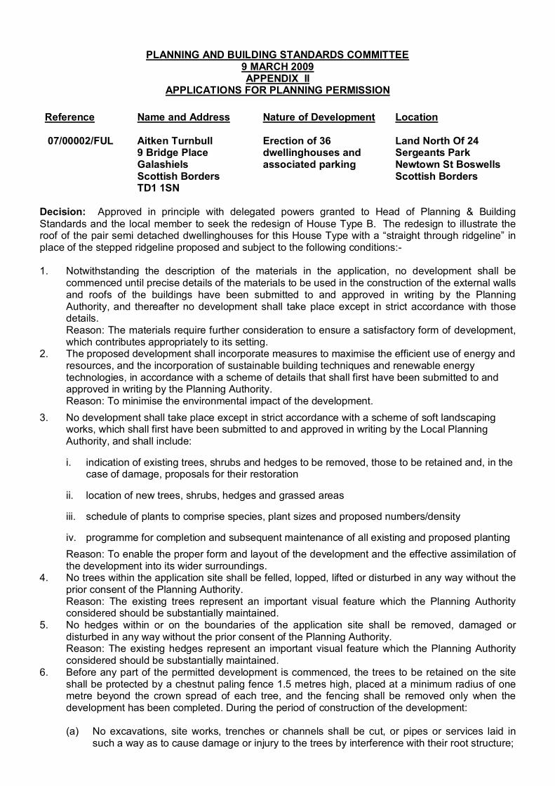
07/00002/FUL Aitken Turnbull9 Bridge PlaceGalashielsScottish BordersTD1 1SN
Erection of 36dwellinghouses andassociated parking
Land North Of 24Sergeants ParkNewtown St BoswellsScottish Borders
Decision: Approved in principle with delegated powers granted to Head of Planning & BuildingStandards and the local member to seek the redesign of House Type B. The redesign to illustrate theroof of the pair semi detached dwellinghouses for this House Type with a “straight through ridgeline” inplace of the stepped ridgeline proposed and subject to the following conditions:-
1. Notwithstanding the description of the materials in the application, no development shall becommenced until precise details of the materials to be used in the construction of the external wallsand roofs of the buildings have been submitted to and approved in writing by the PlanningAuthority, and thereafter no development shall take place except in strict accordance with thosedetails.Reason: The materials require further consideration to ensure a satisfactory form of development,which contributes appropriately to its setting.
2. The proposed development shall incorporate measures to maximise the efficient use of energy andresources, and the incorporation of sustainable building techniques and renewable energytechnologies, in accordance with a scheme of details that shall first have been submitted to andapproved in writing by the Planning Authority.Reason: To minimise the environmental impact of the development.
3. No development shall take place except in strict accordance with a scheme of soft landscapingworks, which shall first have been submitted to and approved in writing by the Local PlanningAuthority, and shall include:
i. indication of existing trees, shrubs and hedges to be removed, those to be retained and, in thecase of damage, proposals for their restoration
ii. location of new trees, shrubs, hedges and grassed areas
iii. schedule of plants to comprise species, plant sizes and proposed numbers/density
iv. programme for completion and subsequent maintenance of all existing and proposed plantingReason: To enable the proper form and layout of the development and the effective assimilation ofthe development into its wider surroundings.
4. No trees within the application site shall be felled, lopped, lifted or disturbed in any way without theprior consent of the Planning Authority.Reason: The existing trees represent an important visual feature which the Planning Authorityconsidered should be substantially maintained.
5. No hedges within or on the boundaries of the application site shall be removed, damaged ordisturbed in any way without the prior consent of the Planning Authority.Reason: The existing hedges represent an important visual feature which the Planning Authorityconsidered should be substantially maintained.
6. Before any part of the permitted development is commenced, the trees to be retained on the siteshall be protected by a chestnut paling fence 1.5 metres high, placed at a minimum radius of onemetre beyond the crown spread of each tree, and the fencing shall be removed only when thedevelopment has been completed. During the period of construction of the development:
(a) No excavations, site works, trenches or channels shall be cut, or pipes or services laid insuch a way as to cause damage or injury to the trees by interference with their root structure;
(b) No fires shall be lit within the spread of the branches of the trees;(c) No materials or equipment shall be stored within the spread of the branches of the trees;(d) Any accidental damage to the trees shall be cleared back to undamaged wood and be
treated with a preservative if appropriate;(e) Ground levels within the spread of the branches of the trees shall not be raised or lowered in
relation to the existing ground level, or trenches excavated except in accordance with detailsshown on the approved plans.
Reason: In the interests of preserving the health and vitality of existing trees on the developmentsite, the loss of which would have an adverse effect on the visual amenity of the area.
7. Before any part of the permitted development is commenced, the hedges to be retained on the siteshall be protected by a chestnut paling fence 1.5 metres high placed at a minimum distance of 2.0metres from the edge of the hedge, and the fencing shall be removed only when the developmenthas been completed. During the period of construction of the development the existing soil levelsaround the boles of the hedges so retained shall not be altered.Reason: In the interests of preserving the hedges which contribute to the visual amenity of thearea.
8. The existing hedges to be outwith the curtilages of the dwellinghouses hereby approved and to beseparated from the garden ground of the dwellinghouses by a post and wire fence erected prior tothe occupation of the dwellinghouses, the details of which are to be submitted to and approved bythe Planning Authority before the development commences.Reason: In the interests of preserving the hedges which contribute to the visual amenity of thearea.
9. No buildings or structures of any sort to be erected within the no-build buffer zones at any time.Reason: To safeguard the buffer zones from development to protect existing tree belts.
10. The access road, footpaths, and visitor parking spaces shown on the approved plans to becompleted to the specification of the Planning Authority in accordance with a programme ofphasing submitted to and approved by the Planning Authority before the development commences.Reason: To ensure that adequate access to the site for pedestrians and vehicles is provided and isat all times properly maintained.
11. Where parking is to be provided within the curtilage of any dwellinghouse, hereby approved,parking for two vehicles, excluding garages, must be provided to the specification of the PlanningAuthority. The parking to be provided before the dwellinghouse is occupied and retained thereafterfor such use unless the written consent of the Local Planning Authority is obtained for alternativeuse.Reason: To ensure that each dwellinghouse has adequate off road parking where that is requiredon the site and in the interests of road safety.
12. The right of way along the southern boundary of the site to be kept open and free from obstructionor encroachment during the construction of the dwellinghouses and thereafter.Reason: To ensure the right of way remains open and free from obstruction.
13. A SUDS scheme and details of the foul water drainage for the site to be submitted to and approvedin writing by the Planning Authority before the development commences. The approved schemethen to be implemented as part of the development.Reason: To ensure that satisfactory arrangements are made for the disposal of surface and foulwater.
14. A survey to be carried out by a suitably qualified wildlife consultant on the use of Sprouston Burnby otters before work commences on the site and to be submitted to and approved by the PlanningAuthority before the development commences. Any mitigating measures required are to be carriedout as part of the development.Reason: To ensure that the requirements of the Conservation (Natural Habitats &c) Regulations1994 (As Amended) are not breached.
15. A survey to be carried out by a suitably qualified wildlife consultant of the site for badgers beforework commences on the site and to be submitted to and approved by the Planning Authority beforethe development commences. Any mitigating measures required are to be carried out as part ofthe development.Reason: To ensure the requirements of the Protection of Badgers Act 1992 and any licensingrequirements are met.
16. A 30m diameter exclusion zone around any badger setts around or close to the site to be markedout before work commences on this development to prevent damage during construction work andretained in place until the development is completed.Reason: To ensure the requirements of the Protection of Badgers Act 1992 are met.
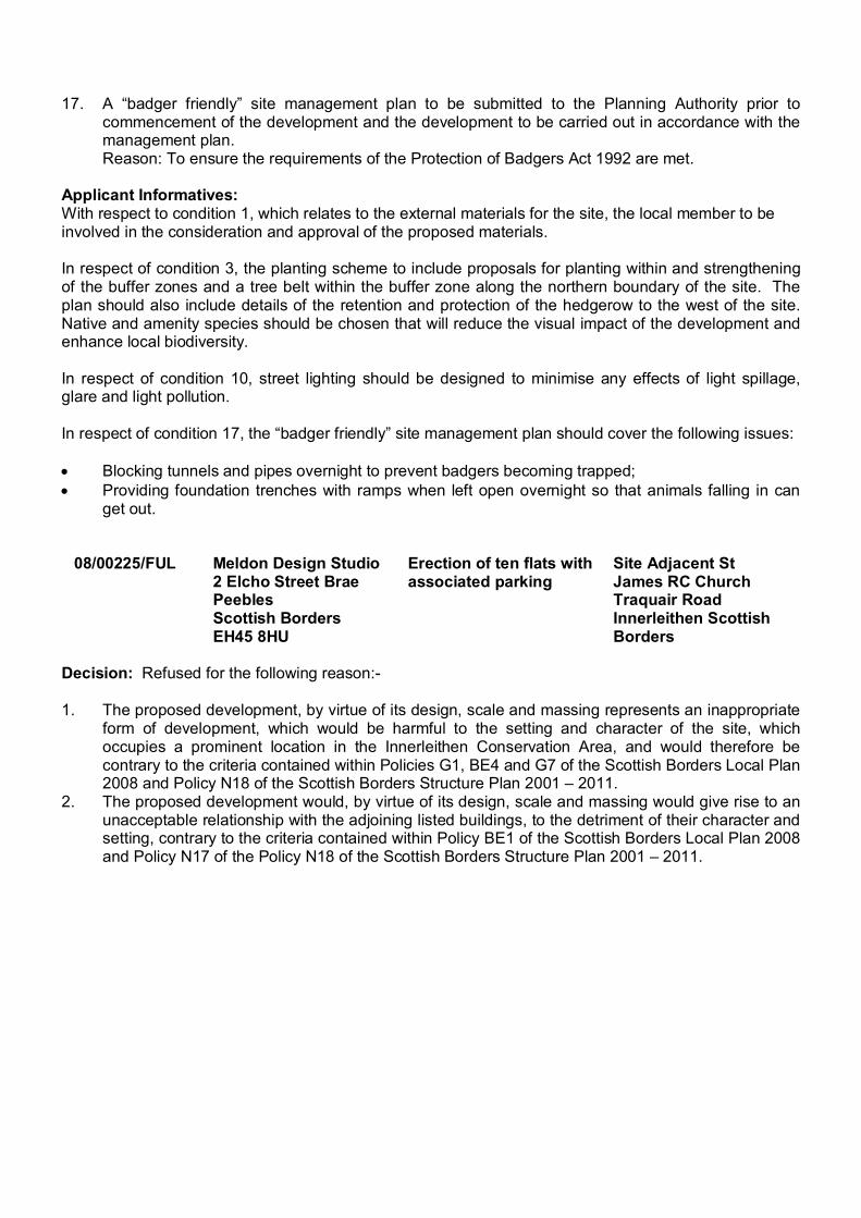
17. A “badger friendly” site management plan to be submitted to the Planning Authority prior tocommencement of the development and the development to be carried out in accordance with themanagement plan.Reason: To ensure the requirements of the Protection of Badgers Act 1992 are met.
Applicant Informatives:With respect to condition 1, which relates to the external materials for the site, the local member to beinvolved in the consideration and approval of the proposed materials.
In respect of condition 3, the planting scheme to include proposals for planting within and strengtheningof the buffer zones and a tree belt within the buffer zone along the northern boundary of the site. Theplan should also include details of the retention and protection of the hedgerow to the west of the site.Native and amenity species should be chosen that will reduce the visual impact of the development andenhance local biodiversity.
In respect of condition 10, street lighting should be designed to minimise any effects of light spillage,glare and light pollution.
In respect of condition 17, the “badger friendly” site management plan should cover the following issues:
Blocking tunnels and pipes overnight to prevent badgers becoming trapped;Providing foundation trenches with ramps when left open overnight so that animals falling in canget out.
08/00225/FUL Meldon Design Studio2 Elcho Street BraePeeblesScottish BordersEH45 8HU
Erection of ten flats withassociated parking
Site Adjacent StJames RC ChurchTraquair RoadInnerleithen ScottishBorders
Decision: Refused for the following reason:-
1. The proposed development, by virtue of its design, scale and massing represents an inappropriateform of development, which would be harmful to the setting and character of the site, whichoccupies a prominent location in the Innerleithen Conservation Area, and would therefore becontrary to the criteria contained within Policies G1, BE4 and G7 of the Scottish Borders Local Plan2008 and Policy N18 of the Scottish Borders Structure Plan 2001 – 2011.
2. The proposed development would, by virtue of its design, scale and massing would give rise to anunacceptable relationship with the adjoining listed buildings, to the detriment of their character andsetting, contrary to the criteria contained within Policy BE1 of the Scottish Borders Local Plan 2008and Policy N17 of the Policy N18 of the Scottish Borders Structure Plan 2001 – 2011.
PLANNING AND BUILDING STANDARDSCOMMITTEE
13 April 2009
ITEM 5
REPORT BY HEAD OF PLANNING AND BUILDING STANDARDS
DRAFT GREEN SPACE STRATEGY AND DRAFT SUPPLEMENTARY PLANNING GUIDANCEON GREEN SPACE
1 PURPOSE
1.1 To seek committee approval for the Draft Supplementary Planning Guidance(SPG) on Green Space incorporating a proposed Green Space Strategy and theDraft Environmental Report as a basis for public consultation.
2 BACKGROUND
2.1 Scottish Planning Policy 11: Open Space and Physical Activity (SPP11) places aresponsibility on all local authorities to carry out an audit and prepare a strategy foropen space. Planning Advice Note 65: Planning and Open Space (PAN65) advisesLocal Authorities to carry out assessments of the existing and future needs of theircommunities for open space and recreational facilities. PAN65 also advises that LocalAuthorities should undertake an audit of quality, quantity and accessibility of openspace, and to base their investment plans on their condition and value to the public.
2.2 The Draft SPG and Green Space Strategy has been prepared on behalf of the Councilby Halcrow in association with Kit Campbell Associates, and has been prepared inconsultation with officers from Environmental services (Parks), and Scottish NaturalHeritage who also contributed 50% of the costs in undertaking this work. The DraftSPG and Strategy is for consideration and approval by the Committee as a basis forpublic consultation.
2.3 In the preparation of the Green Space Strategy and the SPG, the appointedconsultants undertook consultation with the local community. The community wereengaged through the following methods, urban and rural stakeholder consultations,discussions with Scottish Borders Council staff, community councils and village hallcommittees; and resident on-line consultation. The key issues to come out of theconsultation were:
The quantity of open space is about right overall, with exceptions related toallotments, teenage facilities and changing facilities;
The quality of open space is about right although there are some variationsacross the region. Some concerns voiced about children’s play areas andhousing areas as well as changing pavilions; and
Further community involvement is desired by some groups across the region.
2.4 The aim of the Green Space Strategy is to set out what the Council aims to do inconjunction with its partners to ensure the protection of green spaces, sustainable
provision, management and maintenance to meet the needs of existing and newcommunities as well as visitors to the Borders. The document provides a vision andsets directions, priorities and actions for the next 10 to 15 years however; it will besubject to review in five years.
2.5 The SPG and its appendices provides guidance to those preparing planningapplications for one or more dwellings as to what the Council may require in order tomitigate the impact of residential developments on green space and outdoor sport andrecreation provision. The SPG sets out how the Council will assess the potentialimpacts of proposed residential developments in terms of green space and outdoorsport and recreation provision; the SPG also explains how the Council intends to useplanning conditions relating to green space; as well as setting out the circumstances inwhich the Council will require developers to enter into a planning obligation relating togreen space and outdoor sport and recreation provision.
2.6 The Green Space Strategy which has informed the production of the SPG is includedas an appendix to the SPG.
3 CONSULTATION
3.1 The Draft SPG, Draft Strategy and the Draft Environmental Report requires widerconsultation with Community Councils and local stakeholders, together with nationalorganisations such as Scottish Natural Heritage, Scottish Water and the ScottishEnvironment Protection Agency. The draft SPG will also be posted on the Council’swebsite. The consultation period is proposed to be for 12 weeks. Any substantiveobjections (and proposed council response) will be reported back to committee prior tofinalisation of the SPG and Environmental Report.
3.2 Consultation has been undertaken with the Heads of Corporate Administration, LegalServices, Chief Financial Officer, Directors of Social Work (Housing), and TechnicalServices and comments received to date have been incorporated in this report.
4 FINANCIAL IMPLICATIONS
4.1 There are no direct financial implications arising from publication of the SPG, althoughthe risk of planning appeals and possible legal challenge would carry associated costs.The direct costs relate to the staff and administrative costs of holding public inquiriesand handling appeals. However, the award of expenses against the Council can onlybe made on grounds of unreasonable behaviour. It must be proven that the Council’sdecision was so unreasonable that the matter should never have been brought toappeal or that the Council’s conduct had caused the party making the appeal to incurunnecessary expense. There are also potential costs attributable to any challengethrough the courts. The SPG, once finalised, will provide clear guidance to developersand communities to ensure the protection of green spaces and sustainable provision,management and maintenance to meet the needs of existing and new communities, aswell as visitors to the Borders.
4.2 There are ongoing costs related to staff resources needed to carry out research andmanagement related to the production of the SPG. Budget is available to cover thesecosts.
5 RISK COMMENTARY
5.1 The key risks are considered to be:
Risk of not providing guidance
(i) The lack of guidance would cause uncertainty to developers and the public andbe a barrier to effective decision-making by the Council. This could result in ad
hoc and inconsistent decision making with the policies in the Local Plan not beingtaken fully into account.
(ii) Failure to develop a SPG on Green Space would reflect badly on the Council’sresponsibility to carry out an audit and prepare a strategy for open space.
(iii) It is considered that the failure to approve the SPG would have impacts in termsof resources in the Development Management Section, potentially resulting indelays in processing the planning applications. In addition, it may ultimately havea negative impact on the quality of development and the thorough assessment ofthe environmental impact of development.
Risk of providing guidance
(i) In adopting Supplementary Planning Guidance the Council will be required todefend the policy against possible legal challenge by the building industry,members of the public and other interested parties.
(ii) The Council will be required to defend the policy at appeal and the risk of costsfollowing potential challenge by the building industry (see 4.1 above).
5.2 It is not anticipated that successful challenges are likely where SPG has beenproduced in accordance with recommended practice, as proposed in this SPG onGreen Space.
6 EQUALITIES/ ENVIRONMENTAL CONSIDERATIONS
6.1 There are no equality issues in approving this report. It is anticipated there will be noadverse impact on the rural area from the proposals contained in this report.
6.2 In accordance with Section 7 of the Environmental Assessment (Scotland) Act 2005 apre-screening assessment of Supplementary Planning Guidance on Green Space hasbeen undertaken using the criteria specified in Schedule 2 of the Act. The pre-screening assessment identified no effects in relation to the environment hence theSupplementary Planning Guidance on Green Space is exempt from SEA requirementsunder Section 7 (1) of the Act.
6.3 The Green Space Strategy element of the SPG is a key document in prioritising theenvironmental framework related to green space provision in the area. Environmentalimplications related to development policy are an important consideration in thepreparation and consultation on the Strategy. An Environmental Report required underthe Environmental Assessment (Scotland) Act 2005 for the Green Space Strategy hasbeen prepared and will be subject to public consultation.
7 SUMMARY
7.1 The SPG on Green Space incorporating the Green Space Strategy provides guidanceto those preparing planning applications for one or more dwellings as to what theCouncil may require in order to mitigate the impact of residential developments ongreen space and outdoor sport and recreation provision.
8 RECOMMENDATION
8.1 It is recommended that the Planning and Building Standards Committee:
(a) Approves the Draft SPG incorporating the Green Space Strategy and DraftEnvironmental Report as a basis for public consultation for a 12 week period,and that if there are any substantive comments then they should be reportedback to this committee;

(b) Agrees that if there are no substantive comments arising from consultationthat the SPG and Environmental Report should be delegated for approval tothe Head of Planning and Building Standards.
Approved byName DesignationBrian Frater Head of Planning and Building
Standards
Author(s)Name DesignationTrish Connolly Planning Officer
Background Papers: NilPrevious Minute Reference: Nil
Note – You can get this document on tape, in Braille, large print and various computer formats bycontacting the address below. The Department can also give information on other languagetranslations as well as providing additional copies.
Contact us at Business Services, Planning and Economic Development, Scottish Borders Council,Council HQ, Newtown St Boswells, Melrose, TD6 0SA. Phone: 01835 825060. Fax: 01835 825158.Email: [email protected]
PLANNING AND BUILDING STANDARDS
13 APRIL 2009
ITEM 6
REPORT BY HEAD OF PLANNING AND BUILDING STANDARDS
SUPPLEMENTARY PLANNING GUIDANCE: PLANNING BRIEF FOR EARLSTON HIGHSCHOOL
1 PURPOSE
1.1 To seek approval for the Supplementary Planning Guidance relating to aPlanning Brief for Earlston High School, set out in Appendix A.
2 BACKGROUND
2.1 The high school site in Earlston will become available for potential redevelopmentfollowing the move to the new high school site. The area under consideration for thebrief amounts to 2.27 hectares.
2.2 The brief has been prepared on behalf of the Council by Ryden. The brief is forconsideration and approval by the Committee and will, once approved, become amaterial consideration in the consideration of any planning proposals for the site.
3 CONSULTATION
3.1 Following approval of the draft Planning Brief by the Committee in July 2008 it wassubject to an 8 week period of consultation with members of the public, the CommunityCouncil, local stakeholders and national organisations including Historic Scotland,Scottish Natural Heritage, Scottish Water, and the Scottish Environment ProtectionAgency. The brief was also posted on the Council website.
3.2 The summary of the consultation responses are set out in Appendix B of this report.The main changes to the brief following the consultation period are to ensure that thepotential bridge over the Turfford Burn does not impact on the Special Area ofConservation; to require SUDs proposals to be detailed at the planning applicationstage; to recognise the need to protect water vole habitats; and, to require the use ofnative woodland species at the eastern end of the site on the floodplain area.
3.3 Consultation on the finalised brief has been undertaken within the Council with theHeads of Corporate Administration and Legal Services, the Chief Financial Officer, andthe Directors of Education and Lifelong Learning, Technical Services and Social Work.
4 FINANCIAL IMPLICATIONS
4.1 There are no direct substantive financial implications arising from the publication of theplanning brief. The guidance, once agreed, will provide clear guidance to developerson the future development potential of the site.
4.2 There are positive implications to the Council as the landowner of the site in terms offuture potential income from land sales. Production of clear guidance for thedevelopment of sites creates certainty for developers which can help to optimise landvalues for the Council.
4.3 There are ongoing costs related to staff resources needed to carry out research andmanagement relating to the production of planning guidance. These costs can be metby the Planning and Economic Development and Technical Services departments.
5 RISK COMMENTARY
5.1 The key risks are considered to be:
Risk of not providing guidance
(i) The lack of guidance would cause uncertainty to developers and the public andbe a barrier to effective decision-making by the Council. This could result in adhoc and inconsistent decision making with the policies in the Local Plan not beingtaken fully into account.
(ii) Failure to develop a development brief would reflect badly on the Council’scommitment to improve the design standards of new housing developments.
(iii) It is considered that the failure to approve the Development Brief would haveimpacts in terms of resources in the Development Management Section,potentially resulting in delays in processing the planning application. In addition,it may ultimately have a negative impact on the quality of development and thethorough assessment of the environmental impact of development.
(iv) The brief will be an important part of the marketing of the site by the Council, andproceeds from the site sale will contribute towards the costs related to the PublicPrivate Procurement for the three high schools.
Risk of providing guidance
(i) In adopting Supplementary Guidance in advance of the Local Plan the Councilmay be required to defend the policy against possible legal challenge by thebuilding industry, members of the public and other interested parties.
(ii) The Council may be required to defend the policy at appeal and the risk of costsfollowing potential challenge by the building industry.
6 ENVIRONMENTAL IMPLICATIONS
6.1 The environmental risk associated with the potential development of the site has beenassessed in terms of the constraints set out in the development brief.
7 EQUALITIES
7.1 There are no equality issues in approving this report. The report is not appropriate forrural proofing.
8 SUMMARY
8.1 The report sets out the provisions of the planning brief for Earlston High School, andseeks Committee approval of its provisions as a material consideration in theconsideration of planning applications.
9 RECOMMENDATION
9.1 It is recommended that the Committee approve the Supplementary PlanningGuidance planning brief for Earlston High School set out in Appendix A of thisreport, and agree its provisions as material considerations in the considerationof planning applications.
Approved byName Designation SignatureB. Frater Head of Planning and Building
Standards
Author(s)Name DesignationM. Wanless Plans and Research Manager
The original signed copy of this report is retained by the Planning and Economic DevelopmentDepartment
Background Papers:Previous Minute Reference: Planning and Building Standards, 7 July 2008
Note – You can get this document on tape, in Braille, large print and various computer formats bycontacting the address below. Linda Ross can also give information on other languagetranslations as well as providing additional copies.
Contact us at Planning and Economic Development, Scottish Borders Council, CouncilHeadquarters, Newtown St Boswells, Melrose, TD6 0SA. Telephone: 01835 825060. E-mail:[email protected]
Supplementary Planning Guidance Planning Finalised Brief Earlston High School Earlston February 2009
RYDEN PROPERTY CONSULTANTS Supplementary Planning Guidance – Planning Brief Earlston High School, Earlston
January 2009
Contents
1 Introduction 1
2 Background 1
2.1 3 High Schools Project 1
2.2 Earlston 1
3 National Guidance 1
4 Local Plan Context 2
5 Site Location and Description 2
6 Land Ownership 2
7 Development Vision 3
8 Opportunities and Constraints 3
9 Urban Design & Landscape 3
10 Development Mix & Density 6 10.1 Density Calculation .................................................................6
11 Access & Transport 7 11.1 General Comments.................................................................7 11.2 Transport Assessment............................................................7 11.3 Parking and the External Environment ...................................7 11.4 Road Access...........................................................................7
12 Designing Out Crime 9
13 Biodiversity 9
14 Sustainability 11
15 Water Resource Management 12 15.1 Flooding................................................................................12 15.2 Drainage Assessment...........................................................12
16 Developers Contributions 13 16.1 Affordable Housing ...............................................................13 16.2 Education..............................................................................14 16.3 Waverley Line .......................................................................14 16.4 Open Space/play facilities ....................................................14 16.5 Landscaped/grassed areas ..................................................14 16.6 Waste Water Treatment........................................................14 16.7 Central Borders Road Network .............................................15
17 Ground Conditions 15
18 Utilities 15
RYDEN PROPERTY CONSULTANTS Supplementary Planning Guidance – Planning Brief Earlston High School, Earlston
January 2009
19 Existing Studies 15
20 General 15
21 The Way Forward 15
Appendices Appendix 1 – Strategic Location Plan Appendix 2 – Site Location Plan Appendix 3 – Disposal Plan Appendix 4 – Key Diagram Appendix 5 – Service Plan (T.B.C.) Appendix 6 – Legal Agreement (T.B.C) Appendix 7 – Schedule of Works to Primary School Appendix 8 – SEPA Note dated 7 Jan 2009
RYDEN PROPERTY CONSULTANTS Supplementary Planning Guidance – Planning Brief Earlston High School, Earlston
January 2009
1 Introduction This brief sets out the main opportunities and constraints relating to this site, and is intended to create a framework for its future development when the existing high school relocates to new premises. The intended date for relocation is autumn 2009. The brief should be read in full consultation with the relevant guidance at both Local Authority and national level.
2 Background 2.1 3 High Schools Project
The 3 High Schools Project will deliver a new high school and associated playing fields within Earlston. The existing Primary School will remain in its present location but will be improved. As a consequence, the majority of the existing buildings and land associated with the existing high school will become vacant and available for appropriate redevelopment. The capital receipt from the disposal of this site will be used to help finance the 3 High Schools Project.
2.2 Earlston Earlston, which has a population of around 1790, lies within the north of the Primary Development Hub, as part of the Development Strategy approved in the 2001 Scottish Borders Structure Plan (see Appendix 1 – Strategic Location Plan).
3 National Guidance The policy of focusing development on brownfield sites is a long established one and is supported by national guidance, specifically Scottish Planning Policy 3 “Planning for Homes (revised 2008) (SPP3). SPP3, paragraph 58 states that when selecting sites, Local Planning Authorities “should consider the re-use of existing land and buildings before development on Greenfield sites”.
1
RYDEN PROPERTY CONSULTANTS Supplementary Planning Guidance – Planning Brief Earlston High School, Earlston
January 2009
4 Local Plan Context
Scottish Borders Local Plan, adopted in September 2008, Policy G8, shows the site within the Development Boundary of Earlston. Development boundaries indicate the extent to which towns and villages should be allowed to expand during the Local Plan period to 2011. In view of this, there is a general policy support for the redevelopment of the high school site. Within the Scottish Borders Local Plan Vol 2 Settlements, specific reference is made to the possible redevelopment of the site, stating: “If the secondary school moves to a new site then primary school and residential uses would be appropriate on the existing school site.”
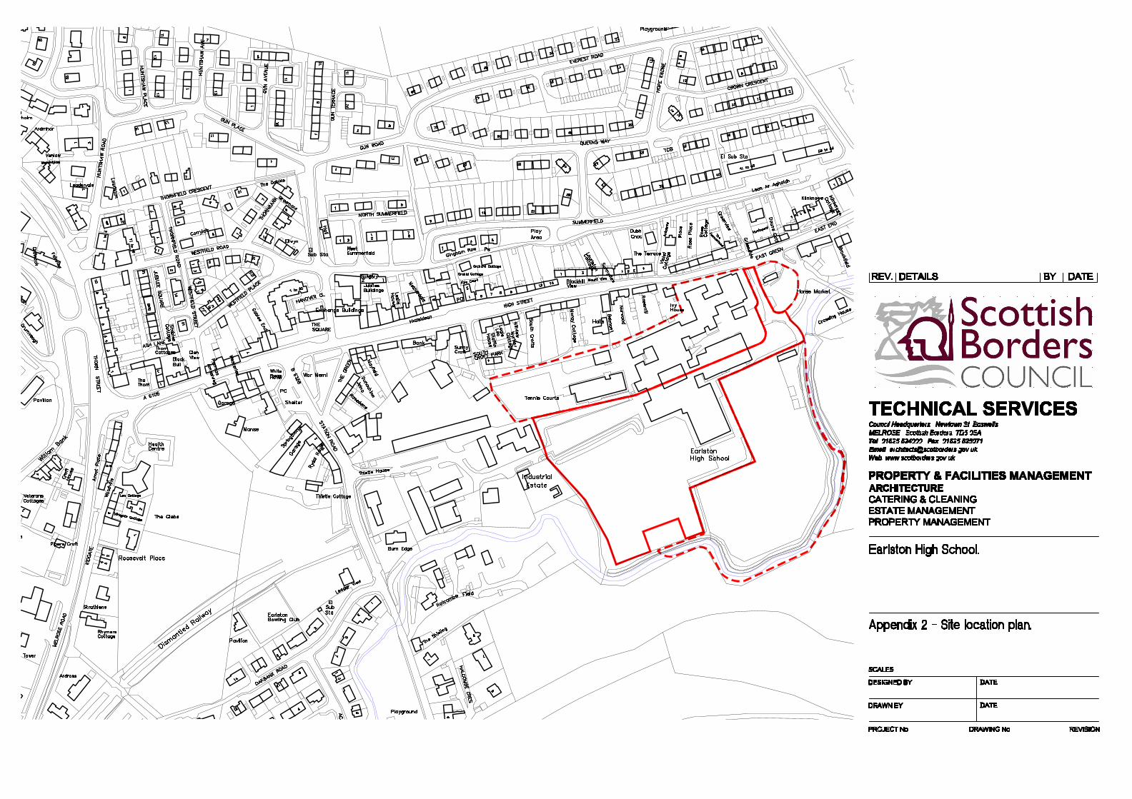
5 Site Location and Description The site is located to the south of the High Street and lies within the south east of the town (see Appendix 2, Site Location Plan). The disposal site extends to 2.27 hectares (gross). • The existing primary school is located immediately to the north of the
disposal site and beyond the primary school, there are a variety of residential properties. The existing detached building to the west of the main primary school complex will be retained for alternative uses. Also, the existing tennis courts will be retained. To the east and west of the site there are employment areas and to the south open countryside.
The new secondary school and associated playing fields are located within 200 metres to the South East, across the Turfford Burn. The site is essentially level but with a raised section in the north west corner. To the south the land falls towards the river bank at the boundary.
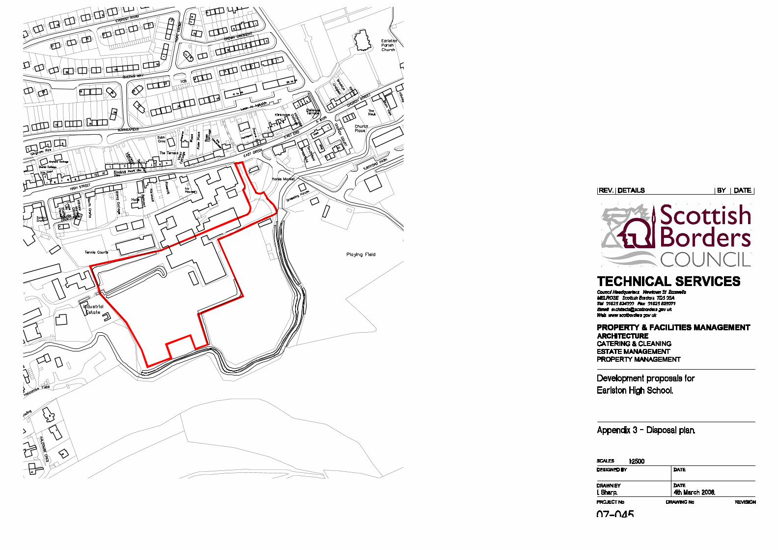
6 Land Ownership The site disposal boundary is detailed on the attached Disposal Plan (see Appendix 3). Please note an area, semi-circular in shape and to the East of the disposal boundary, is outwith the Council’s ownership but could form part of the development area, subject to the agreement of the current owner. In addition, scope exists to utilise the flood plain for
2
RYDEN PROPERTY CONSULTANTS Supplementary Planning Guidance – Planning Brief Earlston High School, Earlston
January 2009
recreational uses and landscape planting. Again this would be subject to the landowners agreement.
7 Development Vision The site of the existing Earlston High School occupies a very central yet discreet position within the centre of Earlston. The site lies behind the High Street and is accessed by the East Green with a secondary access through the industrial estate to the west. To the south the site is bounded by the Turfford Burn and enjoys open southerly views to the hillside beyond. The site affords the possibility of creating a major new development for Earlston within the settlement boundary, defined by the Turfford Burn and without detrimental impact on the form and character of the town. Development will enhance education provision in Earlston, providing an extended and improved primary school. As a consequence of the development, improved access arrangements to the existing primary school will also be secured. The improvements to the retained parts of the high school to serve the improved primary school are discussed in more detail below.
8 Opportunities and Constraints This site offers a significant redevelopment opportunity within the heart of Earlston for primarily residential development although other compatible uses, including retail to serve local needs, would be acceptable. A significant opportunity exists for a development which both incorporates and enhances the land adjacent to the Turfford Burn, creating a new focal point for recreational activity. The key constraints which require to be addressed include the realignment of the road network at East Green, improved access arrangements to serve the primary school and provision for the possible future access to the land to the south. Also, proposals must take account of the existing employment uses adjacent to the site and ensure that, through design, there is no conflict with the proposed residential development.
9 Urban Design & Landscape The site has two very distinct characteristics in that the north and west boundaries are formed by the edge of the existing Earlston settlement,
3
RYDEN PROPERTY CONSULTANTS Supplementary Planning Guidance – Planning Brief Earlston High School, Earlston
January 2009
whereas the southern and eastern boundaries are open to the wider landscape. These conditions should be respected and used as design drivers for the proposed development. In particular, design proposals should be sensitive to the location of the retained primary school and also existing residential neighbours. Potential conflict between existing business/industrial uses adjacent to the site and proposed housing must be factored into any proposals. Potential conflicts must be designed out. Maximum benefit of the southerly open views should be made. The East Green has the potential to be a formal public green space within the heart of Earlston. The potential of the East Green should be recognised in any development layout. The principles of PAN76 “New Residential Streets” must be incorporated into the proposals. A number of factors are considered in detail below:-
• Issues such as planting / lighting / retention of existing vegetation / services / detail of levels etc must be considered in an integrated manner. A Design Statement is required, containing an assessment of the main issues associated with integrating the site and including envisaged mitigation measures. The statement, in written form with supporting illustrative material, must be submitted with the planning application to develop the site. This co-joined approach should be carried forward into detailed plans which clearly exhibit the following design components:
• A village green should be created forming a focal point for
the development. This area should benefit from passive supervision and be well served by pedestrian links. The location of the ‘village green’ could take advantage of the open space provided by the flood plan but not at the expense of passive supervision.
• A high quality of design and materials is required, with
appropriate location and orientation of buildings to ensure houses and gardens are removed from permanent shade as far as possible and maximise passive solar gain. This is particularly important given the southern aspect of the site.
4
RYDEN PROPERTY CONSULTANTS Supplementary Planning Guidance – Planning Brief Earlston High School, Earlston
January 2009
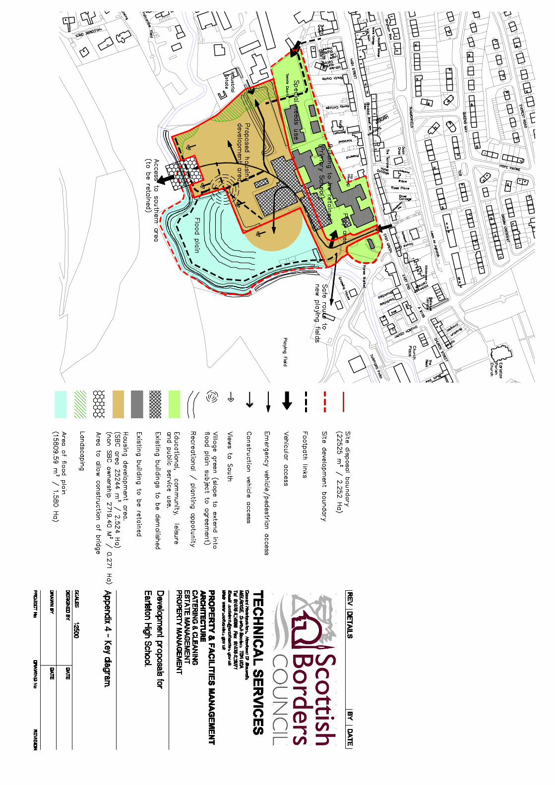
• Careful attention to be given to the boundary treatment of the site including appropriate planting, hedging, fencing and pedestrian access points, particularly where educational or employment uses are adjacent to the site. Two landscape buffers between existing business uses and proposed housing must be provided as indicated in diagram (appendix 4). Furthermore a site appraisal, including shading simulations of all trees within the site and on its boundary must be carried out and submitted as part of the planning application to develop the site.
• With regards to the flood plain, consideration must be given
to the provision of riparian woodland, consistent with the Scottish Borders Woodland Strategy. This would provide :-
• Important habitat; • An appropriate edge to the settlement and; • An opportunity for open space and recreational
opportunities such as a circular riverside walk.
• Only native species should be used in any landscape scheme adjacent to the SAC to ensure that any landscaping does not adversely impact on the SAC through introduction of non native (and potentially invasive) species. Trees and shrubs used should be of local provenance source to maximise the wildlife potential and biodiversity value of the SAC and wider site.
• Lighting – Light intrusion to be minimised as far as possible
in accordance with best practice.
• Open space – An important aim of PAN65: Planning and Open Space is to balance new provision with improved accessibility to and increasing the quality of existing open space. This is particularly relevant when considering the land adjacent to the Turfford Burn. Scope exists to utilise land which lies within the flood plain in a positive way, to provide recreational and leisure opportunities. This approach could also have potential ecologic benefits.
5
RYDEN PROPERTY CONSULTANTS Supplementary Planning Guidance – Planning Brief Earlston High School, Earlston
January 2009
• Play provision must be in accordance with the principles detailed in PAN77, Designing Safer Places. Standards to be met are 60m² (including 20m² play space) per dwelling. In accordance with the principles in “Designing Out Crime”, all open space provision must be overlooked by habitable rooms.
• In line with the requirements of PAN61 Planning and
Sustainable Urban Drainage Systems, an appropriate SUD System will be required as part of the site development. This must be designed as part of the overall site and should be visually attractive, safe and accessible for maintenance purposes.
10 Development Mix & Density
The established housing areas in Earlston benefit from a diversity of size, age and type, allowing a mix of residents to the advantage of the whole community. The density of development should be higher at the more public points close to the High Street, reducing towards the Turfford Burn to the south, although scope does exist to develop at a relatively higher density around the proposed Village Green. This would create a sense of enclosure and higher level of passive supervision.
10.1 Density Calculation Density of housing within the available development land would likely be around 30 units/ha giving a total figure of 60 units. This total is an indicative figure only. A definitive density figure can only be determined at the detailed planning application stage and will be dependent on the mix and size of proposed residential units.
Indicative Developable Area : 2 Hectare (TBC) Total number of Units @ average density of 30 units per hectare : 60 units Indicative Number of Affordable Housing Units : 15 Indicative number of mainstream housing Units: 45
6
RYDEN PROPERTY CONSULTANTS Supplementary Planning Guidance – Planning Brief Earlston High School, Earlston
January 2009
11 Access & Transport 11.1 General Comments This site offers a significant redevelopment opportunity within the heart of
Earlston for primarily residential development although other compatible uses, including retail serving only local needs, would be acceptable. The rationalisation of the access arrangements, including the realignment of the road network at East Green, improved access arrangements to serve the school and provision for the possible future access to the land to the south must be accommodated.
11.2 Transport Assessment A Transport Assessment (TA), taking account of the Central Borders Traffic Study must be submitted as part of a planning application to develop the site. Off-site transport work required as a consequence of the development, must be provided by the developer.
11.3 Parking and the External Environment
The developer should consider a range of solutions to reduce the impact of car parking on the residential environment. These might include a combination of:
Avoiding front garden space being entirely given over to parking
Using traditional front garden walls and hedges to structure the street appearance
Designing in shared small scale semi-private courtyard parking Placing larger parking courtyards adjacent to the site boundary
where uses are located which are least compatible with residential development.
Building shared surfaces in traditional materials rather than using coloured concrete block surfaces – for example in parking zones and domestic runways. Details of materials must be agreed with the Council’s Technical Services.
11.4 Road Access
Vehicular access to the site will be through a new junction from East Green which will also continue to serve the existing primary school. This arrangement could facilitate the provision of a dedicated play area for the primary school. New access arrangements must accommodate fully the
7
RYDEN PROPERTY CONSULTANTS Supplementary Planning Guidance – Planning Brief Earlston High School, Earlston
January 2009
requirements of the existing primary school, ensuring that children can access the school on foot in a safe manner and that appropriate arrangements are made for traffic associated with the school. Appropriate safeguards must be agreed with the Council and implemented to ensure that during construction the school can operate satisfactorily. Access through the existing industrial estate to the east, which presently allows access to the school’s car park, will be retained initially for construction traffic and, on completion of the development, as an emergency vehicle and pedestrian access only. Appropriate measures, such as collapsible bollards must be provided by the developer. An indicative internal road layout is shown at Appendix 4 - Key Diagram. The main access road and internal road must be constructed to allow access to land to the south of the Turfford Burn (see Appendix 4 Key Diagram). Provision must be made to allow, at a future date, the construction of a bridge which is suitable for vehicular and pedestrian use associated with a mainstream residential development. An indicative area, to allow the future construction of a bridge, is highlighted on the proposals plan. A legal agreement is in place regarding this matter (see Appendix 6) and the requirements of this legal agreement must be met by the developer. Vehicular access from South Croft Park will be retained to service the existing building to the West of the existing primary school and to also provide a pedestrian link from the High Street to the development. There may also be scope to provide an emergency access. The Council fully embraces the principles contained within PAN76 “New Residential Streets”. Therefore, the proposed internal road / pedestrian / cycle network must create an informal network of accessible streets, with integral traffic calming measures. Particular consideration must be given to pedestrians and cyclists including creating direct connections with the existing network and creating new links. The creation of direct, accessible pedestrian routes is an important factor to incorporate into the design of the development. The following requirements are to be incorporated into the proposals:-
8
RYDEN PROPERTY CONSULTANTS Supplementary Planning Guidance – Planning Brief Earlston High School, Earlston
January 2009
• Pedestrian access to the north west, linking the tennis courts and Croft Place must be provided, as detailed on the key diagram.
• Pedestrian access to the playing fields, particularly from the primary school and proposed new high school, located to the east, must be provided as detailed on the key diagram.
• An informal (non-adopted) pedestrian route should be formed adjacent to the Turfford Burn, creating a pedestrian loop, as detailed on Appendix 4 - Key Diagram. This path should not be raised or encroach on the river bank or riparian habitat and be designed to sustain flooding. Maintenance arrangements for this path must be included within the maintenance arrangements put in place for other public landscaped areas.
12 Designing Out Crime
Proposals to develop the site must fully embrace the principles detailed in Planning Advice Note 77 “Designing Safer Places” and Planning Advice Note 76 “New Residential Streets” (Scottish Executive Development Department). In addition, proposals must be in accordance with the Council’s Supplementary Planning Guidance “Designing out Crime in the Scottish Borders” (approved Sept 2007). All aspects of the design and layout of the development should create a secure environment where opportunities for crime are minimised.
13 Biodiversity Any proposals must take account of the Council’s approved Supplementary Planning Guidance for Biodiversity. The main thrust of this document is to avoid impacts on biodiversity as far as possible. If there are, as a consequence of the development, impacts on biodiversity appropriate mitigation measures must be implemented or, as a last resort, compensation provided for the loss of biodiversity. As recommended above, the land adjacent to the Turfford Burn has significant potential to be incorporated into the proposals. It is important to conserve and, where possible, enhance the ecological value of the international nature conservation site of the Turfford Burn, which forms part of the River Tweed Special Area of Conservation (SAC). As such, no intervention work should be carried out on the watercourse, for example through the use of hard engineering, bank protection etc as part
9
RYDEN PROPERTY CONSULTANTS Supplementary Planning Guidance – Planning Brief Earlston High School, Earlston
January 2009
of the development to avoid loss of “natural” riverine corridor and knock on cumulative impacts on the SAC. Furthermore, strict controls by Scottish Natural Heritage (SNH) and SEPA will be applied covering a wide range of matters including water discharge, waste and water run off, sedimentation, disturbance to qualifying interest, storage of chemicals, impacts of non native species and changes to the flood plain. Measures must be put in place to ensure the protection of the SAC. A fenced buffer of semi natural riparian habitat established prior to development taking place and adherence to best practice would help to prevent / avoid any contamination of the SAC. Any crossing to the southern area will have to be sensitively designed and constructed. This must be a clear span bridge structure with footings outside the watercourse channel to avoid disruption to the burn and potential significant effect on the SAC. It is recommended that prospective developers contact SNH prior to making a formal offer for the site. Mitigation and enhancements should include flood plain restoration, riparian woodlands and woodland creation complementary to the Forest Habitat Network including the Whitehill Ancient Woodland to the south of the site. SEPA has confirmed that there are signs of water voles on the Tufford Burn in Earlston (Scottish Borders Biological Record Centre – records at NT5794 3851, NT5752 3822 and at Mellerstain). Water voles received protection under the Wildlife and Countryside Act 1981. It is now an offence to damage, destroy or obstruct access to any place that water voles use for shelter or protection. The water vole is also a priority protected species and has its own species action plan. Reference should be made to Scottish Planning Policy – National Planning Policy Guidelines 14: Natural Heritage supported by planning advice notes (PAN 60: species and habitats and development opportunities to improve environment by design). Any development should be carried out in such a way that the water voles are accorded protection and that their habitat is not damaged. Furthermore, any opportunity to enhance the habitat should be taken.
10
RYDEN PROPERTY CONSULTANTS Supplementary Planning Guidance – Planning Brief Earlston High School, Earlston
January 2009
Guidance can be found in the Water Vole Conservation Handbook 2nd Edition (a publication endorsed by SEPA) and advice should be sought from SNH.
14 Sustainability
The planning system supports low and zero carbon development through the use of energy efficiency, micro-generation and renewable energy systems. The Council’s approved SPG18: Renewable Energy requires all future developments with a total cumulative floorspace of 500m2 or more to reduce carbon dioxide (CO2) emissions by 15% beyond the 2007 Building Regulation CO2 emissions levels. This 15% reduction should be considered a minimum requirement. Planning Advice Note 84 Reducing Carbon Emissions in New Development (PAN84) provides information and guidance on achieving and demonstrating reduced CO2 emissions. To achieve the required reduction in CO2 emissions the development should first give consideration to energy conservation measures and sustainable design and construction techniques to reduce the energy demand of the development. Once energy demand has been minimised consideration should then be given to the use of low and zero carbon technologies (LZCT) for on-site heat and / or power generation. LZCT includes community heating schemes and combined heat and power schemes which would serve the development as whole. Developers must submit a statement for the Council’s approval detailing how energy efficiency measures and low and zero carbon technologies will be incorporated into the development proposal, and the level of CO2 reduction that will be achieved.
11
RYDEN PROPERTY CONSULTANTS Supplementary Planning Guidance – Planning Brief Earlston High School, Earlston
January 2009
15 Water Resource Management 15.1 Flooding
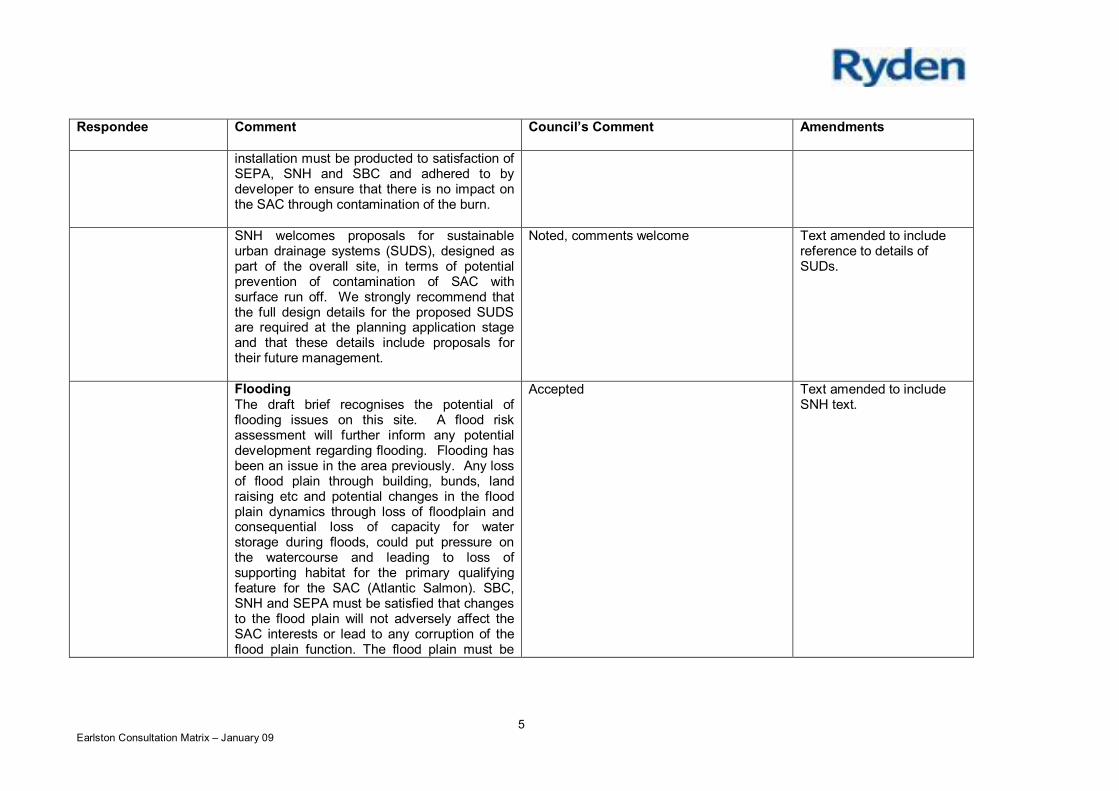
The site lies in close proximity to the Turfford Burn. Furthermore, from information available a flood plain, located to the East and South of the site, has been identified (see Appendix 4 Key Diagram). Flooding has been an issue in the area previously. Any loss of flood plain through building, bunds land raising etc and potential changes in the flood plain dynamics through loss of floodplain and consequential loss of capacity for water storage during floods, could put pressure on the watercourse and leading to loss of supporting habitat for the primary qualifying feature for the SAC (Atlantic Salmon). SBC and SNH and SEPA must be satisfied that changes to the flood plain will not adversely affect the SAC interest or lead to any corruption of the flood plain function. The flood plain must be managed sustainably and the requirements of SPP7 and PAN69 must be satisfied. In view of this, a Flood Risk Assessment will be required.
15.2 Drainage Assessment
A drainage Impact assessment will be required as part of the planning application. The Council’s Policy in relation to surface water is identified in Policy I14 of the Scottish Borders Structure Plan 2001-2011. This policy states that developers will, where appropriate, be encouraged to incorporate Sustainable Urban Drainage Systems as part of their proposals.
Paragraph 6.29 indicates that the guidelines to be followed are those published in a “Design Manual for Sustainable Urban Drainage Systems – Scotland and Northern Ireland”.
More recently, however, Planning Advice Note 69 “Planning and Building Standards Advice on Flooding” as published by the Scottish Executive in August 2004, indicates in paragraph 68 that the Sustainable Urban Drainage Scottish Working Party has developed a national specification for drainage assessments. This national specification can be found at (http://www.sepa.org.uk/pdf/publications/leaflets/suds/drainage_assessment.pdf).
12
RYDEN PROPERTY CONSULTANTS Supplementary Planning Guidance – Planning Brief Earlston High School, Earlston
January 2009
In advance of the publication of the national specification, Scottish Borders Council has been using the drainage assessment guidance published jointly by Aberdeen and Aberdeenshire Councils (http://www.aberdeenshire.gov.uk/planning/devservices/sepa_dia.pdf). This earlier guidance has, by and large, been incorporated in the national specification referred to in PAN 69. However, there are areas where SBC have been using the slightly more onerous guidance of the Aberdeen and Aberdeenshire drainage assessment. In section 3.2(ii) of the national specification, the Council would require a test to be undertaken for a critical 50 year return period rainfall event. In section 3.2(iii), the sensitivity test should be undertaken for the 200 year return period event. Specifically regarding development on the flood plain, the Finalised Scottish Borders Local Plan, Policy G4 must be taken into account. An appropriate SUDs system agreed with SEPA, Scottish Water and SBC is required. Full design details for the proposed SUDs are required at the planning application stage. SUDs must be designed as part of the overall site, and take account of prevention of contamination of SAC with surface run-off, attention of surface water and flood alleviation be visually attractive, accessible and safe and with suitable provisions for long term maintenance. A single purpose engineered solution should be avoided.
16 Developers Contributions Policy G5 of the Scottish Borders Local Plan requires developers to make full or part contribution (through an appropriate legal agreement) towards specific infrastructure. In addition, the Council has approved Supplementary Planning Guidance “Developer Contributions” (April 2008). Prospective purchases are strongly recommended to consult with the council’s development negotiator prior to making an offer for the site. With respect to this site, the following applies:
16.1 Affordable Housing Scottish Borders Council’s “Supplementary Planning Guidance on
Affordable Housing” (29 March 2007) details the requirements placed on developers regarding the provision of affordable housing. The thrust of this document is to secure an appropriate level of affordable housing as part of new developments. As part of the development of this site, 25% affordable housing applies.
13
RYDEN PROPERTY CONSULTANTS Supplementary Planning Guidance – Planning Brief Earlston High School, Earlston
January 2009
16.2 Education
Primary School provision is to be retained on this site. The existing primary school is to be retained. As a consequence of the relocation of the secondary school, there will be a requirement to rationalise and refurbish the existing school site for primary school use creating a single, distinct primary school complex. The exact rationalisation and refurbishment requirements are currently under consideration. The developer of this site, prior to the construction of any houses, and within 6 months of the granting of planning permission for development of the disposal site, must commence the consolidation works to the school. A programme of works must be agreed with the Council prior to commencement of any works. Further information of the extent of work is attached as Appendix 7 – Schedule of Works to Primary School.
16.3 Waverley Line Earlston falls within an area identified for a contribution to the Waverley Railway Project.
16.4 Open Space/play facilities
A play facility to be provided. The likely scale of development will require the provision of a Neighbourhood Equipped Area for Play (NEAP) within the site. Alternatively, there may be scope to upgrade existing provisions located nearby, for example the East Green. A key point to note is that access from the new residential development and also existing houses to the play provision must be safe and direct. Facility to be fully funded with appropriate long-term maintenance regime agreed.
16.5 Landscaped/grassed areas
An appropriate management scheme to be agreed between SBC and developer.
16.6 Waste Water Treatment
It is anticipated that once the already allocated sites have been fully developed, there will be limited capacity at the Waste Treatment Works. In view of this, contributions towards the upgrades to works to provide additional capacity may be required.
14
RYDEN PROPERTY CONSULTANTS Supplementary Planning Guidance – Planning Brief Earlston High School, Earlston
January 2009
16.7 Central Borders Road Network Utilising the Central Borders Traffic Study, developers will have to assess the impact of development on the road network and contribute to the cost of identified upgrades required on a proportional basis.
17 Ground Conditions
Historic records have indicated that the area of the sports pitches was once the site of a gas works. There is evidence of a substantial depth of fill material, with the possibility of buried contamination. As part of an application to develop the site, a Contamination Assessment must be submitted.
18 Utilities Indicative information on services is provided (see Appendix 5 – Service Plan TBC). The impact of any services or constraints on the proposed development will require to be determined in detail by prospective developers.
19 Existing Studies
A number of studies relating to this site are available for inspection and these are listed in Section 22 Related Material.
20 General
Developers must satisfy themselves on all matters relating to the site, including the status/warranty of any previous studies and ground conditions and are strongly advised to contact the Council’s Development Management Service and all service providers to discuss and agree proposals prior to making an offer for the site. Please also note the attached contact list.
21 The Way Forward
The Council encourages the redevelopment of this site in a co-ordinated and comprehensive manner. It is anticipated that the developer will progress matters by submitting an application for the whole site and at that time, enter into an appropriate legal agreement covering all relevant matters. Developers are strongly recommended to enter into discussions with the Council’s Planning Service at an early stage of the design process and prior to the submission of any offer for the site.
15
RYDEN PROPERTY CONSULTANTS Supplementary Planning Guidance – Planning Brief Earlston High School, Earlston
January 2009
Contacts within Scottish Borders Council:
John Hayward (Development Control Manager (West), Council
Headquarters, Newtown St Boswells, Melrose TD6 0SA
Tel : 01835 826510
Martin Wanless (Plans & Research Manager), Council Headquarters,
Newtown St Boswells, Melrose TD6 0SA
Tel : 01835 825063 E-mail : [email protected]
Andy Tharme (Ecology Officer), Council Headquarters, Newtown St
Boswells, Melrose TD6 0SA
Tel: 01835 826514 E-mail : [email protected]
Jon Bowie (Development Negotiator), Council Headquarters, Newtown St
Boswells, Melrose TD6 0SA
Tel : 01835 824000 E-mail : [email protected]
Scottish Borders Council (SBC) Development Control : Carlos Clarke (Senior Development control Officer), Area Office,
Newtown Street, Duns, TD11 3DT
Tel : 01361 886105
SBC Technical Services (Road User Group):
Ron Elliot (Road User Manager), Council Headquarters, Newtown St
Boswells, TD6 0SA
Tel : 01835 825079 E-mail: [email protected]
Lisa Chiles (Street Lighting Manager), Council Headquarters, Newtown
St Boswells, TD6 0SA
Tel : 01835 824000 E-mail [email protected]
16

RYDEN PROPERTY CONSULTANTS Supplementary Planning Guidance – Planning Brief Earlston High School, Earlston
January 2009
SBC Technical Services (Environmental Services)
Graham Prentice (Refuse Collection Manager) Council Headquarters –
Scott House (A), Sprouston Road, Newtown St Boswells, TD6 0QD
Tel : 01835 825111 Ext 5612, E-mail [email protected]
Julie Rankine (Waste Strategy Manager), Council Headquarters - Scott
House (A), Sprouston Road, Newtown St Boswells, TD6 0QD
Tel : 01835 825111 Ext 6629, E-mail [email protected]
SBC Countryside & Heritage
Andy Millar (Countryside & Heritage Manager), Council Headquarters,
Newtown St Boswells, TD6 0SA
Tel : 01835 825062, E-mail [email protected]
Other Contacts within Scottish Borders Council : SBC Technical Services (Environmental Services) Jason Hedley (Parks Manager), Galashiels Area Office, Paton Street,
Galashiels TD1 3AS
Tel : 01896 661770, E-mail [email protected]
SBC Education: A Patterson (Asset Developer Manager), Council Headquarters,
Newtown St Boswells, TD6 0SA
Tel : 01835 824000, E-mail [email protected]
Capital Projects Officer, Education and Life Long Learning : Tel 01835
824000
Asset Development Assistant, Education and Life Long Learning : Tel :
01835 824 4000
Other Suggested Contacts : Scottish Natural Heritage Anne Brown (Area Officer), Anderson’s Chambers, Market Street,
Galashiels, TD1 3AF
17
RYDEN PROPERTY CONSULTANTS Supplementary Planning Guidance – Planning Brief Earlston High School, Earlston
January 2009
Tel : 01896 756652, E-mail : [email protected]
Scottish Water Castle House, 6 Castle Drive, Carnegie Campus, Dunfermline KY11 8GG
Scottish Environment Protection Agency Sonja Millar (Planning Officer), Clearwater House, Heriot Watt Research
Park, Avenue North, Riccarton, Edinburgh EH14 4AP. Tel : 0131 273
7234
18

RYDEN PROPERTY CONSULTANTS Supplementary Planning Guidance – Planning Brief Earlston High School, Earlston
January 2009
Appendix 1
Strategic Location plan
19

RYDEN PROPERTY CONSULTANTS Supplementary Planning Guidance – Planning Brief Earlston High School, Earlston
January 2009
Appendix 2
Site Location Plan
20

RYDEN PROPERTY CONSULTANTS Supplementary Planning Guidance – Planning Brief Earlston High School, Earlston
January 2009
Appendix 3
Disposal Plan
21

RYDEN PROPERTY CONSULTANTS Supplementary Planning Guidance – Planning Brief Earlston High School, Earlston
January 2009
Appendix 4 Key Diagram
22

RYDEN PROPERTY CONSULTANTS Supplementary Planning Guidance – Planning Brief Earlston High School, Earlston
January 2009
Appendix 5 Service Plan
23

RYDEN PROPERTY CONSULTANTS Supplementary Planning Guidance – Planning Brief Earlston High School, Earlston
January 2009
Appendix 6 Legal Agreement
24

RYDEN PROPERTY CONSULTANTS Supplementary Planning Guidance – Planning Brief Earlston High School, Earlston
January 2009
Appendix 7 Schedule of Works to Primary School
25
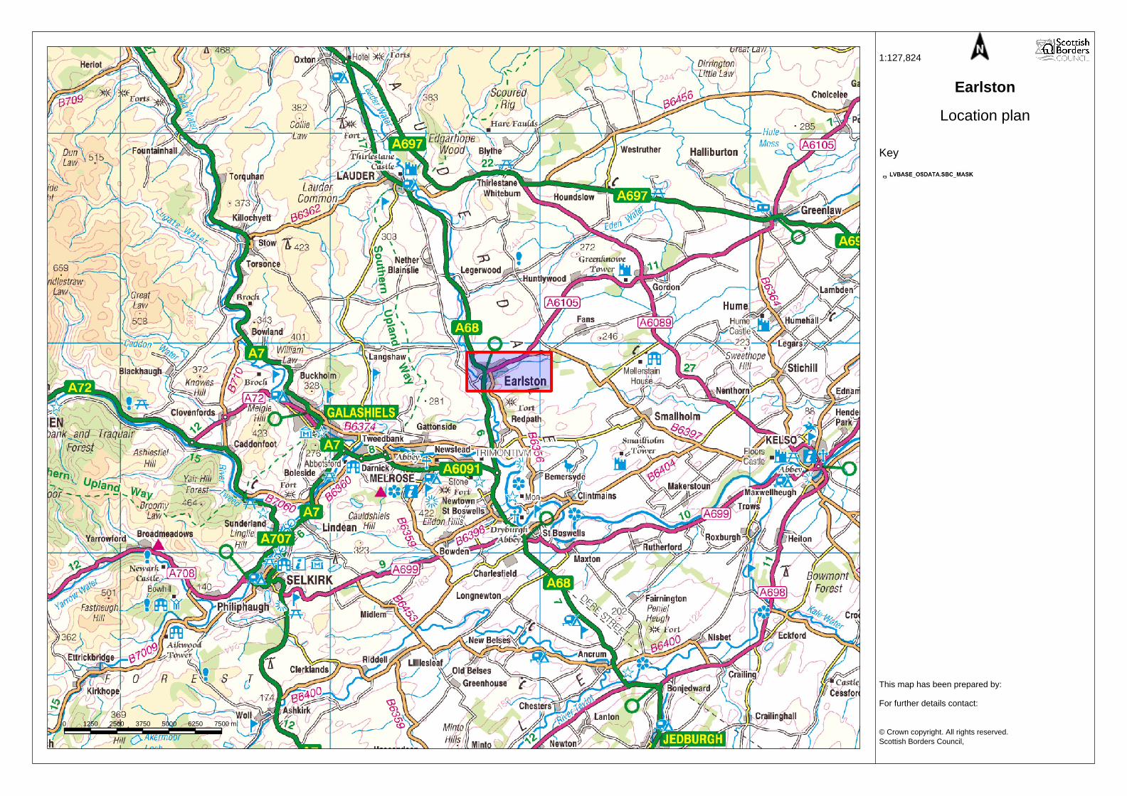
0 1250 2500 3750 5000 6250 7500 m.
1:127,824
Earlston
Location plan
Key
This map has been prepared by:
For further details contact:
© Crown copyright. All rights reserved.Scottish Borders Council,
Licence 100023423, 2008. TGG.
1Earlston Consultation Matrix – January 09
APPENDIX B: EARLSTON PLANNING BRIEF
Consultation Matrix
Respondee Comment Council’s Comment Amendments
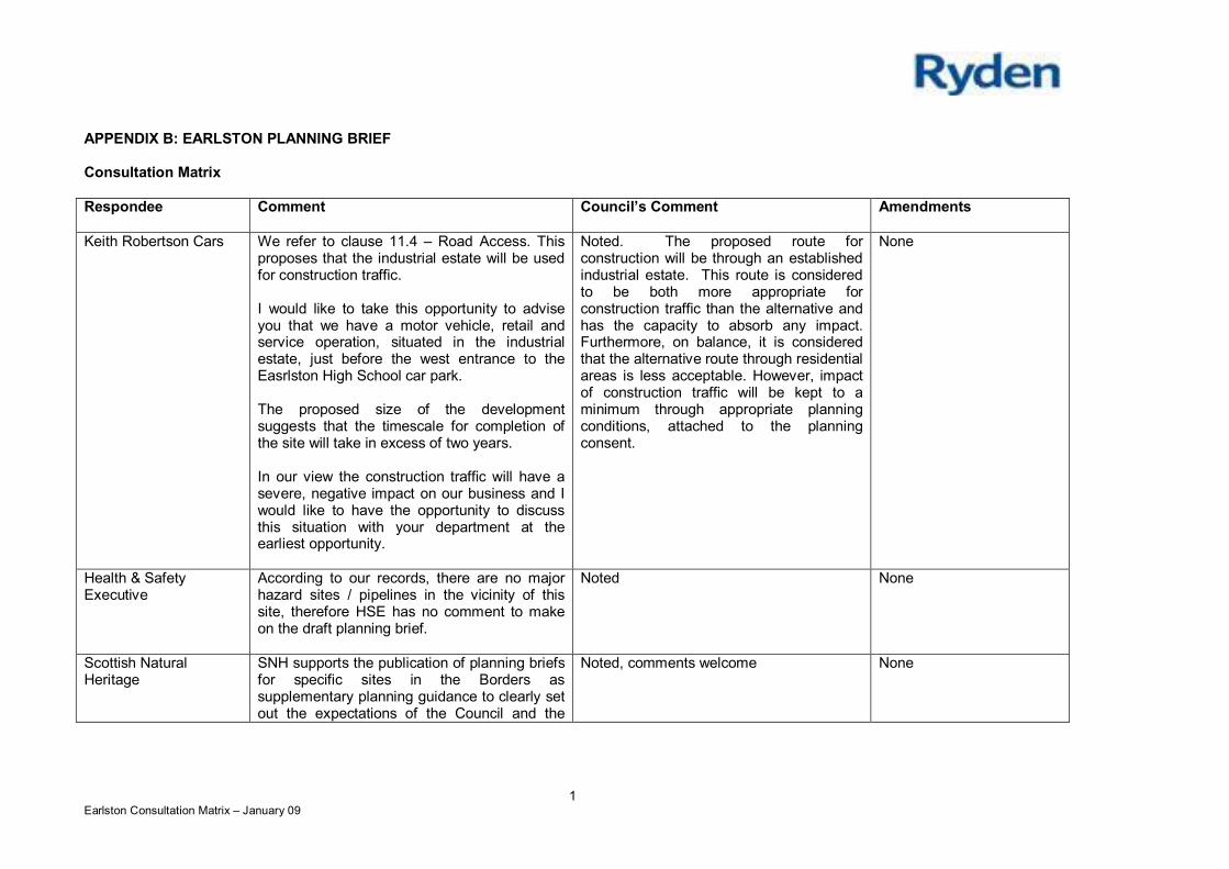
Keith Robertson Cars We refer to clause 11.4 – Road Access. Thisproposes that the industrial estate will be usedfor construction traffic.
I would like to take this opportunity to adviseyou that we have a motor vehicle, retail andservice operation, situated in the industrialestate, just before the west entrance to theEasrlston High School car park.
The proposed size of the developmentsuggests that the timescale for completion ofthe site will take in excess of two years.
In our view the construction traffic will have asevere, negative impact on our business and Iwould like to have the opportunity to discussthis situation with your department at theearliest opportunity.
Noted. The proposed route forconstruction will be through an establishedindustrial estate. This route is consideredto be both more appropriate forconstruction traffic than the alternative andhas the capacity to absorb any impact.Furthermore, on balance, it is consideredthat the alternative route through residentialareas is less acceptable. However, impactof construction traffic will be kept to aminimum through appropriate planningconditions, attached to the planningconsent.
None
Health & SafetyExecutive
According to our records, there are no majorhazard sites / pipelines in the vicinity of thissite, therefore HSE has no comment to makeon the draft planning brief.
Noted None
Scottish NaturalHeritage
SNH supports the publication of planning briefsfor specific sites in the Borders assupplementary planning guidance to clearly setout the expectations of the Council and the
Noted, comments welcome None
2Earlston Consultation Matrix – January 09
Respondee Comment Council’s Comment Amendments
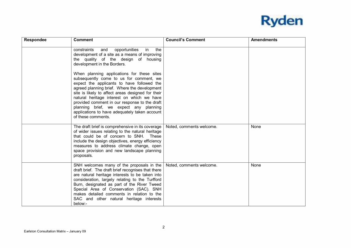
constraints and opportunities in thedevelopment of a site as a means of improvingthe quality of the design of housingdevelopment in the Borders.
When planning applications for these sitessubsequently come to us for comment, weexpect the applicants to have followed theagreed planning brief. Where the developmentsite is likely to affect areas designed for theirnatural heritage interest on which we haveprovided comment in our response to the draftplanning brief, we expect any planningapplications to have adequately taken accountof these comments.
The draft brief is comprehensive in its coverageof wider issues relating to the natural heritagethat could be of concern to SNH. Theseinclude the design objectives, energy efficiencymeasures to address climate change, openspace provision and new landscape planningproposals.
Noted, comments welcome. None
SNH welcomes many of the proposals in thedraft brief. The draft brief recognises that thereare natural heritage interests to be taken intoconsideration, largely relating to the TurffordBurn, designated as part of the River TweedSpecial Area of Conservation (SAC). SNHmakes detailed comments in relation to theSAC and other natural heritage interestsbelow:-
Noted, comments welcome. None
3Earlston Consultation Matrix – January 09
Respondee Comment Council’s Comment Amendments
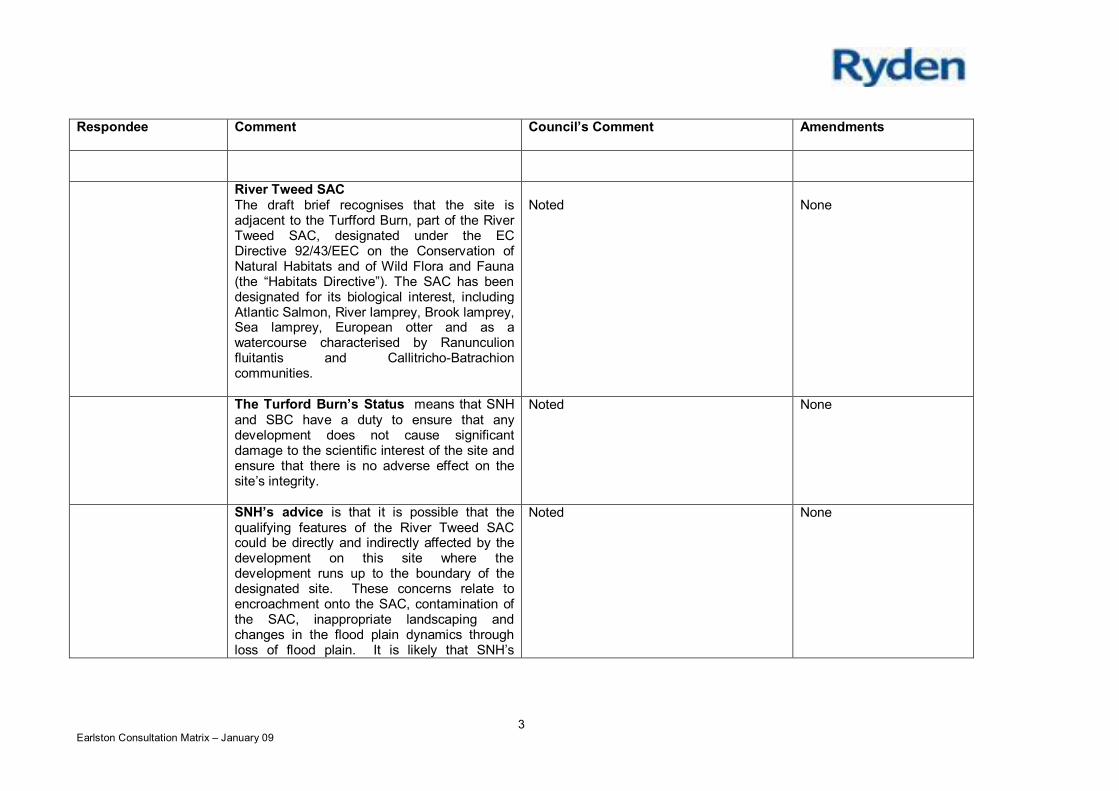
River Tweed SACThe draft brief recognises that the site isadjacent to the Turfford Burn, part of the RiverTweed SAC, designated under the ECDirective 92/43/EEC on the Conservation ofNatural Habitats and of Wild Flora and Fauna(the “Habitats Directive”). The SAC has beendesignated for its biological interest, includingAtlantic Salmon, River lamprey, Brook lamprey,Sea lamprey, European otter and as awatercourse characterised by Ranunculionfluitantis and Callitricho-Batrachioncommunities.
Noted None
The Turford Burn’s Status means that SNHand SBC have a duty to ensure that anydevelopment does not cause significantdamage to the scientific interest of the site andensure that there is no adverse effect on thesite’s integrity.
Noted None
SNH’s advice is that it is possible that thequalifying features of the River Tweed SACcould be directly and indirectly affected by thedevelopment on this site where thedevelopment runs up to the boundary of thedesignated site. These concerns relate toencroachment onto the SAC, contamination ofthe SAC, inappropriate landscaping andchanges in the flood plain dynamics throughloss of flood plain. It is likely that SNH’s
Noted None
4Earlston Consultation Matrix – January 09
Respondee Comment Council’s Comment Amendments
concerns regarding any significant effect on theSAC features could be overcome subject toconditions attached to future planningapplications or amendment.
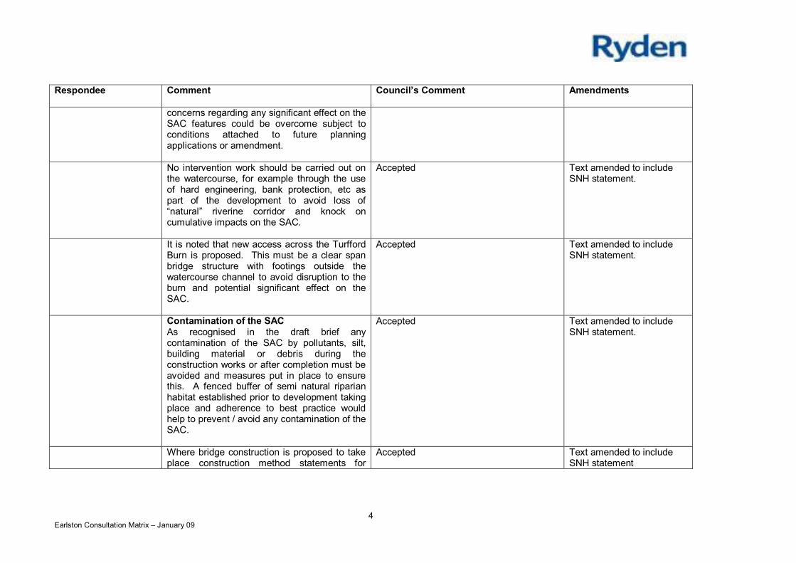
No intervention work should be carried out onthe watercourse, for example through the useof hard engineering, bank protection, etc aspart of the development to avoid loss of“natural” riverine corridor and knock oncumulative impacts on the SAC.
Accepted Text amended to includeSNH statement.
It is noted that new access across the TurffordBurn is proposed. This must be a clear spanbridge structure with footings outside thewatercourse channel to avoid disruption to theburn and potential significant effect on theSAC.
Accepted Text amended to includeSNH statement.
Contamination of the SACAs recognised in the draft brief anycontamination of the SAC by pollutants, silt,building material or debris during theconstruction works or after completion must beavoided and measures put in place to ensurethis. A fenced buffer of semi natural riparianhabitat established prior to development takingplace and adherence to best practice wouldhelp to prevent / avoid any contamination of theSAC.
Accepted Text amended to includeSNH statement.
Where bridge construction is proposed to takeplace construction method statements for
Accepted Text amended to includeSNH statement
5Earlston Consultation Matrix – January 09
Respondee Comment Council’s Comment Amendments
installation must be producted to satisfaction ofSEPA, SNH and SBC and adhered to bydeveloper to ensure that there is no impact onthe SAC through contamination of the burn.
SNH welcomes proposals for sustainableurban drainage systems (SUDS), designed aspart of the overall site, in terms of potentialprevention of contamination of SAC withsurface run off. We strongly recommend thatthe full design details for the proposed SUDSare required at the planning application stageand that these details include proposals fortheir future management.
Noted, comments welcome Text amended to includereference to details ofSUDs.
FloodingThe draft brief recognises the potential offlooding issues on this site. A flood riskassessment will further inform any potentialdevelopment regarding flooding. Flooding hasbeen an issue in the area previously. Any lossof flood plain through building, bunds, landraising etc and potential changes in the floodplain dynamics through loss of floodplain andconsequential loss of capacity for waterstorage during floods, could put pressure onthe watercourse and leading to loss ofsupporting habitat for the primary qualifyingfeature for the SAC (Atlantic Salmon). SBC,SNH and SEPA must be satisfied that changesto the flood plain will not adversely affect theSAC interests or lead to any corruption of theflood plain function. The flood plain must be
Accepted Text amended to includeSNH text.
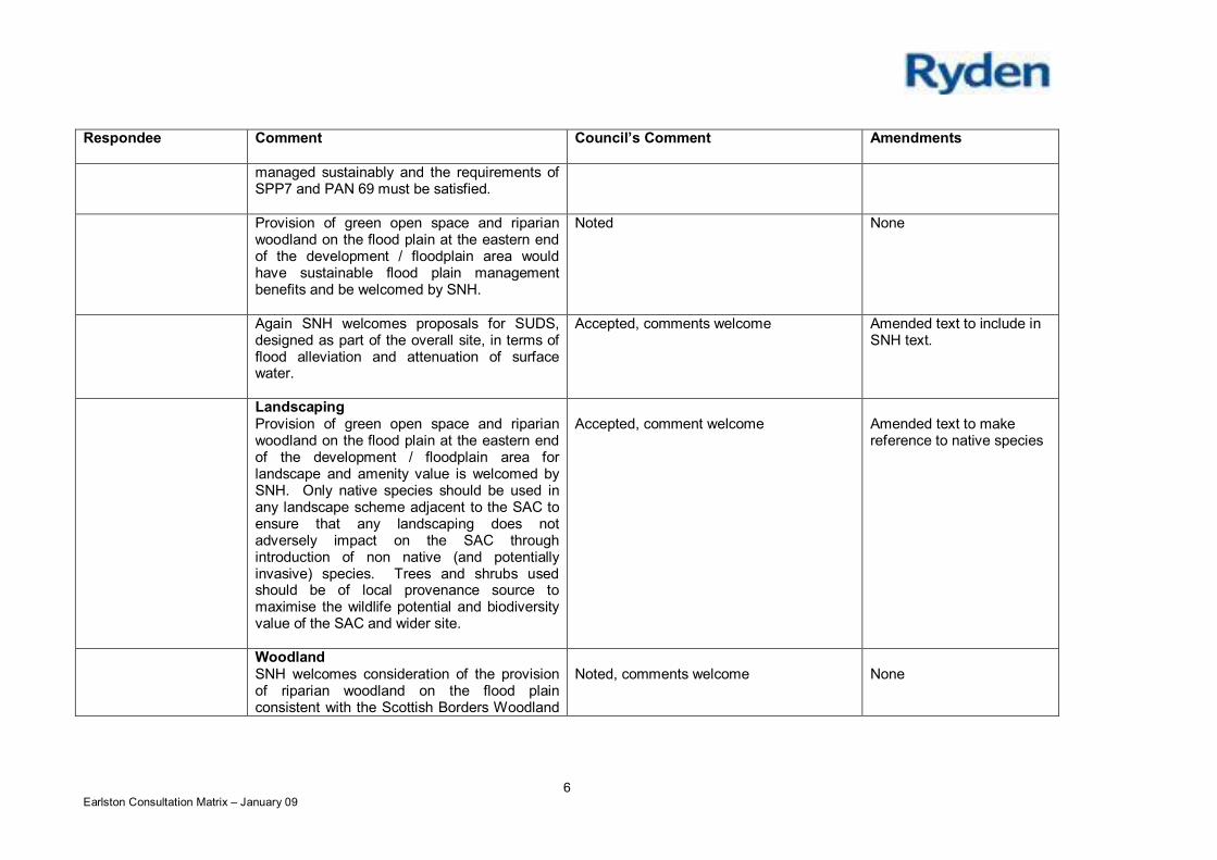
6Earlston Consultation Matrix – January 09
Respondee Comment Council’s Comment Amendments
managed sustainably and the requirements ofSPP7 and PAN 69 must be satisfied.
Provision of green open space and riparianwoodland on the flood plain at the eastern endof the development / floodplain area wouldhave sustainable flood plain managementbenefits and be welcomed by SNH.
Noted None
Again SNH welcomes proposals for SUDS,designed as part of the overall site, in terms offlood alleviation and attenuation of surfacewater.
Accepted, comments welcome Amended text to include inSNH text.
LandscapingProvision of green open space and riparianwoodland on the flood plain at the eastern endof the development / floodplain area forlandscape and amenity value is welcomed bySNH. Only native species should be used inany landscape scheme adjacent to the SAC toensure that any landscaping does notadversely impact on the SAC throughintroduction of non native (and potentiallyinvasive) species. Trees and shrubs usedshould be of local provenance source tomaximise the wildlife potential and biodiversityvalue of the SAC and wider site.
Accepted, comment welcome Amended text to makereference to native species
WoodlandSNH welcomes consideration of the provisionof riparian woodland on the flood plainconsistent with the Scottish Borders Woodland
Noted, comments welcome None
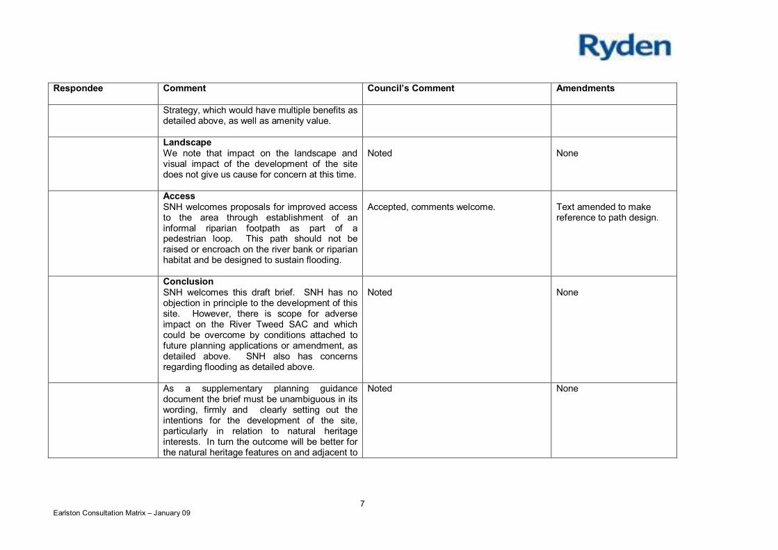
7Earlston Consultation Matrix – January 09
Respondee Comment Council’s Comment Amendments
Strategy, which would have multiple benefits asdetailed above, as well as amenity value.
LandscapeWe note that impact on the landscape andvisual impact of the development of the sitedoes not give us cause for concern at this time.
Noted None
AccessSNH welcomes proposals for improved accessto the area through establishment of aninformal riparian footpath as part of apedestrian loop. This path should not beraised or encroach on the river bank or riparianhabitat and be designed to sustain flooding.
Accepted, comments welcome. Text amended to makereference to path design.
ConclusionSNH welcomes this draft brief. SNH has noobjection in principle to the development of thissite. However, there is scope for adverseimpact on the River Tweed SAC and whichcould be overcome by conditions attached tofuture planning applications or amendment, asdetailed above. SNH also has concernsregarding flooding as detailed above.
Noted None
As a supplementary planning guidancedocument the brief must be unambiguous in itswording, firmly and clearly setting out theintentions for the development of the site,particularly in relation to natural heritageinterests. In turn the outcome will be better forthe natural heritage features on and adjacent to
Noted None
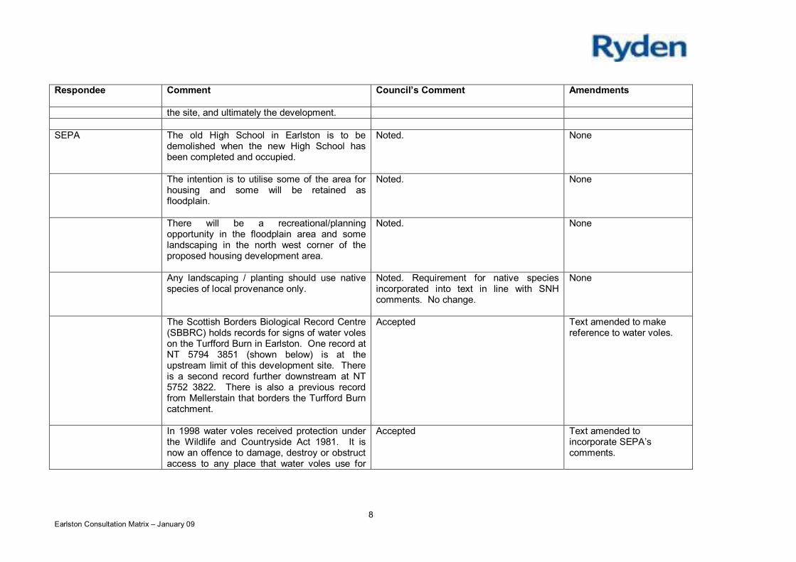
8Earlston Consultation Matrix – January 09
Respondee Comment Council’s Comment Amendments
the site, and ultimately the development.
SEPA The old High School in Earlston is to bedemolished when the new High School hasbeen completed and occupied.
Noted. None
The intention is to utilise some of the area forhousing and some will be retained asfloodplain.
Noted. None
There will be a recreational/planningopportunity in the floodplain area and somelandscaping in the north west corner of theproposed housing development area.
Noted. None
Any landscaping / planting should use nativespecies of local provenance only.
Noted. Requirement for native speciesincorporated into text in line with SNHcomments. No change.
None
The Scottish Borders Biological Record Centre(SBBRC) holds records for signs of water voleson the Turfford Burn in Earlston. One record atNT 5794 3851 (shown below) is at theupstream limit of this development site. Thereis a second record further downstream at NT5752 3822. There is also a previous recordfrom Mellerstain that borders the Turfford Burncatchment.
Accepted Text amended to makereference to water voles.
In 1998 water voles received protection underthe Wildlife and Countryside Act 1981. It isnow an offence to damage, destroy or obstructaccess to any place that water voles use for
Accepted Text amended toincorporate SEPA’scomments.
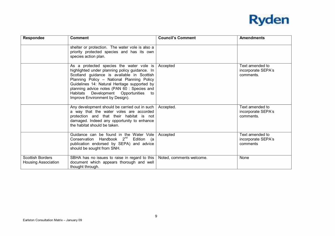
9Earlston Consultation Matrix – January 09
Respondee Comment Council’s Comment Amendments
shelter or protection. The water vole is also apriority protected species and has its ownspecies action plan.
As a protected species the water vole ishighlighted under planning policy guidance. InScotland guidance is available in ScottishPlanning Policy – National Planning PolicyGuidelines 14: Natural Heritage supported byplanning advice notes (PAN 60 : Species andHabitats Development Opportunities toImprove Environment by Design).
Accepted Text amended toincorporate SEPA’scomments.
Any development should be carried out in sucha way that the water voles are accordedprotection and that their habitat is notdamaged. Indeed any opportunity to enhancethe habitat should be taken.
Accepted. Text amended toincorporate SEPA’scomments.
Guidance can be found in the Water VoleConservation Handbook 2nd Edition (apublication endorsed by SEPA) and adviceshould be sought from SNH.
Accepted Text amended toincorporate SEPA’scomments
Scottish BordersHousing Association
SBHA has no issues to raise in regard to thisdocument which appears thorough and wellthought through.
Noted, comments welcome. None
Planning and Building Standards Committee 1
Item No. 7(a)SCOTTISH BORDERS COUNCIL
PLANNING AND BUILDING STANDARDS COMMITTEE
13 APRIL 2009
APPLICATION FOR PLANNING PERMISSION
ITEM: (a) REFERENCE NUMBER: 08/01402/FUL
OFFICER: Mr B FotheringhamWARD: Tweeddale WestPROPOSAL: Erection of 37 extra care apartments and 22 general needs apartments
with associated car parking, landscaping, boundary walls and fencesSITE: Scottish Borders Council Yard, George Street, PeeblesAPPLICANT: Eildon Housing AssociationAGENT: Aitken Turnbull
SITE DESCRIPTION
The application site is currently used as a roads depot by Scottish Borders Council. There are aseries of small industrial buildings on site which are used as vehicle maintenance bays/workshops, aswell as welfare units and open salt store. The site is defined by George Street to the north, DovecotRoad and Somerfield store to the south and the Eddleston Water to the east. The site is currentlyaccessed from George Street and Dovecot Road and enclosed by a 2m high steel security fence.
The application site is not located within the Peebles Conservation Area.
PROPOSED DEVELOPMENT
It is proposed to erect 37 extra care apartments and 22 general needs apartments with associated carparking, landscaping, boundary walls and fences. The existing buildings would be removed and thesite redeveloped.
The proposed buildings would be arranged in 4 blocks over 2, 3 and 4 storeys with street frontages toGeorge Street and Dovecot Road. A one way system would be in place to access the site fromDovecot Road and exit via George Street.
Block 1
Block 1 would be located to the east of the application site and would house the 37 extra careapartments. This block would be arranged over 4 storeys with a central glazed atrium running alongthe north south axis of the building. It would have a series of mono-pitched roofs which would befinished using standing seam aluminium. The walls would be finished using coloured render, facingbrick masonry with weathered face and a dry dash white render on white backing. Windows would bealuminium clad timber framed, coloured dark brown.
Planning and Building Standards Committee 2
Blocks 2, 3 and 4
The remainder of the proposed development – 22 general needs apartments (affordable housing) –would be arranged in 3 blocks over 2 and 3 storeys, with block 4, facing George Street, being thelower of the three blocks. They would be located towards the west of the site and would ‘turn’ thecorner at the junction with George Street and Dovecot Road.
These apartments would also be finished using the same external materials as block 1.
A landscaped area incorporating flood storage would be located to the north east of the site betweenthe proposed buildings and the Eddleston Water.
PLANNING HISTORY
There is no planning history associated with this site.
REPRESENTATION SUMMARY
Thirteen letters of representation/objection have been received in connection with this application.The principal grounds of objection can be summarised as follows:
The aesthetic appearance of the buildings could be construed as slums. The proposedbuildings are not appropriate in this location – close to listed buildings and not in character withPeebles.
The buildings are reminders of Langlee in Galashiels and we should learn from our mistakes. The buildings would be screened from Edinburgh Road but if the trees were removed then it
would be in full view of the main tourist route into town and detract further from our beautifultown.
Insufficient parking at present. This development would only increase the inability to park. The occupants of social housing would not be conducive to living in close proximity to what has
been called a replacement for Dunwhinney Lodge. Four storeys are ludicrous and unsightly. Loss of sunlight and privacy. The height coupled with the close proximity of the proposed development to neighbouring
properties completely overwhelms near neighbours and therefore is inappropriate for this site.Buildings on this site should be an absolute maximum height of two storeys.
The materials proposed for the roof of the development again are not appropriate for the sitewhich is on the edge of a conservation area. The aluminium material will be very visible frommany areas and I suggest should be replaced by grey tiles or slate on traditional pitched roofsto blend in with nearby property, including the new building site being developed in the old millsite opposite.
The colouring and materials on the building should match as near as possible nearbyproperties. Clearly at the moment they do not.
The scale, ultra modem and visually unattractive appearance of the proposed development issuch that it will adversely affect the whole neighbourhood, it will completely dominate that partof Peebles which is occupied by old traditional style stone cottages.
While I am unsure if this is strictly a planning matter, some of the development is being appliedfor under a replacement for Dunwhinney Lodge. There are no married couples or persons atDunwhinney who require any more than one bedroom therefore they would not qualify for aunit within this complex which as far as I can see is all two bedroom. I can only thereforeassume that the application under the present terms is not correct.
The proposed buildings are too high and should be a maximum of two storeys with traditionalslate roofs.
Planning and Building Standards Committee 3
The four storey buildings are too high and out of context with the surroundings. The site is at risk of flooding from the Cuddy. Occupation of the units by ‘homeless’ would result in late night noise, foul language and
rubbish bins being left out. The proposed development has no place to be in Peebles as it will not be in keeping with the
surrounding area. The four storey building will be totally inappropriate for this locationespecially as it is over looking stone cottages.
The size and nature of this visually unattractive building has cheap looking materials whichwould not gel into the surrounding area.
The materials that have been proposed for the roof for this development are not appropriate forthis site as it is on the edge of a conservation area. The aluminium material would be clearlyvisible from many areas.
The colouring and the materials on the proposed development should match as near aspossible the nearby properties.
The scale of the development coupled with the ultra modern and visually unattractiveappearance of the propose development is such that it will in my opinion adversely affect thewhole oft e neighbourhood, as it will completely dominate a part of Peebles which is occupiedby old traditional style stone cottages.
A water pipe serving March Street Mills runs through the application site and this should beprotected.
APPLICANTS’ SUPPORTING INFORMATION
A flood Risk Assessment, Remediation Strategy and Drainage Assessment were submitted along withthe application. These are available for Members to view on Public Access.
DEVELOPMENT PLAN POLICIES
Scottish Borders Structure Plan 2001-2011
Policy N18 – Development Affecting Conservation AreasPolicy N20 – DesignPolicy H7 – Affordable and Special Needs Housing – ProportionPolicy H8 – Affordable and Special Needs Housing – AssessmentPolicy H9 – Affordable and Special Needs Housing – ExceptionsPolicy I11 – Parking Provision in New DevelopmentPolicy I15 – Flood Risk AreasPolicy I18 – Contaminated landPolicy I21 – Small Scale Renewable Energy Technologies
Scottish Borders Local Plan 2008
Policy G1 – Quality Standards for New DevelopmentPolicy G2 – Contaminated LandPolicy G4 – FloodingPolicy G7 – Infill DevelopmentPolicy BE4 – Conservation AreasPolicy BE6 – Protection of Open SpacePolicy H1 – Affordable HousingPolicy H2 – Protection of Residential AmenityPolicy H3 – Land Use AllocationsPolicy Inf3 – Road Adoption StandardsPolicy Inf4 – Parking Standards
Planning and Building Standards Committee 4
Policy Inf6 – Sustainable Urban Drainage
OTHER PLANNING CONSIDERATIONS
PAN 74 – Affordable HousingPAN 84 – Reducing Carbon Emissions in New DevelopmentPAN 33 – Development of Contaminated LandPAN 69 – Planning and Building Standards Advice on FloodingPAN 67 – Housing QualityPAN 44 – Fitting New Housing Development into the Landscape
SPP7 – Planning and FloodingSPP3 – Planning for HomesSPP20 – Architecture and Design Scotland
SPG – Affordable HousingSPG – Landscape and DevelopmentSPG – Trees and DevelopmentSPG – Privacy and Sunlight GuideSPG – Renewable Energy
CONSULTATION RESPONSES
Scottish Borders Council Consultees
Technical Services (Roads): There have been numerous pre-application discussions with theapplicants and their agents regarding this development. In terms of sustainable transport thisdevelopment is to be commended as utilising a brown field site to its maximum potential. There aresome minor issues with the internal layout and small adjustments will be required to accommodate theflow of pedestrians and the swept paths of larger vehicles. This can be dealt with at RCC stage. I notethere appears to be no details of a SUDS system for the development and would question thisomission. The requirement for Roads Construction Consent should be a planning condition.
Technical Services (EH): In its current use the above site is not designated as contaminated landunder Part IIA.
However, development may:
introduce new receptors onto a site, for example by changing the use of the site (e.g. futuresite users, water environment)expose new pathways by which contaminants can reach existing receptors (e.g. Ingestion ofcontaminated soil and dust, dissolution or seepage of residual free organic contaminants)
Potential sources of historic contamination could be activities related to use as former railway land,use for Road Vehicle Servicing & Repair Works, Garages & Filling Stations, Haulage Centres, use forSawmilling, planning & impregnation [i.e. treatment of timber], and Quarrying of sand & clay, operationof sand & gravel pits (unknown filled ground).
It is the observation of the Environmental Health Section (Technical Services) that planningpermission should be granted on condition that development is not be permitted to start until a siteinvestigation and risk assessment has been carried out, submitted and agreed upon by the localauthority. Any requirement for a remediation strategy and verification plan would become a conditionof the planning consent, to be submitted and agreed upon by the local authority prior to development.
Planning and Building Standards Committee 5
Technical Services (Flood Protection Officer): In terms of information that this Council hasconcerning flood risk to this site, I would state that The Indicative River & Coastal Flood Map(Scotland) known as the “second generation flood mapping” prepared by SEPA indicates that this siteis affected from a flood event with a return period of 1 in 200 years. That is the 0.5% annual risk of aflood occurring in any year.The Developer, Eildon Housing Association, has had a Flood Risk Assessment (FRA) prepared byJBA Consulting for this development in order to satisfy the requirements of SPP7.
JBA have taken into account that the development will house vulnerable people and have includedmodelled flows using the 0.2% AP (500 year return period) as well as the 0.5% AP (200 year returnperiod). The flows used were much higher than those in the previous study carried out by MontgomeryWatson Harza for Scottish Borders Council but are considered consistent with other FRA’s undertakenin the area.
Following the initial assessment the buildings have been re-located to the western side of the sitefurther from the Eddleston Water and the land raised with Ground floor levels raised to 164.00m AOD.To provide compensation flood storage part of the land nearer the river will be lowered. Emergencyaccess and egress from the building has also been addressed with routes leading to the higher groundat Dovecote Street.
Education & Lifelong learning: I refer to your request for Education’s view on the impact of thisproposed development, which is located within the catchment area for Kingsland Primary School,Halyrude RC Primary School and Peebles High School.
Education has no observations to make on this proposed development at this time and will not beseeking a developer contribution towards the provision of infrastructure for the schools in thecatchment area.
Social Work (Housing): No reply.
Statutory Consultees
Peebles Community Council: The Community Council Objects to this application as it does notconform to Local Plan Policies G1, G2, BE4, H2 and G4.
SEPA: Based upon the review of the Flood Risk Assessment SEPA objects to the proposal on thegrounds of flood risk. The site has a history of flooding and is currently at risk of flooding from highfrequency 1 in 10 year (10% annual probability) events. Scottish Planning Policy 7 states that sensitivedevelopments such as this should be free of flooding from a 1 in 1000 year (0.1% annual probability)flood event. However, the development has only been designed to accommodate the 1 in 500 year(0.2% annual probability) design flood. In its current form the development site is at risk of floodingduring a 1 in 1000 year flood event (0.1% annual likelihood) and to allow the development to go aheadwould place a vulnerable group of people at significant risk. The proposal is therefore contrary to thegeneral principles of Scottish Planning Policy 7 (SPP 7) 'Planning and Flooding'.
SEPA is of the opinion that care and general needs apartments are sensitive developments and thatcareful consideration must be given to the placing a more vulnerable group of people at flood risk.Given the sensitivity of the development proposed SEPA is of the view that the development shouldbe completely free from flood risk.
Other Consultees
Peebles Civic Society: The CS objects to this application. The buildings are generally higher thanthe surrounding houses and therefore the complex will stand out in its surroundings. The four - storey
Planning and Building Standards Committee 6
part is close to Dovecot Road and will be seen against the skyline on account of its height. Whilst wewelcome the general modern aesthetic approach to the design we are concerned about the choice ofcolours of the materials as these will have a major contribution to the character of the complex. It ismost important that the context of the surroundings to the development is respected.We are concerned that the storm water detention pond/basin might be a hazard to children in the area.There is no indication of the landscaping of the area outwith the fence on the riverside. We welcomethe tree planting and hope that this area will become a useful open space. This development willgreatly enhance the appearance of the riverside.
Scottish Water: No objections. Please note that any planning approval granted by the LocalAuthority does not guarantee a connection to our infrastructure. Approval for connection can only begiven by Scottish Water when the appropriate application and technical details have been received.
KEY PLANNING ISSUES
The main planning issues can be identified as follows:
Whether the proposed development is an acceptable use of the identified redevelopmentopportunity
Whether the development would have an adverse impact on the amenity of existing residentialareas
Whether the site is at risk of flooding Whether the development would have an adverse impact on the character of the conservation
area Whether adequate access and parking can be achieved
ASSESSMENT OF APPLICATION
POLICY
The application site forms part of a wider redevelopment opportunity as identified in the ScottishBorders Local Plan 2008. Site No zRO7 covers a total of 2.7 hectares and includes part of the formerMarch Street Mills (now housing and including existing business units), Brown Brothers garage,Techauto garage (now vacant), as well as the Council Roads Depot. The allocation cross-referenceswith Policy H3.
Policy H3 of the Local Plan applies to all allocated land use proposals as shown on the proposalsmaps in the local plan. Sites proposed for redevelopment or mixed use may be developed forhousing, employment or retaining, or a mix of uses that could include community facilities and openspace depending on the location of the site, the needs of the community and the deliverability ofalternative uses. Redevelopment sites may also be developed for a single use.
The current proposals offer a combination of extra care/special needs housing and general needshousing and would form part of the Peebles Housing Strategy of which Eildon Housing have been thelead stakeholder. This wider strategy for affordable housing/special needs housing in Peebles aims todeliver much improved levels of housing for local needs and would include sites at Dunwhinney Lodgeand Margaret Blackwood Housing (Tweed Bridge Court) as well as the current application site atDovecot Road/George Street. This strategy also ties in with the current proposals (08/01618/FUL) toexpand and improve the existing waste transfer station at Eshiels and decant of facilities/operationsfrom the Dovecot Depot to the Eshiels site.
The redevelopment of the Council Depot for a mix of close care and general needs housing would inprinciple comply with the terms of Policy H3.
Planning and Building Standards Committee 7
RESIDENTIAL AMENITY
Within the development boundary of Peebles, Policy H2 – Protection of Residential Amenity of theLocal Plan covers all the land and sets to protect the amenity of established residential areas. Theapplication site is located within an area of mixed uses, although the predominant use is residential.In this case, the use of the site for residential purposes, albeit special care and general needshousing, would be consistent with the established land use of the area and therefore in-keeping withthe principles behind Policy H2.
The form and type of development would clearly fit within an established residential area, and wouldbe accommodated within the George Street/Dovecot Road area of Peebles. The scale of theproposed buildings is however, different to that of existing residential properties particularly those onGeorge Street. However, it is considered that the proposed apartments would not have a significantadverse impact on the residential amenity of adjacent properties, particularly as a result of overlooking, over shadowing and loss of privacy.
The largest of the four blocks, Block 1, would be located towards the east of the site, adjacent to theexisting Somerfield (soon to be Tesco) store and close to the existing apartments at March StreetLane. The scale and mass of the proposed building would not be inconsistent with the general patternof development in the area and would not have a significant adverse effect on the residential characteror amenity of the area. The remaining blocks would be lower and of a scale consistent with the scaleand mass of nearby properties. As such it is contended that there would be no significant adverseimpact on the amenity of adjacent properties, especially recognising the former use of the site.
In addition, the generation of traffic and noise is considered to be minimal compared to the existinguse of the site as a works/roads depot which attracts a significant volume of traffic and numbers ofvehicular movements.
FLOODING
Members will be fully aware that the application site, given its location adjacent to the EddlestonWater, is at risk of flooding. This is confirmed by the Council’s Flood Protection Officer and SEPA.However, the Flood Risk Assessment (FRA) prepared by JBA Consulting and submitted by theapplicant in support of this application meets the requirements of SPP7.
The FRA has taken into account that the development will house vulnerable people and has includedflows using the 1 in 500 year return period as well as the 1 in 200 year return period. These flows weremuch higher than those used in previous studies but are considered consistent with other FRA’sundertaken in the area.
Following the initial assessment the buildings have been re-located to the western side of the sitefurther from the Eddleston Water and the land raised with finished ground floor levels raised to164.00m AOD. To provide compensation flood storage part of the land nearer the river will be lowered.Emergency access and egress from the building has also been addressed with routes leading to thehigher ground at Dovecote Street.
Members will note that SEPA initially objected to the application on the grounds that the developmentshould be completely free from flood risk given the sensitivity of the development and the highdependency of most of the occupants. SPP7 states that sensitive developments such as this shouldbe free of flooding from a 1 in 1000 year flood event. The development has only been designed toaccommodate the 1 in 500 year design flood and in its current form the development site is at risk offlooding during a 1 in 1000 year flood event. To allow the development to go ahead would place avulnerable group of people at significant risk and SEPA considers the proposal to be contrary to thegeneral principles of SPP 7 'Planning and Flooding'.
Planning and Building Standards Committee 8
Following the submission of additional supporting information and a further FRA which includedrevised and additional figures as well as proposals for compensatory flood storage, SEPA has nowwithdrawn their initial objections. SEPA are now satisfied that the proposed development accords withthe principles of SPP7 and will be free from flood risk. The proposed development would now have aground floor level above the 1 in 1000 year flood event with a minimum freeboard of 480mm. Saveaccess and egress can also be achieved to Dovecot Road. SEPA are satisfied that the proposeddevelopment will not exacerbate flood risk elsewhere and will actually have a beneficial impact as itwill increase the volume of flood storage available.
CONSERVATION AREA
The application site lies outside the Peebles Conservation Area but is located on the edge of theboundary at Dovecot Road. Policy BE4 – Conservation Areas states that development within oradjacent to a Conservation Area that would have an unacceptable adverse impact on its character andappearance will be refused. All new development should be located and designed to preserve thespecial architectural or historic character of the Conservation Area and this should accord with scale,proportions, density, materials as well as open spaces, gardens and landscapes.
The proposed development would be of a contemporary approach compared to the traditionally builtproperties on George Street. However, it is worth bearing in mind that the site is currently occupied bythe Council’s roads depot and lies immediately adjacent to a super market, both of which offer little interms of architectural character or quality. It is considered that the proposed contemporary designapproach in this case would be a considerable improvement on the current position and add muchneeded variety, depth and context to the area.
The aim of Policy BE4 is to preserve or enhance the character and appearance of the ConservationArea and it is considered that the development would certainly enhance the quality of this part of theconservation area, given the previous use and history of the site.
AFFORDABLE HOUSING
Local housing strategy and needs assessments confirm that there is an identified need for aproportion of affordable and special needs housing in Peebles. As mentioned earlier, this proposalforms part of a wider housing strategy aimed at delivering improved levels of affordable and specialneeds housing and this redevelopment site offers this opportunity.
As Eildon Housing Association is the developer, the proposed development would result in 100%provision of affordable housing.
DESIGN/MATERIALS
The design of the proposed blocks of apartments adopts a contemporary approach which is clearlydifferent to the established built form in the immediate surrounding area to the north and west.However, this does not necessarily suggest that the design approach is inappropriate for this location,and the site occupies a historically commercial area, with more modern development to the south andeast. As such, the site can easily be described as having a transitional character, which allows greaterflexibility in the design approach. Policy G1 of the Local Plan encourages all new development to beof a high quality in accordance with sustainability principles, designed to fit with Scottish Borderstownscapes and to integrate with its surroundings. This policy is aimed at ensuring that all newdevelopment, not just housing, is of a high quality and respects the environment in which it iscontained. The policy does not aim to restrict good quality modern or innovative design but does aimto ensure that it does not negatively impact on existing buildings, or surrounding landscape and visualamenity of the area. It is considered that the local environment in this location is not highly sensitive tochange considering the adjacent employment uses, retail developments and more recently, residential
Planning and Building Standards Committee 9
development. The scale of the new apartment blocks would be considerably larger than the existingbuildings on site, but the end product would result in a development which would only serve toimprove the character, appearance and visual amenity of the area. It would offer significantenvironmental and regeneration benefits to the area and contribute to the wider neighbourhood andcharacter of the surrounding area.
The proposed external materials, like the design, are not consistent with the surrounding area, but theproposed coloured renders and aluminium roofs will add a new dimension to this dilapidated area andhelp to create a new sense of place which would complement the architecture and materials used inthe locality.
At the time of writing this report, amended drawings were submitted by the agent. These drawingsamend the elevations and roof plans of the proposed buildings only marginally and do not alter thebasic footprints, scale, mass and general appearance of the proposal.
ACCESS/PARKING
In terms of sustainable transport, this development is to be commended as utilising a brown field siteto its maximum potential. Members will note from comments submitted by Technical Services thatthere are some minor issues with the internal layout and small adjustments will be required toaccommodate the flow of pedestrians and the swept paths of larger vehicles. This, however, can bedealt with at RCC stage. It is also noted there are no details of a SUDS system for the development,however, this can be covered by condition and dealt with at the same time as the RCC application.
The developer is keen to ensure that linkages with adjoining built up areas as well as existing openspaces are provided and is currently investigating options for future pedestrian linkages to a riversidewalkway along the banks of the Eddleston Water. On the remainder of the site, there are proposedpedestrian linkages from the development to George Street and Dovecot Road.
LANDSCAPE
Detailed landscape proposals were submitted late in the application process and details were passedto the Council’s Landscape Architect for information and comment. The proposals offer muchimproved levels of planting and would help to integrate the proposals with the surrounding landscape,particularly the compensatory flood storage area and the banks of the Eddleston Water.
RENEWABLE ENERGY TECHNOLOGIES/SUSTAINABILITY
PAN 84 – Reducing Carbon Emissions in New Development and Scottish Borders Council SPG –Renewable Energy support policies within the Local Plan 2008 and promote a sustainable approach tonew development. The core elements of this approach are firstly to address the use and generation ofenergy; secondly to raise awareness of the potential to reduce energy use (energy efficiency); andthirdly to meet energy needs through the use of low and zero-carbon technologies (LZCT) includingrenewable energy technologies.
The Council’s SPG requires all new developments of 500m2 or more and strongly encourages all othernew developments to reduce carbon dioxide emission levels by an additional 15% beyond the 2007Building Regulations carbon dioxide emission levels. The preferred approach for meeting this 15%reduction is through incorporation of energy efficient measures and where the additional 15% is metthrough efficiency measures the requirements for on-site LZCT will be waived.
This approach is slightly different to that of PAN84 which looks for LZCT to be included indevelopments of this nature. However, given the tight budgetary constraints of this affordable housingdevelopment, the planning authority has agreed with the developers that the Council’s SPG offers the
Planning and Building Standards Committee 10
most sensible approach to meeting this 15% reduction. This can be covered by a suitably wordedcondition.
DRAINAGE
A comprehensive drainage assessment was submitted along with the application and is available forMembers to view on-line. The assessment provides details on information relating to the drainage andSUDS principles that will be used for this development.
The proposed SUDS system, of which no details have been submitted to the planning authority, wouldinclude treatment and attenuation in accordance with SEPA’s design manual for Scotland. ScottishWater has confirmed that there is sufficient capacity within the Peebles Water Treatment Works toservice the demands of the system and the site will be designed on a separate system with surfacewater out falling to the Eddleston Water and foul drainage to the existing combined sewer. Surfacewater will be attenuated to normal green-field run-off and stored in the proposed detention basin/pond.This pond would also accommodate the 1 in 200 year flood event.
The drainage issues above can all be covered by suitably worded conditions.
CONTAMINATED LAND
In its current use the application site is not designated as contaminated land. However, developmentmay:
introduce new receptors onto a site, andexpose new pathways by which contaminants can reach existing receptors
The Council’s Environmental Health Section advises that planning permission should be granted oncondition that development is not be permitted to start until a site investigation and risk assessmenthas been carried out, submitted and agreed upon by the local authority. Any requirement for aremediation strategy and verification plan would become a condition of the planning consent, to besubmitted and agreed upon by the local authority prior to development.
The applicant has submitted a contaminated land survey and remediation strategy which wasprepared by Geovia in September 2008. This study identified a number of contaminants on siteincluding chloride, influenced by on site storage or road salt, diesel/fuel oil and copper. It is also notedthat there may be potential for methane gas generation within the shallow soils within the site.
The study identifies a remediation strategy for the identified contaminants and it is considered that thisstrategy would address EH concerns and remove the need for further investigation/reports.
REPRESENTATIONS
Members will be aware that a number of objections have been received in connection with thisapplication. While most of the objections are both understandable and legitimate concerns, it isconsidered that the positives resulting from this redevelopment opportunity considerably outweigh thenegatives. It is accepted that there may be some loss of residential amenity of neigbouring propertiesparticularly as a result of over shadowing on George Street but it is considered that this is notsignificant enough to warrant refusal of the application. The agent has demonstrated that the levels ofover shadowing are not unacceptable and would not result in an unacceptable adverse impact on theresidential amenity of these properties.
Planning and Building Standards Committee 11
The proposal will clearly offer significant environmental benefits by removing an existing industrial usefrom the site. The dilapidated buildings would be demolished and the number of heavy goods vehiclesusing the narrow residential streets would be significantly reduced.
CONCLUSIONS
The proposed residential development would be consistent with the land use allocations identified inthe adopted Local Plan 2008 and would be an acceptable use for this redevelopment opportunity. Itwould contribute to a wider housing needs strategy for Peebles offering increased and improvedprovision of extra care and general needs housing, of which there is an identifiable need.
The proposals would introduce modern and contemporary design on the fringe of an area of Peebleswhich is largely dominated by traditionally built residential properties finished in wet and dry render,natural stone and slate roofs, but which is located close to more modern forms of development.Recognising this context, the modern design approach is of a high quality and would respect andcomplement the character of the area.
RECOMMENDATION BY HEAD OF PLANNING AND BUILIDNG STANDARDS
I recommend that the application is approved subject to the following conditions:
1. Notwithstanding the description of the materials in the application, no development shall becommenced until precise details of the materials to be used in the construction of the externalwalls and roofs of the buildings have been submitted to and approved in writing by the LocalPlanning Authority, and thereafter no development shall take place except in strict accordancewith those details.
Reason: The materials require further consideration to ensure a satisfactory form of development,which contributes appropriately to its setting.
2. Sample panels of the external wall finish to be prepared on site for prior approval by the PlanningAuthority.
Reason: The materials to be used require further consideration to ensure a satisfactory form ofdevelopment, which contributes appropriately to its setting.
3. No development shall take place except in strict accordance with a scheme of hard and softlandscaping works, which has first been submitted to and approved in writing by the planningauthority. Details of the scheme shall include (as appropriate):i. existing and finished ground levels in relation to a fixed datum preferably ordnanceii. existing landscaping features and vegetation to be retained and, in the case of damage,
restorediii. location and design, including materials, of walls, fences and gatesiv. soft and hard landscaping worksv. existing and proposed services such as cables, pipelines, sub-stationsvi. other artefacts and structures such as street furniture and play equipmentvii. a programme for completion and subsequent maintenance.
Reason: To ensure the satisfactory form, layout and assimilation of the development.
4. Details of all proposed means of enclosure shall be submitted to and approved in writing by theLocal Planning Authority before work on the site is commenced.
Reason: To enable the proper effective assimilation of the development into its widersurroundings.
Planning and Building Standards Committee 12
5. Before any part of the permitted development is commenced, the trees to be retained on the siteshall be protected by a chestnut paling fence 1.5 metres high, placed at a minimum radius of onemetre beyond the crown spread of each tree, and the fencing shall be removed only when thedevelopment has been completed. During the period of construction of the development:(a) No excavations, site works, trenches or channels shall be cut, or pipes or services laid in
such a way as to cause damage or injury to the trees by interference with their root structure;(b) No fires shall be lit within the spread of the branches of the trees;(c) No materials or equipment shall be stored within the spread of the branches of the trees;(d) Any accidental damage to the trees shall be cleared back to undamaged wood and be treated
with a preservative if appropriate;(e) Ground levels within the spread of the branches of the trees shall not be raised or lowered in
relation to the existing ground level, or trenches excavated except in accordance with detailsshown on the approved plans.
Reason: In the interests of preserving the health and vitality of existing trees on the developmentsite, the loss of which would have an adverse effect on the visual amenity of the area.
6. The finished ground floor level shall be a minimum of 164.00m AOD with a free board of 480mmabove the 1 in 1000 year flood event.
Reason: To ensure that buildings and people are not at risk of flooding.
7. The area allocated for parking on the submitted plan shall be properly consolidated, surfaced anddrained before the use of the site commences/the buildings are occupied, and shall not be usedother than for the parking of vehicles in connection with the development hereby permitted.
Reason: To ensure there is adequate space within the site for the parking of vehicles clear of thehighway.
8. The proposed roads, footpaths and turning spaces indicated on the approved drawing shall beconstructed in such a manner as to ensure that each dwelling, before it is constructed, shall beserved by a properly consolidated and surfaced carriageway and footpath.
Reason: To ensure that the proposed estate is laid out in a proper manner with adequateprovision for traffic.
9. Prior to the occupation of the development for residential purposes, new or existing footwaycrossovers must be constructed or extended to the specification of the Highway Authority with anyredundant crossover reinstated to the relevant footway standards.
Reason: To ensure that the footway crossover is satisfactorily constructed.
10. No dwelling forming part of the development shall not be occupied until the access roads andfootpaths shown on the approved plans have been built to the specification of the Local PlanningAuthority.
Reason: To ensure that adequate access to the site for pedestrians and vehicles is provided andis at all times properly maintained.
11. Before any development commences a scheme shall be submitted to the Local Planning Authorityindicating measures to be taken to provide access and facilities for the disabled. Such scheme asshall have been approved in writing shall be fully implemented before any part of the developmentis brought into use and shall be thereafter permanently retained.
Reason: To ensure satisfactory access/facilities for the disabled.
12. All drainage shall be on a rigidly separate system. Reason: To comply with the requirements of the Scottish Environment Protection Agency.
Planning and Building Standards Committee 13
13. None of the dwellings shall be occupied until works for the disposal of sewage have beenprovided on the site to serve the development hereby permitted in accordance with details to besubmitted to and approved in writing by the Local Planning Authority.
Reason: To ensure that satisfactory arrangements are made for the disposal of surface and foulwater.
14. Surface water drainage shall not be taken to the public sewer but shall be disposed of elsewhereand the development hereby permitted shall not be commenced until that means of disposal hasbeen submitted to and approved in writing by the Local Planning Authority.
Reason: To ensure that the existing combined sewerage system is not overloaded.
15. Before any unit forming part of the development hereby approved is occupied or brought into use,the measures to decontaminate the site as identified in the report prepared by Geovia and datedSeptember 2008, shall be fully implemented and approved by the planning authority.
Reason: To ensure that the potential for health risk arising from any identified land contaminationhas been adequately addressed.
16. The proposed development shall incorporate measures to maximise the efficient use of energyand resources, and the incorporation of sustainable building techniques and renewable energytechnologies, in accordance with a scheme of details that shall first have been submitted to andapproved in writing by the planning authority. This should include demonstration of a reduction of15% in CO2 emissions beyond the 2007 building regulations carbon dioxide emissions standardthrough incorporation of on-site low or zero carbon technologies (LZCT) where technicallyfeasible.
Reason: To ensure the development minimises any environmental impact
Approved byName Designation SignatureBrian Frater Head of Planning and Building
Standards
The original version of this report has been signed by the Head of Planning and Building Standardsand the signed copy has been retained by the Council.
Author(s)Name DesignationBarry Fotheringham Principal Planning Officer
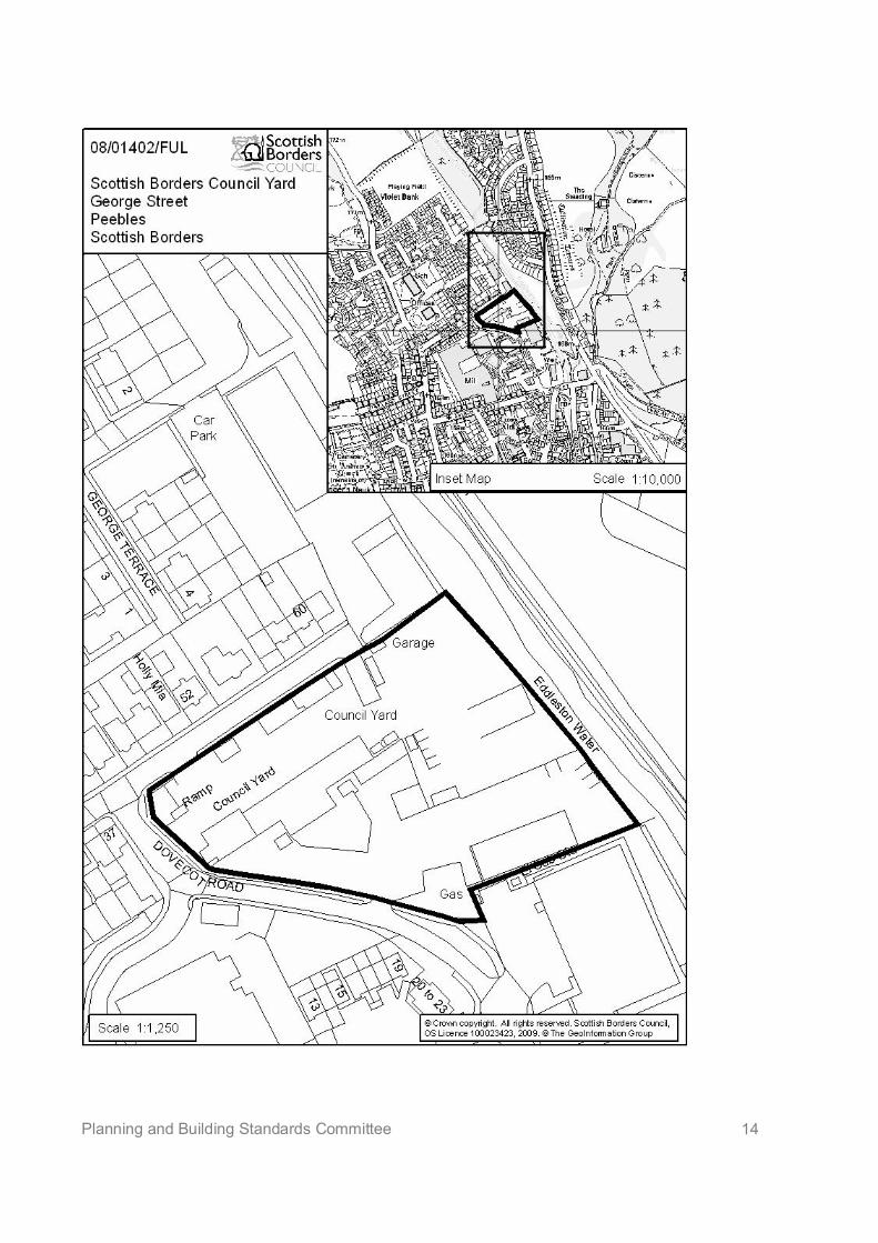
Planning and Building Standards Committee 14
Planning & Building Standards Committee – 13 April 2009
Item No. 7(b)SCOTTISH BORDERS COUNCIL
PLANNING AND BUILDING STANDARDS COMMITTEE
13 APRIL 2009
APPLICATIONS FOR PLANNING PERMISSION AND LISTED BUILDING CONSENT
ITEM: (b) REFERENCE NUMBER: 08/01208/LBC; 08/01209/FUL
OFFICER: Carlos ClarkeWARD NAME: Galashiels and DistrictPROPOSAL: 08/01208/LBC: Demolition of former church hall and alterations and
extension of former church to form eleven apartments;08/01209/FUL: Change of use, alterations and extension of formerchurch to form eleven apartments, erection of fifteen apartments andchange of use of builder’s yard to form related car parking area onremote site
SITE: St Aidans Church Hall and St Aidans Church, Gala Park, andBuilder’s Yard West of 76 St Andrews Street, Galashiels
APPLICANT: Braedale Developments LtdAGENT: Camerons Ltd
SITE DESCRIPTION
The site is located between Gala Park to the north-east, and St Andrew Street to the south-west,and comprises a Category B Listed Victorian Church on its north-east side, and a hall (listed withthe church) on its south-west side built in the 1939. The Church is of Gothic design, with a towerand octagonal spire on its north-east corner, and is built in whinstone, with sandstone dressings,and a tall, steep pitched slated roof. Internally the building retains its symmetrical plan form, whichincludes a curved timber gallery on cast iron columns, barrel vaulted timber Jacobean panelledroof with hammer beams on stone corbels.
The church faces 2 ½ storey properties, and is flanked by the same either side, mainly residentialin use. It backs onto the gardens of residential properties fronting St Andrew Street. The hall isflanked by residential properties to the south-east, with a public car park to the north-west, andmainly 2 ½ storey properties face the site from the south side of St Andrew Street.
The application includes a proposal to form a car parking area on a former builder’s yardaccessible by an existing pend further to the north-west on St Andrew Street, and which comprisesa range of existing, small buildings in an enclosed yard.
PROPOSED DEVELOPMENT
Listed Building Consent is sought for alterations to the existing church to allow for the formation ofeleven residential units, in addition to the demolition of the church hall to which it is currentlyphysically linked.
Planning Permission is sought too for the change of use of the church to eleven residential units,and for the erection of a single, flatted block on the site of the hall which would incorporate fifteenresidential units. The number of new-build residential units was reduced from sixteen, followingrevisions to the proposals during processing of the application.
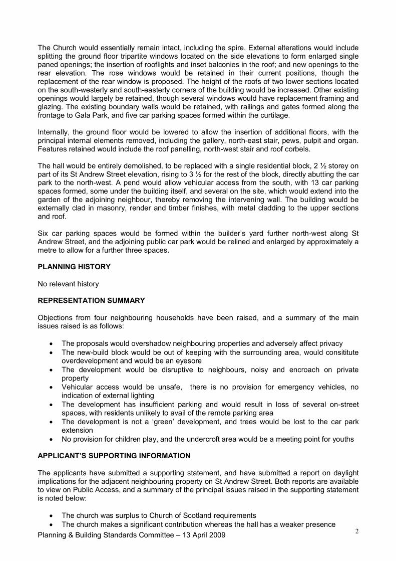
Planning & Building Standards Committee – 13 April 2009 2
The Church would essentially remain intact, including the spire. External alterations would includesplitting the ground floor tripartite windows located on the side elevations to form enlarged singlepaned openings; the insertion of rooflights and inset balconies in the roof; and new openings to therear elevation. The rose windows would be retained in their current positions, though thereplacement of the rear window is proposed. The height of the roofs of two lower sections locatedon the south-westerly and south-easterly corners of the building would be increased. Other existingopenings would largely be retained, though several windows would have replacement framing andglazing. The existing boundary walls would be retained, with railings and gates formed along thefrontage to Gala Park, and five car parking spaces formed within the curtilage.
Internally, the ground floor would be lowered to allow the insertion of additional floors, with theprincipal internal elements removed, including the gallery, north-east stair, pews, pulpit and organ.Features retained would include the roof panelling, north-west stair and roof corbels.
The hall would be entirely demolished, to be replaced with a single residential block, 2 ½ storey onpart of its St Andrew Street elevation, rising to 3 ½ for the rest of the block, directly abutting the carpark to the north-west. A pend would allow vehicular access from the south, with 13 car parkingspaces formed, some under the building itself, and several on the site, which would extend into thegarden of the adjoining neighbour, thereby removing the intervening wall. The building would beexternally clad in masonry, render and timber finishes, with metal cladding to the upper sectionsand roof.
Six car parking spaces would be formed within the builder’s yard further north-west along StAndrew Street, and the adjoining public car park would be relined and enlarged by approximately ametre to allow for a further three spaces.
PLANNING HISTORY
No relevant history
REPRESENTATION SUMMARY
Objections from four neighbouring households have been raised, and a summary of the mainissues raised is as follows:
The proposals would overshadow neighbouring properties and adversely affect privacy The new-build block would be out of keeping with the surrounding area, would consititute
overdevelopment and would be an eyesore The development would be disruptive to neighbours, noisy and encroach on private
property Vehicular access would be unsafe, there is no provision for emergency vehicles, no
indication of external lighting The development has insufficient parking and would result in loss of several on-street
spaces, with residents unlikely to avail of the remote parking area The development is not a ‘green’ development, and trees would be lost to the car park
extension No provision for children play, and the undercroft area would be a meeting point for youths
APPLICANT’S SUPPORTING INFORMATION
The applicants have submitted a supporting statement, and have submitted a report on daylightimplications for the adjacent neighbouring property on St Andrew Street. Both reports are availableto view on Public Access, and a summary of the principal issues raised in the supporting statementis noted below:
The church was surplus to Church of Scotland requirements The church makes a significant contribution whereas the hall has a weaker presence
Planning & Building Standards Committee – 13 April 2009 3
The proposals retain the spire, which will be subject to an ongoing maintenance agreement,and many existing features of the church are being retained
Revised proposals have been submitted in line with discussions with the planningdepartment, including removal of the roof terrace, reduction in stair towers, reduction inheight and elevations and revisions to the church alterations.
The area has seen a consolidation of density in recent years The applicant is considering providing more than the required amount of affordable housing A range of options have been considered for retaining the church hall but ruled out due to
viability, a need to balance funding across the site to retain the church, and parkingrequirements
The new-build design takes the form of a 3-storey-room in the roof/2 –storey room in theroof approach, to plug the gap left by the hall, and provide a built edge to the car park in asimple, honest modern language. The development would have a varied approach betweenelevations when related to surrounding streets.
The development would be sustainable, and represent the best chance of retaining theexisting church, while reinforcing the character and population density of this area ofGalashiels
DEVELOPMENT PLAN POLICIES
Approved Structure Plan 2001-2011
N17 Listed BuildingsN20 DesignH7 Affordable and Special Needs HousingI5 CyclingI5 WalkingI11 Parking Provision in New developmentI14 Surface Water
Scottish Borders Local Plan 2008
G1 Quality Standards for New DevelopmentG5 Developer ContributionsG6 Developer Contributions related to Railway ReinstatementG7 Infill developmentH1 Affordable HousingH2 Protection of Residential AmenityInf 4 Parking StandardsInf 5 Waste Water Treatment StandardsInf 6 Sustainable Urban DrainageBE1 Listed Buildings
OTHER PLANNING CONSIDERATIONS:
SPP3 Planning for Homes 2008SPP6 Renewable Energy 2007SPP23 Planning and the Historic Environment 2008Scottish Historic Environment Policy 2008Memorandum of Guidance on Listed Buildings and Conservation Areas 1998Supplementary Planning Guidance – Waverley Railway Project Developer Contributions 2004 and2006Supplementary Planning Guidance – Developer Contributions 2008Supplementary Planning Guidance – Affordable Housing 2007Supplementary Planning Guidance – Renewable Energy 2007Supplementary Planning Guidance – Privacy and Sunlight Guide 2006
Planning & Building Standards Committee – 13 April 2009 4
CONSULTATION RESPONSES:
Full responses are available on Public Access, the following paragraphs comprising a summary ofthe main comments raised in response to the original submission, prior to the amendmentsreferred to in the assessment section.
Scottish Borders Council Consultees
Director of Education and Lifelong Learning: Contributions of £474 towards Burgh PrimarySchool and £204 towards Galashiels Academy are required (these contributions will rise from April)
Director of Technical Services (Flood Prevention Officer): The site is not at risk in a 1:200 yearevent
Director of Technical Services (Roads): The only roads issue needing to be address has beenparking, and given the location and present use, a 100% requirement should be applied. As 27spaces are proposed for 27 units (now 26), it is difficult to oppose the development, though areduction in numbers would help. All spaces would be private, except the three in the public carpark. The St Andrew Street car park is remote but will be well used by residents who will have theirown space in a safe enclosed area, rather than on-street. On balance does not object. Acontribution of £1000 per unit towards the Galashiels Traffic Study outcomes will be required asthe development comprises more than 25 units.
Director of Planning and Economic Development (Heritage and Design Officer): HistoricScotland were aware of the need to find a new use for the church before listing the buildings.Supports the principle of a reuse for the church, and considers that projects of this nature wouldnormally require a degree of ‘enabling’ development to provide cross-subsidy. More information isrequired to justify the demolition of the hall, in particular, a financial appraisal of the benefits of thenew block.
In terms of the church alterations, acknowledges that repair works to the spire have beenundertaken, and considers the insertion of single windows in the side-elevation tripartite openingsacceptable on balance provided they are needed to satisfy Building Standards. Considers the roofalterations acceptable. Would prefer to see the rose windows retained. Considers that there wouldbe an excess of openings on the rear elevation. Internally, the building is virtually intact, but it issimply not possible to retain all features unless the building is retained for some form of publicassembly. The scheme retains some features though these are limited to some columns, the north-east stair and vaulted ceiling. The south-east stair would be better left intact. A condition requiringarchitectural salvage should be agreed before any stripping out of the internal fittings, and shouldbe recorded by the RCAHMS. Recommends that the applicant agrees the removal of memorialswith the Church of Scotland. Overall, content with the alterations to the rear church rooms.
The hall is at best a Cs Listing and may not be listable in its own right. There are clearly someissues with respect to repair and there is limited cost-benefit potential for redevelopment. It ispossible to use the hall for social activities under separate ownership, though this appears topreclude the redevelopment of, and securing a viable long term future for the main church. Theimportance of putting the site to a new use in economic and social terms is the most importantfactor in this particular application, and further information is still required in support of this.
Regarding the new build proposal, supports the contemporary approach. It would have beendesirable to turn the corner but the car park prevents this. Concerned with the overall height,especially the gable to St Andrew Street which is too high. The stair towers and green roof amountto 5 storeys. It may be possible to omit units nearest St Andrew Street and step up the roof againback towards the back of the church especially if the roof access towers are omitted. Appreciatethere is likely to be an issue with commercial viability and this information may need shared withthe Council in confidence. The surrounding area is characterised by slate roofs and buff sandstonewalls though the tonal balance of the building can be dealt with by condition as regards samplematerials.
Planning & Building Standards Committee – 13 April 2009 5
Overall, the application is challenging, linking a positive future for a recently listed Category Bformer church with a positive reuse for housing. The loss of the hall can be viewed as beingnecessary in order to cross subsidise the cost of the overall development. A clear understanding ofthe constraints on the developer in terms of affordability is important, especially in current market.
Whilst this scheme does involve the effective whole loss of the church interior and demolition ofhall, the scheme has the merit of retaining the church, particularly its spire as a townscape featureand securing its future, whereas it was heading for redundancy when listed in the full knowledgethat redevelopment was likely to be needed.
Statutory Consultees
Architectural Heritage Society of Scotland: Consider the proposals a gross overdevelopment,compounded by the detrimental effect of the poor standard of the new-build proposed. Thesubstantial loss of the church interior will devalue its quality and result in its downgrading. Thenumber of openings proposed all have a seriously detrimental impact on the appearance of thebuilding. If the church interior is to be safeguarded, then the main space should accommodate nomore than two apartments per floor, including retention of north-east staircase and cast ironcolumns. The demolition of the hall seems wholly reliant on car parking, a profoundly depressingreason to demolish a sound, attractive building. The proposed replacement is of insufficient qualityin terms of material, mass and design, competes with church and would be an unattractive additionto the streetscape. Strongly urge refusal.
Galashiels and Langlee Community Council: Always applaud the use of redundant buildings buthave concerns over certain aspects of this development. The design is completely out of characterin terms of materials, roof line etc, and the car parking leaves a lot to be desired e.g. the loss ofpublic parking spaces and distance from the development. Are not against the development of thesite per se, but not this plan.
Scottish Environment Protection Agency: Originally objected to the planning application ongrounds of flood risk but, following clarification of the route of a lade, have now withdrawn thisobjection. Note that connection to the public sewer will be a matter for Scottish Water, request acondition securing the treatment of surface water in compliance with SUDs guidance. Wastefacilities should be discussed with the Council waste management services. Guidelines andregulations on waste should be adhered to.
Scottish Water: No objection in principle, though an impact assessment will be required to assessthe impact of the development on their infrastructure. Galashiels Water Treatment Works haslimited capacity, and the water network may need upgrading. The Waste Water Treatment Workshas capacity.
Historic Scotland: Informal comments have been provided to the effect that it is important that thechurch, which is beginning to deteriorate, is reused; note that the scheme has been revised on anumber of occasions to ensure important aspects of the building are preserved and note thejustification and design statement that have been provided. Still regrettable that the openness ofthe interior is to be lost, though are content with the principle, subject to a salvage scheme. Wouldreiterate the need for window details, roof dormers, timber finishes etc to be conditioned to ensurea sympathetic scheme is implemented.
KEY PLANNING ISSUES:
With regard to the Planning Application, the principal issues are whether the development wouldcomply with policies that seek to ensure infill developments appropriate to their surroundings,paying particular attention to visual impact, neighbouring amenity and parking.
With regard to the Listed Building Consent application, the principle issues are whether thealterations to the church would respect its character and special architectural and historic interest
Planning & Building Standards Committee – 13 April 2009 6
and whether the proposed demolition of the hall can be justified with respect to the quality andcondition of the building, or the wider economic and social benefits of the proposed churchconversion.
ASSESSMENT OF APPLICATION:
Listed Building Consent: Policy Principle
The Listed Building Consent application must be considered primarily with regard to Policy N17 ofthe Structure Plan, which seeks to ensure alterations are appropriate to the character of ListedBuildings, and that the demolition of the hall is considered only after all other options have beenfully explored and deemed not to be feasible. This policy approach is also reflected in Policy BE1of the adopted Local Plan, and of particular note too is the Scottish Historic Environment Policy(SHEP) which requires that demolition proposals meet several tests.
Church Alterations
The principal, most fundamental aspects of the church are to be retained, those being the principalbuilding itself, and the spire. The overall value of the building in townscape terms would besafeguarded. Externally no extensions are proposed, aside from minor increases in lower rearroofs which are considered sympathetic. To the front, the building will largely be unaltered, with theprincipal doorway entrances retained in situ. To either side, however, ground floor tripartitewindows would be opened to allow the insertion of large windows and doors. This type of alterationhas been of some concern to this department, albeit the alterations would be partly obscured frompublic view. It is particularly recognised that there is an inherent difficulty in achieving suitableaccommodation within the building without providing lower level internal floors. With the insertion ofvertical glazing bars, to split the windows in a similar fashion to the pattern of the remaining originalwindows, these works are considered agreeable. The alteration can be secured by planningcondition.
Further alterations to the exterior include the repositioning of vents and the insertion of rooflightsand inset balconies. While the general approach is agreeable, the methods have been of someconcern, in that the types of openings and their sizes are not consistent across each elevation.That said, neither side will be visible in a complete view, and their impact must be balanced withthe benefits of providing efficient future use of the building. It is recognised too that the Heritageand Design Officer is content and Historic Scotland have offered no particular objections in theirinformal comments. Provided the finishes are dark and the rooflights of traditional detailing andprofile, these proposals are considered to be relatively harmless to the overall character of thebuilding.
To the rear, the original proposals comprised a series of window openings and balconies, includingone which crossed the rose window. This elevation may be of lesser importance to the character ofthe building, but its current simplicity should be respected. In response, the number of openingshas been significantly reduced, with balconies removed, and the resulting proposals areconsidered acceptable. The rose window is to be retained, thought the applicants have raised theprospect of replacing it. A condition can be imposed which would allow for this only in the eventthat the existing framing and glazing were beyond repair. The treatment of other windows anddoors can be conditioned to secure appropriate materials, colours and profiles for any new orreplacement features.
Internally, the level of alterations is substantial, and there is no doubt that the ecclesiasticalcharacter of the building would be all but lost to the residential uses. However, if this building is toachieve anything other than retention of its current use, which is clearly questionable, then theoriginal church features are always likely to be at risk. Accounting for the proposal to retain severalelements, including the ceiling and roof details, the proposals are considered reasonable in orderto secure the future of this building. A condition on salvaging materials is imposed with the aim ofsecuring future uses for the existing fittings.
Planning & Building Standards Committee – 13 April 2009 7
Hall Demolition
In terms of the justification for demolition, policies require that the building’s special interest andvalue be accounted for; its state of repair be examined; the value of demolition in economic andsocial terms be considered; and, the viability of securing a new use, and the extent to which thishas option has been offered to potential restoring purchasers, be considered.
In this case, the building is not considered to have a special architectural or historic interest thatwould particularly single it out for special protection were it not for its direct association with thechurch itself. It is clearly a respectful neighbour to surrounding properties, and will have historicconnections with the church, and such attributes justify consideration of other matters. The limitedvalue of the building alone is not considered to justify its demolition.
In terms of repair, there is no evidence to suggest the building could not support new uses in termsof the state of its structure of fabric.
In terms of the wider economic or social benefits of its prospective demolition, there is consideredno doubt that the principal objective must be to secure a future for the church itself, which wouldsecure a range of benefits, including safeguarding important architectural heritage by retaining thechurch, townscape benefits and the advantages of centrally located housing provision. While theretoo would be benefits in securing a future for the hall in townscape terms, and its potential tosupport further uses that could also benefit from the central location, the implications for the futureof the church cannot be ignored in that regard.
The future of the church and the contribution of the hall to that future would effectively rest on twoprincipal considerations – the economic viability of converting the church, and the need to providesufficient car parking in a heavily congested area for any future use of the hall.
In terms of parking, the church conversion could potentially stand on its own terms. Five spacesare proposed within it, and six off-site spaces are proposed, representing parking provision whichmeets with the approval of the Director of Technical Services. However, the hall itself would haveno scope to provide its own parking. Any use that would fall within a different category to thecurrent ecclesiastical use (this could include other public hall/community uses, childcare andeducational uses) would need planning permission and likely require dedicated in-curtilageparking. The applicants have advised that the hall has not been marketed separately for suchpurposes and, therefore, the scope for the hall to support its own uses has not been fully explored.
However, the matter of economic viability is likely to override such consideration, in thisdepartment’s view. Following on from the original proposals, the applicants recently submitted anillustration of financial matters relating to the conversion of the church. It is clear that, based on thefigures provided by the applicants, the church’s viability as a residential conversion project rests onthe cross-funding achieved by developing the hall for residential purposes. Since the hall could notcomfortably support residential uses without off-street parking, this in turn would suggest that thechurch is reliant on the demolition of the hall to support is future. SPP23 recognises that suchenabling development has its place and, in this case, it is considered that there is sufficientjustification for considering that the value of converting the church overrides the value of seeking toretain the hall on which it relies for cross-funding.
It is considered that conversion of the church must be secured by condition to ensure that it isimplemented to a suitable level prior to the hall being demolished, given the circumstances of thisparticular case. Informatives are also noted on recording requirements. Members should also notethat approval of the Listed Building Consent application, both for the church alterations and thehall’s demolition, would be subject to the approval of the Scottish Government.
Planning application: Policy Principle
In terms of the planning merits of the development, regard must be had principally to the
Planning & Building Standards Committee – 13 April 2009 8
requirements of Policy G7 which supports infill developments within settlements, particularly oncentrally located sites such as this where there are no likely open space or biodiversity issues.
Design, scale and layout considerations
In terms of the conversion of the church, matters relating to design have been effectively assessedin the above consideration of Listed Building Consent matters.
With respect to the new-build, the design and scale of this building initially attracted adversecomments from within this department, and neighbouring residents and consultees. While acontemporary approach is fully supported on this exposed site, the traditional form of thesurrounding context is so comprehensive that any development must balance design innovationwith respect for the existing character of the townscape. It is considered that the building should besubstantial, in order to provide a landmark quality to this particular location, which is effectively acorner site, albeit alongside a public car park.
The proposal is strongly geometric in form, particularly the flat/shallow roofed profile, stair towersand fenestration, and the original proposal raised concerns with respect to its height andrelationship to adjoining properties on St Andrew Street, and the strongly horizontal nature of theelevations. In response, amended plans have been submitted which seek to address theseconcerns, with a reduction in the height of the building in part as it faces St Andrew’s Street, beforestepping up another floor as it turns to face Livingstone Place. The roof terrace originally proposedhas been removed and stair towers reduced. The overall elevations have been given a morevertical emphasis, and the ultimate approach has been to attempt to repeat the format of the 2 ½storey houses in a more contemporary form. Ultimately, the changes have been derived from arange of revisions to the original scheme, rather than a completely fresh approach to the design ofthe building and, to some degree, there is merit in considering that a lighter, more glazed approachto the design might permit a more subtle insertion into this very traditional townscape.
It is considered that the issues of scale, massing and physical relationship with of a building of thissize with the church and surrounding residential properties have been satisfied. The nature of thesite, particularly the open aspect to Livingstone Place almost demands a large scale building,particularly given the scale of the adjoining church, although the present scheme, quiteappropriately, is not so large as to compete with it. In addition, the justification for an “enabling”development that would make the case for the number of units being proposed is accepted.However, whilst the changes that have been made have brought about improvement, officersremain unconvinced that these changes have gone far enough on the issue of design. It isconsidered that the design approach that has been taken is not yet appropriate for this key site,even allowing for the possibility that a contemporary design may be acceptable at this site. Inparticular, the relationship with the relatively consistent form of St. Andrew Street, so characteristicof this part of Galashiels, is quite still uncomfortable, and the design of the elevation fronting thecar park is neither striking enough or well-related enough to its context to work satisfactorily.
Neighbouring Amenity
In terms of neighbouring amenity, the new-build proposal has the potential to have a harmful effecton the daylight available to neighbouring properties, particularly that to the south-east, andproperties facing from the south side of St Andrew Street. A report on the implications for thedaylight available to the facing gable-end kitchen window of the neighbouring flat has identified thatthe room already achieves less than recommended daylight which this development would reducefurther. This window leads to a narrow kitchen with very little, if any, scope for seating, which looksout onto boundary fencing and the existing hall. It must also be recognised that, for a building torelate appropriately to the existing townscape, whether of traditional or contemporary form, it willneed to follow the same building line and reflect the height of its neighbours, and be preferablyhigher as it flanks the car park. The building has been reduced by a floor on that part adjacent thiswindow in order, in part, to minimise the implications for this property. Ultimately, it is consideredthat the implications for this and other properties in terms of daylight must be balanced withtownscape considerations and normal guidelines cannot readily apply.
Planning & Building Standards Committee – 13 April 2009 9
In terms of privacy, both the church and the new-build have the potential to adversely affectneighbouring privacy, though this is mainly related to garden overlooking as opposed to directwindow-window overlooking, with the exception of properties facing the site from the south side ofSt Andrew Street. The alterations to the church have been revised, with the extent of openings onthe south elevation reduced, and balconies removed. The new-build scheme now no longerincorporates a roof terrace, inner elevation windows have been splayed so they are directed awayfrom neighbouring gardens and balconies have been removed. Overall, it is considered that thechanges made pay sufficient regard to the privacy of neighbours in the surrounding area, whenpaying due regard to the townscape requirements and the high density nature of the area.
Neighbours have been renotified of the revisions to the proposals and members will be updated asto any comments received.
Access and parking
Five parking spaces are proposed within the church’s curtilage, and 13 within the new-build site.Given the central location, the Director of Technical Services is content to apply a 100%requirement, which requires a further 8 spaces. These would be achieved by converting a builder’syard some 70 metres to the north-west, and extending and relining the adjacent public car park.Neither proposal has attracted concerns from the DTS who considers that the remote parking is abetter option than most current residents currently have, and would be more attractive to futureresidents that in attempting to find an on-street space. Indeed, whether such a parking area isavailable to future residents, or available to existing residents, will ultimately balance out theimplications for on-street parking. The use of the builder’s yard seems agreeable from an amenityperspective, given the nature of the current lawful use, though a condition should be imposed tosecure appropriate screening in the event boundaries are left exposed when existing buildings aredemolished. The small extension to the public car park would likely remove a couple of trees,though the benefits are considered to outwith the implications of this. Accounting for the centrallocation, and the intention to provide bike storage, the proposals are considered sufficient.
The DTS has raised no concerns with respect to the means of access, considers that the car parksneed only be private, therefore no external lighting or access for refuse vehicles need be provided,and access for emergency vehicles would not be a matter for consideration via the planningapplication.
Services
Water and drainage will be expected from the mains, though conditional approval is necessary toensure this is achieved. The developers would be obliged to incorporate sustainable measures ofsurface water drainage – such as porous paving surfaces – under separate regulations, and acondition is imposed to ensure this in response to SEPA’s request.
Contributions
Contributions towards local schools and the Waverley Line will be necessary, and applied to allnon-affordable units. 25% of all but one unit within the development must be affordable and, giventhe central location, there would be no justification for not providing units within the development.Indeed, the applicants have already suggested that more units may be provided in any case. Inaddition, given the scale of the development, the DTS seeks a contribution towards the outcome ofthe Galashiels Traffic Study, and this should be explored further with the applicants. A legalagreement will be necessary to address these obligations.
Renewable Energy
It is considered that the new-build need incorporate measures to reduce CO2 emissions, asrequired by policy guidance. However, it is not considered appropriate to apply such a requirementto the church, given the difficulty of securing additional requirements without implication for the
Planning & Building Standards Committee – 13 April 2009 10
existing fabric, and further adding to the alterations already proposed.
Conclusion
It is considered that the revisions made to the alterations to the church and the new-build proposalduring the processing of this application are sufficient to address concerns regarding the scale andmassing of the development. It is also considered that, while the justification for demolition of thehall has not been comprehensively made, there is likely to be very little realistic opportunity toachieve both a future for the hall and church. The future of the church appears to rely on theredevelopment of the hall site and, for the various reasons noted, it is considered that enabling afuture for the church is sufficient to override any benefits of retaining the hall. It is recognised toothat the scheme may not meet standard requirements for neighbouring amenity and parking, butthat the particular circumstances of this site, notably the townscape context, require that suchmatters be balanced with other issues.
However, concerns remain over the design of the proposed replacement building. Very often, theresponse would have been to dismiss the proposal on design grounds. However, owing to theneed to bring the presently deteriorating church back into active use, and mindful of the importanceof this site, it is appropriate to continue discussions with the applicant on the current scheme,accepting that this may involve potentially quite significant design changes to key elevations. Tofacilitate and inform those discussions, Members’ views are invited on whether the issues of scale,massing, physical relationship and justification have been indeed been addressed, andfurthermore, whether the design of the scheme should become more contemporary or moretraditional in its approach.
Until a scheme of redevelopment is approved, it would be inappropriate to grant listed buildingconsent for the redevelopment of either the church or, particularly, the demolition of the hall, giventhe that the case for demolition is not made without a redevelopment, and the potential that thismay have for leaving a significant gap site.
RECOMMENDATION BY HEAD OF PLANNING AND BUILDING STANDARDS:
I recommend that the issues of scale, massing, physical relationship and justification of numbers ofunits are accepted, along with the demolition of the hall (provided a suitable redevelopmentscheme is agreed), but that further discussion takes place on the issue of design, taking intoconsideration the views of Members on that particular issue.
Approved byName Designation SignatureBrian Frater Head of Planning and Building
Standards
The original version of this report has been signed by the Head of Planning and Building Standardsand the signed copy has been retained by the Council.
Author(s)Name DesignationCarlos Clarke Principal Planning Officer
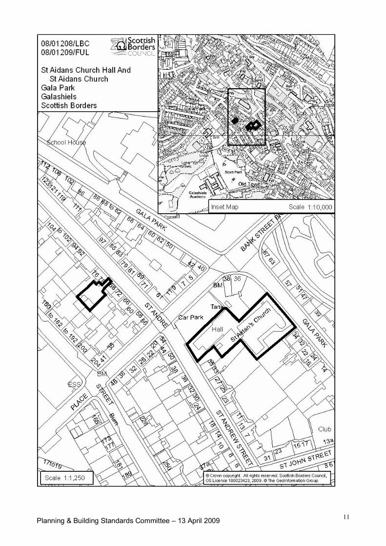
Planning & Building Standards Committee – 13 April 2009 11
Planning & Building Standards Committee 1
Item No. 7(c)SCOTTISH BORDERS COUNCIL
PLANNING AND BUILDING STANDARDS COMMITTEE
13th APRIL 2009
APPLICATIONS FOR PLANNING PERMISSION
ITEM: (c) REFERENCE NUMBER: 08/01600/FUL08/01628/REM08/01629/REM08/01630/REM08/01631/REM
OFFICER: J HiscoxWARD: Mid BerwickshirePROPOSAL: Change of use, alterations and extension to form seven
dwellinghouses from steading buildings; Erection ofdwellinghouses x4 (Plots 1-4 inclusive).
SITE: Land and buildings at Meikle Harelaw Farm,Greenlaw
APPLICANT: ConstableAGENT: Edwin Thompson & Co (Berwick)
SITE DESCRIPTION
The application sites are situated at a farm in open countryside close to Greenlaw, approximately3.5 miles to the west of the town. It is reached from the A697 main road via a public road runningnorthwards for approximately 1km.
Meikle Harelaw, which originates from a 19th Century farm steading, consists of several elementsof development, which include the former farmstead and farmhouse, a range of modern farmbuildings to the north and a number of private dwellings in the eastern area, some modern andsome traditional.
The site itself consists of land and buildings in and around the former traditional farm courtyard,which is situated to the west of the farmhouse at the northern end of the access road. A number ofstone and slate buildings are present, along with later additions and detached outbuildings.Inevitably, as part of the development the agricultural use would cease, although in effect this hasbeen pre-empted, in the granting of planning permission for the relocation of the core of theagricultural business to the north of the current sites (see Planning History below).
PROPOSED DEVELOPMENT
In total, eleven new dwellings would be provided on land to the west of the farmhouse; seven ofthese would be via conversion of the existing buildings and four would be detached new-builddwellings. All the applications are submitted in detail, the conversion proposal being a fullapplication and the new-builds being for Reserved Matters.
As part of the development proposal, passing places would be created along the nearby publicroad, a substantial band of screen planting and other landscaping would be installed, andmitigation measures would be undertaken to offset any impact on bat and bird habitat, which isknown to exist within the buildings.
Planning & Building Standards Committee 2
The submitted layout drawing shows in detail the proposed arrangement of the site, includingcompounds for sewage treatment and gas tanks. Provision is made for the protection of a publicright of way which is situated to the south of the steading buildings.
It should be noted that the planning agent submitted revised proposals to take account ofcomments of the Planning Department and statutory consultees, and it is this revised schemewhich is now under consideration.
PLANNING HISTORY
08/00790/FUL – Erection of new agricultural buildings, repositioning of existing agriculturalbuildings and formation of new access road – Allowed on appeal 2.2.09.
07/01248/FUL – Erection of new agricultural buildings and repositioning of existing agriculturalbuildings – Withdrawn 7 May 2008.
05/00450/OUT – Erection of dwellinghouse (Plot 4) – Approved 27.9.05
05/00449/OUT – Erection of dwellinghouse (Plot 3) – Approved 27.9.05
05/00448/OUT – Erection of dwellinghouse (Plot 2) – Approved 27.9.05
05/00447/OUT – Demolition of steading building and rebuilding in situ to form one dwellinghouse(Plot 1) – Approved 27.9.05
05/00446/COU – Change of use to form five dwellinghouses – Approved 27.9.05
04/01402/FUL – Erection of farmhouse and garage – Approved 15.9.04
REPRESENTATION SUMMARY
In terms of representations received from the public, three stated objections have been received tothe entire project (5 applications). A summary of the issues raised in objection would be as followsi.e. those which are of current planning relevance and therefore material to consideration of theplanning application:
even with proposed passing places, the road serving Meikle Harelaw would not be ableto cope with the additional traffic that would be generated by the development;development would result in increased danger to road users;application should not be favourably considered until proposal for alternative access tofarm buildings has been agreed;insufficient water supply would exist to serve all development at Meikle Harelaw;uncertain whether additional sewage could be accommodated in the manner shown;uncertain as to why seven units in the conversion may now be acceptable, whenoriginally six was reduced to five (original permission);concerns relating to ecological information (bats, birds etc.) and potential impact of thedevelopment;access road to new farmhouse approved in 2004 should be considered for provision ofaccess to the steading re-development;planning permission for new farmhouse approved in 2004 should be taken into account;development too dense and not containing adequate parking;noise and light pollution;inappropriate design (utilitarian);lack of clarity relating to public right of way;are the locations of the LPG and sewage compounds suitable, in terms of visualimpact?sewage proposals do not take account of environmental considerations;

Planning & Building Standards Committee 3
impact on amenity of nearby residents.
It should be noted that a further letter was received in March 2009, but that this is not an objection,and is rather a letter of precaution/information request from one of the previous objectors.
APPLICANTS’ SUPPORTING INFORMATION
16.10.08 – Ecological Report, Bats and Birds.
CONSULTATION RESPONSES:
Scottish Borders Council Consultees:
Director of Technical Services (Road User Manager): No objection to revised layout, whichtakes account of concerns identified in relation to original scheme. Conditions recommended tofinalise minor changes required.
Director of Technical Services (Environmental Health): Recommends investigation relating topotential site contamination, through planning condition, in respect of all sites.
Director of Education and Lifelong Learning: Development contributions required towardsBerwickshire High School, on all plots within the conversion proposal (x7).
Statutory Consultees
Westruther and Gordon Community Council: Objects to all of the applications on the followinggrounds:
incompatibility of existing and proposed development(s) (agricultural/residentialincluding access arrangements/scale of residential element);inappropriate design, inconsistent with character of the buildings;unsuitable window style;development should include affordable housing units;adverse impact on amenity of existing residents due to traffic, noise and visual impact;unavoidable proliferation of septic tanks and potential for pollution;scale of development breaks 100% Rule on expansion of building groups;inadequate road network – would not cope with additional traffic.
Scottish Environmental Protection Agency (SEPA): Originally objected on grounds of lack ofinformation relating to non-mains drainage, but has since indicated that calculations in relation to2005 applications/treatment standards will still be applicable. No formal final consultation responsereceived, but objection is assumed to have been withdrawn.
Scottish Water: No objection.
Other Consultees
Berwickshire Civic Society: Objects: Not favouring level of development and design/layout.
DEVELOPMENT PLAN POLICIES:
Scottish Borders Structure Plan 2001-2011:
Policy N7 – Protection of Nature Conservation InterestPolicy N20 – DesignPolicy H4 – Housing in the Countryside – Conversion or RebuildingPolicy H5 – Housing in the Countryside – Building GroupsPolicy H7 – Affordable and Special Needs Housing – Proportion
Planning & Building Standards Committee 4
Policy I11 – Parking Provision in New DevelopmentPolicy I12 – Provision of Water and Sewerage ServicesPolicy I13 – Water QualityPolicy I14 – Surface WaterPolicy I18 – Contaminated Land
Scottish Borders Local Plan: September 2008:
Policy G1 – Quality Standards for New DevelopmentPolicy G2 – Contaminated LandPolicy G5 – Developer ContributionsPolicy NE3 – Local BiodiversityPolicy NE5 – Development Affecting the Water EnvironmentPolicy H1 – Affordable HousingPolicy H2 – Protection of Residential AmenityPolicy Inf2 – Protection of Access RoutesPolicy Inf4 – Parking Provisions and StandardsPolicy Inf5 – Waste Water Treatment StandardsPolicy Inf6 – Sustainable Urban DrainagePolicy D2 – Housing in the Countryside
OTHER PLANNING CONSIDERATIONS:
Scottish Borders Council adopted Supplementary Planning Guidance:
Affordable Housing (March 2007)Biodiversity (December 2005)Developer Contributions (April 2008)New Housing in the Borders Countryside (December 2008)
KEY PLANNING ISSUES:
Having regard to the extant planning permissions listed above, it is considered that the keyplanning issues would be:
whether the increase in numbers of proposed residential units within the conversionscheme would give rise to any significant new land-use policy issueswhether the level and nature of development proposed would give rise to an acceptabledegree of visual impactwhether the proposed development would be compatible with existing occupiers anduseswhether the development proposals have taken proper account of individual issuessuch as:- species protected by law and their habitat/mitigation- required level of car parking- adequacy of access/improvements requiredwhether any other technical issues are outstandingwhether any of the issues raised in representation would influence the planningposition.
ASSESSMENT OF APPLICATION:
Land-Use Policy Principle:
The site benefits from ‘live’ or extant planning permissions for 4 no. new-build dwellings and 5 no.new dwellings via conversion. This level of development has already been approved under theterms of development plan policy.
Planning & Building Standards Committee 5
Introducing 2 no. additional dwelling units means that careful consideration must be given not onlyto the effect this can have on the buildings and their setting, but also on the infrastructure neededto accommodate the development and the knock-on effect this can have on existing occupiers anduses.
The two additional units have necessitated the addition of modest extensions to one of the existingbuildings, but not to their detriment in terms of visual impact (hidden to the north of existing block).The original car parking areas can accommodate the required level of parking without a completechange to the terms of the original group of planning permissions. The developer hasdemonstrated that necessary access improvements can be made.
The introduction of a number of smaller units into the scheme adds variety to the development andmay have benefits in terms of the occupants attracted to it and the contribution this might make tothe local community. The smaller units would inevitably be more affordable than some of the largerunits and would potentially enable a more diverse range of occupants to reside at Meikle Harelaw.
Having regard to this information, it is highly unlikely that the terms of land-use policy would becompromised with the introduction of the additional 2 no. dwellings, in the manner shown. Becausethe additional units are within the conversion, and because there is no increase in the number ofnew-build units since the original permissions were granted, the 100% Rule is not compromised.
Design/Nature of Development:
The farm steading at Meikle Harelaw benefits from planning permission to re-use the existingbuildings for residential purposes and to accommodate four new-build dwellings. It is, however, atraditional steading of simple form and does not have a striking presence in the local landscape. Itis considered that it can accommodate a reasonable level of change without harm being caused tothe setting, bearing in mind that the principles of development are established.
The applicant has presented a proposal in the revised scheme that is considered favourably in thecircumstances. This is because it is considered to be compatible with the locale in terms of design,materials and layout. Concerns relating to the design were acknowledged and have influenced therevised scheme.
Compatibility with Existing Occupiers and Uses:
There is no reason for the future relationship of the several development components at MeikleHarelaw to be unsustainable. Two particular matters are worthy of specific note:
the application includes a substantial area of tree planting, which would separate thenew residential area from the agricultural operations to the north;following the granting of planning permission in February under appeal for the re-sitingof farm buildings and provision of a new access to serve them, good separationbetween the future uses would be achievable. The new residential development wouldshare the public road network to the point where agricultural traffic travels east andaround the side of Meikle Harelaw; beyond that, it would only be used by domestictraffic for the most part (there may still be an occasional need for agricultural vehicles touse other routes).
Protected Species/Habitat:
Information contained within the submitted ecological appraisal and also shown in the submitteddrawings gives confidence that protected species and habitat would be the subject of anacceptable level of mitigation. Furthermore, a Government Licence would be needed because batsoccupy part of the buildings, which would ensure that the site would be the subject of monitoring byboth the Council and Scottish Natural Heritage (SNH).
Planning & Building Standards Committee 6
Adequacy of Car Parking:
Although the original plans were considered to be deficient in this respect, the amended drawingsdemonstrate a suitable level and nature of parking for domestic vehicles. The Road User Managerhas indicated that the revisions are satisfactory from a road safety point of view. The PlanningDepartment concurs with this view.
Road Improvements:
It is considered that the developer has demonstrated that by undertaking improvements to thepublic road, as per the requirements of the Road User Manager, an acceptable level of road safetycan be achieved.
Sewage Disposal:
Following the submission of additional information to SEPA their objection relating to non-mainsdrainage has been reconsidered and, although it has not yet been confirmed in writing by SEPA,will be withdrawn.
The nature of the proposed sewage treatment plant, including its location, is considered to bereasonable. Indeed, it would be situated close to the site of an existing plant serving dwellings atMeikle Harelaw. It should be noted that any legal entitlement to utilise an existing plant would notbe superseded in the event of planning permission being granted.
Water Supply:
It is unlikely that this issue would be a material consideration, in the circumstances of the planningapplication. A source is known to exist and is utilised by existing residents. The operation of thewater supply would be overseen by utility bodies.
Other Issues Raised in Objection:
Although several of the issues raised in objection to the proposal have been addressed in earliersections of the assessment, the following information should also be noted:
the number of units proposed by conversion has increased by two, over the numberagreed in 2005 from five to seven. This increase in density in itself does not present areason to resist the principle, because the developer has been able to demonstratethat, on its merits, the development would generally be compatible with the locale;the future of the public right of way has been secured through the revisions to thescheme, and would be further protected with the use of suitable planning conditions.the provision of affordable housing within the development site has been the subject ofconsideration. If the principle of planning permission is accepted, this issue will be thesubject of further negotiation. It should be noted, however, that on-site provision ofaffordable housing in isolated locations such as this is not normally insisted upon.
CONCLUSION:
Outline planning permission for four dwellings and full planning permission for five dwellingsalready exists at this site, by virtue of the decisions issued in September 2005. The current groupof applications occupies the same site and is generally of a similar nature, although the number ofconversion units has been increased from five to seven.
Only the new issues arising from the changes to the scheme and the increase in numbers shouldinfluence the planning position.
Although it is acknowledged that there is a level of representation from the Community Council, theCivic Society and from three local residents, the nature of these representations does not present a
Planning & Building Standards Committee 7
sustainable reason to resist the development shown. It does not deviate significantly from whatalready has planning permission, and includes a level and nature of development considered to beacceptable in the particular circumstances.
Furthermore, as a result of the changes made by the applicant in response to concerns identifiedby the Planning Department, the scheme is considered to be appropriately brought forward, andwould not cause harm to the setting of the building group, to protected species or to the level ofamenity experienced by nearby residents.
RECOMMENDATION BY HEAD OF PLANNING AND BUILDING STANDARDS:
I recommend the applications are approved subject to conditions (all applications) and to a LegalAgreement relating to Development Contributions in respect of 08/01600/FUL (conversion).
08/01600/FUL:
1 The development hereby permitted shall not be carried out otherwise than in completeaccordance with the plans and specifications approved by the Planning Authority, whichcomprise the revised drawings received on 29th January 2009, which also describe roadimprovement works and works proposed in mitigation of protected species/habitat.Reason: To ensure that the development is carried out in accordance with the approveddetails.
2 This permission shall only permit the conversion and adaptation of the existing structuresas 7 no. dwelling units. It shall not purport to grant permission for the erection of any newdwellings, nor for any extensive rebuilding which would be tantamount to the erection ofany new dwelling.Reason: Permission has been granted for the conversion of existing buildings to habitableaccommodation, in a location where new-build dwellings would not otherwise beappropriate.
3 Notwithstanding the provisions of the Town and Country Planning (General PermittedDevelopment)(Scotland) Order 1992 (or any subsequent Order amending, revoking or re-enacting that Order);(i) There shall be no addition or extension to the dwellings (including the insertion ofdormer windows or chimneys);(ii) There shall be no further building, structure or other enclosure constructed or placedon the site;(iii) No additional window or other opening shall be made in any elevation;
unless an application for planning permission in that behalf has first been submittedto and approved by the Local Planning Authority.Reason: To safeguard the character, appearance and setting of the building to beconverted.
4 No development shall take place until the applicant has secured the implementation of aprogramme of Historic Building Recording, which has been submitted by the applicant,agreed by the Archaeology Officer and approved by the Planning Authority.Reason: To ensure that the archaeological and historic value of the standing buildings isrecorded prior to any alterations being made.
5 No part of the development hereby permitted shall commence until a site investigation andrisk assessment relating to potential site contamination has been carried out, submitted toand agreed in writing by the Planning Authority. The development shall be carried out instrict accordance with any mitigation measures identified within the report, as agreed by thePlanning Authority.Reason: Due to the past use of the site, contamination may be present within the site thatmust be suitably mitigated against, in the interests of health and safety.
Planning & Building Standards Committee 8
6 Notwithstanding the details shown in the approved drawings, the final paint colour of theexternal timbers shall be submitted to, and agreed in writing by the Planning Authority. Theagreed colour shall be utilised at the time of conversion, and shall thereafter be retainedunless an amendment is agreed in writing by the Planning Authority.Reason: To ensure that the character of the buildings is not undermined by the use of aninappropriate paint colour.
7 All windows and doors in the new development shall be recessed in their openings inaccordance with details that shall first be submitted to and agreed in writing by the PlanningAuthority. Thereafter, no adjustment shall be made to the position of any windows anddoors in their openings, unless otherwise agreed in writing by the Planning Authority.Reason: To ensure that the external appearance of the development is, and remains,appropriate.
8 None of the development hereby approved shall be commenced until such a time asdetailed information relating to the repair and maintenance of the existing buildings,describing clearly the extent of proposed reconstruction, re-pointing, re-roofing and thenature of any new materials has been submitted to, and agreed in writing by the PlanningAuthority. The development shall be carried out in strict accordance with all details agreedas a result of this condition.Reason: To ensure that the full extent of the works required to facilitate the conversion isknown, so that the external appearance of the development is appropriate.
9 The development shall be undertaken in full compliance with the recommendations withinthe submitted Bat and Bird Survey Report (Baker Shepherd Gillespie October 2008 ‘Final’),relating to bats and their habitat.Reason: Bats and bat habitat are known to be present within the site; the mitigationproposals stated in the Survey Report will enable the circumstances to continue, in relationto the legally protected species.
10 Before any part of the development on the site begins, a scheme for the protection ofbreeding birds and the enhancement of potential bird habitat shall be submitted to andapproved in writing by the Planning Authority. Any development works shall, thereafter, becarried out in accordance with the approved scheme. Works shall not commence duringthe breeding bird season (i.e. works to commence after July, prior to March). Mitigation tobe guided by a suitably qualified person.Reason: To ensure that the habitat value of the site for breeding birds is enhanced andcontinued.
11 No construction works shall commence within the application site until such a time as thepassing places (5 no.) within the public road to the south of the development have beenconstructed in accordance with details/locations that shall first have been agreed by thePlanning Authority.Reason: In the interests of road safety.
12 All new and existing private access roads shall be a minimum of 3.7 metres wide and ableto withstand a minimum axle load of 14 tonne and parking bays shall be 2.5 by 5 metres.Reason: In the interests of amenity and road safety.
13 The Public Right of Way BB120, situated on the southern edge of the development site,shall be maintained open and free from obstruction in perpetuity. This Right of Way shallnot form part of the curtilage of properties Plot 1, Plot 2, Plot 4, Unit 7. Neither shall theRight of Way be stopped up or obstructed during or after development.Reason: To ensure that the Public Right of Way remains available for public use at all timesin the future and is not obstructed or stopped up during or after the development takesplace.
Planning & Building Standards Committee 9
14 The right of way shall be signposted at either side of the development, as indicated in theapproved site layout plan, the signage being installed prior to the undertaking of anyconstruction works on the site. The signpost shall be either a metal or wooden fingerpostwith “Right of Way”, written on both sides of the blade.Reason: To ensure that the future existence of the Public Right of Way is suitablyadvertised.
15 No development shall take place until a programme for completion and subsequentmaintenance of the proposed landscape planting has been submitted to, and agreed inwriting by the Planning Authority.Reason: To ensure that the landscape planting will become properly established andenable the development to be compatible with surrounding landscape and uses.
16 No development shall be commenced until such a time as it has been demonstrated that allmatters relating to foul and surface water drainage have been addressed via a drainagemanagement plan, which shall be submitted to and approved by the Planning Authority andthereafter fully complied with in the event of development being carried out as a result ofthis permission.Reason: The Planning Authority is aware that drainage issues are likely to arise at this site,that have not been fully addressed in the planning application.
17 The proposal for surface water disposal shall specifically combine environmentalimprovement and/or habitat provision for flora and fauna with the objectives of the"Sustainable Urban Drainage Systems Design Manual for Scotland and Northern Ireland"2000.Reason: To ensure that adequate and appropriate means are used in the disposal ofsurface water and that benefit for local biodiversity is achieved.
18 The proposed development shall incorporate measures to maximise the efficient use ofenergy and resources, and the incorporation of sustainable building techniques andrenewable energy technologies, in accordance with a scheme of details that shall first havebeen submitted to and approved in writing by the Planning Authority. This should includedemonstration of a reduction of 15% in CO2 emissions beyond the 2007 buildingregulations carbon dioxide emissions standard through incorporation of on-site low or zerocarbon technologies (LZCT) where technically feasible.Reason: To ensure the development minimises any environmental impact
Applicant Informative
The applicant is reminded that this permission does not convey approval for works affecting thirdparty rights which may exist on the land or any adjoining. The applicant is therefore advised toseek the approval of any parties having an interest in any land affected by this permission.
This planning permission does not purport to override the need for any separate consents that maybe necessary under Regulations or legislation operated by any other body, including ScottishNatural Heritage, SEPA, Scottish Water and any other Department of Scottish Borders Council.Please note that this is not an exhaustive list.
Further information in pursuant to condition 10 can be found at:http://www.rspb.org.uk/wildlife/birdguide/name/s/swallow/encouraging.asphttp://www.bto.org/notices/nestbox_guide.htm
08/01628/REM, 08/01629/REM, 08/01630/REM and 08/01631/REM:
1 The development hereby permitted shall not be carried out otherwise than in completeaccordance with the plans and specifications approved by the Planning Authority, whichcomprise the revised drawings received on 29th January 2009, which also describe roadimprovement works and works proposed in mitigation of protected species/habitat.
Planning & Building Standards Committee 10
Reason: To ensure that the development is carried out in accordance with the approveddetails.
2 The development hereby approved shall only be carried out in strict accordance with detailsof the materials to be used on the external walls and roof of the proposed building(s) whichshall first have been submitted to and approved in writing by the Planning Authority.Reason: To ensure a satisfactory form of development, which contributes appropriately toits setting.
3 No part of the development hereby permitted shall commence until a site investigation andrisk assessment relating to potential site contamination has been carried out, submitted toand agreed in writing by the Planning Authority. The development shall be carried out instrict accordance with any mitigation measures identified within the report, as agreed by thePlanning Authority.Reason: Due to the past use of the site, contamination may be present within the site thatmust be suitably mitigated against, in the interests of health and safety.
4 No construction works shall commence within the application site until such a time as thepassing places (5 no.) within the public road to the south of the development have beenconstructed in accordance with details/locations that shall first have been agreed by thePlanning Authority.Reason: In the interests of road safety.
5 All new and existing private access roads shall be a minimum of 3.7 metres wide and ableto withstand a minimum axle load of 14 tonne and parking bays shall be 2.5 by 5 metres.Reason: In the interests of amenity and road safety.
6 The Public Right of Way BB120, situated on the southern edge of the development site,shall be maintained open and free from obstruction in perpetuity. This Right of Way shallnot form part of the curtilage of properties Plot 1, Plot 2, Plot 4, Unit 7. Neither shall theRight of Way be stopped up or obstructed during or after development.Reason: To ensure that the Public Right of Way remains available for public use at all timesin the future and is not obstructed or stopped up during or after the development takesplace.
7 No development shall take place until a programme for completion and subsequentmaintenance of the proposed landscape planting has been submitted to, and agreed inwriting by the Planning Authority.Reason: To ensure that the landscape planting will become properly established andenable the development to be compatible with surrounding landscape and uses.
8 No development shall be commenced until such a time as it has been demonstrated that allmatters relating to foul and surface water drainage have been addressed via a drainagemanagement plan, which shall be submitted to and approved by the Planning Authority andthereafter fully complied with in the event of development being carried out as a result ofthis permission.Reason: The Planning Authority is aware that drainage issues are likely to arise at this site,that have not been fully addressed in the planning application.
9 The proposal for surface water disposal shall specifically combine environmentalimprovement and/or habitat provision for flora and fauna with the objectives of the"Sustainable Urban Drainage Systems Design Manual for Scotland and Northern Ireland"2000.Reason: To ensure that adequate and appropriate means are used in the disposal ofsurface water and that benefit for local biodiversity is achieved.
Applicant Informative

Planning & Building Standards Committee 11
The attention of the developer is drawn to the conditions applicable to outline planning permissions05/00450/OUT (Plot 4), 05/00449/OUT (Plot 3), 05/00448/OUT (Plot 2) and 05/00447/OUT (Plot1). The requirements of conditions of those commensurate permissions must be discharged alongwith those of conditions on this Reserved Matters approval.
Approved byName Designation SignatureBrian Frater Head of Planning and Building
Standards
Author(s)Name DesignationJohn Hiscox Planning Officer
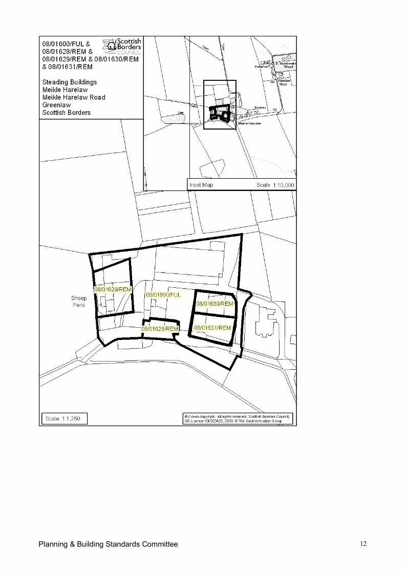
Planning & Building Standards Committee 12
Planning & Building Standards Committee 1
Item No. 7(d)SCOTTISH BORDERS COUNCIL
PLANNING AND BUILDING STANDARDS COMMITTEE
13th APRIL 2009
APPLICATIONS FOR PLANNING PERMISSION
ITEM: (d) REFERENCE NUMBER: 08/01915/FUL08/01928/FUL
OFFICER: Karen HopeWARD: Kelso & DistrictPROPOSAL: Erection of Class 1 retail store, petrol filling station and kiosk with
associated 5 arm round-about, car parking, access and landscaping(08/01915/FUL)Infrastructure for extension to industrial estate and erection of Unit 1(08/01928/FUL)
SITE: Land North West of Croall Bryson & Co, Pinnaclehill IndustrialEstate, Kelso (08/01915/FUL)Land South East of Croall Bryson, Pinnaclehill Industrial Estate,Kelso (08/01928/FUL)
APPLICANT: Sainsbury’s Ltd & CWPAGENT: Turley Associates
BACKGROUND
This report relates to two planning applications. For ease of reference, the report will be divided,where necessary, into sections entitled ‘Retail Store’ (relating to 08/01915/FUL) and ‘IndustrialExpansion’ (relating to 08/01928/FUL).
SITE DESCRIPTION
Retail Store
The application site, which measures approximately 2.698 hectares, is located on land to the northof Croall Bryson and Co at the Pinnaclehill Industrial Estate, Kelso. The site is located within thenorth west corner of the industrial estate. It is currently occupied by a range of occupied andvacant premises with a total site area of approximately 2.7ha as follows:
Kenneth Forbes premises (ca 0.8ha); Small commercial premises (Paul Burton Drinks) (ca 0.2ha); Vacant land and buildings owned by SBC and former David Nesbitt & Bros (ca 0.9ha); Landscaping (ca 0.5he); and Existing road verges within the application boundary (ca 0.4ha).
The site is bounded to the south by the Pinnaclehill Industrial Estate access road and beyond thisare the Croall Bryson and Co premises. To the west is the B6352 beyond which is agriculturalland. To the north is the A698 with Station Road providing access to the town centre. Immediatelyacross the A698 are industrial/business premises with residential areas beyond. To the east areindustrial/business units.
There is existing verge planting along the western boundary of the site, which is well established.Planting also exists along the northern and southern boundaries.
Planning & Building Standards Committee 2
Industrial Expansion
This site, which measures approximately 4.97 hectares, is located on land to the south east ofCroall Bryson and Co, immediately adjacent to the Pinnaclehill Industrial Estate in Kelso. The siteis currently an open field and is bounded to the north by the Pinnaclehill Industrial Estate. To theeast is agricultural land. To the south is a burn, beyond which is further agricultural land. To thewest is the B6352 and further agricultural land. The boundaries of the site are defined by trees andhedging for the most part.
PROPOSED DEVELOPMENT
Retail Store
This application seeks full planning consent for the erection of a Class 1 retail store along with apetrol filling station, kiosk and an associated 5 arm roundabout, car parking, access andlandscaping.
The proposed retail store would be located within the south eastern corner of the site with a total of290 parking spaces to be provided, including 18 disabled and 12 parent and child spaces, locatedto the north and west of the building. A secure service yard would be provided to the south of thebuilding, accessed off the road serving Pinnaclehill Industrial Estate. The proposed petrol fillingstation would be located to the west of the retail store, incorporating four pumps, a jet wash and akiosk which would have a floor area of approximately 13m x 11m. This along with the retail storeand the associated parking, would be served by a new access from the north west, off a new fivearm roundabout incorporating two junctions off the A698, Station Road, the B6352 and theproposed retail store access. Pedestrian links are provided into and within the site.
The retail store would be contemporary in design, with the use of large areas of glazing on theprincipal elevation as well as vertical and horizontal treated softwood timber with sandstoneaspects.
Industrial Expansion
This application seeks full planning consent for the infrastructure for the extension of the industrialestate and the erection of a unit referred to as ‘Unit 1’. This includes the installation of a new linkroad from the B6352 through the site to the north. ‘Unit 1’ would be located at the entrance to theexpanded industrial estate. This would be occupied by Paul Burton Wines and would measureapproximately 24m x 26m. Seven parking spaces would be provided within the curtilage of thebuilding. It would have a blockwork base, with roof and wall cladding (‘goose wing grey’ in colour).
PLANNING HISTORY
The findings of a Public Local Inquiry held in May 2000 which examined retailing provision in Kelsoindicated that there was a proven need and capacity for a Retail store of between 2000 – 2500square metres in the town. The Reporter concluded that a site known as the ‘Henderson Site’(East Bowmont Street / Horsemarket) best met the retail sequential test and its developmentpotential needed to be fully tested before any of the out of town centre options were considered.
During the three years following the findings of the Public Local Inquiry, there was no commercialinterest in pursuing the Henderson Site and no planning applications were lodged to develop theland. It was understood that the supermarket group (Safeway) purchased the site but consideredthat it was too small for the necessary size of Retail store. This would have adversely affected theavailability and effectiveness of the site if it were to be allocated in the Local Plan for retaildevelopment.
During the process of the Local Plan review, the Council was presented with four alternativeoptions for a Retail store in the town. These were Angraflat Road, Shedden Park Road, SheddenPark and Spylaw Farm. The first option at Angraflat was discounted through the Settlement
Planning & Building Standards Committee 3
Appraisal Programme due primarily to its distance from the town centre and the lack of a promotingdeveloper. In addition, planning permission was granted for a Lidl Store on the site at SheddenPark Road (now complete). The approval for this “discount store” did not override the identifiedneed for a larger store in the town providing a wider range and quality of goods.
Prior to the publication of the Scottish Borders Finalised Local Plan 2005, consultation on thelocation of a new supermarket in Kelso took place. At its meeting of 16 June 2005, the Councilagreed to delete the Shedden Park site from consideration. A further round of consultation thenfollowed, highlighting competing developer proposals at Spylaw Farm immediately outside thesettlement boundary, at Pinnaclehill, taking up a frontage portion of the industrial estate. The latterproposal was submitted well after the deadline for consultation responses on the Draft Local Plan.The second stage consultation indicated that the preference by planning officers was the site atSpylaw Farm.
The consultation produced a considerably smaller response than at the time when the SheddenPark site was put forward. Of those who did respond, there was a stated preference for the sitewithin the Pinnaclehill Industrial Estate.
In comparing the sites in terms of policy it was considered that the Pinnaclehill proposal would beconsiderably more difficult to justify on policy grounds and would contravene Structure Plan as wellas Local Plan policy. It was considered that the Spylaw site would offer a greater net gain to theCouncil and the Pinnaclehill site would pose greater risks for the Council. It was thereforeconcluded that the Spylaw site was the preferred option.
The Local Plan Inquiry began on 4 September 2006 and ran until 15 January 2007. The Reportersfindings were received by the Council in August 2007. A hearing was held after the formal inquiryin respect of a site on Station Road. The Reporters findings concluded the most suitable locationfor providing the appropriate scale of Retail superstore in Kelso would be on what is known as theKeltek/Forbes site at Pinnaclehill. The Reporter subsequently recommended that this site isallocated in the Local Plan for a Retail superstore (with associated parking, servicing andlandscaping as well as a petrol filling station). In order to safeguard the shops of Kelso town centrefrom unacceptable levels of impacts from the new store development at Pinnaclehill, the Reporterrecommended that the size of the single supermarket to be permitted at Pinnaclehill should notexceed 4,500sqm gross floor area and with no more than 20% of its sales area being devoted tonon-Retail comparison goods.
These conclusions and recommendations were reached only on the basis that the Keltek/Forbessite at the north-west corner of the Pinnaclehill Industrial Estate would be allocated andimplemented in conjunction with:
• A new 5 arm access roundabout which would not only serve the new Retail store and itsassociated petrol filling station but would also be designed to remove the existing double Tjunctions of Yetholm Road and Station Road onto the A698;
• A landscaping scheme, in particular to provide buffer screen planting along the boundariesof the Keltek site, to a standards approved by the Planning Authority; and
• An allocation for a planned extension of the Pinnaclehill Industrial Estate.
The Council, on 20 March 2008, agreed a report on ‘Proposed Modifications to the Finalised LocalPlan following the Local Plan Inquiry Report’ which supported the recommendations of theReporter. Accordingly, the Keltek/Forbes site was allocated in the Local Plan for a Retailsuperstore (with associated parking, servicing and landscaping as well as a petrol filling station),subject to the aforesaid provisos. The planned extension of the Pinnaclehill Industrial Estate wasalso allocated. The previous allocations for Spylaw Farm were therefore deleted.
An outline planning application for the erection of a Class 1 retail store, petrol filling station andkiosk with associated car parking, access and landscaping (06/00540/OUT) was approved by thePlanning and Building Standards Committee on 12 May 2008 subject to conditions and theconclusion of a legal agreement. A separate outline planning application for the extension of
Planning & Building Standards Committee 4
Pinnaclehill Industrial Estate (06/00541/OUT) was also approved at the same Committee, subjectto conditions and the conclusion of a legal agreement. These consents have not been issued todate as the conclusion of the legal agreement is still awaited.
Both sites have since been allocated within the Scottish Borders Local Plan, adopted in September2008, for retail and employment land.
REPRESENTATION SUMMARY
Retail Store
One general comment has been received from Scottish Power highlighting that there is an existingelectrical substation and low voltage underground cables running through the site. It is thereforesuggested that the applicant contacts Scottish Power to discuss the provision of electricity to theproposed development.
Two letters in support of the proposals has been received. These can be viewed in full on theCouncil’s Public Access System. One of these letters questions whether or not road crossings andtraffic lights would be provided for pedestrians visiting the site and whether adequate publictransport, including bus stops and shelters, would be provided.
Industrial Expansion
No representations have been received.
APPLICANTS’ SUPPORTING INFORMATION
The following documents have been submitted in support of these applications, these can beviewed in full on the Council’s public access system:
Retail Store
Supporting Planning Statement; Design Statement; Supporting Retail Statement; Transport Assessment; Phase 1 Site Geoenvironmental Assessment; and Protected Species Survey & Assessment.
Industrial Expansion
Planning Statement; Transport Assessment; Geoenvironmental Assessment; and Protected Species Survey and Assessment
CONSULTATION RESPONSES:
Scottish Borders Council Consultees
Director of Technical Services (Environmental Health): (Retail Store) This application appearsto be proposing the redevelopment of land which was previously railway land (Epoch 1), a canstore (1969 – 1995) & a works/factory. These land uses are potentially contaminative and it is theresponsibility of the developer to demonstrate that the land is suitable for the use they propose.
Planning & Building Standards Committee 5
It is recommended that planning permission should be granted on condition that development isnot be permitted to start until a site investigation and risk assessment has been carried out,submitted and agreed upon by the Planning Authority.
Any requirement arising from this assessment for a remediation strategy and verification planwould become a condition of the planning consent, again to be submitted and agreed upon by thePlanning Authority prior to development commencing.
(Industrial Expansion) This application appears to be proposing the redevelopment of land whichcontains an infilled mill pond. This land use is potentially contaminative and it is the responsibility ofthe developer to demonstrate that the land is suitable for the use they propose.
It is recommended that planning permission should be granted on condition that development isnot be permitted to start until a site investigation and risk assessment has been carried out,submitted and agreed upon by the Planning Authority.
Any requirement arising from this assessment for a remediation strategy and verification planwould become a condition of the planning consent, again to be submitted and agreed upon by thePlanning Authority prior to development commencing.
Director of Technical Services (Flood Protection Officer): (Industrial Expansion) In terms ofinformation that this Council has concerning flood risk to this site, I would state that The IndicativeRiver & Coastal Flood Map (Scotland) known as the “second generation flood mapping” preparedby SEPA indicates that the site is NOT at risk from a flood event with a return period of 1 in 200years. That is the 0.5% annual risk of a flood occurring in any year.
The Indicative River & Coastal Flood Map (Scotland) has primarily been developed to provide astrategic national overview of flood risk in Scotland. Whilst all reasonable effort has been made toensure that the flood map is accurate for its intended purpose, no warranty is given.
There is a burn on the south east boundary of the site which has a small dam upstream beyondSpylaw and I would advise the need for the developer to take into account the potential for floodingarising from this and other sources such as road drainage, over land surface water runoff, andsurcharged culverts.
Please note that this information must be taken in the context of material that this Council holds infulfilling its duties under the Flood Prevention (Scotland) Act 1961 as amended by the FloodPrevention and Land Drainage (Scotland) Act 1997.
Director of Technical Services (Roads): (Retail Store) No objections in principle. The followingcomments apply:
1. Provision must be made within any legal agreement that enables the Council to receivereimbursement for all reasonable costs incurred by the Council in relation to the supervision ofthe roundabout construction and associated work affecting the public road.
2. Details shall be required of the location and type of pedestrian crossing which is required as aresult of the reporters comments upon this site and proposal. The detail and location of thepedestrian crossing shall have to be re-examined taking on board the comments from theCouncil’s Design Services.
3. Engineering drawings for the roundabout, including geometry and construction details, andother road works shall have to be submitted to, and approved by, this department as part ofthe planning process. These details should also include information regarding the proposedsigning and white lining for the development. It should be noted that the initial comments fromthe Council’s Design Services Section indicate that there are amendments required to thelayout and design of the roundabout and, as such, a meeting will be required with theapplicants’ engineers to discuss these issues prior to amended drawings being submitted forapproval.
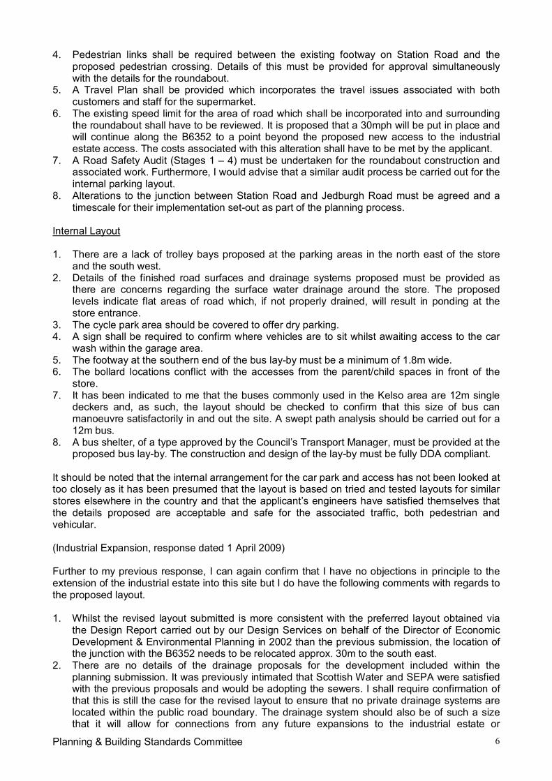
Planning & Building Standards Committee 6
4. Pedestrian links shall be required between the existing footway on Station Road and theproposed pedestrian crossing. Details of this must be provided for approval simultaneouslywith the details for the roundabout.
5. A Travel Plan shall be provided which incorporates the travel issues associated with bothcustomers and staff for the supermarket.
6. The existing speed limit for the area of road which shall be incorporated into and surroundingthe roundabout shall have to be reviewed. It is proposed that a 30mph will be put in place andwill continue along the B6352 to a point beyond the proposed new access to the industrialestate access. The costs associated with this alteration shall have to be met by the applicant.
7. A Road Safety Audit (Stages 1 – 4) must be undertaken for the roundabout construction andassociated work. Furthermore, I would advise that a similar audit process be carried out for theinternal parking layout.
8. Alterations to the junction between Station Road and Jedburgh Road must be agreed and atimescale for their implementation set-out as part of the planning process.
Internal Layout
1. There are a lack of trolley bays proposed at the parking areas in the north east of the storeand the south west.
2. Details of the finished road surfaces and drainage systems proposed must be provided asthere are concerns regarding the surface water drainage around the store. The proposedlevels indicate flat areas of road which, if not properly drained, will result in ponding at thestore entrance.
3. The cycle park area should be covered to offer dry parking.4. A sign shall be required to confirm where vehicles are to sit whilst awaiting access to the car
wash within the garage area.5. The footway at the southern end of the bus lay-by must be a minimum of 1.8m wide.6. The bollard locations conflict with the accesses from the parent/child spaces in front of the
store.7. It has been indicated to me that the buses commonly used in the Kelso area are 12m single
deckers and, as such, the layout should be checked to confirm that this size of bus canmanoeuvre satisfactorily in and out the site. A swept path analysis should be carried out for a12m bus.
8. A bus shelter, of a type approved by the Council’s Transport Manager, must be provided at theproposed bus lay-by. The construction and design of the lay-by must be fully DDA compliant.
It should be noted that the internal arrangement for the car park and access has not been looked attoo closely as it has been presumed that the layout is based on tried and tested layouts for similarstores elsewhere in the country and that the applicant’s engineers have satisfied themselves thatthe details proposed are acceptable and safe for the associated traffic, both pedestrian andvehicular.
(Industrial Expansion, response dated 1 April 2009)
Further to my previous response, I can again confirm that I have no objections in principle to theextension of the industrial estate into this site but I do have the following comments with regards tothe proposed layout.
1. Whilst the revised layout submitted is more consistent with the preferred layout obtained viathe Design Report carried out by our Design Services on behalf of the Director of EconomicDevelopment & Environmental Planning in 2002 than the previous submission, the location ofthe junction with the B6352 needs to be relocated approx. 30m to the south east.
2. There are no details of the drainage proposals for the development included within theplanning submission. It was previously intimated that Scottish Water and SEPA were satisfiedwith the previous proposals and would be adopting the sewers. I shall require confirmation ofthat this is still the case for the revised layout to ensure that no private drainage systems arelocated within the public road boundary. The drainage system should also be of such a sizethat it will allow for connections from any future expansions to the industrial estate or
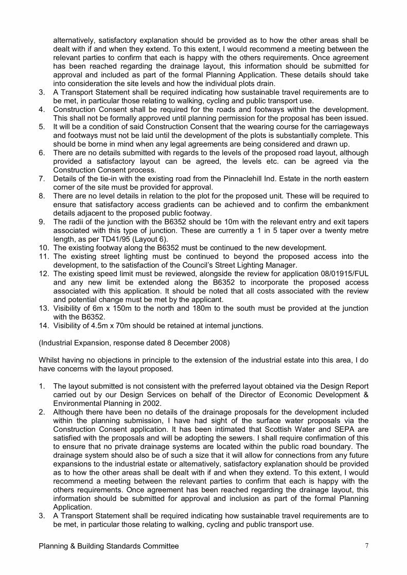
Planning & Building Standards Committee 7
alternatively, satisfactory explanation should be provided as to how the other areas shall bedealt with if and when they extend. To this extent, I would recommend a meeting between therelevant parties to confirm that each is happy with the others requirements. Once agreementhas been reached regarding the drainage layout, this information should be submitted forapproval and included as part of the formal Planning Application. These details should takeinto consideration the site levels and how the individual plots drain.
3. A Transport Statement shall be required indicating how sustainable travel requirements are tobe met, in particular those relating to walking, cycling and public transport use.
4. Construction Consent shall be required for the roads and footways within the development.This shall not be formally approved until planning permission for the proposal has been issued.
5. It will be a condition of said Construction Consent that the wearing course for the carriagewaysand footways must not be laid until the development of the plots is substantially complete. Thisshould be borne in mind when any legal agreements are being considered and drawn up.
6. There are no details submitted with regards to the levels of the proposed road layout, althoughprovided a satisfactory layout can be agreed, the levels etc. can be agreed via theConstruction Consent process.
7. Details of the tie-in with the existing road from the Pinnaclehill Ind. Estate in the north easterncorner of the site must be provided for approval.
8. There are no level details in relation to the plot for the proposed unit. These will be required toensure that satisfactory access gradients can be achieved and to confirm the embankmentdetails adjacent to the proposed public footway.
9. The radii of the junction with the B6352 should be 10m with the relevant entry and exit tapersassociated with this type of junction. These are currently a 1 in 5 taper over a twenty metrelength, as per TD41/95 (Layout 6).
10. The existing footway along the B6352 must be continued to the new development.11. The existing street lighting must be continued to beyond the proposed access into the
development, to the satisfaction of the Council’s Street Lighting Manager.12. The existing speed limit must be reviewed, alongside the review for application 08/01915/FUL
and any new limit be extended along the B6352 to incorporate the proposed accessassociated with this application. It should be noted that all costs associated with the reviewand potential change must be met by the applicant.
13. Visibility of 6m x 150m to the north and 180m to the south must be provided at the junctionwith the B6352.
14. Visibility of 4.5m x 70m should be retained at internal junctions.
(Industrial Expansion, response dated 8 December 2008)
Whilst having no objections in principle to the extension of the industrial estate into this area, I dohave concerns with the layout proposed.
1. The layout submitted is not consistent with the preferred layout obtained via the Design Reportcarried out by our Design Services on behalf of the Director of Economic Development &Environmental Planning in 2002.
2. Although there have been no details of the drainage proposals for the development includedwithin the planning submission, I have had sight of the surface water proposals via theConstruction Consent application. It has been intimated that Scottish Water and SEPA aresatisfied with the proposals and will be adopting the sewers. I shall require confirmation of thisto ensure that no private drainage systems are located within the public road boundary. Thedrainage system should also be of such a size that it will allow for connections from any futureexpansions to the industrial estate or alternatively, satisfactory explanation should be providedas to how the other areas shall be dealt with if and when they extend. To this extent, I wouldrecommend a meeting between the relevant parties to confirm that each is happy with theothers requirements. Once agreement has been reached regarding the drainage layout, thisinformation should be submitted for approval and inclusion as part of the formal PlanningApplication.
3. A Transport Statement shall be required indicating how sustainable travel requirements are tobe met, in particular those relating to walking, cycling and public transport use.
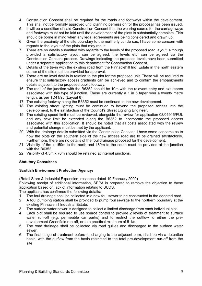
Planning & Building Standards Committee 8
4. Construction Consent shall be required for the roads and footways within the development.This shall not be formally approved until planning permission for the proposal has been issued.
5. It will be a condition of said Construction Consent that the wearing course for the carriagewaysand footways must not be laid until the development of the plots is substantially complete. Thisshould be borne in mind when any legal agreements are being considered and drawn up.
6. Given the proximity of the site boundary to the northerly cul-de-sac, I have some concern withregards to the layout of the plots that may result.
7. There are no details submitted with regards to the levels of the proposed road layout, althoughprovided a satisfactory layout can be agreed, the levels etc. can be agreed via theConstruction Consent process. Drawings indicating the proposed levels have been submittedunder a separate application to this department for Construction Consent.
8. Details of the tie-in with the existing road from the Pinnaclehill Ind. Estate in the north easterncorner of the site must be provided for approval.
15. There are no level details in relation to the plot for the proposed unit. These will be required toensure that satisfactory access gradients can be achieved and to confirm the embankmentsdetails adjacent to the proposed public footway.
16. The radii of the junction with the B6352 should be 10m with the relevant entry and exit tapersassociated with this type of junction. These are currently a 1 in 5 taper over a twenty metrelength, as per TD41/95 (Layout 6).
17. The existing footway along the B6352 must be continued to the new development.18. The existing street lighting must be continued to beyond the proposed access into the
development, to the satisfaction of the Council’s Street Lighting Engineer.19. The existing speed limit must be reviewed, alongside the review for application 08/01915/FUL
and any new limit be extended along the B6352 to incorporate the proposed accessassociated with this application. It should be noted that all costs associated with the reviewand potential change must be met by the applicant.
20. With the drainage details submitted via the Construction Consent, I have some concerns as tohow the plots on the southern side of the new access road are to be drained satisfactorily.Furthermore, there are no details of the foul drainage proposed for the development.
21. Visibility of 6m x 150m to the north and 180m to the south must be provided at the junctionwith the B6352.
22. Visibility of 4.5m x 70m should be retained at internal junctions.
Statutory Consultees
Scottish Environment Protection Agency:
(Retail Store & Industrial Expansion, response dated 19 February 2009)Following receipt of additional information, SEPA is prepared to remove the objection to theseapplication based on lack of information relating to SUDS.The applicant has confirmed the following details:1. The foul drainage shall be collected in a new foul sewer to be constructed in the adopted road.2. A foul pumping station shall be provided to pump foul sewage to the northern boundary at the
existing Pinnaclehill Industrial Estate.3. The surface water sewer is designed to collect a limited discharge from each individual plot.4. Each plot shall be required to use source control to provide 2 levels of treatment to surface
water run-off (e.g. permeable car parks) and to restrict the outflow to either the pre-development Greenfield run-off, or to a practical minimum of 5 1/s.
5. The road drainage shall be collected via road gullies and discharged to the surface watersewer.
6. The final stage of treatment before discharging to the adjacent burn, shall be via a detentionbasin, with the outflow from the basin restricted to the total pre-development run-off from thesite.
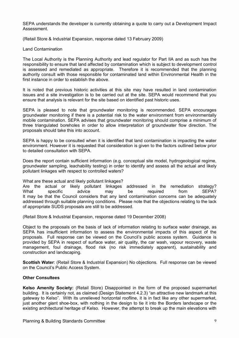
Planning & Building Standards Committee 9
SEPA understands the developer is currently obtaining a quote to carry out a Development ImpactAssessment.
(Retail Store & Industrial Expansion, response dated 13 February 2009)
Land Contamination
The Local Authority is the Planning Authority and lead regulator for Part IIA and as such has theresponsibility to ensure that land affected by contamination which is subject to development controlis assessed and remediated as appropriate. Therefore it is recommended that the planningauthority consult with those responsible for contaminated land within Environmental Health in thefirst instance in order to establish the above.
It is noted that previous historic activities at this site may have resulted in land contaminationissues and a site investigation is to be carried out at the site. SEPA would recommend that youensure that analysis is relevant for the site based on identified past historic uses.
SEPA is pleased to note that groundwater monitoring is recommended. SEPA encouragesgroundwater monitoring if there is a potential risk to the water environment from environmentallymobile contamination. SEPA advises that groundwater monitoring should comprise a minimum ofthree triangulated boreholes in order to allow interpretation of groundwater flow direction. Theproposals should take this into account.
SEPA is happy to be consulted when it is identified that land contamination is impacting the waterenvironment. However it is requested that consideration is given to the factors outlined below priorto detailed consultation with SEPA.
Does the report contain sufficient information (e.g. conceptual site model, hydrogeological regime,groundwater sampling, leachability testing) in order to identify and assess all the actual and likelypollutant linkages with respect to controlled waters?
What are these actual and likely pollutant linkages?Are the actual or likely pollutant linkages addressed in the remediation strategy?What specific advice may be required from SEPA?It may be that the Council considers that any land contamination concerns can be adequatelyaddressed through suitable planning conditions. Please note that the objections relating to the lackof appropriate SUDS proposals are still to be addressed.
(Retail Store & Industrial Expansion, response dated 19 December 2008)
Object to the proposals on the basis of lack of information relating to surface water drainage, asSEPA has insufficient information to assess the environmental impacts of this aspect of theproposals. Full response can be viewed on the Council’s public access system. Guidance isprovided by SEPA in respect of surface water, air quality, the car wash, vapour recovery, wastemanagement, foul drainage, flood risk (no risk immediately apparent), sustainability andconstruction and landscaping.
Scottish Water: (Retail Store & Industrial Expansion) No objections. Full response can be viewedon the Council’s Public Access System.
Other Consultees
Kelso Amenity Society: (Retail Store) Disappointed in the form of the proposed supermarketbuilding. It is certainly not, as claimed (Design Statement 4.2.3) “an attractive new landmark at thisgateway to Kelso”. With its unrelieved horizontal roofline, it is in fact like any other supermarket,just another giant shoe-box, with nothing in the design to tie it into the Borders landscape or theexisting architectural heritage of Kelso. However, the attempt to break up the main elevations with
Planning & Building Standards Committee 10
a mix of timber and stone cladding materials, and the use of site levels to reduce the bulk iscommendable.
(Industrial Expansion) No objections.
Sprouston Community Council: (Retail Store & Industrial Expansion) No objections, welcomethe submission.
DEVELOPMENT PLAN POLICIES:
Scottish Borders Structure Plan 2001-2011
Policy E1 – Prime Quality Agricultural LandPolicy E12 – Employment Land SupplyPolicy E13 – Business and IndustryPolicy E17 – Location of Retailing DevelopmentsPolicy E18 – Out of Centre Retail DevelopmentsPolicy I1 - Transportation and DevelopmentPolicy I4 – Public Transport ProvisionPolicy I5 – CyclingPolicy I7 – WalkingPolicy I11 – Parking Provision in New DevelopmentPolicy I12 – Provision of Water and Sewerage ServicesPolicy I14 – Surface WaterPolicy I18 – Contaminated LandPolicy I19 – Renewable EnergyPolicy N20 – Design
Scottish Borders Local Plan 2008
Policy G1 – Quality Standards for New DevelopmentPolicy G2 – Contaminated LandPolicy G5 – Developer ContributionsPolicy ED5 – Town CentresPolicy H3 – Land Use AllocationsPolicy Inf3 – Road Adoption StandardsPolicy Inf4 – Parking StandardsPolicy Inf5 – Waste Water Treatment StandardsPolicy Inf6 – Sustainable Urban DrainagePolicy ED3 – Shopping DevelopmentPolicy Inf10 – Transport DevelopmentPolicy Inf11 – Development that Generates Travel DemandPolicy R1 – Protection of Prime Quality Agricultural LandPolicy NE4 – Trees, Woodlands and HedgerowsPolicy ED1 – Protection of Employment Land
OTHER PLANNING CONSIDERATIONS:
Scottish Government Planning Policy:
SPP2 – Economic DevelopmentSPP8 – Town Centres and retailingSPP17 – Planning for Transport
Scottish Government Planning Advice Notes:
PAN33 – Development of Contaminated LandPAN59 – Improving Town Centres
Planning & Building Standards Committee 11
PAN61 – Planning and Sustainable Urban Drainage SystemsPAN75 – Planning for TransportPAN77 – Designing Safer PlacesPAN79 – Water and DrainagePAN84 – Reducing Carbon Emissions in New Development
Adopted SBC Supplementary Planning Guidance:
SPG Contaminated Land Inspection Strategy, September 2001SPG Landscape and Development, March 2008SPG Trees and Development, March 2008SPG Renewable Energy, March 2007
KEY PLANNING ISSUES:
Consideration must to be given as to whether or not the proposed uses accord with DevelopmentPlan policies, whether the proposals would have an unacceptable impact on neighbours amenityand landscape character, whether the proposals are acceptable in design and siting terms andwhether satisfactory access, parking, servicing and related matters can be achieved.Consideration must also be given to the mitigation of any site contamination.
ASSESSMENT OF APPLICATION:
Planning Policy
Retail Store
Scottish Planning Policy 8: Town Centres and Retailing (SPP8) advocates that PlanningAuthorities and developers should adopt a ‘sequential approach’ to selecting sites for all retail andcommercial uses. This is reflected in Policy E17 of the Scottish Borders Structure Plan 2001-2011.This requires town centre sites to be used as a first preference and only if there are no suitabletown centre sites then edge of town centre sites would be considered – and again only if none ofthese were suitable and viable within a reasonable time period (5 years) would out-of-centrelocations be considered. The Reporter, following the Local Plan Inquiry, was satisfied that theCouncil had adopted a sequential approach of the type required by SPP8 and that there are nosuitable and available sites either in Kelso town centre or on the edge of the town centre for a newsupermarket of a scale that would match the local expenditure profile and needs of its catchmentarea. The Reporter was also content that the size of store proposed for this site at Pinnaclehillwould be unlikely to result in any store closures or endanger the vitality and viability of Kelso towncentre. It is accepted that this proposal complies with the requirements of Policy E17.
SPP8 points out that where a Planning Authority, through the sequential approach, concludes thatdevelopment may be appropriate outwith existing town centres it should identify appropriatelocations, having regard to other policies of the development plan, including transport and design.
Principle S3 of the Approved Structure Plan provides support for the development of vacant,derelict and brownfield sites in settlements where this is a realistic alternative to greenfielddevelopment. The Retail store application site at Pinnaclehill comprises land and buildings withinthe Pinnaclehill Industrial Estate, mostly property previously occupied by a company called Keltekwhich has remained unused and vacant in recent years. The Reporter concluded that the landproposed for a supermarket has all previously been developed and is mostly occupied by vacant,redundant unused or underutilised industrial buildings, it therefore constitutes brownfield land.
The site of the proposed Retail store has now been formally allocated within the adopted ScottishBorders Local Plan 2008 for retail development and an outline planning application for the erectionof a Retail store on the site was approved by the Planning and Building Standards Committee inMay 2008. The principle of such a development on this site has now been established andaccepted.
Planning & Building Standards Committee 12
Industrial Expansion
Pinnaclehill is one of six strategic employment sites in Structure Plan Policy E13, wheredevelopment will be encouraged for business and industrial uses. In allowing the expansion of theexisting industrial estate at Pinnaclehill, there would not only be an opportunity for the businesseslocated within the application site to develop their operations successfully, there would also be anopportunity for other businesses within the industrial estate to take advantage of opportunitiesavailable. This is considered to be wholly in accordance with Policy E13. The site in question isallocated within the Scottish Borders Local Plan for employment land. The principle of theextension to the existing industrial estate at this location is therefore considered to be acceptable inprinciple.
Layout, Siting and Design
Policy N20 of the Approved Structure Plan states that the Council will encourage a high quality oflayout, design and materials in all new development. Policy G1 of the Scottish Borders Local PlanAdopted 2008 states that all development should be of high quality in accordance withsustainability principles, designed to fit in with Borders townscapes and to integrate with itslandscape surroundings.
Retail Store
The building has been set back within the site in order to reduce the visual dominance of thebuilding on the surrounding area but ensures that the building remains visible. It is contemporaryin design and would utilise an attractive mix of materials. It is considered that the building wouldrepresent an improvement in the approach into Kelso when viewed from the A698.
Industrial Expansion
Unit 1 would be located at the entrance to the expanded industrial estate. The building would belocated to the rear of the plot with a total of seven parking spaces provided between the buildingand the access road serving the industrial area. It is suggested that if the yard around the buildingis to be used for storage that a screen fencing to the Council’s standard detail, along with screenedgates to the elevation to the public frontage, screening the yard from public view. It is alsoconsidered that the frontage could be improved with a beech hedge and an avenue of standardtrees with the frontage grassed. These matters will be discussed with the agent and a verbalreport will be made at Committee.
Landscaping
Policy G1 of the Scottish Borders Local Plan states that all new developments should incorporateappropriate hard and soft landscape works, including structural or screen planting wherenecessary, to help integration with its surroundings and the wider environment.
Retail Store
Whilst it is regrettable that the existing and well established landscaped mound at the north westentrance to the industrial estate would be removed as part of the development of this site, theReporter highlighted that this would be mitigated by a new landscape buffer along the boundary ofthe site and it was noted that a new supermarket on this site would, provided it is suitably designedand sited, represent an improvement to the approach into Kelso when viewed from the A698.
The removal of the existing 9 year old tree belt and its embankment would open up views from theA698 into the site and to the industrial estate beyond. There are also issues concerning theappearance of the back of the filling station building which would be visible from the A698roundabout and the appearance of the service yard elevation when viewed from the Pinnaclehillaccess road. It should, however, be possible to resolve these through landscape mitigation
Planning & Building Standards Committee 13
measures. In order to address these issues, it is considered that the following areas should bestrengthened:
More trees, including evergreens, along the north east site boundary. To allow a moreeffective screen, it is considered that the tree belt on this side should be at least 5m widewhich would require the removal of 6 or 7 parking spaces. N.B. This area may also beinfluenced by ground contamination so allowance should be made for additional excavationand the importation of fresh topsoil. A tall screen fence 2.5 – 3m high should also be builtalong this boundary;
Denser screen planting, including evergreens, to the north of the petrol station building; and Details and possible colour treatment to the screen fence between the service yard and the
Pinnaclehill Access Road which would become a significant and, potentially unattractive,feature.
These issues will be discussed in detail with the agent and a verbal report will be made atCommittee.
Industrial Expansion
The existing site is currently relatively well screened. A landscape layout plan has been submittedwhich shows woodland planting along the western boundary of the site, adjacent to the B6352,along with hedging. A Design Report was carried out by the Council’s Design Services on behalfof the Director of Economic Development and Environmental Planning in 2002. This identified theCouncil’s aspirations for landscaping within the site. The requirements of this will be discussedwith the agent and a verbal report will be made at Committee.
Access & Parking
Policy Inf4 of the Scottish Borders Local Plan states that proposals should provide for car andcycle parking in accordance with the Council’s adopted standards.
Retail Store
The proposed new Retail store would be served from a planned new roundabout at the junction ofthe A698 and B6352 roads. The roundabout would be a five arm junction to include the existingA698 and Station Road T junction. The proposed supermarket site would be served by anindependent access with the proposed industrial expansion area being served by an access off theB6352 Yetholm Road. This arrangement was commended by the Reporter. The Reporter alsosupported the proposed five arm roundabout as this would completely eliminate the existing doubleT junctions on the A698. These arrangements were seen to bring a material community benefit.
The Director of Technical Services (Roads) has raised no objections to the proposals in principle,although there are a number of outstanding issues which would need to be addressed includingdetails relating to the location and type of pedestrian crossing, engineering drawings for theroundabout, including geometry and construction details, and other road works shall have to besubmitted to and approved by the Planning Authority. Details of pedestrian links between theexisting footway on Station Road and the proposed pedestrian crossing would also be required.These matters should be dealt with by attaching suitably worded suspensive conditions to anyconsent granted.
Industrial Expansion
The Director of Technical Services (Roads) has raised no objections in principle to the extension ofthe industrial estate but has made comments in respect of the proposed layout. The proposedposition of the access, which has been amended during the process of the planning application,needs to be relocated approximately 30m to the south east. This matter will be pursued with theagent and a verbal report will be made at Committee.
Planning & Building Standards Committee 14
Contamination
Retail Store
The application site proposes the redevelopment of land which was previously railway land, a canstore and a works/factory. These land uses are potentially contaminative. It is thereforerecommended that any planning approval granted should be subject to a suitably worded conditionrequiring that development is not be permitted to start until a site investigation and risk assessmenthas been carried out, submitted and agreed upon by the Planning Authority.
Industrial Expansion
The application site contains an infilled mill pond which is potentially contaminative. It is thereforerecommended that any planning approval granted should be subject to a suitably worded conditionrequiring that development is not be permitted to start until a site investigation and risk assessmenthas been carried out, submitted and agreed upon by the Planning Authority.
Archaeology
Retail Store
There are archaeological implications to the proposed development. The northern edge of thedevelopment area coincides with 19th century railway infrastructure visible on the Ordnance Survey1st edition map for Roxburghshire (c. 1881). The line of the current road broadly follows the line ofthe railway. Kelso Station and an associated carriage shed sat directly opposite the developmentarea on the north-west side of the road. The ruins of the carriage shed. In the development areaitself, the OS 1st edition map shows several structures, now marked by a line of trees, directly tothe south-east of the road junction and opposite the site of Kelso Station. These are likely to havebeen platforms and storage associated with the station. To the south-west of these structures wasa bridge which extended over the railway. The bridge and road ran roughly NNW-SSE through thedevelopment area and are now marked by a line of trees to the west of the current building.
These structures and associated infrastructure represent an important aspect of the Bordersheritage. Rail and industrial heritage sites are becoming increasingly rare and it is important torecord them. As such, it is recommended that a condition be attached to any consent grantedrequiring a written scheme of investigation and watching brief.
Industrial Expansion
There are no archaeological implications.
Energy Efficiency
Policy G1 of the Scottish Borders Finalised Local Plan requires the buildings to be of an energyefficient design and to incorporate renewable energy technologies and sustainable constructiontechniques. Whilst general proposals have been included within the Planning Statement it isconsidered that measures to maximise the efficient use of energy and resources, and theincorporation of sustainable building techniques and renewable energy technologies should form adetailed scheme which must be submitted to and approved by the Local Planning Authority beforethe development is commenced. This would be a condition of the planning permission.
BREEAM (Building Research Establishment Environmental Assessment Method) is a method forassessing the environmental quality of buildings. It considers design issues that affect the globalenvironment, local environment and the health and well being of building occupants. Theseassessments cover stores between 2500 and 5000 square metres selling predominantly groceryprovisions. Stores are assessed on a range of environmental issues and awarded a rating of Fair,Good, Very Good and Excellent. Assessments have been completed for various superstores in
Planning & Building Standards Committee 15
the country, including Sainsburys. Indeed, it is understood the highest scoring store ever was theSainsbury’s store at Greenwich, which achieved 100% of the credits available.
It is therefore considered that the proposed retail store must be assessed against BREEAMprinciples and it is would be expected that the proposed store should achieve an ‘Excellent’ rating.
Section 75 Legal Agreement
Clearly the ‘loss’ of the industrial land through the development of the retail proposals iscompensated for in the proposed 6ha extension to the south of the industrial estate. Theconclusion of a Section 75 legal agreement would be required in order to ensure the following:
That the junction improvement works are undertaken prior to the proposed supermarketbecoming operational;
That the buffer landscaping is undertaken; and That, if the retail development is undertaken, the Applicants will undertake to carry out and
complete at their own expense the industrial expansion works.
Scottish Ministers
Any decision to approve these applications would require to be referred to the Scottish Minister fortheir ultimate decision. This is necessary as the Council own part of the application site for theretail development. Furthermore, the land associated with the industrial expansion would betransferred to the Council.
CONCLUSION
Overall, provided the aforementioned outstanding issues can be suitably resolved, it consideredthat the proposals are in accordance with the relevant Development Plan policies.
RECOMMENDATION BY HEAD OF PLANNING AND BUILDING STANDARDS:
08/01915/FUL
I recommend the application is approved subject to the approval of the Scottish Ministers, a legalagreement addressing the aforesaid requirements, and the following conditions and informative:
1. Development shall not begin until a scheme to deal with contamination on the site has beensubmitted to and approved in writing by the Local Planning Authority. The scheme shallcontain details of proposals to deal with contamination to include:a) A desk study and development of a conceptual site model, measurement of pollutant
linkages through a detailed investigation of the nature and extent of contamination onsite, and assessment of risk such contamination presents. The scope and method ofthis investigation to be agreed in advance with the Local Planning Authority, and beundertaken in accordance with PAN 33 (2000) and BS10175:2001.
b) Remedial Strategy (if required) to treat/remove contamination to ensure that the siteis fit for its proposed use (this shall include a method statement, programme of works,and proposed validation plan).
c) Submission of a Validation Report (should remedial action be required) by thecompetent person employed by the developer who will validate and verify thecompletion of works to a satisfactory standard as agreed with the Local PlanningCouncil.
d) Submission, if necessary, of monitoring statements at periods to be agreed with theLocal Planning Authority for such time period as is considered appropriate by theLocal Planning Authority.
Reason: To ensure that the potential for health risk arising from any identified landcontamination has been adequately addressed.
Planning & Building Standards Committee 16
2. No development shall take place until the applicant has secured the implementation of aprogramme of archaeological work in accordance with a detailed written scheme ofinvestigation, prepared by a contracted archaeologist, outlining a watching brief. During aWatching Brief, an archaeologist will remain on site during any excavation of undisturbedland in order to identify surviving archaeological remains. If archaeological remains areidentified, the archaeologist should be given 2 hours for proper recording of the evidence. Ifsignificant archaeology is discovered work must cease pending further consultation with theLocal Planning Authority.Reason: To protect the archaeological interest of the site.
3. Details of all proposed means of enclosure shall be submitted to and approved in writing bythe Local Planning Authority before work on the site is commenced. Reason: To enable the proper effective assimilation of the development into its widersurroundings.
4. The proposed development shall incorporate measures to maximise the efficient use ofenergy and resources, and the incorporation of sustainable building techniques andrenewable energy technologies, to be assessed in accordance with BREEAM principles(Building Research Establishment Environmental Assessment Method) which must achievean ‘Excellent’ rating, and in accordance with a scheme of details that shall first have beensubmitted to and approved in writing by the Local Planning Authority before thedevelopment is commenced. This should include demonstration of a reduction of 15% inCO2 emissions beyond the 2007 building regulations carbon dioxide emissions standardthrough incorporation of on-site low or zero carbon technologies (LZCT) where technicallyfeasible.Reason: To ensure the development minimises any environmental impact.
5. Notwithstanding the description of the materials in the application, no development shall becommenced until precise details of the materials to be used in the external surfaces of thebuilding and the development as a whole have been submitted to and approved in writing bythe Local Planning Authority, and thereafter no development shall take place except in strictaccordance with those details. Reason: The materials require further consideration to ensure a satisfactory form ofdevelopment, which contributes appropriately to its setting.
6. The disposal of surface water to comply with the “Sustainable Urban Drainage Systems –Design Manual for Scotland and Northern Ireland” published by CIRA in 2000. Reason: To ensure that adequate and appropriate means are used in the disposal of surfacewater.
7. The junction improvement works, which include the formation of a new 5 arm roundaboutwhich would serve the new Retail Store and its associated petrol filling station and wouldremove the existing double T junctions of Yetholm Road and Station Road onto the A698,hereby approved shall only be carried out in strict accordance with a programme of phasingwhich has first been submitted to and approved in writing by the Local Planning Authority.Reason: To ensure that the development of the estate proceeds in an orderly manner.
8. All planting, seeding or turfing comprised in the approved details of landscaping shall becarried out in the first planting and seeding seasons following the occupation of thebuildings or the completion of the development, whichever is the sooner, and shall bemaintained thereafter and replaced as may be necessary for a period of two years from thedate of completion of the planting, seeding or turfing.Reason: To ensure that the proposed landscaping is carried out as approved.
9. The floor area of the retail store must not exceed 4,500 square metres gross floor area andwith no more than 20% of its sales area to be devoted to non-Retail comparison goods.Reason: To safeguard the vitality and viability of Kelso town centre.
Planning & Building Standards Committee 17
10. Prior to the commencement of the development, details of a suitably located and designedpedestrian crossing on the A698 to be submitted to and approved in writing by the LocalPlanning Authority. The pedestrian crossing shall thereafter be installed in accordance withthe approved details before the development becomes operational. Reason: To ensure adequate access to the site for pedestrians and to ensure the crossingis satisfactorily constructed.
11. Prior to the commencement of the development, engineering drawings for the roundabout,including geometry and construction details, and other road works shall be submitted to andapproved in writing by the Local Planning Authority. These details must include pedestrianlinks between the existing footway on Station Road and the proposed pedestrian crossingas required by condition no. 10. The roundabout and other road works shall be undertakenand completed in accordance with the approved details before the development becomesoperational.Reason: In the interests of road safety.
12. Prior to the commencement of the development, a travel plan must be submitted to andapproved in writing by the Local Planning Authority. The development shall thereafter becarried out in accordance with the agreed travel plan.Reason: In the interests of road safety.
13. Prior to the commencement of the development, the speed limit for the area of road whichshall be incorporated into and surrounding the roundabout shall be agreed by the LocalPlanning Authority and shall be implemented before the development becomes operational.The associated cost in implementing the agreed speed limit will be borne by the developer.Reason: In the interests of road safety.
14. Prior to the commencement of the development, a Road Safety Audit (Stages 1-4) for theroundabout construction and associated works as well as the internal parking layout to besubmitted to and approved by the Local Planning Authority and must thereafter beundertaken in accordance with the approved details before the development becomesoperational.Reason: In the interests of road safety.
15. Prior to the commencement of the development, alterations to the junction between StationRoad and Jedburgh Road must be submitted to and approved in writing by the LocalPlanning Authority and must thereafter be undertaken in accordance with the approveddetails before the development becomes operational.Reason: In the interests of road safety.
16. Prior to the commencement of the development, the locations and details of trolley bays,which must be provided within the parking area to the north east and south west of thestore. to be submitted to and approved in writing by the Local Planning Authority and mustthereafter be installed in accordance with the approved details before the developmentbecomes operational.Reason: In the interests of road and pedestrian safety.
17. Prior to the commencement of development, details of the finished road surfaces anddrainage systems must be submitted to and approved in writing by the Local PlanningAuthority and must thereafter be undertaken in accordance with the approved details beforethe development becomes operational.Reason: In the interests of road safety.
18. Prior to the commencement of the development, the details of the cycle park area, whichmust be covered to offer dry parking, must be submitted to and approved in writing by theLocal Planning Authority and must thereafter be undertaken in accordance with theapproved details before the development becomes operational.
Planning & Building Standards Committee 18
Reason: In the interests of road safety.
19. A sign must be erected where vehicles sit whilst awaiting access to the car wash within thegarage area, to the specification of the Planning Authority, before the developmentbecomes operational.Reason: In the interests of road safety.
20. The footway at the southern end of the bus lay-by must be a minimum of 1.8 metres wide.Reason: In the interest of pedestrian safety.
21. Prior to the commencement of the development, the location of the bollards proposedadjacent to the parent/child spaces in front of the store, must be agreed by the LocalPlanning Authority and shall thereafter be installed in accordance with the agreed detailsbefore the development becomes operational.Reason: In the interests of road safety.
22. Prior to the commencement of the development, a swept path analysis must be carried outfor the internal layout for a 12m bus. The findings of this must be submitted to and agreedby the Local Planning Authority. Any required changes required as a result of the sweptpath analysis must be undertaken in approval with the Local Planning Authority.Reason: In the interests of road safety.
23. A bus shelter, of a type to be approved by the Local Planning Authority, must be provided atthe proposed bus lay-by. The construction and design of the bus shelter must by agreed bythe Local Planning Authority and must be installed in accordance with the agreed detailsbefore the development becomes operational.Reason: In the interests of road safety.
24. Before the development is commenced, a Development Impact Assessment to besubmitted to and approved by the Planning Authority, in consultation with Scottish Water,and an appropriate scheme to be in place to accommodate the development within ScottishWater’s local infrastructure.Reason: To ensure the site is adequately serviced.
25. Before the development is commenced, details of all signage, lighting and any provision forCCTV within the site to be submitted to and approved by the Planning Authority and shallthereafter be installed in accordance with the approved scheme.Reason: To safeguard the amenity of the area.
26. No sub-letting of retail floor space within the food store to be permitted without the priorwritten approval of the Local Planning Authority.Reason: In the interests of maintaining the vitality and viability of the Town Centre.
27. No retailing of any description to be permitted outside the food store or petrol filling stationwithout the prior written approval of the Planning Authority.Reason: To safeguard the amenity of the area.
28. Noise levels emitted by any plant and/or machinery used on the premises must not exceedNoise Rating Curve NR30 when measured at the façade of the nearest noise sensitiveresidential property.Reason: To safeguard the amenity of the surrounding area.
Informative: Please find attached a copy of a letter received from Scottish Power, dated 20November 2008, for your information.
In respect of condition no. 4, as of June 2007 it is approved Council policy that “all futuredevelopments with a total cumulative floor space of 500m2 or more to reduce carbon dioxideemissions (CO2) by 15% beyond the 2007 Building Regulation carbon dioxide emissions”. Please
Planning & Building Standards Committee 19
see attached copy excerpt. The full document can be viewed online athttp://www.scotborders.gov.uk/pdf/20328.pdf. This understanding is in line with approved ScottishExecutive planning policy SPP6: Renewable Energy published in March 2007.
In respect of condition no. 11, these details must also include information regarding the proposedsigning and while lining for the development. It should be noted that the initial comments fromScottish Borders Council’s Design Services Section indicate that there are amendments requiredto the layout and design of the roundabout.
08/01928/FUL
I recommend the application is approved subject to the approval of the Scottish Ministers, a legalagreement addressing the aforesaid requirements, and the following conditions and informative:
1. No development shall take place except in strict accordance with a scheme of hard and softlandscaping works, which has first been submitted to and approved in writing by theplanning authority. This must include buffer screen planting along the boundaries of thesite. Details of the scheme shall include:
i. existing and finished ground levels in relation to a fixed datum preferably ordnance
ii. existing landscaping features and vegetation to be retained and, in the case ofdamage, restored
iii. location and design, including materials, of walls, fences and gates
iv. soft and hard landscaping works
v. existing and proposed services such as cables, pipelines, sub-stations
vi. other artefacts and structures such as street furniturevii. A programme for completion and subsequent maintenance.
Reason: To ensure the satisfactory form, layout and assimilation of the development.
2. All planting, seeding or turfing comprised in the approved details of landscaping shall becarried out in the first planting and seeding seasons following the occupation of thebuildings or the completion of the development, whichever is the sooner, and shall bemaintained thereafter and replaced as may be necessary for a period of two years from thedate of completion of the planting, seeding or turfing.Reason: To ensure that the proposed landscaping is carried out as approved.
3. No trees or hedgerows within the application site shall be felled, lopped, lifted or disturbedin any way without the prior consent of the Local Planning Authority.Reason: The existing trees and hedgerows represent an important visual feature which theLocal Planning Authority considered should be substantially maintained.
4. A pedestrian link from the site to the existing Industrial Estate to the north to be provided tothe specification of the Local Planning Authority before the development becomesoperational.Reason: In the interests of road safety.
5. Details of all proposed means of enclosure shall be submitted to and approved in writing bythe Local Planning Authority before work on the site is commenced and shall thereafter beimplemented in accordance with the approved details. Reason: To enable the proper effective assimilation of the development into its widersurroundings.
Planning & Building Standards Committee 20
6. Before any part of the development hereby permitted is commenced detailed drawingsshowing which trees and hedgerows are to be retained on the site shall be submitted to,and be approved in writing by the Local Planning Authority, and none of the trees orhedgerows so shown shall be felled, thinned, lopped, topped, lifted or disturbed without theprior written consent of the Local Planning Authority.Reason: To enable the proper effective assimilation of the development into its widersurroundings, and to ensure that those existing tree and hedgerows representing animportant visual feature are retained and maintained.
7. Prior to the commencement of the development, a Transport Statement must be submittedto and approved by the Local Planning Authority indicating how sustainable travelrequirements are to be met, particularly those relating to walking, cycling and publictransport use and must thereafter be undertaken in accordance with the approved detailsbefore the development becomes operational.Reason: In the interests of road safety.
8. Prior to the commencement of the development, details of the tie-in with the existing roadfrom the Pinnaclehill Industrial Estate in the north eastern corner of the site must besubmitted to and approved by the Local Planning Authority and must thereafter be carriedout in accordance with the approved details before the development becomes operational.Reason: In the interests of road safety.
9. The finished floor levels of the building hereby permitted shall be consistent with thoseindicated on a scheme of details which shall first have been submitted to and approved inwriting by the Local Planning Authority. Such details shall indicate the existing andproposed levels throughout the application site.Reason: To ensure that the proposed development does not have an adverse effect uponthe amenity of the area.
10. The radii of the junction with the B6352 must be 10 metres with entry and exit tapers to thespecification of the Local Planning Authority.Reason: In the interests of road safety.
11. The existing street lighting must be continued beyond the proposed access into thedevelopment to the specification of the Local Planning Authority before the developmentbecomes operational.Reason: In the interests of road safety.
12. Visibility splays of 6 metres x 150 metres to the north and 180m to the south to be providedat the junction with the B6352 before the development becomes operational.Reason: In the interests of road safety.
13. Visibility splays of 4.5 metres x 70 metres to be provided and retained at internal junctionswithin the development before the development becomes operational.Reason: In the interests of road safety.
14. Prior to the commencement of the development, the speed limit for the B6352 between theproposed vehicular access to the application site and the new five arm roundaboutapproved under 08/01915/FUL shall be agreed by the Local Planning Authority and shall beimplemented before the development becomes operational. The associated cost inimplementing the agreed speed limit will be borne by the developer.Reason: In the interests of road safety.
15. The disposal of surface water to comply with the “Sustainable Urban Drainage Systems –Design Manual for Scotland and Northern Ireland” published by CIRA in 2000. Reason: To ensure that adequate and appropriate means are used in the disposal of surfacewater.

Planning & Building Standards Committee 21
16. Development shall not begin until drainage works have been carried out in accordance withdetails to be submitted to and approved in writing by the Local Planning Authority. Reason: To ensure that satisfactory arrangements are made for the disposal of surface andfoul water.
Informative: Please find attached a consultation response received from Scottish Borders Council’sFlood Protection Officer for your information.
Please find attached a consultation response received from the Director of Technical Services(Roads) for your information.
Approved byName DesignationBrian Frater Head of Planning and
Building Standards
“The original version of this report has been signed by the Head of Planning and BuildingStandards and the signed copy has been retained by the Council.”
Author(s)
Name DesignationKaren Hope Senior Planning Officer
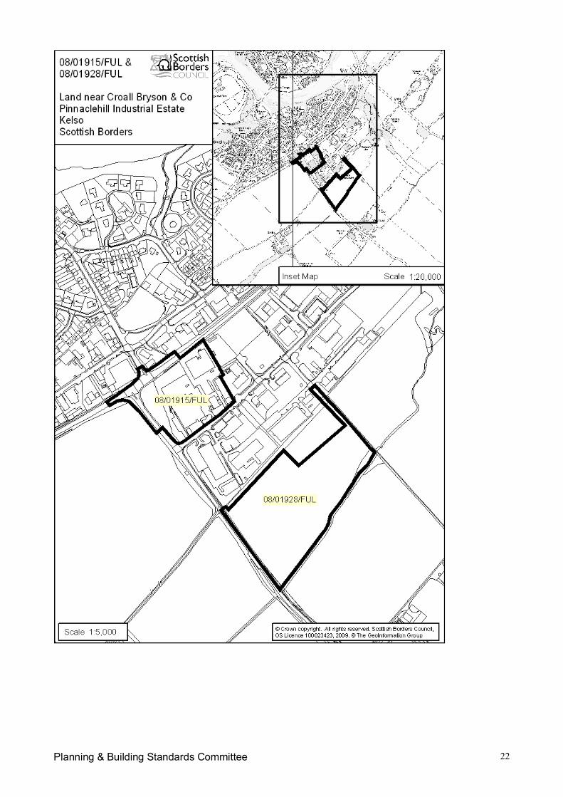
Planning & Building Standards Committee 22
Planning & Building Standards Committee 1
Item No. 7(e)SCOTTISH BORDERS COUNCIL
PLANNING & BUILDING STANDARDS COMMITTEE
13th APRIL 2009
APPLICATION FOR PLANNING PERMISSION & LISTED BUILDING CONSENT
ITEM: (e) REFERENCE NUMBERS: 08/01530/LBC 08/01531/FUL
OFFICER: Karen HopeWARD: East BerwickshirePROPOSAL: Internal and external alterations to auction ring (08/01530/LBC)
Erection of 112 dwellinghouses, district heating building andassociated works (08/01531/FUL)
SITE: Reston Auction Mart Ltd, Main Street, RestonAPPLICANT: BL DevelopmentsAGENT: Simpson & Brown Architects
SITE DESCRIPTION
Formerly a livestock auction mart, comprising 3.92 ha of Brownfield land, the site lies adjacent tothe Main Street (B6438), with a partial frontage to the Main Street and the C112 road to Chirnside.The site is separated from the main East coast railway line by a field to the south and is currentlyaccessed from the B6438. To the East, a mature border of trees separates the site from the twolarge residential properties, ‘Clairholme’ and ‘Brierfield’.
The topography of the site is consistently flat with very slight falls to drainage channels. Hardstanding and a scattering of small agricultural structures cover parts of the former Auction Martsite. A continuous drainage ditch separates the site from the adjacent land to the South.
The former Auction Mart Sheep Ring, which is located centrally within the northern part of the site,is a Category B Listed Building and is recognised as a good example of a rare building type, beingthe only listed auction mart in the Scottish Borders. It is understood the structure dates back to theearly 20th Century.
PROPOSED DEVELOPMENT
The proposed development comprises 112 dwellinghouses on the site. The number of units hasincreased by one during the processing of the planning application.
A village green, which is intended to form a new centre for the village, is proposed within thenorthern part of the site, adjacent to the Main Street. This would be an open space surrounded bya semi-formal arrangement of houses with a regular appearance and would be centred on RestonHouse on the north side of the Main Street. To the south side, the green would be centred on agroup of five terraced houses, the central house within this terrace would be set forward of thebuilding line in order to form a focal point.
The only single storey properties within the development would be facing onto the Main Street,intended to form a gentle transition between the existing single storey houses facing the MainStreet and the proposed development.
The proposed dwellinghouses within the site are generally terraced and face streets. These arearranged in groups with back courtyards which would form parking areas, concealed to the rear.For Members’ who have visited or who are familiar with the development of Poundbury in Dorset, it
Planning & Building Standards Committee 2
is clear that this has been an inspiration for this proposed scheme and has had a significantinfluence on the proposed road layout.
The proposed dwellinghouses are a mix of housing types and sizes, ranging from 2 to 4 bedrooms,finished in render (painted) and natural slate with many timber features spread throughout thescheme, mainly concealed to the rear elevations.
The main streets have been designed as ‘Homes Zones’ whereby they are designed for very lowvehicle speeds which better suits the needs of pedestrians and cyclists. Landscaping is proposedthroughout the site. Trees located within the road junctions provide an interesting and attractivefeature.
A district heating building is proposed towards the eastern end of the development with the roadaccess at this location designed according to the needs of supply vehicles. The entiredevelopment would be served by the wood burning boiler.
Listed building consent is sought to make alterations to the former Auction Mart building wherebythe roof would be re-slated and the original arrangement of roof openings restored. The buildingwould be left without its external timber cladding which would be carefully recorded before removal.The building would thereafter form a sheltered area for children’s play close to the centre of thedevelopment.
PLANNING HISTORY
There is no recent planning history relating to the site. Full planning consent was granted in 1990for the siting of a portacabin on the site (90/01498/FUL).
REPRESENTATION SUMMARY
A total of eight letters of objection have been received. These can be viewed in full on theCouncil’s public access system. The following is a summary of the concerns / objections / issuesraised:
The properties proposed opposite Gladstone Terrace would compromise the amenity ofexisting dwellinghouses and would have limited parking, resulting in on-street parking;
The density of the proposed development would have a detrimental effect upon the village as itdoes not have the infrastructure to support it;
The increase in traffic volumes would create a serious safety issue both within the village andat the junction of the A1;
The development would place pressure on schools, teaching staff and the quality of serviceprovided for existing children;
The proposals include parking bays for up to 211 vehicles. Object to the consequent dangersand hazards such an increase would pose to the village bottleneck at the shop, school, the A1junction and narrow local roads. Speeding is already an issue on Main Street and ChirnsideRoad which has no footpath;
The proposed terraced properties are aesthetically unappealing ‘box’ dwellings and theabsence of garages enables the developer to ‘cram in’ as many houses as possible;
The water system is not expected to accommodate such expansion. The limited capacity ofthe village combined sewer network has been a matter of concern for many years and is inneed of upgrading. The SUDS proposals are in reality a lake into which all surface water wouldbe diverted from the main sewer, allowing the main sewer a greater sewage intake. This lakeis within yards of ‘Brierfield’ and ‘Clairholme’ which suffered extensive flooding in October 2002during a period of heavy rainfall and would be a safety hazard to children;
Plot 100 encroaches into an existing tree line; The amount of car parking spaces is in no way sufficient to accommodate the number of cars
which would accompany such a large-scale development; and
Planning & Building Standards Committee 3
The overall design of the project shows no sensitivity to the surrounding environmentwhatsoever and would be more at home in a town setting.
APPLICANTS’ SUPPORTING INFORMATION
The following documents have been submitted in support of the applications, these can be viewedin full on the Council’s public access system:
Supporting Statement; Ground Gas Risk Assessment; Transport Assessment; Design and Access Statement; Drainage Strategy; Geotechnical Investigation Report; Phase 1 Environmental Audit; and Energy Efficiency and Renewable Energy Strategy.
CONSULTATION RESPONSES:
Scottish Borders Council Consultees
Director of Technical Services (Environmental Health):
Noise
Noise levels emitted by any plant and machinery used in connection with the district heatingsystem should not exceed Noise Rating Curve NR30 when measured at the façade of the nearestnoise sensitive dwelling.
Air Quality
The applicants should be required to submit an assessment of the impact of the development onlocal air quality. The assessment should address issues arising from the operation of the districtheating system and the pollution arising from additional road traffic.
The district heating system should burn only fuel of the grade and quality specified by themanufacturer of the combustion plant.
The efflux velocity and discharge point of the flue serving the district heating system should belocated so as to avoid the risk of fumes entering nearby premises.
Contaminated Land
The above application appears to be proposing the redevelopment of land which was previously anauction mart. This land use is potentially contaminative and it is the responsibility of the developerto demonstrate that the land is suitable for the use they propose.
It is recommended that planning permission should be granted on condition that development isnot be permitted to start until a site investigation and risk assessment has been carried out,submitted and agreed upon by the Planning Authority. Any requirement arising from thisassessment for a remediation strategy and verification plan would become a condition of theplanning consent, again to be submitted and agreed upon by the Planning Authority prior todevelopment commencing.The attached standard condition may be helpful in this respect
Director of Technical Services (Flood Protection Officer): In terms of information that thisCouncil has concerning flood risk to this site, I would state that The Indicative River & Coastal
Planning & Building Standards Committee 4
Flood Map (Scotland) known as the “second generation flood mapping” prepared by SEPAindicates that the site is NOT at risk from a flood event with a return period of 1 in 200 years fromthe Eye Water. That is the 0.5% annual risk of a flood occurring in any year.
The Indicative River & Coastal Flood Map (Scotland) has primarily been developed to provide astrategic national overview of flood risk in Scotland. Whilst all reasonable effort has been made toensure that the flood map is accurate for its intended purpose, no warranty is given. Due tocopyright restrictions I cannot copy the map to you however, if you wish to inspect the maps theycan contact me to arrange a suitable time to come in and view them.
The Briery Burn runs along much of the southern edge of the proposed site and there are historicalrecords of flooding in the South East corner of the proposed site and adjacent fields from the burn.
I would advise that a Flood Risk Assessment is required in this instance. I would also advise theneed for the developer to take into account the potential for flooding arising from other sourcessuch as road drainage, over land surface water runoff, and surcharged culverts.
Please note that this information must be taken in the context of material that this Council holds infulfilling its duties under the Flood Prevention (Scotland) Act 1961 as amended by the FloodPrevention and Land Drainage (Scotland) Act 1997.
Director of Technical Services (Roads): The Roads Officer has been heavily involved indiscussions with the agent and applicant during the process of the application and an amendedsite plan has recently been submitted. A verbal report will be made at Committee of anyoutstanding roads requirements. The previous consultation responses can be viewed in full on theCouncil’s public access system.
Statutory Consultees
Historic Scotland: The timber batten and board walls of the mart building are an essential part ofits special architectural character and their proposed removal would result in a loss of the enclosedcharacter of the building and would represent a considerable loss of significant historic fabric.Consequently, Historic Scotland request that the proposals, given their detrimental impact on theformer sheep ring, be reconsidered.
Reston and Auchencrow Community Council: This response can be viewed in full on theCouncil’s public access system. The following is a summary of the issues raised:
Concerns relating to plots 52, 53 and 54 which appear to be very close to the existing stonewalladjoining the Main Street. These buildings are of concern to the buildings opposite, primarilydue to privacy. At present, no structure exists which imposes on the privacy of the residents atGladstone Terrace. These proposals would also result in a loss of light. There is alsoinsufficient parking at this location. The existing stone wall which runs along the Main Street isa feature of Reston and should be retained.
Concerns relating to access and egress for delivery vehicles along the rear of existingproperties on the Main Street, presently there is a vehicular access to the rear of theseproperties via the ventral Mart entrance. These existing properties have a right of access forfuel tanks which could not be achieved through the proposed pedestrian access.
Although some of the buildings look aesthetically pleasing, plots 11 to 29 are of an extremelyhigh density where insufficient parking is proposed.
Policy Inf4 (Parking Provisions & Standards) of the Scottish Borders Local Plan 2008 requiresa minimum of two parking spaces per dwellinghouse, there is a shortfall of 11 parking spaceswithin the overall development.
The developer has not demonstrated the efficient use of energy and resources. Concerns areraised that the proposed district heating building compromise air quality.
Careful consideration needs to be given to the impact of the proposed development upon theschool, amenities and roads. Question whether or not the expansion of the existing school isthe best option. Reston has now only one access route from the B6438 to the main A1 trunk
Planning & Building Standards Committee 5
road. Concerns relating to safety issues at this junction have been raised previously. Theproposed development would clearly result in an increase in traffic at this location. As itstands, this road entrance would not be acceptable for the large traffic volume.
Concerns relating to the design of the SUDS proposals in relation to safety, particularly forchildren. It is not clear if a drainage assessment will be carried out. The proposals for theSUDS scheme have an emergency overflow structure which would feed into the burn whichruns through the property identified as ‘Brierfield’. This property has previously suffered fromflooding of this burn. To use this burn as an overflow would seriously raise concerns. Theextent of any works required to the sewage plant at Reston has not been detailed.
The Community Council along with residents of Reston acknowledge the need for housing withinthe village. A development in keeping with the linear pattern of Reston is encouraged, as is theinclusion of a village green.
Scottish Environment Protection Agency: Full responses dated 12 November 2008 and 23March 2009 can be viewed on the Council’s public access system. In summary, SEPA objects tothis application given the currently available information, there may be a high flood risk associatedwith the proposed development which could place buildings and/or people at risk. Although theproposed site appears to lie outwith the Indicative River and Coastal Flood Map (Scotland), the siteis adjacent to a small watercourse and consequently the development alongside this watercoursemay potentially be at risk of flooding. The watercourse, which is a tributary of the Eye Water,appears to rise approximately at the midpoint of the southern boundary of the site and flows in aneasterly direction along the southern boundary. SEPA recommends that the topography of theproposed development is reviewed, specifically the elevation of this area above the watercourses’channel banks and bed. In particular, the Agency would welcome the provision of cross sectionalinformation for clarification of potential flood risk.
Advice is also provided in respect of sewage disposal, surface water, contaminated land, the woodfuelled biomass boiler, sustainability, landscaping, waste management and recycling.
Scottish Water: No objections. Due to the size of the proposed development it is necessary forSW to assess the impact this new demand would have on the existing infrastructure. With anydevelopment of 10 or more housing units, or equivalent, there is a requirement to submit a fullycompleted Development Impact Assessment form. Rawburn Water Treatment Works currently haslimited capacity available for new demand. Reston Waste Water Treatment Works currently hascapacity to service the proposed development.
Transport Scotland: The submission of a Transport Assessment (TA) is required to enable anassessment of the impact on the trunk road to be made and any mitigating measures identified.This has now been submitted to Transport Scotland and a formal response is awaited.
Other Consultees
Architectural Heritage Society of Scotland: No response received.
Berwickshire Civic Society: Support the development. It is refreshing to see an applicationwhich appears to be well thought through and isn’t trying to replicate the typical suburban boxes incul-de-sacs approach to new housing. The scale of the housing and house types (predominantlyterraced) reflects the natural evolution seen in many Borders towns. The Society also welcomesthe sensitive conversion of the Auction Mart building as a play area.
DEVELOPMENT PLAN POLICIES:
Scottish Borders Structure Plan 2001-2011
Policy N17 – Listed BuildingsPolicy N20 – DesignPolicy H3 – Housing Land Allocation

Planning & Building Standards Committee 6
Policy H7 – Affordable and Special Needs Housing – ProportionPolicy H8 – Affordable and Special Needs Housing – AssessmentPolicy C6 – Open SpacePolicy C7 – Play AreasPolicy C8 – Access NetworkRecommendation I1 – Reston StationPolicy I11 – Parking Provision in New DevelopmentPolicy I12 – Provision of Water and Sewerage ServicesPolicy I13 – Water QualityPolicy I14 – Surface WaterPolicy I15 – Flood Risk AreasPolicy I18 – Contaminated LandPolicy I21 – Small Scale Renewable Energy TechnologiesPolicy I22 – Energy from Waste
Scottish Borders Local Plan 2008
Policy G1 – Quality Standards for New DevelopmentPolicy G2 – Contaminated LandPolicy G4 – FloodingPolicy G5 – Developer ContributionsPolicy G7 – Infill DevelopmentPolicy BE1 – Listed BuildingsPolicy BE2 – Archaeological Sites and Ancient MonumentsPolicy BE6 – Protection of Open SpacePolicy NE3 – Local BiodiversityPolicy NE4 – Trees, Woodlands and HedgerowsPolicy NE5 – Development affecting the Water EnvironmentsPolicy H1 – Affordable HousingPolicy H2 – Protection of Residential AmenityPolicy H3 – Land Use AllocationsPolicy Inf2 – Protection of Access RoutesPolicy Inf3 – Road Adoption StandardsPolicy Inf4 – Parking StandardsPolicy Inf5 – Waste Water Treatment StandardsPolicy Inf6 – Sustainable Urban DrainagePolicy Inf11 – Developments that Generate Travel DemandPolicy D4 – Renewable Energy Development
OTHER PLANNING CONSIDERATIONS:
Scottish Government Planning Policy
SPP6 Renewable Energy SPP7 Planning and Flooding SPP11 Open Space and Physical Activity SPP17 Planning for Transport SPP23 Planning and the Historic Environment
Scottish Government Planning Advice Notes:
PAN33 Development of Contaminated Land PAN45 Renewable Energy Technologies PAN61 Planning and Sustainable Urban Drainage Systems PAN65 Planning and Open Space PAN68 Design Statements PAN69 Planning and Building Standards Advice on Flooding
Planning & Building Standards Committee 7
PAN74 Affordable Housing PAN75 Planning for Transport PAN76 New Residential Streets PAN77 Designing Safer Places PAN79 Water and Drainage
Scottish Borders Local Plan Supplementary Planning Guidance:
Reston Auction Mart – Development Brief, May 2008 Affordable Housing, March 2007 Developer Contributions, April 2007 updated April 2008 Designing out Crime in the Scottish Borders, August 2007 Landscape and Development, March 2008 Privacy and sunlight guide, July 2006 Renewable Energy, March 2007 Trees and Development, March 2008
KEY PLANNING ISSUES:
The main planning issues are whether the proposed layout, density and design of the proposeddevelopment are appropriate and comply with Council policies and the Supplementary PlanningGuidance Planning Brief for the site and whether the development would have a negative impacton the character and appearance of the village of Reston. In addition, whether satisfactory accessand infrastructure can be provided to accommodate the proposed development.
ASSESSMENT OF APPLICATION:
Planning Policy
The site is allocated for redevelopment in the Scottish Borders Local Plan 2008. Policy H3 statesthat developments will be approved in principle for the land uses allocated on the Land UseProposals Tables and Maps and developments must be in accordance with the Council approvedplanning or development briefs.
A Planning Brief was approved for this site in May 2008. This sets out the main opportunities andconstraints relating to the site and creates an outline framework for its future development.
Layout, Siting and Design
Policy N20 of the Approved Structure Plan states that the Council will encourage a high quality oflayout, design and materials in all new development. Policy G1 of the Scottish Borders Local Plan2008 states that all development should be of high quality in accordance with sustainabilityprinciples, designed to fit in with Borders townscapes and to integrate with its landscapesurroundings.
The Planning Brief for this site states that a Design Statement is required in order to demonstratean integrated approach to architectural, landscape and infrastructural design. The Brief requiresthat a suitable residential environment will be established with a clear, high quality architecturalapproach that integrates and complements the existing settlement. Integral to any developmentwill be the provision of amenity space that will foster public interaction and allow for recreation.
A Design and Access Statement has been submitted with the application. This contains a designstrategy which is focused upon responding to the demands of this important site and surroundingarea while producing a scheme of high architectural quality that is sensitive to its surroundingswhich, for example, sets out an appropriate rural pattern for the area within the context of Restonand the surrounding area and which creates a new heart for Reston, a public space proportionateto the new size of the community.
Planning & Building Standards Committee 8
In respect of the overall concept, it is considered the proposals demonstrate a responsive urbanexpansion of a historic village that represents much of current placemaking aspirations. Thesubmission demonstrates a strong design philosophy in terms of traffic circulation, density andlayout. The aspiration for a well-integrated, permeable extension to the village of Reston thatminimises vehicular dominance and incorporates inclusive community facilities (i.e. the villagegreen and play ground) is highly commendable. The higher density of housing proposed isresponsive to the village context and the conceptual approach of using strong building lines todefine streets as opposed to roads represent a particularly positive aspect in ensuring apermeable, high quality extension to the village that could enhance the overall townscape andvisual character of the village as a whole.
Various discussions have taken place during the process of the application with a view to makingsome relatively minor adjustments to the layout, namely the eastern entrance, the gardens along‘Bayberry Lane’ and ‘Berryhaughs Road’ in order to combat any potential pressures for ‘front door’parking’, road geometry whereby the relationship of the road and buildings has been strengthenedand in particular the junction layouts whereby the arrangement of buildings, boundary treatmentsand roads at junctions is key to enclosing views and generating a positive transition betweenareas. The use of trees as a traffic calming element at junctions would create a positive addition tothe urban fabric. These have been the subject of lengthy discussions with the Roads Officer as itis equally important that the trees do not impinge upon road safety.
The Design Statement highlights that the appearance of the dwellinghouses is based on therepetition of a particular house type set in a variety of different orientations, materials, inter-relationships and connections. Detailing, materials (including the use of painted render and slate)and paint colours would vary but would be consistent within the scheme as a whole. Within theoverall homogenous palette of materials there would be variations in detail and in the distribution ofmaterials which would give a degree of individuality to each house or terraced group. Therepetition of door, window and roof details would be the main motifs which would give the familycharacter of the development.
The existing stone wall along the Main Street would be retained where possible. Openings wouldbe required to form the vehicular along ‘The Green’ and pedestrian openings.
Overall, the layout, siting and design of the proposed development is considered to be highlyresponsive to the site context and is viewed by the Department as a highly commendable scheme.In terms of design, siting and layout this scheme could be seen as a exemplar for high qualitydevelopment. In permitting the application, the Council would be rightly setting a high benchmarkfor other developers in the Borders to aspire to.
Open Space and Play Areas
Policies C6 and C7 of the Approved Structure Plan encourage the provision of open space andfacilities for children’s play that are safe, accessible and appropriate. Provision has been made fora village green in accordance with Policy C6 of the Structure Plan relating to open space and aplay area for young children is proposed beneath and within the vicinity of the former auction martbuilding. Discussions are taking place in respect of play provision for older children, it is likely thatthis would be in the form of a financial contribution towards the upgrade of the existing sports fieldto the north of the Main Street which is within a reasonable walking distance of the application site.
Trees and Landscaping
Policy NE4 of the Scottish Borders Local Plan states that the Council supports the maintenanceand management of trees and woodlands. The siting and design of the development should aim tominimise adverse impacts on the biodiversity value of the woodland resource, including itsenvironmental quality, ecological status and viability.
Planning & Building Standards Committee 9
Due to the nature of the previous use of the site, there are very few existing landscape features.There is, however, a very well established row of mature lime trees along the northern boundary of‘Clairholme’. An accurate survey of these trees is required in order to ascertain what thedevelopable area is at this location. This matter is being pursued further with the agent.
Suitably worded conditions would need to be attached to any consent granted requiring a fulllandscape scheme for the site.
Access and Parking
The development would be accessed off the Main Street to the north and off the Chirnside road tothe east with the layout being designed in order that it accords with “Home Zone” principles,whereby the streets are designed for very low vehicle speeds which better suits the needs ofpedestrians and cyclists.
Concerns have been raised by the Community Council and various neighbouring residents inrespect of the ability of the existing junction of the A1 trunk road to cope with the increase in traffic.Transport Scotland requested the submission of Transport Assessment in order that theimplications of the proposals upon the trunk road could be fully considered. This was subsequentlysubmitted and is currently being assessed by Transport Scotland. Street lighting at the A1staggered junction has been highlighted within the Planning Brief as a potential improvement.
Policy Inf4 of the Scottish Borders Local Plan 2008 states that proposals should provide for car andcycle parking in accordance with the Council’s adopted standards. It is proposed that car parkingwould be contained into areas behind houses. The Planning Brief and the Scottish Borders LocalPlan 2008 specifies that parking provision be a minimum of 2 spaces per dwelling (discountinggarages) for residents, when allocated to individual properties, with 25% visitor spaces in addition.Where the layout has communal parking a reduction in spaces will be allowed, to a ratio of 1.5 –1.75 spaces per dwelling, including visitor parking. The Director of Technical Services (Roads) iscontent with the level of parking proposed.
According to Council records, there are no existing pedestrian access routes which would bedirectly affected by the proposed development. However, Reston has a large path network whichwould benefit from additional investment in infrastructure (for example, in signage, way markers,gates, bridges and surfacing). Discussions with the agent are currently in progress with a view toestablishing whether the applicant is in a position to contribute financially to the off-site provisions.
It has been highlighted by the Director of Technical Services (Roads) that the proposed avenues oftrees along the streets may have implications for street lighting and that, for example, the treesalong ‘The Green’ may not be acceptable as they would impinging upon the lighting to anunacceptable degree. From a planning point of view, the trees are a very attractive and desirablepart of the overall street scenes being created. It is clear therefore that should the Committee beminded to approve the proposed development and in particular the landscape proposals that streetlighting standards may be lessened.
Listed Building
The application for listed building consent must be assessed against Policy BE1. This policy statesthat the Council will support development proposals that protect, maintain, and enhance the activeuse and conservation of Listed Buildings. New development that adversely affects the setting of aListed Building will not be permitted.
The retention of the former auction mart within the overall redevelopment is commendablealthough there are concerns relating to proposed removal of the external timber walls and theaffect this would have upon the character and appearance of the building. Historic Scotland hasnoted that the structure’s timber batten and board walls are an essential part of its specialarchitectural character and their proposed removal would result in a loss of the enclosed characterof the building and would represent a considerable loss of significant historic fabric.
Planning & Building Standards Committee 10
Discussions are currently ongoing between the agent, Historic Scotland and the PlanningDepartment in order that alternative options can be explored. The possibility of installing timberboarded doors to the external walls, which could be fixed open, is an option which is currentlybeing explored. It is hoped that a verbal report on this matter can be made at Committee. Theapplication would ultimately need to be referred to Historic Scotland for clearance.
Residential Amenities
Policy H2 of the Scottish Borders Local Plan 2008 states that development that is judged to havean adverse impact on the amenity of existing or proposed residential areas will not be permitted.
Particular concerns have been raised by existing residents opposite plots 52 – 54 in respect ofprivacy and daylight. The proposed dwellings would be single storey and in view of this it is notconsidered that they would compromise the daylight received by the existing properties. Althoughthe Council’s Privacy and Sunlight Guide seeks a minimum distance of 18 metres between anywindows facing onto one another, it must be accepted that existing properties on the Main Streetalready have a limited degree of privacy. It is not considered that the proposed properties, whichwould be located approximately 15 metres away, with the intervening Main Street, wouldsignificantly compromise privacy.
Overall, it is considered that the proposals would not adversely affect the residential amenities ofoccupiers of the neighbouring properties.
Archaeology
The proposed development has archaeological implications. The village of Reston was created byKing Edgar in 1098. It has retained many of the features that are typical of an early medievalsettlement such as a central street lined with buildings that are backed by agricultural strip fields incommon land. There was also a pele tower in the east end of the village and a church in the westend. These are typical arrangements for a medieval village in the Borders. There is likely to besurviving archaeology associated with the medieval settlement at Reston surviving in the proposeddevelopment area. As such, it is considered that a suitably worded condition should be attachedto any consent granted requiring that prior to the commencement of any ground disturbance, thedeveloper should engage a certified archaeologist to produce a written scheme of investigationoutlining a course of evaluation.
Ecology
The Planning Brief states that the size of the development meets the criteria requiring anEcological Impact Assessment (EcIA) under the Council’s Supplementary Planning Guidance forbiodiversity. For this site, this will require a survey of buildings to be demolished for bats andbreeding birds. As a European Protected Species the bat survey and determination of licensingrequirements are to be carried out prior to any planning consent being granted. As a Brownfieldsite an EcIA should also include a survey and impact assessment for reptiles and amphibians.These requirements are currently being discussed with the agent with a view to ensuring that anappropriate survey is submitted.
Flooding
The Scottish Environment Protection Agency (SEPA) has objected to the proposed developmentas it is advised that, given the currently available information, there may be a high flood riskassociated with the proposed development which could place buildings and / or people at risk.SEPA do not object in principle to the development but instead objects on the grounds ofinsufficient information. Although the site appears to lie outwith the Indicative River and CoastalFlood Map (Scotland), the site is adjacent to a small watercourse and consequently thedevelopment alongside this watercourse may potentially be at risk of flooding. The watercourse,which is a tributary of the Eye Water, appears to rise approximately at the midpoint of the southern
Planning & Building Standards Committee 11
boundary of the site and flows in an easterly direction along the southern boundary. Thewatercourse has a catchment less than 3km2 and therefore the potential flood risk is not shown onthe Indicative River and Coastal Flood Map (Scotland). The owners of ‘Clairholme’ havehighlighted that their property, along with the neighbouring ‘Brierfield’, suffered extensive floodingin October 2002 during a period of heavy rainfall. SEPA therefore recommended that thetopography of the proposed development be reviewed, specifically the elevation of this area abovethe watercourses’ channel banks and bed as cross sectional information for clarification of potentialflood risk.
Discussions have subsequently taken place between the agent and SEPA and a Hydrology Reportwas submitted. SEPA continue to object, however, and now require that a detailed flood riskassessment is undertaken. SEPA also recommend that the proposed SUDS structures are locatedoutwith the functional floodplain, and that the location is reviewed following the completion of theFRA. This requirement has been conveyed to the agent.
Water Management and Drainage
The Planning Brief for the site highlights that there are capacity issues within the water and waste-water system in Reston and that an appropriate Sustainable Urban Drainage System (SUDS)system is required to meet with the agreement of SEPA, Scottish Water and the Local PlanningAuthority. SUDS must be designed to be visually attractive, accessible and safe with suitableprovisions for long-term maintenance
Scottish Water raise no objections in principle to the proposals but indicate that a DevelopmentImpact Assessment would be required to fully assess the impact the new demand would place onthe existing infrastructure. Reston Waste Water Treatment Works will require to be upgraded toserve the development. Scottish Water has confirmed that there is capacity for the first phase of24 units prior to upgrading. The works would be upgraded by Scottish Water to service theremainder of the development.
The SUDS proposals form a dry basin within the south eastern corner of the site. Variousconcerns have been raised by neighbouring residents that the proposals, on the misunderstandingthat it would be a SUDS pond, would result in safety implications, particularly for children. Thebasin would form a depression in the land which would remain dry most of the time and would onlyhave water in it for a short period of time during heavy rainfall. This area would be planted.
Contamination
The previous land use is potentially contaminative. It is therefore recommended that any planningapproval granted should be subject to a suitably worded condition requiring that development is notbe permitted to start until a site investigation and risk assessment has been carried out, submittedand agreed upon by the Planning Authority.
Renewable Energy
Policy G1 of the Scottish Borders Local Plan states that in terms of the layout, orientation,construction and energy supply, the development should demonstrate that appropriate measureshave been taken to maximise the efficient use of energy and resources, including the use ofrenewable energy and resources and the incorporation of sustainable techniques.
An Energy Efficiency and Renewable Energy Strategy has been submitted. This provides detailsin respect of the proposed district heating building which would be located within the north easternpart of the site. It would supply the whole of the development using a wood burning boilerdelivering benefits in terms of both reduced environmental impact and lower operating costs.
It is considered that the proposals accord with the requirements of national and local planningpolicies relating to energy efficiency.
Planning & Building Standards Committee 12
Development Negotiations & Contributions
Policy G5 of the Scottish Borders Local Plan 2008 states that where a site is acceptable but cannotproceed due to deficiencies in infrastructure or due to environmental impacts the Council willrequire developers to make contributions towards the cost of addressing such deficiencies. ThePlanning Brief for the site identifies a number of issues that require to be addressed throughappropriate provision / developer contributions / conditions and a legal agreement:
Railway (to be discussed); Roads: the redesign / mitigation work on the highway network adjacent to existing and new
access points; Water and Drainage: arrangements to ensure sufficient capacity in the waste water
treatment works, including the public foul water connection; Affordable housing; Open space (including landscape / footpaths and aftercare / off-site payments if open
space standards are not achieved on-site); Play facilities: including play equipment, surfacing, fencing, planting and aftercare; Refurbishment / integration and re-use of the ‘Octagon’ auction mart building. Education provision
It is not Council policy to seek a financial contribution towards to railway at this location at this time.
In respect of roads, the Director of Technical Services (Roads) has indicated that a footway alongthe Chirnside road and Main Street is required as well as a road crossing facility. Therequirements, if any, of Transport Scotland are awaited.
In respect of water and drainage, Scottish Water has raised no objections although this does notguarantee a connection to the existing infrastructure. Scottish Water has confirmed that there iscapacity for the first phase of 24 units prior to upgrading. The works would be upgraded byScottish Water to service the remainder of the development. The developer would need to submita full Development Impact Assessment.
In respect of affordable housing, there is a requirement for the on-site provision of affordable unitsat a rate of 20%. A commuted sum may also be required. At this stage, it is anticipated that 20%of the units would be for sale at a discounted rate. These would be dispersed through the site.
Sufficient open space and a play area for younger children is adequately catered for within the site.The refurbishment of the Auction Mart building forms part of the proposals. There may, however,be a requirement for a financial contribution towards the existing sports field to the north of thevillage.
In respect of education, there are severe capacity issues at Reston Primary School. This excludesany allowance for a potential increase in pupil numbers if the proposed development proceeds,along with other allocated housing sites within the village. The Department has been involved inlengthy discussions with the Education and Lifelong Learning Department as there is arequirement to expand the primary school to incorporate additional numbers that new housingwould generate in the village. This matter is complicated by the fact that neither the Council northe developer has control over the necessary land to undertake any school expansion. Detaileddiscussions are still on-going in respect of the primary school and it is anticipated that a solutioncan be achieved that would enable the expansion of the existing school facilities.
A financial contribution per dwellinghouse would be required towards Eyemouth High School.
Members will be aware that in the current economic climate the viability of development schemesis fragile. Discussions and negotiations with the applicant have been conducted to identify the keydevelopment contributions and the requirement for a significant contribution toward Educationfacilities in particular, places a particularly high burden on the development.Paragraph 4.13 of SPG9 – Developer Contributions states that:
Planning & Building Standards Committee 13
“Where substantial contributions are required that may jeopardise the commercial viability of aproject, the Council will enter into negotiations to establish whether reduced contributions to eithereducation or other infrastructure would be appropriate. This may require to be on the basis of anindependent and “open book” assessment of the viability of the scheme.”
The applicant is now entering into open book discussions and has agreed to fully disclosed allrelevant information central to his development appraisal in order to demonstrate the prohibitiveimpact that contributions at this level would have upon the commercial viability of the project.
Consequently, and in an attempt to both facilitate this development as well as achieving a level ofcontribution that the project can support, compromise solutions may have been negotiated with theapplicant and options investigated such as deferring payments, discounting and prioritisingcontributions between demands or indeed removing some contributions altogether.
CONCLUSION
In general terms it is considered that the proposed development is a particularly commendablescheme is respect of design and placemaking. There are clearly, however, a number ofoutstanding issues relating to these proposals, namely:
The junction with the A1 trunk road; The requirement for further information in respect of flood risk; The issues relating to the proximity of Plot 100 to the existing trees along the northern
boundary of ‘Clairholme’; The impact of the proposed development upon the existing school; The requirement for a footpath link to the Main Street from the eastern access onto
Chirnside road; and The requirement for an Ecological Impact Assessment.
At this stage, it is requested that the Committee approves the proposed development ‘in principle’with delegated powers to the Head of Planning and Building Standards to pursue and ultimatelyagree the aforesaid outstanding issues.
RECOMMENDATION BY HEAD OF PLANNING AND BUILDING STANDARDS:
08/01530/LBC
I recommend that the application be approved in principle with delegated powers to the Head ofPlanning and Building Standards in order that the proposals can be pursued and suitably amendedin accordance with the requirements of Historic Scotland. The application would ultimately bereferred to Historic Scotland for clearance.
08/01531/FUL
I recommend that the application be approved in principle with delegated powers to the Head ofPlanning and Building Standards in order that the outstanding issues can hopefully be resolvedand subject to the conclusion of an appropriate legal agreement and the following conditions:
1. Noise levels emitted by any plant and machinery used in connection with the district heatingsystem should not exceed Noise Rating Curve NR30 when measured at the façade of thenearest noise sensitive dwelling.Reason: To safeguard the amenity of existing and prospective neighbouring residents.
2. Prior to the commencement of any ground disturbance the developer will engage a certifiedarchaeologist to produce a Written Scheme of Investigation outlining a course of evaluationto be submitted to and approved by the Planning Authority. Evaluation may includegeophysical survey and evaluation trenching to determine the presence or absence of
Planning & Building Standards Committee 14
buried archaeological features or finds. If significant archaeology is discovered, thePlanning Authority will be contacted to discuss further mitigation.Reason: The site of archaeological interest.
3. Development shall not begin until a scheme to deal with contamination on the site has beensubmitted to and approved in writing by the Planning Authority. The scheme shall containdetails of proposals to deal with contamination to include:a) A desk study and development of a conceptual site model, measurement of pollutant
linkages through a detailed investigation of the nature and extent of contamination onsite, and assessment of risk such contamination presents. The scope and method ofthis investigation to be agreed in advance with the Local Planning Authority, and beundertaken in accordance with PAN 33 (2000) and BS10175:2001.
b) Remedial Strategy (if required) to treat/remove contamination to ensure that the siteis fit for its proposed use (this shall include a method statement, programme of works,and proposed validation plan).
c) Submission of a Validation Report (should remedial action be required) by thecompetent person employed by the developer who will validate and verify thecompletion of works to a satisfactory standard as agreed with the Local PlanningCouncil.
d) Submission, if necessary, of monitoring statements at periods to be agreed with theLocal Planning Authority for such time period as is considered appropriate by theLocal Planning Authority.
Reason: To ensure that the potential for health risk arising from any identified landcontamination has been adequately addressed.
4. Before the development is commenced, a Construction Method Statement to be submittedto and agreed in writing by the Planning Authority in consultation with the ScottishEnvironment Protection Agency (SEPA). The works must thereafter be undertaken inaccordance with these agreed details.Reason: To ensure the satisfactory form of the development.
5. The disposal of surface water to comply with the “Sustainable Urban Drainage Systems –Design Manual for Scotland and Northern Ireland” published by CIRA in 2000. Themanagement and maintenance of the SUDS system to be agreed with the PlanningAuthority before the development is commenced. Reason: To ensure that adequate and appropriate means are used in the disposal ofsurface water.
6. Notwithstanding the description of the materials in the application, no development shall becommenced until precise details of the materials to be used in the construction of theexternal walls and roofs of the buildings have been submitted to and approved in writing bythe Planning Authority, and thereafter no development shall take place except in strictaccordance with those details.Reason: The materials require further consideration to ensure a satisfactory form ofdevelopment, which contributes appropriately to its setting.
7. The access roads, footpaths, and parking spaces shown on the approved plans to becompleted to the specification of the Planning Authority in accordance with a programme ofphasing submitted to and approved by the Planning Authority before the developmentcommences.Reason: To ensure that adequate access to the site for pedestrians and vehicles isprovided and is at all times properly maintained.
8. The development hereby approved shall only be carried out in strict accordance with aprogramme of phasing which has first been submitted to and approved in writing by thePlanning Authority. Reason: To ensure that the development of the estate proceeds in an orderly manner.
Planning & Building Standards Committee 15
9. Notwithstanding the provisions of the Town and Country Planning (General PermittedDevelopment) (Scotland) Order 1992 (or amendments or re-enactment or re-enactmentthereof) no extension, enlargement; or other alteration of any dwelling shall be carried outwithout the prior written consent of the Council, to whom a planning application must bemade.Reason: The Planning Authority considers that the development hereby permitted is themaximum that can be reasonably allowed without causing detriment to the amenities ofadjoining properties, and for this reason would wish to control any future proposals oralterations or extensions.
10. Before the development is commenced, a Development Impact Assessment to besubmitted to and approved by the Planning Authority, in consultation with Scottish Water,and an appropriate scheme to be in place to accommodate the development within ScottishWater’s local infrastructure. This may be on a phased basis with the agreement of thePlanning Authority in liaison with Scottish Water.Reason: To ensure the site is adequately serviced.
11. No development shall take place except in strict accordance with a scheme of hard and softlandscaping works, which has first been submitted to and approved in writing by theplanning authority. Details of the scheme shall include:i. existing and finished ground levels in relation to a fixed datum preferably ordnanceii. existing landscaping features and vegetation to be retained and, in the case of
damage, restorediii. location and design, including materials, of walls, fences and gatesiv. soft and hard landscaping worksv. existing and proposed services such as cables, pipelines, sub-stationsvi. other artefacts and structures such as street furniture, street lighting, play equipmentvii. A programme for completion and subsequent maintenance.Reason: To ensure the satisfactory form, layout and assimilation of the development.
12. No development shall take place except in strict accordance with a scheme of softlandscaping works, which shall first have been submitted to and approved in writing by thePlanning Authority, and shall include:i. indication of existing trees, shrubs and hedges to be removed, those to be retained
and, in the case of damage, proposals for their restorationii. location of new trees, shrubs, hedges and grassed areasiii. schedule of plants to comprise species, plant sizes and proposed numbers/densityiv. programme for completion and subsequent maintenance.Reason: To enable the proper form and layout of the development and the effectiveassimilation of the development into its wider surroundings.
13. All planting, seeding or turfing comprised in the approved details of landscaping shall becarried out in the first planting and seeding seasons for each agreed phase following theoccupation of the buildings or the completion of the development, whichever is the sooner,and shall be maintained thereafter and replaced as may be necessary for a period of twoyears from the date of completion of the planting, seeding or turfing.Reason: To ensure that the proposed landscaping is carried out as approved.
14. No trees within the application site shall be felled, lopped, lifted or disturbed in any waywithout the prior consent of the Local Planning Authority. Reason: The existing trees represent an important visual feature which the Local PlanningAuthority considered should be substantially maintained.
15. Gates must not open onto the public highway.Reason: To ensure safety for users of the public highway.
16. The areas allocated for parking on the submitted plan shall be properly consolidated,surfaced and drained to the specification of the Local Planning Authority before the
Planning & Building Standards Committee 16
dwellinghouses which they serve are occupied, and shall not be used other than for theparking of vehicles in connection with the development hereby permitted. Reason: To ensure there is adequate space within the site for the parking of vehicles clearof the highway.
17. No development shall take place until a scheme for the provision of the equipped play areahas been submitted to and approved in writing by the Local Planning Authority. The schemeso submitted shall include-i. type and location of play equipment, seating, fences, walls and litter binsii. surface treatment of the play areaiii. proposals for the implementation/phasing of the play area in relation to the construction
of houses on the site.Reason: To ensure that proper provision is made for recreational facilities within the site.
18. All works required for the provision of the play area shall be completed in accordance withthe scheme approved in writing by the Local Planning Authority.Reason: To ensure that the development is carried out as approved.
19. No development shall be commenced until an assessment of the impact of thedevelopment on local air quality has been submitted to and approved by the PlanningAuthority. The assessment must include air quality issues arising from the operation of thedistrict heating system and pollution arising from additional road traffic associated with thedistrict heating system. The use of the district heating shall not commence until anymitigation measures found to be necessary as part of the assessment have beenundertaken and must thereafter be permanently maintained.Reason: In the interests of environmental health.
20. The district heating system shall only burn fuel of the grade and quality specified by theLocal Planning Authority and the manufacturer of the combustion plant.Reason: In the interests of environmental health.
21. The efflux velocity and discharge point of the flue serving the district heating system must beagreed in writing by the Local Planning Authority and must thereafter be so retained.Reason: In the interests of environmental health.
Informative:
In respect of condition no. 2, it would also be desirable that if any archaeology is discovered thiscould be marked in an appropriate way for the public.
In respect of condition no. 4, this method statement must satisfactorily address the temporarymeasures proposed to deal with surface water run-off during construction in accordance with therequirements of CAR and the relevant GBRs prior to the operation of the final SUDS. It mustensure that the SUDS performance is not compromised during construction, either by avoiding useof the final SUDS or completely reinstating the SUDS used.
Approved byName DesignationBrian Frater Head of Planning and
Building Standards
“The original version of this report has been signed by the Head of Planning and BuildingStandards and the signed copy has been retained by the Council.”

Planning & Building Standards Committee 17
Author(s)
Name DesignationKaren Hope Senior Planning Officer
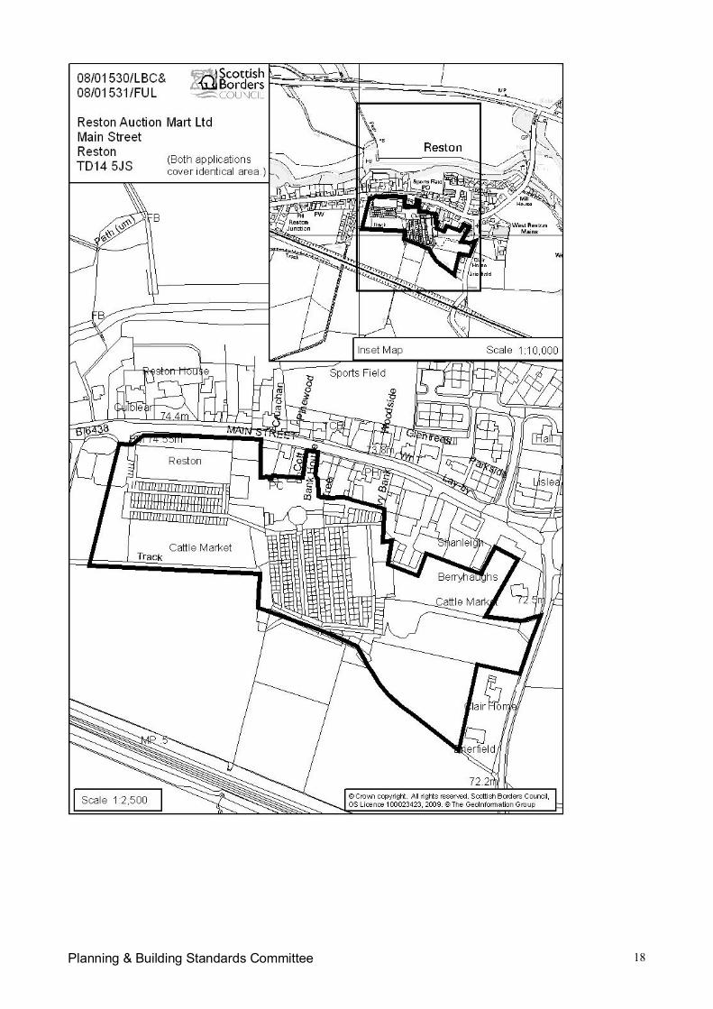
Planning & Building Standards Committee 18
Planning and Building Standards Committee 1
Item No. 7(f)SCOTTISH BORDERS COUNCIL
PLANNING AND BUILDING STANDARDS COMMITTEE
13 APRIL 2009
APPLICATION FOR PLANNING PERMISSION
ITEM: (f) REFERENCE NUMBER: 06/01293/FUL
OFFICER: Julie HaywardWARD: Kelso and DistrictPROPOSAL: Erection of eighteen dwellinghouses and change of use of allotments to
garden groundSITE: Garden Allotments Shedden Park Road KelsoAPPLICANT: CWP ScotlandAGENT: Smith Design Associates
SITE DESCRIPTION
This is a 1.06 hectare site situated within Kelso. It was previously used as allotments but is nowvacant and overgrown. To the north west is the Lidl Supermarket separated from the site by a highwire fence, to the north and north east are the residential properties along Hermitage Lane and thereare mature trees and hedges along this boundary. To the south east is Mayfield Riverside Walk andthe River Tweed separated from the site by a mature hedge and to the south west are residentialproperties in Abbotsford Grove and two properties that front onto the Riverside Walk.
PROPOSED DEVELOPMENT
The original scheme was submitted in June 2006 and was for twenty-five detached, semi-detachedand terraced dwellinghouses. Access was proposed from Abbotsford Grove and an area of publicopen space and a play area were proposed for the eastern section of the site adjacent to the river.The proposal also included a 1.01 hectare site for replacement allotments at Hunters Hall to thesouth east of Kelso.
The scheme has been amended several times since its original submisison. The current proposal isfor eighteen dwellinghouses; there would be two detached, six semi-detached and ten terracedhouses. The access would be formed between nos 8 and 9 Abbotsford Grove utilising part of thefront gardens for the visibility splay. Plots 1 to 8 would front directly onto the new road and plots 9 to18, the terraced properties, would be arranged around courtyards with communal parking served bya minor access road. There would be thirty-six resident’s parking spaces, six visitor parking spacesand nine general purpose parking spaces associated with the allotments.
The proposed dwellinghouses would be two-storey with three and four bedrooms. The houses wouldhave render, natural zinc and timber cladding for the walls and grey roof tiles.
A children’s play area is proposed adjacent the north east boundary and the south east section of thesite would be public open space and allotments. A small section of the site would be incorporatedinto the garden ground of properties on Abbotsford Grove.
Planning and Building Standards Committee 2
PLANNING HISTORY
05/01057/FUL: Erection of twenty three dwellinghouses. The application was withdrawn.
REPRESENTATION SUMMARY
Eleven representations were received in respect of the application as originally submitted in June2006. These are available for Members to view on the Public Access System. The followingplanning issues have been raised:
The site is designated in the development plan as green belt. Policy BE6: Protection of OpenSpace in the Local Plan states that the allotments provide amenity open space within Kelsoand will be protected.
The site is unsuitable for residential development due to the lack of a suitable vehicularaccess.
Access to the site is from Abbotsford Grove that leads directly onto Shedden Park Roadwhich is very busy with extra traffic generated by the Lidl Supermarket. The mini-roundaboutat Shedden Park Road is barely adequate for current traffic and is dangerous at busy times.
The proposed entrance to the site from Abbotsford Grove is narrow with restricted visibility,which will affect existing properties, Maxwell Lane and Mayfield Riverside Walk exacerbatingexisting problems for walkers and traffic. The road cannot cope with the increase in trafficgenerated by this development and the access road will have difficulty coping with servicevehicles, refuse vehicles and emergency vehicles. Abbotsford Road is already congestedwith resident’s cars and lorries visiting the workshops and British Telecom Exchange. Carsfrom this development will spill over into Abbotsford Grove exacerbating the current situation.
This would be a dense, modern development in the middle of nineteenth century housing.The design is out of keeping with the Victorian terraced stone houses and villas to thedetriment of the character of Kelso.
The number of houses proposed is out of keeping with the character of the area.
The development would result in a loss of privacy, noise pollution from additional cars andresidents and light pollution from streetlights. The proposed houses are too close to existingproperties in Abbotsford Grove.
The area suffers from subsidence and construction work and additional traffic would worsenthe situation affecting existing properties.
The allotments are an asset to the town and of amenity and wildlife value and were alloccupied and well maintained for many years. They contribute to the health and welfare ofthe community. They have represented an area of open space for 150 years and theproposal would result in a loss of open space within the town boundaries and result in a morecrowded urban environment. The allotments are currently not in use due to this planningapplication hence the overgrown state but were in use by between forty and fifty allotmentholders prior to the planning application being submitted in 2005 when they were servednotice to quit. The council should replacement these allotments.
Planning and Building Standards Committee 3
The proposed replacement allotments are too far out of town and many people do not havethe transport to get there.
The sewage and water system are already overloaded due to additional houses being built inKelso and this development will aggravate the problem.
The River Tweed is a Special Area of Conservation and the Council must ensure thepreservation of environmental areas.
The Mayfield area frequently floods.
Amended drawings were received in May 2008 and eleven representations were received followingthe neighbour notification process. These are available for Members to view on the Public AccessSystem. The following issues were raised, in addition to those listed above, in respect of theamended proposal:
Although the number of houses has been reduced to retain some allotment land the densityremains similar and the number of houses is excessive.
The proposal is still contrary to the Local Plan policies.
The timber and render of the proposed houses will not blend in with the character of the area.
The proposal is out of keeping with the character of the Conservation Area.
The proposed 1.8m boundary fences will affect the light into existing properties.
The development includes terraced houses in an attempt to blend in with the surroundingarea but this would overshadow a number of existing houses.
The proposal does retain some ground for allotments but the proposal would significantlyreduce the current facility at a time when large numbers of flats have been constructed in thetown and so this proposal may not cater for demand.
Abbotsford Grove is narrow where the new access to the scheme is proposed and wouldneed to be widened and speed bumps installed. Improvements would also be required at thejunction of Abbotsford Road with Shedden Park Road due to the poor alignment and a rightturn lane would be required for motorists coming from the Square. Workers for M & JBallentyne and Rennie Welsh park their vehicles at the top of Abbotsford Grove and traffic forthe Abbey Fitness Centre and Abbotsford Court use this road.
The Local Plan Inquiry Reporter was under the mistaken belief that there were no objectionsfrom neighbouring properties to this proposal. Neighbours submitted their representations inrespect of the planning application rather than to the Local Plan inquiry. The Council wasaware of these objections and should have brought them to the attention of the Reporter.The Reporter was led to believe that there was a falling demand for the allotments hence theovergrown state of the site but in fact the tenants were evicted and no vacant plots were let;the site was allowed to become overgrown. The Reporter’s findings were that the land shouldremain as amenity open space as set out in the Scottish Borders Local Plan of December2005 but that the Council should explore the scope for granting planning permission for someinfill development as part of a mixed use development of the site. This recommendation wasbased on a number of false premises and the Reporter was misled.

Planning and Building Standards Committee 4
The “model predictions” contained within the Flood Risk Assessment do not accurately reflectthe extent of the actual flooding of the riverside walkway and the Flood Risk Assessmentunderestimates the flood risk to the site.
Parking along Abbotsford Grove is at the limit and the provision of site lines will exacerbatethe problem further by reducing existing parking spaces.
Further amended drawings were received in February 2009 and following neighbour notification, fourrepresentations were received. These are available for Members to view on the Public AccessSystem and raise the following issues, in addition to those already listed:
The land should be used as a community area for schools and people which would benefiteveryone. Owls and red squirrels have been sighted.
There are many empty and half-built houses in Kelso that it is unnecessary to have anotherdevelopment of over-expensive houses which may not sell in this economic climate.
There are still too many houses crammed into a small area and out of keeping with thecharacter of the area.
Nothing has been proposed to address the traffic problems associated with Shedden ParkRoad and Abbotsford Grove.
Even though a section of allotments is to be retained the development represents a majorloss of amenity.
The allotments have been neglected and if this application is approved a condition should beattached that requires the developer to restore the land to its original state suitable forimmediate working as allotments
APPLICANT’S SUPPORTING INFORMATION
A Flood Risk Assessment has been submitted by the agent and is available for Members to view onthe Public Access System.
DEVELOPMENT PLAN POLICIES
Scottish Borders Structure Plan 2001-2011
Policy N18: Development Affecting Conservation AreasPolicy N20: DesignPolicy H7: Affordable and Special Needs Housing – ProportionPolicy C6: Open SpacePolicy C7: Play AreasPolicy I11: Parking Provision in New DevelopmentPolicy I15: Flood Risk Areas
Scottish Borders Local Plan Adopted 2008
Policy G1: Quality Standards for New DevelopmentPolicy G4: Flooding
Planning and Building Standards Committee 5
Policy G5: Developer ContributionsPolicy G7: Infill DevelopmentPolicy BE4: Conservation AreasPolicy BE6: Protection of Open SpacePolicy H1: Affordable HousingPolicy H2: Protection of Residential AmenityPolicy Inf4: Parking StandardsPolicy Inf6: Sustainable Urban Drainage
OTHER PLANNING CONSIDERATIONS:
Supplementary Planning Guidance - Developer Contributions April 2008 Supplementary Planning Guidance - Affordable Housing March 2007 Scottish Borders Council’s Housing Needs Study and Affordable Housing Policy Report
December 2006.
CONSULTATION RESPONSES
Scottish Borders Council Consultees
Director of Technical Services (Roads): Unable to support the proposal due to the alignment andlayout of the proposed road, inadequate parking and a lack of information regarding surface waterdrainage.
Re-consultation May 2008: I am still unable to support the application. I am disappointed that,given most of the these amendments were requested in my previous reply of August 2006, they donot appear to have been addressed in the latest submission.
Re-consultation February 2009: Some revisions to the parking bays are required. A swept pathanalysis is required for the shared surface road to ensure that it can accommodate anticipatedassociated vehicles. Construction Consent will be required for the new road and details of thedrainage, road construction and minor geometrical amendments shall be agreed via that process.The extent of the public service strips shall also be agreed through the Construction Consent. Ascheme of improvements should be submitted and agreed for the public road between the site andShedden Park Road prior to commencement of the site. A timescale for their implementation shouldalso be agreed at that stage.
Director of Technical Services (Flood Prevention): In terms of information that this Council hasconcerning flood risk to this site, I would state that The Indicative River & Coastal Flood Map(Scotland) known as the “second generation flood mapping” prepared by SEPA shows a similar areato be at risk from the 1 in 200 year event as the submitted Flood Risk dated 21 Nov 2006. I amcontent with the flood risk subject to agreement of the assessed hydrology by SEPA. The proposalsin the flood risk require to be translated to the developer’s drawings in particular the finished floorlevels and ground profiles around the houses. I would not then oppose this development on thegrounds of flood risk.
Re-consultation February 2009: The Flood Risk Assessment (FRA) prepared by Kaya ConsultingLimited for C W Properties in November 2006 is based on a 1 in 200yr event with an allowance of20% for climate change and was subsequently revised in consultation with SEPA. The FRAsuggested that no properties are located in the functional flood plain and that a minimum finishedfloor level of 33.0m AOD is adopted. They have also suggested that all roads are set above theprojected flood level of 31.94m AOD which would provide safe access and egress during a flood
Planning and Building Standards Committee 6
event. An area of compensatory flood storage would be required equal to the volume of land raisedto achieve the above levels. Provided the above criteria are met I would not oppose thisdevelopment on flooding grounds.
Statutory Consultees
Scottish Environment Protection Agency: Foul water drainage should be to the main sewer andsurface water to an adequate SUDS scheme. The site is adjacent to a watercourse so may be at riskfrom flooding.
Re-consultation May 2008: Objects to the application as given the currently available informationthere may be a high flood risk associated with the proposed development. The Flood RiskAssessment is insufficient to assess the flood risk and further information is required.
Re-consultation February 2009: SEPA Hydrology subsequently received additional information andclarification from Kaya Consulting. The Agency is also aware that a letter dated 23 January 2009was forwarded to the Council by Smith Design Associates along with a revised Drawing whichincorporated proposed amendments to the scheme. Specifically, the revised drawing incorporatesSEPA’s recommendation that finished floor levels should be 1m above the predicted flood level.SEPA also requested that the proposed SUDS pond should be located outwith the functionalfloodplain in order to reduce the risk of pollutants being mobilised during a flood event. It is notedthat the drainage layout has been redesigned by Scott Bennett Associates, and that the SUDS pondhas been replaced by a 1200mm diameter tank sewer system. These revised proposals areacceptable to SEPA, and consequently the Agency considers that it is appropriate to remove theobjection as detailed in the attached Hydrology Report.
Scottish Water: There are no known issues at present with the water network and Kelso wastewater treatment works currently has sufficient capacity to serve the proposed development.
Kelso Community Council: The density and design of the development are considered to beunsuitable. The local plan designates this as a greenfield site and it should be retained as such.The allotments should be retained as the replacement site is too far out of town and the ground ispoor. The access road is not acceptable; the traffic negotiating Abbotsford Grove has difficultieswithout the substantial additional traffic generated by this development.
Re-consultation May 2008: No objections.
Re-consultation February 2009: Concerned about the adequacy of the access into the site fromAbbotsford Grove at what is a narrow part of the street and who would be responsible for maintainingthe public open space, if it is to be grassed.
Kelso Amenity Society: The houses are very small when compared to existing houses in the area.Road access is awkward and will turn Maxwell Lane into a rat-run and increase the traffic usingAbbotsford Grove. The proposed play area on the flood plain is too far from the houses. Externalfinishes should fit in with the surrounding houses and flat roofs are not to be recommended. Noenergy generating features have been included. The proposal would affect the amenities of localresidents. The main objection is the loss of the allotments as these should be preserved as anamenity for the town. The demand for allotments is likely to grow as people are increasinglyinterested in home-grown produce. The proposed replacement allotments are too remote. There isno need for this development, which is unsuitable for the area.
Planning and Building Standards Committee 7
Re-consultation May 2008: General disappointment that the whole area will not be retained asallotments, as required by the Local Plan, and the area allocated is far too small. At least half shouldbe allocated as allotments. There are too many houses for the space available; this is an area oflower density housing and the development would adversely affect the amenities of surroundingproperties. The style and materials of the houses are acceptable. The proposal would put a strainon Abbotsford Grove; the road is unsuitable for the increase in traffic and the junction onto SheddenPark Road is awkward and close to the Rose Lane roundabout. The sight lines for traffic turning intoAbbotsford Grove are poor and the closeness of the roundabout makes it a hazardous operation.The play area is poorly sited. Fireplaces and the use of renewable energy should be considered.
Re-consultation February 2009: A slight improvement as there is one house less and more spacefor allotments. The play area is now a decent size, but has parking area next to it. Concerns aboutthe impact of the additional traffic on Abbotsford Grove remain. A fence and lockable gates for theallotments would be necessary for security and the phasing needs to be agreed as allotment holdershave been left plot-less for years
Other Consultees:
None
KEY PLANNING ISSUES
The main planning issues are whether the proposed layout, density and design of the proposeddevelopment are appropriate and comply with Council policies and whether the development wouldhave a negative impact on the character and appearance of the surrounding area and ConservationArea and on residential amenities of residents of neighbouring housing. In addition, whether asatisfactory access to the site can be achieved.
ASSESSMENT OF APPLICATION
Planning Policy
The site was considered at the Local Plan Inquiry as the applicant sought the inclusion of the site inthe Local Plan as a housing allocation. The Reporter concluded that in principle the development ofthe site for infill housing would not be detrimental to visual or residential amenity as the site issituated between two housing areas along side a small supermarket and has clearly definedboundaries. The site is reasonably centrally located within the town and could provide a beneficialand sustainable housing site with the opportunity to provide affordable housing to meet locallyidentified needs. Although the Reporter did not feel it was necessary to allocate this site for housingin the Local Plan he encouraged the Council to consider the merits of the current application andsuggested a mixed form of infill housing development on part of the site incorporating the provisionof open space and perhaps retaining some allotment plots on the low lying areas of the site nearestto the River Tweed which are most vulnerable to flooding.
Policy C6 of the Approved Structure Plan states the Council will seek to safeguard amenity openspace in accordance with existing and future community needs. The Scottish Borders Local PlanAdopted 2008 states that there is considerable pressure to retain open space within Kelso. All openspace will be protected by policy BE6 and allotments are classified as functional open space. BE6states that open space will be protected from development with reference to the strategic, local orneighbourhood importance of the open space, the environmental, social or economic value of theopen space, the role that the open space plays in defining the landscape and townscape structureand identity of the settlement and the function that the open space serves. Development that would
Planning and Building Standards Committee 8
result in the loss of open space will only be permitted if it can be satisfactorily demonstrated that theloss of the open space is judged to have minimal environmental, social and economic impacts or theneed for the development is judged to outweigh the need to retain the open space and whereappropriate, comparable open space or enhancement of existing open space may be providedand/or paid for by the developer at an alternative location within or immediately adjacent to thesettlement.
The Reporter at the Local Plan Inquiry concluded that the allotments were closed off with highhedges, walls and locked gates and that there is no public access and so as the allotment use hasceased its value is now as passive open space. The community and environmental value of the sitehas declined significantly with the lack of cultivation and maintenance. Although there is a desire toencourage the continuation of the use of the site as allotments the Reporter concluded that this isnot the intention or wish of the landowner. Therefore the proposal for housing on this site would notbe contrary to policy BE6.
The application as submitted was for the erection of 25 houses on the site with a small area of openspace adjacent to the river. The proposal has been amended; the number of houses has beenreduced to 18 and approximately 40% of the site has been allocated for allotments, public openspace and a play area. This mixed form of development for housing and open space/allotmentscomplies with the Reporter’s conclusions. On this basis, the principle of the development proposedis considered acceptable on this site.
Policy G7 of the Scottish Borders Local Plan Adopted 2008 allows development on non-allocated,infill sites provided that certain criteria can be met. The proposal should not conflict with theestablished land use of the area. The surrounding area is defined as an established residential areaand the site is situated between two housing areas and so the erection of houses on part of this siteand the retention of allotments and formation of open space on the remainder would complement thesurrounding land uses. The site is well related to the town centre, being within walking distance, andpublic transport, when considered from a sustainability point of view.
Layout, Siting and Design
Policy N20 of the Approved Structure Plan states that the Council will encourage a high quality oflayout, design and materials in all new development. Policy G1 of the Scottish Borders Local PlanAdopted 2008 states that all development should be of high quality in accordance with sustainabilityprinciples, designed to fit in with Borders townscapes and to integrate with its landscapesurroundings. Policy G7 requires that the proposal should respect the scale, form, design, materialsand density of its surroundings.
The layout now incorporates a large area of public open space and ground for allotments, whichretains the undeveloped and open nature of this part of the site adjacent to the river. The terracedhouses would be form a courtyard development around communal parking spaces with a row ofdetached and semi-detached houses along the estate road to the north east. The layout isconsidered to be acceptable.
The proposal is for a mix of detached, semi-detached and terraced properties. The surroundingareas is characterised by large detached properties set within extensive grounds in Hermitage Lane,along the south western side of Abbotsford Grove and along Mayfield Riverside Walk. However,there are also terraced properties along the north eastern side of Abbotsford Grove and alongShedden Park Road and Rose Lane. In addition, there are infill developments with a higher densityat Shedden Park Court and Abbortsford Court. It is considered that a development of this scale anddensity would not be out of keeping with the character of the surrounding area and would notconstitute an over-development of the site.
Planning and Building Standards Committee 9
A modern approach has been adopted for the design and materials of the proposed dwellinghouses.The surrounding area is characterised by a range of house styles and materials, which is common onthe edge of a town centre. The site itself has well defined boundaries with mature trees, high hedgesand walls along its boundaries. It is reasonably self-contained and screened by existing houses andthe supermarket. It is therefore considered that the design approach is acceptable for this particularsite. The colour of the render will need to be agreed with the developer as it is accepted that whiterender would not be in keeping with other properties in the area and would make the developmenthighly prominent when viewed from Hunters Bridge.
Policy H1 of the Scottish Borders Finalised Local Plan requires the provision of affordable housingwithin all allocated and windfall sites. On-site provision at a level of 20% is required for this site. Theapplicant has entered into discussions with Eildon Housing Association regarding the provision ofaffordable housing on this site. The four affordable housing units will be achieved through thecompletion of a Section 75 Legal Agreement.
A SUDS scheme would be required to comply with policy Inf6 of the Scottish Borders Local Plan andthe requirements of SEPA. The proposed development will connect to the mains sewer and ScottishWater has confirmed that there is currently sufficient capacity in their water and waste waternetworks to accommodate this development, though they are unable to reserve capacity andconnections are granted on a first come first served basis. A surface water drainage scheme hasbeen submitted with the application.
Policy G1 of the Scottish Borders Local Plan requires the buildings to be of an energy efficientdesign and to incorporate renewable energy technologies and sustainable construction techniques.This would be a condition of the planning permission, should it be granted.
Open Space and Play Areas
Policies C6 and C7 of the Approved Structure Plan encourage the provision of open space andfacilities for children’s play that are safe, accessible and appropriate. An area of open space isproposed on the south eastern section of the site and an equipped play area is proposed for thenorth east boundary of the site. This is considered to be well related to the houses within thedevelopment.
The representations received in respect of this application indicate that the allotments were in useuntil 2005 but are no longer cultivated and so have become overgrown and unsightly. It seemsunlikely that the use of the whole site for allotments will ever resume and so there is a risk that thesite would be abandoned. The current application would seem a fair compromise; by reducing thenumber of houses an area of the site can be retained as allotments, which would benefit thecommunity, and allow for a new area of public open space.
Visual Impact
Policy N18 of the Approved Structure Plan states that the Council will support development affectingConservation Areas that is of a quality and design that will preserve and enhance the specialcharacter and appearance of these areas. Policy BE4 of the Scottish Borders Local Plan Adopted2008 states that development within of adjacent to the Conservation Area that would have anunacceptable adverse impact on its character and appearance will be refused.
The site is outwith the existing Conservation Area in Kelso, though within the Conservation Area asproposed in the Scottish Borders Local Plan Adopted 2008. Therefore, the impact of the
Planning and Building Standards Committee 10
development on the character and appearance of the existing and proposed Conservation Area haveto be considered.
The site is within an established residential area but is well contained and is screened by existinghouses, mature trees and hedges and by the supermarket. The proposal seeks to retain the existingmature trees and hedges on the north east and south east boundaries and to supplement these withadditional planting. It is considered that the proposal would not have an adverse impact on thecharacter and appearance of the Conservation Area as the site is so well screened and the proposedplanting would enhance the setting of the development. The site is visible form Hunters Bridge,however the section of the site adjacent to the river will remain undeveloped as open space andallotments with the built development adjacent to existing buildings and this would reduce theprominence of the development. In addition, the development would help to screen the supermarket,which is not an attractive building.
Flooding
SEPA objected to the application as there may be a high flood risk associated with the proposeddevelopment. The Indicative River & Coastal Flood Map (Scotland) known as the “secondgeneration flood mapping” prepared by SEPA indicates that approximately one third of the sitenearest the River Tweed is at risk from a flood event with a return period of 1 in 200 years. That isthe 0.5% annual risk of a flood occurring in any year.
A Flood Risk Assessment was submitted and the proposal has been amended to take into accountthe comments of SEPA and the Council’s Flood Protection Officer. The dwellinghouses have beenrepositioned outwith the functional flood plain, the road levels and finish floor levels of the housesrecommended by SEPA have been incorporated into the layout. SEPA and the Council’s FloodProtection Officer no have no objections to the proposal.
Access and Parking
Policy G7 of the Scottish Borders Local Plan Adopted 2008 requires that an adequate access can beachieved for all infill developments. Policy Inf4 states that proposals should provide for car and cycleparking in accordance with the Council’s adopted standards.
The Director of Technical Services is now satisfied with the level of on-site parking proposed, thoughhas requested amendments to the size of some of the parking bays; an amended drawing has nowbeen submitted by the agent. Parking has been provided for residents, visitors and allotmenttenants.
Concern has been raised by local residents regarding the ability of Abbotsford Grove and its junctionwith Shedden Park Road to cater for the increase in traffic that this scheme will generate. TheDirector of Technical Services has no objections to the proposed site access from Abbotsford Grovebut has advises that improvements to the public road between the site and Shedden Park Roadshould be agreed with the applicant and this can be controlled by a planning condition.
Residential Amenities
Policy H2 of the Scottish Borders Local Plan Adopted 2008 states that development that is judged tohave an adverse impact on the amenity of existing or proposed residential areas will not bepermitted. Policy G7 requires that any infill development does not result in any significant loss ofdaylight, sunlight or privacy to adjoining properties as a result of overlooking and overshadowing.
Planning and Building Standards Committee 11
The site is situated to the rear of the existing properties in The Hermitage. There are mature treesand hedging along this boundary and the back-to-back distance between the existing houses and theproposed houses is approximately 25m, which complies with the Council’s standards.
The houses on Abbotsford Grove that back onto the site have very short rear gardens. The originallayout showed the proposed houses positioned within close proximity to the rear boundaries of theseproperties resulting in concerns regarding overshadowing and a loss of light. The scheme has beenamended so that the proposed terraced houses have been repositioned away from the boundary andare now between 14 and 16m from the rear elevations of the existing houses separated by the minoraccess road. The side elevations of the proposed terraced houses with hipped roofs would face theexisting houses. The only windows in the side elevations of the proposed houses are to showerrooms and so no overlooking would occur. Additional garden ground has been provided for the twohouses closest to the development site. It is considered that the proposal would not adversely affectthe residential amenities of occupiers of the neighbouring properties.
Developer Contributions
Policy G5 of the Scottish Borders Local Plan Adopted 2008 states that where a site is acceptable butcannot proceed due to deficiencies in infrastructure or due to environmental impacts the Council willrequire developers to make contributions towards the cost of addressing such deficiencies.
On-site provision of affordable housing and a financial contribution towards the primary school arerequired and would be secured through the completion of a legal agreement. The legal agreementwould also secure the provision, long term maintenance and management of the allotments, openspace and play area.
CONCLUSION
The Reporter at the Local Plan inquiry recommended that a mix use development of infill housing,open space and allotment ground was appropriate for this site. The application has been amendedto take on board this recommendation. It is considered that the layout, design and materials of theproposed dwellinghouses are appropriate for this site and, given the well-contained nature of thesite, it is considered that the proposal would not be out of keeping with the character of the area norhave a harmful effect on the character and appearance of the Conservation Area. The proposal hasbeen amended to reposition the houses away from the boundary with the properties in AbbotsfordGrove and so it is considered that the proposal would not now affect the residential amenities ofoccupiers of these this property. The Director of Technical Services now has no objections to theproposal in terms of access, parking standards and the capacity of Abbotsford Grove to cope withthe additional traffic generated by this development.
RECOMMENDATION BY HEAD OF PLANNING AND BUILDING STANDARDS:
I recommend that the application be approved subject to an appropriate legal agreement and subjectto the following conditions and informative notes:
1. Notwithstanding the description of the materials in the application, no development shall becommenced until precise details of the materials to be used in the construction of the externalwalls and roofs of the buildings have been submitted to and approved in writing by thePlanning Authority, and thereafter no development shall take place except in strictaccordance with those details.Reason: The materials require further consideration to ensure a satisfactory form ofdevelopment, which contributes appropriately to its setting.
Planning and Building Standards Committee 12
2. The proposed development shall incorporate measures to maximise the efficient use ofenergy and resources, and the incorporation of sustainable building techniques andrenewable energy technologies, in accordance with a scheme of details that shall first havebeen submitted to and approved in writing by the Planning Authority.Reason: To minimise the environmental impact of the development.
3. No development shall take place except in strict accordance with a scheme of softlandscaping works, which shall first have been submitted to and approved in writing by theLocal Planning Authority, and shall include:
i. indication of existing trees, shrubs and hedges to be removed, those to be retainedand, in the case of damage, proposals for their restoration
ii. location of new trees, shrubs, hedges and grassed areas
iii. schedule of plants to comprise species, plant sizes and proposed numbers/density
iv. programme for completion and subsequent maintenance of all existing and proposedplanting
Reason: To enable the proper form and layout of the development and the effectiveassimilation of the development into its wider surroundings.
4. No development shall take place until a scheme for the provision of a public open space andan equipped play area has been submitted to and approved in writing by the PlanningAuthority. The scheme so submitted shall include:-
i. type and location of play equipment, seating, fences, walls and litter bins.
ii. surface treatment of the play area.
iii. proposals for the implementation/phasing of play area and public open space in relationto the construction of houses on the site.
iiv. proposals for the long term inspection and maintenance of the play area and publicopen space.
Reason: To ensure that proper provision is made for recreational facilities within the site.
5. No development shall take place until a scheme for the provision of the allotments has beensubmitted to and approved in writing by the Planning Authority. The scheme so submittedshall include:-
i. the layout and details of the fencing and gates for the allotments.ii. Proposals for the provision/phasing of the allotments in relation to the construction
of the houses on the site.iii. Proposals for the long term inspection, maintenance and management of the
allotments.Reason: To ensure that proper provision is made for the provision and long term retention,management and maintenance of the allotments.
6. No trees or hedges within or on the boundaries of the application site shall be felled,removed, lopped, damaged or disturbed in any way without the prior consent of the PlanningAuthority.
Planning and Building Standards Committee 13
Reason: The existing hedges represent an important visual feature which the PlanningAuthority considered should be substantially maintained.
7. Before any part of the permitted development is commenced, the hedges to be retained onthe site shall be protected by a chestnut paling fence 1.5 metres high placed at a minimumdistance of 2.0 metres from the edge of the hedge, and the fencing shall be removed onlywhen the development has been completed. During the period of construction of thedevelopment the existing soil levels around the boles of the hedges so retained shall not bealtered.Reason: In the interests of preserving the hedges which contribute to the visual amenity ofthe area.
8. A scheme of improvements and a timescale for implementation shall be submitted to andapproved in writing by the Planning Authority for the public road between the site andShedden Park Road prior to commencement of the development. The development then tobe implemented in accordance with the approved scheme.Reason: In the interests of road safety.
9. The access road, footpaths and private, communal resident’s, visitor and general purposeparking spaces shown on the approved plans to be completed to the specification of thePlanning Authority in accordance with a programme of phasing submitted to and approved bythe Planning Authority before the development commences.Reason: To ensure that adequate access to the site for pedestrians and vehicles is providedand is at all times properly maintained.
10. The right of way along the south eastern boundary of the site to be kept open and free fromobstruction or encroachment during the construction of the dwellinghouses and thereafter.Reason: To ensure the right of way remains open and free from obstruction.
11. The approved scheme for surface water drainage to be implemented as part of thedevelopment.Reason: To ensure that satisfactory arrangements are made for the disposal of surface water.
Applicant Informatives:
In respect of condition 1, the colour of the render to be agreed with the Planning Authority before thedevelopment commences as white is not considered to be appropriate in this location.
In respect of condition 9, Road Construction Consent will be required for the new road and details ofthe drainage, road construction and minor geometrical amendments shall be agreed via that process.The extent of the public service strips shall also be agreed through the Construction Consent
Approved byName DesignationBrian Frater Head of Planning and Building Standards
“The original version of this report has been signed by the Head of Planning and Building Standardsand the signed copy has been retained by the Council.”
Author(s)
Planning and Building Standards Committee 14
Name DesignationJulie Hayward Principal Planning Officer
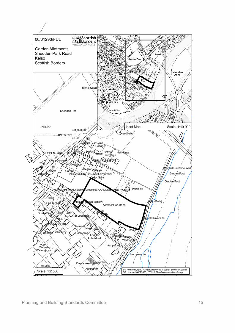
Planning and Building Standards Committee 15
47
54
1 2
53
1 75
41
1
8
3
39
43
51
24
2216
33
El
LB
1617
1415
13
The
Yard
Lyme
Bank
KELSO
Lodge34.5m
Lodge
34.1m
34.7m
35.0m
33.7m
49 47
35.2m
35.0m
House
HouseLodge
COURT
Lodge
KELSO
Telex
Lodge
Nurses
Garage
Harvey
CentreGarden
Centre
Linden
Cedars
Cottage
Cottage
Cottage
SHEDDEN
CottageDalbiac
Cottage
Cottage
Dalveen
MaxwellRoselea
Sub Sta
Bungalow
Rosebank
Rosebank
WoodsideKerfield
Business
Waverley
Tweedbank
Woodlands
St Helens
BM 35.59m
BM 35.82m
Priorbank
HermitageHermitage
Tweedbank
Rose Acre
Hempsford
Tweedford
Allot Gdns
PARK COURT
El Sub Sta
WedderburnAbbotsford
Applegarth
Downstream
Pointfield
Bellachroy
BULLET LOAN
Garden Foot
Walk (Path)
Waltongrove
Garden Foot
Shedden Park
MAXWELL LANE
St Leonard's
Hempseedford
EDENSIDE ROAD
Tennis Courts
HERMITAGE LANE
DRYINGHOUSE LANE
ABBOTSFORD GROVE
Rosebank Cemetery
SHEDDEN PARK ROAD
Allotment Gardens
KELSO CENTRAL WARD
Mayfield Riverside
Mayfield Riverside Walk
ROXBURGH AND BERWICKSHIRE CO CONST AND P CONST
06/01293/FUL
Garden AllotmentsShedden Park RoadKelsoScottish Borders
Inset Map Scale 1:10,000
Scale 1:2,500 © Crown copyright. All rights reserved. Scottish Borders Council,OS Licence 100023423, 2009. © The GeoInformation Group
Planning & Building Standards Committee13 April 2009
1
PLANNING AND BUILDING STANDARDSCOMMITTEE
13 APRIL 2009
ITEM 8(a)
REPORT BY HEAD OF PLANNING AND BUILDING STANDARDS
VARIATION OF SECTION 75 AGREEMENT ATTACHED TO PLANNING PERMISSION ONLAND AT MEIGLE FARM, CLOVENFORDS
1 PURPOSE
1.1 To seek Members approval for variation to a Section 75 legal agreement relatedto a development of 70 houses at Meigle Farm, Clovenfords to facilitatealternative access arrangements and to enable the commencement of theproposed primary school on the adjoining site
2 BACKGROUND
2.1 Full planning permission was granted by the then Development and Building ControlCommittee at its meeting on 2 July 2007 for three distinct but related developments,namely:
The erection of 70 houses on a site at Meigle Farm in Clovenfords The erection of a primary school on land immediately to the west of the housing
site described above; and The creation of an access road linking the proposed school and Caddonfoot
Road
2.2 The permission for the housing development was subject to a legal agreement underSection 75 of the Town and Country Planning (Scotland) Act 1997, requiring a series ofcommitments, including contributions toward the Waverley Line, Education andLifelong Learning (E & LL), Affordable Housing, Central Borders Road Network Study,footpath link provision and local play park enhancement. The agreement wascompleted and signed on 29 November 2007.
2.3 Of these contributions, those relating to Waverley Line and Affordable Housing(totalling £319,330) are not triggered until the completion of the 25th and 50th units; Playpark contributions (£42,000) prior to completion of the 25th unit; that relating to theRoad Network study (£70,000) is triggered prior to completion of the first unit; thefootpath link contribution (£27,500) and the E & LL contribution (£296,386) are requiredto be settled prior to the commencement of any works.
2.4 In addition, there is a planning condition attached to the permission itself that requiresthe completion of the road through the site to the school site as follows:
Planning & Building Standards Committee13 April 2009
2
No development shall commence on site until the road linking the site toCaddonfoot Road is approved by the planning authority. Once approved, the roadlink and its related pedestrian links shall be implemented as part of the first phaseof the development and completed to the specification of the planning authoritybefore any dwellinghouses are occupiedReason: To ensure the site is adequately serviced by transport links and providesthe maximum degree of connectivity with the adjacent school site
2.5 Barratt East Scotland has made the decision not to commence the works associatedwith their permission immediately. This appears to be primarily the direct result of theeconomic conditions making the proposed development commercially unattractive atpresent, but also because it would trigger the requirement for the educationcontribution in advance of those works commencing.
2.6 The decision to delay commencement of development is the prerogative of thedeveloper. However, there are associated implications for the development of theschool on the adjoining site which is scheduled to start in April 2010.If Barratt East donot commence development there will be no requirement on them to complete the roadlink to service the school site. In that circumstance the Authority will have to bear theentire costs of completing the link as part of the school project.
2.7 Whilst the developer has made it clear that they are willing to honour the requirementsfor all of the contributions at the levels sought, they are seeking to vary the currentterms of the legal agreement; it would seem that there may be scope to allow somevariation in the scheduling of E & LL and Road Network contributions in a way thatwould ultimately still achieve the requested contributions, but without affecting thetimeous delivery of the school project. The offer tabled by the developer is to settle theE & LL, Road Network and Footpath link contributions upon completion of the 25th unit,which would be consistent with other contributions.
2.8 The similar deferral of the footpath contribution is less well justified; to delay theprovision of the footpath link is considered inappropriate, as this is a site-specificrequirement necessary for the proper connectivity of the housing scheme. It istherefore considered that the timing of this contribution should remain as currentlyproposed.
2.9 In return for the variation of the terms of the current agreement, the developer hasoffered to contribute half the capital cost of the road provision to their site which willalso serve the school, accommodating the Council’s school development schedule.They propose either to construct the road themselves and seek the Council’s 50% ofcost contribution, or allow the Council to construct and then settle their 50% share. Ineither scenario, settlement would be made upon completion of the road.
2.10 The Council’s Local Plan policy on Developer Contributions, G5, allows flexibility in theapproach to seeking contributions, and specifically states that the Council “will pursuea pragmatic approach, taking into account the importance in securing necessarydevelopments”. It is considered that this is a situation where such an approach isjustified.
2.11 Having regard to the current economic climate, it is entirely appropriate to employ aflexible approach to the timing of the payment contributions; ultimately, the outcome ofeither arrangement would be the same, and the required contributions will be settled atthe originally agreed rate. However, the additional benefit to SBC by agreeing to thedeveloper’s proposals is that the scheduled programme for the school’s delivery willnot be further implicated by current residential market conditions
Planning & Building Standards Committee13 April 2009
3
2.12 As the alternative would be that the Council carries out the road works itself in order toachieve the linkages to the school, there are attractions to the suggested approach,which also include the possibility that the developer can carry out the road works at alesser cost. Crucially, however, it allows the road to be completed to facilitate thedevelopment of the school. The alternatives are likely to involve the Council unilaterallybearing the cost of road provision, possibly through the use of complex and time-consuming compulsory purchase powers.
2.13 However, even were the approach described above accepted, there is still therequirement for an application to vary the terms of the condition set out in paragraph2.4. To that end, a planning application incorporating a slightly amended layout hasalready been submitted (reference 09/00323/FUL, received 20 March 2009).
3 CONSULTATION
3.1 Comments have been received from the Head of Legal Services and Chief FinancialOfficer, and have been incorporated into this report.
4 FINANCIAL IMPLICATIONS
4.1 The Council had initially expected the road provided by the developer to reach theschool site at no cost to the Council. Now, in order to achieve the school buildtimetable, a site access is likely to be required separately from the housingdevelopment, and therefore the financial implications centre on the additional cost ofcontributing 50% of the new shorter road costs. However, this is clearly still preferableto any requirement to meet the entire cost.
4.2 It is understood that the costs of the contribution will be met within the school total buildbudget, and this may mean reprioritising what is provided at the school. However, thatwould is a matter for the Education & Lifelong Learning Director, and is not a matterthat could be addressed through the land use planning process, which is more directlyconcerned with the timeous provision of the road.
5 RISK COMMENTARY
5.1 There is an element of financial risk in that ordinarily contributions should be paid inadvance of the scheme being implemented. However, there is the potential forexposure to a greater cost, if the Council is required to undertake the works itself or topursue land acquisition compulsory purchase powers.
5.2 There is likely to be a greater risk if the approach suggested by the developer is notaccepted, as any alternative is likely to have greater potential not only for exposure togreater cost, but also to the prospect of delay in the delivery of the proposedClovenfords School project.
6 ENVIRONMENTAL IMPLICATIONS
6.1 None directly arising from this report.
7 EQUALITIES
7.1 None directly arising from this report.
Planning & Building Standards Committee13 April 2009
4
8 SUMMARY
8.1 The developer of the Meigle Farm housing site, Barratt East Scotland, is seeking tovary the terms of the legal agreement attached to their permission for 70 houses to theeffect that the contributions for the Central Borders Road Network Study and Educationwould be deferred until the completion of the 25th house on the site.
8.2 As part of this arrangement, and acknowledging the potential implications for the delayof the provision of the Clovenfords School project, the developer has offered tocontribute half the cost of the road that would serve the school from the east (throughtheir development site).
8.3 The Local Plan policy relating to developer contributions makes provision for apragmatic approach, taking into account the importance in securing necessarydevelopments. For the reasons set out in the report, it is considered that this is asituation where such an approach is justified.
9 RECOMMENDATION
9.1 I recommend that the Planning and Building Standards Committee agree to varythe terms of the legal agreement under Section 75 of the Town and CountryPlanning (Scotland) 1997 to allow payment of contributions toward educationand the Central Borders Road Network Study to be deferred until the completionof the 25th house, and also to make provision in that agreement for meeting halfof the cost of the road construction to service the proposed Clovenfords Schoolscheme from the eastern boundary of the school site.
Approved byName Designation SignatureBrian Frater Head of Planning and Building
Standards
The original signed copy of this report is retained by the Planning and Economic DevelopmentDepartment
Author(s)Name DesignationJohn Hayward Development Manager (West)
Background Papers: NonePrevious Minute Reference: Planning and Building Standards Committee 2 July 2007
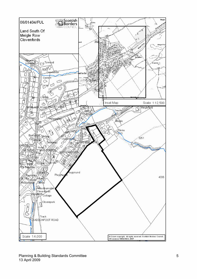
Planning & Building Standards Committee13 April 2009
5
PLANNING & BUILIDNG STANDARDS COMMITTEE
13 APRIL 2009
ITEM 8(b)
REPORT BY HEAD OF PLANNING AND BUILDING STANDARDS
REQUEST FOR VARIATION OF SECTION 50 (75) AGREEMENT AT NETHER KIDSTON FARM,PEEBLES
1 PURPOSE
1.1 The purpose of this report is to consider a request from Mr K Watson and Mr JWatson to vary the terms of the original Section 50 Agreement at Nether KidstonFarm near Peebles
2 BACKGROUND
2.1 Outline planning consent (T027/93) was granted for the erection of a dwellinghouse onland to the west of Nether Kidston farm subject to a Section 50 Agreement restrictingfurther residential development on the farm and regulating the future disposal of theproperty. This consent lapsed before detailed planning permission was granted.
2.2 Outline planning consent (T007/95) was granted for a replacement consent for T027/93for a new house on the northern fringe of the farm adjoining the building group atCringletie. A modification of the Section 50 Agreement was approved to allow therevised siting but the terms of the agreement remain in force. Detailed consent(T223/95) pursuant to T007/95 was subsequently approved. The house is now builtand occupied and is known as Belvedere.
2.3 Outline planning permission was also granted (99/00062/OUT), subject to conditionsand modification of the original Section 50 Agreement, for the erection of adwellinghouse on land adjacent to Kidston View. The modification was approved toallow the dwellinghouse to be erected and to allow the owners son to work and live onthe farm. Detailed consent was approved under 00/00131/REM and the dwelling isnow complete and occupied.
2.4 Outline planning consent 04/01988/OUT for the erection of a dwellinghouse on landsouth of Cringletie was refused for the following reason:
The proposal would be contrary to Policy 7 of the Tweeddale Local Plan, in that the siteis outwith any recognised settlement or building group, and the need for the house hasnot been adequately substantiated. Furthermore, the existing junction of the privateaccess road with the public road is sub-standard and the existing access road leadingto site is inadequate for serving further development.
2.5 A subsequent outline planning application was lodged (07/02153/OUT) for the erectionof a dwellinghouse on the same site as the earlier 2004 application. This applicationwas withdrawn on the advice of the Planning Officer. Furthermore, an additionaloutline planning application (07/02151/OUT) was submitted and subsequentlywithdrawn for the erection of a dwellinghouse on land to the north east of Nether
Kidston Farm Cottages. The two application sites were not considered to form part ofan established building group as defined by the Council’s policies on new housing inthe countryside. Furthermore there was no economic justification for the two dwellingsand both were withdrawn on the advice of the Planning Officer.
2.6 Two new outline planning applications (09/00004/OUT & 09/00008/OUT) have beensubmitted for the erection of dwellings on land to the south west of Nether KidstonFarm Cottages and on land to the south of Cringletie Farm Cottage (adjacent toBelvedere). Both have been submitted on the basis of additions to building groups andno economic justification has been lodged in support of the applications. Theapplicants request that the original legal agreement is modified to allow theseapplications.
2.7 The application site adjacent to Belvedere is located within a previously identifiedbuilding group at Cringletie Farm. This is supported by a recent Appeal decision(P/PPA/140/285) where the Reporter confirmed that “the whole settlement onCringletie Hill accessed from the A703 forms an existing building group”. The currentapplication site clearly lies within that ‘existing building group’. The revised applicationon land to the south east of Nether Kidston Cottages also now forms part of anestablished building group at Nether Kidston Farm comprising of Nether KidstonFarmhouse and two farm cottages. It would be contained within an identified sense ofplace created by the existing residential units and would be well related to the existingbuilding group.
2.8 Notwithstanding the original Section 50 Agreement, which has been modified twice inthe past to allow for the erection of dwellings to support the agricultural business, thetwo new application sites are considered to be well related to existing building groupsas defined by the Council’s new housing in the borders countryside policies andsupplementary planning guidance. Both sites are located adjacent to existing groupsof at least 3 dwellings which are identifiable by a sense of place which is contributed bynatural and man made boundaries. The sites would break into previously undevelopedfields but only man made boundaries (post and wire fences) would be broken and thesurrounding landforms and natural boundaries would continue to contribute to thesense of place.
2.9 The proposed outline applications are considered to be acceptable and in accordancewith policy, and it is hoped that they will be in a position to be approved through thescheme of delegation, subject to conditions and legal agreements covering developercontributions.
2.10 It is considered that the main purpose of the original Section 50 Agreement was torestrict further residential development on the farm which was not adjacent to anyestablished building group and which was not supported by economic justification. Thecurrent application sites are well related to existing groups of buildings and wouldcomply with the Council’s policies for new housing in the countryside. While it wouldordinarily be requested that the Sec 50 Agreement is modified to allow the two newdwellings, it is considered in this case that the Section 50 Agreement should beremoved completely and the associated burden on the land lifted. Any subsequentplanning applications for dwellings on the farm would simply be assessed, on theirindividual merits, against and regulated by the prevailing housing in the countrysidepolicies.
3 CONSULTATION
3.1 There has been no formal consultation.
4 FINANCIAL IMPLICATIONS
4.1 There are no financial implications in approving this report other than administrativeand staff costs arising from adjusting the legal agreement. These costs can be metwithin existing budgets.
5 RISK COMMENTARY
5.1 A decision to amend terms of the agreement would be consistent with current policyand practice and is justified by the particular circumstances of the case, and so wouldnot risk setting a precedent for modification of other agreements.
6 ENVIRONMENTAL RISK
6.1 There is no environmental risk in approving this report.
7 EQUALITY
7.1 There are no equalities issues raised in approving this report.
8 SUMMARY
8.1 The applicant wishes to vary the agreement to allow the house plots (on land to the SWof Nether Kidston Farm Cottages and to the S of Cringletie Farm Cottage) to beexcluded from the area over which the Section 50 applies. However, given that theSection 50 has been modified in the past it is considered that the whole Section 50Agreement should be removed and all associated burdens on the land lifted. Anyfurther applications for residential development would be assessed, on their ownmerits, against the prevailing policy at the time of their submission.
9 RECOMMENDATION
9.1 I recommend that the Planning and Building Standards Committee approves the reportand agrees that the S50 Agreement at Nether Kidston Farm is removed to allow thedevelopment of the current application sites.
Approved byName Designation SignatureBrian Frater Head of Planning and Building
Standards
The original version of this report has been signed by the Head of Planning and Building Standardsand the signed copy has been retained by the Council.
Author(s)Name DesignationBarry Fotheringham Principal Planning Officer
Background Papers: None.Previous Minute Reference: None.
PLANNING & BUILDING STANDARDS COMMITTEE
13 APRIL 2009
ITEM 8(c)
REPORT BY HEAD OF PLANNING AND BUILDING STANDARDS
VARIATION OF SECTION 75 AGREEMENT AT TODHEUGH, EDROM, DUNS
1 PURPOSE
1.1 Consider a request by Mrs M S Anderson as owner of Todheugh, Edrom, Duns,to vary the terms of the S75 Agreement applied to the farm.
2 BACKGROUND
2.1 Planning consent was granted in December 2001 (ref 01/00339/OUT) for the erectionof a dwellinghouse on land adjacent to Todheugh Cottage, Edrom. This consent wassubject to a Section 75 Agreement that linked the sale of the existing farmhouse tothe remainder of the farm land and precluded any further residential development onthe unit other than any that would be specifically consistent with planning policy. Acopy of the Agreement is attached as a supporting paper to this report.
2.2 Following the submission of the subsequent reserved matters application(02/00660/REM), the terms of the Section 75 Agreement concluded at the time of theoutline application were reassessed. It became apparent that the way in which theAgreement was worded required the new house to be tied in ownership to thefarmhouse and steading, even after their sale. The drafting also meant that theapplication site fell within the restricted zone. As the house was for the retiring farmer,it was accepted that that was never the intention of the agreement. When thereserved matters application was approved a Variation to the Minute of Agreementwas allowed. Clause 2(a) of the amended agreement requires that:
“other than as would comply with Clause 6 below, the remainder of the land includingits houses and other buildings being that portion of the land not subject to saidplanning permission shall always be held as a single property and farmed as a singleagricultural unit and no part of it shall be sold or otherwise disposed of except tostatutory undertakers or for the purposes of public works or adjustment ofboundaries”.
2.3 The agreement includes a clause (Clause 6) which would permit subsequent variationor discharge of any or all of the restrictions and regulations.
2.4 Mrs Anderson currently works the land at Todheugh farm but is finding this too muchfor her as she will be 66 years old this year. She wishes to sell part of the farm andlands to a neighbouring farmer who would continue to farm the land. This sale anduse would however be contrary to Clause 2(a) of the amended Section 75 agreementin its requirement that the farm should be held as a single property and farmed as asingle agricultural unit. She therefore requests that a variation be granted to the
terms of the amended agreement to enable the sale and transfer of land fromTodheugh Farm.
2.4 The land that Mrs Anderson is proposing to sell lies to the east of the public road andtherefore represents a logical division of the land currently within the curtilage of theagricultural unit at Todheugh. The plans submitted with her solicitor’s letter appears toindicate the disposal of 53.306 acres of land but the precise figure will be confirmedand reported orally at the meeting. Mrs Anderson has not indicated the extent of theland that would be retained within the agricultural unit at Todheugh. It is understoodhowever, that this would remain as land tied to Todheugh.
2.5 It is considered that the sale of the land and its incorporation into a neighbouringagricultural unit does not raise any planning concerns. The provision for no furtherhouses on the area covered by the agreement would remain in force. In view of this,the request for variation of the legal agreement is supported.
3 CONSULTATION
3.1 The Head of Legal Services has been consulted and is content with therecommendation.
4 FINANCIAL IMPLICATIONS
4.1 There are no financial implications in approving this report apart from administrativeand staff costs arising from concluding the legal agreement. These costs can be metwithin existing budgets and the legal fees for the variation would require to be met bythe applicant.
5 RISK COMMENTARY
5.1 A decision to amend terms of the agreement would be consistent with current policyand practice and would not risk setting a precedent for modification of otheragreements.
6 ENVIRONMENTAL RISK
6.1 There are no environmental risks in approving this report.
7 EQUALITY
7.1 There are no equalities issues raised in approving this report.
8 SUMMARY
8.1 The applicant wishes to vary the agreement to allow the sale of a plot of land to theowner of a neighbouring agricultural unit. Following the conclusion of the sale, theland would continue to be used for agriculture, albeit under different ownership andnot tied by any contractual agreement. Agriculture is however, the established landuse.
8.2 It is considered that the restriction that to the selling off of the land covered by theagreement be modified to allow for this sale.
9. RECOMMENDATION
9.1 I recommend that the Planning and Building Standards Committee approves thereport and agrees that Clause 2(a) of the S75 Agreement be amended to allowthe sale of an agreed proportion of the land at Todheugh Farm.

Approved byName Designation SignatureBrian Frater Head of Planning & Building
Standards
Author(s)Name DesignationStuart Herkes Assistant Planning Officer
Background Papers: Letters dated 17th & 19th March 2009 from Doughtys SolicitorsCopy of Section 75 Agreement
Copy of Variation of Minute of AgreementPrevious Minute Reference: None
PLANNING & BUILDING STANDARDS COMMITTEE
13TH APRIL 2009
ITEM 8(d)
REPORT BY HEAD OF PLANNING AND BUILDING STANDARDS
VARIATION OF SECTION 75 AGREEMENT AT LAND NORTH OF HAWTHORNDEAN,COLDINGHAM
1 PURPOSE
1.1 Consider a request by Mr & Mrs Drummond to vary the terms of the S75 Agreementapplied to the land in the ownership at Hawthorndean, Coldingham.
2 BACKGROUND
2.1 Planning consent was granted on 27th July 2007 for two applications at Hawthorndeannear Coldingham, these were:
07/00284/OUT - outline consent for the erection of a single dwelling on land atHawthorndean.
07/00286/FUL - Full consent for the conversion of redundant barn buildings to formtwo dwellings.
2.2 The applications were subject to a Section 75 Agreement, a copy of which is attached as asupporting paper to this report. The key element of the Agreement was that the payment ofdeveloper contributions would be triggered by the sale of, or the issue of a completioncertificate for, the first of the properties, which ever was the earlier.
2.3 The background and justification for the proposed changes are set out by Mr & MrsDrummond in their letter dated 27 February, which is attached as a supporting paper withthis report. As the proposed modifications to the Section 75 Agreement are significant theyare required to be approved by the Planning & Building Standards Committee. There areconcerns about the acceptability of the proposed changes in that they would potentiallydefer payment of the developer contributions indefinitely and in the circumstances theproposed changes can not be supported. It would however, be reasonable to modify theagreement to defer payment of the contributions to an agreed proportion on the occupationof each of the houses rather than the issue of the completion certificate, or sale of, the firsthouse. This proposal has been put to Mr & Mrs Drummond and an oral report will be madeat the meeting setting out their response to this suggestion.
2.4 Planning permission (reference 08/016190/OUT) has been sought for a house on land tothe south west of Plot granted outline permission under reference 07/00284/OUT by thesame applicants and the Department has indicated that it is minded to approve theapplication subject to the conclusion of a legal agreement relating to a contribution toeducation provision. The terms of that legal agreement should be on the same basis asagreed for the Agreement currently under consideration.
3 CONSULTATION
3.1 There have been no formal consultations.
4 FINANCIAL IMPLICATIONS
4.1 There are no financial implications in approving this report, as suggested by theDepartment, apart from administrative and staff costs arising from concluding the legalagreement. These costs can be met within existing budgets and the legal fees for thevariation would require to be met by the applicant.
4.2 However, agreement to the suggested changes outlined by the landowners may effectivelydefer payment of the required development contributions indefinitely. This may putpressure on other Council budgets and the ability to deliver required education facilities andaffordable housing
5 RISK COMMENTARY
5.1 A decision to amend the terms of the Agreement as suggested by the Department wouldbe consistent with current policy and practice and would not risk setting a precedent formodification of other agreements. However, the agreement to the suggested changesoutlined by the applicant may effectively defer payment of the required developmentcontribution indefinitely and reduce the ability to deliver required education facilities andaffordable housing.
6 ENVIRONMENTAL RISK
6.1 There are no environmental risks in approving this report.
7 EQUALITY
7.1 There are no equalities issues raised in approving this report.
8 SUMMARY
8.1 The applicant wishes to vary the agreement to allow the payment of developercontributions only when the houses or the plot have been sold to a third party.
8.2 Whilst a change to the terms of the Agreement to enable payment of an agreed proportionof the developer contributions on the occupation of each house would be reasonable in thecurrent economic climate, the modification as proposed by Mr & Mrs Drummond would notbe acceptable or consistent with current policy and practice.
9. RECOMMENDATION
9.1 I recommend that the Planning and Building Standards Committee:
(a) refuses to modify the Section 75 Agreement as requested by Mr and MrsDrummond
(b) agrees to change the terms of the Section 75 Agreement to enable payment ofan agreed proportion of the developer contributions on the occupation of eachof the residential units covered by this agreement.
Approved byName Designation SignatureBrian Frater Head of Planning & Building
Standards
Author(s)Name Designation
Ian Aikman Development Manager (East)
Background Papers: Letter dated 27th February 2009 from Mairi and Gordon Drummond.Copy of Section 75 Agreement
Previous Minute Reference: None

PLANNING AND BUILDING STANDARDS COMMITTEE
13 APRIL 2009
ITEM 9
REPORT BY HEAD OF PLANNING AND BUILDING STANDARDS
PLANNING APPEALS
1 PURPOSE
1.1 The purpose of this report is to give details of appeals which have been receivedduring the last month with a brief summary of the grounds of appeal. Appeals whichhave been determined are also listed with a summary of the reasons for the decisiongiven by the Reporter in his decision letter.
2 APPEALS RECEIVED
2.1 Planning Applications
2.1.1 Reference: 08/01228/FULProposal: Erection of DwellinghouseSite: Allerton House, OxnamAppellant: Mr & Mrs Leask
Reason for Refusal: The proposal is be contrary to Policies G1, G7 and H2 of theScottish Borders Finalised Local Plan in that the proposal constitutes an over-development of the site that is out of keeping with the character and form of the areato the detriment of the visual amenities of the area and of the residential amenities ofthe occupants of the neighbouring property.
Grounds of Appeal: The site is scrub ground detached from the hotel but whichrelates well to the existing build pattern and can absorb a dwellinghouse withoutdetrimental impact. It is considered to be appropriate infill development. Thedwellinghouse is of modest scale, traditional in form and sympathetic to its setting.The major constraints of the site were parking and retention of the lime tree. Lengthynegotiations with the Consultees resulted in favourable responses thought heapplication was refused on the grounds of over-development.
Method of Appeal: Written Submissions.
2.1.2 Reference: 08/00866/OUTProposal: Erection of DwellinghouseSite: Land south of Hallmanor House, Manor ValleyAppellant: Mr D Coltman
Reason for Refusal: The proposal would be contrary to Policy H5 of the ScottishBorders Structure Plan 2001-2011 and Policy D2 (Building Groups) of the ScottishBorders Local Plan 2008 in that the site does not form part of a recognised buildinggroup. This would create an undesirable precedent for housing in the countryside.
The proposal would be contrary to Policy H6 of the Scottish Borders Structure Plan2001-2011and Policy D2 (Economic Requirement) of the Scottish Borders Local Plan2008 in that the proposed dwelling is not a direct operational requirement of anestablished agricultural business and the need for the house has not been adequatelysubstantiated. The erection of a dwelling in this location would result in anundesirable precedent.
Grounds of Appeal: There is economic justification for a dwellinghouse assignificant investment is required to stock the hill land at Castlehill in order to start aviable farming enterprise. Operating Castlehill from the appellant's existing farmwould involve considerable travelling and expense. There is precedent for thedevelopment which is supported by an independent report.
Method of Appeal: Written Submissions.
2.1.3 Reference: 08/01635/FULProposal: Alterations and extensions to dwellinghouseSite: Breakers View, 3 Fort Road, EyemouthAppellant: John Wilson
Reason for Refusal: The proposals would be contrary to Policies G1 and H2 ofthe Scottish Borders Local Plan 2008 in that the extensions would, by virtue of theirinappropriate scale form and design, have a detrimental impact upon the characterand appearance of the existing dwellinghouse and the surrounding residential area asa whole. Furthermore, the proposals would be harmful to the residential amenities ofthe occupants of neighbouring properties due to an unacceptable level of overlooking.
Grounds of Appeal: It is not considered that the proposal would result in loss ofprivacy to neighbouring properties. No objections have been submitted byneighbours. There are various different styles of property in the area and the proposalwould not look out of place against them.
Method of Appeal: Written Submissions.
2.1.4 Reference: 08/01401/OUTProposal: Change of use from garden ground to residential landSite: Land adjacent 22 Beechbank SelkirkAppellant: C T Pymont
Reason for Refusal: The proposal is contrary to Structure Plan Policy I11 andPolicies G7 and Inf4 of the Scottish Borders Local Plan in that the proposals wouldhave a significant negative impact on existing on-street parking provision in aconstricted area with associated impacts on vehicular movements along the publicroad all to the detriment of road user safety.
Grounds of Appeal: The proposal is for an infill development in a sustainablelocation affordable in scale and close to amenities. The proposal accords with theCouncil’s policies and would have only a marginal impact on parking in the area.
Method of Appeal: Written Submissions.
2.1.5 Reference: 08/01661/OUTProposal: Erection of Dwellinghouse.Site: Garden Ground Of Belvedere, Easter Ulston CottagesAppellant: Mr R Leddy
Reason for Refusal: The proposal would be contrary to Policies H5 and N17 of theScottish Borders Structure Plan 2001 – 2011 and Policies BE1 and D2 of the ScottishBorders Local Plan 2008 and the Housing in the Borders Countryside Policy andGuidance Note 1993, as amended, in that the proposal would be out of keeping with
the form and character of the building group and would have significant detrimentalimpact on the setting of adjoining Category C(S) statutorily Listed Buildings.
Grounds of Appeal: The Council’s decision and judgements are subjective andnot supported by consultees or professional advisers. The Council’s definition of abuilding group at this location is not accepted. There is nothing in policy to justifyrefusing the application.
Method of Appeal: Written Submissions.
2.1.6 Reference: 08/01399/FULProposal: Alterations and Extensions to DwellinghouseSite: Rawflat, AncrumAppellant: Mr & Mrs Galbraith
Reason for Refusal: The proposal is contrary to Policies N17 of the ApprovedStructure Plan 2001-2011, Policy BE1 of the Scottish Borders Local Plan Adopted2008 and the Historic Scotland Memorandum of Guidance On Listed Buildings andConservation Areas 1998 in that the proposed sunroom would detract from theprincipal elevation of Rawflat harming the architectural integrity of the building to thedetrimental of the special character and appearance of this category B Listed Building
Grounds of Appeal: The proposed development would not have an adverseimpact on the building, its features or its setting. The building which is the subject ofgthe appeal is not the building that was listed and the determination should thereforeexclude application of listed building policies and guidance.
Method of Appeal: Written Submissions.
2.1.7 Reference: 08/01400/LBCProposal: Alterations and Extension to DwellinghouseSite: Rawflat, AncrumAppellant: Mr & Mrs Galbraith
Reason for Refusal: The proposal is contrary to Policies N17 of the ApprovedStructure Plan 2001-2011, Policy BE1 of the Scottish Borders Local Plan Adopted2008 and the Historic Scotland Memorandum of Guidance On Listed Buildings andConservation Areas 1998 in that the proposed sunroom would detract from theprincipal elevation of Rawflat harming the architectural integrity of the building to thedetrimental of the special character and appearance of this category B Listed Building
Grounds of Appeal: The proposed development would not have an adverseimpact on the building, its features or its setting. The building which is the subject ofgthe appeal is not the building that was listed and the determination should thereforeexclude application of listed building policies and guidance.
Method of Appeal: Written Submissions.
2.2 Enforcements:
2.2.1 Reference: 08/00191/UNDEVProposal: Extension to DwellinghouseSite: 10 Winterfield Gardens, DunsAppellant: Mr C Aitchison
Reason for Service of Notice: The structure which has been built on site differsmarkedly from the approved plans and a subsequent planning application seeking itsretention has been refused.
Grounds of Appeal: Awaited.
Method of Appeal: Written Submissions.
2.2.2 Reference: 08/00098/UNDEVProposal: Siting of temporary office accommodation, 2 No Storage
containers and erection of walls , railings and lighting / cctvcolumn (retrospective)
Site: Field 0328, Kirkburn, CardronaAppellant: Andrew Cleghorn
Reason for Service of Notice: A retrospective application has been refused. Thenotice requires breaches of planning control to be addressed including the erection ofa low level wall with metal fence, the siting of a Portacabin and static caravan and thedepositing of items of construction materials, plant, equipment and other detrituswithin the vicinity of the agricultural building.
Grounds of Appeal: The caravan on the site is not static but mobile. Theportacabin is used for the storage of materials essential to the use of thesmallholding. Heras fencing is essential for safety and other works and materials areused either in connection with the smallholding or the construction of a consentedshed. Walls and railings can be reduced to comply with permitted developmentheights.
Method of Appeal: Written Submissions.
3 DECISIONS RECEIVED
3.1 Planning Applications
3.1.1 Reference: 07/02223/OUTProposal: Erection of 28 holiday chalets and associated facilities, bunk
house and ten affordable dwellinghouses.Site: Berrybush Farm, Yarrow.Appellant: Mr & Mrs R B Wallum
Reason for Refusal: The proposed development is contrary to Policy H6 of theScottish Borders Structure Plan (2001-2011); Policy 8 and 63, of the Ettrick andLauderdale Local Plan (1995); Policy D1, D2, G1, Inf3, Inf11 of the Scottish BordersLocal Plan (Finalised December 2005); SPP15, 17, and NPPG14, in that it is notsatisfactorily demonstrated that the permanent housing provision is essential tosupport the proposed use, nor is the economic need clearly substantiated. Asatisfactory access has not been achieved, nor drainage facilities proven asacceptable. There is potential for adverse effects on nature conservation that havenot been satisfied. The proposed residential development of 10 permanent houses inthe rural location is not sympathetic to or complementary to the surrounding area. Theproposal does not contain a suitable sustainable travel plan and the location is poorlyaccessible. There is no proven identifiable need for affordable housing in this location.
The proposed development is contrary to Policy 99 of the Ettrick and LauderdaleLocal Plan (1995), BE8 of the Scottish Borders Local Plan (Finalised December2005), and SPP7, in that the proposal is in an area identified as having a medium tohigh flood risk, and that the details submitted do not clearly identify that no flood riskexists, or to mitigate against the potential for flooding.
The proposed development is contrary to Policy N3, N8, E2, E16, E21, I1, I5, I7, I12,I13, I14, of the Scottish Borders Structure Plan (2001-2011), Policy 28, 30, 37, 84, 85,87, of the Ettrick and Lauderdale Local Plan (1995), Policy D1, Inf5 and Inf6, Inf11,
NE2 and NE5, of the Scottish Borders Local Plan (Finalised December 2005);SPP15, 17, and NPPG14, in that it is not proven that the development will have noadverse affect on the River Tweed SAC, nor proven that the development offerssubstantial benefits that clearly outweigh the national nature conservation value of thesite. There is insufficient information to allow examination of the potential adverseenvironmental effects, and the environmental impacts are not reconciled with relevantplan policies. The benefits to the local economy are not clearly demonstrated and theaccessibility of the proposal to the strategic public transport network is poor, thusrestricting opportunities to cycle and walk to essential services and facilities. It is notproven that the development will accord with best practice in relation to seweragedischarge, and there is insufficient information to determine whether there would bepotentially adverse impacts upon the water environment, or demonstrate that asatisfactory sustainable drainage system is possible.
Grounds of Appeal: The ecological assessments in the applicants Business planand supporting information satisfactorily address the issues raised by the ecologyofficer and comply with the provisions of Policy N3, N8, E2, E16, E21, I1, I5, I7, I12,I13, I14, of the Scottish Borders Structure Plan (2001-2011), Policy 28, 30, 37, 84, 85,87, of the Ettrick and Lauderdale Local Plan (1995), Policy D1, Inf5 and Inf6, Inf11,NE2 and NE5, of the Scottish Borders Local Plan (Finalised December 2005);SPP15, 17, and NPPG14. Furthermore, the appellant considers it can bedemonstrated that a flood risk assessment is not considered necessary. Theappellant coonsiders the proposals to be supported by a robust business plan, andthat the development can be carried out in a sustainable manner. .
Method of Appeal: Written Submissions.
Reporter’s Decision: Dismissed
Summary of Decision: The Reporter, Dannie Onn, concluded that the proposedhouses were contrary to the housing in the countryside policy and the need forpermanent housing to support the not yet established business has not been proven.Workers could live in nearby settlements. No reason has been given as to why theproposed affordable housing requires this remote location. The impact on theecology of the area can not be established in the absence of appropriate surveyswhich have not been forthcoming.
3.1.2 Reference: 07/02284/REMProposal: Erection of DwellinghouseSite: Site South East Of Rogersrigg Cottage, CarlopsAppellant: Mr & Mrs J Alexander
Reason for Refusal: The proposed development would be contrary to Policy G1(1, 2 & 12) of the Scottish Borders Local Plan Finalised December 2005 and Policies57 and 58 of the Tweeddale Local Plan in that the dwellinghouse does not respect thecharacter of the surrounding area, cannot be satisfactorily accommodated within thesite and is not of a scale, massing and height appropriate to its surroundings.
Grounds of Appeal: The site already has outline planning permission and theapplication adheres to the detailed design in that consent. It was not open to theCouncil to revisit issues relating to location, scale, massing or height.
Method of Appeal: Written Submissions.
Reporter’s Decision: Sustained
Summary of Decision: The Reporter, Dannie Onn, concluded that the proposehouse would replicate the style and proportions of a traditional house, would appear
as a farmhouse in relation to the converted steading and would add to the sense ofplace. There would be no significant harm to the living conditions of nearby residents.
3.1.3 Reference: 05/01367/OUTProposal: Erection of 4 Dwellinghouses.Site: Land South Of Westview, Longbaulk Road, HawickAppellant: Mr K Bruce
Reason for Refusal: The proposed development would be contrary to Policy G7of the Scottish Borders Local Plan 2008 in that the proposals would have an adverseeffect on the character and amenity of the surrounding area and are not capable ofsafe, adequate road access and satisfactory water and drainage provision.
Grounds of Appeal: Awaited.
Method of Appeal: Written Submissions.
Reporter’s Decision: Sustained.
Summary of Decision: The Reporter, Gill Stewart, concluded that the site iscapable of accommodating four houses without detracting from the character orappearance of the area. Whilst part of the site is prominent development of the lowerground and limiting the houses to single storey would reduce any impact.Satisfactory access can be achieved subject to some technical adjustments toimprove existing conditions and accommodate the increased traffic safely.
3.1.4 Reference: 07/02316/FULProposal: Erection of DwellinghouseSite: Land West of Ashton Cottage, Leithen Cr, InnerleithenAppellant: Ms Arlene McPherson
Reason for Refusal: The application is contrary to Policies G7 and H2 of theScottish Borders Finalised Local Plan, in that the proposed development constitutesoverdevelopment, resulting in a cramped form of development, which is notconsistent with and does not complement the existing form of the settlement. Thedevelopment would be contrary to policy G4 of the Finalised Local Plan and PolicyI15 of the Structure Plan in that the site occupies low-lying land, which is liable toflooding.
Grounds of Appeal: The proposal would not constitute overdevelopment in thecontext of existing densities in this part of Innerleithen. The site is no more low lyingand any more liable to flooding than the wider area.
Method of Appeal: Written Submissions.
Reporter’s Decision: Dismissed.
Summary of Decision: The Reporter, Dannie Onn, concluded that the site was at asignificant risk of flooding. Although the design of the house may be appropriate forthis location, it would have little garden ground and insufficient turning space forvehicles. It would also threaten the stand of tress on the adjoining plot.
3.1.5 Reference: 08/01243/OUTProposal: Erection of Two DwellinghousesSite: Land West of Garden Cottage, WhitmuirAppellant: RS & HJS Dunlop
Reason for Refusal: The proposed development is contrary to Policy H5 of theScottish Borders Structure Plan 2001-2011, Policy D2 of the Scottish Borders LocalPlan 2008 and the “New Housing in the Borders Countryside” Guidance Note in that
the application site relates poorly to the building group due to the divorced locationfrom the group (and in a pattern not represented previously within the group), theone-sided and ribbon nature of the proposal and the breach outwith a tree belt intoelevated and undulating open farmland. This would create an undesirable precedentand have an inappropriate impact on the setting of the group.
Grounds of Appeal: The proposal complies with Council Policies on Housing inthe Countryside in that it represents an appropriate addition to a building group withinthe 100% scale of addition threshold. The site also does not represent ribbondevelopment, lies across a breachable field boundary and would comply with thegeneral aims of rural regeneration.
Method of Appeal: Written Submissions.
Reporter’s Decision: Dismissed.
Summary of Decision: The Reporter, Dannie Onn, concluded that the appeal sitedid not form part of the building group but would suburbanise the rural landscape andundermine the sense of place created by the existing dwelling group.
3.1.6 Reference: 08/00311/OUTProposal: Erection of DwellinghouseSite: Land South East of Edington Fox Covert, ChirnsideAppellant: Mr & Mrs R G Yeaman
Reason for Refusal: The proposal is contrary to policies H5 and H6 of theScottish Borders Structure Plan 2001-2011, Policies 7 and 8 of the BerwickshireLocal Plan 1994, Policy D2 of the Scottish Borders Local Plan: Finalised December2005 and the Housing in the Borders Countryside Policy and Guidance Note in thatthe site lies outwith any settlement and represents an inappropriate addition to thebuilding group and the need for a dwellinghouse at this location has not beenadequately substantiated.
Grounds of Appeal: The proposal is consistent with policy and there are notechnical problems. The proposal is an appropriate addition to the building group andtherefore the appellant should not have to demonstrate an economic justification.
Method of Appeal: Written Submissions.
Reporter’s Decision: Dismissed.
Summary of Decision: The Reporter, Dannie Onn, concluded that the proposalwould extend development beyond the natural boundary of the group. Additionallythe proposed site would not relate well to the group of dwellings and the closelydefined sense of place that they form.
3.1.7 Reference: 08/01336/FULProposal: Erection of Nine FlatsSite: West Winds And Adjoining Land, Upper BurnmouthAppellant: Arrowhead Housing
Reason for Refusal: The proposed development is contrary to Policy G1 andPolicy H2 of the Scottish Borders Local Plan 2008 in that the scale, massing andheight of the proposed flatted development, on this elevated site, would give rise toan unsatisfactory relationship with existing properties in the immediate vicinity of thesite and act seriously to the detriment of the character, visual and residentialamenities of the locality.
Grounds of Appeal: The appeal relates to a modification of a previous approval.The Council are being inconsistent in applying policy. The scale and mass of therevised proposals are no greater than what was previously agreed.
Method of Appeal: Written Submissions.
Reporter’s Decision: Dismissed.
Summary of Decision: The reporter, Mr A G Walker, concluded that the proposalwould not respect the character of the immediate area in terms of its height, scale andmassing and would not represent a satisfactory fit in that it would dominate andovershadow 1 Lyall Terrace.
3.2 Enforcements
3.2.1 Reference: 08/00791/FULProposal: Site a Free Standing Storage SiloSite: The Yard, Cone View, DolphintonAppellant: Alastair Brown
Reason for Refusal: The proposal is contrary to Policy D1- Business, Tourismand Leisure Development in the Countryside of the Scottish Borders Local Planfinalised December 2005 as the cement silo does not respect the amenity andcharacter of the surrounding area and has a significant adverse impact on nearbyhousing. The location of the cement silo would lead to an unacceptable precedentand would exacerbate the adverse impact on the residential amenity of nearbydwellings.
Grounds of Appeal: No breach of planning control has occurred. The use of thesite has not changed in 82 years. The description of the development was changedby the Council on submission of an application.
Method of Appeal: Written Submissions.
Reporter’s Decision: Dismissed.
Summary of Decision: The Reporter, A M G Walker, concluded that a breach ofplanning control had occurred in that there had been a material change in the use ofthe land. He further concluded that the location of the large unattractive silo close tothe boundary with the adjoining residential property was unacceptable and contrary tocriteria 4 and 5 of Local Plan policy D1.
4 APPEALS OUTSTANDING
4.1 In addition to those listed in section 2 of this report, there remained 13 appealspreviously reported on which decisions were still awaited when this report wasprepared on 2 April. These relate to sites at:
Tweedsmuir (2 Appeals) Dunion Hill, Jedburgh Whim Poultry Farm Huddersfield Street, Galashiels 5 Eshiels Holding, Eshiels Bogangreen, Coldingham Quarry Bank, Hume Chain Bridge, Melrose (2 Appeals) Lennel, Coldstream Bonjedward, Jedburgh Co-op supermarket, Duns
Approved byName Designation SignatureBrian Frater Head of Planning and Building
Standards
This report has been signed by the Head of Planning and Building Standards and the signed copyis retained by the Council.
Author(s)Name DesignationBrian Frater Head of Planning and Building
Standards
Background Papers: None..
Previous Minute Reference: None.
Note – You can get this document on tape, in Braille, large print and various computer formats bycontacting the address below. Linda Ross can also give information on other languagetranslations as well as providing additional copies.
Contact us at Planning and Economic Development, Scottish Borders Council, CouncilHeadquarters, Newtown St BoswellsTD6 0SA Tel. No. 01835 825407 Fax No. 01835 825158 Email : [email protected]
Related Documents