Scott Harder Hydrologist South Carolina Department of Natural Resources Land, Water & Conservation Division October 28, 2015

Welcome message from author
This document is posted to help you gain knowledge. Please leave a comment to let me know what you think about it! Share it to your friends and learn new things together.
Transcript
Scott Harder Hydrologist
South Carolina Department of Natural Resources Land, Water & Conservation Division
October 28, 2015
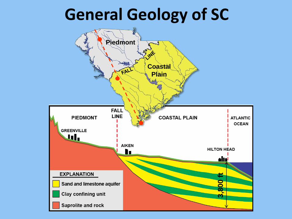
Piedmont
Coastal
Plain
General Geology of SC
3,8
00 f
t
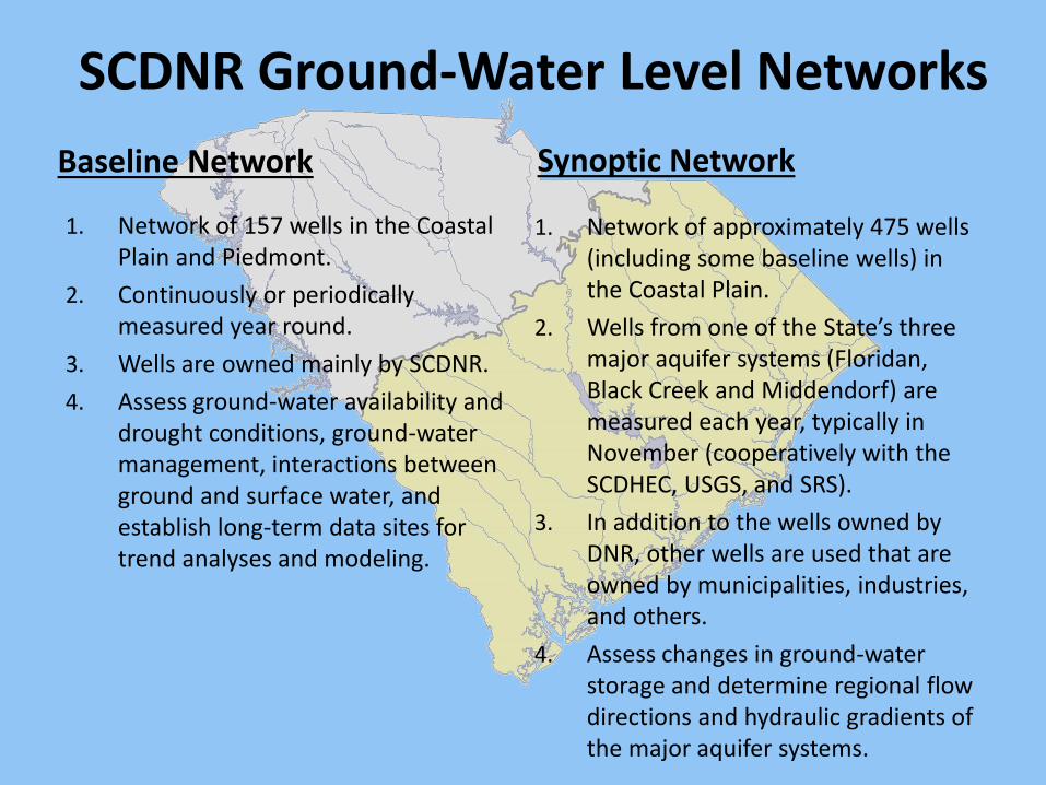
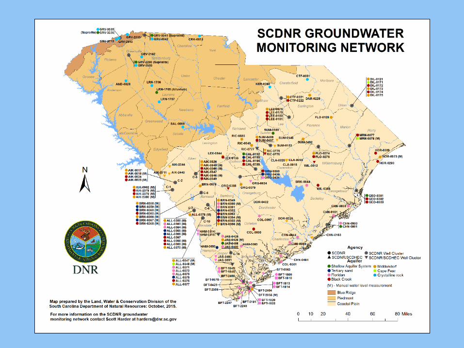
SCDNR Ground-Water Level Networks
Baseline Network
1. Network of 157 wells in the Coastal Plain and Piedmont.
2. Continuously or periodically measured year round.
3. Wells are owned mainly by SCDNR.
4. Assess ground-water availability and drought conditions, ground-water management, interactions between ground and surface water, and establish long-term data sites for trend analyses and modeling.
Synoptic Network
1. Network of approximately 475 wells (including some baseline wells) in the Coastal Plain.
2. Wells from one of the State’s three major aquifer systems (Floridan, Black Creek and Middendorf) are measured each year, typically in November (cooperatively with the SCDHEC, USGS, and SRS).
3. In addition to the wells owned by DNR, other wells are used that are owned by municipalities, industries, and others.
4. Assess changes in ground-water storage and determine regional flow directions and hydraulic gradients of the major aquifer systems.
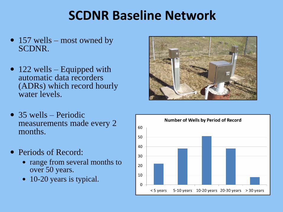
SCDNR Baseline Network
157 wells – most owned by SCDNR.
122 wells – Equipped with automatic data recorders (ADRs) which record hourly water levels.
35 wells – Periodic measurements made every 2 months.
Periods of Record: range from several months to
over 50 years.
10-20 years is typical.
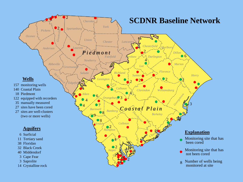
4
4 6
C o a s t a l P l a i n 7
8 9
8
4
2 2
3
2 2 2
Orangeburg
Aiken
Bamberg
Allendale
Barnwell
Edgefield
Colleton
Hampton
Jasper Beaufort
Berkeley
P i e d m o n t
Calhoun Clarendon
Lexington
Richland Sumter
Williamsburg
Florence
Horry
Marlboro
Darlington
Chesterfield
Dillon
Marion
Newberry
Saluda
Laurens
Greenwood Abbeville
Kershaw
Anderson
Union Chester
Fairfield
Lee
Oconee
Lancaster
York
Pickens Spartanburg
Cherokee 2
2
2
8
Monitoring site that has been cored Monitoring site that has not been cored Number of wells being monitored at site
Explanation
SCDNR Baseline Network
6 Surficial
11 Tertiary sand
38 Floridan
32 Black Creek
40 Middendorf
3 Cape Fear
3 Saprolite
14 Crystalline rock
Aquifers
157 monitoring wells
140 Coastal Plain
18 Piedmont
122 equipped with recorders
35 manually measured
27 sites have been cored
27 sites are well-clusters
(two or more wells)
Wells
4
4
2
2
2
2
2
3
2
6
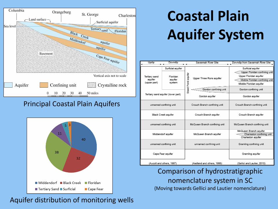
Principal Coastal Plain Aquifers
Comparison of hydrostratigraphic nomenclature system in SC
(Moving towards Gellici and Lautier nomenclature)
Aquifer distribution of monitoring wells
Coastal Plain Aquifer System
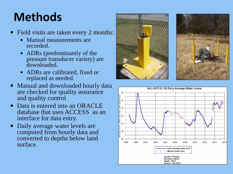
Methods Field visits are taken every 2 months:
Manual measurements are recorded.
ADRs (predominantly of the pressure transducer variety) are downloaded.
ADRs are calibrated, fixed or replaced as needed.
Manual and downloaded hourly data are checked for quality assurance and quality control
Data is entered into an ORACLE database that uses ACCESS as an interface for data entry.
Daily average water levels are computed from hourly data and converted to depths below land surface.
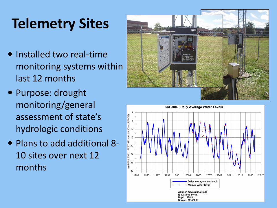
Telemetry Sites
Installed two real-time monitoring systems within last 12 months
Purpose: drought monitoring/general assessment of state’s hydrologic conditions
Plans to add additional 8-10 sites over next 12 months
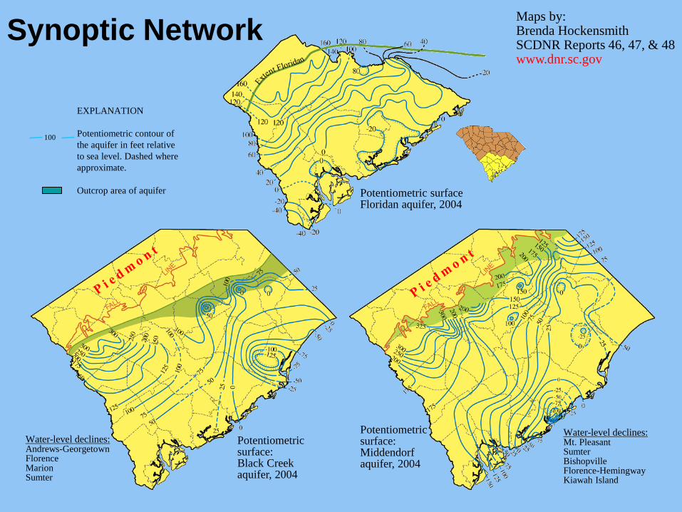
Potentiometric surface: Black Creek aquifer, 2004
Maps by: Brenda Hockensmith SCDNR Reports 46, 47, & 48 www.dnr.sc.gov
Potentiometric surface Floridan aquifer, 2004
EXPLANATION
Potentiometric contour of
the aquifer in feet relative
to sea level. Dashed where
approximate.
Outcrop area of aquifer
100
Potentiometric surface: Middendorf aquifer, 2004
Water-level declines: Mt. Pleasant Sumter Bishopville Florence-Hemingway Kiawah Island
Water-level declines: Andrews-Georgetown Florence Marion Sumter
Synoptic Network
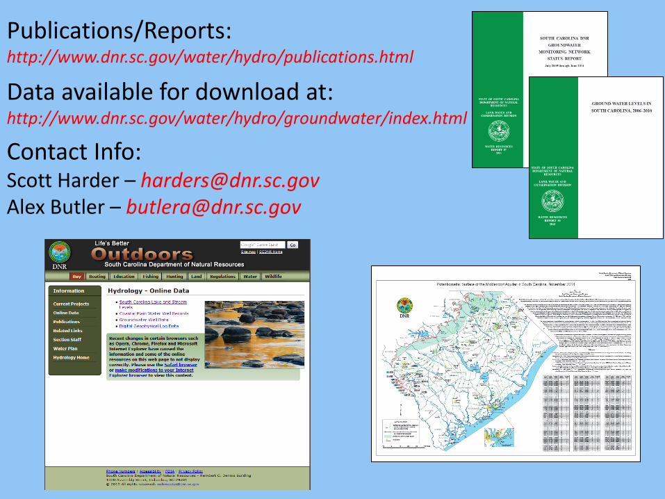
Publications/Reports: http://www.dnr.sc.gov/water/hydro/publications.html
Data available for download at: http://www.dnr.sc.gov/water/hydro/groundwater/index.html Contact Info: Scott Harder – [email protected] Alex Butler – [email protected]
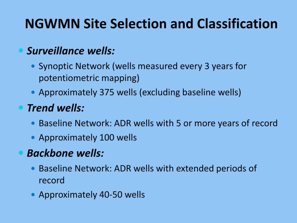
NGWMN Site Selection and Classification
Surveillance wells:
Synoptic Network (wells measured every 3 years for potentiometric mapping)
Approximately 375 wells (excluding baseline wells)
Trend wells:
Baseline Network: ADR wells with 5 or more years of record
Approximately 100 wells
Backbone wells:
Baseline Network: ADR wells with extended periods of record
Approximately 40-50 wells
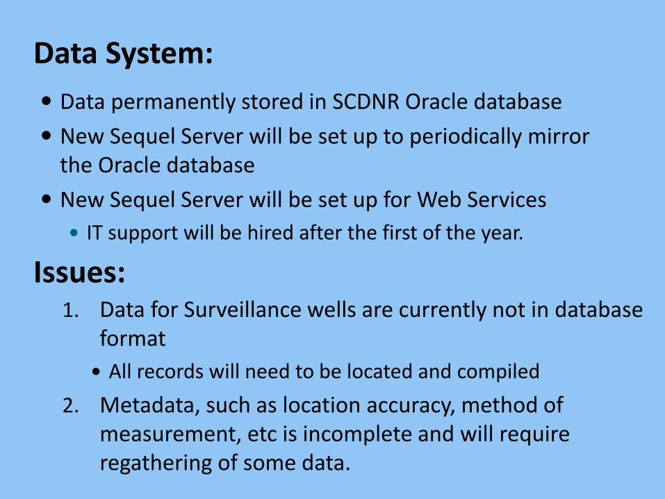
Data System:
Data permanently stored in SCDNR Oracle database
New Sequel Server will be set up to periodically mirror the Oracle database
New Sequel Server will be set up for Web Services
IT support will be hired after the first of the year.
Issues: 1. Data for Surveillance wells are currently not in database
format
All records will need to be located and compiled
2. Metadata, such as location accuracy, method of measurement, etc is incomplete and will require regathering of some data.

Questions?
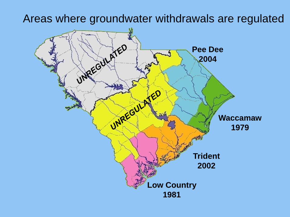
Waccamaw
1979
Low Country
1981
Trident
2002
Areas where groundwater withdrawals are regulated
Pee Dee
2004
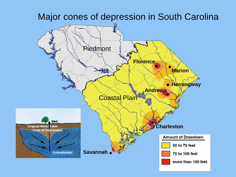
Major cones of depression in South Carolina
Savannah
Charleston
Andrews Hemingway
Florence
Marion
Coastal Plain
Piedmont
Related Documents