1 Scoping for Minnesota Department of Transportation Allied Radio Matrix for Emergency Response (MnDOT ARMER) Superior National Forest I. Introduction Minnesota Department of Transportation (MnDOT) Office of Electronic Communications has applied for a special-use permit to construct two new radio towers and replace two existing towers, for the operation and maintenance of the Allied Radio Matrix for Emergency Response (ARMER) system on National Forest System lands. One of the new towers is proposed to be constructed near a former fire lookout site (Pine Mountain). The second new tower is proposed to be located within a recently completed timber harvest tract (Forest Center). One replacement tower is the current Fernberg Tower site and the other replacement tower is Meander. These four towers fall within the Ranger Districts of Gunflint, Tofte, Kawishiwi, and LaCroix. II. Project Location The attached Vicinity Map displays the general location of the proposed tower locations. Detailed maps of each site can be viewed on the Superior National Forest webpage at www.fs.usda.gov/projects/superior/landmanagement/projects. III. Purpose and Need for the Proposed Action The towers’ purpose is to provide a public safety communications network managing the implementation of the 800 MHz (megahertz) digital trunked radio communication system. When implemented, the system provided emergency response personnel the means and ability to share information via voice and/or data systems on demand in real time. This includes every city, county, state agency, tribal government and non-government public safety entity operating in the state. The ARMER system was first conceived for the metropolitan area in the late 1980s due to aging radio systems and lack of additional frequencies. A commission was formed and a recommendation was presented to and approved by the Minnesota Legislature in 1995. In June 1995, the Metropolitan Radio Board formed and began to plan and implement a region-wide radio system for use by EMS, Fire, Law Enforcement, Public Service and Public Works. In 2001 a plan was developed to extend the metro system into a statewide system for the extension of the backbone into Greater Minnesota.

Welcome message from author
This document is posted to help you gain knowledge. Please leave a comment to let me know what you think about it! Share it to your friends and learn new things together.
Transcript

1
Scoping for Minnesota Department of Transportation Allied Radio
Matrix for Emergency Response (MnDOT ARMER)
Superior National Forest
I. Introduction
Minnesota Department of Transportation (MnDOT) Office of Electronic Communications has
applied for a special-use permit to construct two new radio towers and replace two existing
towers, for the operation and maintenance of the Allied Radio Matrix for Emergency Response
(ARMER) system on National Forest System lands. One of the new towers is proposed to be
constructed near a former fire lookout site (Pine Mountain). The second new tower is proposed
to be located within a recently completed timber harvest tract (Forest Center). One replacement
tower is the current Fernberg Tower site and the other replacement tower is Meander. These
four towers fall within the Ranger Districts of Gunflint, Tofte, Kawishiwi, and LaCroix.
II. Project Location
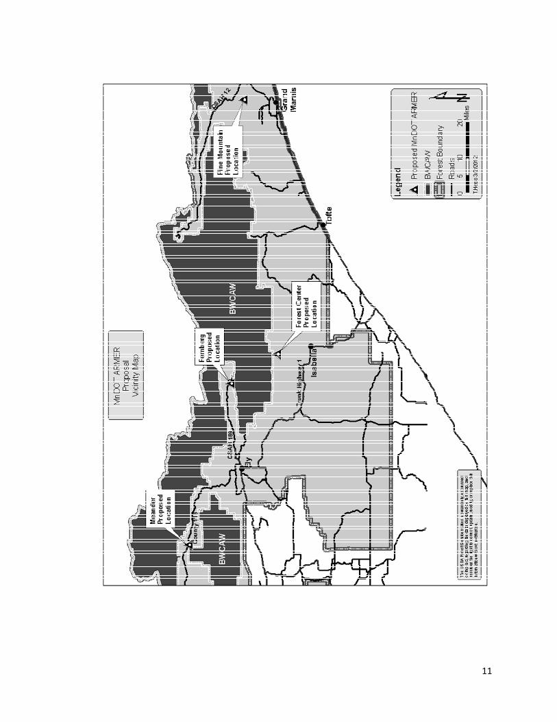
The attached Vicinity Map displays the general location of the proposed tower locations.
Detailed maps of each site can be viewed on the Superior National Forest webpage at
www.fs.usda.gov/projects/superior/landmanagement/projects.
III. Purpose and Need for the Proposed Action
The towers’ purpose is to provide a public safety communications network managing the
implementation of the 800 MHz (megahertz) digital trunked radio communication system.
When implemented, the system provided emergency response personnel the means and ability to
share information via voice and/or data systems on demand in real time. This includes every
city, county, state agency, tribal government and non-government public safety entity operating
in the state.
The ARMER system was first conceived for the metropolitan area in the late 1980s due to aging
radio systems and lack of additional frequencies. A commission was formed and a
recommendation was presented to and approved by the Minnesota Legislature in 1995. In June
1995, the Metropolitan Radio Board formed and began to plan and implement a region-wide
radio system for use by EMS, Fire, Law Enforcement, Public Service and Public Works. In 2001
a plan was developed to extend the metro system into a statewide system for the extension of the
backbone into Greater Minnesota.

2
In 2007, ARMER proved to be a valuable asset when the I-35W bridge collapsed in the Twin
Cities. The shared regional tactical groups allowed various responding agencies with differing
jurisdictions (water vs. land) to easily communicate and coordinate search and rescue and
recovery operations. This system allowed State Patrol to easily speak to city, county, and federal
emergency agencies directly without having to relay information via telephone through
dispatchers or by swapping radios.
The ARMER radio system operates by line of sight, talking to other ARMER towers. In order
for the system to operate effectively, multiple towers are needed to produce a solid blanket of
coverage. A map showing the proposed towers, existing MnDOT ARMER towers, and all other
FCC towers within or near Superior National Forest can be located on the Superior National
Forest website. Some of the last areas in rural Minnesota lacking this coverage are near and
within the Boundary Waters Canoe Area Wilderness. The communication sites proposed would
nearly complete coverage in this area. Other agencies would have the opportunity to rent space
on the radio tower for communication equipment and systems. This includes Cook, Lake, and
St. Louis counties and the US Forest Service and possibly others. For additional information
regarding ARMER, view the website:
http://www.mn-mesb.org/MetroARMERSystem/RadioInteroperability.aspx
The project responds to Forest Plan Objectives for Special Uses: ‘Outside of the BWCAW,
generally provide for utility transmission corridors and communication sites. Emphasize the use
of common corridors and multiple use sites when granting appropriate right-of-ways.’ (O-SU-1)
IV. Proposed Action
The Proposed actions for each of the four communication facility sites, towers, electrical power
line routes, and access roads are detailed below. In addition to the Maps showing land
ownership, aerial views, and management area can be viewed on the Superior National Forest
webpage at www.fs.usda.gov/projects/superior/landmanagement/projects.
Pine Mountain Tower
The Pine Mountain Tower would contain approximately 1 acre of new construction located in
Cook County, T63N, R1E, Section 33 NWSE (Lat. 47°53’42.60”N Long. 90°19’37.50”W) on
the Gunflint Ranger District. This location is on top of Pine Mountain, elevation of 2190 feet.
There once was a Forest Service fire lookout located on this site which was removed decades
ago.
Tower Description
The proposed tower would be a 3-legged, self-sustaining steel structure, being dull grey
galvanized in color to minimize visual impacts. The height would be 180 feet and contain no
FCC markings, lights, or strobes. As a reference, a mature White Pine grows to a height of 80-
110 feet tall.
3
Other Facilities
In order to house the communication equipment and 34kV (kilovolt) back-up generator, a
concrete shelter measuring 12’ x 30’ x 10’ is proposed. This structure would be covered with
brown stone aggregate finish to minimize visual impacts. Next to the shelter would be a 1,000
gallon LP tank measuring 10’ x 4’ to fuel the generator.
Communication Site
The Communication Site that would contain all the facilities is proposed to be 50’ x 60’ with a 7-
foot link fence and an additional 3 strands of barbed wire extending 1 foot above the fence. The
fence includes a 4 foot pedestrian gate and a 16 foot drive-through gate. The entire ground area
would be covered a 4-ounce polyester filter fabric to retard growth of weeds yet porous enough
to allow water to pass to soil. Landscape rock of class 5 will cover the entire area within the
communication site.
Power Requirements
The closest power company operating in the area is Qwest. To access the tower site, new power
lines will need to be installed for approximately three miles. The power line would be buried,
adjacent to and following road rights-of-way.
In addition to electrical power lines, a vertical wind turbine is proposed to be installed. This will
assist in charging a back-up battery supply for power.
Access
The vehicle access to this proposed site would be using FR 154 (Pine Mountain Road) to an
existing unclassified road. A new road approximately 0.5 miles long and 15 feet wide is needed
to complete the access route to the site. This new construction will be designed in accordance
with typical Forest Service standards and stipulations, making it a low operational maintenance
level road. All or parts of this access may need initial reinforcing with class 5 gravel while the
tower is being constructed. An example of the road construction stipulations can be found on
our web site at www.fs.usda.gov/projects/superior/landmanagement/projects .
Management Area
The Forest Plan puts this proposed location within the General Forest Management Area (MA).
Under facilities, this MA allows buildings and structures that provide support of resource
management and allows occasional resorts, utility corridors, towers, dams, and similar structures
(D-GF-12). Under special uses, this MA allows accommodation of most special uses (G-GF-3).
Special Notes of this Location
The proposed site location once held a FS fire lookout. The structure has been removed but the
concrete footings remain. This proposed location may require mitigation measure to prevent
historical/cultural damage during and after construction.
This proposed location is one parcel identified as being part of a possible land exchange with
Cook County in the near future.

4
Forest Center Tower The Forest Center Tower would contain approximately 1 acre of new construction located in
Lake County, T61N, R8W, Section 20 NENW (Lat. 47°45’19.92”N Long. 91°22’28.81”W) on
the Tofte Ranger District. This area was recently logged.
Tower Description
The proposed tower would be a 3-legged, self-sustaining steel structure, being dull grey
galvanized in color to minimize visual impacts. The height would be 180 feet and contain no
FCC markings, lights or strobes. As a reference, a mature White Pine grows to a height of 80-
110 feet tall.
Other Facilities
In order to house the communication equipment and 34kV back-up generator, a concrete shelter
measuring 12’ x 30’ x 10’ is proposed. This structure would be covered with brown stone
aggregate finish to minimize visual impacts. Next to the shelter would be a 1,000 gallon LP tank
measuring 10’ x 4’ to fuel the generator.
Communication Site
The Communication Site that would contain all the facilities is proposed to be 50’ x 60’ with a 7-
foot link fence and an additional 3 strands of barbed wire extending 1 foot above the fence. The
fence includes a 4 foot pedestrian gate and a 16 foot drive-through gate. The entire ground area
would be covered a 4-ounce polyester filter fabric to retard growth of weeds yet porous enough
to allow water to pass to soil. Landscape rock of class 5 will cover the entire area within the
communication site.
Power Requirements
The closest power company operating in the area is Cooperative Light and Power. To access the
tower site, new power lines will need to be installed for approximately six miles. The power line
would be buried, adjacent to and following road rights of ways.
In addition to electrical power lines, a vertical wind turbine is proposed to be installed. This will
assist in charging a back-up battery supply for power.
Access
The vehicle access to this proposed site would be FR 377 (Tomahawk Road), to a newly
constructed access used for timber harvest. This newly constructed access may need initial
reinforcing while the tower is being installed. All or parts of this access may need initial
reinforcing with class 5 gravel while the tower is being constructed.
Management Area
The Forest Plan puts this proposed location within the General Forest Management Area (MA).
Under facilities, this MA allows buildings and structures that provide support of resource
management and allows occasional resorts, utility corridors, towers, dams, and similar structures
(D-GF-12). Under special uses, this MA allows accommodation of most special uses (G-GF-3).
Special Notes of this Location
The Boundary Waters Canoe Area Wilderness is approximately 0.5 miles away from the
proposed location.

5
State land is 0.75 miles away from this location. This State land was considered for the tower
site but with a recently disturbed area from a timber harvest in such close proximity, the
proposed site was chosen.
Fernberg Tower The Fernberg Tower would be replacement of an existing radio tower located in Lake County,
T63N, R9W, Section 8 SESE (Lat. 47°56’49”.10N Long. 91°29’42.10”W) on the Kawishiwi
Ranger District. The current tower is showing age and has limited structural capabilities to hold
the weight of any additional radio equipment.
Tower Description
The proposed tower would be a 3-legged, self-sustaining steel structure, being dull grey
galvanized in color to minimize visual impacts. The height would be 200 feet and contain a dual
mode lighting system at the top of the tower in accordance with FCC requirements. This lighting
system consists of a medium intensity white strobe light for daytime illumination and a red
flashing beacon for nighttime illumination.
The existing tower is a 220 foot guy wire supported structure with orange and white alternating
bands painted for color and a red flashing light for nighttime illumination in accordance with
FCC regulations. As a reference, a mature White Pine grows to a height of 80-110 feet tall.
The FCC regulations for a tower of this height requires it to be marked during the daytime by
either a medium intensity white strobe or alternating orange and white painted markings.
MnDOT has proposed the daytime whit strobe light for the reasons of:
1. Orange and white painted markings are more visible from the ground than a white
strobe light over a greater ground distance. Dull grey galvanized color has less visual
impact to the human eye.
2. The medium intensity white light strobe is encased so it deflects light towards the sky
for an airplane/helicopter pilot to view and minimally towards the ground.
3. Orange and white painted markings require 5-6 year annual maintenance at a high
cost.
Other Facilities
In order to house the communication equipment and 34kV back-up generator, a concrete shelter
measuring 12’ x 30’ x 10’ is proposed. This structure would be covered with brown stone
aggregate finish to minimize visual impacts. Next to the shelter would be a 1,000 gallon LP tank
measuring 10’ x 4’ to fuel the generator.
Communication Site
The Communication Site that would contain all the facilities is proposed to be 50’ x 60’ with a 7-
foot link fence and an additional 3 strands of barbed wire extending 1 foot above the fence. The
fence includes a 4 foot pedestrian gate and a 16 foot drive-through gate. The entire ground area
would be covered a 4-ounce polyester filter fabric to retard growth of weeds yet porous enough
6
to allow water to pass to soil. Landscape rock of class 5 will cover the entire area within the
communication site.
Power Requirements
Since this is an existing Communication Site and power is already installed to the site, no
additional authorization would be required.
In addition to electrical power lines, a vertical wind turbine is proposed to be installed. This will
assist in charging a back-up battery supply for power.
Access
The vehicle access to the existing site is C.S.A.H. 18 (Fernberg Road), to County 181 (FH6
Fernberg Tower), to FR 194, to FR194A. No additional road construction would be required.
Management Area
The Forest Plan puts this proposed location within the Semi-primitive Motorized Recreation
Management Area (MA). This MA generally does not permit special uses except those uses that
do not detract from the semi-primitive environment or uses needed to access or supply utilities to
private land, recreational facilities, or administrative sites (G-SPM-3).
Special Notes of this Location If proposal is accepted, MnDOT will dismantle and remove the existing “old” tower and guy
wires. The concrete footings will be broken off 4-6 feet below grade and soil added.
Other communication facilities are on this site location include Lake County Emergency
dispatch, USFS radio, USFS air monitoring, and USGS earthquake monitoring equipment.
The Fernberg Tower has an approved Communication Site Plan, signed on 1987 by Clay Beal,
Forest Supervisor. If this proposal is accepted, a new Communication Site Plan will be written
and approved with this proposal added.
The Boundary Waters Canoe Area Wilderness is one mile away from the existing location.
Meander Lake Tower The Meander Lake Tower would be replacement of an existing radio tower located in St. Louis
County, T65N, R14W, Section 17 NWNE (Lat. 48°07’12.6”N Long. 92°9’33.0”W) on the
LaCroix Ranger District. The existing radio tower is owned and operated by the National Forest
Service.
Tower Description
The proposed tower would be a 3-legged, self-sustaining steel structure, being dull grey
galvanized in color to minimize visual impacts. The height would be 180 feet and contain no
FCC markings, lights or strobes.
The existing tower is a 60 foot, single-legged, self-supported structure, being dull grey
galvanized in color to minimize visual impacts. The existing tower does not contain FCC
markings, lights or strobes. As a reference, a mature Jack Pine grows to a height of 55-65 feet
tall.

7
Other Facilities
In order to house the communication equipment and 34kV back-up generator, a concrete shelter
measuring 12’ x 30’ x 10’ is proposed. This structure would be covered with brown stone
aggregate finish to minimize visual impacts. The location of the generator building is proposed
to be located approximately 30 feet off of the road, tucked into the woods and underbrush.
Communication Site
The Communication Site that would contain all the facilities is proposed to be 50’ x 60’ with a 7-
foot link fence and an additional 3 strands of barbed wire extending 1 foot above the fence. The
fence includes a 4 foot pedestrian gate and a 16 foot drive-through gate. The entire ground area
would be covered a 4-ounce polyester filter fabric to retard growth of weeds yet porous enough
to allow water to pass to soil. Landscape rock of class 5 will cover the entire area within the
communication site.
Power Requirements
The closest power company operating in the area is Lake Country Power. To access the tower
site, new power lines will need to be installed for approximately 16 miles. The power line would
be buried, adjacent to and following road rights of ways.
An alternative to supply power to this proposed location is to operate the 34kV back-up
generator a constant 24 hours. The LP gas tank and generator would not be located next to the
tower but closer to the road. This would allow the LP tank to be filled on a regular basis. The
generator is reported to be as loud as a homeowner’s lawnmower, therefore it would be housed
in a small shed designed to reduce the noise. The manufacture could be asked to design a special
muffler, decreasing the noise level to an even lesser degree. The LP tank and generator shed
would be colored to blend in with the surrounding woods (see Other Facilities for design and
location). Electric power lines would be run slightly underground from the generator building to
the to the tower site.
In addition to electrical power lines, a vertical wind turbine is proposed to be installed. This will
assist in charging a back-up battery supply for power.
Access
The vehicle access to the existing site is C.S.A.H. 116 (Echo Trail) to a reclaimed unclassified
road numbered U6977. The overgrown road would be reconstructed for the initial installation.
The reconstruction will be designed in accordance with typical Forest Service standards and
stipulations, not to exceed an operational maintenance level 2 road. This road is steep in certain
areas and would require brush/timber removal.
A possible alternative MnDOT has proposed for the initial installation is contract the National
Guard to aerial crane/lift the construction supplies to the site with a helicopter where workers
would hike in and complete construction.
Management Area
The Forest Plan puts this proposed location within the General Forest – Longer Rotation
Management Area (MA). Under facilities, this MA allows buildings and structures that provide
support of resource management and allows occasional resorts, utility corridors, towers, dams,

8
and similar structures (D-LR-12). Under special uses, this MA allows accommodation of most
special uses (G-LR-3).
Special Notes of this Location
The Boundary Waters Canoe Area Wilderness is a half mile away from the existing location.
MNDOT will remove and replace the existing 60 foot National Forest Service tower, giving the
FS better communication reach with its radios. This is desired by FS Communication personnel.
V. Decision to be Made
Tim Dabney, Acting Forest Supervisor, Superior National Forest, is the Responsible Officer for
the Minnesota Department of Transportation Allied Radio Matrix for Emergency Response
(MnDOT ARMER) Project. The decisions to be made include:
� Which sites, if any, will be authorized under a Special-Use Permit.
� Will any of the proposed sites have a significant impact that would lead to preparation of
an Environmental Impact Statement
� Will any of the sites require alterations to the proposed plan
� Will electric power lines be authorized at the new construction location
A decision is expected by August 15, 2012. Implementation would begin October of 2012.
VI. Background Information
In 2010, the MnDOT Office of Electronic Communications approached the Superior National
Forest with a proposal to install radio towers throughout the Forest. These radio towers would
become part of the ARMER system which is the fundamental infrastructure for emergency
responders to achieve seamless interoperable communications. In Spring 2011, MnDOT and
Forest Service personnel visited each initial proposed site and alternative sites. Proposals that
were denied included:
Cascade Lake Tower, located in Cook County at T62N, R2W, Section 18 NESW. This was
denied due to the visual impacts associated with being located a few hundred feet from C.S.A.H.
4, a scenic drive.
Cascade Lake Tower Alternative, located in Cook County at T62N, R2W, Section 24 NWNE.
This was denied due to the availability of suitable State land near the area.
Sawbill Tower, located in Cook County at T62N, R4W, Section 19 NWSW. This was denied
due to the location being in a Roadless Area Review and Evaluation (RARE II) area.
Sawbill Tower Alternative, located in Cook County at T61N, R5W, Section 12 SWNW. This
was denied due to the availability of suitable State land near the area.

9
Forest Center (Original), located in Lake County at T61N, R8W, Sec. 22 SENW. This was
denied due to the close proximity of a heavily used Boundary Waters Canoe Area Wilderness
entry point.
VII. Summary of the Environmental Assessment Process
The MnDOT ARMER interdisciplinary team of resource specialists will prepare an
Environmental Assessment (EA) using the following steps. The team includes a wildlife
biologist, recreation specialist, archeologist, wilderness specialist, and others as needed.
Step 1: The information in this scoping package explaining the Purpose and Need and Proposed
Action is sent to the public, adjacent landowners, and others who have an interest in how the
lands are managed. The purpose of the scoping package is to inform the public and to provide
people with an opportunity to submit comments on the proposal.
Step 2: The interdisciplinary team will evaluate the comments received on the scoping package
and identify environmental issues to help them develop the EA. The issues will be used to
develop management alternatives to the Proposed Action and to disclose any effects of the
actions of each proposed alternative. This analysis will be compiled in an EA that will be
available for public review on the Superior National Forest website. This review will include the
official comment period.
Step 3: Comments received during the official comment period will be considered by the
Responsible Official. He will document his decision in a formal decision document. The
decision document and response to comments will be made available to parties who submit
comments during the official comment period and will be posted on the Superior National Forest
website.
Step 4: Interested parties who submitted comments during the official comment period will have
opportunity to appeal the project. Details on appeal rights will be displayed in the decision
documentation.
VIII. How to Comment on the MnDOT ARMER Proposed Action
Comments will be used to determine issues associated with the special-use permit, to develop
alternatives to the Proposed Action, and to refine the analysis of effects.
Comments are most useful if they refer to a specific action or activity rather than general
management direction of the Superior National Forest. Please consider the following question
when reviewing proposed activities and submitting comments: Is there anything about the areas
involved in the tower locations project that I believe the Forest Service should consider in the
environmental assessment?

10
Scoping comments are most useful if received by April 20, 2012 (30 days after date of letter), in
a timely and legible fashion. Please note that if you do not submit any response for this Special-
Use Permit project, your name will be removed from this project’s mailing list. The next step in
the public involvement process is to release an environmental assessment (EA) document. To
save resources, we will inform those who respond to the scoping document when the EA is
available on the Superior National Forest webpage
(www.fs.usda.gov/projects/superior/landmanagement/project). Please let us know if you prefer a
hard copy. All comments received (including names and addresses) will become part of the
project file and will be available for public review, if requested. Comments submitted
anonymously will not be accepted or considered. Submit comments by e-mailing, faxing,
calling, or writing to:
Tim Dabney, Acting Forest Supervisor
ATTN: MnDOT ARMER
• Electronic comments must be submitted in a format such as text or html e-mail, Adobe
portable document format or formats viewable in Microsoft Office applications. Send
electronic comments to: [email protected]
• FAX comments to: 218-626-4398 with “MnDOT ARMER Project” as the subject.
• Oral comments may be provided in person at the Superior National Forest Headquarters,
8:00 a.m. to 4:30 p.m., Monday through Friday or by calling 218-626-4371.
• Written comments to: Tim Dabney, Acting Forest Supervisor, Attn: MnDOT ARMER
Project, 8901 Grand Avenue Place, Duluth, MN 55808.
11
Related Documents


