Scientific management of Mediterranean coastal zone: A hybrid ocean forecasting system for oil spill and search and rescue operations A. Jordi a, * , M.I. Ferrer a , G. Vizoso a , A. Orfila b , G. Basterretxea a , B. Casas a , A. A ´ lvarez a , D. Roig a , B. Garau a , M. Martı ´nez a , V. Ferna ´ndez a , A. Forne ´s a , M. Ruiz a , J.J. Forno ´s c , P. Balaguer a , C.M. Duarte a , I. Rodrı ´guez d , E. Alvarez d , R. Onken e , P. Orfila f , J. Tintore ´ a a IMEDEA (CSIC-UIB), Institut Mediterrani d’Estudis Avanc ¸ats, Miquel Marque `s 21, 07190 Esporles, Illes Balears, Spain b School of Civil and Environmental Engineering, Cornell University, 14853 Ithaca (NY), USA c Departament de Cie `ncies de la Terra, UIB, Crta. Valldemossa, km 7.5, Palma de Mallorca, Illes Balears, Spain d A ´ rea del Medio Fı ´sico, Puertos del Estado, Antonio Lopez 81, Madrid E-28026, Spain e Institute of Coastal Research, GKSS Research Centre, Max-Planck-Strasse 1, 21052 Geesthacht, Germany f D.G. Emerg encies, Conselleria d’ Interior del Govern de les Illes Balears, Spain Abstract The oil spill from Prestige tanker showed the importance of scientifically based protocols to minimize the impacts on the environment. In this work, we describe a new forecasting system to predict oil spill trajectories and their potential impacts on the coastal zone. The system is formed of three main interconnected modules that address different capabilities: (1) an operational circulation sub-system that includes nested models at different scales, data collection with near-real time assimilation, new tools for initialization or assimilation based on genetic algorithms and feature-oriented strategic sampling; (2) an oil spill coastal sub-system that allows simulation of the tra- jectories and fate of spilled oil together with evaluation of coastal zone vulnerability using environmental sensitivity indexes; (3) a risk management sub-system for decision support based on GIS technology. The system is applied to the Mediterranean Sea where surface currents are highly variable in space and time, and interactions between local, sub-basin and basin scale increase the non-linear interac- tions effects which need to be adequately resolved at each one of the intervening scales. Besides the Mediterranean Sea is a complex reduced scale ocean representing a real scientific and technological challenge for operational oceanography and particularly for oil spill response and search and rescue operations. Ó 2005 Elsevier Ltd. All rights reserved. Keywords: Oil spill; Risk assessment; Operational oceanography; Currents; Search and rescue; Mediterranean Sea 1. Introduction Marine pollution was highlighted on November 2002 by the Prestige tanker accident off the northwest Spanish coast. This incident was preceded by similar ecological disasters such as the Exxon Valdez in USA (1989), the Aegean Sea in Spain (1992) and the Erika in France (1999). The Mediterranean Sea has kept relatively free from those accidents, although some accidents like the oil spills from the tankers Haven and Lyria and the Eshkol power station caused several damage (Guidetti et al., 2000; Ezra et al., 2000). However, accidental oil spills only account for a 5% of total oil pollution hiding the regular pollution in frequented sea routes generated by oil drillings or illegal discharges (Alpers and Huhnerfuss, 1988; Pavla- kis et al., 2001). The Mediterranean is an important traffic 0025-326X/$ - see front matter Ó 2005 Elsevier Ltd. All rights reserved. doi:10.1016/j.marpolbul.2005.10.008 * Corresponding author. Fax: +34 971611761. E-mail address: [email protected] (A. Jordi). www.elsevier.com/locate/marpolbul Marine Pollution Bulletin 53 (2006) 361–368

Welcome message from author
This document is posted to help you gain knowledge. Please leave a comment to let me know what you think about it! Share it to your friends and learn new things together.
Transcript
www.elsevier.com/locate/marpolbul
Marine Pollution Bulletin 53 (2006) 361–368
Scientific management of Mediterranean coastal zone:A hybrid ocean forecasting system for oil spill
and search and rescue operations
A. Jordi a,*, M.I. Ferrer a, G. Vizoso a, A. Orfila b, G. Basterretxea a, B. Casas a,A. Alvarez a, D. Roig a, B. Garau a, M. Martınez a, V. Fernandez a, A. Fornes a, M. Ruiz a,
J.J. Fornos c, P. Balaguer a, C.M. Duarte a, I. Rodrıguez d, E. Alvarez d,R. Onken e, P. Orfila f, J. Tintore a
a IMEDEA (CSIC-UIB), Institut Mediterrani d’Estudis Avancats, Miquel Marques 21, 07190 Esporles, Illes Balears, Spainb School of Civil and Environmental Engineering, Cornell University, 14853 Ithaca (NY), USA
c Departament de Ciencies de la Terra, UIB, Crta. Valldemossa, km 7.5, Palma de Mallorca, Illes Balears, Spaind Area del Medio Fısico, Puertos del Estado, Antonio Lopez 81, Madrid E-28026, Spain
e Institute of Coastal Research, GKSS Research Centre, Max-Planck-Strasse 1, 21052 Geesthacht, Germanyf D.G. Emerg�encies, Conselleria d’ Interior del Govern de les Illes Balears, Spain
Abstract
The oil spill from Prestige tanker showed the importance of scientifically based protocols to minimize the impacts on the environment.In this work, we describe a new forecasting system to predict oil spill trajectories and their potential impacts on the coastal zone. Thesystem is formed of three main interconnected modules that address different capabilities: (1) an operational circulation sub-system thatincludes nested models at different scales, data collection with near-real time assimilation, new tools for initialization or assimilationbased on genetic algorithms and feature-oriented strategic sampling; (2) an oil spill coastal sub-system that allows simulation of the tra-jectories and fate of spilled oil together with evaluation of coastal zone vulnerability using environmental sensitivity indexes; (3) a riskmanagement sub-system for decision support based on GIS technology. The system is applied to the Mediterranean Sea where surfacecurrents are highly variable in space and time, and interactions between local, sub-basin and basin scale increase the non-linear interac-tions effects which need to be adequately resolved at each one of the intervening scales. Besides the Mediterranean Sea is a complexreduced scale ocean representing a real scientific and technological challenge for operational oceanography and particularly for oil spillresponse and search and rescue operations.� 2005 Elsevier Ltd. All rights reserved.
Keywords: Oil spill; Risk assessment; Operational oceanography; Currents; Search and rescue; Mediterranean Sea
1. Introduction
Marine pollution was highlighted on November 2002 bythe Prestige tanker accident off the northwest Spanishcoast. This incident was preceded by similar ecologicaldisasters such as the Exxon Valdez in USA (1989), the
0025-326X/$ - see front matter � 2005 Elsevier Ltd. All rights reserved.
doi:10.1016/j.marpolbul.2005.10.008
* Corresponding author. Fax: +34 971611761.E-mail address: [email protected] (A. Jordi).
Aegean Sea in Spain (1992) and the Erika in France(1999). The Mediterranean Sea has kept relatively freefrom those accidents, although some accidents like the oilspills from the tankers Haven and Lyria and the Eshkol
power station caused several damage (Guidetti et al.,2000; Ezra et al., 2000). However, accidental oil spills onlyaccount for a 5% of total oil pollution hiding the regularpollution in frequented sea routes generated by oil drillingsor illegal discharges (Alpers and Huhnerfuss, 1988; Pavla-kis et al., 2001). The Mediterranean is an important traffic
Managementsub-system
EnvironmentalSensitivity
Trajectories
Riskassessment
Atmosphericforcing
Coastal oceanforecast
Datacollection
Oil spillcoastal
sub-system
Operationalcirculationsub-system
Decisionsupport
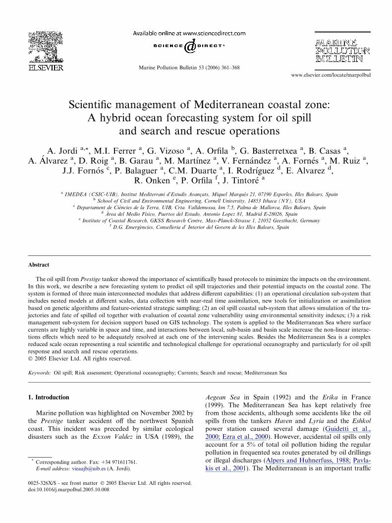
Fig. 1. Structure of the hybrid forecasting system for oil spill or searchand rescue operations.
362 A. Jordi et al. / Marine Pollution Bulletin 53 (2006) 361–368
zone for oil tankers allowing access to Southern Europe,North Africa, The Middle East and The Black Sea. Besidesa high number of oil-related sites (pipeline terminals, refin-eries, offshore platforms, etc.) concentrate along the coastalzone. Furthermore, moderate pollution of petrogenicsource has been detected in harbors of the MediterraneanSea, probably also caused by oil spills (De Luca et al.,2004). As a result, the Mediterranean Sea is a particularlyvulnerable area due to the different types of potential spillsand to its semi-enclosed nature. Therefore, new scientifi-cally based tools for adequate response and coastal man-agement are specially needed.
Prediction of oil spill trajectories is essential to manageadequately the response in the coastal zone. A review ofnumerical models used to simulate the movement and fateof oil released into the sea was carried out by the NationalResearch Council (NRC, 2003). Theses models are usuallybased on a pollutant dispersion model forced by winds pro-vided by an atmospheric model and currents provided byan ocean circulation model. Spaulding et al. (1996) inte-grated the spill modeling with a wide variety of supportingmodels (ocean coastal circulation, meteorological, biologi-cal effects, tactical response) to provide real time supportduring actual spill events. It is important that these modelsadequately reproduce the interactions between large-scalecirculation and coastal currents in order to lead to realisticforecasts. During the Prestige accident, good forecasting ofthe spread of the oil spill was only obtained when the gen-eral circulation near the Spanish coast (Navidad current)was adequately resolved (Garcia-Soto, 2004).
The interaction between scales is especially relevant in theMediterranean Sea, where several temporal and spatialscales (basin, sub-basin and local) interact to form a highlyvariable general circulation (Fernandez et al., 2005). TheMediterranean Sea is a complex and variable ocean system,where the circulation is strongly affected by frontal dynam-ics through mesoscale features that can give rise to a widerange of ocean variability. Currents are of the order of onequarter to half knot, mostly driven by density differenceslocated over the slope areas. Theses coastal currents arestrongly affected by frontal dynamics through mesoscalefeatures that can give rise to transient currents of oppositedirection and speeds higher than one knot (Orfila et al.,2004). In addition to this buoyant forcing, the ocean–atmo-sphere interaction mechanisms are very intense both at thesynoptic and the slowly varying atmospheric variabilityscales (Korres et al., 2000). Thus, the ocean prediction prob-lem in the Mediterranean Sea at short and medium timescales requires the modeling of the large spatial and longtime scales, as well as the local and short scales. The in-depthknowledge of oceanographic phenomenology, circulationand variability in the Mediterranean Sea acquired at IME-DEA during the last two decades is a pre-requisite for ade-quate forecasting of the ocean state (Orfila et al., 2004).
The objective of this paper is to describe a new hybridocean forecasting system that was initially developed dur-ing the Prestige accident and its application to the Mediter-
ranean Sea. The system adequately addresses the differentphysical processes affecting the drift of spills and more gen-erally drifting objects, which opens the possibility of sup-porting a wide range of scientific and operational servicesand applications (oil spill monitoring, marine safety, searchand rescue operations, etc).
2. Description of the system
The structure of the hybrid forecasting system for oilspill or search and rescue operations is presented inFig. 1. The system is based upon three main components:(1) an operational circulation sub-system to predict wind,currents and waves; (2) the analysis of the drift of objectsand spills, including the interaction with sensitive coastalareas; (3) a GIS-based risk assessment module. Each sub-system is composed by one or more modules that interactbetween them.
2.1. Operational circulation sub-system
The goal of the operational sub-system is to provide, innear-real time, reliable information and forecasts for mar-ine environmental conditions, to support all kind of activ-ities at sea. We next present the three main modules thatcompose this sub-system.
2.1.1. Coastal ocean forecast
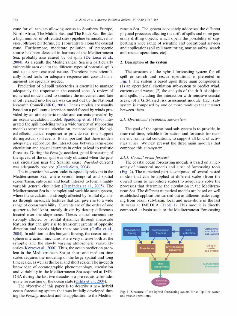
The coastal ocean forecasting module is based on a hier-archy of numerical models and a set of forecasting tools(Fig. 2). The numerical part is composed of several nestedmodels that can be applied at different scales (from theoverall basin to near-shore scales) to adequately solve theprocesses that determine the circulation in the Mediterra-nean Sea. The different numerical models are based on wellestablished applications carried out at different scales rang-ing from basin, sub-basin, local and near-shore in the last10 years at IMEDEA (Table 1). This module is directlyconnected at basin scale to the Mediterranean Forecasting
Local scaleO(100 m)
Basin scaleO(10 km)
Sub-basin scaleO(1 km)
Near-shore scaleO(10 m)
Forecasting tools- Data assimilation- SOFT- FORMS
Fig. 2. Structure of the coastal ocean forecast module.
A. Jordi et al. / Marine Pollution Bulletin 53 (2006) 361–368 363
System (MFS, that currently produces ten-day ocean fore-casts for the whole Mediterranean Sea once a week, Pinardiet al., 2003) and to the operational wave forecasting systemof Puertos del Estado (Carretero et al., 2000). The refer-ences cited in Table 1 show that the mean large-scale circu-lation is modified at sub-basin scale and gives rise to highlyvariable mesoscale structures that interact with the slopecirculation and topographic structures such as canyons orcapes. They also show that successful applications at localand near-shore scale need to include the importance of seebreeze and near-shore currents for water quality control.
The forecasting tools include capacities for near-realtime data assimilation together with new tools for initiali-zation and/or assimilation of satellite data based on geneticalgorithms and feature-oriented strategic sampling. SOFTis a Satellite Ocean Forecasting Tool developed at IME-DEA based on non-linear prediction techniques likegenetic algorithms that has been successfully used to fore-cast future states of ocean currents at the specific sub-basins of Alboran, Ligurian, and Adriatic Seas (Alvarezet al., 2004). The assimilation of these satellite based fore-casts into the numerical models improves the forecastingskill of such models. Also, an important part of this mod-ule is a generic and portable methodology to initialize and/or to update fields for a coastal ocean model calledFORMS for Feature-Oriented Regional Modeling Sam-pling. This approach is developed via observations of thesynoptic structures in the region objectively analyzed with
Table 1Numerical models used and applications at different spatial scales
Scale Area Model
Basin Western Mediterranean Sea MOMMediterranean Sea DieCASTMediterranean Sea DieCAST
Sub-basin Blanes Canyon WangPalamos Canyon WangBalearic Sea HOPSTunisia-Sardinia-Sicily Region HOPS
Local South of Mallorca FUNDYSanta Ponca Bay FUNDYPort of Cabrera FUNDY
Near-shore Magalluf beach Lynett
appropriate background climatology to generate the com-bined circulation variability (Gangopadhyay and Robin-son, 2002).
2.1.2. Ocean observations
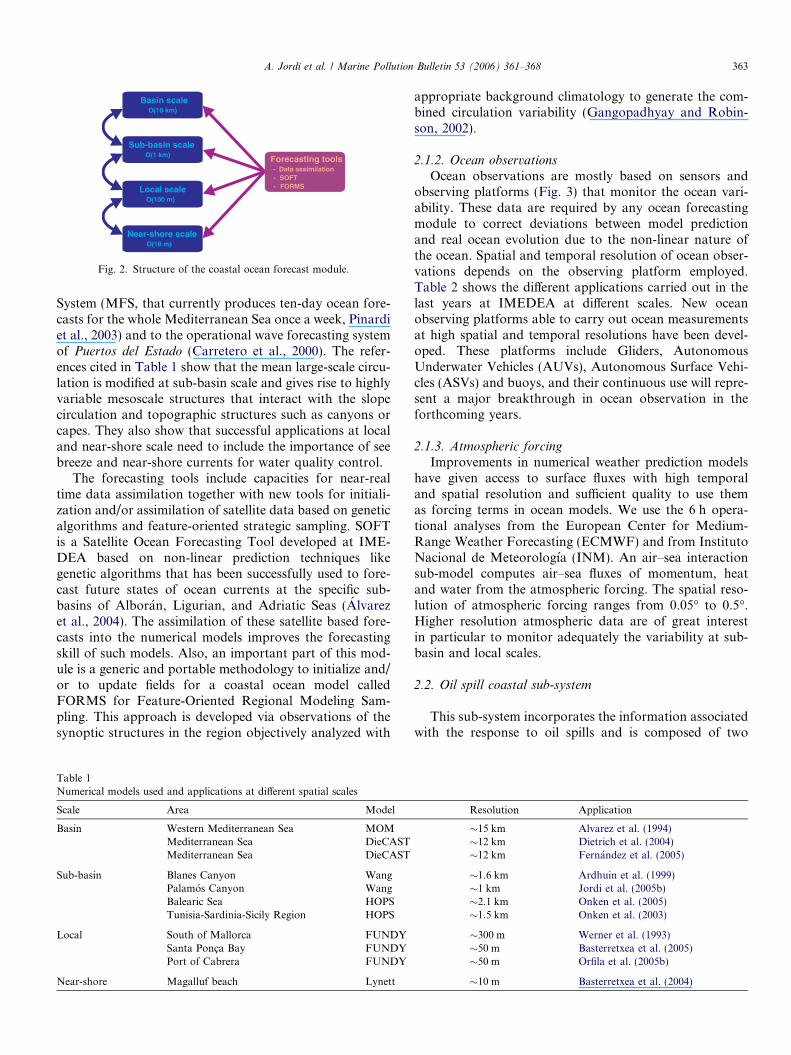
Ocean observations are mostly based on sensors andobserving platforms (Fig. 3) that monitor the ocean vari-ability. These data are required by any ocean forecastingmodule to correct deviations between model predictionand real ocean evolution due to the non-linear nature ofthe ocean. Spatial and temporal resolution of ocean obser-vations depends on the observing platform employed.Table 2 shows the different applications carried out in thelast years at IMEDEA at different scales. New oceanobserving platforms able to carry out ocean measurementsat high spatial and temporal resolutions have been devel-oped. These platforms include Gliders, AutonomousUnderwater Vehicles (AUVs), Autonomous Surface Vehi-cles (ASVs) and buoys, and their continuous use will repre-sent a major breakthrough in ocean observation in theforthcoming years.
2.1.3. Atmospheric forcing
Improvements in numerical weather prediction modelshave given access to surface fluxes with high temporaland spatial resolution and sufficient quality to use themas forcing terms in ocean models. We use the 6 h opera-tional analyses from the European Center for Medium-Range Weather Forecasting (ECMWF) and from InstitutoNacional de Meteorologıa (INM). An air–sea interactionsub-model computes air–sea fluxes of momentum, heatand water from the atmospheric forcing. The spatial reso-lution of atmospheric forcing ranges from 0.05� to 0.5�.Higher resolution atmospheric data are of great interestin particular to monitor adequately the variability at sub-basin and local scales.
2.2. Oil spill coastal sub-system
This sub-system incorporates the information associatedwith the response to oil spills and is composed of two
Resolution Application
�15 km Alvarez et al. (1994)�12 km Dietrich et al. (2004)�12 km Fernandez et al. (2005)
�1.6 km Ardhuin et al. (1999)�1 km Jordi et al. (2005b)�2.1 km Onken et al. (2005)�1.5 km Onken et al. (2003)
�300 m Werner et al. (1993)�50 m Basterretxea et al. (2005)�50 m Orfila et al. (2005b)
�10 m Basterretxea et al. (2004)
Fig. 3. Schematic view of the observing platforms used by the hybrid ocean forecasting system.
Table 2Observing platforms used and applications at different spatial
Scale Area Platform Sensor Application
Sub-basin Palamos Canyon Ship CTD Alvarez et al. (1996)Catalan and Gulf of Lion shelves Moorings Currentmeters and pressure gauges Jordi et al. (2005a)Ligurian Sea Satellite SST and SLA Orfila et al. (2005a)Alboran Sea Ship CTD, ADCP Rodrıguez et al. (2001)Balearic Sea Ship and aeroplane CTD, ADCP and AXBT Pinot et al. (1995)
Local Santa Ponca Bay Moorings Currentmeters and biological sampling Basterretxea et al. (2005)Port of Cabrera Moorings Currentmeters and termistor chain Orfila et al. (2005b)
Near-shore Magalluf beach Moorings Wave recorder and topographic leveling Basterretxea et al. (2004)
364 A. Jordi et al. / Marine Pollution Bulletin 53 (2006) 361–368
modules. The first one predicts the spill trajectory takinginto account the physical and chemical processes affectingthe oil. The second evaluates the coastal zone vulnerabilitycombining physical, biological, geological and socio-eco-nomic parameters of the coastline into a single environ-mental sensitivity index related to oil spills.
2.2.1. TrajectoriesThe trajectories module predicts the drift on the ocean
surface and is based on the General NOAA Oil ModelingEnvironment (GNOME), which uses the standard Eule-rian/Lagrangian approach to pollutant modeling with theregional ocean characteristics simulated as Eulerian fields
within which the pollutant�s Lagrangian elements move(Beegle-Krause, 2001). The model includes processes affect-ing the oil and other hydrocarbons into the sea such asturbulent diffusion, weathering, wave stress, wave compres-sion, Stokes drift, dispersion, over-washing, surface drift,and Langmuir circulation, see the review of Reed et al.(1999) for detailed description. There are six product typesand one non-weathering type for oil spill simulation. Initialspill distribution can vary in space (point, line, or sprayeddistributions) and in time (point and line sources simulateinstantaneous spills or spills over time). The model tracksthe mass balance of the floating, beached and evaporatedoil, as well as the uncertainty associated with the trajectories.
A. Jordi et al. / Marine Pollution Bulletin 53 (2006) 361–368 365
2.2.2. Environmental sensitivity
Environmental Sensitivity Index (ESI) identifies vulner-able coastal locations to the effects of an oil spill, so thatprotection priorities can be established and cleanup strate-gies identified. It is determined by the relationship betweenthe physical make up of the shore, biological resources,geological characteristics and areas of socio-economicimportance. The physical characteristics are comprised ofthe relative exposure to waves, climate conditions and thewater residence time of semi-enclosed areas. The biologicalresources are ranked according to their sensitivity to the oilspilled (Posidonia oceanica meadows or wetland vegeta-tion), the use of the shoreline by oil-sensitivity animals,the presence of rare and endangered species and special sta-tus areas (natural parks, marine reserves). The geologicalcharacteristics include different coastal environments(rocky shores, sandy beaches, etc.), the sediment type, thenatural persistence of oil, and the ease of cleanup. Theareas of socio-economic importance are the regions thatsupport high intensity recreational use like touristy bea-ches, cultural and archaeological sites, commercial areas,etc.
2.3. Management sub-system
The management sub-system is based on a geographicalinformation system (GIS) for oil spill crisis management.GIS are a useful tool for storing, analyzing and displaying
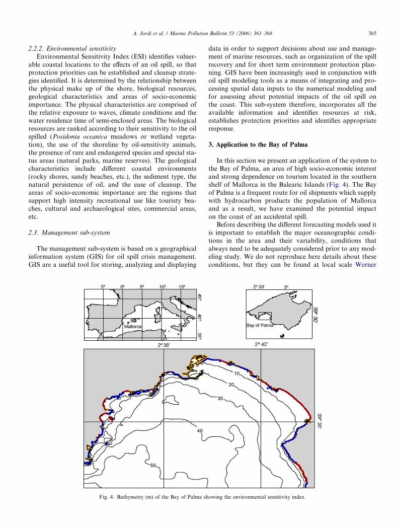
Fig. 4. Bathymetry (m) of the Bay of Palma sh
data in order to support decisions about use and manage-ment of marine resources, such as organization of the spillrecovery and for short term environment protection plan-ning. GIS have been increasingly used in conjunction withoil spill modeling tools as a means of integrating and pro-cessing spatial data inputs to the numerical modeling andfor assessing about potential impacts of the oil spill onthe coast. This sub-system therefore, incorporates all theavailable information and identifies resources at risk,establishes protection priorities and identifies appropriateresponse.
3. Application to the Bay of Palma
In this section we present an application of the system tothe Bay of Palma, an area of high socio-economic interestand strong dependence on tourism located in the southernshelf of Mallorca in the Balearic Islands (Fig. 4). The Bayof Palma is a frequent route for oil shipments which supplywith hydrocarbon products the population of Mallorcaand as a result, we have examined the potential impacton the coast of an accidental spill.
Before describing the different forecasting models used itis important to establish the major oceanographic condi-tions in the area and their variability, conditions thatalways need to be adequately considered prior to any mod-eling study. We do not reproduce here details about theseconditions, but they can be found at local scale Werner
owing the environmental sensitivity index.
366 A. Jordi et al. / Marine Pollution Bulletin 53 (2006) 361–368
et al. (1993) and Ferrer et al. (in preparation), and at sub-basin scale in Pinot et al. (2002).
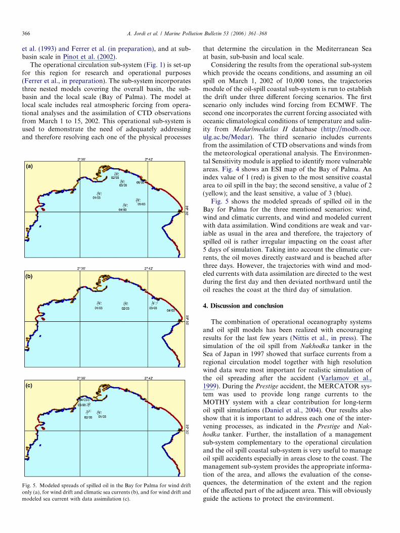
The operational circulation sub-system (Fig. 1) is set-upfor this region for research and operational purposes(Ferrer et al., in preparation). The sub-system incorporatesthree nested models covering the overall basin, the sub-basin and the local scale (Bay of Palma). The model atlocal scale includes real atmospheric forcing from opera-tional analyses and the assimilation of CTD observationsfrom March 1 to 15, 2002. This operational sub-system isused to demonstrate the need of adequately addressingand therefore resolving each one of the physical processes
Fig. 5. Modeled spreads of spilled oil in the Bay for Palma for wind driftonly (a), for wind drift and climatic sea currents (b), and for wind drift andmodeled sea current with data assimilation (c).
that determine the circulation in the Mediterranean Seaat basin, sub-basin and local scale.
Considering the results from the operational sub-systemwhich provide the oceans conditions, and assuming an oilspill on March 1, 2002 of 10,000 tones, the trajectoriesmodule of the oil-spill coastal sub-system is run to establishthe drift under three different forcing scenarios. The firstscenario only includes wind forcing from ECMWF. Thesecond one incorporates the current forcing associated withoceanic climatological conditions of temperature and salin-ity from Medar/medatlas II database (http://modb.oce.ulg.ac.be/Medar). The third scenario includes currentsfrom the assimilation of CTD observations and winds fromthe meteorological operational analysis. The Environmen-tal Sensitivity module is applied to identify more vulnerableareas. Fig. 4 shows an ESI map of the Bay of Palma. Anindex value of 1 (red) is given to the most sensitive coastalarea to oil spill in the bay; the second sensitive, a value of 2(yellow); and the least sensitive, a value of 3 (blue).
Fig. 5 shows the modeled spreads of spilled oil in theBay for Palma for the three mentioned scenarios: wind,wind and climatic currents, and wind and modeled currentwith data assimilation. Wind conditions are weak and var-iable as usual in the area and therefore, the trajectory ofspilled oil is rather irregular impacting on the coast after5 days of simulation. Taking into account the climatic cur-rents, the oil moves directly eastward and is beached afterthree days. However, the trajectories with wind and mod-eled currents with data assimilation are directed to the westduring the first day and then deviated northward until theoil reaches the coast at the third day of simulation.
4. Discussion and conclusion
The combination of operational oceanography systemsand oil spill models has been realized with encouragingresults for the last few years (Nittis et al., in press). Thesimulation of the oil spill from Nakhodka tanker in theSea of Japan in 1997 showed that surface currents from aregional circulation model together with high resolutionwind data were most important for realistic simulation ofthe oil spreading after the accident (Varlamov et al.,1999). During the Prestige accident, the MERCATOR sys-tem was used to provide long range currents to theMOTHY system with a clear contribution for long-termoil spill simulations (Daniel et al., 2004). Our results alsoshow that it is important to address each one of the inter-vening processes, as indicated in the Prestige and Nak-
hodka tanker. Further, the installation of a managementsub-system complementary to the operational circulationand the oil spill coastal sub-system is very useful to manageoil spill accidents especially in areas close to the coast. Themanagement sub-system provides the appropriate informa-tion of the area, and allows the evaluation of the conse-quences, the determination of the extent and the regionof the affected part of the adjacent area. This will obviouslyguide the actions to protect the environment.
A. Jordi et al. / Marine Pollution Bulletin 53 (2006) 361–368 367
One of the advantages of the system described is therapid response capability in front of oil spill crisis or mar-ine emergencies. A quick characterization of the area ofinterest is highly recommendable to improve the forecast-ing skill of the numerical models, especially if the area isnot monitored permanently. Lagrangian buoys and air-borne expendables bathythermographs (AXBTs) havedemonstrated to be useful instruments for that purposebecause they can be deployed from planes and helicopters.For example, an AXBTs survey of the Balearic Sea wascarried out in only three days with a plane; note thatthe same survey with oceanographic ship was taken inapproximately one month (Pinot et al., 1995). In addition,gliders, AUVs and ASVs are now able to carry out ocean-ographic campaigns continuously and in an autonomousway.
Although the system has been described for oil spills, itcan be also used for other applications like search and res-cue operations. In this case, the trajectories module isslightly different because drifting objects are not affectedby processes that affect oil like spreading or weathering.The motion of the object is the net result of the forces act-ing upon it (mainly currents and wind). The immersed frac-tion of the object is a key parameter which is variabledepending on the object (life raft, person in water, vessel,etc.). Another uncertainty usually involved in a searchand rescue operation is the position and the time of theaccident. As a consequence of these uncertainties, a searcharea is defined by computing an ensemble of trajectorieswith slight changes in the fraction immersed of the object,the initial position and the time of incident.
To improve the system described in this paper, extraeffort is actually centered in the development of new oceanobserving platforms (gliders, AUVs and ASVs) to provide,in real time, data to assimilate into numerical models. Sur-face currents and waves provided by coastal radar stationswould be also extremely useful for this purpose. At thesame time, the atmospheric forcing has to be improvedwith high resolution fields to monitor adequately the vari-ability at sub-basin and local scales.
Acknowledgements
This work has been partially supported by ESEOO(VEM2003-20577-C14-08) and CORMORAN (REN2003-07787-C02-01) projects funded by CICYT and MFSTEP(EVK3-CT-2002-00175), SOFT (EVK3-CT-2000-00028)and MERSEA (SIP3-CT-2003-502885) projects funded byEuropean Commission (D. G. Research). Support fromthe Conselleria d’Interior del Govern de les Illes Balears
and UGIZC project, is also gratefully acknowledged.
References
Alpers, W., Huhnerfuss, H., 1988. Radar signatures of oil films floating onthe sea surface and the Marangoni effect. Journal of GeophysicalResearch 93, 3642–3648.
Alvarez, A., Tintore, J., Holloway, G., Eby, M., Beckers, J.M., 1994.Effect of topographic stress on circulation in the western Mediterra-nean. Journal of Geophysical Research 99, 16053–16064.
Alvarez, A., Tintore, J., Sabates, A., 1996. Flow modification of shelf-slope exchange induced by a submarine canyon off the northeastSpanish coast. Journal of Geophysical Research 101, 12043–12055.
Alvarez, A., Orfila, A., Tintore, J., 2004. Real-time forecasting at weeklytimescales of the SST and SLA of the Ligurian Sea with a satellite-based ocean forecasting (SOFT) system. Journal of GeophysicalResearch 109, 1–11.
Ardhuin, F., Pinot, J.M., Tintore, J., 1999. Numerical study of thecirculation in a steep canyon off the Catalan coast. Journal ofGeophysical Research 104, 11115–11135.
Basterretxea, G., Orfila, A., Jordi, A., Casas, B., Lynett, P., Liu, P.L.F.,Duarte, C.M., Tintore, J., 2004. Seasonal dynamics of a microtidalpocket beach with Posidonia Oceanica seabeds (Mallorca, Spain).Journal of Coastal Research 20, 1155–1164.
Basterretxea, G., Garces, E., Jordi, A., Maso, M., Tintore, J., 2005. Breezeconditions as a favoring mechanism of Alexandrium taylori blooms at aMediterranean beach. Estuarine, Coastal and Shelf Science 62, 1–12.
Beegle-Krause, C.J., 2001. General NOAA oil modeling environment(GNOME): a new spill trajectory model. In: 2001 International OilSpill Conference.
Carretero, J.C., Alvarez, E., Gomez, M., Perez, B., Rodrıguez, I., 2000.Ocean forecasting in narrow shelf seas: application to the Spanishcoasts. Coastal Engineering 41, 269–293.
Daniel, P., Josse, P., Dandin, P., Lefevre, J.M., Lery, G., Cabioch, F.,Gouriou, V., 2004. Forecasting the Prestige Oil Spills. In: Proceedingsof the Interspill 2004 Conference.
De Luca, G., Furesi, A., Leardi, R., Micera, G., Panzanelli, A., Piu, P.C.,Sanna, G., 2004. Polycyclic aromatic hydrocarbons assessment in thesediments of the Porto Torres Harbor (Northern Sardinia, Italy).Marine Chemistry 86, 15–32.
Dietrich, D.E., Haney, R.L., Fernandez, V., Josey, S.A., Tintore, J., 2004.Air–sea fluxes based on observed annual cycle surface climatology andocean model internal dynamics: a non-damping zero-phase-lagapproach applied to the Mediterranean Sea. Journal of MarineSystems 52, 145–165.
Ezra, S., Feinstein, S., Pelly, I., Bauman, D., Miloslavsky, I., 2000.Weathering of fuel oil spill on the east Mediterranean coast, Ashdod,Israel. Organic Geochemistry 31, 1733–1741.
Fernandez, V., Dietrich, D.E., Haney, R.L., Tintore, J., 2005. Mesoscale,seasonal and interannual variability in the Mediterranean Sea using anumerical ocean model. Progress in Oceanography 66, 321–340.
Ferrer, M.I., Onken, R., Jordi, A., Tintore, J., in preparation. Circulationin Palma Bay (Balearic Islands): high resolution modelling and dataassimilation.
Gangopadhyay, A., Robinson, A.R., 2002. Feature oriented regionalmodeling of Oceanic Fronts. Dynamics of Atmospheres and Oceans36, 201–232.
Garcia-Soto, C., 2004. Prestige oil spill and Navidad flow. Journal ofMarine Biological Association of the United Kingdom 84, 297–300.
Guidetti, P., Modena, M., La Mesa, G., Vacchi, M., 2000. Composition,abundance and stratification of macrobenthos in the marine areaimpacted by tar aggregates derived from the Haven oil spill (LigurianSea, Italy). Marine Pollution Bulletin 40, 1161–1166.
Jordi, A., Orfila, A., Basterretxea, G., Tintore, J., 2005a. Coastal trappedwaves in the northwestern Mediterranean. Continental shelf research25, 185–196.
Jordi, A., Orfila, A., Basterretxea, G., Tintore, J., 2005b. Shelf-slopeexchanges by frontal variability in a steep submarine canyon. Progressin Oceanography 66, 120–141.
Korres, G., Pinardi, N., Lascaratos, A., 2000. The ocean response to lowfrequency interannual atmospheric variability in the MediterraneanSea, Part I: sensitivity experiments and energy analysis. Journal ofClimate 13, 705–731.
National Research Council (NRC), 2003. Oil in the Sea III: Inputs, Fates,and Effects. National Academy Press, Washington, DC, p. 265.
368 A. Jordi et al. / Marine Pollution Bulletin 53 (2006) 361–368
Nittis, K., Perivoliotis, L., Korres, G., Tziavos, C., Thanos, I., in press.Operational monitoring and forecasting for marine environmentalapplications in the Aegean Sea. Environmental Modelling andSoftware.
Onken, R., Robinson, A.R., Lermusiaux, P.F.J., Haley Jr., P.J., Ander-son, L.A., 2003. Data-driven simulations of synoptic circulation andtransports in the Tunisia-Sardinia-Sicily region. Journal of Geophys-ical Research 108, 8123–8136.
Onken, R., Tintore, J., Fernandez, V., Vizoso, G., Basterretxea, G., Haley,P., 2005. A forecast system of the Balearic Sea. Journal of MarineSystems, submitted for publication.
Orfila, A., Alvarez, A., Tintore, J., Jordi, A., Basterretxea, G., 2005a.Climate teleconnections at monthly time scales in the Ligurian Seainferred from satellite data. Progress in Oceanography 66, 157–170.
Orfila, A., Jordi, A., Basterretxea, G., Vizoso, G., Marba, N., Duarte,C.M., Werner, F.E., Tintore, J., 2005b. Residence time and Posidonia
oceanica in Cabrera Island National Park, Spain. Continental ShelfResearch 25, 1339–1352.
Orfila, A., Vizoso, G., Alvarez, A., Onken, R., Jordi, A., Basterretxea, G.,Fernandez, V., Casas, B., Fornes, A., Tintore, J., 2004. La respuestacientıfica ante el vertido del buque Prestige: oceanografıa operacionalen Espana y la experiencia del IMEDEA. Revista de la Real Academiade Ciencias Exactas, Fısicas y Naturales 98, 191–207.
Pavlakis, P., Tarchi, D., Sieber, A.J., 2001. On the monitoring of illicitvessel discharges using spaceborne SAR remote sensing – a reconnais-sance study in the Mediterranean Sea. Annales des Telecommunica-tions 56, 700–718.
Pinardi, N., Allen, I., Demirov, E., De Mey, P., Korres, G., Lascaratos,A., Le Traon, P.Y., Maillard, C., Manzella, G., Tziavos, C., 2003. The
Mediterranean ocean forecasting system: first phase of implementation(1998–2001). Annales Geophysicae 21, 3–20.
Pinot, J.M., Lopez-Jurado, J.L., Riera, M., 2002. The Canales experiment(1996–1998). Interannual seasonal and mesoscale variability of thecirculation in the Balearic Channels. Progress in Oceanography 55,335–370.
Pinot, J.M., Tintore, J., Gomis, D., 1995. Multivariate analysis of thesurface circulation in the Balearic Sea. Progress in Oceanography 36,343–376.
Reed, M., Johansen, Ø., Brandvik, P.J., Daling, P., Lewis, A., Fiocco, R.,Mackay, D., Prentki, R., 1999. Oil spill modeling towards the close ofthe 20th century: overview of the state-of-the-art. Spill ScienceTechnology Bulletin 5, 3–16.
Rodrıguez, J., Tintore, J., Allen, J.T., Blanco, J., Gomis, D., Reul, A.,Ruiz, J., Rodrıguez, V., Echevarrıa, F., Jimenez-Gomez, F., 2001. Therole of mesoscale vertical motion in controlling the size structure ofphytoplankton in the ocean. Nature 410, 360–363.
Spaulding, M.L., Anderson, E., Howlett, E., Mendelsohn, D., Opishinski,T., 1996. Application of OILMAP and SIMAP to predict the transportand fate of the North Cape Spill, Narragansett, RI. In: Proceedings ofthe 19th Arctic and Marine Oilspill Program (AMOP) TechnicalSeminar, Calgary, Alberta, Canada, vol. 1, pp. 745–774.
Varlamov, S., Yoon, J.H., Hirose, N., Kawamura, H., Shiohara, K., 1999.Simulation of the oil spill processes in the Sea of Japan with regionalcirculation model. Journal of Marine Science and Technology 4, 94–107.
Werner, F.E., Viudez, A., Tintore, J., 1993. An explanatory study of thecurrents off the southern coast of Mallorca including the CabreraIsland Complex. Journal of Marine Systems 4, 45–66.
Related Documents