SAWPITS AND YORK BOATS OF THE HUDSON’S BAY COMPANY: ARCHAEOLOGY IN FORT SIMPSON HERITAGE PARK, FORT SIMPSON, N.W.T., CANADA Jean-Luc PILON * Jennifer BIRCH ** Stephen ROWAN *** Abstract Excavations undertaken to date within the Fort Simpson Heritage Park, lo- cated in Canada’s Northwest Territories, have not yielded anticipated evi- dence for the early XIXth century North West Company’s Fort of the Forks. Instead, archaeological remains found there indicate that the Park was the location of a sawpit and a York Boat recycling and building facility during the mid to late-XIXth century. These two activities, lumber production and the construction of watercraft used for regional transportation and distribution, were critical to the success of the Hudson’s Bay Company. The archaeologi- cal evidence shows that they took place outside of the fur trade company’s precinct which is usually delimited by a palisade or picket fence, and would have been missed by a research approach focused on the enclosed space. Resumen Pozos de sierra vertical y canoas tipo York de la Compañía Hudson’s Bay: Arqueología en el Fort Simpson Heritage Park, Fort Simpson, N.W.T., Canadá * Canadian Museum of Civilization, Gatineau, Québec, Canada. ** Department of Sociology and Anthropology, Carleton University, Ottawa, Ontario, Canada. *** Fort Simpson Historical Society, Fort Simpson, Northwest Territories, Canada.

Welcome message from author
This document is posted to help you gain knowledge. Please leave a comment to let me know what you think about it! Share it to your friends and learn new things together.
Transcript
SAWPITS AND YORK BOATS OF THE HUDSON’S BAY COMPANY: ARCHAEOLOGY IN FORT
SIMPSON HERITAGE PARK, FORT SIMPSON, N.W.T., CANADA
Jean-Luc PILON* Jennifer BIRCH**
Stephen ROWAN***
Abstract
Excavations undertaken to date within the Fort Simpson Heritage Park, lo-cated in Canada’s Northwest Territories, have not yielded anticipated evi-dence for the early XIXth century North West Company’s Fort of the Forks. Instead, archaeological remains found there indicate that the Park was the location of a sawpit and a York Boat recycling and building facility during the mid to late-XIXth century. These two activities, lumber production and the construction of watercraft used for regional transportation and distribution, were critical to the success of the Hudson’s Bay Company. The archaeologi-cal evidence shows that they took place outside of the fur trade company’s precinct which is usually delimited by a palisade or picket fence, and would have been missed by a research approach focused on the enclosed space.
Resumen
Pozos de sierra vertical y canoas tipo York de la Compañía Hudson’s Bay: Arqueología en el Fort Simpson Heritage Park, Fort Simpson, N.W.T., Canadá * Canadian Museum of Civilization, Gatineau, Québec, Canada. ** Department of Sociology and Anthropology, Carleton University, Ottawa, Ontario, Canada. *** Fort Simpson Historical Society, Fort Simpson, Northwest Territories, Canada.
Revista de Arqueología Americana No. 23
96
Las excavaciones para fechar las evidencias en el Fort Simpson Heritage Park, en los territorios del noroeste de Canadá, no produjeron evidencias anteriores hasta lo inicio del siglo XIX para a West Company’s Fort. Pero, los vestigios arqueológicos encontrados indicaron que el Parque fue un local de aserradero y de arreglo y construcción de canoas York durante la mitad final del siglo XIX. Éstas dos actividades, producción de madera aserrada y la construcción de embarcación usada para lo transporte y distribución regio-nal, fueron críticas para el éxito de la Compañía Hudson’s Bay. Mientras, la evidencia arqueológica muestra que ellas tuvieron lugar fuera del recinto de comercio de piel de la compañía que es comúnmente delimitado por una palizada, y ha sido omitidas por las pesquisas que en general enfocan el espacio cerrado.
Résumé
Les fouilles entreprises dans le parc patrimoniale de Fort Simpson aux Terri-toires du Nord-Ouest canadiens n’ont pas livré les restes espérés de la pré-sence du Fort de la Fourche, un établissement de la Compagnie du Nord-Ouest qui se trouvait dans la région au début du XIXième siècle. Plutôt, on y a trouvé une fosse à scieur et des témoignages du recyclage et de la cons-truction des bateaux York vers le milieu et la fin du XIXième siècle. Ces acti-vités (la production de bois de charpente et la fabrication d’embarcation pour la distribution et le transport) étaient de grande importance pour le succès de la Compagnie de la baie d’Hudson. Ces tâches eurent lieu à l’extérieur de l’enceinte de la compagnie de traite de fourrure qui est un endroit normale-ment délimité par une palissade ou une clôture. Les approches centrées sur la zone délimitée auraient donc ignoré cette zone.
Resumo
Poços de serra vertical e canoas tipo York da Companhia Hudson’s Bay: Arqueologia no Fort Simpson Heritage Park, Fort Simpson, N.W.T., Canadá As escavações para datar as evidências no Fort Simpson Heritage Park, nos territórios do noroeste do Canadá, não produziram evidências anteriores ao inicio do século XIX para a West Company’s Fort. Mas, os vestígios ar-queológicos encontrados indicaram que o Parque foi um local de serraria e de conserto e construção de canoas York durante a metade final do século XIX. Estas duas atividades, produção de madeira serrada e a construção de embarcação usada para o transporte e distribuição regional, foram críticas para o sucesso da Companhia Hudson’s Bay. Entretanto, a evidência ar-queológica mostra que elas tiveram lugar fora do recinto de comércio de pele da companhia que é usualmente delimitado por uma paliçada, e tem sido omitidas pelas pesquisas que em geral focalizam o espaço fechado.
Sawpits and York Boats of the Hudson’s Bay Company: Archaeology…
97
Introduction
More often than not, the first sustained presence of Europeans in the “fron-tier” regions of northern North America consisted of establishments whose activities centered on the fur trade. Only rarely are other motivations ad-vanced for the presence of these newcomers (religious missions are a good example of the latter type of justification). In all cases, however, the archaeo-logical study of the locations where these pursuits took place is rendered much more manageable by the mere fact that the Europeans created well-defined precincts within which their lives were centered. Often, these spaces were well delineated by clear physical limits in the form of palisades or fences. Archaeologists are thus afforded a ready-made boundary within which to carry out their investigations. However, these delineations may have, on occasion, inadvertently warped or distorted our perceptions of func-tional space at these distant outposts.
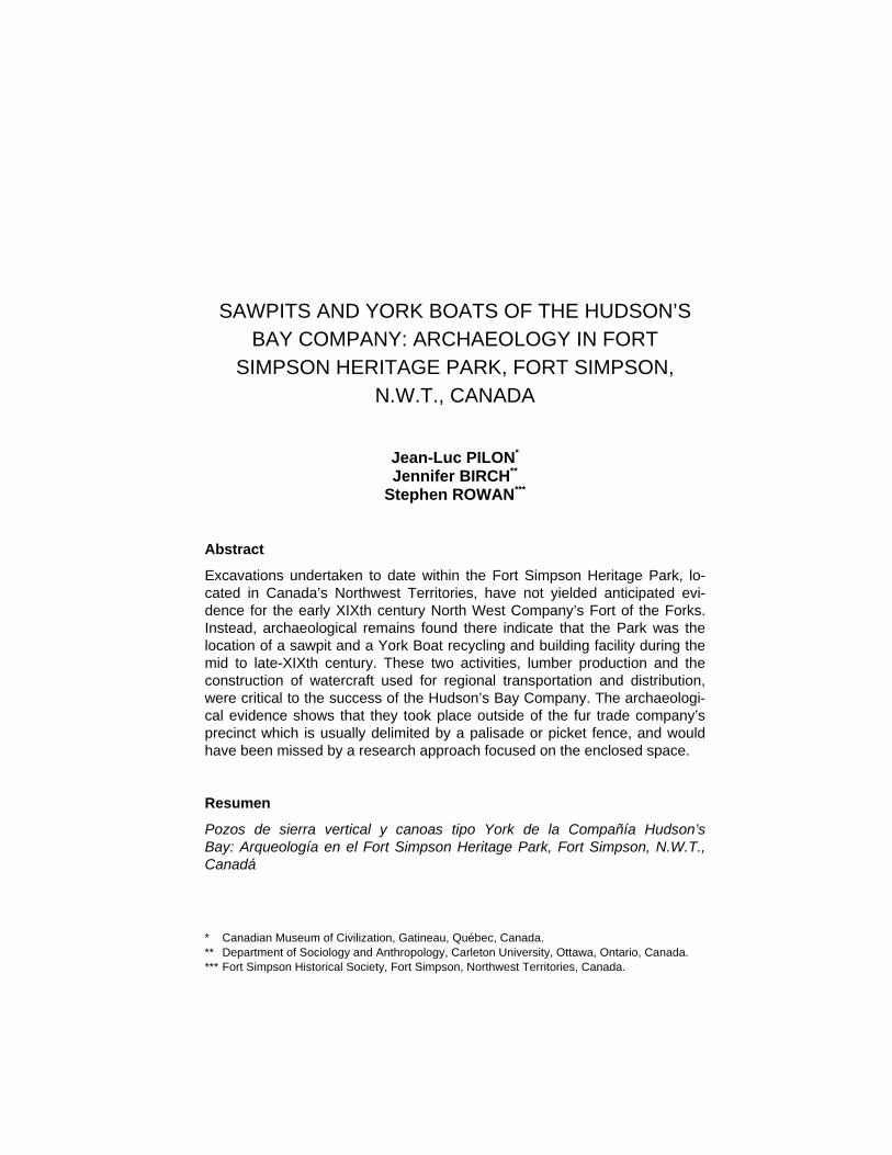
Figure 1. Map of Canada showing the locations of Ottawa, Vancouver and Fort Simpson.
Revista de Arqueología Americana No. 23
98
The present article describes the results of recent archaeological investi-gations carried out within the Fort Simpson Heritage Park located in Fort Simpson, Northwest Territories, Canada (Figure 1). That work revealed evi-dence of lumber production, boat building and even agricultural pursuits at this isolated inland post of the Hudson’s Bay Company (HBC) located roughly 500 kilometres south of the Arctic Circle. The archaeological work itself was undertaken in anticipation of develop-ment within the park which could damage heritage resources thought to exist there and as such it was mitigative in nature, not driven by research objec-tives. However, as a result of these investigations, very significant activities, intimately linked to the success of the fur trade enterprise at Fort Simpson, have been documented. This evidence occurred well outside of the fenced-in area that is the usual center of archaeological attention.
Geographic and Environmental Setting
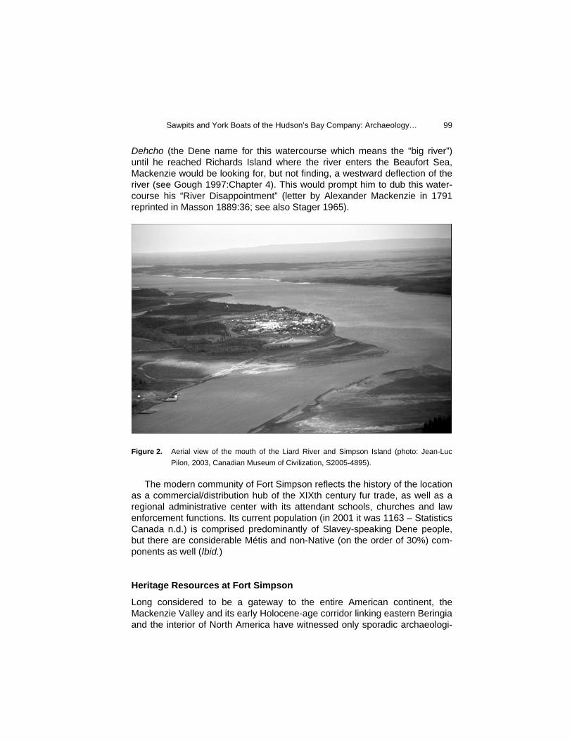
The modern community of Fort Simpson is located on Simpson Island, itself situated on the west side of the Mackenzie River just below its juncture with the Liard River (Figure 2). The landscape in the immediate vicinity of Fort Simpson is generally flat and only slightly undulating, being part of the Mackenzie Plains, an extensive region of interior Taiga Plains, which itself comprises the northern portion of the vast Canadian Interior Plains (Vincent 1989). It is situated between the Canadian Shield to the east and the Cordil-lera to the west (NAC 1993a). Directly west of Fort Simpson is the Mesozoic Nahanni Range and the Mackenzie Mountains further to the northwest. The region surrounding Fort Simpson is underlain by more recent Palaeozoic sedimentary rock, overlain by a thick mantle of later Pleistocene and Holo-cene deposits. Fort Simpson lies within the Boreal Forest, just north of the southern boundary of widespread discontinuous permafrost. Fort Simpson is situated roughly 500 km south of the Arctic Circle, yet the climate is somewhat ame-liorated by proximity to the weather patterns of the north Pacific Ocean. As a result, summer conditions are dominated by the warmer air of the Maritime Polar air mass. Mean daily temperatures in January are between -25º and -30º Celsius while mean daily temperatures in July are in the region of 15º Celsius (NAC 1985). The region receives on the order of 400-600 mm per year with the greatest proportion of that moisture falling during the summer months (NAC 1991). The immediate vicinity of Fort Simpson is within an area of mixed and coniferous forest types (NAC 1993b). At Fort Simpson, the Mackenzie River flows in a west by northwesterly direction. However, a bit further downstream, the river takes a marked turn northward, a fact that did not escape Alexander Mackenzie, the first recorded Europeans traveller to the region, in 1789. For the rest of his trip on the
Sawpits and York Boats of the Hudson’s Bay Company: Archaeology…
99
Dehcho (the Dene name for this watercourse which means the “big river”) until he reached Richards Island where the river enters the Beaufort Sea, Mackenzie would be looking for, but not finding, a westward deflection of the river (see Gough 1997:Chapter 4). This would prompt him to dub this water-course his “River Disappointment” (letter by Alexander Mackenzie in 1791 reprinted in Masson 1889:36; see also Stager 1965).
Figure 2. Aerial view of the mouth of the Liard River and Simpson Island (photo: Jean-Luc
Pilon, 2003, Canadian Museum of Civilization, S2005-4895). The modern community of Fort Simpson reflects the history of the location as a commercial/distribution hub of the XIXth century fur trade, as well as a regional administrative center with its attendant schools, churches and law enforcement functions. Its current population (in 2001 it was 1163 – Statistics Canada n.d.) is comprised predominantly of Slavey-speaking Dene people, but there are considerable Métis and non-Native (on the order of 30%) com-ponents as well (Ibid.)
Heritage Resources at Fort Simpson
Long considered to be a gateway to the entire American continent, the Mackenzie Valley and its early Holocene-age corridor linking eastern Beringia and the interior of North America have witnessed only sporadic archaeologi-
Revista de Arqueología Americana No. 23
100
cal investigations over the course of the last six decades. The first substan-tive introduction to the complex ancient history of the region began with Rich-ard S. MacNeish’s groundbreaking surveys along the second longest waterway of the North American continent, the Mackenzie River, in 1949, 1950 and 1951 (MacNeish 1951, 1953). During those field seasons, MacNeish identified and recorded sites that to this day are considered hall-marks of the ancient history of far north-western Canada and have come to embody a kind of shorthand employed by archaeologists working in that re-gion when referring to various episodes of prehistory or cultural manifesta-tions. It was during the 1950 field season that MacNeish first introduced the archaeological world to the heritage resources of Fort Simpson, however briefly:
Site 5. At Fort Simpson there evidently were numerous small Indian camps, most of which, I believe, are fairly recent. A few flake side scrapers, an ovoid flint blade, a bilateral harpoon or fish spear, and a bone flesher were found in the town. (MacNeish 1953:25).
With those few words, the archaeological heritage of Fort Simpson would return to its long slumber since, it seemed, there was only recent history to be found there and it was not, apparently, of great interest, at least not to MacNeish and his quest for evidence of the passage of the First Americans (MacNeish 1953:23). Five decades later, in the summer of 2000, Tom Andrews, Territorial Archaeologist with the Prince of Wales Northern Heritage Center in Yellow-knife, Northwest Territories, conducted soil auger testing within the Fort Simpson Heritage Park at the request of the Fort Simpson Historical Soci-ety. It was that organization’s intention to relocate a heritage building (the former Roman Catholic Mission rectory) within the park. They were con-cerned that excavation of a foundation for the building would destroy possi-ble heritage resources that they suspected might be found there. Andrews’ half dozen test holes found enough archaeological remains to warrant addi-tional investigations. While most of these objects related to XIXth and XXth century activities, a new vision of archaeology holds that those artifacts are also of importance as they are often the only witnesses to great chapters of our collective past. Consequently, in 2002 and 2003, Jean-Luc Pilon of the Canadian Museum of Civilization conducted archaeological investigations within the Fort Simpson Heritage Park. The results of those excavations are the subject of the current article as they document events and features which relate to otherwise poorly-known, yet highly significant activities bear-ing on the early to mid-nineteenth century fur trading empire of the Hud-son’s Bay Company.
Sawpits and York Boats of the Hudson’s Bay Company: Archaeology…
101
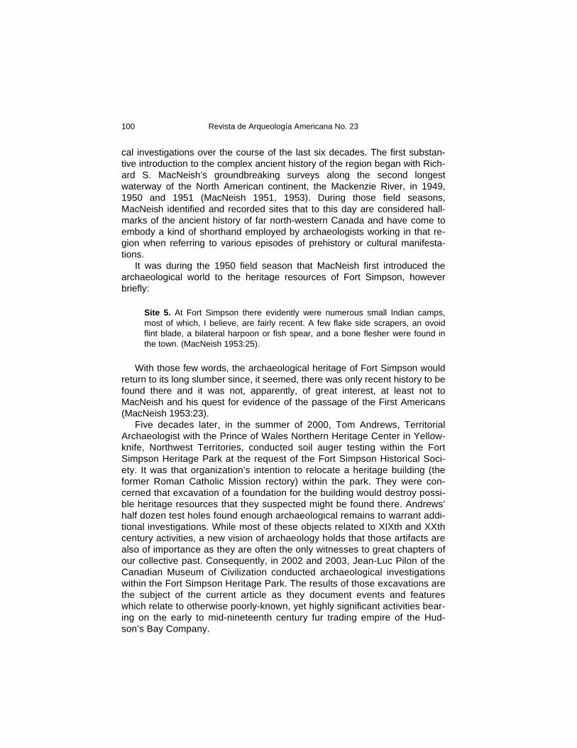
According to the artifact catalogue at the Canadian Museum of Civiliza-tion for MacNeish’s Site 5 (JlRi-1), the exact location of was “on Northern edge of lower terrace just South of Hudson Bay Co.” At the time of his visit to this community, Fort Simpson was predominantly a non-Native commu-nity dominated by the Hudson’s Bay Company, religious institutions (namely the Roman Catholic and Anglican churches) and government ser-vice personnel. The local population was, at that time, still heavily con-nected to the land, spending parts of the summer months on the “Flats” at the south end of Simpson Island, trading their winter furs at the HBC, so-cializing and renewing acquaintances following a long, generally dispersed winter on the land (Fort Simpson Historical Society 2002:3). While the “Flats” is lower than the upper portion of the island where the HBC was established, and thus more prone to seasonal flooding, the summertime occupation of the “Flats” by the Dene precluded concerns of that nature. MacNeish’s Site 5 was located where the people had gathered and set up their canvass tents, their “town” on the “Flats” (Figure 3). The importance of the “Flats” in the local tradition is attested to by its designation in 2002 as the Edhaa National Historic Site, in recognition of its use by Native people for untold centuries.
Figure 3. Native encampment on the “Flats” at Fort Simpson in1927 (photo: Sacred Heart
Parish/NWT Archives/N-1992-255-0028). Also visible cutting across the foreground with a canoe lying in it is the gully or seasonal stream that flows at the foot of the slope leading to the high terrace and the Fort Simpson Heritage Park.
Revista de Arqueología Americana No. 23
102
Simpson Island as a Fur Trade Centre The historical record at what is today Fort Simpson began in the early XIXth century when the North West Company established the Fort of the Forks, presumably on Simpson Island (see Karamanski 1983 and Stager 1962 for overviews of the development of the fur trade in the Mackenzie Valley). The exact location is currently unknown. In 1821, Willard Ferdinand Wentzel stated that “till in the year 1804 I was sent back to that department and ap-pointed to the charge of the post at the Forks, where Mr. James Porter had wintered the year before and made a return of thirty six Packs of Furs” (Wentzel 1821:359 reprinted in Keith 2001). Regardless of whether the Fort of the Forks was actually built in 1803 or 1804 (Keith 2001:33-34), the post was definitely abandoned after the disastrous winter of 1810/11 when four of the post’s employees died of starvation along with several individuals from the local Native band (Wentzel’s letter dated April 30th, 1811 to Roderic MacKenzie in Masson 1889:106-108). Surviving portions of the journal Wentzel kept while at the Fort of the Forks have recently been published (Keith 2001). These succinct documents provide important glimpses into the architectural elements that comprised the outpost as well as some of the activities that took place there. For example, in addition to a number of dis-tinct buildings, including living quarters, a barn, a warehouse, an icehouse and a privy, there was a garden where they grew cucumbers, potatoes, tur-nips, onions, peas and oats. In those journals, Wentzel also related the intense rivalry between them-selves and the XY Company during the fall of 1804 which resulted in the XY Company leaving under near catastrophic conditions (the “Potties” were re-duced to eaten green skins (Wentzel 1804:194 reprinted in Keith 2001)). While Wentzel relates how “Our little House which facing the Potties & at no farther distance than 18 of My Paces...” (ibid.:187), we know that the building he was referring to was intentionally placed close to them (eight days earlier, Wentzel told how he “Set La Prise & Gregoire about Building a Hut along Side of the Potties...”(ibid:186)), but at an undisclosed location for the pur-pose of intimidating them. This was not the Fort of the Forks itself. After the amalgamation of the North West Company with the Hudson’s Bay Company in 1821, it was decided to re-establish a trading post on Mackenzie’s River at the mouth of the Liard River. Willard Ferdinand Wentzel was chosen to lead the expedition to select the location in 1822. While he sought out an acceptable location elsewhere in the vicinity, he was forced to conclude that the best spot was still on Simpson Island:
July 1st… I was ordered to by McLeod, Chief Factor and manager of Mackenzie River Department to erect buildings for the Establishment of a Post to be hence-forth considered the emporium of the Department… In the afternoon we went to
Sawpits and York Boats of the Hudson’s Bay Company: Archaeology…
103
a small river about 8 miles below this spot to examine whether it might not be a more legible place for building, in which however we were all disappointed. 2nd Tuesday… It was finally settled & agreed upon that the Establishment should be erected on the opposite side of Mackenzies River fronting the site of the Old Fort… 3rd Wednesday… I requested Mr. MacDonald to go over and assertain [sic] the truth [reportedly poor wood supply], which he did, and reported that the [?] account was correct – so that we were obliged to bring back again what had al-ready been taken over. 4th Thursday – Three men were employed most part of the day in bringing back the Packs etc. which have been crossed the day before – 4 men were sent to cut down wood for erecting a House of 50 feet long & 25 broad, a short dis-tance below the site of the old Fort… (HBCA/AM, B.200/A/1 1822/23)
The Hudson’s Bay Company occupied that location until 1962 when its new premises on 100th Street were opened (Stephen Rowan, personal com-munication April, 2005).
Archaeological Stratigraphy – an Overview
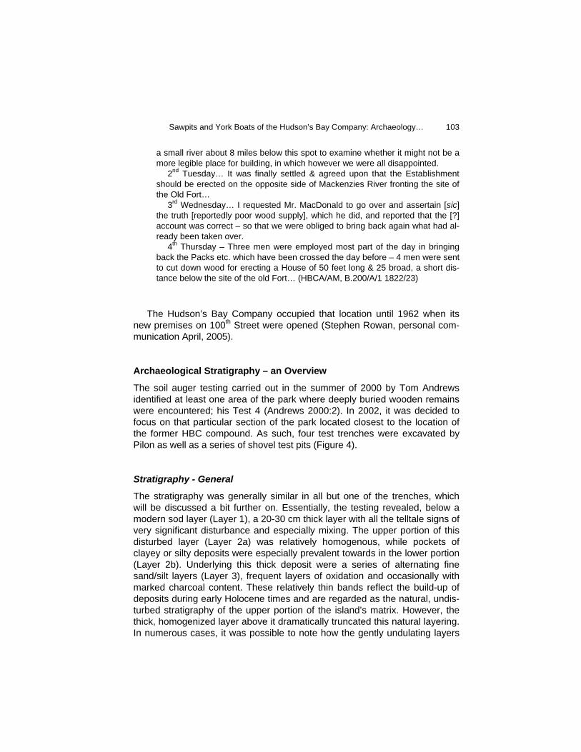
The soil auger testing carried out in the summer of 2000 by Tom Andrews identified at least one area of the park where deeply buried wooden remains were encountered; his Test 4 (Andrews 2000:2). In 2002, it was decided to focus on that particular section of the park located closest to the location of the former HBC compound. As such, four test trenches were excavated by Pilon as well as a series of shovel test pits (Figure 4).
Stratigraphy - General
The stratigraphy was generally similar in all but one of the trenches, which will be discussed a bit further on. Essentially, the testing revealed, below a modern sod layer (Layer 1), a 20-30 cm thick layer with all the telltale signs of very significant disturbance and especially mixing. The upper portion of this disturbed layer (Layer 2a) was relatively homogenous, while pockets of clayey or silty deposits were especially prevalent towards in the lower portion (Layer 2b). Underlying this thick deposit were a series of alternating fine sand/silt layers (Layer 3), frequent layers of oxidation and occasionally with marked charcoal content. These relatively thin bands reflect the build-up of deposits during early Holocene times and are regarded as the natural, undis-turbed stratigraphy of the upper portion of the island’s matrix. However, the thick, homogenized layer above it dramatically truncated this natural layering. In numerous cases, it was possible to note how the gently undulating layers
Revista de Arqueología Americana No. 23
104
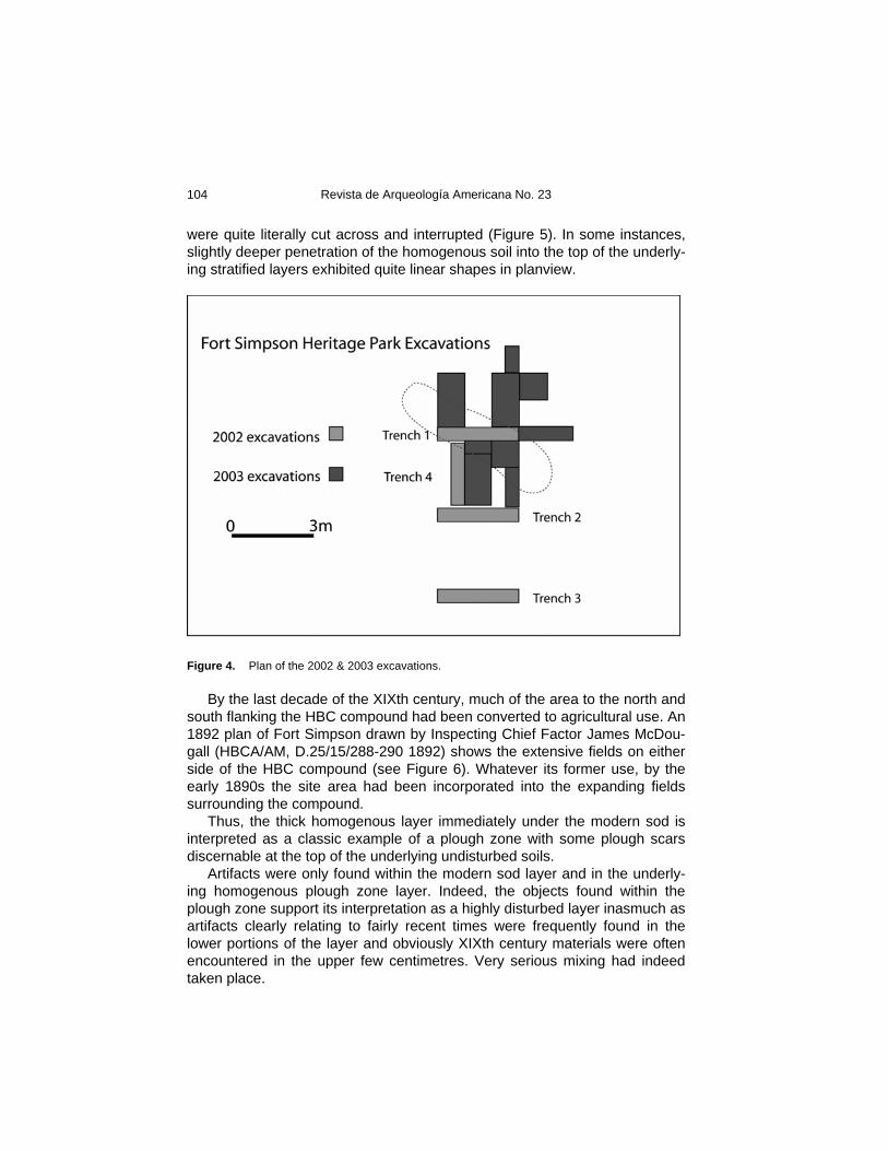
were quite literally cut across and interrupted (Figure 5). In some instances, slightly deeper penetration of the homogenous soil into the top of the underly-ing stratified layers exhibited quite linear shapes in planview.
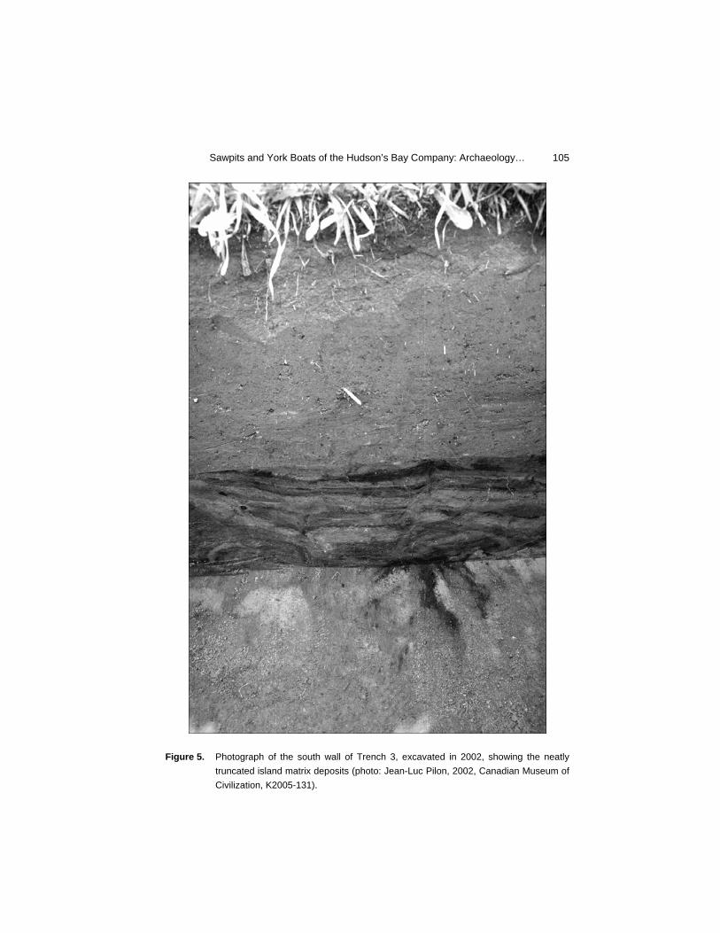
Figure 4. Plan of the 2002 & 2003 excavations. By the last decade of the XIXth century, much of the area to the north and south flanking the HBC compound had been converted to agricultural use. An 1892 plan of Fort Simpson drawn by Inspecting Chief Factor James McDou-gall (HBCA/AM, D.25/15/288-290 1892) shows the extensive fields on either side of the HBC compound (see Figure 6). Whatever its former use, by the early 1890s the site area had been incorporated into the expanding fields surrounding the compound. Thus, the thick homogenous layer immediately under the modern sod is interpreted as a classic example of a plough zone with some plough scars discernable at the top of the underlying undisturbed soils. Artifacts were only found within the modern sod layer and in the underly-ing homogenous plough zone layer. Indeed, the objects found within the plough zone support its interpretation as a highly disturbed layer inasmuch as artifacts clearly relating to fairly recent times were frequently found in the lower portions of the layer and obviously XIXth century materials were often encountered in the upper few centimetres. Very serious mixing had indeed taken place.
Sawpits and York Boats of the Hudson’s Bay Company: Archaeology…
105
Figure 5. Photograph of the south wall of Trench 3, excavated in 2002, showing the neatly
truncated island matrix deposits (photo: Jean-Luc Pilon, 2002, Canadian Museum of Civilization, K2005-131).
Revista de Arqueología Americana No. 23
106
It may initially be difficult to accept that agricultural pursuits can be suc-cessfully undertaken at this latitude (approximately 61º North). However, it is important to remember that while the length of the growing season in the Fort Simpson area is short (between 100 and 120 frost free days annually (NAC 1981)), the number of hours of daylight is much greater because of the lati-tude and so the amount of sunlight received is more significant than in areas further south (on June 21, Fort Simpson experiences about 19.5 hours of daylight (NAC 1987). In fact, there is a long tradition of gardening in the entire Mackenzie Valley extending as far as the Mackenzie Delta itself, well beyond the Arctic Circle, where gardens were cultivated in the early XXth century. These plots provided the local missions with critical supplies of fresh produce (personal communication from several residents of the Mackenzie Delta re-gion between 1985 and 1993) at a time when no roads linked region to southern farms and air links were rare and expensive (see MacKinnon 1982).
Figure 6. 1892 sketch plan by Inspecting Chief Factor James McDougall of Fort Simpson
showing the extensive fields on either side of the Hudson’s Bay Company compound (courtesy Hudson’s Bay Company Archives/Archives of Manitoba).
Stratigraphy within the Feature
As alluded to above, there was one trench which yielded a markedly more complex stratigraphic profile. In this particular unit, Trench 1, the anticipated bottom of the plough zone did not materialize at the expected depth. Instead, the clearly disturbed and mixed layer (Layer 2b) continued to a depth on the order of 50-60 cm from the surface with no significant differentiation. How-
Sawpits and York Boats of the Hudson’s Bay Company: Archaeology…
107
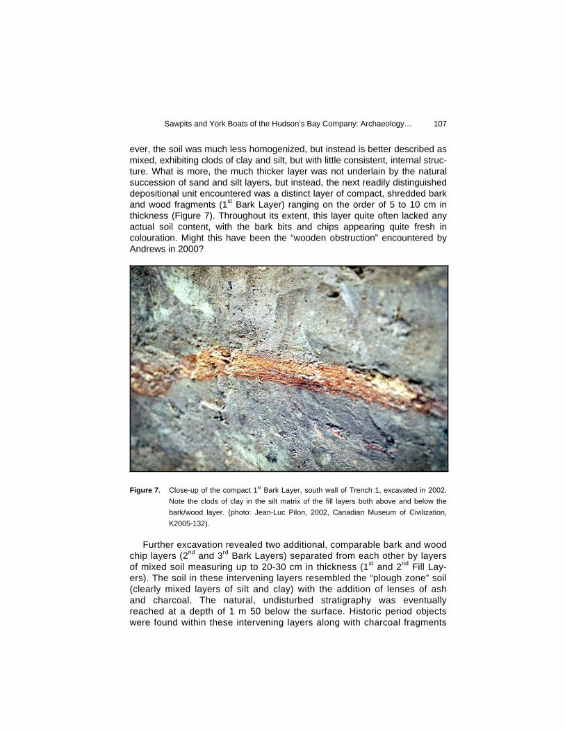
ever, the soil was much less homogenized, but instead is better described as mixed, exhibiting clods of clay and silt, but with little consistent, internal struc-ture. What is more, the much thicker layer was not underlain by the natural succession of sand and silt layers, but instead, the next readily distinguished depositional unit encountered was a distinct layer of compact, shredded bark and wood fragments (1st Bark Layer) ranging on the order of 5 to 10 cm in thickness (Figure 7). Throughout its extent, this layer quite often lacked any actual soil content, with the bark bits and chips appearing quite fresh in colouration. Might this have been the “wooden obstruction” encountered by Andrews in 2000?
Figure 7. Close-up of the compact 1st Bark Layer, south wall of Trench 1, excavated in 2002.
Note the clods of clay in the silt matrix of the fill layers both above and below the bark/wood layer. (photo: Jean-Luc Pilon, 2002, Canadian Museum of Civilization, K2005-132).
Further excavation revealed two additional, comparable bark and wood chip layers (2nd and 3rd Bark Layers) separated from each other by layers of mixed soil measuring up to 20-30 cm in thickness (1st and 2nd Fill Lay-ers). The soil in these intervening layers resembled the “plough zone” soil (clearly mixed layers of silt and clay) with the addition of lenses of ash and charcoal. The natural, undisturbed stratigraphy was eventually reached at a depth of 1 m 50 below the surface. Historic period objects were found within these intervening layers along with charcoal fragments
Revista de Arqueología Americana No. 23
108
and faunal remains. However, it is noteworthy that no clearly XXth century artifacts were encountered within the uppermost bark layer nor in the deeper layers. In 2003, the objective of the excavations was to further delineate the deep feature found in 2002, and to identify its function. As such, a number of units were opened which allowed further definition of the feature’s shape and ex-tents. Shovel tests were also employed to obtain complementary information when time did not permit further excavations. These excavations allowed us to determine that the feature consists es-sentially of an infilled, long (6.5 m), narrow (1.5 m) and deep (1.5 m) trench (Figure 4). Furthermore, we confirmed the extensive nature of the bark/wood layers throughout the trench, although the thickness and distinctiveness of these layers varied in the different units.
Relating the Trench Layers – Artifact Refitting
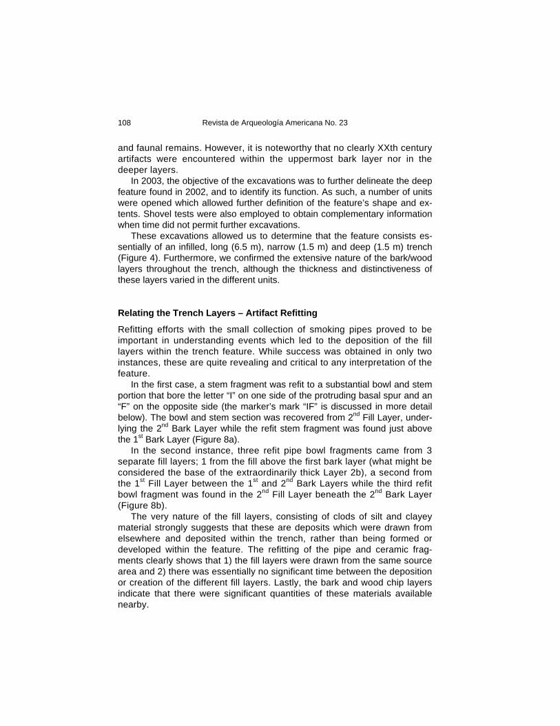
Refitting efforts with the small collection of smoking pipes proved to be important in understanding events which led to the deposition of the fill layers within the trench feature. While success was obtained in only two instances, these are quite revealing and critical to any interpretation of the feature. In the first case, a stem fragment was refit to a substantial bowl and stem portion that bore the letter “I” on one side of the protruding basal spur and an “F” on the opposite side (the marker’s mark “IF” is discussed in more detail below). The bowl and stem section was recovered from 2nd Fill Layer, under-lying the 2nd Bark Layer while the refit stem fragment was found just above the 1st Bark Layer (Figure 8a). In the second instance, three refit pipe bowl fragments came from 3 separate fill layers; 1 from the fill above the first bark layer (what might be considered the base of the extraordinarily thick Layer 2b), a second from the 1st Fill Layer between the 1st and 2nd Bark Layers while the third refit bowl fragment was found in the 2nd Fill Layer beneath the 2nd Bark Layer (Figure 8b). The very nature of the fill layers, consisting of clods of silt and clayey material strongly suggests that these are deposits which were drawn from elsewhere and deposited within the trench, rather than being formed or developed within the feature. The refitting of the pipe and ceramic frag-ments clearly shows that 1) the fill layers were drawn from the same source area and 2) there was essentially no significant time between the deposition or creation of the different fill layers. Lastly, the bark and wood chip layers indicate that there were significant quantities of these materials available nearby.
Sawpits and York Boats of the Hudson’s Bay Company: Archaeology…
109
Figure 8. Refit kaolin pipe fragments: a) the bowl and stem fragment on the left (JlRi-7:1469)
was recovered from the 2nd Bark Layer while the refit stem fragment on the right (JlRi-7:1266) was found at the base of the plough zone/mixed layer overlying the 1st Bark Layer, b) the bottom right fragment (JlRi-7:1481) was recovered from the fill layer above the 1st Bark Layer, the long bowl fragment on the left (JlRi-7:1418) was found in the fill layer under the 1st Bark Layer while the topmost piece (JlRi-7:1548) was found in 2nd Fill Layer (photo: Jean-Luc Pilon, 2005, Canadian Museum of Civili-zation, D2005-22274).
Possible Interpretations of the Trench Feature
It has been proposed that most of the fill layers within the trench are actually disturbed archaeological deposits scraped into the open feature. The trench itself is an artifact that requires interpretation and several possibilities initially present themselves. The more salient ones are addressed below.
Trench as Grave(s)
Earlier in this article, the grim events of the winter of 1810/11 that led to the abandonment of the North West Company Fort of the Forks, were recounted. The death by starvation of four people at the trading establishment must have been very difficult for the survivors to witness. The decision to abandon the site could not have been easy. But what happened to the bodies of the vic-tims? An initial consideration would allow that an already existing trench fea-ture could have been used to eventually bury the deceased once the snow had melted and the ground had thawed. Similarly, graves could have been dug. However, no human bones were found.
Revista de Arqueología Americana No. 23
110
Trench as Cellar
The Fort of the Forks journal kept by Willard Ferdinand Wentzel contains significant references to features that might explain the trench encountered in the Fort Simpson Heritage Park excavations. For example, on September 17, 1805 Wentzel points out that “Got all our Garden Ware in the Cellar for the Weather begins to get very cold…” (Keith 2001:291). Other references to a facility for storing vegetables and other garden produce are also found. Such a cellar would more than likely be located under the floor of a post dwelling. In this way, the produce would not freeze solid, thereby allowing its retrieval during the winter (it wouldn’t be frozen together) and preserving some fresh-ness that would be destroyed by freezing solid. Such interior cellars are common features in fur trade sites and consist of fairly shallow, oval to circular features commonly reinforced with wooden frames to prevent caving in of the walls (see for example Kidd 1970 for Fort George, Alberta, Janes 1974 for Fort Alexander, N.W.T., Steer 1977 at Lac La Loche, Saskatchewan and Steer and Rogers 1976 for Rocky Mountain House). They are usually situated near the hearth, again with the likely pur-pose to delaying hard freezing from occurring. At Fort Simpson, the plough zone has destroyed any evidence of a structure that could have covered the trench. However, its shape is quite different from known examples of cold cellars and further, there was no suggestion of attempts to shore-up the walls of the feature to prevent erosion or collapse.
Trench as Ice House
In addition to cold cellars for the storage of garden produce, there are refer-ences to the construction at the Fort of the Forks of an ice house. Such a structure would, of course, be located outside of a dwelling. On October 21, 1807, Wentzel noted that “Gibeau & Tremp squaring wood for the Ice House - Dug out 9 feet long 4 ½ broad & 5 ½ feet deep in the earth.” (Keith 2001:315). The next day, he mentioned that the ice house floor was installed. While the dimensions of the pit itself are interesting in that they described a narrow, long and deep trench, the Heritage Park trench is more than twice the length of Gibeau’s ice house pit. Further, there was absolutely no evi-dence of a wooden floor in the Heritage Park trench. As such, the ice house interpretation is not substantiated by the archaeological evidence.
Trench as Garbage Pit
The disposal of refuse is handled differently by various cultures. Among the many ways of ridding oneself of unwanted items is burial in pits, either spe-
Sawpits and York Boats of the Hudson’s Bay Company: Archaeology…
111
cially excavated for this purpose or not. The Heritage Park trench is a rather poor candidate for a refuse pit. While its depth is certainly adequate to con-tain a large quantity of refuse, it is difficult to understand why the feature would have been so relatively narrow and long. However, the best argument against its use as a refuse pit is the fact that the highest artifact densities are in the upper plough zone and not within the in situ trench layers themselves. In fact, the density of artifacts within the trench layers is quite low with the exception of the northwest portion of the excavated area that contained a very high incidence of boat rivets and other hardware. Lastly, the shredded bark/wood chips layers are relatively consistent across the length and width of the trench, attesting to distinct, structured and intentional deposition rather than the chaotic juxtaposition of all manner of artifacts that would be ex-pected in a refuse pit. The refitting of clay pipe fragments (see below) strongly indicate an infilling within a brief span of time.
Trench as Semi-Subterranean Dwelling
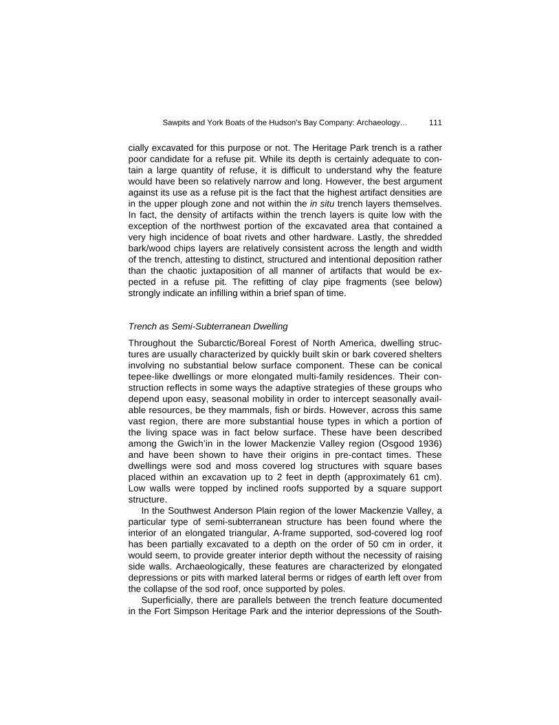
Throughout the Subarctic/Boreal Forest of North America, dwelling struc-tures are usually characterized by quickly built skin or bark covered shelters involving no substantial below surface component. These can be conical tepee-like dwellings or more elongated multi-family residences. Their con-struction reflects in some ways the adaptive strategies of these groups who depend upon easy, seasonal mobility in order to intercept seasonally avail-able resources, be they mammals, fish or birds. However, across this same vast region, there are more substantial house types in which a portion of the living space was in fact below surface. These have been described among the Gwich’in in the lower Mackenzie Valley region (Osgood 1936) and have been shown to have their origins in pre-contact times. These dwellings were sod and moss covered log structures with square bases placed within an excavation up to 2 feet in depth (approximately 61 cm). Low walls were topped by inclined roofs supported by a square support structure. In the Southwest Anderson Plain region of the lower Mackenzie Valley, a particular type of semi-subterranean structure has been found where the interior of an elongated triangular, A-frame supported, sod-covered log roof has been partially excavated to a depth on the order of 50 cm in order, it would seem, to provide greater interior depth without the necessity of raising side walls. Archaeologically, these features are characterized by elongated depressions or pits with marked lateral berms or ridges of earth left over from the collapse of the sod roof, once supported by poles. Superficially, there are parallels between the trench feature documented in the Fort Simpson Heritage Park and the interior depressions of the South-
Revista de Arqueología Americana No. 23
112
west Anderson Plain semi-subterranean structures (which undoubtedly ex-isted in neighbouring regions as well). However, those of the Southwest Anderson Plain only rarely exceed 4 metres in length and are usually in ex-cess of 2 metres in width (Pilon 1991). One particularly large example (NbTj-8, Hyndman Lake) used quite substantial logs in the construction of the roof. While artifacts are few within the depressions, they are present and include the remains of spruce bough flooring, faunal remains, as well as the remains birch bark baskets and trays. Quite often hearth features are documented at the ends of the depressions and these contain numerous fire-cracked rock fragments, calcined bone and charcoal. The Fort Simpson Heritage Park trench appears much too narrow for its length to be considered similar to the Southwest Anderson Plain features. Indications of flooring are absent. Objects which can be generally associated with a Native use of the trench are limited to a single piece. A complete, thin, bifacially edge bevelled red slate implement (a knife for want of any better descriptor) was found in the very bottom of the trench near its eastern ex-tremity. Along with the stone tool were two thin pieces of tin-plated ferrous sheet metal and a thin piece of cuprous sheet metal. Additionally, there was no indication of a hearth feature at the ends of the trench, although it is acknowledged that the ends were not fully investigated. Thus, the resemblance between the two types of features is, at this point, limited.
Trench as Sawpit
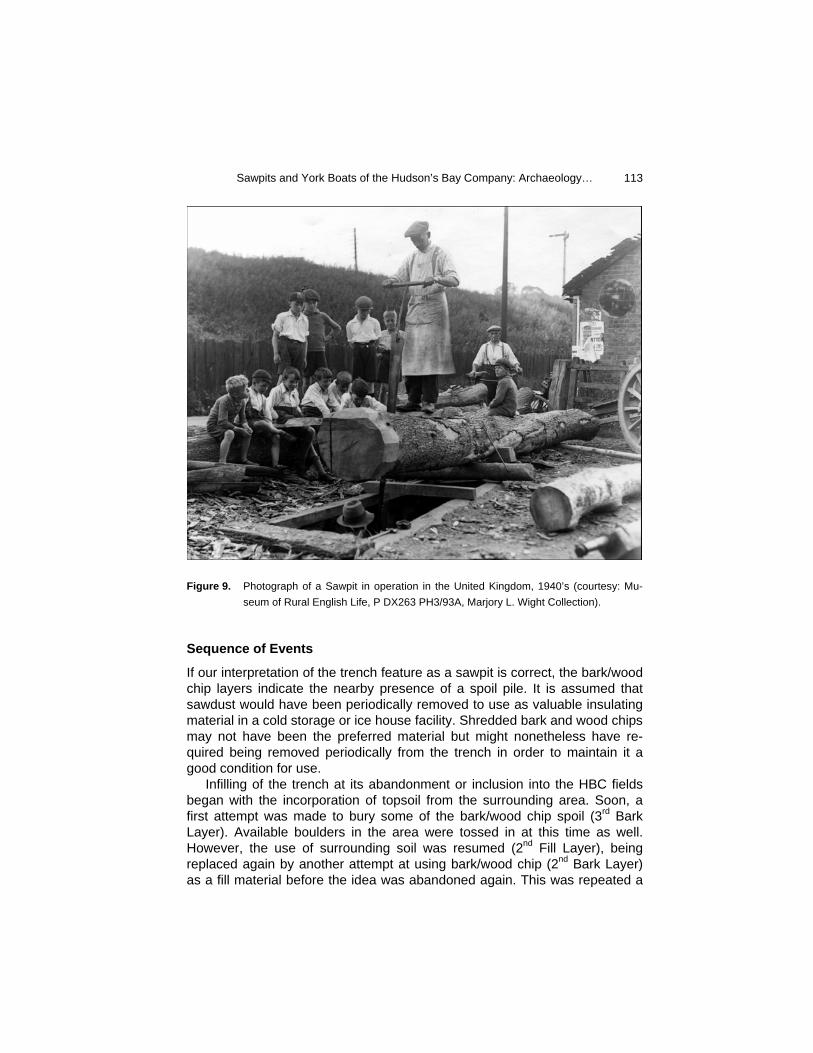
A sawpit is simply a device which lowers one of the two individuals operating a whipsaw, into a hole or trench in order to facilitate transferring logs and lumber to and from the support structure. In this manner less energy is re-quired to hoist the heavy pieces of wood onto and off of the platform (Figure 9). As such, a sawpit is nothing more than a hole in the ground. No shoring is necessarily required and no distinctive set of artifacts are to be expected from their manufacture and use, although one would not be surprised by the dis-covery of tools used in the sawing process, sharpening of the saws as well as personal items discarded or lost by the workmen. By a process of elimination, the most parsimonious explanation of the nature of the trench feature in the Fort Simpson Heritage Park is that it origi-nally functioned as a sawpit. It is long and narrow, allowing the workmen to move as the sawing progresses rather than periodically moving the lumber. Its depth on the order of 1.5 metres below surface would result in a platform no more than a metre or so being required above ground. This would provide a safe working height and one easily attained from ground level when placing a log on to the support structure.
Sawpits and York Boats of the Hudson’s Bay Company: Archaeology…
113
Figure 9. Photograph of a Sawpit in operation in the United Kingdom, 1940’s (courtesy: Mu-
seum of Rural English Life, P DX263 PH3/93A, Marjory L. Wight Collection).
Sequence of Events
If our interpretation of the trench feature as a sawpit is correct, the bark/wood chip layers indicate the nearby presence of a spoil pile. It is assumed that sawdust would have been periodically removed to use as valuable insulating material in a cold storage or ice house facility. Shredded bark and wood chips may not have been the preferred material but might nonetheless have re-quired being removed periodically from the trench in order to maintain it a good condition for use. Infilling of the trench at its abandonment or inclusion into the HBC fields began with the incorporation of topsoil from the surrounding area. Soon, a first attempt was made to bury some of the bark/wood chip spoil (3rd Bark Layer). Available boulders in the area were tossed in at this time as well. However, the use of surrounding soil was resumed (2nd Fill Layer), being replaced again by another attempt at using bark/wood chip (2nd Bark Layer) as a fill material before the idea was abandoned again. This was repeated a
Revista de Arqueología Americana No. 23
114
third time (1st Bark Layer) before the largest deposit of mixed soil (Layer 2b) was laid down which essentially completed the infilling process. Refitting of artifacts shows that this infilling likely occurred over a brief time, perhaps as quickly as over the course of a day or two. The final stage in the preparation for use of the area for agricultural purposes was the deep ploughing in order to remove surface irregularities which may have risen above the grade and using the excess to fill in the trench and level off the entire area.
Artifacts
From the Plough Zone
Earlier it was established that at one time the site area was subjected to ex-tensive and deep ploughing, somewhere on the order of 40-50 cm. This mix-ing resulted in artifacts obviously associated with XIXth century contexts being encountered relatively close to the surface and XXth century artifacts being found buried relatively deeper in the plough zone. Clearly, surface fea-tures that predated the use of the area as a ploughed field have long since been obliterated and their associated artifacts displaced. The usefulness of analysing artifacts from the plough zone should not, however, be dismissed. If items can be found in the plough zone that can be linked with the early XIXth century North West Company occupation, this may help us to narrow the search for the location of the remains of the Fort of the Forks because, as pointed out earlier, there were several structural features at that North West Company post which should have survived even deep ploughing, such as privies, cellars and an icehouse. The presence of one chert flake and one retouched scraper made of Ter-tiary Hills welded tuff (Cinq-Mars 1973) in the assemblage from the plough zone hint at the pre-contact occupation of Simpson Island. The material from the plough zone also helps to establish a useful range of functions and chro-nology for the occupations of this part of Simpson Island. However, given the extensive mixing in the upper layers of the site, and our interest in identifying the nature of the trench, we will focus on the artifacts recovered from the trench feature.
From the Trench Layers
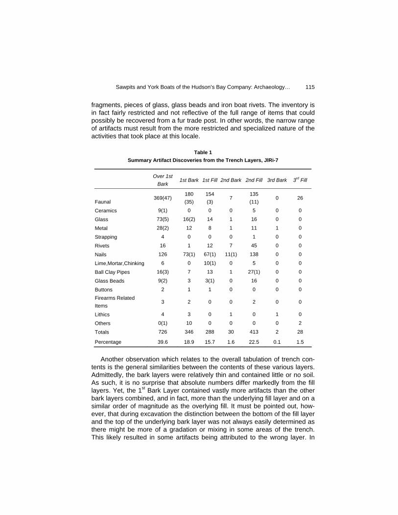
The artifacts found below the plough zone have been grouped together in Table 1 in order to ease their presentation. By far the largest artifact category found within fill and bark layers is faunal remains, followed closely by nails. Secondary categories include kaolin pipe fragments, miscellaneous metal
Sawpits and York Boats of the Hudson’s Bay Company: Archaeology…
115
fragments, pieces of glass, glass beads and iron boat rivets. The inventory is in fact fairly restricted and not reflective of the full range of items that could possibly be recovered from a fur trade post. In other words, the narrow range of artifacts must result from the more restricted and specialized nature of the activities that took place at this locale.
Table 1 Summary Artifact Discoveries from the Trench Layers, JlRi-7
Another observation which relates to the overall tabulation of trench con-tents is the general similarities between the contents of these various layers. Admittedly, the bark layers were relatively thin and contained little or no soil. As such, it is no surprise that absolute numbers differ markedly from the fill layers. Yet, the 1st Bark Layer contained vastly more artifacts than the other bark layers combined, and in fact, more than the underlying fill layer and on a similar order of magnitude as the overlying fill. It must be pointed out, how-ever, that during excavation the distinction between the bottom of the fill layer and the top of the underlying bark layer was not always easily determined as there might be more of a gradation or mixing in some areas of the trench. This likely resulted in some artifacts being attributed to the wrong layer. In
Over 1st
Bark 1st Bark 1st Fill 2nd Bark 2nd Fill 3rd Bark 3rd Fill
Faunal 369(47)
180 (35)
154 (3)
7 135 (11)
0 26
Ceramics 9(1) 0 0 0 5 0 0
Glass 73(5) 16(2) 14 1 16 0 0
Metal 28(2) 12 8 1 11 1 0
Strapping 4 0 0 0 1 0 0
Rivets 16 1 12 7 45 0 0
Nails 126 73(1) 67(1) 11(1) 138 0 0
Lime,Mortar,Chinking 6 0 10(1) 0 5 0 0
Ball Clay Pipes 16(3) 7 13 1 27(1) 0 0
Glass Beads 9(2) 3 3(1) 0 16 0 0
Buttons 2 1 1 0 0 0 0 Firearms Related Items
3 2 0 0 2 0 0
Lithics 4 3 0 1 0 1 0
Others 0(1) 10 0 0 0 0 2
Totals 726 346 288 30 413 2 28
Percentage 39.6 18.9 15.7 1.6 22.5 0.1 1.5
Revista de Arqueología Americana No. 23
116
spite of these caveats, it is clear that faunal remains, glass and nails are the most common elements in all but the last two trench layers (the bottom 2 layers: 3rd Bark and 3rd Fill). While most of the artifacts are relatively non-descript, a number of these warrant particular description as they seem to relate to activities that took place nearby, and as such act as proxy data for this now destroyed portion of the site.
Boat Building
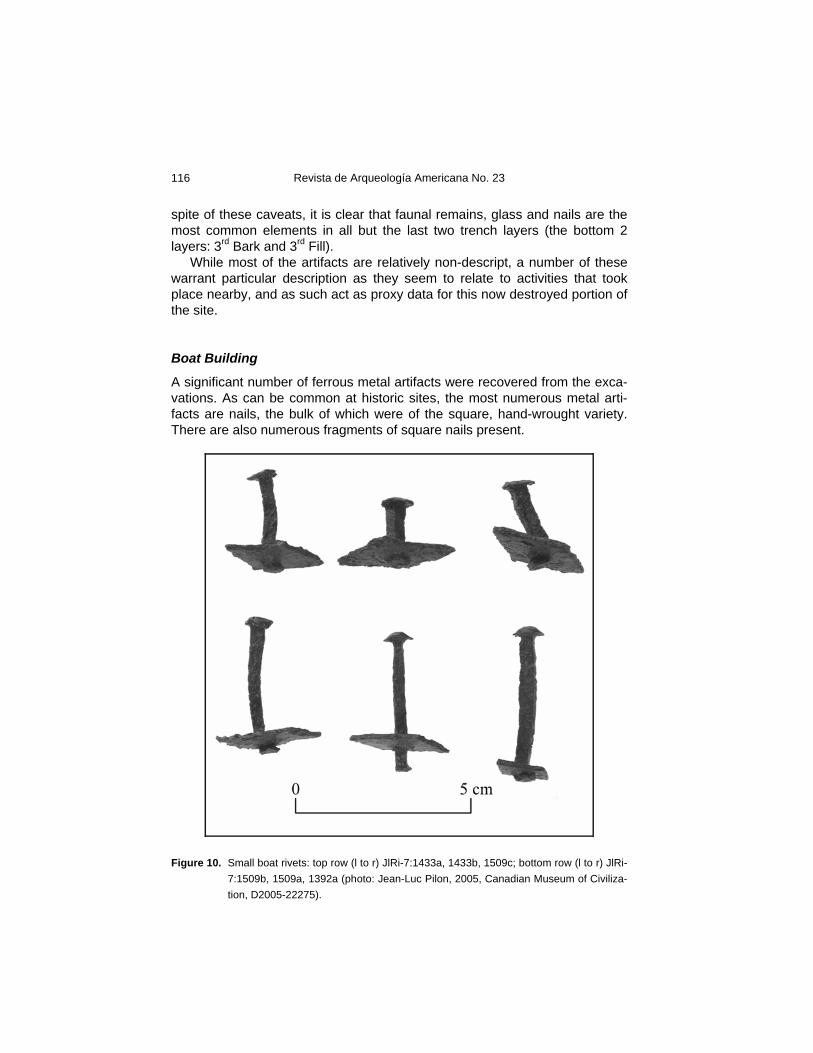
A significant number of ferrous metal artifacts were recovered from the exca-vations. As can be common at historic sites, the most numerous metal arti-facts are nails, the bulk of which were of the square, hand-wrought variety. There are also numerous fragments of square nails present.
Figure 10. Small boat rivets: top row (l to r) JlRi-7:1433a, 1433b, 1509c; bottom row (l to r) JlRi-
7:1509b, 1509a, 1392a (photo: Jean-Luc Pilon, 2005, Canadian Museum of Civiliza-tion, D2005-22275).
Sawpits and York Boats of the Hudson’s Bay Company: Archaeology…
117
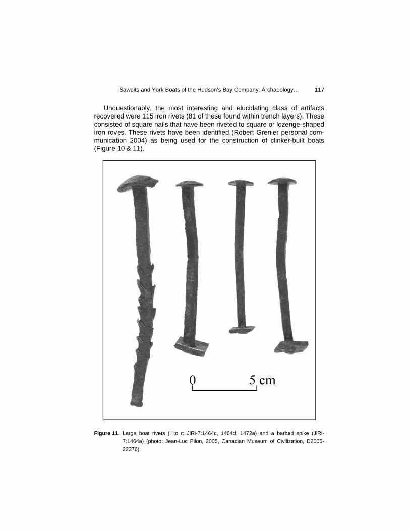
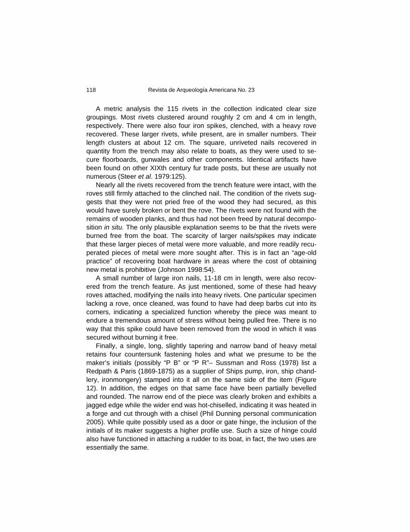
Unquestionably, the most interesting and elucidating class of artifacts recovered were 115 iron rivets (81 of these found within trench layers). These consisted of square nails that have been riveted to square or lozenge-shaped iron roves. These rivets have been identified (Robert Grenier personal com-munication 2004) as being used for the construction of clinker-built boats (Figure 10 & 11).
Figure 11. Large boat rivets (l to r: JlRi-7:1464c, 1464d, 1472a) and a barbed spike (JlRi-
7:1464a) (photo: Jean-Luc Pilon, 2005, Canadian Museum of Civilization, D2005-22276).
Revista de Arqueología Americana No. 23
118
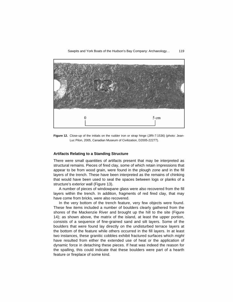
A metric analysis the 115 rivets in the collection indicated clear size groupings. Most rivets clustered around roughly 2 cm and 4 cm in length, respectively. There were also four iron spikes, clenched, with a heavy rove recovered. These larger rivets, while present, are in smaller numbers. Their length clusters at about 12 cm. The square, unriveted nails recovered in quantity from the trench may also relate to boats, as they were used to se-cure floorboards, gunwales and other components. Identical artifacts have been found on other XIXth century fur trade posts, but these are usually not numerous (Steer et al. 1979:125). Nearly all the rivets recovered from the trench feature were intact, with the roves still firmly attached to the clinched nail. The condition of the rivets sug-gests that they were not pried free of the wood they had secured, as this would have surely broken or bent the rove. The rivets were not found with the remains of wooden planks, and thus had not been freed by natural decompo-sition in situ. The only plausible explanation seems to be that the rivets were burned free from the boat. The scarcity of larger nails/spikes may indicate that these larger pieces of metal were more valuable, and more readily recu-perated pieces of metal were more sought after. This is in fact an “age-old practice” of recovering boat hardware in areas where the cost of obtaining new metal is prohibitive (Johnson 1998:54). A small number of large iron nails, 11-18 cm in length, were also recov-ered from the trench feature. As just mentioned, some of these had heavy roves attached, modifying the nails into heavy rivets. One particular specimen lacking a rove, once cleaned, was found to have had deep barbs cut into its corners, indicating a specialized function whereby the piece was meant to endure a tremendous amount of stress without being pulled free. There is no way that this spike could have been removed from the wood in which it was secured without burning it free. Finally, a single, long, slightly tapering and narrow band of heavy metal retains four countersunk fastening holes and what we presume to be the maker’s initials (possibly “P B” or “P R”– Sussman and Ross (1978) list a Redpath & Paris (1869-1875) as a supplier of Ships pump, iron, ship chand-lery, ironmongery) stamped into it all on the same side of the item (Figure 12). In addition, the edges on that same face have been partially bevelled and rounded. The narrow end of the piece was clearly broken and exhibits a jagged edge while the wider end was hot-chiselled, indicating it was heated in a forge and cut through with a chisel (Phil Dunning personal communication 2005). While quite possibly used as a door or gate hinge, the inclusion of the initials of its maker suggests a higher profile use. Such a size of hinge could also have functioned in attaching a rudder to its boat, in fact, the two uses are essentially the same.
Sawpits and York Boats of the Hudson’s Bay Company: Archaeology…
119
Figure 12. Close-up of the initials on the rudder iron or strap hinge (JlRi-7:1536) (photo: Jean-
Luc Pilon, 2005, Canadian Museum of Civilization, D2005-22277).
Artifacts Relating to a Standing Structure
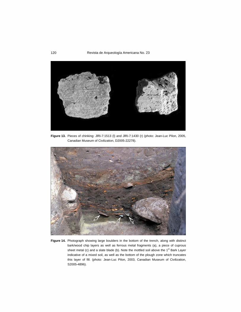
There were small quantities of artifacts present that may be interpreted as structural remains. Pieces of fired clay, some of which retain impressions that appear to be from wood grain, were found in the plough zone and in the fill layers of the trench. These have been interpreted as the remains of chinking that would have been used to seal the spaces between logs or planks of a structure’s exterior wall (Figure 13). A number of pieces of windowpane glass were also recovered from the fill layers within the trench. In addition, fragments of red fired clay, that may have come from bricks, were also recovered. In the very bottom of the trench feature, very few objects were found. These few items included a number of boulders clearly gathered from the shores of the Mackenzie River and brought up the hill to the site (Figure 14); as shown above, the matrix of the island, at least the upper portion, consists of a sequence of fine-grained sand and silt layers. Some of the boulders that were found lay directly on the undisturbed terrace layers at the bottom of the feature while others occurred in the fill layers. In at least two instances, these granitic cobbles exhibit fractured surfaces which might have resulted from either the extended use of heat or the application of dynamic force in detaching these pieces. If heat was indeed the reason for the spalling, this could indicate that these boulders were part of a hearth feature or fireplace of some kind.
Revista de Arqueología Americana No. 23
120
Figure 13. Pieces of chinking: JlRi-7:1513 (l) and JlRi-7:1430 (r) (photo: Jean-Luc Pilon, 2005,
Canadian Museum of Civilization, D2005-22278).
Figure 14. Photograph showing large boulders in the bottom of the trench, along with distinct
bark/wood chip layers as well as ferrous metal fragments (a), a piece of cuprous sheet metal (c) and a slate blade (b). Note the mottled soil above the 1st Bark Layer indicative of a mixed soil, as well as the bottom of the plough zone which truncates this layer of fill. (photo: Jean-Luc Pilon, 2003, Canadian Museum of Civilization, S2005-4896).
Sawpits and York Boats of the Hudson’s Bay Company: Archaeology…
121
Evidence for a Blacksmith
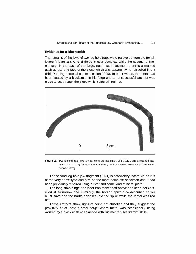
The remains of the jaws of two leg-hold traps were recovered from the trench layers (Figure 15). One of these is near complete while the second is frag-mentary. In the case of the large, near-intact specimen, there is a marked gash across one face of the piece which was apparently hot-chiselled into it (Phil Dunning personal communication 2005). In other words, the metal had been heated by a blacksmith in his forge and an unsuccessful attempt was made to cut through the piece while it was still red hot.
Figure 15. Two leghold trap jaws (a near-complete specimen, JlRi-7:1131 and a repaired frag-
ment, JlRi-7:1021) (photo: Jean-Luc Pilon, 2005, Canadian Museum of Civilization, D2005-22270).
The second leg-hold jaw fragment (1021) is noteworthy inasmuch as it is of the very same type and size as the more complete specimen and it had been previously repaired using a rivet and some kind of metal plate. The long strap hinge or rudder iron mentioned above has been hot chis-elled at its narrow end. Similarly, the barbed spike also described earlier must have had the barbs chiselled into the spike while the metal was red hot. These artifacts show signs of being hot chiselled and they suggest the proximity of at least a small forge where metal was occasionally being worked by a blacksmith or someone with rudimentary blacksmith skills.
Revista de Arqueología Americana No. 23
122
Miscellaneous
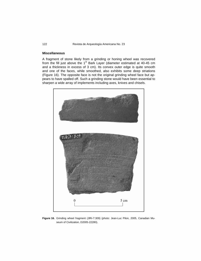
A fragment of stone likely from a grinding or honing wheel was recovered from the fill just above the 1st Bark Layer (diameter estimated at 40-45 cm and a thickness in excess of 3 cm). Its convex outer edge is quite smooth and one of the faces, while smoothed, also exhibits some deep striations (Figure 16). The opposite face is not the original grinding wheel face but ap-pears to have spalled off. Such a grinding stone would have been essential to sharpen a wide array of implements including axes, knives and chisels.
Figure 16. Grinding wheel fragment (JlRi-7:309) (photo: Jean-Luc Pilon, 2005, Canadian Mu-
seum of Civilization, D2005-22280).
Sawpits and York Boats of the Hudson’s Bay Company: Archaeology…
123
An Interpretation of the Artifacts within the Trench Layers
Earlier we concluded that the soil layers within the feature are reworked de-posits scraped into the trench from the surrounding area. As such, the arti-facts contained in the fill layers can be associated with activities that took place in the surrounding area and not directly with the use of the trench fea-ture. The summary descriptions above make it clear that there was a narrow range of activities represented by the artifacts found within the trench fill lay-ers. These seem to relate to efforts to recover useful metal from derelict lap strake or clinker-built boats by burning these. Further, there is indirect evi-dence for the presence of a nearby structure, quite possibly a boat house where new boats were constructed. This building would have included a river cobble fireplace or hearth which apparently was used for limited blacksmith-ing activities.
Chronology
As described earlier, the bark/wood chip layers are quite dense, fairly exten-sive over the length of the trench and well separated from each other by lay-ers of fill which are believed to have been scraped into the trench from elsewhere, most likely the surrounding surface, thus incorporating artifacts from earlier activities. At the same time, it is quite likely that within the trench layers, either in the bark/wood chip layers or in the intervening fill layers, some of the artifacts relate more closely to the occupation or use of the trench feature itself. Distinguishing between these two separate episodes is a challenge, if not virtually impossible. In one unit, a handful of artifacts were found which are also presumed to relate to the period of initial existence of the trench feature, although they lay in what has been interpreted as a fill layer. Two of these were recovered from below the deepest bark/wood chip layer in a tight cluster (Figure 14). These consist of two pieces of tinned ferrous sheet metal. On has been cut into a square shape while the second appears to be from the edge of a container and retains a curved, crimped edge. Found very near these two ferrous sheet metal fragments, but just above the thin layer of bark/wood chips was a piece of cuprous sheet metal, probably from a trade kettle or pot. Finally, among this same cluster of objects was a near-complete ground slate blade. Its is a narrow, elongated and thin piece of red slate with one of the long edges entirely bifacially ground to form a sharp angle. Its characteristics suggest the intended use was as a knife or cutting im-plement. However, this is clearly not the kind of artifact associated with the Hudson’s Bay Company and it is assumed that it is from an earlier Native occupation.
Revista de Arqueología Americana No. 23
124
Firearms Related Artifacts
There are a variety of firearms-related artifacts in the assemblage from the trench, as would be expected at a post where hunting was necessary for survival. There were two percussion caps (JlRi-7:756 and JlRi-7:1269) lo-cated just above the first bark layers, which can date the upper portion of the feature, directly under the ploughed layer, to some time after about 1830 at the earliest, much more likely past the mid-1800’s as flintlock muskets con-tinue to be used until well into the 1870s and later in peripheral regions (Steer et al. 1979:113). At the 1835-1861 Rocky Mountain House excavations, flint-locks were still the only type of firearm in use. Conversely, at the ca. 1874-ca. 1888 Hudson’s Bay Company depot on Methye Portage, while musket balls and shot were found, suggesting the possible presence of muzzle loading muskets, cartridge casings were numerous (Steer 1977), suggesting that the shift to self-contained firearms technology had occurred. A number of small flakes from a dark brown fine-grained siliceous material recovered from within the trench feature that have been interpreted as pieces of gunflints. They could have been used with muskets/pistols or they might have been used in making fire, as with strike-a-lights. A single musket ball was recovered from the upper bark layer of the trench and a small quantity of lead shot was also found in the fill layers. It is noteworthy to point out that no cartridge casings were found within the trench layers below the 1st Bark Layer, although a 12 ga. shotgun shell casing (JlRi-7:1344) was recovered from the thick fill layer above the 1st Bark Layer and below the active plough zone.
Smoking Pipes
Ball clay or kaolin pipe fragments were relatively numerous within the fill lay-ers of the trench. The vast majority are plain, exhibiting no makers’ marks or other distinguishing features. However, two spurs bore the initials of their makers’ “I” and “F” on either side of the protruding heal. These same initials have been recovered from clay pipe at the Hudson’s Bay Company Transport Depot of Lac La Loche in northern Saskatchewan (Steer 1977:186), occupied between ca. 1874 and 1888. They were also recovered from the mid-XIXth century Hudson’s Bay Company post of Rocky Mountain House (Steer et al. 1979:168-174). They have been attributed to James Ford of Stephney, Eng-land. He was apparently producing pipes for the Hudson’s Bay Company between 1830 and 1875 (Sussman and Ross 1978).
Ceramics
Fragments of refined white earthenware, bearing a variety of decorations were recovered from the trench layers. Some of these can be dated while
Sawpits and York Boats of the Hudson’s Bay Company: Archaeology…
125
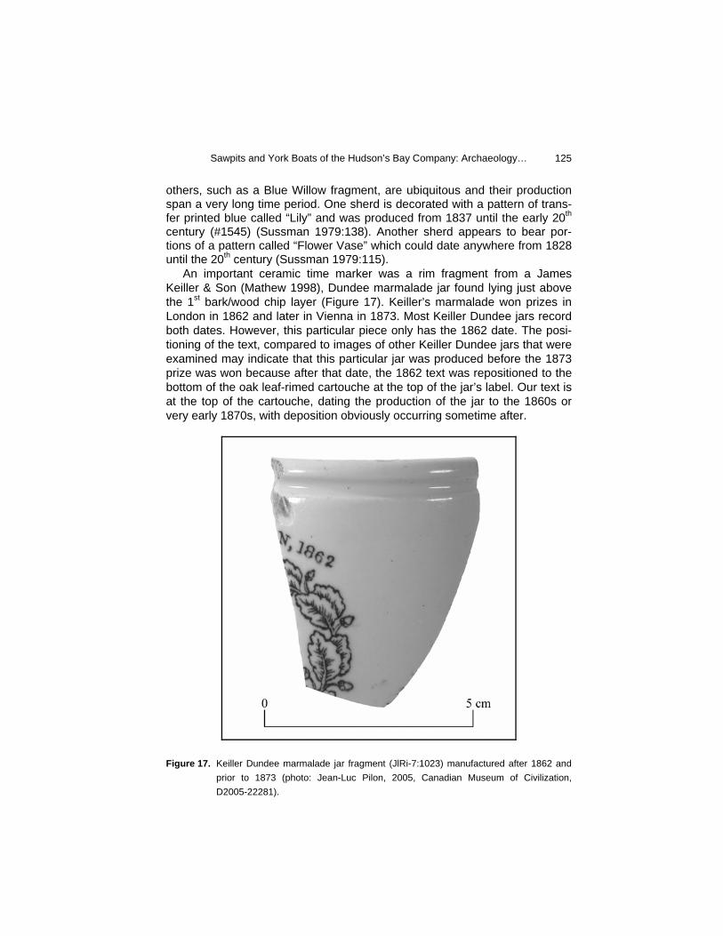
others, such as a Blue Willow fragment, are ubiquitous and their production span a very long time period. One sherd is decorated with a pattern of trans-fer printed blue called “Lily” and was produced from 1837 until the early 20th century (#1545) (Sussman 1979:138). Another sherd appears to bear por-tions of a pattern called “Flower Vase” which could date anywhere from 1828 until the 20th century (Sussman 1979:115). An important ceramic time marker was a rim fragment from a James Keiller & Son (Mathew 1998), Dundee marmalade jar found lying just above the 1st bark/wood chip layer (Figure 17). Keiller’s marmalade won prizes in London in 1862 and later in Vienna in 1873. Most Keiller Dundee jars record both dates. However, this particular piece only has the 1862 date. The posi-tioning of the text, compared to images of other Keiller Dundee jars that were examined may indicate that this particular jar was produced before the 1873 prize was won because after that date, the 1862 text was repositioned to the bottom of the oak leaf-rimed cartouche at the top of the jar’s label. Our text is at the top of the cartouche, dating the production of the jar to the 1860s or very early 1870s, with deposition obviously occurring sometime after.
Figure 17. Keiller Dundee marmalade jar fragment (JlRi-7:1023) manufactured after 1862 and
prior to 1873 (photo: Jean-Luc Pilon, 2005, Canadian Museum of Civilization, D2005-22281).
Revista de Arqueología Americana No. 23
126
Chronological Placement - Summary
While there are hints at a pre-contact Native presence within the plough zone in the form of chipped stone artifacts or detritus, the artifacts found within the trench layers per se appear limited to an 1860-1880 time period. Particularly sensitive chronological markers are the Keiller & Sons marmalade jar and the kaolin smoking pipes. These are further supported by some of the ceramic fragments and the presence of percussion cap technology and the virtual absence of cartridges and gunflints. As such, we propose that the feature may have been in use during the same period as the nearby boat house and boat burning and recycling area: likely during the decades of 1860 to 1880. The 1892 map mentioned earlier provides us with an approximate time when the trench feature had to have ceased to exist entirely. However, it is quite possible that when the fields were expanded to cover the site area, the trench was still an open feature and may have still been in use.
Archival Documentation: Boats, Boat Building and Sawpits at Fort Simpson
In an 1853 letter to George Simpson, Governor of the Hudson’s Bay Com-pany and for whom the small post was named, James Anderson, then Chief Trader included a sketch plan of “New Fort Simpson” (HBCA/AM, D.5/36/462 1853). The plan only illustrates the location and function of those buildings contained within the HBC compound and excludes the structures located beyond the palisaded portion of the post. In fact we know from a sketch, drawn one year earlier in 1852, that there was a blacksmith’s shop located slightly north of the compound that is not included in Anderson’s plan. This may explain the lack of a boat store or sawpit on the plan, although refer-ences to a boat store located at Fort Simpson are present in post journals as early as 1829 and continue until at least 1869, as it would have been similarly located outside of the defined HBC precinct. Anderson only included in his report to Governor Simpson a description of the buildings and activities within the trading precinct, despite the crucial role that boat building and mainte-nance and blacksmithing would have played in life at the post. In it, Anderson lists the purposes to which the attics of all the buildings have been put. The contents of the two buildings nearest the modern-day Fort Simpson Heritage Park are of particular interest:
The Attic of the Fish Store for Masts, Sails, Oars, Rudders, Oil Cloths, Lodges and other boat agrèts. The Attic of Mens House for Boat Wood and Lumber. (HBCA/AM, D.5/36/462 1853).
Sawpits and York Boats of the Hudson’s Bay Company: Archaeology…
127
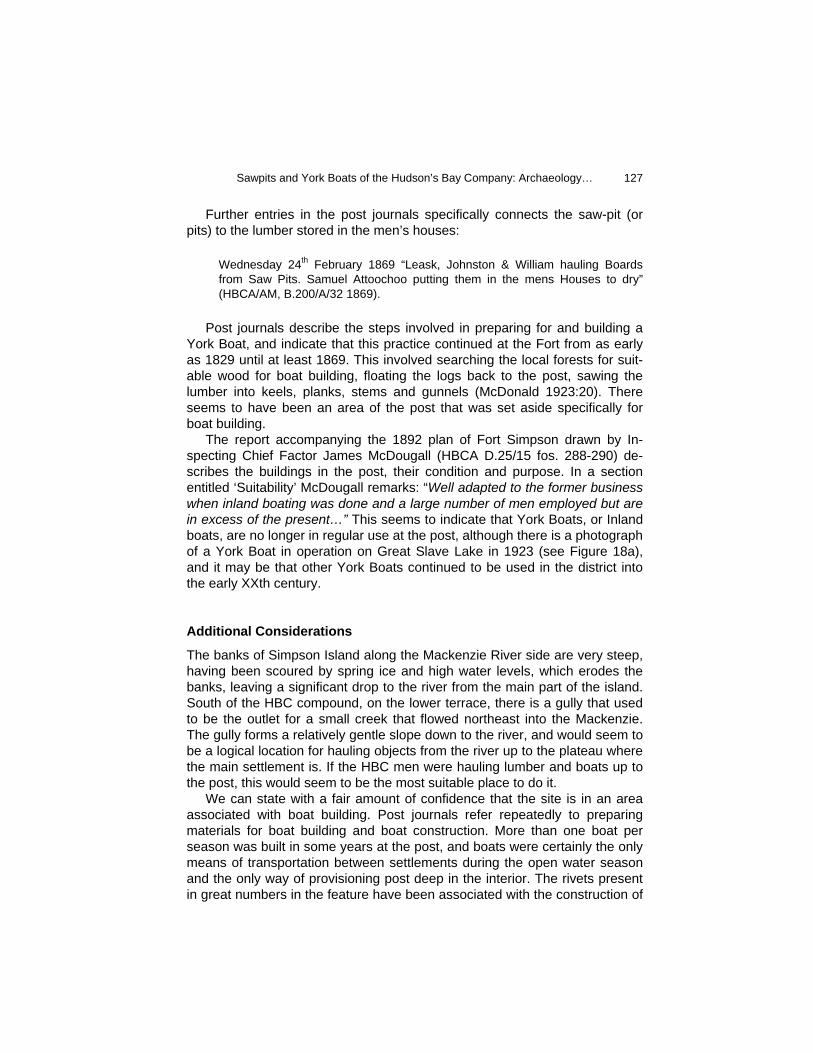
Further entries in the post journals specifically connects the saw-pit (or pits) to the lumber stored in the men’s houses:
Wednesday 24th February 1869 “Leask, Johnston & William hauling Boards from Saw Pits. Samuel Attoochoo putting them in the mens Houses to dry” (HBCA/AM, B.200/A/32 1869).
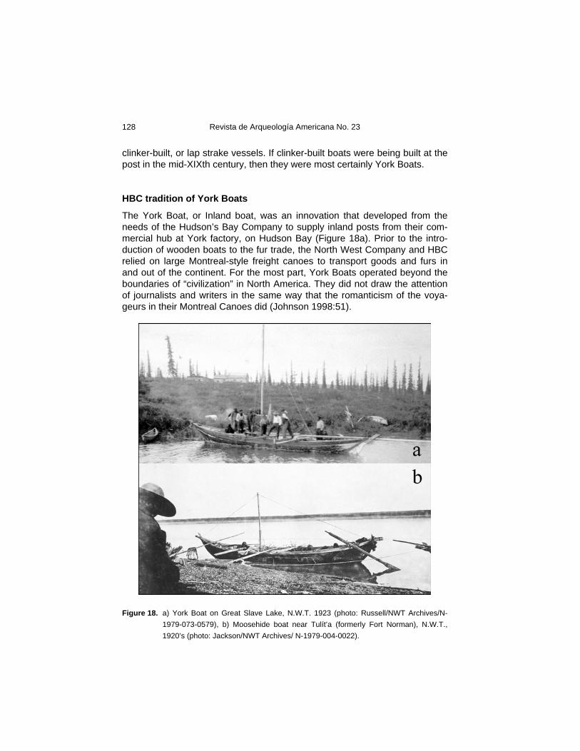
Post journals describe the steps involved in preparing for and building a York Boat, and indicate that this practice continued at the Fort from as early as 1829 until at least 1869. This involved searching the local forests for suit-able wood for boat building, floating the logs back to the post, sawing the lumber into keels, planks, stems and gunnels (McDonald 1923:20). There seems to have been an area of the post that was set aside specifically for boat building. The report accompanying the 1892 plan of Fort Simpson drawn by In-specting Chief Factor James McDougall (HBCA D.25/15 fos. 288-290) de-scribes the buildings in the post, their condition and purpose. In a section entitled ‘Suitability’ McDougall remarks: “Well adapted to the former business when inland boating was done and a large number of men employed but are in excess of the present…” This seems to indicate that York Boats, or Inland boats, are no longer in regular use at the post, although there is a photograph of a York Boat in operation on Great Slave Lake in 1923 (see Figure 18a), and it may be that other York Boats continued to be used in the district into the early XXth century.
Additional Considerations
The banks of Simpson Island along the Mackenzie River side are very steep, having been scoured by spring ice and high water levels, which erodes the banks, leaving a significant drop to the river from the main part of the island. South of the HBC compound, on the lower terrace, there is a gully that used to be the outlet for a small creek that flowed northeast into the Mackenzie. The gully forms a relatively gentle slope down to the river, and would seem to be a logical location for hauling objects from the river up to the plateau where the main settlement is. If the HBC men were hauling lumber and boats up to the post, this would seem to be the most suitable place to do it. We can state with a fair amount of confidence that the site is in an area associated with boat building. Post journals refer repeatedly to preparing materials for boat building and boat construction. More than one boat per season was built in some years at the post, and boats were certainly the only means of transportation between settlements during the open water season and the only way of provisioning post deep in the interior. The rivets present in great numbers in the feature have been associated with the construction of
Revista de Arqueología Americana No. 23
128
clinker-built, or lap strake vessels. If clinker-built boats were being built at the post in the mid-XIXth century, then they were most certainly York Boats.
HBC tradition of York Boats
The York Boat, or Inland boat, was an innovation that developed from the needs of the Hudson’s Bay Company to supply inland posts from their com-mercial hub at York factory, on Hudson Bay (Figure 18a). Prior to the intro-duction of wooden boats to the fur trade, the North West Company and HBC relied on large Montreal-style freight canoes to transport goods and furs in and out of the continent. For the most part, York Boats operated beyond the boundaries of “civilization” in North America. They did not draw the attention of journalists and writers in the same way that the romanticism of the voya-geurs in their Montreal Canoes did (Johnson 1998:51).
Figure 18. a) York Boat on Great Slave Lake, N.W.T. 1923 (photo: Russell/NWT Archives/N-
1979-073-0579), b) Moosehide boat near Tulít’a (formerly Fort Norman), N.W.T., 1920’s (photo: Jackson/NWT Archives/ N-1979-004-0022).
Sawpits and York Boats of the Hudson’s Bay Company: Archaeology…
129
James Isbister, in charge of Fort Albany on James Bay complained in 1743 that the company men were “intirly Unhandy in Cannoes.” Two years later he wrote in the post journal his intent to build a trial wooden boat, as too many canoes were being built and lost after one trip, owing to the “unskillfull-ness” of the men (Johnson 1998:51). From these trials emerged the design of the York Boat. The structure of the York Boat is closely related to the fishing boats of the Orkney Isles. It is estimated that three-quarters of the men em-ployed by the HBC in the late XVIII century were Orkneymen, and when boats were required in Rupert’s land, “they merely adapted their old craft to the new conditions” (Glover 1949:19). The size of boats differed depending on the route on which they were employed. In areas where boats were hauled over portages and launched frequently, 28 to 30 feet was the approximate length, whereas on routes where there were no portages the length was 38 to 40 feet. An entry in the post journal from February 1834 reports the start of construction of a new boat, 22 feet at the keel. The addition of stem and stern pieces to the ends of the keel would bring the length of this boat into the former category. The design of the York Boat was well-suited to its role in the fur trade. The boats were round-bottomed, with a straight keel and flared sides. They drew very little water and were controllable in the rough waters of Canada’s north-ern lakes, such as Lake Winnipeg, where sudden thunderstorms and strong winds presented a severe hazard to trade canoes. The steeply raked bow and stern allowed for easy beaching, quick changes in direction, and held up against the obstacles and hazards presented by river rapids and rocks. The boats were capable of carrying twice the cargo of a freight canoe with the same amount of manpower, giving the HBC a significant economic advan-tage (Johnson 1998:51-52). York Boats often travelled in brigades, with their supplies of trading goods. The transport of goods in and out of the Mackenzie District to the distant HBC hub of Norway House was a carefully planned exchange. The brigade began at Fort Simpson in the latter part of May. The returns from the Liard branch were collected there, as well as the furs from Fort Good Hope and Fort Nor-man. The brigade would arrive at Portage La Loche on the height of land separating the Mackenzie River and Hudson Bay drainage basins, around the end of July. Furs would be exchanged for supplies, which would be dis-tributed throughout the Mackenzie River posts on the return journey (Innis 1930:291). The York Boat had to be reasonably easy to repair and construct, given that they would be operating for the most part in isolated areas, hundreds of miles from the nearest trading post (Johnson 1998:52). Yet, it would seem that many of these sturdy vessels fell prey to the harsh conditions of travel on the northern waterways.
Revista de Arqueología Americana No. 23
130
The life of a York Boat in the northern fur trade was notoriously perilous and short-lived. On inland routes, three or four years were as long as they would be considered safe for carrying cargo (McDonald 1923:52). This was a result of hard use as well as the lack of hard woods for boat building in the forests of the north. Softer woods, such as spruce, were most often employed and supplies always kept at hand for making repairs (Glover 1949:22). While the exteriors of the boats were covered with a coating of melted pitch and tar, the interior was generally left unpainted, resulting in rapid deterioration and decomposition upon abandonment (Johnson 1998:56).
Discussion
The excavations carried out within the Fort Simpson Heritage Park have achieved a number of objectives, some more stimulating than others. On the one hand, evidence of the doomed Fort of the Forks has not been found within the park, in spite of this location being highly suitable. Most certainly the extensive ploughing by the Hudson’s Bay Company likely obliterated any evidence which might have been contained within the topmost soil layers. Nonetheless, subsurface features such as privies, cellars and an icehouse should still exist, but cover a much more restricted surface area and would thus be much more difficult to locate. If Wentzel’s North West Company trading establishment was located within the current footprint of the Heritage Park, it is more than likely that its tentative identification will only be possible based on a careful and perhaps serendipitous identification of artifacts found within the plough zone. The very short time gap between the occupation and abandonment of the Fort of the Forks (1804-1811) and the permanent establishment of Fort Simpson (1822) leaves little time for significant stylistic or even technological changes to have taken place that could be used as markers of one or the other occupation (at least during the earliest years of the HBC being at Fort Simpson). At the same time, one would hope that since these two trading companies received their supplies from markedly different sources (i.e. one mostly from England while the other had a broader range of suppliers, includ-ing St. Lawrence Valley wares), there would be some “fossil indicateur” awaiting discovery which would clearly indicate a NWC presence (see Nicks 1970 for an example for the North Saskatchewan River drainage). On a more positive note, the excavations have shed light on two very important activities associated with the successful operation of Fort Simpson, an HBC post that acted as the regional redistribution center for the Mackenzie District. The construction and maintenance of a fleet of York Boats was critical to the supplying of smaller, more distant fur trading posts and the timely retrieval of the furs and other products of the land gathered at those locales for trans-shipment to England. As well, within the same excava-
Sawpits and York Boats of the Hudson’s Bay Company: Archaeology…
131
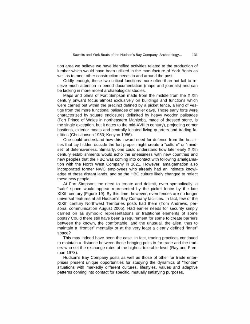
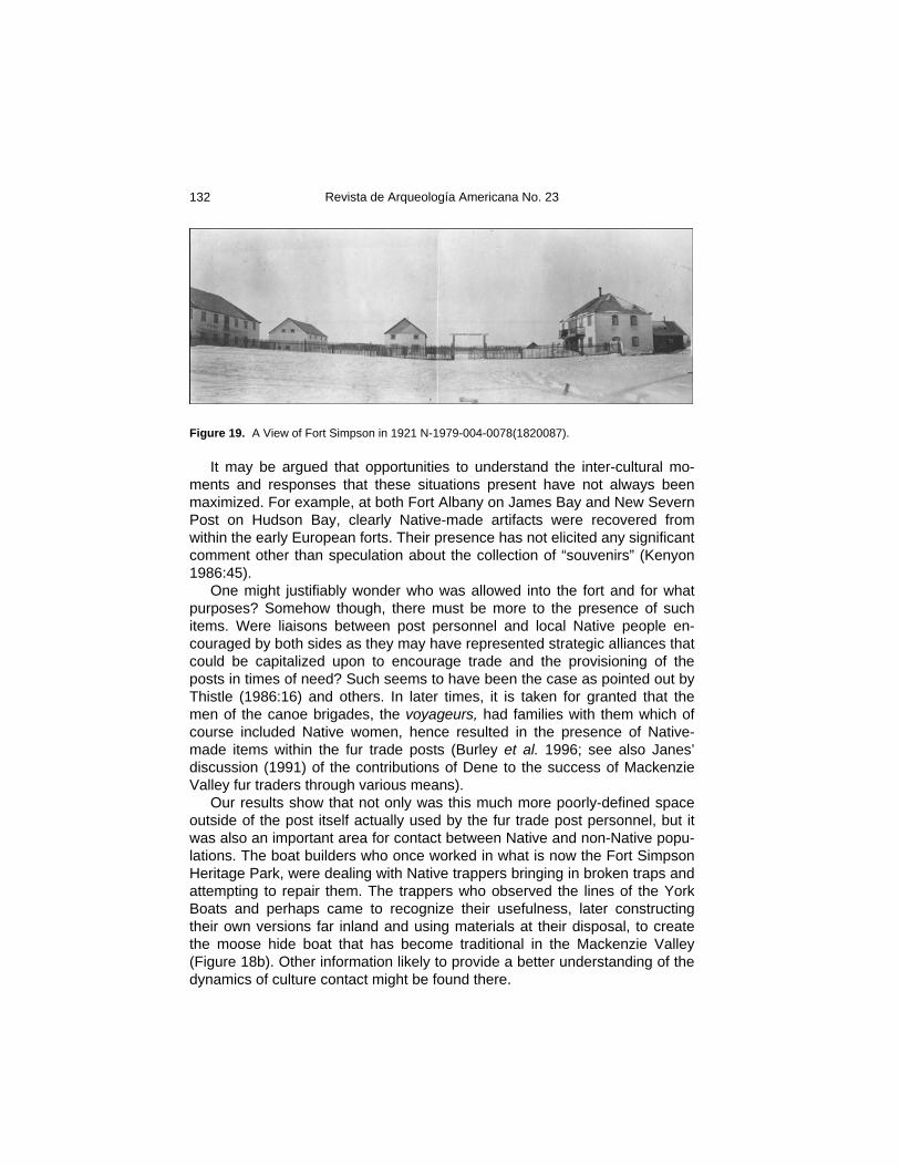
tion area we believe we have identified activities related to the production of lumber which would have been utilized in the manufacture of York Boats as well as to meet other construction needs in and around the post. Oddly enough, these two critical functions more often than not fail to re-ceive much attention in period documentation (maps and journals) and can be lacking in more recent archaeological studies. Maps and plans of Fort Simpson made from the middle from the XIXth century onward focus almost exclusively on buildings and functions which were carried out within the precinct defined by a picket fence, a kind of ves-tige from the more functional palisades of earlier days. Those early forts were characterized by square enclosures delimited by heavy wooden palisades (Fort Prince of Wales in northeastern Manitoba, made of dressed stone, is the single exception, but it dates to the mid-XVIIIth century), projecting corner bastions, exterior moats and centrally located living quarters and trading fa-cilities (Christianson 1980; Kenyon 1986). One could understand how this inward need for defence from the hostili-ties that lay hidden outside the fort proper might create a “culture” or “mind-set” of defensiveness. Similarly, one could understand how later early XIXth century establishments would echo the uneasiness with new countries and new peoples that the HBC was coming into contact with following amalgama-tion with the North West Company in 1821. However, amalgamation also incorporated former NWC employees who already had an intimate knowl-edge of these distant lands, and so the HBC culture likely changed to reflect these new people. At Fort Simpson, the need to create and delimit, even symbolically, a “safe” space would appear represented by the picket fence by the late XIXth century (Figure 19). By this time, however, even fences are no longer universal features at all Hudson’s Bay Company facilities. In fact, few of the XIXth century Northwest Territories posts had them (Tom Andrews, per-sonal communication August 2005). Had earlier needs for security simply carried on as symbolic representations or traditional elements of some posts? Could there still have been a requirement for some to create barriers between the known, the comfortable, and the unusual, the alien, thus to maintain a “frontier” mentality or at the very least a clearly defined “inner” space? This may indeed have been the case. In fact, trading practices continued to maintain a distance between those bringing pelts in for trade and the trad-ers who set the exchange rates at the highest tolerable level (Ray and Free-man 1978). Hudson’s Bay Company posts as well as those of other fur trade enter-prises present unique opportunities for studying the dynamics of “frontier” situations with markedly different cultures, lifestyles, values and adaptive patterns coming into contact for specific, mutually satisfying purposes.
Revista de Arqueología Americana No. 23
132
Figure 19. A View of Fort Simpson in 1921 N-1979-004-0078(1820087). It may be argued that opportunities to understand the inter-cultural mo-ments and responses that these situations present have not always been maximized. For example, at both Fort Albany on James Bay and New Severn Post on Hudson Bay, clearly Native-made artifacts were recovered from within the early European forts. Their presence has not elicited any significant comment other than speculation about the collection of “souvenirs” (Kenyon 1986:45). One might justifiably wonder who was allowed into the fort and for what purposes? Somehow though, there must be more to the presence of such items. Were liaisons between post personnel and local Native people en-couraged by both sides as they may have represented strategic alliances that could be capitalized upon to encourage trade and the provisioning of the posts in times of need? Such seems to have been the case as pointed out by Thistle (1986:16) and others. In later times, it is taken for granted that the men of the canoe brigades, the voyageurs, had families with them which of course included Native women, hence resulted in the presence of Native-made items within the fur trade posts (Burley et al. 1996; see also Janes’ discussion (1991) of the contributions of Dene to the success of Mackenzie Valley fur traders through various means). Our results show that not only was this much more poorly-defined space outside of the post itself actually used by the fur trade post personnel, but it was also an important area for contact between Native and non-Native popu-lations. The boat builders who once worked in what is now the Fort Simpson Heritage Park, were dealing with Native trappers bringing in broken traps and attempting to repair them. The trappers who observed the lines of the York Boats and perhaps came to recognize their usefulness, later constructing their own versions far inland and using materials at their disposal, to create the moose hide boat that has become traditional in the Mackenzie Valley (Figure 18b). Other information likely to provide a better understanding of the dynamics of culture contact might be found there.

Sawpits and York Boats of the Hudson’s Bay Company: Archaeology…
133
In fairness, without the threat of serious disturbance to a large portion of the Fort Simpson Heritage Park, would the excavations described above have ever taken place? Certainly the challenge of locating the North West Company’s Fort of the Forks could have been a catalyst leading to such work. However, without a reason of this kind, the likelihood is that the park would have welcomed visitors and photographers, picnickers and thinkers for a great many more years before an archaeologist would have broken the sod and sifted through the layers of silt and clay lying below, searching out evi-dence of former lifeways. As with ecological ecotones, the intrinsic qualities of human cultures are best perceived when different systems come into con-tact. Archaeologists working in areas where such contact took place must always be cognizant of the broader landscape actually used in such settings in order to recover a fuller range of pertinent information.
Acknowledgements
Several colleagues at Parks Canada were instrumental in identifying a num-ber of key pieces from the Fort Simpson Heritage Park excavations: Robert Grenier, Phil Dunning and Charles Bradley at Parcs. Dena Doroszenko of the Ontario Heritage Foundation helped identify a particularly difficult ceramic decorative type. Caroline Marchand of the Conservation Services of the Ca-nadian Museum of Civilization restored and stabilized a number of metal artifacts. Tom Andrews of the Prince of Wales Northern Heritage Center in Yellowknife conducted the initial testing of the site and invited the principal author to continue with this work. The Martina Norwegian (president) and the Fort Simpson Historical Society arranged for lodging of the Gatineau crew with Father Joe Daley in 2002 and with Mitch and Kathleen Gast in 2003. The Society also shared their wealth of archival information, provided excavators and allowed the use of the MacPherson House during the excavations as both a warehouse and a kitchen/break location. Several individuals at the Archives of Manitoba were very helpful in accessing materials contained in the Hudson’s Bay Company Archives, in particular Denise Jones and Lisa Friesen. Brian Moorman and Christopher Hugenholtz of the University of Calgary, aided by Dana Lampi and Kathleen Groenewegen conducted a ground penetrating radar study over the site in 2003. Most importantly, the following individuals lend their patience and talents to recovering the artifacts from the Heritage Park excavations: Tom Andrews, Erika Kritsch-Andrews, John Blythe, Sophie Borcoman, Pauline Campbell, Dianne Gribbin, Tessa Jamieson, Douglas Kirk, Adele Laramee, Elizabeth Marsh, Gil Parent and family, Heather Passmore, Scott Passmore, Jean-Luc and Laina Pilon, Ste-ven Rowan, Naomi Smethurst, Deborah and Tyrone Stipdonk, Doug Tate and Vanessa. Finally, this article greatly benefited from the judicious com-ments freely offered by Tom Andrews.
Revista de Arqueología Americana No. 23
134
Bibliography
Andrews, Thomas 2000 Fort Simpson, NWT Fieldnotes: 12/07/00, Manuscript report on file at
the Prince of Wales Northern Heritage Centre, Yellowknife, Northwest Territories, Canada.
Burley, David V., J. Scott Hamilton and Knut R. Fladmark 1996 The Prophecy of the Swan. The Upper Peace River Fur Trade of 1794-
1823, Arch Press, Burnaby, British Columbia, Canada. Christianson, David J. 1980 New Severn or Nieu Savanne: The Identification of an Early Hudson’s
Bay Fur Trade Post, Master’s thesis, Department of Anthropology, McMaster University, Hamilton, Ontario, Canada.
Cinq-Mars, Jacques 1973 Appendix E: Research Report, An Archaeologically Important Raw
Material from the Tertiary Hills, Western District of Mackenzie, North-west Territories: A Preliminary Statement, in: Preliminary Archaeologi-cal Study, Mackenzie Corridor, Report No.73-10:E1-E29, edited by Jacques Cinq-Mars, Environmental-Social Committee, Northern Pipe-lines, Task Force on Northern Oil Development.
Fort Simpson Historical Society 2002 Historical Walk, Village of Fort Simpson, Liidlii Kue, Northwest Territo-
ries, Canada. Glover, R. 1949 “York Boats,” in: The Beaver 29:19-23, Winnipeg, Manitoba, Canada. Gough, Barry 1997 First Across the Continent. Sir Alexander Mackenzie, McClelland &
Stewart, Toronto, Ontario, Canada. Innis, Harold A. 1930 The Fur-trade of Canada: An Introduction to Canadian Economic His-
tory, University of Toronto Press, Toronto, Ontario, Canada. Janes, Robert R. 1974 The Archaeology of Fort Alexander, N.W.T., Environmental-Social
Committee, Northern Pipelines, Task Force on Northern Oil Develop-ment, Report No.74-34, Ottawa, Ontario, Canada.
Johnson, D.F. 1998 “The York Boats of the Hudson’s Bay Company,” in: WoodenBoat
Magazine 144:50-59, Boulder, Colorado, USA. Karamanski, Theodore J. 1983 Fur Trade and Exploration. Opening the Far Northwest 1821-1852,
University of British Columbia Press, Vancouver, British Columbia, Canada.
Sawpits and York Boats of the Hudson’s Bay Company: Archaeology…
135
Keith, Lloyd (editor) 2001 North of Athabasca, McGill-Queen’s University Press, Montréal &
Kingston, Canada. Kenyon, W.A. 1986 The History of James Bay 1610-1686, Archaeology Monograph 10.
Royal Ontario Museum, Toronto, Ontario, Canada. Kidd, Robert S. 1970 Fort George and the Early Fur Trade in Alberta, Provincial Museum
and Archives of Alberta, Publication No.2, Edmonton, Alberta, Canada. MacKinnon, C.S. 1982 “The Rise and Decline of Agriculture and Horticulture in the Mackenzie
District and the Yukon,” in: Musk-Ox 30:48-63, University of Sas-katchewan, Saskatoon, Saskatchewan, Canada..
MacNeish, Richard S. 1951 “An Archaeological Reconnaissance in the Northwest Territories,” in:
Annual Report, National Museum of Canada for the Fiscal Year 1949-50, Bulletin 123: 24-41, National Museum of Canada, Ottawa, Ontario, Canada.
1953 “Archaeological Reconnaissance in the Mackenzie River Drainage,” in: Annual Report of the National Museum of Canada for the Fiscal Year 1951-52, Bulletin No.128: 23-39, National Museum of Canada, Ottawa, Ontario, Canada.
Masson, L.R. 1889 Les Bourgeois de la Compagnie du Nord-Ouest: récits de voyages,
lettres et rapport inédits relatifs au nord-ouest canadien : publié avec une esquisse historique et des annotations, Imprimerie généale A. Co-té & Co., Québec, Québec, Canada.
Mathew, W.M. 1998 Keiller’s of Dundee. The Rise of the Marmalade Dynasty 1800-1879,
Abertav Historical Society, Number 38, Dundee, Scotland. McDonald, A.A. 1923 “H.B.C. Inland Transport: No.2. Details of the H.B.C. Transport,” in:
The Beaver 3:52-53, Winnipeg, Manitoba, Canada. National Atlas of Canada (NAC) 1981 Canada. Frost Free Period. MCR 4037, National Atlas Information
Service, Geographical Services Division, Canada Centre for Mapping, Energy, Mines and Resources Canada, Ottawa, Ontario, Canada.
1985 Canada. Temperature – January and July. MCR 4058, National Atlas Information Service, Geographical Services Division, Canada Centre for Mapping, Energy, Mines and Resources Canada, Ottawa, Ontario, Canada.
Revista de Arqueología Americana No. 23
136
1991 Canada. Precipitation. MCR 4145, National Atlas Information Service, Geographical Services Division, Canada Centre for Mapping, Energy, Mines and Resources Canada, Ottawa, Ontario, Canada.
1987 Canada. Length of Day. MCR 4068, National Atlas Information Service, Geographical Services Division, Canada Centre for Map-ping, Energy, Mines and Resources Canada, Ottawa, Ontario, Canada.
1993a Canada. Terrestrial Ecozones. MCR 4164, National Atlas Infor-mation Service, Geographical Services Division, Canada Centre for Mapping, Energy, Mines and Resources Canada, Ottawa, On-tario, Canada.
1993b Canada. Vegetation Cover. MCR 4182, National Atlas Informa-tion Service, Geographical Services Division, Canada Centre for Mapping, Energy, Mines and Resources Canada, Ottawa, Ontario, Canada.
Nicks, G.C. 1970 “Toward a Trait List for the North Saskatchewan River in the Late
Eighteenth and Early Nineteenth Centuries,” in: Western Canadian Journal of Anthropology 1(2):35-53, University of Alberta, Edmonton, Alberta, Canada.
Osgood, Cornelius 1936 Contributions to the Ethnography of the Kutchin, Yale University Publi-
cations in Anthropology No.14, New Haven, Connecticut, USA. Pilon, Jean-Luc 1991 “Insights into the Prehistory of the Lower Mackenzie Valley, Anders
Plain Region, Northwest Territories,” in: NOGAP Archaeology Project: An Integrated Archaeological Research and Management Approach, pp.89-111, edited by Jacques Cinq-Mars and Jean-Luc Pilon, Cana-dian Archaeological Association, Occasional Paper No.1, Victoria, Brit-ish Columbia, Canada.
Ray, Arthur J. and Donald Freeman 1978 Give Us Good Measure. An Economic Analysis of Relations Between
the Indians and the Hudson’s Bay Company Before 1763, University of Toronto Press, Toronto, Ontario, Canada.
Stager, John K. 1962 “Fur Trading Posts in the Mackenzie Region up to 1850. Canadian
Association of Geographers, British Columbia Division,” in: Occasional Papers in Geography, No.3:37-46.
1965 “Alexander Mackenzie’s Exploration of the Grand River,” in: Geo-graphical Bulletin 7(3 and 4):213-241.
Statistics Canada n.d. 2001 Community Profiles Website.
http://www12.statcan.ca/english/profil01/PlaceSearchForm1.cfm
Sawpits and York Boats of the Hudson’s Bay Company: Archaeology…
137
Steer, Donald N. 1977 The History and Archaeology of a North West Company Trading Post
and a Hudson’s Bay Company Transport Depot, Lac La Loche, Sas-katchewan, Manuscript Report Number 280, Parks Canada, Depart-ment of Indian and Northern Affairs, Ottawa, Ontario, Canada.
Steer, Donald N. and Harvey J. Rogers 1976 1975 Archaeological Excavations at Rocky Mountain House National
Historic Park, Manuscript Report Number 180, Parks Canada, Depart-ment of Indian and Northern Affairs, Ottawa, Ontario, Canada.
Steer, Donald N., Harvey J. Rogers and Gregory J. Lutick 1979 Archaeological Investigations at the Hudson’s Bay Company Rocky
Mountain House, 1835-61, Volume I, Manuscript Report Number 445, Parks Canada, Department of Indian and Northern Affairs, Ottawa, On-tario, Canada.
Sussman, Lynne 1979 Spode/Copeland Transfer-Printed Patterns, Occasional Papers in Ar-
chaeology and History, Canadian Historic Sites No.22, Ottawa, On-tario, Canada.
Sussman, Lynne and Lester A. Ross 1978 Request for Information on Artifacts and Company Histories Relating to
19th Century British Suppliers of Goods to the Hudson’s Bay Company, Research Bulletin No.94, Ottawa, Ontario, Canada.
Thistle, Paul C. 1986 Indian-European Trade Relations in the Lower Saskatchewan River
Region to 1840, University of Manitoba Press, Winnipeg, Manitoba, Canada.
Vincent, J-S. 1989 “Quaternary geology of the northern Canadian Interior Plains,” in: Qua-
ternary Geology of Canada and Greenland, pp.100-137, edited by R.J. Fulton, Geological Survey of Canada, Geology of Canada No.1, Ot-tawa, Ontario, Canada.
Wentzel, Willard Ferdinand 1804 “A Journal Kept at the Grand River from Fall 1804 to Spring 1805,” in:
North of Athabasca, 2001, pp.183-206, edited by L. Keith, McGill-Queen’s University Press, Montréal & Kingston, Canada.
1821 “Account of the Mackenzie River Area. February 26, 1821,” in: North of Athabasca, 2001, pp.351-364, edited by L. Keith, McGill-Queen’s Uni-versity Press, Montréal & Kingston, Ontario, Canada.
Archival Sources
HBCA/AM (Hudson’s Bay Company Archives/Archives of Manitoba).
Revista de Arqueología Americana No. 23
138
Section B Post Records
B.200/A/1 1822/23 Fort Simpson (Mackenzie River) Post Journals, 1822-1823 (Reel 1M139).
B.200/A/32 1869 Fort Simpson (Mackenzie River) Post Journals, 1869 (Reel 1M141).
Section D Governor’s Papers
D.25/15/288-290 1892 (Reel 3M229). D.5/36/462 1853 (Reel 3M102).
Related Documents