
Welcome message from author
This document is posted to help you gain knowledge. Please leave a comment to let me know what you think about it! Share it to your friends and learn new things together.
Transcript
Savannah Under Fire, 1779:Expanding the Boundaries
Savannah, Georgia 2011

Savannah Under Fire, 1779:Expanding the Boundaries
Prepared for the National Park ServiceKristen L. McMasters
Archeologist Planner and Grants ManagerAmerican Battlefield Protection Program
1201 Eye Street NW (2255)Washington, DC 20005
202-354-2037
Grant Agreement No. 2255-09-004
By Rita Folse Elliott, Field Director and Co-Author
and Daniel T. Elliott, Co-Author
with contributions by Laura E. Seifert
Coastal Heritage Society
303 Martin Luther King, Jr. Blvd.
Savannah, Georgia 31401
November 2011
This material is based upon work assisted by a grant from the Department of the Interior, National Park Service. Any opinions, findings, and conclusions or recommendations epressed in this material are those of the author(s) and do not necessarily reflect the views of the Department of the Interior.

Savannah Under Fire: Expanding the Boundariesi
Abstract
Savannah Under Fire, 1779: Expanding the Boundaries represents the second phase (2009-2011) in the search for the Revolutionary War Battle of Savannah. The first phase, Savannah Under Fire, 1779: Identifying Savannah’s Revolutionary War Battlefield was conducted between 2007-2009. Both projects were funded by the National Park Service American Battlefield Protection Program with grants awarded to Coastal Heritage Society, Savannah, Georgia. Each incorporated extensive primary document research, geographic information systems (GIS) mapping, shovel test ex-cavation, ground penetrating radar (GPR), test unit excavation, and public outreach.
This report is an addendum to the first project report (Elliott and Elliott 2009) and the reader is referred to it for additonal historical context and results from the first phase of work. The first project’s success was rooted in major discoveries of intact battlefield features. The second project sought to locate additional tangible remains of the battle in order to expand the geographical boundary of the site and provide a foundation for its preservation. In addition, the second phase sought to expand other boundaries by working with constituencies interested in and/or able to protect the battlefield site and its many varied components.
The second phase project expanded the existing site boundary 400 yards farther south through the documentation of arti-fact collections made several years ago during construction in a key area held by French Reserve Corps. These artifacts, in tandem with the project’s archeological study of the area, indicate that more portions of this part of the battlefield are likely to have survived at that location. This project also identified two key areas of buried A-horizons likely to represent the battlefield landscape. Investigation of twelve target areas in Savannah revealed promise for additional battlefield and period-related resources in two of those locations. The work also served to eliminate geographic areas of site potential, reducing the scope of future searches. The project also successfully shared information from both studies with the general public in a myriad of ways, and produced a 4th and 5th grade curriculum packet.
Both phases of the Savannah Under Fire projects have created an extensive body of information unknown previously. This historical and archeological information holds much promise; the promise of a new understanding of the southern colonies’ role in the American Revolution; of this momentous global event unfolding in the everyday lives of those find-ing themselves in Savannah in 1779; of the revelation to many today that history survives in our everyday world - one just needs to pick up his feet. But the promise of that history can only be fulfilled if it is protected and if its story is retold in a thousand different media and venues to a thousand different audiences. We are pleased to have produced a compen-dium of information that can provide the content for such stories and urge the City of Savannah and its residents to pro-tect the resources (both newly discovered and those that await discovery) that contribute to these stories. This should be just the beginning, not the end.
Savannah Under Fire: Expanding the Boundariesii
Acknowledgements
A number of people assisted in various ways in making this complex project a success. Special thanks to those individu-als and entities that provided written letters of support for the proposed project. (Several individuals are no longer in the positions they were in when the letters of support were written.) This includes: Unites States Representative John Barrow (12th District of Georgia); U.S. Senator Saxby Chambliss (8th Congressional District of Georgia); U.S. Senator Johnny Isakson (6th Congressional District of Georgia); former Commissioner Noel Holcomb, Georgia Department of Natural Resources; Dr. David Crass, Deputy Director-Historic Preservation Division; former City Manager Michael Brown, the City of Savannah; Ellen Harris, Preservation Planner, The Metropolitan Planning Commission, Chatham County; Dr. Robin Williams, Chair, Department of Architectural History, Savannah College of Art and Design; Mr. Daniel Carey, President and CEO, Historic Savannah Foundation; President Chica Arndt, Coastal Georgia Archaeological Society; for-mer President Dennis Blanton, The Society for Georgia Archaeology.
The staff of the National Park Service, American Battlefield Protection Program was ever-helpful as they continually provided much appreciated assistance throughout this project. Kristen McMasters, Archeologist Planner and Grants Manager, answered our phone calls and emails promptly and good-naturedly about procedures, policies, and overall battlefield issues. Thank you! A host of additional staff provided information and particularly guidance for ferretting out the correct answers to the blanks on the financial quarterly forms. Thanks to each for their assistance, including January Ruck and Elizabeth Ries, Historic Preservation Specialists; Lucinda Philumalee, Program Assistant; and Kristie Kendall, Historic Preservation Coordinator.
Numerous departmental heads and staff in the City of Savannah aided in this project by providing property access and information. We thank each for the help. These include: Jim Parker (Administrator, Park and Tree), Bill Haws (Urban Forestry), Jim Shirley, Jr. (Maintenance Administrator, Building and Grounds), Jerry Flemming (Cemeteries), Marc Nelson (Engineering/Developmental Services), Martin Fretty (Housing), and Tara Polli (Citizen Specialist, Citizen Office). Special thanks to Bridget Lidy, Administrator, Tourism and Film Services Department, for arranging and facili-tating the meeting with archeologists and key city department heads. We also appreciate the parking assistance provided by Kim Sanderson, of the city’s Parking Services. We thank John Tuggle, Assistant Director for Public Services, Live Oak Public Libraries, for allowing us to inform the Bull Street Library patrons and staff about the project and the related activities on Thomas Park adjacent to the library. We acknowledge the liberal help of Luciana Spracher, Archivist, City of Savannah, Research Library & Municipal Archives, during our local research.
Staff in other organizations also provided assistance to this project. Thanks to David Anderson, GIS Analyst, Chatham County, for his assistance in sharing maps and GIS information with us. We also appreciate the geographical and his-torical insights of Jeff Kirkland, Construction/NPDES Inspector for Chatham County Department of Engineering. Earline Wesley Davis, Executive Director, and Robert Bruce, Facilities Inspector, of the Housing Authority of Savannah were interested in the project and provided information. Much thanks is given to Lauree San Juan, Assistant Director, Congregation Mickve Israel for providing information about the Levi Sheftall and Mordecai Sheftall cemeteries and their history. Thanks to John Sheftall for additional information and clarification. We thank former Principal Miller-McCullough, at Garrison Elementary for allowing us access to the school grounds for the project. Likewise Ms. Karla Redditte with the Savannah Chatham County Public School System provided a point-of-contact for us.
We have fond thanks for several private property owners who greatly aided us in this project. Property owner Henry S. Morgan not only provided access to a tract of land, but gave freely of his information, time, and several maps of the area. His enthusiasm is appreciated. Thank you to surveyor Dale Yawn for copies of plats and maps, via requests by Henry Morgan. Likewise, we thank Noble Boykin who provided access to his property, initiated contact with Mr. Morgan, and supported this project. Mr. Boykin’s continued interest in the history of the area is valued. We thank Richard Carlson and Tim Hargus for allowing us access to their property and Savannah Station and for their genuine interest in the project. We also enjoyed the visits of furry friends Catherine and Stella! We appreciate visits from local residents, particularly Stark Sutton who came out to check on our progress daily at Davant Park and kept an eye on our excavation unit.
Savannah Under Fire: Expanding the Boundariesiii
We thank relic collectors who have been open to saving historical information. Michael Wheless and Bobby Mallard shared their information and allowed us to examine their collections.
The project benefitted from media exposure that allowed us to share our work and search with the public. Providing con-tinual assistance in this chronic endeavor, we thank media expert Michael Jordan. For his interest in Savannah’s history and this project, we thank Chuck Mobley, reporter at the Savannah Morning News. We also appreciate coverage by Jim Morekis, Editor-in-Chief, Connect Savannah. We also enjoyed speaking with Andrew Haywood of Haywood Seaport Magazine.
Thanks go to those who attended the public stakeholder meeting. Your interest, concern, and support are truly appreci-ated. May your efforts be steadfast and increasingly successful in moving the area closer to real preservation—preserva-tion that includes non-renewable archeological resources such as the Battle of Savannah Revolutionary War sites.
We thank our hardworking field volunteers. These included Carl Arndt, Philip “P.T.” Ashlock Jr., Dawn Chapman Guest, Momoco Holder, Michael Lamb, Laura Lewis, Matt Luke, Jonathan McKellar, Ijtihad Muhammad, and Lindsey White. Each made a valuable contribution to this project and we enjoyed working with you. P.T. is thanked for his continual en-thusiastic and energetic assistance.
Mary Bondurant Warren’s eagerness to share documents and historical information for this project is appreciated. We thank archeologist Dan Battle for providing special metal detector survey expertise to the project. The core crew con-sisted of Rita Elliott, Laura Seiffert, and Daniel Elliott. Laura Seiffert undertook the lab analysis, field map graphics, and GIS portions of this project. Rita Elliott directed the project and generated additional report graphics. She and Daniel Elliott conducted historical research prior to and after fieldwork. Daniel Elliott conducted GPR data collection and analy-sis.Thanks to our own John Roberson, Coastal Heritage Society artificer and Savannah History Museum fabricator for assistance with engineering and equipment transportation. Likewise, CHS Curator of Collections, Lydia Moreton, pro-vided administrative and logistical assistance, as well as moral support. We appreciate the continual support of key CHS staff, including Scott W. Smith, CEO and President, Sandra Buttimer, COO, and Bonnie Ballard, Executive Assistant, President’s Office.
Any errors in this report are the sole responsibility of the first author.

Savannah Under Fire: Expanding the Boundariesiv
Savannah Under Fire: Expanding the Boundariesv
Table of ContentsAbstract. . . . . . . . . . . . . . . . . . . . . . . . . . . . . . . . . . . . . . . . . . . . . . . . . . . . . . . . iAcknowledgements. . . . . . . . . . . . . . . . . . . . . . . . . . . . . . . . . . . . . . . . . . . . . . iiTable of Contents. . . . . . . . . . . . . . . . . . . . . . . . . . . . . . . . . . . . . . . . . . . . . . . vList of Figures. . . . . . . . . . . . . . . . . . . . . . . . . . . . . . . . . . . . . . . . . . . . . . . . . . ixList of Tables. . . . . . . . . . . . . . . . . . . . . . . . . . . . . . . . . . . . . . . . . . . . . . . . . xvii
Chapter 1. Introduction . . . . . . . . . . . . . . . . . . . . . . . . . . . . . . . . . . . . . . . . . . 1
Background and Previous Phase I Work . . . . . . . . . . . . . . . . . . . . . . . . . . . . . . . . . . . . . . . 1Project Goals and Strategies . . . . . . . . . . . . . . . . . . . . . . . . . . . . . . . . . . . . . . . . . . . . . . . . 1Research Design . . . . . . . . . . . . . . . . . . . . . . . . . . . . . . . . . . . . . . . . . . . . . . . . . . . . . . . . . 3KOCOA Analysis . . . . . . . . . . . . . . . . . . . . . . . . . . . . . . . . . . . . . . . . . . . . . . . . . . . . . . . . 3
Chapter 2. Methodology . . . . . . . . . . . . . . . . . . . . . . . . . . . . . . . . . . . . . . . . . . 5
Property Access . . . . . . . . . . . . . . . . . . . . . . . . . . . . . . . . . . . . . . . . . . . . . . . . . . . . . . . . . . . . 5
Historical/Archival Research . . . . . . . . . . . . . . . . . . . . . . . . . . . . . . . . . . . . . . . . . . . . . . . . . 5
Collector Surveys . . . . . . . . . . . . . . . . . . . . . . . . . . . . . . . . . . . . . . . . . . . . . . . . . . . . . . . . . . 6
Utilities Marking . . . . . . . . . . . . . . . . . . . . . . . . . . . . . . . . . . . . . . . . . . . . . . . . . . . . . . . . . . . 7
Fieldwork . . . . . . . . . . . . . . . . . . . . . . . . . . . . . . . . . . . . . . . . . . . . . . . . . . . . . . . . . . . . . . . . . 7
Laboratory Analysis . . . . . . . . . . . . . . . . . . . . . . . . . . . . . . . . . . . . . . . . . . . . . . . . . . . . . . . . 8
Curation . . . . . . . . . . . . . . . . . . . . . . . . . . . . . . . . . . . . . . . . . . . . . . . . . . . . . . . . . . . . . . . . . . 9
Geographic Information Systems (GIS) . . . . . . . . . . . . . . . . . . . . . . . . . . . . . . . . . . . . . . . 10
GPR . . . . . . . . . . . . . . . . . . . . . . . . . . . . . . . . . . . . . . . . . . . . . . . . . . . . . . . . . . . . . . . . . . . . 10
Public Outreach . . . . . . . . . . . . . . . . . . . . . . . . . . . . . . . . . . . . . . . . . . . . . . . . . . . . . . . . . . 17Meetings . . . . . . . . . . . . . . . . . . . . . . . . . . . . . . . . . . . . . . . . . . . . . . . . . . . . . . . . . . . . . . 18 Meeting 1 . . . . . . . . . . . . . . . . . . . . . . . . . . . . . . . . . . . . . . . . . . . . . . . . . . . . . . . 18
Meeting 2 . . . . . . . . . . . . . . . . . . . . . . . . . . . . . . . . . . . . . . . . . . . . . . . . . . . . . . . 18Meeting 3 . . . . . . . . . . . . . . . . . . . . . . . . . . . . . . . . . . . . . . . . . . . . . . . . . . . . . . . 18
Social Media . . . . . . . . . . . . . . . . . . . . . . . . . . . . . . . . . . . . . . . . . . . . . . . . . . . . . . . . . . . 20Traditional Media . . . . . . . . . . . . . . . . . . . . . . . . . . . . . . . . . . . . . . . . . . . . . . . . . . . . . . . 20Fieldwork Tours . . . . . . . . . . . . . . . . . . . . . . . . . . . . . . . . . . . . . . . . . . . . . . . . . . . . . . . . 20Curriculum . . . . . . . . . . . . . . . . . . . . . . . . . . . . . . . . . . . . . . . . . . . . . . . . . . . . . . . . . . . . 20Public Presentations . . . . . . . . . . . . . . . . . . . . . . . . . . . . . . . . . . . . . . . . . . . . . . . . . . . . . 23
Final Curation . . . . . . . . . . . . . . . . . . . . . . . . . . . . . . . . . . . . . . . . . . . . . . . . . . . . . . . . . . . . 24
Savannah Under Fire: Expanding the Boundariesvi
Chapter 3. History . . . . . . . . . . . . . . . . . . . . . . . . . . . . . . . . . . . . . . . . . . . . . 25
Overview . . . . . . . . . . . . . . . . . . . . . . . . . . . . . . . . . . . . . . . . . . . . . . . . . . . . . . . . . . . . . . . . 25
Details . . . . . . . . . . . . . . . . . . . . . . . . . . . . . . . . . . . . . . . . . . . . . . . . . . . . . . . . . . . . . . . . . . . 26American Allies . . . . . . . . . . . . . . . . . . . . . . . . . . . . . . . . . . . . . . . . . . . . . . . . . . . . . . . . 26
American Troops . . . . . . . . . . . . . . . . . . . . . . . . . . . . . . . . . . . . . . . . . . . . . . . . . . 26American Continental Regulars . . . . . . . . . . . . . . . . . . . . . . . . . . . . . . . . . . . 26South Carolina Continental Regulars . . . . . . . . . . . . . . . . . . . . . . . . . . . . . . . 27Georgia and South Carolina Militia . . . . . . . . . . . . . . . . . . . . . . . . . . . . . . . . 27
French Troops . . . . . . . . . . . . . . . . . . . . . . . . . . . . . . . . . . . . . . . . . . . . . . . . . . . . 27The Avant-Garde of the Army . . . . . . . . . . . . . . . . . . . . . . . . . . . . . . . . . . . . . 27Fusiliers . . . . . . . . . . . . . . . . . . . . . . . . . . . . . . . . . . . . . . . . . . . . . . . . . . . . . 27Reserve Column . . . . . . . . . . . . . . . . . . . . . . . . . . . . . . . . . . . . . . . . . . . . . . . 27Troops in Batteries . . . . . . . . . . . . . . . . . . . . . . . . . . . . . . . . . . . . . . . . . . . . . 27Haitian and Entrenched Troops . . . . . . . . . . . . . . . . . . . . . . . . . . . . . . . . . . . 28Irish . . . . . . . . . . . . . . . . . . . . . . . . . . . . . . . . . . . . . . . . . . . . . . . . . . . . . . . . . 28Polish . . . . . . . . . . . . . . . . . . . . . . . . . . . . . . . . . . . . . . . . . . . . . . . . . . . . . . . 28
British Troops . . . . . . . . . . . . . . . . . . . . . . . . . . . . . . . . . . . . . . . . . . . . . . . . . . . . 2871st Scottish Highlanders . . . . . . . . . . . . . . . . . . . . . . . . . . . . . . . . . . . . . . . . 28Light Corps . . . . . . . . . . . . . . . . . . . . . . . . . . . . . . . . . . . . . . . . . . . . . . . . . . . 28Royal Artillery & Royal Marines . . . . . . . . . . . . . . . . . . . . . . . . . . . . . . . . . . 28British Legion . . . . . . . . . . . . . . . . . . . . . . . . . . . . . . . . . . . . . . . . . . . . . . . . . 28
Account of Siege and Battle . . . . . . . . . . . . . . . . . . . . . . . . . . . . . . . . . . . . . . . . . . . . . . . . . 29
New Primary Source Information . . . . . . . . . . . . . . . . . . . . . . . . . . . . . . . . . . . . . . . . . . . 34Additional Information about Precursors to the Battle of Savannah . . . . . . . . . . . . . . . . 34American and French Defenses . . . . . . . . . . . . . . . . . . . . . . . . . . . . . . . . . . . . . . . . . . . . 35British Defenses . . . . . . . . . . . . . . . . . . . . . . . . . . . . . . . . . . . . . . . . . . . . . . . . . . . . . . . . 35Additional Information about the Battle Itself . . . . . . . . . . . . . . . . . . . . . . . . . . . . . . . . . 35Pension Records . . . . . . . . . . . . . . . . . . . . . . . . . . . . . . . . . . . . . . . . . . . . . . . . . . . . . . . . 39Casualty Descriptions from Other Sources . . . . . . . . . . . . . . . . . . . . . . . . . . . . . . . . . . . . 42American Military Command Reacts to the Battle of Savannah . . . . . . . . . . . . . . . . . . . 42New Information Regarding the Battle’s Aftermath . . . . . . . . . . . . . . . . . . . . . . . . . . . . . 43Post-Revolutionary War Military Activity in Savannah . . . . . . . . . . . . . . . . . . . . . . . . . . 46New Information About the Revolutionary War French and American Camps Outside Savannah . . . . . . . . . . . . . . . . . . . . . . . . . . . . . . . . . . . . . . . . . . . . . . . . . . . . . . . 49New Details about the Roles of Africans and African-Americans . . . . . . . . . . . . . . . . . . 49Additional Details About Native Americans Involved. . . . . . . . . . . . . . . . . . . . . . . . . . . 55New Details on the Roles of Women and Children . . . . . . . . . . . . . . . . . . . . . . . . . . . . . 61
Chapter 4. Project Results and Interpretations . . . . . . . . . . . . . . . . . . . . . . 65

Savannah Under Fire: Expanding the Boundariesvii
Fieldwork Targets, Results, and Interpretations . . . . . . . . . . . . . . . . . . . . . . . . . . . . . . . . 65
Yamacraw Village . . . . . . . . . . . . . . . . . . . . . . . . . . . . . . . . . . . . . . . . . . . . . . . . . . . . . . 65KOCOA Analysis . . . . . . . . . . . . . . . . . . . . . . . . . . . . . . . . . . . . . . . . . . . . . . . . . 65Archeological Results and Interpretation . . . . . . . . . . . . . . . . . . . . . . . . . . . . . . . 66
GPR Survey . . . . . . . . . . . . . . . . . . . . . . . . . . . . . . . . . . . . . . . . . . . . . . . . . . . 67
Wells Park . . . . . . . . . . . . . . . . . . . . . . . . . . . . . . . . . . . . . . . . . . . . . . . . . . . . . . . . . . . . . 74KOCOA Analysis . . . . . . . . . . . . . . . . . . . . . . . . . . . . . . . . . . . . . . . . . . . . . . . . . 74Archeological Results and Interpretation . . . . . . . . . . . . . . . . . . . . . . . . . . . . . . . 75
Shovel Testing . . . . . . . . . . . . . . . . . . . . . . . . . . . . . . . . . . . . . . . . . . . . . . . . . 76
Thomas Park (aka Thomas Square) . . . . . . . . . . . . . . . . . . . . . . . . . . . . . . . . . . . . . . . . . 79KOCOA Analysis . . . . . . . . . . . . . . . . . . . . . . . . . . . . . . . . . . . . . . . . . . . . . . . . . 79Archeological Results and Interpretation . . . . . . . . . . . . . . . . . . . . . . . . . . . . . . . 79
Shovel Testing . . . . . . . . . . . . . . . . . . . . . . . . . . . . . . . . . . . . . . . . . . . . . . . . . 79GPR Survey . . . . . . . . . . . . . . . . . . . . . . . . . . . . . . . . . . . . . . . . . . . . . . . . . . . 80Test Unit 2 . . . . . . . . . . . . . . . . . . . . . . . . . . . . . . . . . . . . . . . . . . . . . . . . . . . . 85Test Unit 3 . . . . . . . . . . . . . . . . . . . . . . . . . . . . . . . . . . . . . . . . . . . . . . . . . . . 87Interpretation of Test Units 2 and 3 . . . . . . . . . . . . . . . . . . . . . . . . . . . . . . . . 88
W.W. Law Park . . . . . . . . . . . . . . . . . . . . . . . . . . . . . . . . . . . . . . . . . . . . . . . . . . . . . . . . . 96KOCOA Analysis . . . . . . . . . . . . . . . . . . . . . . . . . . . . . . . . . . . . . . . . . . . . . . . . . 96Archeological Results and Interpretation . . . . . . . . . . . . . . . . . . . . . . . . . . . . . . . 96
Shovel Testing
Calhoun Square and Whitefield Square . . . . . . . . . . . . . . . . . . . . . . . . . . . . . . . . . . . . . 101KOCOA Analysis . . . . . . . . . . . . . . . . . . . . . . . . . . . . . . . . . . . . . . . . . . . . . . . . 101Archeological Results and Interpretation . . . . . . . . . . . . . . . . . . . . . . . . . . . . . . 102Calhoun Square Archeological Results and Interpretation . . . . . . . . . . . . . . . . . 104
Shovel Testing . . . . . . . . . . . . . . . . . . . . . . . . . . . . . . . . . . . . . . . . . . . . . . . . 104GPR Survey . . . . . . . . . . . . . . . . . . . . . . . . . . . . . . . . . . . . . . . . . . . . . . . . . . 105
Whitefield Square Archeological Results and Interpretation . . . . . . . . . . . . . . . 105GPR Survey . . . . . . . . . . . . . . . . . . . . . . . . . . . . . . . . . . . . . . . . . . . . . . . . . . 105
Davant Park . . . . . . . . . . . . . . . . . . . . . . . . . . . . . . . . . . . . . . . . . . . . . . . . . . . . . . . . . . . 109KOCOA Analysis . . . . . . . . . . . . . . . . . . . . . . . . . . . . . . . . . . . . . . . . . . . . . . . . 109Archeological Results and Interpretation . . . . . . . . . . . . . . . . . . . . . . . . . . . . . . 115
Test Unit 1 . . . . . . . . . . . . . . . . . . . . . . . . . . . . . . . . . . . . . . . . . . . . . . . . . . . 115
Laurel Grove Cemetery . . . . . . . . . . . . . . . . . . . . . . . . . . . . . . . . . . . . . . . . . . . . . . . . . . 133KOCOA Analysis . . . . . . . . . . . . . . . . . . . . . . . . . . . . . . . . . . . . . . . . . . . . . . . . 133Archeological Results and Interpretation . . . . . . . . . . . . . . . . . . . . . . . . . . . . . . 136
GPR Survey . . . . . . . . . . . . . . . . . . . . . . . . . . . . . . . . . . . . . . . . . . . . . . . . . . 136Shovel Testing . . . . . . . . . . . . . . . . . . . . . . . . . . . . . . . . . . . . . . . . . . . . . . . . 142

Savannah Under Fire: Expanding the Boundariesviii
Jewish Cemetery Area . . . . . . . . . . . . . . . . . . . . . . . . . . . . . . . . . . . . . . . . . . . . . . . . . . . 152KOCOA Analysis . . . . . . . . . . . . . . . . . . . . . . . . . . . . . . . . . . . . . . . . . . . . . . . . 152Study Area in Relation to the Jewish Cemetery . . . . . . . . . . . . . . . . . . . . . . . . . 154The Role of the Jewish Cemetery and Surrounding Landscape in the Battleof Savannah . . . . . . . . . . . . . . . . . . . . . . . . . . . . . . . . . . . . . . . . . . . . . . . . . . . . . 154History of the Jewish Cemetery . . . . . . . . . . . . . . . . . . . . . . . . . . . . . . . . . . . . . 154
Levi Sheftall Cemetery . . . . . . . . . . . . . . . . . . . . . . . . . . . . . . . . . . . . . . . . . 154Mordecai Sheftall Cemetery . . . . . . . . . . . . . . . . . . . . . . . . . . . . . . . . . . . . . 156
Historical Land Use of the Area . . . . . . . . . . . . . . . . . . . . . . . . . . . . . . . . . . . . . 156Archeological Results and Interpretation . . . . . . . . . . . . . . . . . . . . . . . . . . . . . . 161Savannah Station Tract . . . . . . . . . . . . . . . . . . . . . . . . . . . . . . . . . . . . . . . . . . . . 163
Shovel Testing . . . . . . . . . . . . . . . . . . . . . . . . . . . . . . . . . . . . . . . . . . . . . . . . 164GPR Survey . . . . . . . . . . . . . . . . . . . . . . . . . . . . . . . . . . . . . . . . . . . . . . . . . . 164
Morgan and Boykin Tracts . . . . . . . . . . . . . . . . . . . . . . . . . . . . . . . . . . . . . . . . . 164Shovel Testing . . . . . . . . . . . . . . . . . . . . . . . . . . . . . . . . . . . . . . . . . . . . . . . . 164GPR Survey . . . . . . . . . . . . . . . . . . . . . . . . . . . . . . . . . . . . . . . . . . . . . . . . . . 164
Garrison Elementary Tract . . . . . . . . . . . . . . . . . . . . . . . . . . . . . . . . . . . . . . . . . 181Metal Detector Reconnaissance Survey of Jewish Cemetery Area . . . . . . . . 181
Combined Results of Jewish Cemetery Area . . . . . . . . . . . . . . . . . . . . . . . . . . . 186Jewish Cemetery Relic Collector Survey . . . . . . . . . . . . . . . . . . . . . . . . . . . 186
Project Results Summary . . . . . . . . . . . . . . . . . . . . . . . . . . . . . . . . . . . . . . . . . . . . . . . . . . 193Historical Research Results . . . . . . . . . . . . . . . . . . . . . . . . . . . . . . . . . . . . . . . . . . . . . . 193Fieldwork Results . . . . . . . . . . . . . . . . . . . . . . . . . . . . . . . . . . . . . . . . . . . . . . . . . . . . . . 193Results of Project Strategies . . . . . . . . . . . . . . . . . . . . . . . . . . . . . . . . . . . . . . . . . . . . . . 194
Interpretation . . . . . . . . . . . . . . . . . . . . . . . . . . . . . . . . . . . . . . . . . . . . . . . . . . . . . . . . . . . 195Research Design . . . . . . . . . . . . . . . . . . . . . . . . . . . . . . . . . . . . . . . . . . . . . . . . . . . . . . . 195
Historical Significance of Battle of Savannah and Associated Sites . . . . . . . . . . . . . . . . 199Assessment for NRHP Eligibility . . . . . . . . . . . . . . . . . . . . . . . . . . . . . . . . . . . . . . . . . . 199
Battlefield Boundaries . . . . . . . . . . . . . . . . . . . . . . . . . . . . . . . . . . . . . . . . . . . . . 199
Chapter 5. Recommendations --Where Do We Go From Here? . . . . . . . 203
Savannah’s Revolutionary War Heritage Tourism Legacy . . . . . . . . . . . . . . . . . . . . . . . 203
Recommendations . . . . . . . . . . . . . . . . . . . . . . . . . . . . . . . . . . . . . . . . . . . . . . . . . . . . . . . . 205Research Recommendation . . . . . . . . . . . . . . . . . . . . . . . . . . . . . . . . . . . . . . . . . . . . . . . 205Preservation Recommendations . . . . . . . . . . . . . . . . . . . . . . . . . . . . . . . . . . . . . . . . . . . 205Interpretation Recommendations . . . . . . . . . . . . . . . . . . . . . . . . . . . . . . . . . . . . . . . . . . 206
References Cited . . . . . . . . . . . . . . . . . . . . . . . . . . . . . . . . . . . . . . . . . . . . . . 207
Appendices. . . . . . . . . . . . . . . . . . . . . . . . . . . . . . . . . . . . . . . . . . . . . . . . . . . 219

Savannah Under Fire: Expanding the Boundariesix
Minutes, 1st Meeting (with City of Savannah) . . . . . . . . . . . . . . . . . . . . . . . . . . . . . . . . .AMinutes, 2nd/3rd Meeting (with Stakeholders) . . . . . . . . . . . . . . . . . . . . . . . . . . . . . . . . BArtifact Inventory. . . . . . . . . . . . . . . . . . . . . . . . . . . . . . . . . . . . . . . . . . . . . . . . . . . . . . . . C

Savannah Under Fire: Expanding the Boundariesx
Savannah Under Fire: Expanding the Boundariesxi
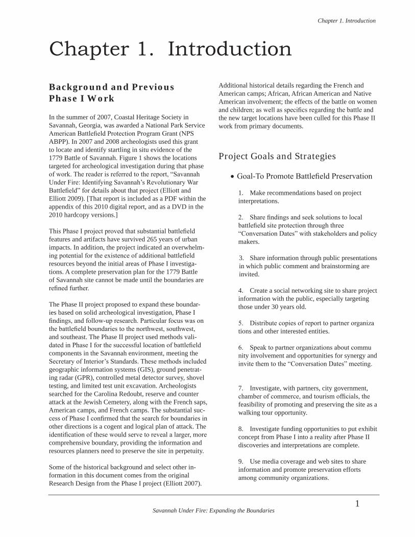
Figure 1. Fieldwork locations of previous and current ABPP Savannah Under Fire projects. . . 2
Figure 2. Archeologists gather information from microfilm in SC. . . . . . . . . . . . . . . . . . . . . . . 6
Figure 3. Study at the Research Library and Municipal Archives, City of Savannah. . . . . . . . . 7
Figure 4. Examining a relic collection from the battlefield. . . . . . . . . . . . . . . . . . . . . . . . . . . . . 8
Figure 5. Measuring gunflints from a battlefield relic collection. . . . . . . . . . . . . . . . . . . . . . . . . 8
Figure 6. Washing, analyzing, and cataloging artifacts in the archeology lab. . . . . . . . . . . . . . . 9
Figure 7. Savannah in 1770 (Shruder 1770). . . . . . . . . . . . . . . . . . . . . . . . . . . . . . . . . . . . . . . . 11
Figure 8. GPR transects in the Yamacraw Village Housing Development. . . . . . . . . . . . . . . . . 12
Figure 9. Block Q radargram. . . . . . . . . . . . . . . . . . . . . . . . . . . . . . . . . . . . . . . . . . . . . . . . . . . 13
Figure 10. Radargram of Block T. . . . . . . . . . . . . . . . . . . . . . . . . . . . . . . . . . . . . . . . . . . . . . . . . 14
Figure 11. Radargram of Block U. . . . . . . . . . . . . . . . . . . . . . . . . . . . . . . . . . . . . . . . . . . . . . . . 14
Figure 12. Radargram of Block V. . . . . . . . . . . . . . . . . . . . . . . . . . . . . . . . . . . . . . . . . . . . . . . . . 14
Figure 13. GPR challenges include underground utilities . . . . . . . . . . . . . . . . . . . . . . . . . . . . . . 14
Figure 14. Radargrams for Block W. . . . . . . . . . . . . . . . . . . . . . . . . . . . . . . . . . . . . . . . . . . . . . . 15
Figure 15. Radargram for Block X. . . . . . . . . . . . . . . . . . . . . . . . . . . . . . . . . . . . . . . . . . . . . . . . 15
Figure 16. Radargram of Block Y. . . . . . . . . . . . . . . . . . . . . . . . . . . . . . . . . . . . . . . . . . . . . . . . . 16
Figure 17. Radargram of Block Z. . . . . . . . . . . . . . . . . . . . . . . . . . . . . . . . . . . . . . . . . . . . . . . . . 16
Figure 18. Radargram of Block AA. . . . . . . . . . . . . . . . . . . . . . . . . . . . . . . . . . . . . . . . . . . . . . . 17
Figre 19. Radargram of Block BB. . . . . . . . . . . . . . . . . . . . . . . . . . . . . . . . . . . . . . . . . . . . . . . 17
Figure 20. An attentive audience at meeting #3, the Stakeholders Meeting. . . . . . . . . . . . . . . . 19
Figure 21. Visitors and volunteer crew sift soil at Thomas Park. . . . . . . . . . . . . . . . . . . . . . . . . 21
Figure 22. Girls on a fieldtrip stop by Davant Park. . . . . . . . . . . . . . . . . . . . . . . . . . . . . . . . . . . 21
Figure 23. The banner follows the crew to each location of fieldwork. . . . . . . . . . . . . . . . . . . . 22
Figure 24. Relevant text and graphics on both sides of the “sandwich board. . . . . . . . . . . . . . . 22
List of Figures
Savannah Under Fire: Expanding the Boundariesxii
Figure 25. Interested passers-by, including these sanitation workers, receive“Savannah Under
Fire” facebook and blog information. . . . . . . . . . . . . . . . . . . . . . . . . . . . . . . . . . . . . 22
Figure 26. Segway visitors stop to learn about Savannah’s battlefield archeology. . . . . . . . . . . 23
Figure 27. Location of Savannah, Georgia, on colonial and modern map. . . . . . . . . . . . . . . . . 25
Figure 28. Defenisve fortifications, and the Franco-American saps and camps (Wison 1779). . 26
Figure 29. Georgia’s colonial coast. . . . . . . . . . . . . . . . . . . . . . . . . . . . . . . . . . . . . . . . . . . . . . . 30
Figure 30. Prevost’s former war injury . . . . . . . . . . . . . . . . . . . . . . . . . . . . . . . . . . . . . . . . . . . . 39
Figure 31. War of 1812 defensive works south of the Revolutionary defenses (Waring 1886). . 48
Figure 32. Outer Civil War fortifications south of the inner War of 1812 fortifications
(Hoffman ca 1865). . . . . . . . . . . . . . . . . . . . . . . . . . . . . . . . . . . . . . . . . . . . . . . . . . . 50
Figure 33. Suter’s 1865 “Map of the Union and Rebel Intrenchments in Savannah”. . . . . . . . . 51
Figure 34. Gun battery “No. 12”, just north-northwest of Spring Hill Redoubt (at the top of
this image). (Wilson 1779). . . . . . . . . . . . . . . . . . . . . . . . . . . . . . . . . . . . . . . . . . . . . 65
Figure 35. Push pin marks center of GPR Block in project area (Google Earth). . . . . . . . . . . . 66
Figure 36. The HAS announcement of the project on its web site. . . . . . . . . . . . . . . . . . . . . . . . 66
Figure 37. Flyer for Yamacraw Village Revolutionary archeology. . . . . . . . . . . . . . . . . . . . . . . 68
Figure 38. Wilson map (1779) puts Redoubt No. 14 . . . . . . . . . . . . . . . . . . . . . . . . . . . . . . . . . 69
Figure 39. The Faden 1784 map in a GIS overlay with a modern Savannah map. . . . . . . . . . . 69
Figure 40. Construction workers dig a massive ditch to accommodate these pipes. . . . . . . . . . . 69
Figure 41. Standing in the trench for the new pipes. . . . . . . . . . . . . . . . . . . . . . . . . . . . . . . . . . 70
Figure 42. Collecting GPR data in the greenspace between Yamacraw Village apartments. . . . 70
Figure 43. Serial GPR plan views of Block Q at increasing depths. . . . . . . . . . . . . . . . . . . . . . . 71
Figure 44. Overlay plan view of Block Q. . . . . . . . . . . . . . . . . . . . . . . . . . . . . . . . . . . . . . . . . . . 71
Figure 45. Utility lines are displayed in green. . . . . . . . . . . . . . . . . . . . . . . . . . . . . . . . . . . . . . . 72
Figure 46. Anomalies A and B (in blue) in Block Q. . . . . . . . . . . . . . . . . . . . . . . . . . . . . . . . . . 72
Figure 47. Linear GPR Blocks R and S, and rectangular GPR Block Q. . . . . . . . . . . . . . . . . . . 73
Figure 48. Portion of the line of American camps and location of General Benjamin
Savannah Under Fire: Expanding the Boundariesxiii
Lincoln’s headquarters (Ozanne 1779). . . . . . . . . . . . . . . . . . . . . . . . . . . . . . . . . . . . . . . . . . . . . 75
Figure 49. GIS overlay of Ozanne and modern Savannah maps, including Wells Park . . . . . . . 75
Figure 50. Locals examine the sign board and watch archeologists. . . . . . . . . . . . . . . . . . . . . . . 76
Figure 51. Shovel test locations at Wells Park . . . . . . . . . . . . . . . . . . . . . . . . . . . . . . . . . . . . . . . 76
Figure 52. Greenspace between the basketball court and picnic tables at Wells Park. . . . . . . . . 76
Figure 53. Long-handled shovel barely extending out of the shovel test. . . . . . . . . . . . . . . . . . . 76
Figure 54. Thomas Park GIS overlay of Ozanne (1779) map and modern Savannah map . . . . . 79
Figure 55. Thomas Park obstacles are visible in the background. . . . . . . . . . . . . . . . . . . . . . . . . 80
Figure 56. Singular blue dots denote shovel tests at Thomas Park.. . . . . . . . . . . . . . . . . . . . . . . 80
Figure 57. Anomalies in GPR Block BB, Thomas Park. . . . . . . . . . . . . . . . . . . . . . . . . . . . . . . . 86
Figure 58. GPR Block BB and in its GPR location in Thomas Park . . . . . . . . . . . . . . . . . . . . . . 87
Figure 59. Beginning of Test Unit 2, Thomas Park. . . . . . . . . . . . . . . . . . . . . . . . . . . . . . . . . . . 88
Figure 60. Plan view, Test Unit 2, Level 4. . . . . . . . . . . . . . . . . . . . . . . . . . . . . . . . . . . . . . . . . . 92
Figure 61. Plan view, Test Unit 3, Level 3.. . . . . . . . . . . . . . . . . . . . . . . . . . . . . . . . . . . . . . . . . 92
Figure 62. Plan view, Test Unit 3, Level 6. . . . . . . . . . . . . . . . . . . . . . . . . . . . . . . . . . . . . . . . . . 93
Figure 63. Plan view, Test Unit 3, Feature.5. . . . . . . . . . . . . . . . . . . . . . . . . . . . . . . . . . . . . . . . . 93
Figure 64. Test Unit 2, Base of Level 7, South Profile photograph. . . . . . . . . . . . . . . . . . . . . . . 94
Figure 65. Test Unit 2, South Profile scaled drawing. . . . . . . . . . . . . . . . . . . . . . . . . . . . . . . . . . 94
Figure 66. Test Unit 2, West Profile scaled drawing. . . . . . . . . . . . . . . . . . . . . . . . . . . . . . . . . . . 95
Figure 67. Test Unit 3, West Profile scaled drawing. . . . . . . . . . . . . . . . . . . . . . . . . . . . . . . . . . . 95
Figure 68. Line of French camps (Ozanne 1779). . . . . . . . . . . . . . . . . . . . . . . . . . . . . . . . . . . . . 96
Figure 69. GIS overlay of Ozanne (1779) map on modern Savannah map. . . . . . . . . . . . . . . . . 96
Figure 70. Singular blue dots represent shovel tests at W.W. Law Park.. . . . . . . . . . . . . . . . . . 101
Figure 71 Shovel testing between the pool and trees in the background and the build off
to the right. . . . . . . . . . . . . . . . . . . . . . . . . . . . . . . . . . . . . . . . . . . . . . . . . . . . . . . . 101
Figure 72. French saps on a French map (Ozanne 1779).. . . . . . . . . . . . . . . . . . . . . . . . . . . . . 102
Figure 73. French saps in the bottom half of map enlargement (Wilson 1779). . . . . . . . . . . . . 102
Savannah Under Fire: Expanding the Boundariesxiv
Figure 74. Calhoun Square and GIS overlay. . . . . . . . . . . . . . . . . . . . . . . . . . . . . . . . . . . . . . . 103
Figure 75. Whitefield GIS overlay . . . . . . . . . . . . . . . . . . . . . . . . . . . . . . . . . . . . . . . . . . . . . . 103
Figure 76. Transit work in Calhoun Square. . . . . . . . . . . . . . . . . . . . . . . . . . . . . . . . . . . . . . . . 105
Figure 77. Shooting points for GIS overlays . . . . . . . . . . . . . . . . . . . . . . . . . . . . . . . . . . . . . . . 105
Figure 78. Shovel testing in Calhoun Square as a tourist trolley drives by. . . . . . . . . . . . . . . . 107
Figure 79. Typical shovel test strata. . . . . . . . . . . . . . . . . . . . . . . . . . . . . . . . . . . . . . . . . . . . . . 107
Figure 80. Plan view overlay of GPR survey in Calhoun Square. . . . . . . . . . . . . . . . . . . . . . . 107
Figure 81. GPR Block V plan view (above) at increasing depths, Calhoun Square. . . . . . . . . 108
Figure 82. GPR Block V overlay of multiple plan views in Calhoun Square . . . . . . . . . . . . . . 108
Figure 83. Location of GPR data in Whitefield Square. . . . . . . . . . . . . . . . . . . . . . . . . . . . . . . 109
Figure 84. Plan of GPR Block W at increasing depths, Whitefield Square. . . . . . . . . . . . . . . . 110
Figure 85. Overlays of GPR Blocks W and X, Whitefield Square. . . . . . . . . . . . . . . . . . . . . . . 110
Figure 86. Plan view of GPR Block X. . . . . . . . . . . . . . . . . . . . . . . . . . . . . . . . . . . . . . . . . . . . 111
Figure 87. Shovel testing in Whitefield Square. . . . . . . . . . . . . . . . . . . . . . . . . . . . . . . . . . . . . 113
Figure 88. The “dog-leg” trench between redoubts 6 and 7 (Faden 1784) . . . . . . . . . . . . . . . . 113
Figure 89. This 1884 Sanborn map shows a vacant lot adjacent to Colonial Park. . . . . . . . . . . 113
Figure 90. 1888 Sanborn map and Davant Park area . . . . . . . . . . . . . . . . . . . . . . . . . . . . . . . . 114
Figure 91. 1898 Sanborn map and Davant Park area. . . . . . . . . . . . . . . . . . . . . . . . . . . . . . . . . 114
Figure 92. Davant Park and GIS . . . . . . . . . . . . . . . . . . . . . . . . . . . . . . . . . . . . . . . . . . . . . . . . 115
Figure 93. Plan view of GPR Block M, Davant Park (from 2008 Savannah Under
Fire project. . . . . . . . . . . . . . . . . . . . . . . . . . . . . . . . . . . . . . . . . . . . . . . . . . . . . . . . 116
Figure 94. Test Unit 1 in GPR Block M (Google Earth 2011). . . . . . . . . . . . . . . . . . . . . . . . . . 116
Figure 95. Test Unit 1, Base of Level 5 . . . . . . . . . . . . . . . . . . . . . . . . . . . . . . . . . . . . . . . . . . . 121
Figure 96. Test Unit 1, Plan View, Base of Level 5. . . . . . . . . . . . . . . . . . . . . . . . . . . . . . . . . . 121
Figure 97. Test Unit 1, East Profile. . . . . . . . . . . . . . . . . . . . . . . . . . . . . . . . . . . . . . . . . . . . . . . 125
Figure 98. Feature 4, West-Northwest Profile (right). . . . . . . . . . . . . . . . . . . . . . . . . . . . . . . . . 125
Figure 99. Features 3 and 2, East Profiles. . . . . . . . . . . . . . . . . . . . . . . . . . . . . . . . . . . . . . . . . 127
Savannah Under Fire: Expanding the Boundariesxv
Figure 100. Test Unit 1, Davant Park, South Profile. . . . . . . . . . . . . . . . . . . . . . . . . . . . . . . . . . 131
Figure 101. Test Unit 1, Davant Park, South Profile. . . . . . . . . . . . . . . . . . . . . . . . . . . . . . . . . . 132
Figure 102. Test Unit 1, Davant Park, Closeup of Stratigraphy. . . . . . . . . . . . . . . . . . . . . . . . . . 132
Figure 103. Portion of the line of American camps (Faden 1784). . . . . . . . . . . . . . . . . . . . . . . . 133
Figure 104. Laurel Grove Cemetery GIS overlay. . . . . . . . . . . . . . . . . . . . . . . . . . . . . . . . . . . . . 134
Figure 105. 1825 map showing “Springfield Plantation” (arrow) southwest of the Savannah
city limits (McKinnon 1825). . . . . . . . . . . . . . . . . . . . . . . . . . . . . . . . . . . . . . . . . . . 135
Figure 106. A view of one of the many sections of Laurel Grove Cemetery. . . . . . . . . . . . . . . . 136
Figure 107. Three-year-old Laurel Grove Cemetery outside of Savannah. (Colton 1855). . . . . 137
Figure 108. Archeological investigation areas in Laurel Grove Cemetery. (City of
Savannah, Department of Cemeteries 2010c). . . . . . . . . . . . . . . . . . . . . . . . . . . . . . 138
Figure 109. GPR survey in the circular greenspace, where there are no tombstones. . . . . . . . . . 139
Figure 110. GPR survey and shovel testing in circular greenspace at Laurel Grove Cemetery. . 139
Figure 111. GPR Block Y plan views at increasing depths, Laurel Grove Cemetery. . . . . . . . . 140
Figure 112. GPR plan view overlays of Blocks Y, Z, and AA, Laurel Grove Cemetery. . . . . . . 141
Figure 113. GPR Plan views of Block Z at increasing depths. . . . . . . . . . . . . . . . . . . . . . . . . . . 143
Figure 114. GPR Plan views of Block AA at increasing depths. . . . . . . . . . . . . . . . . . . . . . . . . . 143
Figure 115. GPR Blocks Y and Z results and locations. . . . . . . . . . . . . . . . . . . . . . . . . . . . . . . . 144
Figure 116. GPR Block AA results and location. . . . . . . . . . . . . . . . . . . . . . . . . . . . . . . . . . . . . 144
Figure 117. Shovel tests and GPR block locations, Laurel Grove Cemetery . . . . . . . . . . . . . . . 145
Figure 118. Location of the French reserve troops during battle (Faden 1784). . . . . . . . . . . . . . 153
Figure 119. Location of the Jewish cemeteries (Ozanne 1779). . . . . . . . . . . . . . . . . . . . . . . . . . 153
Figure 120. Satellite view of the Jewish Cemetery area and the various tracts investigated
(Google Earth 2011). . . . . . . . . . . . . . . . . . . . . . . . . . . . . . . . . . . . . . . . . . . . . . . . . 155
Figure 121. The triangular garden lots outside the city, including Mordecai Sheftall’s
Lot 22 (McKinnon 1798). . . . . . . . . . . . . . . . . . . . . . . . . . . . . . . . . . . . . . . . . . . . . 155
Figure 122. The original garden lot lines of the Jewish Cemetery property, visible on
Savannah Under Fire: Expanding the Boundariesxvi
this 1853 map (Vincent). . . . . . . . . . . . . . . . . . . . . . . . . . . . . . . . . . . . . . . . . . . . . . . . . . . . . . . . 158
Figure 123. 1888 Sanborn map showing mill in pink and two Jewish cemeteries in blue
(Sanborn 1888). . . . . . . . . . . . . . . . . . . . . . . . . . . . . . . . . . . . . . . . . . . . . . . . . . . . . 159
Figure 124. The mill is gone on the 1898 Sanborn map and the small cemetery (in blue) is
encroached by structures (Sanborn 1898). . . . . . . . . . . . . . . . . . . . . . . . . . . . . . . . . 159
Figure 125. Facing east on Cohen Street, at intersection with Spruce Street (SCAD 1998). . . . 161
Figure 126. WPA scaled drawing of large Mordecai Sheftall Cemetery and small Levi Sheftall
Cemetery, and surrounding area (WPA 1935). . . . . . . . . . . . . . . . . . . . . . . . . . . . . . 162
Figure 127. GPR survey on Morgan and Boykin tracts in the Jewish Cemetery area. . . . . . . . . 163
Figure 128. This 1916 Sanborn map depicts the development around the two
cemeteries. . . . . . . . . . . . . . . . . . . . . . . . . . . . . . . . . . . . . . . . . . . . . . . . . . . . . . . . . 165
Figure 129. GPR survey on Savannah Station Tract.. . . . . . . . . . . . . . . . . . . . . . . . . . . . . . . . . . 171
Figure 130. Plan Views of GPR Block T at increasing depths, Savannah Station Tract. . . . . . . 172
Figure 131. GPR Overlays of Plan Maps, Savannah Station Tract. . . . . . . . . . . . . . . . . . . . . . . 173
Figure 132. GPR Survey on Morgan and Boykin tracts. . . . . . . . . . . . . . . . . . . . . . . . . . . . . . . 174
Figure 133. GPR Block U at increasing depths, Morgan and Boykin tracts . . . . . . . . . . . . . . . . 181
Figure 134. GPR Block U Overlays. . . . . . . . . . . . . . . . . . . . . . . . . . . . . . . . . . . . . . . . . . . . . . . 182
Figure 135. Shovel Testing outside the Garrison School playground. . . . . . . . . . . . . . . . . . . . . 183
Figure 136. Composite GPR Block map results in Jewish Cemetery Area. . . . . . . . . . . . . . . . . 183
Figure 137.Location of archeological metal detector reconnaissance survey
(Google Earth 2011). . . . . . . . . . . . . . . . . . . . . . . . . . . . . . . . . . . . . . . . . . . . . . . . . 184
Figure 138. Metal Detector Survey east of Garrison School south playground. . . . . . . . . . . . . 185
Figure 139. Toy gun found in Metal Detector Survey near playground. . . . . . . . . . . . . . . . . . . . 185
Figure 140. Metal Detector Survey reconnaissance of area between the playground
and Interstate. . . . . . . . . . . . . . . . . . . . . . . . . . . . . . . . . . . . . . . . . . . . . . . . . . . . . . . 185
Figure 141. Difference in elevation between the playground and the surrounding
landscape towards the Interstate. . . . . . . . . . . . . . . . . . . . . . . . . . . . . . . . . . . . . . . . 185
Savannah Under Fire: Expanding the Boundariesxvii
Figure 142. Exploded hollow shell in collector’s holdings. . . . . . . . . . . . . . . . . . . . . . . . . . . . . 188
Figure 143. Relic collector’s artifacts from City Market in Savannah, including
Battle of Savannah period items. . . . . . . . . . . . . . . . . . . . . . . . . . . . . . . . . . . . . . . . 189
Figure 144. Collector items from Pink House in Savannah, including lead balls. . . . . . . . . . . . 189
Figure 145. Cannonball from Savannah in relic collection. . . . . . . . . . . . . . . . . . . . . . . . . . . . . 191
Figure 146. 71st Highlander button (white outline digitally added) in relic collection . . . . . . . 191
Figure 147. Triggerguard in collector’s items. . . . . . . . . . . . . . . . . . . . . . . . . . . . . . . . . . . . . . . 191
Figure 148. Various lead balls in collection. . . . . . . . . . . . . . . . . . . . . . . . . . . . . . . . . . . . . . . . . 191
Figure 149. Archeologists document some of the many artifactin the collection from the
Garrison School playground site in the Jewish Cemetery area. . . . . . . . . . . . . . . . . 191
Figure 150. Map sketched by collector after metal detecting Garrison School playground. . . 192
Figure 151. Map of Study Area as Defined by NPS ABPP . . . . . . . . . . . . . . . . . . . . . . . . . . . . . 201
Figure 152. Map of Core Area as Defined by NPS ABPP . . . . . . . . . . . . . . . . . . . . . . . . . . . . . 201
Figure 153. Map of Potential National Register Boundary as Defined by NPS ABPP . . . . . . . 202

Savannah Under Fire: Expanding the Boundariesxviii
Savannah Under Fire: Expanding the Boundariesxix
List of Tables
Table 1. Negroes Enumerated by the Commissary General’s Store at Savannah,
October 11-20, 1779. . . . . . . . . . . . . . . . . . . . . . . . . . . . . . . . . . . . . . . . . . . . . . . . . . 54
Table 2. Enslaved African Americans in Savannah during the American Revolution . . . . . . 56
Table 3. Women and Children in Savannah during the 1779 Siege and Battle . . . . . . . . . . 62
Table 4. Wells Park Shovel Tests, Stratigraphy and Artifacts. . . . . . . . . . . . . . . . . . . . . . . . . 77
Table 5. Thomas Park Shovel Tests, Stratigraphy and Artifacts. . . . . . . . . . . . . . . . . . . . . . . 81
Table 6. Test Unit 2, Level 1, Thomas Park, Artifacts. . . . . . . . . . . . . . . . . . . . . . . . . . . . . . . 89
Table 7. Test Unit 2, Level 3, Thomas Park. Artifacts. . . . . . . . . . . . . . . . . . . . . . . . . . . . . . . 89
Table 8. Test Unit 2, Level 4, Thomas Park, Artifacts. . . . . . . . . . . . . . . . . . . . . . . . . . . . . . . 90
Table 9. Test Unit 2, Level 5 Zones A West and B East, Thomas Park , Artifacts. . . . . . . . . . 90
Table 10. Test Unit 3, Level 3, Thomas Park, Artifacts. . . . . . . . . . . . . . . . . . . . . . . . . . . . . . 91
Table 11. Test Unit 3, Feature 5, Thomas Park, Artifacts. . . . . . . . . . . . . . . . . . . . . . . . . . . . 91
Table 12. W.W. Law Park Shovel Tests, Stratigraphy and Artifacts. . . . . . . . . . . . . . . . . . . . 98
Table 13. Calhoun Square Shovel Tests. Stratigraphy and Artifacts. . . . . . . . . . . . . . . . . . . . 10
Table 14. Whitefield Square Shovel Tests, Stratigraphy and Artifacts. . . . . . . . . . . . . . . . . 112
Table 15. Test Unit 1, Level 1, Davant Park, Artifacts. 117
Table 16. Test Unit 1, Level 3, Davant Park, Artifacts. . . . . . . . . . . . . . . . . . . . . . . . . . . . . 118
Table 17. Test Unit 1, Level 3, Davant Park, MCD. . . . . . . . . . . . . . . . . . . . . . . . . . . . . . . . 119
Table 18. Test Unit 1, Level 4, Davant Park, Artifacts. . . . . . . . . . . . . . . . . . . . . . . . . . . . . 119
Table 19. Test Unit 1, Level 5, Davant Park, Artifacts. . . . . . . . . . . . . . . . . . . . . . . . . . . . . 123
Table 20. Test Unit 1, Level 5, Davant Park, MCD. . . . . . . . . . . . . . . . . . . . . . . . . . . . . . . . 124
Table 21. Feature 4, Artifacts. . . . . . . . . . . . . . . . . . . . . . . . . . . . . . . . . . . . . . . . . . . . . . . . . 126
Table 22. Feature 2, Artifacts. . . . . . . . . . . . . . . . . . . . . . . . . . . . . . . . . . . . . . . . . . . . . . . . . 128
Savannah Under Fire: Expanding the Boundariesxx
Table 23. Feature 3, Artifacts. . . . . . . . . . . . . . . . . . . . . . . . . . . . . . . . . . . . . . . . . . . . . . . . . 129
Table 24. Test Unit 1, Level 6, Davant Park, Artifacts. . . . . . . . . . . . . . . . . . . . . . . . . . . . . 130
Table 25. Test Unit 1, Level 7, Davant Park, Artifacts. . . . . . . . . . . . . . . . . . . . . . . . . . . . . 131
Table 26. Laurel Grove Cemetery Shovel Tests in Circular Greenspace,
Stratigraphy and Artifacts. . . . . . . . . . . . . . . . . . . . . . . . . . . . . . . . . . . . . . . . . . . . . . . 14
Table 27. Laurel Grove Cemetery Shovel Tests in Greenspace along Sycamore
Street, Stratigraphy and Artifacts. . . . . . . . . . . . . . . . . . . . . . . . . . . . . . . . . . . . . . . . 151
Table 28. Jewish Cemetery, Savannah Station Tract, Shovel Tests,
Stratigraphy and Artifacts. . . . . . . . . . . . . . . . . . . . . . . . . . . . . . . . . . . . . . . . . . . . . . 166
Table 29. Jewish Cemetery Area, Morgan and Boykin Tracts, Shovel Tests,
Stratigraphy and Artifacts. . . . . . . . . . . . . . . . . . . . . . . . . . . . . . . . . . . . . . . . . . . . . . 174
Table 30. Jewish Cemetery Area, Garrison School playground south,
select Shovel Tests, Stratigraphy and Artifacts. . . . . . . . . . . . . . . . . . . . . . . . . . . . . 184
Table 31. Recovered Artifacts from Metal Detector Survey. . . . . . . . . . . . . . . . . . . . . . . . . 187
Savannah Under Fire: Expanding the Boundaries
Chapter 1 . Introduction
1
Background and Previous Phase I Work
In the summer of 2007, Coastal Heritage Society in Savannah, Georgia, was awarded a National Park Service American Battlefield Protection Program Grant (NPS ABPP). In 2007 and 2008 archeologists used this grant to locate and identify startling in situ evidence of the 1779 Battle of Savannah. Figure 1 shows the locations targeted for archeological investigation during that phase of work. The reader is referred to the report, “Savannah Under Fire: Identifying Savannah’s Revolutionary War Battlefield” for details about that project (Elliott and Elliott 2009). [That report is included as a PDF within the appendix of this 2010 digital report, and as a DVD in the 2010 hardcopy versions.]
This Phase I project proved that substantial battlefield features and artifacts have survived 265 years of urban impacts. In addition, the project indicated an overwhelm-ing potential for the existence of additional battlefield resources beyond the initial areas of Phase I investiga-tions. A complete preservation plan for the 1779 Battle of Savannah site cannot be made until the boundaries are refined further.
The Phase II project proposed to expand these boundar-ies based on solid archeological investigation, Phase I findings, and follow-up research. Particular focus was on the battlefield boundaries to the northwest, southwest, and southeast. The Phase II project used methods vali-dated in Phase I for the successful location of battlefield components in the Savannah environment, meeting the Secretary of Interior’s Standards. These methods included geographic information systems (GIS), ground penetrat-ing radar (GPR), controlled metal detector survey, shovel testing, and limited test unit excavation. Archeologists searched for the Carolina Redoubt, reserve and counter attack at the Jewish Cemetery, along with the French saps, American camps, and French camps. The substantial suc-cess of Phase I confirmed that the search for boundaries in other directions is a cogent and logical plan of attack. The identification of these would serve to reveal a larger, more comprehensive boundary, providing the information and resources planners need to preserve the site in perpetuity.
Some of the historical background and select other in-formation in this document comes from the original Research Design from the Phase I project (Elliott 2007).
Additional historical details regarding the French and American camps; African, African American and Native American involvement; the effects of the battle on women and children; as well as specifics regarding the battle and the new target locations have been culled for this Phase II work from primary documents.
Project Goals and Strategies
•Goal-To Promote Battlefield Preservation
1. Make recommendations based on project interpretations. 2. Share findings and seek solutions to local battlefield site protection through three “Conversation Dates” with stakeholders and policy makers.
3. Share information through public presentations in which public comment and brainstorming are invited.
4. Create a social networking site to share project information with the public, especially targeting those under 30 years old.
5. Distribute copies of report to partner organiza tions and other interested entities.
6. Speak to partner organizations about commu nity involvement and opportunities for synergy and invite them to the “Conversation Dates” meeting.
7. Investigate, with partners, city government, chamber of commerce, and tourism officials, the feasibility of promoting and preserving the site as a walking tour opportunity.
8. Investigate funding opportunities to put exhibit concept from Phase I into a reality after Phase II discoveries and interpretations are complete.
9. Use media coverage and web sites to share information and promote preservation efforts among community organizations.
Chapter 1. Introduction
Savannah Under Fire: Expanding the Boundaries
Chapter 1 . Introduction
2
1
3 4
5
6
2
7
8
A
C DE
F
G
H
B
1. Yamacraw Village 2. Davant Park 3. Calhoun Square4. Whitfield Square5. Thomas Square6. Wells Park7. Laurel Grove Cemetery8. W.W. Law Park9. Jewish Cemetery Area
2009-2010 Fieldwork
A. Emmet ParkB. Spring Hill RedoubtC. Madison SquareD. Lafayette SquareE. Colonial Cemetery/ Davant ParkF. Cuyler ParkG. Dixon ParkH. Myers Park
2007-2008 Fieldwork
9
2007-2008 Fieldwork (Red Ovals)A. Emmet ParkB. Spring Hill RedoubtC. Madison SquareD. Lafayette SquareE. Colonial CemeteryF. Cuyler ParkG. Dixon ParkH. Myers Park
2009-2010 Fieldwork (Blue Ovals)1. Yamacraw Village 9. Jewish Cemetery Area2. Davant Park3. Calhoun Square4. Whitefield Square5. Thomas Park6. Wells Park7. Laurel Grove Cemetery8. W.W. Law Park
Figure 1. Fieldwork locations of previous and current ABPP Savannah Under Fire projects.
Savannah Under Fire: Expanding the Boundaries
Chapter 1 . Introduction
3
10. Make recommendations for ways to preserve the battlefield site based on best practices for ar cheological site preservation and stakeholder input derived during above process.
Research Design
• How do new discoveries (made in Phase I and in
Phase II) change the GIS map overlays and do these changes contribute to the reinterpretation of past or current concepts of the battle?
• What battlefield components, either above or below the ground surface, have survived and why? Which have not survived, and why?
• What negative evidence for the battlefield was located and how does that contribute to locating or under-standing various portions of the battlefield?
• How accurate are the published accounts of the battle?
• Which accounts were inaccurate, and why?
• Which of the other 13 redoubts, besides Spring Hill, saw battle activity, and to what degree?
• Can the Carolina Redoubt be located, and if so, what evidence is there for its reputed role in greatly assist-ing with the defense of the Spring Hill Redoubt?
• What features were identified, and how can they be interpreted in relation to standard fortification construction?
• What features of the landscape aided or hindered the opposing forces and which are visible in the modern landscape?
• What were reserve troops doing before, during, and after the battle?
• Is there any evidence for reserve troop activities, and if there is, does it support or refute the historical documentation?
• Were standard military procedures followed before, during, and after the battle? Why or why not and how did this affect battle operations?
• Were defensive works constructed following the mili-tary engineering standards of the day?
• What types of extant features survive archeologically and what do these tell us about the period immediately before, during, and immediately after the battle?
• Can evidence for the allied American and French camps be located and if so, does the evidence support or refute historical documentation?
• How did the environment, terrain, and military strat-egy at the time determine the location of the camps?
• How well were opposing forces supplied with food, ammunition, and other necessities of battle?
• What effect did the weather have on activities leading up to and during the battle?
• Did the multi-national nature of the allied forces affect their operations? If so, how?
• What efforts did British forces make to defend their position?
• Did the battle affect strategies used by America and Great Britain in the remainder of the war?
• Did the battle have significant impact on the American Revolution, and if so, how?
KOCOA Analysis
KOCOA is an acronym for the analysis of Key terrain, Observation and fields of fire, Cover and concealment, Obstacles (both natural and man-made), and avenues of Approach. This analysis technique, devised by the National Park Service, enables the study of battlefields from a strategic perspective. The examination of each of these natural and cultural conditions listed above allows the determination of what battlefield strategies of the day should or should not have been used for a particular battle. One can then study documentary, cartography, and archeo-logical data to conclude whether the strategies employed were acceptable by period standards and whether they made sense given the conditions and specific battlefield situation. The fieldwork results section of this report in-cludes KOCOA analysis for each of the target areas.

Savannah Under Fire: Expanding the Boundaries
Chapter 1 . Introduction
4

Savannah Under Fire: Expanding the Boundaries
Chapter 2 . Methodology
5
Archeological methods used for this project meet or ex-ceed the recognized professional standards as set forth by the United States Secretary of the Interior in the Standards and Guidelines for Archeology and Historic Preservation (United States Secretary of the Interior 1983). Activities associated with this project were conducted in accordance with Section 110 of the National Historic Preservation Act of 1966, as amended, in consultation with other Federal, State and local agencies, and Indian tribes, as appropri-ate. In addition, specific ABPP grant requirements and guidelines were followed for various steps of this proj-ect (National Park Service 2000, 2006). Public outreach methods follow best practices as studied and outlined by The Society for American Archaeology (per the Public Education Committee, State Coordinators’ Network, publi-cations, and workshops).
Property Access
Access to properties in the project area owned by the City of Savannah was secured during the grant proposal-writing process of this project. This included properties under the jurisdiction of the city’s Park and Trees (Jim Parker)/Urban Forestry (Bill Haws), Building and Grounds (Jim Shirley), and Cemeteries (Jerry Flemming) departments. An initial meeting on December 9, 2009, with these and other relevant departments in the city and others provided the framework for an on-going cooperative relationship between archeologists and department heads and eliminat-ed access issues that plagued the previous ABPP grant. In addition to the departments listed above, meeting attendees also included representatives from the city’s Engineering/Developmental Services (Marc Nelson), Housing (Martin Fretty), and Citizen Office (Tara Polli). The director of the Housing Authority of Savannah (Earline Davis), a federal entity, also attended. The meeting was called and facili-tated by Bridget Lidy, Administrator, Tourism and Film Services Department, City of Savannah.
In addition to access to city property obtained during the proposal phase, archeologists continued to work hard to obtain access on private property in related areas. These efforts resulted in success on one large tract (Garrison Elementary School property) and three smaller tracts (Boykin/Morgan/Savannah Station property). These tracts are all located in and around the Jewish Cemetery area,
where the Haitian reserves were stationed on October 9, 1779, and where French and American troops were to re-treat in case of defeat. Representatives of the Congregation of Mickve Israel also gave permission to do GPR survey within the larger Jewish Cemetery there, the Mordecai Sheftall Cemetery, although archeologists decided that non-excavation efforts here would not result in definitive evidence of the battle and did not investigate this area.
Access was denied to archeologists on one remaining tract (Oglethorpe Associates LLC property). This property is currently a vacant lot that may be in the vicinity of one of the redoubts near Spring Hill Redoubt; possibly the Carolina Redoubt. The Field Director had several positive conversations with company representatives and followed with a letter requesting access to the property for archeo-logical investigations. The letter stated that archeological investigations would not impact or stop development of the property and that no funds were being requested from the property owner. The real estate/construction/develop-ment company of Bennett Hofford, apparently representing Oglethorpe Associates, replied with a written letter deny-ing the request. The letter stated “We are under advise-ment that no digging of any kind should be done on this site at this time. I wish you luck with the Coastal Heritage Society” (Ray 2010). This property sits diagonal to related property containing a relatively new hotel, which also had no archeological investigations prior to major ground disturbance. It is believed that the property archeologists requested access to will also undergo construction for an-other hotel, with subsequent major ground disturbance (for foundations, pilings, and utilities) resulting in the perma-nent destruction of Revolutionary War or other archeologi-cal sites that may be there.
Historical/Archival Research
The bulk of historical research was conducted during the first ABPP Grant in 2007-2008 when archeologists visited repositories in New York, Pennsylvania, and Michigan. The reader is referred to the first report for a detailed description of this research (Elliott and Elliott 2009). Archeologists brought back thousands of copies of primary documents in the form of digital images.
Chapter 2. Methodology
Savannah Under Fire: Expanding the Boundaries
Chapter 2 . Methodology
6
This initial research included examining primary and secondary documents at the: New York Public Library, New York Historical Society, and Morgan Library, in New York, New York; Historical Society of Pennsylvania in Philadelphia; David Library of the American Revolution in Washington Crossing, Pennsylvania; and William L. Clements Library at the University of Michigan in Ann Arbor, Michigan. During this first grant, they also studied the holdings of the University of Georgia’s Hargrett Rare Book and Manuscripts Library, and numerous internet sources. During the current ABPP grant, archeologists examined and/or re-examined many of these manuscript copies in greater detail. Archeologists continued to use the many copies of contemporary maps collected during the first grant project for the geographical information systems (GIS) overlays for the second project.
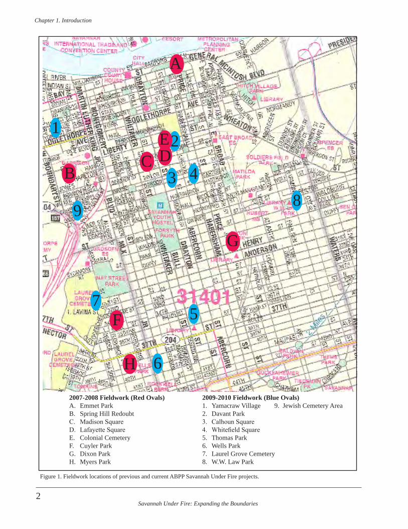
In addition, during the second grant they visited the South Caroliniana Library at the University of South Carolina and the South Carolina Department of Archives and History, both in Columbia, South Carolina (Figure 2). Researchers also visited the Georgia Department of Archives and History, in Morrow, Georgia outside of Atlanta. During the second grant project, research-ers also visited the City of Savannah Research Library and Municipal Archives and the Chatham County Metropolitan Planning Commission office.
Researchers visited the South Caroliniana Library and examined the Francis Marion Papers (Marion 1761-1794). Included in these papers was an over-size manuscript dated 1 Aug-1 Nov. 1779. It was the Pay Roll of Capt. Thomas Hall’s Company, 2nd Regiment of the South Carolina Continentals (Marion 1779). The pay roll listed the name, rank, and casualty information, as well as specific details about pay dates and amounts. Two were listed as casualties of the October 9, 1779 battle. They were Private John Croford listed as missing on October 9th, and Private Thomas Crozer, listed as killed on that day (Marion 1779:1). Researchers also obtained a copy of British Engineer James Moncrief’s “Siege of Charleston” journal (Moncrief 1780a). While it chronicles events in Charleston following the Battle of Savannah, the journal has details regarding Moncrief’s techniques and methods as an engineer, which can prove pertinent to his designs
and construction of the earthworks, redoubts, ditches, and artillery placement in Savannah the previous year.
At the South Carolina Department of Archives and History (SCDAH), researchers examined “The Book of Negroes” in Sir Guy Carleton Papers (Carleton 1783). This docu-ment lists each African American embarking on British ships between April and November of 1783, to sail for ports in Nova Scotia, Canada. Many of these African Americans had been formerly enslaved in Savannah and the surrounding areas, and gained freedom by fleeing their masters and joining British troops. They moved with the troops and when the British evacuated South Carolina in December of 1782, these African Americans went with them to New York, where they were put on ships for pas-sage to Canada. Researchers were aided in their examina-tion of this document by using the searchable transcrip-tions of that book located on a CD Rom (Whitehead 2002). Researchers visiting the SCDAH also examined the Lyman Draper collection on microfilm. This collection contains documents citing specific soldiers involved in and/or killed
in the Battle of Savannah, and events relating to the siege and battle.
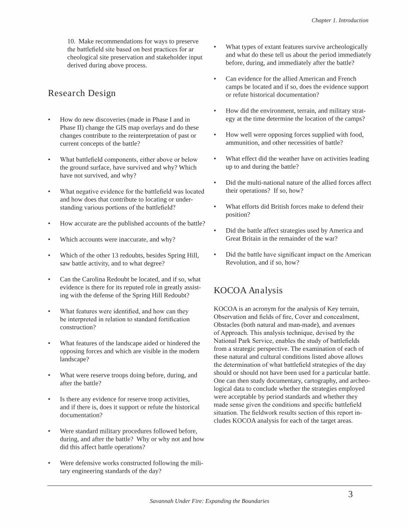
In Savannah, researchers examined hard-copy maps and select documents at the City of Savannah Research Library and Municipal Archives (Figure 3). Prior to their arrival, researchers searched the online catalog using key dates and key words associated with not only the Battle of Savannah, but also the individual parks, squares, and greenspaces to be investigated as part of this project. They also visited
Chatham County’s GIS Analyst David Anderson, and stud-ied select digital maps held by Chatham County.
Collector Surveys
Savannah has an active relic collector community. Archeologists visited one of the local metal detector enthu-siast clubs (Coastal Empire History Hunters Association) in an effort to speak with collectors interested in sharing information on the recovery of artifacts related to the Battle of Savannah. Several individuals at the club ex-pressed an interest in the project, and archeologists visited two members who had collections that sounded relevant to this project. Archeologists took photographs of the
Figure 2. Archeologists gather information from microfilm in SC.
Savannah Under Fire: Expanding the Boundaries
Chapter 2 . Methodology
7
collections, made notes regarding artifact provenience, and in one case made measurements of gunflints (in the Wheless collection) (Figure 4, 5). In several of these cases, metal detecting was conducted on sites under construc-tion that had seen no archeological investigations. This included projects that had no permitting, funding, or other mandates for archeology. In several cases metal detector-ists followed dump trucks removing soil from the sites and used metal detectors on the spoil piles deposited far away from the original sites. In one case a metal detector enthu-siast purchased removed soils and had them deposited on his property to be metal detected at his leisure. In the re-maining cases dozens of collectors used metal detectors on the site undergoing construction or clearing.
Utilities Marking
The Field Director notified the Utilities Hotline “Call Before You Dig” by telephone to make ticket locate
request prior to conducting fieldwork in each area of the project. She then verified responses on the hotline’s web-site. Areas with utilities marked by paint or pin flags were avoided during field work. More than one dozen locate requests were called in for this project and many were re-newed over the course of the work.
Fieldwork
Archeologists spent the first day of fieldwork, January 27, 2010, conducting a windshield survey of the various target areas. They visited each area to determine specific loca-tions of work and the methods that would work best on each site. They used this information the following day to plan for fieldwork investigations in each area.
Archeologists conducted fieldwork in February and May of 2010. They used several methods, and/or combinations of methods, to try to locate additional components of the
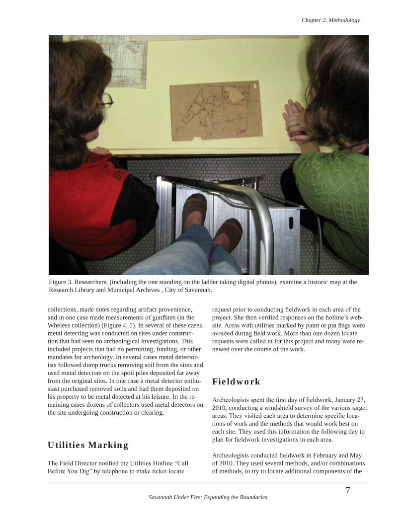
Figure 3. Researchers, (including the one standing on the ladder taking digital photos), examine a historic map at the Research Library and Municipal Archives , City of Savannah.
Savannah Under Fire: Expanding the Boundaries
Chapter 2 . Methodology
8
1779 Battle of Savannah. These included shovel testing, ground penetrating radar survey (GPR), metal detector sur-vey, and test unit excavation.
A continual pagination of bag/lot/FS numbers was used for all sites. This reduced the likelihood of confusion that would result from numerous “FS1”, “FS2”, etc. numbered bags had we started the lot list over at each site. In the same manner, shovel test and test unit numbers were continually pagi-nated. This allowed for only one ST1 or one TU1 during the entire project. (None of these numbers are tied to numbers used in the first NPS ABPP grant.)
Shovel test, metal detec-tor survey, feature, and test unit forms enabled the recording of field data. In a few instances, shovel test numbers were assigned but those shovel tests were not excavated, usually as a result of the information gathered from the shovel tests that were excavated. Shovel test numbers as-signed but not excavated include 18-22, 27, 29,
30, 34-37, 40, 55, and 56. Archeologists drew plan maps and profile drawings of test units, and kept a daily field book log. They photographed test unit floors and walls, and took photographs of shovel testing, GPR survey, metal detector survey, volunteers, and site landscapes. They used a Sokkia laser total station to shoot shovel test locations, GPR survey grid corners, test unit corners, landscaping features, and extant cultural features such as streets, curb corners, and standing structures. Each site was given its own datum points tied to arbitrary Easting and Northing grid locations that were later geo-referenced to digital City of Savannah maps. Archeologists also used the transit data to make scaled maps of each site.
Laboratory Analysis
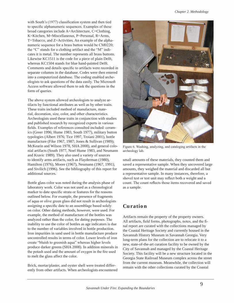
Many of the targeted areas of fieldwork were located where mid-to-late 20th century and early 21st century debris was common. Such modern “artifacts” and debris was noted but usually not recovered. All recovered arti-facts were brought to the Archeology Lab in the Curatorial Department of the Coastal Heritage Society, in Savannah, Georgia (Figure 6). There, artifacts were washed, counted, analyzed, and relabeled and rebagged for permanent cura-tion. Artifacts were analyzed by using a coding system based on broad functional categories generally aligned
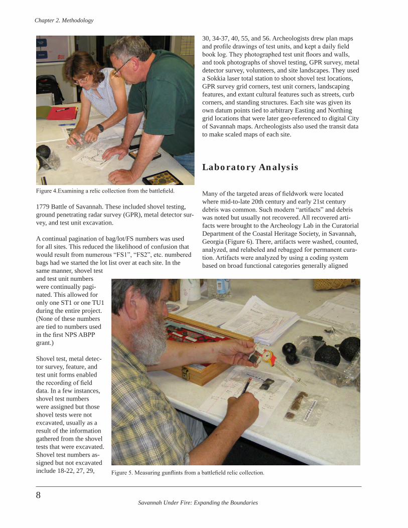
Figure 4.Examining a relic collection from the battlefield.
Figure 5. Measuring gunflints from a battlefield relic collection.
Savannah Under Fire: Expanding the Boundaries
Chapter 2 . Methodology
9
with South’s (1977) classification system and then tied to specific alphanumeric sequences. Examples of these broad categories include A=Architecture, C=Clothing, K=Kitchen, M=Miscellaneous, P=Personal, R=Arms, T=Tobacco, and Z=Activities. An example of the alpha-numeric sequence for a brass button would be CM0220; the “C” stands for a clothing artifact and the “M” indi-cates it is metal. The number represents all brass buttons. Likewise KC1511 is the code for a piece of plain Delft, whereas KC1504 stands for blue hand-painted Delft. Comments and details specific to artifacts were recorded in separate columns in the database. Codes were then entered into a computerized database. The coding enabled arche-ologists to ask questions of the data easily. The Microsoft Access software allowed them to ask the questions in the form of queries.
The above system allowed archeologists to analyze ar-tifacts by functional attributes as well as by other traits. These traits included method of manufacture, mate-rial, decoration, size, color, and other characteristics. Archeologists used these traits in conjunction with studies and published research by recognized experts in various fields. Examples of references consulted included: ceram-ics (Greer 1996; Hume 1983, South 1977), military button typologies (Albert 1976; Tice 1997, Troiani 2001), bottle manufacture (Fike 1967, 1987; Jones & Sullivan (1989); McKearin and Wilson 1978, SHA 2008), and general colo-nial artifacts (South 1977, Noel Hume 1983, and Neumann and Kravic 1989). They also used a variety of sources to identify arms artifacts, such as Flayderman (1980), Hamilton (1976), Moore (1967), Neumann (1967, 1991), and Sivilich (1996). See the bibliography of this report for additional sources.
Bottle glass color was noted during the analysis phase of laboratory work. Color was not used as a chronological marker to date specific strata or features for the reasons outlined below. For example, the presence of fragments of aqua or olive green glass did not result in archeologists assigning a specific date to an assemblage based solely on color. Other dating methods, however, were used. For example, the method of manufacture of the bottles was analyzed rather than the color, for dating purposes. The inability to use the color of bottles as age indicators is due to the number of variables involved in bottle production. Iron impurities in sand used in bottle manufacture produce uncontrolled results in terms of color. Lower levels of iron create “bluish to greenish aqua” whereas higher levels produce darker greens (SHA 2008). In addition minerals in the potash used and the amount of oxygen in the fire used to melt the glass affect the color.
Brick, mortar/plaster, and oyster shell were treated differ-ently from other artifacts. When archeologists encountered
small amounts of these materials, they counted them and saved a representative sample. When they uncovered large amounts, they weighed the material and discarded all but a representative sample. In many instances, therefore, a shovel test or test unit may reflect both a weight and a count. The count reflects those items recovered and saved as a sample.
Curation
Artifacts remain the property of the property owners. All artifacts, field forms, photographs, notes, and the fi-nal report are curated with the collections managed by the Coastal Heritage Society and currently housed in the Savannah History Museum in Savannah Georgia. Very long-term plans for the collection are to relocate it to a new, state-of-the-art curation facility to be owned by the City of Savannah and managed by the Coastal Heritage Society. This facility will be a new structure located in the Georgia State Railroad Museum complex across the street from the current museum. Meanwhile, the collection will remain with the other collections curated by the Coastal
Figure 6. Washing, analyzing, and cataloging artifacts in the archeology lab.
Savannah Under Fire: Expanding the Boundaries
Chapter 2 . Methodology
10
Heritage Society. Select artifacts may be incorporated into future exhibits within the Savannah History Museum.
Geographic Information Systems (GIS)
To find potential locations of archeological resources, historic maps were compared to the modern landscape of Savannah. Using ArcView 9.2, scans or digital photo-graphs of Revolutionary War-era maps were geo-refer-enced to GIS data from the City of Savannah. A minimum of three control points, or common points, were needed to align the maps. Previously, the only common geographic elements on both the historic and modern maps were streets. These were not the most desirable points, as streets and their widths and edges tend to vary through time. The archeological discovery of the southeastern corner and extending trenches of the Spring Hill Redoubt in 2005 allowed for an additional control point directly related to elements on most of the Revolutionary War maps. In addition, the discovery of a fortification trench during the previous ABPP project was incorporated into the GIS work. Unfortunately the latter was a linear stretch and not a “corner” trench that could be definitively aligned with a specific portion of the fortifications located in what is now Madison Square. While the 2005 and 2008 additions proved helpful, they did not resolve issues dealing with the level of accuracy of historic maps and the need for a uniform distribution across the project area of accurate control points.
This map depicts Savannah in 1770, just nine years before the battle (Figure 7). In 1779, Savannah was bounded by Bay and South Broad streets (the latter was renamed Oglethorpe Avenue) to the north and south, respectively, and Lincoln and Jefferson to the east and west, respec-tively. The four intersections of these streets, the center of town at the intersection of Bull and Broughton streets, and the corner of the Spring Hill Redoubt were the preferred control points in geo-referencing the historic and mod-ern maps. In addition, the trench discovered at Madison Square was used experimentally along different portions of trenches on historic maps in an effort to use it effectively as a control point. The historic maps contained varying degrees of detail, therefore, archeologists used as many of these control points as possible. Occasionally, it was nec-essary to add less-accurate control points from the land-scape (for example, at the intersection of a tributary and the Savannah River). These points allowed us to distribute our control points throughout the map, making the trans-formation more accurate overall, while sacrificing local accuracy.
Using these control points, new maps were created using first order polynomial (affine) and adjust transformations to align each historic map with the modern landscape. First order polynomial transformations only shift, scale, and rotate the historic map, but do not warp it. Adjust transformations use both the polynomial transformation and a triangulated irregular network to increase accuracy. Second order polynomial transformations were not used as they resulted in very large root mean square (RMS) errors and too much distortion in the historic maps. Archeologists then examined the new overlay maps to refine locations where the historic buildings, redoubts, camps, and other structures intersected with city green spaces, such as parks and “squares”.
Errors increase as distance from the control points increas-es. For our maps, this generally means any locations in downtown Savannah are fairly accurate; however, the error is much larger in the midtown districts, and continues to increase as one moves farther south and away from the old downtown. Another source of error is the inherent inaccu-racy of much of eighteenth century mapping. In addition, the evolution and redevelopment of the city over the past 230 years has caused some shifting in the centerline and edges of streets since 1779, causing inaccuracy in match-ing the control points.
GPR
Ground Penetrating Radar, or GPR, uses high frequency electromagnetic waves, or microwaves, to acquire sub-surface data. The device uses a transmitter antenna and closely spaced receiver antenna to detect changes in elec-tromagnetic properties beneath them. The antennas are suspended just above the ground surface, and the anten-nas are shielded to eliminate interference from sources other than directly beneath the device. The transmitting antenna emits a series of electromagnetic waves, which are distorted by differences in soil conductivity, dielectric permittivity, and magnetic permeability. The receiving an-tenna records the reflected waves for a specified length of time (in nanoseconds, or ns). The approximate depth of an object can be estimated with GPR, by adjusting for elec-tromagnetic propagation conditions.
The GPR sample blocks in this study area were composed of a series of parallel transects, or traverses, which yielded a two-dimensional cross-section or profile of the radar data (Figure 8). These samples are termed radargrams. This two-dimensional image is constructed from a sequence of thousands of individual radar traces. A succession of radar traces bouncing off a large buried object will produce a hy-perbola, when viewed graphically in profile. Multiple large
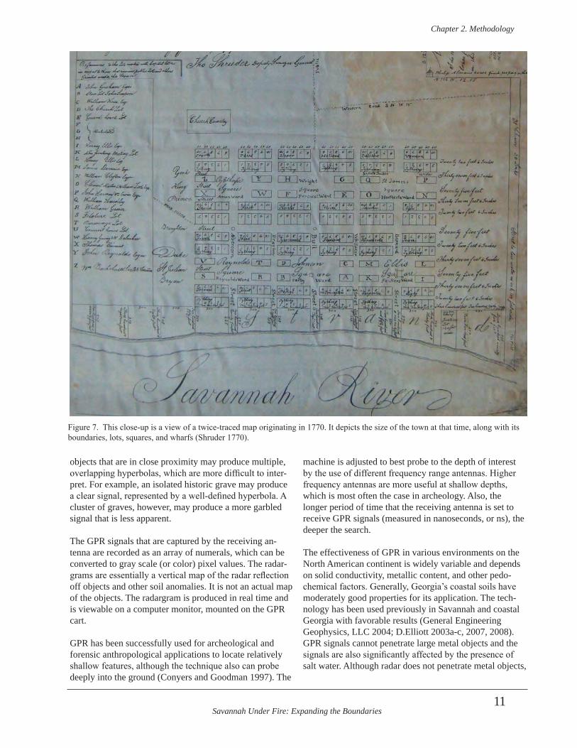
Savannah Under Fire: Expanding the Boundaries
Chapter 2 . Methodology
11
objects that are in close proximity may produce multiple, overlapping hyperbolas, which are more difficult to inter-pret. For example, an isolated historic grave may produce a clear signal, represented by a well-defined hyperbola. A cluster of graves, however, may produce a more garbled signal that is less apparent.
The GPR signals that are captured by the receiving an-tenna are recorded as an array of numerals, which can be converted to gray scale (or color) pixel values. The radar-grams are essentially a vertical map of the radar reflection off objects and other soil anomalies. It is not an actual map of the objects. The radargram is produced in real time and is viewable on a computer monitor, mounted on the GPR cart.
GPR has been successfully used for archeological and forensic anthropological applications to locate relatively shallow features, although the technique also can probe deeply into the ground (Conyers and Goodman 1997). The
machine is adjusted to best probe to the depth of interest by the use of different frequency range antennas. Higher frequency antennas are more useful at shallow depths, which is most often the case in archeology. Also, the longer period of time that the receiving antenna is set to receive GPR signals (measured in nanoseconds, or ns), the deeper the search.
The effectiveness of GPR in various environments on the North American continent is widely variable and depends on solid conductivity, metallic content, and other pedo-chemical factors. Generally, Georgia’s coastal soils have moderately good properties for its application. The tech-nology has been used previously in Savannah and coastal Georgia with favorable results (General Engineering Geophysics, LLC 2004; D.Elliott 2003a-c, 2007, 2008).GPR signals cannot penetrate large metal objects and the signals are also significantly affected by the presence of salt water. Although radar does not penetrate metal objects,
Figure 7. This close-up is a view of a twice-traced map originating in 1770. It depicts the size of the town at that time, along with its boundaries, lots, squares, and wharfs (Shruder 1770).
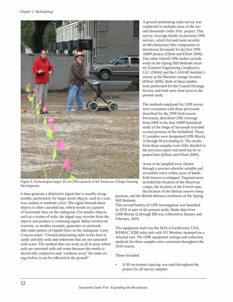
Savannah Under Fire: Expanding the Boundaries
Chapter 2 . Methodology
12
it does generate a distinctive signal that is usually recog-nizable, particularly for larger metal objects, such as a cast iron cannon or manhole cover. The signal beneath these objects is often canceled out, which results in a pattern of horizontal lines on the radargram. For smaller objects, such as a scatter of nails, the signal may ricochet from the objects and produce a confusing signal. Rebar-reinforced concrete, as another example, generates an unmistak-able radar pattern of rippled lines on the radargram. Larry Conyers notes: “Ground-penetrating radar works best in sandy and silty soils and sediments that are not saturated with water. The method does not work at all in areas where soils are saturated with salt water because this media is electrically conductive and ‘conducts away’ the radar en-ergy before it can be reflected in the ground”.
A ground penetrating radar survey was conducted in multiple areas of the sec-ond Savannah Under Fire project. This survey coverage builds on previous GPR surveys, which focused most recently on Revolutionary War components in downtown Savannah for the first NPS ABPP project (Elliott and Elliott 2008). Two other related GPR studies include work on the Spring Hill Redoubt local-ity [General Engineering Geophysics, LLC (2004)] and the LAMAR Institute’s survey at the Marriott cottage location (Elliott 2008). Both of these studies were performed for the Coastal Heritage Society and both were done prior to the present study.
The methods employed for GPR survey were consistent with those previously described for the 2008 field season. Previously described GPR coverage from 2008 in the first ABPP battlefield study of the Siege of Savannah included several portions of the battlefield. Those 12 samples were designated GPR Blocks A through M (excluding I). The results from those samples were fully detailed in the previous report and need not be re-peated here (Elliott and Elliott 2009).
Areas to be sampled were chosen through a process whereby suitable and accessible tracts within areas of battle-field interest overlapped. Targeted areas included the location of the American camps, the location of the French saps, the location of the Haitian reserve troop
position, and the British defenses northwest of the Spring Hill Redoubt.This second battery of GPR investigation was launched in 2010 as part of the present study. Radar data from GPR Blocks Q through BB was collected in January and February, 2010.
The equipment used was the MALA GeoScience USA, RAMAC X3M radar unit with XV Monitor, mounted on a wheeled cart. The GPR equipment settings and collection methods for these samples were consistent throughout the 2010 season.
These included:
• A 50 cm transect spacing was used throughout the project for all survey samples
Figure 8. Archeologists begin 50 cm GPR transects in the Yamacraw Village Housing Development.
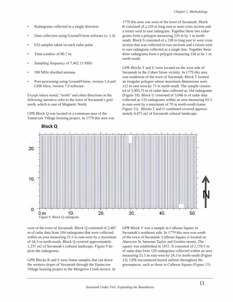
Savannah Under Fire: Expanding the Boundaries
Chapter 2 . Methodology
13
• Radargrams collected in a single direction
• Data collection using GroundVision software (v. 1.4)
• 632 samples taken on each radar pulse
• Time window of 80.7 ns
• Sampling frequency of 7,462.13 MHz
• 500 MHz shielded antenna
• Post-processing using GroundVision, version 1.4 and GPR-Slice, version 7.0 software.
Except where noted, “north” and other directions in the following narrative refer to the town of Savannah’s grid north, which is east of Magnetic North.
GPR Block Q was located in a commons area of the Yamacraw Village housing project. In 1779 this area was
west of the town of Savannah. Block Q consisted of 2,487 m of radar data from 104 radargrams that were collected within an area measuring 51.5 m east-west by a maximum of 24.3 m north-south. Block Q covered approximately 1,251 m2 of Savannah’s cultural landscape. Figure 9 de-picts the radargrams.
GPR Blocks R and S were linear samples that ran down the western slopes of Savannah through the Yamacraw Village housing project to the Musgrove Creek terrace. In
1779 this area was west of the town of Savannah. Block R consisted of a 220 m long east to west cross section and a return west to east radargram. Together these two radar-grams form a polygon measuring 220 m by 1 m north-south. Block S consisted of a 338 m long east to west cross section that was collected in two sections and a return west to east radargram collected as a single line. Together these three radargrams form a polygon measuring 338 m by 1 m north-south.
GPR Blocks T and U were located on the west side of Savannah in the Cohen Street vicinity. In 1779 this area was southwest of the town of Savannah. Block T formed an irregular polygon whose maximum dimensions were 112 m east-west by 71 m north-south. The sample consist-ed of 5,903.75 m of radar data collected as 144 radargrams (Figure 10). Block U consisted of 3,046 m of radar data collected as 133 radargrams within an area measuring 65.5 m east-west by a maximum of 70 m north-south (same Figure 11). Blocks T and U combined covered approxi-mately 4.475 m2 of Savannah cultural landscape.
GPR Block V was a sample in Calhoun Square in Savannah’s southeast side. In 1779 this area was south of the town of Savannah. Calhoun Square is located on Abercorn St. between Taylor and Gordon streets. The square was established in 1851. It consisted of 3,158.5 m of radar data from 120 radargrams collected within an area measuring 51.5 m east-west by 24.3 m north-south (Figure 12). GPR encountered buried utilities throughout the greenspaces, such as these in Calhoun Square (Figure 13).
Figure 9. Block Q radargram.
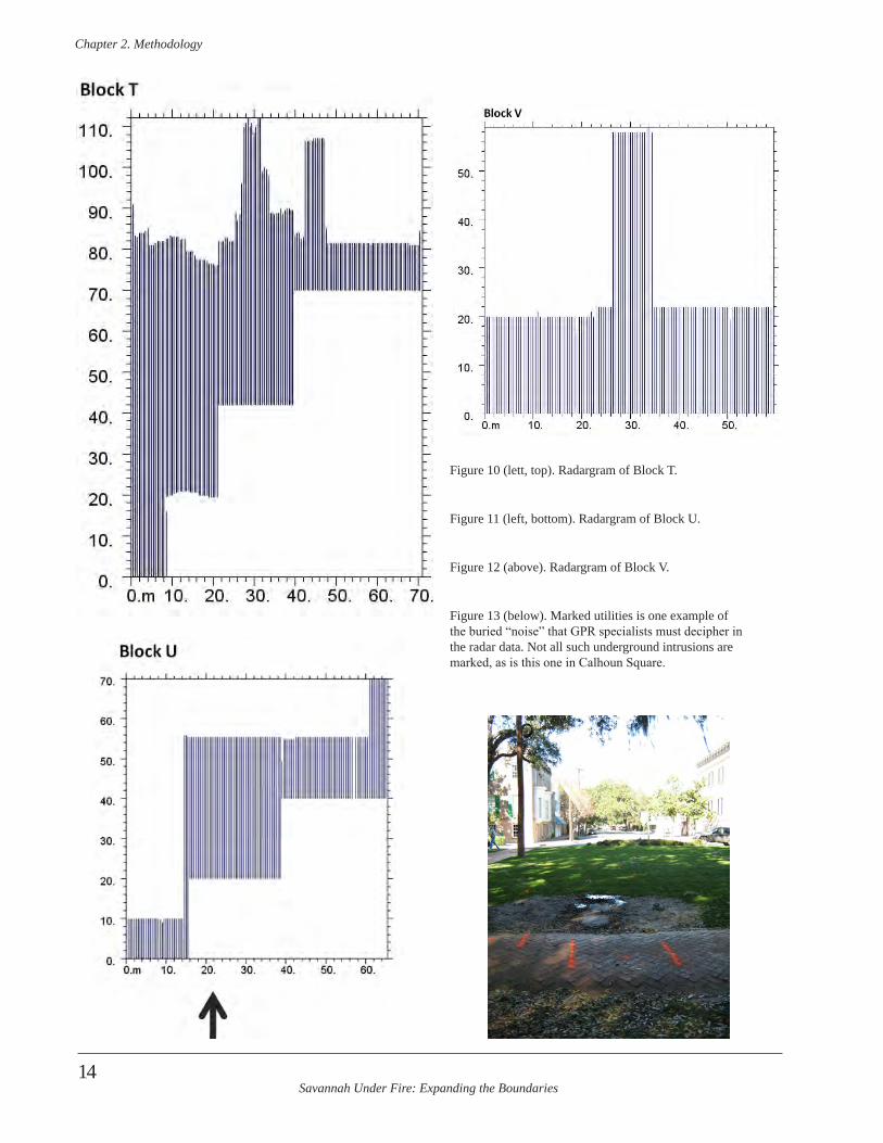
Savannah Under Fire: Expanding the Boundaries
Chapter 2 . Methodology
14
Figure 10 (lett, top). Radargram of Block T.
Figure 11 (left, bottom). Radargram of Block U.
Figure 12 (above). Radargram of Block V.
Figure 13 (below). Marked utilities is one example of the buried “noise” that GPR specialists must decipher in the radar data. Not all such underground intrusions are marked, as is this one in Calhoun Square.
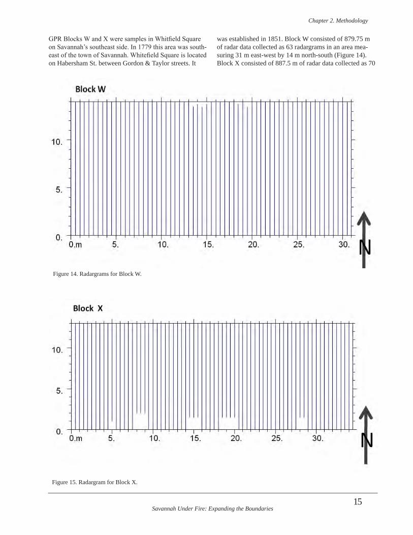
Savannah Under Fire: Expanding the Boundaries
Chapter 2 . Methodology
15
GPR Blocks W and X were samples in Whitfield Square on Savannah’s southeast side. In 1779 this area was south-east of the town of Savannah. Whitefield Square is located on Habersham St. between Gordon & Taylor streets. It
was established in 1851. Block W consisted of 879.75 m of radar data collected as 63 radargrams in an area mea-suring 31 m east-west by 14 m north-south (Figure 14). Block X consisted of 887.5 m of radar data collected as 70
Figure 14. Radargrams for Block W.
Figure 15. Radargram for Block X.
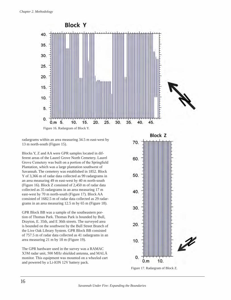
Savannah Under Fire: Expanding the Boundaries
Chapter 2 . Methodology
16
radargrams within an area measuring 34.5 m east-west by 13 m north-south (Figure 15).
Blocks Y, Z and AA were GPR samples located in dif-ferent areas of the Laurel Grove North Cemetery. Laurel Grove Cemetery was built on a portion of the Springfield Plantation, which was a large plantation southwest of Savannah. The cemetery was established in 1852. Block Y of 3,366 m of radar data collected as 99 radargrams in an area measuring 49 m east-west by 40 m north-south (Figure 16). Block Z consisted of 2,450 m of radar data collected as 35 radargrams in an area measuring 17 m east-west by 70 m north-south (Figure 17). Block AA consisted of 1682.5 m of radar data collected as 29 radar-grams in an area measuring 12.5 m by 65 m (Figure 18).
GPR Block BB was a sample of the southeastern por-tion of Thomas Park. Thomas Park is bounded by Bull, Drayton, E. 35th, and E 36th streets. The surveyed area is bounded on the southwest by the Bull Street Branch of the Live Oak Library System. GPR Block BB consisted of 757.5 m of radar data collected as 41 radargrams in an area measuring 21 m by 18 m (Figure 19).
The GPR hardware used in the survey was a RAMAC X3M radar unit, 500 MHz shielded antenna, and MALÅ monitor. This equipment was mounted on a wheeled cart and powered by a Li-ION 12V battery pack.
Figure 16. Radargram of Block Y.
Figure 17. Radargram of Block Z.
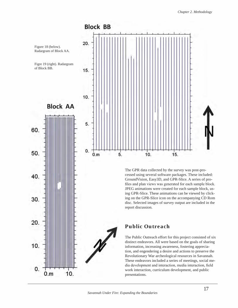
Savannah Under Fire: Expanding the Boundaries
Chapter 2 . Methodology
17
The GPR data collected by the survey was post-pro-cessed using several software packages. These included: GroundVision, Easy3D, and GPR-Slice. A series of pro-files and plan views was generated for each sample block. JPEG animations were created for each sample block, us-ing GPR-Slice. These animations can be viewed by click-ing on the GPR-Slice icon on the accompanying CD Rom disc. Selected images of survey output are included in the report discussion.
Public Outreach
The Public Outreach effort for this project consisted of six distinct endeavors. All were based on the goals of sharing information, increasing awareness, fostering apprecia-tion, and engendering a desire and actions to preserve the Revolutionary War archeological resources in Savannah. These endeavors included a series of meetings, social me-dia development and interaction, media interaction, field work interaction, curriculum development, and public presentations.
Figure 18 (below). Radargram of Block AA.
Figre 19 (right). Radargram of Block BB.
Savannah Under Fire: Expanding the Boundaries
Chapter 2 . Methodology
18
Meetings
One outreach effort involved a series of meetings. The project initially proposed to have three stakeholder meet-ings as warranted. The first would be an introduction meeting and orientation. The second would be a meeting in the field open to the public to showcase field discover-ies, and the third would be a stakeholder preservation meeting. These proposed meeting was realigned to match the project more closely as it progressed. Meeting 3 ben-efitted from the project director’s research of engaging communities. This research included reviewing the article mentioned by NPS ABPP staff, Reaching Out, Reaching In: A Guide to Creating Effective Public Participation for State Historic Preservation Programs (Lawson et al 2002). It also included email and telephone correspondence with archeologist Pam Cressy regarding her public engagement in the Alexandria Archeology Program.
Meeting 1
Meeting 1 was held December 9, 2009 in a conference room in City Hall in Savannah, Georgia. This first meeting was extremely productive and consisted of CHS project staff Laura Seifert and Rita Elliott meeting with officials whose jurisdiction included any part of the project area.
This included key City of Savannah departmental heads and staff, and with Housing Authority of Savannah person-nel. Attendees from City of Savannah departments present included: Jerry Flemming (Cemeteries), Martin Fretty (Housing), Jim Parker (Park & Tree) Bill Haws (Urban Forestry), Bob Scanlon (Facilities Maintenance Bureau), Marc Nelson (Engineering/ Developmental Services), Bridget Lidy (Administrator, Tourism and Film Services Department), Jim Shirley (Buildings and Grounds), and Tara Polli (Citizen Office). Non-city representatives in-cluded Earline Davis (Housing Authority of Savannah). The meeting was instrumental in sharing background information between archeologists and staff about the project.
Elliott gave a brief PowerPoint presentation about the project background, including what had been discovered during the first NPS ABPP project and shared the goals, geographic targets, and rationale for the current project. This was followed by a discussion of target locations, scheduling, needs of staff, and logistical arrangements. City staff provided critical information to archeologists, including what departments had jurisdiction of which areas, where soil removal had taken place in the past and
other information about the target areas. The meeting also allowed archeologists to address any concerns city depart-ments might have related to the execution of the project. It enabled departmental heads to realize that Revolutionary War archeological resources have already been document-ed in Savannah during the first NPS ABPP project, and that there was a strong likelihood that more such resources remain underground in areas of the city under their juris-diction. This meeting created a much better relationship with city staff and resulted in fieldwork unencumbered by problems that faced the fieldwork of the first NPS ABPP project. This report Appendix contains the minutes from this meeting.
Meeting 2
This meeting was proposed to be held in the field during the advent of a major discovery (similar to the discovery of the 6 foot deep defensive trench in Madison Square during the last project). While many small discoveries were made during this project, no one overwhelmingly large discovery occurred that would have made a public meeting and me-dia event warranted. For this reason, archeologists decided to merge Meetings 2 and 3.
Meeting 3
Meeting 3 was initially proposed to be a stakeholders meeting to engage the audience in considering initia-tives to preserve the Revolutionary War battlefield sites in Savannah. This goal was combined with Meeting 2 goals to share information archeologists discovered from the project with the public. In addition archeologists re-searched ways cities and counties in the United States have implemented preservation tools in their areas. This information was included in the presentation as described below.
The one-hour presentation was divided in thirds. The first 20 minutes consisted of a PowerPoint presentation overview of the Savannah Under Fire Revolutionary War projects conducted by Coastal Heritage Society through National Park Service, American Battlefield Protection Program Grants. The second 20 minute portion of the PowerPoint presentation was an overview of how preser-vation of archeological sites such as these has economical-ly and culturally benefitted other cities and counties across the U.S. It included five case studies. The third portion of the meeting consisted of opening the floor to the audience for comments and discussion on the project, the presenta-tion, and how these archeological sites in Savannah and Chatham County can be preserved (Figure 20). This por-tion of the meeting was slated for 20 minutes but remained on-going until the audience had no more comments. This
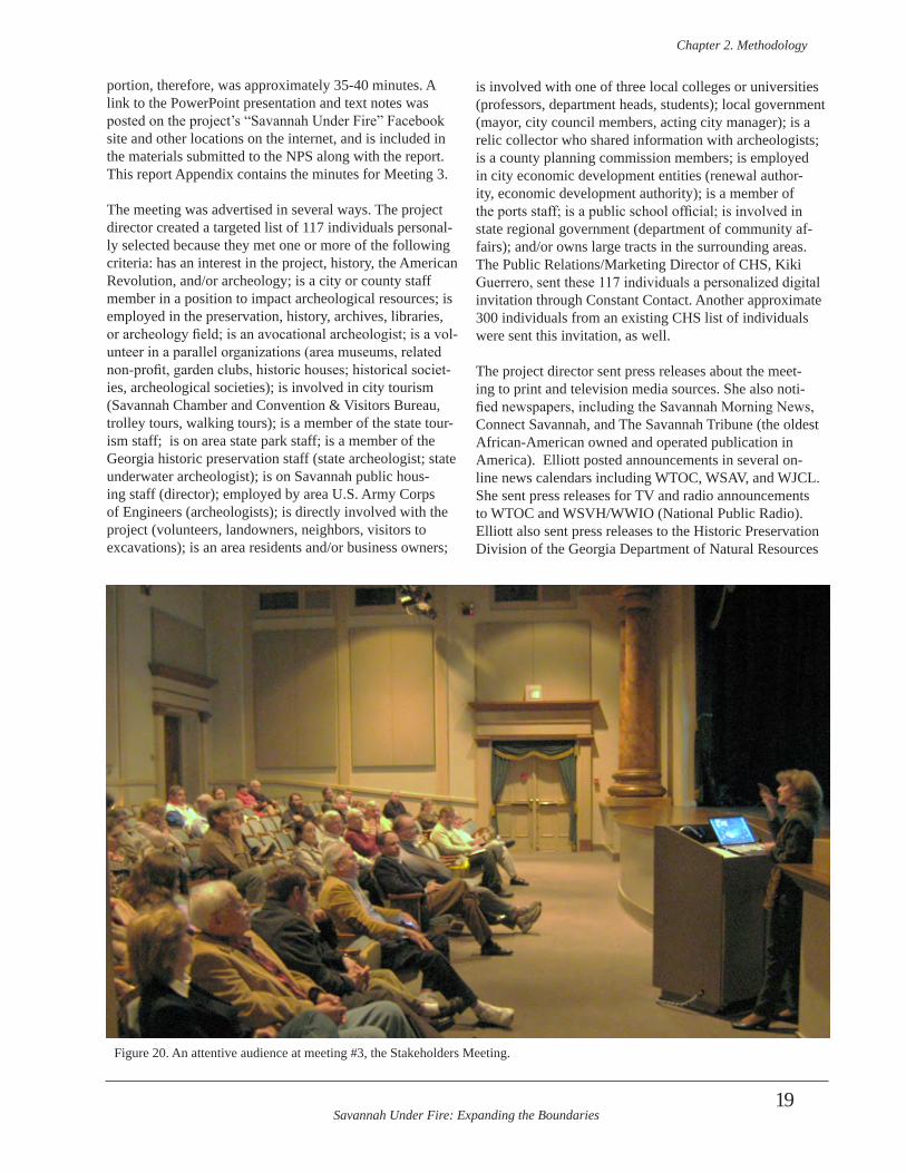
Savannah Under Fire: Expanding the Boundaries
Chapter 2 . Methodology
19
portion, therefore, was approximately 35-40 minutes. A link to the PowerPoint presentation and text notes was posted on the project’s “Savannah Under Fire” Facebook site and other locations on the internet, and is included in the materials submitted to the NPS along with the report. This report Appendix contains the minutes for Meeting 3.
The meeting was advertised in several ways. The project director created a targeted list of 117 individuals personal-ly selected because they met one or more of the following criteria: has an interest in the project, history, the American Revolution, and/or archeology; is a city or county staff member in a position to impact archeological resources; is employed in the preservation, history, archives, libraries, or archeology field; is an avocational archeologist; is a vol-unteer in a parallel organizations (area museums, related non-profit, garden clubs, historic houses; historical societ-ies, archeological societies); is involved in city tourism (Savannah Chamber and Convention & Visitors Bureau, trolley tours, walking tours); is a member of the state tour-ism staff; is on area state park staff; is a member of the Georgia historic preservation staff (state archeologist; state underwater archeologist); is on Savannah public hous-ing staff (director); employed by area U.S. Army Corps of Engineers (archeologists); is directly involved with the project (volunteers, landowners, neighbors, visitors to excavations); is an area residents and/or business owners;
is involved with one of three local colleges or universities (professors, department heads, students); local government (mayor, city council members, acting city manager); is a relic collector who shared information with archeologists; is a county planning commission members; is employed in city economic development entities (renewal author-ity, economic development authority); is a member of the ports staff; is a public school official; is involved in state regional government (department of community af-fairs); and/or owns large tracts in the surrounding areas. The Public Relations/Marketing Director of CHS, Kiki Guerrero, sent these 117 individuals a personalized digital invitation through Constant Contact. Another approximate 300 individuals from an existing CHS list of individuals were sent this invitation, as well.
The project director sent press releases about the meet-ing to print and television media sources. She also noti-fied newspapers, including the Savannah Morning News, Connect Savannah, and The Savannah Tribune (the oldest African-American owned and operated publication in America). Elliott posted announcements in several on-line news calendars including WTOC, WSAV, and WJCL. She sent press releases for TV and radio announcements to WTOC and WSVH/WWIO (National Public Radio). Elliott also sent press releases to the Historic Preservation Division of the Georgia Department of Natural Resources
Figure 20. An attentive audience at meeting #3, the Stakeholders Meeting.
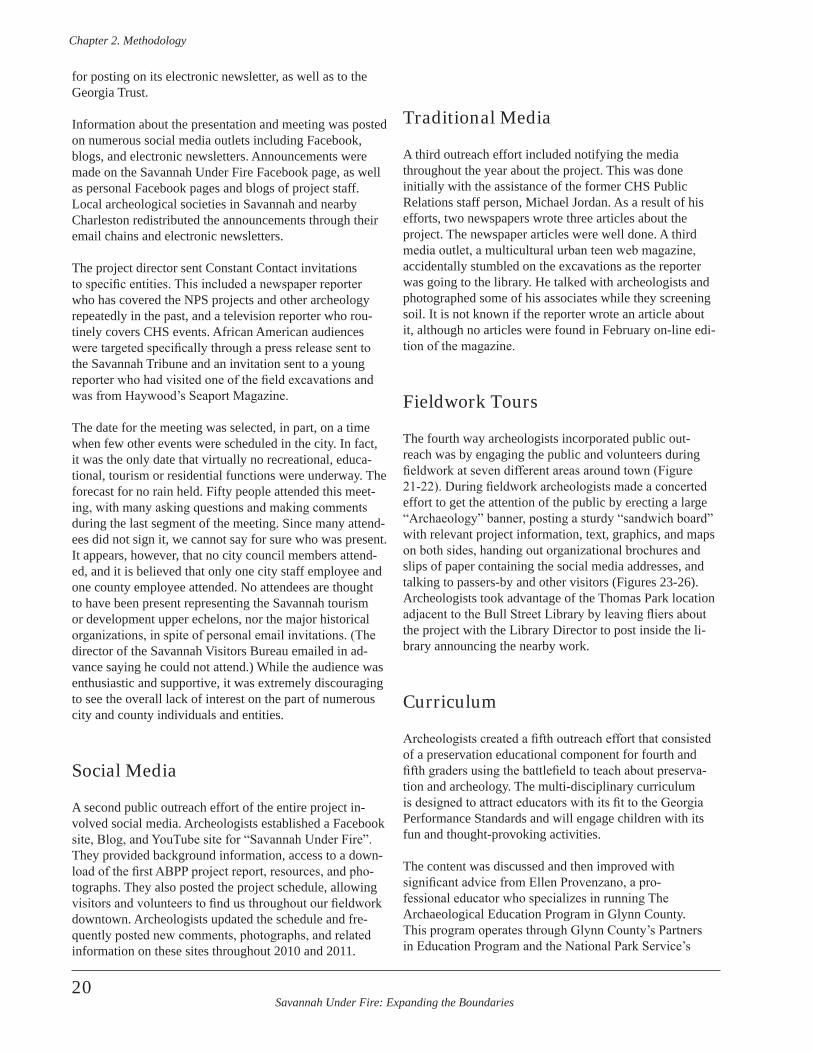
Savannah Under Fire: Expanding the Boundaries
Chapter 2 . Methodology
20
for posting on its electronic newsletter, as well as to the Georgia Trust.
Information about the presentation and meeting was posted on numerous social media outlets including Facebook, blogs, and electronic newsletters. Announcements were made on the Savannah Under Fire Facebook page, as well as personal Facebook pages and blogs of project staff. Local archeological societies in Savannah and nearby Charleston redistributed the announcements through their email chains and electronic newsletters.
The project director sent Constant Contact invitations to specific entities. This included a newspaper reporter who has covered the NPS projects and other archeology repeatedly in the past, and a television reporter who rou-tinely covers CHS events. African American audiences were targeted specifically through a press release sent to the Savannah Tribune and an invitation sent to a young reporter who had visited one of the field excavations and was from Haywood’s Seaport Magazine.
The date for the meeting was selected, in part, on a time when few other events were scheduled in the city. In fact, it was the only date that virtually no recreational, educa-tional, tourism or residential functions were underway. The forecast for no rain held. Fifty people attended this meet-ing, with many asking questions and making comments during the last segment of the meeting. Since many attend-ees did not sign it, we cannot say for sure who was present. It appears, however, that no city council members attend-ed, and it is believed that only one city staff employee and one county employee attended. No attendees are thought to have been present representing the Savannah tourism or development upper echelons, nor the major historical organizations, in spite of personal email invitations. (The director of the Savannah Visitors Bureau emailed in ad-vance saying he could not attend.) While the audience was enthusiastic and supportive, it was extremely discouraging to see the overall lack of interest on the part of numerous city and county individuals and entities.
Social Media
A second public outreach effort of the entire project in-volved social media. Archeologists established a Facebook site, Blog, and YouTube site for “Savannah Under Fire”. They provided background information, access to a down-load of the first ABPP project report, resources, and pho-tographs. They also posted the project schedule, allowing visitors and volunteers to find us throughout our fieldwork downtown. Archeologists updated the schedule and fre-quently posted new comments, photographs, and related information on these sites throughout 2010 and 2011.
Traditional Media
A third outreach effort included notifying the media throughout the year about the project. This was done initially with the assistance of the former CHS Public Relations staff person, Michael Jordan. As a result of his efforts, two newspapers wrote three articles about the project. The newspaper articles were well done. A third media outlet, a multicultural urban teen web magazine, accidentally stumbled on the excavations as the reporter was going to the library. He talked with archeologists and photographed some of his associates while they screening soil. It is not known if the reporter wrote an article about it, although no articles were found in February on-line edi-tion of the magazine.
Fieldwork Tours
The fourth way archeologists incorporated public out-reach was by engaging the public and volunteers during fieldwork at seven different areas around town (Figure 21-22). During fieldwork archeologists made a concerted effort to get the attention of the public by erecting a large “Archaeology” banner, posting a sturdy “sandwich board” with relevant project information, text, graphics, and maps on both sides, handing out organizational brochures and slips of paper containing the social media addresses, and talking to passers-by and other visitors (Figures 23-26). Archeologists took advantage of the Thomas Park location adjacent to the Bull Street Library by leaving fliers about the project with the Library Director to post inside the li-brary announcing the nearby work.
Curriculum
Archeologists created a fifth outreach effort that consisted of a preservation educational component for fourth and fifth graders using the battlefield to teach about preserva-tion and archeology. The multi-disciplinary curriculum is designed to attract educators with its fit to the Georgia Performance Standards and will engage children with its fun and thought-provoking activities.
The content was discussed and then improved with significant advice from Ellen Provenzano, a pro-fessional educator who specializes in running The Archaeological Education Program in Glynn County. This program operates through Glynn County’s Partners in Education Program and the National Park Service’s
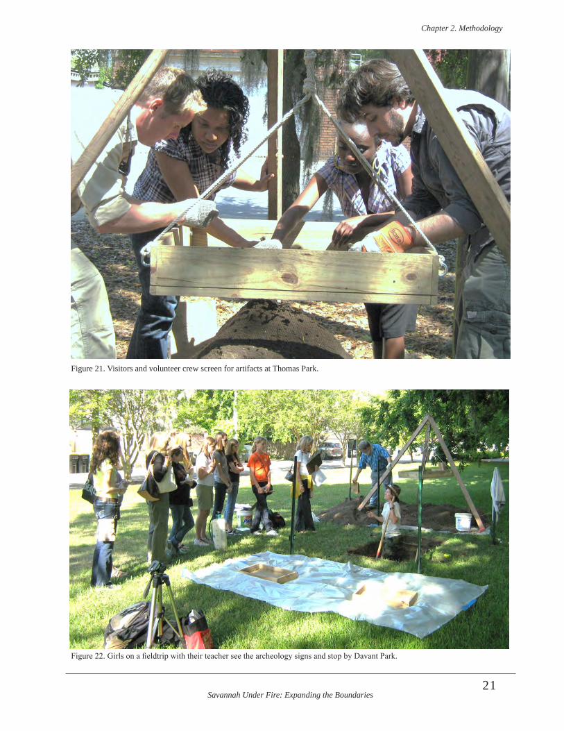
Savannah Under Fire: Expanding the Boundaries
Chapter 2 . Methodology
21
Figure 21. Visitors and volunteer crew screen for artifacts at Thomas Park.
Figure 22. Girls on a fieldtrip with their teacher see the archeology signs and stop by Davant Park.
Savannah Under Fire: Expanding the Boundaries
Chapter 2 . Methodology
22
Figure 23 (right). The ban-ner follows the crew to each location of fieldwork.
Figure 24 (left). Relevant text and graphics are placed on both sides of the “sand-wich board” at each new location.
Figure 25 (right). Interested passers-by, including these sanitation workers, are given papers with the “Savannah Under Fire” facebook and blog information.
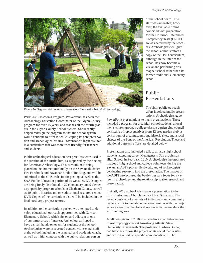
Savannah Under Fire: Expanding the Boundaries
Chapter 2 . Methodology
23
Parks As Classrooms Program. Provenzano has been the Archaeology Education Coordinator of the Glynn County program for over 15 years, and reaches all the fourth grad-ers in the Glynn County School System. She recently helped redesign the program so that the school system would continue to offer it, while keeping its core preserva-tion and archeological values. Provenzano’s input resulted in a curriculum that was more user-friendly for teachers and students.
Public archeological education best practices were used in the creation of the curriculum, as supported by the Society for American Archaeology. This curriculum is being placed on the internet, minimally on the Savannah Under Fire Facebook and Savannah Under Fire Blog, and will be submitted to the CHS web site for posting, as well as the SAA Public Education portion of its website). DVD copies are being freely distributed to 22 elementary and 9 elemen-tary specialty program schools in Chatham County, as well as 10 public libraries and one educational resource center. DVD Copies of the curriculum also will be included in the final hard-copy project reports.
In addition to the curriculum packet, we attempted to de-velop educational outreach opportunities with Garrison Elementary School, which sits on and adjacent to one of our target areas of interest. Archeologists hoped to have a small hands-on event for students at the school. Archeologists were in repeated contact with several staff at the school, including the principal and academic coach, as well as initial contacts with the public relations person
of the school board. The staff was amenable; how-ever, the available timing coincided with preparation for the Criterion-Referenced Competency Tests (CRCT), so was deferred by the teach-ers. Archeologists will give the school administrators a copy of the DVD curriculum, although in the interim the school has now become a visual and performing arts magnet school rather than its former traditional elementary school.
Public Presentations
The sixth public outreach effort involved public presen-tations. Archeologists gave
PowerPoint presentations to many organizations. These included a program for area high school students, a local men’s church group, a college class, a garden club council consisting of representatives from 12 area garden club, a consortium of area museums and historic sites, and a local chapter of the Sons of the American Revolution. These and additional outreach efforts are detailed below.
Presentations also included a talk to all area high school students attending career Megagenesis Day at Johnson High School in February, 2010. Archeologists incorporated images of high school and college volunteers during the Savannah ABPP project fieldwork, and of archeologists conducting research, into the presentation. The images of the ABPP project used the battle sites as a focus for a ca-reer in archeology and the relationship to site research and preservation.
In April, 2010 archeologists gave a presentation to the First Presbyterian Church men’s club in Savannah. The group consisted of a variety of individuals and community leaders. Prior to the talk, none were familiar with the proj-ect or aware of archeological resources in Savannah or the surrounding area.
A talk was given in 2010 to 40 students in an Introduction to Anthropology class at Armstrong Atlantic State University in Savannah. The professor, Barbara Bruno, had her class follow the project on its social media sites and write a report on specific components of it. The
Figure 26. Segway visitors stop to learn about Savannah’s battlefield archeology.
Savannah Under Fire: Expanding the Boundaries
Chapter 2 . Methodology
24
presentation in April was a follow-up to this activity. Project archeologists asked for and received copies of many of these reports. This enabled them to evaluate the effectiveness of their social media postings, and to modify content that may have been unclear.
Archeologists presented a PowerPoint talk to the Savannah Area Council of Garden Clubs at its annual meeting in May, 2010. While this talk was not funded by the ABPP grant, the outreach is very relevant in that it presented a detailed overview of the project. Two of the councils rep-resented expressed a desire for the talk to be presented at their local garden club meetings.
Another presentation in May incorporated some informa-tion from the ABPP project as an example of the signifi-cant archeological resources that lie unseen, underground in Savannah. This presentation was given to the Coastal Museums Association. Members include museum profes-sionals from multiple counties in and around the Savannah area. Many of these professionals are employed at muse-ums, historic houses, and historic sites and include venues owned by the city, state, and federal governments, as well as by private organizations and non-profit entities.In November, 2010 the field director gave a presentation to the Edward Telfair Chapter of the Sons of the American Revolution. This presentation was in Savannah. It was an overview of the NPS project and results, with empha-sis on preservation of the sites and how that might be accomplished.
On a related note, project archeologists organized a Revolutionary War symposium, Revolutionary Steps: Marching Towards Discovery and Preservation at The Society for Historical Archaeology conference in Amelia Island, Florida in January, 2010. The symposium in-cluded their own paper, The Third Battle of Savannah: An Archaeological Struggle for Identification, Preservation, and Interpretation on the past and current ABPP projects they did in Savannah, as well as 11 other papers about ABPP and other projects conducted by other individuals and entities along the east coast of the U.S. Two discus-sants rounded out the symposium. This symposium was not funded by the current NPS ABPP grant; however, it is mentioned because it was an effective outreach tool in sharing the Savannah project information with archeolo-gists and other scholars, while allowing Savannah project archeologists to learn about relevant information on other Revolutionary War projects in the country. The symposium can be considered an additional matching contribution to the project beyond those outlined in the grant proposal.
Project archeologists also staffed a table at the Savannah History Museum in February, 2010 during “Super Museum Sunday”, a day which allows people to visit virtually all
the museums and historic sites in the city at no charge. The table had a hands-on activity to attract interest, while displaying last season’s report. An archeologist then spoke to visitors as they approached the table about the current project and gave them paper slips with the name and ad-dress of the social media sites to visit for more informa-tion. Several interested persons’ names and contact infor-mation emerged from this event, including people who wanted to preserve sites and had a background in preserva-tion prior to moving to Savannah. Later, these individuals were sent email invitations to the Stakeholders meeting. While the Super Museum Sunday effort was not funded by the NPS ABPP project, the outreach was an additional con-tribution to the project not required by the grant.
Final Curation
Recovered artifacts were washed and analyzed, and are curated at the Savannah History Museum. The museum is operated by the non-profit Coastal Heritage Society for the City of Savannah. CHS meets or exceeds archeological lab procedures and curates artifacts in a profession manner. All associated field notes, resources, data, photographs, and other documents associated with the project has been curated along the with artifact collection. Copies of the final report will be curated with the project materials, as well.
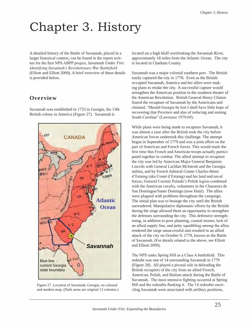
Savannah Under Fire: Expanding the Boundaries
Chapter 3 . History
25
Chapter 3. History
A detailed history of the Battle of Savannah, placed in a larger historical context, can be found in the report writ-ten for the first NPS ABPP project, Savannah Under Fire: Identifying Savannah’s Revolutionary War Battlefield (Elliott and Elliott 2009). A brief overview of these details is provided below.
Overview
Savannah was established in 1733 in Georgia, the 13th British colony in America (Figure 27). Savannah is
located on a high bluff overlooking the Savannah River, approximately 18 miles from the Atlantic Ocean. The city is located in Chatham County. Savannah was a major colonial southern port. The British easily captured the city in 1778. Even as the British occupied Savannah, America and her allies were mak-ing plans to retake the city. A successful capture would strengthen the American position in the southern theater of the American Revolution. British General Henry Clinton feared the recapture of Savannah by the Americans and claimed, “Should Georgia be lost I shall have little hope of recovering that Province and also of reducing and arming South Carolina” (Lawrence 1979:69).
While plans were being made to recapture Savannah, it was almost a year after the British took the city before American forces undertook this challenge. The attempt began in September of 1779 and was a joint effort on the part of American and French forces. This would mark the first time that French and American troops actually partici-pated together in combat. The allied attempt to recapture the city was led by American Major General Benjamin Lincoln with General Lachlan McIntosh and the Georgia militia, and by French Admiral Comte Charles-Henri d’Estaing (aka Count d’Estaing) and his land and naval forces, General Casimir Pulaski’s Polish legion combined with the American cavalry, volunteers in the Chasseurs de San Domingue/Santo Domingo (now Haiti). The allies were plagued with problems throughout the campaign. The initial plan was to besiege the city until the British surrendered. Manipulative diplomatic efforts by the British during the siege allowed them an opportunity to strengthen the defenses surrounding the city. This defensive strength-ening, in addition to poor planning, coastal storms, lack of an allied supply line, and petty squabbling among the allies rendered the siege unsuccessful and resulted in an allied attack of the city on October 9, 1779, known as the Battle of Savannah. (For details related to the above, see Elliott and Elliott 2009).
The NPS ranks Spring Hill as a Class A battlefield. This redoubt was one of 14 surrounding Savannah in 1779 (Figure 28). All played a pivotal role in defending the British occupiers of the city from an allied French, American, Polish, and Haitian attack during the Battle of Savannah. The most intensive fighting occurred at Spring Hill and the redoubts flanking it. The 14 redoubts encir-cling Savannah were associated with artillery positions,
Atlantic Ocean
CANADA
Savannah
Blue line - current Georgia state boundary
Figure 27. Location of Savannah, Georgia, on colonial and modern map. (Dark areas are original 13 colonies.)
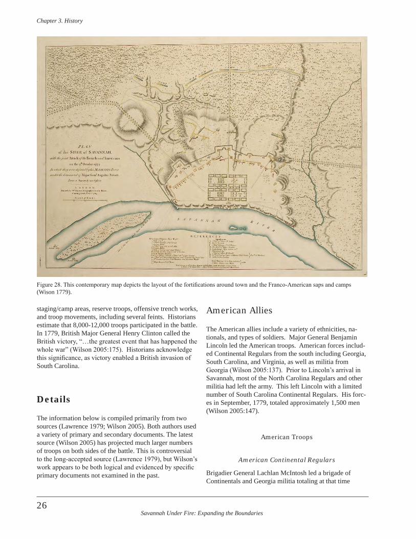
Savannah Under Fire: Expanding the Boundaries
Chapter 3 . History
26
staging/camp areas, reserve troops, offensive trench works, and troop movements, including several feints. Historians estimate that 8,000-12,000 troops participated in the battle. In 1779, British Major General Henry Clinton called the British victory, “…the greatest event that has happened the whole war” (Wilson 2005:175). Historians acknowledge this significance, as victory enabled a British invasion of South Carolina.
Details
The information below is compiled primarily from two sources (Lawrence 1979; Wilson 2005). Both authors used a variety of primary and secondary documents. The latest source (Wilson 2005) has projected much larger numbers of troops on both sides of the battle. This is controversial to the long-accepted source (Lawrence 1979), but Wilson’s work appears to be both logical and evidenced by specific primary documents not examined in the past.
American Allies
The American allies include a variety of ethnicities, na-tionals, and types of soldiers. Major General Benjamin Lincoln led the American troops. American forces includ-ed Continental Regulars from the south including Georgia, South Carolina, and Virginia, as well as militia from Georgia (Wilson 2005:137). Prior to Lincoln’s arrival in Savannah, most of the North Carolina Regulars and other militia had left the army. This left Lincoln with a limited number of South Carolina Continental Regulars. His forc-es in September, 1779, totaled approximately 1,500 men (Wilson 2005:147).
American Troops
American Continental Regulars
Brigadier General Lachlan McIntosh led a brigade of Continentals and Georgia militia totaling at that time
Figure 28. This contemporary map depicts the layout of the fortifications around town and the Franco-American saps and camps (Wison 1779).
Savannah Under Fire: Expanding the Boundaries
Chapter 3 . History
27
approximately 400 men (Wilson 2005:147). The Georgia militia consisted of three companies under General Lachlan McIntosh’s control. They traveled from Augusta, Georgia. In addition, officers who lost most or all of their Georgia Continental troops at the previous battles of Savannah and Brier Creek headed to Savannah, as did troops from Virginia (Lawrence 1979:15).
South Carolina Continental Regulars
South Carolina Continental Regulars included the Corps of Light Infantry and Grenadier Company of the Charlestown Militia, under command of Lieutenant Colonel John Laurens. Colonel Francis Marion led the 2nd South Carolina Continental Regiment and Colonel William Thompson commanded the 3rd South Carolina Regiment (Wilson 2005:177). The 1st Battalion of the Charlestown Militia was led by Colonel Maurice Simons. These troops, along with the 1st Virginia Continental Levies (command-ed by Colonel Richard Parker) constituted the right column of attack during the 1779 battle (Wilson 2005:177).
During the Battle of Savannah Brigadier General Lachlan McIntosh led the left column. This included three South Carolina Regiments. The 1st South Carolina Continental Regiment was commanded by Colonel Charles Pinckney. The 5th South Carolina Regiment fell under Lieutenant Colonel Alexander McIntosh. Lieutenant Colonel William Henderson commanded the 6th South Carolina Regiment (Wilson 2005:177).
Georgia and South Carolina Militia
Brigadier General Isaac Huger’s column contained the bulk of the militia. His Georgia militia was led by Colonels William Few, John Dooly, John Twiggs, Robert Middleton, and Leonard Marbury. His Colonels William Skirving and William Harden and Lieutenant Colonel Benjamin Garden commanded his South Carolina Militia. Brigadier General Andrew Williamson’s Bridgade of South Carolina Militia included Independent Companies and units commanded by the following Colonels: Hammond, Thomas, Williams, Reed, and Brandon. The 2nd Battalion of the Charlestown Militia fought in this column, as well (Wilson 2005:178).
Reserve Troops were led by Major General Benjamin Lincoln. This was an artillery reserve consisting of the 4th South Carolina Regiment of Continental Artillery led by Colonel Barnard Beekman. A total of 10 cannons was in the reserve unit (Wilson 2005:178).
French Troops
The largest body of other nationals on the allied side con-sisted of French troops. Serving under French command were French, Irish, and Caribbean troops. Both the French army and navy were represented. The French allies were under the command of Vice Admiral D’Estaing (Admiral and General Le Comte d’Estaing), who brought an armada of 22 ships to the coast of Georgia in September, 1779. This included the following: “… twenty-two ships of the line, nine frigates, and several dozen transports…” (Wilson 2005:135). French troops included mainland soldiers as well as colonial troops from Caribbean islands.
The Avant-Garde of the Army
The Avant-Garde consisted of grenadiers and chasseurs. Three Volunteer Grenadier Companies were commanded by Captains Aubery, Herneville, and DeVeone. Other troops included the: Grenadier Company of Armagnac, Chasseu Company of Armagnac, Grenadier Company of Agenois, and the Chasseur Company of Gatinois (Wilson 2005:178).
Fusiliers
A Swede named Baron De Steding commanded the left column of the French army. It consisted of two regiments of Fusiliers. One regiment included fusilier companies of: Armagnac, Auxerrois, Foix, Dillon, and Walsh. The other regiment consisted of fusilier companies of: Cambresis, Haynault, Le Cap, Guadeloupe, and Port au Prince. The Dragoons of Conde and of Belzunce [dismounted] fought within this group as well.
Reserve Column
French General Le Vicomte Louis Marie de Noailles com-manded the Corps de reserve. These reserve soldiers were taken from the Right and Left Columns. The reserve also included artillerymen and fieldpieces (Wilson 2005:179).
Troops in Batteries
By October 9, the French had constructed numerous bat-teries. They armed the Right Battery with the Royal Corps of Marines and multiple cannons. Volunteer Chasseurs of San Domingo manned the Left Battery, along with cannons. The Bombardiers of the Navy and additional Volunteer Chasseurs of San Domingo remained in the Mortar Battery, along with mortars (Wilson 2005:180).
Savannah Under Fire: Expanding the Boundaries
Chapter 3 . History
28
Haitian and Entrenched Troops
The country now called Haiti was a French colony in 1779 known as San Domingo (one of several variant spellings). The Volunteers of San Domingo constituted the first free black regiment in the French army. Both the Volunteer Chasseurs of San Domingo and the Volunteer Grenadiers of San Domingo were listed as “entrenched troops” dur-ing the battle. The grenadiers were commanded by Major Des Francais. The French officers of the free black San Domingo troops were white.
Major Jean-Claude-Louis de Sablieres commanded the entrenched troops. Other entrenched troops included the Royal Corps of Marines, Chasseur Company of Martinique, the Fusilier Company of Martinique, the Dragoons of Conde and of Belzunce, and Gunners and Cannoneers. The dragoons were commanded by M. Dejean (Wilson 2005:179).
Irish
French ranks also were swelled by “…hundreds of Irish expatriates” who served under command of Arthur Dillon (Wilson 2005:137). On the day of the battle, Dillon would lead “…elite grenadier and light infan-try companies drawn from the army’s best regiments” (Wilson 2005:158). Dillon led the right column. This included the Volunteer Grenadier Company in the Avant Garde commanded by Captain Moedermotte. It also in-cluded the Battalion of Grenadiers (Grenadier Company of Auxerrois, Grenadier Company of Foix, Grenadier Company of Dillon, Grenadier Company of Guadeloupe, and Chasseur Company of Guadeloupe). Other troops in the right column consisted of the Battalion of Grenadiers and Chasseurs, made up of the Grenadier Company of Cambresis, Grenadier Company of Haynault, Chasseur Company of Champagne, Chasseur Company of Le Cap, Chasseur Company of Port au Prince, and the Dragoons of Conde and of Belzunce [dismounted]) (Wilson 2005:178-179).
Polish
Polish General Count Casimir Pulaski and his Polish and other European officers led his legion, which included the American cavalry. American troops within Pulaski’s Legion included, the American South Carolina Light Dragoons who were commanded by Lt. Colonel Daniel Horry, while the 1st Regiment of Virginia Light Dragoons was under the command of Major John Jameson (Wilson 2005:159; 177). Historians report that Pulaski’s Legion also contained German and British deserters (Wilson 2005:137).
British Troops
British troops consisted of Regular army, in addi-tion to South Carolina Royalists and militia “…from North Carolina, New Jersey and New York” (Wilson 2005:137). British troops included renowned 71st Scottish Highlanders, as well as German Hessian soldiers. African-Americans constituted much of the engineering muscle as they built and strengthened various earthworks. The list below is taken from Wilson (2005: 180-181).
The British occupying Savannah were under the command of Major General Augustin Prevost. Lieutenant Colonel/Major John Maitland was in command of 1,000 men. He moved his troops from nearby Beaufort, South Carolina to Savannah when ordered to do so by Major General Prevost. Prevost also recalled the garrisons at Ebenezer and Sunbury, Georgia.
71st Scottish Highlanders
These Scottish soldiers were led by Lieutenant Colonel John Maitland. It consisted of a 1st and 2nd Battalion. The Highlanders were known for the distinctive sound of bag-pipes before battle followed by fierce fighting.
Light Corps
The Light Corps was led by Major Colin Graham. It in-cluded the 16th Regiment and the Light Infantry. The Light Infantry included the 16th, 60th, and 71st (Wilson 2005:180).
Royal Artillery & Royal Marines
The Royal Artillery included multiple cannons of various sizes. Approximately 40 soldiers participated in the Battle of Savannah as members of the Royal Marines.
British Legion
A total of 24 troops was listed in the British Legion.
HessiansThis general category includes the Grenadier Regiment von Trumback and the Garrison Regiment von Wiessenbach. Lieutenant Colonel Friedrich von Porbeck commanded over 500 men under the latter.
Savannah Under Fire: Expanding the Boundaries
Chapter 3 . History
29
Colonial TroopsThe New York Volunteers were commanded by Major Sheridan. DeLancey’s Regiment consisted of a 1st Battalion under command of Lt. Col. John Cruger and a 2nd battalion commanded by Lt. Col. DeLancy. A 3rd Battalion was Cortland Skinner’s New Jersey Volunteers under command of Lt. Col. Isaac Allen. Southern colo-nies also contributed troops. Lt. Col. Thomas Brown led the King’s Florida Rangers. The South Carolina Royalists were led by Col. Alexander Innes and also called Innes’s Carolina Loyalists. The Royalists had a 1st and 2nd Battalion. Other troops included the South Carolina Volunteers, the North Carolina Volunteers (under com-mand of Lieutenant Col. John Hamilton), the Georgia Loyalists and Volunteers (under Maj. Wright), the Georgia Loyal Militia, and the City of Savannah Loyal Militia. The 60th Regiment (Royal Americans) consisted of loyal-ists from Florida. The regiment contained three battalions. This included the 2nd, 3rd, and 4th.
OthersHistorians estimate that 400-500 enslaved African Americans were pressed into service to work on rein-forcing the four original redoubts around the city and constructing additional redoubts (Lawrence 1979:28). Georgia’s Royal Governor supplied many of these workers from his 11 plantations. The redoubts were surrounded by a cedar and pine abatis. Areas between the redoubts were supplemented with “horse-shoe batteries in embrasure” (Lawrence 1979:28). Rearward of these were epaul-ments and traverses. Various troops and workers included Volunteer Negroes, Black Pioneers, Seamen and other mis-cellaneous troops (Wilson 2005:181)
Account of Siege and Battle
The siege began September 4, 1779 with the sighting of the French fleet off the coast of Georgia. The flurry of activity on both the attacking American allied forces and defending British troops are outlined below. The siege culminated on October 9, in the Battle of Savannah. The battle occurred after dawn on October 9, 1779. A feint on the central redoubt of the city failed and the actual attack at Spring Hill Redoubt was met with the relocation of large amounts of British forces and armament. Confusion among allied officers and in the ranks, as well as the presence of key terrain features such as a nearby swamp, contributed to the total disarray of attacking allied forces. In spite of a few fleeting minutes in which allied colors were held over-head on the Spring Hill Redoubt, the allies were soundly defeated. The 55 minute battle saw approximately two dozen British forces wounded or killed contrasted with an estimated 800 dead or wounded on the allied side. It is
likely that additional primary research and archeological investigation may refine and expand the current Account of Battle outlined below. Some of the account is taken from (Lawrence 1979), but most heavily from Wilson (2005), with many additions from the account Major General Augustin Prevost penned on November 1, 1779 (Prevost 1779a) and a sprinkling of other primary source documents. Pertinent events during the siege and battle are outlined below. Figure 29 is a period map depicting some of the locations mentioned below (Doolittle 1796).
September 4 and 6French ships arrive off the coast of Georgia.
September 6Engineer Moncrief and 100 men sent to Tybee to reinforce the post and battery. Prevost sends express messages to Colonel Maitland for reinforcements, and warnings about the French fleet to St. Augustine, New York, and the West Indies (Prevost 1779a).
September 7 and 8,Prevost sends express messages to all Savannah’s outposts, “…to join Beaufort, Ebenezer, Cherokee Hill, Ogeechee, and Sunbury” (Prevost 1779a).
September 9-11 and 13-15D’Estaing begins landing troops in bad weather at Beaulieu plantation. He brought 1,600 troops from Saint Domingue and 1,600 from Guadeloupe (Dull 1975:161)
September 9Prevost orders repairs to strengthen the abbatis at Savannah. The 20 gun British ships, the Fowey and Rose, along with the Keppel and the Germain armed vessels were “…obliged to retire towards Town [Savannah]” (Prevost 1779a). Prevost ordered the battery on Tybee de-stroyed and the guns spiked. He had his men retrieve the howitzer and stores/supplies.
September 10On the 10th Lieutenant Cruger’s Sunbury forces are joined by men from the other outposts, but more than 100 of Cruger’s force (mostly wounded men) was captured before reaching Savannah. Moncrief supervises the construction of new redoubts and batteries, and continues to strengthen the abbatis (Prevosit 1779a).
September 11Moncrief has men making fascines for the defensive works. Prevost works with naval captains and privateers to land cannon from the vessels to Savannah’s batter-ies. French taking soundings of river, bars, and sounds in Wassaw, Ossabaw and Beaulieu areas (Prevost 1779a).
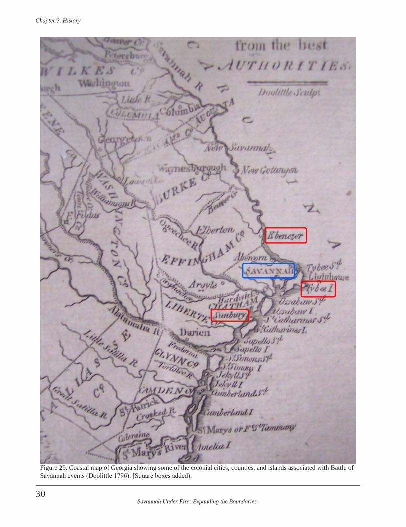
Savannah Under Fire: Expanding the Boundaries
Chapter 3 . History
30
Figure 29. Coastal map of Georgia showing some of the colonial cities, counties, and islands associated with Battle of Savannah events (Doolittle 1796). [Square boxes added).
Savannah Under Fire: Expanding the Boundaries
Chapter 3 . History
31
September 12French land at Beaulieu and rapidly advance three miles to the Orphan House (Bethesda), a mere 13 miles from Savannah (Prevost 1779a). Engineers frantically working on Savannah’s defenses.
September 13Captain Henry (HMS Fowey), Captain Brown (Rose) and Fisher disembark and offer their men and guns to Major General Prevost for the defense of Savannah (Prevost 1779a). Some Masters of Transports and a Privateer volunteer their services. Prevost defends the batteries with the seamen and assigns the marines to join the 60th Grenadiers (Prevost 1779a). [Prevost would later com-mend Lieutenants Lock and Crawford, from the above named vessels, for their zealous defense of the batteries.] General Casimir Pulaski meets French troops. Lincoln transports his 1,500 troops across the Savannah River and bivouacks at Ebenezer, 40 miles north of Savannah. Here he meets up with the 1st Battalion of Virginia Continental Levies (Colonel Richard Parker) and the 1st Regiment of Virginia Light Dragoons (Major John Jameson) (Wilson 2005:147).
September 15Lincoln marches his troops from the Ebenezer area (Zubly’s Ferry) to Cherokee Hill, seven miles north of Savannah (Wilson 2005:147). Prevost reports that, “Some French and Polaski’s Light Horse appears in front force in a subalterns piquet of which 6 are taken, they are forced to retire in turn with some killed…” (Prevost 1779a).
September 16Admiral d’Estaing calls on Prevost to surrender to the “Arms of France” (Prevost 1779a). Lincoln arrives at Miller’s plantation, the camp of General Lachlan McIntosh, three miles from Savannah. General Lachlan McIntosh also meets at this time with Admiral d’Estaing. Lincoln and Colonel Francis Marion learn of the truce between Prevost and d’Estaing. Colonel Maitland arrives in Savannah from Beaufort, SC, with his first division of troops amounting to 400 men (Prevost 1779a). They slipped through the allied blockade of the city by coming through the marshes around Daufuskie Island and dragging their boats through a cut into the Savannah River north of enemy lines (Prevost 1779a).
September 17The remainder of Maitland’s troops arrives in Savannah where they take their posts (Prevost 1779a).
September 18Allied forces get two frigates and three galleys above the cut, keeping British boats from unloading the Vigilant or communicating with it except via the marsh. British troops
continue “work hard” on the redoubts, batteries, and abatis (Prevost 1779a).
September 20Allies put a frigate and galley at four mile point. Capt. Moncrief makes fire rafts and sinks the Rose and Savannah in the river channel (Prevost 1779a).
September 21Moncrief has, “a new work for seven 6 & 9 Pounders begun in front of the Barracks”. Meanwhile, the British make a boom across the river to stop fire rafts made by the Rebels. (Prevost 1779a). British troops burned nearby barns and houses on their flanks that were “…unfortunate-ly property of friends”.
September 22French and American forces appear “…all along our front, in readiness to fight”, yet British troops continue fortify-ing the city (Prevost 1779a). “A few days afterwards the French and Rebels begun to throw up Batteries upon the Hills on the left of Tatnall’s being within about four hun-dred yards of our Lines…” (Prevost 1779b). Reportedly, the French say Moncrief’s batteries around Savannah “rose upon upon them from day to day like Mushrooms” …”(Prevost 1779c)
September 22-23French begin digging siege trenches and opening saps as close as 300 yards from the abatis, left of the British cen-tral redoubts. The French grenadiers and chasseurs pro-tected the sappers, who dug under cover of night. A British account describe the French soldiers “working like Devils every Night” to construct the saps (Prevost 1779c).
September 24The British immediately strike a surprise ambush on the French in the nearby trenches. The sortie resulted in 104 soldiers killed or wounded, four officers killed and nine wounded on the French side. The British lost “…one sub-altern, two sergeants, and three rank and file killed”, with another 15 soldiers wounded (Wilson 2005:151).
September 25The British fire cannon and cohorns to disrupt French sap construction (Prevost 1779a). The first of the guns (two 18-pounders) from French vessels arrived at the French battery after being unloaded and transported overland from Beaulieu. French fire the guns, but had to soon quit. Four French galleys advance, forcing British vessels to retire under the river battery. The British placed 100 marksmen “without” the abatis, to impede French progress on the saps (Prevost 1779a).

Savannah Under Fire: Expanding the Boundaries
Chapter 3 . History
32
September 26, Additional guns (six 18 pounders and six 12- pounders) were brought to the batteries from the supply depot in the settlement of Thunderbolt, southeast of Savannah (Wilson 2005:152). At some point, reports to St. Augustine say that the French and American forces have “…Thirty Pieces of heavy Cannon, and Ten Mortars” in their batteries …” (Prevost 1779b). September 27Moncrief has men “…work on Lines to cover the Troops of the reserve from the exposed Cannonade” and at the same time, troops, “…begin to unroof the Barracks” (Prevost 1779a).
September 27-28Prevost orders a regiment of the Scottish Highlanders to another sortie onto French trenches at night. The British suffered three casualties and the French none until they fired on their own work parties later in the dark. This re-sulted in the wounding or death of 17 of their men (Wilson 2005:153). Prevost says the allies acknowledged loosing over fifty men (Prevost 1779a).
A French frigate (La Truite) establishes itself near Savannah’s North Channel and shot some cannonballs into the city.
The British continue to “…strengthen the River Battery and add the 8 inch howitzer” (Prevost 1779a).
September 28-October 1Both sides worked on enhancing their earthworks and trenches. By September 28 Moncrief had, “The Barracks leveled the back wall to the ground, the front to a good parapet height from the floor converted into a very respect-able Work in Our Centre” (Prevost 1779a).
October 2Savannah is bombarded from the Savannah River by the French La Truite and two American galleys. This supplied the British with ammunition that they could now use in their formerly abandoned twelve pounder guns. Prevost reports that these guns were mounted on the Water Battery. He also details construction of “a new Battery for 15 Guns to the left of the Barracks & strengthening Our Works to the left where it is probable the French may assault” (Prevost 1779a).
October 3British complete 15-gun battery left of the barracks ruin-turned redoubt. British firing from new battery did not stop the French from completing the placement of their siege battery guns (Wilson 2005:152). Prevost reports that they deepened all the ditches, “particularly on the right &
left” (Prevost 1779a). The completion of gun placement allowed the French to begin the bombardment of Savannah in earnest on the night of October 3, 1779, continuing through October 8.
By this time the French had the following artillery:Left Battery - 6 eighteen-pounders, 6 twelve-poundersRight Battery – 5 eighteen-pounders, 11-twelve poundersMortar Battery – 9 six to nine inch guns.
The American Battery consisted of 4 four-pounders meant to protect the French mortar battery.The guns of the French and American batteries, in addition to those 16 guns on French frigates and American galleys, totaled 57 (Wilson 2005:153). This excluded other field pieces of four to six-pounders that were not mounted in a battery.
October 5During bombardment, Prevost sends a request to d’Estaing to allow women and children safe passage out of town on board a ship under French protection (Prevost 1779a). This request was denied.
October 8Troops form at French camp one mile away from Savannah and began marching toward the city (Lawrence 1979:69-70). Major Pierre Charles L’Enfant, of John Lauren’s Corps of Light Infantry, led five American sol-diers in the mission to burn part of the abatis to aid in the allies’ attack. The mission was unsuccessful due to the greenness of the trees (Wilson 2005:157).
D’Estaing holds Council of War to discuss the following day’s attack on Savannah.
October 9Midnight-D’Estaing’s rearrangement of troops into unfa-miliar units and arguments among the French concerning troop movements and column composition delay their march by three hours.
2 a.m.-Americans impatiently await late arrival of French troops.
4 a.m.-Late French troops arrive at the American camp. Americans delay movement even further. Almost 5,000 men in the two allied armies begin the joint march (Wilson 2005:160-161). Column guides do not know the roads, terrain, or fortifications, slowing the march further (Lawrence 1979:69-70).
The front files begin reaching the edge of the woods at dawn. Column formation begins.
Savannah Under Fire: Expanding the Boundaries
Chapter 3 . History
33
5 a.m.- The French reserve column, commanded by General Noailles, takes position on a slight rise just left of the Jewish Cemetery, approximately 400 yards beyond the British fortifications (Wilson 2005:161).
5:15-5:30 a.m.-The five troop columns are not yet in line, with many still marching toward the assembly area.
5:30-6:25 a.m.-The feint on the central redoubt begins, one and a half hours later than planned. The delayed at-tack allows sunrise to light allied columns as targets and enables successful British artillery fire. Hearing the feint, D’Estaing begins the attack on Spring Hill Redoubt with only the columns that had formed at this time. Leading the advance charge of 180 men are Major d’Erneville and Jean-Gaspard Vence “…of the Navy” (Lawrence 1979:71). Colonel de Béthisy and the remainder of the troops followed.
They are met by “…a few troops of the Sixtieth Regiment, North and South Carolina Loyalists, marines, sailors, and a handful of dismounted provincial cavalry” (Lawrence 1979:71). England later claims that only 417 men defend-ed the lines at this point; French forces claim the British were “…heavily massed”. Documents indicate that Spring Hill is manned at this time by 110 British troops, including 54 South Carolina Royalists, 28 dismounted light dragoons (formerly 71st Regiment infantrymen), and 28 men of the 4th Battalion of the 60th Regiment (Wilson 2005:163).
D’Estaing leads the French vanguard column out of the tree line and rushes Spring Hill. The unified attack of columns becomes a piecemeal attack of small battalions. After a substantial gap, and an artillery and musket on-slaught on the French, Dillon’s right column arrives to support D’Estaing’s troops. Dillon’s troops meet the same fate, as the allies are ordered not to fire until they take Spring Hill.
A company of Dillon’s Irish Regiment, led by Major Thomas Brown) breaks through Spring Hill redoubt. Meanwhile the French left column under Baron de Steding’s command advances through the swamp to come to the left, loosing formation. As the column approaches Augusta Road, it is almost annihilated by British fire. In the interim the right column had drifted to the left away from British fire and became entangled with the left column. The mass confusion leads many of the French troops to break away from the fire into the nearby woods and swamp. Soldiers fail to obey the newly appointed of-ficers commanding them only as of that morning (Wilson 2005:164).
The cavalry of Pulaski’s Legion advances and tries to break through the abatis. Pulaski was mortally wounded
and his legion, under command of Lt. Colonel Daniel Horry of the South Carolina Light Dragoons, was pushed off to the left by enemy fire. The entire legion breaks through the American column that had begun attacking Spring Hill Redoubt. This column was commanded by Lieutenant Colonel John Laurens, of South Carolina and consisted of approximately 670 men, including his Corps of Light Infantry, grenadier company and 1st Battalion of the Charlestown Militia, and Francis Marion’s 2nd South Carolina Continental Regiment. Laurens was assigned to attack Carolina Redoubt, northwest of Spring Hill. Instead he goes directly to the Spring Hill Redoubt when he sees the French being repulsed. His column experiences less artillery fire and reaches the redoubt ditch where the troops engage in bayonet fighting with the British, who are cur-rently fighting the French in hand-to-hand combat (Wilson 2005:167).
Lieutenants in the 2nd South Carolina Regiment plant the colors on the Spring Hill Redoubt, where they are killed. The colors are replaced and the new bearers are killed in succession. In all, Lieutenants Bush, Hume, Gray, and Sergeant William Jasper die placing the flag on the redoubt.
Meanwhile Brigadier General Lachlan McIntosh, com-mander of the second American column, asks d’Estaing for new orders based on changes to the plan of attack. McIntosh is told to move his column left of the chaotic columns and towards Carolina Redoubt. He brings his column into the woods where troops become mired in the swamp while being fired on from both the Carolina and Spring Hill Redoubts. Retreat is called before McIntosh’s column can emerge from the swamp (Wilson 2005:169).
As d’Estaing fights to rally troops for another Spring Hill assault, he is wounded for a second time, more seriously. Dillon replaces d’Estaing’s second in command (Viscount de Fontanges) who was wounded and carried away. Dillon immediately calls a retreat that results in mass exodus from the battlefield into the swamp, with troops in total disarray. The British seize the opportunity to counterat-tack and follow the fleeing troops. Major General Viscount de Noailles orders his reserve troops to advance from the area near the cemetery to cover retreating allies. This dis-courages British troops from following retreating soldiers, but also causes Noaille’s troops to be fired upon and suffer casualties (Wilson 2005:169-170).
10 a.m.-French and Americans request a truce to collect wounded and dead. Prevost allows collection of soldiers “…who lay at a distance or out of sight of our lines” (Wilson 2005:170). An eyewitness account reported, “Upwards of Sixty Men were lying dead in the Ditch af-ter the Action” (Prevost 1779c). “The Enemy’s Loss was
Savannah Under Fire: Expanding the Boundaries
Chapter 3 . History
34
astonishing. I never saw such a dreadful Scene, as several Hundred laying dead in a Space of a few Hundred Yards and the Cries of many Hundred wounded was still more distressing…” (Prevost 1779c).
Noon- Allied soldiers continue to trickle into camps as they find their way out of the swamp and woods. The French carry their wounded to an ill-supplied hospital at Thunderbolt. Most that are wounded to any degree are abandoned or already dead (Wilson 2005:173).
October 10, 1779The French dismantle their artillery batteries and take them to the Brewton Hill landing (Wilson 2005:173). D’Estaing decides to depart from Causton’s Bluff rather than Thunderbolt.
October 11-17The French remove artillery and wounded to Tybee Island.
October 18The Volunteers of San Domingo (French army rear guard) oversee the last of the departures from Causton’s Bluff (Wilson 2005:174).
October 19Americans arrive in South Carolina.
October 20The last of the French troops are shuttled to the waiting fleet at Tybee Island (via St. Augustine Creek and the Savannah River) (Wilson 2005:174).
New Primary Source Information
The discussion below is based on new information gleaned from the thousands of pages of primary source document copies gathered during the first NPS ABPP project. This second phase of work allowed for the closer scrutiny of these digital copies and the extraction of information per-tinent to Phase II study areas as well as the overall project. The areas of focus in this report include a more detailed examination of the October 9th battle and the events, people, and geography associated with it. This includes an examination of documents in search of any details that might help archeologists better locate battlefield boundar-ies, and new information that might shed additional light on the interpretation of Phase II discoveries and negative evidence. Attention was also focused on any informa-tion pertaining to the French and American camps out-side of town, which served as the embarkation point for troops marching into battle. Another focus includes closer
examination of the roles of Africans, African Americans, and Native Americans in the Savannah area before, during and after the 1779 Battle of Savannah. Archeologists also re-examined primary documents for a better understand-ing of the roles of women and children in the area during this period. The discussions below review new information pertaining to these areas of focus.
Additional Information about Precursors to the Battle of Savannah
Georgia’s involvement in the War did not begin with the 1779 battle, or even with the 1778 capture of Savannah.Continental troops formed in Georgia prior to this and by March of 1777 Patriot Jonathon Bryan advanced £1,400 of his own money for Continental troops in that colony. Bryan was captured in January 1779, after the first battle of Savannah in 1778. When Bryan was released from British prison on Long Island, he requested reimburse-ment from the American government. During the period from March 1777 to March 1778, however, the value of Continental dollars depreciated by almost 60 percent. Congress authorized his repayment at the original value of £1,400, rather than the new value of £800 (Motte 1780).
In spite of the overwhelming American defeat at the 1779 Battle of Savannah, the Georgia Campaign actually began with some forethought and planning. In January 1779, a committee was meeting to assist General George Washington in a potential 1779 Georgia and South Carolina campaign. Henry Laurens evaluated the situation in Georgia and South Carolina in tandem with his work on the committee. At this time Lauren made several assess-ments about these colonies. He concluded that,
All the Islands of Daufuskee, Hilton Head, St . Helena, Hunting Islands, Fenwicke’s, Edisto &c &c So Carolina abounding with horned Cattle, Horses, Rice, Indigo, Corn, Pease, Hogs, Sheep, Negroes &c &c all at their [British?] mercy/All the heavy Cannon & Military Stores in Georgia (Laurens 1779) .
He stated that there was,
Indian Corn, Peas & Potatoes great abundance suf-ficient to feed their Troops & fleet 2 or 3 months. Pitch, Tar & Turpentine enough for present supply of their fleet. Pine, Cypress & Cedar, Scantlin Boards & Shingles, as much as the enemy can find (Laurens 1779).
Laurens also noted an abundance of horses. Clearly, the Patriots would face a challenge in carrying out a successful Georgia campaign under these circumstances.
Savannah Under Fire: Expanding the Boundaries
Chapter 3 . History
35
American and French Defenses
On September 23, General Lincoln wrote, “This evening the French troops, being furnished with all the intrenching tools, broke ground on the enemy’s left, within 153 toises of ye Barracks without being much annoyed”, although he wrote the next day, “In the morning the enemy made a sortie on the French troops—both parties suffered consid-erably but the former were repulsed and driven into their lines”, and by that night, Lincoln reported, “a Barbette Battery was made and two eighteen pounders mounted on it” (Lincoln 1779 [Library of Congress]).
On September 25, Lincoln wrote, “This night the American troops were to break ground on the right—but upon an inquiry the French could not spare the tools we lent them”, so General Lincoln had his men assist the French in the lines they had begun (Lincoln 1779 [Library of Congress]).
On September 28, General Lincoln wrote, “a Bomb bat-tery is throwing up”, and he added the following day, “The Bomb battery is nearly completed and 7 mortars are mounted”, and on September 30 he noted, “The Bomb bat-tery completed, and nine mortars mounted—One battery for 4 six pounders begun on the left of the Bomb battery” (Lincoln 1779 [Library of Congress]).
General Lincoln’s journal for October 2, 3 and 4 was con-densed when he wrote that his men were, “employed in completing the Batteries, and arranging matters for a can-nonade and bombardment which commenced in the morn-ing of the 5th from 33 pieces of cannon and 9 mortars, and was continued with intervals until the 8th without effect-ing the desired purpose that of capitulation & surrender, notwithstanding the works and the Town were much dam-aged and several house burn’t” (Lincoln 1779 [Library of Congress]).
British Defenses
Benjamin Lincoln wrote on September 18, “I went in the morning to reconnoiter the Enemy in front—found five works on the right of the Barracks with an abatis before them and that the ground was on a level with the Town—after I went to reconnoiter them on the right where we found four works but no abatis—their sight being covered by some ships on the river, a rice field and a deep creek” (Lincoln 1779 [Library of Congress]).
Lincoln wrote on September 19, “The Enemy blew up two of their vessels in the Savannah one of their Gallies ap-pearing in sight” ((Lincoln 1779 [Library of Congress]).On September 27, General Lincoln wrote, “The enemy are taking down the barracks in front of the Town”, and the following day he added, “The enemy continue taking down the barracks, and seem disposed to make a battery there” (Lincoln 1779 [Library of Congress]).
In 1869, Savannah historians Lee and Agnew wrote,
By the sixteenth, a chain of redoubts thirteen in num-ber, mounting seventy-six guns and mortars, a num-ber of which had been taken from the vessels, were thrown up . These redoubts extended from the river at a point a little east of what is now East Broad street to the New barracks, near what is now the corner of Liberty and Bull, thence diverged to what is now South Broad street, thence to where the Central Railroad depot and workshops now stand . This point was then known as Spring Hill, and was the best fortified posi-tion on the lines, and commanded the road to Ebenezer and Augusta . The Musgrove creek and swamp on the west side of the city were almost impassable, and therefore only two small redoubts were thrown up on that side of the town (Lee and Agnew 1869:52) .
To this they added these comments about the burial of British soldiers killed in the October 9th attack on the Spring Hill redoubt,
The enemy buried their dead inside of the redoubt . In 1837 it was cut down to fill up a place where the Central Railroad depot now stands . A number of articles of warfare were dug up and are now in the possession of citizens (Lee and Agnew 1869:62) .
Additional Information about the Battle Itself
There were numerous contemporary battle summaries published throughout the world. Several American news-papers published accounts. This includes an article in a Connecticut newspaper of the account given by Major Matthew Clarkson, an Aide to Major General Lincoln, in-cluding this description of the October 9th action:
The Cannonade and Bombardment of the Town of Savannah (though many Buildings therein were burnt and destroyed) not producing the desired Effect, and the Count d’Estaing being unable, for certain impor-tant Reasons, to stay long enough to finish the Siege, by regular Approaches, came to the Resolution, in Concert with General Lincoln, of making a
Savannah Under Fire: Expanding the Boundaries
Chapter 3 . History
36
vigorous Assault on the Town . In Consequence of this Resolution, the Allied Army, consisting of about 3200 French, and 2400 Americans, were formed in two Columns for the Attack; two Detachments to make two Feints at certain Places fixed on, and a Corps of Reserve; the Remainder were stationed as Guards to the Artillery, Baggage, & c . This Disposition being made, on Saturday Morning, the 9th of last Month, just at Dawn of Day, the two Columns, destined for the Assault, advanced in the most gallant Manner; the Right, consisting of about 2000 French, led on by the intrepid Count d’Estaing, and the Left, composed of 12,00 Americans, headed by the brave Gen . Lincoln . The Design was to force into the Town, if possible, without firing a Gun, there to form, and commence their further Operations .---The Garrison, amount-ing to 2600, including Col . Maitland’s Detachment, which escaped from Beaufort, and threw them-selves into the Town, being too well prepared to receive them, the Town being completely environ’d by strong Redoubts and Abattis, a most tremendous Discharge of Artillery and Musquetry now began from the Enemy’s Works on the advancing Columns . ---Notwithstanding which, they marched forward with the greatest Rapidity and Resolution, and Part of them entered the Enemy’s Abattis . After an ardu-ous bloody Conflict, of one Hour and six Minutes, during which the Count d’Estaing was wounded (slightly) in his Leg and Arm, General Pulaski mortally wounded, Majors Motte and Sife[?] of Carolina, killed, with several other Officers, of both Columns, and about 500 Privates killed and wound-ed, this little Army, this noble Band of Brothers, were forced to abandon their hardy Enterprise, and retire to their Works, 150 Yards distant, which they did with a Regularity that would have done Honour to the best Troops of Prussia, the Enemy making but a very feeble Pursuit . After remaining four Days before the Town, the Enemy not daring to com-mence an Attack, the Generals judged it prudent to raise the Siege (Connecticut Journal 1779:3) .
Major Clarkson is a veritable primary source and he would have had a unique and advantageous perspective during battle while serving in Lincoln’s staff. His perspective has particular value, since Lincoln opted not to elaborate on the details of the battle and its embarrassing outcome. John Jay assigned Major Matthew Clarkson (1758-1825) to Major General Lincoln as an aide in early April, 1779 (Jay 1833). Prior to that Clarkson, a New Yorker served as Benedict Arnold’s aide. Clarkson’s account includes many interesting clues about the battle. He notes that Dillon as-sumed command on the battlefield after D’Estaing and his second in command were wounded. In doing so, Clarkson diverted blame for questionable command decisions from his boss (Lincoln) to the allied command (Dillon). This is an important point, as he notes that Dillon was the officer
who issued the orders to retreat, thus sealing the American defeat at Savannah.
The Cork Remembrancer, published in Ireland, offered this brief summary of the losses sustained by the British,
October 9th, Major-General Prevost defeats the united armies of France and America, at Savannah, in the Province of Georgia, under the command of Count d’Estaing and General Lincoln . British loss, 1 captain, 3 lieutenants, 1 ensign, 4 serjeants, 32 rank and file killed. 2 captains, 2 lieutenants, 2 serjeants, 1 drummer, 56 rank and file wounded. 2 drummers, 2 rank and file missing. 5 serjeants, 2 drummers, 41 rank and file deserted (Fitzgerald 1783:120).
A Massachusetts newspaper reported in January, 1782,
Col . Clarke, commander at Savannah; where the for-tifications were daily improving by the constant la-bour of 800 negroes, and a reinforcement of veteran troops that landed there from Charleston; they were amply supplied with provisions; by recent arrivals, Mr . Greene, had been collecting provisions in the up-per parts of Georgia, but had not appeared within thirty miles of the capital (Salem Gazette 1782:3) .
Other contemporary accounts of the battle can be found in personal letters of the day. A published letter extract, dated November 8, 1779 by Captain Henry, of the HMS Fowey, contained this description of the October 9th attack,
The French having now made regular approaches, and finished their batteries of mortars and cannon near enough to our works, on the 3d of October at midnight, opened their bomb-battery of nine large mortars: at day break they also opened with 37 pieces of heavy cannon, landed from the fleet, and fired on our lines and batteries with great fury. This lasted day and night until the morning of the 9th, when finding little notice taken of their shot or shells, at day-break stormed, with their whole force, the Count D’Estaing at their head . This attempt proved most fatal to them, for they met with so very severe a repulse from only 300 men, assisted by the grape-shot from the batteries, that from this day they worked with indefatigable labour to carry off their cannon and mortars, and descended to a degree of civility we had hitherto been strangers to . Their loss was very great, most of their best officers and sol-diers were killed and wounded; the Count D’Estaing among the latter (Kimber and Kimber 1779:574) .
Captain John Henry had a unique perspective of the events on October 9. He had left his command post on the HMS Fowey weeks earlier to assist Major General Prevost in

Savannah Under Fire: Expanding the Boundaries
Chapter 3 . History
37
establishing Savannah’s defenses. Captain Henry was the ranking British naval officer in Savannah during the siege, following the departure of Commodore Hyde Parker (Beatson 1804:491). Beatson (1804:518) noted,
Upon the first alarm of the enemy being on the coast, General Prevost exerted himself to the ut-most, to increase and strengthen the fortifications of the town of Savannah; and was most ably second-ed in his operations, by Captain James Moncrieffe of the engineers, and Captain Henry of the navy .
The Fowey was an aging 24 gun frigate. In January, 1778, Commodore Hotham ordered the Fowey surveyed, which revealed open seams in her decking and a sprung main mast. The surveyors concluded that “the Ship might be fit to keep the Sea in the Summer-Season,” after some repairs (Long 2009:26).
The Fowey arrived in Savannah in late 1778, as part of the fleet accompanying Lieutenant Colonel Archibald Campbell. The Fowey remained in Savannah until April 1, 1780, when she participated in the Siege of Charleston. The ship later participated in the action at Yorktown before she was scuttled on October 13, 1781.
Anthony Stokes, Loyalist Chief Justice in Savannah, pro-vided a description of Savannah under siege, which was published. The Stokes’ account was previously discussed by Elliott and Elliott (2009). Stokes also authored a legal book, which was published shortly after the war ended. In it, he mentioned the Siege of Savannah and the October 9th battle. He noted,
On the 4th of March 1779, the King’s Civil Government was re-established in Georgia, by proclamation; and matters bore a promising appearance until the 12th of September following, when the Count D’Estaign landed there, and on the 16th summoned the Town of Savannah to surrender to the arms of France . On the 9th of October following the besiegers, consist-ing of about 4500 French, and 2500 Americans, were repulsed with considerable loss— On the 19th of October, the enemy quitted the lines before Savannah, and on the 21st the French embarked, and the Americans marched off to South Carolina .
During the siege of Savannah, the enemy plundered the country of most of the moveable property; and the Town of Savannah was greatly injured by a heavy fire of cannon and mortars, for several days: but notwithstanding the reduced state of the coun-try, and the frequent incursions of the enemy by sea and land, the inhabitants began to plant their lands; and the King’s loyal subjects scattered themselves that a few years would restore the Province to the
flourishing state it was in before the civil war, until the melancholy news of Lord Cornwallis’s capitu-lation at York Town reached Savannah, on the 9th of November 178i, and reduced the inhabitants al-most to a state of despair (Stokes 1783:116-117) .
Other sources of battle information include early histori-cal recounts of events. These tended to be written in the 1790s through the 1830s. Other histories were published at later dates, but these were often written by individuals who weren’t alive during the battle.
Charles Stedman, Lord Cornwallis’ Commissary General, wrote from the British historical perspective about the siege:
The morning of the ninth of October was fixed upon for making the assault; and two feigned attacks by the militia were to draw the attention of the besieged to their centre and left, whilst a strong body of cho-sen troops from the combined armies should advance on the right of the British lines, and in two columns make the real attack . The principal of these columns was commanded by the count d’Estaing in per-son, assisted by general Lincoln, and was destined to attack the Springhill redoubt in front, whilst the other column, commanded by count Dillon, should silently move along the edge of the swamp, pass the redoubts and batteries, and get into the rear of the British lines . The troops which composed these two columns consisted of three thousand five hun-dred French, six hundred provincial regulars, and three hundred and fifty of the Charlestown militia, a number more than double that of the whole British garrison, and were in motion long before daylight Fortunately the column commanded by count Dillon mistook its way, from the darkness of the morning, and was entangled in the swamp, from which it was unable to extricate itself until broad daylight ap-peared, and exposed it to the view of the garrison and the fire from the British batteries. This was so hot, and so well directed, that it was never able even to form, and far less, by penetrating into the rear of the British lines, to accomplish its original object . In the mean time the column led by the count d’Estaing advanced against the Springhill redoubt, just as day-light appeared: And such was the darkness of the morning, that it had approached very near before it was discernible . But, as soon as it was discovered, it became exposed to a continued blaze of musquetry from the redoubt, and to a destructive cross fire from the adjoining batteries, which mowed down whole ranks of the allies as they advanced . From the num-bers which fell, the head of the column was several times thrown into confusion; but their places being instantly supplied by others, it still moved on until it reached the redoubt, where the contest became more fierce and desperate. The brave captain Tawse fell in defending the gate of his redoubt with his sword
Savannah Under Fire: Expanding the Boundaries
Chapter 3 . History
38
plunged in the body of the third enemy he had slain with his own hand, and a French and American stan-dard were for an instant planted upon the parapet . The conflict for the possession of the redoubt nev-ertheless continued to be obstinately maintained on both sides, and the event remained in suspense; when lieutenant-colonel Maitland, seizing the critical mo-ment, ordered the grenadiers of the sixtieth regiment, with the marines, to move forward and charge the enemy’s column, already staggering tinder the ob-stinate resistance it had met with at the redoubt, the slaughter which had been made by the artillery from the different batteries, and now also from the Germaine armed brig . This well timed movement decided the fate of the attack . The assailants were Repulsed, driven out of the ditch of the redoubt, and routed with considerable loss redoubled slaughter, leaving behind them, in killed and wounded, six hun-dred and thirty-seven of the French troops, and two hundred and sixty-four of the Americans . No pursuit was ordered, because the besiegers, although they had suffered greatly in the assault, were still three times more numerous than the garrison; but in their flight, in advancing, they were exposed to a heavy fire from the British artillery, which was well served under the direction of captain Charlton . In this as-sault count Pulaski, who commanded an American corps, received a mortal wound; and the count d’Estaing, who was seen by the garrison to behave with great gallantry, was wounded in two places, but in neither of them dangerously (Stedman1794:130) .
Blanchard (1825:116) gave a brief summary of the October 9th battle in his American Military Biography. In it he stat-ed that, “a column led by Count Dillon missed their route in the darkness, and failed of the intended cooperation”.Another early secondary account of Dillon’s performance on the battlefield was published in a 1788 magazine:
Not less heroical than this was the conduct of the Irish Brigade at the siege of Savannah, which, when Comte D’Estaign madly proposed to take by a coup de main, Comte Dillon, anxious to signalize his regi-ment, proposed a reward of too guineas to the first of his grenadiers that planted a fassine in the Fosse which was exposed to the whole fire of the garri-son—but no one offered to advance .- Comte Dillon in a rage began to upbraid them with cowardice, to which’ the Serjeant-Major replied, Monsieur le Comte, had you not held out a sum of money as the temptation, your grenadiers would have one and all presented them selves .—They did so instantly, and out of 194, of which the company consisted, only 90 returned alive (The Country Magazine 1788:315) .
These citations portray Colonel Count Arthur Dillon and his performance on the battlefield at Spring Hill in a bad light. The role of the Irish Brigade at Savannah
has received minimal scholarship (Onahan 1881:99-102; Murphy 1954; Marmion 1998). Dillon was born in England in 1750 and he died by the guillotine in Paris in April, 1794. The Regiment of Dillon was in the French service. In April, 1779, Dillon’s regiment (1,400 men) joined Estaing’s squadron and they participated in the cap-ture of Granada. At Savannah, Dillon commanded approxi-mately 2,300 men. An account by Dillon was originally published in French in 1792 and translated into English in 1890 (Leonard 1890).
Major General Augustin Prevost’s daughter, Mary, pro-vided the text for her father’s epitaph on his grave in the church cemetery at East Barnet, England. It mentions the Battle of Savannah in this inscription,
Sacred to the memory of Augustin Prevost, Esq . Major General in his Majesty’s army, Colonel of the second battalion of the 60th regiment of foot, &c . &c . By birth a native and citizen of Geneva . He entered into the service of Great Britain in 1756, in the rank of Major, and uniformly distinguishing himself with the zeal and honour of a true soldier, he merited, and, on repeated occasions, received the thanks, both public and private, of the Generals under whom he served . He finished his more active military career with the memorable defence of Savannah in Georgia in 1779, where he commanded, and in a post, entrenched merely on the spur of the occasion, sustained a for-mal siege against the combined armies of France and America, commanded by the Count D’Estaing, of about three times his own number, supported by a powerful fleet, and furnished with a numerous and well-served artillery: he repulsed them in a general and well-maintained assault, and finally compelled them to raise the siege, thirty three days from its being closely invested, twenty-six of open trenches, and fifteen of open batteries. As a man he was mild, unassuming, and modest, perhaps, approaching to a fault; as a soldier, manly, firm, determined; possess-ing himself equally in the hour of danger as in that of the calmest retirement: his solicitude on every occa-sion of public import was solely directed to the hon-ourable discharge of his duty to the king and country he had chosen for his .—A kind husband, a tender fa-ther, a sincere friend, a humane man .—He was also eminent in all the virtues and duties of private life . This monument is erected by the companion of some of his most trying scenes, now his afflicted widow, in pious and affectionate testimony of her gratitude to him who was the best of husbands and the best of men . Ob . May 4, 1786 . æt . 63 . (Lysons 1796) .
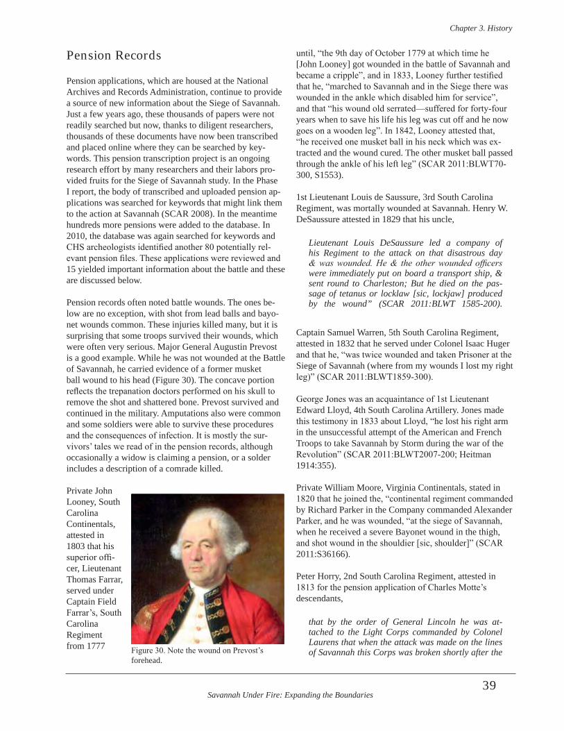
Savannah Under Fire: Expanding the Boundaries
Chapter 3 . History
39
Pension Records
Pension applications, which are housed at the National Archives and Records Administration, continue to provide a source of new information about the Siege of Savannah. Just a few years ago, these thousands of papers were not readily searched but now, thanks to diligent researchers, thousands of these documents have now been transcribed and placed online where they can be searched by key-words. This pension transcription project is an ongoing research effort by many researchers and their labors pro-vided fruits for the Siege of Savannah study. In the Phase I report, the body of transcribed and uploaded pension ap-plications was searched for keywords that might link them to the action at Savannah (SCAR 2008). In the meantime hundreds more pensions were added to the database. In 2010, the database was again searched for keywords and CHS archeologists identified another 80 potentially rel-evant pension files. These applications were reviewed and 15 yielded important information about the battle and these are discussed below.
Pension records often noted battle wounds. The ones be-low are no exception, with shot from lead balls and bayo-net wounds common. These injuries killed many, but it is surprising that some troops survived their wounds, which were often very serious. Major General Augustin Prevost is a good example. While he was not wounded at the Battle of Savannah, he carried evidence of a former musket ball wound to his head (Figure 30). The concave portion reflects the trepanation doctors performed on his skull to remove the shot and shattered bone. Prevost survived and continued in the military. Amputations also were common and some soldiers were able to survive these procedures and the consequences of infection. It is mostly the sur-vivors’ tales we read of in the pension records, although occasionally a widow is claiming a pension, or a solder includes a description of a comrade killed.
Private John Looney, South Carolina Continentals, attested in 1803 that his superior offi-cer, Lieutenant Thomas Farrar, served under Captain Field Farrar’s, South Carolina Regiment from 1777
until, “the 9th day of October 1779 at which time he [John Looney] got wounded in the battle of Savannah and became a cripple”, and in 1833, Looney further testified that he, “marched to Savannah and in the Siege there was wounded in the ankle which disabled him for service”, and that “his wound old serrated—suffered for forty-four years when to save his life his leg was cut off and he now goes on a wooden leg”. In 1842, Looney attested that, “he received one musket ball in his neck which was ex-tracted and the wound cured. The other musket ball passed through the ankle of his left leg” (SCAR 2011:BLWT70-300, S1553).
1st Lieutenant Louis de Saussure, 3rd South Carolina Regiment, was mortally wounded at Savannah. Henry W. DeSaussure attested in 1829 that his uncle,
Lieutenant Louis DeSaussure led a company of his Regiment to the attack on that disastrous day & was wounded. He & the other wounded officers were immediately put on board a transport ship, & sent round to Charleston; But he died on the pas-sage of tetanus or locklaw [sic, lockjaw] produced by the wound” (SCAR 2011:BLWT 1585-200) .
Captain Samuel Warren, 5th South Carolina Regiment, attested in 1832 that he served under Colonel Isaac Huger and that he, “was twice wounded and taken Prisoner at the Siege of Savannah (where from my wounds I lost my right leg)” (SCAR 2011:BLWT1859-300).
George Jones was an acquaintance of 1st Lieutenant Edward Lloyd, 4th South Carolina Artillery. Jones made this testimony in 1833 about Lloyd, “he lost his right arm in the unsuccessful attempt of the American and French Troops to take Savannah by Storm during the war of the Revolution” (SCAR 2011:BLWT2007-200; Heitman 1914:355).
Private William Moore, Virginia Continentals, stated in 1820 that he joined the, “continental regiment commanded by Richard Parker in the Company commanded Alexander Parker, and he was wounded, “at the siege of Savannah, when he received a severe Bayonet wound in the thigh, and shot wound in the shouldier [sic, shoulder]” (SCAR 2011:S36166).
Peter Horry, 2nd South Carolina Regiment, attested in 1813 for the pension application of Charles Motte’s descendants,
that by the order of General Lincoln he was at-tached to the Light Corps commanded by Colonel Laurens that when the attack was made on the lines of Savannah this Corps was broken shortly after the Figure 30. Note the wound on Prevost’s
forehead.
Savannah Under Fire: Expanding the Boundaries
Chapter 3 . History
40
attack commenced, that this Deponent in endeavor-ing to rally the Corps which was broken came to the spot where Major Charles Motte lay slain before the Abettes [sic, abattis] (SCAR 2011:BLWT629-400) .
Philip Martin Frey, a Drummer in Captain Peter Horry’s Company, 2nd South Carolina Regiment, attested in 1818 that he participated in the Siege, “where he received a ball through his left thigh” (SCAR 2011:W9435).
John Bird, a Sergeant in Captain Turner’s Company, 1st South Carolina Regiment, during the Siege of Savannah, attested in 1818 that, “received three gunshot wounds in the Siege of Charleston and Savannah” (SCAR 2011:S39196).
Private William Rogers (Rodgers) was in Captain Huger’s Company of Moultrie’s South Carolina Regiment. Rodgers attested in 1818 that he, “was wounded & maimed in the attempt to storm Savannah” (SCAR 2011:S36276).
The widow of Private Thomas Godfrey, who served in Captain Toomer’s Charleston Artillery Company, testified in 1838 that her deceased husband was “slightly wounded” in the assault upon Savannah in 1779 (SCAR W9456).Elizabeth Gilmore attested in 1842 that her deceased husband, Joseph Gilmore had been a private in the South Carolina militia and that he was, “wounded in the right hand” in the battle of Savannah (SCAR 2011:W355).
John Sullivan, a soldier detached under General Moultrie’s command, marched to Savannah and,
Arrived the [sic, there] in the beginning of the last week in September 1779, continued as part of the be-sieging Army until the morning of the 9th October . Deponent and Company to which he belonged then under command of Captain Peter Boquitt [sic, Peter Bocquet], formed a part of the forlorn hope, under command of Colonel John Laurens, Peter Horry Major Colonel Laurens in front and Major Horry brought up the rear . Deponent received a wound in his right leg in the calf from a musket ball, when mak-ing the second attack on the lines of the British, at the storming of Savannah as called (SCAR 2011:S22002) .
Private Samuel Burton was in Captain Tarlton Payne’s Company of Colonel Richard Parker’s Virginia Continental Regiment. He stated in 1827, “that he was se-verely wounded in the thigh by a musket ball at Savannah Georgia in October 1779” (SCAR 2011:S39254).
Private Isaac Herin, 2nd South Carolina Regiment, stated in 1818 that, “he was in the Battle of Savannah & was there wounded & taken a prisoner” (SCAR 2011:W10098).Information provided in 1858 by James Love, son of
John Love, a Surgeon’s Mate, 1st Georgia Continental Regiment, attested that John Love, “was wounded in the knee, and after having received said wound, was taken prisoner by the enemy and conveyed on board of a British vessel then lying near Savannah” (SCAR 2011:R21476).
Private George Watts, in Captain William Davis’ Company, Colonel [James] Williams’ Regiment, South Carolina militia, stated in his 1832 pension application that the, “Applicant [Watts] was in the whole of the action and Captain Davis whilst standing by his side was mortally wounded by a grape shot and fell against him” (SCAR 2011:W1009).
Private Michael Nash, a North Carolina soldier attached to Captain Vanderhorst’s Company, 2nd South Carolina Regiment, attested in 1832 that he was in Savannah in October, 1779,
where he was in the Battle, where Pulaski was wound-ed -- & this applicant was one of the party that car-ried him off the field. After the Battle he was marched back to the encampment – thence the Army retreat-ed to Charleston . At the siege of Savannah Major Motte [Charles Motte] of the second [Regiment] was killed – and Major Wise [Samuel Wise] of the third, Thompson’s Rangers, was also killed – and the Captain of my company, Vanderhorst was promoted to Major of the second Regiment (SCAR 2011:W4042) .
Private Thomas Boon, South Carolina militia, provided this unique account of the attack on the Spring Hill Redoubt in his 1832 pension application,
At about half way from Augusta to Savannah we were joined by Colonel Parker with a small body of Virginia Regulars . We reached Savannah and encamped within a short distance of the Town, im-mediately on the West of the French forces, under Count d’Estaing . At Savannah we found Count Pulaski . I do not remember the precise date of the Siege of Savannah . But to the best of my recollec-tion it was early in the month of October in the year 1779 . I well know, however, that on the night be-fore the attack was to be commenced we were or-dered to be ready at a moment’s warning -- On that night we were joined by two hundred men, called the Charleston Grenadiers but where they were last from, or on what business they had been, I do not know -- About an hour before day on the morning
Savannah Under Fire: Expanding the Boundaries
Chapter 3 . History
41
on which the attack was made, we were ordered to parade . We were marched to the attack before day break in the morning . A small Detachment was or-dered to dislodge a party of British who build a Fort in a small Dutch settlement called Yammacraw [sic, Yamacraw] Settlement a little short distance from the Main Town of Savannah but precisely the distance I cannot tell . The Expedition against Yammacraw was commanded by Colonel Laurens [John Laurens] and Lieutenant Colonel O’Rea [sic, Peter Horry] -- I well remember that I and John Moore under whom I enlisted, together with one Joseph Reed and his son, Isaac Reed had just mounted the para-pet at the very moment that a retreat was ordered by General Lincoln, the two Reeds on one side of me and my Captain, Moore, on the other and at that moment the two Reeds were shot and fell dead from the parapet, the son following first and the father on the top and across the son . In this engagement Count Pulaski was shot with a grape shot through the Breast just under the Shoulders . I helped to lay Count Pulaski on a litter which was made of a Blanket, some pine poles, some pine boughs, upon which he was carried to the Hospital . He, Count Pulaski, lived that day (that of the Battle) the next day and on the next day he died . I was never at the Hospital but I understood it to be about three miles North South of Savannah . (SCAR 2011:W23656) .
Private Lewis Roux, a soldier in Captain John Hammond’s Company, Colonel Leroy Hammond’s Regiment, Williamson’s South Carolina militia, stated in his 1832 pension application that,
during the siege of said place, that on the 9th October he was with the Militia troops that marched to the left of the British lines, intended to make a [indecipher-able word, possibly “point”] in that quarter -- that after the repulse of our Troops, and during the truce agreed upon to bury the dead, he went and assisted to carry off of the field his brother Captain Albert Roux of the 2nd South Carolina Regiment who was severely wounded (who is since dead) (SCAR 2011:S21952) .
The pension application of James Gabriel, a volunteer in Captain James Sim’s Company, 1st North Carolina Volunteer Regiment, contains a “strike out” section of text in his 1832 statement, which read, “He, the said James Gabriel, also took part in the Siege of Savannah and was employed in cutting down the pickets to admit count Pulaski saw him enter & saw him brought back mortally wounded” (SCAR 2011:S2571).
Private John Swords, in Captain Varley’s [or Warley’s] Company, 6th South Carolina Regiment, stated in his pen-sion application,
having nine weeks at the Seige [sic] of Savannah [Fall, 1779] under the command of Captain Boyce who was in[sic] slain in the Battle, this deponent was assisting one of his fellow soldiers to carry off his Captain was taken prisoner by the British & kept two weeks in Savannah and would have starved But for the charity of some Americans who divided their provisions with him – The British gave him no vict-uals while he was a prisoner about Two weeks --He made his escape from them, and made his way up to-wards Augusta & thence home (SCAR 2011:W8773) .
Private Solomon Legare was attached to a volunteer battalion of the Charleston Militia, “composed of six Companies viz., one Grenadier, one light Infantry, one Company called “True Blues”, one “German Fusiliers” one called “volunteers” and one the “Foresters” com-manded by Major John Huger.” Private Legare was in the “True Blues”. In his 1832 pension application he stated, “this Battalion was at Savannah Georgia, in 1779 where they were placed in a line with the regular troops when the attack was made. There several men and officers in this Battalion were killed” Legare also noted that Captain Sheppard, Fusiliers Corps, was killed at the siege of Savannah (SCAR 2011:S21860).
Jim Capers, 4th South Carolina Artillery Regiment, served as a Drum Major in the 1779 Siege of Savannah. Capers, when he filed for a pension at aged 107, was described in 1849 as “a man of color” (SCAR 2011:R1669).
A large number of American commissioned officers were killed in the action at Savannah. This included Major Charles Motte, 1st Lieutenant James Gray, 2nd Lieutenants Henry Gray and Cornelius Van Vleiland, Lieutenants Alexander Hume and John Wickham, and Ensign John Wickom of the 2nd South Carolina Regiment. Also killed were Captain Shepherd, Charleston Regiment; Captain Samuel Wise, 3rd South Carolina Regiment; and 1st Lieutenant William Donnom, 4th South Carolina Regiment; and Major Thomas Broune. Lieutenant Charles Price, Georgia militia, died on October 22 of wounds he received on October 9. 1st Lieutenant Lewis de Saussure, 3rd South Carolina Regiment, was mortally wounded on October 9. Captain Alexander Boyce, 3rd South Carolina Regiment, died in November, 1779 from wounds he received on October 9 (Heitman 1914:114, 195, 200, 257-258, 308, 405, 452, 493, 558, 590, 601, 646; Moss 2009:990).
The great number of wounded from the battle included officers. Captain Rogowski, Pulaski’s Legion; Captain Josiah Warren, Georgia militia; Captain Thomas Giles, South Carolina Dragoons; Captains Alexander Petrie
Savannah Under Fire: Expanding the Boundaries
Chapter 3 . History
42
and Albert Roux and Lieutenant John Bush, 2nd South Carolina Regiment; 1st Lieutenant Field Farrar and Lieutenant Robert Gaston, 3rd South Carolina Regiment; 1st Lieutenants Harman Davis and Edward Lloyd, 4th South Carolina Artillery; Captain Thomas Hutson and Lieutenant William Wilkie, South Carolina militia; Captains John Bowie and Hogan and Lieutenant Parsons, 5th South Carolina Regiment; Captain Thomas Gill, South Carolina Light Dragoons; Captain Francis Kinloch, South Carolina regiments; Lieutenants George Wade, Wardell and Bonneau, South Carolina militia; 2nd Lieutenant David Walker, 10th Virginia Regiment; Lieutenant John Grafton, Virginia regiment, and Captain Pierre Charles L’Enfant, Corps of Engineers were among the wounded commissioned officers at Savannah on October 9. Lieutenant Lloyd lost his arm as a result of his wound (Johnson 1851:245; Heitman 1914:100, 112, 187, 229, 248, 312, 334, 347, 355, 427, 473, 562, 565, 570, 592; Moss 2009:110, 136, 222, 255, 294, 475, 568, 768; United States Congress 1857).
Colonel John White, 4th Georgia Regiment; Lieutenant Thomas Parker, 2nd Virginia Regiment; Lieutenant John Shick, Georgia militia, were wounded and taken prisoner at Savannah on October 9th (Heitman 1914:426, 495, 586). Lieutenant Shick lost his arm as a result of this wound.
1st Lieutenant John Bailey, 3rd Maryland Regiment, and 2nd Lieutenant John Smith, 2nd Maryland Battalion of the Flying Camp, both were wounded at Savannah (Heitman 1914:81, 504). The participation of Maryland Continental troops at Savannah was not previously recognized in his-tories of the battle. The above information indicates that at least two regiments from that state were engaged in action.
Major General Viscount de Fontanges was seriously wounded at Savannah. He commanded a legion composed of “mulattos and free negroes of St. Domingo”, who “saved the army at Savannah by bravely covering its re-treat” (Heitman 1914:654-655). Heitman’s description of Major General Fontanges position on the battlefield is rel-evant to the present study, since it demonstrates the heated action in the reserve lines following the failure to take the Spring Hill Redoubt.
Captain Erasmus Gill, 4th Continental Dragoons; Lieutenant Louis I de Beaulieu, 1st Cavalry Pulaski’s Legion; Lieutenant James Bryan, 4th Georgia Regiment; were taken prisoner on October 9 (Heitman 1914:95, 128, 258)
Casualty Descriptions from Other Sources
The Irish Brigade was in the deadly zone on the Spring Hill Battlefield and its losses were great. At Savannah Dillon’s regiment lost 63 grenadiers and several officers. In one grenadier company of the Regiment of Dillon who charged against Spring Hill (194 men), only 90 re-turned alive” (The Country Magazine 1788:315). Captain D’Imbart Barry was wounded by a musket ball in his left arm; Captain Commandant Alexander O’Neil received a gun shot wound in the chest; Lieutenant O’Farrell was wounded in the leg; Captain James Shee died from gun-shot wounds in his chest; Captain Bernard O’Neill re-ceived a gunshot wound at Savannah from which he died the following year. Lieutenant Georges Taaffe, Major Browne, and Colonel Browne, Aide-de-Camp to d’Estaing and an Irish Brigade officer, all were killed in the siege of Savannah (Marmion 1998; Gardiner 1905:51-55; Griffin 191:83). These limited data sample hints that most of the Irish officer’s casualties were gunshot wounds.
French casualties at Savannah included many high rank-ing officers. Captain Jacquest-Philippe D’Arly was killed. Captains Jean-Jarlan de Sireuil; M. Boulland, who com-manded a grenadier company, Mathew Louis Claude de Paylery de Saint-Sauveur, Army of Saint-Simon, a na-tive of Martinique; and D’Lambert du Barry, Regiment D’Agenois, were wounded at Savannah (Gardiner 1905:51-55; Hayes 1945:259-270; Keim 1907:577).
American Military Command Reacts to the Battle of Savannah
General George Washington was impatient to learn the outcome of the cooperative effort between Count D’Estaing and the allied forces at Savannah, but it was well over a month before he received any word. Washington received first news of the outcome of the October 9, 1779 engagement at Savannah until November 15, 1779. The information that he received was sketchy at best and the source of his information has not been deter-mined. Possibly he received the news from Henry Laurens, although any letter containing the news has not been iden-tified in any of Washington’s or Laurens’ correspondence. The day after receiving the news Washington wrote from his headquarters at West Point, New York to Governor Jonathan Trumbull on November 16, informing the gover-nor in a private letter:
Savannah Under Fire: Expanding the Boundaries
Chapter 3 . History
43
It would appear that there was a necessity for the Counts returning to the West Indies, which made it impracticable to spend that time before the works of Savannah, requisite to carry them by regular approach . This induced the allied arms to hazard the reduction of the place by assault . It was under-taken accordingly on the 9th of October, when we were repulsed . I do not learn the particulars of our loss . The Count was slightly wounded in the leg and arm; and General Pulaski died a few days af-ter of his wounds. The allied officers and men be-haved with great bravery and spirit . This repulse comprehends the whole of our misfortune, as we met with no hindrance in removing our stores or baggage (Fitzpatrick 1931-1944, Vol . 17:108) .
That same day (November 16) General Washington also informed Governor George Clinton, noting,
It seems the Seige [sic] of Savannah, where the Enemy had secured themselves by strong fortifica-tions, required more time than was expected and there being no certainty of reducing the place by regular approaches, in the course of a few days; It was agreed to attempt to effect it by Storm . The attack was accordingly made on the morning of the 9th . Ulto . By the Allied Troops who suffered a Repulse (Fitzpatrick 1931-1944, Vol . 17:190) .
Other letters written by Washington on November 16 to several of his generals repeated this message. The fol-lowing day (November 17) Washington wrote to Major General Anthony Wayne with a slightly more positive spin on the message, noting,
The failure of our attempt to the Southward is by no means as disagreeable as represent-ed . Altho’ we were repulsed in the storm of the works at Savannah, we met with no opposi-tion afterwards in removing our stores and bag-gage (Fitzpatrick 1931-1944, Vol . 17:120-121) .
Following the brief flurry of correspondence in November, 1779, General Washington had little to say concerning the failed Siege of Savannah or the allied losses suffered on October 9th. The loss at Savannah was a costly and embarrassing loss that questioned the alliance between the Americans and France. Clearly, the less said about the defeat, the better. The alliance was later redeemed by the Patriot and Allied victory at Yorktown in October, 1781.
New Information Regarding the Battle’s Aftermath
In the weeks and months following the October 9, 1779 battle, the outcome of the war was still unclear. The British held a lingering and substantial fear that American and al-lied forces would try to regain Savannah. Major General Augustin Prevost reflected this unease four months after the battle when writing to Sir Henry Clinton in February 1780,
…I found that Captain MonCrieffe had taken away every carpenter—one excepted-all the intrenching tools and others that could be of any use—all the wagons with our best horses . That our large cannons have been taken off the batteries and our best artil-lery men taken with them . In short, little or nothing remains in any of our publick stores that cou’d be of service in the diffence of this place [Savannah] or to assist in fiting out the expedition under Genl Patterson . I do not imagine there is any immedi-ate apprehension in this quarter—but shou’d your Excellency propose pushing foreard—I think it in-cumbent on me to lay before your Excellency the exact and actual state of both St . Augustine and Savannah for your Excellency’s consideration (Historical Manuscripts Commission 1972:89) .
Prevost wrote again three weeks later,
…In compliance with the orders through Captain MonCrieffe to the Depy Quartr Mr Genl-and fur-ther at the desire of Br Gl Patterson, they have taken the remaining part of the Field Artillery that was left here, with it what was in store for their Service-as also all the musquet cartridges we had . Your Excellency will observe that by ren-dering this place [Savannah] undefencible-that the troops in it will be in the greatest danger-for want of ammunition artillery engineers &c…”(Historical Manuscripts Commission 1972:96) .
Finally, by March 26, 1780, Prevost reported, .-“Lt. Durnford arrived and the works begun” to strengthen Savannah’s defenses that had been weakened by the October 1779 battle (Historical Manuscripts Commission 1972:106). It is likely that Durnford began working along the Savannah River, as Prevost told Clinton on March 19, “…If an engineer arrives he shall set to work to contract the works and form something like a citadel at the Bluff” (Historical Manuscripts Commission 1972:104). This “citadel at the Bluff” was named Fort Prevost, in honor of General Augustin Prevost, who, along with his family, left

Savannah Under Fire: Expanding the Boundaries
Chapter 3 . History
44
Savannah for England in May, 1780. Brigadier General Paterson had taken not only the remaining Field Artillery from Savannah, but also 1,500 of Prevost’s troops. This reduced the Savannah garrison to 1,000 of which none were artillery troops (Historical Manuscripts Commission 1972:88).
Augustin Prevost was not the only one concerned about another attack from American and allied forces. The Georgia royalists had been nervous even after the victory at Savannah. Two months after the October 9th battle that was brought to shore by an overwhelming French fleet, Royal Governor of Georgia, Sir James Wright wrote to General Clinton, “We are now anxiously looking out for your arrival here and I must request in the most earnest manner you will not lose a single day…Report from South Carolina by a Negro, that a Spanish fleet of 52 sail is off Charlestown Bar”. (Historical Manuscripts Commission 1972:77). The mere rumor of enemy ships from any coun-try was enough to raise fears. Wright realized what a pre-carious hold he had on the colony and sought repeatedly to get military protection. In March of 1780 he also wrote Clinton, penning,
…It is with the utmost concern that I have learnt your Excellency has altered your plan with respect to the route & operations of the troops in this Province, & that instead of going to Augusta, they are to cross this River & proceed towards Charlestown, and I can only lament that this Province will be exposed to the utmost danger, and the Revels I presume command the whole country within twenty miles or less of Savanah… (Historical Manuscripts Commission 1972:104) .
Governor Wright’s fears materialized, particularly in the back country and rural areas away from Savannah’s pro-tection and the British soldiers there. While the Americans were dealt a severe blow by the October 9th defeat, British control over the Savannah hinterlands remained tenuous, as seen by this letter. An anonymous Loyalist drafted this letter in 1780 which mentioned security concerns that existed in the Savannah vicinity following the October, 1779 defeat. Speaking on behalf of Savannah’s loyalists he wrote,
It gives us infinite concern to reflect that after the Rebels had in a great measure been driven from this Province by the Gallantry of his Majesty’s Troops under Colonel Campbell and the town afterward defended against the combined forces of France & America, yet excepting where the military Posts are actually established, the whole country is open to the depredations of a rebel Banditti, who are lately become as daring as to infest our publick roads and plunder at noon day within Six miles of
the lines of this Town . We therefore sincerely wish a corps of Light Dragoons was employed by His Ex . the Commander in Chief, as the most effectual means to secure this Prov . against the incursions of plunderer, and we doubt not but your Excellency will again take the earliest opportunity of recom-mending this measure (Anonymous ca . 1780:1-2) .
Even those Loyalists residing in Savannah did not feel safe, as there was a chronic fear of a new attack on Savannah by American forces throughout 1780, 1781, and as late as January of 1782. One year after the October 1779 battle, engineer Major Moncrief wrote Lord Cornwallis, “The Fort ordered by Genl. Prevost at Savannah was on great forwardness on my arrival. Col. Clark and I thought it best to let it go on” (Moncrief 1780b).
In late November, 1781, Lieutenant General Leslie thought General Greene’s forces would attack Savannah. Lieutenant Colonel Clarke reported from Savannah that his number of troops was inadequate and Royal Governor Wright, also in Savannah, penned that the province would fall unless they were reinforced (Historical Manuscripts Commission 1906:366). As late as January 29, 1782, the British continued to worry about defending Savannah. At that time, Lieutenant General Leslie sent Colonel Moncrief back to Savannah to “…put the works there in the best possible state of defence…” as General Wayne was head-ing to Georgia with cavalry and infantry troops (Historical Manuscripts Commission 1906:389).
In addition to concerns about a renewed attack on Savannah, there were issues with the soldiers. One month after the Battle of Savannah, Prevost, “in compensation for the work of the soldiers on the late occasion has ordered them a shirt a piece or other articles not exceeding two dollars per man” (Historical Manuscripts Commission 1972:59). He reported to Clinton that he had to draw bills on his Excellency, “by real emergency of service, in par-ticular to pay the Hessians…” (Historical Manuscripts Commission 1972:59). Prevost was obliged to write Clinton in February, 1780, “…The Deputy Quarter Master General has objected to paying the officers of the 60th regt. The 200 days’ bat and forage money...”(Historical Manuscripts Commission 1972:91).
Low or no pay was one of many problems soldiers faced on both sides leading to desertion. These problems were increasing with the duration of the war. By March of 1782 Brigadier General Alured Clarke reported a decrease in the Savannah garrison by 50 men, with additional nine or ten desertions in the first two weeks of April. He reported that four of the deserters were Hessians and five or six were members of Ranger Thomas Brown’s corps (Historical Manuscripts Commission 1906:447). Clarke mentioned
Savannah Under Fire: Expanding the Boundaries
Chapter 3 . History
45
that one corps should be relocated as the men were mak-ing too many contacts in the country and able to desert more easily. It is likely that he was referring to the Hessian troops, who communicated with the German speaking settlers at New Ebenezer. One of the deserters, Henry Pumphrey (Humphrey?) wrote to his “brother soldiers” in Savannah, urging them to desert. In March General Leslie reported that Colonel Clarke sent dragoons after five Hessians who had deserted and the dragoons killed them all (Historical Manuscripts Commission 1906:417).
Americans encouraged desertions. On February 20, 1782, Patriot Governor John Martin issued proclama-tions from Ebenezer offering to reward deserters from the British forces with 200 acres, two swine, and a cow. The proclamations were especially targeting the Hessian troops at Savannah and elsewhere (Historical Manuscripts Commission 1906:401).
French sailors and soldiers who did not disembark for the siege of Savannah in 1779 undoubtedly wished to desert, as they suffered considerably onboard their vessels. They lacked clean water, food, and clothing. An officer reported,
We could not relieve our poor sailors, wanting coats, destitute of linen, without shoes, and ab-solutely naked…The bread…was so much de-cayed and worm-eaten…that even the domestic animals on board would not eat it (Jones 1874) .
Scurvy was epidemic on board, and the officer went on to state they averaged sending 35 bodies a day overboard as a result of disease.
Soldiers on land were overcome with disease as well, before, during, and after the Battle of Savannah. Major General Prevost documented yet another sweltering, disease-ridden summer in the southern colonies only three months before the battle. He wrote,
The Sickness that prevailed to a great degree amongst the Troops left for the defenses of Georgia and the ex-cessive heat of the Weather, having put a stop to the Active Operation of the army…the Corps that came from Florida, Weissenbacks Regiment of Hessians, second Battalion Delanceys, New York Volunteers, are in and about Savannah (Prevost 1779e) .
Prevost, himself suffered serious bouts of illness which were not helped by the oppressive heat and humidity of Savannah summers and the resulting illness of a swampy environment. He made multiple pleas to Sir Henry Clinton to be sent back to England, in part due to “…frequent
attacks of the Gout, former wounds & infirmities”, and “a Constitution much impaired” (Prevost 1779e). One of his former wounds involved his head, mentioned earlier in this report. He recovered in spite of the hole surgeons cut in his skull.
No group among the British military suffered more from disease and illness that the Hessian mercenaries. Colonel Porbeck commented about the unhealthy conditions in Savannah on several occasions in letters to his commander, Lieutenant General von Jungkenn. On February 2, he wrote,
Of the recruits, 19 died at sea or in New York . When they arrived here 30 had to be taken to the hospi-tal with scurvy and rashes . Your Excellency will hopefully not be displeased that I enclose a losses list from this battalion, part of which occurred in this province . This clearly shows there is no hope that Europeans will be accustomed to this climate and the foul drinking water . Further proof of this is that the 2nd Battalion of Delancy’s and one bat-talion of Georgia Loyalists had so many deaths they were placed in two other battalions (Porbeck 1782) .
He continued to outline the poor conditions in a letter he wrote March 28-31, “Most people have to be satisfied drinking the foul water. Among the inhabitants illness and death have increased so that we are surrounded by graves on all sides of the city” (Porbeck 1782). On June 1 he wrote, “Right now three to five inhabitants die every day of dysentery, hot fevers, cramps, and in the last few days epilepsy (Porbeck 1782).
Sick and wounded soldiers were tended to in camps, make-shift military hospitals, or often put on ships and brought to other locations. On example of the latter is listed in a 1779 newspaper article detailing the arrival of the vessel Pendant (or Fendant) in Hampton, Virginia, having on board “…200 invalids, consisting partly of sick, and partly of those who were wounded at Savannah” (New Jersey Gazette 1779). Captured soldiers put on prison ships in the Savannah harbor fared even worse than French sailors or American or French soldiers. At best, one might get draft-ed into the enemy army. In one case, Major James Wright, Jr. reported to Lord Cornwallis in August, 1780,
In June…several of my officers pressed me for per-mission to enlist from the Prison Ships at Cockspur, which for a time I objected to but on seeing other corps admit them I made application to Col . Prevost for such prisoners as were Inhabitants of the Province of Georgia, and in consequence…recruit-ed 50 of which number 15 have since deserted, 20
Savannah Under Fire: Expanding the Boundaries
Chapter 3 . History
46
died, 5 were killed during the Siege and 10 are at present with me being the whole mount of Prisoners now in my Corps, and whose Behaviour has been ir-reproachable for 15 (?) months past (Wright 1780) .
Hessian Colonel Friedrich von Porbeck wrote from Savannah to Lieutenant General von Jungkenn on February 2, 1782 stating,
The British Lieutenant Colonel [John] Moncrief has laid out strong redouts, both in the city and outside . There is no shortage of artillery and am-munition”, but Porbeck added, “The Rebels ride patrols to within one mile of the city (Porbeck 1782) .
It wasn’t until early April of 1782 that royalist in Savannah saw strong evidence that they would not have to worry about defending the city much longer or keeping troops from deserting. At that time Sir Henry Clinton ordered Lieutenant General Leslie to reduce the garrisons at Savannah (Historical Manuscripts Commission 1906:445). Leslie reported to General Sir Guy Carleton that by late June, 1782, Brigadier General Clarke had Savannah in a state of readiness for British evacuation. This included preparing the stores (supplies) for embarkation and ensur-ing that most of the inhabitants proposing to leave had gone to Tybee Island with their possessions (Historical Manuscripts Commission 1906:546).
Likewise, American forces were ready to swiftly fol-low behind evacuating British troops. General Nathanael Greene wrote to Major General Anthony Wayne on June 18, 1782,
I have this moment received information by an officer from Ebenezer that the enemy evacuated Savannah on Sunday last . Should it be the case, I must beg you will order all of the troops except those belonging to the State of Georgia to join this army as soon as possible . The works in the neighborhood of Savannah you will order to be erased as soon as possible (Greene 1782a) .
Three days later Greene wrote again to Wayne saying,
…It is my advice to the people of Georgia to have all the fortifications in and about Savannah leveled except one or two batteries just sufficient to protect the town from insult from single vessels of force, or small parties . Unless we had a regular force to gar-rison the town, fortifications can be of no use but on the contrary will serve to enable the enemy to repos-sess themselves of it with more safety and with a less
force and les loss than if they were leveled . This may appear to be a paradox, but it is true, for militia will not defend works but would annoy the enemy greatly while they were constructing them…(Greene 1782b) .
Clearly, the American leadership was not completely con-vinced that the British were evacuating with no hidden agenda or military strategy.
Post-Revolutionary War Military Activity in Savannah
Savannah’s defenses were not a static entity but continued to evolve as the city expanded. In some locations around the town the areas that had been defended in the American Revolution continued to be defensive places in the decades following the war. Some of these areas were strategic military locations even as late as the American Civil War. These post-Revolutionary War changes to the military landscape of Savannah are an important factor to consider in studying the October 9, 1779 landscape. Many of the changes that took place in the late 18th and early 19th centuries are not well known. Other areas of the military landscape, such as Fort Prevost/Fort Wayne, are slightly better known. Cartography provides many clues to the military landscape in these decades. This section addresses the topic of later fortifications and ditchwork in Savannah, particularly as it may have impacted the Revolutionary War era battlefield resources.
Newspapers provide an important source of information about Savannah’s defenses in the late 18th and early 19th centuries. A November 19, 1787 New York newspaper ar-ticle gave a brief description of Savannah’s defense in the post-war years:
We learn from Georgia, that Martial Law is pro-claimed throughout the State---that the town of Savannah is strongly fortified by several redoubts and other works thrown up round it—and that small parties of Indians have committed depredations with-in 36 miles of Savannah (American Herald 1787:3) .
A Baltimore newspaper described Savannah’s defenses circa April 8, 1794:
The force intended for the defense of the city and harbor of Savannah, is to consist of batter-ies mounting 24 pieces of heavy artillery, a maga-zine, a blockhouse or barracks, a redoubt, &c .—For the ordinary protection of which there will be

Savannah Under Fire: Expanding the Boundaries
Chapter 3 . History
47
stationed here one captain-lieutenant, two serjeants, two corporals, two musicians, and twenty four privates (Baltimore Daily Intelligencer 1794:2) .
The U.S. Congress displayed concern for Savannah’s de-fenses in the late 18th century. In 1794, the U.S. House of Representatives received a committee report that recom-mended these defenses be constructed at Savannah:Twenty-four pieces.Batteries, embrasures, & platforms 1,727.58Redoubt with embrasures 810A magazine 200Block-house or barracks 500 __________ [$] 3,737.58(Daily Advertiser 1794:2).
In 1808, the U.S. Army built Fort Jackson at Five Fathoms Hole, which was located several miles downstream from the town’s center. Fort Jackson became the primary river defense for the city after that period. A New York news-paper cited a Savannah source regarding Savannah’s de-fenses in 1808:
Twelve pieces of Ordinance, (eighteen and twenty-four pounders) arrived here on Saturday evening last, in the sloop Hannah, captain Hawes, from Charleston, for the defence of this place . Mr . McRae, the engi-neer for supervising the fortifications of Savannah, arrived in the stage last evening” (Oracle 1808:2) .
The U.S. Congress authorized substantial funds for strengthening Savannah’s defenses in the War of 1812 (American State Papers 1975-1997). Thomas Pinckney wrote from Savannah to James Monroe on November 9, 1814 in an effort to obtain cannon for the fortifications at Savannah (RG 107, Letters Received by the Secretary of War).
Several maps of Savannah that were drafted shortly af-ter the War of 1812 depict “fortifications thrown up in 1815”, which was a crenulated defensive perimeter line that surrounded the city on its interior side (Figure 31). In some places the 1815 defenses may overlap with those built in the American Revolution. To date, however, no archeological footprint of the 1814-1815 defensive pe-rimeter has been identified. The War of 1812 ended in December, 1814, but the threat to Savannah from British military attack dates shortly afterwards in January and February, 1815. After burning Washington, British Admiral Cockburn sailed his fleet south to the Georgia-Florida border, where troops disembarked and began a coastal campaign. The immediate military targets were Fort Point Peter, St. Marys, Amelia Island, and the surround-ing plantations. Savannah was likely in their sights as
well, and would no doubt have been attacked had not the Admiral received belated news of the peace declaration at Ghent. When Georgia’s shores were invaded in early 1815, Savannah’s military leaders became alarmed about its defense:
The Brigadier General commanding the troops at this station, earnestly recommends to the citizens of Savannah, the necessity of exertion to complete the fortifications around the city. It is hoped that private interest will on so important an occasion yield to public duty, and that every man possessed of American feelings will repair to the lines, and by united efforts render themselves secure against an at-tack from the enemy who will avail himself of neglect . Citizens of Savannah! Let your stores and shops be shut until the defences of the city are completed .
Georgians!—Your state is invaded—the capital of it (Savannah) is threatened—your sires were gal-lant—you will do everything in your power to repel the merciless enemy who carries the sword in one hand and the torch in the other—An enemy who wars on the widows and the distressed—whose deeds have been as bad as the savage of the American woods or the plundering Arab of the Desert . Remember, the eyes of the world are upon you—Georgia ex-pects every man to do his duty .—To Arms, then, Georgians to Arms! (National Aegis 1815:3) .
News from Savannah and coastal Georgia in late January, 1815 was extracted and reprinted in several northern newspapers in early February, including these reports from Savannah, dated January 22:
Here we are, under martial law; not knowing the hour when the British forces may pay us a visit . We have no positive accounts from the southward, however, to warrant a positive conclusion that they are coming this way . We believe the forces at Cumberland and St . Mary’s to be about 6000 men”, and, “Martial law was declared today . Governor Early has arrived at the lines with 2000 men- --Strong reinforcements are on their way. Our fortifications progress rapidly, and are able, at present, to sustain and repel the attack of all the British forces said to have arrived” (Republican Farmer 1815:2, Connecticut Journal 1815:3) .
It is certainly possible that the military activity in Savannah in 1814-1815 may have had an impact on the Revolutionary War battlefield resources. Earthworks and ditches may have occupied some of the same ground as the earlier defenses and “field of fire” zones were almost cer-tainly impacted. This situation is suggested on Savannah
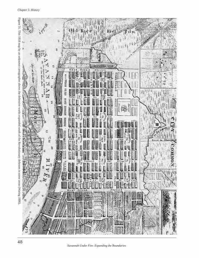
Savannah Under Fire: Expanding the Boundaries
Chapter 3 . History
48
Figure 31. This 1818 map by an unknow
n cartographer shows the defensive w
orks expanded south of the Revolutionary defenses in som
e areas (Waring 1886).
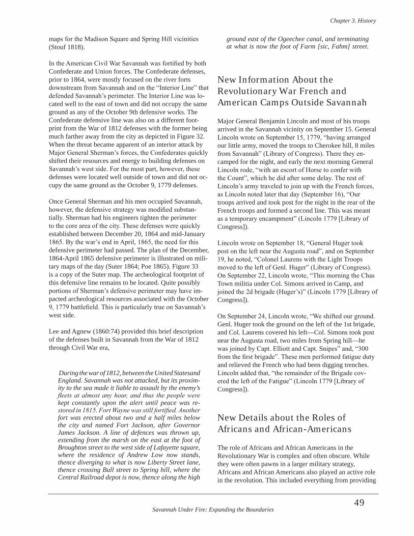
Savannah Under Fire: Expanding the Boundaries
Chapter 3 . History
49
maps for the Madison Square and Spring Hill vicinities (Stouf 1818).
In the American Civil War Savannah was fortified by both Confederate and Union forces. The Confederate defenses, prior to 1864, were mostly focused on the river forts downstream from Savannah and on the “Interior Line” that defended Savannah’s perimeter. The Interior Line was lo-cated well to the east of town and did not occupy the same ground as any of the October 9th defensive works. The Confederate defensive line was also on a different foot-print from the War of 1812 defenses with the former being much farther away from the city as depicted in Figure 32. When the threat became apparent of an interior attack by Major General Sherman’s forces, the Confederates quickly shifted their resources and energy to building defenses on Savannah’s west side. For the most part, however, these defenses were located well outside of town and did not oc-cupy the same ground as the October 9, 1779 defenses.
Once General Sherman and his men occupied Savannah, however, the defensive strategy was modified substan-tially. Sherman had his engineers tighten the perimeter to the core area of the city. These defenses were quickly established between December 20, 1864 and mid-January 1865. By the war’s end in April, 1865, the need for this defensive perimeter had passed. The plan of the December, 1864-April 1865 defensive perimeter is illustrated on mili-tary maps of the day (Suter 1864; Poe 1865). Figure 33 is a copy of the Suter map. The archeological footprint of this defensive line remains to be located. Quite possibly portions of Sherman’s defensive perimeter may have im-pacted archeological resources associated with the October 9, 1779 battlefield. This is particularly true on Savannah’s west side.
Lee and Agnew (1860:74) provided this brief description of the defenses built in Savannah from the War of 1812 through Civil War era,
During the war of 1812, between the United Statesand England . Savannah was not attacked, but its proxim-ity to the sea made it liable to assault by the enemy’s fleets at almost any hour, and thus the people were kept constantly upon the alert until peace was re-stored in 1815. Fort Wayne was still fortified. Another fort was erected about two and a half miles below the city and named Fort Jackson, after Governor James Jackson . A line of defences was thrown up, extending from the marsh on the east at the foot of Broughton street to the west side of Lafayette square, where the residence of Andrew Low now stands, thence diverging to what is now Liberty Street lane, thence crossing Bull street to Spring hill, where the Central Railroad depot is now, thence along the high
ground east of the Ogeechee canal, and terminating at what is now the foot of Farm [sic, Fahm] street .
New Information About the Revolutionary War French and American Camps Outside Savannah
Major General Benjamin Lincoln and most of his troops arrived in the Savannah vicinity on September 15. General Lincoln wrote on September 15, 1779, “having arranged our little army, moved the troops to Cherokee hill, 8 miles from Savannah” (Library of Congress). There they en-camped for the night, and early the next morning General Lincoln rode, “with an escort of Horse to confer with the Count”, which he did after some delay. The rest of Lincoln’s army traveled to join up with the French forces, as Lincoln noted later that day (September 16), “Our troops arrived and took post for the night in the rear of the French troops and formed a second line. This was meant as a temporary encampment” (Lincoln 1779 [Library of Congress]).
Lincoln wrote on September 18, “General Huger took post on the left near the Augusta road”, and on September 19, he noted, “Colonel Laurens with the Light Troops moved to the left of Genl. Huger” (Library of Congress). On September 22, Lincoln wrote, “This morning the Chas Town militia under Col. Simons arrived in Camp, and joined the 2d brigade (Huger’s)” (Lincoln 1779 [Library of Congress]).
On September 24, Lincoln wrote, “We shifted our ground. Genl. Huger took the ground on the left of the 1st brigade, and Col. Laurens covered his left—Col. Simons took post near the Augusta road, two miles from Spring hill—he was joined by Capt. Elliott and Capt. Snipes” and, “300 from the first brigade”. These men performed fatigue duty and relieved the French who had been digging trenches. Lincoln added that, “the remainder of the Brigade cov-ered the left of the Fatigue” (Lincoln 1779 [Library of Congress]).
New Details about the Roles of Africans and African-Americans
The role of Africans and African Americans in the Revolutionary War is complex and often obscure. While they were often pawns in a larger military strategy, Africans and African Americans also played an active role in the revolution. This included everything from providing
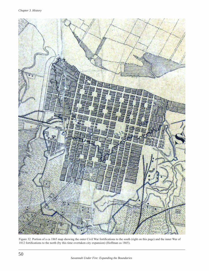
Savannah Under Fire: Expanding the Boundaries
Chapter 3 . History
50
Figure 32. Portion of a ca 1865 map showing the outer Civil War fortifications to the south (right on this page) and the inner War of 1812 fortifications to the north (by this time overtaken city expansion) (Hoffman ca 1865).
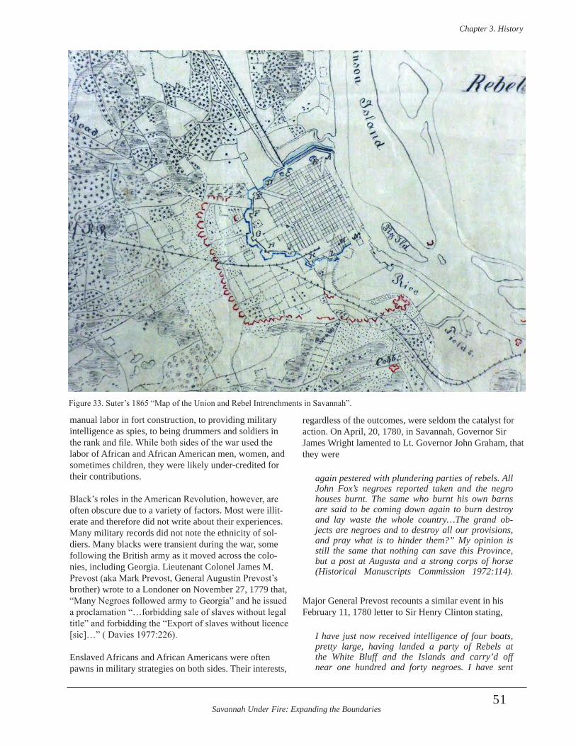
Savannah Under Fire: Expanding the Boundaries
Chapter 3 . History
51
Figure 33. Suter’s 1865 “Map of the Union and Rebel Intrenchments in Savannah”.
manual labor in fort construction, to providing military intelligence as spies, to being drummers and soldiers in the rank and file. While both sides of the war used the labor of African and African American men, women, and sometimes children, they were likely under-credited for their contributions.
Black’s roles in the American Revolution, however, are often obscure due to a variety of factors. Most were illit-erate and therefore did not write about their experiences. Many military records did not note the ethnicity of sol-diers. Many blacks were transient during the war, some following the British army as it moved across the colo-nies, including Georgia. Lieutenant Colonel James M. Prevost (aka Mark Prevost, General Augustin Prevost’s brother) wrote to a Londoner on November 27, 1779 that, “Many Negroes followed army to Georgia” and he issued a proclamation “…forbidding sale of slaves without legal title” and forbidding the “Export of slaves without licence [sic]…” ( Davies 1977:226).
Enslaved Africans and African Americans were often pawns in military strategies on both sides. Their interests,
regardless of the outcomes, were seldom the catalyst for action. On April, 20, 1780, in Savannah, Governor Sir James Wright lamented to Lt. Governor John Graham, that they were
again pestered with plundering parties of rebels . All John Fox’s negroes reported taken and the negro houses burnt . The same who burnt his own barns are said to be coming down again to burn destroy and lay waste the whole country…The grand ob-jects are negroes and to destroy all our provisions, and pray what is to hinder them?” My opinion is still the same that nothing can save this Province, but a post at Augusta and a strong corps of horse (Historical Manuscripts Commission 1972:114) .
Major General Prevost recounts a similar event in his February 11, 1780 letter to Sir Henry Clinton stating,
I have just now received intelligence of four boats, pretty large, having landed a party of Rebels at the White Bluff and the Islands and carry’d off near one hundred and forty negroes . I have sent
Savannah Under Fire: Expanding the Boundaries
Chapter 3 . History
52
immediate notice to Capt . Gayton that some mea-sures may be taken if possible to intercept their re-turn (Historical Manuscripts Commission 1972:88) .
Many blacks were focused on war-time survival, as were virtually all the residents of the colony. Black residents, whether they were the few freed men and women of the day, those who stayed with their masters, or those who tried to escape bondage, faced even more difficult chal-lenges. Blacks living in Savannah as freed people or enslaved were wounded and killed during the siege and battle. Such casualties were reported in The Georgia Royal Gazette. For example, on October 5 the French bombard-ment of the city commenced again, killing a mulatto man and three Negroes who were in the Lieutenant Governor’s cellar (Georgia Royal Gazette 1780: 5). Apparently, the Lieutenant Governor and Governor knew the risk of stay-ing in town was great, and had the luxury to be able to relocate to the camps where they pitched a tent adjacent to Colonel Maitland’s tent. Another cellar, this one under the Office of the Commissioners of Claims, received an incoming shell which wounded one Negro and killed an-other. (Georgia Royal Gazette 1780:6). Africans and African Americans often felt their best chance of survival lay with attaching themselves to the British army. Those who were most successful in the short term were those whose labor was needed by the army. This labor was most often in the form of manual work. Blacks provided manual labor for the British engineer-ing department. Labor included digging defensive ditches and constructing redoubts; hauling supplies, equipment, and artillery; and/or ancillary support, such as working in military hospitals and kitchens, and providing laundry services. There were 10 Negroes working in the Barrack Master General’s Department, one in the Inspector General’s Department, two “in service of Government”, and 14 in the Cattle Department in Savannah in October, 1779 (Clinton Papers Vol. 72:10). Immediately prior to, and during the 1779 siege and Battle of Savannah, there were 54 negroes employed in the British redoubts around Savannah and another 41 working in the Engineers’ de-partment (Clinton Papers Vol. 72:10). Deserters fleeing Savannah to the French lines in 1779 reported that there were 1,000 Negro laborers in Savannah immediately prior to the October 9, 1779 battle (Stevens 1970).
Much of the labor was on the backs of enslaved individu-als loaned to the British army by local Tories. This includ-ed Georgia’s royal Governor Wright. In November, 1779, Major General Augustin Prevost wrote,
The works go on but not so briskly as I wish; since the news of the raising the siege of Savannah: most
of the planters have retaken their negroes; and I am sorry to tell your Excellency that the Governor’s negroes were the very first who went away: I sent an officer to acquaint him with it; his answer was that he knew nothing of it, and that he would order them back, but he has not done it yet: The Lieutenant Governor and the Attorney General retook theirs also (Historical Manuscripts Commission 1972:64) .
The role of the African-American soldier in the American Revolution has received some scholarship but the subject is far from exhausted. Pioneering research by Quarles (1961) has been followed by more recent studies (Foner 1976; Hoffman 1981; Jones 1982; Kaplan and Kaplan 1989; Lanning 2005). African-Americans were enlisted by the Hessians as musicians, laborers, and soldiers (Hoffman 1981). Lanning (2005) notes that of 131 blacks serving un-der the Hessians in a 1787 list, 94 were listed as drummers and the rest as infantrymen. Jones (1982:287) presented examples among the Hessians garrisoned in Savannah, based on his study of original German muster lists. He cites as an example, Bossum (Possum) listed in Porbeck’s Hessians, who was recruited at Ogeechee. Jones reason-ably concluded that Bossum was black, although it is not stated specifically in the document.
On February 22, 1782, Colonel Porbeck wrote,
For every returned deserter the Negroes are paid two Guineas by the commandant . The Rebels have threatened the Negroes with hanging . This has scared them and they hide in the woods, there are no military police patrols, as previously seen .
Porbeck also indicates, in a letter on March 2, that cap-tured rebel Negroes were treated as booty by the King’s troops, and he noted that his officers and enlisted men were eager to get their share.
British engineer Lieutenant Colonel James Moncrief noted the advantage of the labor provided by the enslaved. By the end of the war, when Moncrief was in Charleston, he noted, “The number of slaves who have attached them-selves to the Engineer Department since my arrival…and who look up to me for protection has been for some time past a matter of serious concern” (Historical Manuscripts Commission 1906:419). Moncrief went on to write Sir Henry Clinton about what he should do regarding the Negroes before he departed Charleston. Moncrief rec-ommended embodying a brigade of Negroes (Historical Manuscripts Commission 1906:419).
Black contributions were not limited to manual military labor, however, as both sides had black troops. Patriot forces had limited black enrollment contrasted with
Savannah Under Fire: Expanding the Boundaries
Chapter 3 . History
53
British forces. Northern colonies and their slave owners were more receptive to the concept. Historians estimate that minimally, 5,000 black soldiers were enrolled with the Patriot forces, out of a total enslaved population of 450,000 in the original 13 colonies (NPS 2010). Black participation in the British military was accepted more readily.
Patriots, particularly those in the southern colonies, hesi-tated to use blacks in the military for fear of slave revolts. The threat of losing the war and the inability of colonies to meet congressional troop quotas led Congress to allow the enlistment of both free and enslaved blacks into the mili-tary in 1777. Two years later a desperate Congress offered $1,000 to owners for each slave they allowed to enter the army. Neither fear nor incentives could sway Georgia or South Carolina to participate (NPS 2010).
Just two weeks after the overwhelming defeat at Savannah, General Benjamin Lincoln wrote of South Carolina’s re-fusal to participate in raising black troops. He penned,
I hope therefore that they [Congress] will insist that the number of men, which they require from the neighboring states be fully supplied, with punctual-ity and dispatch-I am sorry to inform you that little maybe expected from this State, unless they rescind their late resolutions-for after Solemn debate in the Assembly, it was resolved that the militia should not be draught to fill up the Continental battalions; that the black regiments, recommended by Congress, should not be raised [emphasis added]; and that the militia while in the field, should not be subject to Continental articles of War (Lincoln 1779a) .
The presence of blacks in the Patriot forces is confirmed periodically in primary source documents. In January of 1779 Henry Laurens wrote notes about a potential Georgia Campaign for General Washington. He noted that there were 10,500 Rebel Negroes (Laurens 1779). This number appears to represent those in the Georgia and Carolina colonies, although this is unclear from Lauren’s notes. Also, it is likely that these were potential black forces for the patriots and were at that time probably unarmed and still enslaved. Laurens also noted that among those British troops embarking on a vessel in the New York harbor in January 1779 were, “6,200 Negroes sufficient for Pioneers, servants & all fatigue duty by land and water” and esti-mated that the number of “Negroes who may be armed” at 800 (Laurens 1779).
While black troops were not raised initially in South Carolina and Georgia, blacks did serve in the ranks of troops raised elsewhere, as well as among British forces. The December 1, 1779 Savannah Muster Roll of Col. Alexander Innes’ Company of the South Carolina
Royalists lists one drummer named “Black Sanchs”, who was possibly an African or African American, as might have been another drummer in the company simply listed as “Cyrus” (Ward-Chipman 1779a). The “Abstract of the Number of Men, Women, and Children, Negroes and Prisoners Victualled at the Commissary General’s Stores at Savannah” form October 11-20, 1779, lists a total of 620 negroes allied with British forces in Savannah at the time of the siege and battle (Clinton Papers Vol. 72:10). Table 1 enumerates the Negroes pulled from this list. A total of 182 of the 620 was listed among the ranks of soldiers (Clinton Papers Vol. 72:10). Deserters claimed the number of armed Negroes in Savannah, however, was closer to 200 (Stevens 1970). This included a variety of battalion and regiments ranging from British regiments, to Georgia militia, to Hessian troops and included rangers, light dragoons, and artillery. In addition, 36 Negroes served as sailors, seamen, or in other capacities on British vessels (Clinton Papers Vol. 72:10). Another two individuals were in the Brigade commanded by Major Skelly, which appears by the order on the list to be associated with the marines. An account in The Georgia Royal Gazette detailed a skirmish between “some Negroes and a party of Rebels” on October 16, well after the battle. The skirmish occurred on McGillivray’s plantation, as allied forces continued to evacuate the area. The newspaper reported that the Rebels, “…were several times driven from the buildings on the plantation into the woods. Want of ammunition, however, obliged the Blacks to retreat in the evening with the loss of one killed, and three or four wounded” (The Georgia Royal Gazette 1780:7).
The Black Pioneer Companies were comprised of Africans and African-Americans that performed manual labor for the military, such as constructing redoubts and digging for-tification trenches. Black Pioneers are discussed briefly in the previous NPS ABPP report and the reader is referred to it for additional information (Elliott and Elliott 2009:58). Maj. On November 22, 1779 Major General Prevost in Savannah. “…directed the Black Pioneer Companies to be employed in preparing material for erection of batter-ies, &c..” (Historical Manuscripts Commission 1972:64). During the siege and Battle of Savannah, there were 59 Black Pioneers stationed in the city with the British forces. A total of 218 blacks was listed under “Volunteer Negroes” (Clinton Papers Vol. 72:10). They are enumerated on the list between “Negroes employed in Redoubts” and “Black Pioneers”. The Georgia Royal Gazette reported that the “French Mulatto and black Brigade had marched to Col. Mullryne’s to embark” on October 17, 1779 (Georgia Royal Gazette 1780:7).
The most well-known Savannah example of black partici-pation on the American side of the Revolution involves the Volunteer Chasseurs of San Domingo, a military force
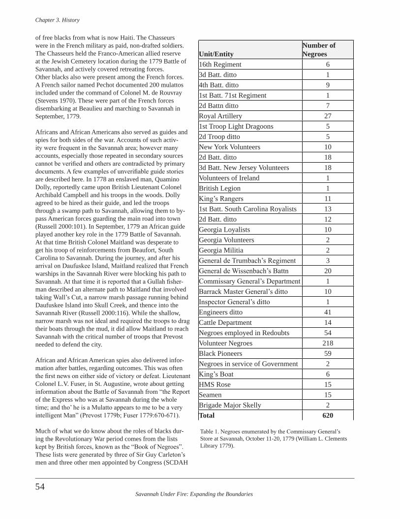
Savannah Under Fire: Expanding the Boundaries
Chapter 3 . History
54
of free blacks from what is now Haiti. The Chasseurs were in the French military as paid, non-drafted soldiers. The Chasseurs held the Franco-American allied reserve at the Jewish Cemetery location during the 1779 Battle of Savannah, and actively covered retreating forces.Other blacks also were present among the French forces. A French sailor named Pechot documented 200 mulattos included under the command of Colonel M. de Rouvray (Stevens 1970). These were part of the French forces disembarking at Beaulieu and marching to Savannah in September, 1779.
Africans and African Americans also served as guides and spies for both sides of the war. Accounts of such activ-ity were frequent in the Savannah area; however many accounts, especially those repeated in secondary sources cannot be verified and others are contradicted by primary documents. A few examples of unverifiable guide stories are described here. In 1778 an enslaved man, Quamino Dolly, reportedly came upon British Lieutenant Colonel Archibald Campbell and his troops in the woods. Dolly agreed to be hired as their guide, and led the troops through a swamp path to Savannah, allowing them to by-pass American forces guarding the main road into town (Russell 2000:101). In September, 1779 an African guide played another key role in the 1779 Battle of Savannah. At that time British Colonel Maitland was desperate to get his troop of reinforcements from Beaufort, South Carolina to Savannah. During the journey, and after his arrival on Daufuskee Island, Maitland realized that French warships in the Savannah River were blocking his path to Savannah. At that time it is reported that a Gullah fisher-man described an alternate path to Maitland that involved taking Wall’s Cut, a narrow marsh passage running behind Daufuskee Island into Skull Creek, and thence into the Savannah River (Russell 2000:116). While the shallow, narrow marsh was not ideal and required the troops to drag their boats through the mud, it did allow Maitland to reach Savannah with the critical number of troops that Prevost needed to defend the city.
African and African American spies also delivered infor-mation after battles, regarding outcomes. This was often the first news on either side of victory or defeat. Lieutenant Colonel L.V. Fuser, in St. Augustine, wrote about getting information about the Battle of Savannah from “the Report of the Express who was at Savannah during the whole time; and tho’ he is a Mulatto appears to me to be a very intelligent Man” (Prevost 1779b; Fuser 1779:670-671). Much of what we do know about the roles of blacks dur-ing the Revolutionary War period comes from the lists kept by British forces, known as the “Book of Negroes”. These lists were generated by three of Sir Guy Carleton’s men and three other men appointed by Congress (SCDAH
Unit/EntityNumber of Negroes
16th Regiment 63d Batt. ditto 14th Batt. ditto 91st Batt. 71st Regiment 12d Battn ditto 7Royal Artillery 271st Troop Light Dragoons 52d Troop ditto 5New York Volunteers 102d Batt. ditto 183d Batt. New Jersey Volunteers 18Volunteers of Ireland 1British Legion 1King’s Rangers 111st Batt. South Carolina Royalists 132d Batt. ditto 12Georgia Loyalists 10Georgia Volunteers 2Georgia Militia 2General de Trumbach’s Regiment 3General de Wissenbach’s Battn 20Commissary General’s Department 1Barrack Master General’s ditto 10Inspector General’s ditto 1Engineers ditto 41Cattle Department 14Negroes employed in Redoubts 54Volunteer Negroes 218Black Pioneers 59Negroes in service of Government 2King’s Boat 6HMS Rose 15Seamen 15Brigade Major Skelly 2Total 620
Table 1. Negroes enumerated by the Commissary General’s Store at Savannah, October 11-20, 1779 (William L. Clements Library 1779).
Savannah Under Fire: Expanding the Boundaries
Chapter 3 . History
55
2010). The lists documented black Loyalists who had worked with and/or fled with British troops, and who were boarding ships in the spring and fall of 1783 in New York, bound for Canada. These rolls contained specific informa-tion about the passengers, including the names of their former masters, where they once lived, their age, when they left their masters, the vessel they boarded, and their expected port. Sometimes the lists included the roles of the passengers in the British service and a brief description of their appearance and health.
An interesting picture of enslaved Africans and African Americans in Savannah emerges from newspaper adver-tisements in nearby Charleston, South Carolina, news-papers. These include ads prior to, during, and after the Revolution, such as those dating from 1756-1764 in the South-Carolina Gazette, and advertisements in the South Carolina and American General Gazette (formerly known as the South-Carolina Weekly Gazette (1764-1781). Other ads for runaway slaves came from the Royal Gazette dur-ing the period from March 1781-1782. The numbers of runaways likely increased after Britain’s success in the 1779 Battle of Savannah, and as British troops maintained a hold on the area for the ensuing three years. Many en-slaved fled to British lines before, during, and after the battle in hopes of securing freedom. In some cases, British officers owned slaves. One example was a man named Blackwall who, “was formerly the property of Lieut. Hook of the [Royal] Artillery” (Whitead 2002). Blackwall es-caped with his friend, Scipio, who “was formerly the prop-erty of Capt. Simmons” and carried his own militia musket (Whitead 2002). (It is unknown whether Capt. Simmons was a civilian ship captain or a military captain.) All the newspaper ads help paint a vivid picture of many individu-als who often remain elusive in history.
Archeologists searched the compilation of these ads for individuals relevant to Savannah to provide a better un-derstanding of those in the area that would have been in-volved in the battle, whether through military-related ac-tivities or as a civilian. Table 2 summarizes these individu-als. An evocative image emerges. Many of these individu-als were born in Africa. Native countries included Ebo/Ibo and Guinea/Pappa. Several of the Africans physically reflected their cultural heritage. This was visible in ritual scarification, such as two to three deep scratches on their cheeks and filed front teeth. One individual even retained his African name of Arrow. This was in marked contrast to the names given slaves, such as Caesar, Prince, Scipio, or simply “Tom” or other first name. Interestingly one man had a first and last name, Bob Lindsay. The list suggests that many enslaved in or nearby Savannah were skilled in one or more professions. Caesar exemplifies this. He was an excellent oarsman, a jobbing carpenter, and a plain cook. Others included another carpenter, a “waiting man”,
and cowboys. Many of the Africans in Georgia and South Carolina were bilingual. All spoke their native African languages and many learned English to varying degrees of proficiency and/or a Pidgin English. Suba was a 5’3” man with filed front teeth that spoke “high Dutch or German” and escaped from bondage in South Carolina (Whitead 2002). Mick, who was born enslaved in the French West Indies, and brought to the southern colonies, spoke French and English.
Various fates befell Africans and African Americans in the Savannah area at the close of the American Revolution. British Lieutenant General Alexander Leslie in Charleston, South Carolina wrote to General Sir Guy Carleton the following:
If this town is to be evacuated, what will be done with the sequestered negroes now under charge of Mr . Cruden, and employed in the different depart-ments…There are many negroes who have been very useful, both at the Siege of Savannah and here; some of them have been guides, and from their loyalty been promised there freedom…I apprehend many of the inhabitants will wish to go to Jamaica with their negroes; therefore a convoy ought to be or-dered to take them in case such as request is made (Historical Manuscripts Commission 1906:544) .
Lieutenant General Alexander Leslie sympathized with
the unfortunate loyalists of Georgia” but not with their enslaved, as he wrote that relocating Georgia loyal-ists would “…afford them a convenient refuge whith-er the most valuable of their property may be without much difficulty transported, and in a country where their negroes may continue to be useful to them… (Historical Manuscripts Commission 1906:546) .
Leslie felt that many Loyalists slave owners “…would wish them sent to Jamaica…St. Augustine, or St. Johns, Florida” (Historical Manuscripts Commission 1906:543). Many African-Americans who had assisted the British in the Siege and Battle of Savannah were sent to eastern Canada at the war’s end.
Additional Details about Native Americans Involved
The British and the Patriots constantly negotiated with Native Americans to join their side during the American Revolution. Native American groups did form alliances with both, however, these alliances proved to be difficult
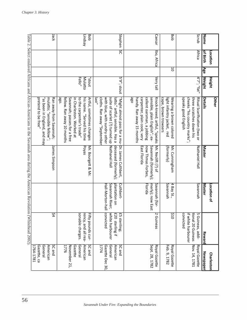
Savannah Under Fire: Expanding the Boundaries
Chapter 3 . History
56
LocationHeight
Other
Location ofCharleston
Nam
eof Birth
AgeW
eightDetails
Master
Master
Reward
New
spaperScrub
Africa4’7”; “fat”
Ritual Scarification (two or
three scratches down his
cheeks “his country marks”;
speaks good English
Nathaniel Hall
Savannah5 Guineas, addi-tional 20 Guineas if w
hite harbourer convicted
Royal Gazette N
ov. 14, 1781
Bob10
Wearing a brow
n colored light infantry jacket, red cape, brow
n trowsers
Mr. Cunningham
(form
erly)4 Bay St., Savannah
$10 Royal Gazette Feb. 9, 1782
CaesarIbo, Africa
Very tallKnock-kneed; artful, “speaks sensible, plain English”; ex-cellent oarsm
an, a jobbing carpenter, plain cook; very handy. Ran aw
ay 15 months
ago
Mr. N
eclift (?) of Savannah (form
erly); now
Thmas Forbes,
East Florida
Savannah (for-m
erly); now East
Florida
2 GuineasRoyal Gazette Sept. 28, 1782
StephenSC
5’9”; stout“M
ight almost pass for a m
u-latto.” artful; sensible. Has a suite of scarlet (?) turned up w
ith blue, with sundry other
cloths. Ran away “Septem
ber last”
Dr. James Cuthbert,
deceased (formerly);
Nathanel Hall
Cuthbert-plantation on Savannah River; Hall-M
orton-hall
£5 steriling; £20 sterling if w
hite harbourer convicted
SC and Am
erican General Gazette Dec 30, 1774
Bob Lindsay
“stout M
ulatto Fello”
Artful, sometim
es changes his nam
e. “Served his time
to the carpenter’s trade” in Charleston. W
orked at Savannah; passes for a free fellow
. Ran away 10 m
onths ago.
Mr. Bourgett
& M
r. Poyas
Fifty pounds cur-rency, and all rea-sonable charges.
SC and Am
erican General Gazette N
ovember 21,
1776
JackRan aw
ay from Savannah;
mulatto; “sensible fellow
”; “as been in England, and m
ay pretend to be free”
James Sim
pson$4
SC and Am
erican General Gazette, ca 1764-1781
Table 2. Select enslaved Africans and A
frican-Am
ericans in the Savannah area during the Am
erican Revolution (W
hitehead 2002).

Savannah Under Fire: Expanding the Boundaries
Chapter 3 . History
57
Loca
tion
Heig
htO
ther
Loca
tion
ofCh
arle
ston
Nam
eof
Birt
hAg
eW
eigh
tDe
tails
Mas
ter
Mas
ter
Rew
ard
New
spap
erTo
mIb
o, A
fric
a5’
5”Fo
rmer
ly w
as a
“w
aitin
g m
an to
Mr.
Nat
hani
el H
all,
Mer
chan
t, at
Sav
nnah
”; W
ife
on o
ne o
f Joh
n M
’Que
en’s
plan
tatio
ns;h
e ra
n aw
ay
abou
t 15
mon
ths a
go
Nat
hani
el H
all,
Mer
chan
t (fo
rmer
ly);
Pric
e, H
est &
Hea
d
Hall-
Sava
nnah
; Pr
ice,
Hes
t, &
He
ad-?
20 p
ound
s & re
a-so
nabl
e ch
arge
s;
50 p
ound
s to
whi
te p
erso
n if
whi
te h
arbo
urer
co
nvic
ted;
20
poun
ds to
Neg
ro
if w
hite
har
bour
er
conv
icte
d
SC a
nd
Amer
ican
Ge
nera
l Ga
zette
, Aug
. 14
, 176
9
Titu
s“t
his
coun
try”
Slim
Artfu
l, m
ay e
ndea
vour
to
pass
as f
ree.
Will
iam
Gib
bon
Sava
nnah
Rew
ard
SC a
nd
Amer
ican
Ge
nera
l Ga
zette
, Nov
. 11
, 177
1Pr
ince
6’Ta
lks p
lain
Eng
lish;
no
mar
ks.
Run
away
from
Sav
anna
hSa
mue
l Pric
eSa
vann
ah14
pou
nds
SC a
nd
Amer
ican
Ge
nera
l Ga
zette
, Oct
. 19
, 177
2Jo
seph
Shor
tLo
st so
me
of h
is fo
re te
eth;
br
ough
t up
on Ja
mes
Isla
ndSa
mue
l Pric
eSa
vann
ah14
pou
nds
SC a
nd
Amer
ican
Ge
nera
l Ga
zette
, Oct
. 19
, 177
2Ju
lyGu
inea
, Af
rica
alm
ost 6
’“C
ount
ry m
arks
on
his
chee
ks”;
supp
osed
har
-bo
ured
at M
r. Br
isban
’es
plan
tatio
n on
Wrig
ht’s
Nec
k,
whe
re th
ey w
ere
once
bef
ore
take
n; p
oste
d O
ct. 8
, 177
3
John
Cha
nnin
g, E
sq.
plan
tatio
n ne
ar
Sava
nnah
20 sh
illin
gsSC
and
Am
eric
an
Gene
ral
Gaze
tte,D
ec,
1773
Tabl
e 2.
Sel
ect e
nsla
ved
Afr
ican
s and
Afr
ican
-Am
eric
ans i
n th
e Sa
vann
ah a
rea
durin
g th
e Am
eric
an R
evol
utio
n (W
hite
head
200
2), C
ontin
ued.
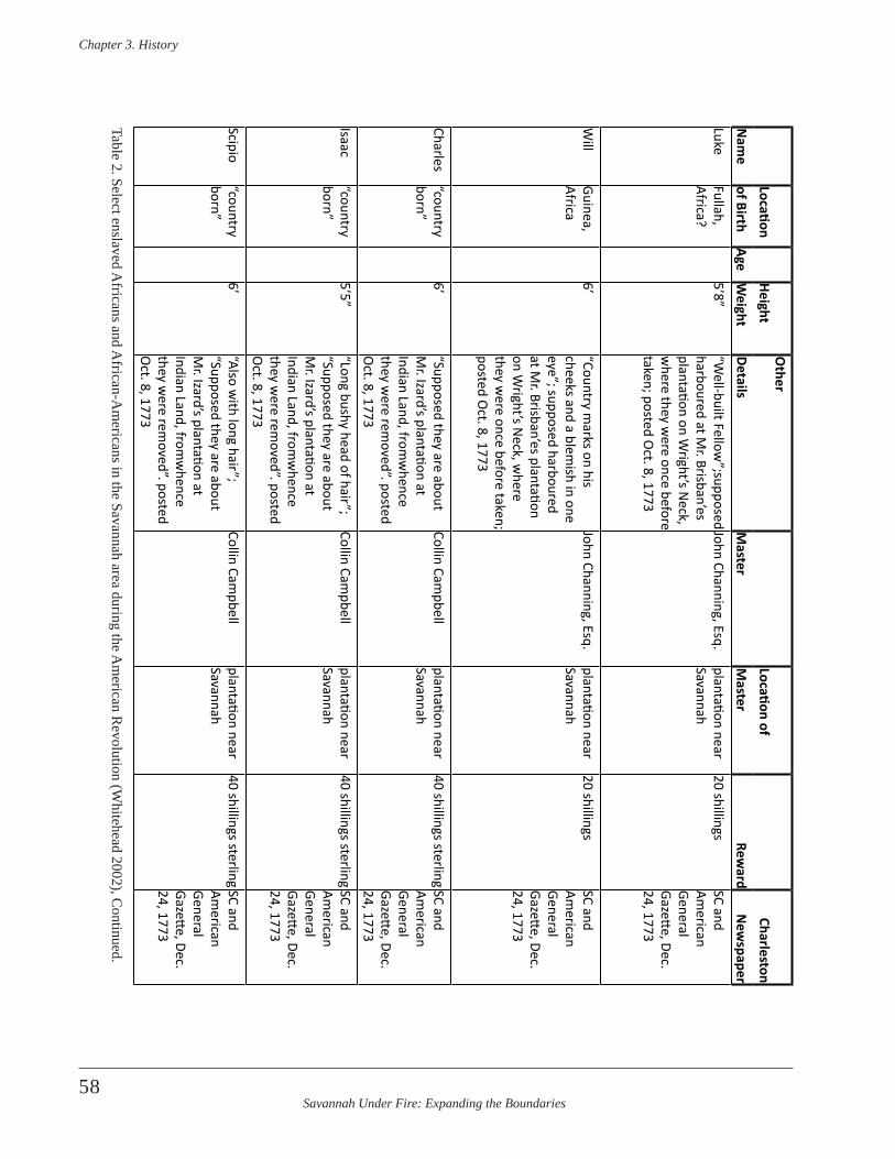
Savannah Under Fire: Expanding the Boundaries
Chapter 3 . History
58
LocationHeight
Other
Location ofCharleston
Nam
eof Birth
AgeW
eightDetails
Master
Master
Reward
New
spaperLuke
Fullah, Africa?
5’8”“W
ell-built Fellow”;supposed
harboured at Mr. Brisban’es
plantation on Wright’s N
eck, w
here they were once before
taken; posted Oct. 8, 1773
John Channing, Esq.plantation near Savannah
20 shillingsSC and Am
erican General Gazette, Dec. 24, 1773
Will
Guinea, Africa
6’“Country m
arks on his cheeks and a blem
ish in one eye”; supposed harboured at M
r. Brisban’es plantation on W
right’s Neck, w
here they w
ere once before taken; posted O
ct. 8, 1773
John Channing, Esq.plantation near Savannah
20 shillingsSC and Am
erican General Gazette, Dec. 24, 1773
Charles“country born”
6’“Supposed they are about M
r. Izard’s plantation at Indian Land, from
whence
they were rem
oved”. posted O
ct. 8, 1773
Collin Campbell
plantation near Savannah
40 shillings sterlingSC and Am
erican General Gazette, Dec. 24, 1773
Isaac“country born”
5’5”“Long bushy head of hair”; “Supposed they are about M
r. Izard’s plantation at Indian Land, from
whence
they were rem
oved”. posted O
ct. 8, 1773
Collin Campbell
plantation near Savannah
40 shillings sterlingSC and Am
erican General Gazette, Dec. 24, 1773
Scipio“country born”
6’“Also w
ith long hair”; “Supposed they are about M
r. Izard’s plantation at Indian Land, from
whence
they were rem
oved”. posted O
ct. 8, 1773
Collin Campbell
plantation near Savannah
40 shillings sterlingSC and Am
erican General Gazette, Dec. 24, 1773
Table 2. Select enslaved Africans and A
frican-Am
ericans in the Savannah area during the Am
erican Revolution (W
hitehead 2002), Continued.

Savannah Under Fire: Expanding the Boundaries
Chapter 3 . History
59
Loca
tion
Heig
htO
ther
Loca
tion
ofCh
arle
ston
Nam
eof
Birt
hAg
eW
eigh
tDe
tails
Mas
ter
Mas
ter
Rew
ard
New
spap
erPh
iland
erAu
gust
a,
GA25
“pre
tty
tall”
Elde
st b
roth
er o
f Pau
l; ex
pert
in
ridi
ng, u
sed
to a
cow
pen;
lik
ely
gone
to “
the
back
se
ttle
men
ts”
Lach
lan
M’G
illiv
ray
plan
tatio
n ne
ar
Sava
nnah
20
pou
nds c
ur-
renc
y &
all
reas
on-
able
cha
rges
; 30
poun
ds c
urre
ncy
upon
con
victi
on o
f th
e ha
rbor
er
SC G
azett
e,
April
17,
176
2
Paul
Augu
sta,
GA
20Yo
unge
r bro
ther
of
Phila
nder
; exp
ert i
n rid
ing,
us
ed to
a c
owpe
n; li
kely
gon
e to
“th
e ba
ck se
ttle
men
ts”
Lach
lan
M’G
illiv
ray
plan
tatio
n ne
ar
Sava
nnah
20
pou
nds c
ur-
renc
y &
all
reas
on-
able
cha
rges
; 30
poun
ds c
urre
ncy
upon
con
victi
on o
f th
e ha
rbor
er
SC G
azett
e,
April
17,
176
2
Sim
on
40lik
ely
gone
to “
the
back
se
ttle
men
ts”
Lach
lan
M’G
illiv
ray
plan
tatio
n ne
ar
Sava
nnah
20
pou
nds c
ur-
renc
y &
all
reas
on-
able
cha
rges
; 30
poun
ds c
urre
ncy
upon
con
victi
on o
f th
e ha
rbor
er
SC G
azett
e,
April
17,
176
2
Arro
wPa
ppa,
(n
ew
Guin
ea?)
, Af
rica
Ran
away
“Tw
o da
ys a
fter h
e w
as b
ough
t out
of a
Gui
nea
ship
, a w
ell g
row
n ne
gro
lad
of th
e Pa
ppa
coun
try,
his
coun
try
nam
e Ar
row,
and
is
perh
aps t
he sa
me
adve
rtise
d to
be
in S
avan
nah
goal
. Ran
aw
ay th
ree
yrs a
go
Will
iam
Will
iam
son
(St.
Paul
’s pa
rish)
may
-be
form
erly
? Ja
mes
Pa
rson
app
ears
to b
e ne
w o
wne
r
Pars
on’s
plan
ta-
tion
as A
shep
oo10
pou
nds a
nd a
ll le
gal c
harg
es; 2
0 pi
stol
es to
whi
te
harb
orer
s upo
n co
nvic
tion
SC G
azett
e. Ja
n.
28, 1
764
Tabl
e 2.
Sel
ect e
nsla
ved
Afr
ican
s and
Afr
ican
-Am
eric
ans i
n th
e Sa
vann
ah a
rea
durin
g th
e Am
eric
an R
evol
utio
n (W
hite
head
200
2), C
ontin
ued.
Savannah Under Fire: Expanding the Boundaries
Chapter 3 . History
60
for both the British and Patriot leadership to manage. Atrocities on all sides were common and included scalp-ings, burning settlers’ houses, burning Indian villages, and wounding and deaths among women and children.
Both the British and the Patriots tried to control Native American behavior and warrior movements through proc-lamations, meetings, and gifts, but with only limited suc-cess. A few examples of this can be seen in Savannah. On August 2, 1779, Maj. Gen. Prevost met with the Principal Headmen and Warriors of the Upper and Lower Creek Nation, at the request of British Deputy Superintendents for the Creek Nation, Major David Taitt and McIntosh (Prevost 1779d). When questioned at the meeting, the Creeks denied any wavering loyalty and insisted that they always tell their people not to listen to any offers made them by the Rebels. On August 7, 1779, Charles Shaw wrote that a few days earlier 120 Creeks arrived in Savannah from their different villages and the General was going to, “order them up immediately to Southern Country between this and Augusta, and to make incursions into Carolina to alarm the Enemy” (Prevost 1779d). Indians returning from service with the Army in Carolina were “in high good humour, loaded with presents by order of the General in return for their services” (Prevost 1779d). The list of these presents included things like brass kettles, shirts, trunks, mirrors, vermillion, silverware, smoking pipes, tin ware, hatchets, axes, lead bars, gunflints, and gunpowder (Prevost 1779d). They were shipped from New York on April 28, 1779 on the vessels Polly and Belrey, and arrived in Savannah on August 7, 1779.
Major General Prevost felt the money spent on buying Indian services and loyalty too great, and wrote as much to Sir Henry Clinton, saying,
I have to take every measure to send them home pleased, but I must confess that their Services are not proportional to the large Sums expended on their Account, and that our Influence over them, notwith-standing the bountiful Provision made for them, is far short of what it ought to be (Prevost 1779d) .
Prevost stated his disaffection with Native American sol-diers again to Clinton in November of 1779, “…heard nothing as yet of the Indians, their services always merce-nary and precarious” (Historical Manuscripts Commission 1972:59).
Like any soldiers, the Native Americans also required food and supplies. When South Carolina Royalist Captain Black surrendered at New Ebenezer he reported that he “had the conduct of the Indian agency under Col. Brown for some time”. He state that at the St. Marys River
…he left a considerable Quantity of foods for the use of the Chocktaws, Creeks, & Chickasaws, also a Considerable number of horses & between three & four hundred head of Cattle, under the care of a few traders & about forty wounded and Invalid Indians, where there is also a quantity of Provision; collected for the use of the Savages & the Dragoons from Savannah (Wayne 1782) .
The Native Americans required a great deal of administra-tive effort and communication, in addition to gifts. Even these measures; however, were not always effective in en-suring that the Indians groups would do as the military hi-erarchy desired. Sir Henry Clinton wrote to Colonel Innes on February 19, 1780,
…By the inclosed letter to Genl Prevost you will see that I wish all the troops that can be spared may join us, as soon as possible; tis the opinion of all here par-ticularly of Capt . Montcrief that the shortest way will be by land…For God’s sake keep your troops under regulation during the march, particularly the Creeks, what think you of bringing an old sac hem and Creek young warriors with you, I wish them to see our army, and operations; reconcile Col . Brown to remaining behind with the Indians; the instant Charlestown is ours he shall have my orders respecting them, in the meantime, as I told him, I would do everything to keep them in good humour…You will of course bring with you all the cattle you can get, but for God’s sake no irregularities . Col . Brown will in proper time explain to the Indians the reason of our changing our plans (Historical Manuscripts Commission 1972:92-93) .
Some, like Georgia Governor James Wright were of the opinion that even if the Native Americans weren’t effec-tive soldiers, it was worth winning them over to avoid having them as an enemy. Wright wrote to Clinton from Savannah in March 18, 1780,
…and with respect to the Indians, the Cherokees, Sir, you may depend will not stay here, & I wish may not go away in disgust, and the Creeks being stop’t and sent home again, most like may be disgusted also, and however these people may be thought useless in the field-your Excellency will be pleased to recollect that I had the honor to mention to you here my opin-ion of the consequence of Indians, and that if they were against us they would harass the King’s Troops in any march, & receive the Rebels amongst them, and I feared we could never subdue the rebellion (Historical Manuscripts Commission 1972:104) .
Savannah Under Fire: Expanding the Boundaries
Chapter 3 . History
61
In spite of deprecatory remarks about the effectiveness of using Indian warriors, Native Americans waged conflict frequently enough to inflict real casualties and damage on both sides, spreading abject terror among rural colonial settlers. In January of 1779 Patriot Henry Laurens reported that there were, “7,000 Creek Indians actually at war with Georgia & So Carolina” and of these apparently were “5,000 Gun Men” (Laurens 1779). He went on to report that the British also had available for fighting in Georgia and South Carolina, 1,000 Choctaws “for the field in their irregular mode of fighting” and “1,000 Cherokees who will make War when they can with an appearance of safety” (Laurens 1779). Native Americans, themselves became casualties in these conflicts as reflected in Royalist Captain Brown’s statement that, “…about forty wounded and Invalid Indians” were with traders on the St. Marys River near the Georgia/Florida boundary (Wayne 1782).
Native American groups were constantly on the move and it was difficult for either side to determine when or where or if their allies would appear. On October 30, 1779, Florida Governor Patrick Tonyn wrote to Lord George Germain that following the successful October 9th British victory in Savannah, “Indians have begun moving towards Savannah” (Davies 1977:202). Tonyn also issued a proc-lamation “…requiring all loyal subjects to use influence to bring Indians to Georgia to act with King’s troops” (Davies 1977:202).
The problems with the transient nature of the Native Americans at this time combined with the problems of major epidemics among them. Major General Augustin Prevost in Savannah wrote to Commander in Chief [General Sir Henry Clinton] in early March of 1780,
…The Indians being in great dread of the small pox-which at present rages in all the lower part of this Province are desirous of going away which it will be difficult for me to prevent-if we wish them to remain our friends-they are not people to be employed In the diffence of a place; they cannot suffer the appearance of being shut up…(Historical Manuscripts Commission 1972:96) .
New Details on the Roles of Women and Children
Twenty-first century warfare in highly technical societies usually precludes the presence of civilian families fol-lowing their soldier-spouses or parent(s) into war zones. This was not the case during the 18th and 19th centu-ries, however, when wives, children, and other relatives
often traveled with the troops from camp to camp during the American Revolution and the American Civil War. Many of these appear to have been supplied by military commissaries.
Savannah’s civilian population included women and chil-dren throughout its period of British control. This popula-tion of women and children already living in Savannah increased with the presence of British forces following the successful British attack and takeover in 1778. By 1779 there were 256 women and 174 children attached to British-controlled troops in Savannah. The safety of this population became a concern with the 1779 siege and battle of Savannah. During the siege and bombardment, Major General Prevost requested that the French and American forces allow women and children (including his own family) safe passage out of the city, but allied forces refused. Multiple injuries and deaths among women and children were documented. On October 4, allied fire from batteries containing 18, 12, and 6 pounders killed Mrs. Thompson’s daughter. On the night of October 5, “…an-other shell fell through Mr. Lawrie’s house in Broughton Street, which killed two women and two children who were under it” (Georgia Royal Gazette 1780:5). Major General Prevost’s wife, Anne, suffered the same fears and dangers as the other women in town while under siege and later attack. In that situation she wrote to family in Europe, “…with the noise of the gun, [with] a trembling hand that I trace these lines…” Anne writes of how her infant is unaccustomed to the noise of the guns and bombs of the siege and how she worries when she hears them that “…perhaps one of these fatal blows has reached my husband, before the frightening sound reaches me…” She goes on to describe how one bomb set ablaze the house, and she had to flee, with the help of a Captain “who par-took my son in his arms” while she took her daughter. “We avoid the danger of fire thus, but our escape exposes us …to the guns and bombardment of the enemies flashes over-head and on all sides” They finally reached the relative safety of a makeshift rampart along the edge of the river, where she lay down “…exhausted of tiredness, deprived of faculty to think…” and “wrapped in a wool blanket a sailor had charity to lend me…” (Lysons 1796:15-16).
Table 3 reflects the associations with various regiments and brigades of the 430 women and children attached to the British military in Savannah. Interestingly, the larg-est numbers of women were associated with units far-thest from Savannah, such as the New York Volunteers and the 3rd Battalion of the New Jersey Volunteers. The 1st Battalion of the 71st Regiment consisted of Scottish Highlanders. They listed 32 women and 20 children at-tached to their regiment. The greater numbers of women and children among units farthest from home may,
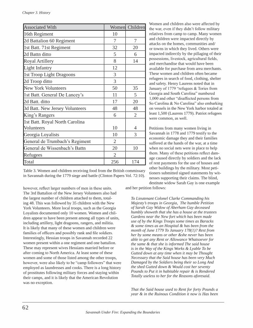
Savannah Under Fire: Expanding the Boundaries
Chapter 3 . History
62
however, reflect larger numbers of men in these units. The 3rd Battalion of the New Jersey Volunteers also had the largest number of children attached to them, total-ing 48. This was followed by 35 children with the New York Volunteers. More local troops, such as the Georgia Loyalists documented only 10 women. Women and chil-dren appear to have been present among all types of units, including artillery, light dragoons, rangers, and militia. It is likely that many of these women and children were families of officers and possibly rank and file soldiers. Interestingly, Hessian troops in Savannah recorded 22 women present within a one regiment and one battalion. These may represent wives Hessians married before or after coming to North America. At least some of these women and some of those listed among the other troops, however, were also likely to be “camp followers” that were employed as laundresses and cooks. There is a long history of prostitutes following military forces and staying within their camps, and it is likely that the American Revolution was no exception.
Women and children also were affected by the war, even if they didn’t follow military relatives from camp to camp. Many women and children were impacted directly by attacks on the homes, communities and/or towns in which they lived. Others were impacted indirectly by the pillaging of their possessions, livestock, agricultural fields, and merchandise that would have been available for purchase from area merchants. These women and children often became refugees in search of food, clothing, shelter and safety. Henry Laurens noted that in January of 1779 “refugees & Tories from Georgia and South Carolina” numbered 1,000 and other “disaffected persons from So Carolina & No Carolina” also embarking on vessels in the New York harbor totaled at least 1,500 (Laurens 1779). Patriot refugees were common, as well.
Petitions from many women living in Savannah in 1778 and 1779 testify to the economic damage they and their families suffered at the hands of the war, at a time when no social nets were in place to help them. Many of these petitions reflect dam-age caused directly by soldiers and the lack of rent payments for the use of houses and other buildings by the military. Most peti-tioners submitted signed statements by wit-nesses supporting their claims. The blind, destitute widow Sarah Gay is one example
and her petition follows:
To Lieutenant Colonel Clarke Commanding his Majesty’s troops in Georgia, The humble Petition of Sarah Gay Widow of Aberham Gay deceased humbly showeth that she has a house at the trustees Gardens near the New fort which has been made use of by the Kings Troops some times as Baracks & some times as an Hospital & has been from the month of June 1779 To January 178(1)? Rest from her by some means or other &she never has been able to get any Rent or Allowance Whatsoever for the same & that she is informed The said house is in the Way of the Kings Works & Lyable To be Gutted down at any time when it may be Thought Necessary that the Said house has been very Much Damaged by the Soldiers being their so Long And the shed Gutted down & Would cost her seventy Pounds to Put it in habitable repair & is Rendered Totally useless to her for the Reasons aforesaid .
That the Said house used to Rent for forty Pounds a year & in the Ruinous Condition it now is Has been
Associated With Women Children16th Regiment 102d Battalion 60 Regiment 7 71st Batt. 71st Regiment 32 202d Battn ditto 5 6Royal Artillery 8 14Light Infantry 121st Troop Light Dragoons 32d Troop ditto 3New York Volunteers 50 351st Batt. General De Lancey’s 11 52d Batt. ditto 17 203d Batt. New Jersey Volunteers 48 48King’s Rangers 6 21st Batt. Royal North Carolina Volunteers 10 4Georgia Loyalists 10 3General de Trumbach’s Regiment 2General de Wissenbach’s Battn 20 10Refugees 2Total 256 174
Table 3. Women and children receiving food from the British commissary in Savannah during the 1779 siege and battle (Clinton Papers Vol. 72:10).
Savannah Under Fire: Expanding the Boundaries
Chapter 3 . History
63
Valued at £200 by Masr __lyming & Allman Two Master builders that your Petitioner is Blind And in Very Destroyed Circumstances & thinks she has An Equitable Claim to some Recompence for the Damage done as aforesaid therefore she humbly Prays you Will be Pleased to Recommend her case So that She may obtain some Relief…Sarah Gay (Gay 1781) .
Sarah’s claim was further substantiated by the British Barrack Master in Savannah on April 4 1781. He stated,
The House within mentioned has been employed as Barracks & as a Hospital for the accommodation of his Majestys Troops in the Garrison from the month of June 1779 to the month of January 1781-Thomas Will Moore, Barrack Master (Moore 1781a) .
Additional papers with the petition indicate that the pa-pers were forwarded to high command, as “the whole to be very true & that the Poor woman is a Real object of Charity-[signature illegible] April 1781”.
The thousands of troops quartered in Savannah resulted in numerous claims for compensation. Another petition for payment for barracks for soldiers came from the widow Martha Young. Her house,
…was made Barracks of for the Royal Artillery Soldiers for a long Space of time; to wit, Seventeen Months and upwards which, for, she received a Certificate from Genl. Prevost and Captain Thomas William Moor Barracks Master and never received any payments for the said Certificate. Your Memorialist is a Widow Woman and has a family to maintain…--Martha Young [March 20, 1781] (Young 1781) .
Widows and other women suffered greatly from economic losses during the war; however, men were not exempt from similar hardships. Loyalist merchant and Savannah resident Samuel Jenkins outlined his grievances in a peti-tion to Colonel Alured Clarke, the Command of Great Britain’s troops in Georgia and East Florida. Jenkins’ peti-tion stated,
That your Memorialist with two Others/one of Them at all times in said Allegance to His Majesty is joint Proprietor of certain large Stores in Savannah situate on the Bluff which Stores by Order of the Barrack Master ---of the British Army in Georgia were occupied by Robert McCullock Esq & were by him employed on the Service of the Kings Army & Navy as well as for a Customs House for more than Sixteen Months viz from the first of Jan 1779 to 18 May 1780 That Mr . McCullock hath refused to Pay any Rent for said Stores, saying that an Act of Parliament Twentieth of the Reign Indemni-frees him
from all such charges That the legal Demand of your Memorialist upon Government is ascertained on the back of this Memorial & the Amount thereof when received will be immediately Remitted to England in Payment of Debts contracted before the Rebellion . That on account of the Rebellion your Memoralist embarked from Georgia early in 1776 on the same day with His Excellency Sir James Wright Baronet Governor & Commander in Chief of said Province whereby he abandoned all his Property & Interest in America Amt to Eighteen Thousand Pounds Sterling . That from repeated Captures, Imprisonments total loss & Destruction of Property your Memoralist hath reason to estimate his Sufferings as propor-tional to those of any other Loyalist in America . At same time he hath been always uniform in his Conduct & zealous for the dignity & support of His Majesty’s Government . From these Circumstances your Memorialist lays no …, claim of merit nor Indulgence,-he only wishes to set forth that he hath faithfully discharged his Duty as a Subject and with entire Confidence in Public Justice he conceives the Act of Parliament was not intended to affect Persons under his description, . . . therefore, with all the dife-rence he now submits his Case to the Commander in Chief of His Majesty’s Troops in Georgia & East Florida & Prays for Redress . Samuel Hunt Jenkins Savannah Georgia 3d Jany 1781”(Jenkins 1781) .
Jenkins’ petition was supported by other merchants who stated,
We the Subscribers Merchants in Savannah have at the request of Mr . S .H . Jenkins examined the Wharf & Stores mentioned in the within Memorial, & hav-ing fully acquainted Ourselves of the Rents Paid for Houses & Stores in Savannah during this Period within mention’d being for Sixteen Months & a half from the first day of Jany 1779 to the fifteenth day of May 1780 are of Opinion that Two Hundred & Thirty Pounds Sterling per Annum is a just, fair, & equita-ble Rent for the said Stores and that the Proprietors thereof are legally entitled to the same . In testimony of this our opinion we have set our hands to three writings of this tenor dated in Savannah the thirty first day of Jany 1781.-Thomas Tallemach[?,] John Woo[d]s?, John Starr[?] [total rents for all years equaled £316 and 5 pence[?] (Tallemach et al . 1781) .
In yet another barracks claim, the Barracks Master Thomas Moore acknowledges the use of private property and the lack of rents paid. He wrote,
…I took possession of a House, Stores & Yard situat-ed in Johnson’s Square in the town of Savanna & the property of Mr . Charles Ogilvie of London, Merchant a good and Loyal Subject of his Majesty which
Savannah Under Fire: Expanding the Boundaries
Chapter 3 . History
64
Premises have continued in my Possession for the term of Two Years & been used as a Barrack Yard & for other purposes in the Barrack Master General’s Department, and that no Rent has been paid nor any kind of satisfaction made to the said Proprietor for the use of the same . I further certify that it appears by a lease this day exhibited same that the above mentioned Premises were let in the year 1774 to good and re-sponsible Tennants at the yearly Rent of Seventy Five Pounds Sterling…Thomas Willm Moore, Barracks Master” [January 11, 1781]” (Moore 1781b) .
According to related correspondence, the property owner Charles Ogilvie, “…was a merchant in London when the Rebellion broke out” (Clarke 1781). Ogilvie was also the Deputy Commissioner for the Seizure & Management of Sequestored Estate in the Province of South Carolina & --”(Clarke 1781) Ogilvie wrote to Alured Clarke that, “…the said premises have been much injured during the said two years & are now delivered up in very bad Condition” and ask for the back rent due and “…the Premises to be put in decent repair” (Ogilvie 1781). It is unclear how many petitions resulted in restitution by the British government. Some payment in money or prop-erty may have been made at the expense of patriots. Lord George Germain wrote Governor Wright in January of 1780, that making
…examples of notoriously disloyal persons is proper . . . you may assent to bill for confiscating rebel estates, out of which compensation may be made to loyalists…Compensation may also be allowed to persons suffer-ing by measures of King’s troops”(Davies 1977:251) .
Military and high ranking officials also suffered property damage and economic loss during the siege and Battle of Savannah. Edward Cooper, town adjutant of Savannah petitioned General Clinton in 1780 for redress. He stated, “that while on duty his baggage and furniture in his quar-ters were destroyed by the bursting of a shell (during the siege) and that his loss amounts to £100 sterling, for which he asks relief.”(Historical Manuscripts Commission 1972:87). If Cooper was a militia soldier, it is unlikely that he received compensation, as Lord Germain told Governor Wright that, “Rations, but not pay, may be given to militia” (Davies 1977:251).
Even Governor Wright was not excluded from war dam-age. His was, ironically, at the hands of his own militia and government. He petitioned General Clinton in the summer of 1780,
In November last I took the liberty to inform Lord George Germain that during the siege it was
thought necessary and for his Majesty’s service, that my barn, rice machine, overseer’s house, and other buildings on my plantation, adjoining the town common, should be pulled down, and that they were so, and the materials used for making platforms, &c, &c ., and I mentioned that I con-ceived I had reasonable claim on Government to have satisfaction or a recompence for the same… (Historical Manuscripts Commission 1972:133) .
Clearly African-Americans, Native Americans, women, and children played a much more substantive role in the Battle of Savannah than most secondary sources indi-cate. Likewise, they were more impacted by the siege, battle, and the results of both. The primary sources cited above provide a better glimpse of their roles, but is in no way exhaustive. Additional research during this second APBB Savannah Under Fire project also provided more information on the French and American camps and more details regarding the people and events of the battle. An interesting contrast; however, is that more research did not uncover additional details on one particular aspect of this project – the actions of the Haitian reserve corps at the Jewish Cemetery covering retreating American allied forc-es. The startlingly few details about this important part of the battle remain historically elusive, although this project revealed that the details can be provided archeologically.
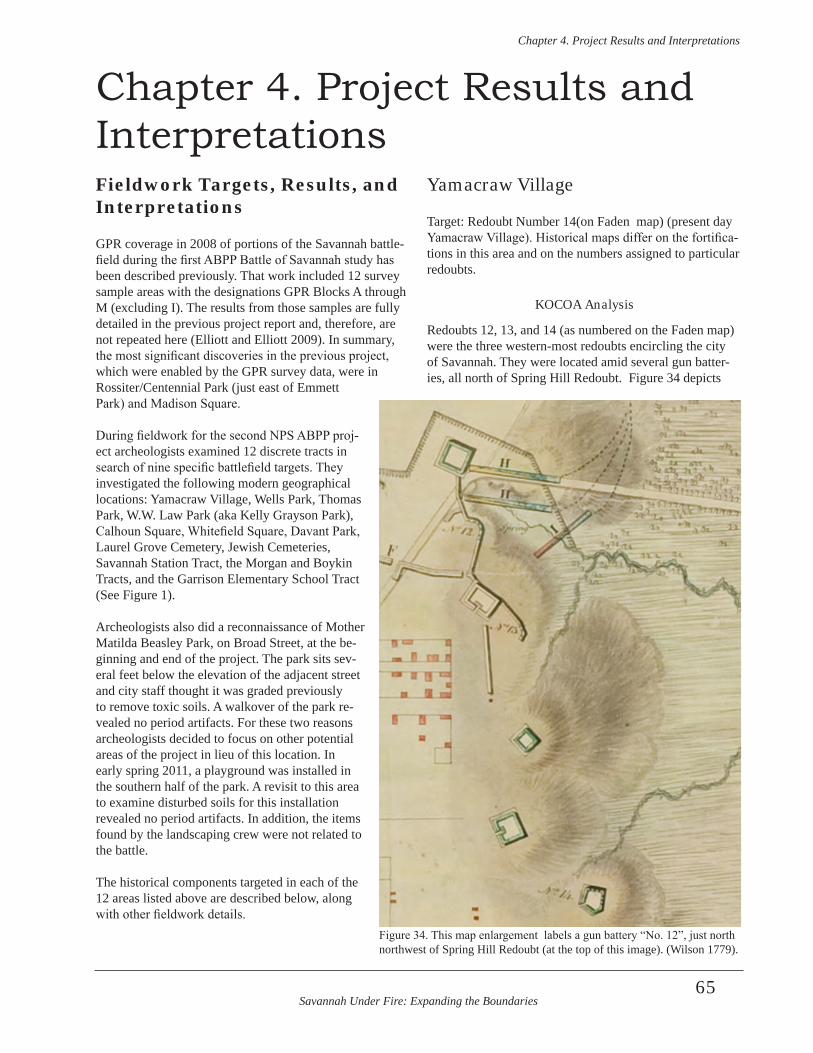
Savannah Under Fire: Expanding the Boundaries
Chapter 4 . Project Results and Interpretations
65
Chapter 4. Project Results and InterpretationsFieldwork Targets, Results, and Interpretations
GPR coverage in 2008 of portions of the Savannah battle-field during the first ABPP Battle of Savannah study has been described previously. That work included 12 survey sample areas with the designations GPR Blocks A through M (excluding I). The results from those samples are fully detailed in the previous project report and, therefore, are not repeated here (Elliott and Elliott 2009). In summary, the most significant discoveries in the previous project, which were enabled by the GPR survey data, were in Rossiter/Centennial Park (just east of Emmett Park) and Madison Square.
During fieldwork for the second NPS ABPP proj-ect archeologists examined 12 discrete tracts in search of nine specific battlefield targets. They investigated the following modern geographical locations: Yamacraw Village, Wells Park, Thomas Park, W.W. Law Park (aka Kelly Grayson Park), Calhoun Square, Whitefield Square, Davant Park, Laurel Grove Cemetery, Jewish Cemeteries, Savannah Station Tract, the Morgan and Boykin Tracts, and the Garrison Elementary School Tract (See Figure 1).
Archeologists also did a reconnaissance of Mother Matilda Beasley Park, on Broad Street, at the be-ginning and end of the project. The park sits sev-eral feet below the elevation of the adjacent street and city staff thought it was graded previously to remove toxic soils. A walkover of the park re-vealed no period artifacts. For these two reasons archeologists decided to focus on other potential areas of the project in lieu of this location. In early spring 2011, a playground was installed in the southern half of the park. A revisit to this area to examine disturbed soils for this installation revealed no period artifacts. In addition, the items found by the landscaping crew were not related to the battle.
The historical components targeted in each of the 12 areas listed above are described below, along with other fieldwork details.
Yamacraw Village
Target: Redoubt Number 14(on Faden map) (present day Yamacraw Village). Historical maps differ on the fortifica-tions in this area and on the numbers assigned to particular redoubts.
KOCOA Analysis
Redoubts 12, 13, and 14 (as numbered on the Faden map) were the three western-most redoubts encircling the city of Savannah. They were located amid several gun batter-ies, all north of Spring Hill Redoubt. Figure 34 depicts
Figure 34. This map enlargement labels a gun battery “No. 12”, just north northwest of Spring Hill Redoubt (at the top of this image). (Wilson 1779).
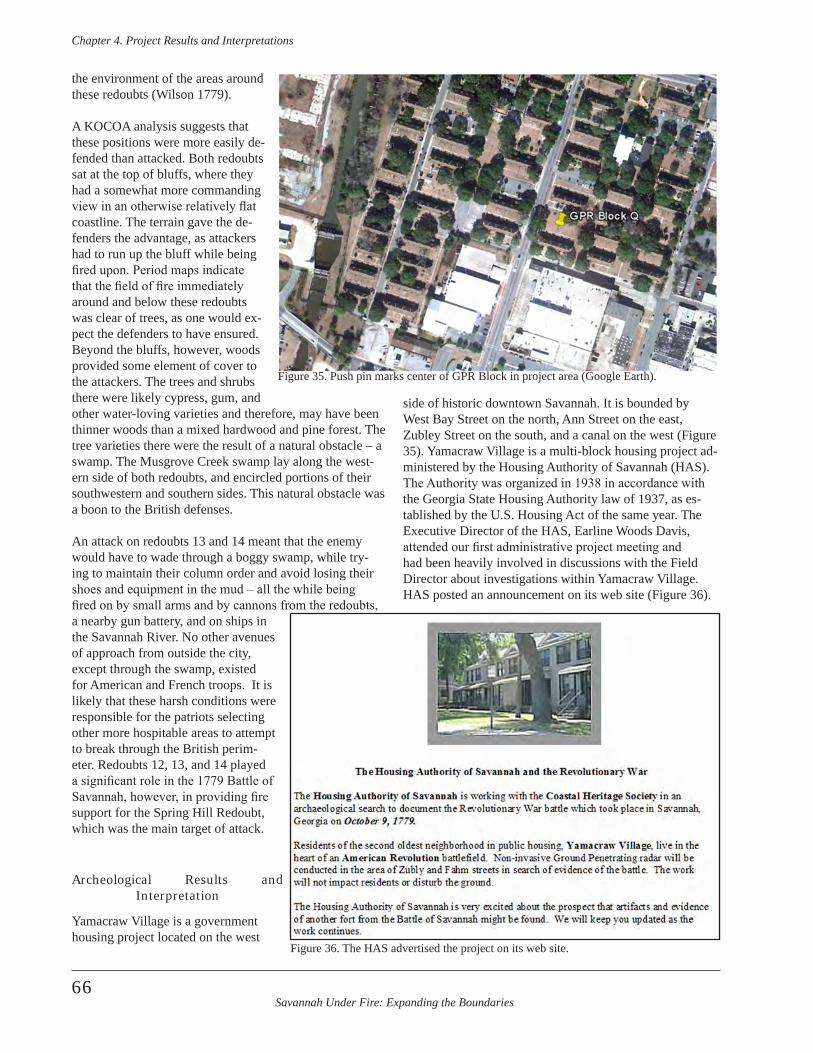
Savannah Under Fire: Expanding the Boundaries
Chapter 4 . Project Results and Interpretations
66
the environment of the areas around these redoubts (Wilson 1779).
A KOCOA analysis suggests that these positions were more easily de-fended than attacked. Both redoubts sat at the top of bluffs, where they had a somewhat more commanding view in an otherwise relatively flat coastline. The terrain gave the de-fenders the advantage, as attackers had to run up the bluff while being fired upon. Period maps indicate that the field of fire immediately around and below these redoubts was clear of trees, as one would ex-pect the defenders to have ensured. Beyond the bluffs, however, woods provided some element of cover to the attackers. The trees and shrubs there were likely cypress, gum, and other water-loving varieties and therefore, may have been thinner woods than a mixed hardwood and pine forest. The tree varieties there were the result of a natural obstacle – a swamp. The Musgrove Creek swamp lay along the west-ern side of both redoubts, and encircled portions of their southwestern and southern sides. This natural obstacle was a boon to the British defenses.
An attack on redoubts 13 and 14 meant that the enemy would have to wade through a boggy swamp, while try-ing to maintain their column order and avoid losing their shoes and equipment in the mud – all the while being fired on by small arms and by cannons from the redoubts, a nearby gun battery, and on ships in the Savannah River. No other avenues of approach from outside the city, except through the swamp, existed for American and French troops. It is likely that these harsh conditions were responsible for the patriots selecting other more hospitable areas to attempt to break through the British perim-eter. Redoubts 12, 13, and 14 played a significant role in the 1779 Battle of Savannah, however, in providing fire support for the Spring Hill Redoubt, which was the main target of attack.
Archeological Results and Interpretation
Yamacraw Village is a government housing project located on the west
side of historic downtown Savannah. It is bounded by West Bay Street on the north, Ann Street on the east, Zubley Street on the south, and a canal on the west (Figure 35). Yamacraw Village is a multi-block housing project ad-ministered by the Housing Authority of Savannah (HAS). The Authority was organized in 1938 in accordance with the Georgia State Housing Authority law of 1937, as es-tablished by the U.S. Housing Act of the same year. The Executive Director of the HAS, Earline Woods Davis, attended our first administrative project meeting and had been heavily involved in discussions with the Field Director about investigations within Yamacraw Village. HAS posted an announcement on its web site (Figure 36).
Figure 35. Push pin marks center of GPR Block in project area (Google Earth).
Figure 36. The HAS advertised the project on its web site.
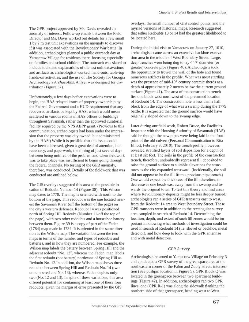
Savannah Under Fire: Expanding the Boundaries
Chapter 4 . Project Results and Interpretations
67
The GPR project approved by Ms. Davis revealed an anomaly of interest. Follow-up emails between the Field Director and Ms. Davis worked out details for a few small 1 by 2 m test unit excavations on the anomaly to discover if it was associated with the Revolutionary War battle. In addition, archeologists planned a public outreach day at Yamacraw Village for residents there, focusing especially on families and school children. The outreach was slated to include tours and explanations of the test unit excavations and artifacts as archeologists worked, hand-outs, table-top hands-on activities, and the use of The Society for Georgia Archaeology’s ArchaeoBus. A flyer was designed for dis-tribution (Figure 37).
Unfortunately, a few days before excavations were to begin, the HAS relayed issues of property ownership by the Federal Government and a HUD requirement that any recovered artifacts be kept by HAS, which would mean scattered in various rooms in HAS offices or buildings throughout Savannah, rather than the approved curatorial facility required by the NPS ABPP grant. (Previous to this communication, archeologists had been under the impres-sion that the property was city owned, but administered by the HAS.) While it is possible that this issue could have been addressed, given a great deal of attention, bu-reaucracy, and paperwork, the timing of just several days between being notified of the problem and when fieldwork was to take place was insufficient to begin going through the federal channels. No testing of the GPR anomaly, therefore, was conducted. Details of the fieldwork that was conducted are outlined below.
The GIS overlays suggested this area as the possible lo-cation of Redoubt Number 14 (Figure 38). This Wilson map dates to 1779. The map is oriented with north to the bottom of the page. This redoubt was the one located near-est the Savannah River (off the bottom of the page) on the city’s western defenses. Redoubt 14 was positioned north of Spring Hill Redoubt (Number 11-off the top of the page), with two other redoubts and a horseshoe battery between them. Figure 39 is a copy of part of the Faden (1784) map made in 1784. It is oriented in the same direc-tion as the Wilson map. The variation between the two maps in terms of the number and types of redoubts and batteries, and in how they are numbered. For example, the Wilson map labels the battery between Spring Hill and the adjacent redoubt “No. 12”, whereas the Faden map labels the first redoubt (not battery) northwest of Spring Hill as Redoubt No. 12.In addition, the Wilson map shows three redoubts between Spring Hill and Redoubt No. 14 (two unnumbered and No. 13), whereas Faden depicts only two (No. 12 and 13). In spite of these variations, this area offered potential for containing at least one of these four redoubts, given the margin of error presented by the GIS
overlays, the small number of GIS control points, and the myriad versions of historical maps. Research suggested that either Redoubts 13 or 14 had the greatest likelihood to be located here.
During the initial visit to Yamacraw on January 27, 1010, archeologists came across an extensive backhoe excava-tion area in the middle of West Boundary Street. Large, deep trenches were being dug to lay 6’-7’ diameter (or greater) concrete pipe (Figure 40). Archeologists took the opportunity to trowel the wall of the hole and found numerous artifacts in the profile. What was most startling was the presence of mid-19th century ceramic sherds at a depth of approximately 2 meters below the current ground surface (Figure 41). The area of the construction trench lies one block west northwest of the presumed location of Redoubt 14. The construction hole is less than a half block from the edge of what was a swamp during the 1779 battle. It is expected that the ground surface would have originally sloped down to the swamp edge.
Later during our field work, Robert Bruce, the Facilities Inspector with the Housing Authority of Savannah (HAS) said he thought the new pipes were being laid in the foot-print of the old culvert (Personal Communication to Rita Elliott, February 3, 2010). The trench profile, however, revealed stratified layers of soil deposition for a depth of at least six feet. The soils in the profile of the construction trench, therefore, undoubtedly represent fill deposited to raise the ground surface to suitable elevations for struc-tures as the city expanded westward. (Incidentally, the soil did not appear to be the fill from a previous pipe trench.) One would expect the thickness of the fill, therefore, to decrease as one heads east away from the swamp and to-wards the original town. To test this theory and find areas where Revolutionary deposits might be less deeply buried, archeologists ran a series of GPR transects east to west, from the Redoubt 14 area to West Boundary Street. These GPR transects were in addition to the rectangular survey area sampled in search of Redoubt 14. Determining the location, depth, and extent of such fill zones would be im-portant in knowing what methods of investigation could be used in search of Redoubt 14 (i.e. shovel or backhoe, metal detector), and how deep to look with the GPR antennae and with metal detectors.
GPR Survey
Archeologists returned to Yamacraw Village on February 3 and conducted a GPR survey of the greenspace area at the northeastern corner of the Fahm and Zubly streets intersec-tion (See pushpin location in Figure 5). GPR Block Q was located in the greenspace between two apartment build-ings (Figure 42). In addition, archeologists ran two GPR lines, one (GPR R-1) was along the sidewalk flanking the northern side of that greenspace, heading west to West
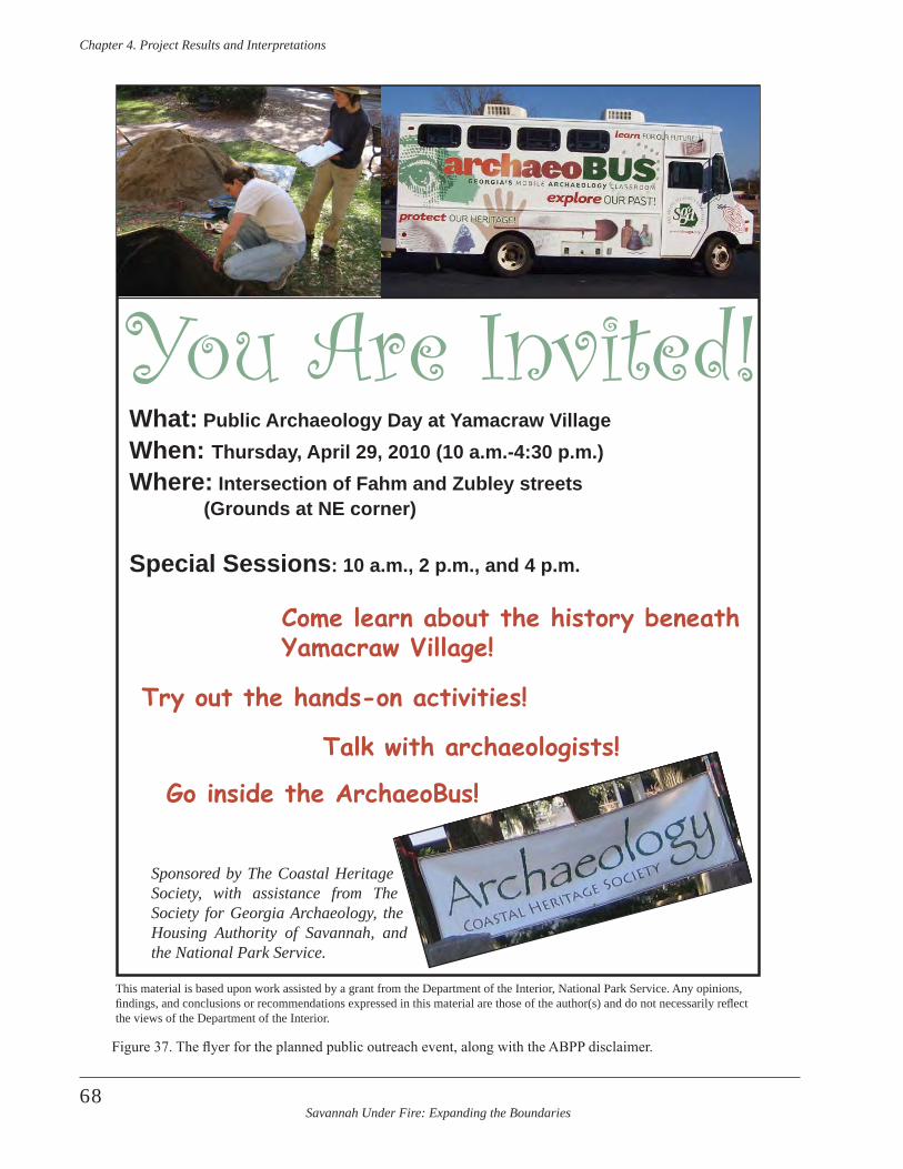
Savannah Under Fire: Expanding the Boundaries
Chapter 4 . Project Results and Interpretations
68
You Are Invited!What: Public Archaeology Day at Yamacraw VillageWhen: Thursday, April 29, 2010 (10 a.m.-4:30 p.m.)Where: Intersection of Fahm and Zubley streets (Grounds at NE corner)
Special Sessions: 10 a.m., 2 p.m., and 4 p.m.
Come learn about the history beneath Yamacraw Village!
Talk with archaeologists!
Try out the hands-on activities!
Go inside the ArchaeoBus!
Sponsored by The Coastal Heritage Society, with assistance from The Society for Georgia Archaeology, the Housing Authority of Savannah, and the National Park Service .
This material is based upon work assisted by a grant from the Department of the Interior, National Park Service. Any opinions, fi ndings, and conclusions or recommendations expressed in this material are those of the author(s) and do not necessarily refl ect the views of the Department of the Interior.
Figure 37. The flyer for the planned public outreach event, along with the ABPP disclaimer.
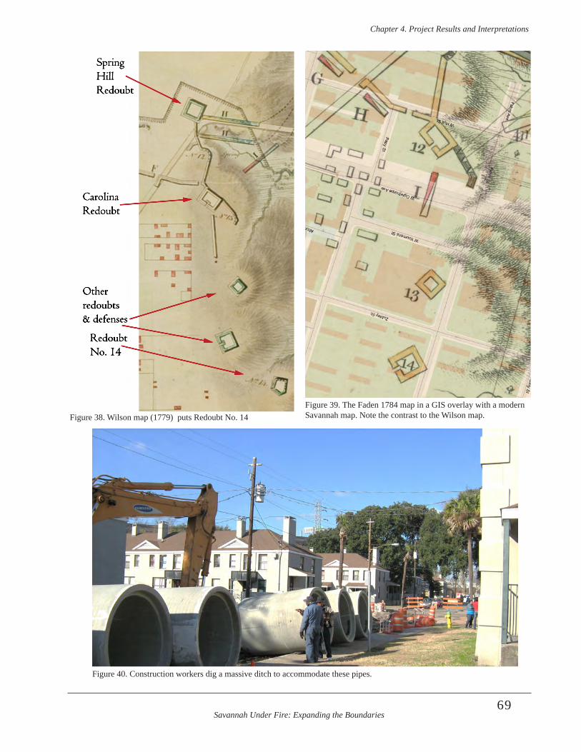
Savannah Under Fire: Expanding the Boundaries
Chapter 4 . Project Results and Interpretations
69
SpringHillRedoubt
CarolinaRedoubt
Other redoubts& defenses
RedoubtNo. 14
Figure 38. Wilson map (1779) puts Redoubt No. 14 Figure 39. The Faden 1784 map in a GIS overlay with a modern Savannah map. Note the contrast to the Wilson map.
Figure 40. Construction workers dig a massive ditch to accommodate these pipes.
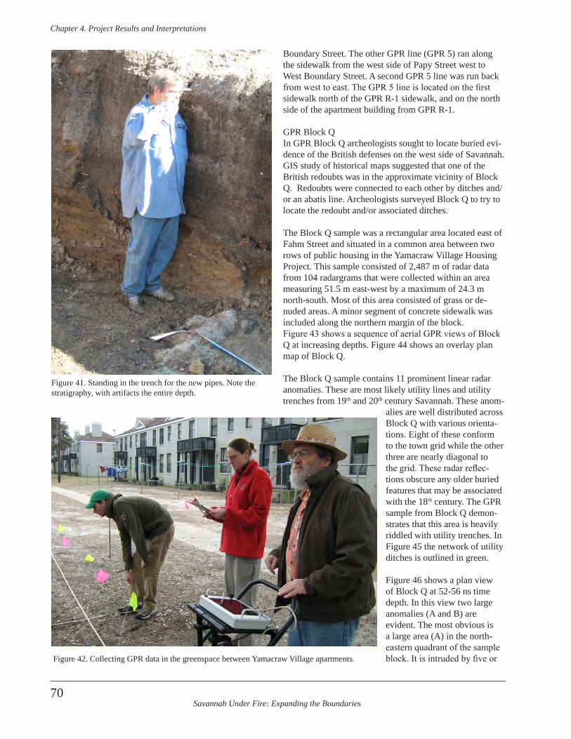
Savannah Under Fire: Expanding the Boundaries
Chapter 4 . Project Results and Interpretations
70
Boundary Street. The other GPR line (GPR 5) ran along the sidewalk from the west side of Papy Street west to West Boundary Street. A second GPR 5 line was run back from west to east. The GPR 5 line is located on the first sidewalk north of the GPR R-1 sidewalk, and on the north side of the apartment building from GPR R-1.
GPR Block QIn GPR Block Q archeologists sought to locate buried evi-dence of the British defenses on the west side of Savannah. GIS study of historical maps suggested that one of the British redoubts was in the approximate vicinity of Block Q. Redoubts were connected to each other by ditches and/or an abatis line. Archeologists surveyed Block Q to try to locate the redoubt and/or associated ditches.
The Block Q sample was a rectangular area located east of Fahm Street and situated in a common area between two rows of public housing in the Yamacraw Village Housing Project. This sample consisted of 2,487 m of radar data from 104 radargrams that were collected within an area measuring 51.5 m east-west by a maximum of 24.3 m north-south. Most of this area consisted of grass or de-nuded areas. A minor segment of concrete sidewalk was included along the northern margin of the block. Figure 43 shows a sequence of aerial GPR views of Block Q at increasing depths. Figure 44 shows an overlay plan map of Block Q.
The Block Q sample contains 11 prominent linear radar anomalies. These are most likely utility lines and utility trenches from 19th and 20th century Savannah. These anom-
alies are well distributed across Block Q with various orienta-tions. Eight of these conform to the town grid while the other three are nearly diagonal to the grid. These radar reflec-tions obscure any older buried features that may be associated with the 18th century. The GPR sample from Block Q demon-strates that this area is heavily riddled with utility trenches. In Figure 45 the network of utility ditches is outlined in green.
Figure 46 shows a plan view of Block Q at 52-56 ns time depth. In this view two large anomalies (A and B) are evident. The most obvious is a large area (A) in the north-eastern quadrant of the sample block. It is intruded by five or
Figure 41. Standing in the trench for the new pipes. Note the stratigraphy, with artifacts the entire depth.
Figure 42. Collecting GPR data in the greenspace between Yamacraw Village apartments.
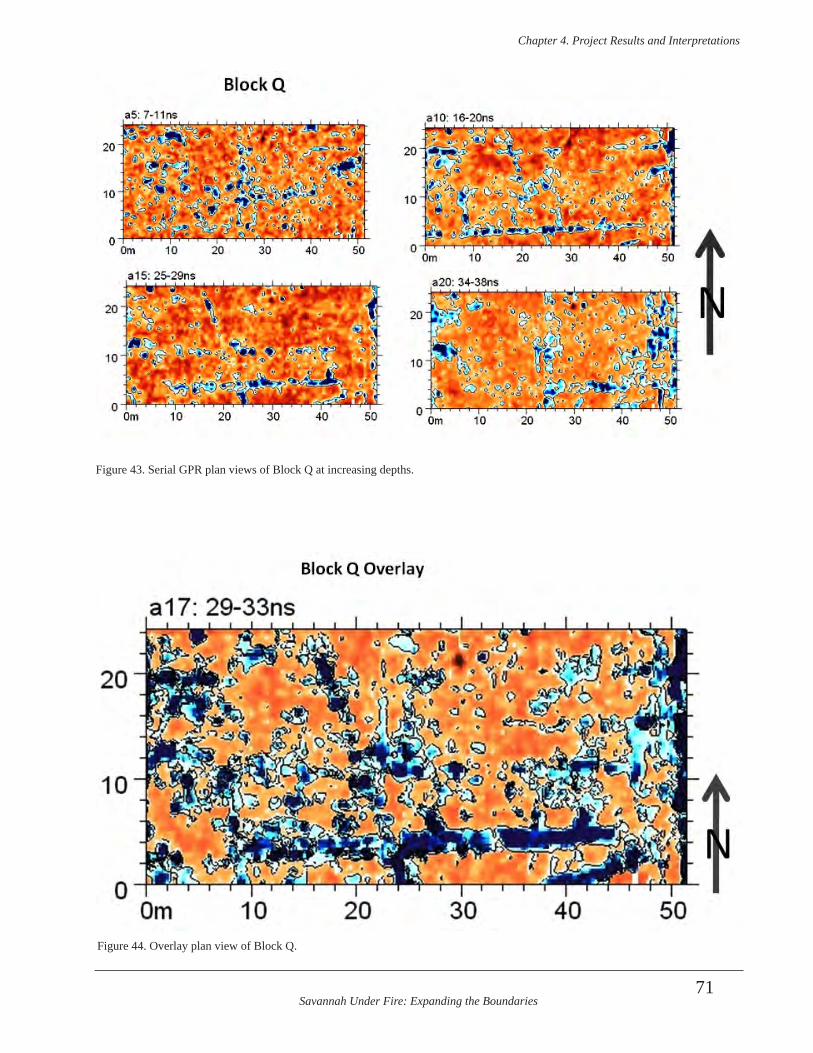
Savannah Under Fire: Expanding the Boundaries
Chapter 4 . Project Results and Interpretations
71
Figure 43. Serial GPR plan views of Block Q at increasing depths.
Figure 44. Overlay plan view of Block Q.
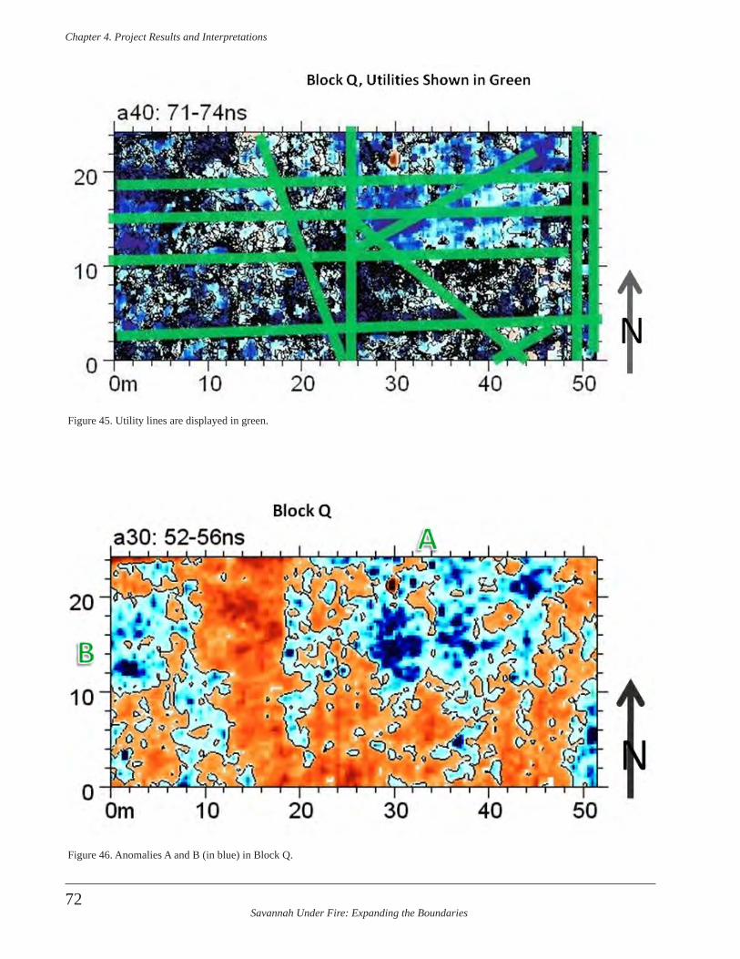
Savannah Under Fire: Expanding the Boundaries
Chapter 4 . Project Results and Interpretations
72
Figure 45. Utility lines are displayed in green.
Figure 46. Anomalies A and B (in blue) in Block Q.
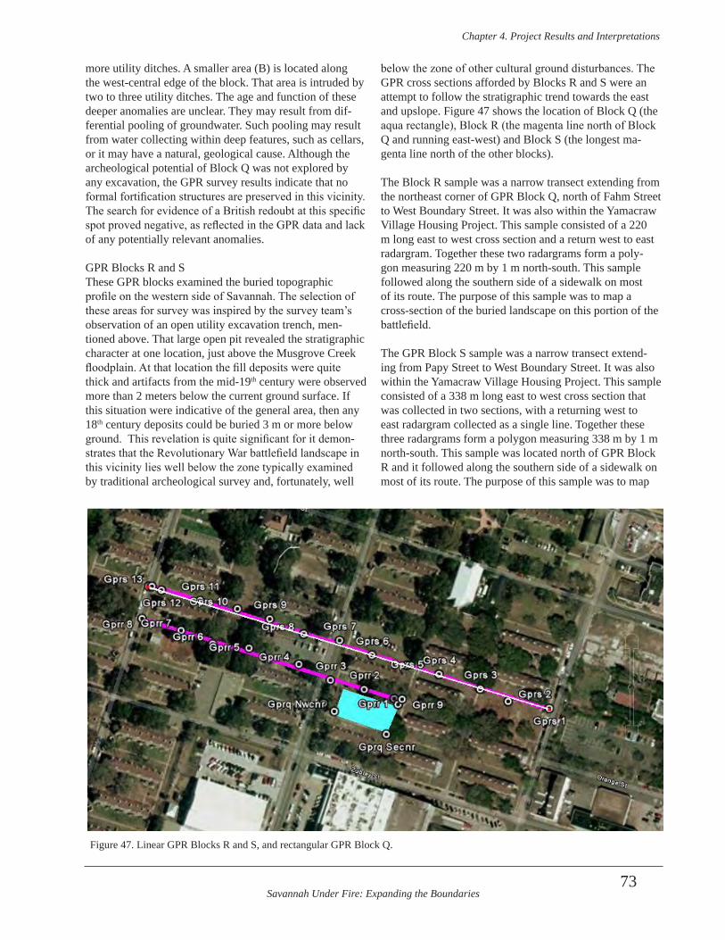
Savannah Under Fire: Expanding the Boundaries
Chapter 4 . Project Results and Interpretations
73
more utility ditches. A smaller area (B) is located along the west-central edge of the block. That area is intruded by two to three utility ditches. The age and function of these deeper anomalies are unclear. They may result from dif-ferential pooling of groundwater. Such pooling may result from water collecting within deep features, such as cellars, or it may have a natural, geological cause. Although the archeological potential of Block Q was not explored by any excavation, the GPR survey results indicate that no formal fortification structures are preserved in this vicinity. The search for evidence of a British redoubt at this specific spot proved negative, as reflected in the GPR data and lack of any potentially relevant anomalies.
GPR Blocks R and SThese GPR blocks examined the buried topographic profile on the western side of Savannah. The selection of these areas for survey was inspired by the survey team’s observation of an open utility excavation trench, men-tioned above. That large open pit revealed the stratigraphic character at one location, just above the Musgrove Creek floodplain. At that location the fill deposits were quite thick and artifacts from the mid-19th century were observed more than 2 meters below the current ground surface. If this situation were indicative of the general area, then any 18th century deposits could be buried 3 m or more below ground. This revelation is quite significant for it demon-strates that the Revolutionary War battlefield landscape in this vicinity lies well below the zone typically examined by traditional archeological survey and, fortunately, well
below the zone of other cultural ground disturbances. The GPR cross sections afforded by Blocks R and S were an attempt to follow the stratigraphic trend towards the east and upslope. Figure 47 shows the location of Block Q (the aqua rectangle), Block R (the magenta line north of Block Q and running east-west) and Block S (the longest ma-genta line north of the other blocks).
The Block R sample was a narrow transect extending from the northeast corner of GPR Block Q, north of Fahm Street to West Boundary Street. It was also within the Yamacraw Village Housing Project. This sample consisted of a 220 m long east to west cross section and a return west to east radargram. Together these two radargrams form a poly-gon measuring 220 m by 1 m north-south. This sample followed along the southern side of a sidewalk on most of its route. The purpose of this sample was to map a cross-section of the buried landscape on this portion of the battlefield.
The GPR Block S sample was a narrow transect extend-ing from Papy Street to West Boundary Street. It was also within the Yamacraw Village Housing Project. This sample consisted of a 338 m long east to west cross section that was collected in two sections, with a returning west to east radargram collected as a single line. Together these three radargrams form a polygon measuring 338 m by 1 m north-south. This sample was located north of GPR Block R and it followed along the southern side of a sidewalk on most of its route. The purpose of this sample was to map
Figure 47. Linear GPR Blocks R and S, and rectangular GPR Block Q.
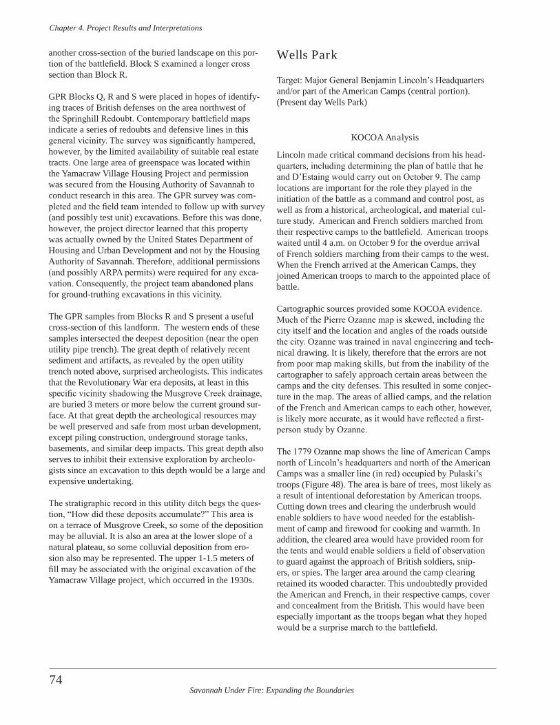
Savannah Under Fire: Expanding the Boundaries
Chapter 4 . Project Results and Interpretations
74
another cross-section of the buried landscape on this por-tion of the battlefield. Block S examined a longer cross section than Block R.
GPR Blocks Q, R and S were placed in hopes of identify-ing traces of British defenses on the area northwest of the Springhill Redoubt. Contemporary battlefield maps indicate a series of redoubts and defensive lines in this general vicinity. The survey was significantly hampered, however, by the limited availability of suitable real estate tracts. One large area of greenspace was located within the Yamacraw Village Housing Project and permission was secured from the Housing Authority of Savannah to conduct research in this area. The GPR survey was com-pleted and the field team intended to follow up with survey (and possibly test unit) excavations. Before this was done, however, the project director learned that this property was actually owned by the United States Department of Housing and Urban Development and not by the Housing Authority of Savannah. Therefore, additional permissions (and possibly ARPA permits) were required for any exca-vation. Consequently, the project team abandoned plans for ground-truthing excavations in this vicinity.
The GPR samples from Blocks R and S present a useful cross-section of this landform. The western ends of these samples intersected the deepest deposition (near the open utility pipe trench). The great depth of relatively recent sediment and artifacts, as revealed by the open utility trench noted above, surprised archeologists. This indicates that the Revolutionary War era deposits, at least in this specific vicinity shadowing the Musgrove Creek drainage, are buried 3 meters or more below the current ground sur-face. At that great depth the archeological resources may be well preserved and safe from most urban development, except piling construction, underground storage tanks, basements, and similar deep impacts. This great depth also serves to inhibit their extensive exploration by archeolo-gists since an excavation to this depth would be a large and expensive undertaking.
The stratigraphic record in this utility ditch begs the ques-tion, “How did these deposits accumulate?” This area is on a terrace of Musgrove Creek, so some of the deposition may be alluvial. It is also an area at the lower slope of a natural plateau, so some colluvial deposition from ero-sion also may be represented. The upper 1-1.5 meters of fill may be associated with the original excavation of the Yamacraw Village project, which occurred in the 1930s.
Wells Park
Target: Major General Benjamin Lincoln’s Headquarters and/or part of the American Camps (central portion). (Present day Wells Park)
KOCOA Analysis
Lincoln made critical command decisions from his head-quarters, including determining the plan of battle that he and D’Estaing would carry out on October 9. The camp locations are important for the role they played in the initiation of the battle as a command and control post, as well as from a historical, archeological, and material cul-ture study. American and French soldiers marched from their respective camps to the battlefield. American troops waited until 4 a.m. on October 9 for the overdue arrival of French soldiers marching from their camps to the west. When the French arrived at the American Camps, they joined American troops to march to the appointed place of battle.
Cartographic sources provided some KOCOA evidence. Much of the Pierre Ozanne map is skewed, including the city itself and the location and angles of the roads outside the city. Ozanne was trained in naval engineering and tech-nical drawing. It is likely, therefore that the errors are not from poor map making skills, but from the inability of the cartographer to safely approach certain areas between the camps and the city defenses. This resulted in some conjec-ture in the map. The areas of allied camps, and the relation of the French and American camps to each other, however, is likely more accurate, as it would have reflected a first-person study by Ozanne.
The 1779 Ozanne map shows the line of American Camps north of Lincoln’s headquarters and north of the American Camps was a smaller line (in red) occupied by Pulaski’s troops (Figure 48). The area is bare of trees, most likely as a result of intentional deforestation by American troops. Cutting down trees and clearing the underbrush would enable soldiers to have wood needed for the establish-ment of camp and firewood for cooking and warmth. In addition, the cleared area would have provided room for the tents and would enable soldiers a field of observation to guard against the approach of British soldiers, snip-ers, or spies. The larger area around the camp clearing retained its wooded character. This undoubtedly provided the American and French, in their respective camps, cover and concealment from the British. This would have been especially important as the troops began what they hoped would be a surprise march to the battlefield.
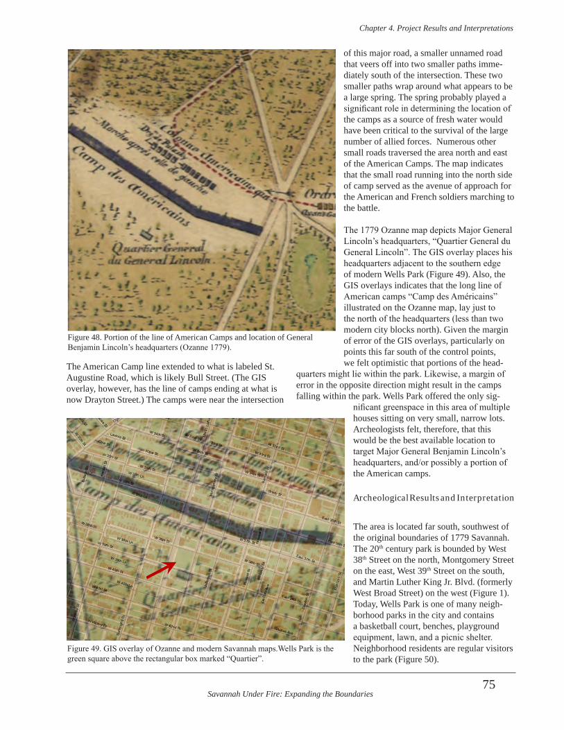
Savannah Under Fire: Expanding the Boundaries
Chapter 4 . Project Results and Interpretations
75
The American Camp line extended to what is labeled St. Augustine Road, which is likely Bull Street. (The GIS overlay, however, has the line of camps ending at what is now Drayton Street.) The camps were near the intersection
of this major road, a smaller unnamed road that veers off into two smaller paths imme-diately south of the intersection. These two smaller paths wrap around what appears to be a large spring. The spring probably played a significant role in determining the location of the camps as a source of fresh water would have been critical to the survival of the large number of allied forces. Numerous other small roads traversed the area north and east of the American Camps. The map indicates that the small road running into the north side of camp served as the avenue of approach for the American and French soldiers marching to the battle.
The 1779 Ozanne map depicts Major General Lincoln’s headquarters, “Quartier General du General Lincoln”. The GIS overlay places his headquarters adjacent to the southern edge of modern Wells Park (Figure 49). Also, the GIS overlays indicates that the long line of American camps “Camp des Américains” illustrated on the Ozanne map, lay just to the north of the headquarters (less than two modern city blocks north). Given the margin of error of the GIS overlays, particularly on points this far south of the control points, we felt optimistic that portions of the head-
quarters might lie within the park. Likewise, a margin of error in the opposite direction might result in the camps falling within the park. Wells Park offered the only sig-
nificant greenspace in this area of multiple houses sitting on very small, narrow lots. Archeologists felt, therefore, that this would be the best available location to target Major General Benjamin Lincoln’s headquarters, and/or possibly a portion of the American camps.
Archeological Results and Interpretation
The area is located far south, southwest of the original boundaries of 1779 Savannah. The 20th century park is bounded by West 38th Street on the north, Montgomery Street on the east, West 39th Street on the south, and Martin Luther King Jr. Blvd. (formerly West Broad Street) on the west (Figure 1). Today, Wells Park is one of many neigh-borhood parks in the city and contains a basketball court, benches, playground equipment, lawn, and a picnic shelter. Neighborhood residents are regular visitors to the park (Figure 50).
Figure 48. Portion of the line of American Camps and location of General Benjamin Lincoln’s headquarters (Ozanne 1779).
Figure 49. GIS overlay of Ozanne and modern Savannah maps.Wells Park is the green square above the rectangular box marked “Quartier”.
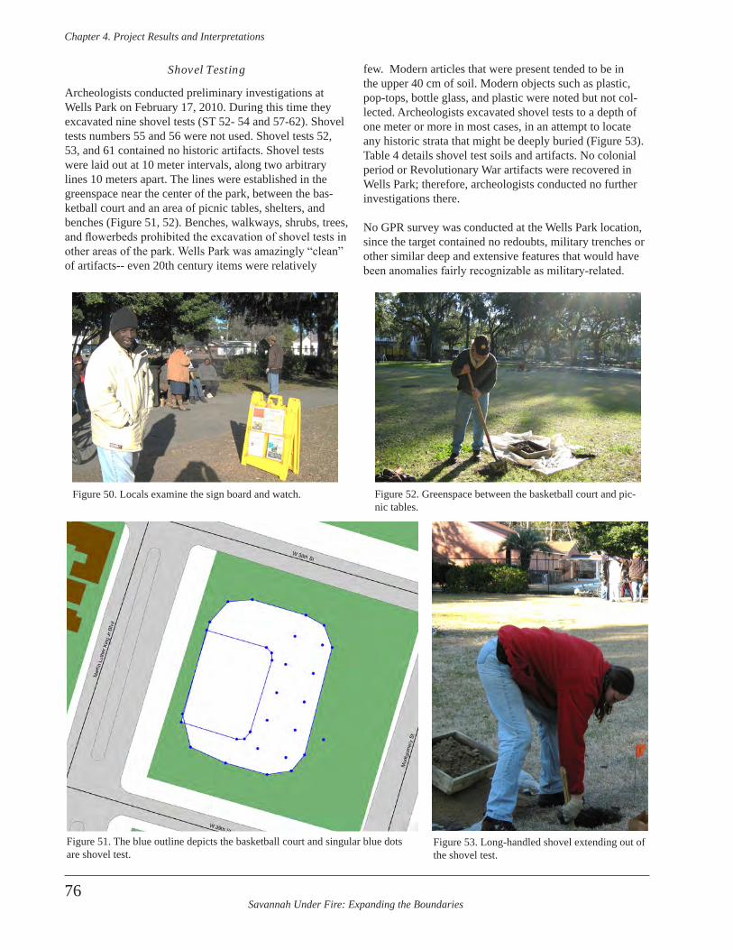
Savannah Under Fire: Expanding the Boundaries
Chapter 4 . Project Results and Interpretations
76
Shovel Testing
Archeologists conducted preliminary investigations at Wells Park on February 17, 2010. During this time they excavated nine shovel tests (ST 52- 54 and 57-62). Shovel tests numbers 55 and 56 were not used. Shovel tests 52, 53, and 61 contained no historic artifacts. Shovel tests were laid out at 10 meter intervals, along two arbitrary lines 10 meters apart. The lines were established in the greenspace near the center of the park, between the bas-ketball court and an area of picnic tables, shelters, and benches (Figure 51, 52). Benches, walkways, shrubs, trees, and flowerbeds prohibited the excavation of shovel tests in other areas of the park. Wells Park was amazingly “clean” of artifacts-- even 20th century items were relatively
few. Modern articles that were present tended to be in the upper 40 cm of soil. Modern objects such as plastic, pop-tops, bottle glass, and plastic were noted but not col-lected. Archeologists excavated shovel tests to a depth of one meter or more in most cases, in an attempt to locate any historic strata that might be deeply buried (Figure 53). Table 4 details shovel test soils and artifacts. No colonial period or Revolutionary War artifacts were recovered in Wells Park; therefore, archeologists conducted no further investigations there.
No GPR survey was conducted at the Wells Park location, since the target contained no redoubts, military trenches or other similar deep and extensive features that would have been anomalies fairly recognizable as military-related.
Figure 50. Locals examine the sign board and watch.
Figure 51. The blue outline depicts the basketball court and singular blue dots are shovel test.
Figure 52. Greenspace between the basketball court and pic-nic tables.
Figure 53. Long-handled shovel extending out of the shovel test.
Savannah Under Fire: Expanding the Boundaries
Chapter 4 . Project Results and Interpretations
77
Unit Count Code Description Start Mean EndLevel/Depth/Stratigraphy/Lot #
Wells Park
Level 1 0-14 cmbs0 N/A Modern debris; not recovered
ST 54 10YR3/2 Very Dark Brown silty sandLevel 2 14-18 cmbs 0N/A Sterile10YR2/1 Black compact sandLevel 3 18-32 cmbs Levels 3-4 (18-48 cmbs) Artifacts. Lot #13210YR5/3 Brown sand 8 AC0199 Brick, unspecifiedLot #132 1 AG0301 Window glass, sized 1804Level 4 32-48 cmbs 1 AR0104 Concrete10YR4/3 Brown sand 9 AR0108 MortarLot #132 1 KF0104 Shell, oyster
1 KG0301 Bottle, colorless bottle glass 18702 ZR0302 Slate, unidentified
ST 57 Level 1 0-50 cmbs 1 KG0300 Bottle, light aqua bottle glass 1800 192010YR4/2 Dark Grayish Brown sand 1 KG0306 Bottle, amber bottle glassLot #130Level 2 50-105 cmbs 0 N/A Sterile10YR5/3 Brown sandLevel 3 105-115 cmbs 0 N/A Sterile10YR7/2 Light Gray sand
ST 58 Level 1 0-45 cmbs 1 AG0301 Window glass, sized 180410YR4/2 Dark Grayish Brown sand 1 KG0301 Bottle, colorless bottle glass 1870Lot #114 1 MM9901 Iron fragment, unidentifiedLevel 2 45-95 cmbs 0 N/A Sterile10YR6/2 sand
ST 59 Level 1 0-35 cmbs 1 AC0199 Brick, unspecified10YR4/2 Dark Grayish Brown sand 1 KC0105 Porcelain, plainLot # 125Level 2 35-70 cmbs 0N/A Sterile10YR5/2 Grayish Brown sand
Table 4. Wells Park shovel tests (continued on next page).
Savannah Under Fire: Expanding the Boundaries
Chapter 4 . Project Results and Interpretations
78
Unit Count Code Description Start Mean EndLevel/Depth/Stratigraphy/Lot #
ST 60 Level 1 0-10 cmbs Levels 1-3 (0-40 cmbs) Artifacts. Lot #14410YR3/1 Very Dark Gray sandy loamLot #144
Level 2 10-15 cmbs0
N/AModern debris not recovered, except:
10YR7/1 Light Gray sand. Lot #144 1 KG0306 Bottle, amber bottle glassLevel 3 15-40 cmbs10YR4/2 Dark Grayish Brown sandLot #144Level 4 40-90 cmbs 0 N/A Sterile10YR6/2 Light Brownish Gray sandLevel 5 90-110 cmbs 0 N/A Sterile10YR7/2 Light Gray sand
ST 62 Level 1 0-23 cmbs
Levels 1-2 (0-35 cmbs) Artifacts. Lot #120
10YR3/1 Very Dark Gray sandy loam 1 AC0121 Brick, machine madeLot #120 1 KG0301 Bottle, colorless bottle glass 1870Level 2 23-35 cmbs 1 KG0303 Bottle, light green bottle glass10YR4/4 Dark Yellowish Brown sand 1 KG0306 Bottle, amber bottle glassLot #120Level 3 35-53 cmbs 0 N/A Sterile10YR4/3 Brown sandy loamLevel 4 53-70 cmbs 0 N/A Sterile
10YR5/6 Yellowish Brown fine sand mottled w/7.5YR5/8 Strong Brown clayey sand
Table 4. Wells Park shovel tests (continued from previous page).

Savannah Under Fire: Expanding the Boundaries
Chapter 4 . Project Results and Interpretations
79
GPR in a camp area would be expected to reveal trash pits, posts and similar smaller features and would be useful on a known camp site. It would be less useful in a sur-vey situation in an urban area such as Wells Park, where small anomalies unrelated to a military camp would be expected and where no colonial or Revolutionary War period artifacts were located in shovel tests. Such anomalies would have to be ground-truthed to know if they were related to the Battle of Savannah or to other activities occurring in the ensuing 230 years.
Thomas Park (aka Thomas Square)
Target: American Camps (East End) (Thomas Park)
KOCOA Analysis
The KOCOA analysis for the area that is now Thomas Park is the same as the analysis for Wells Park. Both areas contained the line of American Camps in similar non-swampy terrain and woods. Both areas were located near main and secondary roads, although the eastern end of the camps, near what is now Thomas Park, lay immediately adjacent to the “Road to Augusta” on the Ozanne map. Also, this end of the camps was much closer to the large spring, which separated the American Camp line from the French Camp line. Both the French and American camps were directly related to the Battle of Savannah, since the joint Franco-American forces marched from their respec-tive camps to the battle.
Archeological Results and Interpretation
Thomas Park is bounded on the north by East 35th Street, on the east by Drayton Street, on the south by the Bull Street Library (formerly East 36th Street), and on the west by Bull Street (Figure 1). The park is located in the city today, but in an area that was far south of Savannah’s 1779 boundary. GIS overlays suggest that a portion of the long line of American Camps (the gray shadowy rectangle on the map) was established in the area that is now the park (the blank green rectangle south of East 35th Street) (Figure 54). Thomas Park is flanked by Bull Street, which was an early route that existed at the time of the 1779 siege and battle. The exact location of this particular segment of the road on the 18th century landscape; however, is unclear.
Archeological investigations began at Thomas Park on February 18, 2010. Archeologists excavated shovel tests throughout the park. Due to the number and location of hardscapes (a fountain, sidewalks, benches, street lights, and underground utilities) and trees, shrubs, and flower-beds, shovel tests could not be placed on any meaningful grid (Figure 55). Archeologists, therefore, excavated shov-el tests at opportune locations throughout the park, includ-ing greenspaces and areas between trees and landscaped beds. Shovel tests are depicted as solitary blue dots (not on lines) in Figure 56. A total of 11 shovel tests (ST 63-73, in-clusive) was excavated and the stratigraphy and artifacts of each are detailed in Table 5. All shovel tests were positive. Many had modern debris in the upper levels. Shovel tests 69 and 70 both contained tabby mortar. ST 70 contained a concentration of colonial period artifacts. This included creamware, redware, Rhenish stoneware, and a kaolin pipe fragment. ST 70 had a MCD of 1754.7, although from an extremely small sample size of four sherds.
Shovel Testing
Shovel testing suggests that the central and western parts of Thomas Park were severely disturbed in modern times and display poor potential for intact 18th century surfaces. Shovel tests on the eastern part; however, yielded some 18th century ceramics, corroded square nails, tabby, and handmade brick. These few artifacts were tantalizing clues, since this location was beyond the extent of the town of Savannah in the 18th and early 19th centuries. They sug-gested the former presence of an early historic occupation.
Figure 54. GIS overlay of Ozanne (1779) map and modern Savannah map. Note the gray bar representing American camps ends in the greenspace of Thomas Park.
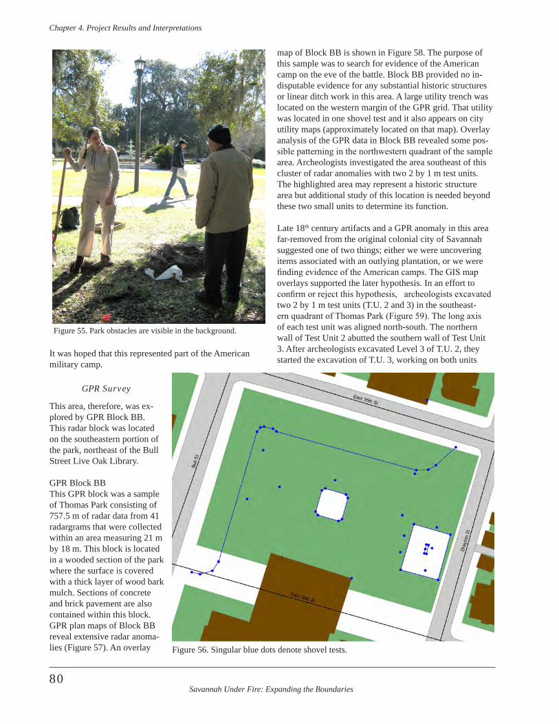
Savannah Under Fire: Expanding the Boundaries
Chapter 4 . Project Results and Interpretations
80
It was hoped that this represented part of the American military camp.
GPR Survey
This area, therefore, was ex-plored by GPR Block BB. This radar block was located on the southeastern portion of the park, northeast of the Bull Street Live Oak Library.
GPR Block BBThis GPR block was a sample of Thomas Park consisting of 757.5 m of radar data from 41 radargrams that were collected within an area measuring 21 m by 18 m. This block is located in a wooded section of the park where the surface is covered with a thick layer of wood bark mulch. Sections of concrete and brick pavement are also contained within this block. GPR plan maps of Block BB reveal extensive radar anoma-lies (Figure 57). An overlay
map of Block BB is shown in Figure 58. The purpose of this sample was to search for evidence of the American camp on the eve of the battle. Block BB provided no in-disputable evidence for any substantial historic structures or linear ditch work in this area. A large utility trench was located on the western margin of the GPR grid. That utility was located in one shovel test and it also appears on city utility maps (approximately located on that map). Overlay analysis of the GPR data in Block BB revealed some pos-sible patterning in the northwestern quadrant of the sample area. Archeologists investigated the area southeast of this cluster of radar anomalies with two 2 by 1 m test units. The highlighted area may represent a historic structure area but additional study of this location is needed beyond these two small units to determine its function.
Late 18th century artifacts and a GPR anomaly in this area far-removed from the original colonial city of Savannah suggested one of two things; either we were uncovering items associated with an outlying plantation, or we were finding evidence of the American camps. The GIS map overlays supported the later hypothesis. In an effort to confirm or reject this hypothesis, archeologists excavated two 2 by 1 m test units (T.U. 2 and 3) in the southeast-ern quadrant of Thomas Park (Figure 59). The long axis of each test unit was aligned north-south. The northern wall of Test Unit 2 abutted the southern wall of Test Unit 3. After archeologists excavated Level 3 of T.U. 2, they started the excavation of T.U. 3, working on both units
Figure 56. Singular blue dots denote shovel tests.
Figure 55. Park obstacles are visible in the background.
Savannah Under Fire: Expanding the Boundaries
Chapter 4 . Project Results and Interpretations
81
Thomas ParkST 63 Level 1 0-12 cmbs 0 N/A Sterile
2.5Y2.5/1 Black mottled w/10YR6/1 Gray sandy loam
Level 2 12-29 cmbs Levels 2-4 (15-40 cmbs) Artifacts. Lot #113Mottled 10YR3/1 Very Dark Gray san-dy loam and 10YR4/6 Dark Yellowish Brown loamy sand 1 AR0108 MortarLot #113 1 KC0105 Porcelain, plainLevel 3 29-33 cmbs 1 KF0104 Shell, oyster10YR5/1 Gray sand 1 KG0300 Bottle, light aqua bottle glass 1800 1920Lot #113Level 4 33-49 cmbs10YR3/1 Very Dark Gray sandLot #113Level 5 49-69 cmbs 0 N/A Sterile10YR3/2 Very Dark Grayish Brown sandLevel 6 69-82 cmbs 0 N/A Sterile10YR4/2 Dark Grayish Brown sand
ST 64 Level 1 0-10 cmbs 0 N/A Sterile10YR6/1 Gray sandLevel 2 10-25 cmbs 0 N/A Sterile10YR5/1 Gray sandLevel 3 25-40 cmbs 4 AC0199 Brick, unspecified10YR4/1 Dark Gray sand 1 KG0301 Bottle, colorless bottle glass 1870Lot #115
ST 65 Level 1 0-12 cmbs 0 N/A Sterile10YR2/2 Very Dark Brown loamLevel 2 12-15 cmbs 0 N/A Sterile10YR8/2 Very Pale Brown sandLevel 3 15-24 cmbs 1 AC0199 Brick, unspecified10YR4/2 Dark Grayish Brown loamy sandLot #103Level 4 24-34 cmbs 0 N/A Sterile10YR6/3 Pale Brown silty sandLevel 5 34-86 cmbs 1 KG0300 Bottle, light aqua bottle glass 1800 192010YR2/2 Very Dark Brown loamy sandLot #104Level 6 86-100 cmbs 0 N/A Sterile10YR6/2 Light Brownish Gray sand
Unit Count Code Description Start Mean EndLevel/Depth/Stratigraphy/Lot #
Table 5. Thomas Park shovel tests (continued on following pages).
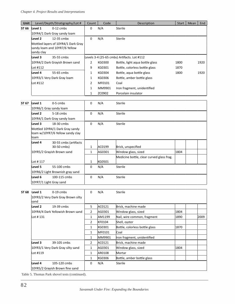
Savannah Under Fire: Expanding the Boundaries
Chapter 4 . Project Results and Interpretations
82
ST 66 Level 1 0-12 cmbs 0 N/A Sterile10YR4/1 Dark Gray sandy loamLevel 2 12-35 cmbx 0 N/A SterileMottled layers of 10YR4/1 Dark Gray sandy loam and 10YR7/6 Yellow sandy clayLevel 3 35-55 cmbs Levels 3-4 (25-65 cmbs) Artifacts. Lot #11210YR4/2 Dark Grayish Brown sand 2 KG0300 Bottle, light aqua bottle glass 1800 1920Lot #112 9 KG0301 Bottle, colorless bottle glass 1870Level 4 55-65 cmbs 1 KG0304 Bottle, aqua bottle glass 1800 192010YR3/1 Very Dark Gray loam 1 KG0306 Bottle, amber bottle glassLot #112 2 MF0101 Coal
1 MM9901 Iron fragment, unidentified1 ZC0902 Porcelain insulator
ST 67 Level 1 0-5 cmbs 0 N/A Sterile10YR6/1 Gray sandy loamLevel 2 5-18 cmbs 0 N/A Sterile10YR4/1 Dark Gray sandy loamLevel 3 18-30 cmbs 0 N/A SterileMottled 10YR4/1 Dark Gray sandy loam w/10YR7/6 Yellow sandy clay loamLevel 4 30-55 cmbs (artifacts
30-50 cmbs) 1 AC0199 Brick, unspecified10YR5/2 Grayish Brown sand 1 AG0301 Window glass, sized 1804
Lot # 117 1 KG0501Medicine bottle, clear curved glass frag.
Level 5 55-100 cmbs 0 N/A Sterile10YR6/2 Light Brownish gray sandLevel 6 100-115 cmbs 0 N/A Sterile10YR7/1 Light Gray sand
ST 68 Level 1 0-19 cmbs 0 N/A Sterile10YR3/2 Very Dark Gray Brown silty sandLevel 2 19-39 cmbs 5 AC0121 Brick, machine made10YR4/4 Dark Yellowish Brown sand 2 AG0301 Window glass, sized 1804Lot # 131 1 AM1199 Nail, wire common, fragment 1890 2009
2 KF0104 Shell, oyster1 KG0301 Bottle, colorless bottle glass 18701 MF0101 Coal1 MM9901 Iron fragment, unidentified
Level 3 39-105 cmbs 2 AC0121 Brick, machine made10YR3/1 Very Dark Gray silty sand 1 AG0301 Window glass, sized 1804Lot #119 1 AR0108 Mortar
1 KG0306 Bottle, amber bottle glassLevel 4 105-120 cmbs 0 N/A Sterile10YR5/2 Grayish Brown fine sand
Unit Count Code Description Start Mean EndLevel/Depth/Stratigraphy/Lot #
Table 5. Thomas Park shovel tests (continued).
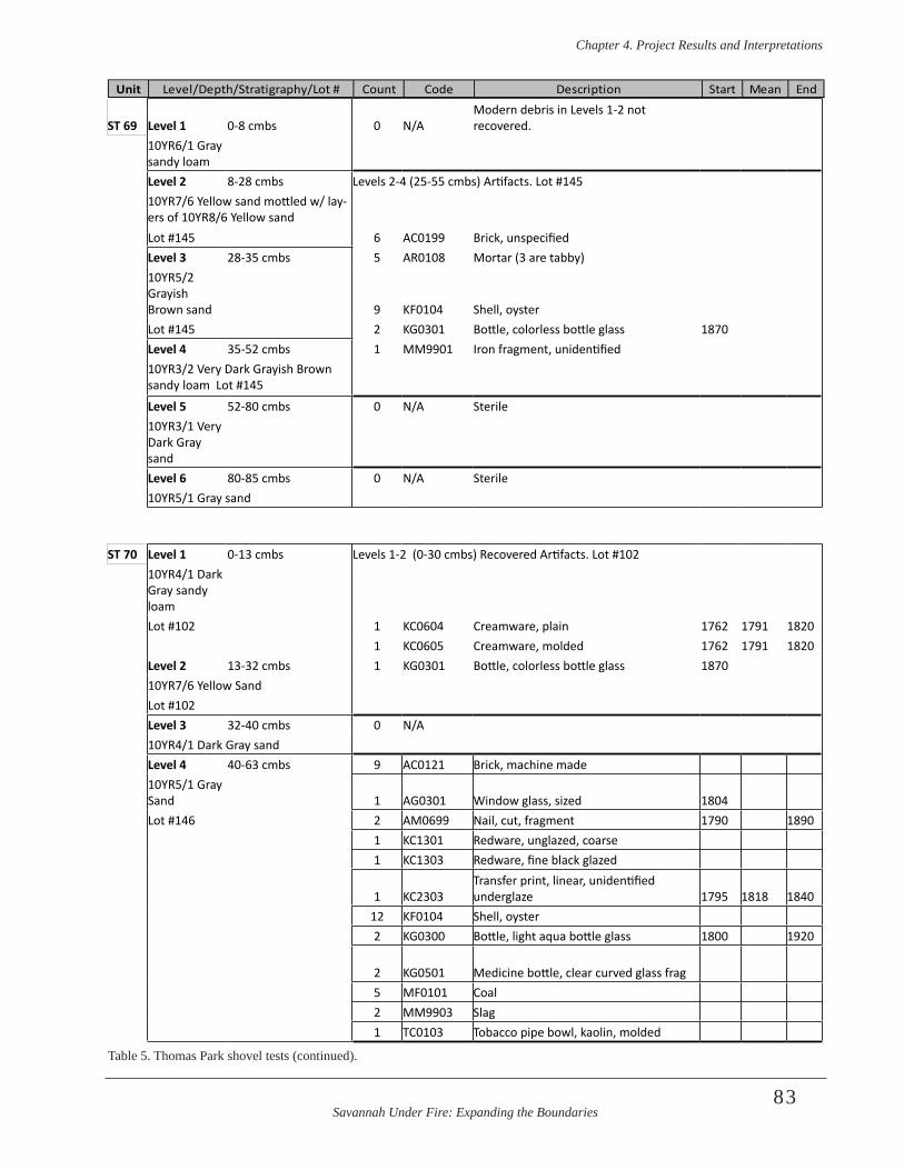
Savannah Under Fire: Expanding the Boundaries
Chapter 4 . Project Results and Interpretations
83
ST 69 Level 1 0-8 cmbs 0 N/AModern debris in Levels 1-2 not recovered.
10YR6/1 Gray sandy loamLevel 2 8-28 cmbs Levels 2-4 (25-55 cmbs) Artifacts. Lot #14510YR7/6 Yellow sand mottled w/ lay-ers of 10YR8/6 Yellow sandLot #145 6 AC0199 Brick, unspecifiedLevel 3 28-35 cmbs 5 AR0108 Mortar (3 are tabby)10YR5/2 Grayish Brown sand 9 KF0104 Shell, oysterLot #145 2 KG0301 Bottle, colorless bottle glass 1870Level 4 35-52 cmbs 1 MM9901 Iron fragment, unidentified10YR3/2 Very Dark Grayish Brown sandy loam Lot #145
Level 5 52-80 cmbs 0 N/A Sterile10YR3/1 Very Dark Gray sandLevel 6 80-85 cmbs 0 N/A Sterile10YR5/1 Gray sand
ST 70 Level 1 0-13 cmbs Levels 1-2 (0-30 cmbs) Recovered Artifacts. Lot #10210YR4/1 Dark Gray sandy loamLot #102 1 KC0604 Creamware, plain 1762 1791 1820
1 KC0605 Creamware, molded 1762 1791 1820Level 2 13-32 cmbs 1 KG0301 Bottle, colorless bottle glass 187010YR7/6 Yellow SandLot #102Level 3 32-40 cmbs 0 N/A10YR4/1 Dark Gray sand Level 4 40-63 cmbs 9 AC0121 Brick, machine made10YR5/1 Gray Sand 1 AG0301 Window glass, sized 1804Lot #146 2 AM0699 Nail, cut, fragment 1790 1890
1 KC1301 Redware, unglazed, coarse1 KC1303 Redware, fine black glazed
1 KC2303Transfer print, linear, unidentified underglaze 1795 1818 1840
12 KF0104 Shell, oyster2 KG0300 Bottle, light aqua bottle glass 1800 1920
2 KG0501 Medicine bottle, clear curved glass frag5 MF0101 Coal2 MM9903 Slag1 TC0103 Tobacco pipe bowl, kaolin, molded
Unit Count Code Description Start Mean EndLevel/Depth/Stratigraphy/Lot #
Table 5. Thomas Park shovel tests (continued).
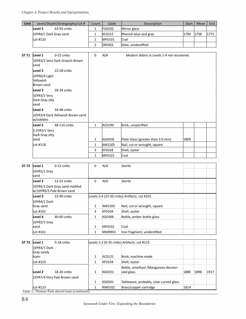
Savannah Under Fire: Expanding the Boundaries
Chapter 4 . Project Results and Interpretations
84
Level 5 63-93 cmbs 1 FG0202 Mirror glass10YR4/1 Dark Gray sand 1 KC0222 Rhenish blue and gray 1700 1738 1775Lot #133 1 MF0101 Coal
2 ZR0302 Slate, unidentified
ST 71 Level 1 0-22 cmbs 0 N/A Modern debris in Levels 1-4 not recovered.10YR3/2 Very Dark Grayish Brown sandLevel 2 22-28 cmbs10YR6/4 Light Yellowish Brown sandLevel 3 28-34 cmbs10YR3/1 Very Dark Gray silty sandLevel 4 34-48 cmbs10YR3/4 Dark Yellowish Brown sand w/cobblesLevel 5 48-116 cmbs 1 AC0199 Brick, unspecified2.5YR3/1 Very Dark Gray silty sand 1 AG0558 Plate Glass (greater than 3.0 mm) 1800Lot #118 1 AM1505 Nail, cut or wrought, square
3 KF0104 Shell, oyster1 MF0101 Coal
ST 72 Level 1 0-12 cmbs 0 N/A Sterile10YR5/1 Gray sandLevel 2 12-22 cmbs 0 N/A Sterile10YR4/1 Dark Gray sand mottled w/10YR6/3 Pale Brown sandLevel 3 22-40 cmbs Levels 3-4 (25-50 cmbs) Artifacts. Lot #10110YR4/1 Dark Gray sand 1 AM1505 Nail, cut or wrought, square Lot #101 3 KF0104 Shell, oysterLevel 4 40-60 cmbs 1 KG0306 Bottle, amber bottle glass10YR5/1 Gray sand 1 MF0101 CoalLot #101 1 MM9901 Iron fragment, unidentified
ST 73 Level 1 0-18 cmbs Levels 1-2 (0-35 cmbs) Artifacts. Lot #12310YR4/1 Dark Gray sandy loam 1 AC0121 Brick, machine madeLot #123 1 KF0104 Shell, oyster
Level 2 18-20 cmbs 1 KG0231Bottle, amethyst /Manganese decolor-ized glass 1880 1898 1917
10YR7/4 Very Pale Brown sand1 KG0501 Tableware, probably, clear curved glass
Lot #123 1 RM0102 Brass/copper cartridge 1814
Unit Count Code Description Start Mean EndLevel/Depth/Stratigraphy/Lot #
Table 5. Thomas Park shovel tests (continued).
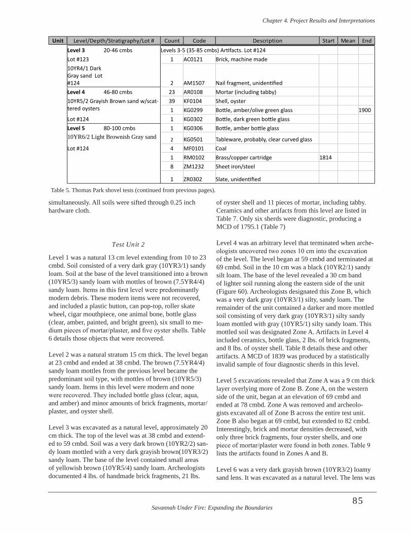
Savannah Under Fire: Expanding the Boundaries
Chapter 4 . Project Results and Interpretations
85
simultaneously. All soils were sifted through 0.25 inch hardware cloth.
Test Unit 2
Level 1 was a natural 13 cm level extending from 10 to 23 cmbd. Soil consisted of a very dark gray (10YR3/1) sandy loam. Soil at the base of the level transitioned into a brown (10YR5/3) sandy loam with mottles of brown (7.5YR4/4) sandy loam. Items in this first level were predominantly modern debris. These modern items were not recovered, and included a plastic button, can pop-top, roller skate wheel, cigar mouthpiece, one animal bone, bottle glass (clear, amber, painted, and bright green), six small to me-dium pieces of mortar/plaster, and five oyster shells. Table 6 details those objects that were recovered.
Level 2 was a natural stratum 15 cm thick. The level began at 23 cmbd and ended at 38 cmbd. The brown (7.5YR4/4) sandy loam mottles from the previous level became the predominant soil type, with mottles of brown (10YR5/3) sandy loam. Items in this level were modern and none were recovered. They included bottle glass (clear, aqua, and amber) and minor amounts of brick fragments, mortar/plaster, and oyster shell.
Level 3 was excavated as a natural level, approximately 20 cm thick. The top of the level was at 38 cmbd and extend-ed to 59 cmbd. Soil was a very dark brown (10YR2/2) san-dy loam mottled with a very dark grayish brown(10YR3/2) sandy loam. The base of the level contained small areas of yellowish brown (10YR5/4) sandy loam. Archeologists documented 4 lbs. of handmade brick fragments, 21 lbs.
of oyster shell and 11 pieces of mortar, including tabby. Ceramics and other artifacts from this level are listed in Table 7. Only six sherds were diagnostic, producing a MCD of 1795.1 (Table 7)
Level 4 was an arbitrary level that terminated when arche-ologists uncovered two zones 10 cm into the excavation of the level. The level began at 59 cmbd and terminated at 69 cmbd. Soil in the 10 cm was a black (10YR2/1) sandy silt loam. The base of the level revealed a 30 cm band of lighter soil running along the eastern side of the unit (Figure 60). Archeologists designated this Zone B, which was a very dark gray (10YR3/1) silty, sandy loam. The remainder of the unit contained a darker and more mottled soil consisting of very dark gray (10YR3/1) silty sandy loam mottled with gray (10YR5/1) silty sandy loam. This mottled soil was designated Zone A. Artifacts in Level 4 included ceramics, bottle glass, 2 lbs. of brick fragments, and 8 lbs. of oyster shell. Table 8 details these and other artifacts. A MCD of 1839 was produced by a statistically invalid sample of four diagnostic sherds in this level.
Level 5 excavations revealed that Zone A was a 9 cm thick layer overlying more of Zone B. Zone A, on the western side of the unit, began at an elevation of 69 cmbd and ended at 78 cmbd. Zone A was removed and archeolo-gists excavated all of Zone B across the entire test unit. Zone B also began at 69 cmbd, but extended to 82 cmbd. Interestingly, brick and mortar densities decreased, with only three brick fragments, four oyster shells, and one piece of mortar/plaster were found in both zones. Table 9 lists the artifacts found in Zones A and B.
Level 6 was a very dark grayish brown (10YR3/2) loamy sand lens. It was excavated as a natural level. The lens was
Unit Count Code Description Start Mean EndLevel/Depth/Stratigraphy/Lot #
Level 3 20-46 cmbs Levels 3-5 (35-85 cmbs) Artifacts. Lot #124Lot #123 1 AC0121 Brick, machine made10YR4/1 Dark Gray sand Lot #124 2 AM1507 Nail fragment, unidentifiedLevel 4 46-80 cmbs 23 AR0108 Mortar (including tabby)10YR5/2 Grayish Brown sand w/scat-tered oysters
39 KF0104 Shell, oyster1 KG0299 Bottle, amber/olive green glass 1900
Lot #124 1 KG0302 Bottle, dark green bottle glassLevel 5 80-100 cmbs 1 KG0306 Bottle, amber bottle glass10YR6/2 Light Brownish Gray sand 2 KG0501 Tableware, probably, clear curved glassLot #124 4 MF0101 Coal
1 RM0102 Brass/copper cartridge 18148 ZM1232 Sheet iron/steel
1 ZR0302 Slate, unidentified
Table 5. Thomas Park shovel tests (continued from previous pages).
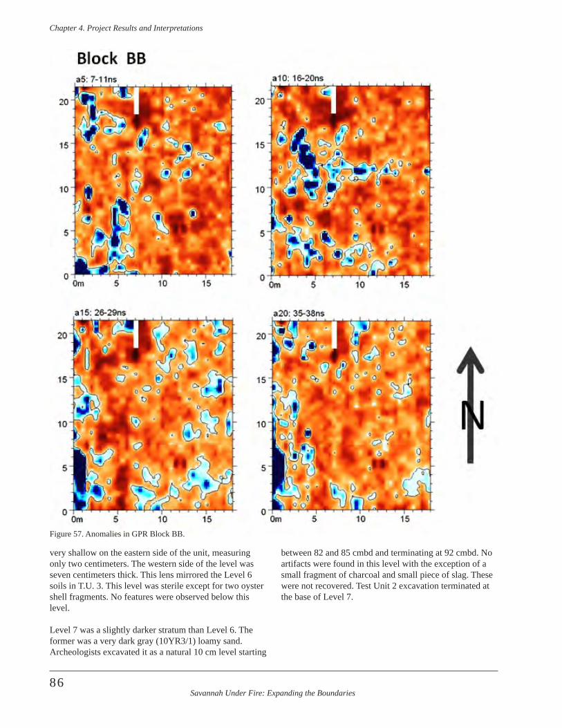
Savannah Under Fire: Expanding the Boundaries
Chapter 4 . Project Results and Interpretations
86
very shallow on the eastern side of the unit, measuring only two centimeters. The western side of the level was seven centimeters thick. This lens mirrored the Level 6 soils in T.U. 3. This level was sterile except for two oyster shell fragments. No features were observed below this level. Level 7 was a slightly darker stratum than Level 6. The former was a very dark gray (10YR3/1) loamy sand. Archeologists excavated it as a natural 10 cm level starting
between 82 and 85 cmbd and terminating at 92 cmbd. No artifacts were found in this level with the exception of a small fragment of charcoal and small piece of slag. These were not recovered. Test Unit 2 excavation terminated at the base of Level 7.
Figure 57. Anomalies in GPR Block BB.
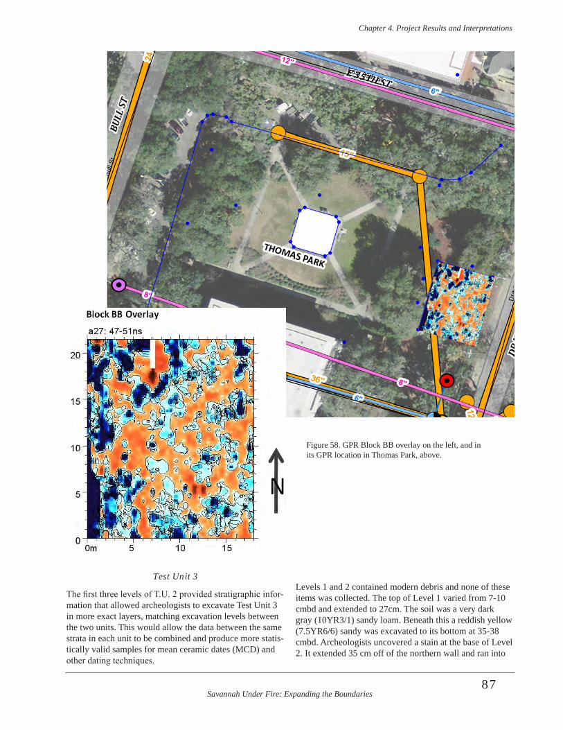
Savannah Under Fire: Expanding the Boundaries
Chapter 4 . Project Results and Interpretations
87
Test Unit 3
The first three levels of T.U. 2 provided stratigraphic infor-mation that allowed archeologists to excavate Test Unit 3 in more exact layers, matching excavation levels between the two units. This would allow the data between the same strata in each unit to be combined and produce more statis-tically valid samples for mean ceramic dates (MCD) and other dating techniques.
Levels 1 and 2 contained modern debris and none of these items was collected. The top of Level 1 varied from 7-10 cmbd and extended to 27cm. The soil was a very dark gray (10YR3/1) sandy loam. Beneath this a reddish yellow (7.5YR6/6) sandy was excavated to its bottom at 35-38 cmbd. Archeologists uncovered a stain at the base of Level 2. It extended 35 cm off of the northern wall and ran into
Bull
St
East 36th St
Dra
yton
St
East 35th St
W 36th St
W 35th St
Figure 58. GPR Block BB overlay on the left, and in its GPR location in Thomas Park, above.
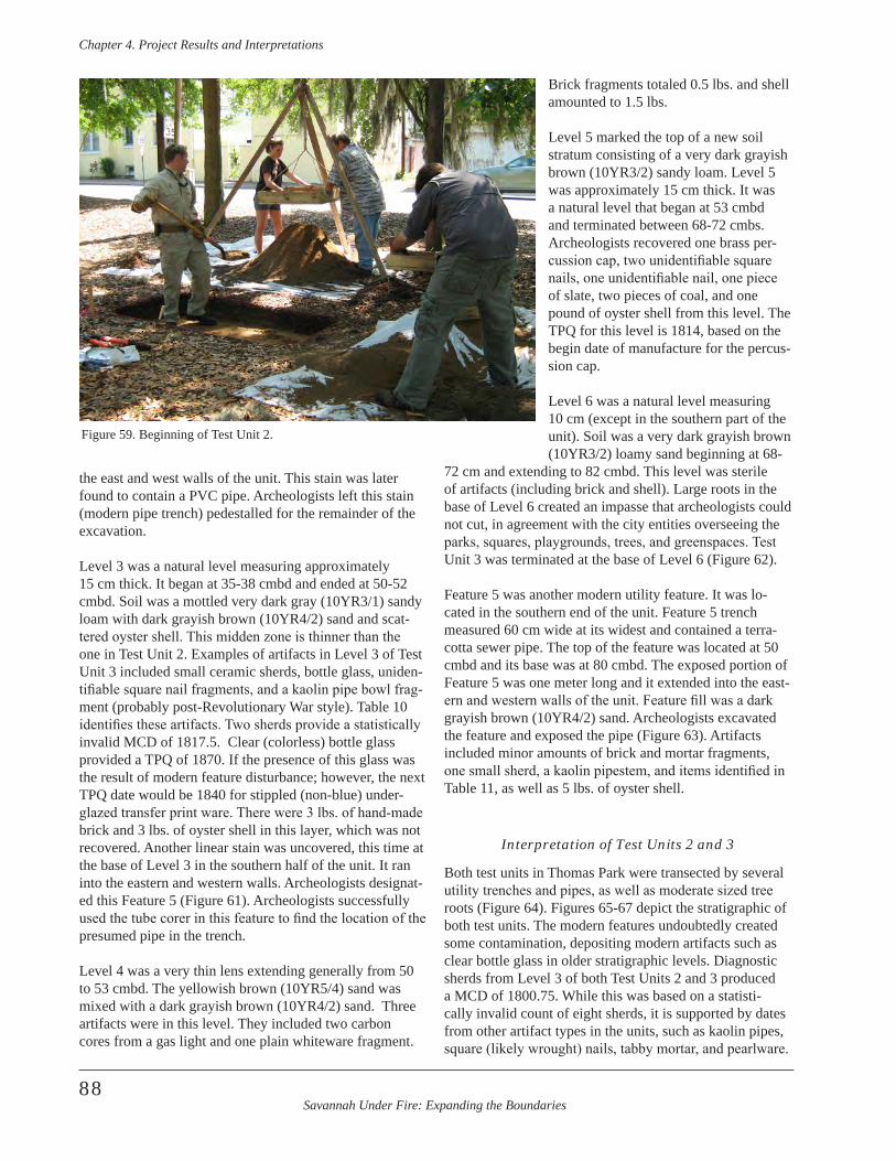
Savannah Under Fire: Expanding the Boundaries
Chapter 4 . Project Results and Interpretations
88
the east and west walls of the unit. This stain was later found to contain a PVC pipe. Archeologists left this stain (modern pipe trench) pedestalled for the remainder of the excavation.
Level 3 was a natural level measuring approximately 15 cm thick. It began at 35-38 cmbd and ended at 50-52 cmbd. Soil was a mottled very dark gray (10YR3/1) sandy loam with dark grayish brown (10YR4/2) sand and scat-tered oyster shell. This midden zone is thinner than the one in Test Unit 2. Examples of artifacts in Level 3 of Test Unit 3 included small ceramic sherds, bottle glass, uniden-tifiable square nail fragments, and a kaolin pipe bowl frag-ment (probably post-Revolutionary War style). Table 10 identifies these artifacts. Two sherds provide a statistically invalid MCD of 1817.5. Clear (colorless) bottle glass provided a TPQ of 1870. If the presence of this glass was the result of modern feature disturbance; however, the next TPQ date would be 1840 for stippled (non-blue) under-glazed transfer print ware. There were 3 lbs. of hand-made brick and 3 lbs. of oyster shell in this layer, which was not recovered. Another linear stain was uncovered, this time at the base of Level 3 in the southern half of the unit. It ran into the eastern and western walls. Archeologists designat-ed this Feature 5 (Figure 61). Archeologists successfully used the tube corer in this feature to find the location of the presumed pipe in the trench.
Level 4 was a very thin lens extending generally from 50 to 53 cmbd. The yellowish brown (10YR5/4) sand was mixed with a dark grayish brown (10YR4/2) sand. Three artifacts were in this level. They included two carbon cores from a gas light and one plain whiteware fragment.
Brick fragments totaled 0.5 lbs. and shell amounted to 1.5 lbs.
Level 5 marked the top of a new soil stratum consisting of a very dark grayish brown (10YR3/2) sandy loam. Level 5 was approximately 15 cm thick. It was a natural level that began at 53 cmbd and terminated between 68-72 cmbs. Archeologists recovered one brass per-cussion cap, two unidentifiable square nails, one unidentifiable nail, one piece of slate, two pieces of coal, and one pound of oyster shell from this level. The TPQ for this level is 1814, based on the begin date of manufacture for the percus-sion cap.
Level 6 was a natural level measuring 10 cm (except in the southern part of the unit). Soil was a very dark grayish brown (10YR3/2) loamy sand beginning at 68-
72 cm and extending to 82 cmbd. This level was sterile of artifacts (including brick and shell). Large roots in the base of Level 6 created an impasse that archeologists could not cut, in agreement with the city entities overseeing the parks, squares, playgrounds, trees, and greenspaces. Test Unit 3 was terminated at the base of Level 6 (Figure 62).
Feature 5 was another modern utility feature. It was lo-cated in the southern end of the unit. Feature 5 trench measured 60 cm wide at its widest and contained a terra-cotta sewer pipe. The top of the feature was located at 50 cmbd and its base was at 80 cmbd. The exposed portion of Feature 5 was one meter long and it extended into the east-ern and western walls of the unit. Feature fill was a dark grayish brown (10YR4/2) sand. Archeologists excavated the feature and exposed the pipe (Figure 63). Artifacts included minor amounts of brick and mortar fragments, one small sherd, a kaolin pipestem, and items identified in Table 11, as well as 5 lbs. of oyster shell.
Interpretation of Test Units 2 and 3
Both test units in Thomas Park were transected by several utility trenches and pipes, as well as moderate sized tree roots (Figure 64). Figures 65-67 depict the stratigraphic of both test units. The modern features undoubtedly created some contamination, depositing modern artifacts such as clear bottle glass in older stratigraphic levels. Diagnostic sherds from Level 3 of both Test Units 2 and 3 produced a MCD of 1800.75. While this was based on a statisti-cally invalid count of eight sherds, it is supported by dates from other artifact types in the units, such as kaolin pipes, square (likely wrought) nails, tabby mortar, and pearlware.
Figure 59. Beginning of Test Unit 2.
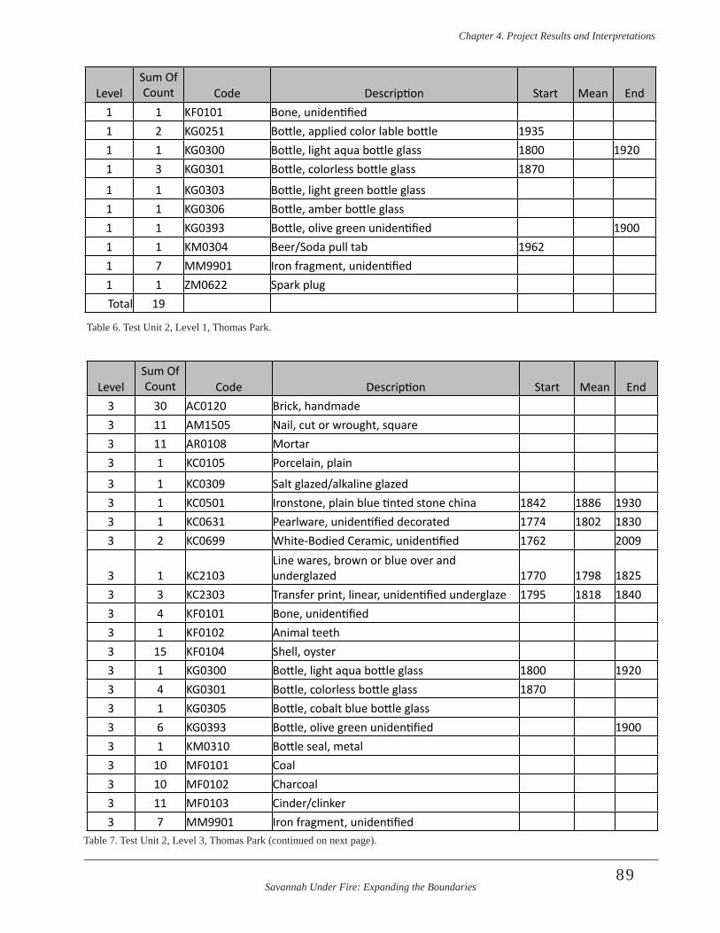
Savannah Under Fire: Expanding the Boundaries
Chapter 4 . Project Results and Interpretations
89
LevelSum Of Count Code Description Start Mean End
1 1 KF0101 Bone, unidentified1 2 KG0251 Bottle, applied color lable bottle 19351 1 KG0300 Bottle, light aqua bottle glass 1800 19201 3 KG0301 Bottle, colorless bottle glass 1870
1 1 KG0303 Bottle, light green bottle glass1 1 KG0306 Bottle, amber bottle glass1 1 KG0393 Bottle, olive green unidentified 19001 1 KM0304 Beer/Soda pull tab 19621 7 MM9901 Iron fragment, unidentified1 1 ZM0622 Spark plugTotal 19
Table 6. Test Unit 2, Level 1, Thomas Park.
LevelSum Of Count Code Description Start Mean End
3 30 AC0120 Brick, handmade3 11 AM1505 Nail, cut or wrought, square 3 11 AR0108 Mortar3 1 KC0105 Porcelain, plain
3 1 KC0309 Salt glazed/alkaline glazed 3 1 KC0501 Ironstone, plain blue tinted stone china 1842 1886 19303 1 KC0631 Pearlware, unidentified decorated 1774 1802 18303 2 KC0699 White-Bodied Ceramic, unidentified 1762 2009
3 1 KC2103Line wares, brown or blue over and underglazed 1770 1798 1825
3 3 KC2303 Transfer print, linear, unidentified underglaze 1795 1818 18403 4 KF0101 Bone, unidentified3 1 KF0102 Animal teeth3 15 KF0104 Shell, oyster3 1 KG0300 Bottle, light aqua bottle glass 1800 19203 4 KG0301 Bottle, colorless bottle glass 18703 1 KG0305 Bottle, cobalt blue bottle glass3 6 KG0393 Bottle, olive green unidentified 19003 1 KM0310 Bottle seal, metal3 10 MF0101 Coal3 10 MF0102 Charcoal3 11 MF0103 Cinder/clinker3 7 MM9901 Iron fragment, unidentified
Table 7. Test Unit 2, Level 3, Thomas Park (continued on next page).
Savannah Under Fire: Expanding the Boundaries
Chapter 4 . Project Results and Interpretations
90
3 1 MM9902 Metal, non iron/steel, unidentified3 7 MM9903 Slag3 2 MR0122 Unmodified stone3 2 RR0133 Chert worked fragment, unidentified3 2 TC0103 Tobacco pipe bowl, kaolin, molded3 3 TC0210 Tobacco pipestem, kaolin, 5/64”3 1 ZM0405 Ferrule3 12 ZM1232 Sheet iron/steel3 3 ZR0302 Slate, unidentified
Total 166Table 7. Test Unit 2, Level 3, Thomas Park. (continued from previous page).
LevelSum Of Count Code Description Start Mean End
4 9 AC0199 Brick, unspecified4 1 AM1507 Nail fragment, unidentified4 3 AR0108 Mortar4 3 KC0501 Ironstone, plain blue tinted stone china 1842 1886 1930
4 3 KC0700 Whiteware, plain 1820 20094 1 KC2805 Yellowware, embossed/molded 1830 1885 19404 1 KG0299 Bottle, amber/olive green glass 19004 2 KG0305 Bottle, cobalt blue bottle glass4 1 KG0306 Bottle, amber bottle glass4 1 KG0393 Bottle, olive green unidentified 19004 2 MF0101 Coal4 6 MF0103 Cinder/clinker4 4 MM9901 Iron fragment, unidentified4 1 MM9903 Slag4 1 TC0209 Tobacco pipestem, kaolin, 4/64”4 1 ZR0302 Slate, unidentified
Total 40Table 8. Test Unit 2, Level 4, Thomas Park.
LevelSum Of Count Code Description Start Mean End
5 ZA West 3AC0199 Brick, unspecified5 ZA West 1AG0301 Window glass, sized 18045 ZA West 4AM1507 Nail fragment, unidentified5 ZA West 2MF0101 Coal
5 ZA West 3MF0103 Cinder/clinker5 ZA West 1TC0199 Tobacco pipe bowl, unidentified clay5 ZA West 1TC0212 Tobacco pipestem, kaolin, 7/64”Table 9. Test Unit 2, Level 5 Zones A West and B East, Thomas Park (continued on next page).

Savannah Under Fire: Expanding the Boundaries
Chapter 4 . Project Results and Interpretations
91
5 ZB East 1 AR0108 Mortar5 ZB East 1 KC0398 Lead glazed, unidentified5 ZB East 1 KC0700 Whiteware, plain 1820 20095 ZB East 4 KF0104 Shell, oyster5 ZB East 2 KG0393 Bottle, olive green unidentified 19005 ZB East 5 MF0101 Coal5 ZB East 2 MM9903 Slag
Total 31
LevelSum Of Count Code Description Start Mean End
Table 9. Test Unit 2, Level 5 Zones A West and B East, Thomas Park. (continued from previous page).
LevelSum Of Count Code Description Start Mean End
3 7 AG0301 Window glass, sized 1804
3 5 AM1505 Nail, cut or wrought, square
3 1 KC0701 Whiteware, indeterminate decoration 1820 20093 1 KC2303 Transfer print, linear, unidentified underglaze 1795 1818 1840
3 1 KC2310Transfer print, stippled, red, green, purple, black underglaze 1840 1855 1870
3 1 KF0104 Shell, oyster
3 3 KG0301 Bottle, colorless bottle glass 1870
3 2 KG0306 Bottle, amber bottle glass
3 1 KG0393 Bottle, olive green unidentified 1900
3 1 TC0101 Tobacco pipe bowl, kaolin, plain
3 3 ZM1211 Wire
Total 26Table 10. Test Unit 3, Level 3, Thomas Park.
FeatureSum Of Count Code Description Start Mean End
5 6 AC0199 Brick, unspecified
5 2 AM1505 Nail, cut or wrought, square
5 4 AM1507 Nail fragment, unidentified
5 2 AR0108 Mortar
5 1 KC0699 White-Bodied Ceramic, unidentified 1762 2009
5 2 MF0101 Coal
5 1 MM9903 Slag
5 1 TC0210 Tobacco pipestem, kaolin, 5/64”
5 1 ZM1206 Metal hooks
5 1 ZM1232 Sheet iron/steel
Total 21Table 11. Test Unit 3, Feature 5, Thomas Park.
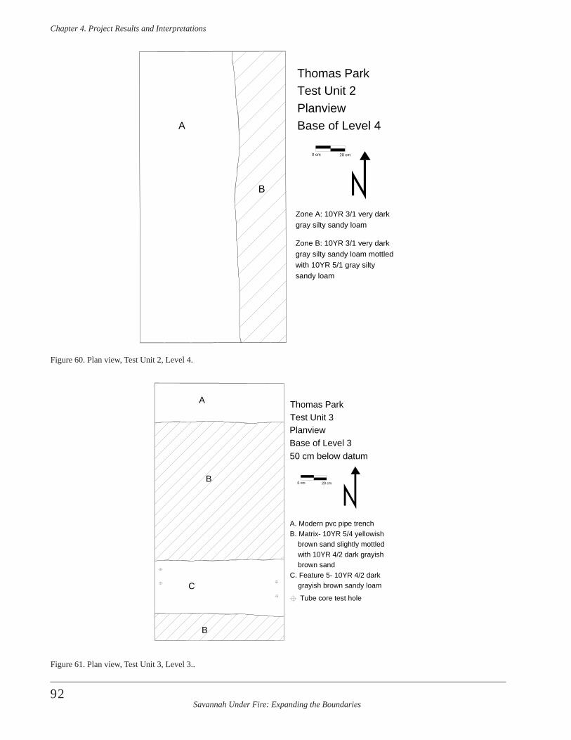
Savannah Under Fire: Expanding the Boundaries
Chapter 4 . Project Results and Interpretations
92
Zone A: 10YR 3/1 very dark gray silty sandy loam
Zone B: 10YR 3/1 very dark gray silty sandy loam mottled with 10YR 5/1 gray silty sandy loam
A
B
Thomas ParkTest Unit 2PlanviewBase of Level 4
0 cm 20 cm
Figure 60. Plan view, Test Unit 2, Level 4.
A
B
B
C
Thomas ParkTest Unit 3PlanviewBase of Level 350 cm below datum
0 cm 20 cm
Tube core test hole
A. Modern pvc pipe trenchB. Matrix- 10YR 5/4 yellowish brown sand slightly mottled with 10YR 4/2 dark grayish brown sandC. Feature 5- 10YR 4/2 dark grayish brown sandy loam
Figure 61. Plan view, Test Unit 3, Level 3..
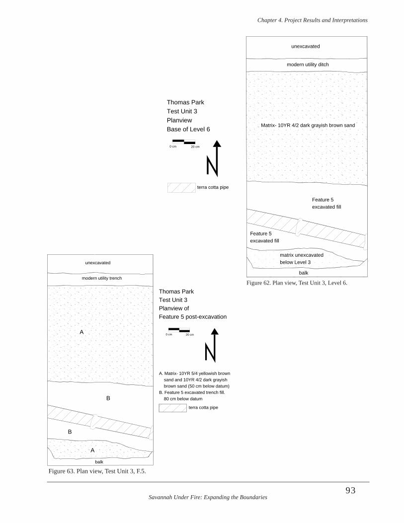
Savannah Under Fire: Expanding the Boundaries
Chapter 4 . Project Results and Interpretations
93
Figure 62. Plan view, Test Unit 3, Level 6.
balk
unexcavated
modern utility trench
A
A
B
B
terra cotta pipe
Thomas ParkTest Unit 3Planview ofFeature 5 post-excavation
A. Matrix- 10YR 5/4 yellowish brown sand and 10YR 4/2 dark grayish brown sand (50 cm below datum)B. Feature 5 excavated trench fill. 80 cm below datum
0 cm 20 cm
Figure 63. Plan view, Test Unit 3, F.5.
unexcavated
modern utility ditch
Matrix- 10YR 4/2 dark grayish brown sand
Feature 5excavated fill
Feature 5excavated fill
matrix unexcavatedbelow Level 3
balk
Thomas ParkTest Unit 3PlanviewBase of Level 6
0 cm 20 cm
terra cotta pipe
unexcavated
modern utility ditch
Matrix- 10YR 4/2 dark grayish brown sand
Feature 5excavated fill
Feature 5excavated fill
matrix unexcavatedbelow Level 3
balk
Thomas ParkTest Unit 3PlanviewBase of Level 6
0 cm 20 cm
terra cotta pipe
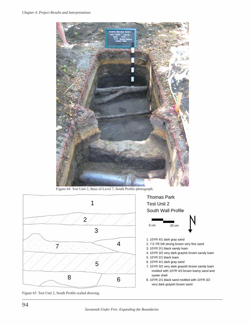
Savannah Under Fire: Expanding the Boundaries
Chapter 4 . Project Results and Interpretations
94
1
2
3
4
68
1. 10YR 4/1 dark gray sand2. 7.5 YR 5/6 strong brown very fine sand3. 10YR 2/1 black sandy loam4. 10YR 3/2 very dark grayish brown sandy loam
6. 10YR 4/1 dark gray sand
mottled wtih 10YR 4/3 brown loamy sand and oyster shell8. 10YR 2/1 black sand mottled with 10YR 3/2 very dark grayish brown sand
Thomas ParkTest Unit 2South Wall Profile
5 7. 10YR 3/2 very dark grayish brown sandy loam
75. 10YR 2/1 black loam
0 cm 20 cm
Figure 64. Test Unit 2, Base of Level 7, South Profile photograph.
Figure 65. Test Unit 2, South Profile scaled drawing.
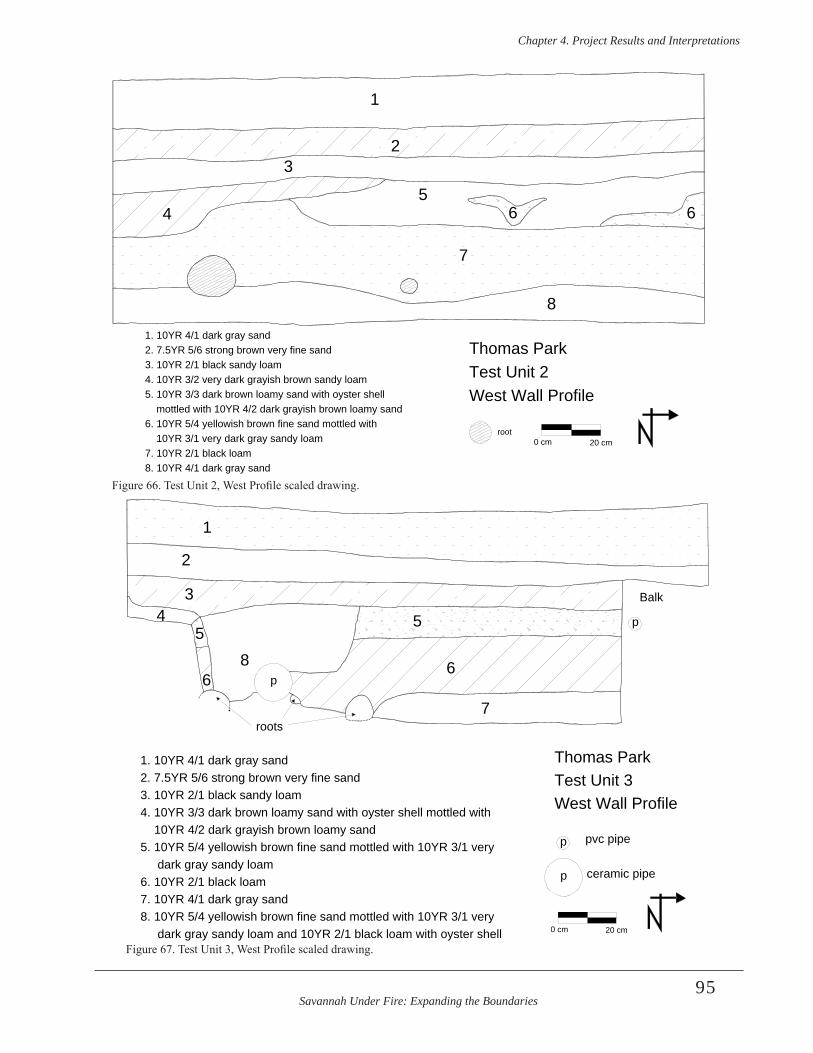
Savannah Under Fire: Expanding the Boundaries
Chapter 4 . Project Results and Interpretations
95
1
23
45
6 6
7
8
Thomas ParkTest Unit 2West Wall Profile
1. 10YR 4/1 dark gray sand2. 7.5YR 5/6 strong brown very fine sand3. 10YR 2/1 black sandy loam4. 10YR 3/2 very dark grayish brown sandy loam5. 10YR 3/3 dark brown loamy sand with oyster shell mottled with 10YR 4/2 dark grayish brown loamy sand6. 10YR 5/4 yellowish brown fine sand mottled with 10YR 3/1 very dark gray sandy loam7. 10YR 2/1 black loam8. 10YR 4/1 dark gray sand
0 cm 20 cmroot
roots
1
2
34
55
6
7
68
Thomas ParkTest Unit 3West Wall Profile
Balk
pvc pipe
ceramic pipe
0 cm 20 cm
1. 10YR 4/1 dark gray sand2. 7.5YR 5/6 strong brown very fine sand3. 10YR 2/1 black sandy loam4. 10YR 3/3 dark brown loamy sand with oyster shell mottled with 10YR 4/2 dark grayish brown loamy sand5. 10YR 5/4 yellowish brown fine sand mottled with 10YR 3/1 very dark gray sandy loam6. 10YR 2/1 black loam7. 10YR 4/1 dark gray sand8. 10YR 5/4 yellowish brown fine sand mottled with 10YR 3/1 very dark gray sandy loam and 10YR 2/1 black loam with oyster shell
p
p
p
p
Figure 66. Test Unit 2, West Profile scaled drawing.
Figure 67. Test Unit 3, West Profile scaled drawing.
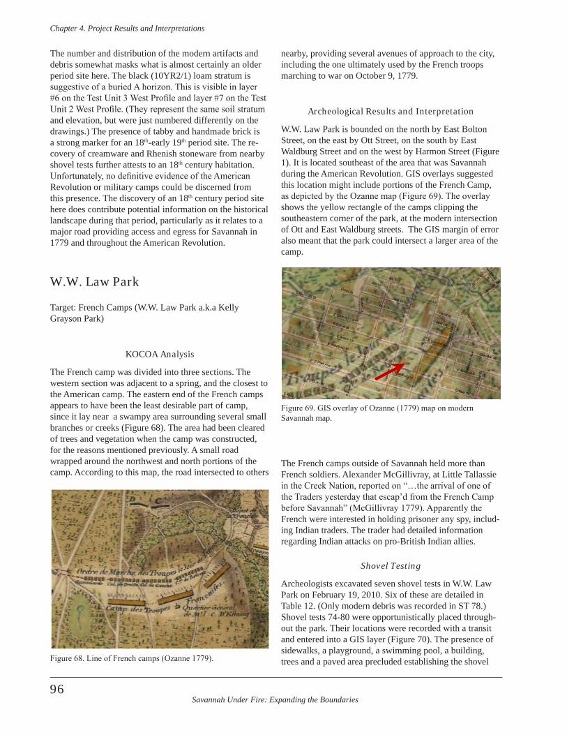
Savannah Under Fire: Expanding the Boundaries
Chapter 4 . Project Results and Interpretations
96
The number and distribution of the modern artifacts and debris somewhat masks what is almost certainly an older period site here. The black (10YR2/1) loam stratum is suggestive of a buried A horizon. This is visible in layer #6 on the Test Unit 3 West Profile and layer #7 on the Test Unit 2 West Profile. (They represent the same soil stratum and elevation, but were just numbered differently on the drawings.) The presence of tabby and handmade brick is a strong marker for an 18th-early 19th period site. The re-covery of creamware and Rhenish stoneware from nearby shovel tests further attests to an 18th century habitation. Unfortunately, no definitive evidence of the American Revolution or military camps could be discerned from this presence. The discovery of an 18th century period site here does contribute potential information on the historical landscape during that period, particularly as it relates to a major road providing access and egress for Savannah in 1779 and throughout the American Revolution.
W.W. Law Park
Target: French Camps (W.W. Law Park a.k.a Kelly Grayson Park)
KOCOA Analysis
The French camp was divided into three sections. The western section was adjacent to a spring, and the closest to the American camp. The eastern end of the French camps appears to have been the least desirable part of camp, since it lay near a swampy area surrounding several small branches or creeks (Figure 68). The area had been cleared of trees and vegetation when the camp was constructed, for the reasons mentioned previously. A small road wrapped around the northwest and north portions of the camp. According to this map, the road intersected to others
nearby, providing several avenues of approach to the city, including the one ultimately used by the French troops marching to war on October 9, 1779.
Archeological Results and Interpretation
W.W. Law Park is bounded on the north by East Bolton Street, on the east by Ott Street, on the south by East Waldburg Street and on the west by Harmon Street (Figure 1). It is located southeast of the area that was Savannah during the American Revolution. GIS overlays suggested this location might include portions of the French Camp, as depicted by the Ozanne map (Figure 69). The overlay shows the yellow rectangle of the camps clipping the southeastern corner of the park, at the modern intersection of Ott and East Waldburg streets. The GIS margin of error also meant that the park could intersect a larger area of the camp.
The French camps outside of Savannah held more than French soldiers. Alexander McGillivray, at Little Tallassie in the Creek Nation, reported on “…the arrival of one of the Traders yesterday that escap’d from the French Camp before Savannah” (McGillivray 1779). Apparently the French were interested in holding prisoner any spy, includ-ing Indian traders. The trader had detailed information regarding Indian attacks on pro-British Indian allies.
Shovel Testing
Archeologists excavated seven shovel tests in W.W. Law Park on February 19, 2010. Six of these are detailed in Table 12. (Only modern debris was recorded in ST 78.) Shovel tests 74-80 were opportunistically placed through-out the park. Their locations were recorded with a transit and entered into a GIS layer (Figure 70). The presence of sidewalks, a playground, a swimming pool, a building, trees and a paved area precluded establishing the shovel Figure 68. Line of French camps (Ozanne 1779).
Figure 69. GIS overlay of Ozanne (1779) map on modern Savannah map.
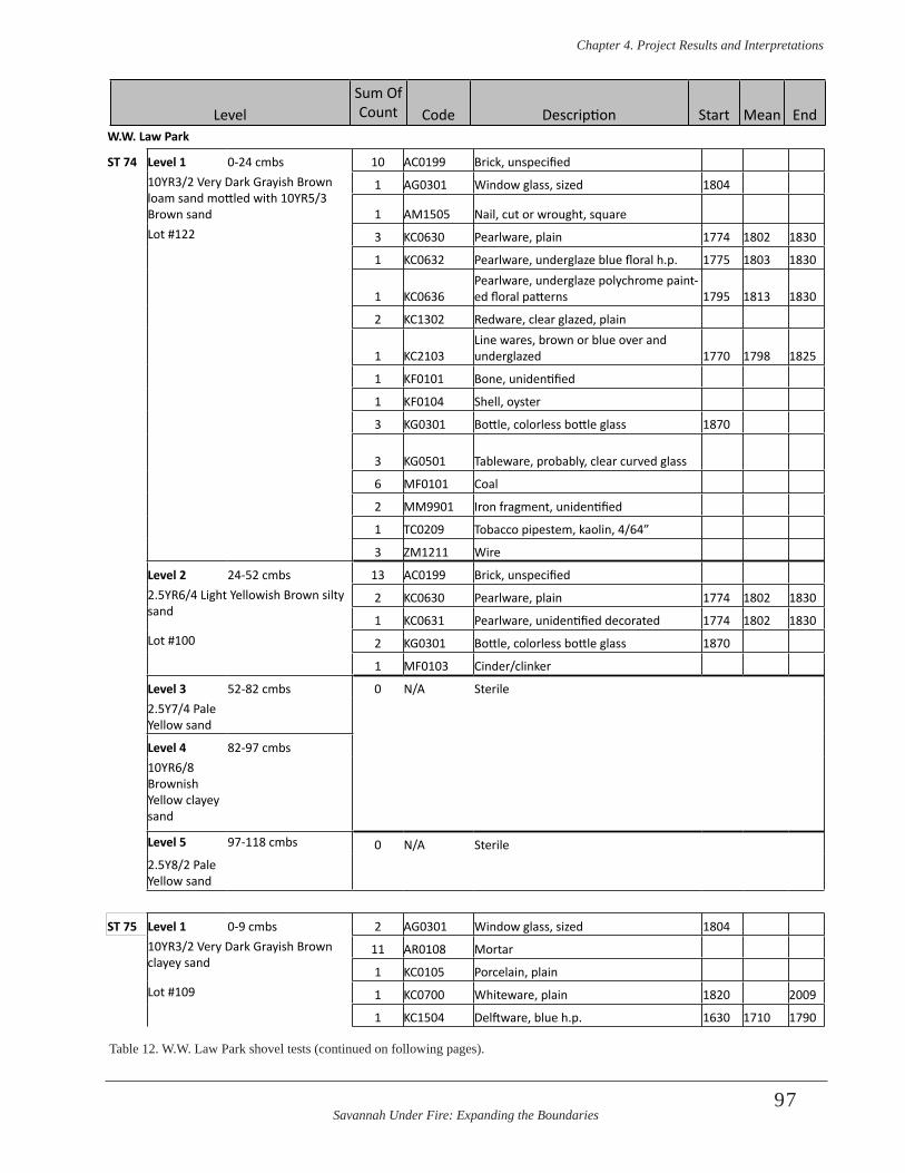
Savannah Under Fire: Expanding the Boundaries
Chapter 4 . Project Results and Interpretations
97
W.W. Law Park
ST 74 Level 1 0-24 cmbs 10 AC0199 Brick, unspecified10YR3/2 Very Dark Grayish Brown loam sand mottled with 10YR5/3 Brown sand
1 AG0301 Window glass, sized 1804
1 AM1505 Nail, cut or wrought, square Lot #122 3 KC0630 Pearlware, plain 1774 1802 1830
1 KC0632 Pearlware, underglaze blue floral h.p. 1775 1803 1830
1 KC0636Pearlware, underglaze polychrome paint-ed floral patterns 1795 1813 1830
2 KC1302 Redware, clear glazed, plain
1 KC2103Line wares, brown or blue over and underglazed 1770 1798 1825
1 KF0101 Bone, unidentified
1 KF0104 Shell, oyster
3 KG0301 Bottle, colorless bottle glass 1870
3 KG0501 Tableware, probably, clear curved glass
6 MF0101 Coal
2 MM9901 Iron fragment, unidentified
1 TC0209 Tobacco pipestem, kaolin, 4/64”
3 ZM1211 Wire
Level 2 24-52 cmbs 13 AC0199 Brick, unspecified2.5YR6/4 Light Yellowish Brown silty sand
2 KC0630 Pearlware, plain 1774 1802 1830
1 KC0631 Pearlware, unidentified decorated 1774 1802 1830Lot #100 2 KG0301 Bottle, colorless bottle glass 1870
1 MF0103 Cinder/clinker
Level 3 52-82 cmbs 0 N/A Sterile2.5Y7/4 Pale Yellow sand
Level 4 82-97 cmbs10YR6/8 Brownish Yellow clayey sand
Level 5 97-118 cmbs 0 N/A Sterile2.5Y8/2 Pale Yellow sand
ST 75 Level 1 0-9 cmbs 2 AG0301 Window glass, sized 180410YR3/2 Very Dark Grayish Brown clayey sand
11 AR0108 Mortar
1 KC0105 Porcelain, plainLot #109 1 KC0700 Whiteware, plain 1820 2009
1 KC1504 Delftware, blue h.p. 1630 1710 1790
LevelSum Of Count Code Description Start Mean End
Table 12. W.W. Law Park shovel tests (continued on following pages).
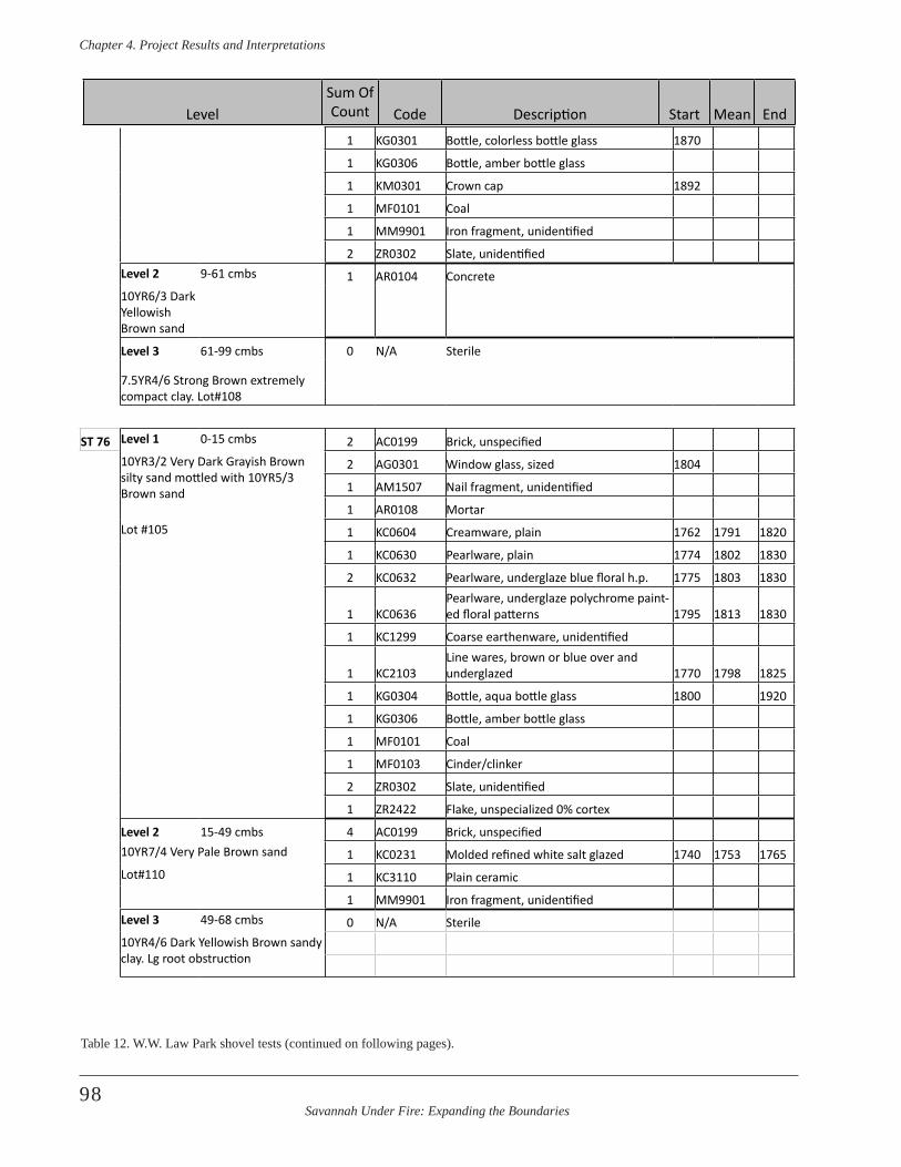
Savannah Under Fire: Expanding the Boundaries
Chapter 4 . Project Results and Interpretations
98
1 KG0301 Bottle, colorless bottle glass 1870
1 KG0306 Bottle, amber bottle glass
1 KM0301 Crown cap 1892
1 MF0101 Coal
1 MM9901 Iron fragment, unidentified
2 ZR0302 Slate, unidentifiedLevel 2 9-61 cmbs 1 AR0104 Concrete10YR6/3 Dark Yellowish Brown sand
Level 3 61-99 cmbs 0 N/A Sterile
7.5YR4/6 Strong Brown extremely compact clay. Lot#108
ST 76 Level 1 0-15 cmbs 2 AC0199 Brick, unspecified10YR3/2 Very Dark Grayish Brown silty sand mottled with 10YR5/3 Brown sand
2 AG0301 Window glass, sized 1804
1 AM1507 Nail fragment, unidentified
1 AR0108 MortarLot #105 1 KC0604 Creamware, plain 1762 1791 1820
1 KC0630 Pearlware, plain 1774 1802 1830
2 KC0632 Pearlware, underglaze blue floral h.p. 1775 1803 1830
1 KC0636Pearlware, underglaze polychrome paint-ed floral patterns 1795 1813 1830
1 KC1299 Coarse earthenware, unidentified
1 KC2103Line wares, brown or blue over and underglazed 1770 1798 1825
1 KG0304 Bottle, aqua bottle glass 1800 1920
1 KG0306 Bottle, amber bottle glass
1 MF0101 Coal
1 MF0103 Cinder/clinker
2 ZR0302 Slate, unidentified
1 ZR2422 Flake, unspecialized 0% cortex
Level 2 15-49 cmbs 4 AC0199 Brick, unspecified10YR7/4 Very Pale Brown sand 1 KC0231 Molded refined white salt glazed 1740 1753 1765Lot#110 1 KC3110 Plain ceramic
1 MM9901 Iron fragment, unidentifiedLevel 3 49-68 cmbs 0 N/A Sterile10YR4/6 Dark Yellowish Brown sandy clay. Lg root obstruction
Table 12. W.W. Law Park shovel tests (continued on following pages).
LevelSum Of Count Code Description Start Mean End
Savannah Under Fire: Expanding the Boundaries
Chapter 4 . Project Results and Interpretations
99
ST 77 Level 1 0-6 cmbs Levels 1-top of Level 3 (0-22 cmbs) Artifacts. Lot #77
10YR5/3 Brown clayey sand w/10YR3/1 Very Dark Gray and 10YR5/8 Yellowish Brown clayey sand mottles
1 AR0104 ConcreteLot #107 1 AR0108 Mortar
Level 2 6-16 cmbs 1 KC1303 Redware, fine black glazed10YR3/1 Very Dark Gray sandy loam 4 KG0301 Bottle, colorless bottle glass 1870Lot #107 1 MF0101 Coal
Level 3 16-40 cmbs 1 MM9903 Slag10YR5/4 sand w/ mottles of 10YR5/6 Yellowish Brown clayey sand. Iron pipe impass
Lot #107
ST 79 Level 1 0-22 cmbs 1 AG0301 Window glass, sized 180410YR3/1 Very Dark Gray silty sand 1 KC2103
Line wares, brown or blue over and underglazed 1770 1798 1825
Lot #99 1 KC2308Transfer print, stippled, dark blue underglaze 1802 1824 1846
2 KC2800 Yellowware, decorated 1830 1940
3 KG0300 Bottle, light aqua bottle glass 1800 1920
5 KG0301 Bottle, colorless bottle glass 1870
3 KG0303 Bottle, light green bottle glass
1 KG0306 Bottle, amber bottle glass
1 KG0501 Tableware, probably, clear curved glass
1 MF0101 Coal
2 MM9901 Iron fragment, unidentified
1 MP9901 Plastic, unidentified
Level 2 22-31 cmbs 1 AM1507 Nail fragment, unidentified10YR5/3 Brown silty sand mottled w/ 10YR5/6 Yellowish Brown clayey sand
1 KC0398 Lead glazed, unidentified
1 KG0300 Bottle, light aqua bottle glass 1800 1920
2 KG0301 Bottle, colorless bottle glass 1870
Lot #116 1 KG0306 Bottle, amber bottle glass
1 MM9901 Iron fragment, unidentified
1 MZ0101 Material, unidentified
Table 12. W.W. Law Park shovel tests (continued on following pages).
LevelSum Of Count Code Description Start Mean End
Savannah Under Fire: Expanding the Boundaries
Chapter 4 . Project Results and Interpretations
100
tests on a grid (Figure 71). Archeologists mapped the loca-tions of the shovel tests, modern landscaping, and above-ground cultural features with a laser transit. The artifacts in ST 77 were likely disturbed fill from a trench dug for an iron pipe that archeologists encountered at 40 cmbs. The most interesting result of the shovel tests were that five of the six contained low densities of extremely small frag-ments of colonial period artifacts. This included ceramics
such as delft, pearlware, redware, and refined saltglazed stoneware. Slate, dark green bottle glass, and unidentifi-able square nails came from the shovel tests, as well as kaolin pipe fragments. No GPR survey was conducted in this vicinity.
The presence of colonial period artifacts excited archeolo-gists and lent support to the hypothesis that this might be
Level 3 31-54 cmbs 1 AC0121 Brick, machine made10YR2/1 Black loamy sand w/ 10YR5/3 Brown silty sand and 10YR4/2 Dark Grayish Brown sand
2 AG0301 Window glass, sized 1804
1 KC1304 Redware, black glazed, unrefined
2 KF0104 Shell, oyster
Lot #121 2 KG0301 Bottle, colorless bottle glass 1870
1 MM9901 Iron fragment, unidentified
1 MM9903 Slag
2 ZR0302 Slate, unidentified
Level 4 54-103 cmbs 0 N/A Sterile10YR6/3 Pale Brown silty sand
ST 80 Level 1 0-9 cmbs Levels 1-2 (0-18 cmbs) Artifacts. Lot #106
10YR3/3 Dark Brown sandy loam 3 AC0199 Brick, unspecified
Lot #106 1 AM1505 Nail, cut or wrought, square
Level 2 9-18 cmbs 1 AR0108 Mortar10YR3/2 Very Dark Grayish Brown sandy loam 1 KC0636
Pearlware, underglaze polychrome paint-ed floral patterns 1795 1813 1830
1 KF0104 Shell, oyster
Lot #106 1 KG0231Bottle, amethyst /Manganese decolor-ized glass 1880 1898 1917
1 KG0251 Bottle, applied color lable bottle 1935
1 KG0299 Bottle, amber/olive green glass 1900
3 KG0300 Bottle, light aqua bottle glass 1800 1920
20 KG0301 Bottle, colorless bottle glass 1870
6 KG0303 Bottle, light green bottle glass
1 KG0393 Bottle, olive green unidentified 1900
1 KM0301 Crown cap 1892
1 MF0101 Coal
2 MM9901 Iron fragment, unidentified
1 PM0120 Coin
Table 12. W.W. Law Park shovel tests (continued on following pages).
LevelSum Of Count Code Description Start Mean End
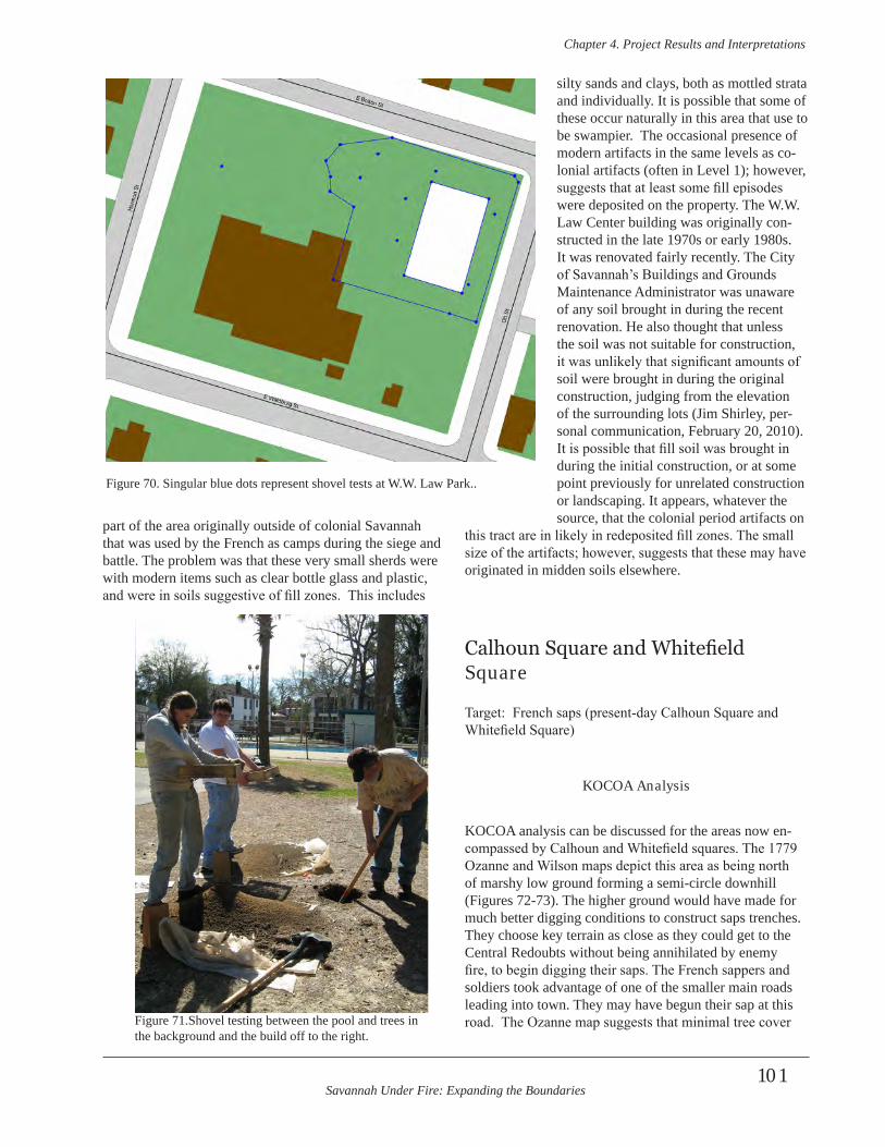
Savannah Under Fire: Expanding the Boundaries
Chapter 4 . Project Results and Interpretations
101
part of the area originally outside of colonial Savannah that was used by the French as camps during the siege and battle. The problem was that these very small sherds were with modern items such as clear bottle glass and plastic, and were in soils suggestive of fill zones. This includes
silty sands and clays, both as mottled strata and individually. It is possible that some of these occur naturally in this area that use to be swampier. The occasional presence of modern artifacts in the same levels as co-lonial artifacts (often in Level 1); however, suggests that at least some fill episodes were deposited on the property. The W.W. Law Center building was originally con-structed in the late 1970s or early 1980s. It was renovated fairly recently. The City of Savannah’s Buildings and Grounds Maintenance Administrator was unaware of any soil brought in during the recent renovation. He also thought that unless the soil was not suitable for construction, it was unlikely that significant amounts of soil were brought in during the original construction, judging from the elevation of the surrounding lots (Jim Shirley, per-sonal communication, February 20, 2010). It is possible that fill soil was brought in during the initial construction, or at some point previously for unrelated construction or landscaping. It appears, whatever the source, that the colonial period artifacts on
this tract are in likely in redeposited fill zones. The small size of the artifacts; however, suggests that these may have originated in midden soils elsewhere.
Calhoun Square and Whitefield Square
Target: French saps (present-day Calhoun Square and Whitefield Square)
KOCOA Analysis
KOCOA analysis can be discussed for the areas now en-compassed by Calhoun and Whitefield squares. The 1779 Ozanne and Wilson maps depict this area as being north of marshy low ground forming a semi-circle downhill (Figures 72-73). The higher ground would have made for much better digging conditions to construct saps trenches. They choose key terrain as close as they could get to the Central Redoubts without being annihilated by enemy fire, to begin digging their saps. The French sappers and soldiers took advantage of one of the smaller main roads leading into town. They may have begun their sap at this road. The Ozanne map suggests that minimal tree cover
Figure 70. Singular blue dots represent shovel tests at W.W. Law Park..
Figure 71.Shovel testing between the pool and trees in the background and the build off to the right.

Savannah Under Fire: Expanding the Boundaries
Chapter 4 . Project Results and Interpretations
102
existed in this area. The Wilson map depicts the tree cover as being predominantly along the eastern side of the saps, next to the marsh. There are fewer trees to the south and virtually none around the rest of the sap. Sappers tried to make their own cover and concealment by digging the saps at angles that would protect them from enfilading fire from the British redoubts and batteries. This fire was the biggest obstacle to the sap offensive prior to the battle and during sorties. The avenue of approach for the sappers was through the ever-encroaching saps and not though the more obvious road leading to town.
Archeological Results and Interpretation
Calhoun Square is bounded on the north by East Taylor Street, on the east by Abercorn Street, on the south by East Gordon Street, and on the west by Abercorn Street (Figure 1). It is located in an area that was south of the original city and southeast of the central redoubts Figure 74 shows the GIS overlay map for Calhoun Square. Whitefield Square is bounded by the same streets to the north and south as Calhoun Square. Whitefield is bordered on the east and west by Habersham Street. The two greenspaces are separated by two city blocks, with Whitefield Square lying east of Calhoun Square. The area that is now Whitefield Square would have been slightly more east-southeast of the central redoubts. Figure 75 is the GIS overlay of one map for Whitefield Square. While the map in this particular overlay depicts the saps as running near
to, but on either side of the greenspace that is Whitefield Square, it was considered near enough to the square to be a target for this project. This is particularly true given the location of one sap adjacent to the northeastern corner of Whitefield Square and the margin of error in the GIS over-lays for the other saps.
The GIS overlay map indicated that the greenspace area now containing Calhoun Square may hold two of the western most French saps. Saps were trenches of ap-proach dug “…under the museketry-fire of the besieged”
Figure 72. The trenches between “A” and “B” are the French saps (Ozanne 1779). North is up on this map.
Figure 73. French saps in the bottom half of map enlargement (Wilson 1779). Image is rotated so that north is up.
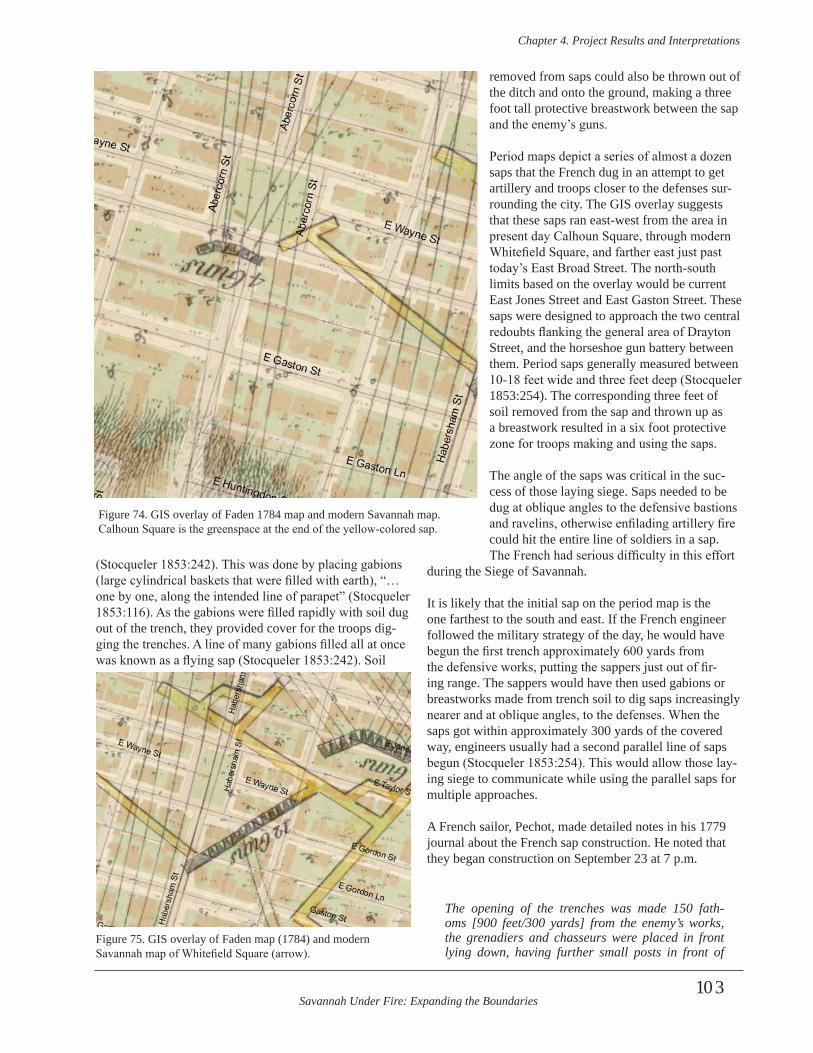
Savannah Under Fire: Expanding the Boundaries
Chapter 4 . Project Results and Interpretations
103
(Stocqueler 1853:242). This was done by placing gabions (large cylindrical baskets that were filled with earth), “…one by one, along the intended line of parapet” (Stocqueler 1853:116). As the gabions were filled rapidly with soil dug out of the trench, they provided cover for the troops dig-ging the trenches. A line of many gabions filled all at once was known as a flying sap (Stocqueler 1853:242). Soil
removed from saps could also be thrown out of the ditch and onto the ground, making a three foot tall protective breastwork between the sap and the enemy’s guns.
Period maps depict a series of almost a dozen saps that the French dug in an attempt to get artillery and troops closer to the defenses sur-rounding the city. The GIS overlay suggests that these saps ran east-west from the area in present day Calhoun Square, through modern Whitefield Square, and farther east just past today’s East Broad Street. The north-south limits based on the overlay would be current East Jones Street and East Gaston Street. These saps were designed to approach the two central redoubts flanking the general area of Drayton Street, and the horseshoe gun battery between them. Period saps generally measured between 10-18 feet wide and three feet deep (Stocqueler 1853:254). The corresponding three feet of soil removed from the sap and thrown up as a breastwork resulted in a six foot protective zone for troops making and using the saps.
The angle of the saps was critical in the suc-cess of those laying siege. Saps needed to be dug at oblique angles to the defensive bastions and ravelins, otherwise enfilading artillery fire could hit the entire line of soldiers in a sap. The French had serious difficulty in this effort
during the Siege of Savannah. It is likely that the initial sap on the period map is the one farthest to the south and east. If the French engineer followed the military strategy of the day, he would have begun the first trench approximately 600 yards from the defensive works, putting the sappers just out of fir-ing range. The sappers would have then used gabions or breastworks made from trench soil to dig saps increasingly nearer and at oblique angles, to the defenses. When the saps got within approximately 300 yards of the covered way, engineers usually had a second parallel line of saps begun (Stocqueler 1853:254). This would allow those lay-ing siege to communicate while using the parallel saps for multiple approaches.
A French sailor, Pechot, made detailed notes in his 1779 journal about the French sap construction. He noted that they began construction on September 23 at 7 p.m.
The opening of the trenches was made 150 fath-oms [900 feet/300 yards] from the enemy’s works, the grenadiers and chasseurs were placed in front lying down, having further small posts in front of
Figure 74. GIS overlay of Faden 1784 map and modern Savannah map. Calhoun Square is the greenspace at the end of the yellow-colored sap.
Figure 75. GIS overlay of Faden map (1784) and modern Savannah map of Whitefield Square (arrow).
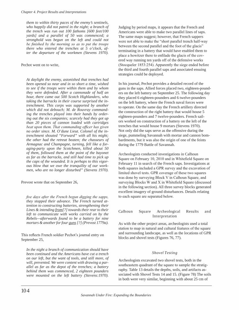
Savannah Under Fire: Expanding the Boundaries
Chapter 4 . Project Results and Interpretations
104
them to within thirty paces of the enemy’s sentinels, who happily did not patrol in the night; a branch of the trench was run out 100 fathoms [600 feet/100 yards] and a parallel of 50 was commenced; a stronghold was begun on the left and could not be finished by the morning so as to put the troops there who entered the trenches at 5 o’clock, af-ter the departure of the workmen (Stevens 1970) .
Pechot went on to write,
At daylight the enemy, astonished that trenches had been opened so near and in so short a time, wished to see if the troops were within them and by whom they were defended . After a cannonade of half an hour, there came out 500 Scotch Highlanders, who taking the barracks in their course surprised the in-trenchment . This corps was supported by another which did not debouch; M . de Rouvray command-ing the trenches played into their hands by order-ing out the six companies; scarcely had they got up than 20 pieces of cannon loaded with cartridges beat upon them. That commanding officer has given no order since . M . O’dune Lieut . Colonel of the in-trenchment shouted “Forward” with all his might; the other had the retreat beaten; the chasseurs of Armagnac and Champagne, turning, fell like a for-aging-party upon the Scotchmen, killed about 50 of them, followed them at the point of the bayonet as far as the barracks, and still had time to pick up the caps of the wounded . It is perhaps to this vigor-ous blow that we owe the tranquility of our work-men, who are no longer disturbed” (Stevens 1970) .
Prevost wrote that on September 26,
five days after the French begun digging the sapps, they stopped their advance . The French turned at-tention to constructing batteries, strengthening their Lines & intending from[?] towards their rear to their left to communicate with works carried on by the Rebels—afterwards found to be a battery for nine mortars & another for four guns [?] (Prevost 1779a) .
This reflects French soldier Pechot’s journal entry on September 25,
In the night a branch of communication should have been continued and the Americans have cut a trench on our left, but the want of tools, and still more, of will, prevented . We were content with drawing a par-allel as far as the depot of the trenches; a battery behind them was commenced, 2 eighteen pounders were mounted on the left battery (Stevens:1970) .
Judging by period maps, it appears that the French and Americans were able to make two parallel lines of saps. The same maps suggest; however, that French sappers were not able to make the “short parallel trench half-way between the second parallel and the foot of the glacis” terminating in a battery that would have enabled them to place a howitzer there to enfilade the glacis of the cov-ered way running ten yards off of the defensive works (Stocqueler 1853:254). Apparently the siege ended before the third and fourth parallel saps and associated ensuing strategies could be deployed.
In his journal, Pechot provides a detailed record of the guns in the saps. Allied forces placed two, eighteen-pound-ers on the left battery on September 25. The following day they placed 6 eighteen-pounders and 6 twelve-pounders on the left battery, where the French naval forces were to operate. On the same day the French artillery directed the construction of the right battery that would house 5 eighteen-pounders and 7 twelve-pounders. French sail-ors worked on construction of a battery on the left of the trenches that would house 9 mortars (Stevens 1970).Not only did the saps serve as the offensive during the siege, pummeling Savannah with mortar and cannon bom-bardments, but it was also the origin of one of the feints during the 1779 Battle of Savannah.
Archeologists conducted investigations in Calhoun Square on February 10, 2010 and in Whitefield Square on February 11 in search of the French saps. Investigations at both squares included a GPR survey and the excavation of limited shovel tests. GPR coverage of these two squares was done by surveying Block V in Calhoun Square, and surveying Blocks W and X in Whitefield Square (discussed in the following section). All three survey blocks generated excellent imagery of ground disturbances. Details relating to each square are separated below.
Calhoun Square Archeological Results and Interpretation
As with the other project areas, archeologists used a total station to map in natural and cultural features of the square and surrounding landscape, as well as the locations of GPR blocks and shovel tests (Figures 76, 77).
Shovel Testing
Archeologists excavated two shovel tests, both in the southeastern quadrant of the square to sample the stratig-raphy. Table 13 details the depths, soils, and artifacts as-sociated with Shovel Tests 14 and 15. (Figure 78) The soils in both were very similar, beginning with about 25 cm of
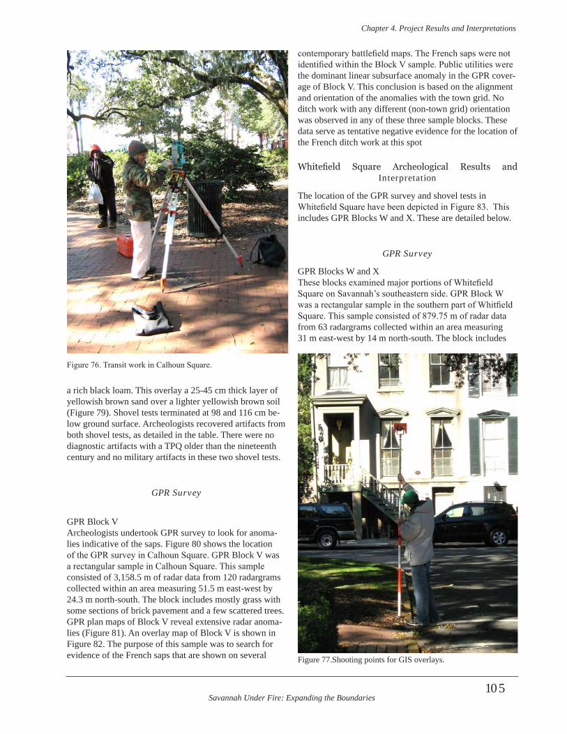
Savannah Under Fire: Expanding the Boundaries
Chapter 4 . Project Results and Interpretations
105
a rich black loam. This overlay a 25-45 cm thick layer of yellowish brown sand over a lighter yellowish brown soil (Figure 79). Shovel tests terminated at 98 and 116 cm be-low ground surface. Archeologists recovered artifacts from both shovel tests, as detailed in the table. There were no diagnostic artifacts with a TPQ older than the nineteenth century and no military artifacts in these two shovel tests.
GPR Survey
GPR Block V Archeologists undertook GPR survey to look for anoma-lies indicative of the saps. Figure 80 shows the location of the GPR survey in Calhoun Square. GPR Block V was a rectangular sample in Calhoun Square. This sample consisted of 3,158.5 m of radar data from 120 radargrams collected within an area measuring 51.5 m east-west by 24.3 m north-south. The block includes mostly grass with some sections of brick pavement and a few scattered trees. GPR plan maps of Block V reveal extensive radar anoma-lies (Figure 81). An overlay map of Block V is shown in Figure 82. The purpose of this sample was to search for evidence of the French saps that are shown on several
contemporary battlefield maps. The French saps were not identified within the Block V sample. Public utilities were the dominant linear subsurface anomaly in the GPR cover-age of Block V. This conclusion is based on the alignment and orientation of the anomalies with the town grid. No ditch work with any different (non-town grid) orientation was observed in any of these three sample blocks. These data serve as tentative negative evidence for the location of the French ditch work at this spot
Whitefield Square Archeological Results and Interpretation
The location of the GPR survey and shovel tests in Whitefield Square have been depicted in Figure 83. This includes GPR Blocks W and X. These are detailed below.
GPR Survey
GPR Blocks W and XThese blocks examined major portions of Whitefield Square on Savannah’s southeastern side. GPR Block W was a rectangular sample in the southern part of Whitfield Square. This sample consisted of 879.75 m of radar data from 63 radargrams collected within an area measuring 31 m east-west by 14 m north-south. The block includes
Figure 76. Transit work in Calhoun Square.
Figure 77.Shooting points for GIS overlays.
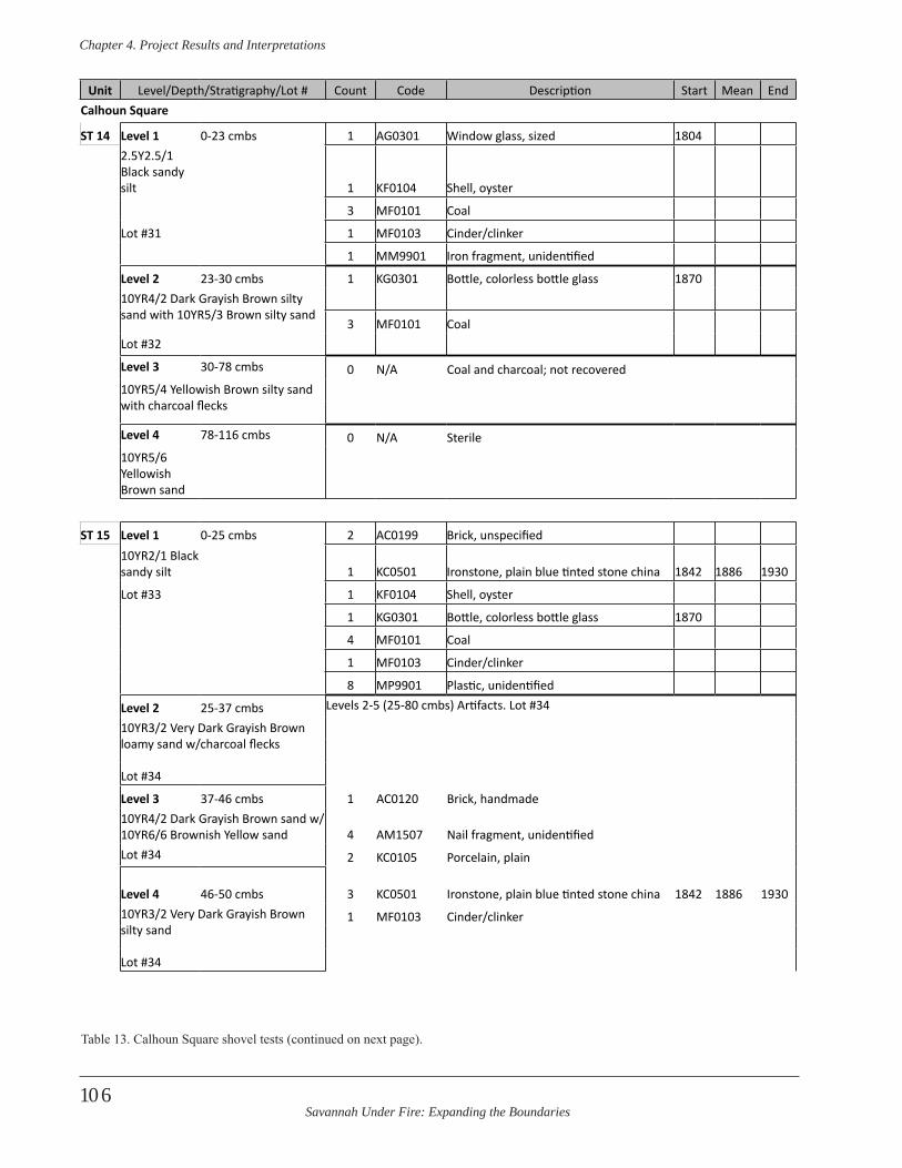
Savannah Under Fire: Expanding the Boundaries
Chapter 4 . Project Results and Interpretations
106
Unit Level/Depth/Stratigraphy/Lot # Count Code Description Start Mean EndCalhoun Square
ST 14 Level 1 0-23 cmbs 1 AG0301 Window glass, sized 18042.5Y2.5/1 Black sandy silt 1 KF0104 Shell, oyster
3 MF0101 Coal
Lot #31 1 MF0103 Cinder/clinker
1 MM9901 Iron fragment, unidentified
Level 2 23-30 cmbs 1 KG0301 Bottle, colorless bottle glass 187010YR4/2 Dark Grayish Brown silty sand with 10YR5/3 Brown silty sand
3 MF0101 CoalLot #32
Level 3 30-78 cmbs 0 N/A Coal and charcoal; not recovered10YR5/4 Yellowish Brown silty sand with charcoal flecks
Level 4 78-116 cmbs 0 N/A Sterile10YR5/6 Yellowish Brown sand
ST 15 Level 1 0-25 cmbs 2 AC0199 Brick, unspecified10YR2/1 Black sandy silt 1 KC0501 Ironstone, plain blue tinted stone china 1842 1886 1930
Lot #33 1 KF0104 Shell, oyster
1 KG0301 Bottle, colorless bottle glass 1870
4 MF0101 Coal
1 MF0103 Cinder/clinker
8 MP9901 Plastic, unidentified
Level 2 25-37 cmbs Levels 2-5 (25-80 cmbs) Artifacts. Lot #34
10YR3/2 Very Dark Grayish Brown loamy sand w/charcoal flecks
Lot #34
Level 3 37-46 cmbs 1 AC0120 Brick, handmade10YR4/2 Dark Grayish Brown sand w/ 10YR6/6 Brownish Yellow sand 4 AM1507 Nail fragment, unidentifiedLot #34 2 KC0105 Porcelain, plain
Level 4 46-50 cmbs 3 KC0501 Ironstone, plain blue tinted stone china 1842 1886 193010YR3/2 Very Dark Grayish Brown silty sand
1 MF0103 Cinder/clinker
Lot #34
Table 13. Calhoun Square shovel tests (continued on next page).
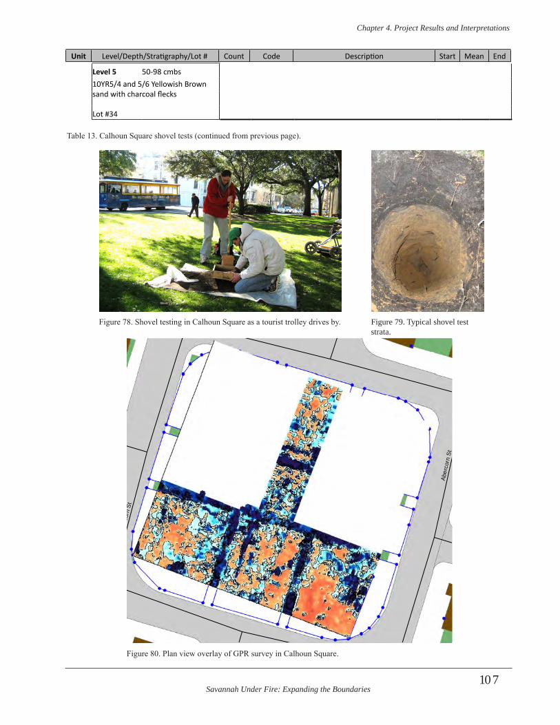
Savannah Under Fire: Expanding the Boundaries
Chapter 4 . Project Results and Interpretations
107
Level 5 50-98 cmbs10YR5/4 and 5/6 Yellowish Brown sand with charcoal flecks
Lot #34
Table 13. Calhoun Square shovel tests (continued from previous page).
Unit Level/Depth/Stratigraphy/Lot # Count Code Description Start Mean End
E Taylor St
E Gordon St
Aber
corn
St
E Wayne St
E Jones Ln
Dra
yton
St
Aber
corn
St
Aber
corn
St
Aber
corn
St
E Wayne St
Figure 78. Shovel testing in Calhoun Square as a tourist trolley drives by. Figure 79. Typical shovel test strata.
Figure 80. Plan view overlay of GPR survey in Calhoun Square.
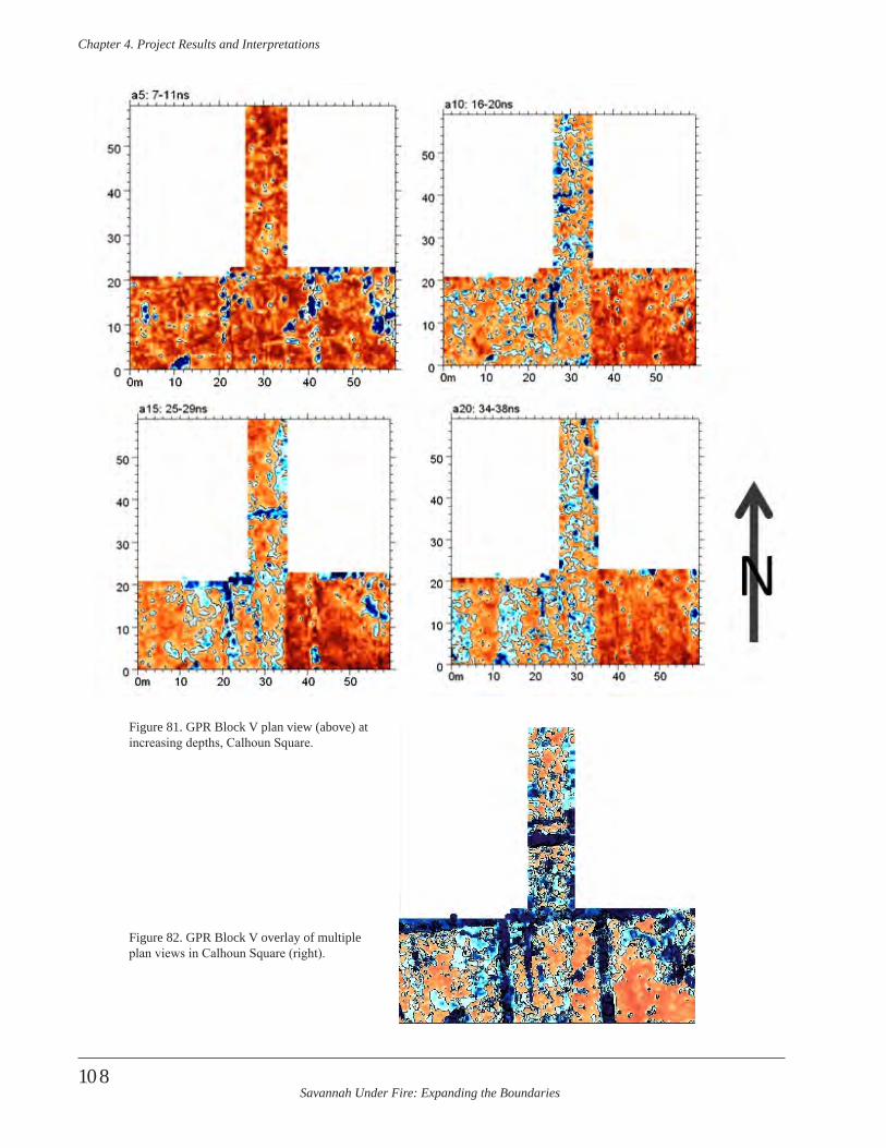
Savannah Under Fire: Expanding the Boundaries
Chapter 4 . Project Results and Interpretations
108
Figure 81. GPR Block V plan view (above) at increasing depths, Calhoun Square.
Figure 82. GPR Block V overlay of multiple plan views in Calhoun Square (right).
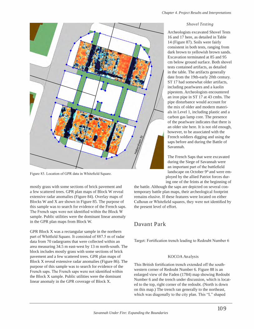
Savannah Under Fire: Expanding the Boundaries
Chapter 4 . Project Results and Interpretations
109
mostly grass with some sections of brick pavement and a few scattered trees. GPR plan maps of Block W reveal extensive radar anomalies (Figure 84). Overlay maps of Blocks W and X are shown in Figure 85. The purpose of this sample was to search for evidence of the French saps. The French saps were not identified within the Block W sample. Public utilities were the dominant linear anomaly in the GPR plan maps from Block W.
GPR Block X was a rectangular sample in the northern part of Whitfield Square. It consisted of 887.5 m of radar data from 70 radargrams that were collected within an area measuring 34.5 m east-west by 13 m north-south. The block includes mostly grass with some sections of brick pavement and a few scattered trees. GPR plan maps of Block X reveal extensive radar anomalies (Figure 86). The purpose of this sample was to search for evidence of the French saps. The French saps were not identified within the Block X sample. Public utilities were the dominant linear anomaly in the GPR coverage of Block X.
Shovel Testing
Archeologists excavated Shovel Tests 16 and 17 here, as detailed in Table 14 (Figure 87). Soils were fairly consistent in both tests, ranging from dark brown to yellowish brown sands. Excavation terminated at 85 and 95 cm below ground surface. Both shovel tests contained artifacts, as detailed in the table. The artifacts generally date from the 19th-early 20th century. ST 17 had somewhat older artifacts, including pearlwares and a kaolin pipestem. Archeologists encountered an iron pipe in ST 17 at 43 cmbs. The pipe disturbance would account for the mix of older and modern materi-als in Level 1, including plastic and a carbon gas lamp core. The presence of the pearlware indicates that there is an older site here. It is not old enough, however, to be associated with the French soldiers digging and using the saps before and during the Battle of Savannah.
The French Saps that were excavated during the Siege of Savannah were an important part of the battlefield landscape on October 9th and were em-
ployed by the allied Patriot forces dur-ing one of the feints at the beginning of
the battle. Although the saps are depicted on several con-temporary battle plan maps, their archeological footprint remains elusive. If these features were located on either Calhoun or Whitefield squares, they were not identified by the present level of effort.
Davant Park
Target: Fortification trench leading to Redoubt Number 6
KOCOA Analysis
This British fortification trench extended off the south-western corner of Redoubt Number 6. Figure 88 is an enlarged view of the Faden (1784) map showing Redoubt Number 6 and the trench under discussion, which is locat-ed to the top, right corner of the redoubt. (North is down on this map.) The trench ran generally to the northeast, which was diagonally to the city plan. This “L” shaped
E Gordon St
E Taylor St
E Wayne St
Pric
e St
Hab
ersh
am S
t
Linc
oln
St
Hab
ersh
am S
t
E Wayne St
Hab
ersh
am S
t
Figure 83. Location of GPR data in Whitefield Square.
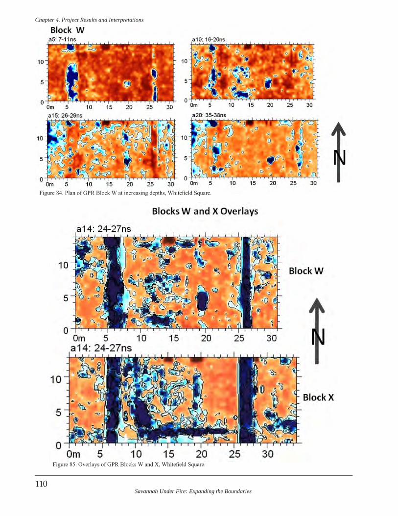
Savannah Under Fire: Expanding the Boundaries
Chapter 4 . Project Results and Interpretations
110
Figure 84. Plan of GPR Block W at increasing depths, Whitefield Square.
Figure 85. Overlays of GPR Blocks W and X, Whitefield Square.
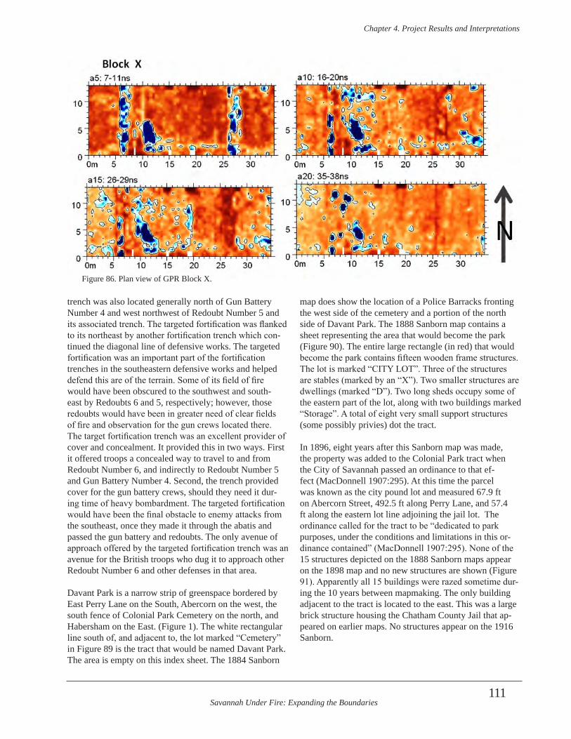
Savannah Under Fire: Expanding the Boundaries
Chapter 4 . Project Results and Interpretations
111
trench was also located generally north of Gun Battery Number 4 and west northwest of Redoubt Number 5 and its associated trench. The targeted fortification was flanked to its northeast by another fortification trench which con-tinued the diagonal line of defensive works. The targeted fortification was an important part of the fortification trenches in the southeastern defensive works and helped defend this are of the terrain. Some of its field of fire would have been obscured to the southwest and south-east by Redoubts 6 and 5, respectively; however, those redoubts would have been in greater need of clear fields of fire and observation for the gun crews located there. The target fortification trench was an excellent provider of cover and concealment. It provided this in two ways. First it offered troops a concealed way to travel to and from Redoubt Number 6, and indirectly to Redoubt Number 5 and Gun Battery Number 4. Second, the trench provided cover for the gun battery crews, should they need it dur-ing time of heavy bombardment. The targeted fortification would have been the final obstacle to enemy attacks from the southeast, once they made it through the abatis and passed the gun battery and redoubts. The only avenue of approach offered by the targeted fortification trench was an avenue for the British troops who dug it to approach other Redoubt Number 6 and other defenses in that area.
Davant Park is a narrow strip of greenspace bordered by East Perry Lane on the South, Abercorn on the west, the south fence of Colonial Park Cemetery on the north, and Habersham on the East. (Figure 1). The white rectangular line south of, and adjacent to, the lot marked “Cemetery” in Figure 89 is the tract that would be named Davant Park. The area is empty on this index sheet. The 1884 Sanborn
map does show the location of a Police Barracks fronting the west side of the cemetery and a portion of the north side of Davant Park. The 1888 Sanborn map contains a sheet representing the area that would become the park (Figure 90). The entire large rectangle (in red) that would become the park contains fifteen wooden frame structures. The lot is marked “CITY LOT”. Three of the structures are stables (marked by an “X”). Two smaller structures are dwellings (marked “D”). Two long sheds occupy some of the eastern part of the lot, along with two buildings marked “Storage”. A total of eight very small support structures (some possibly privies) dot the tract.
In 1896, eight years after this Sanborn map was made, the property was added to the Colonial Park tract when the City of Savannah passed an ordinance to that ef-fect (MacDonnell 1907:295). At this time the parcel was known as the city pound lot and measured 67.9 ft on Abercorn Street, 492.5 ft along Perry Lane, and 57.4 ft along the eastern lot line adjoining the jail lot. The ordinance called for the tract to be “dedicated to park purposes, under the conditions and limitations in this or-dinance contained” (MacDonnell 1907:295). None of the 15 structures depicted on the 1888 Sanborn maps appear on the 1898 map and no new structures are shown (Figure 91). Apparently all 15 buildings were razed sometime dur-ing the 10 years between mapmaking. The only building adjacent to the tract is located to the east. This was a large brick structure housing the Chatham County Jail that ap-peared on earlier maps. No structures appear on the 1916 Sanborn.
Figure 86. Plan view of GPR Block X.
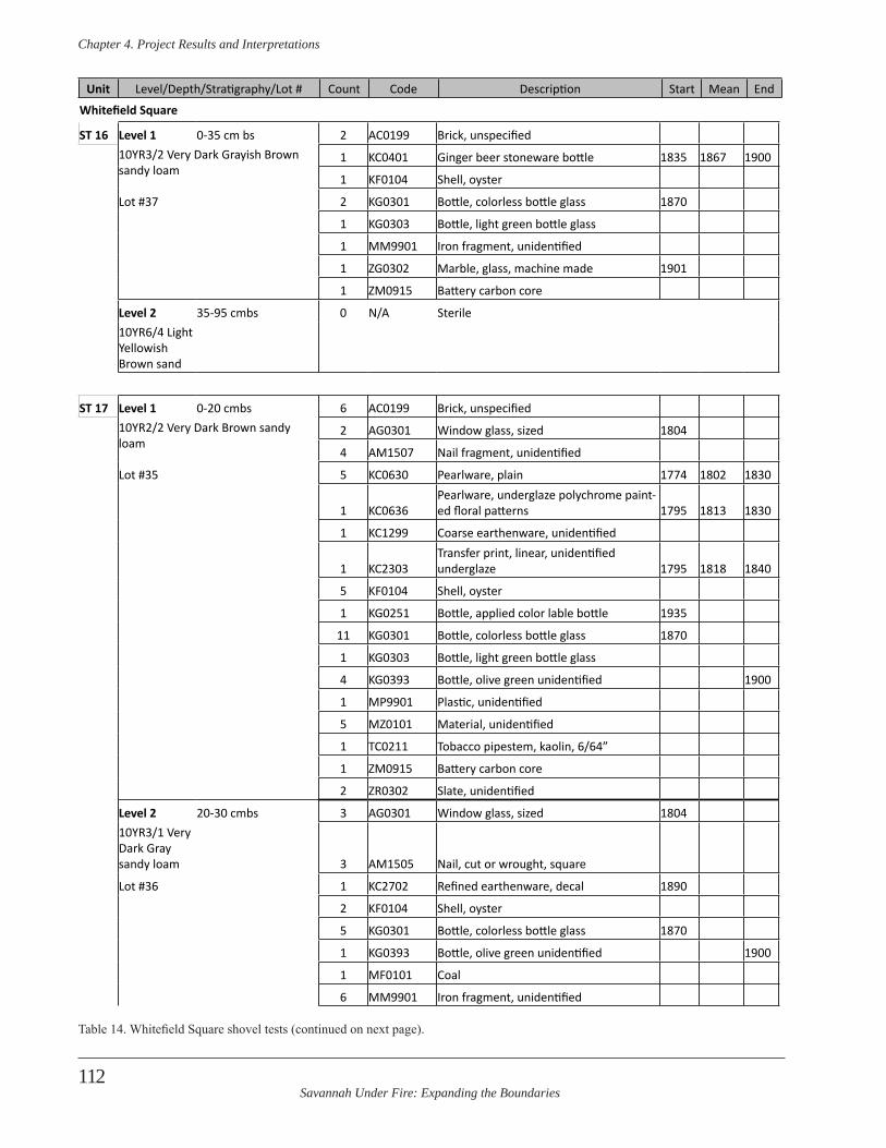
Savannah Under Fire: Expanding the Boundaries
Chapter 4 . Project Results and Interpretations
112
Whitefield Square
ST 16 Level 1 0-35 cm bs 2 AC0199 Brick, unspecified10YR3/2 Very Dark Grayish Brown sandy loam
1 KC0401 Ginger beer stoneware bottle 1835 1867 1900
1 KF0104 Shell, oyster
Lot #37 2 KG0301 Bottle, colorless bottle glass 1870
1 KG0303 Bottle, light green bottle glass
1 MM9901 Iron fragment, unidentified
1 ZG0302 Marble, glass, machine made 1901
1 ZM0915 Battery carbon core
Level 2 35-95 cmbs 0 N/A Sterile10YR6/4 Light Yellowish Brown sand
ST 17 Level 1 0-20 cmbs 6 AC0199 Brick, unspecified10YR2/2 Very Dark Brown sandy loam
2 AG0301 Window glass, sized 1804
4 AM1507 Nail fragment, unidentified
Lot #35 5 KC0630 Pearlware, plain 1774 1802 1830
1 KC0636Pearlware, underglaze polychrome paint-ed floral patterns 1795 1813 1830
1 KC1299 Coarse earthenware, unidentified
1 KC2303Transfer print, linear, unidentified underglaze 1795 1818 1840
5 KF0104 Shell, oyster
1 KG0251 Bottle, applied color lable bottle 1935
11 KG0301 Bottle, colorless bottle glass 1870
1 KG0303 Bottle, light green bottle glass
4 KG0393 Bottle, olive green unidentified 1900
1 MP9901 Plastic, unidentified
5 MZ0101 Material, unidentified
1 TC0211 Tobacco pipestem, kaolin, 6/64”
1 ZM0915 Battery carbon core
2 ZR0302 Slate, unidentified
Level 2 20-30 cmbs 3 AG0301 Window glass, sized 180410YR3/1 Very Dark Gray sandy loam 3 AM1505 Nail, cut or wrought, square
Lot #36 1 KC2702 Refined earthenware, decal 1890
2 KF0104 Shell, oyster
5 KG0301 Bottle, colorless bottle glass 1870
1 KG0393 Bottle, olive green unidentified 1900
1 MF0101 Coal
6 MM9901 Iron fragment, unidentified
Unit Level/Depth/Stratigraphy/Lot # Count Code Description Start Mean End
Table 14. Whitefield Square shovel tests (continued on next page).

Savannah Under Fire: Expanding the Boundaries
Chapter 4 . Project Results and Interpretations
113
4 MZ0101 Material, unidentified
1 ZR0302 Slate, unidentified
Level 3 30-59 cmbs 0 N/A Coal and charcoal; not recovered10YR5/4 Yellowish Brown sand
Level 4 59-85 cmbs 0 N/A Sterile10YR5/6 Yellowish Brown sand
Unit Level/Depth/Stratigraphy/Lot # Count Code Description Start Mean End
Table 14. Whitefield Square shovel tests (continued from previous page).
Figure 88. The “dog-leg” trench between redoubts 6 and 7 (Faden 1784)
Figure 87. Shovel testing in Whitefield Square.
Area to becomeDavant Park
Figure 89. This 1884 Sanborn map shows a vacant lot adjacent to Colonial Park.
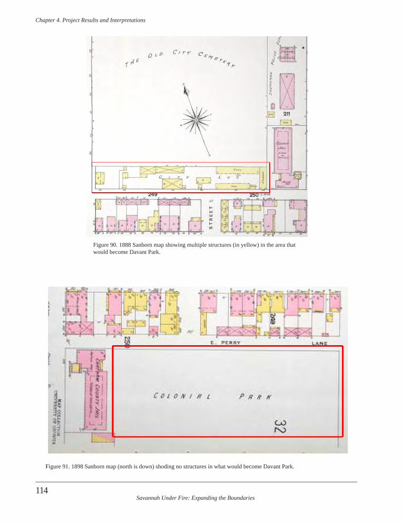
Savannah Under Fire: Expanding the Boundaries
Chapter 4 . Project Results and Interpretations
114
Figure 91. 1898 Sanborn map (north is down) shoding no structures in what would become Davant Park.
Figure 90. 1888 Sanborn map showing multiple structures (in yellow) in the area that would become Davant Park.

Savannah Under Fire: Expanding the Boundaries
Chapter 4 . Project Results and Interpretations
115
It wasn’t until 1915 that the park was named Davant Park in honor of Richard J. Davant, who was a former two-term mayor of Savannah. Davant was born in 1866 and died during his second term in office on October 9, 1915 (City of Savannah 2010). Today, the eastern side of the park contains a small playground with swings and slides. The western side of the park once was a basketball court and the pavement from it remains. Between the playground and former basketball court is an area of grass that was the focus of our investigations.
Archeological Results and Interpretation
During the first NPS ABPP project in 2008, archeolo-gists discovered a large buried anomaly running through Colonial Park Cemetery and into the Davant Park greens-pace south of the cemetery. This anomaly was discovered during a GPR survey of the southeastern quadrant of the cemetery (GPR Block L) and the grassy portion of Davant Park (GPR Block M). Both GPR Blocks L and M revealed a long, linear anomaly aligned on a diagonal, northeast-southwest course. This feature extended for at least 78 m (completely across both GPR blocks) and varied in width from 10-25 m. The anomaly has the same alignment in the same general location as fortifications on the historic battle maps. Figure 92 shows the GIS overlay of a historic map on the modern Savannah map, along with an outline of the location of the two GPR blocks. The interior black line in the GPR blocks shows the alignment of the anomalies. Figure 93 is a plan view of the GPR anomalies identified in the 2008 season, with north towards the top of the page. Note the anomaly in the northwestern corner (red) and the
one I the eastern half of the block that rends northeast-southwest. This GPR anomaly shares many attributes with the deep fortification trench that was located in Madison Square, which was targeted for “ground truthing” by the 2010 survey team. Details about this work are found in Elliott and Elliott (2009).
The Davant Park area was revisited during the second NPS ABPP grant in order to investigate this anomaly and at-tempt to verify, through minimal excavation, if it was one of the Battle of Savannah fortification trenches. Since the anomaly in Block L fell within the cemetery, archeolo-gists focused on excavating a test unit within Block M in Davant Park, outside the cemetery wall. The GPR survey suggested that this greenspace was devoid of burials and the area was accessible for archeological excavation.
Test Unit 1
Archeologists excavated Test Unit 1 in the northeastern section of the GPR block, hoping to catch part the intersec-tion of the anomaly in the cemetery block (GPR Block L) with the anomaly in the Davant Park block (GPR Block M) (Figure 94). This test unit measured 2 m east-west by 1 m north-south. All soils were sifted through 0.25 inch hardware mesh. Brick fragments in this unit were gener-ally handmade.
Level 1 of Test Unit 1 was an arbitrary 10 cm level extend-ing from 7-11 cmbd at the top to 18-20 cmbd at the base. The soils were a dark gray (10YR4/1) sandy loam humus
topsoil and some gravel directly beneath the sod. It was extremely compact. Artifact density was low, totaling only 13 in this level. Artifacts included nails, whiteware, and bottle glass, along with a piece of slate and a 1992 dime (Table 15). The terminus post quem (TPQ) for this level was the 1992 dime, followed by the 1865 wire nail date.
Level 2 began as an arbitrary 10 cm level of dark grayish brown (10YR4/2) silty sand. The level was terminated at a natural break in the soil when it changed to a brownish yellow (10YR6/6) coarse sand mottled with dark gray (10YR4/1) coarse sand and specks of yellowish brown (10YR5/8) coarse sand. Level 2 began at 18-20 cmbd and extended to between 26-31 cmbd. Only a 35 cm wide area of dark grayish brown (10YR4/2) silty sandy soil remained in the base of the unit, and it ran along the north wall from the center to the northeastern corner. Artifacts identified but not recovered included oyster shell, granite gravel, a copper rim-fired
Figure 92. GIS overlay of Faden (1784) map and modern Savannah map. The greenspace is Colonial Cemetery. The black outlines are boundaries of the two GPR survey blocks, L and M. The smaller block is located in Davant Park.
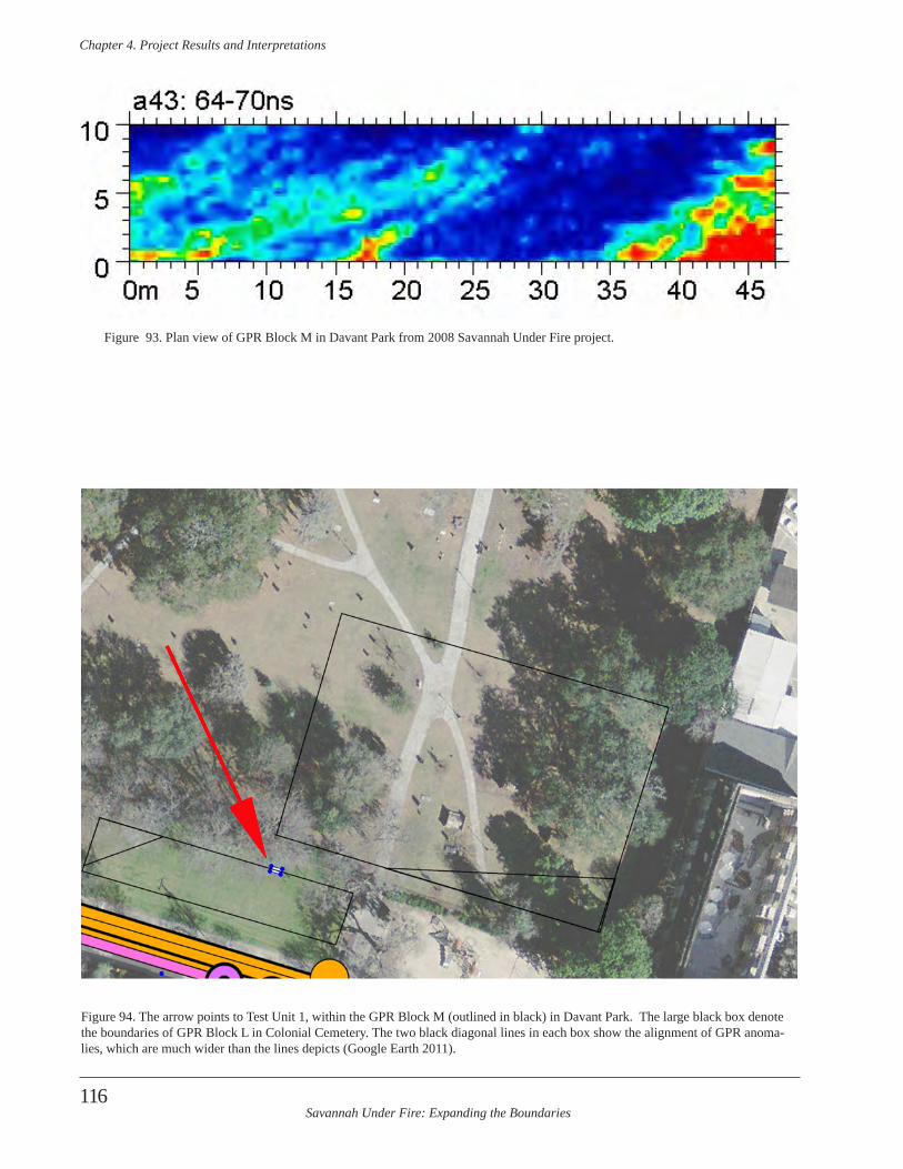
Savannah Under Fire: Expanding the Boundaries
Chapter 4 . Project Results and Interpretations
116
Figure 93. Plan view of GPR Block M in Davant Park from 2008 Savannah Under Fire project.
Figure 94. The arrow points to Test Unit 1, within the GPR Block M (outlined in black) in Davant Park. The large black box denote the boundaries of GPR Block L in Colonial Cemetery. The two black diagonal lines in each box show the alignment of GPR anoma-lies, which are much wider than the lines depicts (Google Earth 2011).
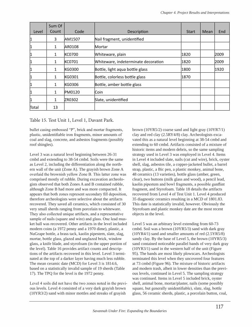
Savannah Under Fire: Expanding the Boundaries
Chapter 4 . Project Results and Interpretations
117
bullet casing embossed “P”, brick and mortar fragments, plastic, unidentifiable iron fragments, minor amounts of coal and slag, concrete, and asbestos fragments (possibly roof shingles).
Level 3 was a natural level beginning between 26-31 cmbd and extending to 38-54 cmbd. Soils were the same as Level 2, including the differentiation along the north-ern wall of the unit (Zone A). The grayish brown Zone A overlaid the brownish yellow Zone B. This latter zone was comprised mostly of rubble. During excavation archeolo-gists observed that both Zones A and B contained rubble, although Zone B had more and was more compacted. It appears that both zones represent secondary fill deposition, therefore archeologists were selective about the artifacts recovered. They saved all ceramics, which consisted of 30 very small sherds ranging from porcelain to whiteware. They also collected unique artifacts, and a representative sample of nails (square and wire) and glass. One lead mus-ket ball was recovered. Other artifacts in the level included modern coins (a 1972 penny and a 1970 dime), plastic, a NuGrape bottle, a brass tack, kaolin pipestem, slate, slag, mortar, bottle glass, glazed and unglazed brick, window glass, a knife blade, and styrofoam (in the upper portion of the level). Table 16 provides artifact counts and descrip-tions of the artifacts recovered in this level. Level 3 termi-nated at the top of a darker layer having much less rubble. The mean ceramic date (MCD) for Level 3 is 1814.6, based on a statistically invalid sample of 19 sherds (Table 17). The TPQ for the level is the 1972 penny.
Level 4 soils did not have the two zones noted in the previ-ous levels. Level 4 consisted of a very dark grayish brown (10YR3/2) sand with minor mottles and streaks of grayish
brown (10YR5/2) coarse sand and light gray (10YR7/1) clay and red clay (2.5RY4/8) clay. Archeologists exca-vated this as a natural level beginning at 38-54 cmbd and extending to 60 cmbd. Artifacts consisted of a mixture of historic items and modern debris, so the same sampling strategy used in Level 3 was employed in Level 4. Items in Level 4 included slate, nails (cut and wire), brick, oyster shell, slag, asbestos tile, a copper-jacketed bullet, a barrel strap, plastic, a Bic pen, a plastic monkey, animal bone, 48 ceramics (13 varieties), bottle glass (amber, green, clear), two buttons (milk glass and wood), a pencil lead, kaolin pipestem and bowl fragments, a possible gunflint fragment, and Styrofoam. Table 18 details the artifacts recovered from Level 4 of Test Unit 1. Level 4 produced 35 diagnostic ceramics resulting in a MCD of 1801.83. This date is statistically invalid, however. Obviously the Styrofoam and plastic monkey date are the most recent objects in the level.
Level 5 was an arbitrary level extending from 60-73 cmbd. Soil was a brown (10YR5/3) sand with dark gray (10YR4/1) sand and smaller amounts of red (2.5YR5/8) sandy clay. By the base of Level 5, the brown (10YR5/3) sand contained noticeable parallel bands of very dark gray (10YR3/1) sand in the western half of the unit (Figure 95). The bands are most likely plowscars. Archeologists terminated this level when they uncovered four features at 73 cmbd (Figure 96). The mixture of historic artifacts and modern trash, albeit in lower densities than the previ-ous levels, continued in Level 5. The sampling strategy was continued. Items in Level 5 included brick, oyster shell, animal bone, mortar/plaster, nails (some possibly square, but generally unidentifiable), slate, slag, bottle glass, 56 ceramic sherds, plastic, a porcelain button, coal,
LevelSum Of Count Code Description Start Mean End
1 3 AM1507 Nail fragment, unidentified
1 1 AR0108 Mortar
1 1 KC0700 Whiteware, plain 1820 2009
1 1 KC0701 Whiteware, indeterminate decoration 1820 2009
1 1 KG0300 Bottle, light aqua bottle glass 1800 1920
1 1 KG0301 Bottle, colorless bottle glass 1870
1 1 KG0306 Bottle, amber bottle glass
1 1 PM0120 Coin
1 1 ZR0302 Slate, unidentified
Total 13
Table 15. Test Unit 1, Level 1, Davant Park.

Savannah Under Fire: Expanding the Boundaries
Chapter 4 . Project Results and Interpretations
118
3 2 AC0120 Brick, handmade
3 1 AG0301 Window glass, sized 1804
3 1 AM1101 Nail, wire common 1890 2009
3 2 AM1505 Nail, cut or wrought, square
3 4 AM1507 Nail fragment, unidentified
3 1 AM1511 Tack
3 1 KC0102 Porcelain, blue underglaze h.p.
3 4 KC0105 Porcelain, plain
3 1 KC0399 Stoneware, unidentified3 9 KC0501 Ironstone, plain blue tinted stone china 1842 1886 1930
3 1 KC0502 Ironstone, blue tinted stone china, decorated 1815 1822 18303 1 KC0630 Pearlware, plain 1774 1802 18303 4 KC0631 Pearlware, unidentified decorated 1774 1802 1830
3 1 KC0700 Whiteware, plain 1820 2009
3 1 KC0712 Edgeware, scalloped, unimpressed
3 1 KC1299 Coarse earthenware, unidentified
3 1 KC2202 Whiteware, hand painted 1820 20093 2 KC2303 Transfer print, linear, unidentified underglaze 1795 1818 18403 1 KC2307 Transfer print, stippled, blue underglaze 1795 1818 1840
3 1 KC2800 Yellowware, decorated 1830 19403 1 KC2801 Yellowware, plain 1830 1885 1940
3 1 KF0101 Bone, unidentified
3 1 KF0104 Shell, oyster
3 1 KF0105 Shell, clam
3 1 KG0251 Bottle, applied color lable bottle 19353 1 KG0253 Bottle, applied finish 1800 1842 1885
3 4 KG0300 Bottle, light aqua bottle glass 1800 1920
3 1 KG0301 Bottle, colorless bottle glass 1870
3 2 KG0303 Bottle, light green bottle glass
3 1 KG0304 Bottle, aqua bottle glass 1800 1920
3 3 KG0305 Bottle, cobalt blue bottle glass
3 1 KG0306 Bottle, amber bottle glass
3 7 KG0393 Bottle, olive green unidentified 1900
3 1 KM0304 Beer/Soda pull tab 1962
3 3 MM9901 Iron fragment, unidentified
Table 16. Test Unit 1, Level 3, Davant Park, Artifacts (continued on following page).
LevelSum Of Count Code Description Start Mean End
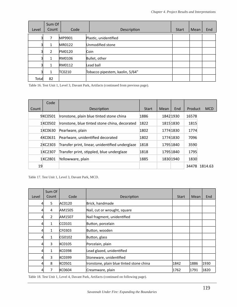
Savannah Under Fire: Expanding the Boundaries
Chapter 4 . Project Results and Interpretations
119
3 7 MP9901 Plastic, unidentified
3 1 MR0122 Unmodified stone
3 2 PM0120 Coin
3 1 RM0106 Bullet, other
3 1 RM0112 Lead ball
3 1 TC0210 Tobacco pipestem, kaolin, 5/64”
Total 82
LevelSum Of Count Code Description Start Mean End
Table 16. Test Unit 1, Level 3, Davant Park, Artifacts (continued from previous page).
CountCode
Description Start Mean End Product MCD
9KC0501 Ironstone, plain blue tinted stone china 1886 18421930 16578
1KC0502 Ironstone, blue tinted stone china, decorated 1822 18151830 1815
1KC0630 Pearlware, plain 1802 17741830 1774
4KC0631 Pearlware, unidentified decorated 1802 17741830 7096
2KC2303 Transfer print, linear, unidentified underglaze 1818 17951840 3590
1KC2307 Transfer print, stippled, blue underglaze 1818 17951840 1795
1KC2801 Yellowware, plain 1885 18301940 1830
19 34478 1814.63
Table 17. Test Unit 1, Level 3, Davant Park, MCD.
LevelSum Of Count Code Description Start Mean End
4 5 AC0120 Brick, handmade
4 4 AM1505 Nail, cut or wrought, square
4 2 AM1507 Nail fragment, unidentified
4 1 CC0101 Button, porcelain
4 1 CF0303 Button, wooden
4 1 CG0102 Button, glass
4 3 KC0105 Porcelain, plain
4 1 KC0398 Lead glazed, unidentified
4 3 KC0399 Stoneware, unidentified4 8 KC0501 Ironstone, plain blue tinted stone china 1842 1886 1930
4 7 KC0604 Creamware, plain 1762 1791 1820
Table 18. Test Unit 1, Level 4, Davant Park, Artifacts (continued on following page).
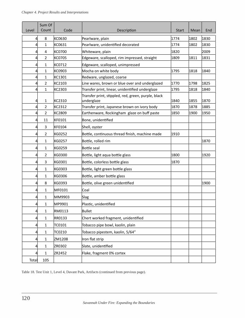
Savannah Under Fire: Expanding the Boundaries
Chapter 4 . Project Results and Interpretations
120
4 8 KC0630 Pearlware, plain 1774 1802 18304 1 KC0631 Pearlware, unidentified decorated 1774 1802 1830
4 4 KC0700 Whiteware, plain 1820 20094 2 KC0705 Edgeware, scalloped, rim impressed, straight 1809 1811 1831
4 1 KC0712 Edgeware, scalloped, unimpressed 4 1 KC0903 Mocha on white body 1795 1818 18404 1 KC1301 Redware, unglazed, coarse4 2 KC2103 Line wares, brown or blue over and underglazed 1770 1798 18254 1 KC2303 Transfer print, linear, unidentified underglaze 1795 1818 1840
4 1 KC2310Transfer print, stippled, red, green, purple, black underglaze 1840 1855 1870
4 2 KC2312 Transfer print, Japanese brown on ivory body 1870 1878 18854 2 KC2809 Earthenware, Rockingham glaze on buff paste 1850 1900 1950
4 11 KF0101 Bone, unidentified
4 3 KF0104 Shell, oyster
4 2 KG0252 Bottle, continuous thread finish, machine made 1910
4 1 KG0257 Bottle, rolled rim 1870
4 1 KG0259 Bottle seal
4 2 KG0300 Bottle, light aqua bottle glass 1800 1920
4 3 KG0301 Bottle, colorless bottle glass 1870
4 1 KG0303 Bottle, light green bottle glass
4 1 KG0306 Bottle, amber bottle glass
4 8 KG0393 Bottle, olive green unidentified 1900
4 1 MF0101 Coal
4 1 MM9903 Slag
4 1 MP9901 Plastic, unidentified
4 1 RM0113 Bullet
4 1 RR0133 Chert worked fragment, unidentified
4 1 TC0101 Tobacco pipe bowl, kaolin, plain
4 1 TC0210 Tobacco pipestem, kaolin, 5/64”
4 1 ZM1208 Iron flat strip
4 1 ZR0302 Slate, unidentified
4 1 ZR2452 Flake, fragment 0% cortex
Total 105
Table 18. Test Unit 1, Level 4, Davant Park, Artifacts (continued from previous page).
LevelSum Of Count Code Description Start Mean End

Savannah Under Fire: Expanding the Boundaries
Chapter 4 . Project Results and Interpretations
121
Davant ParkTest Unit 1Planview at base of Level 573 cm below datum
0 cm 25 cm
AA
BC
D
EE
F
A. Feature 1- 10YR 4/2 dark grayish brown sandB. Feature 2- 10YR 4/2 dark grayish brown sand mottled with 2.5YR 5/8 red clay and brick rubbleC. 10YR 5/2 grayish brown sandD. Feature 3- 10YR 3/1 very dark gray sand with oyster shell and brick rubbleE. Feature 4- 10YR 3/1 very dark gray sand with oyster shell and brick rubbleF. Matrix- 10YR 5/3 brown snd with linear stains of 10YR 3/1 very dark gray sand (possible plowscars)
iron pipe
Figure 96. Test Unit 1, Plan View, Base of Level 5.
Figure 95. Test Unit 1, Base of Level 5 (right). Note the striations in the soil in the western half of the unit. The center and eastern half contains stains from fea-tures. An iron pip runs along the north-ern wall of the unit. Several fill zones are visible in the western wall above this pipe and below the grass.
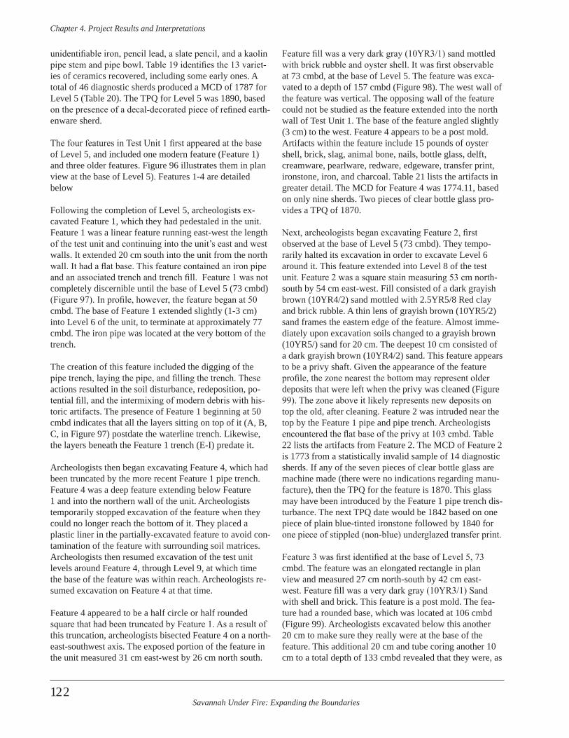
Savannah Under Fire: Expanding the Boundaries
Chapter 4 . Project Results and Interpretations
122
unidentifiable iron, pencil lead, a slate pencil, and a kaolin pipe stem and pipe bowl. Table 19 identifies the 13 variet-ies of ceramics recovered, including some early ones. A total of 46 diagnostic sherds produced a MCD of 1787 for Level 5 (Table 20). The TPQ for Level 5 was 1890, based on the presence of a decal-decorated piece of refined earth-enware sherd.
The four features in Test Unit 1 first appeared at the base of Level 5, and included one modern feature (Feature 1) and three older features. Figure 96 illustrates them in plan view at the base of Level 5). Features 1-4 are detailed below
Following the completion of Level 5, archeologists ex-cavated Feature 1, which they had pedestaled in the unit. Feature 1 was a linear feature running east-west the length of the test unit and continuing into the unit’s east and west walls. It extended 20 cm south into the unit from the north wall. It had a flat base. This feature contained an iron pipe and an associated trench and trench fill. Feature 1 was not completely discernible until the base of Level 5 (73 cmbd) (Figure 97). In profile, however, the feature began at 50 cmbd. The base of Feature 1 extended slightly (1-3 cm) into Level 6 of the unit, to terminate at approximately 77 cmbd. The iron pipe was located at the very bottom of the trench.
The creation of this feature included the digging of the pipe trench, laying the pipe, and filling the trench. These actions resulted in the soil disturbance, redeposition, po-tential fill, and the intermixing of modern debris with his-toric artifacts. The presence of Feature 1 beginning at 50 cmbd indicates that all the layers sitting on top of it (A, B, C, in Figure 97) postdate the waterline trench. Likewise, the layers beneath the Feature 1 trench (E-I) predate it.
Archeologists then began excavating Feature 4, which had been truncated by the more recent Feature 1 pipe trench. Feature 4 was a deep feature extending below Feature 1 and into the northern wall of the unit. Archeologists temporarily stopped excavation of the feature when they could no longer reach the bottom of it. They placed a plastic liner in the partially-excavated feature to avoid con-tamination of the feature with surrounding soil matrices. Archeologists then resumed excavation of the test unit levels around Feature 4, through Level 9, at which time the base of the feature was within reach. Archeologists re-sumed excavation on Feature 4 at that time.
Feature 4 appeared to be a half circle or half rounded square that had been truncated by Feature 1. As a result of this truncation, archeologists bisected Feature 4 on a north-east-southwest axis. The exposed portion of the feature in the unit measured 31 cm east-west by 26 cm north south.
Feature fill was a very dark gray (10YR3/1) sand mottled with brick rubble and oyster shell. It was first observable at 73 cmbd, at the base of Level 5. The feature was exca-vated to a depth of 157 cmbd (Figure 98). The west wall of the feature was vertical. The opposing wall of the feature could not be studied as the feature extended into the north wall of Test Unit 1. The base of the feature angled slightly (3 cm) to the west. Feature 4 appears to be a post mold. Artifacts within the feature include 15 pounds of oyster shell, brick, slag, animal bone, nails, bottle glass, delft, creamware, pearlware, redware, edgeware, transfer print, ironstone, iron, and charcoal. Table 21 lists the artifacts in greater detail. The MCD for Feature 4 was 1774.11, based on only nine sherds. Two pieces of clear bottle glass pro-vides a TPQ of 1870.
Next, archeologists began excavating Feature 2, first observed at the base of Level 5 (73 cmbd). They tempo-rarily halted its excavation in order to excavate Level 6 around it. This feature extended into Level 8 of the test unit. Feature 2 was a square stain measuring 53 cm north-south by 54 cm east-west. Fill consisted of a dark grayish brown (10YR4/2) sand mottled with 2.5YR5/8 Red clay and brick rubble. A thin lens of grayish brown (10YR5/2) sand frames the eastern edge of the feature. Almost imme-diately upon excavation soils changed to a grayish brown (10YR5/) sand for 20 cm. The deepest 10 cm consisted of a dark grayish brown (10YR4/2) sand. This feature appears to be a privy shaft. Given the appearance of the feature profile, the zone nearest the bottom may represent older deposits that were left when the privy was cleaned (Figure 99). The zone above it likely represents new deposits on top the old, after cleaning. Feature 2 was intruded near the top by the Feature 1 pipe and pipe trench. Archeologists encountered the flat base of the privy at 103 cmbd. Table 22 lists the artifacts from Feature 2. The MCD of Feature 2 is 1773 from a statistically invalid sample of 14 diagnostic sherds. If any of the seven pieces of clear bottle glass are machine made (there were no indications regarding manu-facture), then the TPQ for the feature is 1870. This glass may have been introduced by the Feature 1 pipe trench dis-turbance. The next TPQ date would be 1842 based on one piece of plain blue-tinted ironstone followed by 1840 for one piece of stippled (non-blue) underglazed transfer print.
Feature 3 was first identified at the base of Level 5, 73 cmbd. The feature was an elongated rectangle in plan view and measured 27 cm north-south by 42 cm east-west. Feature fill was a very dark gray (10YR3/1) Sand with shell and brick. This feature is a post mold. The fea-ture had a rounded base, which was located at 106 cmbd (Figure 99). Archeologists excavated below this another 20 cm to make sure they really were at the base of the feature. This additional 20 cm and tube coring another 10 cm to a total depth of 133 cmbd revealed that they were, as
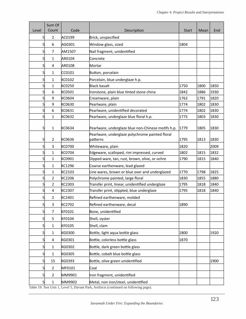
Savannah Under Fire: Expanding the Boundaries
Chapter 4 . Project Results and Interpretations
123
LevelSum Of Count Code Description Start Mean End
5 2 AC0199 Brick, unspecified
5 6 AG0301 Window glass, sized 1804
5 7 AM1507 Nail fragment, unidentified
5 1 AR0104 Concrete
5 4 AR0108 Mortar
5 1 CC0101 Button, porcelain
5 1 KC0102 Porcelain, blue underglaze h.p. 5 1 KC0250 Black basalt 1750 1800 18505 6 KC0501 Ironstone, plain blue tinted stone china 1842 1886 19305 9 KC0604 Creamware, plain 1762 1791 18205 9 KC0630 Pearlware, plain 1774 1802 18305 6 KC0631 Pearlware, unidentified decorated 1774 1802 18305 1 KC0632 Pearlware, underglaze blue floral h.p. 1775 1803 1830
5 1 KC0634 Pearlware, underglaze blue non-Chinese motifs h.p. 1779 1805 1830
5 2 KC0636Pearlware, underglaze polychrome painted floral patterns 1795 1813 1830
5 3 KC0700 Whiteware, plain 1820 20095 1 KC0704 Edgeware, scalloped, rim impressed, curved 1802 1815 18325 1 KC0901 Dipped ware, tan, rust, brown, olive, or ochre 1790 1815 1840
5 1 KC1296 Coarse earthenware, lead glazed 5 1 KC2103 Line wares, brown or blue over and underglazed 1770 1798 18255 2 KC2206 Polychrome painted, large floral 1830 1855 18805 2 KC2303 Transfer print, linear, unidentified underglaze 1795 1818 18405 4 KC2307 Transfer print, stippled, blue underglaze 1795 1818 1840
5 2 KC2401 Refined earthenware, molded
5 3 KC2702 Refined earthenware, decal 1890
5 7 KF0101 Bone, unidentified
5 5 KF0104 Shell, oyster
5 1 KF0105 Shell, clam
5 1 KG0300 Bottle, light aqua bottle glass 1800 1920
5 4 KG0301 Bottle, colorless bottle glass 1870
5 1 KG0302 Bottle, dark green bottle glass
5 1 KG0305 Bottle, cobalt blue bottle glass
5 15 KG0393 Bottle, olive green unidentified 1900
5 2 MF0101 Coal
5 2 MM9901 Iron fragment, unidentified
5 1 MM9902 Metal, non iron/steel, unidentifiedTable 19. Test Unit 1, Level 5, Davant Park, Artifacts (continued on following page).
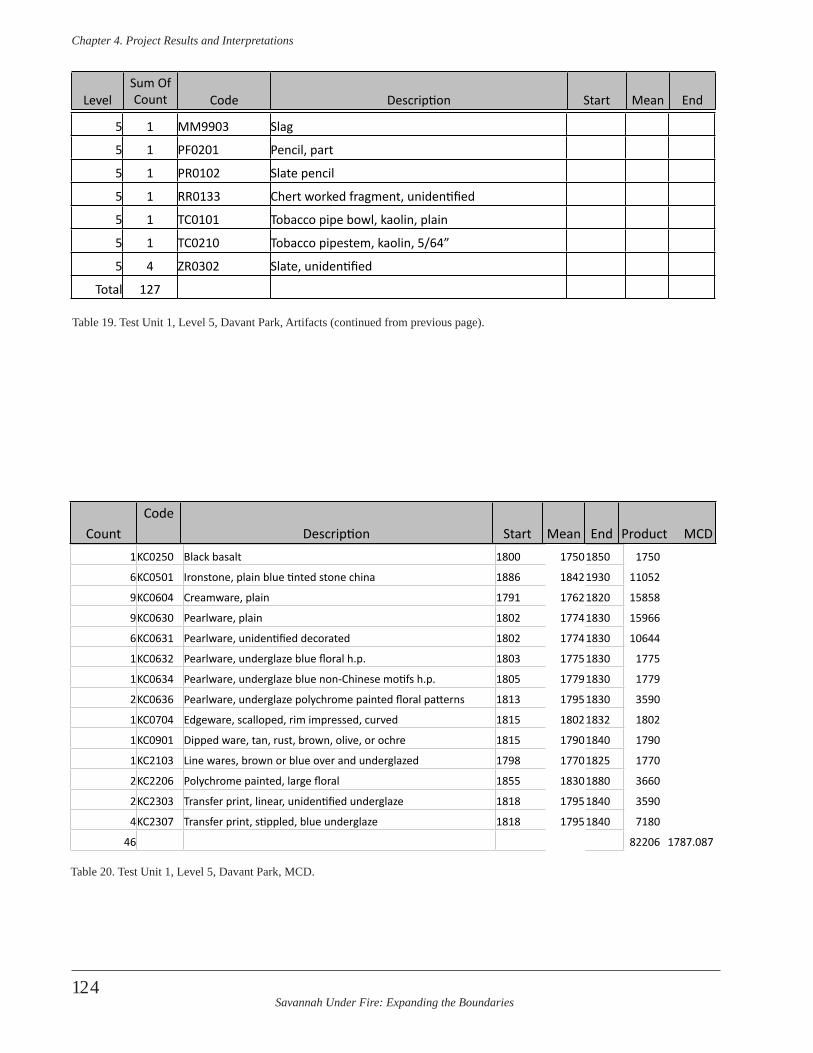
Savannah Under Fire: Expanding the Boundaries
Chapter 4 . Project Results and Interpretations
124
5 1 MM9903 Slag
5 1 PF0201 Pencil, part
5 1 PR0102 Slate pencil
5 1 RR0133 Chert worked fragment, unidentified
5 1 TC0101 Tobacco pipe bowl, kaolin, plain
5 1 TC0210 Tobacco pipestem, kaolin, 5/64”
5 4 ZR0302 Slate, unidentified
Total 127
LevelSum Of Count Code Description Start Mean End
Table 19. Test Unit 1, Level 5, Davant Park, Artifacts (continued from previous page).
1KC0250 Black basalt 1800 17501850 1750
6KC0501 Ironstone, plain blue tinted stone china 1886 18421930 11052
9KC0604 Creamware, plain 1791 17621820 15858
9KC0630 Pearlware, plain 1802 17741830 15966
6KC0631 Pearlware, unidentified decorated 1802 17741830 10644
1KC0632 Pearlware, underglaze blue floral h.p. 1803 17751830 1775
1KC0634 Pearlware, underglaze blue non-Chinese motifs h.p. 1805 17791830 1779
2KC0636 Pearlware, underglaze polychrome painted floral patterns 1813 17951830 3590
1KC0704 Edgeware, scalloped, rim impressed, curved 1815 18021832 1802
1KC0901 Dipped ware, tan, rust, brown, olive, or ochre 1815 17901840 1790
1KC2103 Line wares, brown or blue over and underglazed 1798 17701825 1770
2KC2206 Polychrome painted, large floral 1855 18301880 3660
2KC2303 Transfer print, linear, unidentified underglaze 1818 17951840 3590
4KC2307 Transfer print, stippled, blue underglaze 1818 17951840 7180
46 82206 1787.087
CountCode
Description Start Mean End Product MCD
Table 20. Test Unit 1, Level 5, Davant Park, MCD.
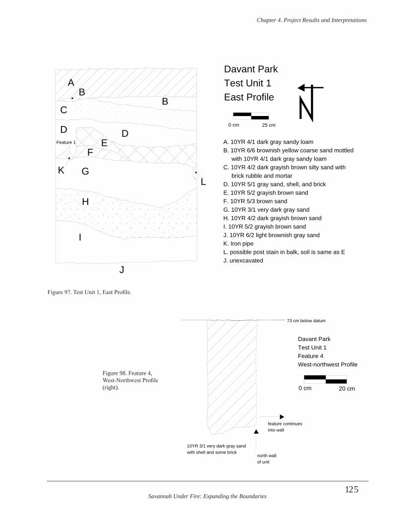
Savannah Under Fire: Expanding the Boundaries
Chapter 4 . Project Results and Interpretations
125
A
BB
C
DDFeature 1
K
EF
G
H
I
J
L
Davant Park Test Unit 1East Profile
0 cm 25 cm
A. 10YR 4/1 dark gray sandy loamB. 10YR 6/6 brownish yellow coarse sand mottled with 10YR 4/1 dark gray sandy loamC. 10YR 4/2 dark grayish brown silty sand with brick rubble and mortarD. 10YR 5/1 gray sand, shell, and brickE. 10YR 5/2 grayish brown sandF. 10YR 5/3 brown sandG. 10YR 3/1 very dark gray sandH. 10YR 4/2 dark grayish brown sandI. 10YR 5/2 grayish brown sandJ. 10YR 6/2 light brownish gray sandK. Iron pipeL. possible post stain in balk, soil is same as EJ. unexcavated
Figure 97. Test Unit 1, East Profile.
with shell and some bricknorth wall of unit
feature continues into wall
73 cm below datum
10YR 3/1 very dark gray sand
0 cm 20 cm
Davant ParkTest Unit 1Feature 4West-northwest Profile
Figure 98. Feature 4, West-Northwest Profile (right).
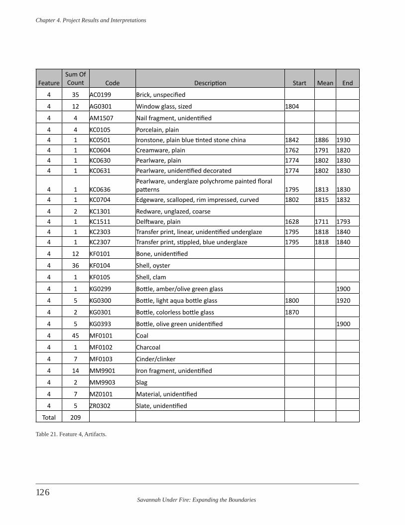
Savannah Under Fire: Expanding the Boundaries
Chapter 4 . Project Results and Interpretations
126
FeatureSum Of Count Code Description Start Mean End
4 35 AC0199 Brick, unspecified
4 12 AG0301 Window glass, sized 1804
4 4 AM1507 Nail fragment, unidentified
4 4 KC0105 Porcelain, plain4 1 KC0501 Ironstone, plain blue tinted stone china 1842 1886 19304 1 KC0604 Creamware, plain 1762 1791 18204 1 KC0630 Pearlware, plain 1774 1802 18304 1 KC0631 Pearlware, unidentified decorated 1774 1802 1830
4 1 KC0636Pearlware, underglaze polychrome painted floral patterns 1795 1813 1830
4 1 KC0704 Edgeware, scalloped, rim impressed, curved 1802 1815 1832
4 2 KC1301 Redware, unglazed, coarse4 1 KC1511 Delftware, plain 1628 1711 17934 1 KC2303 Transfer print, linear, unidentified underglaze 1795 1818 18404 1 KC2307 Transfer print, stippled, blue underglaze 1795 1818 1840
4 12 KF0101 Bone, unidentified
4 36 KF0104 Shell, oyster
4 1 KF0105 Shell, clam
4 1 KG0299 Bottle, amber/olive green glass 1900
4 5 KG0300 Bottle, light aqua bottle glass 1800 1920
4 2 KG0301 Bottle, colorless bottle glass 1870
4 5 KG0393 Bottle, olive green unidentified 1900
4 45 MF0101 Coal
4 1 MF0102 Charcoal
4 7 MF0103 Cinder/clinker
4 14 MM9901 Iron fragment, unidentified
4 2 MM9903 Slag
4 7 MZ0101 Material, unidentified
4 5 ZR0302 Slate, unidentified
Total 209
Table 21. Feature 4, Artifacts.
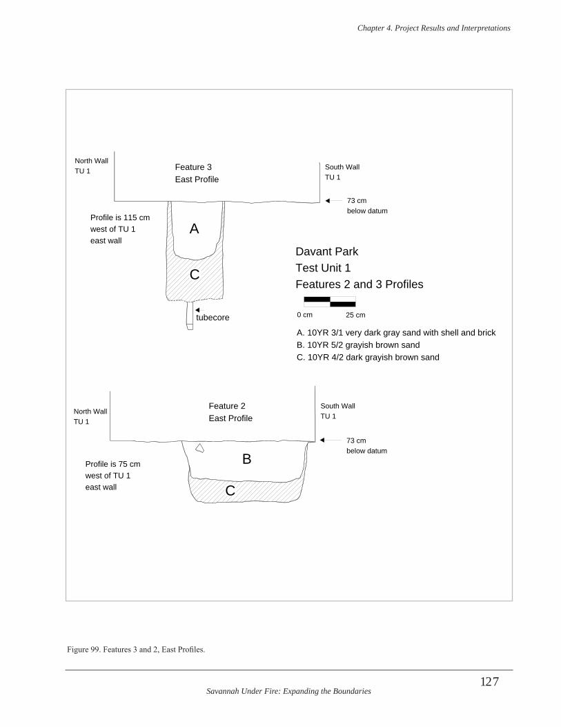
Savannah Under Fire: Expanding the Boundaries
Chapter 4 . Project Results and Interpretations
127
North Wall TU 1
North Wall TU 1
South Wall TU 1
South Wall TU 1
73 cmbelow datum
73 cmbelow datum
Feature 3East Profile
Feature 2East Profile
A
B
C
C
Profile is 115 cm west of TU 1 east wall
Profile is 75 cm west of TU 1 east wall
tubecore
Davant ParkTest Unit 1Features 2 and 3 Profiles
0 cm 25 cm
A. 10YR 3/1 very dark gray sand with shell and brickB. 10YR 5/2 grayish brown sandC. 10YR 4/2 dark grayish brown sand
Figure 99. Features 3 and 2, East Profiles.
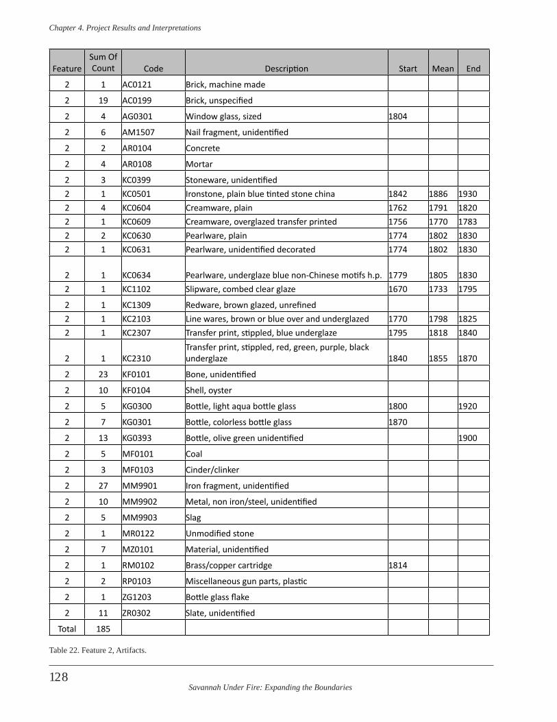
Savannah Under Fire: Expanding the Boundaries
Chapter 4 . Project Results and Interpretations
128
FeatureSum Of Count Code Description Start Mean End
2 1 AC0121 Brick, machine made
2 19 AC0199 Brick, unspecified
2 4 AG0301 Window glass, sized 1804
2 6 AM1507 Nail fragment, unidentified
2 2 AR0104 Concrete
2 4 AR0108 Mortar
2 3 KC0399 Stoneware, unidentified2 1 KC0501 Ironstone, plain blue tinted stone china 1842 1886 19302 4 KC0604 Creamware, plain 1762 1791 18202 1 KC0609 Creamware, overglazed transfer printed 1756 1770 17832 2 KC0630 Pearlware, plain 1774 1802 18302 1 KC0631 Pearlware, unidentified decorated 1774 1802 1830
2 1 KC0634 Pearlware, underglaze blue non-Chinese motifs h.p. 1779 1805 18302 1 KC1102 Slipware, combed clear glaze 1670 1733 1795
2 1 KC1309 Redware, brown glazed, unrefined2 1 KC2103 Line wares, brown or blue over and underglazed 1770 1798 18252 1 KC2307 Transfer print, stippled, blue underglaze 1795 1818 1840
2 1 KC2310Transfer print, stippled, red, green, purple, black underglaze 1840 1855 1870
2 23 KF0101 Bone, unidentified
2 10 KF0104 Shell, oyster
2 5 KG0300 Bottle, light aqua bottle glass 1800 1920
2 7 KG0301 Bottle, colorless bottle glass 1870
2 13 KG0393 Bottle, olive green unidentified 1900
2 5 MF0101 Coal
2 3 MF0103 Cinder/clinker
2 27 MM9901 Iron fragment, unidentified
2 10 MM9902 Metal, non iron/steel, unidentified
2 5 MM9903 Slag
2 1 MR0122 Unmodified stone
2 7 MZ0101 Material, unidentified
2 1 RM0102 Brass/copper cartridge 1814
2 2 RP0103 Miscellaneous gun parts, plastic
2 1 ZG1203 Bottle glass flake
2 11 ZR0302 Slate, unidentified
Total 185
Table 22. Feature 2, Artifacts.
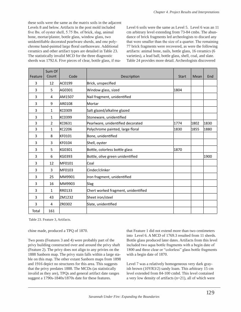
Savannah Under Fire: Expanding the Boundaries
Chapter 4 . Project Results and Interpretations
129
these soils were the same as the matrix soils in the adjacent Levels 8 and below. Artifacts in the post mold included five lbs. of oyster shell, 5.75 lbs. of brick, slag, animal bone, mortar/plaster, bottle glass, window glass, two unidentifiable decorated pearlware sherds, and one poly-chrome hand-painted large floral earthenware. Additional ceramics and other artifact types are detailed in Table 23. The statistically invalid MCD for the three diagnostic sherds was 1792.6. Five pieces of clear, bottle glass, if ma-
chine made, produced a TPQ of 1870.
Two posts (Features 3 and 4) were probably part of the privy building constructed over and around the privy shaft (Feature 2). The privy does not align to any privies on the 1888 Sanborn map. The privy stain falls within a large sta-ble on this map. The other extant Sanborn maps from 1898 and 1916 depict no structures for this area. This suggests that the privy predates 1888. The MCDs (as statistically invalid as they are), TPQs and general artifact date ranges suggest a 1790s-1840s/1870s date for these features.
Level 6 soils were the same as Level 5. Level 6 was an 11 cm arbitrary level extending from 73-84 cmbs. The abun-dance of brick fragments led archeologists to discard any that were smaller than the size of a quarter. The remaining 77 brick fragments were recovered, as were the following artifacts: animal bone, nails, bottle glass, 16 ceramics (6 varieties), a lead ball, bottle glass, shell, coal, and slate. Table 24 provides more detail. Archeologists discovered
that Feature 1 did not extend more than two centimeters into Level 6. A MCD of 1769.3 resulted from 11 sherds. Bottle glass produced later dates. Artifacts from this level included two aqua bottle fragments with a begin date of 1800 and three clear or “colorless” glass bottle fragments with a begin date of 1870.
Level 7 was a relatively homogeneous very dark gray-ish brown (10YR3/2) sandy loam. This arbitrary 15 cm level extended from 84-100 cmbd. This level contained a very low density of artifacts (n=21), all of which were
FeatureSum Of Count Code Description Start Mean End
3 12 AC0199 Brick, unspecified
3 5 AG0301 Window glass, sized 1804
3 4 AM1507 Nail fragment, unidentified
3 9 AR0108 Mortar
3 1 KC0309 Salt glazed/alkaline glazed
3 1 KC0399 Stoneware, unidentified3 2 KC0631 Pearlware, unidentified decorated 1774 1802 18303 1 KC2206 Polychrome painted, large floral 1830 1855 1880
3 8 KF0101 Bone, unidentified
3 3 KF0104 Shell, oyster
3 5 KG0301 Bottle, colorless bottle glass 1870
3 6 KG0393 Bottle, olive green unidentified 1900
3 12 MF0101 Coal
3 3 MF0103 Cinder/clinker
3 25 MM9901 Iron fragment, unidentified
3 16 MM9903 Slag
3 1 RR0133 Chert worked fragment, unidentified
3 43 ZM1232 Sheet iron/steel
3 4 ZR0302 Slate, unidentified
Total 161
Table 23. Feature 3, Artifacts.
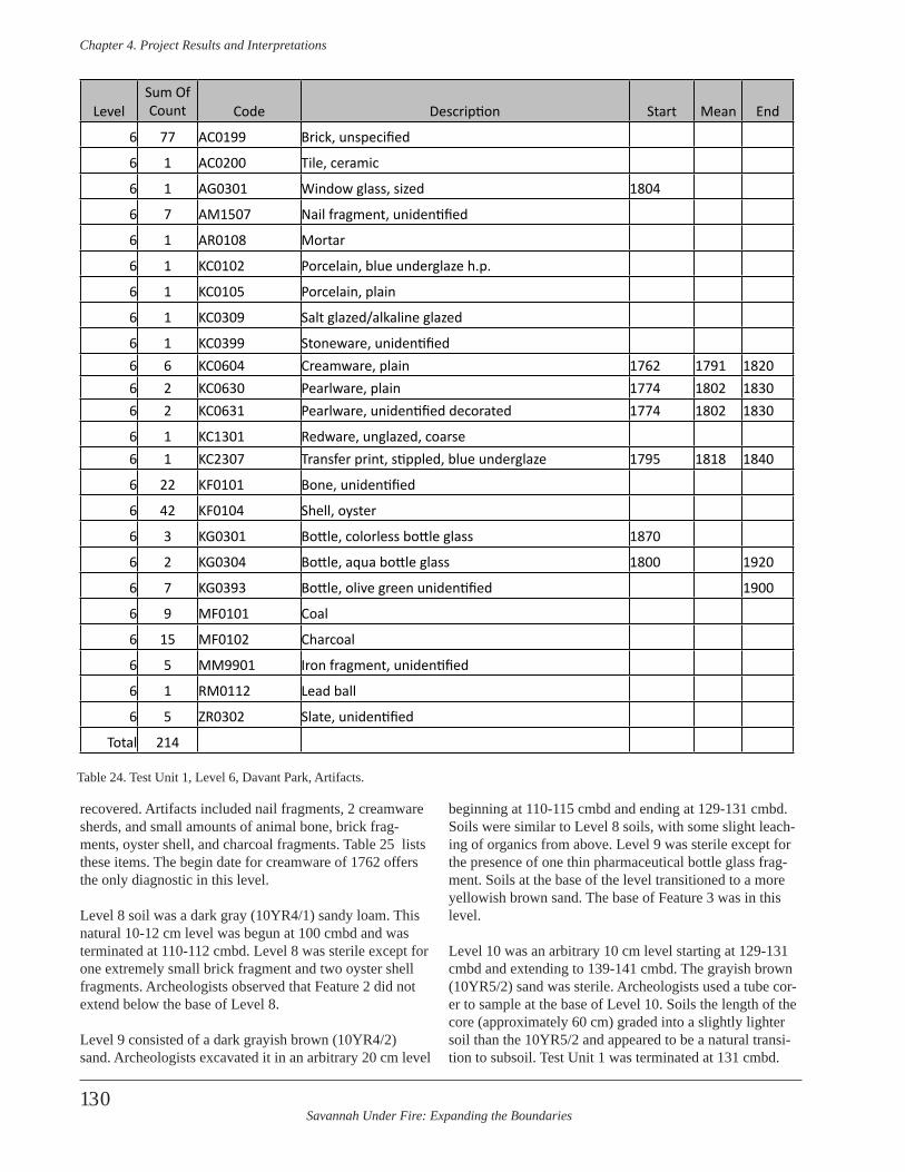
Savannah Under Fire: Expanding the Boundaries
Chapter 4 . Project Results and Interpretations
130
recovered. Artifacts included nail fragments, 2 creamware sherds, and small amounts of animal bone, brick frag-ments, oyster shell, and charcoal fragments. Table 25 lists these items. The begin date for creamware of 1762 offers the only diagnostic in this level.
Level 8 soil was a dark gray (10YR4/1) sandy loam. This natural 10-12 cm level was begun at 100 cmbd and was terminated at 110-112 cmbd. Level 8 was sterile except for one extremely small brick fragment and two oyster shell fragments. Archeologists observed that Feature 2 did not extend below the base of Level 8.
Level 9 consisted of a dark grayish brown (10YR4/2) sand. Archeologists excavated it in an arbitrary 20 cm level
beginning at 110-115 cmbd and ending at 129-131 cmbd. Soils were similar to Level 8 soils, with some slight leach-ing of organics from above. Level 9 was sterile except for the presence of one thin pharmaceutical bottle glass frag-ment. Soils at the base of the level transitioned to a more yellowish brown sand. The base of Feature 3 was in this level.
Level 10 was an arbitrary 10 cm level starting at 129-131 cmbd and extending to 139-141 cmbd. The grayish brown (10YR5/2) sand was sterile. Archeologists used a tube cor-er to sample at the base of Level 10. Soils the length of the core (approximately 60 cm) graded into a slightly lighter soil than the 10YR5/2 and appeared to be a natural transi-tion to subsoil. Test Unit 1 was terminated at 131 cmbd.
LevelSum Of Count Code Description Start Mean End
6 77 AC0199 Brick, unspecified
6 1 AC0200 Tile, ceramic
6 1 AG0301 Window glass, sized 1804
6 7 AM1507 Nail fragment, unidentified
6 1 AR0108 Mortar
6 1 KC0102 Porcelain, blue underglaze h.p.
6 1 KC0105 Porcelain, plain
6 1 KC0309 Salt glazed/alkaline glazed
6 1 KC0399 Stoneware, unidentified6 6 KC0604 Creamware, plain 1762 1791 18206 2 KC0630 Pearlware, plain 1774 1802 18306 2 KC0631 Pearlware, unidentified decorated 1774 1802 1830
6 1 KC1301 Redware, unglazed, coarse6 1 KC2307 Transfer print, stippled, blue underglaze 1795 1818 1840
6 22 KF0101 Bone, unidentified
6 42 KF0104 Shell, oyster
6 3 KG0301 Bottle, colorless bottle glass 1870
6 2 KG0304 Bottle, aqua bottle glass 1800 1920
6 7 KG0393 Bottle, olive green unidentified 1900
6 9 MF0101 Coal
6 15 MF0102 Charcoal
6 5 MM9901 Iron fragment, unidentified
6 1 RM0112 Lead ball
6 5 ZR0302 Slate, unidentified
Total 214
Table 24. Test Unit 1, Level 6, Davant Park, Artifacts.
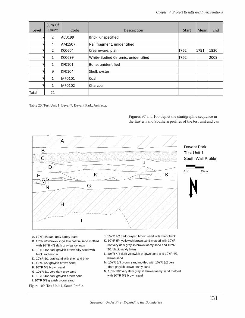
Savannah Under Fire: Expanding the Boundaries
Chapter 4 . Project Results and Interpretations
131
Figures 97 and 100 depict the stratigraphic sequence in the Eastern and Southern profiles of the test unit and can
LevelSum Of Count Code Description Start Mean End
7 2 AC0199 Brick, unspecified
7 4 AM1507 Nail fragment, unidentified7 2 KC0604 Creamware, plain 1762 1791 1820
7 1 KC0699 White-Bodied Ceramic, unidentified 1762 2009
7 1 KF0101 Bone, unidentified
7 9 KF0104 Shell, oyster
7 1 MF0101 Coal
7 1 MF0102 Charcoal
Total 21
Table 25. Test Unit 1, Level 7, Davant Park, Artifacts.
A
BC
DE
G
H
I
J
KK LM
N
A. 10YR 4/1dark gray sandy loamB. 10YR 6/6 brownish yellow coarse sand mottled with 10YR 4/1 dark gray sandy loamC. 10YR 4/2 dark grayish brown silty sand with brick and mortarD. 10YR 5/1 gray sand with shell and brickE. 10YR 5/2 grayish brown sand F. 10YR 5/3 brown sandG. 10YR 3/1 very dark gray sandH. 10YR 4/2 dark grayish brown sandI. 10YR 5/2 grayish brown sand
J. 10YR 4/2 dark grayish brown sand with minor brick K. 10YR 5/4 yellowish brown sand mottled with 10YR 3/2 very dark grayish brown loamy sand and 10YR 2/1 black sandy loamL. 10YR 4/4 dark yellowish bropwn sand and 10YR 4/3 brown sandM. 10YR 5/3 brown sand mottled with 10YR 3/2 very dark grayish brown loamy sandN. 10YR 3/2 very dark grayish brown loamy sand mottled with 10YR 5/3 brown sand
Davant ParkTest Unit 1South Wall Profile
0 cm 25 cm
Figure 100. Test Unit 1, South Profile.

Savannah Under Fire: Expanding the Boundaries
Chapter 4 . Project Results and Interpretations
132
Figure 101. Test Unit 1, Davant Park, South Profile.
Figure 102. Test Unit 1, Davant Park, Closeup of Stratigraphy.
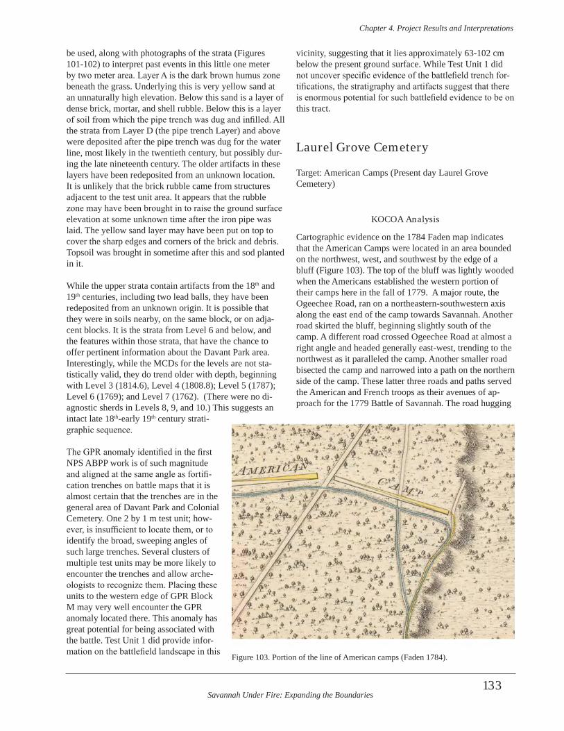
Savannah Under Fire: Expanding the Boundaries
Chapter 4 . Project Results and Interpretations
133
be used, along with photographs of the strata (Figures 101-102) to interpret past events in this little one meter by two meter area. Layer A is the dark brown humus zone beneath the grass. Underlying this is very yellow sand at an unnaturally high elevation. Below this sand is a layer of dense brick, mortar, and shell rubble. Below this is a layer of soil from which the pipe trench was dug and infilled. All the strata from Layer D (the pipe trench Layer) and above were deposited after the pipe trench was dug for the water line, most likely in the twentieth century, but possibly dur-ing the late nineteenth century. The older artifacts in these layers have been redeposited from an unknown location. It is unlikely that the brick rubble came from structures adjacent to the test unit area. It appears that the rubble zone may have been brought in to raise the ground surface elevation at some unknown time after the iron pipe was laid. The yellow sand layer may have been put on top to cover the sharp edges and corners of the brick and debris. Topsoil was brought in sometime after this and sod planted in it.
While the upper strata contain artifacts from the 18th and 19th centuries, including two lead balls, they have been redeposited from an unknown origin. It is possible that they were in soils nearby, on the same block, or on adja-cent blocks. It is the strata from Level 6 and below, and the features within those strata, that have the chance to offer pertinent information about the Davant Park area. Interestingly, while the MCDs for the levels are not sta-tistically valid, they do trend older with depth, beginning with Level 3 (1814.6), Level 4 (1808.8); Level 5 (1787); Level 6 (1769); and Level 7 (1762). (There were no di-agnostic sherds in Levels 8, 9, and 10.) This suggests an intact late 18th-early 19th century strati-graphic sequence.
The GPR anomaly identified in the first NPS ABPP work is of such magnitude and aligned at the same angle as fortifi-cation trenches on battle maps that it is almost certain that the trenches are in the general area of Davant Park and Colonial Cemetery. One 2 by 1 m test unit; how-ever, is insufficient to locate them, or to identify the broad, sweeping angles of such large trenches. Several clusters of multiple test units may be more likely to encounter the trenches and allow arche-ologists to recognize them. Placing these units to the western edge of GPR Block M may very well encounter the GPR anomaly located there. This anomaly has great potential for being associated with the battle. Test Unit 1 did provide infor-mation on the battlefield landscape in this
vicinity, suggesting that it lies approximately 63-102 cm below the present ground surface. While Test Unit 1 did not uncover specific evidence of the battlefield trench for-tifications, the stratigraphy and artifacts suggest that there is enormous potential for such battlefield evidence to be on this tract.
Laurel Grove Cemetery
Target: American Camps (Present day Laurel Grove Cemetery)
KOCOA Analysis
Cartographic evidence on the 1784 Faden map indicates that the American Camps were located in an area bounded on the northwest, west, and southwest by the edge of a bluff (Figure 103). The top of the bluff was lightly wooded when the Americans established the western portion of their camps here in the fall of 1779. A major route, the Ogeechee Road, ran on a northeastern-southwestern axis along the east end of the camp towards Savannah. Another road skirted the bluff, beginning slightly south of the camp. A different road crossed Ogeechee Road at almost a right angle and headed generally east-west, trending to the northwest as it paralleled the camp. Another smaller road bisected the camp and narrowed into a path on the northern side of the camp. These latter three roads and paths served the American and French troops as their avenues of ap-proach for the 1779 Battle of Savannah. The road hugging
Figure 103. Portion of the line of American camps (Faden 1784).
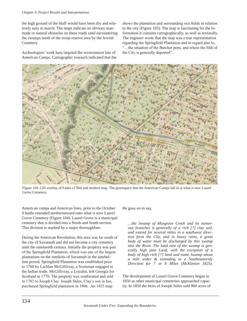
Savannah Under Fire: Expanding the Boundaries
Chapter 4 . Project Results and Interpretations
134
the high ground of the bluff would have been dry and rela-tively easy to march. The maps indicate no obvious man-made or natural obstacles on these roads until encountering the swamps north of the troop reserve area by the Jewish Cemetery.
Archeologists’ work here targeted the westernmost line of American Camps. Cartographic research indicated that the
American camps and American lines, prior to the October 9 battle extended northwestward onto what is now Laurel Grove Cemetery (Figure 104). Laurel Grove is a municipal cemetery that is divided into a North and South section. This division is marked by a major thoroughfare.
During the American Revolution, this area was far south of the city of Savannah and did not become a city cemetery until the nineteenth century. Initially the property was part of the Springfield Plantation, which was one of the largest plantations on the outskirts of Savannah in the antebel-lum period. Springfield Plantation was established prior to 1760 by Lachlan McGillivray, a Scotsman engaged in the Indian trade. McGillivray, a Loyalist, left Georgia for Scotland in 1770. The property was confiscated and sold in 1782 to Joseph Clay. Joseph Stiles, Clay’s son in law, purchased Springfield plantation in 1806. An 1825 map
shows the plantation and surrounding rice fields in relation to the city (Figure 105). The map is fascinating for the in-formation it contains cartographically, as well as texturally. The engineer wrote that the map was a true representation regarding the Springfield Plantation and in regard also to, “…the situation of the Butcher pens, and where the filth of the City is generally deported”.
He goes on to say,
…the Swamp of Musgrove Creek and its numer-ous branches is generally of a rich [?] clay soil, and extend for several miles in a southwest direc-tion form the City, and in heavy rains, a great body of water must be discharged by this swamp into the River . The land east of the swamp is gen-erally high pine Land, with the exception of a body of high rich [?] land and some Swamp about a mile wider & extending in a Southeasternly Direction for 7 or 8 Miles (McKinnon 1825) .
The development of Laurel Grove Cemetery began in 1850 as other municipal cemeteries approached capac-ity. In 1850 the heirs of Joseph Stiles sold 960 acres of
Figure 104. GIS overlay of Faden (1784) and modern map. The greenspace that the American Camps fall in is what is now Laurel Grove Cemetery.
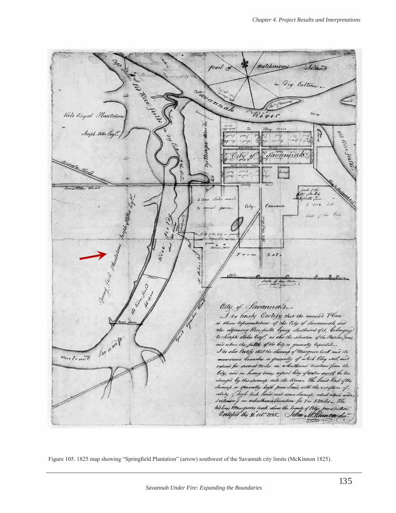
Savannah Under Fire: Expanding the Boundaries
Chapter 4 . Project Results and Interpretations
135
Figure 105. 1825 map showing “Springfield Plantation” (arrow) southwest of the Savannah city limits (McKinnon 1825).
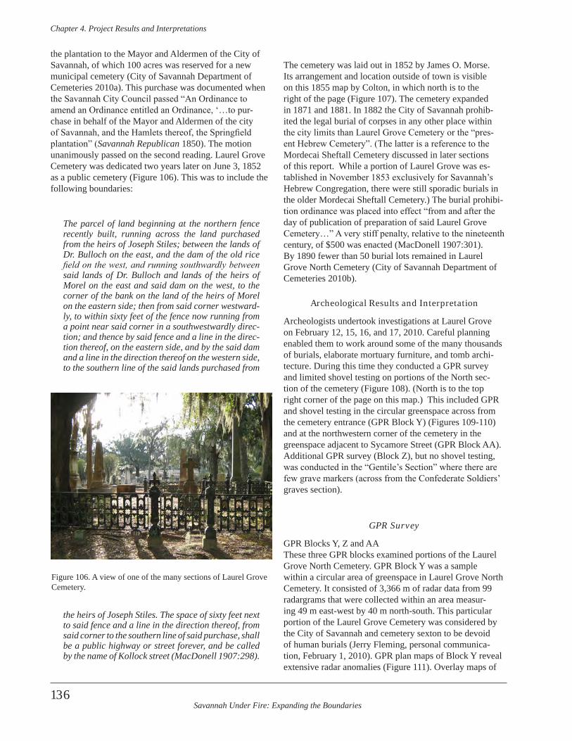
Savannah Under Fire: Expanding the Boundaries
Chapter 4 . Project Results and Interpretations
136
the plantation to the Mayor and Aldermen of the City of Savannah, of which 100 acres was reserved for a new municipal cemetery (City of Savannah Department of Cemeteries 2010a). This purchase was documented when the Savannah City Council passed “An Ordinance to amend an Ordinance entitled an Ordinance, ‘…to pur-chase in behalf of the Mayor and Aldermen of the city of Savannah, and the Hamlets thereof, the Springfield plantation” (Savannah Republican 1850). The motion unanimously passed on the second reading. Laurel Grove Cemetery was dedicated two years later on June 3, 1852 as a public cemetery (Figure 106). This was to include the following boundaries:
The parcel of land beginning at the northern fence recently built, running across the land purchased from the heirs of Joseph Stiles; between the lands of Dr . Bulloch on the east, and the dam of the old rice field on the west, and running southwardly between said lands of Dr . Bulloch and lands of the heirs of Morel on the east and said dam on the west, to the corner of the bank on the land of the heirs of Morel on the eastern side; then from said corner westward-ly, to within sixty feet of the fence now running from a point near said corner in a southwestwardly direc-tion; and thence by said fence and a line in the direc-tion thereof, on the eastern side, and by the said dam and a line in the direction thereof on the western side, to the southern line of the said lands purchased from
the heirs of Joseph Stiles . The space of sixty feet next to said fence and a line in the direction thereof, from said corner to the southern line of said purchase, shall be a public highway or street forever, and be called by the name of Kollock street (MacDonell 1907:298) .
The cemetery was laid out in 1852 by James O. Morse. Its arrangement and location outside of town is visible on this 1855 map by Colton, in which north is to the right of the page (Figure 107). The cemetery expanded in 1871 and 1881. In 1882 the City of Savannah prohib-ited the legal burial of corpses in any other place within the city limits than Laurel Grove Cemetery or the “pres-ent Hebrew Cemetery”. (The latter is a reference to the Mordecai Sheftall Cemetery discussed in later sections of this report. While a portion of Laurel Grove was es-tablished in November 1853 exclusively for Savannah’s Hebrew Congregation, there were still sporadic burials in the older Mordecai Sheftall Cemetery.) The burial prohibi-tion ordinance was placed into effect “from and after the day of publication of preparation of said Laurel Grove Cemetery…” A very stiff penalty, relative to the nineteenth century, of $500 was enacted (MacDonell 1907:301). By 1890 fewer than 50 burial lots remained in Laurel Grove North Cemetery (City of Savannah Department of Cemeteries 2010b).
Archeological Results and Interpretation
Archeologists undertook investigations at Laurel Grove on February 12, 15, 16, and 17, 2010. Careful planning enabled them to work around some of the many thousands of burials, elaborate mortuary furniture, and tomb archi-tecture. During this time they conducted a GPR survey and limited shovel testing on portions of the North sec-tion of the cemetery (Figure 108). (North is to the top right corner of the page on this map.) This included GPR and shovel testing in the circular greenspace across from the cemetery entrance (GPR Block Y) (Figures 109-110) and at the northwestern corner of the cemetery in the greenspace adjacent to Sycamore Street (GPR Block AA). Additional GPR survey (Block Z), but no shovel testing, was conducted in the “Gentile’s Section” where there are few grave markers (across from the Confederate Soldiers’ graves section).
GPR Survey
GPR Blocks Y, Z and AAThese three GPR blocks examined portions of the Laurel Grove North Cemetery. GPR Block Y was a sample within a circular area of greenspace in Laurel Grove North Cemetery. It consisted of 3,366 m of radar data from 99 radargrams that were collected within an area measur-ing 49 m east-west by 40 m north-south. This particular portion of the Laurel Grove Cemetery was considered by the City of Savannah and cemetery sexton to be devoid of human burials (Jerry Fleming, personal communica-tion, February 1, 2010). GPR plan maps of Block Y reveal extensive radar anomalies (Figure 111). Overlay maps of
Figure 106. A view of one of the many sections of Laurel Grove Cemetery.
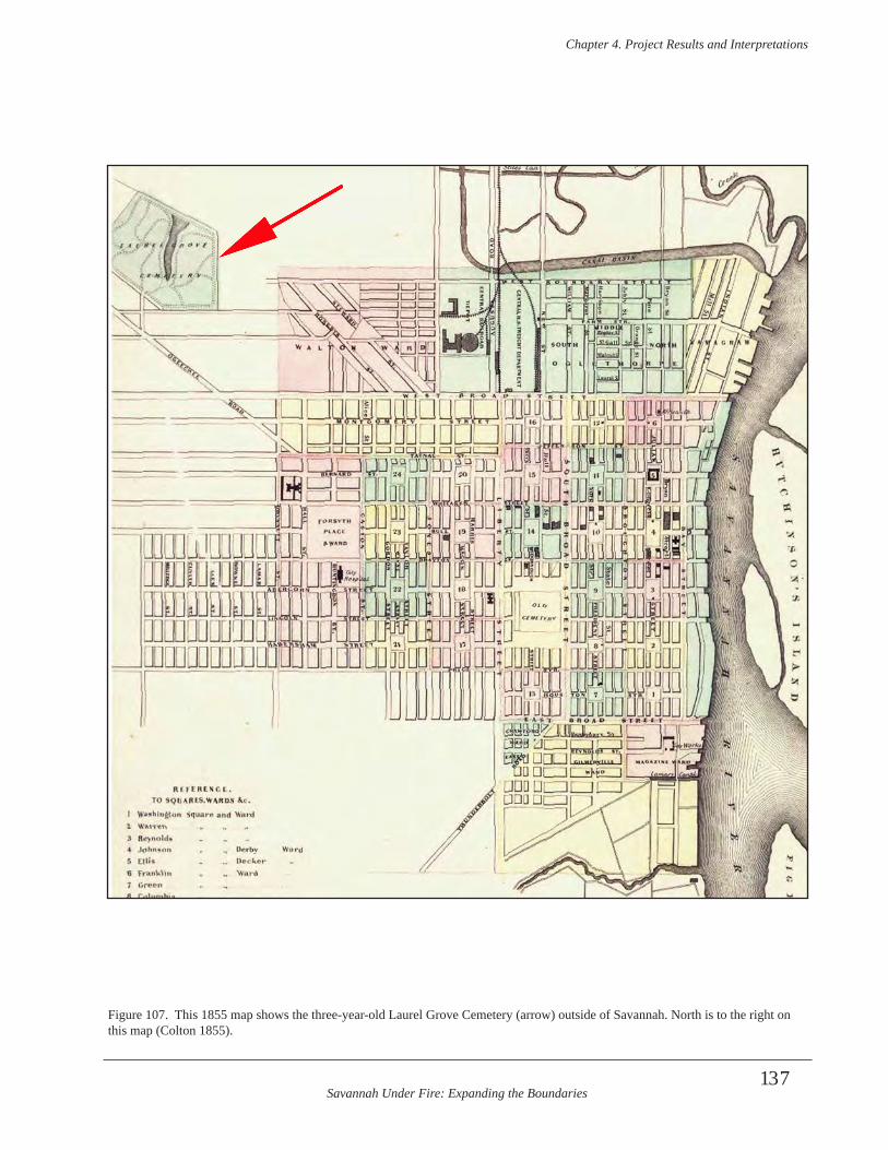
Savannah Under Fire: Expanding the Boundaries
Chapter 4 . Project Results and Interpretations
137
Figure 107. This 1855 map shows the three-year-old Laurel Grove Cemetery (arrow) outside of Savannah. North is to the right on this map (Colton 1855).
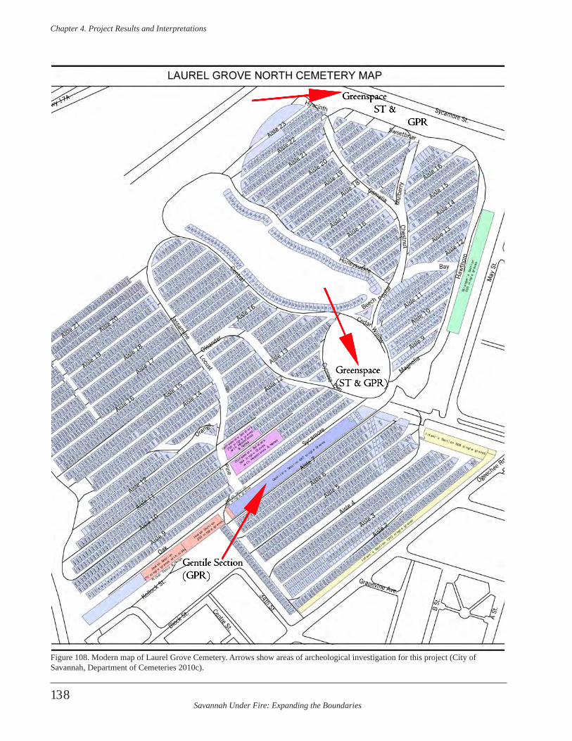
Savannah Under Fire: Expanding the Boundaries
Chapter 4 . Project Results and Interpretations
138
Gentile Section(GPR)
Greenspace(ST & GPR)
Greenspace ST & GPR
Figure 108. Modern map of Laurel Grove Cemetery. Arrows show areas of archeological investigation for this project (City of Savannah, Department of Cemeteries 2010c).
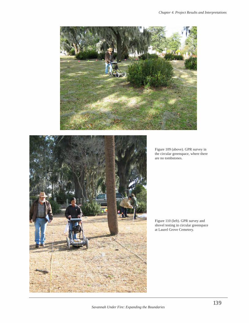
Savannah Under Fire: Expanding the Boundaries
Chapter 4 . Project Results and Interpretations
139
Figure 109 (above). GPR survey in the circular greenspace, where there are no tombstones.
Figure 110 (left). GPR survey and shovel testing in circular greenspace at Laurel Grove Cemetery.
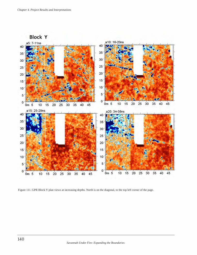
Savannah Under Fire: Expanding the Boundaries
Chapter 4 . Project Results and Interpretations
140
Figure 111. GPR Block Y plan views at increasing depths. North is on the diagonal, to the top left corner of the page.
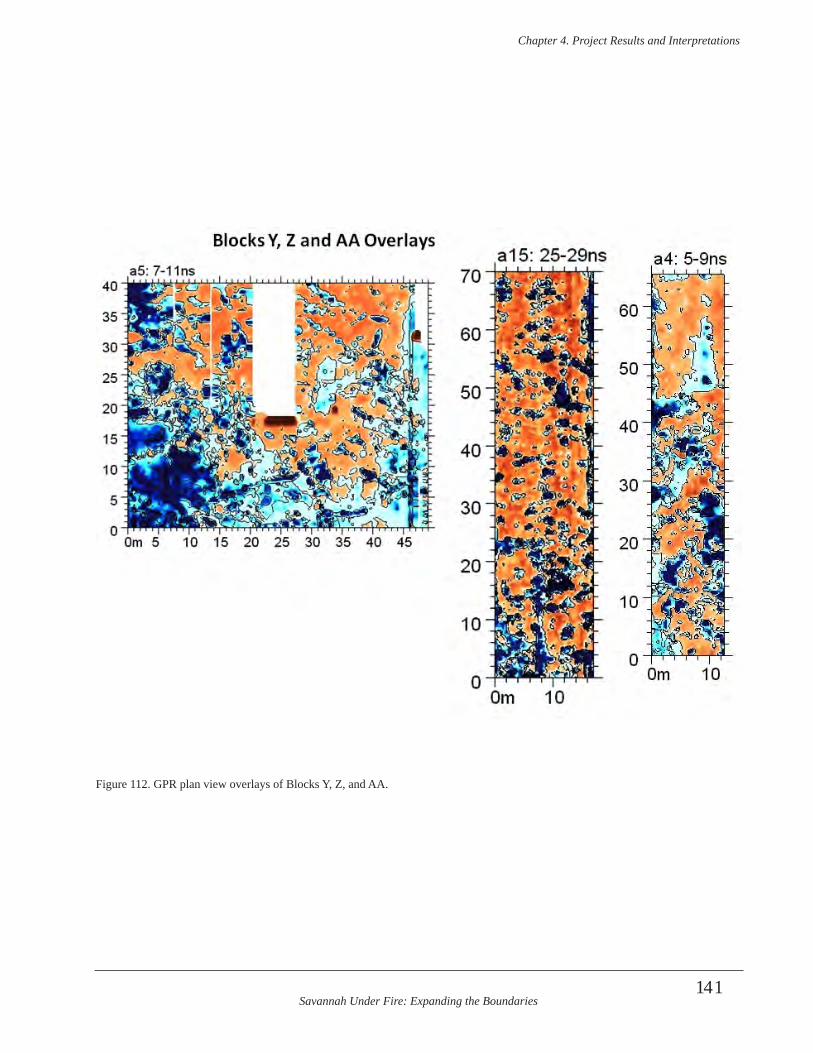
Savannah Under Fire: Expanding the Boundaries
Chapter 4 . Project Results and Interpretations
141
Figure 112. GPR plan view overlays of Blocks Y, Z, and AA.
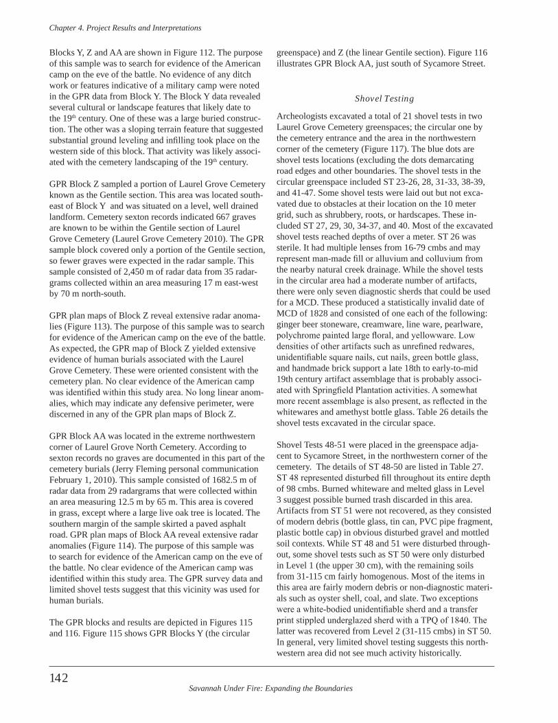
Savannah Under Fire: Expanding the Boundaries
Chapter 4 . Project Results and Interpretations
142
Blocks Y, Z and AA are shown in Figure 112. The purpose of this sample was to search for evidence of the American camp on the eve of the battle. No evidence of any ditch work or features indicative of a military camp were noted in the GPR data from Block Y. The Block Y data revealed several cultural or landscape features that likely date to the 19th century. One of these was a large buried construc-tion. The other was a sloping terrain feature that suggested substantial ground leveling and infilling took place on the western side of this block. That activity was likely associ-ated with the cemetery landscaping of the 19th century.
GPR Block Z sampled a portion of Laurel Grove Cemetery known as the Gentile section. This area was located south-east of Block Y and was situated on a level, well drained landform. Cemetery sexton records indicated 667 graves are known to be within the Gentile section of Laurel Grove Cemetery (Laurel Grove Cemetery 2010). The GPR sample block covered only a portion of the Gentile section, so fewer graves were expected in the radar sample. This sample consisted of 2,450 m of radar data from 35 radar-grams collected within an area measuring 17 m east-west by 70 m north-south.
GPR plan maps of Block Z reveal extensive radar anoma-lies (Figure 113). The purpose of this sample was to search for evidence of the American camp on the eve of the battle. As expected, the GPR map of Block Z yielded extensive evidence of human burials associated with the Laurel Grove Cemetery. These were oriented consistent with the cemetery plan. No clear evidence of the American camp was identified within this study area. No long linear anom-alies, which may indicate any defensive perimeter, were discerned in any of the GPR plan maps of Block Z.
GPR Block AA was located in the extreme northwestern corner of Laurel Grove North Cemetery. According to sexton records no graves are documented in this part of the cemetery burials (Jerry Fleming personal communication February 1, 2010). This sample consisted of 1682.5 m of radar data from 29 radargrams that were collected within an area measuring 12.5 m by 65 m. This area is covered in grass, except where a large live oak tree is located. The southern margin of the sample skirted a paved asphalt road. GPR plan maps of Block AA reveal extensive radar anomalies (Figure 114). The purpose of this sample was to search for evidence of the American camp on the eve of the battle. No clear evidence of the American camp was identified within this study area. The GPR survey data and limited shovel tests suggest that this vicinity was used for human burials.
The GPR blocks and results are depicted in Figures 115 and 116. Figure 115 shows GPR Blocks Y (the circular
greenspace) and Z (the linear Gentile section). Figure 116 illustrates GPR Block AA, just south of Sycamore Street.
Shovel Testing
Archeologists excavated a total of 21 shovel tests in two Laurel Grove Cemetery greenspaces; the circular one by the cemetery entrance and the area in the northwestern corner of the cemetery (Figure 117). The blue dots are shovel tests locations (excluding the dots demarcating road edges and other boundaries. The shovel tests in the circular greenspace included ST 23-26, 28, 31-33, 38-39, and 41-47. Some shovel tests were laid out but not exca-vated due to obstacles at their location on the 10 meter grid, such as shrubbery, roots, or hardscapes. These in-cluded ST 27, 29, 30, 34-37, and 40. Most of the excavated shovel tests reached depths of over a meter. ST 26 was sterile. It had multiple lenses from 16-79 cmbs and may represent man-made fill or alluvium and colluvium from the nearby natural creek drainage. While the shovel tests in the circular area had a moderate number of artifacts, there were only seven diagnostic sherds that could be used for a MCD. These produced a statistically invalid date of MCD of 1828 and consisted of one each of the following: ginger beer stoneware, creamware, line ware, pearlware, polychrome painted large floral, and yellowware. Low densities of other artifacts such as unrefined redwares, unidentifiable square nails, cut nails, green bottle glass, and handmade brick support a late 18th to early-to-mid 19th century artifact assemblage that is probably associ-ated with Springfield Plantation activities. A somewhat more recent assemblage is also present, as reflected in the whitewares and amethyst bottle glass. Table 26 details the shovel tests excavated in the circular space.
Shovel Tests 48-51 were placed in the greenspace adja-cent to Sycamore Street, in the northwestern corner of the cemetery. The details of ST 48-50 are listed in Table 27. ST 48 represented disturbed fill throughout its entire depth of 98 cmbs. Burned whiteware and melted glass in Level 3 suggest possible burned trash discarded in this area. Artifacts from ST 51 were not recovered, as they consisted of modern debris (bottle glass, tin can, PVC pipe fragment, plastic bottle cap) in obvious disturbed gravel and mottled soil contexts. While ST 48 and 51 were disturbed through-out, some shovel tests such as ST 50 were only disturbed in Level 1 (the upper 30 cm), with the remaining soils from 31-115 cm fairly homogenous. Most of the items in this area are fairly modern debris or non-diagnostic materi-als such as oyster shell, coal, and slate. Two exceptions were a white-bodied unidentifiable sherd and a transfer print stippled underglazed sherd with a TPQ of 1840. The latter was recovered from Level 2 (31-115 cmbs) in ST 50. In general, very limited shovel testing suggests this north-western area did not see much activity historically.
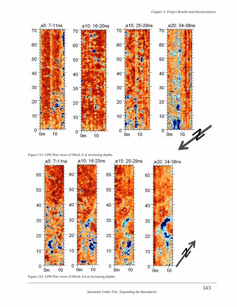
Savannah Under Fire: Expanding the Boundaries
Chapter 4 . Project Results and Interpretations
143
Figure 113. GPR Plan views of Block Z at increasing depths.
Figure 114. GPR Plan views of Block AA at increasing depths.
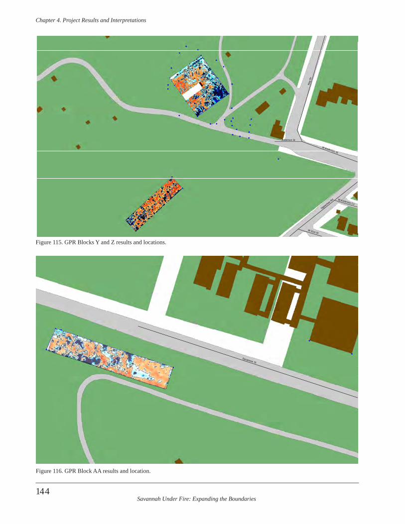
Savannah Under Fire: Expanding the Boundaries
Chapter 4 . Project Results and Interpretations
144
May
Dr
Ogeechee Rd
W Anderson St
W 31st St
Anderson St
W Anderson Ln
Figure 115. GPR Blocks Y and Z results and locations.
Sycamore St
Figure 116. GPR Block AA results and location.
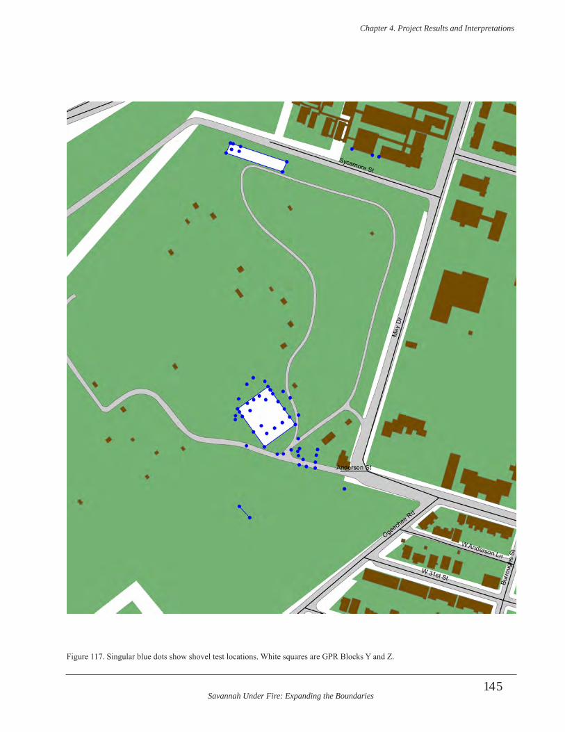
Savannah Under Fire: Expanding the Boundaries
Chapter 4 . Project Results and Interpretations
145
Figure 117. Singular blue dots show shovel test locations. White squares are GPR Blocks Y and Z.
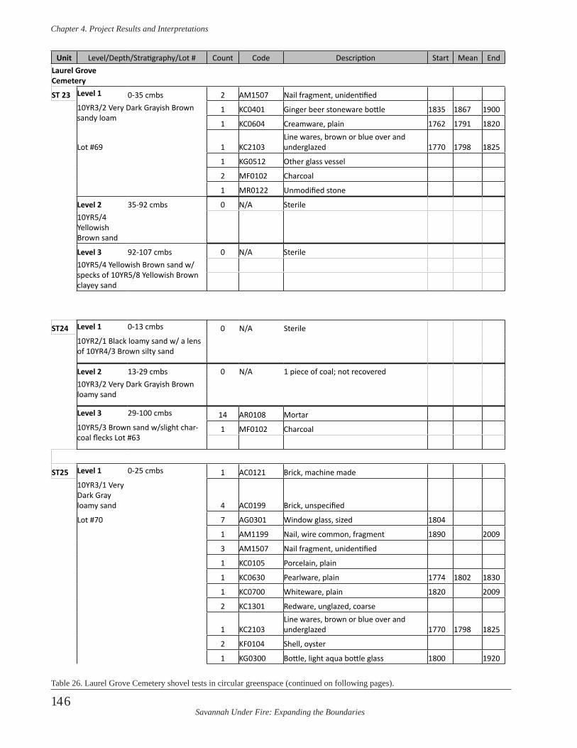
Savannah Under Fire: Expanding the Boundaries
Chapter 4 . Project Results and Interpretations
146
Unit Level/Depth/Stratigraphy/Lot # Count Code Description Start Mean EndLaurel Grove Cemetery
ST 23 Level 1 0-35 cmbs 2 AM1507 Nail fragment, unidentified10YR3/2 Very Dark Grayish Brown sandy loam
1 KC0401 Ginger beer stoneware bottle 1835 1867 1900
1 KC0604 Creamware, plain 1762 1791 1820
Lot #69 1 KC2103Line wares, brown or blue over and underglazed 1770 1798 1825
1 KG0512 Other glass vessel
2 MF0102 Charcoal
1 MR0122 Unmodified stone
Level 2 35-92 cmbs 0 N/A Sterile10YR5/4 Yellowish Brown sand
Level 3 92-107 cmbs 0 N/A Sterile10YR5/4 Yellowish Brown sand w/specks of 10YR5/8 Yellowish Brown clayey sand
ST24 Level 1 0-13 cmbs 0 N/A Sterile10YR2/1 Black loamy sand w/ a lens of 10YR4/3 Brown silty sand
Level 2 13-29 cmbs 0 N/A 1 piece of coal; not recovered10YR3/2 Very Dark Grayish Brown loamy sand
Level 3 29-100 cmbs 14 AR0108 Mortar10YR5/3 Brown sand w/slight char-coal flecks Lot #63
1 MF0102 Charcoal
ST25 Level 1 0-25 cmbs 1 AC0121 Brick, machine made10YR3/1 Very Dark Gray loamy sand 4 AC0199 Brick, unspecified
Lot #70 7 AG0301 Window glass, sized 1804
1 AM1199 Nail, wire common, fragment 1890 2009
3 AM1507 Nail fragment, unidentified
1 KC0105 Porcelain, plain
1 KC0630 Pearlware, plain 1774 1802 1830
1 KC0700 Whiteware, plain 1820 2009
2 KC1301 Redware, unglazed, coarse
1 KC2103Line wares, brown or blue over and underglazed 1770 1798 1825
2 KF0104 Shell, oyster
1 KG0300 Bottle, light aqua bottle glass 1800 1920
Table 26. Laurel Grove Cemetery shovel tests in circular greenspace (continued on following pages).
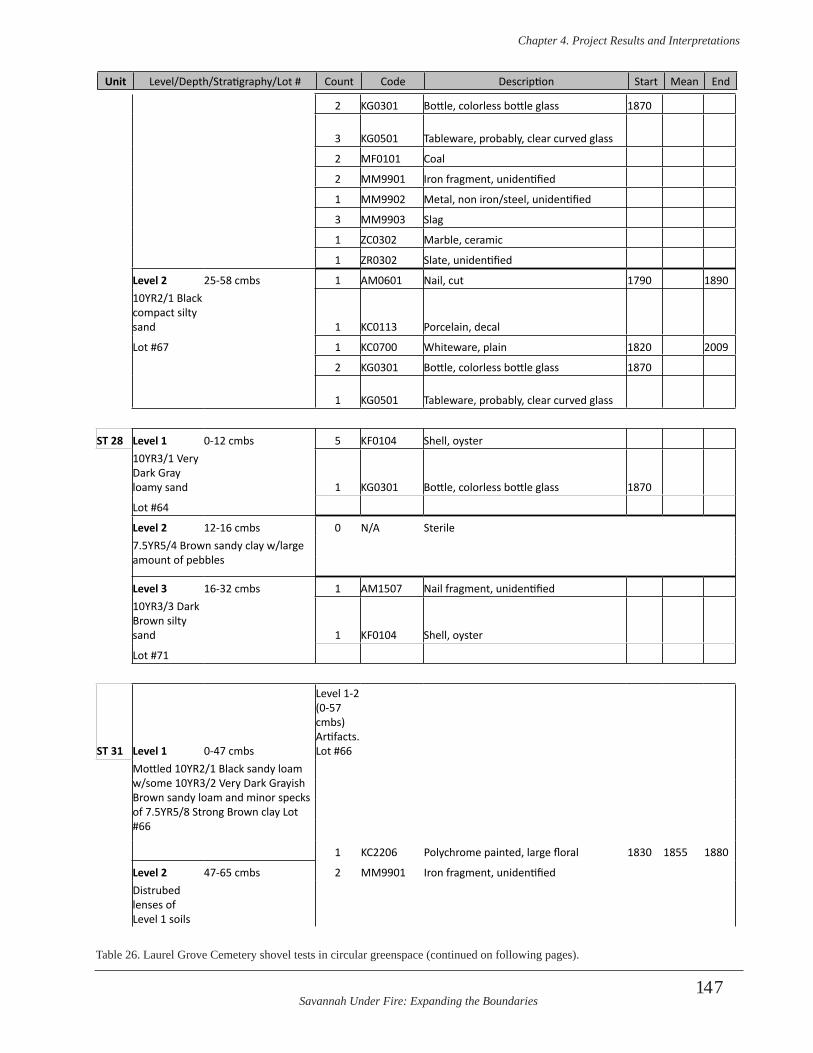
Savannah Under Fire: Expanding the Boundaries
Chapter 4 . Project Results and Interpretations
147
2 KG0301 Bottle, colorless bottle glass 1870
3 KG0501 Tableware, probably, clear curved glass
2 MF0101 Coal
2 MM9901 Iron fragment, unidentified
1 MM9902 Metal, non iron/steel, unidentified
3 MM9903 Slag
1 ZC0302 Marble, ceramic
1 ZR0302 Slate, unidentified
Level 2 25-58 cmbs 1 AM0601 Nail, cut 1790 189010YR2/1 Black compact silty sand 1 KC0113 Porcelain, decal
Lot #67 1 KC0700 Whiteware, plain 1820 2009
2 KG0301 Bottle, colorless bottle glass 1870
1 KG0501 Tableware, probably, clear curved glass
ST 28 Level 1 0-12 cmbs 5 KF0104 Shell, oyster10YR3/1 Very Dark Gray loamy sand 1 KG0301 Bottle, colorless bottle glass 1870
Lot #64
Level 2 12-16 cmbs 0 N/A Sterile7.5YR5/4 Brown sandy clay w/large amount of pebbles
Level 3 16-32 cmbs 1 AM1507 Nail fragment, unidentified10YR3/3 Dark Brown silty sand 1 KF0104 Shell, oyster
Lot #71
ST 31 Level 1 0-47 cmbs
Level 1-2 (0-57 cmbs) Artifacts. Lot #66
Mottled 10YR2/1 Black sandy loam w/some 10YR3/2 Very Dark Grayish Brown sandy loam and minor specks of 7.5YR5/8 Strong Brown clay Lot #66
1 KC2206 Polychrome painted, large floral 1830 1855 1880
Level 2 47-65 cmbs 2 MM9901 Iron fragment, unidentifiedDistrubed lenses of Level 1 soils
Table 26. Laurel Grove Cemetery shovel tests in circular greenspace (continued on following pages).
Unit Level/Depth/Stratigraphy/Lot # Count Code Description Start Mean End
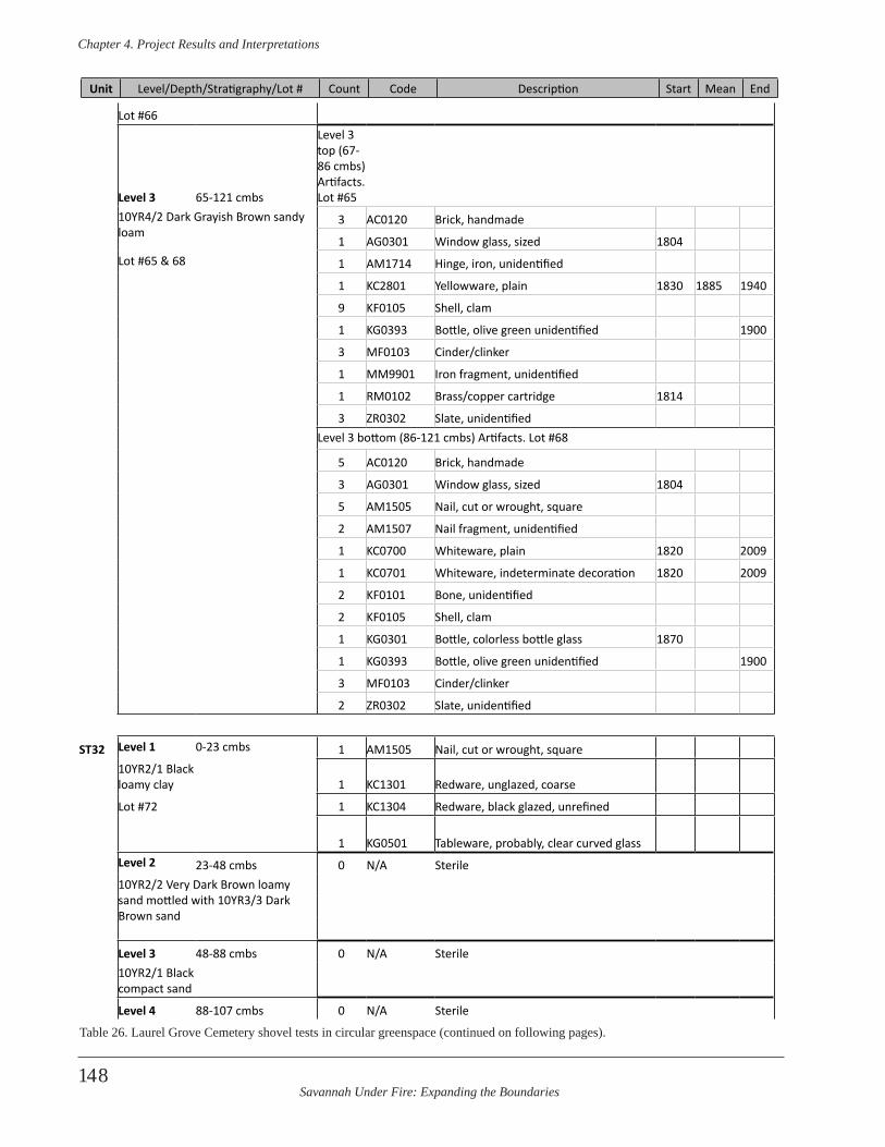
Savannah Under Fire: Expanding the Boundaries
Chapter 4 . Project Results and Interpretations
148
Lot #66
Level 3 65-121 cmbs
Level 3 top (67-86 cmbs) Artifacts. Lot #65
10YR4/2 Dark Grayish Brown sandy loam
3 AC0120 Brick, handmade
1 AG0301 Window glass, sized 1804Lot #65 & 68 1 AM1714 Hinge, iron, unidentified
1 KC2801 Yellowware, plain 1830 1885 1940
9 KF0105 Shell, clam
1 KG0393 Bottle, olive green unidentified 1900
3 MF0103 Cinder/clinker
1 MM9901 Iron fragment, unidentified
1 RM0102 Brass/copper cartridge 1814
3 ZR0302 Slate, unidentifiedLevel 3 bottom (86-121 cmbs) Artifacts. Lot #68
5 AC0120 Brick, handmade
3 AG0301 Window glass, sized 1804
5 AM1505 Nail, cut or wrought, square
2 AM1507 Nail fragment, unidentified
1 KC0700 Whiteware, plain 1820 2009
1 KC0701 Whiteware, indeterminate decoration 1820 2009
2 KF0101 Bone, unidentified
2 KF0105 Shell, clam
1 KG0301 Bottle, colorless bottle glass 1870
1 KG0393 Bottle, olive green unidentified 1900
3 MF0103 Cinder/clinker
2 ZR0302 Slate, unidentified
ST32 Level 1 0-23 cmbs 1 AM1505 Nail, cut or wrought, square 10YR2/1 Black loamy clay 1 KC1301 Redware, unglazed, coarse
Lot #72 1 KC1304 Redware, black glazed, unrefined
1 KG0501 Tableware, probably, clear curved glassLevel 2 23-48 cmbs 0 N/A Sterile10YR2/2 Very Dark Brown loamy sand mottled with 10YR3/3 Dark Brown sand
Level 3 48-88 cmbs 0 N/A Sterile10YR2/1 Black compact sand
Level 4 88-107 cmbs 0 N/A Sterile
Unit Level/Depth/Stratigraphy/Lot # Count Code Description Start Mean End
Table 26. Laurel Grove Cemetery shovel tests in circular greenspace (continued on following pages).
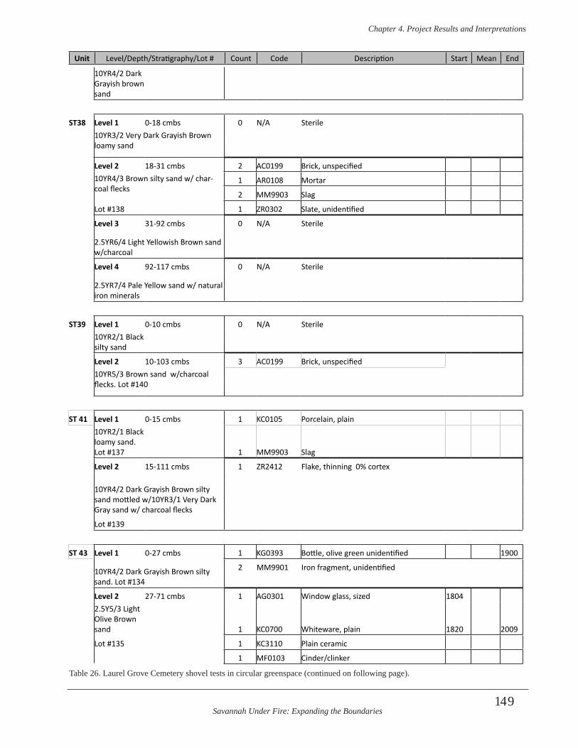
Savannah Under Fire: Expanding the Boundaries
Chapter 4 . Project Results and Interpretations
149
10YR4/2 Dark Grayish brown sand
ST38 Level 1 0-18 cmbs 0 N/A Sterile10YR3/2 Very Dark Grayish Brown loamy sand
Level 2 18-31 cmbs 2 AC0199 Brick, unspecified10YR4/3 Brown silty sand w/ char-coal flecks
1 AR0108 Mortar
2 MM9903 Slag
Lot #138 1 ZR0302 Slate, unidentified
Level 3 31-92 cmbs 0 N/A Sterile
2.5YR6/4 Light Yellowish Brown sand w/charcoal
Level 4 92-117 cmbs 0 N/A Sterile
2.5YR7/4 Pale Yellow sand w/ natural iron minerals
ST39 Level 1 0-10 cmbs 0 N/A Sterile10YR2/1 Black silty sand
Level 2 10-103 cmbs 3 AC0199 Brick, unspecified10YR5/3 Brown sand w/charcoal flecks. Lot #140
ST 41 Level 1 0-15 cmbs 1 KC0105 Porcelain, plain10YR2/1 Black loamy sand. Lot #137 1 MM9903 Slag
Level 2 15-111 cmbs 1 ZR2412 Flake, thinning 0% cortex
10YR4/2 Dark Grayish Brown silty sand mottled w/10YR3/1 Very Dark Gray sand w/ charcoal flecks
Lot #139
ST 43 Level 1 0-27 cmbs 1 KG0393 Bottle, olive green unidentified 1900
10YR4/2 Dark Grayish Brown silty sand. Lot #134
2 MM9901 Iron fragment, unidentified
Level 2 27-71 cmbs 1 AG0301 Window glass, sized 18042.5Y5/3 Light Olive Brown sand 1 KC0700 Whiteware, plain 1820 2009
Lot #135 1 KC3110 Plain ceramic
1 MF0103 Cinder/clinker
Unit Level/Depth/Stratigraphy/Lot # Count Code Description Start Mean End
Table 26. Laurel Grove Cemetery shovel tests in circular greenspace (continued on following page).
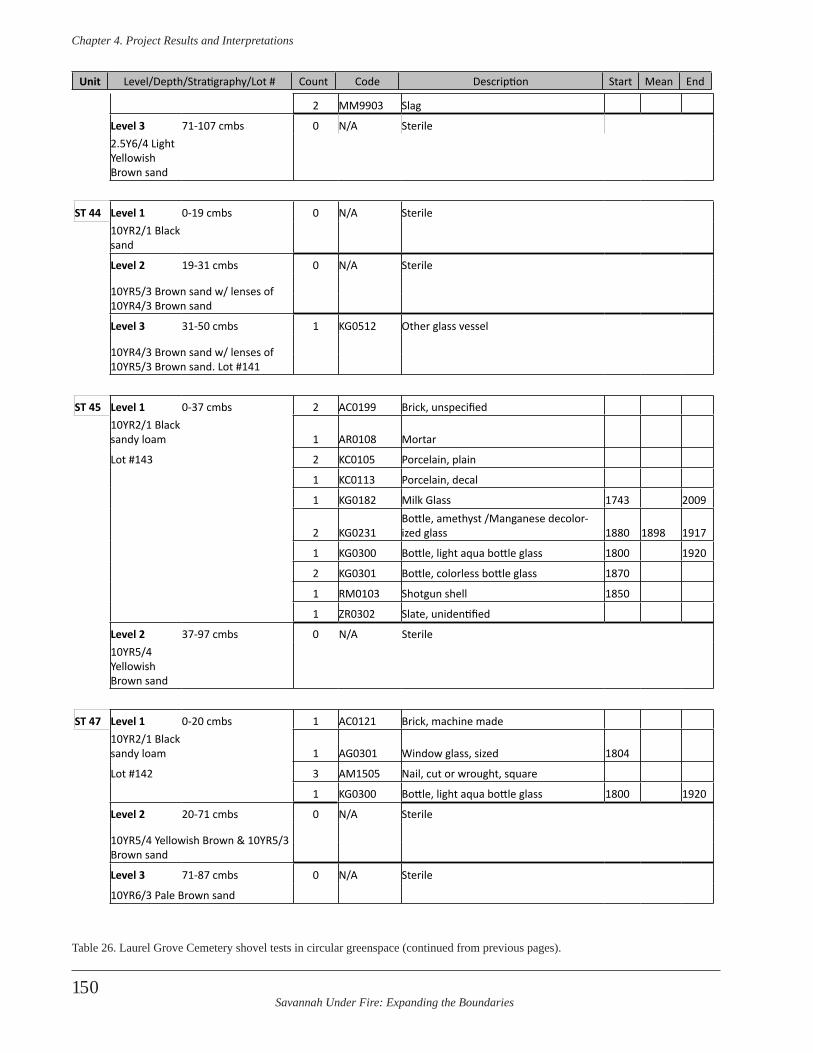
Savannah Under Fire: Expanding the Boundaries
Chapter 4 . Project Results and Interpretations
150
2 MM9903 Slag
Level 3 71-107 cmbs 0 N/A Sterile2.5Y6/4 Light Yellowish Brown sand
ST 44 Level 1 0-19 cmbs 0 N/A Sterile10YR2/1 Black sand
Level 2 19-31 cmbs 0 N/A Sterile
10YR5/3 Brown sand w/ lenses of 10YR4/3 Brown sand
Level 3 31-50 cmbs 1 KG0512 Other glass vessel
10YR4/3 Brown sand w/ lenses of 10YR5/3 Brown sand. Lot #141
ST 45 Level 1 0-37 cmbs 2 AC0199 Brick, unspecified10YR2/1 Black sandy loam 1 AR0108 Mortar
Lot #143 2 KC0105 Porcelain, plain
1 KC0113 Porcelain, decal
1 KG0182 Milk Glass 1743 2009
2 KG0231Bottle, amethyst /Manganese decolor-ized glass 1880 1898 1917
1 KG0300 Bottle, light aqua bottle glass 1800 1920
2 KG0301 Bottle, colorless bottle glass 1870
1 RM0103 Shotgun shell 1850
1 ZR0302 Slate, unidentified
Level 2 37-97 cmbs 0 N/A Sterile10YR5/4 Yellowish Brown sand
ST 47 Level 1 0-20 cmbs 1 AC0121 Brick, machine made10YR2/1 Black sandy loam 1 AG0301 Window glass, sized 1804
Lot #142 3 AM1505 Nail, cut or wrought, square
1 KG0300 Bottle, light aqua bottle glass 1800 1920
Level 2 20-71 cmbs 0 N/A Sterile
10YR5/4 Yellowish Brown & 10YR5/3 Brown sand
Level 3 71-87 cmbs 0 N/A Sterile
10YR6/3 Pale Brown sand
Unit Level/Depth/Stratigraphy/Lot # Count Code Description Start Mean End
Table 26. Laurel Grove Cemetery shovel tests in circular greenspace (continued from previous pages).
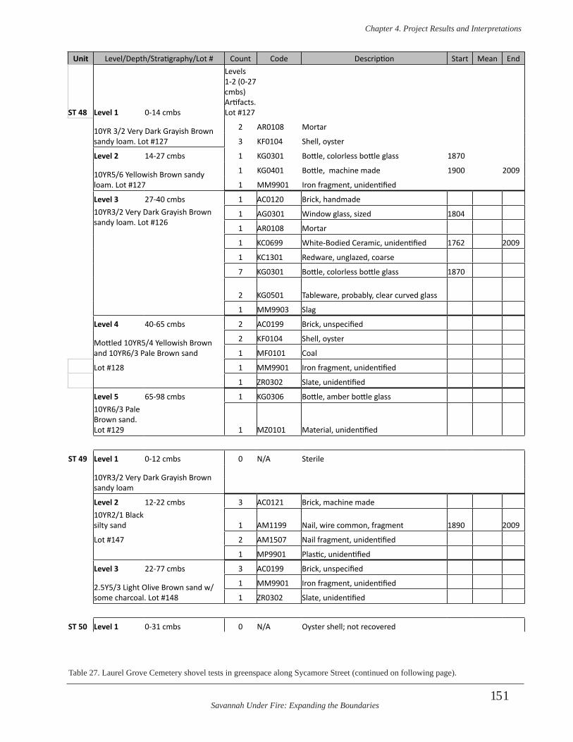
Savannah Under Fire: Expanding the Boundaries
Chapter 4 . Project Results and Interpretations
151
Unit Level/Depth/Stratigraphy/Lot # Count Code Description Start Mean End
ST 48 Level 1 0-14 cmbs
Levels 1-2 (0-27 cmbs) Artifacts. Lot #127
10YR 3/2 Very Dark Grayish Brown sandy loam. Lot #127
2 AR0108 Mortar
3 KF0104 Shell, oyster
Level 2 14-27 cmbs 1 KG0301 Bottle, colorless bottle glass 1870
10YR5/6 Yellowish Brown sandy loam. Lot #127
1 KG0401 Bottle, machine made 1900 2009
1 MM9901 Iron fragment, unidentified
Level 3 27-40 cmbs 1 AC0120 Brick, handmade10YR3/2 Very Dark Grayish Brown sandy loam. Lot #126
1 AG0301 Window glass, sized 1804
1 AR0108 Mortar
1 KC0699 White-Bodied Ceramic, unidentified 1762 2009
1 KC1301 Redware, unglazed, coarse
7 KG0301 Bottle, colorless bottle glass 1870
2 KG0501 Tableware, probably, clear curved glass
1 MM9903 Slag
Level 4 40-65 cmbs 2 AC0199 Brick, unspecified
Mottled 10YR5/4 Yellowish Brown and 10YR6/3 Pale Brown sand
2 KF0104 Shell, oyster
1 MF0101 Coal
Lot #128 1 MM9901 Iron fragment, unidentified
1 ZR0302 Slate, unidentified
Level 5 65-98 cmbs 1 KG0306 Bottle, amber bottle glass10YR6/3 Pale Brown sand.Lot #129 1 MZ0101 Material, unidentified
ST 49 Level 1 0-12 cmbs 0 N/A Sterile
10YR3/2 Very Dark Grayish Brown sandy loam
Level 2 12-22 cmbs 3 AC0121 Brick, machine made10YR2/1 Black silty sand 1 AM1199 Nail, wire common, fragment 1890 2009
Lot #147 2 AM1507 Nail fragment, unidentified
1 MP9901 Plastic, unidentified
Level 3 22-77 cmbs 3 AC0199 Brick, unspecified
2.5Y5/3 Light Olive Brown sand w/some charcoal. Lot #148
1 MM9901 Iron fragment, unidentified
1 ZR0302 Slate, unidentified
ST 50 Level 1 0-31 cmbs 0 N/A Oyster shell; not recovered
Table 27. Laurel Grove Cemetery shovel tests in greenspace along Sycamore Street (continued on following page).
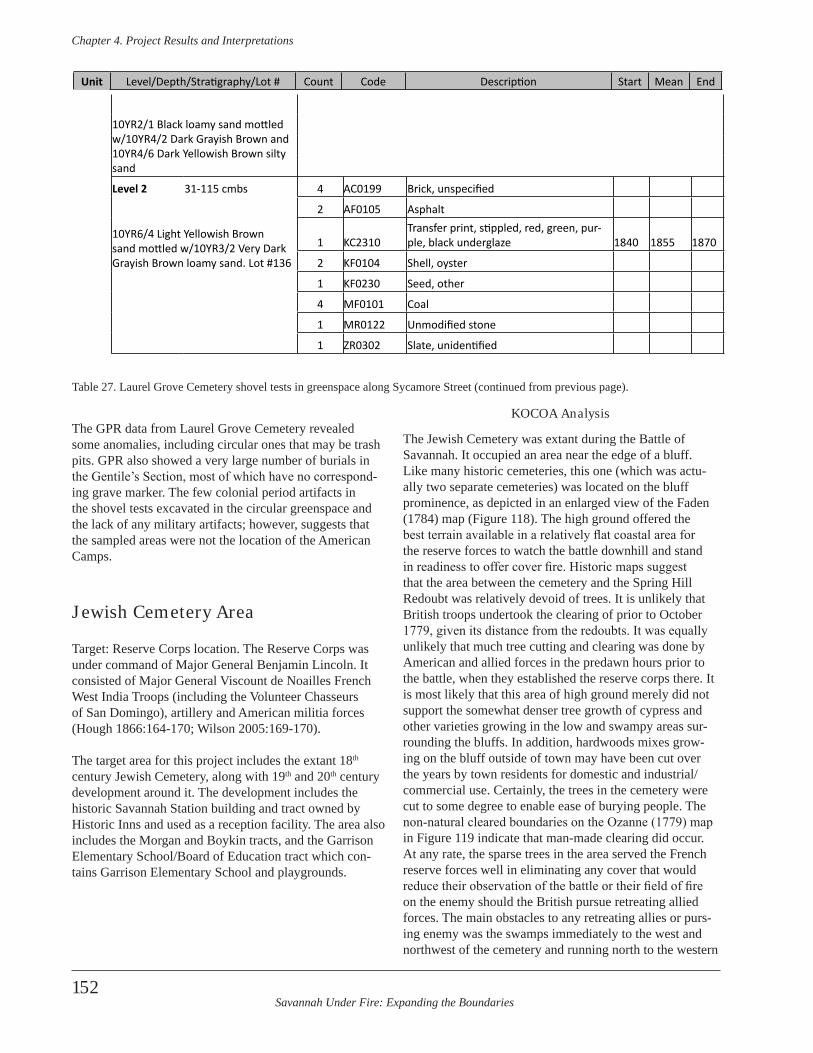
Savannah Under Fire: Expanding the Boundaries
Chapter 4 . Project Results and Interpretations
152
The GPR data from Laurel Grove Cemetery revealed some anomalies, including circular ones that may be trash pits. GPR also showed a very large number of burials in the Gentile’s Section, most of which have no correspond-ing grave marker. The few colonial period artifacts in the shovel tests excavated in the circular greenspace and the lack of any military artifacts; however, suggests that the sampled areas were not the location of the American Camps.
Jewish Cemetery Area
Target: Reserve Corps location. The Reserve Corps was under command of Major General Benjamin Lincoln. It consisted of Major General Viscount de Noailles French West India Troops (including the Volunteer Chasseurs of San Domingo), artillery and American militia forces (Hough 1866:164-170; Wilson 2005:169-170).
The target area for this project includes the extant 18th century Jewish Cemetery, along with 19th and 20th century development around it. The development includes the historic Savannah Station building and tract owned by Historic Inns and used as a reception facility. The area also includes the Morgan and Boykin tracts, and the Garrison Elementary School/Board of Education tract which con-tains Garrison Elementary School and playgrounds.
KOCOA Analysis
The Jewish Cemetery was extant during the Battle of Savannah. It occupied an area near the edge of a bluff. Like many historic cemeteries, this one (which was actu-ally two separate cemeteries) was located on the bluff prominence, as depicted in an enlarged view of the Faden (1784) map (Figure 118). The high ground offered the best terrain available in a relatively flat coastal area for the reserve forces to watch the battle downhill and stand in readiness to offer cover fire. Historic maps suggest that the area between the cemetery and the Spring Hill Redoubt was relatively devoid of trees. It is unlikely that British troops undertook the clearing of prior to October 1779, given its distance from the redoubts. It was equally unlikely that much tree cutting and clearing was done by American and allied forces in the predawn hours prior to the battle, when they established the reserve corps there. It is most likely that this area of high ground merely did not support the somewhat denser tree growth of cypress and other varieties growing in the low and swampy areas sur-rounding the bluffs. In addition, hardwoods mixes grow-ing on the bluff outside of town may have been cut over the years by town residents for domestic and industrial/commercial use. Certainly, the trees in the cemetery were cut to some degree to enable ease of burying people. The non-natural cleared boundaries on the Ozanne (1779) map in Figure 119 indicate that man-made clearing did occur. At any rate, the sparse trees in the area served the French reserve forces well in eliminating any cover that would reduce their observation of the battle or their field of fire on the enemy should the British pursue retreating allied forces. The main obstacles to any retreating allies or purs-ing enemy was the swamps immediately to the west and northwest of the cemetery and running north to the western
10YR2/1 Black loamy sand mottled w/10YR4/2 Dark Grayish Brown and 10YR4/6 Dark Yellowish Brown silty sand
Level 2 31-115 cmbs 4 AC0199 Brick, unspecified
10YR6/4 Light Yellowish Brown sand mottled w/10YR3/2 Very Dark Grayish Brown loamy sand. Lot #136
2 AF0105 Asphalt
1 KC2310Transfer print, stippled, red, green, pur-ple, black underglaze 1840 1855 1870
2 KF0104 Shell, oyster
1 KF0230 Seed, other
4 MF0101 Coal
1 MR0122 Unmodified stone
1 ZR0302 Slate, unidentified
Table 27. Laurel Grove Cemetery shovel tests in greenspace along Sycamore Street (continued from previous page).
Unit Level/Depth/Stratigraphy/Lot # Count Code Description Start Mean End
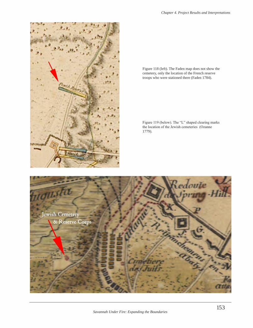
Savannah Under Fire: Expanding the Boundaries
Chapter 4 . Project Results and Interpretations
153
Jewish Cemetery & Reserve Corps
Figure 118 (left). The Faden map does not show the cemetery, only the location of the French reserve troops who were stationed there (Faden 1784).
Figure 119 (below). The “L” shaped clearing marks the location of the Jewish cemeteries (Ozanne 1779).
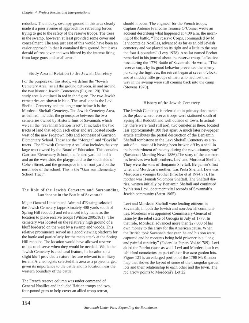
Savannah Under Fire: Expanding the Boundaries
Chapter 4 . Project Results and Interpretations
154
redoubts. The mucky, swampy ground in this area clearly made it a poor avenue of approach for retreating forces trying to get to the safety of the reserve troops. The trees in the swamp, however, at least provided some cover and concealment. The area just east of this would have been an easier approach in that it contained firm ground, but it was devoid of tree cover and was blitzed by the intense firing from large guns and small arms.
Study Area in Relation to the Jewish Cemetery
For the purposes of this study, we define the “Jewish Cemetery Area” as all the ground between, in and around the two historic Jewish Cemeteries (Figure 120). This study area is outlined in red in the figure. The two Jewish cemeteries are shown in blue. The small one is the Levi Sheftall Cemetery and the larger one below it is the Mordecai Sheftall Cemetery. The Jewish Cemetery Area, as defined, includes the greenspace between the two cemeteries owned by Historic Inns of Savannah, which we call the “Savannah Station Tract”. It includes the two tracts of land that adjoin each other and are located south-west of the new Frogtown lofts and southeast of Garrison Elementary School. These are the “Morgan” and “Boykin” tracts. The “Jewish Cemetery Area” also includes the very large tract owned by the Board of Education. This contains Garrison Elementary School, the fenced yard behind it and on the west side, the playground to the south side of Cohen Street, and the greenspace in the front yard on the north side of the school. This is the “Garrison Elementary School Tract”.
The Role of the Jewish Cemetery and Surrounding Landscape in the Battle of Savannah
Major General Lincoln and Admiral d’Estaing selected the Jewish Cemetery (approximately 400 yards south of Spring Hill redoubt) and referenced it by name as the location to place reserve troops (Wilson 2005:161). The cemetery was located on the relatively high ground of a bluff bordered on the west by a swamp and woods. This relative prominence served as a good viewing platform for the battle and particularly for the main attack at the Spring Hill redoubt. The location would have allowed reserve troops to observe when they would be needed. While the Jewish Cemetery is a cultural feature, its location on a slight bluff provided a natural feature relevant to military terrain. Archeologists selected this area as a project target, given its importance to the battle and its location near the western boundary of the battle.
The French reserve column was under command of General Noailles and included Haitian troops and two, four-pound guns to help cover an allied troop retreat,
should it occur. The engineer for the French troops, Captain Antoine Francoise Terance O’Conner wrote an account describing what happened at 4:00 a.m. the morn-ing of the battle, “The reserve Corps, commanded by M. le vicomte de Noailles, advanced as far as an old Jewish cemetery and we placed on its right and a little to the rear the four 4-pounders” (Levy 1978). A sailor named Pechot remarked in his journal about the reserve troops’ effective-ness during the 1779 Battle of Savannah. He wrote, “The reserve corps by its good behavior prevented the enemy pursuing the fugitives, the retreat began at seven o’clock, and at midday little groups of men who had lost their way in the swamp were still coming back into the camp (Stevens 1970).
History of the Jewish Cemetery
The Jewish Cemetery is referred to in primary documents as the place where reserve troops were stationed south of Spring Hill Redoubt and well outside of town. In actual-ity, there were (and still are), two cemeteries there, located less approximately 180 feet apart. A much later newspaper article attributes the partial destruction of the Benjamin Sheftall tombstone in the Levi Sheftall Cemetery as a re-sult of “…most of it having been broken off by a shell in the bombardment of the city during the revolutionary war” (Savannah Morning News 1886).The story of the cemeter-ies involves two half-brothers, Levi and Mordecai Sheftall. They were the sons of Benjamin Sheftall. Benjamin’s first wife, and Mordecai’s mother, was Perla Sheftall. Levi was Mordecai’s younger brother (Proctor et al 1984:73). His mother was Hannah Solomons Sheftall. The Sheftall dia-ries, written initially by Benjamin Sheftall and continued by his son Levi, document vital records of Savannah’s Jewish community (Stern 1965).
Levi and Mordecai Sheftall were leading citizens in Savannah, in both the Jewish and non-Jewish communi-ties. Mordecai was appointed Commissary-General of Issue by the rebel state of Georgia in July of 1778. In that role, Mordecai advanced more than $27,000 of his own money to the army for the American cause. When the British took Savannah that year, he and his son were captured and he recounts being held prisoner in a “long and painful captivity” (Federalist Papers Vol.6:1789). Levi aided the Patriot cause as well. Levi and Mordecai each es-tablished cemeteries on part of their five acre garden lots. Figure 121 is an enlarged portion of the 1798 McKinnon map that shows the layout of some of the triangular garden lots and their relationship to each other and the town. The red arrow points to Mordecai’s Lot 22.
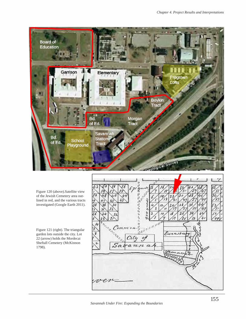
Savannah Under Fire: Expanding the Boundaries
Chapter 4 . Project Results and Interpretations
155
FrogtownLofts
BoykinTract
Garrison Elementary
Playground
BoykinTract
MorganTract
SavannahStation
Board ofEducation
SchoolTract
Bd. of Ed.
Bd. of Ed.
Figure 120 (above).Satellite view of the Jewish Cemetery area out-lined in red, and the various tracts investigated (Google Earth 2011).
Figure 121 (right). The triangular garden lots outside the city. Lot 22 (arrow) holds the Mordecai Sheftall Cemetery (McKinnon 1798).
Savannah Under Fire: Expanding the Boundaries
Chapter 4 . Project Results and Interpretations
156
Levi Sheftall Cemetery
This cemetery was designated as a family burial ground for Levi’s family, the family of Mordecai, and his wife’s family the De LaMottas. Occasionally this cemetery has been referred to as the De Lyon or De LaMotta Cemetery, based on a misconception printed in 1950 and the fact that the extant tombstones are engraved with these names (Levy 1950). In actuality, however, the cemetery was established by Levi Sheftall in or prior to 1765 and the surviving stones represent his descendants. Levi and Mordecai buried their father, Benjamin Sheftall, in Levi’s cemetery in 1765 (Levy 1983). By 1773 Levi formally put the cemetery lot in a trust (Levy 1983:92). The Sheftall diaries note the name of the Levi Sheftall cemetery and lists burials. For example, the 1790 entry states, “…depart-ed this life Mrs. Sara Delamotta wife of Isaac Delamotta mother of Mrs. Sarah Sheftall aged 62 years and was bur-ied on the 19th in Levi Sheftalls burial ground alongside of her granddaughter Rebecka Sheftall…” (Stern 1965). The 1773 trust deed states that there was a brick wall around the Levi Sheftall .In 1797 the City of Savannah paid Levi 50 Ds. (pence) “…in part for bricks for the Cemetery” (Georgia Gazette 1797). These may have been to repair the brick wall that already enclosed it.
Mordecai Sheftall Cemetery
Between 1762 and 1773, Mordecai established a cem-etery, not only for his own family, but for all the Jews in Savannah (Proctor 1984:70). The location he selected was approximately 180 feet south of Levi’s cemetery. Mordecai established this new cemetery on his own five acre lot (Garden Lot No. 22) that he received as a Crown grant in 1762. In the 1773 transaction he conveyed 1.5 acres of the lot to a newly formed cemetery trust (Harden 1913:50). The 1773 trust deed states that any Jewish person could be buried there as the “land shall be and forever remain to and for the use and purpose of a Place of Burial for all per-sons whatever professing the Jewish Religion” (Chatham County Superior Court 1803).The Sheftall diaries lists two entries with dates 16 years apart for the construction of a stone wall around the Mordecai Sheftall Cemetery. A 1771 entry states, “Minis Minis…was buried near Hetty Serzatos and Solomon Solomons (which place is now in-closed in a stone wall by the Congregation given for the purpose for a place of burial by Mordecai Sheftall” (Stern 1965:250). On July 31, 1787,
The society called the Mishebe’t Nefesh laid this day the foundation stones for a wall to be built round the piece of ground given by Mordecai Sheftall for a publick burial ground . Laying the first stone was given to Mordecai Sheftall the 2
stone to Levi Sheftall the 3 stone to Philip I . Cohen the 4 stone to Cushman Polock (Stern 1965:254) .
It is possible that this reflects two different walls, or that one date is in error. Even if the date of 1771 is incorrect for the construction of the first wall around the cemetery, documents show that the cemetery was in use prior to the Battle of Savannah in 1779.
Interments continued but tapered off with the opening of the Hebrew section of Laurel Grove Cemetery. Except for an isolated example in 1916, the last known burial in the Mordecai Cemetery was 1881 (Levy 1978:3). As the sur-rounding area suffered economic neglect, the Mordecai Sheftall Cemetery remained intact (unlike the Levi Sheftall Cemetery). The former’s survival was undoubtedly due to the walls that surrounded it in the past. The extant Belgian block wall around the Mordecai Cemetery was constructed by Mickve Israel in the 1930s when they gained posses-sion of the property (John Sheftall, personal communica-tion, February 23, 2011). Attention was refocused on the cemetery in 1976, with the nation’s bicentennial founding on the forefront. At this time, some of the brick crypts were repointed and repaired, a water line was extended to the area, and the cemetery was landscaped (Green ca. 1976). The Mordecai Sheftall Cemetery occupies a larger footprint today than does the Levi Sheftall Cemetery. This was probably the case throughout most of its history, al-though the maximum size of the Levi cemetery will likely never be known. While GPR can ascertain unmarked buri-als, it cannot find burials that were taken away or other-wise destroyed during area construction.
Historical Land Use of the Area
In addition to the two Jewish Cemeteries, the study tract saw extensive land use and modification during the 19th and 20th centuries. An 1840 map of Savannah reveals that the area was still laid out in its original garden lot triangles at that time (Stephens 1840). These garden lots were given initially to colonists who owned a town lot, allowing them to raise their own produce in the garden lots outside of town. In March, 1849 the Savannah City Council passed a resolution, “That a select Committee be appointed to devise some mode of opening a street to the Cemetery, used by the Hebrew portion of our population” (Savannah Republican 1849a). In July the committee reported to the council that,
Mr . Hiram Roberts, owner of garden lot No . 13, West of the city, is willing to allow a way through his lot East of the Cemetery, provided two plain gates are constructed, so as to prevent injury to his property . This way would be open to the congregation until a
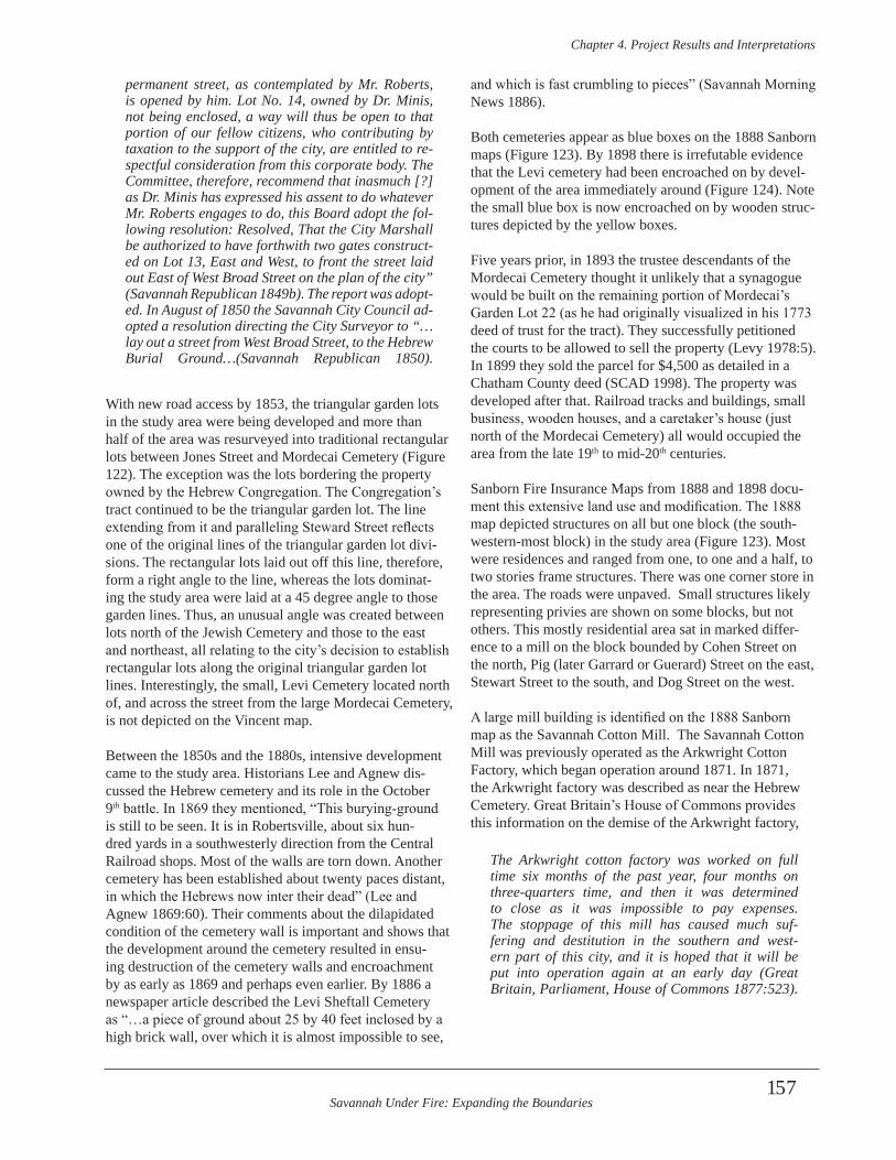
Savannah Under Fire: Expanding the Boundaries
Chapter 4 . Project Results and Interpretations
157
permanent street, as contemplated by Mr . Roberts, is opened by him . Lot No . 14, owned by Dr . Minis, not being enclosed, a way will thus be open to that portion of our fellow citizens, who contributing by taxation to the support of the city, are entitled to re-spectful consideration from this corporate body . The Committee, therefore, recommend that inasmuch [?] as Dr . Minis has expressed his assent to do whatever Mr . Roberts engages to do, this Board adopt the fol-lowing resolution: Resolved, That the City Marshall be authorized to have forthwith two gates construct-ed on Lot 13, East and West, to front the street laid out East of West Broad Street on the plan of the city” (Savannah Republican 1849b) . The report was adopt-ed . In August of 1850 the Savannah City Council ad-opted a resolution directing the City Surveyor to “…lay out a street from West Broad Street, to the Hebrew Burial Ground…(Savannah Republican 1850) .
With new road access by 1853, the triangular garden lots in the study area were being developed and more than half of the area was resurveyed into traditional rectangular lots between Jones Street and Mordecai Cemetery (Figure 122). The exception was the lots bordering the property owned by the Hebrew Congregation. The Congregation’s tract continued to be the triangular garden lot. The line extending from it and paralleling Steward Street reflects one of the original lines of the triangular garden lot divi-sions. The rectangular lots laid out off this line, therefore, form a right angle to the line, whereas the lots dominat-ing the study area were laid at a 45 degree angle to those garden lines. Thus, an unusual angle was created between lots north of the Jewish Cemetery and those to the east and northeast, all relating to the city’s decision to establish rectangular lots along the original triangular garden lot lines. Interestingly, the small, Levi Cemetery located north of, and across the street from the large Mordecai Cemetery, is not depicted on the Vincent map.
Between the 1850s and the 1880s, intensive development came to the study area. Historians Lee and Agnew dis-cussed the Hebrew cemetery and its role in the October 9th battle. In 1869 they mentioned, “This burying-ground is still to be seen. It is in Robertsville, about six hun-dred yards in a southwesterly direction from the Central Railroad shops. Most of the walls are torn down. Another cemetery has been established about twenty paces distant, in which the Hebrews now inter their dead” (Lee and Agnew 1869:60). Their comments about the dilapidated condition of the cemetery wall is important and shows that the development around the cemetery resulted in ensu-ing destruction of the cemetery walls and encroachment by as early as 1869 and perhaps even earlier. By 1886 a newspaper article described the Levi Sheftall Cemetery as “…a piece of ground about 25 by 40 feet inclosed by a high brick wall, over which it is almost impossible to see,
and which is fast crumbling to pieces” (Savannah Morning News 1886).
Both cemeteries appear as blue boxes on the 1888 Sanborn maps (Figure 123). By 1898 there is irrefutable evidence that the Levi cemetery had been encroached on by devel-opment of the area immediately around (Figure 124). Note the small blue box is now encroached on by wooden struc-tures depicted by the yellow boxes.
Five years prior, in 1893 the trustee descendants of the Mordecai Cemetery thought it unlikely that a synagogue would be built on the remaining portion of Mordecai’s Garden Lot 22 (as he had originally visualized in his 1773 deed of trust for the tract). They successfully petitioned the courts to be allowed to sell the property (Levy 1978:5). In 1899 they sold the parcel for $4,500 as detailed in a Chatham County deed (SCAD 1998). The property was developed after that. Railroad tracks and buildings, small business, wooden houses, and a caretaker’s house (just north of the Mordecai Cemetery) all would occupied the area from the late 19th to mid-20th centuries.
Sanborn Fire Insurance Maps from 1888 and 1898 docu-ment this extensive land use and modification. The 1888 map depicted structures on all but one block (the south-western-most block) in the study area (Figure 123). Most were residences and ranged from one, to one and a half, to two stories frame structures. There was one corner store in the area. The roads were unpaved. Small structures likely representing privies are shown on some blocks, but not others. This mostly residential area sat in marked differ-ence to a mill on the block bounded by Cohen Street on the north, Pig (later Garrard or Guerard) Street on the east, Stewart Street to the south, and Dog Street on the west.
A large mill building is identified on the 1888 Sanborn map as the Savannah Cotton Mill. The Savannah Cotton Mill was previously operated as the Arkwright Cotton Factory, which began operation around 1871. In 1871, the Arkwright factory was described as near the Hebrew Cemetery. Great Britain’s House of Commons provides this information on the demise of the Arkwright factory,
The Arkwright cotton factory was worked on full time six months of the past year, four months on three-quarters time, and then it was determined to close as it was impossible to pay expenses . The stoppage of this mill has caused much suf-fering and destitution in the southern and west-ern part of this city, and it is hoped that it will be put into operation again at an early day (Great Britain, Parliament, House of Commons 1877:523) .
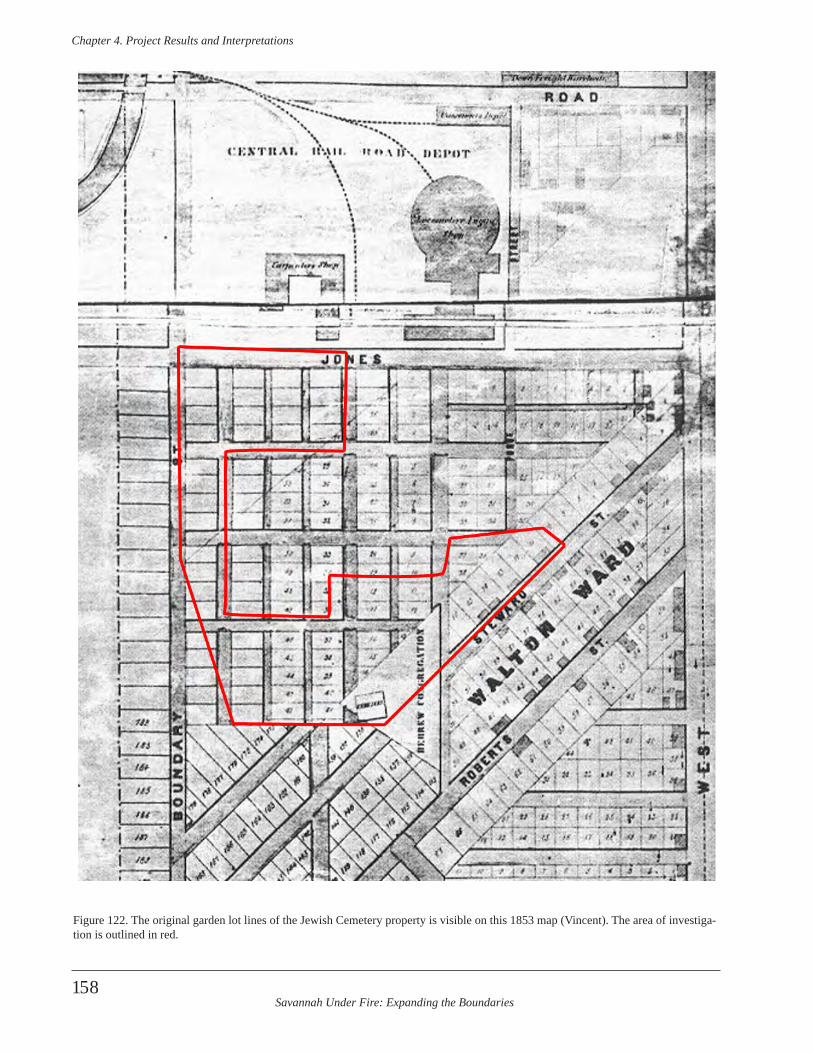
Savannah Under Fire: Expanding the Boundaries
Chapter 4 . Project Results and Interpretations
158
Figure 122. The original garden lot lines of the Jewish Cemetery property is visible on this 1853 map (Vincent). The area of investiga-tion is outlined in red.
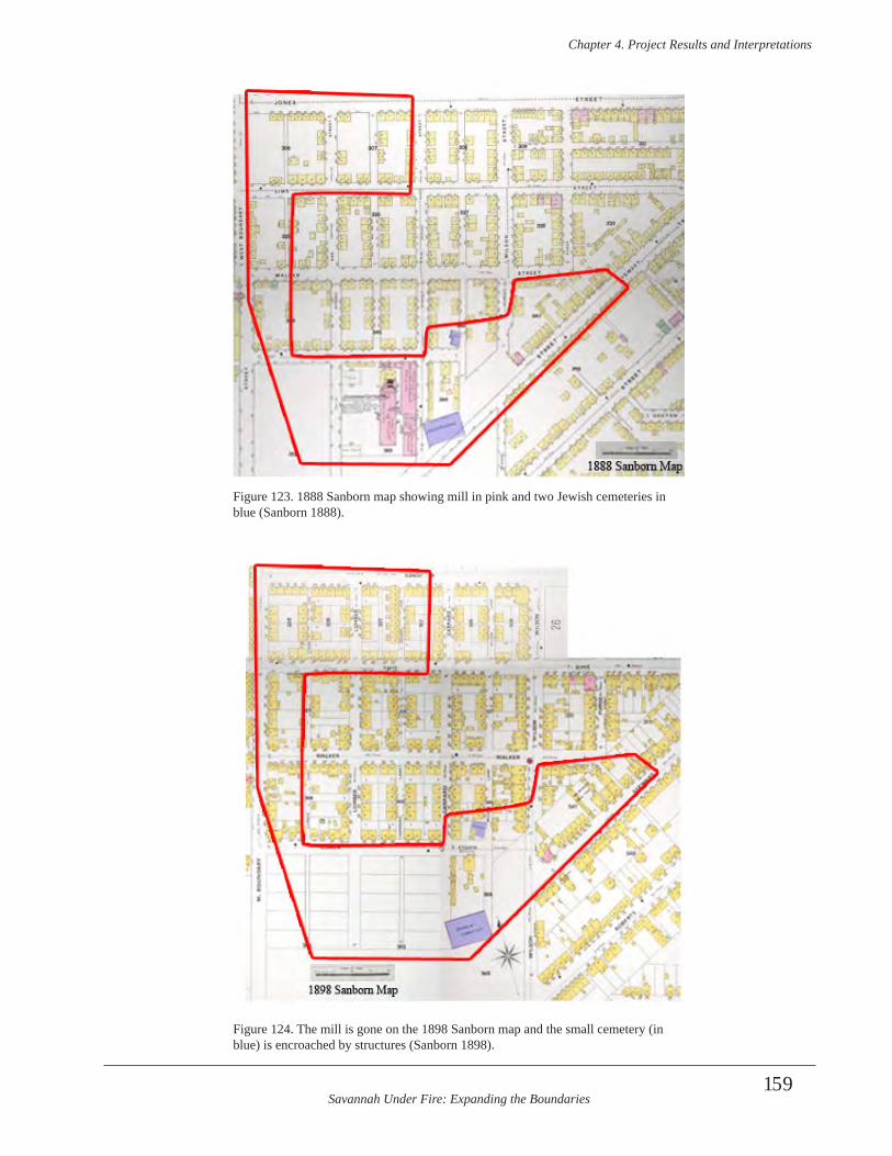
Savannah Under Fire: Expanding the Boundaries
Chapter 4 . Project Results and Interpretations
159
Figure 123. 1888 Sanborn map showing mill in pink and two Jewish cemeteries in blue (Sanborn 1888).
Figure 124. The mill is gone on the 1898 Sanborn map and the small cemetery (in blue) is encroached by structures (Sanborn 1898).
Savannah Under Fire: Expanding the Boundaries
Chapter 4 . Project Results and Interpretations
160
The Arkwright factory apparently rebounded, for the Sholes city directory for 1882 listed the Arkwright Cotton Factory at the south end of Guerard Street. In 1886, the Arkwright factory employed 85 workers (Rebarer 1879:14; Sholes 1882:101; J.M. Elstner and Company 1886:38).
By 1888, the Arkwright mill operated as the Savannah Cotton Mill and employed 100 workers. The mill workers were most likely women if it followed tradition of the day. Employees worked 12 hour days. It is likely that many of the modest houses surrounding the mill were occupied by mill workers who were boarding, renting, or perhaps in rarer cases, buying the houses. The mill had 10,500 spin-dles and contained buildings, rooms, and areas for carding, spinning, reeling, dying, baling and packing. It also had a forge and machine shop.
The location of a very large cotton mill complex, imme-diately west of the Hebrew cemetery undoubtedly had an adverse effect on the archeological resources directly be-neath it. Some portions of the archeological deposits may have been protected by the building; however, including the zone containing battlefield debris. This is evident by the battle artifacts collected by metal detectorists and other relic hunters at the Garrison school playground, which sits on portions of the mill footprint.
The city block immediately west of the cotton mill was vacant of buildings, at least as represented by the Sanborn map. The 1888 map shows the Levi Sheftall Cemetery north of the Mordecai Sheftall Cemetery. By 1892 cem-etery encroachment and vandalism had increased mark-edly. A member of the Mickve Israel Congregation wrote to its president to complain about the “…almost totally neglected condition of the Old Hebrew Cemetery…”, the overgrowth of vegetation that “…made it almost impossi-ble to pass over the ground…” and the fact that “unknown persons make it a receptacle for carcases of dead animals” (Solomons 1882). He went on to say he could not keep cleaning the cemetery and requested that the area adjacent to it be used for construction of a house for a cemetery caretaker. Apparently the congregation agreed, as later Sanborn maps and newspaper articles reference a cem-etery caretaker’s house inhabited by an African American couple.
The 1898 Sanborn map shows no evidence of the Savannah Cotton Mill, so it is likely that it was torn down by that time (Figure 124). Another change in the ten years between map-making included a greater density of frame houses on the blocks. By this time, there were more houses in-filled between houses depicted on the 1888 map. By 1898 all the blocks north of Cohen Street had structures, and most were ringed by the maximum number of side-by-side buildings as space allowed. More stores dotted
the area, particularly on corner lots. The streets remained unpaved. The Levi Sheftall Cemetery walls were virtu-ally gone and the graveyard had been encroached upon by at least two wooden structures. An undated photograph shows a view down Cohen Street facing east, at the in-tersection of Cohen and Spruce (Figure 125). The Levi Cemetery would be immediate behind the photographer. By the mid-20th century the neighborhood was referred to as a slum in newspaper articles. A 1936 survey by the WPA noted 12 extant graves; 4 marked and 8 unmarked.
Researchers encountered confusion caused by a plethora of changing street names in the vicinity of the Jewish cem-etery. These street names involved Cohen, Dog, Garrard, Guerard, Lumber, Pig, and Spruce streets. Savannah city code for 1884 recorded the official naming of several streets in the vicinity,
That certain other street running east and west from the Hebrew Congregation/ lot to West Boundary street, next south of Walker street, in said city, which street is forty feet in width, shall be known as Cohen street . That certain other street running north and south from Jones street continued, to Garden Lot No . 4 of the tan yard tract, being the first street west of Wilson street, in said city, which street is thirty-five feet wide, shall be known as Spruce street . That cer-tain other street running north and south from Jones street continued, to Garden Lot No . 4 of the tan yard tract, being the second street west of Wilson street, in said city, which street is forty feet in width, shall be known as Guerard street (MacDonnell 1907:340) .
Nine years later, in 1893 Savannah’s streets in the vicinity were renamed again,
That certain street in Choctaw Ward, of the city of Savannah, called in the published map of the city Spruce street, is hereby changed to Guerard street, and Guerard street, in the same ward, is hereby changed to the name of Lumber street . The street in the same ward, immediately east of what is called on the map Spruce street, and west of Wilson street, heretofore . unnamed, shall be hereafter called Spruce street . The unnamed street in the same ward, immediately east of the street designated on the said map as Guerard street, shall be hereafter called Cann street, and the unnamed street immedi-ately west of said Guerard street, shall be hereafter called Harmon street (MacDonnell 1907:340-341) .
In 1935 a WPA project documented both cemeteries by making scaled maps of them (Figure 126). This included the remaining marked graves and some details about the surroundings outside the cemetery walls. This included
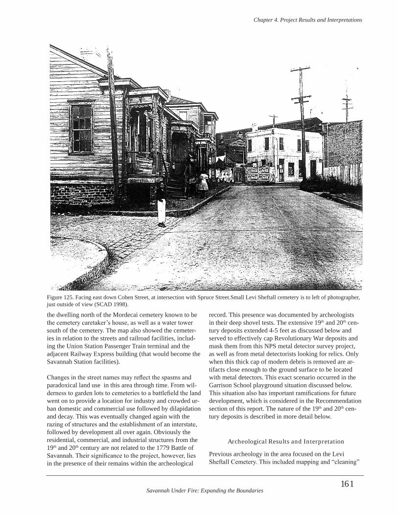
Savannah Under Fire: Expanding the Boundaries
Chapter 4 . Project Results and Interpretations
161
the dwelling north of the Mordecai cemetery known to be the cemetery caretaker’s house, as well as a water tower south of the cemetery. The map also showed the cemeter-ies in relation to the streets and railroad facilities, includ-ing the Union Station Passenger Train terminal and the adjacent Railway Express building (that would become the Savannah Station facilities).
Changes in the street names may reflect the spasms and paradoxical land use in this area through time. From wil-derness to garden lots to cemeteries to a battlefield the land went on to provide a location for industry and crowded ur-ban domestic and commercial use followed by dilapidation and decay. This was eventually changed again with the razing of structures and the establishment of an interstate, followed by development all over again. Obviously the residential, commercial, and industrial structures from the 19th and 20th century are not related to the 1779 Battle of Savannah. Their significance to the project, however, lies in the presence of their remains within the archeological
record. This presence was documented by archeologists in their deep shovel tests. The extensive 19th and 20th cen-tury deposits extended 4-5 feet as discussed below and served to effectively cap Revolutionary War deposits and mask them from this NPS metal detector survey project, as well as from metal detectorists looking for relics. Only when this thick cap of modern debris is removed are ar-tifacts close enough to the ground surface to be located with metal detectors. This exact scenario occurred in the Garrison School playground situation discussed below. This situation also has important ramifications for future development, which is considered in the Recommendation section of this report. The nature of the 19th and 20th cen-tury deposits is described in more detail below.
Archeological Results and Interpretation
Previous archeology in the area focused on the Levi Sheftall Cemetery. This included mapping and “cleaning”
Figure 125. Facing east down Cohen Street, at intersection with Spruce Street.Small Levi Sheftall cemetery is to left of photographer, just outside of view (SCAD 1998).
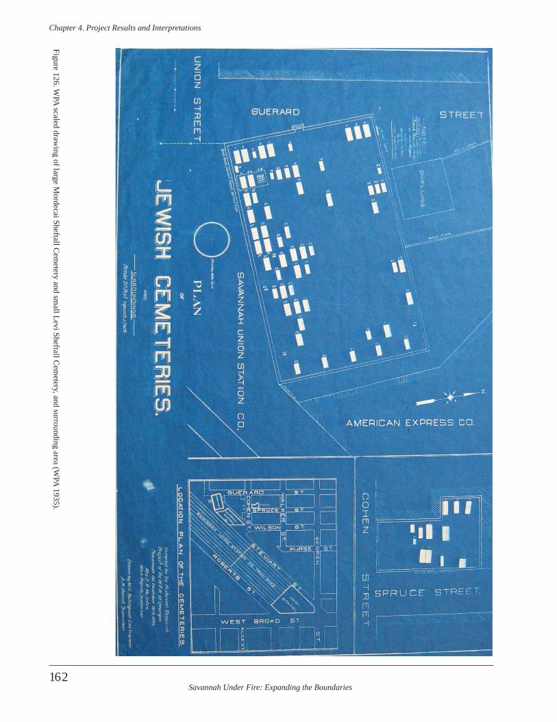
Savannah Under Fire: Expanding the Boundaries
Chapter 4 . Project Results and Interpretations
162
Figure 126. WPA
scaled drawing of large M
ordecai Sheftall Cem
etery and small Levi Sheftall C
emetery, and surrounding area (W
PA 1935).
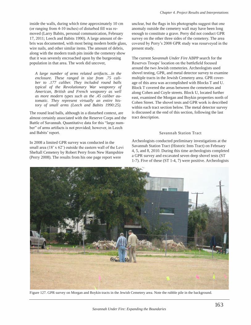
Savannah Under Fire: Expanding the Boundaries
Chapter 4 . Project Results and Interpretations
163
inside the walls, during which time approximately 10 cm (or ranging from 4-10 inches) of disturbed fill was re-moved (Larry Babits, personal communication, February 17, 2011; Leech and Babits 1990). A large amount of de-bris was documented, with most being modern bottle glass, wire nails, and other similar items. The amount of debris, along with the modern trash pits inside the cemetery show that it was severely encroached upon by the burgeoning population in that area. The work did uncover,
A large number of arms related artifacts…in the enclosure . These ranged in size from .75 cali-ber to .177 caliber . They included round balls typical of the Revolutionary War weaponry of American, British and French weaponry as well as more modern types such as the .45 caliber au-tomatic . They represent virtually an entire his-tory of small arms (Leech and Babits 1990:25) .
The round lead balls, although in a disturbed context, are almost certainly associated with the Reserve Corps and the Battle of Savannah. Quantitative data for this “large num-ber” of arms artifacts is not provided; however, in Leech and Babits’ report.
In 2008 a limited GPR survey was conducted in the small area (18’ x 62’) outside the eastern wall of the Levi Sheftall Cemetery by Robert Perry from New Hampshire (Perry 2008). The results from his one page report were
unclear, but the flags in his photographs suggest that one anomaly outside the cemetery wall may have been long enough to constitute a grave. Perry did not conduct GPR survey on the other three sides of the cemetery. The area covered by Perry’s 2008 GPR study was resurveyed in the present study.
The current Savannah Under Fire ABPP search for the Reserves Troops’ location on the battlefield focused around the two Jewish cemeteries. Archeologists used shovel testing, GPR, and metal detector survey to examine multiple tracts in the Jewish Cemetery area. GPR cover-age of this area was accomplished with Blocks T and U. Block T covered the areas between the cemeteries and along Cohen and Coyle streets. Block U, located further east, examined the Morgan and Boykin properties north of Cohen Street. The shovel tests and GPR work is described within each tract section below. The metal detector survey is discussed at the end of this section, following the last tract description.
Savannah Station Tract
Archeologists conducted preliminary investigations at the Savannah Station Tract (Historic Inns Tract) on February 4, 5, and 8, 2010. During this time archeologists completed a GPR survey and excavated seven deep shovel tests (ST 1-7). Five of these (ST 1-4, 7) were positive. Archeologists
Figure 127. GPR survey on Morgan and Boykin tracts in the Jewish Cemetery area. Note the rubble pile in the background.

Savannah Under Fire: Expanding the Boundaries
Chapter 4 . Project Results and Interpretations
164
established an arbitrary grid with the laser transit, includ-ing several datum points. The grid was extended across the Morgan and Boykin Tracts, as well across the Garrison Elementary School Tract. This allowed all archeological investigations to be tied to the same grid at this locale, regardless of tract location. Figure 127 shows a portion of the grid where GPR was being conducted. In the back-ground are the recently constructed Frogtown Lofts. To the left out of view, is Garrison Elementary School.
Shovel Testing
The shovel tests contained a large number of artifacts, but none dating to the colonial or Revolutionary War periods. Shovel tests on the Savannah Station tract, north of the Mordecai Cemetery and south of Cohen Street, revealed massive disturbances and fill. This was represented by numerous thin lenses of redeposited soil and mottle zones of multiple soil types. These disturbances are probably related to the domestic, commercial, and industrial activ-ity in the area during the late 19th and early 20th centuries. This would have included the Mordecai Sheftall Cemetery caretaker’s house that stood north of the cemetery. That structure is denoted on the 1916 Sanborn map as a yellow box attached to the large cemetery at the bottom of the map (Figure 128).
The majority of shovel tests here extended over a meter deep, with disturbed soils and 20th century bottle glass and other artifacts noted over much of this depth. ST 2 is a good example of dense 19th and 20th century artifacts and debris. It also contained medium and large ballast stone in Levels 1 and 2 that were not recovered. A few shovel tests (such as ST 4 and 5) encountered small, shallow trenches dug for the irrigation system. ST 3 encountered what ap-peared to be in situ articulated brick at 39 cmbs and may represent footings or a chimney foundation for one of the wooden frame structures across the street from the mill on the 1888 Sanborn map. Brick and slag were noted, but only representative samples saved from shovel tests. The source of slag and other coal by products could have been from the mill foundry and coal burning fireplaces. Table 28 details the stratigraphy and artifacts of ST 1-4, and 7. A map of the irrigation system provided by the land own-ers was helpful in showing how extensive the system was, although exact locations could not always be determined prior to digging. None of the PVC irrigation pipes; how-ever, were impacted by shovel tests.
GPR Survey
GPR Block TThis was an irregularly shaped area on Savannah’s west side located between two Jewish Cemeteries off of Cohen Street. Figure 129 shows a portion of the Block T location.
The Levi Sheftall Cemetery, surrounded by a gray stone wall, is in front of the archeologist. The red brick Garrison Elementary School is behind the cemetery. The Mordecai Sheftall Cemetery sits behind the archeologist, off the screen. GPR Block T included the Savannah Station tract, as well as the adjacent road and greenspace around the Levi Sheftall Cemetery. This sample formed an ir-regular polygon whose maximum dimensions were 112 m east-west by 71 m north-south. The sample consisted of 5,903.75 m of radar data that were collected in 144 radargrams. Ground conditions within this block included lawn and asphalt and concrete pavement. GPR plan maps of Block T reveal extensive radar anomalies (Figure 130). An overlay map of Block T is shown in Figure 131). Major disruptions of the soil associated with utilities are evident in this block. These include a large utility ditch along Coyle Street and smaller trenches along Cohen Street. This search yielded ambivalent results, due in large part to the heavy overburden of 19th and 20th century debris and utili-ties. The GPR plan maps for Block T confirm the existence of several major utility ditches in this area. The GPR map-ping also confirmed the extensive deposit of urban debris that has built up in the 19th and 20th centuries in this part of Savannah.
Morgan and Boykin Tracts
Archeologists conducted preliminary archeological inves-tigations on the Morgan and Boykin tracts on February 8 and 9, 2010. We excavated six shovel tests (ST 8-13) and completed a GPR survey.
Shovel Testing
All shovel tests contained artifacts. Figure 132 captures a portion of these tracts, with the school in the background and the elevated interstate highway (I-16) behind it. Note the extreme elevation difference between the slough, the hill, and the graded area where the school sits. Shovel tests were mapped with a laser transit. Table 29 details the soil and artifact information within the shovel tests. The shovel tests contained a large number of artifacts, but none dating to the colonial or Revolutionary War periods.
GPR Survey
GPR Block UThis was an eastern continuation of Block T. Block U was an irregularly-shaped sample of portions of lots owned by Henry Morgan and Noble Boykin in the area known as “Frogtown”. This sample consisted of 3,046 m of radar data from 133 radargrams collected within an area measur-ing 65.5 m east-west by a maximum of 70 m north-south.
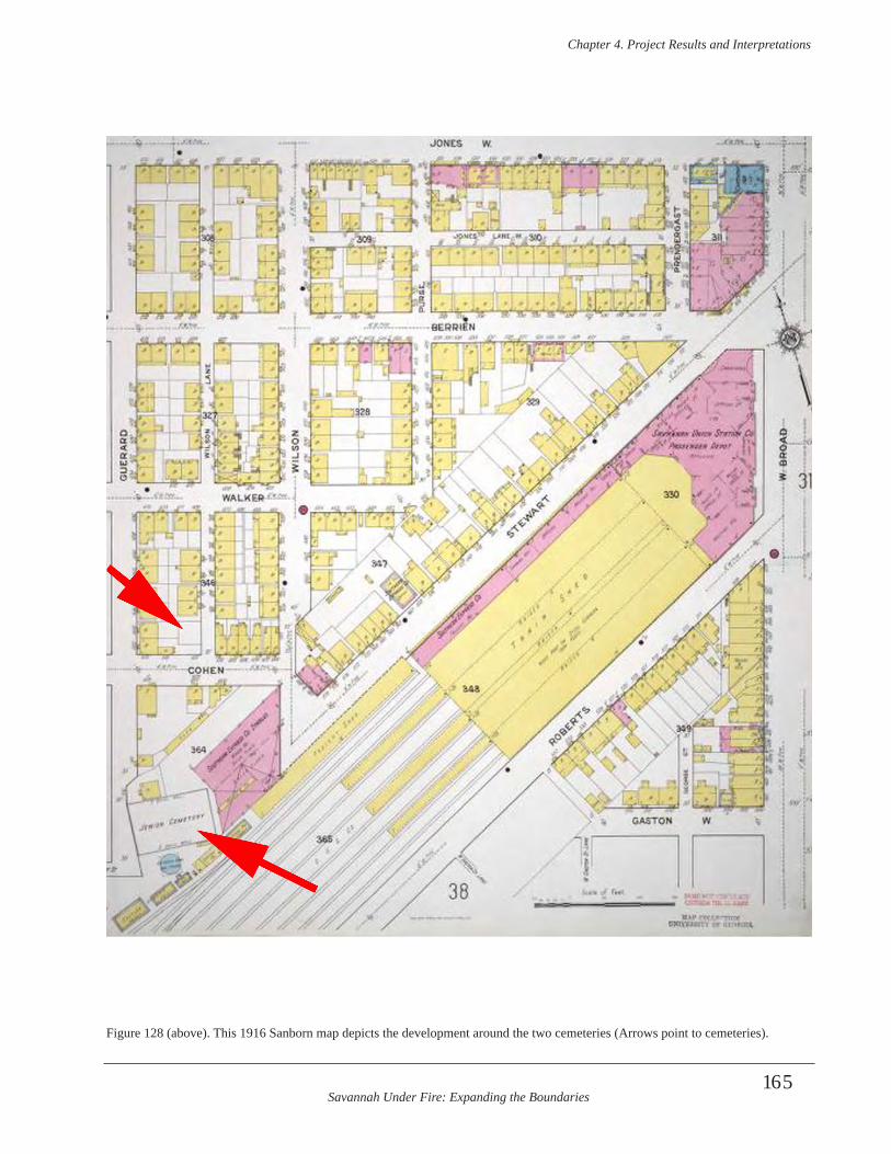
Savannah Under Fire: Expanding the Boundaries
Chapter 4 . Project Results and Interpretations
165
Figure 128 (above). This 1916 Sanborn map depicts the development around the two cemeteries (Arrows point to cemeteries).
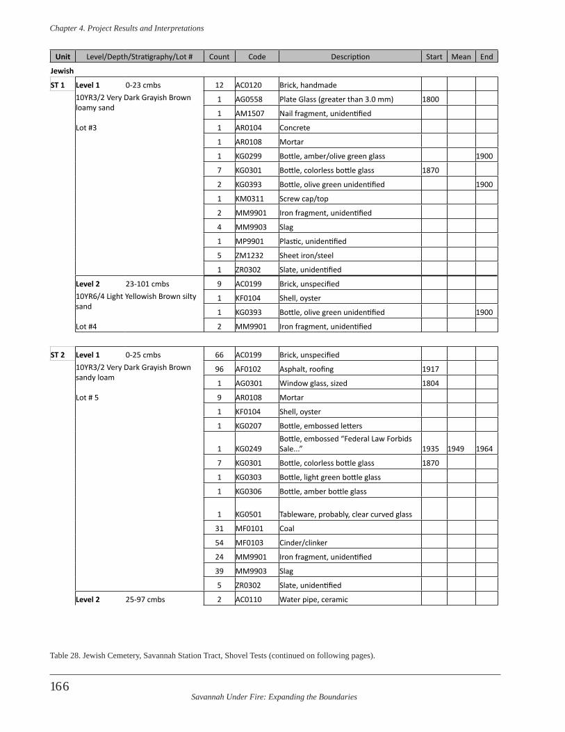
Savannah Under Fire: Expanding the Boundaries
Chapter 4 . Project Results and Interpretations
166
Unit Level/Depth/Stratigraphy/Lot # Count Code Description Start Mean End
Jewish
ST 1 Level 1 0-23 cmbs 12 AC0120 Brick, handmade10YR3/2 Very Dark Grayish Brown loamy sand
1 AG0558 Plate Glass (greater than 3.0 mm) 1800
1 AM1507 Nail fragment, unidentified
Lot #3 1 AR0104 Concrete
1 AR0108 Mortar
1 KG0299 Bottle, amber/olive green glass 1900
7 KG0301 Bottle, colorless bottle glass 1870
2 KG0393 Bottle, olive green unidentified 1900
1 KM0311 Screw cap/top
2 MM9901 Iron fragment, unidentified
4 MM9903 Slag
1 MP9901 Plastic, unidentified
5 ZM1232 Sheet iron/steel
1 ZR0302 Slate, unidentified
Level 2 23-101 cmbs 9 AC0199 Brick, unspecified10YR6/4 Light Yellowish Brown silty sand
1 KF0104 Shell, oyster
1 KG0393 Bottle, olive green unidentified 1900
Lot #4 2 MM9901 Iron fragment, unidentified
ST 2 Level 1 0-25 cmbs 66 AC0199 Brick, unspecified10YR3/2 Very Dark Grayish Brown sandy loam
96 AF0102 Asphalt, roofing 1917
1 AG0301 Window glass, sized 1804
Lot # 5 9 AR0108 Mortar
1 KF0104 Shell, oyster
1 KG0207 Bottle, embossed letters
1 KG0249Bottle, embossed “Federal Law Forbids Sale...” 1935 1949 1964
7 KG0301 Bottle, colorless bottle glass 1870
1 KG0303 Bottle, light green bottle glass
1 KG0306 Bottle, amber bottle glass
1 KG0501 Tableware, probably, clear curved glass
31 MF0101 Coal
54 MF0103 Cinder/clinker
24 MM9901 Iron fragment, unidentified
39 MM9903 Slag
5 ZR0302 Slate, unidentified
Level 2 25-97 cmbs 2 AC0110 Water pipe, ceramic
Table 28. Jewish Cemetery, Savannah Station Tract, Shovel Tests (continued on following pages).
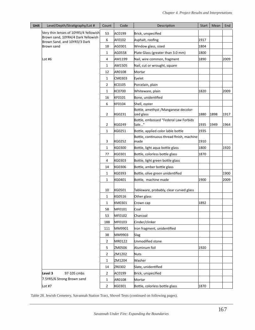
Savannah Under Fire: Expanding the Boundaries
Chapter 4 . Project Results and Interpretations
167
Very thin lenses of 10YR5/4 Yellowish Brown sand, 10YR4/4 Dark Yellowish Brown Sand, and 10YR3/3 Dark Brown sand
53 AC0199 Brick, unspecified
6 AF0102 Asphalt, roofing 1917
18 AG0301 Window glass, sized 1804
1 AG0558 Plate Glass (greater than 3.0 mm) 1800
Lot #6 4 AM1199 Nail, wire common, fragment 1890 2009
1 AM1505 Nail, cut or wrought, square
12 AR0108 Mortar
1 CM0303 Eyelet
2 KC0105 Porcelain, plain
1 KC0700 Whiteware, plain 1820 2009
16 KF0101 Bone, unidentified
6 KF0104 Shell, oyster
2 KG0231Bottle, amethyst /Manganese decolor-ized glass 1880 1898 1917
2 KG0249Bottle, embossed “Federal Law Forbids Sale...” 1935 1949 1964
1 KG0251 Bottle, applied color lable bottle 1935
3 KG0252Bottle, continuous thread finish, machine made 1910
1 KG0300 Bottle, light aqua bottle glass 1800 1920
77 KG0301 Bottle, colorless bottle glass 1870
4 KG0303 Bottle, light green bottle glass
14 KG0306 Bottle, amber bottle glass
1 KG0393 Bottle, olive green unidentified 1900
1 KG0401 Bottle, machine made 1900 2009
10 KG0501 Tableware, probably, clear curved glass
1 KG0516 Other glass
1 KM0301 Crown cap 1892
58 MF0101 Coal
53 MF0102 Charcoal
188 MF0103 Cinder/clinker
111 MM9901 Iron fragment, unidentified
38 MM9903 Slag
2 MR0122 Unmodified stone
5 ZM0506 Aluminum foil 1920
2 ZM1202 Nuts
1 ZM1204 Washer
14 ZR0302 Slate, unidentified
Level 3 97-105 cmbs 2 AC0199 Brick, unspecified7.5YR5/6 Strong Brown sand 1 AR0108 Mortar
Lot #7 2 KG0301 Bottle, colorless bottle glass 1870
Unit Level/Depth/Stratigraphy/Lot # Count Code Description Start Mean End
Table 28. Jewish Cemetery, Savannah Station Tract, Shovel Tests (continued on following pages).
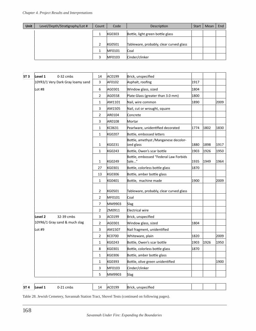
Savannah Under Fire: Expanding the Boundaries
Chapter 4 . Project Results and Interpretations
168
Unit Level/Depth/Stratigraphy/Lot # Count Code Description Start Mean End
1 KG0303 Bottle, light green bottle glass
2 KG0501 Tableware, probably, clear curved glass
1 MF0101 Coal
3 MF0103 Cinder/clinker
ST 3 Level 1 0-32 cmbs 14 AC0199 Brick, unspecified10YR3/1 Very Dark Gray loamy sand 3 AF0102 Asphalt, roofing 1917
Lot #8 6 AG0301 Window glass, sized 1804
2 AG0558 Plate Glass (greater than 3.0 mm) 1800
1 AM1101 Nail, wire common 1890 2009
3 AM1505 Nail, cut or wrought, square
2 AR0104 Concrete
3 AR0108 Mortar
1 KC0631 Pearlware, unidentified decorated 1774 1802 1830
1 KG0207 Bottle, embossed letters
1 KG0231Bottle, amethyst /Manganese decolor-ized glass 1880 1898 1917
1 KG0243 Bottle, Owen’s scar bottle 1903 1926 1950
1 KG0249Bottle, embossed “Federal Law Forbids Sale...” 1935 1949 1964
27 KG0301 Bottle, colorless bottle glass 1870
13 KG0306 Bottle, amber bottle glass
1 KG0401 Bottle, machine made 1900 2009
2 KG0501 Tableware, probably, clear curved glass
2 MF0101 Coal
7 MM9903 Slag
2 ZM0911 Electrical wire
Level 2 32-39 cmbs 3 AC0199 Brick, unspecified10YR6/1 Gray sand & much slag 2 AG0301 Window glass, sized 1804
Lot #9 3 AM1507 Nail fragment, unidentified
2 KC0700 Whiteware, plain 1820 2009
1 KG0243 Bottle, Owen’s scar bottle 1903 1926 1950
8 KG0301 Bottle, colorless bottle glass 1870
1 KG0306 Bottle, amber bottle glass
1 KG0393 Bottle, olive green unidentified 1900
3 MF0103 Cinder/clinker
5 MM9903 Slag
ST 4 Level 1 0-21 cmbs 14 AC0199 Brick, unspecified
Table 28. Jewish Cemetery, Savannah Station Tract, Shovel Tests (continued on following pages).
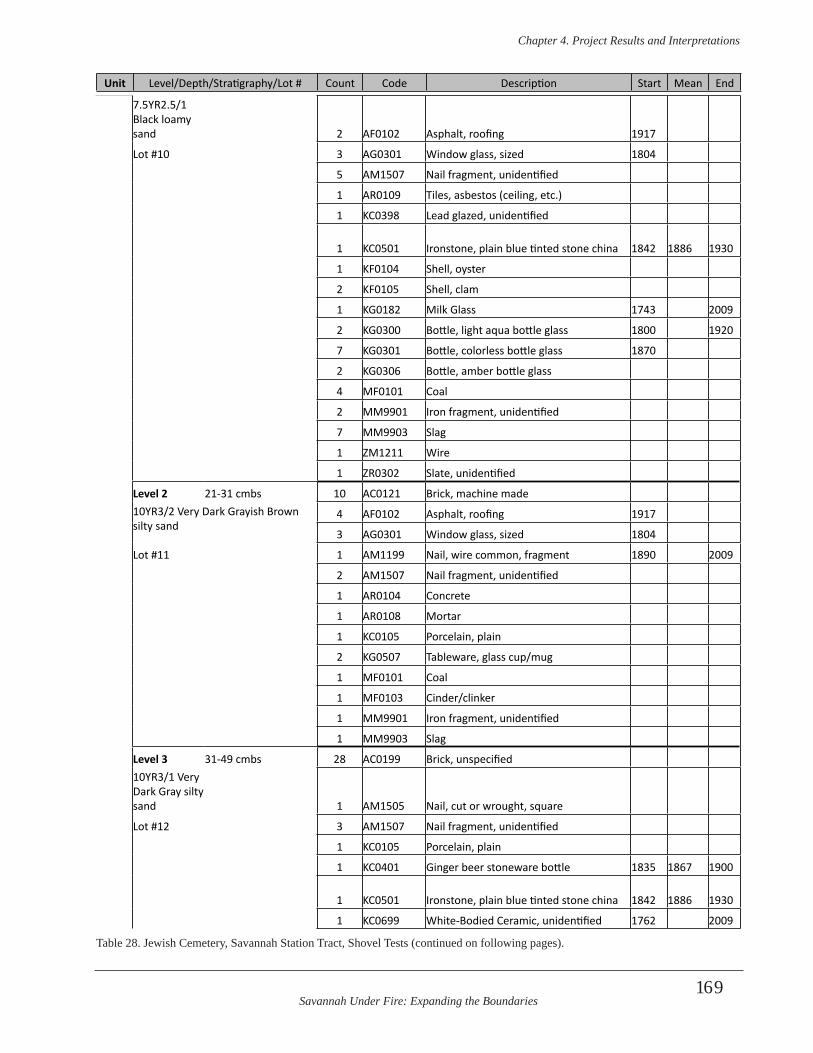
Savannah Under Fire: Expanding the Boundaries
Chapter 4 . Project Results and Interpretations
169
Unit Level/Depth/Stratigraphy/Lot # Count Code Description Start Mean End
7.5YR2.5/1 Black loamy sand 2 AF0102 Asphalt, roofing 1917
Lot #10 3 AG0301 Window glass, sized 1804
5 AM1507 Nail fragment, unidentified
1 AR0109 Tiles, asbestos (ceiling, etc.)
1 KC0398 Lead glazed, unidentified
1 KC0501 Ironstone, plain blue tinted stone china 1842 1886 1930
1 KF0104 Shell, oyster
2 KF0105 Shell, clam
1 KG0182 Milk Glass 1743 2009
2 KG0300 Bottle, light aqua bottle glass 1800 1920
7 KG0301 Bottle, colorless bottle glass 1870
2 KG0306 Bottle, amber bottle glass
4 MF0101 Coal
2 MM9901 Iron fragment, unidentified
7 MM9903 Slag
1 ZM1211 Wire
1 ZR0302 Slate, unidentified
Level 2 21-31 cmbs 10 AC0121 Brick, machine made10YR3/2 Very Dark Grayish Brown silty sand
4 AF0102 Asphalt, roofing 1917
3 AG0301 Window glass, sized 1804
Lot #11 1 AM1199 Nail, wire common, fragment 1890 2009
2 AM1507 Nail fragment, unidentified
1 AR0104 Concrete
1 AR0108 Mortar
1 KC0105 Porcelain, plain
2 KG0507 Tableware, glass cup/mug
1 MF0101 Coal
1 MF0103 Cinder/clinker
1 MM9901 Iron fragment, unidentified
1 MM9903 Slag
Level 3 31-49 cmbs 28 AC0199 Brick, unspecified10YR3/1 Very Dark Gray silty sand 1 AM1505 Nail, cut or wrought, square
Lot #12 3 AM1507 Nail fragment, unidentified
1 KC0105 Porcelain, plain
1 KC0401 Ginger beer stoneware bottle 1835 1867 1900
1 KC0501 Ironstone, plain blue tinted stone china 1842 1886 1930
1 KC0699 White-Bodied Ceramic, unidentified 1762 2009
Table 28. Jewish Cemetery, Savannah Station Tract, Shovel Tests (continued on following pages).

Savannah Under Fire: Expanding the Boundaries
Chapter 4 . Project Results and Interpretations
170
Unit Level/Depth/Stratigraphy/Lot # Count Code Description Start Mean End
2 KF0101 Bone, unidentified
5 KF0104 Shell, oyster
2 KF0105 Shell, clam
1 KG0231Bottle, amethyst /Manganese decolor-ized glass 1880 1898 1917
1 KG0300 Bottle, light aqua bottle glass 1800 1920
2 KG0301 Bottle, colorless bottle glass 1870
1 KG0303 Bottle, light green bottle glass
1 KG0501 Tableware, probably, clear curved glass
2 MF0101 Coal
9 MF0103 Cinder/clinker
1 MM9901 Iron fragment, unidentified
2 ZR0302 Slate, unidentified
Level 4 49-69 cmbs 1 AC0110 Water pipe, ceramic10YR3/2 Very Dark Grayish Brown loamy sand
17 AC0120 Brick, handmade
3 AG0301 Window glass, sized 1804
Lot #13 6 AM1507 Nail fragment, unidentified
8 AR0108 Mortar
1 KC2801 Yellowware, plain 1830 1885 1940
1 KF0101 Bone, unidentified
4 KF0104 Shell, oyster
2 KG0301 Bottle, colorless bottle glass 1870
1 KG0306 Bottle, amber bottle glass
1 MF0101 Coal
2 MF0102 Charcoal
5 MM9901 Iron fragment, unidentified
5 MM9903 Slag
1 MR0122 Unmodified stone
1 ZR0302 Slate, unidentified
Level 5 69-76 cmbs 4 AC0120 Brick, handmade10YR4/3 Brown silty sand 3 AM1505 Nail, cut or wrought, square
Lot #14 12 AM1507 Nail fragment, unidentified
1 KC0903 Mocha on white body 1795 1818 1840
2 KC2307 Transfer print, stippled, blue underglaze 1795 1818 1840
1 KF0101 Bone, unidentified
2 KF0104 Shell, oyster
2 KG0393 Bottle, olive green unidentified 1900
1 MF0101 Coal
1 MF0102 Charcoal
2 MF0103 Cinder/clinker
Table 28. Jewish Cemetery, Savannah Station Tract, Shovel Tests (continued on following pages).
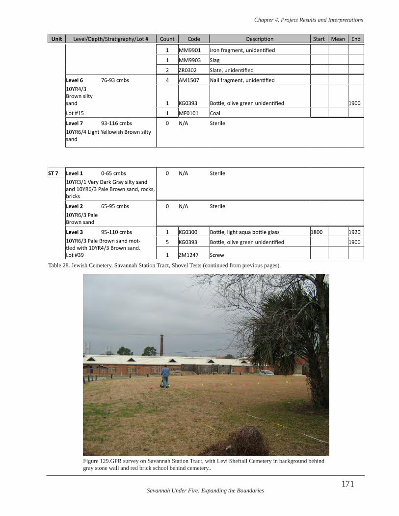
Savannah Under Fire: Expanding the Boundaries
Chapter 4 . Project Results and Interpretations
171
Unit Level/Depth/Stratigraphy/Lot # Count Code Description Start Mean End
1 MM9901 Iron fragment, unidentified
1 MM9903 Slag
2 ZR0302 Slate, unidentified
Level 6 76-93 cmbs 4 AM1507 Nail fragment, unidentified10YR4/3 Brown silty sand 1 KG0393 Bottle, olive green unidentified 1900
Lot #15 1 MF0101 Coal
Level 7 93-116 cmbs 0 N/A Sterile10YR6/4 Light Yellowish Brown silty sand
ST 7 Level 1 0-65 cmbs 0 N/A Sterile10YR3/1 Very Dark Gray silty sand and 10YR6/3 Pale Brown sand, rocks, bricks
Level 2 65-95 cmbs 0 N/A Sterile10YR6/3 Pale Brown sand
Level 3 95-110 cmbs 1 KG0300 Bottle, light aqua bottle glass 1800 192010YR6/3 Pale Brown sand mot-tled with 10YR4/3 Brown sand. Lot #39
5 KG0393 Bottle, olive green unidentified 1900
1 ZM1247 Screw
Table 28. Jewish Cemetery, Savannah Station Tract, Shovel Tests (continued from previous pages).
Figure 129.GPR survey on Savannah Station Tract, with Levi Sheftall Cemetery in background behind gray stone wall and red brick school behind cemetery..
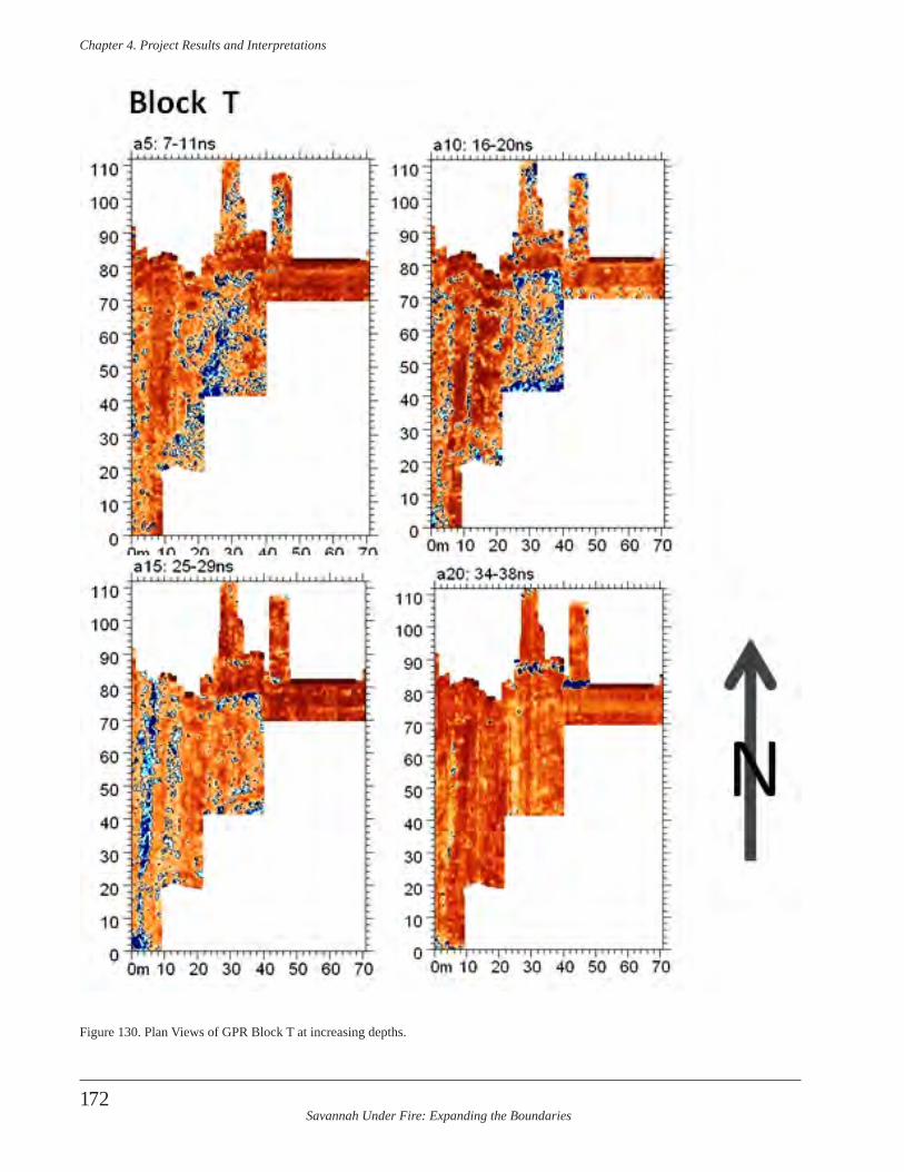
Savannah Under Fire: Expanding the Boundaries
Chapter 4 . Project Results and Interpretations
172
Figure 130. Plan Views of GPR Block T at increasing depths.
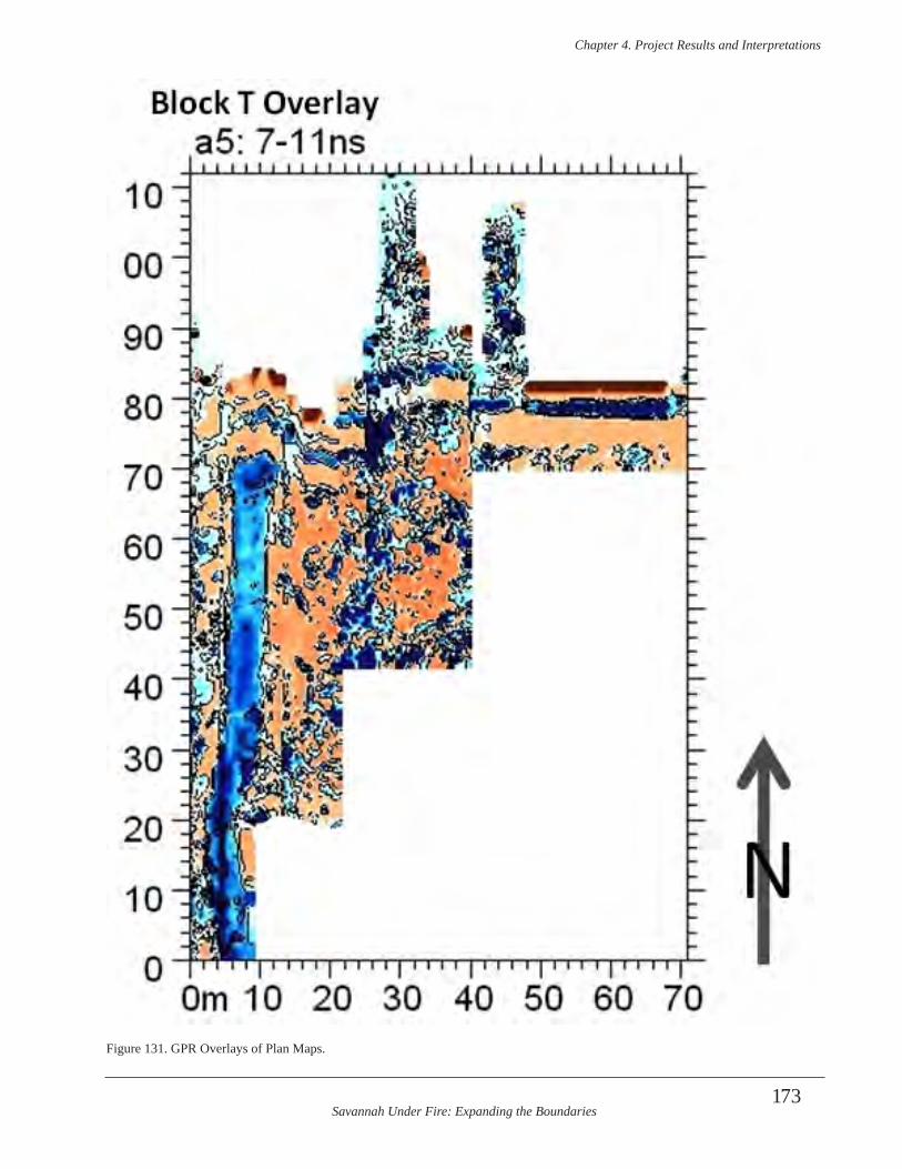
Savannah Under Fire: Expanding the Boundaries
Chapter 4 . Project Results and Interpretations
173
Figure 131. GPR Overlays of Plan Maps.
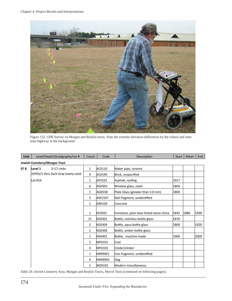
Savannah Under Fire: Expanding the Boundaries
Chapter 4 . Project Results and Interpretations
174
Figure 132. GPR Survey on Morgan and Boykin tracts. Note the extreme elevation differences by the school and inter-state highway in the background.
Jewish Cemetery/Morgan Tract
ST 8 Level 1 0-17 cmbs 1 AC0110 Water pipe, ceramic10YR3/1 Very Dark Gray loamy sand 9 AC0199 Brick, unspecified
Lot #16 1 AF0102 Asphalt, roofing 1917
6 AG0301 Window glass, sized 1804
1 AG0558 Plate Glass (greater than 3.0 mm) 1800
5 AM1507 Nail fragment, unidentified
1 AR0104 Concrete
1 KC0501 Ironstone, plain blue tinted stone china 1842 1886 1930
11 KG0301 Bottle, colorless bottle glass 1870
2 KG0304 Bottle, aqua bottle glass 1800 1920
1 KG0306 Bottle, amber bottle glass
1 KG0401 Bottle, machine made 1900 2009
2 MF0101 Coal
4 MF0103 Cinder/clinker
1 MM9901 Iron fragment, unidentified
4 MM9903 Slag
1 MZ0102 Modern miscellaneous
Unit Level/Depth/Stratigraphy/Lot # Count Code Description Start Mean End
Table 29. Jewish Cemetery Area, Morgan and Boykin Tracts, Shovel Tests (continued on following pages).
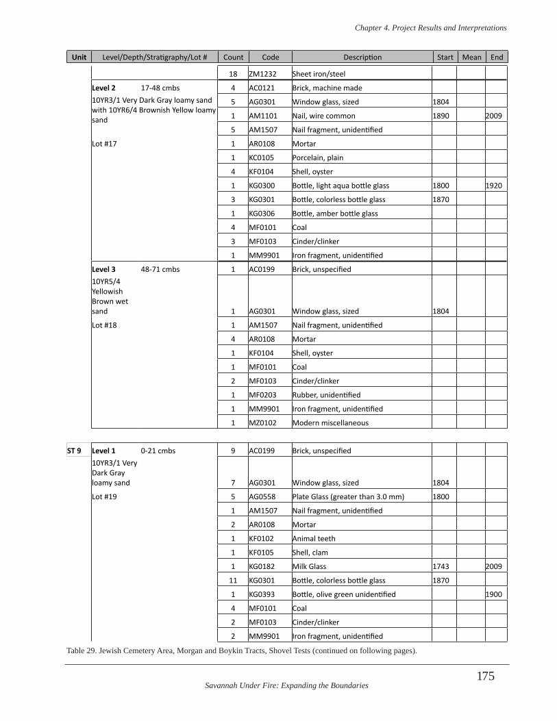
Savannah Under Fire: Expanding the Boundaries
Chapter 4 . Project Results and Interpretations
175
Unit Level/Depth/Stratigraphy/Lot # Count Code Description Start Mean End
18 ZM1232 Sheet iron/steel
Level 2 17-48 cmbs 4 AC0121 Brick, machine made10YR3/1 Very Dark Gray loamy sand with 10YR6/4 Brownish Yellow loamy sand
5 AG0301 Window glass, sized 1804
1 AM1101 Nail, wire common 1890 2009
5 AM1507 Nail fragment, unidentified
Lot #17 1 AR0108 Mortar
1 KC0105 Porcelain, plain
4 KF0104 Shell, oyster
1 KG0300 Bottle, light aqua bottle glass 1800 1920
3 KG0301 Bottle, colorless bottle glass 1870
1 KG0306 Bottle, amber bottle glass
4 MF0101 Coal
3 MF0103 Cinder/clinker
1 MM9901 Iron fragment, unidentified
Level 3 48-71 cmbs 1 AC0199 Brick, unspecified10YR5/4 Yellowish Brown wet sand 1 AG0301 Window glass, sized 1804
Lot #18 1 AM1507 Nail fragment, unidentified
4 AR0108 Mortar
1 KF0104 Shell, oyster
1 MF0101 Coal
2 MF0103 Cinder/clinker
1 MF0203 Rubber, unidentified
1 MM9901 Iron fragment, unidentified
1 MZ0102 Modern miscellaneous
ST 9 Level 1 0-21 cmbs 9 AC0199 Brick, unspecified10YR3/1 Very Dark Gray loamy sand 7 AG0301 Window glass, sized 1804
Lot #19 5 AG0558 Plate Glass (greater than 3.0 mm) 1800
1 AM1507 Nail fragment, unidentified
2 AR0108 Mortar
1 KF0102 Animal teeth
1 KF0105 Shell, clam
1 KG0182 Milk Glass 1743 2009
11 KG0301 Bottle, colorless bottle glass 1870
1 KG0393 Bottle, olive green unidentified 1900
4 MF0101 Coal
2 MF0103 Cinder/clinker
2 MM9901 Iron fragment, unidentified
Table 29. Jewish Cemetery Area, Morgan and Boykin Tracts, Shovel Tests (continued on following pages).
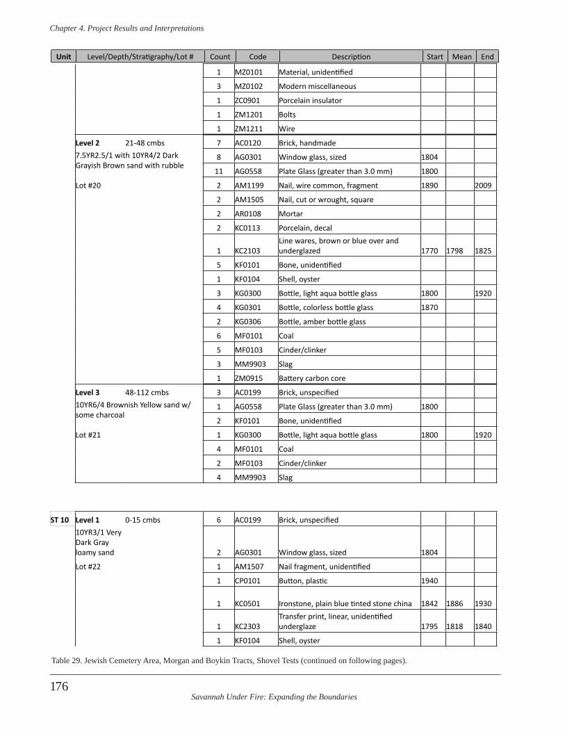
Savannah Under Fire: Expanding the Boundaries
Chapter 4 . Project Results and Interpretations
176
Unit Level/Depth/Stratigraphy/Lot # Count Code Description Start Mean End
1 MZ0101 Material, unidentified
3 MZ0102 Modern miscellaneous
1 ZC0901 Porcelain insulator
1 ZM1201 Bolts
1 ZM1211 Wire
Level 2 21-48 cmbs 7 AC0120 Brick, handmade7.5YR2.5/1 with 10YR4/2 Dark Grayish Brown sand with rubble
8 AG0301 Window glass, sized 1804
11 AG0558 Plate Glass (greater than 3.0 mm) 1800
Lot #20 2 AM1199 Nail, wire common, fragment 1890 2009
2 AM1505 Nail, cut or wrought, square
2 AR0108 Mortar
2 KC0113 Porcelain, decal
1 KC2103Line wares, brown or blue over and underglazed 1770 1798 1825
5 KF0101 Bone, unidentified
1 KF0104 Shell, oyster
3 KG0300 Bottle, light aqua bottle glass 1800 1920
4 KG0301 Bottle, colorless bottle glass 1870
2 KG0306 Bottle, amber bottle glass
6 MF0101 Coal
5 MF0103 Cinder/clinker
3 MM9903 Slag
1 ZM0915 Battery carbon core
Level 3 48-112 cmbs 3 AC0199 Brick, unspecified10YR6/4 Brownish Yellow sand w/some charcoal
1 AG0558 Plate Glass (greater than 3.0 mm) 1800
2 KF0101 Bone, unidentified
Lot #21 1 KG0300 Bottle, light aqua bottle glass 1800 1920
4 MF0101 Coal
2 MF0103 Cinder/clinker
4 MM9903 Slag
ST 10 Level 1 0-15 cmbs 6 AC0199 Brick, unspecified10YR3/1 Very Dark Gray loamy sand 2 AG0301 Window glass, sized 1804
Lot #22 1 AM1507 Nail fragment, unidentified
1 CP0101 Button, plastic 1940
1 KC0501 Ironstone, plain blue tinted stone china 1842 1886 1930
1 KC2303Transfer print, linear, unidentified underglaze 1795 1818 1840
1 KF0104 Shell, oyster
Table 29. Jewish Cemetery Area, Morgan and Boykin Tracts, Shovel Tests (continued on following pages).
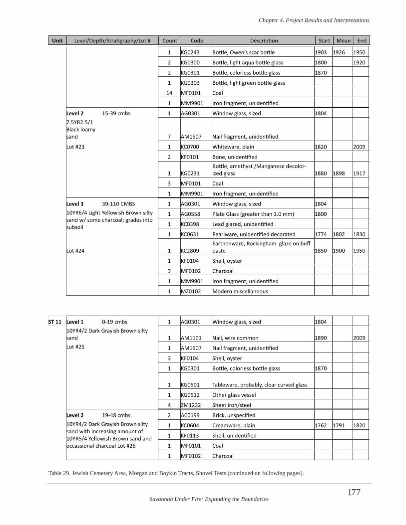
Savannah Under Fire: Expanding the Boundaries
Chapter 4 . Project Results and Interpretations
177
1 KG0243 Bottle, Owen’s scar bottle 1903 1926 1950
2 KG0300 Bottle, light aqua bottle glass 1800 1920
2 KG0301 Bottle, colorless bottle glass 1870
1 KG0303 Bottle, light green bottle glass
14 MF0101 Coal
1 MM9901 Iron fragment, unidentified
Level 2 15-39 cmbs 1 AG0301 Window glass, sized 18047.5YR2.5/1 Black loamy sand 7 AM1507 Nail fragment, unidentified
Lot #23 1 KC0700 Whiteware, plain 1820 2009
2 KF0101 Bone, unidentified
1 KG0231Bottle, amethyst /Manganese decolor-ized glass 1880 1898 1917
3 MF0101 Coal
1 MM9901 Iron fragment, unidentified
Level 3 39-110 CMBS 1 AG0301 Window glass, sized 180410YR6/4 Light Yellowish Brown silty sand w/ some charcoal; grades into subsoil
1 AG0558 Plate Glass (greater than 3.0 mm) 1800
1 KC0398 Lead glazed, unidentified
1 KC0631 Pearlware, unidentified decorated 1774 1802 1830
Lot #24 1 KC2809Earthenware, Rockingham glaze on buff paste 1850 1900 1950
1 KF0104 Shell, oyster
3 MF0102 Charcoal
1 MM9901 Iron fragment, unidentified
1 MZ0102 Modern miscellaneous
ST 11 Level 1 0-19 cmbs 1 AG0301 Window glass, sized 180410YR4/2 Dark Grayish Brown silty sand 1 AM1101 Nail, wire common 1890 2009Lot #25 1 AM1507 Nail fragment, unidentified
3 KF0104 Shell, oyster
1 KG0301 Bottle, colorless bottle glass 1870
1 KG0501 Tableware, probably, clear curved glass
1 KG0512 Other glass vessel
4 ZM1232 Sheet iron/steel
Level 2 19-48 cmbs 2 AC0199 Brick, unspecified10YR4/2 Dark Grayish Brown silty sand with increasing amount of 10YR5/4 Yellowish Brown sand and occassional charcoal Lot #26
1 KC0604 Creamware, plain 1762 1791 1820
1 KF0113 Shell, unidentified
1 MF0101 Coal
1 MF0102 Charcoal
Unit Level/Depth/Stratigraphy/Lot # Count Code Description Start Mean End
Table 29. Jewish Cemetery Area, Morgan and Boykin Tracts, Shovel Tests (continued on following pages).
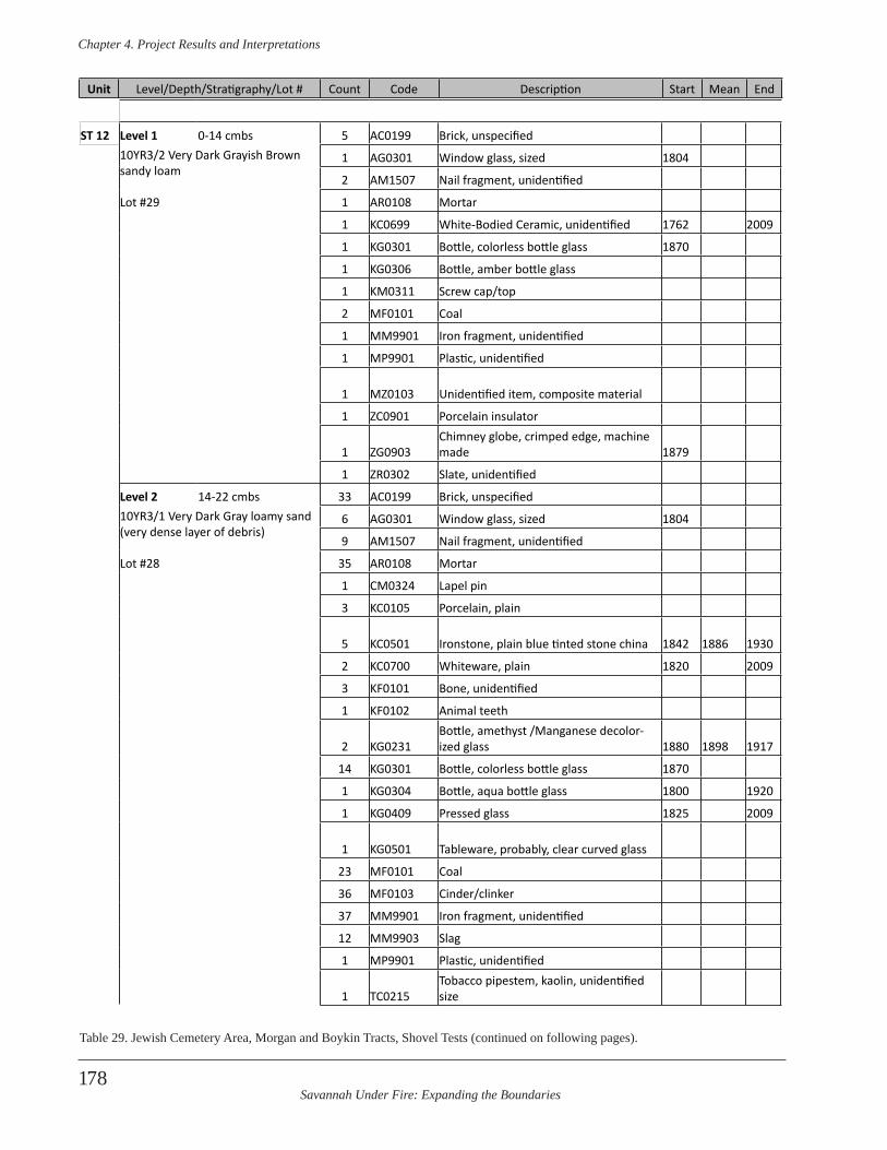
Savannah Under Fire: Expanding the Boundaries
Chapter 4 . Project Results and Interpretations
178
ST 12 Level 1 0-14 cmbs 5 AC0199 Brick, unspecified10YR3/2 Very Dark Grayish Brown sandy loam
1 AG0301 Window glass, sized 1804
2 AM1507 Nail fragment, unidentified
Lot #29 1 AR0108 Mortar
1 KC0699 White-Bodied Ceramic, unidentified 1762 2009
1 KG0301 Bottle, colorless bottle glass 1870
1 KG0306 Bottle, amber bottle glass
1 KM0311 Screw cap/top
2 MF0101 Coal
1 MM9901 Iron fragment, unidentified
1 MP9901 Plastic, unidentified
1 MZ0103 Unidentified item, composite material
1 ZC0901 Porcelain insulator
1 ZG0903Chimney globe, crimped edge, machine made 1879
1 ZR0302 Slate, unidentified
Level 2 14-22 cmbs 33 AC0199 Brick, unspecified10YR3/1 Very Dark Gray loamy sand (very dense layer of debris)
6 AG0301 Window glass, sized 1804
9 AM1507 Nail fragment, unidentified
Lot #28 35 AR0108 Mortar
1 CM0324 Lapel pin
3 KC0105 Porcelain, plain
5 KC0501 Ironstone, plain blue tinted stone china 1842 1886 1930
2 KC0700 Whiteware, plain 1820 2009
3 KF0101 Bone, unidentified
1 KF0102 Animal teeth
2 KG0231Bottle, amethyst /Manganese decolor-ized glass 1880 1898 1917
14 KG0301 Bottle, colorless bottle glass 1870
1 KG0304 Bottle, aqua bottle glass 1800 1920
1 KG0409 Pressed glass 1825 2009
1 KG0501 Tableware, probably, clear curved glass
23 MF0101 Coal
36 MF0103 Cinder/clinker
37 MM9901 Iron fragment, unidentified
12 MM9903 Slag
1 MP9901 Plastic, unidentified
1 TC0215Tobacco pipestem, kaolin, unidentified size
Unit Level/Depth/Stratigraphy/Lot # Count Code Description Start Mean End
Table 29. Jewish Cemetery Area, Morgan and Boykin Tracts, Shovel Tests (continued on following pages).
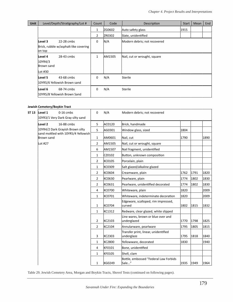
Savannah Under Fire: Expanding the Boundaries
Chapter 4 . Project Results and Interpretations
179
1 ZG0602 Auto safety glass 1915
2 ZR0302 Slate, unidentified
Level 3 22-28 cmbs 0 N/A Modern debris; not recoveredBrick, rubble w/asphalt-like covering on top
Level 4 28-43 cmbs 1 AM1505 Nail, cut or wrought, square 10YR4/3 Brown sand
Lot #30
Level 5 43-68 cmbs 0 N/A Sterile10YR5/6 Yellowish Brown sand
Level 6 68-74 cmbs 0 N/A Sterile10YR5/8 Yellowish Brown Sand
Jewish Cemetery/Boykin Tract
ST 13 Level 1 0-16 cmbs 0 N/A Modern debris; not recovered10YR3/1 Very Dark Gray silty sand
Level 2 16-88 cmbs 5 AC0120 Brick, handmade10YR4/2 Dark Grayish Brown silty sand mottled with 10YR5/4 Yellowish Brown sand
5 AG0301 Window glass, sized 1804
1 AM0601 Nail, cut 1790 1890
Lot #27 2 AM1505 Nail, cut or wrought, square
6 AM1507 Nail fragment, unidentified
1 CZ0102 Button, unknown composition
2 KC0105 Porcelain, plain
1 KC0309 Salt glazed/alkaline glazed
2 KC0604 Creamware, plain 1762 1791 1820
2 KC0630 Pearlware, plain 1774 1802 1830
2 KC0631 Pearlware, unidentified decorated 1774 1802 1830
4 KC0700 Whiteware, plain 1820 2009
1 KC0701 Whiteware, indeterminate decoration 1820 2009
1 KC0704Edgeware, scalloped, rim impressed, curved 1802 1815 1832
1 KC1312 Redware, clear glazed, white slipped
2 KC2103Line wares, brown or blue over and underglazed 1770 1798 1825
2 KC2104 Annularware, pearlware 1795 1805 1815
3 KC2303Transfer print, linear, unidentified underglaze 1795 1818 1840
1 KC2800 Yellowware, decorated 1830 1940
4 KF0101 Bone, unidentified
1 KF0105 Shell, clam
1 KG0249Bottle, embossed “Federal Law Forbids Sale...” 1935 1949 1964
Unit Level/Depth/Stratigraphy/Lot # Count Code Description Start Mean End
Table 29. Jewish Cemetery Area, Morgan and Boykin Tracts, Shovel Tests (continued on following pages).
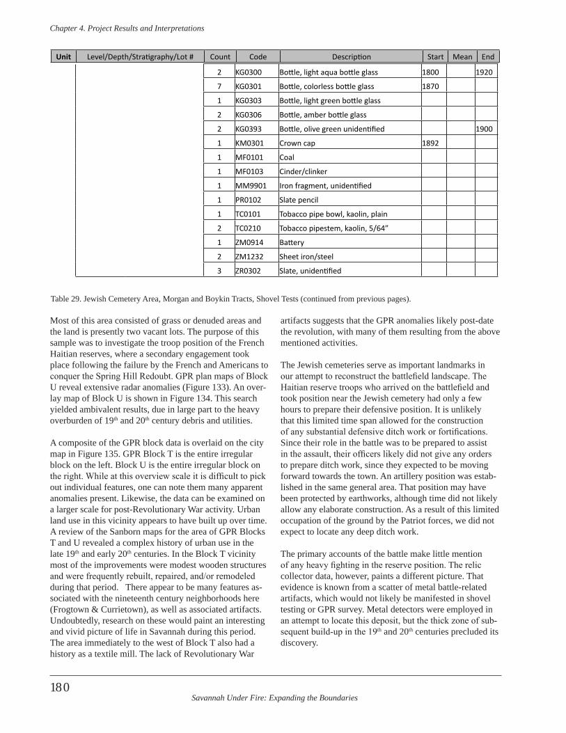
Savannah Under Fire: Expanding the Boundaries
Chapter 4 . Project Results and Interpretations
180
Most of this area consisted of grass or denuded areas and the land is presently two vacant lots. The purpose of this sample was to investigate the troop position of the French Haitian reserves, where a secondary engagement took place following the failure by the French and Americans to conquer the Spring Hill Redoubt. GPR plan maps of Block U reveal extensive radar anomalies (Figure 133). An over-lay map of Block U is shown in Figure 134. This search yielded ambivalent results, due in large part to the heavy overburden of 19th and 20th century debris and utilities.
A composite of the GPR block data is overlaid on the city map in Figure 135. GPR Block T is the entire irregular block on the left. Block U is the entire irregular block on the right. While at this overview scale it is difficult to pick out individual features, one can note them many apparent anomalies present. Likewise, the data can be examined on a larger scale for post-Revolutionary War activity. Urban land use in this vicinity appears to have built up over time. A review of the Sanborn maps for the area of GPR Blocks T and U revealed a complex history of urban use in the late 19th and early 20th centuries. In the Block T vicinity most of the improvements were modest wooden structures and were frequently rebuilt, repaired, and/or remodeled during that period. There appear to be many features as-sociated with the nineteenth century neighborhoods here (Frogtown & Currietown), as well as associated artifacts. Undoubtedly, research on these would paint an interesting and vivid picture of life in Savannah during this period. The area immediately to the west of Block T also had a history as a textile mill. The lack of Revolutionary War
artifacts suggests that the GPR anomalies likely post-date the revolution, with many of them resulting from the above mentioned activities.
The Jewish cemeteries serve as important landmarks in our attempt to reconstruct the battlefield landscape. The Haitian reserve troops who arrived on the battlefield and took position near the Jewish cemetery had only a few hours to prepare their defensive position. It is unlikely that this limited time span allowed for the construction of any substantial defensive ditch work or fortifications. Since their role in the battle was to be prepared to assist in the assault, their officers likely did not give any orders to prepare ditch work, since they expected to be moving forward towards the town. An artillery position was estab-lished in the same general area. That position may have been protected by earthworks, although time did not likely allow any elaborate construction. As a result of this limited occupation of the ground by the Patriot forces, we did not expect to locate any deep ditch work.
The primary accounts of the battle make little mention of any heavy fighting in the reserve position. The relic collector data, however, paints a different picture. That evidence is known from a scatter of metal battle-related artifacts, which would not likely be manifested in shovel testing or GPR survey. Metal detectors were employed in an attempt to locate this deposit, but the thick zone of sub-sequent build-up in the 19th and 20th centuries precluded its discovery.
Unit Level/Depth/Stratigraphy/Lot # Count Code Description Start Mean End
2 KG0300 Bottle, light aqua bottle glass 1800 1920
7 KG0301 Bottle, colorless bottle glass 1870
1 KG0303 Bottle, light green bottle glass
2 KG0306 Bottle, amber bottle glass
2 KG0393 Bottle, olive green unidentified 1900
1 KM0301 Crown cap 1892
1 MF0101 Coal
1 MF0103 Cinder/clinker
1 MM9901 Iron fragment, unidentified
1 PR0102 Slate pencil
1 TC0101 Tobacco pipe bowl, kaolin, plain
2 TC0210 Tobacco pipestem, kaolin, 5/64”
1 ZM0914 Battery
2 ZM1232 Sheet iron/steel
3 ZR0302 Slate, unidentified
Table 29. Jewish Cemetery Area, Morgan and Boykin Tracts, Shovel Tests (continued from previous pages).
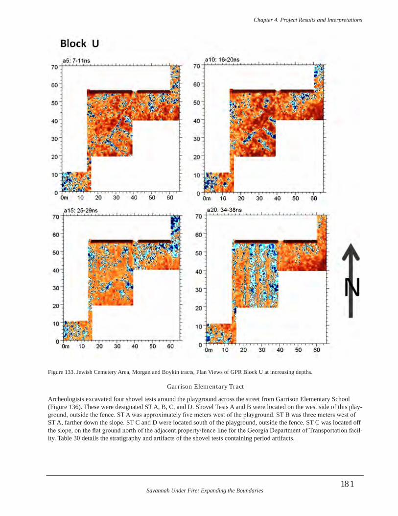
Savannah Under Fire: Expanding the Boundaries
Chapter 4 . Project Results and Interpretations
181
Figure 133. Jewish Cemetery Area, Morgan and Boykin tracts, Plan Views of GPR Block U at increasing depths.
Garrison Elementary Tract
Archeologists excavated four shovel tests around the playground across the street from Garrison Elementary School (Figure 136). These were designated ST A, B, C, and D. Shovel Tests A and B were located on the west side of this play-ground, outside the fence. ST A was approximately five meters west of the playground. ST B was three meters west of ST A, farther down the slope. ST C and D were located south of the playground, outside the fence. ST C was located off the slope, on the flat ground north of the adjacent property/fence line for the Georgia Department of Transportation facil-ity. Table 30 details the stratigraphy and artifacts of the shovel tests containing period artifacts.
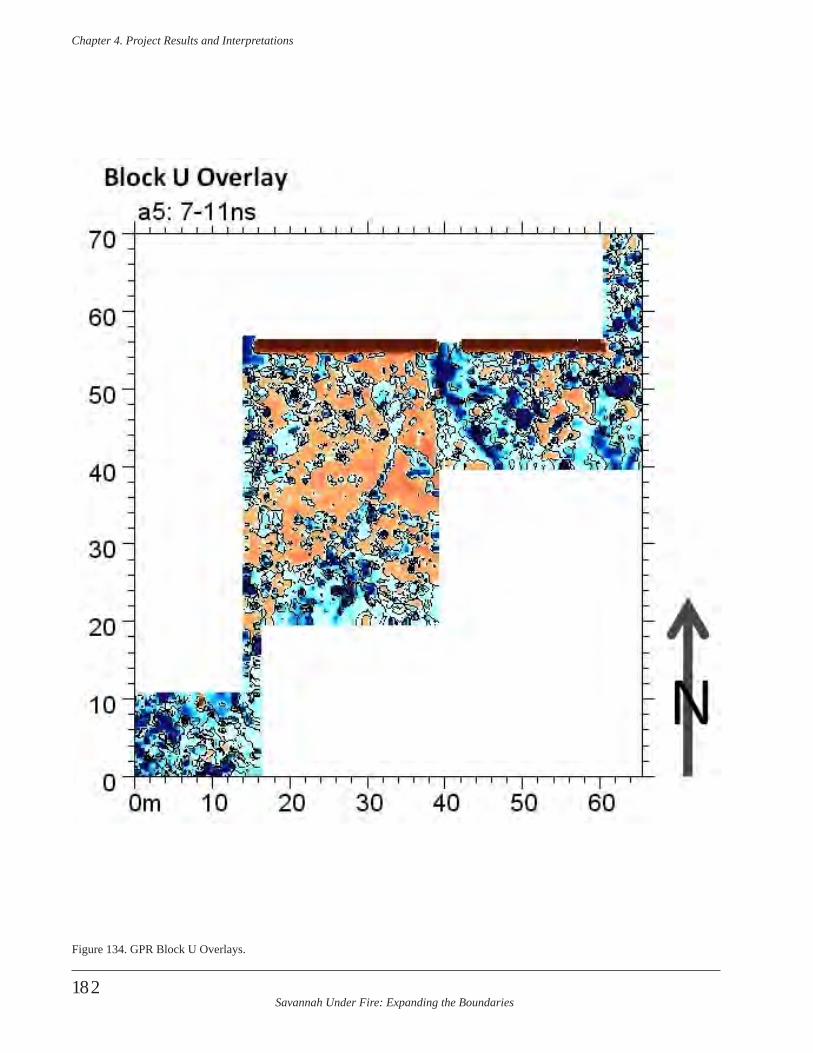
Savannah Under Fire: Expanding the Boundaries
Chapter 4 . Project Results and Interpretations
182
Figure 134. GPR Block U Overlays.
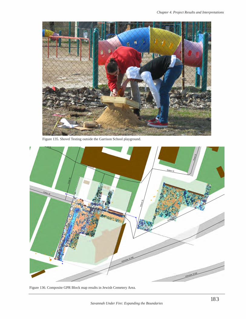
Savannah Under Fire: Expanding the Boundaries
Chapter 4 . Project Results and Interpretations
183
Figure 135. Shovel Testing outside the Garrison School playground.
Selma St
Cohen St
Interstate 16 WB
Wils
on S
t
Coy
le S
t
Walker St
Interstate 16 EB
Purs
e St
Spru
ce S
t
Selma StWalker St
Figure 136. Composite GPR Block map results in Jewish Cemetery Area.
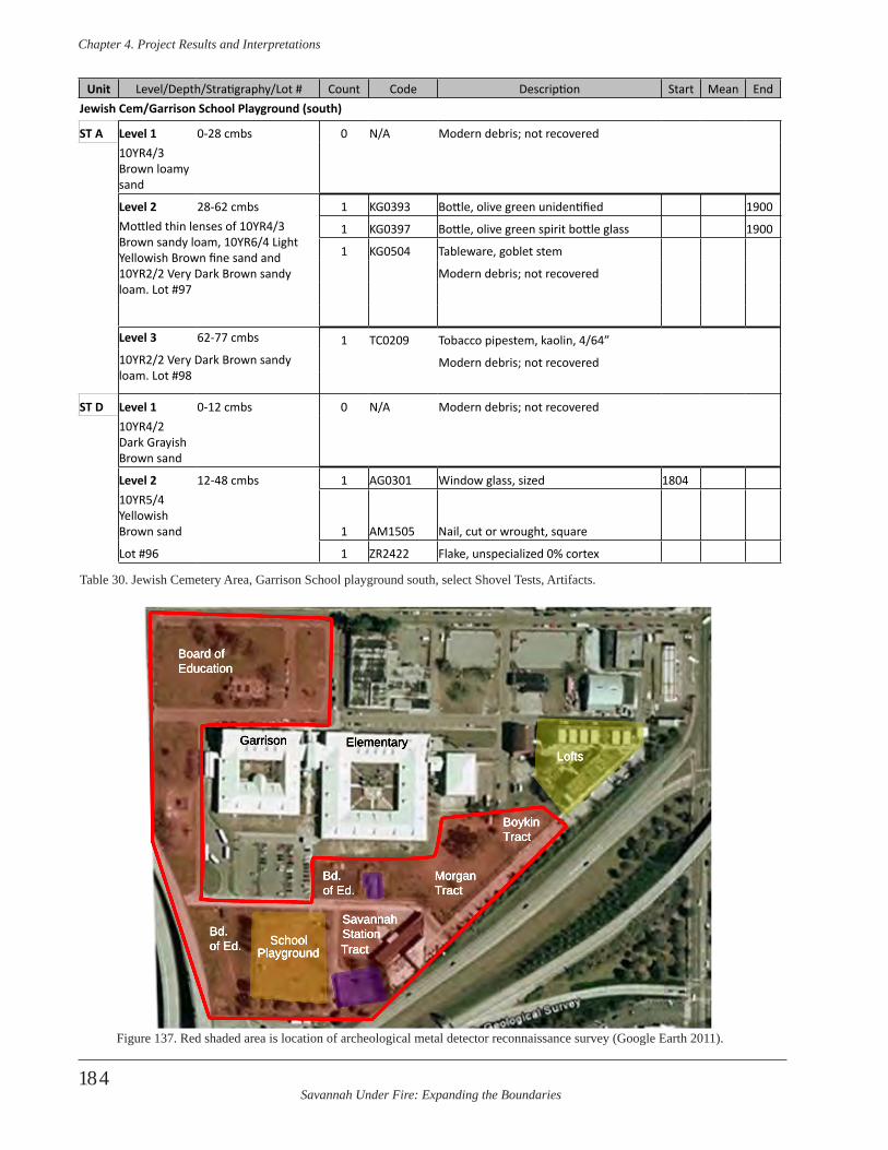
Savannah Under Fire: Expanding the Boundaries
Chapter 4 . Project Results and Interpretations
184
Unit Level/Depth/Stratigraphy/Lot # Count Code Description Start Mean EndJewish Cem/Garrison School Playground (south)
ST A Level 1 0-28 cmbs 0 N/A Modern debris; not recovered10YR4/3 Brown loamy sand
Level 2 28-62 cmbs 1 KG0393 Bottle, olive green unidentified 1900Mottled thin lenses of 10YR4/3 Brown sandy loam, 10YR6/4 Light Yellowish Brown fine sand and 10YR2/2 Very Dark Brown sandy loam. Lot #97
1 KG0397 Bottle, olive green spirit bottle glass 1900
1 KG0504 Tableware, goblet stem
Modern debris; not recovered
Level 3 62-77 cmbs 1 TC0209 Tobacco pipestem, kaolin, 4/64”10YR2/2 Very Dark Brown sandy loam. Lot #98
Modern debris; not recovered
ST D Level 1 0-12 cmbs 0 N/A Modern debris; not recovered10YR4/2 Dark Grayish Brown sand
Level 2 12-48 cmbs 1 AG0301 Window glass, sized 180410YR5/4 Yellowish Brown sand 1 AM1505 Nail, cut or wrought, square
Lot #96 1 ZR2422 Flake, unspecialized 0% cortex
Table 30. Jewish Cemetery Area, Garrison School playground south, select Shovel Tests, Artifacts.
Playground
Lofts
BoykinTract
MorganTract
SavannahStation
Garrison
Board ofEducation
SchoolTract
Elementary
Bd. of Ed.
Bd. of Ed.
Figure 137. Red shaded area is location of archeological metal detector reconnaissance survey (Google Earth 2011).
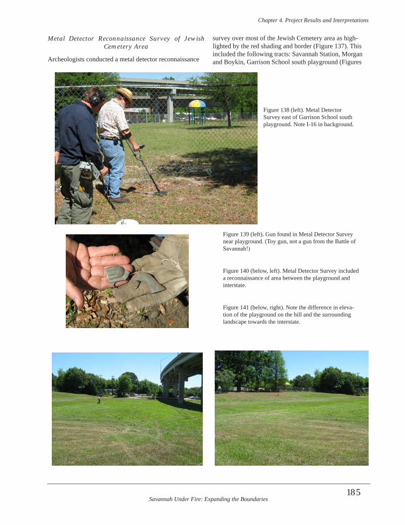
Savannah Under Fire: Expanding the Boundaries
Chapter 4 . Project Results and Interpretations
185
Metal Detector Reconnaissance Survey of Jewish Cemetery Area
Archeologists conducted a metal detector reconnaissance
survey over most of the Jewish Cemetery area as high-lighted by the red shading and border (Figure 137). This included the following tracts: Savannah Station, Morgan and Boykin, Garrison School south playground (Figures
Figure 138 (left). Metal Detector Survey east of Garrison School south playground. Note I-16 in background.
Figure 139 (left). Gun found in Metal Detector Survey near playground. (Toy gun, not a gun from the Battle of Savannah!)
Figure 140 (below, left). Metal Detector Survey included a reconnaissance of area between the playground and interstate.
Figure 141 (below, right). Note the difference in eleva-tion of the playground on the hill and the surrounding landscape towards the interstate.
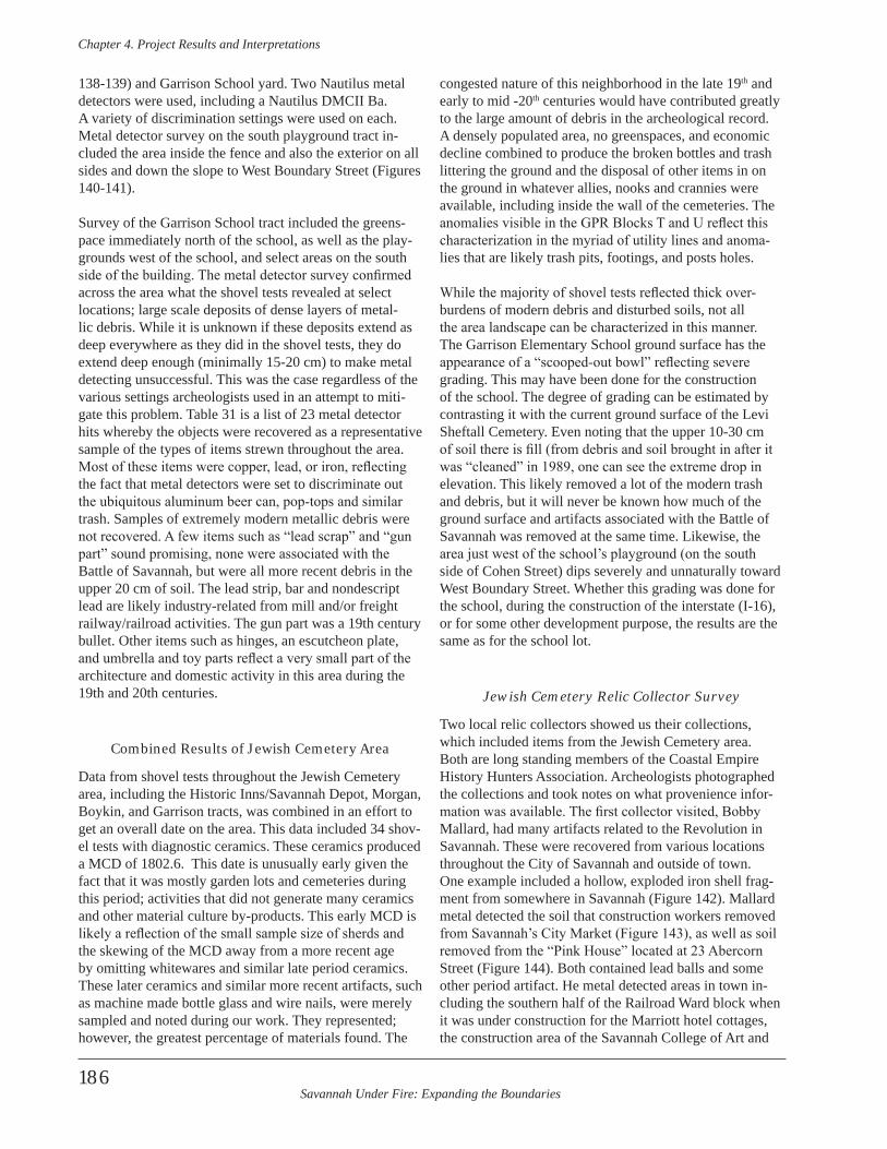
Savannah Under Fire: Expanding the Boundaries
Chapter 4 . Project Results and Interpretations
186
138-139) and Garrison School yard. Two Nautilus metal detectors were used, including a Nautilus DMCII Ba. A variety of discrimination settings were used on each. Metal detector survey on the south playground tract in-cluded the area inside the fence and also the exterior on all sides and down the slope to West Boundary Street (Figures 140-141).
Survey of the Garrison School tract included the greens-pace immediately north of the school, as well as the play-grounds west of the school, and select areas on the south side of the building. The metal detector survey confirmed across the area what the shovel tests revealed at select locations; large scale deposits of dense layers of metal-lic debris. While it is unknown if these deposits extend as deep everywhere as they did in the shovel tests, they do extend deep enough (minimally 15-20 cm) to make metal detecting unsuccessful. This was the case regardless of the various settings archeologists used in an attempt to miti-gate this problem. Table 31 is a list of 23 metal detector hits whereby the objects were recovered as a representative sample of the types of items strewn throughout the area. Most of these items were copper, lead, or iron, reflecting the fact that metal detectors were set to discriminate out the ubiquitous aluminum beer can, pop-tops and similar trash. Samples of extremely modern metallic debris were not recovered. A few items such as “lead scrap” and “gun part” sound promising, none were associated with the Battle of Savannah, but were all more recent debris in the upper 20 cm of soil. The lead strip, bar and nondescript lead are likely industry-related from mill and/or freight railway/railroad activities. The gun part was a 19th century bullet. Other items such as hinges, an escutcheon plate, and umbrella and toy parts reflect a very small part of the architecture and domestic activity in this area during the 19th and 20th centuries.
Combined Results of Jewish Cemetery Area
Data from shovel tests throughout the Jewish Cemetery area, including the Historic Inns/Savannah Depot, Morgan, Boykin, and Garrison tracts, was combined in an effort to get an overall date on the area. This data included 34 shov-el tests with diagnostic ceramics. These ceramics produced a MCD of 1802.6. This date is unusually early given the fact that it was mostly garden lots and cemeteries during this period; activities that did not generate many ceramics and other material culture by-products. This early MCD is likely a reflection of the small sample size of sherds and the skewing of the MCD away from a more recent age by omitting whitewares and similar late period ceramics. These later ceramics and similar more recent artifacts, such as machine made bottle glass and wire nails, were merely sampled and noted during our work. They represented; however, the greatest percentage of materials found. The
congested nature of this neighborhood in the late 19th and early to mid -20th centuries would have contributed greatly to the large amount of debris in the archeological record. A densely populated area, no greenspaces, and economic decline combined to produce the broken bottles and trash littering the ground and the disposal of other items in on the ground in whatever allies, nooks and crannies were available, including inside the wall of the cemeteries. The anomalies visible in the GPR Blocks T and U reflect this characterization in the myriad of utility lines and anoma-lies that are likely trash pits, footings, and posts holes.
While the majority of shovel tests reflected thick over-burdens of modern debris and disturbed soils, not all the area landscape can be characterized in this manner. The Garrison Elementary School ground surface has the appearance of a “scooped-out bowl” reflecting severe grading. This may have been done for the construction of the school. The degree of grading can be estimated by contrasting it with the current ground surface of the Levi Sheftall Cemetery. Even noting that the upper 10-30 cm of soil there is fill (from debris and soil brought in after it was “cleaned” in 1989, one can see the extreme drop in elevation. This likely removed a lot of the modern trash and debris, but it will never be known how much of the ground surface and artifacts associated with the Battle of Savannah was removed at the same time. Likewise, the area just west of the school’s playground (on the south side of Cohen Street) dips severely and unnaturally toward West Boundary Street. Whether this grading was done for the school, during the construction of the interstate (I-16), or for some other development purpose, the results are the same as for the school lot.
Jewish Cemetery Relic Collector Survey
Two local relic collectors showed us their collections, which included items from the Jewish Cemetery area. Both are long standing members of the Coastal Empire History Hunters Association. Archeologists photographed the collections and took notes on what provenience infor-mation was available. The first collector visited, Bobby Mallard, had many artifacts related to the Revolution in Savannah. These were recovered from various locations throughout the City of Savannah and outside of town. One example included a hollow, exploded iron shell frag-ment from somewhere in Savannah (Figure 142). Mallard metal detected the soil that construction workers removed from Savannah’s City Market (Figure 143), as well as soil removed from the “Pink House” located at 23 Abercorn Street (Figure 144). Both contained lead balls and some other period artifact. He metal detected areas in town in-cluding the southern half of the Railroad Ward block when it was under construction for the Marriott hotel cottages, the construction area of the Savannah College of Art and
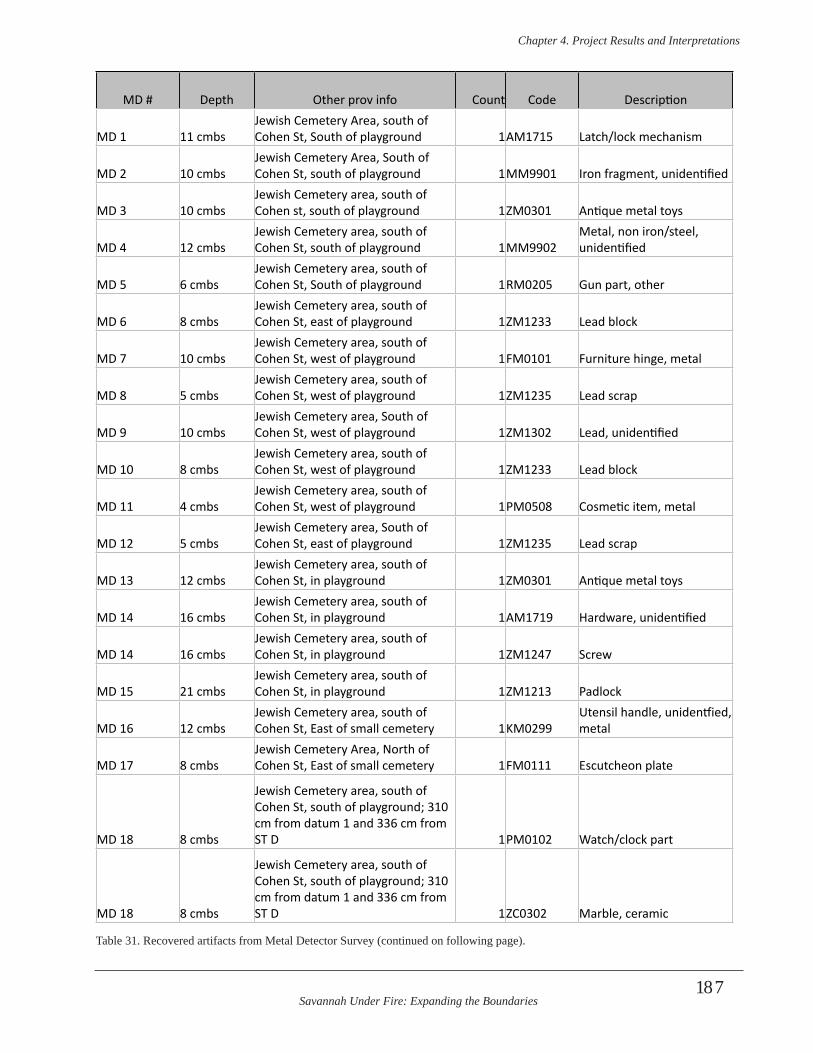
Savannah Under Fire: Expanding the Boundaries
Chapter 4 . Project Results and Interpretations
187
MD # Depth Other prov info Count Code Description
MD 1 11 cmbsJewish Cemetery Area, south of Cohen St, South of playground 1AM1715 Latch/lock mechanism
MD 2 10 cmbsJewish Cemetery Area, South of Cohen St, south of playground 1MM9901 Iron fragment, unidentified
MD 3 10 cmbsJewish Cemetery area, south of Cohen st, south of playground 1ZM0301 Antique metal toys
MD 4 12 cmbsJewish Cemetery area, south of Cohen St, south of playground 1MM9902
Metal, non iron/steel, unidentified
MD 5 6 cmbsJewish Cemetery area, south of Cohen St, South of playground 1RM0205 Gun part, other
MD 6 8 cmbsJewish Cemetery area, south of Cohen St, east of playground 1ZM1233 Lead block
MD 7 10 cmbsJewish Cemetery area, south of Cohen St, west of playground 1FM0101 Furniture hinge, metal
MD 8 5 cmbsJewish Cemetery area, south of Cohen St, west of playground 1ZM1235 Lead scrap
MD 9 10 cmbsJewish Cemetery area, South of Cohen St, west of playground 1ZM1302 Lead, unidentified
MD 10 8 cmbsJewish Cemetery area, south of Cohen St, west of playground 1ZM1233 Lead block
MD 11 4 cmbsJewish Cemetery area, south of Cohen St, west of playground 1PM0508 Cosmetic item, metal
MD 12 5 cmbsJewish Cemetery area, South of Cohen St, east of playground 1ZM1235 Lead scrap
MD 13 12 cmbsJewish Cemetery area, south of Cohen St, in playground 1ZM0301 Antique metal toys
MD 14 16 cmbsJewish Cemetery area, south of Cohen St, in playground 1AM1719 Hardware, unidentified
MD 14 16 cmbsJewish Cemetery area, south of Cohen St, in playground 1ZM1247 Screw
MD 15 21 cmbsJewish Cemetery area, south of Cohen St, in playground 1ZM1213 Padlock
MD 16 12 cmbsJewish Cemetery area, south of Cohen St, East of small cemetery 1KM0299
Utensil handle, unidentfied, metal
MD 17 8 cmbsJewish Cemetery Area, North of Cohen St, East of small cemetery 1FM0111 Escutcheon plate
MD 18 8 cmbs
Jewish Cemetery area, south of Cohen St, south of playground; 310 cm from datum 1 and 336 cm from ST D 1PM0102 Watch/clock part
MD 18 8 cmbs
Jewish Cemetery area, south of Cohen St, south of playground; 310 cm from datum 1 and 336 cm from ST D 1ZC0302 Marble, ceramic
Table 31. Recovered artifacts from Metal Detector Survey (continued on following page).
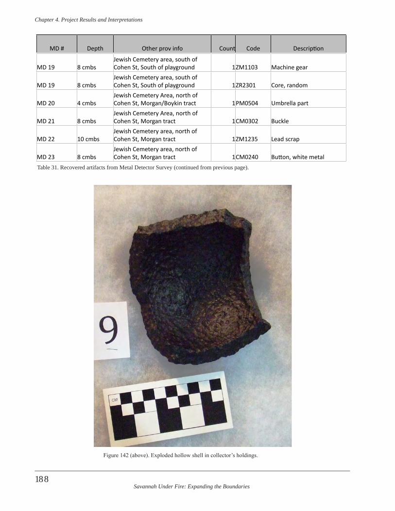
Savannah Under Fire: Expanding the Boundaries
Chapter 4 . Project Results and Interpretations
188
MD 19 8 cmbsJewish Cemetery area, south of Cohen St, South of playground 1ZM1103 Machine gear
MD 19 8 cmbsJewish Cemetery area, south of Cohen St, South of playground 1ZR2301 Core, random
MD 20 4 cmbsJewish Cemetery Area, north of Cohen St, Morgan/Boykin tract 1PM0504 Umbrella part
MD 21 8 cmbsJewish Cemetery Area, north of Cohen St, Morgan tract 1CM0302 Buckle
MD 22 10 cmbsJewish Cemetery area, north of Cohen St, Morgan tract 1ZM1235 Lead scrap
MD 23 8 cmbsJewish Cemetery area, north of Cohen St, Morgan tract 1CM0240 Button, white metal
MD # Depth Other prov info Count Code Description
Table 31. Recovered artifacts from Metal Detector Survey (continued from previous page).
Figure 142 (above). Exploded hollow shell in collector’s holdings.
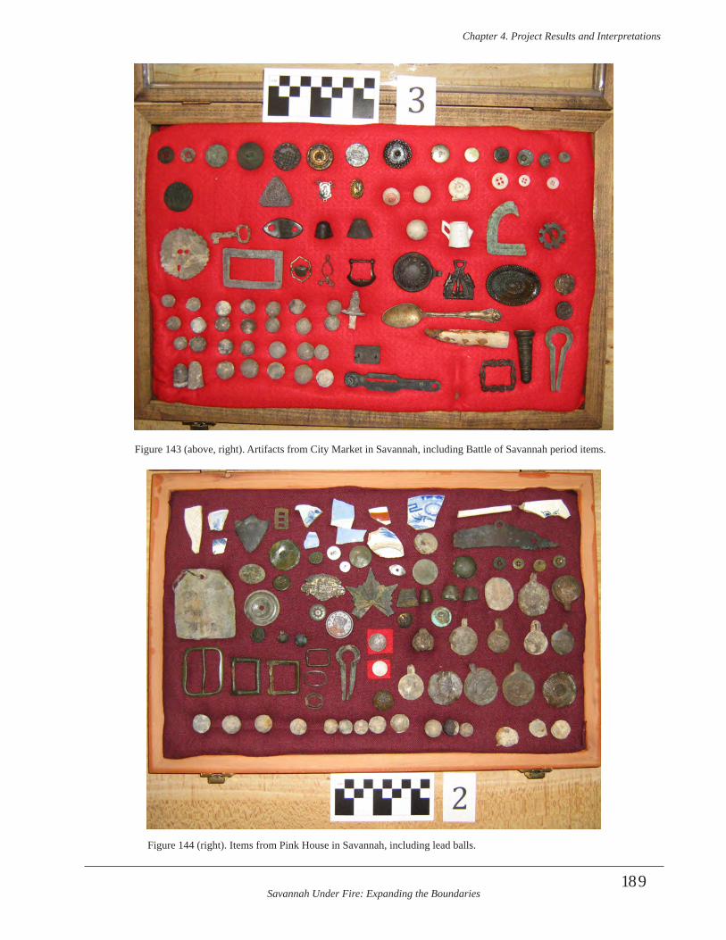
Savannah Under Fire: Expanding the Boundaries
Chapter 4 . Project Results and Interpretations
189
Figure 144 (right). Items from Pink House in Savannah, including lead balls.
Figure 143 (above, right). Artifacts from City Market in Savannah, including Battle of Savannah period items.
Savannah Under Fire: Expanding the Boundaries
Chapter 4 . Project Results and Interpretations
190
Design (SCAD) dorms, street renovation on Montgomery and Gaston streets, and the reputed area of the War of 1812 Barracks and Urban Hospital at President and East Broad streets. Areas detected outside of town containing Revolutionary War artifacts include what is now a housing development called Silk Hope Plantation (a former 71st Scottish Highlander Revolutionary War camp and nearby Civil War site), Berwick plantation, the construction area for the Walmart in Georgetown (a suburb of Savannah), the Savannah/Augusta Road area near the Chatham/Effingham county line, a borrow pit off of I-95 adjacent to the Ogeechee River, and areas on Skidaway Island.
The second collector we visited, Michael Wheless, had an extensive Revolutionary War collection. He had metal de-tected many of the same areas as Bobby Mallard. Wheless found lead balls and gunflints in the SCAD dorms area. He reported the same types of artifacts, in addition to a cannonball near Wheaton and Liberty streets (Figure 145). The button with the arrow in Figure 146 shows a 71st Highlander button from this area. This regiment of Scottish Highlanders played a key role at the Battle of Savannah and during the siege leading up to it. Wheless found many items from the general area between what was Spring Hill Redoubt and where the reserve troops were stationed at the Jewish Cemetery. Some of these items included a trigger-guard from the south half of what was known as the Railroad Ward lot and is now the Marriott hotel cot-tages, and a lead ball and gunflint nearby (Figure 147). He reported British 51st and 52nd regimental buttons, and lead balls and gunflints recovered during construction of the Frogtown lofts (immediately northeast of the Morgan and Boykin lots), and in the area south of the Railroad Ward lot/Marriott hotel cottages. Figure 148 shows a mix of dif-ferent sized lead balls. Some have been impacted, some never fired, and some still have the mold seam and nipple.Many Revolutionary War items were recovered from the area in and around the Jewish Cemetery where the French, American, and Haitian reserves were stationed to cover allied forces should they need to retreat from the battle. A portion of Wheless’ collection came from soils removed from the Garrison Elementary School playground, which is a playground measuring 240 ft. north-south by 226 ft. east-west and located on the south side of Cohen Street. Playground renovation was made in the fall of either 1998 or 1999, and the rubber/asphalt mulch and underlying soils were removed from the playground with heavy machinery. This grading removed approximately 16 inches of soil below the 1990s ground surface, including the overlying mulch. They metal detected the area after the first six to eight inches of soil were removed. At this depth they found mostly large cents and coins from the 1820s-1840s as well as buttons.
The area was then graded to 16 inches below the ground surface and Wheless found pewter U.S. Eagle buttons he attributes to the War of 1812. He believes that the soil that was lying at a depth of between 16-20” below the ground surface contained most of the Revolutionary War artifacts from the 1779 Battle of Savannah, including at least 300 lead balls, in addition to cannonballs, gun parts, gunflints, and military buttons (Figures 149). At that time, Wheless made a sketch map showing the relative locations of the artifacts to each other and the playground boundaries (Figure 150). He noted a general scatter of lead balls and cannonballs across the entire playground, along with gun-flints and a wrought axe head. In addition, he observed two discrete lines of lead balls and other artifacts. One line was located in the northeastern corner of the playground and was oriented northwest-southeast. The second line was lo-cated in the southwestern corner of the playground, paral-leling the first line. The two lines were approximately 200 feet apart. Wheless felt that these two lines might represent opposing lines of battle between the reserves on the south and the counter-attacking British forces on the north. In addition to the lead balls, the northern line contained gun-flints. Near the northern line Wheless recovered gun parts, including a ramrod guide, a hammer, and a partial trigger guard. The southern line contained lead balls, along with a side plate from a gun, a British 20th Regiment button, and unidentified iron hardware.
During the grading process, the soil and mulch were loaded into dump trucks and hauled off to a wooded loca-tion several miles northeast of Savannah. Wheless asked the construction workers for permission to metal detect the playground in-between grading, which he and other collectors did. They also metal detected the dirt after it was removed and re-deposited to a new off-site location. After this, a large amount of “new” soil was brought in and deposited on the playground soon after. Wheless feels confident that he and the many other dectectorists col-lected most of the artifacts in the small playground south of Cohen Street.
In spite of the fact that a decision was made to build the school in the middle of a Revolutionary War battlefield, it was constructed with no archeological investigations prior to construction. No local City of Savannah ordinances or Chatham County ordinances existed then, or now, to preserve significant sites such as these, or to research and document them before they are destroyed by construction. Nor do state codes, such as the Georgia Environmental Policy Act (GEPA) protect such sites. Likewise, no archeo-logical investigations were made prior to the construction of the school’s playground, nor prior to extensive play-ground renovation which resulted in extreme grading and soil removal. Savannah College of Art and Design (SCAD) built a large dormitory complex on West Boundary Street.
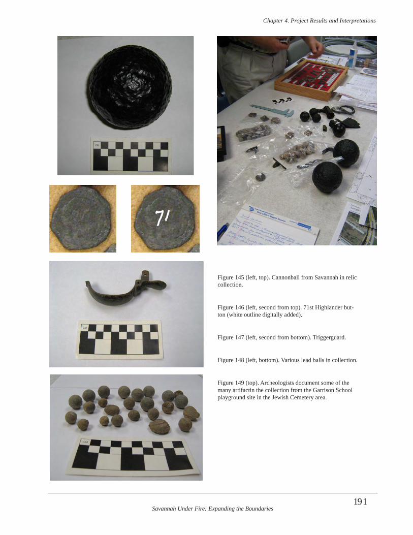
Savannah Under Fire: Expanding the Boundaries
Chapter 4 . Project Results and Interpretations
191
Figure 145 (left, top). Cannonball from Savannah in relic collection.
Figure 146 (left, second from top). 71st Highlander but-ton (white outline digitally added).
Figure 147 (left, second from bottom). Triggerguard.
Figure 148 (left, bottom). Various lead balls in collection.
Figure 149 (top). Archeologists document some of the many artifactin the collection from the Garrison School playground site in the Jewish Cemetery area.
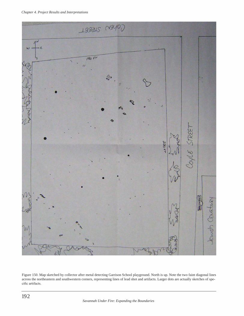
Savannah Under Fire: Expanding the Boundaries
Chapter 4 . Project Results and Interpretations
192
Figure 150. Map sketched by collector after metal detecting Garrison School playground. North is up. Note the two faint diagonal lines across the northeastern and southwestern corners, representing lines of lead shot and artifacts. Larger dots are actually sketches of spe-cific artifacts.
Savannah Under Fire: Expanding the Boundaries
Chapter 4 . Project Results and Interpretations
193
Wheless and others also metal detected this area. The lead balls (fired and unfired) and gunflints he found there indicate that evidence from the Battle of Savannah once existed there as well. No archeological investigation was conducted prior to the construction of the SCAD complex. As a result 98 percent of the information associated with that site is now destroyed forever.
Construction of Garrison Elementary school on this ex-tremely historical site without first implementing a profes-sional archeological investigation is a travesty resulting in a monumental loss to history and the story of the Haitian’s role in the Battle of Savannah. Priceless information about that role could have been recovered had scientific archeo-logical procedures and investigations been undertaken before school construction began. Now, we can only try to collect what little information has not been lost. In this particular case, it is fortunate that Wheless collected the area, kept this collection segregated in labeled bags sepa-rate from his other collections, made a sketch map of the general locations of his finds, made general notes about the depths of the finds, and kept the finds together rather than selling and or trading the collection. Wheless, however, was only one of many individuals who collected the play-ground. Most collectors did not use even the limited stan-dards that Wheless incorporated. For example, Wheless estimates that over 300 lead balls, including fired ones, were recovered from this very small area. Other collectors also recovered gun parts and other battle-related artifacts. Had the exact locations of these artifacts been mapped with a laser transit, the entire artifact assemblage analyzed completely, and any associated features excavated archeo-logically, then the story of what actually happened during the final minutes of the battle would have unfolded in con-cise detail. This would have included the role the Haitian reserve troops and others played; a role currently no more than a footnote in most histories of the battle.
Project Results Summary
Historical Research Results
Research for this project complemented the research con-ducted during the first ABPP project. Archeologists dur-ing this project more closely examined four of the nine CDs containing thousands of digital images of documents gathered during the first project from archival reposito-ries throughout New York, Pennsylvania, Michigan, and Georgia. This scrutiny, along with new documents posted on the World Wide Web, and information from South
Carolina archives, all contributed to a larger body of data on the 1779 Battle of Savannah. It resulted in new inter-pretations and a more complete picture of the events and people involved, particularly locations targeted during this project and the women, children, African-Americans, and Native Americans so often ignored in traditional military histories.
Fieldwork Results
Archeologists conducted historical research and GIS study prior to undertaking survey of 11 discrete parcels of prop-erty for this project. This included the Jewish Cemetery area (Savannah Station, Morgan, Boykin, south play-ground tracts); Calhoun Square; Whitefield Square; Laurel Grove Cemetery (circular and northwestern greenspaces and Gentile section); Wells Park, Thomas Park, and W.W. Law Park. They conducted a combination of shovel test-ing, metal detector survey, transit mapping, and test unit excavation in an attempt to identify specific targets related to the Battle of Savannah. This work resulted in the dis-covery and documentation of the site of the reserve troops, including the Haitian troops, at the Jewish Cemetery area. Most of the landscape here had rubble overburden up to a meter or more deep which prevented archeologist from locating the site during their metal detector survey and in shovel tests. The discovery was made when archeologists included an outreach effort with local relic collectors. At that time archeologists learned that collectors had metal detected a small portion of the area (one of the play-grounds) when the playground was graded several feet be-low the ground surface. This grading allowed the detectors to penetrate to an extant 18th century component associated with the battle. Archeologists documented two collections from this location.
Given the fact that a deeply buried and likely in situ de-posit had been at the small playground south of the school, it is extremely likely that this deposit extends into the other surrounding tracts including the Savannah Station, Morgan, and Boykin tracts, as well as some of the grounds of Garrison Elementary School. The size of the reserve troops and the scope of their activities would require that the site be larger than merely the area that is now a fenced playground south of Cohen St. The fact that the entire deposit beneath the playground was destroyed, except the artifacts which are dispersed in dozens or more collections, is lamentable and easily avoidable had an archeology ordi-nance required archeological investigation prior to school and playground construction. Now that the presence of such deposits are known and thought likely to exist in the surrounding areas, there is no excuse that these, too, should be destroyed when future development occurs.
Savannah Under Fire: Expanding the Boundaries
Chapter 4 . Project Results and Interpretations
194
The search at Yamacraw for the Redoubt northwest of Spring Hill Redoubt began well, with GPR survey locat-ing a promising anomaly. Last minute bureaucratic issues involving excavation and artifact dispensation came to the fore two days before test unit excavation and public out-reach was to begin. Time constraints prohibited any further attempts by archeologists to mitigate these problems and as a result, the anomaly could not be ground-truthed. There is potential; however, for archeological excavation here to determine if this area contains portions of the redoubt.
Both the French saps and French and American camps, as well as Benjamin Lincoln’s headquarters proved elusive. Areas targeted for study were based on GIS mapping. The margin of error on these overlays increases as one moves away from the control points in historic downtown and toward the south. The camps and headquarters were lo-cated far south of town. It is quite possible that archeologi-cal evidence of the camps exists, but we did not find such evidence on the targeted parcels. At the very least, this negative evidence helps future research by narrowing the study area.
Results of Project Strategies
At the onset of the project the Field Director/Project Manager outlined 10 strategies to promote preservation of the Battle of Savannah Battlefield. These strategies were accomplished and are summarized below.
• Make recommendations based on proj-ect interpretations. See this chapter for specific recommendations.
• Share findings and seek solutions to local battlefield site protection through three “Conversation Dates” with stakeholders and pol-icy makers . The first meeting with city staff and departmental policy makers was very successful. It allowed archeologists to share results of the first grant project and provide information on the goals and methodology of the second project. It enabled individuals on both sides of the project to meet, address concerns, and develop a working relationship. Archeologists specifically invited these city staff members to the third meeting (public stakeholders’ meeting) (mentioned below and in greater detail in previous sections of this report). The second meeting was merged with the third for reasons discussed previously.
• Share information through public pre-sentations in which public comment and brain-storming are invited . The project director gave presentations to six community organizations including high school students, a men’s church group, a council of garden clubs, a Revolutionary War group, a consortium of museum and historic sites staff, and college students. CHS staff arche-ologists also included the Savannah Under Fire project in a symposium it organized at an inter-national archeology conference. Public comment and brainstorming was strongly encouraged at all these meetings, and especially at the stakeholders’ meeting at the culmination of the project.
• Create a social networking site to share project information with the public, es-pecially targeting those under 30 years of age . Archeologists created the first social media development for this project. This included the Savannah Under Fire FaceBook page, with up-dates throughout the field and lab components of the project. It also included video links to YouTube. This first FaceBook page developed a following of between 140 and almost 300 people, most of who were not previously linked to arche-ology information in Savannah. The Facebook page was supplemented by information on the CHS web site and information on project person-nel blogs.
• Distribute copies of report to partner organizations and other interested entities . Hard copy and/or digital reports will be distributed to area historical societies, city government, city archives, libraries, local colleges and universi-ties, chamber of commerce/visitor center bureau, county government planning commission, eco-nomic development authorities, specific project area property owners, and other individuals and entities.
• Speak to partner organizations about community involvement and opportunities for synergy and invite them to the “Conversation Dates” meeting . A total of 117 individuals associ-ated with specific, relevant organizations were invited to the public stakeholders’ meeting (i.e. “Conversation Date” meeting.) These included individuals associated with economic develop-ment, tourism, city staff, historical societies,

Savannah Under Fire: Expanding the Boundaries
Chapter 4 . Project Results and Interpretations
195
archeological societies, county staff, community organizations, state and federal agencies, and planning commissions.
• Investigate with partners, city govern-ment, chamber of commerce, and tourism offi-cials, the feasibility of promoting and preserving the site as a walking tour opportunity . Limited discussion ensued at the public stakeholders’ meeting about how the battlefield sites could be incorporated into walking tours. One very ef-fective and increasingly sophisticated and user-friendly way is to use Podcasts and/or augmented reality techniques. Such digital technologies offer the opportunity to bring a buried, invisible archeological site to life through battle sounds, audio of primary accounts read by actors, contem-porary maps and images, and many other auditory and visual methods. Exterior interpretive signage would be a lower tech, less comprehensive ap-proach, but one that would be accessible without technology hardware or operating expertise. Discussion included the mention of the impor-tance of the information generated by this project and the past ABPP project and how that informa-tion can be a significant and useful source of con-tent for tour guides, brochures, and other materi-als about Savannah’s Revolutionary War past.
• Investigate funding opportunities to put exhibit concept from Phase I into a reality after Phase II discoveries and interpretations are com-plete . The Curatorial Department of the Coastal Heritage Society held a day-long departmental working meeting to identify potential funding opportunities and to research each to determine which funders had parameters that matched the exhibit project. This research included online examination of specific entities and their grant guidelines, including corporate and private giv-ing, as well as state and federal grants. It also included a phone conversation with Kristen McMasters, Archeologist Planner and Grants Manager, ABPP, National Park Service, regarding the appropriateness of any NPS ABPP funds, or NPS funds in general for exhibit development and installation. CHS Archeologists also searched the database of the Georgia Center for Non-Profits (both online and at its Savannah office) for po-tential exhibit funding. A short list of potential funders was identified from the various efforts above.
• Use media coverage and web sites to share information and promote preservation ef-forts among community organizations . Online calendars; electronic newsletters; television, radio, and newspaper web sites; and newspapers and television were other venues (in addition to the social media sites discussed below) incorpo-rated by the project to share announcements and information with the public.
• Make recommendations for ways to preserve the battlefield site based on best prac-tices for archeological site preservation and stakeholder input derived during above process . Recommendations are included in this report based on the above. In addition, specific pres-ervation concepts were discussed with property owners in the Jewish Cemetery area, as they participated (of their own accord) in a public charette and public forums involving proposed major alterations to the area. These proposed alterations include re-routing a nearby Interstate Highway flyover, reestablishing former surface road routes, creating new surface road routes, and redeveloping the area as an economic develop-ment corridor. Two property owners are interested in preserving the tracts in the Jewish Cemetery locale due to their historic nature and incorpo-rating the tracts into Savannah’s larger tourism audience. Discussion is also currently underway for considering the inclusion of the archeological components of the Battle of Savannah that fall within the proposed World Heritage Site boundar-ies. Properties falling within the corridor would most likely include the 5.5 foot deep fortification trench in Madison Square discovered during the first NPS project, the Spring Hill Redoubt rem-nants, and possibly others depending on the pro-posed nomination boundaries.
Interpretation
Research Design
A research design typically produces broad research ques-tions with far-reaching implications. Many times these can
Savannah Under Fire: Expanding the Boundaries
Chapter 4 . Project Results and Interpretations
196
be answered by research and fieldwork. Other times the answers await further research. Often research questions and new data result in the formulation of additional ques-tions or modified research questions. The data collected during this project, and in conjunction with the previous ABPP Savannah Under Fire project, resulted in all of the above. The research questions presented at the beginning of this report are addressed below, but grouped by topic.
What efforts did British forces make to defend their posi-tion? Were defensive works constructed following the mil-itary engineering standards of the day? The British made Herculean efforts to construct defensive works around Savannah in the very short period from the sighting of French vessels along the coast to the siege and battle. The British strengthened the four existing redoubts and added 10 additional ones. British forces enlarged and strength-ened the abatis around these fortifications, and dug trench-es between the redoubts to connect them. In addition, with meteoric speed, the British razed a brick barracks to open the field of view, used the foundation as a defensive bul-wark and gun battery, and incorporated the brick rubble along fortification trench edges as additional cover. Which of the other 13 redoubts, besides Spring Hill, saw battle activity, and to what degree? Primary documents in-dicate that while the main focus of attack was Spring Hill; nearby Carolina Redoubt was also a target and it played heavily in helping to defend Spring Hill. Likewise, the redoubts adjacent to Carolina Redoubt supplied fire power to aid Spring Hill. The Central Redoubt was selected as the target of one of the feints, to distract attention from the real goal of Spring Hill.
Can the Carolina Redoubt be located, and if so, what evidence is there for its reputed role in assisting with the defense of the Spring Hill Redoubt? Redoubts 12, 13, and 14 were all situated north of Spring Hill Redoubt, along the western defenses. The search for Redoubt 14, and/or possibly Redoubt 13 at Yamacraw was in process when it was thwarted. The GPR data collected revealed an anomaly that may be related to a redoubt; however, arche-ologists were stopped from ground-truthing it. An attempt to examine an open tract of land south of this area that may have held the Carolina Redoubt or another redoubt near Spring Hill was denied by attorneys for a developer owning that vacant tract. Any archeological site on that tract will likely be destroyed before the information about the role it played in the battle can be retrieved, as tenta-tive plans call for the construction of a hotel. The lack of a city archeology ordinance ensures that any site on the grounds will not be documented before it is destroyed. The Carolina Redoubt and other redoubts may yet be located, if the search can stay ahead of development and resulting destruction.
What battlefield components, either above or below the ground surface, have survived and why? Which have not survived, and why? Currently, we know that several battle-field components have survived in Savannah, in surprising locations. The bottom two feet of the defensive ditch at the Spring Hill Redoubt has survived, in spite of intensive industrial development in that area for over two centu-ries following the battle. We have discovered that some deep fortification trenches (5.5 feet deep) from the battle still exist beneath the city. An example is the fortification trench located in Madison Square. Demarcating this area as a greenspace in 1839 helped preserve this important Revolutionary War feature. The depth of the feature below most modern intrusions such as public utilities and irriga-tion lines also helped ensure its survival.
Other areas examined by this and the previous ABPP project may be related to the battle, but further work is needed to confirm this hypothesis. These areas include the greenspace on Bay Street near Fort Prevost, Lafayette Square, and Thomas Park. Investigations in Davant Park failed to locate battle evidence but archeologists were able to define a deeply buried 18th century land surface that is worthy of further exploration. Limited test unit excava-tion in these GIS target areas revealed either features and/or artifacts suggestive of involvement with the battle. Interestingly, while we have negative evidence for the French and American camps, we cannot say they do not exist, only that they do not seem to be in the areas we have thus far examined. Given the extent of the camps and the thousands of soldiers living there for several weeks, it is extremely likely that evidence of these camps have sur-vived archeologically somewhere within the modern city of Savannah. Likewise, until we know the exact locations of the other redoubts and battlefield features, and excavate enough at those locations and find nothing, we cannot say they those components do not exist. It is likely that some of them have survived, at least partially, the massive on-slaught of development without archeological protections in Savannah.
What types of extant features survive archeologically and what do these tell us about the period immediately before, during, and immediately after the battle? What features were identified, and how can they be interpreted in relation to standard fortification construction? While we found no features during this project that could be associated with the battle, we have evidence from prior work concern-ing specific features. Post mold stains in the Spring Hill Redoubt ditch indicate that both pointed and flat posts of different sizes were somewhat randomly placed, possibly in irregular sets of two, inside the ditch. The posts were set vertically rather than at an angle, with soil filled in around them at the time of construction. All of this suggests that
Savannah Under Fire: Expanding the Boundaries
Chapter 4 . Project Results and Interpretations
197
the construction was expedient and opportunistic, incor-porating whatever type of post materials were available, in as quick a fashion as possible. Stratigraphic sequences reveal that much of the upper part of the ditch was scraped away following the Revolution and a late 18th-early 19th century soil horizon developed. Part of this was scraped away later by Central of Georgia Railroad activities in the 1840s, which then deposited a stratum of coal, clinkers and cinders.
The fortification trench at Madison Square was dug by British forces with the strategy of the day that connected redoubts to each other with trenches, allowing safe move-ment of troops between the redoubts. The archeological deposit within the trench at Madison Square is a three year sequence of the Revolution. Stratigraphy and artifacts reveal the construction of this massively wide (well over 6 ft) and deep (minimally 5.5 ft) trench in September of 1779, its use during the October 9th battle, its use thereaf-ter, and its infill in July-August, 1782.
Archeological features at the French and American camps offer huge potential to provide new information about the condition of the troops before, during, and after the battle. Trash pits, privies, camp kitchens and the like could tell what food was available, the medical condition of the men, the type of camp followers present and their lifestyles, general conditions of the camps, sanitary conditions, the role of Africans and African Americans in both camps, the presence or absence of Native American warriors in the camps, the role of women and families, and camp tasks and leisure time activities, to name a few. Comparisons and contrasts could be made between the French camps and the American camps; between their officers and enlist-ed; between the officers and enlisted within each country’s camp; between sailors, soldiers, and cavalry; and between prisoners and their captors.
What were reserve troops doing before, during, and after the battle? Is there any evidence for reserve troop activi-ties, and if there is, does it support or refute the historical documentation? The accessible artifacts recovered by metal detectorists during playground reconstruction at Garrison Elementary School suggest that the role of the Haitians was much more involved and dangerous than primary documents and secondary sources suggest. The number of lead balls, gunflints, gun parts, and other para-phernalia in only two of the collector’s possession and from such a small area suggests that there was a great deal of activity at the reserve location. It also suggests that the reserve troops took an active part in attacking British troops rather than merely covering the backs of retreating French and American forces. Unfortunately, because this area was not studied archeological prior to playground modifications, we cannot be sure what was happening
before, during, and after the battle. We may be able to answer similar questions in the future if archeological test unit excavation and/or controlled stripping of overburden to document midden and features occurs on the Jewish Cemetery area tracts. The Reserve Corps portion of the Battle of Savannah is an extremely important, yet very little known facet of the story.
What features of the landscape aided or hindered the op-posing forces and which are visible in the modern land-scape? The slightly higher ground of the Jewish Cemetery area provided reserve troops and leaders with a better van-tage of the battle, allowing them to react when needed to cover the retreat. The location of the Spring Hill Redoubt was strategic, in that it was positioned on a hill, provid-ing a good viewshed of the surrounding area. Likewise, it was flanked to the west and southwest by a creek and its swamps, creating an obstacle for attacking troops.
Most of Spring Hill was graded, beginning in the late 18th century and with particular gusto from the 1830s-1870s. Changes in ground elevation are still apparent when look-ing east-west on Louisville Road (formerly Ebenezer Road or Old Augusta Road). Today, the property on either side of the road just downhill from the redoubt towers over the roadway in places as a result of the grading that pushed the soils downhill to the west and from fill soil brought in by the railroad and deposited on former slopes. This westward approach to the city is still used today and was the scene of the massive slaughter of allied troops who were trying to regroup there to attack Spring Hill and Carolina re-doubts following their exodus out of the swamp. Much of the swampy area to the south and west has been drained. Huge, enclosed culverts, drain pipes and infill has changed much of the swamp and this area has lately become the target for future economic development and gentrification.
The fortification trench associated with the Central Redoubts is located in a square directly on Bull Street. This street served as the main thoroughfare and avenue of approach into and out of town in the 18th century, and continues to serve as the gateway into the historic part of the city as it bisects that section of town. Its role as a major artery may have been the reason the French and Americans selected the Central Redoubts for one of the feints during the battle.
The Savannah River is an extant natural feature that was a double-edged sword for both sides. The British found that they were hemmed in by French vessels and could not get their ships very far away from the wharves along the bluff. The French were unable to manipulate their vessels up the Savannah River for a full scale naval assault on the town, in part to navigational issues and the British ships and sunken hulks protecting the city. The river did allow
Savannah Under Fire: Expanding the Boundaries
Chapter 4 . Project Results and Interpretations
198
British vessels to fire successfully on attacking allied forc-es, particularly those troops in the area of the Spring Hill Redoubt, including the swamps and road nearby. The very steep natural bluff along the river (which still exists today) provided desperately needed cover and concealment for civilians and soldiers in town during the siege and battle. It also acted as a deterrent to a land attack from troops on vessels. The maze of tributaries, river drainages, and coastal inlets provided a hidden route for Maitland’s troops coming to reinforce the British at Savannah. Some of these courses have meandered over the centuries, but the area continues to be transected by such waterways.
How well were opposing forces supplied with food, am-munition, and other necessities of battle? What effect did the weather have on activities leading up to and during the battle? Did the multi-national nature of the allied forces affect their operations? If so, how? Locating and studying the French and American camps would go a long way in providing answers to part of this question. Primary docu-ments reveal that French and American troops were hard-pressed to have adequate food and clothing. The French capture of the vessel was a huge victory, as it provided critical food, clothing, and money that immensely aided French troops. The British besieged were actually faring better than their besiegers. British Major General Prevost calculated that he had enough commissary stores to last the soldiers and civilians in town three months.
D’Estaing’s visit during Hurricane season was ill-planned. The weather provided him with an excuse for ending the siege and attacking Savannah. Storms already buffeted his ships of the line and he was ill-prepared for additional damage. The unseasonable cold and damp weather tor-mented the allied forces, which were not properly attired or provisioned for it.
Primary documents are riddled with issues between the French and American forces. These range from opposing agendas between the upper echelons of commanders to snide comments from rank and file. Much of this could have been caused by cultural differences and resulting mis-understandings. Some discontent among the allied forces was likely a result of past political events on the European continent and between the new American government and the established reign of the French monarchy. Regardless of the cause, the Franco-American alliance was tested dur-ing the siege and Battle of Savannah. While the alliance failed miserably in Savannah, it redeemed itself two years later at Yorktown.
How accurate are the published accounts of the battle? Which accounts were inaccurate, and why? Were stan-dard military procedures followed before, during, and after the battle? Why or why not and how did this affect
battle operations? Generally speaking, the accounts of the battle written soon after the event by participants seem to be fairly accurate, or at least to accurately represent that participant’s viewpoint. Accounts at the turn of the century and early 1800s are generally less reliable as events and dates get cloudy. Accounts later than this often have errors or are repeats of earlier accounts.
Standard military procedures were not followed for the battle. When troops were forming for the battle march d’Estaing restructured virtually all of them. As a result soldiers who normally fought together and had an effective knowledge of group dynamics and strong esprit de corps were now marching into fierce battle among strangers. The reason for this restructuring is unclear, but the disastrous results were not. Added to this were vehement arguments among d’Estaing and his officers about the battle plan of attack. Clearly there was no cohesion among the officers or rank and file. These last minute changes and wrangling delayed the battle by two hours and removed the opportu-nity for a surprise pre-dawn attack.
The battle events surrounding Spring Hill reflect an inter-esting chain of command. When d’Estaing could no longer command the troops in the field due to his two wounds, command fell to his second in command, Viscount de Fontanges. When Fontanges fell, Colonel Arthur Dillon took command and ordered a retreat. At no time did Major General Benjamin Lincoln, apparently watching from the reserve troop location at the Jewish Cemetery, send orders. This is likely because he was leader of the American forces and could not command French troops directly. So while Lincoln far out-ranked Dillon, the latter was in charge of the French troops due to the wounding of higher ranking officers and the resultant command chain protocols.
What negative evidence for the battlefield was located and how does that contribute to locating or understanding various portions of the battlefield? We now know that it is unlikely that the French and American camps are located in modern Wells Park, W.W. Law Park, and three specific portions of Laurel Grove Cemetery. While unexciting, this negative evidence is useful in eliminating these areas from future searches. It also tells us that the GIS information for this area needs to be shifted, either north or south. New control point information from the Jewish Cemetery area may help to determine the direction necessary.
Can evidence for the allied American and French camps be located and if so, does the evidence support or refute historical documentation? How did the environment, terrain, and military strategy at the time determine the location of the camps? We were unsuccessful in locating the camps, but feel that their discovery is possible in the future. This is particularly true with new GIS information.
Savannah Under Fire: Expanding the Boundaries
Chapter 4 . Project Results and Interpretations
199
(See below.) The French and Americans needed level, rela-tively high ground, beyond firing distance from Savannah that was preferably not too wooded. They found a place they deemed appropriate south of town that was capped on either end by swamps. A road next to it proved expedient for moving goods and troops. Military strategy dictated the arrangements of the camps, with French troops to-gether and American troops together. Documents note that Pulaski’s cavalry was camped as its own unit. The French and Americans were divided with space between them to reduce cultural, political, and military tensions.
How do new discoveries (made in Phase I and in Phase II) change the GIS map overlays and do these changes contribute to the reinterpretation of past or current con-cepts of the battle? The discovery that there were actually artifacts from the battle at what is now the Garrison School playground will allow this location to be used as a control point on future GIS maps. This is especially important as it establishes a control point approximately 650 yards south of our former control points. A point this much farther south will help reduce the GIS margin of error when the search for the French and American camps continue. This may provide the key to actually locating the camps. Once they are located, they can provide significant missing in-formation about the battle and related events.
Did the battle affect strategies used by America and Great Britain in the remainder of the war? Did the battle have significant impact on the American Revolution, and if so, how? Britain’s sojourn into Savannah in 1778 came under the false premise that rural colonists would flock to the Loyalist cause, support British efforts, and swell the ranks of the militia and military. This did not happen in 1778 and it did not happen in 1779 when the French and American forces threatened the very gates of British-held Savannah. While Britain managed to win the Battle of Savannah, military strategists realized that they would have to take the entire southern theater without depend-ing on help from back country residents or other “closet Loyalists”. Some argue that Britain’s success at the Battle of Savannah lengthened the war by giving the country ad-ditional confidence to take Charleston and beyond. The battle significantly impacted the American cause by creat-ing despondency and disillusionment, and by putting the Franco-American alliance at jeopardy for survival. The fact that American generals were victorious in the war, in spite of losing significant battles such as the 1779 Battle of Savannah speaks volumes. As does the survival of the al-liance, which may be credited best to the political maneu-vering of Benjamin Lincoln and others American generals who publicly smoothed over the many missteps and poor decisions of the siege and battle (including many made by d’Estaing). This may have been Lincoln’s only credible action involving the entire siege, battle, and aftermath.
Historical Significance of Battle of Savannah and Associated Sites
Assessment for NRHP eligibility
Battlefield Boundaries
This was addressed initially in the first project report and is repeated here, with updates from this project (Elliott and Eliott 2009). Battlefield boundaries are subdivided into three categories, including the Study Area, Core Area, and Potential National Register Boundary. These are defined by the National Park Service (NPS 2000) as follows:
• Study Area-Encompasses the ground over which units maneuvered in preparation for combat; determined by historical research, regardless of changing land use over time. It is the “maximum delineation of the historical site…contain[ing] all places related or contributing to the battle event” including troop maneuvers, deployment, and fighting “…before, during and immediately after combat… that directly contributed to the develop-ment and denouement of the battle.”
• Core Area-Area of combat; always within Study Area; determined by historical research, regard-less of changing land use over time. “It includes those places where the opposing forces engaged and incurred casualties”.
• Potential National Register Boundary (PotNR)-Those portions of the battlefield that have retained integrity; determined by integrity and may encom-pass parts of both the Study and Core Areas. It “…indicates to preservationists and planners what remains to save” and provides “…important infor-mation on which to base nominations of the bat-tlefield to the National Register of Historic Places and other historic preservation planning decisions. “Any parts of the Study and Core Areas that have been compromised by modern development, ero-sion, or other destructive forces and that can no longer provide a feeling of the historic setting should be excluded from the PotNR boundary.”
Savannah has a large National Historic Landmark District consisting of the town’s original two dozen squares and surrounding town lots as arranged on the 1733 town
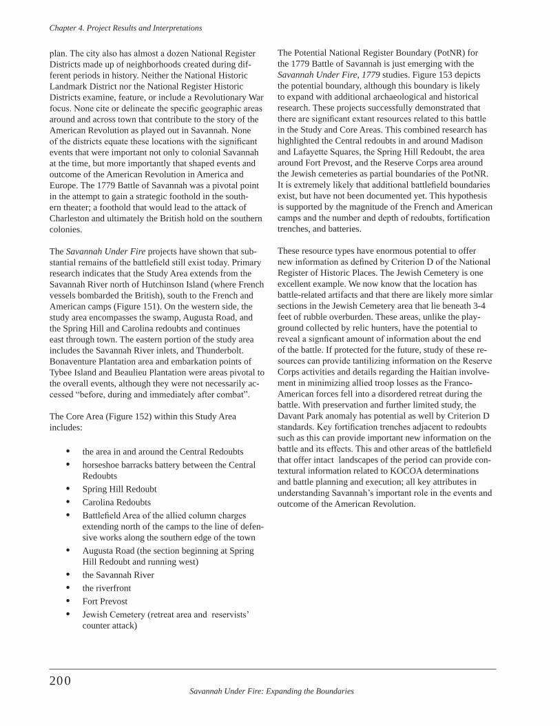
Savannah Under Fire: Expanding the Boundaries
Chapter 4 . Project Results and Interpretations
200
plan. The city also has almost a dozen National Register Districts made up of neighborhoods created during dif-ferent periods in history. Neither the National Historic Landmark District nor the National Register Historic Districts examine, feature, or include a Revolutionary War focus. None cite or delineate the specific geographic areas around and across town that contribute to the story of the American Revolution as played out in Savannah. None of the districts equate these locations with the significant events that were important not only to colonial Savannah at the time, but more importantly that shaped events and outcome of the American Revolution in America and Europe. The 1779 Battle of Savannah was a pivotal point in the attempt to gain a strategic foothold in the south-ern theater; a foothold that would lead to the attack of Charleston and ultimately the British hold on the southern colonies.
The Savannah Under Fire projects have shown that sub-stantial remains of the battlefield still exist today. Primary research indicates that the Study Area extends from the Savannah River north of Hutchinson Island (where French vessels bombarded the British), south to the French and American camps (Figure 151). On the western side, the study area encompasses the swamp, Augusta Road, and the Spring Hill and Carolina redoubts and continues east through town. The eastern portion of the study area includes the Savannah River inlets, and Thunderbolt. Bonaventure Plantation area and embarkation points of Tybee Island and Beaulieu Plantation were areas pivotal to the overall events, although they were not necessarily ac-cessed “before, during and immediately after combat”.
The Core Area (Figure 152) within this Study Area includes:
• the area in and around the Central Redoubts• horseshoe barracks battery between the Central
Redoubts• Spring Hill Redoubt• Carolina Redoubts• Battlefield Area of the allied column charges
extending north of the camps to the line of defen-sive works along the southern edge of the town
• Augusta Road (the section beginning at Spring Hill Redoubt and running west)
• the Savannah River• the riverfront• Fort Prevost• Jewish Cemetery (retreat area and reservists’
counter attack)
The Potential National Register Boundary (PotNR) for the 1779 Battle of Savannah is just emerging with the Savannah Under Fire, 1779 studies. Figure 153 depicts the potential boundary, although this boundary is likely to expand with additional archaeological and historical research. These projects successfully demonstrated that there are significant extant resources related to this battle in the Study and Core Areas. This combined research has highlighted the Central redoubts in and around Madison and Lafayette Squares, the Spring Hill Redoubt, the area around Fort Prevost, and the Reserve Corps area around the Jewish cemeteries as partial boundaries of the PotNR. It is extremely likely that additional battlefield boundaries exist, but have not been documented yet. This hypothesis is supported by the magnitude of the French and American camps and the number and depth of redoubts, fortification trenches, and batteries.
These resource types have enormous potential to offer new information as defined by Criterion D of the National Register of Historic Places. The Jewish Cemetery is one excellent example. We now know that the location has battle-related artifacts and that there are likely more simlar sections in the Jewish Cemetery area that lie beneath 3-4 feet of rubble overburden. These areas, unlike the play-ground collected by relic hunters, have the potential to reveal a signficant amount of information about the end of the battle. If protected for the future, study of these re-sources can provide tantilizing information on the Reserve Corps activities and details regarding the Haitian involve-ment in minimizing allied troop losses as the Franco-American forces fell into a disordered retreat during the battle. With preservation and further limited study, the Davant Park anomaly has potential as well by Criterion D standards. Key fortification trenches adjacent to redoubts such as this can provide important new information on the battle and its effects. This and other areas of the battlefield that offer intact landscapes of the period can provide con-textural information related to KOCOA determinations and battle planning and execution; all key attributes in understanding Savannah’s important role in the events and outcome of the American Revolution.
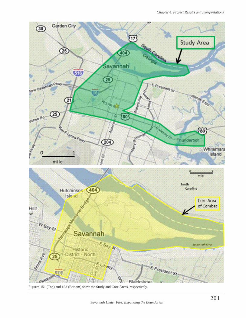
Savannah Under Fire: Expanding the Boundaries
Chapter 4 . Project Results and Interpretations
201
Figures 151 (Top) and 152 (Bottom) show the Study and Core Areas, respectively.
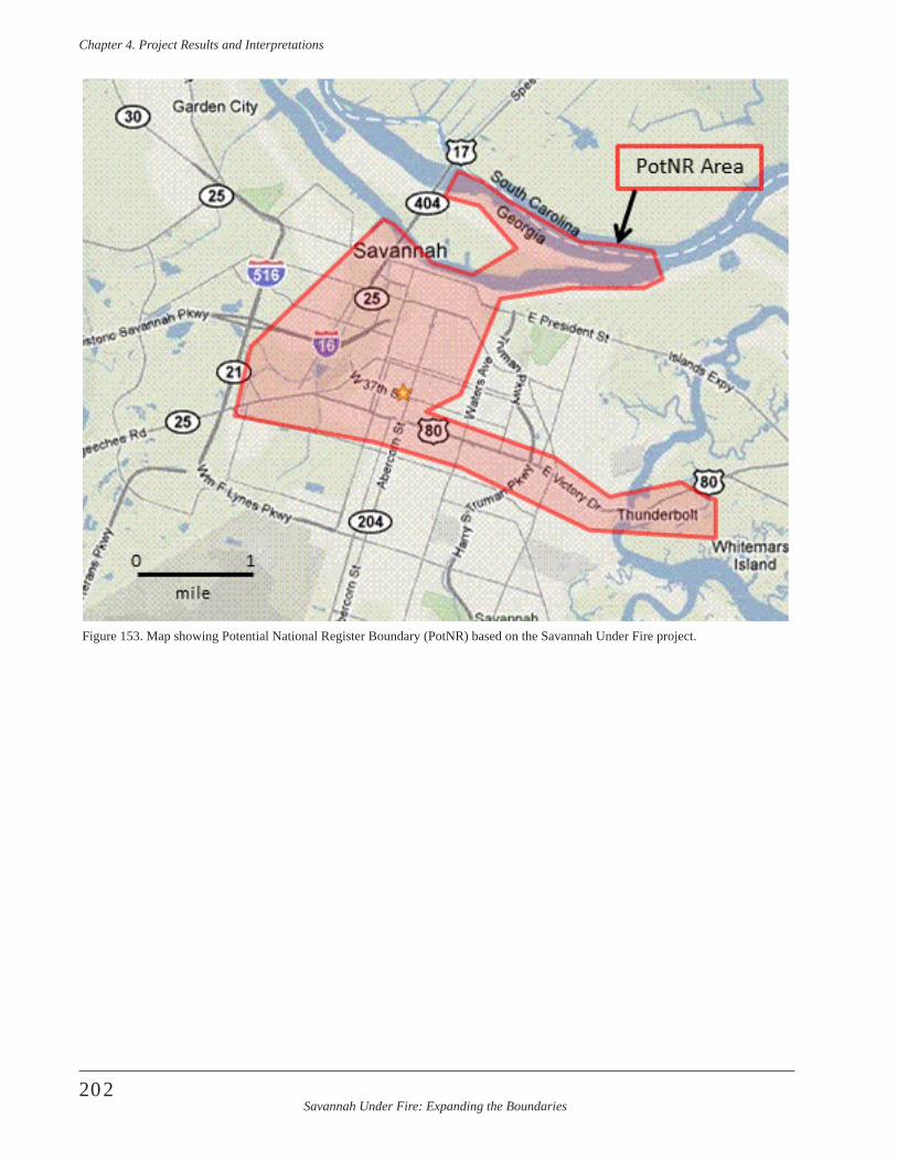
Savannah Under Fire: Expanding the Boundaries
Chapter 4 . Project Results and Interpretations
202
Figure 153. Map showing Potential National Register Boundary (PotNR) based on the Savannah Under Fire project.
Savannah Under Fire: Expanding the Boundaries
Chapter 5 . Recommendations
203
Savannah’s Revolutionary War Heritage Tourism Legacy
Heritage tourism is second in economic importance to Savannah’s economy and it has a colorful history. While many historic preservationists point to the destruction of the City Market and the formation of the Historic Savannah Foundation in the mid-1950s as the beginning of this movement, its roots actually extend far deeper. Savannah’s Revolutionary War heritage was actually rec-ognized much earlier - less than a decade after the war ended.
It began in May, 1791, when President George Washington visited Savannah and during his visit he toured the 1779 battle fortifications. His tour guide on the battlefield was Brigadier General Lachlan McIntosh, a veteran of the October 9 engagement. Washington wrote of his battlefield tour in his diary,
A little after 6 o’clock in Company with Genl. McIntosh, Genl. Wayne, the Mayor, and many others (principal Gentlemen of the City) I visited the City, and the attack and defence of it in the year 1779, under the combined forces of France and the United States, commanded by Count de Estaing & Gen. Lincoln.—To form an opinion of the attack at this distance of time, and the change which has taken place in the appearance of the ground by the cutting away of the woods, &c. is hardly to be done with Justice to the subject; especially as there is remaining scarcely any of the defences (Lossing 1860:187).
Historian Benson Lossing added in his notes to Washington’s diary, “Traces of these lines of defence are still visible in the rear of the town” (Lossing1860:187). For an account of their appearance as late as 1848, see Lossing’s Pictorial Field Book of the Revolution, ii., 531, second edition. Lossing, whose heritage touring of Savannah is well documented in his writings, observed the remains of the French ditchwork on Savannah’s east side. Lossing made a sketch of these earthworks, which ap-peared as an engraving in his book. His original sketches reside in the Huntington Library in San Marino, California.
President Washington’s tour of the battlefield was also covered in the national press. The City Gazette noted,
On Saturday morning the president, attended by gen. McIntosh and several other gentlemen, took a view of the remaining traces of the lines constructed by the British for the defence of Savannah in 1779; the general having been second in command under gen. Lincoln at storming them had an opportunity of giving an account of every thing interesting during the siege and in the attack (City Gazette 1791:2). At a dinner later that afternoon, the president and about 200 guests drank several toasts, including one to, “The memory of those brave men who fell before the lines of Savannah on the 9th of October, 1779”. (City Gazette 1791).
As a token of his appreciation for the people of Savannah, President Washington presented two bronze cannons, which were used on the battlefield at Yorktown, to the Chatham Artillery. These two artillery pieces have had a unique history since their donation to the city, where they remain on display in Emmett Park. These two cannons were hidden by the Confederates during the American Civil War to avoid their being plundered and removed by the U.S. troops (Georgia Historical Commission 1982).
In the decades that followed the memory of the American Revolution in Savannah faded. Old veterans of the en-gagement had mostly died by the 1830s. Other wars, such as the War of 1812 and the American Civil War, further diverted attention from Savannah’s Revolutionary War legacy. A few dedicated historians, such as Hugh McCall, Benson Lossing, and Charles C. Jones, Jr., focused some attention on the subject. Monuments were constructed in Savannah’s elegant squares to two of the renowned partici-pants, Count Casimir Pulaski and Sergeant William Jasper.
Even those efforts, however, were met with some cloudy history and disagreement among those who sought to com-memorate these men and that event. Regarding Pulaski, the argument hinged on his ultimate burial place and whether the bones that were placed within his memorial were actually his (de Couvray 1800:1-149; Johnson 1825;35; Bentalou 1826:34; SCAR 2011:R8205 [Pension applica-tion of Eleazer Phillips]). That controversy continued to brew when the monument was dedicated on October 11, 1853 and it remains to be resolved to the present day. Plans for a Pulaski monument in Savannah were hatched as early as the 1820s, when Revolutionary War veterans
Chapter 5. Recommendations --Where Do We Go From Here?
Savannah Under Fire: Expanding the Boundaries
Chapter 5 . Recommendations
204
were becoming an aging population. When the Marquis de Lafayette visited Savannah in 1825, he presented cor-nerstones for two monuments intended to honor Generals Greene and Pulaski, one in Johnson Square and one in Chippewa Square. Five years later, only enough funds had been raised by a state lottery to fund one of the monu-ments (Macon Weekly Telegraph 1830:31). The Greene monument in Johnson Square was completed at that time. Major General Greene’s contribution to the Patriot victory in the American Revolution is indisputable, but he did not participate directly in any of the battles in Georgia (The American Architect and Building News 1877:107-110).The 75th anniversary of the Battle of Savannah stirred community and national pride; however, finally result-ing in the monument specifically honoring Pulaski. It was completed at a cost of about $17,000. Funding for the Pulaski monument was raised by another state lottery. When the monument was restored in 1996, the economic cost of preserving the monument had risen exponentially (The American Architect and Building News 1877:107-110; White 1855:308-312).
Regarding Sergeant Jasper, the memorializing was more unified, although the commentary was incorrect. His mon-ument was dedicated on October 9, 1879, the centennial of the attack on the Spring Hill Redoubt, where Sergeant Jasper died while attempting to plant the patriot colors on its ramparts. The monument was erected in the center of Madison Square, where it remains today. John Gordon, who gave an eloquent speech at the Jasper monument dedication noted, “as this column rises on the spot where Jasper fell”, later he states, “Yonder, where stands his monument, fell Count Pulaski. Here, near the spot where the monument is to stand, Sergeant Jasper fell” (Gordon 1879:555; Macon Weekly Telegraph 1879:2). His rousing speech was met with cheers and applause by more than 30,000 onlookers, who crowded Madison Square for the event. Other notables present included President Grover Cleveland.
Geographically speaking, General Gordon was wrong on both counts. The Pulaski monument was erected in Monterey Square, nearly a mile from the actual spot where Pulaski fell. The Jasper monument in Madison Square, was situated hundreds of yards from the Spring Hill Redoubt location. Gordon probably was aware that these monu-ments were not erected in their historically accurate loca-tions, but he did not let it impact his oration, nor did his geographical license seem to matter to the people.
A generation later, the topic was revisited with more concern for geographical accuracy. A newspaper article, dated February, 1909, heralded the, “Spot Where Jasper Fell Located Near Savannah”. A committee report by the Society of the Sons of the American Revolution had,
“succeeded in placing, beyond the doubt, the exact spot where Sergeant Jasper fell”. It noted, “The spot is the fa-mous Spring Hill redoubt, which has never been marked, and except from old accounts, could hardly have been found at all”, and the committee further admonished that a monument to Jasper, “stands in Savannah, but no attention has been paid to the place where he was killed”. The re-port stated that the site of the Spring Hill redoubt, “cuts the present Augusta road [modern-day Louisville Road], with its western face about 420 feet west of the western line of the present West Broad street [modern-day Martin Luther King, Jr. Boulevard]. The article concluded with the op-timistic anticipation of, “a demonstration on October 9, next, when a table or monument of some sort will mark the redoubt” (Atlanta Constitution 1909:8). In February, 1911 a monument was dedicated at Spring Hill Redoubt thanks to the persistence of the Sons of the American Revolution (Macon Telegraph 1911:10). That marker was taken from its original location during toxic soil removal from the former railroad property in the early 21st century and has since been reestablished on the actual site of the Spring Hill Redoubt as uncovered by archeologists. Another marker commemorating the battlefield in the Spring Hill Redoubt vicinity was erected by the Georgia Historical Commission in 1952. That marker, which pres-ently stands on the north side of the Savannah Visitors’ Center, contained this geographic reference to the battle-field, “A short distance west of this marker stood the fa-mous Spring Hill Redoubt and along here ran the line of British entrenchments that surrounded Savannah” (Georgia Historical Commission 1952c). Other related markers erected by the Georgia Historical Commission during this era include: “Old Jewish Burial Ground”, which was placed outside the walls of the Mordecai Sheftall cem-etery; “Revolutionary War Barracks and Fortifications”, which is located in the basement of the DeSoto Hilton, southeast of the intersection of Bull and Liberty streets; and another marker commemorating the 1778 capture of Savannah by the British (Georgia Historical Commission n.d., 1952a-b).
The formation of the Historic Savannah Foundation in 1955 addressed the historic preservation needs of the built (above-ground architecture) environment. The American Bicentennial celebration in 1976 provided another boost to recognizing Savannah’s Revolutionary War resources. The Savannah Historic District was listed in the National Register of Historic Places in 1966 and the city was rec-ognized as a National Historic Landmark in 1977. The boundaries for both the NRHD and NHL listings did not include any archeological data, nor was historical archeol-ogy considered as a contributing factor in the nominations (Dillon 1977). From a perspective of the Revolutionary War battlefields in Savannah, the district boundary was
Savannah Under Fire: Expanding the Boundaries
Chapter 5 . Recommendations
205
arbitrary and did not incorporate major portions of the battlefield landscape.
An archeological study in the late 1970s/early 1980s fund-ed by the National Park Service fell short of its intended goal (Rutsch and Morrell:1981). Despite the excavation of extensive backhoe trenches, that team of researchers was unable to locate any vestiges of the American Revolution, or any artifacts dating to the 18th century. Subsequent archeological research from the 1970s-1990s also failed to locate any Revolutionary War-related deposits in Savannah. Other archeological projects in the 1980s and 1990s on Savannah’s west side, with one exception, did not discover any Revolutionary War evidence (Crawford 1980; Honerkamp et al. 1983; Elliott 1990, 1999, 2001, Elliott et al. 1995). The notable exception was the Fahm Street Extension project, where archeologists located a light scatter of Revolutionary War battle debris in mixed early context (Wood 1985). Project schedules and budget-ary constraints prohibited any more detailed investigation of the battlefield in that important study. By the year 2000, it appeared that archeological evidence from that era was largely nonexistent and not worthy of further study.
Discoveries by the Coastal Heritage Society archeologists in August, 2005, however, negated this view and forced a rethinking of the subsurface potential of Savannah’s un-derground resources. Portions of the Spring Hill Redoubt ditch work, as well as battle-related artifacts, were discov-ered on property immediately south of Louisville Road. That hard-earned discovery was the stimulus that led to the first and second (present) NPS ABPP battlefield studies.
Recommendations
Research Recommendation
That professional archeological research be encouraged and supported financially, logistically, and wholeheart-edly by the City of Savannah, Chatham County, and the economic development, tourism, collegiate, corporate, real estate, and residential communities . Archeological research of the Battle of Savannah is in its infancy. Much more work is needed to adequately locate, study, and pre-serve these important archeological resources. This need is especially dire as development in Savannah increases, destroying forever the significant and varied components across the city. Additional research is necessary to deter-mine where surviving components such as the other 13 redoubts, batteries, saps, barracks, French and American
camps, and military headquarters for both sides are lo-cated. Finding them is a necessary step towards their study and preservation.
A persistent question in any discussion of Revolutionary War action in the Savannah theatre remains, where are the war dead? Between 800- 1,000 soldiers were wounded or killed at the Battle of Savannah, but the ultimate disposi-tion of the remains of these men, with a few rare excep-tions, remains a mystery. Historical archeology remains one hope for solving this mystery. Researchers elsewhere in the world have employed various remote sensing tech-nology in attempts to solve similar problems and have met with mixed results (Davis et al. 2000; Witten and Fenner 2001; May 2008; Ruffell et al. 2009). GPR survey and other remote sensing strategies, combined with historical/geographical study, remains the key to locating any mass burial sites in Savannah, if such sites have survived.
Preservation Recommendations
That the archeological components of the Battle of Savannah be included in the city’s World Heritage Site nomination . The battle was a major turning point in Britain’s quest to hold Savannah and take Charleston as attention turned to the southern theater of the war. Key components of the battle have been discovered by ar-cheologists to be intact, including Spring Hill Redoubt and the fortification trench by the Central Redoubt. The latter lies on Bull Street, in Madison Square and is one of the best surviving components of the 1779 battle that has been discovered, to date. The 5.5 foot deep fortifica-tion trench there likely runs throughout the square. This trench was key in the battle and is, in itself a microcosm of the battle and its global participation. For example, the trench was dug by Africans/African-Americans, defended by the British, fired on by the French during the siege, and attacked by the Franco-American allies while being defended by the British. The allied and British factions were global in nature, and included African American, American, French, Haitian, Hessian, Irish, Polish, and Native American troops. Obviously, the entire American Revolution had an influence on the world that forever changed it. Including the presence of the battlefield re-mains is a natural tie-in to a World Heritage Site nomina-tion. In fact, it is hard to imagine that such a component could be omitted, particularly now, when substantial evi-dence of the battlefield has been located and identified in situ.
That the City of Savannah take an active and responsible approach to the understanding and preservation of the archeological heritage for which it is the steward. By fos-tering knowledge and preservation of these sites, Savannah
Savannah Under Fire: Expanding the Boundaries
Chapter 5 . Recommendations
206
will increase pride in local neighborhoods, decrease blight, heighten community awareness and quality of life, and provide fodder for cultural tourism and responsible eco-nomic development. Archeologists can work with the city toward these goals.
That Savannah and Chatham County minimize future de-struction of the remaining non-renewable archeological resources entrusted to the care of city and county lead-ers, by creating a City and County archeologist positions . Archeological resources within the City of Savannah and Chatham County at large are in dire need of protection. Development and looting have already permanently de-stroyed vast numbers of archeological sites and the infor-mation they contain. Measures can be taken now, however, to curtail such destruction and reap benefits in the process.
That Savannah residents, area citizens, preservationists, economic developers, tourism officials, corporations, area colleges and universities, and all interested parties work with the City of Savannah to get the necessary and appro-priate ordinance passed to protect Battle of Savannah and other archeological sites . Twenty plus years and still wait-ing… How many sites have been destroyed in the interim? How many more will be destroyed? The time has come. We can wait no longer.
Interpretation Recommendations
The major role Savannah played in the American Revolution is unknown to the majority of Savannahians, visitors, and Americans in general. This can be countered by effective interpretation as suggested below. Such in-terpretation will offer a comprehensive and continually accessible complement to the educational programs cur-rently conducted by various Revolutionary genealogy and historical societies in the area. Suggested interpretive opportunities for residents, students, heritage tourists, and many others are as follows.
That content (historical and archeological information) from both NPS ABPP Savannah Under Fire projects be added to current Revolutionary War podcast tours and in-cluded in new self-guided and guided tours, and to include augmented reality components when possible .
That interpretive signage be created at key locations and a walking tour brochure developed that connects the 1779 Battle of Savannah battlefield and siege components. This would include the locations of the following, with ap-propriate text and graphic information: 14 redoubts, saps, abatis, French and American camps, prison ships, select soldiers barracks, reserve troop location, feints, Yamacraw river bluff, Tybee Island and the key natural features (both
extant and gone) critical to the siege and battle (swamps, Spring Hill, Musgrove Creek, Savannah River, etc.)
That historical and archeological information about the battle (especially the Spring Hill and Jewish Cemetery reserve troop areas) be incorporated into the development, planning, and interpretation of the Martin Luther King Jr . Blvd . westside development corridor. Include this infor-mation in a variety of materials such as corridor signage, web site presence, real estate materials, economic develop-ment information and neighborhood-accessible materials. Use this information to replace current perceptions of Savannah’s west side with an accurate portrayal of its rich and unique history.
The reader is referred to the previous report Savannah Under Fire: Identifying Savannah’s Revolutionary War Battlefield (Elliott and Elliott 2009) for additional discus-sion on these and other recommendations.
Savannah Under Fire: Expanding the Boundaries
References Cited
207
Albert, Alphaeus H.1976 Record of American Uniform and Historical
Buttons Bicentennial Edition. SCS Publications, Fairfax, Virginia.
The American Architect and Building News 1877 Early Settler Memorials. The American Architect
and Building News XXII(610):107-110.
American Herald 1787 New York, November 19. American Herald,
November 26, 1787, p.3.
American State Papers 1975-1997 American State Papers, 14 Volumes. CIS
US Serial Set Index. Congressional Information Service. Washington, D.C.
Anonymous c. 1780 Anonymous letter. Early American History
Store, Rancho Sante Fe, California. Photocopy on file, Coastal Heritage Society, Savannah, Georgia.
Atlanta Constitution 1909 Spot Where Jasper Fell Located Near
Savannah. Atlanta Constitution, February 15, 1909, p.8.
Baltimore Daily Intelligencer 1794 Savannah, April 8. Baltimore Daily
Intelligencer, May 1, 1794, p. 2.
Beatson, Robert1804 Naval and Military Memoirs of Great Britain: from
the Year 1727 to 1783. Six Volumes. J. Strachan, Edinburgh, Scotland.
Bentalou, Paul1824 Pulaski Vindicated from an Unsupported Charge,
Inconsiderately or Milignantly Introduced in Judge Johnson’s Sketches of the Life and Correspondence of Major Gen . Nathaniel Greene .
1826 A Reply to Judge Johnson’s Remarks…Relating to Count Pulaski…J.D. Toy, Baltimore, Maryland.
Blanchard, Amos 1825 American Military Biography: Containing
the Lives, Characters, and Anecdotes of the Officers of the Revolution, who were most Distinguished in Achieving our National Independence. Printed for Subscribers, Cincinatti, Ohio.
Boswell, James 1779 America: Operations at Savannah. The Scots
Magazine 41:673.
Callaghan, John Cornelius1870 History of the Irish Brigades in the Service of
France. P. O’Shea, New York, New York.Carleton, Sir Guy1783 Papers. “Book of Negroes”, 1783. Item #100,
Record Group 800100 .B800120. South Carolina Department of Archives and History, Columbia.
Chatham County Superior Court1803 Deed Book X, Folio 461-464. August 3, 1803.
(Originally recorded in Georgia Secretary’s Office in Deed Book X:996-997). Copy on file at Mickve Israel, Savannah, Georgia.
City Gazette 1791 Savannah, May 19. City Gazette, May 19,
1791:2.
City of Savannah2010 “Timeline: City Hall in Mourning—October 9,
1915 Mayor Davant Dies in Office” http://www.ci.savannah.ga.us/CityWeb/RLibCat.nsf/d43ec-6d7aedfa02a85256edf004a3860/d0c48dc43ed079b8852570e60051f850?OpenDocument. May, 10.
City of Savannah Department of Cemeteries 2010a Springfield Plantation. http://www.savannahga.
gov/cityweb/cemeteriesweb.nsf/, November 28, 2010.
2010b Laurel Grove North History. http://www.savan-nahga.gov/cityweb/cemeteriesweb.nsf/, November 28, 2010.
2010c Laurel Grove North Cemetery map. http://www.savannahga.gov/cityweb/cemeteriesweb.nsf/, November 28, 2010.
References Cited

Savannah Under Fire: Expanding the Boundaries
References Cited
208
Clarke, Alured1781 Affidavit to Lt. General Cornwallis regarding
memorialist Charles Ogilvie, January 11. Public Record Office (PRO 30/11/69, p. 421-41) David Library of the American Revolution, Washington Crossing, Pennsylvania.
Colton, J.H.1855 The City of Savannah, Georgia. Published by J.H.
Colton & Co., New York.
Condon, Edward O’Meagher1887 The Irish Race in America. Fords’ National
Library, New York, New York.
Connecticut Journal1779 Connecticut Journal, December 1, 1779:3.
1815 Latest from the South. Savannah, January 22. Connecticut Journal, February 6, 1815, p.3.
Conyers, Larry B., and Dean Goodman1997 Ground-Penetrating Radar: An Introduction for
Archaeologists . Altimira Press, London, England.
The Country Magazine1788 Remarkable Instances of Courage. The Country
Magazine 1:315.
Crawford, Peggy1980 An Intensive Archaeological Survey of Georgia
Department of Transportation, Project M-5030(2), the Liberty Street Realignment Project, Chatham County, Georgia. Georgia Department of Transportation, Atlanta.
Daily Advertiser1794 Daily Advertiser, March 12, 1794, p.2.
Davis, J. Les, J. Alan Heginbottom, A. Peter Annan, Rod S. Daniels, B. Peter Berdal, Tom Bergan, Kirtsy E. Duncan, Peter K. Lewin, John S. Oxford, Noel Roberts, John J. Skehel, and Charles R. Smith
2000 Ground Penetrating Radar Surveys to Locate 1918 Spanish Flu Victims in Permafrost. Journal of Forensic Sciences 45(1):68-76.
Davies, K.G. [ed.]1977 Documents of the American Revolution 1779-1783
(Colonial Office Series), Volume XVI Calendar 1779-1780 July-Dec., Irish Academic Press, Ireland.
De Couvray, Jean Baptiste Louvet1800 The Interesting History of the Baron de Lovinski . J.
Babcock, Hartford, Connecticut.
Dillon, James1977 The Savannah Georgia NHL Historic District
(Nomination Form). National Park Service, Washington, D.C.
Doolittle Sculps1796 Georgia Also the Two Floridas from the best
Authorities.
Draper, Lyman1740-1891 Manuscript Collection. Microfilm and micro-
fiche. South Carolina Department of Archives and History, Columbia, South Carolina.
Dull, Jonathan R.1975 The French Navy and American Independence,
A Study of Arms and Diplomacy, 1774-1787. Princeton University Press, Princeton, NJ.
Elliott, Daniel1990 The Lost City Survey, Archaeological
Reconnaissance of Nine 18th Century Settlements in Chatham and Effingham County. LAMAR Institute Publication Series . The LAMAR Institute, Watkinsville, Georgia.
1999 Archaeological Investigations of City Parking Lot Number 2, Liberty Street, Savannah, Georgia. GASF Manuscript 1852, Athens, Georgia.
2001 Cultural Resource Survey and Testing of the Proposed Civic Center Parking Garage, PB-315 in Savannah, Georgia. Southern Research, Ellerslie, Georgia. Submitted to City of Savannah, Leisure Services Bureau, Building & Grounds Department, Design and Construction Group, Savannah, Georgia.
Elliott, Daniel2003a Ebenezer Revolutionary War Headquarters: A
Quest to Locate and Preserve. Lamar Institute, Box Springs, Georgia. Submitted to American Battlefield Protection Program National Park Service, Washington, D.C.
2003b Archaeological Investigations at Fort Morris State
Historic Site, Liberty County, Georgia. Southern Research Historic Preservation Consultants, Ellerslie, Georgia. Submitted to Historic Preservation Division, Georgia Department of Natural Resources, Atlanta.
Savannah Under Fire: Expanding the Boundaries
References Cited
209
2003c Ground Penetrating Radar Survey of the Waldburg
Street Site. Rocquemore Research, Box Springs, Georgia. Submitted to Southern Research Historic Preservation Consultants, Ellerslie, Georgia.
2007 Archaeological Investigations at Tabbies 1 and 2, North End Plantation, Ossabaw Island, Georgia. LAMAR Institute Publication Series, Report 108. Savannah, Georgia.
2008 Ground Penetrating Radar Survey at the Railroad Ward, Savannah, Georgia, with Supplemental Historical and Archival Research Materials. LAMAR Institute Publication Series Report 104, Savannah, Georgia.
Elliott, Daniel T., David Jones, and Jeffrey L. Holland1995 Oglethorpe Median: Archaeological Testing of
Site 9CH795, Savannah, Georgia. Garrow & Associates, Inc., Atlanta, Georgia. Submitted to Chatham County-Savannah Metropolitan Commission, City of Savannah, Savannah, Georgia.
Elliott, Rita2007 Savannah Under Fire: Identifying Savannah’s
Revolutionary War Battlefield. Research Design for Grant Agreement No. GA-2255-07-007. Submitted to the National Park Service, American Battlefield Protection Program, Washington, DC.
Elliott, Rita Folse and Daniel T. Elliott2009 Savannah Under Fire: Identifying Savannah’s
Revolutionary War Battlefield. Final Report for Grant Project No. GA-2255-07-007. Submitted to the National Park Service, American Battlefield Protection Program, Washington, DC.
Elstner, J.M., and Company1886 The Industries of Savannah. J.M. Elstner &
Company, Savannah, Georgia.
Faden, William1784 Plan of the Siege of Savannah with the Joint Attack
of the French & Americans on the 9th October, 1779. Coastal Heritage Society Collections, Savannah, Georgia.
Federalist Papers1789 Vol. 6, Georgia Delegates. The Modern English
Collection. University of Virginia, Charlottesville, VA.
Fike, Richard E.1967 Guide to Old Bottles. Published by the author,
Ogden, Utah.
1987 The Bottle Book. Peregrini Smith Books, Salt Lake City, Utah.
Fitzgerald, John1783 The Cork Remembrancer . J. Sullivan, Cork,
England.
Fitzpatrick, John C., editor1931-1944 The Writings of George Washington from the
Original Manuscript Sources, 1745-1799, Volume 17 . Government Printing Office, Washington, D.C.
Flayderman, Norm1980 Flayderman’s Guide to Antique American Firearms
and Their Values. DBI Books, Northfield, Illinois.
Foner, Philip Sheldon1976 Blacks in the American Revolution . Contributions
in American History, No . 55 . Greenwood Press, Westport, Connecticut .
Fuser, L.V.1779 [Letter from L.V. Fuser to] H. Clinton, St.
Augustine, October 30, 1779. The Town and Country Magazine, or Universal Repository of Knowledge, Instruction and Entertainment 11:670-671. A. Hamilton, Jr., London, England.
Gardiner, Asa Bird1905 The Order of the Cincinnati in France . Rhode
Island State Society of Cincinnati, Providence, Rhode Island .
Gay, Sarah1781 Petition by Memorialist to Lt. Colonel Alured
Clarke. Public Records Office (PRO 30/11/69, p. 32) David Library of the American Revolution, Washington Crossing, Pennsylvania.
Georgia Gazette1797 “The Corporation of Savannah in Account Current
with William Henry Long, City Treasurer…” November 10. Savannah, Georgia.
Georgia Historical Commissionn.d. “Old Jewish Cemetery” (Historical Marker n.d.).
Georgia Historical Commission, Atlanta, Georgia.
1952a “Capture of Savannah December 29, 1778” (Historical Marker 025-8). Georgia Historical Commission, Atlanta, Georgia.
Savannah Under Fire: Expanding the Boundaries
References Cited
210
1952b “Revolutionary War Barracks and Fortifications” (Historical Marker 025-9). Georgia Historical Commission, Atlanta, Georgia.
1952c “Attack on British Lines October 9, 1779” (Historical Marker 025-10). Georgia Historical Commission, Atlanta, Georgia.
1982 “Chatham Artillery’s ‘Washington Guns’” (Historical Marker 025-54). Georgia Historical Commission, Atlanta, Georgia.
General Engineering Geophysics, LLC2004 Computer Assisted Radar Tomography Survey for
Mapping Revolutionary War Fortifications, Earthen Works, and Archeological Artifacts. Letter report submitted to Coastal Heritage Society, Savannah, Georgia. General Engineering Geophysics, LLC., Charleston, South Carolina.
Google Earth2011 Satellite images of Savannah, Georgia.
Gordon, John B.1879 Oration of Gen. John B. Gordon. Donahoe’s
Magazine 2:554-560.
Great Britain, Parliament, House of Commons1877 Accounts and Papers of the House of Commons,
Volume 82. Harrison and Sons, London, England.
Green, Nathanael 1782a Letter to General Anthony Wayne, June 18.
Nathanael Green Papers, GR 2034, Huntington Library, San Marino, California.
1782b Letter to General Anthony Wayne, June 21. Nathanael Green Papers, GR 2036, Huntington Library, San Marino, California.
Green Rick1976ca “Old Cemetery Renewed: Jewish Burying Ground
Bicentennial Project” (probably in Savannah Morning News), in SCAD Restoration Plan (1998).
Greer, Georgianna1996 American Stonewares, The Art & Craft of
Utilitarian Potters. Schiffer publishing, Atglen, Pennsylvannia.
Griffin, Martin I. J.1911 Catholics and the American Revolution, Volume
III. Martin I.J. Griffin, Philadelphia, Pennsylvania.
Harden, William1913 A History of Savannah and the South. Cherokee
Publishing Company.
Hamilton, T.M.1976 Firearms on the Frontier: Guns at Fort
Michilimackinac 1715-1781. Reports in Mackinac History and Archaeology Number 5, Mackinanc Island State Park Commission, Pendell Printing, Midland, Michigan.
Hayes, Richard1945 Biographical Dictionary of Irishmen in France:
Part XIV. Studies: An Irish Quarterly Review Vol. 34(134): 259-270.
Historical Manuscripts Commission (HMC)1972 [reprint] Report on American Manuscripts in
the Royal Institution of Great Britain. Volume II. Gregg Press, Boston.[Reprint of 1906 copy.] David Library of the American Revolution, Washington Crossing, Pennsylvania.
1906 Report on American Manuscripts in the Royal Institution of Great Britain. Volume II. John Falconer, Dublin. David Library of the American Revolution, Washington Crossing, Pennsylvania.
Honerkamp, N., R.B. Council, and C.H. Fairbanks1983 The Reality of the City: Urban Archaeology at the
Telfair Site, Savannah, Georgia. GASF Manuscript 5671, Athens, Georgia.
Hoffman, E.F.1865 Map of Savannah, Georgia and Vicinity, Plate
LXX in Atlas toAccompany the Official Records of the Union and Confederate Armies 1861-1865, published in 1895, U.S. War Department, GPO.
Hoffman, Elliott W. 1981 Black Hessians: American Blacks as German
Soldiers . Negro History Bulletin 44(4):81-82, 91 .
Hough, Franklin B., editor1866 [reprinted in 1975] The Siege of Savannah, by the
Combined American and French Forces, Under the Command of Gen . Lincoln, and the count D’ Estaing in the Autumn of 1779. J. Munsell, Albany, New York. http://books.google.com.
Hume, Ivor Noël1983 A Guide to the Artifacts of Colonial America.
Alfred A. Knopf, New York, New York.
Savannah Under Fire: Expanding the Boundaries
References Cited
211
Jay, William1833 John Jay to Benjamin Lincoln, April 2, 1779
[Letter]. The Life John Jay With Selections from His Correspondence and Miscellaneous Papers. by His Son, William Jay in Two Volumes. Vol. II.
Jenkins, Samuel Hunt1781 Petition by Memorialist to Lt. Colonel Alured
Clarke, January 3. Public Record Office (PRO 30/11/69, p.37) David Library of the American Revolution, Washington Crossing, Pennsylvania.
Johnson, Joseph1851 Traditions and Reminiscences, Chiefly of the
American Revolution in the South. Walker & James, Charleston, South Carolina.
Jones, C.C. [transl.]1874 The Siege of Savannah in 1779 , as Described in
Two Contemporaneous Journals of French Officers in the Fleet of Count D’Estaing. J. Munsell, Albany, New York.
Prepare to discard: in France in the American Revolution byJames Perkins, Houghton Mifflin, Boston.
Jones, George Fenwick1982 The Black Hessians: Negroes Recruited by the
Hessians in South Carolina and Other Colonies. The South Carolina Historical Magazine 83(4): 287-302.
Jones, Olive, and Catherine Sullivan1989 The Parks Canada Glass Glossary for the
Description of Containers, Tableware, Flat Glass, and Closures National Historic Parks and Sites Branch, Parks Canada, Ottawa, Ontario, Canada.
Kaplan, Sidney, and Emma Nogrady Kaplan 1989 The Black Presence in the Era of the American
Revolution. Revised edition. University of Massachusetts Press, Amherst, Massachusetts.
Keim, D.R.1907 Rochambeau. A commemoration by the Congress
of the United States of America of the Services of the French Auxiliary Forces in the War of Independence. Government Printing Office, Washington, D.C.
Kimber, Isaac, and Edward Kimber1779 From the London Gazette. Admiralty Office,
December 21, 1779. The London Magazine, or Gentleman’s Monthly Intelligencer 48:573-575.
Lanning Michael Lee 2005 African Americans in the Revolutionary War. Citadel
Press, New York, New York.
Laurens, Henry1779 Henry Laurens’ Notes on a Georgia Campaign.
Federalist Papers, (MS ScHi: Lauren’s Papers, no. 24, 20th January 1778 [i.e. 1779]), University of Virginia, Charlottesville, VA.
Lawrence, Alexander A.1979 Storm Over Savannah. Tara Press, Savannah,
Georgia.
Lawson, Barry R., Ellen P. Ryan, and Rebecca Bartlett Hutchison (cited as Lawson et al)
2002 Reaching Out, Reaching In: A Guide to Creating Effective Public Participation for State Historic Preservation Programs. (hard copy published in 1993). Heritage Preservation Services, National Park Service, Washington, DC.
Lee, F.D., and J.L. Agnew1869 Historical Record of the City of Savannah . J.H.
Estill, Savannah, Georgia.
Leech, Rick and Lawrence E. Babits1990 Report on Archeological Cleaning of the Levi
Sheftall Cemetery: the Field Work and its Interpretation Spruce and Cohen Streets, Savannah, Georgia. Report on file, Bull Street Branch, Live Oak Public Libraries, Savannah, Georgia.
Leonard, J. P.1890 Historical Notes on the Services of the Irish
Officers in the French Army Addressed to the National Assembly by One of its Members, General Arthur Dillon, 1792; trans. from the French by J. P. Leonard. J. Duffy, Dublin, Ireland.
Levy, B.H.1978 “Savannah’s Old Jewish Community Cemetery”.
Prepared for the Trustees of the Mordecai Sheftall Cemetery Trust. Savannah, Georgia.
1983 Savannah’s Old Jewish Community Cemeteries. Mercer University Press, Macon, Georgia.
Levy, Marion Abrahams (Mrs. B.H.)1950 “Savannah’s Old Jewish Burial Ground” p. 265 in
Georgia Historical Quarterly, (December 1950), Savannah, Georgia.
Lincoln, General Benjamin1779 Letter to Honorable Col. Laurens and the
Savannah Under Fire: Expanding the Boundaries
References Cited
212
Gentlemen of the Committee of Correspondence. October 22. Charles Town, South Carolina. George Washington Papers, 1697-1799. Series 4, October 21, 1779-December 8, 1779. Film 36, Reel 62. David Library of the American Revolution, Washington Crossing, Pennsylvania.
Long, C. Thomas2009 Britain’s Green Water Navy in the Revolutionary
Chesapeake: Long-Range Asymmetric Warfare in the Littoral. International Journal of Naval History 8(2):1-55.
Lossing, Benson John, editor1860 The Diary of George Washington from 1789 to
1781. C.B. Richardson & Co., New York, New York.
Lysons, Daniel1796 “Account by Mrs. Anne Prevost/Lettres et
Dialogues” in The Environs of London: Counties of Herts, Essex & Kent. T. Cadell, London, England (translated by Babelfish for this report)
MacDonell, A.H.1907 The Code of the City of Savannah of 1907.
Morning News Print, Savannah, Georgia.
Macon Telegraph1845 Health of Savannah. September 5, 1845.
1911 Georgia Unveils Table of Bronze. Macon Telegraph, February 23, 1911, p.10.
Macon Weekly Telegraph1830 Greene & Pulaski Monument. Macon Weekly
Telegraph, February 20, 1830, p.31.
1879 The Jasper Centennial Oration of General John B. Gordon, Delivered October 9, 1879. Macon Weekly Telegraph, October 14, 1879, p.2.
Marion, Francis1761-1794 Papers. 1361, South Caroliniana Library,
University of South Carolina, Columbia.
1779 Manuscript, “Pay Role of Capt. Thomas Hall’s Company in the Second Regiment of South Carolina on Continental” 1 Aug-1 Nov. South Caroliniana Library, University of South Carolina, Columbia.
McGillivray, Alexander1779 October 26. Letter to Major General Augustine
Prevost in Savannah. Great Britain, Colonial Office American & West Indies Correspondence, CO5/182 (p.211), Film 590, Reel 50, David Library of the American Revolution, Washington Crossing, Pennsylvania.
McKearin, Helena and Kenneth M. Wilson1978 American Bottles and Flasks and Their Ancestry.
Crown Publishers, Inc., New York, New York.
McKinnon, John1798 Plan of the Forty Five and Five Acre Lots in the
Township of Savannah. (Traced by Assistant City Engineer W.O.D. Rockwell in 1908 from a trac-ing by surveyor McKinnon in 1798, from original by Thos. McCall, late Surveyor General), City of Savannah, Research Library & Municipal Archives, Savannah, Georgia.
1825 City of Savannah. City Engineers Office.City of Savannah, Research Library & Municipal Archives, Savannah, Georgia.
Marmion, Chevalier William F.1998 Irish Brigade Officers of the French Army in the
American Revolution. Irish Roots Magazine 3.
May, J. Alan2008 Archaeological Remote Sensing and Data
Recovery at Ramsour’s Mill Mass Grave Monument, 31LN209, Lincolnton, Lincoln County, North Carolina . The Shiele Museum of Natural History, Charlotte, North Carolina.
Moncrief, James1780a Manuscript 74.The Siege of Charleston. South
Caroliniana Library, University of South Carolina, Columbia.
1780b Letter to Lord Cornwallis. Public Record Office. (PRO 30/11/59-67, p.136) , Film 411, Reel 49. David Library of the American Revolution, Washington Crossing, Pennsylvania.
Moore, Warren1967 Weapons of the American Revolution and
Accoutrements. Promontory Press, New York, New York.
Moore, Thomas Will 1781a Affidavit to Lt. Colonel Alured Clarke on behalf of
Sarah Gay, April 4th. Public Record Office (PRO 30/11/69, p.33). David Library of the American Revolution, Washington Crossing, Pennsylvania.
Savannah Under Fire: Expanding the Boundaries
References Cited
213
1781b Affidavit to Lt. Colonel Alured Clarke on behalf of Charles Ogilvie, January 11. Public Record Office (PRO 30/11/69 p.43) David Library of the American Revolution, Washington Crossing, Pennsylvania.
Moss, Bobby Gilmer2009 Roster of South Carolina Patriots in the American
Revolution, Volume II:K-Z. Genealogical Publishing Company, Baltimore, Maryland.
Motte, Isaac1780 Letter to Thomas Bee, and annotated notes about
it by the Modern English Collection, Electronic Text Center, University of Virginia, Charlottesville, Virginia.
Murphy, W.S.1954 The Irish Brigade of France at the Siege of
Savannah, 1779. Georgia Historical Quarterly 38(4).
National Aegis1815 The Following Short but Energetic Appeal is
from the Savannah Republican. National Aegis, February 8, 1815, p.3.
National Park Service2000 Battlefield Survey Manual. Available on the inter-
net at: www.nps.gov/history/hps/abpp/revwar/pdfs/ManualSect2.pdf
2006 The Museum Handbook Part I and II. Museum Management Program, Washington, D.C.
2010 The American Revolution. Lighting Freedom’s Flame. Stories From the Revolution. African Americans in the Revolutionary Period. May 26.
http://www.nps.gov/revwar/about_the_revolution/afri-can_americans.html
Neumann, George C.1967 The History of Weapons of the American
Revolution. Harper and Row, New York.
1991 Swords & Blades of the American Revolution. Rebel Publishing, Texarkana, Texas.
Neumann, G. C., and F. J. Kravic1989 Collector’s Illustrated Encyclopedia of the
American Revolution. Rebel Publishing Company, Texarkana, Texas.
Ogilvie, Charles1781 Memorialist Petition to Lt. Colonel Alured Clarke,
January 11. Public Record Office (PRO 30/11/69, p. 41) David Library of the American Revolution, Washington Crossing, Pennsylvania.
Onahan, William J.1881 An Irish Brigade Commanded by County Arthur
Dillon at the Siege of Savannah, 1779. Donahoe’s Magazine 5(2):99-102.
Oracle1808 Ordinance. Oracle, May 12, 1808, p.2. New York.
Ozanne, Pierre1779 Siege de Savannah...en 7bre et 8bre 1779. Library
of Congress, Washington, DC.
Perry, Robert2008 “Ground Penetrating Radar Survey Report” letter,
November 16, to Lauree San Juan, Mickve Israel, Savannah, Georgia. Topographix, Hudson, New Hampshire.
Porbeck, Friedrich von1782 Letters from Friedrich von Porbeck to Lieutenant
General von Jungkenn. von Jungkenn Papers, William L. Clements Library, University of Michigan, Ann Arbor, Michigan. Translationed by Henry Retzer.
Prevost, Major General Augustin1779a Account of Battle. November 1. Great Britain,
Colonial Office American & West Indies Correspondence, CO5/237, Film 590, Reel 50, David Library of the American Revolution, Washington Crossing, Pennsylvania.
1779b Letter to Sir Henry Clinton, August 7. Great Britain, Colonial Office American & West Indies Correspondence, CO5/98, Film 590, Reel 19, ppgs. 378-379. David Library of the American Revolution, Washington Crossing, Pennsylvania.
1779c Letter to Sir Henry Clinton, October 22. Great Britain, Colonial Office American & West Indies Correspondence, CO5/98, Film 590, Reel 19, ppgs. 391-392. David Library of the American Revolution, Washington Crossing, Pennsylvania.
1779d Account of Meeting with Creeks, August 2. Great Britain, Colonial Office American & West Indies Correspondence,CO5/80, Film 590, Reel 10, ppgs. 258-263. David Library of the American Revolution, Washington Crossing, Pennsylvania.
Savannah Under Fire: Expanding the Boundaries
References Cited
214
1779e Letter to Clinton, July 30, 1779. Great Britain, Colonial Office American & West Indies Correspondence,CO5/98, Film 590, Reel 19, ppgs.217-219. David Library of the American Revolution, Washington Crossing, Pennsylvania.
1779f Extract of a Letter from Major-General Augustin Prevost, Commanding his Majesty’s Forces in the Province of Georgia to the Right Hon. Lord George Germaine, One of his Majesty’s Principal Secretaries of State, Dated Savannah, Nov. 1, 1779; received by Capt. Shaw, Aid de Camp to the Major-general Prevost. The Remembrancer 9:71-83.
Proctor, Samuel, Louis Schmier, and Malcom Stern1984 Selected Essays from the Southern Jewish
Historical Society. Southern Jewish Historical Society. Mercer University Press, Macon, Georgia.
Quarles, Benjamin 1961 The Negro in the American Revolution. University
of North Carolina Press, Chapel Hill, North Carolina.
Ray, Tracy2010 Letter to Rita Elliott, January 12. From Oglethorpe
Associates/Bennett Hofford Company, Charleston, SC.
Rebarer, Frank E., compiler1879 Rebarer’s Digest: Supplement to City Code,
1871.) Containing the Ordinances of the City of Savannah, from July, 1871, to May, 1879. George N. Nichols, Savannah, Georgia.
Republican Farmer1915 From Georgia. Republican Farmer, February 2,
1815, p.2.
The Royal Georgia Gazette1780 “Account of the Siege of Savannah, by the
French and Reels Commanded by Count d’Estaing and General Lincoln”. James Johnston, Savannah,Georgia.
Ruffell, Alastair, Alan McCabe, Colm Donnelly, and Brian Sloan
2009 Location and Assessment of an Historic (150-160 Years Old) Mass Grave Using Geographic and Ground Penetrating Radar Investigation, NW Ireland. Journal of Forensic Sciences 54(2):382-394.
Russell, David Lee2000 The American Revolution in the Southern Colonies.
McFarland & Co., Jefferson, North Carolina.
Rutsch, E.S., and B.H. Morrell1981 Archeological Survey of the Savannah
Revolutionary Battlefield Park, City of Savannah. GASF Manuscript 1528, Athens, Georgia.
Salem Gazette1782 New York, January 5. Salem Gazette, January 31,
1782, p.3.
Sanborn Map and Publishing Company1884 Sanborn Fire Insurance Maps. Galileo, Digital
Library of Georgia. Accessed March 4, 2010 at http://dlg.galileo.usg.edu/meta/html/dlg/sanb/meta_dlg_sanb_savannah_1884.html
1888 Sanborn Fire Insurance Maps. Galileo, Digital Library of Georgia. Accessed March 4, 2010 at http://dlg.galileo.usg.edu/meta/html/dlg/sanb/meta_dlg_sanb_savannah_1888.html
1898 Sanborn Fire Insurance Maps. Galileo, Digital Library of Georgia. Accessed March 4, 2010 at http://dlg.galileo.usg.edu/meta/html/dlg/sanb/meta_dlg_sanb_savannah_1898.html
1916 Sanborn Fire Insurance Maps. Galileo, Digital Library of Georgia. Accessed March 4, 2010 at http://dlg.galileo.usg.edu/meta/html/dlg/sanb/meta_dlg_sanb_savannah_1916.html
Savannah Morning News1886 “Old Burying Grounds: Resting Places of Some
of Savannah’s Early Dead”, October 26, 1886, Savannah, Georgia.
Savannah Republican1849a “Proceedings of Council, Savannah, March 29,
1849”, March 31. Savannah, Georgia.
1849b “Proceedings of Council, Savannah, July 19, 1849”, July 21. Savannah, Georgia.
1850 “Proceedings of Council, August 29, 1850”, Savannah, Georgia, September 1.
Savannah College of Art and Design (SCAD)1998 “Restoration Plan for the Old Jewish Cemetery,
Savannah, Georgia.” Historic Preservation 727: Preservation Restoration. November. Savannah, Georgia.
Savannah Under Fire: Expanding the Boundaries
References Cited
215
Sholes1882 Sholes’ Directory of the City of Savannah, Volume
4. The Morning News Print, Savannah, Georgia.
Shruder, Thomas1770 Plan of the Town of Savannah/Resurvey of the
Strand, the Wharf Lots, and common of the Town of Savannah. (Actually a copy of a 1929 tracing by City Engineer W.R. Shellman of an 1832 trac-ing by John Bethune), City of Savannah, Research Library & Municipal Archives, Savannah, Georgia.
Sivilich, D. M. 1996 Analyzing Musket Balls to Interpret a
Revolutionary War Site. Historical Archaeology 30(2):101-9.
The Society for Historical Archaeology (SHA)2008 “Bottle/Glass Colors” by Bill Lindsey, on http://
www.sha.org/bottle/colors.htm, November 15, 2008.
Solomons, A.1882 Letter to A. Wild, President, Mickve Israel
Congregation, May 11, Savannah, Georgia in “Restoration Plan for the Old Jewish Cemetery, Savannah, Georgia” Historic Preservation 727: Preservation Restoration. Savannah College of Art and Design. Savannah, Georgia.
South, Stanley A.1977 Method and Theory in Historical Archaeology.
Academic Press, New York.
South Carolina Department of Archives and History (SCDAH)
2010 Online Catalog. Historical Summary section, Details Page for Record Group Number, 800100, Series Number .B800120. http://rediscov.sc.gov/scar/
Southern Campaign of the American Revolution (cited as SCAR)
2008 Pension Application Records (By pensioner name and various pension numbers such as S34923 or R802), www.southerncampaign.org/pen/. Accessed December 15, 2008.
William Algood, S41408 Augustine Balthrop W8113 James Barnes S1746 Louis Baury de Bellerive W28025 Joseph Bertoulin R802 William Campbell W4149
Edward Doyle, S32216 John T. Holland S34923 Christopher Garlington S6874 John Garretson, S35962 William Hasell Gibbes S9339 Joseph Gilmer, W355 Adam Gitsinger, W8880 Absalom Hooper, W7813 John Martin, S15935 James McElwee W9553 Benjamin Munnerlyn, W84790 William Poplin George Watts, W1009
2011 Pension Application Records, Transcribed by Will Graves (By pensioner name and various pension numbers such as S34923 or R802), www.southern-campaign.org/pen/. Accessed April 17, 2011.
John Bird, S39196 Thomas Boon, W23656 Samuel Burton, S39254 Jim Capers, R1669 Louis DeSaussure, BLWt1585-200 Fields Farrar, BLWt70-300 Philip Martin Frew, W9435 James Gabriel, S2571 Joseph Gilmore, W355 Thomas Godfrey, W9456 Isaac Herin, W10098 Solomon Legare, S21860 Edward Lloyd BLWt2007-200 John Looney, S1553 John Love, R21476 William Moore, S36166 Charles Motte, BLWt629-400 Michael Nash, W4042 William Rogers (Rodgers), S36276 Leroy Roux, S21952 John Sullivan, S22002 John Swords, W8773 Samuel Warren, BLWt1859-300 George Watts, W1009 John Wickham, blwt125-200
Stedman, Charles1794 The History of the Origin, Progress, and
Termination of the American War, Volume 2. J. Murray, London, England.
Stern, Malcom H.1965 “The Sheftall Diaries: Vital Records of Savannah
Jewry (1733-1808)” pp. 243-277 in American Jewish Historical Quarterly.
Savannah Under Fire: Expanding the Boundaries
References Cited
216
Stephens, C. (City of Savannah Surveyor)1840 Map of the City of Savannah with the
Extended Limits. City of Savannah. P.A. Mesur Lithographer, New York.
Stevens, B.F. (editor/translator)1970 B.F. Stevens’s Facsimiles of Manuscripts in
European Archives Relating to America 1773-1783, Vol XXIII, Nos 1946-2023. Mellifont Press, Inc., Wilmington, Delaware.
Stocqueler, J.H. Esq.1853 The Military Encyclopaedia; A Technical,
Biographical, and Historical Dictionary, Referring Exclusively to the Military Sciences, The Memoirs of Distinguished Soldiers, and the Narratives of Remarkable Battles. Wm. H. Allen & Co., London.
Stokes, Anthony1783 A View of the Constitution of the British Colonies:
in North America and the West Indians, at the Time the Civil War Broke Out on the Continent of America . B. White, London, England.
Suter, Charles R.1864 Map of the Rebel & Union Intrenchments of
Savannah. Manuscript map, Cartographic Unit, National Archives and Records Administration, College Park, Maryland.
Tallemach, Thomas, John Woo[d?]s, John Starr [?]1781 Testimonial for Petitioner/Memoralist Samuel
Jenkins, January 31. Public Record Office (PRO 30/11/69, p38), David Library of the American Revolution, Washington Crossing, Pennsylvania.
Tice, Warren K.1997 Uniform Buttons of the United States 1776-1865.
Thomas Publication, Gettysburg, Pennsylvania.
The Town and Country Magazine1779 From the London Gazette, Dec. 25. Extract of
a Letter from Sir James Wright, Bart. Governor of the Province of Georgia, to Lord George Germaine, dated Savannah, Nov. 5, 1779, re-ceived by Captain Shaw. The Town and Country Magazine, or Universal Repository of Knowledge, Instruction and Entertainment 11:671-672. A. Hamilton, Jr., London, England.
Troiani, D.2001 Military Buttons of the American Revolution.
Thomas Publications, Gettysburg, Pennsylvania.
United States Congress1857 Report to Accompany H.R. Number 438. Reports
of Committees: 30th Congress, 1st Session. Government Printing Office, Washington, D.C.
United States Secretary of the Interior1983 Standards and Guidelines for Archeology and
Historic Preservation, Federal Register.
The Universal Magazine1779b Papers that Passed between Major-general Prevost
and Count d’Estaing, at Savannah, in Georgia; re-ferred to from General Prevost’s Letter in our last Magazine, Page 340 &c. The Universal Magazine 64:354-357.
1779b American Advices. From the London Gazette, December 21. The Universal Magazine 64:326-
Urban, Sylvanius1779 Monday 20. The Gentleman’s Magazine, and
Historical Chronicle 49:614.
1779 Extract of a Letter from Major-General Augustin Prevost, Commanding his Majesty’s Forces in the Province of Georgia to the Right Hon. Lord George Germaine, One of his Majesty’s Principal Secretaries of State, Dated Savannah, Nov. 1, 1779. The Gentleman’s Magazine, and Historical Chronicle 49:633-639.
1780 American News. Gen. Lincoln’s Letter to Congress on the Defeat of the Combined Army before Georgia. Charles Town, Oct. 22, 1779. 93-94.The Gentleman’s Magazine, and Historical Chronicle 50:93-94.
1787 The Gentleman’s Magazine, and Historical Chronicle 57(2):660. E. Cave, London, England.
Vincent, Edward1853 Vincent’s Subdivision Map of the City of
Savannah. Cartographic and Architectural Divsion, National Archives and Records Administration, Washington, D.C.
WPA1935 Plan of Jewish Cemeteries and Surroundings. M.O.
Bellingrodt, Civil Engineer. Project of the W.P.A. of Georgia, Savannah. City of Savannah, Research Library & Archives, Savannah, Georgia.
Ward-Chipman Papers1779a Muster Roll of Col. Alexander Innis’ Company,
South Carolina Royalists, December 1. Film 272,
Savannah Under Fire: Expanding the Boundaries
References Cited
217
Reel 9, C4222 British Military Records “C” Series, Canada National Archives,
Waring, George E.(comp)1886 Plan of the City and Harbour at Savannah, in
Chatham County, State of Georgia, A.D. 1818, publ. in Report on the Social Statistics of Cities, Part II, U.S. Census Office, Washington, DC.
Wayne, Anthony1782 Letter to Genl. Nathanael Greene, May 18.
Anthony Wayne Manuscripts Volume 17, The Historical Society of Pennsylvania, Philadelphia.
Weekly Messenger1829 Weekly Messenger, April 16, 1829, p.4.
White, George1855 Historical Collections of Georgia . Pudney &
Russell, New York, New York.
Whitehead, Ruth Holmes2002 “Book of Negroes”, 1783. Searchable CD Rom.
South Carolina Department of Archives and History, Columbia.
William L. Clements Library1779 Return. Abstract of the Number of Men Women
and Children, Negroes and Prisoners Victualled at the Commissary General’s Stores at Savannah from 11th to 20th October 1779. Great Britain, Army in America. Sir Henry Clinton Papers, Army in America. Sir Henry Clinton Papers, [72]10, University of Michigan, Ann Arbor.
Wilson, David K.2005 The Southern Strategy, Britain’s Conquest of South
Carolina and Georgia, 1775-1780. University of South Carolina Press, Columbia, South Carolina.
Wilson, John1779 Plan of the Siege of Savannah, and the Defeat
of the French and Rebels on the 9th Octr 1779. By His Majesty’s Forces Under the Command of Major General Augustin Prevost. Surveyed by John Wilson A. Engineer. William Clements Library, University of Michigan, Ann Arbor.
Witten, Alan, Robert Brooks, and Thomas Fenner2001 The Tulsa Race Riot of 1921: A Geophysical
Study to Locate a Mass Grave. The Leading Edge 20:655-660.
Wood, K. G.1985 Life in New Leeds: Archeological and Historical
Investigations at the Fahm Street Extension Site 9Ch703 (FS) Savannah, Georgia. Southeastern Archeological Services, Inc., Athens, Georgia. Submitted to City of Savannah, Savannah, Georgia.
Wright, Jr., Major James1780 Letter to Lord Cornwallis. Public Record Office
(PRO 30/11/59-67, ppgs. 58-59). Film 411, Reel 19. David Library of the American Revolution, Washington Crossing, Pennsylvania.
Young, Martha1781 Petition of Memorialist to Lt. Colonel Alured
Clarke, March 20, 1781. Public Record Office, PRO 30/11/69 , p.52) David Library of the American Revolution, Washington Crossing, Pennsylvania
Zubly, John Joachim1781 The Government of God over Nations Thankfully
Acknowledged in his Humbling the Rebellious and Protecting his People. A Sermon, Occasioned by the Repulse of the French and Rebels be-fore Savannah, in Georgia, October 9, 1779. Charleston, South Carolina. Reviewed in The Critical Review: or, Annals of Literature 51:396. A. Hamilton, London, England].


Appendices
Appendix A
Minutes from First Meeting

Minutes from Meeting with City StakeholdersFor NPS ABPP Grant (GA 2255-09-004)
In Attendance: December 9, 2009- Bridget Lidy- Laura Seifert- Rita Elliott- Marc Nelson, Engineering- Jerry Flemming, Cemeteries- Bill Haws, Park & Trees- Jim Parker, Park & Trees- Martin Fretty, Housing- Jim Shirley, Buildings & Grounds- Earline Davis, Housing- Tara Polli, Citizen Office
After an opening statement by Bridget, everyone introduced himself or herself. Rita Elliott gave a PowerPoint presentation on the history of the 1779 Battle of Savannah, the previous work done during the 2007-2008 grant, and finally what is planned for 2010.
Fahm Street- Because this is a residential area with many children, we will need to cover any units with plywood in addition blocking them with orange mesh fencing. We will meet with the resident’s association (they meet monthly) in addition to our usual outreach efforts.
Colonial Cemetery- The area south of Colonial Cemetery is called Davant Park. There are no known issues in the area, although there are probably utilities along the road.
Mother Matilda Beasley Park: This is a county park. This area underwent soil remediation because it is a former railroad area and near the East Broad School. Jim Shirley will call the county and see whom we need to contact.
Calhoun and Whitfield Squares: During this discussion, we explained our overall research process, future interpretation, and what value this information has for preservationists and planners.
Thomas Square: This is Jim Shirley’s jurisdiction. No known issues.
Wells Park: This is the proper name for this park. Jim Shirley found a John Ryan bottle fragment in this park during renovations. This is Jim Shirley’s jurisdiction.
Laurel Grove Cemetery: We are planning a radar survey in this area. Jerry said there are many unmarked burials in this cemetery, and he knew of no previous ground-penetrating radar that took place here.
Kelly Grayson Park (WW Law Community Center): This is Jim Shirley’s jurisdiction. There is a playground and other improvements made to the green space surrounding the community center.
Truman Parkway: The area of interest is near Spencer Elementary and a basketball complex. It is also near Blacks-hear homes (Earline Woods’ jurisdiction). People used to dig in the woods east of the school in the 1990s.
General notes: - After we conduct reconnaissance surveys, the next step will be us contacting individuals about specific
digging locations. - Marc will try to obtain the GIS layer of utilities for us. - Public information would probably be willing to videotape us at work and create films for the public ac-
cess channel.
Appendix B
Minutes from Stakeholder’s Meeting
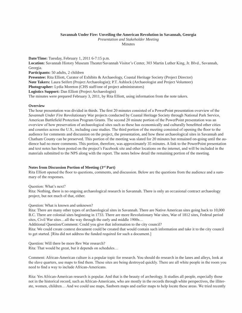
Savannah Under Fire: Unveiling the American Revolution in Savannah, GeorgiaPresentation and Stakeholder Meeting
Minutes
Date/Time: Tuesday, February 1, 2011 6-7:15 p.m.Location: Savannah History Museum Theater/Savannah Visitor’s Center, 303 Martin Luther King, Jr. Blvd., Savannah, Georgia.Participants: 50 adults, 2 childrenPresentee: Rita Elliott, Curator of Exhibits & Archaeology, Coastal Heritage Society (Project Director)Note Takers: Laura Seifert (Project Archaeologist); P.T. Ashlock (Archaeologist and Project Volunteer)Photographer: Lydia Moreton (CHS staff/one of project administrators)Logistics Support: Dan Elliott (Project Archaeologist)The minutes were prepared February 3, 2011, by Rita Elliott, using information from the note takers.
OverviewThe hour presentation was divided in thirds. The first 20 minutes consisted of a PowerPoint presentation overview of the Savannah Under Fire Revolutionary War projects conducted by Coastal Heritage Society through National Park Service, American Battlefield Protection Program Grants. The second 20 minute portion of the PowerPoint presentation was an overview of how preservation of archaeological sites such as these has economically and culturally benefitted other cities and counties across the U.S., including case studies. The third portion of the meeting consisted of opening the floor to the audience for comments and discussion on the project, the presentation, and how these archaeological sites in Savannah and Chatham County can be preserved. This portion of the meeting was slated for 20 minutes but remained on-going until the au-dience had no more comments. This portion, therefore, was approximately 35 minutes. A link to the PowerPoint presentation and text notes has been posted on the project’s Facebook site and other locations on the internet, and will be included in the materials submitted to the NPS along with the report. The notes below detail the remaining portion of the meeting.
Notes from Discussion Portion of Meeting (3rd Part)Rita Elliott opened the floor to questions, comments, and discussion. Below are the questions from the audience and a sum-mary of the responses.
Question: What’s next?Rita: Nothing, there is no ongoing archaeological research in Savannah. There is only an occasional contract archaeology project, but not much of that, either.
Question: What is known and unknown?Rita: There are many other types of archaeological sites in Savannah. There are Native American sites going back to 10,000 B.C. There are colonial sites beginning in 1733. There are more Revolutionary War sites, War of 1812 sites, Federal period sites, Civil War sites…all the way through the early and middle 1900s…Additional Question/Comment: Could you give that information to the city council?Rita: We could create context document could be created that would contain such information and take it to the city council to get started. [Rita did not address the funded required for such a document.]
Question: Will there be more Rev War research?Rita: That would be great, but it depends on schedules…
Comment: African-American culture is a popular topic for research. You should do research in the lanes and alleys, look at the slave quarters, use maps to find them. These sites are being destroyed quickly. There are all white people in the room you need to find a way to include African-Americans.
Rita: Yes African-American research is popular. And that is the beauty of archeology. It studies all people, especially those not in the historical record, such as African-Americans, who are mostly in the records through white perspectives, the illiter-ate, women, children… And we could use maps, Sanborn maps and earlier maps to help locate these areas. We tried recently
to work with a well-known African-American site here in Savannah. Had it all lined up to do archaeology and investigate it and they just dropped the ball, even though we tried very hard to work with the site personnel. And I am disappointed to see no African-Americans here tonight, although many were invited. Perhaps we need to try to invite them in a different way?
Question (by Henry Morgan): What can private landowners do? How can landowners deal with relic collectors?Rita: We can’t stop development. Or even people wanting to do stuff in their yards like gardening, etc. If you find items, make a map, keep the object in a bag labeled with its location/context, mark the location on the bag and the map…If land-owners want to fund archaeology on their property, then archaeologists would love to come out… Not all collectors are the same. There is a broad range of collectors, just like plumbers or gardeners… The problem is, when objects are collected, all information and context are lost. Context is key. It is a lot like a crime scene (explanation). So if someone comes knocking on your door to dig a privy in your yard, they are going to destroy all the information that goes with it. There are ways for collectors and archaeologists to work together, however. It’s the only way to move forward.
Comment (Henry Morgan): Preservation in place is a great method and is very easy. Rita: Yes. Believe it or not, archaeologists don’t want to dig every site. We believe in banking sites for the future, as well, when there will be new technologies and new questions to study sites.Comment: When relic hunters and archaeologists collaborate, we still need context
Question: Is the report from the project available?Rita: Thanks, Dan for holding up the printed copy. Yes, this report from the first grant season is available online via the Savannah Under Fire Facebook site and the Coastal Heritage Society’s web site under Battlefield Park. The report for the sec-ond grant season is currently being compiled. The draft will be completed in March and the final should be approved by NPS in June. After that, it too will be posted on the web where it will be available for free download by the public.
Question (by Jeff Kirkland): Will the political climate support an archaeological ordinance? What can a citizen do?Rita: I am the last one to be an expert on politics! And archaeologists can’t say we need an ordinance because that merely looks self-serving. Nobody will listen to that. But people who aren’t archaeologists can contact their city and county officials and voice support for archaeological and historic preservation legislation. For example, my colleague, Laura Seifert, also an archaeologist on this project, always points out the recycling example here in Savannah. For years the city didn’t have a recy-cling program, but finally when residents got together and demanded one, the city developed a program.
Question (Barry Sheehy): How does the absence of an ordinance influence our application to be a UNESCO World Heritage Site?Rita: Great question! I’m not sure. Others in our organization are more versed in this and may know the answer. I’ll have to ask. It is my understanding that the application includes downtown along Bull Street.Rita/Dan: The UNESCO site is only downtown and there are archaeological sites being destroyed everywhere. Just the Revolutionary War battlefield is larger than the downtown National Register District.
Comment: Downtown is protected.Rita: No, the archaeological sites downtown are no more protected than sites on the south side or those on the west side or the east side…There are no protections for archaeological sites just because they are in a National Register District in Savannah.
Comment (Henry Morgan): City parking garages have surely destroyed archaeology sites.Rita: Two garages did have archaeology, but many buildings have not. Most of the construction in Savannah does not require archaeology. The Garrison Elementary School that we just discussed on the battlefield site did not require archaeological investigation.
Question (by Farris Cadle): Are there any volunteer opportunities?Rita: It depends on project. We had lots of volunteers on the NPS project (by our standards). Commercial archaeology proj-ects are usually too busy, fast, and have insurance issues to have volunteers. But public archaeology programs, in fact all the ones I mentioned tonight in other cities and counties, have lots of volunteers. Comment (Carl Arndt): We have an active archaeology club in town, CGAS. We have worked with Rita in the past.Rita: Yes, Coastal Georgia Archaeological Society has provided us volunteers on some projects, including this one.
Comment: Make a presentation to the Historical Review Board. They make seemingly ridiculously small decisions, seems like they should have an interest in the larger issue of archaeology. Rita: That’s an idea. I’d be happy to talk to them. I talk to anyone who listens (and to a lot of people who don’t!) Thank you.

Question: What are the advantages of an archaeological ordinance? Rita: Do you mean beyond all the economic, community, and cultural benefits mentioned here tonight?Additional Comment: Yes, what would it do?Rita: Specifically, it depends on how the ordinance is written. It can do anything you want it to do. All the cities and counties I mentioned tonight have differences in their ordinances, but there are many similarities running through them. It can protect sites on public land, private land, or both. Most of the ordinances usually include some type of review for ground disturbance projects, and then a small number of those projects will require archaeology. I’m not sure what Savannah has drafted. It has been working on an ordinance for almost 25 years, with nothing to show. It would be good to see what they have, and take the best from the ordinances of these other cities and counties and include that.
Comment: Speak to the MPC planning staff, particularly as they are making decisions about subdivision zoning issues. Possibly could add an ordinance through them.Rita: Oh, that is good to know about the subdivision zoning issues. Good idea. Thank you.
Rita: Are there any other comments? No, then thank you very much!
Comment overheard by note taker Laura Seifert to CHS President & CEO, Scott Smith, after formal presentation: talk to the school board and get some school programs going that involve archaeology.
Topics note taker P.T. Ashlock recorded:•UNESCO applicability
•Community petition initiative (similar to one for recycling initiative)
•Report to city council
•Base plan with community initiative –( examine what sites to focus on; where; & there importance)
•Location pinpoints – (P.T. thought—to identify threatened sites while development is not at its peak and try to preserve them)
•African American presence (P.T. notes they are doing the Houston site cemetery and church project in Port Wentworth
•Period continuum and baseline-( developing period historic and prehistoric continuum in context document)
•Context document
•Sanborn maps
•Private land interests (Does this include funding, property access, general support?)
•Petition for new ordinances
•Relic hunters and archeological cooperation
Appendix C
Artifact Inventory
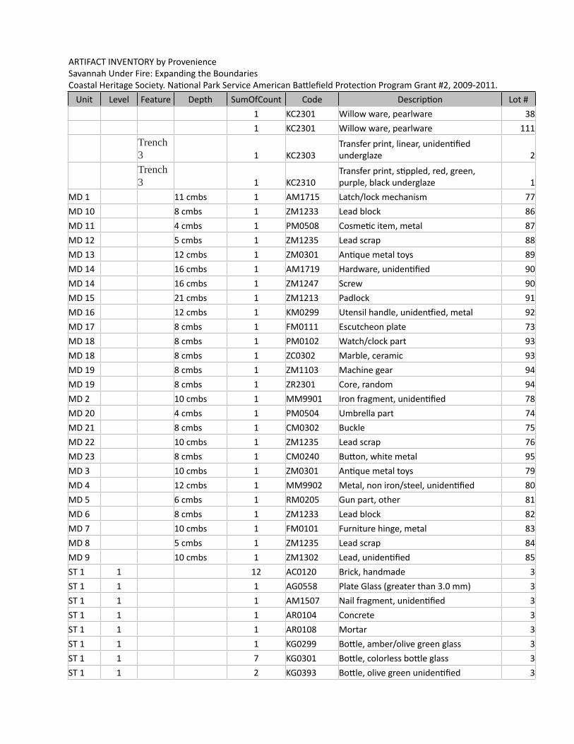
ARTIFACT INVENTORY by ProvenienceSavannah Under Fire: Expanding the BoundariesCoastal Heritage Society. National Park Service American Battlefield Protection Program Grant #2, 2009-2011.
Unit Level Feature Depth SumOfCount Code Description Lot #1 KC2301 Willow ware, pearlware 381 KC2301 Willow ware, pearlware 111
Trench 3 1 KC2303
Transfer print, linear, unidentified underglaze 2
Trench 3 1 KC2310
Transfer print, stippled, red, green, purple, black underglaze 1
MD 1 11 cmbs 1 AM1715 Latch/lock mechanism 77MD 10 8 cmbs 1 ZM1233 Lead block 86MD 11 4 cmbs 1 PM0508 Cosmetic item, metal 87MD 12 5 cmbs 1 ZM1235 Lead scrap 88MD 13 12 cmbs 1 ZM0301 Antique metal toys 89MD 14 16 cmbs 1 AM1719 Hardware, unidentified 90MD 14 16 cmbs 1 ZM1247 Screw 90MD 15 21 cmbs 1 ZM1213 Padlock 91MD 16 12 cmbs 1 KM0299 Utensil handle, unidentfied, metal 92MD 17 8 cmbs 1 FM0111 Escutcheon plate 73MD 18 8 cmbs 1 PM0102 Watch/clock part 93MD 18 8 cmbs 1 ZC0302 Marble, ceramic 93MD 19 8 cmbs 1 ZM1103 Machine gear 94MD 19 8 cmbs 1 ZR2301 Core, random 94MD 2 10 cmbs 1 MM9901 Iron fragment, unidentified 78MD 20 4 cmbs 1 PM0504 Umbrella part 74MD 21 8 cmbs 1 CM0302 Buckle 75MD 22 10 cmbs 1 ZM1235 Lead scrap 76MD 23 8 cmbs 1 CM0240 Button, white metal 95MD 3 10 cmbs 1 ZM0301 Antique metal toys 79MD 4 12 cmbs 1 MM9902 Metal, non iron/steel, unidentified 80MD 5 6 cmbs 1 RM0205 Gun part, other 81MD 6 8 cmbs 1 ZM1233 Lead block 82MD 7 10 cmbs 1 FM0101 Furniture hinge, metal 83MD 8 5 cmbs 1 ZM1235 Lead scrap 84MD 9 10 cmbs 1 ZM1302 Lead, unidentified 85ST 1 1 12 AC0120 Brick, handmade 3ST 1 1 1 AG0558 Plate Glass (greater than 3.0 mm) 3ST 1 1 1 AM1507 Nail fragment, unidentified 3ST 1 1 1 AR0104 Concrete 3ST 1 1 1 AR0108 Mortar 3ST 1 1 1 KG0299 Bottle, amber/olive green glass 3ST 1 1 7 KG0301 Bottle, colorless bottle glass 3ST 1 1 2 KG0393 Bottle, olive green unidentified 3
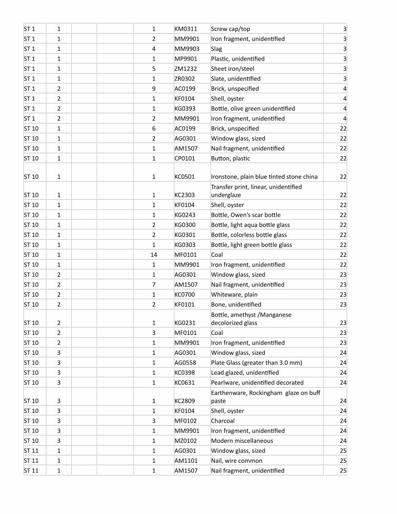
ST 1 1 1 KM0311 Screw cap/top 3ST 1 1 2 MM9901 Iron fragment, unidentified 3ST 1 1 4 MM9903 Slag 3ST 1 1 1 MP9901 Plastic, unidentified 3ST 1 1 5 ZM1232 Sheet iron/steel 3ST 1 1 1 ZR0302 Slate, unidentified 3ST 1 2 9 AC0199 Brick, unspecified 4ST 1 2 1 KF0104 Shell, oyster 4ST 1 2 1 KG0393 Bottle, olive green unidentified 4ST 1 2 2 MM9901 Iron fragment, unidentified 4ST 10 1 6 AC0199 Brick, unspecified 22ST 10 1 2 AG0301 Window glass, sized 22ST 10 1 1 AM1507 Nail fragment, unidentified 22ST 10 1 1 CP0101 Button, plastic 22
ST 10 1 1 KC0501 Ironstone, plain blue tinted stone china 22
ST 10 1 1 KC2303Transfer print, linear, unidentified underglaze 22
ST 10 1 1 KF0104 Shell, oyster 22ST 10 1 1 KG0243 Bottle, Owen’s scar bottle 22ST 10 1 2 KG0300 Bottle, light aqua bottle glass 22ST 10 1 2 KG0301 Bottle, colorless bottle glass 22ST 10 1 1 KG0303 Bottle, light green bottle glass 22ST 10 1 14 MF0101 Coal 22ST 10 1 1 MM9901 Iron fragment, unidentified 22ST 10 2 1 AG0301 Window glass, sized 23ST 10 2 7 AM1507 Nail fragment, unidentified 23ST 10 2 1 KC0700 Whiteware, plain 23ST 10 2 2 KF0101 Bone, unidentified 23
ST 10 2 1 KG0231Bottle, amethyst /Manganese decolorized glass 23
ST 10 2 3 MF0101 Coal 23ST 10 2 1 MM9901 Iron fragment, unidentified 23ST 10 3 1 AG0301 Window glass, sized 24ST 10 3 1 AG0558 Plate Glass (greater than 3.0 mm) 24ST 10 3 1 KC0398 Lead glazed, unidentified 24ST 10 3 1 KC0631 Pearlware, unidentified decorated 24
ST 10 3 1 KC2809Earthenware, Rockingham glaze on buff paste 24
ST 10 3 1 KF0104 Shell, oyster 24ST 10 3 3 MF0102 Charcoal 24ST 10 3 1 MM9901 Iron fragment, unidentified 24ST 10 3 1 MZ0102 Modern miscellaneous 24ST 11 1 1 AG0301 Window glass, sized 25ST 11 1 1 AM1101 Nail, wire common 25ST 11 1 1 AM1507 Nail fragment, unidentified 25
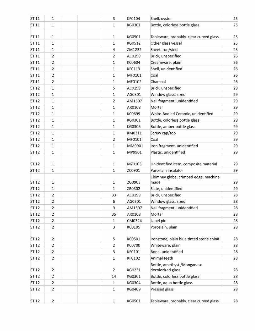
ST 11 1 3 KF0104 Shell, oyster 25ST 11 1 1 KG0301 Bottle, colorless bottle glass 25
ST 11 1 1 KG0501 Tableware, probably, clear curved glass 25ST 11 1 1 KG0512 Other glass vessel 25ST 11 1 4 ZM1232 Sheet iron/steel 25ST 11 2 2 AC0199 Brick, unspecified 26ST 11 2 1 KC0604 Creamware, plain 26ST 11 2 1 KF0113 Shell, unidentified 26ST 11 2 1 MF0101 Coal 26ST 11 2 1 MF0102 Charcoal 26ST 12 1 5 AC0199 Brick, unspecified 29ST 12 1 1 AG0301 Window glass, sized 29ST 12 1 2 AM1507 Nail fragment, unidentified 29ST 12 1 1 AR0108 Mortar 29ST 12 1 1 KC0699 White-Bodied Ceramic, unidentified 29ST 12 1 1 KG0301 Bottle, colorless bottle glass 29ST 12 1 1 KG0306 Bottle, amber bottle glass 29ST 12 1 1 KM0311 Screw cap/top 29ST 12 1 2 MF0101 Coal 29ST 12 1 1 MM9901 Iron fragment, unidentified 29ST 12 1 1 MP9901 Plastic, unidentified 29
ST 12 1 1 MZ0103 Unidentified item, composite material 29ST 12 1 1 ZC0901 Porcelain insulator 29
ST 12 1 1 ZG0903Chimney globe, crimped edge, machine made 29
ST 12 1 1 ZR0302 Slate, unidentified 29ST 12 2 33 AC0199 Brick, unspecified 28ST 12 2 6 AG0301 Window glass, sized 28ST 12 2 9 AM1507 Nail fragment, unidentified 28ST 12 2 35 AR0108 Mortar 28ST 12 2 1 CM0324 Lapel pin 28ST 12 2 3 KC0105 Porcelain, plain 28
ST 12 2 5 KC0501 Ironstone, plain blue tinted stone china 28ST 12 2 2 KC0700 Whiteware, plain 28ST 12 2 3 KF0101 Bone, unidentified 28ST 12 2 1 KF0102 Animal teeth 28
ST 12 2 2 KG0231Bottle, amethyst /Manganese decolorized glass 28
ST 12 2 14 KG0301 Bottle, colorless bottle glass 28ST 12 2 1 KG0304 Bottle, aqua bottle glass 28ST 12 2 1 KG0409 Pressed glass 28
ST 12 2 1 KG0501 Tableware, probably, clear curved glass 28
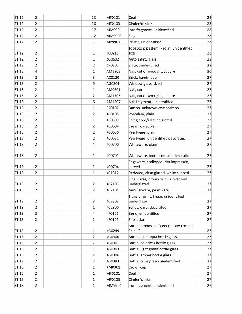
ST 12 2 23 MF0101 Coal 28ST 12 2 36 MF0103 Cinder/clinker 28ST 12 2 37 MM9901 Iron fragment, unidentified 28ST 12 2 12 MM9903 Slag 28ST 12 2 1 MP9901 Plastic, unidentified 28
ST 12 2 1 TC0215Tobacco pipestem, kaolin, unidentified size 28
ST 12 2 1 ZG0602 Auto safety glass 28ST 12 2 2 ZR0302 Slate, unidentified 28ST 12 4 1 AM1505 Nail, cut or wrought, square 30ST 13 2 5 AC0120 Brick, handmade 27ST 13 2 5 AG0301 Window glass, sized 27ST 13 2 1 AM0601 Nail, cut 27ST 13 2 2 AM1505 Nail, cut or wrought, square 27ST 13 2 6 AM1507 Nail fragment, unidentified 27ST 13 2 1 CZ0102 Button, unknown composition 27ST 13 2 2 KC0105 Porcelain, plain 27ST 13 2 1 KC0309 Salt glazed/alkaline glazed 27ST 13 2 2 KC0604 Creamware, plain 27ST 13 2 2 KC0630 Pearlware, plain 27ST 13 2 2 KC0631 Pearlware, unidentified decorated 27ST 13 2 4 KC0700 Whiteware, plain 27
ST 13 2 1 KC0701 Whiteware, indeterminate decoration 27
ST 13 2 1 KC0704Edgeware, scalloped, rim impressed, curved 27
ST 13 2 1 KC1312 Redware, clear glazed, white slipped 27
ST 13 2 2 KC2103Line wares, brown or blue over and underglazed 27
ST 13 2 2 KC2104 Annularware, pearlware 27
ST 13 2 3 KC2303Transfer print, linear, unidentified underglaze 27
ST 13 2 1 KC2800 Yellowware, decorated 27ST 13 2 4 KF0101 Bone, unidentified 27ST 13 2 1 KF0105 Shell, clam 27
ST 13 2 1 KG0249Bottle, embossed “Federal Law Forbids Sale...” 27
ST 13 2 2 KG0300 Bottle, light aqua bottle glass 27ST 13 2 7 KG0301 Bottle, colorless bottle glass 27ST 13 2 1 KG0303 Bottle, light green bottle glass 27ST 13 2 2 KG0306 Bottle, amber bottle glass 27ST 13 2 2 KG0393 Bottle, olive green unidentified 27ST 13 2 1 KM0301 Crown cap 27ST 13 2 1 MF0101 Coal 27ST 13 2 1 MF0103 Cinder/clinker 27ST 13 2 1 MM9901 Iron fragment, unidentified 27
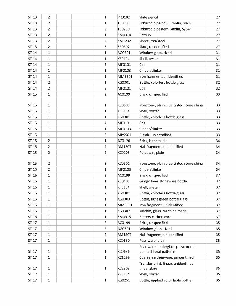
ST 13 2 1 PR0102 Slate pencil 27ST 13 2 1 TC0101 Tobacco pipe bowl, kaolin, plain 27ST 13 2 2 TC0210 Tobacco pipestem, kaolin, 5/64” 27ST 13 2 1 ZM0914 Battery 27ST 13 2 2 ZM1232 Sheet iron/steel 27ST 13 2 3 ZR0302 Slate, unidentified 27ST 14 1 1 AG0301 Window glass, sized 31ST 14 1 1 KF0104 Shell, oyster 31ST 14 1 3 MF0101 Coal 31ST 14 1 1 MF0103 Cinder/clinker 31ST 14 1 1 MM9901 Iron fragment, unidentified 31ST 14 2 1 KG0301 Bottle, colorless bottle glass 32ST 14 2 3 MF0101 Coal 32ST 15 1 2 AC0199 Brick, unspecified 33
ST 15 1 1 KC0501 Ironstone, plain blue tinted stone china 33ST 15 1 1 KF0104 Shell, oyster 33ST 15 1 1 KG0301 Bottle, colorless bottle glass 33ST 15 1 4 MF0101 Coal 33ST 15 1 1 MF0103 Cinder/clinker 33ST 15 1 8 MP9901 Plastic, unidentified 33ST 15 2 1 AC0120 Brick, handmade 34ST 15 2 4 AM1507 Nail fragment, unidentified 34ST 15 2 2 KC0105 Porcelain, plain 34
ST 15 2 3 KC0501 Ironstone, plain blue tinted stone china 34ST 15 2 1 MF0103 Cinder/clinker 34ST 16 1 2 AC0199 Brick, unspecified 37ST 16 1 1 KC0401 Ginger beer stoneware bottle 37ST 16 1 1 KF0104 Shell, oyster 37ST 16 1 2 KG0301 Bottle, colorless bottle glass 37ST 16 1 1 KG0303 Bottle, light green bottle glass 37ST 16 1 1 MM9901 Iron fragment, unidentified 37ST 16 1 1 ZG0302 Marble, glass, machine made 37ST 16 1 1 ZM0915 Battery carbon core 37ST 17 1 6 AC0199 Brick, unspecified 35ST 17 1 2 AG0301 Window glass, sized 35ST 17 1 4 AM1507 Nail fragment, unidentified 35ST 17 1 5 KC0630 Pearlware, plain 35
ST 17 1 1 KC0636Pearlware, underglaze polychrome painted floral patterns 35
ST 17 1 1 KC1299 Coarse earthenware, unidentified 35
ST 17 1 1 KC2303Transfer print, linear, unidentified underglaze 35
ST 17 1 5 KF0104 Shell, oyster 35ST 17 1 1 KG0251 Bottle, applied color lable bottle 35
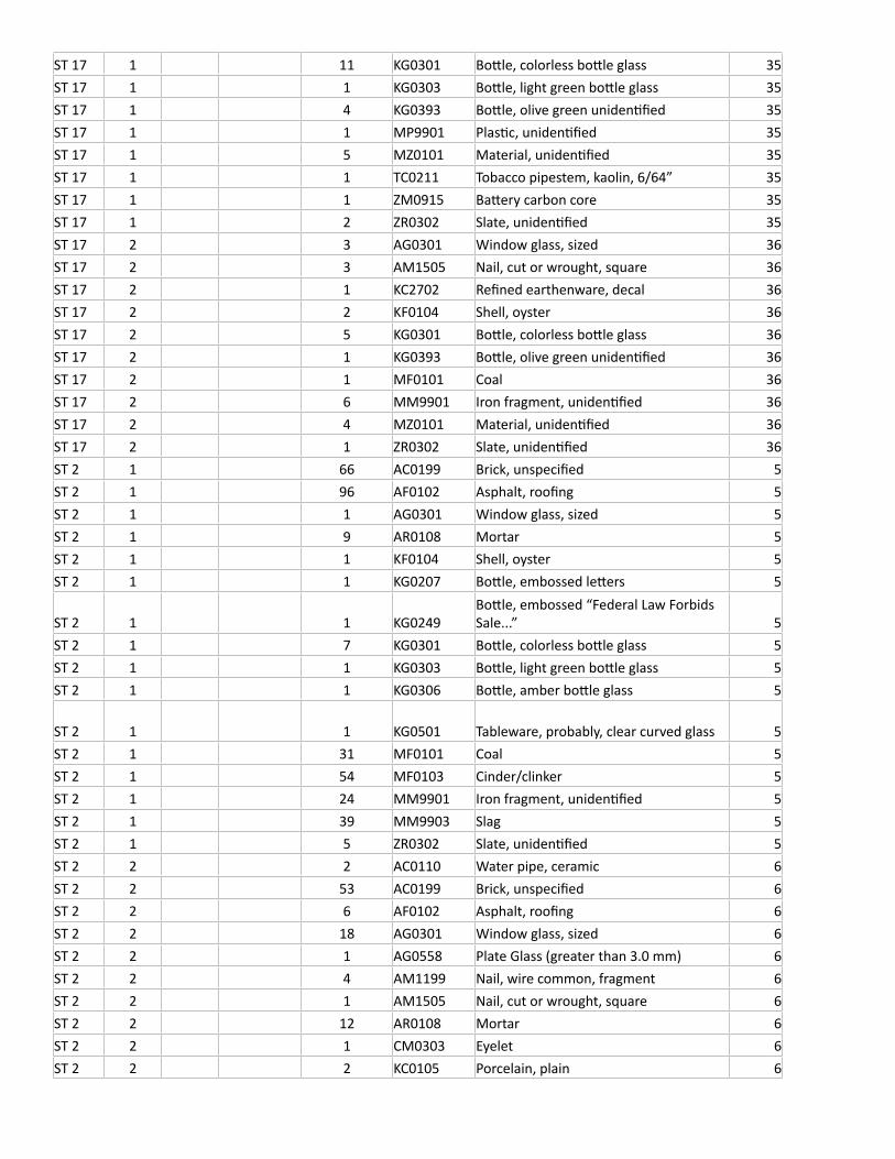
ST 17 1 11 KG0301 Bottle, colorless bottle glass 35ST 17 1 1 KG0303 Bottle, light green bottle glass 35ST 17 1 4 KG0393 Bottle, olive green unidentified 35ST 17 1 1 MP9901 Plastic, unidentified 35ST 17 1 5 MZ0101 Material, unidentified 35ST 17 1 1 TC0211 Tobacco pipestem, kaolin, 6/64” 35ST 17 1 1 ZM0915 Battery carbon core 35ST 17 1 2 ZR0302 Slate, unidentified 35ST 17 2 3 AG0301 Window glass, sized 36ST 17 2 3 AM1505 Nail, cut or wrought, square 36ST 17 2 1 KC2702 Refined earthenware, decal 36ST 17 2 2 KF0104 Shell, oyster 36ST 17 2 5 KG0301 Bottle, colorless bottle glass 36ST 17 2 1 KG0393 Bottle, olive green unidentified 36ST 17 2 1 MF0101 Coal 36ST 17 2 6 MM9901 Iron fragment, unidentified 36ST 17 2 4 MZ0101 Material, unidentified 36ST 17 2 1 ZR0302 Slate, unidentified 36ST 2 1 66 AC0199 Brick, unspecified 5ST 2 1 96 AF0102 Asphalt, roofing 5ST 2 1 1 AG0301 Window glass, sized 5ST 2 1 9 AR0108 Mortar 5ST 2 1 1 KF0104 Shell, oyster 5ST 2 1 1 KG0207 Bottle, embossed letters 5
ST 2 1 1 KG0249Bottle, embossed “Federal Law Forbids Sale...” 5
ST 2 1 7 KG0301 Bottle, colorless bottle glass 5ST 2 1 1 KG0303 Bottle, light green bottle glass 5ST 2 1 1 KG0306 Bottle, amber bottle glass 5
ST 2 1 1 KG0501 Tableware, probably, clear curved glass 5ST 2 1 31 MF0101 Coal 5ST 2 1 54 MF0103 Cinder/clinker 5ST 2 1 24 MM9901 Iron fragment, unidentified 5ST 2 1 39 MM9903 Slag 5ST 2 1 5 ZR0302 Slate, unidentified 5ST 2 2 2 AC0110 Water pipe, ceramic 6ST 2 2 53 AC0199 Brick, unspecified 6ST 2 2 6 AF0102 Asphalt, roofing 6ST 2 2 18 AG0301 Window glass, sized 6ST 2 2 1 AG0558 Plate Glass (greater than 3.0 mm) 6ST 2 2 4 AM1199 Nail, wire common, fragment 6ST 2 2 1 AM1505 Nail, cut or wrought, square 6ST 2 2 12 AR0108 Mortar 6ST 2 2 1 CM0303 Eyelet 6ST 2 2 2 KC0105 Porcelain, plain 6
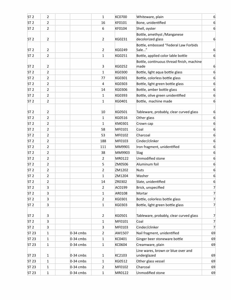
ST 2 2 1 KC0700 Whiteware, plain 6ST 2 2 16 KF0101 Bone, unidentified 6ST 2 2 6 KF0104 Shell, oyster 6
ST 2 2 2 KG0231Bottle, amethyst /Manganese decolorized glass 6
ST 2 2 2 KG0249Bottle, embossed “Federal Law Forbids Sale...” 6
ST 2 2 1 KG0251 Bottle, applied color lable bottle 6
ST 2 2 3 KG0252Bottle, continuous thread finish, machine made 6
ST 2 2 1 KG0300 Bottle, light aqua bottle glass 6ST 2 2 77 KG0301 Bottle, colorless bottle glass 6ST 2 2 4 KG0303 Bottle, light green bottle glass 6ST 2 2 14 KG0306 Bottle, amber bottle glass 6ST 2 2 1 KG0393 Bottle, olive green unidentified 6ST 2 2 1 KG0401 Bottle, machine made 6
ST 2 2 10 KG0501 Tableware, probably, clear curved glass 6ST 2 2 1 KG0516 Other glass 6ST 2 2 1 KM0301 Crown cap 6ST 2 2 58 MF0101 Coal 6ST 2 2 53 MF0102 Charcoal 6ST 2 2 188 MF0103 Cinder/clinker 6ST 2 2 111 MM9901 Iron fragment, unidentified 6ST 2 2 38 MM9903 Slag 6ST 2 2 2 MR0122 Unmodified stone 6ST 2 2 5 ZM0506 Aluminum foil 6ST 2 2 2 ZM1202 Nuts 6ST 2 2 1 ZM1204 Washer 6ST 2 2 14 ZR0302 Slate, unidentified 6ST 2 3 2 AC0199 Brick, unspecified 7ST 2 3 1 AR0108 Mortar 7ST 2 3 2 KG0301 Bottle, colorless bottle glass 7ST 2 3 1 KG0303 Bottle, light green bottle glass 7
ST 2 3 2 KG0501 Tableware, probably, clear curved glass 7ST 2 3 1 MF0101 Coal 7ST 2 3 3 MF0103 Cinder/clinker 7ST 23 1 0-34 cmbs 2 AM1507 Nail fragment, unidentified 69ST 23 1 0-34 cmbs 1 KC0401 Ginger beer stoneware bottle 69ST 23 1 0-34 cmbs 1 KC0604 Creamware, plain 69
ST 23 1 0-34 cmbs 1 KC2103Line wares, brown or blue over and underglazed 69
ST 23 1 0-34 cmbs 1 KG0512 Other glass vessel 69ST 23 1 0-34 cmbs 2 MF0102 Charcoal 69ST 23 1 0-34 cmbs 1 MR0122 Unmodified stone 69
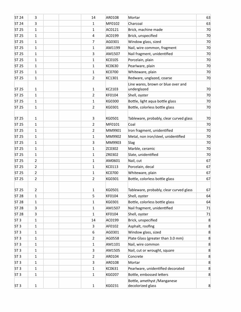
ST 24 3 14 AR0108 Mortar 63ST 24 3 1 MF0102 Charcoal 63ST 25 1 1 AC0121 Brick, machine made 70ST 25 1 4 AC0199 Brick, unspecified 70ST 25 1 7 AG0301 Window glass, sized 70ST 25 1 1 AM1199 Nail, wire common, fragment 70ST 25 1 3 AM1507 Nail fragment, unidentified 70ST 25 1 1 KC0105 Porcelain, plain 70ST 25 1 1 KC0630 Pearlware, plain 70ST 25 1 1 KC0700 Whiteware, plain 70ST 25 1 2 KC1301 Redware, unglazed, coarse 70
ST 25 1 1 KC2103Line wares, brown or blue over and underglazed 70
ST 25 1 2 KF0104 Shell, oyster 70ST 25 1 1 KG0300 Bottle, light aqua bottle glass 70ST 25 1 2 KG0301 Bottle, colorless bottle glass 70
ST 25 1 3 KG0501 Tableware, probably, clear curved glass 70ST 25 1 2 MF0101 Coal 70ST 25 1 2 MM9901 Iron fragment, unidentified 70ST 25 1 1 MM9902 Metal, non iron/steel, unidentified 70ST 25 1 3 MM9903 Slag 70ST 25 1 1 ZC0302 Marble, ceramic 70ST 25 1 1 ZR0302 Slate, unidentified 70ST 25 2 1 AM0601 Nail, cut 67ST 25 2 1 KC0113 Porcelain, decal 67ST 25 2 1 KC0700 Whiteware, plain 67ST 25 2 2 KG0301 Bottle, colorless bottle glass 67
ST 25 2 1 KG0501 Tableware, probably, clear curved glass 67ST 28 1 5 KF0104 Shell, oyster 64ST 28 1 1 KG0301 Bottle, colorless bottle glass 64ST 28 3 1 AM1507 Nail fragment, unidentified 71ST 28 3 1 KF0104 Shell, oyster 71ST 3 1 14 AC0199 Brick, unspecified 8ST 3 1 3 AF0102 Asphalt, roofing 8ST 3 1 6 AG0301 Window glass, sized 8ST 3 1 2 AG0558 Plate Glass (greater than 3.0 mm) 8ST 3 1 1 AM1101 Nail, wire common 8ST 3 1 3 AM1505 Nail, cut or wrought, square 8ST 3 1 2 AR0104 Concrete 8ST 3 1 3 AR0108 Mortar 8ST 3 1 1 KC0631 Pearlware, unidentified decorated 8ST 3 1 1 KG0207 Bottle, embossed letters 8
ST 3 1 1 KG0231Bottle, amethyst /Manganese decolorized glass 8
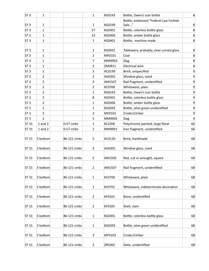
ST 3 1 1 KG0243 Bottle, Owen’s scar bottle 8
ST 3 1 1 KG0249Bottle, embossed “Federal Law Forbids Sale...” 8
ST 3 1 27 KG0301 Bottle, colorless bottle glass 8ST 3 1 13 KG0306 Bottle, amber bottle glass 8ST 3 1 1 KG0401 Bottle, machine made 8
ST 3 1 2 KG0501 Tableware, probably, clear curved glass 8ST 3 1 2 MF0101 Coal 8ST 3 1 7 MM9903 Slag 8ST 3 1 2 ZM0911 Electrical wire 8ST 3 2 3 AC0199 Brick, unspecified 9ST 3 2 2 AG0301 Window glass, sized 9ST 3 2 3 AM1507 Nail fragment, unidentified 9ST 3 2 2 KC0700 Whiteware, plain 9ST 3 2 1 KG0243 Bottle, Owen’s scar bottle 9ST 3 2 8 KG0301 Bottle, colorless bottle glass 9ST 3 2 1 KG0306 Bottle, amber bottle glass 9ST 3 2 1 KG0393 Bottle, olive green unidentified 9ST 3 2 3 MF0103 Cinder/clinker 9ST 3 2 5 MM9903 Slag 9ST 31 1 and 2 0-57 cmbs 1 KC2206 Polychrome painted, large floral 66ST 31 1 and 2 0-57 cmbs 2 MM9901 Iron fragment, unidentified 66
ST 31 3 bottom 86-121 cmbs 5 AC0120 Brick, handmade 68
ST 31 3 bottom 86-121 cmbs 3 AG0301 Window glass, sized 68
ST 31 3 bottom 86-121 cmbs 5 AM1505 Nail, cut or wrought, square 68
ST 31 3 bottom 86-121 cmbs 2 AM1507 Nail fragment, unidentified 68
ST 31 3 bottom 86-121 cmbs 1 KC0700 Whiteware, plain 68
ST 31 3 bottom 86-121 cmbs 1 KC0701 Whiteware, indeterminate decoration 68
ST 31 3 bottom 86-121 cmbs 2 KF0101 Bone, unidentified 68
ST 31 3 bottom 86-121 cmbs 2 KF0105 Shell, clam 68
ST 31 3 bottom 86-121 cmbs 1 KG0301 Bottle, colorless bottle glass 68
ST 31 3 bottom 86-121 cmbs 1 KG0393 Bottle, olive green unidentified 68
ST 31 3 bottom 86-121 cmbs 3 MF0103 Cinder/clinker 68
ST 31 3 bottom 86-121 cmbs 2 ZR0302 Slate, unidentified 68
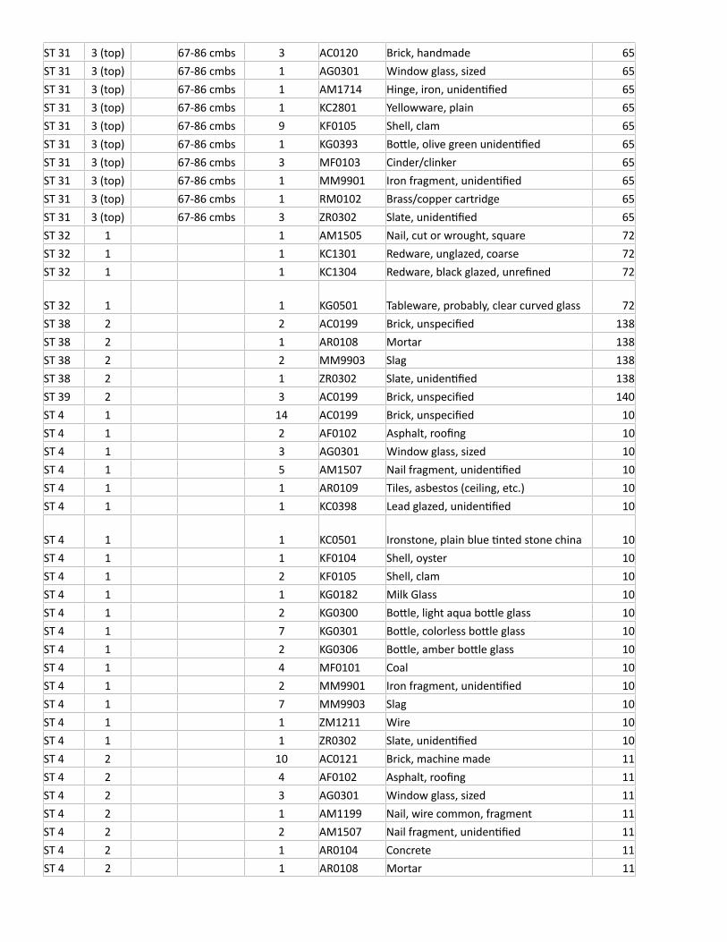
ST 31 3 (top) 67-86 cmbs 3 AC0120 Brick, handmade 65ST 31 3 (top) 67-86 cmbs 1 AG0301 Window glass, sized 65ST 31 3 (top) 67-86 cmbs 1 AM1714 Hinge, iron, unidentified 65ST 31 3 (top) 67-86 cmbs 1 KC2801 Yellowware, plain 65ST 31 3 (top) 67-86 cmbs 9 KF0105 Shell, clam 65ST 31 3 (top) 67-86 cmbs 1 KG0393 Bottle, olive green unidentified 65ST 31 3 (top) 67-86 cmbs 3 MF0103 Cinder/clinker 65ST 31 3 (top) 67-86 cmbs 1 MM9901 Iron fragment, unidentified 65ST 31 3 (top) 67-86 cmbs 1 RM0102 Brass/copper cartridge 65ST 31 3 (top) 67-86 cmbs 3 ZR0302 Slate, unidentified 65ST 32 1 1 AM1505 Nail, cut or wrought, square 72ST 32 1 1 KC1301 Redware, unglazed, coarse 72ST 32 1 1 KC1304 Redware, black glazed, unrefined 72
ST 32 1 1 KG0501 Tableware, probably, clear curved glass 72ST 38 2 2 AC0199 Brick, unspecified 138ST 38 2 1 AR0108 Mortar 138ST 38 2 2 MM9903 Slag 138ST 38 2 1 ZR0302 Slate, unidentified 138ST 39 2 3 AC0199 Brick, unspecified 140ST 4 1 14 AC0199 Brick, unspecified 10ST 4 1 2 AF0102 Asphalt, roofing 10ST 4 1 3 AG0301 Window glass, sized 10ST 4 1 5 AM1507 Nail fragment, unidentified 10ST 4 1 1 AR0109 Tiles, asbestos (ceiling, etc.) 10ST 4 1 1 KC0398 Lead glazed, unidentified 10
ST 4 1 1 KC0501 Ironstone, plain blue tinted stone china 10ST 4 1 1 KF0104 Shell, oyster 10ST 4 1 2 KF0105 Shell, clam 10ST 4 1 1 KG0182 Milk Glass 10ST 4 1 2 KG0300 Bottle, light aqua bottle glass 10ST 4 1 7 KG0301 Bottle, colorless bottle glass 10ST 4 1 2 KG0306 Bottle, amber bottle glass 10ST 4 1 4 MF0101 Coal 10ST 4 1 2 MM9901 Iron fragment, unidentified 10ST 4 1 7 MM9903 Slag 10ST 4 1 1 ZM1211 Wire 10ST 4 1 1 ZR0302 Slate, unidentified 10ST 4 2 10 AC0121 Brick, machine made 11ST 4 2 4 AF0102 Asphalt, roofing 11ST 4 2 3 AG0301 Window glass, sized 11ST 4 2 1 AM1199 Nail, wire common, fragment 11ST 4 2 2 AM1507 Nail fragment, unidentified 11ST 4 2 1 AR0104 Concrete 11ST 4 2 1 AR0108 Mortar 11
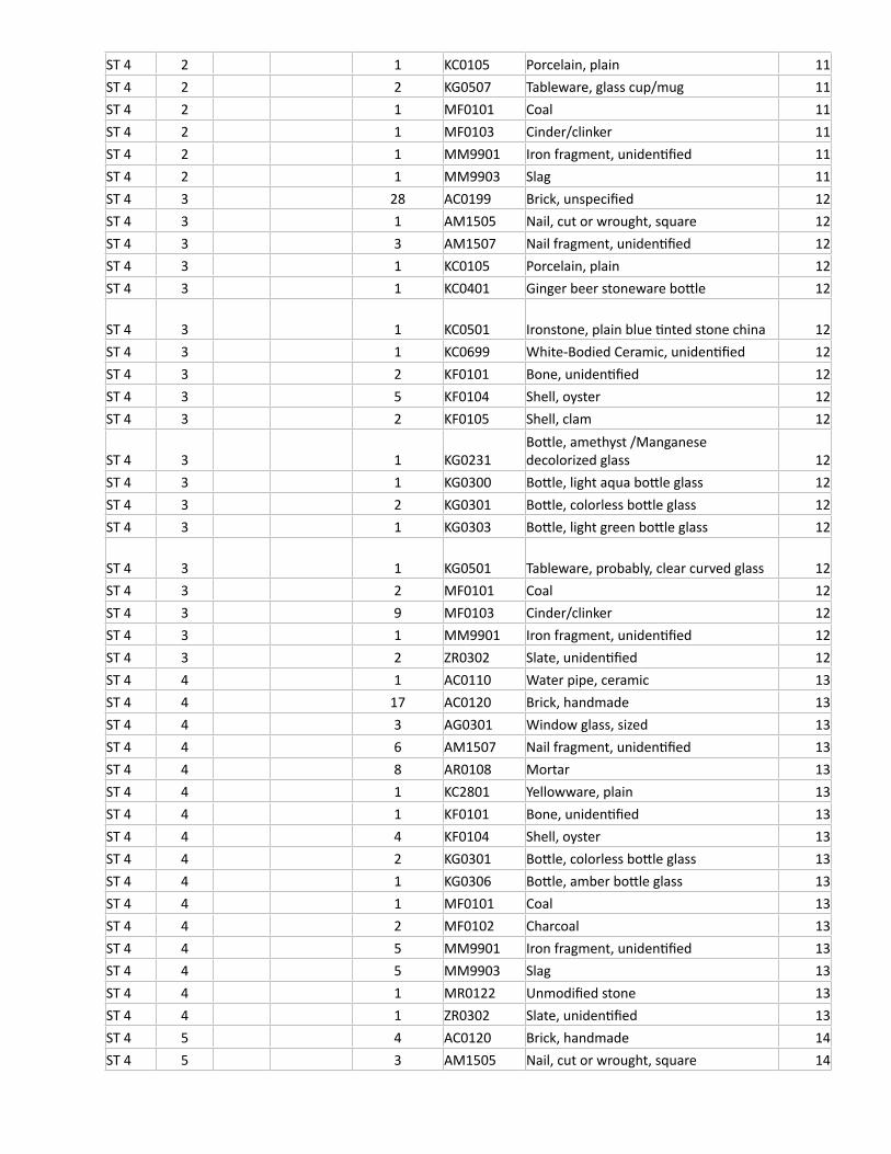
ST 4 2 1 KC0105 Porcelain, plain 11ST 4 2 2 KG0507 Tableware, glass cup/mug 11ST 4 2 1 MF0101 Coal 11ST 4 2 1 MF0103 Cinder/clinker 11ST 4 2 1 MM9901 Iron fragment, unidentified 11ST 4 2 1 MM9903 Slag 11ST 4 3 28 AC0199 Brick, unspecified 12ST 4 3 1 AM1505 Nail, cut or wrought, square 12ST 4 3 3 AM1507 Nail fragment, unidentified 12ST 4 3 1 KC0105 Porcelain, plain 12ST 4 3 1 KC0401 Ginger beer stoneware bottle 12
ST 4 3 1 KC0501 Ironstone, plain blue tinted stone china 12ST 4 3 1 KC0699 White-Bodied Ceramic, unidentified 12ST 4 3 2 KF0101 Bone, unidentified 12ST 4 3 5 KF0104 Shell, oyster 12ST 4 3 2 KF0105 Shell, clam 12
ST 4 3 1 KG0231Bottle, amethyst /Manganese decolorized glass 12
ST 4 3 1 KG0300 Bottle, light aqua bottle glass 12ST 4 3 2 KG0301 Bottle, colorless bottle glass 12ST 4 3 1 KG0303 Bottle, light green bottle glass 12
ST 4 3 1 KG0501 Tableware, probably, clear curved glass 12ST 4 3 2 MF0101 Coal 12ST 4 3 9 MF0103 Cinder/clinker 12ST 4 3 1 MM9901 Iron fragment, unidentified 12ST 4 3 2 ZR0302 Slate, unidentified 12ST 4 4 1 AC0110 Water pipe, ceramic 13ST 4 4 17 AC0120 Brick, handmade 13ST 4 4 3 AG0301 Window glass, sized 13ST 4 4 6 AM1507 Nail fragment, unidentified 13ST 4 4 8 AR0108 Mortar 13ST 4 4 1 KC2801 Yellowware, plain 13ST 4 4 1 KF0101 Bone, unidentified 13ST 4 4 4 KF0104 Shell, oyster 13ST 4 4 2 KG0301 Bottle, colorless bottle glass 13ST 4 4 1 KG0306 Bottle, amber bottle glass 13ST 4 4 1 MF0101 Coal 13ST 4 4 2 MF0102 Charcoal 13ST 4 4 5 MM9901 Iron fragment, unidentified 13ST 4 4 5 MM9903 Slag 13ST 4 4 1 MR0122 Unmodified stone 13ST 4 4 1 ZR0302 Slate, unidentified 13ST 4 5 4 AC0120 Brick, handmade 14ST 4 5 3 AM1505 Nail, cut or wrought, square 14
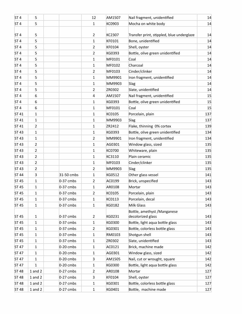
ST 4 5 12 AM1507 Nail fragment, unidentified 14ST 4 5 1 KC0903 Mocha on white body 14
ST 4 5 2 KC2307 Transfer print, stippled, blue underglaze 14ST 4 5 1 KF0101 Bone, unidentified 14ST 4 5 2 KF0104 Shell, oyster 14ST 4 5 2 KG0393 Bottle, olive green unidentified 14ST 4 5 1 MF0101 Coal 14ST 4 5 1 MF0102 Charcoal 14ST 4 5 2 MF0103 Cinder/clinker 14ST 4 5 1 MM9901 Iron fragment, unidentified 14ST 4 5 1 MM9903 Slag 14ST 4 5 2 ZR0302 Slate, unidentified 14ST 4 6 4 AM1507 Nail fragment, unidentified 15ST 4 6 1 KG0393 Bottle, olive green unidentified 15ST 4 6 1 MF0101 Coal 15ST 41 1 1 KC0105 Porcelain, plain 137ST 41 1 1 MM9903 Slag 137ST 41 2 1 ZR2412 Flake, thinning 0% cortex 139ST 43 1 1 KG0393 Bottle, olive green unidentified 134ST 43 1 2 MM9901 Iron fragment, unidentified 134ST 43 2 1 AG0301 Window glass, sized 135ST 43 2 1 KC0700 Whiteware, plain 135ST 43 2 1 KC3110 Plain ceramic 135ST 43 2 1 MF0103 Cinder/clinker 135ST 43 2 2 MM9903 Slag 135ST 44 3 31-50 cmbs 1 KG0512 Other glass vessel 141ST 45 1 0-37 cmbs 2 AC0199 Brick, unspecified 143ST 45 1 0-37 cmbs 1 AR0108 Mortar 143ST 45 1 0-37 cmbs 2 KC0105 Porcelain, plain 143ST 45 1 0-37 cmbs 1 KC0113 Porcelain, decal 143ST 45 1 0-37 cmbs 1 KG0182 Milk Glass 143
ST 45 1 0-37 cmbs 2 KG0231Bottle, amethyst /Manganese decolorized glass 143
ST 45 1 0-37 cmbs 1 KG0300 Bottle, light aqua bottle glass 143ST 45 1 0-37 cmbs 2 KG0301 Bottle, colorless bottle glass 143ST 45 1 0-37 cmbs 1 RM0103 Shotgun shell 143ST 45 1 0-37 cmbs 1 ZR0302 Slate, unidentified 143ST 47 1 0-20 cmbs 1 AC0121 Brick, machine made 142ST 47 1 0-20 cmbs 1 AG0301 Window glass, sized 142ST 47 1 0-20 cmbs 3 AM1505 Nail, cut or wrought, square 142ST 47 1 0-20 cmbs 1 KG0300 Bottle, light aqua bottle glass 142ST 48 1 and 2 0-27 cmbs 2 AR0108 Mortar 127ST 48 1 and 2 0-27 cmbs 3 KF0104 Shell, oyster 127ST 48 1 and 2 0-27 cmbs 1 KG0301 Bottle, colorless bottle glass 127ST 48 1 and 2 0-27 cmbs 1 KG0401 Bottle, machine made 127
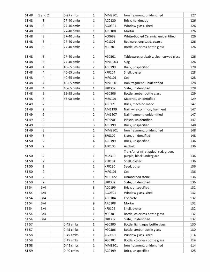
ST 48 1 and 2 0-27 cmbs 1 MM9901 Iron fragment, unidentified 127ST 48 3 27-40 cmbs 1 AC0120 Brick, handmade 126ST 48 3 27-40 cmbs 1 AG0301 Window glass, sized 126ST 48 3 27-40 cmbs 1 AR0108 Mortar 126ST 48 3 27-40 cmbs 1 KC0699 White-Bodied Ceramic, unidentified 126ST 48 3 27-40 cmbs 1 KC1301 Redware, unglazed, coarse 126ST 48 3 27-40 cmbs 7 KG0301 Bottle, colorless bottle glass 126
ST 48 3 27-40 cmbs 2 KG0501 Tableware, probably, clear curved glass 126ST 48 3 27-40 cmbs 1 MM9903 Slag 126ST 48 4 40-65 cmbs 2 AC0199 Brick, unspecified 128ST 48 4 40-65 cmbs 2 KF0104 Shell, oyster 128ST 48 4 40-65 cmbs 1 MF0101 Coal 128ST 48 4 40-65 cmbs 1 MM9901 Iron fragment, unidentified 128ST 48 4 40-65 cmbs 1 ZR0302 Slate, unidentified 128ST 48 5 65-98 cmbs 1 KG0306 Bottle, amber bottle glass 129ST 48 5 65-98 cmbs 1 MZ0101 Material, unidentified 129ST 49 2 3 AC0121 Brick, machine made 147ST 49 2 1 AM1199 Nail, wire common, fragment 147ST 49 2 2 AM1507 Nail fragment, unidentified 147ST 49 2 1 MP9901 Plastic, unidentified 147ST 49 3 3 AC0199 Brick, unspecified 148ST 49 3 1 MM9901 Iron fragment, unidentified 148ST 49 3 1 ZR0302 Slate, unidentified 148ST 50 2 4 AC0199 Brick, unspecified 136ST 50 2 2 AF0105 Asphalt 136
ST 50 2 1 KC2310Transfer print, stippled, red, green, purple, black underglaze 136
ST 50 2 2 KF0104 Shell, oyster 136ST 50 2 1 KF0230 Seed, other 136ST 50 2 4 MF0101 Coal 136ST 50 2 1 MR0122 Unmodified stone 136ST 50 2 1 ZR0302 Slate, unidentified 136ST 54 3/4 8 AC0199 Brick, unspecified 132ST 54 3/4 1 AG0301 Window glass, sized 132ST 54 3/4 1 AR0104 Concrete 132ST 54 3/4 9 AR0108 Mortar 132ST 54 3/4 1 KF0104 Shell, oyster 132ST 54 3/4 1 KG0301 Bottle, colorless bottle glass 132ST 54 3/4 2 ZR0302 Slate, unidentified 132ST 57 0-45 cmbs 1 KG0300 Bottle, light aqua bottle glass 130ST 57 0-45 cmbs 1 KG0306 Bottle, amber bottle glass 130ST 58 0-45 cmbs 1 AG0301 Window glass, sized 114ST 58 0-45 cmbs 1 KG0301 Bottle, colorless bottle glass 114ST 58 0-45 cmbs 1 MM9901 Iron fragment, unidentified 114ST 59 0-40 cmbs 1 AC0199 Brick, unspecified 125
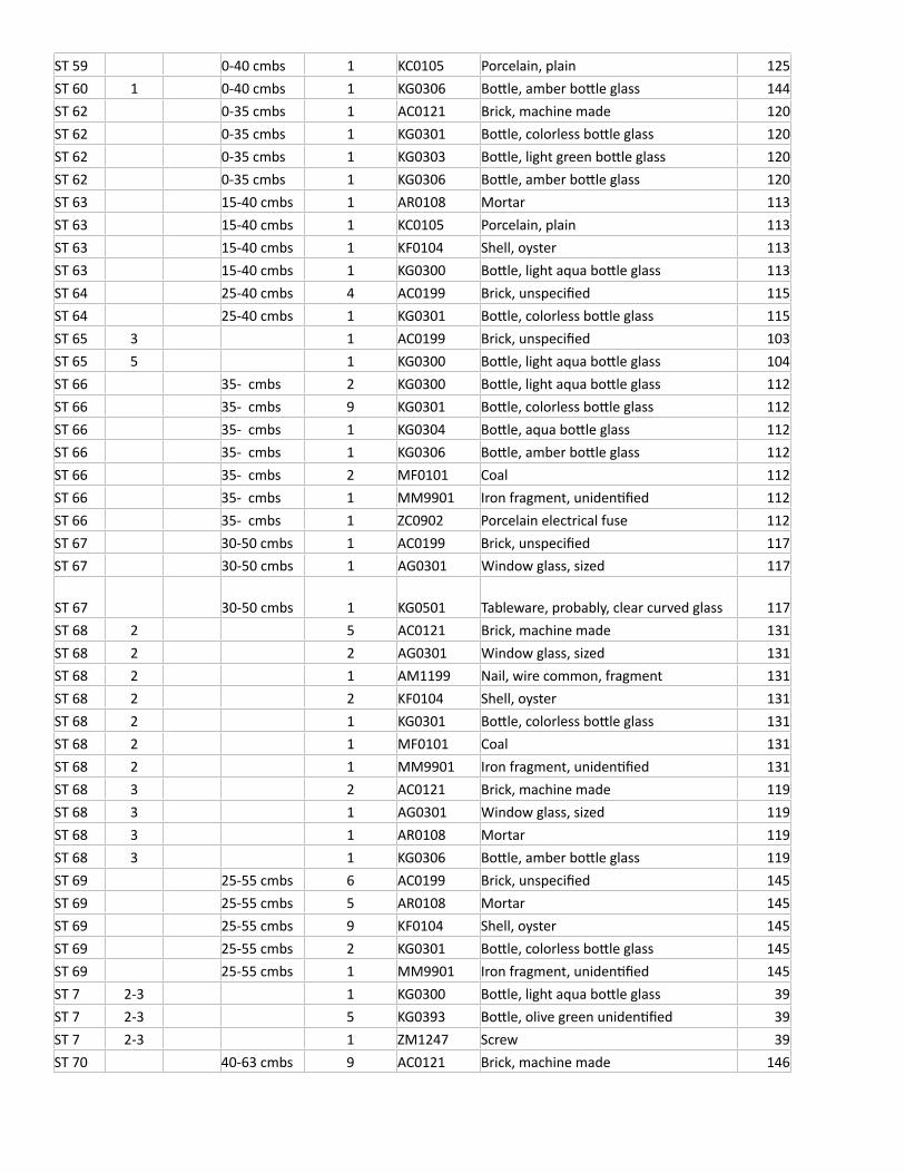
ST 59 0-40 cmbs 1 KC0105 Porcelain, plain 125ST 60 1 0-40 cmbs 1 KG0306 Bottle, amber bottle glass 144ST 62 0-35 cmbs 1 AC0121 Brick, machine made 120ST 62 0-35 cmbs 1 KG0301 Bottle, colorless bottle glass 120ST 62 0-35 cmbs 1 KG0303 Bottle, light green bottle glass 120ST 62 0-35 cmbs 1 KG0306 Bottle, amber bottle glass 120ST 63 15-40 cmbs 1 AR0108 Mortar 113ST 63 15-40 cmbs 1 KC0105 Porcelain, plain 113ST 63 15-40 cmbs 1 KF0104 Shell, oyster 113ST 63 15-40 cmbs 1 KG0300 Bottle, light aqua bottle glass 113ST 64 25-40 cmbs 4 AC0199 Brick, unspecified 115ST 64 25-40 cmbs 1 KG0301 Bottle, colorless bottle glass 115ST 65 3 1 AC0199 Brick, unspecified 103ST 65 5 1 KG0300 Bottle, light aqua bottle glass 104ST 66 35- cmbs 2 KG0300 Bottle, light aqua bottle glass 112ST 66 35- cmbs 9 KG0301 Bottle, colorless bottle glass 112ST 66 35- cmbs 1 KG0304 Bottle, aqua bottle glass 112ST 66 35- cmbs 1 KG0306 Bottle, amber bottle glass 112ST 66 35- cmbs 2 MF0101 Coal 112ST 66 35- cmbs 1 MM9901 Iron fragment, unidentified 112ST 66 35- cmbs 1 ZC0902 Porcelain electrical fuse 112ST 67 30-50 cmbs 1 AC0199 Brick, unspecified 117ST 67 30-50 cmbs 1 AG0301 Window glass, sized 117
ST 67 30-50 cmbs 1 KG0501 Tableware, probably, clear curved glass 117ST 68 2 5 AC0121 Brick, machine made 131ST 68 2 2 AG0301 Window glass, sized 131ST 68 2 1 AM1199 Nail, wire common, fragment 131ST 68 2 2 KF0104 Shell, oyster 131ST 68 2 1 KG0301 Bottle, colorless bottle glass 131ST 68 2 1 MF0101 Coal 131ST 68 2 1 MM9901 Iron fragment, unidentified 131ST 68 3 2 AC0121 Brick, machine made 119ST 68 3 1 AG0301 Window glass, sized 119ST 68 3 1 AR0108 Mortar 119ST 68 3 1 KG0306 Bottle, amber bottle glass 119ST 69 25-55 cmbs 6 AC0199 Brick, unspecified 145ST 69 25-55 cmbs 5 AR0108 Mortar 145ST 69 25-55 cmbs 9 KF0104 Shell, oyster 145ST 69 25-55 cmbs 2 KG0301 Bottle, colorless bottle glass 145ST 69 25-55 cmbs 1 MM9901 Iron fragment, unidentified 145ST 7 2-3 1 KG0300 Bottle, light aqua bottle glass 39ST 7 2-3 5 KG0393 Bottle, olive green unidentified 39ST 7 2-3 1 ZM1247 Screw 39ST 70 40-63 cmbs 9 AC0121 Brick, machine made 146
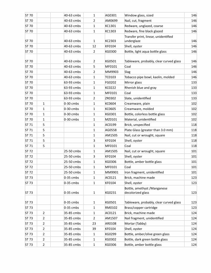
ST 70 40-63 cmbs 1 AG0301 Window glass, sized 146ST 70 40-63 cmbs 2 AM0699 Nail, cut, fragment 146ST 70 40-63 cmbs 1 KC1301 Redware, unglazed, coarse 146ST 70 40-63 cmbs 1 KC1303 Redware, fine black glazed 146
ST 70 40-63 cmbs 1 KC2303Transfer print, linear, unidentified underglaze 146
ST 70 40-63 cmbs 12 KF0104 Shell, oyster 146ST 70 40-63 cmbs 2 KG0300 Bottle, light aqua bottle glass 146
ST 70 40-63 cmbs 2 KG0501 Tableware, probably, clear curved glass 146ST 70 40-63 cmbs 5 MF0101 Coal 146ST 70 40-63 cmbs 2 MM9903 Slag 146ST 70 40-63 cmbs 1 TC0103 Tobacco pipe bowl, kaolin, molded 146ST 70 63-93 cmbs 1 FG0202 Mirror glass 133ST 70 63-93 cmbs 1 KC0222 Rhenish blue and gray 133ST 70 63-93 cmbs 1 MF0101 Coal 133ST 70 63-93 cmbs 2 ZR0302 Slate, unidentified 133ST 70 1 0-30 cmbs 1 KC0604 Creamware, plain 102ST 70 1 0-30 cmbs 1 KC0605 Creamware, molded 102ST 70 1 0-30 cmbs 1 KG0301 Bottle, colorless bottle glass 102ST 70 1 0-30 cmbs 1 MZ0101 Material, unidentified 102ST 71 5 1 AC0199 Brick, unspecified 118ST 71 5 1 AG0558 Plate Glass (greater than 3.0 mm) 118ST 71 5 1 AM1505 Nail, cut or wrought, square 118ST 71 5 3 KF0104 Shell, oyster 118ST 71 5 1 MF0101 Coal 118ST 72 25-50 cmbs 1 AM1505 Nail, cut or wrought, square 101ST 72 25-50 cmbs 3 KF0104 Shell, oyster 101ST 72 25-50 cmbs 1 KG0306 Bottle, amber bottle glass 101ST 72 25-50 cmbs 1 MF0101 Coal 101ST 72 25-50 cmbs 1 MM9901 Iron fragment, unidentified 101ST 73 0-35 cmbs 1 AC0121 Brick, machine made 123ST 73 0-35 cmbs 1 KF0104 Shell, oyster 123
ST 73 0-35 cmbs 1 KG0231Bottle, amethyst /Manganese decolorized glass 123
ST 73 0-35 cmbs 1 KG0501 Tableware, probably, clear curved glass 123ST 73 0-35 cmbs 1 RM0102 Brass/copper cartridge 123ST 73 2 35-85 cmbs 1 AC0121 Brick, machine made 124ST 73 2 35-85 cmbs 2 AM1507 Nail fragment, unidentified 124ST 73 2 35-85 cmbs 23 AR0108 Mortar (Tabby) 124ST 73 2 35-85 cmbs 39 KF0104 Shell, oyster 124ST 73 2 35-85 cmbs 1 KG0299 Bottle, amber/olive green glass 124ST 73 2 35-85 cmbs 1 KG0302 Bottle, dark green bottle glass 124ST 73 2 35-85 cmbs 1 KG0306 Bottle, amber bottle glass 124
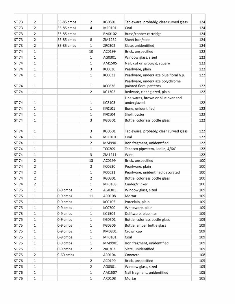
ST 73 2 35-85 cmbs 2 KG0501 Tableware, probably, clear curved glass 124ST 73 2 35-85 cmbs 4 MF0101 Coal 124ST 73 2 35-85 cmbs 1 RM0102 Brass/copper cartridge 124ST 73 2 35-85 cmbs 8 ZM1232 Sheet iron/steel 124ST 73 2 35-85 cmbs 1 ZR0302 Slate, unidentified 124ST 74 1 10 AC0199 Brick, unspecified 122ST 74 1 1 AG0301 Window glass, sized 122ST 74 1 1 AM1505 Nail, cut or wrought, square 122ST 74 1 3 KC0630 Pearlware, plain 122ST 74 1 1 KC0632 Pearlware, underglaze blue floral h.p. 122
ST 74 1 1 KC0636Pearlware, underglaze polychrome painted floral patterns 122
ST 74 1 2 KC1302 Redware, clear glazed, plain 122
ST 74 1 1 KC2103Line wares, brown or blue over and underglazed 122
ST 74 1 1 KF0101 Bone, unidentified 122ST 74 1 1 KF0104 Shell, oyster 122ST 74 1 3 KG0301 Bottle, colorless bottle glass 122
ST 74 1 3 KG0501 Tableware, probably, clear curved glass 122ST 74 1 6 MF0101 Coal 122ST 74 1 2 MM9901 Iron fragment, unidentified 122ST 74 1 1 TC0209 Tobacco pipestem, kaolin, 4/64” 122ST 74 1 3 ZM1211 Wire 122ST 74 2 13 AC0199 Brick, unspecified 100ST 74 2 2 KC0630 Pearlware, plain 100ST 74 2 1 KC0631 Pearlware, unidentified decorated 100ST 74 2 2 KG0301 Bottle, colorless bottle glass 100ST 74 2 1 MF0103 Cinder/clinker 100ST 75 1 0-9 cmbs 2 AG0301 Window glass, sized 109ST 75 1 0-9 cmbs 11 AR0108 Mortar 109ST 75 1 0-9 cmbs 1 KC0105 Porcelain, plain 109ST 75 1 0-9 cmbs 1 KC0700 Whiteware, plain 109ST 75 1 0-9 cmbs 1 KC1504 Delftware, blue h.p. 109ST 75 1 0-9 cmbs 1 KG0301 Bottle, colorless bottle glass 109ST 75 1 0-9 cmbs 1 KG0306 Bottle, amber bottle glass 109ST 75 1 0-9 cmbs 1 KM0301 Crown cap 109ST 75 1 0-9 cmbs 1 MF0101 Coal 109ST 75 1 0-9 cmbs 1 MM9901 Iron fragment, unidentified 109ST 75 1 0-9 cmbs 2 ZR0302 Slate, unidentified 109ST 75 2 9-60 cmbs 1 AR0104 Concrete 108ST 76 1 2 AC0199 Brick, unspecified 105ST 76 1 2 AG0301 Window glass, sized 105ST 76 1 1 AM1507 Nail fragment, unidentified 105ST 76 1 1 AR0108 Mortar 105
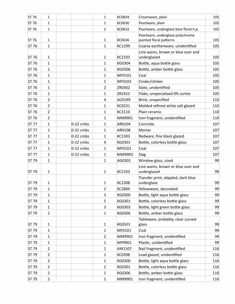
ST 76 1 1 KC0604 Creamware, plain 105ST 76 1 1 KC0630 Pearlware, plain 105ST 76 1 2 KC0632 Pearlware, underglaze blue floral h.p. 105
ST 76 1 1 KC0636Pearlware, underglaze polychrome painted floral patterns 105
ST 76 1 1 KC1299 Coarse earthenware, unidentified 105
ST 76 1 1 KC2103Line wares, brown or blue over and underglazed 105
ST 76 1 1 KG0304 Bottle, aqua bottle glass 105ST 76 1 1 KG0306 Bottle, amber bottle glass 105ST 76 1 1 MF0101 Coal 105ST 76 1 1 MF0103 Cinder/clinker 105ST 76 1 2 ZR0302 Slate, unidentified 105ST 76 1 1 ZR2422 Flake, unspecialized 0% cortex 105ST 76 2 4 AC0199 Brick, unspecified 110ST 76 2 1 KC0231 Molded refined white salt glazed 110ST 76 2 1 KC3110 Plain ceramic 110ST 76 2 1 MM9901 Iron fragment, unidentified 110ST 77 1 0-22 cmbs 1 AR0104 Concrete 107ST 77 1 0-22 cmbs 1 AR0108 Mortar 107ST 77 1 0-22 cmbs 1 KC1303 Redware, fine black glazed 107ST 77 1 0-22 cmbs 4 KG0301 Bottle, colorless bottle glass 107ST 77 1 0-22 cmbs 1 MF0101 Coal 107ST 77 1 0-22 cmbs 1 MM9903 Slag 107ST 79 1 1 AG0301 Window glass, sized 99
ST 79 1 1 KC2103Line wares, brown or blue over and underglazed 99
ST 79 1 1 KC2308Transfer print, stippled, dark blue underglaze 99
ST 79 1 2 KC2800 Yellowware, decorated 99ST 79 1 3 KG0300 Bottle, light aqua bottle glass 99ST 79 1 5 KG0301 Bottle, colorless bottle glass 99ST 79 1 3 KG0303 Bottle, light green bottle glass 99ST 79 1 1 KG0306 Bottle, amber bottle glass 99
ST 79 1 1 KG0501Tableware, probably, clear curved glass 99
ST 79 1 1 MF0101 Coal 99ST 79 1 2 MM9901 Iron fragment, unidentified 99ST 79 1 1 MP9901 Plastic, unidentified 99ST 79 2 1 AM1507 Nail fragment, unidentified 116ST 79 2 1 KC0398 Lead glazed, unidentified 116ST 79 2 1 KG0300 Bottle, light aqua bottle glass 116ST 79 2 2 KG0301 Bottle, colorless bottle glass 116ST 79 2 1 KG0306 Bottle, amber bottle glass 116ST 79 2 1 MM9901 Iron fragment, unidentified 116

ST 79 2 1 MZ0101 Material, unidentified 116ST 79 3 1 AC0121 Brick, machine made 121ST 79 3 2 AG0301 Window glass, sized 121ST 79 3 1 KC1304 Redware, black glazed, unrefined 121ST 79 3 2 KF0104 Shell, oyster 121ST 79 3 2 KG0301 Bottle, colorless bottle glass 121ST 79 3 1 MM9901 Iron fragment, unidentified 121ST 79 3 1 MM9903 Slag 121ST 79 3 2 ZR0302 Slate, unidentified 121ST 8 1 1 AC0110 Water pipe, ceramic 16ST 8 1 9 AC0199 Brick, unspecified 16ST 8 1 1 AF0102 Asphalt, roofing 16ST 8 1 6 AG0301 Window glass, sized 16ST 8 1 1 AG0558 Plate Glass (greater than 3.0 mm) 16ST 8 1 5 AM1507 Nail fragment, unidentified 16ST 8 1 1 AR0104 Concrete 16
ST 8 1 1 KC0501Ironstone, plain blue tinted stone china 16
ST 8 1 11 KG0301 Bottle, colorless bottle glass 16ST 8 1 2 KG0304 Bottle, aqua bottle glass 16ST 8 1 1 KG0306 Bottle, amber bottle glass 16ST 8 1 1 KG0401 Bottle, machine made 16ST 8 1 2 MF0101 Coal 16ST 8 1 4 MF0103 Cinder/clinker 16ST 8 1 1 MM9901 Iron fragment, unidentified 16ST 8 1 4 MM9903 Slag 16ST 8 1 1 MZ0102 Modern miscellaneous 16ST 8 1 18 ZM1232 Sheet iron/steel 16ST 8 2 4 AC0121 Brick, machine made 17ST 8 2 5 AG0301 Window glass, sized 17ST 8 2 1 AM1101 Nail, wire common 17ST 8 2 5 AM1507 Nail fragment, unidentified 17ST 8 2 1 AR0108 Mortar 17ST 8 2 1 KC0105 Porcelain, plain 17ST 8 2 4 KF0104 Shell, oyster 17ST 8 2 1 KG0300 Bottle, light aqua bottle glass 17ST 8 2 3 KG0301 Bottle, colorless bottle glass 17ST 8 2 1 KG0306 Bottle, amber bottle glass 17ST 8 2 4 MF0101 Coal 17ST 8 2 3 MF0103 Cinder/clinker 17ST 8 2 1 MM9901 Iron fragment, unidentified 17ST 8 3 1 AC0199 Brick, unspecified 18ST 8 3 1 AG0301 Window glass, sized 18ST 8 3 1 AM1507 Nail fragment, unidentified 18
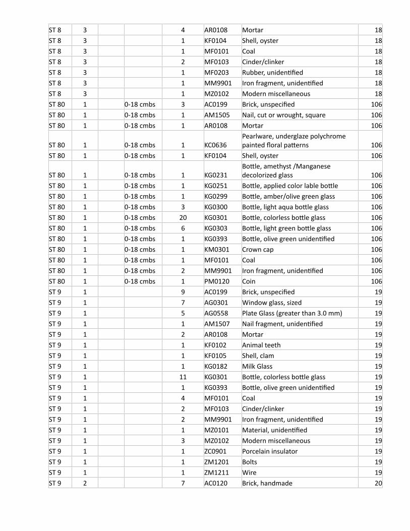
ST 8 3 4 AR0108 Mortar 18ST 8 3 1 KF0104 Shell, oyster 18ST 8 3 1 MF0101 Coal 18ST 8 3 2 MF0103 Cinder/clinker 18ST 8 3 1 MF0203 Rubber, unidentified 18ST 8 3 1 MM9901 Iron fragment, unidentified 18ST 8 3 1 MZ0102 Modern miscellaneous 18ST 80 1 0-18 cmbs 3 AC0199 Brick, unspecified 106ST 80 1 0-18 cmbs 1 AM1505 Nail, cut or wrought, square 106ST 80 1 0-18 cmbs 1 AR0108 Mortar 106
ST 80 1 0-18 cmbs 1 KC0636Pearlware, underglaze polychrome painted floral patterns 106
ST 80 1 0-18 cmbs 1 KF0104 Shell, oyster 106
ST 80 1 0-18 cmbs 1 KG0231Bottle, amethyst /Manganese decolorized glass 106
ST 80 1 0-18 cmbs 1 KG0251 Bottle, applied color lable bottle 106ST 80 1 0-18 cmbs 1 KG0299 Bottle, amber/olive green glass 106ST 80 1 0-18 cmbs 3 KG0300 Bottle, light aqua bottle glass 106ST 80 1 0-18 cmbs 20 KG0301 Bottle, colorless bottle glass 106ST 80 1 0-18 cmbs 6 KG0303 Bottle, light green bottle glass 106ST 80 1 0-18 cmbs 1 KG0393 Bottle, olive green unidentified 106ST 80 1 0-18 cmbs 1 KM0301 Crown cap 106ST 80 1 0-18 cmbs 1 MF0101 Coal 106ST 80 1 0-18 cmbs 2 MM9901 Iron fragment, unidentified 106ST 80 1 0-18 cmbs 1 PM0120 Coin 106ST 9 1 9 AC0199 Brick, unspecified 19ST 9 1 7 AG0301 Window glass, sized 19ST 9 1 5 AG0558 Plate Glass (greater than 3.0 mm) 19ST 9 1 1 AM1507 Nail fragment, unidentified 19ST 9 1 2 AR0108 Mortar 19ST 9 1 1 KF0102 Animal teeth 19ST 9 1 1 KF0105 Shell, clam 19ST 9 1 1 KG0182 Milk Glass 19ST 9 1 11 KG0301 Bottle, colorless bottle glass 19ST 9 1 1 KG0393 Bottle, olive green unidentified 19ST 9 1 4 MF0101 Coal 19ST 9 1 2 MF0103 Cinder/clinker 19ST 9 1 2 MM9901 Iron fragment, unidentified 19ST 9 1 1 MZ0101 Material, unidentified 19ST 9 1 3 MZ0102 Modern miscellaneous 19ST 9 1 1 ZC0901 Porcelain insulator 19ST 9 1 1 ZM1201 Bolts 19ST 9 1 1 ZM1211 Wire 19ST 9 2 7 AC0120 Brick, handmade 20
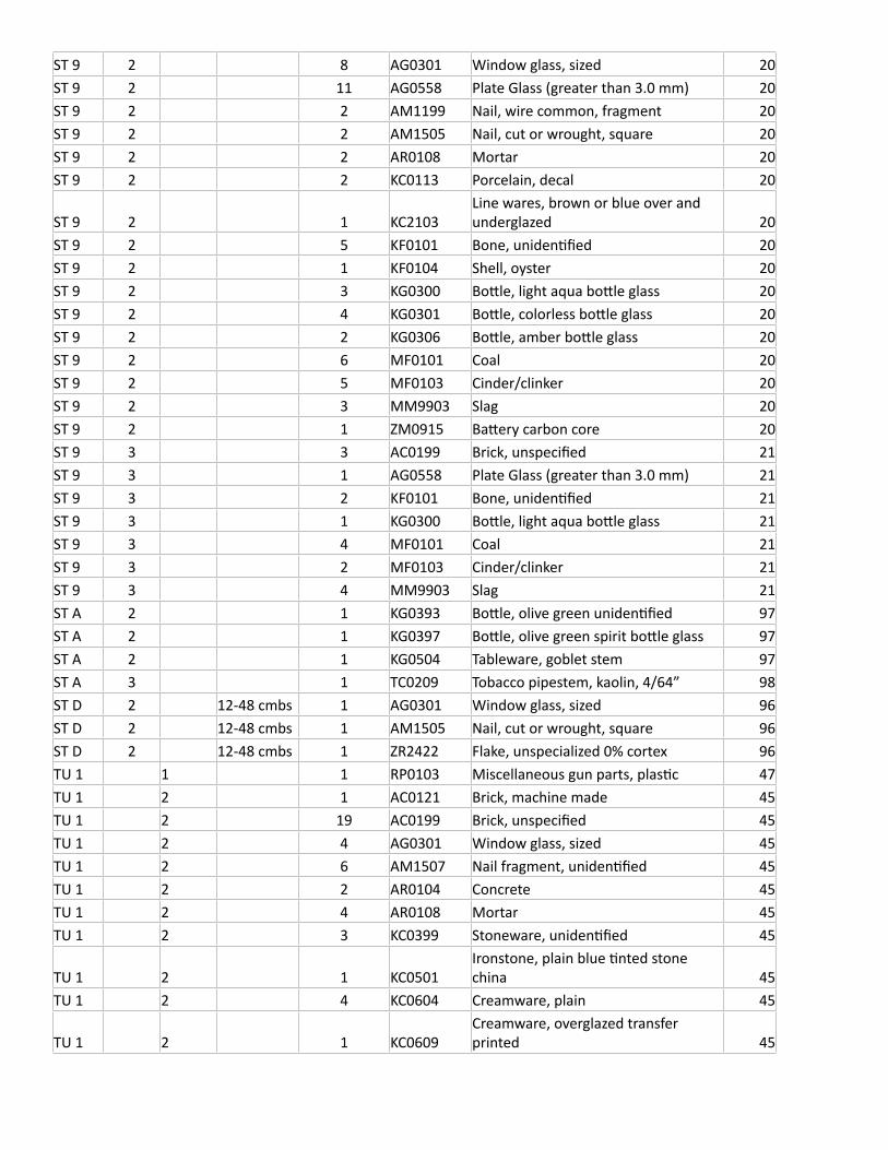
ST 9 2 8 AG0301 Window glass, sized 20ST 9 2 11 AG0558 Plate Glass (greater than 3.0 mm) 20ST 9 2 2 AM1199 Nail, wire common, fragment 20ST 9 2 2 AM1505 Nail, cut or wrought, square 20ST 9 2 2 AR0108 Mortar 20ST 9 2 2 KC0113 Porcelain, decal 20
ST 9 2 1 KC2103Line wares, brown or blue over and underglazed 20
ST 9 2 5 KF0101 Bone, unidentified 20ST 9 2 1 KF0104 Shell, oyster 20ST 9 2 3 KG0300 Bottle, light aqua bottle glass 20ST 9 2 4 KG0301 Bottle, colorless bottle glass 20ST 9 2 2 KG0306 Bottle, amber bottle glass 20ST 9 2 6 MF0101 Coal 20ST 9 2 5 MF0103 Cinder/clinker 20ST 9 2 3 MM9903 Slag 20ST 9 2 1 ZM0915 Battery carbon core 20ST 9 3 3 AC0199 Brick, unspecified 21ST 9 3 1 AG0558 Plate Glass (greater than 3.0 mm) 21ST 9 3 2 KF0101 Bone, unidentified 21ST 9 3 1 KG0300 Bottle, light aqua bottle glass 21ST 9 3 4 MF0101 Coal 21ST 9 3 2 MF0103 Cinder/clinker 21ST 9 3 4 MM9903 Slag 21ST A 2 1 KG0393 Bottle, olive green unidentified 97ST A 2 1 KG0397 Bottle, olive green spirit bottle glass 97ST A 2 1 KG0504 Tableware, goblet stem 97ST A 3 1 TC0209 Tobacco pipestem, kaolin, 4/64” 98ST D 2 12-48 cmbs 1 AG0301 Window glass, sized 96ST D 2 12-48 cmbs 1 AM1505 Nail, cut or wrought, square 96ST D 2 12-48 cmbs 1 ZR2422 Flake, unspecialized 0% cortex 96TU 1 1 1 RP0103 Miscellaneous gun parts, plastic 47TU 1 2 1 AC0121 Brick, machine made 45TU 1 2 19 AC0199 Brick, unspecified 45TU 1 2 4 AG0301 Window glass, sized 45TU 1 2 6 AM1507 Nail fragment, unidentified 45TU 1 2 2 AR0104 Concrete 45TU 1 2 4 AR0108 Mortar 45TU 1 2 3 KC0399 Stoneware, unidentified 45
TU 1 2 1 KC0501Ironstone, plain blue tinted stone china 45
TU 1 2 4 KC0604 Creamware, plain 45
TU 1 2 1 KC0609Creamware, overglazed transfer printed 45
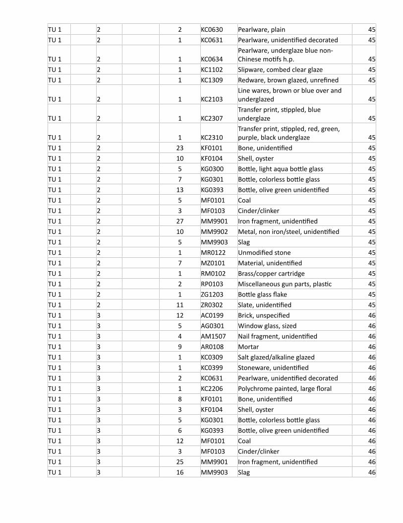
TU 1 2 2 KC0630 Pearlware, plain 45TU 1 2 1 KC0631 Pearlware, unidentified decorated 45
TU 1 2 1 KC0634Pearlware, underglaze blue non-Chinese motifs h.p. 45
TU 1 2 1 KC1102 Slipware, combed clear glaze 45TU 1 2 1 KC1309 Redware, brown glazed, unrefined 45
TU 1 2 1 KC2103Line wares, brown or blue over and underglazed 45
TU 1 2 1 KC2307Transfer print, stippled, blue underglaze 45
TU 1 2 1 KC2310Transfer print, stippled, red, green, purple, black underglaze 45
TU 1 2 23 KF0101 Bone, unidentified 45TU 1 2 10 KF0104 Shell, oyster 45TU 1 2 5 KG0300 Bottle, light aqua bottle glass 45TU 1 2 7 KG0301 Bottle, colorless bottle glass 45TU 1 2 13 KG0393 Bottle, olive green unidentified 45TU 1 2 5 MF0101 Coal 45TU 1 2 3 MF0103 Cinder/clinker 45TU 1 2 27 MM9901 Iron fragment, unidentified 45TU 1 2 10 MM9902 Metal, non iron/steel, unidentified 45TU 1 2 5 MM9903 Slag 45TU 1 2 1 MR0122 Unmodified stone 45TU 1 2 7 MZ0101 Material, unidentified 45TU 1 2 1 RM0102 Brass/copper cartridge 45TU 1 2 2 RP0103 Miscellaneous gun parts, plastic 45TU 1 2 1 ZG1203 Bottle glass flake 45TU 1 2 11 ZR0302 Slate, unidentified 45TU 1 3 12 AC0199 Brick, unspecified 46TU 1 3 5 AG0301 Window glass, sized 46TU 1 3 4 AM1507 Nail fragment, unidentified 46TU 1 3 9 AR0108 Mortar 46TU 1 3 1 KC0309 Salt glazed/alkaline glazed 46TU 1 3 1 KC0399 Stoneware, unidentified 46TU 1 3 2 KC0631 Pearlware, unidentified decorated 46TU 1 3 1 KC2206 Polychrome painted, large floral 46TU 1 3 8 KF0101 Bone, unidentified 46TU 1 3 3 KF0104 Shell, oyster 46TU 1 3 5 KG0301 Bottle, colorless bottle glass 46TU 1 3 6 KG0393 Bottle, olive green unidentified 46TU 1 3 12 MF0101 Coal 46TU 1 3 3 MF0103 Cinder/clinker 46TU 1 3 25 MM9901 Iron fragment, unidentified 46TU 1 3 16 MM9903 Slag 46
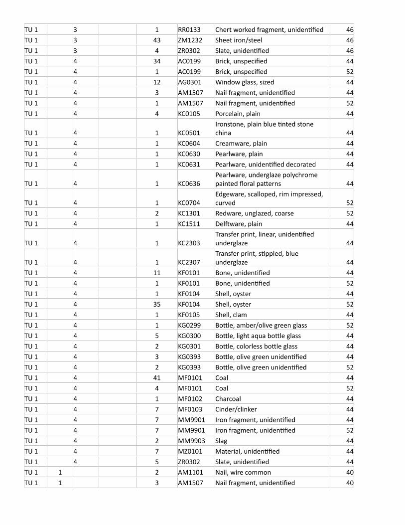
TU 1 3 1 RR0133 Chert worked fragment, unidentified 46TU 1 3 43 ZM1232 Sheet iron/steel 46TU 1 3 4 ZR0302 Slate, unidentified 46TU 1 4 34 AC0199 Brick, unspecified 44TU 1 4 1 AC0199 Brick, unspecified 52TU 1 4 12 AG0301 Window glass, sized 44TU 1 4 3 AM1507 Nail fragment, unidentified 44TU 1 4 1 AM1507 Nail fragment, unidentified 52TU 1 4 4 KC0105 Porcelain, plain 44
TU 1 4 1 KC0501Ironstone, plain blue tinted stone china 44
TU 1 4 1 KC0604 Creamware, plain 44TU 1 4 1 KC0630 Pearlware, plain 44TU 1 4 1 KC0631 Pearlware, unidentified decorated 44
TU 1 4 1 KC0636Pearlware, underglaze polychrome painted floral patterns 44
TU 1 4 1 KC0704Edgeware, scalloped, rim impressed, curved 52
TU 1 4 2 KC1301 Redware, unglazed, coarse 52TU 1 4 1 KC1511 Delftware, plain 44
TU 1 4 1 KC2303Transfer print, linear, unidentified underglaze 44
TU 1 4 1 KC2307Transfer print, stippled, blue underglaze 44
TU 1 4 11 KF0101 Bone, unidentified 44TU 1 4 1 KF0101 Bone, unidentified 52TU 1 4 1 KF0104 Shell, oyster 44TU 1 4 35 KF0104 Shell, oyster 52TU 1 4 1 KF0105 Shell, clam 44TU 1 4 1 KG0299 Bottle, amber/olive green glass 52TU 1 4 5 KG0300 Bottle, light aqua bottle glass 44TU 1 4 2 KG0301 Bottle, colorless bottle glass 44TU 1 4 3 KG0393 Bottle, olive green unidentified 44TU 1 4 2 KG0393 Bottle, olive green unidentified 52TU 1 4 41 MF0101 Coal 44TU 1 4 4 MF0101 Coal 52TU 1 4 1 MF0102 Charcoal 44TU 1 4 7 MF0103 Cinder/clinker 44TU 1 4 7 MM9901 Iron fragment, unidentified 44TU 1 4 7 MM9901 Iron fragment, unidentified 52TU 1 4 2 MM9903 Slag 44TU 1 4 7 MZ0101 Material, unidentified 44TU 1 4 5 ZR0302 Slate, unidentified 44TU 1 1 2 AM1101 Nail, wire common 40TU 1 1 3 AM1507 Nail fragment, unidentified 40
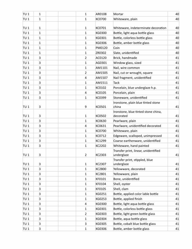
TU 1 1 1 AR0108 Mortar 40TU 1 1 1 KC0700 Whiteware, plain 40
TU 1 1 1 KC0701 Whiteware, indeterminate decoration 40TU 1 1 1 KG0300 Bottle, light aqua bottle glass 40TU 1 1 1 KG0301 Bottle, colorless bottle glass 40TU 1 1 1 KG0306 Bottle, amber bottle glass 40TU 1 1 1 PM0120 Coin 40TU 1 1 1 ZR0302 Slate, unidentified 40TU 1 3 2 AC0120 Brick, handmade 41TU 1 3 1 AG0301 Window glass, sized 41TU 1 3 1 AM1101 Nail, wire common 41TU 1 3 2 AM1505 Nail, cut or wrought, square 41TU 1 3 4 AM1507 Nail fragment, unidentified 41TU 1 3 1 AM1511 Tack 41TU 1 3 1 KC0102 Porcelain, blue underglaze h.p. 41TU 1 3 4 KC0105 Porcelain, plain 41TU 1 3 1 KC0399 Stoneware, unidentified 41
TU 1 3 9 KC0501Ironstone, plain blue tinted stone china 41
TU 1 3 1 KC0502Ironstone, blue tinted stone china, decorated 41
TU 1 3 1 KC0630 Pearlware, plain 41TU 1 3 4 KC0631 Pearlware, unidentified decorated 41TU 1 3 1 KC0700 Whiteware, plain 41TU 1 3 1 KC0712 Edgeware, scalloped, unimpressed 41TU 1 3 1 KC1299 Coarse earthenware, unidentified 41TU 1 3 1 KC2202 Whiteware, hand painted 41
TU 1 3 2 KC2303Transfer print, linear, unidentified underglaze 41
TU 1 3 1 KC2307Transfer print, stippled, blue underglaze 41
TU 1 3 1 KC2800 Yellowware, decorated 41TU 1 3 1 KC2801 Yellowware, plain 41TU 1 3 1 KF0101 Bone, unidentified 41TU 1 3 1 KF0104 Shell, oyster 41TU 1 3 1 KF0105 Shell, clam 41TU 1 3 1 KG0251 Bottle, applied color lable bottle 41TU 1 3 1 KG0253 Bottle, applied finish 41TU 1 3 4 KG0300 Bottle, light aqua bottle glass 41TU 1 3 1 KG0301 Bottle, colorless bottle glass 41TU 1 3 2 KG0303 Bottle, light green bottle glass 41TU 1 3 1 KG0304 Bottle, aqua bottle glass 41TU 1 3 3 KG0305 Bottle, cobalt blue bottle glass 41TU 1 3 1 KG0306 Bottle, amber bottle glass 41
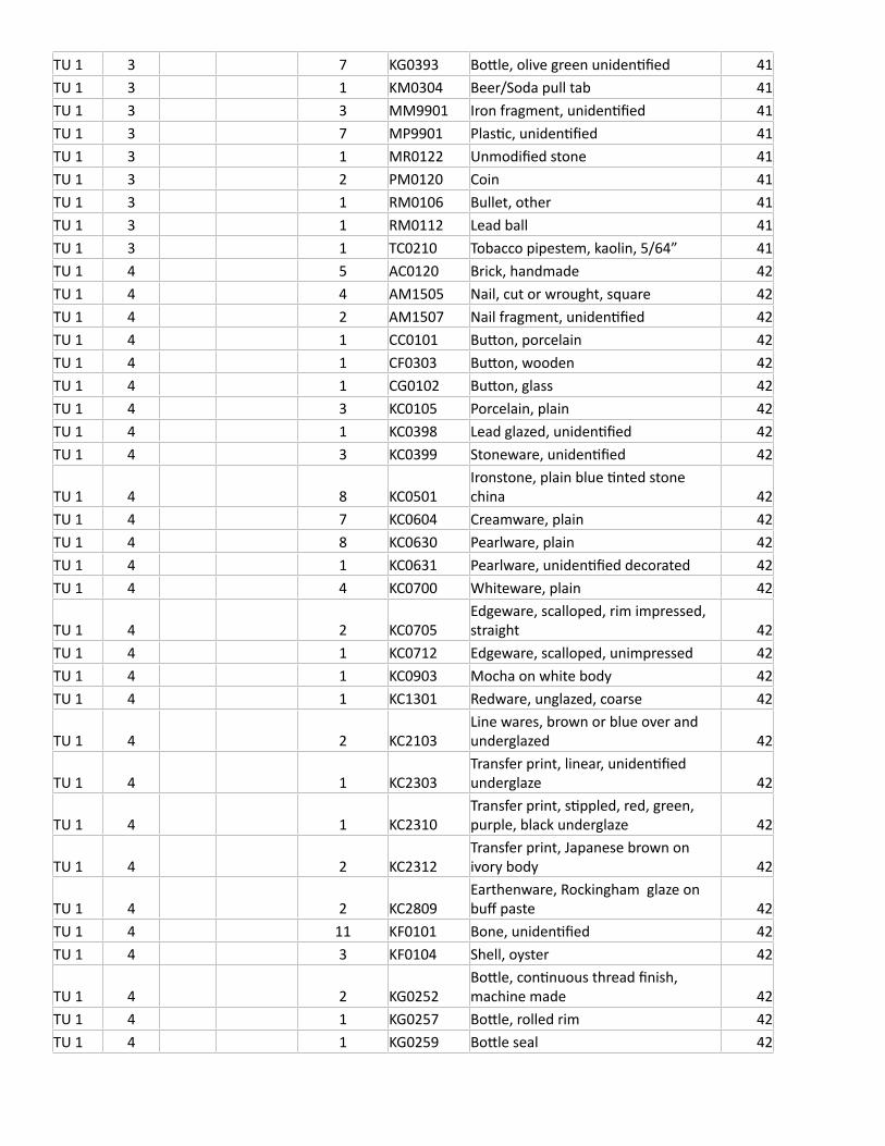
TU 1 3 7 KG0393 Bottle, olive green unidentified 41TU 1 3 1 KM0304 Beer/Soda pull tab 41TU 1 3 3 MM9901 Iron fragment, unidentified 41TU 1 3 7 MP9901 Plastic, unidentified 41TU 1 3 1 MR0122 Unmodified stone 41TU 1 3 2 PM0120 Coin 41TU 1 3 1 RM0106 Bullet, other 41TU 1 3 1 RM0112 Lead ball 41TU 1 3 1 TC0210 Tobacco pipestem, kaolin, 5/64” 41TU 1 4 5 AC0120 Brick, handmade 42TU 1 4 4 AM1505 Nail, cut or wrought, square 42TU 1 4 2 AM1507 Nail fragment, unidentified 42TU 1 4 1 CC0101 Button, porcelain 42TU 1 4 1 CF0303 Button, wooden 42TU 1 4 1 CG0102 Button, glass 42TU 1 4 3 KC0105 Porcelain, plain 42TU 1 4 1 KC0398 Lead glazed, unidentified 42TU 1 4 3 KC0399 Stoneware, unidentified 42
TU 1 4 8 KC0501Ironstone, plain blue tinted stone china 42
TU 1 4 7 KC0604 Creamware, plain 42TU 1 4 8 KC0630 Pearlware, plain 42TU 1 4 1 KC0631 Pearlware, unidentified decorated 42TU 1 4 4 KC0700 Whiteware, plain 42
TU 1 4 2 KC0705Edgeware, scalloped, rim impressed, straight 42
TU 1 4 1 KC0712 Edgeware, scalloped, unimpressed 42TU 1 4 1 KC0903 Mocha on white body 42TU 1 4 1 KC1301 Redware, unglazed, coarse 42
TU 1 4 2 KC2103Line wares, brown or blue over and underglazed 42
TU 1 4 1 KC2303Transfer print, linear, unidentified underglaze 42
TU 1 4 1 KC2310Transfer print, stippled, red, green, purple, black underglaze 42
TU 1 4 2 KC2312Transfer print, Japanese brown on ivory body 42
TU 1 4 2 KC2809Earthenware, Rockingham glaze on buff paste 42
TU 1 4 11 KF0101 Bone, unidentified 42TU 1 4 3 KF0104 Shell, oyster 42
TU 1 4 2 KG0252Bottle, continuous thread finish, machine made 42
TU 1 4 1 KG0257 Bottle, rolled rim 42TU 1 4 1 KG0259 Bottle seal 42
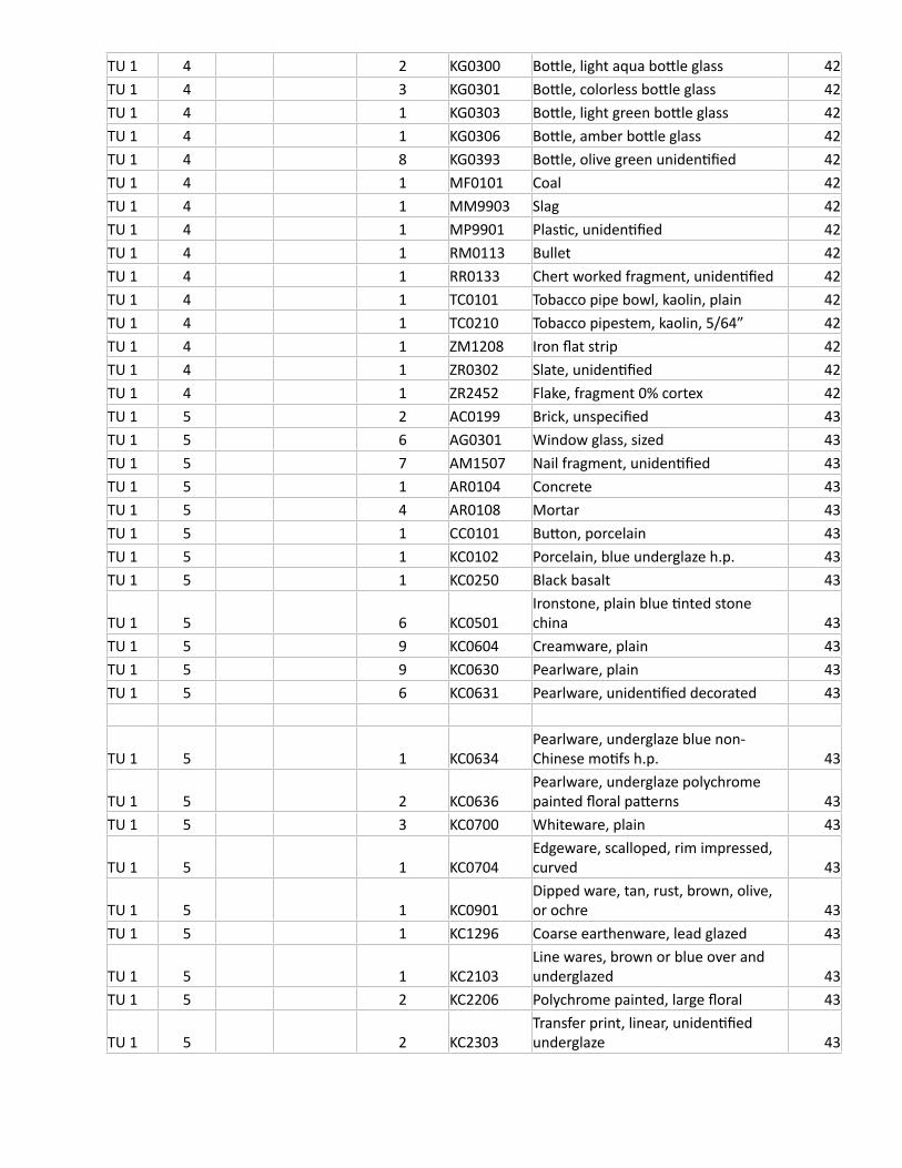
TU 1 4 2 KG0300 Bottle, light aqua bottle glass 42TU 1 4 3 KG0301 Bottle, colorless bottle glass 42TU 1 4 1 KG0303 Bottle, light green bottle glass 42TU 1 4 1 KG0306 Bottle, amber bottle glass 42TU 1 4 8 KG0393 Bottle, olive green unidentified 42TU 1 4 1 MF0101 Coal 42TU 1 4 1 MM9903 Slag 42TU 1 4 1 MP9901 Plastic, unidentified 42TU 1 4 1 RM0113 Bullet 42TU 1 4 1 RR0133 Chert worked fragment, unidentified 42TU 1 4 1 TC0101 Tobacco pipe bowl, kaolin, plain 42TU 1 4 1 TC0210 Tobacco pipestem, kaolin, 5/64” 42TU 1 4 1 ZM1208 Iron flat strip 42TU 1 4 1 ZR0302 Slate, unidentified 42TU 1 4 1 ZR2452 Flake, fragment 0% cortex 42TU 1 5 2 AC0199 Brick, unspecified 43TU 1 5 6 AG0301 Window glass, sized 43TU 1 5 7 AM1507 Nail fragment, unidentified 43TU 1 5 1 AR0104 Concrete 43TU 1 5 4 AR0108 Mortar 43TU 1 5 1 CC0101 Button, porcelain 43TU 1 5 1 KC0102 Porcelain, blue underglaze h.p. 43TU 1 5 1 KC0250 Black basalt 43
TU 1 5 6 KC0501Ironstone, plain blue tinted stone china 43
TU 1 5 9 KC0604 Creamware, plain 43TU 1 5 9 KC0630 Pearlware, plain 43TU 1 5 6 KC0631 Pearlware, unidentified decorated 43
TU 1 5 1 KC0634Pearlware, underglaze blue non-Chinese motifs h.p. 43
TU 1 5 2 KC0636Pearlware, underglaze polychrome painted floral patterns 43
TU 1 5 3 KC0700 Whiteware, plain 43
TU 1 5 1 KC0704Edgeware, scalloped, rim impressed, curved 43
TU 1 5 1 KC0901Dipped ware, tan, rust, brown, olive, or ochre 43
TU 1 5 1 KC1296 Coarse earthenware, lead glazed 43
TU 1 5 1 KC2103Line wares, brown or blue over and underglazed 43
TU 1 5 2 KC2206 Polychrome painted, large floral 43
TU 1 5 2 KC2303Transfer print, linear, unidentified underglaze 43

TU 1 5 4 KC2307Transfer print, stippled, blue underglaze 43
TU 1 5 2 KC2401 Refined earthenware, molded 43TU 1 5 3 KC2702 Refined earthenware, decal 43TU 1 5 7 KF0101 Bone, unidentified 43TU 1 5 5 KF0104 Shell, oyster 43TU 1 5 1 KF0105 Shell, clam 43TU 1 5 1 KG0300 Bottle, light aqua bottle glass 43TU 1 5 4 KG0301 Bottle, colorless bottle glass 43TU 1 5 1 KG0302 Bottle, dark green bottle glass 43TU 1 5 1 KG0305 Bottle, cobalt blue bottle glass 43TU 1 5 15 KG0393 Bottle, olive green unidentified 43TU 1 5 2 MF0101 Coal 43TU 1 5 2 MM9901 Iron fragment, unidentified 43TU 1 5 1 MM9902 Metal, non iron/steel, unidentified 43TU 1 5 1 MM9903 Slag 43TU 1 5 1 PF0201 Pencil, part 43TU 1 5 1 PR0102 Slate pencil 43TU 1 5 1 RR0133 Chert worked fragment, unidentified 43TU 1 5 1 TC0101 Tobacco pipe bowl, kaolin, plain 43TU 1 5 1 TC0210 Tobacco pipestem, kaolin, 5/64” 43TU 1 5 4 ZR0302 Slate, unidentified 43TU 1 6 73-83 cm bd 77 AC0199 Brick, unspecified 48TU 1 6 73-83 cm bd 1 AC0200 Tile, ceramic 48TU 1 6 73-83 cm bd 1 AG0301 Window glass, sized 48TU 1 6 73-83 cm bd 7 AM1507 Nail fragment, unidentified 48TU 1 6 73-83 cm bd 1 AR0108 Mortar 48TU 1 6 73-83 cm bd 1 KC0102 Porcelain, blue underglaze h.p. 48TU 1 6 73-83 cm bd 1 KC0105 Porcelain, plain 48TU 1 6 73-83 cm bd 1 KC0309 Salt glazed/alkaline glazed 48TU 1 6 73-83 cm bd 1 KC0399 Stoneware, unidentified 48TU 1 6 73-83 cm bd 6 KC0604 Creamware, plain 48TU 1 6 73-83 cm bd 2 KC0630 Pearlware, plain 48TU 1 6 73-83 cm bd 2 KC0631 Pearlware, unidentified decorated 48TU 1 6 73-83 cm bd 1 KC1301 Redware, unglazed, coarse 48
TU 1 6 73-83 cm bd 1 KC2307Transfer print, stippled, blue underglaze 48
TU 1 6 73-83 cm bd 22 KF0101 Bone, unidentified 48TU 1 6 73-83 cm bd 42 KF0104 Shell, oyster 48TU 1 6 73-83 cm bd 3 KG0301 Bottle, colorless bottle glass 48TU 1 6 73-83 cm bd 2 KG0304 Bottle, aqua bottle glass 48TU 1 6 73-83 cm bd 7 KG0393 Bottle, olive green unidentified 48TU 1 6 73-83 cm bd 9 MF0101 Coal 48TU 1 6 73-83 cm bd 15 MF0102 Charcoal 48
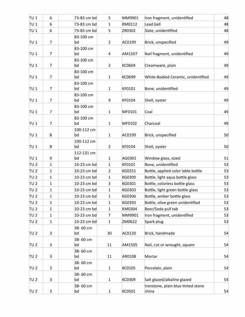
TU 1 6 73-83 cm bd 5 MM9901 Iron fragment, unidentified 48TU 1 6 73-83 cm bd 1 RM0112 Lead ball 48TU 1 6 73-83 cm bd 5 ZR0302 Slate, unidentified 48
TU 1 783-100 cm bd 2 AC0199 Brick, unspecified 49
TU 1 783-100 cm bd 4 AM1507 Nail fragment, unidentified 49
TU 1 783-100 cm bd 2 KC0604 Creamware, plain 49
TU 1 783-100 cm bd 1 KC0699 White-Bodied Ceramic, unidentified 49
TU 1 783-100 cm bd 1 KF0101 Bone, unidentified 49
TU 1 783-100 cm bd 9 KF0104 Shell, oyster 49
TU 1 783-100 cm bd 1 MF0101 Coal 49
TU 1 783-100 cm bd 1 MF0102 Charcoal 49
TU 1 8100-112 cm bd 1 AC0199 Brick, unspecified 50
TU 1 8100-112 cm bd 2 KF0104 Shell, oyster 50
TU 1 9112-131 cm bd 1 AG0301 Window glass, sized 51
TU 2 1 10-23 cm bd 1 KF0101 Bone, unidentified 53TU 2 1 10-23 cm bd 2 KG0251 Bottle, applied color lable bottle 53TU 2 1 10-23 cm bd 1 KG0300 Bottle, light aqua bottle glass 53TU 2 1 10-23 cm bd 3 KG0301 Bottle, colorless bottle glass 53TU 2 1 10-23 cm bd 1 KG0303 Bottle, light green bottle glass 53TU 2 1 10-23 cm bd 1 KG0306 Bottle, amber bottle glass 53TU 2 1 10-23 cm bd 1 KG0393 Bottle, olive green unidentified 53TU 2 1 10-23 cm bd 1 KM0304 Beer/Soda pull tab 53TU 2 1 10-23 cm bd 7 MM9901 Iron fragment, unidentified 53TU 2 1 10-23 cm bd 1 ZM0622 Spark plug 53
TU 2 338- 60 cm bd 30 AC0120 Brick, handmade 54
TU 2 338- 60 cm bd 11 AM1505 Nail, cut or wrought, square 54
TU 2 338- 60 cm bd 11 AR0108 Mortar 54
TU 2 338- 60 cm bd 1 KC0105 Porcelain, plain 54
TU 2 338- 60 cm bd 1 KC0309 Salt glazed/alkaline glazed 54
TU 2 338- 60 cm bd 1 KC0501
Ironstone, plain blue tinted stone china 54
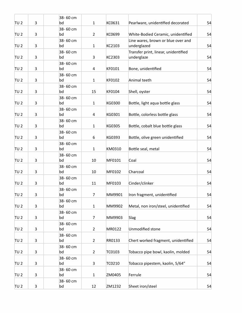
TU 2 338- 60 cm bd 1 KC0631 Pearlware, unidentified decorated 54
TU 2 338- 60 cm bd 2 KC0699 White-Bodied Ceramic, unidentified 54
TU 2 338- 60 cm bd 1 KC2103
Line wares, brown or blue over and underglazed 54
TU 2 338- 60 cm bd 3 KC2303
Transfer print, linear, unidentified underglaze 54
TU 2 338- 60 cm bd 4 KF0101 Bone, unidentified 54
TU 2 338- 60 cm bd 1 KF0102 Animal teeth 54
TU 2 338- 60 cm bd 15 KF0104 Shell, oyster 54
TU 2 338- 60 cm bd 1 KG0300 Bottle, light aqua bottle glass 54
TU 2 338- 60 cm bd 4 KG0301 Bottle, colorless bottle glass 54
TU 2 338- 60 cm bd 1 KG0305 Bottle, cobalt blue bottle glass 54
TU 2 338- 60 cm bd 6 KG0393 Bottle, olive green unidentified 54
TU 2 338- 60 cm bd 1 KM0310 Bottle seal, metal 54
TU 2 338- 60 cm bd 10 MF0101 Coal 54
TU 2 338- 60 cm bd 10 MF0102 Charcoal 54
TU 2 338- 60 cm bd 11 MF0103 Cinder/clinker 54
TU 2 338- 60 cm bd 7 MM9901 Iron fragment, unidentified 54
TU 2 338- 60 cm bd 1 MM9902 Metal, non iron/steel, unidentified 54
TU 2 338- 60 cm bd 7 MM9903 Slag 54
TU 2 338- 60 cm bd 2 MR0122 Unmodified stone 54
TU 2 338- 60 cm bd 2 RR0133 Chert worked fragment, unidentified 54
TU 2 338- 60 cm bd 2 TC0103 Tobacco pipe bowl, kaolin, molded 54
TU 2 338- 60 cm bd 3 TC0210 Tobacco pipestem, kaolin, 5/64” 54
TU 2 338- 60 cm bd 1 ZM0405 Ferrule 54
TU 2 338- 60 cm bd 12 ZM1232 Sheet iron/steel 54
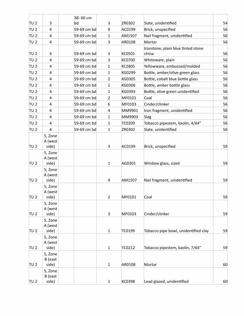
TU 2 338- 60 cm bd 3 ZR0302 Slate, unidentified 54
TU 2 4 59-69 cm bd 9 AC0199 Brick, unspecified 56TU 2 4 59-69 cm bd 1 AM1507 Nail fragment, unidentified 56TU 2 4 59-69 cm bd 3 AR0108 Mortar 56
TU 2 4 59-69 cm bd 3 KC0501Ironstone, plain blue tinted stone china 56
TU 2 4 59-69 cm bd 3 KC0700 Whiteware, plain 56TU 2 4 59-69 cm bd 1 KC2805 Yellowware, embossed/molded 56TU 2 4 59-69 cm bd 1 KG0299 Bottle, amber/olive green glass 56TU 2 4 59-69 cm bd 2 KG0305 Bottle, cobalt blue bottle glass 56TU 2 4 59-69 cm bd 1 KG0306 Bottle, amber bottle glass 56TU 2 4 59-69 cm bd 1 KG0393 Bottle, olive green unidentified 56TU 2 4 59-69 cm bd 2 MF0101 Coal 56TU 2 4 59-69 cm bd 6 MF0103 Cinder/clinker 56TU 2 4 59-69 cm bd 4 MM9901 Iron fragment, unidentified 56TU 2 4 59-69 cm bd 1 MM9903 Slag 56TU 2 4 59-69 cm bd 1 TC0209 Tobacco pipestem, kaolin, 4/64” 56TU 2 4 59-69 cm bd 1 ZR0302 Slate, unidentified 56
TU 2
5, Zone A (west
side) 3 AC0199 Brick, unspecified 59
TU 2
5, Zone A (west
side) 1 AG0301 Window glass, sized 59
TU 2
5, Zone A (west
side) 4 AM1507 Nail fragment, unidentified 59
TU 2
5, Zone A (west
side) 2 MF0101 Coal 59
TU 2
5, Zone A (west
side) 3 MF0103 Cinder/clinker 59
TU 2
5, Zone A (west
side) 1 TC0199 Tobacco pipe bowl, unidentified clay 59
TU 2
5, Zone A (west
side) 1 TC0212 Tobacco pipestem, kaolin, 7/64” 59
TU 2
5, Zone B (east side) 1 AR0108 Mortar 60
TU 2
5, Zone B (east side) 1 KC0398 Lead glazed, unidentified 60
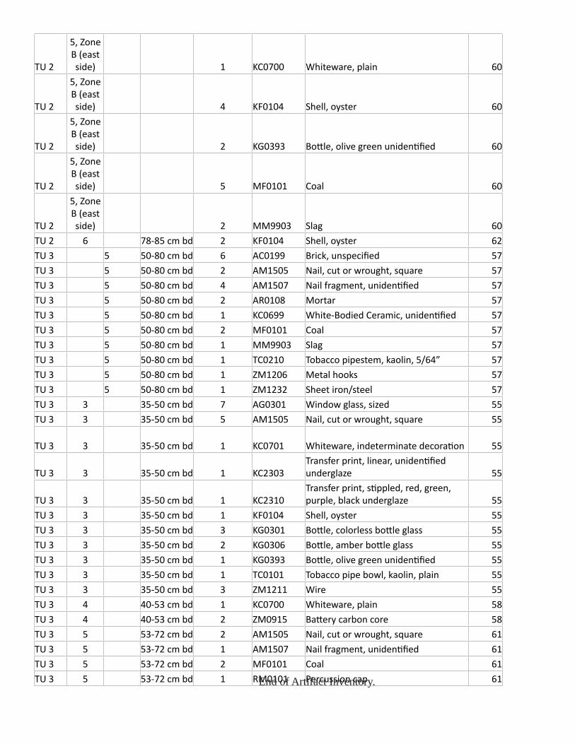
TU 2
5, Zone B (east side) 1 KC0700 Whiteware, plain 60
TU 2
5, Zone B (east side) 4 KF0104 Shell, oyster 60
TU 2
5, Zone B (east side) 2 KG0393 Bottle, olive green unidentified 60
TU 2
5, Zone B (east side) 5 MF0101 Coal 60
TU 2
5, Zone B (east side) 2 MM9903 Slag 60
TU 2 6 78-85 cm bd 2 KF0104 Shell, oyster 62TU 3 5 50-80 cm bd 6 AC0199 Brick, unspecified 57TU 3 5 50-80 cm bd 2 AM1505 Nail, cut or wrought, square 57TU 3 5 50-80 cm bd 4 AM1507 Nail fragment, unidentified 57TU 3 5 50-80 cm bd 2 AR0108 Mortar 57TU 3 5 50-80 cm bd 1 KC0699 White-Bodied Ceramic, unidentified 57TU 3 5 50-80 cm bd 2 MF0101 Coal 57TU 3 5 50-80 cm bd 1 MM9903 Slag 57TU 3 5 50-80 cm bd 1 TC0210 Tobacco pipestem, kaolin, 5/64” 57TU 3 5 50-80 cm bd 1 ZM1206 Metal hooks 57TU 3 5 50-80 cm bd 1 ZM1232 Sheet iron/steel 57TU 3 3 35-50 cm bd 7 AG0301 Window glass, sized 55TU 3 3 35-50 cm bd 5 AM1505 Nail, cut or wrought, square 55
TU 3 3 35-50 cm bd 1 KC0701 Whiteware, indeterminate decoration 55
TU 3 3 35-50 cm bd 1 KC2303Transfer print, linear, unidentified underglaze 55
TU 3 3 35-50 cm bd 1 KC2310Transfer print, stippled, red, green, purple, black underglaze 55
TU 3 3 35-50 cm bd 1 KF0104 Shell, oyster 55TU 3 3 35-50 cm bd 3 KG0301 Bottle, colorless bottle glass 55TU 3 3 35-50 cm bd 2 KG0306 Bottle, amber bottle glass 55TU 3 3 35-50 cm bd 1 KG0393 Bottle, olive green unidentified 55TU 3 3 35-50 cm bd 1 TC0101 Tobacco pipe bowl, kaolin, plain 55TU 3 3 35-50 cm bd 3 ZM1211 Wire 55TU 3 4 40-53 cm bd 1 KC0700 Whiteware, plain 58TU 3 4 40-53 cm bd 2 ZM0915 Battery carbon core 58TU 3 5 53-72 cm bd 2 AM1505 Nail, cut or wrought, square 61TU 3 5 53-72 cm bd 1 AM1507 Nail fragment, unidentified 61TU 3 5 53-72 cm bd 2 MF0101 Coal 61TU 3 5 53-72 cm bd 1 RM0101 Percussion cap 61End of Artifact Inventory.
Related Documents
![Sport [broj 1779, 1.3.2013]](https://static.cupdf.com/doc/110x72/577cd3c81a28ab9e789789b6/sport-broj-1779-132013.jpg)


![Savannah 1779 1 EXCLUSIVE RULEBOOK...2.1 Allied Decisive Victory [Case A] The British surrender under the following conditions: If at least one (1) space of the City of Savannah is](https://static.cupdf.com/doc/110x72/5ed82d280fa3e705ec0dfa57/savannah-1779-1-exclusive-rulebook-21-allied-decisive-victory-case-a-the.jpg)