2009

Sava River Basin Analysis Report High Res
Oct 23, 2015
sava river basin analysis report
Welcome message from author
This document is posted to help you gain knowledge. Please leave a comment to let me know what you think about it! Share it to your friends and learn new things together.
Transcript
2009

INTERNATIONAL SAVA RIVER BASIN COMMISSION
Sava River Basin Analysis Report
Zagreb
September 2009
International Sava River Basin Commission
Sava River Basin Analysis
Prepared by
International Sava River Basin Commission (ISRBC) in cooperation with the Parties to the Framework
Agreement on the Sava River Basin.
The Sava River Basin Analysis Report has been approved at the 13th Special Session of the ISRBC, on
September 22-23, 2009.
Overall coordination and editing by the Secretariat of the ISRBC.
International Sava River Basin Commission
Nova ves 11
Zagreb, Croatia
Phone: + 385 1 488 6960
Fax: + 385 1 488 6986
E-mail: [email protected]
Web: http://www.savacommission.org
The Sava River Basin Analysis Report is available at the website of the ISRBC.
International Sava River Basin Commission
Sava River Basin Analysis
FOREWORD
According to the Framework Agreement on the Sava River Basin (FASRB), the establishment of
sustainable water management in the Sava River Basin is one of the principal objectives of the
cooperation of the Parties to the Agreement. Development of the Sava River Basin Management Plan, in
line with the EU Water Framework Directive (EU WFD) and under the coordinating role of the
International Sava River Basin Commission (Sava Commission), certainly presents a key activity in this
context.
As the first step toward the Sava River Basin Management Plan, substantial effort has been made during
the past years in order to perform the Sava River Basin Analysis, as recognized at the 2nd
Meeting of the
Parties to the FASRB (Belgrade, June 1, 2009).
Sava River Basin Analysis provides the characterization and assessment of water resources in the Sava
River Basin in accordance with Article 5 of the EU WFD, including an additional consideration of the
important issues such as flood management and development of navigation in the basin. Accordingly, the
Analysis has been accepted by the Sava Commission “as a good basis for further activities on
development of the Sava River Basin Management Plan“.
The commitment of the Parties to respect the EU WFD, although not all of them are legally bound to do
so, as well as a good cooperation of the Parties in development of the Sava River Basin Analysis, have
granted a positive perception of the European Commission, which finally resulted in a decision of the EC
to provide support for remaining steps in development of the first Sava River Basin Management Plan,
including filling-up the gaps identified in the Analysis.
The major part of the work on development of this Report has been done by the Sava Commission‟s
Permanent Expert Group for River Basin Management, whose great effort is highly appreciated and
acknowledged.
I would also like to express my gratitude to other expert groups and the Secretariat of the Sava
Commission that significantly contributed to development of the Sava River Basin Analysis, as well as to
preparation of the Report.
Additionally, I would like to thank to many experts from the Parties, from various fields of expertise, to
external consultants and the International Commission for the Protection of the Danube River, for their
contribution to the Analysis.
A fruitful joint work done so far, as well as the Analysis itself, I see as a promising sign for further efforts
to be invested in development of the Sava River Basin Management Plan.
Dejan Komatina, Ph.D.
Secretary of the Sava Commission

International Sava River Basin Commission
Sava River Basin Analysis

International Sava River Basin Commission
Sava River Basin Analysis
TABLE OF CONTENTS
PART I: SAVA RIVER BASIN OVERVIEW AND GENERAL CHARACTERISTICS ..... 1
1. Introduction ................................................................................................................... 3
1.1. Framework Agreement on the Sava River Basin (FASRB) in context of cooperation in river
basin management ...................................................................................................................... 3
1.1.1. History of cooperation towards the FASRB .................................................................. 3 1.1.2. Goals of the FASRB ...................................................................................................... 3 1.1.3. International Sava River Basin Commission (Sava Commission) ................................ 4
2. General Characteristics of the Sava River Basin .......................................................... 5
2.1. Sava River Basin – basic facts.................................................................................................... 5
2.1.1. Location, area and countries sharing of the basin .......................................................... 5 2.1.2. Relief and topography ................................................................................................... 7 2.1.3. Land cover/land use in the basin ................................................................................... 9 2.1.4. Soils ............................................................................................................................. 10
2.2. Climate conditions .................................................................................................................... 11
2.3. Main hydrographic features in the Sava River Basin ............................................................... 12
2.3.1. Description of the Sava River and its main tributaries ................................................ 12 2.3.2. Overview of the „Sava River Basin Analysis” rivers .................................................. 13
2.4. Groundwater ............................................................................................................................. 16
2.5. Ecological characterization ...................................................................................................... 18
2.5.1. Wetlands ...................................................................................................................... 18
3. Water management in the Sava River Basin ............................................................... 21
3.1. Administrative framework ....................................................................................................... 21
3.2. Competent national authorities for WFD implementation ....................................................... 22
3.3. Multilateral and bilateral arrangements .................................................................................... 24
3.3.1. Multilateral agreements ............................................................................................... 24 3.3.2. Bilateral agreements .................................................................................................... 25
PART II: WATER QUALITY ................................................................................................... 27
1. Characterization of surface waters (Art. 5 and Annex II of the WFD) ....................... 29
1.1. Identification of surface water categories ................................................................................. 29
1.2. Typology .................................................................................................................................. 29
1.2.1. Surface water types and reference conditions ............................................................. 29 1.2.2. Identification of Water Bodies .................................................................................... 47 1.2.3. River Water Bodies ..................................................................................................... 47 1.2.4. Reservoirs in the Sava River Basin ............................................................................. 52
1.3. Identification of significant pressures ...................................................................................... 54
1.3.1. Driving forces .............................................................................................................. 55 1.3.2. Significant pressures .................................................................................................... 56 1.3.3. Identification of significant hydromorphological alterations ...................................... 62 1.3.4. Other significant anthropogenic pressures................................................................... 68
International Sava River Basin Commission
Sava River Basin Analysis
1.4. Assessment of impacts in the Sava River Basin ...................................................................... 70
1.4.1. Impacts on rivers ......................................................................................................... 70 1.4.2. Impacts on lakes .......................................................................................................... 72
1.5. Identification of AWBs and provisional identification of heavily modified water bodies ....... 72
1.5.1. Methodology ............................................................................................................... 73 1.5.2. Identification of AWBs ............................................................................................... 75 1.5.3. Identification of HMWBs on the Sava River .............................................................. 76 1.5.4. Identification of HMWBs on the Sava tributaries ....................................................... 79 1.5.5. Length of HMWBs in the Sava River Basin ............................................................... 83 1.5.6. Uses affecting the provisional HMWBs in the Sava River Basin ............................... 85 1.5.7. Significant physical alterations affecting the HMWBs in the Sava River Basin......... 86 1.5.8. Expert judgment for assessing the risk on the HMWBs in the Sava River Basin ....... 87
1.6. Summary of the Risk Assessment ............................................................................................ 88
1.6.1. Risk Assessment of the Sava River ............................................................................. 88 1.6.2. Risk Assessment of the Sava River tributaries ............................................................ 91
1.7. Water quality monitoring in surface waters ............................................................................. 96
1.7.1. National monitoring stations for water quality ............................................................ 96 1.7.2. Transnational monitoring network (TNMN) ............................................................... 97 1.7.3. Water Quality Status Assessment and Water Quality Classification .......................... 98
1.8. Data gaps and uncertainties .................................................................................................... 112
1.8.1. General information on data gaps and uncertainties ................................................. 112 1.8.2. Gaps in the development of the typology and reference conditions .......................... 113 1.8.3. Data gaps and uncertainties for the identification of significant pressures relevant on
the Sava River Basin scale ........................................................................................ 115 1.8.4. Data gaps and uncertainties within the assessment of impacts on the Sava River Basin
scale .......................................................................................................................... 115 1.8.5. Data gaps and uncertainties within the risk of failure analysis ................................. 116
2. Characterization of groundwater (Article 5 and Annex II of the WFD) ................... 117
2.1. Locations, boundaries and characterization of the GWBs ..................................................... 117
2.1.1. Methodology of the GWB delination ........................................................................ 117 2.1.2. Important groundwater bodies in the Sava River Basin ............................................ 122
2.2. Risk of failure to reach the environmental objectives ............................................................ 122
2.2.1. Methodology of risk assessment of the GWBs ......................................................... 122 2.2.2. Results of the risk assessment of the GWBs ............................................................. 125
2.3. Monitoring of groundwater .................................................................................................... 127
2.4. Identification of data gaps and uncertainties .......................................................................... 128
PART III: WATER QUANTITY ............................................................................................ 131
1. Elements of water balance in the Sava River Basin.................................................. 133
1.1. Climate ................................................................................................................................... 133
1.1.1. General types of the climate in the Basin .................................................................. 133 1.1.2. Air temperatures ........................................................................................................ 133 1.1.3. Precipitation, evapotranspiration and runoff ............................................................. 134
1.2. Hydrologic characteristics of the Sava River Basin ............................................................... 136
1.2.1. The Sava River and its main tributaries .................................................................... 136 1.2.2. Characteristic flows in the Sava River Basin ............................................................ 137
1.3. Water balance in the Sava River Basin .................................................................................. 138
International Sava River Basin Commission
Sava River Basin Analysis
1.4. Extreme events: floods and droughts ..................................................................................... 139
1.4.1. Floods ........................................................................................................................ 139 1.4.2. Droughts .................................................................................................................... 140
2. Water use and demands ............................................................................................. 141
2.1. Water use ................................................................................................................................ 141
2.2. Scenario for 2015 – water demand ......................................................................................... 143
3. Economic analysis of water use in the Sava River Basin ......................................... 146
ANNEXES .................................................................................................................................. 151
ANNEX I - NAVIGATION ISSUES........................................................................................ 153
1. Introduction ............................................................................................................... 155
2. Present status of navigation ....................................................................................... 156
2.1. Description of navigation system ........................................................................................... 156
2.2. Current state of the fairway conditions .................................................................................. 160
2.3. Navigation safety and technical standards.............................................................................. 161
3. Competent authorities in the Sava countries, national policies and regulations ....... 162
3.1. Institutional arrangements in B&H ........................................................................................ 162
3.1.1. National regulations .................................................................................................. 164 3.1.2. National policies ........................................................................................................ 164
3.2. Institutional arrangements in Croatia ..................................................................................... 164
3.2.1. National regulation .................................................................................................... 165 3.2.2. National policies ........................................................................................................ 166
3.3. Institutional arrangements in Serbia ....................................................................................... 166
3.3.1. National regulations .................................................................................................. 167 3.3.2. National policies ........................................................................................................ 168
3.4. Institutional arrangements in Slovenia ................................................................................... 168
3.4.1. National regulations .................................................................................................. 169 3.4.2. National policies ........................................................................................................ 170
3.5. International Sava River Basin Commission .......................................................................... 170
4. Future status of navigation ........................................................................................ 171
4.1. Transport needs ...................................................................................................................... 171
4.2. Design/construction criteria ................................................................................................... 173
4.3. Further development of planned works .................................................................................. 174
4.4. Economy indicators ................................................................................................................ 176
4.5. River Information Services (RIS) ........................................................................................... 179
5. Environmental considerations ................................................................................... 182
6. Conclusions ............................................................................................................... 183
International Sava River Basin Commission
Sava River Basin Analysis
ANNEX II: FLOOD MANAGEMENT IN THE SAVA RIVER BASIN ............................. 185
1. Introduction ............................................................................................................... 187
1.1. Basic information on prone areas and threats ........................................................................ 187
1.2. Historical flood events on the Sava River .............................................................................. 191
2. Existing Flood Management ..................................................................................... 191
2.1. Commanding responsibilities ................................................................................................. 191
2.1.1. Institutional arrangements in Bosnia and Herzegovina ............................................. 191 2.1.2. Institutional arrangements in Croatia ........................................................................ 192 2.1.3. Institutional arrangements in Serbia .......................................................................... 193 2.1.4. Institutional arrangements in Slovenia ...................................................................... 194
2.2. Design/construction criteria, system and state of the flood protection structures .................. 194
2.2.1. Bosnia and Herzegovina ........................................................................................... 195 2.2.2. Croatia ....................................................................................................................... 195 2.2.3. Serbia ........................................................................................................................ 195 2.2.4. Slovenia..................................................................................................................... 196
2.3. Long term flood protection strategies .................................................................................... 196
2.3.1. Bosnia and Herzegovina ........................................................................................... 197 2.3.2. Croatia ....................................................................................................................... 197 2.3.3. Serbia ........................................................................................................................ 197 2.3.4. Slovenia..................................................................................................................... 197
2.4. National Flood Prediction and Warning Practices ................................................................. 198
2.4.1. National Flood Prediction and Warning Practices in Bosnia and Herzegovina ........ 198 2.4.2. National Flood Prediction and Warning Practices in Croatia.................................... 198 2.4.3. National Flood Prediction and Warning Practices in Serbia ..................................... 199 2.4.4. National Flood Prediction and Warning Practices in Slovenia ................................. 199
2.5. Cooperation and common effort in the Sava River Basin ...................................................... 200
2.5.1. Activities under the lead of the Sava Commission .................................................... 200
2.6. Recommendations on further regional cooperation in flood management ............................. 203
APPENDICES ........................................................................................................................... 205
APPENDIX I: FLOOD MANAGEMENT IN BOSNIA AND HERZEGOVINA ............... 207
1. Introduction ............................................................................................................... 211
1.1. Sava River .............................................................................................................................. 213
1.2. Una River ............................................................................................................................... 216
1.3. Vrbas River ............................................................................................................................ 217
1.4. Bosna River ............................................................................................................................ 219
1.5. Drina River ............................................................................................................................ 221
2. Basic characteristics of the Sava River Basin in B&H ............................................. 224
2.1. Topographic characteristics of terrain of the Sava RB in B&H ............................................. 226
2.2. Land use ................................................................................................................................. 227
3. Historical floods ........................................................................................................ 228
International Sava River Basin Commission
Sava River Basin Analysis
4. Existing flood management ....................................................................................... 228
4.1. Commanding responsibilites .................................................................................................. 228
4.2. System and state of the flood protection structures ................................................................ 234
4.3. Structure of the drainage system ............................................................................................ 242
4.4. National flood prediction and warning practices .................................................................... 246
5. Long-term flood protection strategy ......................................................................... 246
6. Possible impacts on present flood protection level ................................................... 248
APPENDIX II: FLOOD MANAGEMENT IN CROATIA ................................................... 251
1. Basic information on flood prone areas .................................................................... 255
2. Flooding in the Sava River Basin .............................................................................. 255
3. Historical flood events .............................................................................................. 256
4. Existing Flood Management ..................................................................................... 259
4.1. Commanding responsibilities ................................................................................................. 259
4.2. System and state of the flood protection structures ................................................................ 260
4.3. Structure of the Drainage System ........................................................................................... 265
4.4. National Flood Prediction and warning practices ................................................................... 268
5. Long-Term Flood Protection Strategy ...................................................................... 270
APPENDIX III: FLOOD MANAGEMENT SERBIA ........................................................... 273
1. Introduction ............................................................................................................... 277
2. Existing flood management ....................................................................................... 283
2.1. Commanding responsibilities ................................................................................................. 283
2.1.1. Institutional arrangements in Serbia .......................................................................... 283
2.2. System and state of the flood protection structures ................................................................ 284
2.2.1. Flood protection structures in Serbia ......................................................................... 284
2.3. Structure of drainage system .................................................................................................. 286
2.4. Design/construction criteria and the long-term flood protection strategy .............................. 287
2.4.1. Possible impacts on a current flood protection level ................................................. 287
2.5. National Flood Predicition and Warning Practices ................................................................ 288

International Sava River Basin Commission
Sava River Basin Analysis
International Sava River Basin Commission
Sava River Basin Analysis
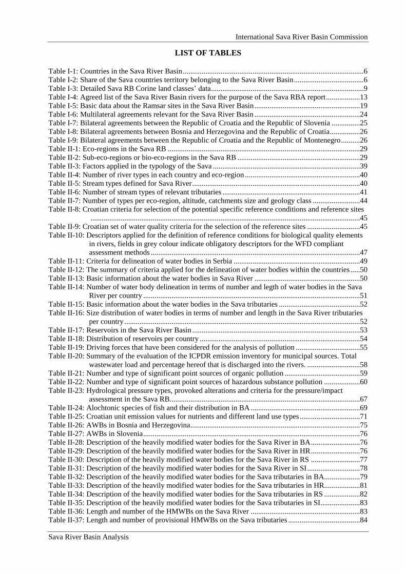
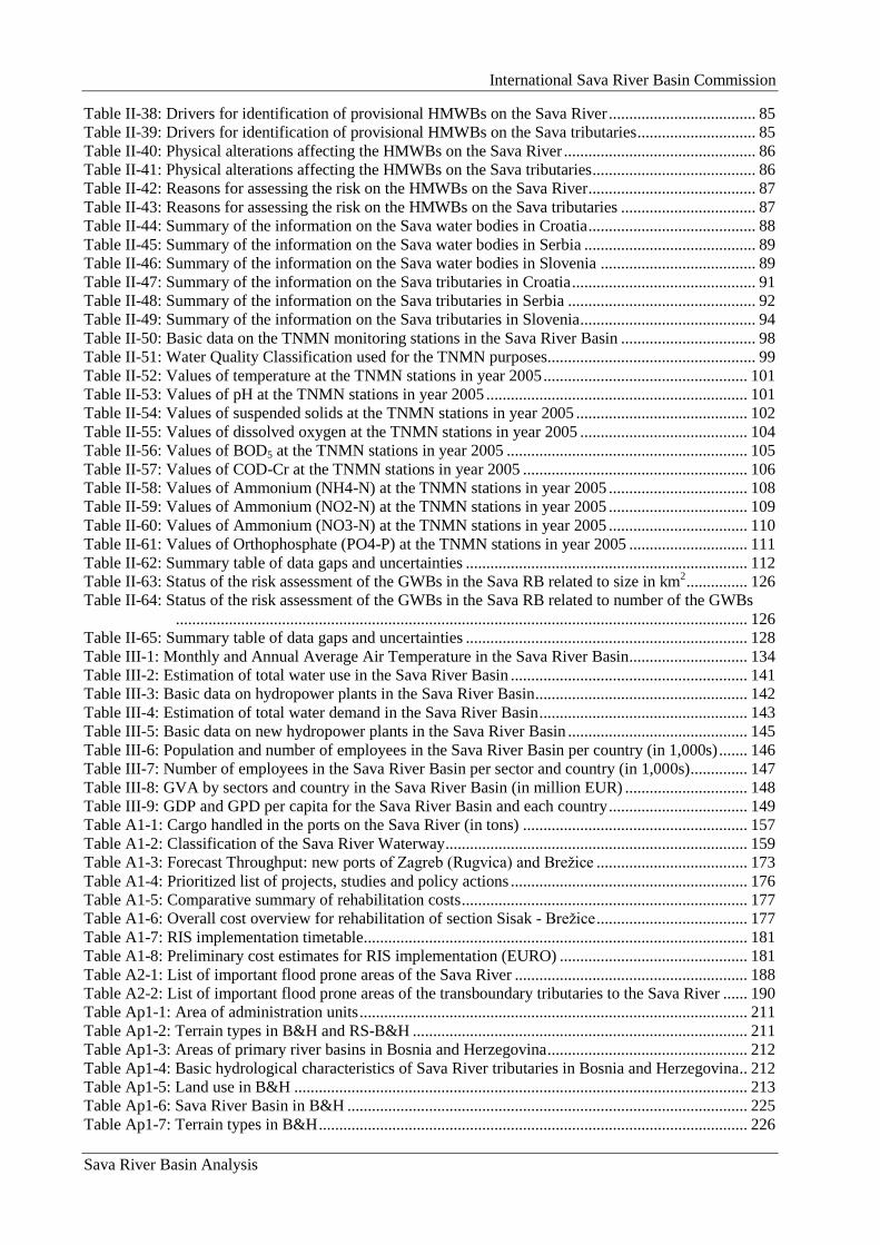
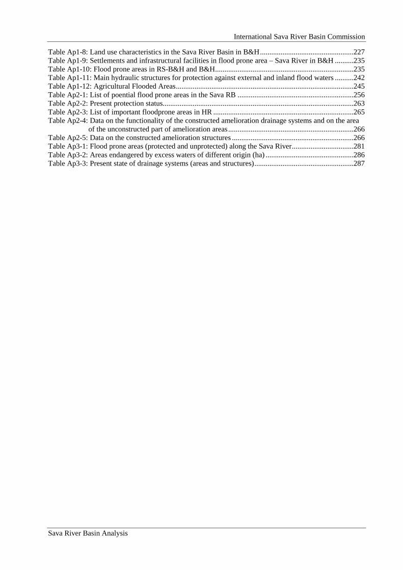
LIST OF TABLES
Table I-1: Countries in the Sava River Basin ................................................................................................6
Table I-2: Share of the Sava countries territory belonging to the Sava River Basin .....................................6
Table I-3: Detailed Sava RB Corine land classes‟ data .................................................................................9
Table I-4: Agreed list of the Sava River Basin rivers for the purpose of the Sava RBA report ..................13
Table I-5: Basic data about the Ramsar sites in the Sava River Basin ........................................................19
Table I-6: Multilateral agreements relevant for the Sava River Basin ........................................................24
Table I-7: Bilateral agreements between the Republic of Croatia and the Republic of Slovenia ...............25
Table I-8: Bilateral agreements between Bosnia and Herzegovina and the Republic of Croatia ................26
Table I-9: Bilateral agreements between the Republic of Croatia and the Republic of Montenegro ..........26
Table II-1: Eco-regions in the Sava RB ......................................................................................................29
Table II-2: Sub-eco-regions or bio-eco-regions in the Sava RB .................................................................29
Table II-3: Factors applied in the typology of the Sava ..............................................................................39
Table II-4: Number of river types in each country and eco-region .............................................................40
Table II-5: Stream types defined for Sava River .........................................................................................40
Table II-6: Number of stream types of relevant tributaries .........................................................................41
Table II-7: Number of types per eco-region, altitude, catchments size and geology class .........................44
Table II-8: Croatian criteria for selection of the potential specific reference conditions and reference sites
...............................................................................................................................................45
Table II-9: Croatian set of water quality criteria for the selection of the reference sites ............................45
Table II-10: Descriptors applied for the definition of reference conditions for biological quality elements
in rivers, fields in grey colour indicate obligatory descriptors for the WFD compliant
assessment methods ...............................................................................................................47
Table II-11: Criteria for delineation of water bodies in Serbia ...................................................................49
Table II-12: The summary of criteria applied for the delineation of water bodies within the countries .....50
Table II-13: Basic information about the water bodies in Sava River ........................................................50
Table II-14: Number of water body delineation in terms of number and legth of water bodies in the Sava
River per country ...................................................................................................................51
Table II-15: Basic information about the water bodies in the Sava tributaries ...........................................52
Table II-16: Size distribution of water bodies in terms of number and length in the Sava River tributaries
per country .............................................................................................................................52
Table II-17: Reservoirs in the Sava River Basin .........................................................................................53
Table II-18: Distribution of reservoirs per country .....................................................................................54
Table II-19: Driving forces that have been considered for the analysis of pollution ..................................55
Table II-20: Summary of the evaluation of the ICPDR emission inventory for municipal sources. Total
wastewater load and percentage hereof that is discharged into the rivers. ............................58
Table II-21: Number and type of significant point sources of organic pollution ........................................59
Table II-22: Number and type of significant point sources of hazardous substance pollution ...................60
Table II-23: Hydrological pressure types, provoked alterations and criteria for the pressure/impact
assessment in the Sava RB.....................................................................................................67
Table II-24: Alochtonic species of fish and their distribution in BA ..........................................................69
Table II-25: Croatian unit emission values for nutrients and different land use types ................................71
Table II-26: AWBs in Bosnia and Herzegovina ..........................................................................................75
Table II-27: AWBs in Slovenia ...................................................................................................................76
Table II-28: Description of the heavily modified water bodies for the Sava River in BA ..........................76
Table II-29: Description of the heavily modified water bodies for the Sava River in HR ..........................76
Table II-30: Description of the heavily modified water bodies for the Sava River in RS ..........................77
Table II-31: Description of the heavily modified water bodies for the Sava River in SI ............................78
Table II-32: Description of the heavily modified water bodies for the Sava tributaries in BA...................79
Table II-33: Description of the heavily modified water bodies for the Sava tributaries in HR...................81
Table II-34: Description of the heavily modified water bodies for the Sava tributaries in RS ...................82
Table II-35: Description of the heavily modified water bodies for the Sava tributaries in SI.....................83
Table II-36: Length and number of the HMWBs on the Sava River ..........................................................83
Table II-37: Length and number of provisional HMWBs on the Sava tributaries ......................................84
International Sava River Basin Commission
Sava River Basin Analysis
Table II-38: Drivers for identification of provisional HMWBs on the Sava River .................................... 85
Table II-39: Drivers for identification of provisional HMWBs on the Sava tributaries ............................. 85
Table II-40: Physical alterations affecting the HMWBs on the Sava River ............................................... 86
Table II-41: Physical alterations affecting the HMWBs on the Sava tributaries ........................................ 86
Table II-42: Reasons for assessing the risk on the HMWBs on the Sava River ......................................... 87
Table II-43: Reasons for assessing the risk on the HMWBs on the Sava tributaries ................................. 87
Table II-44: Summary of the information on the Sava water bodies in Croatia ......................................... 88
Table II-45: Summary of the information on the Sava water bodies in Serbia .......................................... 89
Table II-46: Summary of the information on the Sava water bodies in Slovenia ...................................... 89
Table II-47: Summary of the information on the Sava tributaries in Croatia ............................................. 91
Table II-48: Summary of the information on the Sava tributaries in Serbia .............................................. 92
Table II-49: Summary of the information on the Sava tributaries in Slovenia ........................................... 94
Table II-50: Basic data on the TNMN monitoring stations in the Sava River Basin ................................. 98
Table II-51: Water Quality Classification used for the TNMN purposes................................................... 99
Table II-52: Values of temperature at the TNMN stations in year 2005 .................................................. 101
Table II-53: Values of pH at the TNMN stations in year 2005 ................................................................ 101
Table II-54: Values of suspended solids at the TNMN stations in year 2005 .......................................... 102
Table II-55: Values of dissolved oxygen at the TNMN stations in year 2005 ......................................... 104
Table II-56: Values of BOD5 at the TNMN stations in year 2005 ........................................................... 105
Table II-57: Values of COD-Cr at the TNMN stations in year 2005 ....................................................... 106
Table II-58: Values of Ammonium (NH4-N) at the TNMN stations in year 2005 .................................. 108
Table II-59: Values of Ammonium (NO2-N) at the TNMN stations in year 2005 .................................. 109
Table II-60: Values of Ammonium (NO3-N) at the TNMN stations in year 2005 .................................. 110
Table II-61: Values of Orthophosphate (PO4-P) at the TNMN stations in year 2005 ............................. 111
Table II-62: Summary table of data gaps and uncertainties ..................................................................... 112
Table II-63: Status of the risk assessment of the GWBs in the Sava RB related to size in km2 ............... 126
Table II-64: Status of the risk assessment of the GWBs in the Sava RB related to number of the GWBs
............................................................................................................................................ 126
Table II-65: Summary table of data gaps and uncertainties ..................................................................... 128
Table III-1: Monthly and Annual Average Air Temperature in the Sava River Basin ............................. 134
Table III-2: Estimation of total water use in the Sava River Basin .......................................................... 141
Table III-3: Basic data on hydropower plants in the Sava River Basin .................................................... 142
Table III-4: Estimation of total water demand in the Sava River Basin ................................................... 143
Table III-5: Basic data on new hydropower plants in the Sava River Basin ............................................ 145
Table III-6: Population and number of employees in the Sava River Basin per country (in 1,000s) ....... 146
Table III-7: Number of employees in the Sava River Basin per sector and country (in 1,000s) .............. 147
Table III-8: GVA by sectors and country in the Sava River Basin (in million EUR) .............................. 148
Table III-9: GDP and GPD per capita for the Sava River Basin and each country .................................. 149
Table A1-1: Cargo handled in the ports on the Sava River (in tons) ....................................................... 157
Table A1-2: Classification of the Sava River Waterway .......................................................................... 159
Table A1-3: Forecast Throughput: new ports of Zagreb (Rugvica) and Breţice ..................................... 173
Table A1-4: Prioritized list of projects, studies and policy actions .......................................................... 176
Table A1-5: Comparative summary of rehabilitation costs ...................................................................... 177
Table A1-6: Overall cost overview for rehabilitation of section Sisak - Breţice ..................................... 177
Table A1-7: RIS implementation timetable .............................................................................................. 181
Table A1-8: Preliminary cost estimates for RIS implementation (EURO) .............................................. 181
Table A2-1: List of important flood prone areas of the Sava River ......................................................... 188
Table A2-2: List of important flood prone areas of the transboundary tributaries to the Sava River ...... 190
Table Ap1-1: Area of administration units ............................................................................................... 211
Table Ap1-2: Terrain types in B&H and RS-B&H .................................................................................. 211
Table Ap1-3: Areas of primary river basins in Bosnia and Herzegovina ................................................. 212
Table Ap1-4: Basic hydrological characteristics of Sava River tributaries in Bosnia and Herzegovina.. 212
Table Ap1-5: Land use in B&H ............................................................................................................... 213
Table Ap1-6: Sava River Basin in B&H .................................................................................................. 225
Table Ap1-7: Terrain types in B&H ......................................................................................................... 226
International Sava River Basin Commission
Sava River Basin Analysis
Table Ap1-8: Land use characteristics in the Sava River Basin in B&H ..................................................227
Table Ap1-9: Settlements and infrastructural facilities in flood prone area – Sava River in B&H ..........235
Table Ap1-10: Flood prone areas in RS-B&H and B&H ..........................................................................235
Table Ap1-11: Main hydraulic structures for protection against external and inland flood waters ..........242
Table Ap1-12: Agricultural Flooded Areas ...............................................................................................245
Table Ap2-1: List of poential flood prone areas in the Sava RB ..............................................................256
Table Ap2-2: Present protection status......................................................................................................263
Table Ap2-3: List of important floodprone areas in HR ...........................................................................265
Table Ap2-4: Data on the functionality of the constructed amelioration drainage systems and on the area
of the unconstructed part of amelioration areas ...................................................................266
Table Ap2-5: Data on the constructed amelioration structures .................................................................266
Table Ap3-1: Flood prone areas (protected and unprotected) along the Sava River .................................281
Table Ap3-2: Areas endangered by excess waters of different origin (ha) ...............................................286
Table Ap3-3: Present state of drainage systems (areas and structures) .....................................................287

International Sava River Basin Commission
Sava River Basin Analysis
International Sava River Basin Commission
Sava River Basin Analysis
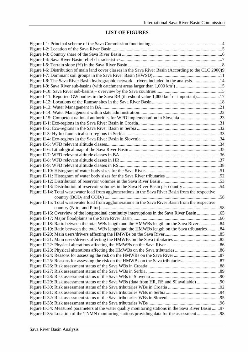
LIST OF FIGURES
Figure I-1: Principal scheme of the Sava Commission functioning ..............................................................4
Figure I-2: Location of the Sava River Basin ................................................................................................5
Figure I-3: Country share of the Sava River Basin .......................................................................................6
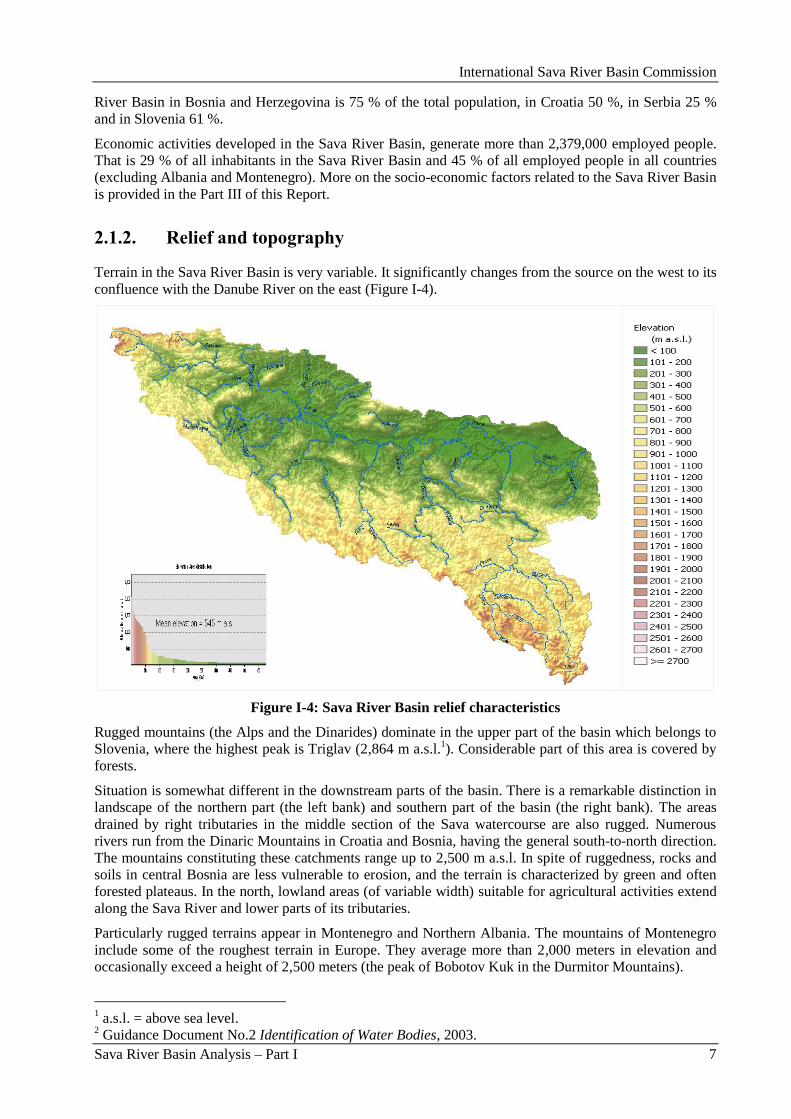
Figure I-4: Sava River Basin relief characteristics ........................................................................................7
Figure I-5: Terrain slope (%) in the Sava River Basin ..................................................................................8
Figure I-6: Distribution of main land cover classes in the Sava River Basin (According to the CLC 2000) 9
Figure I-7: Dominant soil groups in the Sava River Basin (HWSD) ..........................................................11
Figure I-8: The Sava River Basin hydrographic network – rivers included in the analysis ........................14
Figure I-9: Sava River sub-basins (with catchment areas larger than 1,000 km2) ......................................15
Figure I-10: Sava River sub-basins – overview by the Sava countries .......................................................15
Figure I-11: Reported GW bodies in the Sava RB (threshold value 1,000 km2 or important) ....................17
Figure I-12: Locations of the Ramsar sites in the Sava River Basin ...........................................................18
Figure I-13: Water Management in BA.......................................................................................................21
Figure I-14: Water Management within state administration ......................................................................22
Figure I-15: Competent national authorities for WFD implementation in Slovenia ...................................23
Figure II-1: Eco-regions in the Sava River Basin in Croatia .......................................................................31
Figure II-2: Eco-regions in the Sava River Basin in Serbia ........................................................................32
Figure II-3: Hydro-faunistical sub-regions in Serbia ..................................................................................33
Figure II-4: Eco-regions in the Sava River Basin in Slovenia ....................................................................34
Figure II-5: WFD relevant altitude classes ..................................................................................................34
Figure II-6: Lithological map of the Sava River Basin ...............................................................................35
Figure II-7: WFD relevant altitude classes in BA .......................................................................................36
Figure II-8: WFD relevant altitude classes in HR .......................................................................................37
Figure II-9: WFD relevant altitude classes in RS ........................................................................................38
Figure II-10: Histogram of water body sizes for the Sava River .................................................................51
Figure II-11: Histogram of water body sizes for the Sava River tributaries ...............................................52
Figure II-12: Distribution of reservoir volumes in the Sava River Basin ...................................................53
Figure II-13: Distribution of reservoir volumes in the Sava River Basin per country ................................54
Figure II-14: Total wastewater load from agglomerations in the Sava River Basin from the respective
country (BOD5 and COD5) ....................................................................................................58
Figure II-15: Total wastewater load from agglomerations in the Sava River Basin from the respective
country (N-tot and P-tot)........................................................................................................58
Figure II-16: Overview of the longitudinal continuity interruptions in the Sava River Basin ....................65
Figure II-17: Major floodplains in the Sava River Basin ............................................................................66
Figure II-18: Ratio between the total WBs length and the HMWBs length on the Sava River ..................84
Figure II-19: Ratio between the total WBs length and the HMWBs length on the Sava tributaries ...........84
Figure II-20: Main users/drivers affecting the HMWBs on the Sava River ................................................85
Figure II-21: Main users/drivers affecting the HMWBs on the Sava tributaries ........................................85
Figure II-22: Physical alterations affecting the HMWBs on the Sava River ..............................................86
Figure II-23: Physical alterations affecting the HMWBs on the Sava tributaries .......................................86
Figure II-24: Reasons for assessing the risk on the HMWBs on the Sava River ........................................87
Figure II-25: Reasons for assessing the risk on the HMWBs on the Sava tributaries .................................87
Figure II-26: Risk assessment status of the Sava WBs in Croatia...............................................................88
Figure II-27: Risk assessment status of the Sava WBs in Serbia ................................................................89
Figure II-28: Risk assessment status of the Sava WBs in Slovenia ............................................................90
Figure II-29: Risk assessment status of the Sava WBs (data from HR, RS and SI available) ....................90
Figure II-30: Risk assessment status of the Sava tributaries WBs in Croatia .............................................92
Figure II-31: Risk assessment status of the Sava tributaries WBs in Serbia ...............................................94
Figure II-32: Risk assessment status of the Sava tributaries WBs in Slovenia ...........................................95
Figure II-33: Risk assessment status of the Sava tributaries WBs ..............................................................96
Figure II-34: Measured parameters at the water quality monitoring stations in the Sava River Basin .......97
Figure II-35: Location of the TNMN monitoring stations providing data for the assessment ....................98
International Sava River Basin Commission
Sava River Basin Analysis
Figure II-36: The spatial-temporal evolution of physical parameters in the Sava River from 2000 to 2005
............................................................................................................................................ 100
Figure II-37: Measured values of temperature at the TNMN stations in year 2005 ................................. 101
Figure II-38: Values of pH at the TNMN stations in year 2005 ............................................................... 102
Figure II-39: Values of suspended solids at the TNMN stations in year 2005 ......................................... 102
Figure II-40: The spatial-temporal evolution of organic substances in the Sava River from 2000 to 2005
............................................................................................................................................ 103
Figure II-41: Values of dissolved oxygen at the TNMN stations in year 2005 ........................................ 104
Figure II-42: Values of BOD5 at the TNMN stations in year 2005 .......................................................... 105
Figure II-43: Values of COD-Cr at the TNMN stations in year 2005 ...................................................... 106
Figure II-44: The spatial-temporal evolution of nutrients in Sava River from 2000 to 2005 ................... 107
Figure II-45: Values of Ammonium (NH4-N) at the TNMN stations in year 2005 ................................. 108
Figure II-46: Values of Ammonium (NO2-N) at the TNMN stations in year 2005 ................................. 109
Figure II-47: Values of Ammonium (NO3-N) at the TNMN stations in year 2005 ................................. 110
Figure II-48: Values of Orthophosphate (PO4-P) at the TNMN stations in year 2005 ............................. 111
Figure II-49: Country repatriation of the GWBs related to size in km2 ................................................... 122
Figure II-50: Country repatriation of the GWBs related to number of GWBs ......................................... 122
Figure II-51: Risk assessment of the quality (chemical) status of important GWBs in the Sava RB ...... 126
Figure II-52: Risk assessment of the quantity status of important GWBs in the Sava RB....................... 127
Figure II-53: Groundwater monitoring stations on main groundwater bodies in the Sava River Basin ... 127
Figure III-1: Mean annual precipitation in the Sava River Basin (The Danube and its Basin –
Hydrological Monograph, 2006) ........................................................................................ 134
Figure III-2: Mean annual evapotranspiration in the Sava River Basin (The Danube and its Basin –
Hydrological Monograph, 2006) ........................................................................................ 135
Figure III-3: Mean annual runoff in the Sava River Basin (The Danube and its Basin – Hydrological
Monograph, 2006) .............................................................................................................. 136
Figure III-4: Spectrum of mean annual discharges along the Sava River ................................................ 137
Figure III-5: Spectrum of 100-year minimum annual discharges along the Sava River .......................... 137
Figure III-6: Spectrum of 100-year maximum annual discharges along the Sava River.......................... 138
Figure III-7: Comparative maps of mean annual precipitation and runoff (study 1969 – 2006) .............. 139
Figure III-8: Indicative map of important flood prone areas along Sava River ....................................... 140
Figure III-9: Estimation of total water use in the Sava River Basin ......................................................... 141
Figure III-10: Estimation of total water demand between water users for 2015 in the Sava River Basin 144
Figure III-11: The ratio between water use/demand in the Sava River Basin .......................................... 144
Figure III-12: Number of employees in the Sava River Basin by sector and country (in 1,000s) ........... 147
Figure III-13: Main economic activities in the Sava River Basin - GVA (2005) ..................................... 148
Figure III-14: Productivity according to the economic activities in the Sava River Basin ...................... 149
Figure A1-1: SRWTS integrated and multimodal network (concept vision) ........................................... 156
Figure A1-2: History: Tug on the Kupa River in the middle of the 20th century .................................... 157
Figure A1-3: Port of Sisak (on the Kupa River) ....................................................................................... 158
Figure A1-4: Drina confluent ................................................................................................................... 160
Figure A1-5: Organogram, transport ministry of B&H (state level) ........................................................ 163
Figure A1-6: Organogram, transport ministry of Croatia (only parts dealing directly with inland
navigation) .......................................................................................................................... 165
Figure A1-7: Organogram, transport ministry of Serbia .......................................................................... 167
Figure A1-8: Organogram, transport ministry of Slovenia ...................................................................... 169
Figure A1-9: Cumulative traffic volume per main segment (minimum and maximum estimated volumes
for year 2027) ...................................................................................................................... 172
Figure A1-10: SCC requirements for a class IV and class Va waterway ................................................. 174
Figure A1-11: General Action Plan implementation lines ....................................................................... 175
Figure A1-12: Towed convoy on the Sava River ..................................................................................... 179
Figure A1-13: RIS implementation triangle ............................................................................................. 180
Figure A2-1: Indicative map of important floodprone areas along the Sava River .................................. 187
Figure A2-2: Levee system along the Sava River .................................................................................... 195
International Sava River Basin Commission
Sava River Basin Analysis
Figure A2-3: Precipitation stations in the Sava River Basin by the end of 2007 (source SARIB, NHMSs)
.............................................................................................................................................202
Figure A2-4: Hydrological stations in the Sava River Basin by the end of 2007 (source SARIB, NHMSs)
.............................................................................................................................................202
Figure Ap1-1: Sava River (Raĉa River bridge) Figure Ap1-2: Sava dike (Raĉa River bridge) ............214
Figure Ap1-3: Flood protection pump station machine room ...................................................................214
Figure Ap1-4: Sava River (quay – Gradiška bridge) .................................................................................215
Figure Ap1-5: Pump station structure Liman (Lijevĉe polje) ...................................................................215
Figure Ap1-6 and Figure Ap1-7: Una River – details from the upper course ...........................................216
Figure Ap1-8: Una River – middle course Figure Ap1-9: Una River – middle course ..................217
Figure Ap1-10: Una River – lower course (Novi Grad – upstream from the Sana River mouth) .............217
Figure Ap1-11: Vrbas River – upper course .............................................................................................218
Figure Ap1-12: Vrbas River – middle course ...........................................................................................218
Figure Ap1-13: Vrbas River – lower course .............................................................................................219
Figure Ap1-14: Bosna River spring Figure Ap1-15: Bosna River in Zenica ...........................219
Figure Ap1-16: Bosna River – lower course (Modriĉa) ............................................................................220
Figure Ap1-17: Bosna River (mouth into the Sava River – bridge in Šamac) ..........................................220
Figure Ap1-18: Bosna River – lower course (Bosna River mouth into Sava – Šamac port) ....................220
Figure Ap1-19: Confluence of Tara and Piva River – Drina River (Šćepan Polje – Bastasi) ...................221
Figure Ap1-20: HPP Višegrad – RS-B&H ................................................................................................222
Figure Ap1-21: Višegrad (Mehmed Paša Sokolović Bridge, under UNESCO protection) ......................222
Figure Ap1-22: Zvornik (Diviĉ – HPP Zvornik) – RS-B&H ....................................................................223
Figure Ap1-23: Zvornik (Diviĉ - Zvornik reservoir) ................................................................................223
Figure Ap1-24: Drina River - Semberija ...................................................................................................224
Figure Ap1-25: River network and administrative units in the Sava RB in B&H ....................................225
Figure Ap1-26: Terrain chracteristics of the Sava RB in B&H ................................................................226
Figure Ap1-27: Land use in the Sava RB in B&H ....................................................................................227
Figure Ap1-28: Flood prone areas in B&H – Sava River .........................................................................234
Figure Ap1-29: Flood prone areas in B&H – Sava RB wide-scale ...........................................................239
Figure Ap2-1: 100-year flood areas in the Sava River Basin prior to the construction of the flood
protection system .................................................................................................................256
Figure Ap2-2: Status of flood protection in the Sava River Basin in Croatia ...........................................260
Figure Ap2-3: Rationalized flood control solution ...................................................................................262
Figure Ap2-4: Flood prone areas (protected and unprotected) along the Sava River ...............................264
Figure Ap2-5: Amelioration areas and administrative units in the Sava River Basin ...............................267
Figure Ap2-6: Hydrologic data collection and disemenation system of Hrvatske vode ...........................269
Figure Ap2-7: Scheme of Operative Flood Defence .................................................................................270
Figure Ap3-1: River network and administrative units in the part of the Sava River Basin in Serbia ......278
Figure Ap3-2: Topography of the Sava River Basin in Serbia..................................................................279
Figure Ap3-3: Land use in the Sava River Basin in Serbia .......................................................................280
Figure Ap3-4: Flood protection lines and areas potentially prone to flooding along the Sava and its
tributaries .............................................................................................................................282
Figure Ap3-5: „Sava levee profile” ...........................................................................................................285

International Sava River Basin Commission
Sava River Basin Analysis
International Sava River Basin Commission
Sava River Basin Analysis
LIST OF ACRONYMS AND ABBREVIATIONS
Aarhus Convention Convention on Access to Information, Public Participation in Decision-
Making and Access to Justice in Environmental Matters
ADN European Agreement concerning the International Carriage of
Dangerous Goods by Inland Waterways
AGN European Agreement on Main Inland Waterways of International
Importance
Ad hoc HM EG Ad-hoc Expert Group for Hydrological and Meteorological Issues
AIS Aquatic Invasive Species
AIS Network Automatic Identification System Network
AL Republic of Albania
AOX Absorbable Organically Bound Halogens
AQEM The Development and Testing of an Integrated Assessment System for
the Ecological Quality of Streams and Rivers throughout Europe using
Benthic Macroinvertebrates
ASPT Average Score Per Taxon
AWB Artificial Water Body
BA / B&H Bosnia and Herzegovina
Belgrade Convention The Convention on the Danube Navigation Regime
BMWP index Biological Monitoring Working Party Index
BOD Biochemical Oxygen Demand
BQE Biological Quality Element
BQI Biological Quality Index
CARDS Community Assistance for Reconstruction, Development and
Stabilization
CBA Cost Benefit Analysis
CBS Central Bureau of Statistics
CEE Central and Eastern Europe
CEVNI European Code for Inland Navigation
CIS Guidance Common Implementation Strategy Guidance
CLC 2000 Corine Land Cover 2000
COD Chemical Oxygen Demand
DPSIR Driver-Pressure-State-Impact-Response
DRPC Danube River Protection Convention (Convention on Cooperation for
the Protection and Sustainable Use of the Danube River)
DTD Danube-Tisza-Danube
DTM Digital Terrain Model
EC European Commission
ECDIS Electronic Chart Display and Information System
International Sava River Basin Commission
Sava River Basin Analysis
EEA European Environment Agency
EFAS European Flood Alert System
EFD European Flood Directive
EIA Environmental Impact Assessment
ENC Electronic Navigation Chart
EPER European Pollution Emission Registry
EPT Ephemeroptera, Plecoptera and Trichoptera
ER Eco-Region
ERI Electronic Ship Reporting
Espoo Convention Convention on Environmental Impact Assessment in a Transboundary
Context
EU European Union
EU WFD EU Water Framework Directive
FAO Food and Agriculture Organization
FASRB Framework Agreement on the Sava River Basin
FBA / FB&H Federation of Bosnia and Herzegovina (BA)
FIP Future Infrastructure Projects
FMAFWM Federal Ministry of Agriculture, Forestry and Water Management
(FB&H)
FRM Flood Risk Management
FRMP Flood Risk Management Plan
FMAWMF Federal Ministry of Agriculture, Water Management and Forestry
(FB&H)
GDP Gross Domestic Product
GES Good Ecological Status
GIG Geographical Intercalibration Group
GIS Geographic Information System
GTS Global Telecommunications System
GVA Gross Value Added
GW Groundwater
GWBs Groundwater Bodies
Helsinki Convention Convention on the Transboundary Effects of Industrial Accidents
HMIFFWS Hydro-Meteorological Information and Flood Forecasting / Warning
System
HMS Hydro-Meteorological Service
HMWB Heavily Modified Water Bodies
International Sava River Basin Commission
Sava River Basin Analysis
HR Republic of Croatia
HRK Croatian Kuna
HPP Hydro-Power Plant
HTV Croatian Television
HWSD Harmonized World Soil Database
HYCOS Hydrological Cycle Observing System
HYMO Hydromorphological
ICP Integrated Cadastre of Polluters
ICPDR International Commission for the Protection of the Danube River
IMPRESS CIS Guidance Document No.3 Analysis of Pressures and Impacts Impress
IPPC Integral Pollution Prevention and Control
ISRBC International Sava River Basin Commission
IUCN International Union for Conservation of Nature
IWT Inland Waterway Transport
JDS Joint Danube Survey
LPNP Lonjsko Polje Nature Park
MANS Nonlinear Model of River Flow
MAP D-Phase Mesoscale Alpine Programme
ME Republic of Montenegro
MKGP Ministry of Agriculture, Forestry and Food (SI)
MoAFWM Ministry of Agriculture, Forestry and Water Management (RS-B&H)
NAIADES Navigation and Inland Waterway Action and Development in Europe
NGO Non-Governmental Organization
NHMS National Hydro-Meteorological Service
NN Official Gazette
NtS Notices to Skippers
ORUCZ Regional Division for Civil Protection (BA)
OŠCZ Municipal Headquaters for Civil Protection (BA)
PAH Polycyclic Aromatic Hydrocarbons
PE Population Equivalent
PEG FP Permanent Expert Group for Flood Prevention
PEG NAV Permanent Expert Group for Navigation
PRSP Poverty Reduction Strategy Paper
PS Pumping Station
PWMC Public Water Management Company (RS)
Ramsar Convention The Convention on Wetlands of International Importance especially as
Waterfowl Habitat
International Sava River Basin Commission
Sava River Basin Analysis
RB River Basin
RBA River Basin Analysis
RBMP River Basin Management Plan
RHMSS Republic Hydrometeorological Service of Serbia
RIS River Information Service
RS Republic of Serbia
RS (BA) / RS-B&H Republika Srpska (BA)
Sava Commission International Sava River Basin Commission
Sava WMD Water Management Department for the Sava River Basin District (BA)
SCC Waterway Classification of the Sava Commission
SEA Strategic Environmental Assessment
SEE South East Europe
SEEDRMI South East Europe Disaster Management Initiative
SEETO South East Europe Transport Observatory
SFRY Socialist Federal Republic of Yugoslavia
SI Republic of Slovenia
SRWTS Sava River Waterway Transport System
SS Suspended Solids
SWB Significant Water Body
TG Task Group
TNMN Transnational Monitoring Network
UK United Kingdom
UN United Nations
UNDP United Nations Development Programme
UNECE United Nations Economic Commission for Europe
UNECE Water Convention Convention on the Protection and Use of Transboundary Watercourses
UNESCO United Nations Educational, Scientific and Cultural Organization
UWWT Directive Council Directive 91/271/EEC concerning Urban Waste-Water
Treatment
UXO Unexploded Ordnance
VHF Very High Frequency
WANDA Waste Management for Inland Navigation on the Danube
WB Water Body
WMBO Water Management Branch Office
WMO World Meteorological Organization
WWTP Waste Water Treatment Plant
International Sava River Basin Commission
Sava River Basin Analysis – Part I 1
Part I: Sava River Basin overview and general characteristics
International Sava River Basin Commission
Sava River Basin Analysis – Part I 2
International Sava River Basin Commission
Sava River Basin Analysis – Part I 3
1. Introduction
1.1. Framework Agreement on the Sava River Basin (FASRB) in context of
cooperation in river basin management
1.1.1. History of cooperation towards the FASRB
After dissolution of the Socialist Federal Republic of Yugoslavia in the early 1990-ies, the Sava River,
which was the biggest national river, has become an international river of recognized importance. The
arising need for cooperation in management of the shared waters of the Sava River Basin led to beginning
of the process known as the Sava Initiative. It was formally initiated with the Letter of Intent concerning
the International Sava River Basin Commission Initiative, signed in Sarajevo on November 29, 2001, by
the Ministers of Foreign Affairs of the Republic of Croatia, the Republic of Slovenia, the Federal
Republic of Yugoslavia, and the Minister for Civil Affairs and Communications of Bosnia and
Herzegovina.
A successful process of negotiations run under the „umbrella” of the Stability Pact for South-Eastern
Europe, the four riparian countries of the Sava River Basin - Bosnia and Herzegovina, Republic of
Croatia, Federal Republic of Yugoslavia (later on Serbia and Montenegro, and then Republic of Serbia)
and Republic of Slovenia, finally resulted in conclusion of the Framework Agreement on the Sava River
Basin (FASRB). The FASRB was signed at Kranjska Gora (Slovenia), on December 3, 2002.
The FASRB entered into force on December 29, 2004, thirty days after the Depositary of the Agreement
(Republic of Slovenia) notified the signatories on reception of the last instrument for the ratification
procedure. The FASRB presents the first multilateral agreement in the region after the agreement on
succession.
1.1.2. Goals of the FASRB
The FASRB emphasizes the importance of transboundary cooperation of governments, institutions and
individuals for sustainable development of the Sava River Basin.
It defines three main goals of the process of cooperation:
Establishment of an international regime of navigation on the Sava River and its navigable
tributaries which included set-up of conditions for safe navigation on the River Sava and its
tributaries;
Establishment of sustainable water management which included cooperation on management of
the Sava River Basin water resources in a sustainable way, including integrated management of
surface and ground water resources, in a manner that would provide:
water in sufficient quantity and of appropriate quality for the preservation, protection
and improvement of aquatic eco-systems (including flora and fauna and eco-systems
of natural ponds and wetlands);
waters in sufficient quantity and of appropriate quality for all kinds of water
utilization;
protection against detrimental effects of water (flooding, excessive groundwater,
erosion and ice hazards);
resolution of conflicts of interest caused by different uses and utilizations; and
effective control of the water regime;
Undertaking measures to prevent or limit hazards, and reduce and eliminate adverse
consequences, including those from floods, ice hazards, droughts and incidents involving
substances hazardous to water.
International Sava River Basin Commission
Sava River Basin Analysis – Part I 4
The cooperation in achieving the main goals of the FASRB is based on the following principles:
Sovereign equality, territorial integrity, mutual benefit, and good faith;
Mutual respect of national legislation, institutions and organizations;
Cooperation in line with the EU Water Framework Directive and other related Community
legislation;
Regular exchange of information within the basin on: water regime, navigation regime,
legislation, organizational structures, administrative and technical practices;
Securing the integrity of the water regime in the basin,
Reduction of transboundary impacts caused by economic and other activities.
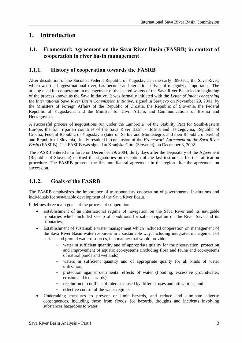
1.1.3. International Sava River Basin Commission (Sava Commission)
The implementation of the FASRB is coordinated by the Sava Commission, which is the joint institution
established as an international organization, and with the permanent Secretariat as its executive body.
The Sava Commission is consisted of two representatives of each Party, one member and one deputy
member. It is mandated with a number of tasks and responsibilities specified in Annex I to the FASRB –
Statute of the Sava Commission. The specific peculiarity of the Sava Commission within the family of
European basin organizations, provided by the FASRB, is integration of navigation and environmental
protection within one institution – providing the Sava Commission with the broadest scope of
responsibilities among similar river bodies.
The Sava Commission is given the capacity for making decisions in the field of navigation and providing
recommendations on all other issues.
Principal scheme of the functioning and decision making process of the Sava Commission can be seen in
Figure I-1.
Figure I-1: Principal scheme of the Sava Commission functioning
International Sava River Basin Commission
Sava River Basin Analysis – Part I 5
2. General Characteristics of the Sava River Basin
2.1. Sava River Basin – basic facts
2.1.1. Location, area and countries sharing of the basin
The Sava River Basin is a major drainage basin of the South Eastern Europe covering the total area of
approximately 97,713.20 km2 (Figure I-2). Geographically, it spreads between 13.67 ºE and 20.58 ºE
longitude and between 42.43 ºN and 46.52 ºN latitude, and represents one of the most significant sub-
basins of the Danube River Basin, with the share of 12 %.
Figure I-2: Location of the Sava River Basin
The northern part of the catchment borders with the Drava River Basin, which is also a tributary of the
Danube River. The watershed between the southern part of the Sava River Basin and the Adriatic Sea
catchments goes over relatively high and rugged mountains.
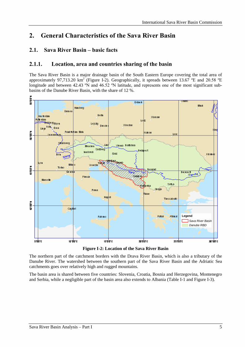
The basin area is shared between five countries: Slovenia, Croatia, Bosnia and Herzegovina, Montenegro
and Serbia, while a negligible part of the basin area also extends to Albania (Table I-1 and Figure I-3).
Legend
Sava River Basin
Danube RBD
International Sava River Basin Commission
Sava River Basin Analysis – Part I 6
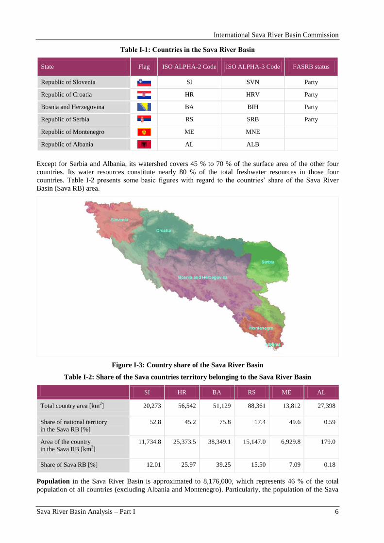
Table I-1: Countries in the Sava River Basin
State Flag ISO ALPHA-2 Code ISO ALPHA-3 Code FASRB status
Republic of Slovenia SI SVN Party
Republic of Croatia HR HRV Party
Bosnia and Herzegovina BA BIH Party
Republic of Serbia RS SRB Party
Republic of Montenegro ME MNE
Republic of Albania AL ALB
Except for Serbia and Albania, its watershed covers 45 % to 70 % of the surface area of the other four
countries. Its water resources constitute nearly 80 % of the total freshwater resources in those four
countries. Table I-2 presents some basic figures with regard to the countries‟ share of the Sava River
Basin (Sava RB) area.
Figure I-3: Country share of the Sava River Basin
Table I-2: Share of the Sava countries territory belonging to the Sava River Basin
SI HR BA RS ME AL
Total country area [km2] 20,273 56,542 51,129 88,361 13,812 27,398
Share of national territory
in the Sava RB [%]
52.8 45.2 75.8 17.4 49.6 0.59
Area of the country
in the Sava RB [km2]
11,734.8 25,373.5 38,349.1 15,147.0 6,929.8 179.0
Share of Sava RB [%] 12.01 25.97 39.25 15.50 7.09 0.18
Population in the Sava River Basin is approximated to 8,176,000, which represents 46 % of the total
population of all countries (excluding Albania and Montenegro). Particularly, the population of the Sava
International Sava River Basin Commission
Sava River Basin Analysis – Part I 7
River Basin in Bosnia and Herzegovina is 75 % of the total population, in Croatia 50 %, in Serbia 25 %
and in Slovenia 61 %.
Economic activities developed in the Sava River Basin, generate more than 2,379,000 employed people.
That is 29 % of all inhabitants in the Sava River Basin and 45 % of all employed people in all countries
(excluding Albania and Montenegro). More on the socio-economic factors related to the Sava River Basin
is provided in the Part III of this Report.
2.1.2. Relief and topography
Terrain in the Sava River Basin is very variable. It significantly changes from the source on the west to its
confluence with the Danube River on the east (Figure I-4).
Figure I-4: Sava River Basin relief characteristics
Rugged mountains (the Alps and the Dinarides) dominate in the upper part of the basin which belongs to
Slovenia, where the highest peak is Triglav (2,864 m a.s.l.1). Considerable part of this area is covered by
forests.
Situation is somewhat different in the downstream parts of the basin. There is a remarkable distinction in
landscape of the northern part (the left bank) and southern part of the basin (the right bank). The areas
drained by right tributaries in the middle section of the Sava watercourse are also rugged. Numerous
rivers run from the Dinaric Mountains in Croatia and Bosnia, having the general south-to-north direction.
The mountains constituting these catchments range up to 2,500 m a.s.l. In spite of ruggedness, rocks and
soils in central Bosnia are less vulnerable to erosion, and the terrain is characterized by green and often
forested plateaus. In the north, lowland areas (of variable width) suitable for agricultural activities extend
along the Sava River and lower parts of its tributaries.
Particularly rugged terrains appear in Montenegro and Northern Albania. The mountains of Montenegro
include some of the roughest terrain in Europe. They average more than 2,000 meters in elevation and
occasionally exceed a height of 2,500 meters (the peak of Bobotov Kuk in the Durmitor Mountains).
1 a.s.l. = above sea level.
2 Guidance Document No.2 Identification of Water Bodies, 2003.
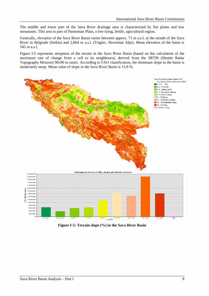
International Sava River Basin Commission
Sava River Basin Analysis – Part I 8
The middle and lower part of the Sava River drainage area is characterized by flat plains and low
mountains. This area is part of Pannonian Plain, a low-lying, fertile, agricultural region.
Generally, elevation of the Sava River Basin varies between approx. 71 m a.s.l. at the mouth of the Sava
River in Belgrade (Serbia) and 2,864 m a.s.l. (Triglav, Slovenian Alps). Mean elevation of the basin is
545 m a.s.l.
Figure I-5 represents steepness of the terrain in the Sava River Basin (based on the calculation of the
maximum rate of change from a cell to its neighbours), derived from the SRTM (Shuttle Radar
Topography Mission) 90x90 m raster. According to FAO classification, the dominant slope in the basin is
moderately steep. Mean value of slope in the Sava River Basin is 15.8 %.
Figure I-5: Terrain slope (%) in the Sava River Basin
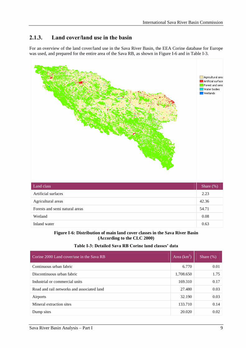
International Sava River Basin Commission
Sava River Basin Analysis – Part I 9
2.1.3. Land cover/land use in the basin
For an overview of the land cover/land use in the Sava River Basin, the EEA Corine database for Europe
was used, and prepared for the entire area of the Sava RB, as shown in Figure I-6 and in Table I-3.
Land class Share (%)
Artificial surfaces 2.23
Agricultural areas 42.36
Forests and semi natural areas 54.71
Wetland 0.08
Inland water 0.63
Figure I-6: Distribution of main land cover classes in the Sava River Basin
(According to the CLC 2000)
Table I-3: Detailed Sava RB Corine land classes’ data
Corine 2000 Land cover/use in the Sava RB Area (km2) Share (%)
Continuous urban fabric 6.770 0.01
Discontinuous urban fabric 1,708.650 1.75
Industrial or commercial units 169.310 0.17
Road and rail networks and associated land 27.480 0.03
Airports 32.190 0.03
Mineral extraction sites 133.710 0.14
Dump sites 20.020 0.02
International Sava River Basin Commission
Sava River Basin Analysis – Part I 10
Corine 2000 Land cover/use in the Sava RB Area (km2) Share (%)
Construction sites 8.160 0.01
Green urban areas 37.800 0.04
Sport and leisure facilities 24.680 0.03
Non-irrigated arable land 6,162.430 6.32
Permanently irrigated land 0.280 0.00
Vineyards 63.490 0.07
Fruit trees and berry plantations 123.900 0.13
Pastures 5,875.410 6.03
Complex cultivation patterns 16,990.640 17.43
Land principally occupied by agriculture, with significant areas of natural
vegetation
12,068.440 12.38
Broad-leaved forest 29,596.930 30.37
Coniferous forest 5,384.240 5.42
Mixed forest 9,376.860 9.62
Natural grasslands 23,636.110 2.38
Moors and heathland 295.410 0.30
Sclerophyllous vegetation 0.400 0.00
Transitional woodland-shrub 5,874.040 5.92
Beaches, dunes, sands 25.570 0.03
Bare rocks 200.370 0.21
Sparsely vegetated areas 449.500 0.46
Burnt areas 2.360 0.00
Glaciers and perpetual snow 0.340 0.00
Inland marshes 81.260 0.08
Water courses 375.620 0.39
Water bodies 233.880 0.24
Total 97,713.200 100.00
2.1.4. Soils
According to Harmonized World Soil database (HWSD), the soils with the largest extent are the
Cambisols (weakly to moderately developed soils) that cover 46.4 % of the basin (Figure I-7). Other
important soil groups are the Luvisols (soils with subsurface accumulation of high activity clays and high
base saturation), Leptosols (very shallow soils over hard rock or in unconsolidated very gravelly
material), Podzoluvisols (leached soils) and Fluvisols (young soils in alluvial deposits).
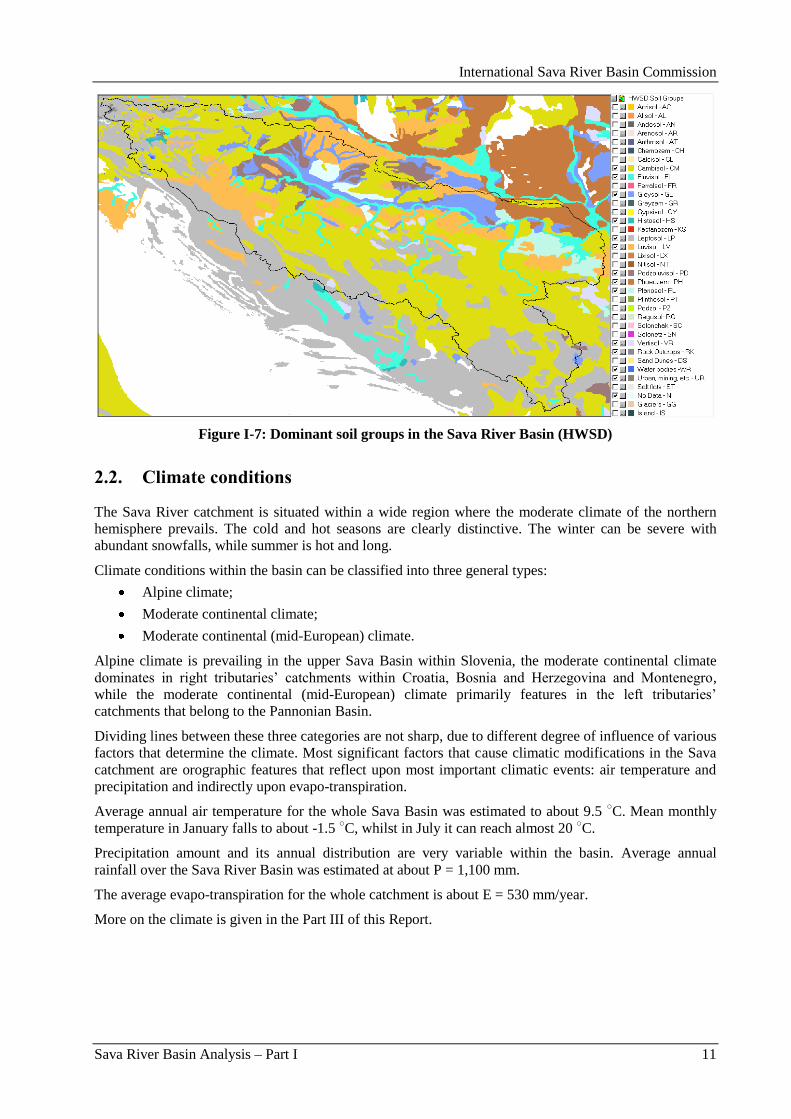
International Sava River Basin Commission
Sava River Basin Analysis – Part I 11
Figure I-7: Dominant soil groups in the Sava River Basin (HWSD)
2.2. Climate conditions
The Sava River catchment is situated within a wide region where the moderate climate of the northern
hemisphere prevails. The cold and hot seasons are clearly distinctive. The winter can be severe with
abundant snowfalls, while summer is hot and long.
Climate conditions within the basin can be classified into three general types:
Alpine climate;
Moderate continental climate;
Moderate continental (mid-European) climate.
Alpine climate is prevailing in the upper Sava Basin within Slovenia, the moderate continental climate
dominates in right tributaries‟ catchments within Croatia, Bosnia and Herzegovina and Montenegro,
while the moderate continental (mid-European) climate primarily features in the left tributaries‟
catchments that belong to the Pannonian Basin.
Dividing lines between these three categories are not sharp, due to different degree of influence of various
factors that determine the climate. Most significant factors that cause climatic modifications in the Sava
catchment are orographic features that reflect upon most important climatic events: air temperature and
precipitation and indirectly upon evapo-transpiration.
Average annual air temperature for the whole Sava Basin was estimated to about 9.5 ○C. Mean monthly
temperature in January falls to about -1.5 ○C, whilst in July it can reach almost 20
○C.
Precipitation amount and its annual distribution are very variable within the basin. Average annual
rainfall over the Sava River Basin was estimated at about P = 1,100 mm.
The average evapo-transpiration for the whole catchment is about E = 530 mm/year.
More on the climate is given in the Part III of this Report.
International Sava River Basin Commission
Sava River Basin Analysis – Part I 12
2.3. Main hydrographic features in the Sava River Basin
2.3.1. Description of the Sava River and its main tributaries
The Sava River is formed by two mountainous streams: the Sava Dolinka (left) and Sava Bohinjka (right).
From the confluence of these headwaters between the Slovenian towns of Lesce and Radovljica until it
joins the Danube in Belgrade (Serbia), the Sava River is 945 km long. Together with its longer headwater,
the Sava Dolinka River, in the north-west, it measures 990 km.
Its average discharge at the confluence (Belgrade, Serbia) is about 1,700 m3/s which results in the long-
term average unit-area-runoff for the complete catchment of about 18 l/s/km2.
Hydrographic network in the basin is well developed. East of Ljubljana, the Sava flows through a 90 km
long gorge and afterwards through the Karst Plain (Krško polje). Most important tributaries in the upper
Sava River Basin are: Kokra, Kamniška Bistrica and Savinja (from the left side) and Sora, Ljubljanica
and Krka (from the right). These rivers are characterized by a torrential nature (steep channel‟s slope,
high flow velocity and rapids).
As the geo-morphological processes caused the Pannonian Sea to recede, the Sava River grew longer,
carving the Sava Trench (Savski rov) through which it flows to the east. The river runs through numerous
towns that used to host considerable industrial capacities (Zagreb, Sisak, Slavonski/Bosanski Brod,
Brĉko, Sremska Mitrovica, Šabac, Obrenovac, Belgrade and others). Waste waters discharged from
municipalities and industries along the Sava River as well as the tributaries were treated only at certain
locations so the water quality used to be considerably endangered. Presently, situation is somewhat better
as a result of decrease of industrial activities.
Together with the lower parts of the Bosnian watercourses, which are its tributaries, the Sava River
created huge floodplains. At its middle and lower course, the Sava River begins to meander, subjective to
gentle slopes of the Pannonian bed and by force of its many right tributaries. It changed its course many
times through history. Old riverbeds turned into swamps and ponds known as „mrtvaja” and „starača”.
The best known and largest pond is in Serbia which is also one of the biggest wild birds‟ reservation areas
in Europe - Obedska Bara.
Common feature of almost all right tributaries of the Sava River is their torrential behaviour, particularly
in their upper sections. River channels are often deeply cut into the hard rocks, with very violent flow
through gorges. These mountainous features are mostly pronounced in the Rivers Una and Drina.
Thanks to geological properties, the Una River is famous by several water falls appearing on its
watercourse. As it approaches the confluence, the Una River becomes mild and slow moving. Further
downstream the Sava River receives several right tributaries that drain central and northern part of Bosnia
and Herzegovina. Most significant among them are Vrbas, Ukrina, Bosna, Brka and Tinja. Vrbas and
Bosna are medium size rivers whose catchments are deeply penetrating into the central part of Bosnia and
Herzegovina. They receive several mountainous tributaries each.
The other three above mentioned rivers (Ukrina, Brka and Tinja) drain rather smaller drainage areas of
northern Bosnia (Tinja and Brka < 1,000 km2).
Drina River is the largest and most important of all tributaries of the Sava River. Its drainage basin
extends into four countries: Montenegro, Bosnia and Herzegovina, Serbia and a very small part extends to
Albania. The river course is formed in Montenegro after merge of two mountainous streams (the Rivers
Tara and Piva that drain very rugged mountains of northern part of Montenegro). In its further course it
receives several tributaries: Sutjeska, Praĉa and Drinjaĉa (from the left) and the Ćehotina, Lim, Rzav,
Ljubovidja and Jadar (from the right). The Lim River is the most important tributary of the Drina River,
whose catchment extends to Albania.
Going further downstream the Sava River near Belgrade receives two important tributaries from the right:
Kolubara and Topĉider River.
International Sava River Basin Commission
Sava River Basin Analysis – Part I 13
The left tributaries, except in the upper part of the catchment (in Slovenia) that was discussed above,
drain mostly flat areas and low hills of Pannonian Basin. Consequently, the slopes and flow velocities are
smaller and the streams are meandering. Most important rivers are Sutla/Sotla (SI and HR), Krapina,
Lonja, Ilova and Orljava (HR), and Bosut (HR and RS). These rivers encompass much smaller part of the
drainage than the right tributaries, thus making the Sava River catchment asymmetric.
2.3.2. Overview of the „Sava River Basin Analysis” rivers
For the purpose of this characterization report, as a common agreement of the Sava countries, the Sava
River tributaries with catchment area above threshold value of 1,000 km2 were taken as the limit for the
scale of analysis for the Sava RB. Based on this arbitrary decision, the rivers listed in Table I-4 were
analyzed during this exercise.
Table I-4: Agreed list of the Sava River Basin rivers for the purpose of the Sava RBA report
River
Con-
fluence
(l-left;
r-right)
Trib.
order
River
basin
size
[km2]
River
length
[km]
Countries sharing the
(sub-)basins
Sava 97,713.2 944.7 SI, HR, BA, RS, ME,
AL
Ljubljanica r 1st 1,860.0 41.0 SI
Savinja l 1st 1,849.0 93.9 SI
Krka r 1st 2,247.0 94.6 SI
Sotla/Sutla l 1st 584.3 88.6 SI, HR
Krapina l 1st 1,237.0 66.9 HR
Kupa/Kolpa r 1st 10,225.6 297.4 HR, SI, BA
Dobra r 2nd 1,428.0 104.2 HR
Korana r 2nd 2,301.5 138.6 HR, BA
Glina r 2nd 1,427.1 112.2 HR, BA
Lonja l 1st 4,259.0 49.1 HR
Ĉesma l 2nd 3,253.0 105.7 HR
Glogovnica r 3rd 1,302.0 64.5 HR
Ilova (Trebeţ) l 1st 1,796.0 104.6 HR
Una r 1st 9,828.9 214.6 BA, HR
Sana r 2nd 4,252.7 141.9 BA
Vrbas r 1st 6,273.8 249.7 BA
Pliva l 2nd 1,325.7 26.8 BA
Orljava l 1st 1,618.0 87.6 HR
Ukrina r 1st 1,504.0 80.7 BA
Bosna r 1st 10,809.8 281.6 BA
Lašva l 2nd 958.1 56.6 BA
Krivaja r 2nd 1,494.5 73.5 BA
Spreĉa r 2nd 1,948.0 138.8 BA
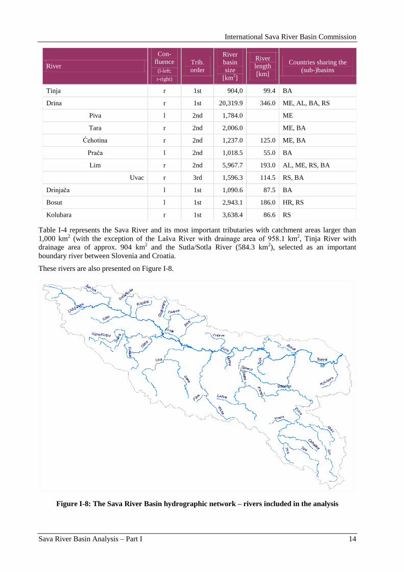
International Sava River Basin Commission
Sava River Basin Analysis – Part I 14
River
Con-
fluence
(l-left;
r-right)
Trib.
order
River
basin
size
[km2]
River
length
[km]
Countries sharing the
(sub-)basins
Tinja r 1st 904,0 99.4 BA
Drina r 1st 20,319.9 346.0 ME, AL, BA, RS
Piva l 2nd 1,784.0 ME
Tara r 2nd 2,006.0 ME, BA
Ćehotina r 2nd 1,237.0 125.0 ME, BA
Praĉa l 2nd 1,018.5 55.0 BA
Lim r 2nd 5,967.7 193.0 AL, ME, RS, BA
Uvac r 3rd 1,596.3 114.5 RS, BA
Drinjaĉa l 1st 1,090.6 87.5 BA
Bosut l 1st 2,943.1 186.0 HR, RS
Kolubara r 1st 3,638.4 86.6 RS
Table I-4 represents the Sava River and its most important tributaries with catchment areas larger than
1,000 km2 (with the exception of the Lašva River with drainage area of 958.1 km
2, Tinja River with
drainage area of approx. 904 km2 and the Sutla/Sotla River (584.3 km
2), selected as an important
boundary river between Slovenia and Croatia.
These rivers are also presented on Figure I-8.
Figure I-8: The Sava River Basin hydrographic network – rivers included in the analysis

International Sava River Basin Commission
Sava River Basin Analysis – Part I 15
Location of the Sava River Basin rivers with their associated catchments can be seen in Figure I-9 and an
overview of the distribution of catchment over territories of the Sava countries is given in Figure I-10.
Figure I-9: Sava River sub-basins (with catchment areas larger than 1,000 km2)
Figure I-10: Sava River sub-basins – overview by the Sava countries
Detailed characteristics of flow regime of the Sava River and its main tributaries are analyzed in the Part
III of this Report.
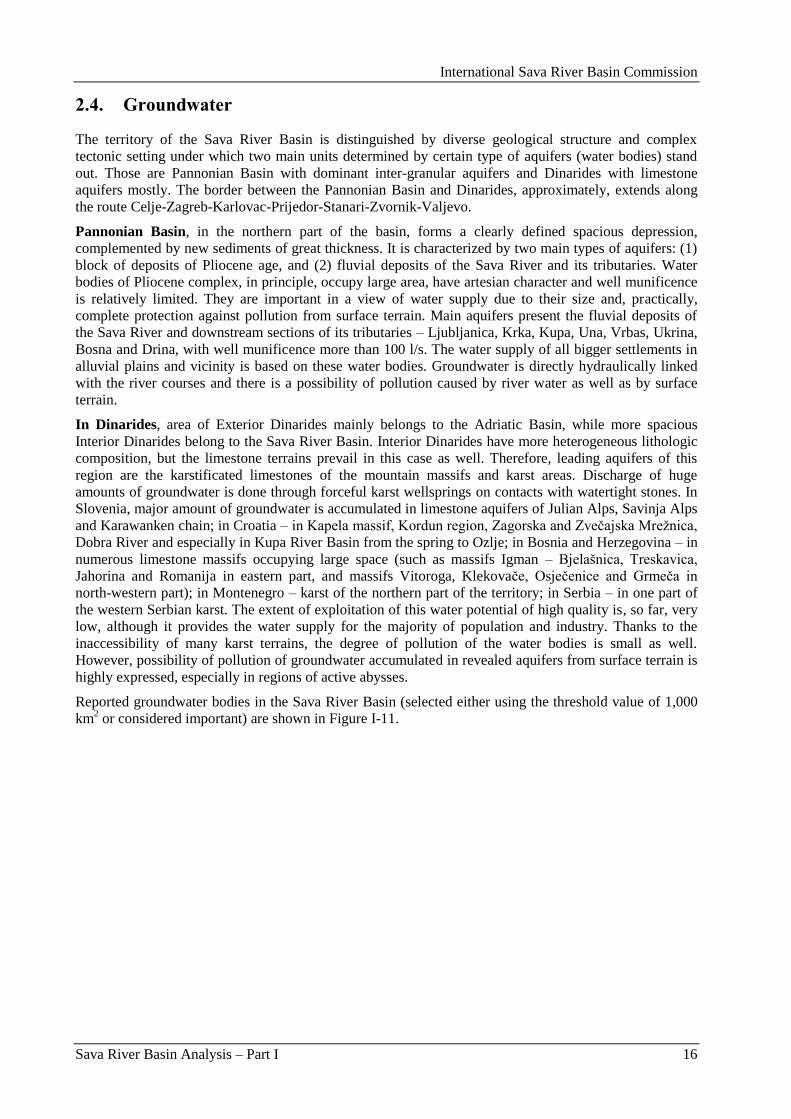
International Sava River Basin Commission
Sava River Basin Analysis – Part I 16
2.4. Groundwater
The territory of the Sava River Basin is distinguished by diverse geological structure and complex
tectonic setting under which two main units determined by certain type of aquifers (water bodies) stand
out. Those are Pannonian Basin with dominant inter-granular aquifers and Dinarides with limestone
aquifers mostly. The border between the Pannonian Basin and Dinarides, approximately, extends along
the route Celje-Zagreb-Karlovac-Prijedor-Stanari-Zvornik-Valjevo.
Pannonian Basin, in the northern part of the basin, forms a clearly defined spacious depression,
complemented by new sediments of great thickness. It is characterized by two main types of aquifers: (1)
block of deposits of Pliocene age, and (2) fluvial deposits of the Sava River and its tributaries. Water
bodies of Pliocene complex, in principle, occupy large area, have artesian character and well munificence
is relatively limited. They are important in a view of water supply due to their size and, practically,
complete protection against pollution from surface terrain. Main aquifers present the fluvial deposits of
the Sava River and downstream sections of its tributaries – Ljubljanica, Krka, Kupa, Una, Vrbas, Ukrina,
Bosna and Drina, with well munificence more than 100 l/s. The water supply of all bigger settlements in
alluvial plains and vicinity is based on these water bodies. Groundwater is directly hydraulically linked
with the river courses and there is a possibility of pollution caused by river water as well as by surface
terrain.
In Dinarides, area of Exterior Dinarides mainly belongs to the Adriatic Basin, while more spacious
Interior Dinarides belong to the Sava River Basin. Interior Dinarides have more heterogeneous lithologic
composition, but the limestone terrains prevail in this case as well. Therefore, leading aquifers of this
region are the karstificated limestones of the mountain massifs and karst areas. Discharge of huge
amounts of groundwater is done through forceful karst wellsprings on contacts with watertight stones. In
Slovenia, major amount of groundwater is accumulated in limestone aquifers of Julian Alps, Savinja Alps
and Karawanken chain; in Croatia – in Kapela massif, Kordun region, Zagorska and Zveĉajska Mreţnica,
Dobra River and especially in Kupa River Basin from the spring to Ozlje; in Bosnia and Herzegovina – in
numerous limestone massifs occupying large space (such as massifs Igman – Bjelašnica, Treskavica,
Jahorina and Romanija in eastern part, and massifs Vitoroga, Klekovaĉe, Osjeĉenice and Grmeĉa in
north-western part); in Montenegro – karst of the northern part of the territory; in Serbia – in one part of
the western Serbian karst. The extent of exploitation of this water potential of high quality is, so far, very
low, although it provides the water supply for the majority of population and industry. Thanks to the
inaccessibility of many karst terrains, the degree of pollution of the water bodies is small as well.
However, possibility of pollution of groundwater accumulated in revealed aquifers from surface terrain is
highly expressed, especially in regions of active abysses.
Reported groundwater bodies in the Sava River Basin (selected either using the threshold value of 1,000
km2 or considered important) are shown in Figure I-11.
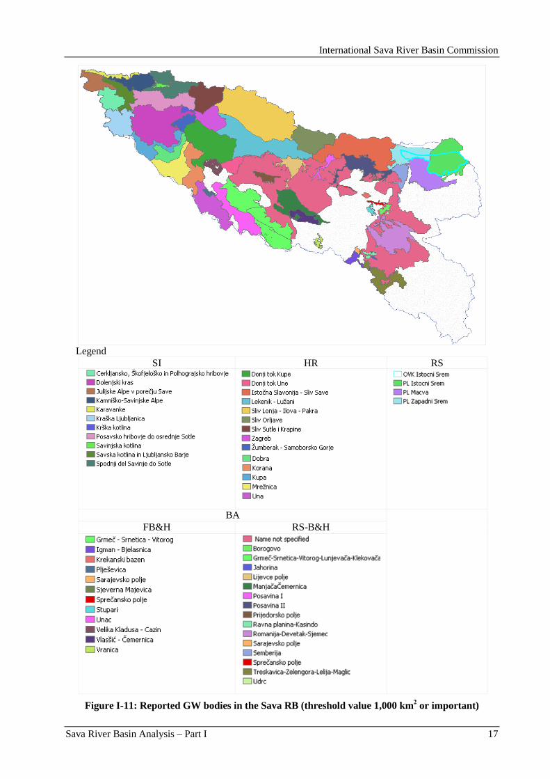
International Sava River Basin Commission
Sava River Basin Analysis – Part I 17
Legend
SI HR RS
BA FB&H RS-B&H
Figure I-11: Reported GW bodies in the Sava RB (threshold value 1,000 km2 or important)
International Sava River Basin Commission
Sava River Basin Analysis – Part I 18
2.5. Ecological characterization
2.5.1. Wetlands
2.5.1.1. Ramsar sites
The Sava River Basin is of important significance due to its outstanding biological and landscape
diversity. It hosts the largest complex of alluvial wetlands and large lowlands forest complexes. Some of
these floodplains are still intact and support flood alleviation and biodiversity. Wetlands are cradles of
biological diversity, providing the water and primary productivity upon which countless species of plants
and animals depend on survival. They support high concentrations of birds, mammals, reptiles,
amphibians, fish and invertebrate species. Wetlands are also important storehouses of plant genetic
material.
These functions, values and attributes can only be maintained if the ecological processes of wetlands are
allowed to continue functioning. Unfortunately, and in spite of important progress made in recent
decades, wetlands continue to be among the most threatened ecosystems, owing mainly to ongoing
drainage, conversion, pollution, and over-exploitation of their resources.
Because of the above mentioned ecological and cultural value of the wetlands, the Sava riparian countries
have designated six sites in the Sava River Basin according to The Convention on Wetlands of
International Importance especially as Waterfowl Habitat or so called Ramsar Convention. The locations
and the main facts about the Ramsar sites are given in Figure I-12 and in Table I-5, respectively.
Figure I-12: Locations of the Ramsar sites in the Sava River Basin
International Sava River Basin Commission
Sava River Basin Analysis – Part I 19
Table I-5: Basic data about the Ramsar sites in the Sava River Basin
Country Ramsar site Designation
date
Coordinates Area
(ha) National status
Lat. Long.
BA Bardaĉa Wetland
(Bardaĉa moĉvarni
kompleks)
Feb. 2, 2007 45°06‟N 17°27‟E 3,500 Important Bird
Area
HR Lonjsko Polje and
Mokro Polje
Feb. 3, 1993 45°21‟N 16°21‟E 50,560 Nature Park,
Ornithological
Reserve
Crna Mlaka Feb. 3, 1993 45°37‟N 15°44‟E 625 Ornithological
Reserve
RS Obedska Bara Mar. 28, 1977 44°44‟N 20°00‟E 17,501 Nature Reserve
Zasavica Mar. 13, 2008 44°56‟N 19°31‟E 1,913 Important Bird
Area, Special natu-
re Reserve, partia-
lly, Important Plant
Area, partially
SI Cerkniško jezero z
okolico (Lake
Cerknica and its
environs)
Jan. 19, 2006 45°45‟N 14°23‟E 7,250 Natura 2000 site,
Ecologically
Important Area,
Regional Park
2.5.1.2. Description of the Ramsar sites in the Sava River Basin
Bardača Wetland (Bardača močvarni kompleks) (BA)
Bardaĉa wetland is situated in northern Bosnia and Herzegovina, between the Rivers Vrbas and Sava.
About half of the Ramsar site comprises fishponds being constructed since the early 20th century and
further enlarged in the 1960-ies for irrigation purposes. The ponds, floodplain forest, meadow and swamp
areas support a range of endangered species and make an important nesting and stopover site for birds.
There is a rich fish fauna (e.g., Gymnocephalus schraetzer, Zingel streber) and a range of amphibians
such as Salamandra salamandra, Rana dalmatina, and the pond tortoise Emys orbicularis. The
hydrological regime has been interrupted by the construction of channels, pump stations, and damming of
nearby streams, but, in present, pressure comes from permanent, intensive agricultural practices such as
intensive pasturing and unwise use of fertilizers and pesticides. Aquaculture and fish production remain a
primary economic pursuit. With assistance from the Ramsar Small Grants Fund, a management plan is
currently under development.
Lonjsko Polje and Mokro Polje (incl. Krapje Dol) (HR)
The Ramsar site and Important Bird Area Lonjsko Polje Nature Park (LPNP) represents mainly
palustrine-riverine wetland located within the floodplains of the middle Sava River Basin (Central
Posavina, HR). It is the largest maintained inundation area of the Danube River catchment and, at the
same time, the key facility of the flood control system of the entire Sava River Basin (including Bosnia
and Herzegovina and Serbia). Within the Pan-European Biological and Landscape Diversity Strategy, the
World Conservation Union (IUCN) identified the site as a showcase of Best Practices of Conservation
Planning in Rural Areas of CEE-countries. The Regional Tourism Master Plan recognized LPNP as the
unit selling point for tourism development of continental Croatia. The high-ranked species and habitat
diversity (approximately 7 habitats and 89 species mentioned in the EU Habitats Directive) is mainly
caused by man-made landscape variety, traditional grazing activities with endangered autochthonous
breeds and a natural micro-relief created by natural flood dynamics. Since the Sava River became
international, effective flood control and conservation management demand an integrated approach.
LPNP started to develop consultative processes and appropriate structures of involvement of stakeholders
and local people both on a park scale and on a central basin scale.
International Sava River Basin Commission
Sava River Basin Analysis – Part I 20
Crna Mlaka (HR)
An area of fishponds surrounded by flooded oak woodland and meadows. The site is important for
numerous species of breeding birds and as a staging area for such spring and autumn migrants such as the
Great white egret, Osprey, and the Peregrine falcon. Human activities include commercial and
recreational fishing and tourism.
Obedska Bara (RS)
Obedska Bara is a seasonally inundated area of the Sava River floodplain, with marshes, ponds, wet
meadows, and an oxbow lake. Vegetation includes reedbeds and Salix-Populus and Quercus woodland.
The area is important for various species of breeding waterbirds. River regulation has adversely affected
fish stocks at the site. The lake is subject to rapid siltation and nutrient-enrich-ment, resulting in
expansion of reedbeds and Salix scrub, to the exclusion of open water areas.
Zasavica (RS)
Zasavica is a seasonal/intermittent freshwater marsh on inorganic soil which includes sloughs, potholes,
seasonally flooded meadows and sedge marshes. It is consisted of tree-dominated wetlands covered by
freshwater swamp forest, seasonally flooded forest and shrubs swamps. Its large diversity of fauna
represents its important biological values. In the area, the invertebrates, fishes, birds and mammals,
among which some are the rare/endangered species, can be found. It is also a staging area for migratory
waterbird species. There is an outstanding variety of flora species in Zasavica which is important for
maintaining the geographic range of a plant species.
Cerkniško jezero z okolico (Lake Cerknica and its environs) (SI)
Cerknica Lake is the largest and most typical intermittent karst lake in its region. It is formed during rainy
periods when the volume of water can no longer be drained through sinkholes, and the lake has no surface
outflow, discharging exclusively underground. Numerous picturesque karst phenomena, such as karst
sources, estavelles, ponors and ponor caves, abound, and the Kriţna cave is renowned for its underground
lakes; the Rakov škocjan valley, formed by the collapse of ceilings of underground caves, and the Rak
River are fed mainly by water from the lake. These special habitats support many rare and endemic
species, such as cave beetle and cave salamander, and the lake is the only nesting site in Slovenia for the
rednecked grebe, the redshank and the ferruginous duck as well as a breeding place for the corncrake.
Remains of Palaeolithic, Mesolithic, and Iron Age settlements are found on Gorica Island in the middle of
the lake, as well as prehistoric settlements from the 12th to the 4
th centuries BC and a Roman necropolis
nearby. Frequent, unpredictable flooding makes intensive agriculture impossible, but pasture and forest
uses are widespread, besides some small recreation grounds; appropriate tourist facilities are needed to
avoid adverse effects of unorganized tourism.

International Sava River Basin Commission
Sava River Basin Analysis – Part I 21
3. Water management in the Sava River Basin
3.1. Administrative framework
Bosnia and Herzegovina
In accordance with the Dayton Peace Agreement, Bosnia and Herzegovina is comprised of two entities:
the Federation of Bosnia and Herzegovina (FBA) and the Republika Srpska, and Brĉko District as a
separate administrative unit as of March 8, 2000. The FBA consists of 10 cantons with total of 79
municipalities and the Republika Srpska of 62 municipalities (no canton level).
According to the Constitution of Bosnia and Herzegovina, water management is under competence of the
entity ministries of agriculture, water management and forestry. In the FBA, the Sava River Watershed
Agency in Sarajevo and Adriatic Sea Watershed Agency in Mostar are responsible for water
management, while in the Republika Srpska this responsibility is given to the Water Agency for the Sava
River District in Bijeljina and future water Agency for Trebišnjica River District in Trebinje. On state
level, the Ministry of Foreign Trade and Economic Relations of BA is responsible for coordination of
activities and harmonization of plans between the bodies of the entity governments, as well as for
institutions on international level in the field of natural resources, environment protection, agriculture and
energy. Ministry of Communications and Transport of BA, also on the state level, is in charge of
navigation on rivers and sea (Figure I-13).
Figure I-13: Water Management in BA
Croatia
The bodies authorized and responsible for these activities are the Croatian Parliament, the National Water
Council, the Government of the Republic of Croatia, the Ministry of Regional Development, Forestry and
Water Management and other state administration bodies, local and regional self-government units, and
Hrvatske vode as a national water management agency (Figure I-14).
The Ministry of Regional Development, Forestry and Water Management performs administrative and
other expert tasks.
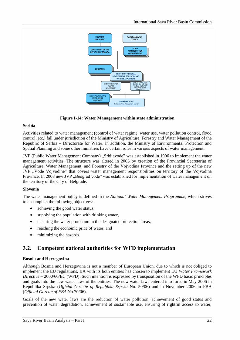
International Sava River Basin Commission
Sava River Basin Analysis – Part I 22
CROATIA N
PARLIAMENT
GOVERNMENT OF THE
REPUBLIC OF CROATIA
STATE
ADMINISTRATION
ORGANISATIONS
NATIONAL WATER
COUNCIL
HRVATSKE VODENational Water Management Agency
PUBLIC AGENCIES AND
STATE-OWNED
COMPANIES
DIRECTORATE FOR
WATER
MANAGEMENT
DIRECTORATE FOR
WATER POLICY AND
INTERNATIONAL
PROJECTS
MINISTRY OF REGIONAL
DEVELOPMENT, FORESTRY AND
WATER MANAGEMENT
MINISTRIES
Figure I-14: Water Management within state administration
Serbia
Activities related to water management (control of water regime, water use, water pollution control, flood
control, etc.) fall under jurisdiction of the Ministry of Agriculture, Forestry and Water Management of the
Republic of Serbia – Directorate for Water. In addition, the Ministry of Environmental Protection and
Spatial Planning and some other ministries have certain roles in various aspects of water management.
JVP (Public Water Management Company) „Srbijavode” was established in 1996 to implement the water
management activities. The structure was altered in 2003 by creation of the Provincial Secretariat of
Agriculture, Water Management, and Forestry of the Vojvodina Province and the setting up of the new
JVP „Vode Vojvodine” that covers water management responsibilities on territory of the Vojvodina
Province. In 2008 new JVP „Beograd vode” was established for implementation of water management on
the territory of the City of Belgrade.
Slovenia
The water management policy is defined in the National Water Management Programme, which strives
to accomplish the following objectives:
achieving the good water status,
supplying the population with drinking water,
ensuring the water protection in the designated protection areas,
reaching the economic price of water, and
minimizing the hazards.
3.2. Competent national authorities for WFD implementation
Bosnia and Herzegovina
Although Bosnia and Herzegovina is not a member of European Union, due to which is not obliged to
implement the EU regulations, BA with its both entities has chosen to implement EU Water Framework
Directive – 2000/60/EC (WFD). Such intention is expressed by transposition of the WFD basic principles
and goals into the new water laws of the entities. The new water laws entered into force in May 2006 in
Republika Srpska (Official Gazette of Republika Srpska No. 50/06) and in November 2006 in FBA
(Official Gazette of FBA No.70/06).
Goals of the new water laws are the reduction of water pollution, achievement of good status and
prevention of water degradation, achievement of sustainable use, ensuring of rightful access to water,
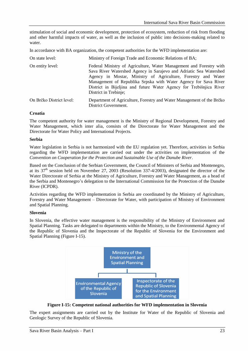
International Sava River Basin Commission
Sava River Basin Analysis – Part I 23
stimulation of social and economic development, protection of ecosystem, reduction of risk from flooding
and other harmful impacts of water, as well as the inclusion of public into decisions-making related to
water.
In accordance with BA organization, the competent authorities for the WFD implementation are:
On state level: Ministry of Foreign Trade and Economic Relations of BA;
On entity level: Federal Ministry of Agriculture, Water Management and Forestry with
Sava River Watershed Agency in Sarajevo and Adriatic Sea Watershed
Agency in Mostar, Ministry of Agriculture, Forestry and Water
Management of Republika Srpska with Water Agency for Sava River
District in Bijeljina and future Water Agency for Trebišnjica River
District in Trebinje;
On Brĉko District level: Department of Agriculture, Forestry and Water Management of the Brĉko
District Government.
Croatia
The competent authority for water management is the Ministry of Regional Development, Forestry and
Water Management, which inter alia, consists of the Directorate for Water Management and the
Directorate for Water Policy and International Projects.
Serbia
Water legislation in Serbia is not harmonized with the EU regulation yet. Therefore, activities in Serbia
regarding the WFD implementation are carried out under the activities on implementation of the
Convention on Cooperation for the Protection and Sustainable Use of the Danube River.
Based on the Conclusion of the Serbian Government, the Council of Ministers of Serbia and Montenegro,
at its 37th session held on November 27, 2003 (Resolution 337-4/2003), designated the director of the
Water Directorate of Serbia at the Ministry of Agriculture, Forestry and Water Management, as a head of
the Serbia and Montenegro‟s delegation to the International Commission for the Protection of the Danube
River (ICPDR).
Activities regarding the WFD implementation in Serbia are coordinated by the Ministry of Agriculture,
Forestry and Water Management – Directorate for Water, with participation of Ministry of Environment
and Spatial Planning.
Slovenia
In Slovenia, the effective water management is the responsibility of the Ministry of Environment and
Spatial Planning. Tasks are delegated to departments within the Ministry, to the Environmental Agency of
the Republic of Slovenia and the Inspectorate of the Republic of Slovenia for the Environment and
Spatial Planning (Figure I-15).
Figure I-15: Competent national authorities for WFD implementation in Slovenia
The expert assignments are carried out by the Institute for Water of the Republic of Slovenia and
Geologic Survey of the Republic of Slovenia.
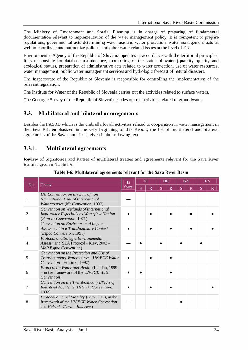
International Sava River Basin Commission
Sava River Basin Analysis – Part I 24
The Ministry of Environment and Spatial Planning is in charge of preparing of fundamental
documentation relevant to implementation of the water management policy. It is competent to prepare
regulations, governmental acts determining water use and water protection, water management acts as
well to coordinate and harmonize policies and other water related issues at the level of EU.
Environmental Agency of the Republic of Slovenia operates in accordance with the territorial principles.
It is responsible for database maintenance, monitoring of the status of water (quantity, quality and
ecological status), preparation of administrative acts related to water protection, use of water resources,
water management, public water management services and hydrologic forecast of natural disasters.
The Inspectorate of the Republic of Slovenia is responsible for controlling the implementation of the
relevant legislation.
The Institute for Water of the Republic of Slovenia carries out the activities related to surface waters.
The Geologic Survey of the Republic of Slovenia carries out the activities related to groundwater.
3.3. Multilateral and bilateral arrangements
Besides the FASRB which is the umbrella for all activities related to cooperation in water management in
the Sava RB, emphasized in the very beginning of this Report, the list of multilateral and bilateral
agreements of the Sava countries is given in the following text.
3.3.1. Multilateral agreements
Review of Signatories and Parties of multilateral treaties and agreements relevant for the Sava River
Basin is given in Table I-6.
Table I-6: Multilateral agreements relevant for the Sava River Basin
No Treaty In
force
SI HR BA RS
S R S R S R S R
1
UN Convention on the Law of non-
Navigational Uses of International
Watercourses (NY Convention, 1997)
▬
2
Convention on Wetlands of International
Importance Especially as Waterflow Habitat
(Ramsar Convention, 1971)
● ● ● ● ●
3
Convention on Environmental Impact
Assessment in a Transboundary Context
(Espoo Convention, 1991)
● ● ● ● ●
4
Protocol on Strategic Environmental
Assessment (SEA Protocol - Kiev, 2003 –
MoP Espoo Convention)
▬ ● ● ● ●
5
Convention on the Protection and Use of
Transboundary Watercourses (UN/ECE Water
Convention - Helsinki, 1992)
● ● ●
6
Protocol on Water and Health (London, 1999
– in the framework of the UN/ECE Water
Convention)
● ● ●
7
Convention on the Transboundary Effects of
Industrial Accidents (Helsinki Convention,
1992)
● ● ● ●
8
Protocol on Civil Liability (Kiev, 2003, in the
framework of the UN/ECE Water Convention
and Helsinki Conv. – Ind. Acc.)
▬ ●
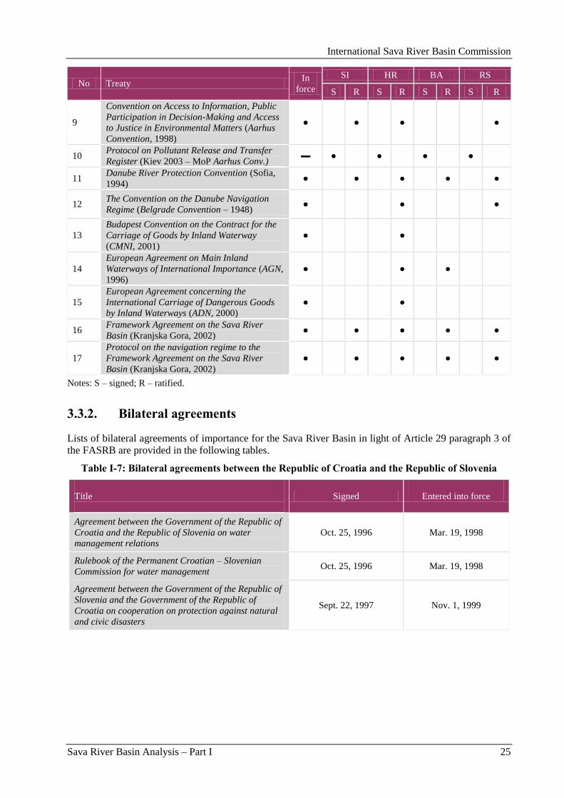
International Sava River Basin Commission
Sava River Basin Analysis – Part I 25
No Treaty In
force
SI HR BA RS
S R S R S R S R
9
Convention on Access to Information, Public
Participation in Decision-Making and Access
to Justice in Environmental Matters (Aarhus
Convention, 1998)
● ● ● ●
10 Protocol on Pollutant Release and Transfer
Register (Kiev 2003 – MoP Aarhus Conv.) ▬ ● ● ● ●
11 Danube River Protection Convention (Sofia,
1994) ● ● ● ● ●
12 The Convention on the Danube Navigation
Regime (Belgrade Convention – 1948) ● ● ●
13
Budapest Convention on the Contract for the
Carriage of Goods by Inland Waterway
(CMNI, 2001)
● ●
14
European Agreement on Main Inland
Waterways of International Importance (AGN,
1996)
● ● ●
15
European Agreement concerning the
International Carriage of Dangerous Goods
by Inland Waterways (ADN, 2000)
● ●
16 Framework Agreement on the Sava River
Basin (Kranjska Gora, 2002) ● ● ● ● ●
17
Protocol on the navigation regime to the
Framework Agreement on the Sava River
Basin (Kranjska Gora, 2002)
● ● ● ● ●
Notes: S – signed; R – ratified.
3.3.2. Bilateral agreements
Lists of bilateral agreements of importance for the Sava River Basin in light of Article 29 paragraph 3 of
the FASRB are provided in the following tables.
Table I-7: Bilateral agreements between the Republic of Croatia and the Republic of Slovenia
Title
Signed
Entered into force
Agreement between the Government of the Republic of
Croatia and the Republic of Slovenia on water
management relations
Oct. 25, 1996 Mar. 19, 1998
Rulebook of the Permanent Croatian – Slovenian
Commission for water management Oct. 25, 1996 Mar. 19, 1998
Agreement between the Government of the Republic of
Slovenia and the Government of the Republic of
Croatia on cooperation on protection against natural
and civic disasters
Sept. 22, 1997 Nov. 1, 1999
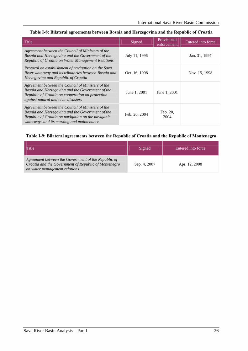
International Sava River Basin Commission
Sava River Basin Analysis – Part I 26
Table I-8: Bilateral agreements between Bosnia and Herzegovina and the Republic of Croatia
Title Signed Provisional
enforcement Entered into force
Agreement between the Council of Ministers of the
Bosnia and Herzegovina and the Government of the
Republic of Croatia on Water Management Relations
July 11, 1996 Jan. 31, 1997
Protocol on establishment of navigation on the Sava
River waterway and its tributaries between Bosnia and
Herzegovina and Republic of Croatia
Oct. 16, 1998 Nov. 15, 1998
Agreement between the Council of Ministers of the
Bosnia and Herzegovina and the Government of the
Republic of Croatia on cooperation on protection
against natural and civic disasters
June 1, 2001 June 1, 2001
Agreement between the Council of Ministers of the
Bosnia and Herzegovina and the Government of the
Republic of Croatia on navigation on the navigable
waterways and its marking and maintenance
Feb. 20, 2004 Feb. 20,
2004
Table I-9: Bilateral agreements between the Republic of Croatia and the Republic of Montenegro
Title
Signed Entered into force
Agreement between the Government of the Republic of
Croatia and the Government of Republic of Montenegro
on water management relations
Sep. 4, 2007 Apr. 12, 2008
International Sava River Basin Commission
Sava River Basin Analysis – Part II 27
Part II: Water Quality

International Sava River Basin Commission
Sava River Basin Analysis – Part II 28
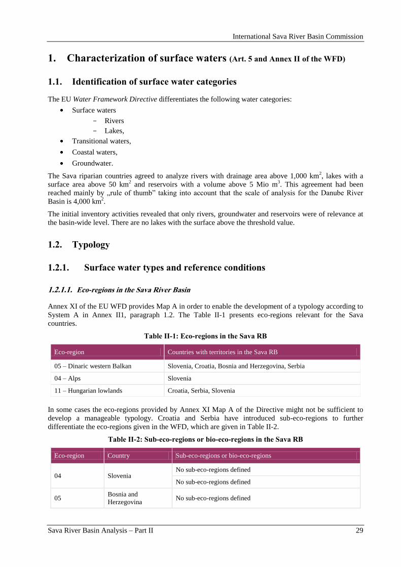
International Sava River Basin Commission
Sava River Basin Analysis – Part II 29
1. Characterization of surface waters (Art. 5 and Annex II of the WFD)
1.1. Identification of surface water categories
The EU Water Framework Directive differentiates the following water categories:
Surface waters
Rivers
Lakes,
Transitional waters,
Coastal waters,
Groundwater.
The Sava riparian countries agreed to analyze rivers with drainage area above 1,000 km2, lakes with a
surface area above 50 km2 and reservoirs with a volume above 5 Mio m
3. This agreement had been
reached mainly by „rule of thumb” taking into account that the scale of analysis for the Danube River
Basin is 4,000 km2.
The initial inventory activities revealed that only rivers, groundwater and reservoirs were of relevance at
the basin-wide level. There are no lakes with the surface above the threshold value.
1.2. Typology
1.2.1. Surface water types and reference conditions
1.2.1.1. Eco-regions in the Sava River Basin
Annex XI of the EU WFD provides Map A in order to enable the development of a typology according to
System A in Annex II1, paragraph 1.2. The Table II-1 presents eco-regions relevant for the Sava
countries.
Table II-1: Eco-regions in the Sava RB
Eco-region Countries with territories in the Sava RB
05 – Dinaric western Balkan Slovenia, Croatia, Bosnia and Herzegovina, Serbia
04 – Alps Slovenia
11 – Hungarian lowlands Croatia, Serbia, Slovenia
In some cases the eco-regions provided by Annex XI Map A of the Directive might not be sufficient to
develop a manageable typology. Croatia and Serbia have introduced sub-eco-regions to further
differentiate the eco-regions given in the WFD, which are given in Table II-2.
Table II-2: Sub-eco-regions or bio-eco-regions in the Sava RB
Eco-region Country Sub-eco-regions or bio-eco-regions
04 Slovenia No sub-eco-regions defined
No sub-eco-regions defined
05 Bosnia and
Herzegovina No sub-eco-regions defined
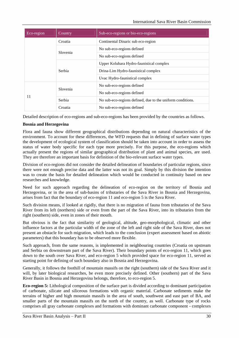
International Sava River Basin Commission
Sava River Basin Analysis – Part II 30
Eco-region Country Sub-eco-regions or bio-eco-regions
Croatia Continental Dinaric sub eco-region
Slovenia No sub-eco-regions defined
No sub-eco-regions defined
Serbia
Upper Kolubara Hydro-faunistical complex
Drina-Lim Hydro-faunistical complex
Uvac Hydro-faunistical complex
11
Slovenia No sub-eco-regions defined
No sub-eco-regions defined
Serbia No sub-eco-regions defined, due to the uniform conditions.
Croatia No sub-eco-regions defined
Detailed description of eco-regions and sub-eco-regions has been provided by the countries as follows.
Bosnia and Herzegovina
Flora and fauna show different geographical distributions depending on natural characteristics of the
environment. To account for these differences, the WFD requests that in defining of surface water types
the development of ecological system of classification should be taken into account in order to assess the
status of water body specific for each type more precisely. For this purpose, the eco-regions which
actually present the regions of similar geographical distribution of plant and animal species, are used.
They are therefore an important basis for definition of the bio-relevant surface water types.
Division of eco-regions did not consider the detailed delineation of boundaries of particular regions, since
there were not enough precise data and the latter was not its goal. Simply by this division the intention
was to create the basis for detailed delineation which would be conducted in continuity based on new
researches and knowledge.
Need for such approach regarding the delineation of eco-region on the territory of Bosnia and
Herzegovina, or in the area of sub-basins of tributaries of the Sava River in Bosnia and Herzegovina,
arises from fact that the boundary of eco-region 11 and eco-region 5 is the Sava River.
Such division means, if looked at rigidly, that there is no migration of fauna from tributaries of the Sava
River from its left (northern) side or even from the part of the Sava River, into its tributaries from the
right (southern) side, even in zones of their mouth.
But obvious is the fact that similarity of geological, altitude, geo-morphological, climatic and other
influence factors at the particular width of the zone of the left and right side of the Sava River, does not
present an obstacle for such migration, which leads to the conclusion (expert assessment based on abiotic
parameters) that this boundary has to be observed more flexible.
Such approach, from the same reasons, is implemented in neighbouring countries (Croatia on upstream
and Serbia on downstream part of the Sava River). Their boundary points of eco-region 11, which goes
down to the south over Sava River, and eco-region 5 which provided space for eco-region 11, served as
starting point for defining of such boundary also in Bosnia and Herzegovina.
Generally, it follows the foothill of mountain massifs on the right (southern) side of the Sava River and it
will, by later biological researches, be even more precisely defined. Other (southern) part of the Sava
River Basin in Bosnia and Herzegovina belongs, therefore, to eco-region 5.
Eco-region 5: Lithological composition of the surface part is divided according to dominant participation
of carbonate, silicate and siliceous formations with organic material. Carbonate sediments make the
terrains of higher and high mountain massifs in the area of south, southwest and east part of BA, and
smaller parts of the mountain massifs on the north of the country, as well. Carbonate type of rocks
comprises all gray carbonate complexes and formations with dominant carbonate component - complexes
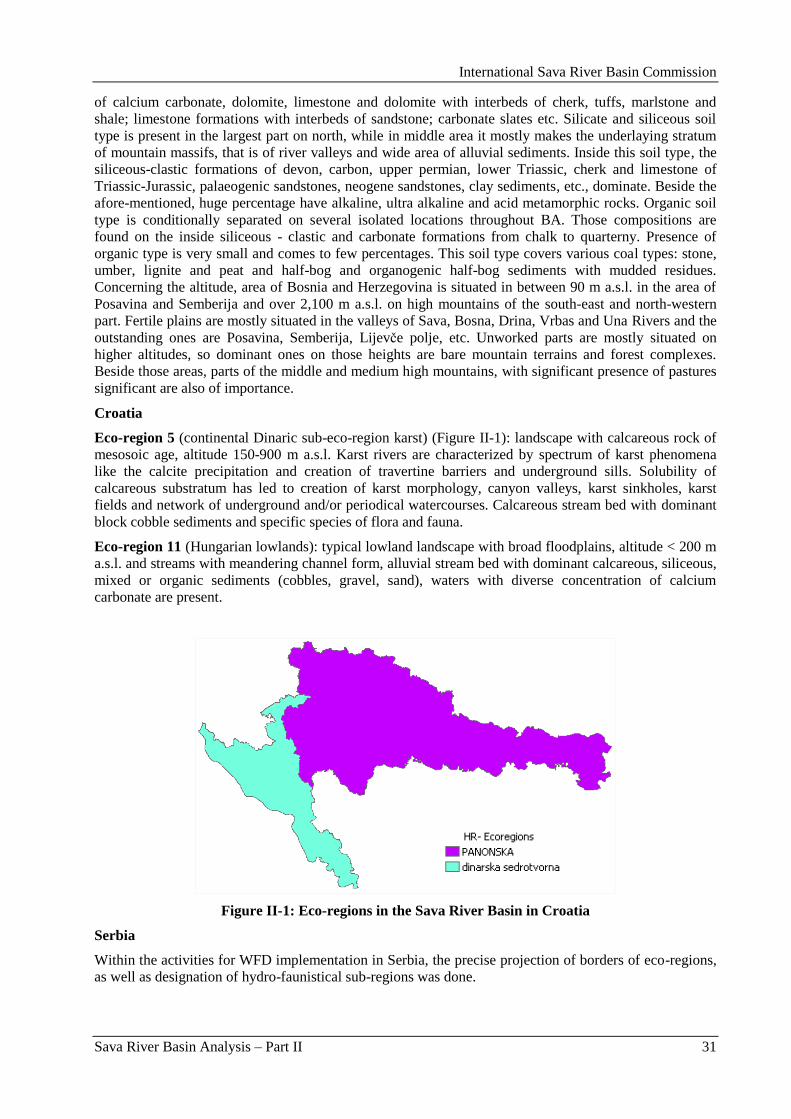
International Sava River Basin Commission
Sava River Basin Analysis – Part II 31
of calcium carbonate, dolomite, limestone and dolomite with interbeds of cherk, tuffs, marlstone and
shale; limestone formations with interbeds of sandstone; carbonate slates etc. Silicate and siliceous soil
type is present in the largest part on north, while in middle area it mostly makes the underlaying stratum
of mountain massifs, that is of river valleys and wide area of alluvial sediments. Inside this soil type, the
siliceous-clastic formations of devon, carbon, upper permian, lower Triassic, cherk and limestone of
Triassic-Jurassic, palaeogenic sandstones, neogene sandstones, clay sediments, etc., dominate. Beside the
afore-mentioned, huge percentage have alkaline, ultra alkaline and acid metamorphic rocks. Organic soil
type is conditionally separated on several isolated locations throughout BA. Those compositions are
found on the inside siliceous - clastic and carbonate formations from chalk to quarterny. Presence of
organic type is very small and comes to few percentages. This soil type covers various coal types: stone,
umber, lignite and peat and half-bog and organogenic half-bog sediments with mudded residues.
Concerning the altitude, area of Bosnia and Herzegovina is situated in between 90 m a.s.l. in the area of
Posavina and Semberija and over 2,100 m a.s.l. on high mountains of the south-east and north-western
part. Fertile plains are mostly situated in the valleys of Sava, Bosna, Drina, Vrbas and Una Rivers and the
outstanding ones are Posavina, Semberija, Lijevĉe polje, etc. Unworked parts are mostly situated on
higher altitudes, so dominant ones on those heights are bare mountain terrains and forest complexes.
Beside those areas, parts of the middle and medium high mountains, with significant presence of pastures
significant are also of importance.
Croatia
Eco-region 5 (continental Dinaric sub-eco-region karst) (Figure II-1): landscape with calcareous rock of
mesosoic age, altitude 150-900 m a.s.l. Karst rivers are characterized by spectrum of karst phenomena
like the calcite precipitation and creation of travertine barriers and underground sills. Solubility of
calcareous substratum has led to creation of karst morphology, canyon valleys, karst sinkholes, karst
fields and network of underground and/or periodical watercourses. Calcareous stream bed with dominant
block cobble sediments and specific species of flora and fauna.
Eco-region 11 (Hungarian lowlands): typical lowland landscape with broad floodplains, altitude < 200 m
a.s.l. and streams with meandering channel form, alluvial stream bed with dominant calcareous, siliceous,
mixed or organic sediments (cobbles, gravel, sand), waters with diverse concentration of calcium
carbonate are present.
Figure II-1: Eco-regions in the Sava River Basin in Croatia
Serbia
Within the activities for WFD implementation in Serbia, the precise projection of borders of eco-regions,
as well as designation of hydro-faunistical sub-regions was done.
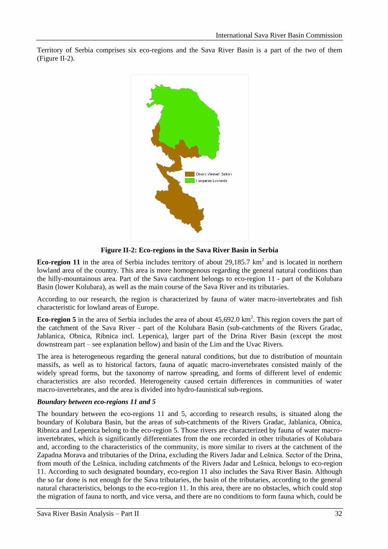
International Sava River Basin Commission
Sava River Basin Analysis – Part II 32
Territory of Serbia comprises six eco-regions and the Sava River Basin is a part of the two of them
(Figure II-2).
Figure II-2: Eco-regions in the Sava River Basin in Serbia
Eco-region 11 in the area of Serbia includes territory of about 29,185.7 km2 and is located in northern
lowland area of the country. This area is more homogenous regarding the general natural conditions than
the hilly-mountainous area. Part of the Sava catchment belongs to eco-region 11 - part of the Kolubara
Basin (lower Kolubara), as well as the main course of the Sava River and its tributaries.
According to our research, the region is characterized by fauna of water macro-invertebrates and fish
characteristic for lowland areas of Europe.
Eco-region 5 in the area of Serbia includes the area of about 45,692.0 km2. This region covers the part of
the catchment of the Sava River - part of the Kolubara Basin (sub-catchments of the Rivers Gradac,
Jablanica, Obnica, Ribnica incl. Lepenica), larger part of the Drina River Basin (except the most
downstream part – see explanation bellow) and basin of the Lim and the Uvac Rivers.
The area is heterogeneous regarding the general natural conditions, but due to distribution of mountain
massifs, as well as to historical factors, fauna of aquatic macro-invertebrates consisted mainly of the
widely spread forms, but the taxonomy of narrow spreading, and forms of different level of endemic
characteristics are also recorded. Heterogeneity caused certain differences in communities of water
macro-invertebrates, and the area is divided into hydro-faunistical sub-regions.
Boundary between eco-regions 11 and 5
The boundary between the eco-regions 11 and 5, according to research results, is situated along the
boundary of Kolubara Basin, but the areas of sub-catchments of the Rivers Gradac, Jablanica, Obnica,
Ribnica and Lepenica belong to the eco-region 5. Those rivers are characterized by fauna of water macro-
invertebrates, which is significantly differentiates from the one recorded in other tributaries of Kolubara
and, according to the characteristics of the community, is more similar to rivers at the catchment of the
Zapadna Morava and tributaries of the Drina, excluding the Rivers Jadar and Lešnica. Sector of the Drina,
from mouth of the Lešnica, including catchments of the Rivers Jadar and Lešnica, belongs to eco-region
11. According to such designated boundary, eco-region 11 also includes the Sava River Basin. Although
the so far done is not enough for the Sava tributaries, the basin of the tributaries, according to the general
natural characteristics, belongs to the eco-region 11. In this area, there are no obstacles, which could stop
the migration of fauna to north, and vice versa, and there are no conditions to form fauna which, could be
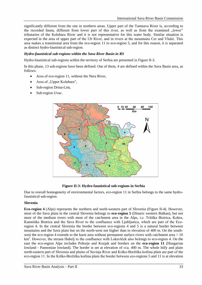
International Sava River Basin Commission
Sava River Basin Analysis – Part II 33
significantly different from the one in northern areas. Upper part of the Tamnava River is, according to
the recorded fauna, different from lower part of this river, as well as from the examined „lower”
tributaries of the Kolubara River and it is not representative for this water body. Similar situation is
expected in the area of upper part of the Ub River, and in rivers at the mountains Cer and Vlašić. This
area makes a transitional area from the eco-region 11 to eco-region 5, and for this reason, it is separated
as distinct hydro-faunistical sub-region.
Hydro-faunistical sub-regions within the Sava River Basin in RS
Hydro-faunistical sub-regions within the territory of Serbia are presented in Figure II-3.
In this phase, 13 sub-regions have been defined. Out of them, 4 are defined within the Sava Basin area, as
follows:
Area of eco-region 11, without the Nera River,
Area of „Upper Kolubara”,
Sub-region Drina-Lim,
Sub-region Uvac.
Figure II-3: Hydro-faunistical sub-regions in Serbia
Due to overall homogeneity of environmental factors, eco-region 11 in Serbia belongs to the same hydro-
faunistical sub-region.
Slovenia
Eco-region 4 (Alps) represents the northern and north-western part of Slovenia (Figure II-4). However,
most of the Sava plain in the central Slovenia belongs to eco-region 5 (Dinaric western Balkan), but not
most of the medium rivers with most of the catchment area in the Alps, i.e. Trţiška Bistrica, Kokra,
Kamniška Bistrica and the Sava River to the confluence with Ljubljanica, which are part of the Eco-
region 4. In the central Slovenia the border between eco-regions 4 and 5 is a natural border between
mountains and the Sava plain but on the north-west not higher than to elevation of 400 m. On the south-
west the eco-region 4 extends to the karst area without permanent surface rivers with catchment area > 10
km2. However, the stream Hubelj to the confluence with Lokavšĉek also belongs to eco-region 4. On the
east the eco-region Alps includes Pohorje and Kozjak and borders on the eco-region 11 (Hungarian
lowland - Pannonian lowland). The border is set at elevation of cca. 400 m. The whole hilly and plain
north-eastern part of Slovenia and plains of Savinja River and Krško-Breţiška kotlina plain are part of the
eco-region 11. In the Krško-Breţiška kotlina plain the border between eco-regions 5 and 11 is at elevation
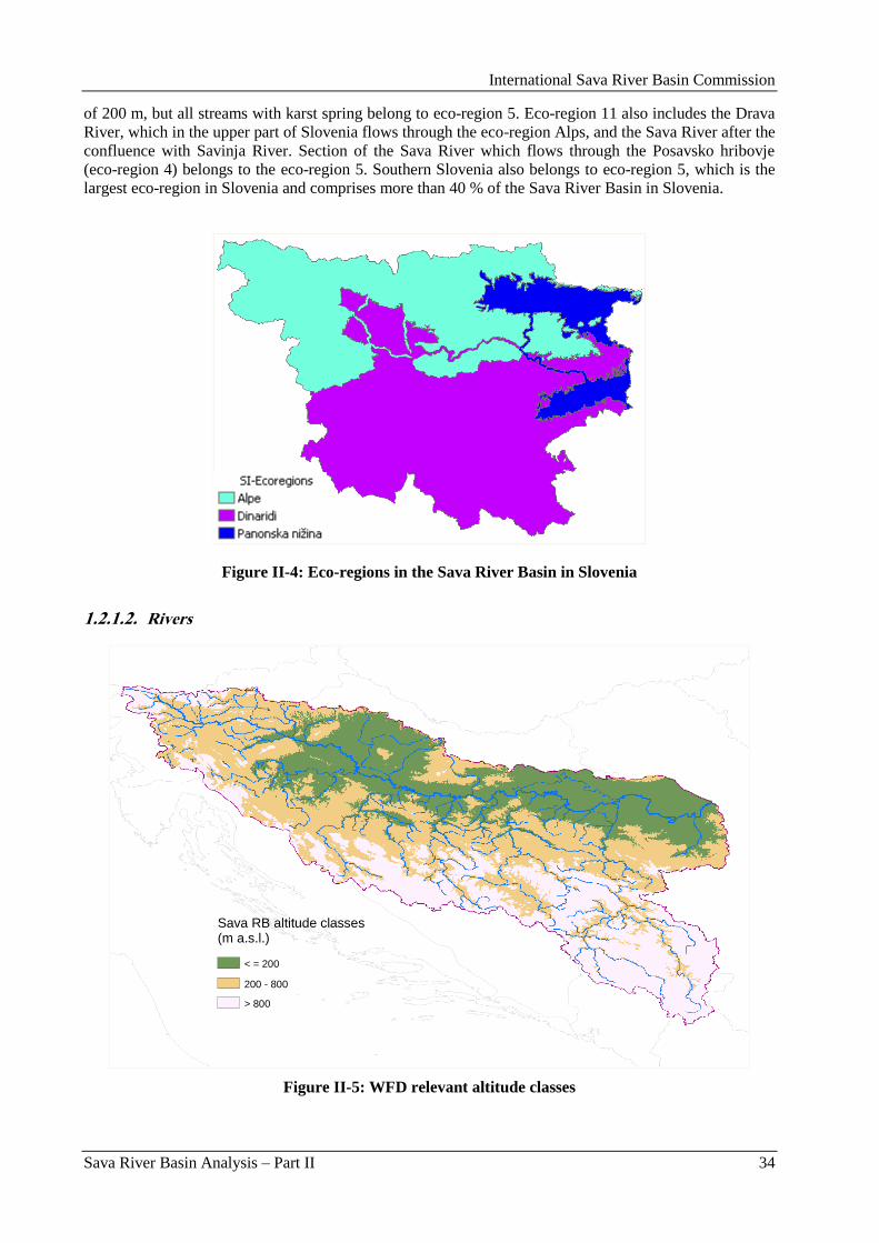
International Sava River Basin Commission
Sava River Basin Analysis – Part II 34
of 200 m, but all streams with karst spring belong to eco-region 5. Eco-region 11 also includes the Drava
River, which in the upper part of Slovenia flows through the eco-region Alps, and the Sava River after the
confluence with Savinja River. Section of the Sava River which flows through the Posavsko hribovje
(eco-region 4) belongs to the eco-region 5. Southern Slovenia also belongs to eco-region 5, which is the
largest eco-region in Slovenia and comprises more than 40 % of the Sava River Basin in Slovenia.
Figure II-4: Eco-regions in the Sava River Basin in Slovenia
1.2.1.2. Rivers
Figure II-5: WFD relevant altitude classes
Sava RB altitude classes (m a.s.l.)
200 - 800
< = 200
> 800
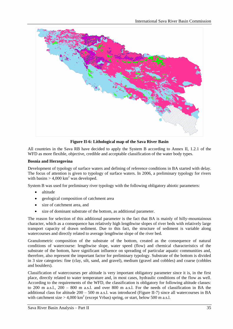
International Sava River Basin Commission
Sava River Basin Analysis – Part II 35
Figure II-6: Lithological map of the Sava River Basin
All countries in the Sava RB have decided to apply the System B according to Annex II, 1.2.1 of the
WFD as more flexible, objective, credible and acceptable classification of the water body types.
Bosnia and Herzegovina
Development of typology of surface waters and defining of reference conditions in BA started with delay.
The focus of attention is given to typology of surface waters. In 2006, a preliminary typology for rivers
with basins > 4,000 km2 was developed.
System B was used for preliminary river typology with the following obligatory abiotic parameters:
altitude
geological composition of catchment area
size of catchment area, and
size of dominant substrate of the bottom, as additional parameter.
The reason for selection of this additional parameter is the fact that BA is mainly of hilly-mountainous
character, which as a consequence has relatively high lengthwise slopes of river beds with relatively large
transport capacity of drawn sediment. Due to this fact, the structure of sediment is variable along
watercourses and directly related to average lengthwise slope of the river bed.
Granulometric composition of the substrate of the bottom, created as the consequence of natural
conditions of watercourse: lengthwise slope, water speed (flow) and chemical characteristics of the
substrate of the bottom, have significant influence on spreading of particular aquatic communities and,
therefore, also represent the important factor for preliminary typology. Substrate of the bottom is divided
in 3 size categories: fine (clay, silt, sand, and gravel), medium (gravel and cobbles) and coarse (cobbles
and boulders).
Classification of watercourses per altitude is very important obligatory parameter since it is, in the first
place, directly related to water temperature and, in most cases, hydraulic conditions of the flow as well.
According to the requirements of the WFD, the classification is obligatory for following altitude classes:
to 200 m a.s.l., 200 – 800 m a.s.l. and over 800 m a.s.l. For the needs of classification in BA the
additional class for altitude 200 – 500 m a.s.l. was introduced (Figure II-7) since all watercourses in BA
with catchment size > 4,000 km2 (except Vrbas) spring, or start, below 500 m a.s.l.
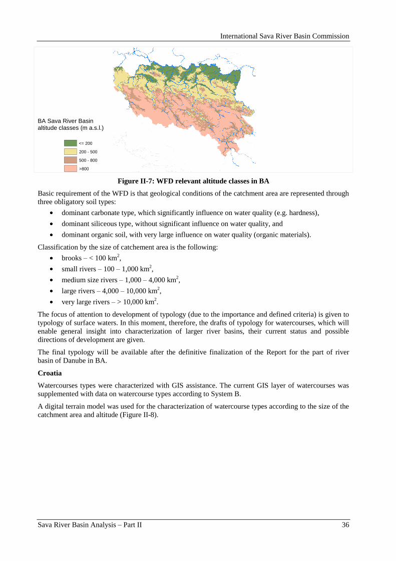
International Sava River Basin Commission
Sava River Basin Analysis – Part II 36
Figure II-7: WFD relevant altitude classes in BA
Basic requirement of the WFD is that geological conditions of the catchment area are represented through
three obligatory soil types:
dominant carbonate type, which significantly influence on water quality (e.g. hardness),
dominant siliceous type, without significant influence on water quality, and
dominant organic soil, with very large influence on water quality (organic materials).
Classification by the size of catchement area is the following:
brooks – < 100 km2,
small rivers – 100 – 1,000 km2,
medium size rivers – 1,000 – 4,000 km2,
large rivers – 4,000 – 10,000 km2,
very large rivers – > 10,000 km2.
The focus of attention to development of typology (due to the importance and defined criteria) is given to
typology of surface waters. In this moment, therefore, the drafts of typology for watercourses, which will
enable general insight into characterization of larger river basins, their current status and possible
directions of development are given.
The final typology will be available after the definitive finalization of the Report for the part of river
basin of Danube in BA.
Croatia
Watercourses types were characterized with GIS assistance. The current GIS layer of watercourses was
supplemented with data on watercourse types according to System B.
A digital terrain model was used for the characterization of watercourse types according to the size of the
catchment area and altitude (Figure II-8).
BA Sava River Basin altitude classes (m a.s.l.)
<= 200
200 - 500
500 - 800
>800
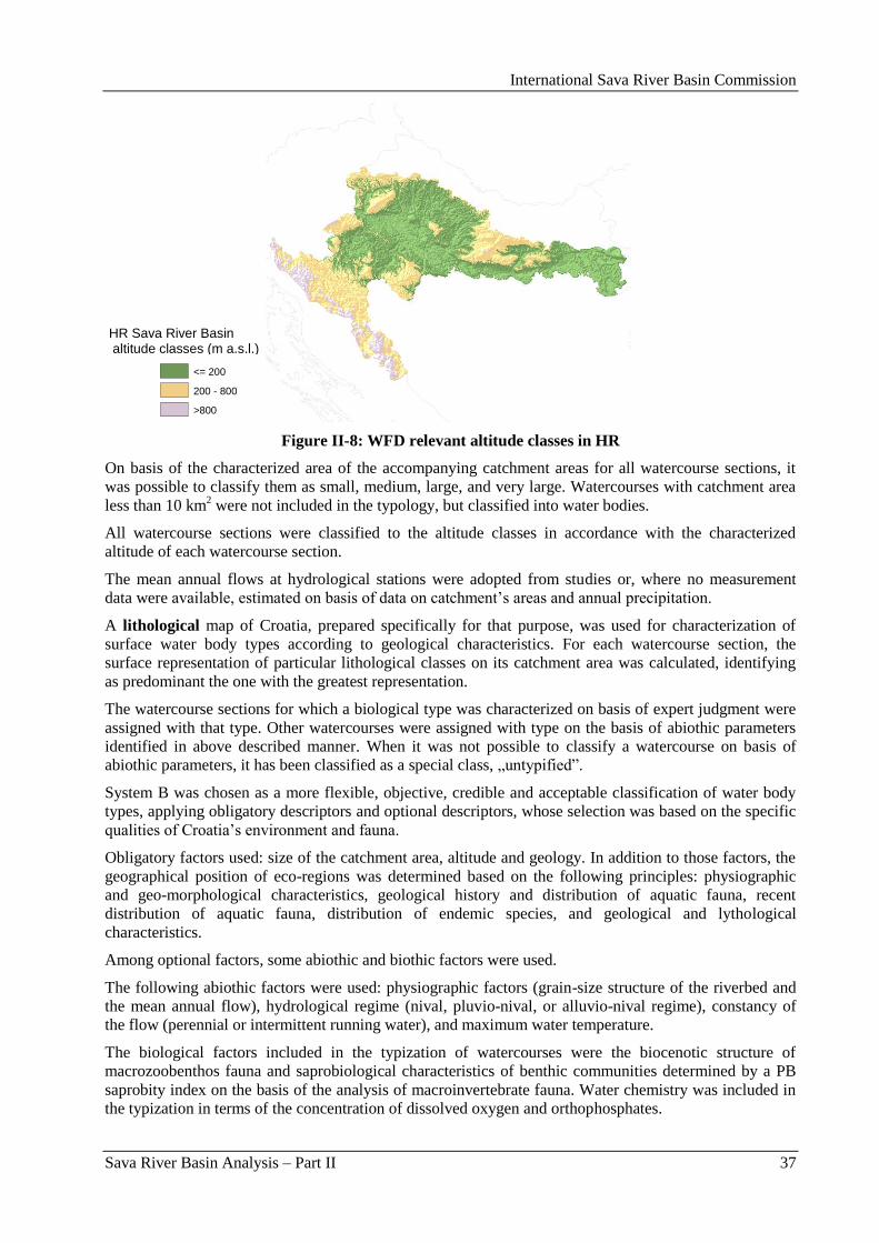
International Sava River Basin Commission
Sava River Basin Analysis – Part II 37
Figure II-8: WFD relevant altitude classes in HR
On basis of the characterized area of the accompanying catchment areas for all watercourse sections, it
was possible to classify them as small, medium, large, and very large. Watercourses with catchment area
less than 10 km2 were not included in the typology, but classified into water bodies.
All watercourse sections were classified to the altitude classes in accordance with the characterized
altitude of each watercourse section.
The mean annual flows at hydrological stations were adopted from studies or, where no measurement
data were available, estimated on basis of data on catchment‟s areas and annual precipitation.
A lithological map of Croatia, prepared specifically for that purpose, was used for characterization of
surface water body types according to geological characteristics. For each watercourse section, the
surface representation of particular lithological classes on its catchment area was calculated, identifying
as predominant the one with the greatest representation.
The watercourse sections for which a biological type was characterized on basis of expert judgment were
assigned with that type. Other watercourses were assigned with type on the basis of abiothic parameters
identified in above described manner. When it was not possible to classify a watercourse on basis of
abiothic parameters, it has been classified as a special class, „untypified”.
System B was chosen as a more flexible, objective, credible and acceptable classification of water body
types, applying obligatory descriptors and optional descriptors, whose selection was based on the specific
qualities of Croatia‟s environment and fauna.
Obligatory factors used: size of the catchment area, altitude and geology. In addition to those factors, the
geographical position of eco-regions was determined based on the following principles: physiographic
and geo-morphological characteristics, geological history and distribution of aquatic fauna, recent
distribution of aquatic fauna, distribution of endemic species, and geological and lythological
characteristics.
Among optional factors, some abiothic and biothic factors were used.
The following abiothic factors were used: physiographic factors (grain-size structure of the riverbed and
the mean annual flow), hydrological regime (nival, pluvio-nival, or alluvio-nival regime), constancy of
the flow (perennial or intermittent running water), and maximum water temperature.
The biological factors included in the typization of watercourses were the biocenotic structure of
macrozoobenthos fauna and saprobiological characteristics of benthic communities determined by a PB
saprobity index on the basis of the analysis of macroinvertebrate fauna. Water chemistry was included in
the typization in terms of the concentration of dissolved oxygen and orthophosphates.
HR Sava River Basin altitude classes (m a.s.l.)
<= 200 200 - 800 >800
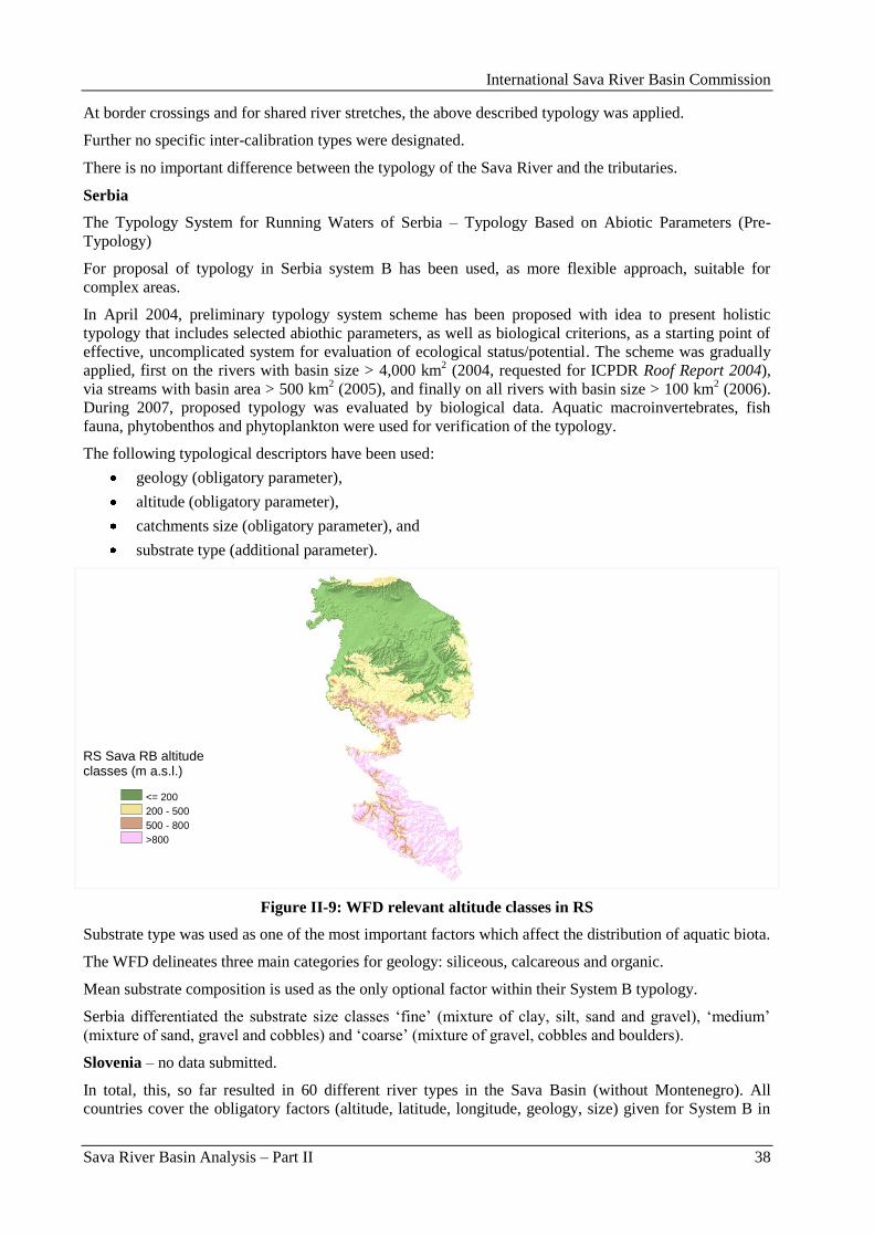
International Sava River Basin Commission
Sava River Basin Analysis – Part II 38
At border crossings and for shared river stretches, the above described typology was applied.
Further no specific inter-calibration types were designated.
There is no important difference between the typology of the Sava River and the tributaries.
Serbia
The Typology System for Running Waters of Serbia – Typology Based on Abiotic Parameters (Pre-
Typology)
For proposal of typology in Serbia system B has been used, as more flexible approach, suitable for
complex areas.
In April 2004, preliminary typology system scheme has been proposed with idea to present holistic
typology that includes selected abiothic parameters, as well as biological criterions, as a starting point of
effective, uncomplicated system for evaluation of ecological status/potential. The scheme was gradually
applied, first on the rivers with basin size > 4,000 km2 (2004, requested for ICPDR Roof Report 2004),
via streams with basin area > 500 km2 (2005), and finally on all rivers with basin size > 100 km
2 (2006).
During 2007, proposed typology was evaluated by biological data. Aquatic macroinvertebrates, fish
fauna, phytobenthos and phytoplankton were used for verification of the typology.
The following typological descriptors have been used:
geology (obligatory parameter),
altitude (obligatory parameter),
catchments size (obligatory parameter), and
substrate type (additional parameter).
Figure II-9: WFD relevant altitude classes in RS
Substrate type was used as one of the most important factors which affect the distribution of aquatic biota.
The WFD delineates three main categories for geology: siliceous, calcareous and organic.
Mean substrate composition is used as the only optional factor within their System B typology.
Serbia differentiated the substrate size classes „fine‟ (mixture of clay, silt, sand and gravel), „medium‟
(mixture of sand, gravel and cobbles) and „coarse‟ (mixture of gravel, cobbles and boulders).
Slovenia – no data submitted.
In total, this, so far resulted in 60 different river types in the Sava Basin (without Montenegro). All
countries cover the obligatory factors (altitude, latitude, longitude, geology, size) given for System B in
RS Sava RB altitude classes (m a.s.l.)
<= 200
200 - 500
500 - 800
>800
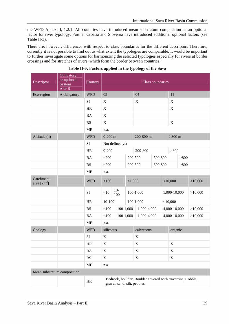
International Sava River Basin Commission
Sava River Basin Analysis – Part II 39
the WFD Annex II, 1.2.1. All countries have introduced mean substratum composition as an optional
factor for river typology. Further Croatia and Slovenia have introduced additional optional factors (see
Table II-3).
There are, however, differences with respect to class boundaries for the different descriptors Therefore,
currently it is not possible to find out to what extent the typologies are comparable. It would be important
to further investigate some options for harmonizing the selected typologies especially for rivers at border
crossings and for stretches of rivers, which form the border between countries.
Table II-3: Factors applied in the typology of the Sava
Descriptor
Obligatory
or optional
System
A or B
Country Class boundaries
Eco-region A obligatory WFD 05 04 11
SI X X X
HR X X
BA X
RS X X
ME n.a.
Altitude (h) WFD 0-200 m 200-800 m >800 m
SI Not defined yet
HR 0-200 200-800 >800
BA <200 200-500 500-800 >800
RS <200 200-500 500-800 >800
ME n.a.
Catchment
area [km2]
WFD <100 <1,000 <10,000 >10,000
SI <10 10-
100 100-1,000 1,000-10,000 >10,000
HR 10-100 100-1,000 <10,000
RS <100 100-1,000 1,000-4,000 4,000-10,000 >10,000
BA <100 100-1,000 1,000-4,000 4,000-10,000 >10,000
ME n.a.
Geology WFD siliceous calcareous organic
SI X X
HR X X X
BA X X X
RS X X X
ME n.a.
Mean substratum composition
HR
Bedrock, boulder, Boulder covered with travertine, Cobble,
gravel, sand, silt, pebbles
International Sava River Basin Commission
Sava River Basin Analysis – Part II 40
Descriptor
Obligatory
or optional
System
A or B
Country Class boundaries
BA
Fine substrates (clay, silt, very fine sand), gravel), medium
(gravel, cobbles), coarse (cobbles, boulders)
RS
fine (clay, silt, sand, gravel), medium (sand, gravel, cobbles),
coarse (gravel, cobbles, boulders)
Other descriptors
Discharge
[m3/s]
HR <2 2-20 >20
specific SI Hydrology (permanent), karst spring influence, lake outflow
influence, limnocrene spring influence
Altitude: Only Croatia applied the size-classes according to the WFD.
Catchment areas: The countries have established different catchment areas than the ones suggested in WFD.
Slovenia, Bosnia and Herzegovina and Serbia have established additional limits, but Croatia has set the maximum
limit at 10,000 km2.
Geology: All countries have delineated same categories of geology as suggested in the WFD (siliceous, calcareous
and organic).
Optional factors: Bosnia and Herzegovina, Croatia and Serbia have defined additional refinements of mean
substratum composition. Croatia and Slovenia have used other descriptors for definition of water types as discharge
(HR) and specific descriptors (SI).
Table II-4: Number of river types in each country and eco-region
Eco-region 4 5 11
BA 18
HR 7 10
RS* 7 4
SI 8 6 7
ME n.a.
Total number 8 38 21
* RS: Only types for the Sava River and selected tributaries have been taken into account. For smaller rivers in the
Sava RB in RS, another 13 types have been identified.
The Sava River has been divided in 11 different river types (Table II-5).
Table II-5: Stream types defined for Sava River
Country River Downstr.
border
Upstr.
border Code Type
RS Sava 0 209 RS_Typ1.1 Very large rivers, lowland, silicious, fine
sediments
BA Sava 179 524 BA_Typ1.15 Very large rivers, lowland, siliceous, fine
sediments
HR Sava 213 375 HR_9b Lowland very large rivers, siliceous,
sand/gravel
HR Sava 375 408 HR_8 Lowland very large rivers,siliceous,
sand/gravel/pebbles
HR Sava 408 521 HR_8 Lowland very large rivers,siliceous,
sand/gravel/pebbles
HR Sava 521 556 HR_8 Lowland very large rivers,siliceous,
International Sava River Basin Commission
Sava River Basin Analysis – Part II 41
Country River Downstr.
border
Upstr.
border Code Type
sand/gravel/pebbles
HR Sava 556 597 HR_8 Lowland very large rivers,siliceous,
sand/gravel/pebbles
HR Sava 597 662 HR_8 Lowland very large rivers,siliceous,
sand/gravel/pebbles
HR Sava 662 711 HR_7b Lowland very large rivers,siliceous,
gravel/pebbles
HR Sava 711 725 HR_7b Lowland very large rivers,siliceous,
gravel/pebbles
SI Sava 0 59.19 SI__VR6 Pannonian Sava, carbonate, large rivers
SI Sava 59.19 116.23 SI__VR3 Dinaric Sava, carbonate,large rivers
SI Sava 116.23 162.05 SI__VR1 Alpine Sava, carbonate,large rivers
SI Sava 162.05 185.47 SI_4_PA-hrib-
D_2
Medium-size rivers of Pre-alpine hills-
Danube river basin, carbonate
SI Sava
(Dolinka) 185.47 211.93
SI_4_KB-AL-
D_2_KI
Medium-size rivers of Carbonate Alps-
Danube river basin with a karst spring
influenc, carbonate
SI Sava
(Dolinka) 215.14 220.75
SI_4_KB-AL-
D_1_LI
Small rivers of Carbonate Alps-Danube
river basin with a limnocrene spring
influence, carbonate
The types of the Sava River Basin tributaries are distributed mainly in eco-region 5 (Dinaric Western
Balkans), only small number is distributed in eco-region 11 (Hungarian lowland) and eco-region 4 (Alps).
The altitudes vary between 200-800 m a.s.l. Most of the tributaries are large rivers. Most of the main
tributaries are siliceous and calcareous, and only a few are mixed and organic. The detailed data of the
main tributaries types is available in Table II-6.
Table II-6: Number of stream types of relevant tributaries
Country River
Number
of
tributaries
stream
type
Code/
abreviation Name
BA Drina 3 BA_Type 1.14 Very large lowland rivers, siliceous, medium sediments
BA_Type 2.16 Large lowland-hilly rivers, siliceous, coarse sediments
BA_Type 2.4 Large lowland-hilly rivers, calcareous, coarse sediments
Lim 1 BA_Type 2.17 Large lowland-hilly rivers, siliceous, medium sediments
Tinja 4 BA_Type 4.15 Small lowland rivers, siliceous, fine sediments
BA_Type 4.14 Small lowland rivers, siliceous, medium sediments
BA_Type 4.13 Small lowland rivers, siliceous, coarse sediments
BA_Type 5.16 Lowland-hilly brooks, siliceous, coarse sediments
Bosna 5 BA_Type 2.14 Large lowland rivers, siliceous, medium sediments
BA_Type 2.16 Large lowland-hilly rivers, siliceous, coarse sediments
BA_Type 2.4 Large lowland-hilly rivers, calcareous, coarse sediments
BA_Type 3.4 Medium size lowland-hilly rivers, calcareous, coarse
sediments
BA_Type 4.4 Small lowland- hilly rivers, calcareous, coarse sediments
Ukrina 2 BA_Type 4.14 Small lowland rivers, siliceous, medium sediments
BA_type 4.17 Small lowland-hilly rivers, siliceous, medium sediments
Vrbas 4 BA_ Type 2.14 Large lowland rivers, siliceous, medium sediments
BA_ Type 3.4 Medium size lowland-hilly rivers, calcareous, coarse
sediments
BA_Type 4.7 Small hilly-mountanious rivers, calcareous, coarse
sediments
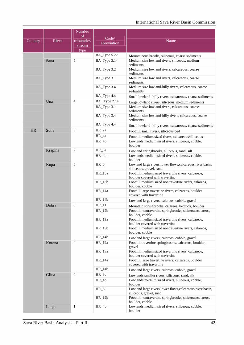
International Sava River Basin Commission
Sava River Basin Analysis – Part II 42
Country River
Number
of
tributaries
stream
type
Code/
abreviation Name
BA_Type 5.22 Mountainous brooks, siliceous, coarse sediments
Sana 5 BA_Type 3.14 Medium size lowland rivers, siliceous, medium
sediments
BA_Type 3.2 Medium size lowland rivers, calcareous, coarse
sediments
BA_Type 3.1 Medium size lowland rivers, calcareous, coarse
sediments
BA_Type 3.4 Medium size lowland-hilly rivers, calcareous, coarse
sediments
BA_Type 4.4 Small lowland- hilly rivers, calcareous, coarse sediments
Una 4 BA_ Type 2.14 Large lowland rivers, siliceous, medium sediments
BA_Type 3.1 Medium size lowland rivers, calcareous, coarse
sediments
BA_Type 3.4 Medium size lowland-hilly rivers, calcareous, coarse
sediments
BA_Type 4.4 Small lowland- hilly rivers, calcareous, coarse sediments
HR Sutla 3 HR_2a Foothill small rivers, siliceous bed
HR_4a Foothill medium sized rivers, calcareous/siliceous
HR_4b Lowlands medium sized rivers, siliceous, cobble,
boulder
Krapina 2 HR_3a Lowland springbrooks, siliceous, sand, silt
HR_4b Lowlands medium sized rivers, siliceous, cobble,
boulder
Kupa 5 HR_6 Lowland large rivers,lower flows,calcareous river basin,
sliliceous, gravel, sand
HR_13a Foothill medium sized travertine rivers, calcareos,
boulder covered with travertine
HR_13b Foothill medium sized nontravertine rivers, calareos,
boulder, cobble
HR_14a Foothill large travertine rivers, calzareos, boulder
covered with travertine
HR_14b Lowland large rivers, calareos, cobble, gravel
Dobra 5 HR_11 Mountain springbrooks, calareos, bedrock, boulder
HR_12b Foothill nontravertine springbrooks, siliceous/calareos,
boulder, cobble
HR_13a Foothill medium sized travertine rivers, calcareos,
boulder covered with travertine
HR_13b Foothill medium sized nontravertine rivers, calareos,
boulder, cobble
HR_14b Lowland large rivers, calareos, cobble, gravel
Korana 4 HR_12a Foothill travertine springbrooks, calcareos, boulder,
gravel
HR_13a Foothill medium sized travertine rivers, calcareos,
boulder covered with travertine
HR_14a Foothill large travertine rivers, calzareos, boulder
covered with travertine
HR_14b Lowland large rivers, calareos, cobble, gravel
Glina 4 HR_3c Lowlands smaller rivers, siliceous, sand, silt
HR_4b Lowlands medium sized rivers, siliceous, cobble,
boulder
HR_6 Lowland large rivers,lower flows,calcareous river basin,
siliceous, gravel, sand
HR_12b Foothill nontravertine springbrooks, siliceous/calareos,
boulder, cobble
Lonja 1 HR_4b Lowlands medium sized rivers, siliceous, cobble,
boulder
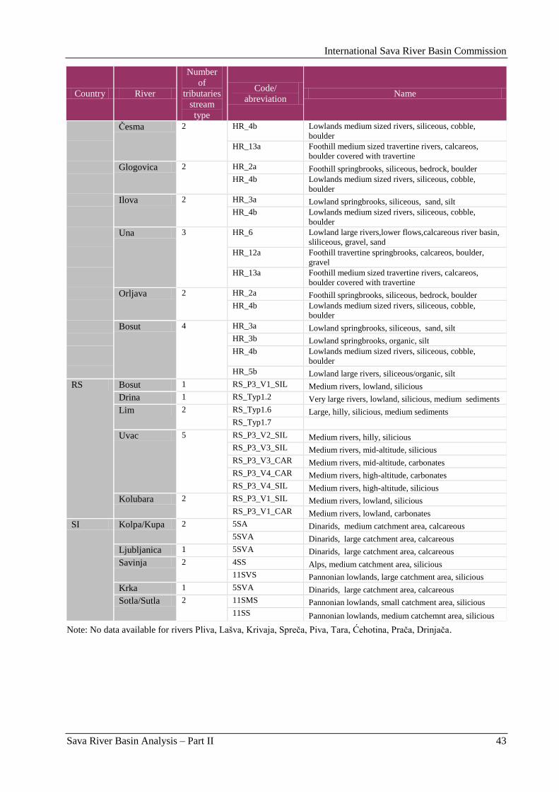
International Sava River Basin Commission
Sava River Basin Analysis – Part II 43
Country River
Number
of
tributaries
stream
type
Code/
abreviation Name
Ĉesma 2 HR_4b Lowlands medium sized rivers, siliceous, cobble,
boulder
HR_13a Foothill medium sized travertine rivers, calcareos,
boulder covered with travertine
Glogovica 2 HR_2a Foothill springbrooks, siliceous, bedrock, boulder
HR_4b Lowlands medium sized rivers, siliceous, cobble,
boulder
Ilova 2 HR_3a Lowland springbrooks, siliceous, sand, silt
HR_4b Lowlands medium sized rivers, siliceous, cobble,
boulder
Una 3 HR_6 Lowland large rivers,lower flows,calcareous river basin,
sliliceous, gravel, sand
HR_12a Foothill travertine springbrooks, calcareos, boulder,
gravel
HR_13a Foothill medium sized travertine rivers, calcareos,
boulder covered with travertine
Orljava 2 HR_2a Foothill springbrooks, siliceous, bedrock, boulder
HR_4b Lowlands medium sized rivers, siliceous, cobble,
boulder
Bosut 4 HR_3a Lowland springbrooks, siliceous, sand, silt
HR_3b Lowland springbrooks, organic, silt
HR_4b Lowlands medium sized rivers, siliceous, cobble,
boulder
HR_5b Lowland large rivers, siliceous/organic, silt
RS Bosut 1 RS_P3_V1_SIL Medium rivers, lowland, silicious
Drina 1 RS_Typ1.2 Very large rivers, lowland, silicious, medium sediments
Lim 2 RS_Typ1.6 Large, hilly, silicious, medium sediments
RS_Typ1.7
Uvac 5 RS_P3_V2_SIL Medium rivers, hilly, silicious
RS_P3_V3_SIL Medium rivers, mid-altitude, silicious
RS_P3_V3_CAR Medium rivers, mid-altitude, carbonates
RS_P3_V4_CAR Medium rivers, high-altitude, carbonates
RS_P3_V4_SIL Medium rivers, high-altitude, silicious
Kolubara 2 RS_P3_V1_SIL Medium rivers, lowland, silicious
RS_P3_V1_CAR Medium rivers, lowland, carbonates
SI Kolpa/Kupa 2 5SA Dinarids, medium catchment area, calcareous
5SVA Dinarids, large catchment area, calcareous
Ljubljanica 1 5SVA Dinarids, large catchment area, calcareous
Savinja 2 4SS Alps, medium catchment area, silicious
11SVS Pannonian lowlands, large catchment area, silicious
Krka 1 5SVA Dinarids, large catchment area, calcareous
Sotla/Sutla 2 11SMS Pannonian lowlands, small catchment area, silicious
11SS Pannonian lowlands, medium catchemnt area, silicious
Note: No data available for rivers Pliva, Lašva, Krivaja, Spreĉa, Piva, Tara, Ćehotina, Praĉa, Drinjaĉa.
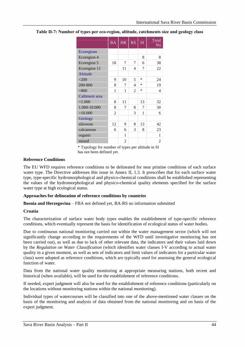
International Sava River Basin Commission
Sava River Basin Analysis – Part II 44
Table II-7: Number of types per eco-region, altitude, catchments size and geology class
BA HR RS SI Total
No
Ecoregions
Ecoregion 4 8 8
Ecoregion 5 18 7 7 6 38
Ecoregion 11 11 4 7 22
Altitude
<200 9 10 5 * 24
200-800 8 7 4 * 19
>800 1 1 2 * 4
Cathment area
<1.000 8 11 13 32
1.000-10.000 8 7 8 7 30
>10.000 2 3 1 6
Geology
siliceous 12 9 8 13 42
calcareous 6 6 3 8 23
organic 1 1
mixed 2 2
* Typology for number of types per altitude in SI
has not been defined yet.
Reference Conditions
The EU WFD requires reference conditions to be delineated for near pristine conditions of each surface
water type. The Directive addresses this issue in Annex II, 1.3. It prescribes that for each surface water
type, type-specific hydromorphological and physico-chemical conditions shall be established representing
the values of the hydromorphological and physico-chemical quality elements specified for the surface
water type at high ecological status.
Approaches for delineation of reference conditions by countries
Bosnia and Herzegovina – FBA not defined yet, BA-RS no information submitted
Croatia
The characterization of surface water body types enables the establishment of type-specific reference
conditions, which eventually represent the basis for identification of ecological status of water bodies.
Due to continuous national monitoring carried out within the water management sector (which will not
significantly change according to the requirements of the WFD until investigative monitoring has not
been carried out), as well as due to lack of other relevant data, the indicators and their values laid down
by the Regulation on Water Classification (which identifies water classes I-V according to actual water
quality in a given moment, as well as sets of indicators and limit values of indicators for a particular water
class) were adopted as reference conditions, which are typically used for assessing the general ecological
function of water.
Data from the national water quality monitoring at appropriate measuring stations, both recent and
historical (when available), will be used for the establishment of reference conditions.
If needed, expert judgment will also be used for the establishment of reference conditions (particularly on
the locations without monitoring stations within the national monitoring).
Individual types of watercourses will be classified into one of the above-mentioned water classes on the
basis of the monitoring and analysis of data obtained from the national monitoring and on basis of the
expert judgment.
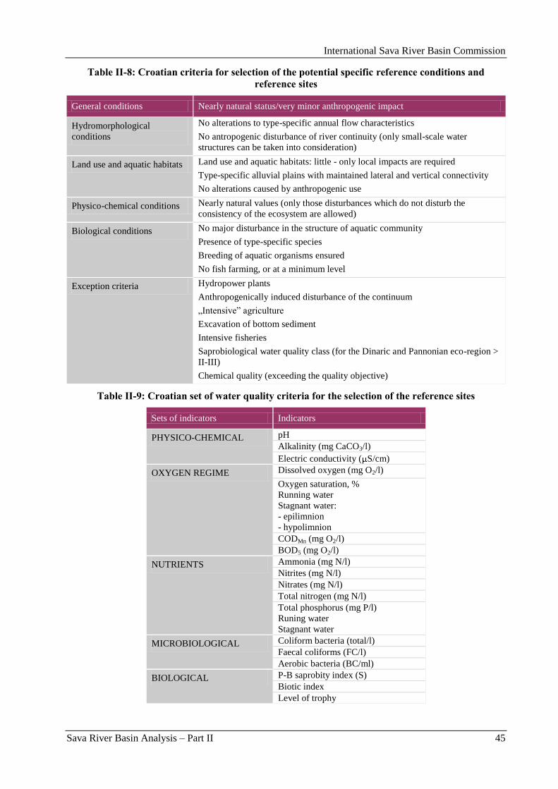
International Sava River Basin Commission
Sava River Basin Analysis – Part II 45
Table II-8: Croatian criteria for selection of the potential specific reference conditions and
reference sites
General conditions Nearly natural status/very minor anthropogenic impact
Hydromorphological
conditions
No alterations to type-specific annual flow characteristics
No antropogenic disturbance of river continuity (only small-scale water
structures can be taken into consideration)
Land use and aquatic habitats Land use and aquatic habitats: little - only local impacts are required
Type-specific alluvial plains with maintained lateral and vertical connectivity
No alterations caused by anthropogenic use
Physico-chemical conditions Nearly natural values (only those disturbances which do not disturb the
consistency of the ecosystem are allowed)
Biological conditions No major disturbance in the structure of aquatic community
Presence of type-specific species
Breeding of aquatic organisms ensured
No fish farming, or at a minimum level
Exception criteria Hydropower plants
Anthropogenically induced disturbance of the continuum
„Intensive” agriculture
Excavation of bottom sediment
Intensive fisheries
Saprobiological water quality class (for the Dinaric and Pannonian eco-region >
II-III)
Chemical quality (exceeding the quality objective)
Table II-9: Croatian set of water quality criteria for the selection of the reference sites
Sets of indicators Indicators
PHYSICO-CHEMICAL pH
Alkalinity (mg CaCO3/l)
Electric conductivity ( S/cm)
OXYGEN REGIME Dissolved oxygen (mg O2/l)
Oxygen saturation, %
Running water
Stagnant water:
- epilimnion
- hypolimnion
CODMn (mg O2/l)
BOD5 (mg O2/l)
NUTRIENTS Ammonia (mg N/l)
Nitrites (mg N/l)
Nitrates (mg N/l)
Total nitrogen (mg N/l)
Total phosphorus (mg P/l)
Runing water
Stagnant water
MICROBIOLOGICAL Coliform bacteria (total/l)
Faecal coliforms (FC/l)
Aerobic bacteria (BC/ml)
BIOLOGICAL P-B saprobity index (S)
Biotic index
Level of trophy
International Sava River Basin Commission
Sava River Basin Analysis – Part II 46
Serbia
Within the process of the reference conditions definition, the following approaches have been used:
Analyses of available recent data,
Analyses of the historical data,
Expert judgment.
It is expected that information on quality for majority of watercourse types that belong to the hilly and
mountainous regions will be satisfactory from the „recent data-set” that enables definition of reference
conditions, since there are still enough sites that could be characterized as natural and „near natural”.
In case of lowland rivers, due to lack of the reference sites, the expert opinion and historical data must be
combined with the data from recent investigations.
The framework of definition of the type-specific reference sites and reference conditions is done
simultaneously with the work on typology of the aquatic ecosystems. The delineation of reference
conditions corresponds to the suggestions that were presented within the WFD and subsequent projects,
as for example, AQEM (The Development and Testing of an Integrated Assessment System for the
Ecological Quality of Streams and Rivers throughout Europe using Benthic Macroinvertebrates -
Contract No. EVK1-CT-1999-00027).
The same data-set that was used in development of typology and definition of type specific reference
conditions. Our intention was to base our work on recent investigations as much as possible and to use
expert judgment only in occasions where no satisfactory data is available – with the aim to minimize the
influence of subjectivity.
In summary, this approach comprehended combination of the data from current investigations (2004-
2007) and selected data from previous studies (1993-2003).
In regard to reference condition for BQI, reference values for selected community parameters for aquatic
macro-invertebrates were identified and the reference fish community was defined for five fish types
(groups of stream types).
For macro-invertebrate community, the reference values were analyzed for the following parameters: taxa
richness (No. of taxa), taxa richness within selected faunistic/ecological groups, EPT index, No. of
families, diversity indices, abundance, abundance of selected groups, the relation of functional feeding
groups, BMWP index, ASPT score, Balkan Biotic Index, No. of sensitive taxa and Saprobic index.
In case of fish fauna, total number of taxa, the structure of the community, Margalef index, biomass and
annual productivity were discussed.
Slovenia – no information submitted.
Reference conditions in the Sava River Basin
Reference conditions were so far defined for certain biological quality elements by Croatia, Serbia and
Slovenia.
Reference conditions for rivers in the Federation of B&H are not defined yet. Tendering for defining the
reference conditions is in progress. The project is expected to be finalized in February 2011. Only after
reference conditions are in place, definition of ecological status in accordance with the WFD will be
possible.
The countries used different methods for establishing the reference conditions. Spatially based data have
been used in Serbia and Slovenia. Historical data have been used in Croatia, Slovenia and for fish fauna
in Serbia. Expert data have been used in Croatia, Serbia and Slovenia.
The Table II-10 outlines the descriptors that have been applied in the Sava countries. The table cells in
grey colour indicate which descriptors are considered to be obligatory for the WFD compliant assessment
methods.
International Sava River Basin Commission
Sava River Basin Analysis – Part II 47
Table II-10: Descriptors applied for the definition of reference conditions for biological quality
elements in rivers, fields in grey colour indicate obligatory descriptors for the WFD compliant
assessment methods
Co
un
try
Fin
ish
ed
by
(mo
nth
-yea
r)
BQ
E
Tax
on
om
ic
com
po
siti
on
Ab
un
dan
ce
Div
ersi
ty
Sen
siti
ve
to
inse
nsi
tiv
e ta
xa
Ag
e st
ruct
ure
Bio
mas
s
Oth
er
BA
Phytoplankton
Macrophytes and
Phytobenthos
Benthic Invertebrates
Fish Fauna
HR
12-2007 Phytoplankton x
Macrophytes and
Phytobenthos
x
Benthic Invertebrates x
Fish Fauna x
RS
6-2008 Phytoplankton x x x
12-2008 Macrophytes x and
Phytobenthos (x) x (x) (x) (x)
12-2006 Benthic Invertebrates x x x x
12-2006 Fish Fauna x x x x
SI
- Phytoplankton
12-2007 Macrophytes and
Phytobenthos x x
12-2008 Benthic Invertebrates x x x x
12-2009 Fish Fauna x x x
1.2.2. Identification of Water Bodies
1.2.3. River Water Bodies
„Member States shall identify the location and boundaries of bodies of surface water …”. „A body of
surface water means a discrete and significant element of surface water such as a lake, a reservoir, a
stream, river or canal, part of a stream, river or canal, a transitional water or a stretch of coastal water”
(Annex II, 1.1 and Art. 2.10. of the WFD).
1.2.3.1. Methodology of delineation of water bodies in Sava River Basin countries
Bosnia and Herzegovina
The basis for designation of water bodies is significant change of the condition or the regime of surface
watercourse within identified types of surface watercourses or planned activity in close or more distant
future in order to reserve such reaches of watercourses (water bodies) for some specific purposes.
International Sava River Basin Commission
Sava River Basin Analysis – Part II 48
Basic criteria for defining of water bodies are:
change of category of surface water,
change of type,
change of pressure
pollution
changes of hydrological regime
morphological changes,
significant tributaries.
Based on these criteria, the boundaries of water bodies are delineated on: locations of border lines with
other countries, locations of dams, locations of slowing down of reservoirs, boundaries of watercourse
types, points of significant change of flow regime and discharge regime, change of type of dominant
bottom sediment, locations of significant abstractions of water and on reaches of watercourses with
significant hydromorphological changes (long dykes and embankments).
Croatia
The preliminary characterization of surface water bodies primarily takes into account „environmental”
characteristics described through water classes, water types, physico-geographical characteristics of water
and the basin. However, following the analyses required under the river basin management plan,
individual surface water bodies are, if needed, identified more precisely taking into consideration „water
management” characteristics (a risk of failing to achieve environmental objectives, the special status of
the water body).
Since river basin management plans have not been completed, a preliminary assessment of surface water
bodies has been carried out. In the process of their characterization, it was not possible to take into
consideration the significance of particular water bodies for water management, particularly those below
the limits to be characterized as separate water bodies.
Having in mind the scope of work and the form in which the results had to be presented, GIS has been
used.
On basis of the performed analyses, it can be concluded that the applicability of the introduced concept of
the water body, as the main element of water management, can be checked only after it has been
coordinated with water management needs. The preliminarily identified water bodies will most likely
have to be modified in the process. It can be expected that the preparation of each subsequent RBMP will
include the reinterpretation of water bodies in order to, for a purpose of new division, enable clear
identification of the status of water bodies and efficient monitoring of the effects of the newly-planned
measures.
In the process of characterization of surface water bodies, the criterion of significant hydromorphological
alterations (e.g. inflows of significant tributaries) has not been applied. Such criterion can, on the one
hand, lead to an increased number of smaller surface water bodies. However, on the other hand, such
newly-developed water bodies have more acceptable form in view of water management practice (they
aim for watercourse sections, which are a traditional water management element). It would, therefore, be
advisable to consider the impact of application of such criterion.
Even though the WFD refers to the protection of all water bodies, in practice, there is an aspiration to
strictly define the criteria of minimally significant running water (minimum size of the catchment area)
which a water body (WB) has to fulfill in order to be identified as a separate WB. The application of such
approach was not justified particularly in the karst region due to the marked disproportion between water
management significance, capacity (size) and availability of water resources. Other characteristics of the
karst, first of all, the inreliability of the estimate of a catchment area, as well as of other water
characteristics, also point to the conclusion that is not justifiable to use strictly predefined limits for the
identification of water bodies. In order to designate the water bodies, the things to be taken into account
are the size, significance for water management, and the need of protection.
International Sava River Basin Commission
Sava River Basin Analysis – Part II 49
Serbia
Delineation of the water bodies in Serbia was done in accordance with provisions of the related CIS
Guidance2. Main criteria for delineation of water bodies were: change in surface water category, change
of pressures (mostly hydromorphological changes) and the main tributaries‟ confluences (Table II-11).
Table II-11: Criteria for delineation of water bodies in Serbia
Criteria RS
1 Change in surface water category +
2 Change in type +
3 Change in pressure
Pollution +
Alternation of hydrological regime +
Change in morphology +
Fisheries –
Dredging +
4 Significant tributaries +
Note: (+) means that status changes (presumed results of
the Risk assessment) are not yet integrated into the water body delineation.
Slovenia
During period of 2004 – 2005, the following water bodies in Slovenia were delineated into SWBs (WB,
AWB and HMWB candidates):
rivers with catchment area of F > 100 km2 and corresponding wetlands;
natural lakes with surface area > 0.5 km2;
artificial channels > 3 km;
water reservoirs on rivers and artificial lakes with a water surface area > 0.5 km2;
coastal waters;
transitional waters.
The methodology of the delineation of surface water bodies is provided in the Guidelines (CIS 2003a),
based on the WFD (The European Parliament and the Council 2000). The provisions of Article 4
(„Delineation of surface water bodies and criteria used”) and 5 („Classification of water bodies”) were
adopted as the methodological basis for the delineation of surface water bodies. A minimum length of a
water body in Slovenia was established at 3 km.
Following criteria were applied to delineate water bodies in the Sava and in the tributaries:
Category of surface water
The surface water bodies were identified as falling within one of the following surface water categories,
as set out in the WFD: rivers, lakes, transitional water and coastal waters.
Type of surface water
Based on the study of classification of surface waters in the period of 2004-2005 in the process of the first
SWB delineation, the results of the study of ecological regionalization based on the hydro-eco-regions
were used, upgraded with available data bases of abiotic factors, catchment area size and geology.
2 Guidance Document No.2 Identification of Water Bodies, 2003.
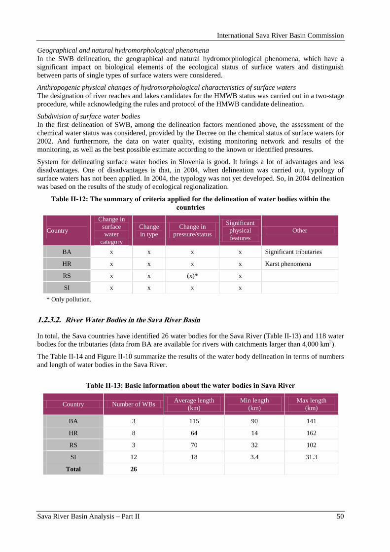
International Sava River Basin Commission
Sava River Basin Analysis – Part II 50
Geographical and natural hydromorphological phenomena
In the SWB delineation, the geographical and natural hydromorphological phenomena, which have a
significant impact on biological elements of the ecological status of surface waters and distinguish
between parts of single types of surface waters were considered.
Anthropogenic physical changes of hydromorphological characteristics of surface waters
The designation of river reaches and lakes candidates for the HMWB status was carried out in a two-stage
procedure, while acknowledging the rules and protocol of the HMWB candidate delineation.
Subdivision of surface water bodies
In the first delineation of SWB, among the delineation factors mentioned above, the assessment of the
chemical water status was considered, provided by the Decree on the chemical status of surface waters for
2002. And furthermore, the data on water quality, existing monitoring network and results of the
monitoring, as well as the best possible estimate according to the known or identified pressures.
System for delineating surface water bodies in Slovenia is good. It brings a lot of advantages and less
disadvantages. One of disadvantages is that, in 2004, when delineation was carried out, typology of
surface waters has not been applied. In 2004, the typology was not yet developed. So, in 2004 delineation
was based on the results of the study of ecological regionalization.
Table II-12: The summary of criteria applied for the delineation of water bodies within the
countries
Country
Change in
surface
water
category
Change
in type
Change in
pressure/status
Significant
physical
features
Other
BA x x x x Significant tributaries
HR x x x x Karst phenomena
RS x x (x)* x
SI x x x x
* Only pollution.
1.2.3.2. River Water Bodies in the Sava River Basin
In total, the Sava countries have identified 26 water bodies for the Sava River (Table II-13) and 118 water
bodies for the tributaries (data from BA are available for rivers with catchments larger than 4,000 km2).
The Table II-14 and Figure II-10 summarize the results of the water body delineation in terms of numbers
and length of water bodies in the Sava River.
Table II-13: Basic information about the water bodies in Sava River
Country Number of WBs Average length
(km)
Min length
(km)
Max length
(km)
BA 3 115 90 141
HR 8 64 14 162
RS 3 70 32 102
SI 12 18 3.4 31.3
Total 26

International Sava River Basin Commission
Sava River Basin Analysis – Part II 51
Table II-14: Number of water body delineation in terms of number and legth of water bodies in the
Sava River per country
Country <10 km 10-25 km 25-50 km 50-75 km 75-100 km 100-150 km >150 km
No No No No No No No
BA 1 2
HR 1 4 1 1 1
RS 1 1 1
SI 2 7 3
0
1
2
3
4
5
6
7
8
<10 km 10-25 km 25-50 km 50-75 km 75-100 km 100-150
km
>150 km
WB range (km)
No
of
WB
BA
HR
RS
SI
Figure II-10: Histogram of water body sizes for the Sava River
The description of the methodologies for the delineation of water bodies in the Sava River Basin shows
that the criteria for the water body delineation are very similar for all riparian countries. Nevertheless, the
Figure II-11 shows significantly different size-distributions of water bodies. On the one hand, this may
occur due to differences in natural conditions, but, on the other hand, this may be the result of different
„quantitative” definitions for the criteria. Even if the criteria for the delineation of water bodies are
qualitatively the same in different countries, their quantitative interpretation may lead to a significantly
different result. If, for instance, the criterion is „significant tributaries”, it still remains to decide how the
criteria „significant” will be quantitatively defined. Therefore, it is recommended to make the underlying
criteria transparent.
The Tables II-14, II-15 and II-16 demonstrate that the results of the water body delineation are indeed
significantly different for all Sava countries. Both, the average size, as well as the size distribution, are
different. It remains to clarify, whether these differences stem from differences in natural conditions or
they are a consequence of different methodological approaches.
Data for the Sava tributaries Lašva, Krivaja, Spreĉa, Piva, Tara, Ćehotina and Praĉa are missing.
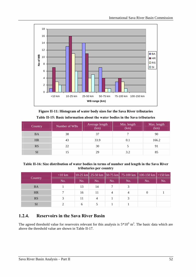
International Sava River Basin Commission
Sava River Basin Analysis – Part II 52
0
2
4
6
8
10
12
14
16
18
<10 km 10-25 km 25-50 km 50-75 km 75-100 km 100-150 km
WB range (km)
No
of
WB
BA
HR
RS
SI
Figure II-11: Histogram of water body sizes for the Sava River tributaries
Table II-15: Basic information about the water bodies in the Sava tributaries
Country Number of WBs Average length
(km)
Min. length
(km)
Max. length
(km)
BA 38 37 7 90
HR 43 33.9 0.1 166.2
RS 22 30 5 91
SI 15 29 3.2 85
Table II-16: Size distribution of water bodies in terms of number and length in the Sava River
tributaries per country
Country <10 km 10-25 km 25-50 km 50-75 km 75-100 km 100-150 km >150 km
No. No. No. No. No. No. No.
BA 1 13 14 7 3
HR 7 16 11 4 4 0 1
RS 3 11 4 1 3
SI 2 6 5 1 1
1.2.4. Reservoirs in the Sava River Basin
The agreed threshold value for reservoirs relevant for this analysis is 5*106 m
3. The basic data which are
above the threshold value are shown in Table II-17.
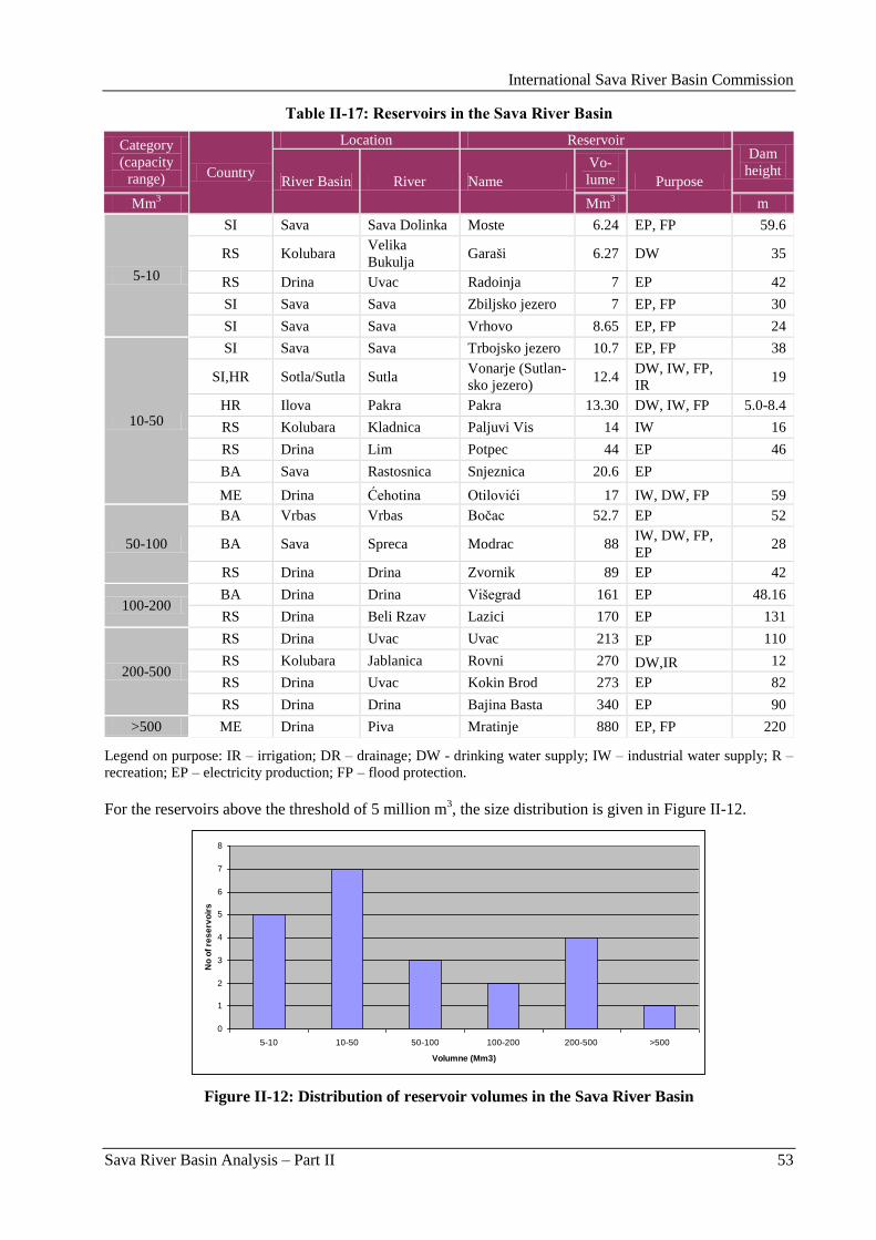
International Sava River Basin Commission
Sava River Basin Analysis – Part II 53
Table II-17: Reservoirs in the Sava River Basin
Category
(capacity
range) Country
Location Reservoir Dam
height River Basin River Name
Vo-
lume Purpose
Mm3 Mm
3 m
5-10
SI Sava Sava Dolinka Moste 6.24 EP, FP 59.6
RS Kolubara Velika
Bukulja Garaši 6.27 DW 35
RS Drina Uvac Radoinja 7 EP 42
SI Sava Sava Zbiljsko jezero 7 EP, FP 30
SI Sava Sava Vrhovo 8.65 EP, FP 24
10-50
SI Sava Sava Trbojsko jezero 10.7 EP, FP 38
SI,HR Sotla/Sutla Sutla Vonarje (Sutlan-
sko jezero) 12.4
DW, IW, FP,
IR 19
HR Ilova Pakra Pakra 13.30 DW, IW, FP 5.0-8.4
RS Kolubara Kladnica Paljuvi Vis 14 IW 16
RS Drina Lim Potpec 44 EP 46
BA Sava Rastosnica Snjeznica 20.6 EP
ME Drina Ćehotina Otilovići 17 IW, DW, FP 59
50-100
BA Vrbas Vrbas Boĉac 52.7 EP 52
BA Sava Spreca Modrac 88 IW, DW, FP,
EP 28
RS Drina Drina Zvornik 89 EP 42
100-200 BA Drina Drina Višegrad 161 EP 48.16
RS Drina Beli Rzav Lazici 170 EP 131
200-500
RS Drina Uvac Uvac 213 EP 110
RS Kolubara Jablanica Rovni 270 DW,IR 12
RS Drina Uvac Kokin Brod 273 EP 82
RS Drina Drina Bajina Basta 340 EP 90
>500 ME Drina Piva Mratinje 880 EP, FP 220
Legend on purpose: IR – irrigation; DR – drainage; DW - drinking water supply; IW – industrial water supply; R –
recreation; EP – electricity production; FP – flood protection.
For the reservoirs above the threshold of 5 million m3, the size distribution is given in Figure II-12.
0
1
2
3
4
5
6
7
8
5-10 10-50 50-100 100-200 200-500 >500
Volumne (Mm3)
No
of
res
erv
oir
s
Figure II-12: Distribution of reservoir volumes in the Sava River Basin
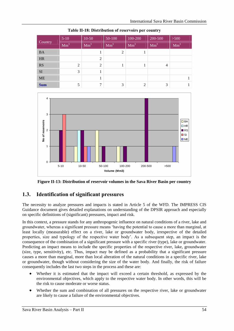
International Sava River Basin Commission
Sava River Basin Analysis – Part II 54
Table II-18: Distribution of reservoirs per country
Country 5-10 10-50 50-100 100-200 200-500 >500
Mm3 Mm
3 Mm
3 Mm
3 Mm
3 Mm
3
BA 1 2 1
HR 2
RS 2 2 1 1 4
SI 3 1
ME 1 1
Sum 5 7 3 2 3 1
0
1
2
3
4
5-10 10-50 50-100 100-200 200-500 >500
Volume (Mm3)
No
of
res
erv
oir
s BA
HR
RS
SI
ME
Figure II-13: Distribution of reservoir volumes in the Sava River Basin per country
1.3. Identification of significant pressures
The necessity to analyze pressures and impacts is stated in Article 5 of the WFD. The IMPRESS CIS
Guidance document gives detailed explanations on understanding of the DPSIR approach and especially
on specific definitions of (significant) pressures, impact and risk.
In this context, a pressure stands for any anthropogenic influence on natural conditions of a river, lake and
groundwater, whereas a significant pressure means „having the potential to cause a more than marginal, at
least locally (measurable) effect on a river, lake or groundwater body, irrespective of the detailed
properties, size and typology of the respective water body‟. As a subsequent step, an impact is the
consequence of the combination of a significant pressure with a specific river (type), lake or groundwater.
Predicting an impact means to include the specific properties of the respective river, lake, groundwater
(size, type, sensitivity), etc. Thus, impact may be defined as a probability that a significant pressure
causes a more than marginal, more than local alteration of the natural conditions in a specific river, lake
or groundwater, though without considering the size of the water body. And finally, the risk of failure
consequently includes the last two steps in the process and these are:
Whether it is estimated that the impact will exceed a certain threshold, as expressed by the
environmental objectives, which apply to the respective water body. In other words, this will be
the risk to cause moderate or worse status.
Whether the sum and combination of all pressures on the respective river, lake or groundwater
are likely to cause a failure of the environmental objectives.
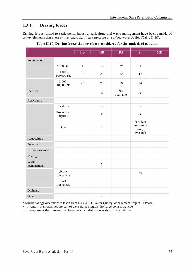
International Sava River Basin Commission
Sava River Basin Analysis – Part II 55
1.3.1. Driving forces
Driving forces related to settlements, industry, agriculture and waste management have been considered
as key elements that exert or may exert significant pressure on surface water bodies (Table II-19).
Table II-19: Driving forces that have been considered for the analysis of pollution
BA* HR RS SI ME
Settlements
>100,000 4 3 5** 1
10,000-
100,000 PE 32 25 12 12
2,000-
10,000 PE 95 78 19 56
Industry 6
Not
available x
Agriculture
Land use x x
Production
figures x x
Other x
Fertilizer
consump-
tion,
livestock
Aquaculture
Forestry
Impervious areas
Mining
Waste
management x
Active
dumpsites 43
Past
dumpsites
Drainage
Other x
* Number of agglomerations is taken from EU CARDS Water Quality Management Project – I Phase
** Inventory municipalities are part of the Belgrade region, discharge point is Danube
SI: x - represents the pressures that have been included in the analysis of the pollution
International Sava River Basin Commission
Sava River Basin Analysis – Part II 56
1.3.2. Significant pressures
1.3.2.1. Significant sources of organic pollution
Methodology per country
Bosnia and Herzegovina
Important step in water characterization is analysis of significant anthropogenous pressures and their
impacts to water bodies. Through the analysis of the pressures it is important to focus on those pressures
whose impact could be mitigated or eliminated through identification of appropriate measures, out of the
broader spectrum of influential factors in the water body, in order to achieve appropriate status of the
water body.
Status of the water bodies represents a sum effect of all pressures combined with all other characteristics
of a specific water body.
Sum of effects of pressures is a result of simultaneous activity of different categories of pressures and
intensities of their impact to changes in the water body, which are also dependent of dynamics in the
water body. Having the latter in mind, the pressures, in general, can be divided in the following manner:
Point pollution sources,
Diffuse pollution sources,
Changes of the water regime caused by changes of measures of water abstraction and regulation
of the flow regime,
Pressures caused by morphological changes, and
Other categories of pressures.
Based on such division and quantification of influential parameters, undertaking an appropriate analysis
process for each mentioned category in the area of the observed basin is needed, which would provide
cause-and-effect connection between pressures and their impacts to water bodies.
This process should, in general, include four steps:
Listing and location of individual causes (the driving forces) of pressures from the above
mentioned categories of pressures, disregarding their current influence on water bodies,
Identification (quantification) of the size (degree) of pressure according to impact parameters for
each driving force from step (1) and setting apart those causes, which, due to their character and
size of pressure, can have (individually or in group) significant negative consequences for water
body,
Assessment of the impact to water body (application of appropriate methods) based on results
from step (2) and condition (quality, quantity and dynamics) of the observed and bordering water
bodies, and
Assessment of probability based on results from the first three steps and target status of the water
body.
Unfortunately, due to lack of data it was impossible to perform detailed identification and quantification
of mentioned influential parameters in this report, and, thus, also to perform all steps of the mentioned
process. It has been planned to continue to work using the goal program formed based on the analysis of
lacks seen during the work on this Report.
Croatia
The main point sources of pollution come from the population through municipal wastewater and from
industrial activities. Point sources of pollution include pollution from public drainage systems, as well as
all settlements that do not have wastewater drainage systems, and the settlements and industrial facilities
that discharge their wastewater into drainage systems and natural recipients.
Waste disposal sites are one of the most significant uncontrolled sources of water pollution in Croatia.
International Sava River Basin Commission
Sava River Basin Analysis – Part II 57
The greatest pressure from diffuse points of pollution comes from agriculture (nutrients from fertilization
and plant protection products). Diffuse pollution from agriculture has been estimated on the basis of land
area, land use category, calculation of nutrients, and soil type assessment.
European experience shows that road traffic accounts for over 90 % of all pollutant emissions from
traffic, while other types of traffic (rail, air, maritime, inland) account for around 10 % of emissions. The
share of pollution load from traffic is small in comparison to other sources of pollution.
Pipelines have been identified as a potentially significant source of pollution.
Serbia
Significant point sources of pollution in Serbia are identified all settlements with constructed sewage
system and emission load with more than 2,000 PE. If a facility for wastewater treatment is built, the
basic parameters of water quality of treated water (BOD, COD, tot N and tot P), and the limits defined
under the Directive on municipal waste water purification (UWWTD - 91/271/EEC) are used as the
criteria.
Criteria for identification of significant pressures originating from the industry are belonging to certain
industrial category and pollution load from direct discharges by following quality parameters: COD,
nutrients, pesticides, heavy metals and organic micro pollutants. Limits are defined according to the
Directive on the integral pollution prevention and control (IPPC) and to European Pollution Emission
Registry (EPER).
Significant industrial categories are: food industry, chemical, leather industry, textile, pulp and paper
industry, metal industry, metal surface treatment, thermal power plant, fertilizer industry, iron and steel
industry and mining. In 2005, the Ministry of Environmental Protection created the preliminary survey of
facilities, need to obtain an integrated permit. The 43 industrial facilities that are subject to reporting
according to the IPPC Directive are identified in the Sava River Basin. Period of transition and change of
the ownership of large industrial companies that marked the last decade of development, caused a
revision of the preliminary list of pollutants and expectations are that a number of industry will be
significantly lower.
Quantification of the load from settlements is done partly on the basis of available measured data and
partly on the basis of expert judgment evaluated using the standard values. Adopted values are: BOD
0.060 kg/inh/day, 0.110 kg COD/inh/day, nitrogen 0.008 kg N/inh/day and phosphorus 0.0018 kg
P/inh/day. Identified settlements with emission load over 100,000 PE are located on the territory of the
city of Belgrade. These are the municipalities of Rakovica, Ĉukarica, Voţdovac and parts of municipality
of Novi Beograd and Zemun. Although territorially belong to the Sava River Basin, these municipalities
have discharge point into the Danube River. Emissions of pollutants from other settlements is provided as
a potential generated emission load and includes load from untreated wastewater from settlements (larger
than 2,000 PE) with and without sewage system. On the territory of the Sava RB, three wastewater
treatment plants are identified in Valjevo, Ruma and Irig of which only WWTP Valjevo works with
satisfactory effects.
Slovenia
Slovenia‟s approach to define significant pressures of organic pollution is based on identification of
agglomeration without waste water treatment and on emission monitoring data. The corresponding data
were provided by the Environmental Agency of the Republic of Slovenia. In future the analysis will be
upgraded by results of the immission monitoring data. In compliance with the urban waste water
directive, Slovenia considered the following sources of organic pollution as significant pressures:
Settlements larger than 2,000 PE without municipal waste water treatment plant,
Discharges from food industry larger than 4,000 PE,
Discharges from waste water treatment plants with capacity larger then 2,000 PE,
Organic pollution from significant point sources.
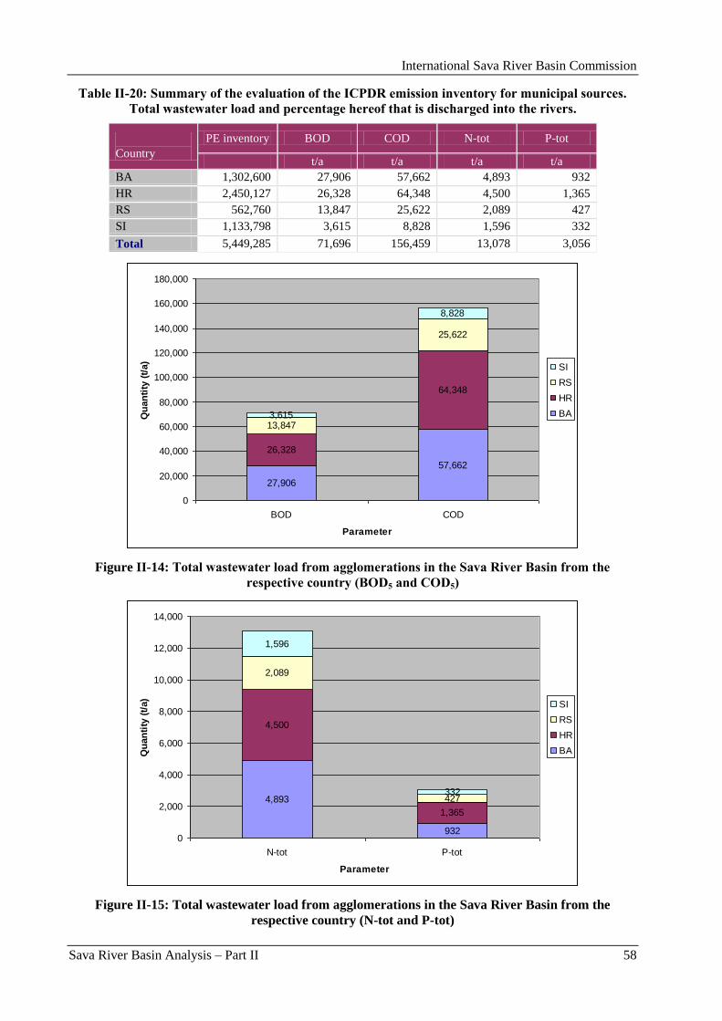
International Sava River Basin Commission
Sava River Basin Analysis – Part II 58
Table II-20: Summary of the evaluation of the ICPDR emission inventory for municipal sources.
Total wastewater load and percentage hereof that is discharged into the rivers.
Country
PE inventory BOD COD N-tot P-tot
t/a t/a t/a t/a
BA 1,302,600 27,906 57,662 4,893 932
HR 2,450,127 26,328 64,348 4,500 1,365
RS 562,760 13,847 25,622 2,089 427
SI 1,133,798 3,615 8,828 1,596 332
Total 5,449,285 71,696 156,459 13,078 3,056
27,906
57,662
26,328
64,348
13,847
25,622
3,615
8,828
0
20,000
40,000
60,000
80,000
100,000
120,000
140,000
160,000
180,000
BOD COD
Parameter
Qu
an
tity
(t/
a)
SI
RS
HR
BA
Figure II-14: Total wastewater load from agglomerations in the Sava River Basin from the
respective country (BOD5 and COD5)
4,893
932
4,500
1,365
2,089
427
1,596
332
0
2,000
4,000
6,000
8,000
10,000
12,000
14,000
N-tot P-tot
Parameter
Qu
an
tity
(t/
a)
SI
RS
HR
BA
Figure II-15: Total wastewater load from agglomerations in the Sava River Basin from the
respective country (N-tot and P-tot)
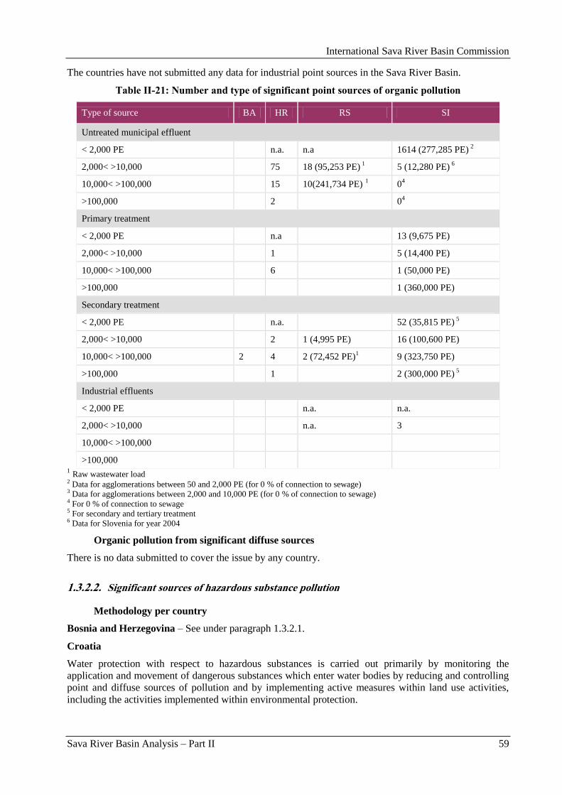
International Sava River Basin Commission
Sava River Basin Analysis – Part II 59
The countries have not submitted any data for industrial point sources in the Sava River Basin.
Table II-21: Number and type of significant point sources of organic pollution
Type of source BA HR RS SI
Untreated municipal effluent
< 2,000 PE n.a. n.a 1614 (277,285 PE) 2
2,000< >10,000 75 18 (95,253 PE) 1 5 (12,280 PE)
6
10,000< >100,000 15 10(241,734 PE) 1 0
4
>100,000 2 04
Primary treatment
< 2,000 PE n.a 13 (9,675 PE)
2,000< >10,000 1 5 (14,400 PE)
10,000< >100,000 6 1 (50,000 PE)
>100,000 1 (360,000 PE)
Secondary treatment
< 2,000 PE n.a. 52 (35,815 PE) 5
2,000< >10,000 2 1 (4,995 PE) 16 (100,600 PE)
10,000< >100,000 2 4 2 (72,452 PE)1 9 (323,750 PE)
>100,000 1 2 (300,000 PE) 5
Industrial effluents
< 2,000 PE n.a. n.a.
2,000< >10,000 n.a. 3
10,000< >100,000
>100,000 1 Raw wastewater load
2 Data for agglomerations between 50 and 2,000 PE (for 0 % of connection to sewage) 3 Data for agglomerations between 2,000 and 10,000 PE (for 0 % of connection to sewage) 4 For 0 % of connection to sewage 5 For secondary and tertiary treatment 6 Data for Slovenia for year 2004
Organic pollution from significant diffuse sources
There is no data submitted to cover the issue by any country.
1.3.2.2. Significant sources of hazardous substance pollution
Methodology per country
Bosnia and Herzegovina – See under paragraph 1.3.2.1.
Croatia
Water protection with respect to hazardous substances is carried out primarily by monitoring the
application and movement of dangerous substances which enter water bodies by reducing and controlling
point and diffuse sources of pollution and by implementing active measures within land use activities,
including the activities implemented within environmental protection.
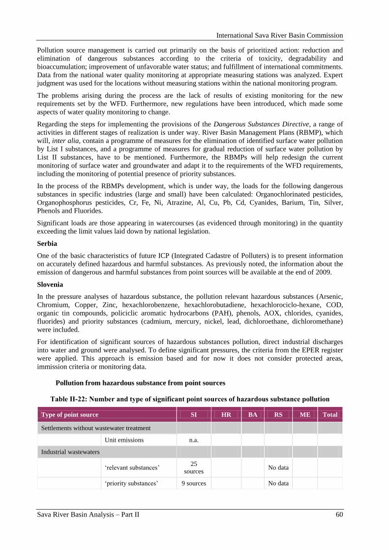
International Sava River Basin Commission
Sava River Basin Analysis – Part II 60
Pollution source management is carried out primarily on the basis of prioritized action: reduction and
elimination of dangerous substances according to the criteria of toxicity, degradability and
bioaccumulation; improvement of unfavorable water status; and fulfillment of international commitments.
Data from the national water quality monitoring at appropriate measuring stations was analyzed. Expert
judgment was used for the locations without measuring stations within the national monitoring program.
The problems arising during the process are the lack of results of existing monitoring for the new
requirements set by the WFD. Furthermore, new regulations have been introduced, which made some
aspects of water quality monitoring to change.
Regarding the steps for implementing the provisions of the Dangerous Substances Directive, a range of
activities in different stages of realization is under way. River Basin Management Plans (RBMP), which
will, inter alia, contain a programme of measures for the elimination of identified surface water pollution
by List I substances, and a programme of measures for gradual reduction of surface water pollution by
List II substances, have to be mentioned. Furthermore, the RBMPs will help redesign the current
monitoring of surface water and groundwater and adapt it to the requirements of the WFD requirements,
including the monitoring of potential presence of priority substances.
In the process of the RBMPs development, which is under way, the loads for the following dangerous
substances in specific industries (large and small) have been calculated: Organochlorinated pesticides,
Organophosphorus pesticides, Cr, Fe, Ni, Atrazine, Al, Cu, Pb, Cd, Cyanides, Barium, Tin, Silver,
Phenols and Fluorides.
Significant loads are those appearing in watercourses (as evidenced through monitoring) in the quantity
exceeding the limit values laid down by national legislation.
Serbia
One of the basic characteristics of future ICP (Integrated Cadastre of Polluters) is to present information
on accurately defined hazardous and harmful substances. As previously noted, the information about the
emission of dangerous and harmful substances from point sources will be available at the end of 2009.
Slovenia
In the pressure analyses of hazardous substance, the pollution relevant hazardous substances (Arsenic,
Chromium, Copper, Zinc, hexachlorobenzene, hexachlorobutadiene, hexachlorociclo-hexane, COD,
organic tin compounds, policiclic aromatic hydrocarbons (PAH), phenols, AOX, chlorides, cyanides,
fluorides) and priority substances (cadmium, mercury, nickel, lead, dichloroethane, dichloromethane)
were included.
For identification of significant sources of hazardous substances pollution, direct industrial discharges
into water and ground were analysed. To define significant pressures, the criteria from the EPER register
were applied. This approach is emission based and for now it does not consider protected areas,
immission criteria or monitoring data.
Pollution from hazardous substance from point sources
Table II-22: Number and type of significant point sources of hazardous substance pollution
Type of point source SI HR BA RS ME Total
Settlements without wastewater treatment
Unit emissions n.a.
Industrial wastewaters
„relevant substances‟
25
sources
No data
„priority substances‟ 9 sources No data
International Sava River Basin Commission
Sava River Basin Analysis – Part II 61
Pollution from hazardous substance from diffuse sources
Bosnia and Herzegovina, Croatia and Serbia – no data submitted.
Slovenia
Data source was sold amounts of plant protection products for Slovenia (kg) for a year 2004. The
estimation of the amount which has been sold for catchments of surface water bodies in kg and kg per
hectare has been made. Out of 154 plant protection products 26 have been chosen which were measured
in national monitoring, those which are on priority list Annex X, those which are national relevant
substances and those which were sold in amount over 50 tons in year 2004.
Significant pressures are on those catchments of surface water bodies where sold amounts of PPP are
higher than median.
1.3.2.3. Significant sources of nutrients pollution
Methodology per country
Bosnia and Herzegovina – see under paragraph 1.3.2.1.
Croatia
The assessment of pollution loads from industry is based on the data on the annual quantities of
discharged wastewater mean concentration values from the available wastewater analyses for the 2000-
2005 period and maximum permissible concentrations of dangerous and other substances laid down by
the water rights permits. The annual loads of COD-Cr, BOD5, total nitrogen, total phosphorus, metals,
phenols and pesticides have been calculated.
Municipal wastewater is mostly polluted with organic substances. The assessment of pollution load
(t/year) from the population was carried out according to EU standards (60 g BOD5 g/d/c, 135 COD-Cr
g/d/c, 11 g N T/d/c, 2.5 g P T/d/c).
The greatest pressure from diffuse points of pollution comes from agriculture due to the input of nutrients
present in fertilizers and plant protection products. Diffuse pollution from agriculture has been estimated
on the basis of land area, land use category, calculation of nutrients, and soil type assessment.
The pressure was evaluated on basis of indicators related to regular agricultural activities; the assessment
of pollution loads from agriculture thus includes the application of mineral fertilizers and the quantity of
organic manure from animal farms. The real impact of the application of pesticides can be identified only
by measurement, which is a costly process and carried out only in exceptional circumstances.
Serbia
The major nutrient inputs to a waterbody generally are wastewater discharges, land runoff, the
atmosphere (precipitation) and groundwater (principaly nitrogen). The inputs from several of these
sources, industrial, agroindustrial and especially the non-point sources were difficult to quantify reliably
due to lack of data. In the case of individual sewerage systems and WWTP‟s evaluation for some
settlements is based on measured data but for most of them loads are estimated useing specific factors
presented in Chapter 1.3.2.1.
Slovenia
Estimation of total annual load (kg/year) of nitrogen and phosphorus to each surface water body was
made from calculation of nitrogen and phosphorus balance on field, vineyard, grassland, orchard and
other agricultural land from the Ministry of agriculture, forestry and food classification (MKGP) for
hydro-geographical area II level. Calculated positive balance represented surplus of nutrient (kg/ha/a).
Estimation of nutrient loss on nutrient surplus was taken from Nutrient balance for Danube countries
(1997) and other projects. As for nitrogen, it was estimated that 20 % of surplus is lost (field, vineyard,
orchard and other agricultural land from MKGP classification), 9 % of nitrogen surplus is lost on
grassland. As for phosphorus, it was estimated that 1.5 % of surplus is lost on all agricultural land from
MKGP classification. Finally, the calculation of total annual load (N, P) to each surface water body was
International Sava River Basin Commission
Sava River Basin Analysis – Part II 62
done depending on contribution area composition (field, vineyard, grassland, orchard and other
agricultural land from MKGP classification). The total annual load (N, P) was further statistically
modeled with monitoring data for nitrate and phosphorus. Significant pressure for nitrogen was
determined at concentration 4.6 mg/l NO3. Significant pressure for phosphorus was determined at
concentration 0.11 mg/l of total P. For natural lakes and artificial accumulations the total annual load was
statistically modeled with monitoring data for lakes and artificial accumulations (only phosphorus).
Significant pressure for phosphorus was determined at concentration 10 µg/l of total P.
Data retrieved from:
Statistical Office of the Republic of Slovenia (fertilizers, livestock, crop production), 2000;
Ministry of agriculture, forestry and food (land use), 2006;
other national research projects.
Data gaps:
consumption of mineral fertilizer on different land use was estimated from total annual sold
amount;
percentage of nutrient loss to environment was taken from national research projects.
Remark: there is no data available for assessment of pollution from nutrient substance from point and
diffuse sources.
1.3.3. Identification of significant hydromorphological alterations
According to Annex II, 1.4 of the WFD, three categories of hydrological and morphological alterations
should be considered:
Estimation and identification of significant water abstraction for urban, industrial, agricultural
and other uses, including seasonal variations and total annual demand, and of loss of water in
distribution systems,
Estimation and identification of the impact of significant water flow regulation, including water
transfer and diversion, on overall flow characteristics and water balances,
Identification of significant morphological alterations to water bodies.
Three HYMO pressure components have been identified in the Sava River Basin:
Interruption of river and habitat continuity,
Disconnection of adjacent wetland/floodplains,
Hydrological alterations3.
Further, potential pressures that may result from future infrastructure projects are being dealt with.
This chapter reflects findings on HYMO alterations and their significance from the ISRBC templates and
DanubeGIS database (most recent national data).
Since national data have been provided in different scales or have not been provided at all, analyses
below give general overview of the listed HYMO components and future infrastructure projects. Detailed
analyses should be done in the next phase (e.g. the Sava RB Management Plan) when data from all
countries are collected in the same scale.
Additionally, information on future infrastructure projects are also based on the related presentations
delivered at the HYMO Workshop organized by the ISRBC (Zagreb, March 23, 2009).
1.3.3.1. Methodology per country
Bosnia and Herzegovina – see under paragraph 1.3.2.1.
3 Hydrological alterations provoke changes in the quantity and conditions of flow.
International Sava River Basin Commission
Sava River Basin Analysis – Part II 63
Croatia
Assessment of risks that water bodies will not be able to achieve environmental objectives specified in the
WFD due to anthropogenic alterations has an important role in the characterization of heavily modified
surface water bodies.
The analysis of pressures and impacts has to be made:
by indirect measuring of the impact on the sites where appropriate monitoring is provided, and
by assessing the likely impacts of the known pressures.
At those sites at which the morphology of a water body is subject to several pressures, their joint impact
shall be considered.
The WFD regards hydromorphological elements as support to biological elements. Essential
hydromorphological elements are defined for rivers, lakes, transitional waters and coastal waters (Annex
V of the WFD). For rivers, these are the quantity and dynamics of water flow, connection to groundwater
bodies, river continuity, river depth and width variations, structure and substrate of the river bed, and
structure of the riparian zone.
Human impact on freshwater ecosystems has been very marked in the last one hundred years or so. Its
consequences are very often, not treated appropriately, or even underestimated. In Croatia, similar to
European Union and the Danube countries, data on impacts of hydromorphological alterations, and for
rare sections of rivers and lakes is very limited. Furthermore, the ways for describing and assessing the
hydromorphological alterations have not been elaborated enough to fully meet the need of this analysis.
Additionally, the interaction between individual morphological factors and ecosystems is often difficult to
understand. There are, thus, some 350 criteria for the characterization and quantification of anthropogenic
hydromorphological impacts on fish. It is for that reason that large part of the characterization of impacts
of individual morphological pressures on ecosystems (biological elements) has to rely on expert
judgment.
It cannot, therefore, be expected that the analysis of morphological pressures and impacts will be based
on complex models which will fully describe the behaviour of ecosystems. Such approach may be
justified in a small number of special cases if the analysis is supported by research results and
observations. However, in most cases this analysis will be based on less demanding methods, which do
not require large amounts of data and will be improved and upgraded as the knowledge on the behavior of
the ecosystem broadens and the targeted collection of data on watercourse hydromorphology broadens.
The applied method has been adapted to the present status, which is most often characterized by
insufficient knowledge of interrelation between individual morphological factors and ecosystems, and
lack of precise data on morphological alterations. It is for that reason that the methodological framework
has been structured in such a way to be comprehensive and adaptable, i.e. to enable simple inclusion of
new knowledge of various complexity.
It would be advisable to initiate basic research which would improve the knowledge on the impact of
hydromorphological alterations on ecosystems and reduce the share of currently prevailing expert
judgment.
Serbia
Hydromorphological pressures and related risk analyses provided by Serbia were based on findings of the
ICPDR HYMO Task Group.
The HYMO pressure/impact analysis focuses on three hydrological pressure types:
Impoundment (alteration/reduction in flow velocity),
Water abstraction (alteration in quantity of discharge/flow in the river),
Hydropeaking (alteration of flow dynamics/discharge pattern in the river).
Criteria, as given by the HYMO TG, are as follows:
impoundment length during low flow conditions is longer than 1 km;
International Sava River Basin Commission
Sava River Basin Analysis – Part II 64
flow below dam is less than 50% of mean annual minimum flow of a specific time period
(comparable with Q95);
water level fluctuation is higher than 1 m /day.
Slovenia
Considering the hydromorphological elements defined in the EU Water Framework Directive, i.e.
hydrological regime, river continuity and morphological conditions, different related pressures that are
causing impacts on hydromorphological state were recognized in Slovenia. Analysis of
hydromorphological pressures was treated separately for morphological and hydrological pressures. Since
the impact of each hydromorphological pressure on biological elements and consequently ecological
status is not yet defined, the criteria for significant pressures were prepared on the expert judgment. The
magnitude of the negative impact of each pressure and combination of different pressures defines result of
the hydromorphological risk assessment.
Pressures were collected from various databases (e.g. concessions and water rights for water use), expert
evidences (e.g. list of large dams), researches (e.g. degree of modifications of river morphology) and
expert knowledge based on field investigations.
1.3.3.2. Longitudinal continuity and habitat interruption
Criteria for longitudinal continuity and habitat interruptions (dams, weirs, ramps, sills, etc.) were defined
at the ICPDR level. The same criteria were adopted for both Danube and sub-basin (Sava) level as listed
below:
for rithral rivers height > 0.7 m,
for potamal rivers height > 0.3 m.
Sava riparian countries mostly provided data on large dams for the DanubeGIS. Data were reported in
different scales, so that there are structures reported by Slovenia not only for the Sava RBA relevant
rivers but also on other (minor) rivers. At the same time, Croatia and Bosnia and Herzegovina reported
the data on structures built on rivers with catchment area larger than 4,000 km2.
Based on the DanubeGIS data collection, Figure II-16 presents information on longitudinal continuity
interruptions in the Sava River Basin.
The course of the Sava River is interrupted by 5 existing hydropower dams in Slovenia (Moste, Mavĉiĉe,
Medvode, Vrhovo, and Boštanj), also used for flood defense. These dams disrupt the longitudinal
continuum of sediment transport, as well as migration of aquatic organisms (only the HPP Boštanj is
equipped with fish migration aid). Downstream reaches of the Sava River are free-flowing.
Significant number of hydropower dams is also present in the Drina River sub-basin. Chain of dams on
the Drina River consists of large dams Višegrad (BA), Bajina Bašta and Zvornik (RS). Zvornik dam is the
only one equipped with fish migration aid, but its performance should be monitored. Hydropower dams
are also built on the Lim and Uvac Rivers in RS, as well on the Piva River in Montenegro (Mratinje).
Slovenia reported 13 structures located on tributaries. Hydropower use is specified only for Zavrsnisko
jezero, while the others have multipurpose use. Ten of those structures are equipped with functional fish
migration aid.
Croatia reported one hydropower dam located on the Kupa River (HPP Ozalj).
Beside the Višegrad dam on the Drina River, Bosnia and Herzegovina delivered data on two dams on
the Vrbas River. Both are aimed for hydropower production, while one is also used for flood protection
and the other for urbanization.
Serbia reported not only dams, but also sills and weirs. Beside hydropower dams in the Drina River
Basin, there is one sill on the Kolubara River used for water supply of the thermal power plant and a weir
on the Bosut River. None of those structures is equipped with fish migration aids, but it is planned for the
Kolubara sill.
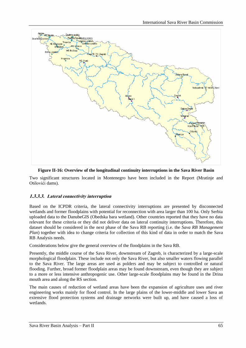
International Sava River Basin Commission
Sava River Basin Analysis – Part II 65
Figure II-16: Overview of the longitudinal continuity interruptions in the Sava River Basin
Two significant structures located in Montenegro have been included in the Report (Mratinje and
Otilovići dams).
1.3.3.3. Lateral connectivity interruption
Based on the ICPDR criteria, the lateral connectivity interruptions are presented by disconnected
wetlands and former floodplains with potential for reconnection with area larger than 100 ha. Only Serbia
uploaded data to the DanubeGIS (Obedska bara wetland). Other countries reported that they have no data
relevant for these criteria or they did not deliver data on lateral continuity interruptions. Therefore, this
dataset should be considered in the next phase of the Sava RB reporting (i.e. the Sava RB Management
Plan) together with idea to change criteria for collection of this kind of data in order to match the Sava
RB Analysis needs.
Considerations below give the general overview of the floodplains in the Sava RB.
Presently, the middle course of the Sava River, downstream of Zagreb, is characterized by a large-scale
morphological floodplain. These include not only the Sava River, but also smaller waters flowing parallel
to the Sava River. The large areas are used as polders and may be subject to controlled or natural
flooding. Further, broad former floodplain areas may be found downstream, even though they are subject
to a more or less intensive anthropogenic use. Other large-scale floodplains may be found in the Drina
mouth area and along the RS section.
The main causes of reduction of wetland areas have been the expansion of agriculture uses and river
engineering works mainly for flood control. In the large plains of the lower-middle and lower Sava an
extensive flood protection systems and drainage networks were built up, and have caused a loss of
wetlands.
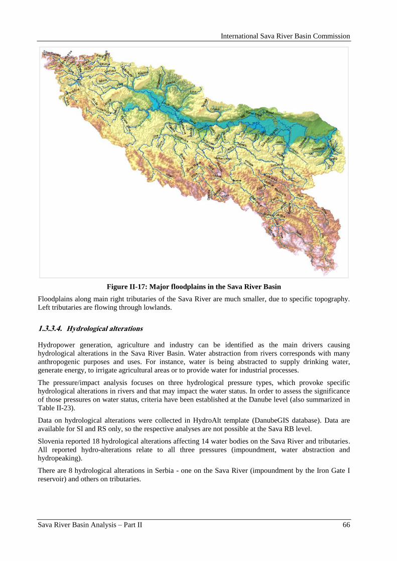
International Sava River Basin Commission
Sava River Basin Analysis – Part II 66
Figure II-17: Major floodplains in the Sava River Basin
Floodplains along main right tributaries of the Sava River are much smaller, due to specific topography.
Left tributaries are flowing through lowlands.
1.3.3.4. Hydrological alterations
Hydropower generation, agriculture and industry can be identified as the main drivers causing
hydrological alterations in the Sava River Basin. Water abstraction from rivers corresponds with many
anthropogenic purposes and uses. For instance, water is being abstracted to supply drinking water,
generate energy, to irrigate agricultural areas or to provide water for industrial processes.
The pressure/impact analysis focuses on three hydrological pressure types, which provoke specific
hydrological alterations in rivers and that may impact the water status. In order to assess the significance
of those pressures on water status, criteria have been established at the Danube level (also summarized in
Table II-23).
Data on hydrological alterations were collected in HydroAlt template (DanubeGIS database). Data are
available for SI and RS only, so the respective analyses are not possible at the Sava RB level.
Slovenia reported 18 hydrological alterations affecting 14 water bodies on the Sava River and tributaries.
All reported hydro-alterations relate to all three pressures (impoundment, water abstraction and
hydropeaking).
There are 8 hydrological alterations in Serbia - one on the Sava River (impoundment by the Iron Gate I
reservoir) and others on tributaries.

International Sava River Basin Commission
Sava River Basin Analysis – Part II 67
Table II-23: Hydrological pressure types, provoked alterations and criteria for the pressure/impact
assessment in the Sava RB
Hydrological pressure Provoked alteration Criteria for pressure assessment
Impoundment Alteration/reduction in flow
velocity of the river
Impoundment length during low flow
conditions > 1 km
Water abstraction/
Residual water
Alteration in quantity of
discharge/flow in the river
Flow below dam < 50% of mean annual
minimum flow of a specific time period
(comparable with Q95)
Hydropeaking Alteration of flow
dynamics/discharge pattern in
the river
Water level fluctuation > 1m /day
1.3.3.5. Future infrastructure projects
In addition to the present degradation of the Sava River and its tributaries caused by existing
hydromorpological alterations, a number of future infrastructure projects (FIP) are at different stages of
planning and preparation. Those projects may provoke significant HYMO pressures on water status, as
described above.
Based on the DanubeGIS data collection, information on future infrastructure projects is available only
for Slovenia. That is most likely due to the fact that selection of the FIPs to be uploaded into the
DanubeGIS should meet criteria as given below:
Strategic Environmental Assessment (SEA) and/or Environmental Impact Assessments (EIA) are
performed and
transboundary effects are provoked.
Information on FIPs in each country was provided by representatives of different sectors on the HYMO
Consultation Workshop (Zagreb, March 23, 2009). Mostly hydropower projects were considered by
countries, while navigation issues were provided by the ISRBC representative.
Two dams with main purpose of hydropower production (Breţice and Mokrice) and also flood protection
are planned in Slovenia. Both projects affect the Sava River. Strategic environmental assessment is
already performed for both projects, while EIA is intended to be done. Both projects are under
preparation and will probably have transboundary impact.
There are no official plans for FIP in Croatia. Although some studies on flood protection of the Sava
River exist, their findings should not be taken as FIP at the moment.
Information for Bosnia and Herzegovina is available separately for countries‟ entities and those refer to
the hydropower production projects only.
There is a decision on building of 4 HPPs on the Bosna, Drina, Unac and Vrbas Rivers in the Federation
of Bosnia and Herzegovina in next 5 – 6 years. About 10 future HPPs are also under consideration as the
„A” priority (Rivers Sana, Bosna, Vrbas, Drina, Una, Bioštica – Krivaja, Ugar). There are also 7 projects
as the „B” priority but they can not be appointed as FIP in near future. Some transboundary projects with
Serbia and Croatia are also considered but only as the initiative since bilateral agreements need to be
made. At the same time, concession for 202 small hydropower plants is already issued in BA Federation.
Information on FIPs in the Republika Srpska is given by sub-catchments and river stretches. Designs for 3
HPPs planned on the upper flow of the Drina River and one on the Lim River are already prepared and
included in spatial plans. Some HPPs on the middle and lower flow of the Drina River (common river
section with Serbia) were also considered, but not in near future. Planning documents comprise two HPPs
in the middle flow of the Vrbas River. Concessions are issued for 7 planned HPPs on the Bosna River.
Some considerations related to HPP on the Una River were made in previous planning documents, but are
not relevant any more.
International Sava River Basin Commission
Sava River Basin Analysis – Part II 68
Although there is none official information on FIPs in Serbia, remarkable but unexploited hydro-
potential of the Drina River was appointed together with the fact that future development depends on
harmonization of interests of different stakeholders.
Navigation issues comprise rehabilitation of the Sava River Waterway. This activity is recognized by the
ISRBC as the priority and a feasibility study was performed in 2008. A multifunctional approach was
used taking into account not only transport but also leisure, water management and environment. Basic
documents (reviews) for EIA report were carried out, including proposal of environment protection
measures, environmental monitoring program and evaluation of costs for environmental protection.
1.3.4. Other significant anthropogenic pressures
1.3.4.1. Accidental pollution
Croatia
In Croatia, some accidental pollution was caused by discharges from farming facilities and pre-treatment
plants; by failures on drainage systems and treatment plants; traffic accidents with leakage of liquid fuel
and other dangerous substances; damage to industrial facilities; irresponsible disposal of dangerous and
harmful substances; bursting of supply lines; damage to storehouses (oil/oil derivatives leaking from fuel
tanks, and other dangerous substances).
At times of low flows, the ecological function of water may be put at risk by larger polluters discharging
wastewater into a watercourse. For such cases, measures of strengthened supervision at discharge points
are provided and the discharge of technological wastewater is limited.
The problems arising in the process are the lack of data on current monitoring for all new requirements
set by the WFD.
Slovenia
In Slovenia the evaluation of potential for accidental pollution of surface waters focussed on two major
areas: traffic and point sources pollution. Traffic accidents represent the possibility of accidental pollution
by leakage of dangerous substance. Because of that the proximity of roads and railway tracks were
considered. The analysis showed that a possibility of accidental pollution from roads accidents is present
on 85 % of surface waters and that 41 % of surface waters in the Sava River Basin is potentially at threat
due to potential accidental pollution from railway accidents.
The accidental pollution can also originate from point sources because leakages from inappropriate
disposal of different hazardous substances and from damaged industrial facilities and storehouses. Point
sources, considered in the analysis, were evaluated as minor, major or other potential sources of
accidental pollution on basis of the chemical properties and quantity of present hazardous material as well
as the proximity to the specific water body. The analysis showed that possibility of major accidental
pollution from point sources exists on 18 % of surface waters in the Sava River Basin.
BA and RS have not submitted any data.
1.3.4.2. Invasive species
Bosnia and Herzegovina
Monitoring of invasive species has not yet been provided systematically in Bosnia and Herzegovina.
Damages caused by these species to autochtonous ichtio/fish-fauna of the country are difficult to be
assessed in quantitative sense.
Ichtyologists are especially worried about the impact of invasive species in rivers of the Sava River Basin,
where live numerous endemic fish species. Some species are introduced accidentally, and some were
introduced for fish-stocking.
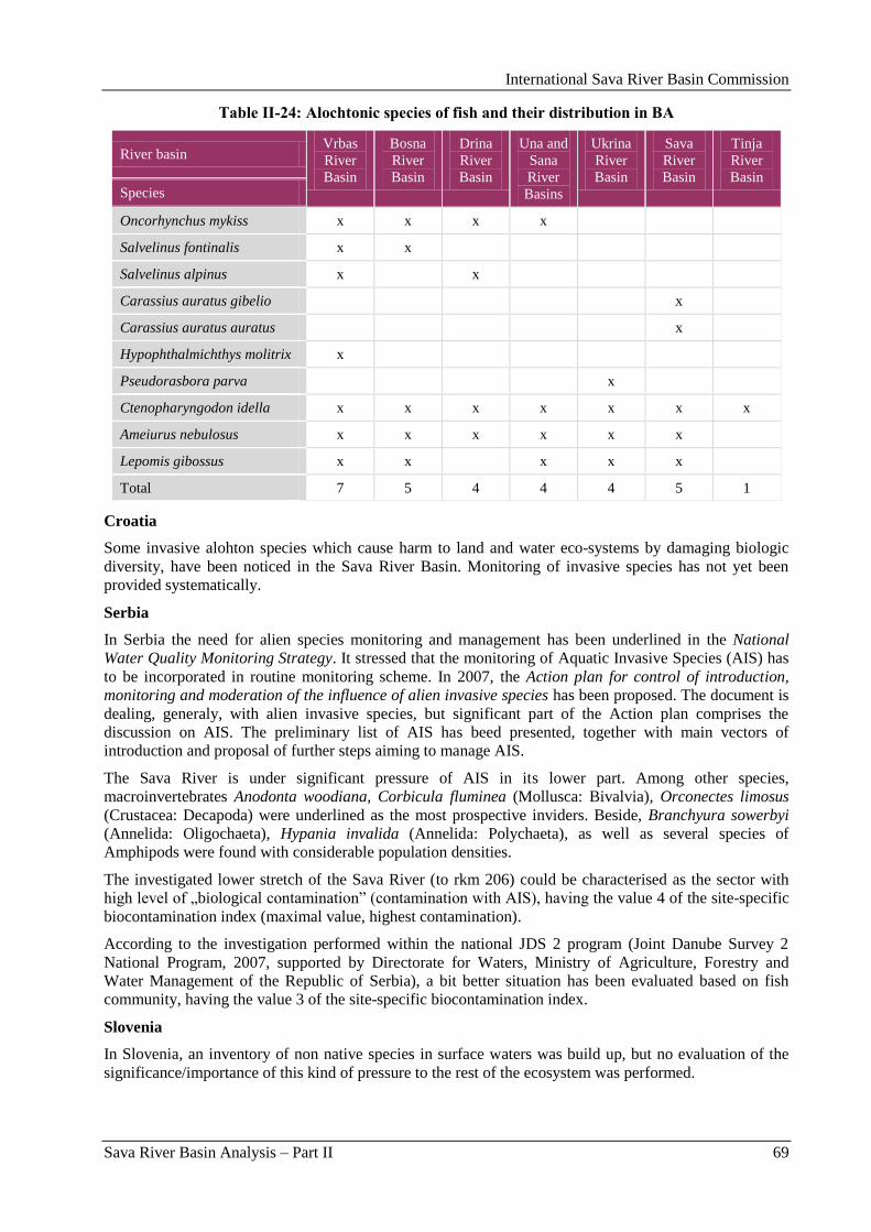
International Sava River Basin Commission
Sava River Basin Analysis – Part II 69
Table II-24: Alochtonic species of fish and their distribution in BA
River basin Vrbas
River
Basin
Bosna
River
Basin
Drina
River
Basin
Una and
Sana
River
Basins
Ukrina
River
Basin
Sava
River
Basin
Tinja
River
Basin Species
Oncorhynchus mykiss x x x x
Salvelinus fontinalis x x
Salvelinus alpinus x x
Carassius auratus gibelio x
Carassius auratus auratus x
Hypophthalmichthys molitrix x
Pseudorasbora parva x
Ctenopharyngodon idella x x x x x x x
Ameiurus nebulosus x x x x x x
Lepomis gibossus x x x x x
Total 7 5 4 4 4 5 1
Croatia
Some invasive alohton species which cause harm to land and water eco-systems by damaging biologic
diversity, have been noticed in the Sava River Basin. Monitoring of invasive species has not yet been
provided systematically.
Serbia
In Serbia the need for alien species monitoring and management has been underlined in the National
Water Quality Monitoring Strategy. It stressed that the monitoring of Aquatic Invasive Species (AIS) has
to be incorporated in routine monitoring scheme. In 2007, the Action plan for control of introduction,
monitoring and moderation of the influence of alien invasive species has been proposed. The document is
dealing, generaly, with alien invasive species, but significant part of the Action plan comprises the
discussion on AIS. The preliminary list of AIS has beed presented, together with main vectors of
introduction and proposal of further steps aiming to manage AIS.
The Sava River is under significant pressure of AIS in its lower part. Among other species,
macroinvertebrates Anodonta woodiana, Corbicula fluminea (Mollusca: Bivalvia), Orconectes limosus
(Crustacea: Decapoda) were underlined as the most prospective inviders. Beside, Branchyura sowerbyi
(Annelida: Oligochaeta), Hypania invalida (Annelida: Polychaeta), as well as several species of
Amphipods were found with considerable population densities.
The investigated lower stretch of the Sava River (to rkm 206) could be characterised as the sector with
high level of „biological contamination” (contamination with AIS), having the value 4 of the site-specific
biocontamination index (maximal value, highest contamination).
According to the investigation performed within the national JDS 2 program (Joint Danube Survey 2
National Program, 2007, supported by Directorate for Waters, Ministry of Agriculture, Forestry and
Water Management of the Republic of Serbia), a bit better situation has been evaluated based on fish
community, having the value 3 of the site-specific biocontamination index.
Slovenia
In Slovenia, an inventory of non native species in surface waters was build up, but no evaluation of the
significance/importance of this kind of pressure to the rest of the ecosystem was performed.

International Sava River Basin Commission
Sava River Basin Analysis – Part II 70
1.4. Assessment of impacts in the Sava River Basin
1.4.1. Impacts on rivers
For the risk assessment status in the Sava River and its tributaries, following impacts have been
considered:
Impacts from organic pollution;
Impacts from hazardous substances pollution;
Impacts from nutrient loads;
Impacts on rivers caused by hydromorphological alterations;
Impacts from other pollution sources.
Bosnia and Herzegovina
Risk assessment in Federation of BA has not been performed yet. BA RS – no data submitted.
Croatia
Impact assessment, i.e. assessment of status in relation to pressures from water pollution was carried out
for all segments of the watercourse and for all relevant chemical elements (BOD5, COD-Mn, total N, total
P). The calculation was made for mean load values and average flows.
The relevant values of chemical parameters were identified at monitoring stations on the basis of the
measured data. The relevant values of the masses of individual chemical parameters were balanced on
subwatersheds between the monitoring stations.
Based on hydromorphological quality elements and their description in the WFD, eight parameters were
used for the characterisation of hydromorphological status.
The assessment was made for river segments with average length of 200 m.
For the assesment of impacts from organic pollution, the relevant values of chemical parameters were
identified at monitoring stations on basis of the measured data. The relevant values of the masses of
individual chemical parameters were balanced on subwatersheds between the monitoring stations. The
difference between the sum of entries (inflow of masses from the upstream subwatersheds – monitoring
stations at the upstream parts of the subwatershed) and inputs (identified pressures in the subwatersheds)
and outputs (familiar relevant masses at monitoring station on the downstream part of the subwatershed)
was balanced on entire subwatershed by a coefficient analogous to a continuous portion of decomposition
of organic matter in the watercourse by means of simple exponential equation:
KdtL
dL
t
t
where:
Lt – remnant of the undecomposed organic matter;
K – continuous portion of decomposition of organic matter in the watercourse.
The relevant spread of masses was calculated for each segment of the watercourse on the subwatershed
on basis of the entries and inputs and the balancing coefficient. The relevant concentration was defined on
the basis of the mean flow estimated for each segment of the watercourse.
To assess the impact of nutrient loads, the quantities of phosphorus used in Croatia for fertilization of
agricultural land, and respectve chemical characteristics of soils should be considered. As a result, it can
be concluded that the risk of harmful impact of phosphorus from the applied fertilizers in Croatia is very
low. Certain problems may arise if a larger quantity of organic matter is discharged directly into the
watercourses, but that is not a problem related to fertilization of agricultural land.
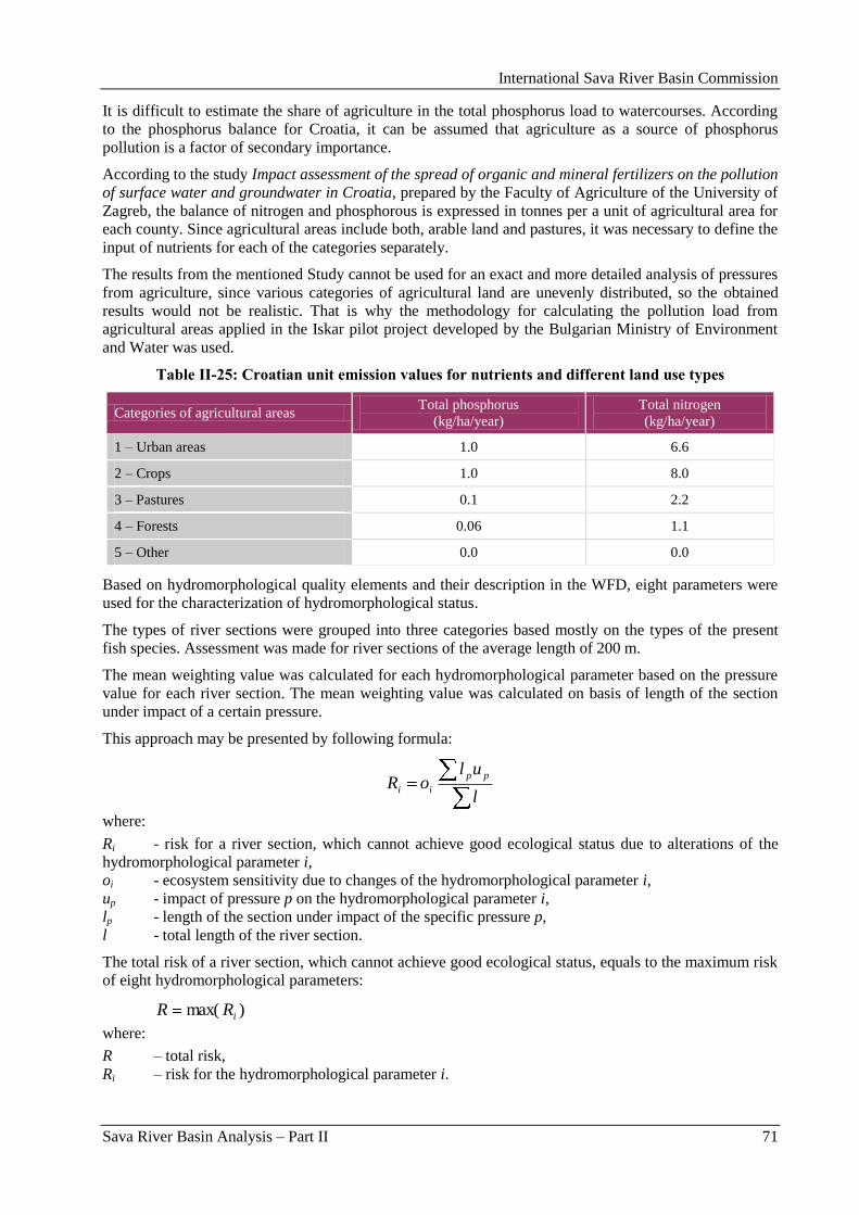
International Sava River Basin Commission
Sava River Basin Analysis – Part II 71
It is difficult to estimate the share of agriculture in the total phosphorus load to watercourses. According
to the phosphorus balance for Croatia, it can be assumed that agriculture as a source of phosphorus
pollution is a factor of secondary importance.
According to the study Impact assessment of the spread of organic and mineral fertilizers on the pollution
of surface water and groundwater in Croatia, prepared by the Faculty of Agriculture of the University of
Zagreb, the balance of nitrogen and phosphorous is expressed in tonnes per a unit of agricultural area for
each county. Since agricultural areas include both, arable land and pastures, it was necessary to define the
input of nutrients for each of the categories separately.
The results from the mentioned Study cannot be used for an exact and more detailed analysis of pressures
from agriculture, since various categories of agricultural land are unevenly distributed, so the obtained
results would not be realistic. That is why the methodology for calculating the pollution load from
agricultural areas applied in the Iskar pilot project developed by the Bulgarian Ministry of Environment
and Water was used.
Table II-25: Croatian unit emission values for nutrients and different land use types
Categories of agricultural areas Total phosphorus
(kg/ha/year)
Total nitrogen
(kg/ha/year)
1 – Urban areas 1.0 6.6
2 – Crops 1.0 8.0
3 – Pastures 0.1 2.2
4 – Forests 0.06 1.1
5 – Other 0.0 0.0
Based on hydromorphological quality elements and their description in the WFD, eight parameters were
used for the characterization of hydromorphological status.
The types of river sections were grouped into three categories based mostly on the types of the present
fish species. Assessment was made for river sections of the average length of 200 m.
The mean weighting value was calculated for each hydromorphological parameter based on the pressure
value for each river section. The mean weighting value was calculated on basis of length of the section
under impact of a certain pressure.
This approach may be presented by following formula:
l
uloR
pp
ii
where:
Ri - risk for a river section, which cannot achieve good ecological status due to alterations of the
hydromorphological parameter i,
oi - ecosystem sensitivity due to changes of the hydromorphological parameter i,
up - impact of pressure p on the hydromorphological parameter i,
lp - length of the section under impact of the specific pressure p,
l - total length of the river section.
The total risk of a river section, which cannot achieve good ecological status, equals to the maximum risk
of eight hydromorphological parameters:
)max( iRR
where:
R – total risk,
Ri – risk for the hydromorphological parameter i.
International Sava River Basin Commission
Sava River Basin Analysis – Part II 72
Serbia
Emission impact assessment analysis has been elaborated according to estimation of surface water quality
status due to lack of measurement data. Water quality has been defined considering the RHMSS
(Republic Hydrometeorological Service of Serbia) data for the reference monitoring stations for year
2004. Only for Kolubara Basin, the DPSIR methodology has been implemented according to the Sava
CARDS project requirement.
Serbia has included 25 water bodies in the risk assessment analysis, 3 of them are in the Sava River and
22 in the Sava tributaries.
Slovenia
For the assessment of impact, the data on physico-chemical and biological status of the water bodies have
been evaluated. Furthermore, the impact of hydromorphological alterations has also been assessed.
To evaluate impacts from organic pollution, the parameters BOD5 and Saprobic index have been
considered.
To evaluate impacts from hazardous substances, the pollution parameters measured in the national
monitoring program have been considered. For these parameters, limit values for good / moderate status
have been already established and validated in the intercalibration process, and used in the impact and
risk assessment.
To evaluate impacts from nutrient loads, the parameters nitrate, nitrite, ammonium and total phosphorous
have been considered. Limit values for these parameters have been decided on the expert judgment.
Impact of each significant pressure by hydromorphological alterations has been defined on the basis of
the expert judgment. For final impact assessment, a number of significant pressures present on each water
body and impact of interaction between different significant pressures have been considered.
In the analysis of impacts from other pollution sources, potential to accidental spills has been valuated.
The results have been included in the refinement of the first risk assessment analysis.
Slovenia has included 27 water bodies in the risk assessment, 12 water bodies are on the Sava River out
of which 7 water bodies are at risk not to achieve good ecological or chemical status. 15 water bodies are
tributaries to the Sava River and 7 of these are evaluated at risk not to achieve good ecological or
chemical status as defined by the WFD.
1.4.2. Impacts on lakes
Only Slovenia has provided some information on approach to impact assessment for lakes, though the
lakes are below the threshold criterion of 50 km2. However, for further refinement of this analysis the
information was included in this report.
For methodological issues, the corresponding chapter Impacts on rivers could be referred.
Following hydromorphological elements have been included in the assessment: overgrowth of lake bed,
structure of lake shore, riparian zone structure and land-use, adjacent land-use. The importance of each
alteration was defined on basis of different weight. Modified weighted mean was calculated as final
impact score.
1.5. Identification of AWBs and provisional identification of heavily
modified water bodies
According to Article 2(8) of the EU WFD, „‟Artificial water body‟ means a body of surface water created
by human activity”.
International Sava River Basin Commission
Sava River Basin Analysis – Part II 73
According to Article 2(9) of the EU WFD, „‟Heavily modified water body‟ means a body of surface
water which, as a result of physical alterations by human activity, is substantially changed in character, as
designated by the Member State in accordance with the provisions of Annex II”.
1.5.1. Methodology
Bosnia and Herzegovina
Methodology for preliminary designation of HMWB‟s is adjusted to regulations of the WFD (Annex II),
which include the description of significant changes in hydromorphology (Annex II, 1.4) and the
assessment whether these changes will have influence the achievement or non-achievement of good
ecological status of the water body (Annex II, 1.5). In this context, the four basic criteria are used for
provisional selection of the HMWB‟s (section) and those are:
Minimum of 70 % of the section should show significant physical alterations and
hydromorphological impacts, so that it can be regarded as heavily modified.
One or more of the below listed water users whose manner of use is causing significant
hydromorphological alterations should exist on the considered length of the section:
hydro-power,
navigation,
flood protection, and
urbanization.
One or more of the following significant physical alterations (pressures) should be present:
dams/weirs,
channelling/straightening,
bank reinforcement/ fixation.
These physical alterations are the consequence of the types of water use related to the use of
above mentioned criteria.
It should be concluded, based on the expert judgement, that the section, due to the mentioned
hydro-morphological alterations, is at risk not to achieve the good ecological status. According to
the WFD, this expert judgement should use an indirect criteria, based on physical parameters.
These criteria which, therefore, are taking into account the impacts of the main hydromorphological
pressures in the river basin, are the following:
non passable obstacles (weirs/dams) for migratory species,
change of water category (e.g. change of river to dammed reservoir),
impoundment with significant reduction of water flow,
disruption of lateral connectivity, and
other criteria, which need to be specified.
Croatia
In case of artificial (AWB) or heavily modified surface water bodies (HMWB), identification was made
according to the characteristics of surface water categories which mostly correspond to the description of
the said AWBs or HMWBs.
For each surface water body type, the type-specific hydromorphological and physico-chemical conditions,
representing the values of the hydromorphological and physico-chemical quality elements specified for
that surface water body type at high ecological status, shall be established. Type-specific biological
reference conditions representing the values of the biological quality elements specified for that surface
water body type at high ecological status shall be established as well. In applying these procedures to the
HMWBs or AWBs references to high ecological status shall be construed as a references to maximum
ecological potential. The values for maximum ecological potential for a water body shall be reviewed
every six years.
International Sava River Basin Commission
Sava River Basin Analysis – Part II 74
A more detailed description of the principles behind the characterisation of the HMWBs is based on the
CIS Guidance document No.4, Identification and Designation of Heavily Modified and Artificial Water
Bodies.
To date, the common methodology for and criteria for designation of the heavily modified water bodies
which could be directly applicable in practice has not beem defined on the EU level. In Croatia there is no
official and precise methodology for designation of the heavily modified water bodies, which has disabled
their designation in this moment due to incomplete data on morphological changes and their influence to
environment.
Having that in mind, following two approaches will be used in identification of the heavily modified
water bodies:
For large structures, the individual analyses related to temporary identification of the heavily
modified water bodies will be conducted.
For smaller morphological changes, several criteria to enable pragmatic evaluation of their
influence to achievement of good ecological status will be defined, paying attention to
cummulative influence of several abstractions.
Problems in temporary identification of the heavily modified water bodies and especially in defining of
the criteria are:
lack of data on hydromorphological changes,
lack of data on interaction between hydromorphology and ecosystem, or problems in
quantification of influence of hydromorphological changes to ecosystems,
insufficiency of the results of the existing biological monitoring for new requirements established
by the WFD,
consensus on biological criteria at EU level.
Serbia
Activities on the HMWB provisional identification in Serbia were primarily based on the relevant CIS
Guidance Paper (CIS Guidance No.4, Identification and Designation of Heavily Modified and Artificial
Water Bodies).
Specific criteria for the HMWBs identification at national level have not been defined so far. The HMWB
identification process was mostly based on the expert judgment. It was considered that the following
conditions should be simultaneously fulfilled:
Certain use of water should be present: water supply, hydro-power production, flood protection,
urbanization, dredging or exploitation of material from the river bottom, etc.
As a result of the said uses, there are structures on the water body which cause significant
physical changes (dams, dikes, embankments, etc.);
Mentioned criteria were also used as criteria for the WBs delineation on national level (e.g. reservoirs,
long river stretches with both side dikes, etc.).
For purpose of the first draft of the Danube RBMP, as well as for the Sava RB Analysis, Serbia applied
the criteria for the HMWB provisional identification set by the ICPDR HYMO Task group:
water body is significantly physically altered (not only in hydrology, but also in morphology) –
this has lead to change in character: the alteration is profound, widespread and permanent
(according to the HMWB-guidance) and
water body is failing the good ecological status – this has to be proven with high confidence (the
biological monitoring result is based on the WFD compliant assessment method).
Slovenia
Criteria for selecting the artificial water bodies (AWBs):
artificial water body means a body of surface water created by human activity,
artificial channels longer than 3 km,
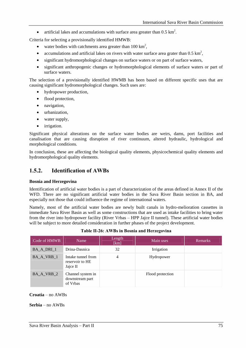
International Sava River Basin Commission
Sava River Basin Analysis – Part II 75
artificial lakes and accumulations with surface area greater than 0.5 km2.
Criteria for selecting a provisionally identified HMWB:
water bodies with catchments area greater than 100 km2,
accumulations and artificial lakes on rivers with water surface area grater than 0.5 km2,
significant hydromorphological changes on surface waters or on part of surface waters,
significant anthropogenic changes or hydromorphological elements of surface waters or part of
surface waters.
The selection of a provisionally identified HWMB has been based on different specific uses that are
causing significant hydromorphological changes. Such uses are:
hydropower production,
flood protection,
navigation,
urbanization,
water supply,
irrigation.
Significant physical alterations on the surface water bodies are weirs, dams, port facilities and
canalisation that are causing disruption of river continuum, altered hydraulic, hydrological and
morphological conditions.
In conclusion, these are affecting the biological quality elements, physicochemical quality elements and
hydromorphological quality elements.
1.5.2. Identification of AWBs
Bosnia and Herzegovina
Identification of artificial water bodies is a part of characterization of the areas defined in Annex II of the
WFD. There are no significant artificial water bodies in the Sava River Basin section in BA, and
especially not those that could influence the regime of international waters.
Namely, most of the artificial water bodies are newly built canals in hydro-melioration cassettes in
immediate Sava River Basin as well as some constructions that are used as intake facilities to bring water
from the river into hydropower facility (River Vrbas – HPP Jajce II tunnel). These artificial water bodies
will be subject to more detailed consideration in further phases of the project development.
Table II-26: AWBs in Bosnia and Herzegovina
Code of HMWB Name Length
[km] Main uses Remarks
BA_A_DRI_1 Drina-Dasnica 32 Irrigation
BA_A_VRB_1 Intake tunnel from
reservoir to HE
Jajce II
4 Hydropower
BA_A_VRB_2 Channel system in
downstream part
of Vrbas
Flood protection
Croatia – no AWBs
Serbia – no AWBs
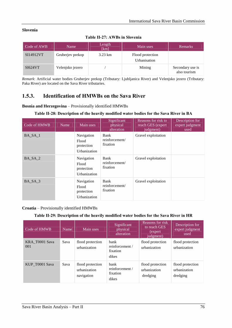
International Sava River Basin Commission
Sava River Basin Analysis – Part II 76
Slovenia
Table II-27: AWBs in Slovenia
Code of AWB Name Length
[km] Main uses Remarks
SI14912VT Gruberjev prekop 3.23 km Flood protection
Urbanisation
SI624VT Velenjsko jezero / Mining Secondary use is
also tourism
Remark: Artificial water bodies Gruberjev prekop (Tributary: Ljubljanica River) and Velenjsko jezero (Tributary:
Paka River) are located on the Sava River tributaries.
1.5.3. Identification of HMWBs on the Sava River
Bosnia and Herzegovina – Provisionally identified HMWBs
Table II-28: Description of the heavily modified water bodies for the Sava River in BA
Code of HMWB Name Main uses
Significant
physical
alteration
Reasons for risk to
reach GES (expert
judgment)
Description for
expert judgment
used
BA_SA_1 Navigation
Flood
protection
Urbanization
Bank
reinforcement/
fixation
Gravel exploitation
BA_SA_2 Navigation
Flood
protection
Urbanization
Bank
reinforcement/
fixation
Gravel exploitation
BA_SA_3 Navigation
Flood
protection
Urbanization
Bank
reinforcement/
fixation
Gravel exploitation
Croatia – Provisionally identified HMWBs
Table II-29: Description of the heavily modified water bodies for the Sava River in HR
Code of HMWB Name Main uses
Significant
physical
alteration
Reasons for risk
to reach GES
(expert
judgment)
Description for
expert judgment
used
KRA_T0001 Sava
001
Sava flood protection
urbanization
bank
reinforcement /
fixation
dikes
flood protection
urbanization
flood protection
urbanization
KUP_T0001 Sava Sava flood protection
urbanization
navigation
bank
reinforcement /
fixation
dikes
flood protection
urbanization
dredging
flood protection
urbanization
dredging
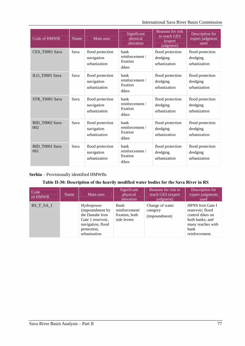
International Sava River Basin Commission
Sava River Basin Analysis – Part II 77
Code of HMWB Name Main uses
Significant
physical
alteration
Reasons for risk
to reach GES
(expert
judgment)
Description for
expert judgment
used
CES_T0001 Sava Sava flood protection
navigation
urbanization
bank
reinforcement /
fixation
dikes
flood protection
dredging
urbanization
flood protection
dredging
urbanization
ILO_T0001 Sava Sava flood protection
navigation
urbanization
bank
reinforcement /
fixation
dikes
flood protection
dredging
urbanization
flood protection
dredging
urbanization
STR_T0001 Sava Sava flood protection
navigation
urbanization
bank
reinforcement /
fixation
dikes
flood protection
dredging
urbanization
flood protection
dredging
urbanization
BID_T0002 Sava
002
Sava flood protection
navigation
urbanization
bank
reinforcement /
fixation
dikes
flood protection
dredging
urbanization
flood protection
dredging
urbanization
BID_T0001 Sava
001
Sava flood protection
navigation
urbanization
bank
reinforcement /
fixation
dikes
flood protection
dredging
urbanization
flood protection
dredging
urbanization
Serbia – Provisionally identified HMWBs
Table II-30: Description of the heavily modified water bodies for the Sava River in RS
Code
of HMWB Name Main uses
Significant
physical
alteration
Reasons for risk to
reach GES (expert
judgment)
Description for
expert judgments
used
RS_T_SA_1 Hydropower
(impoundment by
the Danube Iron
Gate 1 reservoir,
navigation, flood
protection,
urbanisation
Bank
reinforcement/
fixation, both
side levees
Change of water
category
(impoundment)
HPNS Iron Gate I
reservoir; flood
control dikes on
both banks; and
many reaches with
bank
reinforcement.
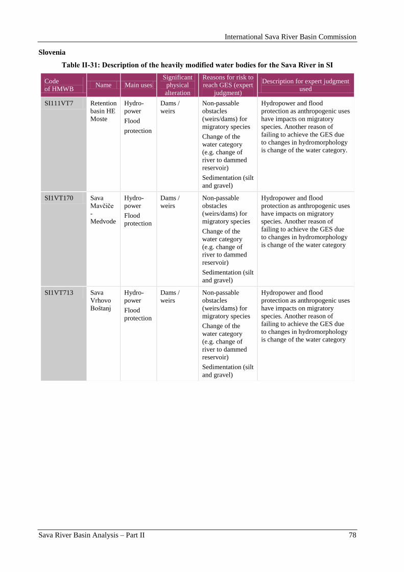
International Sava River Basin Commission
Sava River Basin Analysis – Part II 78
Slovenia
Table II-31: Description of the heavily modified water bodies for the Sava River in SI
Code
of HMWB Name Main uses
Significant
physical
alteration
Reasons for risk to
reach GES (expert
judgment)
Description for expert judgment
used
SI111VT7 Retention
basin HE
Moste
Hydro-
power
Flood
protection
Dams /
weirs
Non-passable
obstacles
(weirs/dams) for
migratory species
Change of the
water category
(e.g. change of
river to dammed
reservoir)
Sedimentation (silt
and gravel)
Hydropower and flood
protection as anthropogenic uses
have impacts on migratory
species. Another reason of
failing to achieve the GES due
to changes in hydromorphology
is change of the water category.
SI1VT170 Sava
Mavĉiĉe
-
Medvode
Hydro-
power
Flood
protection
Dams /
weirs
Non-passable
obstacles
(weirs/dams) for
migratory species
Change of the
water category
(e.g. change of
river to dammed
reservoir)
Sedimentation (silt
and gravel)
Hydropower and flood
protection as anthropogenic uses
have impacts on migratory
species. Another reason of
failing to achieve the GES due
to changes in hydromorphology
is change of the water category
SI1VT713 Sava
Vrhovo
Boštanj
Hydro-
power
Flood
protection
Dams /
weirs
Non-passable
obstacles
(weirs/dams) for
migratory species
Change of the
water category
(e.g. change of
river to dammed
reservoir)
Sedimentation (silt
and gravel)
Hydropower and flood
protection as anthropogenic uses
have impacts on migratory
species. Another reason of
failing to achieve the GES due
to changes in hydromorphology
is change of the water category
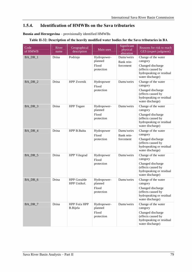
International Sava River Basin Commission
Sava River Basin Analysis – Part II 79
1.5.4. Identification of HMWBs on the Sava tributaries
Bosnia and Herzegovina – provisionally identified HMWBs
Table II-32: Description of the heavily modified water bodies for the Sava tributaries in BA
Code
of HMWB
River
name
Geographical
description Main uses
Significant
physical
alteration
Reasons for risk to reach
GES (expert judgment)
BA_DR_1 Drina Podrinje Hydropower-
planned
Flood
protection
Dams/weirs
Bank rein-
forcement
Change of the water
category
Changed discharge
(effects caused by
hydropeaking or residual
water discharge)
BA_DR_2 Drina HPP Zvornik Hydropower
Flood
protection
Dams/weirs Change of the water
category
Changed discharge
(effects caused by
hydropeaking or residual
water discharge)
BA_DR_3 Drina HPP Tegare Hydropower-
planned
Flood
protection
Dams/weirs Change of the water
category
Changed discharge
(effects caused by
hydropeaking or residual
water discharge)
BA_DR_4 Drina HPP B.Bašta Hydropower
Flood
protection
Dams/weirs
Bank rein-
forcement
Change of the water
category
Changed discharge
(effects caused by
hydropeaking or residual
water discharge)
BA_DR_5 Drina HPP Višegrad Hydropower
Flood
protection
Dams/weirs Change of the water
category
Changed discharge
(effects caused by
hydropeaking or residual
water discharge)
BA_DR_6 Drina HPP Goraţde
HPP Ustikol.
Hydropower-
planned
Flood
protection
Dams/weirs Change of the water
category
Changed discharge
(effects caused by
hydropeaking or residual
water discharge)
BA_DR_7 Drina HPP Foĉa HPP
B.Bijela
Hydropower-
planned
Flood
protection
Dams/weirs Change of the water
category
Changed discharge
(effects caused by
hydropeaking or residual
water discharge)
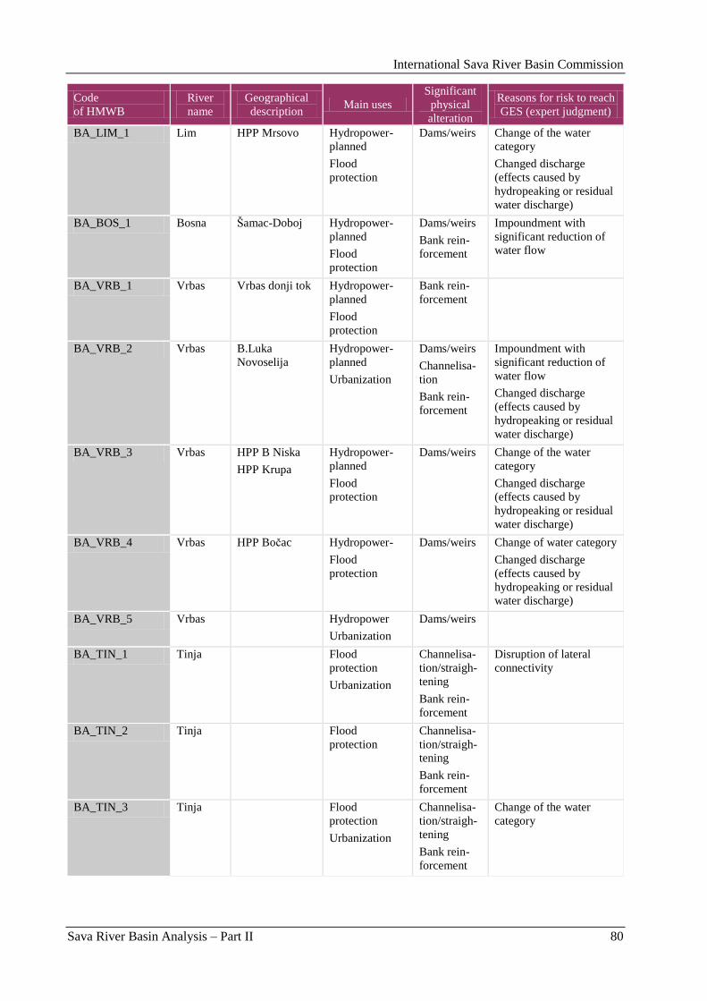
International Sava River Basin Commission
Sava River Basin Analysis – Part II 80
Code
of HMWB
River
name
Geographical
description Main uses
Significant
physical
alteration
Reasons for risk to reach
GES (expert judgment)
BA_LIM_1 Lim HPP Mrsovo Hydropower-
planned
Flood
protection
Dams/weirs
Change of the water
category
Changed discharge
(effects caused by
hydropeaking or residual
water discharge)
BA_BOS_1 Bosna Šamac-Doboj Hydropower-
planned
Flood
protection
Dams/weirs
Bank rein-
forcement
Impoundment with
significant reduction of
water flow
BA_VRB_1 Vrbas Vrbas donji tok Hydropower-
planned
Flood
protection
Bank rein-
forcement
BA_VRB_2 Vrbas B.Luka
Novoselija
Hydropower-
planned
Urbanization
Dams/weirs
Channelisa-
tion
Bank rein-
forcement
Impoundment with
significant reduction of
water flow
Changed discharge
(effects caused by
hydropeaking or residual
water discharge)
BA_VRB_3 Vrbas HPP B Niska
HPP Krupa
Hydropower-
planned
Flood
protection
Dams/weirs Change of the water
category
Changed discharge
(effects caused by
hydropeaking or residual
water discharge)
BA_VRB_4 Vrbas HPP Boĉac Hydropower-
Flood
protection
Dams/weirs Change of water category
Changed discharge
(effects caused by
hydropeaking or residual
water discharge)
BA_VRB_5 Vrbas Hydropower
Urbanization
Dams/weirs
BA_TIN_1 Tinja Flood
protection
Urbanization
Channelisa-
tion/straigh-
tening
Bank rein-
forcement
Disruption of lateral
connectivity
BA_TIN_2 Tinja Flood
protection
Channelisa-
tion/straigh-
tening
Bank rein-
forcement
BA_TIN_3 Tinja Flood
protection
Urbanization
Channelisa-
tion/straigh-
tening
Bank rein-
forcement
Change of the water
category
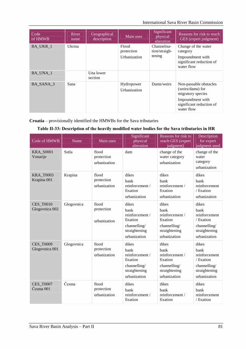
International Sava River Basin Commission
Sava River Basin Analysis – Part II 81
Code
of HMWB
River
name
Geographical
description Main uses
Significant
physical
alteration
Reasons for risk to reach
GES (expert judgment)
BA_UKR_1 Ukrina Flood
protection
Urbanization
Channelisa-
tion/straigh-
tening
Change of the water
category
Impoundment with
significant reduction of
water flow
BA_UNA_1 Una lower
section
BA_SANA_3 Sana Hydropower
Urbanization
Dams/weirs Non-passable obstacles
(weirs/dams) for
migratory species
Impoundment with
significant reduction of
water flow
Croatia – provisionally identified the HMWBs for the Sava tributaries
Table II-33: Description of the heavily modified water bodies for the Sava tributaries in HR
Code of HMWB Name Main uses
Significant
physical
alteration
Reasons for risk to
reach GES (expert
judgment)
Description
for expert
judgment used
KRA_S0001
Vonarije
Sutla flood
protection
urbanization
dam change of the
water category
urbanization
change of the
water
category
urbanization
KRA_T0003
Krapina 001
Krapina flood
protection
urbanization
dikes
bank
reinforcement /
fixation
urbanization
dikes
bank
reinforcement /
fixation
urbanization
dikes
bank
reinforcement
/ fixation
urbanization
CES_T0010
Glogovnica 002
Glogovnica flood
protection
urbanization
dikes
bank
reinforcement /
fixation
channelling/
straightening
urbanization
dikes
bank
reinforcement /
fixation
channelling/
straightening
urbanization
dikes
bank
reinforcement
/ fixation
channelling/
straightening
urbanization
CES_T0009
Glogovnica 001
Glogovnica flood
protection
urbanization
dikes
bank
reinforcement /
fixation
channelling/
straightening
urbanization
dikes
bank
reinforcement /
fixation
channelling/
straightening
urbanization
dikes
bank
reinforcement
/ fixation
channelling/
straightening
urbanization
CES_T0007
Ĉesma 001
Ĉesma flood
protection
urbanization
dikes
bank
reinforcement /
fixation
dikes
bank
reinforcement /
fixation
dikes
bank
reinforcement
/ fixation
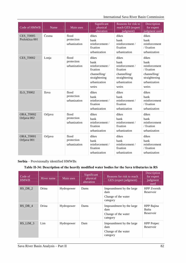
International Sava River Basin Commission
Sava River Basin Analysis – Part II 82
Code of HMWB Name Main uses
Significant
physical
alteration
Reasons for risk to
reach GES (expert
judgment)
Description
for expert
judgment used
CES_T0005
Prelošćica 001
Ĉesma flood
protection
urbanization
dikes
bank
reinforcement /
fixation
urbanization
dikes
bank
reinforcement /
fixation
urbanization
dikes
bank
reinforcement
/ fixation
urbanization
CES_T0002 Lonja flood
protection
urbanization
dikes
bank
reinforcement /
fixation
channelling/
straightening
urbanization
weirs
dikes
bank
reinforcement /
fixation
channelling/
straightening
urbanization
weirs
dikes
bank
reinforcement
/ fixation
channelling/
straightening
urbanization
weirs
ILO_T0002 Ilova flood
protection
urbanization
dikes
bank
reinforcement /
fixation
urbanization
dikes
bank
reinforcement /
fixation
urbanization
dikes
bank
reinforcement
/ fixation
urbanization
ORA_T0002
Orljava 002
Orljava flood
protection
urbanization
dikes
bank
reinforcement /
fixation
urbanization
dikes
bank
reinforcement /
fixation
urbanization
dikes
bank
reinforcement
/ fixation
urbanization
ORA_T0001
Orljava 001
Orljava flood
protection
urbanization
dikes
bank
reinforcement /
fixation
urbanization
dikes
bank
reinforcement /
fixation
urbanization
dikes
bank
reinforcement
/ fixation
urbanization
Serbia – Provisionally identified HMWBs
Table II-34: Description of the heavily modified water bodies for the Sava tributaries in RS
Code of
HMWB River name Main uses
Significant
physical
alteration
Reasons for risk to reach
GES (expert judgment)
Description
for expert
judgment
used
RS_DR_2 Drina Hydropower Dams Impoundment by the large
dam
Change of the water
category
HPP Zvornik
Reservoir
RS_DR_4 Drina Hydropower Dams Impoundment by the large
dam
Change of the water
category
HPP Bajina
Bašta
Reservoir
RS_LIM_3 Lim Hydropower Dam Impoundment by the large
dam
Change of the water
category
HPP Potpec
Reservoir
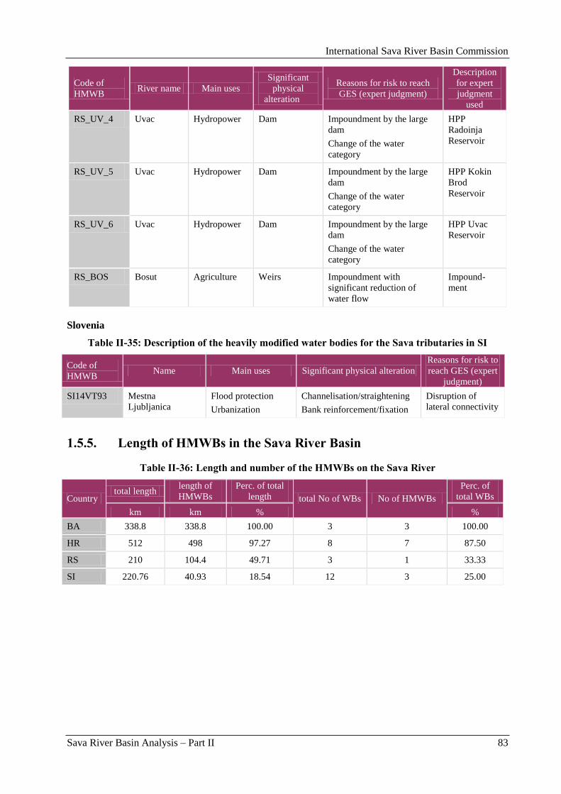
International Sava River Basin Commission
Sava River Basin Analysis – Part II 83
Code of
HMWB River name Main uses
Significant
physical
alteration
Reasons for risk to reach
GES (expert judgment)
Description
for expert
judgment
used
RS_UV_4 Uvac Hydropower Dam Impoundment by the large
dam
Change of the water
category
HPP
Radoinja
Reservoir
RS_UV_5 Uvac Hydropower Dam Impoundment by the large
dam
Change of the water
category
HPP Kokin
Brod
Reservoir
RS_UV_6 Uvac Hydropower Dam Impoundment by the large
dam
Change of the water
category
HPP Uvac
Reservoir
RS_BOS Bosut Agriculture Weirs Impoundment with
significant reduction of
water flow
Impound-
ment
Slovenia
Table II-35: Description of the heavily modified water bodies for the Sava tributaries in SI
Code of
HMWB Name Main uses Significant physical alteration
Reasons for risk to
reach GES (expert
judgment)
SI14VT93 Mestna
Ljubljanica
Flood protection
Urbanization
Channelisation/straightening
Bank reinforcement/fixation
Disruption of
lateral connectivity
1.5.5. Length of HMWBs in the Sava River Basin
Table II-36: Length and number of the HMWBs on the Sava River
Country total length
length of
HMWBs
Perc. of total
length total No of WBs No of HMWBs
Perc. of
total WBs
km km % %
BA 338.8 338.8 100.00 3 3 100.00
HR 512 498 97.27 8 7 87.50
RS 210 104.4 49.71 3 1 33.33
SI 220.76 40.93 18.54 12 3 25.00
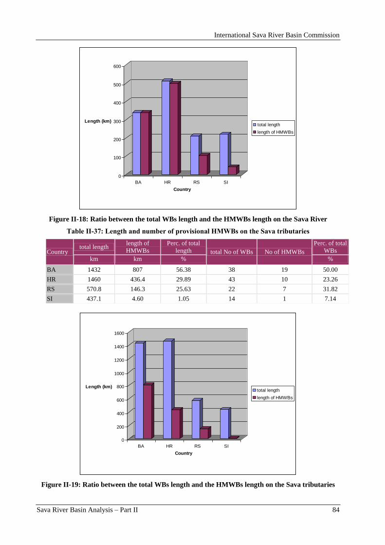
International Sava River Basin Commission
Sava River Basin Analysis – Part II 84
0
100
200
300
400
500
600
Length (km)
BA HR RS SI
Country
total length
length of HMWBs
Figure II-18: Ratio between the total WBs length and the HMWBs length on the Sava River
Table II-37: Length and number of provisional HMWBs on the Sava tributaries
Country total length
length of
HMWBs
Perc. of total
length total No of WBs No of HMWBs
Perc. of total
WBs
km km % %
BA 1432 807 56.38 38 19 50.00
HR 1460 436.4 29.89 43 10 23.26
RS 570.8 146.3 25.63 22 7 31.82
SI 437.1 4.60 1.05 14 1 7.14
0
200
400
600
800
1000
1200
1400
1600
Length (km)
BA HR RS SI
Country
total length
length of HMWBs
Figure II-19: Ratio between the total WBs length and the HMWBs length on the Sava tributaries
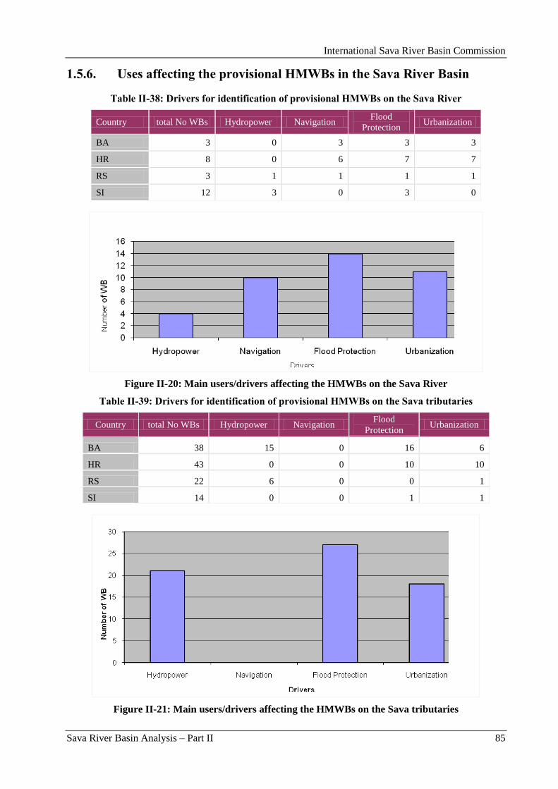
International Sava River Basin Commission
Sava River Basin Analysis – Part II 85
1.5.6. Uses affecting the provisional HMWBs in the Sava River Basin
Table II-38: Drivers for identification of provisional HMWBs on the Sava River
Country total No WBs Hydropower Navigation Flood
Protection Urbanization
BA 3 0 3 3 3
HR 8 0 6 7 7
RS 3 1 1 1 1
SI 12 3 0 3 0
Figure II-20: Main users/drivers affecting the HMWBs on the Sava River
Table II-39: Drivers for identification of provisional HMWBs on the Sava tributaries
Country total No WBs Hydropower Navigation Flood
Protection Urbanization
BA 38 15 0 16 6
HR 43 0 0 10 10
RS 22 6 0 0 1
SI 14 0 0 1 1
Figure II-21: Main users/drivers affecting the HMWBs on the Sava tributaries

International Sava River Basin Commission
Sava River Basin Analysis – Part II 86
1.5.7. Significant physical alterations affecting the HMWBs in the Sava
River Basin
Table II-40: Physical alterations affecting the HMWBs on the Sava River
Country total No WBs Dams/weirs/
dikes
Channelisation/
straightening Bank reinforcement
BA 3 0 0 3
HR 8 7 0 7
RS 3 0 1 1
SI 12 3 0 0
Figure II-22: Physical alterations affecting the HMWBs on the Sava River
Table II-41: Physical alterations affecting the HMWBs on the Sava tributaries
Country total No WBs Dams/weirs/
dikes
Channelisation/
straightening
Bank
reinforcement
BA 38 14 5 7
HR 43 10 3 9
RS 22 7 0 0
SI 14 0 1 1
Figure II-23: Physical alterations affecting the HMWBs on the Sava tributaries
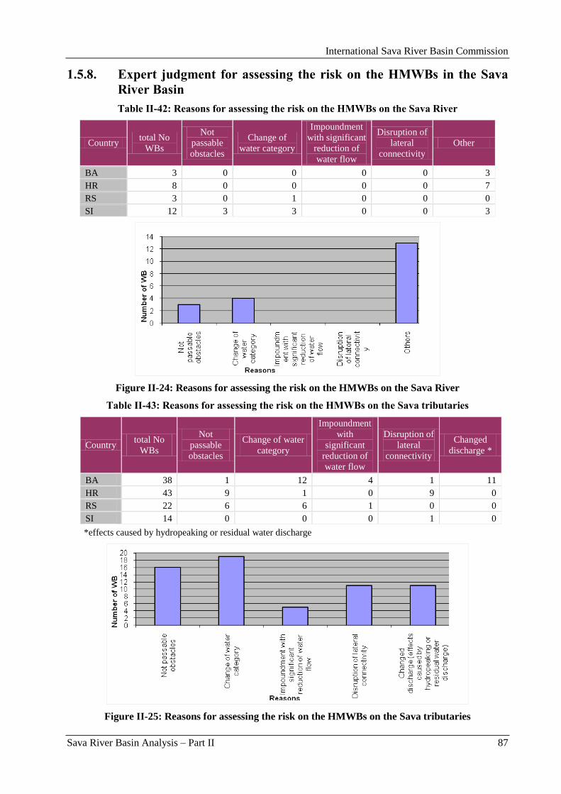
International Sava River Basin Commission
Sava River Basin Analysis – Part II 87
1.5.8. Expert judgment for assessing the risk on the HMWBs in the Sava
River Basin
Table II-42: Reasons for assessing the risk on the HMWBs on the Sava River
Country total No
WBs
Not
passable
obstacles
Change of
water category
Impoundment
with significant
reduction of
water flow
Disruption of
lateral
connectivity
Other
BA 3 0 0 0 0 3
HR 8 0 0 0 0 7
RS 3 0 1 0 0 0
SI 12 3 3 0 0 3
Figure II-24: Reasons for assessing the risk on the HMWBs on the Sava River
Table II-43: Reasons for assessing the risk on the HMWBs on the Sava tributaries
Country total No
WBs
Not
passable
obstacles
Change of water
category
Impoundment
with
significant
reduction of
water flow
Disruption of
lateral
connectivity
Changed
discharge *
BA 38 1 12 4 1 11
HR 43 9 1 0 9 0
RS 22 6 6 1 0 0
SI 14 0 0 0 1 0
*effects caused by hydropeaking or residual water discharge
Figure II-25: Reasons for assessing the risk on the HMWBs on the Sava tributaries
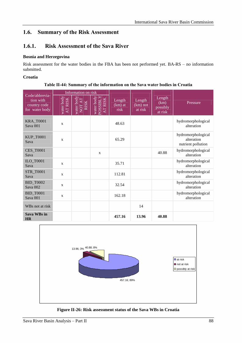
International Sava River Basin Commission
Sava River Basin Analysis – Part II 88
1.6. Summary of the Risk Assessment
1.6.1. Risk Assessment of the Sava River
Bosnia and Herzegovina
Risk assessment for the water bodies in the FBA has been not performed yet. BA-RS – no information
submitted.
Croatia
Table II-44: Summary of the information on the Sava water bodies in Croatia
Code/abbrevia-
tion with
country code
for water body
Information on risk
Length
(km) at
risk
Length
(km) not
at risk
Length
(km)
possibly
at risk
Pressure
wat
er b
od
y
AT
RIS
K
wat
er b
od
y
NO
T A
T
RIS
K
wat
er b
od
y
PO
SS
IBL
Y
AT
RIS
K
KRA_T0001
Sava 001 x 48.63
hydromorphological
alteration
KUP_T0001
Sava x 65.29
hydromorphological
alteration
nutrient pollution
CES_T0001
Sava x 40.88
hydromorphological
alteration
ILO_T0001
Sava x 35.71
hydromorphological
alteration
STR_T0001
Sava x 112.81
hydromorphological
alteration
BID_T0002
Sava 002 x 32.54
hydromorphological
alteration
BID_T0001
Sava 001 x 162.18
hydromorphological
alteration
WBs not at risk 14
Sava WBs in
HR 457.16 13.96 40.88
457.16; 89%
13.96; 3% 40.88; 8%
at risk
not at risk
possibly at risk
Figure II-26: Risk assessment status of the Sava WBs in Croatia
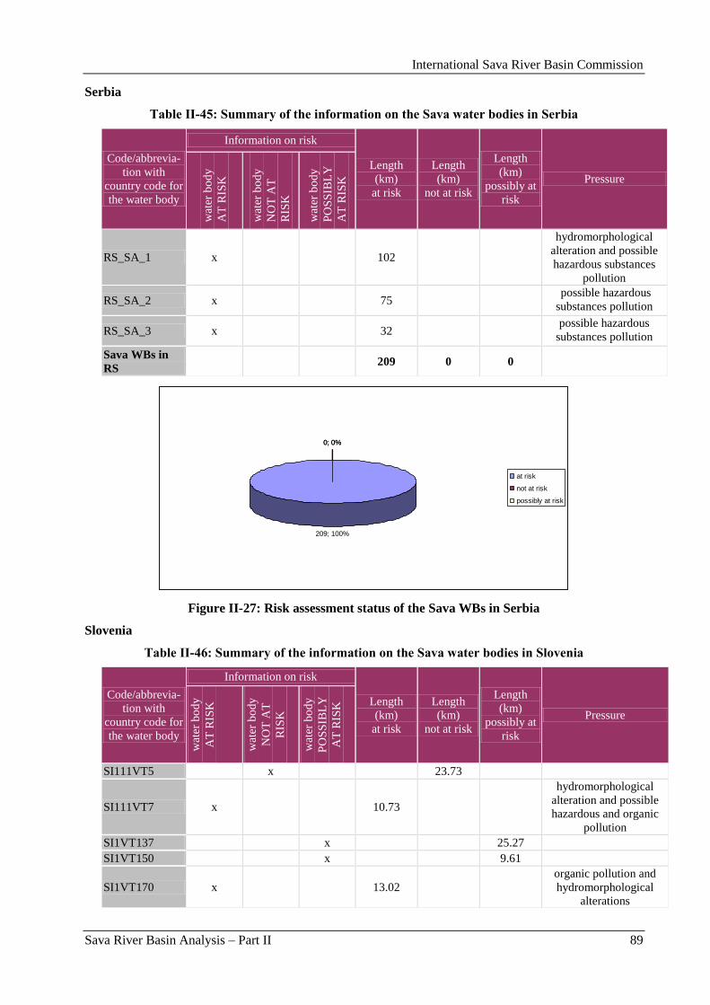
International Sava River Basin Commission
Sava River Basin Analysis – Part II 89
Serbia
Table II-45: Summary of the information on the Sava water bodies in Serbia
Code/abbrevia-
tion with
country code for
the water body
Information on risk
Length
(km)
at risk
Length
(km)
not at risk
Length
(km)
possibly at
risk
Pressure
wat
er b
od
y
AT
RIS
K
wat
er b
od
y
NO
T A
T
RIS
K
wat
er b
od
y
PO
SS
IBL
Y
AT
RIS
K
RS_SA_1 x 102
hydromorphological
alteration and possible
hazardous substances
pollution
RS_SA_2 x 75 possible hazardous
substances pollution
RS_SA_3 x 32 possible hazardous
substances pollution
Sava WBs in
RS 209 0 0
209; 100%
0; 0%0; 0%
at risk
not at risk
possibly at risk
Figure II-27: Risk assessment status of the Sava WBs in Serbia
Slovenia
Table II-46: Summary of the information on the Sava water bodies in Slovenia
Code/abbrevia-
tion with
country code for
the water body
Information on risk
Length
(km)
at risk
Length
(km)
not at risk
Length
(km)
possibly at
risk
Pressure
wat
er b
od
y
AT
RIS
K
wat
er b
od
y
NO
T A
T
RIS
K
wat
er b
od
y
PO
SS
IBL
Y
AT
RIS
K
SI111VT5 x 23.73
SI111VT7 x 10.73
hydromorphological
alteration and possible
hazardous and organic
pollution
SI1VT137 x 25.27
SI1VT150 x 9.61
SI1VT170 x 13.02
organic pollution and
hydromorphological
alterations
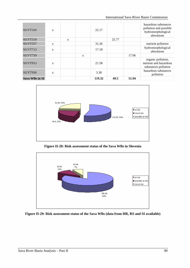
International Sava River Basin Commission
Sava River Basin Analysis – Part II 90
SI1VT310 x 22.17
hazardous substances
pollution and possible
hydromorphological
alterations
SI1VT519 x 25.77
SI1VT557 x 31.26 nutrient pollution
SI1VT713 x 17.18 hydromorphological
alterations
SI1VT739 x 17.06
SI1VT913 x 21.58
organic pollution,
nutrient and hazardous
substances pollution
SI1VT930 x 3.38 hazardous substances
pollution
Sava WBs in SI 119.32 49.5 51.94
119.32; 54%
49.5; 22%
51.94; 24%
at risk
not at risk
possibly at risk
Figure II-28: Risk assessment status of the Sava WBs in Slovenia
785.48
83%
92.82
10%
63.46
7%
at risk
possibly at risk
not at risk
Figure II-29: Risk assessment status of the Sava WBs (data from HR, RS and SI available)
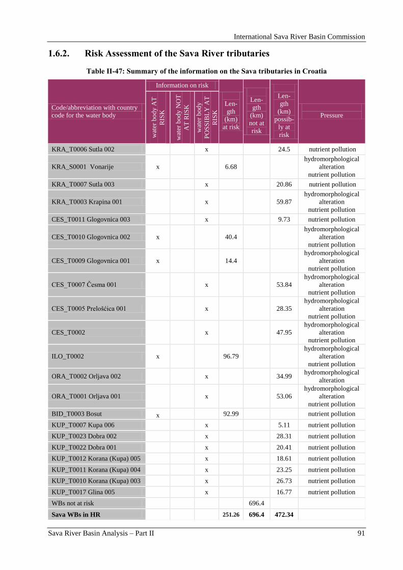
International Sava River Basin Commission
Sava River Basin Analysis – Part II 91
1.6.2. Risk Assessment of the Sava River tributaries
Table II-47: Summary of the information on the Sava tributaries in Croatia
Code/abbreviation with country
code for the water body
Information on risk
Len-
gth
(km)
at risk
Len-
gth
(km)
not at
risk
Len-
gth
(km)
possib-
ly at
risk
Pressure
wat
er b
od
y A
T
RIS
K
wat
er b
od
y N
OT
AT
RIS
K
wat
er b
od
y
PO
SS
IBL
Y A
T
RIS
K
KRA_T0006 Sutla 002 x 24.5 nutrient pollution
KRA_S0001 Vonarije x 6.68
hydromorphological
alteration
nutrient pollution
KRA_T0007 Sutla 003 x 20.86 nutrient pollution
KRA_T0003 Krapina 001 x 59.87
hydromorphological
alteration
nutrient pollution
CES_T0011 Glogovnica 003 x 9.73 nutrient pollution
CES_T0010 Glogovnica 002 x 40.4
hydromorphological
alteration
nutrient pollution
CES_T0009 Glogovnica 001 x 14.4
hydromorphological
alteration
nutrient pollution
CES_T0007 Ĉesma 001 x 53.84
hydromorphological
alteration
nutrient pollution
CES_T0005 Prelošćica 001 x 28.35
hydromorphological
alteration
nutrient pollution
CES_T0002 x 47.95
hydromorphological
alteration
nutrient pollution
ILO_T0002 x 96.79
hydromorphological
alteration
nutrient pollution
ORA_T0002 Orljava 002 x 34.99 hydromorphological
alteration
ORA_T0001 Orljava 001
x 53.06
hydromorphological
alteration
nutrient pollution
BID_T0003 Bosut x 92.99 nutrient pollution
KUP_T0007 Kupa 006 x 5.11 nutrient pollution
KUP_T0023 Dobra 002 x 28.31 nutrient pollution
KUP_T0022 Dobra 001 x 20.41 nutrient pollution
KUP_T0012 Korana (Kupa) 005 x 18.61 nutrient pollution
KUP_T0011 Korana (Kupa) 004 x 23.25 nutrient pollution
KUP_T0010 Korana (Kupa) 003 x 26.73 nutrient pollution
KUP_T0017 Glina 005 x 16.77 nutrient pollution
WBs not at risk 696.4
Sava WBs in HR 251.26 696.4 472.34
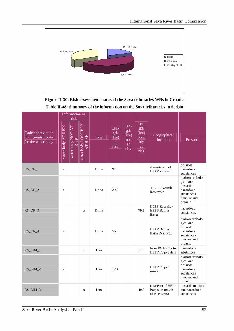
International Sava River Basin Commission
Sava River Basin Analysis – Part II 92
251.26; 18%
696.4; 49%
472.34; 33%
at risk
not at risk
possibly at risk
Figure II-30: Risk assessment status of the Sava tributaries WBs in Croatia
Table II-48: Summary of the information on the Sava tributaries in Serbia
Code/abbreviation
with country code
for the water body
Information on
risk
river
Len-
gth
(km)
at
risk
Len-
gth
(km)
not
at
risk
Len-
gth
(km)
possi
bly
at
risk
Geographical
location
Pressure
wat
er b
od
y A
T R
ISK
wat
er b
od
y N
OT
AT
RIS
K
wat
er b
od
y P
OS
SIB
LY
AT
RIS
K
RS_DR_1 x Drina 91.0 downstream of
HEPP Zvornik
possible
hazardous
substances
RS_DR_2 x Drina 29.0 HEPP Zvornik
Reservoir
hydromorpholo
gical and
possible
hazardous
substances,
nutrient and
organic
RS_DR_3 x Drina 79.5
HEPP Zvornik -
HEPP Bajina
Bašta
hazardous
substances
RS_DR_4 x Drina 56.8 HEPP Bajina
Bašta Reservoir
hydromorpholo
gical and
possible
hazardous
substances,
nutrient and
organic
RS_LIM_1 x Lim 11.6 from RS border to
HEPP Potpeć dam
hazardous
sibstances
RS_LIM_2 x Lim 17.4 HEPP Potpeć
reservoir
hydromorpholo
gical and
possible
hazardous
substances,
nutrient and
organic
RS_LIM_3 x Lim 40.0
upstream of HEPP
Potpeć to mouth
of B. Bistrica
possible nutrient
and hazardous
substances
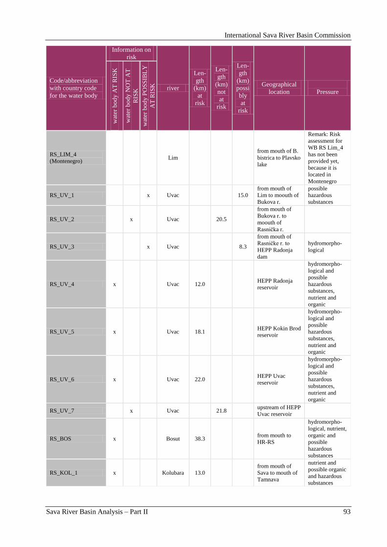
International Sava River Basin Commission
Sava River Basin Analysis – Part II 93
Code/abbreviation
with country code
for the water body
Information on
risk
river
Len-
gth
(km)
at
risk
Len-
gth
(km)
not
at
risk
Len-
gth
(km)
possi
bly
at
risk
Geographical
location
Pressure
wat
er b
od
y A
T R
ISK
wat
er b
od
y N
OT
AT
RIS
K
wat
er b
od
y P
OS
SIB
LY
AT
RIS
K
RS_LIM_4
(Montenegro) Lim
from mouth of B.
bistrica to Plavsko
lake
Remark: Risk
assessment for
WB RS Lim_4
has not been
provided yet,
because it is
located in
Montenegro
RS_UV_1 x Uvac 15.0
from mouth of
Lim to moouth of
Bukova r.
possible
hazardous
substances
RS_UV_2 x Uvac 20.5
from mouth of
Bukova r. to
moouth of
Rasniĉka r.
RS_UV_3 x Uvac 8.3
from mouth of
Rasniĉke r. to
HEPP Radonja
dam
hydromorpho-
logical
RS_UV_4 x Uvac 12.0 HEPP Radonja
reservoir
hydromorpho-
logical and
possible
hazardous
substances,
nutrient and
organic
RS_UV_5 x Uvac 18.1 HEPP Kokin Brod
reservoir
hydromorpho-
logical and
possible
hazardous
substances,
nutrient and
organic
RS_UV_6 x Uvac 22.0 HEPP Uvac
reservoir
hydromorpho-
logical and
possible
hazardous
substances,
nutrient and
organic
RS_UV_7 x Uvac 21.8 upstream of HEPP
Uvac reservoir
RS_BOS x Bosut 38.3 from mouth to
HR-RS
hydromorpho-
logical, nutrient,
organic and
possible
hazardous
substances
RS_KOL_1 x Kolubara 13.0
from mouth of
Sava to mouth of
Tamnava
nutrient and
possible organic
and hazardous
substances
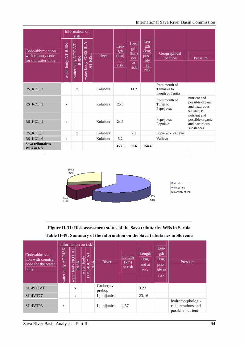
International Sava River Basin Commission
Sava River Basin Analysis – Part II 94
Code/abbreviation
with country code
for the water body
Information on
risk
river
Len-
gth
(km)
at
risk
Len-
gth
(km)
not
at
risk
Len-
gth
(km)
possi
bly
at
risk
Geographical
location
Pressure
wat
er b
od
y A
T R
ISK
wat
er b
od
y N
OT
AT
RIS
K
wat
er b
od
y P
OS
SIB
LY
AT
RIS
K
RS_KOL_2 x Kolubara 11.2
from mouth of
Tamnava to
mouth of Turija
RS_KOL_3 x Kolubara 25.6
from mouth of
Turija to
Pepeljevac
nutrient and
possible organic
and hazardous
substances
RS_KOL_4 x Kolubara 24.6 Pepeljevac -
Popuĉke
nutrient and
possible organic
and hazardous
substances
RS_KOL_5 x Kolubara 7.1 Popuĉke - Valjevo
RS_KOL_6 x Kolubara 5.2 Valjevo -
Sava tributaires
WBs in RS 353.0 60.6 154.4
353
62%60.6
11%
154.4
27%
at risk
not at risk
possibly at risk
Figure II-31: Risk assessment status of the Sava tributaries WBs in Serbia
Table II-49: Summary of the information on the Sava tributaries in Slovenia
Code/abbrevia-
tion with country
code for the water
body
Information on risk
River
Length
(km)
at risk
Length
(km)
not at
risk
Len-
gth
(km)
possi
bly at
risk
Pressure
wat
er b
od
y A
T R
ISK
wat
er b
od
y N
OT
AT
RIS
K
wat
er b
od
y
PO
SS
IBL
Y A
T
RIS
K
SI14912VT x Gruberjev
prekop 3.23
SI14VT77 x Ljubljanica 23.16
SI14VT93 x Ljubljanica 4.57
hydromorphologi-
cal alterations and
possbile nutrient
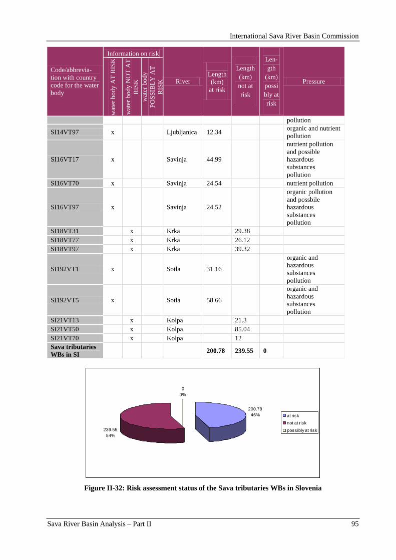
International Sava River Basin Commission
Sava River Basin Analysis – Part II 95
Code/abbrevia-
tion with country
code for the water
body
Information on risk
River
Length
(km)
at risk
Length
(km)
not at
risk
Len-
gth
(km)
possi
bly at
risk
Pressure
wat
er b
od
y A
T R
ISK
wat
er b
od
y N
OT
AT
RIS
K
wat
er b
od
y
PO
SS
IBL
Y A
T
RIS
K
pollution
SI14VT97 x Ljubljanica 12.34 organic and nutrient
pollution
SI16VT17 x Savinja 44.99
nutrient pollution
and possible
hazardous
substances
pollution
SI16VT70 x Savinja 24.54 nutrient pollution
SI16VT97 x Savinja 24.52
organic pollution
and possbile
hazardous
substances
pollution
SI18VT31 x Krka 29.38
SI18VT77 x Krka 26.12
SI18VT97 x Krka 39.32
SI192VT1 x Sotla 31.16
organic and
hazardous
substances
pollution
SI192VT5 x Sotla 58.66
organic and
hazardous
substances
pollution
SI21VT13 x Kolpa 21.3
SI21VT50 x Kolpa 85.04
SI21VT70 x Kolpa 12
Sava tributaries
WBs in SI 200.78 239.55 0
200.78
46%
239.55
54%
0
0%
at risk
not at risk
possibly at risk
Figure II-32: Risk assessment status of the Sava tributaries WBs in Slovenia
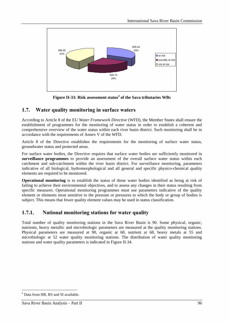
International Sava River Basin Commission
Sava River Basin Analysis – Part II 96
805.04
33%
626.74
26%
996.55
41%at risk
possibly at risk
not at risk
Figure II-33: Risk assessment status4 of the Sava tributaries WBs
1.7. Water quality monitoring in surface waters
According to Article 8 of the EU Water Framework Directive (WFD), the Member States shall ensure the
establishment of programmes for the monitoring of water status in order to establish a coherent and
comprehensive overview of the water status within each river basin district. Such monitoring shall be in
accordance with the requirements of Annex V of the WFD.
Article 8 of the Directive establishes the requirements for the monitoring of surface water status,
groundwater status and protected areas.
For surface water bodies, the Directive requires that surface water bodies are sufficiently monitored in
surveillance programmes to provide an assessment of the overall surface water status within each
catchment and sub-catchment within the river basin district. For surveillance monitoring, parameters
indicative of all biological, hydromorphological and all general and specific physico-chemical quality
elements are required to be monitored.
Operational monitoring is to establish the status of those water bodies identified as being at risk of
failing to achieve their environmental objectives, and to assess any changes in their status resulting from
specific measures. Operational monitoring programmes must use parameters indicative of the quality
element or elements most sensitive to the pressure or pressures to which the body or group of bodies is
subject. This means that fewer quality element values may be used in status classification.
1.7.1. National monitoring stations for water quality
Total number of quality monitoring stations in the Sava River Basin is 90. Some physical, organic,
nutrients, heavy metallic and microbiologic parameters are measured at the quality monitoring stations.
Physical parameters are measured at 90, organic at 68, nutrient at 68, heavy metals at 55 and
microbiologic at 52 water quality monitoring stations. The distribution of water quality monitoring
stations and water quality parameters is indicated in Figure II-34.
4 Data from HR, RS and SI available.
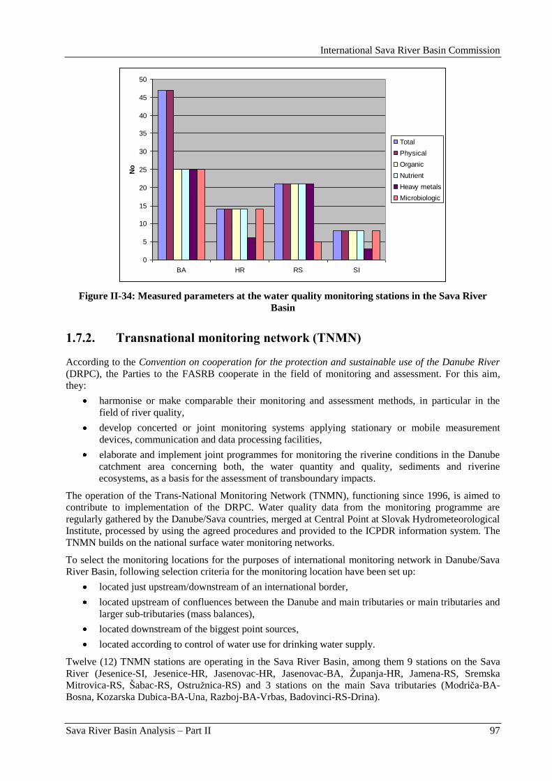
International Sava River Basin Commission
Sava River Basin Analysis – Part II 97
0
5
10
15
20
25
30
35
40
45
50
BA HR RS SI
No
Total
Physical
Organic
Nutrient
Heavy metals
Microbiologic
Figure II-34: Measured parameters at the water quality monitoring stations in the Sava River
Basin
1.7.2. Transnational monitoring network (TNMN)
According to the Convention on cooperation for the protection and sustainable use of the Danube River
(DRPC), the Parties to the FASRB cooperate in the field of monitoring and assessment. For this aim,
they:
harmonise or make comparable their monitoring and assessment methods, in particular in the
field of river quality,
develop concerted or joint monitoring systems applying stationary or mobile measurement
devices, communication and data processing facilities,
elaborate and implement joint programmes for monitoring the riverine conditions in the Danube
catchment area concerning both, the water quantity and quality, sediments and riverine
ecosystems, as a basis for the assessment of transboundary impacts.
The operation of the Trans-National Monitoring Network (TNMN), functioning since 1996, is aimed to
contribute to implementation of the DRPC. Water quality data from the monitoring programme are
regularly gathered by the Danube/Sava countries, merged at Central Point at Slovak Hydrometeorological
Institute, processed by using the agreed procedures and provided to the ICPDR information system. The
TNMN builds on the national surface water monitoring networks.
To select the monitoring locations for the purposes of international monitoring network in Danube/Sava
River Basin, following selection criteria for the monitoring location have been set up:
located just upstream/downstream of an international border,
located upstream of confluences between the Danube and main tributaries or main tributaries and
larger sub-tributaries (mass balances),
located downstream of the biggest point sources,
located according to control of water use for drinking water supply.
Twelve (12) TNMN stations are operating in the Sava River Basin, among them 9 stations on the Sava
River (Jesenice-SI, Jesenice-HR, Jasenovac-HR, Jasenovac-BA, Ţupanja-HR, Jamena-RS, Sremska
Mitrovica-RS, Šabac-RS, Ostruţnica-RS) and 3 stations on the main Sava tributaries (Modriĉa-BA-
Bosna, Kozarska Dubica-BA-Una, Razboj-BA-Vrbas, Badovinci-RS-Drina).
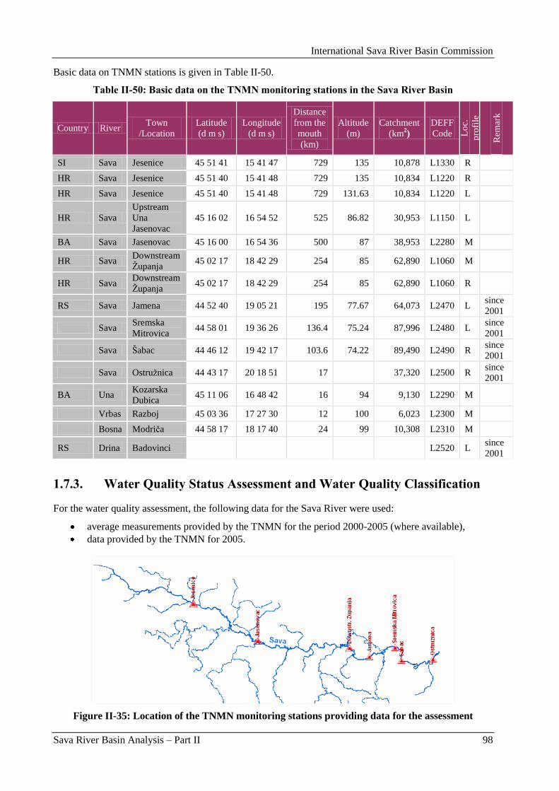
International Sava River Basin Commission
Sava River Basin Analysis – Part II 98
Basic data on TNMN stations is given in Table II-50.
Table II-50: Basic data on the TNMN monitoring stations in the Sava River Basin
Country River Town
/Location
Latitude
(d m s)
Longitude
(d m s)
Distance
from the
mouth
(km)
Altitude
(m)
Catchment
(km2)
DEFF
Code Lo
c.
pro
file
Rem
ark
SI Sava Jesenice 45 51 41 15 41 47 729 135 10,878 L1330 R
HR Sava Jesenice 45 51 40 15 41 48 729 135 10,834 L1220 R
HR Sava Jesenice 45 51 40 15 41 48 729 131.63 10,834 L1220 L
HR Sava
Upstream
Una
Jasenovac
45 16 02 16 54 52 525 86.82 30,953 L1150 L
BA Sava Jasenovac 45 16 00 16 54 36 500 87 38,953 L2280 M
HR Sava Downstream
Ţupanja 45 02 17 18 42 29 254 85 62,890 L1060 M
HR Sava Downstream
Ţupanja 45 02 17 18 42 29 254 85 62,890 L1060 R
RS Sava Jamena 44 52 40 19 05 21 195 77.67 64,073 L2470 L since
2001
Sava Sremska
Mitrovica 44 58 01 19 36 26 136.4 75.24 87,996 L2480 L
since
2001
Sava Šabac 44 46 12 19 42 17 103.6 74.22 89,490 L2490 R since
2001
Sava Ostruţnica 44 43 17 20 18 51 17 37,320 L2500 R since
2001
BA Una Kozarska
Dubica 45 11 06 16 48 42 16 94 9,130 L2290 M
Vrbas Razboj 45 03 36 17 27 30 12 100 6,023 L2300 M
Bosna Modriĉa 44 58 17 18 17 40 24 99 10,308 L2310 M
RS Drina Badovinci L2520 L since
2001
1.7.3. Water Quality Status Assessment and Water Quality Classification
For the water quality assessment, the following data for the Sava River were used:
average measurements provided by the TNMN for the period 2000-2005 (where available),
data provided by the TNMN for 2005.
Figure II-35: Location of the TNMN monitoring stations providing data for the assessment
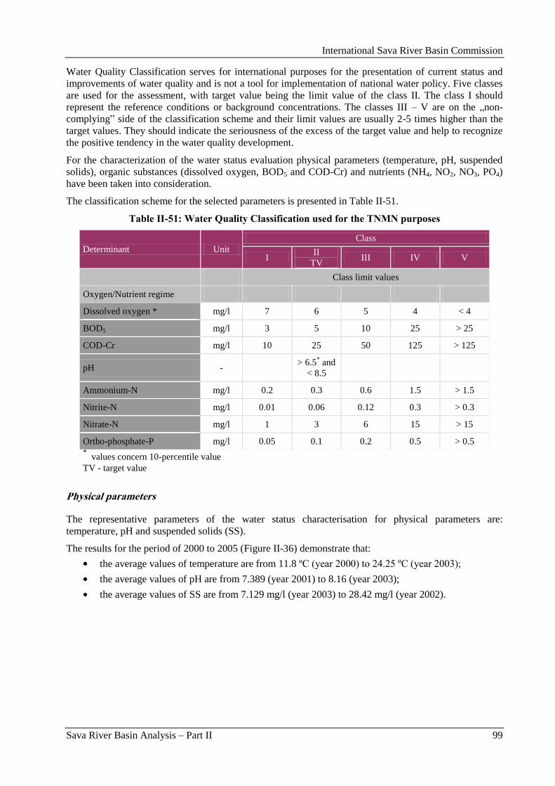
International Sava River Basin Commission
Sava River Basin Analysis – Part II 99
Water Quality Classification serves for international purposes for the presentation of current status and
improvements of water quality and is not a tool for implementation of national water policy. Five classes
are used for the assessment, with target value being the limit value of the class II. The class I should
represent the reference conditions or background concentrations. The classes III – V are on the „non-
complying” side of the classification scheme and their limit values are usually 2-5 times higher than the
target values. They should indicate the seriousness of the excess of the target value and help to recognize
the positive tendency in the water quality development.
For the characterization of the water status evaluation physical parameters (temperature, pH, suspended
solids), organic substances (dissolved oxygen, BOD5 and COD-Cr) and nutrients (NH4, NO2, NO3, PO4)
have been taken into consideration.
The classification scheme for the selected parameters is presented in Table II-51.
Table II-51: Water Quality Classification used for the TNMN purposes
Determinant Unit
Class
I II
TV III IV V
Class limit values
Oxygen/Nutrient regime
Dissolved oxygen * mg/l 7 6 5 4 < 4
BOD5 mg/l 3 5 10 25 > 25
COD-Cr mg/l 10 25 50 125 > 125
pH - > 6.5
* and
< 8.5
Ammonium-N mg/l 0.2 0.3 0.6 1.5 > 1.5
Nitrite-N mg/l 0.01 0.06 0.12 0.3 > 0.3
Nitrate-N mg/l 1 3 6 15 > 15
Ortho-phosphate-P mg/l 0.05 0.1 0.2 0.5 > 0.5 *
values concern 10-percentile value
TV - target value
Physical parameters
The representative parameters of the water status characterisation for physical parameters are:
temperature, pH and suspended solids (SS).
The results for the period of 2000 to 2005 (Figure II-36) demonstrate that:
the average values of temperature are from 11.8 ºC (year 2000) to 24.25 ºC (year 2003);
the average values of pH are from 7.389 (year 2001) to 8.16 (year 2003);
the average values of SS are from 7.129 mg/l (year 2003) to 28.42 mg/l (year 2002).
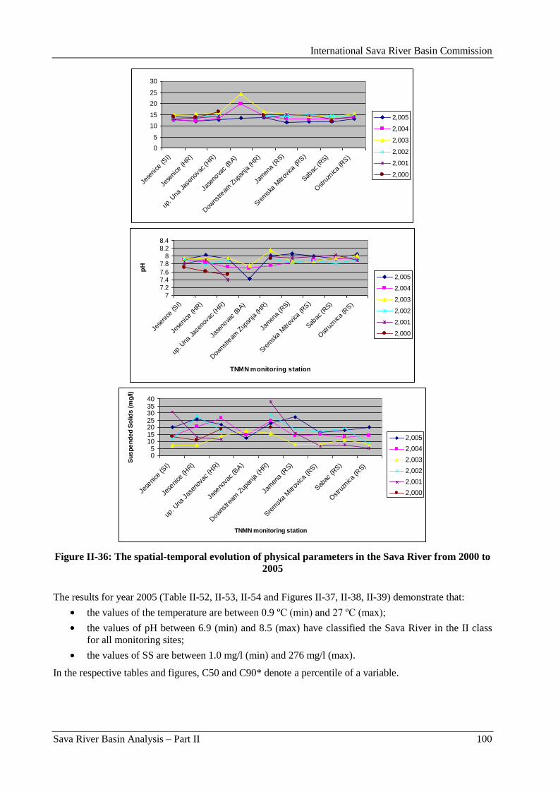
International Sava River Basin Commission
Sava River Basin Analysis – Part II 100
0
5
10
15
20
25
30
Jese
nice
(SI)
Jese
nice
(HR)
up. U
na Jas
enov
ac (H
R)
Jase
nova
c (B
A)
Dow
nstre
am Z
upan
ja (H
R)
Jam
ena
(RS)
Srem
ska
Mitr
ovica
(RS)
Sabac
(RS)
Ostru
znica
(RS)
2,005
2,004
2,003
2,002
2,001
2,000
7
7.2
7.4
7.6
7.8
8
8.2
8.4
Jese
nice
(SI)
Jese
nice
(HR)
up. U
na Jas
enov
ac (H
R)
Jase
nova
c (B
A)
Dow
nstre
am Z
upan
ja (H
R)
Jam
ena
(RS)
Srem
ska
Mitr
ovica
(RS)
Sabac
(RS)
Ostru
znica
(RS)
TNMN monitoring station
pH
2,005
2,004
2,003
2,002
2,001
2,000
05
10152025303540
Jese
nice
(SI)
Jese
nice
(HR)
up. U
na Jas
enov
ac (H
R)
Jase
nova
c (B
A)
Dow
nstre
am Z
upan
ja (H
R)
Jam
ena
(RS)
Sre
msk
a M
itrov
ica
(RS)
Sab
ac (R
S)
Ostru
znica
(RS)
TNMN monitoring station
Su
sp
en
de
d S
olid
s (
mg
/l)
2,005
2,004
2,003
2,002
2,001
2,000
Figure II-36: The spatial-temporal evolution of physical parameters in the Sava River from 2000 to
2005
The results for year 2005 (Table II-52, II-53, II-54 and Figures II-37, II-38, II-39) demonstrate that:
the values of the temperature are between 0.9 ºC (min) and 27 ºC (max);
the values of pH between 6.9 (min) and 8.5 (max) have classified the Sava River in the II class
for all monitoring sites;
the values of SS are between 1.0 mg/l (min) and 276 mg/l (max).
In the respective tables and figures, C50 and C90* denote a percentile of a variable.
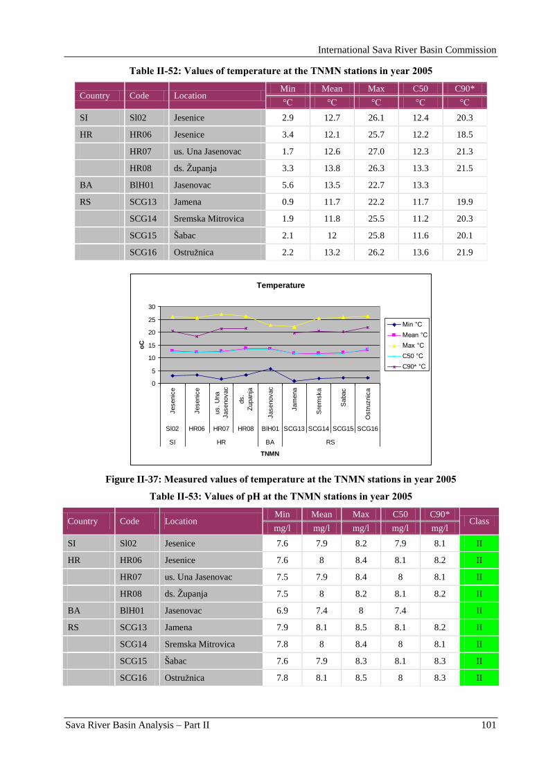
International Sava River Basin Commission
Sava River Basin Analysis – Part II 101
Table II-52: Values of temperature at the TNMN stations in year 2005
Country Code Location Min Mean Max C50 C90*
°C °C °C °C °C
SI Sl02 Jesenice 2.9 12.7 26.1 12.4 20.3
HR HR06 Jesenice 3.4 12.1 25.7 12.2 18.5
HR07 us. Una Jasenovac 1.7 12.6 27.0 12.3 21.3
HR08 ds. Ţupanja 3.3 13.8 26.3 13.3 21.5
BA BlH01 Jasenovac 5.6 13.5 22.7 13.3
RS SCG13 Jamena 0.9 11.7 22.2 11.7 19.9
SCG14 Sremska Mitrovica 1.9 11.8 25.5 11.2 20.3
SCG15 Šabac 2.1 12 25.8 11.6 20.1
SCG16 Ostruţnica 2.2 13.2 26.2 13.6 21.9
Temperature
0
5
10
15
20
25
30
Jesenic
e
Jesenic
e
us.
Una
Jasenovac
ds.
Zupanja
Jasenovac
Jam
ena
Sre
mska
Sabac
Ostr
uznic
a
Sl02 HR06 HR07 HR08 BlH01 SCG13 SCG14 SCG15 SCG16
SI HR BA RS
TNMN
oC
Min °C
Mean °C
Max °C
C50 °C
C90* °C
Figure II-37: Measured values of temperature at the TNMN stations in year 2005
Table II-53: Values of pH at the TNMN stations in year 2005
Country Code Location Min Mean Max C50 C90*
Class mg/l mg/l mg/l mg/l mg/l
SI Sl02 Jesenice 7.6 7.9 8.2 7.9 8.1 II
HR HR06 Jesenice 7.6 8 8.4 8.1 8.2 II
HR07 us. Una Jasenovac 7.5 7.9 8.4 8 8.1 II
HR08 ds. Ţupanja 7.5 8 8.2 8.1 8.2 II
BA BlH01 Jasenovac 6.9 7.4 8 7.4 II
RS SCG13 Jamena 7.9 8.1 8.5 8.1 8.2 II
SCG14 Sremska Mitrovica 7.8 8 8.4 8 8.1 II
SCG15 Šabac 7.6 7.9 8.3 8.1 8.3 II
SCG16 Ostruţnica 7.8 8.1 8.5 8 8.3 II
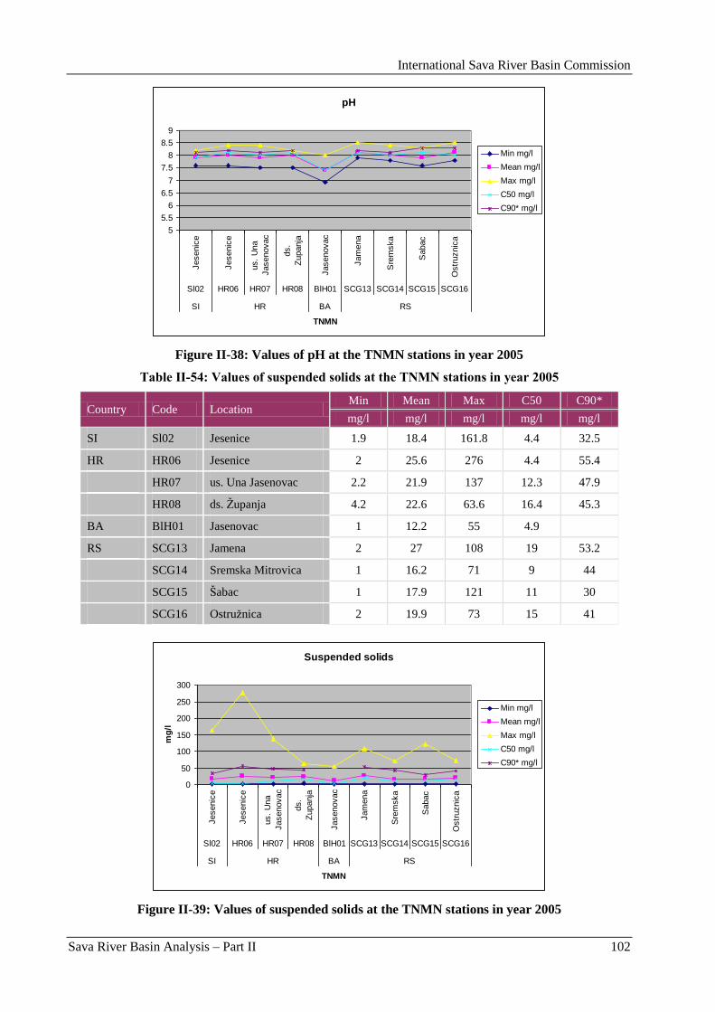
International Sava River Basin Commission
Sava River Basin Analysis – Part II 102
pH
5
5.5
6
6.5
7
7.5
8
8.5
9
Jesenic
e
Jesenic
e
us.
Una
Jasenovac
ds.
Zupanja
Jasenovac
Jam
ena
Sre
mska
Sabac
Ostr
uznic
a
Sl02 HR06 HR07 HR08 BlH01 SCG13 SCG14 SCG15 SCG16
SI HR BA RS
TNMN
Min mg/l
Mean mg/l
Max mg/l
C50 mg/l
C90* mg/l
Figure II-38: Values of pH at the TNMN stations in year 2005
Table II-54: Values of suspended solids at the TNMN stations in year 2005
Country Code Location Min Mean Max C50 C90*
mg/l mg/l mg/l mg/l mg/l
SI Sl02 Jesenice 1.9 18.4 161.8 4.4 32.5
HR HR06 Jesenice 2 25.6 276 4.4 55.4
HR07 us. Una Jasenovac 2.2 21.9 137 12.3 47.9
HR08 ds. Ţupanja 4.2 22.6 63.6 16.4 45.3
BA BlH01 Jasenovac 1 12.2 55 4.9
RS SCG13 Jamena 2 27 108 19 53.2
SCG14 Sremska Mitrovica 1 16.2 71 9 44
SCG15 Šabac 1 17.9 121 11 30
SCG16 Ostruţnica 2 19.9 73 15 41
Suspended solids
0
50
100
150
200
250
300
Jesenic
e
Jesenic
e
us.
Una
Jasenovac
ds.
Zupanja
Jasenovac
Jam
ena
Sre
mska
Sabac
Ostr
uznic
a
Sl02 HR06 HR07 HR08 BlH01 SCG13 SCG14 SCG15 SCG16
SI HR BA RS
TNMN
mg
/l
Min mg/l
Mean mg/l
Max mg/l
C50 mg/l
C90* mg/l
Figure II-39: Values of suspended solids at the TNMN stations in year 2005
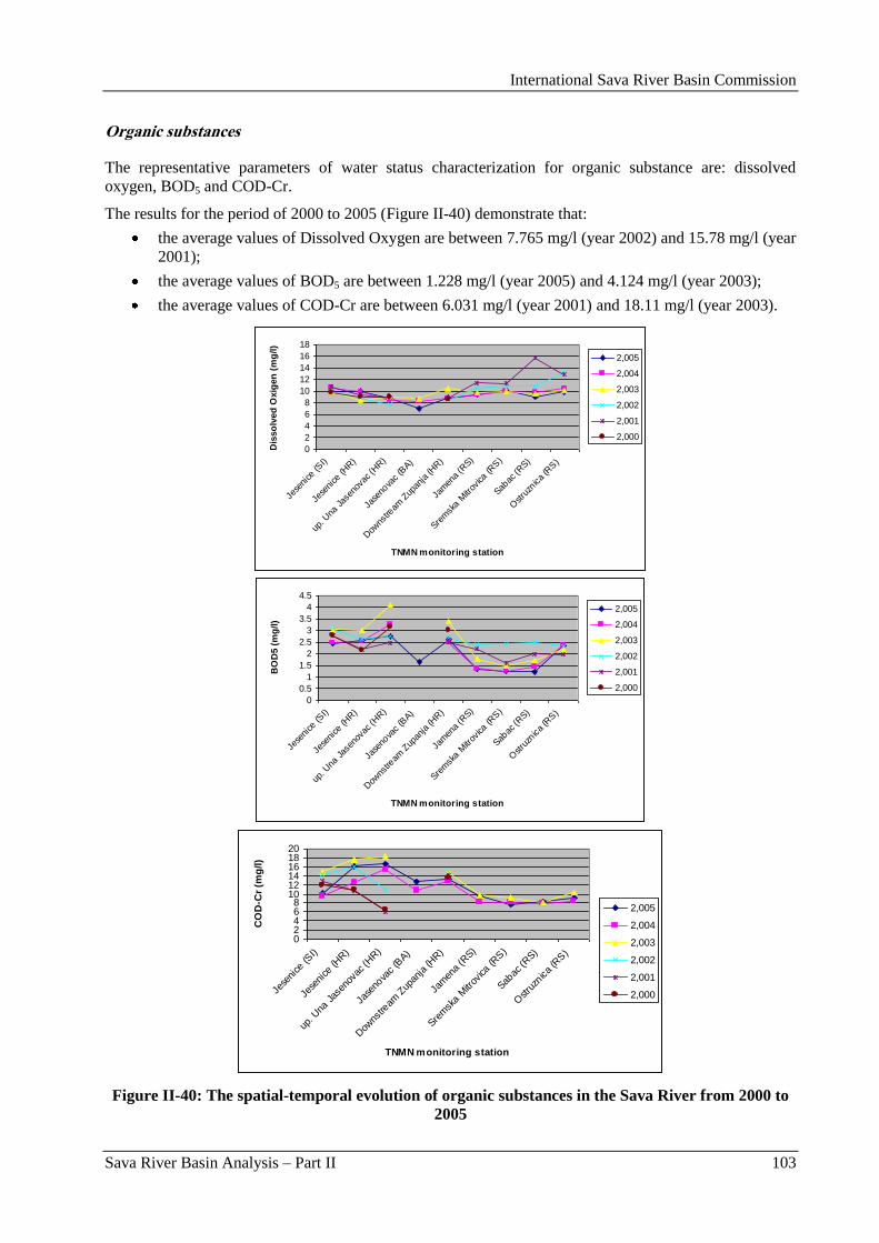
International Sava River Basin Commission
Sava River Basin Analysis – Part II 103
Organic substances
The representative parameters of water status characterization for organic substance are: dissolved
oxygen, BOD5 and COD-Cr.
The results for the period of 2000 to 2005 (Figure II-40) demonstrate that:
the average values of Dissolved Oxygen are between 7.765 mg/l (year 2002) and 15.78 mg/l (year
2001);
the average values of BOD5 are between 1.228 mg/l (year 2005) and 4.124 mg/l (year 2003);
the average values of COD-Cr are between 6.031 mg/l (year 2001) and 18.11 mg/l (year 2003).
0
2
4
6
8
10
12
14
16
18
Jese
nice
(SI)
Jese
nice
(HR)
up. U
na Jas
enov
ac (H
R)
Jase
nova
c (B
A)
Dow
nstre
am Z
upan
ja (H
R)
Jam
ena
(RS)
Srem
ska
Mitr
ovica
(RS)
Sabac
(RS)
Ostru
znica
(RS)
TNMN monitoring station
Dis
so
lved
Oxig
en
(m
g/l)
2,005
2,004
2,003
2,002
2,001
2,000
0
0.5
1
1.5
2
2.5
3
3.5
4
4.5
Jese
nice
(SI)
Jese
nice
(HR)
up. U
na Jas
enov
ac (H
R)
Jase
nova
c (B
A)
Dow
nstre
am Z
upan
ja (H
R)
Jam
ena
(RS)
Srem
ska
Mitr
ovica
(RS)
Sabac
(RS)
Ostru
znica
(RS)
TNMN monitoring station
BO
D5 (
mg
/l)
2,005
2,004
2,003
2,002
2,001
2,000
02468
101214161820
Jese
nice
(SI)
Jese
nice
(HR)
up. U
na Jas
enov
ac (H
R)
Jase
nova
c (B
A)
Dow
nstre
am Z
upan
ja (H
R)
Jam
ena
(RS)
Srem
ska
Mitr
ovica
(RS)
Sabac
(RS)
Ostru
znica
(RS)
TNMN monitoring station
CO
D-C
r (m
g/l)
2,005
2,004
2,003
2,002
2,001
2,000
Figure II-40: The spatial-temporal evolution of organic substances in the Sava River from 2000 to
2005
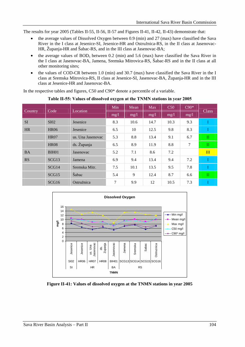
International Sava River Basin Commission
Sava River Basin Analysis – Part II 104
The results for year 2005 (Tables II-55, II-56, II-57 and Figures II-41, II-42, II-43) demonstrate that:
the average values of Dissolved Oxygen between 0.9 (min) and 27 (max) have classified the Sava
River in the I class at Jesenice-SI, Jesenice-HR and Ostruţnica-RS, in the II class at Jasenovac-
HR, Ţupanja-HR and Šabac-RS, and in the III class at Jasenovac-BA;
the average values of BOD5 between 0.2 (min) and 5.6 (max) have classified the Sava River in
the I class at Jasenovac-BA, Jamena, Sremska Mitrovica-RS, Šabac-RS and in the II class at all
other monitoring sites;
the values of COD-CR between 1.0 (min) and 30.7 (max) have classified the Sava River in the I
class at Sremska Mitrovica-RS, II class at Jesenice-SI, Jasenovac-BA, Ţupanja-HR and in the III
class at Jesenice-HR and Jasenovac-BA.
In the respective tables and figures, C50 and C90* denote a percentile of a variable.
Table II-55: Values of dissolved oxygen at the TNMN stations in year 2005
Country Code Location Min Mean Max C50 C90*
Class mg/l mg/l mg/l mg/l mg/l
SI Sl02 Jesenice 8.3 10.6 14.7 10.3 9.3 I
HR HR06 Jesenice 6.5 10 12.5 9.8 8.3 I
HR07 us. Una Jasenovac 5.3 8.8 13.4 9.1 6.7 II
HR08 ds. Ţupanja 6.5 8.9 11.9 8.8 7 II
BA BlH01 Jasenovac 5.2 7.1 8.6 7.2 III
RS SCG13 Jamena 6.9 9.4 13.4 9.4 7.2 I
SCG14 Sremska Mitr. 7.5 10.1 13.5 9.5 7.8 I
SCG15 Šabac 5.4 9 12.4 8.7 6.6 II
SCG16 Ostruţnica 7 9.9 12 10.5 7.3 I
Dissolved Oxygen
0
2
4
6
8
10
12
14
16
Jesenic
e
Jesenic
e
us.
Una
Jasenovac
ds.
Zupanja
Jasenovac
Jam
ena
Sre
mska
Sabac
Ostr
uznic
a
Sl02 HR06 HR07 HR08 BlH01 SCG13 SCG14 SCG15 SCG16
SI HR BA RS
TNMN
mg
/l
Min mg/l
Mean mg/l
Max mg/l
C50 mg/l
C90* mg/l
Figure II-41: Values of dissolved oxygen at the TNMN stations in year 2005
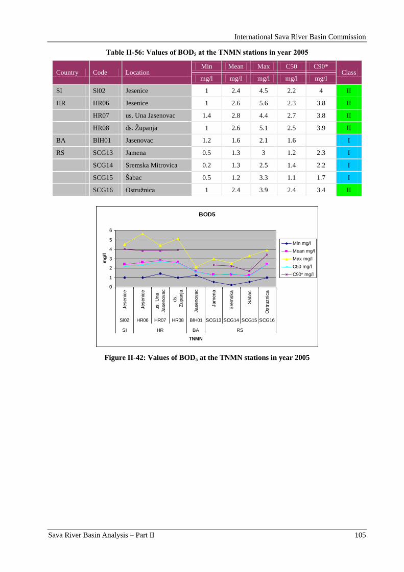
International Sava River Basin Commission
Sava River Basin Analysis – Part II 105
Table II-56: Values of BOD5 at the TNMN stations in year 2005
Country Code Location Min Mean Max C50 C90*
Class mg/l mg/l mg/l mg/l mg/l
SI Sl02 Jesenice 1 2.4 4.5 2.2 4 II
HR HR06 Jesenice 1 2.6 5.6 2.3 3.8 II
HR07 us. Una Jasenovac 1.4 2.8 4.4 2.7 3.8 II
HR08 ds. Ţupanja 1 2.6 5.1 2.5 3.9 II
BA BlH01 Jasenovac 1.2 1.6 2.1 1.6 I
RS SCG13 Jamena 0.5 1.3 3 1.2 2.3 I
SCG14 Sremska Mitrovica 0.2 1.3 2.5 1.4 2.2 I
SCG15 Šabac 0.5 1.2 3.3 1.1 1.7 I
SCG16 Ostruţnica 1 2.4 3.9 2.4 3.4 II
BOD5
0
1
2
3
4
5
6
Jesenic
e
Jesenic
e
us.
Una
Jasenovac
ds.
Zupanja
Jasenovac
Jam
ena
Sre
mska
Sabac
Ostr
uznic
a
Sl02 HR06 HR07 HR08 BlH01 SCG13 SCG14 SCG15 SCG16
SI HR BA RS
TNMN
mg
/l
Min mg/l
Mean mg/l
Max mg/l
C50 mg/l
C90* mg/l
Figure II-42: Values of BOD5 at the TNMN stations in year 2005
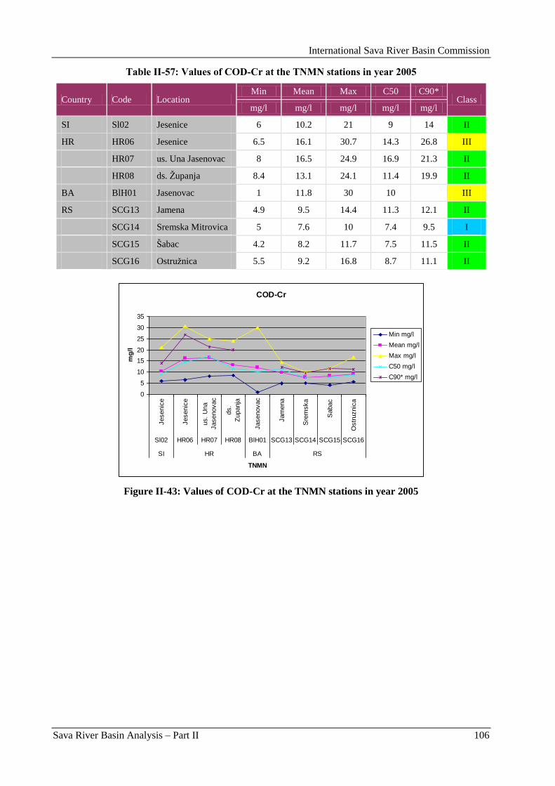
International Sava River Basin Commission
Sava River Basin Analysis – Part II 106
Table II-57: Values of COD-Cr at the TNMN stations in year 2005
Country Code Location Min Mean Max C50 C90*
Class mg/l mg/l mg/l mg/l mg/l
SI Sl02 Jesenice 6 10.2 21 9 14 II
HR HR06 Jesenice 6.5 16.1 30.7 14.3 26.8 III
HR07 us. Una Jasenovac 8 16.5 24.9 16.9 21.3 II
HR08 ds. Ţupanja 8.4 13.1 24.1 11.4 19.9 II
BA BlH01 Jasenovac 1 11.8 30 10 III
RS SCG13 Jamena 4.9 9.5 14.4 11.3 12.1 II
SCG14 Sremska Mitrovica 5 7.6 10 7.4 9.5 I
SCG15 Šabac 4.2 8.2 11.7 7.5 11.5 II
SCG16 Ostruţnica 5.5 9.2 16.8 8.7 11.1 II
COD-Cr
0
5
10
15
20
25
30
35
Jesenic
e
Jesenic
e
us.
Una
Jasenovac
ds.
Zupanja
Jasenovac
Jam
ena
Sre
mska
Sabac
Ostr
uznic
a
Sl02 HR06 HR07 HR08 BlH01 SCG13 SCG14 SCG15 SCG16
SI HR BA RS
TNMN
mg
/l
Min mg/l
Mean mg/l
Max mg/l
C50 mg/l
C90* mg/l
Figure II-43: Values of COD-Cr at the TNMN stations in year 2005
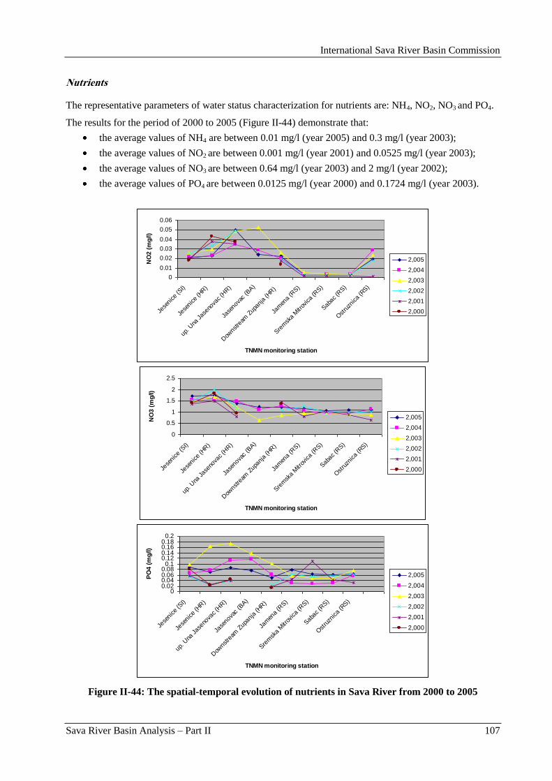
International Sava River Basin Commission
Sava River Basin Analysis – Part II 107
Nutrients
The representative parameters of water status characterization for nutrients are: NH4, NO2, NO3 and PO4.
The results for the period of 2000 to 2005 (Figure II-44) demonstrate that:
the average values of NH4 are between 0.01 mg/l (year 2005) and 0.3 mg/l (year 2003);
the average values of NO2 are between 0.001 mg/l (year 2001) and 0.0525 mg/l (year 2003);
the average values of NO3 are between 0.64 mg/l (year 2003) and 2 mg/l (year 2002);
the average values of PO4 are between 0.0125 mg/l (year 2000) and 0.1724 mg/l (year 2003).
0
0.01
0.02
0.03
0.04
0.05
0.06
Jese
nice
(SI)
Jese
nice
(HR)
up. U
na Jas
enov
ac (H
R)
Jase
nova
c (B
A)
Dow
nstre
am Z
upan
ja (H
R)
Jam
ena
(RS)
Sre
msk
a M
itrov
ica
(RS)
Sab
ac (R
S)
Ost
ruzn
ica
(RS)
TNMN monitoring station
NO
2 (
mg
/l)
2,005
2,004
2,003
2,002
2,001
2,000
0
0.5
1
1.5
2
2.5
Jese
nice
(SI)
Jese
nice
(HR)
up. U
na Jas
enov
ac (H
R)
Jase
nova
c (B
A)
Dow
nstre
am Z
upan
ja (HR)
Jam
ena
(RS)
Sre
msk
a M
itrov
ica
(RS)
Sab
ac (R
S)
Ost
ruzn
ica
(RS)
TNMN monitoring station
NO
3 (
mg
/l)
2,005
2,004
2,003
2,002
2,001
2,000
00.020.040.060.08
0.10.120.140.160.18
0.2
Jese
nice
(SI)
Jese
nice
(HR)
up. U
na Jas
enov
ac (H
R)
Jase
nova
c (B
A)
Dow
nstre
am Z
upan
ja (HR)
Jam
ena
(RS)
Sre
msk
a M
itrov
ica
(RS)
Sab
ac (R
S)
Ost
ruzn
ica
(RS)
TNMN monitoring station
PO
4 (
mg
/l)
2,005
2,004
2,003
2,002
2,001
2,000
Figure II-44: The spatial-temporal evolution of nutrients in Sava River from 2000 to 2005
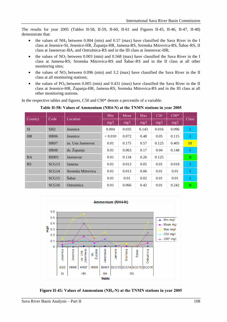
International Sava River Basin Commission
Sava River Basin Analysis – Part II 108
The results for year 2005 (Tables II-58, II-59, II-60, II-61 and Figures II-45, II-46, II-47, II-48)
demonstrate that:
the values of NH4 between 0.004 (min) and 0.57 (max) have classified the Sava River in the I
class at Jesenice-SI, Jesenice-HR, Ţupanja-HR, Jamena-RS, Sremska Mitrovica-RS, Šabac-RS, II
class at Jasenovac-BA, and Ostruţnica-RS and in the III class at Jasenovac-HR;
the values of NO2 between 0.003 (min) and 0.568 (max) have classified the Sava River in the I
class at Jamena-RS, Sremska Mitrovica-RS and Šabac-RS and in the II class at all other
monitoring sites;
the values of NO3 between 0.096 (min) and 3.2 (max) have classified the Sava River in the II
class at all monitoring stations;
the values of PO4 between 0.005 (min) and 0.431 (max) have classified the Sava River in the II
class at Jesenice-HR, Ţupanja-HR, Jamena-RS, Sremska Mitrovica-RS and in the III class at all
other monitoring stations.
In the respective tables and figures, C50 and C90* denote a percentile of a variable.
Table II-58: Values of Ammonium (NH4-N) at the TNMN stations in year 2005
Country Code Location Min Mean Max C50 C90*
Class mg/l mg/l mg/l mg/l mg/l
SI Sl02 Jesenice 0.004 0.035 0.143 0.016 0.096 I
HR HR06 Jesenice < 0.010 0.072 0.48 0.05 0.115 I
HR07 us. Una Jasenovac 0.01 0.175 0.57 0.125 0.405 III
HR08 ds. Ţupanja 0.01 0.063 0.17 0.04 0.148 I
BA BlH01 Jasenovac 0.01 0.134 0.26 0.125 II
RS SCG13 Jamena 0.01 0.013 0.05 0.01 0.018 I
SCG14 Sremska Mitrovica 0.01 0.013 0.06 0.01 0.01 I
SCG15 Šabac 0.01 0.01 0.02 0.01 0.01 I
SCG16 Ostruţnica 0.01 0.066 0.42 0.01 0.242 II
Figure II-45: Values of Ammonium (NH4-N) at the TNMN stations in year 2005
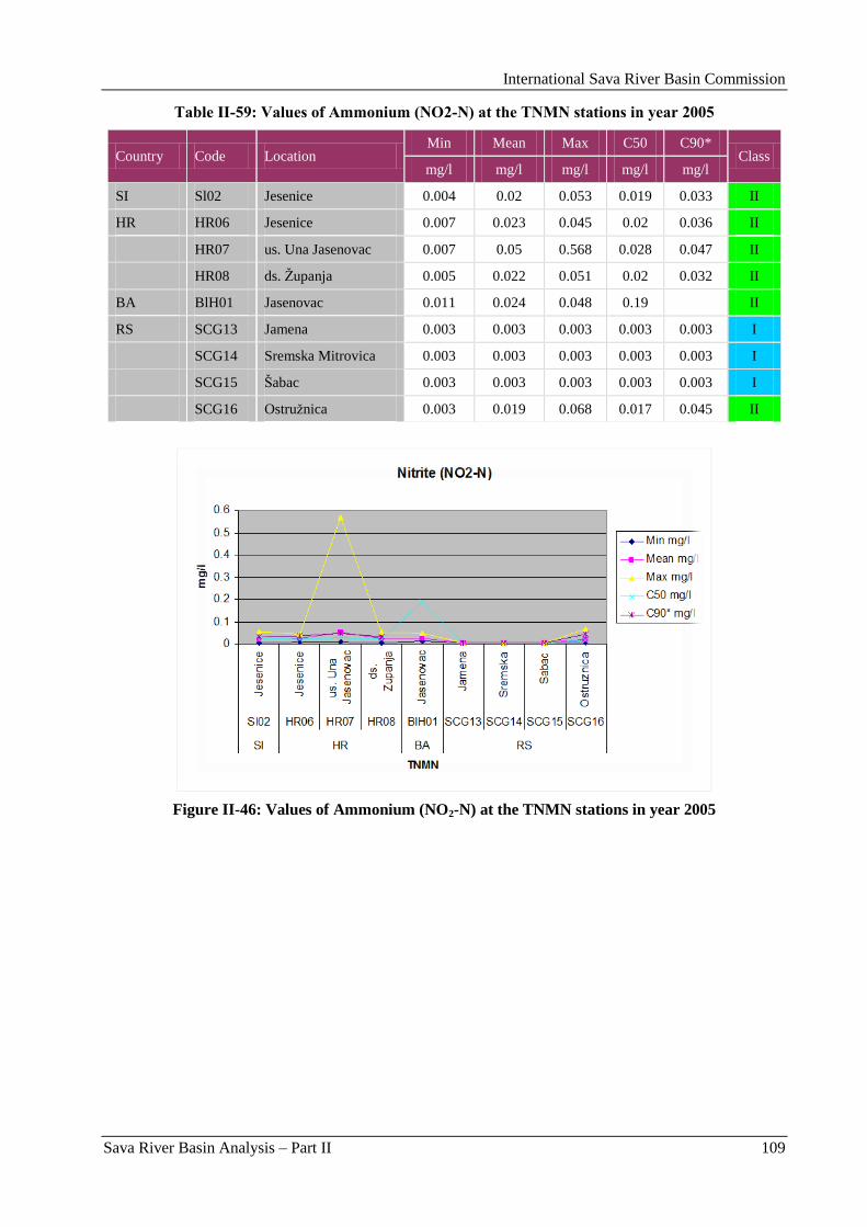
International Sava River Basin Commission
Sava River Basin Analysis – Part II 109
Table II-59: Values of Ammonium (NO2-N) at the TNMN stations in year 2005
Country Code Location Min Mean Max C50 C90*
Class mg/l mg/l mg/l mg/l mg/l
SI Sl02 Jesenice 0.004 0.02 0.053 0.019 0.033 II
HR HR06 Jesenice 0.007 0.023 0.045 0.02 0.036 II
HR07 us. Una Jasenovac 0.007 0.05 0.568 0.028 0.047 II
HR08 ds. Ţupanja 0.005 0.022 0.051 0.02 0.032 II
BA BlH01 Jasenovac 0.011 0.024 0.048 0.19 II
RS SCG13 Jamena 0.003 0.003 0.003 0.003 0.003 I
SCG14 Sremska Mitrovica 0.003 0.003 0.003 0.003 0.003 I
SCG15 Šabac 0.003 0.003 0.003 0.003 0.003 I
SCG16 Ostruţnica 0.003 0.019 0.068 0.017 0.045 II
Figure II-46: Values of Ammonium (NO2-N) at the TNMN stations in year 2005
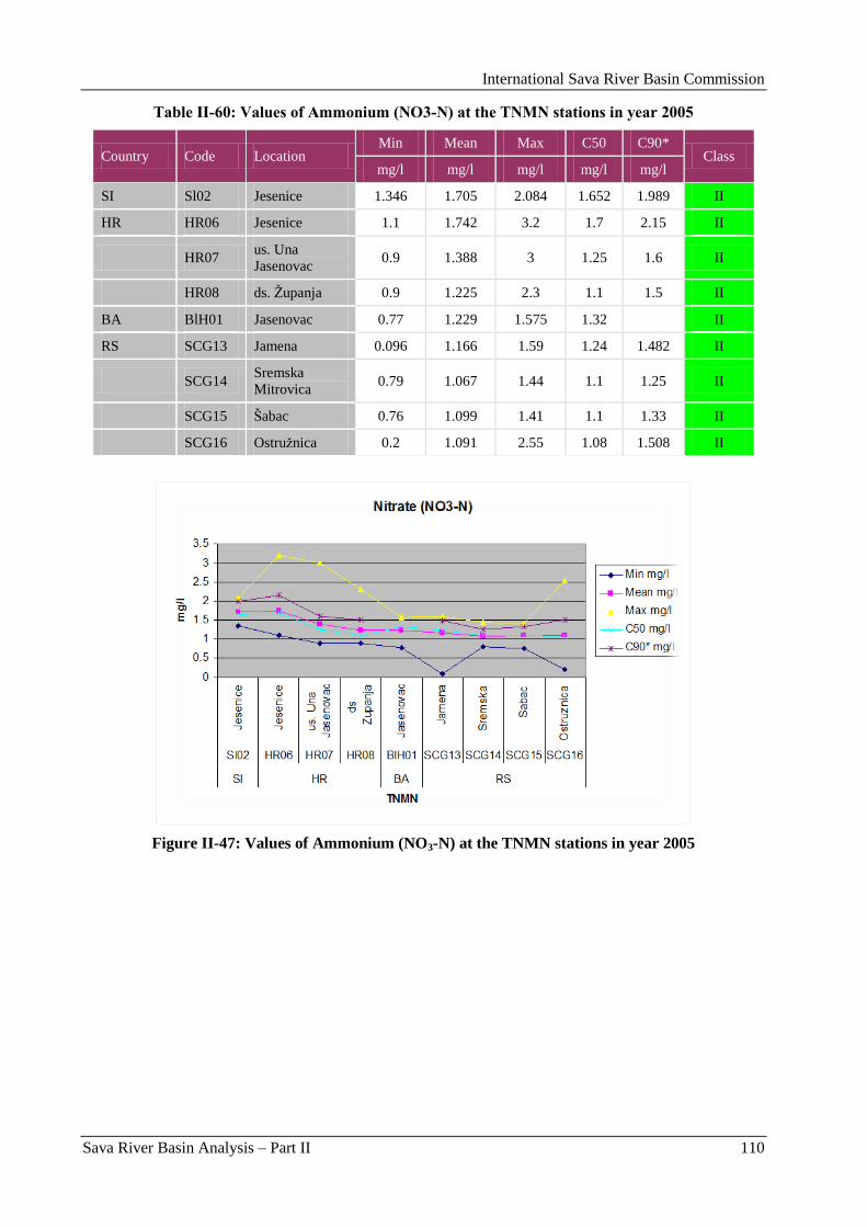
International Sava River Basin Commission
Sava River Basin Analysis – Part II 110
Table II-60: Values of Ammonium (NO3-N) at the TNMN stations in year 2005
Country Code Location Min Mean Max C50 C90*
Class mg/l mg/l mg/l mg/l mg/l
SI Sl02 Jesenice 1.346 1.705 2.084 1.652 1.989 II
HR HR06 Jesenice 1.1 1.742 3.2 1.7 2.15 II
HR07 us. Una
Jasenovac 0.9 1.388 3 1.25 1.6 II
HR08 ds. Ţupanja 0.9 1.225 2.3 1.1 1.5 II
BA BlH01 Jasenovac 0.77 1.229 1.575 1.32 II
RS SCG13 Jamena 0.096 1.166 1.59 1.24 1.482 II
SCG14 Sremska
Mitrovica 0.79 1.067 1.44 1.1 1.25 II
SCG15 Šabac 0.76 1.099 1.41 1.1 1.33 II
SCG16 Ostruţnica 0.2 1.091 2.55 1.08 1.508 II
Figure II-47: Values of Ammonium (NO3-N) at the TNMN stations in year 2005
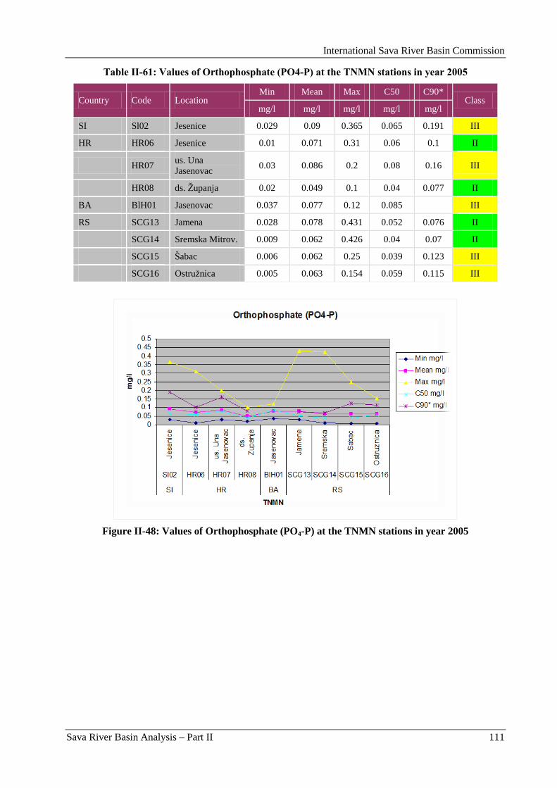
International Sava River Basin Commission
Sava River Basin Analysis – Part II 111
Table II-61: Values of Orthophosphate (PO4-P) at the TNMN stations in year 2005
Country Code Location Min Mean Max C50 C90*
Class mg/l mg/l mg/l mg/l mg/l
SI Sl02 Jesenice 0.029 0.09 0.365 0.065 0.191 III
HR HR06 Jesenice 0.01 0.071 0.31 0.06 0.1 II
HR07 us. Una
Jasenovac 0.03 0.086 0.2 0.08 0.16 III
HR08 ds. Ţupanja 0.02 0.049 0.1 0.04 0.077 II
BA BlH01 Jasenovac 0.037 0.077 0.12 0.085 III
RS SCG13 Jamena 0.028 0.078 0.431 0.052 0.076 II
SCG14 Sremska Mitrov. 0.009 0.062 0.426 0.04 0.07 II
SCG15 Šabac 0.006 0.062 0.25 0.039 0.123 III
SCG16 Ostruţnica 0.005 0.063 0.154 0.059 0.115 III
Figure II-48: Values of Orthophosphate (PO4-P) at the TNMN stations in year 2005
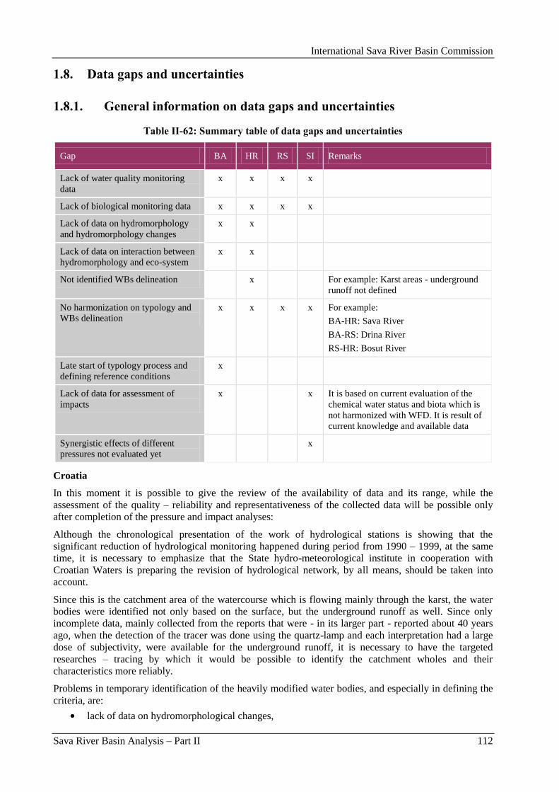
International Sava River Basin Commission
Sava River Basin Analysis – Part II 112
1.8. Data gaps and uncertainties
1.8.1. General information on data gaps and uncertainties
Table II-62: Summary table of data gaps and uncertainties
Gap BA HR RS SI Remarks
Lack of water quality monitoring
data
x x x x
Lack of biological monitoring data x x x x
Lack of data on hydromorphology
and hydromorphology changes
x x
Lack of data on interaction between
hydromorphology and eco-system
x x
Not identified WBs delineation x For example: Karst areas - underground
runoff not defined
No harmonization on typology and
WBs delineation
x x x x
For example:
BA-HR: Sava River
BA-RS: Drina River
RS-HR: Bosut River
Late start of typology process and
defining reference conditions
x
Lack of data for assessment of
impacts
x x It is based on current evaluation of the
chemical water status and biota which is
not harmonized with WFD. It is result of
current knowledge and available data
Synergistic effects of different
pressures not evaluated yet
x
Croatia
In this moment it is possible to give the review of the availability of data and its range, while the
assessment of the quality – reliability and representativeness of the collected data will be possible only
after completion of the pressure and impact analyses:
Although the chronological presentation of the work of hydrological stations is showing that the
significant reduction of hydrological monitoring happened during period from 1990 – 1999, at the same
time, it is necessary to emphasize that the State hydro-meteorological institute in cooperation with
Croatian Waters is preparing the revision of hydrological network, by all means, should be taken into
account.
Since this is the catchment area of the watercourse which is flowing mainly through the karst, the water
bodies were identified not only based on the surface, but the underground runoff as well. Since only
incomplete data, mainly collected from the reports that were - in its larger part - reported about 40 years
ago, when the detection of the tracer was done using the quartz-lamp and each interpretation had a large
dose of subjectivity, were available for the underground runoff, it is necessary to have the targeted
researches – tracing by which it would be possible to identify the catchment wholes and their
characteristics more reliably.
Problems in temporary identification of the heavily modified water bodies, and especially in defining the
criteria, are:
lack of data on hydromorphological changes,
International Sava River Basin Commission
Sava River Basin Analysis – Part II 113
lack of data on interaction between hydromorphology and ecosystem, or problems in
quantification of influence of hydromorphological changes to ecosystems,
insufficiency of the results of existing biological monitoring for new requirements established by
the WFD,
consensus on biological criteria at EU level.
In regard to a need for developing the River Basin Management Plans, especially in the part that will refer
to quantification of morphological changes of riverbed, the lack of monitoring and analysis of sediment
transport and relatively small number of records of transversal profiles on unregulated parts of riverbed,
especially of smaller watercourses, is emphasized.
In Republic of Croatia, in 2000, new regulations, which influenced the changes of some aspects of water
quality monitoring, were passed. In such way the discontinuity in collection or interpretation of data was
created. Due to that, all analyses related to water quality were conducted using samples from the period
2000 – 2004, while the data from pervious period can, at the same time, be used as the additional control.
During the analysis of spatial plans of the counties – which were used or should be used as the source of
data on use of land/space, analysis of development component of economy as a whole, and similar – it
was identified that this level of development (contents - thematically, methodologically and graphically)
is not sufficient for conclusions and interpretations necessary for development of River Basin
Management Plans. It has been proposed to conduct additional, short-term and targeted researches which
will provide the minimum of necessary data.
Since the Republic of Croatia decided to use the biotic typology, which, due to lack of data, was made
based on the expert assessments, in Annual Water Management Plans for 2006 and 2007, the financing of
the comprehensive biological researches, which will serve for more precise identification of the
boundaries of type, reference conditions and reference sites, was planned.
1.8.2. Gaps in the development of the typology and reference conditions
The typology has been developed individually by each country and adjustment or harmonization has not
been completed yet. The adjustment of river type is needed between Serbia and Bosnia and Herzegovina
and Croatia and Bosnia and Herzegovina. It should be discussed whether or not the reference conditions
are needed for all obligatory descriptors of the WFD compliant assessment methods.
Bosnia and Herzegovina
Development of the typology for surface waters and definition of reference conditions in BA started with
delay (for ICPDR Roof Report 2004 – only for rivers with basin area > 4,000 km2). Activities on
preparation of typology and defining of reference conditions will be realized in two phases:
1st phase – to prepare preliminary typology, based on abiotic parameters (currently under
preparation); Preliminary surface water typology based on classification according to the system
B, based on abiotic parameters. Proposed typology system is a draft material for defining the
classes of the surface water types for the Danube River Basin on Bosnia and Herzegovina
territory. Preliminary typology covers following surface waters: the Sava River, as the main
collector of surface waters that flows into the Black Sea, and its tributaries: the Drina, Lim,
Bosna, Vrbas and Una Rivers. Proposed typology is the basis for international agreement on
issues relating to transboundary waters for harmonization with the proposed typologies of the
neighbouring countries. Based on the proposed Preliminary typology, there were, altogether, 11
types of surface waters, whose total surface is bigger then 4,000 km². According to this typology,
water types are divided into 4 basic types with appropriate number of sub-types.
2nd
phase – incorporation of additional abiotic parameters, as well as biological elements
(currently under preparation); Second phase of the activities comprehends:
development and implementation of the typology system;
definition of the reference sites, communities and conditions.
International Sava River Basin Commission
Sava River Basin Analysis – Part II 114
Croatia
The typology was successfully implemented in the Sava River Basin. Approximately 10 % of the
watercourses remained un-typified, i.e. on basis of their abiotic characteristics it was not possible to
ascribe the appropriate type to them. Further research, which will include a biotic system of classification
as one of the parameters, will have to identify to which ecological type (defined through biological
classification), or to which of the new ecological types of running water, these un-typified water bodies
belong. The use of GIS has proven to be essential for efficient characterization of the types. Such concept
enables simple corrections, once the more accurate and precise data is collected. The main problem in
applying the described methodology was input data – it took more than 90 % of the total time to correct
the GIS layer of the watercourses, while certain irregularities related to other input data (DTM) were not a
huge problem. Since the project does not encompass stagnant water, it would be advisable to finalize the
activities related to definition of the national typology for that water category as soon as possible. Once
the preliminary differentiation of watercourses by types is completed (on basis of the expert judgment),
further activities related to the implementation of the WFD should be initiated, such as the identification
of reference sites and reference conditions for each type, and the definition of the type-specific system for
assessing the ecological status. More precise and reliable characterization of types (from areas to
reference conditions) will be possible once the biological monitoring has been established and in function
for several years. More precise identification of these indicators will enable better selection of the
activities that would maintain and/or achieve good ecological status of water, on the one hand, and more
objective monitoring of the effects of the implemented measures, on the other hand.
Serbia
Until now, formal activities on harmonization of the typology with neighbouring countries have not been
undertaken within the Sava Basin.
Although Serbia was invited to participate on several meetings related to intercalibration exercises within
the Eastern Continental GIG, and asked to nominate the intercalibration sites (based on request from
Hungary), so far the intercalibration exercises have not been followed by the Serbia representatives.
Three sites were nominated, one of them on the Sava River, downstream of the border with HR-BA.
Same approach was used for the typology of the tributaries.
As it was identified, the spatial typology could not be applied on all rivers without any compromise. This
is, in particular, the case with large lowland rivers. Taking into consideration the level of simplification of
relations in the nature implied by typological scheme, as well as the self-contained development of large
rivers along the longitudinal gradient, different watercourses (with different overall characteristics) could
be ranked in the same type. That was the case here. To surpass the problem without changing the
approach, the subtypes were proposed.
For rivers at border crossings or shared river stretches:
BA-RS: The Drina River is a transboundary river between RS and BA, which flows along the state border
between the mouth of Brusniĉki potok and the mouth to the Sava River. According to the typology used
in Serbia the Drina River belongs to one type (RS Type 1.2 - very large river, lowland, siliceous, medium
sediments). Delineation of water bodies has been implemented according to the modified category of
surface water, morphological characteristics and changes of hydrological regime. Harmonization of the
typology and water bodies on the Drina River between Serbia and Bosnia and Herzegovina.
The Bosut River is a transboundary river between Serbia and Croatia, which is cut by the state border.
According to the typology accepted, the whole sector of the Bosut River on Serbian territory belongs to
the type CS_P3_V1_SIL (medium river, lowland, siliceous bed). According to the criteria of division of
river into water bodies, the whole Bosut River on Serbian territory presents one water body from the Sava
River mouth up to the state border between Serbia and Croatia. The typology should be harmonized with
Croatia.
Currently, there is less information about the methodology for selection of the reference sites. Therefore,
it cannot be judged whether or not the reference sites and their deviation from a natural state or near
International Sava River Basin Commission
Sava River Basin Analysis – Part II 115
pristine conditions are comparable across the country borders. Reference conditions for
hydromorphological and physico-chemical quality elements are not covered by any of the countries at all.
Further activities comprise:
Further development of the system for assessment of ecological status,
Development of the system for evaluation of the HYMO status.
The evaluation of chemical status will be primarily based on the Directive amending the WFD (Directive
2008/105/EC).
Slovenia
The adjustment of river km is needed in Slovenia.
1.8.3. Data gaps and uncertainties for the identification of significant
pressures relevant on the Sava River Basin scale
Croatia
Data on anthropogenically induced alterations to watercourses, primarily hydraulic structures, was in
majority of cases vectorised from the existing „hardcopy” maps and other available documents, creating a
first-hand GIS database, which will possibly be used for other purposes as well. After necessary revisions,
the said database will be incorporated into the Water Information System – Inventory of Water and Water
Structures. During this initial data collection campaign, only the minimally required number of attribute
data was entered because, on the one hand, in majority of cases a detailed description of particular
structures was not available, and, on the other hand, there is no reliable knowledge that could quantify the
impact on ecosystems more adequately on basis of such attributes
Serbia
Primarily, the lack of the data on physical and chemical parameters on water bodies within hilly-
mountainous area.
Further, the routine monitoring in Republic of Serbia provides the data on phytoplankton and
phytobenthos. The data on aquatic invertebrates are scarce, but the data on aquatic macrophyte and fish,
missing from routine monitoring.
Slovenia
The identification of significant pressures is not supplemented and validated by the monitoring data.
Regarding the diffuse sources of pollution from agriculture, consumption of mineral fertilizer on different
land use was estimated from total annual sold amount. Percentage of nutrient loss to environment was
taken from the national research projects. Percentage of plant protection products used remained the same
in 2003 and 2004. Land use is not dramatically changed in 2003 and 2004. Stores sell same plant
protection products until they run out of stocks. Farmers buy what they are used to buy. In integrated
production plant protection products which are allowed to be used, are prescribed. Calculations are done
on sold quantities which can also mean that all sold amounts are not used in one year or are used
geographically on other area.
1.8.4. Data gaps and uncertainties within the assessment of impacts on the
Sava River Basin scale
Slovenia
Assessment of impact from different sources of pollution is still mainly based on status of chemical
parameters in WB and on biota, or metrics required by the WFD.
International Sava River Basin Commission
Sava River Basin Analysis – Part II 116
Assessment of impact was based on the current evaluation of chemical status of water, which was not
harmonized with the requirements of the WFD. Not all priority substances and chemical parameters
relevant on national level were assessed due to lack of data.
Synergistic effects of different pressures were not evaluated yet.
1.8.5. Data gaps and uncertainties within the risk of failure analysis
Croatia
Analysis of risks in the Sava River Basin is under preparation. In the course of preparation of the
Characterisation Report for the Kupa River Basin, which consists of various types of river sections with
insufficient number of measuring stations, the identification of risks to achieve a good ecological status
was a very unreliable process. The risk of failing to achieve good ecological status was analyzed in
relation to the current status of water, pollution load, and hydromorphological alterations.
Slovenia
All uncertainties referred to assessment of pressures and impacts.
Reported risk assessment is the result of current knowledge and available data. This assessment is current
cross-section in risk assessment development.
International Sava River Basin Commission
Sava River Basin Analysis – Part II 117
2. Characterization of groundwater (Article 5 and Annex II of the WFD)
According to Article 2 of the WFD (2000/60/EC), „groundwater‟ means all water which is below the
surface of the ground in the saturation zone and in direct contact with the ground or subsoil. An „aquifer‟
means a subsurface layer or layers of rock or other geological strata of sufficient porosity and
permeability to allow either a significant flow of groundwater or abstraction of significant quantities of
groundwater. Finally, a „body of groundwater‟ means a distinct volume of groundwater within an aquifer
or aquifers. Groundwater bodies are subject to analyses and reviews as required under Article 5 and
Annex II of the WFD. According to Annex II:
„Member States shall carry out an initial characterisation of all groundwater bodies to assess their uses
and the degree to which they are at risk of failing to meet the objectives for each groundwater body under
Article 4. Member States may group groundwater bodies together for the purposes of this initial
characterisation. This analysis may employ existing hydrological, geological, pedological, land use,
discharge, abstraction and other data but shall identify:
location and boundaries of the groundwater body or bodies,
pressures to which the groundwater body or bodies are liable to be subject (…),
general character of the overlying strata in the catchment area from which the groundwater body
receives its recharge,
those groundwater bodies for which there are directly dependent surface water ecosystems or
terrestrial ecosystems.”
According to paragraph 2.3 under Annex II, for those bodies of groundwater which cross the boundary
between two or more Member States, further information on the impact of human activity on
groundwaters shall be collected and maintained, where relevant.
This chapter provides an overview characterisation of the important transboundary groundwater bodies
(GWBs) in the Sava River Basin. A size threshold of more than 1,000 km² was defined to select important
transboundary GWBs to be included in this Sava River Basin Analysis.
2.1. Locations, boundaries and characterization of the GWBs
2.1.1. Methodology of the GWB delination
Bosnia and Herzegovina
The principle for designation of the water bodies of groundwaters is, in general, taken over from the
document Identification of Water Bodies (CIS Guidance). The problem is that this document does not
observe the groundwater bodies in karst, which are very dispersed in BA, and the importance of which,
due to recharging of strong spring zones with good-quality water, which is necessary to be protected, and
also due to utility value of these waters, deserves a especially sensitive analysis.
Therefore, this report may be regarded as a first step in a set of steps that will follow, with a goal to define
the groundwater bodies very precisely, their importance for total development and risk for failure in
achieving the good status.
Karstic zones
Basic criteria for designation of the groundwater bodies is the reliable defining of hydro-geological
functions and characteristics of rock mass in the hinterland of stronger spring zones with ballanced
discharge.
Second criteria is designation of hydro-geological boundary of the basin and its influence to increase of
orographic surface of the basin, or extension of the influence zone to change of pressures on springs being
influenced by that zone. Therein, all available data are used, especially those regarding the colouring
(identification of the underground connections).
International Sava River Basin Commission
Sava River Basin Analysis – Part II 118
One of the important criteria is defining of the size (volume) and spatial range of groundwater body
using, in the first pace, the monitoring data (hydrographs) of the emptying of underground (spring) zones.
Non-karstic zones
Methodology for defining the non-karstic zones and the size and dynamic characteristics of the water
body is defined by implementation of standard methods of hydraulics based on the defining of
granulometric composition, depth, water-permeability, abundance of the well identified by tests exercises,
observation of the level of underground abstractions/pumping, analysis of data I on the quantities of
pumping, etc.
Preliminary designation of the GWB‟s for different aquifers was conducted based on:
geological boundaries of the water bodies
hydrological (hydraulic) boundaries of the water bodies
entering (in case of water going underground) and exiting points (springs) that control the
recharge zone.
The method of delineation of the boundaries was adjusted to the porosity type of the aquifer and for
intergranular porosity, mainly the hydro-dynamic models and expert judgements were used based on data
on individual abstractions and granulometric composition of the aquifer, while, for aquifers of karstic-
fissure porosity the hydro-geological and geological maps and data on identification of underground
connections (by colouring) of abyss zones and karstic springs, and expert judgement were used.
The next phase will also be related to designation or the volumes of groundwater bodies by
implementation of appropriate analyses.
Basic classification of the groundwater bodies is, depending on aquifer type and ways of flowing, or the
discharge, defined as:
completely separated (non-connected) groundwater bodies (GWB‟s), as the case is with aquifers
of intergranular porosity, which are, dominantly, recharging from watercourses along which they
were created,
connected groundwater bodies like, mainly, in aquifers of karstic-fissure porosity, which are
dominantly recharged by precipitation waters or karstic watercourses through fissure zones, and
discharge through several springs or spring zones,
GWB of sub-artesian, artesian or combined type.
Such classification was conducted not only because of systematic approach, but also, and in the first
place, for creation of grounds for further development of plans for integral management of water
resources in the basin.
In this sense, marked basic directions for connecting these waterbodies with pressures on them (water
abstraction, water pollution ...), risks for the achievement of good quality, transboundary influences and
influences on the water regime in other (orographic) basins, etc., will be in this report.
Such approach is especially important in the GWB‟s with karstic-fissure porosity and due to both: their
ecological and development importance for BA, as well as due to their sensitivity to possible, mostly
hidden, influences that are coming from the broad zone of the places and ways of pollution.
There are 22 large GWB‟s in BA:
Eight groundwater bodies in the inter-granular porosity aquifer: Lijevĉe polje, Prijedorsko polje,
Posavina I, Posavina II, Semberija, Krekanski bazen, Spreĉko polje, Sarajevsko polje;
Fourteen groundwater bodies in the karst-fissure porosity aquifer: Sjeverna Majevica, Devetak-
Romanija-Sjemeĉ, Jahorina-Ravna planina, Treskavica-Zelengora-Lelija-Maglić, Borogovo
region, Udrĉ region, Manjaĉa-Vlašić-Ĉemernica, Grmeĉ-Srnetica-Vitorog, Unac, Plješevica,
Velika Kladuša-Cazin, Vranica, Igman-Bjelašnica, Stupari.
International Sava River Basin Commission
Sava River Basin Analysis – Part II 119
Croatia
Initial characterization of groundwater bodies in the Republic of Croatia was carried out on the basis of
Basic Geological map of HR, in scale 1:100,000; Hydrogeological map, in scale 1:200,000;
Hydrogeological map, in scale 1:300,000; Hydropedological map, in scale 1:300,000, and numerous other
published and unpublished works.
The basis for identification of the groundwater bodies was the analysis of the following elements:
geological composition of the terrain (lithostratigraphic units and structural/tectonic relations),
porosity (intergranular, fracture, fracture-cavernous),
geochemical composition (silicate, carbonate),
hydrogeological characteristics (hydrogeological units according to the porosity, hydraulic
conductivity and aquifer transmissivity),
direction of the groundwater flow – analysis of groundwater tracing in the karst,
yields of springs and wells,
groundwater recharge,
relation with surface waters,
position of groundwater bodies within river basins defined in the Strategy of Water Management
of HR.
The criterion used for identification of the GW bodies was the requirement from the WFD – yield of over
10 m3 per day (0.1 l/s). In this manner, on the basis of the performed analysis according to the previously
stated indicators, 363 groundwater bodies were isolated in the Black Sea RB, all of which were placed
into the category of one aquifer in the vertical cross-section. In the Adriatic RB, a total of 86 groundwater
bodies were isolated on the mainland, and 12 on major islands.
Grouping of the groundwater bodies. Since the WFD enables the grouping of the GWBs for purposes
to achieve the ecological goals, i.e. achievement of good groundwater status and establishment of
surveillance monitoring, the grouping was carried out by taking into account the potential groundwater
uses and protection. As the optimum grouping method, under our conditions, the UK model was applied,
i.e. aquifers were divided into three types: primary aquifers (from which groundwater is significantly used
and which are vital to groundwater ecosystems‟ survival); secondary aquifers (with important role in
groundwater supply, which also, due to their hydrogeological and hydraulic characteristics, can lead to
overexploitation) and unproductive aquifers.
In the area of the Black Sea RB, three aquifer types were found, on basis of which the grouping of
groundwater bodies was performed, as follows:
primary aquifers:
Quaternary aquifers of intergranular porosity in the Sava River valleys with marked
hydraulic characteristics, which either provide water for the majority of public water
supply in northern Croatia or are planned for water supply (aquifer in the area of
Zagreb, cone deposits of the Sava River right tributaries, alluvial aquifer in the area of
Karlovac)
Carbonate aquifers of fracture-cavernous porosity and high permeability in high karst
zones, i.e. Kupa and Una River Basins, from which groundwater surfaces in high-yield
springs,
secondary aquifers:
Quaternary aquifers of intergranular porosity in the Sava River Basin with somewhat
lower hydraulic characteristics, used for water supply, with yields generally under 20
l/s
Carbonate (Triassic) aquifers of fissure porosity and medium permeability in northern
Croatia (Zagorje and Slavonia mountains, Ţumberak-Samobor mountains, Mt.
Medvednica)
International Sava River Basin Commission
Sava River Basin Analysis – Part II 120
Carbonate aquifers of fracture-cavernous porosity in shallow karst zones, i.e. Kupa
River Basin, virtually with no significant springs,
unproductive aquifers:
mostly limited to Neogene deposits (exchanges of marls, silts, clays, sand,
occasionally carbonates), Quaternary deposits with poor hydraulic characteristics
and/or small thickness, and metamorphic rocks (permeable only in a shallow segment
below the terrain surface), which generally cannot yield water quantities over 5 l/s.
Serbia
Delineation Criteria - During the process of delineation of groundwater bodies the principle criteria has
been the geological characterization of the rock mass, hydrogeological borders, exploitation and pressures
identification. On basis of the previously mentioned criteria, two water bodies and one group of water
bodies of groundwater have been identified in the Sava River Basin.
Geological structure - identified water bodies have been formed in the aquifer of inter-granulated
porosity. Aquifers consist of the sand-gravel quaternary sediment and sand-gravel Pliocene sediment.
Groundwater exploitation - Groundwater of identified groundwater bodies is used for public water
supply of inhabitants and industry.
Criteria of significant groundwater bodies - above mentioned groundwater bodies have been identified
as significant because of exploitation. They are used for public water supply of inhabitants and industry
with the quantity larger than 100 m3/day in accordance with the limit given by the WFD.
Delineation of the national ground water bodies is under the execution.
Description of significant groundwater bodies
The „East Srem OVK” Groundwater Body (MS Code RS_SA_GW_I_2)
The „East Srem OVK” groundwater body is located in the area of the alluvial plain (floodplain and river
terrace) and the upper terrace 2-4 m above the alluvial plain. The absolute elevations of the terrain are:
73-83 m a.s.l. (alluvial plain) and from 84 to approx. 100 m a.s.l. (upper terrace). A major portion of the
groundwater body belongs to the Sava River Basin, and a minor portion to the Danube River Basin. The
southern boundary of the groundwater body is the Sava River, which is either in direct hydraulic contact
with the body or features a somewhat reduced hydraulic conductance due to clogging of the riverbed and,
partly, due to partially eroded semi-pervious silty sands of the riverbed. Along the stretch of the Sava
upstream from Jarak to Zasavica, where the Sava River is not incised into the aquifer (i.e. where the river
channel lies in the overlying, virtually impervious strata), the groundwater body is in direct hydraulic
contact with the groundwater body in the region of Maĉva. The eastern/north-eastern boundary of the
groundwater body is the Danube River. The northern boundary of the groundwater body is the aquifer
boundary (i.e. it coincides with the edge of the upper terrace along the Šid-Ruma-Stara Pazova line). It is
hydrodynamically defined by the groundwater flow from the „Srem Series” to the said aquifer. The
surface area of the groundwater body within the above-mentioned boundaries in the territory of the
Republic of Serbia is roughly 1,557 km2.
The aquifer in which the body is found is an intergranular porosity aquifer. The lower portion of the
aquifer is characterized by polycyclic riverine (riverine-lacustrine) sediments, which present an
Eopleistocene sequence generally comprised of sands and gravels in the eastern part of Southern Srem
(east of the Klenak-Ruma line), and of gravelly sands and gravels in the western part of Southern Srem.
The upper portion of the aquifer is generally comprised of sandy deposits, with subordinate sandy-
gravelly Middle Pleistocene riverine/bog deposits. The sandy-gravelly strata, which constitute the lower
and upper portions of the aquifer, are in direct contact in the alluvial plain of the Sava, while in the upper
terrace area they are separated by silt and silty clay interlayers and lenses. The total thickness of the
aquifer is between 16 m and roughly 50 m.
The groundwater body is recharged through infiltration of water from the Sava River at high stages,
infiltration from the primary canal network at low piezometric levels of the groundwater body, and
indirect infiltration of atmospheric precipitation through overlying semi-pervious strata into the aquifer. A
certain degree of groundwater flow from the Srem Series into the aquifer cannot be ruled out.
International Sava River Basin Commission
Sava River Basin Analysis – Part II 121
Groundwater is discharged from the body into the Sava River and the primary canal network, when their
water levels are low, as well as indirectly, through evapotranspiration of groundwater from the overlying
semi-pervious strata. A major portion of the aquifer discharge is attributable to the groundwater
abstraction from the body for public and private drinking-water supply for population and several
industries.
The „West Srem Pliocene” Groundwater Body (MS Code RS_SA_GW_I_6)
The „East Srem Pliocene” Groundwater Body (MS Code RS_SA_GW_I_7)
The „Mačva Pliocene” Groundwater Body (MS Code RS_SA_GW_I_8)
The „West Srem Pliocene”, „East Srem Pliocene” and „Maĉva Pliocene” Groundwater Bodies are the the
parts of the Srem-Maĉva group of the groundwater bodies, located between the southern slopes of Mt.
Fruška Gora in the north and northern slopes of Mt. Cer in the south (i.e. in the region comprised of Srem,
Maĉva and Pocerina).
In Maĉva, Pliocene aquifers are found at depth of roughly 60-196 m, in the zone of Crna Bara-Bogatić,
Belotić-Tabanović, and at depth of 50-170 m in the zone of Ravnje-Crna Bara. The aquifer in the upper
portion of the terrain is continuous, while in the deeper portions of the terrain there are irregular lateral
and vertical interchanges with semi-pervious and virtually impervious silts, silty clays and marly clays.
Aquifer thicknesses range from below 2 m to some 30 m. Larger thicknesses are found in the western
(Badovinci-Crna Bara-Crnobarski Salaš-Ravnje) and central (Belotić-Bogatić) parts of Maĉva, where
they are 18-30 m, unlike in the northeastern part, northeast of the Tabanović-Glušci line, where aquifer
thicknesses are up to 12 m.
In Srem and Maĉva (in the single hydrogeological basin of the Sava trench), each aquifer/aquifer package
includes groundwater reservoirs, which are hydraulically linked into two groundwater bodies, either
directly or indirectly through the semi-pervious silts and silty sands. These two groundwater bodies are
separated by thick semi-pervious or virtually impervious deposits. The first body is comprised of the
groundwater reservoirs formed in Paludine aquifers, while those of the second body are formed in Upper
Pontian aquifers.
The boundaries of the groundwater bodies coincide. The southern and northern boundaries are defined by
the areal extent of the aquifer to the slopes of Mt. Fruška Gora and Mt. Cer, while the eastern and western
boundaries are open toward Banat and the Croatian portion of Srem, respectively. At this time, it is not
possible to define the boundaries along the northern and southern edges accurately, especially along the
slopes of Mt. Fruška Gora, where Pliocene sediments are covered by the Srem Series and loess. Probable
boundary in this area runs along the Novi Karlovac-D. Maradik-Pavlovci-Ĉalma-Šid line. The boundary
of the bodies in the Mt. Cer area roughly coincides with the Pliocene strata boundary.
The aquifers of both these bodies are recharged through infiltration of precipitation in the Mt. Cer area,
where the aquifers are exposed, and to a significantly lesser extent along the southern slopes of Mt.
Fruška Gora, where recharge by infiltration is indirect, through the Srem Series and loess. No data are
available for an assessment of the extent of recharge of the groundwater bodies.
Under natural conditions, the aquifers were discharged through the flow from deeper to shallower
aquifers, especially from the first body to Quaternary aquifers. Today, a major portion of the discharge is
attributable to groundwater abstraction from both bodies for public water supply for six towns and about
36 villages. Groundwater abstracted from the Pliocene aquifers in Maĉva is used for rural water supply
via „public wells”, as well as for private and public agricultural, and a few industrial facilities.
The bodies are subject to moderate quantitative pressures only in the areas of sources of water supply (at
the Batrovci water source in Šid, the pressure is slightly higher than moderate). The permanent drawdown
in the eastern part of Srem is about 10 m, and more than 15 m in the western part of Srem. There is
possible risk of not achieving the WFD Article 4 related to environmental goals.
Slovenia – no data submitted.
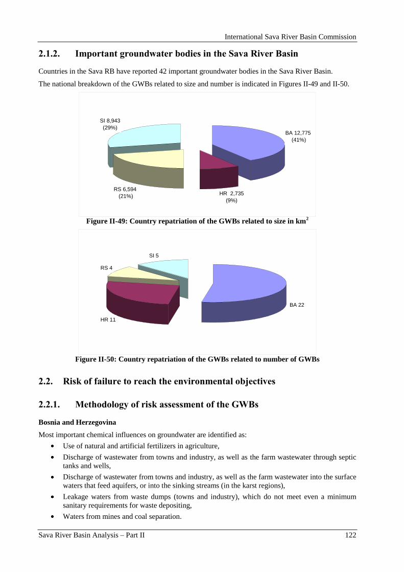
International Sava River Basin Commission
Sava River Basin Analysis – Part II 122
2.1.2. Important groundwater bodies in the Sava River Basin
Countries in the Sava RB have reported 42 important groundwater bodies in the Sava River Basin.
The national breakdown of the GWBs related to size and number is indicated in Figures II-49 and II-50.
BA 12,775
(41%)
HR 2,735
(9%)
RS 6,594
(21%)
SI 8,943
(29%)
Figure II-49: Country repatriation of the GWBs related to size in km
2
BA 22
HR 11
RS 4
SI 5
Figure II-50: Country repatriation of the GWBs related to number of GWBs
2.2. Risk of failure to reach the environmental objectives
2.2.1. Methodology of risk assessment of the GWBs
Bosnia and Herzegovina
Most important chemical influences on groundwater are identified as:
Use of natural and artificial fertilizers in agriculture,
Discharge of wastewater from towns and industry, as well as the farm wastewater through septic
tanks and wells,
Discharge of wastewater from towns and industry, as well as the farm wastewater into the surface
waters that feed aquifers, or into the sinking streams (in the karst regions),
Leakage waters from waste dumps (towns and industry), which do not meet even a minimum
sanitary requirements for waste depositing,
Waters from mines and coal separation.
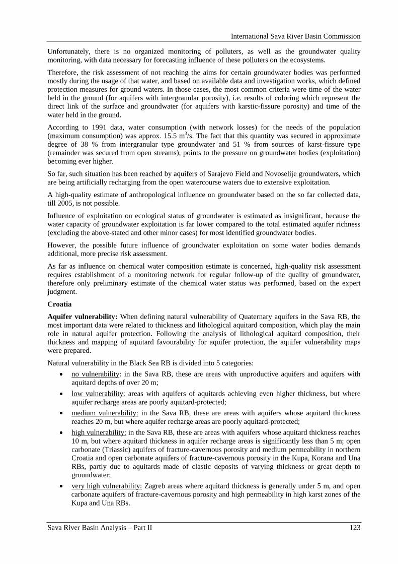
International Sava River Basin Commission
Sava River Basin Analysis – Part II 123
Unfortunately, there is no organized monitoring of polluters, as well as the groundwater quality
monitoring, with data necessary for forecasting influence of these polluters on the ecosystems.
Therefore, the risk assessment of not reaching the aims for certain groundwater bodies was performed
mostly during the usage of that water, and based on available data and investigation works, which defined
protection measures for ground waters. In those cases, the most common criteria were time of the water
held in the ground (for aquifers with intergranular porosity), i.e. results of coloring which represent the
direct link of the surface and groundwater (for aquifers with karstic-fissure porosity) and time of the
water held in the ground.
According to 1991 data, water consumption (with network losses) for the needs of the population
(maximum consumption) was approx. 15.5 m3/s. The fact that this quantity was secured in approximate
degree of 38 % from intergranular type groundwater and 51 % from sources of karst-fissure type
(remainder was secured from open streams), points to the pressure on groundwater bodies (exploitation)
becoming ever higher.
So far, such situation has been reached by aquifers of Sarajevo Field and Novoselije groundwaters, which
are being artificially recharging from the open watercourse waters due to extensive exploitation.
A high-quality estimate of anthropological influence on groundwater based on the so far collected data,
till 2005, is not possible.
Influence of exploitation on ecological status of groundwater is estimated as insignificant, because the
water capacity of groundwater exploitation is far lower compared to the total estimated aquifer richness
(excluding the above-stated and other minor cases) for most identified groundwater bodies.
However, the possible future influence of groundwater exploitation on some water bodies demands
additional, more precise risk assessment.
As far as influence on chemical water composition estimate is concerned, high-quality risk assessment
requires establishment of a monitoring network for regular follow-up of the quality of groundwater,
therefore only preliminary estimate of the chemical water status was performed, based on the expert
judgment.
Croatia
Aquifer vulnerability: When defining natural vulnerability of Quaternary aquifers in the Sava RB, the
most important data were related to thickness and lithological aquitard composition, which play the main
role in natural aquifer protection. Following the analysis of lithological aquitard composition, their
thickness and mapping of aquitard favourability for aquifer protection, the aquifer vulnerability maps
were prepared.
Natural vulnerability in the Black Sea RB is divided into 5 categories:
no vulnerability: in the Sava RB, these are areas with unproductive aquifers and aquifers with
aquitard depths of over 20 m;
low vulnerability: areas with aquifers of aquitards achieving even higher thickness, but where
aquifer recharge areas are poorly aquitard-protected;
medium vulnerability: in the Sava RB, these are areas with aquifers whose aquitard thickness
reaches 20 m, but where aquifer recharge areas are poorly aquitard-protected;
high vulnerability: in the Sava RB, these are areas with aquifers whose aquitard thickness reaches
10 m, but where aquitard thickness in aquifer recharge areas is significantly less than 5 m; open
carbonate (Triassic) aquifers of fracture-cavernous porosity and medium permeability in northern
Croatia and open carbonate aquifers of fracture-cavernous porosity in the Kupa, Korana and Una
RBs, partly due to aquitards made of clastic deposits of varying thickness or great depth to
groundwater;
very high vulnerability: Zagreb areas where aquitard thickness is generally under 5 m, and open
carbonate aquifers of fracture-cavernous porosity and high permeability in high karst zones of the
Kupa and Una RBs.
International Sava River Basin Commission
Sava River Basin Analysis – Part II 124
Groundwater quality. Initial identification of the natural groundwater quality was made on basis of the
monitoring raw water quality at water abstraction sites and systematic monitoring on state waters.
According to the legislation, monitoring of the groundwater quality is mandatory on all water abstraction
sites inluded in the public water supply; however, this scope rarely satisfies the criteria stipulated by the
Regulation on sanitary quality of drinking water (OG 46/1994). Water quality is observed only on the
water abstraction sites used for public water supply, and mostly in abstraction structures (wells or
springs). In all recharge areas in the Sava RB the groundwater quality monitoring is carried out only on
major abstraction sites (Zagreb), where alluvial aquifers are captured. For initial groundwater chemical
and quality status, i.e. selection of indicators for present monitoring, the following are selected:
groundwater temperature;
redox conditions in groundwater;
mineralization/salinity;
groundwater acidity status (alkalinity, pH);
contents of nutrient N (NO3-,NO2
-,NH3) and P (total P, orthophosphates) salts - anthropogenic
impacts (agriculture, industries, households, solid waste disposals, etc.);
heavy metals – Fe – indicator of both natural and anthropogenic pollution;
chemical oxygen demand (COD);
chlorides – proof of impacts form agriculture and use of mineral and natural fertilizers,
wastewater from roads, households, agriculture;
other indicators – suspended solids, turbidity, microbiological indicators, contents of mineral oils.
The arithmetic mean reflects the general condition of individual GW bodies very well, and the reflection
of such state which does not exceed 50 % of the GW body area, but only if monitoring points are evenly
distributed. It is, however, unreliable in cases of uneven pollution by a local or diffuse source, or in
aquifers of fracture-cavernous porosity. It is selected for initial characterization of GWBs. The main
characteristic of natural groundwater quality in aquifers of intergranular porosity in northern Croatia are
increased contents of iron, manganese, ammonium and their associated elements, arsenic in particular, as
recorded in eastern Slavonia. This is a consequence of natural, reductive conditions in the aquifer, and not
of anthropogenic influence. Groundwater with increased concentrations of heavy metals is generally
related to deep aquifers of northern Croatia‟s eastern areas. Groundwater quality from carbonate aquifers
in northern Croatia is exceptionally good, since they are located in forested mountain areas, thus there are
no sources of pollution in their recharge areas. In the areas comprised of carbonate rocks, the natural state
of groundwater quality is very good. At times of medium to low water levels, groundwater quality in
natural conditions is very good; however, in periods of high precipitation, water turbidity occurs in
springs, but lasts only for several days.
Groundwater quality in deeper sections of the alluvial Zagreb aquifer reflects natural geochemical
conditions, while several shallower areas of the aquifer are under anthropogenic influence of varying
intensity. Groundwater quality in the Zagreb area mostly satisfies the requirements from the Regulation
on sanitary quality of drinking water (OG 46/94 and 49/97). However, although they generally do not
exceed maximum allowed concentrations for drinking water, the presence of nitrates, total and mineral
oils, highly volatile hydrocarbons and bacteriological pollution indicates that degradation of groundwater
quality is consequential to anthropogenic influence. Groundwater quality in the analyzed springs in the
littoral area of Croatia and in Lika is of extraordinary good quality. All analyzed indicators are below
maximum allowed concentrations for drinking water, with the exception of microbiological indicators,
which, in accordance with the Regulation, can place water into I and II classes. Springs in Lika have only
occasional problems with bacteriological indicators.
Pressures: As part of pressure analyses (with regard to legal use, i.e. pressures on groundwater), the
following analyses were conducted:
Analysis of pressures on groundwater quantity status (abstraction, lowering of water levels and
irrigation),
International Sava River Basin Commission
Sava River Basin Analysis – Part II 125
Analysis of pressures on groundwater quality (point sources of pollution: industries, discharges
from wastewater systems, solid waste disposals; diffuse sources of pollution: agriculture (total
nitrogen, phosphorus and potassium), data on traffic-related pollution).
Problems with determination of pressures were caused by undefined indicators and not updated data
bases.
Pressure on groundwater quantity status: Status of groundwater quantity in the Sava RB is
satisfactory. There is virtually no regional negative impact on permanent lowering of groundwater levels
in aquifers of intergranular porosity, with the exception of the western part of the Sava. However, this
lowering of groundwater levels is not attributed only to groundwater overexploitation, but also to other
factors, such as construction of hydropower facilities in Slovenia, regulation of the Sava tributaries and
torrential flows as well as the regulation of the Sava River bed and gravel exploitation, etc. Negative
influence on groundwater quantity status in karst aquifers has not been determined to date.
Pressure on groundwater quality: Data on point sources of pollution were not quite sufficient for a
detailed analysis. Pressures, in particular point sources of pollution, were identified: industries, discharges
from wastewater systems and solid waste disposals. Pressure analysis includes identification and impact
assessment of groundwater quality on all accessible monitoring points (abstraction sites, sources,
piezometers).
As part of the impact analysis of diffuse sources of pollution, data were used on terrain coverage with
agricultural surfaces (fields) and their pressure in terms of nitrogen, potassium and phosphorus as
products of fertilizer use for cultivation of various agricultural crops. The highest quantities of nitrogen,
potassium and phosphorus in the Sava RB are in Hrvatsko zagorje, in the valleys of Ilova and Pakra
Rivers and in the Poţega depression.
Serbia
Pressures and impacts - generally the data about pressures on groundwater are missing, because there is
no adequate monitoring of the water quality of identified groundwater water bodies.
The criteria used for the quantity risk assessment were based on the history of alterations of piezometric
levels from 1960 observed at a limited number of monitoring stations, on the data collected from
operators of groundwater sources on level alterations and quantities of the abstracted water, as well as on
the developed regional hydrodynamic groundwater model used for the estimation of future trends of
piezometric levels for several scenarios of future groundwater abstraction.
The criteria used for the (quality) chemical risk assessment were based on the thickness, hydraulic
conductivity of overlying layers as natural protection of the groundwater body, the results of the quality
analysis of chemical monitoring and identification of possible upward trends, as well as on the presence
of anthropogenic pressures on chemical status.
Slovenia – no data submitted.
2.2.2. Results of the risk assessment of the GWBs
The risk classification is distinguished between three classes: GWBs „at risk‟, GWBs „possibly at risk‟
and GWBs „not at risk‟. A GWB is classified as being „at risk‟, if the nationally applied risk criteria are
fulfilled. In cases of insufficient data, GWBs have been classified as being „possibly at risk‟ until more
detailed information is available.
Countries have implemented the risk assessment concerning the quality (chemical) status and quantity
status of all important GWBs in the Sava RB except in BA which has not reported on the risk assessment
for 4 identified GWBs (Krekanski bazen, Spreĉko polje, Sarajevsko polje and Sjeverna Majevica) with
the size of 221 km2 which represents 0.6 % of the total area of important GWBs in the Sava RB.
Following tables and figures present the status of the risk assessment of the GWBs in the Sava RB
concerning the quantity and quality.
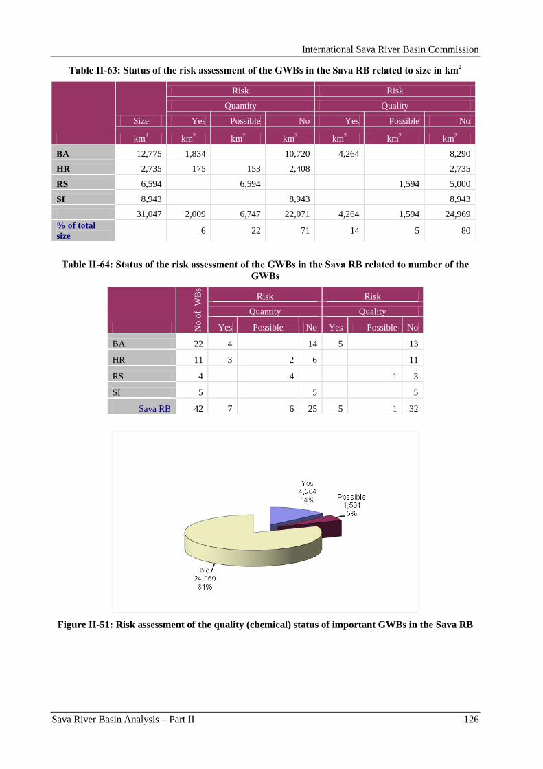
International Sava River Basin Commission
Sava River Basin Analysis – Part II 126
Table II-63: Status of the risk assessment of the GWBs in the Sava RB related to size in km2
Size
Risk Risk
Quantity Quality
Yes Possible No Yes Possible No
km2 km
2 km
2 km
2 km
2 km
2 km
2
BA 12,775 1,834 10,720 4,264 8,290
HR 2,735 175 153 2,408 2,735
RS 6,594 6,594 1,594 5,000
SI 8,943 8,943 8,943
31,047 2,009 6,747 22,071 4,264 1,594 24,969
% of total
size 6 22 71 14 5 80
Table II-64: Status of the risk assessment of the GWBs in the Sava RB related to number of the
GWBs
No
of
WB
s
Risk Risk
Quantity Quality
Yes Possible No Yes Possible No
BA 22 4 14 5 13
HR 11 3 2 6 11
RS 4 4 1 3
SI 5 5 5
Sava RB 42 7 6 25 5 1 32
Figure II-51: Risk assessment of the quality (chemical) status of important GWBs in the Sava RB
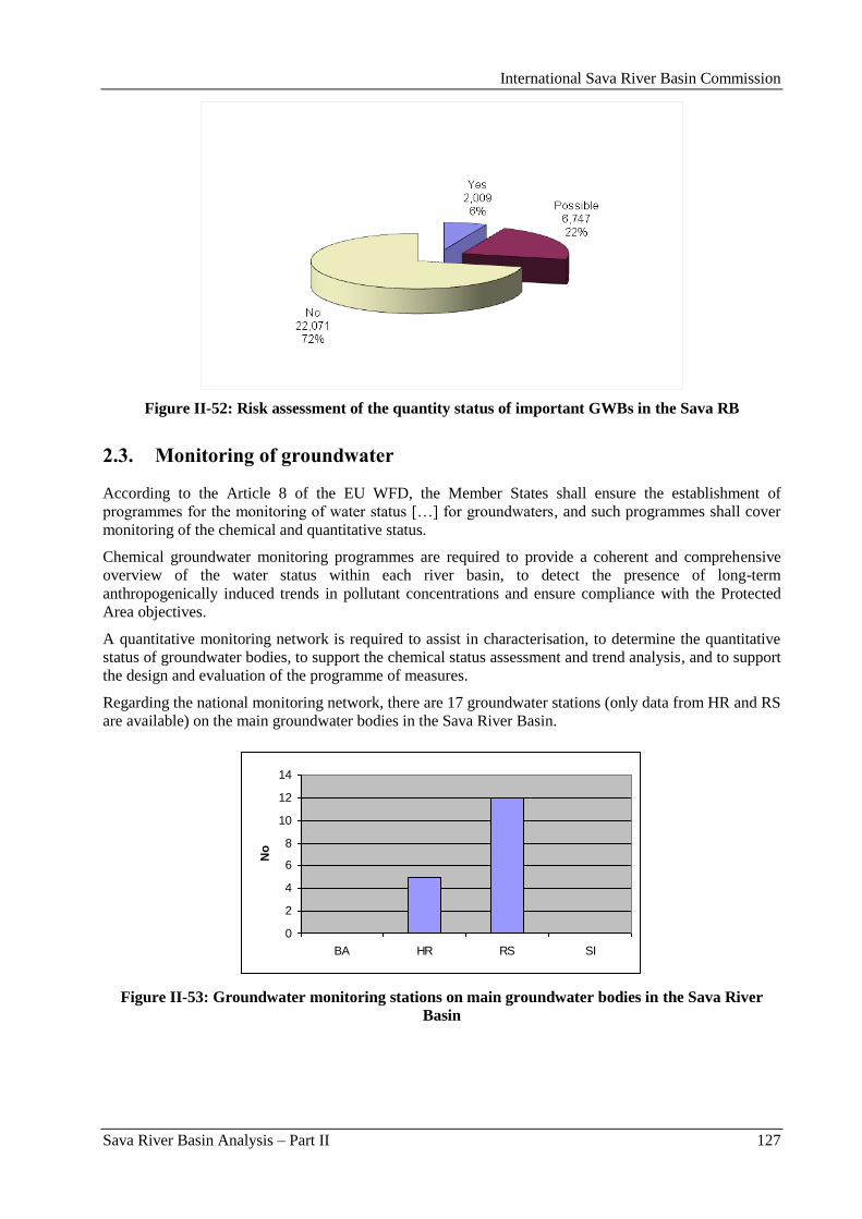
International Sava River Basin Commission
Sava River Basin Analysis – Part II 127
Figure II-52: Risk assessment of the quantity status of important GWBs in the Sava RB
2.3. Monitoring of groundwater
According to the Article 8 of the EU WFD, the Member States shall ensure the establishment of
programmes for the monitoring of water status […] for groundwaters, and such programmes shall cover
monitoring of the chemical and quantitative status.
Chemical groundwater monitoring programmes are required to provide a coherent and comprehensive
overview of the water status within each river basin, to detect the presence of long-term
anthropogenically induced trends in pollutant concentrations and ensure compliance with the Protected
Area objectives.
A quantitative monitoring network is required to assist in characterisation, to determine the quantitative
status of groundwater bodies, to support the chemical status assessment and trend analysis, and to support
the design and evaluation of the programme of measures.
Regarding the national monitoring network, there are 17 groundwater stations (only data from HR and RS
are available) on the main groundwater bodies in the Sava River Basin.
0
2
4
6
8
10
12
14
BA HR RS SI
No
Figure II-53: Groundwater monitoring stations on main groundwater bodies in the Sava River
Basin
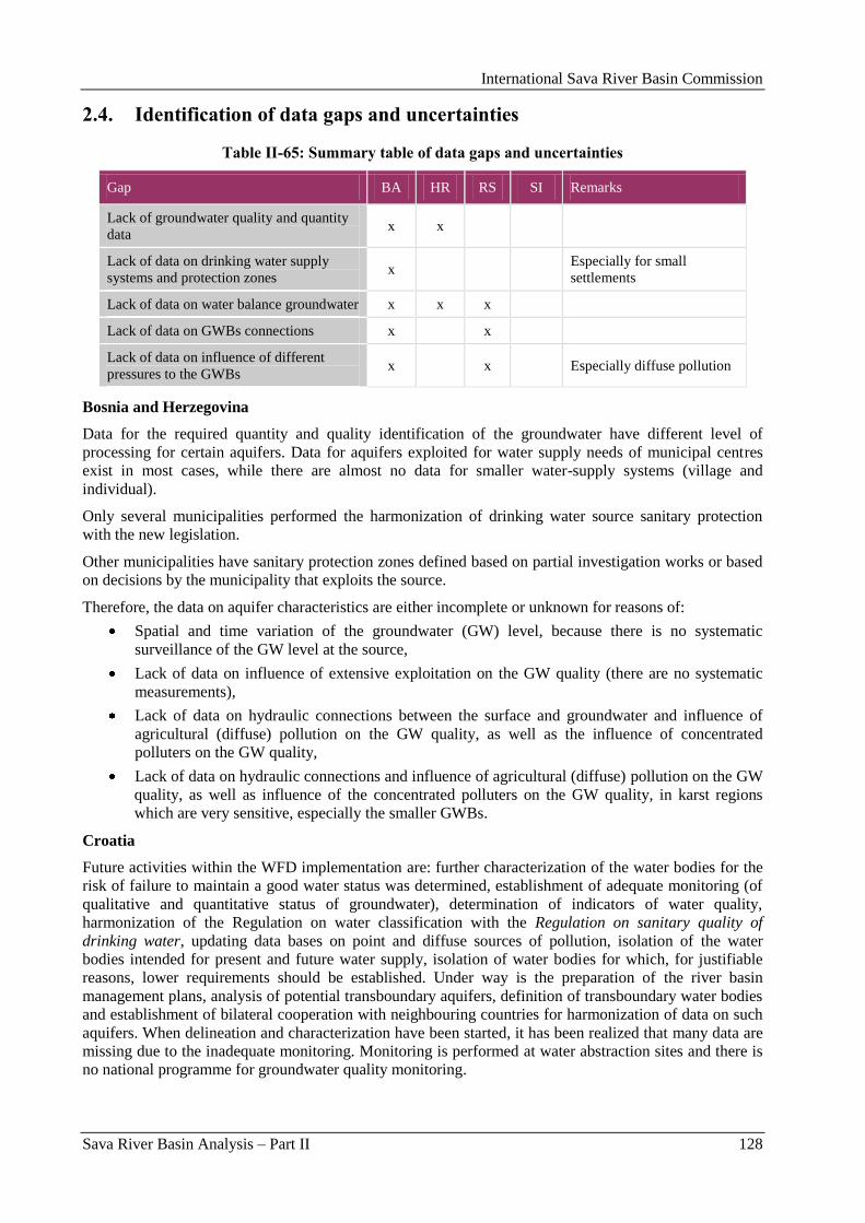
International Sava River Basin Commission
Sava River Basin Analysis – Part II 128
2.4. Identification of data gaps and uncertainties
Table II-65: Summary table of data gaps and uncertainties
Gap BA HR RS SI Remarks
Lack of groundwater quality and quantity
data x x
Lack of data on drinking water supply
systems and protection zones x
Especially for small
settlements
Lack of data on water balance groundwater x x x
Lack of data on GWBs connections x x
Lack of data on influence of different
pressures to the GWBs x x Especially diffuse pollution
Bosnia and Herzegovina
Data for the required quantity and quality identification of the groundwater have different level of
processing for certain aquifers. Data for aquifers exploited for water supply needs of municipal centres
exist in most cases, while there are almost no data for smaller water-supply systems (village and
individual).
Only several municipalities performed the harmonization of drinking water source sanitary protection
with the new legislation.
Other municipalities have sanitary protection zones defined based on partial investigation works or based
on decisions by the municipality that exploits the source.
Therefore, the data on aquifer characteristics are either incomplete or unknown for reasons of:
Spatial and time variation of the groundwater (GW) level, because there is no systematic
surveillance of the GW level at the source,
Lack of data on influence of extensive exploitation on the GW quality (there are no systematic
measurements),
Lack of data on hydraulic connections between the surface and groundwater and influence of
agricultural (diffuse) pollution on the GW quality, as well as the influence of concentrated
polluters on the GW quality,
Lack of data on hydraulic connections and influence of agricultural (diffuse) pollution on the GW
quality, as well as influence of the concentrated polluters on the GW quality, in karst regions
which are very sensitive, especially the smaller GWBs.
Croatia
Future activities within the WFD implementation are: further characterization of the water bodies for the
risk of failure to maintain a good water status was determined, establishment of adequate monitoring (of
qualitative and quantitative status of groundwater), determination of indicators of water quality,
harmonization of the Regulation on water classification with the Regulation on sanitary quality of
drinking water, updating data bases on point and diffuse sources of pollution, isolation of the water
bodies intended for present and future water supply, isolation of water bodies for which, for justifiable
reasons, lower requirements should be established. Under way is the preparation of the river basin
management plans, analysis of potential transboundary aquifers, definition of transboundary water bodies
and establishment of bilateral cooperation with neighbouring countries for harmonization of data on such
aquifers. When delineation and characterization have been started, it has been realized that many data are
missing due to the inadequate monitoring. Monitoring is performed at water abstraction sites and there is
no national programme for groundwater quality monitoring.
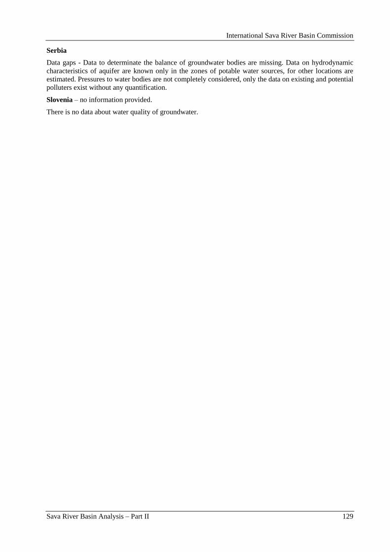
International Sava River Basin Commission
Sava River Basin Analysis – Part II 129
Serbia
Data gaps - Data to determinate the balance of groundwater bodies are missing. Data on hydrodynamic
characteristics of aquifer are known only in the zones of potable water sources, for other locations are
estimated. Pressures to water bodies are not completely considered, only the data on existing and potential
polluters exist without any quantification.
Slovenia – no information provided.
There is no data about water quality of groundwater.

International Sava River Basin Commission
Sava River Basin Analysis – Part II 130
International Sava River Basin Commission
Sava River Basin Analysis – Part III 131
Part III: Water Quantity
International Sava River Basin Commission
Sava River Basin Analysis – Part III 132
International Sava River Basin Commission
Sava River Basin Analysis – Part III 133
1. Elements of water balance in the Sava River Basin5
1.1. Climate
1.1.1. General types of the climate in the Basin
The climate in the Sava River Basin is not uniform, actually it considerably changes over the basin. Its
variations are the result of land and sea distribution and closeness, as well as of various orographic
features. As it is mentioned in Part I of this report the climatic conditions in the basin can roughly be
classified into three general types:
Alpine climate;
Moderate continental climate;
Moderate continental (mid-European) climate.
Three main elements of the climate that significantly affect the water availability and present grounds for
development, use and conservation of this resource are air temperature, precipitation and
evapotranspiration.
1.1.2. Air temperatures
With regard to air temperatures, it can be roughly assessed that the within-the-year variations exhibit a
common pattern for majority of the catchments. Winter temperatures (December to February) are low,
while high temperatures occur during the summer season (June – September).
Average annual air temperature for the whole Sava Basin was estimated to about 9.5 oC. Mean monthly
temperature in January falls to about -1.5 oC, whilst in July it reaches almost 20
oC. These figures
decrease as the altitude grows higher. In earlier studies it was asserted that the average annual
temperatures drop about 5 oC at each 1,000 m of elevation increase. This temperature gradient is
somewhat larger for July (6 oC) and considerably less for January (about 3
oC).
Average annual temperatures in the region vary in a wide boundaries depending, in the first place, on
elevation. The lowest long-term annual average temperatures at measured points take place on the
mountain ridges that divide the Sava River and the Adriatic Sea watersheds. According to available
documentation the lowest estimated value is 4.7 oC at Ţabljak (ME).
Warmest weather appears at lowlands along the Sava River where this parameter rises to about 10.0 –
12.0 oC (Belgrade, Zagreb, Slavonski Brod). Illustration of the temperature regime in the considered
region is provided in Table III-1, based on the estimates originating from various documentation.
5 Detailed Hydrology report for the Sava RB Analysis with appended tables, figures and maps forms a background
document of this Report.
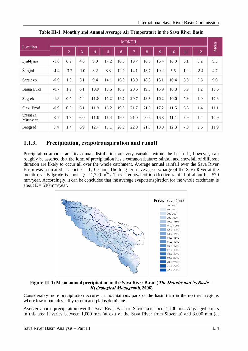
International Sava River Basin Commission
Sava River Basin Analysis – Part III 134
Table III-1: Monthly and Annual Average Air Temperature in the Sava River Basin
Location
MONTH
Mea
n
1 2 3 4 5 6 7 8 9 10 11 12
Ljubljana -1.8 0.2 4.8 9.9 14.2 18.0 19.7 18.8 15.4 10.0 5.1 0.2 9.5
Ţabljak -4.4 -3.7 -1.0 3.2 8.3 12.0 14.1 13.7 10.2 5.5 1.2 -2.4 4.7
Sarajevo -0.9 1.5 5.1 9.4 14.1 16.9 18.9 18.5 15.1 10.4 5.3 0.3 9.6
Banja Luka -0.7 1.9 6.1 10.9 15.6 18.9 20.6 19.7 15.9 10.8 5.9 1.2 10.6
Zagreb -1.3 0.5 5.4 11.0 15.2 18.6 20.7 19.9 16.2 10.6 5.9 1.0 10.3
Slav. Brod -0.9 0.9 6.1 11.9 16.2 19.8 21.7 21.0 17.2 11.5 6.6 1.4 11.1
Sremska
Mitrovica -0.7 1.3 6.0 11.6 16.4 19.5 21.0 20.4 16.8 11.1 5.9 1.4 10.9
Beograd 0.4 1.4 6.9 12.4 17.1 20.2 22.0 21.7 18.0 12.3 7.0 2.6 11.9
1.1.3. Precipitation, evapotranspiration and runoff
Precipitation amount and its annual distribution are very variable within the basin. It, however, can
roughly be asserted that the form of precipitation has a common feature: rainfall and snowfall of different
duration are likely to occur all over the whole catchment. Average annual rainfall over the Sava River
Basin was estimated at about P = 1,100 mm. The long-term average discharge of the Sava River at the
mouth near Belgrade is about Q = 1,700 m3/s. This is equivalent to effective rainfall of about h = 570
mm/year. Accordingly, it can be concluded that the average evapotranspiration for the whole catchment is
about E = 530 mm/year.
Figure III-1: Mean annual precipitation in the Sava River Basin (The Danube and its Basin – Hydrological Monograph, 2006)
Considerably more precipitation occures in mountainous parts of the basin than in the northern regions
where low mountains, hilly terrain and plains dominate.
Average annual precipitation over the Sava River Basin in Slovenia is about 1,100 mm. At gauged points
in this area it varies between 1,000 mm (at exit of the Sava River from Slovenia) and 3,000 mm (at
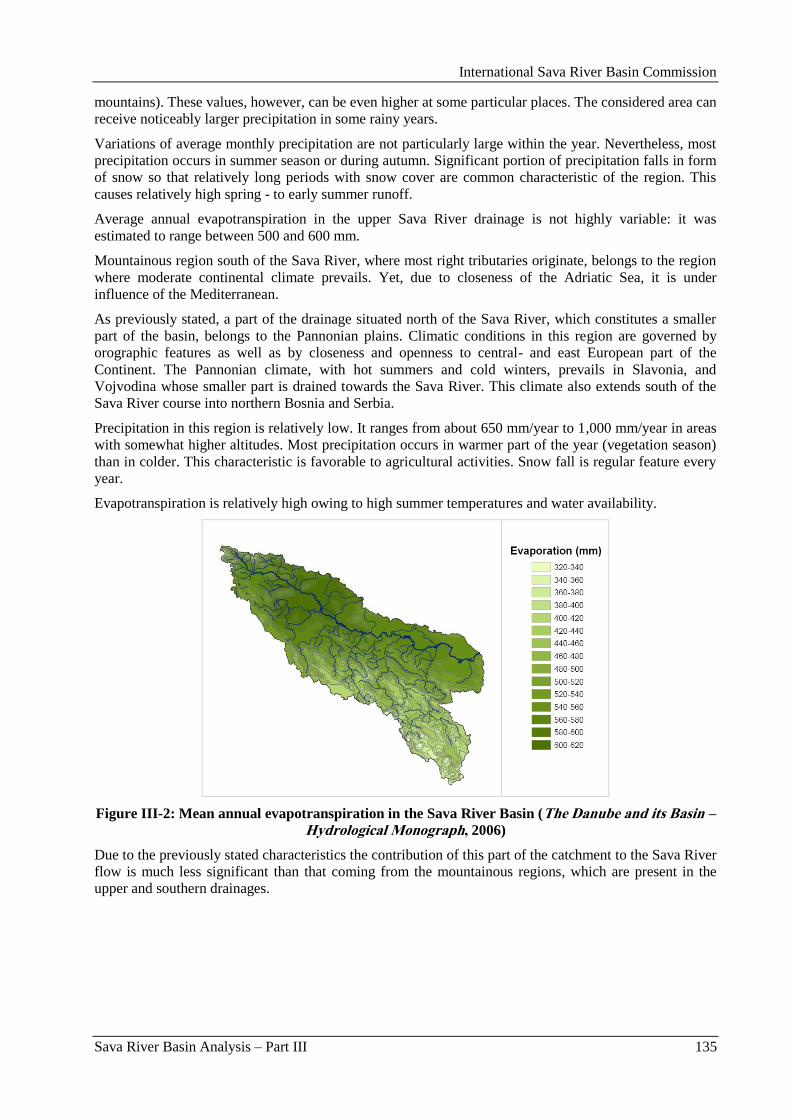
International Sava River Basin Commission
Sava River Basin Analysis – Part III 135
mountains). These values, however, can be even higher at some particular places. The considered area can
receive noticeably larger precipitation in some rainy years.
Variations of average monthly precipitation are not particularly large within the year. Nevertheless, most
precipitation occurs in summer season or during autumn. Significant portion of precipitation falls in form
of snow so that relatively long periods with snow cover are common characteristic of the region. This
causes relatively high spring - to early summer runoff.
Average annual evapotranspiration in the upper Sava River drainage is not highly variable: it was
estimated to range between 500 and 600 mm.
Mountainous region south of the Sava River, where most right tributaries originate, belongs to the region
where moderate continental climate prevails. Yet, due to closeness of the Adriatic Sea, it is under
influence of the Mediterranean.
As previously stated, a part of the drainage situated north of the Sava River, which constitutes a smaller
part of the basin, belongs to the Pannonian plains. Climatic conditions in this region are governed by
orographic features as well as by closeness and openness to central- and east European part of the
Continent. The Pannonian climate, with hot summers and cold winters, prevails in Slavonia, and
Vojvodina whose smaller part is drained towards the Sava River. This climate also extends south of the
Sava River course into northern Bosnia and Serbia.
Precipitation in this region is relatively low. It ranges from about 650 mm/year to 1,000 mm/year in areas
with somewhat higher altitudes. Most precipitation occurs in warmer part of the year (vegetation season)
than in colder. This characteristic is favorable to agricultural activities. Snow fall is regular feature every
year.
Evapotranspiration is relatively high owing to high summer temperatures and water availability.
Figure III-2: Mean annual evapotranspiration in the Sava River Basin (The Danube and its Basin – Hydrological Monograph, 2006)
Due to the previously stated characteristics the contribution of this part of the catchment to the Sava River
flow is much less significant than that coming from the mountainous regions, which are present in the
upper and southern drainages.
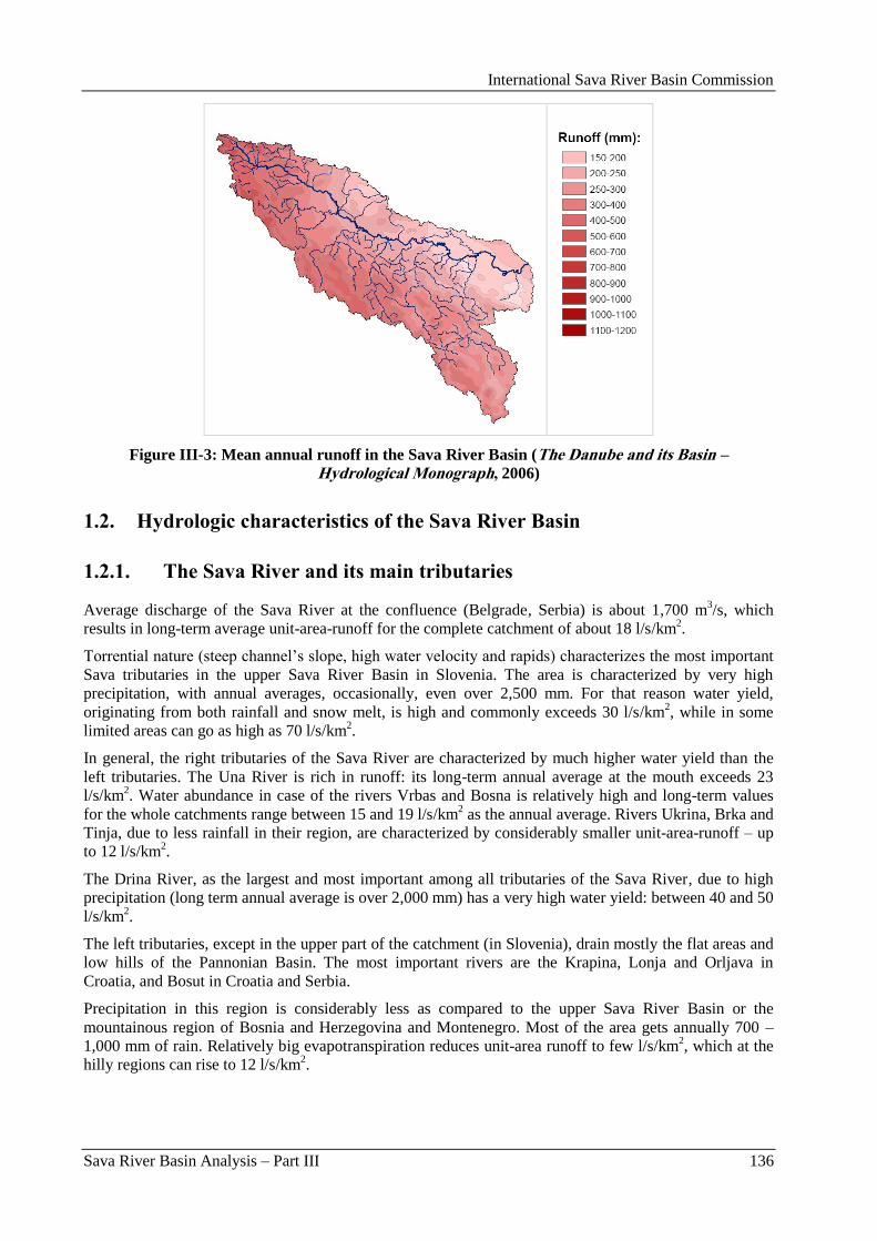
International Sava River Basin Commission
Sava River Basin Analysis – Part III 136
Figure III-3: Mean annual runoff in the Sava River Basin (The Danube and its Basin – Hydrological Monograph, 2006)
1.2. Hydrologic characteristics of the Sava River Basin
1.2.1. The Sava River and its main tributaries
Average discharge of the Sava River at the confluence (Belgrade, Serbia) is about 1,700 m3/s, which
results in long-term average unit-area-runoff for the complete catchment of about 18 l/s/km2.
Torrential nature (steep channel‟s slope, high water velocity and rapids) characterizes the most important
Sava tributaries in the upper Sava River Basin in Slovenia. The area is characterized by very high
precipitation, with annual averages, occasionally, even over 2,500 mm. For that reason water yield,
originating from both rainfall and snow melt, is high and commonly exceeds 30 l/s/km2, while in some
limited areas can go as high as 70 l/s/km2.
In general, the right tributaries of the Sava River are characterized by much higher water yield than the
left tributaries. The Una River is rich in runoff: its long-term annual average at the mouth exceeds 23
l/s/km2. Water abundance in case of the rivers Vrbas and Bosna is relatively high and long-term values
for the whole catchments range between 15 and 19 l/s/km2 as the annual average. Rivers Ukrina, Brka and
Tinja, due to less rainfall in their region, are characterized by considerably smaller unit-area-runoff – up
to 12 l/s/km2.
The Drina River, as the largest and most important among all tributaries of the Sava River, due to high
precipitation (long term annual average is over 2,000 mm) has a very high water yield: between 40 and 50
l/s/km2.
The left tributaries, except in the upper part of the catchment (in Slovenia), drain mostly the flat areas and
low hills of the Pannonian Basin. The most important rivers are the Krapina, Lonja and Orljava in
Croatia, and Bosut in Croatia and Serbia.
Precipitation in this region is considerably less as compared to the upper Sava River Basin or the
mountainous region of Bosnia and Herzegovina and Montenegro. Most of the area gets annually 700 –
1,000 mm of rain. Relatively big evapotranspiration reduces unit-area runoff to few l/s/km2, which at the
hilly regions can rise to 12 l/s/km2.
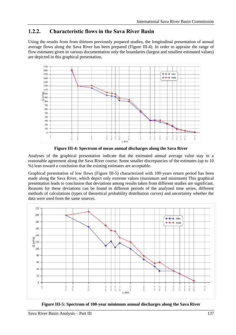
International Sava River Basin Commission
Sava River Basin Analysis – Part III 137
1.2.2. Characteristic flows in the Sava River Basin
Using the results from from thirteen previously prepared studies, the longitudinal presentation of annual
average flows along the Sava River has been prepared (Figure III-4). In order to appraise the range of
flow estimates given in various documentation only the boundaries (largest and smallest estimated values)
are depicted in this graphical presentation.
Figure III-4: Spectrum of mean annual discharges along the Sava River
Analyses of the graphical presentation indicate that the estimated annual average value stay in a
reasonable agreement along the Sava River course. Some smaller discrepancies of the estimates (up to 10
%) lean toward a conclusion that the existing estimates are acceptable.
Graphical presentation of low flows (Figure III-5) characterized with 100-years return period has been
made along the Sava River, which depict only extreme values (maximum and minimum) This graphical
presentation leads to conclusion that deviations among results taken from different studies are significant.
Reasons for these deviations can be found in different periods of the analyzed time series, different
methods of calculations (types of theoretical probability distribution curves) and uncertainty whether the
data were used from the same sources.
Figure III-5: Spectrum of 100-year minimum annual discharges along the Sava River

International Sava River Basin Commission
Sava River Basin Analysis – Part III 138
Based on the values of maximum annual discharge, derived from the hydrology studies analyzed in the
Hydrology report, a graphical illustration of the range (maximum and minimum values determined in
various studies) has been prepared along the Sava River (Figure III-6). This presentation gives an insight
into differences of the calculated results in the reviewed studies related to the Sava River Basin. This
graphical presentation implies that discrepancies of the results can be significant due to the reasons
described in the section concerning low flows.
Figure III-6: Spectrum of 100-year maximum annual discharges along the Sava River
1.3. Water balance in the Sava River Basin
Hydrologic balance is very heterogeneous over the catchments of the Sava River Basin.
Hydrologic balance, i.e. input and output of water over a given area, depends primarily on climatic
conditions and physical features of the catchments where the process takes place. Relation among
elements of the balance (precipitation, river runoff and evapotranspiration) for given geographical
conditions is stable on a long run. This relation defines water availability within the considered area.
Maps compiled in the hydrology report demonstrate elements of hydrological balance from the oldest
reviewed study (Hydrological Study of the Sava River Catchment, Belgrade, 1969) and the most recent
study (The Danube and its Basin – Hydrological Monograph, Follow-up Volume VIII, Basin-Wide Water
Balance in the Danube River Basin, Regional Cooperation of the Danube Countries in the Frame of the
International Hydrological Programme of UNESCO and Water Research Institute Bratislava, Slovakia,
2006).
Comparative analysis of the maps from the two studies presenting the isolines, in other words, elemental
spread of the catchment, which are correspondent to precipitation diapason and discharge from two
analyzed hydrological studies, have shown that there are significant differences in the size of the selected
catchments and space distribution. There are numerous reasons for this, such as analysis period, input
data volume, number of used stations, analysis methodologies applied and accuracy of the basic data from
earlier and recent period. It is obvious that a new hydrological study for the Sava River Basin, which
should address all these problems, is an imperative.
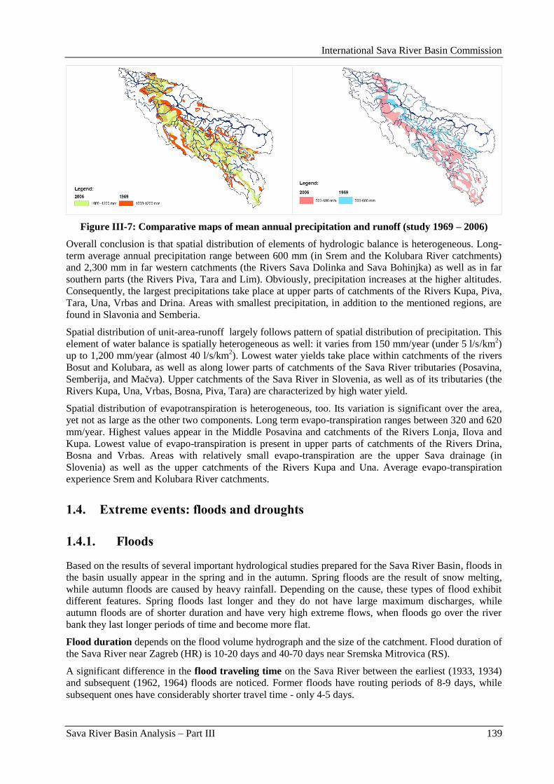
International Sava River Basin Commission
Sava River Basin Analysis – Part III 139
Figure III-7: Comparative maps of mean annual precipitation and runoff (study 1969 – 2006)
Overall conclusion is that spatial distribution of elements of hydrologic balance is heterogeneous. Long-
term average annual precipitation range between 600 mm (in Srem and the Kolubara River catchments)
and 2,300 mm in far western catchments (the Rivers Sava Dolinka and Sava Bohinjka) as well as in far
southern parts (the Rivers Piva, Tara and Lim). Obviously, precipitation increases at the higher altitudes.
Consequently, the largest precipitations take place at upper parts of catchments of the Rivers Kupa, Piva,
Tara, Una, Vrbas and Drina. Areas with smallest precipitation, in addition to the mentioned regions, are
found in Slavonia and Semberia.
Spatial distribution of unit-area-runoff largely follows pattern of spatial distribution of precipitation. This
element of water balance is spatially heterogeneous as well: it varies from 150 mm/year (under 5 l/s/km2)
up to 1,200 mm/year (almost 40 l/s/km2). Lowest water yields take place within catchments of the rivers
Bosut and Kolubara, as well as along lower parts of catchments of the Sava River tributaries (Posavina,
Semberija, and Maĉva). Upper catchments of the Sava River in Slovenia, as well as of its tributaries (the
Rivers Kupa, Una, Vrbas, Bosna, Piva, Tara) are characterized by high water yield.
Spatial distribution of evapotranspiration is heterogeneous, too. Its variation is significant over the area,
yet not as large as the other two components. Long term evapo-transpiration ranges between 320 and 620
mm/year. Highest values appear in the Middle Posavina and catchments of the Rivers Lonja, Ilova and
Kupa. Lowest value of evapo-transpiration is present in upper parts of catchments of the Rivers Drina,
Bosna and Vrbas. Areas with relatively small evapo-transpiration are the upper Sava drainage (in
Slovenia) as well as the upper catchments of the Rivers Kupa and Una. Average evapo-transpiration
experience Srem and Kolubara River catchments.
1.4. Extreme events: floods and droughts
1.4.1. Floods
Based on the results of several important hydrological studies prepared for the Sava River Basin, floods in
the basin usually appear in the spring and in the autumn. Spring floods are the result of snow melting,
while autumn floods are caused by heavy rainfall. Depending on the cause, these types of flood exhibit
different features. Spring floods last longer and they do not have large maximum discharges, while
autumn floods are of shorter duration and have very high extreme flows, when floods go over the river
bank they last longer periods of time and become more flat.
Flood duration depends on the flood volume hydrograph and the size of the catchment. Flood duration of
the Sava River near Zagreb (HR) is 10-20 days and 40-70 days near Sremska Mitrovica (RS).
A significant difference in the flood traveling time on the Sava River between the earliest (1933, 1934)
and subsequent (1962, 1964) floods are noticed. Former floods have routing periods of 8-9 days, while
subsequent ones have considerably shorter travel time - only 4-5 days.
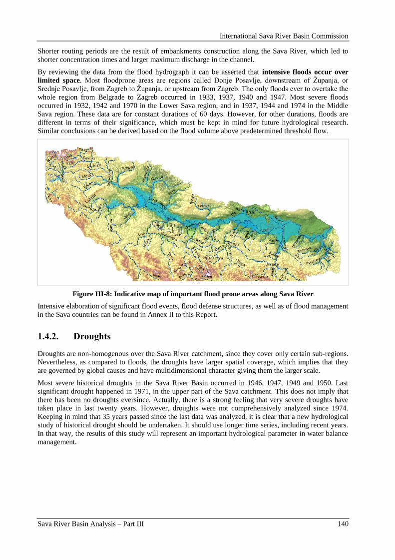
International Sava River Basin Commission
Sava River Basin Analysis – Part III 140
Shorter routing periods are the result of embankments construction along the Sava River, which led to
shorter concentration times and larger maximum discharge in the channel.
By reviewing the data from the flood hydrograph it can be asserted that intensive floods occur over
limited space. Most floodprone areas are regions called Donje Posavlje, downstream of Ţupanja, or
Srednje Posavlje, from Zagreb to Ţupanja, or upstream from Zagreb. The only floods ever to overtake the
whole region from Belgrade to Zagreb occurred in 1933, 1937, 1940 and 1947. Most severe floods
occurred in 1932, 1942 and 1970 in the Lower Sava region, and in 1937, 1944 and 1974 in the Middle
Sava region. These data are for constant durations of 60 days. However, for other durations, floods are
different in terms of their significance, which must be kept in mind for future hydrological research.
Similar conclusions can be derived based on the flood volume above predetermined threshold flow.
Figure III-8: Indicative map of important flood prone areas along Sava River
Intensive elaboration of significant flood events, flood defense structures, as well as of flood management
in the Sava countries can be found in Annex II to this Report.
1.4.2. Droughts
Droughts are non-homogenous over the Sava River catchment, since they cover only certain sub-regions.
Nevertheless, as compared to floods, the droughts have larger spatial coverage, which implies that they
are governed by global causes and have multidimensional character giving them the larger scale.
Most severe historical droughts in the Sava River Basin occurred in 1946, 1947, 1949 and 1950. Last
significant drought happened in 1971, in the upper part of the Sava catchment. This does not imply that
there has been no droughts eversince. Actually, there is a strong feeling that very severe droughts have
taken place in last twenty years. However, droughts were not comprehensively analyzed since 1974.
Keeping in mind that 35 years passed since the last data was analyzed, it is clear that a new hydrological
study of historical drought should be undertaken. It should use longer time series, including recent years.
In that way, the results of this study will represent an important hydrological parameter in water balance
management.
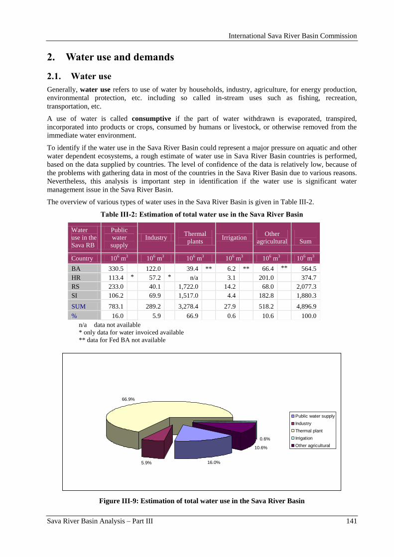
International Sava River Basin Commission
Sava River Basin Analysis – Part III 141
2. Water use and demands
2.1. Water use
Generally, water use refers to use of water by households, industry, agriculture, for energy production,
environmental protection, etc. including so called in-stream uses such as fishing, recreation,
transportation, etc.
A use of water is called consumptive if the part of water withdrawn is evaporated, transpired,
incorporated into products or crops, consumed by humans or livestock, or otherwise removed from the
immediate water environment.
To identify if the water use in the Sava River Basin could represent a major pressure on aquatic and other
water dependent ecosystems, a rough estimate of water use in Sava River Basin countries is performed,
based on the data supplied by countries. The level of confidence of the data is relatively low, because of
the problems with gathering data in most of the countries in the Sava River Basin due to various reasons.
Nevertheless, this analysis is important step in identification if the water use is significant water
management issue in the Sava River Basin.
The overview of various types of water uses in the Sava River Basin is given in Table III-2.
Table III-2: Estimation of total water use in the Sava River Basin
Water
use in the
Sava RB
Public
water
supply
Industry Thermal
plants Irrigation
Other
agricultural
Sum
Country 106 m
3 10
6 m
3 10
6 m
3 10
6 m
3 10
6 m
3 10
6 m
3
BA 330.5 122.0 39.4 ** 6.2 ** 66.4 ** 564.5
HR 113.4 * 57.2 * n/a 3.1 201.0 374.7
RS 233.0 40.1 1,722.0 14.2 68.0 2,077.3
SI 106.2 69.9 1,517.0 4.4 182.8 1,880.3
SUM 783.1 289.2 3,278.4 27.9 518.2 4,896.9
% 16.0 5.9 66.9 0.6 10.6 100.0
n/a data not available
* only data for water invoiced available
** data for Fed BA not available
16.0%5.9%
66.9%
0.6%
10.6%
Public water supply
Industry
Thermal plant
Irrigation
Other agricultural
Figure III-9: Estimation of total water use in the Sava River Basin
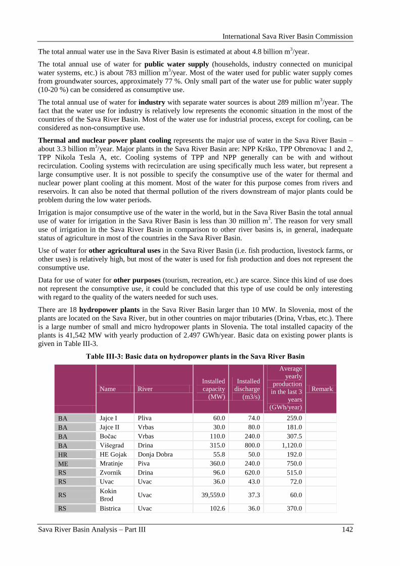
International Sava River Basin Commission
Sava River Basin Analysis – Part III 142
The total annual water use in the Sava River Basin is estimated at about 4.8 billion m3/year.
The total annual use of water for public water supply (households, industry connected on municipal
water systems, etc.) is about 783 million m3/year. Most of the water used for public water supply comes
from groundwater sources, approximately 77 %. Only small part of the water use for public water supply
(10-20 %) can be considered as consumptive use.
The total annual use of water for industry with separate water sources is about 289 million m3/year. The
fact that the water use for industry is relatively low represents the economic situation in the most of the
countries of the Sava River Basin. Most of the water use for industrial process, except for cooling, can be
considered as non-consumptive use.
Thermal and nuclear power plant cooling represents the major use of water in the Sava River Basin –
about 3.3 billion m3/year. Major plants in the Sava River Basin are: NPP Krško, TPP Obrenovac 1 and 2,
TPP Nikola Tesla A, etc. Cooling systems of TPP and NPP generally can be with and without
recirculation. Cooling systems with recirculation are using specifically much less water, but represent a
large consumptive user. It is not possible to specify the consumptive use of the water for thermal and
nuclear power plant cooling at this moment. Most of the water for this purpose comes from rivers and
reservoirs. It can also be noted that thermal pollution of the rivers downstream of major plants could be
problem during the low water periods.
Irrigation is major consumptive use of the water in the world, but in the Sava River Basin the total annual
use of water for irrigation in the Sava River Basin is less than 30 million m3. The reason for very small
use of irrigation in the Sava River Basin in comparison to other river basins is, in general, inadequate
status of agriculture in most of the countries in the Sava River Basin.
Use of water for other agricultural uses in the Sava River Basin (i.e. fish production, livestock farms, or
other uses) is relatively high, but most of the water is used for fish production and does not represent the
consumptive use.
Data for use of water for other purposes (tourism, recreation, etc.) are scarce. Since this kind of use does
not represent the consumptive use, it could be concluded that this type of use could be only interesting
with regard to the quality of the waters needed for such uses.
There are 18 hydropower plants in the Sava River Basin larger than 10 MW. In Slovenia, most of the
plants are located on the Sava River, but in other countries on major tributaries (Drina, Vrbas, etc.). There
is a large number of small and micro hydropower plants in Slovenia. The total installed capacity of the
plants is 41,542 MW with yearly production of 2.497 GWh/year. Basic data on existing power plants is
given in Table III-3.
Table III-3: Basic data on hydropower plants in the Sava River Basin
Name River
Installed
capacity
(MW)
Installed
discharge
(m3/s)
Average
yearly
production
in the last 3
years
(GWh/year)
Remark
BA Jajce I Pliva 60.0 74.0 259.0
BA Jajce II Vrbas 30.0 80.0 181.0
BA Boĉac Vrbas 110.0 240.0 307.5
BA Višegrad Drina 315.0 800.0 1,120.0
HR HE Gojak Donja Dobra 55.8 50.0 192.0
ME Mratinje Piva 360.0 240.0 750.0
RS Zvornik Drina 96.0 620.0 515.0
RS Uvac Uvac 36.0 43.0 72.0
RS Kokin
Brod Uvac 39,559.0 37.3 60.0
RS Bistrica Uvac 102.6 36.0 370.0
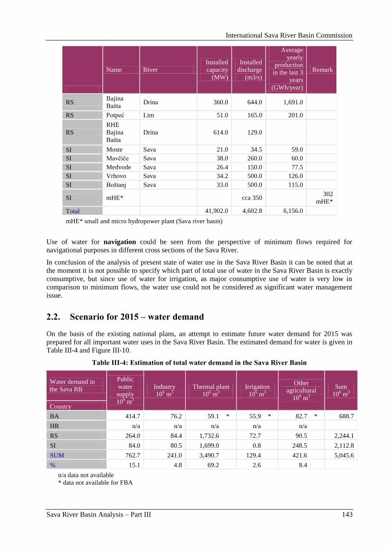
International Sava River Basin Commission
Sava River Basin Analysis – Part III 143
Name River
Installed
capacity
(MW)
Installed
discharge
(m3/s)
Average
yearly
production
in the last 3
years
(GWh/year)
Remark
RS Bajina
Bašta Drina 360.0 644.0 1,691.0
RS Potpeć Lim 51.0 165.0 201.0
RS
RHE
Bajina
Bašta
Drina 614.0 129.0
SI Moste Sava 21.0 34.5 59.0
SI Mavĉiĉe Sava 38.0 260.0 60.0
SI Medvode Sava 26.4 150.0 77.5
SI Vrhovo Sava 34.2 500.0 126.0
SI Boštanj Sava 33.0 500.0 115.0
SI mHE* cca 350 302
mHE*
Total 41,902.0 4,602.8 6,156.0
mHE* small and micro hydropower plant (Sava river basin)
Use of water for navigation could be seen from the perspective of minimum flows required for
navigational purposes in different cross sections of the Sava River.
In conclusion of the analysis of present state of water use in the Sava River Basin it can be noted that at
the moment it is not possible to specify which part of total use of water in the Sava River Basin is exactly
consumptive, but since use of water for irrigation, as major consumptive use of water is very low in
comparison to minimum flows, the water use could not be considered as significant water management
issue.
2.2. Scenario for 2015 – water demand
On the basis of the existing national plans, an attempt to estimate future water demand for 2015 was
prepared for all important water uses in the Sava River Basin. The estimated demand for water is given in
Table III-4 and Figure III-10.
Table III-4: Estimation of total water demand in the Sava River Basin
Water demand in
the Sava RB
Public
water
supply
106 m
3
Industry
106 m
3
Thermal plant
106 m
3
Irrigation
106 m
3
Other
agricultural
106 m
3
Sum
106 m
3
Country
BA 414.7 76.2 59.1 * 55.9 * 82.7 * 688.7
HR n/a n/a n/a n/a n/a
RS 264.0 84.4 1,732.6 72.7 90.5 2,244.1
SI 84.0 80.5 1,699.0 0.8 248.5 2,112.8
SUM 762.7 241.0 3,490.7 129.4 421.6 5,045.6
% 15.1 4.8 69.2 2.6 8.4
n/a data not available
* data not available for FBA
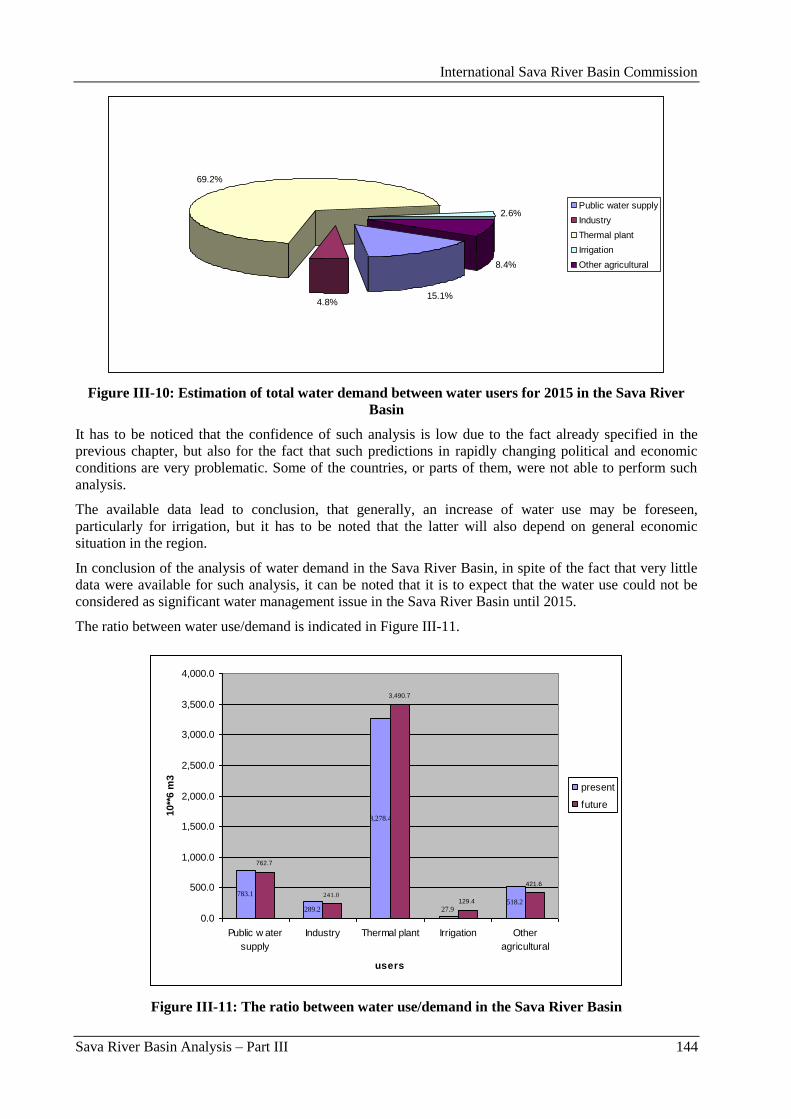
International Sava River Basin Commission
Sava River Basin Analysis – Part III 144
15.1%4.8%
69.2%
2.6%
8.4%
Public water supply
Industry
Thermal plant
Irrigation
Other agricultural
Figure III-10: Estimation of total water demand between water users for 2015 in the Sava River
Basin
It has to be noticed that the confidence of such analysis is low due to the fact already specified in the
previous chapter, but also for the fact that such predictions in rapidly changing political and economic
conditions are very problematic. Some of the countries, or parts of them, were not able to perform such
analysis.
The available data lead to conclusion, that generally, an increase of water use may be foreseen,
particularly for irrigation, but it has to be noted that the latter will also depend on general economic
situation in the region.
In conclusion of the analysis of water demand in the Sava River Basin, in spite of the fact that very little
data were available for such analysis, it can be noted that it is to expect that the water use could not be
considered as significant water management issue in the Sava River Basin until 2015.
The ratio between water use/demand is indicated in Figure III-11.
783.1
289.2
3,278.4
27.9518.2
762.7
3,490.7
129.4
421.6
241.0
0.0
500.0
1,000.0
1,500.0
2,000.0
2,500.0
3,000.0
3,500.0
4,000.0
Public w ater
supply
Industry Thermal plant Irrigation Other
agricultural
users
10**
6 m
3
present
future
Figure III-11: The ratio between water use/demand in the Sava River Basin
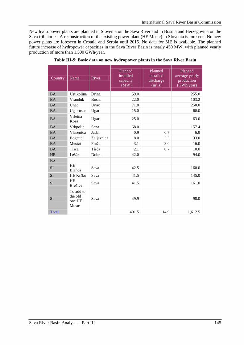
International Sava River Basin Commission
Sava River Basin Analysis – Part III 145
New hydropower plants are planned in Slovenia on the Sava River and in Bosnia and Herzegovina on the
Sava tributaries. A reconstruction of the existing power plant (HE Moste) in Slovenia is foreseen. No new
power plans are foreseen in Croatia and Serbia until 2015. No data for ME is available. The planned
future increase of hydropower capacities in the Sava River Basin is nearly 450 MW, with planned yearly
production of more than 1,500 GWh/year.
Table III-5: Basic data on new hydropower plants in the Sava River Basin
Country Name River
Planned
installed
capacity
(MW)
Planned
installed
discharge
(m3/s)
Planned
average yearly
production
(GWh/year)
BA Ustikolina Drina 59.0 255.0
BA Vranduk Bosna 22.0 103.2
BA Unac Unac 71.0 250.0
BA Ugar usce Ugar 15.0 60.0
BA Vrletna
Kosa Ugar 25.0 63.0
BA Vrhpolje Sana 68.0 157.4
BA Vlasenica Jadar 0.9 0.7 6.9
BA Bogatić Ţeljeznica 8.0 5.5 33.0
BA Mesići Praĉa 3.1 8.0 16.0
BA Tišća Tišća 2.1 0.7 10.0
HR Lešće Dobra 42.0 94.0
RS
SI HE
Blanca Sava 42.5 160.0
SI HE Krško Sava 41.5 145.0
SI HE
Breţice Sava 41.5 161.0
SI
To add to
the old
one HE
Moste
Sava 49.9 98.0
Total 491.5 14.9 1,612.5
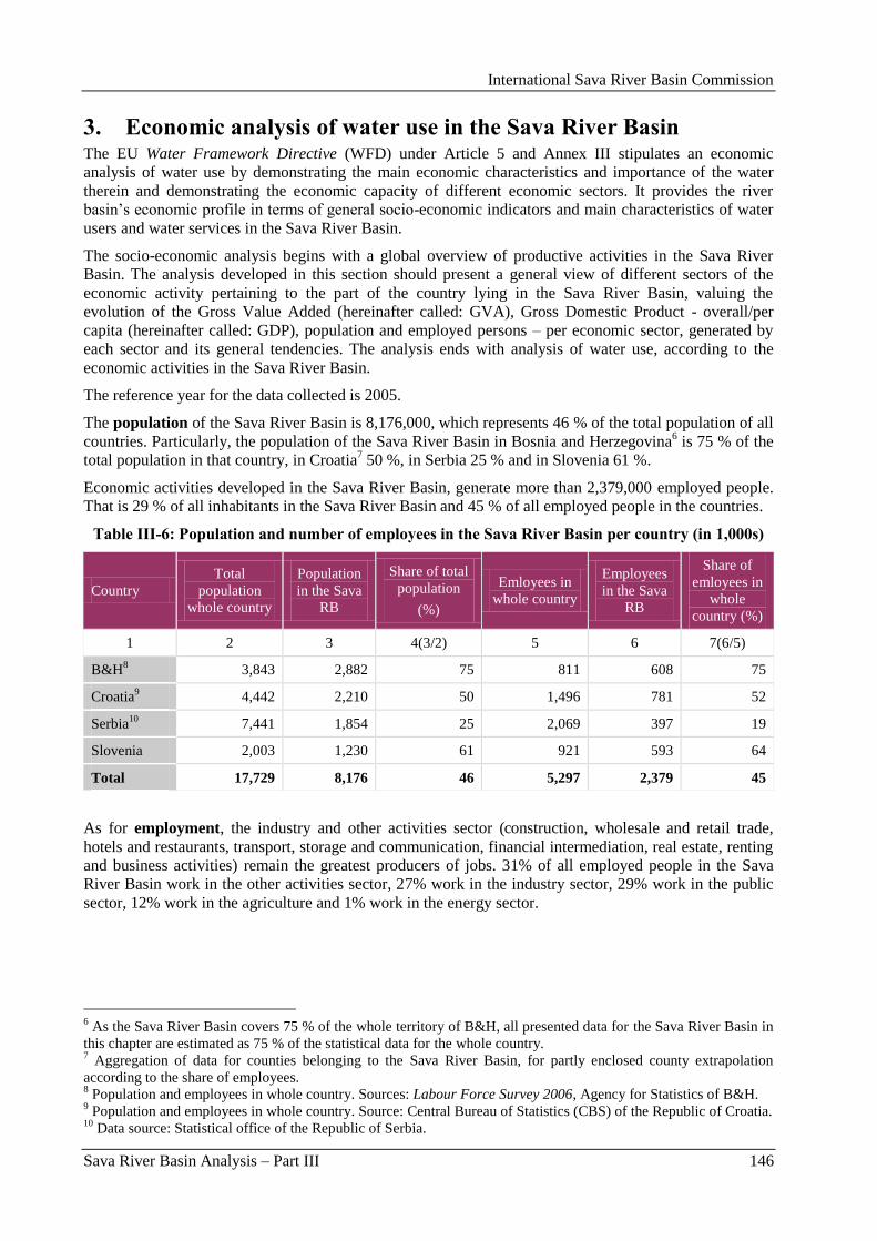
International Sava River Basin Commission
Sava River Basin Analysis – Part III 146
3. Economic analysis of water use in the Sava River Basin The EU Water Framework Directive (WFD) under Article 5 and Annex III stipulates an economic
analysis of water use by demonstrating the main economic characteristics and importance of the water
therein and demonstrating the economic capacity of different economic sectors. It provides the river
basin‟s economic profile in terms of general socio-economic indicators and main characteristics of water
users and water services in the Sava River Basin.
The socio-economic analysis begins with a global overview of productive activities in the Sava River
Basin. The analysis developed in this section should present a general view of different sectors of the
economic activity pertaining to the part of the country lying in the Sava River Basin, valuing the
evolution of the Gross Value Added (hereinafter called: GVA), Gross Domestic Product - overall/per
capita (hereinafter called: GDP), population and employed persons – per economic sector, generated by
each sector and its general tendencies. The analysis ends with analysis of water use, according to the
economic activities in the Sava River Basin.
The reference year for the data collected is 2005.
The population of the Sava River Basin is 8,176,000, which represents 46 % of the total population of all
countries. Particularly, the population of the Sava River Basin in Bosnia and Herzegovina6 is 75 % of the
total population in that country, in Croatia7 50 %, in Serbia 25 % and in Slovenia 61 %.
Economic activities developed in the Sava River Basin, generate more than 2,379,000 employed people.
That is 29 % of all inhabitants in the Sava River Basin and 45 % of all employed people in the countries.
Table III-6: Population and number of employees in the Sava River Basin per country (in 1,000s)
Country
Total
population
whole country
Population
in the Sava
RB
Share of total
population
(%)
Emloyees in
whole country
Employees
in the Sava
RB
Share of
emloyees in
whole
country (%)
1 2 3 4(3/2) 5 6 7(6/5)
B&H8 3,843 2,882 75 811 608 75
Croatia9 4,442 2,210 50 1,496 781 52
Serbia10
7,441 1,854 25 2,069 397 19
Slovenia 2,003 1,230 61 921 593 64
Total 17,729 8,176 46 5,297 2,379 45
As for employment, the industry and other activities sector (construction, wholesale and retail trade,
hotels and restaurants, transport, storage and communication, financial intermediation, real estate, renting
and business activities) remain the greatest producers of jobs. 31% of all employed people in the Sava
River Basin work in the other activities sector, 27% work in the industry sector, 29% work in the public
sector, 12% work in the agriculture and 1% work in the energy sector.
6 As the Sava River Basin covers 75 % of the whole territory of B&H, all presented data for the Sava River Basin in
this chapter are estimated as 75 % of the statistical data for the whole country. 7 Aggregation of data for counties belonging to the Sava River Basin, for partly enclosed county extrapolation
according to the share of employees. 8 Population and employees in whole country. Sources: Labour Force Survey 2006, Agency for Statistics of B&H.
9 Population and employees in whole country. Source: Central Bureau of Statistics (CBS) of the Republic of Croatia.
10 Data source: Statistical office of the Republic of Serbia.
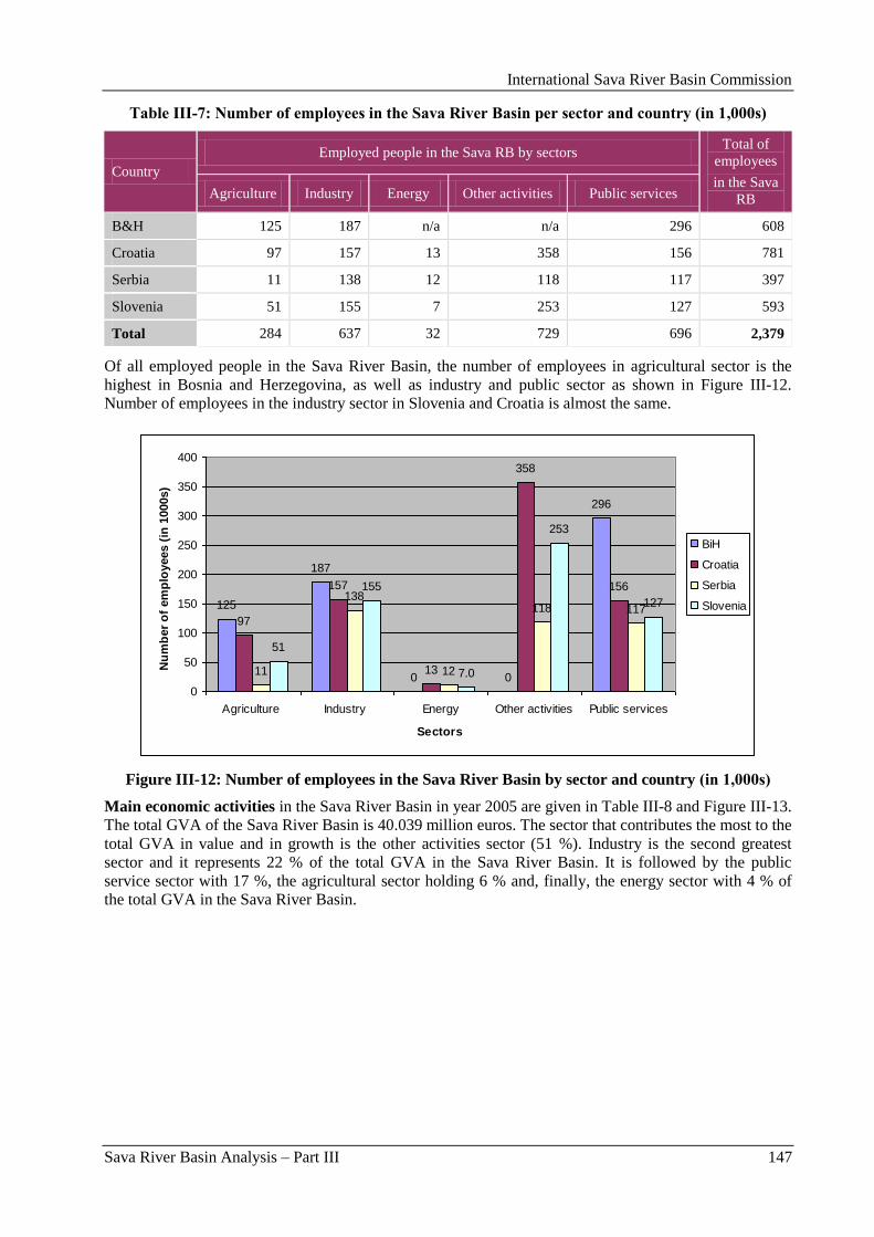
International Sava River Basin Commission
Sava River Basin Analysis – Part III 147
Table III-7: Number of employees in the Sava River Basin per sector and country (in 1,000s)
Country
Employed people in the Sava RB by sectors Total of
employees
in the Sava
RB Agriculture Industry Energy Other activities Public services
B&H 125 187 n/a n/a 296 608
Croatia 97 157 13 358 156 781
Serbia 11 138 12 118 117 397
Slovenia 51 155 7 253 127 593
Total 284 637 32 729 696 2,379
Of all employed people in the Sava River Basin, the number of employees in agricultural sector is the
highest in Bosnia and Herzegovina, as well as industry and public sector as shown in Figure III-12.
Number of employees in the industry sector in Slovenia and Croatia is almost the same.
125
187
0 0
296
97
157
13
358
156
11
138
12
118 117
51
155
7.0
253
127
0
50
100
150
200
250
300
350
400
Agriculture Industry Energy Other activities Public services
Sectors
Nu
mb
er
of
em
plo
yees (
in 1
000s)
BiH
Croatia
Serbia
Slovenia
Figure III-12: Number of employees in the Sava River Basin by sector and country (in 1,000s)
Main economic activities in the Sava River Basin in year 2005 are given in Table III-8 and Figure III-13.
The total GVA of the Sava River Basin is 40.039 million euros. The sector that contributes the most to the
total GVA in value and in growth is the other activities sector (51 %). Industry is the second greatest
sector and it represents 22 % of the total GVA in the Sava River Basin. It is followed by the public
service sector with 17 %, the agricultural sector holding 6 % and, finally, the energy sector with 4 % of
the total GVA in the Sava River Basin.
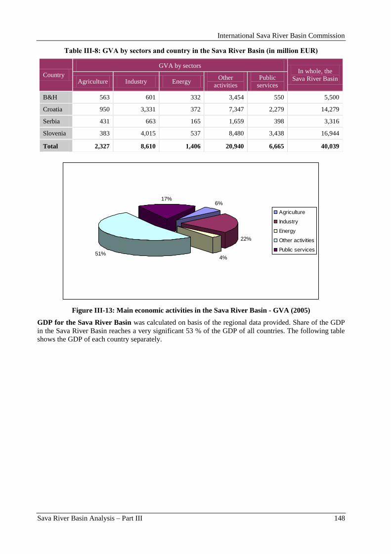
International Sava River Basin Commission
Sava River Basin Analysis – Part III 148
Table III-8: GVA by sectors and country in the Sava River Basin (in million EUR)
Country
GVA by sectors In whole, the
Sava River Basin Agriculture Industry Energy Other
activities
Public
services
B&H 563 601 332 3,454 550 5,500
Croatia 950 3,331 372 7,347 2,279 14,279
Serbia 431 663 165 1,659 398 3,316
Slovenia 383 4,015 537 8,480 3,438 16,944
Total 2,327 8,610 1,406 20,940 6,665 40,039
6%
22%
4%51%
17%
Agriculture
Industry
Energy
Other activities
Public services
Figure III-13: Main economic activities in the Sava River Basin - GVA (2005)
GDP for the Sava River Basin was calculated on basis of the regional data provided. Share of the GDP
in the Sava River Basin reaches a very significant 53 % of the GDP of all countries. The following table
shows the GDP of each country separately.
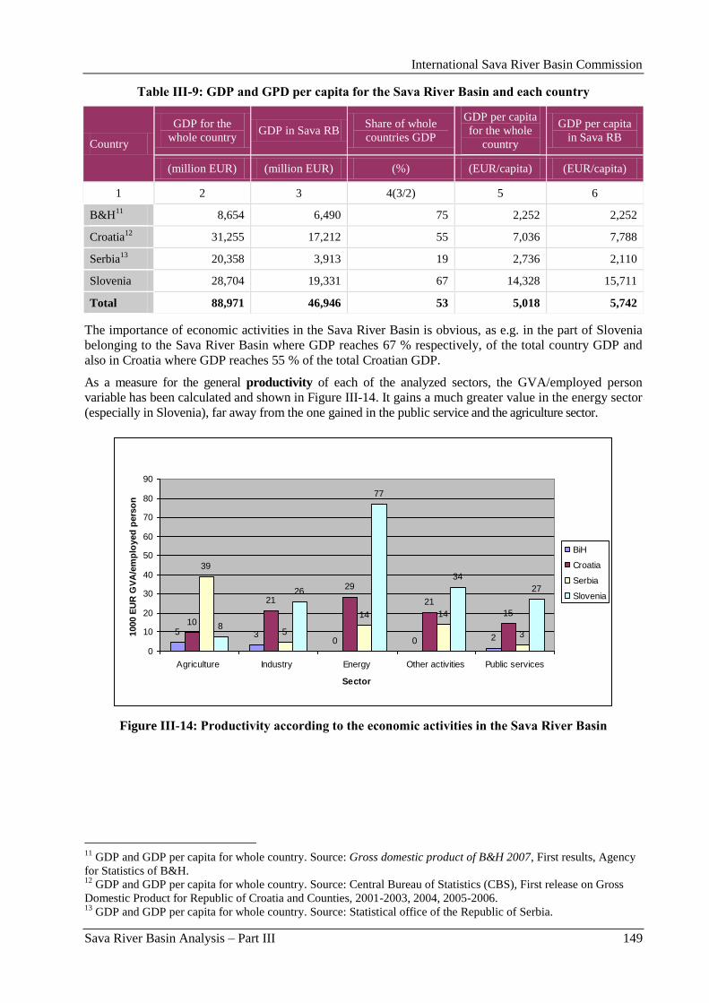
International Sava River Basin Commission
Sava River Basin Analysis – Part III 149
Table III-9: GDP and GPD per capita for the Sava River Basin and each country
Country
GDP for the
whole country GDP in Sava RB
Share of whole
countries GDP
GDP per capita
for the whole
country
GDP per capita
in Sava RB
(million EUR) (million EUR) (%) (EUR/capita) (EUR/capita)
1 2 3 4(3/2) 5 6
B&H11
8,654 6,490 75 2,252 2,252
Croatia12
31,255 17,212 55 7,036 7,788
Serbia13
20,358 3,913 19 2,736 2,110
Slovenia 28,704 19,331 67 14,328 15,711
Total 88,971 46,946 53 5,018 5,742
The importance of economic activities in the Sava River Basin is obvious, as e.g. in the part of Slovenia
belonging to the Sava River Basin where GDP reaches 67 % respectively, of the total country GDP and
also in Croatia where GDP reaches 55 % of the total Croatian GDP.
As a measure for the general productivity of each of the analyzed sectors, the GVA/employed person
variable has been calculated and shown in Figure III-14. It gains a much greater value in the energy sector
(especially in Slovenia), far away from the one gained in the public service and the agriculture sector.
5 30 0 2
10
21
29
21
15
39
5
14 14
38
26
77
34
27
0
10
20
30
40
50
60
70
80
90
Agriculture Industry Energy Other activities Public services
Sector
1000 E
UR
GV
A/e
mp
loyed
pers
on
BiH
Croatia
Serbia
Slovenia
Figure III-14: Productivity according to the economic activities in the Sava River Basin
11
GDP and GDP per capita for whole country. Source: Gross domestic product of B&H 2007, First results, Agency
for Statistics of B&H. 12
GDP and GDP per capita for whole country. Source: Central Bureau of Statistics (CBS), First release on Gross
Domestic Product for Republic of Croatia and Counties, 2001-2003, 2004, 2005-2006. 13
GDP and GDP per capita for whole country. Source: Statistical office of the Republic of Serbia.

International Sava River Basin Commission
Sava River Basin Analysis – Part III 150
International Sava River Basin Commission
Sava River Basin Analysis – Annexes 151
Annexes
International Sava River Basin Commission
Sava River Basin Analysis – Annexes 152
International Sava River Basin Commission
Sava River Basin Analysis – Annex I 153
Annex I - Navigation issues
International Sava River Basin Commission
Sava River Basin Analysis – Annex I 154
International Sava River Basin Commission
Sava River Basin Analysis – Annex I 155
1. Introduction Inland waters have multiple functions such as transport, leisure, water management and environment. The
most commonly known utilization of inland waterways is for the transport of cargo and related therewith
the handling of cargo in river ports.
As a result of growing overseas trade and EU enlargement towards Central and Eastern Europe, freight
transport volumes in Europe are expected to increase by one third until 2015. Present patterns of transport
growth and its reliance on road transport have become a synonym to congestion and pollution, the cost of
which are expected to double to 1% of Europe‟s annual GDP by 2010.
Congestion, capacity problems and delays affect mobility and economic competitiveness and are
detrimental to the environment and quality of life. The EU has committed itself to pursue the goal of
shifting transport to less energy-intensive, cleaner and safer transport modes. Inland waterway transport is
an obvious choice to play a more prominent role in reaching these targets.
Together with rail and short sea shipping, inland waterway transport can contribute to the sustainability of
the transport system.
In some regions inland shipping has already conquered a modal share of more than 40 % (e.g. in
catchment areas of major seaports). Moreover, between 1997 and 2004 impressive traffic growth rates (in
tonne-km) in Belgium of more than 50 % and in France of more than 35 % have been achieved. Today
the sector is made of some 12 500 vessels, corresponding to a loading capacity of 440 000 trucks. Inland
navigation has the best performance in terms of external costs, in particular pollution and safety (2.5
times better than road), and has a huge capacity to deploy. Today only 10 % of the capacity of the Danube
is utilised. Modal share accounts for 6 % whereas in the United States navigation on the Mississippi alone
accounts for 12% of the modal share in the US.
An increase in inland navigation can lead to significant transport cost reductions. The availability of low-
cost inland waterway transport services proves to be a decisive location factor for European industry. It
significantly contributes to the preservation of Europe‟s industrial employment. In Germany alone some
400 000 jobs directly or indirectly depend on the inland waterway sector and related companies.
Moreover, inland waterway transport is by far safer than other modes. The number of yearly fatalities
caused by accidents in the Netherlands, which has the highest density of inland waterway traffic in
Europe, is next to zero.
Inland navigation has also been shown to be the most environmentally friendly land transport mode with
total external costs currently calculated at 10 Euro per 1,000 tonne-kilometres (by comparison: 35 Euro
for road and 15 Euro for rail transport).
Taking into account above mentioned facts and wery suitable geo-political position of the Sava River
which links four SEE countries and can be transport link beetween Adriatic and Danube, the Sava
countries committed themselves to the sustainable development of the inland anvigation on the Sava
River. This is one of the principal objectives of the Framework Agreement on the Sava River Basin
(FASRB), which is a foundation for the cooperation of the countries, and which is being implemented
under the coordinating role of the International Sava River Basin Commission (Sava Commission). To
this end, the Sava Commission has undertaken a wide range of actions, including the preparation of
studies necessary for the rehabilitation and development of the Sava River waterway, such as the
Feasibility Study and Project Documentation for the Rehabilitation and Development of the Transport
and Navigation on the Sava River Waterway, a set of rules and requirements for the improvement of
navigation safety, as well as the re-establishment of the waterway marking system on the Sava River,
which are described in the following text.
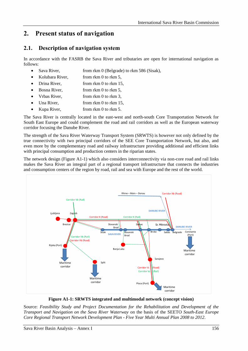
International Sava River Basin Commission
Sava River Basin Analysis – Annex I 156
2. Present status of navigation
2.1. Description of navigation system
In accordance with the FASRB the Sava River and tributaries are open for international navigation as
follows:
Sava River, from rkm 0 (Belgrade) to rkm 586 (Sisak),
Kolubara River, from rkm 0 to rkm 5,
Drina River, from rkm 0 to rkm 15,
Bosna River, from rkm 0 to rkm 5,
Vrbas River, from rkm 0 to rkm 3,
Una River, from rkm 0 to rkm 15,
Kupa River, from rkm 0 to rkm 5.
The Sava River is centrally located in the east-west and north-south Core Transportation Network for
South East Europe and could complement the road and rail corridors as well as the European waterway
corridor focusing the Danube River.
The strength of the Sava River Waterway Transport System (SRWTS) is however not only defined by the
true connectivity with two principal corridors of the SEE Core Transportation Network, but also, and
even more by the complementary road and railway infrastructure providing additional and efficient links
with principal consumption and production centers in the riparian states.
The network design (Figure A1-1) which also considers interconnectivity via non-core road and rail links
makes the Sava River an integral part of a regional transport infrastructure that connects the industries
and consumption centers of the region by road, rail and sea with Europe and the rest of the world.
SAVA RIVER
DANUBE RIVER
Rhine – Main – Donau
Constanta(Port)
DANUBE RIVER
Corridor X (Road)
Zagreb
Corridor Xb (Road)
Sarajevo
Corridor Vc (Road)
Ploce (Port)
Rijeka (Port)
Corridor Vb (Road)
Ljubljana
Corridor Vb (Rail)
Corridor Vc (Rail)
Brezice
Corridor X (Rail)
Corridor Vb (Rail)
Banja Luka
Sisak Belgrade
SlovanskiBrod
BosanskiBrod
Samac
Brcko
Sr. Mitrovica
Sabac
Maritime corridor
Maritime corridor
Maritime corridor
Split
Maritime corridor
Figure A1-1: SRWTS integrated and multimodal network (concept vision)
Source: Feasibility Study and Project Documentation for the Rehabilitation and Development of the
Transport and Navigation on the Sava River Waterway on the basis of the SEETO South-East Europe
Core Regional Transport Network Development Plan - Five Year Multi Annual Plan 2008 to 2012.
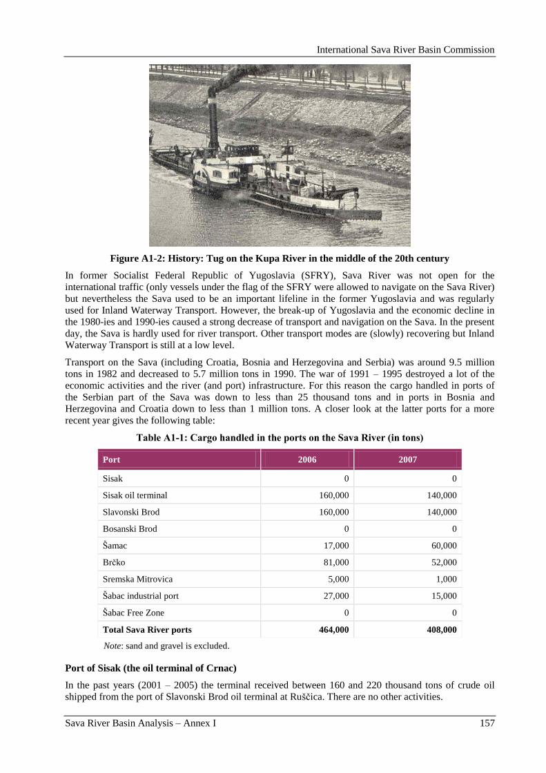
International Sava River Basin Commission
Sava River Basin Analysis – Annex I 157
Figure A1-2: History: Tug on the Kupa River in the middle of the 20th century
In former Socialist Federal Republic of Yugoslavia (SFRY), Sava River was not open for the
international traffic (only vessels under the flag of the SFRY were allowed to navigate on the Sava River)
but nevertheless the Sava used to be an important lifeline in the former Yugoslavia and was regularly
used for Inland Waterway Transport. However, the break-up of Yugoslavia and the economic decline in
the 1980-ies and 1990-ies caused a strong decrease of transport and navigation on the Sava. In the present
day, the Sava is hardly used for river transport. Other transport modes are (slowly) recovering but Inland
Waterway Transport is still at a low level.
Transport on the Sava (including Croatia, Bosnia and Herzegovina and Serbia) was around 9.5 million
tons in 1982 and decreased to 5.7 million tons in 1990. The war of 1991 – 1995 destroyed a lot of the
economic activities and the river (and port) infrastructure. For this reason the cargo handled in ports of
the Serbian part of the Sava was down to less than 25 thousand tons and in ports in Bosnia and
Herzegovina and Croatia down to less than 1 million tons. A closer look at the latter ports for a more
recent year gives the following table:
Table A1-1: Cargo handled in the ports on the Sava River (in tons)
Port 2006 2007
Sisak 0 0
Sisak oil terminal 160,000 140,000
Slavonski Brod 160,000 140,000
Bosanski Brod 0 0
Šamac 17,000 60,000
Brĉko 81,000 52,000
Sremska Mitrovica 5,000 1,000
Šabac industrial port 27,000 15,000
Šabac Free Zone 0 0
Total Sava River ports 464,000 408,000
Note: sand and gravel is excluded.
Port of Sisak (the oil terminal of Crnac)
In the past years (2001 – 2005) the terminal received between 160 and 220 thousand tons of crude oil
shipped from the port of Slavonski Brod oil terminal at Rušĉica. There are no other activities.
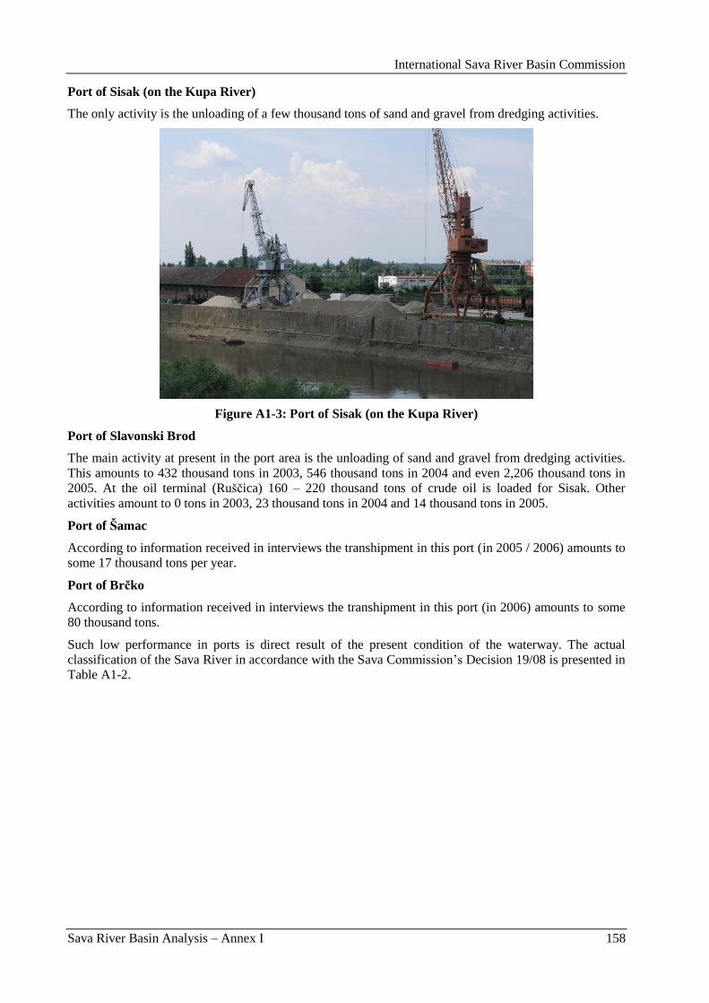
International Sava River Basin Commission
Sava River Basin Analysis – Annex I 158
Port of Sisak (on the Kupa River)
The only activity is the unloading of a few thousand tons of sand and gravel from dredging activities.
Figure A1-3: Port of Sisak (on the Kupa River)
Port of Slavonski Brod
The main activity at present in the port area is the unloading of sand and gravel from dredging activities.
This amounts to 432 thousand tons in 2003, 546 thousand tons in 2004 and even 2,206 thousand tons in
2005. At the oil terminal (Rušĉica) 160 – 220 thousand tons of crude oil is loaded for Sisak. Other
activities amount to 0 tons in 2003, 23 thousand tons in 2004 and 14 thousand tons in 2005.
Port of Šamac
According to information received in interviews the transhipment in this port (in 2005 / 2006) amounts to
some 17 thousand tons per year.
Port of Brčko
According to information received in interviews the transhipment in this port (in 2006) amounts to some
80 thousand tons.
Such low performance in ports is direct result of the present condition of the waterway. The actual
classification of the Sava River in accordance with the Sava Commission‟s Decision 19/08 is presented in
Table A1-2.
International Sava River Basin Commission
Sava River Basin Analysis – Annex I 159
Table A1-2: Classification of the Sava River Waterway
Section of the Sava River
Length (km) Waterway Class
downstream (rkm) upstream (rkm)
0.0
Sava river mouth 86.0
Kamiĉak 86.0 IV
86.0
Kamiĉak 102.0
Mišar 16.0 III
102.0
Mišar 107.0
Šabac 5.0 IV
107.0
Šabac 111.8
Kalovica 4.8 III
111.8
Kalovica 176.0
Mlinsko ostrvo 64.2 IV
176.0
Mlinsko ostrvo 185.0
Sremska Raĉa 9.0 III
185.0
Sremska Raĉa
305.7
Slavonski Šamac
Bosanski Šamac
124.7* IV
305.7
Slavonski Šamac
Bosanski Šamac
330.2
Oprisavci
Rit kanal
24.5 III
330.2
Oprisavci
Rit kanal
363.2
Slavonski Brod
Bosanski Brod
33.0 IV
363.2
Slavonski Brod
Bosanski Brod
586.0
Sisak 219.8 III
* Difference of 4 km of the marked and the actual mileage is a result of two doubled kilometre signs (kilometres 206
and 207 on the river are twice marked) and the newly designed waterway.
Remarks:
(1) The river mileage in the table is referent and names of settlements are used illustratively.
(2) The river mileage from 0.0 to 209.5 is defined based on the newly designed waterway and there are
discrepancies from the kilometre signs in the field.
The quality of the Sava River as a transport mode mostly depends on the availability of sufficient depth
for navigation. In line with Sava Commission Classification (SCC) regulations, the Sava Commission
applies two standards:
Navigation must be possible with a reduced draft 95 % of the time;
Navigation with maximum draft must be possible 65 % of the time.
According to SCC for class IV waterways, this means that the fairway should have a depth of 2.3 m, 95 %
of the time, and a depth of 3.3 m, 65 % of the time. The width of the fairway for 2 lane traffic should be
55 m in straight sections and 75 m in curves, measured along the river bed center line of the curve.
The situation in the field is far from meeting these requirements. The shallow sections in Serbia and
around the Drina confluence make it at present very difficult to reach Croatia / Bosnia for SCC Class IV
categorized vessels, presumable for less than 50 % of the year. The situation in Croatia is slightly better
where category Class III vessels can navigate with full draft around 65 % of the time. But important
improvement works are also required on this section of the river to increase the availability of the fairway
for fully loaded vessels and for SCC Class IV categorized vessels.
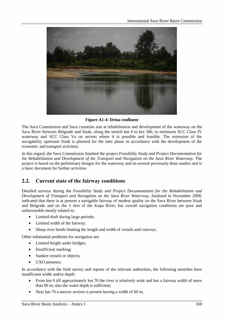
International Sava River Basin Commission
Sava River Basin Analysis – Annex I 160
Figure A1-4: Drina confluent
The Sava Commission and Sava countries aim at rehabilitation and development of the waterway on the
Sava River between Belgrade and Sisak, along the stretch km 0 to km 586, to minimum SCC Class IV
waterway and SCC Class Va on sectors where it is possible and feasible. The extension of the
navigability upstream Sisak is planned for the later phase in accordance with the development of the
economic and transport activities.
In this regard, the Sava Commission finished the project Feasibility Study and Project Documentation for
the Rehabilitation and Development of the Transport and Navigation on the Sava River Waterway. The
project is based on the preliminary designs for the waterway and on several previously done studies and is
a basic document for further activities.
2.2. Current state of the fairway conditions
Detailed surveys during the Feasibility Study and Project Documentation for the Rehabilitation and
Development of Transport and Navigation on the Sava River Waterway, finalized in November 2008,
indicated that there is at present a navigable fairway of modest quality on the Sava River between Sisak
and Belgrade and on the 5 rkm of the Kupa River, but overall navigation conditions are poor and
unfavourable mostly related to:
Limited draft during large periods;
Limited width of the fairway;
Sharp river bends limiting the length and width of vessels and convoys.
Other substantial problems for navigation are:
Limited height under bridges;
Insufficient marking;
Sunken vessels or objects;
UXO presence.
In accordance with the field survey and reports of the relevant authorities, the following stretches have
insufficient width and/or depth:
From km 0 till approximately km 70 the river is relatively wide and has a fairway width of more
than 80 m; also the water depth is sufficient;
Near km 70 a narrow section is present having a width of 60 m;
International Sava River Basin Commission
Sava River Basin Analysis – Annex I 161
A long shallow reach downstream of Šabac extending approximately from km 84 to 110 is
difficult to pass during lower water levels;
Relatively narrow sections occur between km 130 and 150 for example around km 136 the
fairway width is reduced to 70 m;
Sufficient water depth and fairway width are not available on the stretch between km 170 and
180, thus confirming the problems at the Drina confluence, km 175.4. One lane traffic with a
draft of 1 m is only possible at this stretch. Combined with the high flow velocities between 0.7
and 2.2 m/s this stretch causes severe problems for navigation;
Between the confluence with the Drina (km 175) and the border with Croatia, the river is shallow.
The minimum available fairway depth varies between 1.3 and 2.4 m.
Around Šamac (km 300.0 – km 340.0);
At the stretch between Slavonski Brod and Slavonski Kobaš (km 380.0 – km 420.0);
Near Maĉkovac (km 450.0 – km 460.0);
Downstream of Sisak (km 560.0 – km 600.0).
General conclusion is that navigation infrastructure (including training structures and marking system)
suffers of aging, lack of maintenance and incompleteness.
2.3. Navigation safety and technical standards
In order to improve the navigation safety, taking into account the present poor condition of the fairway on
the Sava River, the Sava Commission started with the upgrading of the regulations in the field of
navigation and, at the same time, support the Parties in the re-establishement of the waterway marking
system.
According to the FASRB, as well as the Protocol on the navigation regime to the FASRB, the unification
of rules in the field of navigation is one of the main activities stipulated in the Strategy on implementation
of the FASRB, with the aim to establish an unified regulatory system in the Sava River Basin, which will
be harmonized with the rules on European level.
Using the legal capacity given by Article 16(1a) of the FASRB, the Sava Commission, based on the
proposal of the Permanent Expert Group for Navigation (PEG NAV), passed the following decisions in
the field of navigation safety:
Decision 30/07 on adoption of the Navigation Rules on the Sava River Basin;
Decision 31/07 on adoption of the Rules for Waterway Marking on the Sava River Basin;
Decision 32/07 on adoption of the Rules on Minimum Requirements for the Issuance of
Boatmaster’s Licenses on the Sava River Basin, and
Decision 33/07 on adoption of the Rules on Minimum Manning Requirements for the Vessels on
the Sava River Basin.
The decisions entered into force on December 13, 2007.
The Rules are presented to representatives of the competent authorities of the Parties on regular meetings
of captains from the Sava Port Master Offices and the Sava Commission follows implementation of the
decisions in the Parties with the aim to improve the content of the documents based on the inputs from the
field.
The Sava Commission, jointly with the navigation commissions for the Rhine, Danube and Mosel, as well
as UNECE and Austria, started the process of comparing the existing navigation rules on European level,
in order to improve the European Code for Inland Navigation (CEVNI) and harmonize the rules in
different river basins. There is also a joint work on the establishment of criteria for mutual recognition of
boatmaster certificates, with the aim to minimize administrative obstacles for the development of inland
navigation.
International Sava River Basin Commission
Sava River Basin Analysis – Annex I 162
As for the technical requirements for inland waterway vessels, the Sava Commission developed the Draft
Technical Rules for the Vessels on the Sava River Basin and the Draft Rules for the Transport of the
Dangerous Goods in the Sava River Basin. Both documents are currently under discussion in the
framework of the PEG NAV.
The Draft Technical Rules for the Vessels on the Sava River Basin are based on the EU Directive
2006/87/EC, laying down technical requirements for inland waterway vessels, while the Draft Rules for
the Transport of the Dangerous Goods in the Sava River Basin propose application of the European
Agreement concerning the International Carriage of Dangerous Goods by Inland Waterways (ADN).
Adoption of these rules will be a basis for introduction of highest technical standards in the shipbuilding
and the transport of dangerous goods, and will significantly contribute to improvement of navigation
safety and environmental protection.
All above mentioned Rules represent a basic set of regulations for the establishment of an unique system
of navigation in the Sava River Basin, and are fully harmonized with the requirements of the Danube and
Rhine navigation commissions, the UNECE and EU.
In accordance with Article 10(4) of the FASRB and Article 9 of the Protocol on the navigation regime to
the FASRB, the Sava Commission coordinated and supported activities of the Parties on the waterway
marking and, in this respect, adopted the following decisions:
Decision 29/07 on adoption of the Marking Plan for the Sava River and its Navigable Tributaries
for Year 2008;
Decision 37/08 on Amendments to the Decision 29/07 on adoption of the Marking Plan for the
Sava River and its Navigable Tributaries for Year 2008; and
Decision 02/09 on adoption of the Marking Plan for the Sava River and its Navigable Tributaries
for Year 2009.
The Detailed Design of the Marking System of the Sava River Waterway on the B&H Marking Sector was
prepared in the framework of the Sava Commission. The project, financed by B&H, is the basis for
rehabilitation of the marking system on this river sector.
The Parties have made significant progress in the re-establishment of the waterway marking system
through various activities:
Republic of Croatia improved the existing marking system on its sector of responsibility;
Republic of Serbia re-established the marking system on cca 150 rkm;
B&H completed demining activities in the area of the signs, finished the tendering process for the
marking activities, and started with the marking;
B&H, Republic of Croatia and Republic of Serbia jointly solved the problem of the double river
kilometer marks (there were several doubled river kilometer marks).
The re-establishment of the whole marking system will be finalized until the end of 2009, which will
significantly contribute to the improvement of navigation safety.
3. Competent authorities in the Sava countries, national policies
and regulations
3.1. Institutional arrangements in B&H
Being a decentralized country, Bosnia and Herzegovina has three ministerial levels (state level,
Federation B&H level and the Republika Srpska level) for almost all governmental sectors.
The transport sector of Bosnia and Herzegovina is regulated by three ministries and one transport
department:
Ministry of Communications and Transport of Bosnia and Herzegovina;
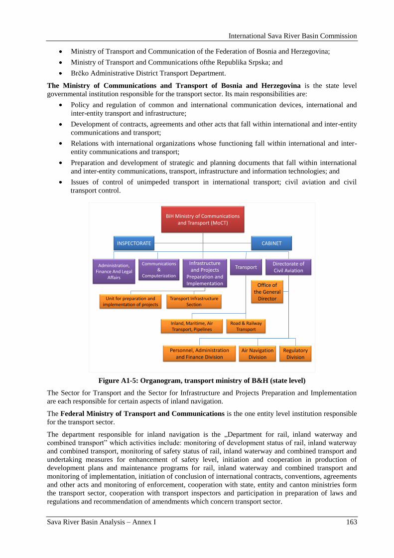
International Sava River Basin Commission
Sava River Basin Analysis – Annex I 163
Ministry of Transport and Communication of the Federation of Bosnia and Herzegovina;
Ministry of Transport and Communications ofthe Republika Srpska; and
Brĉko Administrative District Transport Department.
The Ministry of Communications and Transport of Bosnia and Herzegovina is the state level
governmental institution responsible for the transport sector. Its main responsibilities are:
Policy and regulation of common and international communication devices, international and
inter-entity transport and infrastructure;
Development of contracts, agreements and other acts that fall within international and inter-entity
communications and transport;
Relations with international organizations whose functioning fall within international and inter-
entity communications and transport;
Preparation and development of strategic and planning documents that fall within international
and inter-entity communications, transport, infrastructure and information technologies; and
Issues of control of unimpeded transport in international transport; civil aviation and civil
transport control.
BiH Ministry of Communications and Transport (MoCT)
CABINETINSPECTORATE
Administration, Finance And Legal
Affairs
Communications &
Computerization
Infrastructure and Projects
Preparation and Implementation
Transport Directorate of Civil Aviation
Transport Infrastructure Section
Unit for preparation and implementation of projects
Inland, Maritime, Air Transport, Pipelines
Road & Railway Transport
Office of the General
Director
Regulatory Division
Air Navigation Division
Personnel, Administration and Finance Division
Figure A1-5: Organogram, transport ministry of B&H (state level)
The Sector for Transport and the Sector for Infrastructure and Projects Preparation and Implementation
are each responsible for certain aspects of inland navigation.
The Federal Ministry of Transport and Communications is the one entity level institution responsible
for the transport sector.
The department responsible for inland navigation is the „Department for rail, inland waterway and
combined transport” which activities include: monitoring of development status of rail, inland waterway
and combined transport, monitoring of safety status of rail, inland waterway and combined transport and
undertaking measures for enhancement of safety level, initiation and cooperation in production of
development plans and maintenance programs for rail, inland waterway and combined transport and
monitoring of implementation, initiation of conclusion of international contracts, conventions, agreements
and other acts and monitoring of enforcement, cooperation with state, entity and canton ministries form
the transport sector, cooperation with transport inspectors and participation in preparation of laws and
regulations and recommendation of amendments which concern transport sector.
International Sava River Basin Commission
Sava River Basin Analysis – Annex I 164
The Ministry of Transport and Communications (Republika Srpska) is the second entity level
institution responsible for the transport sector.
The Ministry is responsible for management and other expert works related to activities, road traffic and
public roads, railway traffic and safety of railway traffic, air traffic, sea, river and lake traffic, safety of
sea, river and lake traffic, reloading services, communication system, radio communications, mail,
telegraph and telephone transport, telecommunication, telecom infrastructure, coordination policy
management, inspection supervision of public roads, road traffic, railway traffic, PTT traffic with
telecommunications and other works put under its jurisdiction.
3.1.1. National regulations
At present there is no state-level law which regulates inland waterway transport. A draft Maritime and
Inland Waterways Law (year 2007 version) is in the process of adaptation and is expected to become a
formal law in the near future. The future law is also expected to integrate recent developments in the
inland waterway sector.
Both entities have legislation for inland waterway transport. The Law on Internal Navigation of the
Republika Srpska (Official Gazette RS 58/01) and the Law on Internal and Maritime Navigation of the
Federation of Bosnia and Herzegovina (Official Gazette FB&H 73/05) are harmonized and contain the
same provisions regarding inland navigation. The provisions of both laws are applicable to all vessels
(including military) and to inland waterways in the two entities.
3.1.2. National policies
The Transport Master Plan for B&H from 2001 became a starting point for the institutional development
of the transport sector in B&H.
In a next important step, a comprehensive Medium Term Development Strategy PRSP (2004 – 2007) was
developed in March 2004 by a large team of various governmental and individual experts.
The B&H Medium Term Development Strategy PRSP (2004 – 2007) was updated in 2006 and mentions
regarding infrastructure the following objectives in addition to the above:
By developing river transport in the future a better valorization of the advantages of available
natural geographical can be obtained;
River transport needs to be upgraded up to pre-war levels and the Sava Agreement needs to be
put in use, but the lack of funds impede the development of the river transport; and
To enhance the opening of B&H towards the neighboring countries for which international
agreements and contracts are required.
3.2. Institutional arrangements in Croatia
The inland waterway sector in Croatia is presently very well regulated, with clearly divided
responsibilities among various governmental institutions.
The Ministry of the Sea, Transport and Infrastructure is the ministry directly responsible for inland
waterway transport.
The organization structure dealing directly with the inland waterways is visualized in Figure A1-6.
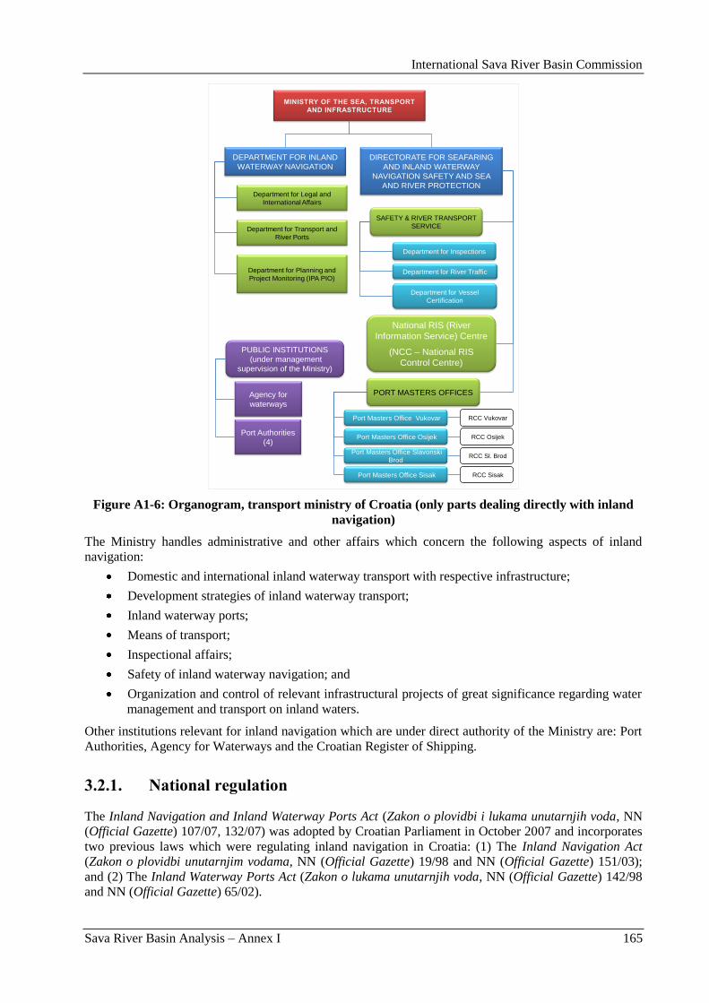
International Sava River Basin Commission
Sava River Basin Analysis – Annex I 165
DEPARTMENT FOR INLAND
WATERWAY NAVIGATION
DIRECTORATE FOR SEAFARING
AND INLAND WATERWAY
NAVIGATION SAFETY AND SEA
AND RIVER PROTECTION Department for Legal and
International Affairs
Department for Transport and
River Ports
Department for Planning and
Project Monitoring (IPA PIO)
SAFETY & RIVER TRANSPORT
SERVICE
National RIS (River
Information Service) Centre
(NCC – National RIS
Control Centre)
Department for Inspections
Department for Vessel
Certification
Department for River Traffic
Port Masters Office Sisak
Port Masters Office Slavonski
Brod
Port Masters Office Osijek
Port Masters Office Vukovar
PORT MASTERS OFFICES
RCC Vukovar
RCC Osijek
RCC Sl. Brod
RCC Sisak
PUBLIC INSTITUTIONS
(under management
supervision of the Ministry)
Agency for
waterways
Port Authorities
(4)
Figure A1-6: Organogram, transport ministry of Croatia (only parts dealing directly with inland
navigation)
The Ministry handles administrative and other affairs which concern the following aspects of inland
navigation:
Domestic and international inland waterway transport with respective infrastructure;
Development strategies of inland waterway transport;
Inland waterway ports;
Means of transport;
Inspectional affairs;
Safety of inland waterway navigation; and
Organization and control of relevant infrastructural projects of great significance regarding water
management and transport on inland waters.
Other institutions relevant for inland navigation which are under direct authority of the Ministry are: Port
Authorities, Agency for Waterways and the Croatian Register of Shipping.
3.2.1. National regulation
The Inland Navigation and Inland Waterway Ports Act (Zakon o plovidbi i lukama unutarnjih voda, NN
(Official Gazette) 107/07, 132/07) was adopted by Croatian Parliament in October 2007 and incorporates
two previous laws which were regulating inland navigation in Croatia: (1) The Inland Navigation Act
(Zakon o plovidbi unutarnjim vodama, NN (Official Gazette) 19/98 and NN (Official Gazette) 151/03);
and (2) The Inland Waterway Ports Act (Zakon o lukama unutarnjih voda, NN (Official Gazette) 142/98
and NN (Official Gazette) 65/02).
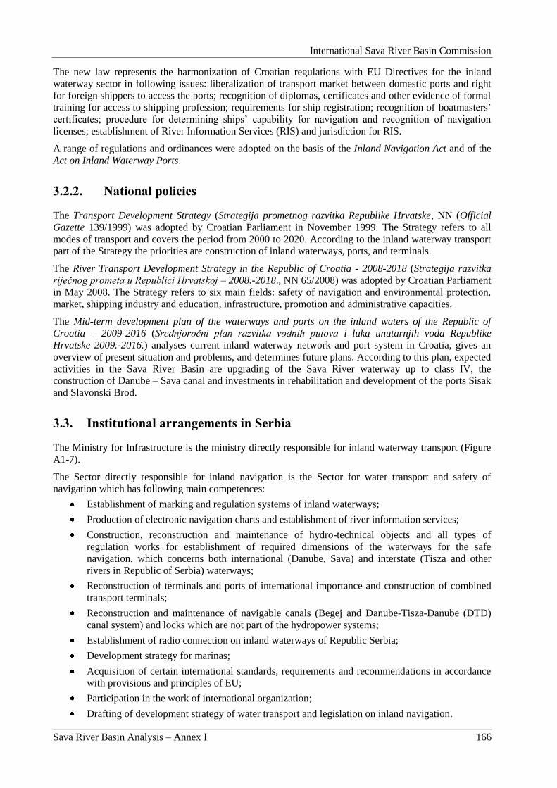
International Sava River Basin Commission
Sava River Basin Analysis – Annex I 166
The new law represents the harmonization of Croatian regulations with EU Directives for the inland
waterway sector in following issues: liberalization of transport market between domestic ports and right
for foreign shippers to access the ports; recognition of diplomas, certificates and other evidence of formal
training for access to shipping profession; requirements for ship registration; recognition of boatmasters‟
certificates; procedure for determining ships‟ capability for navigation and recognition of navigation
licenses; establishment of River Information Services (RIS) and jurisdiction for RIS.
A range of regulations and ordinances were adopted on the basis of the Inland Navigation Act and of the
Act on Inland Waterway Ports.
3.2.2. National policies
The Transport Development Strategy (Strategija prometnog razvitka Republike Hrvatske, NN (Official
Gazette 139/1999) was adopted by Croatian Parliament in November 1999. The Strategy refers to all
modes of transport and covers the period from 2000 to 2020. According to the inland waterway transport
part of the Strategy the priorities are construction of inland waterways, ports, and terminals.
The River Transport Development Strategy in the Republic of Croatia - 2008-2018 (Strategija razvitka
riječnog prometa u Republici Hrvatskoj – 2008.-2018., NN 65/2008) was adopted by Croatian Parliament
in May 2008. The Strategy refers to six main fields: safety of navigation and environmental protection,
market, shipping industry and education, infrastructure, promotion and administrative capacities.
The Mid-term development plan of the waterways and ports on the inland waters of the Republic of
Croatia – 2009-2016 (Srednjoročni plan razvitka vodnih putova i luka unutarnjih voda Republike
Hrvatske 2009.-2016.) analyses current inland waterway network and port system in Croatia, gives an
overview of present situation and problems, and determines future plans. According to this plan, expected
activities in the Sava River Basin are upgrading of the Sava River waterway up to class IV, the
construction of Danube – Sava canal and investments in rehabilitation and development of the ports Sisak
and Slavonski Brod.
3.3. Institutional arrangements in Serbia
The Ministry for Infrastructure is the ministry directly responsible for inland waterway transport (Figure
A1-7).
The Sector directly responsible for inland navigation is the Sector for water transport and safety of
navigation which has following main competences:
Establishment of marking and regulation systems of inland waterways;
Production of electronic navigation charts and establishment of river information services;
Construction, reconstruction and maintenance of hydro-technical objects and all types of
regulation works for establishment of required dimensions of the waterways for the safe
navigation, which concerns both international (Danube, Sava) and interstate (Tisza and other
rivers in Republic of Serbia) waterways;
Reconstruction of terminals and ports of international importance and construction of combined
transport terminals;
Reconstruction and maintenance of navigable canals (Begej and Danube-Tisza-Danube (DTD)
canal system) and locks which are not part of the hydropower systems;
Establishment of radio connection on inland waterways of Republic Serbia;
Development strategy for marinas;
Acquisition of certain international standards, requirements and recommendations in accordance
with provisions and principles of EU;
Participation in the work of international organization;
Drafting of development strategy of water transport and legislation on inland navigation.
International Sava River Basin Commission
Sava River Basin Analysis – Annex I 167
MINISTRY FOR
INFRASTRUCTURE
Sector for Rail and
Intermodal Transport
Sector for Road
Transport
Sector for Air
Transport
Sector for Civil
Engineering and
Investment Projects
Sector for Spatial
and Urban Planning
Sector for Water
Transport and Safety of
Navigation
Department
for water
transport
Jugoregistar
Port Master
Offices
Inland Waterway
Maintenance and
Development Agency
«Plovput»
(under direct authority of
Serbian Government)
Sector for Roads
and Transport
Safety
Figure A1-7: Organogram, transport ministry of Serbia
3.3.1. National regulations
The Maritime and Inland Navigation Act
The Maritime and Inland Navigation Act (Zakon o pomorskoj i unutrašnjoj plovidbi – Službeni list SRJ
(Official Gazette of Federal Republic of Yugoslavia) 12/98, 44/99, 74/99, 73/00) is the law regulating
maritime and inland navigation on the entire territory of former state, the Federal Republic of Yugoslavia
and is still in force in the Republic of Serbia.
This act regulates the safety of navigation on the sea and inland waters of the Federal Republic of
Yugoslavia, navigable waterways in coastal waters and inland waters, right of flag, identification and
registration of the ship, basic ownership relations regarding ships, shippers, obligation rights regarding
ships, navigation accidents, procedure of execution and security on the ships, relevant law and court
competence for legal disputes of international character.
The new Maritime and Inland Navigation Act is in the process of drafting and it is expected to be
harmonized with EU regulations regarding inland navigation.
The Inland Navigation Act
The Inland Navigation Act (Zakon o unutrašnjoj plovidbi – Sluţbeni glasnik SRS 54/90 and Sluţbeni
glasnik RS 46/91, 53/93, 67/93, 48/94) is the law regulating inland navigation in former Federal Republic
of Serbia which was the part of former Federal Republic of Yugoslavia and Act is also still in force in the
Republic of Serbia. This Act gives provisions on:
Inland waterways;
Terminals, winter harbors and anchorages;
International Sava River Basin Commission
Sava River Basin Analysis – Annex I 168
Boats and floating devices;
Crew of the boat;
Radio connection;
Transport in inland navigation;
Navigation accidents;
Inspection, and
Port Master Offices.
3.3.2. National policies
In 2004, the report Transport Policy and Strategy was made as an attempt to harmonize the existing
transport policy with EU White Paper. The report took four years to be adopted as the official Strategy for
rail, road, water, air and intermodal transport of Republic of Serbia (2008-2015).
The Strategy for rail, road, water, air and intermodal transport of Republic of Serbia (2008-2015)
analyses the current situation in the water transport in Serbia and presents priorities and future plans for
the sector. According to the Strategy, Serbia has favorable economic and technical conditions for cargo,
passenger and tourist navigation on inland waterways. The potential of inland waterways in Serbia is
substantial but the infrastructure is in very poor condition.
The Strategy emphasizes, among others, the following priorities:
Enhancement of navigation conditions on Danube, Sava and Tisza waterways, as well as DTD
canal system, in accordance with European development plans regarding inland waterway
transport;
River Sava, which is an international waterway, and Tisza which has an international navigation
regime, have to be rehabilitated in accordance with bilateral and multilateral agreements.
3.4. Institutional arrangements in Slovenia
The Republic of Slovenia is the only Sava riparian state which is already a member of the European
Union. Slovenia joined the EU in 2004 and became a member of the Euro zone in 2007.
The Ministry of Transport is the highest governmental institution directly involved in inland waterway
transport in Slovenia. The Ministry has responsibilities in the fields of railway transport, air transport,
maritime and inland waterway transport, and road transport (with the exception of road transport safety
control) as well as in the field of transport infrastructure and cableway installations.
The Ministry is structured into the following offices (Figure A1-8):
Transport Directorate,
International Affairs Directorate,
Roads Directorate,
Railways and Cableways Directorate,
Civil Aviation Directorate,
Maritime Directorate.
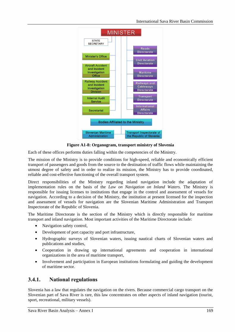
International Sava River Basin Commission
Sava River Basin Analysis – Annex I 169
Figure A1-8: Organogram, transport ministry of Slovenia
Each of these offices performs duties falling within the competencies of the Ministry.
The mission of the Ministry is to provide conditions for high-speed, reliable and economically efficient
transport of passengers and goods from the source to the destination of traffic flows while maintaining the
utmost degree of safety and in order to realize its mission, the Ministry has to provide coordinated,
reliable and cost-effective functioning of the overall transport system.
Direct responsibilities of the Ministry regarding inland navigation include the adaptation of
implementation rules on the basis of the Law on Navigation on Inland Waters. The Ministry is
responsible for issuing licenses to institutions that engage in the control and assessment of vessels for
navigation. According to a decision of the Ministry, the institution at present licensed for the inspection
and assessment of vessels for navigation are the Slovenian Maritime Administration and Transport
Inspectorate of the Republic of Slovenia.
The Maritime Directorate is the section of the Ministry which is directly responsible for maritime
transport and inland navigation. Most important activities of the Maritime Directorate include:
Navigation safety control,
Development of port capacity and port infrastructure,
Hydrographic surveys of Slovenian waters, issuing nautical charts of Slovenian waters and
publications and studies,
Cooperation in drawing up international agreements and cooperation in international
organizations in the area of maritime transport,
Involvement and participation in European institutions formulating and guiding the development
of maritime sector.
3.4.1. National regulations
Slovenia has a law that regulates the navigation on the rivers. Because commercial cargo transport on the
Slovenian part of Sava River is rare, this law concentrates on other aspects of inland navigation (tourist,
sport, recreational, military vessels).
International Sava River Basin Commission
Sava River Basin Analysis – Annex I 170
The Law on Navigation on Inland Waters (Zakon o plovbi po celinskih vodah – ZPCV, Ur.l.RS 67/2002)
regulates the safety of inland navigation, required conditions of navigable areas, vessels and floating
devices, persons responsible for navigation of the vessels, wharfs and other places used for the access to
navigable area, registration of vessels and floating devices, taking out of sunken goods and inspection of
safety of inland navigation.
All issues concerning navigation safety that are not regulated by Law on Navigation on Inland Waters are
regulated by the Maritime Code (Pomorski zakonik, Ur.l.RS 37/2004). Relevant issues include: technique
of vessel measurement, ship‟s logs, identification of vessels, vessel‟s crew exams and certificates,
procedure for registration of vessels and shipping accidents.
3.4.2. National policies
In 2006 Slovenian Parliament adopted a Resolution on Slovenian Transport Policy (Resolucijo o prometni
politiki Republike Slovenije – RePPRS, Ur.l.RS 58/2006) in an effort to harmonize Slovenian transport
policy according to the EU White Paper (European Transport Policy for 2010: Time to Decide, 2001).
The emphasis is given to enhancement of intermodality in the Slovenian transport sector. In spite the
importance of inland waterway transport in the European transport policy, the text does not express the
Slovenian opinion on a possible development of inland navigation and potential investments in this
sector, from which can be concluded that inland navigation is not of strategic importance for Slovenia.
The Spatial Development Strategy of Slovenia (Ur.l.RS 76/2004) is the basic strategic spatial
development document and an integrated planning document which implements the concept of
sustainable spatial development. In the section analyzing the development of public infrastructure it is
states that a river port shall be developed on the Sava River at the border between the Republic of
Slovenia and the Republic of Croatia, provided that the Sava River from its outflow to the Danube River
to the border between the Republic of Slovenia and the Republic of Croatia is made navigable.
3.5. International Sava River Basin Commission
The process, known as the Sava Initiative, was formally initiated with the Letter of Intent concerning the
International Sava River Basin Commission Initiative, signed in Sarajevo on November 29, 2001 by the
Ministers of Foreign Affairs of Republic of Croatia, the Republic of Slovenia, the Federal Republic of
Yugoslavia, and by the Minister for Civil Affairs and Communications of Bosnia and Herzegovina.
The four riparian countries subsequently signed, on December 3, 2002, the Framework Agreement on the
Sava River Basin (FASRB) in Kranjska Gora (Slovenia), after the successful completion of negotiations
run under the „umbrella” of the Stability Pact for South-Eastern Europe.
The Agreement entered into force on December 29, 2004, 30 days after the Depositary of the Agreement
(Republic of Slovenia) notified the signatories on reception of the last instrument for the ratification
procedure. Accordingly, the Constitutional Session of the Sava Commission was held on June 27-29,
2005, in Zagreb.
The FASRB is a legal base for the constitution and functioning of the Sava Commission.
One of the three main objectives of the FASRB is the cooperation of the Parties in order to establish an
international navigation regime on the Sava River and its navigable tributaries.
Regarding the navigation regime, the Agreement stipulates that navigation on the Sava River is free for
trade vessels of all States, identical to the regulation for the Danube River under the Convention on the
navigation regime. Trade vessels have a right to free entrance into ports on the part of the Sava River
waterway from Sisak to its estuary into the Danube as well as on all navigable parts of the Sava River
tributaries, and this for purpose of loading, discharging, supply, and similar actions. Trade vessels should
in their activities respect national regulations of the Parties on whose territory the port is located. Parties
will therefore undertake all necessary measures for maintenance of the waterways in their territory to
International Sava River Basin Commission
Sava River Basin Analysis – Annex I 171
guarantee a navigable state-of-condition as well as to undertake measures on improvement of the
navigation conditions, and will not prevent or cause any obstacles to navigation.
The Parties also agree to regulate by a separate Protocol on the Regime of Navigation all issues regarding
navigation, such as institutional arrangements (rules of navigation, technical rules for vessels, marking of
navigable waterways etc.) and expenses relating to the maintenance of the navigable waterways and the
regime of navigation. The Protocol on the Navigation Regime was agreed between the Parties pursuant to
the provisions referred to in Article 10, Paragraph 6 of the Framework Agreement on the Sava River
Basin and entered into force also on December 29, 2004.
In the field of navigation, the Sava Commission has international legal capacity necessary for making
decisions:
aimed to provide conditions for safe navigations;
on the conditions for financing construction of navigable waterways and their maintenance.
Decisions of the Sava Commission are obligatory for the Parties.
4. Future status of navigation
4.1. Transport needs
A cease of the transport activities on the Sava River and economic changes in the region during the last
two decades caused a significant drop of the cargo transport on the Sava River.
However, the expected growth in river traffic is notable and clearly warrants the investments and
initiatives. An issue that has been investigated in detail was the question whether the rehabilitation efforts
should concentrate on upgrading to Class IV or directly to Class Va.
The cargo forecasts after upgrading to Class IV on the sector between Belgrade and Sisak confirm the
growing positive appreciation regarding traffic volumes on the Sava River between now and the year
2027. During the year 2012 (representative of post-upgrading of the Sava River to Class IV navigation),
commercial cargo traffic is expected to reach between 3.5 million and 7.9 million tonnes, depending on
realization of low or high economic growth scenarios. These volumes are likely to increase to 6.1 million
and 15.3 million tonnes in 2022, and to ultimately reach between 7 million and 18.7 million tonnes during
year 2027, again depending on the low and high growth scenarios, respectively. This positive future is not
a consequence of the progress of one particular port along the Sava River, but the results of a combined
strong performance of all river ports.
From a purely traffic volume perspective, the immediate upgrading to Class Va has a notable additional
positive effect on the estimated future cargo volumes.
Keeping the same evaluation base, the total additional cargo volume that is generated during the reference
period and via an immediate upgrading to Class Va ranges from 1.5 million additional tones in the high
growth scenario to 2.5 million tonnes in the low growth scenario.
Assuming possible benefits obtained from economies-of-scale equaling respectively 5 % and 10 % on
total base traffic, the benefits markedly increase under all economic scenarios and the pattern of benefits
also increases in time. For example, with a 5 % traffic benefit, the immediate upgrading would lead to 3.4
million tonnes of additional cargo in 2012 according to the low growth scenario, increasing to 6.2 million
additional tonnes of cargo in 2027 according to the high growth scenario. Assuming a 10 % scale benefit,
the benefits of an immediate upgrading to Class Va would reach 4.3 million tonnes in 2012 according to
the low growth scenario, climbing to almost 11 million tonnes by 2027 assuming a high growth scenario.
The traffic estimates after rehabilitation to Class Va suggest that for the year 2027 high growth scenario
without any economies-of-scale benefits taken into consideration, 20 million tonnes may be transported
along the highest activity segment (between Danube River and Šabac International Port). Figure A1-9
presents the range according to minimum and maximum economic growth scenario of potential cargo
volumes per river section in year 2027.
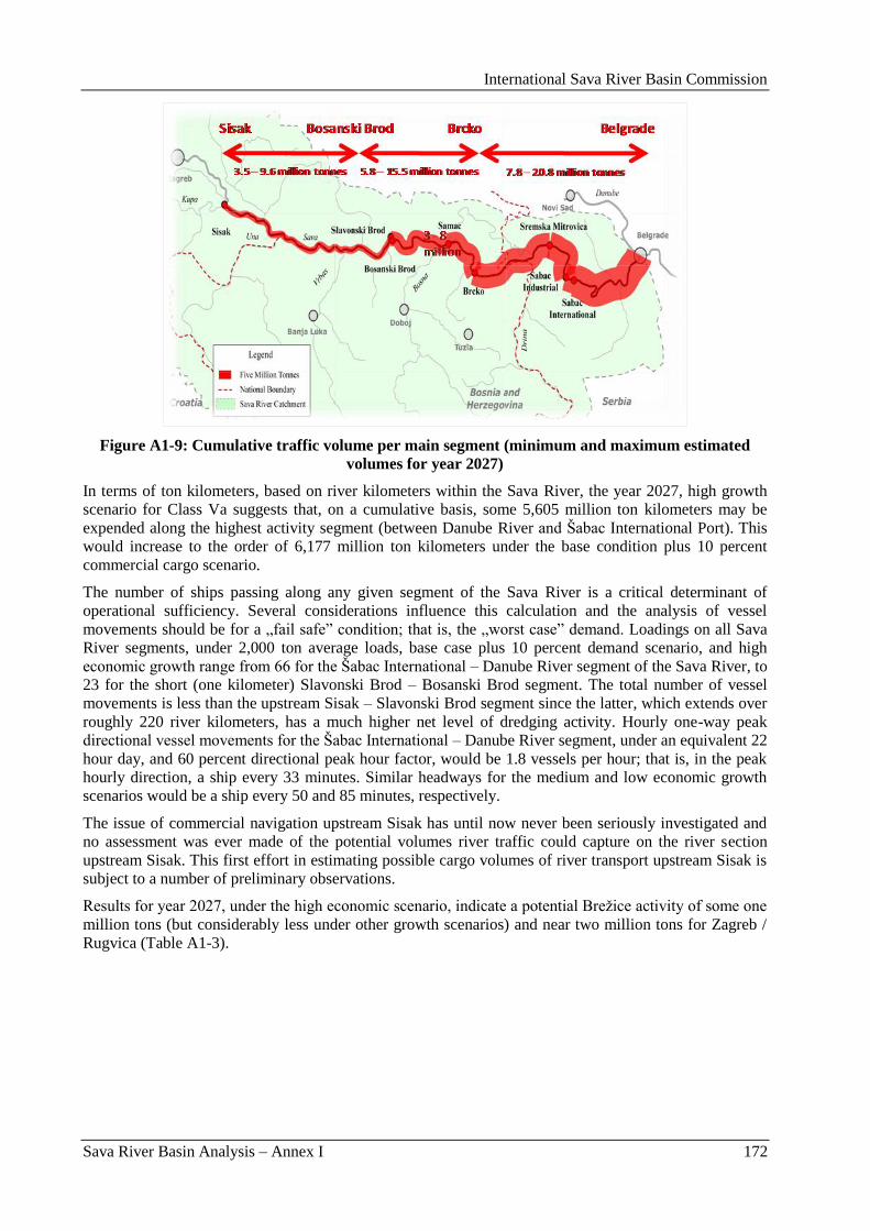
International Sava River Basin Commission
Sava River Basin Analysis – Annex I 172
Figure A1-9: Cumulative traffic volume per main segment (minimum and maximum estimated
volumes for year 2027)
In terms of ton kilometers, based on river kilometers within the Sava River, the year 2027, high growth
scenario for Class Va suggests that, on a cumulative basis, some 5,605 million ton kilometers may be
expended along the highest activity segment (between Danube River and Šabac International Port). This
would increase to the order of 6,177 million ton kilometers under the base condition plus 10 percent
commercial cargo scenario.
The number of ships passing along any given segment of the Sava River is a critical determinant of
operational sufficiency. Several considerations influence this calculation and the analysis of vessel
movements should be for a „fail safe” condition; that is, the „worst case” demand. Loadings on all Sava
River segments, under 2,000 ton average loads, base case plus 10 percent demand scenario, and high
economic growth range from 66 for the Šabac International – Danube River segment of the Sava River, to
23 for the short (one kilometer) Slavonski Brod – Bosanski Brod segment. The total number of vessel
movements is less than the upstream Sisak – Slavonski Brod segment since the latter, which extends over
roughly 220 river kilometers, has a much higher net level of dredging activity. Hourly one-way peak
directional vessel movements for the Šabac International – Danube River segment, under an equivalent 22
hour day, and 60 percent directional peak hour factor, would be 1.8 vessels per hour; that is, in the peak
hourly direction, a ship every 33 minutes. Similar headways for the medium and low economic growth
scenarios would be a ship every 50 and 85 minutes, respectively.
The issue of commercial navigation upstream Sisak has until now never been seriously investigated and
no assessment was ever made of the potential volumes river traffic could capture on the river section
upstream Sisak. This first effort in estimating possible cargo volumes of river transport upstream Sisak is
subject to a number of preliminary observations.
Results for year 2027, under the high economic scenario, indicate a potential Breţice activity of some one
million tons (but considerably less under other growth scenarios) and near two million tons for Zagreb /
Rugvica (Table A1-3).
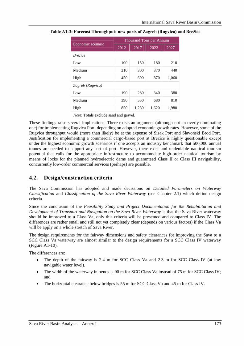
International Sava River Basin Commission
Sava River Basin Analysis – Annex I 173
Table A1-3: Forecast Throughput: new ports of Zagreb (Rugvica) and Brežice
Economic scenario Thousand Tons per Annum
2012 2017 2022 2027
Brežice
Low 100 150 180 210
Medium 210 300 370 440
High 450 690 870 1,060
Zagreb (Rugvica)
Low 190 280 340 380
Medium 390 550 680 810
High 850 1,280 1,620 1,980
Note: Totals exclude sand and gravel.
These findings raise several implications. There exists an argument (although not an overly dominating
one) for implementing Rugvica Port, depending on adopted economic growth rates. However, some of the
Rugvica throughput would (more than likely) be at the expense of Sisak Port and Slavonski Brod Port.
Justification for implementing a commercial cargo-based port at Breţice is highly questionable except
under the highest economic growth scenarios if one accepts an industry benchmark that 500,000 annual
tonnes are needed to support any sort of port. However, there exist and undeniable nautical tourism
potential that calls for the appropriate infrastructure to accommodate high-order nautical tourism by
means of locks for the planned hydroelectric dams and guaranteed Class II or Class III navigability,
concurrently low-order commercial services (perhaps) are possible.
4.2. Design/construction criteria
The Sava Commission has adopted and made decissions on Detailed Parameters on Waterway
Classification and Classification of the Sava River Waterway (see Chapter 2.1) which define design
criteria.
Since the conclusion of the Feasibility Study and Project Documentation for the Rehabilitation and
Development of Transport and Navigation on the Sava River Waterway is that the Sava River waterway
should be improved to a Class Va, only this criteria will be presented and compared to Class IV. The
differences are rather small and still not yet completely clear (depends on various factors) if the Class Va
will be apply on a whole stretch of Sava River.
The design requirements for the fairway dimensions and safety clearances for improving the Sava to a
SCC Class Va waterway are almost similar to the design requirements for a SCC Class IV waterway
(Figure A1-10).
The differences are:
The depth of the fairway is 2.4 m for SCC Class Va and 2.3 m for SCC Class IV (at low
navigable water level).
The width of the waterway in bends is 90 m for SCC Class Va instead of 75 m for SCC Class IV;
and
The horizontal clearance below bridges is 55 m for SCC Class Va and 45 m for Class IV.
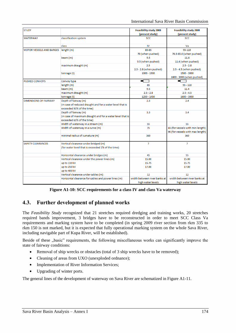
International Sava River Basin Commission
Sava River Basin Analysis – Annex I 174
Figure A1-10: SCC requirements for a class IV and class Va waterway
4.3. Further development of planned works
The Feasibility Study recognized that 21 stretches required dredging and training works, 20 stretches
required bands improvement, 3 bridges have to be reconstructed in order to meet SCC Class Va
requirements and marking system have to be completed (in spring 2009 river section from rkm 335 to
rkm 150 is not marked, but it is expected that fully operational marking system on the whole Sava River,
including navigable part of Kupa River, will be established).
Beside of these „basic” requirements, the following miscellaneous works can significantly improve the
state of fairway conditions:
Removal of ship wrecks or obstacles (total of 3 ship wrecks have to be removed);
Cleaning of areas from UXO (unexploded ordnance);
Implementation of River Information Services;
Upgrading of winter ports.
The general lines of the development of waterway on Sava River are schematized in Figure A1-11.
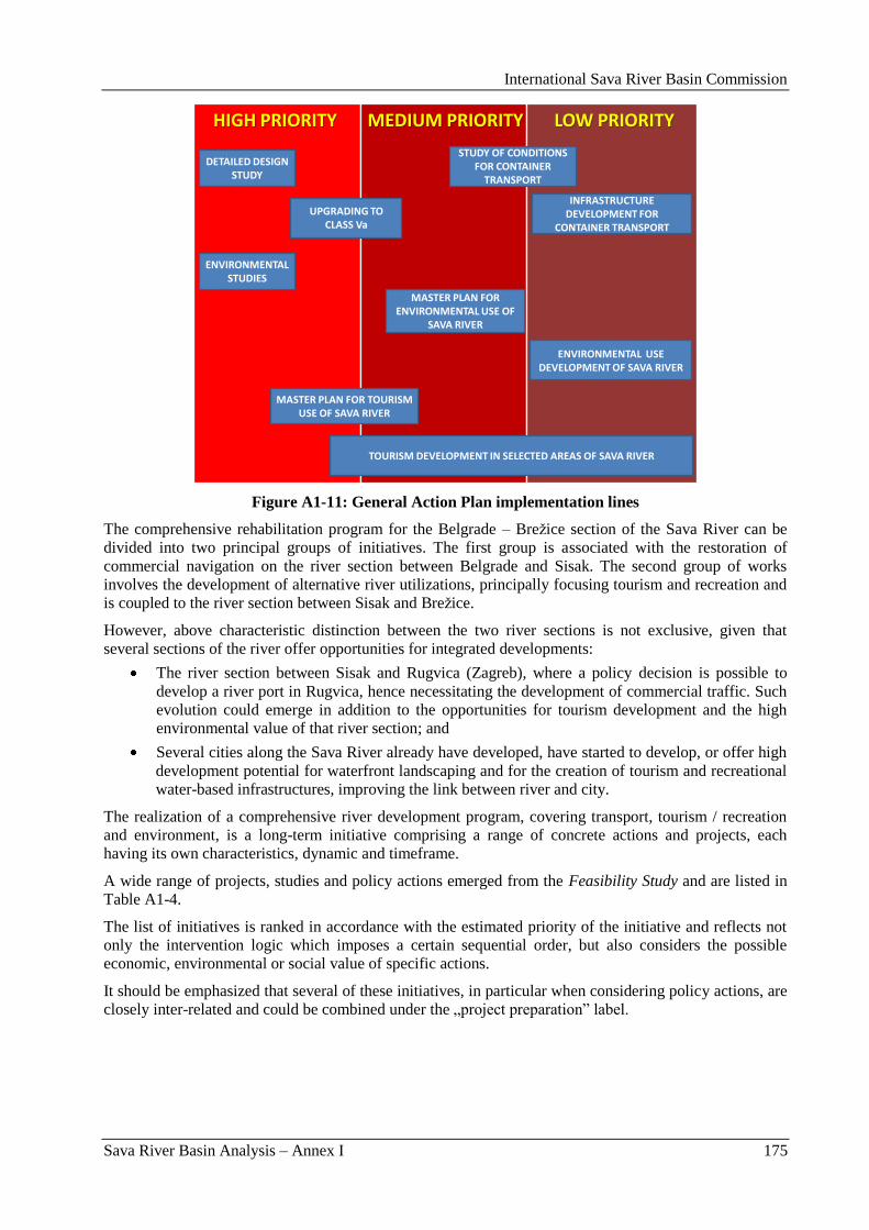
International Sava River Basin Commission
Sava River Basin Analysis – Annex I 175
HIGH PRIORITY MEDIUM PRIORITY LOW PRIORITY
DETAILED DESIGN STUDY
ENVIRONMENTAL STUDIES
UPGRADING TO CLASS Va
MASTER PLAN FOR ENVIRONMENTAL USE OF
SAVA RIVER
TOURISM DEVELOPMENT IN SELECTED AREAS OF SAVA RIVER
MASTER PLAN FOR TOURISM USE OF SAVA RIVER
ENVIRONMENTAL USE DEVELOPMENT OF SAVA RIVER
STUDY OF CONDITIONS FOR CONTAINER
TRANSPORT
INFRASTRUCTURE DEVELOPMENT FOR
CONTAINER TRANSPORT
Figure A1-11: General Action Plan implementation lines
The comprehensive rehabilitation program for the Belgrade – Breţice section of the Sava River can be
divided into two principal groups of initiatives. The first group is associated with the restoration of
commercial navigation on the river section between Belgrade and Sisak. The second group of works
involves the development of alternative river utilizations, principally focusing tourism and recreation and
is coupled to the river section between Sisak and Breţice.
However, above characteristic distinction between the two river sections is not exclusive, given that
several sections of the river offer opportunities for integrated developments:
The river section between Sisak and Rugvica (Zagreb), where a policy decision is possible to
develop a river port in Rugvica, hence necessitating the development of commercial traffic. Such
evolution could emerge in addition to the opportunities for tourism development and the high
environmental value of that river section; and
Several cities along the Sava River already have developed, have started to develop, or offer high
development potential for waterfront landscaping and for the creation of tourism and recreational
water-based infrastructures, improving the link between river and city.
The realization of a comprehensive river development program, covering transport, tourism / recreation
and environment, is a long-term initiative comprising a range of concrete actions and projects, each
having its own characteristics, dynamic and timeframe.
A wide range of projects, studies and policy actions emerged from the Feasibility Study and are listed in
Table A1-4.
The list of initiatives is ranked in accordance with the estimated priority of the initiative and reflects not
only the intervention logic which imposes a certain sequential order, but also considers the possible
economic, environmental or social value of specific actions.
It should be emphasized that several of these initiatives, in particular when considering policy actions, are
closely inter-related and could be combined under the „project preparation” label.
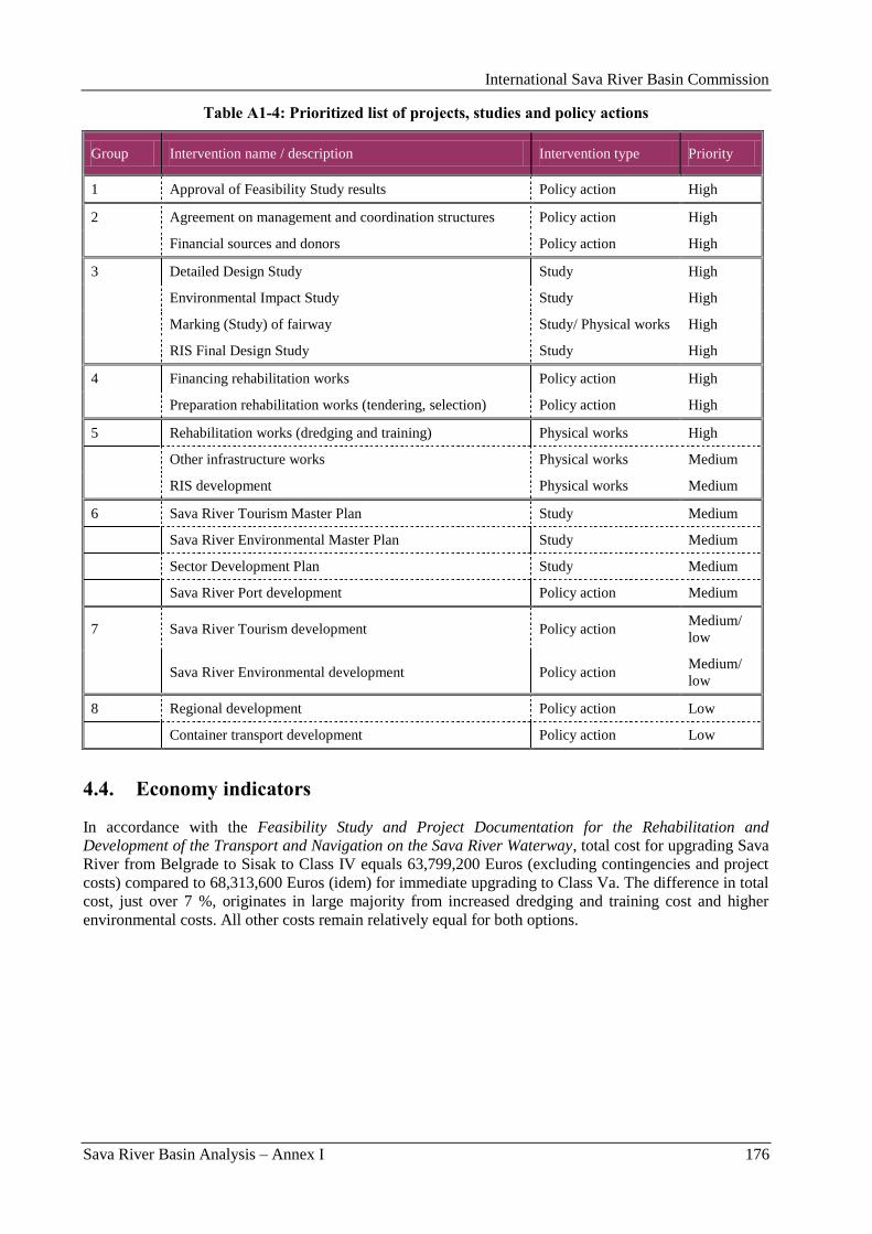
International Sava River Basin Commission
Sava River Basin Analysis – Annex I 176
Table A1-4: Prioritized list of projects, studies and policy actions
Group Intervention name / description Intervention type Priority
1 Approval of Feasibility Study results Policy action High
2 Agreement on management and coordination structures Policy action High
Financial sources and donors Policy action High
3 Detailed Design Study Study High
Environmental Impact Study Study High
Marking (Study) of fairway Study/ Physical works High
RIS Final Design Study Study High
4 Financing rehabilitation works Policy action High
Preparation rehabilitation works (tendering, selection) Policy action High
5 Rehabilitation works (dredging and training) Physical works High
Other infrastructure works Physical works Medium
RIS development Physical works Medium
6 Sava River Tourism Master Plan Study Medium
Sava River Environmental Master Plan Study Medium
Sector Development Plan Study Medium
Sava River Port development Policy action Medium
7 Sava River Tourism development Policy action Medium/
low
Sava River Environmental development Policy action
Medium/
low
8 Regional development Policy action Low
Container transport development Policy action Low
4.4. Economy indicators
In accordance with the Feasibility Study and Project Documentation for the Rehabilitation and
Development of the Transport and Navigation on the Sava River Waterway, total cost for upgrading Sava
River from Belgrade to Sisak to Class IV equals 63,799,200 Euros (excluding contingencies and project
costs) compared to 68,313,600 Euros (idem) for immediate upgrading to Class Va. The difference in total
cost, just over 7 %, originates in large majority from increased dredging and training cost and higher
environmental costs. All other costs remain relatively equal for both options.
International Sava River Basin Commission
Sava River Basin Analysis – Annex I 177
Table A1-5: Comparative summary of rehabilitation costs
Total for SCC
Class IV
(Euro)
Total for SCC
Class Va
(Euro)
Difference
(Euro)
Difference
%
Dredging and training works 34,929,200 39,108,600 4,179,400 12.0
Environmental costs 1,005,000 1,340,000 335,000 33.3
Bridge replacements 8,880,000 8,880,000 0 0.0
River bend improvements (total) 11,360,000 11,360,000 0 0.0
Markings and sunken vessels 1,835,000 1,835,000 0 0.0
RIS 5,790,000 5,790,000 0 0.0
Net cost 63,799,200 68,313,600 4,514,400 7.1
Including contingencies (+10%) 70,179,120 75,144,960 4,965,840 7.1
TOTAL project costs (+15%) 80,705,988 86,416,704 5,710,716 7.1
As the river gradually diminishes its size in upstream direction the demanded work to comply with a SCC
Class IV navigation channel increases. As a result of this, upgrading of the Sava from Rugvica to Breţice
needs from the river engineering point of view, to be done with dams and locks.
Most ideally from the environmental and river engineering point of view is the implementation of a series
of small dams with locks at close internal spacing. Because locks are notoriously expensive this is usually
not feasible and the absolute minimum amount of dams has to be used as alternative solution.
Table A1-6 presents the infrastructure costs and the operation and maintenance costs depending on the
types of alternatives and the approach used to assess these costs.
Table A1-6: Overall cost overview for rehabilitation of section Sisak - Brežice
Project Investment costs
(Euro)
Operation and maintenance
costs (Euro)
Section 1: Sisak – Rugvica:
Approach 1 22,785,000 56,950
Approach 2 32,816,883 56,950
Section 2: Rugvica – Breţice:
Alternative 2 dams 299,046,000 4,476,000
Alternative 2 dams + Mokrice dam 324,346,000 5,476,000
Alternative 5 dams 353,947,000 7,144,000
Alternative 5 dams + Mokrice dam 379,247,000 8,144,000
Combined:
Minimum 321,831,000 4,532,950
Maximum 412,063,883 8,200,950
Furthermore, the Cost Benefit Analysis clearly demonstrated that the investment performance for
immediate upgrading of the section between Belgrade and Sisak to SCC Class Va are very positive and is
even better as the already positive appreciation of upgrading the river to Class IV. Especially the
performance of the project at low transport volumes improves significantly, meaning that the immediate
upgrading to Class Va has less investment risk in case of lower than expected traffic / cargo volumes.
International Sava River Basin Commission
Sava River Basin Analysis – Annex I 178
The river section between km 0 and km 362 shows the best socio-economic performance in case of
upgrading to Class Va while the stretch between 362 and 583 (Slavonski Brod – Sisak) is not yet positive
at the end of the appraisal period in the year 2028, but calculation will break even in 2031, therewith
showing clear potential in the longer term future.
The profitability of investments is substantially better for the upgrading to Class Va than to Class IV,
which already were very positive, and the internal rates of return (IRR) are clearly better for SCC Class
Va. Compared to the higher level of benefits when comparing the upgrading to Class IV with upgrading
to Class Va, the increase in costs remains moderate at a 15 % increase, discounted over 20 years. As a
result, the Net Present Values are much higher for upgrading to SCC Class Va as compared to SCC Class
IV. Also the benefits for the transport industry show big increases of about +55 % compared to upgrading
to Class IV and there is furthermore a notable increase of +20 % on the external benefits.
Overall, the reference medium volume scenario shows an internal rate of return of 20 % which is very
good. The Net Present Value at 6 % discount rate is 157.9 million Euro and the Benefit/Cost ratio is 2.68.
These figures illustrate that the project clearly provides an added value for the industry and society.
Furthermore one should bear in mind that the appraisal period is short (20 years) and sand and gravel
transport by IWT have been disregarded in the analysis. Therefore the results shall be considered to be
robust and rather conservative.
Comparing the river rehabilitation costs and benefits for river section Sisak – Brezice with the results for
upgrading the section Belgrade – Sisak, both to SCC Class IV, the immediate and logical conclusion is
that the extension of navigability upstream Sisak generates a clear negative CBA result. An increase on
the cost-side could be observed of 270 % up to 290 % while the benefits only increased between 2.4 %
and 3.3 %. Since the relative change of costs is much bigger than the relative increase of benefits, the
benefit/cost ratio is strongly negative.
There is no doubt that extension of navigability upstream Sisak does not provide sufficient benefits to
compensate for the huge investments. Even when integrating the investment into the development of Sava
River downstream Sisak, the benefit/cost ratio for the combined investment is 0.60, meaning that only 60
% of the total investments are recovered by internal and external transport benefits. However, once the
investments are completed and there are only operations and maintenance costs, there is a positive annual
cash flow and the balance between benefits and costs is improving during the years 2019 and 2028.
In respect of the above economic analysis and associated results, two specific comments should be made:
The CBA has been conducted according to a specific assumed timetable. Possible changes in this
timetable could change the outcomes of the CBA. This is in particular true if the capital costs are
moved forward significantly, reducing the profitability of the project.
The CBA has assumed a sequential implementation of the rehabilitation works, starting in
Belgrade and proceeding upstream towards Sisak. The CBA does not consider impacts related to
alternative development scenarios which could have an impact on the outcome of the CBA.
The CBA has been realized using realistic assumptions and taking conservative positions. Given the
limitations caused by the level of detail of available information, the investigation provided sufficiently
robust information to recommend:
The immediate implementation of rehabilitation works to upgrade Sava River to Class Va
between Belgrade and Sisak.
To abandon the idea of upgrading that section to Class IV and in the future upgrade to Class Va if
demand warrants such additional investment;
Formally abandon the idea of upgrading Sava River upstream Zagreb for commercial river
transport and concentrate on tourism development and energy production; and
In principle abandon the idea of introducing commercial traffic on the section Sisak – Rugvica
because there is no economic or financial rationale for the investment.
Meanwhile, based on a careful consideration of the findings presented in the Study, as well as all other
relevant inputs, the Sava Commission has decided on the navigation class of the future Sava River
waterway. Namely, according to Decision 21/09, further activities should be performed in accordance
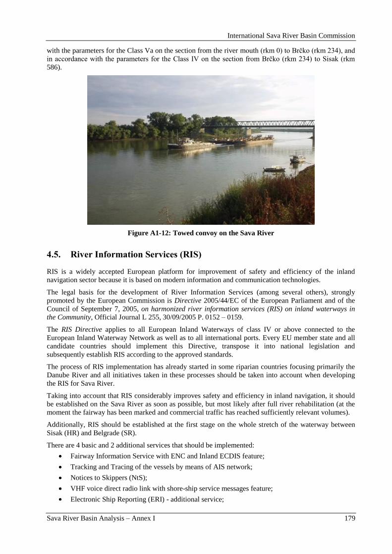
International Sava River Basin Commission
Sava River Basin Analysis – Annex I 179
with the parameters for the Class Va on the section from the river mouth (rkm 0) to Brĉko (rkm 234), and
in accordance with the parameters for the Class IV on the section from Brĉko (rkm 234) to Sisak (rkm
586).
Figure A1-12: Towed convoy on the Sava River
4.5. River Information Services (RIS)
RIS is a widely accepted European platform for improvement of safety and efficiency of the inland
navigation sector because it is based on modern information and communication technologies.
The legal basis for the development of River Information Services (among several others), strongly
promoted by the European Commission is Directive 2005/44/EC of the European Parliament and of the
Council of September 7, 2005, on harmonized river information services (RIS) on inland waterways in
the Community, Official Journal L 255, 30/09/2005 P. 0152 – 0159.
The RIS Directive applies to all European Inland Waterways of class IV or above connected to the
European Inland Waterway Network as well as to all international ports. Every EU member state and all
candidate countries should implement this Directive, transpose it into national legislation and
subsequently establish RIS according to the approved standards.
The process of RIS implementation has already started in some riparian countries focusing primarily the
Danube River and all initiatives taken in these processes should be taken into account when developing
the RIS for Sava River.
Taking into account that RIS considerably improves safety and efficiency in inland navigation, it should
be established on the Sava River as soon as possible, but most likely after full river rehabilitation (at the
moment the fairway has been marked and commercial traffic has reached sufficiently relevant volumes).
Additionally, RIS should be established at the first stage on the whole stretch of the waterway between
Sisak (HR) and Belgrade (SR).
There are 4 basic and 2 additional services that should be implemented:
Fairway Information Service with ENC and Inland ECDIS feature;
Tracking and Tracing of the vessels by means of AIS network;
Notices to Skippers (NtS);
VHF voice direct radio link with shore-ship service messages feature;
Electronic Ship Reporting (ERI) - additional service;
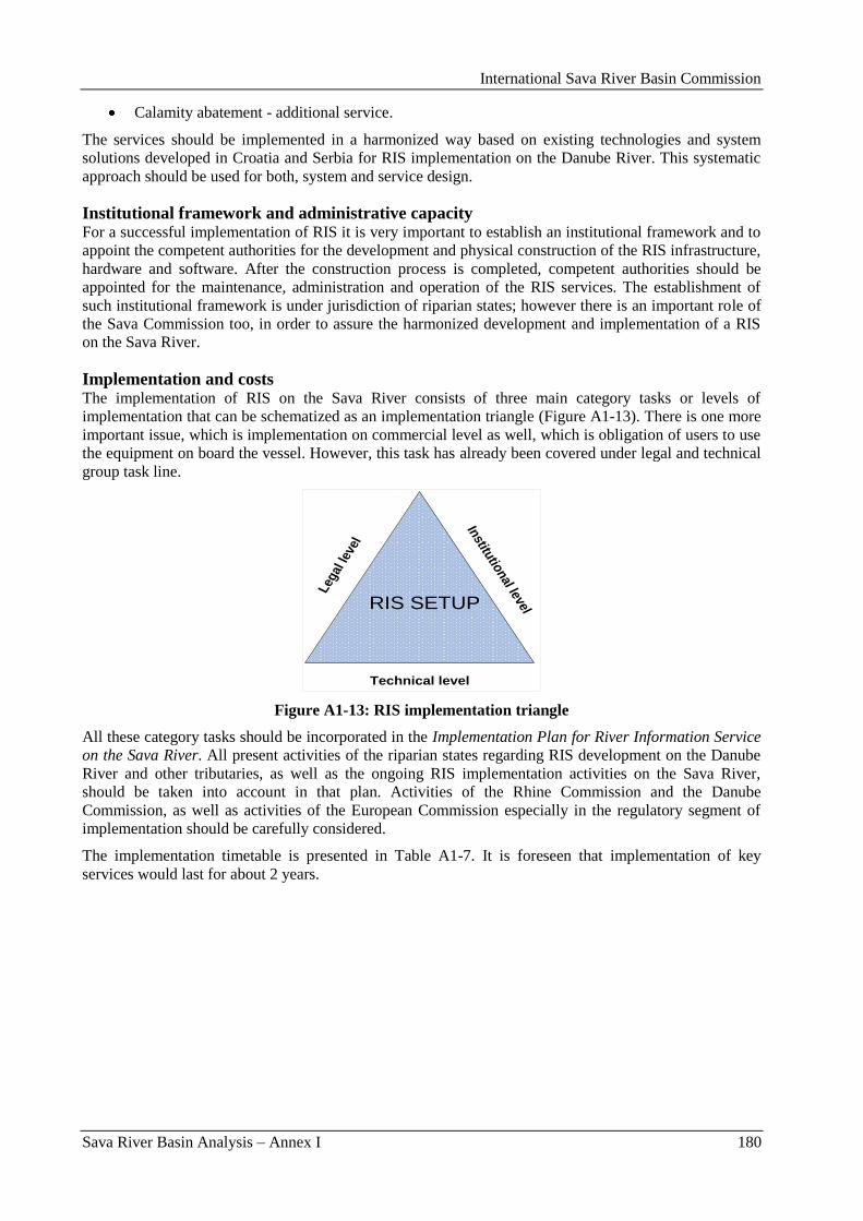
International Sava River Basin Commission
Sava River Basin Analysis – Annex I 180
Calamity abatement - additional service.
The services should be implemented in a harmonized way based on existing technologies and system
solutions developed in Croatia and Serbia for RIS implementation on the Danube River. This systematic
approach should be used for both, system and service design.
Institutional framework and administrative capacity For a successful implementation of RIS it is very important to establish an institutional framework and to
appoint the competent authorities for the development and physical construction of the RIS infrastructure,
hardware and software. After the construction process is completed, competent authorities should be
appointed for the maintenance, administration and operation of the RIS services. The establishment of
such institutional framework is under jurisdiction of riparian states; however there is an important role of
the Sava Commission too, in order to assure the harmonized development and implementation of a RIS
on the Sava River.
Implementation and costs The implementation of RIS on the Sava River consists of three main category tasks or levels of
implementation that can be schematized as an implementation triangle (Figure A1-13). There is one more
important issue, which is implementation on commercial level as well, which is obligation of users to use
the equipment on board the vessel. However, this task has already been covered under legal and technical
group task line.
Technical level
Institu
tional level
Leg
al le
vel
RIS SETUP
Figure A1-13: RIS implementation triangle
All these category tasks should be incorporated in the Implementation Plan for River Information Service
on the Sava River. All present activities of the riparian states regarding RIS development on the Danube
River and other tributaries, as well as the ongoing RIS implementation activities on the Sava River,
should be taken into account in that plan. Activities of the Rhine Commission and the Danube
Commission, as well as activities of the European Commission especially in the regulatory segment of
implementation should be carefully considered.
The implementation timetable is presented in Table A1-7. It is foreseen that implementation of key
services would last for about 2 years.
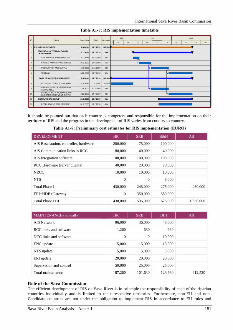
International Sava River Basin Commission
Sava River Basin Analysis – Annex I 181
Table A1-7: RIS implementation timetable
ID Tasks Duration
2008
Q3
2 80wTECHNICAL & TECHNOLOGICAL
DEVELOPMENT
3 8wSITE SURVEY AND RANGE TEST
4 16wSYSTEM AND SERVICE DESIGN
5 24wPRODUCTION AND SUPPLY
6 32wTESTING
7 110,43wLEGAL FRAMEWORK DEFINITION
45wINSTITUTIONAL SETUP
1.1.2009
1.1.2009
26.2.2009
18.6.2009
3.12.2009
2.6.2008
31.8.2009
Beginning
14.7.2010
25.2.2009
17.6.2009
2.12.2009
14.7.2010
14.7.2010
11.7.2010
End
2009 2010
Q4Q4 Q2Q1Q4Q1 Q3Q3 Q2Q2
8 30,57w1.1.20092.6.2008ADOPTION OF RIS STANDARDS
9 24w2.12.200918.6.2009APPOINTMENT OF COMPETENT
AUTHORITIES
10 32w14.7.20103.12.2009SUPPORTING PROGRAMME FOR
ONBOARD EQUIPMENT SUPPLY
1 110,43w14.7.20102.6.2008RIS IMPLEMENTATION
12
11
45w11.7.201031.8.2009RECRUITMENT AND START UP
It should be pointed out that each country is competent and responsible for the implementation on their
territory of RIS and the progress in the development of RIS varies from country to country.
Table A1-8: Preliminary cost estimates for RIS implementation (EURO)
DEVELOPMENT HR SRB B&H All
AIS Base station, controller, hardware 200,000 75,000 100,000
AIS Communication links to RCC 80,000 40,000 40,000
AIS Integration software 100,000 100,000 100,000
RCC Hardware (server clients) 40,000 20,000 20,000
NRCC 10,000 10,000 10,000
NTS 0 0 5,000
Total Phase I 430,000 245,000 275,000 950,000
ERI+HDB+Gateway 0 350,000 350,000
Total Phase I+II 430,000 595,000 625,000 1,650,000
MAINTENANCE (annually) HR SRB BIH All
AIS Network 96,000 36,000 48,000
RCC links and software 1,260 630 630
NCC links and software 0 0 10,000
ENC update 15,000 15,000 15,000
NTS update 5,000 5,000 5,000
ERI update 20,000 20,000 20,000
Supervision and control 50,000 25,000 25,000
Total maintenance 187,260 101,630 123,630 412,520
Role of the Sava Commission The efficient development of RIS on Sava River is in principle the responsibility of each of the riparian
countries individually and is limited to their respective territories. Furthermore, non-EU and non-
Candidate countries are not under the obligation to implement RIS in accordance to EU rules and
International Sava River Basin Commission
Sava River Basin Analysis – Annex I 182
regulations (RIS Directive). This situation could lead to a fragmented development of RIS on Sava River
and to utilization of different and not always compatible technologies.
It is for that reason imperative that a common platform for cooperation between countries and competent
authorities is established within the Sava Commission and that the implementation of RIS services on
Sava River is coordinated and structured via the Sava Commission.
5. Environmental considerations In order to take actions toward sustainable water management by taking appropriate measures to, at least,
maintain and, where possible, improve the environmental conditions in the Sava River Basin, the Sava
Commission has put a special importance on sustainable and environmentally friendly development of
navigation on the Sava River.
In this respect rehabilitation and improvement of the Sava River waterway needs to be in agreement with
the main objectives of the Framework Agreement on the Sava River Basin:
Restoring navigation on the Sava River and its tributaries;
Promoting integrated river basin management of water quality and environmental conservation;
Coordination of risk protection (flood, drought, pollution);
Supporting sustainable, ecologically and socially responsible economic development.
Furthermore due to the fact that IWT plans and projects have environmental implications, there is the
need to carry out environmental assessments before decisions are made. This is required by the Strategic
Environmental (SEA) Directive (2001/42/EC) for qualifying plans, programmes and policies and required
by the Environmental Impact Assessment (EIA) Directive (85/337/EEC) for qualifying projects. Under
these procedures, the public can give its opinion and results are taken into account in the authorisation
procedure for the projects.
It is also important to emphasize that, to achieve „good ecological status” or „good ecological potential”
for all surface waters and to prevent deterioration of the ecological status - as required by the EU WFD –
an integrated planning philosophy is needed. Multi-use riverine landscapes should be the goal (including
for example providing for fauna and flora habitats, flood protection, inland navigation, fisheries, tourism).
The Sava Commission, together with the ICPDR and Danube Commission, was one of the main driving
forces in the process of drafting the Joint Statement on Guiding Principles for the Development of Inland
Navigation and Environmental Protection in the Danube River Basin and, accordinfly, this document has
been taken into account from the beginning of the Project. According to the Joint Statement, future
approach needs balancing between navigation and ecological needs. To enable them to function, both
IWT and ecological integrity have certain basic needs. In order to develop mutually acceptable solutions -
such needs must first be clearly defined. However, not all needs are fulfilled in all cases. The
implementation of a new, integrated planning philosophy would aim to put this right and will help ensure
both sustainable development of IWT and the achievement of all required environmental objectives.
Further, relevant environmental mitigation or restoration measures, should be proposed to prevent the
deterioration of the ecological status and ensure the achievement of the environmental objectives. Both
pressures and measures should be identified via a common understanding. This goal should be achieved
by an interdisciplinary process. Opportunities to improve both the environmental and navigation
conditions through a joint approach to projects need to be identified.
Taking into account all above mentioned principles, the Sava Commission included environmental
experts in the development of the Prefeasibility Study for the Rehabilitation and Improvement of the Sava
River Waterway and Feasibility Study and Project Documentation for the Rehabilitation and
Development of Transport and Navigation on the Sava River Waterway, which is the very first phase of
rehabilitation and development of the Sava River waterway.
The Prefeasibility Study has a special chapter on EIA, and in the Feasibility Study, a separate report on
environmental impact assessment was done for the each phase of the rehabilitation and development of
the waterway.
International Sava River Basin Commission
Sava River Basin Analysis – Annex I 183
These reports present a pre-phase in the EIA report preparation. This document is a basis for EIA reports
preparation (which will folow), it gives a general overview of the intervention location, possible impacts
and measures to be conducted. EIA reports and EIA process in accordance with the EIA Directive and
national regulations will be prepared and conducted during the following phase of project preparation.
In this respect development of the full EIA for the interventions on the part of the Sava River from km
207 to km 586 is in process and will be finished in 2009. B&H and Serbia started with preliminary
actions for the EIA development for the stretch from km 0 to km 207 and it is expected to start in the
second half of 2009.
In order to present whole project and relevant studies to the stakeholders, the Sava Commission organized
several workshops and presentations and all relevant documentation are available on the web. From the
very beginig of the project, interdisciplinary team of expert is engaged on the project and the stakeholders
informed and included in the planning process. Already in this pre-phase of planning the process is very
transparent thanks to the presentations of the project, informing the stakeholder and availability of the
informations on the planned actions and the prepared documents to the public (via web). This step already
complies with the guidelines mentioned above. All the required ecological and planning guidelines
mentioned above will be as well met during the following steps of planning. As the following stages
include the EIA process and the preparation of the designs and EIA reports in each involved country, all
of the mentioned guidelines are to be taken into account during those phases.
On the other side, taking into account the existing navigation on the Sava River and trying to improve
regulation regarding the water protection, the Sava Commission in 2007 developed the Protocol on
prevention of water pollution caused by navigation to the FASRB, which was signed at the Second
Meeting of the Parties to the FASRB, held on June 1, 2009, in Belgrade. This Protocol is aimed at
prevention, control and reduction of pollution originating from vessels, establishment of technical
requirements for the equipment of port facilities, and other reception stations, development of the best
available techniques, informing, development of spill response measures and monitoring of water quality.
Transboundary cooperation should include actions to prevent pollution from vessels by developing a joint
action programme, since water quality monitoring requires a network of national institutions for
monitoring and inspection. The Protocol underlines the importance of set-up of the institutional
framework, establishment of joint body for determination of reasons and facts relating to the accident, and
impact to the environment.
At the same time, the Sava Commission is involved in the recently launched project Waste Management
for Inland Navigation on the Danube – WANDA, which is aimed to develop proposal for the
establishment of the harmonized waste management system for the Danube River. Through participation
in the project, the Sava Commission will be able to receive the most recent information on this issue, to
contribute to the project with its expertise, to provide feedback on a strategic level and make use of the
project results for further activities in this regard.
6. Conclusions Present status of waterway is very poor and waterway infrastructure suffers of aging, lack of maintenance
and incompleteness. Such status has negative impact on the safety of navigation and increase possibility
for accidents with potential adverse impacts on environment.
Rehabilitation and development of the waterway of the Sava River seems to be a project with clear
positive socio-economic effects and the future activities should therefore focus on an efficient completion
of the studies and design, and the execution of works on the waterway rehabilitation.
The infrastructure rehabilitation is only a first step in the establishment of a modern river transport sector
and in this regard, following the approach of the NAIADES program, the next actions are of particular
importance:
The transposition of all EU rules and regulations for inland waterway transport is realized as
quickly as possible with full transparency and following the principles of good governance;
Further work on the harmonization of the rules and regulations on the European level;
International Sava River Basin Commission
Sava River Basin Analysis – Annex I 184
The necessary strategies are developed for the realization of a public support program for the
restoration / creation of a competitive river transport sector, within the limitations of the EU rules
and regulations on state aid;
In time, river transport and Sava River become part of the region‟s transport systems and
attention is paid to the introduction of modern techniques and technologies and to container
transport;
The development of the sector and the modernization of IWT should be strengthened by a
sustainable and modern marketing campaign, on the one hand to attract private investments and
on the other hand to increase the demand for and use of IWT, and
The creation of a comprehensive expertise building program will be required and should be
developed following a benchmark of existing knowledge levels with best practices.
All the required ecological and planning regulations and guidelines such as EU Directives and Joint
Statement on Guiding Principles for the Development of Inland Navigation and Environmental Protection
in the Danube River Basin shall be as well met during the following steps of project.
International Sava River Basin Commission
Sava River Basin Analysis – Annex II 185
Annex II: Flood Management in the Sava River Basin

International Sava River Basin Commission
Sava River Basin Analysis – Annex II 186
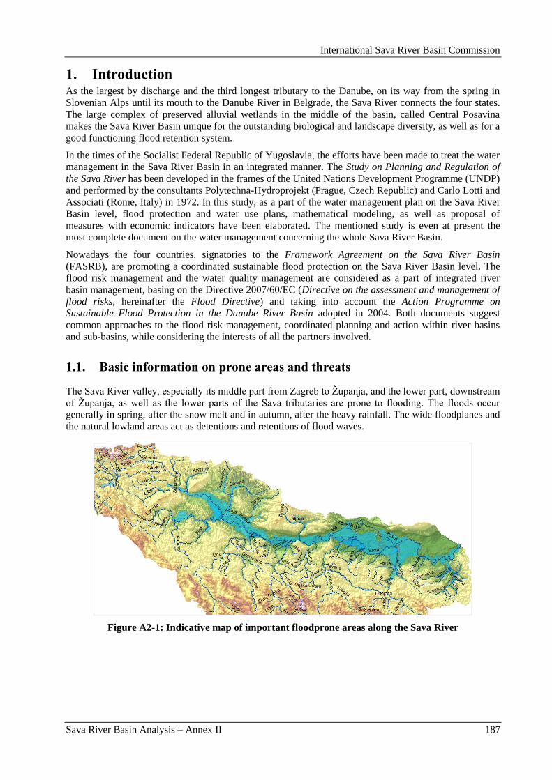
International Sava River Basin Commission
Sava River Basin Analysis – Annex II 187
1. Introduction As the largest by discharge and the third longest tributary to the Danube, on its way from the spring in
Slovenian Alps until its mouth to the Danube River in Belgrade, the Sava River connects the four states.
The large complex of preserved alluvial wetlands in the middle of the basin, called Central Posavina
makes the Sava River Basin unique for the outstanding biological and landscape diversity, as well as for a
good functioning flood retention system.
In the times of the Socialist Federal Republic of Yugoslavia, the efforts have been made to treat the water
management in the Sava River Basin in an integrated manner. The Study on Planning and Regulation of
the Sava River has been developed in the frames of the United Nations Development Programme (UNDP)
and performed by the consultants Polytechna-Hydroprojekt (Prague, Czech Republic) and Carlo Lotti and
Associati (Rome, Italy) in 1972. In this study, as a part of the water management plan on the Sava River
Basin level, flood protection and water use plans, mathematical modeling, as well as proposal of
measures with economic indicators have been elaborated. The mentioned study is even at present the
most complete document on the water management concerning the whole Sava River Basin.
Nowadays the four countries, signatories to the Framework Agreement on the Sava River Basin
(FASRB), are promoting a coordinated sustainable flood protection on the Sava River Basin level. The
flood risk management and the water quality management are considered as a part of integrated river
basin management, basing on the Directive 2007/60/EC (Directive on the assessment and management of
flood risks, hereinafter the Flood Directive) and taking into account the Action Programme on
Sustainable Flood Protection in the Danube River Basin adopted in 2004. Both documents suggest
common approaches to the flood risk management, coordinated planning and action within river basins
and sub-basins, while considering the interests of all the partners involved.
1.1. Basic information on prone areas and threats
The Sava River valley, especially its middle part from Zagreb to Ţupanja, and the lower part, downstream
of Ţupanja, as well as the lower parts of the Sava tributaries are prone to flooding. The floods occur
generally in spring, after the snow melt and in autumn, after the heavy rainfall. The wide floodplanes and
the natural lowland areas act as detentions and retentions of flood waves.
Figure A2-1: Indicative map of important floodprone areas along the Sava River
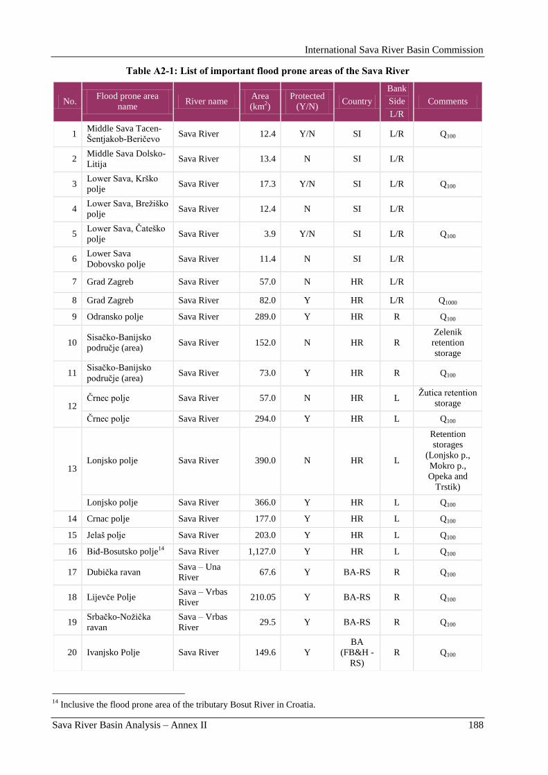
International Sava River Basin Commission
Sava River Basin Analysis – Annex II 188
Table A2-1: List of important flood prone areas of the Sava River
No. Flood prone area
name River name
Area
(km2)
Protected
(Y/N) Country
Bank
Side
L/R
Comments
1 Middle Sava Tacen-
Šentjakob-Beriĉevo Sava River 12.4 Y/N SI L/R Q100
2 Middle Sava Dolsko-
Litija Sava River 13.4 N SI L/R
3 Lower Sava, Krško
polje Sava River 17.3 Y/N SI L/R Q100
4 Lower Sava, Breţiško
polje Sava River 12.4 N SI L/R
5 Lower Sava, Ĉateško
polje Sava River 3.9 Y/N SI L/R Q100
6 Lower Sava
Dobovsko polje Sava River 11.4 N SI L/R
7 Grad Zagreb Sava River 57.0 N HR L/R 8 Grad Zagreb Sava River 82.0 Y HR L/R Q1000
9 Odransko polje Sava River 289.0 Y HR R Q100
10 Sisaĉko-Banijsko
podruĉje (area) Sava River 152.0 N HR R
Zelenik
retention
storage
11 Sisaĉko-Banijsko
podruĉje (area) Sava River 73.0 Y HR R Q100
12 Ĉrnec polje Sava River 57.0 N HR L
Ţutica retention
storage
Ĉrnec polje Sava River 294.0 Y HR L Q100
13 Lonjsko polje Sava River 390.0 N HR L
Retention
storages
(Lonjsko p.,
Mokro p.,
Opeka and
Trstik)
Lonjsko polje Sava River 366.0 Y HR L Q100
14 Crnac polje Sava River 177.0 Y HR L Q100
15 Jelaš polje Sava River 203.0 Y HR L Q100
16 BiĊ-Bosutsko polje14
Sava River 1,127.0 Y HR L Q100
17 Dubiĉka ravan Sava – Una
River 67.6 Y BA-RS R Q100
18 Lijevĉe Polje Sava – Vrbas
River 210.05 Y BA-RS R Q100
19 Srbaĉko-Noţiĉka
ravan
Sava – Vrbas
River 29.5 Y BA-RS R Q100
20 Ivanjsko Polje Sava River 149.6 Y
BA
(FB&H -
RS)
R Q100
14
Inclusive the flood prone area of the tributary Bosut River in Croatia.
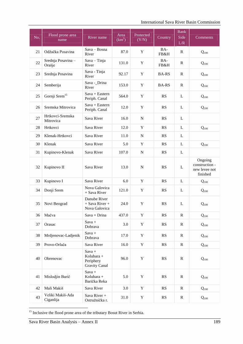
International Sava River Basin Commission
Sava River Basin Analysis – Annex II 189
No. Flood prone area
name River name
Area
(km2)
Protected
(Y/N) Country
Bank
Side
L/R
Comments
21 Odţaĉka Posavina Sava – Bosna
River 87.0 Y
BA-
FB&H R Q100
22 Srednja Posavina –
Orašje
Sava – Tinja
River 131.0 Y
BA-
FB&H R Q100
23 Srednja Posavina Sava - Tinja
River 92.17 Y BA-RS R Q100
24 Semberija Sava -_Drina
River 153.0 Y BA-RS R Q100
25 Gornji Srem15
Sava + Eastern
Periph. Canal 564.0 Y RS L Q100
26 Sremska Mitrovica Sava + Eastern
Periph. Canal 12.0 Y RS L Q100
27 Hrtkovci-Sremska
Mitrovica Sava River 16.0 N RS L
28 Hrtkovci Sava River 12.0 Y RS L Q100
29 Klenak-Hrtkovci Sava River 11.0 N RS L 30 Klenak Sava River 5.0 Y RS L Q100
31 Kupinovo-Klenak Sava River 107.0 N RS L
32 Kupinovo II Sava River 13.0 N RS L
Ongoing
construction -
new levee not
finished
33 Kupinovo I Sava River 6.0 Y RS L Q100
34 Donji Srem Nova Galovica
+ Sava River 121.0 Y RS L Q100
35 Novi Beograd
Danube River
+ Sava River +
Nova Galovica
24.0 Y RS L Q100
36 Maĉva Sava + Drina 437.0 Y RS R Q100
37 Orasac Sava +
Dobrava 3.0 Y RS R Q100
38 Mrdjenovac-Ladjenik Sava +
Dobrava 17.0 Y RS R Q100
39 Provo-Orlaĉa Sava River 16.0 Y RS R Q100
40 Obrenovac
Sava +
Kolubara +
Periphery
Gravity Canal
96.0 Y RS R Q100
41 Mislodjin Bariĉ
Sava +
Kolubara +
Bariĉka Reka
5.0 Y RS R Q100
42 Mali Makiš Sava River 3.0 Y RS R Q100
43 Veliki Makiš-Ada
Ciganlija Sava River +
Ostruţniĉka r. 31.0 Y RS R Q100
15
Inclusive the flood prone area of the tributary Bosut River in Serbia.
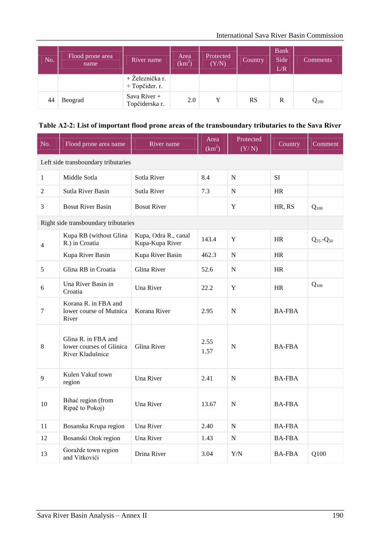
International Sava River Basin Commission
Sava River Basin Analysis – Annex II 190
No. Flood prone area
name River name
Area
(km2)
Protected
(Y/N) Country
Bank
Side
L/R
Comments
+ Ţelezniĉka r.
+ Topĉider. r.
44 Beograd Sava River +
Topĉiderska r. 2.0 Y RS R Q100
Table A2-2: List of important flood prone areas of the transboundary tributaries to the Sava River
No. Flood prone area name River name Area
(km2)
Protected
(Y/ N) Country Comment
Left side transboundary tributaries
1 Middle Sotla Sotla River 8.4 N SI
2 Sutla River Basin Sutla River 7.3 N HR
3 Bosut River Basin Bosut River Y HR, RS Q100
Right side transboundary tributaries
4
Kupa RB (without Glina
R.) in Croatia
Kupa, Odra R., canal
Kupa-Kupa River 143.4 Y HR Q25--Q50
Kupa River Basin Kupa River Basin 462.3 N HR
5 Glina RB in Croatia Glina River 52.6 N HR
6 Una River Basin in
Croatia Una River 22.2 Y HR
Q100
7
Korana R. in FBA and
lower course of Mutnica
River
Korana River 2.95 N BA-FBA
8
Glina R. in FBA and
lower courses of Glinica
River Kladušnice
Glina River 2.55
1.57 N BA-FBA
9 Kulen Vakuf town
region Una River 2.41 N BA-FBA
10 Bihać region (from
Ripaĉ to Pokoj) Una River 13.67 N BA-FBA
11 Bosanska Krupa region Una River 2.40 N BA-FBA
12 Bosanski Otok region Una River 1.43 N BA-FBA
13 Goraţde town region
and Vitkovići Drina River 3.04 Y/N BA-FBA Q100
International Sava River Basin Commission
Sava River Basin Analysis – Annex II 191
1.2. Historical flood events on the Sava River
During the last century, several large floods occurred on the Sava River, the largest covering the whole
region from Zagreb to Belgrade in 1933, 1937, 1940, 1947 and 1974. The Upper Sava Region (Slovenia)
suffered on floods in the last decades in 1990, 1998, 2005 and recently in 2007, when besides enormous
economic damage, six human lives were lost. In the Middle Sava region, the most severe floods occurred
in 1923, 1925, 1926, 1964, 1966, 1970, 1990 and 1998, while in 1915, 1924, 1932, 1940, 1944, 1952,
1962, 1970, 1981, and 2006 in the Lower Sava region. The large flood that hit Zagreb in 1964, resulted in
loss of 17 human lives, loss of homes for tens of thousands of people and huge damages.
Some more information on historic floods on the Sava River and its tributaries in the whole Sava River
Basin can be seen in the national reports, in the Appendices I, II and III.
2. Existing Flood Management
2.1. Commanding responsibilities
2.1.1. Institutional arrangements in Bosnia and Herzegovina
In Bosnia and Herzegovina the water management lies under the entity-level competence.
2.1.1.1. Republika Srpska
The main legal instrument which determines the protection against harmful water affects is the Water
Law of Republika Srpska. This law is in compliance with Water Law of FBA and EU WFD as well as with
EU Flood Directive (Official Gazette of RS, No. 55/06).
Institutions responsible for the law implementation:
Ministry of agriculture, forestry and water management, Banja Luka
Republic Directorate for waters (as of February 13, 2009, the Agency for waters for Sava River
Basin district), Bijeljina
Republic administration of civil protection, Banja Luka.
The implementation of Water law and flood protection is enforced also by public utilities for Sava
(Gradiška), Sava (Brod), Posavina (Vukosavje), Ušće Bosne (Šamac), Srednja Posavina (Lonĉari),
Semberija (Bijeljina), Drina (Zvornik) and Gornja Bosna (Foĉa).
Furthermore, by the Law on civil protection, measures and activities of the Civil protection Center on
prevention and protection of human and capital assets in case of flooding is determined.
Civil protection is managed by the Republic administration of civil protection, directly supervised by the
Government, i.e. Parliament of the RS-B&H. Implementation is done through regional departments in
Banja Luka, Doboj, Bijeljina and Sokolac.
Relevant Ministry of agriculture, forestry and water management determines authorities in charge for
flood protection and their responsibilities. Ministry and the RS-B&H Government cover also the expenses
of the flood protection costs.
Republic Institutes for hydrometeorology are in charge for: supervision, measuring, collecting and
analyzing hydro meteorological data as well as for weather forecasting.
2.1.1.2. Federation Bosnia and Herzegovina
Water law of Federation B&H defines protection against harmful water effects. This law is completely
harmonized with EU WFD and compliant to the RS-B&H water law. In order to regulate the flood
International Sava River Basin Commission
Sava River Basin Analysis – Annex II 192
protection plans, flood protection activities and competences in accordance with the EU law, the existing
Decree on flood protection plans (Official Gazette of FB&H, Nr. 3/02) is going to be substituted by a new
Decree, which fulfills the EU requirements and is in the process of adoption.
Moreover, Decree on people and capital assets protection measures organization, content and
implementation, enacted by FB&H Government (Official Gazette of FB&H 27/08) envisages
organization, preparation activities, as well as protection measures against danger and consequences of
natural disasters, including floods.
Civil protection for Sava River Basin area is in FB&H divided on two flooded areas, namely Odţaĉka and
Srednja Posavina. Inclusion of municipal civil protection headquarters in flood protection activities
ensures prompt response.
Institutional set-up for implementation of the above described legal framework is the following:
Federal Ministry of Agriculture, Water Management and Forestry, Sarajevo;
Agency for Sava River catchment, Sarajevo;
Federal civil protection headquarters, Sarajevo.
In addition, specialized organizations designated by the Main flood protection operational measures plan,
are in charge for flood protection on individual flood prone areas.
Main plan of flood protection operational measures in FB&H also defines municipal civil protection
headquarters, responsible for implementation of civil protection activities on the two flood prone areas.
These are civil protection headquarters in municipalities of Odţak, Domaljevac - Bosanski Šamac, Orašje
and Gradaĉac.
Flood protection institutions‟ competences and responsibilities are prescribed by Federal Ministry of
Agriculture, Water Management and Forestry (FMAWMF) through the Decree on flood protection plans.
The Agency and FMAWMF cover the implementation costs.
Federal Meteorological Institute also plays an important role in the flood protection as it is obligated to
update regularly data on precipitations, river water levels, the snow cover status and weather forecast.
Relevant data are submitted to the Water Agencies competent for flood protection of the individual areas.
More information can be seen in the national report, in Appendix 1.
2.1.1.3. Brčko district
Protection against harmful effects of water in the Brĉko district is based on the Water Law of Republika
Srpska (Official Gazette of RS, No. 10/98).
As institution responsible for the law implementation, the Department of Agriculture, Forestry and Water
Management of the Government of Brĉko District B&H entitles the registered and qualified companies to
be engaged in flood protection in the areas where the flood protection structures egsist, according to the
law of the Brĉko district.
Civil protection is managed by the Headquaters of civil protection of Brĉko district B&H, appointed by
the mayor. The Headquaters of civil protection guides the civil protection, company employees and
members of other organisations in case of flood defense.
2.1.2. Institutional arrangements in Croatia
Legal framework regulating flood protection in the Republic of Croatia consists of the Water Act and the
Water Management Financing Act. Ministry of Regional Development, Forestry and Water Management,
as a state administration body and Hrvatske vode, as a state agency are the competent bodies for the flood
protection issues.
Water Management Strategy is the main water management document. The Water Management Strategy
is adopted by the Croatian Parliament (Official Gazette, No. 91/08) with the aim to establish an integrated
International Sava River Basin Commission
Sava River Basin Analysis – Annex II 193
and coordinated water regime on the whole national territory. This regime encompasses the provision of
sufficient and adequate water for economic purposes, protection of people and assets against floods and
other adverse effects of water and of aquatic on water dependent ecosystems:
Croatian Water Management Strategy is fully compliant with the UN/ECE Guidelines on Sustainable
Flood Prevention, the principles of EFD and the Action Programme for Sustainable Flood Protection in
the Danube River Basin.
The State Flood Defence Plan, adopted by the Croatian Government, defines operative flood defence on
state water. Operative flood defence on local waters is carried out on the basis of the flood defence plans
for catchment areas, which are adopted by county assemblies according to the proposals made by
Hrvatske vode.
Based on these plans, operative flood defence on state waters is established in river basin districts, while
on local waters, the operative flood defence is established in catchment areas.
In the Sava River Basin, Hrvatske vode as a state agency, undertakes operative flood defence through its
Head Office: the Department of Protection against Adverse Effects of Water and through Service for
protection against adverse effects of water, within the Water Management Department for the Sava River
Basin District (Sava WMD). Twelve (12) water management branch offices (WMBO) of the Croatian
Waters in the catchment areas also take part. Legal entities approved by the Ministry and registered by the
court are used for the interventions during operative flood defence. This entities provide their own
machinery, equipment and skilled labour, while Hrvatske vode provide of materials and basic tools.
State Hydro-meteorological Service is responsible for monitoring, measuring, collecting and analyzing of
meteorological data. Systematic monitoring and forecasting of water levels and flows in the Sava River
Basin is conducted by Hrvatske vode, providing efficient implementation of flood defence measures.
More information can be seen in the national report, in Appendix 2.
2.1.3. Institutional arrangements in Serbia
Proceedings and measures for flood and ice protection are in Serbia envisaged by the Water Law (Official
Gazette of the Republic of Serbia 46/91).
Flood defence is carried out by:
Ministry of Agriculture, Forestry and Water Management of the Republic of Serbia – Republic
Directorate for Water;
Public Water Management Companies:
„Srbijavode” – Belgrade (in charge for flood protection along the right bank of the
Sava River, and the Drina and the Kolubara River Basins),
„Vode Vojvodine” – Novi Sad (in charge for flood protection along the left bank of
the Sava River and the Bosut River), and
„Beograd vode” for the territory of the Belgrade city,
Local water management companies, and
State Hydro-meteorological Service (HMS).
Responsibilities are defined in the General Flood Defence Plan and the Flood Defence Action Plan, while
the Ministry provides for the financial sources.
Public Water Management Companies (PWMC) are important actor in overall flood protection activities.
They cover the provision of relevant assessments and studies, construction and maintenance of protection
structures, technical documentation related to flood defence, staff, equipment and warning system.
PWMC ensure local participation and control during the period of flood defence.
State Hydro-meteorological Service is responsible for monitoring, measuring, collecting and analyzing
hydrologic and meteorological data, as well as for providing relevant forecasts and information from
domestic and foreign territories to all the flood defence participants. Ministry of Agriculture, Forestry and
International Sava River Basin Commission
Sava River Basin Analysis – Annex II 194
Water Management compiles Flood Defence Action Plan for one-year period. Flood Defence Action Plan
determines the flood control organization, managers, and criteria for regular and emergency flood
defence.
More information can be seen in the national report, in Appendix 3.
2.1.4. Institutional arrangements in Slovenia
Flood risk management is in Slovenia defined by:
The Water Act (adopted in 2002, amended in 2008)
Rules on methodology to define flood risk areas and erosion areas connected to floods
and classification of plots into risk classes (adopted in 2007),
Decree on conditions and limitations for constructions and activities on flood risk
areas (adopted in 2008),
Decree on the detailed content and method of drawing up a water management plan
(adopted in 2006),
The Natural and Other Disasters Protection Act (adopted in 2006),
Decree on the contents and drawing up of protection and rescue plans (adopted in
2006),
Protection and rescue plan in case of floods (adopted in 2004).
The transposition of the EU Flood Directive will be completed in 2009, with the adoption of Regulation
on detailed content and mode of preparation of the Flood Risk Management Plan (FRMP).
The institutions responsible for flood risk management/defence are:
Ministry of the environment and spatial planning, Environment directorate, Department of waters
with its Environmental Agency;
Ministry of Defence, Administration of the Republic of Slovenia for Civil Protection and Disaster
Relief and Inspectorate for Protection Against Natural and Other Disasters.
National FRM work programme for 2009-2015 will contribute to more operational coordinated tasks in
the process of the EU Flood Directive implementation.
2.2. Design/construction criteria, system and state of the flood protection
structures
The flood protection system in the Middle and Lower Sava Basin relies mostly on the natural retention
areas and the flood protection levees. Generally, the main levees are designed for the 100-year return
period floods, with freeboard of 0.5 - 1.2 m, while in urban settlements for the 1000-year flood. The Sava
River flood protection system is significant for the rarely preserved large natural retentions (Lonjsko
polje, Mokro polje, Kupĉina, Zelenik and Jantak) which have, together with the system of relief canals, a
large positive impact on the flood regime as in Croatia, so in the downstream countries. The nature park
and Ramsar site Lonjsko Polje, covering some 500 km2 presents a great ecological value. Obedska bara is
one of the biggest wild bird nature reserves.
However, the situation is specific. In the recent decades, due to the political disputes and war, the water
management has been neglected during some intervals in several parts of the Sava River Basin. The
hydraulic structures have not been maintained, some have been damaged and monitoring processes have
been interrupted. Many reconstruction works are still to be done.
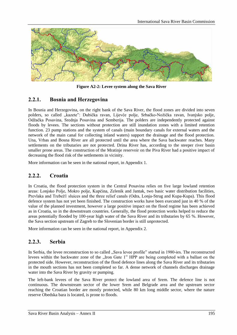
International Sava River Basin Commission
Sava River Basin Analysis – Annex II 195
Figure A2-2: Levee system along the Sava River
2.2.1. Bosnia and Herzegovina
In Bosnia and Herzegovina, on the right bank of the Sava River, the flood zones are divided into seven
polders, so called „kazete”: Dubiĉka ravan, Lijevĉe polje, Srbaĉko-Noţiĉka ravan, Ivanjsko polje,
Odţaĉka Posavina, Srednja Posavina and Semberija. The polders are independently protected against
floods by levees. The sections without protection are still inundation zones with a limited retention
function. 23 pump stations and the system of canals (main boundary canals for external waters and the
network of the main canal for collecting inland waters) support the drainage and the flood protection.
Una, Vrbas and Bosna River are all protected until the area where the Sava backwater reaches. Many
settlements on the tributaries are not protected. Drina River has, according to the steeper river basin
smaller prone areas. The construction of the Mratinje reservoir on the Piva River had a positive impact of
decreasing the flood risk of the settlements in vicinity.
More information can be seen in the national report, in Appendix 1.
2.2.2. Croatia
In Croatia, the flood protection system in the Central Posavina relies on five large lowland retention
areas: Lonjsko Polje, Mokro polje, Kupĉina, Zelenik and Jantak, two basic water distribution facilities,
Prevlaka and Trebeţ1 sluices and the three relief canals (Odra, Lonja-Strug and Kupa-Kupa). This flood
defence system has not yet been finished. The construction works have been executed just in 40 % of the
value of the planned investment, however a large positive impact on the flood regime has been achieved
as in Croatia, so in the downstream countries. Generally, the flood protection works helped to reduce the
areas potentially flooded by 100-year high water of the Sava River and its tributaries by 65 %. However,
the Sava section upstream of Zagreb to the Slovenian border is still unprotected.
More information can be seen in the national report, in Appendix 2.
2.2.3. Serbia
In Serbia, the levee reconstruction to so called „Sava levee profile” started in 1980-ies. The reconstructed
levees within the backwater zone of the „Iron Gate 1” HPP are being completed with a ballast on the
protected side. However, reconstruction of the flood defence lines along the Sava River and its tributaries
in the mouth sections has not been completed so far. A dense network of channels discharges drainage
water into the Sava River by gravity or pumping.
The left-bank levees of the Sava River protect the lowland area of Srem. The defence line is not
continuous. The downstream sector of the lower Srem and Belgrade area and the upstream sector
reaching the Croatian border are mostly protected, while 80 km long middle sector, where the nature
reserve Obedska bara is located, is prone to floods.
International Sava River Basin Commission
Sava River Basin Analysis – Annex II 196
On the right Sava bank, the lowest and the upper sector are protected by levees, while on 40 km long
middle part only local flood protection structures were built. The quay walls and levees in central
Belgrade area do not satisfy the required safety level. In the upper part (the Maĉva region) levees need to
be reconstructed or upgraded to the required safety level and many sluices and pumping stations have to
be restored.
Flood defence structures along the Drina River and its tributaries were constructed mainly for protection
of larger settlements and significant industrial facilities. Protection of agricultural land is present only at
the most downstream section of the Drina River (the Maĉva region), and on some tributaries. Dams and
reservoirs at Drina, Lim and Uvac River are also part of the flood protection system.
Flood protection structures along the Kolubara River were constructed for protection of settlements,
industrial facilities and agricultural land. Different types of flood protection structures were used,
depending on land use in the protected area and location of structures.
The Bosut River discharges into the Sava River through the Bosut sluice, located on the left Sava levee.
During high waters of the Sava River the sluice is closed, and water is being pumped by the „Bosut”
pumping station. Both structures need major overhaul.
More information can be seen in the national report, in Appendix 3.
2.2.4. Slovenia
In Slovenia, the important impact on current flood protection level can be caused by:
too few reliable data about impact of climate changes on flows,
large pressure to land use change,
lack of non-structural measures.
In the present time there are ongoing State spatial plans for reduction of the flood risk:
in the Ljubljanica River Basin, on tributary Gradašĉica (Mali graben), reducing the flood risk on
southwest of Ljubljana,
in the Savinja River Basin, reducing the flood risk in Celje and some smaller settlements near
Savinja River and tributary Bolska River,
in the Savinja River Basin, reducing the flood risk in smaller settlements near Savinja River on
section Loĉica – Letuš,
in the Sora River Basin, reducing the flood risk in Ţelezniki.
Almost all proposal solutions include the preservation of natural retention areas and construction of new
detention reservoirs on areas where the flood hazard already exists, combined with regulation of the river
course or/and dikes. In spatial planning procedures, important principle lies in preservation of the existing
flood hazard areas.
Construction of hydropower stations on lower section of the Sava River involved maintenance,
restoration, improvement and construction of new structural flood defences (dikes, detention reservoirs)
for flood protection of existing settlements.
The most important non-structural instrument is defined by the Decree on conditions and limitations for
constructions and activities on flood risk areas and can be considered as the most important preventive
measure in line with flood risk management plan. The goal of this decree is to prevent and limit the land
use which is generating new flood risk potentials.
2.3. Long term flood protection strategies
The common long term flood protection strategy in the Sava River Basin has clear goals, like
development of the Flood Risk Management Plan in order to minimize the risk from flooding. On one
hand, for efficient flood protection various structural and nonstructural measures have to be provided. On
International Sava River Basin Commission
Sava River Basin Analysis – Annex II 197
the other hand, the process of growing of structures and valuable objects in the vicinity of water courses is
evident and difficult to manage. Thus, the exposure to risk and vulnerability in flood prone areas is
growing constantly.
2.3.1. Bosnia and Herzegovina
In Bosnia and Herzegovina, the flood protection problems are quite complex; large flood prone areas,
partially still damaged constructions and flood protection systems, relatively small financial resources for
prevention, investments and post flood activities. Through the Study of present flood protection level
estimation for Federation B&H, an optimal strategy has been determined for selection of optimal flood
protection development for the territory of the entire FB&H. The Study includes also the selection of
location for priority investment intervention and identification of optimal technical parameters for
structures and flood protection systems that should be constructed in the next period.
Planning of spatial use in river valleys as flood prone areas, protection of natural retentions on Sava River
are priority for all the countries.
2.3.2. Croatia
In Croatia, through the Water Management Strategy, the targets for effective flood protection are
determined. As priority of the first order for the flood protection, the larger towns, potentially at risk from
the Sava and Kupa River, are set, then other settlements along the Sava, Kupa and Una River. As next
goal, reconstruction of dykes and further construction of the Central Posavina flood protection system are
foreseen.
Moreover, performing of operative flood defence, together with competent services from the neighboring
countries, presents an important goal.
2.3.3. Serbia
In Serbia, the long term flood protection strategy is defined in the Water Management Master Plan of the
Republic of Serbia, with a goal of maintenance of existing flood protection structures, and reconstruction
or/and construction of the flood protection structures. The priority projects are the protection of Belgrade
(left and right bank key walls should be reconstructed) and Maĉva region (reconstruction of right Sava
and Drina levees). Further actions will depend on set priorities for flood protection (first priority are areas
with 20,000 inhabitants, large and significant industrial and other facilities, etc.).
More information can be seen in the national reports, in the Appendices 1, 2 and 3.
2.3.4. Slovenia
By the Water Act (adopted in 2002, amended in 2008), Slovenia put legal frame for overall water
management within the river basin districts, which includes protection of water, water use and water
regulation, as well as protection against the adverse effects of water.
The legislative implementation of the EU Flood Directive has in Slovenia been done through the Water
Act and Rules on methodology to define flood risk areas and erosion areas connected to floods, as well as
classification of floods into the risk classes. Further implementation will be done through the national
Flood Risk Management (FRM) work programme for 2009-2015.
The goal in FRM (Framework Programme) is to limit the constructions and the activities in flood hazard
areas and to reduce the existing flood risk. The Decree on conditions and limitations for constructions
and activities on flood risk areas (adopted in 2008), can be considered as a part of FRM Plan. The
conditions and limitations for construction and activities on flood hazard areas are based on expert
studies, based on uniform methodology with Rules on methodology to define flood risk areas and erosion
International Sava River Basin Commission
Sava River Basin Analysis – Annex II 198
areas connected to floods, and classification of floods into the risk classes (adopted in 2007). The major
impact of this decree is on spatial planning, by defining the restrictions that must be accepted in the
planning process.
The conditions and limitations stated in the Water Act, namely that worsening of the high water regime by
the human activities is not allowed, force the planers to reserve the additional areas for flood retention, or
to undertake other measures in order to reach the conditions determined by the Water act and to reduce
existing flood risk.
The process of involvement the insurance company‟s policy in the flood risk management is in progress.
Furthermore, the „user pays principle” and the public-private partnership should be considered more in
financing of the flood protection infrastructure.
2.4. National Flood Prediction and Warning Practices
Adequate hydrologic information, flood prediction and warning system is needed for an integrated water
resources management and flood risk management in the Sava River Basin. Furthermore, a strong
cooperation in sharing data and information among the riparian states present the key factors.
2.4.1. National Flood Prediction and Warning Practices in Bosnia and
Herzegovina
Law on Ministries and Water Law define the role of the entity Hydro-meteorological Institutes (HMS) in
Bosnia and Herzegovina. Two departments of HMS, the Hydrology Department and the Meteorology
Department, are included in flood forecasting and monitoring.
The HMS Forecast Office collects hydrological and meteorological data and distributes information to the
Ministry of Agriculture, Forestry and Water Management, Public Water Companies and to the Entity
information centre.
At the moment, the data available on the territory of B&H are inadequate for or an effective warning and
forecast system, as only daily and short-term meteorological forecasts are available. Information network
for early warning system with 99 automatic real-time stations for water level measuring is under
construction and expected by the end of 2009.
The HMS issues warning and forecasting information which include daily information on rainfall, air and
water temperature, water level, water flow and ice, daily information on water levels and water flows,
together with relevant warning about the development of flood on the upper river parts and forecast on
extreme water levels.
2.4.2. National Flood Prediction and Warning Practices in Croatia
”Hrvatske vode” has established a system of on-line monitoring stations to ensure a more efficient
operative flood defence. There are, 62 automatic stations in Croatia located in the Sava River Basin. The
collected information on real-time monitored water levels is published at the website http://www.voda.hr
and on the teletext of Croatian Television (HTV).
Systematic forecasting of water levels and flows in the Sava River Basin is conducted at the majority of
water gauge profiles in the Sava and Kupa River, which are relevant for the implementation of flood
defence measures under the National Flood Defence Plan.
”Hrvatske vode” is also building a comprehensive hydrologic data collection and dissemination system
for internal use while the improvement of the existing flood forecasting models and integration of the on
line meteorological data is expected for the future. National Protection and Rescue Directorate and public
will also have access to collected data after the test phase.
International Sava River Basin Commission
Sava River Basin Analysis – Annex II 199
More information can be seen in the national report, in Appendix 2.
2.4.3. National Flood Prediction and Warning Practices in Serbia
The role of the State Hydro-meteorological Service of Serbia (HMS) in flood defence is defined by a
number of laws (Law on Ministries, Water Law, Law on Protection Against Natural and Other Major
Disasters), and by-laws (General Flood Defence Plan and Flood Defence Action Plan). Two
departments, namely the Hydrology Department and the Meteorology Department of the HMS Serbia
participate in flood forecasting and monitoring.
The HMS Forecast Office collects and distributes hydrological and meteorological data and transmits
hydrological warnings to the Ministry of Agriculture, Forestry and Water Management of Serbia – the
Republic Directorate for Water, the Public Water Companies and to the State centre for observation and
information, which distributes this information to the endangered communities. Hydrological data are
collected from 13 stations in the Sava River Basin and reported in real time, via radio, telephone and
automatically via GSM. Meteorological data are collected from 61 stations.
Currently, the data available on the territory of Serbia do not provide a sufficient basis for the delivery of
warnings and forecasts. Main reason stems from the fact that floods on major rivers, such as Sava and
Drina River originate beyond Serbian borders. Therefore, information from upstream countries is
indispensable. Data from neighboring countries (8 stations in Croatia) are collected via GTS (Global
Telecommunications System) and by e-mail, and for 5 stations in the Republika Srpska by phone.
Various methods, ranging from the simplest graphical correlations to the most sophisticated models
describing the physical processes that take place within the river basin and the river network are used for
hydrological forecasting. For all of these methods and models, it is important to have the access to
accurate data. For the time being, only nowcasts and short-term meteorological forecasts can be used
successfully.
Hydrological data are collected daily by the HMS from 5 hydrologic stations within the territory of
Serbia and 10 external hydrologic stations. Water level and/or discharge forecasts are prepared daily and
exchanged internationally, The Forecast Office of the HMS issues warning and forecasting information,
which encompass, among others:
daily information on rainfall, air and water temperature, water level, water flow and ice,
daily water level forecasts for 1 or 2 days in advance;
warning about the development of flood on the upper river parts;
forecast on extreme water level (forecast of ice phenomena) for next 7 days and approximate
forecasts for next 30 days.
In addition, plans have been prepared to improve warning and forecasting procedures and to incorporate
more extensively radar surveillance for those rivers on which flood waves rise within Tp ≤ 10 hours.
2.4.4. National Flood Prediction and Warning Practices in Slovenia
Environmental Agency of the Republic of Slovenia, Hydrology Forecasting Department is responsible for
forecasting hydrological events on the national level and launching flood warnings to the Notification
Centre of the Republic of Slovenia. Since 2005 the operative practices in national forecasting department
improved with forecasting tools based on international cooperation. In the time period from 2005 to 2007,
the national hydrological forecasting service became a full member of EFAS (European Flood Alert
System) and MAP D-Phase (Mesoscale Alpine Programme), covering forecasts up to 10 days ahead.
Hydrological observing network in the in Slovenia consists of 196 hydrological stations, among them 18
automatic stations in the Sava RB. The daily data on water levels and discharges and hourly data on
recording gauges are available in the database of Environmental Agency of the Republic of Slovenia.
International Sava River Basin Commission
Sava River Basin Analysis – Annex II 200
Hydrological Forecasting Division is responsible for the real-time data acquisition, data management,
processing and hydrological forecasting and warning. Excellent cooperation between the Weather and
Hydrological forecasting staff within the Environmental Agency has proven to be extremely beneficial in
preparing and issuing hydrological forecasts and flood/drought warnings.
2.5. Cooperation and common efforts in the Sava River Basin
The Parties to the FASRB (Bosnia and Herzegovina, Croatia, Serbia and Slovenia) are promoting a
common approach to the flood risk management, coordinated planning and action within the Sava River
Basin and consideration of all the Parties involved.
2.5.1. Activities under the lead of the Sava Commission
Since the start of work of the International Sava River Basin Commission in 2006, the sustainable flood
protection in the Sava River Basin is coordinated by the Permanent Expert Group for Flood Protection
(PEG FP) on the basin-wide level. The most important document prepared by the PEG FP is the proposed
Protocol on Flood Protection to the FASRB, which should serve as the ground document for all the
common activities in the Sava River Basin. By adoption of this Protocol, the riparian countries agree,
while taking into account the FASRB, the EU Flood Directive and the Action Programme for Sustainable
Flood Protection in the Danube River Basin, on cooperation in:
Preparation of the Program for Development of the Flood Risk Management Plan in the Sava
River Basin,
Undertaking of the Preliminary Flood Risk Assessment,
Preparation of the Flood Hazard and Flood Risk Maps,
Development of the Flood Risk Management Plan in the Sava River Basin,
Establishment of the Flood Forecasting, Warning and Alarm System in the Sava River Basin,
Exchange of information significant for sustainable flood protection.
The Protocol on Flood Protection to the FASRB has been distributed to the Parties. Adoption and
ratification of the Protocol are expected in due course. In the frame of the program quoted under the item
(a), the Permanent Expert Group for Flood Protection is designating a detailed Road map for the
preparation of the Flood Risk Management Plan in the Sava River Basin.
In the whole process of undertaking of Preliminary Flood Risk Assessment, preparation of the Flood
Hazard and Flood Risk Maps, the Sava Commission will be a coordinating body for the data exchange
between the countries.
As the first step towards the future flood risk analyses in the Sava River Basin, an assessment of the
hydrological analyses on the Sava River and tributaries to date, the Hydrology Report for the Sava River
Basin, has been prepared. According to the fact, that the last common hydrology study in the Sava River
Basin has been made some thirty-five years ago, a programme for a new detailed Hydrological Study on
the basin-wide level has been elaborated. The initiative for a common hydrology study has been fully
supported by the newly constituted Ad hoc Hydrometeorological Expert Group (Ah HM EG), as well as
by the PEG FP. According to the programme, the new study should comprise collection and analyses of
data at meteorological and hydrological gauging stations at the asin-wide level, evaluate flood
characteristics and drought properties in meteorological and hydrological aspects, flow forecasting and
climate change.
The second project on the priority list of the PEG FP is the joint Flood Mapping Study for the Sava River,
basing on the information on existing analyses and data availability collected through the ISRBC.
Common activities related to the establishment of the Flood Forecasting, Warning and Alarm System in
the Sava River Basin, are described in the next chapter.
International Sava River Basin Commission
Sava River Basin Analysis – Annex II 201
2.5.1.1. The Hydrometeorological Information and Flood Forecasting/Warning System in the Sava River Basin (HMIFFWS)
Development of a Hydrometeorological Information and Flood Forecasting/Warning System
(HMIFFWS) for the Sava River Basin, as a basis for the integrated water resources management and
sustainable navigation presents one of the goals of the ISRBC. As stipulated in the FASRB (2002), the
Parties to the FASRB shall „establish a coordinated or joint system of measures, activities, warnings and
alarms in the Sava River Basin for extraordinary impacts on the water regime”. Furthermore, in the
Strategy on Implementation of the FASRB (2008), (item 2.6), development of joint or integrated flood
forecasting and warning system in the Sava River Basin is foreseen, based on the assessment of the
existing national systems. The leading body in this process is PEG FP of the Sava Commission, supported
by the Ah HM EG, in close cooperation with the National Hydrometeorological Services (NHMSs) of the
Sava countries.
The initiative for the establishment of a joint or integrated HMIFFWS on the Sava River in a
transboundary context came in 2003, by a meeting of the hydrological experts from the Sava RB in
Geneva. The NHMS representatives from the Sava countries, signatories to the FASRB, supported the
idea of a common hydrometeorological project in the Sava RB, the NHMS from Montenegro and Albania
also joined the initiative. ISRBC overtook the role of the coordinating body in the process. In 2005, the
Skeleton of the Sava Project Proposal for Development and Upgrading of Hydrometeorological
Information and Forecasting System for the Sava River Basin has been prepared. The WMO and the
World Bank supported the initiative.
Finally, in 2007, a new project proposal for Development and Upgrading of the Hydrometeorological
Information and Flood Forecasting/Warning System in the Sava River Basin (HMIFFWS), the so called
Sava Project, has been prepared by M. AnĊelić and J. Roškar. The project aims at building on and
reinforcing further the existing NMHSs of the Sava riparian states in the area of assessment of status of
the resource, river flow simulation, forecasting and flood warning in the Sava RB. Furthermore, the
hydrological and meteorological real-time observing networks and database management should be
supported, and a state of the art hydrological forecasting system for the Sava River Basin should be
developed. The ultimate goal is to reinforce the Sava RB countries‟ capability to manage the common
Sava River Basin water resources and to reduce the disaster risks caused by floods and droughts in the
region. ISRBC is expected to play a significant role in the project implementation, while the WMO is
proposed to be the executing agency of the project.
The implementation of the Sava Project is going to be divided into several phases, in order not to be too
large and too expensive if implemented in its original form.
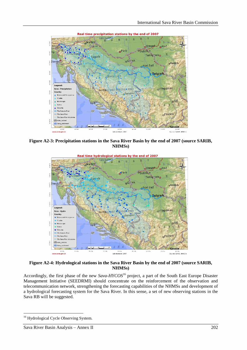
International Sava River Basin Commission
Sava River Basin Analysis – Annex II 202
Figure A2-3: Precipitation stations in the Sava River Basin by the end of 2007 (source SARIB,
NHMSs)
Figure A2-4: Hydrological stations in the Sava River Basin by the end of 2007 (source SARIB,
NHMSs)
Accordingly, the first phase of the new Sava-HYCOS16
project, a part of the South East Europe Disaster
Management Initiative (SEEDRMI) should concentrate on the reinforcement of the observation and
telecommunication network, strengthening the forecasting capabilities of the NHMSs and development of
a hydrological forecasting system for the Sava River. In this sense, a set of new observing stations in the
Sava RB will be suggested.
16
Hydrological Cycle Observing System.
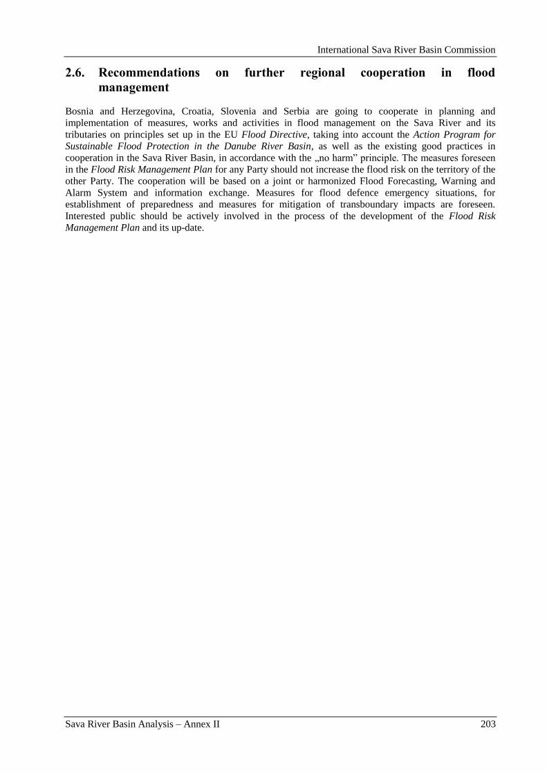
International Sava River Basin Commission
Sava River Basin Analysis – Annex II 203
2.6. Recommendations on further regional cooperation in flood
management
Bosnia and Herzegovina, Croatia, Slovenia and Serbia are going to cooperate in planning and
implementation of measures, works and activities in flood management on the Sava River and its
tributaries on principles set up in the EU Flood Directive, taking into account the Action Program for
Sustainable Flood Protection in the Danube River Basin, as well as the existing good practices in
cooperation in the Sava River Basin, in accordance with the „no harm” principle. The measures foreseen
in the Flood Risk Management Plan for any Party should not increase the flood risk on the territory of the
other Party. The cooperation will be based on a joint or harmonized Flood Forecasting, Warning and
Alarm System and information exchange. Measures for flood defence emergency situations, for
establishment of preparedness and measures for mitigation of transboundary impacts are foreseen.
Interested public should be actively involved in the process of the development of the Flood Risk
Management Plan and its up-date.

International Sava River Basin Commission
Sava River Basin Analysis – Annex II 204
International Sava River Basin Commission
Sava River Basin Analysis – Annex II – Appendices 205
Appendices
International Sava River Basin Commission
Sava River Basin Analysis – Annex II – Appendices 206
International Sava River Basin Commission
Sava River Basin Analysis – Annex II – Appendix I 207
Appendix I: Flood Management in Bosnia and Herzegovina
International Sava River Basin Commission
Sava River Basin Analysis – Annex II – Appendix I 208
International Sava River Basin Commission
Sava River Basin Analysis – Annex II – Appendix I 209
BRIEF CHARACTERIZATION, REVIEW AND ASSESSMENT IN FLOOD MANAGEMENT IN
SAVA COUNTRIES
- Sava River Basin in Bosnia and Herzegovina -
REPUBLIKA SRPSKA
MINISTRY OF AGRICULTURE, FORESTRY AND WATER MANAGEMENT
BANJA LUKA
AGENCY FOR WATERS OF SAVA RIVER BASIN DISTRICT
BIJELJINA
FEDERAL MINISTRY OF AGRICULTURE, WATER MANAGEMENT AND
FORESTRY - SARAJEVO
AGENCY FOR SAVA RIVER CATCHMENT
SARAJEVO
April, 2009

International Sava River Basin Commission
Sava River Basin Analysis – Annex II – Appendix I 210
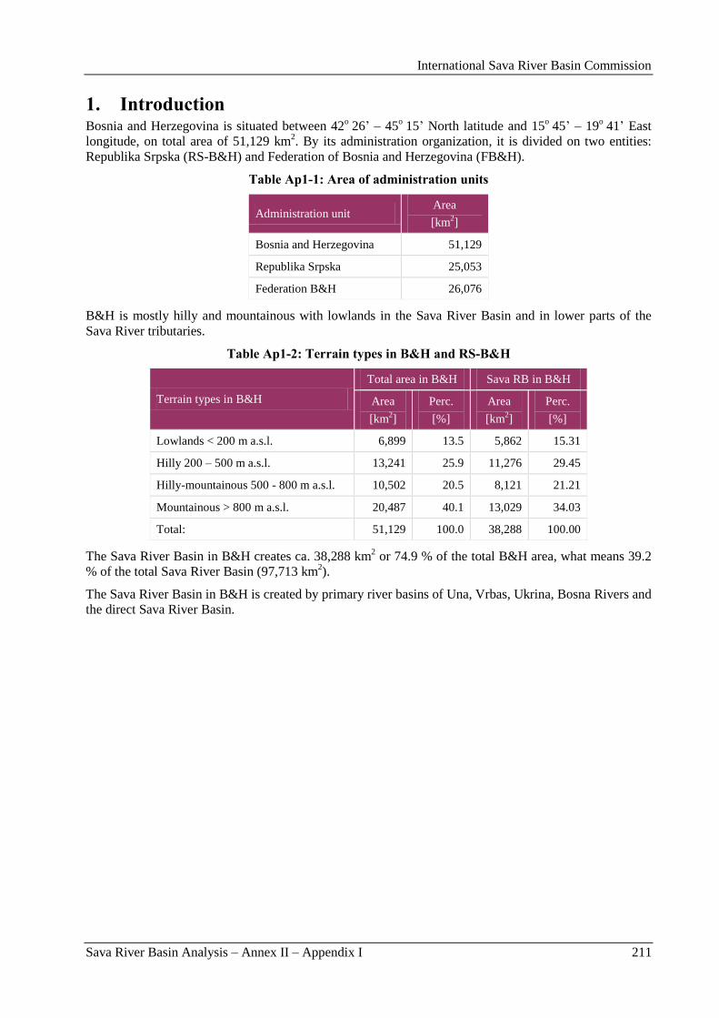
International Sava River Basin Commission
Sava River Basin Analysis – Annex II – Appendix I 211
1. Introduction Bosnia and Herzegovina is situated between 42
o 26‟ – 45
o 15‟ North latitude and 15
o 45‟ – 19
o 41‟ East
longitude, on total area of 51,129 km2. By its administration organization, it is divided on two entities:
Republika Srpska (RS-B&H) and Federation of Bosnia and Herzegovina (FB&H).
Table Ap1-1: Area of administration units
Administration unit Area
[km2]
Bosnia and Herzegovina 51,129
Republika Srpska 25,053
Federation B&H 26,076
B&H is mostly hilly and mountainous with lowlands in the Sava River Basin and in lower parts of the
Sava River tributaries.
Table Ap1-2: Terrain types in B&H and RS-B&H
Terrain types in B&H
Total area in B&H Sava RB in B&H
Area
[km2]
Perc.
[%]
Area
[km2]
Perc.
[%]
Lowlands < 200 m a.s.l. 6,899 13.5 5,862 15.31
Hilly 200 – 500 m a.s.l. 13,241 25.9 11,276 29.45
Hilly-mountainous 500 - 800 m a.s.l. 10,502 20.5 8,121 21.21
Mountainous > 800 m a.s.l. 20,487 40.1 13,029 34.03
Total: 51,129 100.0 38,288 100.00
The Sava River Basin in B&H creates ca. 38,288 km2 or 74.9 % of the total B&H area, what means 39.2
% of the total Sava River Basin (97,713 km2).
The Sava River Basin in B&H is created by primary river basins of Una, Vrbas, Ukrina, Bosna Rivers and
the direct Sava River Basin.
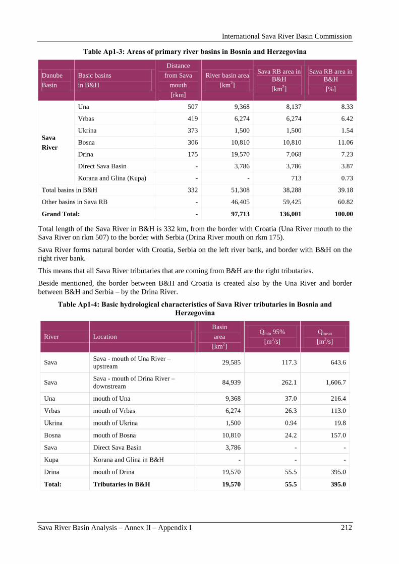
International Sava River Basin Commission
Sava River Basin Analysis – Annex II – Appendix I 212
Table Ap1-3: Areas of primary river basins in Bosnia and Herzegovina
Danube
Basin
Basic basins
in B&H
Distance
from Sava
mouth
[rkm]
River basin area
[km2]
Sava RB area in
B&H
[km2]
Sava RB area in
B&H
[%]
Sava
River
Una 507 9,368 8,137 8.33
Vrbas 419 6,274 6,274 6.42
Ukrina 373 1,500 1,500 1.54
Bosna 306 10,810 10,810 11.06
Drina 175 19,570 7,068 7.23
Direct Sava Basin - 3,786 3,786 3.87
Korana and Glina (Kupa) - - 713 0.73
Total basins in B&H 332 51,308 38,288 39.18
Other basins in Sava RB - 46,405 59,425 60.82
Grand Total: - 97,713 136,001 100.00
Total length of the Sava River in B&H is 332 km, from the border with Croatia (Una River mouth to the
Sava River on rkm 507) to the border with Serbia (Drina River mouth on rkm 175).
Sava River forms natural border with Croatia, Serbia on the left river bank, and border with B&H on the
right river bank.
This means that all Sava River tributaries that are coming from B&H are the right tributaries.
Beside mentioned, the border between B&H and Croatia is created also by the Una River and border
between B&H and Serbia – by the Drina River.
Table Ap1-4: Basic hydrological characteristics of Sava River tributaries in Bosnia and
Herzegovina
River Location
Basin
area
[km2]
Qmin 95%
[m3/s]
Qmean
[m3/s]
Sava Sava - mouth of Una River –
upstream 29,585 117.3 643.6
Sava Sava - mouth of Drina River –
downstream 84,939 262.1 1,606.7
Una mouth of Una 9,368 37.0 216.4
Vrbas mouth of Vrbas 6,274 26.3 113.0
Ukrina mouth of Ukrina 1,500 0.94 19.8
Bosna mouth of Bosna 10,810 24.2 157.0
Sava Direct Sava Basin 3,786 - -
Kupa Korana and Glina in B&H - - -
Drina mouth of Drina 19,570 55.5 395.0
Total: Tributaries in B&H 19,570 55.5 395.0
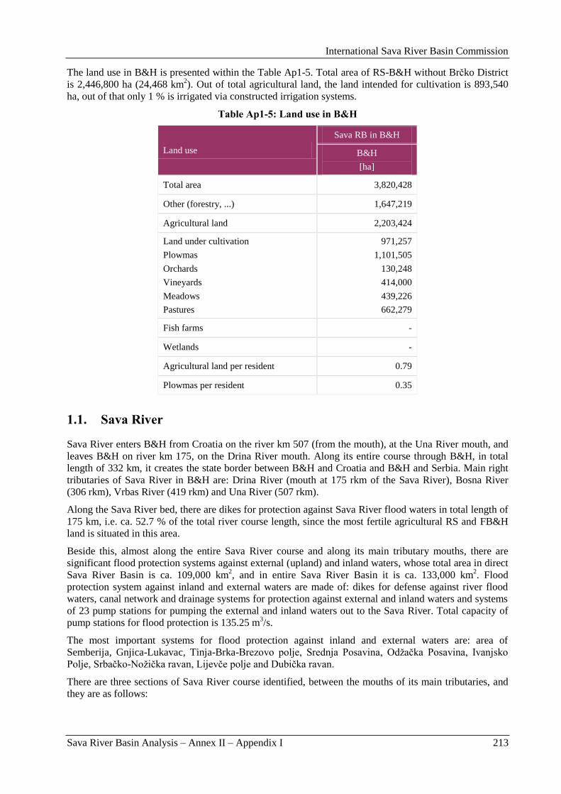
International Sava River Basin Commission
Sava River Basin Analysis – Annex II – Appendix I 213
The land use in B&H is presented within the Table Ap1-5. Total area of RS-B&H without Brĉko District
is 2,446,800 ha (24,468 km2). Out of total agricultural land, the land intended for cultivation is 893,540
ha, out of that only 1 % is irrigated via constructed irrigation systems.
Table Ap1-5: Land use in B&H
Land use
Sava RB in B&H
B&H
[ha]
Total area 3,820,428
Other (forestry, ...) 1,647,219
Agricultural land 2,203,424
Land under cultivation
Plowmas
Orchards
Vineyards
Meadows
Pastures
971,257
1,101,505
130,248
414,000
439,226
662,279
Fish farms -
Wetlands -
Agricultural land per resident 0.79
Plowmas per resident 0.35
1.1. Sava River
Sava River enters B&H from Croatia on the river km 507 (from the mouth), at the Una River mouth, and
leaves B&H on river km 175, on the Drina River mouth. Along its entire course through B&H, in total
length of 332 km, it creates the state border between B&H and Croatia and B&H and Serbia. Main right
tributaries of Sava River in B&H are: Drina River (mouth at 175 rkm of the Sava River), Bosna River
(306 rkm), Vrbas River (419 rkm) and Una River (507 rkm).
Along the Sava River bed, there are dikes for protection against Sava River flood waters in total length of
175 km, i.e. ca. 52.7 % of the total river course length, since the most fertile agricultural RS and FB&H
land is situated in this area.
Beside this, almost along the entire Sava River course and along its main tributary mouths, there are
significant flood protection systems against external (upland) and inland waters, whose total area in direct
Sava River Basin is ca. 109,000 km2, and in entire Sava River Basin it is ca. 133,000 km
2. Flood
protection system against inland and external waters are made of: dikes for defense against river flood
waters, canal network and drainage systems for protection against external and inland waters and systems
of 23 pump stations for pumping the external and inland waters out to the Sava River. Total capacity of
pump stations for flood protection is 135.25 m3/s.
The most important systems for flood protection against inland and external waters are: area of
Semberija, Gnjica-Lukavac, Tinja-Brka-Brezovo polje, Srednja Posavina, Odţaĉka Posavina, Ivanjsko
Polje, Srbaĉko-Noţiĉka ravan, Lijevĉe polje and Dubiĉka ravan.
There are three sections of Sava River course identified, between the mouths of its main tributaries, and
they are as follows:
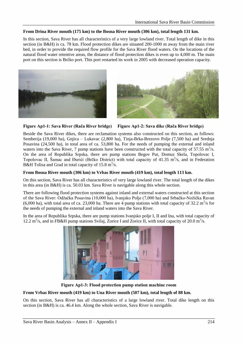
International Sava River Basin Commission
Sava River Basin Analysis – Annex II – Appendix I 214
From Drina River mouth (175 km) to the Bosna River mouth (306 km), total length 131 km.
In this section, Sava River has all characteristics of a very large lowland river. Total length of dike in this
section (in B&H) is ca. 78 km. Flood protection dikes are situated 200-1000 m away from the main river
bed, in order to provide the required flow profile for the Sava River flood waters. On the locations of the
natural flood water retentive areas, the distance of flood protection dikes is even up to 4,000 m. The main
port on this section is Brĉko port. This port restarted its work in 2005 with decreased operation capacity.
Figure Ap1-1: Sava River (Rača River bridge) Figure Ap1-2: Sava dike (Rača River bridge)
Beside the Sava River dikes, there are reclamation systems also constructed on this section, as follows:
Semberija (19,000 ha), Gnjica – Lukavac (2,800 ha), Tinja-Brka-Brezovo Polje (7,500 ha) and Srednja
Posavina (24,500 ha), in total area of ca. 53,800 ha. For the needs of pumping the external and inland
waters into the Sava River, 7 pump stations have been constructed with the total capacity of 57.55 m3/s.
On the area of Republika Srpska, there are pump stations Begov Put, Domuz Skela, Topolovac I,
Topolovac II, Šamac and Đurići (Brĉko District) with total capacity of 41.35 m3/s, and in Federation
B&H Tolisa and Grad in total capacity of 15.8 m3/s.
From Bosna River mouth (306 km) to Vrbas River mouth (419 km), total length 113 km.
On this section, Sava River has all characteristics of very large lowland river. The total length of the dikes
in this area (in B&H) is ca. 50.03 km. Sava River is navigable along this whole section.
There are following flood protection systems against inland and external waters constructed at this section
of the Sava River: Odţaĉka Posavina (10,000 ha), Ivanjsko Polje (7,000 ha) and Srbaĉko-Noţiĉka Ravan
(6,000 ha), with total area of ca. 23,000 ha. There are 4 pump stations with total capacity of 32.2 m3/s for
the needs of pumping the external and inland waters into the Sava River.
In the area of Republika Srpska, there are pump stations Ivanjsko polje I, II and Ina, with total capacity of
12.2 m3/s, and in FB&H pump stations Svilaj, Zorice I and Zorice II, with total capacity of 20.0 m
3/s.
Figure Ap1-3: Flood protection pump station machine room
From Vrbas River mouth (419 km) to Una River mouth (507 km), total length of 88 km.
On this section, Sava River has all characteristics of a large lowland river. Total dike length on this
section (in B&H) is ca. 46.4 km. Along the whole section, Sava River is navigable.
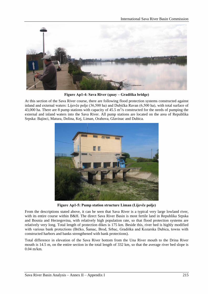
International Sava River Basin Commission
Sava River Basin Analysis – Annex II – Appendix I 215
Figure Ap1-4: Sava River (quay – Gradiška bridge)
At this section of the Sava River course, there are following flood protection systems constructed against
inland and external waters: Lijevĉe polje (36,500 ha) and Dubiĉka Ravan (6,500 ha), with total surface of
43,000 ha. There are 8 pump stations with capacity of 45.5 m3/s constructed for the needs of pumping the
external and inland waters into the Sava River. All pump stations are located on the area of Republika
Srpska: Bajinci, Matura, Dolina, Kej, Liman, Orahova, Glavinac and Dubica.
Figure Ap1-5: Pump station structure Liman (Lijevče polje)
From the descriptions stated above, it can be seen that Sava River is a typical very large lowland river,
with its entire course within B&H. The direct Sava River Basin is most fertile land in Republika Srpska
and Bosnia and Herzegovina, with relatively high population rate, so that flood protection systems are
relatively very long. Total length of protection dikes is 175 km. Beside this, river bed is highly modified
with various bank protections (Brĉko, Šamac, Brod, Srbac, Gradiška and Kozarska Dubica, towns with
constructed harbors and banks strengthened with bank protections).
Total difference in elevation of the Sava River bottom from the Una River mouth to the Drina River
mouth is 14.5 m, on the entire section in the total length of 332 km, so that the average river bed slope is
0.04 m/km.
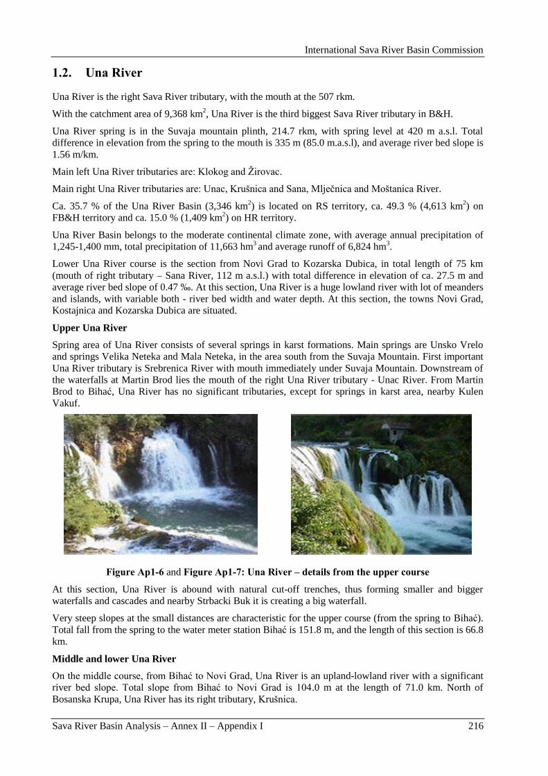
International Sava River Basin Commission
Sava River Basin Analysis – Annex II – Appendix I 216
1.2. Una River
Una River is the right Sava River tributary, with the mouth at the 507 rkm.
With the catchment area of 9,368 km2, Una River is the third biggest Sava River tributary in B&H.
Una River spring is in the Suvaja mountain plinth, 214.7 rkm, with spring level at 420 m a.s.l. Total
difference in elevation from the spring to the mouth is 335 m (85.0 m.a.s.l), and average river bed slope is
1.56 m/km.
Main left Una River tributaries are: Klokog and Ţirovac.
Main right Una River tributaries are: Unac, Krušnica and Sana, Mljeĉnica and Moštanica River.
Ca. 35.7 % of the Una River Basin (3,346 km2) is located on RS territory, ca. 49.3 % (4,613 km
2) on
FB&H territory and ca. 15.0 % (1,409 km2) on HR territory.
Una River Basin belongs to the moderate continental climate zone, with average annual precipitation of
1,245-1,400 mm, total precipitation of 11,663 hm3 and average runoff of 6,824 hm
3.
Lower Una River course is the section from Novi Grad to Kozarska Dubica, in total length of 75 km
(mouth of right tributary – Sana River, 112 m a.s.l.) with total difference in elevation of ca. 27.5 m and
average river bed slope of 0.47 ‰. At this section, Una River is a huge lowland river with lot of meanders
and islands, with variable both - river bed width and water depth. At this section, the towns Novi Grad,
Kostajnica and Kozarska Dubica are situated.
Upper Una River
Spring area of Una River consists of several springs in karst formations. Main springs are Unsko Vrelo
and springs Velika Neteka and Mala Neteka, in the area south from the Suvaja Mountain. First important
Una River tributary is Srebrenica River with mouth immediately under Suvaja Mountain. Downstream of
the waterfalls at Martin Brod lies the mouth of the right Una River tributary - Unac River. From Martin
Brod to Bihać, Una River has no significant tributaries, except for springs in karst area, nearby Kulen
Vakuf.
Figure Ap1-6 and Figure Ap1-7: Una River – details from the upper course
At this section, Una River is abound with natural cut-off trenches, thus forming smaller and bigger
waterfalls and cascades and nearby Strbacki Buk it is creating a big waterfall.
Very steep slopes at the small distances are characteristic for the upper course (from the spring to Bihać).
Total fall from the spring to the water meter station Bihać is 151.8 m, and the length of this section is 66.8
km.
Middle and lower Una River
On the middle course, from Bihać to Novi Grad, Una River is an upland-lowland river with a significant
river bed slope. Total slope from Bihać to Novi Grad is 104.0 m at the length of 71.0 km. North of
Bosanska Krupa, Una River has its right tributary, Krušnica.
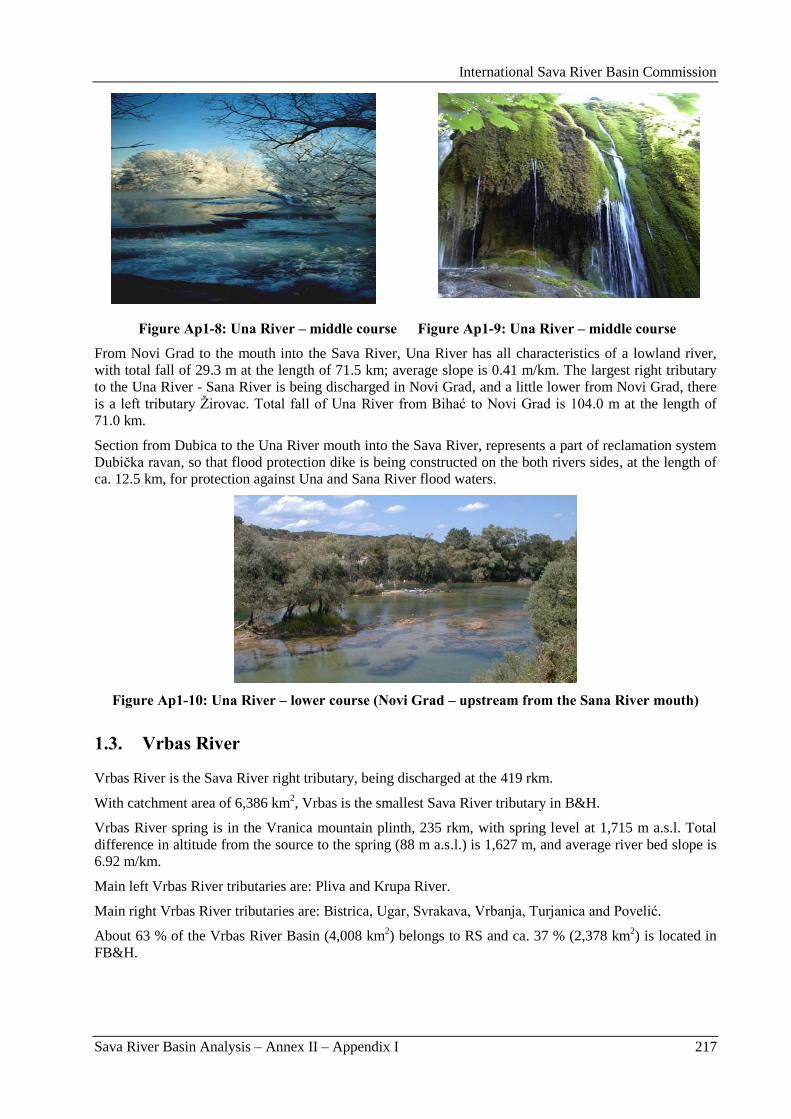
International Sava River Basin Commission
Sava River Basin Analysis – Annex II – Appendix I 217
Figure Ap1-8: Una River – middle course Figure Ap1-9: Una River – middle course
From Novi Grad to the mouth into the Sava River, Una River has all characteristics of a lowland river,
with total fall of 29.3 m at the length of 71.5 km; average slope is 0.41 m/km. The largest right tributary
to the Una River - Sana River is being discharged in Novi Grad, and a little lower from Novi Grad, there
is a left tributary Ţirovac. Total fall of Una River from Bihać to Novi Grad is 104.0 m at the length of
71.0 km.
Section from Dubica to the Una River mouth into the Sava River, represents a part of reclamation system
Dubiĉka ravan, so that flood protection dike is being constructed on the both rivers sides, at the length of
ca. 12.5 km, for protection against Una and Sana River flood waters.
Figure Ap1-10: Una River – lower course (Novi Grad – upstream from the Sana River mouth)
1.3. Vrbas River
Vrbas River is the Sava River right tributary, being discharged at the 419 rkm.
With catchment area of 6,386 km2, Vrbas is the smallest Sava River tributary in B&H.
Vrbas River spring is in the Vranica mountain plinth, 235 rkm, with spring level at 1,715 m a.s.l. Total
difference in altitude from the source to the spring (88 m a.s.l.) is 1,627 m, and average river bed slope is
6.92 m/km.
Main left Vrbas River tributaries are: Pliva and Krupa River.
Main right Vrbas River tributaries are: Bistrica, Ugar, Svrakava, Vrbanja, Turjanica and Povelić.
About 63 % of the Vrbas River Basin (4,008 km2) belongs to RS and ca. 37 % (2,378 km
2) is located in
FB&H.
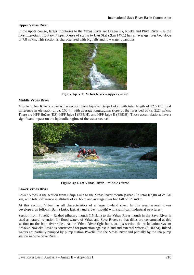
International Sava River Basin Commission
Sava River Basin Analysis – Annex II – Appendix I 218
Upper Vrbas River
In the upper course, larger tributaries to the Vrbas River are Draguĉina, Rijeka and Pliva River – as the
most important tributary. Upper course of spring to Han Skela (km 145.1) has an average river bed slope
of 7.8 m/km. This section is characterized with big falls and low water quantities.
Figure Ap1-11: Vrbas River – upper course
Middle Vrbas River
Middle Vrbas River course is the section from Jajce to Banja Luka, with total length of 72.5 km, total
difference in elevation of ca. 165 m, with average longitudinal slope of the river bed of ca. 2.27 m/km.
There are HPP Boĉac (RS), HPP Jajce I (FB&H), and HPP Jajce II (FB&H). Those accumulations have a
significant impact on the hydraulic regime of the water course.
Figure Ap1-12: Vrbas River – middle course
Lower Vrbas River
Lower Vrbas is the section from Banja Luka to the Vrbas River mouth (Srbac), in total length of ca. 70
km, with total difference in altitude of ca. 65 m and average river bed fall of 0.9 m/km.
At this section, Vrbas has all characteristics of a large lowland river. In this area, several towns
developed, as follows: Banja Luka, Laktaši and Srbac (mouth) with significant industrial structures.
Section from Povelić – Razboj tributary mouth (15 rkm) to the Vrbas River mouth in the Sava River is
used as natural retention for flood waters of Vrbas and Sava River, so that dikes are constructed at this
section on the both river sides. At the Vrbas River right bank, at this section the reclamation system
Srbaĉko-Noţiĉka Ravan is constructed for protection against inland and external waters (6,100 ha). Inland
waters are partially pumped by pump station Povelić into the Vrbas River and partially by the Ina pump
station into the Sava River.
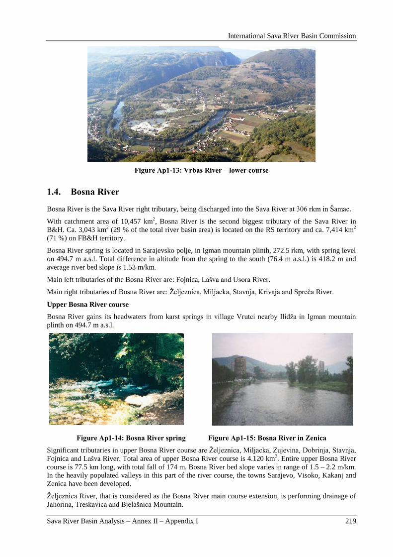
International Sava River Basin Commission
Sava River Basin Analysis – Annex II – Appendix I 219
Figure Ap1-13: Vrbas River – lower course
1.4. Bosna River
Bosna River is the Sava River right tributary, being discharged into the Sava River at 306 rkm in Šamac.
With catchment area of 10,457 km2, Bosna River is the second biggest tributary of the Sava River in
B&H. Ca. 3,043 km2 (29 % of the total river basin area) is located on the RS territory and ca. 7,414 km
2
(71 %) on FB&H territory.
Bosna River spring is located in Sarajevsko polje, in Igman mountain plinth, 272.5 rkm, with spring level
on 494.7 m a.s.l. Total difference in altitude from the spring to the south (76.4 m a.s.l.) is 418.2 m and
average river bed slope is 1.53 m/km.
Main left tributaries of the Bosna River are: Fojnica, Lašva and Usora River.
Main right tributaries of Bosna River are: Ţeljeznica, Miljacka, Stavnja, Krivaja and Spreĉa River.
Upper Bosna River course
Bosna River gains its headwaters from karst springs in village Vrutci nearby Ilidţa in Igman mountain
plinth on 494.7 m a.s.l.
Figure Ap1-14: Bosna River spring Figure Ap1-15: Bosna River in Zenica
Significant tributaries in upper Bosna River course are Ţeljeznica, Miljacka, Zujevina, Dobrinja, Stavnja,
Fojnica and Lašva River. Total area of upper Bosna River course is 4.120 km2. Entire upper Bosna River
course is 77.5 km long, with total fall of 174 m. Bosna River bed slope varies in range of 1.5 – 2.2 m/km.
In the heavily populated valleys in this part of the river course, the towns Sarajevo, Visoko, Kakanj and
Zenica have been developed.
Ţeljeznica River, that is considered as the Bosna River main course extension, is performing drainage of
Jahorina, Treskavica and Bjelašnica Mountain.
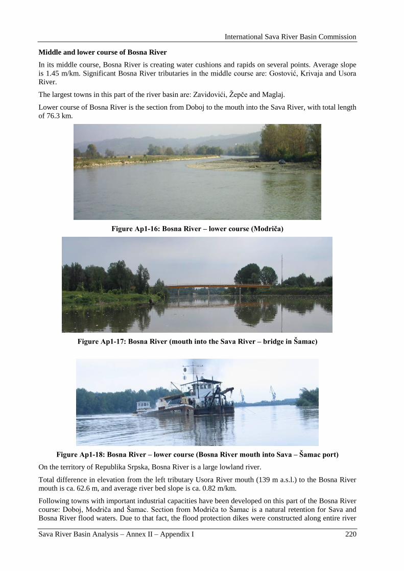
International Sava River Basin Commission
Sava River Basin Analysis – Annex II – Appendix I 220
Middle and lower course of Bosna River
In its middle course, Bosna River is creating water cushions and rapids on several points. Average slope
is 1.45 m/km. Significant Bosna River tributaries in the middle course are: Gostović, Krivaja and Usora
River.
The largest towns in this part of the river basin are: Zavidovići, Ţepĉe and Maglaj.
Lower course of Bosna River is the section from Doboj to the mouth into the Sava River, with total length
of 76.3 km.
Figure Ap1-16: Bosna River – lower course (Modriča)
Figure Ap1-17: Bosna River (mouth into the Sava River – bridge in Šamac)
Figure Ap1-18: Bosna River – lower course (Bosna River mouth into Sava – Šamac port)
On the territory of Republika Srpska, Bosna River is a large lowland river.
Total difference in elevation from the left tributary Usora River mouth (139 m a.s.l.) to the Bosna River
mouth is ca. 62.6 m, and average river bed slope is ca. 0.82 m/km.
Following towns with important industrial capacities have been developed on this part of the Bosna River
course: Doboj, Modriĉa and Šamac. Section from Modriĉa to Šamac is a natural retention for Sava and
Bosna River flood waters. Due to that fact, the flood protection dikes were constructed along entire river
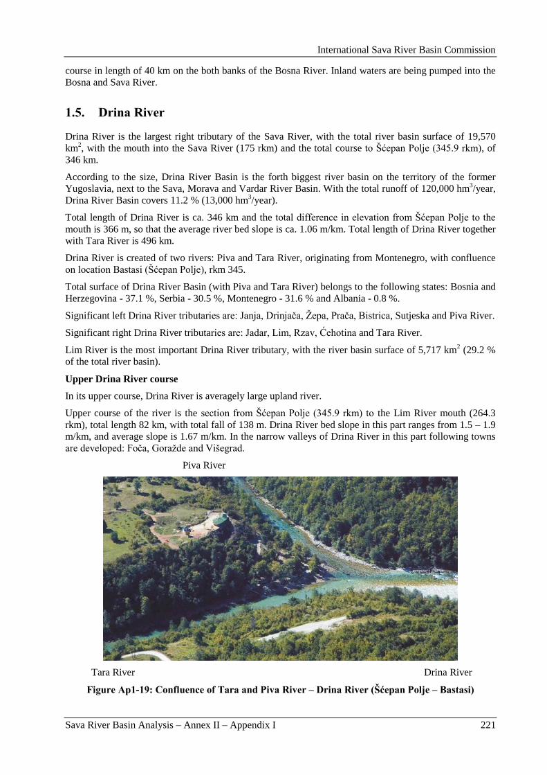
International Sava River Basin Commission
Sava River Basin Analysis – Annex II – Appendix I 221
course in length of 40 km on the both banks of the Bosna River. Inland waters are being pumped into the
Bosna and Sava River.
1.5. Drina River
Drina River is the largest right tributary of the Sava River, with the total river basin surface of 19,570
km2, with the mouth into the Sava River (175 rkm) and the total course to Šćepan Polje (345.9 rkm), of
346 km.
According to the size, Drina River Basin is the forth biggest river basin on the territory of the former
Yugoslavia, next to the Sava, Morava and Vardar River Basin. With the total runoff of 120,000 hm3/year,
Drina River Basin covers 11.2 % (13,000 hm3/year).
Total length of Drina River is ca. 346 km and the total difference in elevation from Šćepan Polje to the
mouth is 366 m, so that the average river bed slope is ca. 1.06 m/km. Total length of Drina River together
with Tara River is 496 km.
Drina River is created of two rivers: Piva and Tara River, originating from Montenegro, with confluence
on location Bastasi (Šćepan Polje), rkm 345.
Total surface of Drina River Basin (with Piva and Tara River) belongs to the following states: Bosnia and
Herzegovina - 37.1 %, Serbia - 30.5 %, Montenegro - 31.6 % and Albania - 0.8 %.
Significant left Drina River tributaries are: Janja, Drinjaĉa, Ţepa, Praĉa, Bistrica, Sutjeska and Piva River.
Significant right Drina River tributaries are: Jadar, Lim, Rzav, Ćehotina and Tara River.
Lim River is the most important Drina River tributary, with the river basin surface of 5,717 km2 (29.2 %
of the total river basin).
Upper Drina River course
In its upper course, Drina River is averagely large upland river.
Upper course of the river is the section from Šćepan Polje (345.9 rkm) to the Lim River mouth (264.3
rkm), total length 82 km, with total fall of 138 m. Drina River bed slope in this part ranges from 1.5 – 1.9
m/km, and average slope is 1.67 m/km. In the narrow valleys of Drina River in this part following towns
are developed: Foĉa, Goraţde and Višegrad.
Piva River
Tara River Drina River
Figure Ap1-19: Confluence of Tara and Piva River – Drina River (Šćepan Polje – Bastasi)
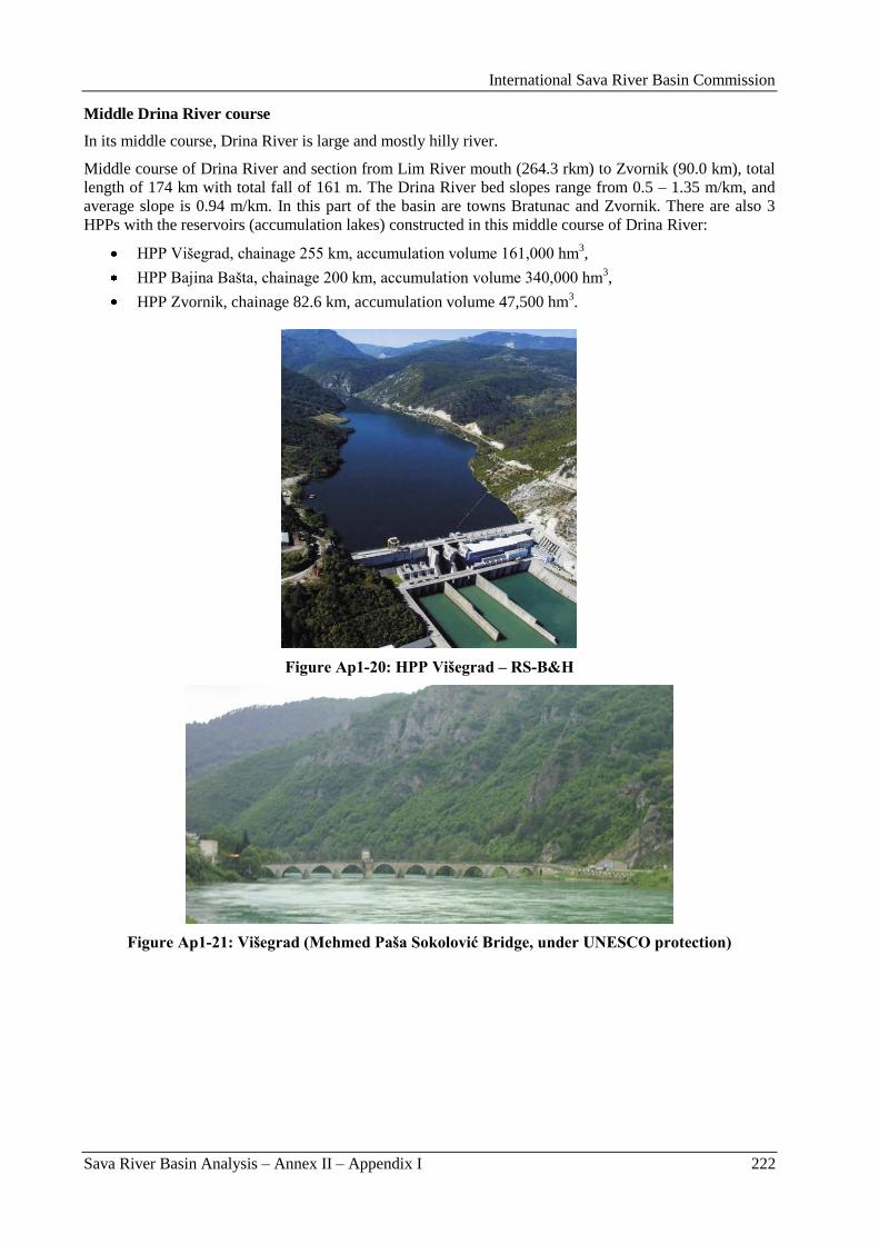
International Sava River Basin Commission
Sava River Basin Analysis – Annex II – Appendix I 222
Middle Drina River course
In its middle course, Drina River is large and mostly hilly river.
Middle course of Drina River and section from Lim River mouth (264.3 rkm) to Zvornik (90.0 km), total
length of 174 km with total fall of 161 m. The Drina River bed slopes range from 0.5 – 1.35 m/km, and
average slope is 0.94 m/km. In this part of the basin are towns Bratunac and Zvornik. There are also 3
HPPs with the reservoirs (accumulation lakes) constructed in this middle course of Drina River:
HPP Višegrad, chainage 255 km, accumulation volume 161,000 hm3,
HPP Bajina Bašta, chainage 200 km, accumulation volume 340,000 hm3,
HPP Zvornik, chainage 82.6 km, accumulation volume 47,500 hm3.
Figure Ap1-20: HPP Višegrad – RS-B&H
Figure Ap1-21: Višegrad (Mehmed Paša Sokolović Bridge, under UNESCO protection)
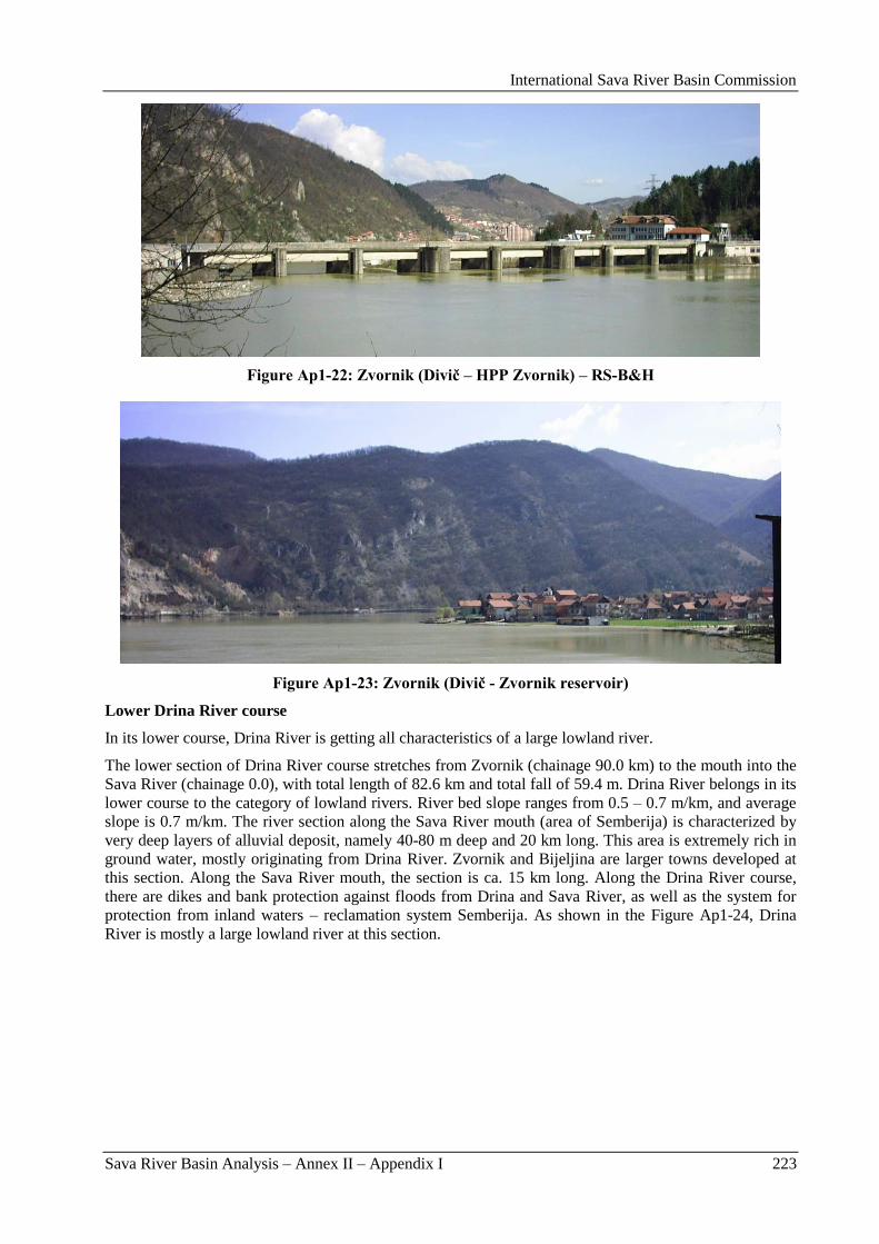
International Sava River Basin Commission
Sava River Basin Analysis – Annex II – Appendix I 223
Figure Ap1-22: Zvornik (Divič – HPP Zvornik) – RS-B&H
Figure Ap1-23: Zvornik (Divič - Zvornik reservoir)
Lower Drina River course
In its lower course, Drina River is getting all characteristics of a large lowland river.
The lower section of Drina River course stretches from Zvornik (chainage 90.0 km) to the mouth into the
Sava River (chainage 0.0), with total length of 82.6 km and total fall of 59.4 m. Drina River belongs in its
lower course to the category of lowland rivers. River bed slope ranges from 0.5 – 0.7 m/km, and average
slope is 0.7 m/km. The river section along the Sava River mouth (area of Semberija) is characterized by
very deep layers of alluvial deposit, namely 40-80 m deep and 20 km long. This area is extremely rich in
ground water, mostly originating from Drina River. Zvornik and Bijeljina are larger towns developed at
this section. Along the Sava River mouth, the section is ca. 15 km long. Along the Drina River course,
there are dikes and bank protection against floods from Drina and Sava River, as well as the system for
protection from inland waters – reclamation system Semberija. As shown in the Figure Ap1-24, Drina
River is mostly a large lowland river at this section.
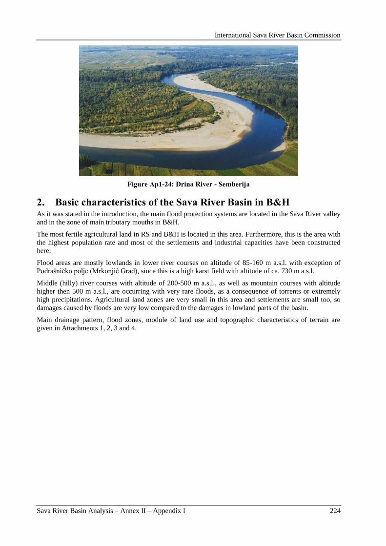
International Sava River Basin Commission
Sava River Basin Analysis – Annex II – Appendix I 224
Figure Ap1-24: Drina River - Semberija
2. Basic characteristics of the Sava River Basin in B&H As it was stated in the introduction, the main flood protection systems are located in the Sava River valley
and in the zone of main tributary mouths in B&H.
The most fertile agricultural land in RS and B&H is located in this area. Furthermore, this is the area with
the highest population rate and most of the settlements and industrial capacities have been constructed
here.
Flood areas are mostly lowlands in lower river courses on altitude of 85-160 m a.s.l. with exception of
Podrašniĉko polje (Mrkonjić Grad), since this is a high karst field with altitude of ca. 730 m a.s.l.
Middle (hilly) river courses with altitude of 200-500 m a.s.l., as well as mountain courses with altitude
higher then 500 m a.s.l., are occurring with very rare floods, as a consequence of torrents or extremely
high precipitations. Agricultural land zones are very small in this area and settlements are small too, so
damages caused by floods are very low compared to the damages in lowland parts of the basin.
Main drainage pattern, flood zones, module of land use and topographic characteristics of terrain are
given in Attachments 1, 2, 3 and 4.
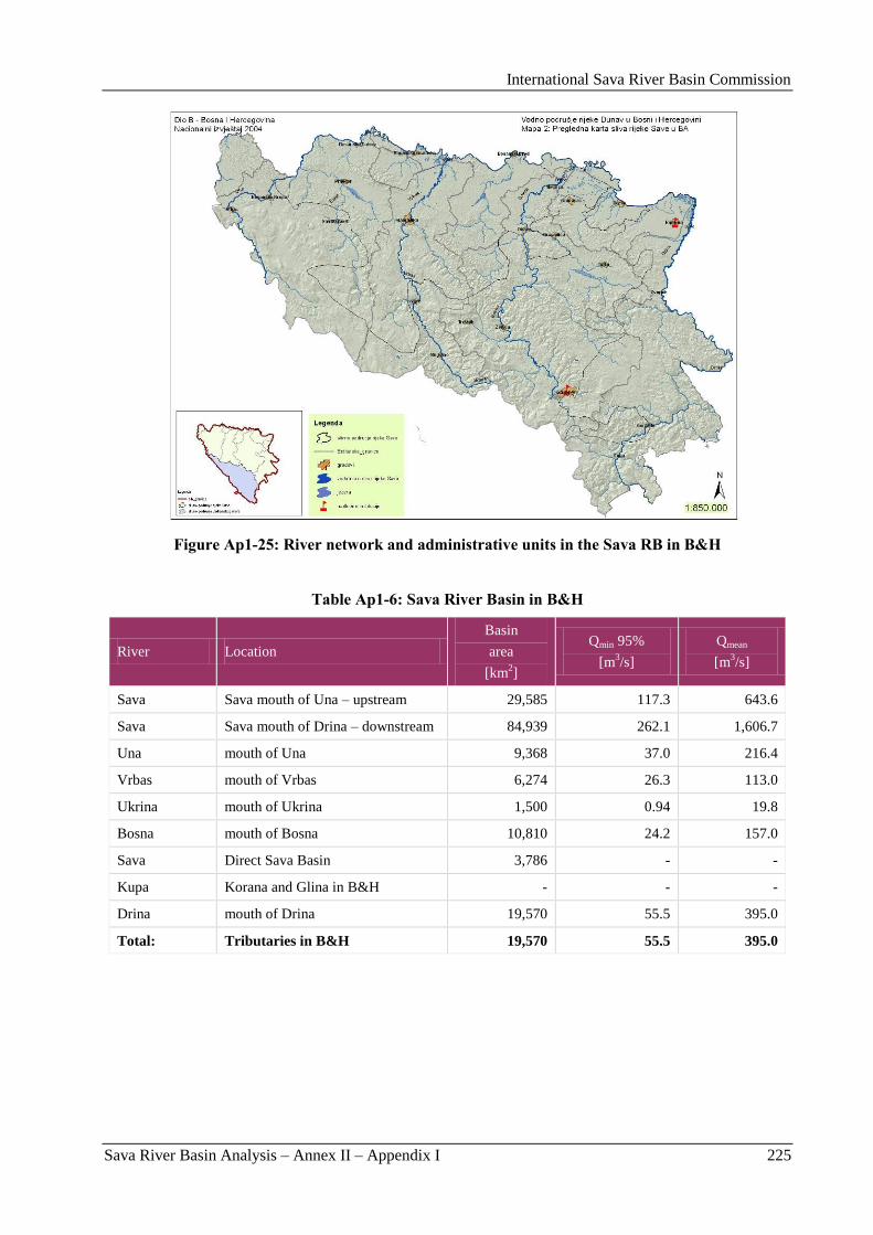
International Sava River Basin Commission
Sava River Basin Analysis – Annex II – Appendix I 225
Figure Ap1-25: River network and administrative units in the Sava RB in B&H
Table Ap1-6: Sava River Basin in B&H
River Location
Basin
area
[km2]
Qmin 95%
[m3/s]
Qmean
[m3/s]
Sava Sava mouth of Una – upstream 29,585 117.3 643.6
Sava Sava mouth of Drina – downstream 84,939 262.1 1,606.7
Una mouth of Una 9,368 37.0 216.4
Vrbas mouth of Vrbas 6,274 26.3 113.0
Ukrina mouth of Ukrina 1,500 0.94 19.8
Bosna mouth of Bosna 10,810 24.2 157.0
Sava Direct Sava Basin 3,786 - -
Kupa Korana and Glina in B&H - - -
Drina mouth of Drina 19,570 55.5 395.0
Total: Tributaries in B&H 19,570 55.5 395.0
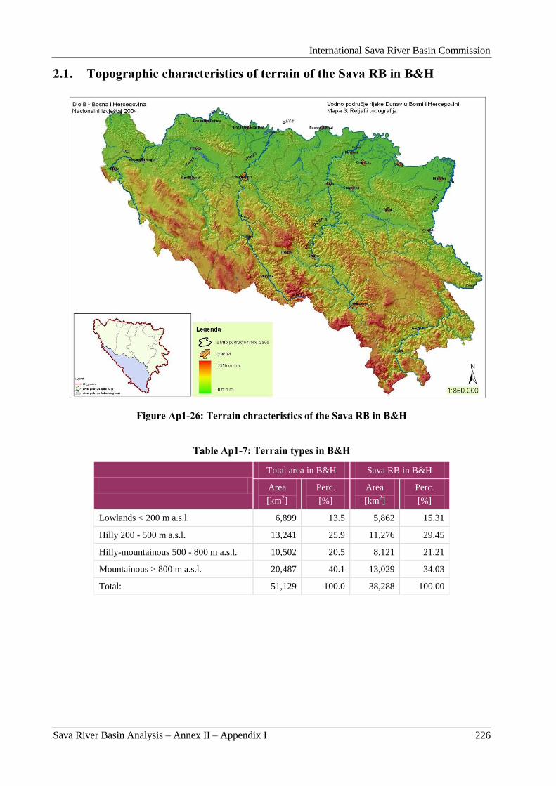
International Sava River Basin Commission
Sava River Basin Analysis – Annex II – Appendix I 226
2.1. Topographic characteristics of terrain of the Sava RB in B&H
Figure Ap1-26: Terrain chracteristics of the Sava RB in B&H
Table Ap1-7: Terrain types in B&H
Total area in B&H Sava RB in B&H
Area
[km2]
Perc.
[%]
Area
[km2]
Perc.
[%]
Lowlands < 200 m a.s.l. 6,899 13.5 5,862 15.31
Hilly 200 - 500 m a.s.l. 13,241 25.9 11,276 29.45
Hilly-mountainous 500 - 800 m a.s.l. 10,502 20.5 8,121 21.21
Mountainous > 800 m a.s.l. 20,487 40.1 13,029 34.03
Total: 51,129 100.0 38,288 100.00
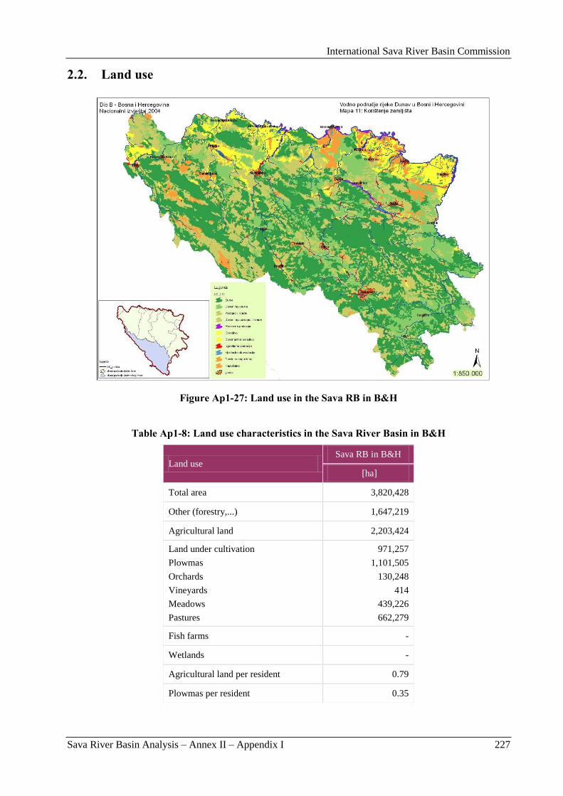
International Sava River Basin Commission
Sava River Basin Analysis – Annex II – Appendix I 227
2.2. Land use
Figure Ap1-27: Land use in the Sava RB in B&H
Table Ap1-8: Land use characteristics in the Sava River Basin in B&H
Land use Sava RB in B&H
[ha]
Total area 3,820,428
Other (forestry,...) 1,647,219
Agricultural land 2,203,424
Land under cultivation
Plowmas
Orchards
Vineyards
Meadows
Pastures
971,257
1,101,505
130,248
414
439,226
662,279
Fish farms -
Wetlands -
Agricultural land per resident 0.79
Plowmas per resident 0.35
International Sava River Basin Commission
Sava River Basin Analysis – Annex II – Appendix I 228
3. Historical floods Historical data on floods are originating from 1822, when first regulation/control works were initiated in
Herzegovina. Systematic observation and flood monitoring on B&H territory started in 1878, when first
construction works were initiated on flood protection dikes in the Sava River valley.
Floods occur in the Sava River Basin in autumn and spring, with approximately same volume of floods
and damages caused by floods.
Largest flood was recorded in period September 20, 1878 to January 4, 1879, when in just 106 days in the
Sava River Basin there was ca. 1381 mm rainfall. According to the data from water gauge in Sisak, in that
period water level went over 900 cm twice and over 800 cm even nine times.
On the Drina River, a catastrophic flood was recorded in 1896, when water level went 100 cm over fence
on the bridge of Omer Paša Sokolović. Entire Podrinje was impacted by this flood with catastrophic
consequences even along entire Sava River course in Semberija and Serbia. This flood has entirely
destroyed settlements Bosanska and Sremska Raĉa. Settlement Sremska Raĉa was displaced to present
location, while settlement Bosanska Raĉa has never been restored.
By constructing reservoirs of HPP Mratinje, HPP Višegrad, HPP Bajina Bašta and HPP Zvornik,
probability of occurrence of such catastrophic wave was significantly decreased.
After construction of dikes on the Sava River right bank in the period of 1934-1941, damages caused by
floods were considerably decreased. Beside those dikes along the Sava River, the construction of dikes
along the main Sava tributaries Una, Vrbas and Bosna, as well as Drina River side started in B&H.
In 1964, a long term flooding event occurred in Middle Posavina with huge damages on agricultural land.
Unfortunately, there is no more precise data on damages.
Floods of similar scope occurred during 1965 and 1966, covering entire area of Posavina and lowland
parts of tributaries in B&H.
On December 19, 1968, large flood was recorded in Sarajevsko polje, when Bosna River overflowed the
bridge on water meter station in Reljevo, with depth of 30-40 cm and took away the road outlet and part
of the local road on right bank in length of ca. 80 m.
In period of 1972-1974, floods have covered entire lowland area in B&H (Posavina with tributaries Una,
Sana, Vrbas, Bosna, Tinja, Brka and Drina River).
Entire period from 1981 to 1991 is characterized by flood events with different volume, covering more or
less even upper Sava River tributary courses.
In 1996, on September 23-24, due to very high precipitations in Vrbas River Basin there was a flood
wave formed, causing floods on entire Vrbas River course downstream of Banja Luka.
In 1999, big flood event was recorded in Tuzla, Bosna River Basin, when small River Jala caused great
flooding.
In 2004, Srbac suffered significant damages in the area of Vrbas and Povelić River mouth, causing great
damages in upper river course of Povelić River.
By construction of a dike along the Sava River, the flood wave propagation from the Una River mouth to
Sremska Mitrovica has been decreased from previously 8-9 days to 4-5 days, as a direct consequence of a
reduction of inundation areas in Posavina.
4. Existing flood management
4.1. Commanding responsibilites
Water management in Bosnia and Herzegovina is under the entity-level competence.
International Sava River Basin Commission
Sava River Basin Analysis – Annex II – Appendix I 229
Republika Srpska
Protection against harmful water effects, meaning protection against river flood waters, protection against
upland external waters, protection against inland flood waters, protection against torrential waters and
protection against erosion, is determined by Water Law of Republika Srpska, which is completely
harmonized with Water Law of FB&H and EU WFD as well as with the EU Flood Directive (Official
Gazette of RS, No. 55/06).
Beside this, Law on civil protection determines measures and activities of Civil protection Center on
human and capital assets prevention and protection in case of flooding and flood occurrence. In that
sense, civil protection is organized in 5 regional departments of Republic administration of civil
protection as follows: ORUCZ Banja Luka, ORUCZ Doboj, ORUCZ Bijeljina and ORUCZ Sokolac.
Civil protection actions are managed by Republic administration of civil protection which is under direct
management of the Government, i.e. Parliament of RS-B&H.
Institutions in charge for above mentioned laws implementation are as follows:
Ministry of Agriculture, Forestry and Water Management, Banja Luka;
Republic Directorate for waters (as of February 13, 2009, the Agency for Waters for Sava River
Basin District), Bijeljina;
Republic administration of civil protection, Banja Luka.
Beside mentioned Republic authorities, implementation of Water Law and flood protection are enforced
by following public and partially privatized utilities as follows:
JP Sava, Gradiška;
JP Sava, Brod;
JP Posavina, Vukosavlje;
JP Ušće Bosne, Šamac – privatized;
JP Srednja Posavina, Lonĉari – privatized;
JP Semberija, Bijeljina;
JP Drina, Zvornik – privatized;
JP Gornja Bosna, Foĉa.
For civil protection implementation, following regional departments are in charge:
ORUCZ Banja Luka,
ORUCZ Doboj,
ORUCZ Bijeljina,
ORUCZ Sokolac.
Responsibilities and authorities within flood protection are defined by the Decree of relevant Ministry of
agriculture, forestry and water management, while flood protection costs are borne by relevant Ministry
and the Government of RS-B&H.
Flood protection is implemented on three basic protection levels (degrees):
Level of flood awareness – for the water level when water is being discharged from the natural
river bed,
Level of regular protection – when flood water level wets toe of the dike, and
Level of emergency protection – when flood water level comes to 0.5-1.0 m above the dike toe
with further growth trend.
Actual flood defense level differs for different protection zones and depends on dike condition, dike
height and imiportance of the protected area.
Actual defense level is being proclaimed by the relevant Ministry, while for the Regional administration
of civil protection, by the RS-B&H Government.
International Sava River Basin Commission
Sava River Basin Analysis – Annex II – Appendix I 230
The role of district water management utilities is very important in flood protection system, since, by
relevant Ministry Decree, they have been proclaimed as competent and in charge for the following issues:
Maintenance and rehabilitation of flood protection structures (dikes, weirs and PS);
River deposit exploitation with the purpose of designed water course profile maintenance and
especially for navigable path maintenance;
Required mechanization for flood structure maintenance and rehabilitation, as well as for the
maintenance of mechanization itself;
In emergency situations organization of additional personnel and equipment from local
companies via Republic administration of civil protection headquarters;
Coordination of all terrain activities related to the flood protection and direct flood protection
management activities in the field, for the flood area of which they are in charge. In that sense,
they are directly managing and making decisions on proclaiming defense needs and level against
external upland drainage waters.
For the purpose of most efficient flood protection, flood protection areas are divided into dike sectors
(sections) where Sector flood protection managers are in charge for flood protection.
Flood protection level is defined per each sector based on the water level measured on water gauge for
each sector and section of the dike, individually.
The role of MoAFWM and Agency for Waters for Sava River Basin District is as follows:
Providing of required Studies and Design documents related to the flood protection systems on
entire area of RS-B&H, and in coordination with MoAFWM and Agency for waters from
Federation of Bosnia and Herzegovina for entire B&H;
Developing Action plans and river basin management plans;
Developing flood protection plans for individual sectors;
Providing financing for new structures construction and for maintenance of existing ones, as well
as for the monitoring system, system for early warning and supervision system for collecting and
exchange of information related to the meteorological conditions and water levels;
Planning and coordination of flood protection and flood risk mitigation activities by involving
municipal civil protection headquarters in charge for flood protection.
Republic Institutes for hydrometeorology are in charge for: supervision, measuring, collecting and
analyzing hydro meteorological data, as well as for weather forecasting.
On RS-B&H territory, within the Sava River Basin, monitoring and measuring of meteorological
parameters have been performed on 23 stations, hydrological parameters were registered on 7 stations and
continuous water level monitoring is been performed on 22 automatic stations (additional 14 automatic
stations are in process of installation). Total number of automatic stations in B&H is 99.
Plans for unforeseen and emergency situations are not a part of the General flood protection plan for
RS-B&H. For time being, this planning activity is under Republic association of civil protection
competence and they are in charge for evacuation plans and activities that are not part of the Flood
protection plan.
General flood protection plan is not enacted and adopted for RS-B&H. The Framework plan for water
management development in RS-B&H until 2015 and Action plan for implementation of this plan
determine the guidelines and the time schedule for preparation of the new Flood protection plan.
For now, Annual flood protection plans are being enacted, based on relevant Ministry decree and based
on the Flood protection plan that was in force until 1992 (Flood protection plan in force until the war).
Legal base for Flood protection plan implementation within RS-B&H are Water law and Civil protection
law and their by-laws.
Annual flood protection plan is enacted annually, based on relevant ministry Decree.
International Sava River Basin Commission
Sava River Basin Analysis – Annex II – Appendix I 231
Constituent part of the Annual flood protection plan is the Main flood protection operational plan for
relevant year and it contains data on:
Flood area (flood area mark, data on Sectoral flood protection manager and its deputies, data on
Public Utility in charge for the named area);
Characteristic water levels for flooded area (relevant water meter staff, maximal observed water
level, water level for proclaiming regular flood protection level, water level for proclaiming
emergency flood protection level);
Flood sector (name and detail description of the sector, data on sector flood protection manager
and its depute);
Nomination of Head manager for RS-B&H flood protection;
Nomination of Head manager deputy for RS-B&H flood protection.
Regional and sector managers for flood protection are in charge for preparation of appropriate flood
protection plans under their competences – plans that contain data on:
Competent municipal civil protection headquarters;
Settlements to be mobilized for flood protection;
Other data on regular and emergency flood protection participants.
Federation of Bosnia and Herzegovina
Protection against harmful water effects means implementation of activities and measures on mitigating
or preventing harmful water effects and its consequences on people and capital assets and it is related to
flood protection and protection against ice on water courses and protection against erosion and torrents.
Protection against harmful water effects covers also protection measures and mitigating its consequences
caused by emergency water pollution and it is proscribed by Water law of Federation B&H, which is
completely harmonized with RS-B&H Water law and EU WFD. Also, it should be pointed out, that types
and content of flood protection plans and flood protection activities are defined by Decree on flood
protection plans (Official Gazette of FB&H, Nr.: 3/02). This Decree also determined structure and
competences of each subject participating in flood protection. Since this Decree was not harmonized with
relevant EU Directive, there was a new Decree on types and content of flood and ice protection plans
developed, which is completely harmonized with relevant Directive and it is in process of adoption. The
old Decree has dealt just with flood protection structures in FB&H ownership, while the new Decree
deals with all water courses of the 1st category, except flood protection structures.
Beside all mentioned, Decree on people and capital assets protection measures organization, content and
implementation, enacted by FB&H Government (Official Gazette of FB&H 27/08), determines
organization, content and preparation activities, as well as protection measures implementation module
against danger and consequences of natural disasters, technological, ecological and other accidental
events, where floods also belong. In article 15, paragraph 1, item 7, in connection with articles 43-46,
protection and rescuing on the water surface and under the water, it reads: Protection and rescuing on and
under the water is to be implemented by: citizens under self-protection, utilities and other legal persons
competent by its basic field of activities or if they are somehow connected to sea, rivers and lakes, as well
as sport organizations dealing with sport performed on or under the water and services equipped and
enabled for this type of protection and rescuing, civil protection units for protection and rescuing on and
under the water, and administration authorities and services for administration in charge with water
management.
Main flood protection operational measures plan enacted each year, amongst other issues determines
also tasks, persons leading actions and unique and harmonized module of actions during preparation and
implementation of activities and protection as well as the rescuing measures, in case of emergency flood
protection on the territory of FB&H.
In that sense, the civil protection for the Sava River Basin area is organized on two flooded areas Odţaĉka
and Srednja Posavina and the municipal civil protection headquarters are involved in flood protection
activities.
International Sava River Basin Commission
Sava River Basin Analysis – Annex II – Appendix I 232
Institutions in charge for the above-mentioned laws implementation are as follows:
Federal Ministry of agriculture, water management and forestry, Sarajevo;
Agency for Sava River catchment, Sarajevo;
Federal civil protection headquarters, Sarajevo.
Beside mentioned bodies, Water law and flood protection activities are provided by specialized
organizations, nominated through the Main flood protection operational measures plan, in charge for
flood protection on individual flood prone areas.
For the implementation of the civil protection activities according to the Main plan of flood protection
operational measures in FB&H, on the two flood prone areas, there are following municipal civil
protection headquarters in charge:
OŠCZ Odţak,
OŠCZ Domaljevac - Bosanski Šamac,
OŠCZ Orašje,
OŠCZ Gradaĉac.
Responsibilities and competences of flood protection institutions are defined by Decree on flood
protection plans, proscribed by Federal Ministry of Agriculture, Water Management and Forestry
(FMAWMF), while costs of implementation are borne by Agency and FMAWMF.
Flood protection activities are implemented on two basic protection levels (degrees):
Regular flood protection, when flood water level reaches the level on water meter staff,
proscribed by the decree for that flood prone area,
Emergency flood protection, when flood water level reaches the level on water meter staff,
proscribed by decree for that flood prone area.
The start and the termination of regular and emergency flood defense for individual flood prone area is
being proclaimed by regional flood protection manager who immediately informs the federal flood
protection manager according to the Decree on flood protection plans.
Role of specialized organizations is very important in flood protection system, since those organizations
are being nominated through the Main plan of flood protection operational measures, as competent
organizations and in charge for:
Maintenance and rehabilitation of flood protection structures (dikes, dams and PS);
River deposit exploitation with the purpose of designed water course profile maintenance and
especially when navigable path is in question;
Required mechanization for flood structure maintenance and rehabilitation and maintenance of
mechanization itself;
In emergency situations organization of additional personnel and equipment from local
companies via Republic administration of civil protection headquarters;
Coordination of all terrain activities connected to flood protection and direct flood protection
management activities on the field for the flood area they are in charge with. In that sense, they
are directly managing and making decision on proclaiming protection need and level against
external upland drainage waters.
For the purpose of most efficient flood protection, flood protection areas are divided into dike sectors
(sections) where Sector flood protection managers are in charge for flood protection.
Flood protection level is defined per each sector, based on the water level measured on water meter staff
for each sector and section of the dike individually.
International Sava River Basin Commission
Sava River Basin Analysis – Annex II – Appendix I 233
Role of the FMAWMF and the Agency for the Sava River catchment is as follows:
Providing the required Studies and Design documents related to flood protection systems on
entire area of FB&H, and in coordination with MoAFWM and Agency for waters from RS-B&H
for entire B&H;
Developing river basin management plans;
Developing flood protection plans for individual sectors according to Decree on flood protection
plans;
Providing financing for new structures construction and for maintenance of existing ones as well
as for monitoring system, system for early warning and supervision system for collecting and
exchange of information related to meteorological conditions and water levels;
Planning and coordination of flood protection and flood risk mitigation activities by involving
municipal civil protection headquarters in charge for flood protection.
Federal Meteorological institute is obligated to continuously submit data on precipitation, river water
levels, status of the snow cover and weather forecasts and to submit them to the water management
information centers of competent Water Agencies for the individual flood protected areas. Main
operational plan determines the hydrological and meteorological stations which will deliver the
mentioned data.
Federal meteorological institute submits to the Water management information center for Sava catchment
the information received from 15 hydrological and 13 meteorological stations.
On the FB&H territory, in the Sava River Basin, under the Agency for Sava River catchment, Sarajevo
competence, monitoring and measuring of meteorological parameters on 14 automatic stations,
hydrological-meteorological on 5 automatic stations and hydrological parameters is carried out on 42
automatic stations. Design documentation for installation of additional 30 hydrological automatic stations
in Bosna River Basin is under preparation.
Main prevention plan for flood protection in FB&H is prepared in accordance with decree in force, but
it is not yet adopted. Considering the fact that the new decree on types and content of flood and ice
protection plans is in adoption procedure and completely harmonized with the EU Flood Directive, the
former plan is not going to be adopted anyhow, at least not in the originally prepared form. New Decree
on flood protection determines directions and time schedule for new Flood protection plans preparation.
In FB&H, the legal base for Flood protection plan implementation is the FB&H Water law and Law on
civil protection, as well as the appropriate by-laws.
Main plan of flood protection operational measures is enacted each year by the FB&H Government on
the FMAWMF proposal and contains data on:
Flood area (flood area mark, data on Sector flood protection manager and its deputies, data on
Public Utility in charge for this area, municipal civil protection headquarters);
Characteristic water levels for flooded area (institution for issuing data, relevant water meter
staff, maximal observed water level, water level for proclaiming regular flood protection level,
water level for proclaiming emergency flood protection level);
Flood sector (name and detail description of the sector, data on sector flood protection manager
and its depute);
Nomination of Head manager for FB&H flood protection;
Nomination of Head manager deputy for FB&H flood protection.
Regional and sector managers for flood protection are in charge for preparation of appropriate flood
protection plans under their competences – plans that contain data on:
Competent municipal civil protection headquarters,
Settlements to be mobilized for flood protection,
Other data on regular and emergency flood protection participants.
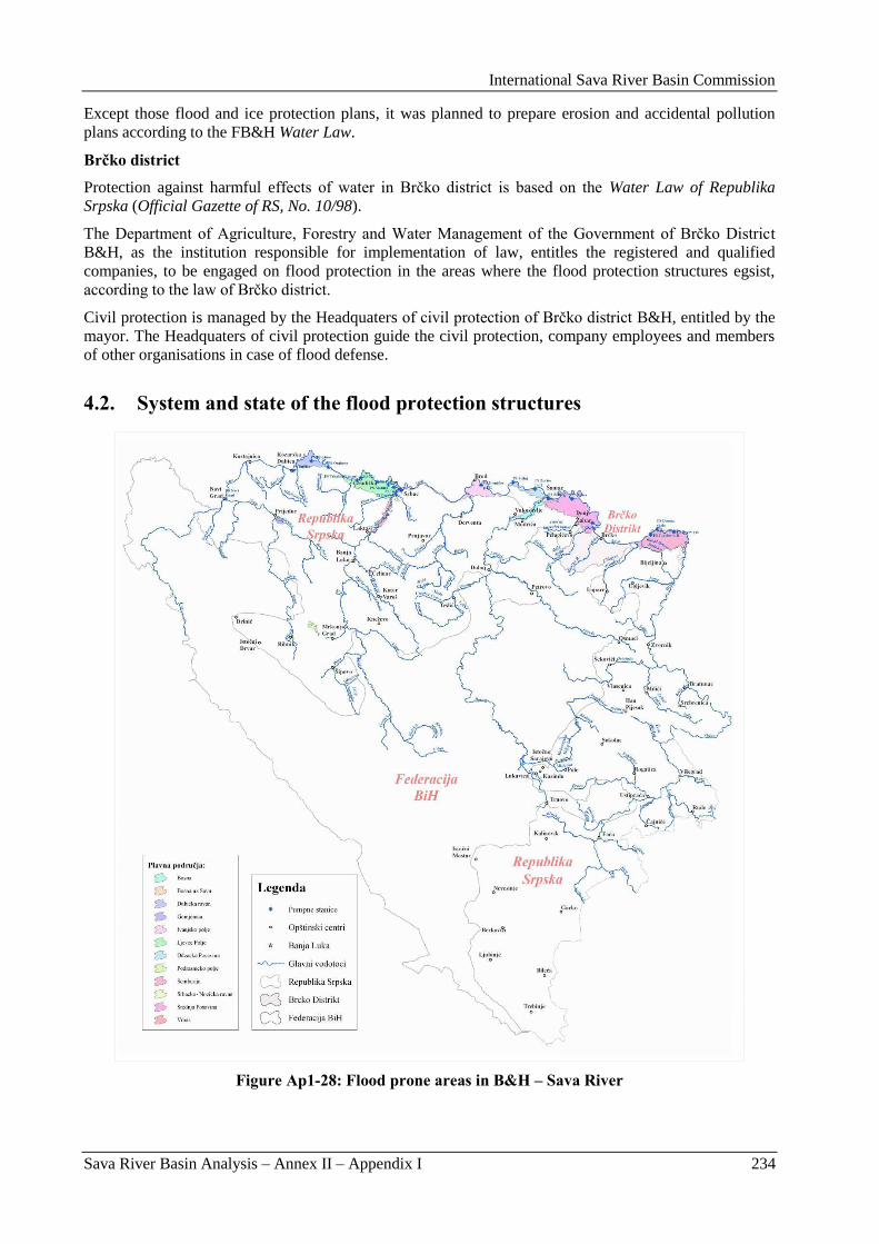
International Sava River Basin Commission
Sava River Basin Analysis – Annex II – Appendix I 234
Except those flood and ice protection plans, it was planned to prepare erosion and accidental pollution
plans according to the FB&H Water Law.
Brčko district
Protection against harmful effects of water in Brĉko district is based on the Water Law of Republika
Srpska (Official Gazette of RS, No. 10/98).
The Department of Agriculture, Forestry and Water Management of the Government of Brĉko District
B&H, as the institution responsible for implementation of law, entitles the registered and qualified
companies, to be engaged on flood protection in the areas where the flood protection structures egsist,
according to the law of Brĉko district.
Civil protection is managed by the Headquaters of civil protection of Brĉko district B&H, entitled by the
mayor. The Headquaters of civil protection guide the civil protection, company employees and members
of other organisations in case of flood defense.
4.2. System and state of the flood protection structures
Figure Ap1-28: Flood prone areas in B&H – Sava River
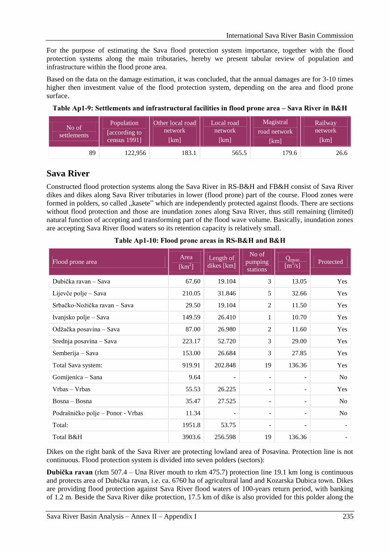
International Sava River Basin Commission
Sava River Basin Analysis – Annex II – Appendix I 235
For the purpose of estimating the Sava flood protection system importance, together with the flood
protection systems along the main tributaries, hereby we present tabular review of population and
infrastructure within the flood prone area.
Based on the data on the damage estimation, it was concluded, that the annual damages are for 3-10 times
higher then investment value of the flood protection system, depending on the area and flood prone
surface.
Table Ap1-9: Settlements and infrastructural facilities in flood prone area – Sava River in B&H
No of
settlements
Population
[according to
census 1991]
Other local road
network
[km]
Local road
network
[km]
Magistral
road network
[km]
Railway
network
[km]
89 122,956 183.1 565.5 179.6 26.6
Sava River
Constructed flood protection systems along the Sava River in RS-B&H and FB&H consist of Sava River
dikes and dikes along Sava River tributaries in lower (flood prone) part of the course. Flood zones were
formed in polders, so called „kasete” which are independently protected against floods. There are sections
without flood protection and those are inundation zones along Sava River, thus still remaining (limited)
natural function of accepting and transforming part of the flood wave volume. Basically, inundation zones
are accepting Sava River flood waters so its retention capacity is relatively small.
Table Ap1-10: Flood prone areas in RS-B&H and B&H
Flood prone area Area
[km2]
Length of
dikes [km]
No of
pumping
stations
Qmean
[m3/s]
Protected
Dubiĉka ravan – Sava 67.60 19.104 3 13.05 Yes
Lijevĉe polje – Sava 210.05 31.846 5 32.66 Yes
Srbaĉko-Noţiĉka ravan – Sava 29.50 19.104 2 11.50 Yes
Ivanjsko polje – Sava 149.59 26.410 1 10.70 Yes
Odţaĉka posavina – Sava 87.00 26.980 2 11.60 Yes
Srednja posavina – Sava 223.17 52.720 3 29.00 Yes
Semberija – Sava 153.00 26.684 3 27.85 Yes
Total Sava system: 919.91 202.848 19 136.36 Yes
Gomijenica – Sana 9.64 - - - No
Vrbas – Vrbas 55.53 26.225 - - Yes
Bosna – Bosna 35.47 27.525 - - No
Podrašniĉko polje – Ponor - Vrbas 11.34 - - - No
Total: 1951.8 53.75 - - -
Total B&H 3903.6 256.598 19 136.36 -
Dikes on the right bank of the Sava River are protecting lowland area of Posavina. Protection line is not
continuous. Flood protection system is divided into seven polders (sectors):
Dubička ravan (rkm 507.4 – Una River mouth to rkm 475.7) protection line 19.1 km long is continuous
and protects area of Dubiĉka ravan, i.e. ca. 6760 ha of agricultural land and Kozarska Dubica town. Dikes
are providing flood protection against Sava River flood waters of 100-years return period, with banking
of 1.2 m. Beside the Sava River dike protection, 17.5 km of dike is also provided for this polder along the
International Sava River Basin Commission
Sava River Basin Analysis – Annex II – Appendix I 236
Una River, from Una River mouth to 27.2 rkm. In urban part of the town, there are bank protections in
function of traffic road with shelf retaining wall in total length of 650 m. The remaining right part of the
Una dike was constructed as classic dike.
Protection against external upland waters and inland waters is provided by 3 pump stations in total
capacity of 13.05 m3/s. PS Dubica with the capacity of 2.95 m
3/s, is performing pumping from both part
of Una River inland waters and rain waters of Dubica. There is also PS for inland waters of direct Sava
River Basin - PS Orahova with capacity of 3.0 m3/s and PS Glavinac I and II, with total capacity of 7.1
m3/s.
For collection of the external (upland drainage waters) and for collection of the own (inland) waters in
zone of protected area, there was canal network constructed, 74.18 km long. Main protection is provided
by main boundary canals: Upper boundary canal 8.7 km long, Hatinovac canal 2.57 km long, Lower
boundary canal 12.5 km long with network of secondary canals 34.64 km long, Stara Rakovica canal 5.54
km long, with network of secondary canals 4.45 km long and Virovska canal 4.01 km long with network
of secondary canals in total length of 2.71 km.
Lijevče polje (rkm 463 – mouth of Jablanica River to rkm 421.9 – Vrbas River mouth), protection line
31.8 km long continues and protects areas of Lijevĉe polje, i.e. ca. 21,005 ha of fertile agricultural land
and Gradiška town. In urban area, dikes are mostly also performing role of traffic roads with shelf
retaining wall in total length of 950 m. Dikes are providing protection against Sava River flood waters of
100 years return period, with banking of 1.2 m. Beside this Sava dike, protection for this polder is
provided also with a 14.6 km long dike along the left Vrbas River bank – zone of Sava River backwaters,
from Vrbas River mouth to 15.0 rkm.
Protection against external upland waters and inland waters is provided by 5 pump stations with total
capacity of 32.66 m3/s: PS „Bainci”, capacity 5.0 m
3/s, PS „Dolina”, capacity 8.61 m
3/s, PS „Matura”,
capacity 8.55 m3/s, PS „Kej”, capacity 1.0 m
3/s and PS „Liman”, capacity 9.50 m
3/s.
For collection of the own (inland) waters in the zone of protected area, a canal network was constructed in
total length of 91.65 km. Main protection is provided by canals: Osorna-Borna-Lijevĉe - total length of
25.6 km with secondary network 12.6 km long, Lukavac - total length of 3.7 km, with secondary network
in total length of 4.6 km, Jurkovica-Jablanica canal - 10.8 km long, with secondary network - 22.43 km
long, Topola-Jablanica canal - 11.65 km long, with secondary network of 22.15 km.
Srbačko-Nožička ravan (rkm 419.2 – Vrbas River mouth to rkm 411.8) protection line 19.1 km long is
continuous and protects area of Srbaĉko-Noţiĉka ravan, i.e. 2950 ha of fertile land and Srbac town. Dikes
are protecting against the Sava River flood waters of 100-years return period, with banking of 1.2 m.
Protection against external upland waters and inland waters is provided by 2 pump stations in total
capacity of 6.00 m3/s: PS „Povelić” - capacity of 4.0 m
3/s and PS „Ina” - capacity of 2.00 m
3/s.
Beside Sava dike, protection for this polder is provided also by 14.6 km long dike along the Vrbas River-
area of Sava backwaters, from Vrbas River mouth to 15.0 rkm. Protection against external upland and
inland waters is provided by canals: Povelić canal - 4.86 km long, with a secondary canal network in total
length of 3.88 km and main canal Ina - 9.995 km long, with secondary canal network of 13.2 km.
Ivanjsko polje (rkm 373.5 to rkm 341.1) protection line of 26.41 km is continuous and protects Ivanjsko
polje, i.e. 14,959 ha of fertile land and Brod town. Dikes are providing protection against Sava River
flood waters of 100-years return period, with banking of 1.2 m.
Protection against external upland waters and inland waters is provided by PS „Ivanjsko polje I and II”,
with capacity of 10.7 m3/s.
Protection against external upland and inland waters is provided by canals, in total 59.91 km long. Main
boundary canal is 17.18 km long and Middle boundary canal 3.87 km long with secondary canal network
in total length of 38.86 km.
Odžačka Posavina – FB&H (rkm 334.5 to rkm 306.0 – Bosna River mouth) protection line is 26.41 km
long and it is continuous and protects 8,700 ha of fertile land and settlements Svilaj, N. Grad, Gornja and
International Sava River Basin Commission
Sava River Basin Analysis – Annex II – Appendix I 237
Donja Dubica and Prud. Dikes are providing protection against Sava River flood waters of 100-years
return period, with banking of 1.2 m.
Protection against external upland and inland waters is provided by PS „Zorice I and II” with the capacity
of 4.0 m3/s.
Protection against inland waters is provided by canals in total length of 68.61 km: Srnotaĉe canal, 12.94
km long with secondary canal network in total length of 8.59 km; Kamenica canal, 5.89 km, with
secondary canal network in total length of 1.26 km; Berek canal - 8.04 km long with secondary canal
network in total length of 1.82 km, Bukovica canal - 11.72 km long, with secondary canal network in
total length of 7.79 km and Main collection canal - 6.13 km long, with secondary canal network in total
length of 4.43 km. Main canal mouths are also protected with dikes.
Flood protection system for Odţaĉka Posavina area is organized by forming two polders:
Svilaj polder – area of 1,240 ha is situated between Sava protection dike and Upper boundary canal,
Lower boundary canal and Svilaj-Potoĉani boundary canal. When Sava River flood waters occur, then
inland waters are being pumped out by PS Svilaj - capacity 2 m3/s.
Area between the Sava protection dike, dikes along the Bosna River, boundary canal Svilaj-Potoĉani and
Bosna – Bukovica are creating Odţak – Novi Grad polder. Total surface of polder is 8,900 ha. When the
Sava River flood waters occur, inland waters are being pumped out by PS „Zorice I” – capacity 5.5 m3/s
and „Zorice II” – capacity 4.1 m3/s.
There are following significant structures constructed on this area which form polder:
Dikes for protection against external waters:
Along the Sava River – Sava protection dike „Prud-Kadar” – 27.1 km long,
Along Bosna River - „Prud-Neteka” – 6.9 km long.
Boundary canal for protection against upland waters:
„Svilaj – Potoĉani” – 13 km long (gravitation drainage of upland waters into Sava River) with
adjacent dikes,
„Bosna – Bukovica” – 6.5 km,
Upper boundary canal 2.4 km long,
Lower boundary canal 3.3 km long.
Sava protection dike is damaged along whole its length because bins and shelters were constructed in the
dike body. Dikes are mined, especially watery side and inundations, so that de-mining of terrain is
important precondition for rehabilitation works. Lack of maintenance for longer time has caused growth
of vegetation, which additionally damages dikes with its roots.
Inland drainage of Odţaĉka Posavina is performed gravitationally by canal network when water levels in
Sava River are low. When Sava River flood waters occur, then they are being pumped out into the Sava
River from Odţak – Novi Grad polder (8,900 ha) or Svilaj polder (1,240 ha).
Srednja Posavina – RS-B&H and FB&H (rkm 306.0 – Bosna River mouth to rkm 228 – Tinja River
Basin) the protection line, 52.7 km long, is discontinuous and protects 22317 ha of fertile land and
settlements Šamac, Orašje and Brĉko. Dikes are protecting against Sava River flood waters of 100-years
return period, with banking of 1.2 m.
In Orašje urban area, dike is a traffic road, combined with shelf retaining wall in total length of 300 m. In
Brcko urban area, there are dikes, with shelf retaining walls in total length of 350 m.
Beside Sava dike, along tributaries, there are dikes constructed in area of Sava River backwaters - Right
dike of Bosna River - 1.5 km long and right dike of Tinja River - 1.6 km long.
Protection against upland waters and inland waters is provided by 3 pump stations in total capacity of
29.0 m3/s: PS „Duga” (Šamac), capacity 6.0 m
3/s, PS „Tolisa”, capacity 15.5 m
3/s and PS „Đurić”,
capacity 7.5 m3/s.
International Sava River Basin Commission
Sava River Basin Analysis – Annex II – Appendix I 238
Protection against inland waters is provided by canals in total length of 197.07 km. Eastern lateral canal -
21.79 km long, with secondary network - 14.15 km long, Tinja-Tolisa canal - 15.95 km long with
secondary network - 14.15 km long, Dušine canal - 14.23 km long with secondary network - 39.37 km,
main boundary canal Svilaj-Potoĉani - 13.60 km long with secondary network - 20.61 km long.
Land reclamation area of Srednja Posavina is a plane located between Sava, Bosna and Tinja Rivers, and
Trebava and Majevica mountains hillsides. There is already a constructed flood protection system on this
location.
Flood protection of reclamation area of Srednja Posavina is performed by Sava protection dike 45.7 km
long, dike lies between village Krepšić and Bosanski Šamac. 37.66 km of the dike are located in the area
of FB&H.
Protection against upland flood waters consists of a constructed system of boundary canals ca. 56 km
long, while protection against inland waters is represented by system of canal network.
The area of Srednja Posavina with the total surface of 48,400 ha is, according to the terrain configuration,
divided into 4 separate areas, as follows:
Area drained gravitationally:
polder „Zapad”, surface of 10,244 ha,
polder „Istok”, surface of 15,546 ha.
polder areas out of which water is pumped out during the Sava River flood waters:
polder „Sjever”, surface of 12,300 ha,
polder „Objeda”, surface of 10,333 ha.
Generally, it can be said that the protection level in the Srednja Posavina area was not on satisfactory
level. Dikes were providing various protection level for tributaries, since protection banking varied from
section to section, thus not providing the adequate protection level. Partial reconstruction of dikes on
urgent sections (the ones with lowest protection level or lowest security of dike slopes) was initiated, due
to the above mentioned reason.
Semberija (rkm 203.6 – GOK mouth to rkm 175 – Drina River mouth) protection line 26.684 km long is
continuous and protects 15,300 ha of fertile land and Bijeljina town. Dikes are providing protection
against Sava River flood waters of 100-year return period, with banking of 1.2 m.
On the section from the Sremska Raĉa bridge to the Stara Dašnica canal mouth (5.1 km upstream), Sava
dike was constructed with banking from 0.1-0.2 m (reconstruction of dike has not been performed). It can
be stated, that this section is most critical one in the entire Sava River flood protection system, so
reconstruction of this part of protection line will be certainly one of the top priority activities for RS-
B&H.
Beside Sava dike along tributary - Drina River, there is left Drina dike in the reach of Sava River
backwater, in length of 8.23 km.
Protection against external upland waters and inland waters is provided with 3 pump stations in total
capacity of 13.5 m3/s: PS „Topolovac I and II” - capacity of 9.3 m
3/s, PS „Domuz skela” - capacity of 2.8
m3/s and PS „Begov put” - capacity of 15.75 m
3/s.
Protection against external and inland waters is provided with canals in total length of 287.8 km: Drina-
Glogovac-Dasnica canal in length 9.73 with secondary canal network 2.65 km long; Dašnica canal -
10.89 km long with secondary canal network 5.59 km long; Stara Dašnica - 10.89 km with secondary
canal network of 44.02 km; Majeviĉki boundary canal – MOK - 12.81 km with secondary canal network
of 25.12 km; Main boundary canal – GOK - 13.69 km with secondary canal network of 35.54 km and
Selište canal - 13.52 km with secondary canal network of 57.83 km.
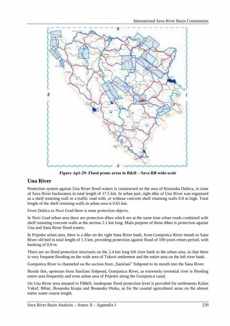
International Sava River Basin Commission
Sava River Basin Analysis – Annex II – Appendix I 239
Figure Ap1-29: Flood prone areas in B&H – Sava RB wide-scale
Una River
Protection system against Una River flood waters is constructed on the area of Kozarska Dubica, in zone
of Sava River backwaters in total length of 17.5 km. In urban part, right dike of Una River was organized
as a shelf retaining wall or a traffic road with, or without concrete shelf retaining walls 0.8 m high. Total
length of the shelf retaining walls in urban area is 0.65 km.
From Dubica to Novi Grad there is none protection objects.
In Novi Grad urban area there are protection dikes which are at the same time urban roads combined with
shelf retaining concrete walls at the section 2.1 km long. Main purpose of those dikes is protection against
Una and Sana River flood waters.
In Prijedor urban area, there is a dike on the right Sana River bank, from Gomjenica River mouth to Sana
River old bed in total length of 1.3 km, providing protection against flood of 100-years return period, with
banking of 0.8 m.
There are no flood protection structures on the 2.4 km long left river bank in the urban area, so that there
is very frequent flooding on the wide area of Tukovi settlement and the entire area on the left river bank.
Gomjenica River is channeled on the section from „Saniĉani” fishpond to its mouth into the Sana River.
Beside this, upstream from Saniĉani fishpond, Gomjenica River, as extremely torrential river is flooding
entire area frequently and even urban area of Prijedor along the Gomjenica canal.
On Una River area situated in FB&H, inadequate flood protection level is provided for settlements Kulen
Vakuf, Bihać, Bosanska Krupa and Bosanska Otoka, as for the coastal agricultural areas on the almost
entire water course length.
International Sava River Basin Commission
Sava River Basin Analysis – Annex II – Appendix I 240
Flood protection for Kulen Vakuf was partially solved by decreasing of limestone obstacle – sedra (in
river bed) located ca. 1.5 km downstream from the settlement. Before the above mentioned obstacle
removal, Kulen Vakuf had a great problem dealing with floods, since larger parts of settlement have been
flooded for several years.
Bihać is endangered by Una River flood waters and Drobnica water course (coming from Plješevica)
flood waters. Drobnica water course was regulated on the section crossing the settlement.
There were no flood protection works performed in Bosanska Krupa and Bosanska Otoka.
Based on the available hydrological data (previously registered maximal flows and water levels), it can be
concluded that Una River valley deals with highest flood risk. Up to date, there were no more significant
flood protection works and absence of floods in the last twenty years has encouraged construction of
structures and settling on river banks. Due to this fact, flood water wave, when occurs, can cause great
material damages with possibility of human casualties.
When flood water wave occurs, floods are going to endanger areas downstream from Bihać, more
precisely the valley between Ripĉa and Sokolac and areas nearby Pokojsko polje. Areas in Klokot valley
are also endangered, so it is not possible to use great area nearby very interesting big spring Klokot,
which is the main potable water source for Bihać.
Areas being flooded by flood waters in Kulen Vakuf are not large, but the problem is that settlement itself
is being flooded.
Besides, flood prone are also bank areas of Una River in the middle parts of settlements Bosanska Krupa
and Bosanska Otoka, where huge damages could be expected.
Vrbas River
Dikes along Vrbas River, in the area of the Sava River backwaters, are providing flood protection of 100-
years return period, with banking of 1.2 m.
But, constructed dikes outside the Sava River impact zone, the left dike in total length of 14.875 km and
the right dike in total length of 11.35 km, have no required banking - there is banking of 0.1 – 0.2 m and
rehabilitation works are required.
Flooding problems along the Vrbas River in the part going through FB&H occur in Gornji Vakuf and
Donji Vakuf.
Project documents are developed for Donji Vakuf for river bed regulation in length of 3.0 km, from the
Prusaĉka River mouth all the way to the exit from the settlement. Up to date, there were river bed
regulation works performed on the section from traffic reinforced concrete bridge on the road Donji
Vakuf - Bugojno downstream, in length of ca. 1.0 km. Also, there are smaller regulation works performed
on Vrbas River tributaries in the area of Donji Vakuf for Oboraĉka River (in the part crossing the
settlement) and Prusaĉka River, nearby the gypsum factory at the Vrbas River mouth.
Vrbas River bed regulation was performed recently on the curve section going through Gornji Vakuf
located upstream of the road bridge, in length of ca. 700 m.
Now, when the flood waters occur in Gornji Vakuf, just smaller areas nearby water course are endangered
by floods. Higher damages could be expected in Donji Vakuf, where the planned regulation works have
to be finished.
Bosna River
Along the Bosna River, except for the dikes, already described in the Sava River impact area, there are no
flood protection systems. For protection of flood prone area, on the section from Šamac to Doboj, it is
necessary to construct 19.342 km of the dike on the left river bank and 8.183 km on the right river bank.
Sarajevsko polje is endangered by flood waters of the Bosna River – as the main recipient and its
tributaries (Dobrinja, Ţeljeznica, Miljacka, Zujevina and Tilava River).
International Sava River Basin Commission
Sava River Basin Analysis – Annex II – Appendix I 241
Since this is a heavily populated area, it is important to protect it against flood waters, since the damages
caused by floods are extremely high.
When flood protection works are considered - the ones being performed are just those, connected to the
tributary river bed regulation on some individual sections.
On Ţeljeznica River, bed regulation through the settlement Ilidţa was performed in length of 1,000 m.
River bed regulation was performed on Miljacka River on the part from the mouth into the Bosna River
and upstream to the Briješćanski potok (stream) mouth in the length of 1,700 m, on the section where this
water course is running beside the urban waste water treatment plant. Miljacka River bed is also regulated
at the section going through Sarajevo – from the bridge on Sarajevo - Ploĉe railway and upstream to the
weir on Bentbaša in the length of ca. 10.0 km. For the remaining part of the inter-section, in length of
2,100 m, the project documentation has been prepared.
Criterion of flood waters probability of occurrence of 0.002 (once in 500 years) has been adopted.
Section of the Bosna River running through FB&H is endangered by flooding by its own flood waters, as
well as by backwaters caused by Sava River flood waters at the mouth section.
At the Bosna River mouth to the Sava River, there is a dike Prud-Neteka, ca. 6.5 km long. It is an
extension of the Sava dike in the area of the Sava River backwaters, and is situated in flood protection
system for the Odţak area. Existing dike is not satisfying the required protection level, neither by its
height, nor by the length. Final design for rehabilitation of this dike was prepared before the war, with the
protection level appropriate for the Sava River waters (1.20 m), but the works were never implemented.
At the considered water course section, from the mouth to the Sava River to the place in Modriĉa, Bosna
River water course is of a lowland type and has no stable course. It is meandering, changing the position
of the river bed frequently, thus endangering both, left and right river bank. This meandering of the river
course, due to decreased flow velocity, has for a consequence creation of gravel bars along the left or
right convex bank, with significant sedimentation quantities, what makes the flow profile narrower,
increases water velocity and traction force, and directs stream of the watercourse towards opposite river
bank.
Water management structures constructed previously for protection of river banks and river bed
stabilization are endangered or completely destroyed.
Those processes are on certain places in such progress, that the course has come to the dike and represents
direct threat. The most critical location on the Bosna River left bank is in Prud settlement, where the
destroyed river bank lies in the immediate vicinity of the protection dike and its further collapsing
endangers directly the dike base and asphalt road Odţak-Prud, and thus also the Prud settlement (when
flood waters occur).
War and lack of maintenance for a longer period, have contributed to this status. In this section, this water
course forms also the Dayton Peace Agreement entity border line, what makes the problem even more
complex and postpones the required actions on the river bank protection, what could also have as a
consequence the flood protection systems destruction, above all the other damages caused.
At the right river bank, protection line against Bosna and Sava River external waters (backwater) is the
road Modriĉa-Šamac, which is not directly endangered by erosion processes on the right bank since it is
on a safe distance.
Drina River
Due to different geo-morphologic characteristics of the Drina River Basin, flood prone areas are
significantly smaller compared to those along the Sava River. That is the reason why the protection
structures along the Drina River have been constructed just along the Drina River mouth, thus protecting
settlements Balatun, Velino Selo, Brodac, Dvorovi and the city of Bijeljina. Protection dikes are mostly
constructed in form of roads.
In the area of Zvornik town, flood protection against Drina River is solved by shelf retaining reinforced
concrete walls in total length of 1.6 km and in other parts of the town just with bank protections made of
International Sava River Basin Commission
Sava River Basin Analysis – Annex II – Appendix I 242
stones. Main function of bank protections along the Drina River lower course is protection against
erosion, i.e. against the fertile land being taken away.
The only section of the Drina River located in FB&H, is in the area of Goraţde and Vitkovići. Entire area
of Goraţde was flooded in 1896, by the Drina River flood waters. This Drina River flow was significantly
higher then the 500-years flood water, which was relevant for the flood protection structures sizing.
By construction of the big Mratinje reservoir (total volume of 880 hm3) on the Piva River, the Drina River
tributary, the flood risk for Goraţde has been decreased considerably.
Larger works in Goraţde were performed on bank stabilization construction for the purpose of the Drina
River bed stabilization.
River bank protection in length of 2,200 m without parapet wall was made on the left bank, thus not
providing protection height from waters of 100- and 500-years return period.
Right bank has been protected by a parapet wall in length of 2,700 m and it is not providing adequate
protection height for waters of 100- and 500- years return period.
In Vitkovići, left river bank has no protection against floods of 100 and 500-years return period.
Also, there are sections out of the town area, that are flood prone and should be protected. Those are
Zupĉići and Ahmovići upstream from Goraţde, on the right river bank and downstream of Podljutaĉe, on
the left river bank and Hubijeri on the right Drina River bank.
4.3. Structure of the drainage system
Constructed flood protection systems along the Sava River in RS-B&H and FB&H consist of Sava River
dikes and dikes along the Sava River tributaries in lower (flood prone) part of the course. Flood zones
were formed in polders, so called „kasete” which are independently protected against floods.
Protection against external upland waters and inland waters is provided by 19 pump stations in total
capacity of 136.4 m3/s. Total length of the Sava River dikes is 202.85 km.
For collection of external (upland drainage) waters, a system of main boundary canals was constructed, in
total length of 223.24 km. For collection of inland waters in zone of the Sava River protected area, a main
canal network has been constructed, in length of 230.2 km in total.
Total protected area in Sava River system covers 919.9 km2.
The above mentioned data on primary flood protection structures in direct Sava River catchement area are
given in Table Ap1-11.
Table Ap1-11: Main hydraulic structures for protection against external and inland flood waters
No
Polder
(melioraton
area)
Water
Body
(WB)
Canal network
Protection of external
water – by gravity Protection of inland water Pumping
Main
canals
(m)
Secondary
canals
(m)
Main canals
(m)
Secondary
canals
(m)
Name of
Pumping
Stations
and Qinst.
(m3/s)
1. Semberija BA_SA_1
Drina -
Glogovac
6,900 -
Glogovac
2,830 2,650
Dašnica
10,890 5,590
canal IV
9,850 28,580
PS
„Begov
International Sava River Basin Commission
Sava River Basin Analysis – Annex II – Appendix I 243
No
Polder
(melioraton
area)
Water
Body
(WB)
Canal network
Protection of external
water – by gravity Protection of inland water Pumping
Main
canals
(m)
Secondary
canals
(m)
Main canals
(m)
Secondary
canals
(m)
Name of
Pumping
Stations
and Qinst.
(m3/s)
Stara
Dašnica
13,860 18,170
canal III
5,510 25,460
put”
15.75
Majeviĉki
lat. canal
MOK
12,810
- canal II
6,810 18,310
Main lat.
canal GOK
13,690 3,750
canal II
6,450 24,340
PS
„Domuz
skela”
2.80
Selište
13,520 -
canal IV
9,420 48,410
PS
„Topolov
ac I i II”
9.30
2. Central
Posavina
BA_SA_1
Eastern
lateral
canal (RS)
21,790
-
Ometa -
Osatno
7,480
10,730
PS
„Đurići”
7.50 Smrudlja
3,490 9,680
Ţalta
11,430 14,560
Tinja –
Tolisa
15,950 7,460
Rain and faecal sewage
Orašje
PS
„Grad”
Brijesnica
6,690 - PS
„Tolisa”
13.00 Canal
Dušine
14,230 25,470
GK
4,260 9,640
Rain and faecal sewage
Šamac (RS)
PS
„Šamac”
6.00
BA_SA_2
Main
lateral
canal
Svilaj -
Potoĉani
13,600
5,420
GK 1
3,950 3,690
PS
„Svilaj” GK 2
3,000 720
GK 3
3,830 -
3.
Odţaĉka
Posavina
(FB&H)
BA_SA_2
Srnotaĉe
12,940 8,590
PS
„Zorice I”
i „Zorice
II”
4.0 m3
Kamenica
5,890 1,260
Berek
8,040 1,820
Bukovica
11,720 7,790
Main
coll.canal
6,130
4,430
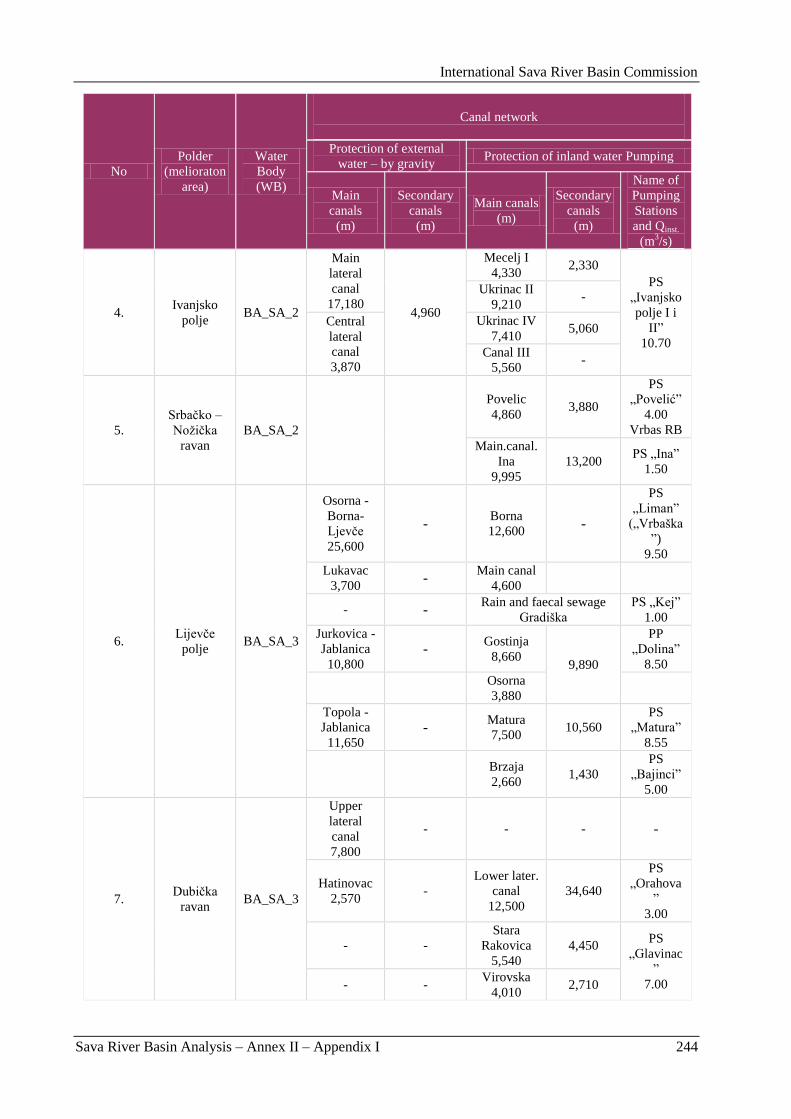
International Sava River Basin Commission
Sava River Basin Analysis – Annex II – Appendix I 244
No
Polder
(melioraton
area)
Water
Body
(WB)
Canal network
Protection of external
water – by gravity Protection of inland water Pumping
Main
canals
(m)
Secondary
canals
(m)
Main canals
(m)
Secondary
canals
(m)
Name of
Pumping
Stations
and Qinst.
(m3/s)
4. Ivanjsko
polje BA_SA_2
Main
lateral
canal
17,180 4,960
Mecelj I
4,330 2,330
PS
„Ivanjsko
polje I i
II”
10.70
Ukrinac II
9,210 -
Central
lateral
canal
3,870
Ukrinac IV
7,410 5,060
Canal III
5,560 -
5.
Srbaĉko –
Noţiĉka
ravan
BA_SA_2
Povelic
4,860 3,880
PS
„Povelić”
4.00
Vrbas RB
Main.canal.
Ina
9,995
13,200 PS „Ina”
1.50
6. Lijevĉe
polje BA_SA_3
Osorna -
Borna-
Ljevĉe
25,600
- Borna
12,600 -
PS
„Liman”
(„Vrbaška
”)
9.50 Lukavac
3,700 -
Main canal
4,600
- - Rain and faecal sewage
Gradiška PS „Kej”
1.00 Jurkovica -
Jablanica
10,800 -
Gostinja
8,660 9,890
PP
„Dolina”
8.50
Osorna
3,880
Topola -
Jablanica
11,650 -
Matura
7,500 10,560
PS
„Matura”
8.55
Brzaja
2,660 1,430
PS
„Bajinci”
5.00
7. Dubiĉka
ravan BA_SA_3
Upper
lateral
canal
7,800
- - - -
Hatinovac
2,570 -
Lower later.
canal
12,500
34,640
PS
„Orahova
”
3.00
- -
Stara
Rakovica
5,540
4,450 PS
„Glavinac
”
7.00 - - Virovska
4,010 2,710
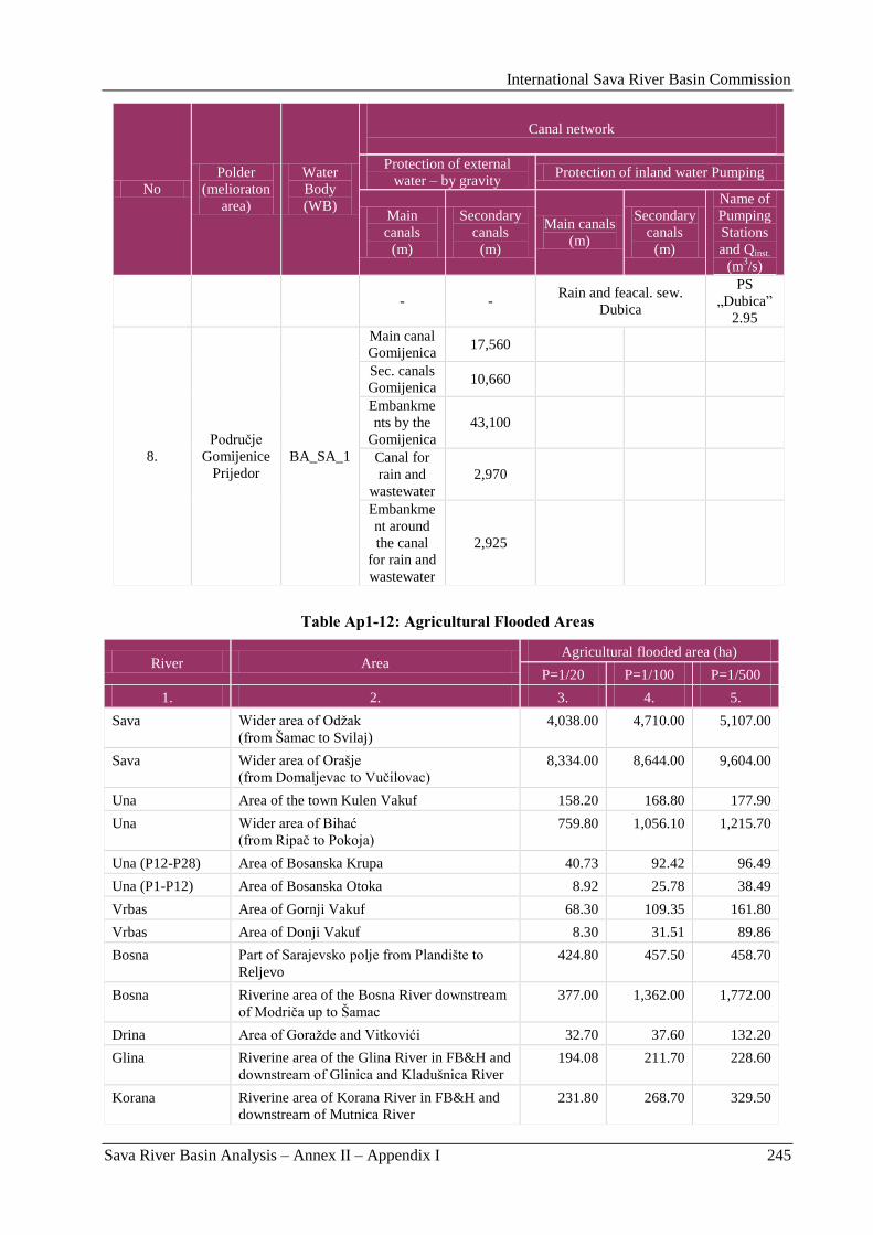
International Sava River Basin Commission
Sava River Basin Analysis – Annex II – Appendix I 245
No
Polder
(melioraton
area)
Water
Body
(WB)
Canal network
Protection of external
water – by gravity Protection of inland water Pumping
Main
canals
(m)
Secondary
canals
(m)
Main canals
(m)
Secondary
canals
(m)
Name of
Pumping
Stations
and Qinst.
(m3/s)
- - Rain and feacal. sew.
Dubica
PS
„Dubica”
2.95
8.
Podruĉje
Gomijenice
Prijedor
BA_SA_1
Main canal
Gomijenica 17,560
Sec. canals
Gomijenica 10,660
Embankme
nts by the
Gomijenica
43,100
Canal for
rain and
wastewater
2,970
Embankme
nt around
the canal
for rain and
wastewater
2,925
Table Ap1-12: Agricultural Flooded Areas
River Area Agricultural flooded area (ha)
P=1/20 P=1/100 P=1/500
1. 2. 3. 4. 5.
Sava Wider area of Odţak
(from Šamac to Svilaj)
4,038.00 4,710.00 5,107.00
Sava Wider area of Orašje
(from Domaljevac to Vuĉilovac)
8,334.00 8,644.00 9,604.00
Una Area of the town Kulen Vakuf 158.20 168.80 177.90
Una Wider area of Bihać
(from Ripaĉ to Pokoja)
759.80 1,056.10 1,215.70
Una (P12-P28) Area of Bosanska Krupa 40.73 92.42 96.49
Una (P1-P12) Area of Bosanska Otoka 8.92 25.78 38.49
Vrbas Area of Gornji Vakuf 68.30 109.35 161.80
Vrbas Area of Donji Vakuf 8.30 31.51 89.86
Bosna Part of Sarajevsko polje from Plandište to
Reljevo
424.80 457.50 458.70
Bosna Riverine area of the Bosna River downstream
of Modriĉa up to Šamac
377.00 1,362.00 1,772.00
Drina Area of Goraţde and Vitkovići 32.70 37.60 132.20
Glina Riverine area of the Glina River in FB&H and
downstream of Glinica and Kladušnica River
194.08 211.70 228.60
Korana Riverine area of Korana River in FB&H and
downstream of Mutnica River
231.80 268.70 329.50
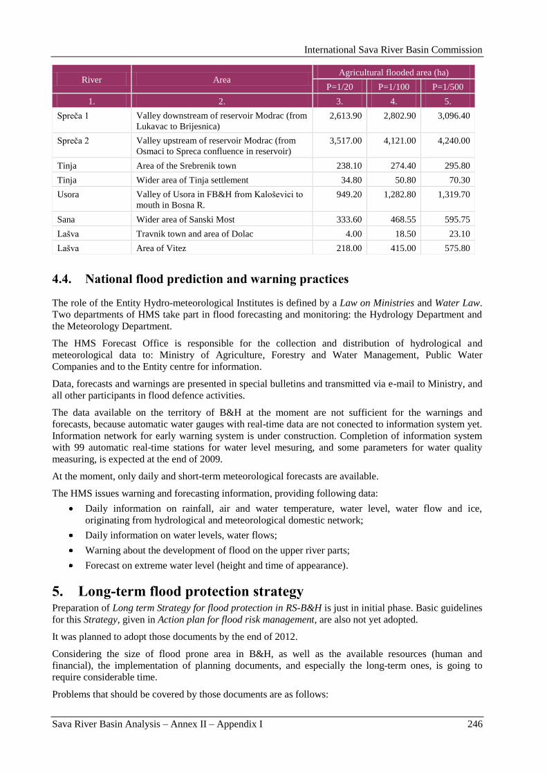
International Sava River Basin Commission
Sava River Basin Analysis – Annex II – Appendix I 246
River Area Agricultural flooded area (ha)
P=1/20 P=1/100 P=1/500
1. 2. 3. 4. 5.
Spreĉa 1 Valley downstream of reservoir Modrac (from
Lukavac to Brijesnica)
2,613.90 2,802.90 3,096.40
Spreĉa 2 Valley upstream of reservoir Modrac (from
Osmaci to Spreca confluence in reservoir)
3,517.00 4,121.00 4,240.00
Tinja Area of the Srebrenik town 238.10 274.40 295.80
Tinja Wider area of Tinja settlement 34.80 50.80 70.30
Usora Valley of Usora in FB&H from Kaloševici to
mouth in Bosna R.
949.20 1,282.80 1,319.70
Sana Wider area of Sanski Most 333.60 468.55 595.75
Lašva Travnik town and area of Dolac 4.00 18.50 23.10
Lašva Area of Vitez 218.00 415.00 575.80
4.4. National flood prediction and warning practices
The role of the Entity Hydro-meteorological Institutes is defined by a Law on Ministries and Water Law.
Two departments of HMS take part in flood forecasting and monitoring: the Hydrology Department and
the Meteorology Department.
The HMS Forecast Office is responsible for the collection and distribution of hydrological and
meteorological data to: Ministry of Agriculture, Forestry and Water Management, Public Water
Companies and to the Entity centre for information.
Data, forecasts and warnings are presented in special bulletins and transmitted via e-mail to Ministry, and
all other participants in flood defence activities.
The data available on the territory of B&H at the moment are not sufficient for the warnings and
forecasts, because automatic water gauges with real-time data are not conected to information system yet.
Information network for early warning system is under construction. Completion of information system
with 99 automatic real-time stations for water level mesuring, and some parameters for water quality
measuring, is expected at the end of 2009.
At the moment, only daily and short-term meteorological forecasts are available.
The HMS issues warning and forecasting information, providing following data:
Daily information on rainfall, air and water temperature, water level, water flow and ice,
originating from hydrological and meteorological domestic network;
Daily information on water levels, water flows;
Warning about the development of flood on the upper river parts;
Forecast on extreme water level (height and time of appearance).
5. Long-term flood protection strategy Preparation of Long term Strategy for flood protection in RS-B&H is just in initial phase. Basic guidelines
for this Strategy, given in Action plan for flood risk management, are also not yet adopted.
It was planned to adopt those documents by the end of 2012.
Considering the size of flood prone area in B&H, as well as the available resources (human and
financial), the implementation of planning documents, and especially the long-term ones, is going to
require considerable time.
Problems that should be covered by those documents are as follows:
International Sava River Basin Commission
Sava River Basin Analysis – Annex II – Appendix I 247
Providing of required financial and human resources for regular and good maintenance of
existing protection structures, according to appropriate technical criteria and standards. Present
maintenance level of existing structures does not provide adequate safety level in flood
protection. Maintenance of inundation areas is not performed by organized and adequate
measures. Just the main dikes, floodgate structures and pump stations are maintained.
Providing adequate financial resources required for reconstruction of existing and construction of
new flood protection structures will be a long term process, as long as the construction of those.
Providing required financial funds for construction of planned accumulation on Drina and Vrbas
River that would be able to decrease flood waves, is also a big task of long term flood protection
strategy that fits quite well into the development strategy of EPC B&H.
Preparation of a simulation module for optimization of the HPPs on the Sava River tributaries
operation with the purpose of maximizing effects in flood protection.
Based on flood risk assessment, it is necessary to make flood protection measures rank list for the
purpose of maximizing effects of measures.
Improving international cooperation on collecting, exchange and processing of meteorological
and hydrological data, as well as on simulation module preparation for entire Sava River Basin
for the purpose of defining possible harmful effects and improving flood wave forecasting, as
well as damages that could be caused.
Renewal and rehabilitation of systems of flood protection structures
Finalizing flood protection line to meet the level, appropriate for the protected area
importance and the volume of damages that could be caused by possible floods by
flood waters of certain range of occurrence;
Enlarging and construction of protection structures against flood waters from urban
area with 30,000 inhabitants.
Water regime control and new approach in water zones organization
Planning and construction of multipurpose systems where flood protection structures
effects are manifested on wider area and on larger part of important economic and
other structures;
Analyzing of solution concept and possibility to apply other prevention measures
(operational, regulation) that would mitigate flood damages;
Determination of priority areas for actions with the purpose of identifying endangered
flood prone areas, flood danger maps and flood risk maps.
Establishing hydrologic forecasting system and system of early warning
Establishing data base and flexible monitoring system with the purpose of delivering
data on water levels, flows and precipitations and establishing flow forecasting module
and accumulation management module.
Coordinated competence and role of other participants in flood protection and public awareness
Coordinated participation of all relevant participants and specialized services as well
(meteorological, accumulation users, spatial planners, services for protection and
rescuing people) in the water management process on potentially endangered areas.
Mitigating erosion processes
Participation of representatives from water management sector in Erosion protection
Program and Strategy;
Implementing general measures against erosion;
Rehabilitation of erosion damages.
Solving the inland waters issue
Coordinated activities of water and agricultural sector on rehabilitating existing
reclamation systems and enabling their development, according to plans and
agricultural consumers needs and needs for settlements protection against inland
waters negative effects.
International Sava River Basin Commission
Sava River Basin Analysis – Annex II – Appendix I 248
Solving the problem of lack of water
Taking participation of water sector in preparation of Plan of activities for lack of
water.
Coordination of water and soil management system
Mutual participation of water and soil management sectors in management plans for
those resources.
Prevention and readiness in case of disasters – collapsing or overflowing of dams
For new dams and protection dikes construction, one should strictly apply regulations,
rules and technical standards. Preparation of studies of status and stability of
constructed structures in function;
Preparation of Early warning Studies for warning people on flood wave occurrence,
and installation of automatic measuring stations and water level indicators for all
bigger water courses and downstream from dams.
6. Possible impacts on present flood protection level Estimated most important factors that can decrease flood protection system safety on the Sava River
Basin area in B&H are as follows:
Flood waters increasing trend due to anthropogenic factors impact in the basin (disconnecting of
flow and decreasing existing inundation, construction activities on inundation terrains).
Uncontrolled felling of forest especially in upper parts of river basin (those that generate flood
wave) can have big harmful effects on downstream area.
New regulations which as a consequence have decrease of natural retention areas in the Sava
River Basin or decreasing the flood wave travel time on tributaries, can also have harmful effects
on downstream areas.
It is well known that retention areas in Srednja Posavina have crucial impact on flood wave size
and duration time on downstream area of the Sava River Basin. It was shown, that complete
disconnection of retentions would increase the Sava River peak discharge nearby Sremska
Mitrovica for over 10 %.
Existing natural inundation along Donja Drina River (downstream of Zvornik dam) have
significant impact on the Drina River flood waters. Construction of dikes on both river banks (as
planned under hydro-power use project) could increase Q1% at the mouth for 5-10 %.
Down to the Drina River mouth, the flood wave is coming before the Sava River flood wave.
Uncontrolled accumulation management on Drina River and in retention areas in Srednja
Posavina can bring to superposition of wave and make the conditions in downstream areas worse.
Climate change, analyzed under LISFLOOD project, can have significant harmful or positive
effects on water regime in the Sava River Basin.
Lots of structures and systems are damaged, thus remained without proper function and
organization of activities before, during and after flood event is disturbed. Material basis and
human capacities in all institutions engaged in flood protection has weakened. What is especially
important, they have such small financial resources for prevention, investments and post flood
activities.
In the last decade, significant process of coming down to valleys and constructing the structures
in the water courses vicinity is evident. Especially in the last ten years, number of very valuable
objects have been constructed in inundation of natural river beds, what makes the situation even
more complicated. Due to that reason, and especially because of neglecting maintenance
activities-cleaning of the river beds - we have critical conditions in a lot of river valleys in B&H.
If appropriate measures are not undertaken emergently, we can expect huge material damages and
even human casualities.
Planning of space use in river valleys with strict appreciation of flood prone areas level of
impairness becomes very important. In some zones, where residential and economic structures are
International Sava River Basin Commission
Sava River Basin Analysis – Annex II – Appendix I 249
constructed, it is not possible to provide adequate flood protection level in short period, due to the
lack of investment funds or unprofitable investment actions on bigger protection systems or
structures. Required technical parameters should be identified on those areas (specific altitude
etc.) for temporary implementation of strategy „living with floods”.
Detailed analyses conducted through the Study of present flood protection level estimation for Federation
B&H, clearly indicates that flood protection problems in FBA are considerable, very specific and
complex. It was concluded that they have to be solved systematically, gradually, studious and with
appropriate optimal strategy application.
Situation is especially complex since lot of structures and systems are largely damaged, thus do not have
appropriate functions and because organization of activities before, during and after floods is quite
disturbed. Financial base and human capacities have weaken in all institutions engaged in flood protection
and especially important is the fact they have such small financial resources for prevention, investments
and post flood activities.
In conditions when work on solving flood protection problems was almost minor and when this sector
dealt with such small financial resources for investment activities on flood protection rehabilitation and
development in last ten years, it is useful to have this kind of Study since strategy for solving this issues
was largely defined within.
Under this strategy it is meant that based on appropriate basis and conducted analyses, it would be
possible to:
Select program of optimal flood protection development for the territory of entire FB&H;
Make selection of location for priority investment interventions, and
Identify optimal technical parameters for structures and flood protection systems that should be
constructed in the next period.
Based on collected hydrological data, conducted hydrological and hydraulic analyses, defined flood prone
areas for individual considered areas and based on cadastre of flood protection structures (if exists) it was
determined that existing structures are not satisfying basic flood protection convention requirements for
various ranges of flood water occurrence. Areas without flood protection system are in more difficult
situation, of course.
In the last decades, process of constructing the structures in the water courses vicinity is evident.
Especially in last ten years, number of very valuable objects have been constructed in inundation of
natural river beds, what makes situation even more complicated. Due to that reason and especially
because of neglecting maintenance activities-cleaning the river beds, there are critical conditions in lot of
river valleys in B&H. If appropriate measures are not undertaken urgently, huge material damages, even
human casualties, can be expected.
Considering through this Study all potential material damages that could occur in agriculture and on
structures on considered endangered areas, it can be generally concluded that flood risk is significantly
high.
There is another unfavorable circumstance in relation to flood risk. After dry period in last twenty years
or so, without significant floods, we have just entered wet period proved by great floods in FB&H in 2001
and 2002 and floods in central and west Europe (Prague, Dresden, earlier in Frankfurt, etc.) then in
Poland, Russia, Austria etc. with human casualties and material damages expressed in tens of billion of
Euros.
Well known strategies were used in approach used for solving flood protection problems. Based on that,
considered areas could be divided into three groups: polders in Posavina, in valleys of water course
regulation, dikes or, as potential possibility, control of natural water regime by accumulation construction
and in case of karst fields, construction of outlet structures for water in fields. Flood protection systems
already exist in Posavina and they require rehabilitation (consequences of war and lack of maintenance)
and reconstructed in order to provide required protection level for Sava and Bosna River flood waters.
Alternative technical solutions (active and passive protection) were proposed in water course valleys –
depending on individual conditions and in several cases mixed as most rational and realistic solutions.
International Sava River Basin Commission
Sava River Basin Analysis – Annex II – Appendix I 250
Third alternative solution, whose strategy was estimated as optimal, was considered on water courses
where construction in upper river basin was considered in previously prepared documents. But due to
complete uncertainty in sense of those structures implementation in recent time, this alternative to the
technical solution was considered just as one of the possible solutions.
There are no alternatives for karst fields when strategy in approach of solving the problem of flood
protection was considered. Fields are closed and it is all about solution of water evacuation from field and
it can be solved just by construction of outlet structure – tunnel with required adjacent structures. Task is
being even more complex when we consider problem of such discharged waters acceptance on lower
horizons. Alternations were performed with outlet structure capacity in function of flood protection effect
in the karst field.
Selection of flood protection solution concept was performed, based on techno-economic analyses,
including environmental aspect of solution.
Under this Study, econometric analyses were performed for the first time (as the study level allowed) for
all considered areas in FB&H and based on this, along with other relevant factors (technical solution,
ecology), selection of proposed flood protection concept for each individual area was performed.
When we consider ecological/environmental impact on selection process, one has been guided by the
attitude of consistent application of sustainable development strategy, according to which it should be
taken care that negative environmental impacts are minimized and positive maximized.
Zoning of priorities (for groups) was performed based on results of conducted analyses, according to the
level of the flood threat and the volume of possible damages, based on investment effects in several areas
(econometric analyses). Ranking was performed based on criteria of inland profitability rate, which is
considered as appropriate method for implementing analyses on the study level.
It is important to point out the importance of this Study for water management, as one of the foundation
documents, which represents first, but at the same time very important step in flood protection
rehabilitation and improvement in FB&H. Complex analyses were performed (including econometric
ones) for the endangered areas for the first time for entire territory of FB&H, based on high quality maps,
considering existing status of structures and flood protection level, size of potential damages, selection of
appropriate strategy, proposal of measures (technical solution option), concluded with conducting
economic-financial analyses and proposing priority actions, based on achieved results.
This Elaborate is going to enable development of long term time schedule for rehabilitation and flood
protection structures and systems construction. In that way, it will be possible to abandon previously
applied strategy to act with investment, just after flood is being registered, although the possibility of two
extremely high water wave occurrence is relatively small.
Planning and use of space in river valley with strict respect of flood threats level for individual areas
becomes very important. Study gives a lot of valuable data that can serve as good base for spatial plans
preparation, whose scope will cover area threaten by floods. In some zones where residential and
economic structures are constructed, it is not possible to provide adequate flood protection level in short
period, due to the lack of investment funds or unprofitable investment actions on bigger protection
systems or structures. Required technical parameters should be identified on those areas (specific altitude
etc.) for temporary implementation of strategy „living with floods”.
For good management and flood protection management, as part of integral water management, it is
necessary to provide information, planning and financial base for timely and quality recommendations for
competent institutions for decision making and implementation activities and also it is necessary to
provide institution in charge for integral water management with qualified personnel.
After the foreseen presentation of this study is implemented in municipalities and cantons threaten by
floods, results of this study could be used for preparation of spatial and town planning documents, for
preparation of flood protection plans on municipal and cantonal level and finally for the preparation of
General flood prevention plan (Official Gazette of FB&H, Nr. 3/02).

International Sava River Basin Commission
Sava River Basin Analysis – Annex II-Appendix II 251
Appendix II: Flood Management in Croatia
International Sava River Basin Commission
Sava River Basin Analysis – Annex II-Appendix II 252
International Sava River Basin Commission
Sava River Basin Analysis – Annex II-Appendix II 253
BRIEF CHARACTERISATION, REVIEW AND ASSESSMENT IN FLOOD MANAGEMENT IN
SAVA COUNTRIES
- Sava River Basin in the Republic of Croatia -
HRVATSKE VODE
VGO SAVA
Sluţba razvitka i katastara
Ulica grada Vukovara 220
10 000 Zagreb
February, 2009

International Sava River Basin Commission
Sava River Basin Analysis – Annex II-Appendix II 254
International Sava River Basin Commission
Sava River Basin Analysis – Annex II-Appendix II 255
1. Basic information on flood prone areas The Sava Basin in Croatia covers 25,770 km
2 (27.0 % of the whole basin). In Croatia, the Sava flows in
the length of 510 km and for the most part constitutes the border with Bosnia and Herzegovina (313 km).
The largest tributaries of the Sava River in Croatia are the Kupa (10,236 km2), Una (9,368 km
2), Bosut
(2,913 km2), Ĉesma (2,890 km
2), Ilova – Pakra (1,816 km
2), Orljava (1,616 km
2) and Krapina (1,244
km2).
Parts of the Kupa River in Croatia constitute the state border with Slovenia (total length of the 100 km),
while parts of the Una River constitute the state border with Bosnia and Herzegovina (total length of 130
km).
The Sava River and its major tributaries, the Kupa and Una, have snow-rain regime, with high discharges
in the period October-December as well as spring discharges (due to snow melting and spring rains).
Distinct discharge minimum is in August and September.
The average annual flow of the Sava River at its entry into Croatia (Jesenice) amounts to ca. 300 m3/s,
and to ca. 1,200 m3/s at its exit from Croatia. At its entry into Croatia the Sava River has torrential
character with huge differences between minimum and maximum flows. The highest flow of the Sava at
its entry into Croatia happened during a huge water wave in 1990 – the flow amounted to 3,607 m3/s,
which is some 70 times larger flow than the absolute minimum in that profile. The torrential character of
the river decreases gradually due to the flattening of water waves in vast lowland retentions of the central
Sava River Basin. The ratio of absolute extremes at the exit from Croatia is considerably less (around 18).
The highest flow of 4,161 m3/s at the Ţupanja station was recorded in as far back as 1970.
The Sava River Basin is asymmetric and dispersed, which is why the occurrence of extreme high waters
is slightly reduced. The central part of the Sava valley is a depression, which is a particular topographic
phenomenon. The average height of the basin in the upper section, in the Zagreb profile, is 540 meters
above sea level; on the downstream section, near Gradiška, the average height of the basin is 420 meters
above sea level, and 570 meters above sea level at the mouth. These data on the average height along the
river point to a certain anomaly, but also to a clear conclusion that this central area is predisposed to
flooding.
The area along the Sava River, from Zagreb and Karlovac in the west to Gradiška in the east is commonly
known as the Central Posavina.
It comprises of approximately 250 km of the Sava River flow and 140 km of the Kupa River flow, with
the accompanying lowland area of about 400,000 ha. This is the region where the large urban centres of
Zagreb, Sisak and Karlovac, together with about 400 smaller settlements have developed, which are now
home to more than one third of Croatian population, where important traffic corridors have been built,
and substantial agricultural surfaces established. For the most part, however, this area has retained its
original, natural characteristics even today. It is a very heterogeneous area, with varying degrees of
development, population density and lifestyle, starting from the Croatian capital of Zagreb and a number
of other, fast developing towns to depopulated rural areas where natural environment is used in traditional
ways for mere survival. Parts of the area are protected in accordance with laws and conventions on nature
protection (Nature Park and a Ramsar site of Lonjsko polje, a Ramsar site of Crna Mlaka, ornithological
reserves of Rakita and Krapje Đol, etc.).
2. Flooding in the Sava River Basin High flows from the mountainous western part of the basin (the Sava River Basin in Slovenia) and larger
right-hand tributaries, wide valleys of lowland watercourses, major cities and valuable assets in
potentially threatened areas make Sava River Basin very vulnerable to floods. It is estimated that floods
potentially endanger 19 % of the Sava Basin in Croatia (Figure Ap2-1, Table Ap2-1). It can be claimed
that the solution of flood protection remains one of the dominant water management tasks as well as the
prerequisite for the success of other activities.
International Sava River Basin Commission
Sava River Basin Analysis – Annex II-Appendix II 256
Figure Ap2-1: 100-year flood areas in the Sava River Basin prior to the construction of the flood
protection system
Table Ap2-1: List of poential flood prone areas in the Sava RB
No. River Basin River nameFloodprone area
(ha)
1 Sava Sava 326700
2 Sutla Sutla 730
3 Krapina Krapina 10510
4 Česma Česma,connection channel Zelina-Lonja-
Glogovnica54740
5 Ilova Ilova,Toplica Bijela,Pakra 13930
6 Orljava Orljava,Londţa, Veličanka 16300
7 Una Una 2220
8 Kupa (without Glina) Kupa, Odra, relief channel Kupa-Kupa 60570
9 Glina Glina 5260
490960
List of potential flood prone areas in the Sava river basin
Total floodprone area
3. Historical flood events Natural floods that occur in the Sava River Basin are divided into five main groups:
river floods caused by heavy rainfall and/or sudden snow melt,
torrential floods on smaller watercourses caused by short-duration rainfalls of high intensity,
floods in karst fields caused by heavy rainfall and/or sudden snow melt, as well as insufficient
permeability of natural sinkholes,
internal waters floods in lowland areas,
International Sava River Basin Commission
Sava River Basin Analysis – Annex II-Appendix II 257
ice floods.
Also possible are artificial floods caused by dam/embankment breaks, activation of landslides, inadequate
structures, etc.
The largest floods of the Sava River and its major tributaries recorded during the last one hundred years
were the following:
the Sava River floods: in 1923, 1925, 1926, 1933, 1964, 1966, 1970, 1974, 1990 and 1998,
the Sutla River floods: in 1974, 1987, 1989 and 1998,
the Krapina River floods: 1974, 1989 and 1998,
the Kupa River floods: in 1939, 1966, 1972, 1974, 1996 and 1998,
the Dobra River floods: 1966, 1998 and 1999,
the Ĉesma River floods: 1969, 1970 and 1973,
the Ilova River floods: 1951, 1960 and 1972,
the Una River floods: in 1955, 1970, 1974 and 2004,
the Orljava River floods: in 1951, 1972, 1987 and 1998,
the Bosut River floods: in 1926, 1970 and 1974.
The floods that occurred in the first half of the 20th century did not cause major damage because river
valleys were not populated yet. The development of the City of Zagreb is a typical example of the
development of a town on the area along a river, thus at risk of floods. Back at the beginning of the 20th
century Zagreb was situated in higher regions, and hence did not suffer any major damage from the
river‟s floods, even at times of great floods, such as those that occurred in 1923, 1925 and 1926. In the
1920-ies the construction of dikes along the Sava River began, the city spread into the plain, and came
closer to the Sava. After World War II, in the 1950-ies and later on, the city spread to the right bank and
grew to become a city of nearly a million. The areas beyond the banks became more and more populated,
the value of construction was high, and the system of dikes constructed until then gave impression that
the protected area was safe.
Unfortunately, the price of ignoring the risk of construction in the floodplain soon became evident, during
high water in October 1964. The flood protection system – constructed only partially, inadequate,
inconsistent and vulnerable – was not able to withstand a sudden extreme inflow from the Sava River
Basin in Slovenia. Around 6,000 hectares of the immediate urban area were flooded, as well as the
settlements of Zaprešić, Samobor, Dugo Selo, and Velika Gorica. The consequences of the flood were
disastrous: 17 human lives were lost, and material damage was extensive. Some 150,000 people were
evacuated, and tens of thousands of people lost their homes.
The towns of Karlovac and Sisak, as well as many settlements along the Kupa River lying between those
two towns paid a price of living near a river in December 1966. Around 5,500 housing units were flooded
on the area of the town of Karlovac, and a total of 15,600 hectares on the territory of the then
municipality of Karlovac, the Karlovac-Zagreb motorway, and many other roads.
Even though the Sava waters were released into the Lonjsko polje retention storage by blowing up the
Sava dike near Dubrovĉak, assisted by the high waters of the Kupa River, the Sava spilt over the dike in
Sisak, flooding the lowest parts of the town.
The middle and lower parts of the Sava River Basin suffered great damage from the Sava flooding in
January 1970. Due to a great inflow of the Sava‟s right-bank tributaries, the Sava flooded an area of
222,640 hectares, inflicting huge damage to agricultural and urbanized areas beyond the banks. Since the
high waters of the Sava and the Bosut Rivers coincided, a large part of BiĊ-Bosutsko polje was flooded.
The most widespread flooding in the Sava River Basin was recorded during a high water wave in October
1974, when 270,000 hectares were flooded.
The flooding was caused by a simultaneous and long-lasting heavy inflow from almost the entire Sava
River Basin. The Sava River spilt over and breached its dikes on several sections downstream of Zagreb
(on 7 locations). The dikes were blown up on 3 locations in order to release excess water into Odransko,
International Sava River Basin Commission
Sava River Basin Analysis – Annex II-Appendix II 258
Lonjsko polje and Mokro polje retention storages. Despite that, numerous villages lying beyond left and
right Sava River banks (from Oborovo to Stara Gradiška) were flooded. Even though the erected
temporary embankments, in some places as high as 120 cm, managed to protect the area beyond the
Sava‟s dikes on the section from Stara Gradiška to Ţupanja from immediate flooding, intensive rainfall
and seepages beneath dikes caused great damage to the agricultural areas of Crnac polje, Jelas polje and
BiĊ polje.
An area of 9,200 ha was flooded in the Krapina River Basin and 14,600 ha in the Kupa River Basin. The
Krapina River and its tributaries flooded Zlatar Bistrica, Pojatno, Bedekovĉina and other smaller
settlements, the Zagorje highway, and the Zaprešić-Kraljevec railroad. The Kupa flooded parts of
Karlovac, Ozalj and 12 smaller settlements, while its tributaries flooded Ogulin, Slunj, Glina and
Topusko among the larger settlements and numerous smaller settlements.
Even though flood protection works had been carried out as far back as 1963 in the Una River-Sava River
node and on the section of the course of the Una River towards Hrvatska Dubica, parts of the villages of
Tanac and Uštica were flooded. The Una River also flooded parts of the town of Dvor.
The floods described above, particularly those in Zagreb in 1964 and in Karlovac and Sisak in 1966,
prompted the development of an integrated solution for protecting the lowland area along the Sava from
floods, known as the Central Posavina. Reconstruction of the existing dikes and construction of new ones
started soon after the 1964 flood. From the mid 1960-ies to the mid 1980-ies, around 40 % of the planned
regulation and protection water structures of the Central Posavina flood protection system were
constructed. They protect important parts of river valleys, enable certain control of the high water regime
of the Sava River and its tributaries, as well as safe use of significant agricultural areas.
That is the reason why the high water waves that occurred in the Sava River in the last thirty or so years
have not caused any major flooding, thus confirming the efficiency and functioning of the constructed
system. We should particularly stress successful evacuation of a high water wave in the Sava River in
November 1990. The height of this wave on the section of the Sava from Radeĉe, Slovenia to Podsused,
Croatia exceeded the disastrous flood wave of 1964. Whereas the 1964 flood had had casualties and
inflicted enormous material damage to Zagreb, the 1990 water wave passed through Zagreb and further
downstream without any serious damage because the Odra relief canal was activated. Damage was
recorded only on the stretch from the Podsused bridge to the mouth of the Sutla River, because there was
no flood protection system there.
In the basins of Sava‟s tributaries flood protection systems are incomplete or do not even exist. In the last
twenty years, larger damage was caused by the flooding of the Kupa (1996 and 1998), Krapina (1989),
and Gornja Dobra Rivers (1999).
The flood protection solution in the Kupa River Basin is integral part of a comprehensive flood protection
solution in the Central Posavina. The constructed structures provide protection from mere 5-year high
water to 50-year high water. That is why higher water waves, like the one in November 1998,
significantly flooded urbanized and agricultural areas (12,000 ha).
Flooding is also frequent in the town of Ogulin, in whose protection from floods the Gojak hydropower
system plays an important role. In July 1999 the flood wave of the Gornja Dobra River occurred during
the overhaul of the Gojak HPP, leading to disastrous flooding in Ogulin.
Watercourses in the Krapina River Basin are regulated for 10-25-year high water, but their capacity is
even lower because of insufficient maintenance. Many parts of the basin are not even protected from 10-
year high water.
The gravest consequences were left in the wake of the water wave of the Krapina River and its tributaries
in July 1989. An area of 5,600 hectares was flooded, as well as the settlements of Krapina, Donja Stubica,
Zabok, Marija Bistrica, Stubiĉke Toplice, Kupljenovo, Zaprešić, and some other smaller settlements. The
Zagorje highway and a number of local roads were flooded; road traffic was virtually closed, as well as
rail traffic between Zagreb and Zagorje.
International Sava River Basin Commission
Sava River Basin Analysis – Annex II-Appendix II 259
4. Existing Flood Management
4.1. Commanding responsibilities
Flood protection in the Republic of Croatia has been regulated under the Water Act and the Water
Management Financing Act. The competent bodies for flood protection issues are: the Ministry of
Regional Development, Forestry and Water Management as a state administration body and Hrvatske
vode as a state agency.
The roof state-level water management document, the implementation of which is provided for under the
Water Act, is the Water Management Strategy, which is prepared by Hrvatske vode and adopted by the
Croatian Parliament (Official Gazette, No. 91/08). It is a long-term planning document which is
systematically harmonized with changes occurring in the water system and socio-economic development,
and is also mutually harmonized with the National Physical Planning Strategy, Environmental Protection
Strategy, the state-level forest management planning documents and the planning documents of inland
navigation system development.
The basic aim of the Water Management Strategy is the establishment of an integrated and coordinated
water regime on the national territory, which includes the following:
Provision of sufficient quantities of drinking water of adequate quality to the population,
Provision of the required quantities of water of adequate quality for various economic purposes,
Protection of people and assets against floods and other adverse effects of water,
Protection and improvement of the status of water and of aquatic and waterdependant
ecosystems.
The UN/ECE Guidelines on Sustainable Flood Prevention, the principles of EFD and Action Programme
for Sustainable Flood Protection in the Danube River Basin are included in the Water Management
Strategy.
Protection of people and assets against floods and other adverse effects of water includes construction and
maintenance of water protection structures, carrying out of protective works and flood protection
measures.
Operative flood defence on state waters is conducted according to the State Flood Defence Plan adopted
by the Government of the Republic of Croatia, whereas the carrying out of operative flood defence on
local waters is based on flood defence plans for catchment areas, which are adopted by county assemblies
on the basis of proposals put forward by Hrvatske vode.
The flood defence plan includes:
a list of measures to be taken prior to, in case of, and after flood occurrence;
areas, sectors, and sections of watercourses, and protective water structures subject to flood
protection measures;
water levels at which certain sectors initiate preparation, regular defence, emergency defence or
emergency status;
regulations on the equipment and materials to be prepared for flood defence;
a list of companies which are to conduct flood defence;
a list of experts involved in flood defence (names, duties, authorities and responsibilities);
methods of informing the public on occurrences and measures during flood defence;
survey of ice protection measures on watercourses.
On the basis of these plans, operative flood defence on state waters is established in river basin districts,
and within those in counties, various sectors and on different sections of watercourses. Operative flood
defence on local waters is established in catchment areas, and within those in counties, various sectors
and on different sections of watercourses.
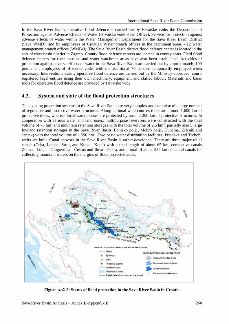
International Sava River Basin Commission
Sava River Basin Analysis – Annex II-Appendix II 260
In the Sava River Basin, operative flood defence is carried out by Hrvatske vode: the Department of
Protection against Adverse Effects of Water (Hrvatske vode Head Office), Service for protection against
adverse effects of water within the Water Management Department for the Sava River Basin District
(Sava WMD), and by employees of Croatian Water branch offices in the catchment areas - 12 water
management branch offices (WMBO). The Sava River Basin district flood defence center is located in the
seat of river basin district in Zagreb. County flood defence centers are located in county seats. Field flood
defence centers for river sections and water watchmen areas have also been established. Activities of
protection against adverse effects of water in the Sava River Basin are carried out by approximately 100
permanent employees of Hrvatske vode, with the additional 70 persons temporarily employed when
necessary. Interventions during operative flood defence are carried out by the Ministry-approved, court-
registered legal entities using their own machinery, equipment and skilled labour. Materials and basic
tools for operative flood defence are provided by Hrvatske vode.
4.2. System and state of the flood protection structures
The existing protection systems in the Sava River Basin are very complex and comprise of a large number
of regulative and protective water structures. Along national watercourses there are around 1,600 km of
protective dikes, whereas local watercourses are protected by around 200 km of protective structures. In
cooperation with various water and land users, multipurpose reservoirs were constructed with the total
volume of 73 hm3 and mountain retention storages with the total volume of 2,5 hm
3; partially also 5 large
lowland retention storages in the Sava River Basin (Lonjsko polje, Mokro polje, Kupĉina, Zelenik and
Jantak) with the total volume of 1.590 hm3. Two basic water distribution facilities, Prevlaka and Trebeţ1
weirs are built. Canal network in the Sava River Basin is rather developed. There are three major relief
canals (Odra, Lonja - Strug and Kupa - Kupa) with a total length of about 65 km, connective canals
Zelina - Lonja - Glogovnica - Ĉesma and Ilova - Pakra, and a total of about 534 km of lateral canals for
collecting mountain waters on the margins of flood protected areas.
Figure Ap2-2: Status of flood protection in the Sava River Basin in Croatia
International Sava River Basin Commission
Sava River Basin Analysis – Annex II-Appendix II 261
The history of works carried out for the purpose of flood protection in the Sava River Basin goes back to
the 19th century. As it was already mentioned, floods in 1960-ies, were instrumental in the development of
the integrated Central Posavina flood control plan, within the framework of a wider regulation of the Sava
River Basin. Economic objectives dominated the concept: the protection of existing goods, the provision
of space for new developments (urbanization, agriculture, traffic) and the creation of conditions for
navigation, hydropower production, raising of water levels in minor watercourses and other water uses in
the area.
The proposed solution was based on the imitation of centuries-old natural flood processes in the Central
Posavina, whose lowest parts are naturally suitable for flood retention due to their geomorphologic
characteristics (pronounced natural depressions), and also due to the way in which the flood defence
system of the Sava was developed - starting downstream and continuing towards the upstream section.
Downstream of the town of Stara Gradiška the flood control system was already defined by dikes
constructed along the Sava. It was therefore necessary to adopt the postulate that any works or
interventions in the Central Posavina area must not deteriorate the flood status of the lower Sava. It is
important to point out that this solution has a positive effect on our neighbouring countries, Bosnia and
Herzegovina and Serbia, which have to guard against a significantly reduced amount of access water from
the Sava.
The core of the solution were the flood storages in the Kupa and Sava lowlands, of sufficient retention
capacity for the relief of excess flood waves. 58,800 ha of flood storages were planned (Lonjsko polje,
Mokro polje, Zelenik, Kupĉina), which provided the required level of protection. Apart from the flood
storages, the system comprised of three relief canals (Odra, Lonja-Strug, Kupa-Kupa), which made up for
the limited flow rate on some stretches of the main watercourses and redirection of excess water into
flood storages, and about 15 structures for water distribution control under flood conditions. Additionally,
there were earlier constructed dikes along the larger watercourses, which had to be continuously rebuilt
and reconstructed, if necessary. The system was generally designed to provide protection from the
predicted 100-year flood, whereas larger urban centres, i.e. Zagreb, Karlovac and Sisak, were defended
from 1000-year flood.
The intention was to achieve the maximum possible reduction of floodplains and the complete control of
floods. All other parts of the area had to be protected and made suitable for urban or economic purposes
through water management works
The implementation of the designed solution soon started and continued until the mid 1980-ies, after
which the construction activities generally came to a halt. During 1980-ies and 1990-ies new concepts
were analyzed and developed in accordance with the principle of sustainable water management, which
takes into account a wide spectrum of needs, including protection of natural ecosystems and maintenance
of biodiversity.
The basic difference between the modified solution and the original project lies in the manner how the
flood storages of Lonjsko and Mokro polje are established. The original solution anticipated these areas
with full flood control, maximally reduced surfaces and higher depths of retained water. The modified
solution proposed the following crucial changes:
enlargement of floodplains at Lonjsko polje by approx. 7,000 ha;
free flow of relieved flood water along Mokro polje;
lowering of maximal water depths in the flood storages.
Another important change was related to the design and functioning of the Lonja-Strug canal, which was
originally planned along the Lonjsko and Mokro polje in the length of 105 km. At its upstream end, the
canal receives waters fed at the sluices of Prevlaka and Palanjek, then waters of numerous minor
tributaries, and finally at Stara Gradiška transfers these waters back to the Sava River. The rationalized
solution uses the functionality of already constructed canal parts. However, a further construction of this
rather sizeable structure, accompanied by high embankments, is abandoned. The natural watercourses of
Lonjsko and Mokro polje are used for transport of fed water. The filling of flood storages occurs
gradually, and thus achieves the return to almost natural flow regime through these areas. Following
figure presents the modified solution of the Central Posavina.
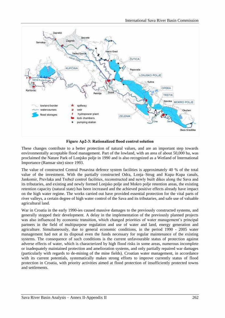
International Sava River Basin Commission
Sava River Basin Analysis – Annex II-Appendix II 262
Figure Ap2-3: Rationalized flood control solution
These changes contribute to a better protection of natural values, and are an important step towards
environmentally acceptable flood management. Part of the lowland, with an area of about 50,000 ha, was
proclaimed the Nature Park of Lonjsko polje in 1990 and is also recognized as a Wetland of International
Importance (Ramsar site) since 1993.
The value of constructed Central Posavina defence system facilities is approximately 40 % of the total
value of the investment. With the partially constructed Odra, Lonja–Strug and Kupa–Kupa canals,
Jankomir, Prevlaka and Trebeţ control facilities, reconstructed and newly built dikes along the Sava and
its tributaries, and existing and newly formed Lonjsko polje and Mokro polje retention areas, the existing
retention capacity (natural state) has been increased and the achieved positive effects already have impact
on the high water regime. The works carried out have provided essential protection for the vital parts of
river valleys, a certain degree of high water control of the Sava and its tributaries, and safe use of valuable
agricultural land.
War in Croatia in the early 1990-ies caused massive damages to the previously constructed systems, and
generally stopped their development. A delay in the implementation of the previously planned projects
was also influenced by economic transition, which changed priorities of water management‟s principal
partners in the field of multipurpose regulation and use of water and land, energy generation and
agriculture. Simultaneously, due to general economic conditions, in the period 1990 - 2005 water
management had not at its disposal even the funds necessary for regular maintenance of the existing
systems. The consequence of such conditions is the current unfavourable status of protection against
adverse effects of water, which is characterized by high flood risks in some areas, numerous incomplete
or inadequately maintained protection and amelioration systems, and only partially repaired war damages
(particularly with regards to de-mining of the mine fields). Croatian water management, in accordance
with its current potentials, systematically makes strong efforts to improve currently status of flood
protection in Croatia, with priority activities aimed at flood protection of insufficiently protected towns
and settlements.
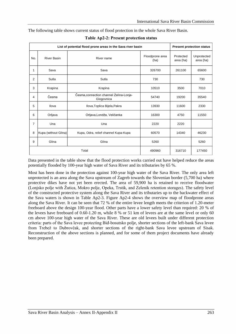
International Sava River Basin Commission
Sava River Basin Analysis – Annex II-Appendix II 263
The following table shows current status of flood protection in the whole Sava River Basin.
Table Ap2-2: Present protection status
No. River Basin River nameFloodprone area
(ha)
Protected
area (ha)
Unprotected
area (ha)
1 Sava Sava 326700 261100 65600
2 Sutla Sutla 730 730
3 Krapina Krapina 10510 3500 7010
4 Česma Česma,connection channel Zelina-Lonja-
Glogovnica54740 19200 35540
5 Ilova Ilova,Toplica Bijela,Pakra 13930 11600 2330
6 Orljava Orljava,Londţa, Veličanka 16300 4750 11550
7 Una Una 2220 2220
8 Kupa (without Glina) Kupa, Odra, relief channel Kupa-Kupa 60570 14340 46230
9 Glina Glina 5260 5260
490960 316710 177450
List of potential flood prone areas in the Sava river basin
Total
Present protection status
Data presented in the table show that the flood protection works carried out have helped reduce the areas
potentially flooded by 100-year high water of Sava River and its tributaries by 65 %.
Most has been done in the protection against 100-year high water of the Sava River. The only area left
unprotected is an area along the Sava upstream of Zagreb towards the Slovenian border (5,700 ha) where
protective dikes have not yet been erected. The area of 59,900 ha is retained to receive floodwater
(Lonjsko polje with Ţutica, Mokro polje, Opeka, Trstik, and Zelenik retention storages). The safety level
of the constructed protective system along the Sava River and its tributaries up to the backwater effect of
the Sava waters is shown in Table Ap2-3. Figure Ap2-4 shows the overview map of floodprone areas
along the Sava River. It can be seen that 72 % of the entire levee length meets the criterion of 1.20-meter
freeboard above the design 100-year flood. Other parts have a lower safety level than required: 20 % of
the levees have freeboard of 0.60-1.20 m, while 8 % or 51 km of levees are at the same level or only 60
cm above 100-year high water of the Sava River. These are old levees built under different protection
criteria: parts of the Sava levee protecting BiĊ-bosutsko polje, shorter sections of the left-bank Sava levee
from Trebeţ to Dubrovĉak, and shorter sections of the right-bank Sava levee upstream of Sisak.
Reconstruction of the above sections is planned, and for some of them project documents have already
been prepared.
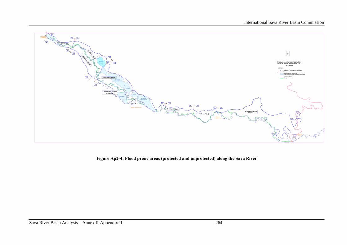
International Sava River Basin Commission
Sava River Basin Analysis – Annex II-Appendix II 264
6. SISAÈKO-BANIJSKO
PODRUÈJE
PREGLEDNA SITUACIJA PODRUÈJA
KOJA SE BRANE ODNOSNO PLAVE
MJ 1 : 400 000
REPUBLIKA
LEGENDA:
poplavna linija
nasip
SRBIJA
3. CRNAC POLJE
2. JELAS POLJE
1. BIÐ-BOSUTSKO
7. ODRANSKO
PO
LJE
8. GRAD ZAGREB
REPUBLIKASLOVENIJA
BOSNA I HERCEGOVINA
BOSNA I
1.
1.2.
2.3.
1. - 8. GRANICA BRANJENOG PODRUÈJA
POLJE
3.4.
4.
5.
5.
8.
8.
8.
8.
7.
7.
6.
6.
5. ÈR
NEC
PO
LJE
4. LONJSKO POLJE
RETENCIJA
ŽUTICA
RETENCIJA
RETENCIJA
MOKRO POLJE
TRSTIK
OPEKA
LONJSKO POLJE
ZELENIK
(RETENCIJE , EKSPANZIONI PROSTORI)
HERCEGOVINA
PLAVLJENO PODRUÈJE
REPUBLIKASLOVENIJA
Figure Ap2-4: Flood prone areas (protected and unprotected) along the Sava River
International Sava River Basin Commission
Sava River Basin Analysis – Annex II-Appendix II 265
On the area of the City of Zagreb the height of the levees is such that they provide protection from Sava‟s high
waters of 1000-year return period. However, even though 19 mountain retarding basins have been constructed,
parts of Zagreb are at risk from torrents from Medvednica Mountain. Zagreb is protected from Mt. Medvednica
torrential streams only from floods of 20 to 50-year return periods.
The entire potentially flooded area in the basins of larger tributaries in the event of a flood of 100-year return
period covers an area of 1,643 km2. Only 36 % of the area is protected, while on other sections protective
structures have not been constructed yet or their level of protection is significantly lower – they are mostly
protected against floods of 5 to 25-year return periods. It is mostly larger settlements and roads that are
protected, while agricultural areas continue to be frequently flooded.
Towns and settlements are also inadequately protected from torrential mountain streams, particularly
settlements in region of Hrvatsko Zagorje, Poţeška kotlina and in the Dobra River Basin.
Table Ap2-3: List of important floodprone areas in HR
Openings
through the
levee
system
Comments
1.20 m 0.60-1.20m 0.00-0.60m
km km km km
1 BiĎ-Bosutsko polje Sava 112700 Y 139.1 126.1 13.0
2 Jelas polje Sava 20300 Y 41.7 41.7
3 Crnac polje Sava 17700 Y 52.0 42.8 9.3
Lonjsko polje Sava 36600 Y 136.8 112.8 6.3 17.7spillway,
weirKošutarica, Trebeţ
Lonjsko polje Sava 39000 N
Lonjsko,Mokro
polje,Opeka and Trstik
retention storages
Črnec polje Sava 29400 Y 73.4 14.8 53.3 5.3 weir Prevlaka
Črnec polje Sava 5700 N Ţutica retention storage
Sisačko-banijsko
područjeSava 7300 Y 58.4 34.1 21.3 3.0
Sisačko-banijsko
područjeSava 15200 N Zelenik retention storage
7 Odransko polje Sava 28900 Y 75.9 30.7 42.2 3.0 spillway Jankomir
Grad Zagreb Sava 8200 Y 54.4 54.4
Grad Zagreb Sava 5700 N
326700 631.6 457.4 123.0 51.2
List of important flood prone areas (protected and unprotected) in the Sava river basin
4
5
6
Length of levee with freeboard above
the Base Flood Elevation (1 %-annual-
chance flood event)No.Floodprone area
nameRiver name
8
TOTAL
Protected
(Y or NO)
Total length
of leveesArea (ha)
4.3. Structure of the Drainage System
Amelioration drainage systems are constructed for the purpose of rapid and efficient drainage of excess water
from agricultural and other lowland areas. The prerequisite for their construction is previous protection of
amelioration areas from the floods of external waters.
The total amelioration area of the Sava River Basin is identified as a lowland and gently rolling area below the
top topographic limit of 200 meters above sea level. Its total area is 955,334 hectares, which accounts for around
42 % of the total basin area on the territory of the Republic of Croatia. The area can be divided into 22 natural,
traditional or design units defined by the constructed structures of watercourse regulation and flood protection
systems (Figure Ap2-5).
Amelioration drainage systems are fully or partially constructed on 348,363 hectares, on 74,919 hectares of
which land drainage and regulation are covered by a combined drainage method (surface drainage +
underground drainage + agricultural engineering measures). An impressive scope of the constructed structures
and amelioration works carried out, particularly intensive in the 1980-ies e.g. a network of main first- and
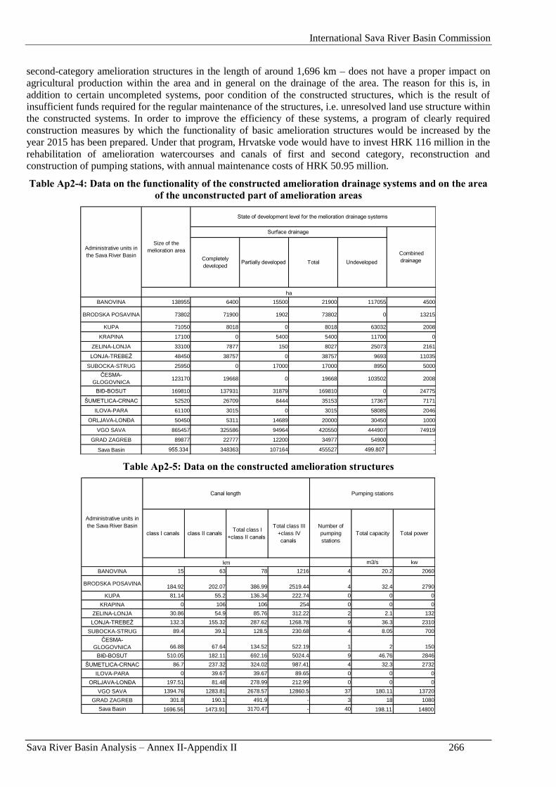
International Sava River Basin Commission
Sava River Basin Analysis – Annex II-Appendix II 266
second-category amelioration structures in the length of around 1,696 km – does not have a proper impact on
agricultural production within the area and in general on the drainage of the area. The reason for this is, in
addition to certain uncompleted systems, poor condition of the constructed structures, which is the result of
insufficient funds required for the regular maintenance of the structures, i.e. unresolved land use structure within
the constructed systems. In order to improve the efficiency of these systems, a program of clearly required
construction measures by which the functionality of basic amelioration structures would be increased by the
year 2015 has been prepared. Under that program, Hrvatske vode would have to invest HRK 116 million in the
rehabilitation of amelioration watercourses and canals of first and second category, reconstruction and
construction of pumping stations, with annual maintenance costs of HRK 50.95 million.
Table Ap2-4: Data on the functionality of the constructed amelioration drainage systems and on the area
of the unconstructed part of amelioration areas
BANOVINA 138955 6400 15500 21900 117055 4500
BRODSKA POSAVINA 73802 71900 1902 73802 0 13215
KUPA 71050 8018 0 8018 63032 2008
KRAPINA 17100 0 5400 5400 11700 0
ZELINA-LONJA 33100 7877 150 8027 25073 2161
LONJA-TREBEŢ 48450 38757 0 38757 9693 11035
SUBOCKA-STRUG 25950 0 17000 17000 8950 5000
ČESMA-
GLOGOVNICA123170 19668 0 19668 103502 2008
BIĐ-BOSUT 169810 137931 31879 169810 0 24775
ŠUMETLICA-CRNAC 52520 26709 8444 35153 17367 7171
ILOVA-PARA 61100 3015 0 3015 58085 2046
ORLJAVA-LONĐA 50450 5311 14689 20000 30450 1000
VGO SAVA 865457 325586 94964 420550 444907 74919
GRAD ZAGREB 89877 22777 12200 34977 54900 -
Sava Basin 955.334 348363 107164 455527 499.807 -
Completely
developedTotal Undeveloped Partially developed
Size of the
melioration area
ha
Surface drainage
Combined
drainage
Administrative units in
the Sava River Basin
State of development level for the melioration drainage systems
Table Ap2-5: Data on the constructed amelioration structures
m3/s kw
BANOVINA 15 63 78 1216 4 20.2 2060
BRODSKA POSAVINA184.92 202.07 386.99 2519.44 4 32.4 2790
KUPA 81.14 55.2 136.34 222.74 0 0 0
KRAPINA 0 106 106 254 0 0 0
ZELINA-LONJA 30.86 54.9 85.76 312.22 2 2.1 132
LONJA-TREBEŢ 132.3 155.32 287.62 1268.78 9 36.3 2310
SUBOCKA-STRUG 89.4 39.1 128.5 230.68 4 8.05 700
ČESMA-
GLOGOVNICA 66.88 67.64 134.52 522.19 1 2 150
BIĐ-BOSUT 510.05 182.11 692.16 5024.4 9 46.76 2846
ŠUMETLICA-CRNAC 86.7 237.32 324.02 987.41 4 32.3 2732
ILOVA-PARA 0 39.67 39.67 89.65 0 0 0
ORLJAVA-LONĐA 197.51 81.48 278.99 212.99 0 0 0
VGO SAVA 1394.76 1283.81 2678.57 12860.5 37 180.11 13720
GRAD ZAGREB 301.8 190.1 491.9 - 3 18 1080
Sava Basin 1696.56 1473.91 3170.47 - 40 198.11 14800
Administrative units in
the Sava River Basin
Canal length
km
class II canals Total class I
+class II canals
Number of
pumping
stations
Total capacity Total powerclass I canals
Pumping stations
Total class III
+class IV
canals
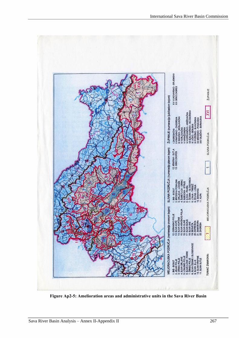
International Sava River Basin Commission
Sava River Basin Analysis – Annex II-Appendix II 267
Figure Ap2-5: Amelioration areas and administrative units in the Sava River Basin
International Sava River Basin Commission
Sava River Basin Analysis – Annex II-Appendix II 268
4.4. National Flood Prediction and warning practices
For more efficient operative flood defence Hrvatske vode has established a system of on-line monitoring
stations. Today, on line data system consists of 103 automatic stations in Croatia. 62 of them are in the Sava
River Basin. The real-time monitored water levels can be found on the website http://www.voda.hr or at the
same address when using „wap” mobile phones as well as on the teletext of Croatian Television (HTV).
Data on water level obtained from field stations are used for the preparation of forecasts of arrival, propagation,
and transformation of a flood wave.
Systematic forecasting of water levels and flows in the Sava River Basin is conducted by Hrvatske vode at the
majority of water gauge profiles in the Sava and Kupa Rivers, which are relevant for the implementation of
flood defence measures under the National Flood Defence Plan.
For the part of the Sava River downstream Jasenovac, it is still not possible to make reliable hydrological
forecasts due to the lack of information from the part of Sava River Basin in Bosnia and Herzegovina.
For internal use of Hrvatske vode comprehensive hydrologic data collection and disemenation system is beeing
built takeing in consideration not only flood monitoring, forecasting and warning but other requirements of
water management as well.
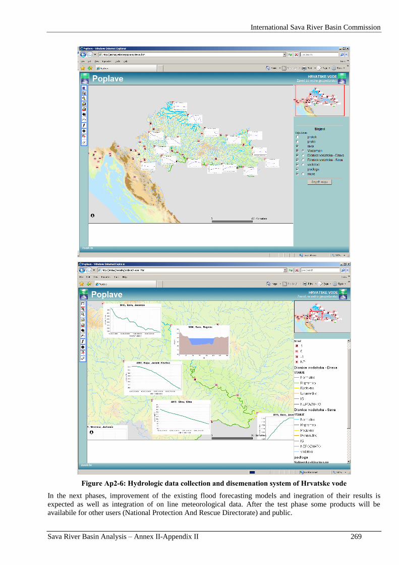
International Sava River Basin Commission
Sava River Basin Analysis – Annex II-Appendix II 269
Figure Ap2-6: Hydrologic data collection and disemenation system of Hrvatske vode
In the next phases, improvement of the existing flood forecasting models and inegration of their results is
expected as well as integration of on line meteorological data. After the test phase some products will be
availabile for other users (National Protection And Rescue Directorate) and public.
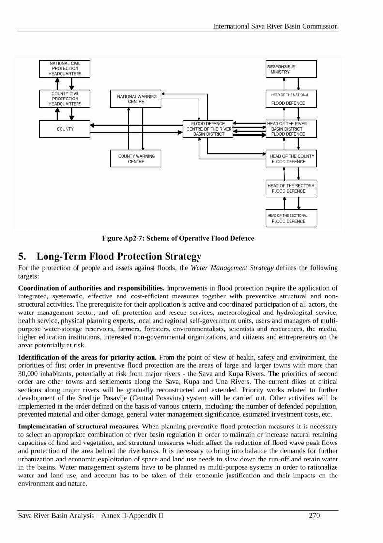
International Sava River Basin Commission
Sava River Basin Analysis – Annex II-Appendix II 270
HEAD OF THE SECTIONAL
FLOOD DEFENCE
HEAD OF THE SECTORAL FLOOD DEFENCE
HEAD OF THE RIVER BASIN DISTRICT FLOOD DEFENCE
HEAD OF THE COUNTY FLOOD DEFENCE
RESPONSIBLE MINISTRY
HEAD OF THE NATIONAL
FLOOD DEFENCE
COUNTY
NATIONAL CIVIL PROTECTION
HEADQUARTERS
COUNTY CIVIL PROTECTION
HEADQUARTERS
COUNTY WARNING CENTRE
NATIONAL WARNING CENTRE
FLOOD DEFENCE CENTRE OF THE RIVER
BASIN DISTRICT
Figure Ap2-7: Scheme of Operative Flood Defence
5. Long-Term Flood Protection Strategy For the protection of people and assets against floods, the Water Management Strategy defines the following
targets:
Coordination of authorities and responsibilities. Improvements in flood protection require the application of
integrated, systematic, effective and cost-efficient measures together with preventive structural and non-
structural activities. The prerequisite for their application is active and coordinated participation of all actors, the
water management sector, and of: protection and rescue services, meteorological and hydrological service,
health service, physical planning experts, local and regional self-government units, users and managers of multi-
purpose water-storage reservoirs, farmers, foresters, environmentalists, scientists and researchers, the media,
higher education institutions, interested non-governmental organizations, and citizens and entrepreneurs on the
areas potentially at risk.
Identification of the areas for priority action. From the point of view of health, safety and environment, the
priorities of first order in preventive flood protection are the areas of large and larger towns with more than
30,000 inhabitants, potentially at risk from major rivers - the Sava and Kupa Rivers. The priorities of second
order are other towns and settlements along the Sava, Kupa and Una Rivers. The current dikes at critical
sections along major rivers will be gradually reconstructed and extended. Priority works related to further
development of the Srednje Posavlje (Central Posavina) system will be carried out. Other activities will be
implemented in the order defined on the basis of various criteria, including: the number of defended population,
prevented material and other damage, general water management significance, estimated investment costs, etc.
Implementation of structural measures. When planning preventive flood protection measures it is necessary
to select an appropriate combination of river basin regulation in order to maintain or increase natural retaining
capacities of land and vegetation, and structural measures which affect the reduction of flood wave peak flows
and protection of the area behind the riverbanks. It is necessary to bring into balance the demands for further
urbanization and economic exploitation of space and land use needs to slow down the run-off and retain water
in the basins. Water management systems have to be planned as multi-purpose systems in order to rationalize
water and land use, and account has to be taken of their economic justification and their impacts on the
environment and nature.
International Sava River Basin Commission
Sava River Basin Analysis – Annex II-Appendix II 271
Operative flood defence. A flood defence plan will be drawn up for an integrated water system. Operative
flood defence on boundary watercourses is carried out together with competent services from the neighbouring
countries.
Monitoring and forecasting of weather phenomena. The efficiency of operative flood defence will be
improved through the modernization of current systems for the monitoring and forecasting of weather
phenomena (on-line monitoring stations, radars, satellite images, forecasting models, etc.), and current
communications systems. Flood forecasting models will be developed, officially adopted and regularly updated,
and on international rivers they will be developed and coordinated in the framework of competent international
bodies. Systematic monitoring and forecasting of weather phenomena and timely provision of relevant
information to the competent services for operative flood defence are the responsibility of hydrological and
meteorological services.
Water estate management. The problems related to water estate will be regulated through the adoption of a
regulation harmonized with other regulations related to land use, which will define precise criteria for
addressing all controversial issues. The water estate on unregulated inundation areas and on large lowland
retarding basins of protective flood defence systems will be resolved by the zoning of the terrain and graded
restrictions in land use. The priority of the water management sector is the demarcation of the water estate, its
registration into land registers, and entry into physical plans, and systematic monitoring of the status of the
water estate.
River basin regulation. Maximum flood wave flows, particularly in small- and medium-sized basins, can be
partly reduced by preserving and improving the natural retaining capacities of land, watercourses, and
floodplains. Natural wetlands and floodplains in the basins therefore need to be preserved, and, where possible
and economically justified, reconstructed or extended.
Financial insurance of property against uncovered flood risks. Flood protection systems provide protection
against high waters only for those return periods for which they were dimensioned. Flood risks will therefore be
more precisely defined. The water management sector is responsible only for the flood damage caused by flood
waves of shorter return periods than those for which protective systems had been dimensioned, under the
condition of sound maintenance. The remaining risks will be covered by the owners and users of property with
appropriate financial insurance. The state should support such insurance. The condition for the implementation
of this measure is the existence of flood risk maps and flood damage maps at the areas under potential risk.
The role of other agents in preventive flood protection. The protection and rescue services will ensure proper
functioning of regional and local public alert systems; organize the work of the civil protection; prepare
strategic, tactical and operative disaster management plans, and, if needed, organize appropriate exercises;
organize the evacuation of inhabitants in case of need; organize emergency medical aid to affected population;
and organize post-flood terrain recovery. Other agents in flood protection are: science-and-research institutions,
the media and interested NGOs with active and constructive participation in the processes of development of
planning documents.
The above mentioned targets will be achieved through gradual implementation of a series of activities and
measures.
It is possible to estimate implementation costs of individual measures, and to make proposals about the manner
of their implementation. The usual 15-year investment cycle has been selected as the planning basis of the goals
that can be reasonably achieved.
In the Sava River Basin, it is anticipated that 87-percent functionality of flood protection systems will be
achieved by the end of 2023, and 100-percent functionality by the end of 2038. This goal will be achieved
through gradual implementation of repair and reconstruction works, and through the implementation of
developmental projects.
The average annual investments in the repair, reconstruction, and development of protective systems during the
next thirty years will amount to around HRK 170 million.
In order to bring the current systems for the protection against adverse effects of water into a functional
condition (repair and reconstruction), it is necessary to invest around HRK 3.8 billion.
International Sava River Basin Commission
Sava River Basin Analysis – Annex II-Appendix II 272
Developmental projects for systems for the protection against adverse effects of water require investment in the
total amount of around HRK 1.3 billion.
Regular economic and technical maintenance of current protective systems require an investment of HRK 489
million per year.
International Sava River Basin Commission
Sava River Basin Analysis – Annex II-Appendix III 273
Appendix III: Flood Management in Serbia
International Sava River Basin Commission
Sava River Basin Analysis – Annex II-Appendix III 274
International Sava River Basin Commission
Sava River Basin Analysis – Annex II-Appendix III 275
FLOOD MANAGEMENT
- Sava River Basin in the Republic of Serbia -
REPUBLIC OF SERBIA
MINISTRY OF AGRICULTURE, FORESTRY AND WATER MANAGEMENT
REPUBLIC DIRECTORATE FOR WATER
INSTITUTE FOR THE DEVELOPMENT OF WATER RESOURCES „JAROSLAV
ČERNI” - BELGRADE
February, 2009

International Sava River Basin Commission
Sava River Basin Analysis – Annex II-Appendix III 276
International Sava River Basin Commission
Sava River Basin Analysis – Annex II-Appendix III 277
1. Introduction The Serbian stretch of the Sava River, 209 km long, has characteristics of a typical alluvial watercourse
flowing through wide lowlands. Between the mouth of the Drina River (km 177) and the state border with
Croatia (km 209) the river is the border line between Serbia (RS) and Bosnia and Herzegovina (B&H).
Sava River tributaries at the Serbian section are:
The Drina River (right tributary), the most significant both by catchment area (about 19,500 km2
or 20 %) and flow. The catchment is shared by B&H (37 %), Montenegro (31.5 %), Serbia (30.5
%) and Albania (1 %). There are many transboundary rivers in this river basin (Drina, Lim,
Cehotina, Crni Rzav, Beli Rzav). Drina makes the border between B&H and Serbia in its
downstream reach. The Drina River Basin is hilly and mountainous, with the average altitude 934
m a.s.l. (from the altitude of 75.4 m a.s.l. at the mouth to over than 2,500 m a.s.l. at the highest
mountains).
Several small right tributaries with catchments located only within the Serbian territory. The
largest one is the Kolubara River with catchment area of 3,639 km2, emptying into the Sava River
at km 27.
The Bosut River at the left with catchment area of 2,913 km2 whereas 70.7 % belongs to Croatia
and 29.3 % to Serbia. The Bosut River flow regime is completely controlled and depends on the
outflow from the Vinkovci reservoir (Croatia) and the operation mode of the sluice and pumping
station Bosut located at the mouth.
Main characteristics of the Sava River Basin are given in Figure Ap3-1 (river network and administrative
units), Figure Ap3-2 (topography), and Figure Ap3-3 (land use).
As presented on Figure Ap3-3, land uses in valleys of the Sava River and tributaries are different.
Numerous rural and urban settlements (the most important being Belgrade, Obrenovac, Šabac and
Sremska Mitrovica) are developed in the riverine lowlands along the Sava, which are predominantly used
for agriculture. Number of settlements in the Kolubara River catchment is smaller, and agricultural land
use is dominant. Forests and barren land prevail in the Drina catchment, and a number of settlements is
small. The Bosut catchment area is mainly covered by forests. Due to the land use, the most significant
are flood risks in the Sava lowlands, while hilly and mountainous areas are endangered by torrent floods
and associated phenomena.
The most famous flood in the Sava River Basin occurred in November 1896, as a consequence of an
extreme and enduring rainfall in the Drina catchment. According to later consideration, the return period
of the event was 10,000 years. This catastrophic flood event initiated construction of flood defence
system along the Sava River.
Flood defence system along the Serbian Sava River section is not continual. There are still natural
floodplains capable to store and attenuate a part of flood wave (Table Ap3-1, Figure Ap3-4). Due to
considerably different geo-morphological characteristics of the Drina River Basin, floodplains are
significantly smaller than along the Sava River.
Numerous floods were registered in 20th century on the Sava River (1915, 1924, 1932, 1940, 1944, 1952,
1962, 1970, 1974 and 1981), with permanent increase of flood volume and water levels (e.g. the
maximum recorded water level at Sremska Mitrovica station was increased by 1 m in 100 years). The
flood wave in October 1974 was the consequence of simultaneous high waters at the Drina and middle
Sava. In the springtime 1981 the riparian land along the Sava River was endangered because the Sava
flood arrived at high levels at the mouth to Danube. The newest episode was in spring 2006, when only
short section in the mouth area was endangered by the Danube backwater. Flood events on smaller rivers
in the Kolubara and Drina catchments are more frequent. Especially frequent floods occur on the Jadar
River, the most downstream right tributary of the Drina.
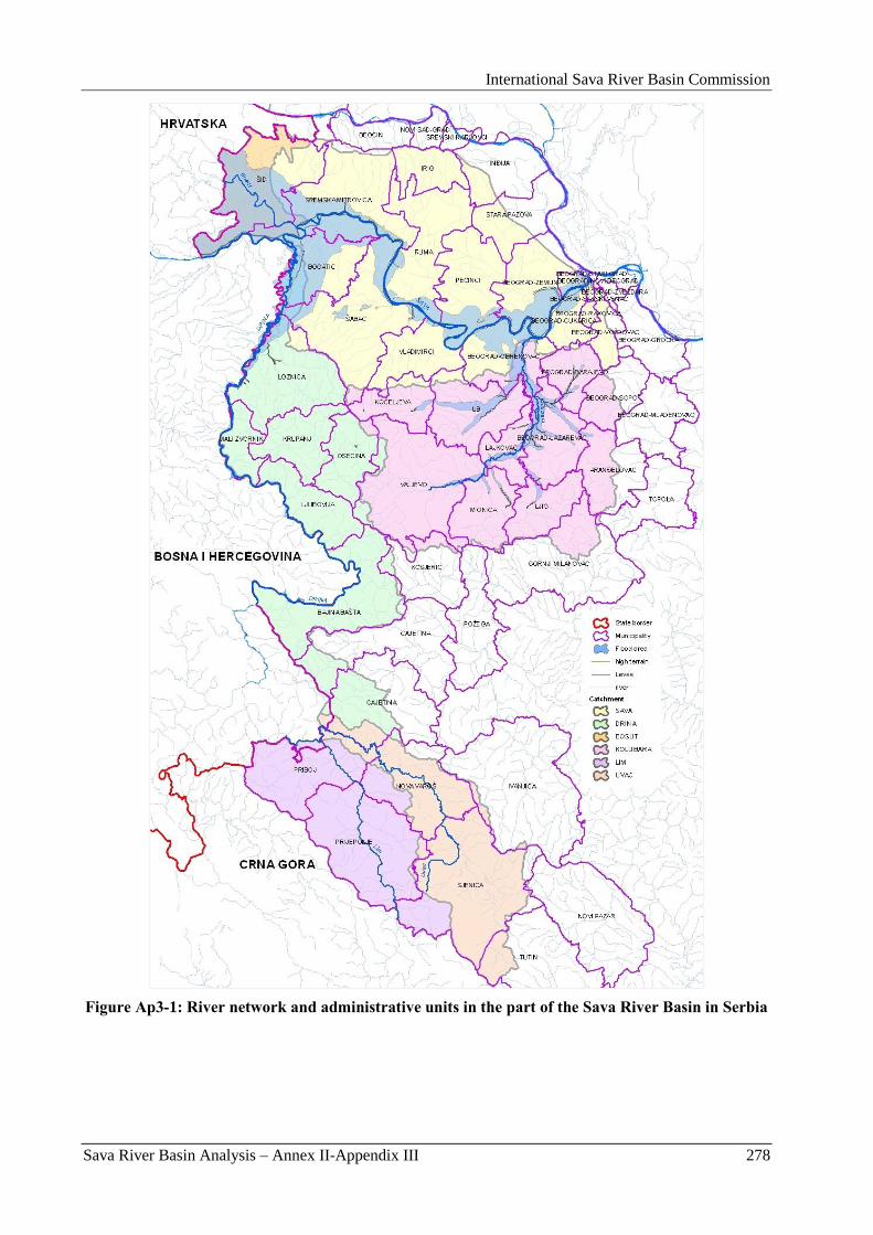
International Sava River Basin Commission
Sava River Basin Analysis – Annex II-Appendix III 278
Figure Ap3-1: River network and administrative units in the part of the Sava River Basin in Serbia
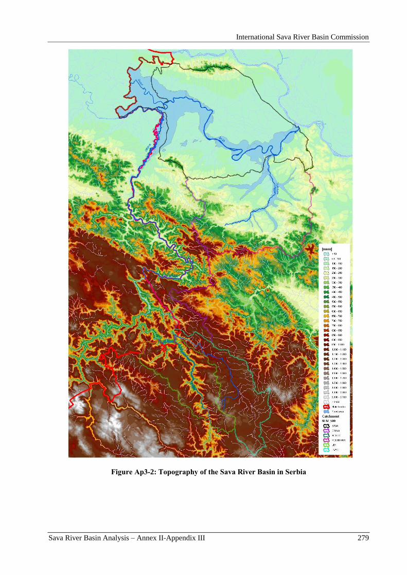
International Sava River Basin Commission
Sava River Basin Analysis – Annex II-Appendix III 279
Figure Ap3-2: Topography of the Sava River Basin in Serbia
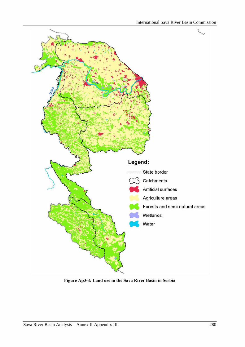
International Sava River Basin Commission
Sava River Basin Analysis – Annex II-Appendix III 280
Figure Ap3-3: Land use in the Sava River Basin in Serbia
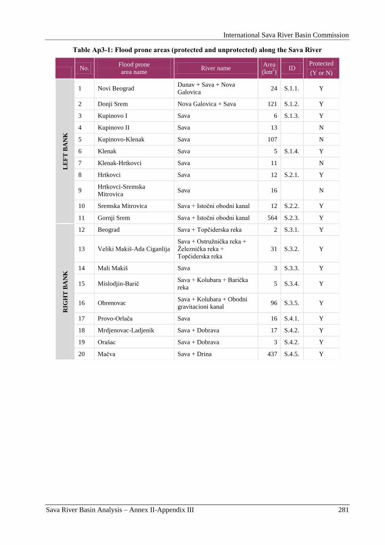
International Sava River Basin Commission
Sava River Basin Analysis – Annex II-Appendix III 281
Table Ap3-1: Flood prone areas (protected and unprotected) along the Sava River
No.
Flood prone
area name River name
Area
(km2)
ID Protected
(Y or N)
LE
FT
BA
NK
1 Novi Beograd Dunav + Sava + Nova
Galovica 24 S.1.1. Y
2 Donji Srem Nova Galovica + Sava 121 S.1.2. Y
3 Kupinovo I Sava 6 S.1.3. Y
4 Kupinovo II Sava 13 N
5 Kupinovo-Klenak Sava 107 N
6 Klenak Sava 5 S.1.4. Y
7 Klenak-Hrtkovci Sava 11 N
8 Hrtkovci Sava 12 S.2.1. Y
9 Hrtkovci-Sremska
Mitrovica Sava 16 N
10 Sremska Mitrovica Sava + Istoĉni obodni kanal 12 S.2.2. Y
11 Gornji Srem Sava + Istoĉni obodni kanal 564 S.2.3. Y
RIG
HT
BA
NK
12 Beograd Sava + Topĉiderska reka 2 S.3.1. Y
13 Veliki Makiš-Ada Ciganlija
Sava + Ostruţniĉka reka +
Ţelezniĉka reka +
Topĉiderska reka
31 S.3.2. Y
14 Mali Makiš Sava 3 S.3.3. Y
15 Mislodjin-Bariĉ Sava + Kolubara + Bariĉka
reka 5 S.3.4. Y
16 Obrenovac Sava + Kolubara + Obodni
gravitacioni kanal 96 S.3.5. Y
17 Provo-Orlaĉa Sava 16 S.4.1. Y
18 Mrdjenovac-Ladjenik Sava + Dobrava 17 S.4.2. Y
19 Orašac Sava + Dobrava 3 S.4.2. Y
20 Maĉva Sava + Drina 437 S.4.5. Y
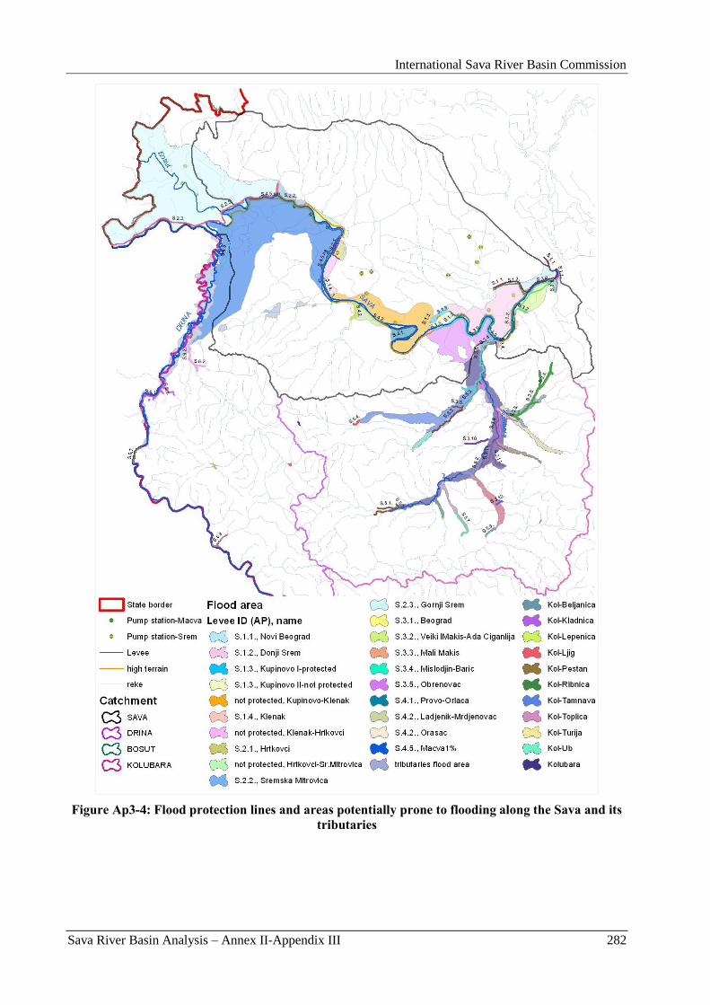
International Sava River Basin Commission
Sava River Basin Analysis – Annex II-Appendix III 282
Figure Ap3-4: Flood protection lines and areas potentially prone to flooding along the Sava and its
tributaries
International Sava River Basin Commission
Sava River Basin Analysis – Annex II-Appendix III 283
2. Existing flood management
2.1. Commanding responsibilities
2.1.1. Institutional arrangements in Serbia
Flood protection is regulated by the Water Law (Official Gazette of the Republic of Serbia 46/91). The
Law arranges proceedings and measures for flood and ice protection, as well as protection from torrents
and erosion.
The participants involved in flood defence are:
Ministry of Agriculture, Forestry and Water Management of the Republic of Serbia – Republic
Directorate for Water;
Public Water Management Companies: „Srbijavode” – Belgrade (in charge for flood protection
along the right bank of the Sava River, and the Drina and the Kolubara River Basins), „Vode
Vojvodine” – Novi Sad (in charge for flood protection along the left bank of the Sava River and
the Bosut River) and „Beograd vode” for the territory of the Belgrade city;
Local water management companies;
State Hydro-meteorological Service (HMS).
Responsibilities of participants are determined in the General Flood Defence Plan and the Flood Defence
Action Plan, while the Ministry is providing financial sources.
The flood and ice control actions are organized and carried on in three phases, depending on the hazard
degree: preparation, regular and emergency defence. Phases of defence are defined in the Flood Defence
Action Plan, in relation to the river stage on the adjacent gauging station.
The role of Public Water Management Companies (PWMC) is very important. Apart from defence
period, the activities of Companies encompass:
Provision of relevant studies and designs;
Construction, reconstruction and maintenance of protection structures;
Making and updating the technical documentation related to flood defence;
Preparation of staff, equipment, material, machines and warning system.
During the period of flood defence, the PWMCs engage skilled stuff from local water management
companies, organize monitoring to provide hydro-meteorological data from local stations, as well as
attending the protection lines. In case when the protection line is endangered, the PWMC should organize
prompt action to prevent levee break.
The protection lines are divided to sectors which, as a rule, correspond to territories of local water
management companies.
State Hydro-meteorological Service is responsible for monitoring, measuring, collecting and analyzing
hydrologic and meteorological data. The Service is also providing relevant information and forecasts
from domestic and foreign territories to all the flood defence participants. Within the Serbian part of the
Sava River Basin, data are collected on 15 points. In addition, data from the foreign countries are being
obtained from 10 stations (in Croatia and B&H).
Measures and procedures for flood protection in the Republic of Serbia are defined in General Flood
Defence Plan and Flood Defence Action Plan. These plans are prepared only for watercourses with the
existing flood protection structures. For other areas endangered by floods, but not included in the
mentioned plans, local community appoints flood protection measures and proceedings. Also companies
which properties are endangered prepare special flood protection plans.
International Sava River Basin Commission
Sava River Basin Analysis – Annex II-Appendix III 284
General Flood Defence Plan is proclaimed by the Government of the Republic of Serbia for 5-year
periods. The overall strategy of management, as well as the obligations and responsibilities of the main
participants are determined in the General Plan. Preparations, monitoring and warning, tasks of personnel
in charge, as well as basic scheme of organization are also specified.
General Plan defines:
The legal framework and mandatory principles;
Preventive measures beyond flood period;
Duties, responsibilities and mandates of persons in charge of flood control;
Duties and responsibilities of legal entities, i.e. companies that organize and implement flood
control measures;
Prerequisites for proclamation of the state of emergency;
Control of floods caused by internal waters;
Methods for provision of funds for flood control implementation.
Ministry of Agriculture, Forestry and Water Management retrieves Flood Defence Action Plan for one-
year period. Flood Defence Action Plan affirms organization of flood control, managers, and criteria for
proclamation of regular and emergency flood defence. The Flood Defence Action Plan accurately defines
the organization of flood and ice control on rivers, as it:
Identifies managers in the Directorate for water, the Public Water Management Companies and
other companies and institutions responsible for flood control;
Enumerates levee sectors and sections, including the name and chainage of each sector and
section, relevant water gauges, and criteria for proclaiming regular and emergency flood defence;
Specifies reporting hydrologic stations, from which the HMS of the Republic of Serbia generates
prescribed reports, forecasts, and warnings;
Lists ice phenomena observation points/localities, the criteria for initiating ice defence, and the
required number of ice breakers;
Provides an overview of hydrologic stations on foreign territories;
Defines the personnel required for regular and emergency flood and ice defence, and the
necessary means (tools, equipment, and machinery) for implementation.
2.2. System and state of the flood protection structures
2.2.1. Flood protection structures in Serbia
Flood protection system along the Sava River
The history of development of the flood protection system along the Sava River is very long, and related
to establishment of numerous settlements and agricultural development. The levee reconstruction to so
called „Sava levee profile” (Figure Ap3-5) was initiated after extremely difficult and expensive flood
defences in 1974 and 1981. Reconstructed levees within the backwater zone of the „Iron Gate 1” HPP
have ballast on the protected side. However, reconstruction of the flood defence lines along the Sava and
its tributaries in the mouth sections has not been completed so far. The alignment of flood defence
structures along the Sava River is presented at Figure Ap3-4.
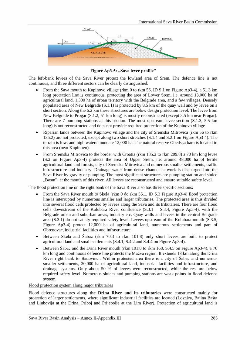
International Sava River Basin Commission
Sava River Basin Analysis – Annex II-Appendix III 285
Figure Ap3-5: „Sava levee profile”
The left-bank levees of the Sava River protect the lowland area of Srem. The defence line is not
continuous, and three different sectors can be clearly distinguished:
From the Sava mouth to Kupinovo village (rkm 0 to rkm 56, ID S.1 on Figure Ap3-4), a 51.3 km
long protection line is continuous, protecting the area of Lower Srem, i.e. around 13,000 ha of
agricultural land, 1,300 ha of urban territory with the Belgrade area, and a few villages. Densely
populated area of New Belgrade (S.1.1) is protected by 8.5 km of the quay wall and by levee on a
short section. Along the 6.2 km these structures are below design protection level. The levee from
New Belgrade to Progar (S.1.2, 51 km long) is mostly reconstructed (except 3.5 km near Progar).
There are 7 pumping stations at this section. The most upstream levee section (S.1.3, 5.5 km
long) is not reconstructed and does not provide required protection of the Kupinovo village.
Riparian lands between the Kupinovo village and the city of Sremska Mitrovica (rkm 56 to rkm
135.2) are not protected, except along two short stretches (S.1.4 and S.2.1 on Figure Ap3-4). The
terrain is low, and high waters inundate 12,000 ha. The natural reserve Obedska bara is located in
this area (near Kupinovo).
From Sremska Mitrovica to the border with Croatia (rkm 135.2 to rkm 209.8) a 70 km long levee
(S.2 on Figure Ap3-4) protects the area of Upper Srem, i.e. around 48,000 ha of fertile
agricultural land and forests, city of Sremska Mitrovica and numerous smaller settlements, traffic
infrastructure and industry. Drainage water from dense channel network is discharged into the
Sava River by gravity or pumping. The most significant structures are pumping station and sluice
„Bosut”, at the mouth of this river. All levees are reconstructed and ensure suitable safety level.
The flood protection line on the right bank of the Sava River also has three specific sections:
From the Sava River mouth to Skela (rkm 0 do rkm 55.1, ID S.3 Figure Ap3-4) flood protection
line is interrupted by numerous smaller and larger tributaries. The protected area is thus divided
into several flood cells protected by levees along the Sava and its tributaries. There are four flood
cells downstream of the Kolubara River confluence (S.3.1 – S.3.4, Figure Ap3-4), with the
Belgrade urban and suburban areas, industry etc. Quay walls and levees in the central Belgrade
area (S.3.1) do not satisfy required safety level. Levees upstream of the Kolubara mouth (S.3.5,
Figure Ap3-4) protect 12,000 ha of agricultural land, numerous settlements and part of
Obrenovac, industrial facilities and infrastructure.
Between Skela and Šabac (rkm 70.3 to rkm 101.8) only short levees are built to protect
agricultural land and small settlements (S.4.1, S.4.2 and S.4.4 on Figure Ap3-4).
Between Šabac and the Drina River mouth (rkm 101.8 to rkm 168, S.4.5 on Figure Ap3-4), a 70
km long and continuous defence line protects the Maĉva region. It extends 18 km along the Drina
River right bank to Badovinci. Within protected area there is a city of Šabac and numerous
smaller settlements, 30,000 ha of agricultural land, industrial facilities and infrastructure, and
drainage systems. Only about 50 % of levees were reconstructed, while the rest are below
required safety level. Numerous sluices and pumping stations are weak points in flood defence
system.
Flood protection system along major tributaries
Flood defence structures along the Drina River and its tributaries were constructed mainly for
protection of larger settlements, where significant industrial facilities are located (Loznica, Bajina Bašta
and Ljubovija at the Drina, Priboj and Prijepolje at the Lim River). Protection of agricultural land is
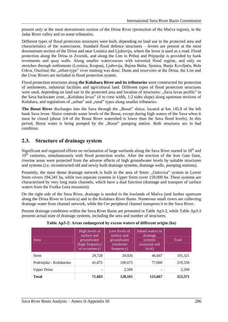
International Sava River Basin Commission
Sava River Basin Analysis – Annex II-Appendix III 286
present only at the most downstream section of the Drina River (protection of the Maĉva region), in the
Jadar River valley and on some tributaries.
Different types of flood protection structures were built, depending on land use in the protected area and
characteristics of the watercourse. Standard flood defence structures – levees are present at the most
downstream section of the Drina and near Loznica and Ljubovija, where the levee is used as a road. Flood
protection along the Drina in Zvornik, and along the Lim in Priboj and Prijepolje is provided by bank
revetments and quay walls. Along smaller watercourses with torrential flood regime, and only on
stretches through settlements (Loznica, Krupanj, Ljubovija, Bajina Bašta, Sjenica, Banja Koviljaĉa, Bela
Crkva, Oseĉina) the „urban-type” river training was done. Dams and reservoirs at the Drina, the Lim and
the Uvac Rivers are included in flood protection system.
Flood protection structures along the Kolubara River and its tributaries were constructed for protection
of settlements, industrial facilities and agricultural land. Different types of flood protection structures
were used, depending on land use in the protected area and location of structures: „Sava levee profile” in
the Sava backwater zone, „Kolubara levee” (4 m crest width, 1:2 sides slope) along upstream sections of
Kolubara, and regulations of „urban” and „rural” types along smaller tributaries.
The Bosut River discharges into the Sava through the „Bosut” sluice, located at km 145.8 of the left
bank Sava levee. Sluice controls water levels of the Bosut, except during high waters of the Sava when it
must be closed (about 3/4 of the Bosut River watershed is lower than the Sava flood levels). In this
period, Bosut water is being pumped by the „Bosut” pumping station. Both structures are in bad
condition.
2.3. Structure of drainage system
Significant and organized efforts on reclamation of large wetlands along the Sava River started in 18th and
19th centuries, simultaneously with flood protection works. After the erection of the Iron Gate Dam,
riverine areas were protected from the adverse effects of high groundwater levels by suitable structures
and systems (i.e. reconstructed old and newly built drainage systems, drainage wells, pumping stations).
Presently, the most dense drainage network is built in the area of Srem: „Galovica” system in Lower
Srem covers 194,341 ha, while two separate systems in Upper Srem cover 159,000 ha. These systems are
characterized by very long main channels, which have a dual function (drainage and transport of surface
waters from the Fruška Gora mountain).
On the right side of the Sava River, drainage is needed in the lowlands of Maĉva (and further upstream
along the Drina River to Loznica) and in the Kolubara River Basin. Numerous small rivers are collecting
drainage water from channel network, while the Cer peripheral channel transports it to the Sava River.
Present drainage conditions within the Sava River Basin are presented in Table Ap3-2, while Table Ap3-3
presents actual state of drainage systems, including the area and number of structures.
Table Ap3-2: Areas endangered by excess waters of different origin (ha)
Area
High levels of
surface and
groundwater
(high frequency
of occurrence)
Low levels of
surface and
groundwater
(moderate
frequency)
Inland waters in
drainage
systems
(seasonal and
local)
Total
Srem 29,728 24,926 46,667 101,321
Podrinjsko - Kolubarsko 41,875 100,675 77,000 219,550
Upper Drina - 2,500 - 2,500
Total 71,603 128,101 123,667 323,371
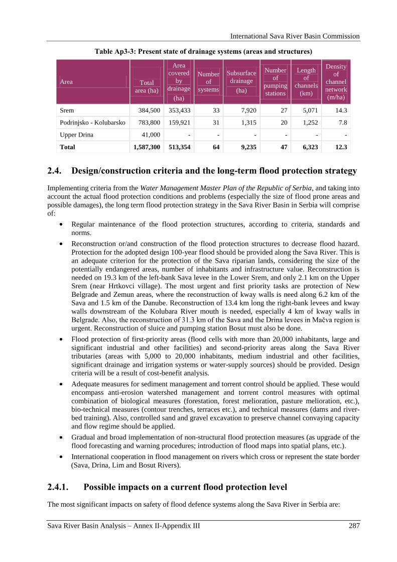
International Sava River Basin Commission
Sava River Basin Analysis – Annex II-Appendix III 287
Table Ap3-3: Present state of drainage systems (areas and structures)
Area
Total
area (ha)
Area
covered
by
drainage
(ha)
Number
of
systems
Subsurface
drainage
(ha)
Number
of
pumping
stations
Length
of
channels
(km)
Density
of
channel
network
(m/ha)
Srem 384,500 353,433 33 7,920 27 5,071 14.3
Podrinjsko - Kolubarsko 783,800 159,921 31 1,315 20 1,252 7.8
Upper Drina 41,000 - - - - - -
Total 1,587,300 513,354 64 9,235 47 6,323 12.3
2.4. Design/construction criteria and the long-term flood protection strategy
Implementing criteria from the Water Management Master Plan of the Republic of Serbia, and taking into
account the actual flood protection conditions and problems (especially the size of flood prone areas and
possible damages), the long term flood protection strategy in the Sava River Basin in Serbia will comprise
of:
Regular maintenance of the flood protection structures, according to criteria, standards and
norms.
Reconstruction or/and construction of the flood protection structures to decrease flood hazard.
Protection for the adopted design 100-year flood should be provided along the Sava River. This is
an adequate criterion for the protection of the Sava riparian lands, considering the size of the
potentially endangered areas, number of inhabitants and infrastructure value. Reconstruction is
needed on 19.3 km of the left-bank Sava levee in the Lower Srem, and only 2.1 km on the Upper
Srem (near Hrtkovci village). The most urgent and first priority tasks are protection of New
Belgrade and Zemun areas, where the reconstruction of kway walls is need along 6.2 km of the
Sava and 1.5 km of the Danube. Reconstruction of 13.4 km long the right-bank levees and kway
walls downstream of the Kolubara River mouth is needed, especially 4 km of kway walls in
Belgrade. Also, the reconstruction of 31.3 km of the Sava and the Drina levees in Maĉva region is
urgent. Reconstruction of sluice and pumping station Bosut must also be done.
Flood protection of first-priority areas (flood cells with more than 20,000 inhabitants, large and
significant industrial and other facilities) and second-priority areas along the Sava River
tributaries (areas with 5,000 to 20,000 inhabitants, medium industrial and other facilities,
significant drainage and irrigation systems or water-supply sources) should be provided. Design
criteria will be a result of cost-benefit analysis.
Adequate measures for sediment management and torrent control should be applied. These would
encompass anti-erosion watershed management and torrent control measures with optimal
combination of biological measures (forestation, forest melioration, pasture melioration, etc.),
bio-technical measures (contour trenches, terraces etc.), and technical measures (dams and river-
bed training). Also, controlled sand and gravel excavation to preserve channel convaying capacity
and flow regime should be applied.
Gradual and broad implementation of non-structural flood protection measures (as upgrade of the
flood forecasting and warning procedures; introduction of flood maps into spatial plans, etc.).
International cooperation in flood management on rivers which cross or represent the state border
(Sava, Drina, Lim and Bosut Rivers).
2.4.1. Possible impacts on a current flood protection level
The most significant impacts on safety of flood defence systems along the Sava River in Serbia are:
International Sava River Basin Commission
Sava River Basin Analysis – Annex II-Appendix III 288
Trend of flood level increase (due to natural or anthropogenic factors as disconnection of
floodplains, heightening of levees, constructions in inundated areas, deforestation, etc.)
It is known that the retentions in the Middle Posavina region have particular influence on extent
and time of occurrence of peak flow on downstream section of the Sava River. It was estimated
that peak flow at Sremska Mitrovica would increase for more than 10% if floodplains were
completely disconnected.
The existing natural floodplains along the lower Drina (downstream of Zvornik dam) have a
significant influence on the Drina floods. Construction of levees on both banks (as planned within
the hydropower generation project) could increase Q1% by 5 to 10% at the mouth.
On the Drina mouth, flood waves usually occur before Sava floods. Uncoordinated operation of
the Drina reservoirs and retentions in the middle Posavina could lead to superposition of flood
waves and worsen conditions on downstream sector of the Sava.
Climate change – analyses provided in the LISFLOOD Project (Impact of climate change to the
Sava River flow regime, JRC).
The Study of Training and Regulation of the Sava River in Yugoslavia (Polytechna - Hydroprojekt - Karlo
Lotti and Co., 1972.) should be mentioned from the perspective of the integrated flood protection in the
Sava River Basin. It was based on the postulate: „No upstream user of the flood defence structures and
measures should be allowed to deteriorate flow regime downstream”.
2.5. National Flood Predicition and Warning Practices
The role of the State Hydro-meteorological service of Serbia (HMS) in flood defence is defined by a
number of laws (Law on Ministries, Water Law, Law on Protection Against Natural and Other Major
Disasters), and by-laws (General Flood Defence Plan and Flood Defence Action Plan). Two departments
of HMS Serbia take part in flood forecasting and monitoring, the Hydrology Department and the
Meteorology Department.
The HMS Forecast Office is responsible for the collection and distribution of hydrological and
meteorological data. It transmits hydrological warnings to: Ministry of Agriculture, Forestry and Water
Management of Serbia – the Republic Directorate for Water, Public Water Companies (which distribute
them to responsible personnel), and to the State centre for observation and information, which distributes
these information to endangered communities. Data, forecasts and warnings are presented in special
bulletins and transmitted via e-mail to Ministry, and all other participants in flood defence activities.
Hydrological data are collected from 13 stations in the Sava River Basin and reported in real time, via
radio, telephone and automatically via GSM. Meteorological data are collected from 61 stations.
The data available on the territory of Serbia are not sufficient for the delivery of warnings and forecasts.
Namely, floods on major rivers, such as the Sava and the Drina originate beyond RS borders and that is
why information from upstream countries is indispensable. Data from neighboring countries (8 in
Croatia) are collected via GTS (Global Telecommunications System) and by e-mail. Also data for 5
stations in the Republika Srpska are collected by phone.
Various methods are used for hydrological forecasting, ranging from the simplest graphical correlations
to the most sophisticated models which describe the physical processes that take place within the river
basin and the river network. For all of these methods and models, it is important to have access to
accurate data on the initial conditions of forecasted parameters, and the fundamental impacts. Such data
are provided by hydrologic and meteorologic measurements and observations, while precipitation can be
the result of meteorological forecasts. For the time being, only nowcasts and short-term meteorological
forecasts can be used successfully.
Hydrological data required for hydrologic forecasts, are collected daily by the HMS from 5 hydrologic
stations within the territory of Serbia and 10 external hydrologic stations. Water level and/or discharge
forecasts are prepared daily and exchanged internationally, along with data from 31 hydrologic stations.
International Sava River Basin Commission
Sava River Basin Analysis – Annex II-Appendix III 289
The Forecast Office of the HMS issues warning and forecasting information. The Office activities
encompass the delivery of the following data:
Daily information on rainfall, air and water temperature, water level, water flow and ice,
originating from hydrological and meteorological domestic network;
Daily information on water levels, water flows, ice and water level forecasts, issued by GTS from
upstream countries;
Daily water level forecasts for 1 or 2 days in advance;
Warning about the development of flood on the upper river parts;
Forecast on extreme water level (height and time of appearance);
Forecast of ice phenomena (twice a week) for next 7 days and approximate forecasts for next 30
days (twice a month).
The following methods are currently operational:
MANS (nonlinear model of river flow) for the Sava;
SSARR and TANK for the Kolubara;
Simple index model for forecasting discrete hydrologic events, i.e. large flood waves on rivers
with catchment areas up to 1,500 km2 (short flood wave travel times and durations).
Plans have been prepared for the ensuing period to improve warning and forecasting procedures and to
more extensively incorporate the products of radar surveillance for those rivers on which flood waves rise
within Tp ≤ 10 hours (corresponding to a catchment area up to 300 km2). At river basins with the surface
area up to 2,000 km2, rainfall/runoff models will be developed. Rainfall/runoff-type models, in
combination with computations of flood wave travel and transformation within the river channel, will be
used for larger catchments (larger than 2,000 km2).
Related Documents