IAEG2006 Paper number 284 © The Geological Society of London 2006 1 Satellite interferometry for monitoring ground deformations in the urban environment A. FERRETTI 1 , C. PRATI 2 , F. ROCCA 3 & J. WASOWSKI 4 1 Tele-Rilevamento Europa - T.R.E. s.r.l., Milano, Italy. (e-mail: [email protected]) 2 Politecnico di Milano, Italy. (e-mail: [email protected]) 3 Politecnico di Milano, Italy. (e-mail: [email protected]) 4 CNR- IRPI, Bari, Italy. (e-mail: [email protected]) Abstract: Satellite differential synthetic aperture radar interferometry (DInSAR) is an attractive technique for detecting and monitoring ground surface deformations arising from regional scale processes (e.g. seismic/volcanic). The technique, however, is not effective for site-specific evaluations, because of coarse resolution and coherence loss limitations. Permanent Scatterers interferometry (PSInSAR), developed at Politecnico di Milano and improved at T.R.E. s.r.l. company, overcomes the limitations of DInSAR and extends the applicability of radar interferometry to local-scale geotechnical investigations of slope instability and soil settlement/ground subsidence. The PSInSAR analysis allows the identification of numerous radar targets (the PS) where very precise displacement information can be obtained. Considering the regular re-visit time and wide-area coverage of satellite radar sensors, and that PS usually correspond to buildings and other man-made structures, this technique is particularly suitable for applications in urban environments, which often represent a harsh setting for GPS or conventional topographic surveying. To demonstrate the effectiveness of PSInSAR in monitoring urban ground deformations we present examples of practical applications in Italy, Japan, and US. PS data can assist in: - Identification and delineation of areas affected by slow deformations. - Estimation of surface velocity and acceleration fields with millimetric precision. - Identification of the source of ground instability by analysing in situ and multi-temporal remotely sensed data. The regular monitoring from space of urban areas offers a unique possibility for detecting precursory deformations associated with the initiation of ground instability, a key element for early warning and hazard mitigation in highly populated areas. Satellite data has to be well ground truthed, because they reflect performance of targets, whose actual or apparent displacements may arise from a variety of causes (e.g. seismic, tectonic or volcanic deformation, slope movement, fill settlement, subsurface civil engineering, mining and fluid extraction, structure deterioration, expansion/shrinkage of soils). Résumé: L'interférométrie différentielle radar (DInSAR) est une technique attrayante pour détecter et surveiller les déformations du sol résultant de processus à l’échelle régionale (par exemple dû à un séisme/volcan). Cependant, cette technique n'est pas efficace pour évaluer un site spécifique en particulier, en raison de la résolution spatiale et des limitations dues à la perte de cohérence. La technique d'interférométrie par poins stables (PSInSAR), développée chez Politecnico di Milano et améliorée par la société T.R.E.s.r.l., surmonte les limitations de DInSAR et permet d’appliquer localement les techniques d'interférométrie radar pour notamment faire des mesures géotechniques sur l'instabilité de pente et l'affaissement ou susidence du sol. L'analyse PSInSAR permet l'identification de nombreuses cibles radar (les diffuseurs permanents ou « PS ») pour lesquels une estimation très précise du déplacement peut être obtenue. Etant donnés les atouts fréquence régulière de passage et la large couverture des satellites radar, et étant donné que les PS correspondent habituellement aux bâtiments et d'autres constructions, cette technique est particulièrement appropriée aux applications dans les environnements urbains, qui représentent souvent un mise au point difficile pour les GPS ou pour les mesures topographiques conventionnelles. Pour démontrer l'efficacité de la technique PSInSAR pour surveiller des déformations urbaines du sol, nous présentons des exemples d’applications en l'Italie et au Japon. Les données de PS peuvent aider à : - l’identification et la délimitation des secteurs affectés par des déformations lentes. - l’évaluation de la vitesse et de l'accélération de la surface avec une précision millimétrique. - l’identification de la source d'instabilité par analyse de mesures in situ et de données multi-temporelles de télédétection. La surveillance régulière depuis l'espace des secteurs urbains offre une possibilité unique pour détecter les déformations précurseurs associées à une instabilité du sol, un élément essentiel pour la détection précoce et la réduction des risques dans des secteurs fortement peuplés. Les données satellites doivent être associées à une vérité terrain, parce qu'elles reflètent les mouvements des cibles, dont les déplacements réels ou apparents peuvent résulter d'une variété de causes de déformations (par exemple séismique, tectonique ou volcanique, mouvements de pente, de génie civil sous-terrain, exploitation et extraction de fluide/gaz, détérioration de structure, expansion/effondrement des sols). Keywords: deformation, geological hazards, land subsidence, landslides, monitoring, remote sensing.

Welcome message from author
This document is posted to help you gain knowledge. Please leave a comment to let me know what you think about it! Share it to your friends and learn new things together.
Transcript
IAEG2006 Paper number 284
© The Geological Society of London 2006 1
Satellite interferometry for monitoring ground deformations in theurban environment
A. FERRETTI1, C. PRATI2, F. ROCCA3 & J. WASOWSKI4
1 Tele-Rilevamento Europa - T.R.E. s.r.l., Milano, Italy. (e-mail: [email protected])2 Politecnico di Milano, Italy. (e-mail: [email protected])
3 Politecnico di Milano, Italy. (e-mail: [email protected])4 CNR- IRPI, Bari, Italy. (e-mail: [email protected])
Abstract: Satellite differential synthetic aperture radar interferometry (DInSAR) is an attractive technique fordetecting and monitoring ground surface deformations arising from regional scale processes (e.g.seismic/volcanic). The technique, however, is not effective for site-specific evaluations, because of coarseresolution and coherence loss limitations. Permanent Scatterers interferometry (PSInSAR), developed atPolitecnico di Milano and improved at T.R.E. s.r.l. company, overcomes the limitations of DInSAR and extendsthe applicability of radar interferometry to local-scale geotechnical investigations of slope instability and soilsettlement/ground subsidence. The PSInSAR analysis allows the identification of numerous radar targets (thePS) where very precise displacement information can be obtained. Considering the regular re-visit time andwide-area coverage of satellite radar sensors, and that PS usually correspond to buildings and other man-madestructures, this technique is particularly suitable for applications in urban environments, which often represent aharsh setting for GPS or conventional topographic surveying.
To demonstrate the effectiveness of PSInSAR in monitoring urban ground deformations we presentexamples of practical applications in Italy, Japan, and US.
PS data can assist in:- Identification and delineation of areas affected by slow deformations.- Estimation of surface velocity and acceleration fields with millimetric precision.- Identification of the source of ground instability by analysing in situ and multi-temporal remotely sensed
data.The regular monitoring from space of urban areas offers a unique possibility for detecting precursory
deformations associated with the initiation of ground instability, a key element for early warning and hazardmitigation in highly populated areas. Satellite data has to be well ground truthed, because they reflectperformance of targets, whose actual or apparent displacements may arise from a variety of causes (e.g.seismic, tectonic or volcanic deformation, slope movement, fill settlement, subsurface civil engineering, miningand fluid extraction, structure deterioration, expansion/shrinkage of soils).
Résumé: L'interférométrie différentielle radar (DInSAR) est une technique attrayante pour détecter et surveillerles déformations du sol résultant de processus à l’échelle régionale (par exemple dû à un séisme/volcan).Cependant, cette technique n'est pas efficace pour évaluer un site spécifique en particulier, en raison de larésolution spatiale et des limitations dues à la perte de cohérence. La technique d'interférométrie par poinsstables (PSInSAR), développée chez Politecnico di Milano et améliorée par la société T.R.E.s.r.l., surmonte leslimitations de DInSAR et permet d’appliquer localement les techniques d'interférométrie radar pour notammentfaire des mesures géotechniques sur l'instabilité de pente et l'affaissement ou susidence du sol. L'analysePSInSAR permet l'identification de nombreuses cibles radar (les diffuseurs permanents ou « PS ») pour lesquelsune estimation très précise du déplacement peut être obtenue. Etant donnés les atouts fréquence régulière depassage et la large couverture des satellites radar, et étant donné que les PS correspondent habituellement auxbâtiments et d'autres constructions, cette technique est particulièrement appropriée aux applications dans lesenvironnements urbains, qui représentent souvent un mise au point difficile pour les GPS ou pour les mesurestopographiques conventionnelles.
Pour démontrer l'efficacité de la technique PSInSAR pour surveiller des déformations urbaines du sol, nousprésentons des exemples d’applications en l'Italie et au Japon. Les données de PS peuvent aider à :
- l’identification et la délimitation des secteurs affectés par des déformations lentes.- l’évaluation de la vitesse et de l'accélération de la surface avec une précision millimétrique.- l’identification de la source d'instabilité par analyse de mesures in situ et de données multi-temporelles de
télédétection.La surveillance régulière depuis l'espace des secteurs urbains offre une possibilité unique pour détecter les
déformations précurseurs associées à une instabilité du sol, un élément essentiel pour la détection précoce et laréduction des risques dans des secteurs fortement peuplés. Les données satellites doivent être associées à unevérité terrain, parce qu'elles reflètent les mouvements des cibles, dont les déplacements réels ou apparentspeuvent résulter d'une variété de causes de déformations (par exemple séismique, tectonique ou volcanique,mouvements de pente, de génie civil sous-terrain, exploitation et extraction de fluide/gaz, détérioration destructure, expansion/effondrement des sols).
Keywords: deformation, geological hazards, land subsidence, landslides, monitoring, remote sensing.

IAEG2006 Paper number 284
2
INTRODUCTIONGround failures and ground instability hazards can be caused by natural geological and climatic processes (e.g.
landslides and slope movements, soil volumetric changes in relation to dry and wet periods, soil/rock dissolution,oscillations of ground water levels, seismic and volcanic activity, neo-tectonic uplift or subsidence) or induced byanthropogenic sources (e.g. ground water pumping, gas and oil withdrawal, mining activity, subsurface and surfaceengineering works). Although the mechanisms and origins of these phenomena are quite variable and complex, theyall produce the same surface effect, i.e. ground deformation. Furthermore, the failure or main instability phase isgenerally preceded by a period of slow deformation. It follows that the early detection and monitoring of surfacedisplacements can represent, in particular in urban areas, a key effort of risk prevention or at least risk reduction.
Ground instability phenomena cover an extremely wide range of spatial and temporal scales, and are notuncommon in large, densely urbanised environments. However, even in the case of large cities, with high exposure tohazard, a regular in situ topographic monitoring of ground deformation is typically unfeasible due to the costsinvolved, or - at best - limited to the during or post-disaster period. Furthermore, towns and cities often represent aharsh setting for GPS or conventional topographic surveying and reliable measurements necessitate the use of skilledpersonnel.
It is now widely accepted that conventional methods used for detecting and monitoring natural hazards couldbenefit from the use of space-borne remote sensing systems because of the rapid and easily updatable acquisitions ofdata over wide areas, which reduce both field work and costs (e.g. CEOS DMSP Report 2002; IGOS GEOHAZARDS2004; Wasowski, Lollino & Limoni et al., 2004). Recent advances in optical and radar imagery capabilities (e.g. highspatial resolution, stereoscopic acquisition and high temporal frequency acquisitions), the development of new robusttechniques based on the interferometric analysis of radar images, such as the Permanent Scatterers Technique (Ferretti,Prati & Roca 2001), and the possibility of integrating these data within a Geographical Information System (GIS) havegreatly increased the potential of remote sensing for ground surface deformation monitoring and landslideinvestigations (e.g. Dehls, Basilico & Colesanti 2002; Wasowski, Refice & Bovenga et al. 2002; Colesanti, Ferretti &Novali et al. 2003a; Colesanti, Ferretti & Prati et al. 2003b; Colesanti & Wasowski 2004; Farina, Colombo &Fumagalli et al. 2004, Ferretti, Novali & Burgmann et al. 2004, Hilley, Burgmann & Ferretti et al. 2004). This paperaddresses the use of advanced interferometric methods for detecting and measuring ground movements, especially inurbanised areas.
SAR INTERFEROMETRY AND THE PS TECHNIQUEThis section provides a short overview of the scientific background related to DInSAR and PSInSAR. More
detailed information can be found in references (Gabriel, Goldstein & Zebker 1989, Massonnet & Feigl 1998; Rosen,Hensley & Joughin et al. 2000; Ferretti, Prati & Roca 2000; Ferretti et al. 2001; Colesanti et al. 2003a).
Satellite radar interferometry involves phase comparison of synthetic aperture radar (SAR) images, gathered atdifferent times along the same nominal orbit. This technique has the potential to detect millimetric targetdisplacements along the radar Line-Of-Sight (LOS) direction. A SAR image is a matrix of complex numbers.Amplitude values are related to local reflectivity (the amount of back-scattered energy), while phase values are sum oftwo contributions: local reflectivity and a quantity proportional to the sensor-target distance. The aim of theinterferometric techniques is to highlight possible range variations of the target, by means of a simple phase differencebetween two images gathered at different times. If the local reflectivity remains unchanged in time (e.g. desert areas,Figure 1), its phase contribution disappears in the differentiation and possible range variations can then be detected.Since the wavelength of the illuminating radiation is usually only a few centimetres (SAR satellites available todayoperate at C-band, in the microwave domain), even a millimetric range variation translates in a phase change ofseveral degrees that can be measured.
Apart from cycle ambiguity problems, limitations are due to temporal and geometrical decorrelation (i.e. the SNR –Signal to Noise Ratio), and to atmospheric artefacts. Temporal decorrelation makes interferometric measurementsunfeasible where the electromagnetic signature and/or the positions of the scatterers change with time within theresolution cell, so that the reflectivity phase contribution cannot be supposed constant with time (e.g. vegetated areas).Reflectivity variations as a function of the incidence angle further limit the number of image pairs suitable forinterferometric applications, unless the change is reduced due to a point-wise character of the target (e.g. a cornerreflector). In areas affected by either kind of decorrelation, generating the interferogram no longer compensates thereflectivity phase contribution, and possible phase variations due to target motion cannot be highlighted. Finally,atmospheric heterogeneity creates an atmospheric phase screen superimposed on each SAR image that can seriouslycompromise accurate deformation monitoring (Figure 2). Indeed, even considering areas slightly affected bydecorrelation, it may prove extremely difficult to discriminate the signal of interest and the atmospheric signature, atleast using single interferograms.
In addressing this hurdle, the “Permanent Scatterer Technique” takes advantage of long temporal series of SARdata of an area, acquired by the satellite on the same orbit, to filter out atmospheric artefacts. It does so by generatingmultiple differential interferograms from a set of radar scenes, and subjects them to numerical and statistical analysesin order to identify a sub-set of image pixels on which high precision measurements can be performed. These pixels,virtually unaffected by temporal and geometrical decorrelation, are referred to as Permanent Scatterers (PS). Theirstability arises, almost always, as the result of a dominating scattering centre within the resolution cell.

IAEG2006 Paper number 284
3
Figure 1. Example of differential interferogram – European Space Agency ESA-ENVISAT ASAR data. Phase data (colour coded)are superimposed on the amplitude image. The satellite radar sensor transmits microwave pulses and records both the amplitude andphase of the echoes reflected back from the Earth's surface. If one compares the phase of echo returns recorded from two passesacquired at different epochs, an estimate of the surface movement can be made. In this picture, the co-seismic deformation field ofthe Bam earthquake in Iran (December 26th, 2003; moment magnitude Mw=6.5) is reported. One fringe corresponds to 28 mm ofLOS displacement. The city of Bam is in the area of maximum displacement.
Figure 2. Example of SAR amplitude image (a) and interferogram (b) affected by atmospheric effects. Atmosphericheterogeneities usually do not impact on amplitude images but can seriously compromise interferometric measurements.
PS contain either natural objects, such as rock outcrops, man-made objects such as statues, lamp standards, antennaand other metallic structures on the roofs of buildings, or specially fabricated reflectors. More often than not, they areman-made objects. Figure 3 shows some typical examples of objects that reflect well.

IAEG2006 Paper number 284
4
Figure 3. Examples of Permanent Scatterers (PS), i.e. objects that exhibit a good stability of their radar return and allowinterferometric measurements.
The PS approach is based on the following few observations. Atmospheric artefacts show a strong spatialcorrelation within every single SAR acquisition, but they are uncorrelated in time. Conversely, target motion is usuallystrongly correlated in time and can exhibit different degrees of spatial correlation depending on the phenomenon athand (e.g. subsidence due to water pumping, fault displacements, localized sliding areas, collapsing buildings, etc.).Atmospheric effects can then be estimated and removed by combining data from a long time series of SAR images,such as those available in the ESA-ERS archive, based on data gathered since 1991. In order to exploit all theavailable images, and then improve the accuracy of the estimation, only scatterers slightly affected by both temporaland geometrical decorrelation are selected.
Possible stable and point-targets (i.e. the PS), are then detected on the grounds of the stability of their radar returns.This allows a pixel-by-pixel selection with no spatial averaging. Due to high spatial correlation of the atmosphericcontribution, even a sparse grid of measurements may allow proper sampling of the atmospheric components,provided that the PS density is high enough. Of course, a sufficient number of images should be available (usuallymore than 20), in order to identify PS and separate the different phase contributions.
At the PS, sub-metre elevation precision and millimetric terrain motion detection (thanks to the high phasecoherence of these scatterers) can be achieved, once atmospheric contributions are estimated and removed. Inparticular, relative target LOS velocity can be estimated very accurately (even better than 0.1 mm/yr in case of thelong time span data). The higher the precision of the measurements the more reliable the differentiation betweenmodels of the deformation process under study. This is a key issue for risk assessment.
The final results of this multi-interferogram approach are the following:
• a map of the PS identified in the image and their coordinates: latitude, longitude (accuracy better than 5 m formost of the data-sets) and precise (better than 1 m) elevation;
• their average LOS velocity (precision better than 1 mm/yr in most of the cases);• the estimated LOS motion component of each PS as a function of time.
Common to all differential interferometry applications, the results are computed with respect to a Ground ControlPoint (GCP) of known elevation and motion. All data can be easily imported in a GIS.
For example, Figure 4 shows the velocity field (in mm/yr) over the central part of Rome, estimated using 70 groupsof SAR data acquired from 1992 to December 2000 by ERS sensors operated by the European Space Agency (ESA).The estimated a posteriori precision is 0.25 mm/yr. Satellite repeat-cycle is 35 days (about 10 acquisitions/yr). Areasaffected by ground surface movements, i.e. local subsidence (negative sign of velocity), are clearly visible. This initialassessment is helpful to focus subsequent more detailed in situ investigations.

IAEG2006 Paper number 284
5
Figure 4. Example of PS results over Rome (Italy). Coloured dots correspond to Permanent Scatterers. The colour of each PSdepends on the LOS velocity value in mm/yr (for visualisation purposes the velocities are saturated to +- 5 mm/yr). Thebackground image is an aerial photo of the city. The analysis allows a fast identification of the areas affected by deformations, i.e.by local subsidence (SAR data: ERS-ESA© 1992-2000).
STRENGTHS AND LIMITATIONS OF THE PS TECHNIQUEThe PS Technique is a software-based (signal processing) technology. Its strengths and limitations and, indeed,
those of any DInSAR analysis, derive from not just the capabilities of the algorithms implemented but also from theperformance of the satellites and their SAR systems that provide the raw data input, as well as from the characteristicsof the Area Of Interest (AOI). The strengths and limitations attributable to the satellites and their SAR systemsavailable today (2005) are summarized in Table 1.
Table 1. Strengths and Limitations of SAR systemsStrengths Limitations• Two satellites are available today for InSAR analyses:
ESA’s ENVISAT and Canadian RADARSAT.• Retroactive analysis, back to 1992, is possible using the
ESA-ERS satellites’ data archive.• Analyses over thousands of square kilometres are possible
and require a limited amount of time.• Resolution cells (pixels) are becoming smaller, enhancing
the spatial accuracy of PS location and the PS density.• At least 3 new satellite sensors will be available in the next
2 years. A weekly update of the information will becomefeasible.
• Each AOI is illuminated by at least two orbits: oneascending (from South to North) and one descending(viceversa). Data acquired from two independentacquisition geometries can allow internal cross-checks anda better evaluation of the local displacement field.
• C-band signals (wavelength: 5.66 cm) cannot penetratevegetation and back scatter to the satellite.
• Steep terrain can prevent the radar signals reaching areas inthe ‘shadow’ of the line of sight.
• Nowadays sensors are not specifically designed for InSARapplications.
• Satellite repeat-cycle is 35 days for ESA sensors and 24days for RADARSAT.
• If prior information on ground motion is unavailable, phaseunwrapping problems (phase aliasing) limit the maximumdisplacement between two consecutive acquisitions to lessthan 14 mm (for C-band sensors available today).
• Although the combination of data acquired along bothascending and descending orbits can help in distinguishingvertical and horizontal deformation, a full 3D displacementfield cannot be recovered.
From the perspective of the technology itself, the principal strengths and limitations of the PS Technique aresummarized in Table 2.

IAEG2006 Paper number 284
6
Table 2. Strengths and Limitations of the PS TechniqueStrengths Limitations• For some areas target velocity can be estimated with
unprecedented precision (up to +/- 0.1 mm/yr) byexploiting all the images acquired over the area of interest.
• Measurement, in millimeters, of the ‘vertical’ dimensionbeing more precise than that of GPS.
• Provides a spatial density of measurement points notachievable with conventional techniques (PS density canbe >300 PS/sqkm in urban areas).
• The ability to recover the displacement time series of eachPS with high precision.
• Geocoding accuracy is usually better than 4-5 m.• Artificial reflectors can be deployed in areas where no
“natural PS” are available and the PS technique can besuccessfully applied using artificial reflectors.
• Difficult to infer the PS distribution in an area withoutprocessing a significant number of SAR images.
• Interferograms can only be generated from SAR dataacquired by the same satellite.
• >20 SAR images needed to identify PS. For some areas notenough data is available to run the processing.
• Satellite repect-cycle (35 days for ESA sensors and 24 daysfor RADARSAT satellite) is still too long for someapplications.
• Not all the man-made structures act as PS. If the user isinterested in gathering information on a particular site (e.g.a bridge or a dam), there is a possibility that no PS ispresent there.
APPLICATIONSThe impact of the PS technique on the potential users depends very much on the application at hand. In general, the
probability of success in performing a PS analysis depends on: (1) the number of data available and their temporaldistribution; (2) the PS density in the AOI; (3) the motion of the targets with respect to the satellite line-of-sight; (4)the presence of snow coverage. In the following, a brief summary of different PS applications is reported. For moredetails the readers are referred to the cited literature.
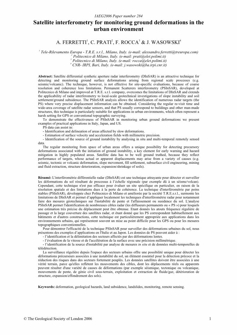
• Subsidence analysis - Both temporal and spatial resolution of the SAR satellite data are well suited formonitoring urban subsidence and terrain settlement such. PS density in urban areas is usually greater than 100PS/sqkm and thousands of square kilometres can be monitored monthly (Ferretti et al. 2000). The recentresults obtained in the framework of the ESA Terrafirma project (www.terrafirma.eu.com) have confirmed thetheoretical analysis. Suburbs and even individual buildings affected by subsidence can be detected (Ferretti etal. 2000), as well as possible seasonal movements induced by the water table variations (Colesanti et al.2003a). Many examples of PSInSAR technique applied to subsidence studies are available at TRE web-site(www.treuropa.com). Companies of the oil and gas sector are currently the major users of PS data. Precisesurface deformation fields can be very valuable for reservoir exploitation (Vasco & Ferretti, 2005) and foridentification of areas, in the neighbourhood of the oil or gas wells, which can suffer damages. Subsidenceinduced by mining activities can be also detected by means of PSInSAR (Colesanti, Le Moulic & Bennani etal. 2005). In Figure 5 the PS velocity field of Tokyo (Japan) is reported. Considering the high rate of seismicand tectonic activity of the region, it is likely that the local deformations (e.g. linked to spatially limitedsubsidence in the Tokyo harbour area) are superimposed on terrain motion related to larger scale geologicalphenomena.
• Seismic fault and volcano monitoring - For seismic fault monitoring a very high precision is usuallyrequired, because terrain motion can be extremely slow (e.g. Massonnet & Feigl 1998). Moreover, higherprecision means more acurate models of fault dynamics and better evaluation of seismic hazard. PS data canplay a major role for two reasons: (1) density of PS measurements is orders of magnitude greater than what isfeasible by using permanent GPS stations; (2) vertical precision of PSInSAR is higher than that of GPS.Indeed, PS and GPS data are somewhat complementary: GPS is capable to provide a continuous 3Dmonitoring of a limited number of benchmarks, whereas, at present, PSInSAR allows a monthly update ofpossible range variations of thousands of radar targets. Although synergistic strategies for an integrated use ofboth systems are still under study, it is now widely accepted that PS and GPS are not competitor technologies,and should be jointly exploited for the monitoring of areas at risk. Clearly, wide-area coverage of PS dataleads to a better identification of the possible locations for permanent GPS stations, highlighting sites affectedby deformations induced by anthropogenic sources rather than by tectonic or volcanic motions (e.g. Salvi,Atzore & Tolomei et al. 2004). A recent example of PSInSAR application in a region characterised by thepresence of several seismically active faults and high rate of tectonic deformations (the San Francisco Bayarea) is reported in Ferretti et al. 2004 and Hilley et al. 2004. An example of the joint use of DInSAR andclassical geodetic techniques for monitoring volcanic caldera unrest episodes near the city of Naples (Italy) isgiven in Lanari, Berardino & Borgstrom et al. 2004.
IAEG2006 Paper number 284
7
Figure 5. The intriguing velocity field estimated from 40 radar scenes acquired over Tokyo, Japan (SAR data: ERS-ESA© 1992-2000); for visualisation purposes the velocities are saturated to +- 5 mm/yr. The subsidence affecting the harbour area is clearlyvisible.
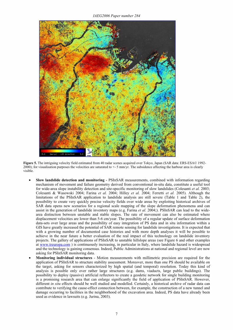
• Slow landslide detection and monitoring - PSInSAR measurements, combined with information regardingmechanism of movement and failure geometry derived from conventional in-situ data, constitute a useful toolfor wide-area slope instability detection and site-specific monitoring of slow landslides (Colesanti et al. 2003;Colesanti & Wasowski 2004; Farina et al. 2004; Hilley et al. 2004; Ferretti et al. 2005). Although thelimitations of the PSInSAR application to landslide analysis are still severe (Table 1 and Table 2), thepossibility to create very quickly precise velocity fields over wide areas by exploiting historical archives ofSAR data opens new scenarios for a regional scale mapping of the slope deformation phenomena and canassist in the generation of landslide inventory maps (e.g. Farina et al. 2004;). PSInSAR can lead to the wide-area distinction between unstable and stable slopes. The rate of movement can also be estimated wheredisplacement velocities are lower than 5-6 cm/year. The possibility of a regular update of surface deformationdata-sets over large areas and the possibility of easy integration of PS data and in situ information within aGIS have greatly increased the potential of SAR remote sensing for landslide investigations. It is expected thatwith a growing number of documented case histories and with more depth analyses it will be possible toachieve in the near future a better evaluation of the real impact of this technology on landslide inventoryprojects. The gallery of applications of PSInSAR to unstable hillslope areas (see Figure 6 and other examplesat www.treuropa.com ) is continuously increasing, in particular in Italy, where landslide hazard is widespreadand the technology is gaining consensus. Indeed, Public Administrations at national and regional level are nowasking for PSInSAR monitoring data.
• Monitoring individual structures - Motion measurements with millimetric precision are required for theapplication of PSInSAR to structure stability assessment. Moreover, more than one PS should be available onthe target, asking for sensors characterized by high spatial (and temporal) resolution. Today this kind ofanalysis is possible only over rather large structures (e.g. dams, viaducts, large public buildings). Thepossibility to deploy (passive) artificial reflectors to create a geodetic network for single building monitoringis a promising research area that can enlarge significantly the field of application of PSInSAR. However,different in situ effects should be well studied and modelled. Certainly, a historical archive of radar data cancontribute to verifying the cause-effect connection between, for example, the construction of a new tunnel anddamage occurring to facilities in the neighborhood of the excavation area. Indeed, PS data have already beenused as evidence in lawsuits (e.g. Jurina, 2003).
IAEG2006 Paper number 284
8
Figure 6. This provides an example of PS analysis used for the identification of an area affected by a slow slope deformationphenomenon in Lombardy (Italy – Alpine area). PS analysis lead to the estimation of the displacement rates and to the preliminaryre-assessment of the areas susceptible to landslide hazard (SAR data: ERS-ESA© 1995-2000); for visualisation purposes thevelocities are saturated to +- 5 mm/yr.
DISCUSSION AND CONCLUSIONSThe significant progress made in SAR interferometry in recent years has been accomplished despite the fact that the
radar sensors on which the technology depends were designed for other purposes. This achievement has nowprompted space agencies to mandate interferometric data capture as a pre-requisite of future SAR missions.
To this end, special attention is now being paid to the following issues:
• Acquisition policy: to create historical archives at least on a regional level. The ESA ERS archive is a clearexample of the potential related to continuous satellite data acquisition. A successful DInSAR applicationrequires regular acquisition of SAR data.
• Good attitude and high orbit stability of the satellite platform: to reduce geometrical decorrelation and toimprove the quality of the interferogram.
• High accuracy of satellite state vectors: to limit systematic errors.• Low repeat cycle: to minimize temporal decorrelation effects.
Looking at the future, although the satellite mission SENTINEL, the new ESA SAR mission to be launched before2009, within the framework of the GMES program, will be specifically designed for InSAR applications, the datasources available today will be supported before the end of 2006 by three new missions operating at three differentfrequencies: RADARSAT-2 (C band, 5.4 GHz), ALOS-PALSAR (L-band, 1.27 GHz) and TerraSAR-X (X-band, 9.6Ghz). Moreover, the Italian dual-use constellation of remote sensing satellites (Cosmo-SkyMed) should start theacquisition of SAR data in X band, in 2007.
The impressive spatial resolution of TerraSAR-X and RADARSAT-2, as well as the potential of the L-band sensormounted on ALOS, which will be capable of monitoring faster phenomena and be less prone to phase decorrelation,should open a completely new scenario in ground deformation detection, monitoring and forecasting. These newsensors, in synergy with GPS, laser scanners and other in situ instruments, will enlarge exponentially our possibilitiesto effectively monitor unstable areas. The joint use of more than one mission will increase significantly the temporalsampling of a geo-hazard under study and weekly updates of information are expected to be realized by 2007. Also,the higher spatial resolution of future SAR sensors will lead to smaller artificial reflectors than those in use today. Thelatter can be applied whenever “natural” radar targets are unavailable in an AOI, e.g. in heavily vegetated and forestedareas. These small passive reflectors will probably represent a breakthrough also for pipeline monitoring and, ingeneral, for the analysis of key structures in vegetated areas.
As illustrated by Wasowski et al. (2004), the integrated use of periodic satellite radar observations for monitoringground deformations in urban areas is needed for local authorities, planners and developers, to advise on: (i) which ofthe areas affected by ground instabilities are most prone to future failures and (ii) what engineering actions are needed

IAEG2006 Paper number 284
9
to mitigate or reduce the actual or potential geohazard and to keep the risk of failure low. In particular, in seismically,volcanically and tectonically active environments it will be useful to develop an integrated strategy of localised in situmonitoring, assisted by wider area, systematic satellite radar observations. This data can provide a spatial overview,both of historic and contemporary ground surface deformations affecting a given area. The data can be geo-referenced,usefully stored at suitable scales and accessed through GIS. In addition, the integrated approach to the problem mayalso help to detect the development of anomalous strains where ground stability may be decreasing. This in turn maylead to the detection of precursory deformations associated with the initiation of ground instability, a key element forearly warning and hazard mitigation in highly populated areas.
At present, however, the interpretation of the exact significance, in terms of cause-effect, of the millimetric-centimetric ground surface displacements detectable by PSInSAR remains difficult, even when some ground truthingis available. Futher research focused on the applications of well integrated in situ and SAR interferometryinvestigations in different tectonic environments and hydro-geotechnical settings is still needed. Nevertheless, it isapparent that over wide areas the surface displacements, where truly reflecting ground strains and not structuredeterioration, are likely to be mainly of volumetric nature (e.g. swelling/shrinking of soils). Clearly, in the large urbanenvironments the anthropogenic influences are expected to be significant, but other factors such as neotectonics mayalso represent an important force driving ground deformations, especially in seismically and volcanically activeregions. Regardless the exact cause-effect linkage, even the most simple, qualitative distinction between the stable anddeforming ground constitutes a valuable input for a preliminary assessment of potential ground instability hazard.Furthermore, the periodic satellite-based remote sensing offers an attractive possibility of a regular survelliance ofwide-areas and timely detection of localised ground deformations. Following the initial assessment it will thus bepossible to focus attention on the areas where a potential hazard may be developing and where more detailedPSInSAR analysis and geotechnical investigations may ultimately be required.
Acknowledgements: The authors would also like to thank Fabrizio Novali, Davide Colombo and the staff of TRE for theircontinuous support in data processing and software development.
Corresponding author: Dr. J. Wasowski, CNR-IRPI, via Amendola 122 I, Bari, 70126, Italy. Tel: +39 080 5929583. Email:[email protected].
REFERENCESCEOS DMSP Report 2002, The Use of Earth Observing Satellites for Hazard Support: Assessments & Scenarios: Final Report of
the Committee on Earth Observation Satellites – Disaster Management Support Grouphttp://disaster.ceos.org/DMSGFinalReport.cfm
COLESANTI, C. & WASOWSKI J. 2004. Satellite SAR interferometry for wide-area slope hazard detection and site-specificmonitoring of slow landslides. Proc. International Landslide Symposium - ISL2004 Rio de Janeiro – Brasil, 795-802.
COLESANTI, C., FERRETTI, A., NOVALI, F., PRATI, C. & ROCCA F. 2003a. SAR Monitoring of Progressive and SeasonalGround Deformation Using the Permanet Scatterers Technique. IEEE Trans. Geoscience And Remote Sensing, 41(7), 1685-1701.
COLESANTI, C., FERRETTI, A., PRATI, C. & ROCCA F. 2003b. Monitoring landslides and tectonic motions with the PermanentScatterers Technique. Engineering Geology, Special Issue on Remote Sensing and Monitoring of Landslides, 68(1), 3-14.
COLESANTI, C., LE MOULIC, S., BENNANI, M., RAUCOLES, D., CARNEC, C. & FERRETTI A. 2005. Detection of miningrelated ground instabilities using the Permanent Scatterers Technique – a case study in the east of France. Int. Journal ofRemote Sensing, 26(1), 201-207.
DEHLS, J. F., MASILICO, M. & COLESANTI C. 2002. Ground deformation monitorino in the Ranafjord area of Norway bymeans of Permanent Scatterers technique. Proceedings of IEEE IGARSS 2002. Toronto – Canada.
FARINA, P., COLOMBO, D., FUMAGALLI, A., MANUNTA, P. & MORETTI S. 2004. Landslide Risk Analysis by means ofRemote Sensing Techniques: Results from the ESA/SLAM Project. Proc. of the International Geoscience And RemoteSensing Symposium. Anchorage - USA.
FERRETTI, A., PRATI, C. & ROCCA F. 2000. Nonlinear Subsidence Rate Estimation Using Permanent Scatterers in DifferentialSAR Interferometry. IEEE Trans. Geoscience And Remote Sensing, 38(5), 2202-2212.
FERRETTI, A., PRATI, C. & ROCCA F. 2001. Permanent Scatterers in SAR Interferometry. IEEE Trans. Geoscience And RemoteSensing, 39(1), 8-20.
FERRETTI, A., NOVALI, F., BURGMANN, R., HILLEY, G. & PRATI C. 2004. InSAR Permanent Scatterer Analysis RevealsUps and Downs in San Francisco Bay Area. EOS, 85(34), 1-3.
FERRETTI, A., PRATI, C., ROCCA, F., CASAGLI, N., FARINA, P. & YOUNG B. 2005. Permanent Scatterers Technology: apowerful state of the art tool for historic and future monitoring of landslides and other terrain instability phenomena. Proc.International Landslide Symposium - ISL2005 Vancouver – Canada.
GABRIEL, A.K., GOLDSTEIN, R. M. & ZEBKER H. A. 1989. Mapping Small Elevation Changes over Large Areas: DifferentialRadar Interferometry. Journal of Geophys. Res. 94, N°B7, pp 9183-9191.
JURINA, L. 2003. A Rovigo il caso emblematico di un parcheggio interrato. Impermeabilità. 3(6).HILLEY, G., BURGMANN, R., FERRETTI, A., NOVALI, F. & ROCCA F. 2004. Dynamics of Slow-Moving Landslides from
Permanent Scatterer Analysis. Science 2004-304: 1952-1955.IGOS GEOHAZARDS 2004. GEOHAZARDS theme report: For the monitoring of our Environment from Space and from Earth.
European Spae Agency publicatiom, 55 p.LANARI, R., BERARDINO, P., BORGSTROM, S., DEL GAUDIO, C., DE MARTINO, P. FORNARO, G., GUARINO, S.,
RICCIARDI, G.P., SANSOSTI, E. & LUNDGREN P. 2004. The use of DIFSAR and classical geodetic techniques for
IAEG2006 Paper number 284
10
caldera unrest episodes. Application to the Campi Flegrei uplift event of 2000. Journal of Volcanology and GeothermalResearch, 133, 247-260.
MASSONNET, D. & FEIGL K. 1998. Radar interferometry and its application to changes in the Earth's surface. Rev. Geophys.,36, 441-500.
ROSEN, P.A., HENSLEY, S., JOUGHIN, I.R., LI, F., MADSEN, S.N., RODRIGUEZ, E. & GOLDSTEIN R.M. 2000. SyntheticAperture Radar Interferometry. Proc. IEEE 88(3), 333-382.
SALVI, S., ATZORI, S., TOLOMEI, C., ALLIEVI, J., FERRETTI, A., PRATI, C., ROCCA, F., STRAMONDO S. & FEUILLETN. 2004. Inflation rate of the Colli Albani volcanic complex retrieved by the Permanent Scatterers SAR interferometrytechnique. Geophysical Research Letters, 31, L12606, 1-4.
VASCO, D.W. & FERRETTI A. 2005. On the use of quasi-static deformation to understand reservoir fluid flow. Geophysics,70(4).
WASOWSKI, J., REFICE, A., BOVENGA, F., NUTRICATO, R. & GOSTELOW P. 2002. On the Applicability of SARInterferometry Techniques to the Detection of Slope Deformations, Proc. 9th IAEG Congress, Durban, South Africa, 16-20Sept. 2002, CD ROM.
WASOWSKI, J., LOLLINO, P., LIMONI, P.P., DEL GAUDIO, V., LOLLINO G. & GOSTELOW P. 2004. Towards an integratedfield and EO-based approach for monitoring peri-urban slope instability. Proc. International Landslide Symposium -ISL2004 Rio de Janeiro – Brasil, 809-816.
Related Documents