Satellite Activities at the Bureau of Meteorology Dr Boris Kelly-Gerreyn Acting Chief Data Officer

Welcome message from author
This document is posted to help you gain knowledge. Please leave a comment to let me know what you think about it! Share it to your friends and learn new things together.
Transcript

Satellite
Activities at the
Bureau of
Meteorology
Dr Boris Kelly-Gerreyn
Acting Chief Data Officer
The Bureau's
Satellite
Network

Direct
Broadcast
Network
DB-Net
Critical for
NWP
BoM data contribution
to DBNet:
• ATOVS
• S-NPP and NOAA-
20 ATMS and CrIS
data from Crib
Point and
Learmonth by end
of 2019
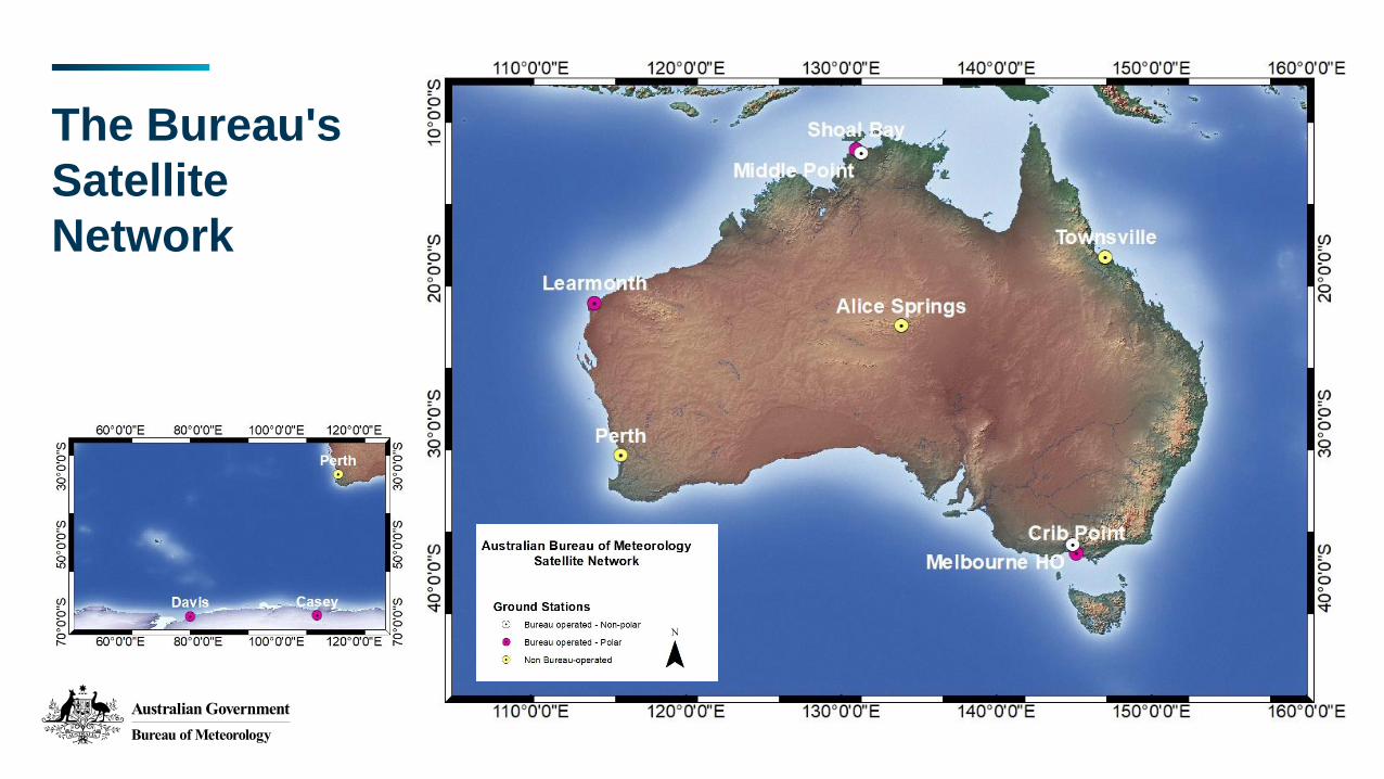
NWP at BoM
ACCESS-G3 (12 km)
and GE3(36 km)
ACCESS-TC3 (4 km)
ACCESS-C3 (1.5 km)
and CE3 (2.2 km)
Australian Parallel Suite NWP Systems

Data
Assimilation
Platform Instruments/Products
NOAA-15, NOAA-18 AMSU-A
NOAA-19 AMSU-A, MHS
GCOM-W1 AMSR-2
MetOp-A, Metop-B IASI, AMSU-A, MHS, ASCAT, GNSS-RO
MetOp-C GNSS-RO
DMSP-17 SSMIS
Terra AIRS, AMV
GOES-15, GOES-16, Meteosat-8, Meteosat-11 AMV
FY3-C, TerraSAR-X, COSMIC2 GNSS-RO
NOAA-20 CrIS (FSR/NSR) + ATMS
Suomi-NPP CrIS + ATMS
Himawari-8 CSR, AMV
SARAL, Jason-2/3 Altimeter wave/winds, sea surface heights
Geostationary / Polar Orbiting satellites Atmospheric Motion Vectors
Sea Surface Temperatures
Scatterometer Wind Vectors
> 20 satellites and instruments
• NOAA-20 ATMS and CrIS
• ScatSat-1
• Metop-C GRAS
• Preparation for Metop-C AMSU/MHS and IASI
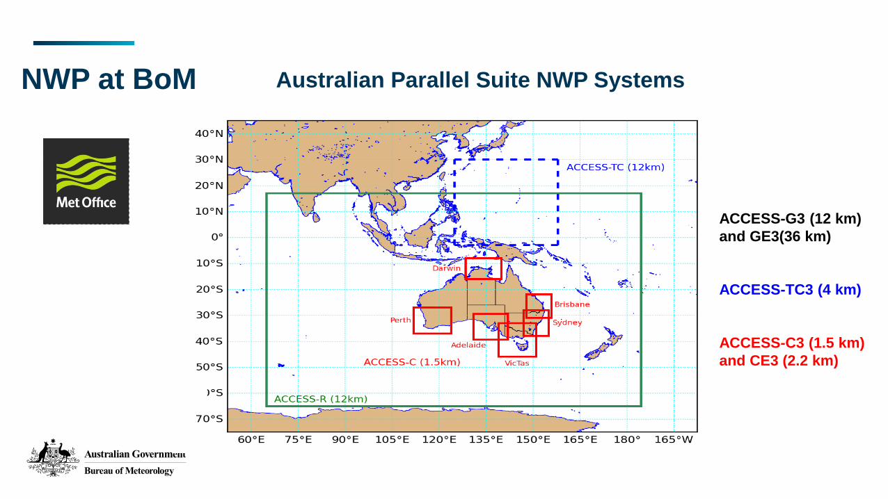
Numerical
Weather
Prediction in
Australia
Criticality of Satellites for NWP Forecast Skill
0.6
0.65
0.7
0.75
0.8
0.85
0.9
0.95
1
0 24 48 72 96 120 144HOURS
SAT
NOSAT
AC
(Le Marshall et al. 2013, AMOJ)
High Skill
Lower Skill
1 day forecastNO Sat
4 day forecastWITH Sat
=
High Skill Score
Data
Assimilation
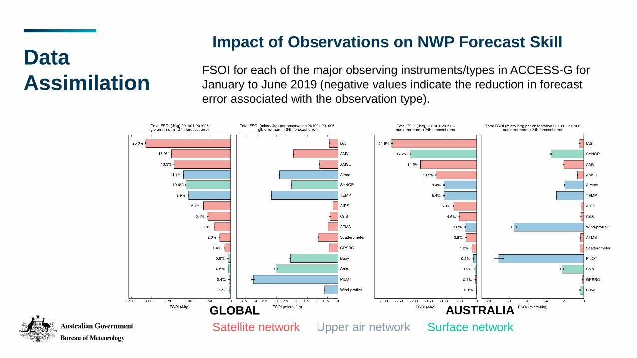
Impact of Observations on NWP Forecast Skill
Satellite network Upper air network Surface network
FSOI for each of the major observing instruments/types in ACCESS-G for
January to June 2019 (negative values indicate the reduction in forecast
error associated with the observation type).
GLOBAL AUSTRALIA

Satellite
Products:
Operational
• Forecaster Imagery
• Satellite data for NWP/Oceans
• Sea Surface Temperature
• Solar Radiation
• Grassland Curing Indices
• Vegetation Indices
• Cloud Properties
• Convective Rainfall Rate
South Australian storms 2016-09-28
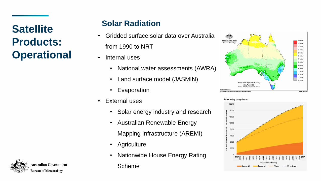
Satellite
Products:
Operational
• Gridded surface solar data over Australia
from 1990 to NRT
• Internal uses
• National water assessments (AWRA)
• Land surface model (JASMIN)
• Evaporation
• External uses
• Solar energy industry and research
• Australian Renewable Energy
Mapping Infrastructure (AREMI)
• Agriculture
• Nationwide House Energy Rating
Scheme
Solar Radiation
20 GW
2017 2037

Atmospheric Motion Vectors for NWP
Operational generation and
assimilation of continuous
(10 min) local Himawari-8
using GEOCAT and 4DVAR
(Le Marshall et al. JSHESS 2017)
H-8 AMVs around TC Quang 00UTC 29 April 2015
The RMS difference between forecast and
verifying analysis geopotential height (m) at
24 hours for ACCESS-R with (green) and
without (red) hourly AMVs
Satellite
Products:
Operational
AMVs reduce errors

Using Ground GPS/ZTD in NWP
Improves moisture analysis and
forecasting
Effective assimilation of ZTD data
into the ACCESS model
(Le Marshall et al. JSHESS 2019)
Satellite
Products:
Operational
Partnership between
Bureau of Meteorology
RMIT University
Geoscience Australia
Now operational, assimilating ZTD into
next generation Capital City and Global
ACCESS Models
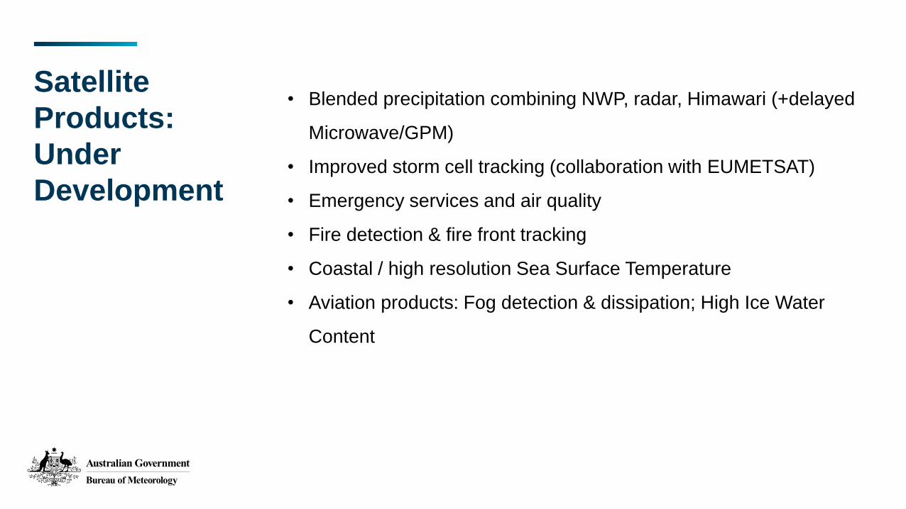
Satellite
Products:
Under
Development
• Blended precipitation combining NWP, radar, Himawari (+delayed
Microwave/GPM)
• Improved storm cell tracking (collaboration with EUMETSAT)
• Emergency services and air quality
• Fire detection & fire front tracking
• Coastal / high resolution Sea Surface Temperature
• Aviation products: Fog detection & dissipation; High Ice Water
Content
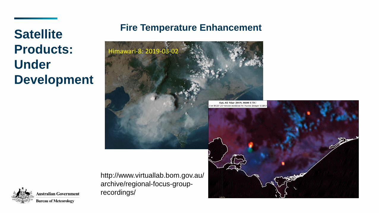
Satellite
Products:
Under
Development
Fire Temperature Enhancement
Himawari-8: 2019-03-02
Himawari-8: 2019-03-02
http://www.virtuallab.bom.gov.au/
archive/regional-focus-group-
recordings/
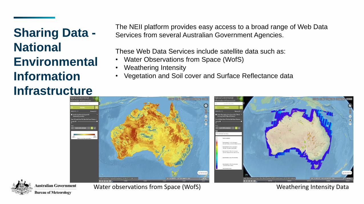
Sharing Data -
National
Environmental
Information
Infrastructure
The NEII platform provides easy access to a broad range of Web Data
Services from several Australian Government Agencies.
These Web Data Services include satellite data such as:
• Water Observations from Space (WofS)
• Weathering Intensity
• Vegetation and Soil cover and Surface Reflectance data
Water observations from Space (WofS) Weathering Intensity Data

Thank you
Related Documents