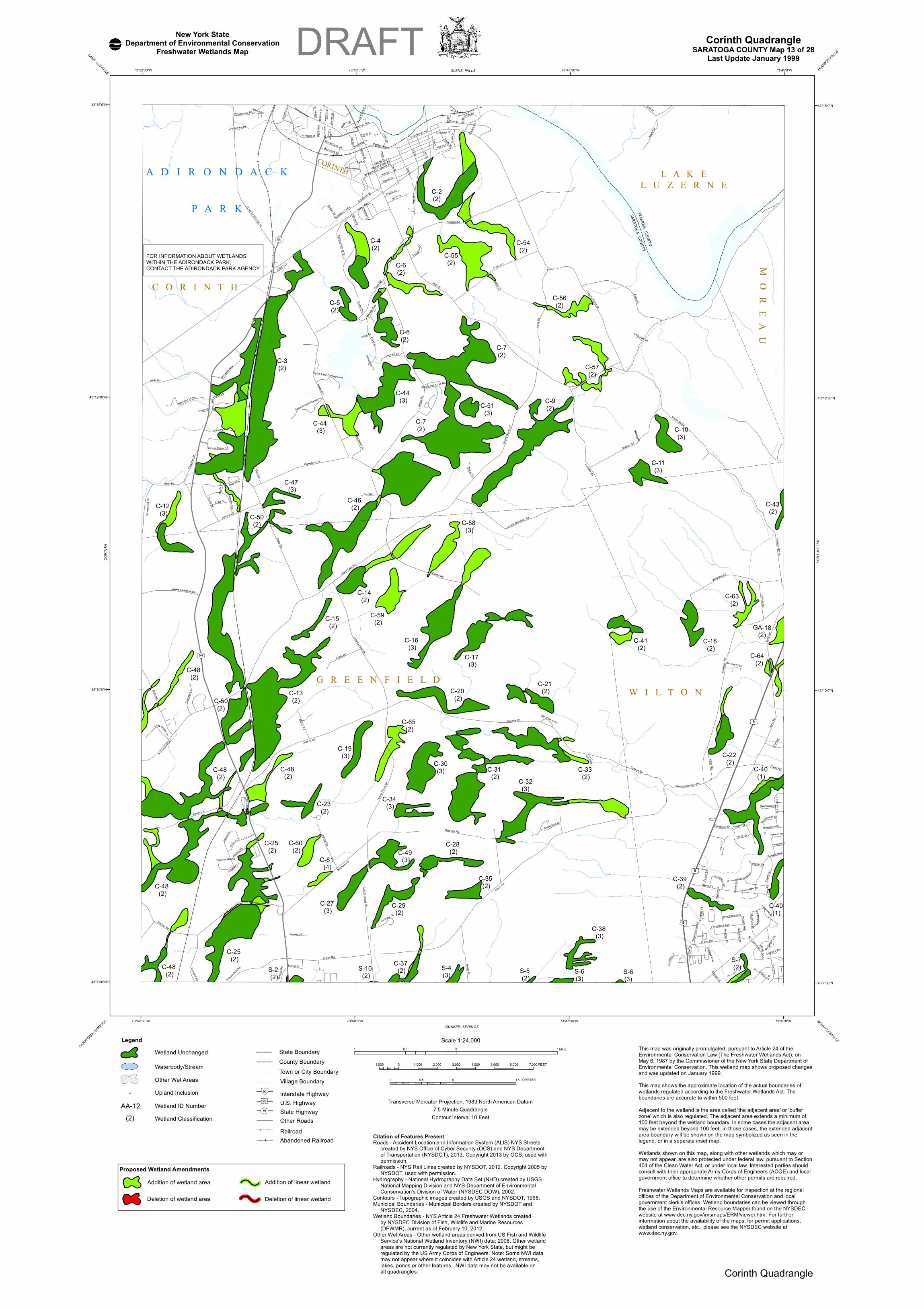
C-40 (1) C-64 (2) C-43 (2) C-40 (1) A D I R O N D A C K P A R K C-55 (2) C-6 (2) C-6 (2) C-4 (2) C-57 (2) C-56 (2) C-61 (4) C-60 (2) C-48 (2) C-13 (2) C-16 (3) C-63 (2) S-6 (3) S-10 (2) C-29 (2) C-28 (2) C-31 (2) C-30 (3) C-50 (2) C-25 (2) C-48 (2) C-48 (2) C-59 (2) C-54 (2) C-7 (2) C-44 (3) WARREN COUNTY SARATOGA COUNTY C-2 (2) GA-18 (2) C O R I N T H C e n ter S t H e at h St 2 nd S t Ha c k Rd W M ount ain Rd Porte r Rd T hist le R d St ep he n Ln Ho v e y Rd E ri c s o n D r 3 rd S t Oak S t 5 t h S t W orth Rd Comst ock R d 4 t h S t W al ker D r Wh i te St S t o n e h e d g e D r E v e r g r e e n D r H a m m R d Ch ap m an S t D a n del io n D r Ca l l St Woo dl an d Tr l C a r r Rd R o l l i n g H i l l s D r Eg gl e st on St Al l en R d Ha mi l to n A v e Wood crest A cr es Rd Birc h C t We s tv iew Dr F a irway B lvd 6 t h S t Bo ckes Rd Ove r look Dr P a rk h u rs t R d W i ley W a y St ar k R d Ho - H u m L n W Ma ple St 7 t h S t N G r e e n fi e l d R d An d o v e r Av e P a rk Dr K i n g A v e F o wle r Ln 1 st S t Wood R d D o r s e t D r M ec hanic S t C o u n ty R o u te 9 U r e Wa y N e w p o r t R d H a n o v e r R d W Waln u t St Co n nors W a y Lilli b r idg e R d M a p l e D r O l d R o u t e 9 N S Gree nfield R d T ow ers Ln G u r n e y L n P e pp e r P l C e d a r S t C a b i n D r N on chal ant Dr L i c ar do Ln Bro o k e v i ew Dr G a il o r R d M o u n t a in L e d g e McGreg o r V i l l a D epot Rd C arl R d W o o d l a k e Dr Ch urch St B ove e R d D u n n A v e M ario n Av e L a k e side Est s She rm a n Ave C o u n ty R o u te 2 5 H o p e fu l L n P l u m C t L i n k s R d Cir c le D r W i l l i a m S t P u l v e r B l v d Par - Ni l Dr Bir c h w o o d D r Ga b ri e l R d P al mer Te r B l ee k e r S t G r eene Rd H ea t he r L n P a r i s A v e L ocus t Dr S nowberry D r M a l loy R d Hi l l A ve W al ler Rd P alm er A ve Daviso n Dr Ad a ms Ln W M ech a n i c S t Ryanwood Ct Eggl eston S t Ex t Hi l l sid e A v e P opla r S t Fo o t h i l l s C t Pin e S tr e et Aly O ld S tra k o s Rd S m i t h D r H i llt o p D r Josep h L n Wal nut S t r eet A l y W a r r e n S t W a l nut S t E m er y L n Ash St H ow e Rd Sepia L n B e ech St H er itage W ay L o u g h r a n D r L i b e r t y St M a l l e r y S t F ar r Rd Ne wi n g ton A ve S o lar D r Hea t h R d F a rmi n g ton Ave B a ke r D r L a k e vi e w D r R iv e r S t T i m b e r l a n e D r Co r i n t h M t n Rd Q u ent i n C t Miner Rd B irch St E l i z a b e t h L n B r o o kstone Dr M i l l St Fra s ie r Rd W oo d ard R d W a l l S t La rksp u r Ct Nation a l Hill R d Pin e L e dg e Te r P i k e Ln R aymond St Leo nard L n D a y t o n D r A l pi n e M e adows Rd Hol me s Rd P i n e S t T a n n e r y H i l l R d F ul le r Dr L a d y S l ip p er L n Lin c oln Mou n t a i n Rd Alp ine Lak e C a mpground C ha n dl er L n Ki n g s R d De matt eo Ln N i c h o l s R d Ada ms Rd H awk R d B rig h am R d A n g e l R d E r n s t R d Ho llist er R d G riffin R d W ilt o n-G reen f i eld Rd Mai n S t S p o t s woo d Dr Spier F a l ls R d C e dar C ha p e l Ra n ch Rd St r ak os R d G r an g e R d M o r g a ns Way Wi l ton Rd Ful le r R d B a r b a ra M a c D D r Lo c us t R idge Dr B a nno ns M t R d Clothier Rd S u r r e y R d W i l t on Mt Rd L o c u s t Gro v e Rd C o un t y R o ute 2 4 Bum p h i l l Rd Er n s t Rd W i lt o n Rd G reene R d Lo cu st G r o v e R d B r ai m R d F o l t s Rd C o hen Rd We lls R d C O U N T Y R O U T E 1 0 Br i gham Rd Locus t Gro v e Rd £ ¤ 9 £ ¤ 9 £ ¤ 9 E F 9N E F 9N L A K E L U Z E R N E M O R E A U CORINTH W I L T O N G R E E N F I E L D C-23 (2) C-65 (2) C-14 (2) C-7 (2) S-7 (2) C-39 (2) C-48 (2) C-47 (3) C-58 (3) C-18 (2) C-9 (2) C-38 (3) C-21 (2) C-34 (3) C-33 (2) C-44 (3) S-6 (3) C-32 (3) C-41 (2) C-12 (3) C-10 (3) C-22 (2) C-15 (2) C-46 (2) C-49 (3) S-2 (2) C-25 (2) C-27 (3) S-4 (3) C-35 (2) C-20 (2) C-51 (3) C-5 (2) C-11 (3) C-48 (2) C-50 (2) C-3 (2) C-37 (2) C-19 (3) C-17 (3) S-5 (2) 73°45'0"W 73°45'0"W 73°47'30"W 73°47'30"W 73°50'0"W 73°50'0"W 73°52'30"W 73°52'30"W 43°15'0"N 43°15'0"N 43°12'30"N 43°12'30"N 43°10'0"N 43°10'0"N 43°7'30"N 43°7'30"N HUDSON FALLS SCHUYLERVILLE LAKE LUZERNE GLENS FALLS FORT MILLER QUAKER SPRINGS SARATOGA SPRINGS CORINTH Scale 1:24,000 1 0 1 0.5 MILE 1,000 0 1,000 2,000 3,000 4,000 5,000 6,000 7,000 FEET 1 0 1 0.5 KILOMETER Transverse Mercator Projection, 1983 North American Datum 7.5 Minute Quadrangle Contour Interval 10 Feet This map was originally promulgated, pursuant to Article 24 of the Environmental Conservation Law (The Freshwater Wetlands Act), on May 6, 1987 by the Commissioner of the New York State Department of Environmental Conservation. This wetland map shows proposed changes and was updated on January 1999. This map shows the approximate location of the actual boundaries of wetlands regulated according to the Freshwater Wetlands Act. The boundaries are accurate to within 500 feet. Adjacent to the wetland is the area called 'the adjacent area' or 'buffer zone' which is also regulated. The adjacent area extends a minimum of 100 feet beyond the wetland boundary. In some cases the adjacent area may be extended beyond 100 feet. In those cases, the extended adjacent area boundary will be shown on the map symbolized as seen in the legend, or in a separate inset map. Wetlands shown on this map, along with other wetlands which may or may not appear, are also protected under federal law, pursuant to Section 404 of the Clean Water Act, or under local law. Interested parties should consult with their appropriate Army Corps of Engineers (ACOE) and local government office to determine whether other permits are required. Freshwater Wetlands Maps are available for inspection at the regional offices of the Department of Environmental Conservation and local government clerk’s offices. Wetland boundaries can be viewed through the use of the Environmental Resource Mapper found on the NYSDEC website at www.dec.ny.gov/imsmaps/ERM/viewer.htm. For further information about the availability of the maps, for permit applications, wetland conservation, etc., please see the NYSDEC website at www.dec.ny.gov. Citation of Features Present Roads - Accident Location and Information System (ALIS) NYS Streets created by NYS Office of Cyber Security (OCS) and NYS Department of Transportation (NYSDOT), 2013. Copyright 2013 by OCS, used with permission. Railroads - NYS Rail Lines created by NYSDOT, 2012. Copyright 2005 by NYSDOT, used with permission. Hydrography - National Hydrography Data Set (NHD) created by USGS National Mapping Division and NYS Department of Environmental Conservation's Division of Water (NYSDEC DOW), 2002. Contours - Topographic images created by USGS and NYSDOT, 1968. Municipal Boundaries - Municipal Borders created by NYSDOT and NYSDEC, 2004. Wetland Boundaries - NYS Article 24 Freshwater Wetlands created by NYSDEC Division of Fish, Wildlife and Marine Resources (DFWMR), current as of February 10, 2012. Other Wet Areas - Other wetland areas derived from US Fish and Wildlife Service's National Wetland Inventory (NWI) data; 2008. Other wetland areas are not currently regulated by New York State, but might be regulated by the US Army Corps of Engineers. Note: Some NWI data may not appear where it coincides with Article 24 wetland, streams, lakes, ponds or other features. NWI data may not be available on all quadrangles. Corinth Quadrangle SARATOGA COUNTY Map 13 of 28 Last Update January 1999 New York State Department of Environmental Conservation Freshwater Wetlands Map DRAFT Corinth Quadrangle FOR INFORMATION ABOUT WETLANDS WITHIN THE ADIRONDACK PARK, CONTACT THE ADIRONDACK PARK AGENCY County Boundary Town or City Boundary Interstate Highway U.S. Highway State Highway Other Roads Village Boundary State Boundary , - 90 £ ¤ 20 E F 36 Railroad Abandoned Railroad AA-12 U (2) Wetland Unchanged Upland Inclusion Wetland ID Number Wetland Classification Legend Other Wet Areas Waterbody/Stream Proposed Wetland Amendments Deletion of wetland area Addition of linear wetland Addition of wetland area Deletion of linear wetland

Welcome message from author
This document is posted to help you gain knowledge. Please leave a comment to let me know what you think about it! Share it to your friends and learn new things together.
Transcript
C-40 (1)
GA-18 (2)
C-64 (2)
C-43 (2)
C-40 (1)
A D I R O N D A C K
P A R K
C-55(2)C-6
(2)
C-6(2)
C-4(2)
C-57(2)
C-56(2)
C-61 (4)
C-60 (2)
C-48 (2)
C-13(2)
C-16 (3)
C-63 (2)
S-6(3)
S-10 (2)
C-29 (2)
C-28 (2)
C-31 (2)
C-30(3)
C-50(2)
C-25 (2)
C-48 (2)
C-48 (2)
C-59 (2)
C-54(2)
C-7(2)C-44
(3)
WARREN COUNTY
SARATOGA COUNTY
C-2(2)
GA-18(2)
C O R I N T H
Center St
Heath St
2nd St
Hac k
Rd
W Mountain Rd
Porter Rd
Thistle Rd
Stephen Ln
Hovey Rd
Ericso
n Dr
3rd St
Oak St
5th St
Worth Rd
Comstock Rd
4th St
Walker
Dr
White St
Sto
nehedge Dr
Evergreen Dr
Hamm Rd
Chap
man S
t
Dandelion Dr
Call St
Woodland Trl
Carr Rd
Rollin
g Hills
Dr
Eggleston St
Allen Rd
Hamilton Ave
Woodcrest Acres Rd
Birch Ct
Westview Dr
Fairway Blvd
6th St
Bockes Rd
Overlook Dr
Park h
u rst R
d
Wiley Way
Stark Rd
Ho-Hum L n
W Maple St
7t h St
N Greenfie
ld Rd
Andove r Ave
Park Dr
King A
ve
Fowle
r Ln
1st St
Wood Rd
Dorse t Dr
Mechanic St
Coun
ty Ro
ute 9
Ure Way
Newport Rd
Han over Rd
W Walnut St
Connors Way
Lillibridge Rd
Maple
Dr
Ol d Rout e 9N
S Greenfie
ld Rd
Towers Ln
Gurne
y Ln
Pepp
er Pl
Cedar St
Cab in Dr
Nonchalant Dr
Licardo Ln
Brookeview Dr
Gailor Rd
Moun
ta in L
edge
McGreg
or Vill
a
Depot Rd
Carl R
d
Wo odl a ke Dr
Church St
Bovee Rd
Dunn
Ave
Mario
n Ave
Lakesi
de Est
s
Sherman Ave
Coun
ty Ro
ute 25
Hope
fu l Ln
P lum
Ct
Links
Rd
Circle Dr
Willia
m St
P ul ve
r Bl vd
Par-Nil Dr
Birchwood Dr
Gabriel Rd
Palmer Ter
Bl eek
er St
Greene Rd
Heather Ln
Paris
Ave
Locust Dr
Snowberry Dr
Malloy Rd
Hill Ave
Waller Rd
Palmer Ave
Davison Dr
Adams Ln
W Mechanic St
Ryanwood Ct
Eggleston St Ext
Hillside Ave
Poplar St
Footh
i l ls Ct
Pine Street Aly
Old Strakos Rd
Smith
Dr
Hilltop
Dr
Joseph Ln
Walnut Street Aly
War re
n St
Walnut St
Emery Ln
Ash St
Howe Rd
Sepia Ln
Beech St
Heritage Way
Loughran D
r
Libert
y St
Mallery St
Farr Rd
Newington Ave
Solar Dr
Heath Rd
Farmington Ave
Baker Dr
Lakeview Dr
River St
Timberlane D r
Co rin th Mtn Rd
Quentin Ct
Miner Rd
Birch St
Eliza
b eth
Ln
Brookstone Dr
Mil l St
Frasier Rd
Woodard Rd
Wall S
t
Larkspur Ct
National Hill Rd
Pine Ledge Ter
Pike Ln
Raymond St
Leonard Ln
Dayton DrAlpine Meadows Rd
Holmes Rd
Pine St
Tann
er y Hi
ll Rd
Fuller Dr
Lady Slipper Ln
Lincoln Mountain Rd
Alpine Lake Campground
Chan
dler L
n
Kings Rd
Dematteo Ln
Nichol s R d
Adams Rd
Hawk
Rd
Brigham Rd
Ange
l Rd
Ernst
Rd
Hollister Rd
Griffin Rd
Wilton-Greenfield Rd
Main St
Spotswood Dr
Spier Falls Rd
Cedar Chapel Ranch Rd
Strakos Rd
Gran
ge Rd
Morgans
Way
Wilton Rd
Fuller Rd
Barbara Mac D Dr
Locust Ridge Dr
Bannons Mt Rd
Clothier Rd
Surrey Rd
Wilton Mt Rd
Locust Grove Rd
County Route 24
Bumphill Rd
Erns
t Rd
Wilton Rd
Greene Rd
Locust G rove Rd
Br aim R d
Folts Rd
Cohen Rd
Wells Rd
COUNTY ROUTE 10
Brigham Rd
Locu
st Gr
ove R
d
£¤9
£¤9
£¤9
EF9N
EF9N
L A K EL U Z E R N E
M O R E A UCORINTH
W I L T O NG R E E N F I E L D
C-23 (2)
C-65 (2)
C-14 (2)
C-7(2)
S-7 (2)
C-39 (2)
C-48 (2)
C-47 (3)
C-58 (3)
C-18 (2)
C-9(2)
C-38 (3)
C-21 (2)
C-34 (3)
C-33 (2)
C-44 (3)
S-6(3)
C-32(3)
C-41 (2)
C-12 (3)
C-10(3)
C-22 (2)
C-15 (2)
C-46 (2)
C-49 (3)
S-2 (2)
C-25 (2)
C-27 (3)
S-4(3)
C-35 (2)
C-20 (2)
C-51 (3)
C-5(2)
C-11(3)
C-48 (2)
C-50(2)
C-3(2)
C-37 (2)
C-19 (3)
C-17 (3)
S-5 (2)
73°45'0"W
73°45'0"W
73°47'30"W
73°47'30"W
73°50'0"W
73°50'0"W
73°52'30"W
73°52'30"W
43°15'0"N 43°15'0"N
43°12'30"N 43°12'30"N
43°10'0"N 43°10'0"N
43°7'30"N 43°7'30"N
HUDSON FALLS
SCHUYLERVILLE
LAKE LUZERNE GLENS FALLS
FORT
MILL
ER
QUAKER SPRINGS
SARATOGA SPRINGS
CORI
NTH
Scale 1:24,0001 0 10.5 MILE
1,000 0 1,000 2,000 3,000 4,000 5,000 6,000 7,000 FEET
1 0 10.5 KILOMETER
Transverse Mercator Projection, 1983 North American Datum7.5 Minute Quadrangle
Contour Interval 10 Feet
This map was originally promulgated, pursuant to Article 24 of theEnvironmental Conservation Law (The Freshwater Wetlands Act), onMay 6, 1987 by the Commissioner of the New York State Department ofEnvironmental Conservation. This wetland map shows proposed changesand was updated on January 1999.This map shows the approximate location of the actual boundaries ofwetlands regulated according to the Freshwater Wetlands Act. Theboundaries are accurate to within 500 feet.Adjacent to the wetland is the area called 'the adjacent area' or 'bufferzone' which is also regulated. The adjacent area extends a minimum of100 feet beyond the wetland boundary. In some cases the adjacent areamay be extended beyond 100 feet. In those cases, the extended adjacentarea boundary will be shown on the map symbolized as seen in thelegend, or in a separate inset map.Wetlands shown on this map, along with other wetlands which may ormay not appear, are also protected under federal law, pursuant to Section404 of the Clean Water Act, or under local law. Interested parties shouldconsult with their appropriate Army Corps of Engineers (ACOE) and localgovernment office to determine whether other permits are required.Freshwater Wetlands Maps are available for inspection at the regionaloffices of the Department of Environmental Conservation and localgovernment clerk’s offices. Wetland boundaries can be viewed through the use of the Environmental Resource Mapper found on the NYSDECwebsite at www.dec.ny.gov/imsmaps/ERM/viewer.htm. For furtherinformation about the availability of the maps, for permit applications,wetland conservation, etc., please see the NYSDEC website atwww.dec.ny.gov.
Citation of Features PresentRoads - Accident Location and Information System (ALIS) NYS Streets created by NYS Office of Cyber Security (OCS) and NYS Department of Transportation (NYSDOT), 2013. Copyright 2013 by OCS, used with permission.Railroads - NYS Rail Lines created by NYSDOT, 2012. Copyright 2005 by NYSDOT, used with permission. Hydrography - National Hydrography Data Set (NHD) created by USGS National Mapping Division and NYS Department of Environmental Conservation's Division of Water (NYSDEC DOW), 2002.Contours - Topographic images created by USGS and NYSDOT, 1968.Municipal Boundaries - Municipal Borders created by NYSDOT and NYSDEC, 2004.Wetland Boundaries - NYS Article 24 Freshwater Wetlands created by NYSDEC Division of Fish, Wildlife and Marine Resources (DFWMR), current as of February 10, 2012.Other Wet Areas - Other wetland areas derived from US Fish and Wildlife Service's National Wetland Inventory (NWI) data; 2008. Other wetland areas are not currently regulated by New York State, but might be regulated by the US Army Corps of Engineers. Note: Some NWI data may not appear where it coincides with Article 24 wetland, streams, lakes, ponds or other features. NWI data may not be available on all quadrangles.
Corinth QuadrangleSARATOGA COUNTY Map 13 of 28
Last Update January 1999
New York StateDepartment of Environmental Conservation
Freshwater Wetlands Map DRAFT
Corinth Quadrangle
FOR INFORMATION ABOUT WETLANDSWITHIN THE ADIRONDACK PARK,CONTACT THE ADIRONDACK PARK AGENCY
County BoundaryTown or City Boundary
Interstate HighwayU.S. HighwayState HighwayOther Roads
Village Boundary
State Boundary
,-90
£¤20
EF36
RailroadAbandoned Railroad
AA-12U
(2)
Wetland Unchanged
Upland InclusionWetland ID NumberWetland Classification
Legend
Other Wet AreasWaterbody/Stream
Proposed Wetland Amendments
Deletion of wetland area
Addition of linear wetlandAddition of wetland area
Deletion of linear wetland
Related Documents


