Salt River Allotments Vegetative Management EIS Draft Recreation Affected Environment Report Don R. Sullivan November 6, 2012 Introduction The area surrounding the Salt River Canyon, the Salt River Canyon Wilderness, and the Sierra Ancha Wilderness, offer recreation settings that are scarce and unique in the arid southwest. Perennial water that supports vegetation and wildlife, and a remote, wild, non-motorized setting characterize much of the Salt River Canyon area. The Wild and Scenic River Study Report and Environmental Impact Statement for the Salt River recommended “wild designation of 22 miles of the Salt River as a component of the National Wild and Scenic Rivers System”. This segment of river, from Lower Corral Canyon to the Highway 288 Bridge, remains eligible for inclusion in the NWSR system. Recreationists come to the Salt River Canyon area for a wide variety of recreation opportunities including whitewater rafting, kayaking, canoeing, swimming, fishing, hiking, camping, horseback riding, mountain biking, picnicking, wildlife viewing, hunting, target shooting, Off-Highway Vehicle (OHV) use, and scenic driving. Additional characteristics that add value to this recreation setting include challenging river rapids, spectacular scenery, dramatic geology, natural salt deposits, archaeological sites, lush stream and river vegetation, and perennial side streams. The 32,100 acres of land that comprise the Salt River Canyon Wilderness were incorporated into the National Wilderness Preservation System in 1984. Although backpackers sometimes access the river by hiking down side creeks, there are no system trails in the Salt River Canyon Wilderness, so recreational access is primarily accomplished by whitewater boating. The 20,850 acres of land that comprise the Sierra Ancha Wilderness were incorporated into the National Wilderness Preservation System in 1964. Access to the Sierra Ancha Wilderness is primarily by foot or horseback through one of thirteen trailheads. Recreational River Running The Upper Salt River is an undammed, free-flowing whitewater river. As such, its water level is entirely dependent upon the annual rainfall and snowpack in its basin, located in the White Mountains of Arizona. Water levels can drop below 100 cubic feet per second (cfs) in summer and have risen as high as 143,000 cfs at flood stage. Recreational river running typically occurs in the spring, at water levels ranging between 500 cfs and 10,000 cfs, with some additional use in summer monsoon season.

Welcome message from author
This document is posted to help you gain knowledge. Please leave a comment to let me know what you think about it! Share it to your friends and learn new things together.
Transcript
Salt River Allotments Vegetative Management EIS
Draft Recreation Affected Environment Report
Don R. Sullivan
November 6, 2012
Introduction
The area surrounding the Salt River Canyon, the Salt River Canyon Wilderness, and the
Sierra Ancha Wilderness, offer recreation settings that are scarce and unique in the arid
southwest. Perennial water that supports vegetation and wildlife, and a remote, wild,
non-motorized setting characterize much of the Salt River Canyon area.
The Wild and Scenic River Study Report and Environmental Impact Statement for the
Salt River recommended “wild designation of 22 miles of the Salt River as a component
of the National Wild and Scenic Rivers System”. This segment of river, from Lower
Corral Canyon to the Highway 288 Bridge, remains eligible for inclusion in the NWSR
system.
Recreationists come to the Salt River Canyon area for a wide variety of recreation
opportunities including whitewater rafting, kayaking, canoeing, swimming, fishing,
hiking, camping, horseback riding, mountain biking, picnicking, wildlife viewing,
hunting, target shooting, Off-Highway Vehicle (OHV) use, and scenic driving.
Additional characteristics that add value to this recreation setting include challenging
river rapids, spectacular scenery, dramatic geology, natural salt deposits, archaeological
sites, lush stream and river vegetation, and perennial side streams.
The 32,100 acres of land that comprise the Salt River Canyon Wilderness were
incorporated into the National Wilderness Preservation System in 1984. Although
backpackers sometimes access the river by hiking down side creeks, there are no system
trails in the Salt River Canyon Wilderness, so recreational access is primarily
accomplished by whitewater boating.
The 20,850 acres of land that comprise the Sierra Ancha Wilderness were incorporated
into the National Wilderness Preservation System in 1964. Access to the Sierra Ancha
Wilderness is primarily by foot or horseback through one of thirteen trailheads.
Recreational River Running
The Upper Salt River is an undammed, free-flowing whitewater river. As such, its water
level is entirely dependent upon the annual rainfall and snowpack in its basin, located in
the White Mountains of Arizona. Water levels can drop below 100 cubic feet per second
(cfs) in summer and have risen as high as 143,000 cfs at flood stage. Recreational river
running typically occurs in the spring, at water levels ranging between 500 cfs and 10,000
cfs, with some additional use in summer monsoon season.
The rafting portion of the Upper Salt River runs 52 miles from the put-in near the
Highway 60 Bridge to the take-out at the Highway 288 Bridge. Administratively, this is
broken up into three Segments; the 9-mile Salt Banks segment, the 11-mile Gleason
segment, and the 32-mile Wilderness segment. The Forest Service co-manages the Upper
Salt River with the White Mountain Apache Tribe, whose tribal lands on the north side of
the river extend 28.9 miles below the Highway 60 put-in.
The Forest Service issues permits to four commercial outfitters for the Upper Salt River.
The outfitter’s clients are from all over the United States, with the majority coming from
the four corners region. These small businesses book half-day, full-day, or overnight
trips on the Salt Banks and Gleason segments, or three to five day trips for the entire
length of river. Bookings vary yearly with the snowpack and water level. In 2010, a year
with normal snowpack, the outfitters sold 8,098 user days (one person on the river for
one day), grossing a total of $774,935.
From March 1 to May 15 the Forest Service requires a permit for private boaters (people
with their own boats who wish to organize their own trips) to boat through the Salt River
Canyon Wilderness. Private boaters may pay the $10 application fee to be included in
the yearly random drawing for special recreation permits. There are four of these permits
available, for trips of up to fifteen people, for each of the 76 days of the permitted season,
or 304 available permits. There is a onetime fee of $125 for each permit. In 2010, 1,792
people applied, and 282 permits were issued, to boat through the Salt River Canyon
Wilderness, generating $53,170 in permit fees. Private boaters also conduct day and
overnight trips on the Salt Banks and Gleason sections where no Forest Service permit is
required.
Private boater application data shows that boaters come from as far away as
Massachusetts and Alaska. Most applicants are from urban areas, and are from the
southwest. Sizable populations from the Northwest, California, and Texas also apply.
While it is known that, through spending on gas, food, lodging and other items, river
recreationists contribute to local jobs and revenue, no study has been conducted to
determine the amount of revenue that boaters provide to the communities near the Upper
Salt River. Given that almost all of the commercial and private boaters are from outside
the Globe/Miami area, it is likely that boating on the Upper Salt River is this local
community’s largest source of ecotourism.
Commercial and private boaters on the Upper Salt River must practice leave no trace
camping and have a number of special regulations that they must follow, abbreviated in
the table below. These include containing their fires in a firepan so as not to leave a mark
on the beach and carrying and using a human waste removal system.
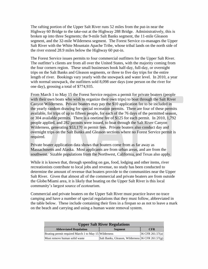
Upper Salt River Regulations Abbreviated Regulation Segment CFR
Boating permit required March 1 to May 15 Wilderness 36 CFR 261.57(a) Must remove human solid waste Salt Banks, Gleason, Wilderness 36 CFR 261.57(g)
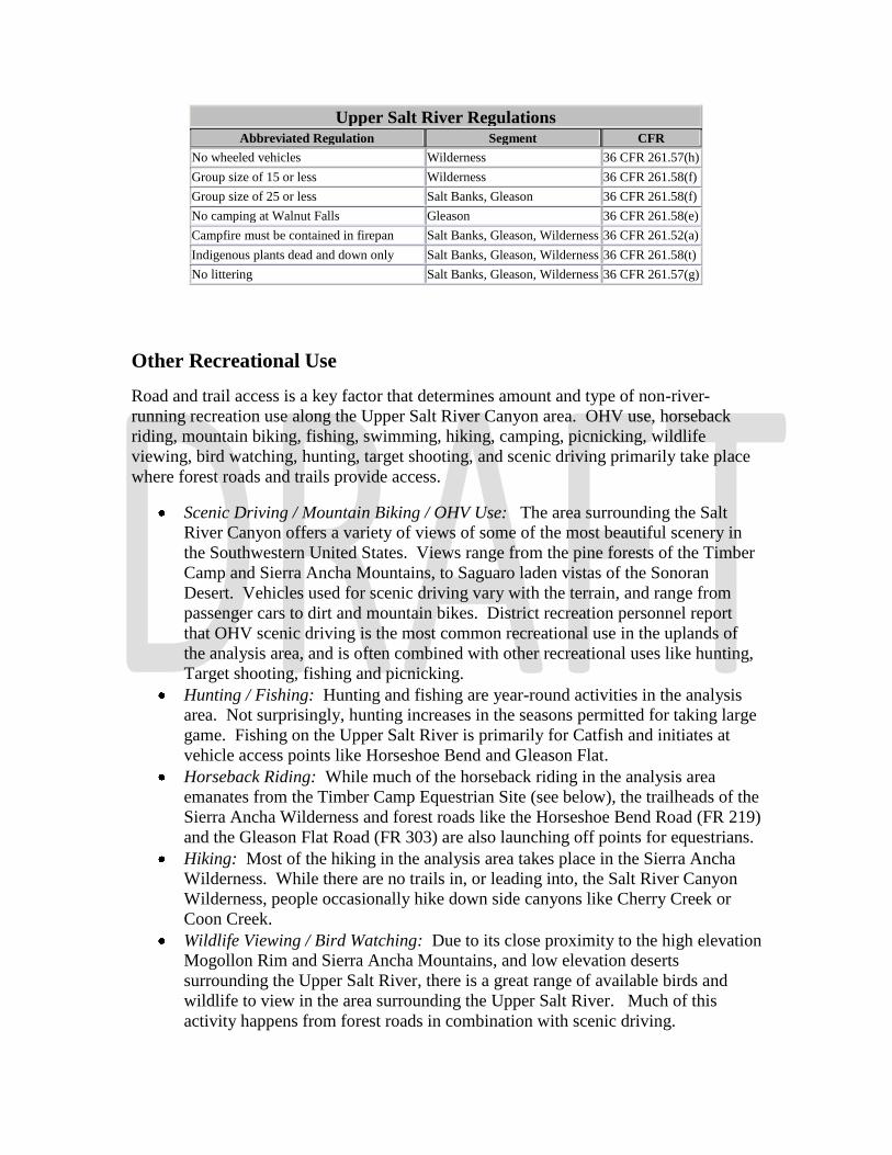
Upper Salt River Regulations Abbreviated Regulation Segment CFR
No wheeled vehicles Wilderness 36 CFR 261.57(h) Group size of 15 or less Wilderness 36 CFR 261.58(f) Group size of 25 or less Salt Banks, Gleason 36 CFR 261.58(f) No camping at Walnut Falls Gleason 36 CFR 261.58(e) Campfire must be contained in firepan Salt Banks, Gleason, Wilderness 36 CFR 261.52(a) Indigenous plants dead and down only Salt Banks, Gleason, Wilderness 36 CFR 261.58(t) No littering Salt Banks, Gleason, Wilderness 36 CFR 261.57(g)
Other Recreational Use
Road and trail access is a key factor that determines amount and type of non-river-
running recreation use along the Upper Salt River Canyon area. OHV use, horseback
riding, mountain biking, fishing, swimming, hiking, camping, picnicking, wildlife
viewing, bird watching, hunting, target shooting, and scenic driving primarily take place
where forest roads and trails provide access.
Scenic Driving / Mountain Biking / OHV Use: The area surrounding the Salt
River Canyon offers a variety of views of some of the most beautiful scenery in
the Southwestern United States. Views range from the pine forests of the Timber
Camp and Sierra Ancha Mountains, to Saguaro laden vistas of the Sonoran
Desert. Vehicles used for scenic driving vary with the terrain, and range from
passenger cars to dirt and mountain bikes. District recreation personnel report
that OHV scenic driving is the most common recreational use in the uplands of
the analysis area, and is often combined with other recreational uses like hunting,
Target shooting, fishing and picnicking.
Hunting / Fishing: Hunting and fishing are year-round activities in the analysis
area. Not surprisingly, hunting increases in the seasons permitted for taking large
game. Fishing on the Upper Salt River is primarily for Catfish and initiates at
vehicle access points like Horseshoe Bend and Gleason Flat.
Horseback Riding: While much of the horseback riding in the analysis area
emanates from the Timber Camp Equestrian Site (see below), the trailheads of the
Sierra Ancha Wilderness and forest roads like the Horseshoe Bend Road (FR 219)
and the Gleason Flat Road (FR 303) are also launching off points for equestrians.
Hiking: Most of the hiking in the analysis area takes place in the Sierra Ancha
Wilderness. While there are no trails in, or leading into, the Salt River Canyon
Wilderness, people occasionally hike down side canyons like Cherry Creek or
Coon Creek.
Wildlife Viewing / Bird Watching: Due to its close proximity to the high elevation
Mogollon Rim and Sierra Ancha Mountains, and low elevation deserts
surrounding the Upper Salt River, there is a great range of available birds and
wildlife to view in the area surrounding the Upper Salt River. Much of this
activity happens from forest roads in combination with scenic driving.
Developed Recreation Areas
There are three developed recreation areas in the analysis area; Timber Camp Recreation
Area, Jones Water Recreation Area, and Bull Canyon Trailhead.
Timber Camp Recreation Area is a heavily used campground located 26 miles
east of Globe Arizona on the north side of Highway 60. It is broken into 4
separate sites, all of which are fenced off from the surrounding grazing
allotment. Timber Camp Equestrian Site and Brundrett Site 1 are available for
use by reservation. Brundrett Site 2 and Timber Camp Day Use Picnic Area are
open year-round.
o Timber Camp Equestrian Site: With a large parking area to
accommodate horse trailers, this site has three corrals, two hitching posts,
two manure receptacles, a concrete vault toilet, a fire ring, and a ramada
that shelters six picnic tables.
o Brundrett Site 1: Brundrett Site 1 has two ramadas (each with six picnic
tables) and a fire ring. It has three concrete vault toilets available for use
from the fourteen campsites, each with a picnic table and fire ring.
o Brundrett Site 2: Brundrett Site 2 has a parking area for large groups and
three day use picnic tables. It has a concrete vault toilet available for use
from three campsites, each with a picnic table and fire ring.
o Timber Camp Day Use Picnic Area: This area has a concrete vault toilet
and four picnic tables. With the closure of the state owned rest area
along highway 60, this toilet has become the de-facto rest area for
travelers between Globe and Show Low Arizona.
Jones Water Recreation Area is a moderately used campground 19 miles east of
Globe Arizona on the south side of Highway 60. The campground is in a
riparian area with perennial water, and is not currently fenced off from the
surrounding allotment. It has two concrete vault toilets available for use from
the twelve campsites, each with a picnic table and fire ring.
Bull Canyon Trailhead is a simple gravel parking lot with a sign designating the
trailhead.
Recreation/ Wilderness Opportunity Spectrums and Visual Quality Objective
The Tonto National Forest Land and Resource Management Plan (LMP) identifies the
Recreation Opportunity Spectrum (ROS) class system, and the Wilderness Opportunity
Spectrum (WOS) class system categories used on forest lands to help guide development
and management in order to provide a variety of recreation and wilderness experiences
desired by the public. The ROS spectrum is broken into Semi-Primitive Non-Motorized
(SPNM), Semi-Primitive Motorized (SPM), Roaded Natural (RN), Rural (R), and Urban
(U) classes. The WOS spectrum is broken into classes I, II, III, and IV. Classes of
recreation and wilderness experiences are described in Recreation Appendixes 1 and 2,
and shown for the analysis area in Recreation Map 1. The table below shows the number

and miles of roads and trails, and the number and percentage of acres of each class, in the
analysis area.
SR-6 ROS / WOS Acres / Roads / Trails
Class Acres Percentage # of Roads Miles Road # Trails Miles Trail
SPNM 137,435 49.82% 69 77.24 8 20.70
SPM 72,416 26.25% 130 168.28 2 2.41
RN 63,274 22.94% 174 211.41 6 3.64
R 2,731 .99% 6 3.26 0 0
ROS Total 275,856 100% 279 460.19 9 26.75
WOS I 29,471 70.82% N/A N/A 6 3.25
WOS II 11,931 28.67% N/A N/A 7 19.12
WOS III 148 .35% N/A N/A 2 .57
WOS IV 66 .15% N/A N/A 2 .23
WOS Total 41,616 100% N/A N/A 9 23.17
Total 275.856 100% 279 460.19 9 26.75
The uplands of the analysis area are primarily a mixture of roaded natural, semi-primitive
motorized, and semi-primitive non-motorized recreation opportunities. The Sierra Ancha
Wilderness and the Salt River Canyon Wilderness are primarily WOS Classes I and II.
Campsites along the Upper Salt River are in semi-primitive motorized in the Salt Banks
segment, semi-primitive non-motorized in the Gleason segment, and WOS Opportunity
Class II in the Wilderness segment.
The LMP assigns a Visual Quality Objective (VQO) for the purpose of maintaining or
enhancing the scenic qualities of the Tonto’s landscapes. Visual Quality Objective
Classes, described in Recreation Appendix 3, represent different degrees of acceptable
alterations to national forest landscapes. The LMP directs a VQO of “Retention” (man’s
activities are not evident to the casual observer) for the Upper Salt River Management
area (LMP) and “preservation” (provides for ecological changes only) in the Salt River
Canyon Wilderness and the Sierra Ancha Wilderness (LRP).
River Recreation Resource Conditions
The Tonto National Forest Salt River Canyon Wilderness Implementation Plan
(SRCWIP) states that a Limits of Acceptable Change (LAC) concept “will be used to
access acceptable conditions in the Wilderness, establish a program of monitoring
conditions, and evaluate management effectiveness” and that “management of the
recreation resource will be consistent with the specified WOS Class.” The SRCWIP sets
the LAC standards for the Wilderness segment of the Upper Salt River. Similarly, the
Tonto National Forest Implementation Plan for the Upper Salt River (IPUSR) sets the
LAC standards for the Salt Banks and Gleason segments, “consistent with their specified
ROS classes”. Both plans direct management personnel to inventory and evaluate LAC
indicators on a continuing basis using the Tonto National Forest Campsite Inventory and
Analysis Form, Recreation Appendix 4.
Between 1991 and 2011 campsite inventories were conducted in 48 camps in the analysis
area in the river corridor of the Upper Salt River Canyon. The inventories show that
impacts in the campsites along the river have dropped significantly since the 1990s and,
with the exception of the campsites immediately adjacent to vehicle access points at
Gleason Flats and Horseshoe Bend, they are well below the established Limits of
Acceptable Change (LAC). For instance, campsites in the wilderness inventoried in 1999
had an average overall score of 21, with 67% of the inventoried campsites over the LAC
of 19. In 2011 the campsites inventoried in the wilderness had an average overall score
of 5, with only .05% of the inventoried campsites over the LAC of 19. Campsites
inventoried from 1991 to 1999 had an average score of 20 while those inventoried
between 2000 and 2011 had and average score of 8.
Impacts to the river corridor and campsites have dropped for a number of reasons
including adoption and enforcement of Leave No Trace regulations for forest users and
outfitters, the addition of actively patrolling river rangers, and the removal of cattle from
the river corridor.
There are a number of highly visible range improvements in the Upper Salt River
Corridor. Pasture fences extending along the river downstream from Gleason Flat, and
across the mouth of the creek at Coon Creek, are in wilderness segment river campsites
which are managed as Wilderness Class II, and for a VQO of “preservation”. The corral
in the Gleason Segment at Gleason Flat is at the end of a closed road (FR 303A) in an
area managed as semi-primitive non-motorized with a visual quality of “retention”.
Starting at this corral, an illegal user made road was bulldozed by a previous range
permittee upstream over a ridge to the east and then across Ash Creek where it too leads
to a corral.
Upland Recreation Resource Conditions
Most of the recreational activity that takes place in the uplands surrounding the Upper
Salt River takes place or emanates from forest roads and trails.
Depending upon their location and placement in relation to recreational activities,
existing and proposed range improvements like piping, water troughs, stock tanks, corrals
and fencing may present a visual impact to forest user’s recreational experience and the
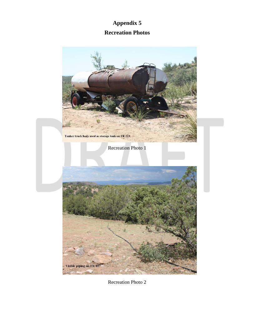
forest’s ability to manage recreation opportunities. Range improvements along forest
roads with a high degree of recreational usage like Horseshoe Bend Road (FR 219),
Gleason Flat Road (FR 303, 303B), Shute Springs Road (FR 223), and Forest Road 897
have numerous range improvements in semi-primitive motorized areas that are highly
visible and limit the areas ability to be “natural or natural appearing” (LMP) (see Rec
Photos 1 and 2). Construction and maintenance of range improvements along the former
Gleason Flat Road (FR 303A), which had been obliterated and signed closed as planned
(IPUSR 19, C-1), have effectively “re-opened” this road to OHV travel in an area which
is designated as semi-primitive non-motorized with a VQO of “retention” (LMP).
Desired Conditions
The wilderness act defines wilderness as “in contrast with those areas where man and his
own works dominate the landscape, is hereby recognized as an area where the earth and
its community of life are untrammeled by man where man himself is a visitor who does
not remain. An area of wilderness is further defined to mean in this Act an area of
undeveloped Federal land retaining its primeval character and influence, without
permanent improvements or human habitation, which is protected and managed so as to
preserve its natural conditions and which (1) generally appears to have been affected
primarily by the forces of nature, with the imprint of man's work substantially
unnoticeable; (2) has outstanding opportunities for solitude or a primitive and unconfined
type of recreation” (WILDERNESS ACT Public Law 88-577 (16 U.S. C. 1131-1136)).
The Tonto National Forest Land and Resource Management Plan (LMP), the Salt River
Canyon Wilderness Implementation Plan (SRCWIP), and Forest Service Manual 2300,
“Recreation, Wilderness, and Related Resource Management,” specify the following
desired conditions:
The portion of this management area from near the Highway 288 Bridge upstream
to the Fort Apache Reservation boundary was studied by the Forest Service for
inclusion in the National Wild and Scenic Rivers System at the direction of the
US Congress. Present management emphasis will not preclude future
Congressional designation of this river. (LMP)
The primary emphasis for the Salt River Canyon Wilderness is the preservation of
naturally occurring flora, fauna, aesthetics and ecological processes while
providing a very high quality white water river running experience. (LMP)
Manage for the Visual Quality Objective of “Preservation” (provides for
ecological changes only) in the Salt River Canyon Wilderness and the Sierra
Ancha Wilderness. (LRP)
Manage for the Visual Quality Objective of “Retention” (man’s activities are not
evident to the casual observer) in the Upper Salt River management area. (LMP)
Insure that other activities that are authorized by the Wilderness Act, including
grazing, will be conducted so as to minimize their impact on wilderness character.
(LMP)
For the Gleason segment, manage ROS classes according to existing inventory as
semi-primitive non-motorized 98%, and primitive 2%. (LMP)
Construct only minimal new range improvements deemed essential for level B
management. (LMP) “Construction of new range improvements may be
approved it they are necessary for resource protection (range and/or wilderness)
and the effective management of these resources. Do not approve construction
solely to accommodate increased grazing”. (FSM 2300, 2320.1)
In wilderness, accomplish management activities with nonmotorized equipment
and nonmechanical transport of supplies and personnel. Exclude the sight sound
and other tangible evidence of motorized equipment or mechanical transport
within the wilderness except where they are needed and justified. (FSM 2300,
2326.02) Do not approve the use of motorized equipment or mechanical
transport unless justified as described in FSM 2300, 2326.1. (FSM 2300, 2326.03)
o Where practical alternatives do not exist, maintenance and other activities
may be accomplished through occasional use of motorized equipment.
The use of this equipment should be based on a rule of practical necessity
and reasonableness. (FSM 2300, 2320.1)
Adhere to the guidelines on grazing in the Salt River Canyon Wilderness
Implementation Plan including:
o Preserve a wide spectrum of primitive recreation opportunities consistent
with established objectives for each opportunity class. A high priority will
be placed on maintaining the integrity of the WOS classes (see appendixes
1& 2).(SRCWIP)
o As an LAC standard is approached by trends of wilderness conditions,
develop corrective prescriptions, including where necessary rationing of
use, so that the standard is not exceeded. (SRCWIP)
o Permitees request for the use of motorized equipment will be thoroughly
analyzed to insure they meet the “rule of practical necessity and
reasonableness” thereby insuring the least impact possible on recreational
users wilderness experience. (SRCWIP)
o Salt will be located away from water and areas of public concentration and
necessary feeders will be constructed of natural materials. (SRCWIP)
o Construct needed structural range improvements from native materials
when possible. Pipelines, where essential, should be buried. (SRCWIP)

Recreation Appendix 1
Recreation Opportunity Spectrum (ROS)
Characterization
Primitive (P) Area is characterized by essentially unmodified natural environment of fairly large size.
Interaction between users is very low and evidence of other users is minimal. The area is
managed to be essentially free from evidence of human-induce restrictions and control.
Motorized use within the area is not permitted.
Semi-Primitive Non-
Motorized (SP) Area is characterized by a predominantly natural or natural-appearing environment of
moderate-to large size. Interaction between users is low, but there is often evidence of
other users. The area is managed in such a way that minimum on-site controls and
restrictions may be present, but are subtle. Motorized used is not permitted.
Semi-Primitive Motorized
(SPM) Area is characterized by a predominantly natural or natural-appearing environment of
moderate to large size. Concentration of users is low, but there is often evidence of other
users. The area is managed in such a way that minimum on-site controls and restriction
may be present, but are subtle. Motorized used is permitted.
Roaded Natural (RN) Area is characterized by predominantly natural- appearing environments with moderate
evidences of sight and sounds of man. Such evidences usually harmonize with the natural
environment. Interaction between users may be low to moderate, but with evidence of
other users prevalent. Resource modification and utilization practices are evident, but
harmonize with the natural environment. Conventional motorized use is provided for in
construction standards and design of
facilities.
Rural (R) Area is characterized by substantially modified natural environment. Resource
modification and
utilization practices are to enhance specific recreation activities and to maintain
vegetative cover and soil. Sight and sounds of humans are readily evident, and the
interaction between users is often moderate to high. A considerable number of facilities
are designed for use by a large number of people. Facilities are often provided for special
activities. Moderate densities are provided for away from developed sites. Facilities for
intensified motorized use and parking are available.
Urban (U) Area is characterized by a substantially urbanized environment, although the background
may have
natural-appearing elements. Renewable resources modification and utilization practices
are to enhance specific recreational activities. Vegetative cover is often exotic and
manicured. Sights and sounds of humans, on-site, are predominant. Large numbers of
users can be expected, both on-site and in nearby areas. Facilities for highly intensified
motor use and parking are available, with forms of mass transit often available to carry
people throughout the site.
Recreation Appendix 2
Wilderness Opportunity Spectrum (WOS)
Characterization
Opportunities Classes represents a spectrum of wilderness experience opportunities within the complex. These classes describe areas
within the complex having different resource and social objectives and also identify management actions that are acceptable within
each class. Inherent in the definitions are different levels of resource and social conditions acceptable for each class in the spectrum.
Three components are used to describe opportunity classes: resource, social, and managerial settings. Each component has several
elements that are used to describe differences between opportunity classes. These descriptions provide managers, researchers, and users with common definitions for terms used to describe areas within the complex.
The following are definitions of each class including descriptions of the objectives for the resource, social, and managerial settings.
I. OPPORTUNITY CLASS I
A. Resource Setting
Characterized by an unmodified natural environment. Ecological and natural processes are not measurably
affected by the actions of users. Environmental impacts are minimal, restricted to temporary loss of vegetation here camping occurs and along some livestock travel routes, typically recover on an annual basis and are subtle
in nature and generally not apparent to most visitors.
B. Social Setting
Provides an outstanding opportunity for isolation and solitude free from evidence of human activities and with very infrequent encounters with users. The user has outstanding opportunities to travel across country utilizing
a maximum degree of outdoor skills, often in an environment that offers a very high degree of challenge, self-
reliance and risk. Inter-party contacts will be very few while traveling and rare to non-existent at the campsite.
C. Managerial Setting Management will strongly emphasize sustaining and enhancing the natural ecosystem. Direct onsite
management of visitors will be seldom. Necessary rules and regulations will be communicated to visitors
outside the area, such as at trailheads or boundary portals. Contact of visitors within this class by Forest
personnel will be mostly reactive and by invitation, with discussion items limited to what visitors want to know.
Formal and informal user education programs will be initiated to inform users about what to expect and how to
use the area for optimum benefits to all. Formal regulations, orders and/or permits will be considered only when less restrictive regulations or programs have consistently failed to achieve desired goals and objectives.
Infrequent patrols and monitoring of conditions by appropriate State and Federal agency personnel will be
conducted only as necessary to achieve management objectives. All scientific and ecological monitoring actions will be scheduled to meet social setting criteria. Trails will not be constructed and maintenance will be
conducted only to protect the resource. No trail signs will be present, and no facilities of any kind will be
provided or permitted, including lookouts and radio transmitter stations.
II. OPPORTUNITY CLASS II
A. Resource Setting
Characterized by an essentially natural environment. Ecological and natural processes and conditions are
minimally affected by the action of users. Environmental impacts are low and restricted to minor losses of vegetation
where
camping occurs and along most travel routes. Most impacts recover on an annual basis and will be apparent to only a
low number of visitors.
B. Social Setting
Provides a high opportunity for exploring and experiencing isolation from the sights and sounds of man with the
probability for encountering other users being low. The user has good opportunity for experiencing independence,
closeness to nature, tranquility, and self-reliance through the application of primitive recreation skills. These
opportunities occur in an environment that offers a high degree of challenge and risk. Inter-party contacts will be low
on the trail and fairly low at the campsite, with parties often camped in isolation.
C. Managerial Setting
Management will emphasize sustaining and enhancing the natural ecosystem. Direct onsite management will
involve minimum visitor contact during the normal season. Necessary rules and regulations will be communicated to
visitors
outside the area, such as at trailhead and boundary portals. Contacts of visitors by Forest personnel will be mostly
reactive and by invitation. In addition to what the visitor wants to know, the opportunity will be seized to
present other pertinent site-specific messages. Formal and informal user education programs will be initiated to inform
users
about what to expect and how to use the area for optimum benefits to all. Formal rules and regulations may be necessary to achieve desire goals and objectives. Signs will be permitted within the area and will provide only
the
minimum information necessary to protect the wilderness resource. Trails will normally be constructed, maintained
and managed to accommodate light and infrequent travel. Routes will be maintained only for resource
protection and minimal user safety. Modification of the natural environment would be minimal. The route should provide the
user
with an opportunity for testing skills and experiencing a sensation of physical exertion and feeling of
accomplishment. Facilities will be provided, only in a few extreme cases, and those that are will be permitted
only
for resource protection and will use only native materials.
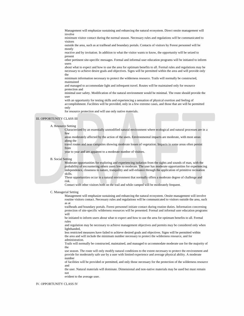
III. OPPORTUNITY CLASS III
A. Resource Setting
Characterized by an essentially unmodified natural environment where ecological and natural processes are in a few
areas moderately affected by the action of the users. Environmental impacts are moderate, with most areas
along the travel routes and near campsites showing moderate losses of vegetation. Impacts in some areas often persist
from
year to year and are apparent to a moderate number of visitors.
B. Social Setting
Moderate opportunities for exploring and experiencing isolation from the sights and sounds of man, with the probability of encountering others users low to moderate. The user has moderate opportunities for experiencing
independence, closeness to nature, tranquility and self-reliance through the application of primitive recreation
skills. These opportunities occur in a natural environment that normally offers a moderate degree of challenge and
risk.
Contact with other visitors both on the trail and while camped will be moderately frequent.
C. Managerial Setting
Management will emphasize sustaining and enhancing the natural ecosystem. Onsite management will involve routine visitors contact. Necessary rules and regulations will be communicated to visitors outside the area, such
as at
trailheads and boundary portals. Forest personnel initiate contact during routine duties. Information concerning protection of site-specific wilderness resources will be presented. Formal and informal user education programs
will
be initiated to inform users about what to expect and how to use the area for optimum benefits to all. Formal rules
and regulation may be necessary to achieve management objectives and permits may be considered only when
lighthanded, less restricted measures have failed to achieve desired goals and objectives. Signs will be permitted within
the area and will include the minimum number necessary to protect the wilderness resource, and for
administration.
Trails will normally be constructed, maintained, and managed to accommodate moderate use for the majority of
the
use season. The route will only modify natural conditions to the extent necessary to protect the environment and provide for moderately safe use by a user with limited experience and average physical ability. A moderate
number
of facilities will be provided or permitted, and only those necessary for the protection of the wilderness resource and
the user. Natural materials will dominate. Dimensional and non-native materials may be used but must remain
not evident to the average user.
IV. OPPORTUNITY CLASS IV

A. Resource Setting Characterized by a predominantly unmodified natural environment where ecological and natural processes are
in many locations substantially affected by the action of users. Environmental impacts are generally high in
areas along major travel routes, along popular river corridors and lakeshores, and near major entry points. Impacts often persist from year to year and there may be moderate loss of vegetation and soil at some sites.
Impacts are readily apparent to most visitors.
B. Social Setting
Moderate to low opportunities for exploring and experiencing isolation from the sights and sounds of man with
the probability of encountering other area users moderate to high. The user has the opportunity for a high degree of interaction with the natural environment, often with low or moderate challenge and risk. Contact with
other users will be relatively high much of the time, both on the trail and at campsites. Some parties will camp
out of sight and sound of other parties, but this will not be common during the main use season.
C. Managerial Setting
Management will be oriented to sustaining and enhancing the natural ecosystem. There will be frequent opportunity for visitor contact with management personnel. Necessary rules and regulations will be
communicated to visitors outside the area, such as the trailheads and boundary portals. Special efforts will be
taken to contact visitors. Information concerning wilderness management, user conflicts, fire prevention, and
other pertinent subjects will be presented. Formal and informal user education programs will be initiated to
inform users about what to expect and how to use the area for optimum benefit to all. Formal rules and
regulations may be necessary to achieve management objectives and permits may be considered only when light-handed, less restricted measures have failed to achieve desired goals and objectives. Signs within the
wilderness will be placed to aid in distributing and dispersing use, and for resource protection purposes. Trails
will normally be constructed, maintained, and managed to accommodate heavy traffic for the majority of the use season. The routes will blend into the natural features of the area. Facilities and improvements may be
provided and permitted for resource protection, user safety, and limited user convenience. Facilities when constructed will emphasize the use of natural materials. Dimensional and non-native materials are acceptable
but should harmonize with the natural environment.
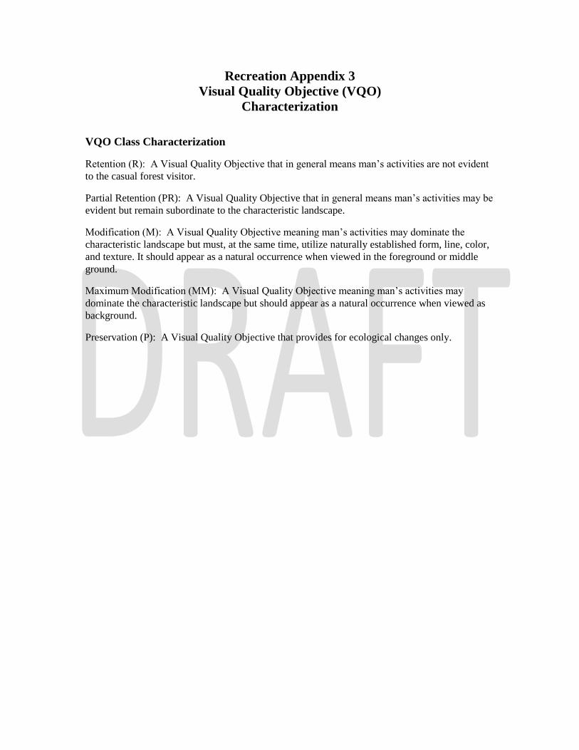
Recreation Appendix 3
Visual Quality Objective (VQO)
Characterization
VQO Class Characterization
Retention (R): A Visual Quality Objective that in general means man’s activities are not evident
to the casual forest visitor.
Partial Retention (PR): A Visual Quality Objective that in general means man’s activities may be
evident but remain subordinate to the characteristic landscape.
Modification (M): A Visual Quality Objective meaning man’s activities may dominate the
characteristic landscape but must, at the same time, utilize naturally established form, line, color,
and texture. It should appear as a natural occurrence when viewed in the foreground or middle
ground.
Maximum Modification (MM): A Visual Quality Objective meaning man’s activities may
dominate the characteristic landscape but should appear as a natural occurrence when viewed as
background.
Preservation (P): A Visual Quality Objective that provides for ecological changes only.
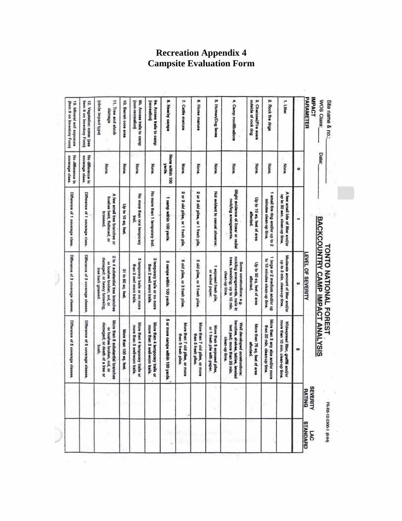
Recreation Appendix 4
Campsite Evaluation Form
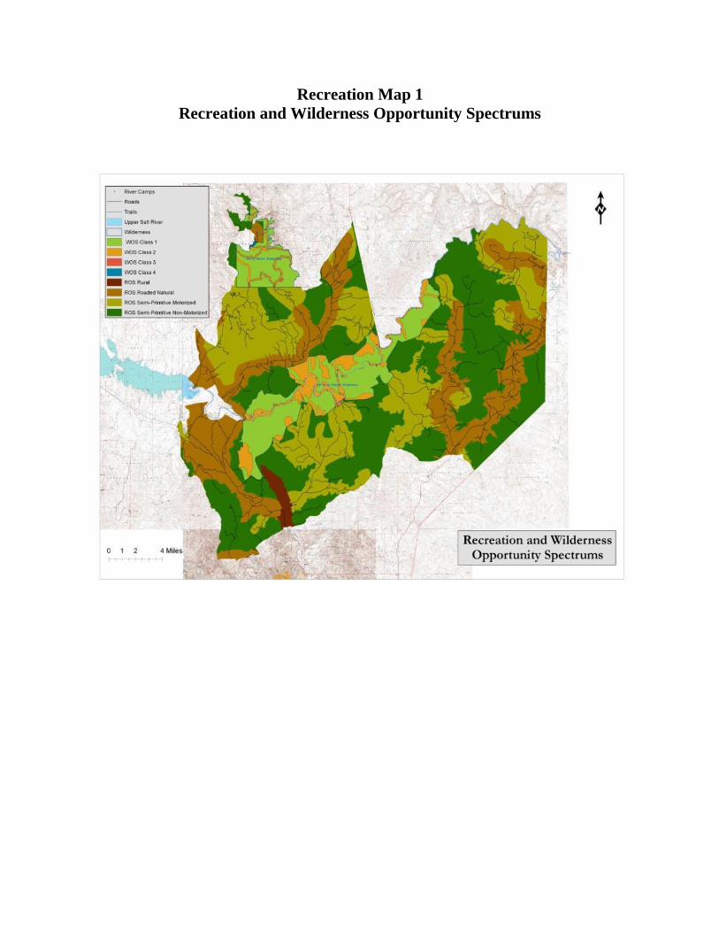
Recreation Map 1
Recreation and Wilderness Opportunity Spectrums
Appendix 5
Recreation Photos
Recreation Photo 1
Recreation Photo 2
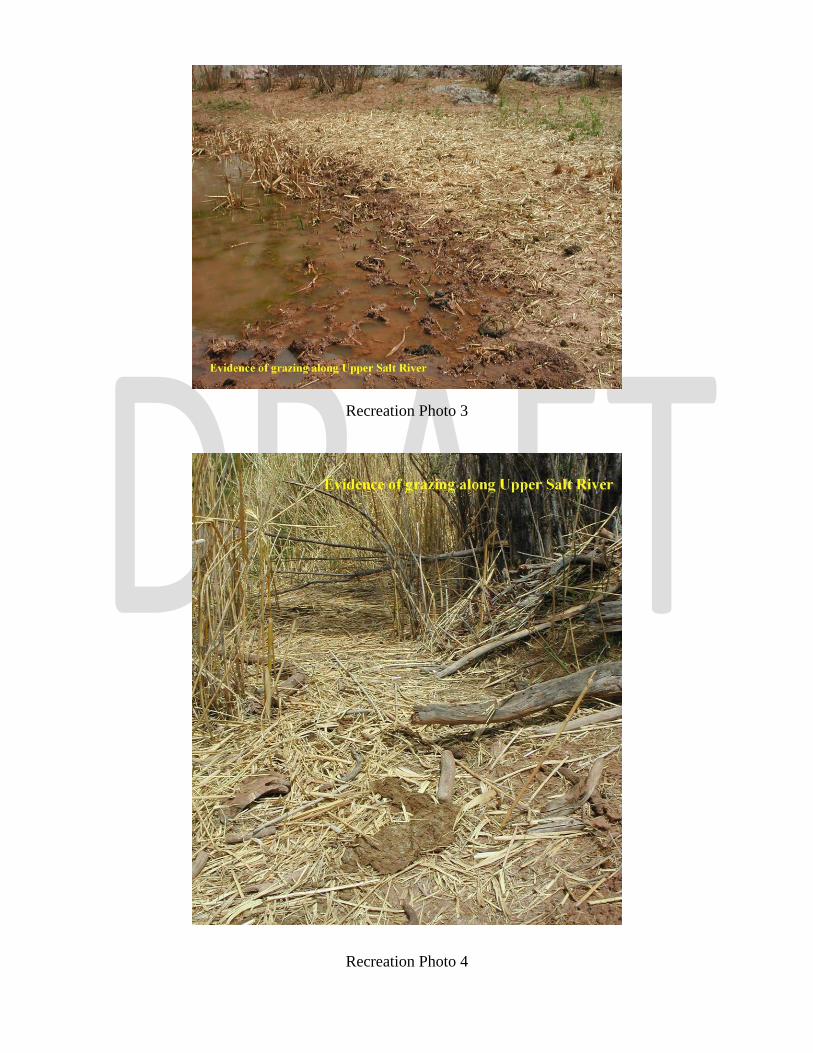
Recreation Photo 3
Recreation Photo 4
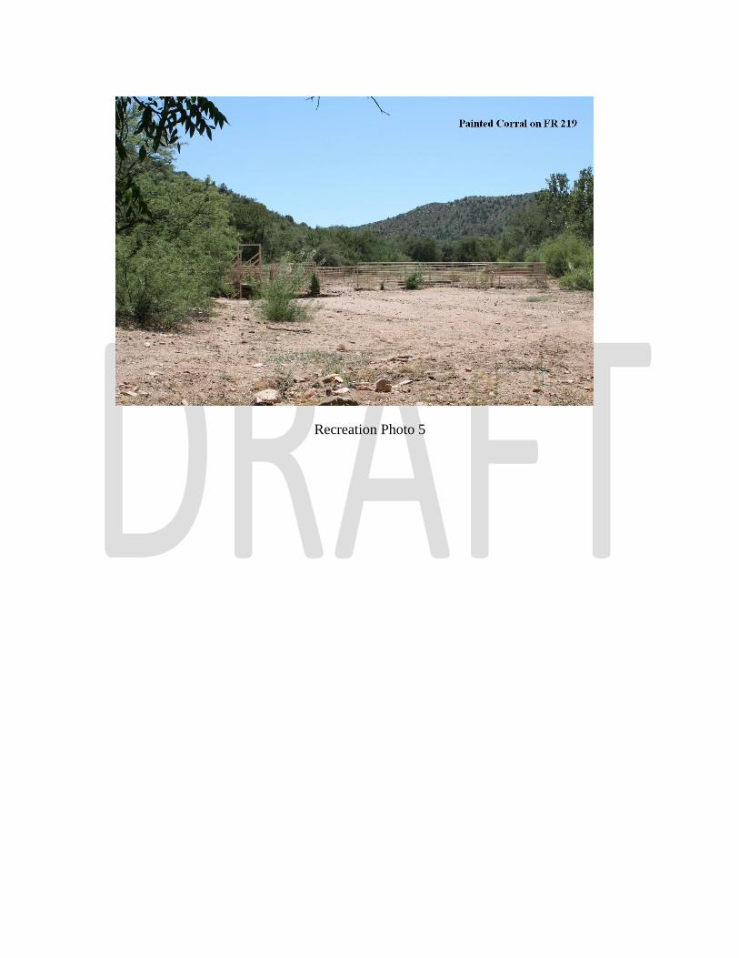
Recreation Photo 5

Recreation References
USDA Forest Service, 1985, “Tonto National Forest Land and Resource Management Plan,” as amended
Tonto National Forest, 1993, “Salt River Canyon Wilderness Implementation Plan,” as amended
Tonto National Forest, 1993, “Implementation Plan for the Upper Salt River,” as amended
Tonto National Forest, 1998, “Sierra Ancha Wilderness Implementation Plan,” as amended
USDA Forest Service, 2011, “Salt River Campsite Condition Inventories 1991-2011,” Tonto NF.
USDA Forest Service, 2008, Forest Service Manual 2300, “Recreation, Wilderness, and Related Resource Management,” as amended
Related Documents