CEN 300 General Information Great Lakes Sailing Directions Pêches et Océans Canada Fisheries and Oceans Canada Corrected to 12/2021

Welcome message from author
This document is posted to help you gain knowledge. Please leave a comment to let me know what you think about it! Share it to your friends and learn new things together.
Transcript
CEN 300General Information
Great Lakes
SailingDirections
Pêches et OcéansCanada
Fisheries and OceansCanada
Corrected to 12/2021
I
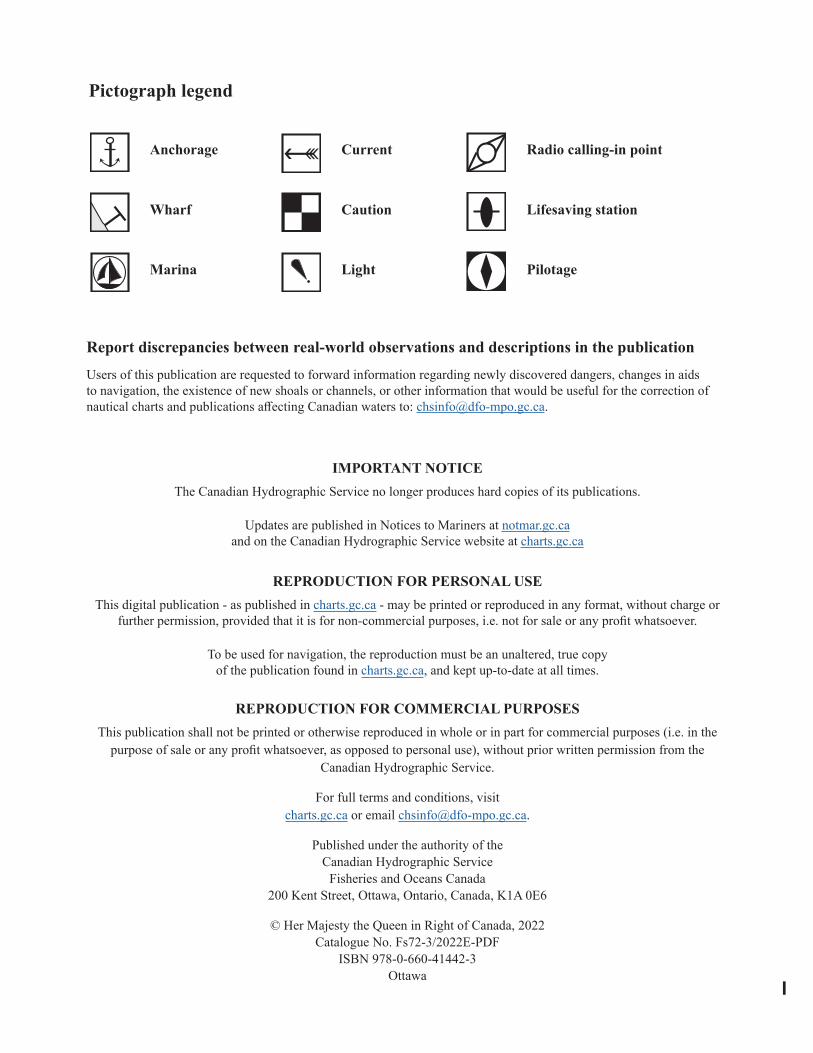
Pictograph legend
Anchorage
Wharf
Marina
Current
Caution
Light
Radio calling-in point
Lifesaving station
Pilotage
Report discrepancies between real-world observations and descriptions in the publication Users of this publication are requested to forward information regarding newly discovered dangers, changes in aids to navigation, the existence of new shoals or channels, or other information that would be useful for the correction of nautical charts and publications affecting Canadian waters to: [email protected].
IMPORTANT NOTICEThe Canadian Hydrographic Service no longer produces hard copies of its publications.
Updates are published in Notices to Mariners at notmar.gc.caand on the Canadian Hydrographic Service website at charts.gc.ca
REPRODUCTION FOR PERSONAL USEThis digital publication - as published in charts.gc.ca - may be printed or reproduced in any format, without charge or
further permission, provided that it is for non-commercial purposes, i.e. not for sale or any profit whatsoever.
To be used for navigation, the reproduction must be an unaltered, true copyof the publication found in charts.gc.ca, and kept up-to-date at all times.
REPRODUCTION FOR COMMERCIAL PURPOSES This publication shall not be printed or otherwise reproduced in whole or in part for commercial purposes (i.e. in the
purpose of sale or any profit whatsoever, as opposed to personal use), without prior written permission from the Canadian Hydrographic Service.
For full terms and conditions, visit charts.gc.ca or email [email protected].
Published under the authority of the Canadian Hydrographic Service
Fisheries and Oceans Canada200 Kent Street, Ottawa, Ontario, Canada, K1A 0E6
© Her Majesty the Queen in Right of Canada, 2022Catalogue No. Fs72-3/2022E-PDF
ISBN 978-0-660-41442-3Ottawa
II
Record of ChangesAs the CHS acquires new information, relevant changes are applied to Sailing Directions volumes in order to maintain safety of navigation. It is the responsibility of the mariner to maintain their digital Sailing Directions file by ensuring that the latest version is always downloaded. Visit charts.gc.ca to download the most recent version of this volume, with all current changes already incorporated.
The table below lists the changes that have been applied to this volume of Sailing Directions. This record of changes will be maintained for the current calendar year only
Chapter /Paragraph Description of Change
III
TAB
LE O
F C
ON
TEN
TS Preface ___________________________________________________________ V Explanatory notes _________________________________________________ VI Abbreviations ____________________________________________________ VIII
CHAPTER 1 General Navigational InformationRoutes and navigational hazards ____________________________________ 1-1 • Ship routing systems _________________________________________ 1-1 • Fishing vessels ______________________________________________ 1-2 • Winter navigation ____________________________________________ 1-2 Nautical publications ______________________________________________ 1-3 • Canadian Hydrographic Service (CHS) publications ________________ 1-3 • Canadian Coast Guard (CCG) publications ________________________ 1-3 Nautical charts ___________________________________________________ 1-4 Magnetic variation ________________________________________________ 1-6 Cables __________________________________________________________ 1-7 Water level information ____________________________________________ 1-7 Aids to navigation _________________________________________________ 1-8 Electronic positioning systems _____________________________________ 1-10 Pilotage ________________________________________________________ 1-10 Canadian Coast Guard (CCG) _____________________________________ 1-11 Use of radio _____________________________________________________ 1-11 Search and rescue ________________________________________________ 1-13 Cold water survival ______________________________________________ 1-14
CHAPTER 2 RegulationsList of Statutes, Regulations, Guidelines and Conventions _______________ 2-1 Regulations ______________________________________________________ 2-2
CHAPTER 3 General Geographic information and Broad Description of Port Facilities
Geographical and physical features __________________________________ 3-1 The provinces ____________________________________________________ 3-3 St. Lawrence River and Great Lakes system ___________________________ 3-5 Port facilities _____________________________________________________ 3-7
CHAPTER 4 Natural ConditionsSeabed __________________________________________________________ 4-1Ice ______________________________________________________________ 4-3 • Types of ice ________________________________________________ 4-3 • Ages of ice _________________________________________________ 4-3 • Concentration _______________________________________________ 4-3 • Forms of floating ice _________________________________________ 4-4 • Surface features _____________________________________________ 4-4 • Other terms common to shipping ________________________________ 4-4 • Ice coverage ________________________________________________ 4-5 Water levels _____________________________________________________ 4-11 Seiches _________________________________________________________ 4-14 Currents _______________________________________________________ 4-15 Meteorological information ________________________________________ 4-16
APPENDICES Sail Plan_________________________________________________________ A-1 Distances between points on the Great Lakes __________________________ A-3
IV
DIAGRAMS Datum, height and clearance diagram ________________________________ 1-6Cold water survival chart _________________________________________ 1-14 Effect of wind on exposed persons __________________________________ 1-15 Median ice cover __________________________________________________ 4-6 Great Lakes water levels __________________________________________ 4-13 Ship icing _______________________________________________________ 4-19
Index ____________________________________________________________ I-1 Geographical Index ______________________________________________ GI-1
V
The First Edition of Sailing Directions, CEN 300 — General Information, Great Lakes, 1996, has been compiled from Canadian Government and other information sources. In general, all hydrographic terms used in this booklet are in accordance with the meanings given in the
Hydrographic Dictionary (Special Publication No. 32), published by the International Hydrographic Bureau.
This edition introduces a new presentation and layout of the geographical areas.
General information for the Great Lakes is grouped in this booklet. It contains navigational information and a brief description of the main port facilities as well as geographic, oceanographic and atmospheric characteristics. A geographical index at the end of this booklet should also be consulted.
The detailed descriptions of the geographical areas is given in a series of volumes and booklets. Their limits are printed on the back cover of the booklets. The appropriate descriptive booklet(s) should be consulted in conjunction with this CEN 300 — General Information booklet.
Tidal, water level and current information has been revised by the Tides, Currents and Water Level Section of the Canadian Hydrographic Service.
Meteorological and ice information has been revised by the Atmospheric Environment Service, Department of the Environment.
The photographs are by the Canadian Hydrographic Service, Department of Fisheries and Oceans.
Users’ comments concerning the format, content or any other matter relating to Sailing Directions would be appreciated and should be forwarded to the Director General, Canadian Hydrographic Service, Department of Fisheries and Oceans, Ottawa, Ontario, Canada K1A 0E6.
PREF
AC
E
VI
Canadian Sailing Directions amplify charted details and provide important information of interest to navigation
which may not be found on charts or other marine publications. Sailing Directions are intended to be read in conjunction with the charts quoted in the text.
Remarks
Buoys are generally described in detail only where they have special navigational significance, or where the scale of the chart is too small to clearly show all the details.
Chart references, in italic in the text, normally refer to the largest scale Canadian chart but occa-sionally a smaller scale chart may be quoted where its use is more appropriate.
Tidal information relating to the vertical mo-vements of the water is not given and the Canadian Tide and Current Tables should be consulted. Howe-ver, abnormal changes in water level are mentioned.
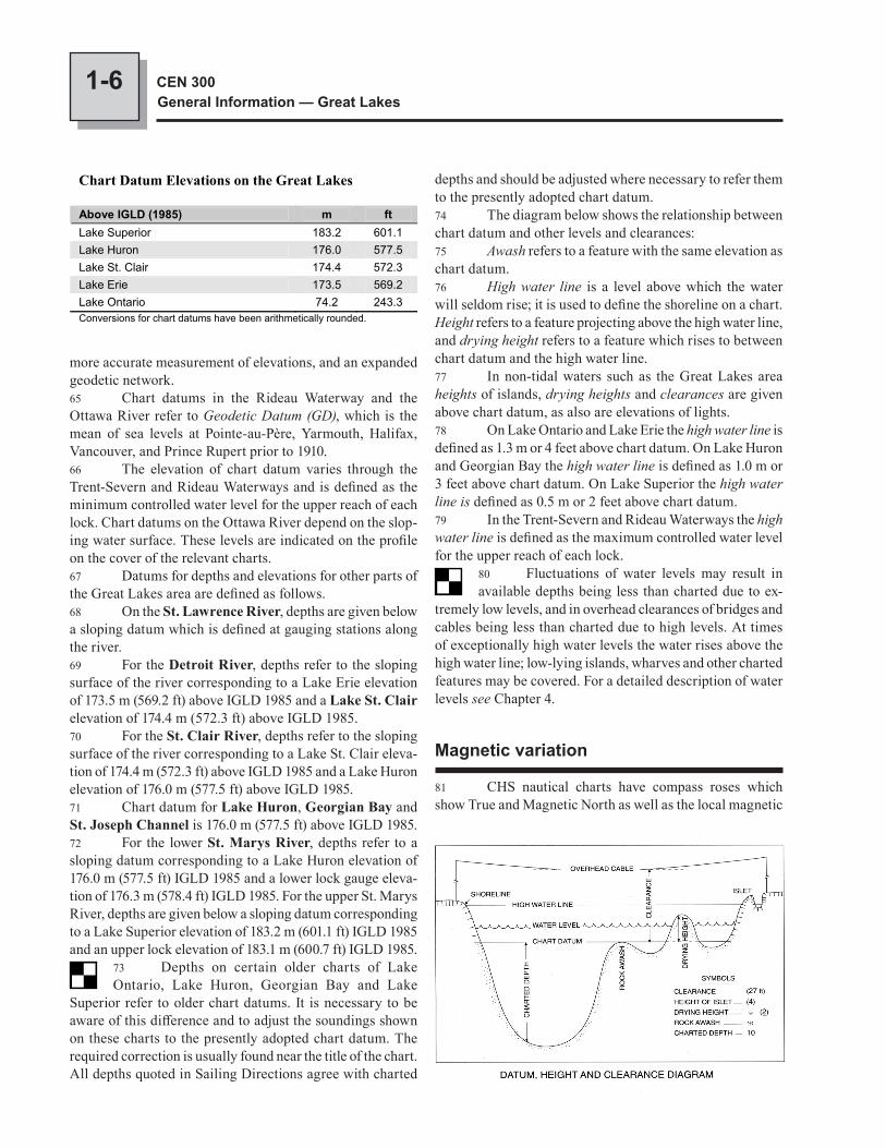
Names have been taken from the most authori-tative source. Where an obsolete name still appears on the chart or is of local usage, it is given in brackets following the official name.
Wreck information is included where drying or submerged wrecks are relatively permanent fea-tures having significance for navigation or anchoring.
Units and terminology used in this booklet
Latitude and longitude given in brackets are approximate and are intended to facilitate reference to the chart quoted.
Bearings and directions are referred to True North (geographic) and are given in degrees from 000° clockwise to 359°. The bearings of conspicu-ous objects, ranges and light sectors are given from seaward. Courses always refer to the course to be made good.
Tidal streams and currents are described by the direction towards which they flow. The ebb stream is caused by a falling tide and the flood stream is caused by a rising tide. Winds are described by the direction from which they blow.
Distances, unless otherwise stated, are ex-pressed in nautical miles. For practical purposes, a nautical mile is considered to be the length of one minute of arc, measured along the meridian, in the
latitude of the position. The international nautical mile, which has now been adopted by most maritime nations, is equal to 1,852 m (6,076 ft).
Speeds are expressed in knots, which means nautical miles per hour.
Depths, unless otherwise stated, are referred to chart datum. As depths are liable to change, par-ticularly those in dredged channels and alongside wharves, it is strongly recommended that these be confirmed by enquiry to the appropriate local authority.
Where sections are quoted verbatim from U.S. Coast Pilot 6, the figures in square brac-kets [thus] after units of measurement are the International System of Units (SI) equivalent in nautical miles, metres or tonnes.
Elevations and vertical clearances are given above chart datum.
Heights of objects, distinct from elevations, refer to the heights of the structures above the ground. A statement, “a hill … m (… ft) high”, is occasion-ally used when there could be no confusion and in this case the reference will signify an elevation.
Deadweight tonnage and mass are expressed in metric tonnes of 1,000 kilograms (2,204.6 pounds). The kilogram is used for expressing relatively small masses.
Figures in brackets following the population identify the census year. The List of Lights, Buoys and Fog Signals number is shown in brackets after the navigational aid (light, leading lights, buoy). The expression “(seasonal)” indicates that it is operatio-nal for a certain period during the year; mariners should consult the List of Lights, Buoys and Fog Signals to determine the period of operation. The expression “(private)” means that the navigational aid is privately maintained; it will not necessarily be mentioned in the List of Lights, Buoys and Fog Signals and its characteristics may change without issuance of a Notice to Shipping.
Time, unless otherwise stated, is expressed in local standard or daylight time. Details of local time kept will be found in Chapter 3 of this booklet.
Public wharf is a Government wharf that is available for general use; it is still shown on older charts as “Government Wharf” or “Govt Whf”.
Conspicuous objects, natural or artificial, are those which stand out clearly from the background
EXPL
AN
ATO
RY N
OTE
S
VII
and are easily identifiable from a few miles offshore in normal visibility.
The expression “small craft” is used to des-ignate pleasure craft and, in general, small vessels with shallow draught.
Pictographs are symbols shown at the begin-ning of certain paragraphs to allow quick reference to
References to other publications:
Canadian Coast Guard• List of Lights, Buoys and Fog Signals• Radio Aids to Marine Navigation (Atlantic and Great Lakes)• Ice Navigation in Canadian Waters• Annual Edition of Notices to Mariners• The Canadian Aids to Navigation System• Merchant Ship Search and Rescue Manual (CANMERSAR)• The International Code of Signals
Environment Canada• Great Lakes Marine Weather Guide• Great Lakes Climatological Atlas
Canadian Hydrographic Service• Canadian Tidal Manual• Chart No. 1 — Symbols, Abbreviations and Terms• Tides in Canadian Waters• Notes on the Use of Loran-C Charts• Canadian Tide and Current Tables• Catalogue of Canadian Nautical Charts and Related Publications (Great Lakes)
St. Lawrence Seaway Management Corporation• The Seaway Handbook
information or to emphasize details. The Pictograph Legend is shown on the inside front and back covers of this booklet.
VIII
Units°C degree Celsius cm centimetre h hour ha hectare kHz kilohertz km kilometre kn knot kPa kilopascal m metre min minute MHz megahertz mm millimetre ft foot t metric tonne ° degree (plane angle) ' minute (plane angle)DirectionsN north NNE north northeast NE northeast ENE east northeast E east ESE east southeast SE southeast SSE south southeast S south SSW south southwest SW southwest WSW west southwest W west WNW west northwest NW northwest NNW north northwestVariousCCG Canadian Coast Guard CHS Canadian Hydrographic Service HF high frequency HW high water LW low water M million, mega MCTS Marine Communications and Traffic Services NAD North American Datum SAR Search and Rescue VHF very high frequency VTS Vessel Traffic Services
AB
BR
EVIA
TIO
NS
CHAPTER 1
General Navigational Information1 Limits of booklet. — This booklet of Sailing Directions offers general navigational, geographic and emer-gency information, as well as information on natural condi-tions (meteorology, ice, currents, etc.) for the St. Lawrence River from Montréal to Lake Ontario and for the Great Lakes. This area includes the waters of the Great Lakes and the connecting waterways including the Welland Canal, Detroit River and the St. Clair River. For a detailed description of any of these regions see the appropriate booklet or volume of Sailing Directions (see the geographical index after the last chapter of this booklet and the index printed on the back cover).2 For the convenience of the user and to provide some necessary continuity, certain United States waters and shoreline are also described in Canadian Sailing Directions, quoting verbatim from U.S. Coast Pilot 6, corrected from U.S. Notices to Mariners to the date of publication.3 Reporting dangers. — All mariners are encouraged to report any dangers to navigation or discrepancies in charted or published information. Members of Canadian Power and Sail Squadrons should report by MAREP. Others should forward a Hydrographic Note or the Marine Information Report and Suggestion Sheet, a copy of which is attached to each monthly edition of Canadian Notices to Mariners.
Routes and navigational hazards
Ship routing systems4 The Great Lakes routing system consists of “Separate Steamer Lanes for Vessels” adopted by the Lake Carriers Association and the Canadian Shipowners Association. Upbound and downbound sailing courses and limits are shown on both Canadian and United States general charts.5 In the interest of safe navigation and environmental protection it is recommended that mariners use such routes in all weather conditions, by day and by night, as far as circum-stances permit. Mariners may, however, exercise discretion in departing from the recommended routes whenever weather or ice conditions make it advisable.5.1 Effective October 11th, 2001, 0000 UTC, all vessels that are:
1-2 CEN 300General Information — Great Lakes
a. of 500 tons gross tonnage or more;b. engaged in towing or pushing a vessel, where the
combined tonnage of the ship and the vessel being towed or pushed is 500 tons gross tonnage or more; or
c. carrying a pollutant or dangerous goods, or engaged in towing or pushing a vessel carrying a pollutant or dangerous goods;
must request clearance 96 hours prior to entering Canadian waters from seaward, or as soon as practical where the estimated time of arrival of the ship in Canadian waters is less than 96 hours after the time the ship departed its last port of call. This will remain in effect until further notice.6 St. Lawrence Seaway traffic control system, oper-ated in the St. Lawrence Seaway between Montréal and the Lake Erie approaches to the Welland Canal, is a marine traffic control system for all vessels other than pleasure craft of less than 19.8 m (65 ft) in length. For the VHF radiotelephone frequencies in use see the table in Chapter 2 quoted from the Seaway Regulations. For full details of the St. Lawrence Seaway traffic control system, consult the Seaway Handbook.7 Marine Communications and Traffic Services. — In the interest of safe navigation in Canadian waters from Long Point light on Lake Erie to De Tour Passage on Lake Huron, the Canadian Coast Guard has established a Marine Communications and Traffic Services (MCTS) Centre at Sarnia, Ontario (42°58'N, 82°24'W). The Centre is equipped with VHF transmitting and receiving facilities, both locally and at remote sites. The Centre is staffed 24 hours a day.8 Full details of the MCTS Centre and the Vessel Traffic Services (VTS) system, including zone coverage, application, responsibility, listening watch, operating pro-cedures, and traffic and other reports, are given in the annual edition of Canadian Notices to Mariners.9 St. Clair and Detroit River Navigation Safety Regulations, quoted in Chapter 2, prescribe speed limits, requirements for traffic calls and reports, and navigation and anchorage rules for vessels operating in the Canadian section of the waters connecting Lake Erie and Lake Huron. The United States government has enacted similar regulations for the waters of the United States section of the waterway.10 Copies of the St. Clair and Detroit River Navigation Safety Regulations, and other Canadian regulations are avail-able from Canada Communication Group — Publishing Division, Ottawa, Ontario K1A 0S9.11 St. Marys River Vessel Traffic Service, operated by the United States Coast Guard, covers the St. Marys River and lower Whitefish Bay from De Tour Reef light to Île Parisienne light, except for the waters of St. Marys Falls Canal. The service, participation in which is mandatory for certain vessels, is designed to prevent collisions and groundings.
Fishing vessels12 Fishing vessels engaged in trawling may be encoun-tered on the Great Lakes. These vessels are restricted in their manoeuvrability; sudden changes in course or speed may cause their gear to foul the bottom, causing damage or loss of expensive gear and endangering the vessel.13 Mariners are advised to observe safe navigational practices when meeting these vessels by giving them a wide berth in plenty of time. The effective use of bridge-to-bridge VHF radiotelephone is encouraged.14 Aquaculture. — There are aquaculture facilities at various locations on the Great Lakes; mariners should make every effort to avoid these areas. A list of these facilities with their locations is published twice a year in Canadian Notices to Mariners. Aquaculture sites are generally shown on charts.
Winter navigation15 The Canadian Coast Guard operates a winter ser-vice to support vessels navigating in Canadian waters of the Great Lakes. This service includes promulgation of the latest information on ice conditions, aids to navigation and rout-ing advice; the provision of icebreakers when available and considered necessary; and the formation of convoys when conditions dictate.16 This service is known as Ice Sarnia and commences about December 1 and terminates when ice conditions per-mit unrestricted navigation. The address of Ice Sarnia is Ice Operations Officer, Canadian Coast Guard, Department of Fisheries and Oceans, Operations Centre, 105 Christina Street South, P.O. Box 2778, Sarnia, Ontario N7T 7W1, telephone (519) 383-1824, fax (519) 337-2498, telex 064 76299.17 Aids to navigation in winter. — Many shore lights are discontinued in winter; some of these are replaced by lower intensity lights. Many buoys are removed; some of these are replaced by spar buoys. Details of seasonal changes in navigational aids are broadcast as Notices to Shipping, or can be obtained from Ice Sarnia.18 Canadian ice advisory service. — In support of the Canadian Coast Guard ice information service and ice-breaking operations, there are regular ice reconnaissance air patrols over the Canadian Great Lakes and the St. Lawrence Seaway in winter and early spring. Aerial reconnaissance is conducted by trained ice observers from the Atmospheric Environment Service of the Department of the Environment. The ice information is broadcast directly from the aircraft to ships equipped with radio facsimile as well as being relayed to Ice Forecasting Central in Ottawa.19 Ice Forecasting Central prepares ice charts and ice forecasts as required during the freeze-up and break-up periods when shipping is active, and sends the information by telex to Ice Sarnia and on request by radio facsimile. Ice
1-3General Navigational Information
CHAPTER 1
charts of the Great Lakes are also available weekly by sub-scription. There is a coordinated exchange of ice data between Ice Forecasting Central and Ice Sarnia and the United States Coast Guard.20 The Canadian Coast Guard icebreakers available for the support of shipping are heavily committed and can-not always be provided at short notice. In order to make the most efficient use of available resources it is important that Ice Sarnia be kept informed on the position and planned movements of vessels in the Great Lakes. Masters or agents should notify Ice Sarnia as soon as their sailing time is known, giving estimated time of departure and destination, in order to receive the latest information.21 The United States Coast Guard operates a similar Great Lakes vessel reporting system to deploy icebreakers in winter and spring to assist marine commerce. Vessels in the system report to the nearest Coast Guard unit on departure and arrival and at designated reporting points. When a vessel makes a report, the Coast Guard will, on request, transmit the latest available information on weather and ice condi-tions along the vessel’s proposed track. Vessels transiting ice areas are requested to include with their vessel report a brief description of ice conditions encountered, showing the loca-tion of the ice and its type, thickness, and average coverage in tenths. A vessel requiring icebreaking assistance should contact the nearest Coast Guard unit on VHF Channel 16 (156.8 MHz).22 A joint United States and Canadian Coast Guard publication Guide to Great Lakes Ice Navigation gives de-tails of ice advisory services, shipping support services and vessel reporting systems. This publication, which should be carried by every vessel sailing in the Great Lakes during the ice season, is available from Ice Sarnia.23 For details of ice conditions in the Great Lakes area see Chapter 4.
Nautical publications
24 The official guides to navigation in Canadian waters of the Great Lakes are published by the Canadian Government. The appropriate charts and publications must be carried, as specified by the Charts and Publications Regulations, 1995 (see Chapter 2). The United States National Ocean Service publishes charts and publications for United States waters.
Canadian Hydrographic Service (CHS) publications25 Catalogues of Nautical Charts and Related Publications are published annually; they inform mariners of the charts and related publications available and required
for safe navigation in Canadian waters. The catalogues offer useful information and list CHS dealers in Canada and for-eign countries. There are five catalogues; four show the chart coverage of CHS and the fifth lists geoscientific publications.26 Nautical Charts are charts designed specifically to meet the needs of navigation. They show depths of water, emphasize dangers to navigation, indicate maritime cultural features, and show topographic detail useful to navigation. Charts also show various aids to navigation and information on tides and currents as well as diagrams and notes.27 Chart l is a booklet listing the symbols and abbrevia-tions used on charts.28 Sailing Directions are volumes or booklets which cover various specific areas. They offer general information important for navigation as well as coastal descriptions, geographic information, and detailed descriptions of port facilities.29 Small Craft Guides are publications designed for use by the recreational boater. They give details of certain areas not covered in other Sailing Directions publications.30 Tide and Current Tables are published annually and offer tide predictions for various ports as well as times of slack water and times and velocities of maximum current at specified locations.31 Atlases of Tidal Currents are illustrated works which cover a region. There are main tidal currents (direc-tion and rate) for different tidal cycle periods. There are five atlases, covering the main shipping lanes in Canadian waters.
Canadian Coast Guard (CCG) publications32 List of Lights, Buoys and Fog Signals is in four volumes published every two or three years; it gives the names and details of the characteristic of lights, lighted buoys, and fog signals in Canadian waters.33 Radio Aids to Marine Navigation is in two volumes published annually; it gives information on CCG MCTS and Vessel Traffic Services centres. Also given is information on marine weather services provided by the Department of the Environment and delivered by CCG.34 Canadian Aids to Navigation System is a brochure which describes the Canadian system and the aids in use (fixed, floating, lighted, radio).35 Annual Edition of Notices to Mariners carries Notices to Mariners 1 to 46 of each year. These Notices in-clude information of a general nature on aids to navigation and marine safety such as radiotelephone communications, pollution, military exercise areas, search and rescue, pilotage, and Vessel Traffic Services.36 Monthly Edition of Notices to Mariners gives im-portant up to date navigational information affecting nautical charts and publications. The release of new charts and new
1-4 CEN 300General Information — Great Lakes
chart user to apply subsequent corrections promulgated in the monthly editions of Canadian Notices to Mariners before using the chart for navigation.44 Most chart dealers do not hand correct charts and thus charts obtained from dealers will generally be corrected only to the date stamped on the chart before it is shipped to the dealer.45 Small craft charts and certain other charts published by the CHS are not hand corrected after publication. Such charts must be corrected by reference to Notices to Mariners issued since the publication date of the charts. A list of such corrections for any particular chart can be obtained from: Nautical Information, Canadian Hydrographic Service, Department of Fisheries and Oceans, Ottawa, Ontario K1A 0E6.46 Chart users are reminded that charts are not cor-rected from Temporary (T) and Preliminary (P) Notices to Mariners. Such notices affecting a chart should be noted on the chart in pencil. The Canadian Coast Guard publishes an annual summary of all (T) and (P) notices in effect at the beginning of each year, and a list of all (T) and (P) notices in effect is also published every three months in the regular monthly editions of Notices to Mariners47 The release of new charts and publications, and of new editions and reprints of existing editions, is announced in Notices to Mariners. Only the latest edition of a chart or publication may legally be used for navigation.48 Reliance on a chart. — The value of a chart depends largely on the accuracy and detail of the surveys on which it is based. The date of survey, or a statement of the authorities on which a chart is based, is given under the title of the chart. Mariners are cautioned, however, that when a chart is com-piled from several sources the dates and areas of the surveys may be difficult to define. For this reason new charts and some new editions will have a source classification diagram to show the type of survey data used in the construction of the chart.49 The appearance of a chart may show the thorough-ness of the surveys on which it is based but it should be borne in mind that a chart drawn from an old survey with few soundings may have had further soundings added to it later from ships’ tracks on passage, thus masking the inadequacy of the original survey. On the other hand, the quality of a chart is not shown only by the number of soundings; new metric charts based on recent surveys show more depth contours and fewer soundings, and some metric charts show information from old charts converted to metres. It is important to use the source classification diagram to assess a chart’s reliability.50 A chart represents general conditions at the time of the original survey and also includes any changes reported to the Canadian Hydrographic Service before the edition date shown on the chart. Areas with sand or mud, especially in
editions of existing charts is also announced through this publication.37 Notices to Shipping are radio navigational warn-ings broadcast by CCG MCTS Centres. Printed versions are available by contacting any CCG office.38 Ice Navigation in Canadian Waters gives informa-tion on ice conditions in Canadian waters, navigation in ice, and ice advisory and shipping support services.39 Caution. — The above-mentioned publications are all affected by continual changes to navigational information and aids to navigation; mariners are cautioned to use only the latest and corrected editions.
Nautical charts
40 Charts. — Under the Charts and Publications Regulations, 1995, of the Canada Shipping Act, the mar-iner must have the appropriate Canadian Hydrographic Service (CHS) charts and publications on board and in use when navigating in Canadian waters.41 The use of symbols and abbreviations on charts is necessary in order to show as much information as possible. Chart 1, Symbols and Abbreviations, a booklet published by the CHS, gives examples and explanations to help with chart interpretation.42 Natural Scale means the relationship between the size of the chart and the size of the earth. For example, 1:15,000 means that one unit on the chart equals 15,000 units on the earth. Here are the different types of charts issued by the CHS and their uses; the scales shown are approximate:
• Harbour Charts are large scale, 1:5,000 to 1:15,000, and are used for navigation in harbours or intricate, hazardous, shoal-infested waters.
• Approach Charts, 1:15,000 to 1:50,000 are used for approaching coasts where a lot of detail is required.
• Coastal Charts, 1:50,000 to 1:150,000 give continu-ous extensive coverage with sufficient inshore detail to make landfall sightings easy.
• General Charts, 1:150,000 to 1:500,000 give exten-sive offshore coverage with enough inshore detail to make landfall.
• Sailing Charts, 1:500,000 and smaller, are used for offshore navigation out of sight of land.
• Small Craft Charts describe some areas not covered by other charts. They are specially designed for rec-reational boaters and are generally published in strip format (accordion folded).
43 Standard navigational charts published by the CHS are up-to-date at the time of publication, and they are then hand corrected from Notices to Mariners to the date stamped on each chart before it is sold. It is the responsibility of the
1-5General Navigational Information
CHAPTER 1
the entrances and approaches to rivers and bays, are subject to change; extra caution is necessary in such areas.51 In areas with reefs and rocks it is always possible that surveys may have failed to find every obstruction. When navigating in such waters, customary routes and channels should be followed; avoid waters where irregular and sudden changes in depth indicate conditions associated with reefs and pinnacle rocks.52 The maximum draught of commercial vessels at the time of the survey should also be considered. Draughts of 15 m (49 ft) were considered to be the maximum until about 1958. For today’s ships of normal draught in much-frequented waters, the reliability of most charts based on early surveys has been confirmed by the safe passage of ships over the years. Vessels with draughts approaching 30 m (98 ft) should exercise care inside the 200 m (656 ft) line in less adequately surveyed areas, even in recognized shipping lanes. In many instances, ships with draughts approaching 30 m (98 ft) may be testing the chart despite the fact that many shallower-draught ships may have passed previously. A ship venturing into unfrequented waters may also be testing the chart for the first time and should exercise due caution.53 In certain parts of the Great Lakes the 20 m (65.6 ft) line can be considered to be the danger line for interlake ships.54 The largest-scale chart of an area should always be used for navigation because dangers cannot be shown with the same amount of detail on small-scale charts. In addition, it sometimes happens that because of production priorities only the largest-scale charts incorporate information from a new survey.55 Charting. — In general, Canadian waters are chart-ed from surveys conducted by the Canadian Hydrographic Service of the Department of Fisheries and Oceans; United States waters are charted by the U.S. Coast and Geodetic Survey (C&GS) of the National Ocean Service. The CHS does not produce charts of the Detroit River, Lake St. Clair, St. Clair River or St. Marys River; these are charted by C&GS. For full details of Canadian chart coverage in the Great Lakes area, consult the Catalogue of Nautical Charts and Related Publications (Great Lakes) published by the Canadian Hydrographic Service.56 Charts, Coast Pilots, Tide Tables, and Tidal Current Tables covering the United States and its territories are published by the National Ocean Service, and are for sale by Distribution Branch (N/CG 33), National Ocean Service, Riverdale, Maryland, USA 20737-1199 and by authorized NOS sales agents.57 Metric charts. — The Canadian Hydrographic Service has embarked on a program to convert all charts to the international metric system. Mariners should pay particular attention to whether the soundings on a chart are shown in fathoms, feet or metres.
58 On new metric charts based on recent surveys, more depth contours will be shown but fewer soundings. With metric charts using information from old charts converted to metres, it is important that the date of the survey should be considered before the appearance of the chart. In such cases an assessment of reliability can best be made from the source classification diagram and from the completeness and detail of depth contours.59 The Canadian Hydrographic Service has also embarked on a program to convert its charts from North American Datum 1927 (NAD 27) to North American Datum 1983 (NAD 83). NAD 83 is considered equivalent to the World Geodetic System 1984 (WGS 84), which has been adopted as the horizontal datum for world-wide use. The difference in position of the same point between NAD 27 and NAD 83 is up to 110 m (361 ft) on the Pacific coast, 60 m (197 ft) on the Atlantic coast, and near zero at Windsor, Ontario. The advantage of the new datum is its compatibility with satellite positioning systems.60 Horizontal positions given by satellite receivers are based on WGS 84 (NAD 83). When the horizontal datum of a chart differs from that used by the positioning equipment, the position must be converted before being plotted on the chart. New charts and new editions of charts have notes indicating whether the chart is based on NAD 27 or NAD 83 and offer information to allow conversion from the other datum.61 Chart datum. — The water level of a lake or river is always changing due to variations in supply and discharge or to meteorological disturbances. For reasons of safety, the depths on a chart refer to a water level which is low enough that the water will seldom be lower. This low water level is called chart datum and is agreed jointly by Canada and the United States for each of the Great Lakes.62 In the Great Lakes area and on the St. Lawrence River downstream of the Port of Montréal as far as Lac Saint-Pierre, elevations of land features and overhead clearances of bridges and cables also refer to chart datum.63 Unless otherwise stated, all chart datum values in the Great Lakes refer to International Great Lakes Datum 1985 (IGLD 1985). This is a reference system used to define water level elevations in the Great Lakes, with the reference zero being the mean water level at Rimouski, Quebec, for the years 1970 to 1988. The water levels on each of the Great Lakes for the years 1982 to 1988 were then used to define the elevation of chart datum for each lake; 1985 (the central year of this period) gives the datum its name.64 IGLD 1985 was brought into use in January 1992; it replaced the previous reference system, which was IGLD 1955, and gives a slightly different value to the chart datum for each lake. This is a result of changes to the value of elevations due to using a different zero reference point and to minor adjustments for the earth’s crustal movement,
1-6 CEN 300General Information — Great Lakes
depths and should be adjusted where necessary to refer them to the presently adopted chart datum.74 The diagram below shows the relationship between chart datum and other levels and clearances:75 Awash refers to a feature with the same elevation as chart datum.76 High water line is a level above which the water will seldom rise; it is used to define the shoreline on a chart. Height refers to a feature projecting above the high water line, and drying height refers to a feature which rises to between chart datum and the high water line.77 In non-tidal waters such as the Great Lakes area heights of islands, drying heights and clearances are given above chart datum, as also are elevations of lights.78 On Lake Ontario and Lake Erie the high water line is defined as 1.3 m or 4 feet above chart datum. On Lake Huron and Georgian Bay the high water line is defined as 1.0 m or 3 feet above chart datum. On Lake Superior the high water line is defined as 0.5 m or 2 feet above chart datum.79 In the Trent-Severn and Rideau Waterways the high water line is defined as the maximum controlled water level for the upper reach of each lock.
80 Fluctuations of water levels may result in available depths being less than charted due to ex-
tremely low levels, and in overhead clearances of bridges and cables being less than charted due to high levels. At times of exceptionally high water levels the water rises above the high water line; low-lying islands, wharves and other charted features may be covered. For a detailed description of water levels see Chapter 4.
Magnetic variation
81 CHS nautical charts have compass roses which show True and Magnetic North as well as the local magnetic
more accurate measurement of elevations, and an expanded geodetic network.65 Chart datums in the Rideau Waterway and the Ottawa River refer to Geodetic Datum (GD), which is the mean of sea levels at Pointe-au-Père, Yarmouth, Halifax, Vancouver, and Prince Rupert prior to 1910.66 The elevation of chart datum varies through the Trent-Severn and Rideau Waterways and is defined as the minimum controlled water level for the upper reach of each lock. Chart datums on the Ottawa River depend on the slop-ing water surface. These levels are indicated on the profile on the cover of the relevant charts.67 Datums for depths and elevations for other parts of the Great Lakes area are defined as follows.68 On the St. Lawrence River, depths are given below a sloping datum which is defined at gauging stations along the river.69 For the Detroit River, depths refer to the sloping surface of the river corresponding to a Lake Erie elevation of 173.5 m (569.2 ft) above IGLD 1985 and a Lake St. Clair elevation of 174.4 m (572.3 ft) above IGLD 1985.70 For the St. Clair River, depths refer to the sloping surface of the river corresponding to a Lake St. Clair eleva-tion of 174.4 m (572.3 ft) above IGLD 1985 and a Lake Huron elevation of 176.0 m (577.5 ft) above IGLD 1985.71 Chart datum for Lake Huron, Georgian Bay and St. Joseph Channel is 176.0 m (577.5 ft) above IGLD 1985.72 For the lower St. Marys River, depths refer to a sloping datum corresponding to a Lake Huron elevation of 176.0 m (577.5 ft) IGLD 1985 and a lower lock gauge eleva-tion of 176.3 m (578.4 ft) IGLD 1985. For the upper St. Marys River, depths are given below a sloping datum corresponding to a Lake Superior elevation of 183.2 m (601.1 ft) IGLD 1985 and an upper lock elevation of 183.1 m (600.7 ft) IGLD 1985.
73 Depths on certain older charts of Lake Ontario, Lake Huron, Georgian Bay and Lake
Superior refer to older chart datums. It is necessary to be aware of this difference and to adjust the soundings shown on these charts to the presently adopted chart datum. The required correction is usually found near the title of the chart. All depths quoted in Sailing Directions agree with charted
Chart Datum Elevations on the Great Lakes
Above IGLD (1985) m ftLake Superior 183.2 601.1Lake Huron 176.0 577.5Lake St. Clair 174.4 572.3 Lake Erie 173.5 569.2Lake Ontario 74.2 243.3 Conversions for chart datums have been arithmetically rounded.
1-7General Navigational Information
CHAPTER 1
variation and its annual change. Isogonic lines (lines of equal magnetic variation) are printed on certain charts.82 When using a magnetic compass, allowance must be made for the gradual changes in variation. Over a period of years the magnetic compass rose on a chart will become slightly in error, and on small scale charts the variation may also change from one side of the chart to the other side. From the east end of Lake Ontario to the west end of Lake Erie, for instance, the variation changes by 9°; from the east end of Georgian Bay to the west end of Lake Superior the variation changes by 12°.83 The change in variation is very rapid in some parts of the world and should always be taken into consideration.84 The Geological Survey of Canada publishes a Magnetic Declination Chart (Sheet No. 10 of the Geophysical Atlas Series) showing lines of equal magnetic declination and annual change. This is available from Geological Survey of Canada, 601 Booth Street, Ottawa, Ontario K1A 0E8.
Cables
85 Canadian charts no longer differentiate be-tween high voltage power lines and other less lethal
types of overhead or submerged cables; all overhead lines and submarine cables must be treated with the same degree of caution.
86 Overhead cables. — Overhead clearances of bridges and cables in the Great Lakes area, being
in non-tidal waters, are given above chart datum. This means that the height of the water level above chart datum must be subtracted from the charted clearance to give the actual clearance at a particular time. Certain other conditions may also reduce the overhead clearance. Some, such as heavy branches hanging on the overhead cable or a heavy load of wet snow or ice, may be obvious but others, such as damage to a bridge or to a supporting pole, may not be so noticeable.87 The actual clearance of a power transmission line also depends on the temperature. When the temperature of the cable rises, it expands and its clearance decreases; when the temperature of the cable falls, it contracts and its clear-ance increases. Under certain exceptional conditions, the decrease of clearance of the cable caused by extremely high operating temperatures is greater than that due to a load of snow or ice.88 Mariners are further cautioned to allow extra clearance when passing under transmission lines carrying high voltages; a safe clearance depends on the line voltage and possible overvoltages. To avoid the dangers of possible electrical discharge when passing under such cables, it is necessary to allow a safe margin of at least 7 m (23 ft).
89 Overhead cables are subject to frequent change as new cables are installed and existing cables are removed or modified. Current editions of charts may not indicate all overhead cables in an area.
90 Submarine cables. — Submerged power and telephone cables are laid across the channel and
between islands in many areas. Where known, cable areas and the individual tracks of submerged cables are shown on the charts but submarine cables are subject to frequent change as new cables are laid and existing cables recovered or modified. For this reason charts may not show all cables.91 Mariners are cautioned to avoid anchoring or fishing near a submerged cable in order to avoid any possibility of entanglement or damage.92 If an anchor or fishing gear has picked up or becomes attached to a cable and does not easily come loose no further attempt should be made to free it; it is better to cut the lines and abandon the anchor or fishing gear than to risk damage to the cable and death by electrocution.93 See the section on Protection of submarine cables in Chapter 2 for more information.
Water level information
94 There are water level gauges on the St. Lawrence River at Montréal, Saint-Lambert, La Prairie, Côte Sainte-Catherine, Lachine, Pointe-Claire, Beauharnois, Pointe-des-Cascades, Coteau-du-Lac, Coteau-Landing, Summerstown, Cornwall, Iroquois and Brockville; in Lake Ontario at Kingston, Cobourg, Toronto, Burlington and Port Weller Harbour; in Lake Erie at Port Colborne, Port Dover, Port Stanley, Erieau, Kingsville and Bar Point; in the Detroit River at Amherstburg and La Salle; in Lake St. Clair at Tecumseh and Belle River; and in the St. Clair River at Port Lambton and Point Edward.95 There are water level gauges in Lake Huron and Georgian Bay at Point Edward, Goderich, Tobermory, Collingwood, Parry Sound, Little Current and Thessalon. There are also gauges at the upper and lower ends of the Canadian lock at Sault Ste. Marie, and in Lake Superior at Gros Cap, Michipicoten Harbour, Rossport and Thunder Bay.96 The Canadian Hydrographic Service also operates a network of voice-announcing water level gauging stations on the Great Lakes and St. Lawrence River. These can be accessed by telephone:97 When one of these gauging stations is called, the caller will be asked to press 1 on the touch-tone telephone for English or 2 for French. If a touch-tone phone is not used, the message in English will start after a few seconds and the French message will follow. The message gives the present water level in metres above chart datum at that station,
1-8 CEN 300General Information — Great Lakes
followed by the high and low water levels recorded during the previous 12 hours. The height of the presently adopted chart datum for that station is then given in metres above International Great Lakes Datum 1985. Pressing 1 or 2 at any time during the message will start it again from the begin-ning, and 0 will end the call. Please call the Burlington office at (905) 336-4844 during office hours (08:00 to 16:00) or fax to (905) 336-8916 or by Internet at [email protected] to report any problems or to obtain additional information.98 Daily water levels for the Port of Montréal can be obtained through the MCTS Centre at Montréal. Daily water levels for Summerstown and Iroquois lock (above the lock) can be obtained through Seaway Beauharnois and Seaway Iroquois Traffic Control Stations. Weekly mean water levels for Lake Ontario, Lake Erie, Lake Huron, Georgian Bay and Lake Superior are broadcast four times daily by Canadian Coast Guard MCTS Centres. Water level information for the Detroit River, Lake St. Clair and St. Clair River can be obtained from the United States Coast Guard, Group Detroit, either by marine radio or by telephone at (313) 226-6930.99 In the Trent-Severn and Rideau Waterways, the water level can be obtained from the lock-master or observed at water level staffs installed at most locks.100 Monthly mean levels and a six month forecast for each of the Great Lakes are published in the form of a Monthly Water Level Bulletin. The bulletin is available at http://chswww.bur.dfo.ca/danp. Information on present or historical levels can also be obtained by calling the Burlington office at (905) 336-4844.101 In order to determine the depth of water likely to be encountered during calm weather, the observed or forecast water level, adjusted to the datum of the chart if necessary, may be applied to the charted depth. If water level informa-tion cannot be obtained from any of the above-mentioned
sources, the hydrograph on the chart may be used to estimate the water level and the possible range of levels.
Aids to navigation
102 This section refers to the following Canadian Cost Guard publication: The Canadian Aids to Navigation System, the Lists of Lights, Buoys and Fog Signals, and Radio Aids to Marine Navigation (Atlantic and Great Lakes). (These publications were described earlier in this chapter.)103 Range daymarks. — Unless otherwise stated, daymarks for leading lights described in Sailing Directions are of the shape for typical range daymarks as shown in the coloured diagram from The Canadian Aids to Navigation System.104 List of Lights, Buoys and Fog Signals, Inland Waters covers the Great Lakes area. Corrections to this publication are published in the monthly editions of Notices to Mariners. These corrections should be inserted in the parent publication to keep it up to date. Consult List of Lights, Buoys and Fog Signals for full details of the characteristics of lights, light buoys and fog signals.
105 Buoys. — Mariners should not rely on buoys being in their charted positions at all times. Buoys
should be regarded as aids to navigation and not as infallible navigation marks. The position of any buoy may not be as charted due to the effects of weather or circumstance. Mariners should always navigate their vessels by bearings or angles on fixed shore objects and by soundings whenever possible, rather than by complete reliance on buoys.106 Large areas of Canadian navigable waters freeze over in winter and many buoys are lifted for the ice season. Some of these are replaced by spar buoys or other types of buoys. Details of winter aids to navigation are promulgated in Canadian Notices to Shipping. The movement of ice and the operation of icebreakers can move buoys from their charted positions.107 In cases where it is necessary to establish a buoy near an existing aid to navigation or a navigational hazard such as a shoal, sounding, reef or ledge, the buoy symbol may be offset slightly on the chart so that the existing symbol or hazard is not overprinted.108 Light buoys, buoys using sound signals (bell or whistle), and fog signals may not give their true character-istics due to mechanical failure, icing or storm effect, or (in the case of bell and whistle buoys) calm weather.109 Buoyage. — The Canadian system of buoyage is based on Region B of the Maritime Buoyage System developed by the International Association of Lighthouse Authorities and adopted by all major maritime nations. In Region B, which includes all of North and South America,
Voice-Announcing Water Level Gauging Stations
Location Telephone No. St. Lawrence River at Cornwall (613) 930-9373
St. Lawrence River below the lock at Iroquois (613) 652-4839
St. Lawrence River at Brockville (613) 345-0095
Lake Ontario at Cobourg (905) 372-6214
Lake Erie at Port Dover (519) 583-2259
Detroit River at Amherstburg (519) 736-4357
St. Clair River at Port Lambton (519) 677-4092
St. Clair River at Point Edward (519) 344-0263
Lake Huron at Thessalon (705) 842-2215
Lake Superior at Michipicoten (705) 856-0077
Lake Superior at Rossport (807) 824-2250 These telephone numbers were correct as of February 11, 2004.
1-9General Navigational Information
CHAPTER 1
Japan, the Republic of Korea, and the Philippines, a vessel navigating in the upstream direction keeps green buoys to port and red buoys to starboard. The shape and/or colour of the buoy and the flash characteristic of the light on the buoy indicate the function of the buoy. It is essential that marin-ers use up-to-date charts with this system. Chart 1, Symbols and Abbreviations explains the buoyage symbols used on Canadian charts. The Canadian system includes Lateral, Cardinal and Special buoys.110 The Lateral System of buoyage indicates the course of a navigable waterway; the sides of the navigable waterway are indicated by buoys of a defined shape, colour or light characteristic in relation to the upstream direction. This upstream direction is the direction from seaward, to-ward the head waters, into a harbour, up a river, or with the flood tidal stream. In general, the upstream direction is in a southerly direction along the Atlantic coast, in a northerly direction along the Pacific coast, and in an easterly direction along the Arctic coast. In some waters the upstream direction is indicated on charts by lines and arrows.111 Lateral buoys indicate the side on which they may be safely passed. There are five types of lateral buoys: port-hand, starboard-hand, port bifurcation, starboard bifurca-tion and fairway.111.1 Isolated danger buoys mark hazards that have navigable water all around them, such as a rock or a wreck, and should be kept to port when passing. Consult the chart for details of the obstruction.112 Cardinal buoys indicate the location of the safest or deepest water by reference to the cardinal points of the compass. There are four cardinal buoys: north, east, south and west.113 Special purpose buoys convey information which, while important, is not primarily intended to assist in navi-gation. They may include a variety of shapes of lighted and unlighted buoys, and they may have yellow reflective ma-terial. Except for the Ocean Data Acquisition System (ODAS) buoy, which is an anchored oceanographic data buoy, special purpose buoys may have a flashing yellow light; an ODAS buoy may have a group flashing yellow light.114 Many special buoys are privately owned. As re-quired by the Private Buoy Regulations, such buoys must be marked with the letters “PRIV” and the owner’s name, address and telephone number. They will not display num-bers or letters conforming to the Coast Guard identification system.115 Control buoys mark areas where boating is re-stricted. Explanations of the various symbols used to indicate the nature of the restriction are given in the Vessel Operation Restriction Regulations of the Canada Shipping Act, 2001.116 Hazard buoys, introduced in January 1992, mark random hazards such as rocks and shoals.
117 Hazard buoys differ from isolated danger buoys, which mark isolated dangers such as rocks and shipwrecks along specific routes and have navigable water around them. Hazard buoys mark random rocks and shoals and may or may not have navigable water around them, and would not normally be on routes marked by Coast Guard buoys.118 It is anticipated that the most common use of a Hazard buoy will be that of a Private Buoy, placed by indi-viduals and organizations in areas where Coast Guard policy does not provide for Aids to Navigation service at public expense.119 Buoy numbering. — Only starboard and port hand buoys are numbered; starboard hand buoys have even num-bers and port hand buoys have odd numbers. Buoy numbers increase in the upstream direction and are kept in sequence on both sides of a channel by omitting numbers where required. Buoy numbers are usually preceded by one or two letters to help with channel identification. Other types of buoys do not have numbers but are identified only by letters, though all buoys may have a name as well as a number or letter. All buoy numbers and letters are white or reflective silver.120 Sound signals. — Any of the buoys in the Canadian buoyage system may be fitted with a bell or a whistle activated by the motion of the buoy in the water. Such buoys are gener-ally used only in coastal waters where there is enough buoy movement to activate the sound device, and where a sound signal is needed to help locate the buoy in poor visibility.121 Daybeacons are sometimes used to mark channel entrances, approaches and bridges. The hand of daybeacons, starboard or port hand, is determined in the same way as that of buoys, and they indicate the channel or the preferred channel.122 Emergency lights. — In the interest of safety, cer-tain light stations have emergency lights; these are noted in List of Lights, Buoys and Fog Signals. The emergency light is of lesser intensity than the main light and is normally vis-ible for 5 miles on a dark night with clear atmosphere. An emergency light is automatically activated by failure of the main light and may be operating without a covering Notice to Shipping.123 The standard characteristic of an emergency light is group flashing (6) 15 seconds, i.e. 6 flashes, each of ½ second duration, followed by a period of darkness of 7 seconds.124 Note. — More information on aids to navigation is given in the booklet The Canadian Aids to Navigation System, published by the Canadian Coast Guard and available from most chart dealers and from all Canadian Coast Guard offices.125 Radar reflectors. — Many buoys and shore struc-tures have special reflectors to help them reflect radar signals. Radar reflectors may also be established as independent aids to navigation.
1-10 CEN 300General Information — Great Lakes
the immediate discontinuation of a particular satellite cor-rection. Reports indicate that some user equipment does not properly recognize this “do not use” correction flag and as a result erroneously processes it as a correction. This can result in position errors as large as 15 kilometres while the receiver is in DGPS mode. DGPS users are advised to contact the manufacturer of their equipment to determine if an upgrade is required.
146.2 Caution. — Vessels with modern naviga-tional equipment such as GPS or DGPS can navigate
with a degree of accuracy and precision that was not available to hydrographic surveyors until very recently. Chart users are cautioned that the charted positions of islands and other features shown on older nautical charts may not agree with latitude and longitude positions given by modern navigational equipment. Such older charts are generally on an unknown or assumed datum, as noted in the Horizontal Datum note printed on each chart. Positions on such charts should be con-firmed by reference to range and bearing of known objects.
Pilotage
147 Pilotage is compulsory on the Great Lakes for all vessels of Foreign Registry and any other vessel
which does not qualify for exemption as prescribed in the Great Lakes Pilotage Regulations.153 Exemptions from compulsory pilotage may be grant-ed to vessels meeting certain conditions under Section 4 of the Great Lakes Pilotage Regulations. Full details are available from Great Lakes Pilotage Authority Ltd., Cornwall, Ontario.154 Masters of vessels requiring pilotage service in the waters of the Great Lakes must give at least 12 hours notice to the Pilot Offices to avoid a delay in obtaining a pilot. This message, giving ship’s name, draught, estimated time of ar-rival or departure, and destination, must be confirmed at least 4 hours prior to arrival at a pilot station or departure from a port, and can be relayed via any Coast Guard radio station.155 Pilot control areas and message addresses are shown below.156 For details of pilotage services available and pro-cedures to be followed, consult:
• Annual Edition of Notices to Mariners;• Radio Aids to Marine Navigation (Atlantic and Great
Lakes);• Atlantic Pilotage Authority Regulations;• Laurentian Pilotage Authority Regulations;• Great Lakes Pilotage Regulations.
157 Vessels requesting a pilot at Sault Ste. Marie must do so 4 hours before their estimated time of arrival at De Tour (for westbound vessels) or Gros Cap light (for eastbound ves-sels). Westbound vessels must order by a message addressed
126 Operators of small craft are encouraged to have a radar reflector as high as possible in their craft, particularly in low visibility, as this will greatly increase the likelihood of being detected by a ship’s radar. Radar reflectors are available from most ship chandlers.127 Radar beacons (Racons). — When an aid to navi-gation gives a poor radar return, equipment may be fitted to enhance the echo. Often this is done with a radar reflector but sometimes a radar transponder beacon is used. Such a beacon is known as a Racon. Most Racons used by the Canadian Coast Guard on the Great Lakes are of the frequency-agile type and consist of a transmitter that responds to any radar transmission in the X or S band radar frequencies. The Racon signal appears on the radar display as a line from the approximate position of the Racon towards the outer edge of the display, along the line of its bearing from the ship. The display may be a solid line or it may be broken into a code consisting of a series of dots and dashes, as published in Radio Aids to Marine Navigation (Atlantic and Great Lakes). The positions of Racons are shown on Canadian charts.128 Should a Racon fail to give a response on a ship’s radar, report this fact immediately to the nearest Coast Guard MCTS Centre so that the information can be broadcast as a Notice to Shipping.
Electronic positioning systems
145 GPS (NAVSTAR Global Positioning System) is a worldwide, continuous-coverage satellite navigation system developed by the U.S. military. Declared operational by the U.S. Department of Defense in July 1995, navigation signals are available to everyone.146 GPS uses 24 satellites arranged in six orbits so that a receiver at any location will always be able to receive 4 satel-lites and will thus be able to compute fixes continuously. Fix accuracy is controlled by U.S. authorities through “selective availability” and is about 100 m.
146.01 Caution. — The Canadian Coast Guard’s Differential Global Positioning System (DGPS)
broadcast contains built in health information designed to alert a DGPS user receiver of an out of tolerance or fault condition. During testing, it was found that some user DGPS receivers did not process the health information properly. Im-proper processing by a user equipment can result in incorrect positions.146.02 Please contact your DGPS manufacturer or supplier to ensure that your receiver is capable of processing the DGPS Reference Station Health information correctly.
146.1 Caution. — The Canadian Coast Guard has received reports of differential GPS (DGPS) receivers
apparently ignoring the broadcast alarm which should signal
1-11General Navigational Information
CHAPTER 1
to Pilots De Tour through Rogers City Radio or any Coast Guard MCTS Centre. Eastbound vessels must order by a message addressed to Pilots De Tour through Sault Ste. Marie Coast Guard Radio or any Coast Guard MCTS Centre.
Canadian Coast Guard (CCG)
158 The CCG includes the fleet of ships and aircraft and the associated shore services with which the Department of Fisheries and Oceans carries out its responsibilities to mar-ine navigation. The CCG operates in Canadian waters from the Great Lakes to the northernmost channel of the Arctic Islands, and from the Pacific coast to Sable Island off the coast of Nova Scotia.159 The fleet consists of about 83 vessels, 29 helicopters and 3 hovercraft. It includes heavy icebreakers and icebreak-ing buoy tenders. It also includes lighthouse supply vessels, buoy vessels, survey craft, and vessels for specialized duties such as search and rescue, marine research, and shallow-draught operations on the Mackenzie River system and in the Arctic.160 The ships of the CCG maintain and supply floating and fixed aids to navigation in Canadian waters, without which commercial shipping could not operate.161 In winter they assist shipping in the Gulf of St. Lawrence and in east coast waters, as well as providing flood control icebreaking service on the St. Lawrence River. At the same time, they provide icebreaker assistance when needed for commercial shipping using the summer sea route from the Atlantic Ocean through Hudson Bay to Churchill, Manitoba, and shipping to mining developments in the Arctic.162 In summer, while the greater part of the fleet is concentrating on its task of keeping shipping channels safe for marine traffic, the icebreakers escort commercial ships carrying supplies to civilian communities and defence estab-lishments throughout the Arctic.163 These duties fulfilled, many of the ships then serve as floating bases for scientific parties engaged in oceano-graphic, hydrographic and related studies.
164 The CCG also carries out duties as the marine ele-ment of the search and rescue organization, for which the Canadian Armed Forces have the overall responsibility. (This is discussed later in this chapter.)165 Principal bases for CCG ships are the district offices at St. John’s, Newfoundland; Dartmouth, Nova Scotia; Saint John, New Brunswick; Charlottetown, Prince Edward Island; Québec and Montréal, Quebec; Prescott and Parry Sound, Ontario; Selkirk, Manitoba; Victoria and Prince Rupert, British Columbia; and at Hay River, on Great Slave Lake in the Northwest Territories.166 The CCG also has responsibility for various marine activities such as:
• Services to marine navigation: maintenance of aids to navigation; Vessel Traffic Services; sounding and dredging of waterways; editing of Notices to Mariners.
• Ship safety: ship inspections; issuance of certificates; certification of masters and officers; investigation of pollution; port authority.
• Marine emergencies: response to shipping casualties or to marine spills.
• Communications and telecommunications services: maintenance and operation of a network of radio sta-tions and radio aids; broadcast of messages, Notices to Shipping and Weather Warnings.
• Harbours and Ports: administration and maintenance of certain ports, harbours and government wharves.
Use of radio
166.1 Caution. — Reception or transmission of VHF DSC radio frequencies is markedly degraded
over land areas. The Trent-Severn Waterway and the Rideau Canal may have areas of poor or no contact with a Marine Communications and Traffic Services (MCTS) centre; in particular, the Ottawa River from about MacLaren’s Landing to Lake Timiskaming is an area of no MCTS coverage. Con-sult Section 4 of Radio Aids to Marine Navigation (Atlantic, St. Lawrence, Great Lakes, Lake Winnipeg and Eastern
Pilot Control Areas and Message Addresses
Control Areas Message Addresses Saint-Lambert lock to Lake Ontario Pilots Cornwall Lake Ontario – ships east of Cobourg Pilots Cornwall Lake Ontario – ships west of Cobourg Pilots Port Weller Welland Canal Pilots Port Weller Lake Erie – ships east of Cleveland Pilots Port Weller Lake Erie – ships west of Cleveland Pilots Port Huron Lake St. Clair, Detroit and St. Clair Rivers Pilots Port Huron Lakes Huron, Michigan and Superior, and St. Marys River Pilots Superior
1-12 CEN 300General Information — Great Lakes
urgency communications are given in Radio Aids to Marine Navigation (Atlantic and Great Lakes).173 Canadian Coast Guard MCTS Centres provide a Continuous Marine Broadcast service on VHF Channel 21B (161.65 MHz) and Channel 83B (161.775 MHz). This service provides weather forecasts, near shore weather forecasts, ship and lighthouse weather observations, and other pertinent in-formation such as reports on dangers to navigation and water level conditions. For more information on weather reports see Chapter 4.174 Radio medical advice. — Masters of vessels can obtain medical advice by addressing a radiotelegram or radiotelephone call to Radiomedical and routing it via the nearest coastal radio station, which will relay the mes-sage to the nearest medical authority of the Department of National Health and Welfare and transmit the reply to the ship. There is no charge for this service, except where long distance telephone charges are involved. It is possible to get around difficulties of communication due to poor reception or linguistic problems by using the medical section of the International Code of Signals, which can be a very useful tool for masters and doctors.175 United States Coast Guard radio stations and United States Coast Guard vessels under way maintain a continuous watch on Channel 16 (156.8 MHz). This frequency may be used to establish initial contact and is also used to transmit and receive distress, urgency and safety information. The United States Coast Guard working and broadcast frequency is Channel 22A (157.1 MHz), and all marine information broadcasts are made on this frequency. Full details are given in United States Coast Guard, Ninth District, Local Notice to Mariners, Special Edition.176 Marine Communications and Traffic Services Centre. — A Canadian Coast Guard Marine Communications and Traffic Services (MCTS) Centre operates on a continuous 24-hour basis at Sarnia, Ontario. It keeps mariners informed of changes in conditions affecting navigation by issuing and controlling Notices to Shipping (NOTSHIPs). This centre is responsible for issuing NOTSHIPs for the navigable waters of the St. Lawrence River above the upper lock at Beauharnois and the Canadian waters of the Great Lakes, Detroit River, Lake St. Clair, St. Clair River, the Welland Canal, St. Marys River, and Lake Winnipeg.177 NOTSHIPs are given a reference number, beginning with C1/(year) and increasing consecutively until the end of the year. They are broadcast by Canadian Coast Guard MCTS Centres on the frequencies listed in Part III of Radio Aids to Marine Navigation (Atlantic and Great Lakes). Notices to Shipping expected to be in effect for an extended period of time are printed in the form of a circular and distributed to shipping companies, mariners and other interested parties on request.
Arctic) for maps of VHF-DSC coverage (this publicaiton is available at: http://www.ccg-gcc.gc.ca).167 Radio. — All maritime mobile radios must be licenced by Industry Canada. This licence specifies which channels may legally be used and should be posted near the radio. All persons using the radio must have an operator’s cer-tificate, also issued by Industry Canada. Further information may be obtained from Industry Canada, 55 St. Clair Avenue East, 9th Floor, Toronto, Ontario M4T 1M2.168 The Canadian Government maintains a VHF ship/shore communication system in the Great Lakes consisting of Canadian Coast Guard Marine Communications and Traffic Services (MCTS) Centres with remotely controlled transmit-ting and receiving facilities to extend their range. This system provides: a 24 hour Marine Safety Service, information on aids and dangers to navigation, weather observations and forecasts, ice advisory service, marine information service, and facilities for handling messages or telephone conversa-tions between ship and shore.169 Radio distress communications. — All Canadian Coast Guard MCTS Centres and Coast Guard vessels on the Great Lakes and connecting waterways, including the St. Lawrence River above Montréal, keep a continuous watch on the international distress and calling frequency, VHF Channel 16 (156.8 MHz). Full details are given in Radio Aids to Marine Navigation (Atlantic and Great Lakes) and Coast Guard Radio Handbook, published by the Canadian Coast Guard, and also in the Radiotelephone Operator Handbook, published by Industry Canada.170 Mariners should conform to international pro-cedures and the use of the designated frequency. Should transmission on Channel 16 be impossible, however, any other frequency on which attention might be attracted should be used. It is recommended that the pages of Radio Aids to Marine Navigation (Atlantic and Great Lakes) on distress communications be prominently posted near the radio at all times.171 Distress Message. — If you are in distress (i.e. you are threatened by grave and imminent danger) transmit the International Distress Call Mayday Mayday Mayday on VHF Channel 16 or any other channel on which attention might be attracted. Any Coast Guard radio station or vessel that hears a distress message will reply and initiate Search and Rescue action.172 Urgency Message. — The transmission of a distress message halts all other communications at radio stations and Coast Guard vessels, and could start an extensive sea and air search which may continue for several days in bad weather. If you are in urgent need of assistance but not in distress, transmit the Urgency Signal PANPAN PANPAN PANPAN on VHF Channel 16 or any other channel on which attention might be attracted. Further details on distress and
1-13General Navigational Information
CHAPTER 1
Coast Guard under contract to the Department of Fisheries and Oceans. There are about 100 of these CMRA vessels in the Great Lakes area, and all have been inspected and ap-proved by the Canadian Coast Guard. CMRA units are alerted by the Rescue Co-ordination Centre. Since its inception, the CMRA has proven to be a very capable resource.185 Airborne liferaft. — Canadian Forces Buffalo, Hercules, and Aurora fixed-wing aircraft and Labrador and Voyageur helicopters are capable of dropping inflatable liferafts and survival equipment. The complete drop consists of a line 305 m (1000 ft) long with a 10-man dinghy at each end and a number of survival packages in between. This is dropped upwind of a distressed mariner, the dinghies inflating on contact with the water. The helicopters are also equipped with a rescue hoist and can deploy rescue specialist personnel and metal stretchers for evacuation operations.186 Helicopter evacuation. — When evacuation by helicopter is planned, prepare a suitable hoisting area, prefer-ably aft, with a minimum radius of 15 m (50 ft) if possible. Booms, flag staffs, stays, running rigging, antenna wires, etc., must be cleared away; secure awnings and all loose gear. At night, light the pick-up area but shade the lights so as not to blind the pilot. When the helicopter arrives, head the vessel 30° to 40° to the right of the wind (wind on the port bow) and maintain a slow speed ahead. To avoid static shock, let the basket or stretcher from the helicopter touch the deck before handling. Do not secure any line from a helicopter to your vessel. Follow instructions given by the pilot.187 Aircraft signals. — The following manoeuvres performed in sequence by an aircraft mean that the aircraft wishes to direct a surface craft towards an aircraft or a sur-face craft in distress. First, the aircraft circles the surface craft at least once. Second, the aircraft crosses close ahead of the surface craft at low altitude and rocks its wings, or opens and closes the throttle, or changes the propeller pitch. Due to possible high noise levels on board surface craft, the rocking of wings is the usual way to attracting attention; the engine and propeller signals may be less effective and are alternative methods. Third, the aircraft heads in the direction in which the surface craft is to be directed. A repetition of such manoeuvres has the same meaning.188 The following manoeuvre by an aircraft means that the assistance of the surface craft to which the signal is directed is no longer required: The aircraft crosses the wake of the surface craft close astern at a low altitude and rocks its wings, or opens and closes the throttle, or changes the propeller pitch.189 For further information on search and rescue, con-sult the annual edition of Canadian Notices to Mariners and Radio Aids to Marine Navigation (Atlantic and Great Lakes).190 Radar reflectors. — Operators of wooden craft which are, or may consider themselves to be, the object of a
178 Deficiencies in aids to navigation, changes in con-ditions which may affect navigation, and all sightings of oil spillage should be reported to the VTS centre. Reports from ships should be made through the nearest Canadian Coast Guard MCTS Centre. Reports may also be made to: Canadian Coast Guard Vessel Operations Centre, 105 Christina Street South, P.O. Box 2778, Sarnia, Ontario N7T 7W1, or by tele-phone: (519) 337-6360.179 Further information on services offered by the above-mentioned traffic centre is given in the annual edition of Canadian Notices to Mariners.
Search and rescue (SAR)
180 The Canadian Armed Forces, supported by the Canadian Coast Guard, are responsible for co-
ordinating all SAR activities in Canadian waters, and oper-ate a Rescue Co-ordination Centre (RCC) at the Canadian Forces Base at Trenton, Ontario, telephone 1-800-267-7270. Canadian Forces and Canadian Coast Guard rescue officers maintain a continuous watch at this centre. The RCC is the headquarters of a co-ordinated network of agencies trained to search for and to aid vessels in distress and is alerted by Canadian Coast Guard MCTS Centres or SAR units immedi-ately a distress signal is received. In United States waters, SAR facilities and activities are provided and controlled by the United States Coast Guard.181 All distress situations and requests for assistance should be directed by radio to the nearest Coast Guard MCTS Centre or by telephone to the RCC. The MCTS Centre will act as communications centre for RCC, the distressed vessel, and all rescue craft. Any other available means should be used, if necessary, to attract attention or to report a distress.182 All Canadian Government ships and aircraft are available for SAR duties when required, as are all Canadian registered ships in accordance with the Canada Shipping Act.
183 The Canadian Coast Guard also operates a number of specialized vessels whose prime mission is
SAR. Such vessels include Coast Guard Cutters at Kingston, Cobourg, St. Catharines, Port Dover, Amherstburg, Goderich, Tobermory, Meaford and Thunder Bay, and Inshore Rescue Boats maintained during the boating season at Vaudreuil-sur-le-Lac, Beaconsfield, Saint-Zotique, Hill Island, Long Point, Thames River, Port Lambton, Port Severn and Gereaux Island. These latter vessels are rigid-hulled inflatable boats. Canadian Coast Guard SAR Cutters can be recognised by their red hulls and yellow superstructures.184 To support the Canadian Coast Guard in its SAR work, the Canadian Marine Rescue Auxiliary (CMRA) has been formed from interested groups and individuals in as-signed areas of the Great Lakes. These support the Canadian
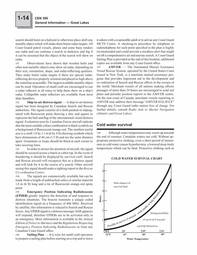
1-14 CEN 300General Information — Great Lakes
search should hoist on a halyard or otherwise place aloft any metallic object which will make them better radar targets. All Coast Guard patrol vessels, planes and some buoy tenders use radar and can continue a search in darkness and fog if it can be assumed that the object of the search will show on radar.191 Observations have shown that wooden hulls and other non-metallic objects may show on radar, depending on their size, orientation, shape, and radar-reflecting qualities. They make better radar targets if there are special radar-reflecting devices properly oriented and placed as high above the waterline as possible. The largest available metallic object can be used. Operators of small craft are encouraged to use a radar reflector at all times to help them show on a ship’s radar. Collapsible radar reflectors are available from most ship chandlers.192 Ship-to-air distress signal. — A ship-to-air distress signal has been designed by Canadian Search and Rescue authorities. The signal consists of a cloth painted or impreg-nated with fluorescent paint showing a disc and square to represent the ball and flag of the international visual distress signal. Evaluation tests by Canadian Forces aircraft indicate that the most suitable colour combination is black symbols on a background of fluorescent orange-red. The smallest useful size is a cloth 1.8 by 1.1 m (6 by 4 ft) showing symbols which have dimensions of 46 cm (1.5 ft) and are the same distance apart. Grommets or loops should be fitted at each corner to take securing lines.193 In order to attract the attention of aircraft, the signal should be secured across a hatch or cabin top. In the event of foundering it should be displayed by survival craft. Search and Rescue aircraft will recognize this as a distress signal and will look for it in the course of a search. Other aircraft seeing this signal should make a sighting report to the Rescue Co-ordination Centre.194 The signals are commercially available but can be made from a length of unbleached calico or similar material 1.8 m (6 ft) long and a tin of fluorescent orange-red spray paint.195 Emergency Position Indicating Radiobeacons (EPIRB) greatly improve the detection of and response to distress situations. The beacon transmits a unique coded identification signal on a frequency of 406 MHz. Received by satellite, this information is relayed to Search and Rescue forces. Any EPIRB signal is a distress message; SAR agencies will respond, therefore EPIRBs are to be activated only in an emergency. More information is available in the Annual Edition of Notice to Mariners and the Regulations Respecting Emergency Position Indicating Radiobeacons or from any Canadian Coast Guard office.196 Sailing Plan. — It is wise for small craft operators to prepare a sailing plan before starting on a trip and to leave
it ashore with a responsible adult or to advise any Coast Guard MCTS Centre. A checking-in procedure by telephone or radiotelephone for each point specified in the plan is highly recommended and could prevent a needless alert that might set off a comprehensive air and marine search. A Coast Guard Sailing Plan is provided at the end of this booklet; additional copies are available from any Coast Guard office.197 AMVER. — The Automated Mutual Assistance Vessel Rescue System, operated by the United States Coast Guard in New York, is a maritime mutual assistance pro-gram that provides important aid to the development and co-ordination of Search and Rescue efforts in the oceans of the world. Merchant vessels of all nations making offsore passages of more than 24 hours are encouraged to send sail plans and periodic position reports to the AMVER centre. On the east coast of Canada, merchant vessels reporting to AMVER may address their message “AMVER HALIFAX” through any Coast Guard radio station free of charge. For further details, consult Radio Aids to Marine Navigation (Atlantic and Great Lakes).
Cold water survival
198 Although water temperatures may warm-up towards the end of summer, Canadian waters are cold. Without ap-propriate protective clothing, even a short period of immer-sion in cold water causes hypothermia, a lowered deep-body temperature which can be fatal. Protective clothing such as
Slim chances ofsurvival-fatal
Possible to survive if rescued - w
eak unabl
e to he
lp the
mselves
6
5
4
3
2
1
Hou
rs
Water Temperature
32°F 41° 50° 59°0°C 5° 10° 15°
COLD WATER SURVIVAL CHART
Strong possibility
of survival if rescued –
can help themselves
1-15General Navigational Information
CHAPTER 1
206 Rewarming after mild hypothermia. — If the cas-ualty is conscious, talking clearly and sensibly and shivering vigorously, then:
• get the casualty out of the water to a dry sheltered area;
• remove wet clothing and if possible put on layers of dry clothing; cover head and neck;
• apply hot, wet towels and water bottles to the groin, head, neck and sides of the chest;
• use electric blankets, heating pads, hot baths or showers;
• use hot drinks but never alcohol.207 Rewarming after severe hypothermia. — If the casualty is getting stiff and is either unconscious or show-ing sign of clouded consciousness such as slurred speech, or any apparent signs of deterioration, immediately (if possible) transport the casualty to medical assistance where aggressive rewarming can be initiated.208 Once shivering has stopped, there is no use wrap-ping casualties in blankets if there is no source of heat as this merely keeps them cold. A way of warming must be found quickly. Some methods are:
• put the casualty in a sleeping bag or blankets with one or two warm persons, with outer clothing removed;
• use hot, wet towels and water bottles as described above;
• warm the casualty’s lungs by mouth-to-mouth brea-thing.
209 Caution. — Warm the chest, groin, head and neck but not the extremities of the body as this can draw heat
an immersion suit or a Personal Flotation Device (PFD) with good thermal protection helps prevent hypothermia.199 Skin and external tissues cool very rapidly in cold water, and in 10 to 15 minutes the temperature of the heart, brain and other internal organs begins to drop. Intense shiv-ering is an attempt to increase the body’s heat production and counteract the large heat loss.200 Once cooling of the deep body begins, body tem-perature falls steadily; unconsciousness can occur when it drops from the normal 37°C to about 32°C. When the body core cools to below 30°C, death from cardiac arrest usually results.201 Persons without thermal protection become too weak to help themselves after about 30 minutes in water temperature of 5°C, and after an hour the chances of survival are slim even if rescued.202 Predicted survival times in a water temperature of 10°C are shown in the table.203 In almost all weather conditions the body cools much faster in water than in air, so the less body surface submerged the better. The parts of the body with the fastest heat loss are the head and neck, the sides of the chest, and the groin. To reduce body heat loss, protect these areas.204 Two ways of reducing heat loss are:
• HELP (Heat Escape Lessening Position): arms held tight against the sides, ankles crossed, thighs close together and raised;
• Huddle: two or more persons in a huddle with chests held close together.
To use these methods successfully, a person must be wearing a PFD. As shown in the table, survival time is greatly increased by wearing clothing that gives thermal protection, including a hood to prevent heat loss from the head.205 Do not swim to keep warm as this causes extra heat to be lost to the cold water due to the extra circulation to the arms, legs and skin. If you have no PFD, remain as still as you can, moving your arms and legs just enough to keep your head out of water.
Predicted Survial Time *
Situation Time (Hours) No flotation Drownproofing 1.5Treading water 2.0With flotation Swimming slowly 2.0 Holding still 2.7HELP 4.0Huddle 4.0Flotation jacket 7.0
* In 10°C water. Clothing worn was cotton shirt, pants and socks plus running shoes.
Extreme danger of freezing of exposed flesh
Moderate danger of freezing of exposed flesh
Slight danger for properly dressed persons
40
30
20
10
0
- 45° - 35° - 23° - 12° 0°
Effect of wind on exposed persons
Wind speed(knots)
Temperature °C10°
1-16 CEN 300General Information — Great Lakes
from the area of the heart, sometimes with fatal results. For
this reason, do not rub the surface of the body. Handle the
casualty gently to avoid damaging the heart.
210 Wind effect on persons exposed to the ele-ments. — The risk of frostbite on exposed body parts in-creases considerably with wind speed; appropriate measures for protection should be taken.
CHAPTER 2
RegulationsList of Statutes, Regulations, Guidelines and Conventions
Canada Shipping Act- Regulations for the Prevention of Pollution from Ships and
for Dangerous Chemicals- Ballast Water Control and Management Regulations- Vessel Operation Restriction Regulations- Burlington Canal Regulations- Collision Regulations- Charts and Nautical Publications Regulations, 1995- Shipping Casualties Reporting Regulations- Small Vessel Regulations- St. Clair and Detroit River Navigation Safety RegulationsCriminal CodeCanadian Environmental Protection Act- Disposal at Sea RegulationsDepartment of Transport Act- Canal Regulations- Historic Canals RegulationsHealth Canada- Ship Sanitation CertificatesIndian ActInternational Convention for the Protection of
Submarine CablesJoint Industry Coast Guard Guidelines for the Control of
Oil Tankers and Bulk Chemical Tankers in Ice Control Zones of Eastern Canada
Long-Range Identification and Tracking of Vessels Regulations
Migratory Birds Convention Act- Migratory Bird Sanctuary RegulationsOntario Ministry of the Environment- Boating RegulationPilotage Act- Great Lakes Pilotage RegulationsCanada Marine Act- Public Ports and Public Port Facilities RegulationsQuarantine ActSt. Lawrence Seaway Authority Act- Seaway Regulations
2-2 CEN 300General Information — Great Lakes
2 (A.R.)) shall be completed and forwarded. There are penal-ties for failing to report a shipping casualty. For additional details contact CCG offices.10 Regulations for the Prevention of Pollution from Ships and for Dangerous Chemicals expressly forbids the discharge of oil, oily mixtures, noxious liquids, dry chemicals listed in Schedule 1 of the regulations, sewage or sewage sludge, organotin compounds or garbage in Canadian waters by any ship, and by Canadian ships in any waters. Smoke pollution caused by ships is also covered by the regulations. Penalties for contravention of the regulations include fines of up to $1,000,000.00, imprisonment for up to three years, or both. For further information, including mandatory docu-ments, record keeping, inspections and exceptions, consult the “Regulations by Title” section of http://laws.justice.gc.ca/en/index.html.10.1 The Pollutant Discharge Reporting Regulations, 1995 requires the master or owner of any ship in Canadian waters to immediately report discharge or probable discharge of a pollutant substance to a pollution prevention officer. A Canadian ship not in Canadian waters shall make a report pursuant to these regulations to an appropriate official of the nearest coastal state.10.2 To make a report pursuant to the Pollutant Discharge Reporting Regulations, 1995, for vessels in the Department of Fisheries and Oceans Central and Arctic Region, contact the nearest Marine Communications and Traffic Services (MCTS) centre by VHF or telephone 1-800-265-0237. In Quebec Region, contact the nearest MCTS centre by VHF or telephone 1-866-283-2333.11 Masters of laden oil and chemical tankers operat-ing in ice control zones of Eastern Canada should refer to the Coast Guard publication Joint Industry Coast Guard Guidelines for the Control of Oil Tankers and Bulk Chemical Tankers in Ice Control Zones of Eastern Canada for guidance in the operation of their vessels while in ice control zones. A copy of the Guidelines should be carried on board all applic-able vessels.12 Ballast Water Control and Management Regulations of the Canada Shipping Act apply to most ves-sels inbound for the St. Lawrence Seaway. The regulations protect the ecosystems in Canadian waters from unintentional transfer of harmful aquatic organisms and pathogens.13 Certain Canadian vessels operating on international voyages must be equipped with Long-Range Identification and Tracking of Vessels (LRIT) equipment approved by IMO. The LRIT system, used world-wide in GMDSS Sea Area A3, transmits the ship’s name, latitude and longitude, date and time in a secure radio message via Inmarsat geostationary satellites to intended recipients. The Canadian Coast Guard is responsible for receiving LRIT transmissions and notify-ing intended recipients in Canada. The main purpose of the
REGULATIONS
1 Note. — Under the Canada Shipping Act, the def-inition of “ship” includes every description of vessel used in navigation and not propelled by oars; the definition of “vessel” includes any ship or boat or any other description of vessel used or designed to be used in navigation.2 The following regulations are mentioned or quoted only to give a general impression. The publisher accepts no liability for failing to mention any particular regulation or for any errors or omissions. Changes or amendments may have been made to the regulations since this booklet was compiled; mariners must consult the complete and latest regulations.3 Copies of Canadian Government regulations are available by mail from Canada Communication Group – Publishing Division, Ottawa, Ontario K1A 0S9.4 Collision regulations. — The International Regulations for Preventing Collisions at Sea, 1972 are modi-fied in waters under Canadian jurisdiction by special Rules. These special Rules are included in the Collision Regulations of the Canada Shipping Act.5 Territorial sea and fishing zones. — Canada claims a 12 mile territorial sea under the authority of the Oceans Act. In addition, Canada exercises management and control of the fisheries within a 200 mile limit.6 Criminal Code. — The following is from Section 258 of the Criminal Code and applies to all Canadian waters: “Everyone who navigates or operates a vessel or any water skis, surfboard, water sled or other towed object on any of the waters or territorial waters of Canada, in a manner that is dangerous to navigation, life or limb, having regard to all the circumstances including the nature and condition of such waters and the use that at the time is or might reasonably be expected to be made of such waters, is guilty of
(a) an indictable offence and is liable to imprisonment for two years, or
(b) an offence punishable on summary conviction.”7 It is an offence to leave the scene of an accident in-volving another vessel or vehicle, or to fail to offer assistance where any person is injured or appears to require assistance.8 Under the Criminal Code it is also an offence to operate or to be in care or control of a vessel while impaired by alcohol or a drug, or having consumed more than the legal limit of alcohol.9 Shipping Casualties Reporting Regulations of the Canada Shipping Act require any person responsible for a ship in Canadian waters or a Canadian ship in any waters, to report without delay a shipping casualty, accident or dangerous oc-currence. The report shall be made by radio or other quickest means to a Canadian radio ship-reporting station such as the Canadian Coast Guard (CCG), a Traffic Centre (VTS) or a port. Thereafter, a written report (combined form l (W.R.),
2-3RegulationsCHAPTER 2
LRIT system is to enhance security; however LRIT has been incorporated in SOLAS Chapter V, Safety of Navigation, for the purposes of safety and environmental protection.14 Health Canada, through its Ship Sanitation Certificate Program, protects public health by ensuring that international vessels stopping in Canada are free of contam-ination and infection, which could introduce communicable diseases. Under International Health Regulations (2005), ves-sels engaged in international trade are required to obtain either a Ship Sanitation Control Certificate, or a Ship Sanitation Control Exemption Certificate, every six (6) months. The Ship Sanitation Certificates replace the Deratification Certificate required by the International Health Regulations (1969). For more information on the issuance of Ship Sanitation Certificates, e-mail [email protected] to request a free copy of the Ship Sanitation Certificate Program Inspection Policy and Procedures Manual. To request an inspection, contact [email protected] or [email protected] or fax request to (514) 283-4317.16 Disposal at Sea Regulations of the Canadian Environmental Protection Act require that a permit be obtained before dumping any substance at sea or loading any substance for dumping at sea, as well as for the disposal of substances at sea, on ice, by incineration at sea, and for dumping dredged material at sea or loading dredged material to dump at sea. Contravention of the Act is punishable on summary convic-tion. Fines of up to $100,000 per day may be imposed.17 Permits are issued on receipt of the appropriate application form and the prescribed fee. In emergencies, the requirement of a permit is waived but a report must be made in the prescribed form. Emergencies are deemed to exist only where there is danger to human life at sea or to a ship.19 Protection of submarine cables. — The following text is a summary from the International Convention for the Protection of Submarine Cables (ICPC).20 It is a punishable offence to break or injure a sub-marine cable in such manner as might interrupt or obstruct communications. This provision does not apply to cases where those who break or injure a cable do so with the intent of saving their lives or their ship.21 When a ship is engaged in repairing a cable, other vessels shall keep a distance of at least one nautical mile so as not to interfere with her operations. Fishing gear and nets shall be kept at the same distance.22 Vessels shall keep a distance of at least one quarter of a nautical mile from buoys showing the position of a cable being laid or out of order. Fishing nets and gear shall be kept at the same distance.23 Even though there may be no specific prohibition against anchoring or trawling in a submarine cable area, mariners should avoid doing so because of the serious con-sequences which can result from damage to such cables.
24 Owners of ships or vessels who can prove that they have sacrificed an anchor, a net or other fishing gear in order to avoid injuring a submarine cable, may receive compensation from the owner of the cable. In order to establish a claim to such compensation, the master of the ship must, within twenty four hours after his return to port, make a report that sets forth full particulars of the occurrence and make a declaration to the Chief Officer of Customs and Excise, to the local Coast Guard, or to the Fisheries Officer of the Department of Fisheries and Oceans.
25 Danger involved in cutting to clear anchors or fishing gear. — In the event of a vessel fouling
a submarine cable, every effort should be made to clear the anchor or gear by normal methods. If these efforts fail, the anchor or gear should be slipped and abandoned without attempting to cut the cable. High voltages are carried by submarine cables as well as by power transmission cables; any attempt to cut a cable can result in severe burns or loss of life due to electric shock. No claim in respect of injury or damage sustained through such interference with a submarine cable will be entertained.26 One of the main objectives of the ICPC is to make known the existence and locations of submarine cables. The universal charting of cables has been endorsed by the International Hydrographic Organization and charts showing cable positions are available from many Hydrographic Offices. If there is any difficulty in obtaining cable information, re-quests addressed to the ICPC Secretary at Mercury House, Theobalds Road, London, United Kingdom WC1X 8RX, will receive immediate attention.27 Hunting and Fishing Regulations. — Hunting and fishing activities in Ontario and Quebec are strictly controlled; copies of the appropriate regulations must be obtained by visitors. These pamphlets are widely available and include information on the various Open Seasons and licence require-ments for both visitors and residents.28 Indian Act. — There are areas which are Reserves established in early treaties and “set apart … for the use and benefit of a band (of Indians)”. These areas, which frequently front on to the water, are generally shown on charts; an effort should be made to respect this property and avoid trespassing on it.29 Because Reserves may not be marked with warnings to the public, trespassing may occur unwittingly. Normally a request to leave will be sufficient to terminate an act of trespass. If minor damage to property has occurred and the trespasser is willing to pay compensation, it may be accepted; charges may be laid if a trespasser has caused substantial damage.30 Where band members operate booths for selling handicrafts or other items to the public, it is implied that visitors are invited to their premises; this is not a trespass.
2-4 CEN 300General Information — Great Lakes
Corporation) and the United States’ (Saint Lawrence Seaway Development Corporation) sections of the Seaway.40.1 Automatic Identification System (AIS). — The St. Lawrence Seaway Management Corporation has instituted mandatory carriage of AIS on board most commercial vessels operating in Seaway waters. For more details, see Seaway Notice No. 1, 2003 or contact the St. Lawrence Seaway Management Corporation by telephone or facsimile, or by the Internet at http://www.greatlakes-seaway.com, under Navigation.41 The Seaway Regulations include a requirement that all self-propelled vessels, other than pleasure craft of less than 20 m in overall length, shall be equipped with VHF (very high frequency) radio telephone equipment and shall use the channels of communication in each control sector as listed in the preceding tables.42 Note. — The following texts are extracts from regulations. The publisher accepts no liability for failing to publish complete details of any particular regulation or for any errors or omissions. Changes or amendments may have been made to the regulations since this booklet was compiled; mariners must consult the complete and latest regulations.
Similarly, where it is the custom for members of the public to attend special band events such as rodeos or ceremonial dances, the consent of the band is implied unless it indicates otherwise.31 When making purchases on an Indian Reserve it will be useful to remember that:32 (1) No person may, without the written consent of the Minister, acquire title to any of the following property, situated on a Reserve, namely:
(a) an Indian grave house;(b) a carved grave pole;(c) a totem pole;(d) a carved house post; or(e) a rock embellished with paintings or carvings.
33 (2) Subsection (1) does not apply to chattels referred to therein that are manufactured for sale by Indians.34 (3) No person shall remove, take away, mutilate, disfigure, deface or destroy any chattel referred to in subsec-tion (1) without the written consent of the Minister.35 Migratory bird sanctuaries. — Mariners who pass through bird sanctuaries are subject to the Migratory Bird Sanctuary Regulations of the Migratory Birds Convention Act. These sanctuaries are generally shown on charts. In these sanctuaries it is prohibited to hunt, disturb, destroy, take nests or to possess a bird, an egg, etc. It is also prohibited to have firearms or any other hunting gear. Dogs and cats are not al-lowed to run free. Access is restricted or prohibited at certain sites; consult the Canadian Wildlife Service of Environment Canada for further information.36 Great Lakes Pilotage Regulations of the Pilotage Act list compulsory pilotage areas and conditions for waiving compulsory pilotage. (See the section on Pilotage in Chapter 1 of this booklet for a summary of compulsory pilotage areas.)37 Quarantine reporting requirements. — The Quarantine Act and Regulations require that, with the exemp-tion in normal circumstances of vessels engaged in coastal trade with the United States, the Master of every vessel shall complete and furnish promptly at the first port of arrival in Canada, a Declaration of Health in the prescribed form.38 The quarantine station for vessels bound for a port in the Province of Quebec or any Canadian port via the St. Lawrence River is Quarantine Station, Montréal, Quebec.39 Seaway Regulations of the St. Lawrence Seaway Authority Act and other information pertinent to the use of the Seaway are contained in the Seaway Handbook. A copy of the Seaway Handbook must be carried by every vessel in transit through the St. Lawrence Seaway; copies may be obtained from The Information Officer, The St. Lawrence Seaway Management Corporation, 202 Pitt Street, Cornwall, Ontario, K6J 3P7, telephone (613) 932-5170, fax (613) 932-503740 The Seaway Regulations are joint regulations applic-able to both the Canadian (St. Lawrence Seaway Management
Seaway Stations
The Seaway stations are located as follows:
VDX20 (Seaway Beauharnois) Upper Beauharnois Lock – Traffic Control Sector No. 1
KEF (Seaway Eisenhower) Eisenhower Lock – Traffic Control Sector No. 2
VDX21 (Seaway Iroquois) Iroquois Lock – Traffic Control Sector No. 3
WAG (Seaway Clayton) Clayton, N.Y. – Traffic Control Sector No. 4
WAG (Seaway Sodus) Sodus, N.Y. – Traffic Control Sector No. 4
VDX72 (Seaway Newcastle) Port Hope, Ontario – Traffic Control Sector No. 5
VDX70 (Seaway Newcastle) Port Weller, Ontario – Traffic Control Sector No. 5
VDX22 (Seaway Welland) St. Catherines, Ontario – Traffic Control Sector No. 6
VDX68 (Seaway Long Point) Port Colborne, Ontario – Traffic Control Sector No. 7
Assigned Frequencies
The Seaway stations operate on the following assigned VHF frequencies:
156.8 MHz (channel 16) Distress and Calling 156.7 MHz (channel 14) Working (Canadian stations in
Sector 1 and the Welland Canal) 156.65 MHz (channel 13) Working (U.S. stations in Lake
Ontario and Sector 4 of the River) 156.6 MHz (channel 12) Working (U.S. stations in Sector 2
of the River) 156.55 MHz (channel 11) Working (Canadian stations in
Sector 3, Lakes Ontario and Erie)
2-5RegulationsCHAPTER 2
blue light is not shown in its direction, the vessel shall wait at the side of the canal to its starboard. (2) No vessel less than 15 m in length shall move within 90 m of the bridge unless the bridge is opened or a flashing blue light is shown in its direction. 8. No vessel shall operate under sail in the canal.
Charts and Nautical Publications Regulations, 1995
REGULATIONS REQUIRING THE PRESENCE ON BOARD SHIPS OF
APPROPRIATE CHARTS, TIDE TABLES AND OTHER NAUTICAL DOCUMENTS OR PUBLICATIONS AND RESPECTING THEIR
MAINTENANCE AND USE
Short Title
1. These Regulations may be cited as the Charts and Nautical Publications Regulations, 1995.Interpretation 2. In these Regulations,“chart” means a nautical chart; (carte)“nautical mile” means the international nautical mile;
(mille marin)“reference catalogue”, in respect of an area to be navigated
by a ship, means(a) for waters under Canadian jurisdiction, the Catalogue
of Nautical Charts and Related Publications, pu-blished by the Canadian Hydrographic Service, and
(b) for waters outside Canadian jurisdiction, the Catalogue of Admiralty Charts and Other Hydrographic Publications, published by the Government of the United Kingdom, or the Catalog of Charts and Publications, published by the Government of the United States of America; (catalogue de référence)
“tons” means gross tons; (tonneaux)“waters under Canadian jurisdiction” means
(a) Canadian waters,
CANADA SHIPPING ACT
Burlington Canal Regulations
Interpretation
2. In these Regulations,“bridge” means the lift bridge over the canal; (pont)“canal” means the Burlington Canal that links Lake Ontario
and Hamilton Harbour; (canal)“mile” means the international nautical mile measuring
1,852 m in length. (mille)
General
3. No vessel shall move in the canal at a speed greater than,
(a) if the vessel is 80 m or less in length, 7 miles per hour, or
(b) if the vessel is more than 80 m in length, the lowest speed at which the vessel can be navigated safely.
4. (1) Subject to subsection (2), no vessel shall, while moving within 0.5 mile of the canal towards the canal, pass another vessel going in the same direction. (2) Subsection (1) does not apply in respect of ves-sels less than 15 m in length. 5. Where the person who has the conduct of a ves-sel requires the bridge to be opened, the person shall make a request to the bridgemaster by radiotelephone or, if such communication is not possible, the person shall sound three long blasts on the whistle or horn of the vessel. 6. (1) No vessel 15 m or more in length shall enter the canal, except in an emergency, unless the signal light on the bridge shows green in the direction of the vessel. (2) Where a vessel 15 m or more in length enters the canal while the signal light on the bridge does not show green in its direction, it shall moor at the north wall of the canal and shall not proceed until the signal light shows green in its direction. 7. (1) Where a vessel less than 15 m in length enters the canal while the bridge is not opened or while a flashing
Channels of Communication in Control Sectors
Station Control sector number Sector limits Call in Work Listening watch Seaway Beauharnois 1 C.I.P. No. 2 to C.I.P. No. 6-7 Ch. 14 Ch. 14 Ch. 14 Seaway Eisenhower 2 C.I.P. No. 6-7 to C.I.P. No. 10-11 Ch. 12 Ch. 12 Ch. 12 Seaway Iroquois 3 C.I.P. No. 10-11 to Crossover Island Ch. 11 Ch. 11 Ch. 11 Seaway Clayton 4 Crossover Island to Cape Vincent Ch. 13 Ch. 13 Ch. 13 Seaway Sodus 4 Cape Vincent to Mid Lake Ontario Ch. 13 Ch. 13 Ch. 16 Seaway Newcastle 5 Mid Lake Ontario to C.I.P. No. 15 Ch. 11 Ch. 11 Ch. 16 Seaway Welland 6 C.I.P. No. 15 to C.I.P. No. 16 Ch. 14 Ch. 14 Ch. 14 Seaway Long Point 7 C.I.P. No. 16 to Long Point Ch. 11 Ch. 11 Ch. 16
2-6 CEN 300General Information — Great Lakes
(b) fishing zones of Canada prescribed pursuant to subsection 4(2) of the Territorial Sea and Fishing Zones Act, and
(c) shipping safety control zones prescribed pursuant to section 11 of the Arctic Waters Pollution Prevention Act. (eaux de compétence canadienne)
Application 3. These Regulations apply to Canadian ships in all waters and to all ships in waters under Canadian jurisdiction.Carriage of Charts, Documents and Publications 4. (1) Subject to subsection (2), the master and owner of every ship shall have on board, in respect of each area in which the ship is to be navigated, the most recent editions of the charts, documents and publications that are required to be used under sections 5 and 6. (2) The master and owner of a ship of less than 100 tons are not required to have on board the charts, docu-ments and publications referred to in subsection (1) if the person in charge of navigation has sufficient knowledge of the following information, such that safe and efficient navigation in the area where the ship is to be navigated is not comprom-ised:
(a) the location and character of charted(i) shipping routes,(ii) lights, buoys and marks, and(iii) navigational hazards; and
(b) the prevailing navigational conditions, taking into account such factors as tides, currents, ice and wea-ther patterns.
Use of Charts
5. (1) Subject to subsection (2), the person in charge of the navigation of a ship shall use the most recent edition of a chart that
(a) is published by the government of a country;(b) applies to the immediate area in which the ship is
being navigated;(c) is, for that area,
(i) the largest scale chart according to the refer-ence catalogue, or
(ii) of a scale that is at least 75 per cent of the scale of the chart referred to in subpara-graph (i) and is as complete, accurate, intel-ligible and up-to-date as that chart.
(2) The person in charge of the navigation of a ship may use the most recent edition of a chart that is the second-largest scale chart for an area according to the reference catalogue where
(a) the scale of the chart is at least 1:400,000 (2.16 nau-tical miles to the centimetre); and
(b) the ship is
(i) more than five nautical miles from any chart-ed feature or charted depth of water that rep-resents a potential hazard to the ship, or
(ii) within an area for which the largest scale chart, according to the reference catalogue, is primarily(A) a chart intended for the use of pleasure
craft, or(B) a chart of an anchorage, a river or a har-
bour that the ship will not transit or enter.
Use of Documents and Publications
6 (1) Subject to subsection (3), the person in charge of the navigation of a ship in waters under Canadian jurisdiction shall use, in respect of each area to be navigated by the ship, the most recent edition of
(a) the reference catalogue;(b) the annual edition of the Notices to Mariners, pu-
blished by the Department of Transport;(c) the following publications, namely,
(i) sailing directions, published by the Canadian Hydrographic Service,
(ii) tide and current tables, published by the Canadian Hydrographic Service,
(iii) lists of lights, buoys and fog signals, pub-lished by the Department of Transport, and
(iv) where the ship is required to be fitted with radio equipment pursuant to any Act of Parliament or of a foreign jurisdiction, the Radio Aids to Marine Navigation, published by the Department of Transport; and
(d) the documents and publications listed in the sche-dule.
(2) Subject to subsection (3), the person in charge of the navigation of a Canadian ship in waters outside Canadian jurisdiction shall use, in respect of each area to be navigated by the ship, the most recent edition of
(a) the reference catalogue;(b) the annual edition of the Notices to Mariners, pu-
blished by the Department of Transport;(c) the following publications referred to in the reference
catalogue, namely,(i) sailing directions,(ii) tide and current tables,(iii) lists of lights, and(iv) where the ship is required to be fitted with
radio equipment pursuant to an Act of Parliament, the list of radio aids to naviga-tion; and
(d) the documents and publications listed in the sche-dule.
2-7RegulationsCHAPTER 2
4. The Merchant Ship Search and Rescue Manual (MERSAR), published by the International Maritime Organization, where the ship is making a foreign voyage or a home-trade voyage, Class I or II. 5. Where the ship is required to be fitted with radio equipment and is making a foreign voyage or a home-trade voyage, Class I or II, the following publications, published by the International Maritime Organization and reprinted by the Department of Transport:
(a) the International Code of Signals; and(b) the Standard Marine Navigational Vocabulary.
43 Note. — A list of acceptable foreign charts is issued for reference in conjunction with the Charts and Nautical Publications Regulations, 1995. This list is published in the Annual Edition of Notices to Mariners and updated in the Monthly Editions of Notices to Mariners.
St. Clair and Detroit River Navigation Safety Regulations
REGULATIONS RESPECTING NAVIGATION SAFETY ON THE WATERS OF THE GREAT
LAKES FROM LAKE HURON TO LAKE ERIE
Interpretation
2. In these Regulations “Captain of the Port” means the Captain of the Port for
the United States Coast Guard at Detroit, Michigan; (capitaine de port)
“District Commander” means the District Commander for the United States Coast Guard District; (commandant du district)
“floating plant” includes any type of manned barge, scow or similar watercraft that is used for river or harbour improvements, salvage, scientific work, cargo handling, exploration or exploitation of mineral resources, or other similar operations; (installation flottante)
“Harbour Master” means the harbour master appointed for the Windsor harbour; (maître de port)
“knot” means one nautical mile per hour over the ground; (nœud)
“length”, in respect to a ship, means the overall length of the ship; (longueur)
“mile” means the international nautical mile of 1,852 metres; (mille)
“Regional Director General” means the Regional Director General for the Central Region, Canadian Coast Guard, Department of Transport; (directeur général régional)
“SARNIA TRAFFIC” means the Canadian Coast Guard traffic centre at Sarnia, Ontario. (SARNIA TRAFFIC)
(3) The documents and publications referred to in paragraphs (1)(c) and (d) and (2)(c) and (d) may be substituted for similar documents and publications issued by the govern-ment of another country, if the information contained in them that is necessary for the safe navigation of a ship in the area in which the ship is to be navigated is as complete, accurate, intelligible and up-to-date as the information contained in the documents and publications referred to in those provisions.Maintenance of Charts, Documents and Publications 7. The master of a ship shall ensure that the charts, documents and publications required by these Regulations are, before being used for navigation, correct and up-to-date, based on information that is contained in the Notices to Mariners, Notices to Shipping or radio navigational warnings.Exclusions 8. (1) No master of a ship shall be held liable for contravening these Regulations where, having been informed of the prospective area in which the ship will be navigating,
(a) the master is unable to obtain the charts, documents or publications, required by these Regulations in respect of that area, at any place at which the ship calls; or
(b) the charts, documents or publications required by these Regulations in respect of that area are unob-tainable without endangering the ship, contravening applicable regulations or requiring the ship to make a substantial detour.
(2) No master of a ship shall be held liable for con-travening these Regulations where the circumstances of the voyage are such that it is impracticable to receive a Notice to Shipping or a radio navigational warning containing informa-tion with respect to the safe navigation of the ship.
SCHEDULE(Section 6)
DOCUMENTS AND PUBLICATIONS
1. Regulations 1, 7 and 8 of Chapter II, and Resolutions 1, 3 and 6, of the International Convention on Standards of Training, Certification and Watchkeeping for Seafarers, 1978, published by the International Maritime Organization and reprinted as the Code of Nautical Procedures and Practices, 1985, by the Department of Transport. 2. Ice Navigation in Canadian Waters, published by the Department of Transport, where the ship is making a voyage during which ice may be encountered. 3. Table of Life-Saving Signals, published by the International Maritime Organization and reprinted by the Department of Transport, where the ship is making a foreign voyage, a home-trade voyage, Class I, II or III, or an inland voyage, Class I.
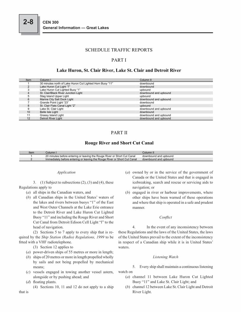
2-8 CEN 300General Information — Great Lakes
Application
3. (1) Subject to subsections (2), (3) and (4), these Regulations apply to
(a) all ships in the Canadian waters, and(b) all Canadian ships in the United States’ waters of
the lakes and rivers between buoys “1” of the East and West Outer Channels at the Lake Erie entrance to the Detroit River and Lake Huron Cut Lighted Buoy “11” and including the Rouge River and Short Cut Canal from Detroit Edison Cell Light “l” to the head of navigation.
(2) Sections 5 to 7 apply to every ship that is re-quired by the Ship Station (Radio) Regulations, 1999 to be fitted with a VHF radiotelephone. (3) Section 12 applies to
(a) power-driven ships of 55 metres or more in length;(b) ships of 20 metres or more in length propelled wholly
by sails and not being propelled by mechanical means;
(c) vessels engaged in towing another vessel astern, alongside or by pushing ahead; and
(d) floating plants. (4) Sections 10, 11 and 12 do not apply to a ship that is
SCHEDULE TRAFFIC REPORTS
PART I
Lake Huron, St. Clair River, Lake St. Clair and Detroit River
Item Column I Column II 1 30 minutes north of Lake Huron Cut Lighted Horn Buoy “11” downbound 2 Lake Huron Cut Light “7” downbound 3 Lake Huron Cut Lighted Buoy “1” upbound 4 St. Clair/Black River Junction Light downbound and upbound 5 Stag Island Upper Light upbound 6 Marine City Salt Dock Light downbound and upbound 7 Grande Point Light “23” downbound 8 St. Clair Flats Canal Light “2” upbound9 Lake St. Clair Light downbound and upbound
10 Belle Isle Light downbound 11 Grassy Island Light downbound and upbound 12 Detroit River Light downbound and upbound
PART II
Rouge River and Short Cut Canal
Item Column I Column II 1 20 minutes before entering or leaving the Rouge River or Short Cut Canal downbound and upbound 2 Immediately before entering or leaving the Rouge River or Short Cut Canal downbound and upbound
(a) owned by or in the service of the government of Canada or the United States and that is engaged in icebreaking, search and rescue or servicing aids to navigation; or
(b) engaged in river or harbour improvements, where other ships have been warned of these operations and where that ship is operated in a safe and prudent manner.
Conflict
4. In the event of any inconsistency between these Regulations and the laws of the United States, the laws of the United States prevail to the extent of the inconsistency in respect of a Canadian ship while it is in United States’ waters.
Listening Watch
5. Every ship shall maintain a continuous listening watch on
(a) channel 11 between Lake Huron Cut Lighted Buoy “11” and Lake St. Clair Light; and
(b) channel 12 between Lake St. Clair Light and Detroit River Light.
2-9RegulationsCHAPTER 2
Traffic Reports
6. Every ship shall, at the locations or the time specified in an item of column I of the schedule when the ship is proceeding in any direction specified in column II of that item, make a traffic report to SARNIA TRAFFIC on the channel on which it is required to maintain a continuous listening watch, indicating its
(a) identity;(b) location;(c) intended course of action; and(d) estimated time of arrival at the next location referred
to in column I of the schedule.
Additional Traffic Reports
7. (1) Subject to subsection (2), every ship shall report to SARNIA TRAFFIC
(a) When departing from any dock, mooring or ancho-rage in waters referred to in subsection 3(1), unless the ship is moving within the Rouge River and Short Cut Canal or is a ferry making regular voyages;
(b) before manoeuvring to come about;(c) when entering waters referred to in subsection 3(1)
and shall give(i) estimated time of arrival at its dock, mooring
or anchorage, if intending to stop within the area,
(ii) draft and local agent if the ship is not regis-tered in Canada or the United States;
(d) where the ship has an accident or malfunction of its machinery or equipment that may impair its safe navigation;
(e) where there is an obstruction or other hazard in the channel; and
(f) in the case of a towing ship, where the towing ship is having difficulty controlling its tow.
(2) The reports required by paragraphs (1)(e) and (f) are not required if the information has been promulgated by a Notice to Shipping or by a Notice to Mariners.Exceptions 8. The reports required by sections 6 and 7 are not required when a ship’s radiotelephone installation is not in working condition.Navigation Rules 9. No person shall navigate or operate any ship in a manner that is dangerous to any person, that ship, or any other vessel, having regard to all the circumstances, including the nature and condition of the waters being navigated and the use that is or might reasonably be expected to be made of those waters. 10. In the Detroit River,
(a) the West Outer Channel is restricted to downbound ships;
(b) the Amherstburg Channel east of Bois Blanc Island is restricted to upbound ships except where the Regional Director General has authorized a ship to proceed downbound;
(c) the Livingstone Channel west of Bois Blanc Island is restricted to downbound ships; and
(d) Between Bar Point Pier Light “D33” and Fighting Island South Light, no ship shall overtake another ship if those ships will meet another ship proceeding in the opposite direction while the overtaking is taking place.
11. A ship shall not overtake another ship(a) except a ship engaged in towing, in the
(i) Detroit River between the west end of Belle Isle and Peach Island Light, and
(ii) St. Clair River between St. Clair Flats Canal Light “2” and Russell Island Light “33”; and
(b) in the Rouge River. 12. The waters between St. Clair/Black River Junction Light and Lake Huron Cut Lighted Buoy “1” con-stitute an area of alternating one-way traffic and
(a) no ship may in that area(i) overtake another ship,(ii) meet another ship, or(iii) come about;
(b) no moored ship may get underway until it is able to proceed through those waters without passing or being passed by another ship; and
(c) a downbound ship that has reached Lake Huron Cut Light “7” has the right-of-way over an upbound ship that has not yet reached the St. Clair/Black River Junction Light, and an upbound ship waiting the transit of a downbound ship shall wait its turn below the St. Clair/Black River Junction Light.
14. No ship shall embark, disembark or exchange a pilot between the St. Clair/Black River Junction Light and the Lake Huron Cut Lighted Buoy “1” unless, because of the weather, it is unsafe to carry out that activity at the normal pilotage ground above the Lake Huron Cut Lighted Buoy “1”. 15. Every ship shall, by using navigation safety calls, communicate its intentions to any other ship in the vicin-ity and ensure that the movements of the ships are coordinated and there is an agreement between the ships before proceeding to overtake or meet it.
Anchorage Rules
16. In the St. Clair and Detroit Rivers, no ship shall anchor in such a manner that it may swing into the channel or across steering courses.
2-10 CEN 300General Information — Great Lakes
Notice to Shipping or Notice to Mariners or until the time specified in the original promulgation.
Coordination
21. The Regional Director General and the Harbour Master shall exchange with the District Commander and Captain of the Port, forthwith, any information they receive or send that may affect the administration of these Regulations and the respective jurisdictions of those persons.43 The use of and activities in public ports and public port facilities are controlled under the Public Ports and Public Port Facilities Regulations and other regulations of the Canada Marine Act, as is navigation on and the use of the navigable waters of any natural or man-made harbour.44 Regulations for small craft. — As well as the above-mentioned regulations, there are several other regula-tions which apply to the operators of small craft in Canadian waters. For the convenience of the boater, the more important regulations and their intent are mentioned in the notes that follow. These notes are printed only for providing general impressions. The publisher accepts no liability for failing to mention or failing to publish complete details of any particu-lar regulation. Transport Canada publishes the very useful Safe Boating Guide booklet (see: http://www.tc.gc.ca/eng/marinesafety/tp-tp511-menu-487.htm).45 Collision Regulations. — Brief extracts of the rules of the road for small craft are given in the Safe Boating Guide.46 Canal Regulations. — Vessels navigating in the Rideau Waterway and on parts of the Ottawa River are subject to the Historic Canals Regulations.47 Small Vessel Regulations of the Canada Shipping Act cover licensing and equipment requirements for vessels that are principally maintained or operated in Canada.48 Prohibited areas and speed regulations. — Pro-hibited areas for certain types of boats and speed limits for certain areas have been proclaimed under Vessel Operation Restriction Regulations of the Canada Shipping Act, 2001 and by Practices and Procedures for Public Ports under the Public Ports and Public Port Facilities Regulations of the Canada Marine Act. These areas are usually marked by signs ashore or by keepout buoys or control buoys. Violators will be prosecuted by law-enforcement agencies.49 Radar reflectors. — Every vessel less than 20 m (65.6 ft) in length or constructed primarily of non-metallic material shall have a passive radar reflector. Compliance with this regulation (Rule 40 of the Collision Regulations) is not required where such compliance is not essential for the safety of the vessel or is impracticable. (See the publication Safe Boating Guide for further details.)50 Pollution regulations. — Operators of pleasure craft are reminded that the Oil Pollution Prevention Regulations, the
17. (1) A floating plant engaged in dredging, con-struction or wrecking may only be operated, anchored or moored if the person having conduct of the floating plant obtains authorization from the Regional Director General, the District Commander, the Captain of the Port or the Harbour Master having jurisdiction in waters in which the floating plant will operate, anchor or moor. (2) The authorization referred to in subsection (1) shall be given if the floating plant conforms to such conditions as are necessary to ensure the safety of navigation.
Speed Rules
18 Except when required for the safety of the ship or any other ship, no ship of 20 m or more in length may proceed at a speed greater than
(a) 10.4 knots between(i) Fort Gratiot and St. Clair Flats Canal
Light “2”, and(ii) Peach Island Light and Light D33;
(b) 3.5 knots in the Rouge River; or(c) 5 knots in the navigable channel south of Peach
Island.
Towing Ships
19. (1) A towing ship shall not drop or anchor its tows in such a manner that they may swing into a channel or across steering courses. (2) A towing ship engaged in arranging its tow shall not obstruct the navigation of other ships.
Temporary Instructions and Prohibitions
20. (1) Notwithstanding anything in these Regulations, where, because of channel obstructions, a cas-ualty, the weather, ice conditions, water levels or other un-foreseen or temporary circumstances, compliance with these Regulations would be impossible, impracticable or unsafe or would cause a risk of pollution, the Regional Director General, in the case of Canadian waters, or the District Commander or the Captain of the Port, in the case of United States’ waters, may temporarily instruct ships to proceed in a certain manner or by a certain route, or to anchor in a certain place, or prohibit ships from proceeding or anchoring except as specified in lieu of or in addition to any provisions of these Regulations. (2) A temporary instruction or prohibition issued by the Regional Director General pursuant to subsection (1) comes into force on its promulgation in a Notice to Shipping or a Notice to Mariners and shall remain in force until its modification or rescission is promulgated in a subsequent
2-11RegulationsCHAPTER 2
Garbage Pollution Prevention Regulations and the Pollutant Substances Regulations expressly forbid the discharge from vessels of oil, oily mixtures, garbage or substances listed in the regulations as pollutants. These regulations are strictly enforced.51 Sewage regulations. — In addition to the equip-ment requirements for ships detailed in the Regulations for the Prevention of Pollution from Ships and for Dangerous Chemicals under the Canada Shipping Act, the Government of Ontario, through the Ministry of the Environment, has enacted the Discharge of Sewage from Pleasure Boats regulation. These regulations are designed to eliminate the discharge of sewage from pleasure craft. In brief, the provisions of the two regulations are summed up as follows: 1. Sewage in all pleasure craft must be retained in suitable equipment. 2. Equipment suitable for the purpose of the Regulation includes:
(a) retention devices with or without recirculation featu-res which retain all toilet waste for disposal ashore, and
(b) incineration devices which reduce to ash all sewage and toilet waste.
3. Suitable equipment shall(a) be non-portable,(b) be constructed of structurally sound material,(c) have adequate capacity for expected use,(d) be properly installed, and(e) in the case of storage devices be equipped with the
necessary pipes and fittings conveniently located for pump-out by shore-based facilities. (Although not specified, a pump-out deck fitting with 1½ inch diameter National Pipe Thread (NPT) is commonly used.)
Individual approval of equipment is not required, but boats are subject to routine inspection by Ministry staff. Approval stickers are issued for boats that are found to be in compliance.52 Ontario Provincial Police and Royal Canadian Mounted Police are also empowered to inspect craft on behalf of the Ministry. Violators may be fined up to $5,000 on a first offence and $10,000 thereafter.
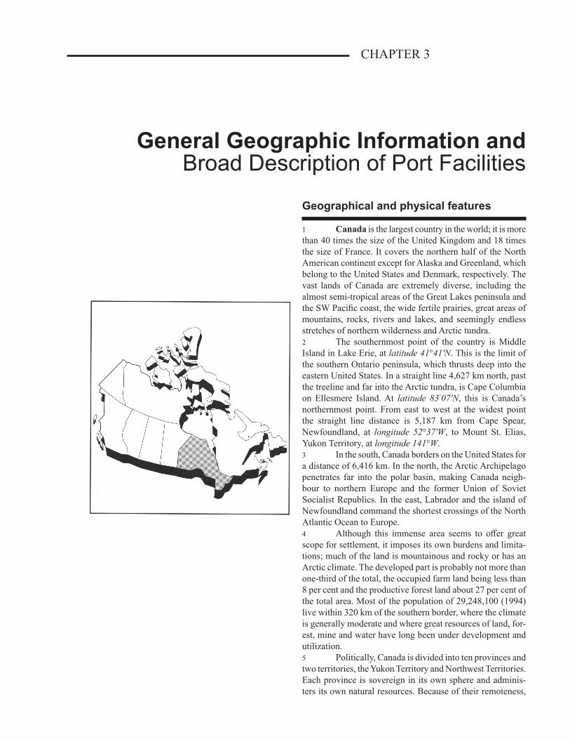
CHAPTER 3
General Geographic Information andBroad Description of Port Facilities
Geographical and physical features
1 Canada is the largest country in the world; it is more than 40 times the size of the United Kingdom and 18 times the size of France. It covers the northern half of the North American continent except for Alaska and Greenland, which belong to the United States and Denmark, respectively. The vast lands of Canada are extremely diverse, including the almost semi-tropical areas of the Great Lakes peninsula and the SW Pacific coast, the wide fertile prairies, great areas of mountains, rocks, rivers and lakes, and seemingly endless stretches of northern wilderness and Arctic tundra.2 The southernmost point of the country is Middle Island in Lake Erie, at latitude 41°41'N. This is the limit of the southern Ontario peninsula, which thrusts deep into the eastern United States. In a straight line 4,627 km north, past the treeline and far into the Arctic tundra, is Cape Columbia on Ellesmere Island. At latitude 83°07'N, this is Canada’s northernmost point. From east to west at the widest point the straight line distance is 5,187 km from Cape Spear, Newfoundland, at longitude 52°37'W, to Mount St. Elias, Yukon Territory, at longitude 141°W.3 In the south, Canada borders on the United States for a distance of 6,416 km. In the north, the Arctic Archipelago penetrates far into the polar basin, making Canada neigh-bour to northern Europe and the former Union of Soviet Socialist Republics. In the east, Labrador and the island of Newfoundland command the shortest crossings of the North Atlantic Ocean to Europe.4 Although this immense area seems to offer great scope for settlement, it imposes its own burdens and limita-tions; much of the land is mountainous and rocky or has an Arctic climate. The developed part is probably not more than one-third of the total, the occupied farm land being less than 8 per cent and the productive forest land about 27 per cent of the total area. Most of the population of 29,248,100 (1994) live within 320 km of the southern border, where the climate is generally moderate and where great resources of land, for-est, mine and water have long been under development and utilization.5 Politically, Canada is divided into ten provinces and two territories, the Yukon Territory and Northwest Territories. Each province is sovereign in its own sphere and adminis-ters its own natural resources. Because of their remoteness,
3-2 CEN 300General Information — Great Lakes
their great extent and their meagre and scattered popula-tion, the resources (except for game) of the Yukon Territory and Northwest Territories are administered by the Federal Government.6 Constitution. — The Canadian federal state of ten provinces and two territories, as we know it today, had its beginnings in an act of the British Parliament: the British North America (BNA) Act of 1867. This act was fashioned for the most part from seventy-two Resolutions drafted by the Fathers of Confederation at Québec in 1864, after an initial conference at Charlottetown that same year.7 The BNA Act of 1867 provided for the federal union of three British North American provinces, Canada (Ontario and Quebec), Nova Scotia and New Brunswick, into one do-minion under the name Canada. The act also made provision for possible future entry into Confederation of the colonies or provinces of Newfoundland, Prince Edward Island, and British Columbia, and of Rupert’s Land and the North-Western Territory, a vast expanse then held by the Hudson’s Bay Company. In 1870 the Company surrendered its territories to the British Crown, which then transferred them to Canada. From this new territory was carved Manitoba in 1870, much smaller at its inception than now, and Saskatchewan and Alberta in 1905. British Columbia entered the union in 1871, followed by Prince Edward Island in 1873. It was not until 1949 that Newfoundland joined.8 The Constitution Act, 1982, proclaimed in Canada by the Queen, includes a Charter of Rights and Freedoms and a formula for amending the constitution. The BNA Act of 1867, which remains the country’s basic constitutional document, and the amendments passed between 1871 and 1975, were renamed and are now known as the Constitution Acts, 1867 to 1975. The written constitution thus consists of the Constitution Acts, 1867 to 1982.9 The Charter of Rights and Freedoms guarantees fundamental rights and freedoms to everyone; freedom of speech, freedom of assembly, freedom of religion, freedom of the press, mobility rights, legal rights and similar liberties are recorded in the charter. The charter also provides specific constitutional protection to the use of the English and French languages.10 The Constitution Act, 1982 also recognizes and affirms the rights of the aboriginal peoples of Canada: the Indians, Inuit and Métis.11 As well as the written constitution, there are unwrit-ten parts which are of equal importance such as common law, convention and usage which were adopted from Great Britain over 200 years ago and which are fundamental to the Canadian style of democratic government. Among these are the principles governing the Cabinet system of responsible government, with its close identity with the executive and legislative branches.
12 The constitution, in its broadest sense, also includes statutes of the Parliament of Canada pertaining to such mat-ters as succession to the throne, the royal style and title, the Governor General, the Senate, the House of Commons, the creation of courts, the franchise and elections, as well as judicial decisions that interpret the written constitution and other statutes of a constitutional nature. The constitutions of the provinces of Canada form part of the overall Canadian constitution, and provincial acts which are of a fundamental constitutional nature similar to those listed above are also part of the constitution. The same can be said of both federal and provincial Orders-in-Council that are of a similar fundamental nature.13 Apart from the creation of the federal union, the principal feature of the Constitution Act, 1867, and indeed of the Canadian federation, is the distribution of powers be-tween the central or federal government on the one hand and the component provincial governments on the other. In brief, the primary purpose was to grant to the Parliament of Canada legislative jurisdiction over all subjects of general or common interest, while giving to the provincial legislatures jurisdiction over all matters of local or particular interest. These powers cover the whole area of government; each level of government is sovereign with respect to the powers it exercises. Hence, provincial governments acting within their jurisdiction as set out in the Constitution Acts, 1867 to 1982 are as sovereign as the federal government acting within its spheres of power.14 Official languages. — The official languages in Canada are English and French, with government services available in both languages. English is the more widely used, but most people in the provinces of Quebec and New Brunswick are French speaking.15 Legal System. — Civil law in each of the provinces (with the exception of Quebec) and in the two territories de-rives from the common law of England. In Quebec the system has been influenced by the legal developments of France, which has resulted in Quebec having its own Civil Code and Code of Civil Procedure. Over the years both Canadian common law and Quebec civil law have developed unique characteristics.16 The criminal law of Canada is based on the criminal common law of England, accumulated over the centuries and consisting of customs and usages later expanded by principles enunciated by generations of judges.17 Government. — Canadian governmental institu-tions are classified into three branches: the Executive, the Legislative and the Judiciary, and exist for the federal and provincial levels of government, each functioning within its respective jurisdiction.18 At the federal level in Canada formal executive power is vested in the Queen, whose authority is delegated to the Governor General, her personal representative in Canada.
3-3General Geographic Information andBroad Description of Port Facilities
CHAPTER 3
Legislative power is vested in the Parliament of Canada, which consists of the Queen, an appointed upper house called the Senate, and a lower house called the House of Commons, which is elected by universal adult suffrage. The members of the Senate are appointed by the Governor General on the advice of the Prime Minister.19 The independence of the judiciary is safeguarded by the constitutional provision that Superior Court judges are appointed by the Governor in Council, that is, by the Governor General on advice of the Cabinet, and that they hold office during good behaviour and are removable only by the Governor General on address of the Senate and the House of Commons. This means that judges cannot be removed un-less the Governor General, the Cabinet and both Houses of Parliament agree.20 The Governor General, appointed by the Queen on the advice of the Prime Minister of Canada, exercises the executive authority of the Queen in relation to the Government of Canada. The Governor General summons, prorogues and dissolves Parliament on the advice of the Prime Minister. He signs Orders-in-Council, commissions and many other state documents, and gives his assent to bills that have been passed in both Houses of Parliament and which thereby become acts of Parliament with the force of law (unless Parliament specifically prescribes otherwise).21 The Canadian legislative branch of government is closely identified with the executive branch, with final dir-ection and authority emanating from the former. The Prime Minister and his Cabinet, who formulate and carry out all executive policy, are responsible at all times to the House of Commons. With occasional exceptions, the Prime Minister and his Cabinet are members of the House of Commons.22 In each of the provinces the Queen is represented by a Lieutenant-Governor appointed by the Governor General on the advice of the Prime Minister of Canada. The Lieutenant-Governor acts on the advice and with the assistance of the Premier of the province and his Ministry, who are responsible to the provincial legislature. The legislature of each province consists of the Lieutenant-Governor and one Legislative Assembly elected by the people.23 The Northwest Territories and the Yukon Territory are each governed by a Commissioner, appointed by the federal government, and a legislative council elected by the people.24 Currency. — The denominations of money in the currency of Canada are dollars and cents, the cent being a hundredth part of a dollar. Coins of 1, 5, 10, 25, 50 cents and 1 and 2 dollars are in use. The Bank of Canada issues notes of 5, 10, 20, 50, 100 and 1,000 dollars.25 Weights and measures. — The Imperial system of weights and measures was used in the past, an excep-tion being the ton, where, unless otherwise stated, the short
ton of 2,000 pounds was used. Canada has converted to SI (International [metric] System) weights and measures, based on the metre and the kilogram, where the tonne is 1,000 kilograms (2,204.6 pounds).26 Holidays. — The following are national holidays:27 When New Year’s Day, Canada Day, Remembrance Day, Christmas Day or Boxing Day fall on a Saturday or a Sunday they will generally be observed on the following Monday.28 Standard time and Time zone. — The province of Ontario east of longitude 90°W and the province of Quebec west of longitude 63°W keep Eastern Standard Time, which is 5 hours slow on Universal Time (UT, formerly Greenwich Mean Time), that is, 5 hours is subtracted from UT.29 Daylight Saving Time (Eastern Daylight Saving Time) is normally kept from the first Sunday in April to the last Sunday in October. Daylight Saving Time is one hour ahead of Standard Time, so Eastern Daylight Saving Time is 4 hours slow on Universal Time.30 Consulates. — The following table lists the countries with a consulate in the Great Lakes area.
The provinces
31 Quebec is the largest province of Canada, extending from its boundary with the United States on the south to Cape Wolstenholme (Saint Louis) on Hudson Strait, a distance of 1,931 km. It is bordered by the province of Ontario in the west, the United States and New Brunswick in the south, and by Labrador in the NE. In 1994, the population of the province was 7,281,100.
Standard Time (Time Zones)
Standard Time Daylight saving time Newfoundland (NST) UTC -3½ (NDST) UTC -2½ Atlantic (AST) UTC -4 (ADST) UTC -3 Eastern (EST) UTC -5 (EDST) UTC -4 UTC: Universal Co-ordinated Time
National Holidays
Name DateNew Year January 1st
Good Friday Friday prior to Easter Easter Monday Monday after Easter Victoria Day Monday preceding May 25th
Canada Day July 1st
Labour Day 1st Monday of September Thanksgiving Day 2nd Monday of October Remembrance Day November 11th
Christmas Day December 25th
Boxing Day December 26th
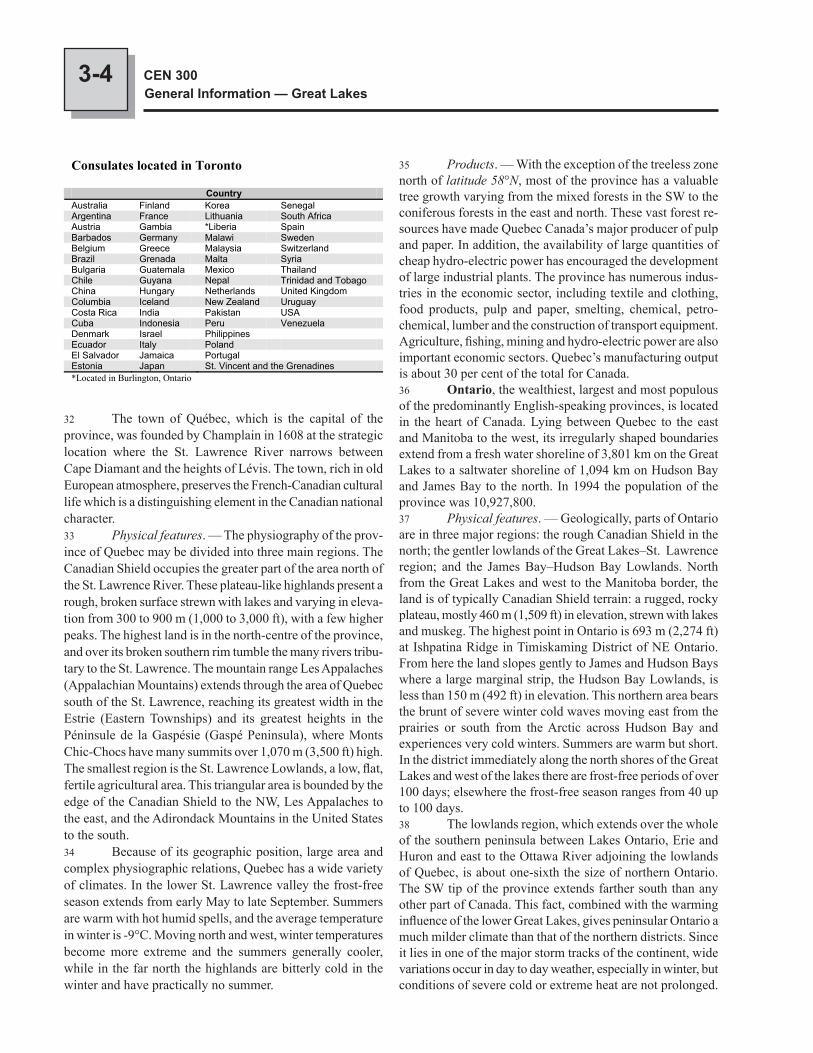
3-4 CEN 300General Information — Great Lakes
32 The town of Québec, which is the capital of the province, was founded by Champlain in 1608 at the strategic location where the St. Lawrence River narrows between Cape Diamant and the heights of Lévis. The town, rich in old European atmosphere, preserves the French-Canadian cultural life which is a distinguishing element in the Canadian national character.33 Physical features. — The physiography of the prov-ince of Quebec may be divided into three main regions. The Canadian Shield occupies the greater part of the area north of the St. Lawrence River. These plateau-like highlands present a rough, broken surface strewn with lakes and varying in eleva-tion from 300 to 900 m (1,000 to 3,000 ft), with a few higher peaks. The highest land is in the north-centre of the province, and over its broken southern rim tumble the many rivers tribu-tary to the St. Lawrence. The mountain range Les Appalaches (Appalachian Mountains) extends through the area of Quebec south of the St. Lawrence, reaching its greatest width in the Estrie (Eastern Townships) and its greatest heights in the Péninsule de la Gaspésie (Gaspé Peninsula), where Monts Chic-Chocs have many summits over 1,070 m (3,500 ft) high. The smallest region is the St. Lawrence Lowlands, a low, flat, fertile agricultural area. This triangular area is bounded by the edge of the Canadian Shield to the NW, Les Appalaches to the east, and the Adirondack Mountains in the United States to the south.34 Because of its geographic position, large area and complex physiographic relations, Quebec has a wide variety of climates. In the lower St. Lawrence valley the frost-free season extends from early May to late September. Summers are warm with hot humid spells, and the average temperature in winter is -9°C. Moving north and west, winter temperatures become more extreme and the summers generally cooler, while in the far north the highlands are bitterly cold in the winter and have practically no summer.
35 Products. — With the exception of the treeless zone north of latitude 58°N, most of the province has a valuable tree growth varying from the mixed forests in the SW to the coniferous forests in the east and north. These vast forest re-sources have made Quebec Canada’s major producer of pulp and paper. In addition, the availability of large quantities of cheap hydro-electric power has encouraged the development of large industrial plants. The province has numerous indus-tries in the economic sector, including textile and clothing, food products, pulp and paper, smelting, chemical, petro-chemical, lumber and the construction of transport equipment. Agriculture, fishing, mining and hydro-electric power are also important economic sectors. Quebec’s manufacturing output is about 30 per cent of the total for Canada.36 Ontario, the wealthiest, largest and most populous of the predominantly English-speaking provinces, is located in the heart of Canada. Lying between Quebec to the east and Manitoba to the west, its irregularly shaped boundaries extend from a fresh water shoreline of 3,801 km on the Great Lakes to a saltwater shoreline of 1,094 km on Hudson Bay and James Bay to the north. In 1994 the population of the province was 10,927,800.37 Physical features. — Geologically, parts of Ontario are in three major regions: the rough Canadian Shield in the north; the gentler lowlands of the Great Lakes–St. Lawrence region; and the James Bay–Hudson Bay Lowlands. North from the Great Lakes and west to the Manitoba border, the land is of typically Canadian Shield terrain: a rugged, rocky plateau, mostly 460 m (1,509 ft) in elevation, strewn with lakes and muskeg. The highest point in Ontario is 693 m (2,274 ft) at Ishpatina Ridge in Timiskaming District of NE Ontario. From here the land slopes gently to James and Hudson Bays where a large marginal strip, the Hudson Bay Lowlands, is less than 150 m (492 ft) in elevation. This northern area bears the brunt of severe winter cold waves moving east from the prairies or south from the Arctic across Hudson Bay and experiences very cold winters. Summers are warm but short. In the district immediately along the north shores of the Great Lakes and west of the lakes there are frost-free periods of over 100 days; elsewhere the frost-free season ranges from 40 up to 100 days.38 The lowlands region, which extends over the whole of the southern peninsula between Lakes Ontario, Erie and Huron and east to the Ottawa River adjoining the lowlands of Quebec, is about one-sixth the size of northern Ontario. The SW tip of the province extends farther south than any other part of Canada. This fact, combined with the warming influence of the lower Great Lakes, gives peninsular Ontario a much milder climate than that of the northern districts. Since it lies in one of the major storm tracks of the continent, wide variations occur in day to day weather, especially in winter, but conditions of severe cold or extreme heat are not prolonged.
Consulates located in Toronto
Country Australia Finland Korea Senegal Argentina France Lithuania South Africa Austria Gambia *Liberia Spain Barbados Germany Malawi Sweden Belgium Greece Malaysia Switzerland Brazil Grenada Malta Syria Bulgaria Guatemala Mexico Thailand Chile Guyana Nepal Trinidad and Tobago China Hungary Netherlands United Kingdom Columbia Iceland New Zealand Uruguay Costa Rica India Pakistan USA Cuba Indonesia Peru Venezuela Denmark Israel Philippines Ecuador Italy PolandEl Salvador Jamaica Portugal Estonia Japan St. Vincent and the Grenadines *Located in Burlington, Ontario
3-5General Geographic Information andBroad Description of Port Facilities
CHAPTER 3
St. Lawrence River and Great Lakes system
44 The St. Lawrence River system, comprising an estu-ary and a series of connected lakes, offers a transportation link by water from the Atlantic Ocean to the middle of the North American continent. From the mouth of the St. Lawrence River near longitude 64°W to the head of Lake Superior near longitude 92°W, this magnificent waterway has a total length of 1,635 miles.45 The first recorded navigational improvement on the St. Lawrence River dates back to 1700 when a canal 0.4 m (1.5 ft) deep was constructed at the Little River Saint-Pierre near Lachine. Other short canals with depths of 0.6 to 0.9 m (2 to 3 ft) were built to bypass the many falls and rapids and were used by the freight-carrying “canots de maître” of the fur trading companies.46 Early in the nineteenth century, the first canals and locks were constructed between Montréal and Kingston, and by 1848 a canal system with a depth of 2.7 m (9 ft) was com-plete. This system consisted of Canal de Lachine, giving ac-cess from Montréal to Lac Saint-Louis; Canal de Beauharnois, linking Lac Saint-Louis with Lac Saint-François on the south shore; and Cornwall Canal, Farran Point Canal (Rapide Plat Canal) and Old Galop Canal (Galop Canal), bypassing the International Rapids section of the St. Lawrence River. The forerunner to the Welland Ship Canal, with 26 locks to bypass Niagara Falls, was also built at this time.47 By 1901 the last of a new and larger series of canals between Montréal and Lake Erie was complete; these can-als were designed to handle ships 77.7 m (255 ft) long with draughts of up to 4.3 m (14 ft). Canal de Beauharnois was replaced by Canal de Soulanges, extending from the north shore of Lac Saint-Louis to Lac Saint-François, at this time.48 By 1932 the 26 locks of the Welland Canal had been replaced by eight locks which provided a deep-water route with a limiting depth of 7.6 m (25 ft). These locks were capable of handling the 217.9 m (715 ft) long lake vessels which plied between Prescott on the Upper St. Lawrence River and Duluth at the western end of Lake Superior.49 The St. Lawrence Seaway was designed to remove the limitations of the 4.3 m (14 ft) depth between Montréal and Prescott, and to harness the power potential of the International Rapids section of the St. Lawrence River by the construction of power and control dams. This would convert the International Rapids section into an artificial lake 30 miles long, extending from Cornwall to Iroquois. The hydro-electric power projects, a joint undertaking of the Hydro-Electric Power Commission of Ontario and the Power Authority of the State of New York, entailed the relocation of four towns from the area now known as Lake St. Lawrence, the building of dams and control dykes, and the relocation of railways and
This is the most densely populated and highly industrialized region of Canada; settlement was influenced by favourable climatic conditions and fertile soil and by ease of travel over the relatively unobstructed terrain and the natural transporta-tion routes of the St. Lawrence River and the Great Lakes.39 Products. — Agriculture is well established and continues to be of major importance to the economy of the province. With the exception of the wheat-growing areas of western Canada, this is by far the most highly productive agricultural area in the country. Maize and soya beans are grown throughout southern Ontario, but its produce is very diversified and many specialized areas have developed: fruit in the Niagara district, tobacco in the counties adjacent to Lake Erie, commercial vegetables north of Toronto, and cattle in the Georgian Bay area.40 The manufacturing industries of southern Ontario produce almost every product required by consumers. The focal point of this great industrial agglomeration is Toronto, the capital and largest city of the province and a major manu-facturing, financial, commercial and distribution centre.41 The Ontario part of the Canadian Shield has long been a producer of many base metals and accounts for close to 40 per cent of the total mineral output of Canada. Much of Canada’s tremendous production of nickel and about half the copper come from the Sudbury area; gold comes from the Kirkland Lake–Porcupine area and from the Red Lake, Pickle Crow and Little Long Lake areas farther west; iron ore comes from the Steep Rock area west of Lake Superior and the Michipicoten area on the NE shore of the lake. Uranium, cadmium, calcium, cobalt, lead, magnesium, selenium, silver, tellurium, thorium, yttrium and zinc are also produced. In the lowlands area of the province, salt, asbestos and nepheline syenite are produced, and there is some natural gas and pet-roleum production.42 Ontario has a large amount of productive forest land which supports a thriving pulp and paper industry. Four tree species — black spruce, poplar, jack pine and white birch — account for almost 75 per cent of all the trees in the province. Ontario has extensive water power resources and is second only to Quebec in hydro-electric power.43 The commercial fishing industry in Ontario, although widely scattered throughout the province, is centred mainly on the Great Lakes, particularly Lake Erie. The species har-vested commercially include yellow perch, smelt, whitefish, pickerel, pike, lake trout, herring, chub, carp, white perch, sturgeon, white bass, bullhead, catfish, eel, goldeye, sunfish, burbot, freshwater drum, rock bass, crappie, sauger and suckers. Nearly 90 per cent of all the fish landed in Ontario is harvested from the Great Lakes, but more than 500 smaller inland lakes, mainly those in the NW part of the province, are fished commercially.
3-6 CEN 300General Information — Great Lakes
roads at an estimated cost of $600 million. The 32 generators in the Moses-Saunders Power Dam extending from Cornwall to Barnhart Island develop some 1,860 MW of power.50 The St. Lawrence Seaway was built jointly by the St. Lawrence Seaway Authority, a Canadian Crown Corporation, and the Saint Lawrence Seaway Development Corporation of the United States. The Saint Lawrence Seaway Developent Corporation undertook to build a canal and two locks in the International Rapids section and to dredge the channel throughout the Thousand Islands section of the St. Lawrence River. The St. Lawrence Seaway Authority undertook the construction of two locks and a 20-mile long canal to bypass the Rapides de Lachine, two locks at Beauharnois, extensive dredging in Lac Saint-Louis and Lac Saint-François, and a lock at the head of Lake St. Lawrence to bypass the Iroquois Control Dam. Improvements in the Welland Canal were also carried out by the St. Lawrence Seaway Authority.51 The St. Lawrence Seaway was officially opened by Her Majesty Queen Elizabeth and by President Dwight Eisenhower of the United States on June 26, 1959, when the Royal Yacht Britannia proceeded through Saint-Lambert and Côte Sainte-Catherine locks to a naval review in Lac Saint-Louis.52 The distance via the St. Lawrence River system from the Strait of Belle Isle to Montréal is 878 miles; to Thunder Bay on the NW coast of Lake Superior 1,939 miles; to Chicago, Illinois, 1,965 miles; to Duluth, Minnesota, 2,045 miles.53 The control of the St. Lawrence ship channel from the Gulf of St. Lawrence to the Port of Montréal, and its regulations and improvements, are under the Department of Transport. From Montréal west to Lake Erie the improve-ments in the Canadian deep channel are under the jurisdiction of the St. Lawrence Seaway Authority. The Department of Public Works is responsible for all improvements west from Lake Erie to the head of Lake Superior, with the exception of the Sault Ste. Marie Canal, which is administered by Parks Canada, Department of the Environment.54 Montréal to Lake Ontario. — The part of the St. Lawrence River above Montréal, extending from the en-trance to the St. Lawrence Seaway at Montréal to Kingston Harbour on the Canadian shore and Tibbetts Point on the United States’ shore, at the foot of Lake Ontario, has a total length of 164 miles. Of this length there are 136 miles of natural river and open lake expansions, and 28 miles of canals. The average width of the river is 1.3 miles. The lake expansions are Lac Saint-Louis, Lac Saint-François, and Lake St. Lawrence. The first, reached from Montréal by Canal de la Rive Sud, is 12 miles long and has a greatest width of 5 miles; Lac Saint-François is 27 miles long and has a maximum width of 4 miles; Lake St. Lawrence is 9 miles long and has
a maximum width of 3.7 miles. From a position where the deep waterway passes east of Cornwall Island, 67 miles above Montréal, to Kingston, the main navigation channel is partly on the Canadian side of the International Boundary and partly on the United States’ side.55 A vessel on passage between Montréal and Kingston will pass through Canal de la Rive Sud, Canal de Beauharnois and Wiley-Dondero Canal. In the canal sections of the St. Lawrence Seaway where the canal is flanked by two embankments, there is a minimum width of 61 m (200 ft) at the bottom and 69 m (225 ft) at the surface. Where the canal is flanked by one embankment, the minimum width at the bottom is 91 m (300 ft). In open water, the minimum width of the channel is 122 m (400 ft). Seven locks in this section overcome the difference of elevation between the Port of Montréal, with an elevation of 5.6 m (18.2 ft), and Lake Ontario, with an elevation of 74.2 m (243.3 ft) above IGLD 1985. The minimum depth over lock gate sills is 9.14 m (30 ft); the locks are 24.38 m (80 ft) wide and 233.5 m (766 ft) long, with a usable length of 222.50 m (730 ft).56 The main channels between Port of Montréal and Lake Erie have a controlling depth of 8.23 m (27 ft).57 Opening and closing dates for the Montréal–Lake Ontario section are generally April 1 and December 15; actual dates depend on weather and ice conditions and are announced by Notice to Shipping.58 Preliminary figures indicate that in 1994 there were 2,868 vessel transits of the Montréal–Lake Ontario section of the Seaway, an increase of 24 per cent over 1993 figures and the best since 1988. Total cargo carried was 38,377,000 tonnes, a 22 per cent increase over the 1993 season.59 Lake Ontario is the smallest of the Great Lakes in area; it is 174 miles long with a breadth of 47 miles. As with Lakes Superior and Erie, its long axis is roughly from east to west. The lake is comparatively deep, its maximum depth being 246 m (807 ft). The waters of Lake Ontario flow NE into the St. Lawrence River.60 Many of the commercial harbours are artificially enlarged basins at the mouths of small rivers, improved by dredging and by the building of jetties, training piers and breakwaters. Many of the harbours are subject to shoaling and require frequent dredging to maintain the channels.61 The navigation season in Lake Ontario is generally from April 1 to December 30, but prevailing ice conditions may delay or advance these dates by as much as two weeks. At the NE end of the lake, inside the offshore islands, the surface water often freezes enough to allow automobiles to drive to and from the islands. Offshore, the lake is little obstructed by ice and areas of open water have been reported even in severe winters.62 Welland Canal, built to bypass the Niagara River and Niagara Falls, has eight locks, raising vessels from Lake
3-7General Geographic Information andBroad Description of Port Facilities
CHAPTER 3
Ontario, with an elevation of 74.2 m (243.3 ft), to Lake Erie, with an elevation of 173.5 m (569.2 ft) above IGLD 1985. The minimum depth over lock gate sills is 9.14 m (30 ft); the locks are 24.38 m (80 ft) wide and have a usable length of 222.50 m (730 ft), except lock 8, which has a usable length of 350.0 m (1,148 ft). The controlling depth in the canal is 8.23 m (27 ft).63 In 1994 there were 3,376 vessel transits of the Welland Canal. Total cargo carried was 39,632,000 tonnes.64 Lake Erie is the most southerly and the most shal-low of the Great Lakes. Together with the Welland Canal, it forms a link in the waterway between Lake Ontario and the connecting channels to Lake Huron. The distance from Buffalo, New York, at the east end of the lake to Toledo, Ohio, at the west end is 220 miles. The greatest width is 50 miles. The flow of water in the lake is from the Detroit River outlet, at the west end of the lake, in an ENE direction to the main outflow through the Niagara River and over Niagara Falls.65 The deepest part of the lake is near the eastern end; the island region at the west end is the most shallow. The maximum depth in Lake Erie is 62 m (203 ft) at a position SE of Long Point, Ontario.66 There is much water-borne commercial activity be-tween the various ports of the lake as well as to and from the other lakes. The navigation season is generally from April 1 to December 30.67 During the winter, heavy ice forms along the shore-line and extends into the lake. The island region at the western end is often quite solidly iced over except for channels kept clear by passing ships.68 Detroit River is 28 miles long from the Detroit River light at its mouth in Lake Erie to its head at Peche Island. It is navigated by the largest vessels on the Great Lakes. The navigation season is generally from April 15 to December 15.69 Lake St. Clair is a shallow basin about 20 miles in diameter with low marshy shores and a gently sloping bottom; the maximum natural depth is 21 feet (6.4 m). Lake St. Clair, with its ship channel improvements, is a connecting waterway link from Lake Erie to Lake Huron but there are no large communities or harbours around its shores.70 St. Clair River is 35 miles long and has a lower or delta part and a deep upper channel. The delta section, known as St. Clair Flats, has several branches of the river reaching into Lake St. Clair. The most important branch, with South Channel and the St. Clair Cutoff Channel, is used for through navigation between Lake St. Clair and the main river. The banks of the river are clay and sand and are generally quite steep.71 Lake Huron is the second largest of the Great Lakes in area, being slightly larger than Lake Michigan. It is 182 miles long in a north-south direction, with a maximum breadth of 88 miles. The waters of Lake Michigan enter Lake
Huron through the Straits of Mackinac, and those of Lake Superior enter by St. Marys River; the lake flows into the St. Clair River at Sarnia. The depths in these rivers and the Detroit River limits the size and draught of vessels navigating between Lake Superior and Lake Erie.72 Lake Huron is generally deep, with a maximum depth of 229 m (750 ft), but shoal water in places extends up to 3 miles off the northern and eastern shores and off the shores of Manitoulin, Duck, Cockburn and Drummond Islands. The navigation season is generally from April 15 to December 30.73 Georgian Bay, close NE of Lake Huron, is separated from the main body of the lake by the Bruce Peninsula and by Manitoulin Island and several other islands and shoals. Georgian Bay is 110 miles long in a NW–SE direction and 48 miles wide at its widest. The NE and north shores of the bay are much broken up by inlets and fringed by many islands and shoals; the SW side of the bay is generally deep and indented by several large bays. The maximum depth in Georgian Bay is 168 m (552 ft) near the north shore of the Bruce Peninsula.74 North Channel of Lake Huron extends from Badgeley Island at the NW end of Georgian Bay to St. Joseph Island, passing north of Manitoulin Island.75 Lake Superior is the largest of the Great Lakes and one of the largest bodies of fresh water in the world. It is char-acterized by deep water and high, bold, rocky shores along a great part of its coast. Compared with the other Great Lakes, its winds and seas are not greatly different and it has about the same snowfall, but its surface is at a higher elevation, it has deeper and colder water, more fog, more shore ice, and less rain.76 Lake Superior is about 304 miles long with a max-imum breadth of 139 miles. Its maximum depth is 406 m (1,333 ft) in the SE part of the lake. The waters of Lake Superior flow through the St. Marys River into Lake Huron.77 The navigation season on Lake Superior is generally about eight months long. Commercial fishing operations from the various harbours around the lake continue throughout the year except when prevented by ice conditions.
Port facilities
78 List of ports. — The following is a summary of the principal ports in this part of Canada. For more information on these ports and for information on other Canadian ports, consult the appropriate Sailing Directions publications.79 For information on United States’ ports, consult the current edition of United States Coast Pilot 6, published by the National Ocean Service of the United States. For the convenience of the user and to provide some necessary con-tinuity, certain United States’ waters and areas of shoreline are also described in Canadian Sailing Directions, quoting
3-8 CEN 300General Information — Great Lakes
verbatim from U.S. Coast Pilot 6, corrected from U.S. Notices to Mariners to the date of publication.80 Prescott (44°43'N, 75°31'W) is on the NW shore of the St. Lawrence River 114 miles upstream of Montréal. Ports Canada maintains a transit shed for handling general cargo and facilities for loading grain.81 Oshawa Harbour (43°52'N, 78°50'W) is on the north shore of Lake Ontario, 26 miles ENE of Toronto. The port is administered by the Oshawa Port Authority. Cargoes handled include petroleum products, steel, salt, calcium chloride, potash and general cargo.82 Toronto Harbour (43°38'N, 79°22'W) is a major inland port on the NW shore of Lake Ontario. The port is administered by the Toronto Port Authority. Main imports are steel products, sugar, grain, coal and coke, crude tar, flour, petroleum products, cement and general merchandise; exports are grain, petroleum products, cast iron pipe, creosote, flour and general merchandise.83 Hamilton Harbour (43°17'N, 79°50'W) is at the west end of Lake Ontario, 27 miles SW of Toronto. The port is administered by the Hamilton Port Authority. The port handles bulk shipments of coal, iron ore, sand, steel, scrap metal, petroleum products, soya bean meal, molasses, fertilizer, automobiles and machinery. The harbour is entered through Burlington Canal, which is dredged to a depth of 8.8 m (29 ft).84 Port Weller Harbour (43°14'N, 79°13'W), at St. Catharines, is an artificial harbour forming the Lake Ontario entrance to the Welland Canal. The port is adminis-tered by the St. Lawrence Seaway Authority. Coal, sand and bulk sugar are unloaded here.85 Port Colborne (42°53'N, 79°15'W) is at the Lake Erie entrance to the Welland Canal. The harbour, protected by breakwaters, has wharf space on both sides of the canal channel. The harbour is administered by the St. Lawrence Seaway Authority. Petroleum products, grain, coal, iron ore, limestone, sand, gravel, flour, cement and crushed stone are handled here.86 Windsor (42°19'N, 83°03'W) is on the Detroit River; its boundaries extend from 15 miles north of Lake Erie to Lake St. Clair. The port is administered by the Windsor Port Authority. There are more than 500 industries in Windsor and vicinity, including the production of automobile components, drugs, chemicals, and brewed and distilled products.87 Sarnia Harbour (42°59'N, 82°25'W) is on the St. Clair River near its junction with Lake Huron. The port is administered by the Department of Transport. The harbour has 2 miles of wharves, mostly privately owned. The navi-gation season is generally from March 15 to December 30. Main imports are grain, steel, lumber, coal, crude oil, crushed stone and cement; exports are petroleum products, rubber, chemicals, lumber, beans, sand, tobacco, grain and fertilizer.
88 Goderich (43°45'N, 81°44'W) is at the mouth of the Maitland River on the east shore of Lake Huron, 55 miles NE of Sarnia. The navigation season is generally from April 15 to December 30. The harbour is a transfer point for grain and offers safe winter quarters for lake vessels. Grain and coal are imported; grain and salt are exported.89 Owen Sound Harbour (44°35'N, 80°56'W) is at the mouth of the Sydenham River in the SW part of Georgian Bay. The distance from Sarnia to Owen Sound is 207 miles; it is about the same distance from Owen Sound to Sault Ste. Marie. Ice usually forms in the harbour about January 1 and breaks up near the end of March. Owen Sound has several manufacturing plants and a large grain elevator. Grain, coal and general merchandise are imported; the main exports are grain and general merchandise.90 Collingwood Harbour (44°31'N, 80°13'W) is an artificial harbour at the south end of Georgian Bay, 32 miles east of Owen Sound. Ice forms in the harbour about January 1 and breaks up near the end of March. Collingwood has a grain elevator.91 Midland (44°45'N, 79°53'W) is in the SE part of Georgian Bay, 45 miles east of Owen Sound. The navigation season is generally from April 15 to December 15. Midland has a grain elevator and is an important grain handling port. There are also ship repair facilities, a coal wharf, and flour, textile and planing mills.92 Port McNicoll (44°45'N, 79°48'W), part of Victoria Harbour, is 4 miles east of Midland. Port McNicoll consists of an artificial basin. Ice forms in the harbour about December 10 and breaks up about April 1.93 Parry Sound Harbour (45°20'N, 80°02'W) is near the mid-point of the east shore of Georgian Bay. The distance from Sarnia to Parry Sound is 215 miles; Parry Sound to Sault Ste. Marie via the North Channel is 210 miles. The navigation season is generally from April 15 to December 15.94 Little Current (45°59'N, 81°55'W) is on the north side of Manitoulin Island at the east end of the North Channel of Lake Huron. All vessels navigating between Georgian Bay and North Channel pass through Little Current. The town is connected by highway with the rest of Canada. The naviga-tion season is generally from April to December. The distance from Sarnia to Little Current is 196 miles; Little Current to Sault Ste. Marie via St. Joseph Channel is 114 miles.95 Sault Ste. Marie (46°31'N, 84°20'W) is on the north shore of St. Marys River. The United States’ city and harbour of Sault Ste. Marie, Michigan, is on the south side of the river. The distance from Sarnia to Sault Ste. Marie is 233 miles. The navigation season is generally from April 15 to December 15. Main industries include the production of steel, chemicals, pulp and paper. The main imports are iron ore, oil, gasoline and coal; the main exports are iron and steel products, coke, paper and forest products.
3-9General Geographic Information andBroad Description of Port Facilities
CHAPTER 3
102 Repairs. — The following table lists the main ship-yards in the Lower Lakes area. Minor repairs are available at most ports.103 The following Canadian ports on the Upper Lakes have facilities to repair vessels: Midland, Goderich, Owen Sound, Sault Ste. Marie and Port of Thunder Bay. Minor repairs to vessels can be carried out at Parry Sound. There is a dry dock at Port of Thunder Bay, operated by the Port Arthur Shipbuilding Company.104 Border crossing information. — Citizens and legal residents of the United States do not need passports or visas to enter Canada as visitors. In general, all other visitors entering Canada must have valid national passports. Any questions about entry to Canada may be addressed to the Canada Immigration Division, Department of Employment and Immigration, Ottawa, Ontario K1A 0J9.105 Customs information was correct at time of printing. Any changes announced by Customs and Excise, Revenue Canada that affect Sailing Directions will be promulgated by Notice to Mariners.106 All vessels entering Canada from foreign ports are required to obtain clearance from the Collector of Customs at a Port of Entry. Visitors may bring their own pleasure craft into Canada for a period of up to 12 months, under a permit obtainable from the Collector of Customs.107 Ports of entry. — On the Lower Lakes, there are vessel clearing stations for commercial traffic at Montréal, Valleyfield, Cornwall, Morrisburg, Kingston, Prescott, Oshawa, Toronto, Clarkson, Bronte (Petro Canada Dock), Hamilton, Port Stanley, Wheatley, Leamington, Kingsville and Windsor. Most marinas between Montréal and Sarnia are vessel reporting stations for pleasure craft.108 On the Upper Lakes, there are vessel clearing stations for commercial traffic at Sarnia, Goderich, Killarney Quarries, Serpent Harbour, Meldrum Bay, Sault Ste. Marie, Marathon and Thunder Bay. Except for Killarney Quarries and Serpent Harbour, these places are also vessel reporting stations for
96 Red Rock (48°57'N, 88°15'W) is on the NW shore of Nipigon Bay, Lake Superior, 5 miles from the town of Nipigon. Red Rock has a large pulp and paper mill. Logging and pulp wood are the main industries in the area. The naviga-tion season is generally from May to November.97 Port of Thunder Bay (48°25'N, 89°13'W), on the north shore of Lake Superior 237 miles from Sault Ste. Marie, is a major Canadian port at the head of the Great Lakes–Seaway System. The port is administered by the Thunder Bay Port Authority. The navigation season is generally from April 1 to December 30. In 1990 the port had 13 operating grain elevators, a feed house with bagging capabilities, a malt-ing plant, two modern dry-bulk handling terminals, a general cargo terminal, two petroleum facilities and two chemical docks. A full range of marine services, including ship repair, is also available. The main imports are coal, coke, structural steel, limestone, salt, petroleum products and cement; the main exports are grain, iron ore, flour, paper, potash, sulphur, newsprint, wood pulp, steel and scrap iron.98 Water. — Potable fresh water is available at most Canadian ports.99 Fuel. — Various types of marine fuel oil and lubri-cants are available in Cornwall, Kingston, Toronto, Hamilton, Port Colborne, Windsor, Sarnia, Goderich, Owen Sound, Parry Sound, Little Current, Sault Ste. Marie, and Port of Thunder Bay.100 Ship Sanitation Control Certificates or Ship Sanitation Control Exemption Certificates, required by International Health Regulations (2005), may be obtained at Toronto. For details, see Health Canada under Regulations, Chapter 2.100.1 The Canadian Food Inspection Agency will inspect a ship if the transported agricultural product requires an inspec-tion. The inspection shall take place before loading and if an anti-parasite treatment is necessary, it will be done under the supervision of the Agency.101 Compass adjustment. — There is a compass ad-juster at Port of Thunder Bay.
Shipyards
Location Company Facilities / Dimensions Capacity Depth over Sill / Maximum DraughtKingston MetalCraft Marine Incorporated Dry dock / 61 x 14.6 m (200 x 48 ft). Depth over sill 4 m (13 ft).
A tug is available.Whitby Cartier Construction
IncorporatedDry dock / 106.7 x 14.3 m (350 x 47 ft). Maximum draught
3.7 to 4.3 m (12 to 14 ft).Toronto Toronto Drydock Corp. Floating dry dock / 54.8 x 12 m (180 x 40 ft).
Floating dry dock / 27.7 x 6.7 m (91 x 22 ft).1,000 tonnes. Maximum draught 5.5 m (18 ft).
Maximum draught 2.1 m (7 ft).Hamilton Heddle Marine Services Inc. Floating dry dock / 110 x 20 m (360 x 66 ft). 3,000 tonnes. Maximum draught 5.5 m (18 ft).St. Catherines Port Weller Dry Docks Dry dock / 228.6 x 24.3 m (750 x 80 ft).
Dry dock / 244 x 24.8 m (800 x 81 ft).37,000 tonnes.34,000 tonnes.
Depth over sill 7.9 m (26 ft). *Depth over sill 4.3 m (14 ft).
Port Colborne (Ramey’s Bend) Marsh Engineering Dry dock / 82.3 x 18.3 m (270 x 60 ft). Depth over sill 2.6 m (9 ft).Port Maitland Powell Shipyard Floating dry dock / 76 x 10.6 m (250 x 35 ft). 406 tonnes. Maximum draught 4.2 m (14 ft).Wheatley Hike Metal Products Marine Travelift. 91 tonnes. Maximum draught 3.7 m (12 ft).LaSalle LaSalle Drydock Ltd. Two carriage marine railway / 45.7 m (150 ft). 453 tonnes. Maximum draught 3 m (10 ft).Windsor Romeo Machine Shop Ltd. No dry dock. Berth / 222.5 m (730 ft). Depths of 6.4 to 7.9 m (21 to 26 ft).Note: All information in this table was provided by local authorities. Users should consult local authorities for the latest conditions. * Depth of 2.1 m (7 ft) reported in approaches.
3-10 CEN 300General Information — Great Lakes
111 Information on tourism, including a booklet called Travel Information — U.S. Visitors, can be obtained from Tourism Canada, 235 Queen Street, Ottawa, Ontario K1A 0H6.112 Police. — The Ontario Provincial Police can help in many kinds of emergencies. To reach the nearest detachment of the O.P.P., ask the telephone operator for Zenith 50,000. In Quebec, contact the nearest office of the Quebec Provincial Police (Sûreté du Québec) for help.
pleasure craft. There are also vessel reporting stations for pleasure craft at most marinas and many Public wharves.109 Note. — Most vessel reporting stations are open only during the summer months and service may not be available after regular office hours. To avoid delays and the probability of fines for non-compliance, visiting boaters should make their report at the earliest opportunity.110 Further information on customs regulations can be obtained from Customs and Excise, Revenue Canada, 360 Coventry Road, Ottawa, Ontario K1K 2C6.
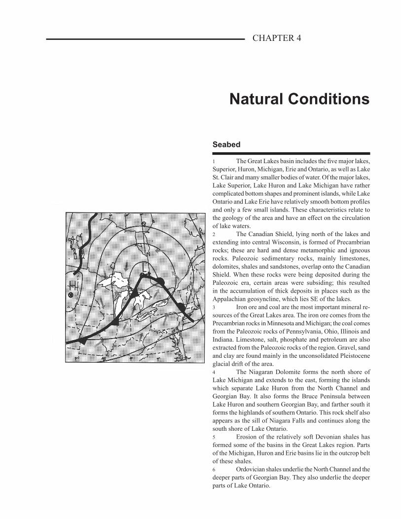
CHAPTER 4
Natural Conditions
Seabed
1 The Great Lakes basin includes the five major lakes, Superior, Huron, Michigan, Erie and Ontario, as well as Lake St. Clair and many smaller bodies of water. Of the major lakes, Lake Superior, Lake Huron and Lake Michigan have rather complicated bottom shapes and prominent islands, while Lake Ontario and Lake Erie have relatively smooth bottom profiles and only a few small islands. These characteristics relate to the geology of the area and have an effect on the circulation of lake waters.2 The Canadian Shield, lying north of the lakes and extending into central Wisconsin, is formed of Precambrian rocks; these are hard and dense metamorphic and igneous rocks. Paleozoic sedimentary rocks, mainly limestones, dolomites, shales and sandstones, overlap onto the Canadian Shield. When these rocks were being deposited during the Paleozoic era, certain areas were subsiding; this resulted in the accumulation of thick deposits in places such as the Appalachian geosyncline, which lies SE of the lakes.3 Iron ore and coal are the most important mineral re-sources of the Great Lakes area. The iron ore comes from the Precambrian rocks in Minnesota and Michigan; the coal comes from the Paleozoic rocks of Pennsylvania, Ohio, Illinois and Indiana. Limestone, salt, phosphate and petroleum are also extracted from the Paleozoic rocks of the region. Gravel, sand and clay are found mainly in the unconsolidated Pleistocene glacial drift of the area.4 The Niagaran Dolomite forms the north shore of Lake Michigan and extends to the east, forming the islands which separate Lake Huron from the North Channel and Georgian Bay. It also forms the Bruce Peninsula between Lake Huron and southern Georgian Bay, and farther south it forms the highlands of southern Ontario. This rock shelf also appears as the sill of Niagara Falls and continues along the south shore of Lake Ontario.5 Erosion of the relatively soft Devonian shales has formed some of the basins in the Great Lakes region. Parts of the Michigan, Huron and Erie basins lie in the outcrop belt of these shales.6 Ordovician shales underlie the North Channel and the deeper parts of Georgian Bay. They also underlie the deeper parts of Lake Ontario.
4-2 CEN 300General Information — Great Lakes
7 The main basin of Lake Superior is in an area under-lain by Upper Keweenawan sedimentary rocks, which are relatively soft.8 Lake Ontario is the smallest of the Great Lakes in area and third in maximum depth, after Lakes Superior and Michigan, with a maximum depth of 246 m (807 ft). The southern rim of the Lake Ontario basin is formed by the outcrop of the tilted Niagara Dolomite, which also forms the sill of Niagara Falls. Most of the basin has eroded in the soft Queenston shale of the Ordovician age; the northern half of the lake bed is underlain by a more resistant Ordovician limestone. The deeper parts of the lake are south of the centre. The lake has a relatively steep slope where it rises from the depths to the south shore.9 Lake Erie is the shallowest of the five Great Lakes, with a maximum depth of 62 m (203 ft). The western part of this lake is partly closed by Point Pelee, on the north shore, and several islands and shoals. The basin of the lake east of Point Pelee has been eroded in soft Devonian shales; it partly lies on the surface of the underlying and more resist-ant Devonian limestones. In the narrow eastern part of this basin, the Devonian shales have eroded more deeply to form the deepest basin in the lake. Along the south border of the Erie basin east of Cleveland, Ohio, there is an escarpment of mainly Mississippian sandstone and shales rising 60 to 90 m (197 to 295 ft) above the floor of the lake basin. This is the NW edge of the Appalachian plateau.10 Lake Huron is the second largest of the Great Lakes in area and fourth in maximum depth, with a depth of 229 m (750 ft) in the main basin 17 miles SW of the NW tip of the Bruce Peninsula.11 The north shore of Lake Huron, along the North Channel and the NE shore of Georgian Bay, is on the edge of the Canadian Shield. The lake basin otherwise is within the Paleozoic rock of the region. The Niagaran Dolomite forms the Bruce Peninsula, Manitoulin Island and the other islands which separate the main body of the lake from its North Channel and Georgian Bay.12 The most striking feature of the bottom of Lake Huron is a submerged ridge which is roughly concentric with the Bruce Peninsula–Manitoulin Island ridge, and which extends across the lake from Kincardine, Ontario, to Alpena, Michigan. Six Fathom Bank, with a depth of 11 m (36 ft), lies on this ridge in mid lake 43 miles ESE of Alpena, though the ridge is generally 30 to 60 m (98 to 197 ft) deep. The NE face of the ridge is very steep and drops off to depths of more than 183 m (600 ft). The greatest depths are in the main basin NE of the ridge. The bottom in all of the deep parts of the basin is irregular; in several places the depths range from less than 60 m (197 ft) to more than 180 m (590 ft) in a distance of a few miles. The SW side of the ridge slopes more gently to
depths of 60 to 90 m (197 to 295 ft) in the SW basin of the lake.13 Lake Superior, the largest of the Great Lakes in area, is also the deepest, with a maximum depth of 406 m (1,333 ft) in the SE part of the lake. There is a relatively smooth basin trending NE–SW in its western half, where depths of over 183 m (600 ft) are fairly common, and a strongly ridged portion in its eastern third, where depths over the ridges are often over 152 m (500 ft) and depths between the ridges are 244 to 305 m (800 to 1,000 ft).14 Lake Superior lies almost entirely in the Canadian Shield and the lake basin is nearly surrounded by highlands. At some places the escarpment, 122 to 244 m (400 to 800 ft) high, drops off into depths of 152 to 274 m (500 to 900 ft).15 The Keweenaw Peninsula and Isle Royale are prom-inent features. Keweenaw Bay and the main basin of Lake Superior, between Isle Royale and the Keweenaw Peninsula, are in an area of late Precambrian sedimentary rocks. These consist of conglomerates, sandstones, arkoses and shales. The softer sedimentary rocks in the centre of the main basin have eroded to depths of over 300 m (984 ft) in places.
16 Superior Shoal, with a depth of 6.4 m (21 ft), lies in the middle part of the lake 53 miles east of Isle
Royale.17 The Canadian Hydrographic Service produces Regional Bathymetric Map 881 of Lake Ontario, 882 of Lake Erie, and 885 of Lake Superior.
18 Magnetic anomalies. — The direction of the magnetic compass needle at some places will differ
appreciably from the normal direction for the area. This is probably due to masses of magnetic iron ore, or rock strata containing iron, in the seabed. When the water is shallow and the force strong, a compass needle may be temporar-ily deflected when passing over such a spot but the area of disturbance will be small, unless there are many such places close together.19 Magnetic variation on Lake Ontario does not change uniformly going east or west; there are many spots with differ-ences from the normal variation. In a distance of 4 miles off the United States’ shore, 9 miles NW of Olcott, New York, for instance, the variation ranges from 0 to 16°W; the normal for the area is 9°W. This and other local magnetic disturbances are shown on Chart 2400. Some of these are of particular interest and concern to mariners because they are in deep water on or near the track to and from the Welland Canal.20 In Lake Ontario, the greatest difference from normal variation is near Kingston Harbour. The normal variation in this area is about 13°W (1995) but due to magnetic anomalies the variation may range from 27°W to 3°E between Melville Shoal (44°11'N, 76°35'W) and Spit Head, 9 miles to the east.21 In the north end of Lake Huron near Magnetic Reefs, at the south point of Cockburn Island, there is a magnetic
4-3Natural Conditions
CHAPTER 4
irregularity; the variation here is about ½°E, though the normal for the vicinity is 6°W. On East Reef, close to the east, the variation is about normal. Differences from normal variation of up to 8° have been reported 8 miles SW of Great Duck Island.22 A local magnetic disturbance has also been reported in the vicinity of Bustard Islands, in Georgian Bay.23 There are more strong magnetic irregularities in Lake Superior than in the other Great Lakes. The areas most affected are close off the north shore. Reports indicate that in the affected areas a compass is deflected towards the shore. Extreme caution is necessary when using a magnetic compass in the following areas: Grand Marais, Pigeon Point, Pie Island, Welcome Islands, Thunder Cape, Point Porphyry, Magnet Island, the area from Fluor Island to Wilson Island, Pic Island, Peninsula Harbour, off Sewell Point, on MacKinnon Bank and in the entrance to Quebec Harbour. Disturbances of 40° to 50° have been reported in the vicinity of Magnet and Pic Islands.
Ice
24 Terminology and definitions. — Ice nomenclature is in accordance with the internationally approved terminol-ogy (Sea Ice Nomenclature of the World Meteorological Organization). A complete manual of ice terminology, clas-sification, standard ice reporting codes and ice reconnaissance practices and procedures used in Canada is available from the Atmospheric Environment Service under the title MANICE.
Types of ice
• Sea ice: any form of ice found at sea which has originated from the freezing of sea water.
• Ice of land origin (Glacier ice): ice formed on land or in an ice shelf, found floating in water. The concept includes ice of this type which is grounded, for example icebergs.
• River ice: ice formed on a river, regardless of observed location.
• Lake ice: ice formed on a lake, regardless of observed location, for example on Lake Melville or the Great Lakes.
25 In terms of physical and chemical properties, ice may also be categorized as being either salt water ice (sea ice) or fresh water ice. Under equal conditions, river and lake ice forms earlier, becomes harder and disintegrates later than does sea ice. The following terminology describes the development stages (ages) of lake and river ice as agreed by the Canadian and United States’ agencies responsible for observing and forecasting ice conditions in the Great Lakes area.
Ages of ice• New (lake) ice: a general term for recently formed ice,
which includes frazil ice, grease ice, slush, shuga and ice rind. These include all the initial stages of ice growth where no definite floe shapes are present, and also the brittle, shiny crust of ice formed on a quiet surface (ice rind) with a thickness of up to 5 cm (2 in).
• Thin (lake) ice: ice in the thickness range of 5 to 15 cm (2 to 6 in).
• Medium (lake) ice: a further development of floes or fast ice reaching a thickness of 15 to 30 cm (6 to 12 in).
• Thick (lake) ice: ice in the thickness range of 30 to 70 cm (12 to 28 in).
• Very thick (lake) ice: ice which develops to greater than 70 cm (28 in) thick.
26 It is in the interest of mariners to note that the age classification of lake ice is also applied to describe ice development in the rivers and connecting waterways of the Great Lakes system including the St. Lawrence Seaway.27 Although the age classification of lake and river ice is not the same as that used to categorize the development of sea ice, the terminology approved by the World Meteorological Organization to describe the distribution and other surface features of sea ice is equally applicable to river and lake ice. In this regard, the term “sea ice” as used in the following list of nomenclature is interchangeable with the terms “river ice” and “lake ice”.
Concentration• Concentration: the ratio expressed in tenths describing
the amount of sea surface covered by ice as a fraction of the whole area being considered. Total concentration in-cludes all stages of development that are present. Partial concentration may refer to the amount of a particular stage or a particular form of ice and represents only a part of the total.
• Compact ice: floating ice in which the concentration is 10/10 and no water is visible.
• Consolidated ice: floating ice in which the concentration is 10/10 and the floes are frozen together.
• Very close ice: floating ice in which the concentration is 9/10 to less than 10/10.
• Close ice: floating ice in which the concentration is 7/10 to 8/10, composed of floes mostly in contact.
• Open ice: floating ice in which the ice concentration is 4/10 to 6/10, with many leads and polynyas, and the floes are generally not in contact with one another.
• Very open ice: floating ice in which the concentration is 1/10 to 3/10 and water predominates over ice.
4-4 CEN 300General Information — Great Lakes
• Open water: a large area of freely navigable water in which sea ice is present in concentrations less than 1/10. No ice of land origin is present.
• Ice free: no ice present. If ice of any kind is present this term should not be used.
Forms of floating ice• Drift ice*/Pack ice: term used in a wide sense to include
any area of sea ice other than fast ice no matter what form it takes or how it is dispersed. When concentrations are high, i.e. 7/10 or more, “drift ice” may be replaced by the term “pack ice”.
• Fast ice: sea ice which forms and remains fast (attached) to the shore, to an ice wall, or between shoals. Vertical fluctuations may be observed during changes of sea level. Fast ice may be formed by the freezing of sea water or by the freezing of floating ice of any age to the shore. It may extend a few metres or several hundred kilometres from the coast.
• Floe: any relatively flat piece of sea ice 20 m (66 ft) or more across. Floes are subdivided according to horizontal extent as follows:
Giant: over 10 km across; Vast: 2 to 10 km across; Big: 500 m to 2 km across; Medium: 100 to 500 m across; Small: 20 to 100 m across.• Ice cake: any relatively flat piece of sea ice less than 20 m
(66 ft) across.• Brash ice: accumulations of floating ice made up of
fragments not more than 2 m (7 ft) across, formed by the wreckage of other forms of ice.
• Pancake ice: predominantly circular pieces of ice from 30 cm to 3 m (1 to 10 ft) across and up to 10 cm (4 in) thick, with raised rims due to the pieces striking one another.
• Strips of sea ice: a long narrow area of floating ice about 1 km or less in width, usually composed of small floes and fragments detached from the main mass of ice and run together under the influence of wind, swell or current.
• Ice patch: an area of floating ice less than 10 km across.• Windrow: a long narrow heaped-up mass of grounded ice
floes usually formed in exposed offshore shallows by wind and wave action. As a rule, this term is peculiar to Great Lakes’ usage.
Surface features• Lead: any fracture or passage-way through sea ice which
is navigable by surface vessels. If the passage-way lies between drift ice and the shore it is termed a “shore lead”.
If it lies between drift ice and fast ice it is called a “flaw lead”.
• Puddle: an accumulation on ice of melt-water, mainly due to melting snow, but in the more advanced stage, to the melting of ice.
• Slush: snow which is saturated and mixed with water on top of either a land or ice surface, or as a viscous mass floating in water after a heavy snowfall.
• Thaw hole: vertical hole in sea ice formed when surface puddles melt through to the underlying water.
• Rafted ice: type of deformed ice formed by one piece of ice over-riding another. Common in new and young ice types.
• Ridge: a line or wall of broken ice forced up by pressure. May be fresh or weathered. The submerged volume of broken ice under a ridge, forced downwards by pressure, is termed an ice keel.
• Hummock: a hillock of broken ice which has been forced upwards by pressure. May be fresh or weathered. The submerged volume of broken ice beneath the hummock, forced downward by pressure, is termed a bummock.
• Polynya: any non-linear shaped opening enclosed in ice. A polynya may contain brash ice and/or be covered with new ice, nilas or young ice. To submariners they are referred to as “skylights”. Sometimes the polynya is limited on one side by the coast and is called a “shore polynya”, or by fast ice and is called a “flaw polynya”. If it recurs in the same position every year it is called a “recurring polynya”.
• Rotten ice: Sea ice which has become honeycombed and is in an advanced stage of disintegration.
• Ice jam: an accumulation of broken river ice or sea ice caught in a narrow channel.
• Batture floes: Fragments of grounded or shore-fast ice common to the upper St. Lawrence River that have broken away and drifted downstream. They may be large, thick and uneven and are frequently discoloured with ground deposits.
Other Terms Common to ShippingBeset. — Situation of a vessel surrounded by ice and unable
to move.Difficult area. — A general qualitative expression to indicate
in a relative manner that the severity of ice conditions prevailing in an area is such that navigation is difficult.
Easy area. — As the foregoing except that navigation in the area is not difficult.
Ice bound. — A harbour, inlet, etc., is said to be ice bound when navigation by ships is prevented on account of ice, except possibly with the assistance of an icebreaker.
Ice under pressure. — Ice in which deformation processes are actively occurring, for example ridging, and hence a poten-tial impediment or danger to shipping is likely to exist.
*Previously the term pack ice was used for all ranges of ice concentrations.
4-5Natural Conditions
CHAPTER 4
the shipping channel. The fast ice is particularly extensive in Lac Saint-Pierre where special engineering works prevent major disruptions once the ice cover has formed. Fast ice is also well developed in the non-navigable channels between Sorel and Montréal.35 From Québec to Lac Saint-Pierre, drift ice moves steadily seaward during the winter with occasional ice jams developing, especially above the Québec bridges where the river is much narrower. Canadian Coast Guard icebreakers keep the drift ice moving to prevent flooding of the low-lying areas along the river and to allow year-round navigation into Montréal. One of the objectives of the Marine Traffic Control system in this area is to enforce speed limits because the wake of passing ships can dislodge large ice floes which may then move into the channel and cause lengthy delays.36 Similar conditions prevail from Lac Saint-Pierre to Montréal but there are more islands to help keep the fast ice in place. Ice booms in some locations help in this control. In the Port of Montréal, the combined effect of the Rapides de Lachine and an ice-control structure above the Champlain Bridge produces a polynya or area of well-dispersed new and young ice throughout the winter.37 The ice begins to melt in early March and results in a gradual clearing of the shipping channel below Montréal as the existing ice is carried seaward and not replaced by new formations. Decay of the shore-fast ice follows and fragments may be carried into the channel as the break-up develops. The whole area is normally free of ice by the middle of April.38 A restricted shipping season is in effect from Montréal to Lake Ontario, depending on the opening and closing dates of the St. Lawrence Seaway. The general ice re-gime is much the same as below Montréal, with ice formation spreading upstream from the Montréal area early in December to reach the entrance to Lake Ontario early in January, and break-up progressing downstream from Lake Ontario during the first half of April.39 Lake Ontario has the smallest surface area in relation to its volume of all the Great Lakes. As a result, its temperature responds slowly to atmospheric cooling and ice growth is confined mainly to sheltered shallows. Ice forms first in the Bay of Quinte in the first week of December, and in the approaches to the upper St. Lawrence River in the first half of January.40 Maximum ice cover expected in a mild winter is about 10 per cent and in a normal winter 20 to 25 per cent. In a severe winter, ice coverage can reach 95 per cent. Only three times in the last 100 years has Lake Ontario approached a nearly complete ice cover, the most recent being in 1979. Any lasting ice cover of more than 25 per cent of the surface of Lake Ontario requires severely cold weather as well as ideal cooling conditions because vertical mixing of the water body rapidly destroys most of the ice cover. Generally, the ice
Ice coverage28 The following ice coverage diagrams show the weekly median ice concentrations for several periods during the ice season. These diagrams were prepared using com-posite ice charts produced by the Ice Centre, Department of the Environment. Thirteen winters of ice data were used in the analyses and only four ranges of ice concentrations were considered: 10 tenths, where the ice is solid; 7 to 9 tenths, where ship navigation is considered difficult; 1 to 6 tenths, where ship navigation is considered easy; and open water areas.29 It is possible to predict the formation and dissipation of ice cover with some degree of accuracy by including only the preceding summer and present winter air temperature data. However, the presence and movement of an ice cover on the Great Lakes is the product of a number of climatic controls.30 The depth of the lake has a direct effect on the forma-tion, retention and decay of ice. In general, deeper lakes retain their stored heat for a longer time than do shallower lakes. Runoff from tributary rivers may also slow the growth of ice. Similarly, the action of currents, winds and waves, mixing warmer deep water with surface water, will inhibit freezing. Winds and waves also act constantly to break up and move large ice floes.31 The ice season may begin by early November. Ice ranging from several centimetres to 1 m (3 ft) or more in thickness first forms in bays, inlets and straits, and other shallow waters rapidly lose heat to the cold air. Much of the ice breaks off to form floes and fields. By the end of winter, sometimes 60 per cent or more of a lake’s surface may be covered by ice. High and persistent winds cause windrows and pressure ridges to form. Some of these may extend 3 to 6 m (10 to 20 ft) above the water and 9 to 12 m (30 to 40 ft) below, often becoming anchored to the lake bottom. The ice cover begins to decay in March, though ice may still be present in mid May.32 The break-up process as ice degenerates is a much more rapid process than that which caused the formation of ice during winter due to the different amounts of heat transfer needed. Each lake, of course, has its own ice cover character-istics of which only the major ones will be discussed here.33 Note. — Information about ice in the Gulf of St. Lawrence and on the east coast of Canada is given in Sailing Directions booklet ATL 100 — General Information, Atlantic Coast.34 Ice in St. Lawrence River above Québec. — Typical river-ice conditions are encountered in this area, though there is some tidal influence below Trois-Rivières. Shore-fast ice begins to form during the first half of December and its main outlines are established by early January. In general, fast ice is found over the shallow coastal portions while drift ice covers
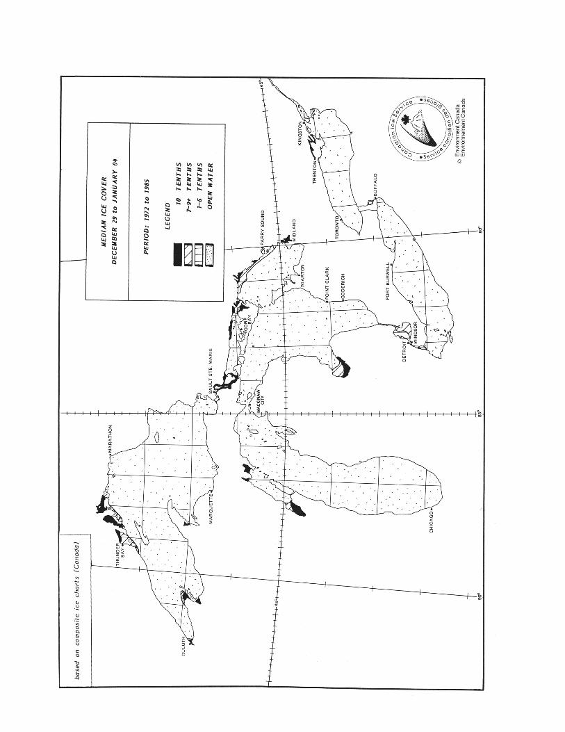
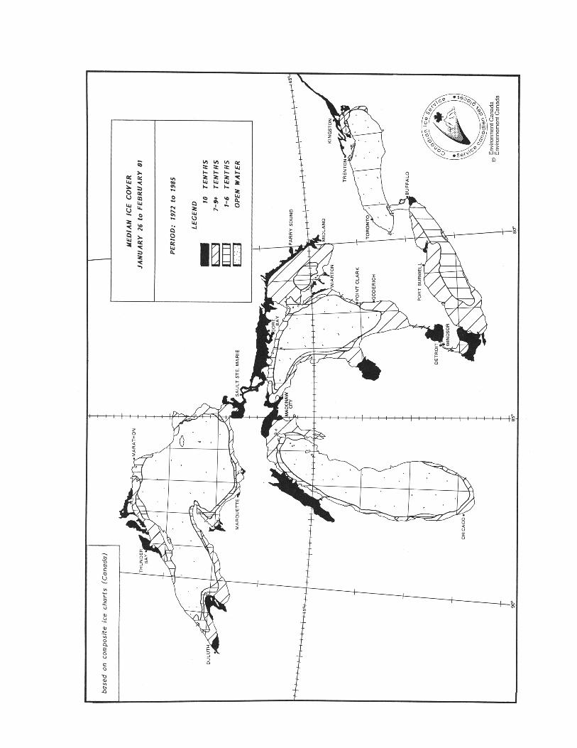
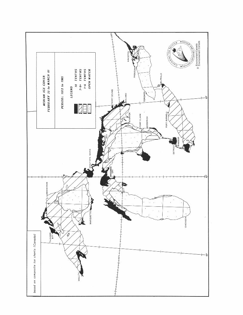
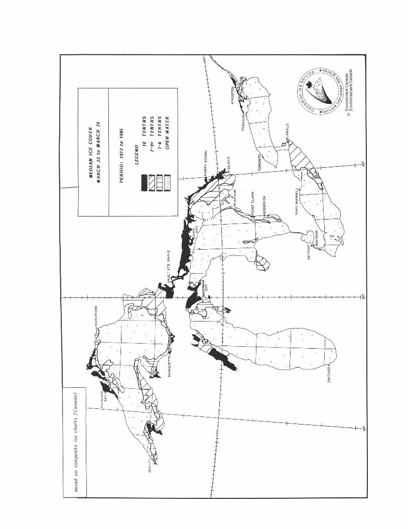
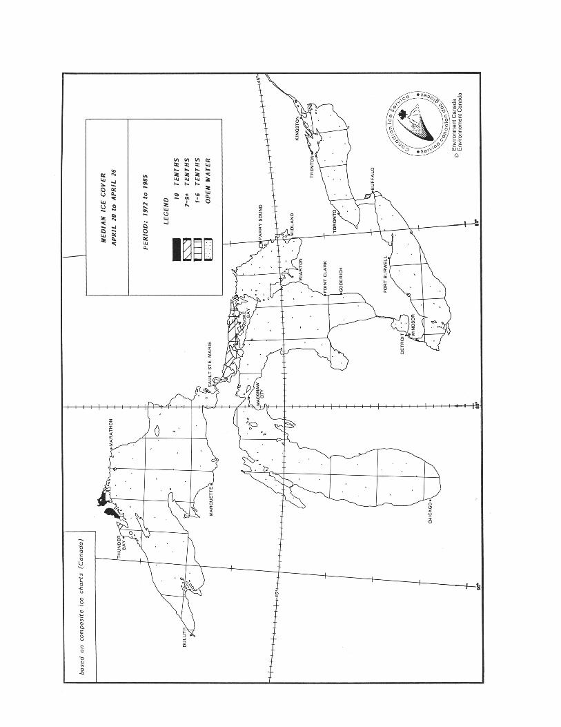
4-11Natural Conditions
CHAPTER 4 4-11
cover is confined mostly to the eastern end of the lake, while conditions along the main Lake Ontario shipping routes are for the most part open water.41 Lake Erie is the most thermally unstable of all the Great Lakes due to its shallow depth and orientation to pre-vailing winds. Ice forms first in the third week of December in the extreme western end of the lake and in Inner Bay of Long Point Bay. Maximum ice cover occurs in February, and except for ice remnants which may survive in the Buffalo area until the middle of May, complete clearing usually takes place by mid April. In a mild winter, 25 per cent of the lake surface will become ice covered, while a normal ice cover is of the order of 90 per cent, and in a severe winter approaches 100 per cent.42 Prevailing westerly winds and the eastward water outflow cause clearing to progress from west to east and frequently result in ice congestion and pressure developing off Long Point and in the east end near Buffalo. Some of the most spectacular windrows and massive accumulations of slush ice of the Great Lakes are found in this area. During cold winter outbreaks, considerable pressure ridging and rafting may occur along most of the south coast of the lake, while westward ice drifts created by spring storms may cause ice congestion in the west end of Lake Erie and the lower Detroit River. This process of mechanical ice redistribution continues throughout the season and it is not uncommon to find ice thick-ness as great as 9 to 10 m (30 to 33 ft) even though level ice growth through cooling accounts for only 25 to 45 cm (0.8 to 1.5 ft). During a single winter storm, aggregate ice thicknesses of over 20 m (66 ft) have been measured.43 Lake St. Clair, being the shallowest of these lakes, responds rapidly to prevailing winds and temperatures. Ice accumulation begins along the SE shore about the middle of December, with the area near the western shore being the last to freeze, usually by early January. The western shore is the first to open in the spring, usually by late February. Maximum ice cover during a normal winter is 100 per cent medium to thick lake ice from late January until early March, with openings remaining only at the head of the Detroit River and occasionally in the channels of the St. Clair River delta. Complete clearing usually occurs in late March.44 Except during severe winters, little actual freezing occurs in the Detroit and St. Clair Rivers. A natural ice bridge tends to form near Sarnia and prevents ice floes from entering the St. Clair River system; destruction of this ice bridge usually results in rapid formation of ice jams farther downstream. The consolidated ice sheet over Lake St. Clair similarly affects ice conditions in the Detroit River.45 Lake Huron waters begin freezing first in the St. Marys River, North Channel and eastern Georgian Bay areas, usually in the second half of December. Early ice formation also occurs in Saginaw Bay, in Thunder Bay near
Alpena, and in the Straits of Mackinac. As a rule, maximum ice cover is in mid February. In a mild winter 30 per cent of the entire Lake Huron area becomes ice covered while in an average year this value is near 70 per cent; in a severe year it may be 95 per cent or more.46 Due to the north–south orientation of the lake, daily mean temperatures are lower in the north than in the south. As a result, it is not unusual to find ice formation and ice destruction occurring simultaneously. This is particularly true for Lake Michigan. Significant spring melt on Lake Huron generally begins in March, with complete clearing by the second week of April. During the winter months, wind stress often causes considerable rafting, ridging and hummocking in the SE. In the spring, the formation of windrows is common in the Straits of Mackinac.47 Ice cover in the St. Marys River area is generally a stable feature during most of the winter. This is mainly because the flow rate through the river system is controlled and is maintained below dangerous threshold values. During spring break-up, however, there are ice jams at river narrows and obstructions.48 Lake Superior is by far the largest of the Great Lakes in depth, area and volume. These features give it an enormous heat storage capacity. Strong winds generated over long distances (a fetch to the middle of Lake Superior can exceed 180 miles), together with currents and waves, cause a continuous overturning of warm deep water and so inhibit an early ice cover. Ice first forms near the end of November or early December in harbours and bays along the north shore, over the shallow waters of Whitefish Bay, and in the western end of the lake.49 The average maximum seasonal ice cover is about 75 per cent; in a mild winter it is about 20 per cent and in a se-vere winter it may approach 100 per cent in the second half of February. Break up usually begins in March, with ice melt and deterioration accelerating rapidly in April. Complete clearing usually occurs by the end of April. In the level fast-ice areas, average maximum ice thickness values reach 45 to 85 cm (1.5 to 3 ft). In areas of ice pressure and ice floe interaction, however, rafting, ridging, and hummocking frequently result in much thicker ice, at times up to 7.6 m (25 ft). Windrows are also common during spring break-up, especially in the west end near Duluth and in the Whitefish Bay and upper St. Marys River areas.
Water levels
50 Fluctuations in water levels in non-tidal areas are the result of several natural factors and may also be influenced by human activities. These factors operate on a time-scale that varies from hours to years.
4-12 CEN 300General Information — Great Lakes
4-12
51 The levels of the Great Lakes depend on their storage capacity, the outflow characteristics of the outlet channels, the operating procedures of the regulatory structures, and the amount of water supply received by each lake. The primary natural factors affecting lake levels include precipitation on the lakes, run-off from the drainage basin, evaporation from the lake surface, inflow from upstream lakes, and outflow to the downstream lakes. Man-made factors include diversions into or out of the basin, consumption of water, dredging of outlet channels, and the regulation of outflows.52 There are three types of water level fluctuations on the Great Lakes: long-term, seasonal and short-period.53 Long-term fluctuations are caused by sustained low or high net basin supplies. They can result in very low levels, such as were recorded on some lakes in 1926, the mid-1930s and mid-1960s, or in very high levels such as in 1952, 1973 and 1985–86. More than a century of records for the Great Lakes basin indicate no regular or predictable cycle. The intervals between periods of high and low levels and the length of such periods can vary widely and erratically over a number of years, and only some of the lakes may be affected. The maximum recorded ranges of monthly water-levels, from extreme high to extreme low, have varied from 1.2 m in (4 ft) for Lake Superior to over 1.8 m (6 ft) for the other lakes. The ranges of levels on Lakes Michigan–Huron, Erie and Ontario reflect not only the fluctuation in supplies from their own basins but also the fluctuations of the inflow from upstream lakes.54 Seasonal fluctuations of Great Lakes’ levels reflect the annual hydrologic cycle. This is characterized by higher net basin supplies in spring and early summer, and lower net basin supplies in the rest of the year. The maximum lake level usually occurs in June on Lakes Ontario and Erie, in July on Lakes Michigan–Huron, and in August on Lake Superior. The minimum lake level usually occurs in December on Lake Ontario, in February on Lakes Erie and Michigan–Huron, and in March on Lake Superior.55 Based on the monthly average water levels, the magnitudes of seasonal fluctuations are quite small, aver-aging 0.4 m (1.3 ft) on Lakes Superior, Michigan and Huron, 0.5 m (1.6 ft) on Lake Erie, and 0.6 m (2 ft) on Lake Ontario. However, in any one season it has varied from less than 0.2 m (0.7 ft) to more than 0.6 m (2 ft) on the upper lakes, from 0.26 to 0.85 m (0.9 to 2.8 ft) on Lake Erie, and from 0.22 to 1.10 m (0.7 to 3.6 ft) on Lake Ontario.56 Short-period fluctuations, lasting from a less than an hour to several days, are caused by meteorological con-ditions. The effects of wind and differences in barometric pressure over the lake surface create temporary imbalances in the water level at various locations. Storm surges are largest at the ends of an elongated basin, particularly when the long axis of the basin is aligned with the wind.
57 In deep lakes such as Lake Ontario, the surge of water level rarely exceeds 0.5 m (1.6 ft), but in shallow Lake Erie, water-level differences from one end of the lake to the other of more than 5 m (16 ft) have been observed. Although the range of fluctuations may be large, there are only minor changes in the volume of water in the lake.58 Superimposed on all three categories of water-level fluctuations are wind-induced waves. Surface waves can be a hazard to navigation and are also the main cause of shore erosion. Surface waves start small, but as they travel more or less downwind, the waves grow in height, become longer and move faster. Although the Great Lakes are large, the fetches they present to winds ensure that the waves are under developed (except in light winds) and tend to be steeper.59 Research has determined the following characteris-tics of waves on the Great Lakes: (i) the closed boundaries effectively eliminate “swell” (long waves propagating from distant storms); (ii) when the fetch varies substantially about the wind direction, the largest waves tend to diverge from the wind direction towards the long-fetch direction; (iii) very under-developed waves move faster than fully developed waves of the same length; (iv) the longest waves in an un-developed sea are much steeper than their fully developed counterparts.60 The natural factors that affect water level fluctua-tions include precipitation, evaporation, runoff, groundwater, ice retardation, aquatic growth, meteorological disturbances, tides and crustal movements.61 Precipitation in the form of rain, snow and conden-sation is the source of all waters reaching the Great Lakes. Over-lake precipitation represents a large and immediate supply of water to the Great Lakes because about one third of the Great Lakes basin area is lake surface. The land area contributing runoff to the Great Lakes, in a band 10 to 150 km wide around the lake shores, is drained by a system of rivers and intermittent streams. The amount of precipitation is fairly constant throughout the year, but winter precipitation stored as snowpack is a major contributor to spring runoff to the lakes.62 Evaporation from land and water surfaces depends on solar radiation, on temperature differences between the air mass and the water, and on humidity and wind. Evaporation from the Great Lakes is greatest in the fall and early winter when the air above the lakes is cold and dry and the lakes are relatively warm. Evaporation is least in spring and early summer when the air above the lakes is warm and moist and the lakes are cold, and there may be condensation on the lake surface instead of evaporation. On the Great Lakes, the aver-age annual evaporation from lake surfaces almost equals the average annual precipitation onto the lake surfaces.63 Groundwater is believed to be a minor component in adding or removing water from the lakes.
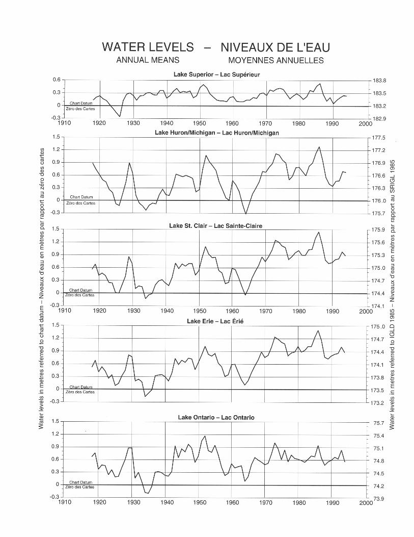
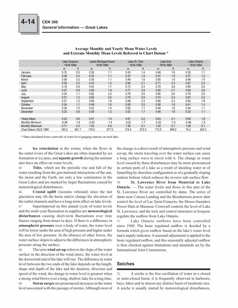
4-14 CEN 300General Information — Great Lakes
64 Ice retardation in the winter, when the flows in the outlet rivers of the Great Lakes are often impeded by ice formation or ice jams, and aquatic growth during the summer also have an effect on water levels.65 Tides, which are the periodic rise and fall of the water resulting from the gravitational interactions of the sun, the moon and the Earth, are only a few centimetres in the Great Lakes and are masked by larger fluctuations caused by meteorological disturbances.66 Crustal uplift (isostatic rebound) since the last glaciation may tilt the basin and/or change the elevation of the outlet channels and have a long-term effect on lake levels.67 Superimposed on this annual cycle of water levels and the multi-year fluctuation in supplies are meteorological disturbances causing short-term fluctuations over time frames ranging from hours to days. If there is a difference in atmospheric pressure over a body of water, the water level will be lower under the area of high pressure and higher under the area of low pressure. In the absence of other forces, the water surface slopes to adjust to the differences in atmospheric pressure along the surface.68 The term wind set-up refers to the slope of the water surface in the direction of the wind stress; the water level at the downwind end of the lake will rise. The difference in water level between the two ends of the lake depends on the length, shape and depth of the lake and the duration, direction and speed of the wind; the change in water level is greatest when a strong wind blows over a long, shallow lake for a long time.69 Storm surges are pronounced increases in the water level associated with the passage of storms. Although most of
the change is a direct result of atmospheric pressure and wind set-up, the storm traveling over the water surface can cause a long surface wave to travel with it. The change in water level caused by these disturbances may be more pronounced in certain parts of a lake as a result of shoaling water or of funnelling by shoreline configuration or of a gradually sloping inshore bottom which reduces the reverse sub-surface flow.70 St. Lawrence River from Montréal to Lake Ontario. — The water levels and flows in this part of the St. Lawrence River are controlled by dams. The series of dams near Coteau-Landing and the Beauharnois power dam control the level of Lac Saint-François; the Moses-Saunders Power Dam at Massena–Cornwall controls the level of Lake St. Lawrence; and the lock and control structures at Iroquois regulate the outflow from Lake Ontario.71 Lake Ontario outflows have been controlled since 1960. The basic regulated outflow is decided by a formula which gives outflow based on the lake’s water level and a supply indicator. A seasonal adjustment is applied to the basic regulated outflow, and this seasonally adjusted outflow is then checked against limitations and standards set by the International Joint Commission.
Seiches
72 A seiche is the free oscillation of water in a closed or semi-closed basin; it is frequently observed in harbours, bays, lakes and in almost any distinct basin of moderate size. A seiche is usually started by meteorological disturbances,
Average Monthly and Yearly Mean Water Levels and Extreme Monthly Mean Levels Referred to Chart Datum *
Lake Superior 1918-1994
Lakes Michigan/Huron 1918-1994
Lake St. Clair 1918-1994
Lake Erie 1918-1994
Lake Ontario 1918-1994
m ft m ft m ft m ft m ftJanuary 0.15 0.5 0.35 1.1 0.43 1.4 0.48 1.6 0.35 1.1 February 0.09 0.3 0.33 1.1 0.37 1.2 0.47 1.5 0.37 1.2 March 0.06 0.2 0.35 1.1 0.49 1.6 0.55 1.8 0.46 1.5 April 0.08 0.3 0.43 1.4 0.64 2.1 0.71 2.3 0.67 2.2 May 0.19 0.6 0.53 1.7 0.72 2.4 0.79 2.6 0.80 2.6 June 0.27 0.9 0.59 1.9 0.77 2.5 0.82 2.7 0.84 2.8 July 0.34 1.1 0.62 2.0 0.79 2.6 0.80 2.6 0.78 2.6 August 0.37 1.2 0.60 2.0 0.75 2.5 0.74 2.4 0.67 2.2 September 0.37 1.2 0.56 1.8 0.69 2.3 0.66 2.2 0.54 1.8 October 0.34 1.1 0.49 1.6 0.60 2.0 0.56 1.8 0.41 1.4 November 0.30 1.0 0.43 1.4 0.52 1.7 0.49 1.6 0.34 1.1 December 0.23 0.8 0.39 1.3 0.52 1.7 0.48 1.6 0.32 1.1
Yearly Mean 0.23 0.8 0.47 1.5 0.61 2.0 0.63 2.1 0.55 1.8 Monthly Minimum -0.48 -1.6 -0.42 -1.4 -0.52 -1.7 -0.32 -1.0 -0.46 -1.5 Monthly Maximum 0.71 2.3 1.50 4.9 1.56 5.1 1.54 5.1 1.56 5.1 Chart Datum IGLD 1985 183.2 601.1 176.0 577.5 174.4 572.3 173.5 569.2 74.2 243.3
* Data calculated from a network of water level gauging stations on each lake.
4-15Natural Conditions
CHAPTER 4
then the water surges back and forth until the oscillation is damped out by friction. The seiche period is the time from peak to peak of the oscillation; it varies with the basin length and depth. The main body of water may oscillate longitudin-ally or laterally at different periods, while the water in a bay or harbour off the main body may oscillate at its own particular seiche period.73 Seiches generally last for only a few oscillations but may be frequently regenerated. The typical longitudinal seiche period is about 5 hours for Lake Ontario with a range of 0.2 m (0.7 ft). The typical longitudinal seiche period is about 14 hours for Lake Erie with a range of 2 m (7 ft).74 Water level fluctuations in Lake Ontario are not as pronounced in range as those in the other Great Lakes due to the smaller area with relatively deep water and the general symmetrical shape.75 Because Lake Erie is the shallowest of the Great Lakes and is aligned with the prevailing wind direction, water levels in the harbours, particularly those near each end of the lake, are subject to large changes. Westerly winds pile up the water in Buffalo Harbor at the east end of the lake and increase the depths in the Niagara River; easterly winds drive the water out of Buffalo Harbor and reduce the flow and depth of the Niagara River.76 The reverse effect is observed at the west end of the lake, the maximum fluctuations being at Sandusky, Toledo, and at the mouth of the Detroit River. As noted above, water-level differences from one end of the lake to the other of more than 5 m (16 ft) have been observed during storm conditions. The water level may fall below chart datum for several hours during storms; this may be critical to navigation, particularly in the shallow western basin of Lake Erie and in the Detroit River where the water level may change at a rate of 0.3 m (1 ft) per hour.77 In Lake Huron and Georgian Bay, water level fluctuations are greatest at the extremities of the lake and in bays off the lake. The latter condition is very pronounced at Port McNicoll, where strong easterly winds across Georgian Bay can cause the water level to fall by as much as 0.9 m (3 ft) in one hour.78 In the upper St. Marys River near the locks, the water level often fluctuates up to 0.3 m (1 ft) on a 2 to 3 hour period, but during storm conditions, the water level may change rapidly, at a rate of over 0.6 m (2 ft) per hour.79 Water level fluctuations in Lake Superior are typ-ically less than 0.3 m (1 ft).
Currents
80 Wind-driven currents are the main feature of surface circulation in the Great Lakes. Since the
speed and direction of wind-driven currents depend on the wind which creates them, they are difficult to predict, but in most cases the direction of wind-driven currents in open water is up to 70° to the right of wind direction, and the rate is 1 to 2 per cent of the wind speed. The surface current may continue after the wind has dropped.81 The speed and direction of currents also depend on many factors such as the depth and shape of the lake, the dif-ference in temperature between the air and the surface water, and the presence of layers of water of different temperatures. Currents are also generally stronger in the fall due to stronger winds and the change in air–water temperature differences.82 With horizontal scales of hundreds of kilometres, depth scales of 100 m (except Lake Erie) and well-developed seasonal thermal stratification, the major Great Lakes have many of the physical phenomena associated with the coastal oceans and inland seas. The major physical difference is the closed boundary, the shoreline of the Great Lakes. The earth’s rotation (Coriolis force) and basin topography strongly af-fect large-scale circulation [source for current information: “Thermal Structure and Circulation in the Great Lakes”, F. M. Boyce et al, Atmosphere-Oceans, 27 (4) 1989, 607-642].83 The major difference between the oceans and the Great Lakes is a consequence of fresh water having a max-imum density at 4°C, significantly above the freezing tem-perature of 0°C. Overturning of the complete water column thus occurs in the fall when the surface water cools to 4°C and again in the spring when the surface water warms from freezing through the 4°C range. A weak, stable stratification of the water column forms in the winter with water cooler than 4°C (lower density) at the surface. In the early phase of warming in the spring, a band of water next to the shore is heated above 4°C while the central part of the lake remains at 4°C and a thermal bar is formed due to the density differences.84 The thermal bar may persist through June in Lakes Ontario and Huron–Michigan, and even longer on Lake Superior, with surface water cooler than 4°C remaining over the deepest portions of the lakes. Eventually the entire lake surface warms and becomes thermally stratified. The stability of a layer of warm water floating on cool water restricts verti-cal circulation and affects large-scale horizontal circulation.85 During the winter isothermal period, the lake circula-tions are driven by the wind. Because the Great Lakes gener-ally have smaller horizontal dimensions than the weather sys-tems passing over them, the wind stress is essentially uniform across the basin. Close to shore, wind drag is experienced all the way to the bottom; this water is accelerated in the direction of the along-shore component of the wind. Since the lakes are closed basins there must be a return flow. The balancing return flow occurs in the middle of the basin, the circulation thus taking the form of a double gyre. Unlike the other major basins, the near-uniform depth of Lake Erie’s central basin
4-16 CEN 300General Information — Great Lakes
wind conditions. The currents farther offshore tend to turn through 360° over a period of about 18 hours.91 The outflow of the Niagara River enters Lake Ontario at a rate of about 2 knots and slows to 0.4 knot about 3 miles offshore. Farther offshore the river current is absorbed by the lake current. The river discharge is generally deflected eastward in response to lake currents and prevailing winds. Large eddies, 0.5 to 1 mile wide, sometimes form on the edges of the river current as it flows into the lake.92 The general circulation of Lake Erie is usually west to east. In the western basin, the discharge from the Detroit River persists well out into the lake in a SE direction. The surface currents continue eastward along the south shore, then deflect northward along the west side of the Bass Islands and finally enter the main lake through Pelee Passage. There is also a northerly flow along the Michigan coast and a clockwise gyre around Pelee Island.93 The inflow from Pelee Passage continues SE towards the south coast where it combines with the general eastward flow of the central basin.94 The eastward flow in Lake Erie also predomin-ates in the eastern basin, with surface currents converging on the south shore and continuing along the coast towards the Niagara River. Within 3 miles of the Niagara River, the hydraulic currents of the river predominate and a direct flow towards the river replaces the erratic, wind-driven currents.95 Lake Erie is comparatively shallow. Due to the trend of its long axis, SW or NE gales quickly raise dangerous seas. Its water temperature fluctuates the most widely of all the Great Lakes, ranging from 0°C in the winter to about 24°C in late summer or fall.
Meteorological information
96 Climate and weather conditions. — One familiar feature of the climate of the Great Lakes basin is the variety of weather conditions on an almost day to day basis. This is due to the passage of pressure systems.97 Weather systems. — Being near the continental cen-tre of North America, the Great Lakes area is the convergence point for air masses from the Arctic Ocean, Pacific Ocean, western North America, Gulf of Mexico, and the Atlantic Ocean; the clear skies usually associated with high pressure systems are interrupted every few days by the passage of low pressure systems, with overcast skies and precipitation. These rapid and marked weather changes occur year round.98 Areas of low pressure originating over western North America and the Pacific Ocean follow several preferred tracks across the continent, with the storms moving eastward and swinging NE when they reach the Great Lakes.
makes its circulation sensitive to the torque (curl) of the wind stress. The wind-forced circulation of the central basin may take the two-gyre form or it may be a single basin-wide gyre in either direction, depending on the torque of the wind stress.86 In the spring, as the water shoreward of the thermal bar increases in temperature, the onshore–offshore pressure gradients created by the density difference tend to push the warm water offshore. The effect of the earth’s rotation (Coriolis force) is to deflect this offshore flow and set up a quasi-steady circulation with the warm water moving counter-clockwise (Northern Hemisphere) and following the bottom contours. Because of the stability of the air column above the lake (cool water and warm air), wind stresses are reduced and this thermally driven horizontal circulation may persist for over a month.87 During the summer stratified period, wind blow-ing over a lake will initially cause the warm surface layer to slide downwind over an undisturbed thermocline (lower layer). At the downwind shore, the warm water will force the thermocline down, and where the warm water moves offshore the thermocline must rise. Generally, the strongest currents are found 0.6 to 6 miles offshore and are associated with along-shore currents that move initially in the direction of the component of the wind parallel to shore. Then, over a time-scale measured in days, they reverse direction before dying out. More than 6 miles offshore, the currents are more variable and in summer tend to rotate clockwise. Very close to shore, within the surf zone, along-shore currents are generated by the breaking surface waves.88 The above paragraphs describe the general horizontal circulation in the Great Lakes. The inflow and outflow of the larger rivers, such as Niagara River, have a local effect on lake circulation. There may also be a hydraulic component of flow in shallow bays and narrows, caused by the difference in water level at the two ends of a channel. For example, currents of 2 to 3 knots have been observed at Little Current, in the North Channel of Lake Huron.89 The following paragraphs give a general description of the usual surface currents in Lake Ontario and Lake Erie. It must be emphasized, however, that these patterns change rapidly with local wind conditions.90 Surface currents in Lake Ontario are sensitive to wind direction but generally move counter-clockwise at an average rate of 0.1 knot. If a wind blows for long enough, the surface layer tends to follow the wind direction. Within about 6 miles of shore the current tends to flow in the direc-tion of the along-shore component of the wind; in general, the currents flow in one along-shore direction for three to eight days, then reverse over a period of 12 to 24 hours and flow in the opposite along-shore direction for several days. One of these directions is usually dominant because of prevailing
4-17Natural Conditions
CHAPTER 4
a surface area of 246,000 km2, the lakes act as a vast reservoir for the storage of heat energy and its later exchange with the atmosphere. About 20 per cent of all storms that cross the basin during the period of cooling (September to March) have their beginnings within the Great Lakes’ borders.107 Because of its immense size, a volume of 12,221 km3, Lake Superior dominates the climate around it. The influence of the lake shows in several ways such as moderation of tem-perature, increase or reduction of precipitation, formation of fog, and increased wind strength.108 Climatological influences are not confined just to the immediate area; Lake Superior profoundly affects the climate of the entire Great Lakes system, intensifying storms and modifying air masses before they reach the lower lakes.109 Winds. — The frequency distribution of winds by speed class and direction is mainly due to the passage of weather systems and local exposure. Regional winds are generally strongest in early spring. The stronger winds of winter are associated with increased cyclonic activity and less surface retardation since the land is either snow covered or thawing with little vegetative growth.110 In general, winds on the open lakes are stronger than those recorded at shore stations bordering the lakes. This is due primarily to differences in surface friction between land and water and to the stability of the atmosphere as influenced by air–water temperature differences. Over-lake winds on Lake Ontario are generally 30 per cent stronger than land winds in the summer and nearly 100 per cent stronger in the winter. In using over-land winds to arrive at an over-water equivalent, a number of controlling factors must be considered including air–water temperature contrast, over-water fetch, and wind strength.111 The effects of high winds are generally more serious when the winds blow along the length of a body of water for a considerable length of time. Islands offer some shelter and help reduce the wind force and but may cause local gusty winds. In addition, a constriction at the down-wind end of the lake can cause a funnelling effect and an increase in wind strength and wind effects.112 As well as winds generated by major weather pat-terns, small craft will be affected by the lighter on-shore and off-shore breezes. These lighter winds are caused by the temperature differences over the land and the lake; as the sun warms the land an on-shore breeze will develop, then in the evening as the land cools the breeze will blow off-shore towards the warmer body of lake water.113 These lake and land breezes provide a welcome re-minder of the lacustrine climate of the Great Lakes. Besides providing relief from summer heat, lake breezes affect cloud amount, evaporation, currents, air diffusion and fumigation, and may be important in influencing summer precipitation. Half of all summer days over the Great Lakes have light
99 Severe weather is more common in late fall and early winter because large intense storms require the energy that is then available from the sharper contrasts between the polar air and the tropical air. Another factor is the large amount of extra heat energy and moisture from the relatively warm open waters of the Great Lakes.100 The usual sequence of changing weather conditions associated with the passage of a low pressure area depends on the location of the observer relative to the track of the centre. In the Great Lakes area, most storm centres pass north of the observer from west to east, in which case the approach of the low is indicated by falling barometric pressure, a wind shift to the south or SE, a gradually lowering cloud level, and drizzle, rain or snow. The wind veers more to the SW at the warm front, and precipitation diminishes as the temperature rises.101 The passage of the warm sector of the low pressure area is marked by steadier temperatures and pressure, with clear or partly cloudy skies and some haze or fog. The passage of the cold front is generally marked by the approach from the west of a bank of convective clouds, a rapid veering of the wind to the west or NW, and sometimes sudden squalls, heavy showers and thunderstorms. After the passage of the cold front the barometer rises rapidly, usually with clearing weather and a drop in temperature.102 For an observer north of the track of the centre of the weather system, the changes in the weather are not as rapid nor as distinctive, and the winds ahead of the low “back” gradually from east through north to NW. The weather condi-tions also vary more gradually from those found ahead of the warm front to those behind the cold front.103 The most severe storms usually come from a SW or west direction, but such storms are less frequent in summer months. Storms approaching from the west or NW are gener-ally less severe, rarely producing severe gales.104 Another source area for storms in the Great Lakes area is western Canada. The so-called Alberta lows occur in all seasons, varying from a high frequency of 40 per cent in October to a low of 25 per cent in April. These lows enter the basin usually from the west and NW and are relatively weak; they rarely produce gales or damage on the lakes but occasionally one will intensify with winds of up to 60 knots.105 A few severe Great Lakes’ storms have been of trop-ical origin. These storms are, however, very rare and usually lose their tropical characteristics by the time they reach the lakes. The tropical storms which have been most severe on the Great Lakes were those modified and re-intensified by the energy processes which form the cyclonic storms of the middle latitudes. This type of storm generally occurs only in the fall months.106 The mere presence of the Great Lakes provides the necessary energy sources for generating severe storms (area of cyclogenesis). With a volume of 22,700 km3 exposed over
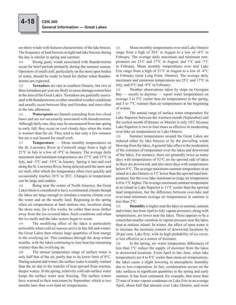
4-18 CEN 300General Information — Great Lakes
121 Mean monthly temperatures over mid Lake Ontario range from a high of 20°C in August to a low of -4°C in February. The average daily maximum and minimum tem-peratures are 23°C and 17°C in August, and 1°C and -7°C in February. Mean monthly temperatures over mid Lake Erie range from a high of 21°C in August to a low of -4°C in February (near Long Point, Ontario). The average daily maximum and minimum temperatures are 25°C and 17°C in July, and 0°C and -9°C in February.122 Weather observations taken by ships on Georgian Bay — mostly in daytime — report water temperatures on average 3 to 5°C cooler than air temperatures in the spring, and 5 to 7°C warmer than air temperatures at the beginning of winter.123 The annual range of surface water temperature for Lake Superior between the warmest month (September) and the coolest month (February or March) is only 10°C because Lake Superior is two to four times as effective in moderating over-lake air temperatures as Lake Ontario.124 Summer temperatures around the Great Lakes are reduced either by lake breezes or by the prevailing winds blowing from the lakes. A general lake effect is the moderation of the extremes of temperature over the lakes and downwind of the lakes. For instance, there are generally twice as many days with temperatures of 32°C on the upwind side of lakes as there are downwind, and also more days with temperatures below 0°C. The average maximum summer temperature at an island in Lake Ontario is 5°C lower than the upwind land tem-perature, but the over-lake minimum average air temperature is 0 to 1°C higher. The average maximum summer temperature at an island in Lake Superior is 11°C cooler than the upwind land temperature, but the difference between over-lake and over-land minimum average air temperatures in summer is less than 2°C.125 Humidity is higher near the lakes in summer, autumn and winter, but from April to July vapour pressures, along with temperatures, are lower near the lakes. There appears to be a somewhat smaller variation in vapour pressure near the lakes than at stations inland. In winter, the effect of open water is to increase the moisture content of downwind locations by 20 per cent. Lake Erie, with its high probability of ice cover, is less effective as a source of moisture.126 In the spring, air–water temperature differences of less than 3°C reduce the supply of moisture from the lakes to downwind locations. From April to late June, when lake temperatures are 4 to 8°C cooler than mean air temperatures, the lakes cause a slight lowering in atmospheric humidity due to less evaporation. In fact, condensation occurs on the lake surfaces in significant quantities in the spring and early summer. It has been estimated, for example, that more than 25 mm of water vapour condenses on Lake Erie in an average April, about half that amount over Lake Ontario, and more
on-shore winds with features characteristic of the lake breeze. The frequency of land breezes at night and lake breezes during the day is similar in spring and summer.114 Strong gusty winds associated with thunderstorms occur for brief periods primarily during the summer season. Operators of small craft, particularly on the more open bodies of water, should be ready to head for shelter when thunder-storms are expected.115 Tornadoes are rare in southern Ontario, but two or three tornadoes per year are likely to cause damage somewhere in the area of the Great Lakes. Tornadoes are generally associ-ated with thunderstorms or other unsettled weather conditions and usually occur between May and October, and most often in the late afternoon.116 Waterspouts are funnels extending from low cloud bases and are not necessarily associated with thunderstorms. Although fairly rare, they may be encountered from late spring to early fall; they occur on cool cloudy days when the water is warmer than the air. They tend to last only a few minutes but are a real hazard for small craft.117 Temperature. — Mean monthly temperatures on the St. Lawrence River at Cornwall range from a high of 21°C in July to a low of -9°C in January. The average daily maximum and minimum temperatures are 27°C and 15°C in July, and -5°C and -14°C in January. Spring is late and cool along the St. Lawrence River, being delayed until the snow and ice melt, after which the temperature often rises quickly and occasionally reaches 26°C to 30°C. Changes in temperature can be large and sudden.118 Being near the centre of North America, the Great Lakes basin is considered to have a continental climate though the lakes are large enough to simulate a marine climate over the water and on the nearby land. Beginning in the spring when air temperatures at land stations rise, locations along the shore may, for a few weeks, be colder than areas farther away from the ice-covered lakes. Such conditions end when the ice melts and the lake waters begin to warm.119 The modifying effect of the lakes is particularly noticeable when cold air masses arrive in late fall and winter; the Great Lakes then release large quantities of heat energy to the overlying air. This continues through the deep winter months, with the lakes continuing to lose heat but remaining warmer than the overlying air.120 The annual temperature range of surface water is only half that of the air, partly due to its lower limit of 0°C. During autumn and winter, the surface water is usually warmer than the air due to the transfer of heat upward from warmer, deeper waters. In the spring, relatively cold sub-surface water keeps the surface water near freezing. The surface waters have warmed to their maximum by September, which is two months later than over-land air temperatures.
4-19Natural Conditions
CHAPTER 4
Ontario, in the SW part of the basin; this is the area with the highest frequency of tropical air, 35 per cent of all July days.134 Fog. — The principal cause of fog on the Great Lakes, in addition to the varying moisture content of the particular air mass, is a temperature difference between the lake water and the overlying atmosphere. In spring and early summer the lakes are slow to lose their winter chill but the surrounding land is rapidly becoming warmer. The water is then generally colder than the air and conditions are favourable for the appearance of advection fog, which occurs when warm land breezes blow across a comparatively cold lake surface; the warm air may be cooled to its dew-point and produce fog.135 Along the NW shores of the lakes, cold water brought to the surface by upwelling can create fog by coming in con-tact with overlying warm air. This fog may then move inland. Advection fog is thus prevalent everywhere, especially in spring and early summer.136 Radiation fog, which is produced by cooling of the lower atmosphere, often appears in early morning under near calm conditions. This type of fog is less frequent over the lakes than over the land because the diurnal cycle of water surface temperature has a much smaller range than that of land surface temperature.137 Steam fog, or sea smoke as it is known over the oceans, forms when intense evaporation takes place at tem-peratures near or below -18°C into cold dry air. It may be observed in late autumn and winter over the Great Lakes.
than 83 mm of water vapour condenses on Lake Superior in an average July. Beginning in July — September over Lake Superior — the thermal contrasts increase atmospheric moisture downwind of the lakes. During October, the lakes are important sources of moisture, increasing humidities at downwind stations by 5 to 15 per cent.127 Precipitation. — One of the characteristics of the climate of the Great Lakes is the lack of any marked season-ality of precipitation. Lake-effect snowfalls originating from open-water sources in the late fall and winter, and fewer convective showers during the warm season, are contrasting phenomena which balance out the seasonal precipitation differences. Annual precipitation for individual lake basins increases from west to east across the Great Lakes; Lake Superior averages 785 mm, Lake Michigan 800 mm, Lake Huron 813 mm, Lake Erie 845 mm and Lake Ontario 863 mm.128 Whether more or less precipitation falls directly on the lakes than on the land basin is a matter of controversy among researchers studying over-lake precipitation. This is an important point because over-lake precipitation represents a large and immediate supply of water to the Great Lakes system. Accurate daily, monthly and seasonal measurements of precipitation on the lakes, which is about one-third of the total basin, are not available.129 Several studies of over-lake precipitation using island rain-gauge data and radar data have shown that lake rainfall, as compared with land basin rainfall, is generally less in the summer, when the cooler lakes act to stabilize conditions, and more in the winter and fall, when the lakes add moisture and heat to enhance over-lake instability.130 The average annual precipitation over the lakes is 6 per cent less than over the surrounding basin. In the sum-mer it is 10 to 20 per cent less, but this is partly offset by a similar percentage increase in the cold season but over less of the water surface.131 Early and late season navigation may be severely hampered for limited times by freezing precipitation and freezing spray conditions.132 Thunderstorms. — The lakes affect the occurrence of thunderstorms. Lake Michigan reduces thunderstorm activity by 20 per cent in summer but increases the number of thunderstorms in autumn by 50 per cent. During daylight hours the lakes suppress air mass convective activity, but at night they enhance frontal thunderstorms. Lake waters are cooler than the overlying air on spring and summer days, thus inhibiting air-mass convection. During summer nights and autumn days the lakes may be expected to increase convection by adding heat and moisture to the atmosphere.133 The number of days with thunderstorms varies dur-ing the year from a low of zero in winter to a high of 6 days a month from May through September. The greatest annual total, of 40 to 45 thunderstorm-days a year, occurs near Sarnia,
4-20 CEN 300General Information — Great Lakes
information on weather services for the Great Lakes area offered by Environment Canada, by the Canadian Coast Guard, and by the U.S. National Weather Service. It also lists the electronic bulletin boards maintained at various strategic locations. The folder also explains the MAFOR code and lists selected weather reporting sites. The folder is available free of charge from Environment Canada, Port Meteorological Office, 100 East Port Boulevard, Hamilton, Ontario L8H 7S4, tel: (905) 312-0900, Fax: (905) 312-0730.142 Observed weather data. — Because ships are encouraged to record weather observations, more and more weather data is available; there is now enough data to esta-blish climatology of the lakes. For detailed climatological analyses of the data over the lakes, consult the Great Lakes Climatological Atlas and the Great Lakes Marine Weather Guide, which are also published by Environment Canada, Ontario Region.143 Note. — Tables of selected meteorological informa-tion for a few local stations are included in Sailing Directions publications.
138 The number of days with fog on the Great Lakes does not vary much over the year; there are usually 2 to 4 days each month with fog (visibility less than 1 km) during at least part of a 24-hour period. The annual average is 27 days at Kingston, 30 at Trenton, 35 at Toronto, 44 at Simcoe, 37 at Windsor, 46 at Wiarton, and 34 at Thunder Bay.139 Weather reports. — Marine weather reports are broadcast continuously on VHF Channel 21B or 83B by all Canadian Coast Guard MCTS Centres. These reports include marine area forecasts in both MAFOR code and plain language, Near Shore forecasts for small craft, and reported weather at selected sites.140 Marine weather forecasts and weather warnings are also broadcast continuously by Environment Canada from dedicated Weatheradio Canada transmitter stations around the Great Lakes area. These broadcasts are on special VHF “weather” frequencies; reception can generally be expected within 33 to 66 miles of the transmitters.141 Marine weather information. — A brochure entitled Marine Weather Services is published each year by Environment Canada, Ontario Region. This brochure gives
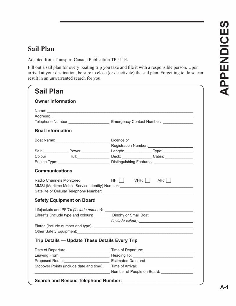
A-1
APP
END
ICES
Sail PlanAdapted from Transport Canada Publication TP 511E.
Fill out a sail plan for every boating trip you take and file it with a responsible person. Upon arrival at your destination, be sure to close (or deactivate) the sail plan. Forgetting to do so can result in an unwarranted search for you.
Sail PlanOwner Information
Name: ____________________________________________________________________Address: __________________________________________________________________Telephone Number: ___________________ Emergency Contact Number: ______________
Boat Information
Boat Name: _________________________ Licence or Registration Number: _____________________Sail: ____________ Power:_____________ Length: _____________ Type: ______________Colour Hull:_______________ Deck: ______________ Cabin: _____________Engine Type: ________________________ Distinguishing Features: __________________
Communications
Radio Channels Monitored: HF: VHF: MF: MMSI (Maritime Mobile Service Identity) Number: __________________________________Satellite or Cellular Telephone Number: __________________________________________
Safety Equipment on Board
Lifejackets and PFD’s (include number): _________________________________________Liferafts (include type and colour): _______ Dinghy or Small Boat (include colour): _________________________Flares (include number and type): ______________________________________________Other Safety Equipment: ______________________________________________________
Trip Details — Update These Details Every Trip
Date of Departure: ___________________ Time of Departure: _______________________Leaving From: _______________________ Heading To: ____________________________Proposed Route: _____________________ Estimated Date andStopover Points (include date and time):___ Time of Arrival: _____________________________________________________________ Number of People on Board: _______________
Search and Rescue Telephone Number: ___________________________
A-2
APP
END
ICES
The responsible person should contact the nearest Joint Rescue Coordination Centre (JRCC) or Maritime Rescue Sub-Centre (MRSC) if the vessel becomes overdue.
Act smart and call early in case of emergency. The sooner you call, the sooner help will arrive.
JRCC Victoria (British Columbia and Yukon) 1-800-567-5111 +1-250-413-8933 (Satellite, Local or out of area) # 727 (Cellular) +1-250-413-8932 (fax) [email protected] (Email)
JRCC Trenton (Great Lakes and Arctic) 1-800-267-7270 +1-613-965-3870 (Satellite, Local or Out of Area) +1-613-965-7279 (fax) [email protected] (Email)
MRSC Québec (Quebec Region) 1-800-463-4393 +1-418-648-3599 (Satellite, Local or out of area) +1-418-648-3614 (fax) [email protected] (Email)
JRCC Halifax (Maritimes Region) 1-800-565-1582 +1-902-427-8200 (Satellite, Local or out of area) +1-902-427-2114 (fax) [email protected] (Email)
MRSC St. John’s (Newfoundland and Labrador Region) 1-800-563-2444 +1-709-772-5151 (Satellite, Local or out of area) +1-709-772-2224 (fax) [email protected] (Email)
MCTS Sail Plan ServiceMarine Communications and Traffic Services Centres provide a sail plan processing and alerting service. Mariners are encouraged to file Sail Plans with a responsible person. In circumstances where this is not possible, Sail Plans may be filed with any MCTS Centre by telephone or marine radio only. Should a vessel on a Sail Plan fail to arrive at its destination as expected, procedures will be initiated which may escalate to a full search and rescue effort. Participation in this program is voluntary. See Canadian Radio Aids to Marine Navigation.
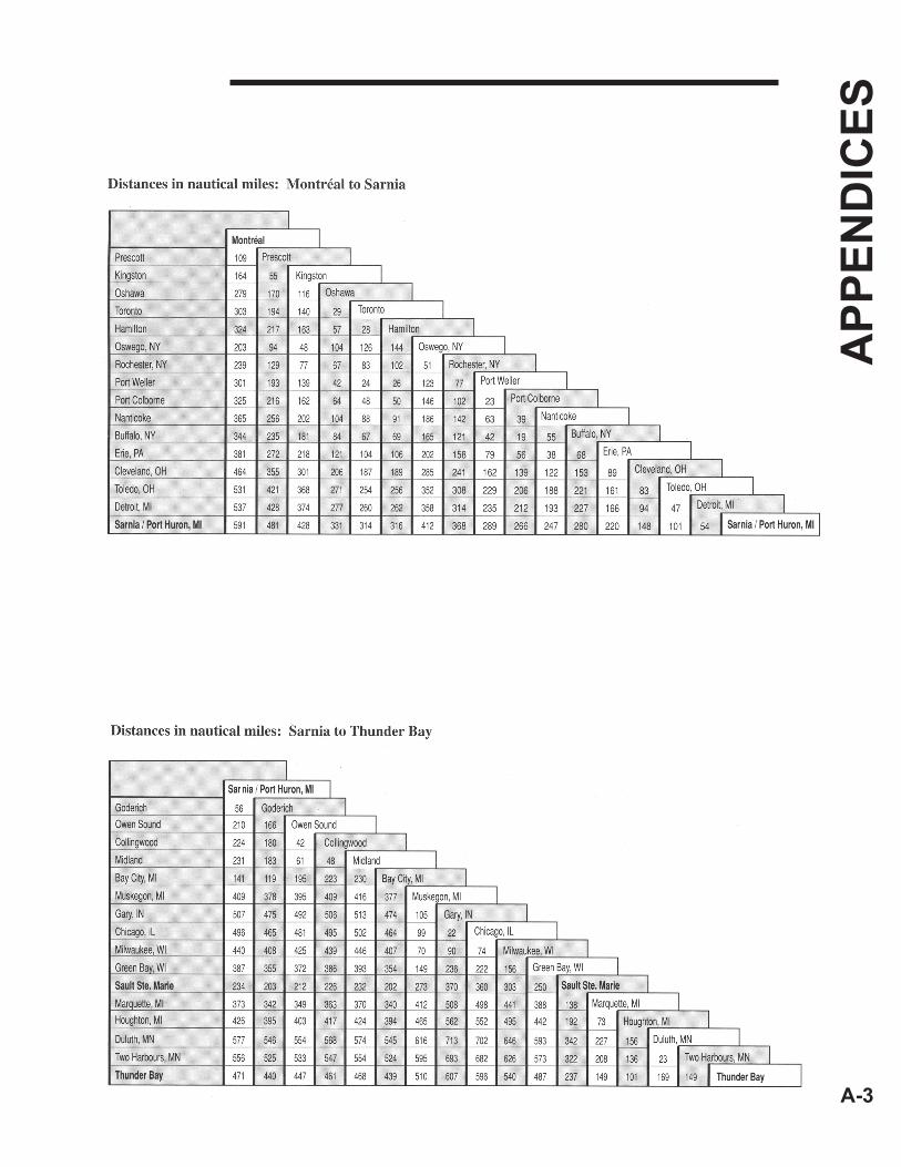
A-3
APP
END
ICES

I-1
IND
EX
C = Chapter/P = Paragraph
Aids to navigation, C1/P102Aids to navigation in winter, C1/P17Airborne liferaft, C1/P185Aircraft signals, C1/P187AMVER, C1/P197Annual Edition of Notices to
Mariners, C1/P35Approach Charts, C1/P42Aquaculture, C1/P14Atlases of Tidal Currents, C1/P31
Ballast Water Control and Management Regulations, C2/P12
Border crossing information, C3/P104Buoyage, C1/P109Buoy numbering, C1/P119Buoys, C1/P105
Cables, C1/P85Canada, C3/P1Canadian Aids to
Navigation System, C1/P34Canadian Coast Guard, C1/P158Canadian ice advisory service, C1/P18Canadian Marine
Rescue Auxiliary, C1/P184Canal Regulations, C2/P46Cardinal buoys, C1/P112Catalogues of Nautical Charts and
Related Publications, C1/P25Chart 1, C1/P27Chart datum, C1/P61Charting, C1/P55Charts, C1/P40Charts, General, C1/P42Charts, Harbour, C1/P42Climate and weather conditions, C4/P96Coastal Charts, C1/P42Cold water survival, C1/P198Collingwood, C3/P90Collision regulations, C2/P4Collision regulations, C2/P45Compass adjustment, C3/P101Constitution, C3/P6Consulates, C3/P30Control buoys, C1/P115Criminal Code, C2/P6Currency, C3/P24Currents, C4/P80Customs, C3/P105
Daybeacons, C1/P121Daylight Saving Time, C3/P29Detroit River, C3/P68Disposal at Sea Regulations, C2/P16Distress Message, C1/P171
Emergency lights, C1/P122Emergency Position Indicating Radio-
beacons (EPIRB), C1/P195Erie, Lake, C3/P64Erie, Lake, C4/P9Erie, Lake, C4/P41
Fishing vessels, C1/P12Fog, C4/P134Fuel, C3/P99
Georgian Bay, C3/P73Georgian Bay, C4/P45Goderich, C3/P88Government, C3/P17GPS, C1/P145Great Lakes Pilotage
Regulations, C2/P36
Hamilton, C3/P83Harbour Charts, C1/P42Hazard buoys, C1/P116Helicopter evacuation, C1/P186Holidays, C3/P26Humidity, C4/P125Hunting and Fishing Regulations, C2/P27Huron, Lake, C3/P71Huron, Lake, C4/P10Huron, Lake, C4/P45Hypothermia, C1/P206
Ice, C4/P24Ice coverage, C4/P28Ice in St. Lawrence River above
Québec, C4/P34Ice in the Gulf of St. Lawrence, C4/P33Ice Navigation in
Canadian Waters, C1/P38IGLD 1985, C1/P64Indian Act, C2/P28International Regulations for Preventing
Collisions at Sea, 1972, C2/P4Isolated danger buoys, C1/P111.1
Lateral buoys, C1/P111Lateral System of buoyage, C1/P110Legal System, C3/P15Limits of booklet, C1/P1List of Lights, Buoys and
Fog Signals, C1/P32List of ports, C3/P78Little Current, C3/P94
Magnetic anomalies, C4/P18Magnetic variation, C1/P81Marine Communications and Traffic
Services, C1/P7Marine weather information, C4/P141Metric charts, C1/P57Michigan, Lake, C3/P71Michigan, Lake, C4/P46Midland, C3/P91Migratory bird sanctuaries, C2/P35Monthly Edition of Notices to
Mariners, C1/P36Montréal to Lake Ontario, C3/P54
Natural Scale, C1/P42Nautical Charts, C1/P26Nautical publications, C1/P24NAVSTAR Global Positioning
System, C1/P145North Channel of Lake Huron, C3/P74Notices to Shipping, C1/P37
Official languages, C3/P14Ontario, C3/P36Ontario, Lake, C3/P59Ontario, Lake, C4/P8
Ontario, Lake, C4/P39Oshawa Harbour, C3/P81Overhead clearances, C1/P86Owen Sound, C3/P89
Parry Sound, C3/P93Pilotage, C1/P147Police, C3/P112Pollutant Discharge Reporting
Regulations, 1995, C2/P10.1Pollution regulations, C2/P50Port Colborne, C3/P85Port McNicoll, C3/P92Ports of entry, C3/P107Port Weller, C3/P84Precipitation, C4/P127Prescott, C3/P80Protection of submarine cables, C2/P19
Quarantine reporting requirements, C2/P37
Quebec, C3/P31
Radar beacons (Racons), C1/P127Radar reflectors, C1/P125Radar reflectors, C1/P190Radar reflectors, C2/P49Radio, C1/P167Radio Aids to Marine Navigation, C1/P33Radio distress communications, C1/P169Radio medical advice, C1/P174Range daymarks, C1/P103Red Rock, C3/P96Regulations for small craft, C2/P44Regulations for the Prevention of
Pollution from Ships and for Dangerous Chemicals, C2/P10
Repairs, C3/P102Reporting dangers, C1/P3
Sailing Charts, C1/P42Sailing Directions, C1/P28Sailing Plan, C1/P196St. Clair, Lake, C3/P69St. Clair, Lake, C4/P43St. Clair Flats, C3/P70St. Clair River, C3/P70St. Lawrence River and Great Lakes
system, C3/P44St. Lawrence Seaway traffic control
system, C1/P6St. Marys River, C4/P47St. Marys River Vessel Traffic
Service, C1/P11Sarnia, C3/P87Sault Ste. Marie, C3/P95Search and rescue, C1/P180Seaway Handbook, C2/P39Seaway Regulations, C2/P39Seiches, C4/P72Sewage regulations, C2/P51Shipping Casualties Reporting
Regulations, C2/P9Ship routing systems, C1/P4Ships sanitation control, C3/P100Ship-to-air distress signal, C1/P192Small Craft Charts, C1/P42Small Craft Guides, C1/P29Small Vessel Regulations, C2/P47
I-2
IND
EX
C = Chapter/P = Paragraph
Sound signals, C1/P120South Channel, C3/P70Special purpose buoys, C1/P113Speed regulations, C2/P48Standard time, C3/P28Submarine cables, C1/P90Superior, Lake, C3/P75Superior, Lake, C4/P13Superior, Lake, C4/P48
Temperature, C4/P117Territorial sea and fishing zones, C2/P5Thunder Bay, Port of, C3/P97Thunderstorms, C4/P132Tide and Current Tables, C1/P30Time zone, C3/P28Tornadoes, C4/P115Toronto, C3/P82
Urgency Message, C1/P172
Water, C3/P98Water level information, C1/P94Water levels, C4/P50Waterspouts, C4/P116Weather reports, C4/P139Weather systems, C4/P97Weights and measures, C3/P25Welland Canal, C3/P62Winds, C4/P109Windsor, C3/P86Winter navigation, C1/P15
GI-1
GEO
GR
APH
ICA
L IN
DEX
Abbott Island — DAberdeen Island — DAbigail Island — AAbino Bay — CEN 303Abino, Point — CEN 303Ab Island — A, DAb Shoal — A, DAcadia Rock (Lake Superior) — AAcadia Rock (North Channel) — AAdams Lake — BAdams Point — AAddington Bank — DAdelaide Island — CEN 301Admiralty Islands — CEN 301Adolphus Reach — CEN 302Adolphustown — CEN 302Advance Island — AAdvance Reef — AAfrica Rock — AAgate Cove — AAgate Island (Nipigon Bay) — AAgate Island (St. Joseph Channel) — AAgate Point — AAgawa Bay — AAgawa Islands — AAgawa River — AAgawa Rock — AAikens Island — AAinslie Shoal — AAird Bay — AAird Island — AAjax Island — DAjax Rock — DAlberta Rock — A, DAlbert Channel — A, DAlbert Islands — AAlec Clark Rock — A, DAlert Point — AAlexander Bay — DAlexander Island — DAlexander Passage — DAlexander, Point — BAlexander Reef (Cape Gargantua) — AAlexander Reef (Flatland Island) — AAlexander Rock — AAlexandria Bay, N.Y. — CEN 301Alexandria, Point — CEN 301Alfred Bank — AAlfred Island — AAlgoma — AAlgoma Mills — AAlgonac, Mich. — CEN 304Alice Island (Georgian Bay) — DAlice Island (St. Joseph Channel) — AAlicia Rock — AAllanburg — CEN 303Allan Otty Shoal — CEN 302Allen Rocks — DAllens Point — CEN 302Allouez Island — AAllumettes, Lac des — BAlmos Shoal — AAloma Island — AAlona Bay — AAlves Point — AAlwin Rock — DAmanda Island — DAmbassador Bridge — CEN 304
Amberley Beach — AAmedroz Island — AAmelia Rock — AAmerican Camp Island — A, DAmerican Eagle Shoal — CEN 303American Island — CEN 301American Narrows
(Upper Narrows) — CEN 301Amethyst Bay — AAmethyst Harbour — AAmherst Bar — CEN 302Amherst Bay — CEN 302Amherstburg — CEN 304Amherstburg Channel — CEN 304Amherstburg Harbour — CEN 304Amherstburg Reach — CEN 304Amherst Island — CEN 302Amherstview — CEN 302Amygdaloid Channel — AAmygdaloid Island — AAmyot Rocks — AAnchor Bay — CEN 304Anchor Island (McBean Harbour) — AAnchor Island (Shawanaga Inlet) — DAnchor Island (West Grant Island) — AAnchor Rock — AAncona Point — CAnderson Island — AAnderson Ledge — AAnderson, Point — AAnderson Shoal — CEN 302Angelica Island — AAnglais, Pointe aux — BAnglin Bay — B, CEN 301Anguros Island — AAngus Islands — AAnker Pint Islet — DAnnie Rock — A, DAnn Long Bank — A, DAnorthite Islet — AAnse de Vaudreuil — BAntelope Rock — AAntler Point — BApostle Island — A, DArabella Island — CEN 301Arabian Rock — AAraxes Bank — AArbutus Rock — AArchibald Island — AArdiluan Island — DAriel Island — AAriel Rock — AArmour Harbour — AArmour Island (Nipigon Bay) — AArmour Island (North Channel) — AArmstrong Rock — AArmstrong Rocks — DArno Island — AArnold Point — AArnold Rock — AArnprior — BArnprior Island — BArthur Island (Georgian Bay) — DArthur Island (Lake Superior) — AArthur Orr Rock — AAshbridges Bay — CEN 302Ashburnham lock — CAshburton Bay — A
Ashiganshing (Indian Dock) Point — A, D
Ash Island — CEN 301Asia Rocks — AAskins Point — CEN 304Astounder Island — CEN 301Asylum Point — A, DAthabasca Rock — A, DAtherley — CAthol Bay — CEN 302Atlantic Rock — AAtocas, Baie des — BAubrey Island — CEN 301Augusta Rock — AAult Island — CEN 301Ausable River — AAva Island — A, DAvis Ground — AAyekwadinak Hill (The Spur) — A, DAylmer — BAylmer Island — BAyre Shoal — AAzov Ledges — A, D
Baby Point — CEN 304Baby Trout Island — BBacchus Island — BBachand Island — ABack Cove — ABacon Island (Mackenzie Bay) — ABacon Island (North Channel) — ABadgeley Island — A, DBadgeley Point — A, DBadgeley Rocks — A, DBad Neighbour Rock — ABad River Channel — A, DBad River Point — DBagot Rock — DBailey Rock — ABain Rock — ABaird Point (Ottawa River) — BBaird Point, N.Y. — CEN 302Bait Island — CEN 303Baker Group — ABaker Island — CEN 302Baker Point — ABaker Rock — ABaker’s Bay — ABakewell Rock — ABald Head (Lake Ontario) — CEN 302Bald Head (Lake Superior) — ABald Head Beach — CEN 302Baldhead Channel — CEN 302Bald Head Island — CEN 302Baldhead River — ABald Island — A, DBald Rock (McBean Channel) — ABald Rock (Ottawa River) — BBald Rock (Thessalon) — ABald Rocks — EBallards Reef Channel — CEN 304Ballast Island — CEN 303Ball Island — A, DBalmy Beach — CEN 302Balsam Lake — CBamageseck Bay — ABamford Island — ABand Island — DBands Island — D
GI-2
GEO
GR
APH
ICA
L IN
DEX
Banford Point — CEN 301Banshee Rock — ABaptême, Pointe au — BBaptiste Creek — CEN 304Baptist Harbour — ABaptist Island — ABaptist Rock — ABarbara Bank — ABarbed Point — ABarclay Island — DBarclay Islands (Bruneau Point) — ABarclay Islands (McKellar Harbour) — ABarcovan Beach — CEN 302Bare Point — ABare Summit — ABar Island — A, DBarnard Bank — DBarney Rock — ABarnhart Island — CEN 301Bar Point — CEN 303Barrel Point — DBarren Island — ABarrets Range Rock — ABarrett Bank — ABarrett Bay — CEN 301Barrett Island — ABarrett Reef — ABarrie — CBarrie Island — ABarrier Island — ABarr Island — ABarr Island Harbour — ABarrow Bay — ABarr Reef — ABarry Point — CEN 302Barry’s Channel — ABar, The — ABartlett Point (Lake Huron,
North Channel) — ABartlett Point
(St. Lawrence River) — CEN 301Barto Island — DBarwis Rock — ABas-Fonds Port Lewis — CEN 301Baskin’s Beach — BBass Bay — ABassett Channel — CEN 304Bassett Island
(Lake St. Clair) — CEN 304Bassett Island (Turnbull Passage) — ABassett Rock — ABass Group — ABass Island — CEN 302Batawa lock — CBatchawana Bay — ABatchawana Island — ABatchawana River — ABateau Channel — CEN 301Bateau Island — ABateau Rock — ABath — CEN 302Bather Island — DBath Islands — A, DBath Point — CEN 302Battery Bluff — ABattery Bluff Anchorage — ABattle Island — ABatture Island — ABattures du Corbeau — B
Battures Green — BBattures Way — BBayard Island — ABayard Reef — ABayfield — A, DBayfield Channel — ABayfield Dike — ABayfield Inlet — DBayfield Island — CEN 301Bayfield Reef — A, DBayfield River — ABayfield Rock — ABayfield Shoal — CEN 301Bayfield Sound — ABayfield Wharves — DBayly Point — ABay of Islands — ABay of Quinte — CEN 302Bay Point — CEN 304Bay State Shoal — CEN 301Bayview Point — ABeach Point — ABeach Point Flat — ABeach Strip — CEN 302Beachy Cove — ABeacon Island — EBeaconsfield — CEN 301Bead Island — ABead Island Channel — ABeament Island — ABeament Island Passage — ABear Creek — EBeardrop Harbour — ABear Point (Ottawa River) — BBear Point (Wolfe Island) — CEN 302Bears Back Island — ABears Back Shoal — ABears Rump Island — ABears Rump Shoal — ABeatrice Bank — ABeatty Bay — ABeatty Cove — ABeatty Point — BBeaucage Point — EBeaudette, Pointe — CEN 301Beaudry Point — ABeaufort Island — ABeaufort Reef — ABeauharnois — CEN 301Beauharnois, Canal de — CEN 301Beaumont Point — ABeaupre Island — BBeaurivage Island — CEN 301Beausoleil Bay — DBeausoleil Island — A, DBeausoleil Point — A, DBeauty Island (Little Current) — A, DBeauty Island (South Channel) — DBeauvier Point — ABeaver Island — DBeaver Island (Isle Royale) — ABeaver Island (Prince Bay) — ABeaver Island (Sheguiandah Bay) — ABeaver Island Bank — A, DBeaver Island Harbour — A, DBeaver River — ABeaver Rock — ABeaverstone Bay — A, DBeaverton Harbour — C
Beaverton River — CBecketts Landing — BBeckie Island — ABeckwith Island — ABedford Harbour — ABedford Island — ABedford Island Reef — ABedores Creek — BBeef Island — ABeer Point — ABeer Rock — ABeetle Point — ABeeton Point — ABegley Rocks — DBekanon Island — DBelanger Point — ABelcher Reef — ABelcher Rock — ABelford Island — ABelize Rock — ABellavista Island — DBell Cove — ABelleau Island — ABelle Bay — A, DBelle Island — ABelle Isle — CEN 304Belle River — CEN 304Belle Rock — ABelleville — CEN 302Bellevue, Île — CEN 301Bellevue Island — ABell Ewart — CBell Point — ABell Reef — CEN 303Bells Point — CEN 302Ben Back Shoal — ABenjamin Islands — ABenjamin’s Point — ABennet Bank — ABennett Island — ABensfort Bridge — CBenson Creek — BBenson Lake — BBent Island — ABentley Rock — ABent Tree Island — DBerdans Shoal — CEN 302Beresford Island — ABergeron Point — ABergie Point — A, DBergin Rock — ABernadette Island — DBernard Rock — A, DBernice Island — DBernyk Island — DBerry Island — EBerrypicker Rock — ABertie Bay — CEN 303Bertrand H. Snell Lock — CEN 301Bests Point — BBeveridge Bay — BBeveridges locks — BBeverly Island — ABewdley — CBig Bald Lake — CBig Bar Shoal — CEN 302Big Bay (Bay of Quinte) — CEN 302Big Bay (Georgian Bay) — ABig Bay (North Keppel) — A
GI-3
GEO
GR
APH
ICA
L IN
DEX
Big Bay Point — CBig Bluff Point — ABig Bob Channel — CBig Burnt Island
(Alexander Passage) — DBig Burnt Island
(Manitoulin Island) — A, DBig Cedar Point — CBig Chicken Island — CEN 303Big Chute — CBig Creek — CEN 303Big David Bay — DBig Dog Channel — DBig Gap — CEN 302Biggar Rock — ABighead River — ABig Island (Bay of Quinte) — CEN 302Big Island (Big Rideau Lake) — BBig Island (Cranberry Lake) — BBig Island (Pigeon Lake) — CBig Island (Upper Rideau Lake) — BBig Island Shoal — CEN 302Big McCoy Island — ABignell Point — ABig Otter Creek — CEN 303Big Point (St. Joseph Channel) — ABig Point (St. Marys River) — ABigras, Île — BBig Rideau Lake — BBig Sand Bay — CEN 302Big Sandy Bay — CEN 302Bigsby Island (Georgian Bay) — DBigsby Island (Lake Huron,
North Channel) — ABig Ship Island — DBig Shoal (Upper Rideau Lake) — BBig Shoal Cove — ABig Shoal, Mich. — ABig Trout Bay — ABig Tub Harbour — ABigwood Island — A, DBill and Jim Islands — ABilla Rocks — ABiolog Island — DBirch Island (Flatland Harbour) — ABirch Island (Isle Royale) — ABirch Island (McGregor Bay) — ABirch Island (Nipigon Bay) — ABirch Island (North Channel) — ABirch Island (Sand Lake) — BBirch Point (Lake George) — ABirch Point (Manitoulin Island) — ABirch Point (Pigeon Lake) — CBirch Point (St. Marys River) — ABirchall Island — DBirch Rock — BBird Island (Lake Huron,
North Channel) — ABird Island, N.Y. — CEN 303Bird Point — A, DBirdsalls Point — CBiron, Pointe — CEN 301Bishops Point — CEN 301Black Bay (Byng Inlet) — DBlack Bay (Lake Superior) — ABlack Bay (Penetang Harbour) — ABlack Bay (Penetang Harbour) — DBlack Bill Islands — ABlackbird Point — C
Black Charlie Island — CEN 301Black Creek (Niagara River) — CEN 303Black Creek (Port Dover) — CEN 303Black Creek (Prince Edward
County) — CEN 302Black Creek, Mich. — CEN 304Blackhead Island — BBlack Island — ABlack (Green) Point — ABlack Point (Little Lake George) — ABlack Point (Ottawa River) — BBlack Rapids Creek — BBlack Rapids lock — BBlack River (Lake Simcoe) — CBlack River Bay, N.Y. — CEN 302Black River Canal — ABlack River, Mich. — CEN 304Black River, N.Y. — CEN 302Black Rock (Big David Bay) — DBlack Rock (Charles Inlet) — ABlack Rock (Naiscoot River) — DBlack Rock (North Channel) — ABlack Rock (Northeast Passage) — DBlack Rock
(Parry Sound approach) — A, DBlack Rock (Quebec Harbour) — ABlack Rock (Simcoe Point) — ABlack Rock (Thompson Channel) — ABlack Rock (Western Islands) — ABlack Rock Canal — CEN 303Black Rock Entrance
Channel — CEN 303Black Rock Lock — CEN 303Black Rock Point — ABlack Rocks — A, DBlacks Point — ABlackstock Bay — ABlackstock Point — ABlackstone Point — ABlack Sturgeon River — ABlack Summit — ABlack’s Wharf — ABlair Creek — ABlair Rock — ABlaisdell Island — ABlake Island — ABlake Point (Duck Islands) — ABlake Point (Isle Royale) — ABlanket Island — ABlind Bay (Parry Sound) — A, DBlind Bay, N.Y. — CEN 301Blind Channel (Gannon Narrows) — CBlind Channel (Lake Superior) — ABlind River — ABlind River Bank — ABlizard Island — ABlockhouse Island — CEN 301Block Island — ABlondin Island — ABlott Point — CEN 303Blower Island — DBlueberry Island — EBlue Mountains — ABlue Point — ABluff Bar — CEN 303Bluffers Park — CEN 302Bluff Point (Amherst Island) — CEN 302Bluff Point (French River) — D
Bluff Point (Long Point, Lake Erie) — CEN 303
Bluff, The — CEN 302Boardman Rock — ABoars, The — ABoat Channel — CEN 301Boat Cove — ABoat Harbour (Melville Sound) — ABoat Harbour (North Channel) — ABoathouse Bay — ABoat Passage — A, DBoat Rock — A, DBobcaygeon — CBobcaygeon lock — CBob-Lo Island — CEN 304Bobs Point — A, DBogardus Island — CEN 301Bogart Island — DBogie Rocks — ABoiler Beach — ABois Blanc Island — CEN 304Bold Point — A, DBolsover lock — CBolster Bank — DBond Head — CEN 302Bone Island — DBoneyard Bay — ABonner Head — ABonnet Island (Cape Hurd
Channel) — ABonnet Island (Georgain Bay) — DBoomcamp Bay — ABoom Island — BBoom Point — ABoone Island — ABooth Island — ABorden Island — ABorer Bank — ABorron Rock — DBoston Island — EBoswell Island — ABotterell Point — ABottle Cove (L’anse à la Bouteille) — ABottle Point — ABottom Islands — CBoucher Island — ABoucher Point — ABoucher Rock — ABouchette Point — CEN 302Boulanger Point — ABoulder Bank — ABoulder Bluff — ABoulton Reef (Lake Superior) — ABoulton Reef (Sheguiandah Bay) — A, DBoundary Islands — ABourbonnais Island — ABourchier Islands — DBourinot Island — ABourinot Reef — ABourke Point — A, DBouteille, L’anse à la — ABowell Cove — A, DBowens Creek — CEN 304Bower Rock — ABowers Bay — A, DBowes Island (Georgian Bay) — A, DBowes Island (Lake Superior) — ABowman Island — ABowmanville — CEN 302
GI-4
GEO
GR
APH
ICA
L IN
DEX
Bowmanville Creek — CEN 302Boyd Group — A, DBoyd Island — ABoyer Reef — ABoyle Cove — A, DBradford — CBradford Island — CEN 301Bradley Harbour — ABradley Rock — ABradshaw Island — ABragdon Island — EBrassar Point — ABrassey Island — A, DBrass Point — BBrayne Island — ABray Reef — DBread Rock — ABrébeuf Island — A, DBreeders, The — ABrewers Mills — BBrewerton Island — ABrick Kiln Point — CEN 302Brickyard Bay — ABridgenorth — CBriggs Island — BBriggs Rock — ABrighton — C, CEN 302Bright Point — ABrignall Banks Narrows — DBritannia Bay — BBritt — A, DBritton Rock — DBroad Head — BBroadway Shoal — CEN 301Brock Group — CEN 301Brock Island — DBrocks Beach — ABrock’s Monument — CEN 302Brockville — CEN 301Brockville Narrows — CEN 301Broder Island — CEN 301Brodeur Island — ABrodeur, Pointe aux — CEN 301Bronte — CEN 302Bronte Harbour — CEN 302Brooke — ABrophy Point — CEN 301Brother Islands — CEN 302Brothers, The
(Alexander Passage) — A, DBrothers, The (Fox Islands) — ABrown Bay (Georgian Bay) — DBrown Bay, N.Y. — CEN 301Brown Head — DBrowning Cove — A, DBrowning Island — A, DBrown Island — ABrown Ledge — ABrowns Island — EBruce Beach — ABruce Mines — ABruce Nuclear Power Development — ABruce Rock — ABrulé Harbour — ABrulé Hill — ABrulé Point — ABrûlé Shoal — ABruneau Point — ABrush Point — A
Bryson — BBuckeye Shoal — ABuckham’s Bay — BBuckhorn — CBuckhorn Island — CEN 303Buckhorn Lake — CBuckhorn lock — CBuckhorn Narrows — CBuckingham — BBuck Island (Lake Superior) — ABuck Island
(St. Lawrence River) — CEN 301Buffalo Harbor — CEN 303Buffalo, N.Y. — CEN 303Buffalo Point — A, DBuffalo River — CEN 303Buffalo Ship Canal — CEN 303Buller Island — DBuller Reef — ABullers (Giraoud) Island — ABullhead Bay — ABull Rock — DBurbidge Island — ABurke Island — ABurke Shoal (Georgian Bay) — DBurke Shoal (Lake Superior) — ABurkett Rock — ABurleigh Falls — CBurleigh Falls lock — CBurlington — CEN 302Burlington Bay — CEN 302Burlington Beach — CEN 302Burlington Canal — CEN 302Burnet Island — ABurnt Cove — ABurnt Island (Beaverstone Bay) — DBurnt Island (Henvey Inlet) — DBurnt Island (Lake Nipissing) — EBurnt Island (Manitoulin Island) — ABurnt Island (Muskoka Landing
Channel) — DBurnt Island (Nipigon Bay) — ABurnt Island (Pointe au Baril
Channel) — DBurnt Island (Potagannissing Bay) — ABurnt Island (Shawanaga Inlet) — DBurnt Island (Thunder Cape) — ABurnt Island (Whalesback Channel) — ABurnt Island Bank — A, DBurnt Island Harbour — ABurnt Island Reef — ABurnt Point (Nipigon Bay) — ABurnt Point (Potagannissing Bay) — ABurnt Summit — ABurpee Rock — ABurritt Island — EBurritt Point — DBurritts Rapids — BBurritts Rapids lock — BBurtch Creek — ABurton Bank — A, DBurton Island — ABushby Inlet — DBushby Point — DBustard Islands — A, DBustard Islands Harbour — DBustard Rocks — A, DBusty Shoal — ABuswell Point — A
Butch Bank — AButcher Boy Bank — AButterfield Island — AButternut Bay — CEN 301Butternut Island — CEN 301Button Rocks — DBuzwales Cove — A, DBygotts Bay — CEN 302Byng — CEN 303Byng Inlet — A, D
Cabot Head — ACabot Head Shoal — ACache Bay — ECachia Island — ACadieux, Île — BCadotte Point — A, DCaesarea — CCairn, The — CEN 301Caldwell Island — ACaldwell Point — ACaldwell Shoal — ACaleb Island — A, DCalf Island (Lake Huron,
North Channel) — ACalf Island, N.Y. — CEN 302Callady Rock — DCallander — ECallander Bay — ECalumet — BCalumet Island — CEN 301Calumet, Pointe au — BCalumet Shoal — CEN 301Calvin Island — DCambria Bank — ACamelot Island — CEN 301Camel Rocks — DCamel Shoal — CEN 302Cameron Bight — ACameron Cove — A, DCameron Island (Rose Island) — A, DCameron Island (South Channel) — DCameron Lake — CCameron Point (Georgian Bay) — ACameron Point (Rice Lake) — CCamerons Island — CEN 301Camerons Point — CEN 301Campana Shoal (Georgian Bay) — ACampana Shoal (Lake Huron,
North Channel) — ACampbell Bay — ACampbellford — CCampbellford lock — CCampbell Island (Georgian Bay) — DCampbell Island (Lake Superior) — ACampbell Point (Lake Nipissing) — ECampbell Point, N.Y. — CEN 302Campbell Reef — ACampbell Rock (Cape Smith) — ACampbell Rock (Cape Smith) — DCampbell Rock (Waubuno Channel) — ACampbell Rock (Waubuno Channel) — DCampbell’s Bay — BCampbelltown — CCamp Cove — A, DCampement d’Ours Island — ACampion Island — DCamp Point — A
GI-5
GEO
GR
APH
ICA
L IN
DEX
Canada Centre for Inland Waters — CEN 302
Canada Island — CEN 301Canada Ports Corporation — CEN 301Canadian Middle Channel — CEN 301Canal Lake — CCanard River — CEN 304Canary Island — DCandlemas Shoal — A, DCanoe Channel — DCanoe Passage — ECanoe Point — ACanoe Rocks — ACantin Shoal — ACape Chin — ACape Hurd Channel — ACapel Rock — ACape Rock — ACape Vincent, N.Y. — CEN 301Caradoc Point — ACardinal — CEN 301Carey Rocks — DCargill Island — ACaribou Island (Isle Royale) — ACaribou Island (Lake Superior) — ACaribou Island (Thunder Bay) — ACaribou Point (Lake Superior) — ACaribou Point (North Channel) — ACarillon — BCarillon Canal — BCarillon, Île de — BCarillon lock — BCarleton Island — CEN 301Carleton Point — ACarley Point — CEN 302Carling Bay (North Channel) — ACarling Bay (Parry Sound) — A, DCarling Point — ACarling Rock — A, DCarlotta Island — DCarman Shoal — CEN 302Carmona Rock — ACarnachan Bay — CEN 302Carney Rock — ACaroline Island — ACaroline Rocks — A, DCaron Point — A, DCaron, Pointe — CEN 301Caron Reef — A, DCarpenter Point
(Wolfe Island) — CEN 301Carpenter Point, Ohio — CEN 303Carpmael Island — ACarroll Wood Bay — ACarruthers Point — B, CEN 301Carruthers Shoal — B, CEN 301Carrying Place, The — CEN 302Carter Bay — ACarter Rock — ACarthew Bay — CCartwright Island — ACartwright Point (Lake Huron,
North Channel) — ACartwright Point
(Lake Ontario) — B, CEN 301Cascade Falls — ACascades, Île des — CEN 301Cascades, Pointe des — CEN 301Casey Shoal — A
Casgrain Rock — ACassaday Point — CEN 303Cassaday Reef — CEN 303Cassidy Shoal — CEN 301Cassidys Point — CEN 301Cass Island — ACass Point — ACastilian Shoal — ACastle Island (Bustard Rocks) — DCastle Island (Mink Islands) — ACastle, The — ACastor Island — DCaswell Bay — DCatalaque Shoal — CEN 302Catamaran Shoal — CEN 301Cataract Rock (Georgian Bay) — DCataract Rock (Lake Huron) — ACataraqui Bay — B, CEN 301Catchall, The — BCatfish Creek — CEN 303Cathcart Island — ACatherine Rock — ACat Island — CEN 301Cat Islands — ACat Island Shoal — CEN 301Cavalier Island — ACave Harbour — ACave Point — ACavers Bay — ACayuga Creek — CEN 303Cayuga Island — CEN 303Cazenovia Creek — CEN 303Cebina Island — ACecilia Island — DCecil Island — DCedar Beach — CEN 303Cedar Creek — CEN 303Cedar Island (Georgian Bay) — DCedar Island (Kingston) — B, CEN 301Cedar Island (Nipigon Strait) — ACedar Island (North Channel) — ACedar Point (Big Rideau Lake) — BCedar Point (Georgian Bay) — ACedar Point (Lake Huron) — ACedar Springs — CEN 303Cèdre, Pointe au — CEN 301Celeron Island — CEN 304Celtic Rocks — A, DCentennial Dock — CEN 302Centre Brother Island — CEN 302Centre Island — A, DCentre Island Bank — A, DCentre Point — CChaffeys lock — BChaffeys Locks — BChaillon, Cap — AChain Island — DChalfant Island — AChallenger Rock — AChamberlain Island — DChamberlain Point — AChampagne Island — CEN 301Champlain Bridge — CEN 301Champlain Island — A, DChamplain Point — CChancellor Islands — A, DChannel Island (Georgian Bay) — DChannel Island (Nipigon Bay) — AChannel Island (North Channel) — A
Channel Point (Devils Horn) — AChannel Rock (Owen Channel) — AChannel Rock (Twelve Mile Bay) — AChantry Island — AChantry Shoal — AChapeau — BChapelle Rock — DChapleau Cove — A, DChapleau Island — AChapleau Point — A, DChapman Chute — EChapman Reef — AChapman Shoal — CEN 301Chapmans Landing — ECharity Point — ACharity Shoal — CEN 302Charles Inlet — DCharles, Point — ACharlie Island — ACharlton Bay — ACharlton Shoal — AChase Rock — AChâteauguay — CEN 301Châteauguay, Rivière — CEN 301Chatham — CEN 304Chats Falls — BChats Haven — BChats, Île aux — CEN 301Chats, Lac des — BChatterton Point — CEN 302Chatwin Rock — AChaumont Bay — CEN 302Chaumont, N.Y. — CEN 302Chaumont River — CEN 302Cheese Boat Shoals — BChematogan Channel — CEN 304Chemung Lake — CChenail Ecarté — CEN 304Chenail, Île du — BChenal A Bout Rond — CEN 304Chenal de la Culbute — BChenal du Grand Calumet — BChenal Lynch — B, CEN 301Chenal Way — BChenaux Island — BChênes, Pointe des — ACherokee Rocks — DCherry Island (Alexandria Bay,
N.Y.) — CEN 301Cherry Island (Chaumont Bay,
N.Y.) — CEN 302Cherry Island (Georgian Bay) — DCherub Rock — AChesapeake Rock — AChevalier Islands — AChickenolee Reef — CEN 303Chickens, The — A, DChick Island — CEN 303Chicora Shoal — AChief Rock — AChiefs Island — CChiefs Point — AChiefs Point Bay — AChilds Island — AChimney Island — CEN 301Chimney Point — CEN 302Chimney Reefs — AChina Reef — AChipman Rock — A
GI-6
GEO
GR
APH
ICA
L IN
DEX
Chippawa — CEN 303Chippawa Channel — CEN 303Chippewa Bank — AChippewa Bay, N.Y. — CEN 301Chippewa Falls — AChippewa Harbor — AChippewa Park — AChippewa Point, Mich. — AChippewa Point, N.Y. — CEN 301Chippewa (Harmony) River — AChisholm Shoal — AChoisy — BChop Rock — BChowne Island — DChrétien, Île — CEN 301Christian Channel — AChristian Island — AChristina Bay — AChrysler Rocks — AChubby Harbour — AChub Point — CEN 302Chummy Bank — AChummy’s (Chubby) Harbour — AChummy’s Island — AChurch Hill — AChurchill Islands — A, DChurch Point — AChurchville Point — AChute-à-Blondeau — BCigar Island — ACinder Point — ACity Rock — AClapperton Channel — AClapperton Harbour — AClapperton Island — AClara Island — AClarence Channel — A, DClarence Creek — BClarence Island — BClark Bay — AClarke Rock (Bourke Point) — A, DClarke Rock (Parry Sound approach) — AClark Island (Byng Inlet) — A, DClark Island (Lake Superior) — AClark Island
(St. Lawrence River) — CEN 301Clark Islands — AClark Reef — AClarkson — CEN 302Claude Rock — AClavet Bay — AClavet Point — AClaw Island — AClaybanks, The — AClay Cliff — AClay Shoal — AClayton, N.Y. — CEN 301Clear Creek — CEN 303Clear Lake (Rideau Waterway) — BClear Lake (Trent-Severn Waterway) — CClearville — CEN 303Cleland Island — ECleopatra Island — CEN 301Clergue Island — AC Line Dock — AClinton Island — AClinton River — CEN 304Cloud Bay — ACloud Islands — A
Cloud River — AClowes lock — BClub Harbour — AClub Island (Georgian Bay) — AClub Island
(St. Lawrence River) — CEN 301Coal Oil Point — ACoates Island — ACoatsworth Cut — CEN 302Cobinosh Island — ACoboconk — CCobourg — CEN 302Cobourg Harbour — CEN 302Cockburn Island — ACoffin Cove — ACoffin Hill — ACoghlan Reef — ACognashene Lake — DCognashene Point — DCohen Rock — AColborne — CEN 302Colby Island — AColchester — CEN 303Colchester Reef — CEN 303Cold Bath Shoal — CEN 301Cold Water Creek — AColdwell — ACole Bay — ACole Point — CEN 302Cole Shoal — CEN 301Coletta Bay — CEN 303Cole Wharf — CEN 302Colin Rock — ACollier Shoal — CEN 302Collingwood — ACollingwood Bay — ACollingwood Harbour — ACollins Bay (Kingston) — CEN 302Collins Bay (Lake Nipissing) — ECollins Bay (Parry Sound) — A, DCollins Creek — CEN 302Collins Inlet — A, DCollins Reef (Collingwood approach) — ACollins Reef (Parry Sound) — A, DColmer Ground — AColonel By Island — BColonel By Lake — BColpoy’s Bay — AColquhoun Islands — CEN 301Coltman Island — DColville Bank — AColville Island — AComb Point — AComfort Cove — AComfort Island — ECommodore, Cape — ACondon Island — ACone Island (Georgian Bay) — DCone Island (Lake Superior) — AConfiance Island — AConfiance Rock — AConger Shoal — CEN 302Conglomerate Bay — AConmee Island — AConmee Point — AConnor Bay — CEN 303Conns Shoal — DConsecon — CEN 302Consolation Island — D
Constance Bay — BConstance Island — CEN 301Constance Shoal — BCook Point — ACook Reef — ACook’s Bay — CCooks Bay — ACook’s Bay Shoal — CCooks Dock — ACooks Point — CEN 301Cooper Point — ACooper Rock — ACoote Island — ACopegog Island — DCopper Harbour (Lambton Cove) — ACopperhead Harbour — DCopperhead Island — DCopper Island (Nipigon Bay) — ACopper Island (St. Joseph Channel) — ACoppermine Point — ACoppermine Rock — ACopper Point — ACopp Rock — ACorbeil Point — ACorbier Cove — ACorisande Bay — ACorisande Rock — ACorner Rock — ACornet Ground — ACorn Island — CEN 301Cornwall — CEN 301Cornwall Island — CEN 301Cornwallis Rock — ACorsair Reef — ACorunna — CEN 304Cosgrave Bay — ACostigan Point — A, DCoteau-Landing — CEN 301Côte Sainte-Catherine — CEN 301Cottage Point — CCotton Cove — ACouchiching, Lake — CCouchiching lock — CCoulonge, Lac — BCounts Bank — DCourtney Bank — ACourtney Island — ACourt of the Duke — BCourtright — CEN 304Cousin Island — A, DCousins, The — ACoutlee Island — ACove Island — ACove Island Ground — ACove Island Harbour — ACove of Cork — ACovered Portage Cove — A, DCow Creek — ACowie Point — ACow Island (Bay of Quinte) — CEN 302Cow Island (Big Rideau Lake) — BCow Island (Honey Harbour) — DCow Island (Rice Lake) — CCoyle Point — ACozens (Harbour) Cove — AC.P.R. Island — ACrab Island Shoal — ACracroft Rock — DCraftsman Point — A
GI-7
GEO
GR
APH
ICA
L IN
DEX
Craganmor Point — DCraigleith — ACraig Rock — ACraigs Pit — ACranberry Island (Lake Huron) — ACranberry Island (Lake Superior) — ACranberry Lake — BCrane Island — ACranesnest Lake — BCrawford Island — ACreak Island — A, DCreasor Bight — ACrebo Rock — ACredit River — CEN 302Creek, The — DCreighton Point — ACrescent Island (Georgian Bay) — ACrescent Island (North Channel) — ACressy Point — CEN 302Crichton Island — ACricket Island — ACrisp Point — ACroil Islands — CEN 301Croker, Cape — ACroker Island — ACrooked Island — DCross Island — ACross Lake — ECross Ledge — ACrossover Island — CEN 301Cross Point — ECross Rocks — ACrowe Bay lock — CCrowes Landing — CCrowley Reef — ACrow Point — ACrozier Island — DCruiser Cracker — BCrysler Park Memorial — CEN 301Crysler Point — CEN 302Crysler Shoal — CEN 301Crystal Bay — ACrystal Beach — CEN 303Cuba Rock — ACumberland — BCumberland Point — ACumberland Rock — ACunningham Point — ACunninghams Channel — DCunninghams Island — DCupid Island — DCurran Rock — ACurrent River — ACurtis Point — CCushing Island — BCutler — ACutoff Canal — CEN 304Cyril Cove — ACyril Point — D
Dablon Point — CEN 302Dack Spit — ADacres Rock — ADahl Shoal — ADalrymple Island — ADalton Reef — ADaly Islands — ADaly Point — ADampier Cove — A
Dane Island — ADaniel Shoal — ADanny Island — A, DDanville Ground — ADarch Island — AD’Arcy, Île — BDark Hole Ranges — ADarling Reef — ADauphine Rock — ADavid Island — ADavidson — BDavidson Point — A, DDavidsons Point — BDavieaux Island — ADavies Island — ADavies Rock — ADavin Point — ADavis Island — ADavis Lock — ADavis lock — BDavis Point — CDavy Island — A, DDavy Rock — A, DDawson Bay — ADawson Island — ADawson Point — CEN 301Dawson Rock — ADaylight Point — ADeacon Point — ADead Island — DDeadman Bay — B, CEN 301Deadman Island — ADeadman’s Point — ADead River — ADeaf Man Shoal — ADealtown — CEN 303Deans Bay — ADean Spit — ADearlove Island — ADe Caen Rock — ADe Celles Island — ADeep Bay (Parry Sound) — A, DDeep Bay (Sparrow Lake) — CDeep Hole Point — CEN 303Deep Point — ADeep River — BDeep River Islet — BDeepwater Island — A, DDeepwater Point — EDeer Bay (Lake Nipissing) — EDeer Bay (Lower Buckhorn Lake) — CDeer Horn Island — DDeerhorn Rock — BDeer Island (Honey Harbour) — DDeer Island (O’Donnell Channel) — A, DDeer Island Channel — DDeer Island, N.Y. — CEN 301De Grassi Point — CDehring Rock — ADeihl Point — CDelaney Island — ADelasco Island — DDelf Island — DDelhi — CEN 303Delphi Point — ADelson — CEN 301Delta Harbour — ADenison Rock — ADenton Island — D
Dent Rock — A, DDepot Harbour — A, DDepot Island (French River) — DDepot Island (Parry Sound) — A, DDe Roberval Point — ADesbarats — ADesbarats River — ADeschênes, Lac — BDeschênes Rapids — BDeseronto — CEN 302Desert Point — ADesjardinsville — BDesor, Mount — ADetention Island — ADe Tour Passage — ADe Tour, Point — ADe Tour Reef — ADe Tour Shoal — ADe Tour Village, Mich. — ADetroit, Mich. — CEN 304Detroit River — CEN 304Deux Montagnes, Lac des — BDeux Rivières — BDevil Door Rapids — DDevil Island (Georgian Bay entrance) — ADevil Island (Lake Superior) — ADevil Island Bank — ADevil Island Channel — ADevils Elbow — DDevils Elbow Channel — DDevils Gap — ADevils Horn (Channel Point) — ADevils Island — ADevils Warehouse Island — ADevonshire, Mont — BDewar’s Creek — ADe Watteville Island — CEN 301Dewdney Island — ADewdney Rock — ADewey Point — ADickinson Creek — CEN 303Dickinson Island
(St. Clair River) — CEN 304Dickinson Island
(St. Lawrence River) — CEN 301Dick Island — DDigby Bank — A, DDillon — DDingy Point — ADingy Reef — ADinner Point — A, DDixie, Île — CEN 301Dixie Rocks — ADixon Bank — ADixon Island — ADixon Islands — ADix Point — ADobbs Bank — CEN 302Dobie Point — ADock Island — DDoctor Island — ADodds Hill — ADog Harbour — ADog Home Pass — A, DDog Island — ADog Lake — BDog Point — ADog Point Shoal — ADokis — E
GI-8
GEO
GR
APH
ICA
L IN
DEX
Dokis Island — DDokis Point — EDollard-des-Ormeaux, Lac — BDominion Bay — ADominion Point — ADonald Rocks — DDonovans Point — BDon River — CEN 302Doran Rock — ADoran Shoal — CEN 301Dorcas Bay — ADoré, Baie du — ADoré Bay — ADoré Point — ADoré River — ADorés Run — DDorion (Lake Superior) — ADorion (Ottawa River) — BDorion Landing — ADorothy Inlet — ADorval — CEN 301Dorval, Île — CEN 301Doty Rocks — A, DDouble Island (Killarney) — A, DDouble Island (Moon Bay) — DDouble Island (Pointe au Baril) — DDouble Island Ledges — A, DDouble Islands — ADouble Top Island — ADoucet Rock — ADouglas Point — ADouro lock — CDow Bay — ADowker, Île — CEN 301Dowker, Pointe — CEN 301Downie Island — CEN 301Dows Lake — BDoyle Rock — A, DDrain's Point — CEN 302Drake Shoal — ADrake Shoal Passage — ADraper Island — ADreadnought Island — ADreamer’s Bay — ADreamers Peninsula — A, DDreamers Rock — A, DDreavers Island — A, DDrever Rock — ADriftwood Bay — BDriftwood Cove — ADruid Rock — ADrummers Shoal — BDrummond Island
(St. Lawrence River) — CEN 301Drummond Island, Mich. — ADrummond, Mich. — ADrunken Island — EDubeau Island — ADubé, Île — BDuchesnay — EDuck Island (Lake George) — ADuck Island
(St. Lawrence River) — CEN 301Duck Islands — ADucks, The — CEN 302Duett Rock — DDufferin Island — A, DDuffins Creek — CEN 302Duffy Island — A, D
Duke Island — A, DDuke Rock — DDumfounder Island — CEN 301Dumoine, Rivière — BDuncan Bay — ADuncan City Rock — A, DDuncan Cove — ADuncan Island — ADuncan Point — A, DDuncan Rock — ADundas, Cape — ADundurn Island — DDunks Bay — ADunks Point — ADunlevie Point — ADunmore Island — ADunnette Landing — CDunn Island — ADunnville — CEN 303Dunroe Island — DDupuis Island — ADupuis Point — ADupuis, Pointe — CEN 301Dutch John Bay — CEN 302Dutchman Head — ADutrisacs Bay — EDuval, Pointe — BDwight D. Eisenhower Lock — CEN 301Dyer’s Bay — ADyment Rock — A
Eagar Rock — AEagle Cove — AEagle Harbour — AEagle Island — AEagle Point (Cove Island) — AEagle Point (North Channel) — AEagle Reef — AEagle Rock — DEarl Patches — AEast and West Channel — A, DEast Bay — AEast Belanger Bay — AEast Bluff — AEast Channel — A, DEast Cross Creek — CEast End light — AEast Entrance — AEastern Gap — CEN 302Eastern Island — AEast Grant Island — AEast Hardwood Island — EEast Lake — CEN 302East Mary Island — A, DEast Morrison Island — EEast Mound — A, DEast Neebish Channel — AEast Neebish Island — AEast Point — A, DEast Reef — AEast Rock — AEast Rous Island — AEast Sand Bay — AEast Shoal — CEN 303East Sister — AEast Sister Island — CEN 303East Sister Rock — AEast Sister Shoal — CEN 303Eaton Point — A
Echo Bay — AEcho Island — AEcorse Channel — CEN 304Ecorse, Mich. — CEN 304Ecorse River — CEN 304Edmonds Island — AEdmonds lock — BEdna Point — AEdsall Bank — AEdward Harbour — AEdward Island (Collins Inlet) — DEdward Island (Lake Superior) — AEdward Island
(Waubuno Channel) — A, DEdward, Point — A, CEN 304Edwards Bank — AEel Bay — BEgg Island — AEight Fathom Patch — AEight Mile Point — CElbow Channel — BEleven Foot Rock — AElgin Rock — DElimere Point — A, DElizabeth Bay — AElizabeth Island — A, DElla Islet — AEllen Pearce Island — DElliot Island — EElliott Island — BElm Island — AElmsley, Port — BElmtree Island — AElm Tree Island — DElson Rock — AElswood Rock — BEmerald Island (Crooked Island) — DEmerald Island (Middle Channel) — DEmerald Point — AEmeric Point — CEN 302Emery Reef — DEmily Island — AEmily Maxwell Reef — AEmpire Ledge — AEmpire Shoal — CEN 301Empress Island — DEndymion Island — CEN 301English Point — A, DEnterprise Bay — AEnterprise Shoal — BEntrance Bay — BEntrance Island (Georgian Bay) — DEntrance Island (Lake Superior) — AEntrance Rocks — A, DErieau — CEN 303Erie Bank — AErie Beach — CEN 303Erie Channel — AErie Shingle — AEshpabekong Island — AEspanola — AEspanore Island — AEsther Cliff — AEsther Rock — AEthel Rock — AEtobicoke — CEN 302Etobicoke Creek — CEN 302Eulas Ground — A
GI-9
GEO
GR
APH
ICA
L IN
DEX
Europa Reef — AEva Islands — AEvangeline Patch — AEvans Point (Georgian Bay) — A, DEvans Point (Lake Erie) — CEN 303Evelyn Island — AEvelyn Rocks — AEverens Point — AEverett Point — CEN 301Everett Reefs — AEverleigh Point — CEN 302Excelsior — AExcelsior Group — CEN 301Explorer’s Point — B
Fagan Ground — AFairclough Island — BFair Haven, Mich. — CEN 304Fairlie Island — DFair Oaks Point — CFairport Beach — CEN 302Faith Point — AFalse Detour Channel — AFalse Dog Harbour (Dog Harbour) — AFalse Ducks Island — CEN 302False Ganley Harbour — AFalse Harbour — AFanny Island (Bayfield Sound) — AFanny Island
(Manitowaning Bay) — A, DFarr Rock — AFassett — BFawcett Island (Lake Superior) — AFawcett Island (North Channel) — AFawkes Rock — AFawn Island — CEN 304Feather Bed Shoal — CEN 301Featherstone Point — CEN 303Fee’s Landing — CFeline, Baie — BFelix Rock — DFenelon Falls — CFenelon Falls lock — CFenelon River — CFer à Cheval, Baie du — BFer à Cheval, Île — BFerguson Island — BFerguson Islands — AFerguson Point (Lake Huron) — AFerguson Point (Lake Simcoe) — CFerguson Point
(St. Lawrence River) — CEN 301Fiddlers Elbow — CEN 301Fifty Mile Point — CEN 302Fifty Point — CEN 302Fighting Island — CEN 304Fighting Island Channel — CEN 304Filion, Pointe — BFinch Head — AFindlay Point — AFine, Baie — A, DFineview, N.Y. — CEN 301Fingerboard Island — BFinger Island — DFinger Point — AFinlander Reef — AFinlay Bay — AFinlay Point — AFire Hill Bay — A
First Island — BFish Creek Point — AFisher Bay — AFisher Harbour — A, DFisher Island — AFisherman Gut — AFisherman Reef — AFishermans Home — AFishermans Island — EFisher Rock — AFishers Glen — CEN 303Fisher Shoal — AFishers Landing, N.Y. — CEN 301Fishery Island — AFishery Point (Barrie Island) — AFishery Point (Club Harbour) — AFish Harbour — AFish Point (Killarney Channel) — DFish Point (Lake Erie) — CEN 303Fishing Island — A, DFishing Island Cove — AFishing Islands — AFisk Reef — AFitzgerald Bay — DFitzroy Harbour — BFitzsimmons Rocks — AFitzwilliam Channel — AFitzwilliam Island — AFive Fathom Patch — A, DFive Finger Bay — AFive Foot Reef — AFive Islands — AFive Mile Bay (French River) — EFive Mile Bay (Georgian Bay) — DFive Mile Narrows — DFive Mile Point — AFlagg Bay — CEN 301Flanigans Point — CEN 301Flat Island — A, DFlatland Harbour — AFlatland Island — AFlatland Reef — AFlat Point (Bay of Islands) — AFlat Point (Georgian Bay) — A, DFlat Rock (Byng Inlet) — AFlat Rock (Collins Inlet) — A, DFlat Rock Bank — DFlatt Point — CEN 302Fleming Bank — AFleming Channel — CEN 304Flint Rocks — AFlood Island — AFlood’s Landing — CFloral Park — CFlossie Island — DFlowerpot Island — AFlowerpot, The — DFlummerfelt Patch — AFluor Island — AFly Rock — AFoin, Pointe au — CEN 301Foley Point — CFoote Island — AForbes Island — AFord Island — AForeman Islands — DForesters Island — CEN 302Forks, The — CEN 304
Fort Channel — A, DFort-Coulonge — BFort Erie — CEN 303Fort Gratiot Light — AFortier, Pointe — CEN 301Fortin Rocks — AFort La Cloche — AFort Mississauga — CEN 302Fort Niagara — CEN 302Fort William (Lake Superior) — AFort William (Ottawa River) — BForty Mile Creek — CEN 302Forwood Point — AFoster Bank — AFoster Island — AFoster Point — AFoul Bight — AFour Mile Point (Niagara-on-
the-Lake) — CEN 302Four Mile Point
(Simcoe Island) — CEN 301Fournier Islands — AFox Bay — DFoxes, The — AFox Harbour — AFoxhound Rock — AFox Island (Buckhorn Lake) — CFox Island (French River) — DFox Island (Lake Simcoe) — CFox Island (McBean Channel) — AFox Island (Mississagi River) — AFox Island (St. Joseph Island) — AFox Island, N.Y. — CEN 302France Island — DFrances Point — DFrances Smith Shoal — A, DFranceville — DFrancis Bank — A, DFrancis Point — AFrancs-Tireurs, Île des — CEN 301Frankford — CFrankford lock — CFrank Ledge — A, DFranklin Island — DFranklin wharf — CFrank Point — EFrank Rock — AFraser Bank — AFraser Island — EFraser Point — AFraser Rocks — AFrazer Bay — A, DFrazer Point — A, DFrazer Shoal — CEN 301Frechette Bank — AFrechette Bay — AFréchette Island (McBean Channel) — AFrechette Island (MacBeth Bay) — AFréchette Point (Lake Huron) — AFrechette Point, Mich. — AFreddy Channel — DFrederick, Point — B, CEN 301Fred Shoal — AFreed Island — BFree Drinks Passage — DFreeman Rock — AFreer Point — AFremlin Reef — AFrench Harbour — A
GI-10
GEO
GR
APH
ICA
L IN
DEX
French Island — AFrench Islands, The — AFrenchman Bay — AFrenchman Point — AFrenchman’s Bay — CEN 302French River — A, DFrog Creek — CEN 304Frog Island — AFrontenac Shoal — CEN 301Frost Point — A, DFroude Bay — AFrying Pan Bay, Mich. — DFryingpan Harbour — DFryingpan Island (Georgian Bay) — DFrying Pan Island, Mich. — AFrying Pan Shoal — AFuller Bay — CEN 302
Gaffney Island — AGaffney Point — AGahan Rock — A, DGalbraith Island — DGalbraith Point — AGaletta — BGalloo Island — CEN 302Galloo Shoal — CEN 302Galna Island — DGalt Island (Lake Huron,
North Channel) — AGalt Island (Parry Sound) — DGamebridge lock — CGananoque — CEN 301Gananoque Narrows — CEN 301Gananoque River — CEN 301Ganaraska River — CEN 302Ganley Harbour — AGanley Island — AGanley Rock — AGannon Narrows — CGap, The — AGarden Bay — AGarden Island (Lake Nipissing) — EGarden Island (Little Current) — A, DGarden Island
(St. Lawrence River) — CEN 301Garden Island (Stokes Bay) — AGarden Island Bank — A, DGarden River — AGarden Village — EGardenville — CEN 302Gargantua Bay — AGargantua, Cape — AGargantua Harbour — AGargantua Island — AGaribaldi Island — AGariepy Marsh — BGarland Island — AGarnet Rocks — AGarrett Point — CEN 301Garside Bay — AGash Island — DGaspesia Shoal — AGatacre Point — AGatineau — BGatineau, Rivière — BGat Point — AGat Point Reef — AGauge Islands — D
Gaukler Point — CEN 304Gauley Bay — AGauthier Point — AGavazzi Island — AGaviller Island — DGawas Bay — AGell Point — DGem Island — AGemmells Point — BGenesta Bank — AGeneva Park — CGeorge Island — A, DGeorge, Lake — AGeorge Point — AGeorge Rock (Collingwood) — AGeorge Rock (Killarney Bay) — A, DGeorges, Lac — BGeorgian Bay — A, DGeorgina Island (Lake Simcoe) — CGeorgina Island
(St. Lawrence River) — CEN 301Geraldine Island — DGereaux Island — A, DGereaux Rock — AGerry Island — DGertrude Island — AGervase Island — AGhegheto Island — AGiants Tomb Island — AGibbons Bank — A, DGibbons Point — A, DGibraltar Cliff — A, DGibraltar Island (Georgian Bay) — DGibraltar Island (Lake Erie) — CEN 303Gibraltar, Mich. — CEN 304Gibraltar Point — CEN 302Gibson (Sanford) Island — AGibson Point — A, DGibson Reef — DGidley Point — AGiffen Islands — A, DGig Point — AGilead Rock — AGilford — CGillespie Island — DGillespies Point — CEN 301Gillford Rocks — A, DGill Harbor — CEN 302Gillies Lake — AGillmor Point — AGilphie Reef — AGilpin Island — AGin Islands — AGin Rocks — AGiraoud Island — AGirard Rock — AGirouard Point — AGisborne Point — AGiwshkwebi Bay
(Fishing Island Cove) — A, DGiwshkwebi (William) Island — A, DGlacis Island — DGladman Rock — AGladwyn Rock — AGlanville Point — AGlen Cove — AGlen Island — CEN 302Glenlyon Shoal — A
Glen Miller lock — CGlenora — CEN 302Glen Ross — CGlen Ross lock — CGloucester Pool — CGlycerine Rock — AGlyn Rock — AGoat Island (Little Current) — A, DGoat Island (Newboro Lake) — BGoat Island (Parry Sound) — A, DGoat Island Channel — A, DGoderich — AGoderich Harbour — AGodfrey Islands — AGoffatt Island — CGo Home Bay — DGolden Sword Island — DGoldhunter Rock — A, DGold Point — CEN 302Goldwin Rock — DGood Cheer Island — A, DGoodkey Island — AGoose Bay — CEN 301Gooseberry Island (Bourke Point) — A, DGooseberry Island (Macbeth Bay) — AGooseberry Island (Smith Bay) — A, DGooseberry (Trudeau) Island — AGoose Island — CEN 301Goose Islands — EGoose Neck Island Shoals — CEN 301Goose Point — AGordon Island (Lake Superior) — AGordon Island
(St. Lawrence River) — CEN 301Gordon Rock — AGordon Rocks — AGordons Bay — A, DGore Bay — AGore Rock — A, DGore Shoal — CEN 302Gores Landing — CGorrel Point — AGosport — C, CEN 302Goulais Bay — AGoulais Island Point — EGoulais Mission — AGoulais Point (Lake Nipissing) — EGoulais Point (Lake Superior) — AGoulais River — AGourdeau Island — AGourdeau Patch — AGourganne, Pointe à la — AGovernor Island — DGowan Island — AGow Point — A, DGow Shoal — A, DGrabell Point — CEN 303Grace Bank — AGrace Harbor — AGrace Island — AGrafton — CEN 302Graham Bay — BGraham Creek — CEN 302Grand Bank — AGrand Bend — AGrand Island — CGrand Marais, Pointe du — BGrandolph Bay — A
GI-11
GEO
GR
APH
ICA
L IN
DEX
Grand Point — AGrand Reef — AGrand River — CEN 303Grandview Point — CGrange, Ile la — AGranite Island — AGranite State Shoals — CEN 301Grantham Shoal — AGrant Point (Lake Erie) — CEN 303Grant Point (Nipigon Bay) — AGrants Point — BGrape Island (Lake Ontario) — CEN 302Grape Island (Lake Superior) — CGrass River — CEN 301Grassy Bay — A, DGrassy Island — CEN 304Grassy Point — CEN 302Grave Island (Parry Sound) — A, DGrave Island (Shawanaga Inlet) — DGravel Bay — AGravel Island (Lake Huron) — AGravel Island (Lake Superior) — AGravelly Bay (Colpoy’s Bay) — AGravelly Bay (Long Point,
Lake Erie) — CEN 303Gravelly Bay (Long Point,
Lake Ontario) — CEN 302Gravelly Bay (Owen Sound) — AGravelly Bay
(Port Colbourne) — CEN 303Gravelly Point — CEN 302Gravel Point (Great Duck Island) — AGravel Point (Nipigon Bay) — AGravel Point (St. Joseph Channel) — AGravel River — AGraveyard Point — AGraveyard (Sandy) Point — AGray Island — AGrays Creek — CEN 301Great Barrier — AGreat Duck Island — AGreat La Cloche Island — A, DGreat Manitou Island — EGreat North Bay — EGrebe Point — AGrecian Shoal — CEN 303Greece’s-Point — BGreene Island Harbour — AGreene Island — AGreenfield Shoal — AGreenhurst-Thurstonia — CGreen Island (Black Bay,
Lake Superior) — AGreen Island (French River) — DGreen Island (Hawk Islands) — AGreen Island (Isle Royale) — AGreen Island (Little Detroit) — AGreen Island (Mink Islands) — AGreen Island (Parry Sound) — A, DGreen Island (Potato Island Channel) — DGreen Island
(Prince Edward Bay) — CEN 302Green Island (Quebec Harbour) — AGreen Island (Shawanaga Inlet) — DGreen Island Bank — DGreen Island, Ohio — CEN 303Greenough Bank — AGreenough Harbour — AGreenough Point — A
Green Point (Bay of Quinte) — CEN 302Green Point (Lake Huron) — AGreen’s Cove — AGreenstone Point — AGreenway Island — AGrenadier Island — CEN 301Grenadier Island, N.Y. — CEN 302Grenfell Rock — AGrenville — BGrenville, Baie — BGrenville, Canal — BGrey Island — AGrieve Rock — AGriffin Bank — AGriffin, Île — BGriffin Point — CEN 302Griffith Island — AGriffith (Bayard) Island — AGriffon Reef — AGrimsby — CEN 302Grimsby Beach — CEN 302Grimsby Harbour — CEN 302Grindstone Island (Big Rideau Lake) — BGrindstone Island
(St. Lawrence River) — CEN 301Grindstone Point — AGriper Bank — A, DGrog Island — CEN 301Grondine, Point — A, DGrondine Rock — A, DGros Cap — AGros Cap Reefs — AGrosse Ile — CEN 304Grosse Pointe — CEN 304Grosse Pointe, Île de la — CEN 301Grosse Pointe Farms — CEN 304Grosse Pointe Park — CEN 304Grosse Point Shores — CEN 304Grotto Point — AGrubb Reef — CEN 303Guano Rock — DGuard Island — BGuffin Bay — CEN 302Guffin Creek — CEN 302Gull Bar — CEN 302Gull Island (North Channel) — AGull Island (Parry Sound) — A, DGull Island (The Chickens) — AGull Island (Western Islands) — AGull Island, N.Y. — CEN 302Gull Island Shoal — CEN 303Gull Islands (Lake Nipissing) — EGull Islands (Lake Superior) — AGull Pond — CEN 302Gull River — CGull Rock (Duck Islands) — AGull Rock (Lake Nipissing) — EGull Rock (North Channel) — AGull Rock (Waubuno Channel) — AGull Rock (Whalesback Channel) — A, DGull Rocks (Georgian Bay) — DGull Rocks (Lake Superior) — AGull Roost — A, DGulnare Point — AGun Barrel, The — DGunboat Shoal — AGundersen Shoal — AGun Island — A, DGunn Island — D
Gunn Point — AGun Point — AGuse Point — AGust Point — BGut, The — AGwetchewan Island — DGwynne, Mount — A
Hackett Reach — CEN 304Haffie Shoal — CEN 301Hagarty Islands — AHaggart Island — AHaggart Narrows — DHaggart Point — DHagues Reach — CHagues Reach lock — CHaha Rock — AHaight Rock — DHailstone Island — A, DHaiste Rocks — AHalcyon Rock — A, DHale Rock — AHalfmoon Bank — AHalfmoon Island — AHalfmoon Point — CEN 302Half Sphere Island — DHalfway Islands — AHalfway Rock Point — AHalkett Rock — A, DHallen Rock — A, DHalliday Hill — AHall Landing — CHall River — EHall Rock (Northeast Passage) — DHall Rock (Parry Sound approach) — AHalstead Beach — CHalsteads Bay — CEN 301Hamilton — CEN 302Hamilton Bay — AHamilton Beach — CEN 302Hamilton Harbour — CEN 302Hamilton Island (Georgian Bay) — A, DHamilton Island (Lake Superior) — AHamilton Island (Ottawa River) — BHamilton Island
(St. Lawrence River) — CEN 301Hamilton Mountain — CEN 302Hamilton Rock — AHamlet — CHammond Point — AHam (Mary Ellen) Point — AHampshire Rock — A, DHanbury Island — AHandy Point — DHangcliff Point — A, DHangdog Bank — A, DHangdog Channel — DHangdog Island — DHangdog Point — DHangdog Reef — DHankinson Bank — AHanna Bank — DHannah Ground — AHannahs Rock — CHans Rock — AHarbour Cove — AHarbour Island (Clapperton Harbour) — AHarbour Island
(Cove Island Harbour) — A
GI-12
GEO
GR
APH
ICA
L IN
DEX
Harbour Island (John Harbour) — AHarbour Island (Western Islands) — AHarbour Island Reef — AHarbour Point — AHarbour Reef (AIexander Passage) — DHarbour Reef
(Waubuno Channel) — A, DHarbour Rocks — AHardhead Point — AHardie Rock — AHardscrabble Island — AHardwood Islands — EHare Island — AHare Island Reef — AHarkness Island — CEN 301Harlem Reef — AHarmony Bay — AHarmony River — AHarold Point (Lake Huron,
North Channel) — AHarold Point (Parry Sound) — A, DHarriet Point — BHarriette Point — AHarrington Bay — CHarrington Narrows — CHarris Bank — AHarris Island — A, DHarrison Bank — AHarrison Point — AHarrison Rock — A, DHarrison Shoal — AHarris Shoal — CEN 302Harry Island — AHarsens Island — CEN 304Hartley Bay — DHartwells locks — BHarty Island — AHarty Patches — AHarty Rock — AHarwood — CHarwood Point — AHarwood Point Ranges — AHaskell Shoal — CEN 301Haskins Point — BHaslewood Bank — AHastings — CHastings Channel — CEN 303Hastings lock — CHatch Island — DHat Island (Isle Royale) — AHat Island (St. Joseph Island) — AHatrick Point — CHattie Island — AHattie Rock — AHavilland Bay — AHawken Island — AHawkers Bay — CHawkesbury — BHawkes Shoal — AHawkestone — CHawkins Island (McBean Channel) — AHawkins Island (Peninsula Harbour) — AHawkins Point — DHawk Island (Agate Cove) — AHawk Island (Isle Royale) — AHawk Islands — AHawks Nest Point — AHay Bay (Bay of Quinte) — CEN 302Hay Bay (Cape Hurd Channel) — A
Hay Bay (Lake Huron, North Channel) — A
Hay Bay (Parry Sound) — A, DHayburn — CEN 302Haydens Point — AHay, Île — BHay Island — AHay Narrows — EHay Point (Lake George) — AHay Point (St. Marys River) — AHay Rock — EHaystack Rock — A, DHayter Point — AHead Island — A, DHead Islands — A, DHead, The (Lake Ontario) — CEN 302Head, The (Lake Superior) — AHealey Falls — CHealey Falls locks — CHealey Island — AHeart Bank — AHeather Island — AHecla Rock — A, DHelen Bay — AHelen Island (Lake Superior) — AHelen Island (McBean Channel) — AHells Gate — CHen and Chicken Island — AHenderson Bay — CEN 302Henderson Harbor — CEN 302Hen Island (Georgian Bay) — A, DHen Island (Lake Erie) — CEN 303Hen Island Shoal — CEN 303Hennepin Island — AHennepin, Point — CEN 304Hennessys Bay — BHenriette Island — AHenry Island — AHenry Island Sandbank — AHenry Patch — AHenry, Point — B, CEN 301Hensley Bay — AHenvey Inlet — DHerbert Island — AHercules Bank — AHeriot Island — CEN 301Herman Point — AHeron Bay — AHeron Island — AHeron Patch — AHerron Point — AHerschel Island — AHertzberg Island — A, DHervey Rock — AHesson Point — AHewett Shoal — AHewis Rocks — DHewitt Island — BHeywood Island — A, DHeywood Rock — A, DHeyworth Island — EHiawatha Bank — AHiawatha Park — BHibbard Bay — AHibbard Rock — AHickory Creek — CEN 303Hickory Island (Percy Reach) — C
Hickory Island (St. Lawrence River) — CEN 301
Hiesordt Rocks — AHigh Beach — A, DHigh Beach Cove — A, DHigh Bluff Island — CEN 302High Hill — AHigh Island — AHighland Point — A, DHigh Pine Island — DHigh Rock Island — A, DHill Bank — A, DHillcrest Point — CEN 301Hillier Islands — A, DHillis Bay — DHill Island — CEN 301Hill Point — AHilton Beach — AHinckley Flats Shoal — CEN 301Hincks Island — DHird Rock — AHoar Point — AHog Bay — A, DHoggs Bay — BHog Island (Fort La Cloche) — AHog Island (Lower Rideau Lake) — BHog Island (Potagannissing Bay) — AHog Island (Smith Bay) — A, DHog Island (Whitefish Lake) — BHog Island Bank — AHogsback — CEN 302Hogs Back locks — BHolden Shoal — AHolder Point — DHoldridge Shoal — AHole-in-the-Wall
(Detroit River) — CEN 304Hole in the Wall (Lake Huron,
North Channel) — AHole in the Wall
(Lansdowne Channel) — A, DHole in the Wall (Parry Sound) — A, DHolland River — CHoney Harbour — DHonora — AHonora Point — AHonoré-Mercier Bridge — CEN 301Hood Patch — AHood Reef — A, DHook Island — AHooper Island — AHoorigan Bay — AHoorigan Point — AHoover Point — CEN 303Hope Bay — AHope Channel — AHope Island (Georgian Bay) — AHope Island (Quebec Harbour) — AHope Island (St. Ignace Island) — AHopkins Bank — AHopkins Bay — AHopkins Harbor — AHopkins Point — AHoppner Island — DHorace Point — AHorace Point Bank — AHorne Rock — AHornes Point — CEN 301Horsburgh Point — A
GI-13
GEO
GR
APH
ICA
L IN
DEX
Horse Island (Parry Sound) — A, DHorse Island (St. Joseph Channel) — AHorse Island, N.Y. — CEN 302Horse Point — CEN 302Horseshoe Bay — AHorseshoe Cove — AHorseshoe Island
(Lake Couchiching) — CHorseshoe Island
(Lake Ontario) — CEN 302Horseshoe Reef — AHorsey Bay — CEN 302Horsley Island — DHorton Point — AHoskin Islands — AHospital Point — AHotchkiss Rock — A, DHotham Island — AHoughton, Point — AHoughton Rocks — AHoughton Sand Hills — CEN 303Howdenvale — AHowe Island — CEN 301Howland Rocks — AHoxford Island — AHuckleberry Island — A, DHudgen Rock — AHudson — BHudson, Haut-fond d’ — BHuffs Island — CEN 302Hughes Island — AHughes Point (Nipigon Bay) — AHughes Point (River Styx) — BHugh Rock — A, DHughson Bay — AHull — BHumber Bay — CEN 302Humbug Point — AHummock, The — AHumphrey Rock — AHungerford Point — AHungry Bay — CEN 302Hunter Rock — BHunt Island — EHuntly Reef — AHunt Point — AHuntress Reef — AHurd, Cape — AHurkett — AHurkett Cove — AHuron Bay — AHuron, Lake — AHuron, Point — CEN 304Hursley Island — AHuycke Island — CHuycks Bay — CEN 302Huycks Point — CEN 302Hyndman Bay — A
Île Cadieux, Baie de l’ — BImperial Bank — AIndependence Point — CEN 302Indian Belle Rock — AIndian Channel — AIndian Creek — A, DIndian Dock Channel — DIndian Dock Point — AIndian Harbour (Big David Bay) — D
Indian Harbour (Fitzwilliam Island) — AIndian Harbour (Lake Superior) — AIndian Harbour Point — AIndian Harbour Reef — AIndian Island
(Bay of Quinte) — C, CEN 302Indian Island (Big Rideau Lake) — BIndian Island (Goderich) — AIndian Island (Oliphant) — AIndian Island Bank — C, CEN 302Indian Lake — BIndian Landing — BIndian Point
(Adolphus Reach) — CEN 302Indian Point (Lake George) — AIndian Point (Lake Huron) — AIndian River — CInez Island — A, DIngram (Ingraham) Rock — A, DInkster Rock — AInner Bay — CEN 303Inner Channel — DInner Duck Island — AInner Harbour — BInner Ironsides Shoal — CEN 301Innes Island — AInside Head Island — A, DInverhuron Bay — AIona Island — DIpperwash, Cape — AIreland Point — DIreson Island — AIrish Harbour — AIron Island (Lake George) — AIron Island (Lake Nipissing) — EIron Rock — A, DIronsides Island — CEN 301Ironsides Reef — AIronsides Rock — A, DIronsides Shoal — CEN 301Iroquois — CEN 301Iroquois Bay — A, DIroquois Island — CEN 301Iroquois lock — CEN 301Iroquois, Point — AIroquois Rock — AIrvine Island — AIrvine Point — CEN 301Irwin Island — AIrwin Rock — AIsaac Rock — AIsabella Island — A, DIsabel Rock — A, DIsacor, Point — AIsaiah Rock — AIsland Grove — CIsland Harbor — AIsland No. 1 — AIsland No. 3 — AIsland Point — CEN 302Islands, Bay of — DIsland, The — EIsle of Man — BIsle of Pines — DIsle Royale — AIsthmus Bay — AIsthmus, The — BIvan Point — A
Ivor Rocks — AIvy Lea — CEN 301
Jackfish Bay — AJackfish Channel — AJack Island — AJackman Rock — A, DJack Reef — DJack Rock — AJacks Island — DJackson Island
(Whalesback Channel) — AJackson Island (Whitefish Bay) — AJackson Rock — AJackson’s Cove — AJackson Shoal — AJacksons Point — CJacks Point — AJacks Rock — DJackstraw Shoal — CEN 301Jacob Island — CJacques Island — A, DJagged Island — AJames Bay — AJames Foote Patch — AJames Island (Rideau Waterway) — BJames Island (Ridout Islands) — DJames Island (Yeo Channel) — AJames Reef — AJames Rock — AJanden Island — AJane Island (Canoe Channel) — DJane Island (Waubuno Channel) — A, DJane Rock (Lake Huron,
North Channel) — AJane Rock (Shawanaga Inlet) — DJanet Head — AJarrad Island — DJarvis Bay — AJarvis Island — AJarvis Point — AJarvis River — AJarvis Rock — AJeannettes Creek — CEN 304Jean Pierre Point — AJellicoe Cove — AJenkins Point (Manitoulin Island) — AJenkins Point (Parry Sound) — A, DJenkins Rock — AJenner Bay — DJennie Graham Shoal — AJergens Island — DJermyn Rock — AJesso Island — DJessup Island — EJewell Point — DJobin Island — AJocko Bay — AJocko Point — EJock River — BJoe Dollar Bay — AJohn Harbour — AJohn Island — AJohn Joe Island — BJohn Ledge — A, DJohnny Rock — DJohns Island — AJohnson Bay — CEN 301
GI-14
GEO
GR
APH
ICA
L IN
DEX
Johnson Harbour — AJohnson Island — A, DJohnson Point
(Clapperton Channel) — AJohnson Point (St. Marys River) — AJohnson, Pointe — CEN 301Johnson Shoal — CEN 302Johnston Channel — CEN 304Johnston Harbour — AJohnston Point (Lake Huron) — AJohnston Point
(St. Clair River) — CEN 304Johnstown — CEN 301Joliette Islands — AJones Bluff — AJones Falls locks — BJones Falls — BJones Island — A, DJone’s Point — DJones Point — AJones Shoal — AJordan Harbour — CEN 302Jordan Island — AJorstadt Island — CEN 301Josephine Rocks — DJosephine Shoal — AJossie Island — AJoyceville — BJubilee Island — DJubilee Shoal — AJudd Bank — DJules, Pointe des — BJulia Bay — AJulia Point — AJumbo Bay — A, DJumbo Island (Copperhead Harbour) — DJumbo Island (McGregor Bay) — A, DJuniper Island — CJuno Point — A
Kagawong — AKahnawake — CEN 301Kalulah Rock — AKama Bay — AKama Point — AKaministiquia River — AKangaroo Rock — AKanigandibe (Skull) Point — A, DKantos Point — A, DKars — BKatchewanooka Lake — CKate Rock — AKathleen Island — DKaulbach Rock — AKawartha Park — CKeating Channel — CEN 302Keating Island — DKeating Rock — AKeats Island — A, DKedey’s Island — BKeefer Islands — DKeefer Point — AKeegan Rock — DKeene — CKeith Rocks — AKeith Shoal — CEN 302Kelleys Island — CEN 303Kelleys Island Shoal — CEN 303Kelly, Pointe — B
Kellys Point — BKempenfelt Bay — CKemp Shoal — AKemptville — BKemptville Creek — BKeneden Park — CKennebeck Island — DKennedy Bank — AKennedy Bay — CKennedy Islands — BKennedy, Pointe — BKenneth Patches — AKenny Point — AKenny Shoal — AKensington Point — AKent Islands — AKerr Bay — CEN 302Kerr Island — DKerr Point — CEN 302Kerr Point Shoal — CEN 302Keswick — CKetcheson Island — DKettle Creek — CEN 303Kettle, Île — BKettle Point — AKettle Point Reef — AKew Beach — CEN 302Key Harbour — A, DKeyhole Island — DKey River — DKeystone Rock (French River) — EKeystone Rock (Georgian Bay) — A, DKidd Bay — AKidd Point (Georgian Bay) — AKidd Point (Lake Superior) — AKilcoursie Bay — A, DKillaly Point — AKillarney — A, DKillarney Bay — A, DKillarney Channel — A, DKillarney Harbour — A, DKillarney Ridge — AKillbear Point — A, DKilmarnock — BKilmarnock Island — BKilmarnock lock — BKilroy Patch — AKincardine — AKindersley Island — A, DKineras Bay — DKing Bay — DKingcome Island — AKingdon Island — AKing Point (Georgian Bay) — DKing Point (Lake Huron,
North Channel) — AKings Point — AKings Point Bluff — AKingston — CEN 301Kingston Harbour — CEN 301Kingston Mills — BKingsville — CEN 303King William Island — A, DKinnear Island — DKiowana Beach — AKipling Reef — AKirke Island — AKirkfield lift lock — CKirkpatrick Island — A
Kitchener Island — AKitchens Point — CEN 303Kitsilano Channel — DKitsilano Point — DKittiwake Rock — AKitty Shoal — AKlotz Island — AKnapp Point — CEN 301Knife Islands — AKnight Point — AKnobel Point — AKokanongwi Island — A, DKokanongwi Shingle — A, DKolfage Island — AKoshkawong Point — AKumfort Island — DKwekwekijiwan Bay — D
Labelle Reef — ALabrador Reef — ALa Canadienne Point — ALa Cave, Lac — BLac Georges, Ruisseau de — BLachine — CEN 301Lackawanna Canal — CEN 303La Cloche Channel — A, DLa Cloche Peninsula — A, DLa Cloche, Rivière — ALaffertys Home — ALafontaine, Baie — BLa France Rock — ALagoon City — CLa Grande Presqu’île — BLa Grange Island (Ile la Grange) — ALaidlaw Point — CLaird Point — DLaird Rocks — A, DLakefield — CLakefield lock — CLake Fleet Islands, The — CEN 301Lake Point — ELakeport — CEN 302Lakeside Beach — CLakeside Shoal — ALakeview (Lake Ontario) — CEN 302Lakeview (Lake Simcoe) — CLally Point — ALambert Island (Georgian Bay) — DLambert Island (Lake Superior) — ALambert Shoal — ALamb Island (Georgian Bay) — DLamb Island (Lake Superior) — ALambton Cove — ALame Squaw Island — CEN 301Lamondin Point — DLamorandiere Bank — ALampey Rock — ALancaster Bar — CEN 301Landerkin Island — ALanding Beach — ALandry Point — ALangevin Rock — A, DLangmuir Rock — A, DLanoka Island — DLansdowne Channel — A, DLansdowne Rock — ALa Passe — CEN 301Lapointe Islands — ALa Prairie — CEN 301
GI-15
GEO
GR
APH
ICA
L IN
DEX
Lapthorn Island — ALaramie Bay — DLaronde Creek — ELarry Island (Lake Huron,
North Channel) — ALarry Island (Parry Sound approach) — DLarry Rock — ALarson Island — ALa Salle — CEN 304LaSalle Causeway — CEN 301La Salle Island — ALasher Island — ALash Island — DLatreille, Pointe — CEN 301Lauderdale Point — CLauder Island — DLaura Grace Rock — ALaurier Island — ALauzon Bay — ALauzon River — ALaval-sur-le-Lac — BLa Vase River — ELavigne — ELawrence Bank — ALawson Island — ALawson Rock — ALeach Island — ALeadman Islands — ALeamington — CEN 303Leask Bay — ALeask Point — ALeason Bay — ALeblanc, Île — BLee Bank — ALeech Point — A, DLeech Reef — A, DLee Island — ALeek Island — CEN 301Lefaivre — BLefebvre Island — ALefroy — CLefroy Island — DLegault’s Rock (Legault Island) — ALe Grand Marais — BLe Haye Point — A, DLe Haye Rock — ALeigh Bay — ALeisur Lee Point — DLeith Island — DLemoine Point — CEN 302Le Nid Point — CEN 302Lennox Rock — ALent Island — DLeonard Island — DLeon Island — ALeo Rock — ALe Pâté — ALéry — CEN 301Les Petits Ecrits — ALeSueur Island — ALe Tertre — CEN 301Lewin Island — ALewis, Point — ALiard Hill — ALibby Island — BLiddon Point — A, DLièvre, Rivière du — BLighthouse Beach — E
Lighthouse, Île (Lac des Chats) — BLighthouse, Île
(Lower Allumette Lake) — BLighthouse Island — ALighthouse Point (Christian Island) — ALighthouse Point (Lake Erie) — CEN 303Lighthouse Point (Tobermory) — ALily Bay — CEN 301Lily Island — ALime Barrel Shoal — CEN 302Lime Island — ALime Island Channel — ALimekiln Crossing Reach — CEN 304Limekiln Reef — CEN 303Limerick Island — BLimestone Point — A, DLincoln Shoal — ALinda Island — CEN 301Lindsay — CLindsay Bank — ALindsay lock — CLindsay Rock — ALinter Island — ALinter Rock — A, DLion’s Head — ALions Head — A, DLion’s Head Harbour — ALions Rump — A, DLisgar Island — A, DLittle Bald Lake — CLittle Beausoleil Island — DLittle Beckwith — ALittle Bluff — CEN 302Little Cass Island — ALittle Cedar Point — CLittle Chicken Island — CEN 303Little Chute — CLittle Cove — ALittle Cranberry Lake — BLittle Current — A, DLittle Detroit — ALittle Dog Channel — DLittle Eagle Harbour — ALittle Eagle Point — ALittle Galloo Island — CEN 302Little Gibraltar Rock — ALittle Go Home Bay — CLittle Grenadier Island — CEN 301Little Island (Bruce Mines) — ALittle Island (Christian Island) — ALittle Island (Clapperton Channel) — ALittle Island (Killarney) — ALittle Island (Little Current) — A, DLittle Island (Owen Channel) — ALittle Island Bank — ALittle La Cloche Island — A, DLittle Lake (Peterborough) — CLittle Lake (Port Severn) — CLittle Lake George — ALittle Lake Harbour — ALittle McCoy Island — ALittle Nick Rock — ALittle Oak Island — ELittle Otter Creek — CEN 303Little Pike Bay — ALittle Pike Point — ALittle Pine Tree Harbour — ALittle Poplar Point — CEN 302Little Rapids Cut — A
Little Red Bay — ALittle Rice Bay — CEN 303Little River (Niagara River) — CEN 303Little River
(St. Lawrence River) — CEN 301Little Rock — ALittle Round Island — CEN 301Little Snake Island — ALittles Point — CEN 303Little Sturgeon River — ELittle Trout Bay — ALittle Tub Harbour — ALivingstone Channel — CEN 304Livingstone Creek — ALivingston Island — BLizard Islands — ALloyd Island — DLoaf Rock (Bruce Peninsula) — ALoaf Rock (French River) — DLobster Point — A, DLocke Point — ALockerbie Rock — ALocust Point — CEN 303Lodge Channel — DLogan Bay — ALogan Island — ALogie Rock — ALombiere Island — DLone Brother Island — CEN 301Lonely Bay — ALonely Island (Georgian Bay) — ALonely Island (Lake Huron) — ALonely Island (Lake Nipissing) — ELonely Point — ALonely (Milton) Point — ALone Rock — A, DLong Bank (Lake Huron,
North Channel) — ALong Bank (Parry Sound approach) — ALong Beach — CLong Branch — CEN 302Longcroft Island — ALong Island (Big Rideau Lake) — BLong Island (Georgian Bay) — ALong Island (Lake Huron,
North Channel) — ALong Island (Rideau River) — BLong Island locks — BLong Point (Lake Erie) — CEN 303Long Point (Lake George) — ALong Point (Muskoka Landing
Channel) — A, DLong Point
(Prince Edward Bay) — CEN 302Long Point (Serpent Harbour) — ALong Point
(Strawberry Channel) — A, DLong Point (Wolfe Island) — CEN 302Long Point Bay (Lake Erie) — CEN 303Long Point Bay
(Lake Ontario) — CEN 302Long Point Harbour — CEN 302Long Point Island — DLong Point Reef — ALong Reach — CEN 302Long Sault (Georgian Bay) — DLong Sault
(St. Lawrence River) — CEN 301Long Sault Islands — CEN 301
GI-16
GEO
GR
APH
ICA
L IN
DEX
Long Shoal — CLongs Island — A, DLonguissa Point — DLookout Island — A, DLoon Bay — A, DLoon Harbour — ALoon Island (Parry Sound) — A, DLoon Island
(Shebeshekong Channel) — DLoon Island (Sheguiandah Bay) — A, DLoon Island (Twelve Mile Bay) — A, DLoon Island (Upper Rideau Lake) — BLoon Island Reef — A, DLoon Portage — ALord Stanley Rock — AL’Orignal — BLorne Rock — ALoscombe Bank — ALost Bay — DLost Channel — CEN 301Lost Rock — ALottie Wolf Rock — ALougheed Reef — ALougheeds Point — ALoughlin Island — ALouisa Island — ALouisa Rocks — ALouise Bay — ALouise, Pointe — ALouis Island — ALovers Creek — CLovesick Lake — CLovesick lock — CLowbanks — CEN 303Lower Allumette Lake — BLower Beauharnois lock — CEN 301Lower Black Rock Harbor — CEN 303Lower Brewers (Washburn) lock — BLower Buckhorn Lake — CLower Duck Island — BLower Foley Island — CLower Gap — CEN 301Lower Lakes Terminal — CEN 301Lower Livingstone Channel — CEN 304Lower Rideau Lake — BLow Island — A, DLowndes Island — DLow Point — CEN 303Lowrey Island — ALoxton Island — A, DLuard Rock — ALucas Channel — ALucas Island — ALucas Point (Lake Ontario) — CEN 302Lucas Point
(St. Lawrence River) — CEN 301Lucas Reef — ALumière, Pointe à la — BLumsden Rock — ALurgan Beach — ALyal Island — ALyal Reef — ALyndoch Island — CEN 301Lynn Point — ALynn River — CEN 303Lyon Cove — ALyon Point — ALyon Rocks — ALyons Island — CEN 302
MacArthur Lock — AMacauley Spit — AMacBeth Bay — AMacBeth Creek — AMacdonald Island — CEN 301Macdougal Bay — DMacFarlane Island — DMacGregor Cove — AMacGregor Harbour — AMacGregor Point — AMacgregor Channel — AMacInnes Point — AMackay’s Point — A, DMackenzie Bay — AMackenzie River — AMackey Bay — BMackey Creek — BMackey Island — DMackey Point — BMackey Shoal — DMacKinnon Bank — AMacKinnon Point — AMacklin Island — DMacomb Island — AMacoun Island — AMacpherson Ledge — AMacpherson Point — AMacrae Cove — AMac’s Bay (Frechette Bay) — AMadawaska River — BMadore, Baie — B, CEN 301Madore, Pointe — CEN 301Mad Reef — AMaganasipi, Rivière — BMagazine Island — A, DMagazine Islands — AMagazine Point — A, DMagee Island — AMagee Point — AMagee Rock — AMaggie May Shoal — BMaggie Rock — AMagnetawan Ledges — A, DMagnetawan River — A, DMagnet Channel — AMagnetic Island — AMagnetic Reefs — AMagnet Island — AMagnet Point — AMahmundaug Island — A, DMahogany Harbour — BMain Channel — AMain Duck Island — CEN 302Main Passage — AMain Station Island — AMaitland — CEN 301Maitland Bank — A, DMaitland Patch — AMaitland River — AMajestic Rock — AMakatewis Island — CEN 302Malcolm Bluff — AMalcolm Reef — AMal de Mer Bank — AMalin, Pointe — BMallard Cove — A, DMallory Bay — CEN 302Mallorytown Landing — CEN 301
Malone Bay — AMalone Island — AMalony Shoal — AMaltas Island — A, DMamainse Harbour — AMamainse Island — AMamainse Point — AMamajuda Island — CEN 304Mamajuda Island Shoal — CEN 304Manchip Island — DManhattan Group — CEN 301Manitoba Ledge — AManitoba Reef — AManitoba Shoal — AManitou Gap — AManitou Islands — EManitoulin Island — A, DManitou Point — DManitowaning — A, DManitowaning Bay — A, DMann Island — DMann Rock — AManotick — BManuel Rock — AMaple Bluff — AMaple Island (Georgian Bay) — AMaple Island (Lake Superior) — AMaple Point — AMaple Ridge — AMaraboo Point — BMarathon — AMarble Head — AMarch Rock — BMarcil Bay — AMargaret Island — CMariatown — CEN 301Marine City, Mich. — CEN 304Marin Island — AMariposa Beach — CMarjorie Island — A, DMarjorie Point — DMarks Point — AMarquis Rock — AMarshall Bay — BMartindale Pond — CEN 302Martin Island — CEN 304Martin Reef — AMartin’s Point — AMartyr Islands — A, DMarvin Island — AMary Ellen Point — AMary Grant Rock — DMary Harbour — AMary Island (Little Detroit) — AMary Island (Parry Sound) — A, DMary Island (Thunder Bay) — AMary Islet — A, DMary Point (Lake Huron,
North Channel) — AMary Point (Little La Cloche
Island) — A, DMary Rock — DMary Rocks — DMarys Cove — CEN 302Mary Shoal — AMarysville — CEN 301Mary Ward Ledges — AMaskinonge Bay — AMaskinonge Island — E
GI-17
GEO
GR
APH
ICA
L IN
DEX
Maskinonge (Jersey) River — CMassasauga Point — CEN 302Massena Canal — CEN 301Massena, N.Y. — CEN 301Massena Point — CEN 301Massey — AMasson — BMasson Island — AMatchedash Bay — DMather Rock — DMatheson Island — AMatheson Shoal — A, DMattawa — BMaud Island — DMaumee Bay — CEN 303Maumee River — CEN 303Maurepas, Point — AMaurice Point — AMaxwell Island — A, DMaxwell Point — A, DMaxwell Rock — AMayflower Island — AMayne Island — DMay Reef — AMazeppa Rock — AMazokamah (Kama) Bay — AMcBean Channel — AMcBean Harbour — AMcBean, Mount — AMcBrien Island — DMcCaigs (McQuaigs) Hill — AMcCallum Islands — AMcCargoe Cove — AMcCarthy Point — AMcCarthy Point Ledge — AMcClelland Rock — A, DMcColl Island — AMcCormick Island — DMcCort (McCourt) Point — AMcCourt Point — AMcCoy Island — CEN 301McCoy Islands — AMcCoy Shoal — AMcCracken Island — AMcCracken Landing — CMcCrackens Landing — CMcCrearys Point — BMcCurry Rocks — DMcDivitt Island — DMcDonald Island — CEN 301McDonald Islands — AMcDonald Point — CEN 301McDonald Point Shoal — CEN 301McDonald’s Cut — CMcDonald Shoal (Georgian Bay) — AMcDonald Shoal (Lake Huron,
North Channel) — AMcEachan Island — AMcElhinney Ground — AMcFarlane Point — AMcFarlanes Point — BMcFaul Shoal — CEN 302McGarvey Shoal — AMcGaw Point — AMcGhie Rock — AMcGibbons Point — CEN 301McGinty Cove — AMcGlashan Patch — AMcGlennon Point — CEN 302
McGowan Rock — AMcGreevy Harbour — AMcGregor Bank — A, DMcGregor Bay (Georgian Bay) — A, DMcGregor Bay (Rice Lake) — CMcGregor Island — A, DMcGregor Point — A, DMcHugh Rock — A, DMcIlray Island — A, DMcInnes Bank — AMcIntosh Bank — AMcIntyre River — AMcIntyre Shoal — DMcKay Cove — AMcKay Island — AMcKay, Mount — AMcKay Reef — AMcKay Rock — AMcKay Rocks — AMcKellar Harbour — AMcKellar Island (Pie Island) — AMcKellar Island (Thunder Bay) — AMcKellar Point — AMcKellar River — AMcKenney Reef — AMcKenzie Island — DMcKerrel Rock — A, DMcKim Bay — AMcKinnon Rock — AMcLaren Island — DMcLaughlin Bay — CEN 302McLean Bay — CMcLean Shoal — DMcLelan Rock — AMcLennan Rock — AMcLeod Island (Canoe Channel) — DMcLeod Island
(Musquash Channel) — DMcMahon Bluff — CEN 302McMaster Point — AMcMillan Bank — AMcNab Harbour — AMcNab Peninsula — AMcNab Point (Lake Huron) — AMcNab Point (Lake Superior) — AMcNab Rocks — A, DMcNair Island — CEN 301McNallys Bay — BMcNamees Point — BMcNeil Ledge — AMcPhee Bay — CMcQuade Island — AMcQuaigs Hill — AMcQuestin Point — BMcRae Patch — AMcRae Point — AMcRae Rock — AMcRay Point — CEN 301McTavish Island — AMcTavish, Pointe — BMcVicar Creek — AMeade Island — AMeaford — AMeaford Island — DMeaford Shoal — AMeaux Shoal — AMelancon Point — AMeldrum Bay — AMeldrum Point — A
Melocheville — CEN 301Melville Point — AMelville Shoal — CEN 302Melville Sound — AMelvin Bight — A, DMenagerie Island — AMeneilly Island — DMenekaunee Point — AMenimmenis Island — DMenominee Channel — DMercer Rocks — AMercier Rock — A, DMeredith Island — AMeredith Rock — AMerida Shoal — AMermaid Island (Georgian Bay) — DMermaid Island
(St. Lawrence River) — CEN 301Merrickville — BMerrickville locks — BMeshkodeyang (Prairie) Point — A, DMeso Island — CEN 304Metapedia Island — EMeteor Rock — AMethodist Bay — AMethodist Island — A, DMethodist Point — AMethuen Reef — AMeyers lock — CMeyers Point — CEN 302Miall Patch — AMica Bay — AMica Shoal — AMichael’s Bay — AMichael’s Point — AMichaud Point — A, DMichels Ground — AMichipicoten Bay — AMichipicoten Harbour — AMichipicoten Island — AMichipicoten River — AMiddle Bank (Clapperton Channel) — AMiddle Bank
(Georgian Bay entrance) — AMiddle Bank (St. Joseph Channel) — AMiddle Bank
(Strawberry Channel) — A, DMiddle Bass Island — CEN 303Middle Bluff — AMiddlebrun Bay — AMiddlebrun Channel — AMiddlebrun Island — AMiddlebrun Point — AMiddle Channel (Georgian Bay) — DMiddle Channel
(St. Clair River) — CEN 304Middle Duck Island — AMiddle Grant Island — AMiddle Ground
(Lake Erie) — CEN 303Middle Ground
(Parry Sound approach) — AMiddle Ground
(St. Lawrence River) — CEN 301Middle Ground
(Waubaushene Channel) — DMiddle Island
(Georgian Bay entrance) — AMiddle Island (Lake Erie) — CEN 303
GI-18
GEO
GR
APH
ICA
L IN
DEX
Middle Island (Parry Sound) — A, DMiddle Island (Snug Harbour) — A, DMiddle Islands Passage — AMiddle Neebish Channel — AMiddle Neebish Channel Ranges — AMiddle Reef (French River) — DMiddle Reef (Lake Huron) — AMiddle Reefs — CEN 303Middle Rock — DMiddle Sister Island — CEN 303Middleton Islands — AMidland — A, DMidland Bank — AMidland Bay — A, DMidland Bay Shoal — A, DMidland Point — A, DMidshipman Point — DMiles Bay — AMilford Haven — AMilford Island — AMilk River — CEN 304Mill Bay — BMillen Bay — CEN 301Miller Island — BMille Roches Island — CEN 301Miller Point (Bay of Quinte) — CEN 302Miller Point (Little Current) — A, DMiller Rock — A, DMiller’s Bay — BMillhaven — CEN 302Millhaven Creek — CEN 302Milligan Island — A, DMilligan Rock — AMill Lake — DMill Pond Bay — A, DMills Island — AMilo Rock — AMilton Bank — AMilton Island (Georgian Bay) — DMilton Island
(St. Lawrence River) — CEN 301Milton Point (Lake Huron) — AMilton Point
(St. Lawrence River) — CEN 301Milton Reef — AMimico — CEN 302Mimico Creek — CEN 302Miner Rocks — DMiners Creek — DMines, Pointe aux — AMink Bay — AMink Island (Lake Huron,
North Channel) — AMink Island (Lake Superior) — AMink Islands — AMink Point — AMink Reef — AMinnicog Channel — A, DMinnicognashene Island — A, DMinnie Blakely Shoal — CEN 302Minnie Island (Georgian Bay) — DMinnie Island (Lake Superior) — AMinnie Reef — AMinnie Rock (Northeast Passage) — DMinnie Rock
(Parry Sound approach) — AMinnie Rock
(Pointe au Baril Channel) — D
Minnie Rock (Twelve Mile Bay) — AMinos Bank — AMinstrel Rock — AMiron Bank — AMiron Island — DMirre Point — AMisery Bay — AMisery Point — AMission Hill — AMission Island — AMission Point — AMission River — AMississagi Bay — AMississagi Island — AMississagi River — AMississagi Strait — AMississauga — CEN 302Mississauga Point — CEN 302Mitawanga Island — DMitchell Island — AMitchell Lake — CMitchell’s Bay — CEN 304Mitchell’s Point — CEN 304Moberly Bay — AMoberly Rock — AMocking Bird Island — A, DMoffat Bay — AMoffat Strait — AMohawk Bay
(Bay of Quinte) — CEN 302Mohawk Bay (Lake Erie) — CEN 303Mohawk Island — CEN 303Mohawk Point — CEN 303Mohawk Rock — A, DMohr, Île — BMoiles Harbour — AMoira River — CEN 302Moira Shoal — CEN 302Monague Point — AMonette Point — DMonetville — EMonkhouse Bank — DMonk Island — AMonk Point
(False Detour Channel) — AMonk Point
(Manitowaning Bay) — A, DMonmouth Island — AMontague Islands — AMontebello — BMontgomery Island — AMontreal Channel — AMontreal Island — AMontreal River — AMontreal Shoal — AMonument Channel — DMoodie Rock — AMood Island — AMooley Island — AMoon Bay — AMooneys Bay — BMoon Island (Georgian Bay) — DMoon Island, Mich. — AMoonlight Island — DMoonshine Island — AMooreland Bank — AMoore Point (Georgian Bay) — A, DMoore Point (Lake Ontario) — CEN 302Mooretown — CEN 304
Moorhouse Patch — AMoose Deer Point — A, DMorden Rock — A, DMoreau Rock — DMoreland (Mooreland) Bank — A, DMorgans Point — CEN 303Morn Harbour — AMorn Point — AMorpeth — CEN 303Morrell Reef — AMorrisburg — CEN 301Morris Island (Georgian Bay) — DMorris Island (Lake Huron,
North Channel) — AMorrison Harbour — AMorrison, Île — BMorrison Island — EMorrison Islands — AMorrison Landing — CMorrison Point — CEN 302Morris Rock — BMorristown, N.Y. — CEN 301Morrow Bay — CMorrow Point — CMortimer Island — AMorton Bay — BMoseley Island — DMosley Island — DMosquito Bay — AMosquito Harbour — AMosquito Island — AMosquito Lake — BMoss Harbour — AMoss Island — AMoss Point — AMott Island — AMotton Point — AMoulinette Island — CEN 301Moulin, Pointe du — CEN 301Moulton Bay — CEN 303Mountain Ash Hill — AMountain Bay — AMountains, Lake of the — AMount Clemens, Mich. — CEN 304Mount Julian — CMountneys Island — BMouse Island (Lake Erie) — CEN 303Mouse Island (Lake Huron,
North Channel) — AMouse Island Reef — CEN 303Mouse Rock — CMowat Island — A, DMowat Point — AMud Bay (Lake Superior) — AMud Bay, N.Y. — CEN 302Mud Cut — BMuddy Creek — CEN 303Mudge Bay — AMud Island — CEN 304Mulcaster Island — CEN 301Mulcaster Patch — CEN 302Mullet Creek Bay — CEN 301Munroe Island — AMunro, Port — AMunuscong Channel — AMunuscong Lake — AMuriel Island — A, DMuriel Point — AMurphy Harbour — A
GI-19
GEO
GR
APH
ICA
L IN
DEX
Murphy Islands — CEN 301Murphy Point — AMurphy, Pointe — BMurphys Bay — BMurphy Shoal — CEN 301Murphys Narrows — BMurphys Point — BMurray Canal — C, CEN 302Murray Island (Georgian Bay) — DMurray Island
(St. Lawrence River) — CEN 301Murray Rocks — DMurton Reef — AMuscote Bay — CEN 302Muskie Bay — CMuskie Island — DMuskoka Landing Channel — DMuskrat Bay — DMuskrat Hole — BMuskrat Island — AMusquash Channel — DMutchmor Point — AMutton Shoal — AMyers Island — CEN 301Myles Bay — AMyles Shoal — B, CEN 301Myrtie Bank — AMystery Island — A
Nadeau Island — DNadeau Point — A, DNadeaus Point — CEN 301Nadie Island — CNaiscoot River — A, DNancy Island — ANano, Cape — ANanticoke — CEN 303Nanticoke Creek — CEN 303Nanticoke Harbour — CEN 303Nanticoke Shoal — CEN 303Naomi Island — ANaomikong Point — ANapanee — CEN 302Napanee River — CEN 302Nares Inlet — DNares Ledge — DNares Point — DNarrow Island — A, DNarrow Point
(Manitowaning Bay) — A, DNarrow Point (Serpent Harbour) — ANarrows Island — DNarrows lock — BNarrows Shoal — CEN 302Narrows, The
(Bay of Quinte) — CEN 302Narrows, The (Lake Huron) — ANarrows, The (Lake Nipissing) — ENarrows, The (Lake Simcoe) — CNarrows, The (Little Lake) — CNassau — CNassau Mills lock — CNavy Bay — B, CEN 301Navy Island (Lake Huron,
North Channel) — ANavy Island (Niagara River) — CEN 303Navy Islands, The — CEN 301Navy Point — CEN 302
Ned Island — ANeebing River — ANeebish Island — ANeedles Eye Island — CEN 301Nelles Island — ANemo, Mount — CEN 302Nepean Point — BNeptune Island — ANest Island (St. Ignace Island) — ANest Island (Shaganash Island) — ANestorville — ANest, The — A, DNewash Point — ANew Baltimore, Mich. — CEN 304New Bank — ANewbery Cove — ANewboro’ — BNewboro Lake — BNewboro’ lock — BNewcastle — CEN 302Newcombe Rock — ANewman Island — ENewport — ANewport Channel — ANewton Island — ANewton Islands — A, DNew Toronto — CEN 302Niagara Bar — CEN 302Niagara Falls — CEN 303Niagara Falls, N.Y. — CEN 303Niagara Island — CEN 301Niagara-on-the-Lake — CEN 302Niagara Reef — CEN 303Niagara River — CEN 302Niagara River Channel — CEN 303Niagara Shoal — CEN 301Nias Islands — A, DNias Rocks — A, DNiblett Island — DNicholas Cove — CNicholas Island — ANichol Island — CNichols Cove (Lake Superior) — ANichols Cove (Pigeon Lake) — CNicholson Island — CEN 302Nicholson Rock — ANicholsons locks — BNicholson Spit — DNicholsons Point — CEN 302Nicolet, Lake — ANicolet Rock — A, DNicol Island — ANicoll Shoal — ANicolls Island — BNiger Rock — A, DNine Mile Point
(Lake Ontario) — CEN 302Nine Mile Point
(St. Lawrence River) — CEN 301Ninemile Point, Mich. — ANine Mile River — ANipigon — ANipigon Bay — ANipigon River — ANipigon Strait — ANipissing, Lake — ENisbet Island — ANisbet Rock — ANobel — D
Noble Bank — DNobles Bank — ANobles Bay — BNobles Island (Beaverstone Bay) — DNobles Island (Lake Huron,
North Channel) — ANodoway Point — ANoelville — ENogies Creek Bay — CNoisy River — ANonquon River — CNord, Rivière du — BNorgate Inlet — A, DNorgate Rocks — A, DNorman Bank — ANormandale — CEN 303Norquay Island — ANorris Island — ENorth Bank — ANorth Bass Island — CEN 303North Bay (Balsam Lake) — CNorth Bay (Georgian Bay) — ANorth Bay (Honey Harbour) — DNorth Bay (Lake Erie) — CEN 303North Bay (Lake Nipissing) — ENorth Bay (Lake Ontario) — CEN 302North Beach — CEN 302North Benjamin Island — ANorth Canal — ANorth Channel (Byng Inlet) — DNorth Channel (Georgian Bay
entrance) — ANorth Channel (Lake Huron) — A, DNorth Channel
(Lake Ontario) — CEN 302North Channel (McGregor Bay) — A, DNorth Channel
(St. Clair River) — CEN 304North Channel
(St. Lawrence River) — CEN 301North Colborne Island — CEN 301North Cove — ANortheast Island — DNortheast Passage — DNortheast Point (Cove Island) — ANortheast Point (Fitzwilliam Island) — ANortheast Point (Killarney) — A, DNortheast Rock — ANortheast Shelf — A, DNortheast Shingle — ANorth Entrance — ANorthey Bay — CNorth Go Home Bay — DNorth Government Island — ANorth Gros Cap — ANorth Group — ANorth Harbour Island — CEN 303North Harbour Island Reef — CEN 303North Island — ANorth Keppel — ANorth Limestone Island — ANorth McNair Shoal — CEN 301North Otter Island — ANorth Passage — ANorth Point (Colpoy’s Bay) — ANorth Point (Darch Island) — ANorth Point (Mississagi Island) — ANorth Point (Squaw Island) — A, DNorth Point (Tobermory Harbour) — A
GI-20
GEO
GR
APH
ICA
L IN
DEX
North Point Shoal — ANorth Pond — CEN 302North Port — CEN 302North Port Shoal — CEN 302North Reef (Alexander Passage) — DNorth Reef (Club Harbour) — ANorth Reef (Mississagi Strait) — ANorth Rock — DNorth Sandy Island — ANorth Seine Island — ANorth Shoal — ANorth Sister Rock — ANorth Spit — A, DNorth Tonawanda, N.Y. — CEN 303North Watcher Island — ANorthwest Bank
(French River entrance) — DNorthwest Bank
(Macgregor Channel) — ANorthwest Banks — ANorthwest Basin — A, DNorthwest Bay — ENorthwest Burnt Island — A, DNorthwest Pine Island — ANorthwest Point — ANorthwest Reef — ANorth Wooded Pine Island — ANorway Bay — BNottawasaga Bay — ANottawasaga Island — ANottawasaga River — ANumber 10 Island — ANut Island — CEN 302Nuttall Island — ANuttal Point — ANutter Bay — D
Oak Bay — AOakes Cove — AOak Island (Parry Sound) — A, DOak Island (Shebeshekong Bay) — A, DOak Island (Waubuno Channel) — A, DOak Island (West Arm of
Lake Nipissing) — EOak Island, N.Y. — CEN 301Oak Point (Lake Huron,
North Channel) — AOak Point (Trent River) — COak Point (Wolfe Island) — CEN 301Oak Point, N.Y. — CEN 301Oakville — CEN 302Oakville Creek — CEN 302Oakville Harbour — CEN 302O’Brien Islands — AO’Brien Patch — AObstacle Island — DO’Connor Island — AO’Connor Rocks — DO’Donnell Bank — AO’Donnell Channel — A, DO’Donnell Island — AO’Donnell Point — A, DO’Dwyer Island — AOgden Island — CEN 301Ogden Point — CEN 302Ogdensburg, N.Y. — CEN 301Ogdensburg-Prescott-International
Bridge — CEN 301
Ogilvie Island — AOgilvy Point — AOiseau Bay — AOiseau, Pointe à l’ — BOjibway Bay — DOjibway Island — DOka — BOka, Baie d’ — BOld Channel — CEN 304Old Cut — CEN 303Old Cut Point — CEN 303Old Daves Harbour — AOld Dumping Ground Shoal — AOldfield Island — DOld Fort St. Joe Point — AOld Galop Canal — CEN 301Old John Rock — AOldman Shoal — AOld Mill Island — A, DOld Portage Channel — A, DOld Slys locks — BOld Tower Island — AOld Tower Rocks — A, DOld Woman Bay — AOld Woman River (Lake Huron) — AOld Woman River (Lake Superior) — AOliphant — AOliver Rock (Bay of Islands) — AOliver Rock (Georgian Bay) — AOlivers Rock — BO’Meara Point — A, DOmemee — COnderdonk Point — C, CEN 302One Mile Point — A, DOne Tree Island (Churchill Islands) — AOne Tree Island (Collingwood) — AOne Tree Island (Collins Inlet) — A, DOne Tree Island (Indian Harbour) — DOntario — DOntario Bank — AOntario Place — CEN 302Opechee Island — DOpinicon Lake — BOrchard Point — COrignal, Baie de l’ — BOrillia — COriole Rock — A, DOrlebar Rock — DOsborn Point — AOshawa — CEN 302Oshawa Harbour — CEN 302Osler Bay — AOsprey Bank — A, DOssifrage Island — AOssifrage Rock (Georgian Bay) — DOssifrage Rock (Lake Superior) — AOstrander Point — CEN 302Oswegatchie River — CEN 301Otonabee lock — COtonabee River — COtonabee Shoal — DOttawa — BOttawa River — BOtter Cove (La Canadienne Point) — AOtter Cove (Shesheeb Bay) — AOtter Creek — BOtter Head — AOtter Island (La Canadienne Point) — AOtter Island (Shesheeb Bay) — A
Otter Island Channel — AOtter Islands — AOttley Island — A, DOtty Point — CEN 302Ouida Rock — AOuimet Point — A, DOutan Island — AOuter Duck Island — AOuter Fox Islands — DOuter Harbour East
Headland — CEN 302Outer Pancake Shoal — AOverhanging Point — AOwen Channel — AOwen Island (Clarence Channel) — A, DOwen Island (Lake Superior) — AOwen Island (Owen Channel) — AOwen Sound — AOwen Sound Harbour — AOwl Island — AOxenden — AOxley Point — A, DOx Point — CEN 302
Pacific Rock — APage Rocks — APaix, Îles de la — CEN 301Palen Bank — CEN 302Palestine Island — A, DPalette Island — APallideau Island — APalliser Point — APalmers Point — APancake Bay — APancake Point — APancake Rock — A, DPancake Shoal — APancakes, The — A, DPandora Rock — APanet Point — APannikin Shoal — APapineau Island — APapineauville — BPapoose Bay — A, DPapoose Island (Georgian Bay) — APapoose Island (Sand Lake) — BPapoose Islands — APaps, The — AParadise Beach — CParadise Island — AParadise Point — APare Island — DParisienne, Ile — AParisienne Shoal — AParker Island (Lake Huron) — AParker Island (Ottawa River) — BParker Landing — AParker Point — AParrotts Bay — CEN 302Parry Island — A, DParry Sound — A, DParry Sound Harbour — A, DParsons Island — AParsons, Pointe — BParting Channel — DPartridge Island (French River) — EPartridge Island (Killarney Bay) — A, DPartridge Island
(Lansdowne Channel) — A, D
GI-21
GEO
GR
APH
ICA
L IN
DEX
Partridge Island (Parry Sound) — A, DPartridge Island Rocks — A, DPartridge Point (Lake George) — APartridge Point (Sault Ste. Marie) — APassage Island (Haggart Narrows) — DPassage Island (Lake Huron,
North Channel) — APassage Island (Lake Superior) — APassage Island (Parry Sound) — A, DPassage Island (Twelve Mile Bay) — APaterson Rocks — APathfinder Bay — A, DPatrick Point (Lake Erie) — CEN 303Patrick Point (Lake Huron,
North Channel) — APatrick Point Bank — APatricks Cove — CEN 304Patten Island — A, DPatterson Cliffs — APatterson Island (Lake Superior) — APatterson Island (Parry Sound) — A, DPaulett, Cape — APavis Island — DPawsey Rocks — DPayette Island — APaynter’s Bay — APays Plat Bay — APays Plat River — APeachey Island — DPeach Orchard Point — CEN 303Peacock Island — DPeacock Point — CEN 303Pearl Island — DPearl River — APearson Island (Lake Huron) — APearson Island (Lake Superior) — APearsons Point — CPeche Island — CEN 304Peerless Island — APefferlaw — CPefferlaw Brook — CPelee Island — CEN 303Pelee Passage — CEN 303Pelee, Point — CEN 303Pelées, Îles — BPelican Rock — APelkie Rock — A, DPell Island — A, DPembroke — BPendall (Penaall) Point — APender Islets — A, DPendills Bay — APendills Creek — APenetang Harbour — A, DPenetangore River — APenetang Rock — DPenetanguishene — A, DPengallie Bay — DPeninsula Harbour — APeninsula, Point — CEN 302Peninsula, The — APenitentiary Shoal — B, CEN 301Pennsylvania Island — DPentecôte, Baie de la — BPercy Reach — CPercy Reach lock — CPercy Rock — APerkins Rock — A, DPerkwakwia Point — A
Perley Island (Lake Huron, North Channel) — A
Perley Island (Lake Superior) — APerley Rock — APerrique Island — APerrot, Île — CEN 301Perry Bay — APerry Point — APerseverance Island — APerth — BPetawawa Point — BPeterborough — CPeterborough lift lock — CPeter Islands — APeter Rock — CEN 302Peters Island — APetite Île Limerick — BPetite Nation, Rivière de la — BPetley Rock — A, DPetrel Point — APetre, Point — CEN 302Petrie Islands — BPetticoat Point — CEN 302Phantom Shoal — APhilip Edward Island — A, DPhillimore Rock — APhillips Shoal — DPhipps Point — A, DPhipps Point Shoal — A, DPhoebe Point — APhoebe Rocks — DPic Island — APickerel Point — CEN 302Pickerel River — DPickering Beach — CEN 302Picnic Island (Honey Harbour) — DPicnic Island (Little Current) — D, APicnic Point (Georgian Bay) — DPicnic Point (Rice Lake) — CPicnic Rock — DPic River — APicton — CEN 302Picton Bay — CEN 302Picton Harbour — CEN 302Picture Island — APie Island — APiercy Rocks — APierson Point — CEN 302Pigeon Bay (Lake Erie) — CEN 303Pigeon Bay (Lake Superior) — APigeon Island — CEN 302Pigeon Lake — CPigeon Point — APigeon River — APig Island — DPig Point — CEN 302Pig, The — A, DPike Bay (Georgian Bay) — DPike Bay (Lake Huron) — APike Creek — CEN 304Pike Point — APiledriver Shoal — APillar Point — CEN 302Pilon Island — CEN 301Pilons Point — CEN 301Pilot Harbour — APinchgut Point — APinch Island — A, D
Pine Bay — APine Island (Killarney Bay) — A, DPine Island (St. Joseph Channel) — APine Islands — APine Point (Bay of Quinte) — CEN 302Pine Point (Ottawa River) — BPine Point (Wellers Bay) — CEN 302Pine River (Lake Superior) — APine River (St. Clair River) — CEN 304Pine Rock — APinery Point — APine Tree Harbour — APine Tree Point (Byng Inlet) — A, DPinetree Point (Byng Inlet) — A, DPine Tree Point (Georgian Bay) — APine Tree Point (Lake Huron) — APinetree Point
(St. Lawrence River) — CEN 301Pinhey Point — BPink Island — BPinnacle Rock — APins, Pointe aux (Lake Erie) — CEN 303Pins, Pointe aux (St. Marys River) — APipe Island — APipe Island Shoal — APipe Island Twins — APipe River — APirate Island — APirates Island — CEN 303Pirie Rocks — DPitman Bank — APitman Point — APlayter Harbour — APleasant Bay — APleasant Harbour — APleasant Island — A, DPleasant, Point — CEN 301Pleasant Point (Georgian Bay) — DPleasant Point (Lake Huron) — APleasant Point
(Lake Ontario) — CEN 302Pleasant Point (Sturgeon Lake) — CPlum Island — BPlummer Bank — APlummer Cove — A, DPlummer Island — APlum Point — CEN 303Poe Lock — APoint Anne — CEN 302Point aux Frenes — APointe au Baril — A, DPointe au Baril Channel — DPointe au Baril Harbour — APointe au Baril Station — DPointe-au-Chêne — BPointe-au-Sable — BPointe aux Pins Bay — APointe-Calumet — BPointe-Cavagnal — BPointe-Claire — CEN 301Pointe-Fortune — BPointe Gatineau — BPointe Louise Channel — APointe Mouillée Flats — CEN 301Point Frederick Shoal — B, CEN 301Point Iroquois Shoals — APollard Island — DPollux Island — D
GI-22
GEO
GR
APH
ICA
L IN
DEX
Pollys Gut — CEN 301Pond Point — DPond, The — BPool Rocks — APool, The — A, DPoonamalie lock — BPope Point — APope Rock — APopham Bay — CEN 302Popham Point — DPoplar Bar — CEN 302Poplar Beach — APoplar Island — DPoplar Point — CEN 302Porcupine Island — APorcupine Point — APorcupine Reef — APork Islet — BPorphyry Island — APorphyry, Point — APorphyry Reef — APortage Bay — APortage Cove — A, DPortage Island — DPortage lock — CPortage Point (Georgian Bay) — DPortage Point (Lake Huron) — APortage Point (Lake Huron,
North Channel) — APortage Point Spit — APortage-du-Fort — BPort Alma — CEN 303Port Arthur — APort Britain — CEN 302Port Bruce — CEN 303Port Burwell — CEN 303Port Colborne — CEN 303Port Coldwell — APort Credit — CEN 302Port Crewe — CEN 303Port Dalhousie — CEN 302Port Darlington — CEN 302Port Dover — CEN 303Port Elgin — APort Elgin Shoal — APort Franks — APort Glasgow — CEN 303Port Hope — CEN 302Port Huron — APort Huron, Mich. — CEN 304Port Lambton — CEN 304Portland — BPort Lewis — CEN 301Port Lewis, Haut-fond de — CEN 301Portlock Harbour — APortlock Island — APort Maitland — CEN 303Port McNicoll — A, DPort Metcalf — CEN 301Port Perry — CPort Robinson — CEN 303Port Rowan — CEN 303Port Royal — CEN 303Port Ryerse — CEN 303Port Severn — CPort Severn lock — CPortsmouth Harbour — B, CEN 301Port Stanley — CEN 303
Port Stanton — CPort Weller Harbour — CEN 303Post Hill — APotagannissing Bay — APotato Island — DPotato Island Channel — DPottawatomi River — APottohawk Point — CEN 303Potvin Point — DPoundnet Point — APowassan — EPowder Islands — APowder Shoal (Barwis Rock) — APowell Cove — A, DPowell Cove Bank — A, DPower Island — APowys Rock — DPoynter Rock — APrairie Point (Manitoulin Island) — APrairie Point (Melville Sound) — APrairie Siding — CEN 304Prairies, Rivière des — BPratt Island — DPratt Reef — DPrefontaine Island — APremier, Mount — APremier Mountain (Mount Premier) — APrendergast Island — APrescott — CEN 301Present Island — A, DPresqu’île — CEN 301Presqu’ile Bay — B, CEN 302Presqu’ile Middle Ground — CEN 302Presqu’ile Peninsula — CEN 302Presqu’ile Point (Georgian Bay) — APresqu’ile Point
(Lake Ontario) — B, CEN 302Preston Cove — CEN 302Preston Island — CPrince Bay — APrince Edward Bay — CEN 302Prince Edward Point — CEN 302Prince Regent Island — CEN 301Pringle Creek — CEN 302Pring Reef — A, DPrinyer Cove — CEN 302Prinyer Point — CEN 302Proctor Point — CEN 302Proudfoot Point — AProut Rock — AProvidence Bay — AProvidence Point — AProvost Island — AProw Island — DPsyche Shoal — CEN 302Puce River — CEN 304Puckasaw Depot — APuckasaw River — APudding Island — DPuff Island — APugsley Island — APukaskwa (Puckasaw) Depot — APukaskwa (Puckasaw) River — APullman Shoal — CEN 301Pull Point — CEN 302Pulpwood Harbour — APulpwood Point — APumper Rock — BPumpkin Point — A
Punts, The — CEN 301Purgatory Cove — APurvis Bank — APuswawa Island — DPut-In-Bay, Ohio — CEN 303Pyette Hill — APyette Point (Owen Sound) — APyette Point (Parry Sound) — A, DPym Rock — DPyritic Island — A
Quai des Roches — AQuaid’s Bay — AQuarry Bay (Greene Island Harbour) — AQuarry Island (Georgian Bay) — A, DQuarry Island (Lake Superior) — AQuarry Point — AQuarters, The — BQuartz Rock — A, DQuebec Harbour — AQuebec Head — CEN 301Quebec Mines — AQuebec Rocks — AQueen Reef — DQueens Point — AQueenston — CEN 302Quenet, Pointe à — CEN 301Quick Shoal — CEN 302Quigley Island — AQuilliam Shoal — AQuinns Bay — CEN 301Quinte Point — CEN 302Quyon — B
Rabbit Island (Byng Inlet) — A, DRabbit Island (Georgian Bay) — ARabbit Island
(Manitowaning Bay) — A, DRabbit Island Bank — ARabbit Island Rock — A, DRabbit Narrows — A, DRaber Bay — ARaber Point — ARaby Head — CEN 302Raft Island — DRaft Narrows — CEN 301Raft Point — ARafting Point — BRagged Bight — ARagged Point (Alexander Passage) — DRagged Point (Squaw Island) — A, DRainboth Island — ARaisin River — CEN 301Rains Wharf Range — ARamey’s Bend — CEN 303Ram Island — CEN 302Ramsay Islands — ARamsay Point — DRandle Point — ARandle Reef — CEN 302Range Island — A, DRankin Creek — CEN 304Ranney Falls locks — CRaper Island — ARapide Plat Point — CEN 301Rapides de Sainte-Anne — BRapides-des-Joachims — BRapides du Cheval Blanc — BRapides Lalemant — B
GI-23
GEO
GR
APH
ICA
L IN
DEX
Rapids, The — ARaquette Point — CEN 301Raquette River — CEN 301Raspberry Island — DRathbun Bay — ARathlyn Island — DRat Portage — A, DRattlesnake Harbour — ARattlesnake Island — CEN 303Rattlesnake Point (Georgian Bay) — ARattlesnake Point
(Lake Ontario) — CEN 302Raven (Rowen) Island — ARawbone Island — DRaymond Island — ARaynolds Point — ARecollet Point — ARed Bay — ARedcliff Bight — ARed Cliff Flat — A, DRed Dan Rock — AReddendale — CEN 301Redner Bay — DRednersville — CEN 302Red Rock (Collins Inlet) — A, DRed Rock (High Rock Island) — A, DRed Rock (Lake Superior) — ARed Rock (Mink Islands) — A, DRed Rock (Norgate Inlet) — A, DRed Rock (Whitefish Lake) — BRed Rock Point — A, DRed Rock River — ARedsucker Cove — ARed Sucker Cove — AReeds Bay — CEN 302Reedy Bay — ARefugee Island — CEN 301Regatta Bay — DReid, Île — BReid Island — AReid Islands — AReid Point — ARenshaw Island — CEN 301Rescue Rock — ARestless Bank — ARex Island — AReynolds Point — ARhoddys Point — BRice Island — DRice Lake — CRichards Island — DRichards Landing — ARichardson Harbour — ARichardson Island — ARichardson Point — CEN 302Richards Reef — A, DRich, Cape — ARichelieu Island — ARichmond Point — ARichmond Rock — ARicketts Harbour — ARicketts Reef — ARickley Harbour — ARickord Rocks — DRideau Canal — BRideau Ferry — BRideau King Rock — BRideau Queen Rock — BRideau River — B
Ridge, The (Clapperton Channel) — ARidge, The (Owen Channel) — ARidout Islands — DRigaud — BRigaud, Rivière — BRigby Island — A, DRigg Rock — DRiley Patch — ARipple Reef — ARipple Rock — DRitchie Point — ARitchie Rock — ARiver Drive Park — CRive Sud, Canal de la — CEN 301Roach Point — CRobb Rocks — ARoberts Bay — ARoberts, Cape — ARoberts Hill — ARoberts Island — A, DRobertson Island — A, DRobertson Islands — ARobertson Rock — ARobin Island — ARobin Landing — CRobinson Bay (Lake Huron,
North Channel) — ARobinson Bay (Lake Superior) — ARobinson Cove — CEN 302Robinson Point (Lake Huron,
North Channel) — ARobinson Point
(Lake Ontario) — CEN 302Robinson Point (Sand Lake) — BRobitaille Point — ARob Roy Patch — ARoche Debout Channel — ARoche Debout Point — ARoches Point — CRock Harbor — ARock Harbor Lodge — ARock Island (Lake Erie) — CEN 303Rock Island (Lake George) — ARock Island Reef — CEN 301Rockland — BRock of Ages — ARock Point — CEN 303Rockport — CEN 301Rock, The — CEN 302Rockway Point — CEN 301Rocky Bay — ARocky Island — BRocky Narrows — BRoe Rock — ARogers Gut — DRogers Island (Henvey Inlet) — DRogers Island (Shawanaga Inlet) — DRolette Shoal — ARolfton — BRolland Rock — ARondeau Bay — CEN 303Ronde, Île — CEN 301Rooster Reef — A, DRosedale — CRosedale lock — CRose Island — A, DRose Island Channel — A, DRose Point — A, D
Rose Rocks — ARoses Reef — CEN 303Rosetta Island — A, DRosseau Island — ARosseau Shoal — ARoss Island — ARoss Point (Cockburn Island) — ARoss Point (Waubuno Channel) — A, DRossport — ARossport Harbour — ARossport Point — ARoss Shoal (Georgian Bay) — A, DRoss Shoal (Lake Huron,
North Channel) — ARothwells Island — BRouge, River — CEN 304Rouge, Rivière — BRound Hill — ARound Island (Bayfield Sound) — ARound Island (Fort La Cloche) — ARound Island (Lake Huron) — ARound Island
(Parry Sound approach) — DRound Island (St. Marys River) — ARound Island (Serpent Harbour) — ARound Island (Upper Rideau Lake) — BRound Tail — BRousseau Bank — ARousseau Island — ARousson, Pointe — CEN 301Rowan Reef — ARowe Island — ARowen Island — ARowland Bank — ARowland Rock — ARownes Island — ARoyal Island (Georgian Bay) — DRoyal Island
(St. Lawrence River) — CEN 301Royal Point — ARozels Bay — ARudderhead Point — ARuddy Island — DRudyard Reef — ARuel Shoal — DRuisseau du Lac — BRumbles Island — A, DRumsey Shoal — CEN 302Ruscom River — CEN 304Rush Bar — CEN 302Rush Channel — ARushy Cove — ARussel Island — ARussell Island — CEN 304Russell Point — ARussel Reef — ARyan Point — ARyders Rock — D
Sabine Island — DSabin Lock — ASable, Pointe au — BSables, River aux — ASackets Harbor, N.Y. — CEN 302Sagamok Point — ASaint-André-Est — BSt. Andrew Island — ASt. Ange Island — ASaint-Anicet — CEN 301
GI-24
GEO
GR
APH
ICA
L IN
DEX
Saint-Anicet, Haut-fond — CEN 301St. Anne Island — CEN 304St. Aubyn Bay — DSt. Catharines — CEN 303St. Charles — ESt. Clair Cutoff Channel — CEN 304St. Clair Flats — CEN 304St. Clair Flats Canal — CEN 304St. Clair, Lake — CEN 304St. Clair, Mich. — CEN 304St. Clair Middle Ground — CEN 304St. Clair River — CEN 304St. Clair Shores, Mich. — CEN 304Sainte-Anne Lock — B, CEN 301Sainte-Anne-de-Bellevue — B, CEN 301Sainte-Rosalie, Île — BSaint-François, Lac — CEN 301St. Ignace Harbour — ASt. Ignace Island — ASt. Joe Islands — ASt. Joseph Channel — ASt. Joseph Island — ASt. Just Islands — ASaint-Lambert lock — CEN 301St. Lawrence, Lake — CEN 301St. Lawrence Seaway — CEN 301Saint-Louis, Lac — CEN 301Saint-Louis, Pointe — CEN 301Saint-Louis, Pont — CEN 301Saint-Louis, Rivière — CEN 301St. Luke — CEN 304St. Marys Falls — ASt. Marys Falls Canal — ASt. Marys River — ASaint-Nicolas, Île — CEN 301St. Patrick Island — ASt. Paul Rock — ASaint-Placide — BSaint-Placide, Baie de — BSaint-Régis — CEN 301St-Regis dyke — CEN 301Saint-Régis, Île — CEN 301St. Regis River — CEN 301St. Williams — CEN 303Saint-Zotique — CEN 301Salaberry-de-Valleyfield — CEN 301Salisbury Island — ASalmon Bay — ASalmon Island — CEN 302Salmon Point — CEN 302Salmon River — CEN 302Salt Cove — ASalter Island — ASalt Island — ASalt Point (Lake Ontario) — C, CEN 302Salt Point (Parry Sound) — A, DSalt Point (Whitefish Bay) — ASalt Reef — C, CEN 302Salt River — CEN 304Salubrious, Point — CEN 302Sampson Islands — ASam Smith Rock — ASamson Point — B, CEN 301Sand Bank — BSandbanks, The — CEN 302Sand Bay (Amherst Island) — CEN 302Sand Bay (Georgian Bay) — DSand Bay (Kingston
Harbour) — B, CEN 301
Sand Bay (Lake Huron) — ASand Bay (Ottawa River) — BSand Bay (Wolfe Island) — CEN 301Sanders Island — BSandfield Point — ASandhurst Shores — CEN 302Sand Island (Big Rideau Lake) — BSand Island (Lake George) — ASand Island (Lower Rideau Lake) — BSand Islands — ASand Lake — BSand Point (Lac des Chats) — BSand Point (Lower Allumette Lake) — BSand River — ASandusk Creek — CEN 303Sandy Bay (Henvey Inlet) — DSandy Bay (Hope Island) — ASandy Cove — A, DSandy Cove Ledge — A, DSandy Hook — BSandy Island (Georgian Bay) — A, DSandy Island (Lake Nipissing) — ESandy Point (John Harbour) — ASandy Point (Manitowaning Bay) — A, DSandy Point (Milford Haven) — ASandy Point (Pigeon Lake) — CSanford Island — ASanger Island — DSans Souci — DSans Souci Island — DSanta Island — BSantoy Bay — ASarah Island (Georgian Bay) — A, DSarah Island (Lake Superior) — ASarah Rock — ASarnia — CEN 304Sarnia Bay — CEN 304Sarnia Harbour — CEN 304Sarrat Island — ASatchels Bay — ESaturn Rock — ASauble Beach — ASauble Falls — ASauble River — ASaugeen River — ASault Ste. Marie — ASault Ste. Marie (Canada) Canal — ASault Ste. Marie, Mich. — ASaumons, Rivière aux — CEN 301Saunders Reef — ASavage Rocks — DSawbill Island — ESawer Creek lock — CSawlog Bay — ASawlog Point — ASawmill Bay — CEN 302Sawmill Point — ASawyer Bay — AScajaquada Creek — CEN 303Scammon Cove — AScammon Point — AScarecrow Island — AScarecrow Island Bank — ASceptre Bank — A, DSchafer Bay — ASchaffner Rock — ASchank Rock — ASchermerhorns Landing — CEN 301School House Island — D
Schooner Island — ASchreiber — ASchreiber Beach — ASchreiber Channel — ASchreiber Island — ASchreiber Point — ASchwitzer Shoal — ASchyan Point — BSchyan, Rivière — BScimming Island — AScollard Point — CScotch Bonnet Island (Lake Huron) — AScotch Bonnet Island
(Lake Ontario) — CEN 302Scotch Bonnet Shoal — CEN 302Scotchie Reef — AScotch Thistle Point — AScotsman Point — CScott Island (Parry Sound) — A, DScott Island (Whalesback Channel) — AScott Middle Ground — CEN 304Scott Passage — AScott Point — AScott Point Shoal — CEN 303Scotts Bluff — AScott’s Mills lock — CScougall Bank — AScout Reef — AScovell Island — DScoville Point — AScratch Island — DScudder — CEN 303Scugog Island — CScugog, Lake — CScugog River — CSeagram Rock — ASeagull Island (Martin Reef) — ASeaman Bank — A, DSeaman Reef — ASearle Island — ASeashell Rock — ASeaway International Bridge — CEN 301Seaway Island — CEN 304Sèche, Pointe — BSecond Island — BSecond Marsh — CEN 302Second Rocky Point — ESecord Bank — ASecord Point — ASecretary Island — ASedgewick Point — DSeeleys Bay — BSeguin Bank — ASeguin River — A, DSénécal Point — ASenlis Shoal — ASerpent Harbour — ASerpent Island — ASerpent River — ASeven Fathom Bank — ASeven Mile Narrows — DSevern Bridge — CSevern Falls — CSevern River — CSewell Point — ASextant Point — ASeymour Rock — DShadow Island — BShadow Rock — B
GI-25
GEO
GR
APH
ICA
L IN
DEX
Shaganash Island — AShallow Cove — AShamrock Bank — AShangoina Island — AShanly Island — AShannon Bay — CShannon Rock — AShannonville — CEN 302Shanty Bay (Lake Simcoe) — CShanty Bay (West Arm of
Lake Nipissing) — ESharpe Island — DShasha Island — DShawanaga Inlet — A, DShawanaga Island — A, DSheaffe Island — CEN 301Shearer Point — CShebeshekong Channel — DSheep Head Bay — DSheep Island (Beaverstone Bay) — DSheep Island (Big Rideau Lake) — BSheep Island (Killarney Bay) — A, DSheep Island Shoal — BSheguiandah — A, DSheguiandah Bay — A, DSheguiandah Hill — A, DShehan Point — A, DShelldrake River — AShenick Reef — AShepherd Reef — ASheridan Point — CEN 303Shermans Point — CEN 302Sherwood Point — CEN 302Shesheeb Bay — AShesheeb Point — ASheshegwaning — AShigniconing Bay (Cyril Cove) — AShingle Bay — CShip Bank — AShip Island (Georgian Bay) — DShip Island (Lake Couchiching) — CShip Island (Quebec Harbour) — AShip Island (Stony Lake) — CShip Island (Thunder Cape) — AShip Islet — CEN 302Shirley Point — CEN 303Shirleys Bay — BShirt Tails, The — DShoal Bight — A, DShoal Island — A, DShoal Islands — AShoal Island Spit — A, DShoal Narrows — DShoal Point (Drummond Island) — AShoal Point (Hope Island) — AShoal Point (Julia Bay) — AShoal Point (Lake Ontario) — CEN 302Shoepack Bay — AShort Cut Canal — CEN 304Short Turn Island — BShrigley (Srigly) Bay — AShute Point — AShutin Point — A, DSibald Rock — DSibbald Point — CSibert Point — ASibley Cove — ASiccorde Point — A
Siesta Shoal — ASifton Point — CEN 301Signboard Island — BSilbow Rock — A, DSilent Island — DSilver Harbour — ASilver Islet — ASilverwater — ASimcoe Bank
(Collingwood Harbour) — ASimcoe Bank (Providence Bay) — ASimcoe Island — CEN 302Simcoe, Lake — CSimcoe Point (Lake Huron) — ASimcoe Point (Lake Ontario) — CEN 302Simon Point — ASimon Rock — ASimons Harbour — ASimpson Channel — ASimpson Island — ASimpson Rock — A, DSims Bay — ASims Island — ASims Point — A, DSinclair Cove — ASinclair Island — ASingle Rock (Hawk Islands) — ASingle Rock (Monument Channel) — DSir William Island — CEN 301Sir William Shoal — CEN 301Siskiwit Bay — ASister Islands (Cranberry Lake) — BSister Islands (Georgian Bay) — A, DSister Islands (Lake Superior) — ASister Island Shoal — CEN 301Sister Rock — A, DSister Rocks — ASisters Islands (Whitefish Lake) — BSisters Islands, The
(Upper Rideau Lake) — BSisters, The (Alexander Passage) — A, DSisters, The (Meaford) — ASitgreaves Bay — ASitric Rock — A, DSix Fathom Patch — A, DSix Mile Point — ASixteenmile Creek — CEN 303Six Town Point — CEN 302Skelton Island — CEN 301Skiff Rock — A, DSkinaway Island — ASkin Island (Lake Huron) — ASkin Island (Lake Superior) — ASkinner’s Bluff — ASkull Point — ASkull Point Reef — A, DSkunk Island — A, DSlab Island — BSlate Islands — ASlaters Point — CEN 303Sleeping Giant, The — ASlipper Island — ASloan Bank — ASloane Point — A, DSloan Island — DSloop Island — A, DSly Boots — A, DSlyboots Rock — ASly Rock (Lake Superior) — A
Sly Rock (Rideau River) — BSmall Lake Harbour — ASmelter Bay — ASmith Bay (Carling Bay) — A, DSmith Bay (Lake Huron,
North Channel) — ASmith Bay (Lake Ontario) — CEN 302Smith Bay (Wikwemikong) — A, DSmith, Cape — ASmith Island (Lake Nipissing) — ESmith Island
(St. Lawrence River) — CEN 301Smith Point — ASmith Rock — ASmiths Falls — BSmith Shoal — ASmokehouse Island — ASmoke Point — CEN 302Smokey Head — ASmooth Island
(Minnicog Channel) — A, DSmooth Island (Moose Deer Point) — DSmooth Rock — ASnake Bank — ASnake Island (Bay of Quinte) — CEN 302Snake Island (Great Barrier) — ASnake Island (Lake Simcoe) — CSnake Island (Midland approach) — A, DSnake Island (Parry Sound approach) — ASnake Island
(St. Lawrence River) — CEN 301Snake Island
(Strawberry Channel) — A, DSnake Island (Upper Rideau Lake) — BSnake Island Bank (Georgian Bay) — ASnake Island Bank
(St. Lawrence River) — CEN 301Snap Rock — DSnider Island — ASnider Point — CEN 302Snow Island — DSnow Shoe Bay — CEN 302Snug Harbour
(Lansdowne Channel) — A, DSnug Harbour (Parry Sound) — DSnug Harbour (Scugog River) — CSnug Island — A, DSnye, The — CEN 304Soeurs Grises, Île des — CEN 301Soeurs, Île des — CEN 301Solitary Rock — ASolomon Point — ASolomon Rock — ASombra — CEN 304Somerset Island — DSophia Rock — ASoulanges, Canal de — CEN 301Sounding Cove — ASoup Harbour — CEN 302Sour Island — ASouthampton — ASouth Bank — ASouth Basin — A, DSouth Bass Island — CEN 303South Bay (Honey Harbour) — DSouth Bay (Lake Erie) — CEN 303South Bay (Lake Nipissing) — ESouth Bay (Lake Ontario) — CEN 302
GI-26
GEO
GR
APH
ICA
L IN
DEX
South Bay (Manitoulin Island) — ASouth Baymouth — ASouth Beach — CSouth Benjamin Island — ASouth Bluff — ASouth Canal — ASouth Channel (Byng Inlet) — DSouth Channel (Parry Sound) — DSouth Channel
(St. Clair River) — CEN 304South Charity Shoal — CEN 302Southeast Bank
(Devil Island Channel) — ASoutheast Bank (Lake Superior) — ASoutheast Bend — CEN 304Southeast Point — A, DSoutheast Rock (Black Bill Islands) — ASoutheast Rock
(Northeast Passage) — A, DSoutheast Rock
(Waubuno Channel) — ASoutheast Rock (Western Islands) — ASoutheast Shoal — CEN 303Southeast Wooded Pine Island — ASouth Government Island — ASouth Group — ASouth Lancaster — CEN 301South Ledge — ASouth Limestone Bank — ASouth Limestone Islands — ASouth Lizard Island — ASouth McKellar Island
(McKellar Island) — ASouth McNair Shoal — CEN 301South Nation River — BSouth Otter Island — ASouth Passage (Lake Erie) — CEN 303South Passage (Lake Huron,
North Channel) — ASouth Point (Bustard Islands) — ASouth Point (Club Island) — ASouth Point (Hay Island) — ASouth Point (Hope Island) — ASouth Point (Philip Edward Island) — DSouth Point (Squaw Island) — A, DSouth Point (Strawberry Island) — A, DSouth Reef (Alexander Passage) — DSouth Reef (Mississagi Strait) — ASouth River — ESouth Rock — DSouth Sandy Island — ASouth Seine Island — ASouth Shoal — CEN 303South Sister Rock — ASouth Spit (Clapperton Channel) — ASouth Spit (Club Island) — ASouth Watcher Island — ASouthwest Bank
(Devil Island Channel) — ASouthwest Bank (Lake Superior) — ASouthwest Gut — A, DSouthwest Harbour — ASouthwest Hawk Island — ASouthwest Island — ASouthwest Patches — ASouthwest Rock — A, DSouthwest Shoal — ASovereign Rock — ASow and Pigs — A
Sow, The — A, DSpain Island — ASpain Rock — ASpanish — ASpanish Marsh — ASpanish River — ASpar Channel — ASpar Island (Nipigon Strait) — ASpar Island (Spar Channel) — ASparks Island — DSpar Reef — ASparrow Lake — CSparrow Shoal — ASpectacle Island — A, DSpectacles Shoal — CEN 301Spectacles, The — CEN 301Speke Bank — ASpence Island — ASpencer Island — CEN 301Spencer Point — CEN 302Spencer Reef — ASpero Point — DSpicer Bay — CEN 301Spider Bay — DSpider Island — A, DSpider Reef — ASpilsbury Islands — ASpilsby Rock — ASpit Head — CEN 301Splatt Bay — CEN 303Split Rock (Frazer Bay) — A, DSplit Rock (Monument Channel) — DSplitrock Channel — A, DSplitrock Island — DSpohn Spit — DSpotted Island — ASpragge — ASpratt Point — ASpray Rock — DSpringer Brook — A, DSproule Islands — ASpruce Island — ASpruce Island Shoal — A, DSpruce Rocks — A, DSpur, The (Ayekwadinak Hill) — ASpur, The (Devil Island Channel) — ASquare Bay — ASquare Rock — DSquaw Bay (Black Bay) — ASquaw Bay (Thunder Bay) — ASquaw Island (Black Bay) — ASquaw Island (Canoe Channel) — DSquaw Island (Cape Gargantua) — ASquaw Island (Cape Smith) — A, DSquaw Island
(Niagara River) — CEN 303Squaw Island (St. Marys River) — ASquaw Island (Thunder Bay) — ASquaw Island Harbour — A, DSquaw Point — ASquaw Point Shoal — ASquirrel Island — ASrigly Bay — AStack Island — AStafford Rock — AStag Island — CEN 304Stairs Island — DStaley Point — CEN 302Stalker Bank — A
Stalker Island — AStanley Crab — CEN 301Stanley Island (Lake Huron,
North Channel) — AStanley Island
(St. Lawrence River) — CEN 301Stanley Point — A, DStanton Island — AStar Island — BStarke Point — AStarkey Point — A, DStarr Island — DStarvation Bay — DStarve Island — CEN 303Starve Island Reef — CEN 303Station (Smith) Point — AStave Island — CEN 301Steamboat Channel — ASteamboat (Confiance) Island — ASteamboat Island (Pie Island) — ASteamboat Island (Whitefish Bay) — ASteamer Reef — A, DSteele Rock — ASteeple Rock — ASteeple Shoal — CEN 301Steers Island — DSteers Rock — ASteevens Island — AStella — CEN 302Stella Bay — CEN 302Stella Point — CEN 302Stench Rock — AStephens Cove — A, DSterling Bay — AStevens Shoal — BStewart Island — AStewart, Point — BStewart Rock — AStill River — A, DStillwater Bay — AStisted Island — AStokes Bay — AStokes Point — CEN 304Stokes River — AStoneburg Cove — CEN 302Stonecliffe — BStonehouse Island — BStone Island — DStoney Creek — CEN 303Stoney Islands — AStoney Point (Georgian Bay) — AStoney Point (Lake St. Clair) — CEN 304Stony Island (Detroit River) — CEN 304Stony Island (Lake Ontario) — CEN 302Stony Lake — CStony Point (Batchawana Bay) — AStony Point
(Great La Cloche Island) — A, DStony Point (Lake Huron) — AStony Point (Murray Canal) — CEN 302Stony Point, N.Y.
(Buffalo Harbor) — CEN 303Stony Point, N.Y.
(Lake Ontario) — CEN 302Stormy Point — EStovin Island — CEN 301Stowe Point — AStrange Bay — A
GI-27
GEO
GR
APH
ICA
L IN
DEX
Strange Point — AStraubenzee Point — AStraubenzee Reef — AStrawberry Channel — A, DStrawberry Island (Lake Simcoe) — CStrawberry Island
(Niagara River) — CEN 303Strawberry Island
(Sheguiandah Bay) — A, DStribling Point — AStrong Island — AStruthers Island — ASturdivants Point — CEN 301Sturgeon Bay (Bay of Islands) — ASturgeon Bay (Flatland Island) — ASturgeon Bay (Lake Erie) — CEN 303Sturgeon Bay (Pointe au Baril) — DSturgeon Bay (Waubaushene) — DSturgeon Bay (Zeolite Point) — ASturgeon Cove — ASturgeon Creek — CEN 303Sturgeon Falls — ESturgeon Island (Bayfield Sound) — ASturgeon Island (Flatland Island) — ASturgeon Lake — CSturgeon Point (Flatland Island) — ASturgeon Point (Methodist Island) — ASturgeon Point (Smith Bay) — A, DSturgeon Point (Sturgeon Lake) — CSturgeon Point (Waubaushene) — DSturgeon River (Lake Nipissing) — ESturgeon River (Waubaushene) — DStyx, River — BSucker Creek
(Bay of Quinte) — CEN 302Sucker Creek (West Arm of
Lake Nipissing) — ESucker Creek Point — A, DSucker Island — ASugar Bay — DSugar Island (Georgian Bay) — DSugar Island (Rice Lake) — CSugar Island (St. Marys River) — ASugar Island Cut — CEN 304Sugar Island, Mich. — CEN 304Sugar Island, Ohio — CEN 303Sugar John Bay — DSugar Loaf — CEN 303Sugarloaf Hill — ASugar Loaf Point — CEN 303Sugar Loaf Rock — ESugarloaf, The — ASullivan Island — ASullivan Patch — ASullivan Point — BSulphur Island — ASultan Rock — DSummerland Group — CEN 301Summerstown — CEN 301Sunday Harbour — ASunken Rock Island — CEN 301Sunken Rock Shoal — CEN 301Sunset Cove (Callander Bay) — ESunset Cove (South Bay) — ESunset Point — ASuperior, Lake — ASuperior Shoal (Georgian Bay) — DSuperior Shoal (Lake Superior) — A
Superior Shoal (St. Lawrence River) — CEN 301
Supply Point (Lake Huron, North Channel) — A
Supply Point (Parry Sound) — A, DSurprise Shoal — ASusanne Island — ASusan Shoal — ASutherland Creek — CEN 301Sutherland Shoal — ASutton — CSutton Point — ASwallow River — ASwan Bay — CEN 301Swan Creek — CEN 304Swan Rock (Big Rideau Lake) — BSwan Rock (Lake Superior) — ASweatman Island — DSwede Island — ASweetbriar Island — ESweetland Island — ASweet Shoal — DSweets Point — ASwift Rapids lock — CSwimmers Island — ESybil Island — ASydenham River (Owen Sound) — ASydenham River
(St. Clair River) — CEN 304Sydney Bay — ASydney Bay Bluff — ASydney lock — CSylvain Island — ASylvia Rock — DSymes Rock — A
Table Rocks — ATaché Island — ATaché Island Reef — ATadenac Bay — DTahquamenon Bay — ATahquamenon Island — ATahquamenon River — ATalbot Island — ATalbot Islands — A, DTalbot lock — CTalbot River — CTalon Rock — ATamarack Harbour — ATamarack Island — ATamarack Point (Georgian Bay) — ATamarack Point (Lake huron,
North Channel) — ATannery Point — A, DTar Island (Big Rideau Lake) — BTar Island
(St. Lawrence River) — CEN 301Tarpot Island — DTaschereau Bay — ATay Canal — BTaylor Island — A, DTaylor Reef — ATay River — BTea Lake — CTeat Rocks, The — DTeat, The — DTecumseh — CEN 304Tecumseh Cove — ATecumseh Reef — CEN 303
Teed Shoal — ATee Harbour — ATekakwitha, Île — CEN 301Telegram Rock — ATelegraph Island — CEN 302Telegraph Narrows — CEN 302Telegraph Rock — ATelephone Point — CTémiscaming — BTemple Rock — ATemple Rocks — DTenby Bay — ATen-Foot Rock — ATen Mile Point — A, DTen Mile Shoal — A, DTennant Point — DTen Rib Rock — ATenspot Shoal — ATern Island — ATerrace Bay — ATerry Point — AThames River — CEN 304Theano Point — AThebo Cove — A, DThessalon — AThessalon Island — AThessalon Point — AThessalon River — AThibault (Inner Duck) Island — AThibault Shoal — AThicksons Point — CEN 302Third Brother Island — CEN 301Thistle Island — DThistle Reef — AThomas Bay — AThomas Island — AThomas Point — AThompson Channel — AThompson Island (Isle Royale) — AThompson Island (Thunder Bay) — AThompson Point
(Bay of Quinte) — CEN 302Thompson Point (Cockburn Island) — AThompson Point
(Strawberry Channel) — A, DThompson’s Island — DThorah Island — CThorah lock — CThornbury — AThorne — BThorne Island — CThorne Shoal — AThorn Island — AThorofare Canal — CEN 304Thorold — CEN 303Thorold South — CEN 303Thoroughfare Point — CEN 303Thousand Island Park — CEN 301Thousand Islands — CEN 301Thousand Islands Bridge — CEN 301Three Mile Bay, N.Y. — CEN 302Three Mile Gap — DThree Mile Point — A, DThree Pine Island — EThree Sisters — EThree Sisters Islands — CEN 301Threestar Shoal — A, DThree Tree Island — A, DThumb Point — D
GI-28
GEO
GR
APH
ICA
L IN
DEX
Thumb Rock — AThunder Bay (Georgian Bay) — AThunder Bay (Lake Superior) — AThunder Beach — AThunder Cape — AThunder Point — AThurso — BThurso, Îles — BThwartway Island — CEN 301Tibbetts Point — CEN 301Tick Island — CTie Island — DTiffin Basin — A, DTiger Island — ATiger Rock — ATilley Rock — ATilton Reef — ATimber Bay — ATimber Bay Shoal — ATimber Island — CEN 302Tiny Island (Cranberry Lake) — BTiny Island (Georgian Bay) — ATip Top Mountain — ATisdall Island — ATizard Rock — AToad Island — DToanche Hill — A, DTobermory — ATobermory Harbour — ATobin Harbor — ATodd Harbor — ATodd Point (Amedroz Island) — ATodd Point (Georgian Bay) — ATodd Shoal — ATodman Reef — ATogo Rock — CToledo Harbor — CEN 303Toledo, Ohio — CEN 303Tolmie Reef — ATolsma Bay — ATolsmaville — ATomahawk Island — DTomb, The — ATonawanda Channel — CEN 303Tonawanda Creek — CEN 303Tonawanda Harbor — CEN 303Tonawanda Island — CEN 303Tonawanda, N.Y. — CEN 303Tonches Island — DTonty Island — ATooth, The — AToronto — CEN 302Toronto Harbour — CEN 302Tottenham Shoal — ATotten Island — DTourtes, Île aux — BToussaint Island — CEN 301Tower Island — BTown Point (Gore Bay) — ATown Point (Manitowaning) — DTownsend Island — A, DTrack Island (Cranberry Lake) — BTrack Island (Georgian Bay) — DTracy Shoal — ATracys Point — BTranch Rock (Grand Bank) — ATranch Rock (Parry Sound) — A, DTrapper Harbour — ATraverse Shoal — CEN 302
Treadwell — BTreasure Island — CEN 301Tree Island — ATremblay Island — ATrent lock — CTrenton — CEN 302Trenton Channel — CEN 304Trenton lock — CTrenton, Mich. — CEN 304Trent River — CTrent Rock — A, DTrent-Severn Waterway — CTriangle Harbour — ATriangle, The — ATribune Island — ATrident Point
(Bay of Quinte) — CEN 302Trident Point
(St. Lawrence River) — CEN 301Triton Rock — ATrout Island — BTrout Shoal — CTrowbridge Island — ATrow Point — ATrow Point Shoal — ATrudeau Island — ATrudeau Point
(Clapperton Channel) — ATrudeau Point (Penetang Harbour) — ATrumpour Point — CEN 302Tryon Island — A, DTug Channel Rock — DTug Reef — ATully Island — DTunnel Bay (Lake Superior) — ATunnel Bay
(St. Lawrence River) — CEN 301Tunnel Island — ATupper Island — ATurkey Creek — CEN 304Turkey Island — CEN 304Turkey Point — CEN 303Turnaway Rock — DTurnbull Island — ATurnbull Passage — ATurner Cove — ATurning Island (Cove Island) — ATurning Island (Shawanaga Inlet) — DTurning Island (South Channel) — A, DTurning Rock (Honey Harbour) — A, DTurning Rock (Waubaushene) — DTurning Rocks — DTurtle Bay — ATurtle Head — ATurtle Rock (Collins Inlet) — DTurtle Rock (Giants Tomb Island) — ATurtle Rock (Whalesback Channel) — ATwelve Fathom Bank — ATwelve Mile Bay — A, DTwelve Mile, Île — BTwelve O’Clock Point — CEN 302Twenty Minute Point — ATwilight Isle — ATwin Islands (Bustard Islands) — DTwin Islands (Killarney Bay) — A, DTwin Rock — ATwin Sisters Island — A, DTwo Creeks — CEN 303Two Mile Narrows — D
Two Mile Point — A, DTwo Pines Island — DTwyning Islands — ATyrconnell — CEN 303Tyrone Island — DTyrwhitt Island — ATyrwhitt Shoals — ATyson Island — A
Umbrella Islands — AUmbrella Ledges — AUmwah Island — DUncle Bobs Bank — AUnderhill Point — A, DUnger Island — CEN 302Union Canal — CEN 303University River — AUpper Beauharnois lock — CEN 301Upper Brewers (Brewers Mills) locks — BUpper Duck Island — BUpper Foley Island — CUpper Gap — CEN 302Upper Niagara River — CEN 303Upper Rideau Lake — B
Vail Rock — AVail’s Point — AVail’s Point Shoal — AValentine Rocks — DValleyfield, Pont de — CEN 301Valleyfield, Port de — CEN 301Valois, Baie de — CEN 301Vanderdasson Island — DVan Dousens Point — CEN 302Vanguard Rock — AVankoughnet Ground — AVankoughnet Island — AVan Wagners Beach — CEN 302Variation Point — AVaudreuil — BVaudreuil, Baie de — BVaudreuil-sur-le-Lac — BVaux Island — AVein (Salter) Island — AVerner — EVert Island — AVerulam Park — CVeuve River — EVictor Bank — AVictoria Bay — AVictoria, Cape — AVictoria Cove — AVictoria Harbour — A, DVictoria Island (Lake Nipissing) — EVictoria Island (Lake Superior) — AVictoria, Mount — AVictoria Park — CEN 302Victoria Springs — CVictory Hill — BVidal Bay — AVidal Island — AVidal Shoals — AVidal Shoals Channel — AVigilant Rock — AVilliers Island — AVimy Island — AVirginia Beach — CVirtue Island — AVolunteer Spit — A
GI-29
GEO
GR
APH
ICA
L IN
DEX
Voyageur Channel — A, DVrooman Islands — A
Wabassee, Ruisseau — BWabeck Island — DWabeck Rock — DWabena Point — DWabos Island — AWabosons Island — AWabuno Channel — AWaddington, N.Y. — CEN 301Wadena Shoal — AWagosh Bay — AWagosh Reef — AWahsoune Island — DWahwashkesh Lake — A, DWaiska Bay — AWaitabit Point — A, DWales Rock — DWalker Island — AWalker Point — AWalkhouse Bay — AWalkhouse Point — AWallaceburg — CEN 304Wallace Island — CEN 301Wallace Point — CWallace Rock (Lake Huron,
North Channel) — AWallace Rock (Snake Bank) — AWallace Rock (South Baymouth) — AWallbank Island — AWallbridge Point — CEN 302Wall Island (Georgian Bay) — AWall Island (Parry Sound) — A, DWall Island Channel — AWallis Rocks — AWall, The — AWalpole Island — CEN 304Walsh Islands — DWaltonian Bay — EWalton Islands — AWanderer Shoal — AWard Island — DWardrope Island — A, DWarner Bay — AWarner Point — AWarp Bay — AWarwick Rocks — DWasaga Beach — AWashago — CWashburn — BWashington Harbor — AWashington Island — AWashington Island — CEN 301Wasi Falls — EWatcher Reef — AWatchers, The — AWaters Point — AWatson Point — A, DWatson Reefs — AWatts Rock — A, DWaubamac Lake — EWaubanoka Island — DWaubaushene — DWaubaushene Channel — DWaubuno Bank — AWaubuno Channel — A, DWaubuno (Wabuno) Channel — AWaubuno Rock — A
Waupoos — CEN 302Waupoos Island — CEN 302Waverly Shoal — CEN 303Wawa — AWawa Island — AWawataysee Island — DWay Point — CEN 302Ways Point — AWeaver Shoal — CEN 301Webb Bay — CWebber Island — AWebbwood — AWedge Island — DWegner Point — BWelcome Island — AWelcome Islands — AWelcome Shoal — AWeldon Shoal — AWelland — CEN 303Welland Canal — CEN 303Welland River — CEN 303Wellers Bay — CEN 302Wellesley Island — CEN 301Wellington — CEN 302Wellington Bay — CEN 302Wells Island — AWells Shoal — AWelsh Bank — AWelsh Island — AWemps Bay — CEN 302Wemps Point — CEN 302Wendover — BWesleyville — CEN 302West Anguros Island — AWest Arm of Lake Nipissing — EWest Banks — AWest Bay (Excelsior) — AWest Bay (Lake Huron,
North Channel) — AWest Bay (Lake Nipissing) — EWest Belanger Bay — AWest Bluff — AWest Branch Rideau River — BWest Dock — CEN 303West End Island — AWestern Duck Island — AWestern Duck Reef — AWestern Gap — CEN 302Western Islands — AWestern Outlet — DWestern Reef — AWest Flat — AWest Fox Island — AWest Grant Island — AWest Hardwood Island — EWest Island — AWest Lake — CEN 302West Ledge — AWestleys Point — CEN 301West Mary Island — A, DWestminster Park, N.Y. — CEN 301West Mound — A, DWest Neebish Channel — AWest Onetree Island — AWest Patch — AWest Point (John Island) — AWest Point (Lake Ontario) — CEN 302West Point (Vidal Island) — AWestport — B
West Red Cliff — A, DWest Reef (Mississagi Strait) — AWest Reef (North Limestone Island) — AWest Rock (Caradoc Point) — AWest Rock (McBean Channel) — AWest Rock (Squaw Island) — A, DWest Rock (Western Islands) — AWest Rous Island — AWest Sand Bay — AWest Sister — AWest Sister Island — CEN 303West Sister Reef — CEN 303West Sister Rock — AWhaleback Shoal — CEN 301Whalesback (Lake Huron,
North Channel) — AWhalesback Channel
(Georgian Bay) — AWhalesback Channel (Lake Huron,
North Channel) — AWhalesback Islands — AWhalesback, The (Georgian Bay) — AWharton Point — A, DWheat Bin, The — AWheatley — CEN 303Wheatley Harbour — CEN 303Wheeler Reef — AWhelan Shoal — AWhippoorwill Bay — AWhirlpool Rapids — CEN 302Whiskey Bay — AWhiskey Island — AWhiskey Island Shoal — CEN 301Whiskey Point — AWhiskey Rock — AWhisky Island (Fishing Islands) — AWhisky Island
(Penetang Harbour) — A, DWhiskyjack Point — AWhitby — CEN 302Whitby Harbour — CEN 302Whitchelo Point — A, DWhitcher Island — AWhiteaves Island — AWhite Bluff — AWhite Cloud Island — AWhitefish Bar — CEN 303Whitefish Bar Island — CEN 303Whitefish Bay — AWhitefish Falls — AWhitefish Island — AWhitefish Lake — BWhitefish Point — AWhitefish Point Harbor — AWhitefish River — AWhitefish Shoal — CWhitehall Island — BWhite Island (Gannon Narrows) — CWhite Island (Lake Huron,
North Channel) — AWhite Island (Rice Lake) — CWhite Rock
(Devil Island Channnel) — AWhite Rock (French River) — DWhite Rock Ledge — DWhite’s (White) Cove — A, DWhites Bay (Gloucester Pool) — CWhites Bay, N.Y. — CEN 302White Shingle — A
GI-30
GEO
GR
APH
ICA
L IN
DEX
Whites Point — AWhitly Point — AWhitney Bay — AWhyte Reef — AWiarton — AWicked Bank — CEN 302Wickham Bay — AWicksteed Point — AWicksteed Rock — DWiggins Bank — AWigwam Point — EWigwam Point Channel — EWigwas Island — A, DWikwemikong — A, DWikwemikongsing — AWilde Island — AWildgoose Island — DWild Goose Point — AWiley-Dondero Canal — CEN 301Wilfrid Island — AWillard Island — AWilliam Island (Smith Bay) — AWilliam Island
(Waubuno Channel) — A, DWilliam Shoal — CEN 302Williscroft Island — AWillow Beach — CWillow Point — CEN 302Wilson Bay — CEN 302Wilson Channel (Lake Superior) — AWilson Channel (St. Joseph Channel) — AWilson Hill Island — CEN 301Wilson Island (Lake Superior) — AWilson Island (St. Joseph Channel) — AWilson Island Harbour — AWilson Point (Lake Huron,
North Channel) — A
Wilson Point, N.Y. — CEN 302Wilson’s Landing — BWindmill Point
(Detroit River) — CEN 304Windmill Point (Lake Erie) — CEN 303Windmill Point
(St. Lawrence River) — CEN 301Windsor — CEN 304Windsor Harbour — CEN 304Wingfield Basin — AWingfield Point — AWinona Island — DWinston Point — AWise Point — AWitlow Point — CEN 302Wolfe Island — CEN 301Wolfe Island Cut — CEN 301Wolford Chapel — BWolf River — AWolsey, Lake — AWolsley Rock — AWolstan Point — AWolverine Beach — DWoodbine Harbour — AWood Island — DWood Landing — DWoodman Point — AWoods Island — CWoods Point — CEN 302Woolsey Narrows — BWoore Rocks — DWorthington Bay — AWreck Point — AWright Bay — CEN 302Wright Island (French River) — EWright Island (Isle Royale) — AWright Point — A
Wyandotte, Mich. — CEN 304Wyatt Bay — AWye River — A, DWyllie Point — A
Xile Island — A, D
Yankanuck Island — DYarwood Point — AYellek Point — EYeo Channel — AYeo Island — AYeo Spit — AYorkshire Island — CEN 302Youell Island — AYoung Cove — CEN 302Young Rock — AYoung’s Creek — CEN 303Youngs Point
(Bay of Quinte) — CEN 302Youngs Point
(Katchewanooka Lake) — CYoungs Point lock — CYoung Squaw Island — A, DYpres Point — A
Zachary Rock — AZealand Spit — AZeolite Bay — AZeolite Point — AZinkan Island — AZug Island — CEN 304Zwick Island — CEN 302
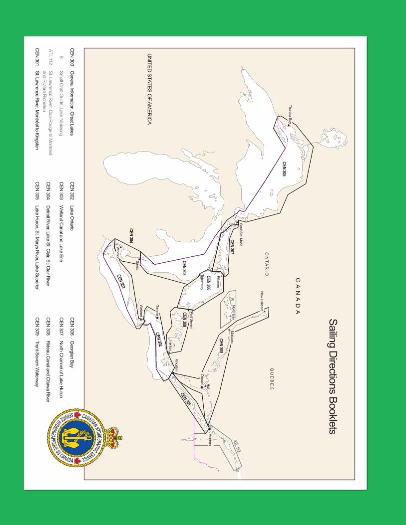
UN
ITED STATES O
F AMER
ICA
Sailing Directions Booklets
Q U
E B E C
C A N
A D A
O N
T A R I O
Thunder Bay
Sault Ste. Marie
Tobermory
Killarney
North Bay
New
Liskeard
Mattaw
a
Ottaw
a Hull
Montréal
Kingston
Trenton
Port Severn
Toronto
Welland
Sarnia
Windsor
CEN 304 CEN 307
CEN 305 CEN 306
CEN 303
CEN 302
CEN 301
CEN 308
ATL 112
CEN 305
B
CEN 309
General Inform
ation, Great Lakes
Small C
raft Guide, Lake N
ipissing
St. Lawrence R
iver, Cap-R
ouge to Montréal
and Rivière R
ichelieu
Welland C
anal and Lake Erie
Lake Ontario
Detroit R
iver, Lake St. Clair, St. C
lair River
Lake Huron, St. M
arys River, Lake Superior
St. Lawrence R
iver, Montréal to Kingston
Trent-Severn Waterw
ay
Rideau C
anal and Ottaw
a River
North C
hannel of Lake Huron
Georgian Bay
CEN
300
B
ATL 112
CEN
301
CEN
302
CEN
303
CEN
304
CEN
305
CEN
306
CEN
307
CEN
308
CEN
309
Related Documents