Safer Roads Program 2020/21 Safer Roads Program – Round 3 projects starting 2020/21 Page | 1 RMS Region Project ID LGA Location Project description Initiative Round 3 – Saving Lives on Country Roads and Liveable Safe Urban Communities projects 2020/21 Hunter Project- 2047 Central Coast 0.3km length of Blackwall Road, WOY WOY Pedestrian safety improvements including raised pedestrian crossing. Liveable and Safe Urban Communities Hunter Project- 2190 Central Coast 0.7km length of Old Maitland Road, MARDI Safety improvements to reduce the likelihood and severity of crashes including vehicle activated signage, safety barrier and shoulder widening. Liveable and Safe Urban Communities Hunter Project- 2229 Central Coast Intersection of Albany Street North and William Street, GOSFORD Intersection improvements to address critical safety issues. Liveable and Safe Urban Communities Hunter Project- 2230 Central Coast Intersection of Mount Ettalong Road and Hobart Avenue, UMINA BEACH Safety improvements to reduce the likelihood and severity of crashes including shoulder widening, median separation and upgraded road pavement. Liveable and Safe Urban Communities Hunter Project- 2240 Central Coast 4.2km length of Wisemans Ferry Road, MANGROVE MOUNTAIN Safety improvements to reduce the likelihood and severity of crashes including motorcycle barrier protection, vehicle activated signage and delineation. Liveable and Safe Urban Communities

Welcome message from author
This document is posted to help you gain knowledge. Please leave a comment to let me know what you think about it! Share it to your friends and learn new things together.
Transcript

Safer Roads Program 2020/21
Safer Roads Program – Round 3 projects starting 2020/21 Page | 1
RMS Region
Project ID LGA Location Project description Initiative
Round 3 – Saving Lives on Country Roads and Liveable Safe Urban Communities projects 2020/21
Hunter Project-2047
Central Coast 0.3km length of Blackwall Road, WOY WOY
Pedestrian safety improvements including raised pedestrian crossing.
Liveable and Safe Urban Communities
Hunter Project-2190
Central Coast 0.7km length of Old Maitland Road, MARDI
Safety improvements to reduce the likelihood and severity of crashes including vehicle activated signage, safety barrier and shoulder widening.
Liveable and Safe Urban Communities
Hunter Project-2229
Central Coast Intersection of Albany Street North and William Street, GOSFORD
Intersection improvements to address critical safety issues. Liveable and Safe Urban Communities
Hunter Project-2230
Central Coast Intersection of Mount Ettalong Road and Hobart Avenue, UMINA BEACH
Safety improvements to reduce the likelihood and severity of crashes including shoulder widening, median separation and upgraded road pavement.
Liveable and Safe Urban Communities
Hunter Project-2240
Central Coast 4.2km length of Wisemans Ferry Road, MANGROVE MOUNTAIN
Safety improvements to reduce the likelihood and severity of crashes including motorcycle barrier protection, vehicle activated signage and delineation.
Liveable and Safe Urban Communities

Safer Roads Program 2020/21
Safer Roads Program – Round 3 projects starting 2020/21 Page | 2
RMS Region
Project ID LGA Location Project description Initiative
Hunter Project-2244
Central Coast Intersection of Alison Road and Hope Street, WYONG
Intersection improvements to address critical safety issues. Liveable and Safe Urban Communities
Hunter Project-2250
Central Coast Intersection of Pacific Highway HW10 and Cutler Drive, WATANOBBI
Intersection improvements to address critical safety issues. Liveable and Safe Urban Communities
Hunter Project-2251
Central Coast Intersection of George Downes Drive and Great Northern Road, BUCKETTY
Safety improvements to reduce the likelihood and severity of crashes including shoulder widening, safety barrier, motorcycle barrier protection and delineation.
Liveable and Safe Urban Communities
Hunter Project-2254
Central Coast Intersection of Wyong Road MR335 and Bundilla Road, GLENNING VALLEY
Intersection improvements to address critical safety issues. Liveable and Safe Urban Communities
Hunter Project-2480
Central Coast Intersection of Henry Parry Drive and Wells Street, EAST GOSFORD
Intersection improvements to address critical safety issues. Liveable and Safe Urban Communities
Hunter Project-2483
Central Coast Intersection of Wyong Rd and Reliance Dr/Bryant Dr, TUGGERAH
Safety improvements to reduce the likelihood and severity of crashes including vehicle activated signage.
Liveable and Safe Urban Communities

Safer Roads Program 2020/21
Safer Roads Program – Round 3 projects starting 2020/21 Page | 3
RMS Region
Project ID LGA Location Project description Initiative
Hunter Project-2510
Central Coast Intersection of Avoca Drive and Melville St, KINCUMBER
Safety improvements to reduce the likelihood and severity of crashes including upgraded road pavement, shoulder widening, safety barrier.
Liveable and Safe Urban Communities
Hunter Project-2514
Central Coast
Intersection of Wyong Road and Tonkiss Street, Bundeena Road, Pindarri Avenue, Cornish Avenue, BERKELEY VALE
Safety improvements to reduce the likelihood and severity of crashes including vehicle activated signage.
Liveable and Safe Urban Communities
Hunter Project-2294
Cessnock Intersection of Oakey Creek Road and O'Connors Road, POKOLBIN
Safety improvements to reduce the likelihood and severity of crashes including shoulder widening, delineation, safety barrier, upgraded road pavement and audio-tactile line marking.
Saving Lives on Country Roads
Hunter Project-2219
Lake Macquarie 0.4km length of Pacific Highway, BELMONT NORTH
Safety improvements to reduce the likelihood and severity of crashes including median separation and delineation.
Liveable and Safe Urban Communities
Hunter Project-2239
Lake Macquarie 2.2km length of Pacific Highway, JEWELLS
Safety improvements to reduce the likelihood and severity of crashes including shoulder widening and delineation.
Liveable and Safe Urban Communities

Safer Roads Program 2020/21
Safer Roads Program – Round 3 projects starting 2020/21 Page | 4
RMS Region
Project ID LGA Location Project description Initiative
Hunter Project-2243
Lake Macquarie Intersection of Pacific Highway A43 and Dalrymple Street, JEWELLS
Intersection improvements to address critical safety issues. Liveable and Safe Urban Communities
Hunter Project-2323
Lake Macquarie 0.2km length of Dunkley Parade, MOUNT HUTTON
Safety improvements to reduce the likelihood and severity of crashes including median separation, safety barrier and upgrade of road pavement.
Liveable and Safe Urban Communities
Hunter Project-2476
Lake Macquarie Intersection of Awaba Road and Wakefield Road, RYHOPE
Safety improvements to reduce the likelihood and severity of crashes including vehicle activated signage.
Liveable and Safe Urban Communities
Hunter Project-2644
Lake Macquarie
Intersection of Pacific Highway (HW10) and Flowers Dr (Cams Wharf Rd) and Nords Wharf Rd, CATHERINE HILL BAY
Intersection improvements to address critical safety issues. Liveable and Safe Urban Communities
Hunter Project-1865
Maitland Intersection of Woodberry Road and Raymond Terrace Road, MILLERS FOREST
Safety improvements to reduce the likelihood and severity of crashes including shoulder widening and delineation.
Saving Lives on Country Roads

Safer Roads Program 2020/21
Safer Roads Program – Round 3 projects starting 2020/21 Page | 5
RMS Region
Project ID LGA Location Project description Initiative
Hunter Project-2509
Maitland Intersection of Raymond Terrace Road and Hausmann Drive, THORNTON
Intersection improvements to address critical safety issues. Saving Lives on Country Roads
Hunter Project-2221
Mid-Coast 3.6km length of Pacific Highway, GHINNI GHINNI
Safety improvements to reduce the likelihood and severity of crashes including safety barrier.
Saving Lives on Country Roads
Hunter Project-2338
Mid-Coast 0.2km length of The Bucketts Way, BURRELL CREEK
Safety improvements to reduce the likelihood and severity of crashes including vehicle activated signage.
Saving Lives on Country Roads
Hunter Project-2271
Muswellbrook 10km length of Sandy Creek Road, MUSWELLBROOK
Safety improvements to reduce the likelihood and severity of crashes including delineation, safety barrier and motorcycle barrier protection.
Saving Lives on Country Roads
Hunter Project-2300
Muswellbrook 2km length of New England Highway, ABERDEEN
Safety improvements to reduce the likelihood and severity of crashes including wide centre line, safety barrier and audio-tactile line marking.
Saving Lives on Country Roads
Hunter Project-2508
Muswellbrook 0.7km length of New England Highway, ABERDEEN
Safety improvements to reduce the likelihood and severity of crashes including audio-tactile line marking, shoulder widening and safety barrier.
Saving Lives on Country Roads
Safer Roads Program 2020/21
Safer Roads Program – Round 3 projects starting 2020/21 Page | 6
RMS Region
Project ID LGA Location Project description Initiative
Hunter Project-1752
Newcastle 0.6km length of Mawson Street, SHORTLAND
Pedestrian safety improvements including raised pedestrian refuge.
Liveable and Safe Urban Communities
Hunter Project-1761
Newcastle Intersection of Croudace Road and Garsdale Avenue, ELERMORE VALE
Intersection improvements to address critical safety issues. Liveable and Safe Urban Communities
Hunter Project-1766
Newcastle Intersection of Maryland Drive and Grange Avenue, MARYLAND
Pedestrian safety improvements including raised pedestrian refuge.
Liveable and Safe Urban Communities
Hunter Project-1826
Newcastle 0.7km length of Everton Street, HAMILTON
Intersection improvements to address critical safety issues. Liveable and Safe Urban Communities
Hunter Project-1831
Newcastle Intersection of Coane Street and Frederick Street, MEREWETHER
Intersection improvements to address critical safety issues. Liveable and Safe Urban Communities
Hunter Project-1999
Newcastle Intersection of Hobart Road and Wallarah Road, NEW LAMBTON
Intersection improvements to address critical safety issues. Liveable and Safe Urban Communities

Safer Roads Program 2020/21
Safer Roads Program – Round 3 projects starting 2020/21 Page | 7
RMS Region
Project ID LGA Location Project description Initiative
Hunter Project-2231
Newcastle Intersection of Newcastle Road and Morehead Street, LAMBTON
Intersection improvements to address critical safety issues. Liveable and Safe Urban Communities
Hunter Project-2236
Newcastle Intersection of Newcastle Road and Victory Parade / Drury Street, JESMOND
Intersection improvements to address critical safety issues. Liveable and Safe Urban Communities
Hunter Project-2238
Newcastle Intersection of Thomas Street and Metcalfe Street, WALLSEND
Intersection improvements to address critical safety issues. Liveable and Safe Urban Communities
Hunter Project-2346
Newcastle Intersection of Cowper Street and Bulkara Street - Newcastle Road, WALLSEND
Intersection improvements to address critical safety issues. Liveable and Safe Urban Communities
Hunter Project-2477
Newcastle Intersection of Lookout Road and McCaffrey Drive, NEW LAMBTON HEIGHTS
Intersection improvements to address critical safety issues. Liveable and Safe Urban Communities
Hunter Project-2524
Newcastle Intersection of University Drive and Stannett Street, CALLAGHAN
Intersection improvements to address critical safety issues. Liveable and Safe Urban Communities

Safer Roads Program 2020/21
Safer Roads Program – Round 3 projects starting 2020/21 Page | 8
RMS Region
Project ID LGA Location Project description Initiative
Hunter Project-2493
Port Stephens 0.3km length of Pacific Highway, TOMAGO
Intersection improvements to address critical safety issues. Saving Lives on Country Roads
Hunter Project-2552
Port Stephens Intersection of Nelson Bay Road and Williamtown Drive, WILLIAMTOWN
Intersection improvements to address critical safety issues. Saving Lives on Country Roads
Hunter Project-2576
Port Stephens Intersection of Richardson Rd and Grahamstown Rd, CAMPVALE
Safety improvements to reduce the likelihood and severity of crashes including vehicle activated signage.
Saving Lives on Country Roads
Hunter Project-2042
Singleton 5.8km length of Hebden Road, HEBDEN
Safety improvements to reduce the likelihood and severity of crashes including safety barrier, motorcycle barrier protection, delineation and shoulder widening.
Saving Lives on Country Roads
Hunter Project-2496
Upper Hunter 6km length of New England Highway, PARKVILLE
Safety improvements to reduce the likelihood and severity of crashes including wide centre line, audio-tactile line marking, shoulder widening and safety barrier.
Saving Lives on Country Roads
Northern Project-2599
Armidale Regional
Intersection of Waterfall Way and Bayley Park Road, METZ
Safety improvements to reduce the likelihood and severity of crashes including shoulder widening, wide centre line, safety barrier and audio-tactile line marking.
Saving Lives on Country Roads

Safer Roads Program 2020/21
Safer Roads Program – Round 3 projects starting 2020/21 Page | 9
RMS Region
Project ID LGA Location Project description Initiative
Northern Project-1729
Ballina 6.9km length of Ross Lane, Byron Bay Road, LENNOX HEAD
Safety improvements to reduce the likelihood and severity of crashes including shoulder widening, delineation and road pavement upgrade.
Saving Lives on Country Roads
Northern Project-1735
Ballina Intersection of Tamarind Drive and Tintenbar Road, TINTENBAR
Intersection improvements to address critical safety issues. Saving Lives on Country Roads
Northern Project-1744
Ballina Intersection of Kerr Street and Bentinck Street, BALLINA
Intersection improvements to address critical safety issues. Saving Lives on Country Roads
Northern Project-1792
Byron 12km length of Myocum Road, MYOCUM
Safety improvements to reduce the likelihood and severity of crashes including vehicle activated signage, safety barrier and shoulder widening.
Saving Lives on Country Roads
Northern Project-1793
Byron Intersection of Main Arm Road and Coolamon Scenic Drive, MAIN ARM
Safety improvements to reduce the likelihood and severity of crashes including shoulder widening, safety barrier and intersection improvements.
Saving Lives on Country Roads
Northern Project-1852
Clarence Valley 1.9km length of Gwydir Highway, WATERVIEW HEIGHTS
Safety improvements to reduce the likelihood and severity of crashes including wide centre line and shoulder widening.
Saving Lives on Country Roads

Safer Roads Program 2020/21
Safer Roads Program – Round 3 projects starting 2020/21 Page | 10
RMS Region
Project ID LGA Location Project description Initiative
Northern Project-2039
Clarence Valley Intersection of Tallawudjah Creek Road and Tallowood Place, GLENREAGH
Safety improvements to reduce the likelihood and severity of crashes including delineation, shoulder widening and wider clear zone.
Saving Lives on Country Roads
Northern Project-2054
Clarence Valley
Intersection of Gumnut Road and Witonga Dr, Acacia Cct, Hakea Ave, Treelands Dr, Willow Way, Parkview Cr, Wattle Dr, Melaleuca Dr, YAMBA
Safety improvements to reduce the likelihood and severity of crashes including delneation and pedestrian refuges.
Saving Lives on Country Roads
Northern Project-2145
Clarence Valley 0.1km length of Pacific Highway, ULMARRA
Safety improvements to reduce the likelihood and severity of crashes including shoulder widening and delineation.
Saving Lives on Country Roads
Northern Project-2149
Clarence Valley 1km length of Armidale Road, NYMBOIDA
Safety improvements to reduce the likelihood and severity of crashes including delineation, wider clear zones and shoulder widening.
Saving Lives on Country Roads
Northern Project-2155
Clarence Valley 1km length of Orara Way, KREMNOS
Safety improvements to reduce the likelihood and severity of crashes including wide centre line, delineation and shoulder widening.
Saving Lives on Country Roads
Safer Roads Program 2020/21
Safer Roads Program – Round 3 projects starting 2020/21 Page | 11
RMS Region
Project ID LGA Location Project description Initiative
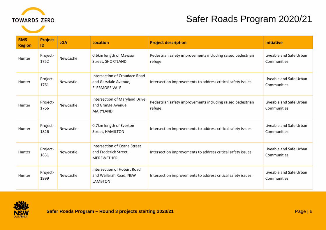
Northern Project-2305
Clarence Valley 0.5km length of Armidale Road, BLAXLANDS CREEK
Safety improvements to reduce the likelihood and severity of crashes including delineation and shoulder widening.
Saving Lives on Country Roads
Northern Project-2358
Clarence Valley 107km length of Armidale Road, NYMBOIDA
Safety improvements to reduce the likelihood and severity of crashes including vehicle activated signage, delineation, safety barrier and motorcycle barrier protection.
Saving Lives on Country Roads
Northern Project-2359
Clarence Valley 104km length of Clarence Way, UPPER FINE FLOWER
Safety improvements to reduce the likelihood and severity of crashes including delineation and wider clear zone.
Saving Lives on Country Roads
Northern Project-2593
Clarence Valley Gwydir Highway/Summerland Way, GLENUGIE to TYNDALE
Safety improvements to reduce the likelihood and severity of crashes including audio-tactile line marking, safety barrier and shoulder widening.
Saving Lives on Country Roads
Northern Project-2045
Glen Innes Severn
2.9km length of Bald Nob Road, GLEN INNES
Safety improvements to reduce the likelihood and severity of crashes including shoulder widening and delineation.
Saving Lives on Country Roads
Northern Project-1911
Kempsey 2.9km length of Armidale Road, YARRAVEL
Safety improvements to reduce the likelihood and severity of crashes including delineation and safety barrier.
Saving Lives on Country Roads

Safer Roads Program 2020/21
Safer Roads Program – Round 3 projects starting 2020/21 Page | 12
RMS Region
Project ID LGA Location Project description Initiative
Northern Project-1933
Kempsey Intersection of South West Rocks Road and Hat Head Road, KINCHELA
Safety improvements to reduce the likelihood and severity of crashes including delineation, shoulder widening and vehicle activated signage.
Saving Lives on Country Roads
Northern Project-2406
Kyogle 5.4km length of Summerland Way, DAIRY FLAT
Safety improvements to reduce the likelihood and severity of crashes including shoulder widening, delineation, safety barrier, vehicle activated signage, upgraded road pavement and audio-tactile line marking.
Saving Lives on Country Roads
Northern Project-1894
Lismore 0.4km length of Johnston, CLUNES
Safety improvements to reduce the likelihood and severity of crashes including delineation and shoulder widening.
Saving Lives on Country Roads
Northern Project-2027
Lismore 1.4km length of Bruxner Highway, TABULAM
Safety improvements to reduce the likelihood and severity of crashes including shoulder widening, wide centre line, intersection upgrade and audio-tactile line marking.
Saving Lives on Country Roads
Northern Project-2296
Lismore 1.4km length of Bruxner Highway, SOUTH GUNDURIMBA
Safety improvements to reduce the likelihood and severity of crashes including shoulder widening, delineation, wide centre line and audio-tactile line marking.
Saving Lives on Country Roads

Safer Roads Program 2020/21
Safer Roads Program – Round 3 projects starting 2020/21 Page | 13
RMS Region
Project ID LGA Location Project description Initiative
Northern Project-2297
Lismore Intersection of Bruxner Highway and Tatham Road, SOUTH GUNDURIMBA
Safety improvements to reduce the likelihood and severity of crashes including shoulder widening, wide centre line, audio-tactile line marking, safety barrier and intersection upgrade.
Saving Lives on Country Roads
Northern Project-2402
Lismore 0.3km length of Boatharbour Rd, BOAT HARBOUR
Safety improvements to reduce the likelihood and severity of crashes including shoulder widening and delineation.
Saving Lives on Country Roads
Northern Project-334
Lismore Intersection of Nimbin Road and Boyle Road, GOOLMANGAR
Safety improvements to reduce the likelihood and severity of crashes including delineation and shoulder widening.
Saving Lives on Country Roads
Northern Project-343
Lismore Intersection of Orion Street and Keen Street, LISMORE
Intersection improvements to address critical safety issues. Saving Lives on Country Roads
Northern Project-1974
Port Macquarie-Hastings
Intersection of Lord Street and Herschell Street, PORT MACQUARIE
Intersection improvements to address critical safety issues. Saving Lives on Country Roads
Northern Project-1977
Port Macquarie-Hastings
Intersection of Owen Street and Home Street, PORT MACQUARIE
Intersection improvements to address critical safety issues. Saving Lives on Country Roads
Safer Roads Program 2020/21
Safer Roads Program – Round 3 projects starting 2020/21 Page | 14
RMS Region
Project ID LGA Location Project description Initiative
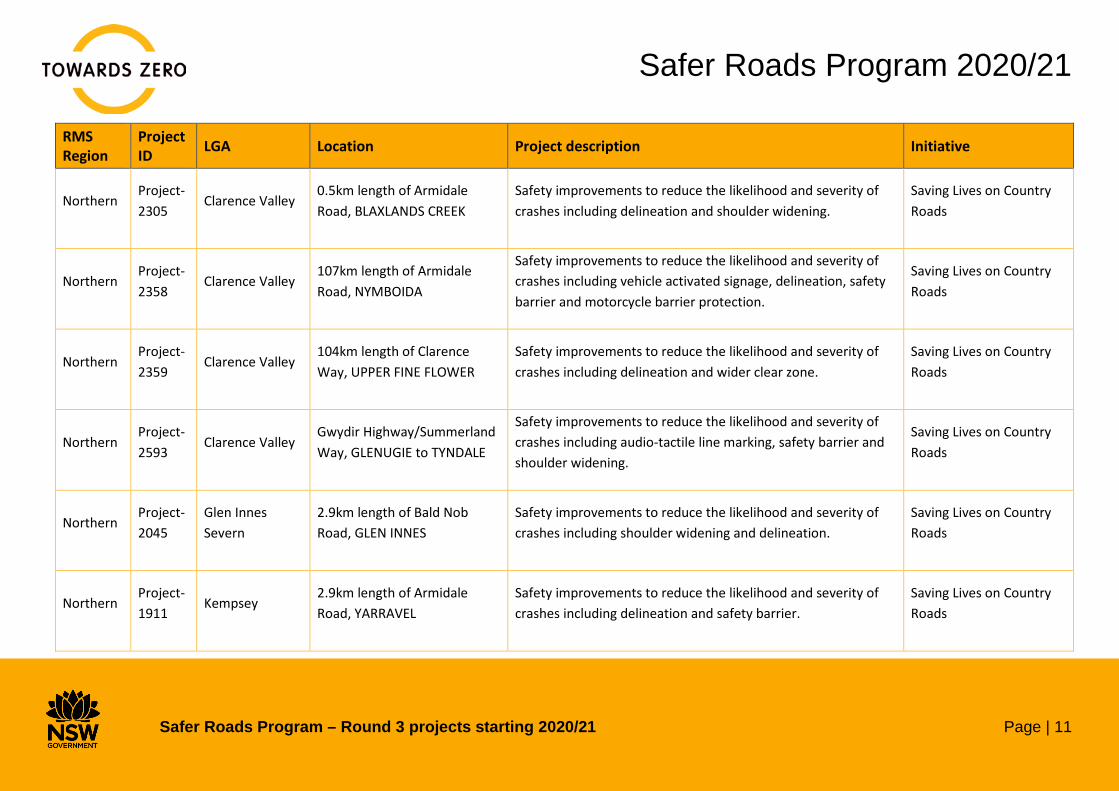
Northern Project-1996
Port Macquarie-Hastings
Intersection of Kendall Road and Nancy Bird Walton Drive, KEW
Intersection improvements to address critical safety issues. Saving Lives on Country Roads
Northern Project-2014
Port Macquarie-Hastings
Intersection of King Creek Road and Berowra Place, KING CREEK
Safety improvements to reduce the likelihood and severity of crashes including shoulder widening and safety barrier.
Saving Lives on Country Roads
Northern Project-2404
Richmond Valley
1.7km length of Summerland Way, CASINO
Safety improvements to reduce the likelihood and severity of crashes including shoulder widening, audio-tactile line marking and shoulder widening.
Saving Lives on Country Roads
Northern Project-2405
Richmond Valley
1.1km length of Summerland Way, FAIRY HILL
Safety improvements to reduce the likelihood and severity of crashes including shoulder widening, wide centre line, safety barrier, motorcycle barrier protection and audio-tactile line marking.
Saving Lives on Country Roads
Northern Project-2126
Tamworth Regional
134km length of New England Highway, TAMWORTH
Safety improvements to reduce the likelihood and severity of crashes including wide centre line, audio-tactile line marking and shoulder widening.
Saving Lives on Country Roads

Safer Roads Program 2020/21
Safer Roads Program – Round 3 projects starting 2020/21 Page | 15
RMS Region
Project ID LGA Location Project description Initiative
Northern Project-2411
Tamworth Regional
0.1km length of Nundle Road, DUNGOWAN
Safety improvements to reduce the likelihood and severity of crashes including delineation and safety barrier.
Saving Lives on Country Roads
Northern Project-2434
Tamworth Regional
Intersection of Evans Street and Oxley Highway, WESTDALE
Intersection improvements to address critical safety issues. Saving Lives on Country Roads
Northern Project-2306
Tenterfield 4.7km length of Boonoo Boonoo Falls Rd, BOONOO BOONOO
Safety improvements to reduce the likelihood and severity of crashes including safety barrier and delineation.
Saving Lives on Country Roads
Northern Project-2429
Tweed 0.3km length of Kyogle Road, DUM DUM
Safety improvements to reduce the likelihood and severity of crashes including safety barrier.
Saving Lives on Country Roads
Northern Project-2648
Tweed Intersection of Limpinwood/Zara Roadand TYALGUM
Safety improvements to reduce the likelihood and severity of crashes including vehicle activated signage, safety barrier, shoulder widening and delineation.
Saving Lives on Country Roads
Northern Project-2029
Uralla 0.3km length of Thunderbolts Way, URALLA
Safety improvements to reduce the likelihood and severity of crashes including delineation, shoulder widening and safety barrier.
Saving Lives on Country Roads

Safer Roads Program 2020/21
Safer Roads Program – Round 3 projects starting 2020/21 Page | 16
RMS Region
Project ID LGA Location Project description Initiative
Northern Project-2602
Walcha Intersection of Oxley Highway and Nowendoc Rd, WALCHA
Safety improvements to reduce the likelihood and severity of crashes including shoulder widening, delineation and safety barrier.
Saving Lives on Country Roads
Northern Project-2606
Walcha 1.9km length of Oxley Highway, YARROWITCH
Safety improvements to reduce the likelihood and severity of crashes including shoulder widening, delineation and safety barrier.
Saving Lives on Country Roads
South West
Project-1838
Bland 40km length of Lake Cargelligo Road, UNGARIE
Safety improvements to reduce the likelihood and severity of crashes including audio-tactile linemarking, delineation, safety barrier and shoulder widening.
Saving Lives on Country Roads
South West
Project-2311
Federation 20km length of Riverina Highway, HOWLONG
Safety improvements to reduce the likelihood and severity of crashes including shoulder widening, wide centre line and audio-tactile line marking.
Saving Lives on Country Roads
South West
Project-1724
Greater Hume 30km length of Urana Road, BURRUMBUTTOCK
Safety improvements to reduce the likelihood and severity of crashes including safety barrier and audio-tactile line marking.
Saving Lives on Country Roads
South West
Project-2382
Hilltops Intersection of Wombat Street and Berthong Street, YOUNG
Intersection improvements to address critical safety issues. Saving Lives on Country Roads
Safer Roads Program 2020/21
Safer Roads Program – Round 3 projects starting 2020/21 Page | 17
RMS Region
Project ID LGA Location Project description Initiative
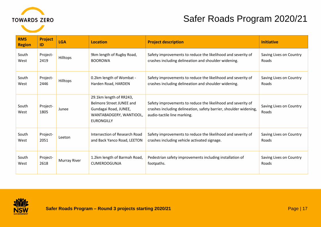
South West
Project-2419
Hilltops 9km length of Rugby Road, BOOROWA
Safety improvements to reduce the likelihood and severity of crashes including delineation and shoulder widening.
Saving Lives on Country Roads
South West
Project-2446
Hilltops 0.2km length of Wombat - Harden Road, HARDEN
Safety improvements to reduce the likelihood and severity of crashes including delineation and shoulder widening.
Saving Lives on Country Roads
South West
Project-1805
Junee
29.1km length of RR243, Belmore Street JUNEE and Gundagai Road, JUNEE, WANTABADGERY, WANTIOOL, EURONGILLY
Safety improvements to reduce the likelihood and severity of crashes including delineation, safety barrier, shoulder widening, audio-tactile line marking.
Saving Lives on Country Roads
South West
Project-2051
Leeton Intersection of Research Road and Back Yanco Road, LEETON
Safety improvements to reduce the likelihood and severity of crashes including vehicle activated signage.
Saving Lives on Country Roads
South West
Project-2618
Murray River 1.2km length of Barmah Road, CUMEROOGUNJA
Pedestrian safety improvements including installation of footpaths.
Saving Lives on Country Roads
Safer Roads Program 2020/21
Safer Roads Program – Round 3 projects starting 2020/21 Page | 18
RMS Region
Project ID LGA Location Project description Initiative
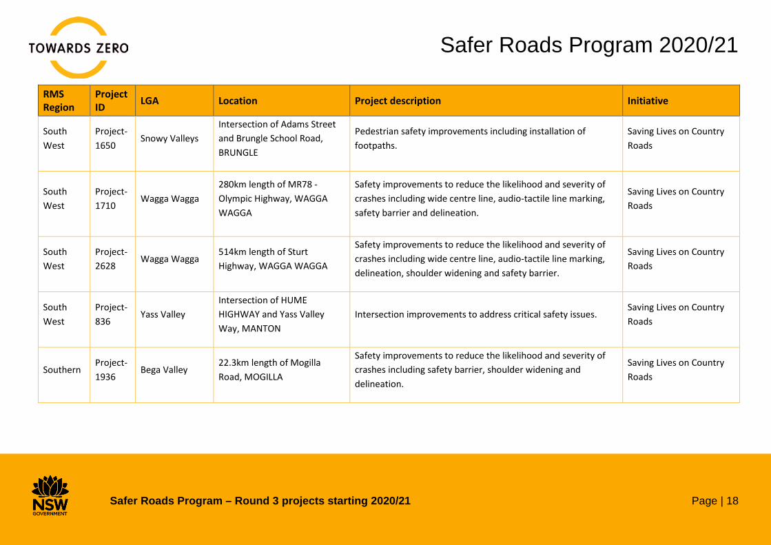
South West
Project-1650
Snowy Valleys Intersection of Adams Street and Brungle School Road, BRUNGLE
Pedestrian safety improvements including installation of footpaths.
Saving Lives on Country Roads
South West
Project-1710
Wagga Wagga 280km length of MR78 - Olympic Highway, WAGGA WAGGA
Safety improvements to reduce the likelihood and severity of crashes including wide centre line, audio-tactile line marking, safety barrier and delineation.
Saving Lives on Country Roads
South West
Project-2628
Wagga Wagga 514km length of Sturt Highway, WAGGA WAGGA
Safety improvements to reduce the likelihood and severity of crashes including wide centre line, audio-tactile line marking, delineation, shoulder widening and safety barrier.
Saving Lives on Country Roads
South West
Project-836
Yass Valley Intersection of HUME HIGHWAY and Yass Valley Way, MANTON
Intersection improvements to address critical safety issues. Saving Lives on Country Roads
Southern Project-1936
Bega Valley 22.3km length of Mogilla Road, MOGILLA
Safety improvements to reduce the likelihood and severity of crashes including safety barrier, shoulder widening and delineation.
Saving Lives on Country Roads
Safer Roads Program 2020/21
Safer Roads Program – Round 3 projects starting 2020/21 Page | 19
RMS Region
Project ID LGA Location Project description Initiative
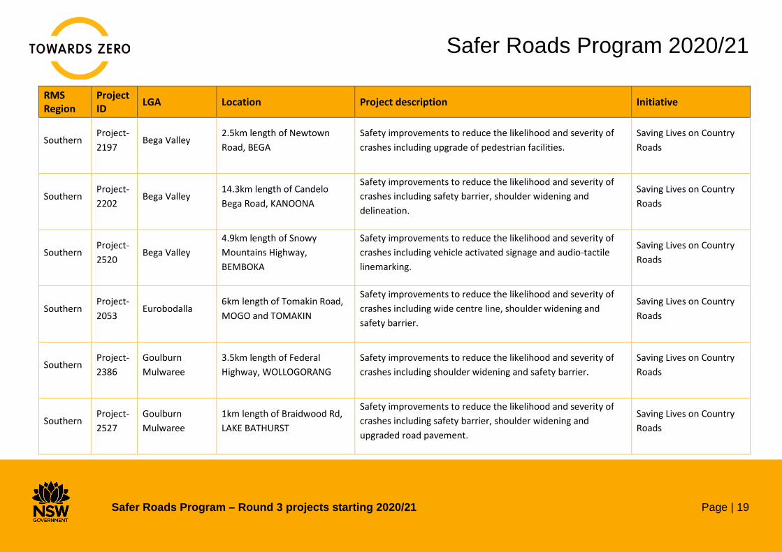
Southern Project-2197
Bega Valley 2.5km length of Newtown Road, BEGA
Safety improvements to reduce the likelihood and severity of crashes including upgrade of pedestrian facilities.
Saving Lives on Country Roads
Southern Project-2202
Bega Valley 14.3km length of Candelo Bega Road, KANOONA
Safety improvements to reduce the likelihood and severity of crashes including safety barrier, shoulder widening and delineation.
Saving Lives on Country Roads
Southern Project-2520
Bega Valley 4.9km length of Snowy Mountains Highway, BEMBOKA
Safety improvements to reduce the likelihood and severity of crashes including vehicle activated signage and audio-tactile linemarking.
Saving Lives on Country Roads
Southern Project-2053
Eurobodalla 6km length of Tomakin Road, MOGO and TOMAKIN
Safety improvements to reduce the likelihood and severity of crashes including wide centre line, shoulder widening and safety barrier.
Saving Lives on Country Roads
Southern Project-2386
Goulburn Mulwaree
3.5km length of Federal Highway, WOLLOGORANG
Safety improvements to reduce the likelihood and severity of crashes including shoulder widening and safety barrier.
Saving Lives on Country Roads
Southern Project-2527
Goulburn Mulwaree
1km length of Braidwood Rd, LAKE BATHURST
Safety improvements to reduce the likelihood and severity of crashes including safety barrier, shoulder widening and upgraded road pavement.
Saving Lives on Country Roads
Safer Roads Program 2020/21
Safer Roads Program – Round 3 projects starting 2020/21 Page | 20
RMS Region
Project ID LGA Location Project description Initiative
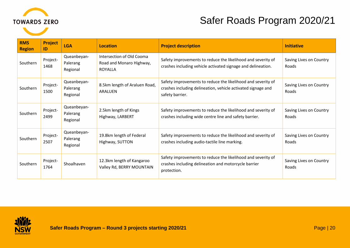
Southern Project-1468
Queanbeyan-Palerang Regional
Intersection of Old Cooma Road and Monaro Highway, ROYALLA
Safety improvements to reduce the likelihood and severity of crashes including vehicle activated signage and delineation.
Saving Lives on Country Roads
Southern Project-1500
Queanbeyan-Palerang Regional
8.5km length of Araluen Road, ARALUEN
Safety improvements to reduce the likelihood and severity of crashes including delineation, vehicle activated signage and safety barrier.
Saving Lives on Country Roads
Southern Project-2499
Queanbeyan-Palerang Regional
2.5km length of Kings Highway, LARBERT
Safety improvements to reduce the likelihood and severity of crashes including wide centre line and safety barrier.
Saving Lives on Country Roads
Southern Project-2507
Queanbeyan-Palerang Regional
19.8km length of Federal Highway, SUTTON
Safety improvements to reduce the likelihood and severity of crashes including audio-tactile line marking.
Saving Lives on Country Roads
Southern Project-1764
Shoalhaven 12.3km length of Kangaroo Valley Rd, BERRY MOUNTAIN
Safety improvements to reduce the likelihood and severity of crashes including delineation and motorcycle barrier protection.
Saving Lives on Country Roads

Safer Roads Program 2020/21
Safer Roads Program – Round 3 projects starting 2020/21 Page | 21
RMS Region
Project ID LGA Location Project description Initiative
Southern Project-1824
Shoalhaven Intersection of Currambene Street and Bowen Street, HUSKISSON
Intersection improvements to address critical safety issues. Saving Lives on Country Roads
Southern Project-2059
Shoalhaven 0.3km length of Matron Porter Drive, MILTON
Safety improvements to reduce the likelihood and severity of crashes including wide centre line, shoulder widening and safety barrier.
Saving Lives on Country Roads
Southern Project-2491
Shoalhaven Intersection of Princes Hwy and Warra Warra Rd, SOUTH NOWRA
Safety improvements to reduce the likelihood and severity of crashes including vehicle activated signage, street lighting and audio-tactile line marking.
Saving Lives on Country Roads
Southern Project-2523
Shoalhaven 4km length of Moss Vale Rd, BARRENGARRY
Safety improvements to reduce the likelihood and severity of crashes including safety barrier, shoulder widening and audio-tactile line marking.
Saving Lives on Country Roads
Southern Project-2548
Shoalhaven 0.7km length of Kings Hwy, CURROWAN
Safety improvements to reduce the likelihood and severity of crashes including shoulder widening, wide centre line, safety barrier and audio-tactile line marking.
Saving Lives on Country Roads

Safer Roads Program 2020/21
Safer Roads Program – Round 3 projects starting 2020/21 Page | 22
RMS Region
Project ID LGA Location Project description Initiative
Southern Project-2518
Snowy Monaro Regional
5.7km length of Monaro Highway, MICHELAGO
Safety improvements to reduce the likelihood and severity of crashes including wide centre line, audio-tactile linemarking and safety barrier.
Saving Lives on Country Roads
Southern Project-2521
Snowy Monaro Regional
14km length of Monaro Highway, BOMBALA
Safety improvements to reduce the likelihood and severity of crashes including shoulder widening and safety barrier.
Saving Lives on Country Roads
Southern Project-2501
Upper Lachlan 1.5km length of Crookwell Road, WAYO
Safety improvements to reduce the likelihood and severity of crashes including shoulder widening and safety barrier.
Saving Lives on Country Roads
Southern Project-2060
Wingecarribee Old South Road, Merrigang St to Aylmerton Rd, BOWRAL & MITTAGONG
Safety improvements to reduce the likelihood and severity of crashes including shoulder widening, audio-tactile line marking and safety barrier.
Saving Lives on Country Roads
Southern Project-2498
Wingecarribee 0.1km length of Illawarra Highway, ROBERTSON
Safety improvements to reduce the likelihood and severity of crashes including vehicle activated signage, wide centre line and shoulder widening.
Saving Lives on Country Roads
Southern Project-2540
Wingecarribee 2.6km length of Illawarra Highway, ROBERTSON
Safety improvements to reduce the likelihood and severity of crashes including safety barrier and shoulder widening.
Saving Lives on Country Roads

Safer Roads Program 2020/21
Safer Roads Program – Round 3 projects starting 2020/21 Page | 23
RMS Region
Project ID LGA Location Project description Initiative
Southern Project-2635
Wingecarribee 2.3km length of Hume Highway, BERRIMA
Safety improvements to reduce the likelihood and severity of crashes including safety barrier.
Saving Lives on Country Roads
Southern Project-1480
Wollondilly Intersection of Argyle Street and Barkers Lodge Rd, PICTON
Safety improvements to reduce the likelihood and severity of crashes including vehicle activated signage, delineation, intersection upgrade, wide centre line and audio-tactile line marking.
Saving Lives on Country Roads
Southern Project-1705
Wollondilly 19km length of Silverdale Road, SILVERDALE
Safety improvements to reduce the likelihood and severity of crashes including delineation, upgraded road pavement, shoulder widening, audio-tactile line marking and safety barrier.
Saving Lives on Country Roads
Southern Project-1730
Wollondilly 6.5km length of West Parade, THIRLMERE
Safety improvements to reduce the likelihood and severity of crashes including audio-tactile linemarking, delineation, safety barrier, vehicle activated signage and shoulder widening.
Saving Lives on Country Roads
Southern Project-2516
Wollondilly 4.6km length of Hume Highway, PHEASANTS NEST
Safety improvements to reduce the likelihood and severity of crashes including safety barrier.
Saving Lives on Country Roads
Safer Roads Program 2020/21
Safer Roads Program – Round 3 projects starting 2020/21 Page | 24
RMS Region
Project ID LGA Location Project description Initiative
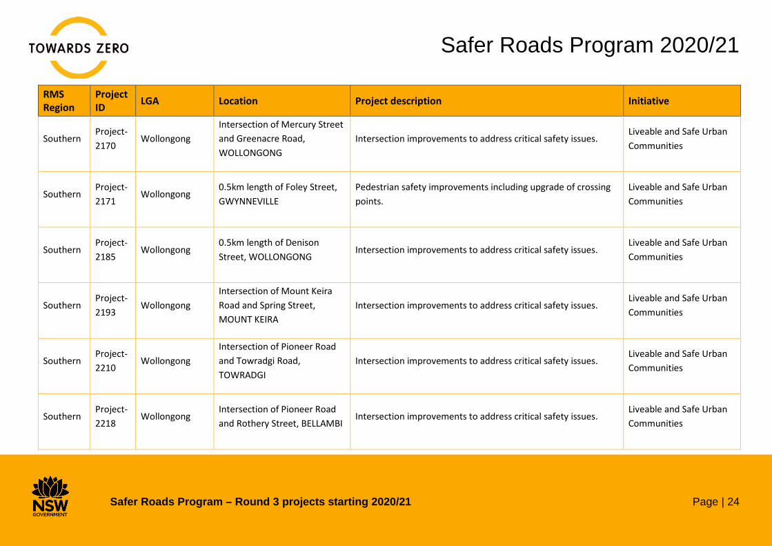
Southern Project-2170
Wollongong Intersection of Mercury Street and Greenacre Road, WOLLONGONG
Intersection improvements to address critical safety issues. Liveable and Safe Urban Communities
Southern Project-2171
Wollongong 0.5km length of Foley Street, GWYNNEVILLE
Pedestrian safety improvements including upgrade of crossing points.
Liveable and Safe Urban Communities
Southern Project-2185
Wollongong 0.5km length of Denison Street, WOLLONGONG
Intersection improvements to address critical safety issues. Liveable and Safe Urban Communities
Southern Project-2193
Wollongong Intersection of Mount Keira Road and Spring Street, MOUNT KEIRA
Intersection improvements to address critical safety issues. Liveable and Safe Urban Communities
Southern Project-2210
Wollongong Intersection of Pioneer Road and Towradgi Road, TOWRADGI
Intersection improvements to address critical safety issues. Liveable and Safe Urban Communities
Southern Project-2218
Wollongong Intersection of Pioneer Road and Rothery Street, BELLAMBI
Intersection improvements to address critical safety issues. Liveable and Safe Urban Communities

Safer Roads Program 2020/21
Safer Roads Program – Round 3 projects starting 2020/21 Page | 25
RMS Region
Project ID LGA Location Project description Initiative
Southern Project-2269
Wollongong Intersection of Burelli Street and Church Street, WOLLONGONG
Intersection improvements to address critical safety issues. Liveable and Safe Urban Communities
Southern Project-2472
Wollongong Intersection of Five Islands Road and Princes Motorway, UNANDERRA
Intersection improvements to address critical safety issues. Liveable and Safe Urban Communities
Southern Project-2474
Wollongong Intersection of Princes Highway and Arkell Drive, FIGTREE
Intersection improvements to address critical safety issues. Liveable and Safe Urban Communities
Sydney Project-2091
Bayside
Intersection of St Georges Road and between Stoney Creek Road and Forest Road, BEXLEY
Safety improvements to reduce the likelihood and severity of crashes including traffic calming and delineation.
Liveable and Safe Urban Communities
Sydney Project-1956
Blue Mountains Intersection of Badgery Crescent and San Jose Avenue, LAWSON
Intersection improvements to address critical safety issues. Liveable and Safe Urban Communities

Safer Roads Program 2020/21
Safer Roads Program – Round 3 projects starting 2020/21 Page | 26
RMS Region
Project ID LGA Location Project description Initiative
Sydney Project-1963
Blue Mountains Intersection of Leura Mall and Gordon Road, LEURA
Intersection improvements to address critical safety issues. Liveable and Safe Urban Communities
Sydney Project-1986
Blue Mountains Intersection of Blaxland Road and 125m length from Sinclair Crescent, WENTWORTH FALLS
Intersection improvements to address critical safety issues. Liveable and Safe Urban Communities
Sydney Project-2350
Campbelltown Intersection of Collins Promenade and Eagleview Road, INGLEBURN
Intersection improvements to address critical safety issues. Liveable and Safe Urban Communities
Sydney Project-1775
Canterbury-Bankstown
0.7km length of Burwood Road, BELFIELD
Intersection improvements to address critical safety issues. Liveable and Safe Urban Communities
Sydney Project-1776
Canterbury-Bankstown
Intersection of Tower St and Hinemoa St, PANANIA
Intersection improvements to address critical safety issues. Liveable and Safe Urban Communities
Sydney Project-1810
Canterbury-Bankstown
Intersection of Edgar St and From Yanderra St to Saurine St, CONDELL PARK
Intersection improvements to address critical safety issues. Liveable and Safe Urban Communities

Safer Roads Program 2020/21
Safer Roads Program – Round 3 projects starting 2020/21 Page | 27
RMS Region
Project ID LGA Location Project description Initiative
Sydney Project-1812
Canterbury-Bankstown
William Street, between Kingsgrove Road and Woolcott Street, KINGSGROVE
Intersection improvements to address critical safety issues. Liveable and Safe Urban Communities
Sydney Project-1855
Canterbury-Bankstown
0.1km length of Penshurst St, ROSELANDS
Safety improvements to reduce the likelihood and severity of crashes including traffic calming.
Liveable and Safe Urban Communities
Sydney Project-1917
Canterbury-Bankstown
Intersection of Northcote Street and Narani Cr, EARLWOOD
Safety improvements to reduce the likelihood and severity of crashes including traffic calming.
Liveable and Safe Urban Communities
Sydney Project-1918
Canterbury-Bankstown
Glassop St, from Saltash St to Dutton St, YAGOONA
Intersection improvements to address critical safety issues. Liveable and Safe Urban Communities
Sydney Project-1919
Canterbury-Bankstown
Intersection of Calbina Rd and Ryrie Rd, EARLWOOD
Intersection improvements to address critical safety issues. Liveable and Safe Urban Communities
Sydney Project-1955
Canterbury-Bankstown
Waldron Road and Chester Hill Road, CHESTER HILL
Pedestrian safety improvements including traffic calming measures.
Liveable and Safe Urban Communities

Safer Roads Program 2020/21
Safer Roads Program – Round 3 projects starting 2020/21 Page | 28
RMS Region
Project ID LGA Location Project description Initiative
Sydney Project-1961
Cumberland Intersection of Marian Street and Woodstock Street, GUILDFORD
Intersection improvements to address critical safety issues. Liveable and Safe Urban Communities
Sydney Project-2401
Georges River Intersection of Nielsen Avenue and Jubilee Avenue, CARLTON
Pedestrian safety improvements including raised pedestrian crossing.
Liveable and Safe Urban Communities
Sydney Project-1920
Hawkesbury 0.2km length of Scheyville Road, SCHEYVILLE
Safety improvements to reduce the likelihood and severity of crashes including vehicle activated signage, safety barrier and shoulder widening.
Liveable and Safe Urban Communities
Sydney Project-1418
Hornsby Intersection of Pacific Highway and Baldwin Avenue, ASQUITH
Pedestrian safety improvements including pedestrian fencing. Liveable and Safe Urban Communities
Sydney Project-1425
Hornsby Intersection of Peats Ferry Road and Bridge Road, HORNSBY
Intersection improvements to address critical safety issues. Liveable and Safe Urban Communities
Sydney Project-2334
Hornsby Intersection of Beecroft Road and Lyne Road, CHELTENHAM
Safety improvements to reduce the likelihood and severity of crashes including safety barrier.
Liveable and Safe Urban Communities

Safer Roads Program 2020/21
Safer Roads Program – Round 3 projects starting 2020/21 Page | 29
RMS Region
Project ID LGA Location Project description Initiative
Sydney Project-2458
Hunters Hill 0.3km length of Victoria Road, HUNTLEYS POINT
Safety improvements to reduce the likelihood and severity of crashes including vehicle activated signage.
Liveable and Safe Urban Communities
Sydney Project-2267
Ku-ring-gai Intersection of Burns Road and Ellalong Road, TURRAMURRA
Intersection improvements to address critical safety issues. Liveable and Safe Urban Communities
Sydney Project-1383
Lane Cove Intersection of Northwood Road and River Road, LANE COVE
Development of intersection improvements to address critical safety issues.
Liveable and Safe Urban Communities
Sydney Project-2165
Liverpool Intersection of Feodore Drive and Burlina Circuit, CECIL HILLS
Pedestrian safety improvements including traffic calming measures.
Liveable and Safe Urban Communities
Sydney Project-2332
Northern Beaches
Intersection of Pittwater Road and Turimetta Rd / Jenkins Rd, NORTHERN BEACHES
Intersection improvements to address critical safety issues. Liveable and Safe Urban Communities
Sydney Project-2337
Northern Beaches
0.2km length of Pittwater Road, NORTH NARRABEEN
Pedestrian safety improvements including raised pedestrian fencing.
Liveable and Safe Urban Communities

Safer Roads Program 2020/21
Safer Roads Program – Round 3 projects starting 2020/21 Page | 30
RMS Region
Project ID LGA Location Project description Initiative
Sydney Project-2399
Northern Beaches
Intersection of Pittwater Road and Vineyard Street, MONA VALE
Pedestrian safety improvements including pedestrian fencing. Liveable and Safe Urban Communities
Sydney Project-2033
Parramatta Intersection of Great Western Highway and Good Street, MAYS HILL
Intersection improvements to address critical safety issues. Liveable and Safe Urban Communities
Sydney Project-2598
Parramatta Intersection of Silverwater Road and Clyde Street, SILVERWATER
Intersection improvements to address critical safety issues. Liveable and Safe Urban Communities
Sydney Project-1898
Penrith Intersection of Sydney Street and Canberra Street, OXLEY PARK
Intersection improvements to address critical safety issues. Liveable and Safe Urban Communities
Sydney Project-2331
Penrith Intersection of Great Western Highway and Parker Street (Northern Road), KINGSWOOD
Intersection improvements to address critical safety issues. Liveable and Safe Urban Communities
Sydney Project-2167
Randwick Intersection of Anzac Parade and Moverly Road, MAROUBRA
Intersection improvements to address critical safety issues. Liveable and Safe Urban Communities
Safer Roads Program 2020/21
Safer Roads Program – Round 3 projects starting 2020/21 Page | 31
RMS Region
Project ID LGA Location Project description Initiative
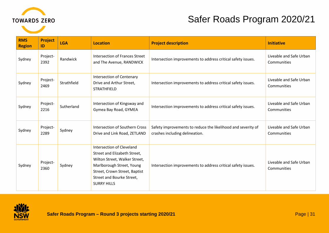
Sydney Project-2392
Randwick Intersection of Frances Street and The Avenue, RANDWICK
Intersection improvements to address critical safety issues. Liveable and Safe Urban Communities
Sydney Project-2469
Strathfield Intersection of Centenary Drive and Arthur Street, STRATHFIELD
Intersection improvements to address critical safety issues. Liveable and Safe Urban Communities
Sydney Project-2216
Sutherland Intersection of Kingsway and Gymea Bay Road, GYMEA
Intersection improvements to address critical safety issues. Liveable and Safe Urban Communities
Sydney Project-2289
Sydney Intersection of Southern Cross Drive and Link Road, ZETLAND
Safety improvements to reduce the likelihood and severity of crashes including delineation.
Liveable and Safe Urban Communities
Sydney Project-2360
Sydney
Intersection of Cleveland Street and Elizabeth Street, Wilton Street, Walker Street, Marlborough Street, Young Street, Crown Street, Baptist Street and Bourke Street, SURRY HILLS
Intersection improvements to address critical safety issues. Liveable and Safe Urban Communities

Safer Roads Program 2020/21
Safer Roads Program – Round 3 projects starting 2020/21 Page | 32
RMS Region
Project ID LGA Location Project description Initiative
Sydney Project-1926
The Hills Intersection of Samantha Riley Drive and Hezlett Road, KELLYVILLE
Intersection improvements to address critical safety issues. Liveable and Safe Urban Communities
Sydney Project-1930
The Hills Intersection of Aiken Road and Salina Avenue, WEST PENNANT HILLS
Intersection improvements to address critical safety issues. Liveable and Safe Urban Communities
Sydney Project-1932
The Hills Intersection of Old Castle Hill Road and First Farm Drive, CASTLE HILL
Intersection improvements to address critical safety issues. Liveable and Safe Urban Communities
Sydney Project-2082
Willoughby Intersection of Herbert Street and Ella Street, ST LEONARDS
Development of intersection improvements to address critical safety issues.
Liveable and Safe Urban Communities
Western Project-2153
Bathurst Regional
3.8km length of Hill End Road, CRUDINE
Safety improvements to reduce the likelihood and severity of crashes including safety barrier and delineation.
Saving Lives on Country Roads

Safer Roads Program 2020/21
Safer Roads Program – Round 3 projects starting 2020/21 Page | 33
RMS Region
Project ID LGA Location Project description Initiative
Western Project-2384
Bathurst Regional
0.1km length of Rankin Street, BATHURST
Intersection improvements to address critical safety issues. Saving Lives on Country Roads
Western Project-2470
Bathurst Regional
Intersection of Great Western Highway and Keppel Street, BATHURST
Intersection improvements to address critical safety issues. Saving Lives on Country Roads
Western Project-2079
Broken Hill Intersection of Oxide Street and Blende Street, BROKEN HILL
Pedestrian safety improvements including pedestrian refuge. Saving Lives on Country Roads
Western Project-2083
Broken Hill Intersection of Gypsum Street and Cornish Street, BROKEN HILL
Intersection improvements to address critical safety issues. Saving Lives on Country Roads
Western Project-1433
Dubbo Regional 35.6km length of Mitchell Highway, DUBBO
Safety improvements to reduce the likelihood and severity of crashes including shoulder widening, safety barrier and audio-tactile line marking.
Saving Lives on Country Roads
Western Project-2031
Dubbo Regional 9.5km length of Renshaw McGirr Way, MOUNT ARTHUR
Safety improvements to reduce the likelihood and severity of crashes including shoulder widening and delineation.
Saving Lives on Country Roads
Safer Roads Program 2020/21
Safer Roads Program – Round 3 projects starting 2020/21 Page | 34
RMS Region
Project ID LGA Location Project description Initiative
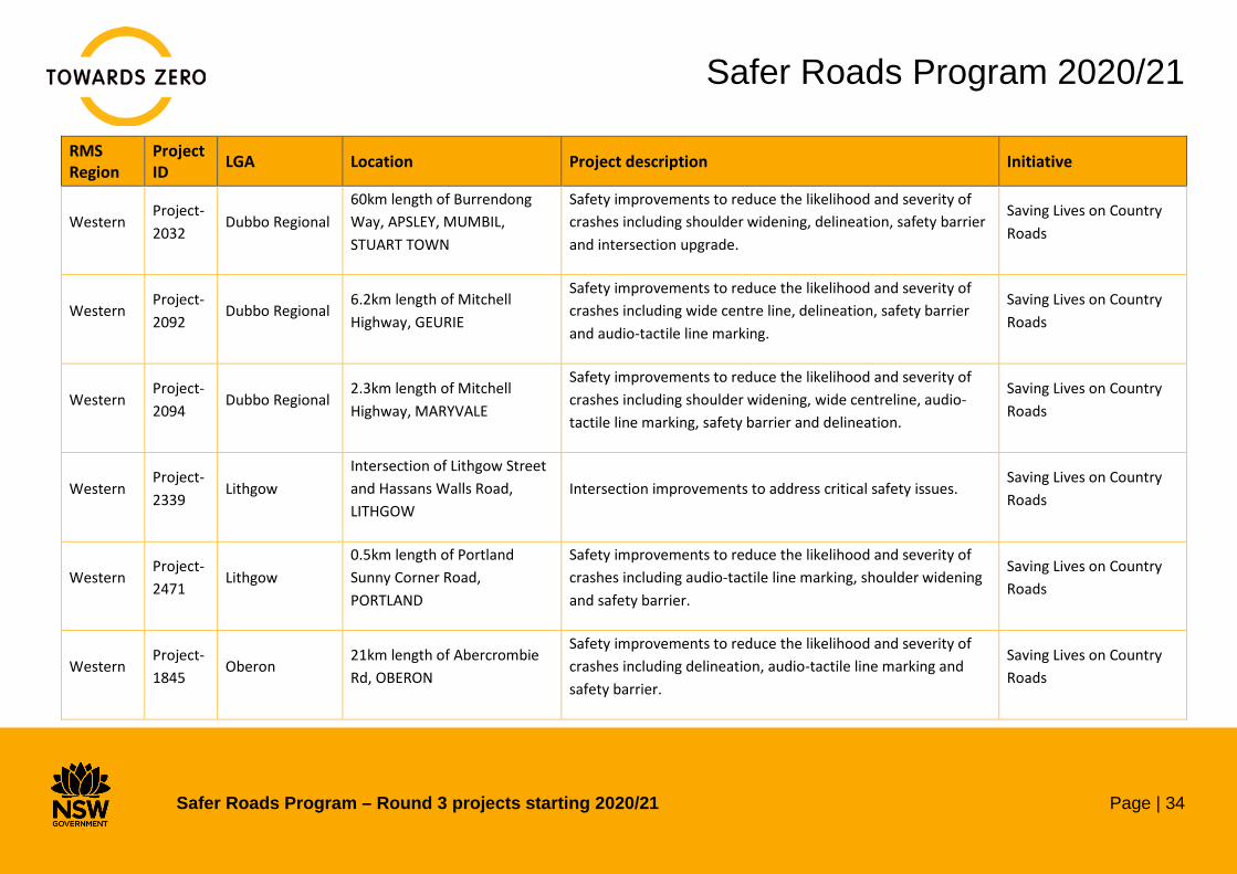
Western Project-2032
Dubbo Regional 60km length of Burrendong Way, APSLEY, MUMBIL, STUART TOWN
Safety improvements to reduce the likelihood and severity of crashes including shoulder widening, delineation, safety barrier and intersection upgrade.
Saving Lives on Country Roads
Western Project-2092
Dubbo Regional 6.2km length of Mitchell Highway, GEURIE
Safety improvements to reduce the likelihood and severity of crashes including wide centre line, delineation, safety barrier and audio-tactile line marking.
Saving Lives on Country Roads
Western Project-2094
Dubbo Regional 2.3km length of Mitchell Highway, MARYVALE
Safety improvements to reduce the likelihood and severity of crashes including shoulder widening, wide centreline, audio-tactile line marking, safety barrier and delineation.
Saving Lives on Country Roads
Western Project-2339
Lithgow Intersection of Lithgow Street and Hassans Walls Road, LITHGOW
Intersection improvements to address critical safety issues. Saving Lives on Country Roads
Western Project-2471
Lithgow 0.5km length of Portland Sunny Corner Road, PORTLAND
Safety improvements to reduce the likelihood and severity of crashes including audio-tactile line marking, shoulder widening and safety barrier.
Saving Lives on Country Roads
Western Project-1845
Oberon 21km length of Abercrombie Rd, OBERON
Safety improvements to reduce the likelihood and severity of crashes including delineation, audio-tactile line marking and safety barrier.
Saving Lives on Country Roads

Safer Roads Program 2020/21
Safer Roads Program – Round 3 projects starting 2020/21 Page | 35
RMS Region
Project ID LGA Location Project description Initiative
Western Project-2268
Orange Intersection of Hill Street and Casey Street, ORANGE
Intersection improvements to address critical safety issues. Saving Lives on Country Roads
Western Project-2278
Orange Intersection of Anson Street and Margaret, ORANGE
Pedestrian safety improvements including pedestrian refuge. Saving Lives on Country Roads
Western Project-2287
Orange Intersection of Byng Street and McLachlan Street, ORANGE
Safety improvements to reduce the likelihood and severity of crashes including delineation.
Saving Lives on Country Roads
Western Project-2349
Orange Intersection of Kearneys Drive and Matthews Avenue, ORANGE
Intersection improvements to address critical safety issues. Saving Lives on Country Roads
Western Project-2364
Orange Intersection of Ophir Road and Banjo Patterson Way, CLIFTON GROVE
Safety improvements to reduce the likelihood and severity of crashes including delineation and shoulder widening.
Saving Lives on Country Roads
Western Project-2375
Orange Intersection of Phoenix Mine Road and Mitchell Highway, LUCKNOW
Safety improvements to reduce the likelihood and severity of crashes including shoulder widening, safety barrier and delineation.
Saving Lives on Country Roads

Safer Roads Program 2020/21
Safer Roads Program – Round 3 projects starting 2020/21 Page | 36
RMS Region
Project ID LGA Location Project description Initiative
Western Project-2137
Parkes Intersection of East Street and Gap Street, PARKES
Intersection improvements to address critical safety issues. Saving Lives on Country Roads
Western Project-2057
Weddin 3.7km length of Henry Lawson Way, GRENFELL
Safety improvements to reduce the likelihood and severity of crashes including delineation, safety barrier, shoulder widening and intersection upgrade.
Saving Lives on Country Roads
Notes
The scope of projects (location, treatment type, cost and completion time) are subject to change throughout the year and this page will be updated accordingly on a quarterly basis.
Related Documents