STATE OF NORTH CAROLINA DEPARTMENT OF T RANSPORTATION ROY COOPER JAMES H. TROGDON, III GOVERNOR SECRETARY Mailing Address: NC DEPARTMENT OF TRANSPORTATION NATURAL ENVIRONMENT SECTION 1598 MAIL SERVICE CENTER RALEIGH NC 27699-1598 Telephone: (919) 707-6000 Fax: (919) 212-5785 Customer Service: 1-877-368-4968 Website: www.ncdot.gov Location: 1020 BIRCH RIDGE DRIVE RALEIGH NC 27610 April 7, 2017 U.S. Army Corps of Engineers Asheville Regulatory Field Office 151 Patton Avenue, Room 208 Asheville, NC 28801-5006 ATTN: Mr. Steve Kichefski, NCDOT Regulatory Coordinator Subject: Request for Modification to the Section 404 Individual Permit and Section 401 Water Quality Certification for the proposed US 221 Widening from US 421 to US 221 Business/NC 88 in Jefferson in Watauga and Ashe Counties. Federal Aid Project No. STP-0221(13), Division 11, TIP No. R-2915, WBS 34518.1.1. Reference: USACE Individual Permit Action ID SAW-2012-00882, January 7, 2015. USACE Individual Permit Modification Action ID SAW-2012-00882, August 31, 2016. NCDWR Project No. 20140762, Certification No. 4001, September 8, 2014. NCDWR Project No. 20140764_v2, Certification No. 4001, August 23, 2016. Dear Sir: The purpose of this letter is to request a modification to the United Stated Army Corps of Engineers (USACE) Section 404 Individual Permit and North Carolina Division of Water Resources Section 401 Certification for the above referenced project. The original 2014 permit application and subsequent 2016 modification application (referenced above) presented final impacts for R-2915A, R-2915B, R-2915C, and R-2915D. This modification presents changes to two permit sites in the B Section needed as a result of a driveway modification and new temporary wetland fill. The last section, R-2915E, is currently scheduled to let in September 2019. A permit modification for the final impacts for R-2915E will be submitted prior to let. All changes in impacts due to the two modified sites in the B Section are in red italics. Please see the enclosed revised permit drawings for Section B. Summary of R-2915 Jurisdictional Impacts: The preliminary projected impacts for the overall (Sections A-E) project will be approximately 3.11 acres of permanent wetland impacts, 0.15 acre of temporary wetland impacts, 8,156 linear feet of permanent stream impacts (6,983 linear feet of fill and 1,173 linear feet of bank stabilization), and 0.34 acre of temporary stream impacts (see Tables 1 and 2 for a breakdown of impacts by Section).

Welcome message from author
This document is posted to help you gain knowledge. Please leave a comment to let me know what you think about it! Share it to your friends and learn new things together.
Transcript

STATE OF NORTH CAROLINA
DEPARTMENT OF TRANSPORTATION
ROY COOPER JAMES H. TROGDON, III GOVERNOR SECRETARY
Mailing Address: NC DEPARTMENT OF TRANSPORTATION NATURAL ENVIRONMENT SECTION 1598 MAIL SERVICE CENTER RALEIGH NC 27699-1598
Telephone: (919) 707-6000 Fax: (919) 212-5785
Customer Service: 1-877-368-4968
Website: www.ncdot.gov
Location: 1020 BIRCH RIDGE DRIVE
RALEIGH NC 27610
April 7, 2017
U.S. Army Corps of Engineers Asheville Regulatory Field Office 151 Patton Avenue, Room 208 Asheville, NC 28801-5006 ATTN: Mr. Steve Kichefski, NCDOT Regulatory Coordinator Subject: Request for Modification to the Section 404 Individual Permit and Section 401
Water Quality Certification for the proposed US 221 Widening from US 421 to US 221 Business/NC 88 in Jefferson in Watauga and Ashe Counties. Federal Aid Project No. STP-0221(13), Division 11, TIP No. R-2915, WBS 34518.1.1.
Reference: USACE Individual Permit Action ID SAW-2012-00882, January 7, 2015. USACE Individual Permit Modification Action ID SAW-2012-00882, August 31, 2016.
NCDWR Project No. 20140762, Certification No. 4001, September 8, 2014. NCDWR Project No. 20140764_v2, Certification No. 4001, August 23, 2016.
Dear Sir: The purpose of this letter is to request a modification to the United Stated Army Corps of Engineers (USACE) Section 404 Individual Permit and North Carolina Division of Water Resources Section 401 Certification for the above referenced project. The original 2014 permit application and subsequent 2016 modification application (referenced above) presented final impacts for R-2915A, R-2915B, R-2915C, and R-2915D. This modification presents changes to two permit sites in the B Section needed as a result of a driveway modification and new temporary wetland fill. The last section, R-2915E, is currently scheduled to let in September 2019. A permit modification for the final impacts for R-2915E will be submitted prior to let. All changes in impacts due to the two modified sites in the B Section are in red italics. Please see the enclosed revised permit drawings for Section B. Summary of R-2915 Jurisdictional Impacts: The preliminary projected impacts for the overall (Sections A-E) project will be approximately 3.11 acres of permanent wetland impacts, 0.15 acre of temporary wetland impacts, 8,156 linear feet of permanent stream impacts (6,983 linear feet of fill and 1,173 linear feet of bank stabilization), and 0.34 acre of temporary stream impacts (see Tables 1 and 2 for a breakdown of impacts by Section).

R-2915 Individual Permit Modification Application Page 2 of 5
Table 1 – Summary of Wetland Impacts for R-2915
Section Design Stage Wetland Impact Type
Wetland Impact Area
(ac)
Wetland Impacts Requiring
Mitigation (ac)
R-2915A Final
Perm. Wetland Fill 0.48
0.57* Excavation in Wetlands 0.01
Mechanized Clearing in Wetlands 0.08 Hand Clearing in Wetlands 0.05†
R-2915B Final
Perm. Wetland Fill 0.32
0.43* Excavation in Wetlands 0.04
Mechanized Clearing in Wetlands 0.06 Temporary Fill in Wetlands 0.15
R-2915C Final Perm. Wetland Fill 0.22
0.27* Excavation in Wetlands -- Mechanized Clearing in Wetlands 0.05
R-2915D Final Perm. Wetland Fill 1.01
1.32 Excavation in Wetlands 0.01 Mechanized Clearing in Wetlands 0.30
R-2915E Preliminary Perm. Wetland Fill 0.43
0.52 Excavation in Wetlands --Mechanized Clearing in Wetlands 0.09
Total 3.11 †Additionally, 0.01 acre of temporary fill in wetlands will occur in the hand clearing areas for erosion control measures * Values are based on rounding, due to calculating totals with actual numbers to the thousandths Table 2 – Summary of Stream Impacts for R-2915
Section Design Stage Stream Impact Type Impact
Length (lf) Temporary
Impacts (ac)
Stream Impacts Requiring
Mitigation (lf)
R-2915A Final Permanent Fill 1,119 --
1,119
Bank Stabilization 402 --Temporary -- 0.05
R-2915B Final Permanent Fill 493 --
493*
Bank Stabilization 411 --Temporary -- 0.15
R-2915C Final Permanent Fill 2,339 --
2,339 Bank Stabilization 234 -- Temporary -- 0.09
R-2915D Final Permanent Fill 2,627 --
2,627 Bank Stabilization 126 --
Temporary -- 0.05
R-2915E Preliminary Permanent Fill 405 --
405 Temporary -- <0.01
Total 8,156 0.34 6,983 * See Table 4
R-2915 Individual Permit Modification Application Page 3 of 5
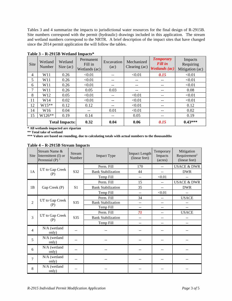
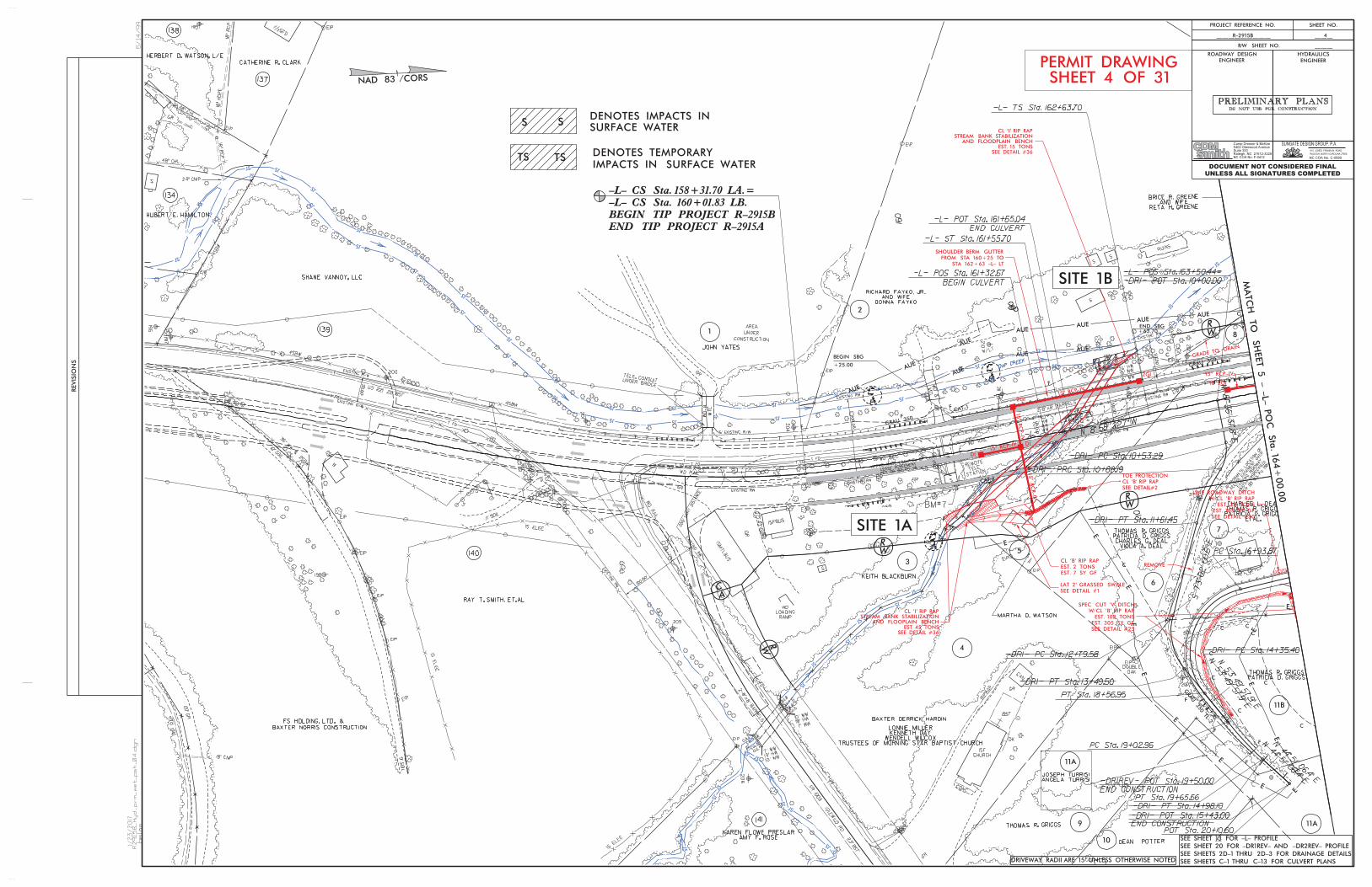
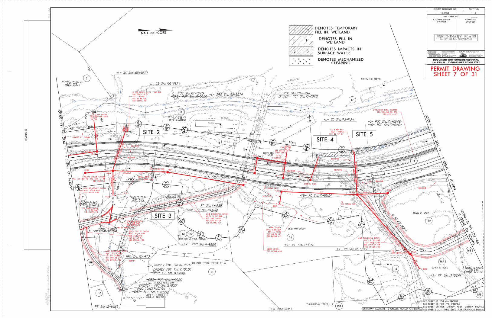
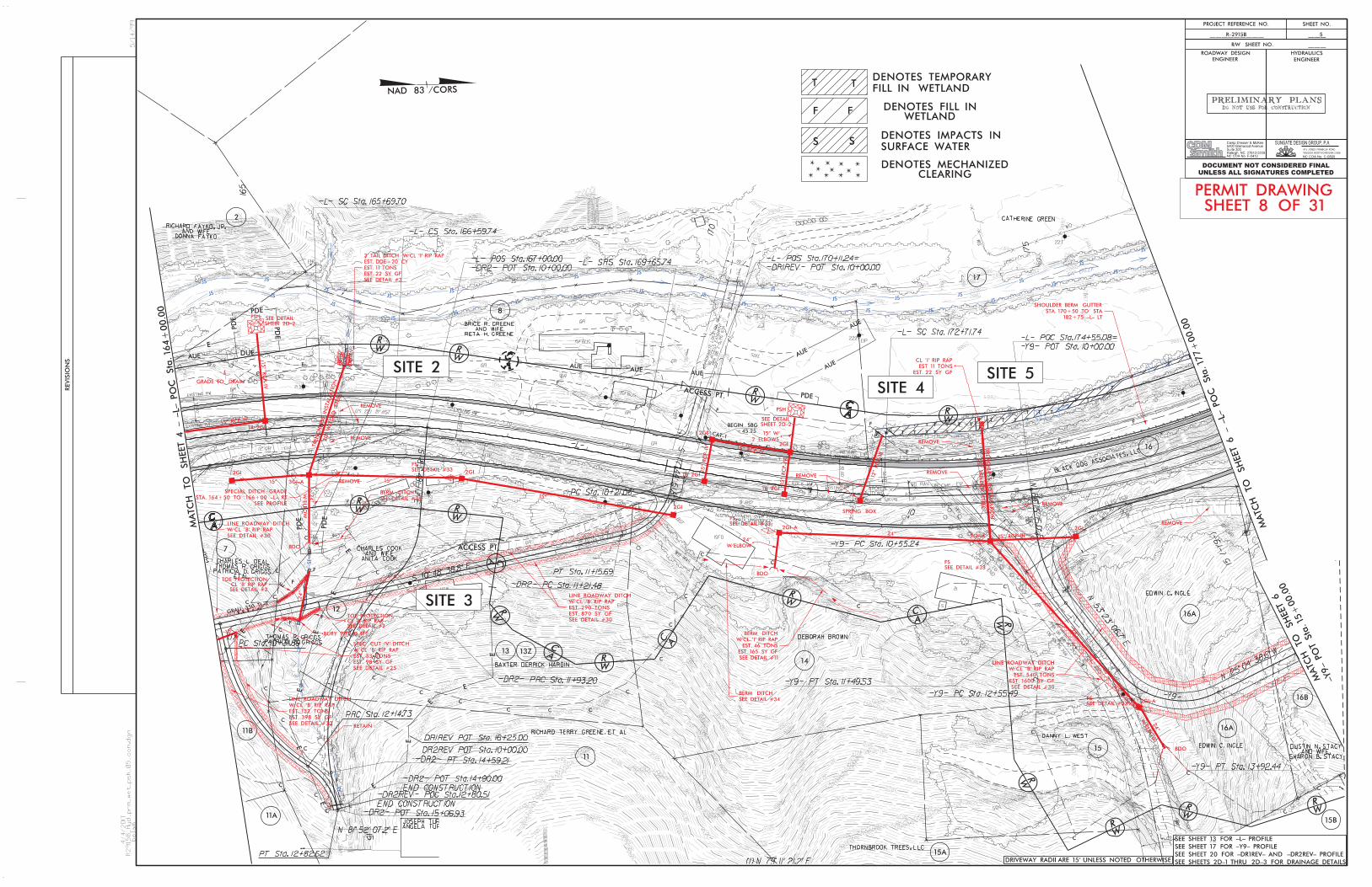
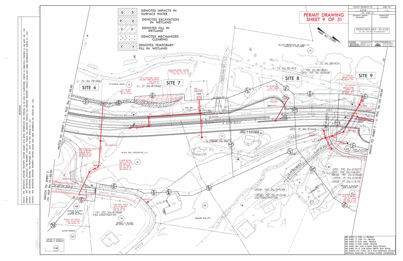
Tables 3 and 4 summarize the impacts to jurisdictional water resources for the final design of R-2915B. Site numbers correspond with the permit (hydraulic) drawings included in this application. The stream and wetland numbers correspond to the NRTR. A brief description of the impact sites that have changed since the 2014 permit application the will follow the tables. Table 3 – R-2915B Wetland Impacts*
Site Wetland Number
Wetland Size (ac)
Permanent Fill in
Wetlands (ac)
Excavation (ac)
Mechanized Clearing (ac)
Temporary Fill in
Wetlands (ac)
Impacts Requiring
Mitigation (ac) 4 W11 0.26 <0.01 -- <0.01 0.15 <0.01 5 W11 0.26 <0.01 -- -- -- <0.01 6 W11 0.26 <0.01 -- -- -- <0.01 7 W11 0.26 0.05 0.03 -- -- 0.08 8 W12 0.05 <0.01 -- <0.01 -- <0.01
11 W14 0.02 <0.01 -- <0.01 -- <0.01 12 W15** 0.12 0.12 -- <0.01 -- 0.12 14 W16 0.04 -- 0.01 <0.01 -- 0.02 15 W126** 0.19 0.14 -- 0.05 -- 0.19
Total Impacts: 0.32 0.04 0.06 0.15 0.43***
* All wetlands impacted are riparian ** Total take of wetland *** Values are based on rounding, due to calculating totals with actual numbers to the thousandths Table 4 – R-2915B Stream Impacts
Site Stream Name & Intermittent (I) or Perennial (P) 1
Stream Number
Impact Type Impact Length
(linear feet)
Temporary Impacts (acres)
Mitigation Requirement2 (linear feet)
1A UT to Gap Creek
(P) S32
Perm. Fill 170 -- USACE & DWRBank Stabilization 44 -- DWR
Temp Fill -- <0.01 --
1B Gap Creek (P) S1 Perm. Fill 15 -- USACE & DWR
Bank Stabilization 35 -- DWR Temp Fill -- <0.01 --
2 UT to Gap Creek
(P) S35
Perm. Fill 34 -- USACE Bank Stabilization -- -- --
Temp Fill -- -- --
3 UT to Gap Creek
(P) S35
Perm. Fill 71 -- USACE Bank Stabilization -- -- --
Temp Fill -- -- --
4 N/A (wetland
only) -- -- -- -- --
5 N/A (wetland
only) -- -- -- -- --
6 N/A (wetland
only) -- -- -- -- --
7 N/A (wetland
only) -- -- -- -- --
8 N/A (wetland
only) -- -- -- -- --

R-2915 Individual Permit Modification Application Page 4 of 5
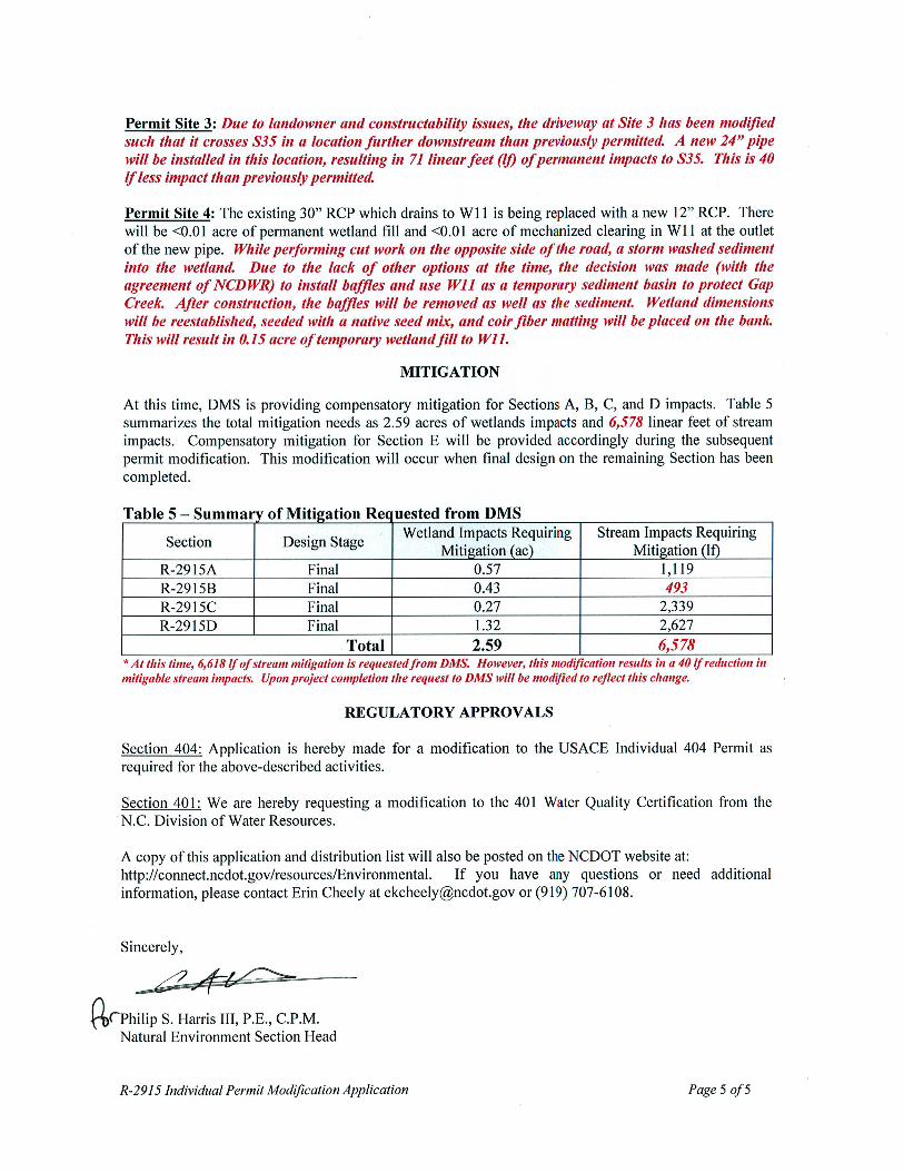
Table 4 continued – R-2915B Stream Impacts
Site Stream Name & Intermittent (I) or Perennial (P) 1
Stream Number
Impact Type Impact Length
(linear feet)
Temporary Impacts (acres)
Mitigation Requirement2 (linear feet)
9 UT to Gap Creek
(P) S36
Perm. Fill 124 -- USACE Bank Stabilization 23 -- --
Temp. Fill -- -- --
10 Gap Creek (P) S1 Perm. Fill -- -- --
Bank Stabilization 154 -- DWR Temp. Fill -- 0.02 --
11 N/A (wetland
only) -- -- -- -- --
12 N/A (wetland
only) -- -- -- -- --
13 UT to Gap Creek
(P) S40
Perm. Fill 52 -- USACE Bank Stabilization -- -- --
Temp. Fill -- <0.01 --
14 N/A (wetland
only) -- -- -- -- --
15 N/A (wetland
only) -- -- -- -- --
16 UT to Gap Creek
(P) S42
Perm. Fill 27 -- USACE Bank Stabilization 9 -- --
Temp. Fill -- -- --
17 Gap Creek (P) S1 Perm. Fill -- -- --
Bank Stabilization 54 -- DWR Temp. Fill -- -- --
18 Gap Creek (P) S1 Perm. Fill -- -- --
Bank Stabilization 53 -- DWR Temp. Fill -- -- --
19 South Fork New
River (P) S43
Perm. Fill -- -- -- Bank Stabilization --- -- --
Temp. Fill -- 0.12 --
20 South Fork New
River (P) S43
Perm. Fill -- -- -- Bank Stabilization 19 -- --
Temp. Fill -- -- --
21 South Fork New
River (P) S43
Perm. Fill -- -- -- Bank Stabilization 20 -- --
Temp. Fill -- -- --
Total Temporary Impacts: -- 0.153 -- Total Permanent Impacts (Perm. Fill + Bank Stabilization): 904 -- --
Permanent Impacts Requiring DWR Mitigation: 525 -- -- Permanent Impacts Requiring USACE Mitigation: 493 -- --
Total Impacts Requiring Mitigation: 493 -- † 1 – All streams are Class C; Tr+ waters except S43 (South Fork New River), which is WS-V; HQW 2 – Mitigation for bank stabilization impacts required by DWR – not required by USACE 3 – Values are based on rounding, due to some of the individual impacts being <0.01 acre † – Final mitigation requirement will be up to the USACE and DWR

ekcheely
Text Box
Revised 4/6/17
ekcheely
Text Box
Revised 4/6/17

ekcheely
Text Box
Revised 4/6/17
ekcheely
Text Box
Revised 4/6/17

ekcheely
Text Box
Revised 4/6/17
ekcheely
Text Box
Revised 4/6/17
ekcheely
Text Box
Revised 4/6/17
ekcheely
Text Box
Revised 4/6/17

ekcheely
Text Box
Revised 4/6/17

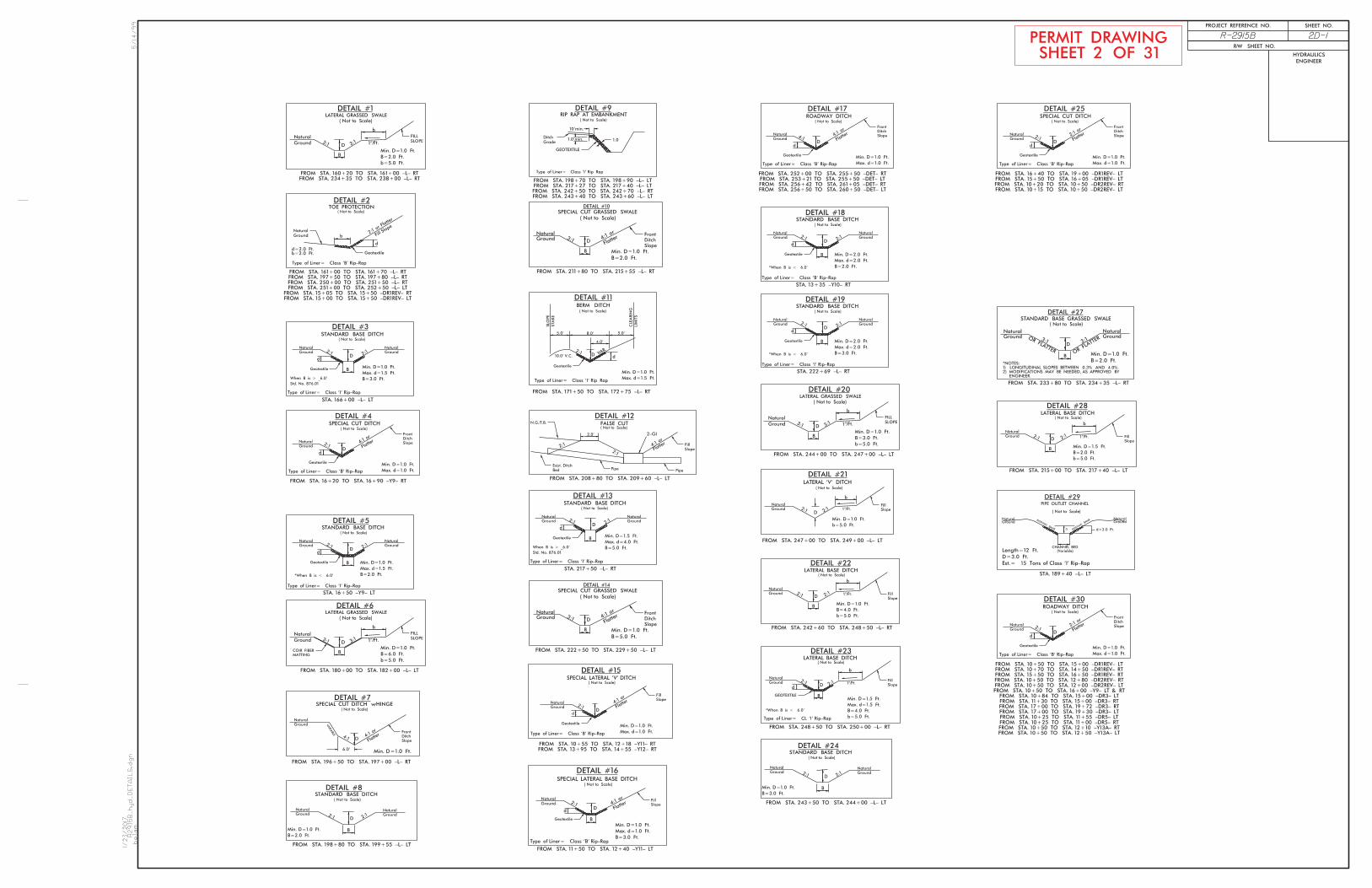
Hand Existing Existing Permanent Temp. Excavation Mechanized Clearing Permanent Temp. Channel Channel Natural
Site Station Structure Fill In Fill In in Clearing in SW SW Impacts Impacts StreamNo. (From/To) Size / Type Wetlands Wetlands Wetlands in Wetlands Wetlands impacts impacts Permanent Temp. Design
(ac) (ac) (ac) (ac) (ac) (ac) (ac) (ft) (ft) (ft)159+80 / 160+40 -L- RT BANK STABILIZATION (TRIB.) 0.01 < 0.01 44 21
160+40 / 161+80 -L- CULVERT (TRIB.) 0.05 170 162+15 / 162+30 -L- LT CULVERT (GAP CREEK) < 0.01 < 0.01 15 6 162+15 / 162+65 -L- LT BANK STABILIZATION (GAP CREEK) < 0.01 35
165+73 -L- BDO / 30" RCP < 0.01 5166+00 -L- LT TAIL DITCH < 0.01 29
3 15+32 / 15+00 -DR1REV- 24" PIPE < 0.01 714 172+58 / 172+85 -L- LT 12" RCP < 0.01 0.15 < 0.01 5 174+00 -L- LT 30" CSP < 0.01 6 178+50 -L- LT 24" CSP < 0.01 7 180+00 / 182+00 -L- LT ROAD FILL 0.05 0.03 8 186+21 / 186+43 -L- LT ROAD FILL < 0.01 < 0.01
187+63 / 189+15 -L- 36" RCP 0.01 124189+35 / 189+45 -L- LT BANK STABILIZATION < 0.01 23
197+20 / 198+90 -L- BANK STABILIZATION 0.02 154198+80 / 198+90 -L- WORKPAD / CULVERT REMOVAL 0.02 57
11 207+00 / 207+05 -L- RT ROAD FILL < 0.01 < 0.01 12 208+72 / 209+51 -L- RT ROAD FILL 0.12 < 0.01 13 209+23 -L- LT 24" Pipe < 0.01 < 0.01 52 814 210+01 / 210+36 -L- LT ROAD FILL 0.01 < 0.01 15 215+54 / 217+43 -L- RT ROAD FILL 0.14 0.05
217+48 -L- LT 60" RCP < 0.01 27217+45 -L- LT BANK STABILIZATION < 0.01 9
SUBTOTALS*: 0.32 0.15 0.04 0.06 0.12 0.03 758 92
*Rounded totals are sum of actual impacts
NOTES:
ATN Revised 3/12/13 SHEET 30 OF 31
WETLAND PERMIT IMPACT SUMMARYWETLAND IMPACTS SURFACE WATER IMPACTS
R-2915B ASHE COUNTYON US 221 FROM SR 1003 (IDLEWILD RD)TO NORTH OF SOUTH FORK NEW RIVER
1A
1B
2
16
9
Site 10: Total Permanent Pier Impacts = 25.1 SF = 0.0006 AC Site 15: Fill Imapcts = 0.14 ac, Mechanized Clearing Impacts=0.013, Total Take Impacts=0.036
10
NC DEPARTMENT OF TRANSPORTATIONDIVISION OF HIGHWAYS
4-4-2017
ekcheely
Text Box
Revised 4/6/17

Hand Existing Existing Permanent Temp. Excavation Mechanized Clearing Permanent Temp. Channel Channel Natural
Site Station Structure Fill In Fill In in Clearing in SW SW Impacts Impacts StreamNo. (From/To) Size / Type Wetlands Wetlands Wetlands in Wetlands Wetlands impacts impacts Permanent Temp. Design
(ac) (ac) (ac) (ac) (ac) (ac) (ac) (ft) (ft) (ft)17 217+22 / 217+75 -L- RT BANK STABILIZATION < 0.01 54 18 222+55 / 222+83 -L- RT BANK STABILIZATION < 0.01 53 19 241+75 / 243+25 -L- WORK PAD 0.12 115 20 242+41 / 242+54 -L- RT BANK STABILIZATION < 0.01 19 21 243+31 / 243+46 -L- LT BANK STABILIZATION < 0.01 20
SUBTOTALS*: 0.02 0.12 146 115 SUBTOTALS FROM PAGE 1*: 0.32 0.15 0.04 0.06 0.12 0.03 758 92 TOTALS*: 0.32 0.15 0.04 0.06 0.14 0.15 904 207
*Rounded totals are sum of actual impacts
NOTES:
ATN Revised 3/12/13 SHEET 31 OF 31
NC DEPARTMENT OF TRANSPORTATIONDIVISION OF HIGHWAYS
4-4-2017
WETLAND PERMIT IMPACT SUMMARYWETLAND IMPACTS SURFACE WATER IMPACTS
R-2915B ASHE COUNTYON US 221 FROM SR 1003 (IDLEWILD RD)TO NORTH OF SOUTH FORK NEW RIVER
Site 19: Total Permanent Pier Impacts = 150.8 SF = 0.003 AC
ekcheely
Text Box
Revised 4/6/17
Related Documents