RYTON-ON-DUNSMORE Neighbourhood Plan 2018 - 2031 Submission Version

Welcome message from author
This document is posted to help you gain knowledge. Please leave a comment to let me know what you think about it! Share it to your friends and learn new things together.
Transcript
RYTON-ON-DUNSMORE
Neighbourhood Plan
2018 - 2031
Submission Version

2
Page left deliberately blank
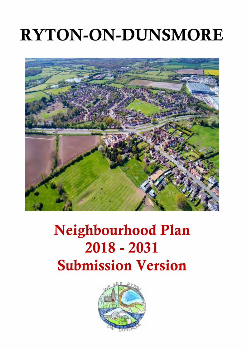
Cover photograph courtesy of David Kenning
3
Contents
Chapter heading Page
Foreword 4
1. Introduction 5
2. How the Neighbourhood Plan fits into the Planning System 6
3. The Plan, its vision, objectives and what we want it to achieve 7
4. How the Plan was prepared 8
5. Our Parish 11
6. Meeting the requirement for sustainable development 14
7. Neighbourhood Plan Policies 15
A. General
B. Housing and the Built Environment
C. The Natural and Historic Environment
15
21
35
D. Community Sustainability 58
8. Community Actions
9. Infrastructure Requirements
10. Monitoring and Review
71
72
73
Appendices
Appendix 1 Basic Conditions Statement Appendix 2 Consultation Statement Appendix 3 Census Data Appendix 4 Housing Needs Report Appendix 5 Site Sustainability Assessments Appendix 6 Environmental Inventory Appendix 7 Non-Designated Heritage Assets

4
Foreword
The process of creating the Ryton on Dunsmore Neighbourhood Plan has been driven by Parish Councillors and members of the community and is part of the Government’s approach to planning contained in the Localism Act of 2011. Local people now have a greater say about what happens in the area in which they live by preparing a Neighbourhood Plan that sets out policies that meet the needs of the community whilst having regard for local, national and EU policies.
The aim of this Neighbourhood Plan is to put forward the wishes of the community regarding future development and to deliver local aspirations within the context of the strategic planning framework.
Ryton on Dunsmore Parish Council has overseen the development of the Neighbourhood Plan but has delegated its preparation to a Steering Committee.
The Neighbourhood Plan contains a number of policies, including some areas where the Parish Council will support development activity, and other areas such as 'Local Green Spaces' that the community wish to protect. These policies have been drafted following engagement with the residents and landowners of Ryton on Dunsmore Parish.
During the development of the Plan and the dialogue with residents and other stakeholders, it became evident that there were opportunities to improve the Parish in a variety of ways, in addition to the policy requirements for a Neighbourhood Plan. These opportunities would help to realise our Vision Statement. These are included as Community Actions. The aspiration is to progress these Community Actions, whilst acknowledging that the ability to do so will in many cases depend upon residents volunteering their time, energy and skill to convert them into action. The Parish Council may in some cases be the appropriate body to provide some oversight.
We are grateful to Officers from Rugby Borough Council who have supported us through the process and to our community for engaging so enthusiastically in the process. Many hours of volunteer time and expertise have made this plan possible. The Parish Council wishes to express sincere thanks to all the Parishioners who kindly contributed to the development of the Neighbourhood Plan.
Ryton on Dunsmore is an attractive and popular place in which to live and the contribution from people who care about their community and want to make it better for generations to come is greatly appreciated.
Cllr Geoffrey Marsh – Chair Ryton on Dunsmore Neighbourhood Plan Steering Committee
Cllr Steve Witter - Chair Ryton on Dunsmore Parish Council

5
1. Introduction
This is the Submission Version of the Neighbourhood Plan for Ryton on Dunsmore Parish. It has been prepared by the Ryton on Dunsmore Neighbourhood Plan Steering Committee together with the support of three Focus Groups. This organisation has brought together members of the local community and Parish Councillors and has been led by the Parish Council.
A Neighbourhood Plan is a new type of planning document that gives local people greater control and say over how their community develops and evolves. It is an opportunity for local people to create a framework for delivering a sustainable future for the benefit of all who live or work in that community, or who visit it.
As the Plain English Guide to the Localism Act 2011 states, “Instead of local people being told what to do, the Government thinks that local communities should have genuine opportunities to influence the future of the places where they live”.
It enables a community to create a vision and set clear planning policies for the use and development of land at the neighbourhood level to realise this vision. This includes, for example, where new homes, shops and industrial units should be built, what new buildings and extensions should look like and which areas of land should be protected from development.
Neighbourhood Plans can be general or more detailed, depending on what local people want. They must, however, be in general conformity with Borough-wide planning policies, have regard for national planning policies and must be prepared in a prescribed manner.
Comments received through the pre-submission consultation process have been taken on board and the Neighbourhood Plan amended where appropriate. It will now be submitted to Rugby Borough Council who will consult on it further before submitting it for Independent Examination where the Plan will be tested for conformity with a range of ‘Basic Conditions’:
it must have appropriate regard for national policy;
it must contribute towards the achievement of sustainable development;
it must be in general conformity with the strategic policies of the development plan for the local area;
it must be compatible with human rights requirements and
it must be compatible with EU obligations.
After that it will be put forward to referendum, where those on the electoral register in Ryton on Dunsmore Parish will be invited to vote on whether or not they support it. At least 50% of those voting must vote yes for it to become a ‘Made’ statutory planning document.
After being ‘Made’, each time a planning decision has to be taken by Rugby Borough Council, or any other body, they will be required to refer to the Neighbourhood Plan (alongside the Borough’s own Local Plan and other relevant documents) and check whether the proposed development is in accordance with the policies the community has developed.

6
2. How the Neighbourhood Plan fits into the Planning System
The right for communities to prepare Neighbourhood Plans was established through the Localism Act 2011, which set out the general rules governing their preparation.
A Neighbourhood Plan forms part of the statutory Development Plan for the area in which it is prepared. This statutory status means that it must be taken into account when considering planning decisions affecting that area.
A Neighbourhood Plan is not prepared in isolation. It also needs to be in general conformity with relevant national and Borough-wide (i.e. Rugby) planning policies.
For Ryton on Dunsmore, the most significant planning document is the Rugby Local Plan, due to be adopted in 2019. This sets out the strategic planning framework for the District’s future development up to 2031. It contains a number of policies and objectives which are relevant to Ryton on Dunsmore and which the Plan must be in general conformity with. These policies and objectives span issues such as the provision and location of new housing; providing strong and sustainable communities; protecting and enhancing historic character and local distinctiveness whilst protecting and enhancing natural habitats; and providing transport systems that reduce the need to travel. The Neighbourhood Plan is in general conformity with the policies contained in these documents.
Also important is the National Planning Policy Framework (NPPF) updated in July 2018. This sets out the Government's planning policies for England and how these are expected to be applied. The NPPF requires the planning system (including Neighbourhood Plans) to promote sustainable development and details three dimensions to that development: an economic dimension – they should contribute to economic development; a social dimension – they should support strong, vibrant and healthy communities by providing the right supply of housing and creating a high quality-built environment with accessible local services and an environmental dimension – they should contribute to protecting and enhancing the natural, built and historic environment.
In addition, Neighbourhood Plans must be compatible with European Union (EU) legislation. Relevant EU obligations in relation to the neighbourhood planning process are those relating to Strategic Environmental Assessments, protected European Habitats and Human Rights Legislation.
This Plan and the policies it contains are consistent with the NPPF, Rugby Local Plan and relevant EU legislation. Full details of how the Plan complies with these legislative requirements are set out in the Basic Conditions Statement (Appendix 1). Furthermore, these policies are specific to Ryton on Dunsmore and reflect the needs and aspirations of the community.
It is important to note that not having a Neighbourhood Plan does not mean that development won’t happen. Development will still take place, but without the policies in this Plan, which set out the type of development that is in keeping with our area’s character having any effect. Decisions will instead be primarily based on the Borough’s policies rather than local criteria.
7
3. The Plan, its vision, aims and what we want it to achieve
The Plan area encompasses the whole of the Parish of Ryton on Dunsmore and covers the period up to 2031, a timescale which deliberately mirrors that for the 2019 Rugby Local Plan.
Our Vision is as follows:
The policies in this Plan aim to ensure that Ryton-on-Dunsmore will retain its distinct ‘village’ feel and identity as it grows and evolves up to 2031. It will be a thriving, attractive and safe place to live, work, visit and move around. Its countryside setting, green spaces, flora and fauna and other community assets will have been preserved and enhanced as far as possible. The redevelopment of disused commercial sites and other sites with buildings that are derelict will be local priorities as will improvements to the communications infrastructure.
New housing developments will be sustainable with a balanced mix in the sizes of homes reflecting the local need for affordable starter homes, small to medium family homes and housing for older people. The number of dwellings on any development will be appropriate to a rural village.
Any new building in the Parish will be high quality, environmentally friendly, have exterior building styles that are sympathetic to the village character and have thoughtful and imaginative approaches to street scenes, parking, landscaping and boundary structures.
Appropriate new business developments and land use which encourage local employment will be supported subject to due consideration of any potential negative impacts of increased commercial activity on neighbouring residents in general and existing traffic issues in particular.
The initial draft of the Vision was based heavily on community feedback contained in the Parish Plan 2012. The draft Vision received very high levels of support through the initial consultation processes and only minor amendments were necessary in response to the feedback received from the Neighbourhood Plan Questionnaire. The Steering Committee felt that the Vision comprised a sufficient number of detailed individual aims which could be allocated as appropriate amongst the Focus Groups to underpin their work in developing policies.
8
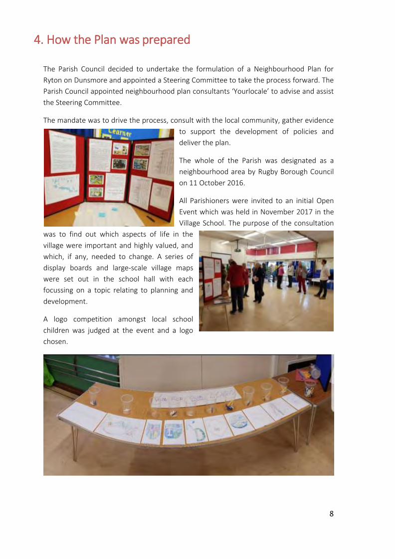
4. How the Plan was prepared
The Parish Council decided to undertake the formulation of a Neighbourhood Plan for
Ryton on Dunsmore and appointed a Steering Committee to take the process forward. The
Parish Council appointed neighbourhood plan consultants ‘Yourlocale’ to advise and assist
the Steering Committee.
The mandate was to drive the process, consult with the local community, gather evidence
to support the development of policies and
deliver the plan.
The whole of the Parish was designated as a
neighbourhood area by Rugby Borough Council
on 11 October 2016.
All Parishioners were invited to an initial Open
Event which was held in November 2017 in the
Village School. The purpose of the consultation
was to find out which aspects of life in the
village were important and highly valued, and
which, if any, needed to change. A series of
display boards and large-scale village maps
were set out in the school hall with each
focussing on a topic relating to planning and
development.
A logo competition amongst local school
children was judged at the event and a logo
chosen.

9
The turnout was good, with 68 attendees participating, providing important input into the
future development of the plan. A summary of
the responses is contained in the Open Event
Report on the Village Website
A comprehensive questionnaire was produced
in late 2017/early 2018 to obtain further
information from the community. The
questionnaire was distributed to every
household in the Parish with an invitation to
all householders, including children aged 12
and over to respond. Responses were
received from over 500 householders
representing 34% of the target audience and
provided very clear direction for the Plan
and the future of the Parish. Many
households chose to return a single questionnaire representing the views of more than
one person, so the response rate figures are arguably higher than those stated.
An independent analysis of the
questionnaire was distributed to each
household and all comments in the
completed Questionnaires were
published on the Parish Council
website.
In order to involve younger members
of the community in the consultation
process, it was decided to focus on
two age groups, the year 5 class at the
local Primary School and a focus group
of young people aged between 11 and
17.
The Primary School children were
challenged in an exercise to consider
and prioritise facilities and amenities
for the village, while the older group
held a discussion considering what they like or do not like about living in Ryton and what
features they felt would be important to develop as the village grows. A report detailing
the two events is included in the Consultation Statement (Appendix 2).
10
Focus groups were established in January 2018 which looked in detail at the draft Vision
and considered the development of the Neighbourhood Plan from the perspective of
Housing, Environment and Community Sustainability. These groups continued to meet
until the autumn of 2018 and it was through this process that the draft polices and
supporting evidence emerged.
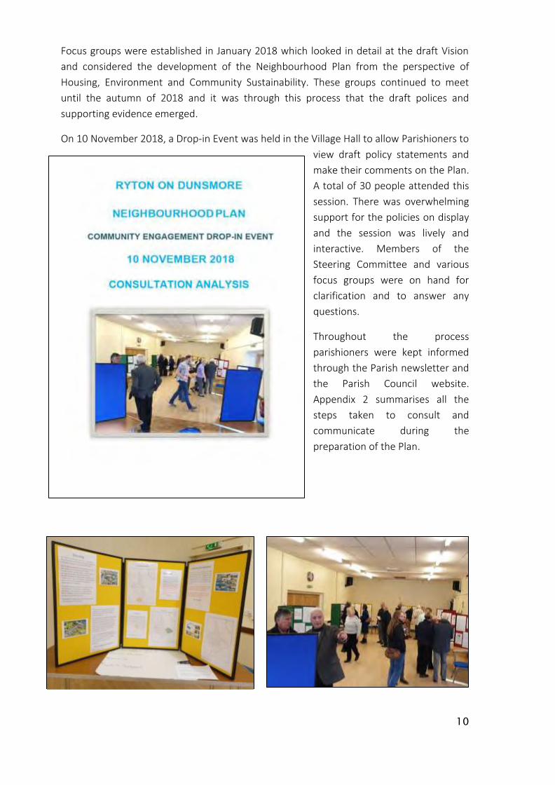
On 10 November 2018, a Drop-in Event was held in the Village Hall to allow Parishioners to
view draft policy statements and
make their comments on the Plan.
A total of 30 people attended this
session. There was overwhelming
support for the policies on display
and the session was lively and
interactive. Members of the
Steering Committee and various
focus groups were on hand for
clarification and to answer any
questions.
Throughout the process
parishioners were kept informed
through the Parish newsletter and
the Parish Council website. Appendix 2 summarises all the
steps taken to consult and
communicate during the preparation of the Plan.
11
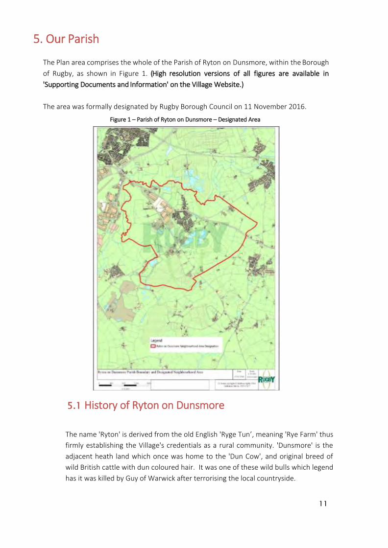
5. Our Parish
The Plan area comprises the whole of the Parish of Ryton on Dunsmore, within the Borough
of Rugby, as shown in Figure 1. (High resolution versions of all figures are available in
'Supporting Documents and Information' on the Village Website.)
The area was formally designated by Rugby Borough Council on 11 November 2016.
Figure 1 – Parish of Ryton on Dunsmore – Designated Area
5.1 History of Ryton on Dunsmore
The name 'Ryton' is derived from the old English 'Ryge Tun’, meaning 'Rye Farm' thus
firmly establishing the Village's credentials as a rural community. 'Dunsmore' is the
adjacent heath land which once was home to the 'Dun Cow', and original breed of
wild British cattle with dun coloured hair. It was one of these wild bulls which legend
has it was killed by Guy of Warwick after terrorising the local countryside.
12
Ryton is mentioned in the Doomsday Book of 1086 as 'Rietone' with a stated value of
60 shillings. The earliest parts of Ryton Church St Leonard's, date from this time
having been completed in 1080.
Ryton is home to the Wroth Silver Ceremony, Britain's oldest annual ceremony,
which records indicate as 'ongoing' in 1170 and is still held every year on Martinmas
Eve (11th November) before sunrise. At this time, representatives of each of the 25
parishes which made up the 'Knightlow Hundred' meet at Knightlow Cross to pay
their annual dues to the Duke of Buccleugh. A total of nine shillings and four pence
is collected but the Ryton Parish, being the host of the event, is exempt from
payment.
We know that in the early part of the 17th century the village consisted of 24
cottages and six small farmhouses with a population of 150. By the early 1800s the
population had grown to around 500, where it remained until after the Great War.
Ryton saw rapid growth during the Second World war with the construction of a
large 'shadow factory' to build and test aero engines. After the War this site became
the Rootes Motor company car assembly plant. Car production continued here until
2006 when the then owner, Peugeot, closed the plant with the loss of 2,300 jobs.
The site has since been acquired by Prologis who have developed a high-quality
business park with a mixture of warehousing and distribution and light industrial
activities.
The village also saw significant growth in the 1990's with the addition of over 150
homes (a 25% increase) in less than a decade. Although at a slower pace, Ryton has
continued to grow to the present day.
5.2 Ryton on Dunsmore today
Ryton-on-Dunsmore is a village situated in the heart of the Warwickshire
countryside, protected from the Coventry conurbation by Green Belt. It is also
adjacent to Rugby, Leamington Spa, Warwick and Kenilworth. Ryton is very
conveniently located for commuting to the nearby towns and cities, as the A45 dual
carriageway is on the doorstep - indeed it bisects the village.
However, these facts tell you little about the community which lives in Ryton today.
Yes, the A45 does bisect our village - but a pedestrian subway provides a link
between the two sides and villagers, recognising this as an opportunity, have chosen
to make a feature of this to encourage the connection between the two halves of the
village. In collaboration with a local artist, over 150 people of all ages came together
to decorate the subway, creating a mural depicting many different scenes relating to
Ryton's past and present.
Ryton is fortunate to have a primary school, a church, a Village Hall, two pubs and
13
many green spaces within its parish. These provide a range of opportunities for
many different groups to meet and enjoy a variety of activities and hobbies, both
indoor and outdoor. Ryton is a caring community. There is a minibus, driven by
volunteers which is in regular use to ensure that as many people as possible are able
to access the different clubs and groups and a taxi service, again run by volunteers,
to ensure patients can get to the local doctors' surgery.
There is a well-attended annual fete and football competition held on the Recreation
Ground to raise funds for St Leonard's Church. The school children are involved, both
in playing football and maypole dancing as well as enjoying the many games and
challenges offered by the different stalls. The fete leads into an evening community
event which is greatly enjoyed by many parishioners.
There are people living in Ryton today who can recall the village in the past when
there was a village pump on the Leamington Road, and cars were very few and far
between - a far cry from today when the speed of cars and the increase in
congestion along that same road are now a very real source of concern.
5.3 Ryton on Dunsmore statistical analysis
At the time of the 2011 Census, Ryton on Dunsmore was home to around 1,813
residents living in 728 households. Analysis of the Census suggests that between
2001 and 2011 the parish population increased by around 8% (141 people). During
this period, the number of dwellings rose by 5% (36). At 19% the parish had a higher
propensity of older residents (aged 65+) and evidence of an ageing population with
the share of residents aged 65 and over increasing from 15% in 2001 to 19% in 2011.
Home ownership levels were relatively high with around 79% of households owning
their homes outright or with a mortgage or loan. At 6% the share of households
living in private rented accommodation was relatively low and social rented housing
accounted for just 12% of tenure. Land Registry price paid, and Council Tax data
indicate evidence of a relatively high volume of new build housing in the parish over
the past 20 years.
Deprivation is not a significant issue in the parish. However, the high price of housing
in the area makes it difficult for those on lower and middle incomes to enter the
local housing market.
14
6. Meeting the requirement for sustainable development
The NPPF states that there are three dimensions to sustainable development: social,
environmental and economic, all of which are important and interrelated.
a) Social
We have sought, through the neighbourhood plan, to safeguard existing open space
for the future enjoyment of residents.
We are also seeking to protect existing community facilities and to deliver a mix of
housing types so that we can meet the needs of present and future generations and
ensure that we support the community’s needs and its health, social and cultural
wellbeing.
b) Environmental
In order to protect and enhance our natural, built and historic environment, we are seeking to ensure that housing development is of the right type in the right location, so that it does not harm but instead positively reflects the existing historic character of the area in order to:
Protect the village identity and conserve the rural nature of its surroundings;
Recognise the need to protect and, where possible, improve biodiversity and important habitats; and
Provide for improved pedestrian facilities.
c) Economic
Whilst the built-up parts of the parish of Ryton on Dunsmore are primarily residential, there is a significant commercial element within the parish and a desire to ensure that appropriate economic activity is maintained as long as the local infrastructure supports it. We therefore wish to encourage employment opportunities in our area by:
Supporting appropriate existing business development and expansion where the local infrastructure would not be adversely affected by the proposals; and
Encourage start-up businesses and home working.
This document sets out local considerations for delivering sustainable development across Ryton on Dunsmore Parish. Development proposals should meet the requirements of all relevant policies in the Local Development Plan.

15
7. Neighbourhood Plan Policies
A. General
One of the key ways in which the planning system can ensure sustainable
development is to direct residential and employment growth to the most sustainable
locations.
This is a core principle of the NPPF, which seeks to “focus significant development in
locations which are or can be made sustainable”. It is also at the heart of the Rugby
Local Plan which seeks to direct growth to the most sustainable settlements based
on a Settlement Hierarchy.
Ryton on Dunsmore, classed as a ‘Main Rural Settlement’ along with eight other
settlements, is second in the Rugby Borough Council Settlement Hierarchy, behind
Rugby but ahead of Rural Villages. The Local Plan states that ‘Main Rural Settlements
play an important role locally and the settlement hierarchy is intended to support
the sustainability and maintenance of existing services, such as schools, by enabling
development which will support the local community. Main Rural Settlements have a
sufficient level of services, or access to services to allow for development within the
existing settlement boundaries.’
Consultation shows that the community do not wish to see significant housing and
other growth in the Parish but are generally sympathetic to development that helps
meet local needs, supports local services and facilities, and fosters diverse and mixed
communities. Consultation responses clearly favoured smaller developments of up to
25 dwellings although there was also significant support for larger development sites
of up to 75 dwellings (with only 31% Disagreement, compared to 76% Disagreement
for larger developments of 75-100 dwellings). Any development will also need to
respect the distinct character of the Parish and not have an adverse impact on the
amenity of this predominately rural area.
The community also recognised that by focusing development in the main
settlement and encouraging the re-use of previously developed buildings or sites,
the open countryside can be protected.
Limits to Development
Limits to Development are a commonly used tool in planning documents such as
Neighbourhood Plans and Local Plans. They are used to define the extent of a built-
up part of a settlement. They distinguish between areas where, in planning terms,
development would be acceptable in principle (such as towns and villages) and
where it would not be (generally in less sustainable locations, such as in the open
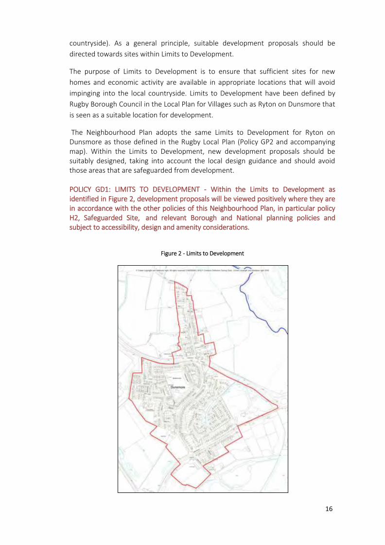
16
countryside). As a general principle, suitable development proposals should be
directed towards sites within Limits to Development.
The purpose of Limits to Development is to ensure that sufficient sites for new
homes and economic activity are available in appropriate locations that will avoid
impinging into the local countryside. Limits to Development have been defined by
Rugby Borough Council in the Local Plan for Villages such as Ryton on Dunsmore that
is seen as a suitable location for development.
The Neighbourhood Plan adopts the same Limits to Development for Ryton on Dunsmore as those defined in the Rugby Local Plan (Policy GP2 and accompanying map). Within the Limits to Development, new development proposals should be suitably designed, taking into account the local design guidance and should avoid those areas that are safeguarded from development. POLICY GD1: LIMITS TO DEVELOPMENT - Within the Limits to Development as identified in Figure 2, development proposals will be viewed positively where they are in accordance with the other policies of this Neighbourhood Plan, in particular policy H2, Safeguarded Site, and relevant Borough and National planning policies and subject to accessibility, design and amenity considerations.
Figure 2 - Limits to Development

17
Design
There is a very wide variety of housing styles in the Parish which reflect the
different prevailing styles of private and local authority construction over time.
Traditional ‘village’ style cottages and houses are very much in the minority and
whilst there are some single storey dwellings, the vast majority of homes are two
storey. The housing styles of recent major developments have tended to be drawn
from a relatively narrow speculative portfolio and the Bellway Estate housing in
the Parish, for example, can be found replicated in an urban area of the Borough
(Aqua Place, Rugby CV21).
The Neighbourhood Plan seeks to ensure that future design in residential or
commercial/community buildings is more consistently reflective of and
sympathetic to both the rural context of the Village and the existing buildings
nearby. Additionally, the materials used in any new development must not only be
aesthetically pleasing but also high quality and therefore durable in the long term.
Community feedback overwhelmingly supported the key design features below
which, in the interests of simplicity and consistent application, have been
combined into a single set of design principles applicable to all new development
in the Parish, including extensions.
Recent residential developments have failed to maximise some additional storage
opportunities which can easily be undertaken at the build stage and at relatively
low cost. This Plan seeks to encourage more thoughtful approaches to internal
storage by developers.
Another storage issue is an external one relating to refuse bins. The Local Plan
includes a generalised requirement for off-street storage for wheeled bins to
serve all new residential properties (Policy SDC1). In the context of a rural area
and the anticipated types of future housing, that requirement should be met by
hard standing suitably located within all rear gardens and screened hard standing
in any shared amenity area and detailed provisions relating to this are included in
the Principles below.
Policy GD2: BUILDING DESIGN PRINCIPLES – All commercial and residential
development, including one or more houses, replacement dwellings and extensions, should
ensure the following design principles are incorporated as appropriate and relevant to
the development concerned:
a) High quality materials and architectural design incorporating variety, detail and
craftsmanship that enhances the street-scene. Care should be taken to ensure
that the development does not disrupt the visual amenities of the street-scene
and impact negatively on any significant wider landscape views;

18
b) The development relates well to the topography of the area, with existing trees,
hedges and streams preserved whenever possible;
c) The development should be of a similar density to properties in the immediate
surrounding area;
d) Development should respect the shape, massing, form and character of dwellings
in the immediate vicinity in order to maintain a consistent character and enhance
it where possible. Three-storey houses are unlikely to suit the scale and mass of
existing development.
e) A reasonable size frontage is provided to each dwelling with an adequate balance
of soft landscaping and high-quality hard landscaping;
f) A reasonable rear garden or apartment amenity space is allocated for the size of each property which is at least equal to the ground floor footprint of the dwelling;
g) There is provision for the generous planting of indigenous trees and large shrubs
to dwelling frontages and open spaces;
h) High quality boundary treatments such as close board timber fencing and/or
brick walling should be specified. Particular attention should be paid to the detail
and visual appeal of site perimeter boundary treatments;
i) Any existing boundary walls and other boundary structures (such as isolated gate
piers) that are significant from either an architectural or heritage point of view,
should be retained where practicable. Plans should indicate any improvement
works and/or other alterations that would be necessary to bring any such
structure up to both a physically sound and visually appealing standard;
j) Thoughtful approaches to the maximisation of useful storage space in all new
dwellings are encouraged. These might include, amongst other things:
• boarding of loft spaces and incorporating roof lights and/or electrical
lighting;
• installation of loft ladders for safe access;
• provision of full height utility storage cupboards in kitchens and utility
rooms.
k) Provision is made for dedicated hard standing within the rear garden of each
dwelling which is accessible without entering the building. It should be capable of
accommodating 3 x 240 litre double wheeled bins each measuring
1100x585x740mm (HxWxD) and, in the case of shared amenity areas, screened
(with close board timber) so as to minimise the visual impact of the bins from the
19
dwellings and garden. Paved pathways at least 650mm wide should be
incorporated into plot and site layout as necessary to provide a continuous flat
connection between the dwelling, the hard standing and the nearest bin
collection point;
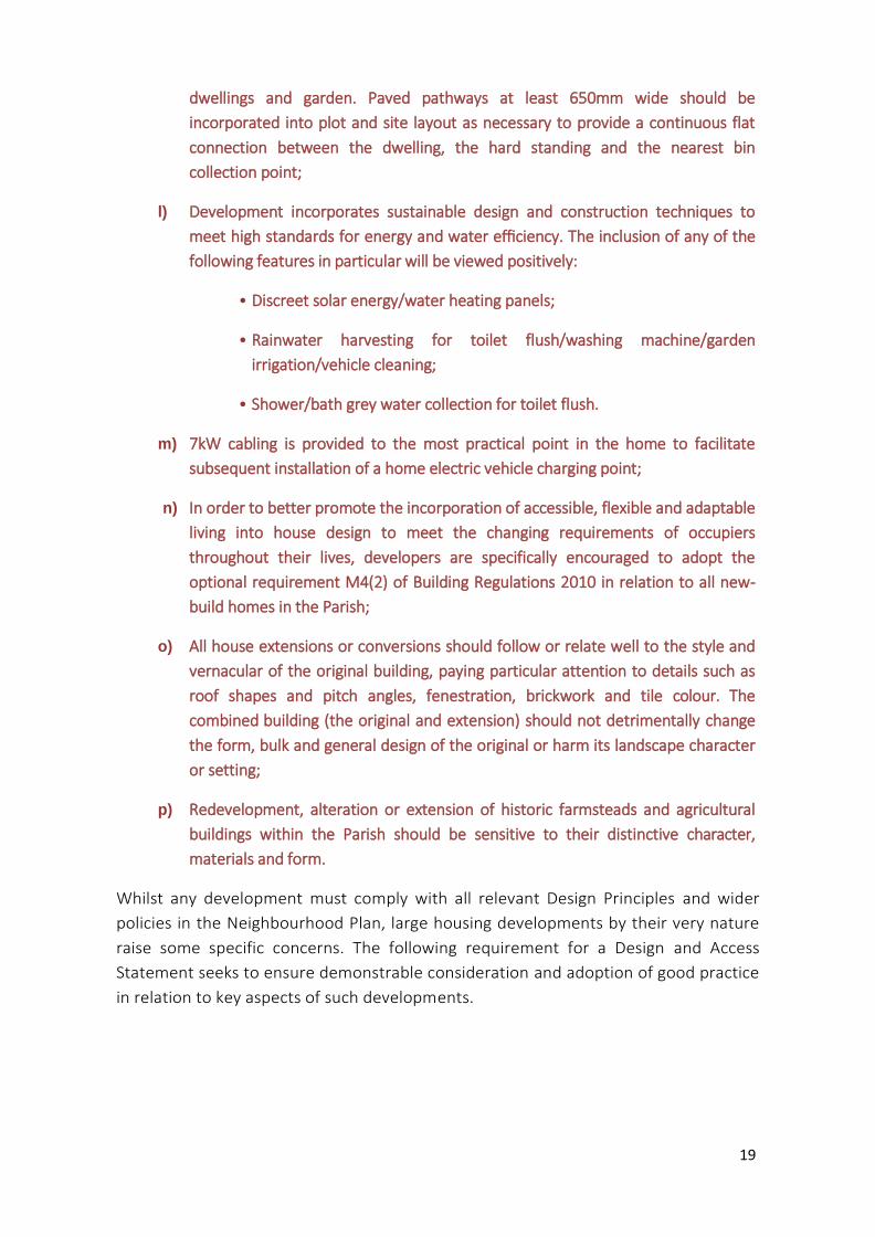
l) Development incorporates sustainable design and construction techniques to
meet high standards for energy and water efficiency. The inclusion of any of the
following features in particular will be viewed positively:
• Discreet solar energy/water heating panels;
• Rainwater harvesting for toilet flush/washing machine/garden
irrigation/vehicle cleaning;
• Shower/bath grey water collection for toilet flush.
m) 7kW cabling is provided to the most practical point in the home to facilitate
subsequent installation of a home electric vehicle charging point;
n) In order to better promote the incorporation of accessible, flexible and adaptable
living into house design to meet the changing requirements of occupiers
throughout their lives, developers are specifically encouraged to adopt the
optional requirement M4(2) of Building Regulations 2010 in relation to all new-
build homes in the Parish;
o) All house extensions or conversions should follow or relate well to the style and
vernacular of the original building, paying particular attention to details such as
roof shapes and pitch angles, fenestration, brickwork and tile colour. The
combined building (the original and extension) should not detrimentally change
the form, bulk and general design of the original or harm its landscape character
or setting;
p) Redevelopment, alteration or extension of historic farmsteads and agricultural
buildings within the Parish should be sensitive to their distinctive character,
materials and form.
Whilst any development must comply with all relevant Design Principles and wider
policies in the Neighbourhood Plan, large housing developments by their very nature
raise some specific concerns. The following requirement for a Design and Access
Statement seeks to ensure demonstrable consideration and adoption of good practice
in relation to key aspects of such developments.
20
Policy GD3: DESIGN AND ACCESS STATEMENT Any proposal for a major housing
development (one involving 10 or more dwellings or development of a site of more than
1 hectare) must be accompanied by a Design and Access/Planning Statement which
clearly shows how the plans respond to the above Design Principles and the wider
policies in the Neighbourhood Plan.
The Statement should:
(1) Include a section on broadband connectivity to support the Neighbourhood Plan Vision
and to comply with RBC Local Plan Policy SDC 9. It should identify who the intended
network provider(s) will be and how the connection will be secured to each property in the
context of taking every opportunity to future-proof broadband provision and
infrastructure;
(2) Clearly show how the plans demonstrate imaginative and thoughtful best practice on
parking such that resident and visitor parking is well integrated and does not dominate
streets;
(3) Clearly indicate how the plans reflect relevant guidance in the latest version of
Building for Life 12 (BfL12) and in particular should indicate how the plans:
a) Integrate the development in the best way possible into the existing
neighbourhood rather than create an inward-looking cul-de-sac development;
b) Contribute toward creating a more walkable and cycle friendly neighbourhood;
c) Create streets that are pedestrian, wheelchair and pushchair friendly and that
encourage cars to be driven more slowly and carefully;
d) Offer good natural surveillance opportunities to impact positively on the
safety, security and vitality of the street and open spaces;
e) Provide a management and maintenance plan to include a sustainable way to
fund public or shared communal open spaces.

21
B. Housing and the Built Environment
Devising a land use plan for residential development is an important element of the
Neighbourhood Plan.
The 2019 Rugby Local Plan identifies an overall development need to 2031 of 12,400
additional homes with seven of the nine Main Rural Settlements identified for
residential allocations. Policy DS3 identifies site allocation DS3.9 in Ryton on Dunsmore
off Leamington Rd for around 75 dwellings but notes that implementation can only
occur when adequate replacement of pitch provision is made in accordance with the
NPPF.
In embracing the NPPF requirement for the planning system to contribute to
sustainable development and to control and shape development over the plan period,
this Neighbourhood Plan both supports the residential allocation in the Rugby Local
Plan and also identifies a further residential development to exceed the minimum
requirement through the Local Plan. A Safeguarded site is also identified to be brought
forward in the event that the allocated sites fail to deliver the required volume of new
housing, or housing need increases during the Plan period.
In this way, the Neighbourhood Plan meets the requirements of the NPPF (2018) para
14 which confirms that with further housing applications where Rugby BC cannot
demonstrate a 5-year supply of housing, nonetheless ‘the adverse impact of allowing
development that conflicts with the Neighbourhood Plan is likely to significantly and
demonstrably outweigh the benefits’.
Residential Site Allocations
In progressing the Neighbourhood Plan, the Ryton on Dunsmore Neighbourhood Plan
Steering Committee established three ‘Focus Groups’ to develop specific policy areas.
One of these was the Housing Focus Group which was tasked with assessing potential
sites put forward by landowners, developing key design principles and other housing
related policies.
Landowners in the Parish with sites adjacent to the built-up area were written to and
asked whether they had plans to develop their land over the Plan period. All sites were
subject to an independent Sustainability Assessment. The process followed a formula
that measured 27 criteria covering a wide range of issues including capacity, current use,
topography, visual impact, wildlife considerations, vehicular access, flooding, heritage
and distance to community facilities. The results are shown in Appendix 5 and have
enabled the Group to recommend the following Allocated Sites and a Safeguarded Site.
Where appropriate, conditions are attached to the development. The conditions include
provision for affordable housing that reflects the local situation.
22
Affordable housing provision in the Parish has increased significantly following the
recent approvals of a substantial exception site (Warren Field) and the redevelopment
of the Old Coal Yard.
The type of preferred affordable housing was specifically raised in the Neighbourhood
Plan Questionnaire and there was very high support expressed for more discounted
starter homes (86%) and for making affordable housing available to people with a local
connection to the Parish.
Another key outcome of consultation was that there was a desire for more affordable
housing for local younger people so that they have the opportunity to stay in the
village. An affordability analysis in the Housing Needs Report (see Appendix 4) cites an
entry level property in the Parish as costing on average £176,875 which is significantly
above the national average and indicates how financially challenging that price point
would be for youngsters seeking to enter the housing market.
Historic England raised concerns in relation to the former British Legion site (Site 2)
involving a Grade II a listed building set within a Registered Historic Park and Garden.
The initial Site Allocations policy was amended following a comment raised through
Regulation 14 consultation to remove reference to specific development numbers and
to ensure that development does not take place until the impact on the designated
heritage assets is mitigated to the satisfaction of Historic England. The site is currently
in disrepair and it is considered that sympathetic and appropriate development would
represent a significant enhancement.
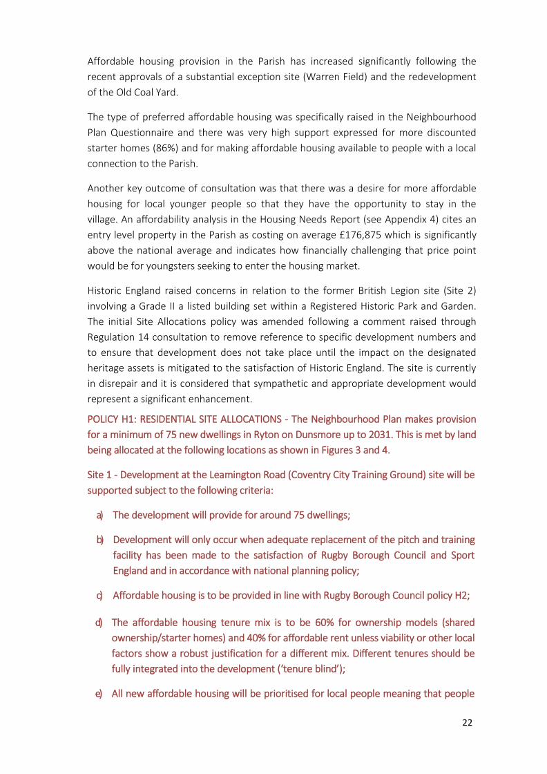
POLICY H1: RESIDENTIAL SITE ALLOCATIONS - The Neighbourhood Plan makes provision
for a minimum of 75 new dwellings in Ryton on Dunsmore up to 2031. This is met by land
being allocated at the following locations as shown in Figures 3 and 4.
Site 1 - Development at the Leamington Road (Coventry City Training Ground) site will be
supported subject to the following criteria:
a) The development will provide for around 75 dwellings;
b) Development will only occur when adequate replacement of the pitch and training
facility has been made to the satisfaction of Rugby Borough Council and Sport
England and in accordance with national planning policy;
c) Affordable housing is to be provided in line with Rugby Borough Council policy H2;
d) The affordable housing tenure mix is to be 60% for ownership models (shared
ownership/starter homes) and 40% for affordable rent unless viability or other local
factors show a robust justification for a different mix. Different tenures should be
fully integrated into the development (‘tenure blind’);
e) All new affordable housing will be prioritised for local people meaning that people
23
with a strong local connection to the Parish and whose needs are not met by the
open market will be offered the tenancy or shared/discounted ownership of the
home before it is opened up across the Borough. In this context a strong local
connection is defined as someone:
• who has a minimum period of five continuous years permanent residence in
the Parish or adjoining parishes (Brandon and Bretford, Wolston, Stretton-on-
Dunsmore, Bubbenhall, Baginton); or
• has resided permanently in the Parish, or an adjoining parish, for five years or
more within the previous 20 years; or
• is required to live close to another person who satisfies the above criteria in
order to provide or receive essential frequent attention and/or care due to
age, infirmity or disability.
Only where no such individual can be found that meets the above criteria within a
three-week period from advertising the vacancy shall affordable housing within the
plan area be allocated to other eligible residents from elsewhere across Rugby
Borough.
If it is not possible to provide affordable housing on site, in exceptional
circumstances it will be acceptable to provide funding in lieu of affordable housing
on-site if this leads to the provision of additional affordable housing in the Parish.
Figure 3 – Residential Site Allocation at Coventry City Training Ground, Leamington Road

24
Site 2 - Sympathetic limited development on the Leamington Road (former British Legion)
site will be supported where it allows restoration of the listed building and registered
garden. Proposals will need to avoid harm to the designated heritage assets to the
satisfaction of Historic England.
Figure 4 – Residential Site Allocation at the former British Legion.
Aerial photograph showing the current state of the former British Legion building. There is strong village support for a sympathetic limited development of the site to enable the building and garden to be restored.
25
Safeguarded site
Although Ryton on Dunsmore as a parish has met, and exceeded, its housing
requirement for the Plan period through the housing allocations identified in Policy
H1, it is recognised that circumstances change and that there may be a need for
additional new housing over the timeframe of the Neighbourhood Plan.
In the event that the allocations identified in the Neighbourhood Plan fail to deliver
the required housing target, or there is a recognised increase in housing need, the
following Safeguarded Site will be considered. The period of five years as set out in
the Policy reflects the initial housing trajectory period used in the Local Plan. After
this five year period has expired, factors including whether permission has been
granted and works have started on site will be considered when assessing whether
the allocation has failed.
Policy H2: SAFEGUARDED SITE – the area of land known as Lamb’s Field (see Figure 5
below) is to be safeguarded in relation to future development. It will be considered
for residential development but only where either:
a) It is required to remediate a substantial shortfall in the supply of housing land
due to the failure of the Leamington Road (Coventry City Training Ground)
Site (allocated under Policy H1 in this Plan and Policy DS3 in the Rugby Local
Plan) to deliver the anticipated scale of development required. Any
assessment as to whether or not the site has failed can only be made after
the first five years from the date of Local Plan adoption;
or:
b) It becomes necessary to provide for additional homes in the Parish in
accordance with any new development plan document that replaces the
2019 Rugby Local Plan or any updated version of this Neighbourhood Plan.

26
Figure 5 – Safeguarded Site
Windfall sites
A windfall site is defined in the NPPF as one which has not been specifically
identified as available through the local or neighbourhood plan process. The sites
often comprise previously developed land that has unexpectedly become available.
Any such sites that do emerge can make a valuable contribution to new housing
provision over the lifetime of this Plan.
To help protect the nature of the Village character, development beyond the
housing allocation described in H1 above (or development of the Safeguarded site
in Policy H2 should this be necessary) will be restricted to windfall sites within the
Limits to Development in Policy GD1.
Policy H3: WINDFALL SITES - Small residential development proposals will be
supported subject to proposals meeting all relevant requirements set out in other
policies in this Plan and where such a development:
a) Comprises a restricted gap in the continuity of existing frontage buildings or
on other sites within the built-up area of Ryton on Dunsmore or where the
site is closely surrounded by buildings.
b) Does not involve the outward extension of the built-up area of Ryton on
Dunsmore;
c) Provides for safe vehicular and pedestrian access;
d) Respects the shape, massing, form and character of dwellings in the
27
immediate vicinity of the development in order to maintain a consistent
character and enhance it where possible;
e) Does not reduce garden space to an extent where it adversely impacts on the
character of the area, or on the amenity of neighbours and the existing and
future occupiers of the dwelling where relevant;
f) Does not result in an unacceptable loss of amenity for neighbouring
occupiers by reason of loss of privacy, loss of daylight, visual intrusion or
noise; and
g) If it involves two or more dwellings, provides for at least one small dwelling
with three or fewer bedrooms for every one larger dwelling (i.e. four or more
bedrooms).
Support for brownfield sites
Economic derelict sites (brownfield sites) remain across the Plan area and these
often create a drag on its vibrancy and attractiveness.
This is also a core principle of the NPPF (paragraph 118) which gives ‘substantial
weight to the value of using suitable brownfield land within settlements for homes
and other identified needs, and support(s) appropriate opportunities to remediate
despoiled, degraded, derelict, contaminated or unstable land’.
Development that addresses these issues will be supported.
POLICY H4: SUPPORT FOR BROWNFIELD SITES – Within the Limits to Development,
proposals for the redevelopment or change of use of redundant land or buildings
will be supported over non-brownfield sites, where opportunities exist to remediate
despoiled, degraded, derelict, contaminated or unstable land.
Housing mix The Housing Needs Report (Appendix 4) indicates that the highest proportion of
dwellings type at the last census was semi-detached (40%), well above the district
level and nearly 10% above the national average. Detached homes were nearly 5%
above district level and 10% above England as a whole. Terraced housing was 3 - 4%
below comparative averages whilst flats/maisonettes/apartments were significantly
below and accounted for just 3% of household spaces. That hierarchy of type was
replicated in the responses to the Neighbourhood Plan Questionnaire with 87%
wanting to see more semi-detached, 72% more detached, 61% more terraced and
48% more flats/ apartments.
28
The Warren Field site of affordable housing will adjust the current mix of type given
the inclusion of apartments and terraced housing within the predominant semi-
detached provision of the development. The recently approved Old Coal Yard
development of affordable housing will also add some semi-detached houses within
the predominant terraced provision. Whilst it is not thought to be helpful to include
specific proportions of house type as a matter of policy, there is an expectation that
there will be a suitable and balanced variety of house types on any development.
In relation to the mix of house size, the Housing Needs Report shows that the
proportion of homes in the Parish with 4+ bedrooms is high (28%) when compared
to rates at district (23%), regional (18%) and national (19%) levels. There is also a
significant under-representation of homes for single people or couples with just 3%
of dwellings having one bedroom (a quarter of the national average) and 2 bed
properties being 3-5% below comparative averages. Such a housing size profile
means that the supply of less expensive homes is particularly restricted in a Parish
where housing is relatively expensive given that the overall annual average house
price from residential resales in the 12 months to August 2018 was £329,167
(Rightmove data from 21 sales).
There is also some evidence of under-occupancy with just under half of all occupied
households having two or more spare bedrooms and 36% having one spare. The
Housing Needs Report suggests that older person households are more likely to
under-occupy their dwellings. From census data, it concludes that around 57% of
pensioner households in the Parish have at least two more bedrooms than is
technically required by the household. This is 13% higher than the non-pensioner
household rate. This under-occupancy is above district, regional and national rates
and also 2% higher than the overall England rural estimate and would support a
policy aimed at providing more smaller homes of up to two bedrooms which would
be suitable for older householders needing to downsize, small families and those
entering the housing market. Providing potentially suitable accommodation for
elderly local residents in particular will enable them to remain in the local
community and also release under-occupied larger properties onto the market
which would be suitable for growing families. This is particularly important given
that all the local and national demographic trends cited in the Housing Needs Report
indicate that there will be an increasing need for housing provision for the elderly
people in Ryton on Dunsmore. The number of residents aged 65+ at the last census
was 2-3% higher than district, region and national levels having risen by 40% since
the previous census. Rugby’s 65+ age group is projected to grow by around 55%
between 2014 - 2034.
A policy commitment to encourage a varied housing provision whilst emphasising
smaller homes was strongly supported by responses to the Neighbourhood Plan
Questionnaire. 95% wished to see more bungalows or accommodation suitable for
29
older people or people with disabilities whilst the preference for more medium
sized 3 bed homes was 92% and for more small 1-2 bed homes it was 87%. Support
for more large family homes (4+ beds) was far lower at 57% overall, with only 10%
wishing to see a lot more and 43% wanting to see no more. The Warren Field
development, with 15No. 2 bed houses, 10No. 3 bed houses and 4No. 1 bed flats,
will contribute to increasing the proportion of smaller homes in the Parish as will the
Old Coal Yard development with 8No. 2 bed and 13No. 3 bed houses.
The Neighbourhood Plan seeks to continue the above trend towards smaller homes
in the context of the Local Plan SHMA recommended strategic mixes for each of
market housing and affordable housing. The key neighbourhood variances are:
(a) Any specific commitment to single-bed dwellings is avoided due to the limited
flexibility of such accommodation in adapting to future household change.
(b) The common use of small apartments to meet single bed targets in urban areas
of the Borough would not be appropriate in Ryton on Dunsmore given not only a
rural setting but also the existing mix of house types.
(c) In order to meet the identified local need for increased housing provision for
elderly people, encouragement is given to a proportion of bungalows being
delivered on larger developments. Opportunities in the regard have notably been
overlooked in both of the most recent affordable housing proposals in the Parish.
Policy H5: HOUSING MIX - Any new housing development proposals other than
Windfall Sites should provide a mixture of housing types and sizes to meet the
identified local needs of Ryton on Dunsmore. Any such new development overall
should:
a) Give priority to dwellings of 2 and 3 bedrooms. The inclusion of four-bedroom
houses will only be supported where they are subservient in number to 1, 2 and 3
bedroom accommodation unless there is a robust justification for an alternative
mix based on site specific constraints or considerations.
b) Seek to meet the needs of older residents and those with disabilities by including,
wherever practical and viable, a small proportion of single level 2 bed bungalows
with modest rear gardens. 2 and 3 bed dormer style bungalows would also be
welcome provided that the ground floor is readily adaptable to single level living.
In seeking to meet local housing need, a key related consideration is the extent to
which new housing of any type and size addresses changing needs. Current Building
Regulations optional requirement M4(2) relates to accessible and adaptable
dwellings and seeks to ensure that a new dwelling makes reasonable provision for
most people to access the dwelling and incorporates features that make it
immediately, or by adaptation, suitable and functional for a wide range of

30
occupants including young families, older people, those with reduced mobility and
some wheelchair users.
Building to M4(2) standards inevitably increases build costs which the Department
for Communities and Local Government, (Housing Standards Review: Cost Impacts
2014) projects as follows:
Construction cost of detached dwelling (extra over usual industry standard) £520
Additional space cost (after space cost recovery via additional sales revenues) £866
Process costs per dwelling on a development of 5 dwellings £235 50 dwellings £48 100 dwellings £46
Such additional costs are relatively modest in terms of overall development viability
and are considerably less than the potential costs of later adaptation of industry
standard built homes. On balance therefore, it is felt that there is an opportunity
for new housing delivered during the Neighbourhood Plan period to better meet
the accessibility needs of an ageing local population and the potential changing
needs of all residents over time in a cost-effective way. Whilst the Local Plan
broadly supports proposals which provide homes designed to meet the needs of
older people and those with disabilities (Policy HS1), Rugby Borough Ccouncil have
not undertaken to apply the new optional technical standards on accessibility as a
matter of policy and therefore this Plan cannot be used to apply them.
Nevertheless, our Design Principles incorporate encouragement for all new-build
homes to comply with requirement M4(2) through Policy GD2 (n).
Residential car parking
The provision of sufficient off-road parking spaces attracted the highest level of
support of all the new-build features tested in the Neighbourhood Plan
Questionnaire with 98% agreement and is therefore deserving of a specific policy.
From the car ownership-per-household data in the 2011 Census, the percentage of
Parish households with no cars or vans is low at around a third of the national
average whilst those with 2 or more cars is 20% higher than the national average.
The rural context of the Parish clearly puts increased pressure on parking provision
and justifies a higher level of recommended minimum parking spaces than provided
for in the Local Plan.
Further pressure comes from the widespread use of garages for storage rather than
parking and the conversion of garages into additional living space. On the
Bellway/Barrett estate for example, one garage space has been converted in each
of 26 dwellings (18% of all dwellings) despite a restrictive covenant to maintain
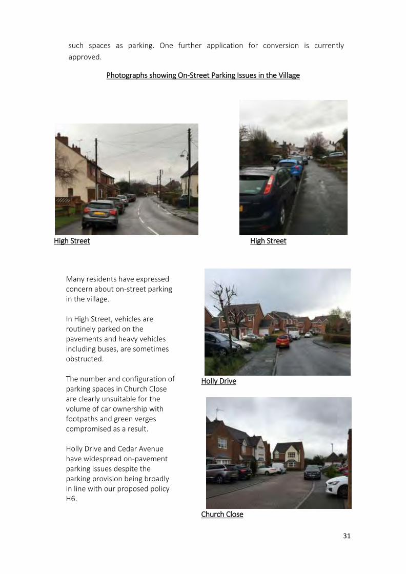
31
such spaces as parking. One further application for conversion is currently
approved.
Photographs showing On-Street Parking Issues in the Village
High Street High Street
Holly Drive
Church Close
Many residents have expressed concern about on-street parking in the village. In High Street, vehicles are routinely parked on the pavements and heavy vehicles including buses, are sometimes obstructed. The number and configuration of parking spaces in Church Close are clearly unsuitable for the volume of car ownership with footpaths and green verges compromised as a result. Holly Drive and Cedar Avenue have widespread on-pavement parking issues despite the parking provision being broadly in line with our proposed policy H6.
32
Policy H6: OFF-ROAD PARKING SPACES
a) Development proposals of one or more dwellings should provide one residential
off-road parking space per bedroom unless otherwise justified having regard to site
specific constraints;
b) In meeting that target, allocated spaces on driveways within a plot boundary
should not be in tandem;
c) Where a development includes garage provision, each single garage space will
count as one off-road parking space provided that it is of a sufficient size to
accommodate a modern family car. Garage sizes less than those scheduled below
will not be classed as off-road parking as they are too small to allow drivers to exit
their cars once parked in the garage:
• Single garages (with internal spaces less than 6m x 3m, with a minimum door
width of 2.3m);
• double garages (with internal spaces less than 6m x 6m with a minimum
door width of 4.2m).
d) Development will be subject to a restrictive covenant to ensure that the
garaging remains available to house vehicles.
Tandem and backland development
Consultation has highlighted a lack of support for ‘tandem’ and ‘backland development’ defined as the placing of one dwelling behind another within a single plot and the erection of a dwelling or dwellings on parts of large gardens attached to existing dwellings.
Although the housing allocations in Policies H1 and H2 meet the existing housing requirement for Ryton on Dunsmore and there is therefore no further requirement for additional housing in the Parish, the presence of a policy on tandem and backland development helps to reinforce this position in line with community wishes.
POLICY H7: FURTHER TANDEM AND BACKLAND DEVELOPMENT in gardens of existing properties will not be supported where the development would cause harm to the local area.
External storage
The provision of secure sustainable outside storage is now a necessity for home occupiers. Pastimes now include: gardening, food production, alfresco eating, barbecuing, sitting out, entertaining, the recreational use of bikes and other sports equipment.

33
All these activities generate equipment which, when not in use, needs to be stored securely. When storage is inadequate or non-existent, this equipment tends to go into the garage, thereby eliminating car parking spaces. This is one of a number of transport related issues in Ryton on Dunsmore, alongside on-road parking and pavement obstruction where there are many narrow streets which are quickly prone to congestion. The following external storage standards are based on an update to Parker Morris Standards that were established some 55 years ago. It will be the responsibility of the applicant to demonstrate that providing these elements is not viable.
POLICY H8: EXTERNAL STORAGE - New residential development shall include provision for secure external storage at the following minimum standard:
Size of dwelling External storage area
1 and 2 bedroomed dwellings 3 sqm
3 bedroomed dwellings 3.5 sqm
4+ bedroomed dwellings 4.0 sqm
Building for biodiversity
Residents in the Plan Area want their communities to play their part in the sustainable
development of Rugby Borough. As noted in the National Planning Policy Framework,
Planning Authorities should, through their policies, contribute as fully as possible to
the aims of Biodiversity 2020 DEFRA, 2011. New development in Ryton should be
designed to incorporate the current (at time of every Planning Application) best
practice standards and methods for biodiversity protection and enhancement.
POLICY H9: BIODIVERSITY PROTECTION IN NEW DEVELOPMENT – Proposals for new
development should incorporate measures for the protection and enhancement of
local biodiversity, as follows:
a) Roof and wall construction should apply technical best practice for integral bird nest
boxes and bat breeding and roosting sites;
b) Hedges (or fences with ground-level gaps) should be used for property boundaries
to maintain connectivity of habitat for hedgehogs;
c) Security lighting should be operated by intruder switching, not on constantly. Site
and sports facility lighting should be switched off during ‘curfew’ hours between
March and October, following best practice guidelines in Bats and Lighting
(Leicestershire and Rutland Environmental Record Centre 2014). Maximum light
spillage onto bat foraging corridors should be 1 lux;
34
d) Existing trees and hedges of ecological or arboricultural value on and immediately
adjacent to new development sites should be retained and protected whenever
possible. Where this is demonstrably not practicable, the developer should be
responsible for arranging new plantings on a one-for-one (or better) ratio, using
native species, either on-site or elsewhere in suitable locations in the Plan Area;
e) Sustainable drainage and landscaping schemes should be designed to incorporate
measures for habitat creation and biodiversity enhancement and should include a
resourced management plan to maintain the designed biodiversity value of these
features.
35
C. The Natural and Historic Environment
Introduction
The environment in sustainable development
This section of the Plan deals with the environmental component of sustainable
development, as described in the National Planning Policy Framework. It balances the
requirement for appropriate development in Ryton against the value of environmental
features that are both special – appreciated, in their own right and as community assets,
by local people - and significant for their wildlife and history. It also deals with the broader
environmental issues of concern to the community, including biodiversity in new
development and renewable energy generation.
The MAPS in this chapter have been reduced to fit the document page size. Full-size
versions are available in 'Supporting Documents and Information' on the Village Website
Care was taken during preparation of the Plan to ensure that the policies (and the sites
and areas of environmental significance covered by them) were not unduly restrictive on
development during the Plan’s lifetime. Only 24% (approximately) by area of all the open,
potentially developable land in the Parish has been earmarked for environmental
protection at any level in the planning system. Excluding the statutory protection afforded
by existing national designations (SSSI, Listing, Scheduling), this Plan identifies 108 ha
(11.4%) for protection of locally-significant environmental features.
Total area of Ryton parish = 947 ha
Area of undeveloped land in Ryton parish = 867 ha
Area of sites designated or notified for environmental protection in this Plan = 108 ha (11.4%)
(excludes existing statutory protection in SSSIs and Scheduled Monuments etc. 118ha)
Landscape, geology and setting
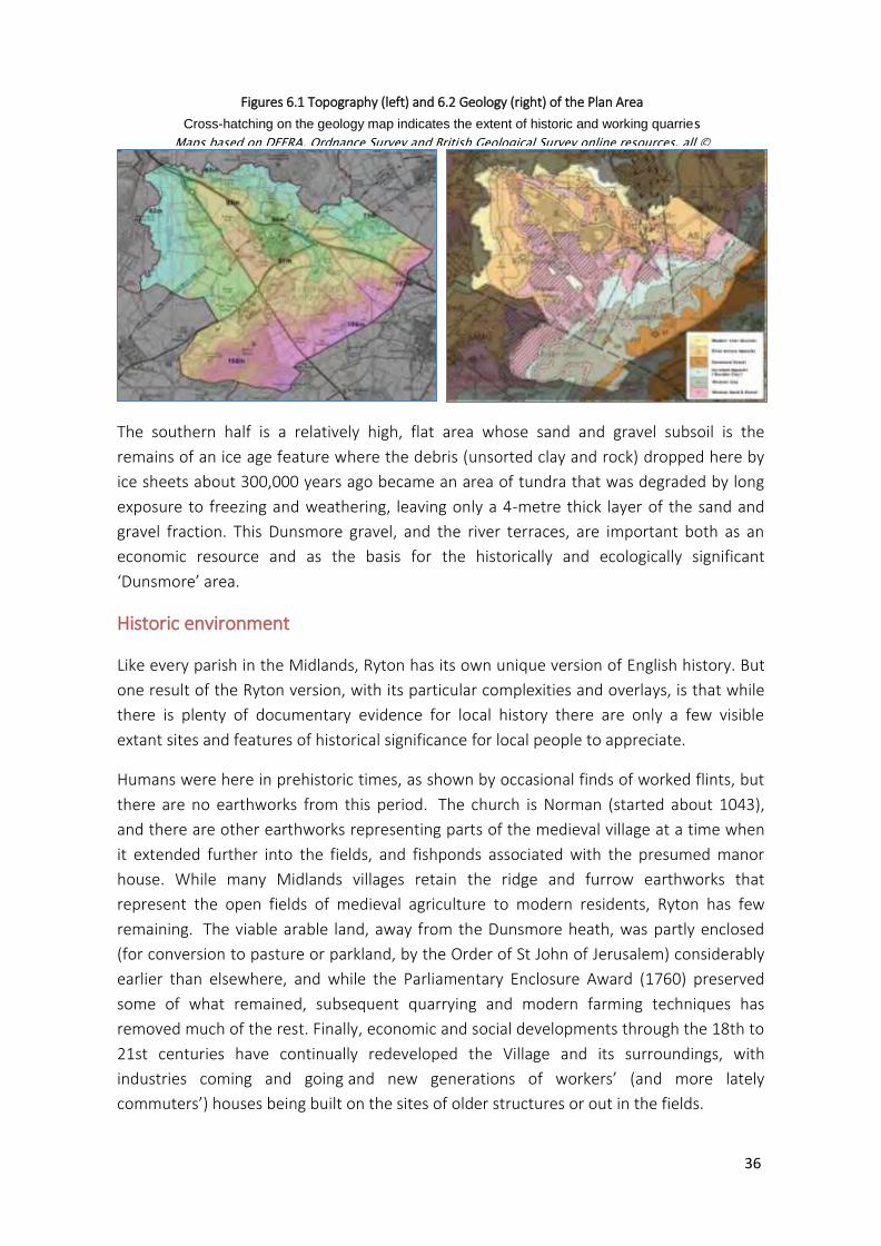
The Plan Area (which coincides with the Civil Parish of Ryton on Dunsmore) is,
topographically, a dissected plateau that falls gently from southeast (106 metres above
sea level) to northwest (about 60metres above sea level). The northern and western
boundaries are largely defined by the valley of the River Avon, whose ancient terraces
(shaped by a much larger river flowing here during the ice ages) provide the stepped and
gently rolling landscape of the northern half of the Parish, including the old part of the
Village. (See Figures 6.1 and 6.2)
36
The southern half is a relatively high, flat area whose sand and gravel subsoil is the
remains of an ice age feature where the debris (unsorted clay and rock) dropped here by
ice sheets about 300,000 years ago became an area of tundra that was degraded by long
exposure to freezing and weathering, leaving only a 4-metre thick layer of the sand and
gravel fraction. This Dunsmore gravel, and the river terraces, are important both as an
economic resource and as the basis for the historically and ecologically significant
‘Dunsmore’ area.
Historic environment
Like every parish in the Midlands, Ryton has its own unique version of English history. But
one result of the Ryton version, with its particular complexities and overlays, is that while
there is plenty of documentary evidence for local history there are only a few visible
extant sites and features of historical significance for local people to appreciate.
Humans were here in prehistoric times, as shown by occasional finds of worked flints, but
there are no earthworks from this period. The church is Norman (started about 1043),
and there are other earthworks representing parts of the medieval village at a time when
it extended further into the fields, and fishponds associated with the presumed manor
house. While many Midlands villages retain the ridge and furrow earthworks that
represent the open fields of medieval agriculture to modern residents, Ryton has few
remaining. The viable arable land, away from the Dunsmore heath, was partly enclosed
(for conversion to pasture or parkland, by the Order of St John of Jerusalem) considerably
earlier than elsewhere, and while the Parliamentary Enclosure Award (1760) preserved
some of what remained, subsequent quarrying and modern farming techniques has
removed much of the rest. Finally, economic and social developments through the 18th to
21st centuries have continually redeveloped the Village and its surroundings, with
industries coming and going and new generations of workers’ (and more lately
commuters’) houses being built on the sites of older structures or out in the fields.
Figures 6.1 Topography (left) and 6.2 Geology (right) of the Plan Area
Cross-hatching on the geology map indicates the extent of historic and working quarries
Maps based on DEFRA, Ordnance Survey and British Geological Survey online resources, all ©

37
Figure 7: Ryton extract from Mineral Resources map (British Geological Survey, for Warks CC); Pink = sand and gravel. Hatched = worked out
Consequently, the few surviving historical environment sites and features have been
evaluated as being of high local significance partly because of their local rarity, bearing in
mind that a Neighbourhood Plan only needs to be concerned with local importance. What
survives here is disproportionately precious, and any further loss should be avoided by the
Planning system.
Natural environment
As a rural Parish, Ryton’s local biodiversity is evident, with a number of sites existing within
and adjacent to the settlement boundary. There are also several sites of national
importance, separated by farmland, restored quarry land and industrial/employment
zones. As with historical environment sites, the identified biodiversity sites are precious
locally because of their ‘last survivor’ status and several are still threatened. This Plan aims
to protect these survivors, and to re-establish species and habitats connectivity between
them.
Existing environmental designations
The Plan Area is located in National Character Area (NCA) 96 Dunsmore and Feldon as defined by Natural England for planning purposes. It is in the Rugby section of the West Midlands Green Belt, but this has low intrinsic ecological value and almost no visible expression in the local environment (see below).
Three SSSIs (Ryton Wood; Ryton and Brandon Gravel Pits; Brandon Marsh) are either
entirely or partially located in the Plan Area. There are six potential Local Wildlife Sites
(LWS) and one validated LWS (in Warwickshire CC Phase 1 Habitat Survey, 2015)
The Plan Area also includes one Scheduled
Monument, five Listed Buildings, one
Registered Park/Garden, three further sites
and features of historic significance with
expression in the modern landscape, and
the historically significant medieval or
older Ryton Wood.
Mineral resources
About half of the Plan Area is (or was)
underlain by potential sand and gravel
resources, as mapped in 2009 by the
British Geological Survey for Warwickshire
County Council (extract showing Ryton section; Figure 7).
https://www.bgs.ac.uk/downloads/start.cfm?id=2624
The geological map (figure 6.2) indicates their extent in Ryton, while noting areas
already completely or partially worked out. The potential national and local economic
38
value of this resource is such that the remaining areas, where not already built upon,
are included in Warwickshire CC’s designated Mineral Safeguarding Areas (maps and
policies) in conformity with NPPF paragraph 204.
Note: the remaining areas of sand and gravel may not be developable for reasons other
than mineral safeguarding. This Plan also acknowledges that (except for Local Green
Space designations) its environmental protections would be superseded in planning
decisions by Mineral Safeguarding and other strategic minerals policies.
Green Belt
The Plan Area, except for the built-up area of the Village, is all within the West Midlands
Green Belt. This Green Belt was reviewed jointly in 2015 (Stage 1 Final Report for Coventry
City Council, Nuneaton and Bedworth Borough Council, Rugby Borough Council and
Warwick District Council, LUC, June 2015) by the Local Planning Authorities (LPAs) within
whose boundaries it lies The review was initiated largely in response to pressure on the
LPAs to relax the boundaries of and protection afforded by the Green Belt to permit
required strategic developments in the region.
In Ryton, substantial areas of the Green Belt land are, for historical and more recent
reasons, already developed (industry, quarrying, warehousing, etc.). Residents are not
confident that Green Belt status can be relied on to effectively protect the rural character
of the remaining undeveloped areas of the Plan Area.
This Plan therefore pays particular attention to identifying key features and sites of
environmental and community significance to ensure their protection in the event of
further dilution of the effectiveness of Green Belt protection. It is noted that, although
Green Belt protection theoretically supersedes Neighbourhood Plan designations (except
Local Green Space, which is equivalent), site-by-site protection of the best of Ryton’s
environment, even within Green Belt land, is now an important consideration.
Environmental inventory
An environmental inventory (Appendix 6) was carried out between March and July 2018.
The work comprised two complementary elements:
A desk study, based on information sources including:
DEFRA
Natural England
Historic England
Warwickshire Historic Environment Records
Environment Agency
British Geological Survey
Old maps (Ordnance Survey, manuscript)
39
British History Online
Local history and archaeology publications
Fieldwork, reviewing all open and currently undeveloped land in the Plan Area, and
significant species, habitats, landscape characteristics, earthworks and other extant
features were recorded.
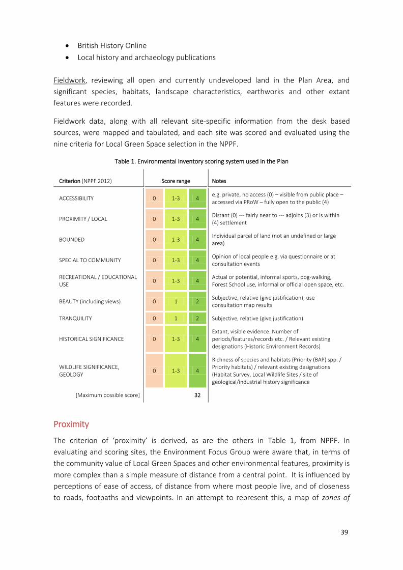
Fieldwork data, along with all relevant site-specific information from the desk based
sources, were mapped and tabulated, and each site was scored and evaluated using the
nine criteria for Local Green Space selection in the NPPF.
Table 1. Environmental inventory scoring system used in the Plan
Criterion (NPPF 2012) Score range Notes
ACCESSIBILITY 0 1-3 4 e.g. private, no access (0) – visible from public place – accessed via PRoW – fully open to the public (4)
PROXIMITY / LOCAL 0 1-3 4 Distant (0) --- fairly near to --- adjoins (3) or is within (4) settlement
BOUNDED 0 1-3 4 Individual parcel of land (not an undefined or large area)
SPECIAL TO COMMUNITY 0 1-3 4 Opinion of local people e.g. via questionnaire or at consultation events
RECREATIONAL / EDUCATIONAL USE
0 1-3 4 Actual or potential, informal sports, dog-walking, Forest School use, informal or official open space, etc.
BEAUTY (including views) 0 1 2 Subjective, relative (give justification); use consultation map results
TRANQUILITY 0 1 2 Subjective, relative (give justification)
HISTORICAL SIGNIFICANCE 0 1-3 4 Extant, visible evidence. Number of periods/features/records etc. / Relevant existing designations (Historic Environment Records)
WILDLIFE SIGNIFICANCE, GEOLOGY
0 1-3 4
Richness of species and habitats (Priority (BAP) spp. / Priority habitats) / relevant existing designations (Habitat Survey, Local Wildlife Sites / site of geological/industrial history significance
[Maximum possible score] 32
Proximity
The criterion of ‘proximity’ is derived, as are the others in Table 1, from NPPF. In
evaluating and scoring sites, the Environment Focus Group were aware that, in terms of
the community value of Local Green Spaces and other environmental features, proximity is
more complex than a simple measure of distance from a central point. It is influenced by
perceptions of ease of access, of distance from where most people live, and of closeness
to roads, footpaths and viewpoints. In an attempt to represent this, a map of zones of
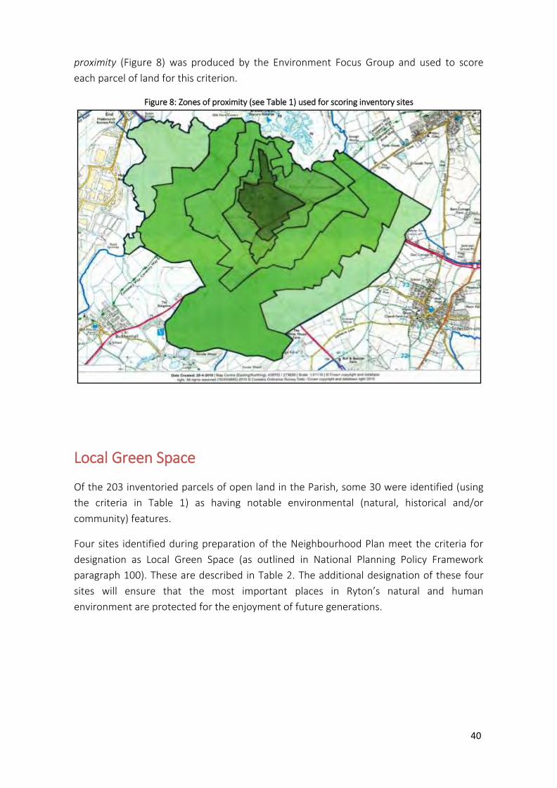
40
proximity (Figure 8) was produced by the Environment Focus Group and used to score
each parcel of land for this criterion.
Figure 8: Zones of proximity (see Table 1) used for scoring inventory sites
Local Green Space
Of the 203 inventoried parcels of open land in the Parish, some 30 were identified (using
the criteria in Table 1) as having notable environmental (natural, historical and/or
community) features.
Four sites identified during preparation of the Neighbourhood Plan meet the criteria for
designation as Local Green Space (as outlined in National Planning Policy Framework
paragraph 100). These are described in Table 2. The additional designation of these four
sites will ensure that the most important places in Ryton’s natural and human
environment are protected for the enjoyment of future generations.
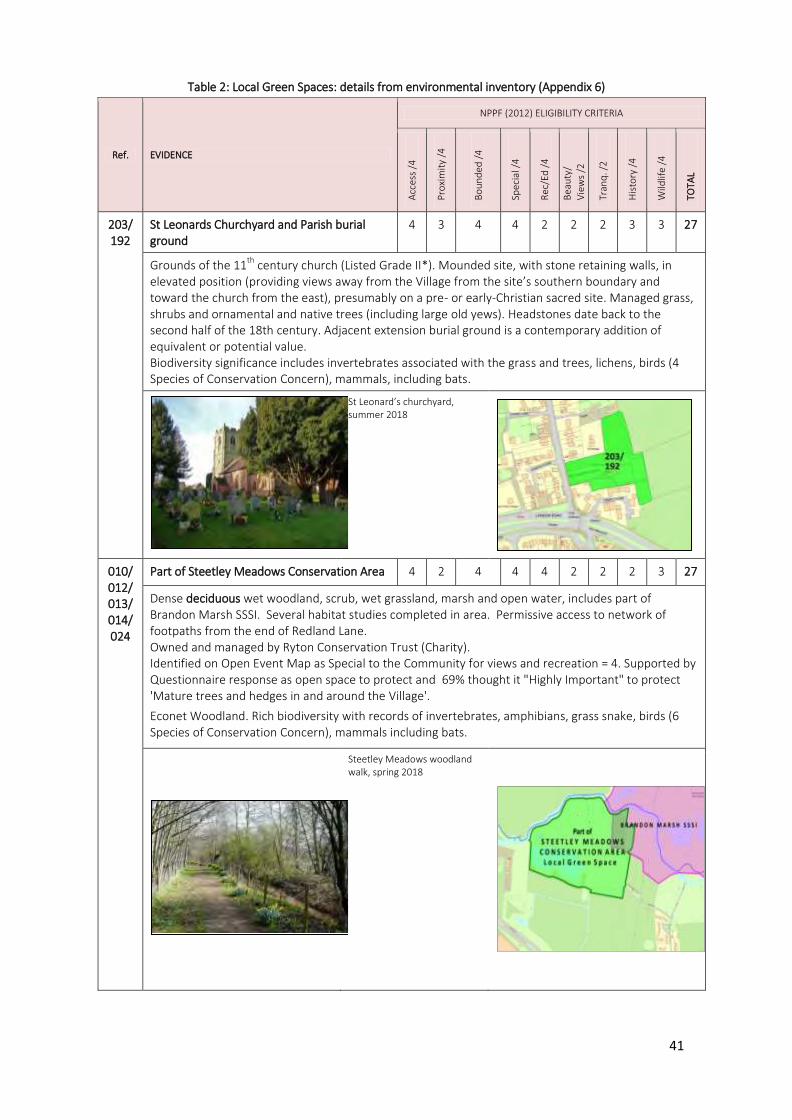
41
Table 2: Local Green Spaces: details from environmental inventory (Appendix 6)
Ref. EVIDENCE
NPPF (2012) ELIGIBILITY CRITERIA
Acc
ess
/4
Pro
xim
ity
/4
Bo
un
ded
/4
Spec
ial /
4
Rec
/Ed
/4
Bea
uty
/
Vie
ws
/2
Tran
q. /
2
His
tory
/4
Wild
life
/4
TOTA
L
203/ 192
St Leonards Churchyard and Parish burial ground
4 3 4 4 2 2 2 3 3 27
Grounds of the 11th
century church (Listed Grade II*). Mounded site, with stone retaining walls, in elevated position (providing views away from the Village from the site’s southern boundary and toward the church from the east), presumably on a pre- or early-Christian sacred site. Managed grass, shrubs and ornamental and native trees (including large old yews). Headstones date back to the second half of the 18th century. Adjacent extension burial ground is a contemporary addition of equivalent or potential value. Biodiversity significance includes invertebrates associated with the grass and trees, lichens, birds (4 Species of Conservation Concern), mammals, including bats.
St Leonard’s churchyard, summer 2018
010/ 012/ 013/ 014/ 024
Part of Steetley Meadows Conservation Area 4 2 4 4 4 2 2 2 3 27
Dense deciduous wet woodland, scrub, wet grassland, marsh and open water, includes part of Brandon Marsh SSSI. Several habitat studies completed in area. Permissive access to network of footpaths from the end of Redland Lane. Owned and managed by Ryton Conservation Trust (Charity). Identified on Open Event Map as Special to the Community for views and recreation = 4. Supported by Questionnaire response as open space to protect and 69% thought it "Highly Important" to protect 'Mature trees and hedges in and around the Village'.
Econet Woodland. Rich biodiversity with records of invertebrates, amphibians, grass snake, birds (6 Species of Conservation Concern), mammals including bats.
Steetley Meadows woodland walk, spring 2018
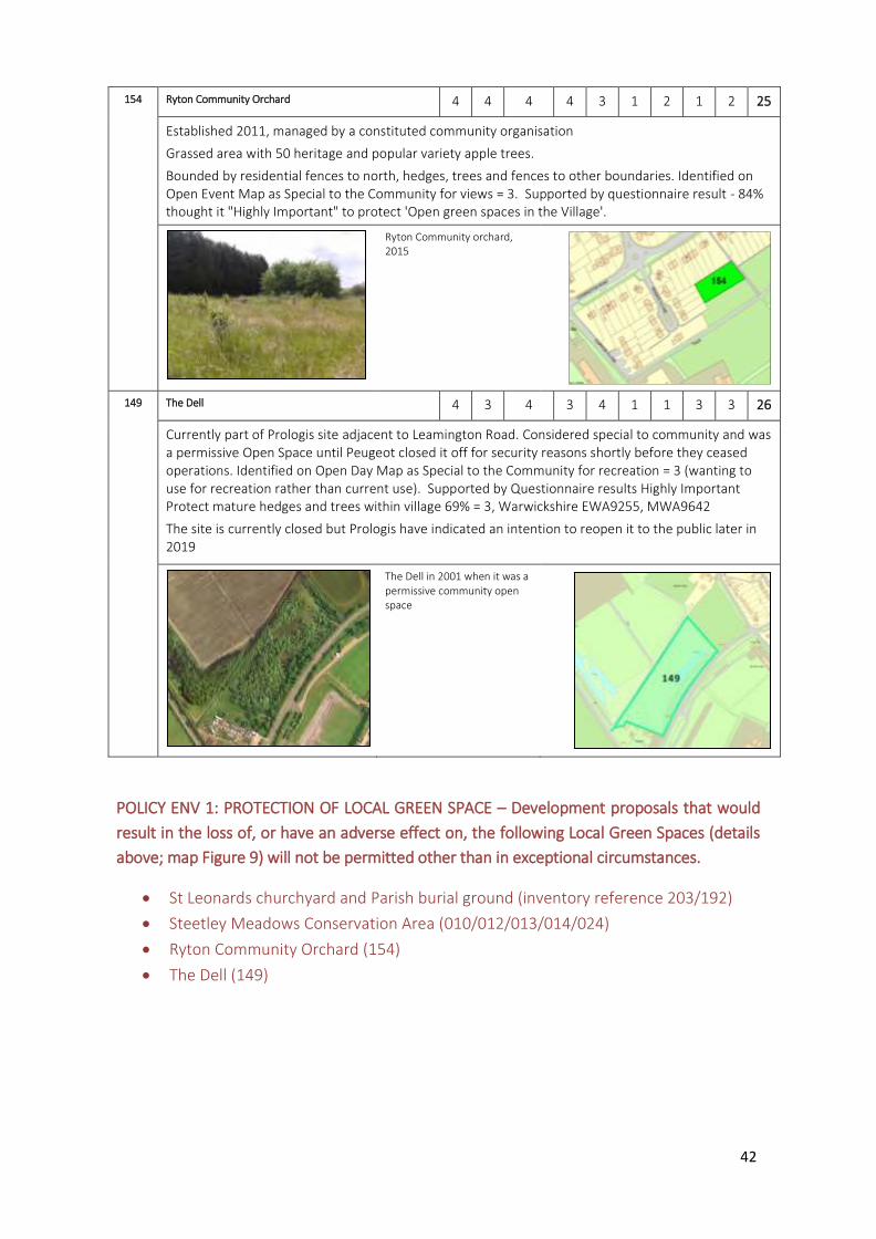
42
154 Ryton Community Orchard 4 4 4 4 3 1 2 1 2 25
Established 2011, managed by a constituted community organisation
Grassed area with 50 heritage and popular variety apple trees.
Bounded by residential fences to north, hedges, trees and fences to other boundaries. Identified on Open Event Map as Special to the Community for views = 3. Supported by questionnaire result - 84% thought it "Highly Important" to protect 'Open green spaces in the Village'.
Ryton Community orchard, 2015
149 The Dell 4 3 4 3 4 1 1 3 3 26
Currently part of Prologis site adjacent to Leamington Road. Considered special to community and was a permissive Open Space until Peugeot closed it off for security reasons shortly before they ceased operations. Identified on Open Day Map as Special to the Community for recreation = 3 (wanting to use for recreation rather than current use). Supported by Questionnaire results Highly Important Protect mature hedges and trees within village 69% = 3, Warwickshire EWA9255, MWA9642
The site is currently closed but Prologis have indicated an intention to reopen it to the public later in 2019
The Dell in 2001 when it was a permissive community open space
POLICY ENV 1: PROTECTION OF LOCAL GREEN SPACE – Development proposals that would
result in the loss of, or have an adverse effect on, the following Local Green Spaces (details
above; map Figure 9) will not be permitted other than in exceptional circumstances.
St Leonards churchyard and Parish burial ground (inventory reference 203/192)
Steetley Meadows Conservation Area (010/012/013/014/024)
Ryton Community Orchard (154)
The Dell (149)
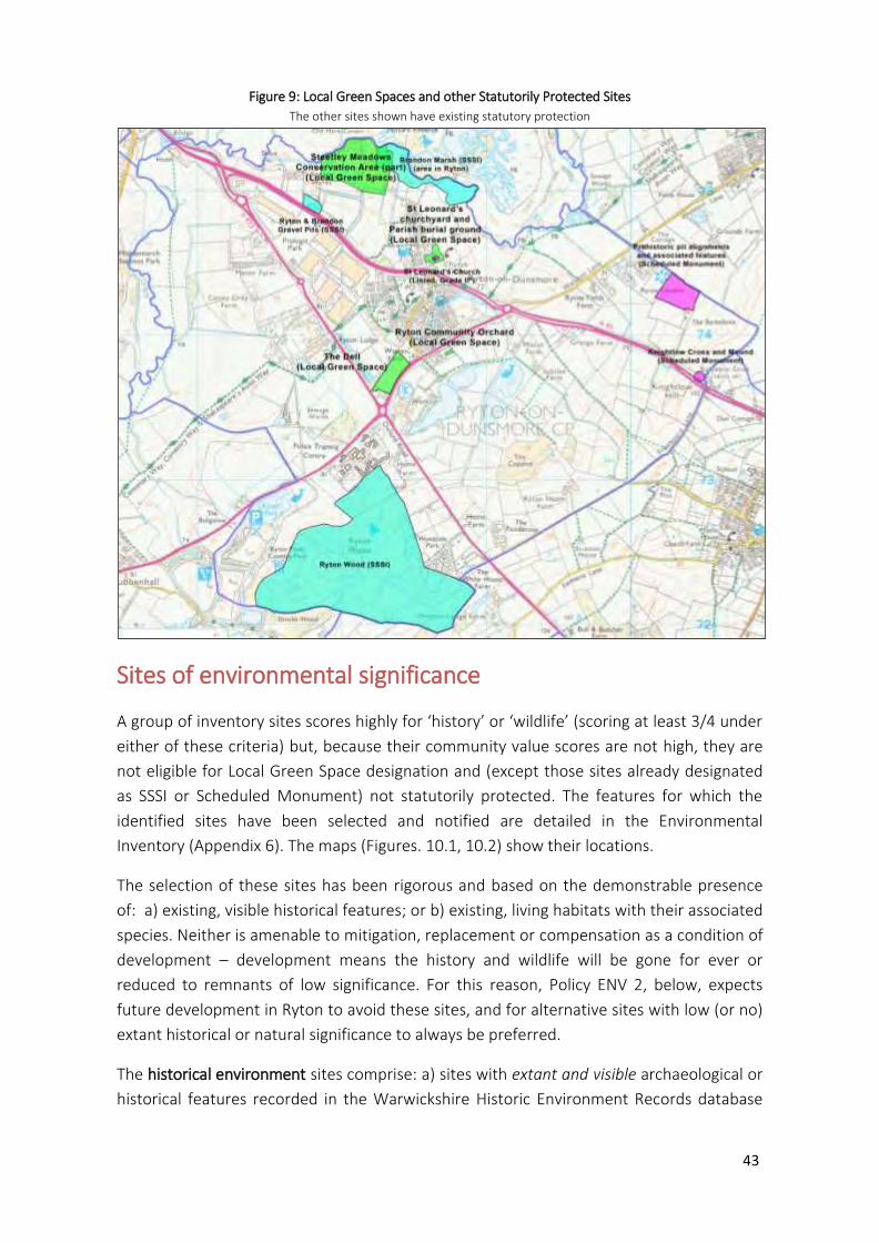
43
Figure 9: Local Green Spaces and other Statutorily Protected Sites
The other sites shown have existing statutory protection
Sites of environmental significance
A group of inventory sites scores highly for ‘history’ or ‘wildlife’ (scoring at least 3/4 under
either of these criteria) but, because their community value scores are not high, they are
not eligible for Local Green Space designation and (except those sites already designated
as SSSI or Scheduled Monument) not statutorily protected. The features for which the
identified sites have been selected and notified are detailed in the Environmental
Inventory (Appendix 6). The maps (Figures. 10.1, 10.2) show their locations.
The selection of these sites has been rigorous and based on the demonstrable presence
of: a) existing, visible historical features; or b) existing, living habitats with their associated
species. Neither is amenable to mitigation, replacement or compensation as a condition of
development – development means the history and wildlife will be gone for ever or
reduced to remnants of low significance. For this reason, Policy ENV 2, below, expects
future development in Ryton to avoid these sites, and for alternative sites with low (or no)
extant historical or natural significance to always be preferred.
The historical environment sites comprise: a) sites with extant and visible archaeological or
historical features recorded in the Warwickshire Historic Environment Records database
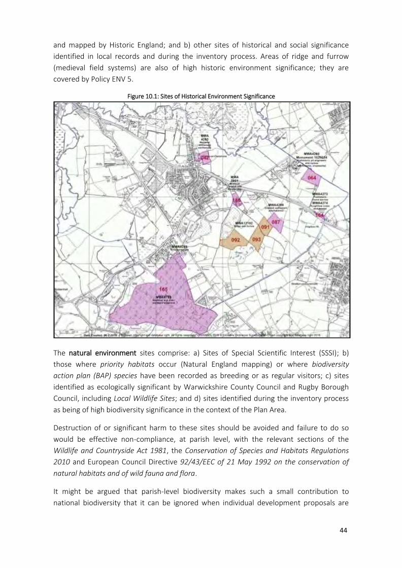
44
and mapped by Historic England; and b) other sites of historical and social significance
identified in local records and during the inventory process. Areas of ridge and furrow
(medieval field systems) are also of high historic environment significance; they are
covered by Policy ENV 5.
Figure 10.1: Sites of Historical Environment Significance
The natural environment sites comprise: a) Sites of Special Scientific Interest (SSSI); b)
those where priority habitats occur (Natural England mapping) or where biodiversity
action plan (BAP) species have been recorded as breeding or as regular visitors; c) sites
identified as ecologically significant by Warwickshire County Council and Rugby Borough
Council, including Local Wildlife Sites; and d) sites identified during the inventory process
as being of high biodiversity significance in the context of the Plan Area.
Destruction of or significant harm to these sites should be avoided and failure to do so
would be effective non-compliance, at parish level, with the relevant sections of the
Wildlife and Countryside Act 1981, the Conservation of Species and Habitats Regulations
2010 and European Council Directive 92/43/EEC of 21 May 1992 on the conservation of
natural habitats and of wild fauna and flora.
It might be argued that parish-level biodiversity makes such a small contribution to
national biodiversity that it can be ignored when individual development proposals are
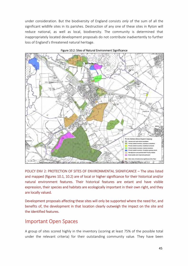
45
under consideration. But the biodiversity of England consists only of the sum of all the
significant wildlife sites in its parishes. Destruction of any one of these sites in Ryton will
reduce national, as well as local, biodiversity. The community is determined that
inappropriately located development proposals do not contribute inadvertently to further
loss of England’s threatened natural heritage.
Figure 10.2: Sites of Natural Environment Significance
POLICY ENV 2: PROTECTION OF SITES OF ENVIRONMENTAL SIGNIFICANCE – The sites listed
and mapped (figures 10.1, 10.2) are of local or higher significance for their historical and/or
natural environment features. Their historical features are extant and have visible
expression, their species and habitats are ecologically important in their own right, and they
are locally valued.
Development proposals affecting these sites will only be supported where the need for, and
benefits of, the development in that location clearly outweigh the impact on the site and
the identified features.
Important Open Spaces
A group of sites scored highly in the inventory (scoring at least 75% of the possible total
under the relevant criteria) for their outstanding community value. They have been
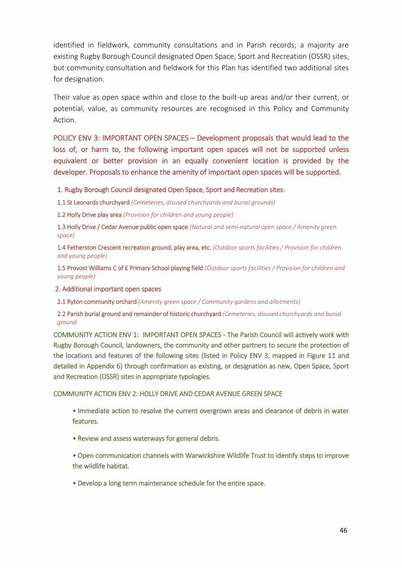
46
identified in fieldwork, community consultations and in Parish records; a majority are
existing Rugby Borough Council designated Open Space, Sport and Recreation (OSSR) sites,
but community consultation and fieldwork for this Plan has identified two additional sites
for designation.
Their value as open space within and close to the built-up areas and/or their current, or
potential, value, as community resources are recognised in this Policy and Community
Action.
POLICY ENV 3: IMPORTANT OPEN SPACES – Development proposals that would lead to the
loss of, or harm to, the following important open spaces will not be supported unless
equivalent or better provision in an equally convenient location is provided by the
developer. Proposals to enhance the amenity of important open spaces will be supported.
1. Rugby Borough Council designated Open Space, Sport and Recreation sites:
1.1 St Leonards churchyard (Cemeteries, disused churchyards and burial grounds)
1.2 Holly Drive play area (Provision for children and young people)
1.3 Holly Drive / Cedar Avenue public open space (Natural and semi-natural open space / Amenity green space)
1.4 Fetherston Crescent recreation ground, play area, etc. (Outdoor sports facilities / Provision for children and young people)
1.5 Provost Williams C of E Primary School playing field (Outdoor sports facilities / Provision for children and young people)
2. Additional important open spaces
2.1 Ryton community orchard (Amenity green space / Community gardens and allotments)
2.2 Parish burial ground and remainder of historic churchyard (Cemeteries, disused churchyards and burial ground
COMMUNITY ACTION ENV 1: IMPORTANT OPEN SPACES - The Parish Council will actively work with
Rugby Borough Council, landowners, the community and other partners to secure the protection of
the locations and features of the following sites (listed in Policy ENV 3, mapped in Figure 11 and
detailed in Appendix 6) through confirmation as existing, or designation as new, Open Space, Sport
and Recreation (OSSR) sites in appropriate typologies.
COMMUNITY ACTION ENV 2: HOLLY DRIVE AND CEDAR AVENUE GREEN SPACE
• Immediate action to resolve the current overgrown areas and clearance of debris in water
features.
• Review and assess waterways for general debris.
• Open communication channels with Warwickshire Wildlife Trust to identify steps to improve
the wildlife habitat.
• Develop a long term maintenance schedule for the entire space.

47
Figure 11: Important Open Spaces
Buildings and structures of local significance
Statutory Protection
Seven buildings and structures in the Plan Area have statutory protection through
Scheduled Monument status or Listing at Grade II* or II. The Neighbourhood Plan lists
them for reference, and to note that new development will be required to take into
account their settings as determined on a case by case basis by Historic England. Their
location within, or close to, sites designated or noted for protection in the Plan’s Policies
and Community Actions contributes to these sites’ evidence of significance.
48
Statutorily protected historic environment features in the Plan Area
SCHEDULED MONUMENTS
KNIGHTLOW CROSS AND MOUND
List Entry Number: 1020302
PREHISTORIC PIT ALIGNMENTS AND ASSOCIATED
FEATURES 160m NORTH OF THE BARBELLOWS
List Entry Number: 1020034
LISTED BUILDINGS
RYTON HOUSE
List Entry Number: 1034887
Heritage Category: Listing
Grade: II
Location: LEAMINGTON ROAD,
REMAINS OF KNIGHTLOW CROSS
List Entry Number: 1365114
Heritage Category: Listing
Grade: II
WAR MEMORIAL
List Entry Number: 1393914
Heritage Category: Listing
Grade: II
Location: HIGH STREET,
CHURCH OF ST LEONARD
List Entry Number: 1034875
Heritage Category: Listing
Grade: II*
Location: CHURCH ROAD,
REGISTERED PARKS and GARDENS
RYTON HOUSE
List Entry Number: 1001343
Heritage Category: Park and Garden
Grade: II
Location: LEAMINGTON ROAD.
Location: London Road (A45), Knightlow Hill,
Local Heritage List
The Neighbourhood Plan identifies a number of other buildings and structures in the built
environment of Ryton that are considered to be of local significance for architectural,
historical or social reasons (details in Appendix 7). Their inclusion here records them in the
Planning system as non-designated heritage assets.
POLICY ENV 4: NON-DESIGNATED HERITAGE ASSETS – The structures and buildings listed
here (and mapped in Figure 12) are non-designated local heritage assets. They are
important for their contribution to the layout and characteristic mix of architectural styles in
the Parish, and their features and settings will be protected wherever possible. The benefits
of a development proposal, or of a change of land use requiring planning approval, will need
to be judged against their significance as heritage assets.
1. 88 High St
2. 86 High St
3. 84 High St
4. 82 High St
5. 80 High St
6. 79 High St
7. 77 High St
8.The Blacksmiths Arms, High St
9. 3 High St
10. 1 High St
11. Manor Cottage, Church Road
12. The Malt Shovel, Church Road
13. 7 Church Road
14. The Old Post Office, Church Road
15. 15 Church Road
16. 17 Church Road
17. 66 Church Road
18. 70 Church Road
19. The Old Flour Mill (Site of)
20. The Old Vicarage London Road

49
Figure 12: Non-Designated Heritage Assets
Ridge and furrow Like other parishes in the English Midlands, Ryton was farmed using the open field system
from (probably) around 800AD. Centuries of ploughing of the arable lands, using ox-teams
and non-reversible ploughs, produced deep furrows with ridges between them. When
these fields were ‘inclosed’ – in Ryton’s case in 1517, again in the early 17th century and
finally in 1760 – to be taken out of cultivation in favour of permanent pasture, the ridges
and furrows were ‘fossilised’ to form a record of a medieval way of village life. This ridge
and furrow then survived until the 20th century, when a combination of intensive arable
production, sand and gravel quarrying and industrial sites resulted in the destruction of
most of this feature of Ryton’s historical heritage. (See Figures 13 and 14)
In most parishes the loss has been between 70% and 90% since 1950. In recognition of the
threat to what still remained, English Heritage (now Historic England) instigated a mapping
programme and made recommendations for protection of ridge and furrow via the
Planning system. The situation in Ryton is that only seven fields (just 1.8% by area of the
open land) still show any trace of ridge and furrow.
Following Historic England’s recommendation and practice, this Plan recognises all of
these survivors as non-designated heritage assets. Every effort should be made to ensure
that new development is located so that none of these few surviving areas is damaged or
destroyed.
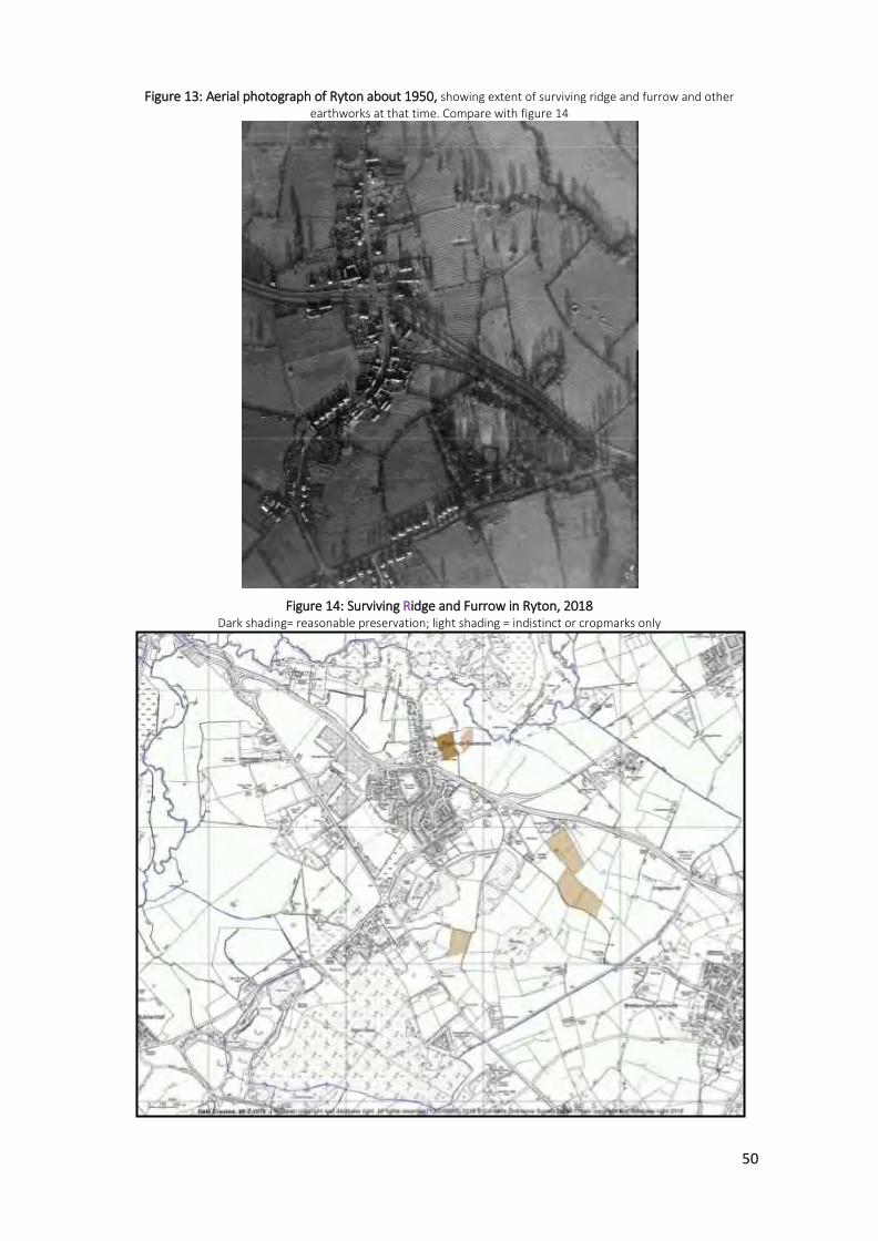
50
Figure 13: Aerial photograph of Ryton about 1950, showing extent of surviving ridge and furrow and other
earthworks at that time. Compare with figure 14
Figure 14: Surviving Ridge and Furrow in Ryton, 2018 Dark shading= reasonable preservation; light shading = indistinct or cropmarks only
51
POLICY ENV 5: RIDGE AND FURROW - The areas of ridge and furrow earthworks (map, Figure
14) are non-designated heritage assets.
Any loss or damage arising from a development proposal (or a change of land use requiring
planning permission) is to be avoided; the benefits of such development must be balanced
against the significance of the ridge and furrow features as heritage assets.
Biodiversity and habitat connectivity
Ryton’s history and location means that, from an ecological point of view, it has areas of
high biodiversity value, including two SSSIs but otherwise only a limited amount of the
Plan Area is available for wildlife. Of the (approximately) 900 hectares in the Parish, 115 is
housing, commercial and industrial development. Of remaining (undeveloped) land, 110
hectares is woodland and 10 is open water; most of the rest (some 600 hectares) is
farmland. The community wishes to protect and enhance what land remains for wildlife
and to increase the area whenever possible. This Plan recognises three opportunities, in
conformity with the letter and spirit of relevant sections of the Wildlife and Countryside
Act 1981, the Conservation of Species and Habitats Regulations 2010 and European
Council Directive 92/43/EEC of 21 May 1992 on the conservation of natural habitats and of
wild fauna and flora, for improving the Ryton situation:
Conserving the remaining areas of natural and semi-natural habitat
Welcoming local farmers’ adoption of diversification, lower-intensity management
regimes and Countryside Stewardship agreements
Encouraging and taking part in biodiversity enhancement through habitat creation.
The Parish lies within Natural England Natural Character Area 96 Dunsmore and Feldon.
NCA 96 is a DEFRA guidance document for local Planning in England, and includes the
following Statement of Environmental Opportunity:
SEO 3 Protect and manage the mosaic of habitats including woodlands, hedgerows and heathlands, particularly ancient and semi-natural woodlands, together with sustainable management of agricultural land, and new planting of woodland and heathland, where appropriate… As a response to this statement of opportunity, Community Actions ENV 1 and ENV 2
record a community aspiration to protect and enhance local biodiversity in the longer
term (see page 46) .
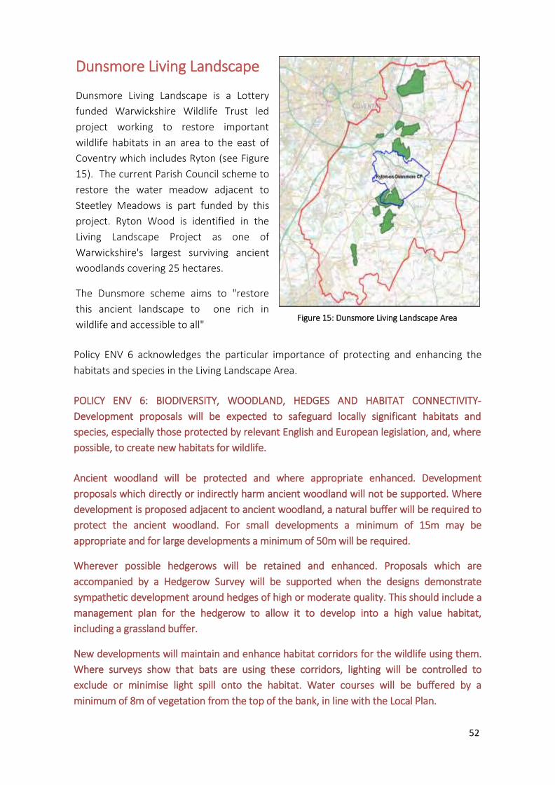
52
Policy ENV 6 acknowledges the particular importance of protecting and enhancing the
habitats and species in the Living Landscape Area.
POLICY ENV 6: BIODIVERSITY, WOODLAND, HEDGES AND HABITAT CONNECTIVITY-
Development proposals will be expected to safeguard locally significant habitats and
species, especially those protected by relevant English and European legislation, and, where
possible, to create new habitats for wildlife.
Ancient woodland will be protected and where appropriate enhanced. Development
proposals which directly or indirectly harm ancient woodland will not be supported. Where
development is proposed adjacent to ancient woodland, a natural buffer will be required to
protect the ancient woodland. For small developments a minimum of 15m may be
appropriate and for large developments a minimum of 50m will be required.
Wherever possible hedgerows will be retained and enhanced. Proposals which are
accompanied by a Hedgerow Survey will be supported when the designs demonstrate
sympathetic development around hedges of high or moderate quality. This should include a
management plan for the hedgerow to allow it to develop into a high value habitat,
including a grassland buffer.
New developments will maintain and enhance habitat corridors for the wildlife using them.
Where surveys show that bats are using these corridors, lighting will be controlled to
exclude or minimise light spill onto the habitat. Water courses will be buffered by a
minimum of 8m of vegetation from the top of the bank, in line with the Local Plan.
Dunsmore Living Landscape
Dunsmore Living Landscape is a Lottery
funded Warwickshire Wildlife Trust led
project working to restore important
wildlife habitats in an area to the east of
Coventry which includes Ryton (see Figure
15). The current Parish Council scheme to
restore the water meadow adjacent to
Steetley Meadows is part funded by this
project. Ryton Wood is identified in the
Living Landscape Project as one of
Warwickshire's largest surviving ancient
woodlands covering 25 hectares.
The Dunsmore scheme aims to "restore
this ancient landscape to one rich in
wildlife and accessible to all"
Figure 15: Dunsmore Living Landscape Area
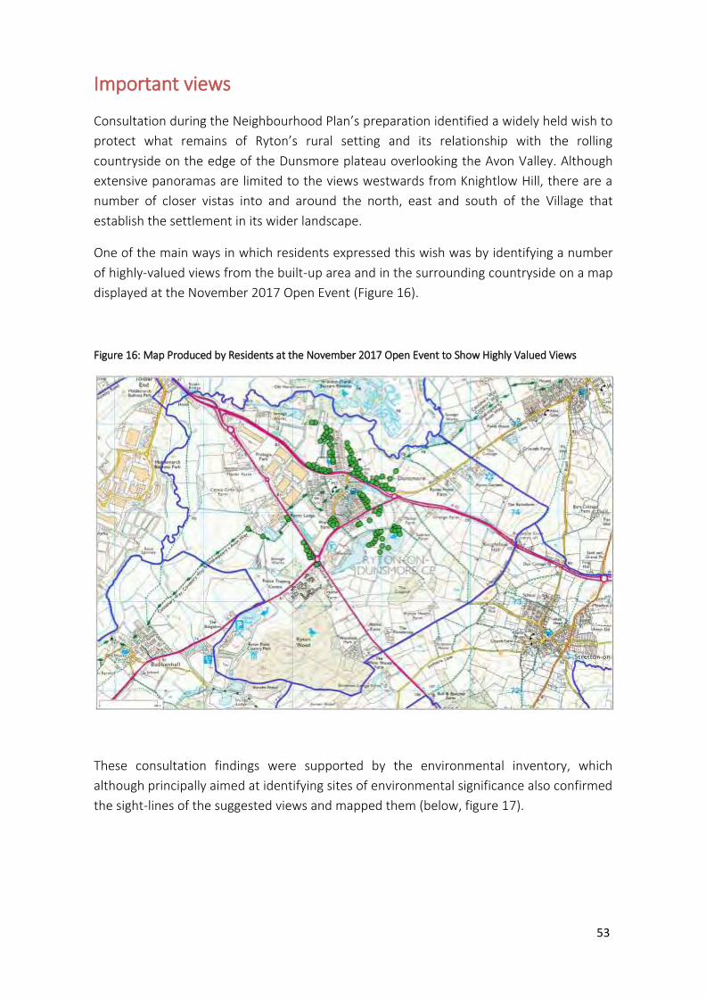
53
Important views
Consultation during the Neighbourhood Plan’s preparation identified a widely held wish to
protect what remains of Ryton’s rural setting and its relationship with the rolling
countryside on the edge of the Dunsmore plateau overlooking the Avon Valley. Although
extensive panoramas are limited to the views westwards from Knightlow Hill, there are a
number of closer vistas into and around the north, east and south of the Village that
establish the settlement in its wider landscape.
One of the main ways in which residents expressed this wish was by identifying a number
of highly-valued views from the built-up area and in the surrounding countryside on a map
displayed at the November 2017 Open Event (Figure 16).
Figure 16: Map Produced by Residents at the November 2017 Open Event to Show Highly Valued Views
These consultation findings were supported by the environmental inventory, which
although principally aimed at identifying sites of environmental significance also confirmed
the sight-lines of the suggested views and mapped them (below, figure 17).
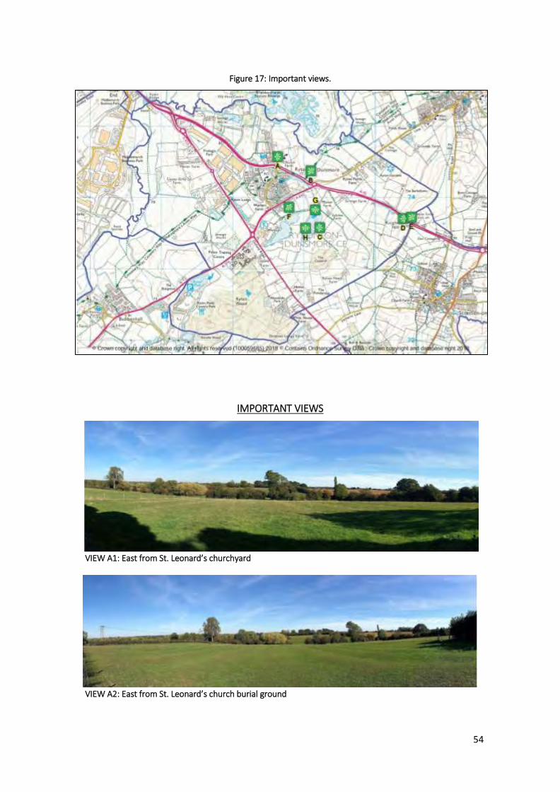
54
Figure 17: Important views.
IMPORTANT VIEWS
VIEW A1: East from St. Leonard’s churchyard
VIEW A2: East from St. Leonard’s church burial ground

55
VIEW B: Northeast from footpath to Wolston
VIEW C: East from Jubilee Pools
VIEW D: West from Knightlow Hill
VIEW E: Northwest from Knightlow Cross

56
VIEW F: Southeast from the corner of village orchard
VIEW G: South from the corner of Jubilee Pool (North fishing pool)
VIEW H: South from the corner of Jubilee Pool (South fishing pool)

57
POLICY ENV 7: PROTECTION OF IMPORTANT VIEWS – The following views (Figure 17) are
important to the setting and character of the Parish. To be supported, development
proposals must not significantly harm these views where seen from publicly accessible
locations and should include the treatment of views in any design statement.
A1: East from St. Leonard’s
churchyard
A2: East from St. Leonard’s burial
ground
B: Northeast from footpath to
Wolston
C: East from Jubilee Pools
D: East from Knightlow Hill
E: Northwest from Knightlow Cross
F: Southeast from the corner of
village orchard
G: South from the corner of Jubilee
Pool (North fishing pool)
H: South from the corner of Jubilee
Pool (South fishing pool)
Renewable energy generation infrastructure
Ryton is in Rugby Borough Council Landscape Character Type (LCT) 2 Dunsmore Plateau
Fringe, which is judged to be unsuitable (‘high’ sensitivity) for commercial wind turbine
development.
POLICY ENV 8: RENEWABLE ENERGY GENERATION INFRASTRUCTURE - Renewable energy
generation infrastructure should:
a) Not have an adverse impact (such as noise, visual impact, reflections, shadow flicker, water pollution, smell, air quality, gaseous or particulate emissions) on the health, wellbeing or amenities of residents and visitors;
b) Not have an adverse impact on the area in relation to views or the character of the surrounding landscape;
c) Be of an appropriate scale for its location;
d) Where practicable, incorporate designed-in features to enhance biodiversity in the built environment.
58
D. Community Sustainability
Introduction
In any rural community, the availability, quality and balance of local services and amenities is
vital. In Ryton, we recognise that, as our community grows, it is important to ensure that the
infrastructure grows with it, and the facilities, amenities and environment are not only
retained and protected but also enhanced. This is integral to sustaining a healthy
community, its cohesion, vitality, safety and general wellbeing.
Through the questionnaire and other events, the villagers of Ryton have expressed their
views and concerns on the following subjects relating to Community Sustainability:
Village Community
'One of the best things about Ryton is the great community spirit, with the Village Hall, School
and Church at the centre of activities, including many clubs and groups'. (Rebecca Lucas)
The value of being part of a village community is clearly important; it was highlighted by
parishioners during the consultation process (54 specific comments*). There are many
examples of the Village community working together.
The painting of the subway mural in 2011 involved more than 150 people of all ages
giving up their time to help design and paint it.
The response to the Parish Plan research in 2012 was remarkable - with nearly 70% of
the households returning their questionnaires and over 50 people then volunteering
to address the different issues raised, many of which have now been resolved.
There is also the Church Fete and evening community event which involves many
different groups and is enjoyed by villagers of all ages.
A team of volunteers drives the Village minibus to provide transport for less mobile
members of the community.
In their responses to the questionnaire, people used expressions such as 'the heart and soul'
'charm' or 'flow and feel' of the Village community. People also referred to the 'much loved
identity' or the 'individuality' of our Village and 'the importance of community spirit'
Facilities and Amenities
The community facilities and amenities that exist in Ryton make a significant contribution to
this special sense of 'community'. They have a positive impact on our sustainability;
enhancing the quality of life for residents and providing the potential for social interaction.
Our community consultations showed that many villagers were most concerned about the

59
importance of ensuring that, as the Village grows, the facilities and amenities are upgraded
and developed accordingly. (166 comments*). Many people commented on the importance
of maintaining and, if possible, improving the local bus service as a vital link with nearby
towns and facilities.
The fact that Ryton, despite lying close to Coventry, is surrounded by Warwickshire
countryside, may in part account for the considerable value the villagers place on the
surrounding green spaces both within and around the Village - recreation ground, community
orchard, fields, woodland, ponds, lakes and associated footpaths, trees, hedgerows, flowers
and wildlife. (100 comments*)
These green spaces are all invaluable community amenities, which have been separately
covered in the Environment section
Traffic Concerns
The majority of respondents expressed concerns about the potential impact that additional
housing will have on the levels of traffic congestion and road safety in the village. (185
comments*) Comments focused mainly on road safety issues, linked to the volume and
speed of traffic on the Leamington Road, Warren Field, High St and Church Rd. Parking issues
at Provost Williams CE Primary School and the Co-op were also raised.
Businesses and Employment
A thriving local economy is an important factor in a healthy community. Ryton already has the
benefit of many sizeable employers such as Keller, Marshalls/Stonemarket, UK Mail, Network
Rail and JLR, which help to explain why 78% of respondents to the questionnaire are against
further larger industrial developments within the Parish. However, a similar proportion (73%)
is supportive of further development of individual shops and offices. A number of
parishioners also work from home in a variety of different fields.
In the following pages we present policies that are intended to sustain and develop our
infrastructure as expressed in our Vision.
* Comments received either at the November 2017 Open Event or in the Neighbourhood Plan
Questionnaire responses. Reports of both these are available on the Village website and
referenced in Appendix 2
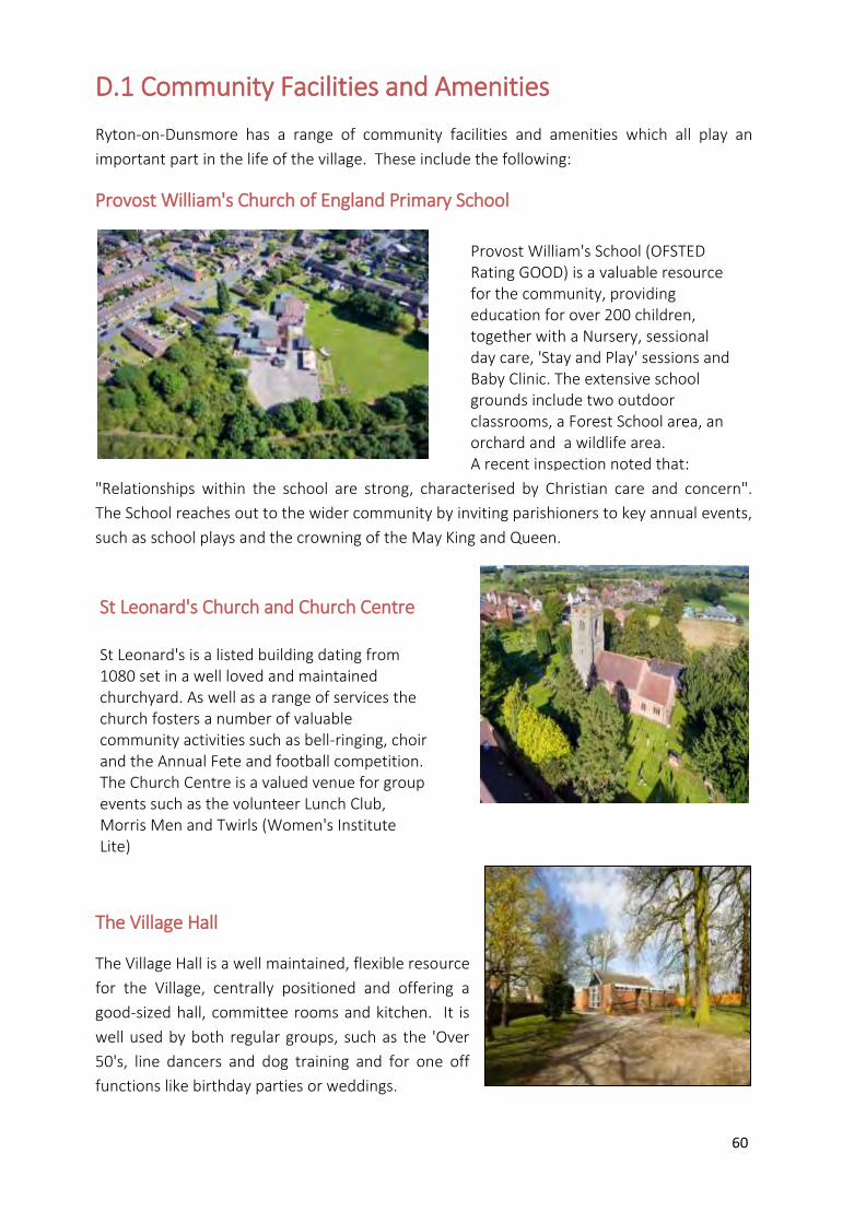
60
D.1 Community Facilities and Amenities
Ryton-on-Dunsmore has a range of community facilities and amenities which all play an
important part in the life of the village. These include the following:
Provost William's Church of England Primary School
"Relationships within the school are strong, characterised by Christian care and concern".
The School reaches out to the wider community by inviting parishioners to key annual events,
such as school plays and the crowning of the May King and Queen.
St Leonard's Church and Church Centre
The Village Hall
The Village Hall is a well maintained, flexible resource
for the Village, centrally positioned and offering a
good-sized hall, committee rooms and kitchen. It is
well used by both regular groups, such as the 'Over
50's, line dancers and dog training and for one off
functions like birthday parties or weddings.
Provost William's School (OFSTED Rating GOOD) is a valuable resource for the community, providing education for over 200 children, together with a Nursery, sessional day care, 'Stay and Play' sessions and Baby Clinic. The extensive school grounds include two outdoor classrooms, a Forest School area, an orchard and a wildlife area. A recent inspection noted that:
St Leonard's Church and Church Centre St Leonard's is a listed building dating from 1080 set in a well loved and maintained churchyard. As well as a range of services the church fosters a number of valuable community activities such as bell-ringing, choir and the Annual Fete and football competition. The Church Centre is a valued venue for group events such as the volunteer Lunch Club, Morris Men and Twirls (Women's Institute Lite)

61
The Village Hall also houses the outreach part-time Post Office. There is a desire for the Post
Office to be open more often. One of the three defibrillators is sited here too.
Village Pubs
The Parish is served by two pubs, The Malt Shovel and The Blacksmiths Arms. Both pubs are
assets to community and are supported by both locals and passing trade. The Malt Shovel
houses a defibrillator.
Shops and other amenities
The Village has a Co-operative shop, which is open 7 days a week and offers a wide range of
products. In addition, there is a free to use cashpoint. The third Parish Defibrillator is sited in
the Co-op.
Other valued Village facilities and amenities
include a Parish Burial Ground, Manor
Farm Shop, 'Summie's', a Chinese Take-
away, 'Solutions', a hairdresser's, 'New
Leaf' Gym and Connexion Sports Centre.
The parishioners of Ryton have many
different opportunities and venues for
outdoor recreation. These include the
Recreation Ground, with pavilion, football pitch, children's play area and multi-use games
area, the Holly Drive Children's Playground, Village Allotments, Community Orchard, Steetley
Meadows Conservation Area and Water Meadow, Jubilee Pools, Ryton Pools Country Park,
linked to Ryton Wood, Five Acre Community Farm and local footpaths.
The retention and enhancement of these important community facilities and amenities has
been identified as a priority for the Plan.
POLICY CF1: THE RETENTION OF COMMUNITY FACILITIES AND AMENITIES - Development
proposals that result in the loss of, or have a significant adverse effect on, an existing
community facility will not be supported, unless it can be demonstrated that
a) There is no longer any need or demand for the community facility; or
b) The community facility is, demonstrably, no longer economically viable, or able to be
supported by the community, including the potential use of fundraising and
volunteering by parishioners or others; or
c) The proposal makes alternative provision for the relocation of the community facility to
an equally or more appropriate and accessible location within the Parish which
complies with the other general policies of the Neighbourhood Plan.
Allotments
62
The Facilities and Amenities which need protecting and enhancing are as follows: St Leonard's
Church, Church Centre and burial ground, The Parish Burial Ground, the Village Hall, the Post
Office, Provost Williams Primary School, the two pubs, the Malt Shovel and the Blacksmiths
Arms, the hairdresser's, the Co-op, the Farm Shop, the Take-Away, New Leaf Gym, Five Acre
Community Farm; Ryton Organic Gardens, Village Allotments and the Connexion Sports Centre.
New community facilities
As a community we are keen to develop and enhance our community facilities to meet the
growing needs of the residents; for example, the village does not have its own Doctor's
surgery or pharmacy. Instead residents generally attend a surgery either in Wolston,
Stretton-On-Dunsmore or Chase Avenue, Willenhall. Due to the capacity of these existing
surgeries, Ryton-on-Dunsmore does not merit its own doctor's surgery. It is acknowledged,
however, that with the further development of the Village, the residents would desire
additional health care services. (45 Comments from November 2017 Open Event and
Questionnaire responses)
We also aspire to develop the following areas as suggested and supported by members of the
community: outdoor gym activity stations, year-round access to the Water Meadow,
increased days/hours of Post Office, cycle racks at key points in the village.
POLICY CF2: NEW OR IMPROVED COMMUNITY FACILITIES - Proposals that improve the quality
and/or range of community facilities, will be supported provided that the development:
a) Meets the design principles stated in Policy GD2;
b) Will not result in unacceptable traffic movements or other disturbance, to residential
properties;
c) Will not generate a need for parking that cannot be adequately catered for;
d) Is of a scale appropriate to the needs of the locality;
e) Is conveniently accessible for residents of the village wishing to walk or cycle;
f) Takes into full account the needs of people with disabilities;
COMMUNITY ACTION CF1: POST OFFICE - The Parish will seek ways to increase the number of
days/hours the outreach Post Office is open.
COMMUNITY ACTION CF2: HEALTHCARE FACILITIES - The Parish will explore ways to achieve
the provision of healthcare facilities within the Parish as its population expands.

63
School expansion
The School has, in recent years, installed bike stands and launched campaigns to encourage
both pupils and staff to cycle or walk to and from School. The County also adapted an area
outside the School gates to improve parking. Despite these measures, there continues to be
a serious problem with cars parking outside the School, on both sides of the nearby roads,
particularly at drop off and pick up times. This is a particular worry for parents, with the risk
of children running into the road between parked cars etc. and for residents, unable to access
their driveways at these times. It is not unusual for access to be so compromised that, in the
event of an accident or fire, an emergency vehicle would be unable to reach the scene.
The number of children attending the School is likely to increase following the building of
additional houses. There is therefore a pressing need to address this issue to ameliorate the
impact of further pressure on car parking around the School.
POLICY CF3: SCHOOL EXPANSION - Proposals for the expansion of Provost William's C of E
Primary School will be supported where it can be demonstrated that:
a) expansion would not exacerbate existing access related or traffic circulation problems,
unless suitable mitigation measures are brought forward as part of the proposal;
b) the development would not result in a significant loss of amenity to local residents or
other adjacent users and is in character, scale and form to the current building;
c) Safe Routes to Schools’ schemes and similar initiatives are introduced wherever
possible utilising developer contributions where appropriate.
The provision of onsite parking for staff and appropriate parking/drop off/pick up points for
parents and children will be supported.

64
D.2 Transport
Despite being bisected by the A45 dual carriageway, Ryton remains essentially a rural Parish
and it is this 'country village' quality, which residents have repeatedly stated they wish to see
protected.
The NPPF encourages a reduction in congestion and greenhouse gas emissions through the
introduction of measures, which promote a decrease in the number of journeys made by car,
and there are several actions that can be taken by individuals and by the public and private
sectors to support this objective.
The policies relating to transport therefore focus on those areas where they can have an
influence on highway safety, parking provision and the reduction of the need to travel by car.
The large majority of respondents are exercised by the potential impact that additional
housing will have on the current and future levels of traffic congestion and road safety in the
village. 83% of respondents to the Neighbourhood Plan Questionnaire indicated that if the
Village expands they would rate traffic management/calming as 'Highly Important' or
'Important'.
Traffic Management Highway Safety
Particular areas of concern are:
In spite of a traffic restrictor, speed humps, parked cars and restricted road width, some
vehicles still do not observe the speed limit. Residents have very real fears of an accident
involving the elderly or children. The danger is exacerbated by narrow pavements or, in
some areas of Church Road, no pavement at all. For this reason we would like to ensure that
there is provision in the Plan for steps to be taken to mitigate the impact of any increased
volume of traffic in the village.
Leading off the dual carriageway, the A445 Leamington Road runs through the Village. This
road is a source of particular concern to the residents of Ryton from the aspect of road
safety. (54 Questionnaire comments relate to traffic and congestion on Leamington Rd)
Speed restrictors and speed warning signals have been installed, with the aim of reducing the
speed and also the numbers of HGVs. In spite of Warwickshire Police prioritising Leamington
Road for mobile speed camera surveillance, they have conceded that they are unable to
make a significant impact on excessive average speeds.
In addition, at times of congestion on the nearby major road networks, Leamington Road
experiences considerable additional traffic leading to serious congestion.
The Parish has secured transport routing agreements with all the occupants of the Prologis
site and with Marshalls/Stonemarket and Wolston Quarry, prohibiting HGV traffic associated
with these businesses from using Leamington Rd.
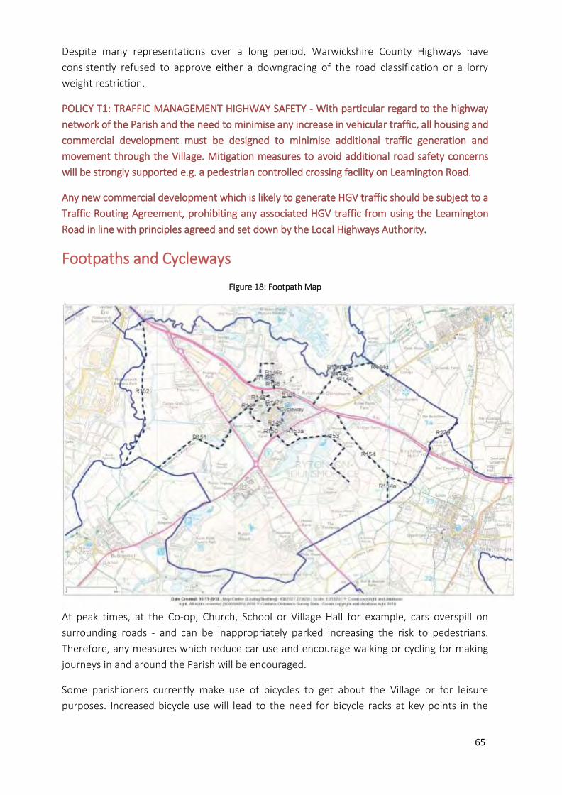
65
Despite many representations over a long period, Warwickshire County Highways have
consistently refused to approve either a downgrading of the road classification or a lorry
weight restriction.
POLICY T1: TRAFFIC MANAGEMENT HIGHWAY SAFETY - With particular regard to the highway
network of the Parish and the need to minimise any increase in vehicular traffic, all housing and
commercial development must be designed to minimise additional traffic generation and
movement through the Village. Mitigation measures to avoid additional road safety concerns
will be strongly supported e.g. a pedestrian controlled crossing facility on Leamington Road.
Any new commercial development which is likely to generate HGV traffic should be subject to a
Traffic Routing Agreement, prohibiting any associated HGV traffic from using the Leamington
Road in line with principles agreed and set down by the Local Highways Authority.
Footpaths and Cycleways
Figure 18: Footpath Map
At peak times, at the Co-op, Church, School or Village Hall for example, cars overspill on
surrounding roads - and can be inappropriately parked increasing the risk to pedestrians.
Therefore, any measures which reduce car use and encourage walking or cycling for making
journeys in and around the Parish will be encouraged.
Some parishioners currently make use of bicycles to get about the Village or for leisure
purposes. Increased bicycle use will lead to the need for bicycle racks at key points in the
66
Village such as at the Village Hall or Co-op. These, in turn, will raise the profile of cycling
within the Village.
Outside the Village, apart from the cycle lane along the A45 towards Coventry, there are no
dedicated cycle routes around the area. With the increase of traffic and the consequent
deterioration of the road surface, cycling is becoming increasingly hazardous. There is an
increasing need to provide safe cycling routes both around the Village and along surrounding
roads to connect Ryton to nearby villages and towns. This will entail negotiation with the
appropriate bodies of neighbouring parishes.
Many villagers mention the importance of footpaths and walking for leisure. Ryton is
fortunate to have many footpaths (see Figure 18). As the Village grows it will be important to
establish a means by which these can be maintained and enhanced.
POLICY T2: FOOTPATHS AND CYCLEWAYS - Development proposals should include measures to
facilitate and encourage safe access by cycle and on foot and the protection of, connection to,
and extension where practicable of existing pedestrian and cycle routes.
Where the diversion of a footpath or cycleway is necessary, or where a route is absorbed into a
development proposal, the route should be designed and bounded to retain its character.
The creation of new footpaths, or the enhancement of existing footpaths, to encourage
walking from the new developments to the village amenities for leisure and wellbeing, is
supported.
COMMUNITY ACTION T1: CYCLE LANES - The Parish will seek to increase the number of
dedicated cycle lanes to link Ryton to surrounding villages, stations etc. where possible
enhancing/developing cycle lanes within the Parish and negotiating with appropriate bodies
outside of the Parish.
COMMUNITY ACTION T2: FOOTPATH MAINTENANCE - The Parish will work with the
community and appropriate bodies to ensure the ongoing maintenance and enhancement of
footpaths within the Parish.
Community transport
Many residents are reliant on the bus service to reach nearby towns and find the service
restricted. (26 comments in Questionnaire responses). There is a village minibus which,
through volunteers, provides regular visits to a local shopping centre and transport for the
different activities that take place in the Village. There is the potential to develop a
community transport system to support villagers who do not have cars with transport to
opticians, dentists, hospital appointments etc.
COMMUNITY ACTION T3: COMMUNITY TRANSPORT - The Parish will seek to develop its own
voluntary community transport scheme for residents without transport as a means to increase
mobility and reduce isolation.
67
D.3 Businesses and Employment
Ryton has seen a huge change in the local employment scene in the recent past. The Parish
was home to a major car assembly operation from the Second World War until 2006 when
the then owner, Peugeot, closed the plant with the loss of 2,300 jobs.
The site has since been completely redeveloped and is now home to a mixture of smaller
manufacturing and distribution operations. Compared with surrounding parishes, Ryton
already has the benefit of many sizeable employers such as Keller, Marshalls/Stonemarket,
UK Mail, Network Rail and JLR.
While we recognise that these companies provide valuable employment opportunities - vital
for a thriving community such as Ryton - it has to be understood that an increase in traffic
congestion within the Village has been a significant negative consequence of the large-scale
redevelopment of the commercial sites in and around the Parish. This in part explains the
result from the Neighbourhood Plan Questionnaire where 78% of respondents were against
further larger industrial developments within the Parish.
However, there was a much more positive response with regard to further development of
individual shops and offices with 73% people being in support (31 specific comments relating
to needing additional shops).
For economic activity to thrive in the Parish, it is important that the necessary infrastructure
exists. Consequently, in order to protect and strengthen the economic base within the Parish,
where there are buildings dedicated to business use in the Parish they should be protected
against being lost to other uses.
POLICY BE1: SUPPORT FOR EXISTING BUSINESSES and EMPLOYMENT OPPORTUNITIES - There
will be a strong presumption against the loss of commercial premises or land that provides
employment or future potential employment opportunities. Applications for a change of use to
an activity that does not provide employment opportunities will only be supported if it can be
demonstrated that:
a) The commercial premises or land in question has not been in active use for at least 12
months; and
b) The commercial premises or land in question has no potential for either reoccupation
or redevelopment for employment generating uses and as demonstrated through the a
full valuation report.
New employment initiatives can help to boost and diversify the local economy, thus providing
more local employment opportunities.
Parishioners have been clear that any new employment initiatives should be small-scale, such
as individual shops and offices. Employment proposals should only be approved if they avoid
harmful impacts on other matters agreed to be locally important. For example, over 90%, of
68
respondents to the Neighbourhood Plan Questionnaire felt that any commercial
development should only be allowed if it could be shown not to increase heavy goods traffic,
not to be detrimental to visual amenity and not to have a negative environmental impact on
neighbouring properties.
POLICY BE2: SUPPORT FOR NEW BUSINESSES AND EMPLOYMENT - In supporting additional
employment opportunities, new development will be required to:
a) Be of a size and scale not adversely affecting the character, infrastructure and environment
of the Parish, including the countryside;
b) Not generate unacceptable levels of traffic movement and on-road parking and make
appropriate off-road parking provision;
c) Fall within the boundary of planned limits of development for Ryton-on-Dunsmore Parish,
unless it relates to small scale leisure or tourism activities, the sensitive extension of
existing commercial premises or other forms of commercial/employment related
development appropriate to a countryside location;
d) Where possible, be sited in existing buildings or on areas of previously developed land;
e) Not involve the loss of dwellings;
f) Not increase noise levels or light pollution or introduce any pollution to an extent that they
would unacceptably disturb occupants of nearby residential property;
g) Contribute to the character, the design of the local built environment and the vitality of the
local area.
Home working
There is an increasing trend for residents to work from home, either whole or part time. A
targeted survey revealed that home workers in the village include hairdressers, book keeper,
beautician, furniture restorer, project manager, business consultant, Borough Councillor.
With improving internet connectivity locally and changing employment patterns nationally,
this trend is likely to continue, making the Parish a place where a greater percentage of the
population are spending more of their time within the Parish. This could create opportunities
for joint working, business hubs, support groups and room hire for meetings.
A key benefit of supporting home working is that it helps to promote local employment
activities whilst reducing dependency on the car for journeys to employment sites outside
the Parish. This, in turn, can help to reduce traffic volume within the Parish.
However, it is recognised that people may not have a suitable space within their home from
which to run a business, or they may wish to distinctly and deliberately separate their work
and living spaces. The construction of extensions, the conversion of outbuildings, and the
69
development of new freestanding buildings in gardens from which businesses can operate
will be supported. This is intended to maximise the opportunities for entrepreneurial activity
and employment in the Parish.
POLICY BE3: HOME WORKING - Proposals for the use of part of a dwelling for office and/or light
industrial uses, and for small-scale free-standing buildings within its curtilage, extensions to the
dwelling or conversion of outbuildings for those uses, will be supported where:
a) Such development will not result in unacceptable traffic movements and that
appropriate parking provision is made;
b) No significant and adverse impact arises to nearby residents or other sensitive land
uses from noise, fumes, light pollution, or other nuisance associated with the work
activity; and
c) Any extension or free-standing building is designed having regard to policies in this Plan
and does not detract from the quality and character of the building to which they are
subservient by reason of height, scale, massing, location or the facing materials used in
their construction.
Broadband infrastructure
The modern economy is ever evolving and increasingly requires a good communications
infrastructure to maximise technological advances. High-speed Internet connectivity is driving
business innovation and growth, helping people access services, and opening up new
opportunities for learning. This is important for the Parish, where better broadband enables
improved access to an increasing number of on-line applications and services, provided by
the public and private sector. This can help to significantly reduce social exclusion and create
business and employment opportunities. 90% of those responding to the Neighbourhood
Plan Questionnaire felt that good broadband coverage and speed is important as the Village
expands.
Responses to a question about supporting infrastructure for home workers included the
following comments:
'Poor mobile coverage and broadband speeds - this is how I do a lot of my admin and
marketing'
'Unfortunately, our connection is very poor (2mbps, 3 on a good day, worse if the
weather is wet or windy.)'
'Project manager and need to connect to the work servers which is a nightmare.'
‘As the internet crashes so often .... I lose work.'
70
It is crucial that all efforts are made to enable all businesses and households in the Parish to
access superfast broadband. Additionally, communications technology is progressing at pace
with new developments over the life of this Plan being inevitable. The Parish wishes to take
advantage of these developments for the benefit of its Parishioners.
POLICY BE4: BROADBAND INFRASTRUCTURE - Proposals to provide access to superfast
broadband for all commercial and domestic developments in Ryton-on-Dunsmore Parish will be
supported.
Improvements to the mobile telecommunication network that will serve all businesses and
households within the Parish will be supported.
Where new masts are installed, these should be shared where possible by more than one
provider.
Any infrastructure improvements, possibly requiring above ground network installations, must
be sympathetically located, designed to integrate into the landscape and not be in or near to
open landscapes.
Any new building should make allowance for fibre to be installed using underground ducting.
All new buildings must provide the capability specified by the Government for above and below
ground access and mobile radio.

71
8. Community Actions
The Community Actions identified in the preparation of this Plan are presented in context
through the document and are listed here as a summary.
The aspiration is to progress these Community Actions, whilst acknowledging that the ability
to do so will in many cases depend upon residents volunteering their time, energy and skill to
convert them into action. The Parish Council may in some cases be the appropriate body to
provide some oversight.
COMMUNITY ACTION ENV 1: IMPORTANT OPEN SPACES - The Parish Council will actively work
with Rugby Borough Council, landowners, the community and other partners to secure the
protection of the locations and features of the following sites (listed in Policy ENV 3, mapped in
Figure 10 and detailed in Appendix 6) through the confirmation as existing, or designation as
new, Open Space, Sport and Recreation (OSSR) sites in appropriate typologies.
COMMUNITY ACTION ENV 2: HOLLY DRIVE AND CEDAR AVENUE GREEN SPACE
• Immediate action to resolve the current overgrown areas and clearance of debris in water
features.
• Review and assess waterways for general debris.
• Open communication channels with Warwickshire Wildlife Trust to identify steps to improve
the wildlife habitat.
• Develop a long term maintenance schedule for the entire space.
COMMUNITY ACTION CF 1: POST OFFICE - The Parish will seek ways to increase the number of
days/hours the outreach Post Office is open.
COMMUNITY ACTION CF2: HEALTHCARE FACILITIES - The Parish will explore ways to achieve
the provision of healthcare facilities within the Parish as its population expands.
COMMUNITY ACTION T1: CYCLE LANES - The Parish will seek to increase the number of
dedicated cycle lanes to link Ryton to surrounding villages, stations etc. where possible
enhancing/developing cycle lanes within the Parish and negotiating with appropriate bodies
outside of the Parish.
COMMUNITY ACTION T2: FOOTPATH MAINTENANCE - The Parish will work with the community
and appropriate bodies to ensure the ongoing maintenance and enhancement of footpaths
within the Parish.
COMMUNITY ACTION T3: COMMUNITY TRANSPORT -The Parish will seek to develop its own
voluntary community transport scheme for residents without transport as a means to increase
mobility and reduce isolation.
72
9. Infrastructure Requirements
All development has the potential to impact on the environment and place pressure on local
infrastructure and services. It is recognised that the planning system should be used to ensure
that new development contributes positively to the local environment and helps to mitigate
against any adverse impacts on infrastructure.
Appropriate infrastructure is therefore critical to support the provision of development. This is
not only to ensure that the new development is properly served in respect of essential day-to-
day infrastructure required by the occupants of any new development but also to minimise
the impact upon existing infrastructure.
However, the NPPF stresses that the need for infrastructure accompanying development must
have regard for the viability of that development. Planning Practice Guidance (PPG 46) also
recognises the ability of Neighbourhood Plans to identify the need for new or enhanced
infrastructure but requires them to prioritise the infrastructure requirements.
Provision of the necessary physical and community infrastructure arising from proposed
development is therefore a critical component of the Plan, which has identified a range of
potential infrastructure requirements through its production.
Funding for new infrastructure is currently provided through a legal agreement (often referred
to as a Section 106 Agreement) between the Borough Council and the applicant, along with
other parties involved in the delivery of the specific infrastructure improvement (such as the
County Council Education Department in relation to the impact on school places).
The potential introduction of what is known as a Community Infrastructure Levy (CIL)
introduces charges to be applied according to the scale and type of development, and these
funds are then used to contribute towards the infrastructure requirements of development.
The provision of these diverse elements of infrastructure needs to be timely if deficiencies are
to be avoided. The infrastructure requirements identified and detailed within The Plan are
summarised in the policy below:
POLICY INF 1: DEVELOPER CONTRIBUTIONS – Where policies in this Plan require contributions to
community infrastructure, they will be made through contributions through Section 106
agreements or the Community Infrastructure Levy (CIL) where applicable.
The following projects are identified as priorities for investment in local community infrastructure:
Outdoor gym activity stations,
Year-round access to the Village Water Meadow (adjacent to Steetley Meadows),
Cycle Racks at key points in Village e.g. Co-op, Church, Village Hall
Conversion/fitting out of appropriate space for use as surgery/clinic in the event of a Health Care Facility being set up.
Extra provision of cycle lanes.
73
10. Monitoring and Review
The Neighbourhood Plan will last until 2031. During this time, it is likely that the
circumstances which the Plan seeks to address will change.
The Neighbourhood Plan will be regularly monitored. This will be led by Ryton on Dunsmore
Parish Council on at least an annual basis. The policies and measures contained in the
Neighbourhood Plan will form the core of the monitoring activity, but other data collected
and reported at the Parish level relevant to the delivery of the Neighbourhood Plan will also
be included.
The Parish Council proposes to formally review the Neighbourhood Plan in 2023 or to
coincide with the review of the Rugby Local Plan if this cycle is different.

Publication of Decision under Regulation 7 of the Neighbourhood Planning (General) Regulations 2012
Ryton on Dunsmore Parish Council’s application to Rugby Borough Council for the designation of the area defined by the Civil Parish of Ryton on Dunsmore, as shown on the map below, as a Neighbourhood Area for the purpose of neighbourhood planning is APPROVED.
Date of Decision: 11th October 2016
This decision notice and the map of the area is viewable on https://www.rugby.gov.uk/rytonondunsmorenp For further information on Neighbourhood Planning please email [email protected] or call 01788 533631
Appendix 2
Ryton on Dunsmore Neighbourhood Plan
2018-2031
Consultation Statement
needhm
Rectangle

2
Ryton-on-Dunsmore Neighbourhood Plan 2018-2031
Consultation Statement
This Consultation Statement has been prepared to comply with the requirements of Section 15(2) of
Part 5 of the Neighbourhood Plan Regulations 2012
Contents Page
Getting Started 3
Initial Engagement 3
Setting up the Steering Committee and Initial Consultation 3
Vision Statement 4
Neighbourhood Plan Questionnaire 4
November 2017 Open Event 5
Focus Groups 6
Site Sustainability Assessment 6
Engagement of Young People 7
November 2018 Open Event 8
Liaison with Rugby Borough Council 8
Local Listing of Heritage Assets 9
Regulation 14 Consultation 10
Conclusion 11
Attachments:
1. Neighbourhood Plan Documents available on the Village Website 12
2. Village Newsletter Articles about the Neighbourhood Plan 13
3. Getting Started and Launch Event Flyer 17
4. Neighbourhood Plan Steering Committee Meeting Dates 18
5. Introductory Village Flyer 19
6. Neighbourhood Plan Vision Post-Survey Changes February 2018 20
7. Neighbourhood Plan Questionnaire Distribution Process 22
8. Covering Note for the Neighbourhood Plan Questionnaire Report 24
9. Letter of Invitation to Focus Groups Launch Event 25
10. List of Landowners Contacted Regarding Site Sustainability Assessment 26
11. Notes from Meetings with Landowners of Sites Proposed for Allocation 29
12. Reports on Consultation with
(a) Primary School Children and 31
(b) Young People 33
13. Letter to Prospective Heritage Site Owners 36
14. List of Stakeholders informed of the Regulation 14 Consultation 37
Items referenced as being available on the Village Website can be found at: www.ryton-on-dunsmore.org.uk under 'Parish Council', 'Our Neighbourhood Plan'
3
Getting Started
The Parish Council resolved at its September 2016 meeting to proceed with the preparation of a
Neighbourhood Plan.
This meeting also resolved to apply to Rugby Borough Council (RBC) for the designation of the Plan
area to be the whole civil parish of Ryton-on-Dunsmore. This area designation was confirmed by
RBC on 11th October 2016.
Initial Engagement
The decision to proceed with the Plan was communicated to the Village in the October 2016 Village
Newsletter (which is distributed to every household). The article is reproduced in Attachment 2
together with articles in subsequent editions which have been used to update the Village on
progress with the Plan's development.
The April 2017 meeting of the Parish Council resolved to:
a) appoint YourLocale to act as consultants for the preparation of the Plan
b) launch the Plan process at the Annual Village Meeting on 17th May 2017.
Advertising this launch event was through posters on village notice boards together with a flyer
which was distributed to every household. This is shown in Attachment 3 together with the
relevant Parish Council meeting minutes. At the event, attended by 25 residents and Councillors, a
presentation was given describing the process of preparing the Neighbourhood Plan. Eight residents
indicated that they were interested in helping with the preparation of the Plan in addition to six
Councillors.
Setting Up the Steering Committee and Initial Consultation
The June 2017 Parish Council Meeting resolved to establish a Neighbourhood Plan Steering
Committee as a sub-committee of the Parish Council. The introductory meeting was held on 26th
June 2017 and the Steering Committee was formed with seven residents and seven councillors and
Terms of Reference agreed. The Committee met 16 times up to Plan Submission. The dates of these
meetings are shown in Attachment 4.
The agendas and minutes of all the meetings can be found on the Village Website.
The initial key objectives of the Committee were determined as:
Communication with the Village
Preparation of a Vision Statement
Design of a Village Questionnaire

4
The initial communication objective was met with a professionally produced flyer (Attachment 5 and
Village Website) delivered to all households in September 2017 with the title:
"So what's all this about a Neighbourhood Plan for Ryton?"
This flyer aimed to:
explain the purpose and benefits of a Neighbourhood Plan
describe the process
answer key questions
seek additional volunteers.
Vision Statement
The initial draft of the Vision for the Village was prepared based on the community feedback in the
Parish Plan published in 2012. This draft Vision was presented at the November 2017 Open Event
and included in the Village Questionnaire (see below).
Respondents were asked if they would support the use of this vision in the Neighbourhood Plan and
were invited to comment/suggest changes. 98%(491) of respondents indicated support.
However, there were a number of comments made which were analysed in detail leading to some
proposed amendments to the Vision. This analysis of the Vision feedback and the resulting changes
approved by the Steering Committee at their 13.03.18 meeting are shown in Attachment 6.
Neighbourhood Plan Questionnaire
The Neighbourhood Plan Questionnaire was prepared by a sub-group of the Steering Committee.
The version as delivered to every household is on the Village Website.
The Questionnaire sought the Villagers' views on the type, scale, location and designs of future
housing and commercial development in the Village together with questions on what aspects of the
Village need protecting and what amenity improvement should be prioritised as the Village grows.
All residents from the age of 12 were invited to complete a questionnaire. The process ran from mid
November through December 2017.
In order to maximise engagement, each household was visited by a member of the Steering
Committee to deliver their copies, explain the importance of the process and answer any questions.
Villagers could respond on a paper copy (which we called to collect) or online. The process is
detailed in Attachment 7.
We received 531 returned Questionnaires from 731 households, 114 online and 417 paper copies.
Of the total target population of aged 12 and above this strictly represents a 34% return. However
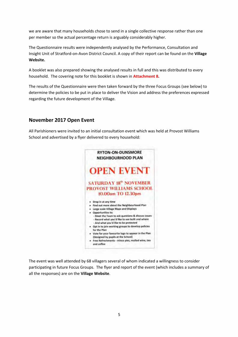
5
we are aware that many households chose to send in a single collective response rather than one
per member so the actual percentage return is arguably considerably higher.
The Questionnaire results were independently analysed by the Performance, Consultation and
Insight Unit of Stratford-on-Avon District Council. A copy of their report can be found on the Village
Website.
A booklet was also prepared showing the analysed results in full and this was distributed to every
household. The covering note for this booklet is shown in Attachment 8.
The results of the Questionnaire were then taken forward by the three Focus Groups (see below) to
determine the policies to be put in place to deliver the Vision and address the preferences expressed
regarding the future development of the Village.
November 2017 Open Event
All Parishioners were invited to an initial consultation event which was held at Provost Williams
School and advertised by a flyer delivered to every household:
The event was well attended by 68 villagers several of whom indicated a willingness to consider
participating in future Focus Groups. The flyer and report of the event (which includes a summary of
all the responses) are on the Village Website.

6
Focus Groups
All those who had expressed an interest at the Open Day were invited to a Focus Groups Launch
Event on 18th January 2018 (Attachment 9). The event was also advertised in the Village
Newsletter.
Three Focus Groups were established at this meeting:
Housing
Environment
Community Sustainability
They were tasked with taking all the information obtained from the Questionnaire and Open Event
and developing policies for the Plan which addressed the identified needs, ambitions and
preferences.
Site Sustainability Assessment
An assessment of all potential development sites in the Parish was carried out in conjunction with
local landowners. All sites with boundaries adjoining the Village Limits to Development were
included together with some remote brownfield sites.
The landowners were identified by a Land Registry search and asked by letter to complete a
questionnaire describing their site and indicate if they would like it to be included in the assessment.
The list of landowners contacted is shown in Attachment 10.
Twenty-four potential sites were assessed using a standard methodology with criteria determined by
the Housing Focus Group.
The full results of each assessment were fed back by letter to the relevant landowner who was
invited to comment. Responses were received from two landowners which, following consideration
by the Housing Focus Group, resulted in minor revision to the site scores in both cases. The results
of this assessment led to the recommendation to allocate three sites in the Plan:
The Sky Blues Training Ground site (in line with the Rugby Local Plan)
The former British Legion site (for limited development to enable the restoration of the
listed building and registered garden)
Lamb's Field as a Safeguarded site.
Meetings have been held with the owners or representatives of these three sites all of whom have
confirmed their support for our allocation proposals. Notes of the meetings are in Attachment 11.
Discussions have also been held with Historic England regarding the former British Legion site to
ensure that the provisions of this allocation address the concerns to avoid harm to the designated
heritage assets. RBC has also been consulted to ensure that the proposed housing strategy is in
conformance with the Local Plan.
7
Engagement of Young People
At the first Steering Group meeting it was decided to involve the children at the Village primary
school in a competition to design a logo for the Neighbourhood Plan. The idea was enthusiastically
taken up by the Head Teacher and we received over a hundred entries depicting the children's ideas
of what the Village means to them and the areas they cared about This was judged by those
attending the first Open Event and the winning entry used as our logo.
We then held two further events:
A practical activity held over two afternoons, involving Year 5 children at the school to
enable and encourage them to focus on which amenities and facilities would be most
important to them as the Village grew. (See Attachment 12a)
An informal discussion with a group of young people aged between 12 and 17 who live in
the Village. The discussion was based around a small number of questions, starting with a
conversation about features that make for an ideal community and leading on to how they
felt about living in a village and considerations of the kinds and numbers of houses they felt
would be appropriate for the Village in the future. (See Attachment 12b)
The views of the young people made a valuable contribution to the development of the policies in
the Plan.
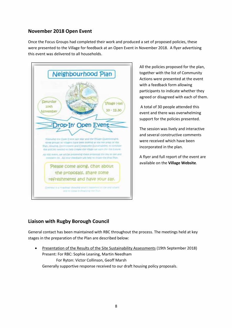
8
November 2018 Open Event
Once the Focus Groups had completed their work and produced a set of proposed policies, these
were presented to the Village for feedback at an Open Event in November 2018. A flyer advertising
this event was delivered to all households.
Liaison with Rugby Borough Council
General contact has been maintained with RBC throughout the process. The meetings held at key
stages in the preparation of the Plan are described below:
Presentation of the Results of the Site Sustainability Assessments (19th September 2018)
Present: For RBC: Sophie Leaning, Martin Needham
For Ryton: Victor Collinson, Geoff Marsh
Generally supportive response received to our draft housing policy proposals.
All the policies proposed for the plan,
together with the list of Community
Actions were presented at the event
with a feedback form allowing
participants to indicate whether they
agreed or disagreed with each of them.
A total of 30 people attended this
event and there was overwhelming
support for the policies presented.
The session was lively and interactive
and several constructive comments
were received which have been
incorporated in the plan.
A flyer and full report of the event are
available on the Village Website.
9
Review of the Draft of the Pre-Submission Version of the Plan (7th November 2018)
Present: For RBC: Sophie Leaning, Martin Needham
For Ryton: Victor Collinson, Gary Kirk, Geoff Marsh
Comments received from RBC on twelve of our proposed Policies which we have
endeavoured to incorporate in the revised document.
Review of Regulation 14 Comments (28th February 2019)
Present: For RBC: Sophie Leaning, Martin Needham
For Ryton: Gary Kirk, Geoff Marsh
Historic England were also invited to this meeting to discuss the former British Legion site
allocation but were unable to attend. They did however provide written advice on revised
wording for the allocation to address the concerns they had expressed in their comments.
This has now been incorporated.
It was agreed that all the other comments required only minor revision to the Plan. RBC also
confirmed that our inclusion of a limit of 'less than five dwellings' in the Windfall Sites Policy
was in conflict with the Rugby Plan. This has since been removed.
Local Listing of Heritage Assets
A total of 26 buildings/sites were identified from discussion with various residents for possible
inclusion on a local listing of Heritage Assets.
The owners of all these sites were contacted by letter for their feedback (see Attachment 13).
We received eight responses with six owners requesting that their properties were not included in
the list. These have subsequently been removed. (The owner responses are included in the Pre-
Submission Consultation Responses document on the Village Website)
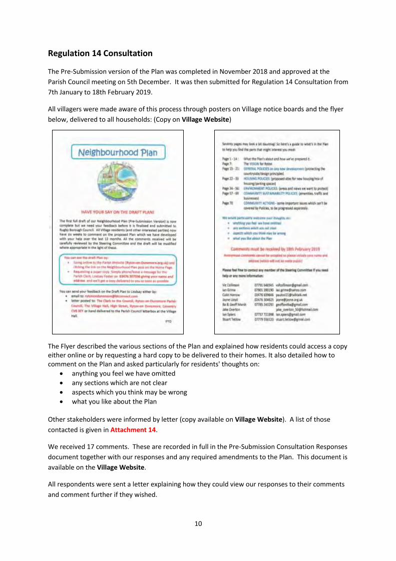
10
Regulation 14 Consultation
The Pre-Submission version of the Plan was completed in November 2018 and approved at the
Parish Council meeting on 5th December. It was then submitted for Regulation 14 Consultation from
7th January to 18th February 2019.
All villagers were made aware of this process through posters on Village notice boards and the flyer
below, delivered to all households: (Copy on Village Website)
The Flyer described the various sections of the Plan and explained how residents could access a copy either online or by requesting a hard copy to be delivered to their homes. It also detailed how to comment on the Plan and asked particularly for residents' thoughts on:
anything you feel we have omitted
any sections which are not clear
aspects which you think may be wrong
what you like about the Plan
Other stakeholders were informed by letter (copy available on Village Website). A list of those
contacted is given in Attachment 14.
We received 17 comments. These are recorded in full in the Pre-Submission Consultation Responses
document together with our responses and any required amendments to the Plan. This document is
available on the Village Website.
All respondents were sent a letter explaining how they could view our responses to their comments
and comment further if they wished.

11
Conclusion
We believe that the focus on broad consultation has resulted in a Plan which has identified
and addressed the key needs and preferences of the Village and other stakeholders during the Plan
period.
The Neighbourhood Plan Steering Committee would like to thank all those residents who helped
with the preparation of this Plan through participation in meetings and open events, responding to
the questionnaire, commenting on the pre-submission draft and general informal discussion.

12
Attachment 1
Neighbourhood Plan Documents available on the Village Website
www.ryton-on-dunsmore.org.uk
under 'Parish Council', 'Our Neighbourhood Plan'
Submission Version of our Neighbourhood Plan:
Plan Document
Appendix 1 Statement of Basic Conditions
Appendix 2 Consultation Statement
Appendix 4 Housing Needs Report
Appendix 3 Ryton Census 2011 Profile
Ryton Land Registry Data 1995-2016
Appendix 4 Housing Needs Report
Appendix 5 Site Sustainability Assessments
Appendix 6 Environmental Inventory
Appendix 7 Non-Designated Heritage Assets
Supporting Documents and Information:
Parish Council minutes confirming acceptance of the Submission Version
Designated Neighbourhood Plan Area - Map and Decision notice
Other Maps and Figures
Pre-Submission Version of our Neighbourhood Plan:
Plan Document
Regulation 14 Letter to Stakeholders
Pre-Submission Flyer
Pre-Submission Responses
Key Documents from Plan Preparation:
Neighbourhood Plan Progress Report December 2018
Drop-in Event November 2018 Report
Drop-in event held at the Village Hall November 2018 to present the policies (Flyer)
Focus Group Event at Village Hall (Focus Groups invite)
Young People Consultation Report
Neighbourhood Plan Questionnaire Results Report
Neighbourhood Plan Questionnaire distributed to the Village November 2017
Open Event November 2017 Report
Open event held at Provost Williams School November 2017 (Flyer)
Neighbourhood Plan Steering Committee Minutes and Agendas
Introductory Village Flyer September 2017
Launch Event Flyer May 2017
13
Attachment 2
Village Newsletter Articles about the Neighbourhood Plan
(1) October 2016
Neighbourhood Plan Also on the planning theme, all parishes are being encouraged to develop their own Neighbourhood Plans. A Neighbourhood Plan is a statement of policies intended to determine the quality, quantity and location of new development in our community. It will be developed by the Parish Council but based on extensive community consultation. It is different from the Parish Plan we prepared four years ago in that:
It is more narrowly focussed, dealing specifically with land use (i.e. housing and commercial development)
Will be put to the Village for approval in a referendum.
Has legal status once approved and MUST be taken into account in any future planning decisions.
It is clear that the Neighbourhood Plan process is part of the Government's push for more 'localism' to ensure that local communities have a significantly greater say in development decisions in future. If we don't participate we will miss this chance. Based on other parishes' experiences, simply put, the process requires a group of about 15 villagers, 18 months and some funding (grants available). We have to work through a structured process, engaging with the Village and involving the local Planning Authority with a village referendum to approve the Plan as a final step. We have taken the first step of applying to Rugby with our proposal of the scope that our NP should cover. We need now to get together the team which is going to take this forward. If you think you might be interested in taking part or just want to find out more before committing please contact Geoff Marsh (07785243293, [email protected] or 99, High Street) or any other Parish Councillor or the Clerk. This is a one-off opportunity to help shape the future of our Village. Please give some serious thought to playing a part and joining the Team.
(2) July 2017
Neighbourhood Plan
Things are happening! A Steering Committee has been set up to start preparing the Neighbourhood
Plan for Ryton. To find out more and see how you might become involved, look out for the flyer
which will be appearing through your letterbox shortly!
14
(3) November 2017
Neighbourhood Plan
By the time you read this you should have had a copy of the Neighbourhood Plan Questionnaire
delivered. As it says this is your opportunity to express your views on the future of Ryton so please
complete it if you can. All residents from the age of 12 are welcome to either:
Complete a paper copy which will be collected from your door. If you need extra copies
these can be downloaded from the village website (www.rytonondunsmore.org.uk). Or ask
any of the Neighbourhood Plan team listed on the back of the questionnaire for extra copies.
Or you can complete it on-line on the village website.
(4) January 2018
Ryton Neighbourhood Plan
Update
Many thanks to everyone who completed the Neighbourhood Plan Questionnaire. The total number
of returns was 543 which is a terrific result. These are currently being analysed and the results will
form an important part of the Plan.
Thank you also to those who attended the Open Event at School in November. Again we got a lot of
very useful information and feedback to help with the preparation of the Plan.
Focus Groups Launch Event
The next step is to set up three Focus Groups to look at the key aspects of:
Housing
Environment
Community Facilities These Groups will meet over a 3 to 4 month period. Their aim will be to establish the key objectives (arising from the analysis of the feedback you have given us) and then work on policies to enable them to be achieved. A number of villagers have already indicated that they would be interested in joining a Focus Group
but we are looking for more volunteers.
We have planned a Focus Groups Launch Event on Thursday 18th January in the
Village Hall at 7.00pm. At this meeting we will summarise what has happened so far and discuss how the Focus Groups are going to work. The Neighbourhood Plan is a one-off opportunity for us to have a much greater say in how our village develops. The Focus group activity is at the heart of the Neighbourhood Planning process and the work they do will really bring the plan together. We are not looking for a huge time commitment
15
- each Focus Group is likely to meet 4 to 6 times over the 3 or 4 months - so please do give some serious thought to getting involved. Coming along to the meeting does not in any way commit you to joining a group - but it does give you the chance to hear about the plans and decide if you would like to take part. If you would like to find out more before the meeting please contact Geoff Marsh (07785243293, [email protected], 99 High Street). Hope to see you at the meeting.
(5) July 2018
Progress with the Ryton Neighbourhood Plan In the early part of this year we've had three 'Focus Groups' looking into the key parts of the Neighbourhood Plan:
Housing
Environment
Community Sustainability
They have been using the information collected at the Open Event last year and through the recent Neighbourhood Plan Questionnaire to develop policies for the Plan which will help us achieve our vision for the future of Ryton. This is the vision which was set out in the Questionnaire and which the responses indicated was strongly supported. There will be another Open Event in the autumn when we will have the draft Neighbourhood Plan policies available for everyone to see and comment on before they are finalised. Details of the event will be available in the next newsletter. Meanwhile if you have any questions about the Plan please contact the Clerk to the Council, Lindsay Foster, at [email protected] or 02476307336
(6) December 2018 Neighbourhood Plan Open Event
Many thanks to everyone who came to the recent Neighbourhood Plan Open Event in the Village Hall. We presented the policies we are proposing to put in the Plan to shape the way the village develops in the future. We received a lot of very useful feedback which was almost totally in support of these proposals. But if you missed it, don't worry, you'll have another chance to see the draft Plan and comment on it when it goes out for a six week public consultation period which will probably be either side of Christmas.

16
(7) January 2019 Consultation on Neighbourhood Plan - Have Your Say!
As you will have seen from other publicity, you currently have the opportunity to comment
on Ryton's draft Neighbourhood Plan during the six week consultation period.
If you haven't already done so you can see the draft Plan by either:
Going online to the Parish Website (Ryton-on-Dunsmore.org.uk) and clicking the link on the Neighbourhood Plan post on the Home Page.
Requesting a paper copy. Simply phone/leave a message for the Parish Clerk, Lindsay Foster on 02476 307336 giving your name and address and we'll get a copy delivered to you as soon as possible
You can send your feedback on the Draft Plan to Lindsay either by:
email to: [email protected]
letter posted to: The Clerk to the Council, Ryton-on-Dunsmore Parish Council, The
Village Hall, High Street, Ryton-on Dunsmore, Coventry CV8 3EY or hand delivered
to the Parish Council letterbox at the Village Hall.
We would particularly welcome your thoughts on:
anything you feel we have omitted
any sections which are not clear
aspects which you think may be wrong
what you like about the Plan
Comments must be received by 18th February 2019 Anonymous comments cannot be accepted so please include your name and address (which will
not be made public)
Please feel free to contact any member of the Steering Committee if you need help or any more information: Vic Collinson 07791 646545 [email protected] Ian Grime 07901 390190 [email protected] Colin Harrow 02476 639646 [email protected] Jayne Lloyd 02476 304625 [email protected] Ba & Geoff Marsh 07785 243293 [email protected] Jake Overton [email protected] Ian Spiers 07737 721998 [email protected] Stuart Tetlow 07779 556120 [email protected]
Neighbourhood Plan
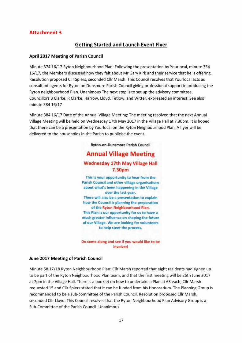
17
Attachment 3
Getting Started and Launch Event Flyer
April 2017 Meeting of Parish Council
Minute 374 16/17 Ryton Neighbourhood Plan: Following the presentation by Yourlocal, minute 354
16/17, the Members discussed how they felt about Mr Gary Kirk and their service that he is offering.
Resolution proposed Cllr Spiers, seconded Cllr Marsh. This Council resolves that Yourlocal acts as
consultant agents for Ryton on Dunsmore Parish Council giving professional support in producing the
Ryton neighbourhood Plan. Unanimous The next step is to set up the advisory committee,
Councillors B Clarke, R Clarke, Harrow, Lloyd, Tetlow, and Witter, expressed an interest. See also
minute 384 16/17
Minute 384 16/17 Date of the Annual Village Meeting: The meeting resolved that the next Annual
Village Meeting will be held on Wednesday 17th May 2017 in the Village Hall at 7.30pm. It is hoped
that there can be a presentation by Yourlocal on the Ryton Neighbourhood Plan. A flyer will be
delivered to the households in the Parish to publicise the event.
June 2017 Meeting of Parish Council
Minute 58 17/18 Ryton Neighbourhood Plan: Cllr Marsh reported that eight residents had signed up
to be part of the Ryton Neighbourhood Plan team, and that the first meeting will be 26th June 2017
at 7pm in the Village Hall. There is a booklet on how to undertake a Plan at £3 each, Cllr Marsh
requested 15 and Cllr Spiers stated that it can be funded from his Honorarium. The Planning Group is
recommended to be a sub-committee of the Parish Council. Resolution proposed Cllr Marsh,
seconded Cllr Lloyd. This Council resolves that the Ryton Neighbourhood Plan Advisory Group is a
Sub-Committee of the Parish Council. Unanimous

18
Attachment 4
Neighbourhood Plan Steering Committee Meeting Dates
Introductory meeting held on 26.06.17. Full meetings thereafter:
10.07.17
29.05.18
21.08.17
27.06.18
21.09.17
01.08.18
02.11.17
04.09.18
12.12.17
04.10.18
13.02.18
26.11.18
13.03.18
27.02.19
24.04.18
25.03.19
Agendas and Minutes for these meetings can be found on the Village Website.
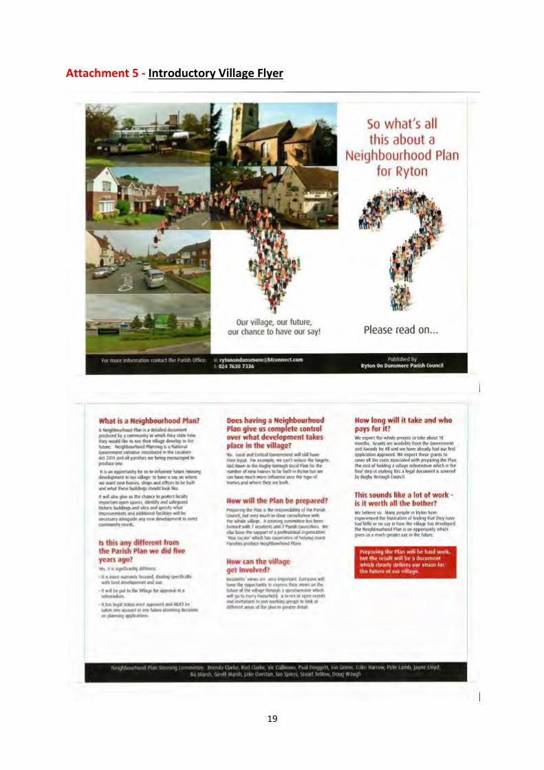
19
Attachment 5 - Introductory Village Flyer
20
Attachment 6
Neighbourhood Plan Vision Post-Survey Changes March 2018
Proposed changes to NP Vision in response to Questionnaire Feedback
Given that 98% of respondents to the Survey indicated that they would support the use of the draft
vision in the Neighbourhood Plan, there is a very strong argument for not making any major
changes. There were, however, a large number of comments received & any significantly recurring
issues clearly deserve consideration for prompting amendments. The broad issues amongst the
comments were:
11 ‘No’ comments Against any further development 5 Survey a waste of time 2 Agree but focus on large detached housing 1 Traffic increase 1 Support affordable social housing 1 Not meaningful 1 91 ‘Yes’ comments (with 5 of those comments each raising 2 issues) = 96 Supportive statement or issue already covered 26 Need to sustain &/or improve amenities & services 23 Existing traffic/parking 14 Support for affordable housing 6 Need for Ryton House development 4 More eco emphasis 2 More emphasis on greenfield/greenbelt protection 4 More emphasis on wildlife/woodland 2 No more/only restricted commercial development 5 Improve pavements/cite healthy living aspect 2 Not meaningful/impractical 8
Whilst the ‘No’ comments don’t reveal any widely held relevant themes, the ‘Yes’ comments
indicate a consistent breadth of opinion in relation to:
• improving amenities/services. Whilst the Vision does refer to the “other assets” of Ryton being
preserved it might be that residents views would be better reflected by: (1) referring to “community
assets” which can be very broadly defined as anything within a community that is or could be used
for the benefit of its residents & (2) including a commitment to seeking to “enhance” as well as
preserve those assets.
• existing, rather than future, traffic issues were widely commented on & some may deserve further
attention through community action points sitting alongside the NP. Similar traffic issues were also
raised in the previous Parish Plan & these shaped the draft Vision which accordingly has references
to ensuring Ryton remains a safe place in general which will shape our policies on all future
developments. Furthermore, the potential negative traffic impact of possible commercial
developments also get specific mention.
21
• the need for single/younger/local persons to be able to access affordable housing was raised a
significant number of times in the “Yes” comments & once in the “No” comments. It is arguably
appropriate therefore that our existing reference to the local need for ‘starter homes’ should be
more clearly targeted towards being “affordable”
The remaining themes reflect only relatively modest numbers of comments & also relate to matters
that are in essence covered in the draft Vision so therefore do not justify further change.
• We might, however, usefully pick up on the 2 comments on wildlife/woodland which, on
reflection, were arguably significant omissions from the draft Vision. The creation of a separate
sentence beginning “Its countryside setting…………” would conveniently permit the insertion of “flora
& fauna”.
The proposed revised version of the Vision is therefore:
The policies in this Plan aim to ensure that Ryton-on-Dunsmore will retain its distinct ‘village’ feel
and identity as it grows and evolves over the next 15 years. It will be a thriving, attractive and safe
place to live, work, visit and move around. Its countryside setting, green spaces, flora & fauna and
other community assets will have been preserved and enhanced as far as possible. The
redevelopment of disused commercial sites and other sites with buildings that are derelict will be
local priorities as will improvements to the communications infrastructure.
New housing developments will be sustainable with a balanced mix in the sizes of homes reflecting
the local need for affordable starter homes, small to medium family homes and housing for older
people. The number of dwellings on any development will be appropriate to a rural village.
Any new building in the Parish will be high quality, environmentally friendly, have exterior building
styles that are sympathetic to the village character and have thoughtful and imaginative approaches
to street scenes, parking, landscaping and boundary structures.
Appropriate new business developments and land use which encourage local employment will be
supported subject to due consideration of any potential negative impacts of increased commercial
activity on neighbouring residents in general and existing traffic issues in particular.
22
Attachment 7
Neighbourhood Plan Questionnaire Distribution Process
Dear
Please could you deliver to: ..................................................................
Our aim is to deliver the questionnaire personally to every household in the village.
It would be best to have all the questionnaires delivered before the Open Event on 18th
November. The target is to then have them all returned by the end of the month.
When delivering, we probably can't take for granted that the recipient will have read or understood
the publicity we have put out so far. So be prepared to give a short introduction explaining what this
is all about and why it's important (see bullet points below*)
Also please explain the following options for completing the questionnaire - pointing out that all
household members aged 12 and above are invited to do this:
Complete the hard copy. The copy you give them should have your name and the date you
intend to return to collect it in the space provided on the front.
Get extra hard copies, if required, either from you (you have enough to leave two at every
house, and we have plenty of spares) or by downloading them from the village website link.
Complete on-line via the village website. (On-line completion will save us processing costs!)
Finally please give them a copy of the Open Event flyer - with a plug to attend!
The attached sheets should help you keep track of deliveries and collections for the houses in your
patch. Please return all completed questionnaires with the log to 99 High Street.
* Suggested introductory points:
Neighbourhood Planning is a Central Government initiative and all parishes are being
encouraged to produce one.
It is an opportunity for us to have a much greater say in how the village develops - what gets
built where.
It also gives us the chance to protect those things we value in the village.
Our Neighbourhood Plan will define a vision for how we want the village to develop and will
set out the policies to achieve this.
This questionnaire gives you an opportunity to have your say on what goes in the Plan.
Please complete it if you can.
Best of luck
Geoff
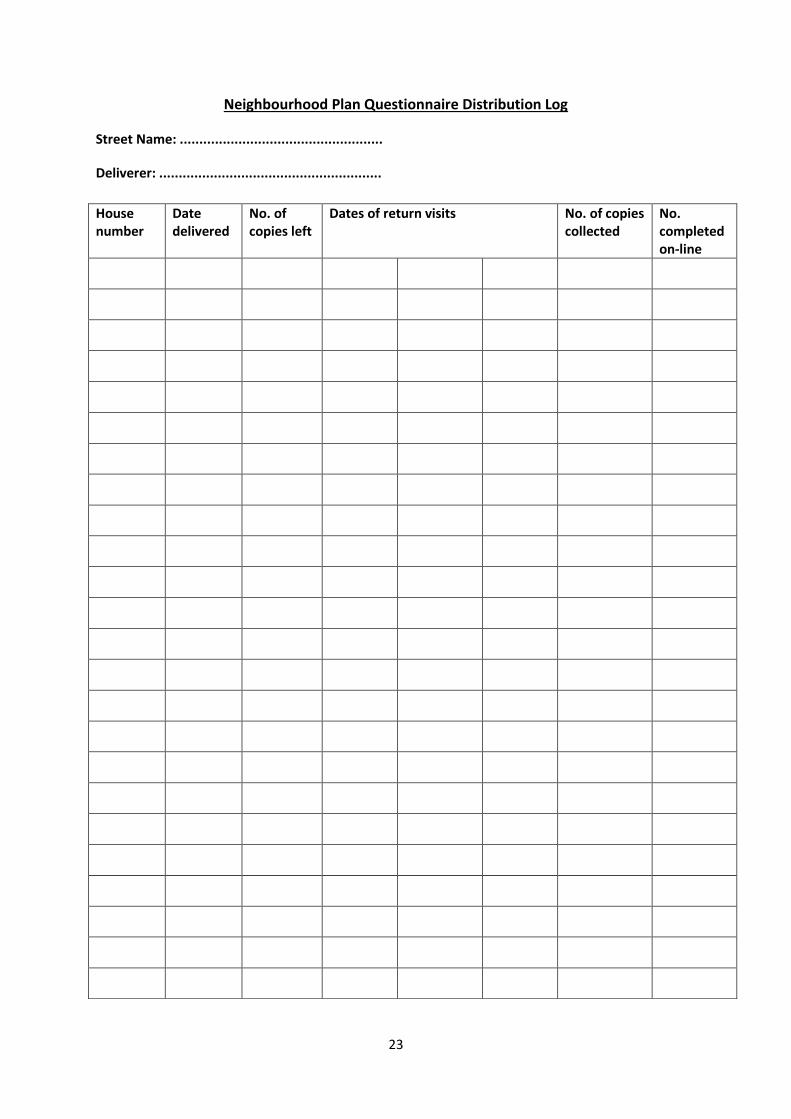
23
Neighbourhood Plan Questionnaire Distribution Log
Street Name: ....................................................
Deliverer: .........................................................
House number
Date delivered
No. of copies left
Dates of return visits No. of copies collected
No. completed on-line
24
Attachment 8
Covering Note for Neighbourhood Plan Questionnaire Report
Ryton on Dunsmore
Neighbourhood Plan Questionnaire Report Dear Resident
Many thanks to everybody who filled in the questionnaire which was distributed around the village
before Christmas. We had a tremendous response with over 500 completed!
This is your household's copy of the analysed results which we hope you will find interesting. The
Neighbourhood Plan Focus Groups are now using these results together with the information which
we received at the Open Event in November to help prepare the policies regarding housing,
environment and community facilities which will form our Neighbourhood Plan. The village will have
future opportunities to see and comment on the Plan as it is being prepared.
There were also many useful comments made in the completed questionnaires. These have all been
collected into one document and can be viewed on the Village website (www.ryton-on-
dunsmore.org.uk/parish-council) . Alternatively a copy is available in the Parish Office.
The Plan will be aiming to address the key concerns raised in these comments particularly in the
areas of traffic congestion, parking, development of village amenities and protection of green
spaces. We have already analysed the comments on the Vision and agreed some changes as a result.
There is a new commitment to enhancing what are now called “community” assets, not just
preserving them, and flora/fauna now get specific mention in this context. We have also added the
need for starter homes to be affordable.
If you have any comments about the report or any other aspect of the Neighbourhood Plan or would
like to get involved in its preparation please contact any member of the NP team:
Vic Collinson 07791 646545 [email protected] Ian Grime 07901390190 [email protected] Colin Harrow 02476 639646 [email protected] Jane Lloyd 02476 304625 [email protected] Ba & Geoff Marsh 07785243293 [email protected] Jake Overton [email protected] Ian Spiers 07737 721998 [email protected] Stuart Tetlow 07779 556120 [email protected]
25
Attachment 9
Letter of Invitation to Focus Groups Launch Event
Dear
Ryton Neighbourhood Plan
Many thanks for coming to the Open Event at School last month and for indicating that you might be interested in helping with the development of the Plan. We collected a lot of useful views and feedback at the Open Event and we will also have the results from the Village Questionnaire early in the New Year. The response to the Questionnaire has been excellent with over 500 returned. Using the Open Event and Questionnaire feedback as a starting point, the next step is to form some Focus Groups to look into the key areas (housing, environment, community facilities) in more detail. These groups will meet over a 3/4 month period to brainstorm the issues and propose community objectives and the policies required to achieve them. This Focus Group activity is at the heart of the Neighbourhood Planning process and we very much hope that you will be able to be part of it.
We have planned a Focus Group Launch Event on Thursday 18th January in the
Village Hall at 7.00pm. At this meeting we will summarise what has happened so far and how the Focus Groups are going to work. Coming along does not in any way commit you to joining a group - but it does give you the chance to hear about the plans and decide if you would like to take part. We very much hope you will be able to come on 18th and look forward to seeing you then. Many thanks again for your interest in the Neighbourhood Plan. Very best wishes The Steering Committee
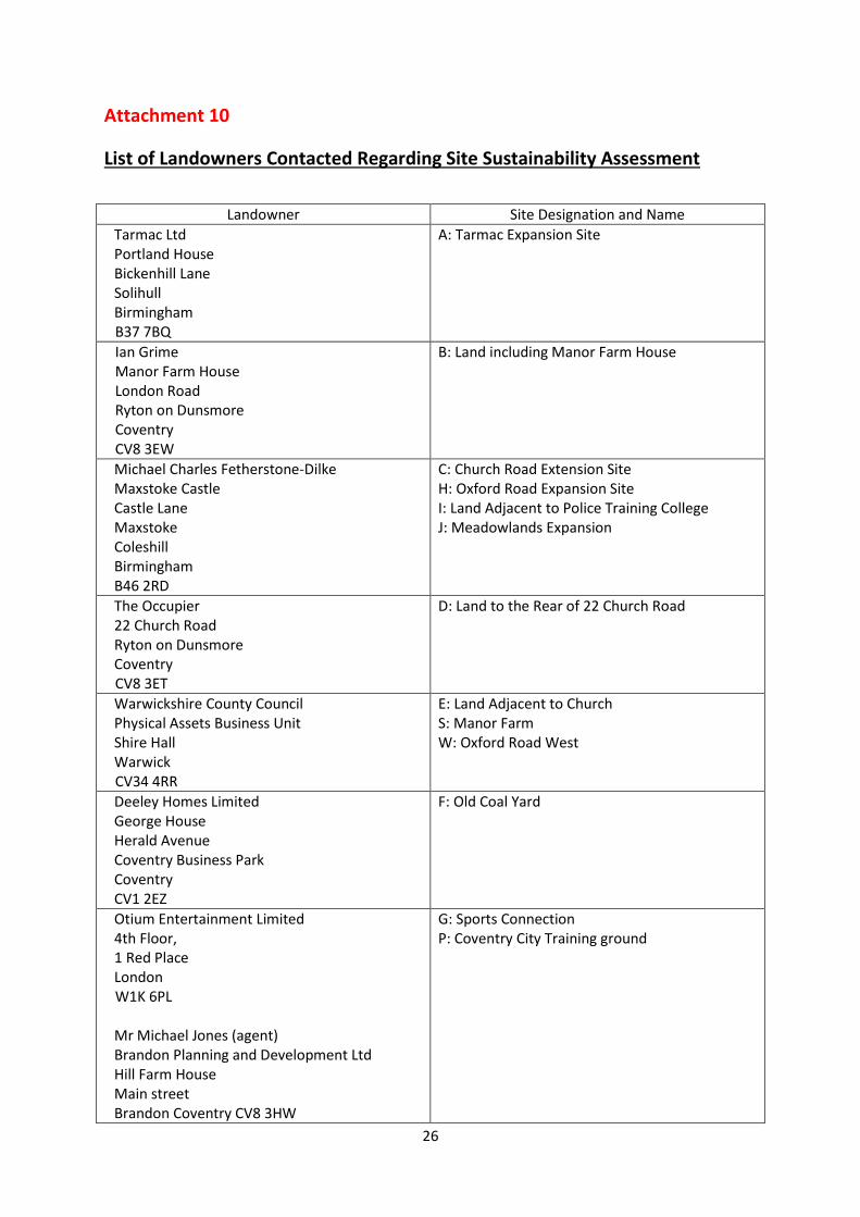
26
Attachment 10
List of Landowners Contacted Regarding Site Sustainability Assessment
Landowner Site Designation and Name
Tarmac Ltd Portland House Bickenhill Lane Solihull Birmingham
B37 7BQ
A: Tarmac Expansion Site
Ian Grime Manor Farm House London Road Ryton on Dunsmore Coventry CV8 3EW
B: Land including Manor Farm House
Michael Charles Fetherstone-Dilke Maxstoke Castle Castle Lane Maxstoke Coleshill Birmingham B46 2RD
C: Church Road Extension Site H: Oxford Road Expansion Site I: Land Adjacent to Police Training College J: Meadowlands Expansion
The Occupier 22 Church Road Ryton on Dunsmore Coventry
CV8 3ET
D: Land to the Rear of 22 Church Road
Warwickshire County Council Physical Assets Business Unit Shire Hall Warwick
CV34 4RR
E: Land Adjacent to Church S: Manor Farm W: Oxford Road West
Deeley Homes Limited George House Herald Avenue Coventry Business Park Coventry CV1 2EZ
F: Old Coal Yard
Otium Entertainment Limited 4th Floor, 1 Red Place London
W1K 6PL
Mr Michael Jones (agent) Brandon Planning and Development Ltd Hill Farm House Main street Brandon Coventry CV8 3HW
G: Sports Connection P: Coventry City Training ground
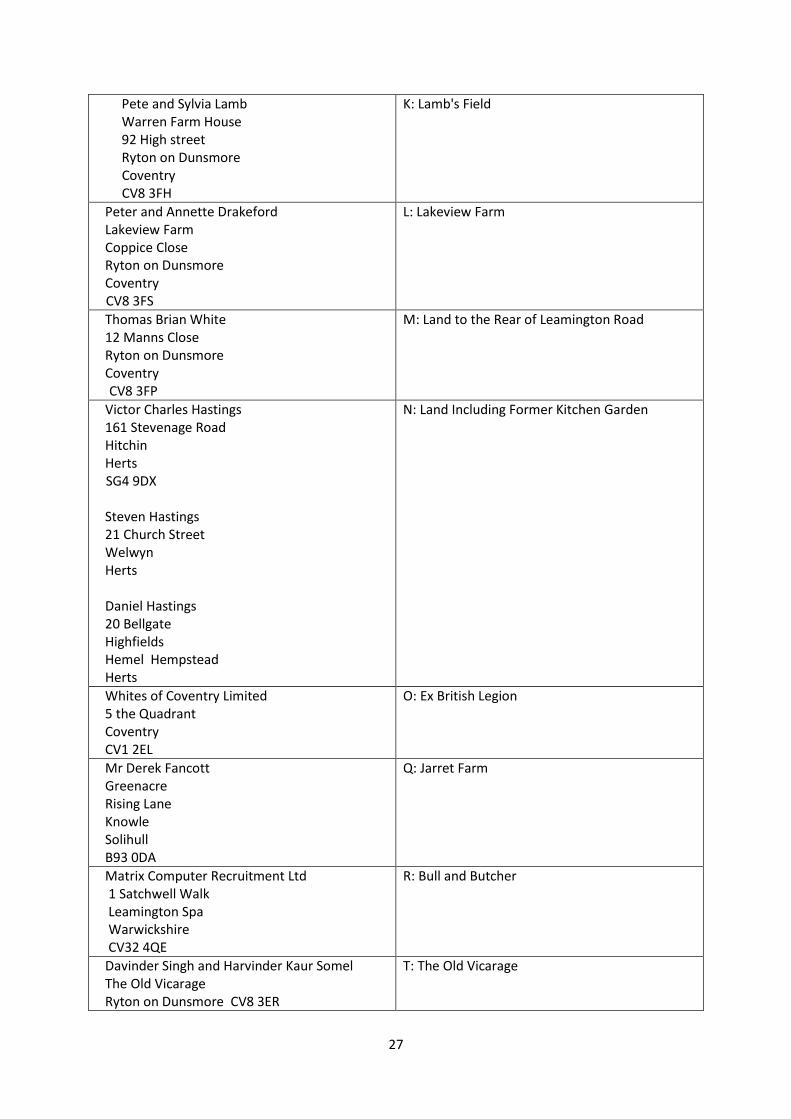
27
Pete and Sylvia Lamb Warren Farm House 92 High street Ryton on Dunsmore Coventry CV8 3FH
K: Lamb's Field
Peter and Annette Drakeford Lakeview Farm Coppice Close Ryton on Dunsmore Coventry
CV8 3FS
L: Lakeview Farm
Thomas Brian White 12 Manns Close Ryton on Dunsmore Coventry
CV8 3FP
M: Land to the Rear of Leamington Road
Victor Charles Hastings 161 Stevenage Road Hitchin Herts
SG4 9DX
Steven Hastings 21 Church Street Welwyn Herts Daniel Hastings 20 Bellgate Highfields Hemel Hempstead Herts
N: Land Including Former Kitchen Garden
Whites of Coventry Limited 5 the Quadrant Coventry CV1 2EL
O: Ex British Legion
Mr Derek Fancott Greenacre Rising Lane Knowle Solihull B93 0DA
Q: Jarret Farm
Matrix Computer Recruitment Ltd 1 Satchwell Walk Leamington Spa Warwickshire CV32 4QE
R: Bull and Butcher
Davinder Singh and Harvinder Kaur Somel The Old Vicarage Ryton on Dunsmore CV8 3ER
T: The Old Vicarage
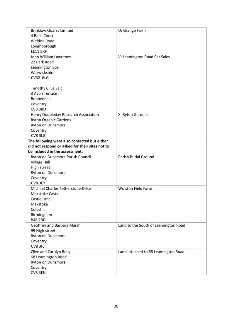
28
Brinklow Quarry Limited 4 Bank Court Weldon Road Loughborough
LE11 5RF
U: Grange Farm
John William Lawrence 22 Park Road Leamington Spa Warwickshire
CV32 6LG
Timothy Clive Salt 3 Avon Terrace Bubbenhall Coventry CV8 3BU
V: Leamington Road Car Sales
Henry Doubleday Research Association Ryton Organic Gardens Ryton on Dunsmore Coventry
CV8 3LG
X: Ryton Gardens
The following were also contacted but either did not respond or asked for their sites not to be included in the assessment:
Ryton on Dunsmore Parish Council Village Hall High street Ryton on Dunsmore Coventry
CV8 3EY
Parish Burial Ground
Michael Charles Fetherstone-Dilke Maxstoke Castle Castle Lane Maxstoke Coleshill Birmingham B46 2RD
Wolston Field Farm
Geoffrey and Barbara Marsh 99 High street Ryton on Dunsmore Coventry
CV8 3FJ
Land to the South of Leamington Road
Clive and Carolyn Reily 68 Leamington Road Ryton on Dunsmore Coventry CV8 3FN
Land attached to 68 Leamington Road

29
Attachment 11
Notes from Meetings with Landowners of Sites Proposed for Allocation
1. Whites of Coventry (Owners of The Former Legion Site) 20th November 2018
Vic Collinson Geoff Marsh
Mr White's ambition for the site almost exactly mirrors the allocation we are proposing:
'An enabling development of a "small number" of houses which is sufficient to support the
restoration of Ryton House and the Gardens.'
Additional details:
"Small number" of houses: mentioned around 10 'quality' dwellings.
Would propose to open the lake area for public access.
Seeking to move the site access 50 metres towards London Road.
It was also explained that one of the current obstacles to development is an overage entitlement
which Myton Hospice has. This expires in eight years and Whites are currently seeking to negotiate
an earlier exit.
2. Michael Jones, Brandon Planning and Development Ltd, acting for CCFC (Sky Blues Training
Ground) 20th November 2018
Vic Collinson Geoff Marsh
The previously identified site for CCFC's relocated Training Ground/Academy which was presented to
the Inspector at the Rugby Plan examination as enabling the allocation of the site has since fallen
through. There was no suggestion that this might compromise the allocation. The determination to
find an alternative site and move remains but although dates of early next year were stated for
planning application submission there is plenty of scope for further slippage. This move has now
been 'imminent' for nearly three years!
Michael Jones welcomes our allocation of the site but spent some time trying to persuade us to
dilute our Policy requirements to give the project a better chance of success. We have given him a
draft copy of the relevant Policies and invited him to give us a considered response.
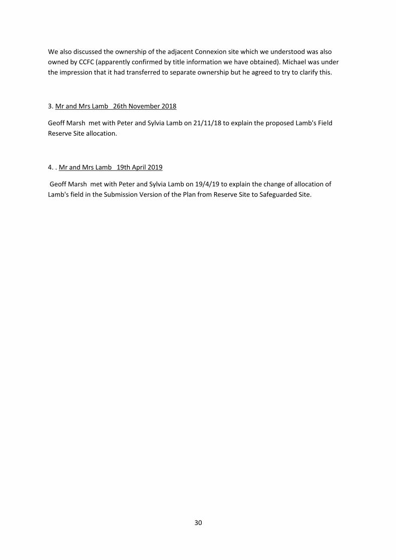
30
We also discussed the ownership of the adjacent Connexion site which we understood was also
owned by CCFC (apparently confirmed by title information we have obtained). Michael was under
the impression that it had transferred to separate ownership but he agreed to try to clarify this.
3. Mr and Mrs Lamb 26th November 2018
Geoff Marsh met with Peter and Sylvia Lamb on 21/11/18 to explain the proposed Lamb's Field
Reserve Site allocation.
4. . Mr and Mrs Lamb 19th April 2019
Geoff Marsh met with Peter and Sylvia Lamb on 19/4/19 to explain the change of allocation of
Lamb's field in the Submission Version of the Plan from Reserve Site to Safeguarded Site.

31
Attachment 12(a)
Report on Consultation with Primary School Children
The work with children at the local school involved two afternoon sessions with the full year-five
class. There was an initial discussion about beauty and the elements that make a place good to be in.
The class then divided into five groups of five or six children.
In the first session, the children created a map of Ryton, centered on the 3 main roads in the Parish,
which form a triangle. They then drew and cut out houses to live in, shops, the church, the pubs and
other existing features of the Parish, placing them on the map.
Following this, each table was invited to imagine and create additional features and facilities that
they wished to see in their Parish – for example they chose a cinema, a cafe, additional shops, fun
house/amusement arcade and an equestrian centre.
For the second session each element was given a cost value – for example a house was £5, a shop
£10 and a cinema £40. The children were given a budget of £150 and so set about selecting the
elements that they would like to remain or add to Ryton, whilst remaining within budget.
Part way through the session an announcement was made that there had been budgetary cuts and
each group now had a budget of only £120. This caused general consternation but the children
quickly set about negotiating reduction in facilities. Those who had favorite elements, such as a
funhouse and a café, were particularly aggrieved when discussion led to the loss of these facilities.
Further concern followed a second announcement that the budget was now reduced to £100. But,
once again the children successfully negotiated a revised set of facilities based on the new budget.
Towards the end of the session the children were invited to glue down their remaining elements
onto the map and to present them to the class. They were featured at a subsequent community
consultation.
32
The children showed a remarkable aptitude for successful negotiation and their selection of facilities
and features for Ryton were overwhelmingly based on sound logic - for example the parish has two
pubs so some children decided that just one was required; another group proposed an amusement
arcade merged into a room within the pub; it was decided that a block of flats was too large and
inappropriate for the village setting; it was also decided that certain specialist shops were not
necessary for such a small community which is within short distance of larger shopping centres.
Year five activity comments:
'We need more nature!'
'Beauty...... pleasing ....... trees ..... birdsong'
There were strong feelings about the importance of countryside – 'pleasing surroundings'
Decided against the stadium 'because of noise pollution'
'Very difficult to please everyone'
'You can't have everything you want'
'Need to discuss and compromise'
'Older people who can't drive need to have shops'
'Looking for places for having fun – gym, swimming pool, cinema'
Some found final discussions easier than others – others worked out solutions to help keep everyone happy
One group sacrificed the post office! Another sacrificed one pub!
Happy to have more houses as long as they 'don't eat up the green spaces'
Don't mind the village growing as long as it doesn't 'spoil the surrounding countryside.'

33
Attachment 12(b)
Report on Consultation with Young People
A Focus Group of young people aged between 12 and 17 was held at a house within the Parish. Pizza
was provided and a welcoming relaxed atmosphere created. The discussion was facilitated and
structured by a small number of questions starting with a conversation about features that make for
an ideal community.
As with the children's group, the young people's group was asked to explore the concept of beauty
and it's place within the assessment and creation of the physical environment.
Group members demonstrated an extremely detailed knowledge of the Parish and were able to
select and evaluate elements that are important to them.
Crossing the A445 is a significant problem of the young people who feel that a pedestrian crossing is
essential. They were able to identify precisely where the ideal spot for this crossing would be.
Subway: this is considered to be very important for community cohesion and movement within the
Parish. Very positive memories exist of the time that the subway was painted by members of the
community.
The primary school is fondly remembered and the group felt that it gave an excellent social
grounding to them in preparation for moving on to the secondary school. But, they did feel that such
a small school did not provide them with the range of learning experiences received by children from
larger communities. However, there was no sense that their secondary education was impaired in
anyway by their primary education within Ryton.
The young people felt strongly that they are "rural people "and differ in their environmental
preferences from those brought up in urban areas. They predict that this will be a feature of their
adult life and anticipate either being drawn back to Ryton following their further education or to
another rural community.
A number of key historical features are valued such as the church and other old buildings. However,
there was some support for modern housing with its energy efficiency and greater suitability for the
needs of modern living.
The young people felt that the co-op is "a lifesaver" as it provides a ready source of produce to meet
daily and indeed emergency needs. It also provides a social hub for the village where people
informally meet and chat to other residents.
The young people felt that, growing up, they knew most of the people within Ryton and that to a
small extent this is changing as the community grows and new housing is built. This in turn brings in
people for whom village life is not necessarily so important and so perhaps remain resident within
the Parish for shorter periods of time.
34
What features make for good place to live?
A good community, places to go and be with friends, parks, fields - big basket swing as at Ryton Pools
Park for little kids
Shop "without the shop we'd have died!"
Pubs
Walking
Routes for bike riding
This raised concerns about road safety:
Hate crossing Oxford Road and A445 especially
Main roads – need clear site lines
Big lorries are dangerous
Village School
Advantage of small village school - taught us social skills
Disadvantage: limited range of staff specialist subjects e.g. science
Living in a village
Ryton feels safe and small - like it - knowing people/everyone
"I probably would like to live here to bring up my children"
All very clear they would choose to live in a village when they have their own homes
"We are well positioned near to towns"
New houses
Smaller houses – affordable housing
Houses to fit in with current bricks etc. Range of houses
Need to control how Ryton develops – small developments
Space out increase in housing – Not one large development - a few a year – yes, good idea
Maybe in Lamb's Field or British Legion?
Don't cram too tight
Need Footpaths through to link
Space between
Climate change
Need solar panels
Wind turbines - for each house perhaps
What constitutes 'Beauty'
Freshly cut grass: tidy, good impression
Jubilee Pools – scenery – gorgeous – nature – nothing man made – overgrown
Rec'
Green open space
Old houses give character - new houses too clean
Dan prefers straight lines

35
Population - will it rise?
Would rather it didn't but overall think it will
Have young people got a voice?
Think they have but you have to be more actively involved
Division of village by A45?
Feel it works - subway - we helped paint it - we go to see friends in Church Rd
Would like:
More park equipment - e.g. outdoor gym
More spaces to go – to meet as groups
Village hall – move onto rec?
More bins
Youth club - would like it to start again
What is the future for Ryton?
Positive outlook - looking good
36
Attachment 13
Letter to Prospective Heritage Site Owners
Parish Letter Head
Dear
Over the past 18 months, the Neighbourhood Plan Working Group has sought opinions of Ryton on
Dunsmore residents through open days and questionnaires and have combined this information
with studies of the local environment to develop the draft Neighbourhood Plan, which is now out for
public consultation. As part of the process, a number of houses and other buildings are being
considered for local listing as heritage assets and is one of these.
What is a local list?
"Local lists play an essential role in building and reinforcing a sense of character and
distinctiveness in the historic environment. They enable the significance of any building or
site on the list, to be better taken into account in planning applications affecting the building
or site or its setting”.
What does this mean?
"In deciding any relevant planning permission that affects a locally listed heritage asset or
its setting, local planning authorities should take into account the desirability of sustaining
and enhancing the significance of such heritage assets and of putting them to viable uses
consistent with their conservation. They are also obliged to consider the positive
contribution that conserving such heritage assets can make to sustainable communities
including their economic vitality" (Historic England).
If you are content for the property referenced above to be included in the list, then all we request is
any additional information you may have that we can include in the listing that is specific to the
property – e.g. Original name; Age; Rarity; Architectural/Aesthetic Value; Archaeological
Significance; Historical Associations; Village Landmark; and Community Value.
What if I don’t want my property to be included in the local list?
You can contact us and to ask for your property to be removed from the list. You will receive
confirmation when completed.
When do I need to send the requested information or ask to be removed from the list?
All responses must be received by 18th February 2019 and please use the following contact details:
Email address: Clerk
Postal address: Clerk
Many thanks,
37
Attachment 14
List of Stakeholders informed of the Regulation 14 Consultation
Statutory Bodies Local Businesses and Organisations
Councils: Provost Williams Primary School
Warwickshire County Council Sports Connexion
Rugby Borough Council Citrus Hotel
Wolston Parish Council Village Hall
Stretton Parish Council Heart of England Co-operative Society
Bubbenhall Parish Council Malt Shovel
Baginton Parish Council Blacksmith's Arms
Branson and Bretford Parish Council Prologis
Coventry County Council Jaguar Land Rover
Pantos Logistics
Other Bodies: Stonemarket
Coal Authority Millboard
Homes and Communities Agency Network Rail
Natural England DHL
The Environment Agency Freeman
Network Rail Infrastructure Keller Foundations
Historic England College of Policing
Highways Agency St Leonard's Church
British Telecom
NHS Coventry and Warwick Land Owners
National Grid
British Gas All Landowners listed in Attachment 10
Severn Trent
Voluntary Action Rugby
Federation of Gypsy Liaison Groups
Age UK
Campaign to Protect Rural England
Equality and Inclusion Partnership
Coventry Interfaith Forum
Coventry and Warwick Chamber of Commerce
Warwickshire Integrated Disability Service
Warwickshire Fire and Rescue
Warwickshire Police
English Heritage

Appendix 1
Ryton on Dunsmore Neighbourhood Plan
2018-2031 Statement of Basic
Conditions
needhm
Rectangle
1 | P a g e
Contents 1.0 Introduction ............................................................................................. Page 2
2.0 Legal Requirements ............................................................................... Page 3
3.0 The Basic Conditions ............................................................................. Page 4
4.0 Conclusion ............................................................................................ Page 12
2 | P a g e
1.0 Introduction 1.1 The Basic Conditions Statement has been prepared to accompany the Ryton on
Dunsmore Neighbourhood Plan (“the Neighbourhood Plan”) under regulation 15 of
the Neighbourhood Planning (General) Regulations 2012 (“the Regulations”). 1.2 In order to satisfy Regulation 15 of the Neighbourhood Planning (General)
Regulations 2012, the Parish Council, as the ‘qualifying body’ must include a
statement explaining how the proposed Neighbourhood Plan meets the
requirements of paragraph 8 of Schedule 4B to the Town and Country Planning Act
1990 (as amended). 1.3 Paragraph 8 (1) states that the examiner must consider the following:
(a) whether the draft neighbourhood development plan meets the basic conditions
(see sub-paragraph (2))
(b) whether the draft neighbourhood development plan complies with the provision
made by or under sections 61E (2), 61J and 61L, as amended by s38C(5)(b)
(c) whether the area for any referendum should extend beyond the neighbourhood
area to which the draft neighbourhood development plan relates and
(d) such other matters as may be prescribed. 1.4 Paragraph 8 (2) states that a draft neighbourhood development plan meets the basic
conditions if:
(a) having regard to national policies and advice contained in guidance issued by
the Secretary of State, it is appropriate to make the neighbourhood
development plan
(b) the making of the neighbourhood development plan contributes to the
achievement of sustainable development
(c) the making of the neighbourhood development plan is in general conformity
with the strategic policies contained in the development plan for the area of
the authority (or any part of that area)
(d) the making of the neighbourhood development plan does not breach, and is
otherwise compatible with, EU obligations and
(e) prescribed conditions are met in relation to the neighbourhood development
plan and prescribed matters have been complied with in connection with the
proposal for the neighbourhood development plan.
3 | P a g e
1.5 Section 2 of this Statement sets out how the Neighbourhood Plan complies with the
legal requirements of sub-paragraphs 1 (b), (c) and (d). Section 3 of this Statement
sets out how the Neighbourhood Plan meets the basic conditions contained in sub-
paragraph 1 (a) and sub-paragraph 2. 2.0 Legal Requirements
2.1 The Plan complies with the provisions of sub-paragraph 1(b) as described below.
The Plan is being submitted by a qualifying body
The Neighbourhood Plan has been submitted by Ryton on Dunsmore Parish
Council, which is a qualifying body and entitled to submit a Neighbourhood Plan for
the designated Plan Area.
What is being proposed is a neighbourhood plan
2.2 The Neighbourhood Plan contains policies relating to the development and use of
land within the Neighbourhood Plan Area and has been prepared in accordance
with the statutory requirements and processes set out in the Town and Country
Planning Act 1990 (as amended by the Localism Act 2011) and the Neighbourhood
Planning Regulations 2012.
The proposed Neighbourhood Plan states the period for which it is to have
effect
2.3 The Neighbourhood Plan states that the period which it relates to is from 2018 until
2031. The period has been chosen to align with that of the 2019 Rugby Local Plan.
The policies do not relate to excluded development
2.4 The Neighbourhood Plan does not deal with county matters (mineral extraction and
waste development), nationally significant infrastructure or any other matters set out
in Section 61K of the Town and Country Planning Act 1990.
The proposed Neighbourhood Plan does not relate to more than one
neighbourhood plan area and there are no other neighbourhood plans in place
within the Neighbourhood Plan Area.
2.5 The designated Plan area was approved by Rugby Borough Council on 11 October
2016. The Plan does not relate to more than one neighbourhood plan area. There
are no other neighbourhood plans in place within the Neighbourhood Plan Area.
4 | P a g e
2.6 In relation to sub-paragraph 1.3(c), it is not considered that there is any benefit
or reason for extending the area for the referendum beyond the designated
Neighbourhood Plan Area. 2.7 In relation to sub-paragraph 1.3(d), there are no other prescribed matters.
3.0 The Basic Conditions
3.1 This section addresses how the Neighbourhood Plan fulfils the basic conditions set
out in sub-paragraph (2). The Neighbourhood Plan has been prepared having regard
to national policies and advice set out in the National Planning Policy Framework
(NPPF) and to the saved strategic policies contained in the 2019 Rugby Local Plan.
Having regard to national policies and advice
3.2 The Neighbourhood Plan has been developed having regard to the NPPF (2018). An explanation of how each of the Neighbourhood Plan policies have shown regard to the NPPF are outlined in Table 1 below.
3.3 In broad terms the Plan:
process has empowered the local community to develop the plan for their neighbourhood and has undertaken a creative and thorough exercise in identifying ways to enhance and improve the area;
policies are based on robust evidence and provide a practical framework within which decisions on planning applications can be made, with a high degree of predictability and efficiency;
seeks to deliver locally appropriate homes, businesses and infrastructure through housing allocations, a windfall policy and employment policies;
seeks to actively manage patterns of growth in the most sustainable locations through the designation of a Limits to Development;
supports local strategies to deliver sufficient community facilities and services to meet local needs;
contributes to conserving and enhancing the natural environment through the protection of Local Green Spaces, biodiversity and a range of environmental protections.
5 | P a g e
General conformity with the strategic policies of the development plan for the
area
3.4 The Neighbourhood Plan has been prepared in general conformity with the 2019
Rugby Local Plan. 3.5 Table 1 provides a summary of how each of the Neighbourhood Plan policies are in
general conformity with the Rugby Development Plan and have regard for the National
Planning Policy Framework (2018).
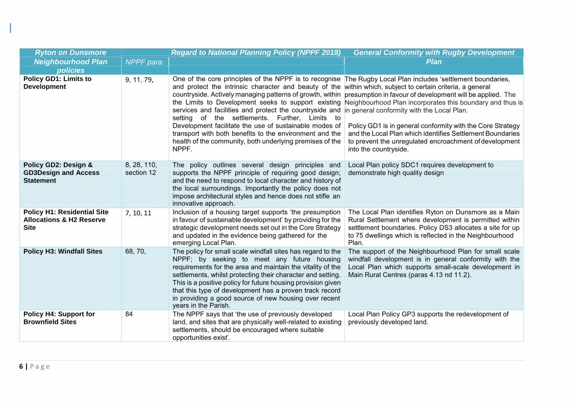
6 | P a g e
Ryton on Dunsmore Regard to National Planning Policy (NPPF 2018) General Conformity with Rugby Development
Neighbourhood Plan policies
NPPF para Plan
Policy GD1: Limits to Development
9, 11, 79, One of the core principles of the NPPF is to recognise and protect the intrinsic character and beauty of the countryside. Actively managing patterns of growth, within the Limits to Development seeks to support existing services and facilities and protect the countryside and setting of the settlements. Further, Limits to Development facilitate the use of sustainable modes of transport with both benefits to the environment and the health of the community, both underlying premises of the NPPF.
The Rugby Local Plan includes ‘settlement boundaries, within which, subject to certain criteria, a general presumption in favour of development will be applied. The Neighbourhood Plan incorporates this boundary and thus is in general conformity with the Local Plan.
Policy GD1 is in general conformity with the Core Strategy and the Local Plan which identifies Settlement Boundaries to prevent the unregulated encroachment of development into the countryside.
Policy GD2: Design & GD3Design and Access Statement
8, 28, 110, section 12
The policy outlines several design principles and supports the NPPF principle of requiring good design; and the need to respond to local character and history of the local surroundings. Importantly the policy does not impose architectural styles and hence does not stifle an innovative approach.
Local Plan policy SDC1 requires development to demonstrate high quality design
Policy H1: Residential Site Allocations & H2 Reserve Site
7, 10, 11 Inclusion of a housing target supports ‘the presumption in favour of sustainable development’ by providing for the strategic development needs set out in the Core Strategy and updated in the evidence being gathered for the emerging Local Plan.
The Local Plan identifies Ryton on Dunsmore as a Main Rural Settlement where development is permitted within settlement boundaries. Policy DS3 allocates a site for up to 75 dwellings which is reflected in the Neighbourhood Plan.
Policy H3: Windfall Sites 68, 70, The policy for small scale windfall sites has regard to the NPPF; by seeking to meet any future housing requirements for the area and maintain the vitality of the settlements, whilst protecting their character and setting. This is a positive policy for future housing provision given that this type of development has a proven track record in providing a good source of new housing over recent years in the Parish.
The support of the Neighbourhood Plan for small scale windfall development is in general conformity with the Local Plan which supports small-scale development in Main Rural Centres (paras 4.13 nd 11.2).
Policy H4: Support for Brownfield Sites
84 The NPPF says that ‘the use of previously developed land, and sites that are physically well-related to existing settlements, should be encouraged where suitable opportunities exist’.
Local Plan Policy GP3 supports the redevelopment of previously developed land.
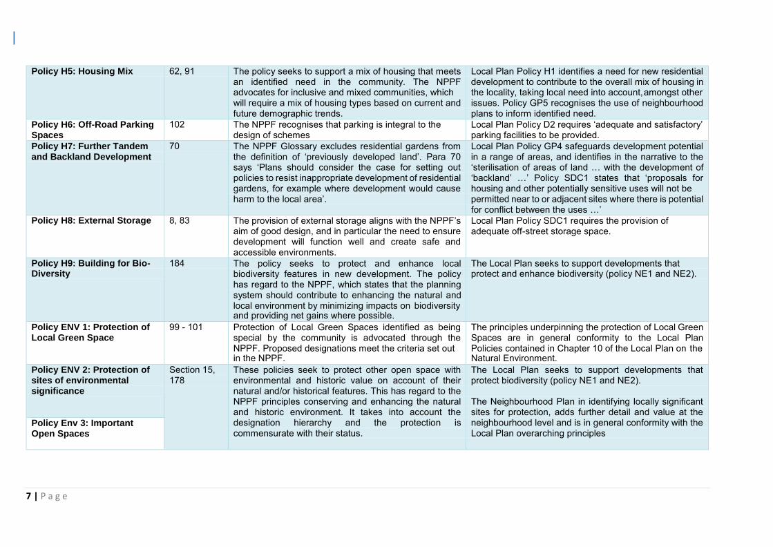
7 | P a g e
Policy H5: Housing Mix 62, 91 The policy seeks to support a mix of housing that meets
an identified need in the community. The NPPF advocates for inclusive and mixed communities, which will require a mix of housing types based on current and future demographic trends.
Local Plan Policy H1 identifies a need for new residential development to contribute to the overall mix of housing in the locality, taking local need into account, amongst other issues. Policy GP5 recognises the use of neighbourhood plans to inform identified need.
Policy H6: Off-Road Parking Spaces
102 The NPPF recognises that parking is integral to the design of schemes
Local Plan Policy D2 requires ‘adequate and satisfactory’ parking facilities to be provided.
Policy H7: Further Tandem and Backland Development
70 The NPPF Glossary excludes residential gardens from the definition of ‘previously developed land’. Para 70 says ‘Plans should consider the case for setting out policies to resist inappropriate development of residential gardens, for example where development would cause harm to the local area’.
Local Plan Policy GP4 safeguards development potential in a range of areas, and identifies in the narrative to the ‘sterilisation of areas of land … with the development of ‘backland’ …’ Policy SDC1 states that ‘proposals for housing and other potentially sensitive uses will not be permitted near to or adjacent sites where there is potential for conflict between the uses …’
Policy H8: External Storage 8, 83 The provision of external storage aligns with the NPPF’s aim of good design, and in particular the need to ensure development will function well and create safe and accessible environments.
Local Plan Policy SDC1 requires the provision of adequate off-street storage space.
Policy H9: Building for Bio- Diversity
184 The policy seeks to protect and enhance local biodiversity features in new development. The policy has regard to the NPPF, which states that the planning system should contribute to enhancing the natural and local environment by minimizing impacts on biodiversity and providing net gains where possible.
The Local Plan seeks to support developments that protect and enhance biodiversity (policy NE1 and NE2).
Policy ENV 1: Protection of Local Green Space
99 - 101 Protection of Local Green Spaces identified as being special by the community is advocated through the NPPF. Proposed designations meet the criteria set out in the NPPF.
The principles underpinning the protection of Local Green Spaces are in general conformity to the Local Plan Policies contained in Chapter 10 of the Local Plan on the Natural Environment.
Policy ENV 2: Protection of sites of environmental significance
Section 15, 178
These policies seek to protect other open space with environmental and historic value on account of their natural and/or historical features. This has regard to the NPPF principles conserving and enhancing the natural and historic environment. It takes into account the designation hierarchy and the protection is commensurate with their status.
The Local Plan seeks to support developments that protect biodiversity (policy NE1 and NE2).
The Neighbourhood Plan in identifying locally significant sites for protection, adds further detail and value at the neighbourhood level and is in general conformity with the Local Plan overarching principles
Policy Env 3: Important Open Spaces
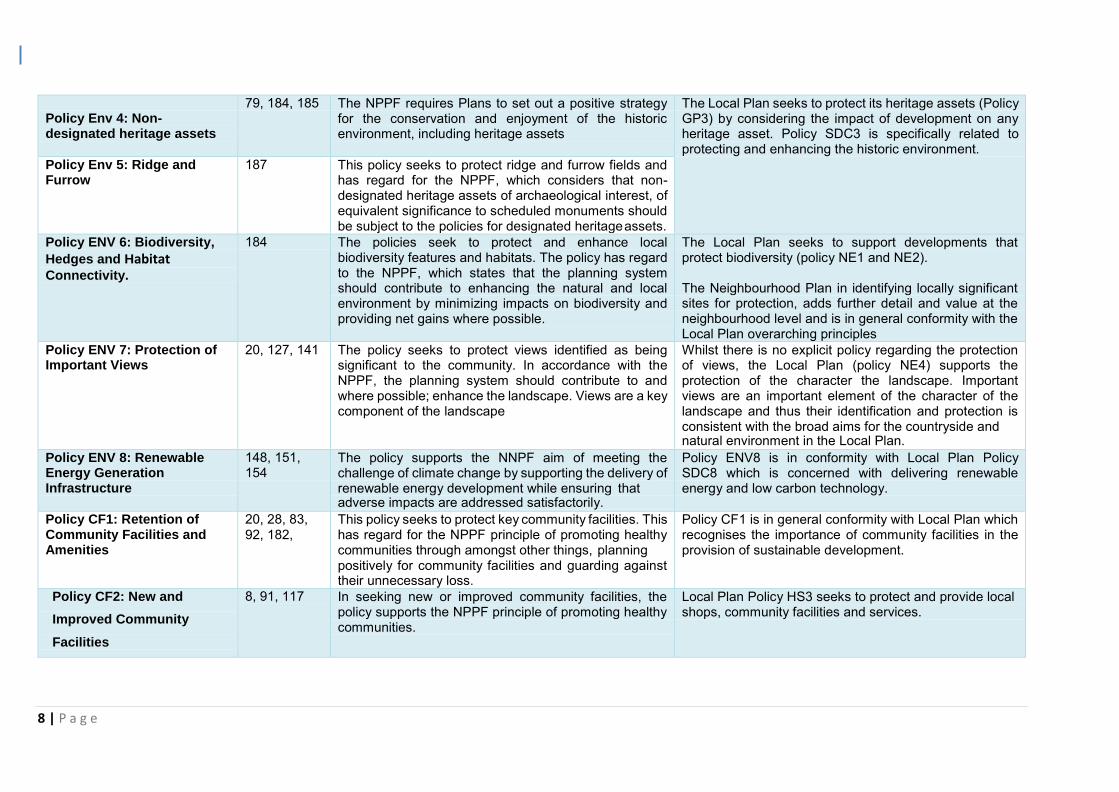
8 | P a g e
Policy Env 4: Non- designated heritage assets
79, 184, 185 The NPPF requires Plans to set out a positive strategy for the conservation and enjoyment of the historic environment, including heritage assets
The Local Plan seeks to protect its heritage assets (Policy GP3) by considering the impact of development on any heritage asset. Policy SDC3 is specifically related to protecting and enhancing the historic environment.
Policy Env 5: Ridge and Furrow
187 This policy seeks to protect ridge and furrow fields and has regard for the NPPF, which considers that non- designated heritage assets of archaeological interest, of equivalent significance to scheduled monuments should be subject to the policies for designated heritage assets.
Policy ENV 6: Biodiversity,
Hedges and Habitat Connectivity.
184 The policies seek to protect and enhance local biodiversity features and habitats. The policy has regard to the NPPF, which states that the planning system should contribute to enhancing the natural and local environment by minimizing impacts on biodiversity and providing net gains where possible.
The Local Plan seeks to support developments that protect biodiversity (policy NE1 and NE2).
The Neighbourhood Plan in identifying locally significant sites for protection, adds further detail and value at the neighbourhood level and is in general conformity with the Local Plan overarching principles
Policy ENV 7: Protection of Important Views
20, 127, 141 The policy seeks to protect views identified as being significant to the community. In accordance with the NPPF, the planning system should contribute to and where possible; enhance the landscape. Views are a key component of the landscape
Whilst there is no explicit policy regarding the protection of views, the Local Plan (policy NE4) supports the protection of the character the landscape. Important views are an important element of the character of the landscape and thus their identification and protection is consistent with the broad aims for the countryside and natural environment in the Local Plan.
Policy ENV 8: Renewable Energy Generation Infrastructure
148, 151, 154
The policy supports the NNPF aim of meeting the challenge of climate change by supporting the delivery of renewable energy development while ensuring that adverse impacts are addressed satisfactorily.
Policy ENV8 is in conformity with Local Plan Policy SDC8 which is concerned with delivering renewable energy and low carbon technology.
Policy CF1: Retention of Community Facilities and Amenities
20, 28, 83, 92, 182,
This policy seeks to protect key community facilities. This has regard for the NPPF principle of promoting healthy communities through amongst other things, planning positively for community facilities and guarding against their unnecessary loss.
Policy CF1 is in general conformity with Local Plan which recognises the importance of community facilities in the provision of sustainable development.
Policy CF2: New and
Improved Community
Facilities
8, 91, 117 In seeking new or improved community facilities, the policy supports the NPPF principle of promoting healthy communities.
Local Plan Policy HS3 seeks to protect and provide local shops, community facilities and services.
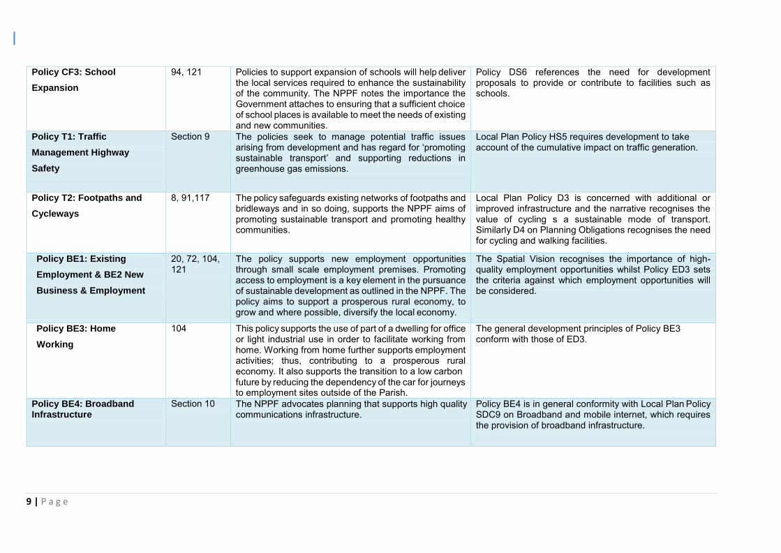
9 | P a g e
Policy CF3: School
Expansion
94, 121 Policies to support expansion of schools will help deliver the local services required to enhance the sustainability of the community. The NPPF notes the importance the Government attaches to ensuring that a sufficient choice of school places is available to meet the needs of existing and new communities.
Policy DS6 references the need for development proposals to provide or contribute to facilities such as schools.
Policy T1: Traffic
Management Highway
Safety
Section 9 The policies seek to manage potential traffic issues arising from development and has regard for ‘promoting sustainable transport’ and supporting reductions in greenhouse gas emissions.
Local Plan Policy HS5 requires development to take account of the cumulative impact on traffic generation.
Policy T2: Footpaths and
Cycleways
8, 91,117 The policy safeguards existing networks of footpaths and bridleways and in so doing, supports the NPPF aims of promoting sustainable transport and promoting healthy communities.
Local Plan Policy D3 is concerned with additional or improved infrastructure and the narrative recognises the value of cycling s a sustainable mode of transport. Similarly D4 on Planning Obligations recognises the need for cycling and walking facilities.
Policy BE1: Existing
Employment & BE2 New
Business & Employment
20, 72, 104, 121
The policy supports new employment opportunities through small scale employment premises. Promoting access to employment is a key element in the pursuance of sustainable development as outlined in the NPPF. The policy aims to support a prosperous rural economy, to grow and where possible, diversify the local economy.
The Spatial Vision recognises the importance of high- quality employment opportunities whilst Policy ED3 sets the criteria against which employment opportunities will be considered.
Policy BE3: Home
Working
104 This policy supports the use of part of a dwelling for office or light industrial use in order to facilitate working from home. Working from home further supports employment activities; thus, contributing to a prosperous rural economy. It also supports the transition to a low carbon future by reducing the dependency of the car for journeys to employment sites outside of the Parish.
The general development principles of Policy BE3 conform with those of ED3.
Policy BE4: Broadband Infrastructure
Section 10 The NPPF advocates planning that supports high quality communications infrastructure.
Policy BE4 is in general conformity with Local Plan Policy SDC9 on Broadband and mobile internet, which requires the provision of broadband infrastructure.

10 | P a g e
Achieving sustainable development 3.7 The Neighbourhood Plan is positively prepared, reflecting the presumption in the
NPPF in favour of sustainable development. In this regard, the Plan supports the
strategic development needs in the Development Plan, shaping and directing
development in the area that is outside of the strategic elements of the Core
Strategy and Local Plan. 3.8 The NPPF defines sustainable development as having three dimensions; economic,
social and environmental. The Neighbourhood Plan has been developed with regard
to these principles and has jointly sought environmental, economic and social gains. 3.9 The policies contained in the Neighbourhood Plan contribute to achieving sustainable
development by seeking positive improvements to the quality of the natural, built and
historic environment, as well as in people’s quality of life, including:
supporting strong, vibrant, healthy and inclusive communities by facilitating the right mix of housing to meet local need;
supporting the transition to a low carbon future through actively managing patterns of growth within existing settlements, supporting sustainable modes of
transport, renewable energy generation and local employment opportunities;
protecting and enhancing the distinctive character of the built and natural
environment through high quality design, protection of important local green space and protection of important views;
conserving and enhancing the natural environment by protecting and supporting a net gain in biodiversity and important habitats;
supporting a strong economy through the protection of existing employment sites, support for new businesses including home working and encouragement
of superfast broadband;
safeguarding and enhancing existing open space, community facilities and
pedestrian and cycling facilities for the health, social and cultural wellbeing of the community.
11 | P a g e
EU obligations
Strategic Environmental Assessment (SEA)
3.10 In some limited circumstances, where a neighbourhood plan could have significant
environmental effects, it may require a Strategic Environmental Assessment under the
relevant EU Directive. DCLG planning guidance suggests that, whether a
neighbourhood plan requires a strategic environmental assessment and (if so) the
level of detail needed, will depend on what is proposed in the draft neighbourhood
plan. A strategic environmental assessment may be required, for example, where:
a neighbourhood plan allocates sites for development;
the neighbourhood area contains sensitive natural or heritage assets that may be affected by the proposals in the plan;
the neighbourhood plan may have significant environmental effects that have not already been considered and dealt with through a sustainability appraisal
of the Local Plan. 3.11 A Screening Opinion was issued by Rugby Borough Council which determined that a
full SEA would not be required. The statutory consultees concurred with this
conclusion. Habitats Directive
3.12 Rugby Borough Council undertook a Habitat Regulation Assessment (HRA)
Screening of the Neighbourhood Plan and concluded that an HRA was not required.
The statutory consultees concurred with this conclusion. Convention on Human Rights
3.13 The Neighbourhood Plan has regard to and is compatible with the fundamental rights
and freedoms guaranteed under the European Convention on Human Rights. The
Neighbourhood Plan has been prepared with extensive input from the community and
stakeholders as set out in the accompanying Consultation Statement. Considerable
care has been taken throughout the preparation and drafting of this Plan to ensure that
the views of the whole community were embraced to avoid any unintentional negative
impacts on particular groups. 3.14 There was extensive consultation and engagement in identifying issues and objectives
and the community has been consulted on the draft Neighbourhood Plan, as required
by Regulation14 of the Neighbourhood Planning (General) Regulations 2012.
Responses have been recorded and changes have been made as described in the
12 | P a g e
Presubmission Responses Document referenced in the set out in the appendices to
the Consultation Statement and available on the Village Website. The Consultation
Statement has been prepared by the Steering Committee and meets the
requirements set out in Paragraph 15 (2) of the Regulations. 4.0 Conclusion
4.1 The Basic Conditions as set out in Schedule 4B of the Town and Country Planning Act
1990 are considered to have been met by the Ryton on Dunsmore Neighbourhood
Plan.
4.2 The Plan has regard to national policy, will contribute towards the achievement of
sustainable development, is in general conformity with the saved strategic policies in
the Charnwood Local Plan 2015 and meets relevant EU obligations.
4.3 It is therefore respectfully suggested to the Examiner that the Ryton on Dunsmore
Neighbourhood Plan complies with Paragraph 8(1)(a) of Schedule 4B of the Act.

THE ENVIRONMENTAL ASSESSMENT OF PLANS AND PROGRAMMES REGULATIONS 2004
REGULATION 9 SCREENING DETERMINATION
Ryton on Dunsmore Neighbourhood Plan
Introduction
European Union Directive 200142/EC requires a Strategic Environmental Assessment to be undertaken for certain types of plans or programmes that would have a significant environmental effect. The Environmental Assessment of Plans and Programmes Regulations 2004 (the regulations) require that this is determined by a screening process, which should use a specified set of criteria (set out in Schedule 1 of the Regulations). The results of this process must be set out in an SEA Screening Statement, which must be publicly available. Before the Council make a formal determination, there is a requirement to consult three statutory consultation bodies designated in the regulations (Historic England, Environment Agency & Natural England) on whether an environmental assessment is required. This document is the Screening Determination of the need to carry out a Strategic Environmental Assessment for the Ryton on Dunsmore Neighbourhood Plan and is made in accordance with the regulations. Within 28 days of making its determination, Rugby Borough Council and Ryton on Dunsmore Parish Council will publish a statement, setting out this decision. If it is determined that an SEA is not required, the statement must include reasons for this. Determination
In accordance with Regulation 9 of the SEA Regulations 2004, Rugby Borough Council has determined that an environmental assessment of the emerging Ryton on Dunsmore Neighbourhood Plan is not required as it is unlikely to have significant environmental effects. In making this determination, Rugby Borough Council has had regard to Schedule 1 of the Regulations and has carried out consultation with the consultation bodies. An assessment against Schedule 1 of Regulations forms Appendix 1 to this determination and comments made by the Consultation bodies form Appendix 2. This determination has been made on Friday 31st May 2019.
Further Information
A copy of this determination will be sent to the Consultation Bodies and made available on the
Rugby Borough Council website and Parish Council’s website.

Ryton-on-Dunsmore Neighbourhood Plan- SEA & HRA Screening Report
2
Appendix 1‐ SEA and HRA Screening Report
Ryton-on-Dunsmore Neighbourhood Plan- SEA & HRA Screening Report
3
Ryton-on-Dunsmore Neighbourhood Plan
Strategic Environmental Assessment and Habitat Regulations
Assessment
Screening Report
15th April 2019

Ryton-on-Dunsmore Neighbourhood Plan- SEA & HRA Screening Report
4
Contents
1. Introduction
4
2. Legislative Background
4
3. Criteria for Assessing the Effects of Neighbourhood Planning Documents
5
4. Assessment
6
5. Screening Outcome
8
Ryton-on-Dunsmore Neighbourhood Plan- SEA & HRA Screening Report
5
1. Introduction
1.1 Under the requirements of the European Union Directive 2001/42/EC and
Environmental Assessment of Plans and Programmes Regulation (2004) certain
types of plans that set the framework for the consent of future development
projects, must be subject to an environmental assessment.
1.2 This screening report has been prepared to determine whether the Ryton-on-
Dunsmore Neighbourhood Development Plan to 2031 should be subject to a
Strategic Environmental Assessment (SEA) in accordance with the European
Directive 2001/42/EC (SEA Directive) and associated Environmental Assessment
of Plans and Programmes Regulation 2004 (SEA Regulations)
2. Legislative Background
2.1 The basis for Strategic Environmental Assessments and Sustainability Appraisal
legislation is European Directive 2001/42/EC. This was transposed into English
law by the Environmental Assessment of Plans and Programmes Regulations
2004, or SEA Regulations. Detailed Guidance on these regulations can be found
in the Government publication ‘A Practical Guide to the Strategic Environmental
Assessment Directive’ (ODPM 2005).
2.2 This report will also screen to determine whether the Neighbourhood Plan requires
a Habitats Regulations Assessment (HRA) in accordance with Article 6(3) and (4)
of the EU Habitats Directive and with Regulation 61 of the Conservation of
Habitats and Species Regulations 2010 (as amended). A HRA is required when it
is deemed that likely adverse significant effects may occur on protected European
Sites (Natura 2000 sites) as a result of the implementation of a plan/project. As a
general ‘rule of thumb’ it is identified that sites with pathways of 10-15km of the
plan/project boundary should be included with a HRA.
2.3 This report focuses on screening for SEA and HRA and the criteria for establishing
whether a full assessment is needed.
3. Criteria for Screening for SEA
3.1 Criteria for determining the likely significance of effects are set in Schedule 1 of
The Environmental Assessment of Plans and Programmes Regulations 2004.
These are:
1. The characteristics of plans and programmes, having regard, in particular, to
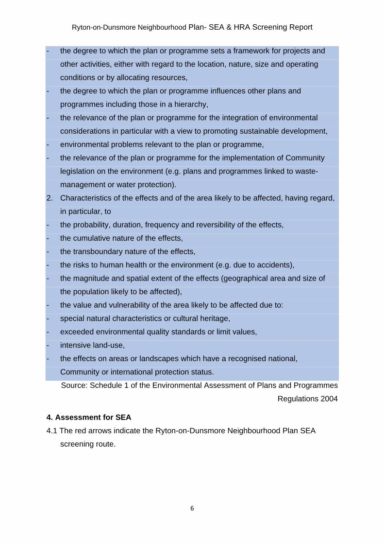
Ryton-on-Dunsmore Neighbourhood Plan- SEA & HRA Screening Report
6
- the degree to which the plan or programme sets a framework for projects and
other activities, either with regard to the location, nature, size and operating
conditions or by allocating resources,
- the degree to which the plan or programme influences other plans and
programmes including those in a hierarchy,
- the relevance of the plan or programme for the integration of environmental
considerations in particular with a view to promoting sustainable development,
- environmental problems relevant to the plan or programme,
- the relevance of the plan or programme for the implementation of Community
legislation on the environment (e.g. plans and programmes linked to waste-
management or water protection).
2. Characteristics of the effects and of the area likely to be affected, having regard,
in particular, to
- the probability, duration, frequency and reversibility of the effects,
- the cumulative nature of the effects,
- the transboundary nature of the effects,
- the risks to human health or the environment (e.g. due to accidents),
- the magnitude and spatial extent of the effects (geographical area and size of
the population likely to be affected),
- the value and vulnerability of the area likely to be affected due to:
- special natural characteristics or cultural heritage,
- exceeded environmental quality standards or limit values,
- intensive land-use,
- the effects on areas or landscapes which have a recognised national,
Community or international protection status.
Source: Schedule 1 of the Environmental Assessment of Plans and Programmes
Regulations 2004
4. Assessment for SEA
4.1 The red arrows indicate the Ryton-on-Dunsmore Neighbourhood Plan SEA
screening route.

Ryton-on-Dunsmore Neighbourhood Plan- SEA & HRA Screening Report
7
Source: Practical Guide to the Strategic Environmental Assessment Directive (2005)
Table 1: Establishing the need for an SEA Stage No/Yes Reason 1. Is the PP (plan or programme) subject to preparation and/or adoption by a national, regional or local authority OR prepared by an authority for adoption through a legislative procedure by
Yes If the final Neighbourhood Plan is successful at referendum and is subsequently ‘made’ by the Local Planning Authority it will become a Development Plan Document with equal status to the Local Plan.
Ryton-on-Dunsmore Neighbourhood Plan- SEA & HRA Screening Report
8
Parliament or Government? (Art. 2(a)) 2. Is the PP required by legislative, regulatory or administrative provisions? (Art. 2(a))
Yes Communities have a right to produce a Neighbourhood Plan; however communities are not required by legislative, regulatory or administrative purposes to produce a Neighbourhood Plan. However, once ‘made’ the Ryton-on-Dunsmore Neighbourhood Plan would form part of the statutory development plan, and will be used when making decisions on planning applications within the Neighbourhood Area. Therefore it is considered necessary to answer the following questions to determine further if an SEA is required.
3. Is the PP prepared for agriculture, forestry, fisheries, energy, industry, transport, waste management, water management, telecommunications, tourism, town and country planning or land use, AND does it set a framework for future development consent of projects in Annexes I and II to the EIA Directive? (Art 3.2(a))
Yes The Ryton-on-Dunsmore Neighbourhood Plan is prepared for town and country planning and land use. The plan sets out a framework for some aspects of future development in the Ryton-on-Dunsmore Neighbourhood Area. Once ‘made’ the Ryton-on-Dunsmore Neighbourhood Plan would form part of the statutory development plan, and will be used when making decisions on planning applications which may include development which may fall under Annex I and II of the EIA directive.
5. Does the PP Determine the use of small areas at local level, OR is it a minor modification of a PP subject to Art. 3.2? (Art.3.3)
Yes Once ‘made’ the Neighbourhood Plan would form part of the statutory development plan and be used when making decisions on planning applications of small areas at the local level.
6. Does the PP set the framework for future development consent of projects (not just projects in annexes to the EIA Directive)? (Art 3.4)
Yes The Neighbourhood Plan, once ‘made’, forms part of the statutory development plan and will be used to determine planning applications within the designated Neighbourhood Area. Therefore the Neighbourhood Plan will set the framework for future developments.
Ryton-on-Dunsmore Neighbourhood Plan- SEA & HRA Screening Report
9
8. Is it likely to have a significant effect on the environment? (Art. 3.5)
No See table 2 below for further detail.
Source: Stages taken from the Practical Guide to the Strategic Environmental
Assessment Directive (2005)
4.2 The following assessment in table 2 provides further detail on the response to
criteria 8 in table one. The assessment considers the likelihood of the Ryton-on-
Dunsmore Neighbourhood Plan to have significant effects on the environment.
Table 2: Likelihood of significant effects on the environment part 1 Characteristics of the Plan Summary of Effects The degree to which the plan or programme sets a framework for projects and other activities, either with regard to the location, nature, size and operating conditions or by allocating resources.
Once ‘made; the Neighbourhood Plan will set out the framework which will be used to determine proposals for development within the neighbourhood area.
The degree to which the plan or programme influences other plans or programmes including those in a hierarchy.
The Neighbourhood Plan must be in general conformity with the strategic policies of the currently adopted Rugby Core Strategy (or any subsequently adopted Local Plan) and the National Planning Policy Framework and all proposals within the Neighbourhood Area must comply with the policies of all three documents.
The relevance of the plan or programme for the integration of environmental considerations in particular with a view to promoting sustainable development.
Draft policies GD2, H4, H9, ENV1, ENV2, ENV3, ENV6, ENV7, ENV8, T2 and BE2 of the Ryton-on-Dunsmore Neighbourhood Plan include elements of environmental protection. This includes:
A preference for retaining trees, hedges and streams on site;
The use of indigenous trees and shrubs on site;
Encouragement to include measures which meet high standards in energy and water efficiency, including infrastructure for electric vehicle charging;
Ryton-on-Dunsmore Neighbourhood Plan- SEA & HRA Screening Report
10
Support for reuse of brownfield sites and remediation of land;
Requirement for protection of Biodiversity; Protection for Local Green Spaces; Protection for sites of Environmental
Significance; Protection for important open spaces; Protection and enhancement of biodiversity,
woodland, hedges and habitat connectivity; Protection of important views; Support for renewable energy generation
infrastructure; Promotion of new footpath and cycleways; and Limit noise and light pollution from new
business; Any proposal would have to comply with the principle of Sustainable Development as laid out in the NPPF and has to comply with the environmental protection policies of both the NPPF and the Local Plan.
Environmental problems relevant to the plan.
Current issues in Ryton-on-Dunsmore raised during the initial public consultation included traffic volume. However it is not felt that this plan would have any increased impact on these issues as no additional sites have been allocated for development. The key environmental issues from the Rugby Core Strategy and the draft Rugby Local Plan which are relevant to this plan include:
1. The risk of flooding; 2. Protection and enhancement of biodiversity; 3. The effects of development on the historic
environment; 4. The effects of development on the wider
landscape; and 5. The protection of the best and most versatile
agricultural land; The Local Plan contains policies to tackle these issues. The Neighbourhood Plan adds additional support to this.
Ryton-on-Dunsmore Neighbourhood Plan- SEA & HRA Screening Report
11
The relevance of the plan or programme for the implementation of Community legislation on the environment (e.g. plans and programmes linked to waste management or water protection).
The Local Plan has regard to European community legislation on the environment and the Ryton-on-Dunsmore Neighbourhood Plan has to be in general conformity with the strategic policies of the Local Plan.
Source: Criteria taken from Schedule 2, Paragraph 1&2 of the Environmental
Assessment of Plans and Programmes Regulations 2004
Table 3 looks at the specific issues and assesses the likelihood of a significant environmental impact.
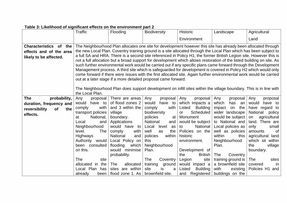
Table 3: Likelihood of significant effects on the environment part 2 Traffic Flooding Biodiversity Historic
Environment
Landscape Agricultural
Land
Characteristics of the effects and of the area likely to be affected.
The Neighbourhood Plan allocates one site for development however this site has already been allocated through the new Local Plan. Coventry training ground is a site allocated through the Local Plan which has been subject to a full SA and HRA. There is a second site referenced in Policy H1; the former British Legion site. However this is not a full allocation but a broad support for development which allows restoration of the listed building on site. As such further environmental work would be carried out if any specific plans came forward through the Development Management process. A third site which is safeguarded for development is covered in Policy H2 which would only come forward if there were issues with the first allocated site. Again further environmental work would be carried out at a later stage if a more detailed proposal came forward. The Neighbourhood Plan does support development on infill sites within the village boundary. This is in line with the Local Plan.
The probability, duration, frequency and reversibility of the effects.
Any proposal would have to comply with transport policies at National, Local and Neighbourhood level. The Highways Authority would been consulted on this. The site allocated in the Local Plan has already been
There are areas of flood zones 2 and 3 within the village boundary. Applications would have to comply with National and Local Policy on flooding which would minimise probability. The allocated sites are within flood zone 1. As
Any proposal would have to comply with biodiversity policies at National and Local level as well as the policies within this Neighbourhood Plan. The Coventry training ground site is a brownfield site.
Any proposal which impacts a Listed Building or Scheduled Monument would be subject to National Policies on the historic environment. Development of the British Legion site would impact a Listed Building and Registered
Any proposal which has an impact on the wider landscape would be subject to National and Local policies as well as policies within this Neighbourhood Plan. The Coventry training ground is a brownfield site with existing buildings on the
Any proposal would have to have regard to National policy on agricultural land. There are only small amounts of agricultural land which sit within the village boundary. The sites covered in Policies H1 and
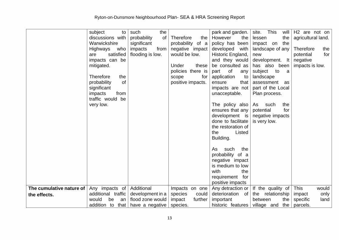
Ryton-on-Dunsmore Neighbourhood Plan- SEA & HRA Screening Report
13
subject to discussions with Warwickshire Highways who are satisfied impacts can be mitigated. Therefore the probability of significant impacts from traffic would be very low.
such the probability of significant impacts from flooding is low.
Therefore the probability of a negative impact would be low. Under these policies there is scope for positive impacts.
park and garden. However the policy has been developed with Historic England, and they would be consulted as part of any application to ensure that impacts are not unacceptable. The policy also ensures that any development is done to facilitate the restoration of the Listed Building. As such the probability of a negative impact is medium to low with the requirement for positive impacts
site. This will lessen the impact on the landscape of any new development. It has also been subject to a landscape assessment as part of the Local Plan process. As such the potential for negative impacts is very low.
H2 are not on agricultural land. Therefore the potential for negative impacts is low.
The cumulative nature of the effects.
Any impacts of additional traffic would be an addition to that
Additional development in a flood zone would have a negative
Impacts on one species could impact further species.
Any detraction or deterioration of important historic features
If the quality of the relationship between the village and the
This would impact only specific land parcels.

Ryton-on-Dunsmore Neighbourhood Plan- SEA & HRA Screening Report
14
which already passes through the village.
cumulative effect on flooding.
could lead to further deterioration in future.
wider landscape deteriorates this could lead to further deterioration in future.
The trans boundary nature of the effects.
Air pollution from traffic may have a trans boundary effect.
Flooding would generally be localised.
These would generally be fairly localised.
These would be localised.
This could have an impact on the wider landscape.
These would be localised.
The risks to human health or the environment (e.g. due to accidents).
Potential for a decrease in air quality, increase in noise and potential for car accidents.
Potential for impacts to human health and damage to habitats.
Very little risk to human health. Potential impacts on individual plants and animals, their habitats and the wider ecosystem.
Very little risk to human health. Risk to the quality of the historic environment and deterioration of the character of Ryton-on-Dunsmore.
Very little risk to human health. Risk to the relationship between the village and the wider landscape.
Very little risk to human health. Some risk to flora and fauna that benefit from the agricultural land.
The magnitude spatial extent of the effects (geographical area and size of the population likely to be affected).
These would be very localised impacts.
Localised impacts.
Localised impacts.
Localised impacts.
Impacts could be perceived to extend beyond the Neighbourhood Area.
Generally impacts would be local but could feed into a larger scale picture if good quality agricultural land is also being lost elsewhere.
The value and vulnerability of the area
This would be dependent on the location of any proposed development.
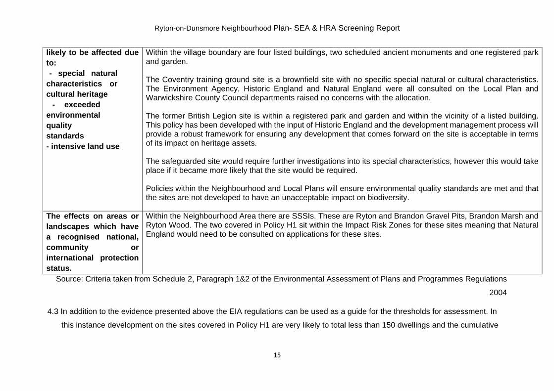
Ryton-on-Dunsmore Neighbourhood Plan- SEA & HRA Screening Report
15
likely to be affected due to:
- special natural characteristics or cultural heritage
- exceeded environmental quality standards - intensive land use
Within the village boundary are four listed buildings, two scheduled ancient monuments and one registered park and garden. The Coventry training ground site is a brownfield site with no specific special natural or cultural characteristics. The Environment Agency, Historic England and Natural England were all consulted on the Local Plan and Warwickshire County Council departments raised no concerns with the allocation. The former British Legion site is within a registered park and garden and within the vicinity of a listed building. This policy has been developed with the input of Historic England and the development management process will provide a robust framework for ensuring any development that comes forward on the site is acceptable in terms of its impact on heritage assets. The safeguarded site would require further investigations into its special characteristics, however this would take place if it became more likely that the site would be required. Policies within the Neighbourhood and Local Plans will ensure environmental quality standards are met and that the sites are not developed to have an unacceptable impact on biodiversity.
The effects on areas or landscapes which have a recognised national, community or international protection status.
Within the Neighbourhood Area there are SSSIs. These are Ryton and Brandon Gravel Pits, Brandon Marsh and Ryton Wood. The two covered in Policy H1 sit within the Impact Risk Zones for these sites meaning that Natural England would need to be consulted on applications for these sites.
Source: Criteria taken from Schedule 2, Paragraph 1&2 of the Environmental Assessment of Plans and Programmes Regulations
2004
4.3 In addition to the evidence presented above the EIA regulations can be used as a guide for the thresholds for assessment. In
this instance development on the sites covered in Policy H1 are very likely to total less than 150 dwellings and the cumulative

Ryton-on-Dunsmore Neighbourhood Plan- SEA & HRA Screening Report
16
area of allocated sites is less than 5ha. This would make the allocations less likely to have significant effects than if the sites
were larger.

5. Assessment for HRA
5.1 There are no European sites within 15km of the Neighbourhood Area.
6. Screening Outcomes
6.1 As a result of the assessment in section 4, it is unlikely that there will be any
significant environmental effects arising from the emerging proposals to be
contained within the Ryton-on-Dunsmore.

Ryton-on-Dunsmore Neighbourhood Plan- SEA & HRA Screening Report
18
Appendix 2‐ Consultation Body Responses
Environment Agency 9, Sentinel House Wellington Crescent, Fradley Park, Lichfield, WS13 8RR. Customer services line: 03708 506 506 www.gov.uk/environment-agency End
Ms Sophie Leaning Rugby Borough Council Development Control PO Box 16 Rugby Warwickshire CV21 2LA
Our ref: UT/2007/101479/SE-05/SC1-L01 Your ref: Ryton-on-Dunsmore Date: 30 April 2019
Dear Ms Leaning Ryton-on-Dunsmore Neighbourhood Plan SEA/HRA Screening Report Thank you for your email which was received on 15 April 2019. As requested we have reviewed the Screening Assessment prepared in support of the Ryton-on-Dunsmore Neighbourhood Plan. Having reviewed the proposals we do not consider there to be significant environmental impacts as a result of this plan, therefore we concur with the conclusions of the report and do not require a SEA or HRA to be undertaken in support of the plan. We advise that consultation is undertaken with Natural England amongst other statutory bodies prior to making any final decision. Yours sincerely Miss Lauren Millward Planning Advisor Direct dial 020 3025 2642 Direct e-mail [email protected]
THE AXIS 10 HOLLIDAY STREET BIRMINGHAM B1 1TF
Telephone 0121 625 6870 HistoricEngland.org.uk
Historic England is subject to both the Freedom of Information Act (2000) and Environmental Information Regulations (2004). Any
Information held by the organisation can be requested for release under this legislation.
Ms Sophie Leaning Direct Dial: 0121 625 6887 Rugby Borough Council Town Hall Our ref: PL00576444 Evreux Way Rugby CV21 2RR 24 April 2019 Dear Ms Leaning RYTON-ON-DUNSMORE NEIGHBOURHOOD PLAN- SEA AND HRA SCREENING Thank you for your consultation and the invitation to comment on the SEA and HRA Screening Document for the above Neighbourhood Plan. For the purposes of consultations on SEA Screening Opinions, Historic England confines its advice to the question, “Is it likely to have a significant effect on the environment?” in respect of our area of concern, cultural heritage. Our comments are based on the information supplied with the screening request. On the basis of the information supplied and in the context of the criteria set out in Schedule 1 of the Environmental Assessment Regulations [Annex II of the ‘SEA’ Directive], Historic England concurs with your view that the preparation of a Strategic Environmental Assessment is not required. Regarding HRA Historic England does not disagree with your conclusions but would defer to the opinions of the other statutory consultees. The views of the other statutory consultation bodies should be taken into account before the overall decision on the need for a SEA is made. If a decision is made to undertake a SEA, please note that Historic England has published guidance on Sustainability Appraisal / Strategic Environmental Assessment and the Historic Environment that is relevant to both local and neighbourhood planning and available at: <https://www.historicengland.org.uk/images-books/publications/sustainability-appraisal-and-strategic-environmental-assessment-advice-note-8/> I trust the above comments will be of help in taking forward the Neighbourhood Plan. Yours sincerely,
Peter Boland Historic Places Advisor [email protected] cc:

THE AXIS 10 HOLLIDAY STREET BIRMINGHAM B1 1TF
Telephone 0121 625 6870 HistoricEngland.org.uk
Historic England is subject to both the Freedom of Information Act (2000) and Environmental Information Regulations (2004). Any
Information held by the organisation can be requested for release under this legislation.
Date: 29 May 2019 Our ref: 281842 Your ref: Ryton-on-Dunsmore SEA Screening
Sophie Leaning Senior Planner Development Strategy Team Rugby Borough Council BY EMAIL ONLY [email protected]
Hornbeam House Crewe Business Park Electra Way Crewe Cheshire CW1 6GJ
T 0300 060 3900
Dear Ms Leaning, SEA Screening for Ryton-on-Dunsmore Neighbourhood Development Plan Thank you for your consultation on the above dated 15th April 2019 which was received by Natural England on the same day. Natural England is a non-departmental public body. Our statutory purpose is to ensure that the natural environment is conserved, enhanced, and managed for the benefit of present and future generations, thereby contributing to sustainable development. Strategic Environmental Assessment Screening We welcome the production of this SEA Screening report. Natural England notes and concurs with the screening outcome i.e. that ‘it is unlikely that there will be any significant environmental effects arising from the emerging proposals…’. Further guidance on deciding whether the proposals are likely to have significant environmental effects and the requirements for consulting Natural England on SEA are set out in the National Planning Practice Guidance. We would be happy to comment further should the need arise but if in the meantime you have any queries please do not hesitate to contact us. For any new consultations, or to provide further information on this consultation please send your correspondences to [email protected]. Yours sincerely Victoria Kirkham Consultations Team

The Civil Parish Of Ryton On Dunsmore
Minutes of the extraordinary meeting held on Wednesday 24th April 2019 in the Village Hall at 7pm
Council Minutes 2019-04b Page 1 of 1 Initial ………
Present: Chairman: Councillor Steve Witter Councillors: Ian Spiers, Geoffrey Marsh, Stuart Tetlow, Kamaldeep Bahra Public: Jake Overton Miss Lindsay Foster (Clerk) 431 18/19 Apologies Councillor Brenda Clarke, Councillor Rod Clarke,Councillor Martin Nobes and Councillor Jayne Lloyd sent apologies. Councillor D Roberts and Councillor H Roberts sent their apologies. These were noted by members of the Council. 432 18/19 Declarations of interests with regard to items on the agenda None. 433 18/19 Public Participation The Council agreed the public could contribute in the Council discussions. 434 18/19 To approve a revision to the Neighbourhood Plan Reserve site policy proposed by RBC. Rugby Borough Council has proposed that Lamb’s Field becomes a safeguarded site rather than a reserve site outside of the limits to development. This would provide the same protection to the site and achieve the intended outcome. Councillor Harrow arrived 19.10. Concerns regarding whether the site would be allocated if Sky Blues failed to deliver housing which would also be the same outcome with original wording of policy. A resolution signed by three councillors had been delivered to the Clerk to revisit the decisions made at the April Parish Council meeting. Motion to revisit decision made to submit submission version of plan Resolution, Proposed by Councillor Witter, seconded by Councillor Marsh The Council resolves that the decision can be revisited to amend the submission version of the plan. Motion to reapprove submission version with amendments and submit to Rugby Borough Council Resolution, Proposed Cllr Marsh seconded Cllr Tetlow The Council resolves that the amendments proposed by rugby borough Council are accepted and the plan is amended and submitted to Rugby borough Council. With thanks to Jake and committee for their efforts in producing the plan. Meeting closed 19.17
Signed ____________ Chairman Date __________

Please ask for Martin Needham
Ryton on Dunsmore Parish Council The Village Hall High Street Ryton on Dunsmore Rugby CV83EY
Direct Line (01788) 5337 41 E-mail [email protected] DX DX 11681 Rugby
Date 3rd June 2019
Dear Miss Foster,
Submission of Neighbourhood Development Plan for Ryton on Dunsmore (Ryton on Dunsmore Neighbourhood Development Plan 2018 - 2031). Submitted 1st May 2019: Consideration of proposal under Schedule 48 of the Town and Country Planning Act 1990.
I write to you on behalf of Rugby Borough Council (RBC) to confirm our receipt of the submission version of your neighbourhood development plan (the Ryton on Dunsmore Neighbourhood Development Plan 2018 - 2031 ), along with accompanying supporting documentation. Firstly, I would like to congratulate your neighbourhood planning group on successfully reaching the submission stage in the neighbourhood planning process.
Under Paragraphs 5 and 6 of Schedule 4B of the Town and Country Planning Act (TCPA) 1990 there is a requirement for RBC, as the local planning authority, to undertake a check of the compliance of the plan. The relevant tests are set out in the TCPA 1990 and relevant sections of the Planning and Compulsory Purchase Act (PCPA) 2004. It is then an obligation of the local planning authority to issue a written statement clarifying the compliance (or otherwise) of the plan.
Accordingly, this letter comprises the formal view of RBC and recommends whether it should be submitted for independent examination. At this stage it is not a duty of the local planning authority to consider the plan proposal against the 'basic conditions' tests set out under Paragraph 8(2) of the TCPA 1990 (this is the role of the independent examiner). I note that your submissions include the Basic Conditions Statement, which provides your detailed consideration of the plan submission against the requirements of the TCPA 1990 and the PCPA 2004.
In a similar manner, I am pleased to confirm the following on behalf of RBC:
• The plan DOES accord with all relevant provisions of the PCPA 2004 in that it: specifies a plan period; does not include any provision for excluded development; and does not relate to more than one neighbourhood area;
Rugby Borough Council, Town Hall, Evreux Way, Rugby CV21 2RR Telephone: (01788) 533533 Email: [email protected]
• The plan DOES NOT comprise a 'repeat proposal' as defined under Paragraph 5 of the TCPA 1990;
• The plan HAS been prepared by a qualifying body (Ryton on Dunsmore Parish Council) who are authorised to deliver a neighbourhood plan; • The submission DOES comprise the relevant documentation required under Paragraph 1 of Schedule 4B of the TCPA 1990 and as prescribed by Regulation 15 of the Neighbourhood Planning (General) Regulations 2012 ('the Regulations');
• The statutory consultation undertaken to date DOES comply with the requirements and regulations set out under Paragraph 4 of the TCPA 1990 and as prescribed by Regulation 14 of the Regulations; and
• The plan DOES comply with all other provisions under section 61 E(2), 61 J and 61 L of the TCPA 1990.
The Ryton on Dunsmore Neighbourhood Development Plan is scheduled to be taken to Cabinet on Monday 24th June for approval to continue to Regulations 16 and 17.
If approval is granted the Neighbourhood Development Plan and supporting documentation will be publicised under Regulation 16 of the 2012 Neighbourhood Planning (General) Regulations, as amended. RBC is now required to publicise the Neighbourhood Plan along with details of how to make representations to it on its website for a minimum of 6 weeks. In accordance with Regulation 16, consultation, if approved by Cabinet, is expected to take place from Tuesday 25th June until Tuesday 6th August 2019 inclusive (6 weeks). The consultation will be carried out in line with the Regulations and the Councils Statement of Community Involvement.
Following this, the plan will be made available for independent examination. We will be arranging for the appointment of an independent examiner for the Ryton on Dunsmore Neighbourhood Plan, who will start the examination following the close of the consultation period. The appointment of the examiner will have to be agreed by Ryton on Dunsmore Parish Council.
Finally, on behalf of RBC this letter represents the Council's formal view that the draft Ryton on Dunsmore Neighbourhood Development Plan 2018 - 2031, as submitted, complies with all of the relevant statutory requirements. Please do not hesitate to contact me if you have any further queries regarding the neighbourhood planning process from hereon.
Yours sincerely,
,rvJ Martin Needham Senior Planning Officer Development Strategy Rugby Borough Council

Page 1 of 6
EQUALITY IMPACT ASSESSMENT (EqIA)
Context 1. The Public Sector Equality Duty as set out under section 149 of the Equality Act 2010
requires Rugby Borough Council when making decisions to have due regard to the following:
eliminating unlawful discrimination, harassment and victimisation, and other conduct prohibited by the Act,
advancing equality of opportunity between people who share a protected characteristic and those who do not,
fostering good relations between people who share a protected characteristic and those who do not, including tackling prejudice and promoting understanding.
2. The characteristics protected by the Equality Act are: age disability gender reassignment marriage/civil partnership pregnancy/maternity race religion/belief sex/gender sexual orientation
3. In addition to the above-protected characteristics, you should consider the crosscutting elements of the proposed policy, such as impact on social inequalities and impact on carers who look after older people or people with disabilities as part of this assessment.
4. The Equality Impact Assessment (EqIA) document is a tool that enables RBC to test and analyse the nature and impact of what it is currently doing or is planning to do in the future. It can be used flexibly for reviewing existing arrangements but in particular should enable identification where further consultation, engagement and data is required.
5. The questions will enable you to record your findings.
6. Where the EqIA relates to a continuing project, it must be reviewed and updated at each stage of the decision.
7. Once completed and signed off the EqIA will be published online.
8. An EqIA must accompany all Key Decisions and Cabinet Reports.
9. For further information, refer to the EqIA guidance for staff.
10. For advice and support, contact: Minakshee Patel Corporate Equality & Diversity Advisor [email protected] Tel: 01788 533509

Page 2 of 6
Equality Impact Assessment
Service Area
Development Strategy
Policy/Service being assessed
Ryton on Dunsmore Neighbourhood Development Plan
Is this is a new or existing policy/service? If existing policy/service please state date of last assessment
This is a new policy document
EqIA Review team – List of members
Martin Needham – Senior Planning Officer Victoria Chapman – Development Strategy Manager
Date of this assessment
3rd June 2019
Signature of responsible officer (to be signed after the EqIA has been completed)
A copy of this Equality Impact Assessment report, including relevant data and information to be forwarded to the Corporate Equality & Diversity Advisor. If you require help, advice and support to complete the forms, please contact Minakshee Patel, Corporate Equality & Diversity Advisor via email: [email protected] or 01788 533509
Page 3 of 6
Details of Strategy/ Service/ Policy to be analysed
Stage 1 – Scoping and Defining
(1) Describe the main aims, objectives and purpose of the Strategy/Service/Policy (or decision)?
The Ryton on Dunsmore Neighbourhood Development Plan contains policies which, once the document is adopted or ‘made’ will form part of the Development Plan for the Borough and will be used alongside local and national policies to determine planning applications in the Parish.
(2) How does it fit with Rugby Borough Council’s Corporate priorities and your service area priorities?
This Plan has the potential to contribute towards several corporate priorities: Enable our residents to live healthy independent lives; Ensure that the council works efficiently and effectively Ensure residents have a home that works for them and is affordable Understand our communities and enable people to take an active part in them; Promote sustainable growth and economic prosperity; and Encourage healthy and active lifestyles to improve wellbeing within the Borough.
All Parish Councils have the right to produce a Neighbourhood Plan if they choose to. The Local Planning Authority has a statutory duty to assist in their production and follow the Regulations in dealing with these. Once adopted or ‘made’ the Local Planning Authority has a statutory duty to use the policies in the determination of planning applications.
(3) What are the expected outcomes you are hoping to achieve?
That the document can be used in the determination of planning applications.
(4)Does or will the policy or decision affect: Customers Employees Wider community or groups
The policy may affect customers or the wider community. Specifically it will affect those living or working in the Parish of Ryton on Dunsmore.
Page 4 of 6
Stage 2 - Information Gathering
As a minimum you must consider what is known about the population likely to be affected which will support your understanding of the impact of the policy, eg service uptake/usage, customer satisfaction surveys, staffing data, performance data, research information (national, regional and local data sources).
(1) What does the information tell you about those groups identified?
The 2011 Census identifies that Ryton on Dunsmore Parish has a population of 1813. 21.35% of the population is aged under 18, 11.42% aged 18 to 29, 20.3% aged 30 to 44, 28.13% aged 45 to 64 and 18.81% aged 65 and over.
(2) Have you consulted or involved those groups that are likely to be affected by the strategy/ service/policy you want to implement? If yes, what were their views and how have their views influenced your decision?
Ryton on Dunsmore Parish Council have carried out their own statutory consultation on their draft plan. They received comments back which have been summarised in their consultation statement. This document has now been submitted to Rugby Borough Council. If approved by Cabinet it will undergo a further consultation by the Council who will contact directly all parties who have previously registered an interest as well as statutory bodies. The consultation will be widely publicised to ensure other interested parties have the chance to respond. The representations made will be passed on to an Independent Examiner who will take these representations into account when producing an examination report.
(3) If you have not consulted or engaged with communities that are likely to be affected by the policy or decision, give details about when you intend to carry out consultation or provide reasons for why you feel this is not necessary.
N/A
Stage 3 – Analysis of impact
(1)Protected Characteristics From your data and consultations is there any positive, adverse or negative impact identified for any particular group, which could amount to discrimination?
RACE No
DISABILITY No
GENDER No
MARRIAGE/CIVIL PARTNERSHIP
No
AGE No
GENDER REASSIGNMENT
No
Page 5 of 6
If yes, identify the groups and how they are affected.
RELIGION/BELIEF No
PREGNANCY MATERNITY
No
SEXUAL ORIENTATION No
(2) Cross cutting themes (a) Are your proposals likely to impact on social inequalities e.g. child poverty, geographically disadvantaged communities? If yes, please explain how? (b) Are your proposals likely to impact on a carer who looks after older people or people with disabilities? If yes, please explain how?
No
(3) If there is an adverse impact, can this be justified?
N/A
(4)What actions are going to be taken to reduce or eliminate negative or adverse impact? (this should form part of your action plan under Stage 4.)
N/A
(5) How does the strategy/service/policy contribute to the promotion of equality? If not what can be done?
The policies have been developed taking into account the thoughts and ideas from a wide cross section of those living and working in the Parish. The Consultation Statement which accompanies the document states the ways in which the community were consulted on several occasions with consultation being widely publicised and accessible. Policies within the plan support affordable housing provision, accommodation for young people, families and elderly people, protection of businesses and fostering new employment opportunities, protection of community facilities and encouraging walking and cycling. Together these help protect and promote sustainable ways of life across the community.
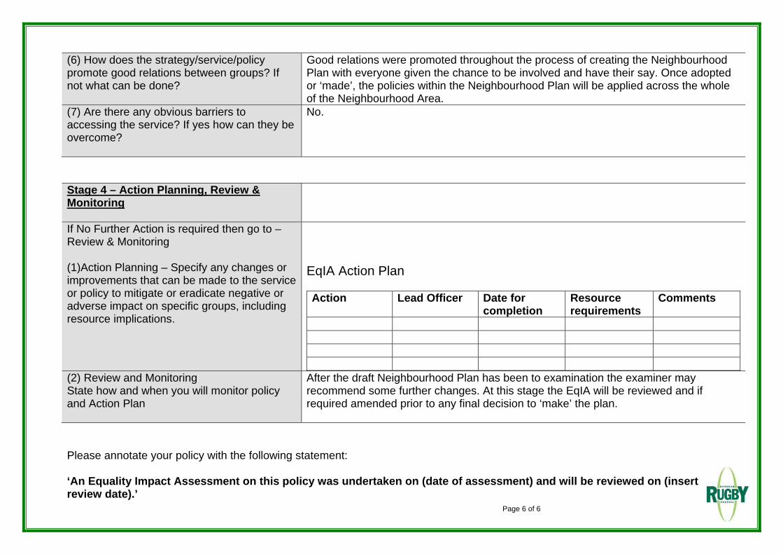
Page 6 of 6
(6) How does the strategy/service/policy promote good relations between groups? If not what can be done?
Good relations were promoted throughout the process of creating the Neighbourhood Plan with everyone given the chance to be involved and have their say. Once adopted or ‘made’, the policies within the Neighbourhood Plan will be applied across the whole of the Neighbourhood Area.
(7) Are there any obvious barriers to accessing the service? If yes how can they be overcome?
No.
Stage 4 – Action Planning, Review & Monitoring
If No Further Action is required then go to – Review & Monitoring (1)Action Planning – Specify any changes or improvements that can be made to the service or policy to mitigate or eradicate negative or adverse impact on specific groups, including resource implications.
EqIA Action Plan Action Lead Officer Date for
completion Resource requirements
Comments
(2) Review and Monitoring State how and when you will monitor policy and Action Plan
After the draft Neighbourhood Plan has been to examination the examiner may recommend some further changes. At this stage the EqIA will be reviewed and if required amended prior to any final decision to ‘make’ the plan.
Please annotate your policy with the following statement: ‘An Equality Impact Assessment on this policy was undertaken on (date of assessment) and will be reviewed on (insert review date).’

Consultation Strategy
Document title: Ryton on Dunsmore Neighbourhood Development Plan Regulation 16 Consultation and Regulation 17 Examination
Nature of Plan being prepared:
This document is the submission version of the Ryton on Dunsmore Neighbourhood Development Plan. Once adopted, or ‘made’, it will form part of the development plan for Rugby and the policies contained within it will be used to make decisions on planning applications within the Neighbourhood Area alongside local and national policy.
Purpose of consultation This consultation is required under Regulation 16 of The Neighbourhood Planning (General) (As Amended) Regulations 2012.
Nature of issues that need to be consulted upon
The focus of the consultation and subsequent examination
will be on whether the plan meets the basic conditions.
These require that the plan:
Has regard to national policy and guidance from the
Secretary of State;
Contributes to sustainable development;
Is in general conformity with the strategic policy of
the development plan for the area or any part of that
area;
Doesn’t breach or is otherwise compatible with EU
obligations‐ this includes the SEA Directive of
2001/42/EC; and that
The making of the Neighbourhood Plan is not likely
to have a significant effect on a European site (as
defined in the Conservation of Habitats and Species
regulations 2010(d)) either alone or in combinations
with other plans or projects.
Who should be consulted All individuals and organisations referred to in the consultation statement will be notified directly in accordance with the Regulations. Other statutory bodies and individuals will be notified directly in line with the SCI. The consultation will also be publicised on the Rugby Borough Council website and with a press notice in line with the Regulations and the SCI. Hard copies will be available at Rugby Borough Council and local libraries.
Why are we consulting The consultation is to obtain views on whether the Neighbourhood Development Plan meets the basic conditions.
When will the consultation take place
Consultation is expected to take place between Tuesday the 25th June and Tuesday 6th August 2019.
Accessible Inclusive Consultation
Notifications will be made in the local newspaper, online and by email and post. Electronic copies of the documents will be available to download with hard copies available in local libraries. Hard copies can also be provided to individuals on request. Representation can be received in several formats; via an online form, via email or by post.
How comments will be taken into account
All comments received will be passed on to the Examiner and be used in examining the Neighbourhood Plan.
How will comments be reported
Responses received will be considered by the Examiner. The representations will be made public by the Council following the close of the consultation.
Related Documents


![SIAF PRODUZIONE [*P] - IMPORTAZIONE e AGENZIA DI · PDF file8.13 kd siaf mod k r - chemical ryton versione in ryton magneti teflonati red switch hall effect ingranaggi in ryton corpo](https://static.cupdf.com/doc/110x72/5a9d46617f8b9abd058b4af7/siaf-produzione-p-importazione-e-agenzia-di-kd-siaf-mod-k-r-chemical.jpg)