RV AKADEMIK M. A. LAVRENTYEV CRUISE 27 CRUISE REPORT GREGORY GERMAN RUSSIAN EXPEDITION FOR GEOLOGICAL / GEOPHYSICAL OKHOTSK SEA RESEARCH Vladivostok - Pusan - Okhotsk Sea - Pusan - Vladivostok September 7 - October 12,1995 Edited by Dirk Nürnberg, Boris V. Baranov, and Boris Ya. Karp The GREGORY marine expedition was initialized on responsibility of the Pacific Oceanological Institute (Vladivostok) the P. P. Shirshov Institute of Oceanology (Moscow) and the GEOMAR Research Center for Marine Geosciences (Kiel) GEOMAR Forschungszentrum für marine Geowissenschaften der Christian-Aibrechts-Universität zu Kiel Kiel 1997 GEOMAR REPORT 60 GEOMAR Research Center for Marine Geosciences Christian Albrechts University in Kiel

Welcome message from author
This document is posted to help you gain knowledge. Please leave a comment to let me know what you think about it! Share it to your friends and learn new things together.
Transcript
RV AKADEMIK M. A. LAVRENTYEV CRUISE 27 CRUISE REPORT
GREGORYGERMAN RUSSIAN EXPEDITION
FOR GEOLOGICAL / GEOPHYSICAL OKHOTSK SEA RESEARCH
Vladivostok - Pusan - Okhotsk Sea - Pusan - Vladivostok September 7 - October 12,1995
Edited byDirk Nürnberg, Boris V. Baranov, and Boris Ya. Karp
The GREGORY marine expedition was initialized on responsibility of the Pacific Oceanological Institute (Vladivostok)
the P. P. Shirshov Institute of Oceanology (Moscow)and the
GEOMAR Research Center for Marine Geosciences (Kiel)
GEOMARForschungszentrum für marine Geowissenschaften der Christian-Aibrechts-Universität zu Kiel
Kiel 1997
GEOMAR REPORT 60
GEOMARResearch Center for Marine Geosciences Christian Albrechts University in Kiel
Redaktion der Serie: Gerhard Haass Managing Editor. Gerhard HaassUmschlag: Kerstin Kreis, Harald Gross, Cover: Kerstin Kreis, Harald Gross,
GEOMAR Technologie GmbH GEOMAR Technologie GmbH
GEOMAR REPORT ISSN 0936 - 5788
GEOMARForschungszentrum für marine Geowissenschaften D-24148 Kiel Wischhofstr. 1-3Telefon (0431) 600-2555, 600-2505
GEOMAR REPORT ISSN 0936 - 5788
GEOMARResearch Center for Marine Geosciences D-24148 Kiel / Germany Wischhofstr. 1-3Telephone (49) 431 / 600-2555, 600-2505
Contents:
1. Preface 1
2. List o f participants 3
3. Scientific background and objectives 43.1 Tectonics 43.2 Petrology 73.3 Paleoceanography 73.4 Gas geochemistry 9
4. Methods and instruments 104.1 Geophysical methods 10
4.1.1 Gravity 104.1.2 Magnetic intensity 104.1.3 Seismic 104.1.4 Bathymetry 11
4.2 Geological and geochemical methods 114.2.1 Recovery o f deep-sea sediments 11
4.2.1.1 Multicorer 114.2.1.2 Gravity corer 114.2.1.3 Dredging 12
4.2.2 Sediment sampling and processing aboard the ship 134.2.2.1 GEOMAR approach 134.2.2.2 POI approach 14
4.2.3 Gas sampling 144.2.4 Mechanical properties o f the sediments 144.2.5 Magnetic susceptibility 154.2.6 Micropaleontology 15
4.3 Hydrographical methods 164.3.1 Plankton net 164.3.2 Water sampling 17
5. Results 185.1 Marine geophysics 18
5.1.1 Bathymetry 185.1.2 Seismic 215.1.3 Gravity and magnetics 26
5.2 Marine geology and geochemistry 295.2.1 Bedrocks 295.2.2 Sediment stratigraphy 315.2.3 Mineralogy 325.2.4 Morphometric analysis o f terrigenous quartz 345.2.5 Mechanical properties o f sediments 365.2.6 Magnetic susceptibility 385.2.7 Radiolarians in the Okhotsk Sea sediments 395.2.8 Sedimentation at the northeastern slope o f Sakhalin 415.2.9 Marine geology o f the central Okhotsk Sea 435.2.10 Gas geochemistry 48
5.3 Plankton investigations 525.4 Conclusions 53
6. Tectonic structure o f the northern Kurile Basin slope:Implication to the Okhotsk Sea geodynamics 54
7. Conclusions and perpectives 64
8. References 66
Appendix I. Research vessel "Akademik M.A. Lavrentyev"Appendix II. Station coordinatesAppendix III. Track coordinatesAppendix IV. TablesAppendix V. Sediment core descriptionAppendix VI. Magnetic susceptibility and humidity o f all sites
1. Preface(B.Ya. Karp, D. Nürnberg, and B.V. Baranov)
The Okhotsk Sea belongs to the NW-Pacific marginal sea system. To the northwest and to the north, it is bound by the Asian continent. To the east and southeast, the NE-SW trending Kurile-Kamchatka Island Arc separates the Okhotsk Sea from the Bering Sea and the Pacific Ocean. The Okhotsk Basin is separated from the Japan Sea and the Asian continent by the N-S trending Hokkaido and Sakhalin mountain systems, which lie approximately 45° to the strike o f the Kurile-Kamchatka Island Arc. W ith respect to geodynamical and environmental problems, each o f the marginal seas o f the NW- Pacific marginal sea system represents a unique object for research. The Okhotsk Sea is the most interesting among them due to certain peculiar features o f its tectonic structure, distinctly manifested seasonal character o f the climate and hydrology, and the high level o f the primary production. The investigations o f tectonics, environment and ecology o f the Okhotsk Sea and surrounding areas is, thus, suggested to be o f highest priority.
The jo in t German/Russian KOMEX Project (Kurile - Okhotsk - Marine Expedition), a Russian-German cooperation planned for 1997-1999 - suggests three major topics o f research:
1. environmental parameters, fluxes, paleoceanographical proxies;2. crustal structure, tectonics and geodynamics;3. volcanic volatiles and petrogenesis.
Within the framework o f the multidisciplinary KOMEX project the 27th cruise o f RV Akademik Lavrentyev was jointly organized by the Pacific Oceanological Institute, Far East Branch o f the Russian Academy o f Sciences (POI, Vladivostock), the institute o f Oceanology o f the Russian Academy o f Sciences (IORAS, Moscow), and GEOMAR, Research Center for Marine Geosciences at Kiel University, and was intended to be a pre-KOMEX activity. The cruise was sponsored by the M inistry o f Science and Technology (BMBF, Germany) and the Russian Academy o f Sciences.
Initially, it was planned to conduct several ship expeditions during KOMEX to focus on each o f these research topics separately. However, the pre-KOMEX RV Akademik Lavrentyev cruise combines both the tectonic and the environmental topics, in order to allow all participating partner institutions to evaluate the area for future investigations, to estimate possibilities o f the equipment available, and to coordinate their scientific interests and the scientific and logistical p lanning for future cooperations.
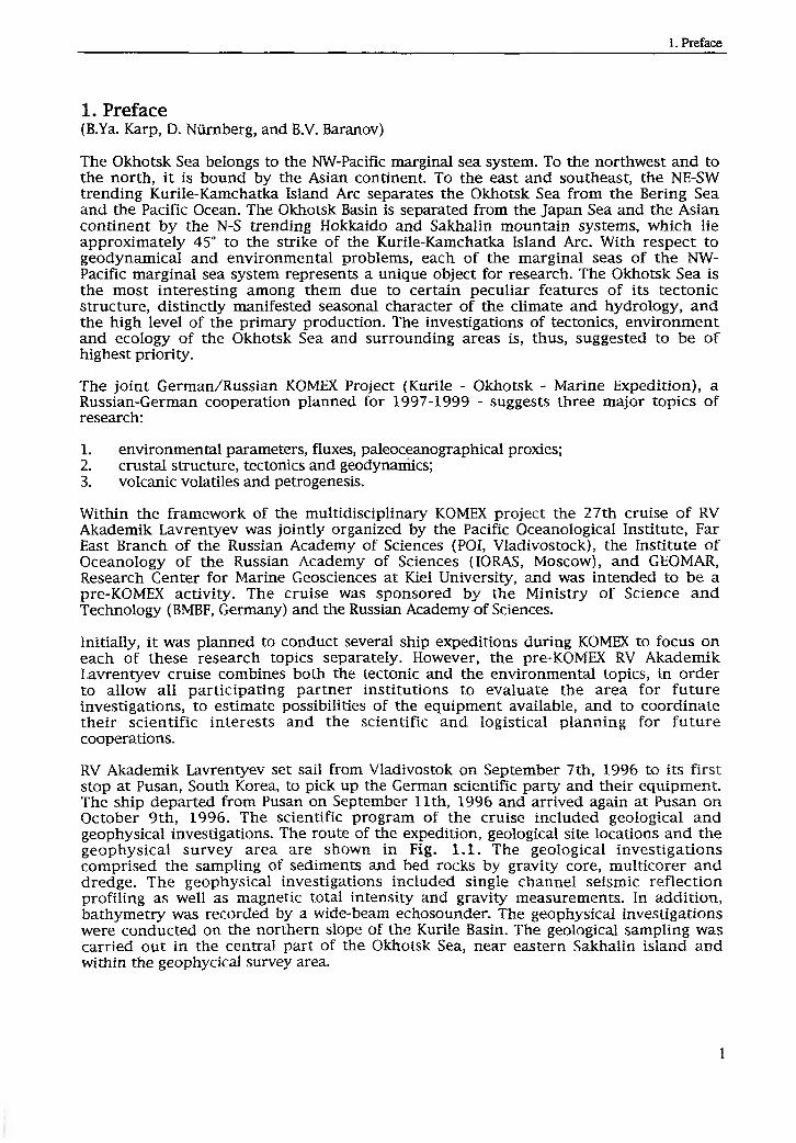
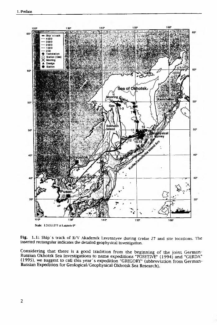
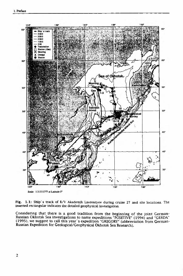
RV Akademik Lavrentyev set sail from Vladivostok on September 7th, 1996 to its first stop at Pusan, South Korea, to pick up the German scientific party and their equipment. The ship departed from Pusan on September 11th, 1996 and arrived again at Pusan on October 9th, 1996. The scientific program o f the cruise included geological and geophysical investigations. The route o f the expedition, geological site locations and the geophysical survey area are shown in Fig. 1.1. The geological investigations comprised the sampling o f sediments and bed rocks by gravity core, multicorer and dredge. The geophysical investigations included single channel seismic reflection profiling as well as magnetic total intensity and gravity measurements. In addition, bathymetry was recorded by a wide-beam echosounder. The geophysical investigations were conducted on the northern slope o f the Kurile Basin. The geological sampling was carried out in the central part o f the Okhotsk Sea, near eastern Sakhalin island and within the geophycical survey area.
120" 130" 140° 150» 1601
Scale: 1:31511377 at Latitude 0°
Fig. 1.1: Ship s track of R/V Akademik Lavrentyev during cruise 27 and site locations. The inserted rectangular indicates the detailed geophysical investigation.
Considering that there is a good tradition from the beginning o f the jo in t German- Russian Okhotsk Sea investigations to name expeditions "POSETIVE" (1994) and "GERDA" (1995), we suggest to call this year's expedition "GREGORY" (abbreviation from German- Russian Expedition for Geological/Geophysical Okhotsk Sea Research).

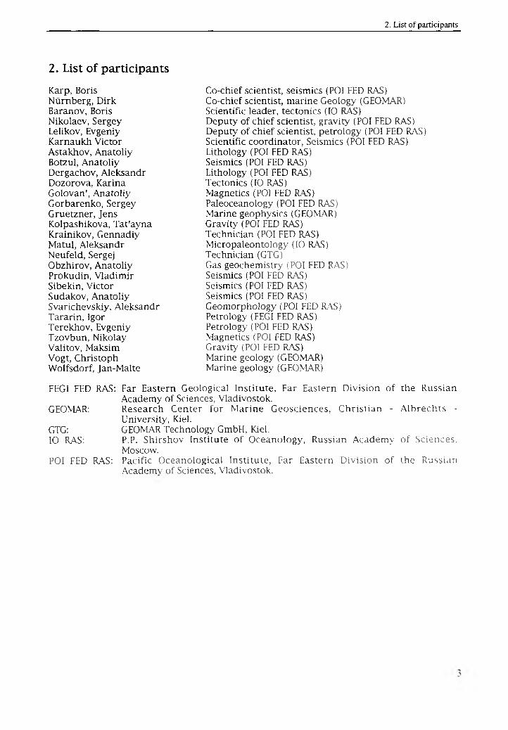
2. List of participants
Karp, Boris Nürnberg, Dirk Baranov, Boris Nikolaev, Sergey Lelikov, Evgeniy Karnaukh Victor Astakhov, Anatoliy Botzul, Anatoliy Dergachov, Aleksandr Dozorova, Karina Golovan', Anatoliy Gorbarenko, Sergey Gruetzner, Jens Kolpashikova, Tat'ayna Krainikov, Gennadiy Matul, Aleksandr Neufeld, Sergej Obzhirov, Anatoliy Prokudin, Vladimir Sibekin, Victor Sudakov, Anatoliy Svarichevskiy, Aleksandr Tararin, Igor Terekhov, Evgeniy Tzovbun, Nikolay Valitov, Maksim Vogt, Christoph Wolfsdorf, Jan-Malte
Co-chief scientist, seismics (POI FED RAS)Co-chief scientist, marine Geology (GEOMAR) Scientific leader, tectonics (10 RAS)Deputy o f chief scientist, gravity (POI FED RAS) Deputy o f chief scientist, petrology (POI FED RAS) Scientific coordinator, Seismics (POI FED RAS) Lithology (POI FED RAS)Seismics (POI FED RAS)Lithology (POI FED RAS)Tectonics (10 RAS)Magnetics (POI FED RAS)Paleoceanology (POI FED RAS)Marine geophysics (GEOMAR)Gravity (POI FED RAS)Technician (POI FED RAS)Micropaleontology (10 RAS)Technician (GTG)Gas geochemistry (POI FED RAS)Seismics (POI FED RAS)Seismics (POI FED RAS)Seismics (POI FED RAS)Geomorphology (POI FED RAS)Petrology (FEGI FED RAS)Petrology (POI FED RAS)Magnetics (POI FED RAS)Gravity (POI FED RAS)Marine geology (GEOMAR)Marine geology (GEOMAR)
FEGI FED RAS: Far Eastern Geological Institute, Far Eastern Division o f the Russian Academy o f Sciences, Vladivostok.
GEOMAR: Research Center for Marine Geosciences, Christian - A lbrechts - University, Kiel.
GTG: GEOMAR Technology GmbH, Kiel.10 RAS: P.P. Shirshov Institute o f Oceanology, Russian Academy o f Sciences,
Moscow.POI FED RAS: Pacific Oceanological Institute, Far Eastern Division o f the Russian
Academy o f Sciences, Vladivostok.
120* 130* 140* 150" 1 « r
120“ 130" 140“ 150- 160“
Scale: 1:31511377 at Latitude 0°
Fig. 1.1: Ship's track of R/V Akademik Lavrentyev during cruise 27 and site locations. The inserted rectangular indicates the detailed geophysical investigation.
Considering that there is a good tradition from the beginning o f the join t German- Russian Okhotsk Sea investigations to name expeditions "POSETIVE" (1994) and "GERDA" (1995), we suggest to call this year's expedition "GREGORY" (abbreviation from German- Russian Expedition for Geological/Geophysical Okhotsk Sea Research).

2. List of participants
Karp, Boris Nürnberg, Dirk Baranov, Boris Nikolaev, Sergey Lelikov, Evgeniy Karnaukh Victor Astakhov, Anatoliy Botzul, Anatoliy Dergachov, Aleksandr Dozorova, Karina Golovan', Anatoliy Gorbarenko, Sergey Gruetzner, Jens Kolpashikova, Tat'ayna Krainikov, Gennadiy Matul, Aleksandr Neufeld, Sergej Obzhirov, Anatoliy Prokudin, Vladimir Sibekin, Victor Sudakov, Anatoliy Svarichevskiy, Aleksandr Tararin, Igor Terekhov, Evgeniy Tzovbun, Nikolay Valitov, Maksim Vogt, Christoph Wolfsdorf, Jan-Malte
Co-chief scientist, seismics (POI FED RAS)Co-chief scientist, marine Geology (GEOMAR) Scientific leader, tectonics (10 RAS)Deputy o f chief scientist, gravity (POI FED RAS) Deputy o f chief scientist, petrology (POI FED RAS) Scientific coordinator, Seismics (POI FED RAS) Lithology (POI FED RAS)Seismics (POI FED RAS)Lithology (POI FED RAS)Tectonics (10 RAS)Magnetics (POI FED RAS)Paleoceanology (POI FED RAS)Marine geophysics (GEOMAR)Gravity (POI FED RAS)Technician (POI FED RAS)Micropaleontology (10 RAS)Technician (GTG)Gas geochemistry (POI FED RAS)Seismics (POI FED RAS)Seismics (POI FED RAS)Seismics (POI FED RAS)Geomorphology (POI FED RAS)Petrology (FEGI FED RAS)Petrology (POI FED RAS)Magnetics (POI FED RAS)Gravity (POI FED RAS)Marine geology (GEOMAR)Marine geology (GEOMAR)
FEGI FED RAS: Far Eastern Geological Institute, Far Eastern Division o f the Russian Academy o f Sciences, Vladivostok.
GEOMAR: Research Center for Marine Geosciences, Christian - Albrechts -University, Kiel.
GTG: GEOMAR Technology GmbH, Kiel.10 RAS: P.P. Shirshov Institute o f Oceanology, Russian Academy o f Sciences,
Moscow.POI FED RAS: Pacific Oceanological Institute, Far Eastern Division o f the Russian
Academy o f Sciences, Vladivostok.
Scale: 1:31511377 at Latitude 0°
Fig. 1.1. Ship s track of R/V Akademik Lavrentyev during cruise 27 and site locations. The inserted rectangular indicates the detailed geophysical investigation.
Considering that there is a good tradition from the beginning o f the joint German- n n n '-n Okhotsk Sea investigations to name expeditions "POSETIVE" (1994) and "GERDA" (1995), we suggest to call this year s expedition "GREGORY" (abbreviation from German- Kussian Expedition for Geological/Geophysical Okhotsk Sea Research).
2. List of participants
Karp, Boris Nürnberg, Dirk Baranov, Boris Nikolaev, Sergey Lelikov, Evgeniy Karnaukh Victor Astakhov, Anatoliy Botzul, Anatoliy Dergachov, Aleksandr Dozorova, Karina Golovan', Anatoliy Gorbarenko, Sergey Gruetzner, Jens Kolpashikova, Tat'ayna Krainikov, Gennadiy Matul, Aleksandr Neufeld, Sergej Obzhirov, Anatoliy Prokudin, Vladimir Sibekin, Victor Sudakov, Anatoliy Svarichevskiy, Aleksandr Tararin, Igor Terekhov, Evgeniy Tzovbun, Nikolay Valitov, Maksim Vogt, Christoph Wolfsdorf, Jan-Malte
Co-chief scientist, seismics (POI FED RAS)Co-chief scientist, marine Geology (GEOMAR) Scientific leader, tectonics (10 RAS)Deputy of chief scientist, gravity (POI FED RAS) Deputy o f chief scientist, petrology (POI FED RAS) Scientific coordinator, Seismics (POI FED RAS) Lithology (POI FED RAS)Seismics (POI FED RAS)Lithology (POI FED RAS)Tectonics (10 RAS)Magnetics (POI FED RAS)Paleoceanology (POI FED RAS)Marine geophysics (GEOMAR)Gravity (POI FED RAS)Technician (POI FED RAS)Micropaleontology (10 RAS)Technician (GTG)Gas geochemistry (POI FED RAS)Seismics (POI FED RAS)Seismics (POI FED RAS)Seismics (POI FED RAS)Geomorphology (POI FED RAS)Petrology (FEGI FED RAS)Petrology (POI FED RAS)Magnetics (POI FED RAS)Gravity (POI FED RAS)Marine geology (GEOMAR)Marine geology (GEOMAR)
FEGI FED RAS: Far Eastern Geological Institute, Far Eastern Division o f the Russian Academy o f Sciences, Vladivostok.
GEOMAR: Research Center for Marine Geosciences, Christian - Albrechts -University, Kiel.GEOMAR Technology GmbH, Kiel.P.P. Shirshov Institute o f Oceanology, Russian Academy o f Sciences. Moscow.Pacific Oceanological Institute, Far Eastern Division o f the Russian Academy o f Sciences, Vladivostok.
GTG:10 RAS:
POI FED RAS:
3. Scientific background and objectives(B. Baranov, S. Gorbarenko, B. Karp, D. Nürnberg, E. Lelikov, and A. Obzhirov)
3.1 Tectonics
In the Okhotsk Sea, various scientific and industrial organizations o f the former USSR carried out geological and geophysical investigations. Most o f these studies were performed in areas showing a thick sedimentary cover to search for oil and gas occurrences. These areas are located along Sakhalin Island, the Asian continent, and the Kamchatka Peninsula coasts. The available data allowed to determine the general tectonic and crustal structure, nevertheless, many unsolved problems still remain. The tectonic evolution o f the Kurile Basin is one of them.
The Kurile Basin is the greatest and deepest among three basins o f the Okhotsk Sea (Fig. 3.1). The so-called back-arc basin is located behind the Kurile Island arc, the existence o f which is typical for other north-western Pacific marginal seas, e.g. the Japan and Bering Seas. The maximum depth of the Kurile Basin equals to 3374 m, which is the maximum depth o f the entire Okhotsk Sea. The average depth o f the Kurile Basin equals to 3300 m.
Previous studies (Galperin and Kosminskaya, 1964; Bikkenina et al., 1987) showed that the Kurile Basin's oceanic crust is covered by a thick sediment pile (velocity o f 1.7-2.3 km/s) o f up to 5 km. Below, the second layer is characterized by velocities o f 4.3-5.2 km/s and a thickness o f 2.0-2.8 km. This layer presumably constitutes the top of consolidated volcanogenic-sedimentary rocks. A high velocity layer (Vp = 6.8 km/sec) corresponding to oceanic layer 3 exhibits a thickness of 4-5 km. The Moho discontinuity is recognized at 13 km depth below sea surface.
Based on these results, the Kurile Basin is suggested to have been formed due to back- arc extension, which was followed by seafloor-spreading and the formation o f new oceanic crust. Up to now, it is suggested that the spreading axis within the Kurile Basin trends NE-SW being parallel to the Kurile Island Arc. Opening is, thus, suggested to be orthogonal to the spreading axis (Fig. 3.2 a) (Savostin et al., 1983; Kimura and Tamaki, 1986). However, data verifying this geometry, such as linear magnetic anomalies and the structural manifestation o f the spreading axis, are still absent. The above mentioned tectonic situation is mainly based on both the general tectonic pattern and the similarity o f the northern and southern Kurile Basin slopes.
The impossibility o f establishing a correlation between the opening geometry o f the Kurile Basin and the Okhotsk rift system furthermore contradicts the tectonic pattern outlined above. The Okhotsk rift system is one o f the most remarkable features o f the Okhotsk Sea tectonics (Gnibidenko, 1990). Its separate parts formed simultaneously with the basin, but exhibit an orthogonal direction of extension in comparison to it.
Recently, Baranov et al. (1995) proposed a new model of the Kurile Basin opening geometry. According to this model, the spreading axis is orientated in a northwesterly direction, orthogonal to both the Kurile Island Arc and the Kurile Basin, suggesting the pull-apart mode o f basin opening (Fig. 3.2 b). In such a case, the direction o f the Kurile Basin opening parallels the extensional trend o f the Okhotsk rift system Accordingly, both the northern and southern flanks o f the Kurile Basin correspond to strike-slip structures along the curves of big circles.
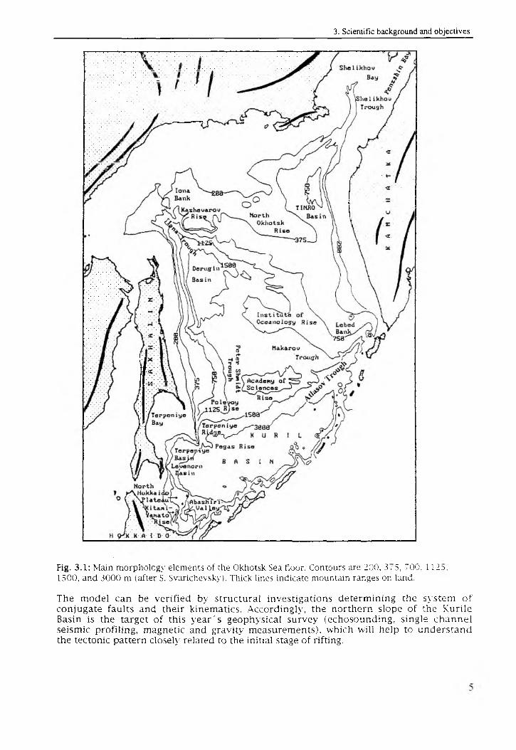
Fig. 3.1: Main morphology elements of the Okhotsk Sea floor. Contours are 200, 3, 5, 700, 112^,1500, and 3000 m (after S. Svarichevsky). Thick lines indicate mountain ranges on land.
The model can be verified by structural investigations determining the system o f conjugate faults and their kinematics. Accordingly, the northern slope o f the Kurile Basin is the target o f this year's geophysical survey (echosounding, single channel seismic profiling, magnetic and gravity measurements), which will help to understand the tectonic pattern closely related to the initial stage o f rifting.
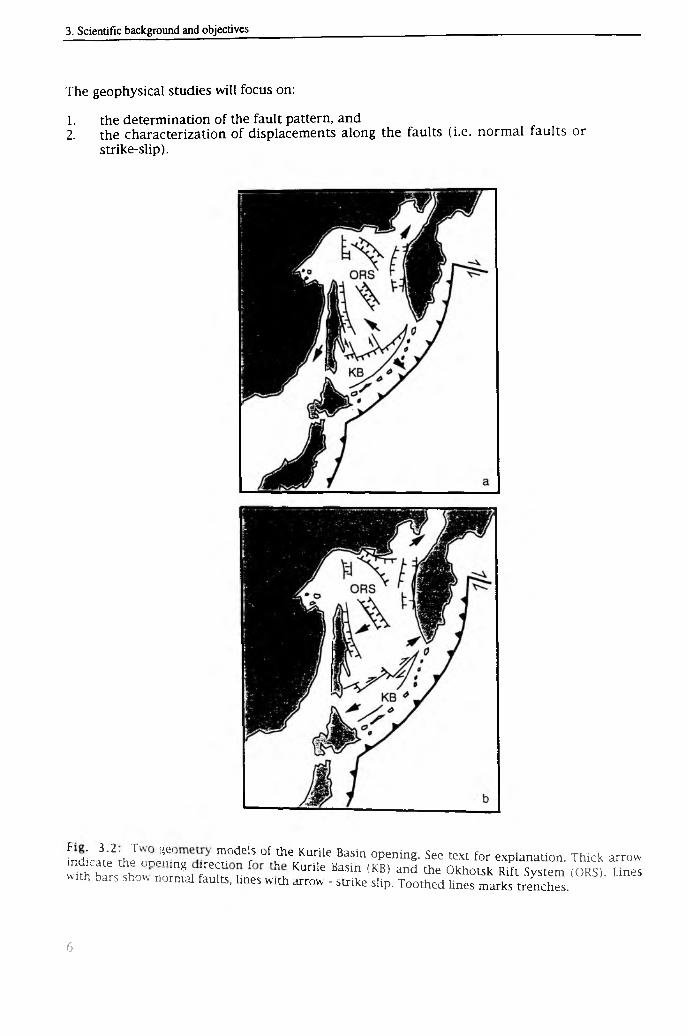
The geophysical studies will focus on:
1. the determination of the fault pattern, and2. the characterization of displacements along the faults (i.e. normal faults or
strike-slip).
fndlci;2; J n n J i ? T ° deifS 0f ,the Kurile Basin 0pening- See text for explanation. Thick arroww iS S s ih o w n o Z , r ' i r r Kurile Basm (KB) and 1116 0khotsk Rift System (ORS). Linesh bars show normal faults, lines with arrow - strike slip. Toothed lines marks trenches.
3.2 Petrology
Previous investigations (Geodekyan et al., 1976; Vasiliev et al., 1990; Lelikov, 1992) showed that the Okhotsk Sea has a complex heterogenous basement structure. In this respect, the central Okhotsk Sea is the best studied area as it exhibits the minimum sediment thickness. In contrast, the periphery o f the basin being characterized by deep subsidence and accordingly, maximum sediment thicknesses o f up to 8 km (Kharakhinov et al., 1985), remains nearly unknown.
In the central Okhotsk Sea, the basement outcrops are predominantly located on bathymetric uplifts. These uplifts can be traced from Iona Island in the north to the continental rise o f the Kuriles in the south. Within this belt, the basement crops out on Iona Bank, Kashevarova Rise, North-Okhotsk Rise, Institute o f Oceanology Rise, and Academy o f Sciences Rise, as well as on the slopes o f the Kurile Basin.
Different institutes o f the Russian Academy o f Sciences carried out dredgings on these rises during the seventies and eighties. Unfortunately, the dredging stations were not supported by seismic reflection surveys. This, however, is extremely needed in regions characterized by a widely extended sedimentary cover, which may cover basement scarps. On the base o f rock material gathered by dredging, the follow ing rock complexes were found:
1. Metamorphic rocks o f apparently Paleozoic age;2. Jurassic and Mesozoic granitoids;3. Cenozoic volcanic rocks similar in composition to the Kurile-Kamchatka
Island Arc volcanites;4. Mesozoic to Cenozoic sedimentary rocks.
Based on these data, Noklenberg et al. (1994) suggested that the Okhotsk Sea basement consists o f terranes, which originated from d ifferen t geodynamic conditions. Nevertheless, a lot o f problems are still unsolved, e.g. how is the boundary between the ancient continental crust occupying the major part o f the Okhotsk Sea and the young (Oligocene-Miocene?) oceanic crust manifested in the basement rock composition?
Therefore, a number o f dredgings at the northern slope o f the Kurile Basin were suggested in order to investigate the boundary between thinned continental crust (Academ y o f Sciences Rise) and oceanic crust (Kurile Basin). Bedrock sampling accompanied by geophysical surveys and its further petrological analysis is, thus, proposed in order:
1. to examine the rock composition and to determine the type o f the earth's crust;2. to search for volcanic rocks, such as alkaline basalts connected with the rifting
process;3. to determ ine the basem ent's physical properties being important for the
geophysical (seismic, gravimetric and magnetic) data interpretation;4. to study the composition and the age o f sedimentary rocks outcropping along the
Kurile Basin slopes.
3.3 Paleoceanography
From the paleoceanographic point o f view, the Okhotsk Sea is still one o f the poorly investigated basins, although this basin is o f extraordinary importance for the understanding o f both regional paleoenvironmental changes and global climate changes. The Okhotsk Sea represents a marginal basin characterized by a high terrigenous influx. It, thus, is a unique location at high northern latitudes to obtain
high-resolution records o f paleoclimatic and paleoenvironmental changes and to understand the nature o f these changes. Changes o f water circulation, biological productivity, sea-level, and sea ice conditions connected with global climatic changes during Pleistocene and Holocene times are expressed in this basin better than in the Pacific Ocean.
In the fifties and sixties, Russian scientists started lithological, geochemical and m icropaleontological studies within the upper sediment cover o f the Okhotsk Sea (Bezrukov, 1955; Zhuze, 1962), but the low content o f biogenic carbonate restricted detailed stratigraphical and paleoceanographical investigations in this basin.
During the last years, radiocarbon-dated downcore records o f stable isotopes, and diverse geochemical and micropaleontological parameters allowed to set up a reliable stratigraphy, from which prelim inary conclusions were drawn concerning the tem porally changing paleoenvironment o f the Okhotsk Sea (M orley et al., 1991; Gorbarenko et al., 1988; Gorbarenko, 1991, Keigwin, 1995). The majority o f the analyzed cores was recovered from the central Okhotsk Sea, mainly from the southern slope of the Academ y o f Sciences Rise. From these studies it became apparent that environmental changes in the Okhotsk Sea are closely linked to NW-Pacific conditions, but also show distinct individual features (Gorbarenko, subm.). For instance, AMS-14C dated 3 ^ 0 and 3l^C records, carbonate, organic carbon and opal records, and temporal changes in the faunal composition reveal significant paleoenvironmental changes in the Okhotsk Sea during Termination 1A (13-12 ky BP), the Younger Dryas cooling event, and early Holocene times (Gorbarenko et al., in press). The Holocene environmental changes were accompanied by the drastic increase o f biogenic silica caused by an enhanced biological productivity transforming the basin into a "silica" type basin.
Gorbarenko et al. (1988) pointed out that the increasing productivity during Holocene times did not simultaneously occur in the entire basin, but spread progressively from its open part towards the basin periphery in dependance from the increasing surface water temperatures. During this years s cruise, it will be attempted to assemble detailed records o f various paleoenvironmental parameters from different parts o f the basin,i.e. in sediment cores located along a NW-SE-trending profile (Sites 4, 5, 6, 7, 8, 9, 12) (Figs. 1.1 and 5.1).
The proposed Sites 1-3 are located in the outflow zone o f suspended matter from the Amur river, which flows southward along the eastern Sakhalin slope. The sediment cores will distinctively reflect environmental changes o f the northwestern Okhotsk Sea, which is strongly influenced by the Amur river.
In order to study deep water ventilation changes and their influence on the generation of intermediate and deep waters within the Pacific Ocean, sediment cores from different depths will be recovered (Sites 5, 6, 7, 9, and 12). The deep water masses o f the Pacific Ocean are the largest reservoir o f total dissolved inorganic carbon dioxide (total COz)- Possible changes in the formation o f the Pacific intermediate and deep water masses may allow to further understand variations in the atmospheric CO 2 content, and further to better understand the global climate.
Recently, Talley (1991) has stressed the importance o f the Okhotsk Sea water masses for the North Pacific intermediate water mass formation. Due to the fact that the Okhotsk Sea belongs to the "silica"-type basin, CO2 is directly transported from the surface waters to the deep water masses through bioproduction and, thus, serves as a sink for atmospheric CO2- Processes of vertical ventilation and changes o f the biological CO2- pump transferring CO2 from the atmosphere to the Pacific deep reservoir are therefore of outstanding importance to understand climate change.
3.4 Gas geochemistry
During the last twenty years, gas distribution patterns were studied within the water column and in sediments from the Okhotsk Sea. All investigations focussed on the applicability o f gas as an indicator for oil-gas prediction, for mapping fault zones, and for searching for gas hydrates, hydrothermal and seeping vents.
As a result, gas anomalies were found in bottom water masses, in distinct horizons o f the water column, and within seafloor deposits o f the Okhotsk Sea. Here, methane is concentrated in bottom water anomalies located above oil and gas deposits, gas hydrates and fault zones. Methane concentrations in anomalies reach approximately 10000 nl/1. The background methane concentration is about 50-80 nl/1. Gas fluxes within the water column were found in areas where sediments contain gas hydrates (Zonenshain et al., 1987, Obzhirov et al., 1989). They look like plumes on the echosounder records.
The gas distribution within the water column o f the Okhotsk Sea resembles the distribution o f other marginal seas (e.g. Bering and Japan Seas). The normal pattern, however, disappears in areas with fields o f gas anomalies. Since the upward migration o f gas is significantly dependent on the saturation state o f the water, this process has to be considered when calculating the exact amount o f gas reaching the surface.
High concentrations o f methane were determined in sediments, mainly in sediments containing gas hydrates (more than 10 ml/1). Sediments showing gas anomalies contain diverse carbonate and sulfide mineral assemblages. Commonly, a distinct horizon keeping gas and preventing gas migration from sediments to sea water is established in sediments at about 0.5 m below sea floor, which interacts with the gas and influences the oxidation-redox processes (Obzhirov, 1993).
With respect to the Okhotsk Sea before 1987, background methane concentrations amount to 30-40 nl/1. Gas anomalies, in contrast, increased to 300-400 nl/1 offshore northeast Sakhalin. After 1987, the background methane concentrations increased to 70-80 nl/1, whereas the anomalies showed maximum values of 2000-3000 nl/1. Such drastic increase in methane concentrations may be related to the increased tectonic activity in this area (Neftegorsk earthquake, May 27, 1995; M = 7.6). It has to be noted, indeed, that the onshore areas in the vicinity o f the East-Sakhalin Fault have not experienced such a change in methane concentrations since 1987. Analog increases of gas concentration were also obtained between the Okinawa Trough and Taiwan (Obzhirov, 1994). Here, the enhanced gas concentrations may also be related to earthquakes in that area, which occurred in 1994 and 1996. It seems possible that the drastically enhanced gas exhalation can be applied for long-term earthquake prediction.
During this yea r 's cruise o f "Akademik Lavrentyev" it is planned to study the gas distribution within both the water column and the sediment. Accordingly, the identification o f gas occurrences will be used:
1. to estimate the recent tectonic activity and to recognize fault zones;2. to find gas fluxes and to calculate the gas volume migrating to the water/atmosphere
interface;3. to investigate the interaction between gas fields and mineral assemblages.
4. Methods and instruments
4.1 Geophysical methods
4.1.1 Gravity(S. Nikolaev and B. Karp)Four highly damped spring-type sea gravimeters GMNTM (made in Russia) mounted on a gyrostabilized platform GMS-2TM (made in Russia) were installed in a special room aboard the research vessel. The accuracy o f the gravimeters is 0.8 mgal. In order to reduce cross-coupling errors, the straight-line model o f the two gravimeters was used. The gravity data were written on an analog recorder for visual checking and subsequently stored on a PC486 with a sampling rate o f 4 seconds. The gravity observations were started three days before the beginning o f the cruise in Vladivistok, where the base gravity point is installed.
4.1.2 Magnetic intensity (S. Nikolaev and B. Karp)The magnetic total intensity measurements were perform ed by the proton magnetometer MBM-1TM (made in Russia). The magnetometer has a measuring range of 20.000 to 100.000 nT and shows an accuracy o f 2-4 nT within the total measuring range. The magnetometer receiver was towed by a nonmagnetic cable in a distance o f 250 m behind the ship's stern. The magnetic data were written on an analog recorder with a sampling rate o f 10 seconds and stored by a PC486 with a sampling rate o f 2 seconds.
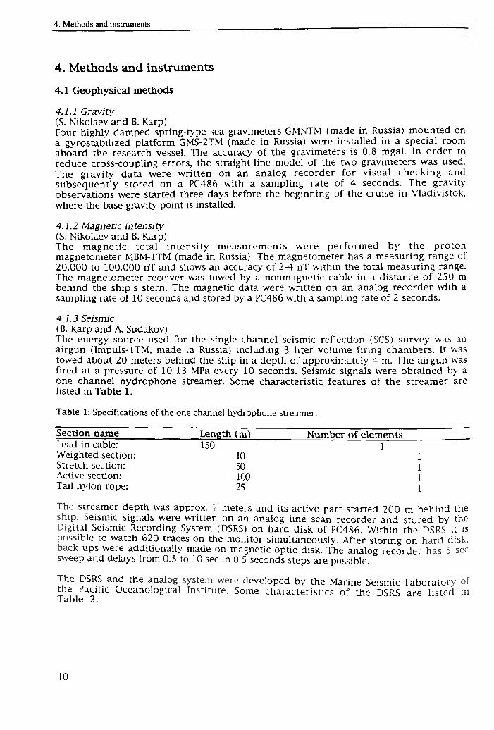
4.1.3 Seismic(B. Karp and A. Sudakov)The energy source used for the single channel seismic reflection (SCS) survey was an airgun (Impuls-ITM, made in Russia) including 3 liter volume firing chambers. It was towed about 20 meters behind the ship in a depth o f approximately 4 m. The airgun was fired at a pressure o f 10-13 MPa every 10 seconds. Seismic signals were obtained by a one channel hydrophone streamer. Some characteristic features o f the streamer are listed in Table 1.
Table 1: Specifications of the one channel hydrophone streamer.
Section name___________________Length (m)_____________ Number of elementsLead-in cable: 150 1Weighted section: 10 1Stretch section: 50 1Active section: 100 1Tail nylon rope: 25 1
The streamer depth was approx. 7 meters and its active part started 200 m behind the ship. Seismic signals were written on an analog line scan recorder and stored by the Digital Seismic Recording System (DSRS) on hard disk o f PC486. Within the DSRS it is possible to watch 620 traces on the monitor simultaneously. After storing on hard disk, back ups were additionally made on magnetic-optic disk. The analog recorder has 5 sec sweep and delays from 0.5 to 10 sec in 0.5 seconds steps are possible.
The DSRS and the analog system were developed by the Marine Seismic Laboratory of the Pacific Oceanological Institute. Some characteristics o f the DSRS are listed in Table 2.
Table 2: Specifications of the Digital Seismic Recording System.
Length o f trace: Start delay: Sampling rate: Data format: 10 bits plus sign (integer 2 bytes)
5 sec.optional 0 to 4 sec in 1 sec. steps optional 0.5, 1, 2 and 4 ms; here: 2 ms
4.1.4 Bathymetry (A. Svarichevsky)Bathymetric mapping was carried out with the echosounding system designed by Elac Corporation (Kiel, Germany), especially designed for the Holming Corporation (Finland). The echosounding system has a fixed impulse power providing a radiated energy o f 200W and/or 2kW. The duration o f the impulses are 1,3, and 10 ms, the main frequency is 12 kHz, and the beam width is 100 x 100. The received reflection signal is formed by an antenna of receivers as separate analogous beam o f 9.20 x 4.30 width. Depth values were written on an analog echosounder line scan recorder and stored by the echosounder digital system on hard disk (PC486). The analog recorder has a delay o f1 m to 9999 m. Sea water sound velocity was considered to be 1500 m/s. Variations o f sea water temperature and ambient pressure were not taken into consideration.
Locations o f the geophysical observations were determ ined applying the GPS navigation system. The receiving set NavTracXL designed by Trimble Navigation was applied to determine the ship's location. All navigation data were stored on PC 486.
4.2 Geological and geochemical methods
4.2.1 Recovery o f deep-sea sediments (D. Nürnberg)Seafloor sediments were recovered with the Standard Multicorer (MUC), the GEOMAR gravity corer (GC), and the POI gravity corer. The multicorer usually gains the undisturbed uppermost sediment column and therefore, covers the transition to the gravity corer, which recovers long sediment cores, but often shows disturbed surfaces.
During cruise 27 o f RV "Akademik Lavrenteyv", 12 multicorer were run. Only two runs failed. 12 GEOMAR gravity cores were taken in total recovering ca. 49 m. Only one corer was damaged. 10 POI corer were recovered successfully (ca. 47 m).
4.2.1.1 Multicorer(S. Neufeld and J.-M. Wolfsdorf)The multicorer is a pyramidal metal cage with a fixed frame in its center. The frame consists o f an apparatus inhabiting 12 plastic tubes (length 61 cm, diameter 6 cm, open at both sides), and a release mechamism. Additional weights increase the total load o f the MUC. Each tube is equipped with two lids, which are fixed in an open position by springs when lowering the device to the seafloor. When reaching the sediment surface, the frame containing the tubes is pushed into the sediment. When again pulling up the device, the springs are deactivated and the lids tightly close the sediment-filled tubes. On average, sediment recovery is ca. 30-40 cm. Further, the bottom water directly overlying the sediment/water interface is trapped within the tubes.
4.2.1.2 Gravity corer(S. Gorbarenko, S. Neufeld and J.-M. Wolfsdorf)The GEOMAR gravity corer (GC) applied by the German group consists of a long steel tube (length 5.75 m, diameter 0.18 m), which includes a removeable plastic liner of the same length (diameter 0.125 m). At the lower end, a core catcher prevents the sediment from sliding out o f the tube. At the upper end, the tube is fixed to a large weight i, 1200
kg), which pushes the gravity corer deeply into the sediment. The maximum sediment recovery o f 5.75 m can be extended by connecting additional tubes. Dependent o f the type o f sediment, cores o f up to 18 m length can be easily derived. Aboard the ship, the plastic liner is pulled out o f the steel tube and sliced into 1-meter segments.
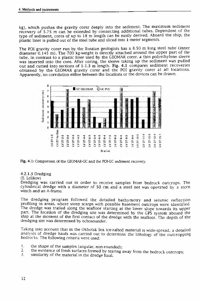
The POI gravity corer run by the Russian geologists has a 8.50 m long steel tube (inner diameter 0.145 m). The 700 kg-weight is directly attached around the upper part o f the tube. In contrast to a plastic liner used by the GEOMAR corer, a thin polyethylene sleeve was inserted into the core. After coring, the sleeve taking up the sediment was pulled out and cutted into sections o f 1-1.3 m length. Fig. 4.1 compares sediment recoveries obtained by the GEOMAR gravity corer and the POI gravity corer at all locations. Apparently, no correlation either between the locations or the devices can be drawn.
i t
■ GC GEOMAR 1 GC POI
e g cm
> >CM CM
> >
^ liî tii (O to s ri. n- r<LCM CM OJ CM CM CM
> > > > > >
O) r- v*CM CM
> >CM CM
> >CM CM
> >
St a tion
Fig. 4.1: Comparison of the GEOMAR-GC and the POI-GC sediment recovery.
4.2.1.3 Dredging (E. Lelikov)Dredging was carried out in order to receive samples from bedrock outcrops. The cylindrical dredge with a diameter o f 50 cm and a steel net was operated by a stern winch and an A-frame.
The dredging program followed the detailed bathymetry and seismic reflection profiling in areas, where steep scarps with possible basement outcrops were identified. The dredge was trailed along the seafloor starting at the lower slope towards its upper part. The location o f the dredging site was determined by the GPS system aboard the ship at the moment o f the first contact o f the dredge with the seafloor. The depth o f the dredging site was determined by echosounder.
Taking into account that in the Okhotsk Sea ice-rafted material is wide-spread, a detailed analysis o f dredge hauls was carried out to determine the lithology o f the outcropping bedrocks. The following criteria were used:
1. the shape o f the samples (angular, non-rounded);2. the existence of fresh surfaces formed by tearing away from the bedrock outcrops;3. similarity o f the material in the dredge haul.
4.2.2 Sediment sampling and processing aboard the ship4.2.2.1 GEOMAR approach (Chr. Vogt and D. Nürnberg)Up to 7 multicorer tubes were cut into 1 cm slices and stored immediately after coring. The lithology was described prior to sampling. For multicorer tubes, the bottom water and the flu ff layer at the water/sediment-interface were sampled. Bottom water was taken for pH and gas analyses (see chapter hydrochemistry). At nearly each station, tubes were also sampled for stable isotope and coarse fraction analyses, organo- geochemical and inorganic-geochemical analyses (GEOMAR), the determ ination o f biogenic silica (GEOMAR), and micropaleontology (AWI). Two tubes were utilized by Russian scientists (hydrochemisty, paleoceanography).
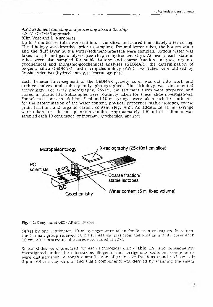
Each 1-meter liner-segment o f the GEOMAR gravity corer was cut into work and archive halves and subsequently photographed. The lithology was documented accordingly. For X-ray photography, 25x1x1 cm sediment slices were prepared and stored in plastic lits. Subsamples were routinely taken for smear slide investigations. For selected cores, in addition, 5 ml and 10 ml syringes were taken each 10 centimeter for the determination o f the water content, physical properties, stable isotopes, coarse grain fraction, and organic carbon content (Fig. 4.2). An additional 10 ml syringe were taken for siliceous plankton studies. Approximately 100 ml o f sediment was sampled each 10 centimeter for inorganic geochemical analyses.
Micropaleontology
P01 scientists
X-radiography (25x10x1 cm slice)
Geochemistry
Coarse fraction/ stable isotopes
Water content (5 ml fixed volume)
Fig. 4.2: Sampling of GEOMAR gravity- core.
Offset by one centimeter, 10 ml syringes were taken for Russian colleagues. In return, the German group received 10 ml syringe samples from the Russian gravity corer each 10 cm. After processing, the cores were stored at ->-23C.
Smear slides were prepared for each lithological unit (Table 1A) and subsequently investigated under the microscope. Biogenic and terrigenous sediment components were distinguished. A rough quantification o f grain size fractions (sand >63 um, silt 2 um - 63 um, clay <2 |im) and single components was derived by scanning the smear
slide and classifying it into 4 classes o f occurrence: rare, common, abundant and rich. This method provides preliminary knowledge o f the lithological sediment composition.
4.2.2.2 POI approach (S. Gorbarenko)During the cruise follow ing steps o f sediment sampling and processing were performed:
1. Sampling for the analysis o f gas components and pH-parameter2. Measurements o f humidity and magnetic susceptibility were done every 3 cm by
microwave meter (MWM-8) and magnetic susceptibility meter (IMV-2), which is in direct contact to the sediment covered by a polyethylene foil. Data were directly stored on a computer. The devices were designed by the Western Company, Kaliningrad (Russia).
3. Sampling every 20-50 cm for measuring the sediment humidity and density according to the weight method.
4. Visual description, sampling, preparation and the prelim inary study o f smear slides with the microscope POLAM L-211.
5. Sampling for micropaleontological studies (diatoms, radiolarians, foraminifers, every 2.5-5 cm), oxygen and carbon isotopic analyses (2.5-5 cm), granulometric (10 cm) and geochemical (5-10 cm) measurements.
6. Removal o f the clay fraction and classification into the grain size fractions 0.05-0.1 mm, 01.-0.25 mm, and fractions larger than 0.25 mm for mineralogical analyses o f the terrigenous and authigenic sediment components.
7. Selection o f heavy minerals (density o f more than 2.89 g/cm3) in the 0.05-0.1 mm fraction (every 20-50 cm) for immersion analysis.
8. For morphometric analyses sampling o f quartz granules (every 5-20 cm) in the0.25-0.315 mm fraction from selected cores.
4.2.3 Gas sampling (A. Obzhirov)For gas measurements samples were taken from both surface and bottom water applying Niskin bottles and multicorer tubes. Sediments recovered by multicorer and gravity corer were also investigated for their gas content. The gas was extracted by a specific vacuum assembly, and subsequently analysed by gas chromatography aboard the ship. Methane and heavy hydrocarbons (ethane, propane, butane and their homologs) were analysed by a flame-ionization detector. Oxygen, nitrogen and carbon dioxide were analysed by a catharometer. The sensibility o f the hydrocarbon analyses was 0.00001%, o f other gases ca. 0.01%.
4.2.4 Mechanical properties o f the sediments (A. Astakhov and S. Gorbarenko)The analysis o f sedimentary mechanical properties was mainly performed to establish a lithostratigraphy o f the Quaternary sediments. In addition, the mechanical properties are necessary to calculate sediment accumulation rates. Since it is difficult to preserve the sediment s natural humidity, humidity measurements were d irectly carried out aboard the ship, immediately after cutting the core.
Two methods were used: First, the standard weight method and, second, humidity measurements with the MWM-meter. The standard method includes sampling o f 50 cm^ o f non-disturbed sediment, subsequent drying at 105°C temperature, and weighing before and after drying. On the base o f these data, the density o f the natural sediment (D), the density o f the mineral base (Dp), the mineralogical density (D t), the volume humidity (W y), and the weight humidity (Ww ) were calculated applying following equations:
D=P0/V;Dp=P/V;Dt=P/(V-(P0-P)/g);WP=(P0-P)/V*g 100%;Ww=(P0-P)/P0 100%,
where PQ and P are the sediment sample masses before and after drying (g); V - sample volume (cm3); g - slime water density (g/cm3) (1,00).
4.2.5 Magnetic susceptibility (J. Griitzner)Records o f magnetic susceptibility mainly reflect the content o f ferrim agnetic minerals in the sediments. During the cruise, measurements o f magnetic susceptibility were obtained with two different methods:
1. Whole core segments ( lm length) retrieved with the GEOMAR gravity corer were measured with a Bartington loop sensor (MS2C) in conjunction with a control unit (MS2). The sensor generates a low intensity alternating (f=565 Hz) magnetic field and any material brought into the sensor changes the oscillator frequency. This frequency information is returned to the control unit where it is converted into a value o f magnetic susceptibility. Magnetic susceptibility was measured in SI units (*1 0 ~ 5) in 3 cm intervals along the cores. A rtific ia l minima o f magnetic susceptibility usually occurring at both ends o f each core section were identified and removed from the data set.
2. Cores collected with the POI-gravity corer were measured with a sensor directly at the sediment surface. Magnetic susceptibility and humidity values were obtained every 2 cm along cores. The magnetic susceptibility was measured in cgs-mode.
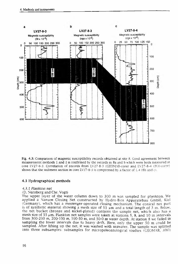
For comparison and calibration, some o f the cores from the GEOMAR corer were also analysed with method 2 after splitting. Fig. 4.3 shows a comparison o f three records o f magnetic susceptibility from Site 8. Measurements obtained from Core LV27-8-3 (GEOMAR corer) demonstrate good agreement and comparability' between method 1 and2 (Fig. 4.3 a and b). This comparability is given at all locations except for Sites 1-3, where the sediment has a very weak magnetic susceptibility. In this environment d ifferences in the sensitivity o f the two sensors are most likely the cause o f inconsistancies between the two methods. Figs. 4.3 b and 4.3 c show a correlation between cores LV27-8-3 (GEOMAR corer) and LV27-8-4 (POI corer). An ash layer, which was found in both cores, is marked by susceptibility maxima at 121 cm in Core LV27-8-3 and at 310 cm in Core LV27-8-4. Below this peak, both records show very similar curvature (shaded area), but, the distances between the maxima are less in Core LV27-8-3. According to these differences, the sediment section in Core LV27-8-3 is compressed by a factor o f 1.4 relative to Core LV27-8-4. When comparing the two records it is obvious that the uppermost sediment section (diatomaceous ooze) in Core LV27-8-4, which is characterised by low (<25 * 10~5 SI) magnetic susceptibility, is missing in LV27-8-3.
4.2.6 Micropaleontology (A. Matul)For the radiolarian study, the uppermost 1 cm of the surface sediment of the multicorer tubes (MUC) was used. The preparation technique includes the sediment disaggregation and the extraction o f organic ingredients by boiling in a weak hydrogen peroxvde solution, washing through a 50 |im sieve, and settling o f the residues on slides in Canada balsam. 230-280 specimens per sample were counted, from which the absolute radiolarian content and the relative species concentrations were calculated.
Dept
h (c
m)
aLV27-8-3
Magnetic susceptibility (S ix 10 '5)
0 50 100 150 200 250 300 0 11 i i 111 ill m il
100 -
200 -
300 -
400
500
600 ' 1111 *1 ' ' 11111111 ' ‘‘ 11
LV27-8-3Magnetic susceptibility
(cgs x 10'6}
0 50 100 150 200 250 300
LV27-8-4Magnetic susceptibility
(cgs x 10'6 )
0 25 50 75 100 125 150
- 100
- 200
300
400
500
600
- 700
Q
m i i i i i i m i l l m l I n I in I goo
Fig. 4.3: Comparison of magnetic susceptibility records obtained at site 8. Good agreement between measurement methods 1 and 2 is confirmed by the records in 8a and b which were both measured at core LV27-8-3. Correlation o f records from LV27-8-3 (GEOMAR-corer and LV27-8-4 (POI-corer) shows that the sediment section in core LV27-8-3 is compressed by a factor of 1.4 ( 8b and c).
4.3 Hydrographical methods
4.3.1 Plankton net(D. Nürnberg and Chr. Vogt)The upper layer o f the water column down to 300 m was sampled for plankton. We applied a Nansen Closing Net constructed by Hydro-Bios Apparatebau GmbH, Kiel (Germany), which has a messenger-operated closing mechanism. The conical net part is o f synthetic material showing a mesh size o f 55 |im and a total length o f 3 m. Below, the net bucket (bronze and nickel-plated) contains the sample net, which also has a mesh size o f 55 [im. Plankton net samples were taken at stations 5, 8, and 10 in intervals from 300-200 m, 200-100 m, 100-50 m, and 50-0 m water depth. At station 8 we failed in sampling the lower intervals due to heavy drift. Here, only the upper 50 m could be sampled. After lifting up the net, it was washed with seawater. The sample was splitted into three subsamples: subsamples for m icropaleontological studies (GEOMAR, AVVI)
were poisoned with ethanol; the subsample containing living foraminifers was diluted by seawater and stored at +2°C.
4.3.2 Water sampling(D. Nürnberg, Chr. Vogt and A. Obzhirov)At stations 5, 8, and 10 water sampling was performed by 1.75 liter-Niskin bottles (General Oceanic, Inc.), which were lowered by the portside front winch to 300 m, 200 m, 100 m, and 50 m water depth. The Niskin bottle is a cylindrical plastic container, on both ends open, that can be closed by two rubberband-connected lids. Closing o f the lids at the proposed water depth is triggered by a small weight falling down along the steel-rope. Surface waters were easily sampled with a bucket at all stations. Sample splits will be investigated for gas content (POI) and oxygen isotopes (GEOMAR).
5. Results
5.1 Marine geophysics
5.1.1 Bathymetry (A Svarichevsky)The main purpose o f the geomorphological survey was to investigate in great detail the Okhotsk Sea bottom relief, especially in the area o f the geophysical survey (Fig. 1.1) and in the region o f a hydroacoustic anomaly at the northern Sakhalin shelf. In addition, the continuous mapping o f the bottom relief during transit was undertaken to find new hydroacoustic anomalies, to further establish their correlation with re lie f elements, and to explain relief genesis.
The main objectives o f the bathymetric study were:
1. Regular square bathymetry survey on the poligon;2. Echosounder measurements on all the ship tracks;3. Bathymetry and map support on all geological sites.
In the area o f the complex geophysical survey (the Academy o f Sciences Rise and the northern slope o f the Kurile Basin), the bathymetry mapping was performed along the system o f northwesterly and northeasterly directed ship tracks (F ig. 5.1). In average, the main track length is 90 miles. The distance between tracks did not exceed 12 miles. The size o f the survey area was approximately 800 square miles. In total, 1310 miles were surveyed within the survey area and about 2000 miles o f bathymetric profiles were obtained during transits.
On the basis o f these profiles, the bathymetric map was compiled. The map was plotted using the commercial software SURFER. Since the survey tracks were not regularly spaced, and since the track network in its southern part was denser than in the northern part, two maps were prepared, one for the entire study area (F ig . 5 .2) and another for the southernmost part (Fig. 5.3).
Specific attention was paid to the eastern flank o f the Academy o f Sciences Rise. Former investigations allowed to distinguish a large-scale fault and an adjacent submarine Pegas valley. Along with the general submerging o f the rise towards the Makarov Trough in the east, its upper part is divided into a series o f minor rises. They correspond to basement blocks separated by graben structures. In some places where sediment thickness is reduced basement blocks crop out, the tops o f which are cut by abrasion.
Minor rises oriented in a WNW direction are manifested in the bottom morphology. Deep grabens located in this area are filled with sediments and form an accumulative plateau gently inclining towards the Kurile Basin. Here, gouges originated at the contact zone between the outcropping basement blocks and sedimentary layers, which s'1 rface * hydrodynamic activity o f the water masses during the form ing o f this
Ir^ rr ffV irrH Pt^rih »f Npei-Aca(! f mu 0[ . sp ences Rise is restricted by a series o f tectonic scarps, faced to the NE towards the Makarov Trough. Their heights reach approximately
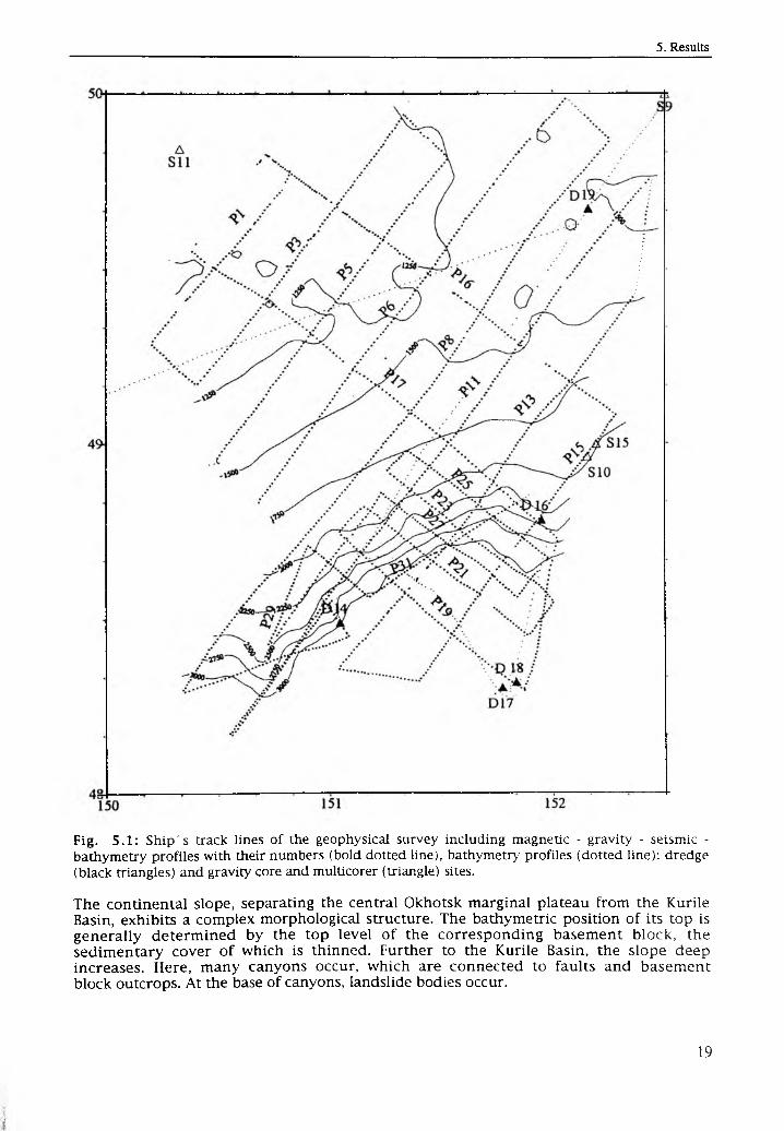
Fig. 5.1: Ship's track lines of the geophysical survey including magnetic - gravity - seismic - bathymetry profiles with their numbers (bold dotted line), bathymetry profiles (dotted line); dredge (black triangles) and gravity core and multicorer (triangle) sites.
The continental slope, separating the central Okhotsk marginal plateau from the Kurile Basin, exhibits a complex morphological structure. The bathymetric position o f its top is generally determ ined by the top level o f the corresponding basement block, the sedimentary cover o f which is thinned. Further to the Kurile Basin, the slope deep increases. Here, many canyons occur, which are connected to faults and basement block outcrops. At the base o f canyons, landslide bodies occur.
150 151 152
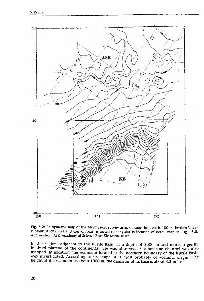
Fig. 5.2: Bathymetric map of the geophysical survey area. Contour interval is 100 m, broken lines - submarine channel and canyon axis, inserted rectangular is location of detail map in Fig. 5.3. Abbrevation: ASR: Academy of Science Rise; KB: Kurile Basin.
In the regions adjacent to the Kurile Basin at a depth o f 3000 m and more, a gently inclined plateau o f the continental rise was observed. A submarine channel was also mapped. In addition, the seamount located at the northern boundary o f the Kurile Basin was investigated. According to its shape, it is most probably o f volcanic origin. The height o f the seamount is about 1000 m, the diameter o f its base is about 3.5 miles.
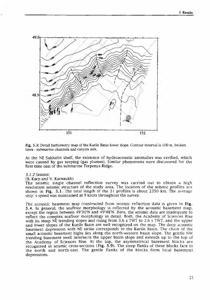
Fig. 5.3 : Detail bathymetry map of the Kurile Basin lower slope. Contour interval is 100 m, broken lines - submarine channels and canyon axis.
At the NE Sakhalin shelf, the existence o f hydroacoustic anomalies was verified, which were caused by gas seeping (gas plumes). Similar phenomena were discovered for the first time east o f the submarine Terpenya Ridge.
5.1.2 Seismic(B. Karp and V. Karnaukh)The seismic single channel reflection survey was carried out to obtain a high resolution seismic structure o f the study area. The location o f the seismic profiles are shown in Fig. 5.1. The total length o f the 31 profiles is about 2350 km. The average ship's speed was maintained at 9 knots throughout the survey.
The acoustic basement map constructed from seismic reflection data is given in Fig. 5.4. In general, the seafloor morphology is reflected by the acoustic basement map, except the region between 49°30’N and 49°48'N. Here, the seismic data are inadequate to reflect the complex seafloor morphology in detail. Both, the Academy o f Sciences Rise with its steep NE trending slopes and rising from 3.6 s TWT to 2.6 s TWT, and the upper and lower slopes o f the Kurile Basin are well recognized on the map. The deep acoustic basement depression with NE strike corresponds to the Kurile Basin. The chain o f the small acoustic basement highs lies along the north-western basin slope. The gentle NW trending basement swell intersects the upper basin slope and extends up to the top o f the Academy o f Sciences Rise. At the top, the asymmetrical basement blocks are recognized in seismic cross-sections (Fig. 5.9). The steep flanks o f these blocks face to the north and north-east. The gentle flanks o f the blocks form local basement depressions.
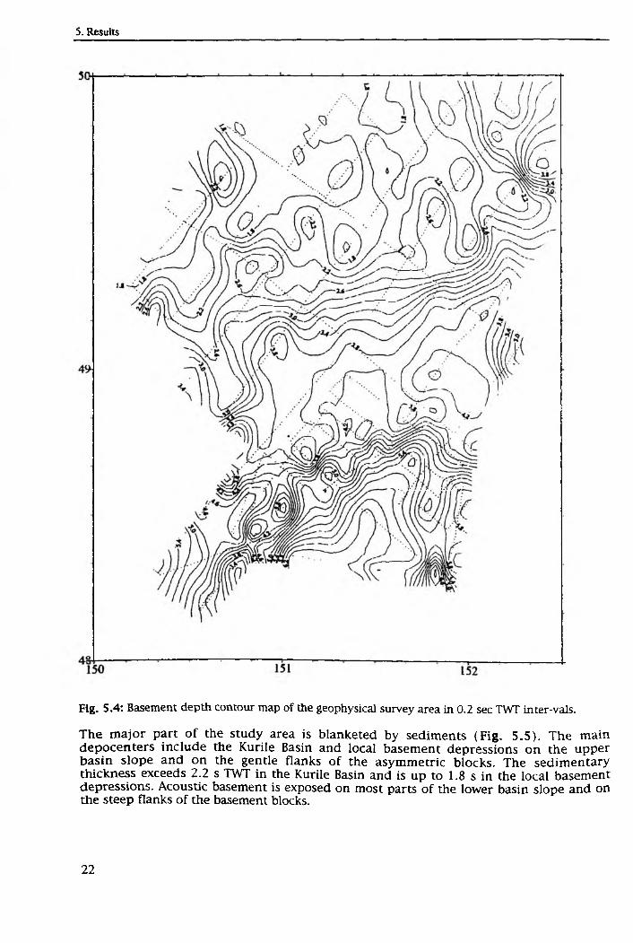
Fig. 5.4: Basement depth contour map of the geophysical survey area in 0.2 sec TWT inter-vals.
The m ajor part o f the study area is blanketed by sediments (F ig . 5.5). The main depocenters include the Kurile Basin and local basement depressions on the upper basin slope and on the gentle flanks o f the asymmetric blocks. The sedimentary thickness exceeds 2.2 s TWT in the Kurile Basin and is up to 1.8 s in the local basement depressions. Acoustic basement is exposed on most parts o f the lower basin slope and on the steep flanks o f the basement blocks.
Fig. 5.5: Isopach map of sedimentary layer of the geophysical survey area in 0.2 sec TVVT intervals.
Stratigraphy o f sedimentary layersThe sediment fill o f the Kurile Basin is composed o f two major acoustic units. The upper acoustic unit is characterized by low frequency stratified reflectors (F ig. 5.6). The high continuity/variable amplitude reflectors from within the unit indicate turbidite deposition alternating with pelagic and/or hemipelagic deposition. The lower acoustic unit is acoustically transparent. The thickness o f the upper unit is approximately constant throughout the study area ranging from 0.7 to 0.9 s TWT. The thickness o f the
lower unit varies from 0.5 s near the basin slope to 1.2 s at some distance from it. The source o f the detrital material deposited as turbidites is the Academy o f Sciences Rise. The detritus is transported along submarine channels, which cut the upper and lower basin slope (Fig. 5.2). In most cases, the upper acoustic unit onlaps to the lower basin slope. In places, the upper unit reflection pattern suggests tectonic movements in terms o f subsidence. The tectonic movement took place during the lower part o f the upper unit accumulation.
Fig. 5.6: Structure of sedimentary layer in the Kurile Basin. Portion of seismic profile 19.
Sedimentation on the lower basin slope occurs mainly as deposition o f detritus transported along canyons and submarine channels. The sedimentary layer includes one acoustically transparent unit. There are numerous slumps. Sea bottom water currents running along canyons and channels form a levee (Fig. 5.7).
The sediment fill o f the Kurile Basin upper slope includes two major seismic sequences. The upper sequence is characterized by stratified reflections, whereas the lower sequence is acoustically semitransparent (Fig. 5.8). These seismic sequences are separated by an unconformity. The high-amplitude, laterally continuous reflectors from within the upper sequence indicate deposition o f turbidites. Transparent units alternating with high-ampiitude reflectors indicate pelagic and/or hem ipelagic deposition. We can recognize two major turbidite events in the Kurile Basin slope area. The turbidite events correspond to periods characterized by an enhanced s e d im e n t supply to the slope area. Possible mechanisms for the major variations in s e d im e n t supply to the slope area include both an eustatic sea-level change and a rapid uplift o f the source areas onshore. We have not enough data to differentiate between these possibilities.
Fig. 5. 7: Structure of the Kurile Basin lower slope showing submarine channel and levee. Portion of seismic profile 15.
Fig. 5.8: Structure of the Kurile Basin upper slope. Portion of seismic profile 13.
The reflection pattern from both seismic sequences suggests a tectonic movement i terms o f subsidence. The rate o f the tectonic movement varies with time. It was hig during the lower unit deposition and low during the upper unit formation.
3“
3
The sedimentary sequence lying above the asymmetric blocks, which occur at the top o f the Academ y o f Sciences Rise, consists o f stratified units separated by an unconform ity (F ig. 5.9). The lower unit lies on the tilted surface o f the asymmetric blocks and its reflection boundaries are conform to them. The reflection boundaries of the upper unit are subhorizontal. Almost without exception, submarine channels can be recognized close to the asymmetric block tops, which occur as sea-floor local highs. In places, the seismic reflections below the unconform ity are curved downward indicating a subsidence o f block surface during sedimentation.
Fig. 5.9: Tilted blocks and structure of sediments on the Academy of Science Rise top. Portion of seismic profile 16.
5.1.3 Gravity and magnetics (S. Nikolaev and T. Kolpashikova)Gravity and magnetic measurements were carried out simultaneously in the seismic reflection survey. The location o f gravity and magnetic profiles is shown in Fig. 5.1- The total lengths o f the gravity and magnetic profiles are about 2000 km and about 2300 km, respectively. The magnetic anomaly can be calculated after converting magnetic variations into measured values o f the magnetic field. Values o f magnetic field variations will finally be obtained at the home lab at Vladivostok. Also, the gravity anomaly field will be calculated after having finished the gravity observations at the basic gravity point in Vladivostok.
For the prelim inary presentation o f the gravity and the magnetic field, the relative values for gravity and magnetic fields along three profiles were used (Fig. 5 .10). The data analysis obtained during the cruise shows that the gravity fie ld gradually decreases from the Academy o f Sciences Rise towards
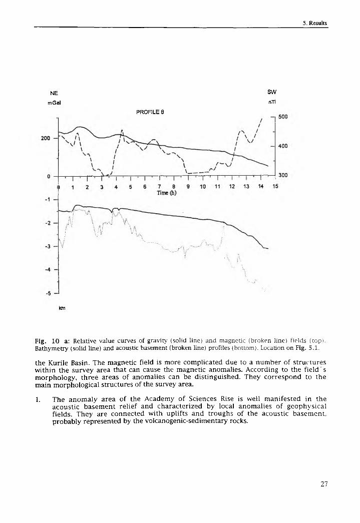
N E
m Gal
SWnTl
PROFILE 8
km
Fig. 10 a: Relative value curves of gravity (solid line) and magnetic (broken line) fields (top). Bathymetry (solid line) and acoustic basement (broken line) profiles (bottom). Location on Fig. 5.1.
the Kurile Basin. The magnetic field is more complicated due to a number o f structures within the survey area that can cause the magnetic anomalies. According to the fie ld 's morphology, three areas o f anomalies can be distinguished. They correspond to the main morphological structures o f the survey area.
1. The anomaly area o f the Academy o f Sciences Rise is well manifested in the acoustic basement relief and characterized by local anomalies o f geophysical fields. They are connected with uplifts and troughs o f the acoustic basement, probably represented by the volcanogenic-sedimentary rocks.
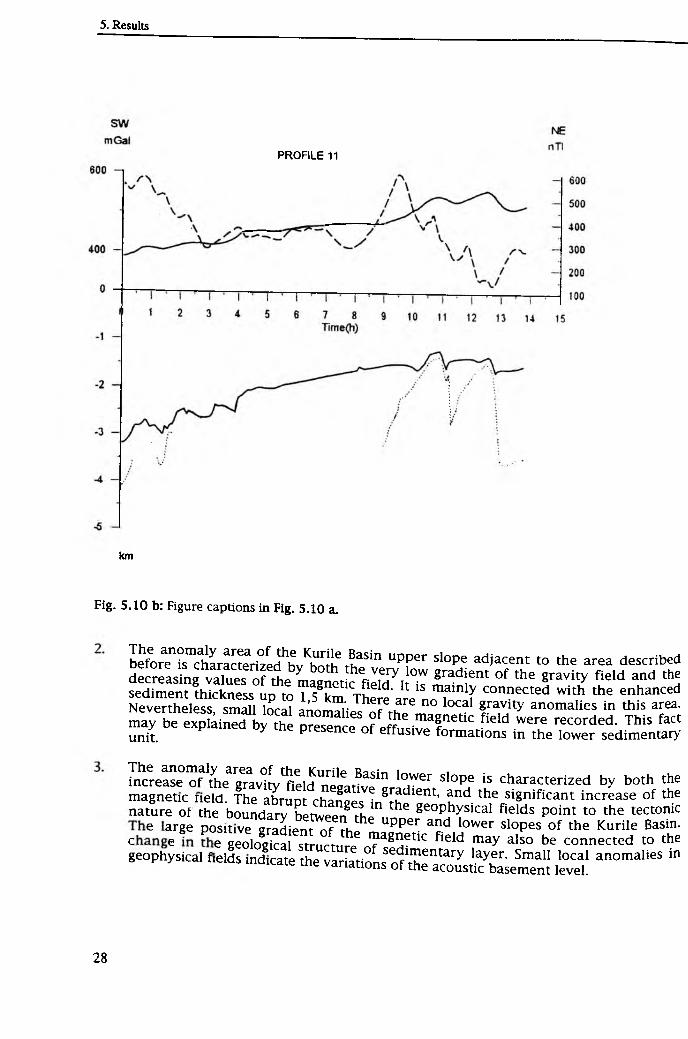
PROFILE 11
km
Fig. 5.10 b: Figure captions in Fig. 5.10 a.
The anomaly area o f the Kurile Basin upper slope adjacent to the area d e s c r ib e dbefore is characterized by both the very low gradient o f the gravity fie ld and thedecreasing values o f the magnetic field. It is mainly connected with the e n h a n c e dsediment thickness up to 1,5 km. There are no local gravity anomalies in this area.Nevertheless, small local anomalies o f the magnetic field were recorded. This factmay be explained by the presence o f effusive formations in the lower sedimentary unit.
The anomaly area o f the Kurile Basin lower slope is characterized by both the increase o f the gravity field negative gradient, and the significant increase o f the magnetic neld. The abrupt changes in the geophysical fields point to the tectonic nature of the boundary between the upper and lower slopes o f the Kurile Basin.
e ar8e posrtive gradient o f the magnetic field may also be connected to the I p m h l v . i f 6 geological structure o f sedimentary layer. Small local a n o m a l ie s in geophysical fields indicate the variations o f the acoustic basement level.
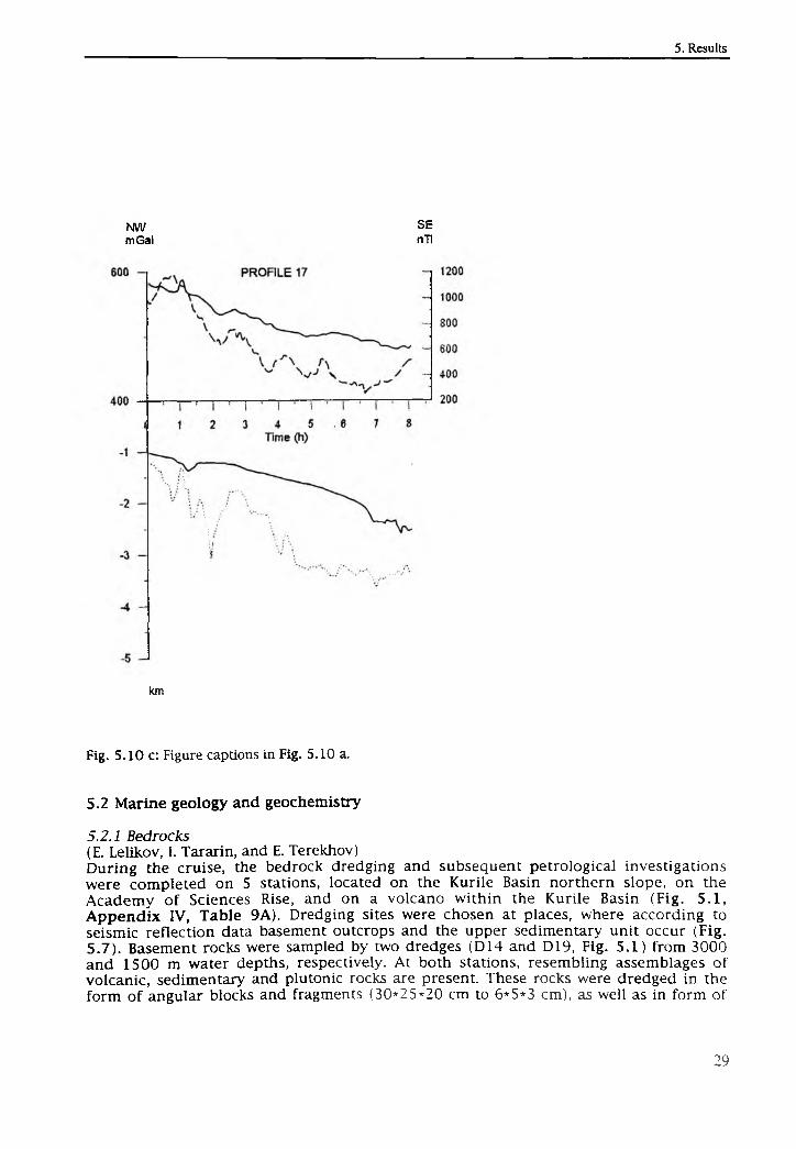
N W SEm Gal nTl
km
Fig. 5.10 c: Figure captions in Fig. 5.10 a.
5.2 Marine geology and geochemistry
5.2.1 Bedrocks(E. Lelikov, I. Tararin, and E. Terekhov)During the cruise, the bedrock dredging and subsequent petrological investigations were completed on 5 stations, located on the Kurile Basin northern slope, on the Academy o f Sciences Rise, and on a volcano within the Kurile Basin (Fig. 5.1, Appendix IV, Table 9A). Dredging sites were chosen at places, where according to seismic reflection data basement outcrops and the upper sedimentary unit occur (Fig. 5.7). Basement rocks were sampled by two dredges (D14 and D19, Fig. 5.1) from 3000 and 1500 m water depths, respectively. At both stations, resembling assemblages o f volcanic, sedimentary and plutonic rocks are present. These rocks were dredged in the form o f angular blocks and fragments (30*25*20 cm to 6*5*3 cm), as well as in form o f
rubbles, pebbles and rounded boulders. For the characterization o f the basement rocks, the non-rounded fragments that apparently represent debris from bed rocks outcrops were considered.
Volcanic rocks demonstrate a broad variety of composition and are represented by the whole series from basalts to dacites. Lavas and tuffs o f andesite and dacite dominate with subordinate basalts and tuffs. Some volcanites have metamorphic textures and mineral assemblages indicating some recrystalization at low greenschist fades conditions.
The sedimentary rocks intercalated with volcanic sequences are subordinate and are represented by argillites, alevrolites, greywackes and gravelites. Sometimes, sedimentary rocks are weakly metamorphosed: mica phyllites and even biotite hornfels with thin veins o f leicocratic granite occur.
These low temperature alterations of volcanic and sedimentary rocks are apparently of regional nature and are influenced to a lower degree by the intrusions o f granitoids. The radiometric K-Ar data for volcanites (basalts, dacites and felsites) from Academy of Sciences Rise (Kornev et al., 1982) justify the sedimentary-volcanic unit to be o f Cretaceous age (125, 117, 87 Ma).
Angular fragments o f fresh sparse porphyritic clinopyroxene-plagioclase basalts were sampled by dredge LV-27-14. Obviously, this rock type forms dykes connected to a younger (Neogene) magmatism.
A great variety o f plutonic rocks was recovered. Biotite and biotite-amphibole granite, granodiorite and quartz diorite could be distinguished. Also few fragments o f amphibole gabbro occur. On the Academy o f Sciences Rise, granitoids similar in composition to the dredged rocks have a Cretaceous isotopic age (121-75 Ma).
Besides, Fe-Mn crusts were found among the dredged material. The largest crusts were recovered at station LV27-19, where the thickness o f Fe-Mn crusts overgrow ing silica sponges reaches 5-8 cm.
During this cruise, for the first time the fresh vesicle-poor two-pyroxene-amphibole basalts and basaltic andesites were dredged from the volcanic edifice located in the Kurile Basin. At station D18 (Fig 5.1), several angular fragments o f pillow lavas o f two- pyroxene-amphibole basalts and basaltic andesites were recovered. Further study of these rocks will allow to estimate the age o f the volcanic edifice and its geodynamic position.
The samples o f the upper sedimentary unit were obtained at station D16, which is located at an abrupt scarp on the northern slope o f the Kurile Basin. Two types o f sedimentary rocks were recovered. In the lowest part of the dredge, plate-shaped heaps o f light o live gray and dark yellowish brown dense tuff-diatom aceous clays (approximately 45*35*20 cm) are present. In the upper part, less dense dusky yellow
T o c n ° Un,d' The first were dred8ed from the lower part o f the scarp, ntrr nf fh m (lnterval o f h edging -2450-2200 m), and characterize the
l l L n K t,?! yOUH8 sedimentary unit, whereas the second type o f material Lower Pliocene Se imentary unit‘ apparent age o f these rocks is Miocene to
Discussion
o f Sciences ise ancM-hp dredp d r0^ks shows that the basement o f the AcademyL d i m e n S r v % o l c a n n P P n ir ^ i e m t ^ ° f th .e K u r i le B as in c o n s is ts o f L a te M e s o s o ic
, which were intruded by Cretaceous granitoids. This
unit underwent weak regional metamorphism (low greenschist facies), which was followed by contact metamorphic processes connected with the intruding o f granitoid massives. There is evidence from the metabasite gravel o f the greenschist facies found in the greywackes o f the Cretaceous volcanogenic/sedimentary unit recovered on Site D19 that this unit overlies the oldest complex (probably o f Paleozoic age) metamorphologically altered in greenschist and epidote-amphibolite facies. These data are compatible with the model that the oldest basement o f the Okhotsk Sea is buried by an onlapping Cretaceous unit.
The published data as well as our investigations show that the successive geological developm ent is typical for various m orphologic structures in the Okhotsk Sea (Kashevarov Bank, Okhotsk Arch, Institute o f Oceanology Rise). All these structures exhibit outcrops o f Cretaceous volcanic or sedimen-tary/volcanogenic rocks intruded by granitoids and old methamorphic basement. Among the dredged fresh basalts, clinopyroxene-plagioclase and two-pyroxene-amphibole basalts and basaltic andesites can be distinguished. The first may represent the rift-related dyke complex in the sedimentary-volcanic Late Mesozoic unit and may be connected with the formation o f small extensional basins (pull-apart basins) due to the back-arc spreading in Kurile Basin. The data obtained suggest that two-pyroxene-amphibole basalts and basaltic andesites dredged from the slopes o f the seamount in the Kurile Basin apparently have island-arc nature and are connected with Kurile Island Arc magmatism.
5.2.2* Sediment stratigraphy (S. Gorbarenko)Various indications derived from diatoms analyses (Zhuze, 1962), oxygen isotope records, AMS-14C dating, as well as positions o f volcanic ash layers, and horizons with enhanced b iogenic components (diatoms, foram inifers, total organic carbon) (Gorbarenko et al., 1988; Gorbarenko, 1993) were used to establish a prelim inary stratigraphy for the Okhotsk Sea sediments. Wide parts o f the Okhotsk Sea surface sediments consist o f a typical olive diatomaceous ooze. Diatom analyses performed by Zhuze (1962) revealed that this upper layer o f diatomaceous sediment belongs to the Holocene. Previous oxygen isotope investigations and AMS-radiocarbon datings on Core B34-90 from the Academy o f Sciences Rise southern slope (Gorbarenko et al., in press) further reveal that the base o f the diatomaceous silts age to about 6 ky BP. The underlying terrigenous sediments, which still contain large concentrations o f diatoms (weak diatomaceous), were formed approximately 8 ky ago. It has to be mentioned, however, that the upper diatomaceous horizon did not begin to form simultaneously all over the Okhotsk Basin. Especially in the peripheric areas, it formed later due to progressive environmental warming (Gorbarenko, 1991).
The transition between the weak diatomaceous silts and the underlying, dominantly terrigenous sediments is characterized by an increasing carbonate content, which is due to large amounts o f planktic foraminifers. This 2-step increase in calcareous plankton dates to approximately 9 and 12 ky, thus corresponding to the glacial terminations T IB and T1A (Gorbarenko et al., in press). The terminations are further characterized by the presence o f volcanic ash layers, which were dated to 8.5 and 12 ky BP, respectively (Gorbarenko et al., in press). The lower volcanic ash, which was observed in many cores o f the central Okhotsk Sea during this year's cruise, is defined as K-l.
According to micropaleontological and lithological indications, as well as information from the oxygen isotope stratigraphy, the dark gray terrigenous
* List o f the lithology and paleoceanology group and their scientific contribution in Appendix IV.
sediments underlying the upper horizon enriched in biogenic silica, were formed mainly during glacial conditions, i.e. oxygen isotope stage 2 and the upper part o f stage3 (Zhuze, 1962; Gorbarenko, 1991). Accordingly, biogenic components are o f minor importance, whereas the significant influence o f ice-rafted material must be noted m many cores.
Distinct variations in the coarse fraction (sand, pebbles) and a slightly varying carbonate content in these sediments suggest small but severe environmental changes in the Okhotsk Sea even during the last glacial period. In a number o f cores the terrigenous succession is intercalated by a volcanic ash (K-2), which is dated to approximately 28 ky (AMS-14C dating o f Core 936, Dr. John Southon, personal communication, 1995).
The thick succession o f terrigenous glacial sediments is underlain by a diatomaceous ooze characterized by abundant planktic foraminifers and a high total organic carbon content. According to the oxygen isotope records from the central Okhotsk Sea, this biogenic sediment package can presumably be related to the warm isotopic event 3.3 (Gorbarenko, 1991).
Below the diatomaceous horizon, a second sequence o f terrigenous sediments follows, which must be related to cool environmental conditions during the lower part of isotope stage 3, stage 4 and the upper part o f stage 5. The preceding third diatomaceous horizon accumulated during the interglacial oxygen isotopic event 5e, as inferred from the preliminary isotopic stratigraphy o f Core K-105 from the central part o f the Okhotsk Sea (Gorbarenko, 1991). The typical succession o f relatively warm biogenic and cool terrigenous horizons is also typical for the Bering Sea and the NW-Pacific (Bezrukov and Romankevich, 1960; Gorbarenko, subm.).
5.2.3 Mineralogy (A. Derkachev)Mineralogical composition o f the sedimentsThe climate and - in particular - the formation o f the sea-ice cover are the most important factors influencing the depositional environment o f the Okhotsk Sea. During sea ice formation in the shallow coastal zone, detrital material o f all size fractions is entrained into the ice. The coastal ice is later transported by surface currents into the outer parts o f the Okhotsk Sea and subsequently, releases its terrigenous freight during ice melting.
Apart from the coarse fraction (pebbles, gravel, boulders) found in Okhotsk Sea seafloor deposits, the silt fraction is o f outstanding importance. The analysis o f the mineralogical composition of the silt fraction in both coastal zones o f the Okhotsk Sea and the deep-sea deposits allows to reconstruct pathways o f debris transport from probable source areas to depositional areas. Petelin (1957) already deter-m ined the mineralogical associations of the source areas along the coastal zones and was able to relate them to distinct sedimentary Okhotsk Sea provinces (surface layer, 0-10 cm).
In this respect, the mineralogical studies o f the terrigenous sediment components play a major role for the reconstruction o f the Okhotsk Sea paleoceanography. The estimation o f the intensity and the reconstruction o f transport paths o f debris allow to
mLvt*'tiany j econstrucl: the pattern o f surface currents, and the basin 's ice covet during Pleistocene-Holocene times.
sanmles" mineral°g ical composition performed on selected sediment?ADDendix IV) C o r e / i v ? ^ S I C0an be deciP.hered. According to Tab le 2A
> 6 and LV27-8-4 located in the central Okhotsk Sea are
characterized by the pyroxene group. Clinopyroxene dominates in all samples. The content o f minerals typical for granito-methamorphic rocks (aktinolite, granite, chlorite, zircon, turmaline, sphene etc.) on average is lower than 15%. The group o f resistant minerals (zircon, turmaline, sphene, anataz) is o f minor importance (less than 1%). Downcore mineralogical changes are negligible within the Holocene and Late Pleistocene sediments. Horizons enriched with volcanoclastics, namely volcanic ashes, are the only exceptions.
Within the Holocene sediments, however, a downcore decrease in the silty and sandy fractions can be observed indicating some changes in transport energy and also, revealing information about the constancy o f the source area for the clastic material (i.e. West Kamchatka coasts). The similarity between both the studied mineral associations and the associations o f the coastal regions o f West Kamchatka justifies this supposition (Petelin, 1957). Ongoing studies on the mineral associations and typomorphic features o f the minerals will allow to determine transport mechanisms o f pyroclastics connected with volcanism on the adjacent coasts.
The mineral composition o f the western group o f stations (LV27-2-4, LV27-4-4) is quite d ifferen t from the southeastern sites (Tab le 2A, Append ix IV ). The amount o f pyroxenes decreases, but the contents o f epidote, aktinolite, chlorite, sphene and hornblend increase. Such mineral associations are due to the weathering o f granite - metamorphic rocks. At the same time, the high content o f pyroxenes in association with epidot, anti polite, and chlorite justifies the wide development o f erosion and transport o f the weakly metamorphic volcanogenic rocks. Outcrops o f such rocks are known from the western coasts o f the Okhotsk Sea. From the morphostructural point o f view, they correspond to the Okhotsk-Chukotka Mesozoic volcanogenic belt.
Mineralogy o f volcanic ashesIn particular, the analysis o f the volcanoclastic sediment components allows to identify specific ash layers, which can be used for a lithostratigraphic correlation o f the investigated cores. The absolute dating o f these volcanic ashes will further allow to correlate them with known volcanic eruptions in the Kurile-Kamchatka region.
The volcanic ashes are the most reliable time markers in the studied cores o f the Okhotsk Sea. Two o f the most distinctly manifested and well diagnosted ashes can be found. The first is located beneath the Holocene diatomaceous horizon. Its characteristics are: color - grey; structure - silt, prevailing size fraction - 0.05-0.1mm (in comparison, the >0.1 mm fraction is rare). In the interlayer composition, the volcanic uncolored glass o f fluidal-fibrous, rarely bubble-clastical sharp prevails. As an admixture, the crystal-clastics present plagioclase, heavy minerals and clastic rocks. Among the heavy minerals, hyperstene (Opx) and augite (Cpx) prevail. Their quantitative relation varies in the different cores (Cpx/0px=0.54-1.11) (Table 3A). An important diagnostic feature o f the ash is the dominance o f hyperstene. Dark ore minerals are mainly represented by magnetite. The majority o f mineral grains is covered by volcanic glass. For the orthopyroxenes, the isomorphic, long-axis prismatic crystals with weak pleochroism are typical.
The ashes with the above mentioned properties were found in Cores LV27-8-4 (153-155 cm), LV27-15-4 (110-112 cm), LV27-7-3 (51 cm) and presumably, also in Core LV27-5-4 (221. cm). Since the material was not representative (1.5-2 mm lenses), the ash from the last station was conventionally related to this type, although according to the morphology o f the glass fractions (the fluidal-fibrous graines prevail) it is similar to them.
The second volcanic ash is located in the gray terrigenous sedimentary unit between stratigraphical horizons III and IV and was investigated m Core LV27-8-4 at 332-334 cm It has reddish tinge and has a more rough-grained structure m comparison to the first ash (it contains significant amounts o f the >0.1 mm fraction). The volcanic ash is represented by the fractions o f bubble-cellic transparent (non-colored) glass (fluidal- fibrous fractions are rare). For this ash, clinopyroxene prevails (Cpx/Opx=1.74). It is also characterized by a very high content o f magnetite (up to 33.5%) Quantitatively comparable with clinopyroxene (Table 3A, Appendix IV ). The m ajority o f heavy minerals are in the volcanic glass cover. Orthopyroxenes are characterized by short- prismatic idiomorphic crystals. Their combinations with slightly smoothed and melted surfaces are also covered by glass. Volcanic ashes with similar properties were discovered on stations LV27-8-3, LV27-7-3, and LV27-15-3, but their m ineral composition has been not studied so far.
5.2.4 Morphometric analysis of terrigenous quartz (A. Astakhov)The morphometric analyses o f terrigenous sand-sized quartz was carried out to determine the sources and mechanisms o f coarse material being transported across the continental slope to the central parts o f the Okhotsk Sea. The applied analytical method allows to differentiate between eolian material and material transported by water (Astakhov & Vashchenkova, 1993; Astakhov, 1995).
Among water transported debris, material accumulated in rivers deltas and submarine deltas can be differentiated. Taking into account that the sand-sized material is mainly transported by ice floating into the central Okhotsk Sea, the determ ination o f its sources may provide information about the ice drift direction. Tem poral changes within this process may justify changes in paleoceanographic conditions. The reason for applying this method in the Okhotsk Sea is the restricted occurrence o f nearshore eolian sediments. They only appear at the North Sakhalin coasts, but are w idely spread and have morphometric characteristics typical for eolian sediments (Astakhov & Vashchenkova, 1993).
The investigated 0.25-0.315 mm fraction was separated by sieves and analysed under the microscope equipped with a mirror device (Willets & Rice, 1983). The lengths o f three quartz grain axes were measured. Subsequently, the nondimensional morphometrical coefficients were calculated. The data interpretation was made on the base o f the modified Cailleux sphericity coefficient (Cailleux, 1952) - 2c/(a+b), and rollness coefficient - c/b (Astakhov & Vashchenkova, 1993) (a, b, c, - correspondingly long, medium and short grain axes). The roundness estimation was made by comparison with the standard scale (Khabakov, 1946). In each sample, 30 grains were measured.
The most interesting results were obtained in Core LV27-2-4. The drastic change o f morphometric characteristics was observed at 160-200 cm core depth. According to the hthostratigraphy, this change took place 4000-7000 years ago. S ign ifican t paleogeographical events during this period are unknown. According to the main
\ £hai? ctenstl£s- this event occured after the global climate and sea-level frnm rtfo h ^ ° ' ° m Í morphometrical point o f view, the analysed material “ ¿dfmAnrc th Samp esj see dia8ram c/b - 2c/(a+b) on Fig. 5 .11 ) correspond and pvpn HpIS S í rUf-per *l°nzori- m contrast, is characterized by water transport environm pnf Tht f°n samPles are verV similar to the Amur estuarine
North Saldialin &^asl^enkOTa^(199r3)Sem^*e e° Uan SedimentS fr° m
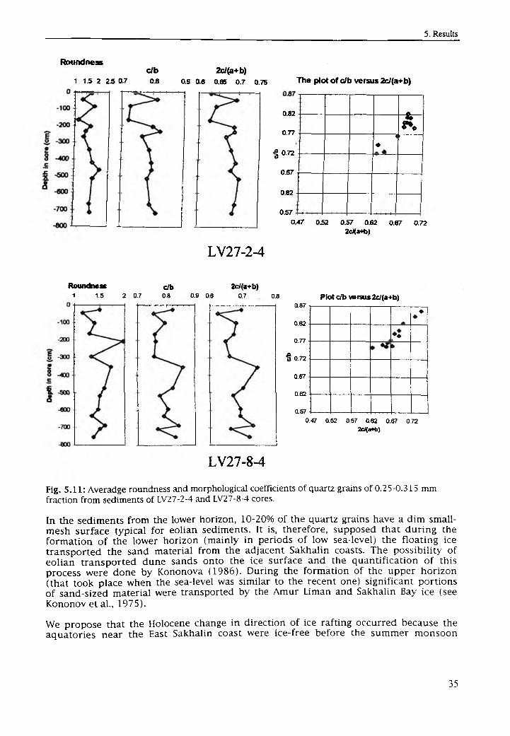
Roundness
1 15 2 2.5 0.7c/b 2c/(a+b)0.8 as 0.6 0.65 0.7 0.75 The plot of c/b versus 2e/(a+b)
0.82
0.77
| 0 .72
0.67
0.62
0.57
A4
*»■ ■ ■ ■
.. . . . .0.47 032 0.57 0.62 0.67 0.72
2c/(a+b)
LV27-2-4
Roundness1- 1.5 2 0.7
c/b0.8 0.9 0.6
2c/(a+b)0.7 0.8
0.87
0.82
0.77
§ 0.72
0.67
0.62
0.57
Plot c/b versus 2c/(a+b)
♦
0.47 0.52 057 0.82 0.67 0 72 2cJ(a*b)
LV27-8-4
Fig. 5.11: Averadge roundness and morphological coefficients of quartz grains of 0.25-0.315 mm fraction from sediments of LV27-2-4 and LV27-8-4 cores.
In the sediments from the lower horizon, 10-20% o f the quartz grains have a dim small- mesh surface typical for eolian sediments. It is, therefore, supposed that during the formation o f the lower horizon (mainly in periods o f low sea-level) the floating ice transported the sand material from the adjacent Sakhalin coasts. The possibility of eolian transported dune sands onto the ice surface and the quantification o f this process were done by Kononova (1986). During the formation of the upper horizon (that took place when the sea-level was similar to the recent one) significant portions o f sand-sized material were transported by the Amur Liman and Sakhalin Bay ice (see Kononov et al., 1975).
We propose that the Holocene change in direction o f ice rafting occurred because the aquatories near the East Sakhalin coast were ice-free before the summer monsoon
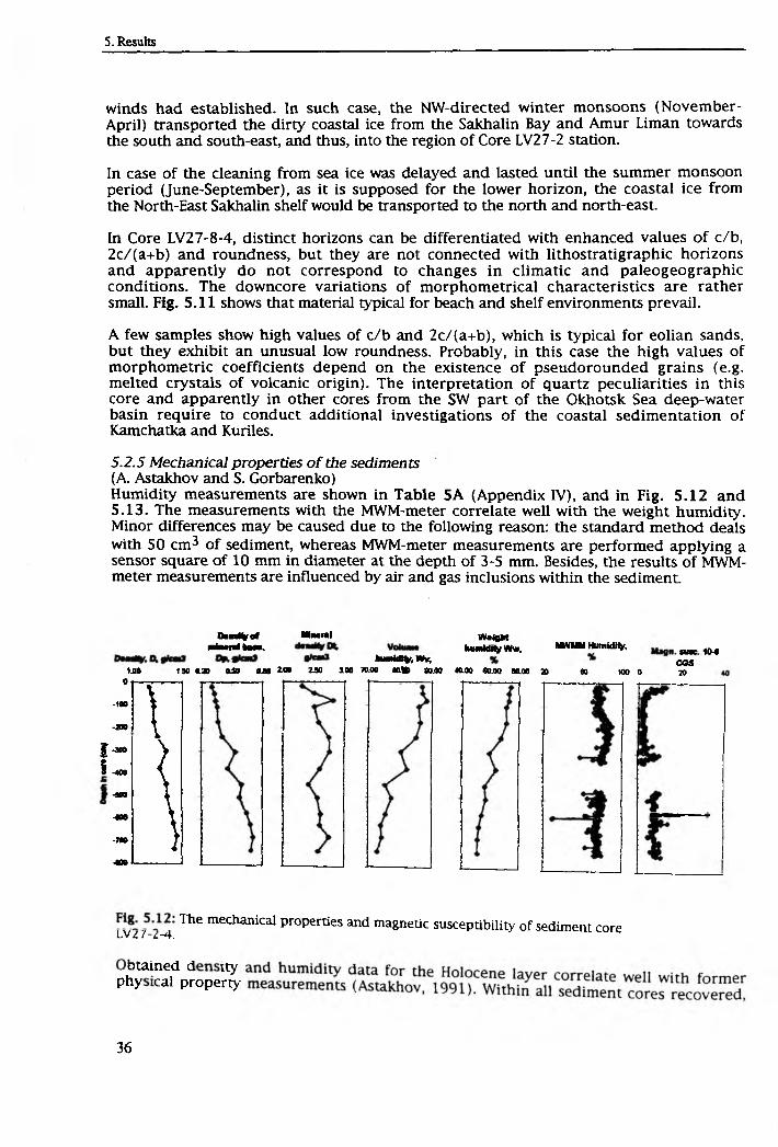
winds had established. In such case, the NW-directed winter monsoons (November - April) transported the dirty coastal ice from the Sakhalin Bay and Amur Liman towards the south and south-east, and thus, into the region o f Core LV27-2 station.
In case o f the cleaning from sea ice was delayed and lasted until the summer monsoon period (June-September), as it is supposed for the lower horizon, the coastal ice from the North-East Sakhalin shelf would be transported to the north and north-east.
In Core LV2 7-8-4, distinct horizons can be differentiated with enhanced values o f c/b, 2c/(a+b) and roundness, but they are not connected with lithostratigraphic horizons and apparently do not correspond to changes in climatic and paleogeographic conditions. The downcore variations o f morphometrical characteristics are rather small. Fig. 5.11 shows that material typical for beach and shelf environments prevail.
A few samples show high values o f c/b and 2c/(a+b), which is typical for eolian sands, but they exhibit an unusual low roundness. Probably, in this case the high values o f morphometric coefficients depend on the existence o f pseudorounded grains (e.g. melted crystals o f volcanic origin). The interpretation o f quartz peculiarities in this core and apparently in other cores from the SW part o f the Okhotsk Sea deep-water basin require to conduct additional investigations o f the coastal sedimentation o f Kamchatka and Kuriles.
5.2.5 Mechanical properties o f the sediments (A. Astakhov and S. Gorbarenko)Humidity measurements are shown in Table 5A (Appendix IV), and in Fig. 5.12 and 5.13. The measurements with the MWM-meter correlate well with the weight humidity. Minor differences may be caused due to the following reason: the standard method deals with 50 cm3 o f sediment, whereas MWM-meter measurements are performed applying a sensor square o f 10 mm in diameter at the depth o f 3-5 mm. Besides, the results o f MWM- meter measurements are influenced by air and gas inclusions within the sediment
Dm%ef Mmm!Miami ka*.
taimMtoWir.MMgftt
humid tty Ww, «NM M HumldMy, „ 1M
CSS*£ • 1.90 030 ISO (UQ 2A0 230 3.00 70.00 M fc 90.00 «0.00 <0.00 ML00 3D 60 100 0 20
Is
0
-160 V-200 I-300 >-400 {-0 » \400 \•78» }40 »
1116 mechanical properties and magnetic susceptibility of sediment coreL V z 7 -x -4 .
phby“ ? i p ? o p e ^
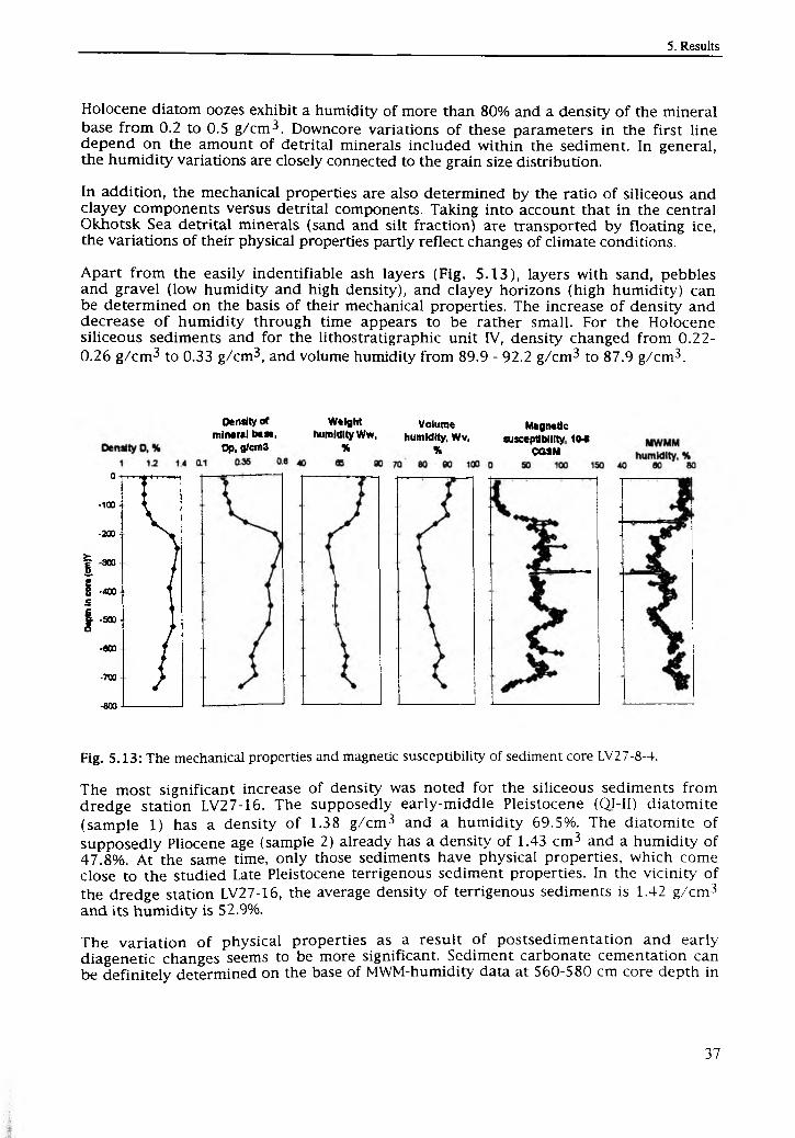
Holocene diatom oozes exhibit a humidity o f more than 80% and a density o f the mineral base from 0.2 to 0.5 g/cm3. Downcore variations o f these parameters in the first line depend on the amount o f detrital minerals included within the sediment. In general, the humidity variations are closely connected to the grain size distribution.
In addition, the mechanical properties are also determined by the ratio o f siliceous and clayey components versus detrital components. Taking into account that in the central Okhotsk Sea detrital minerals (sand and silt fraction) are transported by floating ice, the variations o f their physical properties partly reflect changes o f climate conditions.
Apart from the easily indentifiable ash layers (Fig. 5.13), layers with sand, pebbles and gravel (low humidity and high density), and clayey horizons (high humidity) can be determined on the basis o f their mechanical properties. The increase o f density and decrease o f humidity through time appears to be rather small. For the Holocene siliceous sediments and for the lithostratigraphic unit IV, density changed from 0.22-0.26 g/cm3 to 0.33 g/cm3, and volume humidity from 89.9 - 92.2 g/cm3 to 87.9 g/cm3.
Density of Weight Volume Magneticmineral base, humidity Ww, humidity, Wv, susceptibility 1 M
Op, g/cm3 % % c c sm
0 • •"?.....-1C» ■ I-200 - \
> yI 300 II -400 Ie i| .500- )
•eoo /-700 >-600
Fig. 5.13: The mechanical properties and magnetic susceptibility of sediment core LV2 7-8-4.
The most significant increase o f density was noted for the siliceous sediments from dredge station LV27-16. The supposedly early-m iddle Pleistocene (QI-II) diatomite (sample 1) has a density o f 1.38 g/cm3 and a humidity 69.5%. The diatomite o f supposedly Pliocene age (sample 2) already has a density o f 1.43 cm3 and a humidity o f 47.8%. At the same time, only those sediments have physical properties, which come close to the studied Late Pleistocene terrigenous sediment properties. In the vicinity o f the dredge station LV27-16, the average density o f terrigenous sediments is 1.42 g/cm3 and its humidity is 52.9%.
The variation o f physical properties as a result o f postsedimentation and early diagenetic changes seems to be more significant. Sediment carbonate cementation can be definitely determined on the base o f MWM-humidity data at 560-580 cm core depth in
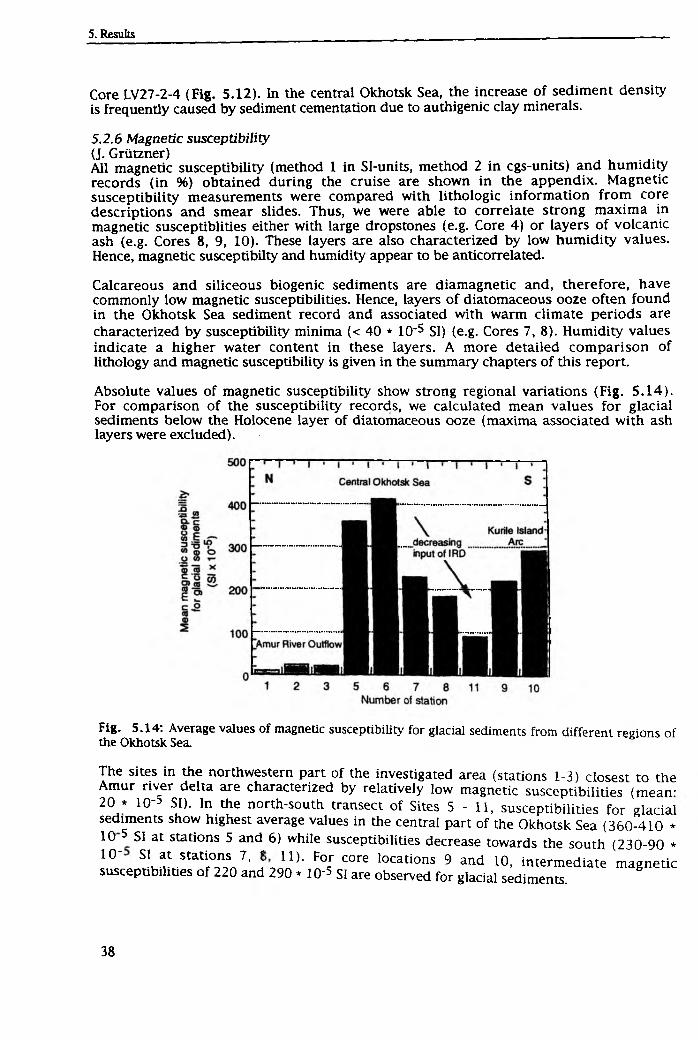
Core LV27-2-4 (Fig. 5.12). In the central Okhotsk Sea, the increase o f sediment density is frequently caused by sediment cementation due to authigenic clay minerals.
5.2.6 Magnetic susceptibility (J. Griitzner)All magnetic susceptibility (method 1 in Sl-units, method 2 in cgs-units) and humidity records (in %) obtained during the cruise are shown in the appendix. Magnetic susceptibility measurements were compared with lithologic inform ation from core descriptions and smear slides. Thus, we were able to correlate strong maxima in magnetic susceptiblities either with large dropstones (e.g. Core 4) or layers o f volcanic ash (e.g. Cores 8, 9, 10). These layers are also characterized by low humidity values. Hence, magnetic susceptibilty and humidity appear to be anticorrelated.
Calcareous and siliceous biogenic sediments are diamagnetic and, therefore, have commonly low magnetic susceptibilities. Hence, layers o f diatomaceous ooze often found in the Okhotsk Sea sediment record and associated with warm climate periods are characterized by susceptibility minima (< 40 * 10'5 SI) (e.g. Cores 7, 8). Humidity values indicate a higher water content in these layers. A more detailed comparison o f lithology and magnetic susceptibility is given in the summary chapters o f this report.
Absolute values o f magnetic susceptibility show strong regional variations (Fig. 5 .14). For comparison o f the susceptibility records, we calculated mean values for glacial sediments below the Holocene layer o f diatomaceous ooze (maxima associated with ash layers were excluded).
Fig. 5.14: Average values of magnetic susceptibility for glacial sediments from different regions of the Okhotsk Sea.
The sites in the northwestern part o f the investigated area (stations 1-3) closest to the Amur river delta are characterized by relatively low magnetic susceptibilities (mean- 20 * 10-5 SI). In the north-south transect o f Sites 5 - 11, susceptibilities for glacial sediments show highest average values in the central part o f the Okhotsk Sea (360-410 * 10 5 si at stations 5 and 6) while susceptibilities decrease towards the south (230-90 *
10~ SL ? . Stati ° nfA 7’ f n ) ’ FoJ core locati°ns 9 and 10, intermediate magnetic susceptibilities o f 220 and 290 * 10-5 SI are observed for glacial sediments.
The described pattern is most probably caused by grain size differences in the supply o f terrigenous m aterial, which carries magnetic minerals. W hile terrigenous sedimentation in the Amur river outflow area is dominated by fine grained terrigenous clays, the central and southern Okhotsk Sea is more affected by the input o f ice rafted detritus (IRD), which obviously decreased from north to south. We suggest that higher susceptibility values in the vicinity o f the Kurile Island Arc are caused by the volcanic ashes rather then by higher amounts o f ice-rafted material.
5.2.7 Radiolarians in Okhotsk Sea sediments (A. Matul)Surface sedimentsThe absolute radiolarian content is relatively low and is approximately similar in all the samples: 1,600-2,800 (in MUC-4 to 8) specimens per 1 g o f dry sediment independing o f the water depths. The species composition o f the radiolarian assemblages does not fluctuate significantly within the analysed samples. Each assemblage contains 24-29 radiolarian forms. 52 radiolarian forms were defined in total (Tab le 6A, A ppen d ix IV ). 19 radiolarian forms occurred in all the samples. The dominant species are A. micropora, A. dubius, C. davisiana, Ps. gracilipes, Pt. hirundo, R. boreale, S. tabulatus, S. glacialis, S. pyriformis, S. venustum, Th. borealis.
Except for C. davisiana, their common percentages vary from 42% to 57%. Therefore, in addition to C. davisiana. these species presumably provide the most important portion o f the radiolarian assemblages o f the Okhotsk Sea.
The relative concentrations o f the above listed species do not change considerably across the investigated area. However, a substantional d ifference between the assemblages o f MUC-1 to 3 and the remaining assemblages has to be noted. In the assemblages o f MUC-1 to 3, the concentrations o f C. davisiana increase slightly, whereas the content o f S. tabulatus, S. glacialis, and S. venustum drops. The assemblage o f MUC-4 to 11 contains rare specimens o f A. aquilonaris, E. delicatulum, S. pylomaticus borealis,S. osculosus, S. validispina, and Tholospira sp., which are typical for recent sediments in the North Pacific. In the samples MUC-6, MUC-8, and MUC-11, L. arachnea and S. pyriform is, typical species for the boreal Pacific, reach their highest concentrations. In the assemblage o f MUC-7, E. acuminatum was found, which is widely distributed in sediments from the southern parts of the boreal oceanic provinces.
In conclusion, the following radiolarian assemblages could be distinguished in the studied surface sediments:
1. Assemblages MUC-1 to MUC-3 exhibit a relative increase o f C. davisiana concentrations, whereas typical Pacific species are absent;
2. Assemblages MUC-4 to MUC-11 are characterized by the presence o f species typical for the boreal Pacific;
2a. Assemblages MUC-7 to MUC-11 show a relative increase o f the concentration o f Pacific species.
It may, thus, be concluded that the Pacific water masses have a distinct influence on the radiolarian assemblages o f the Okhotsk Sea south o f 52-53°N.
Two specimens o f ?A. setosa were surprisingly found in sample MUC-11. According to Kruglikova (1989 a), this species disappeared in the North Pacific ca. 80,000 years ago. Since the author is familiar with A. setosa specimens from many samples from the southern Norwegian Sea, the Labrador Sea, and from Late Pleistocene North Atlantic sediments, the ?A. setosa specimens from sample MUC-11 were accurately identified and fit well to' the regular species definition. Since it is questionable that these species are
modern specimens, it is suggested that they are reworked from Pleistocene sediments of the Academy o f Sciences Rise.
Downcore radiolarian study o f Core LVZIiSThe radiolarian distribution was analysed in 18 sediment samples from 120 cm core depth to the base (Tab le 7A, Appendix IV). In all samples, the radiolarian fauna is abundant and highly diverse. The absolute radiolarian content varies between 2,400- 3,100 to 5,500-6,900 specimens per 1 g o f sediment, and reaches its maximum in the upper and lower diatomaceous ooze units (13,900 and 18,000-32,000, respectively). The number o f radiolarian species is not less than 18-25 in each slice showing a significant increase o f up to 40 species in the lower diatomaceous ooze unit.
The list o f the abundant species (relative concentration more than 1-2%) is almost similar for all the samples (Tab le 8A, Appendix IV ), and does not d iffer from the modern situation in the central Okhotsk Sea. However, species concentrations vary downcore substantially. Further, radiolarians, which are rare or absent in the present day Okhotsk Sea, occur. Cr. borealis is not abundant in modern sediments, but exhibits great concentrations (up to 16.6%) in the 200-690 cm interval. L. grande, at present inhabiting the tropical and southern temperate North Pacific areas (Kruglikova, 1989 b), appears only below 480 cm and reaches 38.5%. A. setosa, an endemic species o f the Arctic and northern North Atlantic (Kruglikova, 1988) and presumably typical for the surface arctic and subarctic waters, was noted at 200-400 cm and 530-743.5 cm depth. The author (Matul, 1994) found high A. setosa concentrations (up to 36.6%) in the Younger Dryas sediments o f the North Atlantic.
In conclusion, the following radiolarian assemblages were distinguished in Core LV27-8:
2 .
The assemblage occurring at the 120-182 cm interval is similar to the modern radiolarian assemblages o f MUC-1 to MUC 3, with enhanced C. davisiana concentrations and only minor influence o f the Pacific radiolarian fauna. Probably, this assemblage belongs to the early Holocene (oxygen isotope stage 1).The assemblage occurring at the 200-371 cm interval is defined by an obvious decrease in concentration o f C. davisiana (21.5-30%), the appearence o f A. setosa and the significant increase o f Cr. borealis, which is a typical species for the modern arctic-boreal Pacific. Probably, this assemblage is typical for the Last Glacial (oxygen isotope stage 2). For cores from the south-western Okhotsk Sea, Morley et al. (1991) defined the Last Glacial by a sharp content's decrease and even the absence o f radiolarian. At the same time, C. davisiana concentrations decrease to a few percents. For core LV27-8, the situation is different: the radiolarian content stays higher than the modern one, and C. davisiana is the dominant species. We, therefore, suppose strong lateral differences across the Okhotsk Sea during the Last Glacial.The assemblage occurring at the 400-691 cm interval shows concentrations o f the main dominant species (except C. davisiana), which are similar to the modern ones. However, the C. davisiana content decreases (up to 7.5-16.6%); in slices C davisiana mostly is presented by specimens o f oceanic (non marine) style Below 480 cm, L grande appears, which possibly is a tracer for relatively warm waters We assume that assemblage 3, in contrast to assemblage 2, is significantly influenced by relatively warm Pacific water.The assemblage occurring at the 710-743.5 cm interval shows increasing y* setosa
t0 46r>%)‘ TheuC davisiana concentration is re lative ly high ^ r rht ^ L ™ 1SHaSSei? blal e 15 characterized by many radiolarian forms typical for the modern boreal and southern boreal Pacific (e.g. A aquilonaris A botryocyrtmm, A. annulatus, A. joergensenii, C. laguncula, £ a cu m L tu m etc., as
well as colonial Spumellaria A. lappacea?, Acrosphaera sp., Collosphaera sp.). Probably, a strong contrast existed between the cold surface waters (A. setosa, modern Arctic endemic) and warm subsurface and intermediate inflowing Pacific waters.
In conclusion, assemblages 3 and 4 correspond to the last large interstadial (oxygen isotope stage 3), whereas assemblage 4 may indicate its warmest period (stage 3.3).
5.2.8 Sedimentation at the northeastern slope o f Sakhalin(Chr. Vogt, J. Grtitzner, S. Gorbarenko, A. Astakhov, and D. Nürnberg)SedimentologvDespite the near continent, the surface and near surface sediments contain high amounts o f biogenics, in particular diatoms, mollusc and gastropod shells and carbonaceous shell fragments (Fig. 5.15, for legend see Appendix V). The thickness o f the soft dark brown oxidation layer increases with water depth. A 1-2 cm flu ff layer was observed at all multicorer stations. The diatomaceous ooze and the predominantly biogeneous horizons are characterized by very low magnetic susceptibility values (Fig 5.15: layer A and B).
Below the biogenic horizons, transitional sediments with increasing amounts o f terrigenous material appear which leads to slightly enhanced magnetic susceptibilities. The deposits contain higher amounts o f carbonaceous shell fragments and some randomly distributed pebbles. In several cores, a moderate coarsening o f the sediment is obvious (Fig. 5.15: layer B). Down to this core section, olive colors predominate. Further below, gray colors dominate. In core LV27-2-4 significant changes o f color and biogenic and mineralogical contents and composition occur at 1.7-1.8 m within layer B (see 5.2.4).
W ith increasing core depth, hydrogen sulfid odor is typical. Black streaks become abundant, and authigenic pyrite is reported from core LV27-2-4 below 4.2 m. Thus, color, sediment composition and gas formation delineate the prevailing reducing conditions within the sediment. The redox-conditions may have favored early d iagenetic alteration o f the major magnetic minerals (Fe-oxides) leading to the extremely low magnetic susceptibility values below approx. 50 cm core depth (F ig. 5.15: LV27-la-l, LV27-2-4). Hence, the drastic increase o f the magnetic susceptibility at the core tops may indicate the change between fully reducing and oxygenating sedimentary conditions (Fig. 5.15: layer A).
An increase in the magnetic susceptibility record reflects the change to more terrigenous sediments including increasing amounts o f pebbles. Below this increase with its threefold maxima the magnetic susceptibility sticks to the higher level down to ca. 7 m core depth (Fig. 5.15: layer C). The threefold maxima are observed in all slope cores and can be used for correlation (Fig. 5.15, for legend see Appendix V).
Layer B has its base at 4 to 6 m on the upper slope (LV27-1-3, LV27-2-4) and wedges out downslope showing its base at about 0.6 m on the lower slope (LV27-3-3). Hence, decreasing sedimentation rates downslope can be assumed. Below layer B, in layer C at least three maxima o f magnetic susceptibility values can be correlated between cores LV27-2-4 and LV27-3-3 (Fig. 5.15, for legend see Appendix V). The most prominent peak is related to a coarsening in lithology in cores LV27-2-4 and LV27-3-3 (gravel layer). In core LV27-2-4 calcareous concretions were observed. The evenly spaced susceptibility peaks in core LV27-3-3 may reflect some kind o f cyclicity, though the lithology does not change drastically. It should be noted that at 476-523 cm core depth, large crystals o f ikaite (up to 9 cm in length) were found. The calcium carbonate
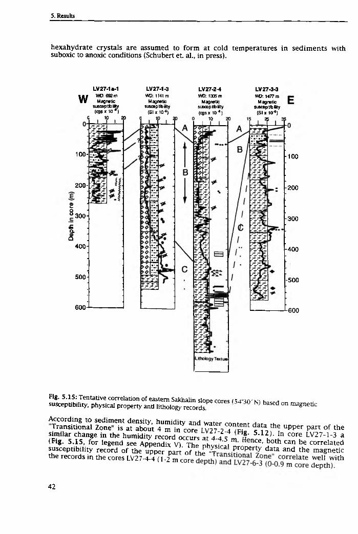
hexahydrate crystals are assumed to form at cold temperatures in sediments with suboxic to anoxic conditions (Schubert et. al., in press).
wLV27-1a-1
WD: 692 m Magnetic
susceptbffity (cgs x l O * )
10 20
LV27-1-3WD: 1141 m
Magnetic susceptblity
(SI x 10-®)
LV27-2-4WD: 1305 m
Magnetic susceptbity (ogsx 1C6'
10
LV 27-3-3WD: 1477 m
Magnetic susceptbaty
(SI x 10-®) $
100-
200 - ’
©woo 300
£Q.Q
400-
500
6 0 0
100
200
300
400
-500
600
Fig. 5.15: Tentative correlation of eastern Sakhalin slope cores iS4^rv \n h susceptibility, physical property and lithology records } baSed 0n ma§nedc
According to sediment density, humidity and water rnnrmr -u Transitional Zone" is at about 4 m in core LV27-2 4 m a c ^ w upper part o f the
similar change in the humidity recordoccur, at 1 1 1 u 5 ' 1 2 )‘ In core LV27-1-3 a (Fig. 5.15, for legend see Appendix V). The nhvcirfi m' ce’ both can be correlated susceptibility record o f the upper Dart o f rh^ " t Pr0Perty data and the magnetic the records in f l * c o r « LV27-4-4 (1-2 m core de“
Depositional environ mpnr
The diatomaceous oozes of the Okhotsk Sea are of Holocene age. Despite the near continent, the sediments of the northeastern slope of Sakhalin exhibit up to 4 m of diatomaceous ooze or weak diatomaceous sediment (Fig. 5.15). This points to an extraordinarily high bioproductivity during the Holocene. The extreme bioproductivity is presumably driven by the distinctive Okhotsk Sea oceanography. The seasonally changing surface layer is underlain by a cold layer of 100 to 150 m thickness substained by the production of winter sea-ice, which induces winter convection of the upper water masses (Yang & Honjo, 1996). This "Okhotsk Diochothermal Layer" most effectively prevents vertical exchange of water masses during summer. Thus, nutrient enriched in the surface waters can completely be used up and therefore, contribute to the very high surface water productivity (Tally & Nagata, 1995). The core transect northeast off Sakhalin locates in the eastern part of the Okhotsk Gyre, which counterclockwise moves from the inflow of Pacific waters near Kamchatka across the northern shelf regions to the eastern coast of Sakhalin. It is still not well known how the surface waters of the Okhotsk Sea substain their high nutrient content (Yang & Honjo, 1996). Admixtures of continental runoff probably provide a lot to the nutrient budget. Near the Amur outflow area, therefore, the surface waters might be strongly enriched in nutrients, causing the extreme accumulation of diatomaceous sediments.
The Holocene age of the diatomaceous ooze would result in sedimentation rates of more than 40 cm /1000 years. The increased content of terrigenous sediment components in layer C, thus, points to a reduction in surface water productivity during the last glacial and the deglacial Termination I. The higher input of terrigeneous material may also be due to an increased input of ice-rafted debris. The horizon of ice-rafted material in LV27-3-3 correlates with the thin laminated layer in LV27-2-4 (Fig. 5.15). The laminated area is interpreted as distal turbidity currents.
The stratigraphical framework outlined above states the occurrence of a volcanic ash layer in between the "Transitional Sediments" (Unit II). None of the cores along the transect northeast off Sakhalin exhibits such an ash layer. Most probably, the ash, which presumably originated from the Kurile Islands and was transported northward by wind, did not reach the northern Okhotsk Sea. The decreasing thickness of ash layer K1 from south to north as observed in the central Okhotsk Sea cores, supports this
hypothesis.
5.2.9 Marine geology o f the central Okhotsk Sea (D. Nürnberg and S. Gorbarenko)SedimentologvThe surface deposits from the central Okhotsk Sea commonly consist of a soft, brown diatomaceous ooze, which is mostly overlain by a ca. 1 cm thick brownish fluff layer. Grain sizes vary accordingly from silty sand to clayey silt depending on the water depth. Approximately 3-4 cm below the surface, the brownish color changes to olive gray typical for the diatomaceous oozes. Calcareous foraminifera and coccoliths are abundant. Due to the dominating biogenic components, the magnetic susceptibility values are extremely low. According to our lithostratigraphical classification, we call the diatomaceous ooze Unit I (Fig. 5.16, for legend see Appendix V).
The diatomaceous ooze is underlain by a "transitional" sediment (Unit II), which is only- weakly diatomaceous, but is dominated by terrigenous components. Accordingly, the magnetic susceptibility values increase slightly. Grain sizes vary between sandy silt and clayey sandy silt. The dark olive gray sediment is homogenous and includes reworked lenses of diatomaceous ooze due to strong bioturbation. Occasionally, small pebbles occur. Foraminifers commonly occur and
LV27-5-3 GC
WD: 482 m(m) |
OjO-
LV27-6-4 GC LVZ7-7-3 GC WD: 872 m WD: 1140 m
Fig. 5.16: Lithostratigraphic classification of central Okhotsk Sps ^
(shading) based on lithology and magnetic susceptibility records ^ correIation
show distinct variations. Within this unit, two ash layers dated to 8.500 a and 12.000 a, were already described (Gorbarenko et al., in press). Within the sediments recovered during this expedition, we only observed one volcanic ash layer (K-l), the age of which is most probably 8.500 a BP. The magnetic susceptibility record exhibits pronounced maxima.
The transitional lithological unit overlays the typical glacial sediment (Unit III), consisting of dark gray sandy to clayey silt and containing abundant dropstones of largely varying size (few mm to ca. 10 cm). The dominating portion of detrital material causes high magnetic susceptibilities. With increasing depth, black streaks and mottles can be observed pointing to the presence of organic matter. Calcareous shell fragments occur, but are rare. Formation of free hydrogen sulfid inferred from an intensive odor, points to the decay of organic matter by the activity of sulphate reducing bacteria under suboxic conditions. Greenish diagenetic horizons must presumably be related to the formation of authigenic clays.
A second layer of volcanic ash (K-2), dated to approximately 28.000 a BP. (Dr. J. Southon, pers. com.), intercalates the glacial unit of terrigenous sediments, thus, relating the glacial deposits to isotopic stage 2 and the upper part of stage 3. It is again characterized by maxima in the magnetic susceptibility records.
Below the glacial succession, the pronounced decrease in the magnetic susceptibility records refer to a second diatomaceous ooze (Unit IV) showing abundant foraminifers, and a high organic carbon content. According to Gorbarenko (1991), this strongly bioturbated sequence belongs to stage 3.3. It is followed by glacial (rest of oxygen isotope stage 3 and stage 4), terrigenous sediments enriched with pebbles (Unit V). Accordingly, the magnetic susceptibility values increase.
Depositional environmentMost sediment cores recovered during the 27th cruise of R/V "Akademik Lavrentyiev" delineate along a N-S-profile within the central Okhotsk Sea covering a depth range of approximately 1500 m. Nevertheless, lithostratigraphic units described above could be traced over long distances. Fig. 5.16 exhibits the core correlation based on lithology. This correlation is supported by the according correlation of magnetic susceptibility records (Fig. 5.17).
The lower diatomaceous ooze (Unit IV) was only reached by core LV 27-5-3 at the North Okhotsk Rise, and further south by cores LV 27-8-3 and LV 27-8-4 in the Makarov Trough (Fig. 5.16, for legend see Appendix V). In this respect, despite their relatively short lengths, cores LV 27-5-3 and LV 27-8-3 cover the longest time period, since they also intruded lower stage 3 sediments. We suspect that during stage 3.3 the enhanced marine productivity reflected in diatomaceous oozes was mainly initiated by high nutrient supply due to inflowing Pacific surface water masses (Kamchatka Current) favoring a stable water column with relatively warm surface waters comparable to the recent situation. Largely ice-free conditions during the entire year may additionally have contributed favorable environmental conditions for siliceous plankton growth. The fact that the diatomaceous ooze at the northern site is less evolved compared to the southern ones (Fig. 5.16) may be related to different sediment accumulation rates. It may, however indicate a reduced plankton productivity due to less favorable conditions in the northern part of the Okhotsk Sea during stage 3.3. Perennial sea ice coverage originating in the cold, shallow and low saline coastal waters in the north and subsequently drifting in a direction approximating the Okhotsk-Kurile current system may drastically reduce plankton growth simply by light reduction.
Fig. 5.17: Magnetic susceptibility records of central Okhotsk Sea cores. Core correlation (shading, similar to shading in Fig. 5.16) is based on lithology and magnetic susceptibility records.
Most characteristic for the overlying glacial sediments (Unit III) are the enhanced occurrences of dropstones covering all size fractions (mainly small pebbles of ca. 0.5 cm, but also boulders of up to 10 cm). Since large glacier systems did presumably not exist onshore, sea ice is suggested to be the most important transport agent for the coarse detrital material. Cliff fall and coastal adfreezing, thus, seem to be the most effective entrainment mechanisms. Drifting ice subsequently distributed the pebbles across the entire Okhotsk Sea, releasing its freight during ice-melt in summer. The systematic investigation of ice-rafted detritus within the deep-sea sediments should allow to elucidate both the extension of glacial ice-coverage, and varying transport directions in great detail.
It should be noted in this respect that Arctic Ocean sea ice seldomly includes particles larger than silt-sized. Cliff fall and coastal adfreezing as entrainment mechanisms only play a minor role in comparison to suspension freezing, the dominant entrainment mechanism for fine-grained sea-ice sediments (Nürnberg et al., 1994).
The volcanic ash layer K-2 intercalated within the glacial sequences of most of our cores provides an excellent time-marker and allows to correlate the deep-sea sediments over long distances (Fig. 5.16, for legend see Appendix V). The ash layer is best established in the southern sites (LV 27-10-5, LV 27-9-4, LV 27-8-4, LV 27-8-3), whereas it is not found in the northern site LV 27-6-4. In site LV 27-5-3, only few volcanic particles were found, which may be related to K-2. Such distribution pattern proposes a southern source area for the volcanic ash, e.g. Kurile Islands, and a northerly direction of wind transport becoming less effective in the northernmost parts of our study area.
The transitional, weak diatomaceous sediments (Unit II) overlying the glacial deposits imply a gradual climatic improvement. The influence of sea ice onto deep-sea sedimentation is reduced, since pebbles rarely occur. Diatom concentrations, in contrast, rapidly increase due to improving environmental conditions. The retreating and deteriorating ice cover may reflect the changing surface water current system at that time. In addition, the enhanced light supply and small-scale upwelling at ice edges may have favored plankton growth.
During this climatic improvement, the volcanic ash layer K-l spread over large areas of the Okhotsk Sea. The volcanic Kurile Islands most probably served as the K-l source area, since the southermost sites show a well-evolved ash, whereas the ash is missing in the northernmost sites (LV 27-7-3, LV 27-6-4, and LV 27-5-3).
The transitional, weak diatomaceous sediments gradually change to pure diatomaceous ooze during Holocene times, implying the onset of an extreme siliceous primary productivity. Gorbarenko et al. (1988) mentioned that marine productivity did not simultaneously increase within the entire basin. It is rather suggested that in dependence from increasing surface water temperatures related to the newly establishing surface current system, productivity spread progressively from the southern to the northern parts of the Okhotsk Sea. The preliminary observation that diatomaceous oozes are much thicker at the southern sites compared to the relatively thin oozes at the northernmost sites further suggests that the onset of surface productivity commenced earlier in the southern part contemporaneously with a progressively retreating ice cover from S to N and a stepwise northward intrusion of Pacific surface waters. This assumption, however, needs to be proved by absolute age
dating.
5.2.10 Gas geochemistry(A. Obzhirov and B. Baranov) ,, ,Gas geochemical analyses were made at 12 stations (see Figs. 1.1 and 5.1). At a l or them, the gas component in bottom water samples derived from multicorer tubes was examined. At stations LV27-1, 2, and 4, gas was additionally examined m sediment samples derived from the multicorer. At stations LV27-2, 4, 5, and 8, gas was extracted from sediments obtained by the POI gravity core. At stations LV27-5 and 11, gas was studied in water samples from water depths of 50, 100, 200, and 300 m derived by Niskin bottles. In the sediments and bottom water samples, the pH values were measured. The gas concentrations and pH values measured in water and sediments are listed in Tables
10A and 11A (Appendix IV).
The oxygen and nitrogen concentrations measured in bottom water samples are typical for these depths in the Okhotsk Sea (1.6-2.5 ml/1 and 11.9-13.0 ml/1, respectively). In the LV27-7 water sample, the promoted oxygen concentration (3.8 ml/1) and the reduced nitrogen concentration were determined. These conditions may be connected with the mixing up of the bottom and surface waters, which could have occurred during the uplift of the multicorer device. This supposition is verified by a decrease in CO2 (0.61 ml/1) in this sample. The CO2 concentrations measured in bottom water (1.40-1.86 ml/1) are rather high, in particular, at site LV27-11 (1.86 ml/1). The same concentrations were obtained in the bottom water from the Paramushir gas seeping (Obzhirov, 1993)
At these stations the most significant difference in bottom water gas composition was observed for the methane distribution. At stations LV27-1 and 2, abnormal methane concentrations were observed (221 and 2000 nl/1, respectively). At other sites, there are background methane concentrations of 20-50 nl/1 in the bottom water. At sites LV27-11 and 12, very low methane concentrations were observed (8 nl/1 and 12 nl/1, respectively). Such level of concentrations corresponds to the background level of Pacific bottom water and areas where red clays dominate (Obzhirov, 1993).
In water samples taken from the upper horizons (50-300 m) of two stations, the main difference between them exists in their methane distribution. At station LV27-5, it follows the usual distribution law determined earlier (Obzhirov, 1993; see chapter 3), but at station LV27-11 at water depths of 50, 100, and 200 m, the methane concentrations exceed the background level more than 3 times (189 nl/1 on 100m).
In sediments recovered from stations under investigation, major differences in methane concentrations were observed. The maximum methane volume (10.2 ml/1) was determined at (gas-) station LV27, where on the echosounder record gas plumes were observed. Such plumes were already found in this region earlier (Obzhirov et al., 1989). Here, the sediments contain high concentrations of methane in the entire core, but maximum methane concentrations were determined in its lower part, in the 180-245 cm interval. The low methane concentrations (0.001-0.003 ml/1) were measured in sediments from sites LV27-4, 5, 8, and 10. In sediments from sites LV27-2, 9, and 12, methane concentrations of 0.1-0.3 ml/1 were measured. They are 100 times less than the methane concentrations measured at (gas-) station LV27, but 100 times more than the background methane concentrations typical for the other stations. At site LV27-8 and
and 5 6 me ane concentrat'on is increased by two times in comparison to sites LV27-4
Discussion
abov<r’ the most significant amount of methane in bottom sedimentsrh innnn n 1 f?S at station LV27-gas. In this region, methan anomalies of
more than 10000 nl/l m the bottom water were already reported (Obzhirov 1993). Also,
gas hydrates were observed in sediments (Ginsburg et al., 1993). At site LV27-gas, gas hydrates were, unfortunately, not observed within the sediments, however, methane concentration anomalies were found exceeding the background level 10.000 times.
a
1200
1300: *>M
1400 m
oac nlumes offshore northern (a) and southern (b) SakhalinF.g. 5.18: Echosounder records of the gas p umes otK ^ ? ^Island. N shows new gas plumes, 0 marKs oia one*.
number 1 and 3, respectively.
The existence of gas plumes and methane anomalies in bottom sediments justify in any case that there must be gas hydrates in the sediments. Such gas plumes usually correspond with the zones of destruction and venting of gas hydrates. This process may begin under the conditions of pressure decrease or temperature increase. Such conditions may be caused by global sea-level changes, volcanic processes, recent
tectonic activity, and others.
Site LV27-gas is located in the area of the East-Sakhalin fracture zone, the tectonic activity of which seems to have increased recently. The following facts verify this
phenomena:1. the increase of methane concentrations in abnormal and background fields of the
bottom water is at least 10 times higher during the period after 1987 compared to the period before 1987;
2. the contineuous gas seeping (plumes) recorded by echosounding techniques during the period between 1988 and 1996;
3. the discovery of new sites of gas seeping (plumes) not far from site LV27-gas (Fig. 5. 18a).
New gas seepings were discovered inside the field, which was earlier defined and studied (Obzhirov, 1993; Ginsburg et al., 1993). According to the location of known gas seepings, it is oriented orthogonal to the Sakhalin continental slope at water depths of 672-865 m. Moreover, during this expedition two gas plumes were found 150 miles southward in water depths of 1320-1400 m (Figs. 5.18 b and 5.19). These plumes are located on small mounds showing heights of about 15-20 m, which may represent mud volcanos.
All known gas fields on the Sakhalin continental slope are obviously connected with the East Sakhalin fault zone (Fig. 5.19). This zone represents the eastern restriction of the Sakhalin shear zone, which can be traced over a distance of more than 2000 km and separates the Amur and Okhotsk plates (Baranov et al., 1996). The East-Sakhalin Fault is a dextral strike-slip structure, as deduced from the existence of extensional feather structures. These structures are located in the Derugin Basin, where they were carefully investigated during the joint German-Russian expedition on RV "Professor Gagarinsky" in 1995 (Baranov et al., subm). The Polevoy Ridge located in the south may correspond to a reverse fault zone.
The area mentioned should be mapped in detail for the determination of the recent tectonic pattern. Such mapping may serve as the base for finding new gas seeping fields and to understand their nature. Nevertheless, it is possible to use the data sampled during this year' s expedition to:1. testimate the volume of methane seeping from the sediments into the water and
from the water into the atmosphere;2. estimate, in a broader sense, the global cycles of natural methane and its
influence on global climate change; and/or3. predict future earthquakes, such as the Neftegorsk earthquake.
The suggestion that methane can penetrate from the water into the atmosphere is supported by the discovery of abnormal methane concentrations in the upper horizons of sea water at site LV27-11. The methane concentrations here exceed the balance with the atmosphere 2-3 times. In the bottom water of this station, however, the lowest methane concentration was 8 nl/1. This discrepancy indicates that the methane does not
J f i ” ! i6 ftt0m sediments- The methane anomaly is rather connected to both c micr?bl0tic productivity and the transportation of methane by
water masses. If the second assumption is true, the seep providing methane from the bottom sediments must be located at some distance to site LV27-11
142 146 E 45 N
Fig S 19- Location of the gas seeping fields offshore Sakhalin (solid points) and East Sakhalin strike-slip zone (thick line with arrows). Fields 1 and 2 were known before (Obzhirov, 1993; Ginzburg et al„ 1993). Field 3 was finding in this cruise. Toothed line indicates reverse fault, line with bars shows normal fault. DB - Derugin Basin, PR - Polevoy Rise, KB - Kurile Basin.
It must be noted that at site LV27-11 high C02 concentrations (1.86 ml/1) were found in the bottom water along with very low methane concentrations. This may be due to both the low tectonic activity of the geological structures, and the existence of ancient intrusive complexes, dislocated by faults, along which the gas migrates from the earth s
interior to the sea water.
Conclusions .1. Large amounts of methane were observed in the bottom sediments in areas where
gas vents are active.2. It is suggested that at site LV27-11 the surface water masses have higher methane
concentrations than the balance concentrations with air.3. It is supposed that the region of site LV27-11 is characterized by passive tectonics.4. The newly discovered gas seeps are located in the vicinity of the East-Sakhalin
Fault Zone and may be due to the recent tectonic activity in this area. In this case both gas hydrates and gas and oil deposits may be the sources of methane.
The future detailed investigation of this region would allow to estimate the volume of methane penetrating from the earth' s crust into the atmosphere, and its contribution to the global climate change.
5.3 Plankton investigations (D. Nürnberg and Chr. Vogt)
a) ForaminifersPlankton sampling focussed on studying of calcareous foraminifers, siliceous diatoms, and radiolarians. One basic assumption of paleoceanographic studies using planktic assemblages is that the planktic organisms accurately reflect surface water conditions both now and in the past.
In this respect, stable oxygen isotope analyses within planktic foraminifers are widely accepted to be a powerful paleoceanographic tool for the reconstruction of water mass circulation and surface water temperatures. Nevertheless, there are major uncertainties in understanding the formation of the stable oxygen isotope signal. Recent studies point out that the stable oxygen isotope signal within the water the foraminifers live in is slightly different from the signal preserved in living foraminifers. Further, the isotope signal differs between living and dead foraminifers. The plankton net studies in combination with water sampling represent one further step to understand these vital effects.
In the Okhotsk Sea, the water column is clearly stratified. Below 50 m, temperatures are commonly below 0°C, whereas above, surface temperatures increase to 14°C during summer. Based on temperature and salinity data, Alderman (1996) calculated calcification depths of 40-20 m for the dominating planktic foraminifers N. pachyderms sin. and G. bulloides. Accordingly, we took plankton nets in different intervals down to 300 m water depth. For comparison of living foraminifers (if possible), dead assemblages down to 300 m water depth, and core-top foraminifers oxygen isotope analyses will be performed at the home laboratories, and will hopefully contribute important insights into vital effects perturbing the stable oxygen isotope signal of surface waters.
bLSiliceous plankton
wvio1«5 ’ e*c^ ent fossilization and their known ecology, radiolarians andami fnturp dlniov USe? J pa,Ieocean°graPhic reconstructions. Plankton net studiesdistribution anri n ? r m<:nt traPs wiU document seasonal changes in the distribution and flux of siliceous plankton assemblages in surface waters of the high
latitude, the seasonally ice-covered NW Pacific. Parallel to the plankton net work, sampling of the water column will provide necessary information on the hydrography and nutrient content. Both plankton net studies and water sampling will further help to interpret the siliceous plankton signal preserved in the sea floor deposits.
During this year's cruise, we started performing vertical net sampling of the uppermost 300 m water column, which gives insight into the depth and diversity distribution of siliceous plankton in dependence from hydrography and nutrient supply. Knowledge about the life habitat of different species is of great value for paleoceanographic interpretations.
In particular, the investigation of the radiolarian species Cycladophora davisiana, which is common in Okhotsk Sea surface waters, is of large interest. Except for the Okhotsk Sea, this species occurs in high concentrations only in glacial deposits. These glacial C. davisiana peaks can be well correlated over long distances and provide excellent stratigraphie time-markers in high latitudes. However, in paleoceanographic reconstructions, they lead to "non-analog" situations, since conditions for production and sedimentation are not known well enough. Since C. davisiana is well known from Okhotsk Sea surface sediments and Holocene sequences, the in situ documentation of occurrence and living conditions will provide necessary information for paleoceanographic interpretations.
5.4 Conclusions
During expedition LV27 of RV "Akademik Lavrentyev", in total ca. 100 m of sediment cores were recovered from different morphological structures of the Okhotsk Sea (N - S, E - W profiles). Cores were retrieved from approximately 500 m to 2000 m water depth. Lithological descriptions of sediments, measurements of magnetic susceptibility, humidity, and preliminary mineralogical and micropaleontological analyses were performed aboard the ship, which allowed to determine temporally and spatially changing climatic and environmental conditions.
The investigations reveal drastically changing conditions from the Last Glacial to deglaciation and Holocene times, which are closely related to the paleoceanographical and climatic developement in the Okhotsk Sea. During glacial times, a strong influence of ice-rafted debris on the deep-sea sedimentation was observed in the northern and central parts of the sea. Sea ice as the major transport agent for the dropstones apparently covered large areas of the Okhotsk Sea, though the ice cover is not assumed to have behaved as a rigid ice cover during the entire year. During deglaciation times and the beginning Holocene, the influence of sea ice on the depositional environment successively decreases whereas plankton productivity drastically increases, changing the environment to à "silica-type" basin. Such change was closely related to the establishing surface current system, which was connected to NW-Pacific oceanography Retrieved cores from the Sakhalin slope show high sedimentation rates. The high resolution records will help to decipher the paleoceanographic and climatic
changes in the Okhotsk Sea in great detail.
6. Tectonic structure of the northern Kurile Basin slope: Implication to the Okhotsk Sea geodynamics(B. Baranov, B. Karp, and K. Dozorova)
IntroductionIt is well known that the margins of oceanic basins formed as a result of continental crust breakup conserve the structural pattern, which existed during the initial stage of this process. This is also typical for back-arc basins such as the Kurile Basin. The Kurile Basin is underlain by oceanic crust. However, on its northern and southern flanks, according to the dredging data, Jurassic and Cretaceous granites crop out. It is, therefore, concluded that it initially formed on continental crust.
We, thus, suppose that the structural pattern on the flanks of this structure remained the same as the pattern formed during both the breakup and the initial rift stage. Its tectonic analysis will provide the opportunity to determine the trend and the kinematics of the fault zones and further, to reconstruct the direction of the basin opening. As it has been mentioned previously, these objectives were the main purpose of the geophysical survey during this year's cruise. The results of the bathymetric and seismic surveys were used for the tectonic purposes accordingly. Gravimetry and magnetic survey data will be used after processing in the home labs.
The survey area is located on the northern slope of the Kurile Basin and embraces the eastern part of the Academy of Sciences Rise. Its northern flank faces to the Makarov Trough, its southern slope deepens towards the Kurile Basin (Figs. 3.1 and 6.1). Before the cruise results are described and interpreted, we will briefly inform about the general location and description of these structures.
General descriptionThe Okhotsk Sea Basin can be divided into three major provinces: the Kurile Basin, the Central Okhotsk Province and the Northern Okhotsk Province, being characterized by different morphologies and hypsometric levels (Figs. 3.1 and 6.1). The first province is represented by the deep-water Kurile Basin, showing water depths of more than 3000 m in the southernmost part. Water depths in the central Okhotsk Sea, which is characterized by the most complex morphology, are limited by the 1000 m contour line. Several bathymetric features are located here: the Institute of Oceanology and Academy of Sciences Rises, the Peter Shmidt and Makarov Troughs, and the Derugin Basin. The third province occupies the northernmost and shallowest part of the Okhotsk Sea.
The Central Okhotsk Province encompasses the central part of the Okhotsk Sea. It has a triangular shape, and the wide part of this triangle looks to the south towards the Kurile Basin. The sea floor of the Central Okhotsk Province is rough. The relief amplitude is approximately 800 m. The Institute of Oceanology and the Academy of Sciences Rises and the Derugin Basin can be defined within this area. The Institute of Oceanology Rise and the Academy of Sciences Rise are located in its central and southern parts, respectively, separated by the Makarov Trough (Figs. 3.1 and 6.1).
s*laP®.°[ Academy of Sciences Rise closely resembles a triangle, the northern side of which is oriented in north-westerly direction. The southern side is oriented in north-easterly direction, and the western side shows a N - S strike. Its size reaches almost 200 miles m E - W direction, and is about 100 miles in its central part from the no! 3 ^ sou The toP is represented by a plateau extending in W - E direction. The width of the top is about 50 miles, whereas the E - W - extension is about 150 miles. The minimum water depth is 894 m. The top looms 400-500 m above the Makarov Trough
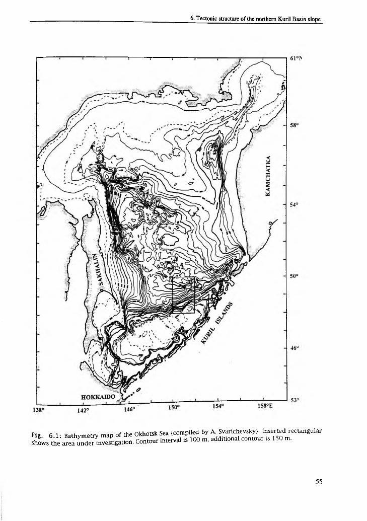
Fig. 6 1- Bathymetry map of the Okhotsk Sea (compiled by A Svarichevsky). Inserted rectangular shL s th e '^ e f iS n v e s t ig a t io n . Contour interval is 100 m, additional contour * 1 ,0 m.
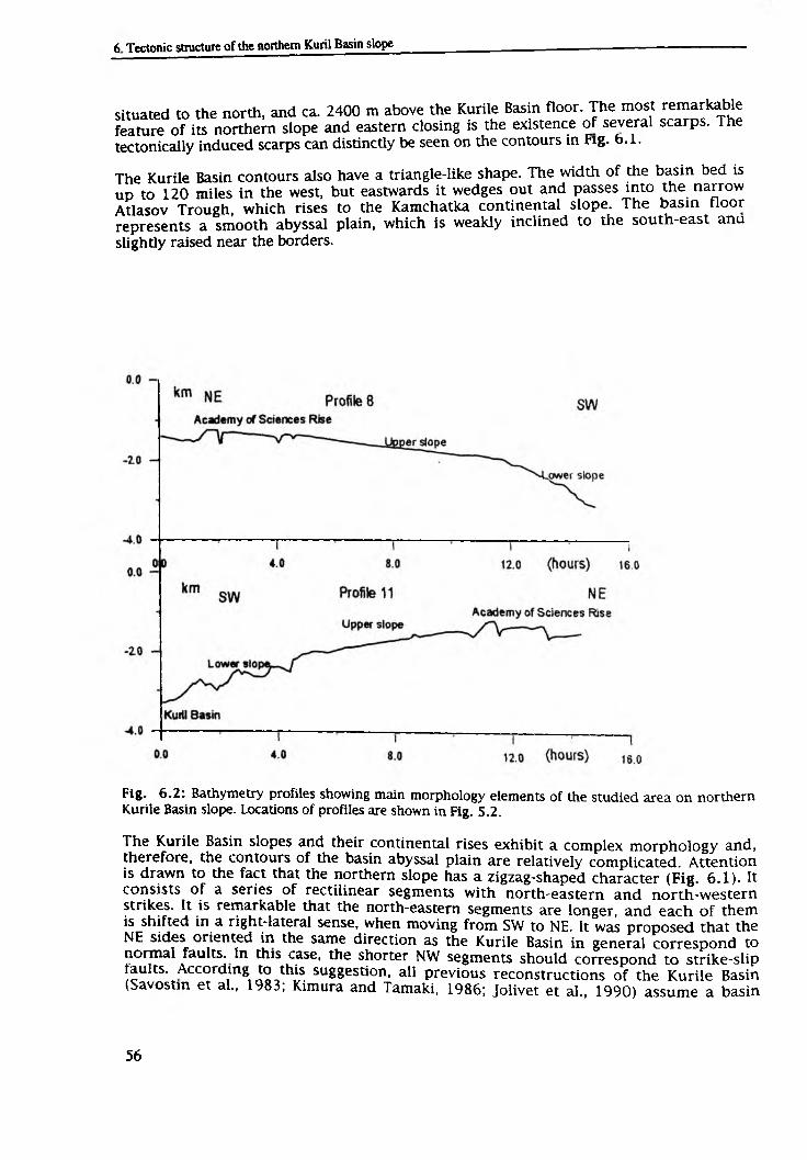
situated to the north, and ca. 2400 m above the Kurile Basin floor. The most remarkable feature of its northern slope and eastern closing is the existence of several scarps. The tectonically induced scarps can distinctly be seen on the contours in Fig. 6.1.
The Kurile Basin contours also have a triangle-like shape. The width of the basin bed is up to 120 miles in the west, but eastwards it wedges out and passes into the narrow Atlasov Trough, which rises to the Kamchatka continental slope. The basin floor represents a smooth abyssal plain, which is weakly inclined to the south-east ana
slightly raised near the borders.
Fig. 6.2: Bathymetry profiles showing main morphology elements of the studied area on northern Kurile Basin slope. Locations of profiles are shown in Fig. 5.2.
The Kurile Basin slopes and their continental rises exhibit a complex morphology and, therefore, the contours of the basin abyssal plain are relatively complicated. Attention is drawn to the fact that the northern slope has a zigzag-shaped character (Fig. 6.1). It consists of a series of rectilinear segments with north-eastern and north-western strikes. It is remarkable that the north-eastern segments are longer, and each of them is shifted in a right-lateral sense, when moving from SW to NE. It was proposed that the NE sides oriented in the same direction as the Kurile Basin in general correspond to normal faults. In this case, the shorter NW segments should correspond to strike-slip faults. According to this suggestion, all previous reconstructions of the Kurile Basin (Savostm et al., 1983; Kimura and Tamaki, 1986; Jolivet et al., 1990) assume a basin
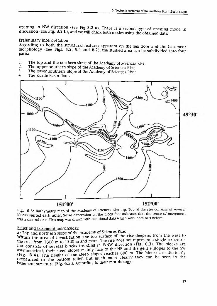
opening in NW direction (see Fig 3.2 a). There is a second type of opening mode in discussion (see Fig. 3.2 b), and we will check both modes using the obtained data.
Preliminary interpretation
According to both the structural features apparent on the sea floor and the basement morphology (see Figs. 5.2, 5.4 and 6.2), the studied area can be subdivided into four parts:
1.2.
3.4.
The top and the northern slope of the Academy of Sciences Rise; The upper southern slope of the Academy of Sciences Rise;The lower southern slope of the Academy of Sciences Rise;The Kurile Basin floor.
Fig. 6.3: Bathymetry map of the Academy of Sciences Rise top. top or me rise consists or several blocks shifted each other. S-like depression on the block feet indicates that the sence of movement was a dextral one. This map was drawn with additional data which were obtained before.
&£iief and basement morphology.a) Top and northern slope of the Academy of Sciences Rise.
Within the area of investigation, the top surface of the rise deepens from the west to the east from 1000 m to 1200 m and more. The rise does not represent a single structure, but consists of several blocks trending in WNW direction (Fig. 6.3). The blocks are asymmetrical their steep slopes mainly face to the NE and the gentle slopes to the SW (Fig. 6.4) The height of the steep slopes reaches 600 m. The blocks are distinctly recognized in the bottom relief, but much more clearly they can be seen m the basement structure (Fig. 6.5.). According to their morphology,
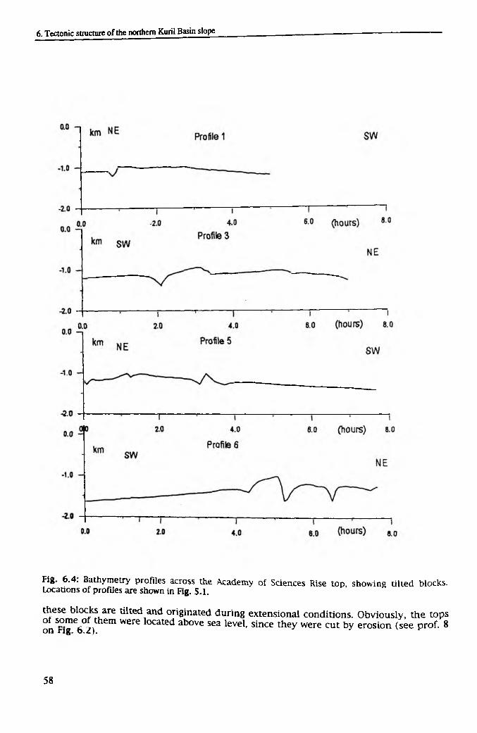
Fig. 6.4. Bathymetry profiles across the Academy of Sciences Rise top, showing tilted blocks. Locations of profiles are shown in Fig. 5.1.
these blocks are tilted and originated during extensional conditions. Obviously, the topsof some of them were located above sea level, since they were cut by erosion (see prof. 8 on rig. 6.2). *
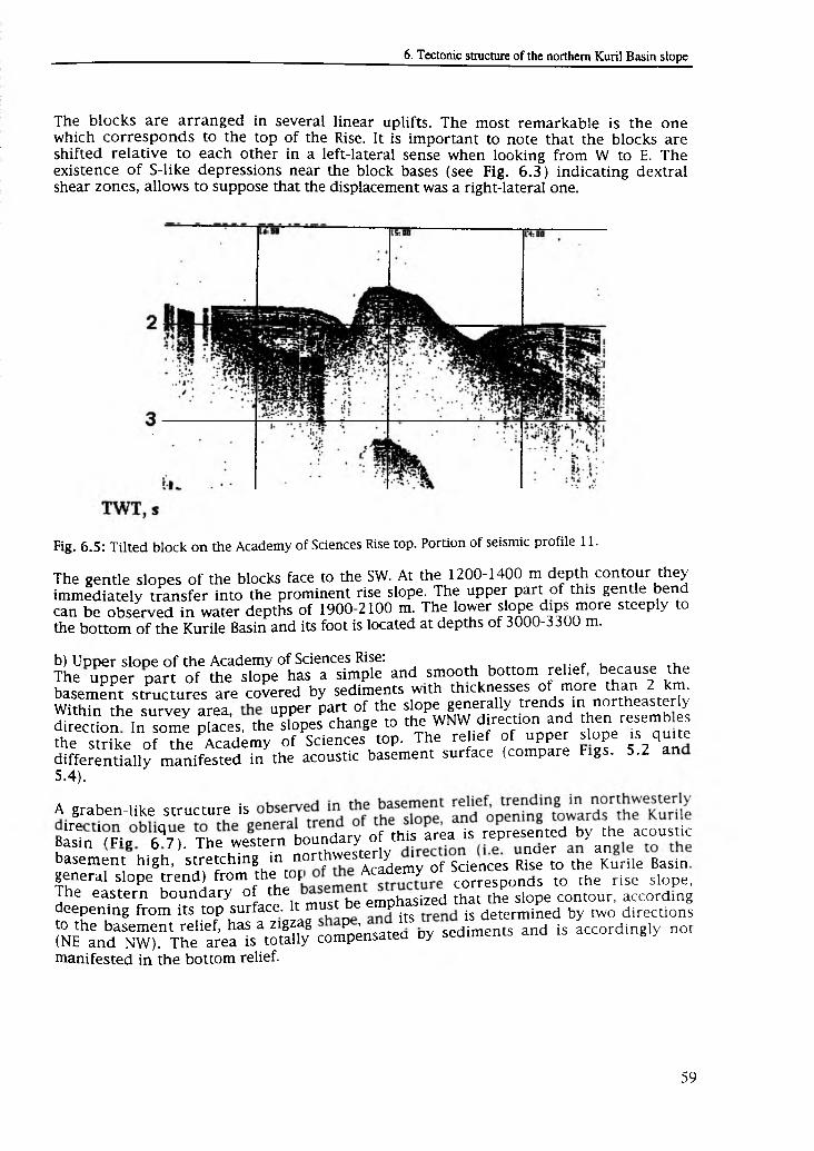
The blocks are arranged in several linear uplifts. The most remarkable is the one which corresponds to the top of the Rise. It is important to note that the blocks are shifted relative to each other in a left-lateral sense when looking from W to E. The existence of S-like depressions near the block bases (see Fig. 6.3) indicating dextral shear zones, allows to suppose that the displacement was a right-lateral one.
Fig. 6.5: Tilted block on the Academy of Sciences Rise top. Portion of seismic profile 11.
The gentle slopes of the blocks face to the SW. At the 1200-1400 m depth contour they immediately transfer into the prominent rise slope. The upper part of this gentle bend can be observed in water depths of 1900-2100 m. The lower slope dips more steeply to the bottom of the Kurile Basin and its foot is located at depths of 3000-3300 m.
b) UDDer slooe of the Academy of Sciences Rise:The upper part of the slope has a simple and smooth bottom rehef because the basement structures are covered by sediments with thicknesses of more than 2 km. E teesu^ey lv Z upper part of the slope generally trends in northeasterly direction In some places, the dopes change to the^WNW direct,on and then resemb es the strike of the Academy of Sciences top. The rehef of upper slope is quite differentially manifested in the acoustic basement surface (compare Figs. 5.2 an
5.4).
A graben-like structure is
B S n 'm z 6q7K The western boundary of this area is represented by the acoustic
basement high, stretching in nort.h” est enlyof Sciences rL ^ o U m Turtle Basin general slope trend) from the t o t C o r r e s p o n d s to the rise slope. The eastern boundary of the emphasized that the slope contour, accordingdeepening from its top surface, it¡must be p ^ ^ determined by m,0 directions
to the basement relief, has a zigzag p» , sediments and is accordingly not(NE and NW). The area is totally compensated Dy
manifested in the bottom relief.
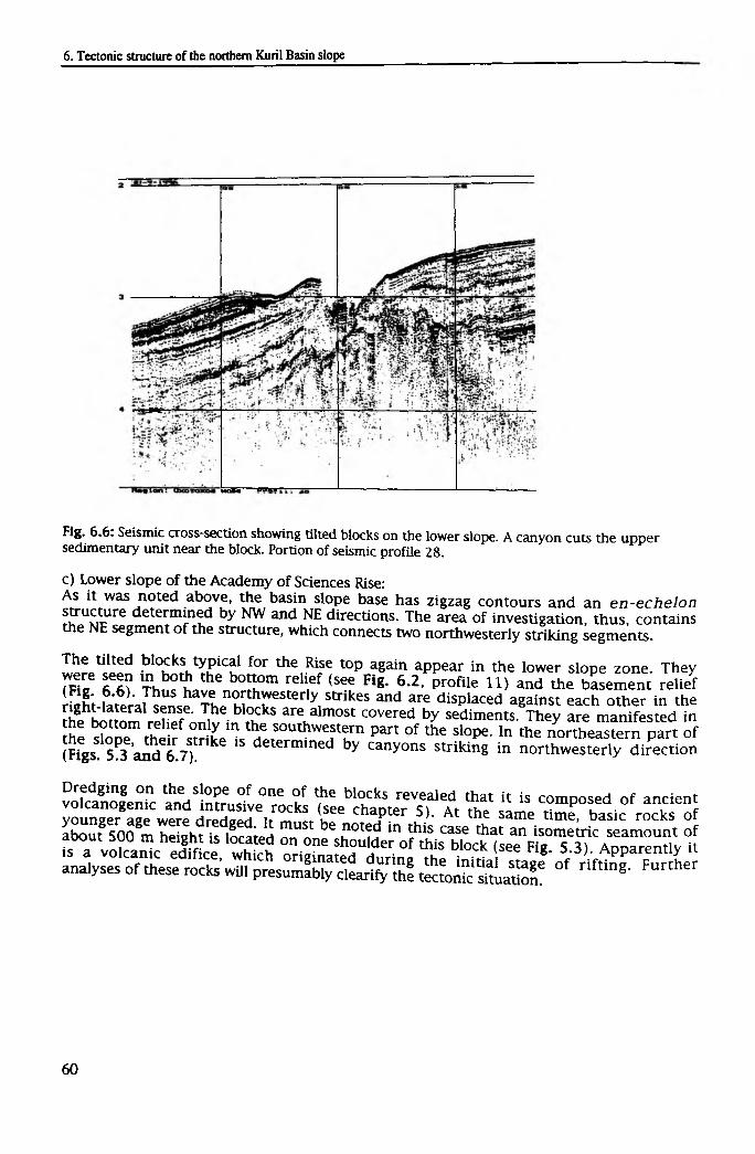
Fig. 6.6 : Seismic cross-section showing tilted blocks on the lower slope. A canyon cuts the upper sedimentary unit near the block. Portion of seismic profile 28.
c) Lower slope of the Academy of Sciences Rise:As it was noted above, the basin slope base has zigzag contours and an en-echelon structure determined by NW and NE directions. The area of investigation, thus, contains the NE segment of the structure, which connects two northwesterly striking segments.
The tilted blocks typical for the Rise top again appear in the lower slope zone. Theywere seen in both the bottom relief (see Fig. 6.2, profile 11) and the basement relief(Fig. 6.6). Thus have northwesterly strikes and are displaced against each other in theright-lateral sense. The blocks are almost covered by sediments. They are manifested inthe bottom relief only in the southwestern part of the slope. In the northeastern part ofthe slope, their strike is determined by canyons striking in northwesterly direction (Figs. 5.3 and 6.7).
Dredging on the slope of one of the blocks revealed that it is composed of ancient volcanogenic and intrusive rocks (see chapter 5). At the same time, basic rocks of younger age were dredged. It must be noted in this case that an isometric seamount of about 500 m height is located on one shoulder of this block (see Fig. 5.3). Apparently it is a volcanic edifice, which originated during the initial stage of rifting. Further analyses of these rocks will presumably clearify the tectonic situation.
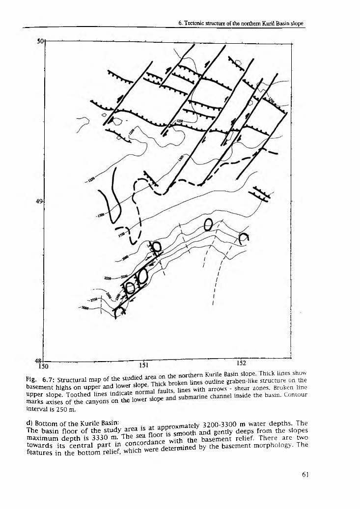
j ™ rho nnrrhpm Kurile Basin slope. Thick lines show Fig. 6.7: Structural map of the studied are , Unes outline graben-like structure on the
basement highs on upper and lower sl°Pe' h ith arrows . shear zones. Broken lineupper slope. Toothed lines i n d i c a t e i n s i d e the basin. Contour marks axises of the canyons on the lower slop
interval is 250 m.
d) Bottom of the Kurile Basin: annrnvmatelv 3200-3300 m water depths. TheThe basin floor of the study area is a PP smoQth and gently deeps from the slopes maximum depth is 3330 m. The sea with the basement relief. There are twotowards its central part in concorda determined by the basement morphology. The features in the bottom relief, which wer
first structure at water depths of about 1000 m is the seamount in the SE corner of the area (Figs. 5.3 and 5.4). Dredging showed that this seamount is a submarine volcano (see Chapter 5). We hope that additional investigations will help to solve the following problems: Does this volcano belong to the recent Kurile subduction zone, or does it represent the oceanic basement of the basin. The second structure is related to the basement high that deepens from the northwestern segment of the slope in
southwesterly direction.
Apart from these structures connected to the basement relief, the basin bottom is further divided by two submarine channels. One of them can be traced into the basin for at least 15 miles (see Fig. 5.3). The channels are the continuations of two large canyons, cutting through the northwestern part of the slope. The channels are bound by leeves, the heights of which are more than 100 m in the upper parts of the canyons. The canyons trend to the NE and cut through the slope near the basement highs, which are covered by sediments. The depths of the canyons are 200-300 m and on their western flanks the upper sedimentary unit crops out. Dredging showed that this unit consists of tuff-diatomaceous clays and diatomaceous oozes (see chapter 5). According to the preliminary stratigraphy worked out by A. Matul, their age is Upper Miocene to Lower Pliocene.
TectonicsThe relief forms of the sea floor and the basement described above justify that the study area is characterized by two main structural trends, namely WNW-NW and NE striking features. These directions are determined by two types of faults - normal faults and strike-slips (Fig. 6.7). Normal faults are distinctly manifested in the bottom relief as scarps with heights of up to 600 m. According to the basement relief, the visible displacement reaches 2 km.
Normal faults bound the tilted blocks, structures typical for extensional conditions. Their planes face to both the NE and the SW, forming graben and semi-graben structures. The tilted blocks are most distinctly manifested at the top and the northern slope of the Academy of Sciences Rise, and to a lesser degree on the lower slope. They are absent within the basin. At the Academy of Sciences Rise, normal faults strike in WNW direction. On the lower slope, their strike changes to NW, i.e. structures apparently rotate clockwise towards the basin.
The strike-slip zones are most distinctly seen at the Academy of Sciences Rise, and are determined by the displacements of basement blocks. They have NE strike and are generally longer than normal faults. According to the NE curving of the basement contours of graben-like structure, they may continue into the upper slope zone. On the lower slope, a small clockwise rotation of strike-slip faults takes apparently place. The existence of S-like structures, as it is clearly seen in Fig. 6.3, allows to suppose that there are dextral displacements along the faults and that the entire region belongs to a dextral shear zone.
Discussion and conclusions
It is proposed that from Paleocene times up to present time, the structural features of North-East Asia were shaped by the interaction of two major plates - the North- Amertcan and the Eurasian plates (Savostin and Drachev, 1988). During the entire time period, the Okhotsk Sea was situated in between these plates so that its geodynamic situation was entirely determined by the location of the North-American/Eurasian pole of rotation Before Early Oligocene times, the rotation pole was located near Japan. Th refore the area to the north of it was in the extensional mode. From Oligocene times
y’ P°le * as situated to the south of the Okhotsk Sea for the entire period, although a number of small pole displacements occurred. Accordingly, the
Okhotsk Sea was always under compressional mode. Nevertheless, extensional structures, namely the Okhotsk rift systems and the Kurile Basin, could form during this time. 6
Gnibidenko (1995) suggested that the Kurile Basin originated during Oligocene-Miocene times due to the movement of the Okhotsk plate away from the Kurile-Kamchatka subduction zone (Zonenshain and Savostin, 1979). The second extensional area belongs to the Okhotsk rift system. The majority of the related structures are oriented orthogonal to the Kurile Basin trend. Some of them began to originate simultaneously with the basin in Oligocene times, severely preventing consistent plate tectonic reconstructions for this region. It has, thus, to be noted that it is still not clear how the existence of the Okhotsk Sea extensional structures are connected with subduction processes within the Kurile-Kamchatka trench during Cenozoic times (Gnibidenko, 1990).
The data obtained during this cruise reveal that on the Kurile Basin northern slope, extensional structures are widely developed. They are manifested in both the sea floor and the basement reliefs by tilted blocks, grabens, and semi-grabens. The structural pattern of the study area is further characterized by two fault systems: NW striking normal faults and NE striking dextral shear zones, thus, showing the orientation as the Okhotsk rift system structural pattern.
The above mentioned tectonic pattern of the northern Kurile Basin slope gives rise to suppose that it did not extend across, but along the basin trend, i.e. it opened as a pull- apart basin. We conclude that the Kurile Basin and Okhotsk rift system formed due to a single mechanism. The opening can be most perfectly described by the Okhotsk Sea clockwise rotation around the pole, which is located off the Okhotsk Sea northwestern coast. Such movement may be caused by the convergent motion between the North- American and Eurasian plates.
In this line it is further proposed that the different parts of the rift system originated during different time periods: Paleogene-Lower Miocene times, Neogene-Quaternary times and Middle Miocene-Quaternary times (Kharakhinov et. al. 1985). The successive rift formation can apparently explain the complex structural pattern of the rift system. This mode does not agree in every aspect with the pattern obtained in supposition with the Okhotsk plate rotation around the non-moving pole, since it is the pole, which describes the general opening of the rift system and the basin since Oligocene times.
Since Oligocene times up to present day, the rotation pole between the North-American and Eurasian plates repeatedly changed its position (Savostin and Drachev, 1988). It could have consequently influenced the Okhotsk plate motion parameters, which caused the non-simultaneous opening of both the Okhotsk Sea rift system and the Kurile Basin For example, the structural pattern of the Derugin Basin rift system, as obtained on'the 16-th cruise of RV "Professor Gagarinsky" (Baranov et al., subm.), does not correspond to the pattern of the northern Kurile Basin slope and can not be obtained from the same pole. This area is situated near the Amur/Okhotsk Sea plate boundary Here the extensional process began only in Miocene-Pliocene times, and was caused by the right-lateral displacements along the Sakhalin shear zone. According to the basement structure extensional processes are widespread in the entire Okhotsk Sea. This fart justifies that the deformations did not only took place along the Okhotsk Sea boundaries but a lS in its inner parts, i.e. the Okhotsk plate moved not as a rigid body during Cenozoic times (or there were many jumpings of a plate boundary). Within the rift system the extensional processes stopped at the stage of rifting, whereas in the Kurile Basin they continued up to the spreading stage and the formation of new oceanic
crust.
7. Conclusions and perspectives
The results obtained during the GREGORY expedition allow to specify the regions, which are interesting from the tectonic and environmental point of view for further investigations within the KOMEX framework. The offshore eastern Sakhalin region is among the most important ones. The discovery of new gas plumes justifies the existence of vast areas of gas venting, stretching along the eastern Sakhalin coast. This area corresponds to the active shear zone separating the Okhotsk and Amur plates.
It is well known that gas seeps are widely spread on the inner slopes of deep-sea trenches - the regions of recent subduction representing convergent plate boundaries. The offshore eastern Sakhalin region, however, is related to the second plate boundary type - transform fault zones. The evaluation of how important such zones are in the global gas balance compared to the gas contribution from subduction zones seems to be of extreme importance.
Up to now, the future KOMEX project only plans to include the gas monitoring of the near Sakhalin region. The complex investigations performed during the GREGORY expedition including the first mapping of active fault zones, the finding of new gas fields, and the in situ gas geochemical survey and flux estimations underline that this region is undoubtedly interesting from the paleoceanological point of view, because it is located within the Amur river outflow area.
The investigations devoted to the origin and formation of marginal seas were a major task during this expedition. The appearance of tensional structures under the overall compressional conditions (back-arc basins in subduction zones, such as the Kurile Basin) were discussed from the very beginning of the plate tectonic theory. Several models were suggested to explain the origin of such back-arc basins.
The clockwise rotation model of the Okhotsk plate explaining the mode of formation of the Kurile Basin and other extensional structures in the Okhotsk Sea (e.g. Derugin and T1NRO Basins) were initially proposed for examiniation. The first step in this direction was already done during the GERDA expedition (16th cruise of RV "Professor Gagarinsky", 1995, Derugin Basin). During the GREGORY expedition, this work was successfully continued within the Kurile Basin.
The TINRO Basin is the third one among the biggest basins of the Okhotsk Sea. Its structure is not clear so far, hence it certainly represents one of the key regions in understanding the Okhotsk Sea history and modern kinematics. Juxtaposition of its structural pattern with those of the Kurile and Derugin basins may allow to verify the model of the Okhotsk Sea Basin formation. The TINRO Basin can therefore be proposed as the second major research object for future investigations. Besides, this area is extremely important with regard to gas fluxes.
It is known that the TINRO Basin is filled with sediments containing gases. Since it is located on the boundary between the Okhotsk and North-America plates, it represents a highly active geodynamic regime. Active faults, in fact, must occur in this area contributing the conduits for gases being released from the sea floor deposits and transferred through the water column to the atmosphere. The investigations on gas release in the TINRO Basin may be the same as in the offshore eastern Sakhalin area.
Another tectonically important area is located between the Institute of Oceanology and Academy of Sciences rises and corresponds to the Kashevarov linear zone. It is situated adjacent to the Derugin Basin, and apparently possesses another structural pattern. In paleoreconstructions, this zone is regarded as a linear shear zone, which is connected
with the Kurile Basin opening in NW direction. The data obtained during this cruise allow to conclude that the basin opened in northeasterly direction. Hence, the geodynamics of the Kashevarov linear zone again appear to be amazing, i.e. it is still unclear whether it is a big shear zone or an extensional structure consisting of elements oriented in the same direction as those in the Kurile Basin.
During the 27th cruise of RV "Akademik Lavrentyev", the research program was entirely fulfilled. Significant and original results in both geological and geophysical respect were obtained. Some of them have even a unique character. Moreover, the GREGORY expedition allowed to specify most important regions for future studies and to determine the perspectives of the joint German-Russian geological and geophysical investigations in the Okhotsk Sea. This expedition can, therefore, be estimated as a successful beginning of the KOMEX project.
8. References
Alderman S.E. (1996): Planktonic foraminifera in the Sea of Okhotsk: Population and stable isotope analysis from a sediment trap.- MS-thesis, Massachusetts Institute of
Technology: 99 pp.
Astakhov, A.S. (1991): Physics-mechanical features and absolute masses of Holocene sediments of the Okhotsk Sea.- Pacific Geology, 2: 50-55 (in Russian).
Astakhov, A.S. (1995): Genesis and sources of the east China sea shelf sediments based on quartz-granes morphometric analysis.- Terrestrial, Atmospheric and Ocean
Sciences.- 6(N1): 65-74.
Astakhov, A.S., Vagina, N X , Gorbarenko, S.A., et al. (1988): Velocities of Holocene sedimentation in the Sea of Okhotsk.- Pacific Geology, 4: 1-14 (in Russian).
Astakhov, A.S. and Vashchenkova, N.G. (1993): Morphometric analysis of terrigeneous quartz for lithodynamical and paleogeographical reconstructions.- Lithologia I poleznie iskopaemie, 5: 106-117 (in Russian).
Baranov, B.V., Dozorova, K.A., and Svarichevsky, A.S. (1995): Cenozoic kinematics of the Okhotsk plate: opening of the back-arc basin and Okhotsk rift system.- Abstracts of the International Lithosphere Program Workshop, Miyagi, Japan.
Baranov, B.V., Drachev, S.S., and Pristavakina, E.I. (1996): The geodynamics of active plate boundaries in the Arctic region.- CASP Report, 638: 126 pp.
Baranov, B.V., Karp, B.Ya., Dickmann, Th., Dozorova, K.A., and Karnauch, V.N. (subm.): Tectonics of the central Ionian Rift, Eastern Derugin Basin (Okhotsk Sea).- Tectonics.
Bezrukov, P.L. (1955): On the migration and velocity of siliceous sediments accumulation in the Okhotsk Sea.- Doklady Akademii Nauk, 103(N3): 473-476 (in Russian).
Bezrukov, P.L. and Romankevich, E.A. (1960): To stratigraphy and lithology of the sediments of the Northwestern Pacific.- Doklady of Academy of Science USSR, 130(N2): 417-420 (in Russian).
Bikkenina, S.K., Anosov, G.I., Argentov, V.V., and Sergeev, K.Ph. (1987): Crustal structure of the southern Okhotsk Sea according to seismic data.- Science Publ., Moscow. 86 pp. (in Russian).
Cailleux, A. (1952): Morphoskopische Analyse der Geschiebe und Sandkörner und ihre Bedeutung für die Paläoklimatologie.- Geol. Rdsch., 40: 11-19.
Galperin, E.I. and Kosminskaya, LP. (1964): Structure of the Earths crust in theí,ra/ íSI^°f} zone from the Asian continent to the Pacific Ocean.- Moscow, Science Publ.: 307 pp. (m Russian).
AcAm- VrÍntfeV’ Baranov- B-v -. et al. (1976): Bedrocks of the Central Okhotsk Sea.- Soviet Geology, 6: 12-31 (in Russian).
n q w f h v ’rfS! i ° Vif V’ V-A" Cranst°n, R.E., Lorenson, T.D., and Kvenvolden, K.A.
Geo-Marine Letters 13:41^48COntlnenta* Sl° Pe' ° ffSh0re Sakhalin ,sland’ Okhotsk Sea ‘
Gnibidenko, G.S. (1990): The Rift System of the Okhotsk Sea.- Proceeding of the First International Conference on Asian Marine Geology, China Ocean Press, Beijing: 73-81.
Gnibidenko, G.S., Hilde, T.W.C., Gretskaya, E.V., and Andreev, A.A. (1995): Kurile (South Okhotsk) Backarc Basins.- In: Backarc Basins: Tectonics and Magmatism, B. Taylor (ed.) Plenum Press, New York: 421-449.
Gorbarenko, S.A. (1991): Stratigraphy of the upper Quaternary sediments of the Central
Okhotsk Sea and their paleoceanography using d180 and other methods.- Okeanoloeiya, 31(6): 1036-1042 (in Russian).
Gorbarenko, S.A. (subm.): Stable isotope and lithologic evidence of late-glacial and Holocene oceanography of the Northwestern Pacific and its marginal seas.- Quaternary Research.
Gorbarenko, S.A., Kovalukh, N.N., Odinokova, L.Y., et al. (1988): Upper Quaternary sediments of the Okhotsk Sea and reconstruction of paleo-ceanological condition.- Tikhookeanskaya geologiy, N2: 25-34 (in Russian).
Gorbarenko, S.A., Chekhovskaya, M.P., and Southern, J.R. (in press): Detailed changes of the Central Okhotsk Sea paleoceanography during last glaciation-Holocene.- Okeanologiya.
Jolivet, L., Davy, P., and Cobbold, P. (1990): Right-lateral shear along the northwest Pacific margin and the India-Eurasia collision.- Tectonics, 9: 1409-1419.
Keigwin, L.D. (1995): Northwest Pacific paleoceanography.- In: Global fluxes of carbon and its related substances in the coastal sea-ocean-atmosphere system, Proceeding of the 1994 Sapporo IGBP Symposium, S.Tsunogai et al., (eds.), M. and J. International, Yokohama, Japan: 473-478.
Khabakov, A.B. (1946): On indexes of roundness of pebbles.- Soviet Geology, N10: 98-99. (in Russian)
Kharakhinov, V.V., Tereshchenkov, A.A., Baboshina, V.A., and Pudikov, E.G. (1985): Sedimentary basin tectonics of the Okhotsk Sea region.- Review of the Mingasprom, Ser.: Geology and prospecting of the marine oil and gas deposits, 2, 32 pp. (in Russian).
Kimura, G. and Tamaki, K. (1986): Collision, rotation and back arc spreading: The case of the Okhotsk and Japan Seas.- Tectonics, 5, 389-401 pp.
Kononov, Yu.I., Morik, V.A., and Petrik, N.S. (1975): Ice cover and its significance in sediment formation of Nevelskoy Strait.- In: Problems of Pacific ocean geography,
Vladivostok: 64-67 (in Russian).
Kononova, N.N. (1986): Eolian landscapes of the sea coast.- Far East State University
Press, Vladivostok: 104 pp.
Kornev, O.S., Neverov, Yu.A., Ostapenko, V.F., et al. (1982): The results of geological dredging in the Okhotsk Sea from RV "Pegasus" (21 Cruise).- In: Geological structure of
the Okhotsk Sea Region, Vladivostok: 36-51 (in Russian).
Kruglikova, S.B. (1988): Radiolarians (Polycystina) from the bottom Arctic sediments.- Academy of Sciences of USSR Transac. Geol. series, 1: 92-101 (in Russian).
Kruelikova SB. (1989a): Radiolarian zonal stratigraphy.- In: Neogene-Quaternary paleoceanology (on micropaleontological data), M.S. Barash (ed.), Moscow, NAUKA
Press: 67-70 (in Russian).
Kruglikova, S.B. (1989b): Quaternary radiolarian zonal stratigraphy, datum levels. In: Neogene-Quaternary paleoceanology (on micropaleontological data), M.S.Barash (ed.),
Moscow. NAUKA Press: 85-89 (in Russian).
Lelikov, E.P. (1992): Metamorphic complexes of the marginal seas of Pacific.- Vladivostok, Dal’nauka: 168 pp. (in Russian).
Leonov, A.K. (1960): Regional oceanography. Part I. Leningrad.- Gidrometeoizdat Press:
765 pp. (in Russian).
Matul, A. (1994): On the problem of paleoceanological evolution of the Reykjanes Ridge region (North Atlantic) during the last deglaciation based on radiolarian study.- Oceanology, 34(6): 881-889 (in Russian).
Morley, J.J., Heusser, L.E., and Shackleton, N.J. (1991): Late Pleistocene/Holocene radiolarian and pollen records from sediments in the Sea of Okhotsk.- Paleoceanography, 6(1): 121-131.
Noklenberg, W.J., Parfenov, L.M., Monger, J.W.H., Baranov, B.V., et al. (1994): Circum- North Pacific tectono-stratigraphic terrane map.- U.S. Department of the Interior, U.S. Geological Survey, Open-file report, 94: 216pp.
Nürnberg, D., Wollenburg, LW., Dethleff, D., Eicken H., Kassens, H., Letzig, T., Reimitz, E., and Thiede, J. (1994): Sediments in Arctic sea ice - Implications for entrainment, transport and release.- Marine Geology, 119:185-214.
Obzhirov, A.I. (1993): Gas geochemical fields in bottom water of seas and oceans.- Science PubL, Moscow: 139 pp. (in Russian).
Obzhirov, A.I. (1994): Dissolution gas distribution in sea water columns North-Eastern Taiwan.- The Fifth Seep and Voce Conference, NTU, Taiwan: 141-150.
Obzhirov, A.I., Kazansky, B.A., and Melnichenko, Yu.I. (1989): Effect of the sound scattering in the Okhotsk Sea water.- Pacific Geology, N2: 119-121 (in Russian).
Petelin, V.P. (1957): Mineralogy of silt-sand fraction of the sediments of the Okhotsk Sea.- Proceeding of Institute of Oceanology USSR, 22: 77-138 (in Russian).
Savostin, L.A., Zonenshain, L.P., and Baranov, B.V. (1983): Geology and plate tectonics of, 5 Okhotsk.- In: Geodynamics of the Western Pacific. T.W.H. Hilde and S. Uyeda(eds.): 189-221.
äanH lI^ ’nHAtcanw Drai heV’ SÜS' (1988): Cenozoic compression in the New Siberian 775-781 (in RussSn)*0 ^ e °Penin8 of the Eurasian Basin.- Oceanology, 28(5):
d p n i p r i Schef le’ N- Pauer> F- and Kriews, M. (in press): Carbon
shelves?.- c Ä ™ Une“ . ^ EV‘denCe f° r methaM release from Slberia"
Talley, L. (1991). An Okhotsk Sea anomaly: implication for ventilation in the North Pacific.- Deep-Sea Research, 38: 171-190.
Talley, L.D. and Nagata, Y. (1995): The Okhotsk Sea and Oyashio Region.- Inst, of Ocean Sci., Sidney, B.C., Canada: 227 pp.
Vasiliev, B.I., Putintsev, V.K., Makarovskii, B.A., Svyatogorova, N.N., and Selivanov, V.A. (1990): Bedrocks complexes of the Okhotsk Sea submarine rises.- In: New data on geomorphology and geology of West Pacific, V.P. Bobykina, B.I. Vasiliev, and G.M. Tomolov (eds.), Vladivostok: 5-16 (in Russian).
Willetts, B.B. and Rice, M.A. (1983): Practical representation of the characteristic grain shape of sands: a comparison of methods.- Sedimentology, 30: 557-565.
Yang, J. and Honjo, S. (1996): Modelling the near-freezing dichothermal layer in the Sea of Okhotsk and its interannual variations.- Journal of Geophysical Research, 101(C7): 16421-16433.
Zhuze, A.P. (1962): Stratigraphy and paleontological investigations in the North-West Pacific.- Academy of Sciences Publishing House: 258 pp (in Russian).
Zonenshain, L.P., Murdmaa, I.O., Baranov, B.V., Kuznetsov, B.V., Kuzin, V.S., Kuzmin, M.I., Avdeyko, G.P., Stunzhas, P.A., Lukashin, V.N., Barash, M.S., Valyasko, G.M., and Diomina, L.L. (1987): An underwater gas source in the Okhotsk Sea to the west from Paramushir Island.- Oceanology, 27(5):795-800 (in Russian).
Zonenshain, L.P. and Savostin, L.A. (1979): Introduction to Geodynamics.- Moscow,
Nedra: 311pp (in Russian).
Appendix IResearch Vessel "Akademik M.A. Lavrentyev"
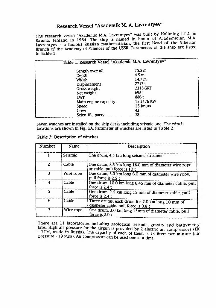
Research Vessel "Akademik M. A. Lavrentyev
The research vessel "Akademic M.A. Lavrentyev" was built by Hollming LTD. in Rauma, Finland in 1984. The ship is named in honor of Academician M.A. Lavrentyev - a famous Russian mathematician, the first Head of the Siberian Branch of the Academy of Sciences of the USSR. Parameters of the ship are listed
in Table 1.
Table 1: Research Vessel "Akademic M.A. Lavrentyev"
Length over all 75.5 m
Depth 4.5 mWidth 14.7 mDisplacement 27121Gross weight 2318 GRTNet weight 6951DWT 8861Main engine capacity lx 2576 KWSpeed 13 knotsCrew 43Scientific party 28
Seven winches are installed on the ship desks including seismic one. The winch locations are shown in Fig. 1A. Parameter of winches are listed in Table 2.
Table 2: Description of winches
Number Name Description
1 Seismic One drum, 4.5 km long seismic streamer
2 Cable One drum, 8.5 km long 18.0 mm of diameter wire rope or cable, pull force is 10 t
3 Wire rope One drum, 5.0 km long 6.0 mm of diameter wire rope, pull force is 2.5 t
4 Cable One drum, 10.0 km long 6.45 mm of diameter cable, pull force is 2.4 t
5 Cable One drum, 7.5 km long 15 mm of diameter cable, pull force is 2.4 t
6 Cable Three drums, each drum for 2.0 km long 10 mm of diameter cable. Dull force is 0.8 t
7 Wire rope One drum, 3.0 km long 13mm of diameter cable, pull force is 2.0 t
There are 11 laboratories including geological, seismic, gravity and bathymetry 7t u * air pressure for the airgun is provided by 2 electric air compressors (EK
- 7TM, made in Russia). The capacity of each of them is 13 liters per minute (air pressure -19 Mpa). Air compressors can be used one at a time.
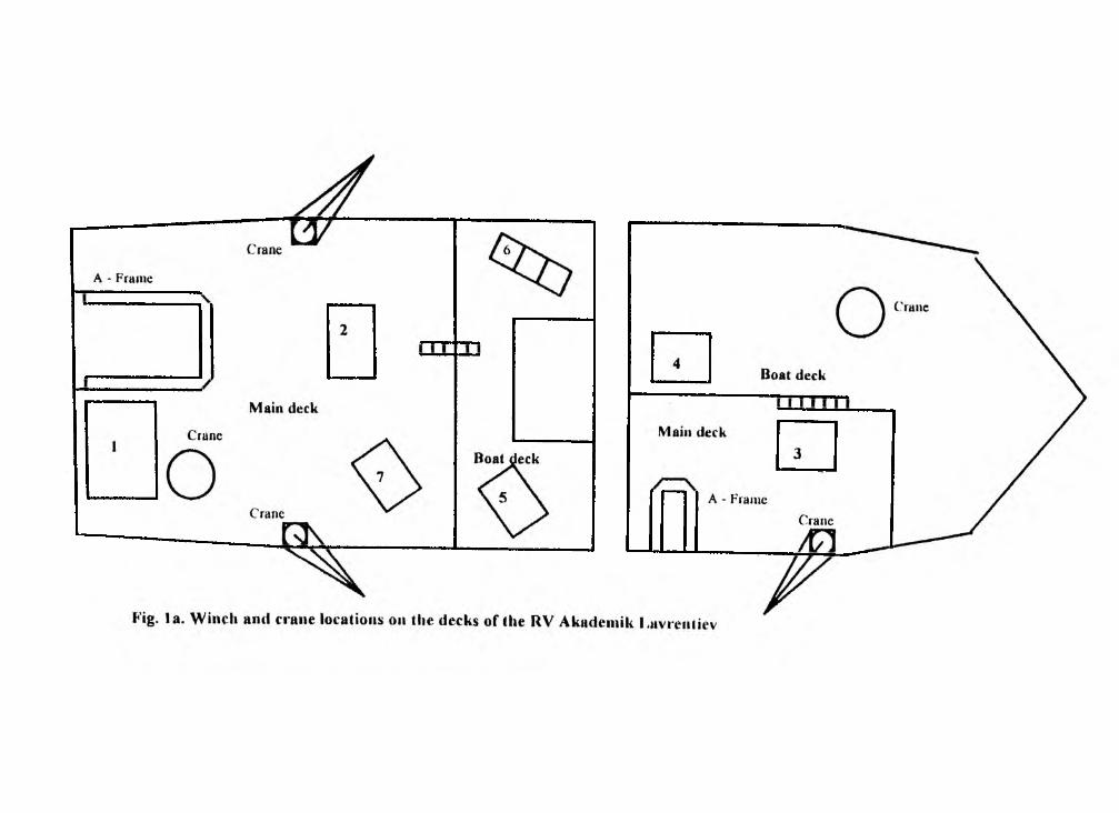
Appendix II Station coordinates
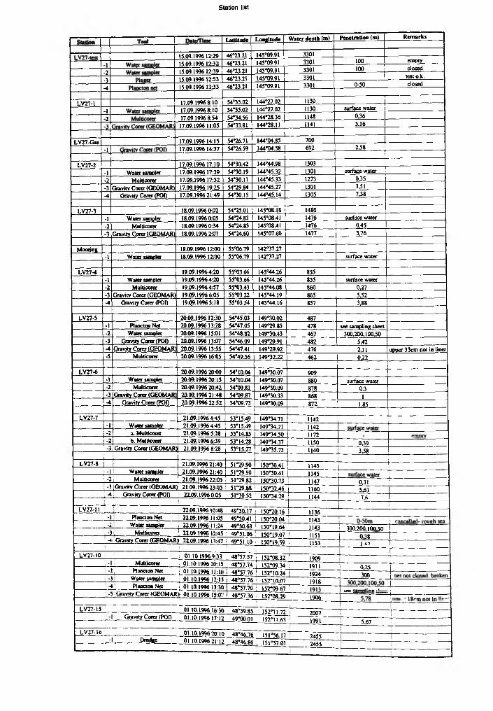
LaUltude Longitude Water deoth (m) Penetration (m) Remarks
15.09.1996 12:29 46*23.21 145*09.91 3301
15.09.1996 12:32 46*23.21 145*09.91 3301 100 empty
.7 15.09.1996 12:39 46*23.21 145*09.91 3301 100 closed
.3 15.09.1996 12:53 46*23.21 145*09.91 3301 testo.k.
-4 15.09.1996 13:33 46*23.21 145*09.91 3301 0-50 closed
LV27-1 17.09.19968:10 54*35.02 144*27.02 1130
-I 17.09.1996 8:10 54*35.02 144*27.02 1130 surface water
-7 17.09.1996 8:54 54*34.56 144*28.36 1148 0,36
17.09.1996 11:05 54*33.81 144*28.11 1141 5.16
LV27-Gas 17.09.1996 14:15 54*26.71 144*04.85 700
-1 17.09.1996 14:37 54*26.59 144*04.58 692 2,58
LV27-2 17.09.1996 17:10 54*30.42 144*44.98 1303
-1 Water sampler 17.09.1996 17:39 54*30.19 144*45.32 1301 surface water
-? Muiticorer 17.09.199617:52 54*30.11 144*45.33 1273 0,35
-3 Gravity Corer (GEOMAR) 17.09.1996 19:25 54*29.84 144*45.27 1301 3,51
■4 Gravity Corer {POD 17.09.1996 21:49 54*30.15 144*45.14 1305 7,38
LV27-3 18.09.19960:02 54*25.01 145*08.18 1480
•I Water sampler 18.09.1996 0:05 54*24.83 145*08.41 1476 surface water
-? Mulbcorer 18.09.1996 0:34 54*24.83 145*08.41 1476 0,45
-3 Gravity Corer (GEOMAR] 18.09.1996 2:07 54*24.60 145*07.60 1477 3,76
Mooring 18.09.1996 12:00 55*06.79 142*37.27
-1 Water sampler 18.09.1996 12:00 55*06.79 142*37.27 surface water
LV27-4 19.09.19964:20 55*03.66 145*44.26 855
-1 Water sampler 19.09.19964:20 55*03.66 145*44.26 855 surface water
-2 Muiticorer 19.09.1996 4:57 55*0343 145*44.08 860 0,27
-3 Gravity Corer (GEOMAR> 19.09.1996 6:05 55*03.22 145*44.19 865 5.52
-4 Gravity Corer (POI) 19.09.1996 3:18 55*03.54 145*44.16 857 3,88
LV27-5 20.09.1996 12:30 54*45.03 149*30.02 487
-1 Plaoctoo Net 20.09.1996 13:28 54*47.05 149*29.85 478 see sampling sheet
-2 Water sampler 20.09.1996 15:01 54*48.82 149*30.43 467 300,200,100,50
-3 Gravity Corer (POI) 20.09.1996 13:07 54*46.09 149*29.91 482 5,42
-4 Gravity Corer (GEOMAR 20.09.1996 13:55 54*47.41 149*29.92 476 2,11 upper 33cm pot in liner
-5 Mttltkoier 20.09.1996 16:05 54*49.56 149*32.22 462 0,22
LV27-6 20.09.1996 20:00 54*10.04 149*30.07 909
-1 Water sampler 20.09.1996 20:15 54*10.04 149*30.07 880 surface water
-2 Mulbcorer 20.09.199620:42 54*09.81 149*30.09 878 0,3-3 Gravity Corer (GEOMAR 20.09.1996 21:48 54*09.87 149*30.33 868 1-4 Gravity Corer (POO 20.09.1996 22:52 54*09.73 149*30.09 872 1,85
LV27-7 21.09.19964:45 53*15.49 149*34.71 1142-I Water sampler 21.09.19964:45 53*1549 149*34.71 1142-2 a. Muiticorer 21.09.1996 5:28 53*14.85 149*34.50 1172•2 b. Muiticorer 21.09.19966:39 53*14.28 149*34.37 1150 0,39•3 .Gravity Corer 1GEOMAR) 21.09.1996 8:28 j 53*15.27 149*35.73 1140 3JS8
--------- 1— i_------------------- ,LV27-8 | [ 21.09.1996 21:40 51*29.90 150*30.41 1145
■
j -1 ■ Water sampler 21.09.1996 21:40 51*29.90 150*30.41 1145; -21 Muiticorer 21.09.1996 22:03 51*29.82 150*30.73 1147 0,31| -3 [ Gravity Corer (GfcUMAR) 21.09.199623:05 51*29.88 150*3X46 1160 5,63i_*4i Gravity Corer (POI) 22.09.1996 0:05 51*30.32 1 150*34.29 1144 7 6
LV27-II ■ 22.09.1996 10:48 49*50.17 ! 150*20.16 1136- Plancton Net 22.09.199611:05 49*50.4! i 150*20.04 ¡ 1143
, -2 Water sampler i 22.09.199611:24 49*50.63 ! 150*19.64 í 1143 1 300.200 100 50- i \ Muiticorer ! 22.09.19% 12:45 : 49*51.06 ! 150-19.07 Í 1151 I 0 38-1 Gravity Corer (GEOMAR* 22.09.1996 13:47 1 49*51 10 1 150*19.59 ! 1153 f.’) ~T ......
LV27-10 ! 01.10.1996 9:33 48*57.57 j 152*08.32 1 1909-r--------------
i - Muiticorer i 01.10.1996 10:15 . 48*57.74 1 152*09.34 1911 j O 7Sl ] Plancton Net ; 01.10.1996 11:1C ! 48*57.76 1 152-10.24 1924 1 300S Water sampler . 01.10.1996 12:15 I 48*57.76 1 152*10 07 1918
-4 Plaocton Net ' 01.10.199613:30 ! 48*57.70 i 152*09.67-5 ‘ Gravity Corer (GEOMAR)i 01.10.1996 15 0! i 48*57.36 152-08.29 1906 ......... ...
LV27-15
CV27-16
Graviry Corer (POI)
1 Dredge
01.10.1996 16.30 48*59.85 152*1172
01.10.1996 17:12 49*0001 152*1163
01.10.199620:10 48*46.76 151*56 I"
01 10,199621:12 48*46.86 , 151°5701
2007
1991
2455
2455
.1! 5.67—1--------------
!
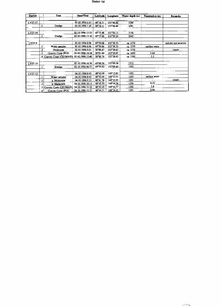
Station Tool Date/Time LaUltude Longitude Water depth (m) Penetration (m) Remarks
LV27-17 02.10.1996 6:15 48*18.21 151*46.60 3280
-1 Dredge 02.10.1996 7:19 48*18.11 151*46.44 3281
LV27-18 02.10.1996 12:25 48*19.48 151*50.13 3190
-1 Dredge 02.10.1996 13:30 48*19.06 151*50.24 2945
LV27-9 03.10.1996 8:06 49°59.88 152*30.35 ca. 1370 echolot not accurate
-1 Water sampler 03.10.1996 8:06 49*59.88 152*30.35 ca. 1370 surface water
-2 Muldcorer 03.10.1996 9:01 50*00.47 152*28.62 ca. 1370 empty
-3 Gravity Corer (POI) 03.10.1996 10:34 50°01.00 152*25.07 ca. 1430 5,64
-4 Gravity Corer (GEOMAR) 03.10.1996 12:40 50*00.76 152°28.43 ca. 1390 5,5
LV27-19 03.10.1996 16:30 49°40.36 152°09.58 1572
-1 Dredee 03.10.1996 16:57 49*39.82 152*09.60 1503
LV27-12 04.10.1996 8:45 48*42.00 148*13.01 1293
-1 ' Water sampler 04.10.1996 8:45 48°42.00 148*13.01 1293 surface water
-? a. Muldcorer 04.10.1996 9:19 48*41.76 148*13.55 1291 - empty
-? b. Muldcorer 04.10.1996 10:15 48*42.50 148°14.38 1296 0,35
-3 Gravity Corer (GEOMAR) 04.10.1996 11:23 48*43.49 148*14.77 1301 5,8
A Gravitv Corer (POI) 04.10.1996 12:22 48*44.51 148*14.41 1291 6,96
Appendix III Track coordinates
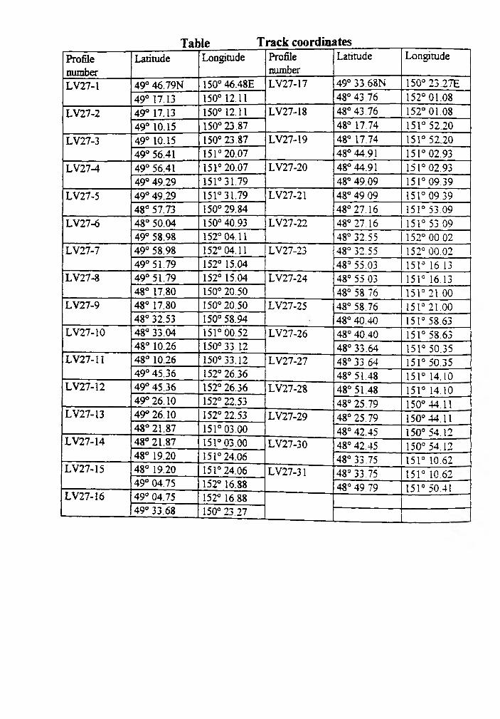
Table Track coordinatesProfile
□umber
Latitude Longitude Profile
number
Latitude Longitude
LV27-1 49° 46.79N 150° 46.48E LV27-17 49° 33.68N 150° 23 .27E
49° 17.13 150° 12.11 48° 43 76 152° 01.08
LV27-2 49° 17.13 150° 12.11 LV27-18 48° 43 .76 152° 01.08
49° 10.15 150° 23.87 48° 17.74 151° 52.20
LV27-3 49° 10.15 150° 23 .87 LV27-19 48° 17.74 151° 52.20
49° 56.41 151° 20.07 48° 44.91 151° 02.93
LV27-4 49° 56.41 151° 20.07 LV27-20 48° 44.91 151° 02.93
49° 49.29 151° 31.79 48° 49.09 151° 09.39
LV27-5 49° 49.29 151° 31.79 LV27-21 48° 49.09 151° 09.39
48° 57.73 150° 29.84 48° 27.16 151° 53.09
LV27-6 48° 50.04 150° 40.93 LV27-22 48° 27.16 151° 53 09
49° 58.98 152° 04.11 48° 32.55 152° 00 02
LV27-7 49° 58.98 152° 04.11 LV27-23 48° 32.55 152° 00.02
49° 51.79 152° 15.04 48° 55.03 151° 16.13LV27-8 49° 51.79 152° 15.04 LV27-24 48° 55.03 151° 16.13
48° 17.80 150° 20.50 48° 58 76 1513 21 00LV27-9 48° 17.80 150° 20.50 LV27-25 48° 58.76 151° 21.00
48° 32.53 150° 58.94 48° 40.40 151° 58.63LV27-10 48° 33.04 151° 00.52 LV27-26 48° 40.40 151° 58.63
48° 10.26 150° 33.12 48° 33.64 151° 50.35LV27-11 48° 10.26 150°33.12 LV27-27 48° 33 .64 151° 50.35
49° 45.36 152° 26.36 48° 51.48 151° 14.10LV27-12 49° 45.36 152° 26.36 LV27-28 48° 51.48 151° 14.10
49° 26.10 152° 22.53 48° 25.79 150° 44.11LV27-I3 49° 26.10 152° 22.53 LV27-29 48° 25.79 150° 44.11
48° 21.87 151° 03.00 48° 42.45 150° 54.12LV27-14 48° 21.87 151° 03.00 LV27-30 48° 42.45 150° 54.12
48° 19.20 151° 24.06 48° 33.75 151° 10.62LV27-15 48° 19.20 151° 24.06 LV27-31 48° 33 75 151° 10.62
49° 04.75 152° 16.88 48° 49.79 151° 50.41LV27-16 49° 04.75 152° 16.88
49° 33.68 150° 23 .27
Appendix IV Tables
List of Iithology and paleoceanology group and their scientific contribution
D. Nürnberg, S. Gorbarenko:
A. Astakhov:
A. Derkachev:
J. Griitzner:
S. Gorbarenko:
A. Matul:
S. Neufeld:
D. Nürnberg:
Chr. Vogt:
J.-M. Wolfsdorf:
A ll the participants: coring and sampling.
Scientific supervising
Lithological description, magnetic susceptibility, humidity and density measurements, morphometric analysis, smear slide analysis
Lithological description, mineralogical analysis, smear slide analysis
Magnetic susceptibility measurement
Magnetic susceptibility and humidity measurement
Micropaleontological analysis (radiolarians)
Technical handling of equipment
Lithological description, smear slide analysis
Lithological description
Lithological description

Table 1 A: Smear slides taken and prepared during the expedition from the GEOM AR group.
KOM EX '96
Akadcmik M.A. Lavrentyev
LV 27-1-2 MUC LV 27-1-3 SL LV 27-2-2 MUC LV 27-1-3 SL I.V 27-3-2 MUC LV 27-3-3 SL LV 27-4-3 SL LV 27-5-4 SL LV 27-4-3 SL LV 27-7-2 MUC LV 27-7-3 SL LV 27-4-1 MUC LV 27-4-3 SL LV 27-9-4 SL LV 27-10-1 MUi LV 27-IO-fSL LV 27-11-4 SL LV 27-IM SL
Uouuk 44*14 i t 54*31 Si 54*10 II 54*24.84 54*24.11 54*24 60 55*0122 54*47.41 54*09 87 51*14 28 51*1527 51*29.82 51*2988 49*41 10 48*57 74 48*57 1« 49*51 «0 48*4149
Loniuutk 144*28 16 ' 144*28 II 144*45 n 144*4527 145*08 41 145*07 60 145*44 IV 149*29.92 149*1031 149*14.37 149*15 71 150*10 71 150*12 4« 150*1959 152*09 14 152*08 29 150*19 59 148*14 77
Wuer dtfxft <tn> ) 14» i >41 1271 )J0 l 1476 1477 865 476 868 1150 1140 1147 1160 1151 1911 1906 1151 1301
1,62
Dcjxh in tore (cm 2 x fur(acc 20 2 * iurl«;c x lutiacc 40 0 1 x turfacc 1 1 1 iur(«c 1 0 2 X SuriKc 20 5 25
b 5 0 50 20 3 4 15 60 21 60
7 25 10 80 49 18 10 10 90 60 90
to 5 19 120 B8 15 20 18 100 $0 103
(8 SO 50 110 48 40 45 140 110 120
57 60 90 160 59 41 55 159 150 111
70 70 120 190 80 49 65 170 150
91 HO I1B 210 90 55 80 190 170
140 150 92 70 120 210 190
150 170 170 120 80 ISO 250 210
180 200 200 140 89 160 257 232
210 210 210 160 no 400 290 255
210 270 250 180 MS 440 110 290
250 100 260 190 120 460 350 310
ISO 100 199 140 490 190 340
180 110 210 (70 520 410 m
120 420 150 210 190 519 428 410
140 460 370 250 220 460 450
490 400 280 240 464 490
520 440 288 270 490 510
550 470 295 290 500 540
500 105 120 530 580
540 120 350 560
350 170 579
370 180
400
420
410
435
450
460
470
480
520
560
I 1
Table 2A: Heavy mineral composition in sediments of Okhotsk Sea (size Fraction 0.05-0.1 mm, specific weight >2.89 g/cm
LV 27-4-4 LV27-4-4 LV27-4-4
( ’px Op*()lbglllihilt)OHI»lipAil<iaiChiMeTouApSphZicMi
gMil)Mi
CaKlOpNotes for
12.13 9.43
0.54 25.34
3.23 0.54 20.75 8.09
1.62
2,96 0.27 0.27
0.54
1.08
1.35
4.041.08
0.27
3.23
3.24
tables
29.17
1.04
19.53
5.210.52
4.17
1.04
0.52
0.26
2.34 3.65 1.82
0.26
10.94 1.3
29.26
1.020.51
21.884.83 1.023.84
0.25
1.53
1.020.25
1.27
3.051.27
6.361.78
29.89
0.570.29
20.15.46
1.72
4.02
0.860.29
1.15
3.16 1.65
4.121.15
(0-10) (206-207) (330-335)
24.73 19.96 21.72
7.44 9.76 5.88
13.13 24.22 21.94
0.22 1.12 0.9
0.44 1.12 0.45
20.79 16.19 21.72
1.97 3.55 1.81
0.44 1.33 0.33
3.06 1.58 1.13
0.66 - 0.68__ 0.22 —
0.44 0.44 0.9
0.22 0.44 0.23
0.44 - 0.23
0.88 0.89 0.9
0.66 2.00 0.9
0.44 0.67 0.68
0.22 0.22 -
6.56 4.98 6.35
14.01 11.31 13.35
17.19
0.90 0.90 11.09 2.04 0.90 0.68 0.23
27.34.72
1.05
14.96
1.311.05
13.65 2.36 0.52 1.84
0.79
28.82
8.13
0.2516.47
0.740.7413.05
1.480.252.46
0.25
0.25
16.09
0.9910.15
2.230.992.48
0.25
0.5
0.68 0.79 — 2.48
0.23 1.57 2.22 9.90
0.45 0.26 1.97 7.92
0.23 0.49 -
17.87 17.59 13.05 7.67
7.92 8.67 7.39 11.14
) (%)
30.187.16
0.2519.69
1.020.77
10.492.300.51
0.510.26
0.25
0.26
0.77
1.791.02
12.289.97
mineral (ilmenite, magnetite).
Table 3A. Heavy mineral composition in axil layers (làefrnaùm 0.05-0.1 mmf
M ineral LV27-S-4(153-155)
LV27-15-4(110-112)
LV27-7-3(51)*
LV27-S-4(332-034)
Cpx 23.96 20.45 34.28 34.91
Opx 25.0 37.37 30.85 20.05
01 1.3 0.25 - -
bgHb 15.1 1.52 4.86 0.71
bifb - - 0.29 -
Ep 5.21 1.26 2.29 0.71
Act - - 0.29 -
Gar - - - -
Chi - 0.25 0.29 0.24
Ap 0.52 0.76 0.57 0.24
T i - - - 0.24
cMi - 0.25 - -
gHi - 0.51 - -
bMi - - 0.57 -
Rf 16.67 10.01 6.57 9.43
Op 12.24 27.27 19.15 33.49
Notes o f tables • - sire fraction 0.03-0.01 mm, Op- prevaile magnetite.
5 < 5 5!j a $ *K> K> M N)
¿J K.
>b73
>a>b50
>O*50
r r- r r < < < < »O M Ni »O
>b7>>b?o
r* T- r* r- v~< < < < <M tO W W (O
>4 n| *J sJ
9 9 9S S
>b30
>bjo
>b>b50
>b50
>b50
>b50
o50
r* . < < to ro
r* r* r* r* < < < <N i Nä N> N>
00 00 00 ¿i N» ~
>b50>b>b50
>bj»
>b>o
r r r < < < w w to
>b50
>b>b?0
>b73
r r r r< < < <io W IO to■«J —J *4
w to —
>b50
>b>b*>
O50
r r r- r- r< < < < <£ 7$ £ $ T*6« 6> 6< 6» y»¿\ i . W N -
5 < < 5a a a af ¥ ¥ f4k W M —
>b
>b73
>bJO
>b>b70
>b50
>b50
>b50
>b>b50
>b?o
>b73
2 r r r< < <2 Is) IO W2 T* T*p 'IQ Ü) u> u>6» N» »-
> >b b
>b70
>b>b50
>b73
>b5*5
>b50
>b>b?o
>b90
r r r r r r r< < < < < < <a a a ■j4 -j -J
_ ■L H -46> tU 1» a g a¿1 ~
>b*50
O >b
>b50
>b50
>b>b50
>b50
>b50
73
Station/ Gear
Plankton Net
Surface Water
Water Column
Bottom Water
Fluff Layer
Surface Sediment
Near Surface Sediment
Sediment Column
icii
oiHntvo
Core Depth in Sediment Density of Mineral Volume Weighthumidity
number core (cm) density 0, mineral base density Dt, humidityg/an3 Dp, g/cm3 g/cm3 (porosity)
Wv, %Ww, %
LV27-2-4 -20 1.17 0.30 2.31 87.00 74.37LV27-2-4 -48 1.19 0.32 2.51 87.14 72.98LV27-2-4 -81 1.21 0.33 2.81 88.38 73.05LV27-2-4 -106 1.21 0.35 2.51 86.02 71.07LV27-2-4 -175 1.22 0.35 2.57 86.24 70.93LV27-2-4 -238 1.26 0.40 2.76 85.32 67.83LV27-2-4 -303 1.34 0.54 2.77 80.58 59.94LV27-2-4 -377 1.28 0.46 2.60 82.40 64.27LV27-2-4 -447 1.35 0.59 2.42 75.56 56.12LV27-2-4 -504 1.35 0.58 2.57 77.58 57.42LV27-2-4 -572 1.40 0.64 2.81 75.42 54.06LV27-2-4 -621 1.42 0.68 2.60 74.00 52.27LV27-2-4 -674 1.45 0.70 2.74 74.34 51.36LV27-2-4 -733 1.43 0.69 2.58 73.16 51.34LV27-4-4 -4 1.52 0.84 2.63 68.12 44.83LV27-4-4 -20 1.53 0.82 2.86 71.30 46.53LV27-4-4 -87 1.53 0.86 2.61 67.16 43.94LV27-4-4 -147 1.61 1.00 2.55 60.58 37.63LV27-4-4 -177 1.62 0.98 2.72 63.86 39.38
LV27-4-4 -214 1.65 1.05 2.88 60.94 36.83
LV27-4-4 -244 1.55 0.88 2.63 66.42 42.88
LV27-4-4 -302 1.59 0.95 266 64.32 40.39
LV27-4-4 -360 1.63 0.99 2.75 63.92 39.21
LV27-5-3 -5 0.85 0.40 0.73 44.52 52.48
LV27-5-3 -34 1.34 0.56 2.49 77.40 57.86
LV27-5-3 -66 1.65 1.02 2.77 63.22 38.27
LV27-5-3 -95 1.55 0.87 2.74 68.22 43.94
LV27-5-3 -146 1.61 0.99 2.60 61.88 38.44
LV27-5-3 -176 1.76 1.21 2.72 55.64 31.57
LV27-5-3 -207 1.75 1.22 2.59 52.80 30.16
LV27-5-3 -236 1.71 1.14 2.66 56.98 33.26
LV27-5-3 -330 1.57 0.92 ■ 2.63 65.00 41.35
LV27-5-3 -430 1.81 1.32 2.60 49.26 27.20
LV27-5-3 -518 1.52 0.87 2.49 65.00 42.74
LV27-3-4 -6 1.15 0.23 2.95 92.22 80.07
LV27-8-4 -25 1.15 0.25 2.53 90.22 78.47
LV27-8-4 -60 1.15 0.25 2.61 90.60 78.71
LV27-8-4 -92 1.15 0.27 2.31 88.46 76.81
LV27-3-4 -130 1.18 0.28 2.80 89.90 76.10
LV27-8-4
LV27-8-4
LV27-3-4
LV27-8-4
LV27-8-4
LV27-8-4
LV27-8-4
-163
-206
-247
-319
-385
-456
-520
1.221.34
1.38
1.35
1.321.33
1.34
0.37
0.550.59
0.54
0.50
0.520.51
2.46
2.57
2.77
2.79
2.782.79 3.03
85.0078.5078.70
80.52
81.92
81.3683.24
69.73
58.7057.18
59.72
62.0160.9862.14
Corenumber
Depth in core (cm) density 0,
g/cm3
Density of
mineral base Dp, g/cm3
Mineral density Dt,
g/cm3
Volume humidity (porosity)
Wv, %
Weight humidity Ww, %
LV27-8-4 -590 1.28 0.43 2.94 85.38 66.46
LV27-8-4 -630 1.27 0.40 3.13 87.20 68.55
LVZ7-8-4 -665 1.25 0.41 2.63 84.44 67.33
LV27-&-4 -698 1.27 0.43 2.69 84.16 66.40
LV27-8-4 -736 1.21 0.33 2.73 87.88 72.82
LV27-9-2 -18 1.17 0.27 2.65 89.84 76.94
LV27-9-2 -54 1.29 0.46 2.71 83.00 64.28
LV27-&-2 -92 1.35 0.56 2.65 79.04 58.69
LV27-9-2 -128 1.35 0.54 2.82 80.84 59.91
LV27-9-2 -163 1.33 0.53 2.59 79.42 59.80
LV27-9-2 -234 1.31 0.49 2.65 81.42 62.31
LV27-9-2 -304 1.29 0.46 2.67 82.60 64.01
LV27-&-2 -375 1.35 0.53 2.85 81.40 60.52
LV27-9-2 -450 1.39 0.01 2.71 77.44 55.90
LV27-9-2 -538 1.35 0.54 2.77 80.54 59.87
LV27-15 -10 1.24 0.38 2.65 85.78 69.46
LV27-15 -45 1.26 0.44 2.47 82.24 65.23
LV27-15 -80 1.41 0.64 2.78 76.84 54.40
LV27-15 -116 1.45 0.73 2.57 71.52 49.47
LV27-15 -151 1.41 0.64 2.72 76.34 54.26LV27-15 -186 1.36 0.59 2.65 77.86 57.05LV27-15 -220 1.43 0.68 2.69 74.52 52.13LV27-15 -289 1.40 0.63 2.73 76.82 54.80LV27-15 -355 1.46 0.74 2.65 72.06 49.28LV27-15 -439 1.40 0.66 2.54 74.00 52.81LV27-15 -538 f.43 0.68 2.73 75.02 52.36LV27-16/1 1.38 0.60 2.74 78.18 56.63LV27-16/2 1.43 0.75 2.37 68.44 47.82
Stations
Radiolarians1. Acanthodesmiamicropora 10.8 111 9.4 6.4 4.0 3.9 7.0 6.3 S.l
2. ?Ampiumelissa setosa 0 !
3. ?Androcvclas sp.
4. Arachoocorys dubius 9.7 13.2 10.9 10.6 15.6 11.0 6.6 13.4 6.85. Aitoboays boceaiis
6 . Anostrobiuzn aquiloaans 0.4
7. Astrosphacridac tam. l . l 1.1 0.4 0.4 0.4 g itlrillla 1.8 0.8 1.1 2.6 0.7 0.6 1.8 1.8 1.7
9. Bjobusta 0.7 0.4 0.7 0.6 0.7 0.5 1.3
10. ?Botryopera boreale 0.4 0.4QA 0.4 0.3 0.6 0.4 0.4
0.4 1.3 0.3 0.6 1.1 2.2 1.7
52. S.validispwa < n 5 1 L0.953. Tholospyns borealis
54. Trisulcus sp.
55. Tholospira sp.
56. Redeposited Tertiary rads u ^ ,57. Indejerauned rads igOO 1200 Rad comeni per 1 g ot sediment — *
9.7 132
l.l 1.11.8 0.8
0.7 0.4
0.4 1.11.8 1.1
0.4 1.151.8 35.8
0.4
0.4
0.8
0.4 0.4
0.4 0.4
0.4 0.4
0.4 0.4
0.4
0.4
0.4
0.4
0.4
0.7
6.5 9.7
0.4
0.7 4.7
6.8 3.5
0.4
1.4 0.8
0.4 0.4
0.4
1.1 0.80.4
5.0 5.1
0.4
0.4 0.8
4.7 3-5
1.1 0.4 0.7 1.3 0.4
35.1 34.0 34.2 27.2 30.6 29.5 36.8
1.1 0.7 0.5 0.4
11. Cenosphaera sp.
12. Ceratocyrtis bistricosa
13. Ceralocyrtis sp.
14. Cladoscenium sp.
15. Cycladopbora davisiana
16. C.davisiana var.comutoides
17. Cyrtolagena laguncula
18. Cromyechinua borealis
19. Cromyedruppa sp.
20. Dictyophimus sp
21. Enneapbonnis rotuia 0.4 0.4 0.4
22. Echinomma delicamlum
23. Eucyrudium *™iminanim24. T Ithamrrtnmm traitnrmm 0.4 0.4 0.4
2 5 .1 ithi-lHi-i spiralis
26. Liihoounpe piatycepbaU
27. TLiihomeiissa setosa
28. Lithonntra araebnea
29. L.lineata
30. Lopbopbaeoa sp. 1
31 Lopbophaeaa sp.2 Q3 Q6 0 J 0.4
32. Pcridium longispirtmo 0.4 Q4 n i 0.7 1.8 0.8
0.4
0.4
0.4
0.4
0.433. PtKx,TB>r:artf a hyscnx34. PUgia^arrr^trfaa faiXL ^
35. Pleoacamba oikisicos 0-? 0 4 - 0 3 ^.4
36. Pylooidae fam. ^ 9 0 7.0 5.4 7,737. Pseudodictyophimus gracilipes
38. Pseudodictyophimus sp.
39. Pterocaniumsp. 4 ? 21 0 3 Z 9 3.7 2.2 3.440. Pterocorys hinindo °.7 4. •
41. Ptm>corythium reschetnjalcae ? ' -j 6 4 J 4 g 3 .1 4 3
42. Rhizoplegma boreale ^ 2
43. Schizodiacus stylotrocbotdes
44. Sethoconns rahiilanis
45. Spoogodoscidae tam.
46. Spoogodiacus osculosus ^ ?
47. Spoogotrochus gUcudis
48. Spongurus pylomancus borealis ^ q ^ 0.3 0.6 3.3 2— 3.4
49. Stylanacnis pyrifonms ' ^ 2.6 12.0 7.8 4.0 9 4 3 8
SO S lytrn-hlafTiif1inm VfTHHIlini l-l Q ^
51. Stvlodictva steilaia
0.4
0.7
0.7
4 5 6 7 8
6.4 4.0 3.9 7.0 6.3
0.3
10.6 15.6 11.0 6.6 13.4
0.5
0.4 0.4
2.6 0.7 0.6 1.8 1.80.7 0.6 0.7 0.5
0.4
0.4 0.3 0.6 0.4
1.3 0.3 0.6 1.1 2.20.4
0.4 0.7 1.3
34.0 34.2 27.2 30.6 29 5
0.9
0.6 0.4 0.9
0.3 0.60.7 0.5
0.4 0.60.4
0.4 1.3 0.4
0.3 1.10.7
0.619 1.8
1.7 0.3 1.3 0.4 0.9
0.40.5
0.3 0.6 0.5
0.4 0.7 1.8
0.3 U 1.5 0.5
0.3 0.7
0.4 0.3 1.1
2.6 1.4 9.0 7.0 5.4
2.1 0.3 19 3.7 t 2
3.8 7.6 4.5 4.8 3.1
3.4 l.l 3.2 3.7 5.4
l.l 1.1 0.5
0.6
11.9 19 5.2 2.6 3.6
0.4 0.3 1.3
0.8 0.3 0.6 3.3 2.2
2.6 110 7.8 4.0 9 4
1.7 0.7 0.6 0.5
0.6 0.4
6.8 9.8 8.4 70 5 8
0.8 0.3 0.6 0.7 0.9
2.6 2.9 1.3 3.7 2.6
800 2^00 2.000 1800 1.600
0.8
0.4
0.4
1.3
1.3
O.i
6.0
0.4
■» i 700
cm 120- 151- 180 5- 200- 230- 270- 300- 340- 370-121 152 182 201 231 271 301 341 371
23 24 27 7.8 34 4.4 4.9 6.1 7.7 8.44 15.1 09 03 2.115. 0.36 7.4 1.9 3.3 2.0 2.7 1.6 0.4 1.3 0.87 0.9
8.9. 0.4
10.11. 0.312.
13. 0.7 0.8 0.9 0.7 0.3 1.1 0.9 0.3
14 07 0.7 0.4 04
15 0.316.17. 0.4 0.3
18. 1.5 0.4 0.3 0.3 0.4
19. 0.4 0.3 0.3 0.4
20. 0.4
21. 0.4
22.23. 04
24. 680 684 4J.4 45.9 41.8 32.1 21 3 36.7 30.1
25. 0.326. 04 1.1 0.3
2728. 0.7 5 5 6.2 12.5 16.6 9.7 108
29. 1.0
30. 04
31. 04 0.7 0.3 1.1 1.7 1.0 08
32.33
34.35.
36.
37
38. 3940.
41.
03
03
0 3
0.8
06
1.7 2.7
14
0 5 05
04
04
04
03
0.3
0.3
400- 480- 530- 580- 640- 690- 710- 730- 742.5-401 481 531 581 641 691 711 731 743.5
0.3
11.30.3 0.3 0.3 0.3
6.5 12.1 96 5.6 62 2.1 1.1 2.30 4 24 8.6 12 5 29.3 32.4 46.5
2.5 2.9 4 2 1.7 1.3 2.4 1.1 2.012 2.7 1.3 1.3 0.3 0.7
0.3 0.30.3 0.3 0.3
04 0 3 0.3 0.3 0.30.6 0.3
0.3 0.3 0.30.5 12 0.3 0.8 1.0 1.5 0.8 2.30.5 0.3 06 0.8 0.72.10.8 0.31.5 0.8 2.1 2.6 1.0 0.3 0.3 0.3
0.4 08 0.3 0.6 0.6 0.6 0.7
0.6 0.30.3
0.30.3
33.3 16 0 7 5 19.8 30.5 38 1 309 42 2 176
0 4 0 304 0 3 0 35 4 4 5 2 9 3 9 0.4 16 12 0 3 070 4 1 7 10 0 3
0.8 0 304 15 0 8 03 03 0.3
03 0 3
0 4 0 303
0303 0 3 0 3 03
08 0 3 030 1 03 06 13
0 3
Ö o w f ld o d o <■*5 'O »O
N r i - M
f l f l
o d d f'*r'f*infSTTO“ ^dO 'n«-ri
o d o < <N * <*. SO fl <*! ^ ^ vo Nö Ä »- — O O o o O N O O O O » — <?;
'Oo
f l a <o f l d r s — d
» P- f l d * - ' —'
p*i » r* fs V ao o <3 Qs“1* © -• O f l ‘i (N ^
P fl fl «y— o o d r *
fNfl r aoc\p r*söcso“ • d CS — O CH <S d f l T ’
» fl fl r*O fl fl —'
CS *r - OO c o 30 VÛ ^CN d <S* d «A f l V «r»’
»n w-| «n 0 0 - 7 o o o o d c * d < s f l ^ - < r f s -
T «r oo >o r id d — m r i
O so — <s o p**rr 30 CI — o ’T fl
f l f l f l P* O f l f l fp
d d d f l f l a o d o r**ip'flr-OflOO'T — — o — — r i N
^ O -o O n ^ w» 'T csaofl cNvocs — ö M o« f*> -ÖrtOO <s — - O'Á'óflfñ
_ (V, r** — f l« n > û v û ^ / v ( N r * f s » r^ M r « — d — f l - i d c s 3 0 r i f s
30 30 — - *T f (V
V V> ^ f l •— f l «\
p -
o o o —p- o O O*
30 O O T (N —
f l ^ ^ f l O d
tr c* w * » T o — d o d o o
t/v ▼ T ’t * cs o 3« «» d o d —* V
r . ae f l f l r** 30 os
£s fl “»r *S p - p* p - p* p* «¿ 4 . « .
I . Actotphaix » lappmea?3 Aauspluua* «p.3. AiauUhoUesiiua niicropora4 AjnpltinulicH (ctoca5. Aiuitucycla* ganiphunychaV6. A/»clinocury» ilubiiu7. Afaclinuctvyi tp.8 Aitobolrya bofcaU»9 Aitosuobmin aquilwarU10 A.txxryocyrtiun)I I. Ariostrobu* kiuiulaUu12. A.joertJe»ueiui13. UoUyovampe mfUU14. U tobukU15 ? ItoUyopcm burette16 ? Ciupucuiium mgriniae 17. Ccnoaphacra crirtnu18 Ca»locyrU » huiricas*19. ClatLwuenium sp20. CUlhrumilriiutc liun.2 1 Collosptucra huxky?22 Colluspluteia fcp23. CuniutvlU pujfuiwl*24. Cyoladophora davuúuu25. C.dtv'mtm vu.iMfauUíidt»26. Cynolagena ciupidaU27. C.Uguncuta2K Croinyucliimu borealis29. Cromycdruppa sp.30. Dictyophiniui sp31. Echmotiuiw délit»lulura32. t ijua<ir»piuM:ra33. Eucyrtidium acuminatum34. E.Uushcri35. Eucyitidinae lam36.1 jpiitajwlla vuchowii37.1 jttiarachnium teuton um38. UtheUus aptraJu39. litiiocampc plalycepbal*40. V UUioateUm tetona 411 .lUioiueUua thoraeitesT 42. tjüionwluiia up.43 liUioniiua aiachnca44 l.linuata
45. l.iiodosari»
46. Uiphupiwcn« hispid«?
47. Ixiphoptueiu up.
48. taphoptuwniiMe ftm .
49. Lophoph*cnoma 7 »p.
50. Lydmocanium grande
51. Pcridium longupmuni52. Peripyranus ciicuuuexla
53. Phonnacantha hystrix
54. Htorticiura clavei
55. PUgiauanlhidae fwn.
56. Pylonidac fain
57 Pseudocubus'/ sp.
58. Pseudodiclyophimus gracilipea59. Pscudodiclyoplumus sp.60. Plerocorys hirando
6 1. Kliuoplegnm boreale 62 Selliocoiuu ubulalus
63. SpungodUcus osculosus64. Spoiigolioclius gUciulis
65. Spongurus pylonulicus borealis
66. Spoiigodiscidae fun
67. ? Spyrenis haliouuna
68. Slyloiraaus pyriformu
69. Slylodilaiuidium vcnualum
70 Stylodictya sUlUU
71. S.validispiua
72 Tlialospira sp.
73. 'lliolospyris borealis
74. Jndclcniuiied specimens
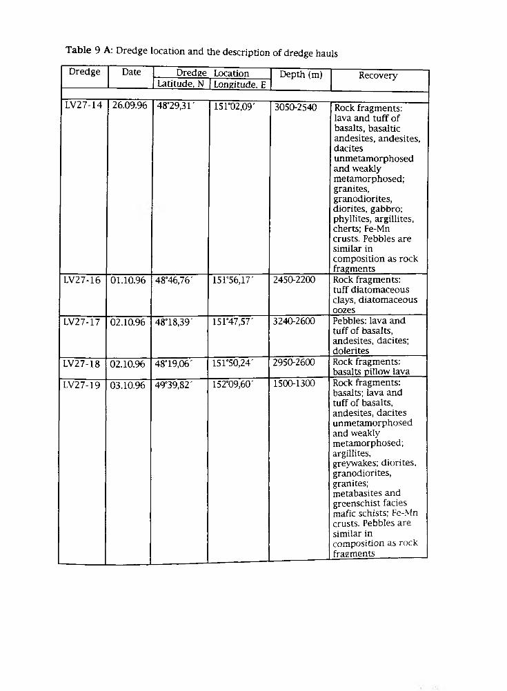
Table 9 A: Dredge location and the description of dredge hauls
Dredge Date Dredge Location Depth (m) RecoveryLatitude, N Longitude, E
LV27-14 26.09.96 48°29,31' 151102,09' 3050-2540 Rock fragments: lava and tuff of basalts, basaltic andesites, andesites, dacitesunmetamorphosed and weakly metamorphosed; granites, granodiorites, diorites, gabbro; phyllites, argillites, cherts; Fe-Mn crusts. Pebbles are similar incomposition as rock fragments
LV27-16 01.10.96 48°46,76' 151*56,17' 2450-2200 Rock fragments: tuff diatomaceous clays, diatomaceous oozes
LV27-17 02.10.96 4818,39' 151°47,57' 3240-2600 Pebbles: lava and tuff of basalts, andesites, dacites; dolerites
LV27-18 02.10.96 48° 19,06' 151*50,24' 2950-2600 Rock fragments: basalts pillow lava
LV27-19 03.10.96 49°39,82 ' 152°09,60' 1500-1300 Rock fragments: basalts; lava and tuff of basalts, andesites, dacites unmetamorphosed and weakly metamorphosed; argillites,greywakes; diorites, granodiorites, granites; metabasites and greenschist facies mafic schists; Fe-Mn crusts. Pebbles are similar incomposition as rock fragments
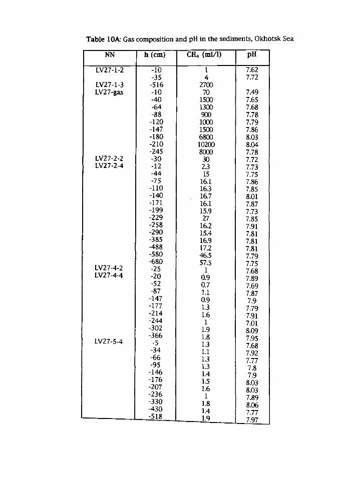
NN h (cm) CH4 (ml/1) pH
LV27-1-2 -10 1 7.62-35 4 7.72
LV27-1-3 -516 2700LV2 7-gas -10 70 7.49
-40 1500 7.65-64 1300 7.68-88 900 7.78-120 1000 7.79-147 1500 7.86-180 6800 8.03-210 10200 8.04-245 8000 7.78
LV27-2-2 -30 30 7.72LV27-2-4 -12 2.3 7.73
-44 15 7.75-75 16.1 7.86-110 16.3 7.85-140 16.7 8.01-171 16.1 7.87-199 15.9 7.73-229 27 7.85-258 16.2 7.91-290 15.4 7.81-385 16.9 7.81-488 17.2 7.81-580 46.5 7.79
LV27-4-2-680 57.5 7.75-25 1 7.68
LV27-4-4 -20 0.9 7.89-52 0.7 7.69-87 1.1 7.87-147 0.9 7.9-177 1.3 7.79-214 1.6 7.91-244 1 7.01-302 1.9 8.09
LV27-5-4-366-5
1.81.3
7.957.68
-34 1.1 7.92-66 1.3 7.77-95 1.3 7.8-146 1.4 7.9-176-207-236-330
1.51.6 1
1.8
8.038.03 7.89 8.06-430 1.4 7.777.97-518 1.9
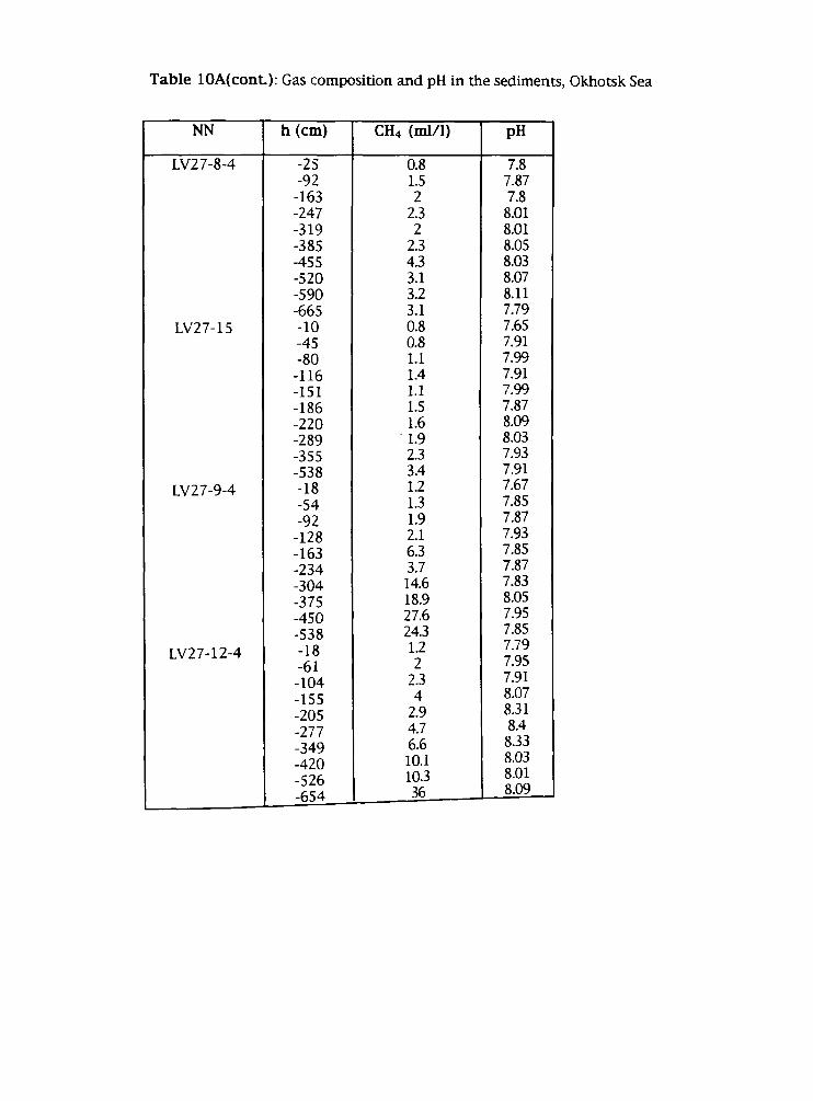
NN h (cm) CH4 (ml/1) pH
LV27-8-4 -25 0.8 7.8-92 1.5 7.87-163 2 7.8-247 2.3 8.01-319 2 8.01-385 2.3 8.05-455 4.3 8.03-520 3.1 8.07-590 3.2 8.11-665 3.1 7.79
LV27-15 -10 0.8 7.65-45 0.8 7.91-80 1.1 7.99-116 1.4 7.91-151 1.1 7.99-186 1.5 7.87-220 1.6 8.09-289 1.9 8.03-355 2.3 7.93-538 3.4 7.91
LV2 7-9-4 -18 1.2 7.67-54 1.3 7.85-92 1.9 7.87-128 2.1 7.93-163 6.3 7.85-234 3.7 7.87-304 14.6 7.83-375 18.9 8.05-450 27.6 7.95-538 24.3 7.85
LV27-12-4 -18-61
1.22
7.797.95
-104 2.3 7.91-155 4 8.07-205 2.9 8.31-277 4.7 8.4
-349 6.6 8.33-420 10.1 8.03-526 10.3 8.01-654 36 8.09
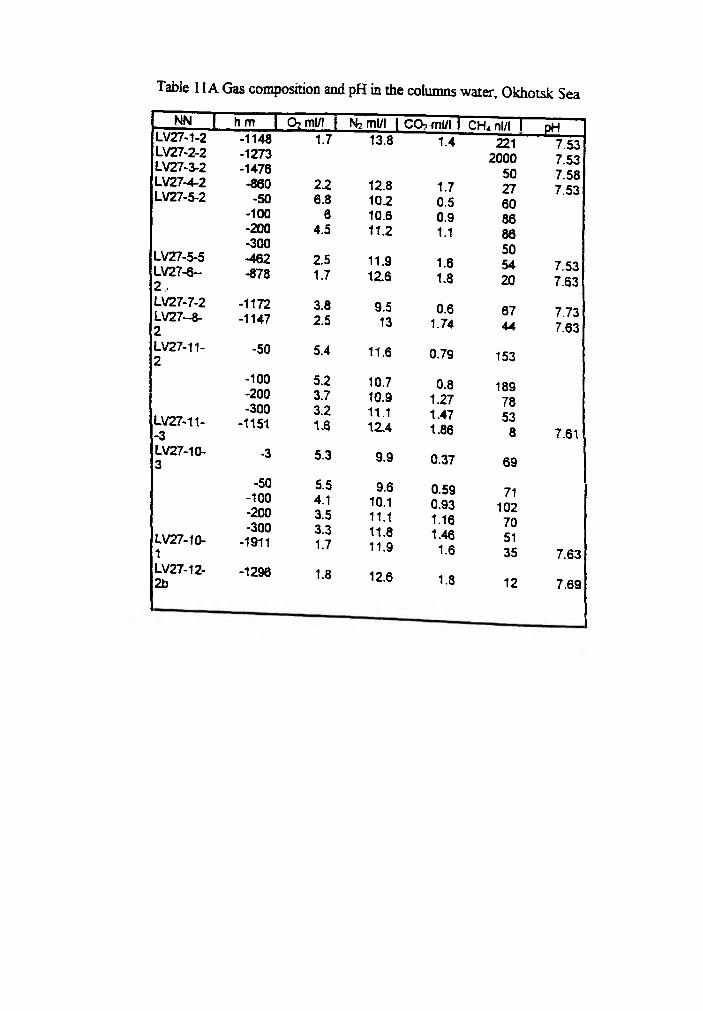
NN LV27-1-2
| hm I O? ml/1 I N? ml/l IC O , ml/ll CH. nl/l 1 _EtLLV27-2-2LV27-3-2LV27-4-2LV27-5-2
LV27-5-5LV27-6-2 ,LV27-7-2LV27-8-2LV27-11-2
LV27-11--3LV27-10-3
LV27-10-1LV27-12-2b
-1148 1.7 13.8 1.4 221-1273 2000-1476 50-860 2.2 12.8 1.7 27-50 6.8 10.2 0.5 60
-100 6 10.6 0.9 86-200 4.5 11.2 1.1 86-300 50-462 2.5 11.9 1.6 54-878 1.7 12.6 1.8 20
-1172 3.8 9.5 0.6 67-1147 2.5 13 1.74 44
-50 5.4 11.6 0.79 153
-100 5.2 10.7 0.8 189-200 3.7 10.9 1.27 78-300 3.2 11.1 1.47 53-1151 1.6 12.4 1.86 8
-3 5.3 9.9 0.37 69
-50 5.5 9.6 0.59 71-100-200-300
-1911
4.13.53.31.7
10.111.111.811.9
0.931.161.461.6
102705135
-1296 1.8 12.6 1.8 12
7.537.53 7.587.53
7.537.63
7.737.63
7.61
7.63
7.69
Appendix V Sediment core description
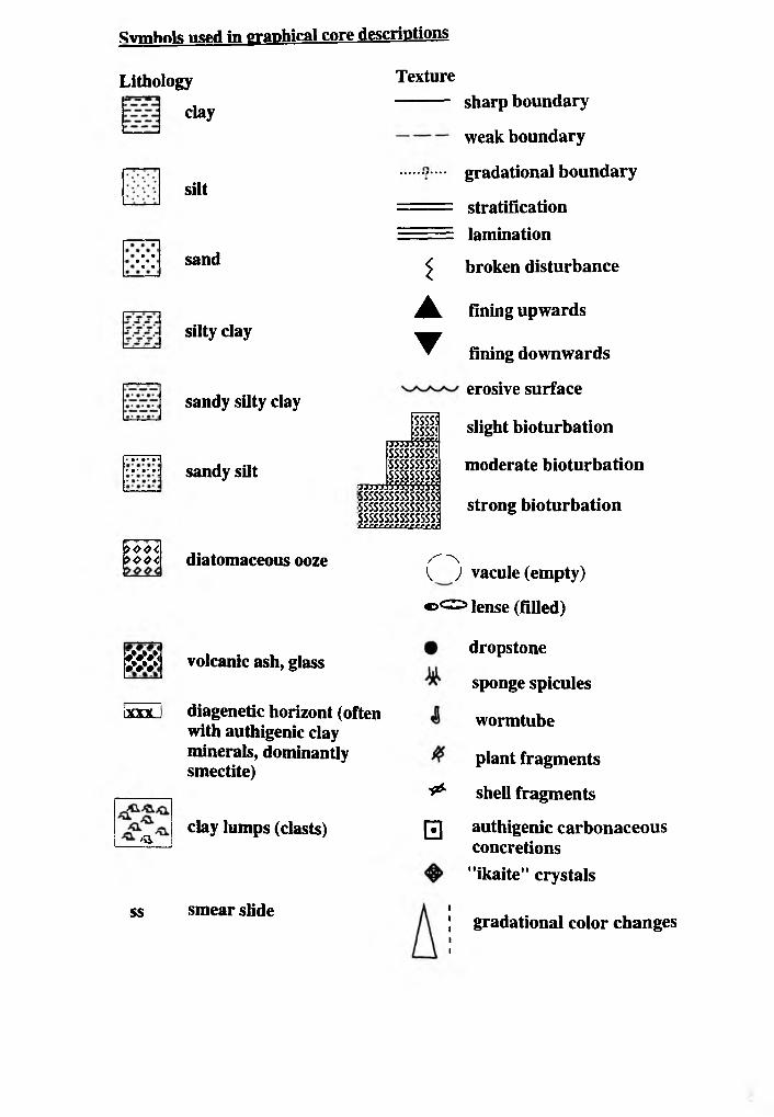
Symbols used in graphical core descriptions
Lithology
clay
• • • •« •
• •• •• • •} • •• *••j
>44<> o e <
K #X<•##*
tm .
>a
ss
silt
sand
silty clay
sandy silty clay
sandy silt
diatomaceous ooze
Texture
i
▲
▼
SSSSÎ ■SSSSÎ
Mussssy. tsssssssss; sssssssss;SSSSSSSSSi
j yj j j . SSSSS5SSÎ! SSSSSSSSSSSSSSSÎ SSSSSSSSSSSSSSSi SSSSSSSSSSSSSSSÎcrcceercecrrecn
sharp boundary
weak boundary
gradational boundary
stratificationlamination
broken disturbance
fining upwards
fining downwards
erosive surface
slight bioturbation
moderate bioturbation
strong bioturbation
/''"N ) vacule (empty)
volcanic ash, glass
diagenetic horizont (often with authigenic clay minerals, dominantly smectite)
clay lumps (clasts)
smear slide
®<Z2> ]ense (filled)
dropstone
sponge spicules
wormtube
plant fragments
shell fragments&
□ authigenic carbonaceous concretions"ikaite" crystals
gradational color changes
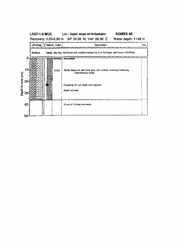
Uthology Texture Color Description SS
Surface Sandy silty day, dark brown,soft, mottled overiayn by 2 cm fluff-layer, dark brown (10YR4/2)
10-*!"Eo,® — & 20$oÇ
«3 0 ^
W f ' W >,-- ’<?V< - - ■oV. - :'<7*0*« “'o V < - -5* 5— ’<?*<>*. — 'o y , -’r w —>0*0* . - - &>*,-- '<j*o*. - T’<?*o>*<’«»¿A -i.
S5SSI;sss|;sss:SSSSi5SSS:;sss:5SSS!SSSS'
;sssi5SSSÎ* s s :sss:5SSS:5SSS'|sss|;sss,LSSS5
WVH-VÜ] hke surlacë
5Y3/2 Sandy dayey silt, dark olive gray, soft, mottled, downward stiffening (diatomiceous ooze)
Dropstone: 0 1cm, black rock fragment
Weak HîS-odor
40-: 10 out of 12 tubes recovered
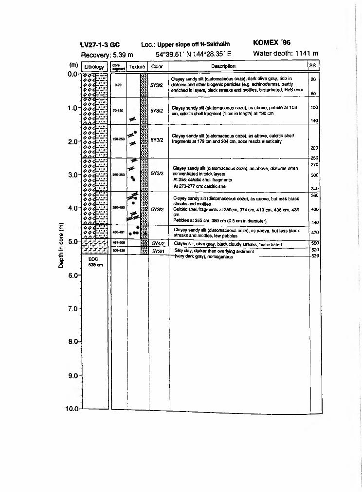
Dept
h in
core
(m
)Lithology Texture
77 4 44 4 4 -- 44> * 44-
Color Description SS
5Y3/2Clayey sandy silt (diatomaceous ooze), dark olive gray, rich in diatoms and other biogenic particles (e.g. echinoderms), partly enriched in layers, black streaks and mottles, bioturbated, H2S odor
20
60
1 .0 -
2.0-
44<r 44- 44< 44<%-"- 44< ‘ ¿UXA
5Y3/2Clayey sandy silt (diatomaceous ooze), as above, pebble at 103 cm, calcitic shell fragment (t cm in length) at 130 cm
100
1404 4 < 4 4 - 44< 44< 4 4 , 44< Ù.Ù.Î.
3 . 0
4.0-
444r- 44< ‘ 4 4 - 44<4 4 < 44< ■4Â4
SSSS:SS:SS:SS|ss:s i
5Y3/2Clayey sandy silt (diatomaceous ooze), as above, calcitic shell fragments at 179 cm and 204 cm, ooze reacts elastically
44<-"- 4 44 4 < ’- - 4 4 < ~ 44< -■ 44<
5Y3/2Clayey sandy silt (diatomaceous ooze), as above, diatoms often concentrated in thick layers At 258: calcitic shell fragments At 273-277 cm: calcitic shell
5 . 0 -
4 4 < - - 44< -V
;ss:;ss:;ss:;ss:sSS:5SS:sss
5Y3/2
SS:
6.0-
7 . 0
8.0
9 . 0
10.0 -
5Y4/2
5Y3/1
Clayey silt, olive gray, black cloudy streaks, bioturbated
EOC 539 cm
Silty day, darker than overlying sediment “ (very dark gray), homogenous
220
250270
300
340
Clayey sandy silt (diatomaceous ooze), as above, but less black streaks and mottlesCalcitic shell fragments at 359cm, 374 cm, 410 cm, 436 cm, 439 cm.Pebbles at 365 cm, 380 cm (0.5 cm in diameter)
360
400
440Clayey sandy silt (diatomaceous ooze), as above, but less black streaks and mottles, few pebbles 470
500'520■539
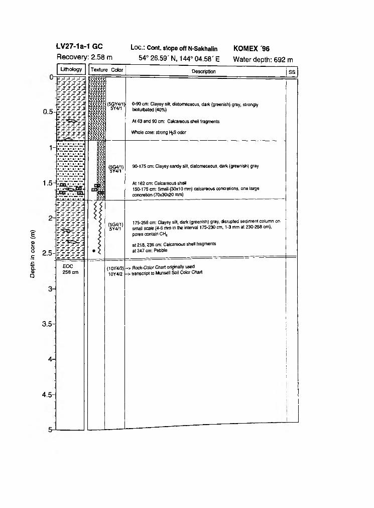
Dept
h in
core
(m
)
0.5-
1-
1.5-
Description
2.5-
IS S S S J rj-j-'-'j-j
s 's 's 's '2
i s T s sjmmT S S S S Jr 's 's 's 's 'j- - - - - -
3.5
4-
4.5-
EOC 258 cm
;ssssss ;s sssss ;ssssss ssssss ssssss ssssss ssssss ssssss ¡ssssss ssssss issssss: issssss■errr -
(5GY4/1)5Y4/1
(5G4/1 ) 5Y4/1
(5G4/1)5Y4/1
(10Y4/2)10Y4/2
0-90 cm: Clayey silt, diatomaceous, dark (greenish) gray, strongly bioturbated (40%)
At 63 and 90 cm: Calcareous shell fragments
Whole core: strong 1-feS odor
90-175 cm: Clayey sandy silt, diatomaceous, dark (greenish) gray
At 162 cm: Calcareous shell150-175 cm: Small (30x10 mm) calcareous concretions, one large concretion (70x30x20 mm)
175-258 cm: Clayey silt, dark (greenish) gray, disrupted sediment column on small scale (4-6 mm in the interval 175-230 cm, 1-3 mm at 230-258 cm), pores contain CH4
at 218,236 cm: Calcareous shell fragments at 247 cm: Pebble
-> Rock-Color Chart originally used transcript to Munsell Soil Color Chart
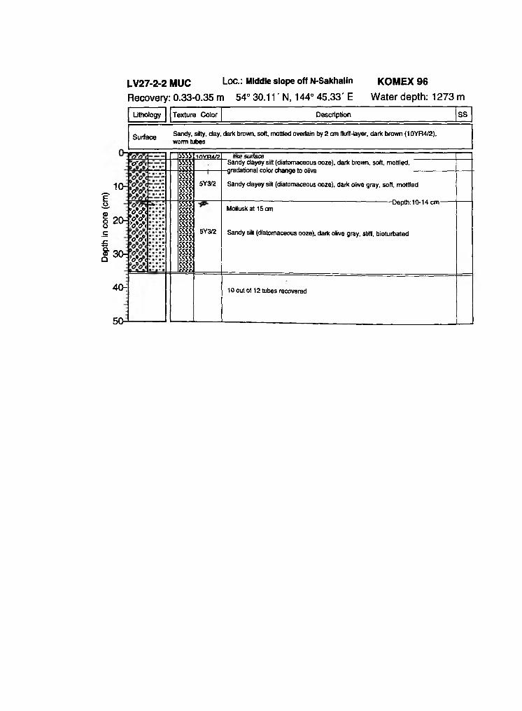
Dept
h in
core
(c
m)
Lithology Texture Color Description SS
Surface Sandy, silty, day, dark brown, soft, mottled overlain by 2 cm fluff-layer, dark brown (10YR4/2), worm tubes
1 0 -Í • a • •• • •
20r
30:
Vcr<
Cro<
>v<*oV< W <
<&>*<
&><
ESS
ssss:ssss:ssss:ssss:
3555!SStt
5555!ssss:ssss:ssss:ssss:ssss:ssss:ssss:ssss:ssss:jfffi
invm/i>
5Y3/2
5Y3/2
like surfaceSandy dayey silt (diatomaceous ooze), dark brown, soft, mottled,
-gradational color change to olive
Sandy dayey silt (diatomaceous ooze), dark olive gray, soft, mottled
----------------------------------------------Depth:10-14 cm-Molluskat 15 cm
Sandy silt (diatomaceous ooze), dark olive gray, stiff, bioturbated
40-i 10 out of 12 tubes recovered
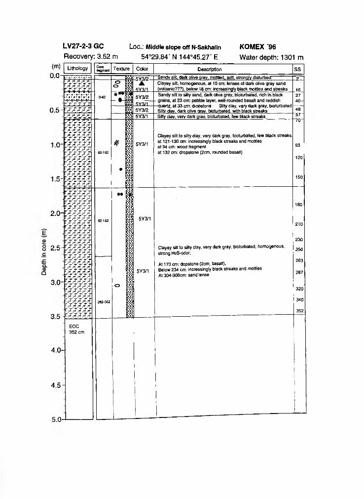
(m ) Lithology Coresegment Texture Color Description SS
0 .0 5Y3/2 Saiidv silt, dark olive arav. mottled, soft, strongly disturbed 2oo
5Y3/1Clayey silt, homogenous, at 10 cm: lenses of dark olive gray sand (volcanic???), below 18 cm: increasingly black mottles and streaks 1fiSandy silt to silty sand, dark olive gray, bioturbated, rich in black 27
-40 -■ 0-62 f 5Y3/2
RY3/10 . 5 - j - - - - 5Y3/2
c usrtz, dl 33 cni. diopstoiitt oilty clay, vsry ddrK gray, bioturüàlüd Silty dav. dark olive arav. bioturbated. with black streaks 48
- 5Y3/1 Silty day, very dark qrav, bioturbated, few black streaks 5 /T - T T 70
1 .0 -62-162
5Y3/1
Clayey silt to silty day, very dark gray, bioturbated, few black streaks, at 121-130 cm: increasingly black streaks and mottles at 94 cm: wood fragment at 132 cm: dropstone (2cm, rounded basalt)
93
120
1 . 5 - . V y V V r
•150
~ s s s s s • •
2 .0 -T S S S S Sr 'ss 'ss 'st 's 's 's 's s
[■-i ’î î ï ’ï62-162 5Y3/1
180
210
2 . 5 -r s s s s s r's's s s s r 's 's s ss t's 's 's 's s r s s s s s r 'ss 's 'ss
- ' y y y ? }r s s s s s r's's s 's s
Clayey silt to silty clay, very dark gray, bioturbated, homogenous, strong H2S-odor,
230
250
3 . 0 -
262-352
o
5Y3/1At 173 cm: dopstone (2cm, basalt),Below 234 cm: increasingly black streaks and mottles At 304-308cm: sand lense
263
287
320
340
3523 .5 -1
e o c352 cm
4 . 0 -
4 . 5 -
k n _
Ii
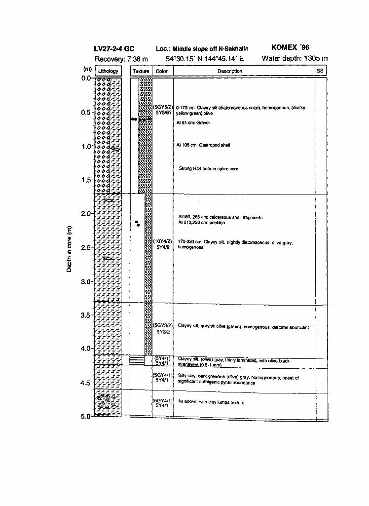
Dept
h in
core
(m
)
LV27-2-4 GC Loc.: Middle slope off N-Sakhalin KOMEX '96Recovery: 7.38 m 54°30.15' N 144°45.14' E Water depth: 1305 m
( m ) Lithology Texture Color Description SS
0.0-
0.5-
1.0-
1.5-
TTzrzo o oo o oo o 40040040 0 4o o <o o <0 0 40 0 40 0 40 0 40 0 40 0 40 0 40 0 40 0 40 0 40 0 40 0 40 0 40 0 40 0 4
M
ASSSS¡sssss¡sssss¡ssssi;ssss!SSSSS!5SSSS!»SSSSi
p iSSSSSisssss;SSSSS!SSSSSiSSSSS!SSSSS!SSSSS!SSSSS!SSSSS!SSSSS!5SSSS!SSSSS!SSSSS!SSSSS!
(5GY5/2)5Y5/6?
0-170 cm: Clayey silt (diatomaceous ooze), homogenous, (dusky yellow green) olive
At 61 cm: Gravel
At 105 cm: Gastropod shell
Strong H2S odor in egtire core
ii!SS!
2.0-
2.5-
3.0-
-
r.-.j-.j-.j-.j-
-.3.SSÏ.S.
W / Æ
- - - - - - -
•«
SS!SS!SS!SS!SS!SS!SS!SS!SS!SS!SS!SS!SS!SS!SS!SS!SS!SS!SS!SS!tt<
(1QY4/2)5Y4/2
At180, 265 cm: calcereous shell fragments At 210,220 cm: pebbles
170-330 cm: Clayey silt, slightly diatomaceous, olive gray, homogenous
3.5-
4.0-
Î.-T .W
'.sssz^s
,-r ,-r .-r
F f fS S f
SS!SS!SS!SS!SS!SS!SS!SS!SS!SS!ct<
(5GY3/2)5Y3/2
(5Y4/1 )
Clayey silt, grayish olive (green), homogenous, diatoms abundant
uiayey silt, (olive) gray, thinly laminated with olive black
4.5-
' - - . - y . - v'SSS'S'S
5Y4/1
(5GY4/1)5Y4/1
interlavers (0.5-1 mml
Silty clay, dark greenish (olive) gray, homogeneous, onset of significant authigenic pyrite abundance
5.0-'h îr ï - - -
(5GY4/1)5Y4/1
As above, with clay lumps texture
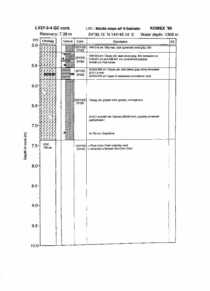
Dept
h in
core
(m
)
(m)5 . 0 -
Lithology Texture Color
333553SSSSSSrrrect
• SSSSSÍ
(5GY3/2)5Y3/2
Description
496-518 cm: Silty clay, dark (greenish) olive gray, stiff
SS
5 . 5 SSSSS!¡ m
(5Y3/2)5Y3/2
518-553 cm: Clayey silt, dark (olive) gray, thin lamination at 518-521 cm and 538-541 cm, occassional pebbles At 536 cm: Fish bones
(5Y3/2)5Y3/2
At 553-585 cm: Clayey silt, dark (olive) gray, thinly laminated (0.3-1.5 mm)At 570-575 cm: Layer of calcareous concretions, hard
SSSSSÍSSSSSÍSSSSSÍSSSSSÍSSSSSÍSSSSSÍSSSSSÍSSSSSÍSSSSSÍSSSSS!SSSSSÍSSSSSÍSSSSS!SSSSS!SSSSSÍSSSSSÍSSSSSÍSSSSSÍSSSSS!SSSSS!CCC£f<
6.0--:
6 . 5 - - ;
7 . 0 - - :
7 . 5 -
8.0-
8 - 5 -
9 . 0 -
9 . 5
EOC 738 cm
(5GY3/2)5Y3/2
Clayey silt, grayish olive (green), homogenous
At 617 and-682 cm: Vacules (30x40 mm), possibly contained gashydrates!
At 720 cm: Dropstone
(10Y4/2)10Y4/2
-> Rock-Color Chart originally used > transcript to Munsell Soil Color Chart
10.0
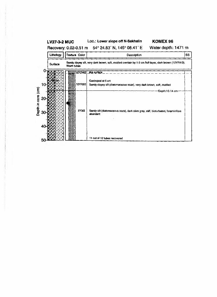
Dept
h in
core
(c
m)
Lithology Texture Color Description SS
SurfaceSandy clayey silt, Worm tubes
very dark brown, soft, mottled overlain by 1-2 cm fluff-layer, dark brown (10YR4/2),
1(*
j»Jam.*-
20:
30:
40:
oo(oV•<sVWWW'oVW’<?VWw'oVW><?VWW>oVuu
SSSS:ssss:SSSS:ssss:ssss:
ssss:ssss:SSS:sss:ssss:ssss:ssss:ssss:ssss:ssss:ssss:
SSSS:ssss:ssss:ssss:ssss:££££.
10YJ34Æ
10VR2/2
5Y3Æ
JtesyrfQSB.____ ... _. .................. ...... ... ... ... ... . .
Gastropod at 5 cmSandy clayey silt (diatomaceous ooze), very dark brown, soft, mottled
-Depth:12-14 cm-
Sandy silt (diatomaceous ooze), dark olive gray, stiff, bioturbated, foraminifera abundant
11 out of 12 tubes recovered
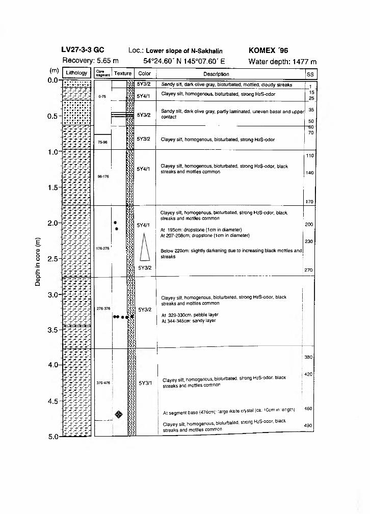
Dept
h in
core
(m
)
0.5
1.0-
Coresegment
SSS
5Y3/2
5Y4/1
5Y3/2
5Y3/2
Sandy silt, dark olive gray, bioturbated, mottled, cloudy streaks
Clayey silt, homogenous, bioturbated, strong H2S-odor
Sandy silt, dark olive gray, partly laminated, uneven basal and upper contact
Clayey silt, homogenous, bioturbated, strong H2S-odor
1.5
5SS»SS¿SSESS;ss;ss;ss;ss;ss1SÍ
5Y4/1 Clayey silt, homogenous, bioturbated, strong H2S-odor, black streaks and mottles common
110
140
170
2.0-
2.5
3.0-
3.5
4.0-
4.5
sss|ssssssssSssfeSS;ss;ss;ss;ss;ss;ss;ss;ss
5Y4/1
•• •
7SS;ss;ss;ss:;ss;ss;ss:$;ss
ssSSSSSS
376-476 i
Clayey silt, homogenous, bioturbated, strong H2S-odor, black streaks and mottles common
At 195cm: dropstone (1cm in diameter)At 207-208cm: dropstone (1cm in diameter)
Below 220cm: slightly darkening due to increasing black mottles and streaks
5Y3/2
5Y3/2
5Y3/1
Clayey silt, homogenous, bioturbated, strong H2S-odor, black streaks and mottles common
At 329-330cm: pebble layer At 344-345cm: sandy layer
200
230
270
Clayey silt, homogenous, bioturbated, strong H2S-odor, black streaks and mottles common
At segm ent b ase (476cm): large ikaite crystal (ca. 10cm in length)
Clayey silt, homogenous, bioturbated, strong H2S-odor, black streaks and mottles common ____ _______________
380
i 420
460
490
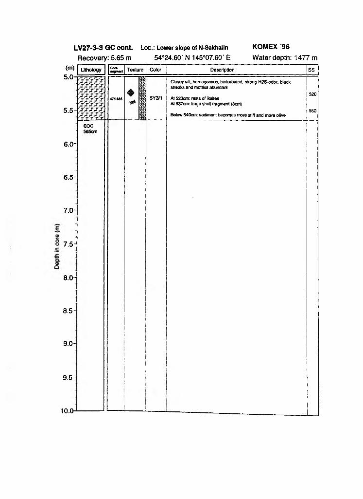
(m) Lithology Cor»segment Texture Color Description SS
5.0-
5 .5- - ' r V j ' / r
475-565
ssssssssss;ssssssss
5Y3/1
Clayey silt, homogenous, bioturbated, strong H2S-odor, black streaks and mottles abundant
At 523cm: rests of ikaites At 537cm: large shell fragment (3cm)
Below 540cm: sediment becomes more stiff and more olive
520
550
•EOC565cm
6.0-
6.5-
7.0-
7.5-
8.0-
8.5-
9.0-
9.5-
10.0- !
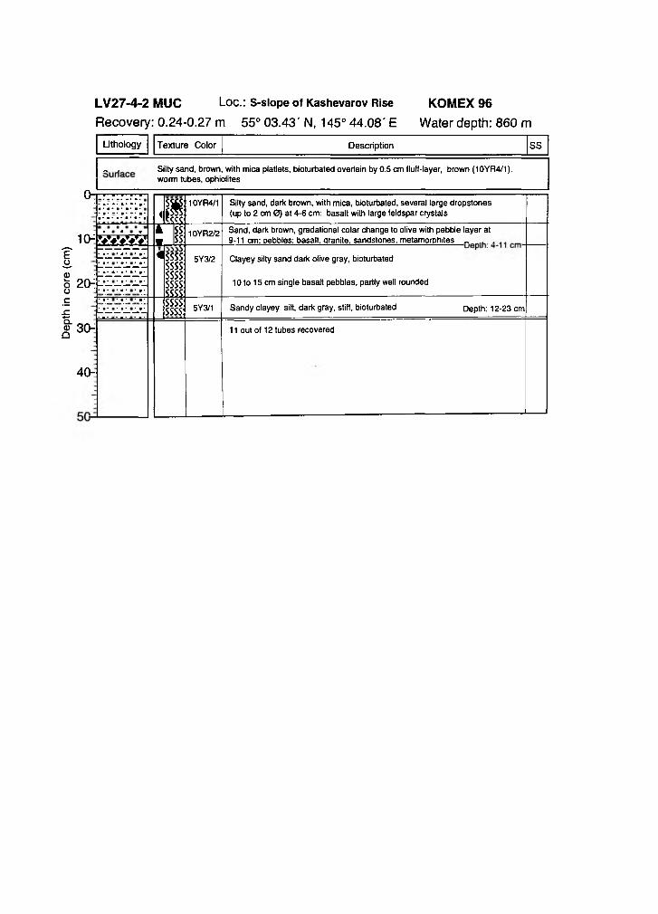
Dept
h in
core
(c
m)
Lithology Texture Color Description SS
- . Silty sand, brown, with mica platlets, bioturbated overtain by 0.5 cm fluff-layer, brown (10YR4/1), worm tubes, ophiolites
u -
<p10YR4/1 Silty sand, dark brown, with mica, bioturbated, several large dropstones
(up to 2 cm 0) at 4-6 cm: basalt with large feldspar crystals
1 0 "
2 0 -i
k SS« ss
10YR2/2 Sand, dark brown, gradational colar change to olive with pebble layer at 9-11 cm: pebbles: basalt, qranite, sandstones, metamorphites „ .. .W A V
• •• • ■ ■* ■*
« ssssssssssssssssssss
5Y3/2 Clayey silty sand dark olive gray, bioturbated
10 to 15 cm single basalt pebbles, partly well rounded
3 0 "
4 0 -
ssssssss 5Y3/1 Sandy clayey silt, dark gray, stiff, bioturbated Depth: 12-23 cm
11 out of 12 tubes recovered
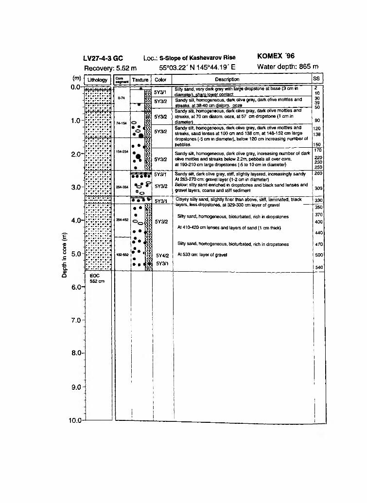
Dept
h in
core
(m
)
1.0-
2.0-
w-ss:
• Â 4ss:o
• •SS:¿5s• • SS:SS1
ss:mss
1SS:
5Y3/1
5Y3/2
5Y3/2
5Y3/2
5Y3/2
Silty sand, very dark gray with large dropstone at base (3 cm in diameter), sharp lower contactSandy silt, homogeneous, dark olive gray, dark olive mottles and streaks, at 38-40 cm diatom, ooze___________________Sandy silt, homogeneous, dark olive gray, dark olive mottles and streaks, at 70 cm diatom, ooze, at 57 cm dropstone (1 cm in diameter)___________________________________________Sandy silt, homogeneous, dark olive gray, dark olive mottles and streaks, sand lenses at 100 cm and 138 cm, at 148-152 cm large dropstones (-5 cm in diameter), below 120 cm increasing number of pebbles. _____________
Sandy silt, homogeneous, dark olive gray, increasing number of dark olive mottles and streaks below 2.2m, pebbels all over core, at 190-210 cm large dropstones (-5 to 10 cm in diameter)
210303950
90
120138
150170220230250
3 . 0 -• • • ••
”o
5Y3/1
5Y3/2
Sandy silt, dark olive gray, stiff, slightly layered, increasingly sandy At 263-270 cm: gravel layer (1-2 cm in diameter)Below: silty sand enriched in dropstones and black sand lenses and gravel layers, coarse and stiff sediment
260
300
4 . 0 -
5 . 0
_ ¿55: • • SS:
SS: , ¿SS:ofss
SS• •
452-552
• • 4SS:• SS:
• • « SS:• SS: • • • $
5Y3/1
"SS:SS:
5Y 3/2
5Y4/25Y3/1
Clayey silty sand, slightly finer than above, stiff, laminated, black •layers, less dropstones, at 329-330 cm layer of gravel
Silty sand, homogeneous, bioturbated, rich in dropstones
At 410-420 cm lenses and layers of sand (1 cm thick)
Silty sand, homogeneous, bioturbated, rich in dropstones
At 533 cm: layer of gravel
6.0-
7 . 0
8.0-
9 . 0
EOC 552 cm
330350370400
440
470
500
540
10.0
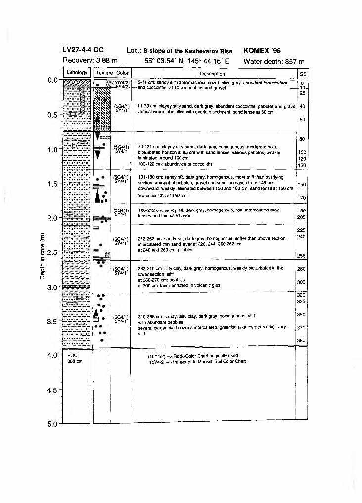
Dept
h in
core
(m
)
0.0
0 . 5
1.0
1 . 5
ro'o'd'o'o]ÎSSSSSSÎSSSSSSm s ts sissssssÎSSSSSSŒ SSSSJtssssÏSSSSSS
(10Y4/2) —5Y4/2-
(5G4/1)5Y4/1
(5G4/1 ) 5Y4/1
0-11 cm: sandy silt (diatomaceous ooze), olive gray, abundant foraminifera -and coccoliths; at 10 cm pebbles and gravel
11 -73 cm: clayey silty sand, dark gray, abundant coccoliths, pebbles and gravel vertical worm tube filled with overlain sediment, sand lense at 50 cm
73-131 cm: clayey silty sand, dark gray, homogenous, moderate hard, bioturbated horizon at 85 cm with sand lenses, various pebbles, weakly laminated around 100 cm 100-120 cm: abundance of coccoliths
010-]25
40
60
80
100120130
(5G4/1)5Y4/1
L : .
131-180 cm: sandy silt, dark gray, homogenous, more stiff than overlying section, amount of pebbles, gravel and sand increases from 145 cm downward, weakly laminated between 150 and 160 cm, sand lense at 150 cm few coccoliths at 150 cm
150
170
2.0-(5G4/1)5Y4/1
180-212 cm: sandy silt, dark gray, homogenous, stiff, intercalated sand lenses and thin sand layer
190205
2 . 5
(5G4/1 ) 5Y4/1
*-»-* -V1
■’s s ’s s sy.ss's.-
212-262 cm: sandy silt, dark gray, homogenous, softer than above section, intercalated thin sand layer at 228, 244, 260-262 cm at 240 and 260 cm: pebbles
225240
258
(5G4/1)5Y4/1
3 . 0 -
262-310 cm: silty clay, dark gray, homogenous, weakly bioturbated in thelower section, stiffat 260-270 cm: pebblesat 300 cm: layer enriched in volcanic glas
280
300
■ ■ • ■ • ■ • • • * •
3 . 5
• •
••
r . (5G4/1)5Y4/1
310-388 cm: sandy, silty clay, dark gray, homogenous, stiff with abundant pebblesseveral diagenetic horizons intercalated, greenish (like copper oxide), very stiff
320335
350
370
380
4 . 0 -
4 . 5
EOC 388 cm
(10Y4/2) -> Rock-Color Chart originally used 10Y4/2 ~> transcript to Munsell Soil Color Chart
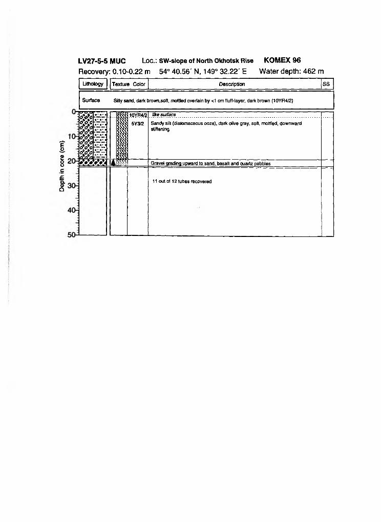
Dept
h in
core
(c
m)
Lithology Texture Color Description SS
Surface Silty sand, dark brown,soft, mottled overlain by <1 cm fluff-layer, dark brown (10YR4/2)
TOW”* i 6 6 •* ■• 0-€rC 16 6 • * • OOCI 6 5 ■ * • *
:: oVo - - o V c ’- -.....x x x x x i n m
.957ssssssssssssssssssssssssssssssss
1.0YR4/2
5Y3/2
like surface
Sandy silt (diatomaceous ooze), dark olive gray, soft, mottled, downward stiffening
Gravel grading upward to sand, basalt and quartz pebbles
11 out of 12 tubes recovered
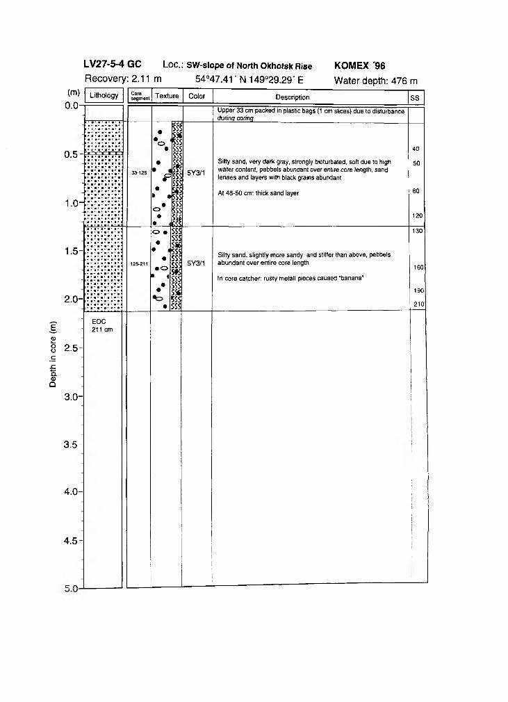
Dept
h in
core
(m
)
(m ) Litholn n ----------
°gy Ornent Texture Color Description SSU.U Upper 33 cm packed in plastic bags (1 cm slices) due to disturbance
during coring
1 • • • •
0 . 5 - ™ =
J §
33-125
•
•o•
•
p•
• • •o
••
sss5 *5SSSSSsss
Ihssssss
$ssssss
8 1
5Y3/1
Silty sand, very dark gray, strongly bioturbated, soft due to high water content, pebbels abundant over entire core length, sand lenses and layers with black grains abundant
At 48-50 cm: thick sand layer
40
50
80
120
1 - 5 - I r i r j
• a* •* !• • • • •
2.°-:i;i;|
'aym\ 125-211
o • •
••
• o • 1
••
•
ssssssSS65SSssssssS*5ssssssSSf5SSsss
5Y3/1Silty sand, slightly more sandy and stiffer than above, pebbels abundant over entire core length
In core catcher: rusty metall pieces caused "banana"
130
160
190
210
' EOC - 211
2.5-
3.0-
3.5-
4 . 0 -
4 . 5 -
c n
m
i
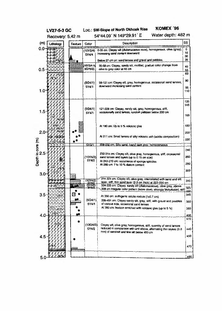
Dept
h in
core
(m
)
Lithology Texture
>oo -i± - >oo
0 . 5
1.0-
m 6SSS55SSS'j , mvs/dlWhmsâSSÿ
Color Description
(10Y5/4) 0-35 cm: Clayey silt (diatomaceous ooze), homogenous, olive (gray), 5Y4/4 increasing sand content downward
Below 27 cm on: sand lenses and gravel and pebbles_____________
(5G4/1)5Y4/1
SS
35-58 cm: Clayey, sandy silt, mottled, gradual color change from olive to gray color at 46 cm
58-121 cm: Clayey silt, gray, homogenous, occasional sand lenses, downward increasing sand content
63
80
95110
1 . 5(5G4/1)5Y4/1
3ÏS
121-228 cm: Clayey, sandy silt, gray, homogenous, stiff, occasionally sand lenses, random pebbles below 200 cm
At 180 cm: Up to 5 % volcanic glas
At 211 cm: Small lenses of silty volcanic ash (acidic composition)
135145
165
180
200
220
228-232 cm: Siltv sand. (verv> dark orav. homogeneous-5Y3/1
2 .5 --^ d d d
m m
3 . 0 -
3 . 5 -
4 . 0 '
4.5-
5 .0 -^
(10Y4/2)5Y4/2
232-314 cm: Clayey silt, olive gray, homogenous, stiff, occasional sand lenses and layers (up to 0.15 cm size)At 263-270 cm: occurrence of sponge spicules At 280 cm: 7 to 10 % diatom content
240
260
280
300
Eggs?
0
(10Y4/2)
i M■ 5Y5Æ
^314-324 cm: Clayey silt, olive gray, intercalated with sand and silt layer, stiff, thin sand layer (2-3 cm thick) at 223-224 cm 310
324-335 cm: Clayey, sandy silt (diatomaceous), olive gray, above ~\328 cm irregular color pattern (more olive), strongly bioturbated, stifl 325
-330-
(5G4/1 ) 5Y4/1
At 350 cm: authigenic calcite nodule (1x0.7 cm)335-401 cm: Clayey sandy silt, gray, stiff, with gravel and peeblesof various size, occasional sand lensesAt 380 cm: horizon enriched with volcanic glas (up to 5 %)
345
360
380
400
(10G4/2)5Y4/2
Clayey silt, olive gray, homogenous, stiff, quantity of sand lenses reduced in comparison with unit above, alternating thin layers (2-3 mm) of sand/silt and fine silt below 480 cm
410
440
450
470
490
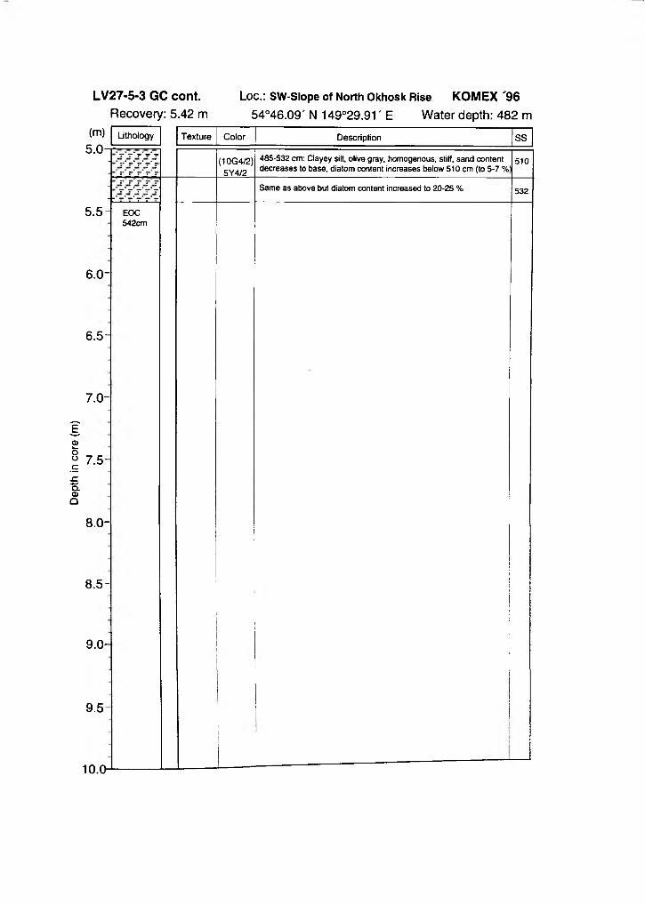
Dept
h in
core
(m
)
(m)
5 . 5
6.0-
6 . 5 -
7 . 0 -
7 . 5 -
8.0-
8 . 5 -
9 . 0 -
9 . 5
10.0-
Lithology Texture Color
(10G4/2)5Y4/2
Description SS
485-532 cm: Clayey silt, olive gray, homogenous, stiff, sand content decreases to base, diatom content increases below 510 cm (to 5-7 %i
Same as above but diatom content increased to 20-25 % 532
EOC542cm
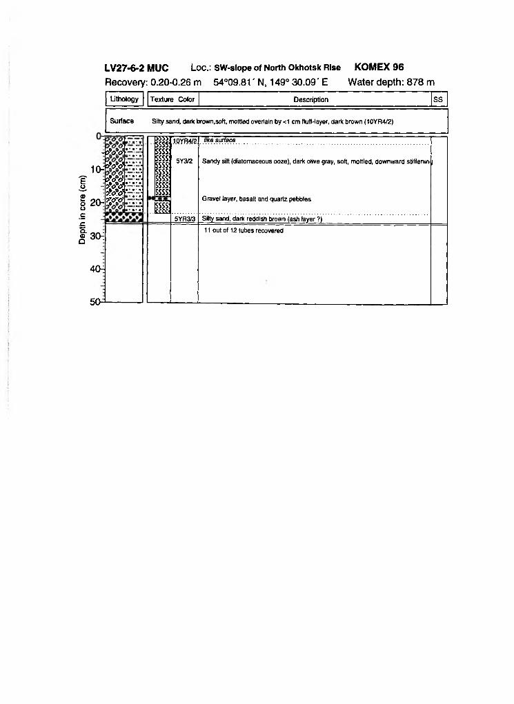
Dept
h in
core
(c
m)
Lithology Texture Color Description SS
Surface Silty sand, dark brown.soft, mottled overlain by <1 cm fluff-layer, dark brown (10YR4/2)
- b W -
10"W o V -p W - - ? W - s W -
2 0 -5 ^
555?SSSS5SSS5SSSSSSSSSSSSSSSSSSSSSSS
SSSS'££££j
1.0YR4/2
5Y3/2
5YR3/3
like surface
Sandy silt (dlatomaceous ooze), dark olive gray, soft, mottled, downward stiffenini |
Gravel layer, basalt and quartz pebbles
Silty sand, dark reddish brown (ash layer ?)
30-i
4 C H
11 out of 12 tubes recovered
Dept
h in
core
(m
)
0 . 5
1.0-
1 . 5 -
2.0-
2 . 5 -
3 . 0 -
3 . 5
4 . 0 -
4 . 5
Coresegment
• • • •
• •
•• •• •
• • • • •• •
5Y4/4.
5Y3/1
Sand rich in large dropstones (-5 cm), brownish
Coarse sand, very dark gray, pebbles all over core
At 20 cm: small rusty crustAt 59 cmand 84-89 cm: gravel layer
0_
20
49
88EOC 89 cm
(m ) Lithology Texture Color Description SS0 .0 - [
• ▲ • (1ÔY4/2). 5Ï4Z21. .
0-11 cm: Sandy silt (diatomaceous), homogenous, olive (gray), soft, \ dropstone at 3 cm
-------H »sssss6SSSS
(5G4/1)5Y4/1 11-29 cm: Clayey, silty sand, bioturbated, gray, stiff, few gravels
incorporated, coccoliths abundant
- • ••
>sssssISSSSS;sssss
(5G4/1)5Y4/1
29-48 cm: Clayey silty sand, bioturbated, gray, few intercalated sand lenses, pebbles between 32 and 48 cm
0 . 5 -• (5G4/1)
5Y4/148-82 cm: Clayey silty sand, gray, intercalated sand lenses, pebbles and thin layer of sand increasing downward, very stiff between 80-82 cm, few randomly distributed peebles
»•I-1 ' ï
1 .0 -
• is ;ss
• ;ss (5G4/1)5Y4/1
82-140 cm: Silty sand, gray, weakly biotuibated, occasional sandlenses, randomly distributed peeblesAt 105 cm: Increase of volcanic glas content (up to 2 %)At 110 cm: Lense with well sorted sand
■ • ■ • •»• ■ • ■
»• 1Î **T • ♦ • • ■
••
•*«= ••• ■ •> ■
1 5 - 140-145 cm: Siltv sand, bioturbated. arav. stiff
■ • • • •• •» ••
••
(5G4/1)5Y4/1
145-186 cm: Silty sand, gray, stiff horizont at 173-180 cm, occasional sand lenses, few pebbles at 184 cm, some coccoliths and vulcanic glas content up to 5-7 %
2 .0 -EOC 186 cm
(10Y4/2)10Y4/2
--> Rock-Color Chart originally used ~> transcript to Munsell Soil Color Chart
LV27-7-2 MUC Loc.: Derugin BasinRecovery: 0.25-0.39 m 53° 14.28' N, 149° 34.37' E
Lithofogy Texture Color Description SS
Surface Sandy silty clay, dark brown, soft, mottled overlain by 1 cm fluff-layer, dark brown (10YR4/2)
e ©Oo
•Ef ^<DQ
) V 'O
>°oV>W> w> w»W
r -r -r -
j v j j :;sss';sss4;sss!;sss!;sss;
¿SSS!p s
SSS!sss: sss:sss.sssgSSS! SSSÍ SSS! SSS! SSS!
-*t*L
10YR4/2 Sandy clayey silt (diatomaceous ooze), dark brown,soft, mottled
-y.
2(^
30:
> w> w> w> w> w> w> w> w> wr -
40-■-
5Y3/2 Sandy clayey silt (diatomaceous ooze), dark olive gray, mottled, stiffening downward
Black pebble, basalt, rounded
10 out of 12 tubes recovered
Dept
h in
core
(m
)Loc.: E-Derugin Basin
5 3 ° 1 5 . 2 7 ' N 1 4 9 ° 3 5 . 7 3 ' E
0 . 5 -
Lithology Texture
X »O O O I0-86 ------
1.0-
1 . 5 -
2.0- ÙJt
2 . 5
3 . 0 -
3 . 5 -
4 . 0 -
4 . 5
eoc360 cm
XX
XX-
XX
KS;ss
jS S<5SS>ssC£Ss ?i*ssÄ■SS►ss>ss»S:|SS:tes;ss:;Si:XI
Color :5Y5/2= -5Y4/1 -
IY3/1 = 5Y3/15Y4/2
-5Y4/1 z 2.5Y3/2
5Y3/2
5Y3/2
5Y3/1
5Y3/2
5Y5/2;5Y3/2l
5Y3/1
5Y3/1
1 - - 3
Description SS:Sandy silt (diatomaceous ooze), light olive gray, at 3 cm: intercalatec -bv brown sandv layer (0.5 cm thick), sharp upper and lower contacts]-. :Silty sand, slightly darker than overlying sediment, dark gray, — pebbles (1 cm) abundantIntercalation of silty sand (very dark gray 5Y3/1) and sandy silt (dark gray 5Y4/1), sand fining upwards
iSilty sand:Reddish volcanic ash laver of coarse sand, uneven contactsClayey silt, slightly sandy, bioturbated, dark olive gray, at 53cm and 59cm: pebbles abundant (1cm in diameter)______________________
Clayey sandy silt, increasing number of black mottles and streaks,layering, black sandy lenses and streaksAt 92 cm: diagenetic horizon, 0.5 cm, stiff, greenish
Clayey sandy silt, lighter than overlying section, bioturbated
Sandy silt, more stiff and slightly darker than overtying section, black streaks and mottles, bioturbated
-Sandy silt (diatomaceous ooze), rich in foraminifers, includes -lenses of reworked material from above, bioturbated
Sandy silt, very dark gray, abundant pebbles (1cm), homogeneous, bioturbatedAt 225-226cm: diagenetic horizon, very stiff, greenish (authigenic smectite???)
:Silty sand, dark olive gray=
Sandy silt to silty sand, bioturbated, black mottles and streaks, abundant pebbles (1cm)
At 295-298cm: diagenetic horizon, stiff, greenish (authigenic smectite???)
At 366-370cm: large dropstone (4cm)
4859
120
140
160
180
19019a210
230
250
280
288295
305320
350
370
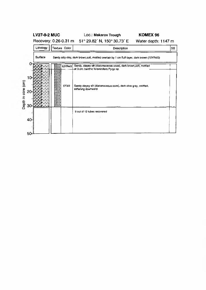
Lithology Texture Color Description SS
Surface Sandy silty clay, dark brown,soft, mottled overlain by 1 cm fluff-layer, dark brown (10YR4/2)
-P.- f t
w
1(HÿE
®o 2CHoÇ-C v>-
. r
> W -> W -w>W> w> ww>W> w>v<?S
r -r -r -
SSS!«Sisss|SSS!SSS!SSS!SSS!
$SSS!"SSS!■SSS!
ISSS!SSS!SSS!SSS!
10YR4/2
5Y3/2
Sandy, clayey silt (diatomaceous ooze), dark brown,soft, mottled -at 3 cm: benthic foraminifera Pyrgo sp. -
Sandy clayey silt (diatomaceous ooze), dark olive gray, mottled, stiffening downward
40-
9 out of 12 tubes recovered
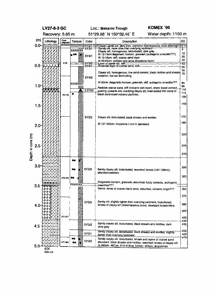
Dept
h in
core
(m
)
1.5-
2.0-
2.5
----- Brownish layer of coarse sand, soft-
5Y3/2
Description
rClavev sandv silt, dark arav. overtvina diatomaceous ooze m issing=p-Sandy silt, more olive than overlying sediment----------------------------Clayey silt, homogenous, bioturbated, dark gray At 12-13cm:diagenetic horizon, greenish (authigenic smectite???)At 15-16cm: stiff, coarse sand layerAt 20-21cm: oebbles and large dropstone (4cm)_________________-Laver of sandv silt, stiff!
Clayey silt, homogenous, low sand content, black mottles and streak! common, but not dominating
At 90cm: diagenetic horizon, greenish, stiff, authigenic smectite???
.Reddish coarse sand, stiff (volcanic ash layer), sharp basal contact,,
.grading upwards into overlying clayey silt; intercalated thin band of . black sand-sized volcanic particles
Clayey silt, bioturbated, black streaks and mottles
At 121-122cm: dropstone (1cm in diameter)
SS
8089110115120
140
170
180
220
240
270
3.0-
3.5
4.0-
4.5
oo <r.y. ee< ■oo<oo<"."vOO i'.'Veo<r.r.
*S: mSS:
§
& ss: xxxxxxxox
SS: SS: SS: SS: SS: SS: SS: SS: SS: SS: SS: 35
5Y3/2 Sandy clayey silt, bioturbated, reworked lenses (131-136cm), abundant pebbles
Diagenetic horizon, greenish, disturbed, fuzzy contacts, authigenic -smectites??? ZBelow: lense of coarse black sand, disturbed, volcanic origin???
290
320
5Y5/2 Sandy silt, slightly lighter than overlying sediment, bioturbated, lenses of clayey silt (diatomaceous ooze), abundant foraminifers
5Y3/2 Sandy clayey silt, bioturbated, black streaks and mottles, dark olive gray
350
370
380
400
420430435
5Y3/1 Sandy clayey silt, bioturbated, black streaks ancf mottles, slightly darker than overlying sediment
5Y3/2
EOC 565 cm
Sandy clayey silt, bioturbated, lenses and layers of coarse sand abundant, black streaks and mottles, reworked lenses of clayey silt At 480cm, 487cm, 510-513cm, 519cm, 555cm: dropstones
450460•470
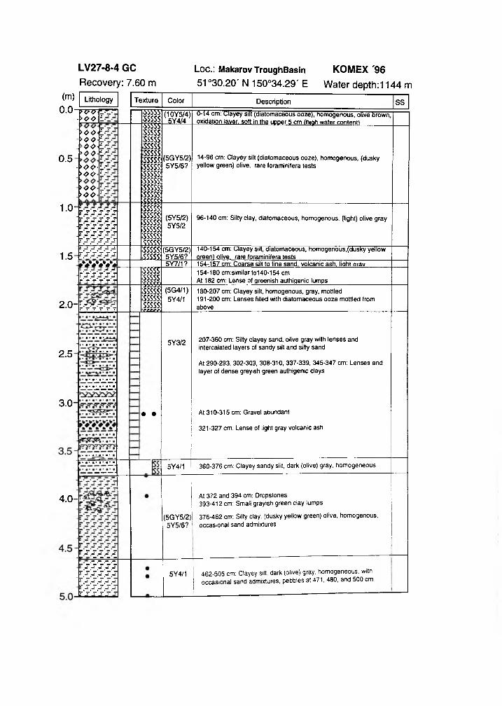
ÏVVÇT. - >ooL-
0.5
1.0-
>oe<L->o o l ->eo<L->ooL-
- >00‘ L- >eeL->OOL->oo i -
55555!sssss:5SSSSsssss: sssss: sssss: sssss: sssss: sssss:SSSSS:SSSSS:sssss:sssss:SSSSS
(10Y5/4)5Y4/4
(5GY5/2)5Y5/6?
0-14 cm: Clayey silt (diatomaceous ooze), homogenous, olive brown oxidation layer, soft in the upper 5 cm (high water content!_________
14-96 cm: Clayey silt (diatomaceous ooze), homogenous, (dusky yellow green) olive, rare foraminifera tests
SSSSS:sssss:sssss:sssss:sssss:sssss:
(5Y5/2)5Y5/2
96-140 cm: Silty day, diatomaceous, homogenous, (light) olive gray
140-154 cm: Clayey silt, diatomaceous, homogenous,(dusky yellow green) olive, rare foraminifera tests1.5-E
W W Wsssss:SSSS£
(5GY5/2)5Y5/6?
S5SÏÏSSSSSSSSSS
5Y7/1? 154-157 cm: Coarse silt to fine sand, volcanic ash, light orav154-180 cm:similar to140-154 cmAt 182 cm: Lense of greenish authigenic lumps
2 .0 - L
sssss:sssss:sssss:c£crfi
(5G4/1)5Y4/1
180-207 cm: Clayey silt, homogenous, gray, mottled191-200 cm: Lenses filled with diatomaceous ooze mottled fromabove
2.5
3.0-
5Y3/2
• •
207-360 cm: Silty clayey sand, olive gray with lenses and intercalated layers of sandy silt and silty sand
At 290-293, 302-303, 308-310, 337-339, 345-347 cm: Lenses and layer of dense greyish green authigenic clays
At 310-315 cm: Gravel abundant
321-327 cm: Lense of light gray volcanic ash
4 .0 -L-
5Y4/1 360-376 cm: Clayey sandy silt, dark (olive) gray, homogeneous
(5GY5/2)5Y5/6?
- s s s s s- — S S S S -
s 's 's 's 's r's's's's's ' r's's's's's -'s's's's's
ir's’s ' s 'j
At 372 and 394 cm: Dropstones 393-412 cm: Small grayish green clay lumps
376-462 cm: Silty clay, (dusky yellow green) olive, homogenous, occasional sand admixtures
5Y4/1 462-505 cm: Clayey silt, dark (olive) gray, homogeneous, with occasional sand admixtures, pebbles at 471, 480, and 500 cm
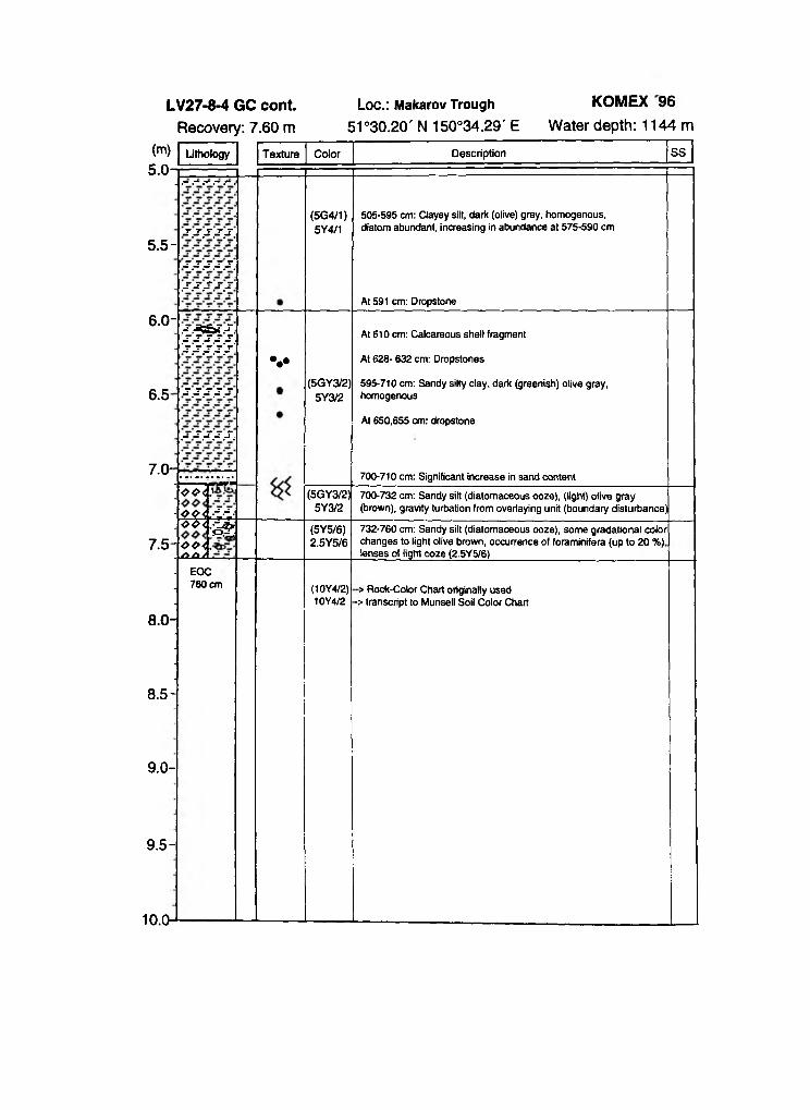
Loc.: Makarov Trough KOMEX 9651°30.20' N 150°34.29' E Water depth: 1144 m
5.5-j\j\j -.j\j\
■J\J-.J\J\J\
.-r.J -.---r._-
(5G4/1)5Y4/1
505-595 cm: Clayey silt, dark (olive) gray, homogenous, diatom abundant, increasing in abundance at 575-590 cm
At 591 cm: Dropstone
6.0-
6.5
7.0-
7.5
imi:J\J\J\J\J-
J-.J-.J-.J-.--
.-■-r.J-.J-.-r..
oo<.'
W :
V(5GY3/2)
5Y3/2
At 610 cm: Calcareous shell fragment
At 628- 632 cm: Dropstones
595-710 cm: Sandy silty clay, dark (greenish) olive gray, homogenous
At 650,655 cm: dropstone
700-710 cm: Significant increase in sand content
i(5GY3/2)
5Y3/2700-732 cm: Sandy silt (diatomaceous ooze), (light) olive gray (brown), gravity turbation from overlaying unit (boundary disturbance)
oo<.£UXi
(5Y5/6)2.5Y5/6
732-760 cm: Sandy silt (diatomaceous ooze), some gradational color changes to light olive brown, occurrence of foraminifera (up to 20 %) lenses of light ooze (2.5Y5/6)__________________________________
EOC 760 cm (10Y4/2)
10Y4/2> Rock-Color Chart originally used
-> transcript to Munsell Soil Color Chart
8.0-
8.5-
9.0-
9.5-
10.0-
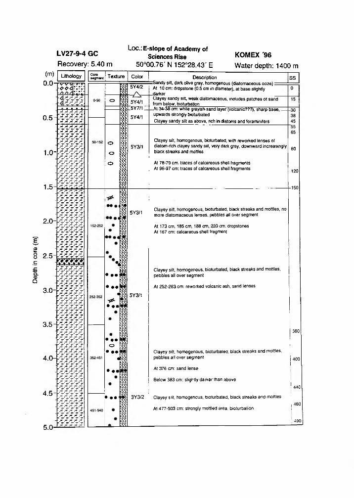
Dept
h in
core
(m
)
Loc.: E-slope of Academy of Sciences Rise
50°00.76' N 152°28.43' E
0.5
1.0-
1.5
2.0-
2.5
LithoiogyV v vOOC
3.0-
3.5
4.0-
4.5
Coresegment Texture
o
o
o
>SS!;ss:;ss:;ss:;ss:;ss:;ss:;ss:;ss:ESS:;ss;ss;ss;ss:;ss:;ss:
;ss:;ss«;»;ss
• ••
• ••«
• ••
• ••o
• ••4:
• ••
• ••
;ss ss. ss- . CSS V s s ;ss
Color
5Y4/2
-¿V -5Y4/1 :5Y7/1 :
5Y4/1
5Y3/1
5Y3/1
5Y3/1
3Y3/2
DescriptionrSandy silt, dark olive gray, homogenous (diatomaceous ooze) “ At 10 cm: dropstone (0.5 cm in diameter), at base slightly
.darker __Clayey sandy silt, weak diatomaceous, includes patches ot sand from below, bioturbationW 34-38 cm: white grayish sand layer (volcanic???), sharp base, upwards strongly bioturbatedClayey sandy silt as above, rich in diatoms and foraminifers
Clayey silt, homogenous, bioturbated, with reworked lenses of diatom-rich clayey sandy silt, very dark gray, downward increasingly black streaks and mottles
At 78-79 cm: traces of calcareous shell fragments At 96-97 cm: traces of calcareous shell fragments
Clayey silt, homogenous, bioturbated, black streaks and mottles, no more diatomaceous lenses, pebbles all over segment
At 173 cm, 185 cm, 188 cm, 220 cm: dropstones At 167 cm: calcareous shell fragment
Clayey silt, homogenous, bioturbated, black streaks and mottles, pebbles all over segment
At 252-263 cm: reworked volcanic ash, sand lenses
SS
Clayey silt, homogenous, bioturbated, black streaks and mottles, pebbles all over segment
At 376 cm: sand lense
Below 383 cm: slightly darker than above
Clayey silt, homogenous, bioturbated, black streaks and mottles
At 477-503 cm: strongly mottled area, bioturbation
80
120
150
360
400
440
460
! 490
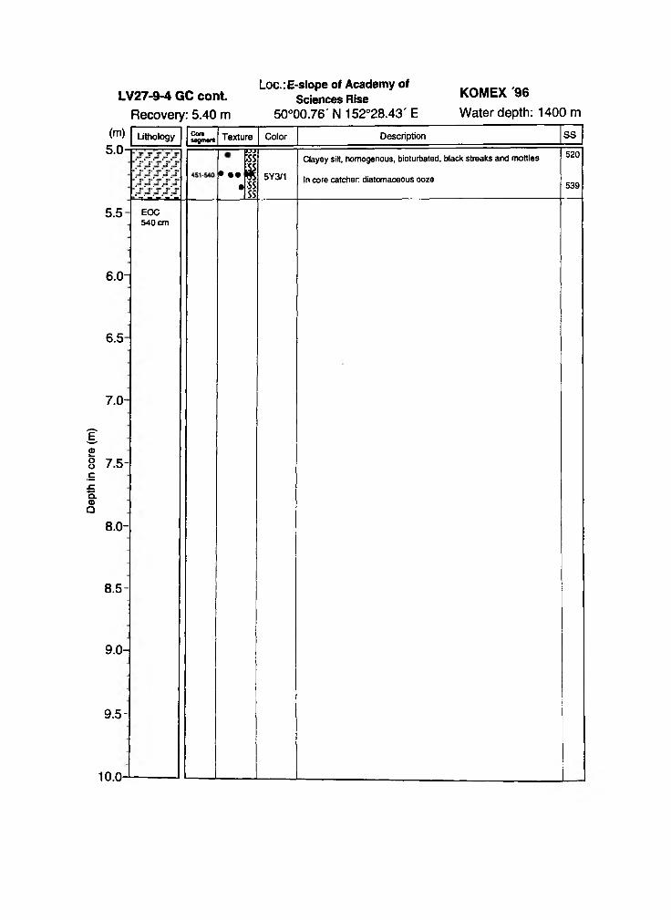
Dept
h in
core
(m
)Loc.: E-slope of Academy of
LV27-9-4 GC cont. Sciences Rise50°00.76' N 152°28.43' E Water depth: 1400 m
KOMEX '96
Recovery: 5.40 mCoresogmant
i— F5]1 ;ss► . . s
• I5Y3/1
Clayey silt, homogenous, bioturbated, black streaks and mottles
In core catcher diatomaceous ooze
520
539
5.5
6.0-
6.5
7.0-
7.5-
8.0-
8.5-
9.0-
9.5-
10. 0-
EOC 540 cm
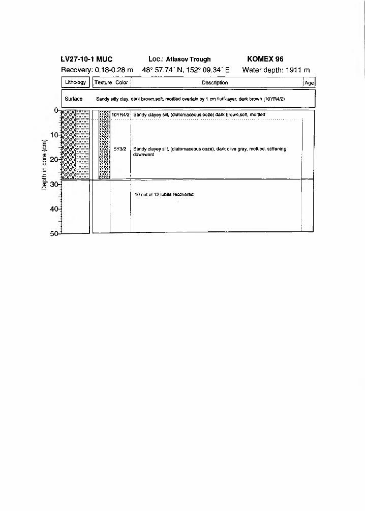
Dept
h in
core
(c
m)
LV27-10-1 MUC Loc.: A t l a s o v T r o u g h
Recovery: 0.18-0.28 m 48° 57.74' N, 152° 09.34' E
Lithology Texture Color Description Age
Surface
On
Sandy silty clay, dark brown,soft, mottled overlain by 1 cm fluff-layer, dark brown (10YR4/2)
m -
2 o m - -: W < --- — • ■ • •
sSLml
ssssssssssssssssssssssssSSSSssssssssssssssssssssssss
10YR4/2
5Y3/2
Sandy clayey silt, (diatomaceous ooze) dark brown.soft, mottled
Sandy clayey silt, (diatomaceous ooze), dark olive gray, mottled, stiffening downward
30-
40:
10 out of 12 tubes recovered
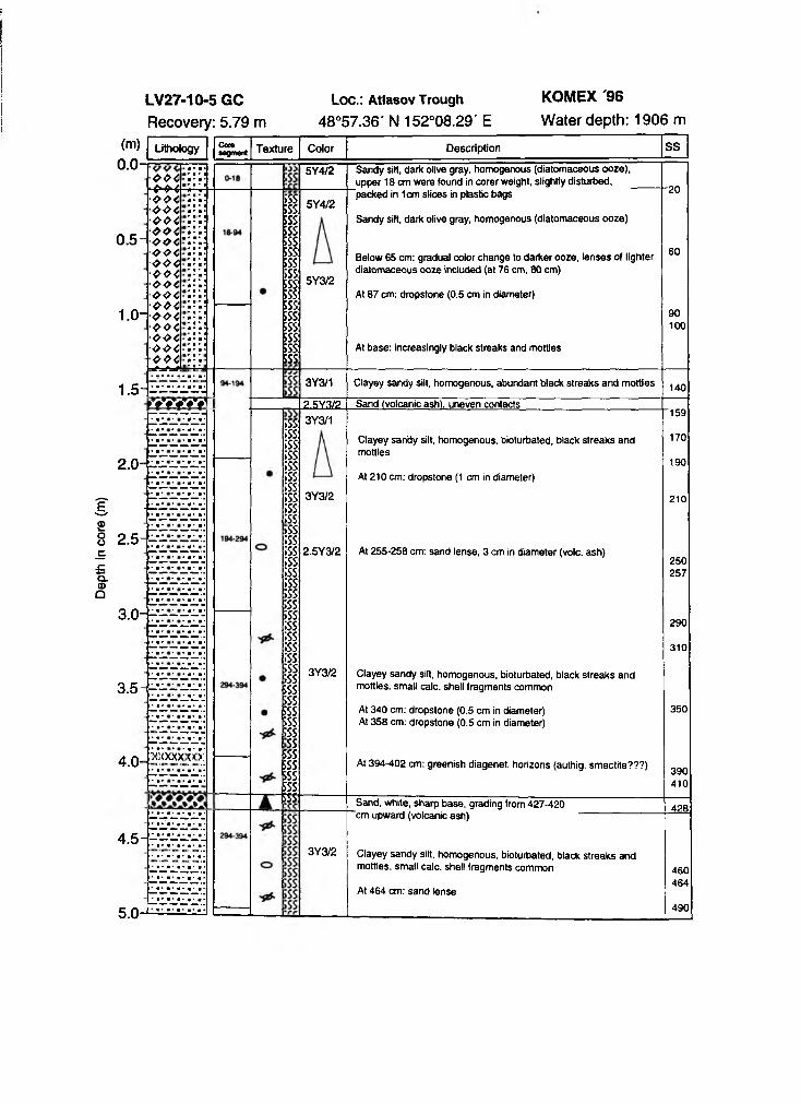
Dept
h in
core
(m
)Loc.: A t i a s o v T r o u g h
48°57.36' N 152°08.29' E
KOMEX '96
Water depth: 1906 m(m)0.0-
0.5-
1.0-
Lithology
oo40-^4oo4004004oo<oo<oo<OOC004004004004004004004004004*=*=*
Camsegment Texture
;ssSSS.5SSÎSSESSsss:ESS¡SS:SSS:SSS:sss:SSS:sss:SSS:sss:SSS:
Color
5Y4/2
5Y4/2
5Y3/2
Description SS
Sandy silt, dark olive gray, homogenous (diatomaceous ooze), upper 18 cm were found in corer weight, slightly disturbed, packed in 1cm slices in plastic bags
Sandy silt, dark olive gray, homogenous (diatomaceous ooze)
Below 65 cm: gradual color change to darker ooze, lenses of lighter diatomaceous ooze included (at 76 cm, 80 cm)
At 87 cm: dropstone (0.5 cm in diameter)
At base: increasingly black streaks and mottles
20
60
90100
1.5-
2.0-
m w i i3Y3/1 Clayey sandy silt, homogenous, abundant black streaks and mottles
2.5-
3.0-
3.5
4.0-
4.5
5.0-
XXX
>ss:;ss:;ss:;ss;ss;ss;ss;ss;ss;ss>ss;ss;ss;ss;ss;ssÏSS;ssÏSS;ss;ss;ss;ss;ss;sssss;sssss5SS;ssssssssssssssssss?
Z5Y3Z2 Sand (volcanic ash), uneven contacts3Y3/1
3Y3/2
2.5Y3/2
Clayey sandy silt, homogenous, bioturbated, black streaks and mottles
At 210 cm: dropstone (1 cm in diameter)
At 255-258 cm: sand lense, 3 cm in diameter (vole, ash)
3Y3/2 Clayey sandy silt, homogenous, bioturbated, black streaks and mottles, small calc, shell fragments common
At 340 cm: dropstone (0.5 cm in diameter)At 358 cm: dropstone (0.5 cm in diameter)
At 394-402 cm: greenish diagenet. horizons (authig. smectite???)
Sand, white, sharp base, grading from 427-420 "cm upward (volcanic ash)
3Y3/2 Clayey sandy silt, homogenous, bioturbated, black streaks and mottles, small calc, shell fragments common
At 464 cm: sand lense
140
159
170
190
210
250257
290
310
350
390410
428
460464
490
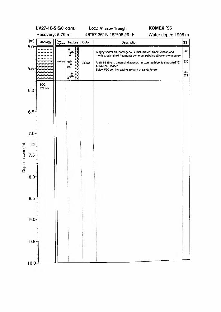
Dept
h in
core
(m
)L o c . : A t l a s o v T r o u g h
4 8 ° 5 7 . 3 6 ' N 1 5 2 ° 0 8 . 2 9 ' E
5 . 5
6.0-
Cor«sagmant
3Y3/2
Clayey sandy silt, homogenous, bioturbated, black streaks and mottles, calc, shell fragments common, pebbles all over the segment
At 514-515 cm: greenish diagenet. horizon (authigenic smectite???) At 546 cm: lensesBelow 550 cm: increasing amount of sandy layers
500
530
560579
EOC 579 cm
6 . 5 -
7 . 0 -
7 . 5 -
8.0-
8 . 5
9 . 0 -
9 . 5 -
10.0 -
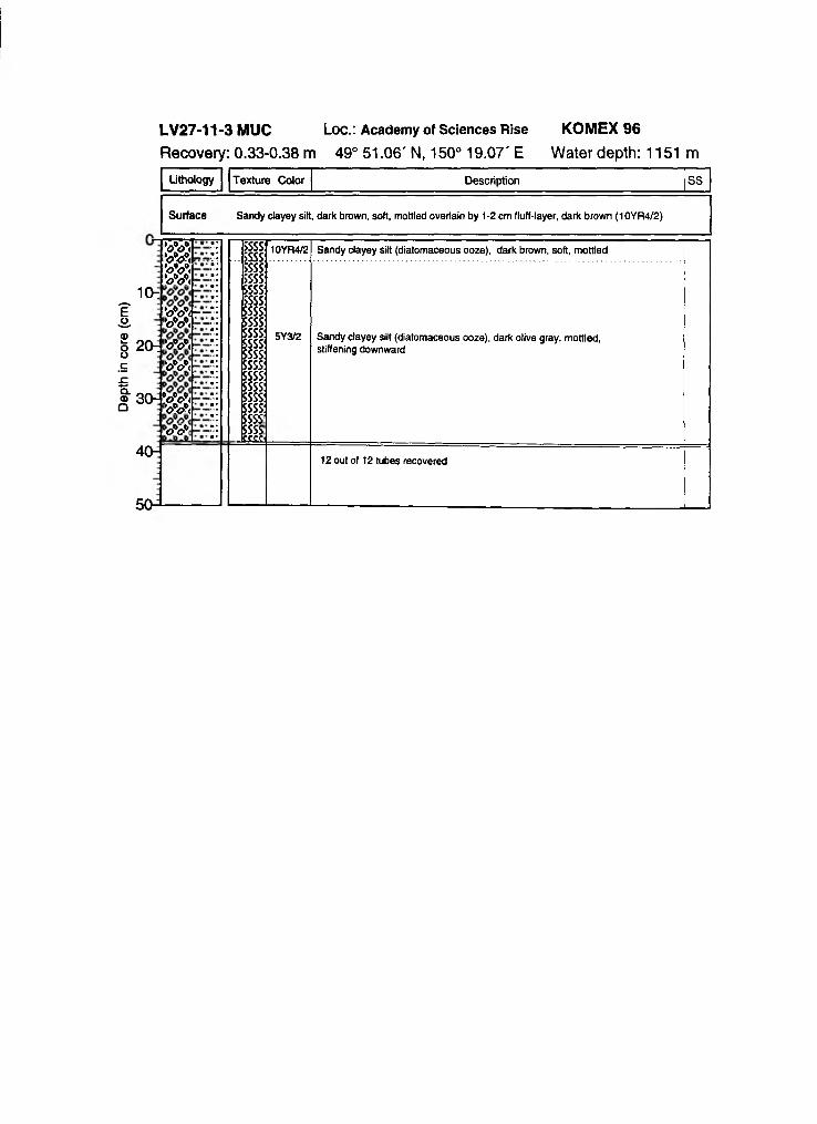
Dept
h in
core
(cm
)LV27-11-3 MUC Loc.: Academ y of Sciences R ise KOMEX 96 Recovery: 0.33-0.38 m 49° 51.06' N, 150° 19.07' E Water depth: 1151 m
Lithology Texture Color Description SS
Surface Sandy clayey silt, dark brawn, soft, mottled overlain by 1-2 cm fluff-layer, dark brown (10YR4/2)
10t
20-;
30-?«
W < *oV< 'oV< W <
'o'o'&r-W , W , “oV,
oW '¿>V<©V
5SSS:ssss:ssss:ssss:SSSS!ssss:SSSS!ssss:ssss:SSSS!SSSS!ssss;ssss!ssss;ssssissss;ssssssss:ccci
10YR4/2
5Y3/2
Sandy clayey silt (diatomaceous ooze), dark brown, soft, mottled
Sandy clayey silt (diatomaceous ooze), dark olive gray, mottled, stiffening downward
12 out of 12 tubes recovered
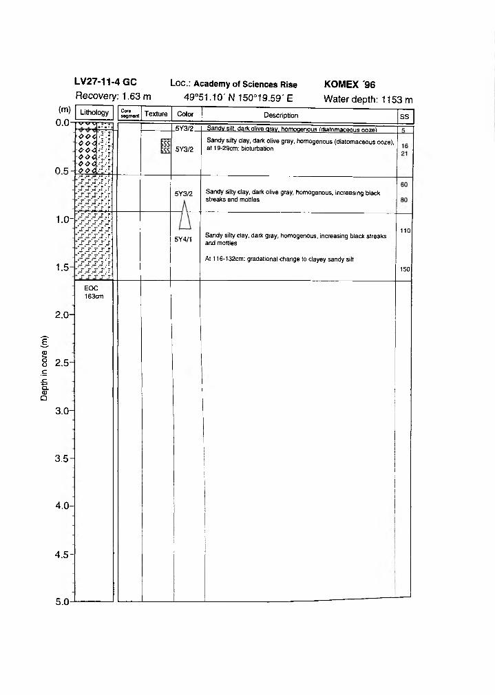
Dept
h in
core
(m
)
LV27-11-4 GC Loc.: Academ y of Sciences Rise KOMEX '96Recovery: 1.63 m 49°51.10' N 150°19.59' E Water depth: 1153 m
V V V
004004 004 004 004
0 R - 004
1.0-
1.5-
Core segment
.5Y3/2.
5Y3/2
5Y3/2
5Y4/1
Sandy silt, dark olive gray, homogenous (diatomaceous ooze!
Sandy silty clay, dark olive gray, homogenous (diatomaceous ooze), at 19-29cm: bioturbation
Sandy silty clay, dark olive gray, homogenous, increasing black streaks and mottles
Sandy silty clay, dark gray, homogenous, increasing black streaks and mottles
At 116-132cm: gradational change to clayey sandy silt
110
150
EOC163cm
2.0-
2.5-
3.0-
3.5-
4.0-
4.5 -
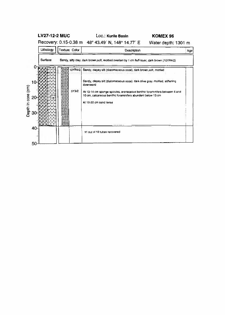
Dept
h in
core
(c
m)
LV27-12-2 MUC Loc.: Kurile Basin
Recovery: 0.15-0.38 m 48° 43.49' N, 148° 14.77' E
Lithology Texture Color Description Age
Surface Sandy, silty clay, dark brown,soft, mottled overlain by 1 cm fluff-layer, dark brown (10YR4/2)
JoVi■w<w <w <■w<•w<■w<■w ,
w <’W i■W<w .■ w0 - 0 -0
10-
30-!
ssssssssssssssssssssssssssssssssSSSS:SSSS:SSSS:SSSS:ssssssssssssssssssssssss
10YR4/2
5Y3/2
Sandy, clayey silt (diatomaceous ooze), dark brown,soft, mottled
Sandy, clayey silt (diatomaceous ooze), dark olive gray, mottled, stiffening downward
At 13-14 cm sponge spicules, arenaceous benthic foraminifers between 6 and 10 cm, calcareous benthic foraminifers abundant below 13 cm
At 19-20 cm sand lense
40-11 out of 12 tubes recovered
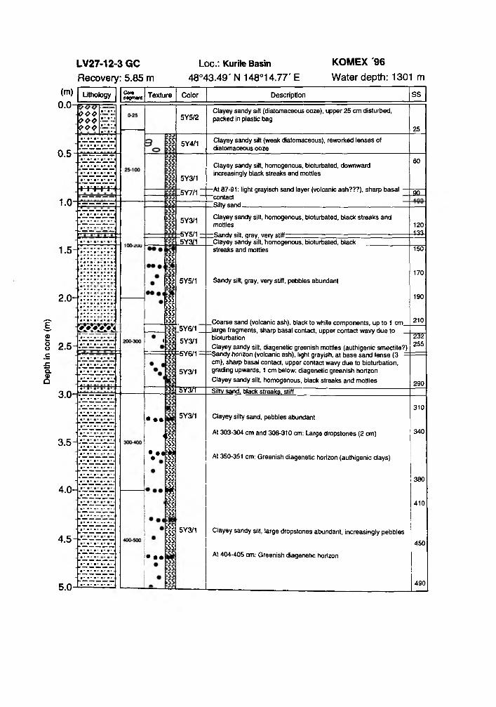
Dept
h in
core
(m
)
Loc.: Kurile Basin 48°43.49' N 148°14.77' E
o e eoeoooo
0.5
1.0-
1.5
2.0-
2.5
3.0-
3.5
4.0-
4.5
I 'l l I >
Corasegment
00000(1
;ss
>ss ;ss|ss ;ss5SS;ss;ss <;ss>55
iSS
• ••
4SS;ssv*S;ss ;ss ;ss
% ;ss :ss ;ss;ss ;ss ;ss ;ss
• ••
5Y4/1
5Y3/1
[5Y7/1 ;
5Y3/1
-5Y5/1 - 5Y3/1
5Y5/1
5Y3/1
5Y6/1
5Y3/1
O TT
5Y3/1
5Y3/1
Clayey sandy silt (diatomaceous ooze), upper 25 cm disturbed, packed in plastic bag
Clayey sandy silt (weak diatomaceous), reworked lenses of diatomaceous ooze
Clayey sandy silt, homogenous, bioturbated, downward increasingly black streaks and mottles
-At 87-91: light grayisch sand layer (volcanic ash???), sharp basal ‘ contact.Silty sand_________________________________________________
Clayey sandy silt, homogenous, bioturbated, black streaks and mottles
iSandy silt, gray, very stiff:_Clayey sandy silt, homogenous, bioturbated, black streaks and mottles
Sandy silt, gray, very stiff, pebbles abundant
Coarse sand (volcanic ash), black to white components, up to 1 cm_5Y6/1___ large fragments, sharp basal contact, upper contact wavy due to
bioturbationClayey sandy silt, diagenetic greenish mottles (authigenic smectite?)
:Sandy horizon (volcanic ash), light grayish, at base sand lense (3 = cm), sharp basal contact, upper contact wavy due to bioturbation, grading upwards, 1 cm below: diagenetic greenish horizon Clayey sandy silt, homogenous, black streaks and mottlesSiltv sand, black streaks, stiff
Clayey silty sand, pebbles abundant
At 303-304 cm and 308-310 cm: Large dropstones (2 cm)
At 350-351 cm: Greenish diagenetic horizon (authigenic clays)
60
3Q_
120133.
150
170
190
210
232255
290
Clayey sandy silt, large dropstones abundant, increasingly pebbles
At 404-405 cm: Greenish diagenetic horizon
310
340
380
410
450
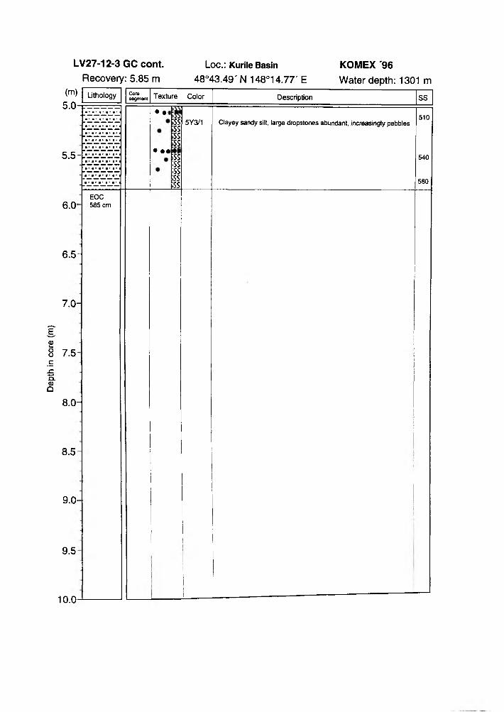
Dept
h in
core
(m
)
(m)
Loc.: Kurile Basin KOMEX '9648°43.49' N 148°14.77' E Water depth: 1301 m
5.0-
5.5-
Lithology Coresegment Texture
• •<
• ••
ssssssss*s;ss;ssssss
Color
5Y3/1
Description
Clayey sandy silt, large dropstones abundant, increasingly pebbles
SS
510
540
580
6.0-
6.5-
7.0-
7.5
8.0-
8.5
9.0-
9.5
EOC 585 cm
10.0
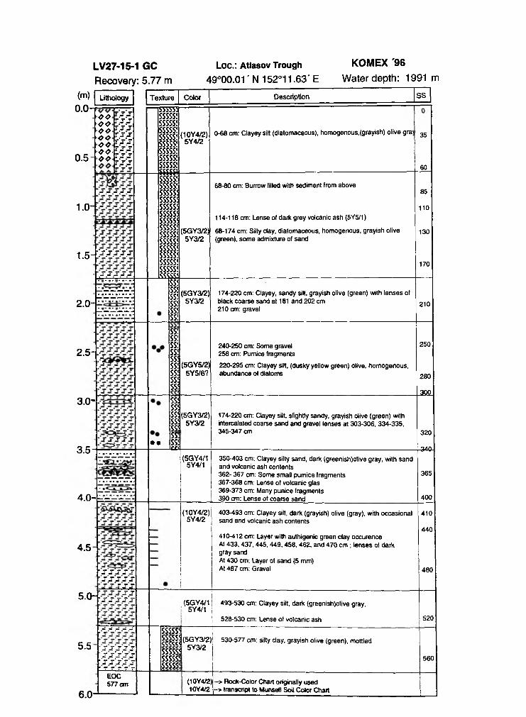
LV27-15-1 GC Loe.: Atlasov Trough KOMEX '96Recovery: 5.77 m 49°00.01 ' N 152°11.63' E Water depth: 1991 m
Lithology
0.5
1.0-
O G '-11 O O L l l <>0 L i “ O <> i.-" 1 OO L ' l ^ • L l l 0<> Ld-i
L 'l-i
1555553SSSSS!sssss;SSSSS!SSSSSÍSSSSSÍSSSSSÍSSSSS!SSSSS!sosa
(10Y4/2)5Y4/2
0-68 cm: Clayey silt (diatomaceous), homogenous, (grayish) olive g raj 35
60
1.5
SSSSS!SSSSS!SSSSS!SSSSS!SSSSS!SSSSS!SSSSS!SSSSS!SSSSSÍSSSSS!SSSSS!SSSSS!SSSSS!SSSSS!lSSSSSJ
(5GY3/2)5Y3/2
68-80 cm: Burrow filled with sediment from above
114-118 cm: Lense of dark grey volcanic ash (5Y5/1)
68-174 cm: Silty clay, diatomaceous, homogenous, grayish olive (green), some admixture of sand
85
110
130
170
2.0-
SS!SS!SS!SS!SS!SS!
SS!SS!SS!SS!SSÍSS!SS!SS!SS
(5GY3/2)5Y3/2
174-220 cm: Clayey, sandy silt, grayish olive (green) with lenses of black coarse sand at 181 and 202 cm 210 cm: gravel
210
2.5-•1 (5GY5/2)
5Y5/6?
240-250 cm: Some gravel 258 cm: Pumice fragments
220-295 cm: Clayey silt, (dusky yellow green) olive, homogenous, abundance of diatoms
250
280
JQQ.3.0-
3.5• •
SSLSS5rsstSSSS!££i
[5GY3/2)5Y3/2
174-220 cm: Clayey silt, slightly sandy, grayish olive (green) with intercalated coarse sand and gravel lenses at 303-306, 334-335, 345-347 cm 320
-34a
4.0- - - - - -
(5GY4/15Y4/1
350-403 cm: Clayey silty sand, dark (greenish)olive gray, with sandand volcanic ash contents362- 367 cm: Some small pumice fragments367-368 cm: Lense of volcanic glas369-373 cm: Many punice fragments390 cm: Lense of coarse sand
365
400
4.5
r.sssssS S S S S
m
(10Y4/2)5Y4/2
403-493 cm: Clayey silt, dark (grayish) olive (gray), with occasional sand and volcanic ash contents
410-412 cm: Layer with authigenic green clay occurence At 433,437,445,449,458, 462, and 470 cm ; lenses of dark gray sandAt 430 city. Layer of sand (5 mm)At 487 cm: Gravel
410
440
480
5.0- r.r.r.r.r.r
5.5
6.0
>v.-V .-T.
■ s s s s s~'.ss[s:ss[ S S S S S ■ r T r T y
(5GY4/1 ! 5Y4/1
493-530 cm: Clayey sät, dark (greenish)olive gray,
528-530 cm: Lense of volcanic ash 520
SSSSS-, lcciil<SGY3/2>ejY'i/oSSSSS? 5 3 / 2sssss: sssss:
530-577 cm: silty clay, grayish olive (green), mottled
560
EOC 577 cm (10Y4/2)
10Y4/2-> Rock-Color Chart originally used -» transcript to Munsetl Soil Color Chart
Appendix VI Magnetic susceptibility and humidity
records of all sites
Station 1
LV27-1-3Magnetic susceptibility
(SI x 10-5)
LV27-1-3Magnetic susceptibility
(cgsx 10"6)0 5 10 15 30 40 50 60 70
Station 1 aLV27-1a-1
Magnetic susceptibility
(cgs x 10'6)
LV27-1a-1Humidity
(%)
LV27-2-3Magnetic susceptibility
(SI x 10'5)
LV27-2-4Magnetic susceptibility
(cgsx 10 '6)0 5 10 15 20
LV27-2-4Humidity
(%)50 60 70 80 90 100
LV27-3-3Magnetic susceptibility
(SI x 10 s)15 20 25 30 35
Station 3LV27-3-3
Magnetic susceptibility
(cgsx 10 '6)5 10 15 20 25
LV27-3-3Humidity
(%>20 30 40 50 60
LV27-4-3Magnetic susceptibility
(SI Units)200 300 400 500
LV27-4-4Magnetic susceptibility
(cgs x 10"6)100 200 300 20 30 40 50 60
Station 5LV27-5-4
Magnetic susceptibility
(S ix 10'5)
LV27-5-3Magnetic susceptibility
(cgs x 10 '6)0 200 400
LV27-6-3Magnetic susceptibility
(SI x 10-5)100 300 500
LV27-6-4Magnetic susceptibility
(cgs x 10'6)100 200 300 400 10 20 30 40 50 60 70
LV27-7-3Magnetic susceptibility
(SI x 10 s)50 150 250 350
Station 7LV27-7-3
Magnetic susceptibility
(cgs x lO-6)0 50 100 150 200 250
LV27-7-3Humidity
(%)20 30 40 50 60 70
LV27-8-3 LV27-8-4Magnetic susceptibility
Station 9LV27-9-4
Magnetic susceptibility
(SI x 10 s)100 200 300
Humidity(%)
30 40 50 60 70 80 90
700 " i | { { | "
gQQ In n l n n l i i n l i i in
LV27-9-3Magnetic susceptibility
(cgsx 10"6)50 100 150 200
j - i i - i 11 ■ ■ ■ 11 ... I ,
100
200
300
400
500
600
LV27-10-5Magnetic susceptibility
(SI x 10-5)100 300 500
LV27-15-1Magnetic susceptibility
(cgsx 10"®)
LV27-11-4Magnetic susceptibility
(Six 10'5)0 50 100 150
Station 12LV27-12-3
Magnetic susceptibility
(SI x 10-5)0 100 200 300
LV27-12-4Magnetic susceptibility
(cgs x 10'6)0 100 200 300
GEOMAR REPORTS
1 GEOMAR FORSCHUNGSZENTRUM FÜR MARINE GEOWISSENSCHAFTEN DER CHRISTIAN-ALBRECHTS-UNIVERSITÄT ZU KIEL BERICHT FÜR OIE JAHRE 1987 UND 1988.1989. 71 + 6 pp.In German
2 GEOMAR FORSCHUNGSZENTRUM FÜR MARINE GEOW ISSENSCHAFTEN OER CHRISTJAN-ALBRECHTS-UNIVERSfTÄT ZU KJEL JAHRESBERICHT/ ANNUAL REPORT 1989. 1990. 96 pp.In German and English
3 GEOMAR FORSCHUNGSZENTRUM FÜR MARINE GEOW ISSENSCHAFTEN DER CHRISTI AN-ALBRECHTS-UNIVERSITÄT ZU KIEL JAHRESBERICHT / ANNUAL REPORT 1990. 1991. 212 pp.In German and English
4 ROBERT F. SPIELHAGENDIE EISDRIFT IN DER FRAMSTRASSE W ÄHREND DER LETZTEN 200.000 JAHRE. 1991. 133 pp.In German with English summary
5 THOMAS C. W . W OLFPALÄO-OZEANOGRAPHISCH-KLIMATISCHE ENTWICKLUNG DES NÖRDLICHEN NORDATLANTIKS SEIT DEM SPÄTEN NEOGEN (OOP LEGS 105 UND 104. DSDP LEG 81). 1991. 92 pp.In German with English summary
6 SEISMIC STUDIES OF LATERALLY HETEROGENOUS STRUCTURES - INTERPRETATION AND MODELLING OF SEISMIC DATA Edited by ER NST R. FLUEHCommission on Controlled Source Seismology (CCSS), Proceedings of the 8th Workshop Meeting, held at Kiel • Fellhorst (Germany), August 27-31, 1990. 1991. 359 pp.In English
7 JENS MATTHIESSENDINOFLAGELLATEN-ZYSTEN IM SPÄTQUARTÄR DES EUROPÄISCHEN NORDMEERES: PALÖKOLOGIE UND PALÄO-OZEANOGRAPHIE. 1991 104 PP In German with English summary
8 DIRK NÜRNBERGHAUPT- UND SPURENELEM ENTE IN FORAMINIFERENGEHÄUSEN - HINWEISE AUF KLIMATISCHE UND OZEANOGRAPHISCHE ÄNDERUNGEN IM NÖRDLICHEN NORDATLANTIK W ÄHREND DES SPÄTQUARTÄRS. 1991. 117 pp.In German with English summary
9 KLAS S. LACKSCHEW ITZSEDIMENTATIONSPROZESSE AM AKTIVEN MITTELOZEANISCHEN KOLBEINSEY RÜCKEN ( NÖRDLICH VON ISLAND) 1991 133 pp In German with English summary
10 UW E PA G ELSSEDIMENTOLOGISCHE UNTERSUCHUNGEN UND BESTIMMUNG DER KARBONATLÖSUNG IN SPÄTQUARTÄREN SEDIMENTEN DES ÖSTLICHEN ARKTISCHEN OZEANS. 1991. 106 pp.In German with English summary
11 FS POSEIDON - EXPEDITION 175 (9.10.-1.11.1990)175/1: OSTGRÖNLÄNDISCHER KONTINENTALRAND (65* N)175/2: SEDIMENTATION AM KOLBEINSEYRÜCKEN (NÖRDLICH VON ISLAND)Hrsg. von J. MIENERT und H.-J. W ALLRABE-ADAMS. 1992. 56 pp. + app.In German with some English chapters
12 GEOMAR FORSCHUNGSZENTRUM FÜR MARINE GEOW ISSENSCHAFTEN OER CHRIST1AN-ALBRECHTS-UNIVERSITÄT ZU KIEL JAHRESBERICHT/ ANNUAL REPORT 1991. 1992. 152 pp.In German and English
13 SABINE E. I. KÖHLERSPÄTQUARTÄRE PALÄO-OZEANOGRAPHISCHE ENTW ICKLUNG DES NORDPOLARMEERES UND EUROPÄISCHEN NORDMEERES ANHAND VON SAUERSTOFF- UND KOHLENSTOFF- ISOTOTPENVERHÄLTNISSEN DER PLANKT1SCHEN FORAMINIFERE Neogbboquadnna pachyderma (sin.). 1992. 104 pp.In German with English summary
14 FS SONNE - FAHRTBERICHT SO 78 PERUVENT: BALBOA, PANAMA - BALSOA, PANAMA, 28.2.1992-16 4.1992 Hrsg. von ERWIN SUESS. 1992. 120 pp.In German with some English chapters
15 FOURTH INTERNATIONAL CONFERENCE ON PALEOCEANOGRAPHY (ICP IV): SHORT- AND LONG-TERM GLOBAL CHANGE RECORDS AND MODELLING 21-25 SEPTEM BER 1992, KIEL/GERMANYPROGRAM & ABSTRACTS. 1992. 351 pp.In English
16 MICHAELA KUBISCHDIE EISDRIFT IM ARKTISCHEN OZEAN W ÄHREND DER LETZTEN 250 000 JAHRE. 1992. 100 pp.In German with English summary
17 PERSISCHER GOLF UMWELTGEFÄHRDUNG. SCHADENSERKENNUNG. SCHADENSBEW ERTUNG AM BEISPIEL DES MEERESBODENS; ERKENNEN EINER ÖKOSYSTEMVERÄNOERUNG NACH ÖLEINTRÄGEN. Schlußbencht iu den beiden BMFT-Forschungsvorhaben 03F0C55 A *B 1993 108 pptn German with English summary
18 TEKTONISCHE ENTW ÄSSERUNG AN KONVERGENTEN PLATTENRANOERN / DEWATERING AT CONTINENTAL MARGINS Hrsg von / ed. by ERWIN SUESS 1993. 106 + 32 + 68 * 16 ♦ 22 ♦ 38 ♦ 4 ♦ 19 ppSome chapters in English, some in German
19
20
21
22
23
24
29
26
27
28
29
30
31
32
33
34
35
36
37
38
39
THOMAS DICKMANNDAS KONZEPT DER POLARISATIONSMETHODE UND SEINE ANWENDUNGEN AUF DAS SEIMISCHE VEKTORW ELLENFELD IM WEfTW lNKELBEREICR 1993. 121 pp.In German with English summary
GEOMAR FORSCHUNGSZENTRUM FÜR MARINE GEOW ISSENSCHAFTEN DER CHRISTIAN-ALBRECHTS-UNIVERSITÄT ZU KIEL JAHRESBERICHT / ANNUAL REPORT 1992.1993. 139 pp.In German and English
Ka i U W E SCHMIDTPALYNOMORPHE IM NEOGENEN NORDATLANT1K - HINWEISE ZUR PALÄO-OZEANOGRAPHIE UND PALÄOKLIMATOLOGIE. 1993. 104 + 7 * 41 pp.In German with English summary
UW E JORGEN GRÜTZMACHERDIE VERÄNDERUNGEN DER PALAOGEOGRAPHISCHEN VERBREITUNG VON BQLBOFORM A ■ EIN BEITRAG ZUR REKONSTRUKTION UND DEFINITION VON WASSERMASSEN IM TERTIÄR.1993. 104 pp.In German with English summary
RV PROFESSOR LOGACHEV - Research Cruise 09 (August 30 - September 17,1993): SEDIMENT DISTRIBUTION ON TH E REYKJANES RIDGE NEAR 59"N Edited by H.-J. WALLRABE-ADAMS & K.S. LACKSCHEWFTZ. 1993. 66 + 30 pp.In English
ANDREAS DEITMERDIATOMEEN-TAPHOZÖNOSEN ALS ANZEIGER PALÄO-OZEANOGRAPHISCHER ENTWICKLUNGEN IM PLIOZÄNEN UND QUARTÄREN NORDATLANTIK. 1993. 113 + 10 + 25 pp. tn German with EngRsh summary
GEOMAR FORSCHUNGSZENTRUM FÜR MARINE GEOW ISSENSCHAFTEN DER CHRISTI AN-ALBRECHTS-UNIVERSITÄT ZU KIEL JAHRESBERICHT / ANNUAL REPORT 1993. 1994. 69 pp.In German and English
JÖRG BIALASSEISMISCHE MESSUNGEN UND W EITERE GEOPHYSIKALISCHE UNTERSUCHUNGEN AM SÜD-SHETLAND TRENCH UND IN DER BRANSFIELD STRASSE - ANTARKTISCHE HALBINSEL 1994.113 pp.In German with English summary
JA N E T M ARGARET SUMNERTH E TRANSPORT AND DEPOSfTIONAL MECHANISM OF HIGH GRADE MIXED-MAGMA IGNIMBRITE TL, GRAN CANARIA:TH E MORPHOLOGY O F A LAVA-UKE FLOW. 1994. 224 pp.In English with German summary
GEOMAR LfTHOTHEK. Edited by JÜRGEN MIENERT. 1994. 12 pp + app.In English
FS SONNE - FAHRTBERICHT SO 97 KOOIAK-VENT: KODIAK - DUTCH HARBOR - TOKYO ■ SINGAPUR, 27.7 -19.9.1994 Hrsg. von ERWIN SUESS. 1994.Some chapters in German, some in English
CRUISE REPORTS:RV UVONIA CRUISE 92, KJEL-KIEL. 21.8.-17 9.1992: GLORIA STUDIES OF TH E EAST GREENLAND CONTINENTAL MARGIN BETW EEN 70° AND 80°N RV POSEIDON P0200/10, USSON-BREST-BREMERHAVEN, 7.-23.8.1993: EUROPEAN NORTH ATLANTIC MARGIN: SEDIMENT PATHW AYS,
PROCESSES AND FLUXESRV AKADEMtK ALEKSANDR KARPINSKIY, KIEL-TROMS0, 5.-25.7.1994: GAS HYDRATES ON TH E NORTHERN EUROPEAN CONTINENTAL MARGIN
Edited by JURGEN MIENERT. 1994.In English; report of RV AKADEMIK ALEKSANDR KARPINSKIY cruise in English and Russian
MARTIN WE1NELTBECKENENTWICKLUNG DES NÖRDLICHEN WIKING-GRABENS IM KANOZOIKUM - VERSENKUNGSGESCHICHTE. SEQUENZSTRATIGRAPHIE, SEDIMENTZUSAMMENSETZUNG 1994. 85 pp.In German with English summary
GEORG A. HEISSCORAL REEFS IN TH E RED SEA: GROWTH. PRODUCTION AND STABLE ISOTOPES. 1994. 141 pp. in English with German summary
JENS A.HÖLEMANNAKKUMULATION VON AUTOCHTHONEM UND ALLOCHTHONEM ORGANISCHEM MATERIAL IN DEN KANOZOISCHEN SEDIMENTEN DER NORWEGISCHEN SEE (ODP LEG 104). 1994. 78 pp.In German with English summary
CHRISTIAN HASSSEDIMENTOLOGJSCHE UND MiKROPALAONTOLOGISCHE UNTERSUCHUNGEN ZUR ENTWICKLUNG DES SKAGERRAKS (NE NORDSEE)IM SPÄTHOLOZÄN. 1994. in German with English summary
BRITTA JÜNGERTIEFENW ASSERERNEUERUNG IN DER GRÖNLANDSEE W ÄHREND DER LETZTEN 340.000 JAHRE DEEP W ATER RENEWAL IN TH E GREENLAND SEA DURING TH E PAST 340,000 YEARS.1994. 6 +1 09 pp.In German with English summary
JÖ R G K U N ER TUNTERSUCHUNGEN ZU MASSEN- UND FLUIDTR ANSPORT ANHAND DER BEARBEITUNG REFLEXIONSSEISMISCHER DATEN AUS DER KOOIAK-SUBOUKTIONSZONE, ALASKA 1995 129 pp ln German with English summary
CHARLOTTE M. KRAWCZYKDETACHMENT TECTONICS DURING CONTINENTAL RIFTING OFF TH E W E S T IBERIA MARGIN: SEISMIC REFLECTION AND DRILLING CONSTRAINTS. 1995 133 pp in English with German summary
CHRISTINE CAROLINE NÜRNBERGBARIUMFLUSS UND SEDIMENTATION IM SÜDLICHEN SÜDATLANTIK - HINWEISE AUF PROOUKTIViTÄTSANDERUNGEN IM OUARTAR 1995 6 - 108pp ln German with English summary
JÜRGEN FRÜHNTEKTONIK UNO ENTW ÄSSERUNG DES AKTIVEN KONTINENTALRANDES SÜDÖSTLICH DER KENAI-HALBINSEL, ALASKA. 1995 93 pp. ln German with English summary
40
41
42
43
44
45
46
47
48
49
50
51
52
53
54
55
56
GEOMAR FORSCHUNGSZENTRUM FÜR MARINE GEOWISSENSCHAFTEN DER CHRISTIAN-ALBRECHTS-UNIVERSITÄT ZU KIEL JAHRESBERICHT / ANNUAL REPORT 1994. 1995. in German and English
FS SONNE - FAHRTBERICHT / CRUISE REPORT SO 103 CONDOR 1 B: VALPARAISO-VALPARAISO 2 -21 7 1995 Hrsg. von ER NST R. FLUEH. 1995. 140 pp.Some chapters in German, some in English
R/V PROFESSOR BOGOROV CRUISE 37: CRUISE REPORT "POSETIV: Vladivostok - Vladivostok, September 23 - October 22 1994 Edited by CHRISTOPH GAEDICKE, BORIS BARANOV and EVGENIY LELIKOV. 1995. 46 + 33 pp.In English
CHRISTOPH GAEDtCKEDEFORMATION VON SEDIMENTEN IM NANKAI-AKKRETJONSKEIL. JAPAN. BILANZIERUNG TEKTONISCHER VORGÄNGE ANHAND VON SEISMISCHEN PROFILEN UNO ERGEBNISSEN DER ODP-BOHRUNG 806. II + 89 pp.In German with English summary
MARTIN ANTONOWSEDIMENTATIONSMUSTER UM DEN VESTERIS SEAMOUNT (ZENTRALE GRÖNLANDSEE) IN DEN LETZTEN 250.000 JAHREN. 1995.In German with English summary
INTERNATIONAL CONGRESS: CORING FOR GLOBAL CHANGE - ICGC '95. KIEL, 28 - 30 June, 1995.Edited by JÜRGEN MIENERT and GEROLD W EFER. 1996.In English
JENS GRÜTZNERZUR PHYSIKALISCHEN ENTWICKLUNG VON DIAGENETISCHEN HORIZONTEN IN DEN SEDIMENTBECKEN DES ATLANTIKS. 1995. 96 pp.In German with English summary
INGO A. PECHERSEISMIC STUDIES OF BOTTOM SIMULATING REFLECTORS AT THE CONVERGENT MARGINS OFFSHORE PERU AND COSTA RICA. 1996. 159 pp.In English with German summary
XIN SUDEVELOPM ENT OF LATE TERTIARY AND QUATERNARY COCCOLfTH ASSEMBLAGES IN THE NORTHEAST ATLANTIC. 1996. 120 pp. + 7 pi.In English with German summary
FS SONNE - FAHRTBERICHT / CRUISE REPORT SO 108 ORWELL: SAN FRANCISCO - ASTORIA, 14.4. - 23.5.1996 Edited by ER NST R. FLUEH and MICHAEL A. FISHER. 1996
GEOMAR FORSCHUNGSZENTRUM FÜR MARINE GEOWISSENSCHAFTEN DER CHRISTIAN-ALBRECHTS-UNIVERSITÄT ZU KIEL JAHRESBERICHT / ANNUAL REPORT 1995. 1996. 93 pp.In German and English
THOMAS FUNCKSTRUCTURE OF THE VOLCANIC APRON NORTH OF GRAN CANARIA DEDUCED FROM REFLECTION SEISMIC, BATHYMETRIC AND BOREHOLE DATA. 1996. VI, 144 pp.In English with German summary
PETER BRUNSGEOCHEM ISCHE UND SEDIMENTOLOGISCHE UNTERSUCHUNGEN ÜBER DAS SEDIMENTATIONSVERHALTEN IM BEREICH BIOSTRATIGRAPHISCHER DISKONTINUITÄTEN IM NEOGEN DES NORDATLANTIK, ODP LEG 104, SITES 642B UND 643A. 1993. V, 73 pp n German with English summary
CHRISTIANE C. W AGNERCOLD S EEP S AN KONVERGENTEN PLATTENRÄNDERN VOR OREGON UND PERU: BIOGEOCHEMISCHE BESTANDSAUFNAHME. 1996. 108, XXXVI pp In German with English summary
FRAUKE KLINGELHÖFERMODEL CALCULATIONS ON TH E SPREADING OF SUBMARINE LAVA FLOWS. 1996. 98 pp.In English with German summary
HANS-JÜRGEN HOFFMANNOBJEKTORIENTIERTE ANALYSE UND MIGRATION DIFFRAKT1ERTER W ELLENFELDER UNTER VERWENDUNG DER STRAHLENMETHODE UND DER EDGE-W AVE-THEORIE. 1996. XX!. 153 pp.In German with English summary
DIRK KLÄSCHENSTRAHLENSEISMISCHE MODELLIERUNG UNTER BERÜCKSICHTIGUNG VON MEHRFACHDIFFRAKTIONEN MIT HILFE DER EDGE-WAVES:THEORIE UND ANWENDUNGSBEISPIELE. 1996. X, 159 pp.In German with English summary
NICOLE BIEBOWDINOFLAGELLATENZYSTEN ALS INDIKATOREN DER SPÄT- UND POSTGLAZIALEN ENTWICKLUNG DES AUFTRIEBSGESCHEHENS VOR PERU 1996. IV, 100,17, 14 (7 pl.) pp.In German with English summary
RV SONNE - CRUISE REPORT S0109: HYDROTRACE. ASTORIA-VICTORIA-ASTORIA-VtCTORIA. MAY 23 - JULY 8, 1996.Ed. by PETER HERZIG, ERWIN SUESS, and PETER LINKE. 1997 In English
RV SONNE - CRUISE REPORT S0110: SO - RO (SONNE - ROPOS). VICTORIA-KODIAK-VICTORIA. JULY 9 - AUGUST 19. 1996.Ed. by ERWIN SUESS and GERHARD BOHRMANN. 1997.In English
RV AKADEMIK M. A. LAVRENTYEV CRUISE 27. CRUISE REPORT GREGORY. VLADIVOSTOK-PUSAN-OKHOTSK SEA-PUSAN-VLADIVOSTCK SEPTEM BER 7 - OCTOBER 12, 1996. Ed. by OIRK NÜRNBERG, BORIS BARANOV, and BORIS KARP 1997. 143 pp In English
Related Documents


![BiosyntheticPathwaysandtheRoleoftheMasReceptorin ...downloads.hindawi.com/journals/ijhy/2012/121740.pdforating these results, studies by Lavrentyev and Malik [14] have found that reduction](https://static.cupdf.com/doc/110x72/6058b6c6d5112e5ae5728f5a/biosyntheticpathwaysandtheroleofthemasreceptorin-orating-these-results-studies.jpg)