RUNOFF EROSION – THE MECHANISMS By Niki EVELPIDOU, Theodoros GOURNELOS

Welcome message from author
This document is posted to help you gain knowledge. Please leave a comment to let me know what you think about it! Share it to your friends and learn new things together.
Transcript

RUNOFF EROSION – THE MECHANISMS
By Niki EVELPIDOU, Theodoros GOURNELOS

Water - Erosion
Erosion is classified in different categories depending on the factor that initiates it. Among the most important factors, which cause the detachment of the soil, are the wind, the water, gravity and the land uses.
The superficial runoff due to rainfall and irrigation constitute the most crucial factors of erosion processes. The types of water-erosion are classified into subcategories based on their location inside the watershed.
The study of water-erosion usually takes place within the boundaries of the drainage basin. The most important types (Fig. 1) of water-erosion are taken place in rills, interills, ephemeral streams, permanent engraved streams and the river beds. Rill and interill erosion appear at slopes, where runoff has the form of terrestrial flow. The ephemeral stream erosion is found on the small depressions of the relief, where runoff occurs with small concentration flow, due to the topography. The depth of ephemeral erosion is generally small, resulting to the easy alluvium of the channels. The permanent, engraved, streams appear in the same topographical locations as the ephemerals; however, they cannot be easily filled with erosion material, since they are quite deep. The main types of rill erosion are the headward and oblique recession of the wall sides (embankment erosion); each can produce significant quantities of sediment.
Fig. 1: Types of water induced erosion.

Geographical distribution In order to better understand erosion caused by surface runoff, it should be examined within the boundaries of a drainage basin. Drainage basins vary in size, from an acre up to some thousands of acres. The smallest and simplest drainage basin is composed of areas with surface flow, which are located near an individual branch of the drainage network (Fig. 2). A large drainage basin consists of a series of smaller basins, which include smaller class branches of the drainage network (Fig. 2).
Two important elements in erosion studies are the flow and direction of the water. Water can be regarded as flowing in two types of channels: i) the free channel type ii) the pipe type (Fig. 3). An open channel has a free water surface exposed in atmospheric pressure, and corresponds, in nature, to a branch of a drainage network, whereas the pipe type occurs under hydraulic pressure (Chow, 1959). The first type of flow is encountered in rills, streams and basins. Flow under hydraulic pressure occurs in saturated soil, through the porosity of the consisting material.
Fig. 2: Schematic representation of the hierarchy of the hydrographic basins.

The shape of the cross section of the drainage network branches’ varies significantly (Fig. 4) from deep engraved channels, such as permanent streams, to wide, shallow channels, such as ephemeral streams.
A simple measurement of a channel’s shape is the ratio of width - depth. For a narrow channel this ratio is small (e.g. 1:1), whereas for a wide channel it exceeds 10:1; for the unformed surface flow, this analogy tends to infinity. The branches of a drainage network develop as a natural part of the landscape’s evolution. The drainage area is delimited from the areas between a branch and its watershed. In the drainage area, flow does not occur through a specific branch, but water flows freely until it is concentrated in the branch of the drainage network (Fig. 5).
Fig. 3: Open channel flow and pipe flow.
Fig. 4: Width – depth ratios of the channels.

Types of superficial erosion
Rill and interill erosion
The first phase of erosion is superficial erosion, occurring with relatively small rates and constitutes a uniform displacement of soil. Rill erosion begins, as erosion becomes more intense. Deep engraved channels are developed as rill erosion evolves into stream erosion.
According to empirical estimations, erosion in a stream initiates when the superficial erosion approaches approximately 6-7 tn per acre per year. Because the erosion of the areas between the streams is uniform, it is practically considered as superficial erosion. This erosion rate can reach 20 tn per acre per year, at the mountain crests, which separated by streams (Meyer & Harmon, 1985). In reality, sedimentation may appear in streams, when the inclination along them is relatively small, as well as, when the interrill erosion is intense.
Rills and interrills constitute the areas of terrestrial flow. According to Emmett (1970), Foster (1971) and Meyer et al. (1975) water accumulates in very small branches of the hydrographic network, which are called rills, even when erosion does not occur within them. In case erosion due to runoff occurs, it will be observed in these areas. Furthermore, erosion can also be observed in the interrill areas. Surface runoff in these areas, also known as Hortonian overland flow, develops when the
Fig. 5: Areas of surface runoff and concentrated flow. Photo by C. Centeri.
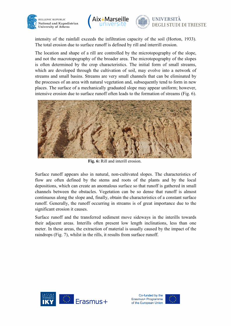
intensity of the rainfall exceeds the infiltration capacity of the soil (Horton, 1933). The total erosion due to surface runoff is defined by rill and interrill erosion.
The location and shape of a rill are controlled by the microtopography of the slope, and not the macrotopography of the broader area. The microtopography of the slopes is often determined by the crop characteristics. The initial form of small streams, which are developed through the cultivation of soil, may evolve into a network of streams and small basins. Streams are very small channels that can be eliminated by the processes of an area with natural vegetation and, subsequently tend to form in new places. The surface of a mechanically graduated slope may appear uniform; however, intensive erosion due to surface runoff often leads to the formation of streams (Fig. 6).
Surface runoff appears also in natural, non-cultivated slopes. The characteristics of flow are often defined by the stems and roots of the plants and by the local depositions, which can create an anomalous surface so that runoff is gathered in small channels between the obstacles. Vegetation can be so dense that runoff is almost continuous along the slope and, finally, obtain the characteristics of a constant surface runoff. Generally, the runoff occurring in streams is of great importance due to the significant erosion it causes.
Surface runoff and the transferred sediment move sideways in the interills towards their adjacent areas. Interills often present low length inclinations, less than one meter. In these areas, the extraction of material is usually caused by the impact of the raindrops (Fig. 7), whilst in the rills, it results from surface runoff.
Fig. 6: Rill and interill erosion.

Erosion and deposition areas can be recognized at the slopes, with sedimentation taking place mostly in the concave side of the slope (Fig. 8). Erosion, which is defined as soil loss, mainly appears at the upstream of the slope, while deposition is observed at the downstream. The quantity of sediment accumulating upstream is less than the soil loss due to erosion downstream. The total length of the uniform and convex slopes forms an area prone to erosion. Furthermore, slopes with small curvature do not present significant deposition. Other factors can also result in deposition, apart from the shape of the slope, such as the dense vegetation or other obstacles that dramatically decelerate erosion.
Fig. 7: Splash erosion: the impact of the raindrops. Photo by Centeri.
Fig. 8: Erosional and depositional areas on a hill slope.

Areas of concetrated flow
An area of concentrated flow is distinguished from a stream, by its morphological location and the role of macrotopography in the definition of the position of the channel of the concentrated flow. The location of the channel of concentrated flow is exclusively determined by the macrotopography of the landscape. In case the channel is aggregated, the channel of concentrated flow reshapes to its previous location. Despite the fact that the location of the concentrated flow is controlled by macrotopography, artificial channels can be constructed at the slopes in order to reduce slope’s inclination and rill erosion.
Ephemeral stream erosion
Ephemeral streams are usually observed in areas, where the natural balance is disturbed by agricultural activities. The quantity of sediment produced, in this case, is equal to the amount of sediment deriving from rill and interrill erosion in a specific area (Foster, 1985; Thomas et al., 1986).
In agricultural areas, ephemeral streams develop due to common cultivation practices and, they usually evolve due to material transport from the terrestrial areas to adjacent ephemeral streams. Ephemeral streams are forced by surface macrotopography to regain their previous location after the aggregation, due to agricultural activities. Their name -ephemeral -is also owed to this periodic sediment re-enrichment and reshape from erosion. Over the years, these channels are gradually merged, while, in some cases, they remain engraved with vertical lateral walls (Fig. 9).
Cultivations result to the development of a superficial zone in the area of the ephemeral stream which is more vulnerable to erosion than the non-cultivated soil. Flow leads to deep erosion of the ephemeral stream and gradually in lateral erosion, resulting to a wide, shallow channel of great width-depth ratio.
Fig. 9: Blending of ephemeral gully areas with overland flow areas.

Permanent, incised gully erosion
Permanent, incised gullies are observed in both natural and disturbed soils (Fig. 10). In agricultural soils, these gullies are defined as very deep channels (Foster, 1985). Changes in land use are commonly responsible for the development of gullies. Permanent, incised gullies are usually juvenile and develop in a short period of time. Depending on the flow occurring within them, these permanent gullies are, often, engraved, broad and deep channels (Heede, 1975; Piest et al., 1975). Headward erosion can also lead to the formation of a permanent engraved gully.
When the lateral walls consist of resistant rocks, they are low and vertical, as opposed to when they consist of loose material. Erosion in permanent, incised gullies is periodical and varies in an annual base (Piest et al., 1975). For example, the vegetation that may develop on the materials ending up in the gully, can protect them from detachment. The weight of the material that has accumulated by the undercutting of the lateral walls stabilizes their base, preventing further collapse into the gully. However, an incident of high runoff can cause intense flow and, as a result, move the detached soil material and destabilize the lateral walls from the gully.
Fig. 10: Permanent incised gully.

River-bed erosion
The river-beds of the drainage network constitute an integral part of the relief. Although their development is independent of human interventions, activities in the upstream and within the channels can greatly affect river-bed erosion. The characteristics of the river-bed, including the degree and shape of the spiral route, facilitate the flow and regulate the sediment load that deposits within (Schumm, 1977). Consequently, changes in land use also transform the river-bed, in addition to altering runoff and sediment deposition. River-beds are constantly changing; however the alteration of steady beds can be imperceptibly slow (Trimble, 1977).
The abrupt changes in land uses, such as the intensive agriculture which significantly increases the upstream runoff, can destabilize the bed and lead to erosion phenomena. This erosion can widen the bed and lead to the regression of the knick-points in very high rates, producing great sediments loads. The most active erosion locations in the river-bed are commonly found in the outer part of the meanders’ inflexions, where the channel’s embankment retreats several meters during heavy storms. River-bed erosion can be controlled by reducing runoff rates through flow adjustments, constructing expanded intersections, installing control structures in the channel, expanding protective embankments and deflecting the flow away from the bed walls (Shields et al., 1995).
Stream channels in non-disturbed forest soils are typically permanent, however logging and road constructions can drastically disturb them (Dunne, 1998; Elliot, 1999; Grace, 2000; Warrington et al., 1980). Such disturbances can increase surface runoff as well as the sediment load that results in the river-bed. Irrigation ditches that are built along the roads often transfer the increased runoff and the sediment, originating from roadway erosion and other disturbed areas, directly to the river-bed.
The instability of the river-bed can be additionally caused by dramatic changes in the sediment load, which approaches the streams from the upstream areas. The agricultural growth in the 19ο c. and the beginning of the 20 c. led extensive areas to erosion (Trimble, 1977). The high levels of rill and interrill erosion, in recently deforestated and cultivated soils, produced and distributed a great amount of sediment in the stream valleys, which were eventually aggregated.
Erosion processes in the watershed
The amount of sediment distributed in the basin’s exit, which results from erosion processes occurring in its interior, is called product of erosion in a drainage basin. Sediment production is a measure of the mean erosion occurring within a watershed. It is the total amount of sediment produced from any kind of source: terrestrial flow, ephemeral streams, permanent engraved streams and the areas of channels-streams.

Erosion due to the snow melting
Erosion from terrestrial flow can result from the melting of snow however it depends on a particular combination of conditions. Runoff due to the melting of snow may appear after frost and can be significant (McCool et al., 1995; 1997; Van Klaveren & McCool, 1998). Rainfall in a soil after frost is a common phenomenon. The soil is particularly vulnerable to erosion and even the slightest amounts of surface runoff, from low, but steady intensity rainfall, can cause high rates of rill erosion. Ground sensitivity in this type of erosion is most evident in cultivated soils rather than in the natural non-disturbed ones.
Erosion via porosity
The water usually flows within the soil, right beneath its superficial layer. The soil can consist of macro-pores, other small interstices and channels, which have been created by plant roots, insects, animals, etc. The formation of ‘pipes’ through these pores, can cause heavy flow and result in erosion phenomena. The initial diameter of the pipes is, usually, of the order of some mm but can be broaden to even one meter. When a pipe is close to the ground surface, its upper part might collapse and form an open groove or a permanent, engraved flow (Zachar, 1982).
Similar flow can occur, when the superficial layer has a coarse texture and is located above a dense soil zone that will deter the downward flow of the water. The water flows towards downstream, along the crest of the dense soil zone, and escapes through the lower part of the slope, making this area more vulnerable to erosion compared to the neighboring ones (Huang & Laften, 1996). The increasing humidity of the soil in the lower topographical sections and the concentration of the ground’s humidity in the cavities is a common phenomenon. The increasing ground humidity, and sometimes the water filtration, makes soil vulnerable to erosion and results to the acceleration of rill and ephemeral stream erosion (Huang & Laften, 1996).
Erosion due to irrigation
Irrigational water reaches the soil through elevated sprayers, surface runoff, or underground vaporizers. When the methods of use of irrigation water are applied appropriately with vaporizers or underground systems, erosion is small. However, when the superficial method for the management of irrigation water is applied, the induced erosion is significant. Through this type of irrigation, the surface water is inserted from upstream of the grooves and begins to flow towards downstream. This irrigational system can cause significant erosion, especially to the upper parts of the grooves, where the rate can be up to 4 times larger than the mean erosion rate of the particular area (Trout, 1996).

Main factors that control soil erosion
The environmental conditions that define the type and rate of erosion occurring in a specific area depend, mainly, on five factors:
• climate, • soil, • morphology, • land uses • weathered cap and, • the soil management
Apart from water erosion, the aforementioned factors control aeolian erosion as well, but in a different way. In this book, the focus is on erosion that results from surface runoff.
Water-erosion is the dominant geomorphic process for the larger part of the earth’s surface. Sedimentation and water-erosion include the processes of detachment, crawling, transportation and deposition of the soil particles. The main forces that characterize these processes are:
• the shear stresses, which are activated by the impact of raindrops • surface runoff
Water-erosion is a result of these forces and relates to the soil resistance against detachment processes. With the onset of water-erosion, the soil particles behave as sediment. Sediment deposition is the amount of eroded material, which is distributed in a particular area and may originate either from the eroded sections of a slope (soil loss), or from a drainage basin (sediment production). The capacity of sediment transfer through surface runoff is also related to the shear stresses applied on the soil, the size and the density of the sediment particles. Sedimentation takes place when the available quantity of sediment is larger than the transfer capacity, and results to sediment accumulation on the ground surface. Consequently, erosion rates, sediment production and depositional rates are determined by the environmental conditions.
The erosive action of precipitation, which depends on climatic conditions, controls the forces that are applied to the soil and trigger water-erosion. The vulnerability of soil to erosion is determined by the soil properties. The forces applied to soil are affected by the morphology, the vegetation, the formation of the surface, the presence of biogenic material and land uses, and define the degree of soil vulnerability to erosion.
Each of the aforementioned factors are analyzed and correlated in the following paragraphs.
Climate The climate refers to the weather and the variability of weather conditions through time. Erosion can be affected both directly and indirectly by the climate. Precipitation

is the most important climatic variable that affects runoff-erosion. The erosive ability of rainfall can be described through different variables. These variables include the amount of rain, kinetics, impetus and intensity of every rainfall event (Foster et al., 1982; Wischmeier, 1959). Simple observations show that the intensity and amount of rainfall are the two main precipitation variables, which define the erosive ability of a storm. The intensity of rainfall refers to erosion per unit of precipitation, which leads to an overall estimation of the erosive ability of a storm, when multiplied with the amount of rainfall.
This simple relationship is obvious for erosion, due to the impact of the raindrops, and can be also applied to erosion due to surface runoff. Surface runoff erosion is related to the rate and amount of runoff. The quantity of runoff is associated with the quantity of rainfall minus the amount of infiltration, and the maximum rate of runoff is related to the maximum intensity of precipitation minus the infiltration rate.
Although the erosive ability of rainfall is sufficiently described by the quantity and intensity of rainfall, a further examination regarding the size of the raindrops is considered necessary. The forces that are exerted in the soil by the impact of the raindrops depend on their size. A very small drop, which impacts the ground with low velocity, exerts a very small force to it and causes a small degree of erosion, despite the quantity and intensity of rainfall. This result is described by a variable, the kinetic force of a raindrop impacting the ground, which equals half of the drop’s mass times the velocity of the impact squared.
The size and impact velocity of a raindrop constitute two closely linked terms/concepts. A small raindrop has a small impact velocity and consequently small impact energy. A storm is composed of thousands of raindrops. As a result, the total kinetic energy of the storm is the sum of the kinetic energies of the individual drops.
The final velocity of the raindrops when they impact the ground is directly linked to the drop’s diameter.
Because erosion constitutes a complex phenomenon, it requires experimental research in order to define many of the relationships describing it, such as the erosive ability of precipitation. Experimental research shows that a reliable index of the erosive ability of precipitation is the result of the total kinetic energy of a storm multiplied to the maximum intensity of 30 minutes (Wischmeier, 1959). The mean total kinetic energy of all storms, occurring during one year, is an index that can be calculated by precipitation data (Wischmeier & Smith, 1978). Annual precipitation height and, hence its annual erosive ability, vary considerably from year to year. Moreover, the erosive capability varies during the same year.
Another significant parameter is the temporary erosive ability, since it interacts with changes in vegetation and soil conditions and therefore, has an important impact on
2
2mv=∑Ε
ν
1

the annual erosion. The greatest erosion appears when the period of maximum erosive ability corresponds to the period that soil is most exposed to surface runoff and raindrop impact. The erosive ability is significantly decreased, when these two periods do not correspond to the period of maximum sensitivity.
The form of precipitation, which is primarily defined by temperature, significantly affects the erosive ability of rain. Snowfall is not erosive whereas high intensity rainfall can be highly erosive. Furthermore, soil conditions are affected by temperature and the interplay between soil conditions and the form of precipitation can result to very high or very low erosion rates, during different periods of the year. Snowfall, as well as rainfall, in a frost ground will not cause any erosion, but the runoff caused by the melting of snow and the rainfall in defrost soils can cause very high erosion rates.
Although the amount and intensity of rainfall are significant erosive factors, the amount and rate of runoff should also be taken into account. Additionally, the infiltration, which is the result of the accordance of the earlier soil humidity and soil sealing, should be calculated and taken into consideration. Surface runoff occurs when the precipitation rate exceeds infiltration rate. Consequently, comprehending the hydrology of the study area is vital for the integrated study of runoff-erosion.
Vegetation acts protectively against the forces of the raindrop impact and surface runoff. Plant roots, organic material and the products of decomposition increase the soil’s resistance to erosion. The climatic variables of precipitation, temperature, evapotranspiration and, in some cases, soil humidity, affect the biomass and decomposition within the soil’s profile. These climatic variables affect the growth and decay of vegetation which, in their turn, affect erosion significantly. The quantity of vegetation is in direct correlation to the quantity of precipitation. Vegetation, or its decomposition products, e.g. falling leaves and roots, increase the organic material on the surface of the soil and in the interior of the soil cap, and therefore reduce the soil’s susceptibility to erosion. The amount of organic material coming from vegetation depends on both the plant biomass, which was initially produced, and the remaining quantity after other uses. The remaining organic material on the surface of the soil is lost as time passes due to decomposition processes. Decomposition appears quicker in areas characterized by high values of temperature and precipitation.
Soil In general, the term soil refers to the loose material that covers the earth’s surface and can be distinguished from solid rock (Govens & Poesen, 1986). The soil performs many functions, feeding and supporting the plants growing on it, and constitutes the base on which roads and buildings are constructed. Furthermore, it produces sediments, due to erosion, and constitutes the means for water circulation.

Soil evolves dynamically through time. Initially, the bedrock is weathered into unstable mineral material that operates as the parent material in soil genesis. The sediment originates either from aggradational processes through water, or from the wind. Finally, the development of soil reflects the combined effects of climate, topography, organic material and time.
Certain soils are much more vulnerable to erosion than others (Agassi et al., 1996; Bryan, 1977; Foster et al., 1985; Foth & Turk, 1972). Apart from the soil properties, other factors also affect the soil’s vulnerability to erosion, such as the presence of organic material.
In order to measure the soil’s vulnerability to erosion, a constant term of reference was established, in which all external affects are excluded, apart from the influence of soil properties. An example is the case of a limited area of land, where soil is kept fallow (without vegetation) and its upper and lower parts are periodically cultivated. The sediment from the limited experimental area is collected and illustrated graphically as a function of vulnerability to erosion, where the x-axis shows erosivity and the y-axis shows soil loss. The inclination of the line corresponds to an empirical measurement of the vulnerability to erosion.
The most important property in many processes, and especially in erosion, is the composition of the soil. Soils, which are rich in clay, present low rates of vulnerability since they are resistant to detachment. Soils, rich in sand, present low rates as well, at least where vulnerability index is based on the total kinetic energy (practically, the amount of precipitation) and the intensity of rain. Due to reduced runoff, such soils produce less sediment, because of the high infiltration rates. Even when soil particles are easily detached from sandy soils, only a small surface runoff is observed for this detachment and transportation. Soils with medium-sized composition are the most vulnerable to erosion. In these cases, soil particles are distracted and the eroded sediment can be easily transferred. The permeability of soil profile is related to its vulnerability to erosion, since it affects surface runoff. The presence of, e.g. limited layers of clay, near the ground surface can significantly increase vulnerability, especially in sandy soils that are easily detached. An increase of the surface runoff on these soils can lead to an important increase of erosion. Another factor that influences vulnerability is the soil structure, which reflects the sorting of the organic and inorganic materials (Grissenger, 1966; Moldenhaeur & Wischmeier, 1960; Wischmeier et al., 1971).
Soil’s vulnerability to erosion varies during the year. Soils are most vulnerable during the months in which the energy, the amount of precipitation and soil humidity are highest. The quantity of surface runoff erosion is increased by high soil humidity. Low temperature increases the humidity of soil, since evaporation is low. As a result, soil vulnerability tends to be higher during the last months of winter and the first months of spring, rather than in the end of summer. Additionally, vulnerability is reduced during the last months of summer because the higher temperatures increase

the biological activity in the ground and produce organic compounds, which function as composing factors of the soil.
Defrost soil is particularly vulnerable to erosion due to its saturation that leads to greater surface runoff (Van Klaveren & McCool, 1998).
The compaction of soil and the diffusion of the fine particles that are generated from the impact of raindrops can lead to the development of a thick layer on the soil surface (Bradford & Huang, 1992; Bradford et al., 1986; Summer & Stewart, 1992). This layer is called crust when it is dry and sealing when it is humid; it limits the infiltration rate, which, in turn increases runoff and erosion.
Soils can vary depending on their vulnerability to erosion due to the raindrop impact and to surface runoff. An example where soil is much more vulnerable to runoff erosion rather than from raindrop impact is the case of runoff in defrosted soils. A soil, rich in clay, can be particularly resistant to runoff erosion compared to soils rich in mud. Erosion caused by the raindrop impact is uniformly distributed on the impact surface, while runoff erosion increases with distance along the route of runoff (Meyer et al., 1975). The effect of morphology in erosion processes is larger when the soil is more vulnerable to runoff erosion, rather than to erosion from raindrop impact.
Erosion differs in a landscape since the soil properties vary as well. For instance, the behavior of soil on the slopes’ top is defined, to a large extent, by the parent material (Renard et al., 1997). On the contrary, the lower parts of the slopes reflect the properties of a developed soil in a depositional environment, which is quite different from the developing soil of the slopes top. The fluctuations of humidity conditions have a significant impact in soil development and its consecutive properties. The lower parts of the relief and the cavities of the ground tend to be more humid than other areas, which results to different soil properties due to anomalies in the developing environment.
Morphology The morphology refers to the geometry of earth’s surface. The length of the slope, its inclination and its shape in section and in plan-view are the most important geometrical variables. Slopes with stable inclination along their length are called uniform; in these cases, erosion increases along the slopes. The most common forms of slopes are presented in figure 11.

The sediment gathered at the end of a uniform slope differs as a function of the slope’s length and it also depends on the amount of erosion caused by raindrops impact in relation to erosion caused by runoff. Moreover, erosion depends on the inclination of the uniform slope (McCool et al., 1987). Erosion increases linearly with increasing inclination. Nonetheless, in the case of runoff erosion, the inclination has greater affect than on erosion caused by raindrop impact (Foster, 1982).
Therefore, erosion on a part of the slope is a function of distance from the starting point of surface runoff and the inclination in that location (Foster et al., 1977). In a location towards downstream, the rate of erosion will be high. For a given location, erosion is proportional to the inclination. This principal can also be implemented in non-uniform slopes, which are most common in nature. A non uniform slope has varying inclination along its length. Other characteristics may differ as well, but only the deviation of the inclination is taken into account during the morphological study of the slopes. In a convex slope, the inclination increases constantly along its length. Erosion on a part of the slope is related to both the inclination and length. The maximum erosion rate is much larger in a convex slope than in a uniform, and the accumulating sediment at the end of the convex slope is also more than in the uniform.
A concave slope is the opposite of a convex. Although the inclination in a concave slope is large, runoff is minimum (Fig. 12). The maximum erosion rate is slightly smaller in a concave slope than in a uniform. The same applies for the sediment
Fig. 11: Various forms of slopes (a) concave-concave form, (b) convex-concave form, (c) concave-convex form, (d) convex-convex form and the effect of morphology on surface
runoff.

production, since the steep inclination of a concave slope does not get small enough to lead to deposition.
When the available amount of sediment is larger than the transporting ability, sedimentation takes place on a slope. The available sediment for transfer correlates with the amount of sediment produced, in the upper part of the slope. The topography of a slope, which defines runoff, is in direct relation to its transfer capability. As a result, when the steep inclination of a slope is flat enough at its lower part, it can present significant amount of deposition; this reduces significantly the sediment transfer at the end of the slope. A complex slope with a convex upper part and a concave lower, behaves as a combination of convex and concave slopes.
Figure 13 illustrates a typical topography, which consists of three basic parts.
• The slopes, where runoff occurs parallel along the slope (D). The discharge rate, across the width of the hill remains the same, along route of the flow.
• The second important part is at the edges or the tops of the slope (F). In these areas, flow deviates so much that outflow, per unit of width, is reduced downstream and results to a reduction of the erosion rate.
• The third important part is the cavities that cause the convergence of runoff (G). In these areas, the outflow, per unit of width, increases towards downstream with a corresponding increase in erosion. The areas of concentrated flow are formed in cavities where runoff converges.
Fig. 12: The inclination in a concave slope is large, but the runoff is minimum. The
topography of a slope, which defines runoff, is in direct relation to its transfer capability. As a result, deposition takes place at the lowest part of concave slope and erosion at its
upper part.

Topography has a direct impact on erosion. Soil humidity tends to be larger at the bases of slopes and in cavities, rather than in the upper parts (Weltz et al., 1998). Vegetation, biomass and the presence of organic material on the surface and the interior of the soil tend to be greater in areas where humidity is high. This contributes to the spatial fluctuation of erosion, the formation of runoff and, last but not least, to the affect of the slope’s inclination from the impact of raindrops (Foster, 1982).
Land uses The land uses parameter has a special effect on erosion processes. The term “land uses” refers not only to the general use of the land, but to the applied management as well. For instance, one land use can characterize an undisturbed area, in which all human activities are forbidden. Forest areas are another land use, where disturbance is generally restricted.
Vegetation can be much greater in areas of controlled grazing as opposed to areas where overgrazing takes place. Vegetation species are primarily defined by climate and soil; however the amount of vegetation is controlled by human interventions, such as the management of cultivated areas and pasture lands. Vegetation combined with soil disturbance, which affects erosion, is defined by management.
Generally, land use widely refers to the vegetation cover, the applied cap and the level of vegetation and soil management, along with the support practices that are implemented in order to control erosion.
Fig. 13: Typical topography consisting of three basic parts.

Land uses have an impact not only on the forces that are applied on the soil but also on the soil’s resistance towards them. Three elements of land use are more important for runoff erosion:
• the vegetation and its role • the surface cap, e.g. deriving from plant remains, and • the mechanical disturbance of the soil (Renard et al., 1997; Weltz et al., 1998;
Wischmeier, 1975).
Weathered Cap
Tree foliage
The foliage of the treetops constitutes the overground part of the plants that prevents the raindrops, which does not contact the ground to influence surface runoff. Thick foliages ‘block’ a significant percentage of rainfall to reach the surface of the ground. A quantity of rainfall evaporates before it reaches the ground. This obstruction of the rainwater can be important with thick foliages, of large extent per unit of soil, and it results to a significant decrease of the surface runoff.
Part of the rainwater, which was ‘blocked’ by the foliages of the treetops, flows along the surface of plants, approaching their stems and moving towards the ground. The erosion by the impact of these raindrops is zero. Although this water becomes part of surface runoff, the erosivity of its runoff is reduced because of the travel time from the obstruction point to the surface.
Part of the ‘blocked’ rainwater forms water drops which fall down to the ground. If the bottom of the canopy is close enough to the soil’s surface, the erosivity of this water is much smaller than the one from raindrops that were not stopped. However, if the bottom of the canopy is high enough, the height of the falling drops is enough to approach the erosivity of the non-stopped rainfall (Chapman, 1948).
The percentage of soil that is covered by foliages and their density defines how much foliages affect erosion. Between plants there may be an open area, where raindrops can directly impact the ground, without foliages limiting their erodibility. Erosivity from foliages can be reduced by plants, whose canopy bottom is close to the ground (US Department of Agriculture, Forest Service, 1987).
The foliages of the treetops are alternated during the year, through natural processes. After maturity, plants lose their canopy as leaves lean and fall down. The maximum control of erosion can be accomplished by the selection and management of the plants, in order to have maximum canopy of foliage during the periods of maximum erosivity.
The soil properties, the humidity and other microclimatic characteristics affect differences between areas resulting to a spatial variation. Different plant species can

appear at the same place, such as the thick grass cap under a bush. The canopy foliage of grass has a greater affect in the reduction of erosion than that of bushes.
Characteristics of vegetation
The trunk of a tree and the area of its total diameter are equally significant factors in the processes of erosion. Erosion can be eliminated in the part of the ground which is covered by the spread area of the plant. Thick branches decelerate runoff and reduce erosivity. Plant stems can actually accelerate erosion around them. In general, branches and their spread area decrease erosion.
After the harvest, the entire biomass of an annual plant’s root, such as wheat, remains in the soil (Reeder et al., 2001). This material constitutes the decomposing biomass which will reduce vulnerability and significantly increase infiltration. Water can flow sideways of the living roots and the rotten dead roots that lie in the rills. Through this process, the infiltration is increased in the rills, whereas runoff is decreased and erosion is limited.
The aboveground biomass is integrated into the soil through cultivation or other mechanical disturbances, which mix the plant materials within the soil. Biomass can be added on the ground by fertilizers and other organic materials. Worms and other organisms living into the soil incorporate the plant material, in the upper 50 mm of the soil (West, 1990). Plant remains are more effective when they are near the surface rather than when buried deeper. Flora and fauna activities improve the structure of the soil and reduce erosion.
Erosion is reduced as the amount of biomass increases from plant production (Renard et al., 1997). The production of underground biomass differs spatially, like the aboveground biomass. The quantity of the remaining organic material depends on the decomposition rate and that, in its turn, depends on the temperature and humidity of the soil, which are inextricably connected to air temperature and precipitation.
In some occasions, lines of vegetation are developed on a slope or in the edge of a stream so as to retain the sediment. These lines, which are also known as filter strips, significantly decelerate runoff, and result to deposition and reduction of sediment transfer in the area. Filter strips that are placed at a hill’s slope are known as buffer strips, and they result to the decrease of erosion while preserving the sediment on the slope. The alternative cultivation of strips includes planting some lines with thick vegetation in alteration with others with intensive cultivation. Strips of thick vegetation and other crops alter so that any kind of vegetation can grow on every strip. The width of the strips in the alteration system is, usually, the same. Cultivation in strips reduces the amount of sediment that moves to the downstream of the slopes. The effectiveness of the vegetation strips depends on the density of plants and on the ability of the strip to decelerate runoff.

Soil cap
The surface cap is in direct contact with the soil, protecting it from the impact of raindrops and decelerating runoff. The soil cap can form from plant remains that accumulate from falling leaves, from harvest remains, protective layers of hay, artificial material added on the surface and living parts of the plants that contact the ground. Research has shown that the affect of the soil cap on erosion is directly related to the percentage of the covered surface. The impact of the soil cap varies according to the climate, the topography and soil conditions (Box, 1981; Meyer et al., 1972).
The protective cap of hay, which is applied in construction areas, is less effective in the reduction of erosion than harvest remains in a rural area. The harvest remains of the previous year are very important in the preservation of the cultivation systems that are used widely for controlling erosion in cultivated areas (Simanton et al., 1984).
Cryptogams are collections of mossy, algae and lichen, which develop across the soil profile. The resulting organic crust of soil can reduce infiltration rates by preventing flow in the large pores of the soil and therefore increase runoff and soil erosion. In other cases, cryptogams can improve porosity and infiltration by increasing soil aggregation and asperity (West, 1990). Furthermore, cryptogams protect soil from both types of erosion, runoff and raindrop impact.
Mechanical disturbance
Apart from soil management, soils properties are also crucial in soil’s vulnerability to erosion. The presence of organic material, as already mentioned, affects vulnerability.
Furthermore, mechanical disturbances affect not only the vulnerability of the soil but also the erosivity of the raindrop impact and surface runoff. Mechanical disturbance decelerates runoff and reduces the vulnerability to erosion, by creating superficial hardness (ruggedness). Moreover, the hardness of the surface forms cavities where water stagnates, resulting to the reduction in raindrop erosivity and to local storage of the transported sediment.
In nursery conditions, the soil is approximately twice as vulnerable to erosion after cultivation, than after an extensive period of a few years, with no mechanical soil disturbances. On the contrary, the superficial plant material is often buried and mixed with the underground plant remains by the mechanical soil disturbance, in order to significantly reduce erosion.
Soil can be artificially developed, in order to redefine the runoff from a downhill route to another around the slope; a practice known as contouring. This redefinition of flow prevents the erosivity of runoff.
Terraces are often formed in slopes, in order to reduce their length and consequently control erosion caused by runoff. Terraces can, also, be developed as part of a process known as “chain” in natural leas, by removing trees and bushes. A long chain or wire is stretched between two vehicles that move parallel through the ground surface and uproot the highest vegetation of the ground. The remains from the broken plants accumulate regionally and act as terraces to control and direct runoff around the slope.

References
Agassi, M. (ed.), 1996. Soil Erosion, Conservation, and Rehabilitation. New York: Marcel Dekker.
Box, J. E., 1981. The effect of surface slaty fragments on soil erosion by water. Soil Science Society of America Journal 45, 111-116.
Bradford, J. M., Huang, C., 1992. Mechanisms of crust formation: physical components. In: Sumner, M.D., Stewart, B. A., (Eds.), Soil Crusting: Chemical and Physical Processes, pp 55-72. Boca Raton, FL: Lewis Publishers.
Bradford, J. M., Remley, P. A., Ferris, J. E. Santini, J. F., 1986. Effects of soil surface sealing on splash from a single waterdrop. Soil Science Society of America Journal 50, 1547-1552.
Bryan, R. B., 1977. Assessment of soil erodibility: new approaches and directions. In: Toy, T.J., (Ed.), Erosion: Research Techniques, Erodibility and Sediment Delivery, pp. 57-72. Norwich: Geo Books.
Chapman, G., 1948. Size of raindrops and their striking force at the soil surface in a red pine plantation. Transactions–American Geophysical Union 29, 664-670.
Chow, V.T., 1959. Open Channel Hydraulics. New York: McGraw-Hill.
Dunne, T., 1998. Critical data requirements for prediction of erosion and sedimentation in mountain drainage basins. Journal of the American Water Resources Association 34, 795-808.
Elliot, W. J., 1999. Understanding and modeling erosion from insloping roads. Journal of Forestry 97, 30-34.
Emmett, W. W., 1970. The Hydraulics of Overland Flow on Hillslopes. USGS Professional Paper 662A. Washington, DC: U.S. Government Printing Office.
Foster, G. R., 1971. The overland flow processes under natural conditions. In: Biological Effects in the Hydrological Cycle. Proceedings of 3rd International Seminar for Hydrological Professors, pp. 173-185.
Foster, G. R., 1982. Modeling the erosion process. In: Haan, C. T., Johnson, H. P., , Brakensiek, D. L. (Eds.), Hydrologic Modeling of Small Watersheds, pp. 297-382. St. Joseph, MI: American Society of Agricultural Engineers.
Foster, G. R., 1985. Understanding ephemeral gully erosion (concentrated flow erosion). In: Soil Conservation: Assessing the National Resources Inventory, pp. 90-125. Washington, DC: National Academy Press.
Foster, G. R., Lombardi, F., Moldenhauer, W. C., 1982. Evaluation rainfall-runoff erosivity factors for individual storms. Transactions of ASAE 25(1), 124-129.
Foster, G. R., Young, R. A., Neibling, W., H., 1985. Sediment composition for nonpoint source pollution analysis. Transactions of the ASAE 28 (1), 133-139.

Foster, G. R., Meyer, L. D., Onstad, C. A., 1977. An erosion equation derived from
basic erosion principles. Transactions of ASAE 20(4), 678-682.
Foth, H. D., Turk, L. M., 1972. Fundamentals of Soil Science. New York: Wiley.
Govers, G., Poesen, J., 1986. A field-scale study of surface sealing and compaction of loam and sandy loam soils. I. Spatial variability of surface sealing and crusting. In: Callebaut, F., Gabriëls, D., De Boodt, M. (Eds.), Assessment of Soil Surface Sealing and Crusting, Proc. Symposium, pp. 171-182. Gent: Flanders Research Centre for Soil Erosion and Soil Conservation.
Grace, J.M., III., 2000. Forest road sideslopes and soil conservation techniques. Journal of Soil and Water Conservation 55, 96-101.
Grissenger, E. H., 1966. Resistance of selected clay systems to erosion by water. Water Resources Research 2, 131-138.
Heede, B. H., 1975. Stages of development of gullies in the west. In: Present and Prospective Technology for Predicting Sediment Yields and Sources, pp. 155-161. USDA Agricultural Research Service ARS-S-40. Washington, DC: USDA Science and Education Administration.
Horton, R. E., 1933. The role of infiltration in the hydrologic cycle. Transactions American Geophysical Union 20, 693-711.
Huang, C., Laflen, J. M., 1996. Seepage and soil erosion for a clay loam soil. Soil Science Society of America Journal 60, 408-416.
McCool, D. K., Brown, L. C., Foster, G. R, Mutchler, C. K., Meyer L. D., 1987. Revised slope steepness factor for the Universal Soil Loss Equation. Transactions ASAE 30(4), 1387-1396.
McCool, D. K., Walter, M. T., King, L. G., 1995. Runoff index values for frozen soil areas of the Pacific Northwest. Journal of Soil and Water Conservation 50, 466-469.
McCool, D.K., Saxton, K. E., Williams, J. D., 1997. Surface cover effects on soil loss from temporally frozen cropland in the Pacific Northwest. In: Proceedings of International Symposium on Physics, Chemistry, and Ecology of Seasonally Frozen Soils, pp. 235-341. Hanover, NH: Cold Regions Research and Engineering Laboratory, U.S. Department of the Army.
Meyer, L. D., Harmon, W. C., 1985. Sediment losses from cropland furrows of different gradients. Transactions ASAE 28, 448-453.
Meyer, L. D., Johnson, C. B., Foster, G. R., 1972. Stone and woodchip mulches for erosion control on construction sites. Journal of Soil and Water Conservation 27(6), 264-269.
Meyer, L. D., Foster, G. R., Romkens, M. J. M., 1975. Sources of soil eroded by water from upland slopes. In: Present and Prospective Technology for Predicting
Sediment Yields and Sources, pp. 177-189. USDA Agricultural Research Service ARS-S-40. Washington, DC: USDA Science and Education Administration.
Moldenhauer, W. C., Wischmeier, W. H., 1960. Soil and water losses and infiltration rates on Ida Silt Loam as influenced by cropping systems, tillage practices, and rainfall characteristics. Soil Science Society of America Proceedings 24, 409-413.
Piest, R. F., Bradford, J. M., Spomer, R. G., 1975. Mechanisms of erosion and sediment movement from gullies. In: Present and Prospective Technology for Predicting Sediment Yields and Sources, pp. 162-176. USDA Agricultural Research Service ARS-S-40. Washington, DC: USDA Science and Education Administration.
Renard, K., Foster, G. R., 1983. Soil Conservation: Principle of Erosion by Water. In: Dregne, H. E., Willies, W. O. (Eds.), Dryland Agriculture, pp. 155-176. Madison, WO, USA: Soil Science Society of America.
Reeder, J. D., Franks, C. D., Michunas, D. G., 2001. Root biomass and microbial processes. In: Follet, R. K., Kimble, J. M., Lal, R. (Eds.), The Potential of U.S. Grazing Lands to Sequester Carbon and Mitigate the Greenhouse Effect, pp. 139-166. Boca Raton, FL: Lewis Publishers.
Renard, K. G., Foster, G. R., Weesies, G.A., McCool, D. K., Yoder D. C., 1997. Predicting Soil Erosion by Water: A Guide to Conservation Planning with the Revised Universal Soil Loss Equation (RUSLE). USDA Agricultural Handbook 703. Washington, DC: U.S. Government Printing Office.
Schumm, S. 1977. The Fluvial System. The Blackburn Press, 338pp.
Shields, F. D., Jr., Bowie, A. J., Cooper C. M., 1995. Control of streambank erosion due to bed degradation with vegetation and structure. Journal of the American Water Resources Association 31(3), 475-489.
Simanton, J. R.., Rawitz, E., Shirley E. D., 1984. Effects of rock fragments on erosion of semiarid rangeland soils. In: Kral, D.M. (Ed.) Erosion and Productivity of Soils Containing Rock Fragments, SSA Special Publication 13, pp. 65-72. Madison, WI: Soil Science Society of America.
Sumner, M. D., Stewart, B. A. (eds.), 1992. Soil Crusting: Chemical and Physical Processes. Advances in Soil Science. Boca Raton, FL: Lewis Publishers.
Thomas, A. W., Welch, R., Jordan, T. R., 1986. Quantifying concentrated-flow erosion on cropland with aerial photogrammetry. Journal of Soil and Water Conservation 41(4), 249-252.
Trimble, S. W. 1977. The fallacy of stream equilibrium in contemporary denudation studies. American Journal of Science 277, 876-887.
Trout, T.J., 1996. Furrow irrigation erosion and sedimentation: on-field distribution. Transactions ASAE 39, 1717-1723.
U.S. Department of Agriculture, Forest Service, 1987. In: Proceedings of Pinyon-
Juniper Conference. General Technical Report INT-215. Washington, DC: U.S. Government Printing Office.
Van Klaveren, R. W., McCool., D. K., 1998. Erodibility and critical shear stress of a previously frozen soil. Transactions ASAE 41,1315-1321.
Van Klaveren, R. W., McCool., D. K., 1998. Erodibility and critical shear stress of a previously frozen soil. Transactions ASAE 41, 1315-1321.
Warrington, G. E., Knapp, K. L., Klock, G.O., Foster, G. R., Beasley R. S., 1980. Surface erosion. In: An Approach to Water Resources Evaluation on Non-profit Silvicultural Sources, Chap. IV. EPA-160018-80-012. Washington, DC: U.S. Environmental Protection Agency.
Weltz, M. A., Kidwell, M. R., Fox H. D., 1998. Influence of abiotic and biotic factors in measuring and modeling soil erosion on rangelands: state of knowledge. Journal of Range Management 51, 482-495.
West, N. W., 1990. Structure and function of microphytic soil crusts in wild-land ecosystems of arid and semi-arid regions. Advances of Ecological Research 20, 179-223.
Wischmeier, W. H., 1959. A rainfall erosion index for a Universal Soil Loss Equation. Soil Science Society of America Proceedings 23, 246-249.
Wischmeier, W. H., 1975. Estimating the soil loss equation’s cover and management factor for undisturbed areas. In: Present and Prospective Technology for Predicting Sediment Yields and Sources, pp. 118-124. USDA-ARS-S40. Washington, DC: USDA Science and Education Administration.
Wischmeier, W. H., Smith, D. D., 1978. Predicting Rainfall-Erosion Losses: A Guide to Conservation Planning. USDA Agriculture Handbook 537. Washington, DC: U.S. Government Printing Office.
Wischmeier, W. H., Johnson, C. B., Cross, B. V., 1971. A soil erodibility monograph for farmland construction sites. Journal of Soil and Water Conservation 26,189-193
Zachar, D., 1982. Soil Erosion. New York: Elsevier Scientific Publishing.
Related Documents


