STATE OF COLORADO DEPARTMENT OF NATURAL RESOURCES DIVISION OF WATER RESOURCES OFFICE OF THE STATE ENGINEER DAM SAFETY BRANCH RULES AND REGULATIONS FOR DAM SAFETY AND DAM CONSTRUCTION EFFECTIVE DATE: JANUARY 1, 2007 2-CCR 402-1 1313 SHERMAN STREET ROOM 818 CENTENNIAL BUILDING DENVER, COLORADO TELEPHONE 303-866-3581 WEBSITE: http://water.state.co.us

Welcome message from author
This document is posted to help you gain knowledge. Please leave a comment to let me know what you think about it! Share it to your friends and learn new things together.
Transcript

STATE OF COLORADO DEPARTMENT OF NATURAL RESOURCES
DIVISION OF WATER RESOURCES OFFICE OF THE STATE ENGINEER
DAM SAFETY BRANCH
RULES AND REGULATIONS
FOR
DAM SAFETY AND DAM CONSTRUCTION
EFFECTIVE DATE: JANUARY 1, 2007
2-CCR 402-1
1313 SHERMAN STREET ROOM 818
CENTENNIAL BUILDING DENVER,
COLORADO
TELEPHONE 303-866-3581
WEBSITE: http://water.state.co.us
STATE OF COLORADO
DEPARTMENT OF NATURAL RESOURCES
DIVISION OF WATER RESOURCES
OFFICE OF THE STATE ENGINEER
RULES AND REGULATIONS
FOR
DAM SAFETY AND DAM CONSTRUCTION
2-CCR 402-1
Effective Date: JJaannuuaarryy 11,, 22000077

OFFICE OF THE STATE ENGINEER
RULES AND REGULATIONS
FOR
DAM SAFETY AND DAM CONSTRUCTION
TABLE OF CONTENTS
RULE PAGE
1. Title 1
2. Authority 1
3. Scope and Purpose 1
4. Definitions 1
5. Requirements for Construction or Enlargement of Jurisdictional Size Dams or Reservoirs 8
6. Requirements for Alteration, Modification, or Repair of an Existing Dam 37
7. Requirements for Removing or Breaching an Existing Dam 39
8. Fees 40
9. Construction of Jurisdictional Size Dams 41
10. Acceptance of Construction of Jurisdictional Size Dams 43
11. Construction, Modification, Alteration, Repair, and Breach of Non-jurisdictional Size Dams 45
12. General Maintenance, Ordinary Repairs, and Emergency Actions 46
13. Determination of Safe Storage Level 48
14. Safety Inspections Performed by the Owner's Engineer 48
15. Dam Owner's Responsibilities 49
16. Emergency Action Plans (EAP) 52
17. Exempt Structures 53
18. Restriction of Recreational Facilities within Reservoirs 54
19. Waiver or Delay of Enforcement of Rules by the State Engineer 55
20. Appeal of Requirements or Approval 55
21. Rules by Reference 55
22. Severability 55
23. Revision 55
24. Statement of Basis and Purpose Incorporated by Reference 56
25. Effective Date 56

1
Office of the State Engineer
Rules and Regulations
For
Dam Safety and Dam Construction Rule 1. Title:
The title of these Rules and Regulations is "The Rules and Regulations for Dam Safety and Dam
Construction." They may be referred to herein collectively as the "Dam Safety Rules" or "Rules"
and individually as a "Rule".
Rule 2. Authority:
These Rules are promulgated pursuant to the authority granted the State Engineer in sections 37-
87-102 and 37-87-105, C.R.S.; and section 37-80-102(1k), C.R.S.; and section 24-4-103, C.R.S.
Rule 3. Scope and Purpose:
3.1 These Rules apply to any dam constructed or used to store water in Colorado. These Rules
apply to applications for review and approval of plans for the construction, alteration,
modification, repair, enlargement, and removal of dams and reservoirs, quality assurance of
construction, acceptance of construction, non-jurisdictional dams, safety inspections, owner
responsibilities, emergency action plans, fees, and restriction of recreational facilities within
reservoirs. Certain structures defined in Rule 17 are exempt from these Rules.
3.2 The purpose of these Rules is to provide for the public safety through the Colorado Safety of
Dams Program by establishing reasonable standards and to create a public record for reviewing
the performance of a dam.
Rule 4. Definitions:
4.1 Statutory Definitions - The terms are defined in section 37-87-102, C.R.S., 37-87-122
C.R.S. and 35-49-103 C.R.S. and shall have the identical meanings when used in these Rules.
4.2 Specific Definitions - Unless expressly stated otherwise, the following terms when used in
these Rules shall have the meaning indicated by this Rule. Words in the singular shall include
the plural. Words in the masculine gender include the feminine and neuter.
4.2.1 "Alteration, Modification, or Repair of an Existing Dam and Appurtenant
Structures" means to make different from the originally approved construction plans and
specifications or the existing configuration, except for ordinary repairs and general
maintenance as defined in Rule 12.

2
4.2.2 "Appurtenant Structure" means components other than the material structure of the
dam itself such as the outlet works and controls, spillways and controls, access structures,
bridges, and other systems directly related to the safe operation of a dam.
4.2.3 "Breach Order" is an order issued by the State Engineer, or the State Engineer’s
designee, for removal of all or part of a dam to permanently reduce the maximum storage
level, minimize the risk of failure and/or the potential of damage downstream due to the
failure of the dam.
4.2.4 "Capacity" is the volume of water a reservoir is capable of impounding at the high-
water line, expressed in acre-feet. Dead storage below the natural surface of the ground or
low-level outlet is generally excluded.
4.2.5 "Dam" means a man-made barrier, together with appurtenant structures, constructed
above the natural surface of the ground for the purpose of impounding water. Flood control
and storm runoff detention dams are included.
4.2.5.1 "Jurisdictional Size Dam" is a dam creating a reservoir with a capacity of more
than 100 acre-feet, or creates a reservoir with a surface area in excess of 20 acres at the
high-water line, or exceeds 10 feet in height measured vertically from the elevation of the
lowest point of the natural surface of the ground where that point occurs along the
longitudinal centerline of the dam up to the crest of the emergency spillway of the dam.
For reservoirs created by excavation, or where the invert of the outlet conduit is placed
below the surface of the natural ground at its lowest point beneath the dam, the
jurisdictional height shall be measured from the invert of the outlet at the longitudinal
centerline of the embankment or from the bottom of the excavation at the longitudinal
centerline of the dam, which ever is greatest. Jurisdictional height is defined in
Rule 4.2.19. The State Engineer shall have final authority over determination of the
jurisdictional height of the dam.
4.2.5.2 "Non-jurisdictional Size Dam" is a dam creating a reservoir with a capacity of
100 acre-feet or less and a surface area of 20 acres or less and with a height measured as
defined in Rules 4.2.5.1 and 4.2.19 of 10 feet or less. Non-jurisdictional size dams are
regulated and subject to the authority of the State Engineer consistent with sections 37-
87-102 and 37-87-105 C.R.S.
4.2.5.3 "Minor Dam" is a jurisdictional size dam that does not exceed 20 feet in
jurisdictional height and/or 100 acre-feet in capacity (see Figure 1).
4.2.5.4 "Small Dam" is a dam with a jurisdictional height greater than 20 feet but less
than or equal to 50 feet and/or a reservoir capacity greater than 100 acre-feet, but less
than 4,000 acre-feet (see Figure 1).
4.2.5.5 "Large Dam" is a dam greater than 50 feet in jurisdictional height, and/or greater
than 4,000 acre-feet in capacity (see Figure 1).

3
4.2.5.6 "Diversion Dam" is a dam constructed for the purpose of diverting water from a
natural watercourse into a canal, tunnel, ditch, or pipeline that typically impounds an
insignificant volume of water, and for which the impacts of failure are not a significant
public safety hazard.
4.2.5.7 "Flood Control Dam" is a special purpose dam that is normally dry and has an
un-gated outlet structure for the controlled release of water impounded during and
subsequent to a flood event. The jurisdictional size and classification of the dam are
determined using the height and capacity of the reservoir to the emergency spillway
elevation, or using the elevation of the maximum routed water surface elevation if no
emergency spillway is provided.
4.2.6 "Dam Failure Inundation Map" is a map depicting the area downstream from a dam
that would reasonably be expected to be flooded in the event of a failure of the dam.
4.2.7 "Day" as used in these Rules means a calendar day. For computation of time periods
as used in these Rules, Colorado Rules of Civil Procedure 6(a) shall apply.
4.2.8 "Emergency Action Plan (EAP)" is a written document prepared by the dam owner,
describing a detailed plan of actions for response to emergency or unusual events, including
alerting and warning emergency officials in the event of a potential or imminent dam failure
or other emergency related to the safety of the dam and public.

4
4.2.9 "Engineer" means a Professional Engineer registered and licensed in Colorado in
accordance with section 12-25-101, C.R.S. The Engineer must be sufficiently qualified and
experienced in the design, construction, and safety evaluation of the type of dam under
consideration. The Engineer will be the Professional Engineer responsible for the design. In
general, the Engineer is responsible for the following:
4.2.9.1 Demonstrating a minimum of five years of experience as a Professional Engineer
in the design, construction, and safety evaluation of the type of dam under review.
4.2.9.2 Understanding all applicable regulatory requirements of the project and the
required work and analyses needed to complete a safe design of the project.
4.2.9.3 Using current state of the practice methods and means to locate and design dams
with safety as the primary goal and complete engineering methodology that represents the
professional level of care exercised by qualified engineers.
4.2.9.4 Assembling and supervising a team of qualified engineers, engineering
geologists/geological engineers and other professionals required to address all of the
disciplines necessary for the design and construction of a dam.
4.2.10 "Enlargement of an Existing Dam or Appurtenant Structure" means any
alteration, modification, or repair that increases the reservoir volume and/or jurisdictional
height of a dam as defined in Rules 4.2.4 and 4.2.19.
4.2.11 “Extreme Precipitation Event” means a precipitation event based on Colorado
extreme storm data approved by the State Engineer, maximized through modern
meteorological techniques.
4.2.12 “Extreme Storm Precipitation (ESP)” means the maximum precipitation possible,
as developed using the Dam Safety Branch’s Extreme Precipitation Analysis Tool (EPAT) or
a site-specific hydrometeorologic analysis. The greatest depth of precipitation for a given
duration that is physically possible over a drainage basin through the application of modern
meteorological techniques, based on Colorado extreme storm data approved by the State
Engineer.
4.2.13 "Freeboard" means the vertical dimension between the crest (or invert) of the
emergency spillway and the crest of the dam.
4.2.13.1 "Residual Freeboard" means the vertical dimension between the maximum
water surface elevation at the peak of the inflow design flood and the lowest point on the
crest of the dam at which the dam would be first overtopped.
4.2.14 "Hazard Classification of a Dam" is the placement of a dam into one of four
categories based on the hazard potential derived from an evaluation of the probable
incremental adverse consequences due to failure or improper operation of the dam.
5
Conditions for evaluation are absent flooding, and the reservoir is assumed to be full to the
high water line. The hazard potential classification does not reflect the current condition of
the dam with regard to safety, structural integrity, or flood routing capacity. (See Rule 5.4,
Hazard Classification Study, for a more detailed description of determining which hazard
category a given dam shall be placed.) The Hazard Classification evaluation method must be
approved by the State Engineer.
4.2.14.1 "High Hazard Dam" is a dam for which loss of human life is expected to result
from failure of the dam. Designated recreational sites located downstream within the
bounds of possible inundation should also be evaluated for potential loss of human life.
4.2.14.2 "Significant Hazard Dam" is a dam for which significant damage is expected
to occur, but no loss of human life is expected from failure of the dam. Significant
damage is defined as damage to structures where people generally live, work, or recreate,
or public or private facilities. Significant damage is determined to be damage sufficient
to render structures or facilities uninhabitable or inoperable.
4.2.14.3 "Low Hazard Dam" is a dam for which loss of human life is not expected, and
significant damage to structures and public facilities as defined for a "Significant Hazard"
dam is not expected to result from failure of the dam.
4.2.14.4 "No Public Hazard (NPH) Dam" is a dam for which no loss of human life is
expected, and which damage only to the dam owner's property will result from failure of
the dam.
4.2.15 "High Water Line" is the water surface elevation of the reservoir at the crest (or
invert) of the emergency spillway, or, if no emergency spillway exists, at the crest of the
dam.
4.2.16 "Impound Water" means to accumulate water in a reservoir for immediate or future
use, including the purpose of flood control and detention.
4.2.17 "Incremental Damage Analysis" means a comparative study of two floods of
differing magnitude used to identify differential impacts for loss of human life and property
damage in the zone above the lesser magnitude flood (incremental zone).
4.2.18 "Inflow Design Flood" (IDF) means the flood hydrograph used to determine if the
emergency spillway's hydraulic capacity meets the safety standards as defined in Rules 5
and 6 (or in absence of a spillway, the reservoir is capable of storing the IDF). The required
magnitude of the IDF is defined by these Rules.
4.2.19 "Jurisdictional Height" means the vertical dimension measured from the elevation
of the lowest point of the natural surface of the ground, or from the invert of the outlet pipe if
excavated below the natural surface of the ground, whichever is lower, where the low point
occurs along the longitudinal centerline of the dam, up to the spillway crest of the emergency
spillway. For existing dams, the jurisdictional height shall be measured by using the slope of

6
the downstream channel and the height of the dam at the downstream toe by extrapolating the measured height to the longitudinal centerline of the dam. The formula for determining the vertical height of existing dams is: h = hd-fb-(s*l); where h = jurisdictional height, hd = height
of dam from downstream toe, fb = freeboard, s = slope of the natural surface of the ground
downstream of the dam, and l = measured or computed horizontal distance between the downstream toe and the longitudinal centerline of the dam. The State Engineer shall have final authority over determination of the height of the dam (see Figure 2).
4.2.20 "Natural Surface of the Ground" means the undisturbed ground surface before
excavation, or the undisturbed bed of a natural watercourse.
4.2.21 "Normal Water Line" means the elevation of the water at the crest of the principal or
service spillway.
4.2.22 "One-hundred-year Flood" means a potential flood having a magnitude (peak
discharge) which is expected to be equaled or exceeded on the average once during any one-
hundred-year period (recurrence interval) and has a one percent chance of being equaled or
exceeded during any year (0.01 exceedance probability). The terms “one-hundred-year
flood" and "one percent chance flood” are synonymous.
4.2.23 "Outlet" means a conduit (usually regulated by gates or valves) used for controlled or
regulated releases of impounded water from the reservoir.

7
4.2.24 "Owner" means any person, private or non-profit company, special district, federal,
state, or local government agency, or any other entity in direct routine control of a dam and
reservoir, and/or directly involved in the physical operation and maintenance of a dam, or
proposes to construct a dam. Changes in ownership shall be immediately filed with the State
Engineer.
4.2.25 “Permit” means a written approval for dam construction, which will be provided by
the State Engineer upon approval of the dam plans and specifications. The written approval
may be signed by the State Engineer or Deputy State Engineer and identify all contingencies.
4.2.26 "Plans" means all necessary drawings, cross-sections, tables, notes, maps and other
information necessary to accompany the construction specifications for design review and
approval and construction observation and approval.
4.2.27 "Probable Maximum Precipitation (PMP)" means the theoretically greatest depth
of precipitation for a given duration that is physically possible over a drainage basin at any
specific time of year. The PMP values are normally determined from the appropriate
Hydrometeorological Report (HMR) (HMR 49 for west of the continental divide, HMR 52
for the eastern plains and HMR 55A for the Front Range). The 100-year, 50-year, and 25-
year events are normally determined from the National Weather Service NOAA Atlas #2
"Precipitation-Frequency Atlas of the Western United States" Volume III-Colorado, U.S.
Department of Commerce, NOAA, National Weather Service, Silver Springs, Maryland,
1973, (later amendments, editions, or subsequent publications not included).
4.2.28 "Reservoir" means a body of water impounded by a dam.
4.2.29 "Restriction Order" means an order issued by the State Engineer to limit the
maximum water surface elevation of a reservoir as an interim measure to immediately reduce
the possibility of failure and risk to the public and property until investigations of a problem
can be performed or structural modifications can be made to repair the problem or breach the
dam.
4.2.30 "Routing Capacity" means the capability of a reservoir and spillway system to
attenuate flood inflows, and is calculated as the sum of the spillway discharge(s) and
surcharge storage for a specific time increment, expressed in acre-feet.
4.2.31 "Safe Storage Level" means the maximum reservoir water surface elevation at which
the State Engineer has determined that the dam is safe to impound water based on the safety
inspection and/or evaluations.
4.2.32 "Safety Inspection" means an evaluation by an engineer to be used by the State
Engineer in determining the reservoir’s safe storage level. The safety inspection includes,
but is not limited to, the review of previous inspections, instrumentation results, reports and

8
drawings; visual inspections of the dam and appurtenances, seepage control and
measurement systems, and any permanent monument or monitoring installations.
4.2.33 "Spillway" means an appurtenant structure that conducts overflows from a reservoir.
4.2.33.1 "Principal or Service Spillway" means the overflow structure designed to limit
or control the operating level of a reservoir, and first to be activated in runoff conditions.
The principal or service spillway is designed to pass normal flows, and may not be
designed to pass the entire Inflow Design Flood. The principal or service spillway is
usually an open channel, pipe, or culvert.
4.2.33.2 "Emergency Spillway" means the appurtenant structure designed to pass the
Inflow Design Flood in conjunction with the routing capacity of the reservoir and any
principal or service spillway(s). Pipe or culvert spillways are not considered acceptable
emergency spillways.
4.2.34 "Spillway Crest" means the elevation of the floor of a spillway, grade control
structure, or ogee crest above which spillway flow begins.
4.2.35 "Surcharge Storage" means the volume of water temporarily stored within a
reservoir between the high water line and the crest of the dam.
Rule 5. Requirements for Construction or Enlargement of Jurisdictional Size Dams or
Reservoirs:
An owner proposing to construct or enlarge a jurisdictional dam or reservoir shall submit an
application package, in a form acceptable to the State Engineer, and shall receive approval of the
construction plans and specifications and Permit for Dam Construction from the State Engineer
prior to commencing construction. The application package shall be prepared by an engineer
and shall consist of the following:
1. Application Form
2. Construction Plans
3. Construction Specifications
4. Hazard Classification Report
5. Hydrology Report
6. Geotechnical Report
7. Design Report
8. Instrumentation Plan
9. Cost Estimate
10. Filing Fee
The requirements for each of these items are as follows:
5.1 Application Form - A completed application form provided by the State Engineer. This
form will be the only information normally available to the public before the project is approved
for construction. The application form shall be signed by the dam owner or an authorized
representative of the dam owner. The engineer responsible for the preparation of the design and
9
construction may not act as an authorized representative of the dam owner unless written
authorization for the engineer to act as the owner’s representative is provided by the dam owner.
5.2 Construction Plans - Construction plans/drawings shall meet the following requirements:
5.2.1 The plans shall show the design of the dam and each appurtenant structure in sufficient
detail so that the contractor or builder is able to construct the proposed structure from the
plans and the specifications.
5.2.2 The front cover sheet of the plans shall have as a minimum, the name of the dam; the
county, Water Division and Water District in which the dam is located; and a project location
map. A list of the drawings that follow the cover sheet should be provided on the second
sheet of the plans and a note should be added to the cover sheet indicating the location of the
list of the drawings. The construction drawings and plans shall display the design engineer’s
seal (crimp type not acceptable) in accordance with current practice defined by The Bylaws
and Rules of Procedure of the State Board of Registration for Professional Engineers and
Professional Land Surveyors. The original signed mylar coversheet will be returned to the
engineer after being approved and signed by the State Engineer. The original signed mylar
cover sheet with any appropriate revisions is required to be returned to the State Engineer at
the completion of the construction project in accordance with Rule 10. The design engineer's
certification statement, the State Engineer's approval signature block, and the design
engineer's AS-CONSTRUCTED statement shall be located in the lower right quadrant of the
cover sheet in the following format:
Design engineer signature
Printed Name, Colo. P.E. No. xxxxx
Approved on the _day of 20_ .
State Engineer
By:_
Deputy State Engineer
And,
These plans represent the AS-CONSTRUCTED conditions of Dam
to the best of our knowledge and judgment, based in part on information furnished by
others, as of the day of , 20__.
(Engineer's printed name) (Signature)
5.2.3 Drawings filed with the State Engineer shall be originals, drawn with permanent ink on
high quality mylar or equivalent, or a high quality reproducible archival copy of the original,
and shall be prepared in an appropriate scale so details are legible with an overall size of 24
inches high and 36 inches wide or 22 inches high and 34 inches wide.

10
5.2.4 Drawings shall have a minimum margin of two inches on the left and 1/2-inch on the
right, top, and bottom.
5.2.5 All drawings shall have bar scales to allow scaling of reduced drawings.
5.2.6 All drawings shall have a 1/2- by 3-inch space for the State Engineer's file number
inside the margin in the lower right-hand corner. A unique project file number will be
assigned by the State Engineer prior to final approval of the project documents for
construction and shall be placed in bold characters on all of the drawings.
5.2.7 Each sheet shall be numbered sequentially with the first sheet being sheet number one
along with the total number of sheets; e.g., 1 of 6.
5.2.8 Minimum lettering size on full size drawings (24 inches high and 36 inches wide or 22
inches high and 34 inches wide) shall be 12 pitch.
5.2.9 Spillway and outlet discharge rating curves and tables, and reservoir area-capacity
curves and tables meeting requirements of Rule 5.9.6 shall be placed on the drawings.
5.3 Construction Specifications - Construction Specifications shall meet the following
requirements:
5.3.1 The front cover of the specifications shall show the title or name of the dam (identical
to the title on the plans), the county, the Water Division and the Water District in which the
dam is located. The specifications shall display the design engineer’s seal (crimp type not
acceptable) in accordance with current practice defined in The Bylaws and Rules of
Procedure of the State Board of Registration for Professional Engineers and Professional
Land Surveyors. The first page behind the front cover shall show the name of the dam
(identical to the name on the plans), the county, Water Division and Water District in which
the dam is located, the engineer's certification statement, seal and signature, and the State
Engineer's approval statement as follows:
Approved on the day of
, State Engineer
, 20
By: _ , Deputy State Engineer
5.3.2 The specifications shall have an index.
5.3.3 Final specifications shall be bound and submitted on white 8 1/2 by 11-inch paper.
Specifications bound in a loose or loose-leaf manner, including 3-ring binders, are not
acceptable.
5.3.4 The general conditions shall include statements that the plans and specifications cannot
be significantly changed without the prior written approval of the State Engineer in
accordance with Rule 9.1.8.

11
5.3.5 The general conditions shall include the provision that construction shall not be
considered complete until the State Engineer has accepted the construction in writing.
5.3.6 The specifications shall provide that the owner's engineer will monitor the quality of
construction as specified in Rule 9. The engineer monitoring the construction for the owner
is responsible for the quality of construction, compliance with the approved design and
specifications, preparation of the necessary documentation for the State Engineer’s review
and approval of all construction change orders, and preparation of the project completion
documents required in Rule 10.
5.3.7 The specifications shall include as a minimum, but are not limited to, the following:
5.3.7.1 The quality of materials used in construction;
5.3.7.2 The acceptable quality of workmanship;
5.3.7.3 The reference to applicable standards, if any;
5.3.7.4 The required tests and estimated frequency of testing; and,
5.3.7.5 The action to be taken if unsatisfactory materials or workmanship are discovered
in the construction.
5.4 Project Design Reports
5.4.1 Hazard Classification Report - The hazard classification report shall identify the size
and hazard classification category for the proposed dam, or enlarged existing dam. A report
is not required for dams that are declared as High Hazard; however, a dam failure inundation
map will be required for the Emergency Action Plan pursuant to Rule 16. The report shall
include sufficient information regarding assumptions, calculations and data used to develop
the dam failure flood hydrograph and an assessment of the impact of the dam failure upon the
downstream floodplain. The dam shall be classified according to the definitions of Rule 4.
The hazard classification report must be approved by the State Engineer, and shall be in a
form that meets the State Engineer’s requirements, including, but not be limited to:
5.4.1.1 Dam failure inundation maps are required for all dams classified as High and
Significant Hazard. Inundation maps are required for dams classified as Low Hazard
unless the dam is located in a remote area where no development exists downstream of
the dam;
5.4.1.2 Cross-sections along the watercourse, drawn to scale, showing water surface
elevations at critical locations where structures may be impacted by the flood wave.
Cross-sections shall show discharge in cubic feet per second, average velocity in feet per
second, and structures located in the flooded section. References to all computer
programs, data sources and related documents used in the evaluation shall be included;
and
12
5.4.1.3 Supporting documentation and tabulation of assumed parameters, including
Manning’s “n” values for the stream channel and the floodplain shall be included.
5.4.2 Hydrology Report - A hydrology report is required that presents the inflow design
flood (IDF) for determining the required spillway capacity. The IDF may be determined
through any of the four methods described in Rule 5.9.1; Extreme Precipitation Analysis
Tool (EPAT), site specific hydrometeorologic analysis (SSHMA), Hydrometeorological
Report (HMR), and Incremental Damage Analysis (IDA). The precipitation determined
through use of the Extreme Precipitation Analysis Tool (EPAT) and site specific
hydrometeorologic analysis is the most probable extreme precipitation event for the specific
basin determined through modern meteorologic techniques and therefore, the IDF determined
from the analysis is probable. No reduction of IDF is allowed for dams classified as High
hazard or large size Significant hazard dams. The reduction in the IDF determined through
the use of Hydrometeorological Report (HMR), is allowed as provided in Rule 5.9.1.5.
Spillways designed in accordance with these Rules will not be required to be enlarged due to
subsequent revisions to the IDF as a result of changes to the probable maximum precipitation
estimates or EPAT extreme storm database unless, in the opinion of the State Engineer, there
is a substantial threat to public safety.
5.4.2.1 The hydrology report is required to be reviewed and approved by the State
Engineer and shall be in a form acceptable to the State Engineer and shall include, but not
be limited to the following:
5.4.2.1.1 A topographical map delineating the drainage area tributary to the dam,
with the drainage area size labeled in square miles; the location of the proposed dam
by quarter section, section, township, range, and principle meridian; the bearing and
distance from Station 0+00 on the dam to a section corner, or, the location of Station
0+00 on the dam determined by GPS, NAD83 datum, provided as UTM coordinates;
the name of the natural watercourse on which the dam is located or indicate the dam
is off-stream, and the name of the primary watercourse which the dam is tributary, or
the name of the drainage basin in which the dam is located; and the elevation of the
dam crest;
5.4.2.1.2 A description of all basin response factors, including the topography,
geology, and vegetative cover of the tributary drainage area;
5.4.2.1.3 A summary of all hydrologic parameters for the method used, the inflow
design flood hydrograph, volume of the flood, and hazard classification of the dam;
5.4.2.1.4 A spillway discharge rating table (in cubic feet per second) for each foot of
elevation above the spillway crest up to the crest of the dam, including the equations
used for determining the discharge rate; and
5.4.2.1.5 A table showing the reservoir area (in acres) and storage capacity (in acre-
feet) for each foot of elevation from the invert of the outlet to the crest of the dam;
and indicating the amount of dead storage (in acre-feet), elevation of the invert of the
13
outlet, elevation(s) of the spillway crest(s), and elevation of the dam crest. All
elevations shall be based on USGS datum, referenced to the invert of the outlet.
5.4.3 Geotechnical Report - A geotechnical report is required that evaluates the suitability
of the foundation, stability of the dam and the slopes along the reservoir rim, and addresses
issues regarding suitability and quantity of material available for construction of the dam as
designed. The geotechnical report shall include, but not be limited to, the following:
5.4.3.1 A geological assessment of the dam and reservoir site is required for all dams
classified as High or Significant Hazard. The geological assessment shall address at a
minimum regional geologic setting; local and site geology; geologic suitability of the
dam foundation and reservoir area; slope stability and seepage potential of the reservoir
and abutment areas; seismic history and potential; and other potential geological hazards
posed by the site and proposed construction. The geological assessment shall include the
preparation of a site-specific geological map based upon field observations and mapping
by a geologist or geological engineer.
5.4.3.2 Foundation investigations for High and Significant Hazard dams shall include
drilling to a depth 1.5 times the height of the dam or at least 10 feet into bedrock,
whichever is less; logs of borings and test pits; standard penetration or other field density
tests; field and laboratory classification of soils; measurement of the water level in each
drill hole; in-situ permeability tests; gradation tests of foundation materials, especially at
the locations of proposed drains; determination of liquefaction potential; and whether
clay type foundation materials exhibit residual strength properties and dispersivity.
Where tunneling or other underground construction is anticipated, subsurface
investigation depths, orientations, methods and testing shall be tailored to the geologic
setting and details of underground construction anticipated at each site. All
investigations for underground facilities shall be performed under the direction of a
qualified professional engineering geologist with prior relevant underground experience.
The boring logs in the geotechnical report shall include detailed written descriptions of
each sample and stratum encountered including observations of the drilling action,
drilling and sampling methods and any other observations pertinent to developing a
detailed understanding of the subsurface conditions. Graphical “stick” logs alone are not
acceptable.
5.4.3.3 The report shall document the suitability of proposed borrow materials or other
material sources to be used in construction for High and Significant Hazard dams. The
following information and data are required, as a minimum, to be included in the
Geotechnical Report:
5.4.3.3.1 Standard index tests and soil classification of all materials;
5.4.3.3.2 Compressibility and/or consolidation tests of soils;
5.4.3.3.3 Permeability of placed materials;

14
5.4.3.3.4 Shear strength of natural and placed materials (dynamic shear strength tests
if applicable);
5.4.3.3.5 Proctor Compaction tests; and
5.4.3.3.6 Identification of potentially dispersive clays.
5.4.3.4 For Low Hazard dams, the report shall include field classification of soils, logs of
borings and test pits, standard penetration test results, and the requirements of
Rules 5.4.3.3.1, 5.4.3.3.2, and 5.4.3.3.5. The foundation exploration shall include drilling
to a depth 1.5 times the height of the dam or 10 feet into bedrock, whichever is less.
5.4.3.5 For NPH dams, the report shall include, as a minimum, field and laboratory
classification of natural and placed soils.
5.4.3.6 For all dams, except Minor Low Hazard and all NPH, with a spillway located on
a soil foundation, the report shall include the following:
5.4.3.6.1 Laboratory Classification of soils along the alignment of the spillway;
5.4.3.6.2 A profile of soils along the channel extending to a depth of at least five feet
below the bottom of the spillway; and
5.4.3.6.3 Density or bearing capacity of foundation soils beneath spillway structures
except for riprapped or unlined sections of the channel.
5.4.3.7 For all dams, except minor Low Hazard and all NPH, with spillways located on a
rock foundation, the report shall include a geologic description of the rock, description of
the bedding and jointing patterns, and an evaluation of the site’s suitability to
accommodate the spillway.
5.4.4 Design Report - A Design Report shall be submitted with the application package. The
report shall include information sufficient to evaluate the design of the dam and
appurtenances, including references and page numbers, to support any assumptions or criteria
used in the design. The report shall also include information on the construction sequence
needed to complete the dam along with a summary of any water quality permits that will be
required prior to the start of construction. The report shall include calculations and be
sufficiently detailed to accurately define the final design of the proposed dam as represented
in the construction plans. The following is a typical list of topics to be addressed in the
design report:
5.4.4.1 Introduction - Project description and review process.
5.4.4.2 Project Components - Main dam, spillway, and outlet works.
5.4.4.3 Site Requirements - The dam site and reservoir area design requirements.

15
5.4.4.4 Flood Hydrology and Results of Flood Routings (a summary of Hydrology
Report) - This section should include the final results of the routing of the IDF through
the reservoir and spillway system for the purpose of determining the size of the spillway
or spillways.
5.4.4.5 Spillway and Outlet Works Hydraulics - This should include spillway hydraulics
and the development of a spillway discharge rating curve, stilling basin hydraulics, a
tailwater rating curve including effects of streambed degradation, hydraulic design
assumptions for the design of entire outlet system, and development of an outlet works
discharge curve. Design of stilling basins for stepped chute spillways shall include
assumptions, calculations, and applicable references for estimating energy dissipation and
stilling basin entrance velocities.
5.4.4.6 Foundation Designs - These designs are to include information of local geology
(alluvium and topsoil nature and engineering properties), bedrock nature and engineering
properties, groundwater impacts, dam foundation requirements, foundation excavation
requirements, surface treatment of foundation, seepage control and foundation drainage,
piping control measures, downstream erosion, and overtopping control measures. (Refer
to the Geotechnical Report requirements for additional requirements, Rule 5.4.3).
5.4.4.7 Seismic Hazard Assessment - This section include seismic sources
(seismotectonic setting, historical seismicity, earthquake sources), ground motion hazard
(ground motion attenuation, deterministic analysis, probabilistic analysis), and
recommended ground motions (time histories).
5.4.4.8 Dam Analysis and Design - This section should include material properties (earth
and/or concrete, foundation geology for dam, foundation strength parameters), analysis
methodology and model results (load combinations, static analysis, dynamic analysis),
conclusions and recommendations. In addition for Roller Compacted Concrete (RCC)
dams, this section should also include required in-situ material properties for concrete or
RCC, RCC trial mix program, mix proportions, and RCC placement requirements (RCC
joint treatment, contraction joint spacing, upstream and downstream facing systems).
5.4.4.9 Structural Design - This section should include structural design criteria and
allowable stresses, design of spillway crest, spillway walls and slabs, design of spillway
foundation anchors, design of outlet works intake and outlet structures, and outlet
conduit.
5.4.4.10 Dam Instrumentation - This section should include a description of the
instrumentation per the requirements of Rule 5.5 and including any other monitoring
devices and equipment such as automatic data acquisition system.
5.4.4.11 Mechanical and Electrical Design - Design of gates, valves, trash racks and
mechanical systems, systems for operating gates and valves, and electrical power
requirements and emergency backup power.

16
5.4.4.12 Quality Assurance and Quality Control Plan - Project management plan, project
quality plan, and testing procedures and frequency requirements.
5.4.4.13 River Diversion During Construction - Anticipated construction scheduling and
historical river flows, diversions hydrology and selection of diversion flood, proposed
diversion system, and potential risks to public safety during construction.
5.4.5 Project Design Report - A Project Design Report incorporating all of the
aforementioned reports into one design document is permitted. The report should fully
document and provide defendable reasoning for the design of the dam and appurtenant
structures.
5.5 Instrumentation Plan - An instrumentation plan is required and shall meet the following
requirements:
5.5.1 All instrumentation shall be properly identified in the field to correspond to the
identification of the instrumentation in the long-term monitoring plan required in Rule 10.
5.5.2 Gage rods shall be installed in the close proximity to the outlet on all dams. The zero
mark of the gage shall be aligned with the invert elevation of the entrance to the outlet. The
gage shall be clearly marked in feet and tenths of feet, and extend to within one foot of the
crest of the dam. If the Division Engineer so requires, the gage shall be marked in
hundredths of a foot. Markings and numbers on the gage rod shall be of sufficient size to
allow for the reading of the gage rod from a distance 50 feet or further if the gage rod is
placed on an intake tower within the reservoir.
5.5.3 High and Significant Hazard dams shall have the following minimum instrumentation:
5.5.3.1 Monuments that allow measurement of the horizontal and vertical movements of
the dam, installed in accordance with industry standards and in a manner acceptable to
the State Engineer. Control or benchmark monuments shall be placed on the abutments
in areas not subject to movement;
5.5.3.2 Weirs, flumes, or other measuring devices installed in a manner acceptable to the
State Engineer, to allow monitoring of seepage through the embankment or foundation.
Positive drainage away from all seepage monitoring devices should be provided to
prevent the device from becoming submerged;
5.5.3.3 Station markers at least every 100 feet along the crest of the dam; and
5.5.3.4 Piezometers to allow monitoring of the phreatic surface within the dam, installed
in accordance with industry standards and in a manner acceptable to the State Engineer.
As a minimum, the construction of the open well piezometers shall be in accordance with
the requirements of a monitoring well as presented in the Division of Water Resources’
“Rules and Regulations for Water Well Construction, Pump Installation and Monitoring

17
an Observation Hole/Well Construction,” later amendments, editions or subsequent
publications are not included.
5.5.3.5 Piezometers or equivalent instruments shall be installed to measure uplift
pressures in the dam and foundation for concrete dams, when the reduction of uplift
pressures are required to meet the factors of safety and stress requirements of the design
of the dam.
5.5.3.6 Where drainage galleries are provided for concrete dams, seepage measuring
devices should be provided at the appropriate locations and be accessible for making the
necessary readings.
5.5.4 Low Hazard dams shall have weirs, flumes or other measuring devices installed, as
approved by the State Engineer, to allow monitoring and measurement of leakage through the
embankment or foundation.
5.5.5 NPH dams are not required to have instrumentation other than gage rods in accordance
with Rule 5.5.2.
5.6 Cost Estimate - A detailed cost estimate of the construction of the dam including the
engineering fees. The cost estimate will remain confidential until after the construction contract
is executed.
5.7 Fees - A filing fee of $3.00 per $1,000.00 (or fraction thereof) of the cost estimate, limited to
a maximum of $3,000.00, with a minimum filing fee of $100.00.
5.8 Design Review Approvals and Limitations
5.8.1 Approval of Plans and Specifications - Acceptable plans and specifications will be
certified by the State Engineer or designee and approved for construction.
5.8.2 Approval Limitation - If construction, alteration, or repair of a reservoir dam is not
commenced within five years of approval of the application, the State Engineer's approval
shall be void. The owner must resubmit the application and receive approval before
commencing construction, and shall meet the requirements of the current Rules.
5.8.3 Design Review Limitation - The design review performed by the State Engineer shall
be limited to three years from the date of the review. Re-submittal of the design package
shall be required if resolution of the design review comments does not occur within three
years.

18
5.9 Design Requirements
5.9.1 Inflow Design Flood (IDF) Requirements
5.9.1.1 The IDF shall be determined considering basin size, the elevation of the basin,
various soil permeabilities, the various vegetative covers, and other factors related to the
routing of the storm event. Historical precipitation data of the National Weather Service
may be used for determining the IDF provided applicable stochastic procedures are used
as outlined in the National Weather Service NOAA Atlas #2 "Precipitation-Frequency
Atlas of the Western United States" Volume III-Colorado, U.S. Department of
Commerce, NOAA, National Weather Service, Silver Springs, Maryland, 1973, or other
methods approved by the State Engineer.
5.9.1.2 The National Weather Service, NOAA, Atlas #2 "Precipitation-Frequency Atlas
of the Western United States" Volume III-Colorado, U.S. Department of Commerce,
NOAA, National Weather Service, Silver Springs, Maryland, 1973, may be used for
determining the precipitation for l00-year, 50-year and 25-year rainstorm events for the
purpose of calculating the magnitude of the resulting flooding.
5.9.1.3 Extreme Precipitation Analysis Tool - The Inflow Design Flood (IDF)
requirements for determining the spillway capacity may be developed through the use of
the Extreme Precipitation Analysis Tool (EPAT). The process and procedures for use of
the EPAT are available from the State Engineer. The IDF requirement determined
through the use of the EPAT Extreme Storm Precipitation (ESP) for determining spillway
capacity are summarized in Table 5.1:
TABLE 5.1
INFLOW DESIGN FLOOD REQUIREMENTS
USING EPAT
DAM SIZE HAZARD CLASSIFICATION
High Significant Low NPH
Large ESP ESP 100 YR 50 YR
Small ESP 0.5 ESP 100 YR 25 YR
Minor ESP 100 YR 50 YR 25 YR
5.9.1.3.1 New Large, Small, and Minor High Hazard dams and enlargements shall
have spillways capable of passing, as a minimum, the Inflow Design Flood (IDF)
generated by the Extreme Storm Precipitation (ESP), unless an Incremental Damage
Analysis (IDA) demonstrates a lesser inflow design flood is applicable.
5.9.1.3.2 New Large, Significant Hazard dams and enlargements shall have spillways
capable of passing, as a minimum, the Inflow Design Flood (IDF) generated by the
Extreme Storm Precipitation (ESP), unless an Incremental Damage Analysis (IDA)
demonstrates a lesser inflow design flood is applicable.
19
5.9.1.3.3 New Small, Significant Hazard dams and enlargements shall have spillways
capable of passing, as a minimum, the inflow design flood generated by 50 percent of
the Extreme Storm Precipitation (ESP), unless an Incremental Damage Analysis
(IDA) demonstrates a lesser inflow design flood is applicable.
5.9.1.3.4 New Minor, Significant Hazard plus new Large and Small, Low Hazard
dams and enlargements shall have spillways capable of passing, as a minimum, the
inflow design flood generated by a 24-hour, l00-year rainstorm event.
5.9.1.3.5 New Minor, Low Hazard dams and new Large, NPH Dams and
enlargements shall have spillways capable of passing the inflow design flood
generated by a 24-hour, 50-year rainstorm event.
5.9.1.3.6 New Small and Minor NPH dams and enlargements shall have spillways
capable of passing the Inflow Design Flood (IDF) generated by a 24-hour, 25 year
rainstorm event.
5.9.1.3.7 The minimum size spillway for all High Hazard, Significant Hazard, and
Large and Small, Low Hazard jurisdictional size dams for which an IDA shows a
smaller spillway is justifiable under Rule 5.9.7.1 shall be capable of passing the
inflow design flood generated by a 24-hour, 100-year rainstorm event. For all other
jurisdictional size dams, the minimum size spillway shall be capable of passing the
IDF generated by the appropriate rainstorm event presented in the above table.
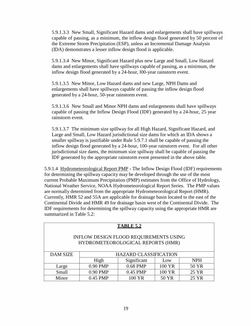
5.9.1.4 Hydrometeorological Report PMP - The Inflow Design Flood (IDF) requirements
for determining the spillway capacity may be developed through the use of the most
current Probable Maximum Precipitation (PMP) estimates from the Office of Hydrology,
National Weather Service, NOAA Hydrometeorological Report Series. The PMP values
are normally determined from the appropriate Hydrometeorological Report (HMR).
Currently, HMR 52 and 55A are applicable for drainage basin located to the east of the
Continental Divide and HMR 49 for drainage basin west of the Continental Divide. The
IDF requirements for determining the spillway capacity using the appropriate HMR are
summarized in Table 5.2:
TABLE 5.2
INFLOW DESIGN FLOOD REQUIREMENTS USING
HYDROMETEOROLOGICAL REPORTS (HMR)
DAM SIZE HAZARD CLASSIFICATION
High Significant Low NPH
Large 0.90 PMP 0.68 PMP 100 YR 50 YR
Small 0.90 PMP 0.45 PMP 100 YR 25 YR
Minor 0.45 PMP 100 YR 50 YR 25 YR

20
5.9.1.4.1 New Large and Small, High Hazard dams and enlargements shall have
spillways capable of passing, as a minimum, the Inflow Design Flood (IDF)
generated by 90 percent of the Probable Maximum Precipitation, unless an
incremental damage analysis demonstrates a lesser inflow design flood is applicable.
5.9.1.4.2 New Minor, High Hazard dams and enlargements shall have spillways
capable of passing, as a minimum, the Inflow Design Flood generated by 45 percent
of the Probable Maximum Precipitation (PMP), unless an Incremental Damage
Analysis (IDA) demonstrates a lesser IDF is applicable.
5.9.1.4.3 New Large, Significant Hazard dams and enlargements shall have spillways
capable of passing, as a minimum, the Inflow Design Flood (IDF) generated by 68
percent of the Probable Maximum Precipitation (PMP), unless an Incremental
Damage Analysis (IDA) demonstrates a lesser IDF is applicable.
5.9.1.4.4 New Small, Significant Hazard dams and enlargements shall have spillways
capable of passing, as a minimum, the Inflow Design Flood (IDF) generated by 45
percent of the Probable Maximum Precipitation (PMP), unless an Incremental
Damage Analysis (IDA) demonstrates a lesser IDF is applicable.
5.9.1.4.5 New Minor, Significant Hazard and new Large and Small, Low Hazard
dams and enlargements shall have spillways capable of passing, as a minimum, the
Inflow Design Flood (IDF) generated by a 24-hour, l00-year rainstorm event.
5.9.1.4.6 New Minor, Low Hazard dams, and new Large, NPH Dams and
enlargements shall have spillways capable of passing the Inflow Design Flood
generated by a 24-hour, 50-year rainstorm event.
5.9.1.4.7 New Small and Minor, NPH dams and enlargements shall have spillways
capable of passing the Inflow Design Flood (IDF) generated by a 24-hour, 25-year
rainstorm event.
5.9.1.4.8 The minimum size spillway for all High Hazard, Significant Hazard, and
Large and Small, Low Hazard jurisdictional size dams for which an IDA shows a
smaller spillway is justifiable under Rule 5.9.7.1 shall be capable of passing the
Inflow Design Flood (IDF) generated by a 24-hour, 100-year rainstorm event. For all
other jurisdictional size dams, the minimum size spillway shall be capable of passing
the IDF generated by the appropriate rainstorm event presented in the above table.
5.9.1.5 Elevation Reduction - The HMR PMP used to determine the IDF may be reduced
based on the average elevation of the drainage basin. The HMR PMP value may be
adjusted for the determination of the IDF for drainage basins above 5,000 (ft) MSL in
accordance with Table 5.3:
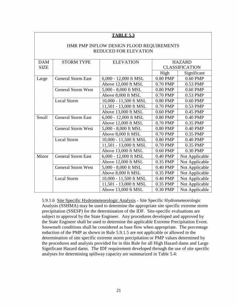
21
TABLE 5.3
HMR PMP INFLOW DESIGN FLOOD REQUIREMENTS
REDUCED FOR ELEVATION
DAM SIZE
STORM TYPE ELEVATION HAZARD CLASSIFICATION
High Significant
Large General Storm East 6,000 - 12,000 ft MSL 0.80 PMP 0.60 PMP
Above 12,000 ft MSL 0.70 PMP 0.53 PMP
General Storm West 5,000 - 8,000 ft MSL 0.80 PMP 0.60 PMP
Above 8,000 ft MSL 0.70 PMP 0.53 PMP
Local Storm 10,000 - 11,500 ft MSL 0.80 PMP 0.60 PMP
11,501 - 13,000 ft MSL 0.70 PMP 0.53 PMP
Above 13,000 ft MSL 0.60 PMP 0.45 PMP
Small General Storm East 6,000 - 12,000 ft MSL 0.80 PMP 0.40 PMP
Above 12,000 ft MSL 0.70 PMP 0.35 PMP
General Storm West 5,000 - 8,000 ft MSL 0.80 PMP 0.40 PMP
Above 8,000 ft MSL 0.70 PMP 0.35 PMP
Local Storm 10,000 - 11,500 ft MSL 0.80 PMP 0.40 PMP
11,501 - 13,000 ft MSL 0.70 PMP 0.35 PMP
Above 13,000 ft MSL 0.60 PMP 0.30 PMP
Minor General Storm East 6,000 - 12,000 ft MSL 0.40 PMP Not Applicable
Above 12,000 ft MSL 0.35 PMP Not Applicable
General Storm West 5,000 - 8,000 ft MSL 0.40 PMP Not Applicable
Above 8,000 ft MSL 0.35 PMP Not Applicable
Local Storm 10,000 - 11,500 ft MSL 0.40 PMP Not Applicable
11,501 - 13,000 ft MSL 0.35 PMP Not Applicable
Above 13,000 ft MSL 0.30 PMP Not Applicable
5.9.1.6 Site Specific Hydrometeorologic Analysis - Site Specific Hydrometeorologic
Analysis (SSHMA) may be used to determine the appropriate site specific extreme storm
precipitation (SSESP) for the determination of the IDF. Site-specific evaluations are
subject to approval by the State Engineer. Any procedures developed and approved by
the State Engineer shall be used to determine the applicable Extreme Precipitation Event.
Snowmelt conditions shall be considered as base flow when appropriate. The percentage
reduction of the PMP as shown in Rule 5.9.1.5 are not applicable or allowed in the
determination of site specific extreme storm precipitation or PMP values determined by
the procedures and analysis provided for in this Rule for all High Hazard dams and Large
Significant Hazard dams. The IDF requirement developed through the use of site specific
analyses for determining spillway capacity are summarized in Table 5.4:

22
TABLE 5.4
INFLOW DESIGN FLOOD REQUIREMENTS
FOR SSHMA
DAM SIZE HAZARD CLASSIFICATION
High Significant Low NPH
Large SSESP 0.75 SSESP 100 YR 50 YR
Small SSESP 0.5 SSESP 100 YR 25 YR
Minor SSESP 100 YR 50 YR 25 YR
5.9.1.7 Incremental Damage Analysis - An Incremental Damage Analysis (IDA) used to
justify an Inflow Design Flood (IDF) less than the requirements of Rule 5.9.1.3 through
Rule 5.9.1.6, shall be based on a comparison of two floods: first, a base flow flood of the
minimum magnitude which exceeds the capacity of all spillways, resulting in overtopping
of the dam routed through the downstream floodway assuming no dam is in place; and
second, the dam failure flood which occurs due to overtopping, and is routed downstream
with the base flow flood. The spillway capacity and IDF will be acceptable where it can
be shown that the dam failure flood would cause no additional loss of life nor additional
significant property damages downstream within the zone between the two floods.
5.9.1.7.1 No loss of life or significant damage is expected to occur if the increased
depth of flow is two feet or less and the product of the flood flow velocity in the
incremental zone and the depth of flow at critical locations along the floodway is less
than seven.
5.9.1.7.2 Documentation for the IDA shall include but not be limited to: a plot
showing both the base flow and dam break flood on topographic maps of the affected
areas; cross-sections of the downstream channel showing flood stages, velocities, and
discharges for the two floods at the critical locations; incremental damage and loss of
life determinations; and a summary of all assumed hydraulic parameters. A table
summarizing the results of the IDA at the various downstream cross sections showing
that the criteria in Rule 5.9.1.7.1 has been satisfied shall be included in the IDA study
report. Documentation shall also include, if deemed necessary by the State Engineer,
channel profiles with the various flood stages, aerial photographs of the affected
areas, and computer printouts showing flood discharges, stage, and velocities with
respect to time.
5.9.1.8 The minimum freeboard requirements for new or enlarged dams shall be based
upon the dam height required to prevent overtopping by wave action, or the sum of the
inflow design flood maximum water surface level plus one foot of residual freeboard, but
not less than five feet unless the State Engineer approves a lesser amount. Except for
concrete dams where the design engineer has demonstrated that overtopping of the dam
will not be detrimental to the safety of the dam, the inflow design flood can be

23
accommodated with zero residual freeboard or the overtopping depth at which the dam
still meets the stability and stress requirements of Rule 5.9.5.
5.9.1.9 For any dam whose spillway is not designed to pass the inflow design flood as
defined previously in Rule 5.9.1, the engineer may as an alternative, provide
documentation of the analysis that overtopping of the dam by floods which exceed the
spillway capacity up to the design flood will not cause failure of the dam. Otherwise,
overtopping protection shall be provided.
5.9.1.10 Spillway Design Exemption - Spillways designed and constructed in accordance
with the requirements of the Rules dated September 30, 1988 are exempt from the
requirements of these Rules.
5.9.2 Seismicity Design Requirements
5.9.2.1 Dams classified as High or Significant hazard shall be analyzed for seismic
stability. Seismic analysis for water storage dams shall be based on full reservoir under
steady state seepage conditions. Flood control dams with ungated outlets shall be
designed for earthquake loads under empty reservoir conditions and need not consider
steady-state seepage for seismic analysis. Dams sited on active faults shall obtain a
waiver from the State Engineer. To obtain a waiver, the analysis shall show that the
location of the dam is unavoidable and the dam must be designed to withstand anticipated
fault movement without compromising its integrity. Appropriate data sheets, calculation
sheets and computer program output computations from manual or computerized analysis
shall be provided. The seismic analysis shall meet the following minimum requirements:
5.9.2.1.1 A seismological investigation for the dam area and reservoir area. This
study may be part of the geotechnical report for the structure, or may be a separate
report. The study shall determine and justify the appropriate seismic parameters to be
used for design. The seismic parameters shall be based on the following design
earthquake:
5.9.2.1.1.1 Dams classified as High Hazard and with a height greater than or
equal to 30 feet, other than flood control structures, shall be designed for the
maximum credible earthquake or for an earthquake with a minimum 5000-year
return frequency.
5.9.2.1.1.2 Dams classified as High Hazard and with a height less than 30 feet,
other than flood control structures, shall be designed for either: a) the maximum
credible earthquake or an earthquake with a minimum 5000-year return
frequency, or b) for a peak ground surface acceleration equal to twice the
acceleration for the site with a 2% chance of exceedance in 50 years
(approximately 2500-year return frequency), as estimated and published by the
U.S. Geological Survey.

24
5.9.2.1.1.3 Dams classified as Significant Hazard or High Hazard dams whose
sole purpose is for flood control shall be designed for a 2% chance of exceedance
in 50 years (approximately 2500-year return frequency).
5.9.2.2 An analysis of materials in the foundation, reservoir area and proposed
embankment shall be completed to determine the potential for liquefaction, earthquake-
induced sliding, or other seismic sensitivity, which may be accomplished as part of the
geotechnical investigation.
5.9.2.3 Pseudostatic analysis for embankment dams will be acceptable for the following
cases:
5.9.2.3.1 The embankment is to be mechanically compacted to at least 95% of the
maximum standard Proctor density, ASTM D698, or at least 90% of the maximum
modified Proctor density, ASTM D1557 or at least 70% relative density per
ASTM D4253 and ASTM D4254, if Proctor testing is not appropriate; no materials
prone to liquefaction are present in the foundation and the design peak bedrock
acceleration is 0.20g or less; or
5.9.2.3.2 The embankment is to be mechanically compacted to at least 95% of the
maximum standard Proctor density, ASTM D698, or at least 90% of the maximum
modified Proctor density, ASTM D1557; potentially submerged portions of the
embankment except for internal drain elements are constructed of clayey material; the
dam is constructed on clayey soil or bedrock foundation and peak bedrock
acceleration is 0.35g or less; and
5.9.2.3.3 All static stability safety factor requirements of these Rules are met;
minimum freeboard requirements of these Rules are met; and the pseudostatic
coefficient selected for analysis must be at least 50% of the design peak bedrock
acceleration, but not less than 0.05g and the factor of safety under pseudostatic
analysis shall be 1.0 or greater. In determining the factor of safety for pseudostatic
analysis, a search for the critical failure surface shall be made.
5.9.2.4 Pseudostatic analysis for concrete dams will be acceptable and shall meet the
requirements Rule 5.9.5.
5.9.2.5 For dams not satisfying the requirements for pseudostatic analysis, a deformation
analysis is required. The resulting embankment must be capable of withstanding the
design earthquake without breaching and with at least 3 feet of freeboard remaining after
deformation. The analysis shall also assess the potential for internal erosion as a result of
cracking during earthquake-induced deformation.
5.9.2.6 The seismic assessment shall also address the stability of appurtenant structures
to the dam during the design earthquake, as appropriate, unless failure of an appurtenance
due to earthquake does not represent an immediate threat to the dam, in which case a
lesser operating basis earthquake may be used, as approved by the State Engineer.

25
5.9.3 Geotechnical Investigation and Foundation Requirements
5.9.3.1 Geological and geotechnical investigations are required to describe the geology
and geotechnical conditions for construction of the dam and reservoir. The report shall
include the geological and geotechnical analyses required for the design and construction
of the dam. The report shall describe the foundation conditions for the dam and provide
justification for foundation strength, deformation, sliding stability and seepage
parameters assumed for design. The foundation requirements for design of the dam will
vary based upon the foundation conditions, geology, rock jointing and faulting, dam size
and use of the reservoir.
5.9.3.2 Geological and geotechnical engineering exploration shall be conducted under
the supervision of a Licensed Professional Engineer or an Engineering Geologist
experienced in geotechnical or geological engineering for dams.
5.9.3.3 Geological mapping is required for the dam and reservoir area. The geological
mapping shall include the dam, dam abutments and the locations of appurtenant
structures.
5.9.3.4 Subsurface investigations shall be conducted for all new dams and for all major
modifications to existing dams. The subsurface investigation is typically required to
evaluate the depth and geologic classification of the bedrock foundation excavatability
and characterize the foundation competency under the dam. The subsurface investigation
shall include, test holes, test pits, geophysical survey, insitu-testing, water packer test,
pressure meter, and block shear tests.
5.9.3.5 The number and depth of test holes and test pits are typically based on the
geological conditions, the complexity of the geological conditions and the size of the dam
and depth of the reservoir. The number of foundation drill holes shall not be less than
three.
5.9.3.6 Direct shear strength testing and compressive strength testing is required to
evaluate design values for shear strength and bearing capacity. Strength properties of
discontinuities and the weakest foundation materials are required, as these will generally
control foundation behavior. Shear strength testing is also required on rock
discontinuities including pre-existing shear planes or faults in the dam foundation.
Typical test requirements could include stress-strain properties, shear wave velocity,
density and tensile strength.
5.9.3.7 The geological and geotechnical basis for the foundation grouting design for the
dam should be prepared. This documentation includes the basis for the design of the
curtain grouting and consolidation grouting of the dam footprint.

26
5.9.3.8 Foundation excavation requirements necessary to provide a firm foundation for
the dam shall be documented in the Geotechnical Report. The Geotechnical Report shall
provide excavation requirements for shaping of the foundation to provide more uniform
foundation stresses or to minimize dam cracking.
5.9.3.9 Foundation drainage design shall be provided including justification for reduction
in uplift pressures on the dam. The efficiency of the drainage system to reduce uplift
pressures under the dam shall be based upon the geology of the dam foundation. The
ability to maintain the drainage system to meet the requirements assumed for the design
of the dam shall be addressed.
5.9.3.10 Confirmation of foundation design assumptions is required after the foundation
for the dam has been exposed. The project geologist and design engineer shall confirm
foundation conditions assumed for the design. Changes in foundation conditions from
assumptions made in the Geotechnical Report shall be communicated to the State
Engineer when they are identified during construction. Changes to the foundation design
for the dam shall be submitted to State Engineer’s Office in a formal Change Order
Request during construction per the requirements of Rule 9.
5.9.4 Embankment Dam Design Requirements
5.9.4.1 Stability Analysis - Embankment dams shall be designed to have stable slopes
during construction, and under all conditions of reservoir operation, including rapid
draw-down of the reservoir.
5.9.4.1.1 Factors of safety shall be evaluated by slope stability analyses
methodologies that are acceptable to the State Engineer. The analysis models shall
adequately represent, for the critical cross section (or sections) of the dam, the
embankment geometry and internal zoning; shear strengths and unit weights of each
material; pore water pressures; and external loading or other relevant factors. Shear
strength and pore pressure assumptions used in stability analyses should be obtained
from tests that appropriately model the loading condition being analyzed. Where
appropriate, the analyses shall consider non-circular or wedge-shaped failure
surfaces, as well as circular failure surfaces. All parameters and assumptions used in
the analysis shall be summarized in a table, and justified in the Geotechnical Report.
A scale drawing, utilizing the same scale for vertical and horizontal dimensions, shall
be provided for each cross-sectional model used in the analysis, with the critical
failure surface(s) identified. Appropriate data sheets and representative computer
program output shall be provided in the report.
5.9.4.1.2 Minimum factors of safety for slope stability of embankment dams for
various loading conditions other than seismic loading are summarized in Table 5.5.

27
TABLE 5.5
MINIMUM FACTORS OF SAFETY FOR SLOPE STABILITY
OF EMBANKMENT DAMS
Loading Condition Minimum Factor of Safety1
Steady seepage with phreatic surface fully developed for reservoir at normal pool
elevation
1.5
End of Construction 1.3
Rapid draw-down (upstream slope) 1.2 1Not applicable for embankment dams on clay shale foundations; residual shear strength may be
appropriate and required factors of safety shall be determined on a case-by-case basis by the State
Engineer.
5.9.4.1.3 For Low hazard or NPH dams, the State Engineer may waive the
requirements for stability analysis if it can be demonstrated that conservative slopes
and competent materials are used in the dam design. Dams classified as Low hazard
or NPH shall have upstream slopes no steeper than 3:1 (horizontal:vertical), and
downstream slopes no steeper than 2:1 (horizontal:vertical).
5.9.4.2 Seepage and Internal Drainage Design - The evaluation of the steady state
seepage and internal drainage conditions shall be performed for all High and Significant
Hazard Dams. The seepage and internal drainage analyses shall include, but not be
limited to, the following:
5.9.4.2.1 Flow nets or numerical analysis computer programs shall be used in the
analyses. Data sheets and output files from these analyses shall be provided or made
available where requested. The hydraulic conductivity parameters used in these
analyses shall be obtained from field permeability tests, laboratory permeability tests,
or empirical/correlative permeability determinations, and the sources of the estimated
hydraulic conductivities shall be clearly documented.
5.9.4.2.2 The analyses shall quantify the anticipated seepage beneath, around and
through the dam. Seepage exiting on the downstream face of the dam shall not be
permitted. Internal drains and filters shall be constructed of granular soil materials
(sands and gravels), and the filter and drain zones shall be of sufficient thickness to be
constructed without significant contamination or loss of continuity that would
adversely impact the performance of these features.
5.9.4.2.3 The filter compatibility of the drain and embankment material shall be
evaluated utilizing current state of the practice methodologies, such as those
published by the Natural Resources Conservation Service, the U.S. Bureau of
Reclamation or the U.S. Army Corps of Engineers.

28
5.9.4.3 For embankment dams, the following design considerations must be addressed
and documented in the Design Report.
5.9.4.3.1 Geometric and Design Requirements - Dam geometry shall be supported by
the slope stability and seismic analysis, and shall meet the following minimum
requirements:
5.9.4.3.1.1 The crest width shall be equal to the jurisdictional height of the dam
in feet divided by 5, plus 10 feet. The maximum crest width required shall be 25
feet.
5.9.4.3.1.2 The crest shall have a camber sufficient to maintain the design
freeboard, based on the anticipated magnitude of crest settlement. The anticipated
magnitude of crest settlement shall be based on engineering analyses. In no case
shall the camber be less than 0.5 feet.
5.9.4.3.1.3 Guidelines for minimum dimensions of impervious core zones for
zoned embankment dams up to 50 feet high are defined in the "Design of Small
Dams," United States Department of the Interior, Bureau of Reclamation, Third
Edition, 1987, U.S. Government Printing Office, Washington, D.C., 20402, (later
amendments, editions or subsequent publications not included). Zone
dimensioning for dams over 50 feet shall be evaluated using industry standard
analyses.
5.9.4.3.1.4 Roads located on the dam crest shall have appropriate surfacing to
provide a stable base that resists rutting and provides adequate traction for safety
in wet conditions.
5.9.4.3.1.5 The crest design shall include details to protect impervious cores from
desiccation or frost penetration, as approved by the State Engineer.
5.9.4.3.1.6 The crest shall be provided with adequate cross slopes to the upstream
edge to prevent ponding.
5.9.4.3.1.7 Minimum dimensions for internal granular filter and drain zones shall
meet requirements of Rule 5.9.4.2.
5.9.4.3.1.8 The embankment shall be protected against external erosion.
5.9.4.3.1.9 The downstream slope of the embankment dams shall be provided
with a well maintained vegetative cover to prevent surface erosion from
occurring. No landscaping or planting of trees or large vegetation shall be
permitted within 25 feet of the footprint of the dam.
5.9.4.3.1.10 The shear strengths of the foundation soils (including suitable factors
of safety) shall not be exceeded under any foreseeable loading conditions.

29
5.9.4.3.1.11 Seepage through the embankment, abutments, and foundation shall
be controlled to prevent internal erosion and external sloughing.
5.9.4.3.2 Compaction Requirements - Material compaction requirements shall meet
the minimum requirements:
5.9.4.3.2.1 Minimum compacted density for embankment materials shall be 95
percent of maximum dry density for ASTM D698 (Standard Proctor) or 90
percent for ASTM D1557 (Modified Proctor), as found in the 2006 "Annual Book
of ASTM Standards", Section 04.08, Soil and Rock; 100 Barr Harbor Drive, West
Conshohocken, PA 19428, (later amendments, editions or subsequent publications
not included). Impervious zones with clay fines shall be controlled using
Standard Proctor criteria to maintain the plastic nature of the material; and
5.9.4.3.2.2 The minimum density for cohesionless materials shall be 65 to 75
percent relative density as determined by ASTM D4253 and D4254 as found in
the 2006 "Annual Book of ASTM Standards," Section 04.08, Soil and Rock; 100
Barr Harbor Drive, West Conshohocken, PA 19428, (later amendments, editions
or subsequent publications not included).
5.9.4.3.3 Rock Riprap - Rock Riprap shall be well graded, durable and sized to
withstand design wave action or channel velocities, and shall be placed on a well-
graded pervious sand and gravel bedding or geotextile fabric. Soil cement for erosion
protection may be used in lieu of rock riprap, but shall be designed and constructed in
accordance with standards acceptable to the State Engineer. Slope protection for
wave action is required to be provided on the entire upstream face of the dam, unless
lesser coverage is justified based on engineering analysis and reservoir operational
criteria and approved by the State Engineer.
5.9.4.3.4 Filters and Drains - The design of all drains, filter blankets, and toe drains
shall be performed in accordance with Rule 5.9.4.2 and must be acceptable to the
State Engineer.
5.9.4.3.5 Internal Drain Pipes - Pipes to collect and distribute seepage flows from
internal filters and drains shall:
5.9.4.3.5.1 Be comprised of material that is non-corrodible and non-collapsible
for the estimated overlying earth pressures and anticipated settlement or ground
movement associated with dam construction.
5.9.4.3.5.2 Be surrounded with free-draining material that is filter compatible
with the surrounding earth material in accordance with current filter criteria of
such organizations as the Natural Resources Conservation Service, the U.S.
Bureau of Reclamation, and the U.S. Army Corps of Engineers.

30
5.9.4.3.5.3 Have slots or perforations that are filter compatible with the
surrounding free-draining material in accordance with current filter criteria of
such organizations as the Natural Resources Conservation Service, the U.S.
Bureau of Reclamation, and the U.S. Army Corps of Engineers.
5.9.4.3.5.4 Be installed in such a manner to be accessible for internal camera
inspection and repair.
5.9.4.3.5.5 Be designed to flow with a water depth no greater than ¼ of the
diameter of the pipe for the estimated seepage flows.
5.9.4.3.5.6 Be no smaller than 6 inches in diameter.
5.9.4.3.5.7 Discharge into locations where discharge flows can be evaluated and
monitored, such as galleries, manholes, or daylight (ground surface) areas.
5.9.4.3.5.8 Be inspected after a maximum of 3 to 5 feet of fill placed over pipe,
and again after remaining fill has been placed.
5.9.4.3.5.9 Be equipped with rodent screens in locations where the discharge
ends of the pipes are accessible to animals.
5.9.4.3.5.10 Be designed with multiple discharge points in order to isolate
seepage to various sections of the dam and foundation.
5.9.4.3.6 Geosynthetics - The use of geosynthetics shall be evaluated by the State
Engineer on a case-by-case basis for each dam. Geosynthetics materials shall be used
in accordance with the manufacturers’ recommendations and intended use for each
product. Use of geosynthetics shall comply with the following general design
considerations:
5.9.4.3.6.1 Geosynthetics will not be accepted where the geosynthetic is the sole
element employed to perform a function that is an element of the dam were failure
of the geosynthetic, could result in a catastrophic release of the reservoir.
Redundant design features are required whenever geosynthetics are used for these
functions.
5.9.4.3.6.2 The use of a geotextile as a filter layer may be allowed if the
geotextile is placed such that it does not jeopardize the stability or safety of the
dam or appurtenant structures due to failure of the geotextile (such as clogging),
and the geotextile can be repaired or replaced without jeopardizing the stability or
safety of the dam.

31
5.9.5 Concrete Dam Design Requirements
5.9.5.1 For concrete dams, the following design considerations must be addressed
and documented in the Design Report
5.9.5.1.1 Access to the dam crest shall be provided from at least one of the
abutments of the dam. Access shall be provided to the side of the dam where the
control of the outlet works used for the emergency release of the reservoir volume
is situated.
5.9.5.1.2 The crest of the dam shall have a width of not less than 15 feet.
5.9.5.1.3 Concrete dam crests, if designed as emergency spillway, shall not be
overtopped for floods more frequent than the 100-year storm. Emergency
spillway discharge for flows up to the inflow design flood shall not cause
excessive downstream erosion of the abutments and foundation.
5.9.5.1.4 If the design of the concrete dam includes drainage features and the
reduction in uplift pressures is required to meet factors of safety and stress
requirements, a gallery shall be provided in the dam to access, monitor and clean
or re-drill the dam and foundation drains.
5.9.5.2 Arch Dam Design - Concrete arch dams are not specifically addressed in
these Rules and shall be designed in accordance with principles provided in U.S.
Bureau of Reclamation publication "Design of Arch Dams," 1977 or U.S. Army
Corps of Engineers publication “Arch Dam Design” EM 1110-2-2201 1994, (later
amendments, editions, or subsequent publications not included).
5.9.5.3 Gravity Dam Design - Concrete gravity dams (conventional or roller
compacted concrete (RCC)) shall be designed in accordance with the following Rules
and with principles provided in U.S. Bureau of Reclamation publication "Design of
Gravity Dams," 1976, or U.S. Army Corps of Engineers publications “Gravity Dam
Design” EM 1110-2-2200 1995 and “Roller-Compacted Concrete” EM 1110-2-2006
2000 (later amendments, editions or subsequent publication not included).
5.9.5.3.1 The structural stability and stress analyses of a concrete gravity dam for
both non-overflow and spillway sections shall be performed using the gravity
method of stress and stability analysis, as described in the aforementioned
publications. The trial-load twist method of analysis may be used for the stability
analysis when keyed or grouted transverse contraction joints are provided. The
finite element method may be used to supplement the gravity method and to
investigate specific features where areas of maximum stresses may occur within
the dam and foundation.
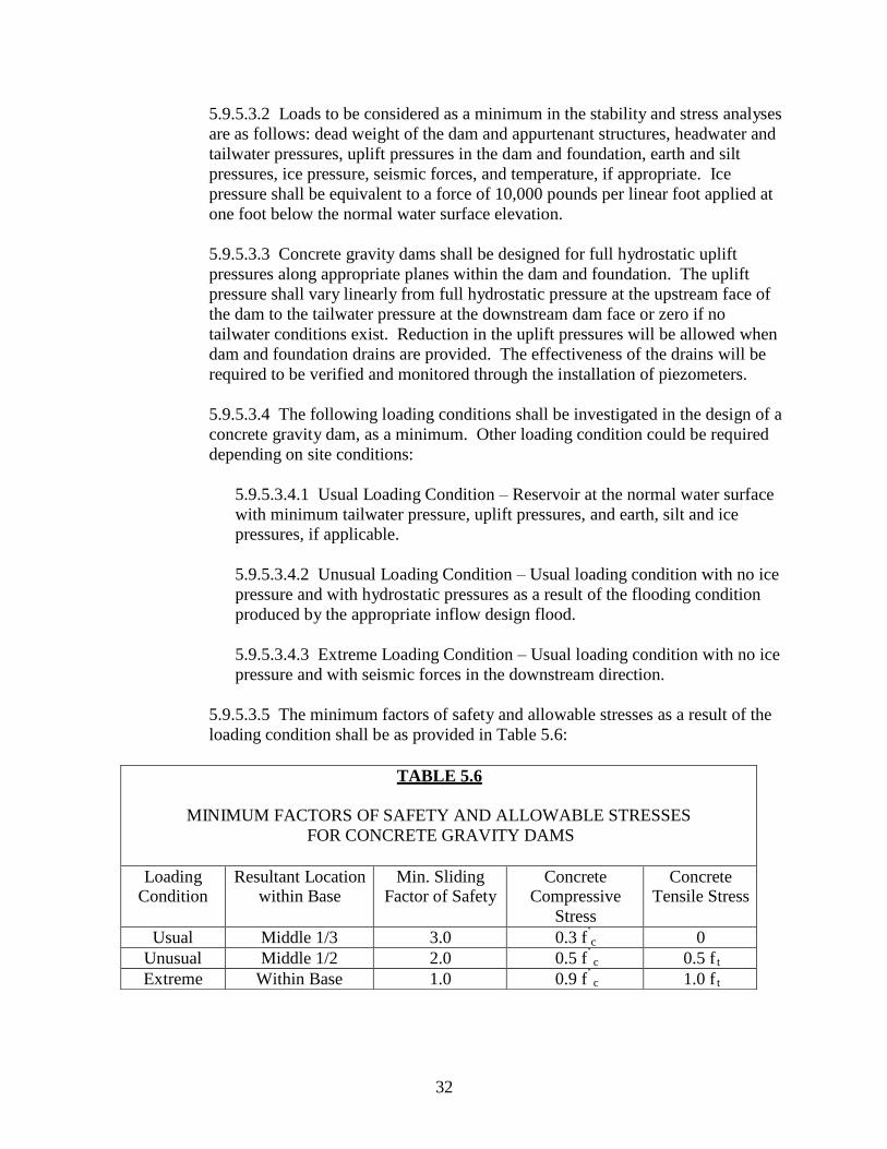
32
TABLE 5.6
MINIMUM FACTORS OF SAFETY AND ALLOWABLE STRESSES
FOR CONCRETE GRAVITY DAMS
Loading Condition
Resultant Location within Base
Min. Sliding Factor of Safety
Concrete Compressive
Stress
Concrete Tensile Stress
Usual Middle 1/3 3.0 0.3 f’ c 0
Unusual Middle 1/2 2.0 0.5 f’ 0.5 f
Extreme Within Base 1.0 0.9 f’ 1.0 f
5.9.5.3.2 Loads to be considered as a minimum in the stability and stress analyses
are as follows: dead weight of the dam and appurtenant structures, headwater and
tailwater pressures, uplift pressures in the dam and foundation, earth and silt
pressures, ice pressure, seismic forces, and temperature, if appropriate. Ice
pressure shall be equivalent to a force of 10,000 pounds per linear foot applied at
one foot below the normal water surface elevation.
5.9.5.3.3 Concrete gravity dams shall be designed for full hydrostatic uplift
pressures along appropriate planes within the dam and foundation. The uplift
pressure shall vary linearly from full hydrostatic pressure at the upstream face of
the dam to the tailwater pressure at the downstream dam face or zero if no
tailwater conditions exist. Reduction in the uplift pressures will be allowed when
dam and foundation drains are provided. The effectiveness of the drains will be
required to be verified and monitored through the installation of piezometers.
5.9.5.3.4 The following loading conditions shall be investigated in the design of a
concrete gravity dam, as a minimum. Other loading condition could be required
depending on site conditions:
5.9.5.3.4.1 Usual Loading Condition – Reservoir at the normal water surface
with minimum tailwater pressure, uplift pressures, and earth, silt and ice
pressures, if applicable.
5.9.5.3.4.2 Unusual Loading Condition – Usual loading condition with no ice
pressure and with hydrostatic pressures as a result of the flooding condition
produced by the appropriate inflow design flood.
5.9.5.3.4.3 Extreme Loading Condition – Usual loading condition with no ice
pressure and with seismic forces in the downstream direction.
5.9.5.3.5 The minimum factors of safety and allowable stresses as a result of the
loading condition shall be as provided in Table 5.6:
c t
c t

33
5.9.5.4 Roller Compacted Concrete Design Requirements - Design of new RCC
dams shall meet all requirements for concrete dams regarding field investigations,
testing, foundation treatment, stability and stresses. RCC dam design shall also meet
the following additional requirements:
5.9.5.4.1 An RCC mix design study shall be submitted with the design report,
containing proposed aggregate data, source of aggregate, strength test results, and
proposed cementitious contents.
5.9.5.4.2 The dam design shall include adequate control of cracking in upstream
facing system and RCC mass caused by thermal shrinkage of the concrete. Crack
control provisions shall also include control of excessive heat of hydration by use
of fly ash and limit in-place temperature of RCC.
5.9.5.4.3 Design dimensions shall be constructable with conventional earthwork
equipment, particularly between the upstream face of the dam and the drainage
gallery, and the “chimney section” width.
5.9.5.4.4 Adequate cold joint treatment shall be provided in the specifications to
prevent formation of unbonded lift joints that are potential paths of seepage.
5.9.5.4.5 RCC dams with a structural height of 100 feet or higher shall be
designed with a drainage gallery, when dam and foundation drains are provided.
5.9.5.4.6 Specifications shall include provisions for placing RCC under cold
weather, hot weather, and rain.
5.9.5.4.7 RCC spillway chute steps shall be protected with conventional facing
concrete, or equivalent protection, unless the State Engineer approves a lesser
standard for good cause shown. Design of stilling basins for RCC stepped chute
spillways shall include assumptions, calculations, and applicable references for
estimating energy dissipation and stilling basin entrance velocities.
5.9.5.4.8 Outlet works gate and spillway towers shall be designed as temporary
free-standing tower, if structures are proposed to be completed before any RCC
placement.
5.9.5.5 Roller Compacted Concrete Dam Construction Requirements - The construction
of RCC dams shall meet the following additional requirements.
5.9.5.5.1 An RCC test section shall be constructed outside the dam footprint at least
21 days before production placement of the RCC. The final design mix and the
method of construction shall be approved by the SEO prior to production placement.
5.9.5.5.2 The Owner shall provide full-time qualified field observation during RCC
production placement.

34
5.9.5.5.3 Locations of all cold joints shall be documented.
5.9.5.5.4 Representative RCC cores shall be taken from the completed dam to verify
design strengths. RCC cores shall be 6-inch diameter.
5.9.5.5.5 Because a RCC dam can be completed within a short period of time, the
dam shall be allowed to gain adequate strength before initial filling of the reservoir.
5.9.5.6 Concrete Slope and Overtopping Protection - The design of RCC and soil-cement
dam rehabilitation shall meet the following additional requirements.
5.9.5.6.1 Soil-cement mix design shall meet guidelines of Portland Cement
Association or the U.S. Bureau of Reclamation.
5.9.5.6.2 Soil-cement slope protection shall be designed for a minimum 56-day
strength of 750 psi for durability considerations.
5.9.5.6.3 Soil-cement shall not be used for emergency spillway or embankment
overtopping protection, unless it can be demonstrated that the soil-cement can
withstand the anticipated flow rates and velocities.
5.9.5.6.4 RCC emergency spillway or RCC embankment overtopping protection
shall not operate for floods more frequent than the 100-year storm.
5.9.5.6.5 Normal thickness of soil-cement or RCC shall be a minimum of 2 feet.
5.9.6 Spillway and Outlet Works Design Requirements
5.9.6.1 Spillway Design - All spillways shall be designed and constructed in a manner
acceptable to the State Engineer and meet the following criteria.
5.9.6.1.1 The spillway flows must be safely routed back to the natural channel or
drainage way that would exist if the dam were not built. Where the spillway channel
discharges into an adjacent basin, apart from the drainage on which the dam is
located, the owner shall possess title to the property, a right-of-way, or easement for
the flood channel downstream to the location where the maximum discharge would
no longer cause damage beyond what naturally would occur on the adjacent drainage.
5.9.6.1.2 Log booms or other methods approved by the State Engineer shall be
installed in the spillway approach where logs and other debris may block spillway
flow or damage the spillway structure.
5.9.6.1.3 Pipe emergency spillways are not acceptable.

35
5.9.6.1.4 The Design Report shall include discharge tables (in cubic feet per second)
for all spillways showing the discharge for each foot of head between the crest of the
spillways and dam. The equation(s) used for determining the discharge shall also be
included. Crest elevations of all spillways and the dam shall be clearly noted on the
table.
5.9.6.1.5 For floodwater detention and flood control dams, the required principal
spillway and outlet conduit discharge rate shall be coordinated with the Division
Engineer for the Water Division in which the dam is located.
5.9.6.2 Outlet Works Design - All outlet systems shall be designed and installed in a
manner acceptable to the State Engineer and shall meet the following criteria:
5.9.6.2.1 The outlets for High Hazard dams shall be capable of releasing the top five
feet of the reservoir capacity in five days, and for all other classes of dams as required
by the State Engineer. The outlet shall be capable of releasing the entire reservoir in
a reasonable period of time. In addition, outlets shall be capable of passing inflow to
the reservoir with a minimum of ten feet of head, in order to meet the demands of
downstream senior water rights and the owner's release requirements. The minimum
size required for outlet conduits and controls is 12 inches. For all other Hazard dams,
the outlets should be sized to draw down the reservoir under emergency conditions in
a reasonable period of time, as determined by the State Engineer.
5.9.6.2.2 All principal outlets connected to a pipeline shall have a by-pass valve that
will meet the capacity criteria as defined in Rule 5.9.6.2.1.
5.9.6.2.3 Outlet conduits for all dams, except for dams with un-gated outlets, shall
have a guard gate installed at the upstream end of the conduit
5.9.6.2.4 Intake structures for outlet works shall have trash racks unless exempted by
the State Engineer for good cause shown.
5.9.6.2.5 The Design Report shall include an outlet discharge table (in cubic feet per
second) showing the discharge for each foot of head between the invert of the intake
structure and the crest of the dam. The equation(s) used for determining the
discharge shall also be included. Elevations of all outlets and spillways shall be
clearly noted on the table.
5.10 Reservoir and Water Diversion Requirements
5.10.1 Reservoir and Site Requirements
5.10.1.1 The area to be submerged by the new or enlarged reservoir shall be cleared of
logs and debris.

36
5.10.1.2 Borrow areas shall be located at least 200 feet from either toe of the dam. The
dimension of this limit may be reduced using engineering analyses indicating that the
reduced dimension will not negatively impact dam stability and/or foundation seepage.
5.10.1.3 The dam crest and appurtenant structures shall be accessible by equipment and
vehicles for emergency operations and maintenance.
5.10.1.4 The dam owner shall possess title to the property, or a permanent easement,
including permanent access, for a minimum distance of fifty feet or the height of the dam,
whichever is greater, downstream from the downstream toe of the dam for the purpose of
maintenance and the removal of trees and large vegetation along the downstream toe of
the dam.
5.10.1.5 Pipelines, utility lines or any other construction that penetrate through dam
abutment areas below the dam crest elevation, or that are within a distance of 50 feet or
the height of the dam, whichever is greater, from either toe of the dam shall not be
allowed without prior written approval by the State Engineer. To be considered for
approval, such penetrations must be designed to protect against seepage and piping
through trench backfill materials and avoid temporary or permanent impacts to dam
stability, and must be documented with as-constructed survey data and installation details
submitted to the State Engineer.
5.10.1.6 The design of a new reservoir or enlargement of an existing dam and reservoir
shall not result in the inundation of properties (except marina-type structures) during the
Inflow Design Flood (IDF) unless the dam owner owns or obtains flood right-of-ways for
all areas which may be inundated by the reservoir surcharge. The owner shall submit a
written statement certifying they own the properties, or own the right-of-way on all
affected properties, or possess a right-of-way easement for the reservoir inundation zone.
5.10.1.7 Flood easements for spillway discharges shall meet the requirements of
Rule 5.9.6.1.1.
5.10.2 River Diversion During Construction Requirements
5.10.2.1 A water diversion plan to control surface water during construction meeting the
requirements of Rule 9 may be developed by the construction contractor based on
information and requirements provided by the Engineer, or the Engineer may prepare
these plans.
5.10.2.2 In developing the requirements of the plan during the project design, the design
storm for the construction period, including the estimated volume or flow rate that must
be managed during construction should be clearly specified in the Design Report.
5.10.2.3 The contractor may be allowed flexibility to develop the methods and means to
divert the water in coordination with other aspects of the construction.

37
5.10.2.4 Regardless of who prepares the detailed water diversion plan, the plan must be
prepared and submitted to the State Engineer for review in advance of construction of the
diversion facilities in accordance with Rule 9. The plan must be prepared under the
direction of a qualified Professional Engineer registered in the State of Colorado.
5.10.2.5 The water diversion plan meeting the intent of Rule 9 should include the
following items.
5.10.2.5.1 Design drawings and specifications depicting the constriction of
cofferdams, spillways, conduits, gates, or other temporary features that may be
required to control the water.
5.10.2.5.2 Stability analysis of the cofferdam, under both normal and design flood
loading condition.
5.10.2.5.3 Hydraulic calculations showing the capacity of spillways or conduits used
for diversion.
5.10.2.5.4 The plan for the removal or abandonment of cofferdams, spillways,
conduits, or other temporary features after construction is complete.
Rule 6. Requirements for Alteration, Modification, or Repair of an Existing Dam:
6.1 An owner proposing to alter, modify, or repair an existing dam shall submit an application
package in a form acceptable to the State Engineer and receive approval of the construction plans
and specifications from the State Engineer prior to construction. The provisions of Rule 6 shall
apply to such application only to the extent directly related to work for which approval is being
sought.
6.1.1 Design Requirements - The requirements of Rule 5 shall apply except as modified by
Rules 6.1.2 and 6.1.3. A Hydrology Report, Geotechnical Report, Design Report, and
Instrumentation Plan are required as a minimum to support the scope of the work described
on the application.
6.1.2 Application and Approval Requirements for High Hazard, Significant Hazard,
and Large, Low Hazard Dams - Plans for repair of an existing dam, or alteration of existing
High Hazard, Significant Hazard, and Large, Low Hazard dams to non-jurisdictional size
may be approved by the State Engineer by letter without meeting requirements set forth in
Rules 5.2 and 5.3, subject to the following conditions:
6.1.2.1 A completed application form provided by the State Engineer shall accompany
appropriate specifications and necessary drawings depicting minimum details for the
repair or alteration. Plans and specifications must be prepared by an engineer. The
provisions of Rules 5.6, 5.7, and 11 shall apply.

38
6.1.2.2 The plans and specifications shall contain sufficient detail to enable a contractor
to prepare a bid and construct the repair, or alter the dam to non-jurisdictional size. The
provisions of Rule 9 shall apply. The engineer shall give the State Engineer not less than
7 days notice of the start of construction.
6.1.2.3 Upon completion of repair or alteration, the engineer shall file as-constructed
plans in conformance with Rule 5 and Rule 10.
6.1.2.4 The requirement for submitting as-constructed plans for altering an existing
jurisdictional size dam to non-jurisdictional size dam will be determined by the State
Engineer.
6.1.3 Application and Approval Requirements for Small and Minor, Low Hazard and
NPH Dams - Plans for repair of Small and Minor, Low Hazard dams, or NPH dams; and
plans for the alteration of all Low Hazard or NPH dams to non-jurisdictional size are exempt
from the provisions of Rules 5, 6, 9, and 10, except as specified in Rule 6.1.3.1 through
Rule 6.1.3.3.
6.1.3.1 Notice - The dam owner must provide at least thirty days advanced written notice
to the State Engineer. The written notice must contain the name of the dam, the location
of the dam, the name of the owner, and a clear description of the work to be performed.
6.1.3.2 Determination - If the State Engineer determines that plans and specifications
prepared by an engineer are necessary for the repair, the owner will be notified within
five working days from the date the owner’s notice was received. A cost estimate and
filing fee will also be required. The owner cannot begin construction until the plans and
specifications are approved by the State Engineer. If plans and specifications are not
required, the State Engineer will inform the dam owner of engineering and construction
requirements, if any, and will perform construction inspections as determined necessary.
6.1.3.3 Project Completion - The dam owner must keep the State Engineer informed of
the project status and provide the State Engineer with as-constructed drawings and
specifications within sixty days following completion of the work. The as-constructed
drawings must be drawn on good quality mylar with permanent ink (or equivalent), and
the drawings shall be reproducible, and suitable for a long lasting permanent record.
6.1.4 Inflow Design Flood Requirements - The inflow design flood (IDF) requirements for
all existing dams shall be determined in accordance with Rule 5. Structures with spillways
designed and approved prior to 1988 and in accordance with the methods published in the
U.S. Department of the Interior, Bureau of Reclamation, "Design of Small Dams," Second
Edition 1973, (later amendments, editions or subsequent publications not included) shall be
considered adequate for the original hazard classification. If the classification has changed,
then the provisions of these Rules and specifically Rule 5 apply.

39
6.1.4.1 The methods of Rule 5 apply, but may be reduced for good cause shown.
Spillways designed in accordance with these Rules will not be required to be enlarged
due to subsequent revisions in ESP or PMP estimates, unless, in the opinion of the State
Engineer, a substantial increased threat to public safety exists.
6.1.4.2 The minimum size spillway for all existing High Hazard dams and Large and
Small Significant Hazard dams, for which an incremental damage analysis shows a
smaller spillway is justifiable under Rule 5.9.1.7, is the spillway size required to safely
accommodate the flood generated by a 24-hour, 100-year rainstorm event.
6.1.5 Freeboard - The minimum freeboard requirements for an existing dam shall be the
maximum required to either prevent overtopping by wave action or to pass the IDF without
overtopping, but not less than three feet.
6.2 Approval Limitation - If construction, alteration, or repair of a reservoir dam is not
commenced within five years of approval of the application, the State Engineer's approval shall
be void. The owner must resubmit the application and receive approval before commencing
construction, and shall meet the requirements of the current Rules and Regulations.
6.3 Design Review Limitation - The design review performed by the State Engineer shall be
limited to three years from the date of the review. Re-submittal of the design package shall be
required if resolution of the design review comments does not occur within three years.
Rule 7. Requirements for Removing or Breaching an Existing Dam:
7.1 Breach Plan and Application - An owner proposing to permanently remove or breach a
dam shall submit an application package in a form acceptable to the State Engineer prior to
commencing work. Plans for Removal or Breach of a dam shall meet the following
requirements:
7.1.1 Application - A completed application shall be submitted on a form provided by the
State Engineer.
7.1.2 High and Significant Hazard Dams - For High and Significant Hazard dams, a
breach plan shall be prepared by an engineer.
7.1.2.1 The dam shall be excavated down to the level of the natural ground, or as
necessary in accordance with Rule 7.1.2.3, at the maximum section; and shall be of
sufficient width to pass the 24-hour, 100-year flood with a maximum increase in reservoir
depth of five feet. However, the maximum breach width shall not exceed the width of the
original natural channel before the dam was constructed, regardless of the 100-year flood
magnitude unless approved by the State Engineer for improved public safety.

40
7.1.2.2 The sides of the breach shall be excavated to a slope that is stable, but not steeper
than 2:1 (two horizontal to one vertical). Slope stability analysis that provides an
adequate factor of safety for steeper slopes may be accepted by the State Engineer, but in
no case shall the slopes be steeper than 1:1.
7.1.2.3 The breach shall be designed to prevent silt previously deposited in the reservoir
and material excavated for the breach from washing downstream.
7.1.2.4 Water impounded in the reservoir area shall be released in a controlled manner
that will not endanger lives or damage downstream properties.
7.1.2.5 The drawing(s) of the plan for the breach of a dam shall include the location,
dimensions and lowest elevation of the breach.
7.1.2.6 The removal or breaching of the dam shall be performed under the purview of an
engineer.
7.1.2.7 The engineer shall submit written notice of the completion of the removal or
breaching of the dam along with as-constructed plans in conformance with Rule 10.
7.1.3 Low Hazard and NPH Dams - For Low Hazard and NPH dams the owner shall
submit a written notice of intent to breach the dam to the State Engineer. The State Engineer
shall determine the size of the breach in accordance with the following:
7.1.3.1 The bottom width of the breach shall be one-half the height of the dam but not
less than ten feet;
7.1.3.2 The side slopes of the breach shall not be steeper than one horizontal to one
vertical;
7.1.3.3 The breach shall be to original ground at the low point in the foundation of the
dam; and
7.1.3.4 The excavated material shall not be placed in the stream channel.
Rule 8. Fees:
The owner shall submit with the application for construction, enlargement, alteration,
modification, or repair an amount equal to three dollars for each one thousand dollars or fraction
thereof of the estimated cost of construction including engineering costs, but the maximum fee
shall not exceed three thousand dollars, nor shall the minimum fee be less than one hundred
dollars. When an owner resubmits an application that was previously received and disapproved
by the State Engineer, the owner shall submit a new filing fee in accordance with the above.
Checks shall be made payable to the Colorado Division of Water Resources.

41
Rule 9. Construction of Jurisdictional Size Dams:
9.1 High and Significant Hazard Dams - For all High and Significant Hazard dams, the owner
shall provide an engineer experienced in dam design and construction, who shall be responsible
for the following:
9.1.1 Plan for Construction Observation - Not less than 30 days prior to construction, the
engineer must submit to the State Engineer a general plan for construction observation. The
construction observation plan shall include:
9.1.1.1 The date of the start of construction;
9.1.1.2 Names and qualifications of the engineer and staff to be used on the project;
9.1.1.3 A construction observation schedule for the engineer and staff;
9.1.1.4 For dams on rock foundations, a schedule for observations of the foundation by a
geologist, or engineering geologist;
9.1.1.5 A schedule for inspection of the gate installation by the gate manufacturer or its
representative unless waived by the State Engineer;
9.1.1.6 Identification of the firm that will conduct the construction material tests in the
field and in the laboratory; and
9.1.1.7 A schedule of the construction material tests.
9.1.2 Approval - Within ten working days of receipt, the State Engineer shall provide
written comments and approval, or conditions for approval of the construction observation
plan. Construction shall not commence without approval of the observation plan by the State
Engineer.
9.1.3 Pre-Construction Meeting - Subsequent to submitting the construction observation
plan, but no later than two weeks prior to commencement of construction, a meeting shall be
held between the engineer, dam owner, State Engineer and the general contractor. The
general contractor shall develop and thoroughly explain its construction control plan along
with any anticipated construction difficulties. During this meeting, the means used to divert
and care for the stream during construction will be identified by the contractor; and if
reasonable, the plan will be approved by the State Engineer. The name of the contractors and
any principals in charge shall be furnished to the State Engineer at the meeting. Project
communication protocol between the owner, engineer and the State Engineer shall be
established at the pre-construction meeting.

42
9.1.4 Engineer’s Observation - The engineer shall observe the construction of the dam. It
is the engineer's responsibility to observe the progress and quality of the construction to
determine whether the construction is proceeding in accordance with the approved plans and
specifications. The engineer shall endeavor to prevent defects and deficiencies in the
construction of the dam and appurtenant structures, and shall disapprove or reject work
failing to conform to the approved plans and specifications. To assure independent review
and proper quality assurance, in cases where the engineer has a contractual relationship with
the general construction contractor to provide engineering services, the owner shall provide
an independent, third-party engineer to perform the engineering quality assurance
observations.
9.1.5 Construction Records - The engineer shall maintain a record of construction that, as a
minimum, shall include: daily activity and progress reports; all test results pertaining to
construction; photographs sufficient to provide a record of foundation conditions and various
stages of the construction through completion; all geologic information obtained; and
construction problems and remedies.
9.1.6 Progress Report - A construction progress report summarizing the contents of
Rule 9.1.5 shall be submitted to the State Engineer every 30 days or more frequently if
directed by the State Engineer. A summary report of all the items in Rule 9.1.5 shall be
submitted at the end of construction in accordance with Rule 10.
9.1.7 Notice for Inspection - The engineer shall give the State Engineer at least five days
advance notice of initial materials placement on the dam's foundation, in the cutoff trench,
outlet backfill, outlet foundation and any appurtenance requested by the State Engineer in the
approval of the plan for construction observation, to allow for observation by the State
Engineer.
9.1.8 Change Order - When unforeseen site conditions or material availability require that
the construction work differ significantly from the approved plans and specifications, a
change order, including details, must be provided by the engineer to the State Engineer. No
change shall be executed until approved by the State Engineer. Major changes must be
submitted in writing with supporting documentation, and approved in writing by the State
Engineer. Minor changes may be transmitted verbally by the engineer and approved by the
State Engineer verbally.
9.1.9 Final Inspection - The engineer shall give the State Engineer at least 10 days advance
written notice prior to the projects final construction inspection.
9.1.10 Completion of Construction - The engineer shall notify the State Engineer of the
completion of the construction in accordance with Rule 10.

43
9.2 Low Hazard and NPH Dams - Low Hazard and NPH dams require the owner to provide an
engineer experienced in dam design and construction, who shall be responsible for the following:
9.2.1 Construction Plan - Not less than 30 days prior to construction or as soon as possible
for dams whose construction season is affected by freezing weather, the engineer shall notify
the State Engineer in writing of the date construction will begin, the name of the engineer in
charge of the project, and the name of the contractor.
9.2.2 Engineer Observation - The engineer shall observe, or provide for the observation by
a qualified technician directly responsible to the engineer, the construction work on the dam,
the cutoff trench, and outlet works foundation to see that they are in substantial accordance
with the approved plans. The engineer shall endeavor to guard against defects and
deficiencies in the construction of the dam, and shall disapprove or reject work failing to
conform to the approved plans and specifications.
9.2.3 Inspection, Testing and Reporting - Tests of construction materials shall be taken
and inspections of the construction made to verify that the work is completed in accordance
with the approved plans and specifications. Periodic progress reports shall be submitted as
requested by the State Engineer. The engineer shall compile a record of all tests conducted,
and any problems and remedies, for submittal to the State Engineer at the end of
construction.
9.2.4 Change Orders - Change orders shall be submitted in accordance with Rule 9.1.8.
9.2.5 Final Inspection - The engineer shall give the State Engineer at least 10 days advance
written notice prior to the projects final construction inspection.
9.2.6 Completion of Construction - The engineer shall notify the State Engineer of the
completion of construction in accordance with Rule 10.
Rule 10. Acceptance of Construction of Jurisdictional Size Dams:
10.1 Acceptance of Construction - Construction for which application has been made pursuant
to Rule 5 or Rule 6 shall not be deemed complete nor shall storage of water be permitted until
the State Engineer furnishes to the owner a written statement of acceptance, unless temporary
approval of storage is granted by the State Engineer. The acceptance shall specify the vertical
height, freeboard, length of the dam, the capacity of the reservoir in acre-feet, and any limitation
upon, or requirements for the use of the dam. The State Engineer shall furnish the acceptance or
denial within 60 days of receipt of a complete notification of completion.
10.2 Construction Completion Documents - The engineer shall provide the following
construction documentation within 60 days of the final construction inspection in order for the
project to be deemed complete:
10.2.1 A written notification that the project is complete and in general conforms with the
approved plans, specifications and change orders;

44
10.2.2 As-constructed drawings that meet the format requirements of Rule 5;
10.2.3 A final construction report containing the following information, if applicable, in
accordance with the requirements of Rule 9; a summary of construction, problems
encountered, and solutions implemented to resolve the problems; a summary of construction
material tests and geologic observations; photographs of construction from exposure of the
foundation to completion of construction;
10.2.4 A record of the location of permanent monuments and instrumentation as well as
installation details and initial surveys and readings shall be submitted, if applicable;
10.2.5 A schedule for the first filling of the reservoir specifying fill rates, water level
elevations to be held for observation, and a schedule for inspecting and monitoring the dam.
No filling schedule is required for minor dams rated Low Hazard and all NPH dams or if
waived by the State Engineer for good cause shown. The dam owner, however, shall monitor
the dam frequently during the first filling; and
10.2.6 A long-term instrumentation monitoring plan for new dams and enlargements (except
for minor Low Hazard and all NPH dams) that shall include: the frequency of monitoring;
the data recording format; graphical presentation of data; and, the parties who will perform
the work.
10.3 The engineer shall provide periodic review of the data included in the long-term monitoring
plan on at least an annual basis for the first five years, whereupon the monitoring shall continue
in accordance with Rule 15. The engineer shall submit the data and a written assessment of the
dam's performance to the State Engineer annually.
10.4 Upon written request by the owner and for good cause shown, the State Engineer may
temporarily approve storage of water prior to full compliance with Rule 10. The written request
shall include a schedule for compliance with Rule 10, a certification letter signed and sealed by
the engineer in accordance with Rule 10.2.1, a schedule for the first filling of reservoir in
accordance Rule 10.2.5, and a monitoring plan for observing the behavior of the dam and
appurtenances during the initial filling or refilling of the reservoir. For High and Significant
Hazard dams, an Emergency Action Plan prepared in accordance with Rule 16 shall be
developed by the owner and approved by the State Engineer prior to placing any water in the
reservoir. Only a partial reservoir filling will be granted under this Rule. Final acceptance of the
construction for full use of the reservoir will not be granted until the requirements of Rule 10
have been satisfactorily completed.
10.5 The engineer and/or owner shall submit an Emergency Action Plan that conforms to
Rule 16 within 60 days after the final construction inspection.

45
Rule 11. Construction, Modification, Alteration, Repair, and Breach of Non-jurisdictional
Size Dams:
11.1 Notice of Construction - Any person intending to construct a non-jurisdictional size dam
other than a Livestock Water Tank or Erosion Control Dam, must submit notice of the intent to
construct the dam on forms provided by the State Engineer not less than 45 calendar days prior
to the proposed construction. The State Engineer shall determine the potential hazard for loss of
life or significant damage due to failure of the structure and determine if the submittal of plans
and specifications and approval of the plans and specifications by the State Engineer is required
prior to construction. The forms shall be submitted to the Division Engineer of the Water
Division in which the dam is to be located. The Division Engineer shall respond to the owner
within 45 days after receipt of the complete notice of intent to construct form. All dam owners
shall be required to comply with the applicable dam safety and water administration
requirements.
11.2 Modification or alteration to Non-jurisdictional Size Dam - Jurisdictional size dams
proposed to be modified or altered to non-jurisdictional size shall comply with the following
requirements:
11.2.1 For High or Significant Hazard dams, the owner shall submit plans for approval in
accordance with Rule 6.1.2.
11.2.2 For Low Hazard or NPH dams, the owner shall submit written notice of the intent to
alter the dam to the State Engineer in accordance with Rule 6.1.3.
11.2.3 The engineer shall submit written notice of the completion of the project and file as-
constructed plans in conformance with Rule 10.
11.3 Repair and Breaching of Non-jurisdictional Dams - Repair and breaching of existing
non-jurisdictional size dams shall meet the following requirements:
11.3.1 Owners who intend to repair, modify, breach or entirely remove a non-jurisdictional
dam shall submit written notice to the State Engineer prior to construction.
11.3.2 High or Significant Hazard non-jurisdictional size dams shall have the plans for repair
or breaching prepared by an engineer and submitted to the State Engineer for approval before
construction. The plans shall be of sufficient detail to allow review and provide for the
quality control of the work and must meet the requirements of Rule 7.1.2, if the dam is being
breached.
11.4 Spillway Requirements - Spillway sizing requirements shall meet the criteria for the
appropriate hazard classification of the dam for a Minor size dam as specified in the appropriate
Table of Inflow Design Flood Requirements in Rule 5.9.1.

46
11.5 Construction of Non-Jurisdictional Size Dams under Rule 11 - The construction of non-
jurisdictional size dams under these provisions with freeboard in excess of five feet with the
intent to convert the dam to a jurisdictional size structure with only minor modifications to the
spillway will not be approved. The modification of a non-jurisdictional size dam to a
jurisdictional size dam will not be permitted within 10 years of the construction of the original
structure and/or without meeting the requirements of Rule 5.
Rule 12. General Maintenance, Ordinary Repairs, and Emergency Actions:
12.1 General Maintenance - General maintenance and ordinary repairs that do not require prior
approval of the State Engineer for the purpose of this Rule shall be those activities that do not
impair the safety of the dam. These maintenance and repair activities include:
12.1.1 Removal of brush or tall weeds.
12.1.2 Cutting of trees and removal of slash from the embankment or spillway. Removal of
small stumps is acceptable provided no excavation of more than 3 feet into the embankment
occurs. An engineer must oversee removal of trees and stumps larger than 12” diameter.
12.1.3 Rodent control, removal or extermination. Repair of minor rodent damage is
acceptable provided it does not involve excavation of more than 3 feet into the embankment.
12.1.4 Repair of erosion gullies on the embankment or in the spillway. Large gullies that
have already weakened the dam must be repaired in accordance with Rule 6.
12.1.5 Surface grading of the embankment crest or spillway to eliminate potholes and
provide proper drainage provided that the freeboard is not reduced. Material placed on the
dam crest to restore the design freeboard must be compacted to specifications outlined in
Rule 5. The State Engineer must be provided notice prior to placement of material on the
dam crest of greater than 1 foot in depth for approval. Placement of material in excess of 1
foot in depth to provide freeboard is not considered general maintenance.
12.1.6 Placement of additional riprap and bedding on the upstream slope, or in areas of the
spillway that have sustained minor damage. Such placement shall be limited to restoring the
original riprap protection where the damage has not yet resulted in weakening of the dam.
An engineer must oversee restoration of the embankment.
12.1.7 Painting or caulking metal structures, or lubricating mechanical equipment.
12.1.8 Patching, sealing, or caulking spalled or cracked concrete surfaces to prevent
deterioration.
12.1.9 Removing debris, rock, or earth from outlet conduits, outlet channels or spillway
channels.

47
12.1.10 Patching or sealing surface damage to prevent further deterioration within outlet
conduits.
12.1.11 Replacement of worn or damaged parts of outlet valves or controls to restore to
original condition.
12.1.12 Repair or replacement of fences intended to keep traffic or livestock off the dam or
spillway.
12.1.13 Landscaping of new and existing dams and spillway channels is not general
maintenance and will not be allowed without the prior approval of the State Engineer. No
trees or large vegetation shall be planted within 25 feet of the footprint of the dam.
12.2 Excavation and Determination of General Maintenance - General maintenance and
ordinary repair which may impair safety such as excavation into or near the dam, construction of
new appurtenant structures for the dam, and repair of damage which has already significantly
weakened the dam must be done in accordance with Rule 6. When questions arise concerning
this Rule, the determination of general maintenance and ordinary repair will be made by the State
Engineer.
12.3 Emergency Action - Emergency actions not impairing the safety of the dam may be taken
before consultation and guidance can be provided by an engineer, and do not require prior
approval of the State Engineer. Emergency actions are interim solutions only and may not serve
as a permanent solution to the problem being addressed. Additional remedial actions may be
required after the emergency passes. Emergency actions may include:
12.3.1 Stockpiling materials such as riprap, earthfill, sand, sandbags and plastic sheeting;
12.3.2 Lowering the reservoir level by making controlled releases through the outlet or a
gated spillway, by pumping, or by siphoning. Where large releases are to be made, the
Division Engineer shall be notified;
12.3.3 Armoring eroding areas by placing sandbags, riprap, plastic sheeting, or other
available material;
12.3.4 Plugging leakage entrances on the upstream slope;
12.3.5 Increasing freeboard by placing sandbags or temporary earthfill on the dam;
12.3.6 Diverting flood waters around the reservoir or closing inflow diversions;
12.3.7 Constructing training berms to control flood waters;
12.3.8 Placing sandbag ring dikes around boils at the downstream toe to provide back
pressure; and/or

48
12.3.9 Removing obstructions from outlet or spillway flow areas.
12.4 Emergency Excavation - Lowering the water level by excavating the spillway or
embankment is prohibited unless failure is imminent.
12.5 Emergency Notification - The State Engineer shall be notified as soon as reasonably
possible of any emergency condition that exists and any emergency action taken with or without
prior approval of the State Engineer.
12.6 Emergency Action Plan - For all High and Significant Hazard dams, the Emergency
Action Plan must be implemented in conjunction with any emergency actions taken in
accordance with Rule 12.
Rule 13. Determination of Safe Storage Level:
13.1 Authority to Determine Safe Storage Level - The State Engineer is assigned the
responsibility to determine the safe storage level for every reservoir in the state. The reservoir
owner shall not store water in excess of the amount so determined by the State Engineer to be
safe.
13.2 Restriction of Storage - If the dam safety inspection or information from other reliable
sources reveals problems affecting the safe storage level of the reservoir, the State Engineer will
issue an order restricting reservoir operations until the problems have been resolved. The dam
owner shall comply with the restriction order at all times. The restriction order will be removed
or modified by the State Engineer only after receipt and approval of engineering evaluations
which indicate that the problems have been adequately remediated and after completion of
required repairs.
13.3 Review of Potential Hazard Classification - As part of the determination of safe storage
level, the State Engineer will periodically review the classification of existing dams by
evaluating the consequences of failure applying the definitions of Rule 4. If the State Engineer's
review indicates the consequences of failure have increased or decreased due to changes in
development within the dam failure inundation area, the State Engineer will assign an
appropriate new classification and will require that, the dam meet the requirements of these
Rules as they apply to the new classification, within a reasonable period of time.
Rule 14. Safety Inspections Performed by the Owner's Engineer:
14.1 Owner Safety Inspection - An owner may provide a safety inspection report to the State
Engineer regarding the safe storage level of a reservoir. The State Engineer may utilize the
owner's safety inspection report in lieu of a State Engineer safety inspection report if said report
is written by a qualified engineer, as defined below. The owner's engineer must notify the State
Engineer and submit a written summary of qualifications at least 14 days prior to the scheduled
safety inspection.

49
14.2 Engineer Qualifications - An engineer shall be considered qualified to provide
information to the State Engineer regarding the safe storage level of a reservoir if the engineer
meets the following minimum qualifications:
14.2.1 Registration as a professional engineer in Colorado;
14.2.2 Three years of experience in the field of dam safety; and
14.2.3 Experience in conducting safety inspections of dams.
14.3 Scope of Inspection - Dam safety inspections by the owner's engineer shall include, but are
not limited to: review of previous inspections, reports and drawings; site inspection of the dam,
spillways, outlet facilities, seepage control and measurement system; and evaluation of data from
permanent monument or monitoring installations, if any. The inspection shall include an
assessment of all parts of the dam which are related to the dam's safety. (See Rule 15.1 for outlet
inspection requirements.) The engineer shall prepare an inspection report that describes the
findings, and lists actions the dam owner must take to improve the safety of the dam to an
acceptable level. The report shall include the engineer's recommendation of the safe storage
level.
14.4 Retaining an Engineer - If the owner elects to retain an engineer to conduct safety
inspections, such inspections shall be conducted in accordance with current policies and Rules of
the State Engineer.
Rule 15. Dam Owner's Responsibilities:
15.1 Outlet Inspection - It is the dam owner's responsibility to provide for inspection of outlet
facilities associated with the dam. The frequency of outlet inspections and the requirements of
those inspections are as follows:
15.1.1 High and Significant Hazard dams shall receive a Type A outlet inspection in
conjunction with safety inspections, and Type B inspections at least once every ten years
unless the condition indicates more frequent inspections are necessary. A Type B inspection
of the entire outlet conduit shall only be required on dams without upstream gates if ordered
by the State Engineer in conformity with Rule 15.1.4. Type B inspections may be waived
where the condition of the outlet conduit would not be considered detrimental to the safety of
the dam.
15.1.2 Low Hazard and NPH dams shall receive a Type A outlet inspection in conjunction
with routine periodic safety inspections of the dam. A Type B inspection may be required by
the State Engineer to determine the safe storage level.
15.1.3 Type A outlet inspections shall consist of observation of exposed surfaces of the inlet
and discharge structures, control valves or gates and vaults; a test of the outlet valve(s) for
proper operation, observation of the downstream end of the conduit and adjacent
embankment for leakage; and observation of the dam (upstream slope, crest, downstream

50
slope or natural ground) in the vicinity of the outlet alignment for signs of distress which
would indicate failure of the outlet system.
15.1.4 Type B outlet inspections shall consist of a complete Type A inspection, a close
inspection of the interior of the conduits, outlet wells, and access ways, and operation of the
outlet valve(s) or gates through the full operating range. In cases where the conduits are too
small for a person to safely enter, the owner shall provide for an inspection using video or
other remote sensing equipment capable of detecting flaws or imperfections within the
conduit. A written report of inspection findings, including the opinion of the owner's
engineer, must be submitted to the State Engineer unless waived by the State Engineer for
good cause. A Type B inspection of the normally inundated outlet conduit of a dam without
upstream guard gates shall be required only when existing baseline data available to the State
Engineer is inadequate to permit an evaluation of the condition of the outlet conduit.
Thereafter, such inspections shall only be required if the criteria set forth in ACER Technical
Memorandum No. 6, U.S. Department of the Interior, Bureau of Reclamation, 1985, (later
amendments, editions or subsequent publications not included) indicates the need for an
inspection. In ordering such inspections, the State Engineer shall coordinate with the dam
owner and make all reasonable efforts to prevent expense and waste of water consistent with
ensuring dam safety.
15.1.5 At any time the water level in a dam without upstream gates on the outlet conduit will
be lowered to the invert of the conduit, or the normally inundated conduit will be otherwise
dewatered and available for inspection, the dam owner shall inform the State Engineer in
writing. The dam owner is responsible to provide for inspection of outlet facilities associated
with the dam and may take advantage of the low water level conditions to perform the
necessary outlet inspection. The State Engineer may require an inspection of the conduit
when conditions warrant and/or based on the period of time since the last outlet inspection.
15.2 Owner Observations - The owner is responsible for ensuring frequent observation of the
dam, unless prohibited by weather or difficulty of access to the dam, especially at times when the
reservoir is full, during heavy rains or flooding, and following an earthquake. When the
reservoir water level is greater than half the full storage capacity, High and Significant Hazard
dams shall be observed at least twice a month, and a Low Hazard dam shall be observed at least
every three months. The observations shall be conducted in accordance with methods acceptable
to the State Engineer. Conditions which threaten the safety of the dam must be reported to the
State Engineer in accordance with the Emergency Action Plan for High and Significant Hazard
dams as soon as reasonably possible, after discovery of the conditions. If dam failure appears
imminent, the county sheriff (or local emergency manager) must be immediately notified. The
owner is responsible for the safety of the dam and shall take action to lower the reservoir if it
appears that the dam has weakened or is in danger of failing.
15.3 Monitoring Instrumentation - The owner of a dam is responsible for installing,
maintaining, and monitoring the required instrumentation. All instrumentation plans shall be
submitted to the State Engineer for review and approval prior to installation of instrumentation,
survey monuments, weirs, flumes or other measuring devices.
51
15.3.1 The following minimum instrumentation is required on existing dams; however, the
State Engineer may require additional instrumentation when he deems it necessary.
15.3.1.1 High Hazard dams shall have survey monuments to monitor horizontal and
vertical movement of the dam and appurtenant structures, and weirs, flumes or other
structures that are acceptable to the State Engineer to monitor seepage. Installation of
piezometers to measure the internal water surface of the embankment or adjacent
abutments and foundation of the dam may be required by the State Engineer for
determination of the safe storage level in the reservoir.
15.3.1.2 Significant and Low Hazard dams shall have weirs, flumes or other structures
that are acceptable to the State Engineer to monitor seepage. Significant Hazard dams
may require piezometers be installed as described in Rule 15.3.1.1.
15.3.1.3 All dams shall have gage rods pursuant to Rule 5.
15.3.2 The dam owner shall measure seepage during each routine observation of the dam.
Owners of High Hazard dams shall also be responsible for providing first order surveys of
horizontal and vertical movement monuments. These surveys are required annually for five
years (including the year of installation of the monuments) on new and recently enlarged
dams, and then once every five years thereafter. The State Engineer may also approve other
methods for monitoring movement monuments on the dam and may require monitoring at
any frequency deemed necessary based upon review of inspection data and past measurement
results.
15.3.3 The dam owner is responsible for ensuring that all instrumentation data is properly
recorded in an acceptable format and sent to the State Engineer annually. The State Engineer
may require that instrumentation data for High and Significant Hazard dams be evaluated by
the owner's engineer and the analysis sent to the State Engineer annually, unless more
frequent reporting is required by the State Engineer.
15.3.4 The dam owner shall promptly notify the State Engineer of any abnormal changes in
the dam based on the results of evaluation of instrumentation data, as compared to historical
patterns and trends.
15.4 Responsibility for Maintenance - The owner is responsible for adequate and timely
maintenance of the dam. The owner shall establish an annual maintenance plan to ensure that
the maintenance, as identified in Rule 12, is accomplished.
15.5 Trash Racks - The owner shall ensure that trash racks are installed on all outlet structures
unless waived in writing by the State Engineer.
15.6 Change In Ownership - Changes in ownership of a dam shall be immediately filed with
the State Engineer.
52
Rule 16. Emergency Action Plans (EAP):
16.1 Emergency Action Plans (EAP) - Owners of High and Significant Hazard dams shall
prepare and maintain an Emergency Action Plan. An EAP is a formal document that identifies
potential emergency conditions at a dam and specifies preplanned immediate actions to prevent
failure of the dam, reduce the potential for loss of life, and minimize property damage
downstream. An EAP shall contain, as a minimum, the following key elements:
16.1.1 Emergency Condition Detection – The conditions, incident, events, or measures for
detection of an existing or potential emergency shall be described.
16.1.2 Emergency Level Determination – Guidance shall be provided for classifying the
emergency level following incident detection using the system of:
16.1.2.1 Emergency Level 1 – A non-emergency incident, unusual event, or slowly
developing situation, which if not mitigated, endangers the structural integrity of the dam
or results in uncontrolled releases of water causing flooding downstream;
16.1.2.2 Emergency Level 2 – Potential dam failure situation, rapidly developing, and;
16.1.2.3 Emergency Level 3 – Urgent, dam failure is imminent or in progress.
16.1.3 Notification and Communication - Prioritized notification lists and flowcharts
applicable to each of the emergency levels shall be provided to enable communication and
notification of the emergency level and with applicable Local, State and Federal emergency
agencies, engineering and construction support personnel, the State Engineer’s office, and
other affected parties as appropriate.
16.1.4 Expected Actions –Description of actions necessary to prevent a dam failure incident
or to help reduce the effects of a dam failure and facilitate response to an emergency,
including, but not limited to, identification of equipment, manpower, and material available
for implementation of the plan.
16.1.5 Inundation Mapping - A dam failure inundation map for High and Significant
Hazard dams showing the stream which will be flooded, including urban and rural impacts.
Inundation mapping for High and Significant Hazard dams shall contain the following
minimum information:
16.1.5.1 - Inundation mapping for High Hazard dams shall show the calculated extents of
the dam breach flood wave. Include cross sections at critical locations showing lateral
and vertical flood extents, flood wave velocity and flood wave arrival time. Inundation
mapping shall be extended downstream to a location where no potential for loss of life
and no significant property damage exist.
16.1.5.2 - Inundation mapping for Significant Hazard dams shall show the route of the
dam breach flood wave, the estimated time of arrival of the flood wave at critical
53
sections, and the estimated lateral extent of inundation. The inundation mapping shall be
extended downstream to a location where no significant property damage exists. The
inundation mapping requirements for Significant Hazard dams may be modified for good
cause, with the approval of the State Engineer.
16.1.6 Termination – A description of the roles and responsibilities for declaring that the
emergency or incident at the dam is terminated, and a discussion of the requirements for
follow up evaluation including, but not limited to, documenting the event in a summary
report.
16.2 EAP Guidelines - The State Engineer's guidelines are available to aid in the preparation
and/or revision of EAPs for all High and Significant Hazard dams.
16.3 EAP Distribution - The owner shall submit a copy of the EAP to the Colorado Division of
Emergency Management (CDEM), all emergency response coordinators involved in the plan,
and other affected parties, as necessary. A distribution list that includes the names and contact
information for all parties who have been provided with a copy of the EAP shall be included in
the EAP. The owner shall incorporate reasonable recommendations from the CDEM, the State
Engineer, emergency coordinators, and other parties affected by the plan.
16.4 EAP Updates – The owner shall review the EAP annually and update as necessary and
appropriate. The updates shall be distributed to all parties shown on the distribution list.
16.5 EAP Testing - The owner shall test the EAP as necessary to ensure the effectiveness of the
EAP, that the EAP is up to date, and to obtain information for revisions or corrections, as
deemed necessary. All Revisions and corrections shall be distributed to all parties on the
distribution list.
Rule 17. Exempt Structures:
17.1 Exempt Structures - Existing or proposed structures not designed or operated for the
purpose of impounding water above the natural surface of the ground other than flood detention
are exempt from these Rules. Exempt structures include:
17.1.1 Highways, road-fills, and railroad embankments with an ungated outlet conduit;
17.1.2 Diversion dams if less than jurisdictional size, and all diversion dams of any size if
Low Hazard or NPH;
17.1.3 Refuse embankments (e.g., solid waste disposal facilities); and,
17.1.4 Structures which store water only below the lowest point of the natural ground are
exempt from these Rules, unless an outlet works is constructed to develop water.
17.2 Mine Tailing Impoundments - Mill tailing impoundments which are permitted under the
Colorado Mined Land Reclamation Act, sections 34-32-101 through 125, C.R.S. or the Colorado
Surface Coal Mining Reclamation Act, sections 34-33-101 through 137, C.R.S. are exempt from
these Rules. Any solution process impoundment permitted under the Colorado Mined Land

54
Reclamation Act, or the Colorado Surface Coal Mining Reclamation Act, are exempt from these
Rules and Regulations. Siltation structures which are permitted under the Colorado Surface Coal
Mining Reclamation Act, sections 34-33-101 through 137, C.R.S. are exempt from these Rules.
17.3 Uranium Mill Tailing Dams - Uranium mill tailing and liquid impoundment dams
permitted under the authority of the Colorado Department of Public Health and Environment are
exempt from these Rules. Raw and potable water dams, sewage effluent dams, and water
treatment sludge dams associated with the uranium mill are not exempt.
17.4 Livestock Water Tanks - Livestock Water Tanks as defined in the Livestock Water Tank
Act of Colorado, Sections 35-49-101 through 116, C.R.S., are exempt from these Rules.
17.5 Erosion Control Dams - Erosion Control Dams as defined in Section 37-87-122, C.R.S.,
are exempt from these Rules.
Rule 18. Restriction of Recreational Facilities within Reservoirs:
18.1 Restriction on Construction - No person, including any state or federal agency, quasi-
municipal corporation, or political subdivision, shall construct any permanent recreational
structure within a reservoir below the elevation of the bottom of the spillway unless:
18.1.1 The facility is constructed to withstand partial or complete inundation without
significant damage; or
18.1.2 The facility is necessary to the operation of the reservoir; and
18.1.3 The facility is capable of being restored with a minimum amount of cleaning or
expense. Boat ramps, docks, and marinas are exempt from these Rules.
18.2 Existing Facilities - This Rule does not apply to facilities completed prior to July 1, 1984,
but shall apply to any subsequent enlargements or modifications to such facilities.
18.3 Construction Requirements - Any person planning on constructing, enlarging, or
modifying any facility coming under this Rule shall notify the State Engineer in writing 180 days
in advance of construction. The notice shall include the following information:
18.3.1 The name and location of the reservoir and/or dam;
18.3.2 Whether the recreational facility is new, or an enlargement or modification to a
facility completed prior to July 1, 1984;
18.3.3 A description of the facility, its intended purpose, and its location within the reservoir
including depth below the high water line; and
18.3.4 A description of how the facility will be able to withstand the damage from the
inundation without a significant amount of cleaning or expense to restore it.

55
18.4 Approval Prior to Construction - No person shall be allowed to construct, enlarge, or
modify any facility coming under this Rule until approved by the State Engineer.
Rule 19. Waiver or Delay of Enforcement of Rules by the State Engineer:
The State Engineer may waive or delay the enforcement of any of the responsibilities of dam
owners under the foregoing Rules in particular cases if, in the State Engineer’s judgment, dam
safety will not be reasonably impaired and the circumstances of the individual case so warrants.
Such circumstances may include, but are not limited to, the benefits that would be realized by
full enforcement, the cost or difficulty of complete compliance, the owner's good faith efforts to
comply, the expected remaining life of the structure, and the impacts to beneficial use of water in
Colorado.
Rule 20. Appeal of Requirements or Approval:
The applicant or any other person affected or aggrieved by the State Engineer's approval or
disapproval of plans and specifications for construction of a reservoir/dam, or the alteration,
modification, repair or enlargement of a reservoir or dam which will affect the safety of the
structure may request an adjudicatory hearing before the State Engineer pursuant to section
1.1.4(2)(vi) of the Division of Water Resources' Procedural Regulations, 2 CCR 402-5. Such
request must be made within thirty (30) days of the date of the State Engineer's determination
and must identify the person(s) requesting the hearing and the basis upon which they believe
error was committed in the determination. All adjudicatory hearings will be conducted pursuant
to the requirements of the Division of Water Resources' Procedural Regulations and the State
Administrative Procedures Act, section 24-4-105, C.R.S.
Rule 21. Rules by Reference:
Certified copies of the complete text of the materials incorporated by reference in these Rules
shall be maintained by the Office of the Engineer and state publications depository and
distribution center and shall be available for public inspection during business hours. The title
and address of the Office of the State Engineer is: 1313 Sherman Street, Room 818, Denver, CO
80203.
Rule 22. Severability:
If any portion of these Rules and Regulations for Dam Safety and Dam Construction is found to
be invalid, the remaining portion of the Rules shall remain in force.
Rule 23. Revision:
The State Engineer may revise these Rules and Regulations for Dam Safety and Dam
Construction in accordance with section 24-4-103, C.R.S. Such revisions may be the result of
new data or technology, or the submittal of a petition by an interested person pursuant to section
24-4-103(7), C.R.S. and 2 C.C.R. 402-5 1.1.3.B.2.

56
Rule 24. Statement of Basis and Purpose Incorporated by Reference: The Statement of Basis and Purpose for the adoption of these Rules and Regulations for Dam
Safety and Dam Construction is incorporated by reference as part of these Rules.
Rule 25. Effective Date:
These Rules shall become effective on January 1, 2007.

57
FOR REFERENCE
COLORADO REVISED STATUTES
TITLE 37, ARTICLE 87
RESERVOIRS

58
37-87-101. Storage of water.
(1) (a) The right to store water of a natural stream for later application to beneficial use is
recognized as a right of appropriation in order of priority under the Colorado constitution. No
water storage facility may be operated in such a manner as to cause material injury to the senior
appropriative rights of others. Acquisition of those interests in real property reasonably necessary
for the construction, maintenance, or operation of any water storage reservoir, together with
inlet, outlet, or spillway structures or other facilities necessary to make such reservoir effective to
accomplish the beneficial use or uses of water stored or to be stored therein, may be secured
under the laws of eminent domain.
(b) State agencies shall, to the maximum extent practicable, cooperate with persons desiring
to acquire real property for water storage structures.
(2) Underground aquifers are not reservoirs within the meaning of this section except to the
extent such aquifers are filled by other than natural means with water to which the person filling
such aquifer has a conditional or decreed right.
37-87-102. Definitions - natural streams and use thereof by reservoir owners.
(1) As used in this article, unless the context otherwise requires:
(a) "Mean annual flood" means a flood which has a magnitude (peak discharge) which is
expected to be equalled or exceeded on the average once every 2.33 years and has a
forty-three percent chance of being equalled or exceeded (0.43 exceedence probability)
during any year, by application of the criteria defined in subsection (2) of this section.
(b) "Natural stream" means a place on the surface of the earth where water naturally
flows regularly or intermittently with a perceptible current between observable banks,
although the location of such banks may vary under different conditions.
(c) "One-hundred-year flood" means a flood which has a magnitude (peak discharge)
which is expected to be equalled or exceeded on the average once during any one-
hundred-year period (recurrence interval) and has a one percent chance of being equalled
or exceeded during any year (0.01 exceedence probability). The terms "one-hundred-year
flood", "one percent chance flood", and "intermediate regional flood" are synonymous.
(d) "One-hundred-year floodplain" means that area in and adjacent to a natural stream
which is subject to flooding as a result of the occurrence of a one-hundred-year flood.
(e) "Ordinary high watermark" of any stream means the visible channel of a natural
watercourse within which water flows with sufficient frequency so as to preclude the
erection or maintenance of man-made improvements without special provision for
protection against flows of water in such channel or the channel defined by the mean
annual flood, whichever is greater.
(2) Whenever the records basic to a determination of probable future water flows, either with
respect to this section or by other requirements of law, extend for a period of one hundred or
more years, the calculation based upon those results shall be deemed conclusive. If such records
do not extend for a period of one hundred or more years the determination shall be made by
interpolation and correlation to a full one hundred years of records by relating them to known

59
records of water basins as similar as reasonably possible to the basin under consideration or by
other acceptable methods.
(3) (a) In any case in which a determination of probable future surface water flows at any place in
the state is required, the calculation shall be based upon past surface water runoff at the place
in question supplemented as provided in this section. Such probable flows shall be
determined by reference to the records of reliable stream gauging stations. A stream gauging
station record shall be deemed reliable if made by the state of Colorado or the United States
as part of a regular program of either of those entities, except as to any part of such records
which the state engineer shall have designated as being unreliable, on the basis of facts so
showing. Whenever a designation of probable future runoff is required at a place other than
the location of a reliable stream gauging station, the determination of probable runoff at such
other place shall be made by relating the probable future runoff at that place to the recorded
runoff at a comparable gauging station or gauging stations by the interpolation of reasonable
hydrologic, geologic, and natural vegetative factors supplemented as provided in this section.
Unless clearly unrelated, the factors of the comparison shall include, but not be limited to, the
following elements or characteristics:
(I) The water basin contributing to the probable future flow at the place where probable
future runoff is to be determined, considering:
(A) The size;
(B) The altitude or altitudes;
(C) The various soil permeabilities;
(D) The various vegetative covers;
(II) The known runoff as determined by reliable stream gauging stations using
interpolations when necessary from comparable gauging stations and relating
interpolations to the characteristics of the basin measured by the comparable gauging
stations as related to the basin of runoff being determined;
(III) The slope or slopes of the terrain whose surface runoff contributes to the surface
water flows at the place at which a determination of probable future surface water flows
is required.
(b) The state engineer shall promulgate rules pursuant to section 24-4-103, C.R.S., which
include other factors for consideration in any area or situation in which calculations based on
the criteria in paragraph (a) of this subsection (3) will probably be made more accurate by
use of other or additional criteria. Whenever conditions are such that records of past
precipitation are an appropriate factor, he may designate any portion of official precipitation
records of agencies of the United States or of the state of Colorado which are appropriate in
evaluating probable future water flows. He may approve use of factors referred to in this
paragraph (b) with respect to particular areas or design of specific structures when requested
to do so.
(c) No dam safety requirement shall be imposed to meet a potential hazard of a flood whose
magnitude is such that the hazard would probably exist whether or not the dam failed.
(3.5) Whenever a determination of probable future surface water flows, or the probability of
frequency of their recurrence, at any place in Colorado is required by relation to a longer period
of flow than that for which there is a reliable record of flow as defined in subsection (3) of this
60
section, the determination shall be made by interpolation and correlation of known records to the
longer period by relating known records of water basins as similar as reasonably possible to the
place of determination or basin under consideration, or by use of geologic determinations, or by
use of other methods reasonably calculated to formulate an accurate estimate of probable future
flows or the probability of frequency of their recurrence at the place of determination of such
flows.
(3.7) Calculations of probable flows or frequency of recurrence based upon application of the
principles set forth in subsections (3) and (3.5) of this section shall relieve anyone acting in
accordance with such principles of any liability respecting an occurrence different than that
predicted. This exemption from liability shall apply to the state and its public officials or
employees when acting in performance of their public duties.
(4) The owners of any reservoir may conduct the waters legally stored therein into and along any
of the natural streams of the state, but not so as to raise the waters thereof above ordinary high
watermark, and may take the same out again at any point desired if no material injury results to
the prior or subsequent rights of others to other waters in said natural streams. Due allowance
shall be made for evaporation and other losses from natural causes for the protection of all rights
to the waters flowing in said streams, such losses to be determined by the state engineer.
37-87-103. Notice of release of stored waters.
The owners of reservoirs who avail themselves of the provisions of this section and section 37-
87-102 shall give reasonable prior notice to the irrigation division engineer of the irrigation
division in which the reservoir is located or to the chief administrative water official of such
irrigation division of the date on which they desire to release stored waters into any natural
streams, together with the quantity thereof in cubic feet per second of time, the length of period
to be covered by such releases, and the name of the ditch, canal, pipeline, or reservoir to which
the water so released from storage is to be delivered, to the end that the water officials in
responsible charge of any stream into which such stored water is released shall have ample time
in which to make the necessary observations measurements of flow and storage and records
thereof and to provide for a proper patrol of the said stream, for the protection of the reservoir
owner and also all other appropriators along the stream whose interests might be affected as a
result of such reservoir release. Such notice may be given to the division engineer when the
reservoir from which the water is to be released and the point where the water is to be taken from
the stream or again stored are in the same water district.
37-87-104. Liability of owners for damage.
(1) Any provision of law to the contrary notwithstanding, no entity or person who owns,
controls, or operates a water storage reservoir shall be held liable for any personal injury or
property damage resulting from water escaping from that reservoir by overflow or as a result of
the failure or partial failure of the structure or structures forming that reservoir unless such
failure or partial failure has been proximately caused by the negligence of that entity or person.
No entity or person shall be required to pay punitive or exemplary damages for such negligence
in excess of that provided by law. Any previous rule of law imposing absolute or strict liability
on such an entity or person is hereby repealed.
(2) No such entity or person shall be liable for allowing the inflow to such reservoir to pass
through it into the natural stream below such reservoir.

61
(3) (a) No stockholder, officer, or member of a board of directors of an owner of a reservoir shall
be liable for any personal injury or property damage resulting from water escaping from such
reservoir or as a result of the failure or partial failure of the structure or structures forming
such reservoir for which the owner shall have been found liable if a valid liability insurance
policy, or adequate substitute as provided in paragraph (b) of this subsection (3), has been
purchased by the owner of the reservoir and is in effect at the time such damage occurs. Such
insurance policy shall insure against such damages and provide coverage in an amount of not
less than fifty thousand dollars for each claim and in an aggregate amount of not less than
five hundred thousand dollars for all claims which arise out of any one incident. The policy
may provide that it does not apply to any act or omission of a stockholder, officer, or member
of a board of directors of an owner if such act or omission is dishonest, fraudulent, malicious,
or criminal. The policy may also contain other reasonable provisions with respect to policy
periods, territory, claims, conditions, and other matters common to such policies of
insurance. The limitation of liability pursuant to this paragraph (a) shall not apply to any
criminal, fraudulent, or malicious act or omission by a member of the board of directors of
the owner, an officer of the owner, or a stockholder of the owner, nor shall it apply to any
ultra virus act of the owner or of a member of the board of directors, an officer, or a
stockholder of such owner. The provisions of this paragraph (a) shall not be deemed to
impose any liability upon a member of the board of directors, an officer, or a stockholder of
the owner of a reservoir beyond that provided in section 7-42-118, C.R.S.
(b) An adequate substitute for such insurance may be in the form of:
(I) A good and sufficient bond, in an amount equal to such recovery limitations duly
executed by a qualified corporate surety approved by the commissioner of insurance,
conditioned upon the payment by the entity or person who owns, controls, or operates a
water storage reservoir of any valid and final judgment for damages imposed within the
judgment limitations established in this subsection (3);
(II) A good and sufficient escrow of acceptable securities, as defined in section 24-91-
102, C.R.S., or an annual irrevocable letter or annual letters of credit issued by any
national or state bank or any bank for cooperatives as chartered under Title III of the
"Federal Farm Credit Act of 1971", as amended, and deposited with an escrow agent
pursuant to an escrow contract or agreement requiring the escrow agent to pay from the
escrow account amounts necessary to discharge a valid and final judgment for damages
within the limits established in this subsection (3). Such escrow contract or agreement
shall provide that it cannot be revoked or amended until after any claims for damage
against such entity or person have been discharged or until applicable statutes of
limitations pertaining thereto have expired.
(III) A combination of insurance and any of the substitutes described in this paragraph
(b).
37-87-104.5. Notification of ownership of dam - when person in control
deemed owner.
The person or persons actually in control of the physical structure of any dam shall be deemed,
for determining liability arising from ownership of a dam and with respect to operation thereof,
to be the owners thereof unless notice of the name and address of the true owner thereof, together

62
with reasonable evidence of such ownership, has been filed in the office of the state engineer by
January 1, 1985. Any change in ownership shall be immediately filed in the office of the state
engineer.
37-87-105. Approval of plans for reservoir - notice of modification.
(1) No dam shall be constructed in this state to impound water above the elevation of the natural
surface of the ground for the purpose of creating a reservoir with a capacity of more than one
hundred acre-feet of water or with a surface area at the high water line in excess of twenty acres
or if the height of the dam will exceed ten feet measured vertically from the elevation of the
lowest point of the natural surface of the ground, where that point occurs along the longitudinal
centerline of the dam, up to the flow line crest of the spillway of the dam before plans and
specifications for that dam have been filed in the office of the state engineer and approved by
him in accordance with regulations established by the state engineer governing such structures.
(2) Repealed.
(3) In making his determination for approval, the state engineer shall be guided by dam, spillway,
and construction regulations established pursuant to this article. Such regulations may include
less stringent requirements than those dictated by consideration of probable maximum
precipitation. The state engineer shall issue his written decision regarding the approval of plans
and specifications within one hundred eighty days of submittal to him. The state engineer shall
have authority to require the material used and the work of construction to be accomplished in
accordance with regulations which the state engineer may establish. No work shall be deemed
complete until the state engineer furnishes to the owners of such structures a written statement of
acceptance, which statement shall specify the dimensions of such dam and capacity of such
reservoir. The state engineer shall render his written decision regarding acceptance within sixty
days of written notification by the owner that construction has been completed.
(4) No alteration, modification, repair, or enlargement of a reservoir or dam which will affect the
safety of the structure shall be made without prior written notice and approval in accordance with
this section to the state engineer. General maintenance, ordinary repairs, or emergency actions
not impairing safety shall be excluded from the terms of this subsection (4).
37-87-106. Cost of inspections and observation. (Repealed)
37-87-107. Safety inspections - amount of water to be stored.
Dam safety inspections shall be made on all dams within the state by qualified, experienced
personnel as often as the state engineer deems necessary or appropriate for the protection of
public health and safety so that a determination of the amount of water which is safe to impound
in the reservoir can be made by the state engineer. The dam safety inspections shall include, but
shall not be limited to, review of previous inspections, reports and drawings, site inspection of
the dam, spillways, outlet facilities, seepage control and measurement system, and permanent
monument or monitoring installations, if any. Based upon inspection reports and other
information affecting the safety of each dam, the state engineer shall determine the amount of
water which is safe to impound in the reservoir. It is unlawful for the owners of any reservoir to

63
store in said reservoir water in excess of the amount so determined by the state engineer to be
safe.
37-87-108. Withdrawal of excess water.
If the owners of any such reservoir impound water therein to a depth greater than that determined
by the state engineer to be safe, it is the duty of the division engineer of the district wherein such
reservoir is located to forthwith proceed to withdraw from said reservoir so much of the water as
shall be in excess of the amount so determined by the state engineer to be safe, and the division
engineer shall close the inlets to the same to prevent said reservoir from being refilled to an
amount beyond what said state engineer has designated as being safe. If the owners of said
reservoir, or any other persons, interfere with the division engineer in the discharge of said duty,
the said division engineer shall call to his aid such persons as he deems necessary and employ
such force as the circumstances demand to enable him to comply with the requirements of this
section. Any costs incurred by the state engineer in rectifying a failure of compliance by the
owner may be recovered in a suit for civil damages.
37-87-108.5. Emergency actions.
(1) If, in the opinion of the state engineer, conditions of any dam or reservoir are so dangerous to
the health and safety of life or property as not to permit time for issuance and enforcement of an
order relative to construction, modification, maintenance, or restriction of storage, or the dam is
threatened by any large flood, the state engineer may immediately employ remedial measures
necessary to protect such life and property.
(2) (a) The state engineer shall maintain complete control of any such dam or reservoir which,
pursuant to subsection (1) of this section, has been determined to be dangerous to life or
property until such dam or reservoir is deemed safe, or until any emergency conditions which
precipitated the state engineer taking control of any such dam or reservoir, pursuant to
subsection (1) of this section, have abated. The state engineer is hereby empowered to
determine the proper time at which to relinquish control of any such dam or reservoir.
(b) For purposes of this paragraph (b), measures taken by the state engineer pursuant to
subsection (1) of this section shall be deemed final action by the state engineer for purposes
of judicial review. The owner or operator of any dam upon which the state engineer has
employed remedial measures pursuant to subsection (1) of this section may seek judicial
review of the propriety of such measures by filing an action in the state district court for the
district in which such dam is located.
(3) (a) Any necessary and reasonable costs and expenses incurred by the state engineer in
fulfilling the duties mandated by subsections (1) and (2) of this section in connection with a
remedial or emergency action shall be recoverable by the state engineer from the owner of
any such dangerous or threatened dam.
(b) Any owner failing or refusing, after written notice has been given, to pay the reasonable
costs and expenses incurred by the state engineer pursuant to paragraph (a) of this subsection
(3) shall be, upon complaint by the state engineer to the attorney general, subject to
reasonable attorney fees incurred in the recovery of such costs and expenses.
64
(4) (a) All moneys collected by the state engineer pursuant to subsection (3) of this section shall
be credited to the emergency dam repair cash fund created in section 37-60-122.5, to the
extent necessary to replenish the account. Moneys collected in excess of such amount shall
be credited to the Colorado water conservation board construction fund.
(b) The general assembly shall make annual appropriations from the emergency dam repair
cash fund created in section 37-60-122.5, for the direct and indirect costs incurred by the
state engineer in the performance of those duties authorized to be carried out by the state
engineer in this section.
37-87-109. Complaint that reservoir is unsafe.
Upon complaint being made to the state engineer by one or more persons residing or having
property in such a location that their homes or property would be in danger of destruction or
damage in the event of a flood occurring on account of the breaking of the embankment of any
reservoir within the state, that said reservoir is in an unsafe condition, or that it is being filled
with water to such an extent as to render it unsafe, it is the duty of the state engineer to forthwith
examine said reservoir and determine the amount of water it is safe to impound therein. If, upon
such examination, the state engineer finds that said reservoir is unsafe, or is being filled with
water to such an extent as to render it unsafe, it is his duty to immediately cause said water to be
drawn from said reservoir to such an extent as will, in his judgment, render the same safe. If
water is then flowing into said reservoir, he shall cause it to be discontinued
37-87-110. Engineer may use force.
The state engineer is authorized to use such force as is necessary to perform the duties required
of him in section 37-87-109 and to have and exercise all of the powers conferred upon the
division engineer by section 37-87-108. If, after any of such reservoirs have been examined by
said state engineer, the owners thereof, or any other person, fills or attempts to fill them, or any
of them, to a point in excess of the amount the state engineer has determined to be safe, then it is
the duty of the division engineer of the district wherein such reservoir is located to proceed as
directed by section 37-87-108. All direct, actual, and necessary expenses incurred in performing
any action authorized by this section shall be recoverable by the state engineer from the owner of
the affected reservoir and if not reimbursed may be collected by action brought by the state
engineer in the district court of the county in which the reservoir, or part thereof, is located.
65
37-87-111. Expense of examination.
The person calling upon the state engineer to perform the duty required of him by section 37-87-
109, if the request is frivolous or made in bad faith, shall pay him any invoiced expenses and
mileage at the rate prevailing for state officers and employees under section 24-9-104, C.R.S.,
for each mile actually and necessarily traveled in going to and from said reservoir, and, should
the state engineer find upon examination that such reservoir is in an unsafe condition, the owners
thereof shall be liable for all expenses incurred in such examination.
37-87-112. Review of action of state engineer.
Any action of the state engineer under section 37-87-110 shall be subject to review in a de novo
proceeding commenced by complaint of the owner in the district court in and for the county
where the affected structure is located. When the state engineer has directed that certain
measures shall be taken immediately for the protection of the public safety, any such judicial
proceeding shall be accelerated on the court's calendar and determined immediately upon the
conclusion of such proceeding. The judgment and action of the state engineer shall control until
judicial determination of the cause.
37-87-113. Breakage of reservoir - damages. (Repealed)
37-87-114. Penalty - disposition of fines.
(1) Any reservoir owner or operator failing or refusing, after notice in writing has been given, to
obey the reasonable directions of the state engineer as to the construction or safe operation of any
reservoir shall be subject to a fine of not less than five hundred dollars for each offense, and each
day's continuance after time of notice has expired shall be considered a separate offense. Such
fines shall be recovered by civil action in the name of the people by the district attorney, upon
the complaint of the state engineer, in the district court of the county where the injury
complained of occurred. The proceeds of all fines, after payment of costs and charges of the
proceedings, shall be paid into the county treasury for the use of the general fund of the county.
(2) Upon the complaint of the state engineer, the attorney general is authorized to commence
proceedings against any reservoir owner or operator for refusing, after notice in writing has been
given, to obey the directions of the state engineer as to the construction or safe operation of any
reservoir to secure compliance with any such reasonable direction necessary for public safety in
the district court of the county wherein any portion of such reservoir is located, pursuant to the
Colorado rules of civil procedure; except that, if it appears to the court that the public safety is in
jeopardy as the result of a failure to obey the directions of the state engineer, the court shall
expedite the proceedings so that determinations may be made with respect to the directions of the
state engineer commencing not later than twenty days from the service of the complaint on the
owner or operator of a reservoir.

66
37-87-114.4. Annual report.
The state engineer shall submit an annual report to the general assembly by November 1 of each
year concerning the activities of the state engineer and the division of water resources relating to
sections 37-87-105 to 37-87-114 for the preceding fiscal year. In addition to the copies required
to be filed as provided in section 24-1-136 (9), C.R.S., a copy of such report shall be provided to
each of the following: The governor and the chairmen of the committees of reference of the
senate and the house of representatives dealing with agriculture and natural resources. Such
report shall include but not be limited to information on the following: Approvals of plans and
specifications for construction of dams and reservoirs and for alterations, modifications, repairs,
and enlargements; number of safety inspections made and the results thereof; use of appropriated
funds; receipts generated for inspections of dams and reservoirs; rules and regulations adopted or
amended; enforcement orders and proceedings; dam failures and reasons therefor; and other
available data regarding the effectiveness of the state's dam and reservoir safety program.
37-87-114.5. Applicability of provisions - exemptions.
(1) The provisions of sections 37-87-105 to 37-87-114 shall not apply to:
(a) Structures not designed or operated for the purpose of storing water;
(b) Mill tailings impoundment structures permitted under article 32 or 33 of title 34, C.R.S.;
(c) Uranium mill tailings and liquid impoundment structures permitted under article 11 of
title 25, C.R.S.; except that the state engineer shall render such consultation as necessary for
the permitting of such structures;
(d) Siltation structures permitted under article 33 of title 34, C.R.S.; or
(e) Structures which store water only below the elevation of the natural surface of the ground.
37-87-115. Damages.
The provisions of this article are undertaken by the state of Colorado in the discretionary exercise
of its governmental authority; therefor, neither the state of Colorado nor the state engineer, any
member of his staff, or any person appointed by him shall be liable in damages for any act done
by him or for his failure to act in pursuance of the provisions of this article. In addition, the state
engineer, any member of his staff, and any person appointed by him shall have the same
immunity from liability as other public employees pursuant to the provisions of article
10 of title 24, C.R.S.
37-87-116. Tax reduction where reservoirs located. (Repealed)
37-87-117. Landowner to submit plans. (Repealed)
37-87-118. State engineer's authority over construction. (Repealed)

67
37-87-119. Completion of dam. (Repealed)
37-87-120. Reduction in valuation for assessment. (Repealed)
37-87-121. Application to existing dams. (Repealed)
37-87-122. Erosion control dams.
(1) The provisions of sections 37-87-101 to 37-87-108 shall not apply to erosion control dams of
the character defined in this section, unless such dams also come within the specification
requirements of said sections.
(2) Erosion control dams for reservoirs may be constructed on watercourses, the channels of
which have been determined by the state engineer to be normally dry, having a vertical height
not exceeding fifteen feet from the bottom of the channel to the bottom of the spillway, and
having a capacity not exceeding ten acre-feet at the emergency spillway level, upon approval of
an application for such erosion control dam by the state engineer, which application shall be
accompanied by a fee of fifteen dollars. The approval by the state engineer of an erosion control
dam shall be chronologically numbered in order of approval and in concert with any livestock
water tanks approved pursuant to section 35-49-109, C.R.S. When such reservoirs are to be
constructed with such height exceeding fifteen feet and such capacity exceeding ten acre-feet,
they shall be constructed in accordance with section 37-87-105.
(3) Such reservoirs may be constructed with a capacity in excess of two acre-feet if, at or below
the two acre-feet level, an ungated outlet tube is installed, with twelve inches minimum diameter
and large enough to assure adequate capacity to drain within thirty-six hours any impoundment
in excess of two acre-feet.
(4) The state engineer shall prepare and keep on file at the office of the state engineer standard
specifications for erosion control dams which shall be subject to revision by the state engineer
and shall in general be used as a guide by persons proposing to construct such dams.
(5) The fees collected pursuant to subsection (2) of this section shall be deposited by the state
engineer with the state treasurer, who shall credit all such fees to the general fund of the state.
37-87-123. Dam and reservoir information. (Repealed)
37-87-124. Restriction of facilities within reservoirs.
(1) The general assembly hereby declares that the prevention of seasonal flooding which causes
destruction of property and crops, loss of livestock, and risk or loss of human life is manifestly of
greater concern and benefit to this state than the availability of recreational facilities and other

68
facilities, not functionally related to the operation of the reservoir, constructed below the high
water level of a reservoir.
(2) In order to achieve the purposes of subsection (1) of this section, no person, including any
state or federal agency, quasi-municipal corporation, or political subdivision, shall construct any
permanent recreational structure within a reservoir below the elevation at the crest of the
spillway of the reservoir unless such facility is constructed in such a manner as to withstand
partial or complete inundation and sustain minimal or no damage thereby or unless such facility
is necessary to the operation of the reservoir. Said facility should be capable of being restored to
full recreational use with a minimum amount of cleaning or expense. This subsection (2) and
subsection (3) of this section shall not apply to facilities completed before July 1, 1984, but shall
apply to any enlargement or remodeling of such facilities.
(3) The state engineer shall order the removal of any facilities constructed, enlarged, or
remodeled in violation of this section. Such order may be appealed by the affected person or
enforced by the state engineer pursuant to article 4 of title 24, C.R.S.
37-87-125. Notice of intent to construct impoundment structure.
Any person proposing to construct a reservoir for the purpose of storing water, other than a
reservoir specified in section 37-87-105 (1) or a livestock water tank as described in section 35-
49-103, C.R.S., shall submit notice thereof to the state engineer prior to the beginning of any
construction. Such notice shall include the location of such proposed reservoir with reference to
section, township, and range and the dimensions of the reservoir, the dam, and the spillway. If
any reservoir is constructed without the notice required by this section, the state engineer may
prohibit the storage of water in such reservoir or direct the withdrawal of water from such
reservoir. The provisions of this section shall not apply to structures listed in section 37-87-
114.5.

69
FOR REFERENCE
COLORADO REVISED STATUTES
TITLE 35, ARTICLE 49
LIVESTOCK WATER TANKS
70
35-49-101. Short title.
This article shall be known and may be cited as the "Livestock Water Tank Act of Colorado".
35-49-102. Legislative declaration.
It is the policy of the state of Colorado to encourage and improve range conditions for livestock
within its borders through the construction of watering tanks, to provide a system of priorities of
right of use thereof, and to protect adjudicated water rights and the public interest by providing
an official record and reasonable public supervision of such watering tanks.
35-49-103. Definitions.
As used in this article, unless the context otherwise requires:
(1) "Livestock water tanks" includes all reservoirs created by dams constructed after April 17,
1941, on watercourses, the channels of which are normally dry as determined by the state
engineer, having a capacity not exceeding ten acre feet and a vertical height not exceeding fifteen
feet from the bottom of the channel to the bottom of the spillway to be used for stock watering
purposes.
35-49-104. Statutes inapplicable.
The provisions of sections 37-87-101 to 37-87-108 and 37-87-114 to 37-87-115, C.R.S., shall not
apply to livestock water tanks of the character defined in section 35-49-103.
35-49-105. Not used for irrigation.
No livestock water tanks constructed under the provisions of this article shall be used for
irrigation purposes, and nothing contained in this article shall be construed as conferring upon
the owner of any such livestock water tank a priority of use superior to any vested water right or
to an adjudicated appropriation of water pursuant to state laws. Unless built upon an intermittent
or perennial main stream, dams creating such livestock water tanks shall be deemed to have a
rebuttable presumption that there is no injury to adjudicated water rights when built pursuant to
the specifications set forth in section 35-49-103. If used solely for watering of livestock in areas
known to be deficient in windmill water, having a pumping capacity of less than five gallons per
minute, dams of greater capacity than those designated in section 35-49-103 may be constructed
on any ephemeral stream, but in such event, the state engineer may require the construction of
drainage facilities to reduce the water impounded in the reservoir to the capacity prescribed in
section 35-49-103, within a thirty-six hour period.
35-49-106. Plans submitted to state engineer.
Anyone proposing to construct a dam for the creation of a livestock water tank, as described in
section 35-49-103, shall submit to the state engineer for approval an application on a form
provided by the state engineer showing the general location of such proposed dam with reference

71
to section, township, and range, location and dimensions of spillway, and the number, location,
and size of dams already constructed within the watersheds of the dry channel on which such
dam is proposed to be built. Nothing contained in this section shall be construed to specify plans
and specifications of such technical detail or nature as to require preparation by an engineer or
construction of such stock water tanks under the supervision of an engineer; it being the intent
and purpose of the provisions of this section that the state engineer shall be apprised by the
completed application of pertinent information sufficient to enable the state engineer to ascertain
the general location of the water tank, its operation in relation to tanks already constructed, its
relative priority rights, its effect on existing appropriations of water, its capacity, its dam
dimensions, the necessary and reasonable factors of safety, and its compliance with the
provisions of this article.
35-49-107. Construction requirements.
(1) The state engineer shall examine each application submitted and, if the state engineer
approves the same, shall return one copy of each such application with the approval of the state
engineer thereon to the person submitting the same and file the other copy at the office of the
state engineer. If the state engineer disapproves such application, or any part thereof, the same
shall be returned to the applicant for correction and revision. In cases where the state engineer
deems it necessary, before approval thereof, the state engineer may inspect the proposed water
tank site and make such independent investigation as necessary. Whether the state engineer
approves such application, or disapproves it and returns the same for correction and revision, the
state engineer shall act within fifteen days after the application is submitted. Until the approval
by the state engineer of an application has been obtained, the construction of such dam is
prohibited.
(2) The provisions of this section and section 35-49-112 specifying approval by the state
engineer and providing a fee therefor shall not apply to dams having a vertical height not
exceeding five feet from the bottom of the channel to the bottom of the spillway and which
impound not more than two acre feet of water.
(3) Anyone proposing to construct a dam for the creation of a livestock water tank, as described
in section 35-49-103, shall comply with section 35-49-106. Every owner of a proposed reservoir
for stock watering purposes who desires to obtain a priority number for such structure shall
comply fully with all pertinent provisions of this article.
35-49-108. State engineer to inspect dam.
When such a dam is completed the state engineer shall be notified of such completion and,
thereafter, may inspect said stock water tank. If the state engineer finds that the construction fails
to conform with the application approved by the state engineer, it then becomes the duty of the
owner of such dam to make such change and corrections therein as the state engineer has
determined to be necessary to correct such failure, and when the same have been made, the state
engineer shall provide in writing approval of such structure. Approval shall be granted by the
state engineer upon reasonable compliance with the approved application and standard
specifications. A livestock water tank shall not be disapproved because of failure to observe
technical engineering details in construction.
72
35-49-109. Priority determined, how.
The state engineer's certificate of approval of a livestock water tank on each normally dry stream
and its tributaries shall be chronologically numbered in the order of approval and in concert with
any erosion control dams approved pursuant to section 37-87-122, C.R.S. Priority of right as
between such tanks located on or within the watershed of each such dry stream shall be
determined by such numbers seriatim, number one being first in such right.
35-49-110. Standard plans - publication.
The state engineer shall prepare and keep in file at the office of the state engineer standard plans,
drawings, and specifications for livestock water tanks, which shall be subject to revision by the
state engineer and shall in general be used as a guide by persons proposing to construct such
tanks. Publication of these plans shall be subject to the approval and control of the executive
director of the department of natural resources.
35-49-111. When conduits not required.
Where, in the judgment of the state engineer, tanks upon any stream and its tributaries do not
require conduits for purposes of safety or the protection of prior livestock water tank rights, it is
lawful for the state engineer to approve an application not calling for conduits. Nothing in this
section shall abrogate the right of any owner of a vested water right or appropriation of water to
require such conduits in any case where necessary to protect such senior right.
35-49-112. Fees deposited in general fund.
Each application for a livestock water tank submitted to the state engineer under the provisions
of this article shall be accompanied by a fee of fifteen dollars. This fee shall be deposited by the
state engineer with the state treasurer who shall credit all such fees to the general fund of the
state.
35-49-113. Assignment of priority number. (Repealed)
35-49-114. Approval required for reservoir. (Repealed)
35-49-115. Penalty.
The owner of any dam or reservoir failing to comply with the provisions of this article shall be
subject to a penalty of not more than twenty-five dollars nor less than five dollars, to be
recovered and disposed of as are fines for violations of section 37-87-114, C.R.S.

73
35-49-116. Appropriation - transfer of funds.
The general assembly shall annually appropriate from the general fund moneys for the
administration of this article.
Related Documents