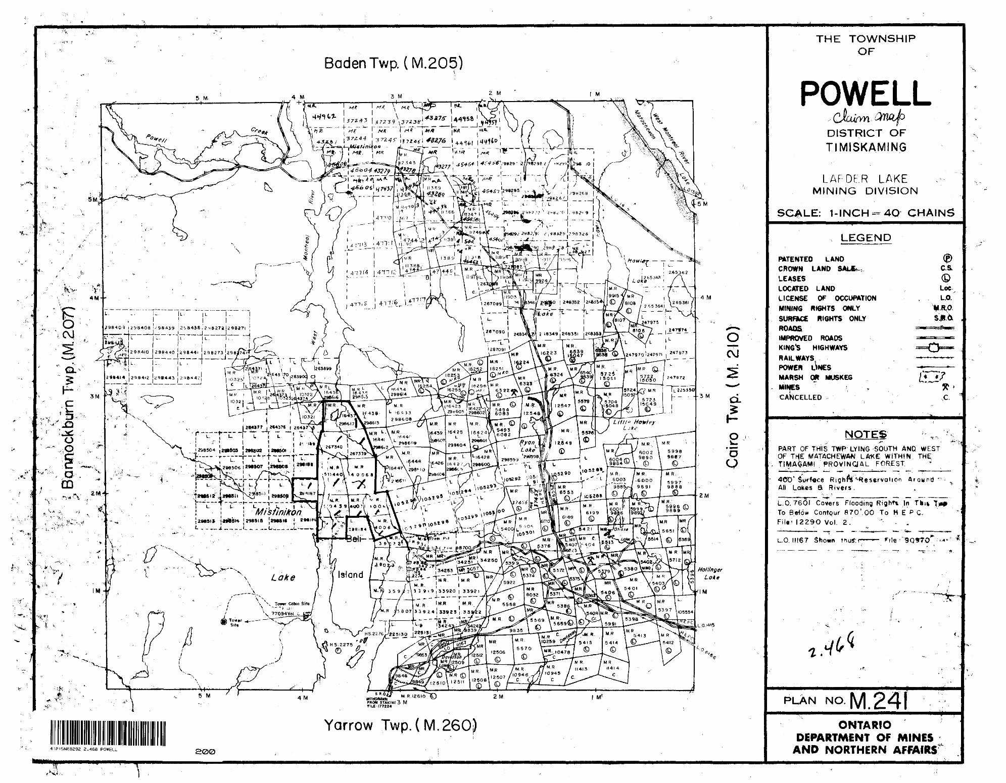
Report on an Electromagnetic and Magnetic Geophysical Survey on the. Bell Island, Mistinikqn Lake Section of the British Matachewan Gold Mines Limited Property Powell Township, Ontaric PROPERTY 41P15NE8292 2 .468 POWELL 0 10 This survey covers seven unpatended mining claims of the British Matachewan Gold Mines Limited property, Powell Township, Ontario, MR 50440, MR 50439, MR 40068, MR 40071, MR 40067, MR 269340, and MR 267339. LOCATION AND ACCESSIBILITY This group of claims lies at the northern end of Bell Island in Mistinikon Lake of the West Branch of the Montreal River, Powell Township, Ontario. The property is accessible by gravel highway 2 1/2 miles north of the Town of Matachewan, thence 2 miles by summer road to Mistinikon Lake at a point approximately 1/2 mile south of the south boundary of the group. TOPOGRAPHY Sixty-five percent of the group is water covered by the west branch of the Montreal River. Th'e shorelines and the northern end of Bell Island comprising the other thirty-five percent of the group have relief of 100 to 200 feet predominated by north-south tending outcropping scarps. The t forest cover is predominantly spruce and balsam with the exception of a 20-acre stand of birch near the grid baseline between 4+OOE and 14+OOE. GEOLOGY The property is in general underlain by 200' to 1000' thickness of cobalt sediments which dip shallowly to the west and are cut by a major

Welcome message from author
This document is posted to help you gain knowledge. Please leave a comment to let me know what you think about it! Share it to your friends and learn new things together.
Transcript

Report on an Electromagnetic and Magnetic
Geophysical Survey on the. Bell Island,
Mistinikqn Lake Section of the British
Matachewan Gold Mines Limited Property
Powell Township, Ontaric
PROPERTY41P15NE8292 2 .468 POWELL 010
This survey covers seven unpatended mining claims of the British
Matachewan Gold Mines Limited property, Powell Township, Ontario,
MR 50440, MR 50439, MR 40068, MR 40071, MR 40067, MR 269340, and MR 267339.
LOCATION AND ACCESSIBILITY
This group of claims lies at the northern end of Bell Island in
Mistinikon Lake of the West Branch of the Montreal River, Powell Township,
Ontario. The property is accessible by gravel highway 2 1/2 miles north
of the Town of Matachewan, thence 2 miles by summer road to Mistinikon Lake
at a point approximately 1/2 mile south of the south boundary of the group.
TOPOGRAPHY
Sixty-five percent of the group is water covered by the west branch
of the Montreal River. Th'e shorelines and the northern end of Bell Island
comprising the other thirty-five percent of the group have relief of 100
to 200 feet predominated by north-south tending outcropping scarps. Thet
forest cover is predominantly spruce and balsam with the exception of a
20-acre stand of birch near the grid baseline between 4+OOE and 14+OOE.
GEOLOGY
The property is in general underlain by 200' to 1000' thickness of
cobalt sediments which dip shallowly to the west and are cut by a major

- 2 -
north-south fault underlying the lake on the west side of Bell Island.
Teraiskaming volcanics underlie the cobalt sediments and are exposed at
the north extreme of the group.
HISTORY
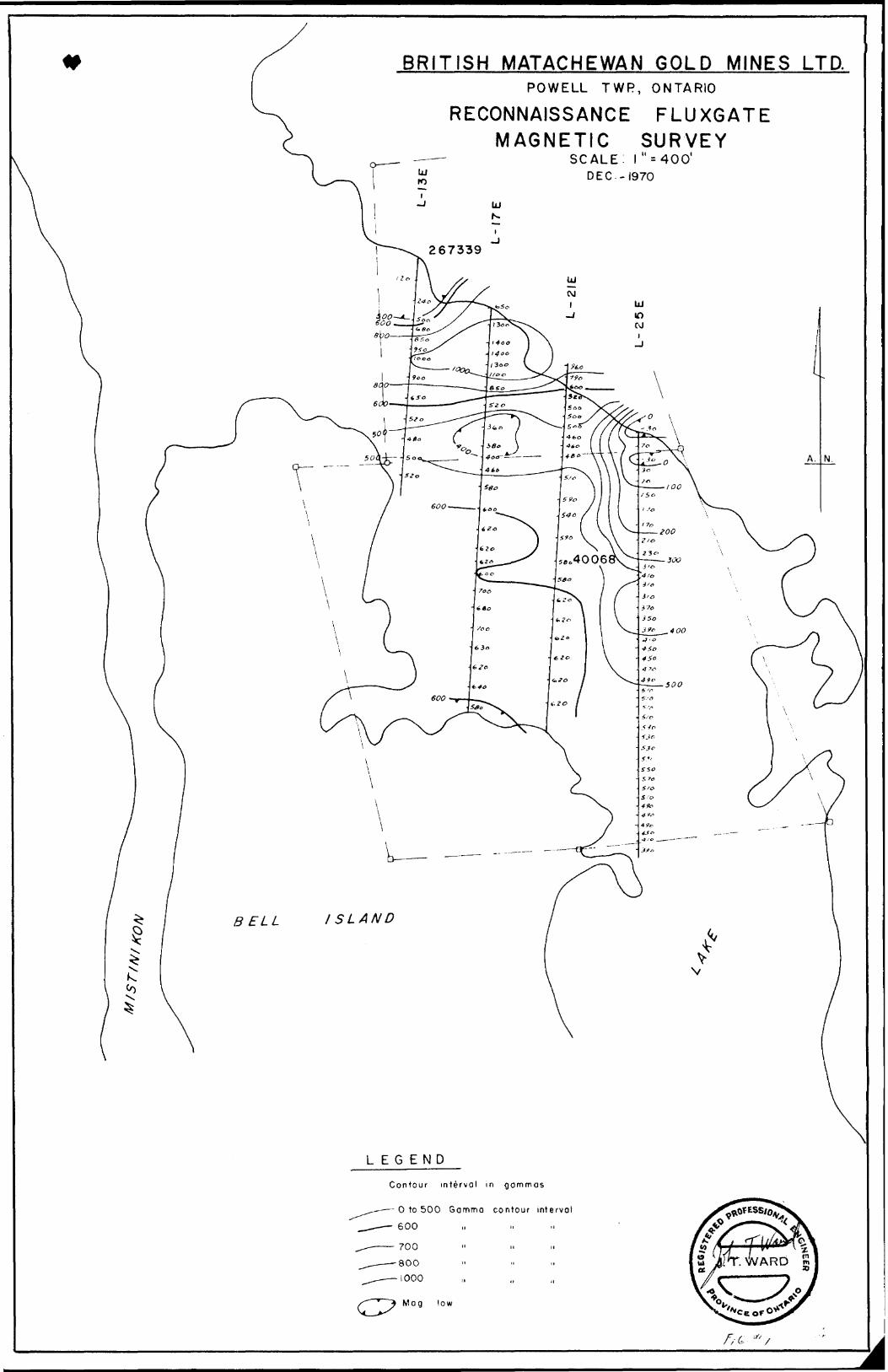
This group has had limited prospecting only, A minor magnetic
reconnaissance survey was also carried out by J. Sherriff in the summer
of 1970. The area is included in airborne magnetic map 287G (Matachewan
Sheet) 41 - P/15.
PRESENT WORK
From December 20 to 23 inclusive. 1970. a reconnaissance geophysical
orientation survey was carried out with Scintrex SE 71 fTuram tvne^ electro-
and MFI fluxgate magnetic instruments to determine a suitable
direcLXUii Lu cuL Lau geupiiybiual survey gi'lu, oiiu cG uctcVwiuc the dip
direction of conductors, if encountered. From December 28 to January 10,
approximately 2 1/2 miles of line were cut on Bell Island by Jim Johnson
and Mervin King hampered by rough topography on the island and adverse
* slush conditions on the lake. Grid chaining on the island and onto the
lake was completed by Jacques Robert and Oliver Simard, January 16 to 23,
again hampered by adverse slush conditions. Ten miles of geophysical
surveying with Scintrex SE71 and MF| were then completed, January 24 to*
February 10 inclusive, by J. Ward and Jacques Robert. Some operating
difficulties were encountered with the SE71 motor generator when temper
atures were sub -200 below zero, but these were avoidable by keeping the
motor generator in a heated enclosure at the survey site.
- 3 -
TECHNICAL DESCRIPTION SURVEY METHODS
(a) Scintrex SE71 Electromagnetic Method - (Serial 9 oof // 4
The Scintrex SE71 electromagnetic survey method is essentially
similar to the Swedish Turam method. A large single turn loop of #18 HF
insulated copper wire of dimensions in the order of 1/2 mile square is
energized by a motor generator unit producing approximately 1.5 amperes
signals of either 200 Hz , 400 Hz , or 800 Hz . Two receivers Joined by a
100-foot reference cable traverse outside of the transmitter loop up to
distances of approximately 1/2 mile from the near side of the transmitter
loop. The ratio of the signal strengths and phase difference in degrees
between the two receivers is measured at each station. The ratios of
signal strength between the two receivers are then compared with the ratios
expected by theoretical calculation from the transmitters loop size ands*
geometry (i.e. the signals in the receiver nearer the transmitter loop will
be stronger by a predictable amount) . The deviation of the ratio of the
signal strengths read compared to the ratios of the signal strengths
expected is then expressed in % ratio and recorded on the survey map midway
between the receiver locations. The phase difference is recorded in degrees
phase. The % ratios were read to the nearest l/2% ratio and the phase
difference to the nearest 0.1 degree phase.
The SE71 and Turam methods are superior in their depth of survey
abilities due to their large transmitter receiver .separation, low frequency
signals used, smallness of errors in signal strength ratios in rugged terrain,
and very high accuracy in out-of-phase measurements.
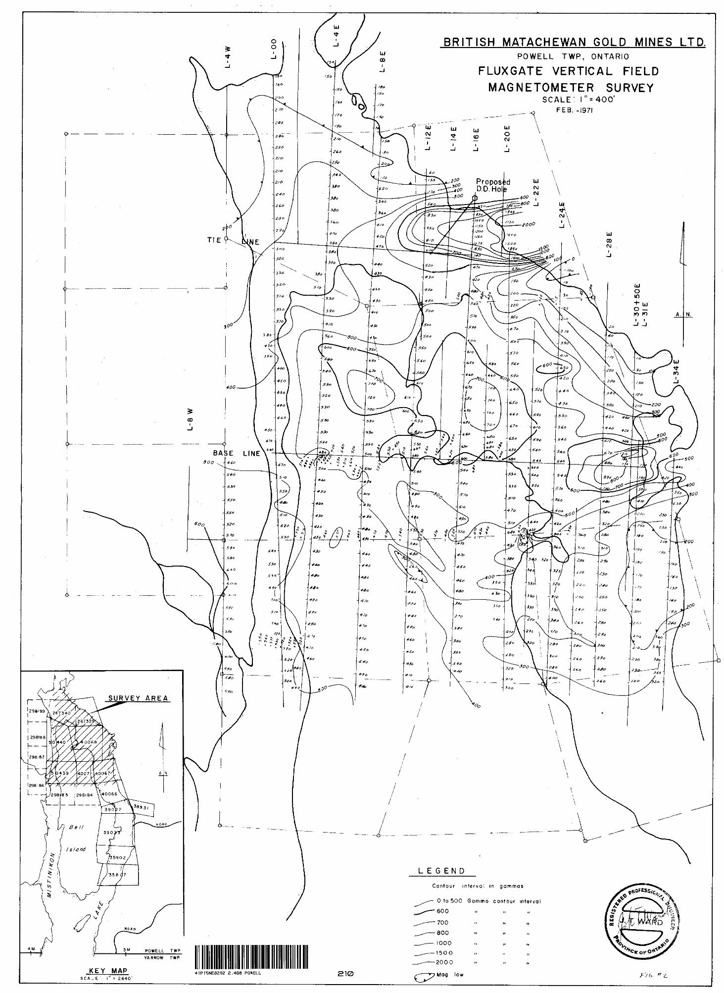
(b) Sharpe MF1 Fluxgate Magnetometer - (Serial
The MF1 fluxgate magnetometer measures the vertical magnetic field

- 4 -
variations directly in gammas. Reading divisions are at 20 gamma
intervals on the sensitive range (O - 1000 gammas) used and were read
to the nearest 10 gammas. Readings were reduced to a standard datum
by correcting for instrument drift at base and tie in stations.
GEOPHYSICAL INTERPRETATION
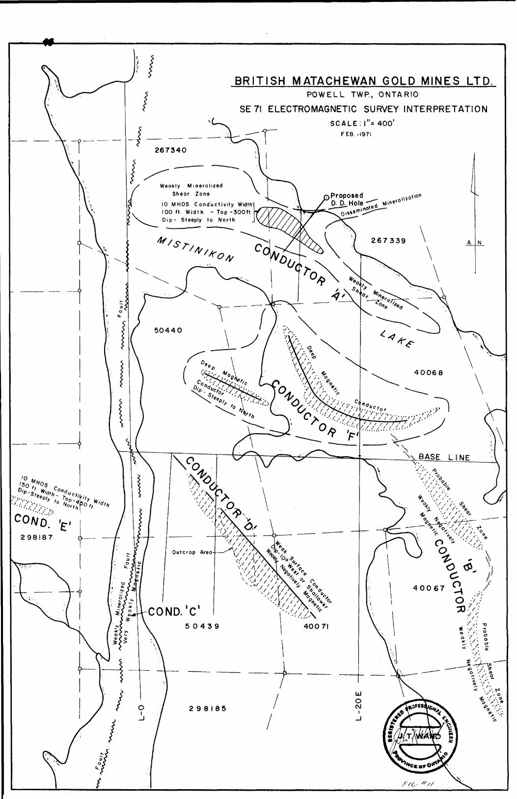
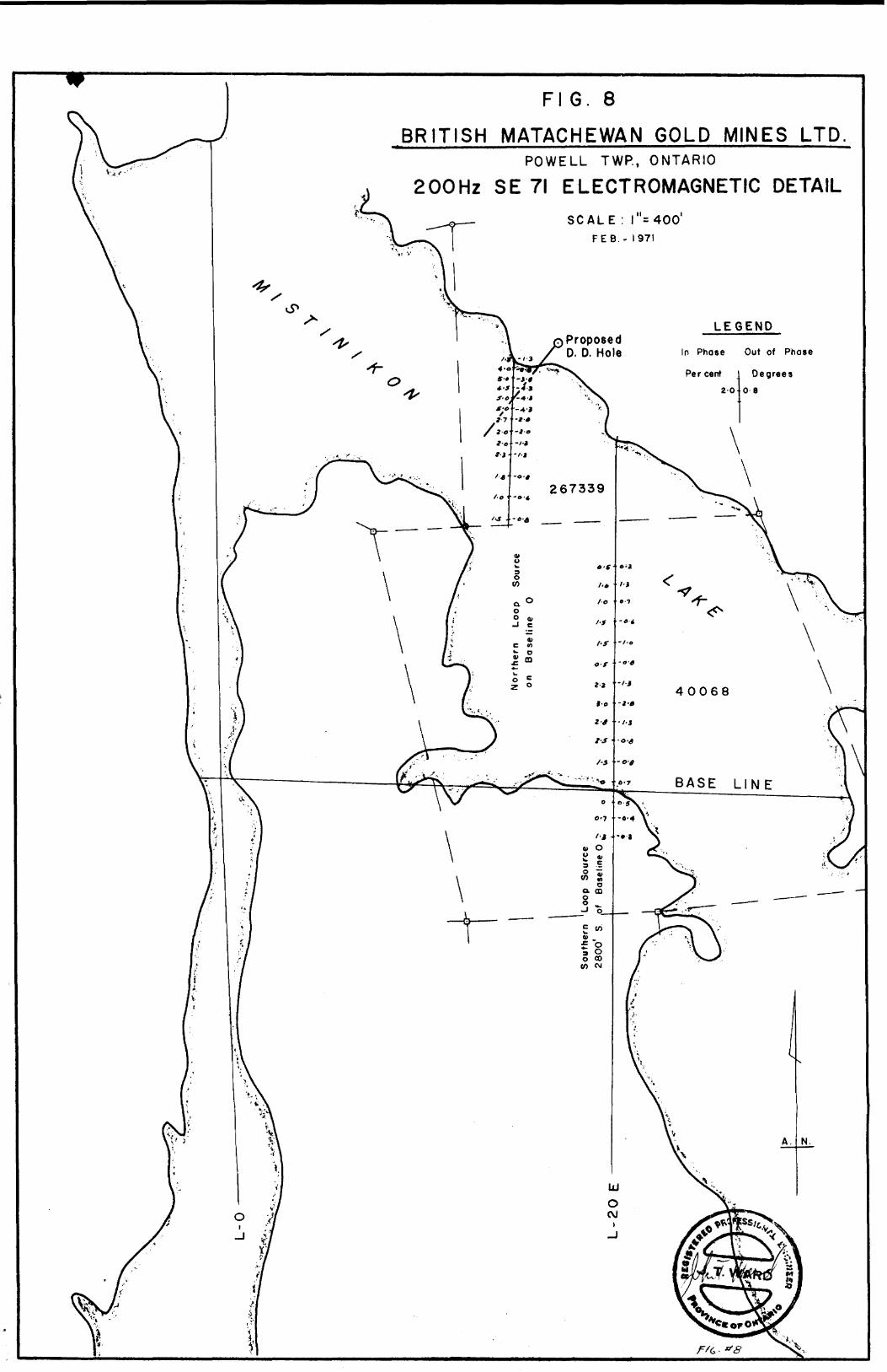
(a) A weakly mineralized shear zone striking N60OW through claims 267340
and 267339 is interpreted as topping 300 feet subsurface and therefore
probably lying in the volcanics capped by the cobalt sediments. The
strongest conductivity (10 mhos conductivity width) lies between
L11E and L17E with an indicated thickness of 100* and a steeply north
dip (650 200). Vertical coil EM checkwork gave less than 2 degrees
peak to peak crossover response consistent with the 300-foot depth
below surface to the top of the conductor. Probable mineralization
associated with conductivities of the order indicated for this con
ductive zone is roughly 5% sulphides by volume or minor graphitic
shearing.
, (b) A second conductive zone striking N200W through claims 40067 and
40068 is enhanced by good coupling with the east side of the trans
mitter loop in claims 40066 and 39022. This is a probable shear zone
in the cobalt sediments and may be expected to be an extension of the*
metallic lustre graphite zone encountered in previous drilling by
J. Sherriff on the west flank of a mineralized carbonate shear zone
immediately to the south of the group.
(c) The Mistinikon Lake fault under the river on the west side of Bell
Island also has an enhanced anomaly due to good coupling with a side

- 5 -
of transmitter loop, this time in claim 298185. East-west detailed
SE71 electromagnetic traverses (see fig.10) show that virtually all
electromagnetic response on line OE is due to traversing the fault
anomaly at sub-parallel angles. East-west reconnaissance traverses
were read across the fault anomaly at several locations as far as a
mile to the south of the group. Depth to top of conductive zone in
Mistinikon Fault is indicated at less than 50 feet. The conductivity
of the fault mineralization is traceable over the entire length
tested but is strongest in the section from the baseline 00 south
for 3/4 of a mile. Magnetic detailing indicated a possible magnetic
correlation of less than 20 gammas with the more conductive sections
of the Mistinikon Fault.
(d) A very weak shallow dipping conductor strikes northwest-southeast
through the northeast corner of claim number 50439. It is expected
to outcrop in the area 275' west of the #1 post of 50439. Direct
negative magnetic correlation of approximately 200 gammas suggests
high temperature metamorphism accompanied the formation or emplace
ment of minor mineralization in an accommodating stratagraphic*
horizon of the cobalt sediments. Mineralization indicated by the
conductivity, if caused by sulphides, is characteristic of roughly
25! sulphides by volume. .
(e) A conductor of indicated 10 mhos conductivity width and probable
thickness of 150 feet was detected on the west boundary of claim
50439. Depth to top of this conductor is indicated as 450 feet
with dip steeply north and strike north 70O west.
o ~
(f) Anomalous conductivity at a depth of roughly 600 feet seems to be
indicated in correlation with a 200 gamma magnetic anomaly between
Line 8E and L20E approximately 600 feet north of the baseline in
claims 50440 and 40068. Anomalous responses from near surface
conductors especially shoreline effects and the near surface shear
zone at line 20E 4450N,limited traverses with lower frequencies with
the transmitter at large distances and the reverse coupling with the
transmitter too near the deep conductor make analysis of this possible
conductor with present data virtually impossible excepting that it
has better conductivity than the near surface conductors.
RECOMMENDATIONS AND CONCLUSIONS
The proposed drill hole spotted for conductor "A" was field located
before all data were plotted and was chosen in part for convenient drill
platform terrain. It is now recommended that a sub baseline 200* or 300'
long be cut from the proposed collar at right angles to the proposed
azimuth of drilling and that the collar of the proposed drill hole be re-
spotted about 300 feet west of its present location. The respotted hole
should be at such a dip so as to intersect the conductive zone at -350*.
The new location will then permit more economical testing of a broadening
of the zone on Line 8E - 20+OON to 23+OON should a second hole be
warranted. t
Conductors "B" and "C" require lake traverses with induction loops
energizing them in an east-west direction to assess their unenhanced
apparent conductivity since limited vertical coil EM testing at 10+OOS
Line O indicated scattered sulphides at best.

- 7 -
Conductor "D" in claim #50439 near #1 post should receive limited
prospecting to determine the character of the indicated minor amounts of
conductive mineralization.
Conductor "E" investigation should be considered only in the light
of the findings of conductor "A".
Conductor "F" requires further 200!fedetailing to reduce the response
from near surface conductors. The near side of the transmitter loop
should be ideally at approximately 10+OOS in order to avoid reverse
coupling by being too near the deep conductor and, of course, still
within the limited range of readability of the 200 Hz signal.
Respectfully submitted,
Toronto, Ontario J. T. Ward, P.Eng. April 30, 1971
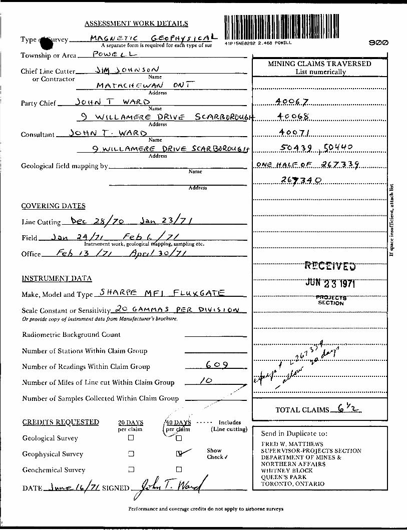
ASSESSMENT WORK DETAILS
YPe '^" -7 ' A "separatc form u required for eayh type of sur 41P15NE8292 2.468 POWELL
Township or Arpa PovOi^
300
Chief Line Cutter, or Contractor
O H ^ 5Name
M A r AC (f c- u/vW o/U TAddress
Party Chief. T WAfCQName
Address
Consultant.Name
Address
Geological field mapping by.Name
Address
COVERING DATES
Line fining We- 2 X/7O
FiHrf J a
3/7
34/7
Office.
Instrument work, geological nrfappiiig, sampling etc.
x 3 /7s /W// 30/7/
INSTRUMENT DATA
Make, Model and TypP MF l
Scale Constant or Sensitivity c3o G-AMHftS PirfOr provide copy of instrument data from Manufacturer's brochure.
Radiometric Background Count -
Number of Stations Within Claim Group -
Number of Readings Within Claim Group
Number of Miles of Line cut Within Claim Group
Number of Samples Collected Within Claim Group .
/o
CREDITS REQUESTED
Geological Survey
Geophysical Survey
Geochemical Survey
20 DAYS per claim
D
aD
'40 DAYS ----- Includes per cj^im (Line cutting)
D
B^
D
Show Check/
STHNFT)
(7
—i
i^//
MINING CLAIMS TRAVERSED _____List numerically^^^^^
400^ 74*((***l**l t Tt * ft l I
SECTION
TOTAL CLAIMS.
Send in Duplicate to:
FRED W. MATTHEWS SUPERVISOR-PROJECTS SECTION DEPARTMENT OF MINES 8c NORTHERN AFFAIRS WHITNEY BLOCK QUEEN'S PARK TORONTO, ONTARIO
Performance and coverage credits do not apply to airborne surveys

SUBMISSION OF GEOLOGICAL, GEOPHYSICAL AND GEOCHEMICAL SURVEYS
AS ASSESSMENT WORK
In order to simplify the filing of geological, geochemical and ground geophysical surveys for assessment work, the Minister has approved the following procedure under Section 84 (8a) of the Ontario Mining Act. This special provision does not apply to airborne geophysical surveys.
If, in the opinion of the Minister, a ground geophysical survey meets the requirements prescribed for such a survey, including:
(a) substantial and systematic coverage of each claim(b) line spacing not exceeding 400 foot intervals(c) stations not exceeding 100 foot intervals or(d) the average number of readings per claim not less than 40 readings
it will qualify for a credit of 40 assessment work days for each claim so covered. It will not be necessary for the applicant to furnish any data or breakdown concerning the persons employed in the survey except for the names and addresses of those in charge of the various phases (linecutting contractor, etc.). It will be assumed that the required number of man days were spent in producing the survey to qualify for the specified credit.
Each additional ground geophysical survey using the same grid system and otherwise meeting these requirements will qualify for an assessment work credit of 20 days.
A geological survey using the same grid system, and meeting the requirements for submission of geological surveys for maximum credits will qualify for an assessment work credit of 20 days. If line cutting has not previously been reported with any other survey and is reported in conjunction with the geological survey a credit of 40 days per claim will be allowed for the survey.
Similarly, a geochemical survey using the same grid system with the average number of collected samples per claim being not less than 40 samples, and meeting the requirements for the submission of geochemical surveys for maximum credits, will qualify for an assessment work credit of 20 days. If line cutting has not previously been reported with any other survey and is reported in conjunction with the geochemical survey a credit of 40 days per claim will be allowed for the survey.
Credits for partial coverage or for surveys not meeting requirements for full credit will be granted on a pro-rata basis.
If the credits are reduced for any reason, a fifteen day Notice of Intent will be issued. During this period, the applicant may apply to the Mining Commissioner for relief if his claims are jeopardized for lack of work or, if he wishes, may file with the Department, normal assessment work breakdowns listing the names of the employees and the dates of work. The survey would then be re-assessed to determine if higher credits may be allowed under the provisions of subsections 8 and 9 of section 84 of the Mining Act.
If new breakdowns are not submitted, the Performance and Coverage credits are confirmed to the Mining Recorder at the end of the fifteen days.
BRITISH MATACHEWAN GOLD MINES LTDPOWELL TWP., ONTARIO
SE 71 ELECTROMAGNETIC SURVEY INTERPRETATIONSCALE: i"* 400'
Weekly Mineralized Shear Zone Proposed
D. D. Hole*effl
10 MHOS Conductivity Width 100 ft Width - Top -300ft. Dip - Steeply to North
•/•v-,. "fy t, (oc
COND. C
298185
BRITISH MATACHEWAN GOLD MINES LTD.POWELL TWP, ONTARIO
RECONNAISSANCE FLUXGATE MAGNETIC SURVEY
LU ro
SCALE: i "*400'DEC -1970
LJ
267339
600
B ELL ISLAND
too
400
A.
LEGEND
Contour interval ir gammas
- O to 500 Gamma contour interval
600
Mag low
f,-(t- 1"
FI G. 8
BRITISH MATACHEWAN GOLD MINES LTDPOWELL TWP., ONTARIO
200Hz SE 71 ELECTROMAGNETIC DETAILSCALE : 1=400'
FEB.- 1971
Proposed D. D. Hole In Phase Out of Phase
BASE LINE

FIG. 9
BRITISH MATACHEWAN GOLD MINES LTDPOWELL TWR, ONTARIO
SOOHz SE 71 ELECTROMAGNETIC DETAILSCALE : 1=400
FEB. - 1971
LEGENDProposed D. D. Hole In Phose Out of Phase
BASE LINE

FIG. 10
BRITISH MATACHEWAN GOLD MINES LTD.POWELL TWR, ONTARIO
400 Hz SE 71 ELECTROMAGNETIC SURVEY EAST-WEST DETAIL TRAVERSING
SCALE : l"s400'
FEB.-1971
LEG END
Out of Phase Degrees
In Phase Per cent
Conductor A xis
BRITISH MATACHEWAN GOLD MINES LTD.POWELL TWR, ONTARIO
RECONNAISSANCE 800 HzELECTROMAGNETIC SURVEY
SCALE: )'^DEC. - 1970
LEGEND
In Phose Per Centl"' -\
Out of Phose Degrees
--- /o"
Baden Twp. (M.205)
45+4-7 2 9*2*3
2*4376 2 6447-. —— -*— -.-
L- L.
2*6506 2WS07 ,2**BO* j
21*512 ,!2M8M
Towvr Cabin Site
77094VOI C
WITHDRAWN ,, . , fROM STAKING 3 M FILEil77Z24
Yarrow Twp.(M.260)41P15NE8292 2.468 POWELL S00
THE TOWNSHIP OF
POWELLDISTRICT OF
TIMISKAMING
LAP DER LAKE MINING DIVISION
SCALE: 1-INCH ^4O- CHAINS
LEGEND
PATENTED LANDCROWN LAND SALE,
LEASESLOCATED LANDLICENSE OF OCCUPATION
MINING RH5HTS ONLY
SUftfifcCE RIGHTS ONLYROADSIMPROVED ROADSKING'S HIGHWAYS
RAILWAYSPOWER L\NESMARSH Gft MUSKEG
MINES * - " "CANCELLED
C. S.
—Jii'.Ti^ ^XUMPE
c.
NOTES, - -***
PART OF THIS TW'LYING SOUTH AND WEST OF T^E MATACHEWAN LAKE WITHIN. THE TIMAGAMI PROVINQAL FOREST.
400' Surface Righ^'^eservalion Ali Lakes 3 Rivers.
Around
L.O. 766l Covers Flooding RighH In T lin To Befow Contpur 870'.00 To M E P C, Fi)*' I229O Vol. 2. "" . ,
L.O. I M67 Shown
-z.
PLAN NO. 241
ONTARIODEPARTMENT OF MINES
AND NORTHERN AFFAIRS
BRITISH MATACHEWAN GOLD MINES LTD.POWELL TWR, ONTARIO
FLUXGATE VERTICAL FIELDMAGNETOMETER SURVEY
SCALE: r*400'FEB. -197!
SURVEY AREA
LEGEND
Contour interval in gammas
O to 500 G amma c ontour interval

BRITISH MATACHEWAN GOLD MINES LTDPOWELL T WP., ONTARIO
400 Hz ELECTROMAGNETIC SURVEY SOUTHERN TRANSMITTER LOOP
SCALE: r*400'FEB.-1971
SURVEY A REA
LEGEND
n Phase Out of PhaseIn Phase C ontours
KEY MAP 41P15NE8292 2 .4B8 POWELL
BRITISH MATACHEWAN GOLD MINES LTD.POWELL TWR, ONTARIO
400Hz SE 71 ELECTROMAGNETIC SURVEYSOUTHERN TRANSMITTER LOOP
SCALE: r*400'FEB.-I97I
Out of Phase C ontours
s/li it WARD S
BRITISH MATACHEWAN GOLD MINES LTDPOWELL TWR, ONTARIO
400 Hz SE 71 ELECTROMAGNETIC SURVEY NORTHERN TRANSMITTER LOOP
SCALE:1=400FEB.-1971
Proposed D.D.Ho.le
SURVEY AREA
298189^263^0
ISLAND
TRAKSIMI55
LEGEND
In Phase C o ntours
l "/o
In Phase Out of Phase
Per cent De grees
2-0 0-8
4IPI5NE8292 2.468 POWELL

BRITISH MATACHEWAN GOLD MINES LTDPOWELL TWP, ONTARIO
400 Hz SE 71 ELECTROMAGNETIC SURVEYNORTHERN TRANSMITTER LOOP
SCALE: i "s 400'
267339Propose D.D. Hoi
l ISLAND
LEGENDOu l of P ho 3 e Contours
Related Documents