ROLE OF WETLANDS TO ENHANCE STORM WATER INFILTRATION AND TO REDUCE WATER TEMPERATURE JACKSON BOTTOM WETLANDS AS AN EXAMPLE Nadeem Kazmi and Candice Loveland 8/31/2012 Abstract Wetlands can reduce the negative impact of elevated runoff temperatures caused by contact with heated impervious surfaces, such as streets and buildings. To test the benefits of wetlands

Welcome message from author
This document is posted to help you gain knowledge. Please leave a comment to let me know what you think about it! Share it to your friends and learn new things together.
Transcript
ROLE OF WETLANDS TOENHANCE STORM WATERINFILTRATION AND TO
REDUCE WATERTEMPERATURE
JACKSON BOTTOM WETLANDS AS ANEXAMPLE
Nadeem Kazmi and Candice Loveland8/31/2012
Abstract
Wetlands can reduce the negative impact of elevated runoff temperatures caused by contact with heated impervious surfaces,such as streets and buildings. To test the benefits of wetlands
in preventing excess heating, a climate based temperature modelwas used to predict the thermal impact of impervious surfaces. As the percentage of impervious area increases, Storm runoff temperatures raises causing significant degradation to aquatic ecosystems. Predicated storm runoff temperature of post urban development showed that wetlands helped to keep average water temperature approximately by 1 degree C below water temperaturecriterion set by Oregon Fish and Wildlife Department for salmonand trout species.
Introduction
Wetlands are important ecosystems, which shelter a unique variety of aquatic organisms. Their ecological value has only recently begun to be fully appreciated. Besides being a unique and complex ecosystem, supporting a wide variety of organisms, wetlands provide many valuable services to humans. Wetlands act as buffers, reducing the negative impacts of storms (such as hurricanes and typhoons in coastal areas) and flooding along lakes, streams, and rivers. (Mitsch Wetlands 2007) Wetlands canalso act as sinks for sediment, nutrient, and even some chemical pollutants, such as heavy metals. When contaminated stream wateror runoff enters the wetland, the flow slows. This reduction in velocity allows suspended materials, such as sediment particles and any pollutants absorbed to those sediments, to settle from the water column and into soils where the rapid accumulation of sediment and peat will bury those (Mitch Wetlands 207). The elevated level of anaerobic and aerobic processes in close association leads to increased chemical precipitation and denitrification as well as other chemical reactions that remove pollutants from the water column. The high diversity of both decomposers and decomposition processes in wetland soils combinedwith the increased contact of surface water and sediments in shallow waters also leads to increased removal of pollutants. (Mitsch Wetlands 2007) Because of this natural mitigation
action, wetlands are becoming valuable tools in water quality projects.
Using existing wetlands in mitigation projects have both ecological and economic benefits. Citing increased water qualityin surrounding waterways, as a benefit of existing wetlands is increasingly becoming an important legal reason for their preservation (Mitsch Wetlands 2007). Using existing wetlands inmitigation project’s can reduce the projects total cost, by reducing the need for spending on additional mechanical mitigation tools.
Elevated stream temperature is one of the most common effects of urbanization on streams. As storm water flows overland across impermeable surfaces, such as pavement and rooftops, it heats up significantly. When this heated water reaches the stream, it in turn raise the in stream temperature. (Mitsch Wetlands 2007). An increase in stream temperature can impair the biological functions of many aquatic organisms. . Increases in stream temperature due to urban runoff can cause thestream to reach temperatures that exceed the optimal range for the aquatic organisms that thrive there under natural conditions.Aquatic organisms at different stages of their lives are vulnerable to even small increases in water temperature. Higher temperature is correlated with increased metabolic rates in aquatic organisms (Kinouchi 2003). This means at higher water temperatures, aquatic organisms need more food, and though metabolic requirements have increased, available nutrient supply likely has not. This can lead to reduction in population numbers for cold-water species, especially those sensitive to temperature fluctuation, such most salmon species and brook and rainbow trout. Therefore, if temperature increases too much, streams may become uninhabitable to species they once supported. (Lessard 2003) Warmer temperatures can also open niches for species that would not have been able to thrive in streams at
lower temperatures. These species often have a wider range of conditions they thrive at and can gain a significant population hold, often pushing out other cold-water species, which cannot compete at the higher temperatures. This leads to a shift in community assemblages for fish as well as macroinvertabrates.(Lessard 2003) Increased temperature also decreases the water’s ability to hold oxygen, which can have significant detrimental impact on the aquatic life. Warm temperatures can cause a varietyof problems for fish, including decreased egg survival and increased susceptibility to disease. Especially sensitive are species that require cold water throughout most stages of their lives, such as trout and salmon. (Shepherd and Wilson, 1986) Oregon Fish and Wildlife water temperature standards for optimal Salmon and trout rearing and migration are 64.4 F (17.8 degree C)(ODFW, 1996).This study looks at mitigating the harmful effects of elevated stream temperatures due to impervious surface using anatural wetland ecosystem.
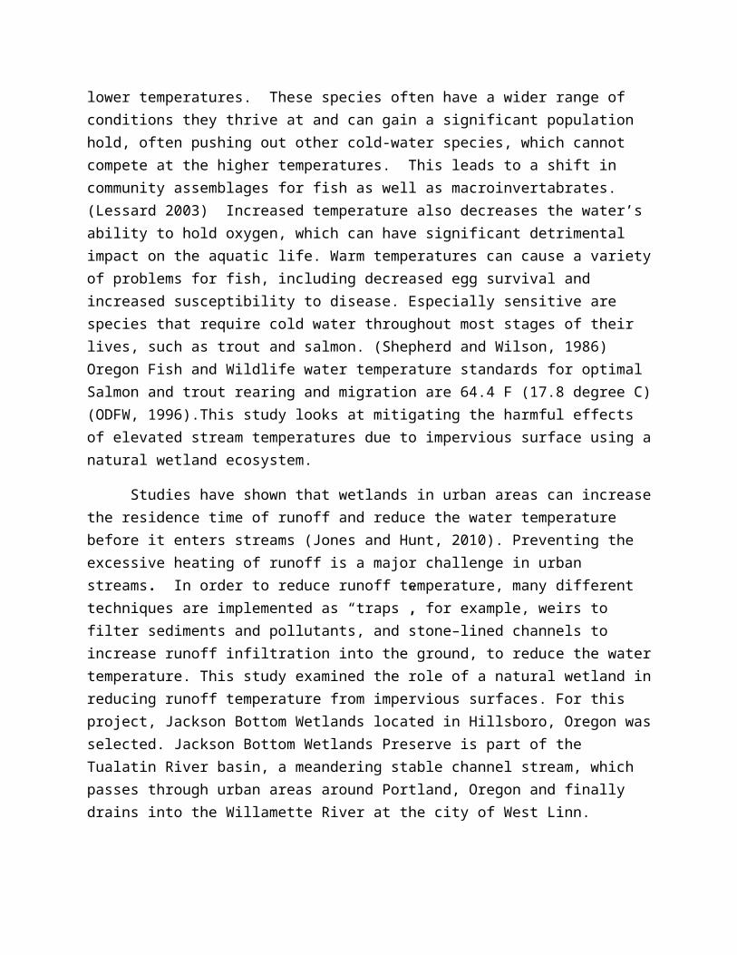
Studies have shown that wetlands in urban areas can increasethe residence time of runoff and reduce the water temperature before it enters streams (Jones and Hunt, 2010). Preventing the excessive heating of runoff is a major challenge in urban streams. In order to reduce runoff temperature, many different techniques are implemented as “traps”, for example, weirs to filter sediments and pollutants, and stone–lined channels to increase runoff infiltration into the ground, to reduce the watertemperature. This study examined the role of a natural wetland inreducing runoff temperature from impervious surfaces. For this project, Jackson Bottom Wetlands located in Hillsboro, Oregon wasselected. Jackson Bottom Wetlands Preserve is part of the Tualatin River basin, a meandering stable channel stream, which passes through urban areas around Portland, Oregon and finally drains into the Willamette River at the city of West Linn.
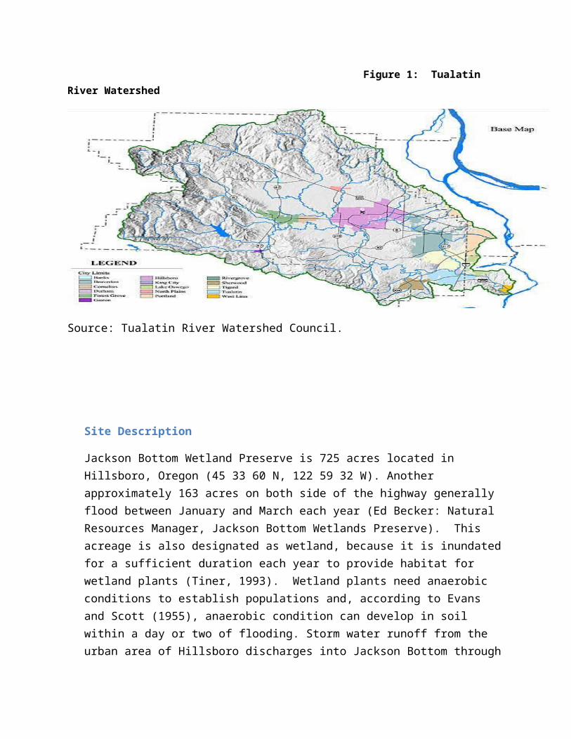
Figure 1: Tualatin River Watershed
Source: Tualatin River Watershed Council.
Site Description
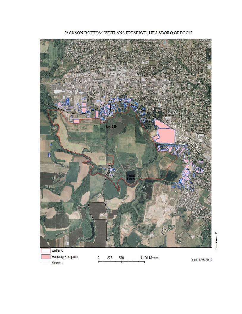
Jackson Bottom Wetland Preserve is 725 acres located in Hillsboro, Oregon (45 33 60 N, 122 59 32 W). Another approximately 163 acres on both side of the highway generally flood between January and March each year (Ed Becker: Natural Resources Manager, Jackson Bottom Wetlands Preserve). This acreage is also designated as wetland, because it is inundatedfor a sufficient duration each year to provide habitat for wetland plants (Tiner, 1993). Wetland plants need anaerobic conditions to establish populations and, according to Evans and Scott (1955), anaerobic condition can develop in soil within a day or two of flooding. Storm water runoff from the urban area of Hillsboro discharges into Jackson Bottom through
an estimated 42 drain pipes at the edge of the wetlands (Jackson Bottom Concept Master plan, 1989). This study focuses only on the land use within 300 meters of the Jackson Bottom Wetlands Preserve, because according to Jones and Hunt 2010, underground piped runoff reduces inflow temperature, dueto the higher thermal conductivity of the metal pipes and the lower soil temperature below ground. Therefore, storm drainage pipes at far away distances from the wetlands would have lower runoff temperature and are not significant source of thermal pollution. Jackson Bottom captures runoff from an estimated 117.01 acres from rooftops that lies within a 300 meter radius of the Preserve. The percentage impervious surface area is 13 percent within that 300 meter radius
Method
This study will examine the role that wetlands can play in storm water runoff management and in the mitigation of its thermal impacts. Wetlands are great natural aquatic buffer systems that infiltrate runoff into the ground, thereby reducing non-point source of pollution. A water temperature-modeling tooldesigned by the Wisconsin department of natural resources (WiDNR), called Temperature Urban Runoff Model (TURM), was used to determine post-development runoff temperature caused by impervious surface. ESRI ArcGIS was used to calculate the total area of impervious surfaces surrounding Jackson Bottom wetland. Then the “head up” digitizing method was applied to determine thepercentage of impervious surface within 300 meters of Jackson Bottom wetlands. TURM predicated stream temperatures were then compared with USGS station (14206241) water temperature data , from June 1 to June 9, 2010, to determine whether there was a significant difference between the predicated temperatures without wetland mitigation, determined by TURM, and the actual water temperatures.
The method used for predicating the effects of land use change on water temperature varies from region to region, as it is dependent on climate, particularly the amount of precipitation. For this study, rainfall data from June 1 to July 1, 2010 was used. Average rainfall for this month was 1.2 inches.Summer hydrological data was selected because of the significant seasonal variations in stream discharge. Impervious surface area can rapidly increase the volume of storm water runoff by preventing infiltration in the soil, which can in turn cause an increase in stream water temperatures in summer and decrease themin winter (Lee and Rinne, 1980). In such circumstances, determining summer temperature represents a more realistic value of thermal change due to impervious surface, than the winter temperature. Moreover, roads and parking lots are generally dark;
they absorb more heat in summer consequently; when rainfall hits the surface it heats up the water.
Parcel size (build-up areas) is an important factor that contributes to water and runoff temperatures. For small parcel areas there is a smaller thermal impact, regardless of the percentage of impervious area within that parcel. For example, smaller building footprints will have smaller thermal impacts than larger buildings. Conversely, runoff from larger parcels causes a substantial rise in the in stream water temperature, even at relatively low percentage of imperviousness. For example,a wider street shorter in length would have a relatively higher runoff temperature, than a narrower street of long length (Roa- Espinosa, 2003). The average building footprint within the study area is 1,484 sq meters, and is comprised of both residential andcommercial properties.
Temperature Urban Runoff Model (TURM), which was developed and tested in Dane County, Wisconsin, was used to predict the thermal impact of developed parcels (Roa- Espinosa, 2002). The model requires three inputs; percentage of imperviousness on site, site area in acres, and time of concentration (Tc). The percentage connected to imperviousness on site was calculated within 300-meters radius, by dividing the building footprint acreage by the total area.
The Tualatin River basin has witnessed an increase in population and economic activity, leading to a rise in non –pointsource pollution. According to the Tualatin River Watershed Council there are approximately 500,000 people residing on just 15 percent of the land in the Tualatin River watershed (TRWC, 2003). Urbanization and such high population density have led to an increase in impervious surface cover. Impervious surface areascan be estimated using GIS by making large scale maps; covering
tax lots and wetlands around the proposed study area. We used aerial imagery obtained from National Agriculture Imagery Program(NIAP) and used editing tool in ArcGIS. Our map scale of 1: 100 meters shows parcels within 300- meters radius. ESRI ArcGIS 10.1 was used to delineate the boundary of the wetland. We verified the aerial imagery by visiting the study area to make sure that aerial imagery correspond with the current tax lots.
Results and Discussion
The TURM model for this study represents the relative thermal impact of urban development, if heated runoff is not allowed to cool before entering the Tualatin River. The two basicprinciples behind thermal reduction practices are to slow down heated runoff and to increase the infiltration of heated runoff. The TURM model predicated an average stream (without the mitigating influence of the wetland) temperature of 18.36 °C, over the nine –day study period, while the average actual water temperature was 16.1 °C. The TURM model is designed to predict stream temperatures only in the event of rainfall. June 6th in our study period received the highest rainfall, 1.44 inches in approximately 3 hours. The projected stream temperature for the study period is 18.36 °C, demonstrating that the moving average projected stream declined, even with steady rainfall during the study period. Figure 3, shows the stream temperatures, as predicated by the TURM model compared to, average measured streamtemperatures. This comparison shows that the average water temperature is 2.26 °C lower than the projected temperature. The difference between the projected temperatures and the actual water temperatures indicates that the wetland is performing its intended purpose, allowing runoff to cool before entering the stream. Long term monitoring of steam temperatures and extensive modeling is needed to better understand the residual value of storm runoff temperatures.
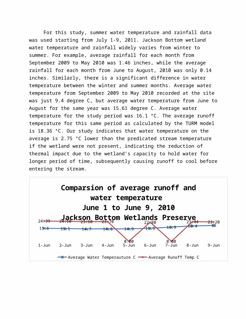
For this study, summer water temperature and rainfall data was used starting from July 1-9, 2011. Jackson Bottom wetland water temperature and rainfall widely varies from winter to summer. For example, average rainfall for each month from September 2009 to May 2010 was 1.46 inches, while the average rainfall for each month from June to August, 2010 was only 0.14 inches. Similarly, there is a significant difference in water temperature between the winter and summer months. Average water temperature from September 2009 to May 2010 recorded at the site was just 9.4 degree C, but average water temperature from June toAugust for the same year was 15.61 degree C. Average water temperature for the study period was 16.1 °C. The average runoff temperature for this same period as calculated by the TURM model is 18.36 °C. Our study indicates that water temperature on the average is 2.75 °C lower than the predicated stream temperature if the wetland were not present, indicating the reduction of thermal impact due to the wetland’s capacity to hold water for longer period of time, subsequently causing runoff to cool beforeentering the stream.
1-Jun 2-Jun 3-Jun 4-Jun 5-Jun 6-Jun 7-Jun 8-Jun 9-Jun
15.6 15.1 14.7 14.8 14.9 15.5 16.9 18.4 1924.39 24.10 23.60 23.70
0.00
22.80
0.00
23.44 23.20
Comparsion of average runoff and water temperature
June 1 to June 9, 2010Jackson Bottom Wetlands Preserve
Average Water Temperauture C Average Runoff Temp C
Based on the predicated values of the TURM model, Jackson Bottom Wetland is performing the two basic principles mentioned above. Comparison of runoff and water temperature indicates that the wetland is cooling the heated runoff. Runoff flowing into the wetland is collected and cooled before it flows into the stream. This reduced the heating effect the runoff would otherwise have had on the stream. The cooling effect of the wetland is enough to keep stream temperatures within water quality standards and help keep the stream healthy.
The health of a stream or river is greatly influenced by water temperature. Impervious surface cover reduces infiltration,which increases the runoff volume from these surfaces, (Roa-Espinosa, 2002). In addition, the runoff from the heated impervious surfaces changes the thermal composition. Heated runoff also alters ecological and biotic conditions in rivers (Coutant, 1999) Thermal variation influences the growth rate of aquatic organisms as well as their distribution (Markarian, 1980). This study focused on two variables, which are also the input variables for the temperature model (TURM) discussed above.Any increase in impervious surface has a direct effect on water storage and movement in the hydrological cycle. Impervious surfaces absorb solar radiation, raising surface temp. During rain, some of the surface heat is transferred to the water that falls on these surfaces. This study examined the use of wetlandsas a mitigation tool to decrease the thermal impact of urban runoff. TURM modeling was used to estimate what the water temperature would be without the wetland as a thermal buffer. This figure was then compared to actual water data. The actual wetland water temperature was found to be significantly lower than the estimated runoff temperature. This indicates the Jackson Bottom Wetland does indeed reduce the impact of heated urban runoff and keep stream temperatures lower.
The results of this study indicate that wetlands can reduce the temperature of runoff before it enters the stream, thereby reducing thermal impact. Thermal pollution is a big problem facing urban streams. Mitigation of thermal pollution through wetlands is one way to combat thermal stresses on streams. Further research is needed to determine the size and morphology of wetland best suited to this task. Wetland mitigation remains apromising tool for reducing thermal impact in urban streams.
Appendix
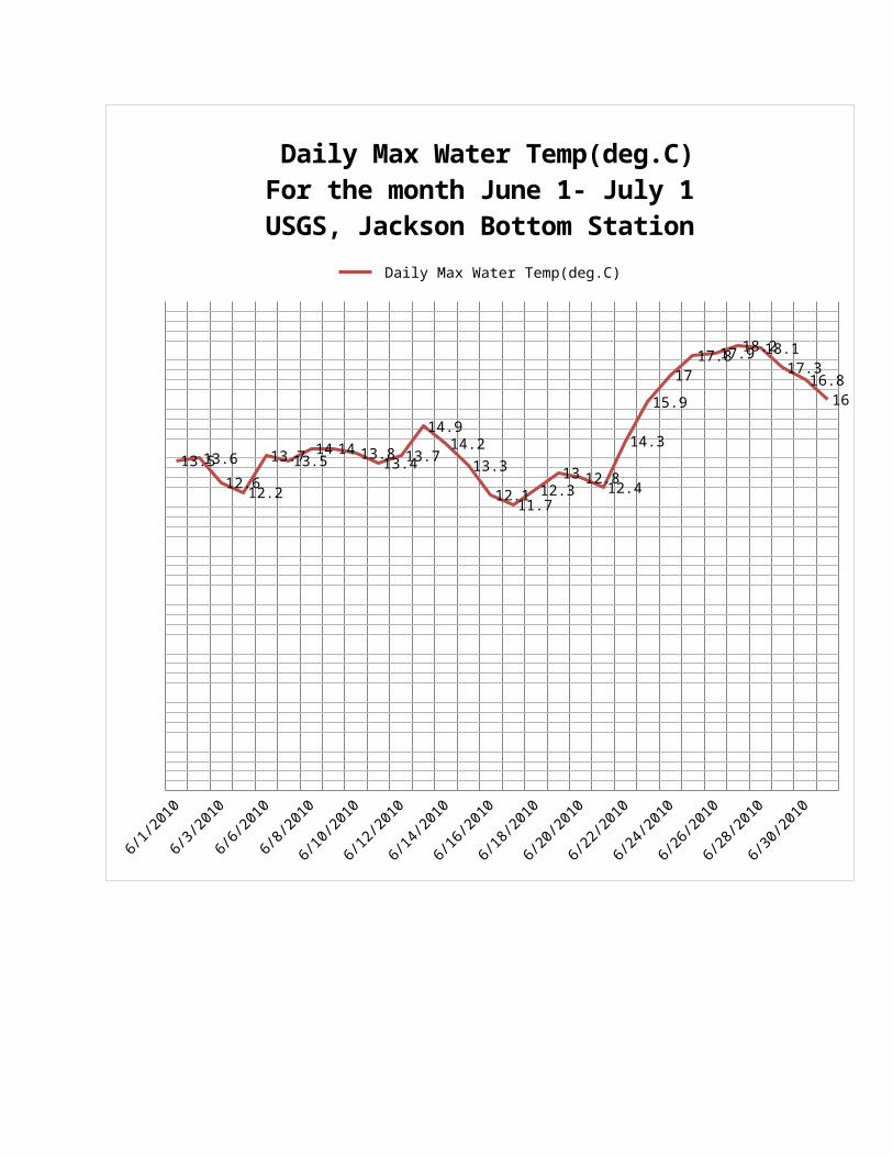
6/1/2010
6/3/2010
6/6/2010
6/8/2010
6/10/2010
6/12/2010
6/14/2010
6/16/2010
6/18/2010
6/20/2010
6/22/2010
6/24/2010
6/26/2010
6/28/2010
6/30/2010
13.513.612.612.2
13.713.514 14 13.813.413.7
14.914.2
13.312.111.7
12.313 12.812.4
14.3
15.917
17.817.918.218.117.3
16.816
Daily Max Water Temp(deg.C)For the month June 1- July 1USGS, Jackson Bottom Station
Daily Max Water Temp(deg.C)
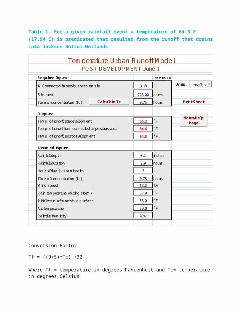
Table 1. For a given rainfall event a temperature of 64.3 F (17.94 C) is predicated that resulted from the runoff that drainsinto Jackson Bottom Wetlands
Required Inputs: version 1.0
% Connected im perviousness on site 13.1%
Site area 725.00 acresTim e of concentration (Tc) 0.75 hours
Outputs:Tem p. of runoff, predevelopm ent 66.2 FTem p. of runoff from connected im pervious area 84.6 FTem p. of runoff, post-developm ent 64.3 F
Assum ed Inputs:Rainfall depth 0.2 inchesRainfall duration 2.0 hoursHour of day that rain begins 3
Tim e of concentration (Tc) 0.75 hoursW ind speed 13.2 ft/sRain tem perature (during storm ) 57.0 FInitial tem p. of im pervious surfaces 56.0 FAir tem perature 59.0 FRelative hum idity 78%
Tem perature Urban Runoff M odelPO ST-DEVELO PM ENT June 1
Units:
Print SheetCalculate Tc
°
°
°
°°
°
°
°
Notes/Help Page
english
Conversion Factor
Tf = ((9/5)*Tc) +32
Where Tf = temperature in degrees Fahrenheit and Tc= temperature in degrees Celsius
Acknowledgments
The writer would like to thank Jeremy Balousek, P.E. Of Land Conservation Division
Dane County, Wisconsin.
Ed Becker of Jackson Bottom Wetlands Preserve, Hillsboro, Oregon USA.
Eve Wills, Soil Scientist at National Cooperative Soil Survey, Montana, USA.
References
Aircardo Roa-Espinosa. (2003). Predicting the Impact of Urban Development on Stream Temperature Using TURM (Temperature Urban Runoff Model): A National Conference, Urban Storm Water: Enhancing Programs at the Local Level, Chicago, Illinois, 2003, Proceedings, Environmental Protection Agency
Corbitt, Robert A. (1999). Standard Handbook of Environmental Engineering. McGraw-Hill. 2ed.
Coutant C.C. (1999). Perspective on Temperature in the Pacific Northwest's Fresh Water. Environmental Sciences Division, Publication No. 4849, Oak Ridge National Laboratory, ORNL/TM-1999/44. Oak Ridge National Laboratory, Oak Ridge, Tennessee, 109p.
Dane County Land Conservation (2002).Temperature Urban Runoff Model (TURM) worksheet. Retrieved from http://www.co.dane.wi.us/landcopnservation/pwshed.htm
Evan D.D., A.D. Scott. 1955. A polarographic method of measuringdissolved oxygen in saturated soil. Soil Science Society of America Proceedings 19:12-16
Jackson Bottom Concept Plan (1989).Retrieved from www.jacksonbottom.org/docs/concept_Master_Plan_Pdf
Javed Mallick. , Atiqur Rahman., Pham Veit Hoa., P.K.Joshi. (2009). Assessment of Night-Time Urban Surface Temperature –Land Use/ Cover Relationship for Thermal Urban Environment Studies Using Optical and Thermal Satellite Data.
Jones, Matthew., Hunt. William (2010). Effect of Storm-Water Wetland and Wet Ponds on Runoff Temperature in Trout Sensitive Waters. Journal of Irrigation and Drainage Engineering, 136(9), 656-661
Lee R.M., Rinne J.N. ( 1980 ) Critical thermal maximum of five trout species in the southwestern United States . Transactions of the American Fisheries Society , 109 , 632 – 635 .
Markarian R.K. (1980) A study of the relationship between aquaticinsect growth and water temperature in a small stream. Hydrobiologia, 75, 81–95.
National Cooperative Soil Survey (2010). Retrieved from www.2.ftw.nrcs.usda.gov/osd/dat/A/ALOHA.html
Oregon Department of Fish and Wildlife (ODFD). (1996) Tualatin River Basin Fish and Water Quality. 15p. mimeo Report.
Singh, Vijay P. (1992). Elementary Hydrology. Prentice-Hall
Shepherd B.G., Hartman G.F. , Wilson W.J. ( 1986 ) Relationships between stream and intragravel temperatures in coastal drainages,
and some implications for fisheries workers . Canadian Journal of Fisheries and Aquatic Sciences , 43 , 1818 – 1822 .
Tiner. W.Ralph. (1993). The Primary Indicators Method –A Practical Approach to Wetland Recognition and Delineation in the United States, WETLANDS, VoL 13, No. I, March 1993, pp. 50 – 64
Tualatin River Watershed Council population density map. Retrieved from http://www.trwc.org/tualatin-info/atlas-maps/pop-density.html
United States Geological Survey, USGS. Retrieved from
http://or.water.usgs.gov/cgi bin/grapher/graphxy_setup.pl?basin_id=tualatin&site_id=14206241#step2
Related Documents