Role of the structural inheritance of the oceanic lithosphere in the magmato-tectonic evolution of Piton de la Fournaise volcano (La Re ´union Island) Laurent Michon, 1 Francky Saint-Ange, 1 Patrick Bachelery, 1 Nicolas Villeneuve, 2 and Thomas Staudacher 3 Received 26 June 2006; revised 10 October 2006; accepted 3 November 2006; published 24 April 2007. [1] La Re ´union Island is located east of Madagascar, on the eastern rim of the tectonically inactive Mascarene Basin. This island is composed of three shield volcanoes of which only Piton de la Fournaise is currently active. Although the magmatic activity is restricted to Piton de la Fournaise, a scattered seismicity occurs on the whole 200 km wide volcanic edifice and in the underlying oceanic crust. We carried out a multiscale analysis to understand (1) the origin of the seismicity in the geodynamic context and (2) the role of the oceanic lithosphere in the deformation of Piton de la Fournaise and La Re ´union Island. Analysis of the magmatic system suggests that the magma ascent is controlled by large N25–30 and N125–130 fracture zones located below the Enclos depression. We also show that the orientation difference between the eruptive fissures and the related dykes result from a rotation of the main principal stress s 1 from vertical to downslope through the surface. Combining a Digital Elevation Model (DEM) analysis, field observations and the geophysical data reveals that the volcano is affected by large fault zones. The fault distribution indicates the predominance of a main N70–80 trend. Magnetic data show the same N80 orientation characterizing the remnant part of the Alize ´s volcano. Such parallel alignment suggests a control exerted by the underlying Alize ´s volcano on Piton de la Fournaise. Furthermore, the alignment between the crustal orientations and the structures determined on the island suggests a control of the crustal structures in La Re ´union’s volcano-tectonic activity. Contrary to several volcanic islands such as Hawaii and Tenerife, La Re ´union volcanoes lie on an upbending crust. Then, we interpret the reactivation of the crustal faults as resulting from a crustal uplift related to the thermal erosion of the base of the lithosphere and/or to strong underplating. The upward deformation may prevent the spreading of the volcanoes, as no evidence of such a mechanism is observed in the bathymetry and the seismic data around the island. Citation: Michon, L., F. Saint-Ange, P. Bachelery, N. Villeneuve, and T. Staudacher (2007), Role of the structural inheritance of the oceanic lithosphere in the magmato-tectonic evolution of Piton de la Fournaise volcano (La Re ´union Island), J. Geophys. Res., 112, B04205, doi:10.1029/2006JB004598. 1. Introduction [2] The building of an oceanic island is mainly induced by the development of a mantle plume at depth and its upwelling below the oceanic lithosphere [Morgan, 1971]. The volcanic activity resulting from the ascent of this mantle anomaly is frequently radially distributed around a volcanic center and concentrated in volcanic rift zones [e.g., Walker, 1999]. As documented for the Hawaiian volcanoes [MacDonald and Abbott, 1970] and the Society and Austral Islands [Binard et al., 1991], the orientation of these rift zones is superimposed to main crustal orientations as transform zones and/or paleoridges. Active faulting is frequently associated with the volcanism. Fault analysis reveals that (1) normal faulting always prevails whatever the geodynamic context is and (2) faults and dyke swarms (i.e., rift zones) are parallel [MacDonald and Abbott, 1970; Marinoni and Gudmundsson, 2000]. As mentioned by Binard et al. [1991], such an alignment between tectonics and volcanism, and the rift zones and the crustal structures, respectively, suggests a control of the oceanic lithosphere on the deformation of shield volcanoes and on the location of the magmatism. [3] La Re ´union Island is located east of Madagascar and is related to the mantle plume that generated the Deccan JOURNAL OF GEOPHYSICAL RESEARCH, VOL. 112, B04205, doi:10.1029/2006JB004598, 2007 Click Here for Full Articl e 1 Laboratoire des Sciences de la Terre de l’Universite ´ de la Re ´union (LSTUR), Institut de Physique du Globe de Paris, CNRS, Saint Denis, France. 2 CREGUR, Universite ´ de la Re ´union, Saint Denis, France. 3 Observatoire volcanologique du Piton de la Fournaise (OVPF), Institut de Physique du Globe de Paris, CNRS, La Plaine des Cafres, France. Copyright 2007 by the American Geophysical Union. 0148-0227/07/2006JB004598$09.00 B04205 1 of 21

Welcome message from author
This document is posted to help you gain knowledge. Please leave a comment to let me know what you think about it! Share it to your friends and learn new things together.
Transcript

Role of the structural inheritance of the oceanic lithosphere in the
magmato-tectonic evolution of Piton de la Fournaise volcano
(La Reunion Island)
Laurent Michon,1 Francky Saint-Ange,1 Patrick Bachelery,1 Nicolas Villeneuve,2
and Thomas Staudacher3
Received 26 June 2006; revised 10 October 2006; accepted 3 November 2006; published 24 April 2007.
[1] La Reunion Island is located east of Madagascar, on the eastern rim of the tectonicallyinactive Mascarene Basin. This island is composed of three shield volcanoes of whichonly Piton de la Fournaise is currently active. Although the magmatic activity is restrictedto Piton de la Fournaise, a scattered seismicity occurs on the whole 200 km wide volcanicedifice and in the underlying oceanic crust. We carried out a multiscale analysis tounderstand (1) the origin of the seismicity in the geodynamic context and (2) the role ofthe oceanic lithosphere in the deformation of Piton de la Fournaise and La Reunion Island.Analysis of the magmatic system suggests that the magma ascent is controlled by largeN25–30 and N125–130 fracture zones located below the Enclos depression. We alsoshow that the orientation difference between the eruptive fissures and the related dykesresult from a rotation of the main principal stress s1 from vertical to downslope throughthe surface. Combining a Digital Elevation Model (DEM) analysis, field observations andthe geophysical data reveals that the volcano is affected by large fault zones. The faultdistribution indicates the predominance of a main N70–80 trend. Magnetic data show thesame N80 orientation characterizing the remnant part of the Alizes volcano. Such parallelalignment suggests a control exerted by the underlying Alizes volcano on Piton de laFournaise. Furthermore, the alignment between the crustal orientations and the structuresdetermined on the island suggests a control of the crustal structures in La Reunion’svolcano-tectonic activity. Contrary to several volcanic islands such as Hawaii andTenerife, La Reunion volcanoes lie on an upbending crust. Then, we interpret thereactivation of the crustal faults as resulting from a crustal uplift related to the thermalerosion of the base of the lithosphere and/or to strong underplating. The upwarddeformation may prevent the spreading of the volcanoes, as no evidence of such amechanism is observed in the bathymetry and the seismic data around the island.
Citation: Michon, L., F. Saint-Ange, P. Bachelery, N. Villeneuve, and T. Staudacher (2007), Role of the structural inheritance of the
oceanic lithosphere in the magmato-tectonic evolution of Piton de la Fournaise volcano (La Reunion Island), J. Geophys. Res., 112,
B04205, doi:10.1029/2006JB004598.
1. Introduction
[2] The building of an oceanic island is mainly inducedby the development of a mantle plume at depth and itsupwelling below the oceanic lithosphere [Morgan, 1971].The volcanic activity resulting from the ascent of thismantle anomaly is frequently radially distributed around avolcanic center and concentrated in volcanic rift zones
[e.g., Walker, 1999]. As documented for the Hawaiianvolcanoes [MacDonald and Abbott, 1970] and the Societyand Austral Islands [Binard et al., 1991], the orientationof these rift zones is superimposed to main crustalorientations as transform zones and/or paleoridges. Activefaulting is frequently associated with the volcanism. Faultanalysis reveals that (1) normal faulting always prevailswhatever the geodynamic context is and (2) faults anddyke swarms (i.e., rift zones) are parallel [MacDonaldand Abbott, 1970; Marinoni and Gudmundsson, 2000].As mentioned by Binard et al. [1991], such an alignmentbetween tectonics and volcanism, and the rift zones andthe crustal structures, respectively, suggests a control ofthe oceanic lithosphere on the deformation of shieldvolcanoes and on the location of the magmatism.[3] La Reunion Island is located east of Madagascar and
is related to the mantle plume that generated the Deccan
JOURNAL OF GEOPHYSICAL RESEARCH, VOL. 112, B04205, doi:10.1029/2006JB004598, 2007ClickHere
for
FullArticle
1Laboratoire des Sciences de la Terre de l’Universite de la Reunion(LSTUR), Institut de Physique du Globe de Paris, CNRS, Saint Denis,France.
2CREGUR, Universite de la Reunion, Saint Denis, France.3Observatoire volcanologique du Piton de la Fournaise (OVPF), Institut
de Physique du Globe de Paris, CNRS, La Plaine des Cafres, France.
Copyright 2007 by the American Geophysical Union.0148-0227/07/2006JB004598$09.00
B04205 1 of 21
Traps at the Cretaceous-Tertiary boundary [Courtillot et al.,1986; O’Neill et al., 2003]. The island built up on anoceanic lithosphere characterized by N30–40 transformzones, predominant N120–130 trending magnetic anoma-lies [e.g., Fretzdorff et al., 1998], and local N80 magneticanomalies east of La Reunion (Figure 1a) [Lenat et al.,2001]. The N120–130 orientation also corresponds to theoverall elongation of the island, which results from theemplacement of three volcanoes along this axis (the Alizes,Piton des Neiges, and Piton de la Fournaise volcanoes;Figure 1b [Lenat et al., 2001]). Contrary to Hawaiianvolcanoes no active faults were identified at Piton desNeiges and Piton de la Fournaise, suggesting no or unde-tectable tectonic activity. However, the seismic monitoringcarried out by the Piton de la Fournaise Volcano Observa-tory recorded numerous earthquakes originating in the crustbelow the island and its vicinity (Figure 2). More distant(�100 km) earthquakes, which cannot be precisely locatedwith the current seismic network, occur below the subma-rine flanks of the edifice. Although the occurrence ofearthquakes indicates an active tectonic regime, its originand consequences in the development of the volcano arepoorly understood.[4] Using a multiscale and multidisciplinary analysis,
we aim at studying the tectonic activity of La Reunion,integrating it at a lithospheric scale, and understandingthe origin of the deformation, taking into account theregional geodynamics and the role of the mantle plume.We focus our work on four different scales: (1) the activemagmatic system of PdF, (2) the overall edifice of PdF,(3) the island and the proximal submarine flanks, and(4) the oceanic crust in the island’s vicinity. The magmaticsystem is studied through the analysis of the eruptive fissureand dyke distribution in the Enclos caldera. The tectonicstructures of PdF are inferred from a combination of surfacedeformation derived from a 25 m resolution digital eleva-tion model (DEM), available geophysical data such asseismic, self-potential, magnetic, and audiomagnetotelluricdata, field observations, and aerial photographs. As thedense tropical vegetation makes most of the volcanic flanksinaccessible, the field observations are focused on the deepvalleys which incise the volcano’s western part. Structuresof the southern and northern flanks are studied with theDEM and the available geophysical data. At the islandscale, a 100 m resolution DEM, gravimetric and magneticdata and sonar images are used to determine the first ordersubaerial and submarine structures. Finally, the magneticcrustal structures and the oceanic floor topography areintegrated in our study to extend the analysis from akilometer scale to a several hundred kilometers scale.
2. Geological Setting
[5] La Reunion Island is the subaerial part of a 7 kmhigh oceanic shield volcano with a diameter of 220–240 km.Considering the historical magma production rate and theoldest dated subaerial basalts (�2 Ma [MacDougall, 1971]),an age of around 5 Ma was estimated for the beginning of theedifice growth [Gillot et al., 1994]. The initial evolution wascharacterized by the development of two adjacent volcanoes(Piton des Neiges and Alizes volcanoes), which encountered
recurrent flank destabilizations [Lenat et al., 2001; Bacheleryet al., 2003;Oehler et al., 2004]. Around 530 ka ago, Piton dela Fournaise appeared west of the Alizes volcano whichstopped its activity. Between 530 ka and 12 ka (date of thelast eruption of Piton des Neiges (PdN) [Deniel et al., 1992])PdN and PdF showed contemporaneous activity. Finally,since 12 ka, eruptions are restricted to PdF.[6] This multiphase evolution made the structure of the
overall edifice of La Reunion very complex. The Alizesvolcano is now completely dismantled and the only evi-dence of its past existence is (1) a large intrusion complexidentified by drilling below the Grand Brule (Figure 3)[Rancon et al., 1989], (2) the remnant old submarinerelieves [Labazuy, 1996], and (3) the pre-Brunhes reversemagnetic anomalies which characterize magmatic forma-tions older than those of Piton de la Fournaise [Lenat et al.,2001].[7] Piton des Neiges results from a more than 2 m.y. long
activity during which construction and dismantling phasesalternated. The oldest parts correspond to La Montagne, theDimitile, and Takamaka massifs (Figure 3). The othervolcano flanks consists on piles of differenciated lava flowswhich date from the volcano’s late activity, some 350 kaago. Large explosive eruptions occurred during this period[Fretzdorff et al., 2000]. The volcano’s central part exhibitsthree major depressions: the cirques of Cilaos, Mafate, andSalazie, which originate from an intense erosion controlledby structural limits such as large landslides [Oehler et al.,2004]. In the depressions, most of the outcropping forma-tions are intensively weathered rocks and debris avalanchedeposits, intruded by a large number of dykes [Chevallier,1979; Maillot, 1999].[8] Piton de la Fournaise is the active volcano of
La Reunion Island. Geochronological and geological dataallow defining two main phases of construction, separatedby a main collapse event: the ‘‘ancient Fournaise’’ (530–150 ka) and the ‘‘recent Fournaise’’ (150 ka to present day)[Gillot and Nativel, 1989; Bachelery and Mairine, 1990;Gillot et al., 1990]. This large landslide led to an eastwardshift of the volcano center from the present-day location ofthe Plaine des Sables to the current position of the activevolcano. During the last 0.15 Ma, the ‘‘recent Fournaise’’was affected by at least two caldera collapses whose exactorigin is still under debate [Bachelery, 1981; Duffield et al.,1982; Gillot et al., 1994; Labazuy, 1996; Merle and Lenat,2003]. The resulting structures are the Plaine des Sables andthe large U-shaped structure composed of the Enclosdepression and the Grand Brule (Figure 3). Since theformation of the Enclos depression 4.5 ky ago, the volcanicactivity is mainly restricted to the caldera. Only feweruptions occurred along the NE and SE rift zones, inthe Plaine des Sables and in the Riviere des Remparts[Bachelery, 1981].[9] Intense erosion incised the edifice leading to the
formation of deep valleys (Riviere des Remparts, RiviereLangevin, Riviere Basse Vallee, and Riviere de l’Est(Figure 3). An additional erosional structure was discoveredon the eastern flank of PdF. Geophysical data (audiomag-netotelluric and time domain electromagnetic) and coreswith fluvial sediments from a drill hole in the northern part
B04205 MICHON ET AL.: REGIONAL TECTONICS AT LA REUNION ISLAND
2 of 21
B04205

Figure 1. a) Map of the crustal magnetic anomalies in the vicinity of La Reunion and Mauritius Islands.Transform zones trend N30–40 while the magnetic anomalies present a N120–130 orientation. AfterLenat et al. [2001]. (b) Location of the three basaltic volcanoes that constructed La Reunion Island.SERZ: Southeast rift zone; NERZ: Northeast rift zone.
B04205 MICHON ET AL.: REGIONAL TECTONICS AT LA REUNION ISLAND
3 of 21
B04205

of the Grand Brule reveal the presence of the Osmondespaleoriver [Courteaud, 1996].
3. Multiscale Structures of the Piton de laFournaise
3.1. Structure of the Magmatic System
[10] During the eruptions of PdF, magma ascent mainlyleads to the formation of eruptive fissures in the Enclos andon the flanks of the central cone. Most of the eruptionsinduce the development of en echelon eruptive fissures,which are commonly interpreted as the result of lateral shearduring the dyke intrusion [e.g., Bachelery et al., 1983;Lenat et al., 1989; Zlotnicki et al., 1990]. According tothese studies the northern and southern rift zones arecharacterized by left lateral and right lateral deformation,respectively, which would contribute to the eastward desta-bilization of the volcano flank. Although this general viewis well established, we believe that it raises several ques-tions. Are the eruptive fissures adequate to determine the riftzone orientation? Is the en echelon geometry an evidence oflateral shear along the rift zones?3.1.1. Eruptive Fissures and Feeder-Dyke Orientation[11] The visible pre-2003 eruptive fissures are predomi-
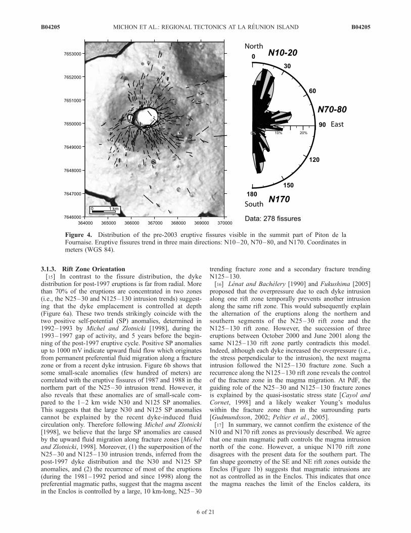
nantly oriented along three main directions (N10–20, N70–80, and N170), which are in agreement with the three trends
determined by Bachelery [1981] (Figure 4). The N10–20and N170 trends are interpreted as the upper part of the NEand SE rift zones, named the N10 and N170 rift zones,respectively [Bachelery, 1981], and were inferred from theeruptive fissure distribution [Bachelery, 1981]. A detailedinspection of the recent en echelon eruptive fissures clearlyshows that both orientations can develop during a singleevent (e.g., the March 1998 eruption, August 2003) and thatN170 eruptive fissures also form in the northern flank,which is commonly described as the ‘‘site of the N10 riftzone’’ (Figure 5). Figure 5 reveals en echelon fissures whichare parallel or subparallel to the slope. This distribution ofthe recent fissures is common to most of the visible pre-2003 eruptive fissures (Figure 4). Only a few are linear andoblique to the slope (e.g., the August 2004 eruption). Theirconstant orientation and location east of the Dolomieu cratercould indicate a control of local subsurface structures in thefissure development.[12] As for Stromboli [Tibaldi, 2003] and Etna [MacGuire
and Pullen, 1989], it has been recently shown for theMarch 1998 [Battaglia and Bachelery, 2003], February2000, June 2000, and August 2003 eruptions [Peltier etal., 2005] that the orientation of the en echelon eruptivefissures do not represent the orientation of the magmaticdyke at depth. Moreover, numerical models show that the enechelon pattern results from the intrusion of linear dykes at
Figure 2. Map of the post-1997 seismicity occurring on La Reunion Island. Location of Figures 4, 8,and 9 is indicated by rectangles. Black dots represent the seismic stations of the Piton de la FournaiseVolcano Observatory.
B04205 MICHON ET AL.: REGIONAL TECTONICS AT LA REUNION ISLAND
4 of 21
B04205

depth [Cayol and Cornet, 1998; Battaglia and Bachelery,2003; Fukushima et al., 2005; Peltier et al., 2005]. Consid-ering these results, we compared the orientation of 17 dykesfor the 1998–2004 period with the distribution of the63 eruptive fissures formed during the same time span(Figure 6a). It appears that the fissure and dyke orientationsdiffer from each other.3.1.2. Dyke, Fissure, and Stress Field[13] As dykes and eruptive fissures are strongly sensitive
to the stress distribution (s3 and s1, the least and mainprincipal stress component, respectively), the difference inthe orientation between dykes and fissures suggests distinctstress field orientations at depth and near the surface. In ahomogeneous volcanic cone, s3 is perpendicular to theslope and s1 varies from a vertical orientation at depth toa downslope one in subsurface [van Wyk de Vries andMatela, 1998]. Note that the magnitude of the downslopes1 increases through the surface [Borgia, 1994]. In such anideal cone, eruptive fissures and dykes, which correspond totension cracks are radially distributed [Pollard, 1987].However, in nature additional effects such as magmaoverpressure, contrasted rheological layering, volcano insta-
bilities, faulting activity and structural inheritance lead to astrongly anisotropic stress field, which may influence thedyke intrusion along preferential orientations [Chadwickand Dieterich, 1995; Tibaldi, 1996, 2003; Walker, 1999;Marinoni and Gudmundsson, 2000; Walter and Troll, 2003;Gudmundsson, 2006].[14] At PdF the radial to subradial distribution of the
eruptive fissures and the deformation field observed throughinterferometry and only showing deformation perpendicularto the dyke [Sigmundsson et al., 1999; Froger et al., 2004;Fukushima et al., 2005] suggest that the fissure orientationis controlled by downslope s1 rather than by the lateralshear during the dyke intrusion. According to the numericalmodels simulating the coeruptive deformation observed ininterferometry [Fukushima et al., 2005], the transition depthat which the dykes transform into eruptive fissures, that isthe depth at which s1 rotates from vertical to downslope,evolves from �200 m below the top of the cone to �100 mbelow the base of the cone. Such variation agrees with thedistribution of the downslope s1 which affects a greatervertical section close to the top of a cone than at its base[van Wyk de Vries and Matela, 1998].
Figure 3. Overview of the main geological structures of La Reunion Island discussed in the text.PdS: Plaine des Sables.
B04205 MICHON ET AL.: REGIONAL TECTONICS AT LA REUNION ISLAND
5 of 21
B04205
3.1.3. Rift Zone Orientation[15] In contrast to the fissure distribution, the dyke
distribution for post-1997 eruptions is far from radial. Morethan 70% of the eruptions are concentrated in two zones(i.e., the N25–30 and N125–130 intrusion trends) suggest-ing that the dyke emplacement is controlled at depth(Figure 6a). These two trends strikingly coincide with thetwo positive self-potential (SP) anomalies, determined in1992–1993 by Michel and Zlotnicki [1998], during the1993–1997 gap of activity, and 5 years before the begin-ning of the post-1997 eruptive cycle. Positive SP anomaliesup to 1000 mV indicate upward fluid flow which originatesfrom permanent preferential fluid migration along a fracturezone or from a recent dyke intrusion. Figure 6b shows thatsome small-scale anomalies (few hundred of meters) arecorrelated with the eruptive fissures of 1987 and 1988 in thenorthern part of the N25–30 intrusion trend. However, italso reveals that these anomalies are of small-scale com-pared to the 1–2 km wide N30 and N125 SP anomalies.This suggests that the large N30 and N125 SP anomaliescannot be explained by the recent dyke-induced fluidcirculation only. Therefore following Michel and Zlotnicki[1998], we believe that the large SP anomalies are causedby the upward fluid migration along fracture zones [Micheland Zlotnicki, 1998]. Moreover, (1) the superposition of theN25–30 and N125–130 intrusion trends, inferred from thepost-1997 dyke distribution and the N30 and N125 SPanomalies, and (2) the recurrence of most of the eruptions(during the 1981–1992 period and since 1998) along thepreferential magmatic paths, suggest that the magma ascentin the Enclos is controlled by a large, 10 km-long, N25–30
trending fracture zone and a secondary fracture trendingN125–130.[16] Lenat and Bachelery [1990] and Fukushima [2005]
proposed that the overpressure due to each dyke intrusionalong one rift zone temporally prevents another intrusionalong the same rift zone. This would subsequently explainthe alternation of the eruptions along the northern andsouthern segments of the N25–30 rift zone and theN125–130 rift zone. However, the succession of threeeruptions between October 2000 and June 2001 along thesame N125–130 rift zone partly contradicts this model.Indeed, although each dyke increased the overpressure (i.e.,the stress perpendicular to the intrusion), the next magmaintrusion followed the N125–130 fracture zone. Such arecurrence along the N125–130 rift zone reveals the controlof the fracture zone in the magma migration. At PdF, theguiding role of the N25–30 and N125–130 fracture zonesis explained by the quasi-isostatic stress state [Cayol andCornet, 1998] and a likely weaker Young’s moduluswithin the fracture zone than in the surrounding parts[Gudmundsson, 2002; Peltier et al., 2005].[17] In summary, we cannot confirm the existence of the
N10 and N170 rift zones as previously described. We agreethat one main magmatic path controls the magma intrusionnorth of the cone. However, a unique N170 rift zonedisagrees with the present data for the southern part. Thefan shape geometry of the SE and NE rift zones outside theEnclos (Figure 1b) suggests that magmatic intrusions arenot as controlled as in the Enclos. This indicates that oncethe magma reaches the limit of the Enclos caldera, its
Figure 4. Distribution of the pre-2003 eruptive fissures visible in the summit part of Piton de laFournaise. Eruptive fissures trend in three main directions: N10–20, N70–80, and N170. Coordinates inmeters (WGS 84).
B04205 MICHON ET AL.: REGIONAL TECTONICS AT LA REUNION ISLAND
6 of 21
B04205

Figure
5.
Distributionofthe1998–2004eruptivefissures.Enechelonpatternsdevelopformostoftheeruption:March
1998,February2000,June2000,June2001,August2003.Coordinates
inmeters(G
auss
Laborde–Reunion).
B04205 MICHON ET AL.: REGIONAL TECTONICS AT LA REUNION ISLAND
7 of 21
B04205

Figure 6. (a) Post-1997 eruptive fissures and the related dykes (dotted lines). The dyke distributionhighlights two main N25–30 and N125–130 intrusion trends. Coordinates in meters (Gauss Laborde–Reunion). (b) Distribution of the post-1997 dykes (dotted lines) with respect to the Self-Potentialanomalies measured by Michel and Zlotnicki [1998].
B04205 MICHON ET AL.: REGIONAL TECTONICS AT LA REUNION ISLAND
8 of 21
B04205

propagation is controlled by the stress field of the shallowedifice rather than by deep, narrow fracture zones.
3.2. Edifice Structures
3.2.1. Field Observations[18] As the flanks of PdF are covered by either a dense
vegetation or recent lava flows, we carried out a struc-tural analysis in the deep valleys where geological unitsoutcrop at the base of the scarps. We focused our analysisin the Riviere des Remparts and Riviere Langevin wherethe formations of the ‘‘ancient’’ and current Fournaiseoutcrop in 1000 m high scarps. Although dense vegeta-tion covers most of the scarps, combination of structuraland aerial photograph analysis allows determination ofseveral main faults (Figure 7a). A large N05 trending,15 km long fault zone is observed in the Riviere desRemparts inducing at different locations intense breccia-tion of the lava flows. In the southern half of the Rivieredes Remparts, the fault zone controls the valley orienta-tion and dyke emplacement (site 1 in Figure 7b). Furtherto the north (i.e., in the Mahavel and Bras Caron valleys),the fault zone, which is inaccessible but visible in aerialphotographs is composed of several segments that in-duced a left-lateral offset of another subperpendicularfault (i.e., the N95 normal fault visible in the RiviereLangevin; Figure 7a). At site 1, geological formations donot show any vertical offset, suggesting a strike-slipmotion along the fault plane. Although this outcrop isof small size the strike-slip motion is in agreement withthe observation obtained further north by an aerialphotograph.[19] The second main fault presents a N40 orientation and
is continued up in the scarp. The fault plane is characterizedby constant subhorizontal slickenside, which indicates aright lateral movement with a slightly normal component(site 2 in Figure 7b). The fault plane outcrop is punctual andits lateral continuity cannot be determined directly. Never-theless, it is interesting to note that the fault is in the westerncontinuity of the Mahavel valley. Recent analogue modelsshow that incisions of such deep valleys in volcanic settingsresult in structurally controlled erosion [Fevre et al., 2004].This indicates that erosion, which led to the valley forma-tion, was favored by the presence of the N40 trending fault.A third main fault is located in both the Riviere desRemparts and Riviere Langevin. In the Riviere Langevinthis N95 trending fault affects both the tabular lava flows ofthe ‘‘ancient’’ Fournaise and the inclined lava flows of therecent Fournaise (60–70 ky) (site 3 in Figure 7b). The faultactivity which is younger than 60 ky induced a verticaloffset of around 100 m. This N95 fault being slightlydisturbed by the N05 fault, a maximum age of 60 ky canbe attributed to the last activity of the N05 trending fault.[20] Thus field observations demonstrate that large
faults developed during the Piton de la Fournaise evolu-tion. However, it remains to be shown whether the faultsare related to the PdF’s own evolution or to the regionalstress field.3.2.2. DEM Analysis[21] The flanks of Piton de la Fournaise are covered by
tropical vegetation which prevents any field observation.To fill this gap, we combine the analysis of a 25 m DEMwith the available geophysical data to extend the struc-
tural analysis to the whole flanks of PdF. In the southernflank, an audiomagnetotelluric (AMT) survey revealed theoccurrence of two N65 and N145–150 trending preferen-tial orientations of the subsurface basement, which areinterpreted as large structural discontinuities (Figure 8)[Courteaud et al., 1996]. The slope map shows thepresence of numerous lineaments, which can have differ-ent origins. To prevent any integration of human-madestructures and boundaries of geological formations such aslava flows and the river patterns, we compared the linea-ments with geological and topographic maps. We consideronly kilometer-scale and well-developed lineaments. Oncerivers and the margins of the geological formations areexcluded, the DEM shows two predominant lineamenttrends: a large N80 lineament on both sides of the BasseVallee River and N155 lineaments parallel to the BasseVallee River (Figure 8). The lack of geophysical data atthe lineament location does not allow the study of theirorigin. Moreover, the extremely dense vegetation makesdirect observation of the structures in the scarp of BasseVallee absolutely impossible. It has been proposed that thebasement structures in the lower part of the southern flankmost likely correspond to faults [Courteaud et al., 1996].The alignment of these faults with the lineament trendsinferred from the DEM analysis (N65–80 and N145–155)suggests a tectonic origin of the lineaments. Furtherstudies are required to constrain better the exact originof these structures.[22] In the northern flank of PdF, two different slope
domains can be determined from the slope orientationmap (Figure 9a). Domains 1 and 2 are characterized byregular eastward and north-north-eastward slopes, respec-tively. In a homogeneous setting, rivers flow downslope.One striking exception is the Ravine Bellevue indomain 2, which flows in a N70–75 orientation that isstrongly oblique to the slope. The development of straightand abnormally oriented rivers is usually due to a struc-tural control [e.g., Twidale, 2004]. The pattern and orien-tation of Ravine Bellevue suggest that its formation wascontrolled by a N70–75 trending structure. This interpre-tation is supported by two sets of geophysical data. First,two-dimensional magnetic profiles carried out in the lowerpart of the flank reveals strong reverse magnetic anomaliesbelow the Piton Balmann and 500 m south of the PitonBellevue (Figure 9b) [Michel and Zlotnicki, 1998]. Reversemagnetized structures predate the Bruhnes period (normalmagnetization since 0.78 My) and are consequently olderthan the formation of PdF. It is likely that these structurescorrespond to a remnant part of the Alizes volcano [Micheland Zlotnicki, 1998], which shows in this area a N75orientation. The second set of data is located in the upperpart of the Riviere de l’Est where 19 seismic events wererecorded from 1985 to the end of 1988 (Figure 9b)[Nercessian et al., 1996]. These events, which occurredoutside the present-day magmatic zone between 6 km b.s.l.and the surface, are disconnected from any recognizedfaults. Nevertheless, the earthquake distribution along aN70–75 main axis suggests the occurrence of a deep andactive N70–75 fault. Hence the combination of the geo-physical data and DEM analysis suggests that the northernflank of PdF is affected by a N70–75 fault zone, the
B04205 MICHON ET AL.: REGIONAL TECTONICS AT LA REUNION ISLAND
9 of 21
B04205

development of which was likely controlled by structuresthat also influenced the evolution of the Alizes volcano.[23] The DEM analysis allowed us to extend the struc-
tural analysis to the PdF southern and northern flanks. Our
work suggests the predominance of large N65–80 trendingfault zones outside the Enclos-Grand Brule structure andsecondary N145–155 faults. It is worth noting that the faultorientation differs from the field observations. This differ-
Figure 7
B04205 MICHON ET AL.: REGIONAL TECTONICS AT LA REUNION ISLAND
10 of 21
B04205

ence could indicate that the structural control of the Alizesvolcano is predominant in the eastern half of PdF.
4. Island and Crustal Orientations
4.1. Island Structures
[24] La Reunion Island presents a N120–130 trendingelongated shape which corresponds to the alignment of thePiton de la Fournaise, the Plaine des Cafres volcanic zone,and the Piton des Neiges (Figure 10a). In the past decadesseveral structural analyses and geophysical studies werecarried out to determine the first order structures ofLa Reunion Island [e.g., Malengreau et al., 1999; Lenat etal., 2001]. Gravimetric data show two main orientations(N40 and N120–130), which correspond to the orientationsof deep gravity anomalies located below PdN and the PdN-PdF alignment, respectively [Malengreau et al., 1999]. Twoadditional large and old structures (i.e., prior to the forma-tion of PdF) were determined on the island’s submarineflanks from a sea-level magnetic survey: a N35 reverseanomaly that corresponds to the continuity of a rift zone ofPdN, and a N80 reverse anomaly east of PdF which isinterpreted as a remnant of the Alizes volcano (Figure 10b)[Lenat et al., 2001].[25] Geological and structural analyses carried out in the
three central depressions of PdN (i.e., Salazie, Mafate, andCilaos) and on its outcropping flanks reveal the complexityof PdN and the difficulties to study it. An initial worksuggested a polyphase evolution, the development of fourpaleorift zones presenting a star-like distribution (N10,N45, N120, and N160; Figure 10a) and the formation ofthree main fault trends (N30, N70, and N120) [Chevallier,1979]. Additional studies confirmed the occurrence ofradial intrusion and fracture trends with slight differencesof 5–10� in orientation which corresponds to the expectederror related to the measure of old structures in scarps[Robert, 1980; Haurie, 1987; Rocher, 1988]. If the recentinvestigations confirm the fracture orientations, observa-tions in the central depressions combined with geophysicaldata partly disagree with the rift zone distribution as it wasinitially proposed. For instance, in the Cilaos depressionwhere a N10 rift zone should have existed in the easternpart of the depression [Chevallier, 1979], Maillot [1999]highlighted two main N30 and N55 intrusion trends in thewestern margin of the depression and did not observe anyN10 trending dyke. It is important to note that most of thegeological formations outcropping in the depressions cor-respond to debris avalanche deposits [Bret et al., 2003;Oehler, 2005; Arnaud, 2005]. It is likely that a significantpart of the dykes measured in previous studies consists ofdisplaced intrusions. Moreover, the only well-developed riftzone in the S flank, the N35 Etang Sale rift zone, which
presents cone alignment, a topographic ridge in bathymetryand a strong magnetic anomaly, was not considered previ-ously (Figure 10a). This rift zone is connected to thesummit of PdN by the N30 intrusions which turn to N55close to the summit. Hence the occurrence of the N10 riftzone in the southern part of Piton des Neiges is highlyquestionable. It is hard to evaluate with the available datathe other rift zones (i.e., N45, N120, and N160). Neverthe-less, the N40 orientation of the apex of the gravimetricanomaly of PdN suggests a magmatic system which couldexplain the development of the N45 rift zone on the NEflank of PdN. It subsequently follows a �N40 structuralalignment between the N35 Etang Sale rift zone and theN45 rift zone on the SW and NE flanks of PdN, respec-tively. The dykes related to the N120 rift zone are mainlyobserved in the western part of La Montagne Massif, theMafate depression and east of PdN. This intrusion directionalso corresponds to (1) the overall orientation of the Plainedes Cafres volcanic zone which was interpreted as con-trolled by crustal structures [e.g., Chevallier, 1979; Micheland Zlotnicki, 1998] and (2) the gravimetric anomaly whichlinks the PdF and PdN [Malengreau et al., 1999]. TheN120 orientation is consequently a strong structural orien-tation that influenced the dyke intrusion. Finally, the N160rift zone was determined in the eastern part of La Montagnemassif and in the Riviere Saint-Denis where a dense dykenetwork outcrops (Figure 3). Contrary to the N35, N45, andN120 rift zones, the N160 rift zone is not correlated withgravimetric or magnetic data. This could suggest that thisintrusion path is of minor importance or is structurallyshallower than the three other rift zones. In summary, threemain rift zones are recognized at PdN: the N35 rift zone onthe S flank, the N45 rift zone on the NE flank, and theN120 which affects both the WNW and ESE flanks.[26] Different bathymetric campaigns revealed the pres-
ence of huge amount of mass deposits on the submarineflanks of La Reunion Island [Lenat et al., 1990; Labazuy,1996; Bachelery et al., 2003; Oehler et al., 2004]. TheDigital Terrain Model shows that the debris avalanchedeposits are incised by deep channels which are connectedto active or ancient rivers (Figure 11a). Additional erosionstructures are interpreted as secondary submarine slides[Oehler, 2005]. The lack of geophysical data and theprecision of the DTM which strongly varies around theisland make a determination of active faults very hard.Nevertheless, one can note that some of the deep channelsthat incise the debris avalanche deposits or some straightescarpments are locally strikingly linear and oblique to theslope. We propose that the alignment of the subaerial faultzones inferred in the present study with straight lineamentson the submarine flank indicates a fault origin of part of thelineaments visible on the DTM. To this respect, the N05
Figure 7. (a) Location of the three main fault zones visible in the Riviere des Remparts and Riviere Langevin. The blacklines do not correspond to the exact fault trace but to the overall fault zone location. Aerial photographs showing the traceof the N05 and N95 faults. The small arrows highlight the visible traces in the valley flanks. (b) At site 1 the N05 faultinduced a brecciation of the lava flows of the ‘‘ancient’’ Fournaise and was subsequently followed by a basaltic dyke of thepresent-day Fournaise. At site 2 outcrops the N40 strike-slip fault, which is aligned with the Bras de Mahavel, suggestingthat the valley formation was probably controlled by the fault orientation. Site 3 allows determination of a 100 m offsetcaused by the N95 fault. Note the angular unconformity between the planar lava flows located in the lower part of therampart and the upper lava flows, which filled the paleovalley 60 ky ago (photo: Jean-Lambert Join).
B04205 MICHON ET AL.: REGIONAL TECTONICS AT LA REUNION ISLAND
11 of 21
B04205

trending fault zone observed in the Riviere des Remparts isaligned with the N05 lineament visible in the submarinetopography (Figure 11a). Considering the length of thislineament and its continuation on the island, a total length of
45–50 km can be inferred for the fault zone. The northernmargin of the Eastern Plateau corresponds to a N75 linearscarp, which is aligned with the N70–75 fault zone thataffects the PdF northern flank and the N80 reverse magne-
Figure 8. (a) Greyscale slope map representation of the southern flank of PdF. Arrows highlight themain lineaments. RL: Riviere Langevin. (b) Distribution of the main tectonic structures that affect thevolcano flank. Dotted lines represent the faults inferred from audiomagnetotellurics method [Courteaudet al., 1996]. The N05 fault zone observed in the Riviere des Remparts is added. Coordinates in meters(Gauss Laborde–Reunion).
B04205 MICHON ET AL.: REGIONAL TECTONICS AT LA REUNION ISLAND
12 of 21
B04205

Figure 9. (a) Slope orientation map of the northern flank of PdF. 1 and 2 correspond to two differentslope domains. The white arrow highlights the N70–75 trending kilometer-long lineament of the RavineBellevue. (b) Shaded relief representation (artificial illumination from the NW) of the northern flank ofPdF. The thick dotted line indicates the location of a strong reverse magnetised body [Michel andZlotnicki, 1998]. Black dots represent the earthquakes recorded between 1985 and the end of 1988[Nercessian et al., 1996]. Note that the earthquakes are distributed along a main N70–75 axis, which isparallel to the Ravine Bellevue lineament and the deep reverse magnetised body. Coordinates in meters(Gauss Laborde–Reunion).
B04205 MICHON ET AL.: REGIONAL TECTONICS AT LA REUNION ISLAND
13 of 21
B04205

Figure 10
B04205 MICHON ET AL.: REGIONAL TECTONICS AT LA REUNION ISLAND
14 of 21
B04205

tized anomaly. Such an alignment between the structurescould be explained by the occurrence of a large N70–N80fault in the eastern part of the edifice. Finally, the southernsubmarine flank of PdF is characterised by a N150 lineamentfor which sonar images show that it does not consist of eithera geological limit or an incised channel (Figure 11b). It isnoteworthy that the N145–150 direction also corresponds toclear lineaments and geophysical structures (inferred fromtime domain electromagnetic and audiomagnetotelluricmethods) in the southern subaerial flank of PdF (Figure 8).Thus we show that the different faults observed in thesubaerial part of PdF coincide with those on a larger scale.
4.2. Oceanic Crust Orientations
[27] Recent aeromagnetic, sea level magnetic, seismicsurveys, and bathymetric data allowed the determinationof the structures of oceanic crust in the surrounding areas ofLa Reunion and Mauritius Islands [Dyment, 1991; de Voogdet al., 1999; Lenat et al., 2001]. Around the islands, thelithosphere shows N30–40 transform zones and N120–130trending magnetic anomalies (Figure 1a). The N120–130crustal orientation is also present below the island assuggested by the global alignment of the magmatic massifsof La Reunion, and the elongated seamount located on thewestern submarine flank (Figure 11a). This general patternwith two main crustal orientations changes betweenLa Reunion Island and the Mauritius transform zone wheremagnetic anomalies trend in the N80 direction. The pres-ence of this crustal orientation below the eastern part of thevolcanic edifice has been revealed by seismic data, whichshow the occurrence of a N80 trending basement highbelow the Eastern Plateau [de Voogd et al., 1999]. Bathy-metric data [Smith and Sandwell, 1997; Fretzdorff et al.,1998] indicate that south of the island the crust is charac-terized by N55–60 trending topographic ridges and elon-gated seamounts, which continue below the eastern part ofthe island (Figure 12a).
5. Discussion and Conclusions
5.1. Scale Integration
[28] Our study aimed at the characteristics of tectonic andvolcanic structures at different scales allowing comparisonof large and small-scale structures (i.e., oceanic crust,submarine and island structures, volcano faults, and erup-tive fissures).[29] We showed that each structural level is characterized
by several structural orientations. It is hard to discriminatefor a given structural level alone whether the differentstructures are related to large-scale processes or to localeffects due to the intraedifice stress field or volcano evolu-tion. However, the combination of several scales allowsdistinction of these origins. Indeed, structures induced bylocal effects such as the intraedifice deformation, the
landslide-induced stress field, or magmatic overpressureare restricted to the edifice, whereas large-scale deformationmay influence the development of multiscale structures. Tothis respect, the data show the recurrence of several struc-tural trends from the crustal scale to the small-scale mag-matic system of PdF (i.e., N30–40, N70–80, and N120–130; Figure 12b). The N30–40 and N120–130 trendscorrespond to (1) preferential directions of magmatic intru-sion at both PdF and PdN, (2) the elongation of denseintrusive complexes in PdN and between PdF and PdN[Malengreau et al., 1999], (3) two of the main fault trendsof PdN [Chevallier, 1979], and (4) the regional orientationsof the transform zone and spreading center. Even though theN70 faults are observed in PdN [Chevallier, 1979], theN70–80 structural direction is mainly restricted to PdF andbetween PdF and the Mauritius transform zone. This struc-tural orientation is represented by (1) surface and subsurfacestructures in the N and S flanks of PdF (Figures 8 and 9),(2) a strong reverse anomaly below the E submarine flank(Figure 10b) [Lenat et al., 2001], (3) an elongated basementhigh [de Voogd et al., 1999], and (4) the local crustal fabricsrevealed by magnetic anomalies (Figure 1). We interpret theparallelism between the magmatic, the island scale, andcrustal structures as resulting from a structural controlplayed by the oceanic crust in the past and present con-struction of La Reunion’s volcanoes.[30] Other structures such as the N05 fault zone south of
PdF or the N160 rift zone of PdN, which are spatiallyisolated and not observed at different structural levels mayformed as the consequence of independent geologicalprocesses. Local geological events such as flank destabili-zation are able to control the development of volcanic riftzones [e.g., Tibaldi, 2003; Walter and Troll, 2003]. Thedeformation of a volcano above a decollement level [e.g.,Merle and Borgia, 1996] is an additional feature to decou-ple the structural influence of both the oceanic crust and thevolcanic edifice. In consequence, we consider that thesecondary structural directions in La Reunion’s volcanoesmay result from intraedifice processes rather than a regionalstress-field.
5.2. Origin of the Large-Scale Deformation
5.2.1. General Context[31] La Reunion Island is located east of Madagascar and
on the southeastern rim of the Mascarene Basin. Magneticanomalies indicate that this basin results from oceanicextension between the Campanian (Late Cretaceous; anom-aly 34) and the Early Paleocene (anomaly 27 [e.g., Dyment,1991]). This extension was accommodated by large trans-form zones such as the Wilshaw Ridge and the MauritiusTransform Zone (Figure 1a). Between these two transformzones, the age and the structure of the crustal domain onwhich La Reunion Island is built are poorly constrained.
Figure 10. (a) Digital Terrain Model (DTM) of the sub-aerial part and proximal sub-marine flanks of La Reunion Island.The island presents a N125-130 elongation. According to Chevallier [1979], the magmatic intrusions of Piton des Neigeswere restricted to four rift zones (N10, N45, N120, and N160). Note that the well-developed Etang-Sale rift zone, whichforms a submarine ridge and is characterized by a cone alignment, was not considered by Chevallier [1979]. (b) Sea-levelmagnetic map showing the N35 reverse magnetized anomaly of the Etang-Sale rift zone. The N80 reverse magnetizedanomaly east of the Piton de la Fournaise is interpreted as a remnant part of the Alizes volcano (after Lenat et al. [2001]).
B04205 MICHON ET AL.: REGIONAL TECTONICS AT LA REUNION ISLAND
15 of 21
B04205

Dyment [1991] proposed that the island is located at theintersection of a small-scale transform zone and a paleo-ridge. Whatever the exact structure, the age of the oceanicspreading in the Mascarene Basin suggests that the trans-
form zones are tectonically inactive since 60 m.y. Conse-quently, the recent, active deformation determined in thepresent study and the seismicity on an island scale are
Figure 11
B04205 MICHON ET AL.: REGIONAL TECTONICS AT LA REUNION ISLAND
16 of 21
B04205

hardly explainable by the present-day activity of the pale-oridge and the transform zones.5.2.2. Effect of the Mantle Plume and the MagmaticUnderplating[32] Geophysical campaigns in the past decades have
allowed the determination of the crustal topography aroundand below the main volcanic islands [Watts et al., 1985;Binard et al., 1991;Watts et al., 1997; de Voogd et al., 1999;Ali et al., 2003]. Large lithospheric flexures have beendetermined below the Hawaiian chain [Watts et al., 1985]and the Tenerife Island [Watts et al., 1997]. In the island’svicinity, the lithospheric flexure led to the formation of largeangular unconformities between prevolcanic and syn/post-volcanic formations [e.g., Watts et al., 1997, Figure 2]. Inthe Cape Verde Islands, angular unconformities reveal a pastcrustal flexure during the Miocene, which has been subse-quently balanced by a general uplift [Ali et al., 2003].In contrast to these evolutions, reflection seismic data inLa Reunion Island show a lack of angular unconformity,firmly establishing the lack of significant vertical downwardmovement and flexure [de Voogd et al., 1999]. Furthermore,the base of the edifice that is the top of the preexistingoceanic plate is roughly domed and is characterised byseveral N55–60 and N80 topographic highs and lows.[33] The amount of lithospheric flexure is controlled by
three main parameters: (1) the size of the volcanic edifice(i.e., the surface load), (2) the elastic thickness of thelithosphere (Te) which depends on the effective flexuralrigidity (De) [Burov and Diament, 1995], and (3) the sub-surface upward loads induced by underplated materials andlithospheric thinning [Watts et al., 1980; Ali et al., 2003]. Asthe height of La Reunion, Cape Verde, Hawaii, and Tenerifeislands are of the same order of magnitude, the downwardload due to the volcano weight are roughly similar and itcannot explain alone the differences observed in the crustgeometry. One could consider that the lack of lithosphericflexure in La Reunion Island could be caused by differentTe values in La Reunion Island, Hawaii, Cape Verde, andTenerife. However, Te values of the oceanic lithosphere arenearly similar in La Reunion (28 km [Bonneville, 1990]),Cape Verde (29 km [Ali et al., 2003]), Tenerife (26 km [Wattset al., 1997]), and Hawaii (30–35 km [Wessel and Keating,1994]). Even if the Te values may present uncertainties due tothe complexity of determining the effective flexural rigidityfor a oceanic lithosphere (A. Gudmundsson, personal com-munication, 2006), the ‘‘normal’’ value of lithosphere elasticthickness in La Reunion Island cannot explain the lack offlexure and moreover the slight doming of the edificebasement. Two different processes may produce upwardforces and subsequent doming: (1) a thermal erosion of thebase of the lithosphere caused by the mantle anomaly and(2) magmatic underplating. The amount of thermally erodedlithosphere and the related uplift depend on the time that a
lithosphere stays above a hot anomaly. Large isostaticdisequilibrium will be favored in slow plate motion settingsand almost nonexistent in fast moving plates (Figure 13). Ithas been proposed that the displacement of La ReunionIsland relative to the hot spot, for the time of known volcanicactivity (2.1 My [MacDougall, 1971]), was less than 40 km[Charvis et al., 1999]. In such a context, an efficientlithospheric thinning was possible. Furthermore, geophysicaldata reveal that a large amount of underplated material existsbelow the southwestern part of La Reunion edifice [Charviset al., 1999], supporting the underplating hypothesis as anadditional cause of the doming.[34] Hence we interpret the slight crustal doming below
La Reunion Island as resulting from a combination oflithospheric thinning due to thermal erosion and magmaticunderplating.
5.3. Consequences in the Evolution of La ReunionVolcanoes
[35] The development of a dome-like geometry of theoceanic basement and the occurrence of 500 to 1500 m ofpelagic sediments [de Voogd et al., 1999] below thevolcanic edifice potentially had strong influences in theevolution of the volcanoes on La Reunion.[36] The dome-like geometry suggests that the oceanic
crust underwent an uplift during the development of theedifice. In a continental setting, the uplift of the lithosphereinduces the reactivation of preexisting crustal structures(inherited faults and/or metamorphic fabrics) which subse-quently control the location of the volcanism and thegeometry of the extension structures [e.g., Le Gall et al.,2004]. In a similar way, we interpret the uplift of the oceaniclithosphere at La Reunion as the motor of the reactivation ofthe preexisting crustal faults. Such a reactivation can ex-plain the parallelism between the crustal structures and mostof the structures observed on the volcanoes. It is obviouslywrong to consider that each fault or rift zone observed at thesurface is directly linked to reactivated crustal faults.Several additional factors potentially triggered the develop-ment of tectonic and magmatic structures. The huge amountof mass deposits on the submarine flanks of the edifice [e.g.,Labazuy, 1996; Oehler et al., 2004] and in the subaerial part[Bachelery et al., 2003; Bret et al., 2003] suggests that largeflank destabilizations occurred during the evolution of thevolcano. The occurrence of large landslides may haveproduced a rift zone reorientation [e.g., Walter and Troll,2003] and an isostatic deformation [Smith and Wessel,2000]. The deformation of a volcano above low strengthlayers [Borgia, 1994;Merle and Borgia, 1996; Oehler et al.,2005] can also develop independent stress fields that lead tothe formation of numerous faults. Although a large-scalespreading could have theoretically occurred at La ReunionIsland (presence of potential decollement layer at the base of
Figure 11. (a) DTM of the bathymetry showing the distribution of the mass deposits which are mainly concentrated infour bulges (the western, southern, and northern bulges and the Eastern Plateau [Oehler et al., 2004]). The main faults ofPdF inferred in this study are represented by black lines. Small arrows indicate the N80, and N05 lineaments visible in thesubmarine flanks which are aligned with subaerial structures. The N150 lineament is parallel to the structures observed onthe southern flank of PdF. Rectangle in dashed line represents the location of Figure 10b. (b) Sonar image of the southernsubmarine flank of PdF showing the location of the N150 lineament (white arrows) and the distinct geological formations.Note that the lineament does not correspond to either the limit of geological formations or to an incised channel.
B04205 MICHON ET AL.: REGIONAL TECTONICS AT LA REUNION ISLAND
17 of 21
B04205

Figure 12. (a) Distribution of the main structures of PdF, PdN, La Reunion edifice and the oceaniccrust. Yellow, red and green lines correspond to the N30–40, N120–130, and N70–80 structural trends,respectively. (b) Summary of the main trends observed at different scales: Piton de la Fournaise, island,and crust.
B04205 MICHON ET AL.: REGIONAL TECTONICS AT LA REUNION ISLAND
18 of 21
B04205

the edifice), its existence is still unclear. The pelagic sedi-ments below the submarine flanks are undeformed and noexpected distal anticline and thrust are observed in reflec-tion seismic data on the SW and NE flank, even several tensof kilometers away from the volcano [de Voogd et al.,1999]. Additional to the large-scale spreading, Oehler et al.[2005] proposed that small-scale low strength layers (e.g.,deltas and hyaloclastites layers) have induced the edificedeformation and flank landslides.[37] We therefore propose that the deformation of
La Reunion Island and the development of the magmaticrift zones result from the superposition of a general stressfield, which is induced by the uplift of the oceanic crust, andlocal stress fields related to the dynamics and settings ofeach of the volcanoes.[38] The volcanoes of La Reunion experienced recurrent
flank destabilizations [Oehler, 2005]. Recent field observa-tions [Bachelery et al., 2003; Bret et al., 2003] and analogueexperiments [Merle and Lenat, 2003; Oehler et al., 2005]suggest that the landslides of La Reunion are due and/orfavored by the occurrence of low strength levels in theedifice. Most of these low strength layers correspond tohydrothermally altered materials which mainly develop inthe vicinity of the intrusive complex of PdN, PdF, and theAlizes volcano. We propose that the presence of in situdecollement composed of hydrothermally altered and weak-ened materials is probably not the only cause of a landslide.Indeed, analogue models show that the reactivation innormal faulting mode of crustal preexisting faults below avolcanic edifice leads to the development of normal andreverse faults in the volcano, which can result in gravityinstabilities such as flank landslides [Vidal and Merle,2000]. The stability of the edifice decreases when obliquebasement faults are simultaneously reactivated and land-slides occur after vertical basement displacements of�150–300 m. Such large amplitudes of vertical displace-ment are currently not observed in the subaerial part ofLa Reunion. However, as the faults correspond to the lateralborders of the landslides, the initial offsets related to thereactivation of the basement fault would have not beenpreserved in the upper part of the edifice. Moreover, theanalogue experiment of Vidal and Merle [2000] was carried
out with brittle materials only. It has been widely demon-strated that the occurrence of low strength materials involcanoes is a crucial parameter in the deformation andthe destabilization of the edifice [e.g., Siebert, 1984; Day,1996; Cecchi et al., 2005] We hypothesize that the defor-mation related to the reactivation of the basement faultwould be enhanced by the presence of hydrothermallyweakened material in the edifice. Part of the widespreadlandslides in La Reunion Island would consequently resultfrom the combination of basement fault reactivation and theoccurrence of hydrothermally altered materials.
[39] Acknowledgments. The authors want to thank Andrea Borgia,Olivier Merle, and Jurgen Neuberg for their constructive comments on theinitial version of the manuscript. Philippe Mairine guided us in the Rivieredes Remparts. Thanks are also given to Jean-Luc Froger, Philippe Labazuy,and Jean-Francois Lenat for stimulating discussions on the volcano evolu-tion and to Jean-Francois Oelher who provided the DTM of the bathymetry.Valerie Ferrazzini kindly provided the map of the island seismicity. Thereviews of Joan Marti and Agus Gudmundsson helped in the improvementof the manuscript. This work was partly funded by the BQR 2004 providedby the University of La Reunion to L.M.
ReferencesAli, M. Y., A. B. Watts, and I. Hill (2003), A seismic reflection profile studyof lithospheric flexure in the vicinity of the Cape Verde Islands, J. Geo-phys. Res., 108(B5), 2239, doi:10.1029/2002JB002155.
Arnaud, N. (2005), Les processus de demantelement des volcans; le casd’un volcan bouclier en milieu oceanique: Le Piton des Neiges (Ile de laReunion), Ph.D. thesis, 407 pp., Univ. la Reunion, Saint-Denis Messag,France.
Bachelery, P. (1981), Le Piton de la Fournaise (Ile de la Reunion): Etudevolcanologique, structurale et petrologique, Ph.D. thesis, Univ. eClermont-Ferrand II, Clermont-Ferrand, France.
Bachelery, P., and P. Mairine (1990), Evolution volcano-structurale duPiton de la Fournaise depuis 0,53 Ma, in Le Volcanisme de la Reunion,edited by J.-F. Lenat, pp. 213–242, Cent. de Rech. Volcanol., Clermont-Ferrand, France.
Bachelery, P., L. Chevalier, and J.-F. Gratier (1983), Caracteres structurauxdes eruptions historiques du Piton de la Fournaise, C. R. Acad. Sci., 296,1345–1350.
Bachelery, P., B. Robineau, M. Courteaud, and C. Savin (2003), Avalanchesde debris sur le flanc occidental du volcan-bouclier Piton des Neiges(Reunion), Bull. Soc. Geol. Fr., 174, 125–140.
Battaglia, J., and P. Bachelery (2003), Dynamic dyke propagation deducedfrom tilt variations preceding the March 9, 1998, eruption of Piton de laFournaise volcano, J. Volcanol. Geotherm. Res., 120, 289–310.
Binard, N., R. Hekinian, J. L. Cheminee, R. C. Searle, and P. Stoffers(1991), Morphological and structural studies of the Society and
Figure 13. (a) The impact of a plume emplacement below a fast moving plate. The fast plate movementabove the mantle anomaly does not allow significant thermal erosion of the base of the lithosphere belowthe volcanic island. The volcano load subsequently leads to a lithospheric flexure as in Hawaii. Dottedshapes represent the mantle anomaly location at different times. (b) Efficient thermal erosion of a slowmoving lithosphere. The thermal erosion induces an isostatic disequilibrium and an uplift of thelithosphere, which at least balances the load of the volcanic edifice. This evolution may partly explain thelack of lithospheric flexure below La Reunion Island.
B04205 MICHON ET AL.: REGIONAL TECTONICS AT LA REUNION ISLAND
19 of 21
B04205

Austral hotspot regions in the South Pacific, Tectonophysics, 186,293–312.
Bonneville, A. (1990), Structure de la lithosphere, in Le Volcanisme de laReunion, edited by J-.F. Lenat, pp. 1–18., Cent. de Rech. Volcanol.,Clermont-Ferrand, France.
Borgia, A. (1994), Dynamic basis of volcanic spreading, J. Geophys. Res.,99, 17,791–17,804.
Bret, L., Y. Fevre, J.-L. Join, B. Robineau, and P. Bachelery (2003),Deposits related to degradation processes on Piton des Neiges volcano(Reunion Island): Overview and geological hazard, J. Volcanol.Geotherm. Res., 123, 25–41.
Burov, E. B., and M. Diament (1995), The effective elastic thickness (Te) ofcontinental lithosphere: What does it really mean?, J. Geophys. Res., 100,3905–3927.
Cayol, V., and F. H. Cornet (1998), Three-dimensional modeling of the1983–1984 eruption at Piton de la Fournaise volcano, Reunion Island,J. Geophys. Res., 103, 18,025–18,037.
Cecchi, E., B. van Wyk de Vries, and J. M. Lavest (2005), Flank spreadingand collapse of weak-cored volcanoes, Bull. Volcanol., 67, 72–91.
Chadwick, W. W., Jr., and J. H. Dieterich (1995), Mechanical modeling ofcircumferential and radial dike intrusion on Galapagos volcanoes,J. Volcanol. Geotherm. Res., 66, 37–52.
Charvis, P., A. Laesanpura, J. Gallart, A. Hirn, J.-C. Lepine, B. de Voogd,T. A. Minshull, Y. Hello, and B. Pontoise (1999), Spatial distribution ofhotspot material added to the lithosphere under la Reunion, from wide-angle seismic data, J. Geophys. Res., 104, 2875–2893.
Chevallier, L. (1979), Structures et evolution du volcan Piton des Neiges,ıle de la Reunion: Leurs relations avec les structures du Bassin desMascareignes, Ocean Indien occidental, 187 pp., Ph.D. thesis, GrenobleUniv., Grenoble, France.
Courteaud, M. (1996), Etude des structures geologiques et hydrogeologi-ques du Massif de la Fournaise par la methode audiomagnetotellurique,Ph.D. thesis, 212 pp., Univ. la Reunion, Saint-Denis Messag, France.
Courteaud, M., M. Ritz, M. Descloitres, B. Robineau, and J. Coudray(1996), Cartographie AMT du biseau sale sur le flanc sud du Piton dela Fournaise (Ile de la Reunion), C. R. Acad. Sci., 322, 93–100.
Courtillot, V., D. Besse, D. Vandamme, R. Montigny, J. J. Jaegger, andH. Capetta (1986), Deccan flood basalts at the Cretaceous/Tertiaryboundary?, Earth Planet. Sci. Lett., 80, 361–374.
Day, S. (1996), Hydrothermal pore fluid pressure and the stability of por-ous, permeable volcano, in Volcano Instability on the Earth and OtherPlanets, edited by W. J. McGuire, A. P. Jones, and J. Neuberg, Geol. Soc.Spec. Publ., 110, 77–93.
Deniel, C., G. Kieffer, and J. Lecointre (1992), New 230Th and 238U and14C age determinations from Piton des Neiges volcano, Reunion: A re-vised chronology for the differenciated series, J. Volcanol. Geotherm.Res., 51, 253–267.
de Voogd, B., S. Pou Palome, A. Hirn, P. Charvis, J. Gallart, D. Rousset,J. Danobeitia, and H. Perroud (1999), Vertical movements and materialtransport during hotspot activity: Seismic reflection profiling offshore laReunion, J. Geophys. Res., 104, 2855–2874.
Duffield, W. A., L. Stieltjes, and J. Varet (1982), Huge landslide blocks inthe growth of Piton de la Fournaise, la Reunion, and Kilauea volcano,Hawaii, J. Volcanol. Geotherm. Res., 12, 147–160.
Dyment, J. (1991), Structure et evolution de la lithosphere oceanique dansl’ocean Indien: Apports des anomalies magnetiques, Ph.D. thesis, 374 pp.,Univ. Strasbourg, Strasbourg, France.
Fevre, Y., F. Saint-Ange, S. Bonnet, A. Crave, and B. Robineau (2004),Role of groundwater flow in oceanic volcanoes evolution: Experimentalmodelling and application to la Reunion Island, paper presented at IAV-CEI General Assembly 2004, Int. Assoc. of Volcanol. and Chem. of theEarth’s Inter., Pucon, Chile.
Fretzdorff, S., P. Stoffers, C. W. Devey, and M. Munschy (1998), Structureand morphology of submarine volcanism in the hotspot region aroundReunion Island, western Indian Ocean, Mar. Geol., 148, 39–53.
Fretzdorff, S., M. Paterne, P. Stoffers, and E. Ivanova (2000), Explosiveactivity of the Reunion Island volcanoes through the past 260,000 yearsas recorded in deep-sea sediments, Bull. Volcanol., 62, 266–277.
Froger, J.-L., Y. Fukushima, P. Briole, T. Staudacher, T. Souriot, andN. Villeneuve (2004), The deformation field of the August 2003 eruption atPiton de la Fournaise, Reunion Island, mapped by ASAR interferometry,Geophys. Res. Lett., 31, L14601, doi:10.1029/2004GL020479.
Fukushima, Y. (2005), Transferts de magma au volcan du Piton de la Four-naise determines par la modelisation 3D des donnees d’interferometrieradar entre 1998 et 2000, Ph.D. thesis, 149 pp., Univ. e Clermont-FerrandII, Clermont-Ferrand, France.
Fukushima, Y., V. Cayol, and P. Durand (2005), Finding realistic dikemodels from interferometric synthetic aperture radar data: The February2000 eruption at Piton de la Fournaise, J. Geophys. Res., 110, B03206,doi:10.1029/2004JB003268.
Gillot, P.-Y., and P. Nativel (1989), Eruptive history of the Piton de laFournaise volcano, Reunion Island, Indian Ocean, J. Volcanol. Geotherm.Res., 36, 53–65.
Gillot, P.-Y., P. Nativel, and M. Condomines (1990), Geochronologie duPiton de la Fournaise, in Le Volcanisme de la Reunion, edited by J-.F.Lenat, Cent. de Rech. Volcanol., pp. 243 –255, Clermont-Ferrand,France.
Gillot, P.-Y., J.-C. Lefevre, and P. E. Nativel (1994), Model for thestructural evolution of the volcanoes of Reunion Island, Earth Planet.Sci. Lett., 122, 291–302.
Gudmundsson, A. (2002), Emplacement and arrest of dykes in centralvolcanoes, J. Volcanol. Geotherm. Res., 255, 279–298.
Gudmundsson, A. (2006), How local stresses control magma-chamber rup-tures, dyke injections, and eruptions in composite volcanoes, Earth Sci.Rev., 79, 1–31, doi:10.1016/j.earscirev.2006.06.006.
Haurie, J.-L. (1987), Geodynamique des cirques de la Reunion: Implica-tions geotechniques et stabilite des versants, Ph.D. thesis, 284 pp., Univ.Grenoble, Grenoble, France.
Labazuy, P. (1996), Recurrent landslides events on the submarine flank ofPiton de la Fournaise volcano (Reunion Island), in Volcano Instability onthe Earth and Other Planets, edited by W. J. McGuire, A. P. Jones, andJ. Neuberg, Geol. Soc. Spec. Publ., 110, 293–305.
Le Gall, B., L. Gernigon, J. Rolet, C. Ebinger, R. Gloaguen, O. Nilsen,H. Dypvik, B. Deffontaines, and A.Mruma (2004), Neogene-Holocene riftpropagation in central Tanzania: Morphostructural and aeromagnetic evi-dence from the Kilombero area, Geol. Soc. Am. Bull., 116, 490–510.
Lenat, J.-F.. and P. Bachelery (1990), Structure and dynamics of the centralzone of Piton de la Fournaise volcano, in Le Volcanisme de la Reunion,Monogr. Cent. De Rech. Volcanol., edited by J-.F. Lenat, pp. 257–296,Cent. De Rech. Volcanol., Clermont-Ferrand, France.
Lenat, J.-F., P. Bachelery, A. Bonneville, and A. Hirn (1989), The begin-ning of the 1985–1987 eruptive cycle at Piton de la Fournaise (la Re-union): New insights in the magmatic and volcano-tectonic systems,J. Volcanol. Geotherm. Res., 36, 209–232.
Lenat, J-.F., P. Bachelery, A. Bonneville, A. Galdeano, P. Labazuy,D. Rousset, and P. Vincent (1990), Structure and morphology of thesubmarine flank of an active basaltic volcano: Piton de la Fournaise (Re-union Island, Indian Ocean), Oceanol. Acta, 10, 211–223.
Lenat, J.-F., B. Gibert-Malengreau, and A. Galdeano (2001), A new modelfor the evolution of the volcanic island of Reunion (Indian Ocean),J. Geophys. Res., 106, 8646–8663.
MacDonald, G. A., and A. T. Abbott (1970), Volcanoes in the Sea: TheGeology of Hawaii, 441 pp., Univ. Press of Hawaii, Honolulu.
MacDougall, I. (1971), The geochronology and evolution of the youngisland of Reunion, Indian Ocean, Geochim. Cosmochim. Acta, 35,261–270.
MacGuire, W. J., and A. D. Pullen (1989), Location and orientation oferuptive fissures and feeder-dykes at Mount Etna: Influence of gravita-tional and regional tectonic stress regimes, J. Volcanol. Geotherm. Res.,38, 325–344.
Maillot, E. (1999), Les systemes intrusifs des volcans boucliers oceaniques:Ile de la Reunion (Ocean Indien): Approche structurale et experimentale,Ph.D. thesis, 289 pp., Univ. la Reunion, Saint-Denis Messag, France.
Malengreau, B., J.-F. Lenat, and J.-L. Froger (1999), Structure of the Re-union Island (Indian Ocean) inferred from the interpretation of gravityanomalies, J. Volcanol. Geotherm. Res., 88, 131–146.
Marinoni, L. B., and A. Gudmundsson (2000), Dykes, faults and palaeos-tresses in the Teno and Anaga massifs of Tenerife (Canary Islands),J. Volcanol. Geotherm. Res., 103, 83–103.
Merle, O., and A. Borgia (1996), Scaled experiments of volcanic spreading,J. Geophys. Res., 101, 13,805–13,817.
Merle, O., and J. Lenat (2003), Hybrid collapse mechanism at Piton de laFournaise volcano, Reunion Island, Indian Ocean, J. Geophys. Res.,108(B3), 2166, doi:10.1029/2002JB002014.
Michel, S., and J. Zlotnicki (1998), Self-potential and magnetic surveyingof la Fournaise volcano (Reunion Island): Correlations with faulting,fluid circulation, and eruption, J. Geophys. Res., 103, 17,845–17,857.
Morgan, W. J. (1971), Convection plumes in the lower mantle, Nature, 230,42–43.
Nercessian, A., A. Hirn, J.-C. Lepine, and M. Sapin (1996), Internalstructure of the Piton de la Fournaise volcano from seismic wavepropagation and earthquake distribution, J. Volcanol. Geotherm. Res.,70, 123–143.
Oehler, J.-F. (2005), Les destabilisations de flanc des volcans de l’Ile de laReunion (Ocean Indien): Mise en evidence, implications et origines,Ph.D. thesis, 422 pp., Univ. e Clermont-Ferrand II, Clermont-Ferrand,France.
Oehler, J.-F., P. Labazuy, and J.-F. Lenat (2004), Recurrence of major flanklandslides during the last 2 Ma-history of Reunion Island, Bull. Volcanol.,66, 585–598.
B04205 MICHON ET AL.: REGIONAL TECTONICS AT LA REUNION ISLAND
20 of 21
B04205

Oehler, J.-F., B. Van Wyk de Vries, and P. Labazuy (2005), Landslides andspreading of oceanic hot-spot and arc shield volcanoes and Low StrengthLayers (LSLs): An analogue modelling approach, J. Volcanol. Geotherm.Res., 144, 169–189.
O’Neill, C., D. Muller, and B. Steinberger (2003), Geodynamic implica-tions of moving Indian Ocean hotspots, Earth Planet. Sci. Lett., 215,151–168.
Peltier, A., V. Ferrazzini, T. Staudacher, and P. Bachelery (2005), Imagingthe dynamics of dyke propagation prior the 2000–2003 flank eruptions atPiton de la Fournaise, Reunion Island, Geophys. Res. Lett., 32, L22302,doi:10.1029/2005GL023720.
Pollard, D. D. (1987), Elementary fracture mechanics applied to the struc-tural interpretation of dykes, in Mafic Dyke Swarms, edited by H. C.Halls and W.F. Fahrig, Geol. Assoc. Can. Spec. Pap., 34, 5–24.
Rancon, J.-P., P. Lerebour, and T. Auge (1989), The Grand Brule explora-tion drilling: New data on the deep framework of the Piton de la Four-naise volcano. part 1: Lithostratigraphic units and volcanostructuralimplicationsm, J. Volcanol. Geotherm. Res., 36, 113–127.
Robert, D. (1980), Inventaire et analyse systematiques des differents en-sembles d’intrusions volcaniques (dykes et sills) de l’ıle de la Reunion,Rap. BRGM 80 SGN 532 GTH/80 REU 17, 71 pp., Bur. de Rech. Geol. etMin., Orleans, France.
Rocher, P. (1988), Contexte volcanique et structural de l’hydrothermalismerecent dans le massif du Piton des Neiges, ıle de la Reunion: Etudedetaillee du cirque de Salazie, Ph.D. thesis, 443 pp., Univ Paris-Sud,Paris.
Siebert, L. (1984), Large volcanic debris avalanches: Characteristics ofsource areas, deposits, and associated eruptions, J. Volcanol. Geotherm.Res., 22, 163–197.
Sigmundsson, F., P. Durand, and D. Massonnet (1999), Opening of aneruptive fissure and seaward displacement at Piton de la Fournaise vol-cano measured by RADARSAT satellite radar interferometry, Geophys.Res. Lett., 26, 533–536.
Smith, J. R., and P. Wessel (2000), Isostatic consequences of giant land-slides on the Hawaiian Ridge, Pure Appl. Geophys., 157, 114–1097.
Smith, W. H. F., and D. T. Sandwell (1997), Global sea floor topographyfrom satellite altimetry and ship depth soundings, Science, 277, 1956–1963.
Tibaldi, A. (1996), Mutual influence of diking and collapses at Strombolivolcano, Aeolian Arc, Italy, in Volcano Instability on the Earth and OtherPlanets, edited by W. J. McGuire, A. P. Jones, and J. Neuberg, Geol. Soc.Spec. Publ., 110, 55–63.
Tibaldi, A. (2003), Influence of cone morphology on dykes, Stromboli,Italy, J. Volcanol. Geotherm. Res., 126, 79–95.
Twidale, C. R. (2004), River patterns and their meaning, Earth Sci. Rev., 67,159–218.
van Wyk de Vries, B., and R. Matela (1998), Styles of volcano-induceddeformation: Numerical models of substratum flexure, spreading andextrusion, J. Volcanol. Geotherm. Res., 81, 1–18.
Vidal, N., and O. Merle (2000), Reactivation of basement faults beneathvolcanoes: A new model of flank collapse, J. Volcanol. Geotherm. Res.,99, 9–26.
Walker, G. P. L. (1999), Volcanic rift zones and their intrusion swarms,J. Volcanol. Geotherm. Res., 94, 21–34.
Walter, T. R., and V. R. Troll (2003), Experiments on rift zone evolution inunstable volcanic edifice, J. Volcanol. Geotherm. Res., 127, 107–120.
Watts, A. B., J. H. Bodine, and M. S. Steckler (1980), Observations offlexure and the state of stress in the oceanic lithosphere, J. Geophys. Res.,85, 6369–6376.
Watts, A. B., U. S. ten Brink, P. Buhl, and T. M. Brocher (1985), A multi-channel seismic study of lithospheric flexure across the Hawaiian-Emperor seamount chain, Nature, 315, 105–111.
Watts, A. B., C. Pierce, J. Collier, R. Dalwood, J. P. Canales, and T. J.Henstock (1997), A seismic study of lithospheric flexure in the vicinity ofTenerife, Canary Islands, Earth Planet. Sci. Lett., 146, 431–447.
Wessel, P., and B. Keating (1994), Temporal variations of flexural deforma-tion in Hawaii, J. Geophys. Res., 99, 2747–2756.
Zlotnicki, J., J.-C. Ruegg, P. Bachelery, and P. A. Blum (1990), Eruptivemechanism on Piton de la Fournaise volcano associated with the Decem-ber 4, 1983 and January 18, 1984 eruptions from ground deformationmonitoring and photogrammetric surveys, J. Volcanol. Geotherm. Res.,40, 197–217.
�����������������������P. Bachelery, L. Michon, and F. Saint-Ange, Laboratoire des Sciences de
la Terre de l’Universite de la Reunion (LSTUR), Institut de Physique duGlobe de Paris, CNRS, UMR 7154, BP7151, 15 rue Rene Cassin, F-97715Saint Denis messag 9, France. ([email protected])T. Staudacher, Observatoire volcanologique du Piton de la Fournaise
(OVPF), Institut de Physique du Globe de Paris, CNRS, UMR 7154,F-97418 La Plaine des Cafres, France.N. Villeneuve, CREGUR, Universite de la Reunion, 15 rue Rene Cassin,
F-97715 Saint Denis messag 9, France.
B04205 MICHON ET AL.: REGIONAL TECTONICS AT LA REUNION ISLAND
21 of 21
B04205
Related Documents


