ROADWAY LAND COSTS: A CASE STUDY OF PROVINCIALLY-FUNDED ROADS IN THE GREATER VANCOUVER REGION by SIGNE KAREN BAGH B.A., The University of Calgary, 1989 A THESIS SUBMITTED IN PARTIAL FULFILLMENT OF THE REQUIREMENTS FOR THE DEGREE OF MASTER OF ARTS (Planning) in THE FACULTY OF GRADUATE STUDIES (School of Community and Regional Planning) We accept this thesis as conforming THE UNIVERSITY OF BRITISH COLUMBIA May 1993 © Signe Karen Bagh, 1993

Welcome message from author
This document is posted to help you gain knowledge. Please leave a comment to let me know what you think about it! Share it to your friends and learn new things together.
Transcript
ROADWAY LAND COSTS:A CASE STUDY OF PROVINCIALLY-FUNDED ROADS
IN THE GREATER VANCOUVER REGION
by
SIGNE KAREN BAGH
B.A., The University of Calgary, 1989
A THESIS SUBMITTED IN PARTIAL FULFILLMENT OF
THE REQUIREMENTS FOR THE DEGREE OF
MASTER OF ARTS (Planning)
in
THE FACULTY OF GRADUATE STUDIES
(School of Community and Regional Planning)
We accept this thesis as conforming
THE UNIVERSITY OF BRITISH COLUMBIA
May 1993
© Signe Karen Bagh, 1993
In presenting this thesis in partial fulfilment of the requirements for an advanced
degree at the University of British Columbia, I agree that the Library shall make it
freely available for reference and study. I further agree that permission for extensive
copying of this thesis for scholarly purposes may be granted by the head of my
department or by his or her representatives. It is understood that copying or
publication of this thesis for financial gain shall not be allowed without my written
permission.
(Signature)
Department of , Ihoi /07 6/polcipi
The University of British ColumbiaVancouver, Canada
4
Date ^L.744),-,:j?,^7
71-1/L/fy te.-7^p rP7/%y
DE-6 (2/88)
ii
ABSTRACT
Decisions made regarding road building have far-flung consequences. Spending money on roads
means that other public goals such as farmland preservation, air quality improvement and provision
of housing may be frustrated. In order for knowledgeable land-use decisions to be made, the full
cost of roads needs to be examined.
This thesis explores the issue of roadway land costs from a professional planning point of view. A
method for calculating roadway land costs is developed and is then applied to provincially-funded
roads in the Greater Vancouver region.
The case study revealed that annual provincial roadway land costs amount to approximately $162
per automobile. Limited supplies of land and limited financial resources suggest that it may be time
to examine approaches that would make it less necessary to add capacity to the existing road
network. Expenditures on roads can be reduced by shifting from current "supply side" tactics.
This thesis suggests various policies that could be enacted to effect such a change.
CONTENTS
ABSTRACT^
LIST OF TABLES^ v
ACKNOWLEDGMENTS^ vi
1. INTRODUCTION ^ 1
1.1 Problem Statement^ 11.2 Rationale ^ 11.3 Purpose ^ 21.4 Methodology^ 21.5 Organization^ 31.6 Definitions ^ 3
2. LITERATURE REVIEW^ 5
2.1 Pollution Probe Study^ 52.2 Hanson Study^ 72.3 Litman Study^ 92.4 Peat Marwick Study^ 122.5 Summary^ 14
3. TYPES OF ROADWAY LAND COSTS^ 15
4. LAND VALUES^ 17
4.1 Historical Cost Method ^ 174.2 The Ratio Method ^ 184.3 Discount Method^ 204.4 Opportunity Cost Method^ 214.5 Calculation of Land Values ^ 24
5. PECUNIARY COSTS SOMETIMES ASSOCIATED WITH ROADWAY LAND^ 31
5.1 Foregone Municipal Tax Revenue ^ 315.2 Foregone Investment Interest^ 38
iii
iv
6. LAND COST ALLOCATION^ 43
7.1 Allocation between Road Users and Other Beneficiaries^ 437.2 Allocation among Road Users^ 437.3 Approaches Used in Practical Studies ^ 447.4 Allocating Costs in the Greater Vancouver Region ^ 45
7. TOTAL ROADWAY LAND COST^ 49
8. POLICY IMPLICATIONS^ 51
8.1 Why Money Spent on Roadway Land is a Critical Issue ^ 518.2 The Role of Public Policy^ 568.3 A Framework for Action^ 568.4 Possible Implementation Problems^ 68
9. CONCLUSION^ 73
BIBLIOGRAPHY^ 74
APPENDIX 1 ^ 79
APPENDIX 2 ^ 82
APPENDIX 3^ 83
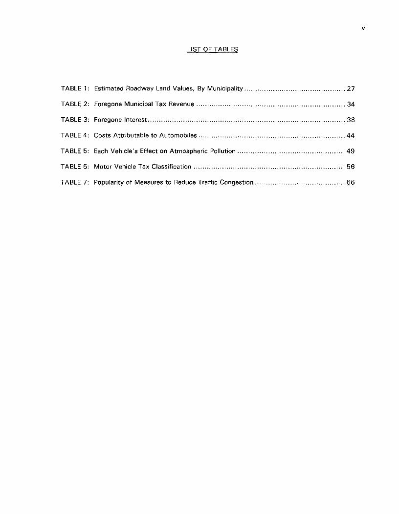
LIST OF TABLES
TABLE 1: Estimated Roadway Land Values, By Municipality^ 27
TABLE 2: Foregone Municipal Tax Revenue^ 34
TABLE 3: Foregone Interest^ 38
TABLE 4: Costs Attributable to Automobiles^ 44
TABLE 5: Each Vehicle's Effect on Atmospheric Pollution ^ 49
TABLE 6: Motor Vehicle Tax Classification ^ 56
TABLE 7: Popularity of Measures to Reduce Traffic Congestion^ 66
v
vi
ACKNOWLEDGMENTS
I wish to extend my appreciation to my supervisors, Professor Alan Artibise and Professor Craig
Davis.
I am grateful for the assistance of my friends and family, who provided both emotional support and
practical help along the way. A special word of thanks is due to David, who encouraged me to
pursue my dreams.
Finally, I would like to thank the University of British Columbia for providing me with the financial
support that allowed me to pursue graduate studies.
1
1.0^INTRODUCTION
1.1^PROBLEM STATEMENT
Roads and other facilities provided for vehicles have a tremendous impact on the urban
landscape. Indeed, one author has even suggested that urban planning has become nothing less
than a "knee-jerk reaction" to the needs of the car (Mowbray 1968, 238). City residents need
many different facilities. Among these many facilities are roads. Roads are a necessary part of a
city's infrastructure and can thus not be totally eliminated. However, the use of land for roads
entails a sacrifice because the land used for roads cannot be used for other purposes such as
housing, park land, farmland or countless other possible uses. There is only a finite amount of
land. When population increases, the pressures on land also increase. Road users often begin to
exert pressure for improved facilities when existing roads become congested. With population
increases and with more people acquiring automobiles and driving those vehicles greater distances
each year, it does not appear likely that the demand for new roads will abate any time in the near
future. Indeed there are many transportation experts who believe that demand for new roads will
never end. Such beliefs are supported by the observation that the construction of new roads often
only exacerbates problems since such construction creates additional demand. Why is demand for
roads insatiable? A major reason is that the market is not currently signaling that roadway land is a
scarce resource.
1.2^RATIONALE
If the reason behind current problems lies in the market sending incorrect signals, then the
obvious solution would seem to lie in making the market send the "right" signals. How can that be
done? It can only be done by first determining the full social costs of automobiles. Currently,
there is not much knowledge regarding this issue. This creates problems because, as Norbert
Wiener has said: "One of the great difficulties of policynnaking in any field is that policies cannot
be made indefinitely by dead reckoning. To sail a ship by dead reckoning alone, without sight of
2
the sun and stars, without the use of the lead, and without the possibility of a distant view of the
coastal landfall means ultimately to run up on the rocks" (Wiener 1993, pp. 116, 117). In the
interests of informed decision-making, it is important that the full costs of roads be acknowledged.
There remain many aspects of the social costs of automobiles that have not yet been fully
explored. Land costs are among the least studied issues. The few studies which do address land
costs often do so in a very vague manner and are generally based on many unexplained
assumptions.
1.3 PURPOSE
The purpose of this thesis is to explore the issue of roadway land costs from a professional
planning point of view. Recommendations will be made concerning policies that could be adopted
by the provincial government to confront drivers with some of the costs they impose upon society.
Attempts will not be made to define the ideal subsidy level or the precise costs that should be
levied against drivers. Such recommendations could only be made once a comprehensive analysis
of all costs and benefits of roads has been completed. Such an analysis is beyond the scope of
this thesis. It should be emphasized that some level of subsidy may be deemed appropriate. After
all, education and health care are not required to "pay for themselves." Society may decide that it
is appropriate to treat transportation facilities in a similar manner. Such a decision should not,
however, be made without understanding the costs involved. It is hoped that this thesis will add
to the existing knowledge base and ultimately contribute to informed debate on the costs of roads.
1.4 METHODOLOGY
Roadway land costs will be explored by conducting a case study of provincially-funded
roads of the Greater Vancouver region. Such an approach forces the researcher to confront the
limitations of data availability and also raises awareness of the complexity of the relevant issues.
The case study was limited to provincially-funded roads because that was a manageable study unit.
3
^
1.5^ORGANIZATION
The thesis begins with a review of the existing literature. This review identifies several
costs that are typically considered attributable to roadways. Subsequent chapters deal with the
most commonly used methods of calculating the identified costs. Within each chapter, a rationale
is then given for selecting a particular approach to estimate costs in the Greater Vancouver region.
A summary is given of the estimated total land costs of provincially-funded roads of the Greater
Vancouver region. The thesis concludes with a brief overview of some policy implications.
^1.6^DEFINITIONS
There are several terms in this thesis which may cause some confusion. In order to clarify
the intended meanings, these terms have been explicitly defined below:
--Automobile refers specifically to privately-owned cars.
--Equity refers to impartial justice and fairness, and not to the net financial interest
in property.
--The Greater Vancouver region is, within this thesis, defined to include the
following municipalities: Burnaby, Coquitlam, Delta, City of Langley, District of
Langley, New Westminster, Port Coquitlam, Port Moody, Richmond, Surrey,
Vancouver, City of North Vancouver, District of North Vancouver, West Vancouver,
and White Rock.
--NOV stands for "High Occupancy Vehicle" and is defined, in this thesis, to be any
automobile containing more than one individual.
--Pecuniary roadway land costs are defined to include the tax revenue that is
foregone on roadway property removed from the tax base, and financing costs
associated with roadway land.
--Roadways include the paved surface of roads, as well as shoulders, ditches and
any other land that must be purchased in order to build a road.
--Roadway land value refers specifically to the value of the land on which a road is
built. This does not include foregone tax revenue or financing costs.
--SOV stands for "Single Occupancy Vehicle" and refers to an automobile
containing a driver, but no passengers.
4
5
2.0 LITERATURE REVIEW
In the following section, several studies that have in some manner dealt with the issue of
roadway land costs will be reviewed. This review will demonstrate how others have approached
the topic.
Four studies have been selected for detailed analysis. These studies have all been
conducted within the last ten years, so the impacts and considerations they deal with are fairly
current. The studies cover a range of geographic locations. Two of the studies have Canadian
localities as their focus; two have American focuses. The studies also represent different
community sizes: one focuses on a province of 10 million people; another on the region of British
Columbia's Lower Mainland; another on a U.S. county; and yet another on a medium sized city.
The studies are written from a variety of perspectives. The authors include a public interest group,
a private consulting group, a master's student and a practicing professional.
2.1 POLLUTION PROBE STUDY
In 1991, Pollution Probe published a report entitled "Costs of the Car: a Preliminary Study
of the Environmental and Social Costs Associated with Private Car Use in Ontario." Pollution Probe
is an Ontario-based public interest group which was founded in 1969. Its research and advocacy
programs are geared towards pragmatic solutions to pressing environmental problems.
Pollution Probe focused on: government spending (for example: road construction,
maintenance and policing); environmental damage and waste; health costs; and resource depletion.
"Most information was collected from published research reports or articles describing such
research" (Pollution Probe 1991, 3). Pollution Probe did not rely only on secondary information.
Where necessary, additional information was obtained through "numerous in-person and telephone
interviews. . . with government and industry officials" (Ibid.).

6
The Pollution Probe researchers focused on several aspects of land costs. First, they
discussed the opportunity costs involved in using land for roads. The authors pointed out that the
"car has had a great impact on Ontario's agricultural land. As more land is used for roads, parking
lots, garages, car washes and car dealerships, less is available for agricultural activity" (Pollution
Probe 1991, 9).
The value of land was considered an important 'cost.' Pollution Probe revealed that
"successive Ontario governments have paved over a million hectares of land to construct the
160,000 kilometres of highways in the province. Assuming a conservative price of
$1,000/hectare, this land would be worth over $1 billion at current market value." The authors did
not go into great detail explaining how the $1,000/hectare value was calculated. The only
explanation given was a subnote which mentioned that "prices for land vary across Ontario,
depending on the quality of land and location. Prime agricultural land in southern Ontario can cost
up to $3,500/hectare" (Pollution Probe 1991, 10).
Pollution Probe estimated that the total cost of the car to the Province of Ontario amounts
to $8 billion per year. This figure does not include costs of global warming, stress due to traffic
congestion, "car-related" court costs, Ontario Ministry of the Environment "car-related" spending
or individual ownership costs (Pollution Probe 1991, ii). The authors of the report acknowledge
that the omission of these costs will result in an underestimation of the real impact of cars. They
excuse the omission of this data by explaining that "the true cradle-to-grave cost of the car is
beyond the scope of (the) report, mostly due to the unavailability of sufficiently disaggregated
statistics" (Ibid., 3).
Overall, the Pollution Probe study provides a good summary of some of the environmental
costs of car use but it fails to go into great detail regarding land costs or other costs which are not
directly linked to pollution effects. The focus on the environment is not, however, surprising given
Pollution Probe's mandate to deal with environmental issues.

7
2.2 HANSON STUDY
In 1992, the American Planning Association published Mark Hanson's article on
"Automobile Subsidies and Land Use: Estimates and Policy Responses." The study attempted to
provide "an empirical approximation of aggregate automobile subsidies" (Hanson 1992, 60). The
study focused on the mid-sized American city of Madison, Wisconsinl.
Hanson believes "that automobile use in the U.S. has been subsidized directly through
highway funding policies, and indirectly through externalities and petroleum subsidies" (Hanson
1992, 60). He adds his voice to those of the Pollution Probe authors when he states that long-
term subsidies and other factors have encouraged a pattern of urban and regional sprawl that
would not have occurred if it were not for the privileged position of the automobile. He believes
that the U.S. transportation system has largely been based on and designed for the automobile
(Ibid.).
Hanson suggested that the effects of subsidies have occurred without much notice from
academics. He said that the literature has generally not made any "systematic attempt to
empirically treat subsidies in aggregate (or) to consider their influence on urban form" (Hanson
1992, 61). He goes on to say that "there appears to be a widely held myth even among some
transportation professionals, that highway users pay for all the direct and operating costs of
highways through user fees such as fuel taxes and registration fees. [A]ny research that has been
conducted has tended to be segmented and often focused on specific, complex subsidies that are
difficult to measure" (Ibid.).
Hanson focused his research on issues that had previously only been dealt with in a very
superficial manner. Wherever possible, Hanson used data that was specific to Madison or
Wisconsin. In fact, part of his reason for selecting Madison as the focus of his case study was
that extensive data were available for that city. However, Hanson did in some cases have to resort
1 In 1989 the population of Madison was 175,000.
8
to more generalized data. He stated that "where data (were) lacking for the specific case, regional
or national averages (were) used to construct a set of reference conditions" (Hanson 1992, 65).
Hanson excluded certain externalities from his calculations because of insufficient data. Among the
excluded externalities were: community disruption due to physical barriers and noise; costs
associated with urban reorganization; costs of larger regional and global impacts attributable in part
to the automobile (such as acid deposition); and the costs of private parking subsidies. Costs
which he did consider were: highway construction and maintenance costs, policing costs,
environmental impacts such as air pollution and water pollution, personal injury costs, property
damage, lost earnings, land use opportunity costs and petroleum subsidies (Ibid.).
Hanson examined both direct and indirect subsidies. He defined direct subsidies as being
those "for construction, maintenance, and operation of highways that are not funded by user
fees." Indirect subsidies were defined to "include air pollution and related aesthetic losses, water
pollution, losses to society from human injuries, and opportunity cost of land used for the highway
system" (Hanson 1992, 61). Hanson reminded his readers that the magnitude of "indirect
subsidies is highly uncertain and methodologies to estimate them are controversial" (Ibid., 64).
Hanson considered land costs to have both "direct" and "indirect" components. He
considered right-of-way acquisition to be part of construction costs, and therefore a direct cost
(Hanson 1992, 63). Land opportunity costs were, however, classified as indirect costs (Ibid., 61).
He said that "a land opportunity cost occurs when land, used for roads, could have been used for
some other purpose" (Ibid., 66). He suggested that "because roads do provide mobility and
access, a subsidy in the form of an opportunity cost occurs if more than a necessary or 'optimal'
amount of land is dedicated to highways" (Ibid.). He considered the determination of the optimal
amount of highways and congestion to be beyond the scope of his research.
Hanson concluded that foregone tax revenue should also be included in the calculation of
land costs. He used foregone property tax revenue as "a conservative estimate of the opportunity
9
cost of land" (Hanson 1992, 70). Prevailing tax rates were then applied to the one third of the
roadway land that he deemed unessential for basic road service. He estimated that foregone
property taxes amounted to about $1 million (1983) dollars (Ibid., 66). This figure amounted to
less than five percent of the total indirect subsidies that he tallied. He therefore came to the
conclusion that "ignoring this cost would not significantly alter the overall subsidy levels" (Ibid.).
He acknowledged, however, that "in larger cities with much higher land values and greater
proportions of highways to land area, this cost might grow more than proportionally with
population" (Ibid.).
Hanson reached the conclusion that indirect costs of automobiles to the Madison area
amounted to $23 million per year. This was about twice the level of direct subsidies of $11.7
million (figures given in 1987 dollars). He acknowledged that there was uncertainty as to the
precision of these values and therefore suggested that "the range of indirect costs could easily be
from 50 percent lower to at least 100 percent higher" (Hanson 1992, 65).
2.3 LITMAN STUDY
Todd Litman developed, as part of his Master's thesis, a full cost transport computer
model. In this model, he dealt with both direct and indirect costs. Among the many costs he
discussed was the cost of roadway land.
Litman agreed with Hanson's contention that the opportunity cost of land must be taken
into consideration when calculating the total cost of roads. When land is used for road right-of-
ways, it cannot be used for other purposes. When other usage could have resulted in higher
revenues, then the use of the land for roads may entail a loss to the public purse. This loss must,
according to Litman, be counted as a road cost. He expanded on this point when he said that
"since land used for roads is unavailable for other productive uses and earns no "rent" or tax
revenue, the value of land dedicated to roadways, beyond that required for a minimal level of
1 0
access, can be considered a subsidy to driving" (Litman 1992, 11). Litman claimed that reports
that only consider the acquisition cost of land thus seriously under-represent true costs.
Litman estimated total roadway land costs to be approximately $.01-.03 per vehicle mile.
Litman claimed that this was the amount of money that would be needed to compensate society
for the land dedicated to roads. He took the value of $0.015 per vehicle mile to be "a reasonable
average value" (Litman 1992, 11).
Litman did not appear to consider that the relative importance of fixed and variable costs
might play a factor in the per mile rates. For example, he does not mention that if fixed costs were
very high and variable costs minimal, a higher level of road usage (up to the point where more fixed
costs would be incurred) might actually decrease per vehicle mile costs since there would be more
vehicles among which the total costs could be dispersed. By ignoring this factor, Litman's
approach could conceivably overestimate the total cost. Traffic volumes are also an important
factor in per mile rates. If traffic volumes were taken to be quite high, and were in fact
significantly lower, the "per mile" approach could underestimate the total cost. The approach of
using per mile figures has significant limitations because such figures are heavily influenced by the
traffic patterns that prevailed at the time of the cost estimate.
Litman appeared oblivious to the fact that although land used for roads may no longer
generate property tax revenue, those roads may indirectly create tax revenues through license fees,
gas taxes and other vehicle-related taxes. Such taxes could not be collected if roads did not exist.
It thus appears that Litman considers only losses without acknowledging that there might be
revenue that could offset such losses.
Litman was more detailed in his evaluation of land costs than were Pollution Probe and
Hanson. Litman considered financing costs to be an important element of total costs. Neither
1 1
Pollution Probe nor Hanson mentioned this cost. Litman also went further than Pollution Probe and
Hanson in that he allocated responsibility for different costs.
12
2.4 PEAT MARWICK STUDY
In 1992, Peat Marwick Stevenson Kellogg (Peat Marwick) was hired by TRANSPORT 2021
to conduct an analysis of the "full" costs of various modes of transport in the British Columbia
Lower Mainland. This study was to help TRANSPORT 2021 staff develop recommendations for an
effective long term transport plan for the Lower Mainland region (Peat Marwick 1993, 1). Peat
Marwick used much of Litman's research as a basis for their study and engaged Litman as an
Associate. Although much of Litman's approach was used, Peat Marwick used secondary data
(including Litman's data) only when local data was not available.
Peat Marwick studied both private costs (such as vehicle operating costs and user charges)
and public costs (such as environmental impacts) (Peat Marwick 1993, 1). The Peat Marwick
study made no attempt to measure benefits unless such benefits directly offset particular costs.
Peat Marwick calculated the value of the land devoted to roads by applying, to the land, the
average value per hectare that applied to the municipality in which the road was located (Peat
Marwick 1993, 27). Peat Marwick decided that the value given to roadway land must be the land
value which would prevail if the road did not exist. The average value per hectare figure that Peat
Marwick obtained from the British Columbia Assessment Authority reflected the value given to the
land by road access. Peat Marwick decided to discount that value by 70 percent to estimate the
value of the land as it would have been without roads.
Peat Marwick's approach involves at least three assumptions. One assumption is that the
value of land adjacent to roads is the same as the average value of land in a municipality. Peat
Marwick acknowledged this assumption when they said that: "land assessments per hectare vary
widely from area to area within a municipality" and that the average which was used for the
calculations "may not be represented (sic) of land adjacent to roadways" (Peat Marwick 1993, 28).
A second assumption, and one which is not acknowledged, is that discounting the average value of
land would yield reasonable results. This assumption may create problems. The average value of

13
land is presumably heavily weighted by land that is not adjacent to major highways since most land
parcels do not abut major roads or highways. This means that the average value of land is already
considerably lower than the value that would be attached to land adjacent to a major road.
Discounting even the average land value by seventy percent, means that the land adjacent to roads
is being discounted twice: once as a result of using average assessed values, and then again when
that average is discounted by seventy percent. A third assumption is that seventy percent is a
reasonable discount rate.
Peat Marwick amortized land costs over ten years, but gave no rationale for selecting this
time period. The value of the total land area required for roads wider than a basic seven meters
(20,000 hectares) was estimated to be $19,284 million before discounting and $5,785 million
once a seventy percent discount rate had been applied (Peat Marwick 1993, 27). The costs that
the market does not capture are "experienced by more than municipal and provincial taxpayers"—
they are paid for by "society in general" (Ibid.).
Peat Marwick concluded that roadway land values are difficult to assess. This difficulty
can largely be attributed to the fact that, even among experts, there is no consensus on the
method which should be adopted. Every method involves some assumptions and the assumptions
will greatly affect the final values. It is thus not surprising that Peat Marwick freely admits that, of
all the figures they calculated, the figures given for roadway land values are among those in which
they have least confidence (Peat Marwick 1993, 11).
14
2.5 SUMMARY
The studies reviewed in this section all made at least some mention of the societal cost of
roadway land. Although land costs were considered important enough to be mentioned in all the
studies, several of the researchers stated emphatically that the figures given were very rough
estimates. All the cost estimates that were given for roadway land rested on very general
assumptions. In most cases the grounds for accepting the assumptions were not explained. It
would appear that there is a need for a study that probes in greater depth the costs associated
with roadway land.
15
3.0 TYPES OF ROADWAY LAND COSTS
The calculation of roadway land costs has not escaped the controversy and difficulties
associated with the tallying of other road costs.
Recent studies have suggested that there are three types of costs that should be
considered in the calculation of total roadway land values (Pollution Probe 1991; Litman 1992;
Hanson 1992; Peat Marwick Stevenson Kellogg 1993). These three costs are: the value of the
land, the taxes potentially foregone when previously taxed lands are removed from the tax base,
and the interest that is potentially foregone when money is spent on roads.
Roadway land value is an important component of the total cost of roadways. Pollution
Probe researchers discussed this cost when they revealed that Ontario had, over the years, "paved
over a million hectares of land" that was deemed to "be worth over $1 billion at current market
value" (Pollution Probe 1991, 10). Hanson also considered land value to be an important element
in calculating subsidies to automobiles (Hanson 1992, pp. 60, 65). In 1993, Peat Marwick
conducted an analysis of the "full" costs of various modes of transport in the Vancouver region. In
this study, Peat Marwick considered the value of land used for non-basic roads to be a subsidy to
drivers. Roadway land value generally seems to be considered an important component of total
roadway costs.
Foregone property taxes are also often considered to be a cost of roadway land. Hanson is
one researcher who believes that foregone tax revenue should be included in the calculation of land
costs (Hanson 1992, 70). Litman is another researcher who mentioned that the loss of tax
revenue on the land used for non-basic roads can be considered a subsidy to automobile drivers
(Litman 1992, 11). This cost is, however, a different type of cost than is the cost of actually
purchasing roadway land. Property taxes may only in some cases be considered "foregone." In
many cases, the taxes that are lost are made up for in other ways. From a societal point of view,
the building of roads does not always mean a loss of property taxes.
16
Foregone investment interest is another cost component that is sometimes attributed to
roadway land (Litman 1992, 11). This cost is also considerably different from the cost of actually
purchasing roadway land. Although it may appear, on the surface, as if no interest is earned on
the money invested in roads, such interest often does exist, although in a slightly less conventional
format than more traditional bond yields. The "returns to investment" can occur in such forms as
travel time savings. From a societal point of view, there may indeed not be any real loss incurred
from road investments.
Foregone investment interest and foregone property taxes cannot be classified as the same
types of costs as the cost of roadway land. However, since foregone investment and property
taxes are often alleged to be integral components of total cost, they are included as part of this
thesis so that some appreciation can be gained for the extent of compensating revenue or benefits
that are needed before such indirect costs will be "paid" for.
The next three sections will deal with the three costs identified in this section: roadway
land value, foregone property taxes, and foregone investment interest. Each section will begin with
a review and evaluation of existing and proposed methods of calculating these costs. A particular
approach will then be selected for application to the Greater Vancouver region.
17
4.0 LAND VALUES
Land values are a major component of total roadway land costs. The land value must be
determined before either foregone taxes or foregone investment interest can be estimated. Yet,
despite its importance, there is no universally accepted method of arriving at an estimate of land
values. A review of the literature reveals that there are at least four different ways of determining
land values. Each of these has its advantages and drawbacks.
4.1 HISTORICAL COST METHOD
Historical costs are those which were originally incurred to build existing roads (Meyer
1971, 39). Data for such costs can be obtained by referring to files indicating the original
purchase prices of all the lands involved.
One of the advantages of the historical cost approach is that it is relatively straight-forward.
In addition, the data may, in some cases, be quite readily available. All one has to do to get the
data is to research the prices at which the land was originally bought.
Historical costs could, however, only be considered equivalent to current costs if there
were no such thing as inflation. Inflation necessitates adjustments to original costs so that they
can be made comparable to present-day values. Under conditions of general price inflation, land
values would be underestimated unless some adjustments were made (Meyer 1971, 39). Since
there are currently no satisfactory land acquisition cost indices, the adjustment process can
become rather problematic (Keeler and Small 1977, 9).
Another major disadvantage of the historical cost approach is that it does not necessarily
reflect the current opportunity cost of roads. The roads may originally have been purchased at a
very low price. Attaching this low cost to present roads denies the possibility that roads might
bring greater returns if used for higher-value purposes. The historical cost approach assumes that
18
roadway land was being used for the current highest and best use even at the time it was originally
purchased. This is a problem that is resolved by the opportunity cost method.
The serious conceptual flaws of the historical cost method and the availability of more
generally accepted methods have meant that this approach is rarely used in practice. Lack of
access to the Ministry of Transportation and Highway's files, means that this approach is not, in
any case, a viable option for calculating roadway land costs for the Greater Vancouver region.
4.2 THE RATIO METHOD
Keeler and Small are among the researchers who have proposed alternatives to the
historical approach. In an attempt to determine optimal road pricing, Keeler and Small estimated
the total value of roads in the San Francisco Bay Area. To estimate the value of roadway land,
they first researched how much money was spent on constructing roads between 1947 and 1972.
These values were converted to 1972 prices using the California Highway Construction Cost Index
(Keeler and Small 1977, 6). The costs were then added up, "under the assumption of a 'one-
horse-shay' depreciation policy, with an estimated lifetime of 25 years" (Ibid.). To determine
roadway land values, Keeler and Small then assumed that the ratio of land acquisition costs to
construction costs would remain fairly constant over the years. Given this assumption, they were
able to calculate the total value of roadway land. To do this, they merely took the total current
value of construction costs (1947-72) and multiplied this total by the ratio of land/construction
costs which held during the 1968-1972 period. Construction costs and land values were broken
down into categories that reflected road types. So, for example, collector roads were not
compared to freeways. Keeler and Small were able to gather this data because "some new roads
(had) been built in very recent years in each county" and land acquisition costs for these roads
were available (Ibid., 9).
The ratio method allows researchers to use relatively current data. This can be a definite
advantage because it means that researchers do not have to devise arbitrary land acquisition cost
19
indices. The exclusive reliance on current data can, however, also have its disadvantages. For
example, if the land cost/construction cost ratio does not accurately reflect the ratios that have
applied historically, then significant distortions in the data may be expected. One way to
circumvent this danger is to check the ratios which have applied historically. So, for example,
instead of automatically assuming that a selected time period is reflective of others, studies can be
done to see how much the ratio has changed over the years. If there are significant fluctuations,
then it may not be wise to use a ratio which differs widely from the norm. This is not a moot
point. After all, it has been well established that the ratio between housing construction costs and
lot prices fluctuates quite a bit. It would not be surprising if the same phenomenon applied to
roads.
Changing land cost/construction cost ratios may reflect changing land uses. If, for
example, a new freeway was built through a suburban community within a given county in the
1968-72 period, land costs might account for a fairly high proportion of total costs. The
proportion of land costs would not be as high as for a freeway in the central city, but it would
certainly be more substantial than if the freeway were built through farmland. However, the area
which is now suburban may, fifteen years ago, have been farmland. If a freeway was also built in
that area 15 years earlier, Keeler and Small's ratio method would retroactively apply the 1968-72
suburban ratio to an area that was rural when the road was built! This danger can be averted by
not classifying the earlier road as a suburban freeway, but rather as a rural freeway.
Changing construction costs may also affect the land/construction cost ratio. Improved
technologies may have made construction in recent years relatively cheaper than in earlier years. If
a standard ratio were applied over a time period in which significant technological change occurred,
the results would be inaccurate.
The ratio method, like all other methods, cannot be used unless sufficient data is available.
Unfortunately, data may not always be readily available. The ratio method depends heavily on both
20
construction and land cost data being available on a highly disaggregated basis. Historical
construction cost data must be available by time period, type of road, and location. The
information needs for the determination of the land cost/construction cost ratio are even more
stringent. Within a defined time period (such as the 1968-72 period used by Keeler and Small), a
road of each type that will be analyzed must have been built within each defined geographical area.
Keeler and Small's study, for example, would not have been possible if there were a county in
which a freeway had not been built within the four year study period.
The method proposed by Keeler and Small is certainly innovative. If great care is taken to
ensure that the assumptions being made are not highly unrealistic, then this method may present a
reasonable evaluation of road costs. The method, however, requires extensive research, and as
such may not be widely adopted. In the case of the Greater Vancouver region, this method cannot
be used because historical costs are extremely difficult to obtain and because construction activity
within the last few years has been too limited to allow for collection of sufficient data samples.
4.3 DISCOUNT METHOD
When it comes to finding a relatively simple method of determining land costs, researchers
have often relied on quite different methods than those previously discussed. One quite common
method appears to be to gather data on values for land adjacent to roads (through tax assessment
rolls) and to then discount these values by a certain percentage to take into account the increase in
land value that supposedly comes from being next to a major road. This approach has the benefit
of being both quick and easy. It has been used by both Litman (1992) and Peat Marwick (1993).
One drawback of this approach is that the selection of the discount rate often seems highly
arbitrary. Researchers do not always give reasons for choosing the rates they use. When
explanations are given, these sometimes consist only of references to other studies which used
similar rates. Adoption of rates used in other localities denies the possibility that the location under
study may differ dramatically from previously studied areas. To be fair, some researchers do adjust
21
their numbers to reflect differences. But, such revisions require a thorough knowledge of both the
locality to which the rate will be applied and the locality from which the numbers were originally
taken. Adjustments also require a thorough knowledge of market influences and economics in
general. Those who lack such knowledge would likely be making highly arbitrary adjustments.
The application of a discount rate implies that land will always increase in value once new
access has been provided. This is doubtless not the case. Indeed, Mohring and Harwitz (1962)
have demonstrated that land values may actually decrease. This is not a problem which need be
inherent to this procedure. If, in a particular locality, it is expected that the value of land near the
highway is actually less than that of unaffected land, then the rate could presumably be adjusted to
reflect this. However, this, once again, requires an in-depth knowledge of the likely effects of
highways in particular locations.
The discount rate method is attractive because it is relatively easy to apply. By using this
approach (as was done in the Peat Marwick study), the value of roadway land can be determined
quite quickly. It is important to recognize, however, that this approach is very arbitrary and
involves many assumptions. If there is to be any assurance of accuracy, then the rate-setter must
have considerable expertise in the area of highway economics.
4.4 OPPORTUNITY COST METHOD
Another method of estimating roadway land costs is to determine what it would cost to
buy the land today. Such an approach takes into consideration the opportunity cost of using land
for roads. Winch explains that the "opportunity cost of using land and buildings for a highway is
the sacrifice of alternative uses" (Winch 1963, 16). Even roads that have been "acquired well in
advance of requirements" have an opportunity cost (Ibid., 61). All land, both that purchased for
the explicit and immediate purpose of building roads, as well as land held for potential future use,
should be valued at "what the land would be worth if sold now for other purposes and no highway
were built" (Ibid.). The relevant value is "that of the land if no highway is to be built, since that is
22
the value in other uses. If we take the value of adjacent land, which value takes account of
expected development, we are really assuming that the opportunity cost of the land used is its
value with the highway adjacent" (Ibid.). Winch therefore concludes that it would be preferable to
avoid using adjacent land as an indicator of the value of roadway land, since this would
overestimate the value of the land (Ibid.). Here he makes the assumption that roads always
increase the value of adjacent land. Although some researchers agree that roads generally increase
the value of adjacent land (for example, Winfrey), other researchers point out that this is certainly
not always the case (Mohring and Harwitz). 2
Under the opportunity cost method, the monetary value of any individual piece of land "is
the most that some other user would be prepared to pay . . . that is, (the) current market value"
(Winch 1963, 16). The total cost of the right-of-way is considered to be "the sum of the
capitalized current market values of all the interests held in the land and buildings acquired," which
can be "amortized over the anticipated life of the highway" (Ibid.). Winch explains that current
market values can be determined by examining "past land sales in the area, adjusted for any rise in
value over time caused by anything other than potential highway development" (Ibid., 61).
Use of the opportunity cost method might be accepted wholeheartedly in a perfect world in
which no assumptions would have to be made. However, the world is far from neat and tidy and,
as such, obtaining the data needed is often a difficult task. Sometimes the difficulties result in
assumptions having to be made. Winch's approach requires several assumptions.
Winch assumes that it will be possible to find examples of similar land to which he can
compare the roadway land. Plots of land are often quite unique and it may be rather difficult to
find a strictly comparable plot of land. Plots "can differ with respect to both the quality and
2Regardless of the effects of roads on land, it is probably a good idea to avoid applying the value of adjacent landto the roads themselves. There does not appear to be any harm in taking a conservative approach in this regardand saying that, because roads may have some effect on land values, it is better to use land values which may notbe thus contaminated.
23
location of the land itself and the amount, age, and productivity of the capital installed on it"
(Burrows 1991, 61). This can create inconsistencies and can even provide an inducement to over
invest. Burrows explains that there is the danger that:
lacking information on some of the major determinants of plot value, such as thenet profitability of the goods produced by the capital installed, the valuer will view aplot as comparable because similar amounts of capital are installed on it. Thiswould involve (an) . . . inducement to overinvestment . . . With diverse plots in theproject locality, a plot owner may see such excessive investment either as a meansof reducing the probability of his/her particular plot being acquired, or as a means ofraising his/her compensation receipt in the event of a taking (Ibid.).
In addition to "comparable" land values potentially being affected by over investment, there
is also the possibility that such values may be influenced by expectations of future development.
In some cases, it may be quite a challenge to find a plot of land whose value is not affected by
plans for future roads, or even rumours of such plans. Complications arise when "the very
existence (or even the prospect of the existence) of government project plans influences the market
value of land plots in particular localities" (Burrows, 1991, 60).
Winch assumes that researchers will be able to update historical land opportunity costs by
adjusting "for any rise in value over time" (Winch 1963, 61). In reality, this approach is likely to
cause problems since no suitable land acquisition cost index is available (Keeler and Small 1977,
9). Translating the costs of previous years into current values may therefore prove quite
challenging. The only way to avoid this problem would be to calculate opportunity costs for the
year that one is interested in. Thus, if a value for 1992 was desired, the actual values of the land
in 1992 would have to be taken into consideration. One drawback of this approach is that the data
collected in 1992 could not easily be converted to 2002 values if, ten years later, an update were
required.
Yet another disadvantage of the opportunity cost method is that it does not necessarily
take into account all the things that give value to land. For example, the market prices which are
24
used as indications of land values may not reflect personal attachment to the land, or various
environmental benefits such as the oxygen enriching capacity of the trees on a land parcel
(Burrows 1991, 60►. It is worthwhile to note, however, that this factor is also not taken into
consideration in any of the other evaluation methods discussed.
Winch's approach can be considered logical and correct in a theoretical sense.
Unfortunately, it suffers from several drawbacks when attempts are made to use it for determining
actual roadway land costs. The opportunity cost approach is, however, one of the few approaches
that can be readily used under conditions of restricted data access.
4.5 CALCULATION OF LAND VALUES
The brief overview of some of the most commonly adopted methods of estimating land
costs has revealed that there is no method which does not have clear disadvantages. The selection
of a particular method will be dictated by the need for theoretical validity and by data availability.
Even under the most favourable circumstances, the final numbers will be estimates rather than
definitive bottom-line figures.
Given the need for a theoretically valid approach, the choices are immediately reduced to
either the ratio method or the opportunity cost method. In choosing a method to assess land, the
issue of data availability is also of utmost consequence. Limited access to data immediately
precludes the ratio method. The only method that can be used for the Greater Vancouver region
would appear to be some variation of the opportunity cost method. All the other methods require
disaggregated data that are not readily available to researchers working without access to the
British Columbia Ministry of Transportation and Highways' files.
The opportunity cost method uses current market values to estimate the value of roads.
Current market values are available from the tax assessment rolls of the British Columbia
Assessment Authority (BCAA►. The most recent data available are the 1993 assessed values. The
25
1993 assessed values are the BCAA's estimate of the "most probable selling price of the property
had it been for sale on July 1, 1992." Values are determined based on the physical condition and
permitted use on October 31, 1992. The likely sales prices are determined by assessors who take
into consideration such factors as: location, zoning, size, topography, shape, condition, sales of
comparable properties in the area, and other factors that might affect the property's value (B.C.
Assessment Authority 1992, 3 ).
Roads are not subject to taxes. There is therefore no need for the Assessment Authority to
place a value on roadway land. This means that the assessment rolls do not contain information
on the value of roads. Since roadway land values cannot be obtained from the assessment rolls,
some other method of determining land values must be created.
It is generally agreed that the value of roadway land should be the value that would be in
effect if the road did not exist. It is, however, very difficult to establish the value of land as it
would be without the presence of roads. All properties are required, by law, to have road access
(Land Titles Act, Section 75(1)(a)). This means that roadway land can not be readily compared to
land with no access and then simply given the value of such property. Fortunately, such a
comparison is not actually necessary. If all properties have some degree of access, then minimal
access will not affect any given property in ways that all other properties are not also affected. In
a sense, minimal access can be said to be incorporated in the basic value of property. It is access
which goes beyond a minimal level that will change the value of the affected land. But, increased
access will only add to the value of land if there are buyers who are willing to pay for increased
access. If increased access serves potential owners no useful purpose, then it is unlikely that such
individuals would be willing to pay a premium for it. It is unlikely, for example, that a residential
property abutting on a major highway would be worth considerably more than a residential
property located at a less 'accessible' location. Indeed, if the highway is of the "limited access"
type, it may not even offer increased access. Rather than conferring benefits, the highway may
actually be perceived as a nuisance--especially if it increases noise and air pollution. In such cases,

26
a highway may actually decrease adjacent property values. Land values would seem to increase
only when owners can take advantage of improved access or exposure, either in the present, or in
the future (by selling land at a high price to people who can benefit from the access or exposure).
Thus it would seem to be a land-use change, rather than the road itself, which adds value.
Of course, land further away from the highway can also benefit from increased access
offered by the new road. A 1960's study quoted by Rice found that transport accessibility
accounted for from 10 percent to 16 percent of total property value (Rice 1993, 4). Even if
access were improved once a new highway were built, the incremental benefit would often be less
than the 10 to 16 percent cited by Rice since some basic road access would exist even without the
new road. Since most arterials and major highways exist primarily to improve mobility rather than
to provide access (Ministry of Transportation and Highways June 1992, D2), there appears to be
little reason to believe that a new provincially-funded road would add considerable value by way of
improved access.
To accurately assess the value of roadway land, it is important not to make any
assumptions about the relationship between adjacent land values and actual 'opportunity' costs.
The opportunity cost of the roadway land can be established by taking into consideration the likely
use of land had a major road not been constructed. This can be determined by examining what
land further away from the road is typically used for and what that land is worth.
Land parcels not directly affected by major roads can be found by examining legal maps
available at Assessment Authority offices. For this thesis, an attempt was made to select parcels
located in areas bordering on each of the provincially-funded roads, but still far enough away that
the use of the parcels would not likely have changed due to the presence of the road. Samples of
this sort were selected at roughly one kilometer intervals along each provincially-funded road.
These samples were collected in such a way as to be fairly representative of the land uses in each
area. The samples were selected from alternate sides of the road to take into account possible

27
differences in value that might result from varying exposures. Wherever possible, samples that
might be influenced by unique characteristics were avoided. Examples of such characteristics
included: waterfront exposures, locations close to hydro right-of-ways or railways, and presence
of stream beds. All these factors could result in values being unrepresentative. There are,
however, many influences on land values. Every lot is unique and, as such, it is very difficult to
find a perfectly 'typical' lot. To help ensure that values were not too unusual, land values that
were included were checked to see that their values did not deviate too much from those of
neighbouring lots. It should be noted that in some cases it was extremely difficult to find samples
that were in roughly the same neighbourhood as the roadway, but still far away from all major
roads. Some parts of the Greater Vancouver region are quite built-up. This means that it is
difficult to find land parcels unaffected by major roads. For example, in some parts of Burnaby, the
Lougheed Highway and Canada Way run in close proximity. Vast areas are thus influenced by
those two roads. However, in many cases, the high land values found in such areas may
accurately depict the opportunity cost of the road. Given the existing high level of access, the
prevailing uses would likely have been in existence even without some of the roads. As such, the
land used for a new road may well have an opportunity cost that is accurately reflected in existing
highly accessible lots.
After the values (dollars per hectare) of typical, non-adjacent land were found, these values
were then applied to the road areas. A six kilometer stretch of road would have roughly six
observations attached to it. An average dollar per hectare figure was calculated from these six
observations and then the average value was applied to the total road area to estimate the roadway
land value. Since the samples were taken at roughly equal intervals along the stretch of road, the
average value of the observations will reasonably depict the average land value for that particular
stretch of road. There is no need to apply a discount rate to the values since the samples used
were not directly adjacent to the roads, and were thus not unduly influenced by the road.
28
In calculating roadway land value, the applicable land values were attached to the full right-
of-way rather than to only the paved surface. Provincially-funded roads are generally built to
facilitate high-speed vehicle movement, rather than pedestrian access. Indeed in many cases,
sidewalks are not built along major roads such as the Trans Canada Highway. In the case of major
arterials and highways, it seems fair to assume that the right-of-way is provided exclusively for
vehicle use. The shoulders and ditches that are part of a right-of-way are an integral component of
the road. They exist for safety reasons, to provide for possible future widening, and to provide for
snow removal and drainage. None of these factors directly serve the needs or interests of non-
vehicle owners.
Using the opportunity cost method, the total value of roadway land in the Greater
Vancouver region was found to be $3,660,923,687. Table 1 shows the results of the calculations
by municipality. Appendix 1 contains a more detailed inventory of the values found to prevail along
each roadway within each of the municipalities.
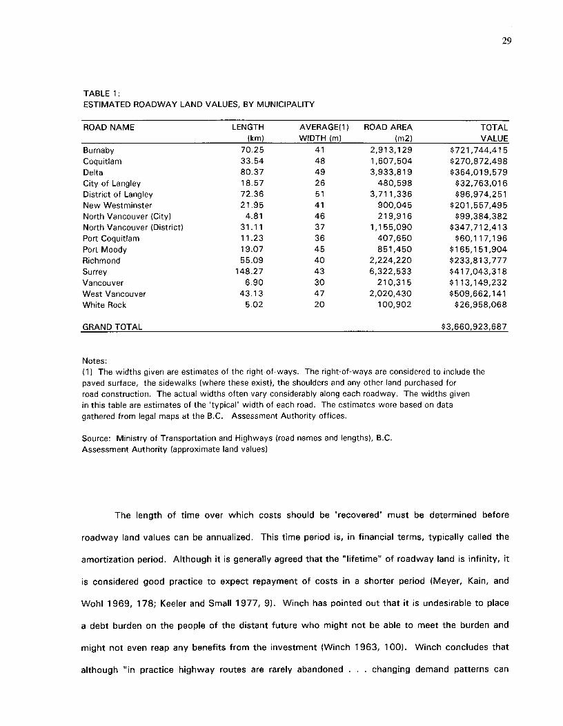
TABLE 1:ESTIMATED ROADWAY LAND VALUES, BY MUNICIPALITY
ROAD NAME LENGTH AVERAGE(1) ROAD AREA TOTAL(km) WIDTH (m) (m2) VALUE
Burnaby 70.25 41 2,913,129 $721,744,415Coquitlam 33.54 48 1,607,504 $270,872,498Delta 80.37 49 3,933,819 $364,019,579City of Langley 18.57 26 480,598 $32,763,016District of Langley 72.36 51 3,711,336 $96,974,251New Westminster 21.95 41 900,045 $201,557,495North Vancouver (City) 4.81 46 219,916 $99,384,382North Vancouver (District) 31.11 37 1,155,090 $347,712,413Port Coquitlam 11.23 36 407,650 $60,117,196Port Moody 19.07 45 851,450 $165,151,904Richmond 55.09 40 2,224,220 $233,813,777Surrey 148.27 43 6,322,533 $417,043,318Vancouver 6.90 30 210,315 $113,149,232West Vancouver 43.13 47 2,020,430 $509,662,141White Rock 5.02 20 100,902 $26,958,068
GRAND TOTAL $3,660,923,687
Notes:(1) The widths given are estimates of the right-of-ways. The right-of-ways are considered to include thepaved surface, the sidewalks (where these exist), the shoulders and any other land purchased forroad construction. The actual widths often vary considerably along each roadway. The widths givenin this table are estimates of the 'typical' width of each road. The estimates were based on datagathered from legal maps at the B.C. Assessment Authority offices.
Source: Ministry of Transportation and Highways (road names and lengths), B.C.Assessment Authority (approximate land values)
The length of time over which costs should be 'recovered' must be determined before
roadway land values can be annualized. This time period is, in financial terms, typically called the
amortization period. Although it is generally agreed that the "lifetime" of roadway land is infinity, it
is considered good practice to expect repayment of costs in a shorter period (Meyer, Kain, and
Wohl 1969, 178; Keeler and Small 1977, 9). Winch has pointed out that it is undesirable to place
a debt burden on the people of the distant future who might not be able to meet the burden and
might not even reap any benefits from the investment (Winch 1963, 100). Winch concludes that
although "in practice highway routes are rarely abandoned . . . changing demand patterns can
29
30
considerably affect useful life. The period should therefore be limited to the foreseeable future in
which there is no reason to fear that they will become obsolete. It is prudent to err on the side of
underestimating this . . ." (Ibid.). Winfrey's arguments are similar to Winch's, but Winfrey goes
further by actually suggesting that "20 years or so is a maximum future period for reliable forecasts
of traffic volume, composition, and performance" (Winfrey 1969, 25). The British Columbia
Ministry of Transportation and Highways states that although the life of the right-of-way is
generally considered to be hundreds of years, the strategic planning for highways is based on
twenty-year projections (Ministry of Transportation and Highways June 1992, 8). Since demand
cannot be reasonably predicted beyond such a 20-year time period, it would seem wise to limit
cost recovery expectations to this time-frame. If the land values given in Table 1 are amortized
over 20 years, then the annual land value would be $183,046,184.
It should be emphasized that the figures given in this section are for the value of land as
estimated by the opportunity cost method. Since data on the cost of initially acquiring the land is
not available, the opportunity cost method was used to derive an estimate of the value of the land
as it would be if it were purchased today. The costs of the land have already been accounted for
in the budgets of the Ministry of Transportation and Highways. 3 The object of this thesis is not to
claim that these costs are not now considered but rather to determine the extent of roadway land
costs.
3 The Ministry of Transportation and Highways' budgets are, however, not sufficiently detailed to allow for useof those budgets in determining land values of particular roads. Therefore, other means, namely the opportunitycost method had to be used to estimate the land values.
31
5.0 PECUNIARY COSTS SOMETIMES ASSOCIATED WITH ROADWAY LAND
In addition to the value of roadway land, there are tangential societal costs which are
sometimes attributed to roadways. These costs include foregone municipal tax revenue and
foregone investment interest. These costs are often fully attributed to roads although there are
arguments that society does not always bear such costs and that they should therefore not be
considered 'real' costs. This dispute will be discussed in the following paragraphs.
5.1^FOREGONE MUNICIPAL TAX REVENUE
Publicly-owned roads are exempt from property taxes. Roads have a somewhat special
status then, since most land is taxable.4 When taxable land is expropriated to be used for non-
taxable roads, the tax base of local government appears eroded. Property tax losses are not
insignificant since property taxes provide approximately 40 percent of local government revenue in
Canada. It is the major source of revenue controlled by local government (British Columbia
Assessment Authority, 1992). Since roads cover a large area of the total urban landscape, lost
taxes can become quite significant. Lost taxes have the potential of being a "societal" cost if the
loss of such taxes can only be made up for by increasing taxes on other individuals who do not
benefit from the new road. Whether there is any justification in considering tax losses a road cost
is a matter of considerable debate.
The Cases for and against Considering Lost Tax Revenues
The arguments for including lost tax revenues as a roadway cost centre primarily on the
contention that failure to do so would result in inequities or economic inefficiencies.
Not taking lost revenues into consideration can result in inequitable and inefficient allocation
of resources between the public and the private sector. It can also result in inefficient allocation
between various public projects. Winch, for example, points out that:
4Publicly owned land such as parks as well as some privately owned land such as church property is usuallyexempt from property taxation.
property taxation must be included as part of the cost of a highway in our planninganalysis . .. because we are trying to determine how much of available resourcesshould be devoted to highways. Highways and other uses are essentiallycompeting for resources, which should go to that use where the utility yielded isgreatest . . . If highways are to compete for these resources on equal footing,determining net yield by our cost and demand analysis, it is important thathighways be subjected to the same overhead costs in the form of taxation thatapply to other resource uses (Winch 1963 19).
There is considerable theoretical support for considering foregone tax revenues as a road
cost. It is thus not surprising that such costs have sometimes been considered when cost studies
have been prepared. There are several precedents for including foregone taxes as a community
cost of roads (Winch 1963, 19; Shortreed and Berry 1968, 33-43; Meyer 1971, 33; Wachs 1981,
248; Hanson 1992, 66).
Winfrey, however, urges caution in calculating foregone taxes. He states that using
formerly tax-generating lands for non-taxable roads does not necessarily result in a tax loss to the
community. He believes that although such a loss may occur, it should not be assumed that it will
Occur.
Winfrey acknowledges that, on the surface, it would appear that the removal of land from
the tax rolls would involve a loss of revenue. He states, however, that such a loss can be
compensated for by gains which are also directly related to the roadway land taking. For example,
adjacent land may increase in value if a new road is built. Such increases may be sufficient to
offset any losses in tax revenue that occurred by removing roads from the tax rolls. In fact, in
some cases, increased land values may even exceed the losses that were a result of land-takings.
Winfrey points out that it would be wrong to ignore such increases while acknowledging losses
similarly imposed (Winfrey 1969, 488).
Tax revenues lost from one location may also be compensated by increased tax revenues
32
from other, more distant, locations within the same municipality (Winfrey 1969, 488). The total
33
values on the assessment rolls can, for example, be maintained at an equivalent or increased value
if the owners whose land was expropriated reinvest their compensation money within the municipal
boundaries. In such a case, the total assessed value of land within the municipality may not
decrease. In a rapidly growing region such as Greater Vancouver it is, however, likely that such
reinvestment would occur at the expense of other investment in the same land. If only a few
parcels of vacant land remained, it is likely that they would have been occupied quite rapidly under
any circumstances. If the displaced user did not buy the parcels--some other individual likely
would. In such cases, the roadway land taking may result in a tax loss to the municipal finance
department and an equal gain to those community members who would otherwise have paid the
taxes.
Winfrey goes to the extent of saying that roadway tax revenue losses should not be
considered even in cases where loss of tax revenue is not compensated by increases in other
localities. Winfrey's argument centres on the fact that it is not the total value of assessed property
(which is what would be affected by removing land from the tax rolls) which determines the total
value of taxes collected. Rather, it is the tax rate which establishes this (Winfrey 1969, 485). The
tax rate is only set once a municipality has both prepared a budget and examined the total value of
assessed property. Once both have been established, there is only one element of flexibility left--
the tax rate. Winfrey explains that since "the tax rate is not determined until the budget is adopted
and compared to the assessed value, or tax base", "the taking of privately owned real estate for
public highway purposes by this action alone does not alter the real estate tax income of the taxing
authority" (Ibid.). This is because, even with decreases in assessed values, incomes can be
maintained by increasing the tax rate. Winfrey does admit that maintaining revenues in this manner
results in a redistribution of tax burdens. If land takings result in a decreased tax base, then "the
specific taxpayers giving up their property to the highway pay a significantly less amount (or none
at all) and each of the large number of other owners of taxable property pays a slightly increased
tax" (Ibid.).
34
Winfrey concedes that such reallocation of tax burdens is not without consequences. In
this regard, he seems to be acknowledging some of the concerns expressed by Meyer, Wachs, and
Winch. Winfrey points out, for example, that "who pays how much tax is a factor" when
considering questions of fairness (Winfrey 1969, 486). He believes, however, that for the purpose
of analyzing "the total effects of a governmental action, the real measure of consequences is its
effect on total income or total expense" (Ibid.). He believes that it is "the net total tax income that
is the net measure of the tax consequences and not what happens to one set or separate sets of
citizens" (Ibid., 485).
Calculation of Foregone Property Taxes
The problem of determining when property taxes have been foregone has not been
completely resolved. The crux of the problem lies in determining the net effects of land takings. In
some cases tax losses will be compensated by tax gains that occur from reinvestment or land value
increases. In other cases, this will not happen. There is no guarantee that compensation from
roadway takings will be reinvested within the same municipality, especially in the Lower Mainland,
where many municipalities are quite small and may thus offer only limited opportunities for
reinvestment. If reinvestment does occur, it may well occur at the expense of investment that
would have occurred under any circumstance. Other taxpayers may indeed pay higher taxes and
thus make up for any loss associated with a highway, but this is still very much a societal cost.
The municipality may not lose money if it is able to increase tax rates, but individual citizens will
lose money and such a loss is therefore a cost that can be associated with the roadway land
taking. Since there is no guarantee that the tax lost from roadway land takings will be made up for
in other ways, it makes sense to at least calculate possible losses to determine how much tax
revenue would need to be recouped.
Property tax rates are independently set by each municipality. Within each municipality, the
rates vary depending on the use of the property. Residential uses are charged considerably less
than business and industrial uses. Farmland is generally taxed at a slightly higher rate than
35
residential land.5 The following are rough averages of the rates applying to Greater Vancouver:
residential--0.0098; business--0.0255; light industrial--0.0309; and farmland--0.0149. Appendix 2
contains a detailed listing of tax rates, by municipality and by land use type.
Accurately estimating lost taxes would require knowledge of the use to which all roadway
land would have been put if the road were not built. This is difficult to determine. Even if this
were known for individual parcels of land, it would become difficult to determine this for an entire
road network. But, if some basic and not too unrealistic assumptions are made, these problems
can be circumvented.
The object in determining the opportunity cost of roads is to establish what land use would
have prevailed had major roads not been constructed. One assumption that can be made is that
roadway land would not generally be used for business or industrial purposes. Since industry and
business seem to prefer highly accessible and visible locations, it is unlikely that they would chose
locations far from major roads. The presence of major roads attracts such uses; their absence
repels them. In determining the most likely alternative use of roadway land, it therefore makes
sense not to consider business or industrial uses. Since such uses are less common than other
types of uses, statistics would also suggest that there is less probability of an alternative use being
business or industrial than of being something else. Residential and farm uses would seem to be
far more probable alternative uses of roadway land. As it happens, these two uses are taxed at
somewhat similar rates. By applying the residential tax rates of each municipality to the estimated
assessed roadway land value within that municipality, a rough conservative estimate of maximum
foregone taxes can be derived.
Table 2 provides an estimate of maximum possible societal losses given the assumptions
about roadway land value and prevailing mill rates. The actual tax loss experienced will of course
5Farmland is generally assessed at quite a low value—so the amount of taxes paid per hectare of farmland isactually considerably less than that paid for residential land.
36
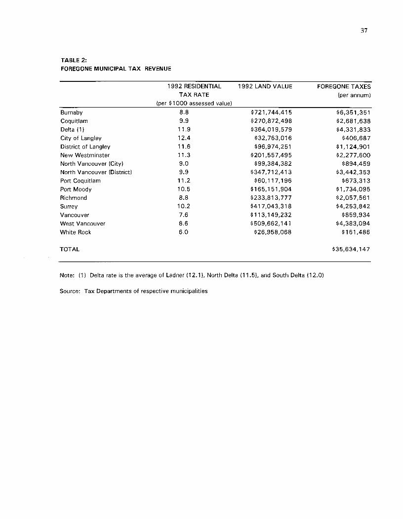
depend on a road's effect on the total value of taxable property. Land value increases and
reinvestment may partially offset potential tax losses. By calculating the amount of taxes that may
conceivably be foregone, some idea is at least gained of how much reinvestment and land value
increases will be required for the lost taxes to be recouped. Of course, some of the "lost" taxes
may also be compensated for by revenues obtained by gas taxes or other road-user fees. In the
end, the societal costs of extracting land from the tax base may be far below what is indicated in
Table 2.
37
TABLE 2:FOREGONE MUNICIPAL TAX REVENUE
1992 RESIDENTIALTAX RATE
(per $1000 assessed value)
1992 LAND VALUE FOREGONE TAXES(per annum)
Burnaby 8.8 $721,744,415 $6,351,351Coquitlam 9.9 $270,872,498 $2,681,638Delta (1) 11.9 $364,019,579 $4,331,833City of Langley 12.4 $32,763,016 $406,687District of Langley 11.6 $96,974,251 $1,124,901New Westminster 11.3 $201,557,495 $2,277,600North Vancouver (City) 9.0 $99,384,382 $894,459North Vancouver (District) 9.9 $347,712,413 $3,442,353Port Coquitlam 11.2 $60,117,196 $673,313Port Moody 10.5 $165,151,904 $1,734,095Richmond 8.8 $233,813,777 $2,057,561Surrey 10.2 $417,043,318 $4,253,842Vancouver 7.6 $113,149,232 $859,934West Vancouver 8.6 $509,662,141 $4,383,094White Rock 6.0 $26,958,068 $161,486
TOTAL $35,634,147
Note: (1) Delta rate is the average of Ladner (12.1), North Delta (11.5), and South Delta (12.0)
Source: Tax Departments of respective municipalities
38
5.2 FOREGONE INVESTMENT INTEREST
When money is borrowed, there is often a charge involved. This charge is commonly
known as 'interest'. If, for example, a provincial ministry borrows money to build a highway, the
cost of the highway will include both the actual money borrowed and the interest that is charged
on the loan. The interest payments can be classified as financing costs. Such costs are often
overlooked when highway costs are examined.
Often, interest costs are only considered when these are part of the current expenditures of
a particular department. This can result in an underestimation of total costs if the interest costs
are not carried along with money transfers. An example may be helpful in illustrating this. When a
highway department is given funding for a particular project, this money is then viewed as paying
for the costs of the road. No further charges are applied. This may, however, be an inaccurate
portrayal of real costs if the larger government body had to borrow money in order to provide a
department with the funding for a new highway. Somewhere in the allocation of funds, the real
cost of the money has been overlooked. To determine the full cost of roads, it is important that
these costs be tracked down.
Furthermore, some researchers suggest that even if money is not borrowed to fund a
particular road, there is still a cost involved. The money that is spent on the roads could have
earned interest had it been otherwise invested. The foregone interest may in some cases be
considered a cost that should be applied against roads. Douglass Lee emphasizes this point when
he states that: "normally, any long-lived business investment is expected to earn a rate of return at
least equal to the interest rate on borrowed funds" (Douglass Lee 1989, 6). When financing costs
are ignored, roadway costs can be considerably understated. It is important, however, to
acknowledge that investment returns may be of a non-conventional type. For example, it could be
argued that society gains a "return on investment" in the form of travel time savings or other
39
societal benefits. To insist that using land for roads always implies a societal investment loss is
therefore incorrect.
In order to gain some perspective on the extent of benefits that are necessary to
compensate for potential losses in interest revenue, it is necessary to determine the likely maximum
foregone investment returns. To determine this, a value must be placed on forgone future streams
of cash flows. The value applied is commonly called the discount rate (Stubbs et al. 1984, 121).
Although there is general agreement that a discount rate should be applied, there is little agreement
or definitive evidence to suggest the adoption of any particular rate. Lack of agreement does not,
however, excuse analysts from considering this matter for, as Wohl has pointed out: "prescribing
an 'appropriate' discount or interest rate, while difficult, is of crucial importance to matters of
economic efficiency, investment planning, and decision-making" (Wohl 1972, 30). Unfortunately,
"as long as the methodological controversy continues the choice of any rate may be criticized as
somewhat arbitrary and 'dangerous— (Stubbs et al. 1984, 121). The choice between rates is
perhaps most arbitrary if analysts applying the rates do not understand the consequences of their
particular choices. Since it appears that a rate must, in the end, be selected, it is important to at
least understand the potential consequences of different choices.
The choice of a discount rate can affect choices between projects with very different
expenditure time lines. For example, a high discount rate penalizes long-term projects that have
very high initial expenditures. Very low rates can over encourage such projects (Stubbs et al.
1984, 121). Discount rates can also affect allocations of funds between generations. A high
discount rate can mean that current benefits are valued more highly than ones that would affect
future generations. A low discount rate will, on the other hand, encourage investments that might
benefit the future while imposing a high initial cost on the current generation (Davis 1990, 124).
Discount rates also impact allocations of funds between the public sector and the private sector. If
the rate applied to public sector investments differs substantially from that applied to the private
sector, then allocations between the two may not be made in the most economically efficient
40
manner (Davis 1990, 123). Future uncertainties and risks can also be valued differently depending
on the choice of discount rate. For example, a high rate discounts future uncertainties more than
does a low rate (Winfrey 1969, 27).
Hirschleifer has suggested that some consideration be given to the fact that the public
sector tends to be overly optimistic in its perception of returns and risks. To counteract this over
optimism, Hirschleifer recommends that the discount rate be at least equal to the prevailing market
rate (Hirschleifer in Wohl 1972, p. 35). He pointed out, for example, that "even for utility
investments in the private sphere, we have seen that the capital market will supply funds only for
projects promising (with the average degree of riskiness experienced in that sector) to yield around
9 or 10 percent. Unfortunately, public investment decision processes have on the whole a far
worse record of over optimism, so that the lowest discount rate for public projects we would
recommend in practice, unless and until their record improves, is around 10 percent" (Ibid.). Meyer
also supports the idea that conservative discounting procedures may be a good antidote to public
sector over optimism (Meyer 1971, 214).
Considering the impact of discount rates, it is not surprising that the debate over the
selection of the rate continues. The fact is that one can not avoid choosing a rate. Even if one
assigns a rate of zero, this will have an effect on the choices to be made. The question that should
be answered is: what is the preferred rate (Daiute 1970, 651?
Calculation of Foregone Investment Interest
Given the on-going controversy and lack of unanimous recommendations for any specific
discount rate, the best response may be to analyze project sensitivities to several rates. Daiute
(1970) has been one supporter of this approach. Keeler and Small actually adopted this method in
their 1977 study of land value costs. In their study, they used two alternative rates: 6 percent
and 12 percent (Keeler and Small 1977, 9). If the variation in rates results in significantly different
conclusions, then this may suggest that the precision of the analysis is limited (Daiute 1970, 64).
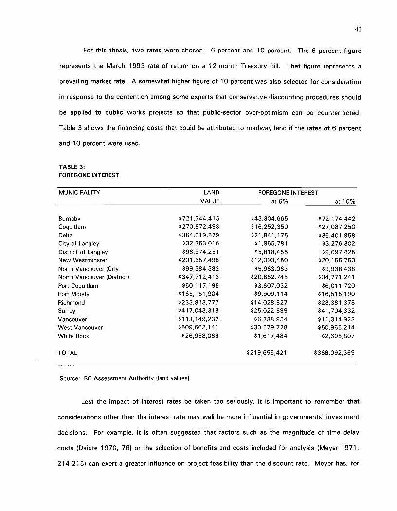
41
For this thesis, two rates were chosen: 6 percent and 10 percent. The 6 percent figure
represents the March 1993 rate of return on a 12-month Treasury Bill. That figure represents a
prevailing market rate. A somewhat higher figure of 10 percent was also selected for consideration
in response to the contention among some experts that conservative discounting procedures should
be applied to public works projects so that public-sector over-optimism can be counter-acted.
Table 3 shows the financing costs that could be attributed to roadway land if the rates of 6 percent
and 10 percent were used.
TABLE 3:FOREGONE INTEREST
MUNICIPALITY LAND FOREGONE INTERESTVALUE at 6%^at 10%
Burnaby $721,744,415 $43,304,665 $72,174,442Coquitlam $270,872,498 $16,252,350 $27,087,250Delta $364,019,579 $21,841,175 $36,401,958City of Langley $32,763,016 $1,965,781 $3,276,302District of Langley $96,974,251 $5,818,455 $9,697,425New Westminster $201,557,495 $12,093,450 $20,155,750North Vancouver (City) $99,384,382 $5,963,063 $9,938,438North Vancouver (District) $347,712,413 $20,862,745 $34,771,241Port Coquitlam $60,117,196 $3,607,032 $6,011,720Port Moody $165,151,904 $9,909,114 $16,515,190Richmond $233,813,777 $14,028,827 $23,381,378Surrey $417,043,318 $25,022,599 $41,704,332Vancouver $113,149,232 $6,788,954 $11,314,923West Vancouver $509,662,141 $30,579,728 $50,966,214White Rock $26,958,068 $1,617,484 $2,695,807
TOTAL $219,655,421 $366,092,369
Source: BC Assessment Authority (land values)
Lest the impact of interest rates be taken too seriously, it is important to remember that
considerations other than the interest rate may well be more influential in governments investment
decisions. For example, it is often suggested that factors such as the magnitude of time delay
costs (Daiute 1970, 76) or the selection of benefits and costs included for analysis (Meyer 1971,
214-215) can exert a greater influence on project feasibility than the discount rate. Meyer has, for
42
example, pointed out that "for many sorts of public projects, project justification will hinge on the
inclusion of external and social effects not readily quantifiable and, more importantly, typically
subject to political pressures and oftentimes considerable exaggeration" (Ibid.).
It is worth reiterating that the figures given in Table 3 do not necessarily reflect societal
losses occurring from investment in roads. The returns on roadway investment may manifest
themselves in indirect ways. The numbers given are merely indicators of the extent of benefits
that would be necessary to compensate for potential losses.
43
6.0 LAND COST ALLOCATION
Once roadway costs have been determined, methods of allocating these costs can be
examined. There is unfortunately no easy way to allocate costs. In fact, a review of the literature
reveals that no method exists that does not suffer from some degree of arbitrariness. Many
methods of cost allocation suffer from either theoretical or practical limitations. These limitations
have contributed to on-going debate on this issue.
6.1 ALLOCATION BETWEEN ROAD USERS AND OTHER BENEFICIARIES
The cost responsibility of road users as a group must be determined before determining
how much of total costs automobile drivers in particular should be responsible for. Road users
include drivers of automobiles, buses, trucks, delivery vans, motorcycles and other vehicles. But,
road users are not the only beneficiaries of roads. The general public may benefit "because of the
broad economic and social benefits derived from • . . expansion of . . . transportation facilities" and
local property owners may benefit if their property values are increased as a result of road
improvements (Westmeyer 1952, 382; Locklin 1972, 625). There is much debate on the issue of
cost allocation between these sectors. Westmeyer has acknowledged that there is actually no
logical basis for making allocations and that "the method used will have a profound effect on the
final result" (Westmeyer 1952, 383). He goes on to state that "differences of opinion on this point
alone may lead competent and unbiased students to reach entirely different conclusions, and it
provides an opportunity for the special pleader to reach any conclusion he wishes" (Ibid.).
6.2 ALLOCATIONS AMONG ROAD USERS
Westmeyer's pronouncement would, by itself, sound a death knell for defensible cost
allocation but the indictments against allocations extend even further. For, even once costs have
been allocated to road users as a group, further break-downs are necessary in order to determine
how much of that total can be attributed specifically to automobiles. Westmeyer has said that,
"here, again, the possibility of wide variations in estimates exists" (Westmeyer 1952, 383).
Locklin agreed: "numerous methods of dealing with this question have been proposed; but many, if
44
not all of them, are subject to criticism on theoretical or practical grounds, or both" (Locklin 1972,
632). One of the difficulties of making allocations is that it is not known whether such allocation
"should be made on the basis of vehicle miles traveled, ton miles carried, or some other measure of
frequency of use". This "is a problem on which there are sharp differences of opinion" (Westmeyer
1952, 383).
6.3 APPROACHES USED IN PRACTICAL STUDIES
Despite the difficulties, several individuals have attempted to allocate costs. Their
approaches have varied somewhat but all seem to be rather arbitrary. The particular approach
adopted depends on such considerations as "the objective of the costing, the data available, the
knowledge of the underlying engineering relationships, and the analytic and numerical
computational aids at hand" (Meyer 1971, 40). Locklin seemed to believe that in addition to these
factors, politics also play an important role. He stated that "whatever may be the most desirable
basis for dividing responsibility for highway support between general taxpayers and highway users,
the actual division of responsibility at a given time is the result of political forces" (Locklin 1972,
628). The political effects would likely be witnessed in scenarios where data is to be used to
determine pricing schedules.
In his 1992 study, Litman acknowledges that not all roadways are built to accommodate
automobiles. In fact, he claims that "a more reasonable estimate is that 60 to 75 percent of
roadway land is required for automobile use" (Litman 1992, 11). His decision to attribute only part
of the land costs to automobiles results from his belief that a minimal level of access is needed
regardless of the extent of automobile traffic. This minimal service level is to provide for such
things as emergency vehicles and delivery vans. Litman believes that a lightly paved, single lane of
roadway can adequately serve such needs (Litman 1992, 7). He points out that such a road
represents the level of road investment which consumers typically select when they themselves
must pay for road construction (Ibid.). He assumes that anything above this level would therefore
be built in response to the extra needs of automobiles. In his belief that automobiles can not be
45
held accountable for all roadway land costs, he differs slightly from Voorhees and Holtzclaw.
Litman quoted both of these sources as attributing all roadway land costs to automobiles.
Peat Marwick consultants concur with Litman's belief that not all roadway land costs can
be attributed to automobiles and that a minimal level of access needs to be defined. Peat Marwick
went a little further than Litman in that they actually defined the width of a minimal access road.
Peat Marwick believed that a 7-meter wide road would be adequate to provide minimal service.
Road widths in excess of this were considered to be catering to the demands of automobile drivers
(Peat Marwick 1993, 26). Peat Marwick calculated the roadway land attributable to automobiles
by subtracting the land required to provide minimal service from the amount of land that is actually
devoted to roads (Ibid.). This approach assumes that all existing roads are required for minimal
service to be provided. In reality this may not be true. There is the possibility that some roads
could be altogether eliminated, while still maintaining minimal access. Many houses are, for
example, served by both lane ways and roads. Only one of these is necessary to provide basic
property access. Peat Marwick's approach will over-estimate the minimal road needs to the extent
that the seven meter road requirement is applied to superfluous roads.
Hanson seemed comfortable with assuming that most costs could be attributed to private
automobiles. He said that "while the same streets are used for buses, trucks, and other
commercial vehicles, usage is overwhelmingly by automobiles and other personal vehicles" (Hanson
1992, 64). The Pollution Probe Study did not allocate costs.
6.4 ALLOCATING COSTS IN THE GREATER VANCOUVER REGION
A review of the literature demonstrates that, to date, no approach has been deemed
completely appropriate. Theorists do not consider any particular approach to be perfectly suitable.
It is thus not surprising that those given the task of deriving bottom-line figures are forced to rely
on rather arbitrary methods. Litman and Peat Marwick are among those who have attempted to
find methods that would yield rough estimates. Litman's and Peat Marwick's approaches do not
46
yield precise results. But, since no other approach can be said to do so, it makes little sense to
adopt other, more complicated approaches, if they are no more theoretically appropriate than the
approaches adopted by Litman and Peat Marwick.
Since automobiles are not the only users of public roads, it is important not to attribute the
total cost of roads to automobile drivers. To determine the portion of road costs that can be
attributed to automobiles, it is important to examine the standard that would be required if it were
not necessary to provide for automobiles. Other road users include buses, trucks, emergency
vehicles and bicycles. Basic access for these users can be provided with a 7-meter wide road.
Two-directional traffic could easily be provided for with two 3.5-meter lanes. Any width in excess
of this can thus be attributed to automobiles.
Some experts argue that it may not make sense to apply the 7-meter right-of-way to all
links in a road network (Rice 1993►. It has been suggested that high-capacity, high-speed facilities
such as expressways are not needed to provide basic access. The implied conclusion is that such
facilities can be completely attributed to demands from automobile drivers. Although this makes
theoretical sense, non-automobile users do in fact use such facilities and it would therefore not
seem fair to charge automobile drivers with the full costs of providing such facilities. The British
Columbia Ministry of Transportation and Highways (1992► states that automobiles make up 82
percent of 'typical' traffic on rural highways. Similar figures were not available for urban
highways, but a quick afternoon survey of Kingsway revealed a similar breakdown. If cost
responsibility were allocated based on traffic composition, then automobile drivers could be held
responsible for about 82 percent of costs. Interestingly, this approach would yield a cost
breakdown quite similar to that obtained by using the 7-meter minimum access approach. An
examination of average widths of roads given in Table 1 reveals that many provincially-funded road
right of ways are about 40 meters wide. If the minimum access of seven meters is subtracted
from this width, then 33 meters can be attributed to automobile users. Those 33 meters represent
83 percent of the total width--a figure very similar to that indicated by the traffic composition

47
approach. Table 4 represents the costs that could be attributed to automobiles if a rate of 80
percent were applied.
TABLE 4:COSTS ATTRIBUTABLE TO AUTOMOBILES(Assuming 80% Cost Responsibility)
MUNICIPALITY LAND VALUE FOREGONE FOREGONEATTRIBUTABLE INTEREST TAXES
TO CARS (at 6%)Burnaby $577,395,532 $34,643,732 $5,081,081Coquitlam $216,697,998 $13,001,880 $2,145,310Delta $291,215,663 $17,472,940 $3,465,466City of Langley $26,210,413 $1,572,625 $325,350District of Langley $77,579,401 $4,654,764 $899,921New Westminster $161,245,996 $9,674,760 $1,822,080North Vancouver (City) $79,507,506 $4,770,450 $715,567North Vancouver (District) $278,169,930 $16,690,196 $2,753,882Port Coquitlam $48,093,757 $2,885,625 $538,650Port Moody $132,121,523 $7,927,291 $1,387,276Richmond $187,051,022 $11,223,061 $1,646,049Surrey $333,634,654 $20,018,079 $3,403,074Vancouver $90,519,386 $5,431,163 $687,947West Vancouver $407,729,713 $24,463,783 $3,506,475White Rock $21,566,454 $1,293,987 $129,189TOTAL $2,928,738,948 $175,724,337 $28,507,318
Note: (1) Calculated as the sum of lost taxes and foregone interest
Source: BC Assessment Authority (land values)
There are many techniques that can be used for allocating costs among road users. Table
4 indicates the results of the traffic composition/minimum access methods. The costs allocated to
automobiles may be somewhat lower with the use of other approaches. Litman, for example,
suggested that automobiles are responsible for only 60 to 75 percent of costs (Litman 1992, 11).
Figures closer to those given by Litman would be obtained if consideration is given to the size of
the vehicle using the roads. According to such an approach, a large truck would be considered
equivalent to three or four cars. Such an approach differs substantially from the traffic
48
composition approach which allocates all vehicles equal cost responsibility. If consideration is
given to the size of vehicles, then the share of costs attributable to cars would go down to about
70 percent. Given that there is currently little agreement on methodologies of allocating costs, it
may perhaps be wise to indicate a range of cost responsibility. It seems reasonable to suggest
that automobile drivers are responsible for between 70 to 80 percent of roadway land costs.
49
7.0 TOTAL ROADWAY LAND COST
The individual components of roadway land costs have now been calculated. These
components can be added up to determine the total cost of provincially-funded roadway land in the
Greater Vancouver region. The land value of provincially-funded arterials and highways totals
$3,660,923,687. Of this total, $2,928,738, 948 has been attributed to automobiles. In 1992,
there were 999,419 registered and insured vehicles in the Greater Vancouver Regional District. Of
this total, 97,587 were insured for business purposes (GVRD Development Services June 1992,
63). If it is assumed that all registered vehicles not insured for business purposes are privately-
owned automobiles, then the number of such automobiles totals 901,832. If it were assumed that
all roads were built within the past twenty years, and that costs were amortized over a 20-year
period, then the annual value of roadway land could be said to be $162 per vehicle.
An annual maximum societal loss of $255,289,568 could result from lost taxes and
foregone investment interest. Of this total, $204,231,654 can be attributed to automobiles. If
the total costs are apportioned among all automobiles not insured for business purposes, then each
automobile would be accountable for annual land-related "pecuniary" costs of $226.
The figures given in this thesis are estimates. Some of the approaches that have been used
have led to rather conservative costs estimates, while others have likely led to possible
overestimates. It is important to acknowledge the effect of the approaches so that others can view
the given costs in their proper light.
Conservative approaches were used in: establishing land values (non-adjacent land values
were applied to roads); determining lost taxes (lowest tax rates were applied); and in determining
financing costs (low interest rates were applied).
The twenty year amortization period and the 80 percent cost allocation may have resulted
in overestimates of annual cost responsibility per automobile. The amortization period has a great

50
influence on annual roadway land value costs. In this thesis, it was assumed that all roads were
built within the amortization period of twenty years. The value of the land was thus amortized
over those years. If a longer amortization period were adopted, the annual costs would be lower.
Of course, not all roads were actually built in the last twenty years. Some roads were built before
1972. The costs of such roads should therefore already have been fully amortized. It is, however,
difficult to determine which roads predate 1972. As such, an assumption has been made that all
roads have been built within the last twenty years. To the extent that this is incorrect, land costs
will be overestimated.
The cost allocation method chosen for this thesis could also result in overestimation of
automobile drivers' responsibility for roadway land costs. To the extent that such drivers are
actually responsible for less than 80 percent of roadway land costs, their responsibility will have
been overestimated.
The point of this thesis has not been to determine the precise cost of roadway land. Such
a task would be virtually impossible. The values given are estimates. It should be emphasized that
some of the foregone investment interest and property tax may have been compensated for by
various means. As such, the societal cost of lost taxes and foregone interest are likely to be far
less than the maximum figures that have been given in this thesis. The contribution of this thesis
has been to explore the issues involved in determining the cost of roadway land--something that
has not previously been done in any comprehensive manner. By discussing the issues and by
providing rationales for selection of particular methods, the door has been opened for further
debate on transportation costing issues in the Greater Vancouver region.
51
8.0 POLICY IMPLICATIONS
Given the high cost of roads, it is worthwhile to find ways to reduce the need for such
roads in the future. This is especially relevant given the current climate of fiscal restraint and
environmental concern.
8.1 WHY MONEY SPENT ON ROADWAY LAND IS A CRITICAL ISSUE
Road expenditures are an issue because of the impact that such expenditures have on other
societal goals.
Using land for roads means that the land is not available for other uses. Among the many
alternative land uses are agriculture or housing. The building of new roads threatens the
preservation of agricultural land. As the population grows, there will be more pressure to use
farmland for urban development. Since 1974, 5.5 percent of the land in the Agricultural Land
Reserve has been removed for other uses (Seelig and Artibise 1991, 10). By 2006, the supply of
all vacant Greater Vancouver land zoned for single family housing will have been exhausted (Jim
Chim, class lecture, October 1992). The construction of roads encourages sprawl and thus the
rapid urbanization of what little land remains. Instead of using scarce land for roads, such land
could be used to provide more housing. At the very least, road-building could be reduced so as to
discourage further sprawl and delay housing shortages. With the growing pressure on agricultural
lands and the looming shortage of land for housing, does it make sense to use so much land for
roads?
Road building also runs counter to the public goal of protecting air quality. Environmental
concerns of Greater Vancouver residents have been expressed in such documents as Creating Our
Future (1990) and Clouds of Change (1990). Both reports suggest that automobile traffic is a
significant threat to the quality of the environment. Increasing the road supply will result in an
increase in traffic. Land devoted to roads thus contributes directly to a deterioration of the
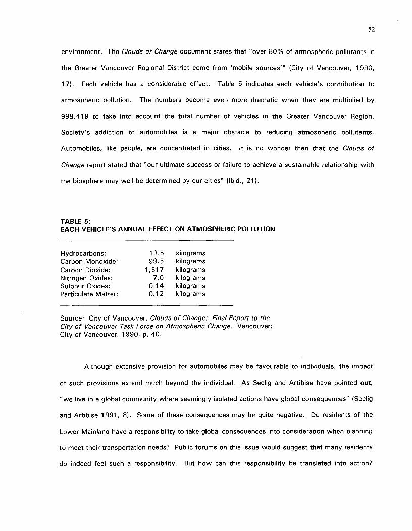
52
environment. The Clouds of Change document states that "over 80% of atmospheric pollutants in
the Greater Vancouver Regional District come from 'mobile sources— (City of Vancouver, 1990,
17). Each vehicle has a considerable effect. Table 5 indicates each vehicle's contribution to
atmospheric pollution. The numbers become even more dramatic when they are multiplied by
999,419 to take into account the total number of vehicles in the Greater Vancouver Region.
Society's addiction to automobiles is a major obstacle to reducing atmospheric pollutants.
Automobiles, like people, are concentrated in cities. It is no wonder then that the Clouds of
Change report stated that "our ultimate success or failure to achieve a sustainable relationship with
the biosphere may well be determined by our cities" (Ibid., 21).
TABLE 5:EACH VEHICLE'S ANNUAL EFFECT ON ATMOSPHERIC POLLUTION
Hydrocarbons:^13.5^kilogramsCarbon Monoxide:^99.5^kilogramsCarbon Dioxide:^1,517^kilogramsNitrogen Oxides:^7.0^kilogramsSulphur Oxides:^0.14^kilogramsParticulate Matter:^0.12^kilograms
Source: City of Vancouver, Clouds of Change: Final Report to theCity of Vancouver Task Force on Atmospheric Change. Vancouver:City of Vancouver, 1990, p. 40.
Although extensive provision for automobiles may be favourable to individuals, the impact
of such provisions extend much beyond the individual. As Seelig and Artibise have pointed out,
"we live in a global community where seemingly isolated actions have global consequences" (Seelig
and Artibise 1991, 8). Some of these consequences may be quite negative. Do residents of the
Lower Mainland have a responsibility to take global consequences into consideration when planning
to meet their transportation needs? Public forums on this issue would suggest that many residents
do indeed feel such a responsibility. But how can this responsibility be translated into action?
53
While certain individuals embrace the philosophy of global concern, the majority continue to pump
gas into cars and demand more road space on which to drive those cars.
There is currently little personal incentive for people to change their habits and thereby
become less car-dependent. Individuals benefit from car usage, and therefore continue to use their
cars. Meanwhile, society as a whole often suffers serious negative consequences. This situation
seems paradoxical to those who believe that the interests of society as a whole are best served if
all individuals within the society pursue their self-interest. The idea that the sum of individual
interests will equate with the best interests of society is often thought to be a core concept of
capitalism. After all, did Adam Smith not say that an individual, although only intending to act for
"his own gain", is "led by an invisible hand to promote . . . the public interest" (Smith [1776]
1937, 423)? Garret Hardin has suggested that "Adam Smith did not assert that this was invariably
true, and perhaps neither did any of his followers. But he contributed to a dominant tendency of
thought that has ever since interfered with positive action based on rational analysis" (Hardin
1968, 1244).
Hardin insisted that the pursuit of individual gain does not necessarily produce the best
outcome for society as a whole. He believed that individuals will not necessarily treat common
property such as the air, water, or roads in a manner that is conducive to the interests of society
as a whole. In fact, he asserted that when all individuals pursue their own best interests "in a
society that believes in the freedom of the commons," society is headed toward ruin. He stated
that although the individual may benefit "from his ability to deny the truth," the "society as a
whole, of which he is a part, suffers" (Hardin 1968, 1244).
Hardin stated that the "tragedy of the commons" arises when principles that may apply to
use and allocation of privately-owned resources are applied to public goods such as the
environment (Hardin 1968, 1243). Hardin explained that "the air and waters surrounding us
cannot be readily fenced, and so the tragedy of the commons as a cesspool must be prevented by
54
different means, by coercive laws or taxing devices that make it cheaper for the polluter to treat his
pollutants than to discharge them untreated" (Ibid., 1245). Currently, the interests of the
individual are best served by discharging untreated sewage.
Relying on the "invisible hand" may work tolerably well when resources are abundant and
demand for those resources is low. The principle of the "invisible hand" does not work nearly as
well when resources are scarce and demand high. Hardin pointed out that "using the commons as
a cesspool does not harm the general public under frontier conditions, because there is no public;
the same behavior in a metropolis is unbearable" (Hardin 1968, 1245). Since land is a scarce
commodity, and demand for that land is high, it may be time to re-examine the principles by which
it is allocated.
Hardin's essay on The Tragedy of the Commons dealt primarily with the "freedom to breed"
and the consequences this had for society as a whole. He said that "to couple the concept of the
freedom to breed with the belief that everyone born has an equal right to the commons is to lock
the world into a tragic course of action." It is not too far-fetched to apply the same statement to
the "freedom to drive." Hardin did not hesitate to recommend that some freedoms be restricted.
He pointed out that society already accepts the restriction of, for example, the "freedom" to rob a
bank. Hardin stated that "the man who takes money from a bank acts as if the bank were a
commons. How do we prevent such action? [W]e seek the social arrangements that will keep (the
bank) from becoming a commons. That we thereby infringe on the freedom of would-be robbers
we neither deny nor regret (Hardin 1968, 1247). Hardin suggests that "as the human population
has increased, the commons has had to be abandoned in one aspect after another" (Ibid., 1248).
Has society now come to the point where it needs to stop treating the road network as a
"commons"?
The effects of road-building are both immediate and long-lasting. By building a road, a
certain amount of land is used up that could have been used for other purposes. This is the
55
immediate effect. The longer term effect is that the very act of building the road perpetuates the
need for roads. The longer term effects of road-building are not always acknowledged. Often,
people see road-building as a solution to the problems of congestion. But, adding capacity does
not necessarily alleviate congestion. New roads may temporarily take the pressure off a burdened
system, but the very existence of a new, relatively uncongested road will usually attract additional
trips that would not previously have been contemplated. This adds to traffic. With time, the
system will, once again, be operating beyond desirable capacity. The result? More roads will be
demanded. This "no-win" situation becomes firmly entrenched if gas tax revenues are reserved
exclusively for new construction. If gas-taxes are ear-marked for new road construction, the
system will perpetuate itself. More gas taxes will result in more freeways which will result in more
suburbs and more cars--which will in turn produce more gas taxes to be invested in more roads.
Thus a vicious cycle is started (Dantzig 1973, 112).
How society uses land is a good gauge of its priorities. This was pointed out by E.F.
Schumacher who said that "among material resources, the greatest, unquestionably is the land.
Study how a society uses its land, and you can come to pretty reliable conclusions as to what its
future will be" (E.F. Schumacher in Seelig and Artibise 1991, 39). Current land use indicates that
our society is enamoured of the car. Land taken up by roads already exceeds 25 percent of the
total area of Vancouver; 7 percent of the Pacific Fraser Region (Seelig and Artibise 1991, 60).
What does this say about the future of the Greater Vancouver region?
The decisions made regarding road building have far-flung consequences and have an
impact on future quality of life. Spending money on roads means that other public goals such as
housing, farmland preservation and air quality improvement may be frustrated.
56
8.2 THE ROLE OF PUBLIC POLICY
It is public policy that guides the provision of roads. As such, policy must be considered
when examining the current provision of roads and the course that should be pursued in the future.
Public policy is the "bridge" that links the present situation with future desired outcome.
Transportation can not be changed in isolation because it is very much related to other
issues such as where we live and work. To be most effective, a good strategy will therefore
require an effort that is sustained by coordinated policies.
Public policy can be used to make it in peoples' self-interest to engage in behavior that
serves the best interests of society as a whole. Such an approach can help overcome the "tragedy
of the commons" that was described by Hardin.
Solving problems is a three step process. The first step is to recognize that a problem
exists. Next, possible solutions must be identified and a choice made. Then, action must be
taken. To complete the first two steps without following with the third, may create more
knowledge, but it will hardly solve the problem. A person who goes to a dentist complaining about
bad teeth may be told that lack of brushing is a major contributor to the problem. If that person
then goes home only to continue previous bad habits, the problem will not be solved. This analogy
can be applied to public policy: unless action is taken, little will change. Residents and politicians
of the Greater Vancouver region have identified some problems associated with current
transportation patterns and also several possible solutions. But, to reach the goals, certain things
must change. Changed outcomes require changed actions.
8.3 A FRAMEWORK FOR ACTION
If society is serious about reducing the negative consequences of roadway spending, then
there are several existing policies that should be re-examined and several new ones which ought to
be considered. Policies can be adopted at many levels. For the purposes of this analysis, the
57
focus will be on the provincial level since this thesis has dealt with provincially-funded roads. It is
important, however, to recognize that for effectiveness to be maximized, policies at the provincial
level must be matched with compatible policies at the municipal and regional levels.
The Province's Current Approach to Dealing with Roadway Demand
The British Columbia Ministry of Transportation and Highways has, until now, maintained a
supply-side orientation. The Ministry of Transportation and Highways has generally focused on
alleviating congestion by constructing new roads or widening existing ones. The underlying
assumption is that the demand for roads must be catered to.
To some extent, efforts have been made to counter the demands for roads by emphasizing
the role of public transit. However, the construction of new roads usually seems to take
precedence. One Ministry publication stated that "a functional transportation system in Vancouver
now requires added investment to major roads so as to balance and facilitate the upgrades that are
being made to the transit network" (Ministry of Transportation and Highways (vol. 5) 1988, 6.25).
Although new roads can indeed facilitate the provision of improved transit service, such roads can
also act to reduce the public's incentive to use transit. Once extra capacity has been created,
people may no longer see a need to reduce automobile use. Although the Ministry report speaks of
increasing transit service (Ibid., 9.5), it does not really address how to get people to use that
service. As long as more roads are provided, it is unlikely that people will shift to public transit.
Although the Ministry has generally pursued supply-side tactics, they do admit that "it will
not be possible to relieve all congestion" (Ibid., 6.26). Relief of congestion by constructing more
roads appears, however, to be a major goal despite the Ministry's admission that "the extent of the
needs for new and improved transportation infrastructure as outlined in the recommendations . . .
clearly exceeds the financial resources of the Province in the short run (Ibid., vol. 1, 1.21).
58
Part of the reason for the Ministry's supply-side approach may be that their mandate deals
exclusively with the road network. They do not have direct influence over all transportation policy.
The Ministry has indicated that the "lack of co-ordinated transportation policy encompassing roads
and transit in the region, coupled with the division of decision-making between the Ministry of
Transportation and Highways, municipalities, and BC Transit often makes it difficult to determine
an appropriate balance of roads versus transit in a corridor" (Ministry of Transportation and
Highways (vol. 5) 1988, 9.6).
The Ministry has readily admitted that they are constrained in their current approach to
dealing with demand for more roads. The limitations are both financial and organizational. Given
such constraints and further constraints imposed by the limited supply of land, it makes sense to
review alternative strategies.
Alternative Approaches
One of the keys to reducing the need for new roads is to reduce the amount of traffic that
is using existing roads. This can be done in numerous ways. Ultimately a comprehensive strategy
that involves the concerted efforts of municipal, regional and provincial governments or authorities
will work best. This section will, however, concentrate on the actions that could be taken by the
provincial government.
The most successful policy would probably involve the simultaneous application of several
different tactics (Downs 1992, 146). For the purposes of analysis, several different policies will be
examined before a particular combination will be recommended for consideration. The following
paragraphs include a discussion of some of the approaches most commonly used to deal with
traffic congestion. These approaches can be separated into demand-side tactics (which attempt to
reduce the need for new roads by reducing the amount of traffic) and supply side tactics (which
attempt to alleviate congestion by providing more facilities or more efficient facilities). Appendix 3
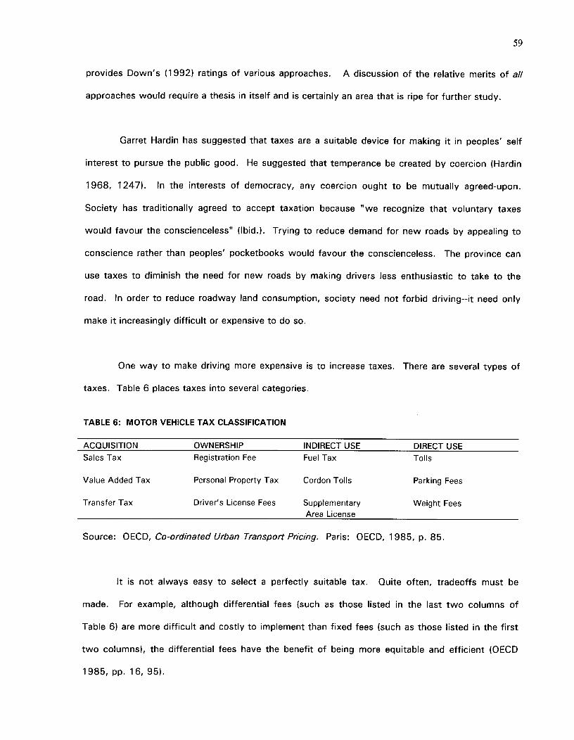
59
provides Down's (1992) ratings of various approaches. A discussion of the relative merits of all
approaches would require a thesis in itself and is certainly an area that is ripe for further study.
Garret Hardin has suggested that taxes are a suitable device for making it in peoples' self
interest to pursue the public good. He suggested that temperance be created by coercion (Hardin
1968, 1247). In the interests of democracy, any coercion ought to be mutually agreed-upon.
Society has traditionally agreed to accept taxation because "we recognize that voluntary taxes
would favour the conscienceless" (Ibid.). Trying to reduce demand for new roads by appealing to
conscience rather than peoples' pocketbooks would favour the conscienceless. The province can
use taxes to diminish the need for new roads by making drivers less enthusiastic to take to the
road. In order to reduce roadway land consumption, society need not forbid driving--it need only
make it increasingly difficult or expensive to do so.
One way to make driving more expensive is to increase taxes. There are several types of
taxes. Table 6 places taxes into several categories.
TABLE 6: MOTOR VEHICLE TAX CLASSIFICATION
ACQUISITION OWNERSHIP INDIRECT USE DIRECT USESales Tax Registration Fee Fuel Tax Tolls
Value Added Tax Personal Property Tax Cordon Tolls Parking Fees
Transfer Tax Driver's License Fees Supplementary Weight FeesArea License
Source: OECD, Co-ordinated Urban Transport Pricing. Paris: OECD, 1985, p. 85.
It is not always easy to select a perfectly suitable tax. Quite often, tradeoffs must be
made. For example, although differential fees (such as those listed in the last two columns of
Table 6) are more difficult and costly to implement than fixed fees (such as those listed in the first
two columns), the differential fees have the benefit of being more equitable and efficient (OECD
1985, pp. 16, 95).
60
The appropriateness of a given tax will depend on the aim of the tax. Essentially, the
taxing authority must ask itself what it hopes to achieve by imposing a new tax. Is the aim merely
to raise money? Is the aim to reduce usage? Is the aim to price a "public" good? The answers
will determine which tax is most appropriate. An example will illustrate this concept. Flat fuel
taxes may be quite appropriate for charging for emissions, noise and accident rates. The amount
of fuel tax that a driver pays will be more or less directly related to the distance driven by that
driver. Emissions, noise, and accidents are also more or less related to distances driven. It
therefore makes sense to use fuel taxes as a pricing mechanism for these externalities. Fuel taxes
may not, however, be appropriate to relieving congestion and thus reducing the peak period traffic
demand that results in demand for extra roads (OECD 1985, 65). Congestion costs are higher at
some times than at others. The rate at which fuel is taxed is not dependent on the time of day
that a driver uses the fuel. As such, flat fuel taxes may not be a good way to price peak-period
road use. Fuel taxes also present problems in that they may encourage people to switch to more
fuel-efficient cars to reduce the negative impact of higher gasoline taxes. Although that would help
reduce gasoline consumption, it may not necessarily discourage driving. Another consideration
should be the potential for evading the tax. This is a problem particularly in the Greater Vancouver
region where drivers can, by purchasing gas in the United States, avoid paying stiff fuel taxes. It
would seem that fuel taxes might not be the most effective way to discourage driving.
Roadway land consumption can be reduced if fewer people drive. One way to reduce the
number of people who drive is to increase the attractiveness of public transit. This can be done by
managing the supply and pricing of parking spaces. "Restrictions on parking space can improve
the performance and profitability of public transport both by reducing the opportunity for car
commuting and by making more road space available for public transport vehicles" (OECD 1985,
36). Currently, there is only "a weak correlation between a price based on the duration of parking
and the preceding trip characteristics (length, time, locations)"(Ibid., 115). For parking to be used
as a mechanism for road pricing, existing parking fees must be restructured. The OECD has
suggested that one method of doing this would be to divide parking fees into two parts. One part
61
would ration scarce road space. This part would account for road congestion and would vary
according to time of entry and departure. The collection of "road use fees" at existing parking
booths would eliminate the need to spend money on installing new collection points on major roads
and would also have the advantage of charging for the use of all roads, and not just roads that
might be tolled. 6 The second part of the parking fee would ration scarce parking spaces and would
therefore vary according to demand for parking space. Such a pricing scheme has not yet been
tried anywhere (Ibid., pp. 18, 92).
Tolls can also be used to price roads. The provincial government is now contemplating
using tolls to finance repairs to the Lion's Gate Bridge. Although tolls have periodically been used
to finance construction, they have not yet, in the Greater Vancouver region, been used to price
roads. Tolls would likely discourage unnecessary trips. This would, in turn, reduce the need for
future expansion of facilities. A few urban areas such as New York City and San Francisco already
have quasi-government authorities empowered to levy tolls (OECD 1985, 102). Tolls, however,
suffer from the potential to transfer congestion onto untolled roads (Downs 1992, 56). The
potential for transference could be partially averted in the Greater Vancouver region by placing tolls
on bridge or tunnel crossings. For many journeys, the only way of avoiding such crossings would
be to forego the trip. Tolls would have a disproportionate effect on low income earners. The
effect on low-income earners could, however, be tempered by offering transportation tax credits.
It would take very high tolls to discourage higher-income drivers from using the tolled roads. Such
individuals place a high value on their time. The toll charge for such people might easily be paid for
out of the extra earnings derived during the time that would otherwise have been spent on a more
congested road. Despite the drawbacks, tolls can be very effective. One expert has estimated that
"peak-hour pricing might reduce traffic on toll roads by 20% or more" (Downs 1992, 56).
6 It has been suggested that road space could be charged by installing, in all vehicles, a device that wouldindicate where the vehicles origniated from (O'Connell 1973, 76). With indications of both "home base" and thedestination, such a device would allow parking fees to reflect the distance driven. This would have theadvantage of charging for any road space which may be used--not just tolled roads. Such an approach wouldhelp prevent drivers from switching to residential or other non-tolled roads when tolls are imposed on majorroads.
62
Some of the disadvantages of tolls can be overcome by systematic roadway pricing. Full
roadway pricing would, for example, help prevent traffic from transferring from tolled roads to
untolled roads. Such pricing would charge all drivers--not just those who use tolled roads or those
who park their automobiles. Roadway pricing would charge each user the marginal social cost of
each trip. The cost may vary according to time and place of travel. Roadway pricing could take
such variances into account far more easily than could tolls or parking charges. Electronic metering
would be one method of charging for the use of roads. Electronic metering would be equitable in
the sense that it would charge people fees that vary according to the burden placed on the system.
Full roadway pricing would not eliminate congestion, but would reduce congestion substantially
below present levels (Downs 1992, 52►. Practical, affordable techniques of implementing such a
pricing scheme have yet to be made widely available. Advances in micro-electronics and a planned
demonstration in Hong Kong do, however, suggest that such measures may be possible sometime
in the future (OECD 1985, 126). Road pricing has received some criticism for its inequity,
inefficiency, and invasion of privacy.
If the goal of taxes is to reduce use of vehicles, it makes little sense to tax ownership.
Sales taxes, registration fees, and license fees are all acquisition or ownership taxes rather than
"use" taxes. In order to have a functional road network, a certain number of roads must exist. It
makes sense that all beneficiaries should help pay for the basic system. Flat taxes may be used for
this purpose. There are, however, many costs that are incurred only to provide for peak period
demand. Is it fair to tax all people equally regardless of the costs they impose on the system?
Quite aside from the issue of fairness, such a system does little to encourage decreased use of the
roads. To reduce demand for new roads, it is preferable to opt for use-related fees rather than
fixed fees. Fixed fees merely encourage people to make maximum use of their initial investment.
People currently have an incentive to make the most of all the money they have paid to purchase,
insure, register and license their vehicles. People rationalize that each time they use their
automobile, they are helping to make the most of their "fixed" investment. By increasing costs
63
associated with usage (the variable costs), it is likely that many 'optional' trips could be
discouraged. Drivers "perceive operating costs poorly, special fees that are clearly related to given
trips (e.g. tolls, parking charges, supplementary licenses) are better perceived by users and are
more likely to influence travel behavior" (OECD 1985, 96). A reduction in trips would have the
ultimate result of decreasing the need for new roads. The provincial government can help reduce
the need for new roads by relying more heavily on use-related taxes, and less heavily on fixed fees.
Use-related taxes, may, however, cost more to collect. More study is needed to determine
whether the extra costs would outweigh the benefits gained by reducing road demand and
increasing equity.
In addition to tactics that attempt to reduce demand by appealing to peoples' pocket books
(market based approaches), there are tactics that attempt to force reduction in car trips (regulatory
approaches) (Downs 1992, 23).
One regulatory tactic that receives frequent mention is that of restricting the days on which
automobiles can be driven. One way of doing this would be to restrict automobile usage according
to license plate numbers.7 For example, on Mondays, all automobiles bearing license plates with
numbers ending in 1 and 2 would be banned from the roads. On Tuesdays, the affected license
plate numbers would be 3 and 4, and so on. If each automobile were banned from the road one
day per work week, this would immediately reduce traffic by 20 percent. There are, however,
several problems with this approach. There are commuters who would experience exceptional
hardship from such a regulation. If workplaces or homes are not well-served by transit and if ride-
sharing is not possible, then such an approach would not seem reasonable. If "non-driving" days
were based on license plate numbers, then individuals possessing more than one vehicle could
merely switch automobiles on days when their "usual" automobile was banned from the roads.
The problems potentially incurred with multiple automobile ownership could be averted if all
vehicles registered to a particular household were given license plates ending with the same
7This has been tried on a voluntary basis in Calgary, Alberta.
64
number. All drivers, regardless of income, would be affected by the regulation, and none could
circumvent it by "buying their way out." If this approach were adopted, then a driver would have
to find alternate means of transportation on the "non driving" day. To make this tactic slightly
more palatable, drivers could be given some choice in the selection of their "automobile free" day. 8
Enforcement could take place with periodic spot checks, much like the drinking/driving laws are
now enforced. Rather than imposing fines (which would place high income earners willing to pay
the fine at an advantage), the penalty for driving on "banned" days, could be very stiff--
confiscation of the offending driver's license for a stipulated time period. The stiffer the penalty,
the less likely that drivers would be willing to take the risk of driving on banned days, and the less
will be the need for enforcement. Drivers who could prove a legitimate and indispensable need for
their car could be provided with exemptions.
Another regulatory approach to reducing demand for road space is to impose mandatory
densification on newly developing suburbs. This tactic would not have immediate effects on traffic
congestion, but would have significant effects over the long run (Downs 1992, 97). It would be
much more difficult to densify areas that are already built up. The relatively slight decreases in
traffic congestion that would occur from doing so would not likely warrant the high costs of the
densification.
So far, the approaches discussed have aimed to reduce demand for roads by either
regulating use of roads or by providing market incentives to reduce demand. There is, however,
also the possibility of adopting approaches to more effectively accommodate demand by
introducing supply-side tactics.
The construction or designation of more High Occupancy Vehicle (HOV) lanes is one
supply-side tactic. Such an approach would seek to discourage the use of Single Occupancy
8For example, when drivers register their vehicles and receive license plates for their cars, they could be givensome choice as to the number selected. The number selected would determine which days would be "non-driving" days.
65
Vehicles (SOV) and would thereby enable more efficient use of existing facilities. A vehicle takes
up the same amount of road space whether it has one occupant or four. If the same number of
people as currently use the roads could be carried in fewer cars, the number of automobiles on the
road would be reduced, congestion would be alleviated and the need for many road-widenings
could be averted. If people enjoy speedier travel in HOV lanes, then ride sharers will receive some
compensation for the time that it takes to pick up and drop off additional passengers. HOV lanes
can also be used to increase the relative attractiveness of public transit use. People often claim
that they do not use transit because travel by bus or train is slower than travel by car. If HOV
lanes could confer significant time savings, then more people may be persuaded to travel by bus.
HOV lanes need not necessarily be added to the existing road network. Such a tactic would be
quite costly and would therefore delay implementation. An alternative would be to convert existing
lanes to HOV lanes. This would increase congestion in other lanes, and would make transit
relatively more attractive. There is of course the danger that those who continue to ride in the
SOV lanes will become angry and frustrated with the increased congestion and then push for
retraction of such a policy (Downs 1992, 40).
Another supply-side remedy would be to use technological solutions to make more efficient
use of existing roads. Such tactics might include better signal timing, TV monitoring, electronic
signs, and ramp signals (Downs 1992, 152).
Unfortunately, the approaches which will likely be most effective in reducing demand are
also those approaches that would likely be considered least acceptable. Many punitive measures
would not "be in force long enough to have a major impact because those politicians who
introduced the measures would be booted out at the next election" (O'Connell 1973, 2). Demand-
side tactics--including the most effective ones--have poor political acceptability (Downs 1992,
151). The most effective supply-side tactics would require less traumatic institutional change than
the most effective demand-side tactics (Ibid., 150). From a political perspective, it makes sense to
rely on supply side tactics. It is, perhaps, not surprising then that this has traditionally been the
66
approach adopted by the Ministry of Transportation and Highways. There are, however, also
shortfalls to the supply-side approach. Supply side tactics are generally far more costly to society
and they are generally less effective in reducing congestion than are demand side tactics.
Recommended Policy
Intractable congestion combined with limited supplies of land and limited financial resources
suggest that it is time to examine approaches other than traditional supply-side tactics. Before an
alternative strategy can be recommended, it is important to define the criteria which should ideally
be met by a new policy. A new policy should obviously be deemed to have the potential to
significantly reduce traffic congestion. In other words, it ought to be effective. This effectiveness
should be achieved at minimal implementation cost. It is also important that the policy not
disproportionately affect those least able to pay. Finally, it is important that a new strategy be
flexible enough to adjust to changes that occur over time, and between municipalities. Finding a
policy that meets all these objectives is certainly a tall order. Once the criteria of political
acceptability is added, the difficulties become even greater. It may be difficult to completely fulfill
all of the above objectives. The definition of the goals does, however, help in ranking the
acceptability of various approaches. Obviously, the approaches that are selected will depend on
the values considered most important by the policy-setter.
The implementation phase should start with the less onerous policies. Such policies might,
for example, include changing tax laws to make employer-provided transit passes a tax-free benefit
or increasing advertising to encourage ride-sharing. If such tactics do not prove sufficiently
effective, they should be followed by implementation of some of the least "regressive" market
approaches. The success of such measures should be monitored carefully. If traffic reduction
objectives can not be accomplished with such measures then more regulatory measures may need
to be implemented. The object should not be to price or regulate cars out of existence since
automobiles will still be necessary for some trips. The goal should rather be to limit automobiles to
those trips for which they are best suited. Peak hour use would generally not be one of those
67
uses. It is peak hour usage that is responsible for most of the demand on provincially-funded
roads. At non-peak hours, those roads are often operating below capacity. To reduce future
roadway land costs, it is therefore peak hour trips which should be targeted. The goal should be to
reduce traffic sufficiently to minimize the need for new construction. In order of implementation,
recommendations are as follows:
1) Change tax laws to make employer-provided transit passes a tax-free benefit
2) Place peak-hour tolls on all bridge and tunnel crossings in the Greater Vancouver
Region
3) Impose a peak-hour parking tax surcharge for parking in areas that are well-served
by transit and receive a lot of traffic (such as Downtown Vancouver)
4) Introduce full road pricing
In order to minimize the regressive impacts of market approaches such as peak hour tolls
and parking taxes, transportation tax credits could be offered to those earning low incomes.9 Such
tax credits should not, however, completely cancel the effect of price increases. If complete
refunds were offered then the charges would have little effect on driving behaviours. To be most
effective, the charges should still be sufficient to discourage unnecessary driving. The point is that
the charge necessary to discourage those of lower incomes from driving is less than that required
to change the behaviours of wealthier individuals. The purpose of the road charges is to change
behaviours; not to raise revenue.
Most of the policies which have been suggested are fairly harsh. But, if British Columbians
are serious about reducing congestion, such measures will be necessary. Less drastic policies have
repeatedly proven unsuccessful in reducing congestion and thereby reducing roadway land
consumption.
9 Such transportation tax credits could be offered by allowing people earning under a certain income to deduct a"transportation amount" from their taxable income.
68
Traditionally, supply side measures have been used to cope with congestion. Such
measures have often involved using more land for roads. Increasingly it is being realized that
supplying more roads does not eliminate congestion. The repeated failure of such "supply-side"
tactics suggests that it may be time to adopt other approaches. Such approaches may include
ones that focus on changing people's behaviours and thus changing the demand for roads. All the
recommendations that have been given focus on changing demand for roads.
The recommended policies cannot be implemented overnight. There are several reasons for
that. First, some of the tactics will require installation of special equipment. Second, the public
will require time to adjust to the idea of being charged more directly for the use of roads. It
therefore makes sense to start with policies that would be the least politically unpopular and the
least expensive to implement. If it becomes apparent that such policies are sufficient to result in
desired traffic reductions, then the more drastic measures may never be needed. On the other
hand, if the less drastic measures prove insufficient, then pressure may be exerted for harsher
action. The gradual approach also makes sense because it "has a greater chance of eventual
success than aiming at the perfect solution on the first go" (OECD 1985, 113).
8.4 POSSIBLE IMPLEMENTATION PROBLEMS
Policy is effective only to the extent that it can predict peoples' reactions. People are,
however, fairly unpredictable. Unpredictability is particularly prevalent when a large number of
options are available. It is important to remember that people have a wide variety of choices even
with the implementation of any of the suggested policies. People may not necessarily react to
policy changes by reducing their automobile travel. Drivers' reactions can include switching mode,
changing time of travel or route, foregoing the trip entirely, or paying the newly imposed toll or fee
(OECD 1985, 95►.
69
The key to changing peoples' behavior is really to change their attitudes. If public attitudes
are changed, then public policies may not even be necessary. Without a change in attitude, it is
actually unlikely that public policies to reduce roadway land consumption will even be implemented.
After all, the steps that would be required to reduce the Greater Vancouver region's consumption
of land for roads would not likely be politically or socially popular.^Politicians implementing
severely unpopular measures would not likely be re-elected.^The policies implemented by
unpopular politicians would therefore be rather short-lived.
Full road-pricing is not likely to be politically popular. Even in Sweden, where government
control is fairly widespread, road-pricing is ranked as the least desirable method of reducing traffic.
Table 7 shows Stockholm politicians' and administrators' relative preferences for various policy
methods of reducing traffic.
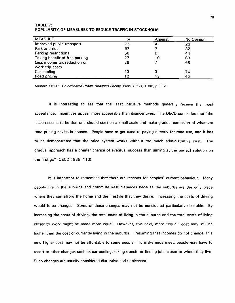
70
TABLE 7:POPULARITY OF MEASURES TO REDUCE TRAFFIC IN STOCKHOLM
MEASURE^ For^Against^No OpinionImproved public transport^ 73^4^23Park and ride^ 67^7^32Parking restrictions^ 50^6^44Taxing benefit of free parking^ 27^10^63Less income tax reduction on^ 26^7^68work trip costsCar pooling^ 23^3^74Road pricing^ 12^43^45
Source: OECD, Co-ordinated Urban Transport Pricing. Paris: OECD, 1985, p. 113.
It is interesting to see that the least intrusive methods generally receive the most
acceptance. Incentives appear more acceptable than disincentives. The OECD concludes that "the
lesson seems to be that one should start on a small scale and make gradual extension of whatever
road pricing device is chosen. People have to get used to paying directly for road use, and it has
to be demonstrated that the price system works without too much administrative cost. The
gradual approach has a greater chance of eventual success than aiming at the perfect solution on
the first go" (OECD 1985, 113).
It is important to remember that there are reasons for peoples' current behaviour. Many
people live in the suburbs and commute vast distances because the suburbs are the only place
where they can afford the home and the lifestyle that they desire. Increasing the costs of driving
would force changes. Some of these changes may not be considered particularly desirable. By
increasing the costs of driving, the total costs of living in the suburbs and the total costs of living
closer to work might be made more equal. However, this new, more "equal" cost may still be
higher than the cost of currently living in the suburbs. Presuming that incomes do not change, this
new higher cost may not be affordable to some people. To make ends meet, people may have to
resort to other changes such as car-pooling, taking transit, or finding jobs closer to where they live.
Such changes are usually considered disruptive and unpleasant.
71
For real change to occur, rather significant life-style changes would have to be accepted.
Life-style changes are never easy nor are they usually particularly popular when they are made
necessary by political decisions. Garret Hardin has commented that "infringements made in the
distant past are accepted because no contemporary complains of a loss. It is the newly proposed
infringements that we vigorously oppose; cries of 'rights' and 'freedom' fill the air. But what does
'freedom' mean? Individuals locked into the logic of the commons are free only to bring on
universal ruin; once they see the necessity of mutual coercion, they become free to pursue other
goals" (Hardin 1968, 1248). This is something that Vancouver's Clouds of Change (1990) report
commented on. In that report it was stated that: "without a major initiative of public discussion
and education, efforts to reduce emissions of atmospheric pollutants will be seen by many as an
infringement of 'my' individual 'freedom' to, for example, commute to work in my car by myself.
With substantial discussion and involvement, most people will realize that our most important
shared 'freedom' is literally our freedom to breathe" (City of Vancouver, 1990, p. 67).
To facilitate implementation, it is suggested that the positive aspects of change be
emphasized. One benefit would be that congestion would be reduced and land that might
otherwise be used for roads could be used for other purposes. Also, the revenue collected from
directly charging drivers for road use, could be used to reduce other taxes. Small suggested a
further benefit when he said that policies such as those recommended could restore the highway
system "as a functioning component of the system of urban production, making the entire urban
economy run more smoothly and providing its members with higher incomes" (Small et al. 1989, p.
86). While on the surface, the recommended policies may appear rather draconian, that initial
impression can be softened by stressing the significant advantages of such policies.
No policy will have a lasting impact unless the majority of the public supports it. Downs
has suggested that three requirements must be met before the recommended policies can be
successful. First, traffic congestion must be perceived as enough of a problem that people will
72
look for a cure. Second, the public must understand that only a "rather painful cure will work".
Third, anticongestion feelings must be strong enough to cause politicians to act (Downs 1992,
164). Currently, it would seem that the first condition has been met: people are indeed aware
that a problem exists. The second and third conditions have not been met. Many people are still
under the impression that problems can be solved by constructing more roads. Before the public
can support "demand side" measures, they must have increased knowledge of both the costs of
roads and the futility of catering to the insatiable demand for more roads. This thesis is a
compilation of information that could be used to increase such knowledge.
73
9.0 CONCLUSION
Society must ultimately decide whose rights and what rights are most important. It would
appear that current land use patterns cannot continue without significant effects upon the quality
of life of both current and future generations, not just in the Lower Mainland, but also in more
distant locations. Are Lower Mainland residents willing to sacrifice vast amounts of land to
continue to enjoy the individual privileges of driving? Should governments continue to meet the
insatiable demands of automobile drivers or should they instead adopt a broader approach to
transportation--an approach in which access to transportation is considered a necessary right, but
one in which that transportation need not always be in the form of an automobile?
There is considerable evidence that the Greater Vancouver regions reliance on automobiles
is incurred at significant cost. These costs can be reduced if certain changes are brought about. A
major barrier to change has been the lack of a perfect alternative. Garret Hardin has summarized
the constant battle between change and the status quo. He stated that "it is one of the
peculiarities of the warfare between reform and the status quo that it is thoughtlessly governed by
a double standard--automatic rejection of proposed reforms is based on one of two unconscious
assumptions: (i) that the status quo is perfect (li) that the choice we face is between reform and no
action; if the proposed reform is imperfect, we presumably should take no action at all, while we
wait for a perfect proposal" (Hardin 1968, 1247). The status quo is obviously not perfect. There
is at least the option of gradually implementing changes that would decrease automobile usage.
Given the high costs of our current automobile dependence and the vast benefits of reducing this
dependence, does it not at least make sense to try?
A more realistic assessment of the land costs associated with existing and proposed roads
will hopefully prod society onto using limited resources in a manner that will confer the greatest
benefits upon both present and future citizens.

74
BIBLIOGRAPHY
American Association of State Highway Officials. 1960. Road User Benefit Analyses for HighwayImprovements. Washington D.C.: American Association of State Highway Officials.
Banister, David. 1988-89. "Congestion: Market Pricing for Parking." Built Environment. 15: 251-256.
Beesley, M.E., P. Gist, and S. Glaister. 1983. "Cost Benefit Analysis and London's TransportPolicies." Progress in Planning. 19: 169-269.
British Columbia Assessment Authority. 1992. Fact Sheet: Real Property Assessment and Taxationin British Columbia. Victoria: British Columbia Assessment Authority.
Brown, Lester R., Christopher Flavin, and Colin Norman. 1979. Running on Empty: The Future ofthe Automobile in an Oil Short World. New York: W.W. Norton and Company.
Bryan, Nancy. 1972. More Taxes and More Traffic. Toronto: Canadian Tax Foundation.
Bureau of Public Roads. 1964. Highways and Economic and Social Changes. Washington D.C.:Bureau of Public Roads.
Burrows, Paul. 1991. "Compensation for Compulsory Acquisition." Land Economics. 67:49-63.
City of Vancouver. 1974. Project Turn Down Traffic Volume. Vancouver: City of Vancouver.
^ . 1990. Clouds of Change: Final Report of the City of Vancouver Task Force onAtmospheric Change. Vancouver: City of Vancouver.
Daiute, Robert J. 1970. Economic Highway Planning. New Jersey: Chandler-Davis PublishingCompany.
Dantzig, George B., and Thomas L. Saaty. 1973. Compact City: A Plan for a Livable UrbanEnvironment. San Francisco: W.H. Freeman and Company.
Davis, Craig H. 1990. Regional Economic Impact Analysis and Project Evaluation. Vancouver:University of British Columbia Press.
Downs, Anthony. 1992.^Stuck in Traffic: Coping with Peak-Hour Traffic Congestion.Washington, D.C.: The Brookings Institution.
Dunn, James A. Jr. 1981. Miles to Go: European and American Transportation Policies.Cambridge, Massachusetts: The MIT Press.
Feeny, David. et al. 1990. "The Tragedy of the Commons: Twenty-Two Years Later." HumanEcology. 18(1): 1-19.
Goldberg, Michael A. 1970. "Transportation, Urban Land Values, and Rents: A Synthesis." LandEconomics. 46: 153-162.
G.V.R.D. Development Services. 1985. 1985 Metropolitan Vancouver Origin and DestinationSurvey. Burnaby B.C.: G.V.R.D. Development Services.
. June 1992. Greater Vancouver Key Facts. Burnaby: G.V.R.D. Development Services.
75
. September 1990. Creating Our Future: Steps to a More Livable Region. Burnaby:G.V.R.D. Development Services.
Hanson, Mark E. 1992. "Automobile Subsidies and Land Use: Estimates and Policy Responses."APA Journal. 60: 60-71.
Hardin, Garret. 1968. "The Tragedy of the Commons." Science. 162: 1243-1248.
Haveman, Robert H. 1983. "Common Property, Congestion, and Environmental Pollution."Quarterly Journal of Economics. 87: 278-287.
Hill, Morris. 1973. Planning for Multiple Objectives: An Approach to the Evaluation ofTransportation Plans. U.S.A.: Morris Hill and Regional Science Research Instititute.
lmbrecht, Charles. 1993. "Procedures for Internalizing Environmental Costs." IEEE PowerEngineering Review. April: 15-17.
International Road Federation. 1991. World Road Statistics 1986-90. Geneva: International RoadFederation.
Johnsen, Julia E. 1929. Financing of State Highways. New York: H.W. Wilson Company.
Jones, E., and Eleanor Van Zandt. 1974. The City Yesterday, Today and Tomorrow. New York:Doubleday and Co. Inc.
Keeler, Theodore E. , and Kenneth A. Small. 1977. "Optimal Peak-Load Pricing, Investment, andService Levels on Urban Expressways." Journal of Political Economy. 85: 1-25.
Kirby, Richard Shelton et al. 1990. Engineering in History. New York: Dover Publications, Inc.
Kitamura, Ryuichi. 1989. "A Causal Analysis of Car Ownership and Transit Use." Transportation.16: 155-173.
Knight, F.H. 1924. "Some Fallacies in the Interpretation of Social Cost." Quarterly Journal ofEconomics. 38: 582-606.
Kraus, Marvin. 1981. "Indivisibilities, Economies of Scale, and Optimal Subsidy Policy forFreeways." Land Economics. 57: 115-121.
Land Titles Act. RS Chap. 219.
Leavitt, Helen. 1970. Superhighway--Superhoax. New York: Doubleday & Company Inc.
Lee, Douglass. 1989. An Efficient Transportation and Land Use System (Draft). Cambridge: U.S.Department of Transportation, Transportation Systems Center.
Litman, Todd. 1992. Transportation Cost Survey. Olympia: TESC.
^ . 1991. Transportation Efficiency: An Economic Analysis. Olympia: TESC.
Locklin, Philip D. 1972. Economics of Transportation. Illinois: Richard D. Irwin Inc.
Meiburg, Charles O. 1963. "An Economic Analysis of Highway Services." Quarterly Journal ofEconomics. 77: 648-656.
76
Meyer, John R. 1971. Techniques of Transport Planning. (vol. I). Washington D.C.: TheBrookings Institution.
Meyer, J.R., J.F. Kain, and M. Wohl. 1969. The Urban Transportation Problem. Cambridge,Massachusetts: Harvard University Press.
Ministry of Transportation and Highways. 1988. A Transportation Planning Overview for theProvince of British Columbia. Volumes 1-5. Victoria: Province of British Columbia.
^ . 1991. Annual Report 1990/91. Victoria: Province of British Columbia.
^ . 1992. Highway Functional Classification Study. Victoria: Province of BritishColumbia.
^ . 1992. The Economic Appraisal of Highway Investment Guidebook. Victoria: B.C.Ministry of Transportation and Highways, Planning Services Branch.
Mohring, Herbert. 1976. Transportation Economics.^Cambridge, Massachusetts:^BallingerPublishing Company.
Mohring, Herbert. 1970. "The Peak Load Problem with Increasing Returns and Pricing Constraints."The American Economic Review. 60: 693-705.
Mohring, Herbert and Mitchell Harwitz. 1962. Highway Benefits: An Analytical Framework.U.S.A.: Northwestern University Press.
Mowbray, A.Q. 1968. Road to Ruin: A Critical Review of the Federal Highway Program.Philadelphia: J.B. Lippincott Company.
Newberry, David M. 1988. "Road Damage Externalities and Road User Charges." Econometrica.56: 295-316.
. 1990. "Pricing and Congestion: Economic Principles Relevant to Pricing Roads."Oxford Review of Economic Policy. 6: 22-37.
Nijkamp, P., and S. Reichman, eds. 1987. Transportation Planning in a Changing World. Hants:Gower Publishing Company.
O'Connell, W.H. 1973. Ride Free, Drive Free. New York, The John Day Company.
Organization for Economic Cooperation and Development. 1979. Transport Services in LowDensity Areas. Paris: OECD.
^ . 1985. Co-ordinated Urban Transport Pricing. Paris: OECD.
^ . 1988. Cities and Transport. Paris: OECD.
Owen, Wilfred. 1966. The Metropolitan Transportation Problem. Washington D.C.: The BrookingsInstitution.
^ . 1976. Transportation for Cities: The Role of Federal Policy. Washington D.C.: TheBrookings Institution.
O'Sullivan, Patrick. 1980. Transport Policy: An Interdisciplinary Approach. London: BatsfordAcademic and Educational Ltd.
77
Peat Marwick Stevenson & Kellogg Management Consultants. 1993. The Cost of TransportingPeople in the British Columbia Lower Mainland. Vancouver: Peat Marwick Stevenson &Kellogg Management Consultants.
Peiser, Richard B. 1984. "Land Use versus Road Network Design in Community Transport CostEvaluation." Land Economics. 60: 95-105.
Pollution Probe. 1991. The Costs of the Car; A Preliminary Study of the Environmental and SocialCosts Associated with Private Car Use in Ontario. Toronto: Pollution Probe.
Rice, R.G. Letter to Martin L. Crilly. February 8, 1993.
Roads and Transport Association of Canada. 1988. Canada's Road Building Industry: A Profile.Ontario: Roads and Transport Association of Canada.
Roberts, John. 1989-90. "Sowing the Caraway Seed." Built Environment. 15: 215-230.
Roberts, John and Nicholas James. 1990. "Some Transport is More Equal than Others." ThePlanner. 30: 22-25.
Roseland, Mark. 1992. Toward Sustainable Communities. Ottawa: National Round Table on theEnvironment and Economy.
Sasaki, Komei. 1989. "Urban Transportation System Change." Journal of Urban Economics.25:346-67.
Schaeffer, K.H. and Elliott Sclar. 1975.^Access for All; Transportation and Urban Growth.Harmondsworth: Penguin Books.
Schneider, Kenneth, R. 1971. Autokind vs. Mankind. New York: W.W. Norton & Company Inc.
Schumer, Leslie A. 1964. The Elements of Transport. 2nd ed. London: Butterworth & Co. Ltd.
Seelig, Michael Y. and A.F.J. Artibise. 1991. From Desolation to Hope: The Pacific Fraser Regionin 2010. Vancouver: SCARP.
Shah, Anwar M. 1990. "Optimal Pricing of Traffic Externalities: Theory and Measurement."International Journal of Transport Economics. 17: 3-19.
Shortreed, J.H. and D.S. Berry. 1968. Spacing of Grade Separations on Rural Freeways.Washington D.C.: Highway Research Board.
Small, Kenneth A. and Clifford Winston. 1988. "Optimal Highway Durability." American EconomicReview. 78: 560-569.
Small, Kenneth A. and Clifford Winston and Carol A. Evans. 1989. Road Work: A New HighwayPricing and Investment Policy. Washington D.C.: The Brookings Institution.
Smith, Adam. 1937. The Wealth of Nations. New York: Modern Library.
Stubbs, P.C. and W.J. Tyson and M.Q. Malvi. 1984. Transport Economics. rev. ed. London:George Allen & Unwin.
Turvey, Ralph. 1963. "On Divergences Between Social Cost and Private Cost." Economica. 30:309-313.
78
Vitaliano, Donald F. and James Held. 1990. "Marginal Cost Road Damage User Charges."Quarterly Review of Economics and Business. 30: 32- 49.
Wachs, Martin. 1981. "Pricing Urban Transportation: A Critique of Current Policy." APA Journal.47: 243-251.
Waters, W.G. II and James E. Evans. 1992. A Pilot Survey of Motorists' Valuation of Travel TimeSavings. U.B.C.: Centre for Transportation Studies.
Westmeyer, Russel E. 1952. Economics of Transportation. New York: Prentice-Hall Inc.
Whipple, William Jr. 1968. Economic Basis for Water Resources Analysis. New Jersey: RutgersState University.
Wiener, Norbert. 1993. Invention: The Care and Feeding of Ideas. Massachusetts: The MITPress.
Williams, Huw C.W.L. and Laurence A.R. Moore. 1990. "The Appraisal of Highway Investmentsunder Fixed and Variable Demand." Journal of Transport Economics and Policy. (volume #?►:61-81.
Willson, Richard W. and Donald C. Shoup. 1990. "Parking Subsidies and Travel Choices:Assessing the Evidence." Transportation. 17: 141-157.
Winch, David M. 1963. The Economics of Highway Planning. The Netherlands: University ofToronto Press.
Winfrey, Robley. 1969. Economic Analysis for Highways. Scranton, Pennsylvania: InternationalTextbook Company.
Wohl, Martin. 1972. Transportation Investment Planning: An Introduction for Engineers andPlanners. Lexington, Massachusetts: Lexington Books.
APPENDIX 1:SUMMARY OF ESTIMATED ROADWAY LAND VALUES, BY MUNICIPALITY
ROAD NAME LENGTH(km)
WIDTH ROAD AREA(m)^(m2)
VALUE($/ha)
TOTALVALUE
BURNABYKingsway 6.79 25 170,769 $3,335,600 $56,961,541Lougheed Hwy. 9.90 30 301,752 $1,076,000 $32,468,515Canada Way 4.14 20 83,214 $1,076,000 $8,953,826Tenth Avenue 2.01 20 40,401 $968,400 $3,912,433Barnet Hwy 10.27 30 308,100 $3,873,600 $119,345,616Trans-Canada Hwy. 22.90 60 1,374,000 $2,905,200 $399,174,480Grandview Hwy. 0.09 20 1,809 $1,076,000 $194,648Marine Way 5.80 40 233,334 $430,400 $10,042,695Gaglardi Way 6.10 60 366,000 $2,259,600 $82,701,360North Road (west side) 2.25 15 33,750 $2,367,200 $7,989,300Subtotal $721,744,415
COQUITLAMBrunette Street 0.64 20 12,864 $1,721,600 $2,214,666Trans-Canada Hwy. 11.67 84 980,280 $1,506,400 $147,669,379Lougheed Hwy. 11.76 36 423,360 $1,936,800 $81,996,365Barnet Hwy. 1.93 30 57,900 $2,797,600 $16,198,104Mary Hill Bypass etc 3.00 20 60,000 $1,721,600 $10,329,600Mariner Way OH 0.60 28 16,800 $1,721,600 $2,892,288North Road (east side) 2.25 10 22,500 $1,506,400 $3,389,400Clarke Road 1.69 20 33,800 $1,829,200 $6,182,696Subtotal $270,872,498
DELTATwawwassen Hwy. 10.35 46 472,995 $1,519,312 $71,862,698Point Roberts Hwy. 4.57 20 91,400 $2,519,992 $23,032,727Scott Road (west side) 7.92 8 59,400 $2,705,064 $16,068,080Vancouver-Blaine Hwy. 14.76 69 1,012,536 $6,456 $653,693Roberts Bank Road 5.31 18 93,987 $11,836 $111,243Swenson Road 0.93 14 12,741 $1,850,720 $2,358,002Annacis Is. Access Rd. 0.43 82 35,260 $1,216,956 $4,290,987Annacis Is. Hwy. 23.10 82 1,894,200 $1,216,956 $230,515,806Ladner-Langley Hwy. 13.00 20 261,300 $578,888 $15,126,343Subtotal $364,019,579
CITY OF LANGLEYFraser Hwy. 4.83 28 137,172 $1,011,440 $13,874,125200th St. (CarvoIth Rd) 0.11 20 2,211 $1,085,684 $240,045Langley Bypass 1.27 37 47,371 $814,532 $3,858,520Ladner-Langl Hwy. 2.64 37 98,472 $654,208 $6,442,117Aldergrove-Bell. Hwy. 6.50 20 130,650 $101,144 $1,321,446200th St. (CarvoIth Rd) 3.22 20 64,722 $1,085,684 $7,026,764Subtotal $32,763,016
79
. . . continued
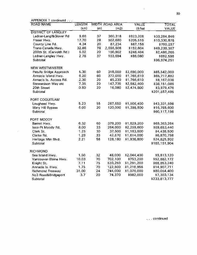
APPENDIX 1 continued .. .ROAD NAME LENGTH WIDTH ROAD AREA VALUE TOTAL
(km) (m) (m2) ($/ha) VALUEDISTRICT OF LANGLEY
Ladner-Langl&Glover Rd 9.66 37 360,318 $923,208 $33,264,846Fraser Hwy. 17.70 28 502,680 $205,516 $10,330,878County Line Rd. 4.34 20 87,234 $87,156 $760,297Trans-Canada Hwy. 32.86 78 2,556,508 $192,604 $49,239,367200th St. (Carvolth Rd.) 5.02 20 100,902 $246,404 $2,486,266Ladner-Langley Hwy. 2.78 37 103,694 $86,080 $892,598Subtotal $96,974,251
NEW WESTMINSTERPatullo Bridge Approach 5.30 60 318,000 $2,690,000 $85,542,000Annacis Island Hwy. 6.20 60 372,000 $1,766,610 $65,717,892Annacis Is. Access Rd. 2.30 20 46,230 $1,766,610 $8,167,038Stewardson Way etc 7.35 20 147,735 $2,582,400 $38,151,08620th Street 0.80 20 16,080 $2,474,800 $3,979,478Subtotal $201,557,495
PORT COQUITLAMLougheed Hwy. 5.23 55 287,650 $1,506,400 $43,331,596Mary Hill Bypass 6.00 20 120,000 $1,398,800 $16,785,600Subtotal $60,117,196
PORT MOODYBarnet Hwy. 6.32 60 379,200 $1,829,200 $69,363,264loco-Pt Moody Rd. 8.00 33 264,000 $2,259,600 $59,653,440Clark St. 1.25 30 37,500 $1,183,600 $4,438,500Clarke Rd. 1.29 33 42,570 $1,614,000 $6,870,798Heritage Mtn Blvd. 2.21 58 128,180 $1,936,800 $24,825,902Subtotal $165,151,904
RICHMONDSea Island Hwy. 1.50 32 48,000 $2,044,400 $9,813,120Vancouver-Blaine Hwy. 10.03 70 702,100 $753,200 $52,882,172Knight St. 7.11 75 533,250 $1,291,200 $68,853,240Annacis Is. Hwy. 1.75 70 122,500 $1,216,956 $14,907,711Richmond Freeway 31.00 24 744,000 $1,076,000 $80,054,400No3 Road&Bridgeport 3.7 20 74,370 $982,000 $7,303,134Subtotal $233,813,777
80
.. continued
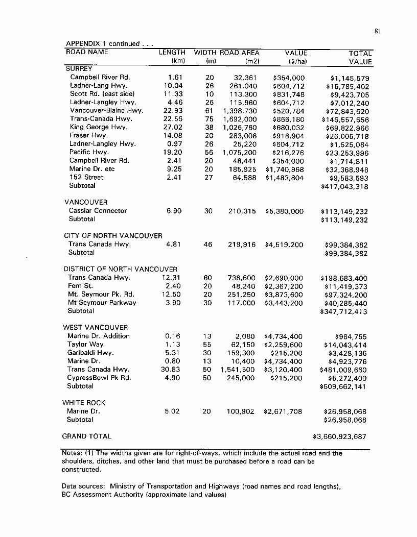
APPENDIX 1 continued . . .ROAD NAME^LENGTH WIDTH ROAD AREA VALUE TOTAL
(km) (m) (m2) ($/ha) VALUESURREY
Campbell River Rd.^1.61 20 32,361 $354,000 $1,145,579Ladner-Lang Hwy.^10.04 26 261,040 $604,712 $15,785,402Scott Rd. (east side)^11.33 10 113,300 $831,748 $9,423,705Ladner-Langley Hwy.^4.46 26 115,960 $604,712 $7,012,240Vancouver-Blaine Hwy.^22.93 61 1,398,730 $520,784 $72,843,620Trans-Canada Hwy.^22.56 75 1,692,000 $866,180 $146,557,656King George Hwy.^27.02 38 1,026,760 $680,032 $69,822,966Fraser Hwy.^14.08 20 283,008 $918,904 $26,005,718Ladner-Langley Hwy.^0.97 26 25,220 $604,712 $1,525,084Pacific Hwy.^19.20 56 1,075,200 $216,276 $23,253,996Campbell River Rd.^2.41 20 48,441 $354,000 $1,714,811Marine Dr. etc^9.25 20 185,925 $1,740,968 $32,368,948152 Street^ 2.41 27 64,588 $1,483,804 $9,583,593Subtotal $417,043,318
VANCOUVERCassiar Connector^6.90 30 210,315 $5,380,000 $113,149,232Subtotal $113,149,232
CITY OF NORTH VANCOUVERTrans Canada Hwy.^4.81 46 219,916 $4,519,200 $99,384,382Subtotal $99,384,382
DISTRICT OF NORTH VANCOUVERTrans Canada Hwy.^12.31 60 738,600 $2,690,000 $198,683,400Fern St.^ 2.40 20 48,240 $2,367,200 $11,419,373Mt. Seymour Pk. Rd.^12.50 20 251,250 $3,873,600 $97,324,200Mt Seymour Parkway^3.90 30 117,000 $3,443,200 $40,285,440Subtotal $347,712,413
WEST VANCOUVERMarine Dr. Addition^0.16 13 2,080 $4,734,400 $984,755Taylor Way^ 1.13 55 62,150 $2,259,600 $14,043,414Garibaldi Hwy.^5.31 30 159,300 $215,200 $3,428,136Marine Dr.^ 0.80 13 10,400 $4,734,400 $4,923,776Trans Canada Hwy.^30.83 50 1,541,500 $3,120,400 $481,009,660CypressBowl Pk Rd.^4.90 50 245,000 $215,200 $5,272,400Subtotal $509,662,141
WHITE ROCKMarine Dr.^ 5.02 20 100,902 $2,671,708 $26,958,068Subtotal $26,958,068
GRAND TOTAL $3,660,923,687
Notes: (1) The widths given are for right-of-ways, which include the actual road and theshoulders, ditches, and other land that must be purchased before a road can beconstructed.
Data sources: Ministry of Transportation and Highways (road names and road lengths),BC Assessment Authority (approximate land values)
81
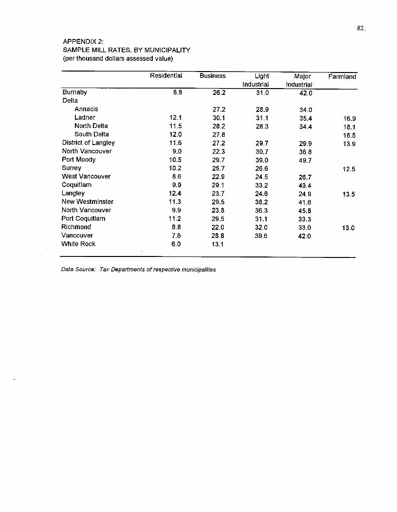
82.
APPENDIX 2:SAMPLE MILL RATES, BY MUNICIPALITY(per thousand dollars assessed value)
Residential Business LightIndustrial
MajorIndustrial
Farmland
Burnaby 8.8 26.2 31.0 42.0Delta
Annacis 27.2 28.9 34.0Ladner 12.1 30.1 31.1 35.4 16.9North Delta 11.5 28.2 28.3 34.4 18.1South Delta 12.0 27.8 16.5
District of Langley 11.6 27.2 29.7 29.9 13.9North Vancouver 9.0 22.3 30.7 36.8Port Moody 10.5 29.7 39.0 49.7Surrey 10.2 25.7 26.6 12.5West Vancouver 8.6 22.9 24.5 26.7Coquitlam 9.9 29.1 33.2 43.4Langley 12.4 23.7 24.6 24.9 13.5New Westminster 11.3 29.5 38.2 41.6North Vancouver 9.9 23.8 36.3 45.8Port Coquitlam 11.2 29.5 31.1 33.3Richmond 8.8 22.0 32.0 33.0 13.0Vancouver 7.6 28.8 39.6 42.0White Rock 6.0 13.1
Data Source: Tax Departments of respective municipalities
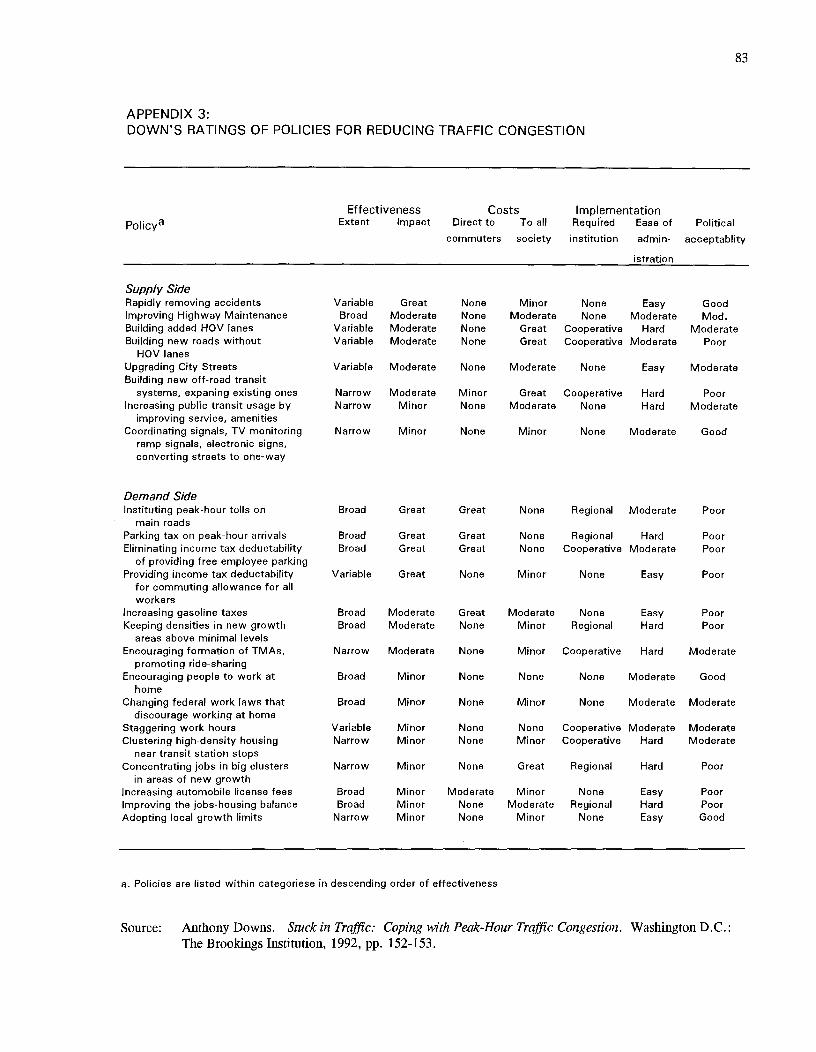
83
APPENDIX 3:DOWN'S RATINGS OF POLICIES FOR REDUCING TRAFFIC CONGESTION
Effectiveness^Costs^ImplementationPolicya^
Extent^Impact^Direct to^To all^Required^Ease of^Political
commuters society^institution^admin- acceptablity
istration
Supply SideRapidly removing accidents^Variable^Great^None^Minor^None^Easy^GoodImproving Highway Maintenance^Broad^Moderate^None^Moderate^None^Moderate^Mod.Building added I-10V lanes^Variable^Moderate^None^Great^Cooperative^Hard^ModerateBuilding new roads without^Variable Moderate^None^Great^Cooperative Moderate^Poor
HOV lanesUpgrading City Streets^ Variable Moderate^None^Moderate^None^Easy^ModerateBuilding new off-road transit
systems, expaning existing ones^Narrow^Moderate^Minor^Great^Cooperative^Hard^PoorIncreasing public transit usage by^Narrow^Minor^None^Moderate^None^Hard^Moderate
improving service, amenitiesCoordinating signals, TV monitoring^Narrow^Minor^None^Minor^None^Moderate^Good
ramp signals, electronic signs,converting streets to one-way
Demand SideInstituting peak-hour tolls on
main roadsBroad Great Great None Regional^Moderate Poor
Parking tax on peak-hour arrivals Broad Great Great None Regional^Hard PoorEliminating income tax deductability
of providing free employee parkingBroad Great Great None Cooperative Moderate Poor
Providing income tax deductabilityfor commuting allowance for allworkers
Variable Great None Minor None^Easy Poor
Increasing gasoline taxes Broad Moderate Great Moderate None^Easy PoorKeeping densities in new growth
areas above minimal levelsBroad Moderate None Minor Regional^Hard Poor
Encouraging formation of TMAs,promoting ride-sharing
Narrow Moderate None Minor Cooperative^Hard Moderate
Encouraging people to work athome
Broad Minor None None None^Moderate Good
Changing federal work laws thatdiscourage working at home
Broad Minor None Minor None^Moderate Moderate
Staggering work hours Variable Minor None None Cooperative Moderate ModerateClustering high-density housing
near transit station stopsNarrow Minor None Minor Cooperative^Hard Moderate
Concentrating jobs in big clustersin areas of new growth
Narrow Minor None Great Regional^Hard Poor
Increasing automobile license fees Broad Minor Moderate Minor None^Easy PoorImproving the jobs-housing balance Broad Minor None Moderate Regional^Hard PoorAdopting local growth limits Narrow Minor None Minor None^Easy Good
a. Policies are listed within categoriese in descending order of effectiveness
Source: Anthony Downs. Stuck in Traffic: Coping with Peak-Hour Traffic Congestion. Washington D.C.:The Brookings Institution, 1992, pp. 152-153.
Related Documents