1 Dept. of Civil Engineering

Welcome message from author
This document is posted to help you gain knowledge. Please leave a comment to let me know what you think about it! Share it to your friends and learn new things together.
Transcript

1
Dept. of Civil Engineering

Course No: CE 452
TRANSPORTATION
ENGINEERING SESSIONAL -II
2
Course Instructor: Mr. Minhazul Islam
Khan (Lecturer)
Ms. Nuzhat (Lecturer)

3
Presentation on
Roadway Condition Survey
3

Presented by4th Year 2nd Semester
Section; B
Group No: 4
4
Name Student ID
Wasi Uddin Ahmed 11.01.03.129
Shahana Akter Esha 11.01.03.073
Farjana Rahman Tripty 11.01.03.077
Suhana Sultana 11.01.03.095
Antora Dhali 11.01.03.114
Shajeda Allam Mahbuba 10.01.03.103
Sazzad Hussain 10.01.03.152
Tuhin Hasan 10.01.03.156

Study Area (Panthapath) on
Google Earth
Mirpur
Road
Russel
Square
Panthapath-
Green Road
Intersection
Green Road
SAARC
Fountain
Green Road
Mirpur
Road
Kazi Nazrul
Islam Road
5

Presentation Contents
6
Introduction
Literature review
Methodology
Data Collection
Data Analysis
Findings, Limitations & Recommendations

OBJECTIVES
To draw detailed layout of roadway and intersection
Measure-
Road length,
Numbers of lane,
Median height and width,
Shoulder height and width etc.
Observe Geometric Measurement and Position of channel or islands,
Dimension and location of pedestrian refuge.
To shoe location of bottlenecks.
To show various control devices like Road Sign, Marking, Signal, speed Breaker, StreetLight etc.
To find density of Road obstructions (manholes, speed breakers, potholes etc).
To find Density of Side roads.
To find out the faults of that intersection and making proposals to remove them.
To plan for reducing and minimize delay time in intersection.
To make some recommendations for the betterment of the existing situation of our studyintersection.
7

SCOPE OF THE STUDY
Repairing Purpose
Future Planning Purposes
Further Roadway condition Improvement & Modification
Purposes
Further Sidewalk condition Improvement & Modification
Purposes
Parking Management Purpose
Signaling system modification Purpose
Road marking & road signs modification purpose
8

Basic Components of
Roadway Survey
Road,
Vehicles,
Road Users &
Roadway Environment.
9

Importance of Roadway
Condition Study
Increase the efficiency and life of roads.
Reduces traffic congestion
Provide better means for development of
infrastructures.
To find the need of improvement of a roadway or
side walk or any other basic road component.
To improvisation of pedestrian or vehicle
movement or parking facility.
10

Literature Review
11

Potholes
A pothole (sometimes called
a kettle and known in parts
of the Western United States
as a chuckhole) is a type of
disruption in the surface of a
roadway where a portion of
the road material has broken
away, leaving a hole.
12
Potholes
Potholes
Accident
In a
Pothole

Curbs A curb the edge where a
raised pavement/ sidewalk /footpath, road median/central reservation, or roads shoulder/hard shoulder meets an unraised street or other roadway.
Curbs may fulfill several functions.
Curbs can be used to channel runoff water from rain, or melted snow and ice into storm drains.
13

Channelization
Channelization is an engineering concept which employs the use of secondary roads to separate certain flows of traffic from the main traffic lanes. It is the separation or regulation of conflicting traffic movements into definite paths of travel by traffic islands or pavement marking to facilitate the safe and orderly movements of both vehicles and pedestrians.
14

ShouldersA hard shoulder, or simply
shoulder, is a reserved area
by the verge of a road or
motorway. Generally it is
kept clear of motor vehicle
traffic.
15
Shoulders
Super ElevationSuper elevation is tilting the roadway to help offset centripetal forces developed as the vehicle goes around a curve. Along with friction they are what keep a vehicle from going off the road.

Link Road
A link road is a transport infrastructure road that links other major road transport facilities, often added because of increasing road traffic. They can be controversial, especially if they threaten to destroy natural habitat and green field land
16
Link
Road

Side
road A side road or side roadway is a
narrow lane found in urbanareas, often for pedestrians only,which usually run between orbehind the buildings…
17

Road
Marking Road marking is any kind of device or material
that is used on a road surface in order toconvey official information. They can also beapplied in other facilities used by vehicles tomark parking spaces or designate areas forother uses. Road surface markings are used onpaved roadways to provide guidance andinformation to drivers and pedestrians.Uniformity of the markings is an importantfactor in minimizing confusion and uncertaintyabout their meaning, and efforts exist tostandardize such markings across borders.However, countries and areas categorize andspecify road surface markings in differentways. Road surface markings are eithermechanical, non-mechanical, or temporary.
18

Road
Signs Traffic signs or
road signs are signs
are shown at the
side of or above
roads to give
instructions or
provide information
to road users. The
earliest signs were
simple wooden or
stone milestones.
Later, signs with
directional arms 19

Road Signals A road signal for directing vehicular traffic
by means of colored lights, typically red
for stop, green for go, and yellow for
proceed with caution. Also called
stoplight, traffic signal.
20

METHODOLOGY
Reconnaissance survey of study area.
Chose Study MethodManual Walking Method
Chose Data Collection MethodIndirect Method
Chose equipment for
Ensure other key featuresPerform necessary office preparations.
Select proper observer location.
Label data sheets and record observations.
21

Main Road Alignment of Study
Area
22
Mirpur
Road
Russel
Square
Panthapath-
Green Road
Intersection
Green Road

Steps of Methodology
Reconnaissance Survey
Type of Roadway Condition Method
Manual Roadway Condition Survey
Manual Roadway Condition Survey Instruments
Vehicle Based automatic roadway condition survey
Vehicles for automatic roadway condition survey
Choice of Mechanism For Roadway Survey
Chose Procedure of Work
23

Reconnaissance survey
Reconnaissance survey was performed-
To get an idea about the situation of the roadway.
To make easy and understandable final roadway condition survey.
To select what type of method for fieldwork to be followed
24
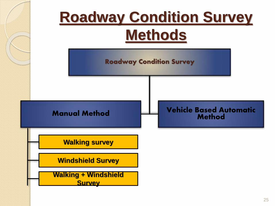
Roadway Condition Survey
Methods
25
Roadway Condition Survey
Manual Method Vehicle Based Automatic Method
Walking survey
Windshield Survey
Walking + Windshield
Survey

Manual Roadway Condition
Survey Instruments
26
Measuring tape (small)
Measuring tape (large)
Odometer
camera

Roadway Condition Summary
27
Survey Date15th & 17th December, 2014
Survey TimeBetween 7:00am to 8:00pm (Day & Night)
Survey routeRussell Square to Green Road
Survey MethodManual Measurement
Measuring Equipment A pair of 15 meter tape & 5 meter tape
CameraNokia 5MP mobile & Samsung HD Camera
Number of Enumerator 8 person in two groups (1 group each side)

Working Steps
At first we divided our enumerators into two groups.
Each group takes different sides.
We used tapes for measurements.
We counted number & width of side roads, potholes,
and street light and observed their physical
condition.
We collected information about road marking, signs
& signals, parking facilities.
We listed measurement data of roadway and
sidewalk and their present condition.
We measured median and opening heights and
widths.
We also have photographic documentation 28

Length Measurement
29

Chose The Best Option From
Considering all facilities & limitations we chose
MANUAL ROADWAY CONDITION SURVEY SYSTEM
30

Data
Analysis
31

Geometrical Roadway Section
Data-1
32
Distance(m) Width(m)Left Approach Width(m) Right Approach Lane
0 11.7 9.8 3
50 14.8 11.8 4
100 9.6 9.5 3
150 9.4 9.2 3
200 9.0 9.2 3
250 8.5 9.9 3
300 8.7 8.6 3
350 8.7 8.6 3
400 8.6 8.6 3
450 8.4 8.9 3
500 9.3 9.9 3
550 9.0 8.8 3
600 8.6 8.8 3
650 7.5 8.7 3
700 9.0 8.3 3
750 8.7 8.5 3
800 7.2 8.6 3
850 8.4 8.5 3
900 11.5 8.5 3
Road Width

Geometric Measurement of Channel/Islands, Pedestrians Refuge
33

Island and Channels
34

35
Location & Width of side roads

Condition of Footpath

Island Channel
Median
Road intersection is blocked
by Channel

Condition of Divider

Condition of Manhole

Condition of Parking Facility

Condition of Curb

Surface Distortion

Pedestrian movement across the
road

Side road

Road Sign

Road Sign

Condition of Roadway Signal

Obstruction due
to trees
Condition of Roadway Signal

Road marking
Tiger lane
marking

Pedestrian movement marking

Finding
s Lots of pot holes on pavement
In some segment sidewalk is full of human waste and unusable forpedestrian.
Lots of side road causes side friction on main stream vehicle
Uneven, dirty & unusable side walk in some road section
Lots of small shops found obstructing sidewalk
No additional facility for blind pedestrian
Poor or no parking facility in some road sections
Lots of illegal parking on road side even by the law enforcing forces.
Street light condition are good and some solar street light are newlyimplemented
All type of signals are useless.
Manual traffic handling of vehicle at intersections by traffic police.
Islands are illegally captured, in some places by police box
51

Limitations
Totally manual method.
Number of enumerators was 4 persons per group
We collected data for some segment at large
interval. However if it was possible to collect
data for more sections then a better scenario
could have been presented.
52

Recommendation
s
53
Pot holes and other obstruction which reduce the trafficspeed should be removed.
A bus lay by may be applied on both side of this road.
Parking facilities should be improved & controlled to reduceside friction.
In junctions automatic signaling system might be introduced.
Fused street light should be replaced.
Worn out or almost worn out road marking & signs should bereplaced.
Storage of construction materials on roadway should not beallowed.
Food shop, nursery, temporary shops are recommended toremove from footpath with their proper compensation.
A public toilet may be constructed to stop footpath beingunusable due to human waste .

54
Thank You
Related Documents