1 | Page Rivers & Drainage System of India SSC CGL, Railways RRB or any other competitive exam needs a good deal of General Knowledge for scoring good marks. You need to have sufficient knowledge about General Knowledge/ Social Awareness and Current affairs to score good in this exam. So here is a GK article on the Rivers & Drainage System of India to help you with the General Knowledge section of your exam. Today’s focus will be on Geography, specifically on the Rivers & Drainage System of India. Geography – Rivers & Drainage System of India The flow of water through channels is called drainage. The network of such channels is known as drainage system. On the basis of origin, Indian drainage system is divided into - Himalayan rivers and Peninsular rivers. I. Himalayan Rivers The major Himalayan rivers are the Ganga, the Indus and the Brahmaputra. These rivers are very long compared to the rivers of South India. They are called perennial rivers as they are fed by both rainfall and the melting of snow. A. Indus River System It is also known as Sindhu river. Total length is 2880 km. Source - Kailash Range, Tibet near Mansarovar Lake. Destination - Arabian Sea. Panchnad – Jhelum (Vitasta), Chenab (Chandrabhaga), Ravi (Iravati), Beas (Bipasha) and Sutlej (Satadru). RIVER SOURCE DAMS/HYDRO PROJECT Jhelum Verinag Uri Chenub Bara Lacha Pass Dul Hasti Ravi Rohtang Pass -

Welcome message from author
This document is posted to help you gain knowledge. Please leave a comment to let me know what you think about it! Share it to your friends and learn new things together.
Transcript

1 | P a g e
Rivers & Drainage System of India
SSC CGL, Railways RRB or any other competitive exam needs a good deal of General Knowledge for scoring good marks. You need to have sufficient knowledge about General Knowledge/ Social Awareness and Current affairs to score good in this exam. So here is a GK article on the Rivers & Drainage System of India to help you with the General Knowledge section of your exam. Today’s focus will be on Geography, specifically on the Rivers & Drainage System of India.
Geography – Rivers & Drainage System of India
The flow of water through channels is called drainage. The network of such channels is known as drainage system. On the basis of origin, Indian drainage system is divided into - Himalayan rivers and Peninsular rivers.
I. Himalayan Rivers
The major Himalayan rivers are the Ganga, the Indus and the Brahmaputra. These rivers are very long compared to the rivers of South India. They are called perennial rivers as they are fed by both rainfall and the melting of
snow.
A. Indus River System
It is also known as Sindhu river. Total length is 2880 km. Source - Kailash Range, Tibet near Mansarovar Lake. Destination - Arabian Sea. Panchnad – Jhelum (Vitasta), Chenab (Chandrabhaga), Ravi (Iravati), Beas (Bipasha)
and Sutlej (Satadru).
RIVER SOURCE DAMS/HYDRO PROJECT
Jhelum Verinag Uri
Chenub Bara Lacha Pass Dul Hasti
Ravi Rohtang Pass -

2 | P a g e
Beas Rohtang Pass -
Sultuj Near Mansarovar Govind Sagar/Bhakra Nangal Dam
B. Ganga River System
Source - Gangotri glacier near Gomukh, Uttrakhand in the Kumaon Himalaya. It is named as Bhagirathi here. At Devprayag, Alakananda joins Bhagirathi and
becomes Ganga. In Allahabad it is joined by the Yamuna, the largest tributary of Ganga, rising from
Yamunotri glacier. Left bank tributaries - Ramganga, Gandak, Kosi, Gharghara, Gomati. Right bank tributaries - Son. Kosi, a tributary, is flood prone. So it is known as “Sorrow of Bihar”. Ganga flows through Uttrakhand, UP, MP, Chattisgarh, Bihar, Jharkhand and WB. It bifurcates into Bhagirathi and Hooghly in WB and Padma-Meghna in Bangladesh. Ganga-Brahmaputra delta is the largest delta in the world. Total length of Ganga – 2530 km. Ganga Basin area is 9,51,600 sq. km. The plain area from Haridwar to Ganga’s mouth is fertile with alluvial soil.
C. Bramhaputra
Source - Chemayung-Dung glacier near Mansarovar in Tibet. In Tibet it is known as Tsangpo. It turns SW near Namcha Barwa in Arunachal Pradesh and enters India as Dihang Near Sadiya, Dihang enters into India where Dibang and Lohit join it to make
Brahmaputra. Finally it enters into Bangladesh as Jamuna and meets Padma to drain into Bay of
Bengal. Right bank tributaries - Subansiri, Kameng, Manas. Left bank tributaries - Buri Dihang, Kameng. Majuli is a large riverine island of Brahmaputra. Total length of Brahmaputra is 2900 km.
II. Peninusular River Systems
Peninsular rivers are both west and east flowing. Narmada and Tapi drain into Arabian Sea where Mahanadi, Godavari, Cauvery and
Krishna drain into Bay of Bengal. East flowing rivers form delta where west flowing rivers don’t form delta.
3 | P a g e
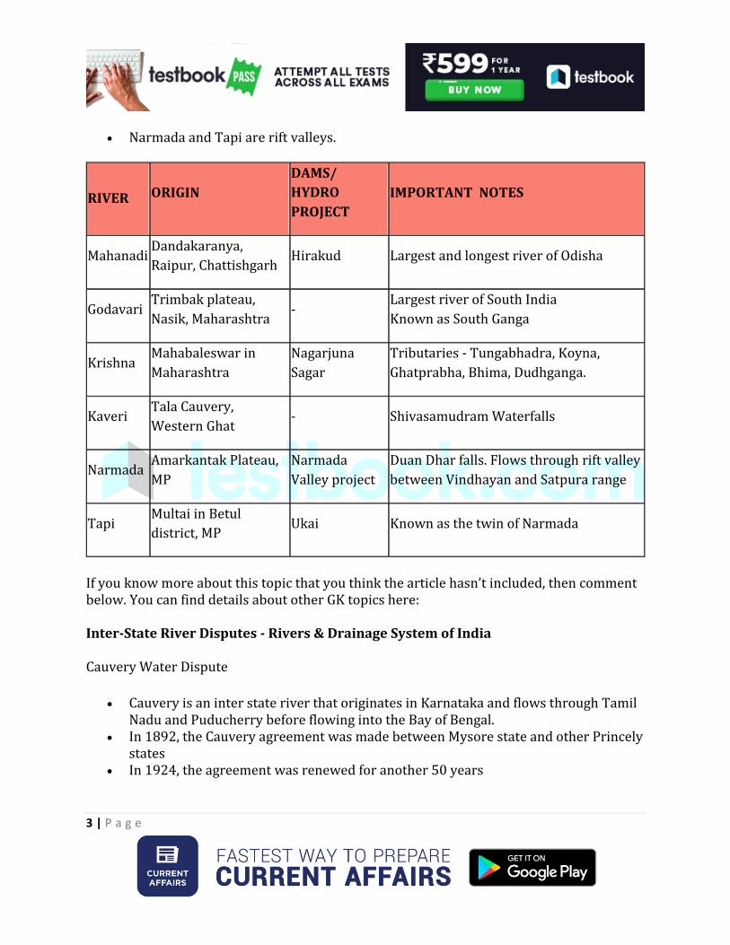
Narmada and Tapi are rift valleys.
RIVER ORIGIN
DAMS/
HYDRO
PROJECT
IMPORTANT NOTES
Mahanadi Dandakaranya,
Raipur, Chattishgarh Hirakud Largest and longest river of Odisha
Godavari Trimbak plateau,
Nasik, Maharashtra -
Largest river of South India
Known as South Ganga
Krishna Mahabaleswar in
Maharashtra
Nagarjuna
Sagar
Tributaries - Tungabhadra, Koyna,
Ghatprabha, Bhima, Dudhganga.
Kaveri Tala Cauvery,
Western Ghat - Shivasamudram Waterfalls
Narmada Amarkantak Plateau,
MP
Narmada
Valley project
Duan Dhar falls. Flows through rift valley
between Vindhayan and Satpura range
Tapi Multai in Betul
district, MP Ukai Known as the twin of Narmada
If you know more about this topic that you think the article hasn’t included, then comment below. You can find details about other GK topics here:
Inter-State River Disputes - Rivers & Drainage System of India
Cauvery Water Dispute
Cauvery is an inter state river that originates in Karnataka and flows through Tamil Nadu and Puducherry before flowing into the Bay of Bengal.
In 1892, the Cauvery agreement was made between Mysore state and other Princely states
In 1924, the agreement was renewed for another 50 years

4 | P a g e
In 1970, Tha Tamil Nadu government asked the Central government ro set up a tribunal and in the same year the Tamil Nadu Farmers Association filed a civil suit in the Supreme Court.
The Cauvery Water disputes tribunal was set up in the year 1990 The Tribunal passed an interim in the year 1991 ordering the state of Karnataka to
release 205 thousand million cubic feet of water to Tamil Nadu from it's reservoirs. Karnataka refused to obey the order and after 16 years of hearing, another
judgement was passed allocating 419 thousand million cubic feet of water to Tamil Nadu.
Karnataka again refused to obey the order and a case of contempt of court was filed against the state.
The matter is still under judicial view.
Satluj Yamuna Link Canal Issue
The dispute started when the state of Haryana was seperated from Punjab in the year 1966
To enable Haryana to use its share of water from Sutlej and Beas, the construction of a canal was planned in the year 1982.
The construction was stopped in 1986 due to protests from Punjab Haryana approached the Supreme Court for completing the construction of the canal
in 2002. The court ordered Punjab to finish construction in 12 months. In 2004, Punjab assembly passed a water sharing act which scrapped all its water
sharing dues. The Supreme Court declared this act as Unconstitutional 12 years later in 2016 The Centre has opted to act as a mediator in this case.
Follow the Links given below for other GK articles

5 | P a g e
Know Major Facts about the Indian States
Indian towns on River Banks
UNESCO World Heritage Sites in India
Famous Sites in India
Important Regulatory Bodies in India
Latest Books and Authors
List of New Appointments in the World
As we all know, practice is the key to success. Therefore, boost your preparation by starting your practice now.
Solve Practice Questions for Free
Furthermore, chat with your fellow aspirants and our experts to get your doubts cleared on Testbook Discuss:
Go to Testbook Discuss!
Related Documents