River Riparian Connectivity & Habitat - Section 506 WRDA 2000 Detailed Project Report & Environmental Assessment Public Review Document 2016 h6plvfmv Cook County Chicago, Illinois May 2016

Welcome message from author
This document is posted to help you gain knowledge. Please leave a comment to let me know what you think about it! Share it to your friends and learn new things together.
Transcript
River Riparian Connectivity & Habitat - Section 506 WRDA 2000 Detailed Project Report & Environmental Assessment Public Review Document
2016
h6plvfmv
Cook County Chicago, Illinois May 2016
AFB Version DPR
U.S. Army Corps of Engineers -i- River Riparian Connectivity & Habitat Chicago District Detailed Project Report & EA
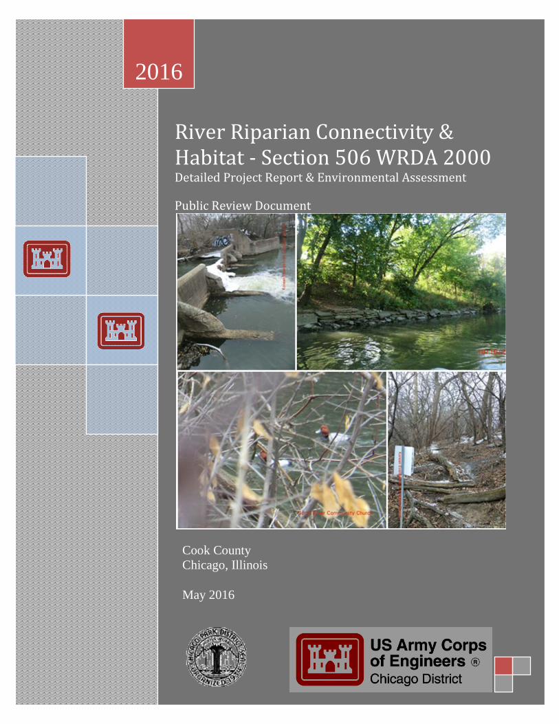
EXECUTIVE SUMMARY Front cover photos clockwise: River Park Dam / Concrete Block Bank / Redhead (Aythya americana) / Naturalized Bank. This Detailed Project Report presents the results of an ecosystem restoration feasibility study for the North Branch Chicago River and North Shore Channel. This Detailed Project Report presents the assessment of ecological conditions and potential plans to restore important riverine habitat for transient and migratory mussels, fishes, birds and wildlife within a modified, yet restorable riverine environment. This report gathered historic and current site conditions, and forecasts future without and future with project conditions for this reach of the Chicago River system while considering watershed attributes. This report also provides a recommended plan for restoring habitat within the study area. The Chicago Park District is currently implementing an initiative within the City of Chicago to address habitat degradation and connectivity for the purpose of habitat restoration, fish and wildlife recolonization, water quality improvement and natural aesthetics for humans. The CPD has in turn requested that the USACE initiate a study under the Section 506 WRDA 2002, Great Lakes Fishery & Ecosystem Restoration authority to ascertain the feasibility of restoring important riverine habitat within the Chicago River. The need for riverine ecosystem restoration of the study area is based on habitat, organism and water quality studies conducted by state, regional and local agencies and groups, that have shown over the decades, the impairments caused to fish, wildlife and other natural resources. The River Riparian Connectivity and Habitat Restoration study area consists of three contiguous parks that straddle the Chicago River. All three parks are leased to, maintained and managed by the Chicago Park District, but are currently owned by the Metropolitan Water Reclamation District of Greater Chicago. The three parks are named Ronan Park (13-acres), River Park (30-acres) and Legion Park (50-acres), encompassing over 2-miles of contiguous river. The confluence of the North Branch Chicago River and the North Shore Channel occurs at River Park, which is also the location of the River Park Dam near Foster Avenue. The parks were integrated into the Chicago Park District system between 1917 and 1934. In the 1990s, the park district began to lease additional MWRDGC land and upgrading the walking and bike riding trails through much of the parks lining the river. All study lands are held by CPD through 100-year leases from MWRD. Based on site qualitative and quantitative investigations and aside from the massive hydrogeomorphic changes to the system, the main aquatic resource problems within the NBCR in which the 506 Authority may take opportunity to address are as follows: Lack of passage for mussel and fish species to access habitat within the NBCR
o Mussels depend on fish passage for dispersal, fish being glochidial (larval) hosts Lack of riverine (lotic/flowing) velocities and forces that riverine species require Lack of natural sediment (substrate) transport
o Impaired substrate composition and sorting o Lack of natural macro-habitat features
Islands, deep pools, riffles, native aquatic vegetation, bars, undercut banks o Eliminated ability to naturally filter and clean water and sediments (substrates)
Moving water facilitates cleansing as substrates (sediment) move through the river becoming exposed to saprophytes (animals, bacteria, fungi) and oxygen
Lack of native species richness and composition of riparian zone plant communities o Poor structural diversity (monotypic thickets) o Poor food sources from non-seed/berry producing trees and shrubs

AFB Version DPR
U.S. Army Corps of Engineers -ii- River Riparian Connectivity & Habitat Chicago District Detailed Project Report & EA
o Noxious chemical sources from non-native plants (i.e. Buckthorn, Garlic Mustard) o Poor/eliminated longitudinal (along the river) and lateral (up the bank) connectivity
To address the listed problems above, six (6) measures, including the No Action measure, were developed and input into the IWR-Planning Suite in terms of costs and benefits (stream & riparian plant community habitat outputs). Stream Channel Option A (SCa) and Stream Channel Option B (SCb) were not combinable as they propose different methods for stream channel restoration. The three riparian plant community measures, Aquatic Bed (AB), River Bank (RB), and Riparian Savanna (RS) were independent and combinable with each other and with the Stream Channel Options (SCa or SCb). Based on these inputs and criteria, the IWR Planning software generated eighteen (18) alternative combinations for ecosystem restoration. A cost effectiveness analysis was used to ensure that certain options would be screened out if they produced the same amount or less output at a greater cost than other options with a lesser cost. Of the eighteen (18), eleven (11) cost effective combinations were identified, with a subset of four (4) plans being identified as “Best Buys”. The No Action plan is always deemed cost effective and a “best buy”. Six (6) alternative combinations were screened out as non-cost effective. Alternative 4 was selected from the four (4) “best buy” plans as the National Ecosystem Restoration plan (synonymous with the Preferred Plan and Tentatively Selected Plan). Rationale for selecting the Tentatively Selected Plan is presented in Section 4.6. Alternative Plan 4 consists of the following measures presented in Section 4.1: SCa (Stream Channel & Dam Removal), RS (Riparian Savanna), (RB) River Bank and (AB) Aquatic Bed. The implementation of these combined measures would restore riverine fish habitat and connectivity, riverine aquatic beds with Eel Grass and Pondweeds, naturalize bank slopes, and plant banks with native trees, shrubs, grasses and flowers, and riparian savanna. The implementation of these features is generally described as follows and according to the measures descriptions in Section 4.1. More detail would be added to the plan should this project commence to the design and implementation phase, for example, specifying spatial distribution of native plugs within a given zone and species clumping, planting centers, soil amendment percentages, temporary predator controls, and establishment activities. General construction activities and sequencing would include: (1) Site Preparation – The first task would be to install safety fencing, signage and other temporary safety features (barricades, temporary path reroutes, timing of construction activities, appropriate field apparel for access to the site, etc.) in order to keep the public out of the site during heavy construction. Staging areas and access and construction haul roads would be created and demarcated as well. The road system provides incidental ecosystem restoration benefits, for example, keeping equipment and pedestrians from disturbing wildlife and impacting planted restoration areas; there are 640,000 to 680,000 people who live nearby the heavily utilize the park system. Instructive signage for workers would be set up as well to signify off limit work areas and site restrictions. (2) Invasive Species Eradication – All invasive plant species would be physically and if need be, chemically eradicated from the planting zones. A “No Invasive Species Clearing” window between 01 March and 01 October which is typically established for all USACE, Chicago District ecosystem projects in conjunction with the Region 3 US Fish & Wildlife Service and the local birding community. All woody species removed not selected for Large Woody Debris habitat would be chipped and utilized for project features or appropriately recycled. Based on lessons learned from Chicago District restoration projects, the addition of these wood chips greatly aids in starting a plant community where soils lack or have no organic material, aiding as well in soil water retention for early plant establishment phases. Those species having allelopathic chemicals or the potential to provide an invasive species seed source would be destroyed on site via fire or appropriately disposed; such species include European Buckthorn, Black Alder, etc. Herbicide application would also be employed; all required permits for licensed herbicide application practices near water ways would be applied for and adhered to.

AFB Version DPR
U.S. Army Corps of Engineers -iii- River Riparian Connectivity & Habitat Chicago District Detailed Project Report & EA
(3) Geomorphic Contouring – Once targeted woody and invasive species are removed, North Shore Channel banks would be graded to provide a suitable hydrogeomorphology for establishing native riparian plant species. These areas will be contoured and all excess soils will be incorporated into the landscape design; all materials will be managed on site and not removed. Grading activities would be limited to areas along the bank where they are too steep to plant native riparian communities. Graded areas will be planted with native seeds, plugs or shrubs and immediately stabilized to prevent erosion. Haul roads would be created within the graded areas to maintain the movement and hauling of materials during construction to defined paths in order to prevent new plantings and habitat from becoming damaged and for construction site safety. Large boulders, dolomitic limestone slabs and woody debris would be transported via the haul roads and placed at various locations along the North Shore Channel where severe erosion points exist or the opportunity for providing sustainable habitat structure is available. The stone and large woody debris material would not intrude into the navigation channel or impede or attenuate flood-flows. Aquatic soil amendments identified above would be placed along the toe of the North Shore Channel in slackwater areas where emergent and submergent aquatic macrophytes can be established. These would be place by small machines or hand from the bank to achieve the appropriate hydrogeomorphic setting and to provide a kick-start growth medium for native aquatic macrophytes. (4) Concrete Channel Removal – Recent and past fish surveys show that there are usually no fish present with in the reaches of the North Branch Chicago River that have a concrete lined channel. The V-shaped smooth concrete channel therefore would be broken and recycled in order to restore natural riverine substrates and morphology. A temporary coffer-dam system or pipe by-pass system would be used to pass half the channel flows through the 390-foot restoration zone in order to work in the dry; any system implemented would impact less than .25-ac, be quickly removable prior to imminent flooding and would not increase any stage of flows. In order to increase channel stability and reduce project costs, removed concrete would be cleaned and crushed on site and then line the newly exposed channel before it is covered and top-dressed with natural riverine substrates and morphologic features. Excess concrete not needed for the channel design would be appropriately removed from site and recycled. (5) North Branch Channel Restoration – After the concrete channel is removed, turned to rubble, and placed as a bedding layer, riverine morphologic features of riffles and step-pools would be installed. These riffles and step-pools would be created from large boulders and cobbles that are locked into the channel bed and banks. Remaining channel areas outside these riffles and step-pools would be lined with natural riverine substrates of sand, gravel and cobbles as well; these will be placed based on predicted channel velocities for the bank-full width condition and adaptive management during construction. (6) Concrete Dam Removal – After the channel above the dam is restored and stabilized with riffles, step-pools and stone material, the grade control dam would be removed, turned to rubble, and placed in the large scour hole caused by the dam. All rebar and foreign material would be removed and properly disposed of. A final large fluvial stone riffle and apron would be placed over where the dam and scour hole formerly existed. The combination design of the dam removal and channel restoration would provide a) fish and mussel passage and b) fish and mussel habitat. (7) Native Plant Community Establishment – Next would be to establish native plant communities of aquatic bed and riparian savanna over the remaining 4 years of the construction period. Planting lists are presented as Future With-Project Planting Lists located in Appendix B. Zones would be seeded and planted with seed and live plugs. Live plug areas will require predatory control, primarily stringing and caging to prevent Beaver, Canada Goose and Common Carp predation. Again, the duration of the construction contract would primarily be for spot herbicide application and additional planting; most activities similar to public landscaping activities. The haul roads created for moving large materials would then be utilized to maintain and establish native plant communities along the two mile project area.

AFB Version DPR
U.S. Army Corps of Engineers -iv- River Riparian Connectivity & Habitat Chicago District Detailed Project Report & EA
(8) BMPs – Soil erosion and sediment control measures would be incorporated into the design documents and will comply with local and federal environmental requirements. A 5 year period of BMPs and erosion prevention would be implemented by the contractor. The minimum measures required at the project site may include: Hydroseeding, seeding, and mulching to stabilize disturbed areas Installation of silt fences around graded slopes and stockpile areas Protection of the waterway where grading occurs with silt fencing prevent sediments from traveling
into the waterway Stabilizing construction entrances to limit soil disturbance at the ingress/egress from the site Installing erosion blanket over unprotected finished grades that are to be unplanted for at least two
weeks (9) Recreational Features – Specific components of recreation are not specified for this project. Incidental recreational benefits of canoe passage are inherent with most dam removal projects. (10) Operations & Maintenance – Once the construction contract is complete, the non-Federal sponsors will maintain the project and associated habitat benefits. These activities would primarily include invasive plant species control, additional native plantings, woody debris management, minor additions of river cobbles and public access control. The haul roads created for construction and establishment are required and would be finished with suitable, non-toxic materials such as gravel or concrete to sustain their longevity throughout the O&M phase. The estimated Fully Funded Cost FY16 of the Tentatively Selected Plan is $14,619,000 for Design and Implementation, and the estimated annual operations, maintenance, repair, replacement and rehabilitation (OMRR&R) cost is $63,000. The Federal portion of the estimated total project cost is $9,502,350 for Design & Implementation. The non-Federal share of the estimated first cost of the project is about $5,116,650 and will be covered by lands, easements, rights-of-way, utility or public facility relocations, and dredged or excavated material disposal areas (LERRDs) of $32,000, WIK of $0 and a cash contribution of $4,972,650. The recommendations contained herein reflect the information available at this time and current departmental policies governing formulation of individual projects. They do not reflect program and budgeting priorities inherent in the formulation of a national Civil Works construction program nor the perspective of higher review levels within the Executive Branch.
AFB Version DPR
U.S. Army Corps of Engineers -v- River Riparian Connectivity & Habitat Chicago District Detailed Project Report & EA
Draft Finding of No Significant Impact
River Riparian Connectivity & Habitat Restoration Study SECTION 506 FEASIBILITY STUDY
May 2016
The U.S. Army Corps of Engineers Chicago District (Corps), has conducted an environmental analysis in accordance with the National Environmental Policy Act of 1969, as amended. The Corps assessed the effects of the following actions in the Detailed Project Report and Environmental Assessment, dated May 2016, for the River Riparian Connectivity & Habitat Restoration Project Section 506, which is incorporated herein by reference: Chicago River North Branch at River Park: removing 390 linear feet of in channel concrete,
removing 1 grade control structure/dam, replacing the concrete channel and concrete dam with natural riverine substrates of boulder, cobble, gravel and sand, channel stabilization with boulder riffles and native plantings, provides 48 miles of river connectivity and availability for fish, mussels
North Shore Channel at River and Legion Parks: gentling bank slopes from 1:1 and 2:1 to 4:1, removing invasive and non-native trees, shrubs, grasses and forbs, placing soil amendments of organic compost, sand, silt, or woodchips for native plantings, establishing aquatic bed wetland along bank toe, establishing riparian savanna on banks and parkland natural areas
Chicago River North Branch at Ronan Park: removing non-native grasses and forbs on banks, establishing riparian savanna on banks and parkland natural areas
In addition to the “no action” alternative, 18 alternatives with varying levels of ecosystem outputs and costs were evaluated. Alternative 4 was identified as the National Ecosystem Restoration Plan and is the environmentally-Preferred Plan. All practicable means to avoid and minimize adverse environmental effects have been incorporated into the recommended plan. The Preferred Plan would not result in any impacts to federally-listed threatened or endangered species or their designated critical habitat, would have no impact to sites listed on or eligible for inclusion on the National Register of Historic Places, and would not adversely affect any wetlands or water of the U.S., nor any important wildlife habitat. Technical and environmental criteria used in the formulation of alternative plans were those specified in the ER 1105-2-100 Planning Guidance Notebook, Appendix E. All applicable laws, executive orders, regulations, and local government plans were considered in the evaluation of the alternatives. It is my determination that the recommended plan does not constitute a major federal action that would significantly affect the human environment; therefore, preparation of an Environmental Impact Statement is not required. Date: ____________________ __________________________________________ Christopher T. Drew
Colonel, U.S. Army District Commander
AFB Version DPR
U.S. Army Corps of Engineers -vi- River Riparian Connectivity & Habitat Chicago District Detailed Project Report & EA
RIVER RIPARIAN CONNECTIVITY & HABITAT - SECTION 506 -
COOK COUNTY, ILLINOIS
DETAILED PROJECT REPORT & ENVIRONMENTAL ASSESSMENT
May 2016
TABLE OF CONTENTS
CHAPTER 1 – INTRODUCTION ................................................................................................................ 1
1.1 REPORT STRUCTURE ...................................................................................................................................................... 1 1.2 STUDY AUTHORITY......................................................................................................................................................... 2 1.3 STUDY PURPOSE & NEED .............................................................................................................................................. 3 1.4 STUDY AREA .................................................................................................................................................................... 4 1.5 PRIOR STUDIES & PROJECTS ........................................................................................................................................ 6
1.5.1 Pertinent Reports & Studies .............................................................................................................................................. 6 1.5.2 Pertinent Projects ................................................................................................................................................................... 7
CHAPTER 2 – STUDY AREA INVENTORY & FORECASTING ............................................................ 9 2.1 HISTORIC SETTING ......................................................................................................................................................... 9 2.2 PHYSICAL RESOURCES ................................................................................................................................................... 9
2.2.1 Geology & Soils ...................................................................................................................................................................... 10 2.2.2 Watershed Hydrography ................................................................................................................................................... 10 2.2.3 Water Quality ......................................................................................................................................................................... 15 2.2.4 Sediment (Substrate) Types & Quality ........................................................................................................................ 16 2.2.5 HTRW Assessment ............................................................................................................................................................... 16 2.2.6 Air Quality .................................................................................................................................................................................. 16
2.3 ECOLOGICAL RESOURCES ............................................................................................................................................ 16 2.3.1 Riparian Plant Communities ............................................................................................................................................ 17 2.3.2 Riverine Habitat .................................................................................................................................................................... 19 2.3.3 Aquatic Macroinvertebrates ............................................................................................................................................ 20 2.3.4 Freshwater Mussels ............................................................................................................................................................. 21 2.3.5 Fishes ......................................................................................................................................................................................... 22 2.3.6 Reptiles & Amphibians ....................................................................................................................................................... 23 2.3.7 Birds ........................................................................................................................................................................................... 24 2.3.8 Mammals .................................................................................................................................................................................. 25 2.3.9 Threatened and Endangered Species .......................................................................................................................... 25
2.4 CULTURAL & SOCIAL RESOURCES ............................................................................................................................. 26 2.4.1 Archaeological & Historical Properties ....................................................................................................................... 26 2.4.2 Land Use History ................................................................................................................................................................... 26 2.4.3 Social Setting ........................................................................................................................................................................... 26 2.4.3 Summary of Native American Coordination ............................................................................................................. 27 2.4.4 Existing Recreation Types ................................................................................................................................................... 27
2.5 FORECASTING HABITAT QUALITY ............................................................................................................................. 27 2.5.1 Qualitative Habitat Evaluation Index (QHEI) ........................................................................................................... 28 2.5.2 QHEI as the Habitat Suitability Index (HSI) .............................................................................................................. 30 2.5.3 Stream Acres as Quantity Measure ............................................................................................................................... 30 2.5.4 Stream Average Annual Habitat Units (AAHUs) ..................................................................................................... 30 2.5.5 Floristic Quality Assessment (FQA) .............................................................................................................................. 31 2.5.6 Mean C Value as the Habitat Suitability Index (HSI) ............................................................................................. 31 2.5.7 Plant Community Acres as Quantity Measure ......................................................................................................... 32

AFB Version DPR
U.S. Army Corps of Engineers -vii- River Riparian Connectivity & Habitat Chicago District Detailed Project Report & EA
2.5.8 Plant Community Average Annual Habitat Units (AAHUs) ................................................................................ 32 2.6 FUTURE WITHOUT-PROJECT CONDITIONS / NO ACTION ..................................................................................... 33
CHAPTER 3 – PROBLEMS & OPPORTUNITIES ................................................................................. 35 3.1 PROBLEMS AND OPPORTUNITIES .............................................................................................................................. 35
3.1.1 Study Area Problems ........................................................................................................................................................... 35 3.1.2 Specific Study Area Opportunities ................................................................................................................................ 36
3.2 GOAL & OBJECTIVES .................................................................................................................................................... 36 3.2.1 Goal ............................................................................................................................................................................................. 36 3.2.2 Objectives ................................................................................................................................................................................. 36
3.3 PLANNING CONSTRAINTS ............................................................................................................................................ 39 CHAPTER 4 – PLAN FORMULATION & EVALUATION .................................................................... 40
4.1 HABITAT MEASURES .................................................................................................................................................... 40 4.1.1 Habitat Management Measures ...................................................................................................................................... 40 4.1.2 Habitat Measures Cost & Assumptions ....................................................................................................................... 45 4.1.3 Habitat Measure Benefits .................................................................................................................................................. 45
4.2 ALTERNATIVE PLAN GENERATION ............................................................................................................................ 47 4.3 COST EFFECTIVENESS/INCREMENTAL COST ANALYSIS ........................................................................................ 48
4.3.1 Cost Effectiveness ................................................................................................................................................................. 48 4.3.2 Incremental Cost Analysis ................................................................................................................................................ 49
4.4 SIGNIFICANCE OF ECOSYSTEM OUTPUTS .................................................................................................................. 50 4.5 ACCEPTABILITY, COMPLETENESS, EFFECTIVENESS & EFFICIENCY ..................................................................... 56
4.6.3 Risk and Uncertainty ........................................................................................................................................................... 58 4.7 PLAN COMPARISON & TENTATIVELY SELECTED PLAN (TSP) RECOMMENDATION ......................................... 59
4.7.2 NER / Tentatively Selected / Preferred Plan ........................................................................................................... 60 CHAPTER 5 – INTEGRATED ENVIRONMENTAL ASSESSMENT ................................................... 62
5.1 NEED AND PURPOSE .................................................................................................................................................... 62 5.2 ALTERNATIVES CONSIDERED ..................................................................................................................................... 62 5.3 THE AFFECTED ENVIRONMENT ................................................................................................................................. 62 5.4 DIRECT AND INDIRECT EFFECTS OF THE PREFERRED PLAN ................................................................................. 63
5.4.1 Physical Resources ............................................................................................................................................................... 63 5.4.2 Ecological Resources ........................................................................................................................................................... 64 5.4.3 Cultural Resources ............................................................................................................................................................... 67 5.4.4 17 Points of Environmental Quality ............................................................................................................................. 67
5.5 CUMULATIVE EFFECTS ................................................................................................................................................ 69 5.5.1 Scope of Cumulative Effects Analysis .......................................................................................................................... 69 5.5.2 Cumulative Effects on Resources .................................................................................................................................. 70
5.6 COMPLIANCE WITH ENVIRONMENTAL STATUTES .................................................................................................. 71 5.7 DRAFT FINDING OF NO SIGNIFICANT IMPACT (FONSI) ....................................................................................... 74
CHAPTER 6 – PLAN IMPLEMENTATION ............................................................................................ 75 6.1 PROJECT AUTHORIZATION .......................................................................................................................................... 75 6.2 NER PLAN IMPLEMENTATION AND SEQUENCING .................................................................................................. 75 6.3 REAL ESTATE CONSIDERATIONS ............................................................................................................................... 77 6.4 PERMIT REQUIREMENTS ............................................................................................................................................. 77 6.5 MONITORING PLAN ...................................................................................................................................................... 78 6.6 OPERATION & MAINTENANCE ................................................................................................................................... 80 6.7 PROJECT SCHEDULE & COSTS ..................................................................................................................................... 81
6.7.1 Total Project Costs .................................................................................................................................................................. 81 6.7.2 Financial Capability of Non-Federal Sponsor ............................................................................................................. 82
CHAPTER 7 – RECOMMENDATION ...................................................................................................... 83 BIBLIOGRAPHY .......................................................................................................................................... 85
AFB Version DPR
U.S. Army Corps of Engineers -viii- River Riparian Connectivity & Habitat Chicago District Detailed Project Report & EA
List of Figures Figure 1: Chicago River North Branch Watersheds and Features ................................................................ 4 Figure 2: Study Area Parks (Legion, River & Ronan) and Nearby In-Progress Projects ............................. 5 Figure 3: North Branch Chicago River Watershed Topography/Geomorphology* .................................. 12 Figure 4: Mean Monthly Flows for NBCR at Albany Park Gage 5536105. ................................................. 14 Figure 5: Existing Study Area Habitats & Land Uses ................................................................................... 19 Figure 6: Riverine & Riparian FWOP Average Annual Habitat Suitability Index Forecast ....................... 34 Figure 7: River Riparian Measures Overview Map ...................................................................................... 44 Figure 8: FWOP vs. FWP for Stream Habitat Suitability .............................................................................. 46 Figure 9: FWOP vs. FWP for Riparian Plant Community Habitat Suitability ............................................. 47 Figure 10: Cost Effective Analysis on 18 Alternative Combinations .......................................................... 49 Figure 11: Incremental Cost and Output of “Best Buy” Alternative Plans ................................................. 50 Figure 12: Indirect Effectiveness of Dam Removal (SCa) ............................................................................ 58 Figure 13: Tentatively Selected Plan / Preferred Plan / NER Plan ............................................................ 61 List of Tables Table 1: Existing Stream Flow Gauges on NBCR. ......................................................................................... 13 Table 2: North Branch Chicago River Dams ................................................................................................. 14 Table 3: Macroinvertebrates Collected within 1 mile of the Study Area (MWRD 2005). ......................... 20 Table 4: Fishes Recorded between 1939 and 2014 above and below the River Park Dam. .................... 22 Table 5: Nesting & Migratory Birds Recorded from within 1 miles of Study Area (BCN 2014) .............. 24 Table 6: Existing Condition QHEI Scores for Stream above River Park Dam ............................................ 29 Table 7: Existing Condition Mean C Values for the Study Area Plant Communities ................................. 31 Table 8: Mean C Values Conversion to Habitat Suitability Index (HSI) for Existing Conditions (EX)...... 32 Table 9: Acres of Native Plant Community within the Study Area ............................................................. 32 Table 10: Existing (EX) Habitat Units (HUs) per Riparian Habitat Type ................................................... 32 Table 11: Riverine & Riparian FWOP AAHSI & AA Habitat Units ............................................................... 34 Table 12: Total and Average Annual Costs per Measure ............................................................................. 45 Table 13: Net Average Annual (50-years) Habitat Units per Measure ....................................................... 47 Table 14: Measure AA Costs & Net AA Habitat Units (NAAHUs) ................................................................ 48 Table 15: Summary of CE/ICA “Best Buy” Alternative Plans ...................................................................... 49 Table 16: Schedule of Monitoring Costs ....................................................................................................... 79 Table 17: Operations & Maintenance Costs per Year .................................................................................. 80 Table 18: Study & Tentative Project Schedule ............................................................................................. 81 Table 19: NER Plan Total Feasibility, Design and Implementation Cost (First Cost FY15) ...................... 82 Table 20: NER Plan Cost Apportionment (First Cost FY15) ........................................................................ 82 List of Technical Appendices Appendix A: 404(b)(1)/401 & Coordination Appendix B: Civil Design Appendix C: Cost Engineering Appendix D: H&H Appendix E: Phase I Environmental Site Assessments Appendix F: Geotechnical Analyses

AFB Version DPR
U.S. Army Corps of Engineers -ix- River Riparian Connectivity & Habitat Chicago District Detailed Project Report & EA
Appendix G: Real Estate Appendix H: Monitoring Plan & Habitat Analysis
AFB Version DPR
U.S. Army Corps of Engineers -x- River Riparian Connectivity & Habitat Chicago District Detailed Project Report & EA
List of Acronyms CE/ICA Cost Effectiveness/Incremental Cost Analysis CPD Chicago Park District DPR Detailed Project Report DO Dissolved Oxygen EOP Environmental Operating Principals EX Existing Conditions FCSA Feasibility Cost Sharing Agreement FONSI Finding of No Significant Impact FWOP Future Without-Project Conditions FWP Future With-Project Conditions GIS Geographic Information System HSI Habitat Suitability Index IDNR Illinois Department of Natural Resources IEPA Illinois Environmental Protection Agency MWRDGC Metropolitan Water Reclamation District of Greater Chicago NBCR North Branch Chicago River NSC North Shore Channel NEPA National Environmental Policy Act NER National Ecosystem Restoration PMP Project Management Plan PPA Project Partnership Agreement SHPO State Historic Preservation Office TSP Tentatively Selected Plan USACE U.S. Army Corps of Engineers USEPA U.S. Environmental Protection Agency USDA U.S. Department of Agriculture USFWS U.S. Fish and Wildlife Service WRDA Water Resources Development Act

US Army Corps of Engineers 1 River Riparian Connectivity & Habitat, Illinois Chicago District Detailed Project Report & EA
CHAPTER 1 – Introduction 1.1 Report Structure This Detailed Project Report (DPR) presents the results of an ecosystem restoration feasibility study for the North Branch Chicago River (NBCR) and North Shore Channel (NSC). This DPR presents the assessment of ecological conditions and potential plans to restore important riverine habitat for transient and migratory mussels, fishes, birds and wildlife within a modified, yet restorable riverine environment. This report gathered historic and current site conditions, and forecasts future without and future with project conditions for this reach of the Chicago River system while considering watershed attributes. This report also provides a recommended plan for restoring habitat within the study area. The report contains the following chapters and appendices: Chapter 1 – Introduction: introduces the project and provides a description of the study area and a summary of relevant studies and projects completed Chapter 2 – Inventory of Study Area and Forecasting: contains an inventory or description of the study area, which includes an assessment of pertinent historic, current and future without project conditions Chapter 3 – Problems and Opportunities: discusses the problems within the study area, potential opportunities to remedy them, a study goal, restoration objectives and limiting constraints Chapter 4 – Plan Formulation and Evaluation: discusses how plans have been formulated, presents the cost effectiveness and ecological benefits of each alternative, and discusses the evaluation process used to identify the National Ecosystem Restoration (NER) plan and select a recommended plan Chapter 5 – Environmental Assessment: provides a description of potential impacts, both negative and positive, to cultural, ecological and physical resources within the surrounding environment and their significance Chapter 6 – Plan Implementation: discusses construction sequencing, monitoring and adaptive management, project costs and cost sharing responsibilities Chapter 7 – Recommendation: provides the District Commander’s recommendation for implementation of an ecosystem restoration plan Appendix A: 404(b)(1)/401 & Coordination Appendix B: Civil Design Appendix C: Cost Engineering Appendix D: H&H Appendix E: Phase I Environmental Site Assessments Appendix F: Geotechnical Analyses Appendix G: Real Estate Appendix H: Monitoring Plan & Habitat Analysis
US Army Corps of Engineers 2 River Riparian Connectivity & Habitat, Illinois Chicago District Detailed Project Report & EA
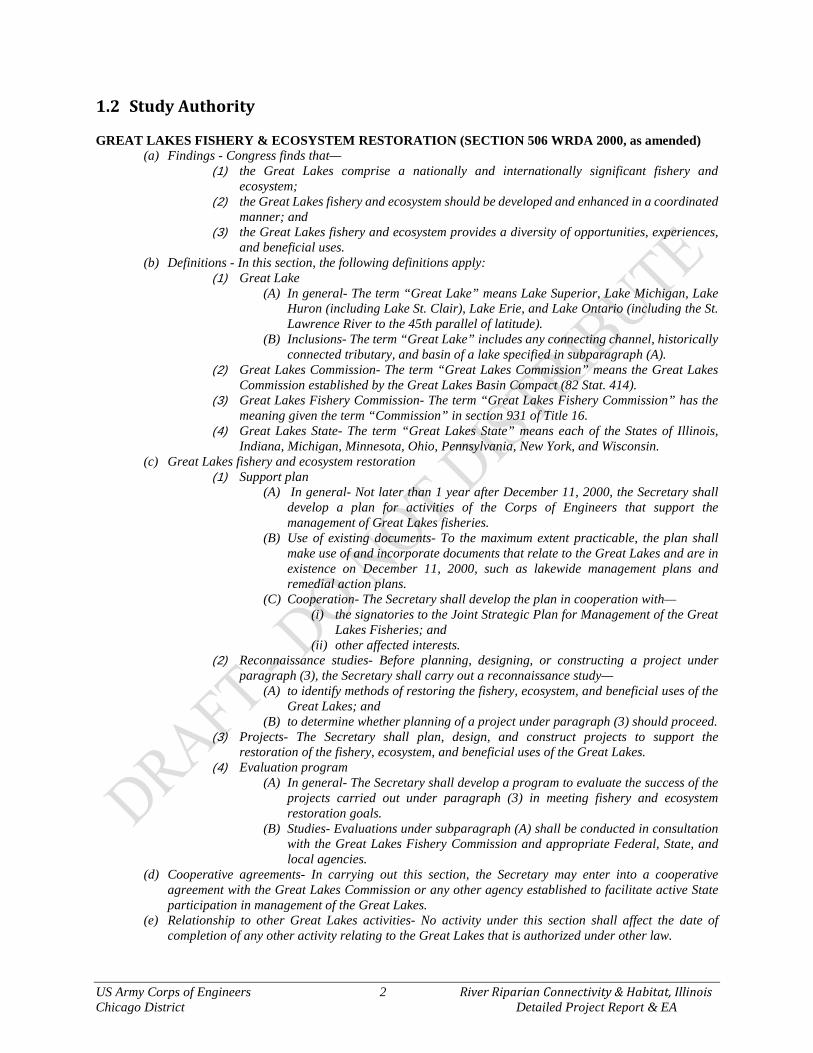
1.2 Study Authority GREAT LAKES FISHERY & ECOSYSTEM RESTORATION (SECTION 506 WRDA 2000, as amended)
(a) Findings - Congress finds that— (1) the Great Lakes comprise a nationally and internationally significant fishery and
ecosystem; (2) the Great Lakes fishery and ecosystem should be developed and enhanced in a coordinated
manner; and (3) the Great Lakes fishery and ecosystem provides a diversity of opportunities, experiences,
and beneficial uses. (b) Definitions - In this section, the following definitions apply:
(1) Great Lake (A) In general- The term “Great Lake” means Lake Superior, Lake Michigan, Lake
Huron (including Lake St. Clair), Lake Erie, and Lake Ontario (including the St. Lawrence River to the 45th parallel of latitude).
(B) Inclusions- The term “Great Lake” includes any connecting channel, historically connected tributary, and basin of a lake specified in subparagraph (A).
(2) Great Lakes Commission- The term “Great Lakes Commission” means the Great Lakes Commission established by the Great Lakes Basin Compact (82 Stat. 414).
(3) Great Lakes Fishery Commission- The term “Great Lakes Fishery Commission” has the meaning given the term “Commission” in section 931 of Title 16.
(4) Great Lakes State- The term “Great Lakes State” means each of the States of Illinois, Indiana, Michigan, Minnesota, Ohio, Pennsylvania, New York, and Wisconsin.
(c) Great Lakes fishery and ecosystem restoration (1) Support plan
(A) In general- Not later than 1 year after December 11, 2000, the Secretary shall develop a plan for activities of the Corps of Engineers that support the management of Great Lakes fisheries.
(B) Use of existing documents- To the maximum extent practicable, the plan shall make use of and incorporate documents that relate to the Great Lakes and are in existence on December 11, 2000, such as lakewide management plans and remedial action plans.
(C) Cooperation- The Secretary shall develop the plan in cooperation with— (i) the signatories to the Joint Strategic Plan for Management of the Great
Lakes Fisheries; and (ii) other affected interests.
(2) Reconnaissance studies- Before planning, designing, or constructing a project under paragraph (3), the Secretary shall carry out a reconnaissance study—
(A) to identify methods of restoring the fishery, ecosystem, and beneficial uses of the Great Lakes; and
(B) to determine whether planning of a project under paragraph (3) should proceed. (3) Projects- The Secretary shall plan, design, and construct projects to support the
restoration of the fishery, ecosystem, and beneficial uses of the Great Lakes. (4) Evaluation program
(A) In general- The Secretary shall develop a program to evaluate the success of the projects carried out under paragraph (3) in meeting fishery and ecosystem restoration goals.
(B) Studies- Evaluations under subparagraph (A) shall be conducted in consultation with the Great Lakes Fishery Commission and appropriate Federal, State, and local agencies.
(d) Cooperative agreements- In carrying out this section, the Secretary may enter into a cooperative agreement with the Great Lakes Commission or any other agency established to facilitate active State participation in management of the Great Lakes.
(e) Relationship to other Great Lakes activities- No activity under this section shall affect the date of completion of any other activity relating to the Great Lakes that is authorized under other law.

US Army Corps of Engineers 3 River Riparian Connectivity & Habitat, Illinois Chicago District Detailed Project Report & EA
(f) Cost sharing (1) Development of plan- The Federal share of the cost of development of the plan under
subsection (c)(1) of this section shall be 65 percent. (2) Project planning, design, construction, and evaluation- Except for reconnaissance studies,
the Federal share of the cost of planning, design, construction, and evaluation of a project under paragraph (3) or (4) of subsection (c) of this section shall be 65 percent.
(3) Non-Federal share (A) Credit for land, easements, and rights-of-way- The Secretary shall credit the non-
Federal interest for the value of any land, easement, right-of-way, dredged material disposal area, or relocation provided for carrying out a project under subsection (c)(3) of this section.
(B) Form- The non-Federal interest may provide up to 100 percent of the non-Federal share required under paragraphs (1) and (2) in the form of services, materials, supplies, or other in-kind contributions.
(4) Operation and maintenance- The operation, maintenance, repair, rehabilitation, and replacement of projects carried out under this section shall be a non-Federal responsibility.
(5) Non-Federal interests- In accordance with section 1962d-5b of this title, for any project carried out under this section, a non-Federal interest may include a private interest and a nonprofit entity.
(g) Authorization of appropriations (1) Development of plan- There is authorized to be appropriated for development of the plan
under subsection (c)(1) of this section $300,000. (2) Other activities- There is authorized to be appropriated to carry out paragraphs (2) and
(3) of subsection (c) of this section $100,000,000. 1.3 Study Purpose & Need This report documents whether or not a project is warranted for Federal participation based on a feasibility level assessment of estimated costs, potential benefits, and possible environmental impacts of various alternatives, all of which follow the US Army Corps of Engineers (USACE) planning and policy guidelines. The main purpose of the DPR is to recommend a plan, including consideration of the No Action Plan, for ecological restoration of this Chicago River study area. By restoring riverine and connecting habitats, this project could provide essential life history requirements for residential, transient and migratory fish and wildlife within a highly urbanized area. If an alternative is found to be worth the investment, the next steps would include the signing of a Project Partnership Agreement (PPA) and the development of a contract set of Plans and Specifications (P&S). The non-Federal sponsor is the Chicago Park District (CPD) and is coordinating with the Metropolitan Water Reclamation District of Greater Chicago, whom is an involved stakeholder supporting land use change and dam removal on their properties. The CPD is currently implementing an initiative within the City of Chicago to address habitat degradation and connectivity for the purpose of habitat restoration, fish and wildlife recolonization, water quality improvement and natural aesthetics for humans. The CPD has in turn requested that the USACE initiate a study under the Section 506 WRDA 2002, Great Lakes Fishery & Ecosystem Restoration authority to ascertain the feasibility of restoring important riverine habitat within the Chicago River. The need for riverine ecosystem restoration of the study area is based on habitat, organism and water quality studies conducted by state, regional and local agencies and groups, that have shown over the decades, the impairments caused to fish, wildlife and other natural resources.
US Army Corps of Engineers 4 River Riparian Connectivity & Habitat, Illinois Chicago District Detailed Project Report & EA
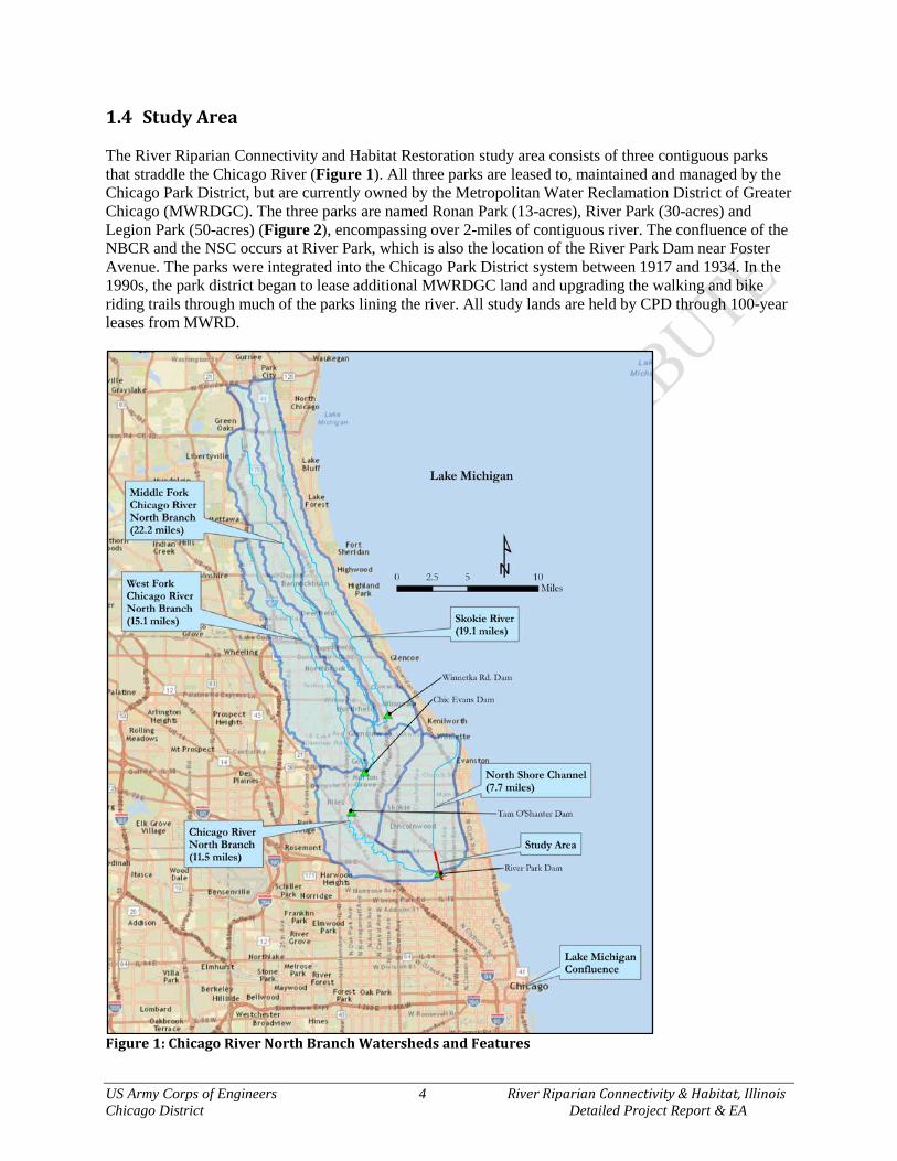
1.4 Study Area The River Riparian Connectivity and Habitat Restoration study area consists of three contiguous parks that straddle the Chicago River (Figure 1). All three parks are leased to, maintained and managed by the Chicago Park District, but are currently owned by the Metropolitan Water Reclamation District of Greater Chicago (MWRDGC). The three parks are named Ronan Park (13-acres), River Park (30-acres) and Legion Park (50-acres) (Figure 2), encompassing over 2-miles of contiguous river. The confluence of the NBCR and the NSC occurs at River Park, which is also the location of the River Park Dam near Foster Avenue. The parks were integrated into the Chicago Park District system between 1917 and 1934. In the 1990s, the park district began to lease additional MWRDGC land and upgrading the walking and bike riding trails through much of the parks lining the river. All study lands are held by CPD through 100-year leases from MWRD.
Figure 1: Chicago River North Branch Watersheds and Features

US Army Corps of Engineers 5 River Riparian Connectivity & Habitat, Illinois Chicago District Detailed Project Report & EA
Figure 2: Study Area Parks (Legion, River & Ronan) and Nearby In-Progress Projects

US Army Corps of Engineers 6 River Riparian Connectivity & Habitat, Illinois Chicago District Detailed Project Report & EA
1.5 Prior Studies & Projects This section summarizes the studies, reports and nearby projects that are pertinent to this study.
1.5.1 Pertinent Reports & Studies City of Chicago, Department of Planning & Development. 1999. Chicago River Corridor
Development Plan. The framework for the revitalization of the Chicago River is provided by the Chicago River Corridor Development Plan. The five goals of the plan are to:
1. Create a connected greenway along the river with continuous multi-use paths along at least one side.
2. Increase public access to the river through the creation of overlooks and public parks. 3. Restore and protect landscaping and natural habitats along the river, particularly fish habitat. 4. Develop the river as a recreational amenity, attracting tourists and enhancing Chicago’s image as
a desirable place to live, work, and visit. 5. Encourage economic development compatible with the river as an environmental and recreational
amenity. Approved by the Chicago Plan Commission in 1998, the plan sets forth a shared vision for the river and outlines specific recommendations for public and private land and presents strategies for preserving and enhancing the river's natural areas. City of Chicago, Department of Planning & Development. 2006. Chicago Nature & Wildlife
Plan. The Chicago Nature and Wildlife Plan and its associated Chicago Nature Areas Directory identifies more than 4,800 acres of prairies, savannas, dunes, woodlands, wetlands and potential restoration areas at 98 sites throughout Chicago. As the first plan of its kind in Chicago's history, the Nature and Wildlife plan established a framework to protect and expand ecosystems for the benefit of wildlife and people. The original plan was adopted by Chicago Plan Commission, the Chicago Park District and the Forest Preserve District of Cook County in 2006. The "Chicago Nature and Wildlife Plan Update: A Strategy to Enhance Urban Ecosystems (2011-2016)" was produced by the Mayor's Nature and Wildlife Advisory Committee to continue Chicago's commitment to expand and improve our important urban natural areas. The plan update reviews progress made since the original plan and sets priorities for the next five years. Friends of the Chicago River. 2006. North Branch Dam Fish Passage Alternatives Assessment
Report. Completed by Montgomery Watson Harza. This study was scoped to be performed in three phases: (1) assess the habitat and fish communities upstream and downstream of the Dam to determine if a fish passage facility would benefit the North Branch fish communities; (2) analyze the channel hydraulics; and (3) evaluate up to three fish passage facility alternatives. The results of the first phase of this study surmised that the Dam currently represents a barrier to connectivity of fish populations in the North Branch, and that removal of this barrier could benefit fish populations. In turn, this report contains the results of the second and third study phases, and references the first phase.
US Army Corps of Engineers 7 River Riparian Connectivity & Habitat, Illinois Chicago District Detailed Project Report & EA
MWRDGC. 2009. Design and Modeling of a Combined Canoe Chute/Fish Passage for the North
Branch Dam, Chicago, Illinois. An integrated canoe chute/fish passage design was recommended for the site. The canoe chute is comprised of four drop structures that provide a gradual transition between the upstream and downstream portions of the dam. A 1:20 scale physical model of the NBCR system in the vicinity of the River Park Dam was built in the Ven Te Chow Hydrosystems Laboratory of the University of Illinois’ Department of Civil and Environmental Engineering. The purpose of the physical model, supplemented by computational fluid dynamics modeling, is to verify the safety of the proposed boat chute for the range of design flows while also providing insight into the effect the proposed structure will have on the overall flow patterns observed in the vicinity of the dam. Modeling results indicate that the canoe chute should be safe for boater use for the full range of design discharges, with flows over the River Park Dam ranging from 30 – 223 cfs. Illinois Environmental Protection Agency. 2008. North Branch Chicago River Watershed: TMDL
Stage 1 Report Provides this study with pertinent inventory topics of land use, soils, geology, topography, population, hydrology and hydraulic structures. Also provides information on water quality studies within the watershed. USACE, Chicago District. 2013. North Branch of the Chicago River Dams – Forest Preserve
District of Cook County Section 22 Planning Assistance to States. The purpose of this study was to provide planning assistance (planning level engineering and scientific information) to the Forest Preserve District of Cook County on the feasibility of dam removal to begin defragmentation of the NBCR. The study focused on engineering, environmental considerations, and ecological benefits for practical dam removal. The dam removal plans provided are being utilized by the FPDCC and the ILDNR to obtain permits, comply with environmental laws & regulations, and ultimately remove the three dams. The three dams (Winnetka Road, Chic Evans Golf Course and Tam O’Shanter Golf Course Dams, see Figure 1) to be removed are diminutive in nature and primarily prevent the passage of riverine fishes and are hazardous to canoes and paddlers.
1.5.2 Pertinent Projects USACE, Chicago. 2015. Eugene Field Section 206 Aquatic Ecosystem Restoration – This ecosystem restoration project was completed in 2015 and is now maintained by the CPD and enrolled in their Natural Areas Program (see Figure 2). About 8-acres of stream (NBRC), marsh, wet prairie and savanna were restored. There are currently over 100 native plants species and a multitude of wildlife species; a few of these are White River Crayfish, Muskrat, Great Blue Heron, Little Green Heron, Black-Crown Night-Heron, Song Sparrow, Belted Kingfisher, bees, wasps, hornets, butterflies, skippers, grasshoppers, and leaf hoppers. The site is currently free of invasive and non-native plant species. Some interesting plants doing well at the site include Pickerel Weed, Duck Potato, American Bur-Reed, Rattlesnake Master and White Oak. USACE, Chicago. Horner Park Section 206 Aquatic Ecosystem Restoration – Horner Park lies along the NBCR, bounded by Montrose Avenue to the north, Irving Park Road to the south, the NBCR to the East, and California Ave to the West. The project site encompasses approximately 2,600-feet of riverbank and at some points extends inland about 300-feet, totaling about 14-acres. The CPD is the non-federal sponsor. The objectives of this project include restoring native oak savanna riparian zone with

US Army Corps of Engineers 8 River Riparian Connectivity & Habitat, Illinois Chicago District Detailed Project Report & EA
intermittent wetland pockets at the toe of the gentled banks. The base year of the contract was awarded in 2013 with a four year establishment period thereafter. Geomorphic contouring was completed in November 2014, with planting and plant establishment currently being the main focus. The project naturalized bank geomorphology, added tree snag habitat, removed invasive plant species, and is currently establishing native vegetation to improve fish and other aquatic habitat, while providing the public river access. Chicago Department of Transportation. 2015. Foster Avenue Diversion Tunnel – This City project is currently in design and permitting phase. This project will divert flows greater than the 1% annual chance exceedance flow frequency via an off channel intake and tunnel beneath Foster Avenue to the North Shore Channel. Hydrology and hydraulic modeling completed for this project by the City provided insight into the River Park Dam, in that it has no effect on flood stages or attenuation. This project would actually provide a positive benefit to any ecosystem restoration project downstream of Foster Avenue, in that forces within the channel would be lessened by reducing the amount of water flowing through the confined channel. This allows for habitat to become more stable and sustainable in terms of woody debris, perching habitat, riffles, and native vegetation. It would also prevent fish from being blown out of the NBCR and into the NSC.

US Army Corps of Engineers 9 River Riparian Connectivity & Habitat, Illinois Chicago District Detailed Project Report & EA
CHAPTER 2 – STUDY AREA INVENTORY & FORECASTING The purpose of this step of the planning process is to develop an inventory and forecast of critical resources (physical, environmental, social, etc.) relevant to the problems and opportunities under consideration in the planning area. This information is used to define and characterize the problems and opportunities. A quantitative and qualitative description of these resources is made, for both current and future conditions, and is used to define existing and future without-project conditions. Existing (EX) conditions are those at the time the study is conducted. The forecast of the future without-project (FWOP) condition reflects the conditions expected during the period of analysis. The future without-project condition provides the basis from which alternative plans are formulated and impacts are assessed. Since impact assessment is the basis for plan evaluation, comparison and selection, clear definition and full documentation of the without-project condition are essential. Gathering information about historic and existing conditions requires an inventory. Gathering information about potential future conditions requires forecasts, which should be made for selected years over the period of analysis to indicate how changes and other conditions are likely to have an impact on problems and opportunities. Information gathering and forecasts will continue throughout the planning process. As such, Chapter 2 contains the following: An inventory of relevant historic conditions; An inventory of relevant current conditions and the studies that have been completed to identify
those conditions; and A forecast of future without-project conditions.
2.1 Historic Setting Chicago’s natural environment has undergone many changes since the glaciers retreated about 14,000 years ago. More than 90 percent of the land within the city limits was formerly lakebed that over centuries evolved into gently rolling grasslands and savannas. At the time of European exploration in the late 1600s, tallgrass prairies and oak savannas characterized the area, with dunes and marsh more prevalent near the lakeshore. Ridges were distinguished by tall grass, wild quinine, and oaks, where swales with cord grass, sweet plantains and wild irises. Slow, shallow sloughs meandered between soggy marsh and drier savanna creating an ever-shifting estuarine habitat mosaic as they flowed into Lake Michigan. With the arrival of permanent settlers in the 1770s, the area’s prairies, savannas, and sloughs underwent numerous changes induced by two centuries of rapid population growth. Prairies were changed to vacant lots between buildings, while woodland areas dwindled to the outskirts of the expanding community. Marshland was drained and filled for new construction. The Chicago and Calumet rivers were dredged, straightened, moved and/or reversed for industrial purposes. The natural shorelines of Lake Michigan and other large hemi-marsh basins were filled with an assortment of waste materials. While the ecosystem, hydrology and natural habitat of Chicago was radically altered and degraded within the last 200 years as a whole, there remain remnant pockets and naturalized ground to restore and preserve. For exampling, looking deep into Eugene Field Park ecosystem restoration project, history still existed. This park was an urban parcel of mixed and disturbed soils, but just inches beneath a surface of discarded yard dirt remained the ancient lacustrine deposits that once formed the base of a once vast wetland system. Eugene Field Park is now a thriving wetland ecosystem once again, and is a living example of what the River Riparian study area could be. Endeavor 2.2 Physical Resources The following provides information pertinent to riverine connectivity and habitat decisions.

US Army Corps of Engineers 10 River Riparian Connectivity & Habitat, Illinois Chicago District Detailed Project Report & EA
2.2.1 Geology & Soils
Geology – The underlying regional bedrock is Silurian-age dolomite, most likely of the Niagaran Series. This rock resulted from marine deposition when all of northeastern Illinois and much of the neighboring Great Lakes region was the floor of a tropical sea from about 440 to 410 million years ago. This formation is the foundations for Great Lakes alvars and reefs. The study area lies over the Dolton Member and Carmi Members of the Equality Formation. These members were derived of shore and shallow-water lake deposits, mostly manifested as low ridges, beaches, bars and spits. The Dolton Member is dominantly sand, but contains pockets of silt, pebbly sand and gravels. The Carmi Member is dominantly lacustrine silts with lenses of clay and/or sand. These glacial materials are for the most part buried within the study area by manmade fills on bank and riparian areas, only being moderately exposed in the bed of the stream and canal channels. Soils – In terms of ecological function, the surficial soils within the study area are considered manmade, and relatively unsuitable for a diverse array of native microbial, plant and insect growth. These soils primarily consist of mixed topsoil, clay, and gravel, and fines derived from urban sources. In addition to ecological function, soils are important for hydrologic and hydraulic functions. The hydrologic soil group classification identifies soil groups with similar infiltration and runoff characteristics during periods of prolonged wetting. Typically, clay soils that are poorly drained have lower infiltration rates, while well-drained sandy soils have the greatest infiltration rates. United States Department of Agriculture (USDA) has defined four hydrologic groups (A, B, C, or D) for soils. Type A soil has high infiltration while D soil has very low infiltration rate. Generally, areas to the east along Lake Michigan have a moderately slow infiltration rate (hydrologic group C) with very poorly drained areas along the western border of the watershed. The central portion of the watershed and to the south has no data due to intense alteration within the city limits of Chicago. Greater detail is provided in IEPA 2008 and Appendix D.
2.2.2 Watershed Hydrography Detailed hydrology, hydraulics and modeling for the North Branch Chicago River (NBCR) may be found in Appendix D. The following provides information pertinent to riverine connectivity and habitat decisions.
Climate & Precipitation The climate of the NBCR watershed is predominantly continental, which is influenced by Lake Michigan moderating temperature extremes. Weather patterns significantly affect conditions within the watershed, as they dictate the frequency and timing of precipitation and subsequent flood pulses. Because more than half of the rainfall occurs from May to September, flood events in the watershed are more likely to occur during that time. Flood events in the watershed are also common in late winter through early spring during major snowmelts and/or rain events when the ground is still frozen (IEPA 2008). In winter, total snowfall is generally heavy with an average annual snowfall of approximately 37.5 inches. The average winter temperature is 25°F with an average daily minimum of 17°F. The average summer temperature is 71°F with an average daily maximum of 81°F. Average annual precipitation is approximately 33 inches.
US Army Corps of Engineers 11 River Riparian Connectivity & Habitat, Illinois Chicago District Detailed Project Report & EA
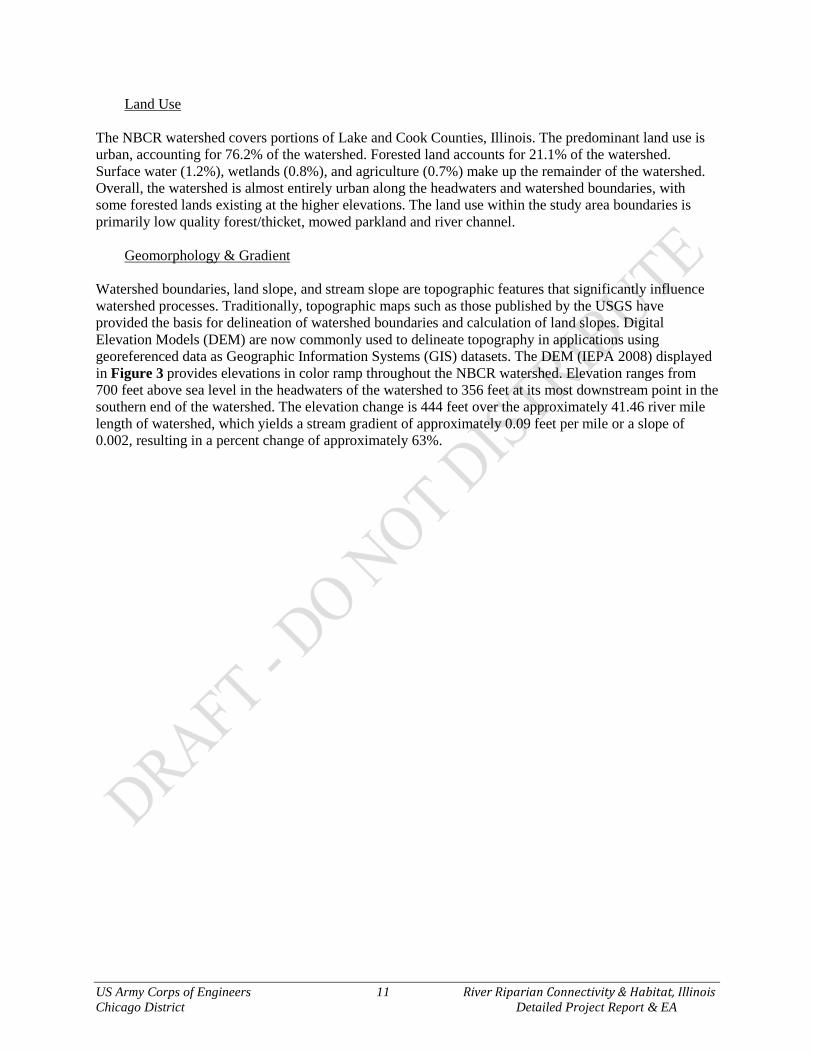
Land Use The NBCR watershed covers portions of Lake and Cook Counties, Illinois. The predominant land use is urban, accounting for 76.2% of the watershed. Forested land accounts for 21.1% of the watershed. Surface water (1.2%), wetlands (0.8%), and agriculture (0.7%) make up the remainder of the watershed. Overall, the watershed is almost entirely urban along the headwaters and watershed boundaries, with some forested lands existing at the higher elevations. The land use within the study area boundaries is primarily low quality forest/thicket, mowed parkland and river channel.
Geomorphology & Gradient Watershed boundaries, land slope, and stream slope are topographic features that significantly influence watershed processes. Traditionally, topographic maps such as those published by the USGS have provided the basis for delineation of watershed boundaries and calculation of land slopes. Digital Elevation Models (DEM) are now commonly used to delineate topography in applications using georeferenced data as Geographic Information Systems (GIS) datasets. The DEM (IEPA 2008) displayed in Figure 3 provides elevations in color ramp throughout the NBCR watershed. Elevation ranges from 700 feet above sea level in the headwaters of the watershed to 356 feet at its most downstream point in the southern end of the watershed. The elevation change is 444 feet over the approximately 41.46 river mile length of watershed, which yields a stream gradient of approximately 0.09 feet per mile or a slope of 0.002, resulting in a percent change of approximately 63%.
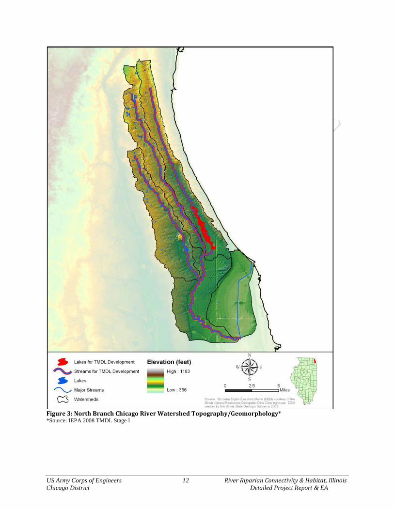
US Army Corps of Engineers 12 River Riparian Connectivity & Habitat, Illinois Chicago District Detailed Project Report & EA
Figure 3: North Branch Chicago River Watershed Topography/Geomorphology* *Source: IEPA 2008 TMDL Stage I

US Army Corps of Engineers 13 River Riparian Connectivity & Habitat, Illinois Chicago District Detailed Project Report & EA
Hydrology & Hydraulics Understanding how water moves and flows is an important component of understanding riverine ecosystem conditions. All of the parameters listed in the previous sections (i.e. topography, soils, and precipitation) impact hydrology and ecosystem parameters as well. Hydrology refers to the way that water behaves from its origins as precipitation, through its movement on or beneath the surface of the earth, to its entry into sewers, streams, lakes, oceans and its eventual return to the atmosphere. More specifically for the Chicago River, a hydrological assessment can model how much precipitation falls in the watershed, what volume ends up in the river and the rate that it is discharged at critical locations. Hydraulics addresses how water flows over the land surface, within sewers and stream channels, over and under bridges and dams and through culverts, wetlands, lakes and impoundments. Prior to extensive land settlement, most of the precipitation was intercepted by vegetation and was additionally stored in the ground, wetlands and floodplains. Under natural conditions the former marsh-like river channels within the watershed had less water to transport and more space to expend flood energies. In the late 1800s and early 1900s, wetlands and other poorly drained lands in the watershed were tiled to improve drainage for agriculture. The channels of the river were subsequently straightened and deepened in the early 1900s to better collect and transport the increased drainage from the land. Urbanization of the watershed throughout the 1900s has resulted in additional improved drainage to the land, and watershed hydrology continues to change as farmland and open space is converted to residences and businesses. Like many other urban watersheds, large-scale drainage of wetlands, substantial increases in impervious surface, and drain tile and storm sewer drainage improvements in the NBCR have resulted in a watershed with an extremely flashy hydrology and very little stormwater storage capacity. A “flashy” hydrology means that the water level in the river goes up very quickly during a storm and down quickly afterward. The City of Chicago is planning and designing the Albany Tunnel Project to alleviate minor flooding in the Albany Park neighborhood. This would aid in reducing flashiness and high velocities within the study reach. Hydrological data available from the USGS Water Data website (http://waterdata.usgs.gov/nwis/rt) are presented below. Table 1 lists the gages operating within the NBCR watershed. The gage at Albany Avenue (05536105) is the closest and most indicative of the River Riparian study area. The streamflow and hydrological information is important for certain riverine habitat parameters and native plant community delineation. Table 1: Existing Stream Flow Gauges on NBCR.
USGS Gage Location Drainage Area Date Begin 5536101 NSC Wilmette NA 1996 5534500 NBCR at Deerfield 19.7 1951 5535000 Skokie River at Lake Forest 13 1951 5535070 Skokie River Near Highland Park 21.1 1966 5535500 West Fork NBCR at Northbrook 11.5 1952 5536000 NBCR at Niles 100 1950 5536105 NBCR at Albany Park 113 1989 5536118 NBCR at Grand Ave. 179 2002
US Army Corps of Engineers 14 River Riparian Connectivity & Habitat, Illinois Chicago District Detailed Project Report & EA
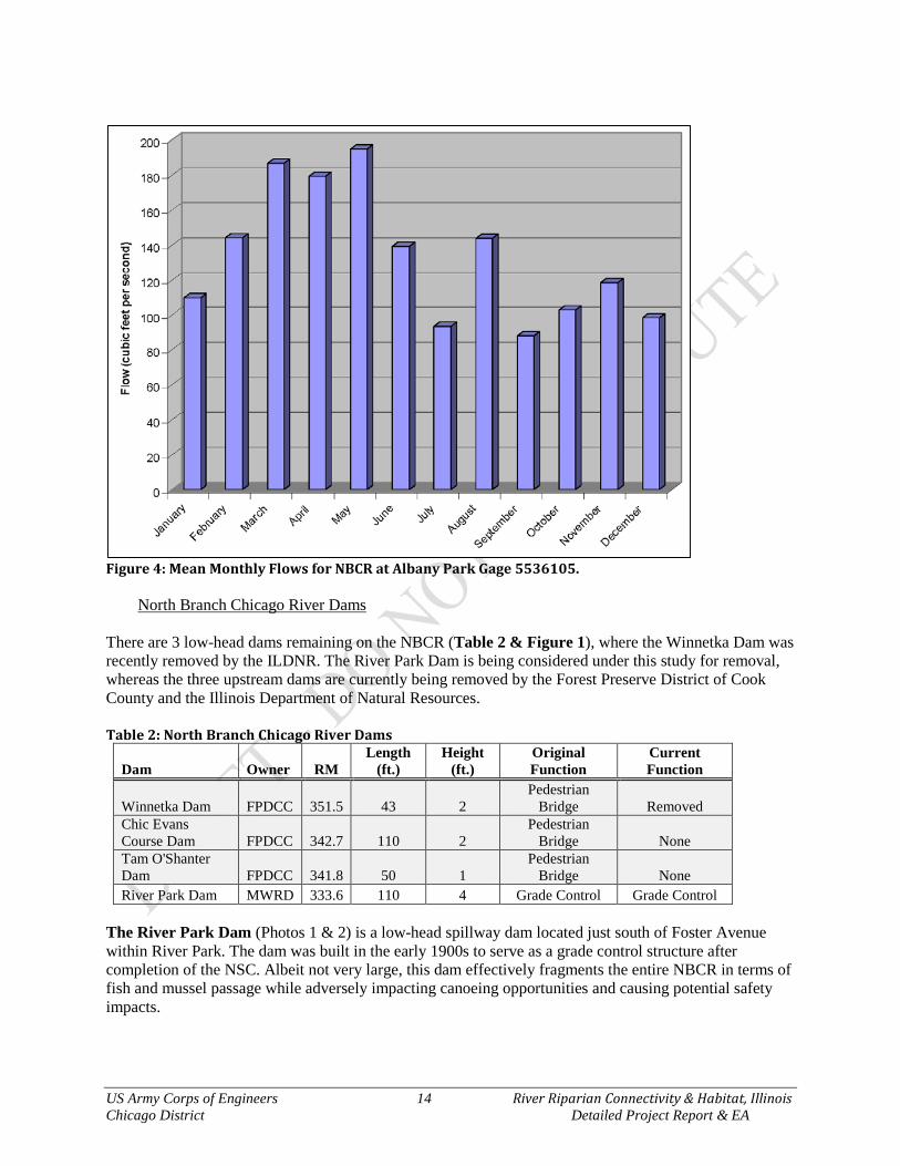
Figure 4: Mean Monthly Flows for NBCR at Albany Park Gage 5536105.
North Branch Chicago River Dams There are 3 low-head dams remaining on the NBCR (Table 2 & Figure 1), where the Winnetka Dam was recently removed by the ILDNR. The River Park Dam is being considered under this study for removal, whereas the three upstream dams are currently being removed by the Forest Preserve District of Cook County and the Illinois Department of Natural Resources. Table 2: North Branch Chicago River Dams
Dam Owner RM Length
(ft.) Height
(ft.) Original Function
Current Function
Winnetka Dam FPDCC 351.5 43 2 Pedestrian
Bridge Removed Chic Evans Course Dam FPDCC 342.7 110 2
Pedestrian Bridge None
Tam O'Shanter Dam FPDCC 341.8 50 1
Pedestrian Bridge None
River Park Dam MWRD 333.6 110 4 Grade Control Grade Control The River Park Dam (Photos 1 & 2) is a low-head spillway dam located just south of Foster Avenue within River Park. The dam was built in the early 1900s to serve as a grade control structure after completion of the NSC. Albeit not very large, this dam effectively fragments the entire NBCR in terms of fish and mussel passage while adversely impacting canoeing opportunities and causing potential safety impacts.

US Army Corps of Engineers 15 River Riparian Connectivity & Habitat, Illinois Chicago District Detailed Project Report & EA
Photo 1: River Park Dam Looking Downstream
Photo 2: River Park Dam Looking Upstream
2.2.3 Water Quality The Illinois Environmental Protection Agency (IEPA) annually collects chemical, physical, biological, habitat and toxicity data on rivers and streams, inland lakes, Lake Michigan and groundwater to satisfy reporting requirements found in Section 305(b) of the Federal Clean Water Act (CWA). The primary purpose of the Section 305(b) process is to provide for an assessment of the overall water quality conditions of Illinois waters. Most portions of the Chicago River are classified as a general use water body, which indicates the water quality should be protected to support aquatic life, wildlife, agricultural, primary, or secondary contact, and most industrial uses (IEPA 2012). The river has been assessed for aquatic life use, fish consumption, and primary contact based on site-specific physical and chemical data, fish tissue analysis, intensive integrated field surveys, and other recent data. Illinois Environmental Protection Agency (IEPA) water quality sampling site IL_HCC-07 (downstream of dam) is the closest to the study area. Based on the data collected at this site, the NBCR is not supported

US Army Corps of Engineers 16 River Riparian Connectivity & Habitat, Illinois Chicago District Detailed Project Report & EA
in this reach for aquatic life, fish consumption, and primary contact. Causes may include out of balance parameters including chlorine, fecal coliform, dissolved oxygen and pH, total phosphorus, dissolved solids. Potential sources of impairment include municipal point sources, urban runoff/storm sewers, combined sewer overflows, highway/road/bridge runoff, and hydromodifications such as streambank modifications/destabilization, channelization, the River Park dam and a concrete paved channel.
2.2.4 Sediment (Substrate) Types & Quality Sediment and substrates were investigated behind the River Park Dam on 03 September 2015 during habitat data collection for the Qualitative Habitat Evaluation Index (QHEI). A Depth of Refusal survey was planned to determine the volume of sediment trapped or attenuated by the dam, but upon entering the river directly above the dam, it was quite apparent that the entire channel is lined with concrete. Cracks, fissures and non-conformities in the concrete channel were collecting alluvium from upstream sources, which were primarily small gravels of both natural glacial materials and quarried limestone riprap. Based on the QHEI assessment for the reach, substrates were 100% concrete for pool zones and about 75% concrete, 15% gravel, and 10% sand for the riffle. The sediment and substrate for other project areas were not investigated due to potential project outcomes not affecting this physical resource. It is assumed that sediment and substrate of the NSC and Chicago River navigation channel are primarily silts, clays and sands.
2.2.5 HTRW Assessment USACE conducted a Phase I Environmental Site Assessment (ESA) in accordance with ASTM E-1527-13. According to ER 1165-2-132, non-HTRW environmental issues that do not comply with federal, state, and local regulations should be discussed in the HTRW evaluation along with HTRW issues. The HTRW Phase I ESA included in Appendix C was completed using existing information, historical topographic maps and aerial photographs, database research, and a site visit. No HTRW or recognized environmental conditions (RECs) were identified and one non-HTRW issue was identified in the investigation. The banks along the North Shore Channel are steep and any bank grading proposed could generate a significant volume of material that may require on or offsite handling and disposal. There are no indications that the site soils have been impacted by any RECs. A Phase II ESA is not recommended.
2.2.6 Air Quality The study area, in Cook County, Illinois, is within a non-attainment area for lead and ozone. Air quality is not considered to be a major factor in the health of the existing ecosystem. 2.3 Ecological Resources Generally, the Chicago River was once a sluggishly flowing marsh system that supported an immense diversity of plant and animal species. As a natural resource, it provided significant food, clothing, and building tools for American Indians and early settlers. Once the City of Chicago began to develop, the fate of the river was set in that it would soon be transformed into a conduit that would drain the surrounding wetlands and rush away storm and waste waters. The natural and anthropogenic history of the Chicago River is so diverse and rich, whole books have been written about it. The Chicago River by Libby Hill (2000) and A Natural History of the Chicago Region by Joel Greenberg (2002) are excellent resources for those interested in how the Chicago River and its watershed were transformed from its natural ecosystem into the booming city that it is today. The following are aspects within the study area pertinent to potential ecological restoration actions.

US Army Corps of Engineers 17 River Riparian Connectivity & Habitat, Illinois Chicago District Detailed Project Report & EA
2.3.1 Riparian Plant Communities
Photo 3 is indicative of what the study area would have looked like historically (photo by Earl E. Sherff “Vegetation of the Skokie Marsh” early 1900s). The natural condition of the NBCR and its riparian plant communities was a broad, sluggishly flowing marsh system that was confined by the Park Ridge Moraine to the west and the Rose Hill and Graceland sand spits to the east. The marshy plant communities were predominately reeds, sedges, rushes, and other hydrophytic plants. Native shrub patches would form in the slightly higher elevation areas and trees were quite minimal in this ecosystem (Pepoon 1927, Swink & Wilhelm 1994, Libby 2000).
Photo 3: Skokie Marsh in the Early 1900s by Earl E. Sherff (Pepoon 1927) The study area was surveyed for plant community types and species composition in September 2015. Existing wetlands, habitats or land uses were delineated and presented in Figure 5. The Chicago Region Floristic Quality Assessment (FQA) was employed for quantitative evaluations required by this study, which the methodology and application is explained in Section 2.5. Appendix A presents the floristic inventories for floristic species richness and quality expressed via the FQA. The following gives brief summary on the native floral condition within the study area, which are indicative of highly degraded habitats and riparian communities. Canal – The canal communities were devoid of vegetation during the survey. Steep slopes and concrete armoring of the streambanks have prevented any vegetative growth. Stream – The stream community was completely devoid of vegetation during the survey. The concrete lined channel bottom is not currently amenable to supporting vegetation. [Note that the rest of the river is not included in the project; only a small portion of the stream by the dam which is currently concreted.]
US Army Corps of Engineers 18 River Riparian Connectivity & Habitat, Illinois Chicago District Detailed Project Report & EA
River Banks – Most of the river banks in the project area are dominated by non-native invasive brush and a very limited suite of native species. Non-native invasive species such as European Buckthorn (Rhamnus cathartica) and Amur Honeysuckle (Lonicera maackii) have proliferated and are suppressing much of the other vegetative growth. In less invaded areas, common weedy trees such as Box Elder (Acer negundo) and Cottonwood (Populus deltoides) compose the canopy. In very limited areas beneath these trees where a small floodplain shelf exists some moderately conservative species such as sneezeweed (Helenium autumnale), Green-Head Coneflower (Rudbeckia laciniata), and Rice Cut Grass (Leersia oryzoides) were observed. In portions of the project area prior restoration efforts have removed invasive brush from river banks and replaced it with a basic suite of native species and Oak (Quercus spp.) saplings. Park Land – Floristic composition of the park land within the project area varies by its use. A few small areas have been planted to native dominated communities and have a basic suite of native prairie species such as big bluestem (Andropogon gerardii), yellow Indian grass (Sorghastrum nutans), and Oswego tea (Monarda fistulosa) present. Other areas are dominated by Kentucky blue grass lawns (Poa pratensis) with a mix of native and non-native trees.

US Army Corps of Engineers 19 River Riparian Connectivity & Habitat, Illinois Chicago District Detailed Project Report & EA
Figure 5: Existing Study Area Habitats & Land Uses
2.3.2 Riverine Habitat The non-navigation channel portions (above River Park Dam) of the NBCR are typically shallow and range between 30 to 70 feet wide and a couple feet deep, whereas the NSC and navigation portions of the system are about 130 wide and 8 to 10 feet deep. Habitat within the shallow wadeable reach above the dam is a higher quality even though it is lined with concrete, since the current configuration provides diverse flow velocities, large woody debris, riffle/pool features, and more of a natural channel structure. The deep draft portions of the navigation channels are homogenous canals with little to no structure except for the toe of bank zones. Some areas within the navigation channel portion however have shallow bank zones that harbor native and non-native submerged aquatic vegetation, whereas no submerged aquatic vegetation occurs within the concrete channel above the dam. All river reaches within the study area were historically relocated and channelized with no future natural recovery mechanisms. Current primary adverse effects to NBCR riverine habitat within the study area include channelization, confined

US Army Corps of Engineers 20 River Riparian Connectivity & Habitat, Illinois Chicago District Detailed Project Report & EA
channel conditions, dredging, dam placement, concrete channel lining, armoring with riprap, sheet-pile and concrete, non-native riparian tree and shrub species, lack of natural substrates, no sediment transport and various water quality issues.
Photo 4: Stream Channel above River Park Dam A specific habitat investigation was conducted upstream of the River Park Dam on 03 September 2015. The Qualitative Evaluation Habitat Index (QHEI) was employed for quantitative evaluations required for this study, which the methodology and application is explained in Section 2.5. The overarching score of 44 out of 100 indicates a rating of “Poor” riverine habitat. Substrates, in-stream cover, channel morphology, riparian zone, and riffle pool complexes were all found to be degraded.
2.3.3 Aquatic Macroinvertebrates Macroinvertebrates were sampled at various locations within the NBCR in 2005 by the Metropolitan Water Reclamation District of Chicago (MWRDGC) in 2005 (Table 3). Generally, samples yielded a total of 44 taxa and three Ephemeroptera-Plechotpera-Trichoptera (EPT) taxa (conservative groups), with the dominant taxa being tolerant Oligochaeta (highly tolerant). In addition, Caecidotea, Procladius, Pisidium, and Hydra achieved more than five percent of the total density in samples taken. Overall, the benthic community within the NBCR could be characterized as degradation tolerant and moderately stressed based on composition, relative abundance of tolerant taxa, and incidence of deformities (MWRD 2007). Rusty crayfish (Orconectes rusticus) was collected directly above the River Park Dam during 03 September 2015 fish surveys. Various species of Dragonfly (Odanata) and Butterfly (Lepidoptera) were observed flying over the stream as well. Table 3: Macroinvertebrates Collected within 1 mile of the Study Area (MWRD 2005).
Station Name
Taxon
Foster Avenue
Caecidotea Ferrissia Nanocladius distinctus
Chironomidae Gammarus fasciatus Oligochaeta Dicrotendipes simpsoni Glyptotendipes Turbellaria Dreissena polymorpha Helobdella
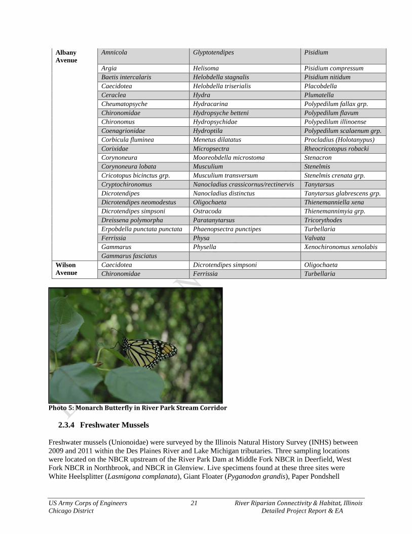
US Army Corps of Engineers 21 River Riparian Connectivity & Habitat, Illinois Chicago District Detailed Project Report & EA
Albany Avenue
Amnicola Glyptotendipes Pisidium
Argia Helisoma Pisidium compressum Baetis intercalaris Helobdella stagnalis Pisidium nitidum Caecidotea Helobdella triserialis Placobdella Ceraclea Hydra Plumatella Cheumatopsyche Hydracarina Polypedilum fallax grp. Chironomidae Hydropsyche betteni Polypedilum flavum Chironomus Hydropsychidae Polypedilum illinoense Coenagrionidae Hydroptila Polypedilum scalaenum grp. Corbicula fluminea Menetus dilatatus Procladius (Holotanypus) Corixidae Micropsectra Rheocricotopus robacki Corynoneura Mooreobdella microstoma Stenacron Corynoneura lobata Musculium Stenelmis Cricotopus bicinctus grp. Musculium transversum Stenelmis crenata grp. Cryptochironomus Nanocladius crassicornus/rectinervis Tanytarsus Dicrotendipes Nanocladius distinctus Tanytarsus glabrescens grp. Dicrotendipes neomodestus Oligochaeta Thienemanniella xena Dicrotendipes simpsoni Ostracoda Thienemannimyia grp. Dreissena polymorpha Paratanytarsus Tricorythodes Erpobdella punctata punctata Phaenopsectra punctipes Turbellaria Ferrissia Physa Valvata Gammarus Physella Xenochironomus xenolabis Gammarus fasciatus Wilson Avenue
Caecidotea Dicrotendipes simpsoni Oligochaeta Chironomidae Ferrissia Turbellaria
Photo 5: Monarch Butterfly in River Park Stream Corridor
2.3.4 Freshwater Mussels Freshwater mussels (Unionoidae) were surveyed by the Illinois Natural History Survey (INHS) between 2009 and 2011 within the Des Plaines River and Lake Michigan tributaries. Three sampling locations were located on the NBCR upstream of the River Park Dam at Middle Fork NBCR in Deerfield, West Fork NBCR in Northbrook, and NBCR in Glenview. Live specimens found at these three sites were White Heelsplitter (Lasmigona complanata), Giant Floater (Pyganodon grandis), Paper Pondshell

US Army Corps of Engineers 22 River Riparian Connectivity & Habitat, Illinois Chicago District Detailed Project Report & EA
(Uterbackia imbecillis), Fat Mucket (Lampsillis siliquoidea), and Lilliput (Toxolasma parvum). All of these mussel species are indicative of low gradient, silty habitats.
2.3.5 Fishes Generally, the fish assemblage within the North Branch Chicago River contains a wide array of tolerant to intolerant species. Areas within the study area are likely to contain a combination of both types of species as Cook County has both good and poor habitat reaches. The potential for fishes to utilize restored habitat can be put into context by observing the data of fish collections within the study area (Table 4). All collections within a ~10-mile radius of the study area and all collections from the NBCR were queried from the Fishes of Chicago Region Database. Forty-three (43) collections were made between 1939 and 2009 above the Foster Avenue dam and 55 collections between 1976 and 2014 below the dam, which reveal that 35 native fish species have the potential to utilize restored habitat within the 2-mile reach of the NBCR and NSC. Of the 35 native species, 14 are sensitive species, intolerant of high human disturbance and mainly found below the River Park Dam. This suggests that the dam is impeding movement of sensitive fish species that were once wiped out of the upstream reaches. The Longnose Dace (Rhinichthys cataractae) recorded by Veraldi & Taylor (2004) is a sensitive lake and stream species that requires fast flowing or highly turbulent water. The Spotted Gar (Lepisosteus oculatus) was recorded 22 September 2014 by the Illinois DNR (Jakubicek) and is the first Spotted Gar from Lake Michigan waters within Illinois. A specific fishes investigation was conducted upstream of the River Park Dam on 03 September 2015. The entire 520 foot reach from the River Park footbridge to the River Park Dam was backpack electrofished. No fishes were gathered or observed. It was observed that below the dam, many herons and fish eating birds were hunting. This is typical for a dam to trap fishes attempting to move upstream, where fish eating birds and humans can easily harvest them.
Photo 6: Spotted Gar Collected in the NSC 22 September 2014, ILDNR. Table 4: Fishes Recorded between 1939 and 2014 above and below the River Park Dam.
Common Name Species Above Dam
Below Dam Potential Restored Habitat Use
Alewife Alosa pseudoharengus X no effect Rockbass Ambloplites rupestris X hunting
US Army Corps of Engineers 23 River Riparian Connectivity & Habitat, Illinois Chicago District Detailed Project Report & EA
Black Bullhead Ameiurus melas X X forage/spawning Yellow Bullhead Ameiurus natalis X X forage/spawning Goldfish Carassius auratus X X negligible in system; minor herbivory White Sucker Catostomus commersonii X X forage/spawning Brook Stickleback Culaea inconstans X forage/spawning Spotfin Shiner Cyprinella spiloptera X X forage/spawning Common Carp Cyprinus carpio X X destructive herbivory Gizzard Shad Dorosoma cepedianum X X no effect Grass Pickerel Esox americanus X hunting/spawning/nursery Northern Pike Esox lucius X hunting/spawning/nursery Blackstripe Topminnow Fundulus notatus X X forage/spawning Mosquito Fish Gambusia affinis X forage/spawning Channel Catfish Ictalurus punctatus X hunting Black Buffalo Ictiobus niger X forage/spawning Brook Silverside Labidesthes sicculus X forage/spawning Spotted Gar Lepisosteus oculatus X hunting/spawning/nursery Green Sunfish Lepomis cyanellus X X no effect Pumpkinseed Lepomis gibbosus X X forage/spawning Warmouth Lepomis gulosus X hunting/spawning/nursery Orangespotted Sunfish Lepomis humilis X X forage/spawning Bluegill Lepomis macrochirus X X no effect Smallmouth Bass Micropterus dolomieu X hunting Largemouth Bass Micropterus salmoides X X hunting/spawning/nursery Oriental Weatherfish Misgurnus anguillicaudatus X no effect White Perch Morone americana X no effect White Bass Morone chrysops X hunting Round Goby Neogobius melanostomus X no effect Golden Shiner Notemigonus crysoleucas X X forage/spawning Emerald Shiner Notropis atherinoides X forage/spawning Spottail Shiner Notropis hudsonius X forage/spawning Sand Shiner Notropis stramineus X X forage/spawning Coho Salmon Oncorhynchus kisutch X no effect Chinook Salmon Oncorhynchus tshawytscha X no effect Rainbow Smelt Osmerus mordax X no effect Yellow Perch Perca flavescens X forage/spawning/nursery Log Perch Percina caprodes X extirpated Blackside Darter Percina maculata X forage/spawning Bluntnose Minnow Pimephales notatus X X forage/spawning Fathead Minnow Pimephales promelas X X forage/spawning Black Crappie Pomoxis nigromaculatus X X forage/spawning Longnose Dace Rhinichthys cataractae X forage/spawning European Brown Trout Salmo trutta X no effect Central Mudminnow Umbra limi X spawning/forage/nursery
2.3.6 Reptiles & Amphibians
A list of reptiles and amphibians was assembled utilizing publications and available data that are known to occur within the watershed and have potential to occur within the study area. Amphibian and reptile habitat is much degraded or non-extant within the study except for those common and tolerant species. The most abundant riverine reptiles and amphibians within the NBCR include, but are not limited to:
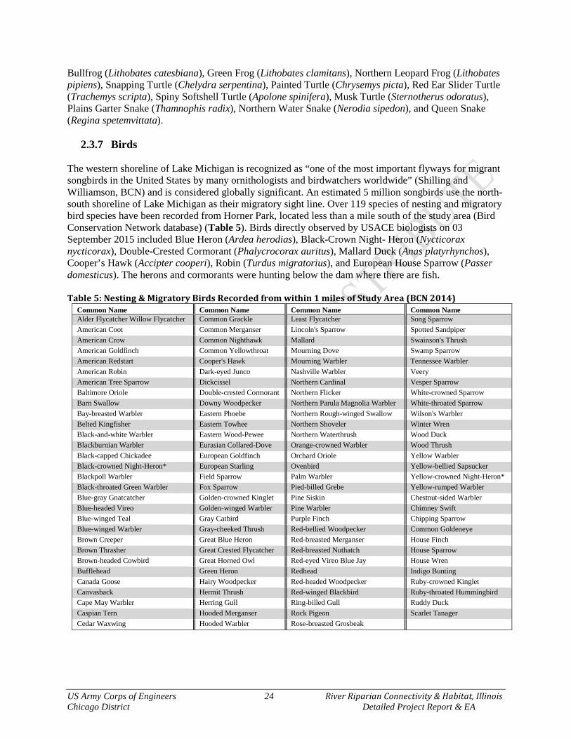
US Army Corps of Engineers 24 River Riparian Connectivity & Habitat, Illinois Chicago District Detailed Project Report & EA
Bullfrog (Lithobates catesbiana), Green Frog (Lithobates clamitans), Northern Leopard Frog (Lithobates pipiens), Snapping Turtle (Chelydra serpentina), Painted Turtle (Chrysemys picta), Red Ear Slider Turtle (Trachemys scripta), Spiny Softshell Turtle (Apolone spinifera), Musk Turtle (Sternotherus odoratus), Plains Garter Snake (Thamnophis radix), Northern Water Snake (Nerodia sipedon), and Queen Snake (Regina spetemvittata).
2.3.7 Birds The western shoreline of Lake Michigan is recognized as “one of the most important flyways for migrant songbirds in the United States by many ornithologists and birdwatchers worldwide” (Shilling and Williamson, BCN) and is considered globally significant. An estimated 5 million songbirds use the north-south shoreline of Lake Michigan as their migratory sight line. Over 119 species of nesting and migratory bird species have been recorded from Horner Park, located less than a mile south of the study area (Bird Conservation Network database) (Table 5). Birds directly observed by USACE biologists on 03 September 2015 included Blue Heron (Ardea herodias), Black-Crown Night- Heron (Nycticorax nycticorax), Double-Crested Cormorant (Phalycrocorax auritus), Mallard Duck (Anas platyrhynchos), Cooper’s Hawk (Accipter cooperi), Robin (Turdus migratorius), and European House Sparrow (Passer domesticus). The herons and cormorants were hunting below the dam where there are fish. Table 5: Nesting & Migratory Birds Recorded from within 1 miles of Study Area (BCN 2014)
Common Name Common Name Common Name Common Name Alder Flycatcher Willow Flycatcher Common Grackle Least Flycatcher Song Sparrow American Coot Common Merganser Lincoln's Sparrow Spotted Sandpiper American Crow Common Nighthawk Mallard Swainson's Thrush American Goldfinch Common Yellowthroat Mourning Dove Swamp Sparrow American Redstart Cooper's Hawk Mourning Warbler Tennessee Warbler American Robin Dark-eyed Junco Nashville Warbler Veery American Tree Sparrow Dickcissel Northern Cardinal Vesper Sparrow Baltimore Oriole Double-crested Cormorant Northern Flicker White-crowned Sparrow Barn Swallow Downy Woodpecker Northern Parula Magnolia Warbler White-throated Sparrow Bay-breasted Warbler Eastern Phoebe Northern Rough-winged Swallow Wilson's Warbler Belted Kingfisher Eastern Towhee Northern Shoveler Winter Wren Black-and-white Warbler Eastern Wood-Pewee Northern Waterthrush Wood Duck Blackburnian Warbler Eurasian Collared-Dove Orange-crowned Warbler Wood Thrush Black-capped Chickadee European Goldfinch Orchard Oriole Yellow Warbler Black-crowned Night-Heron* European Starling Ovenbird Yellow-bellied Sapsucker Blackpoll Warbler Field Sparrow Palm Warbler Yellow-crowned Night-Heron* Black-throated Green Warbler Fox Sparrow Pied-billed Grebe Yellow-rumped Warbler Blue-gray Gnatcatcher Golden-crowned Kinglet Pine Siskin Chestnut-sided Warbler Blue-headed Vireo Golden-winged Warbler Pine Warbler Chimney Swift Blue-winged Teal Gray Catbird Purple Finch Chipping Sparrow Blue-winged Warbler Gray-cheeked Thrush Red-bellied Woodpecker Common Goldeneye Brown Creeper Great Blue Heron Red-breasted Merganser House Finch Brown Thrasher Great Crested Flycatcher Red-breasted Nuthatch House Sparrow Brown-headed Cowbird Great Horned Owl Red-eyed Vireo Blue Jay House Wren Bufflehead Green Heron Redhead Indigo Bunting Canada Goose Hairy Woodpecker Red-headed Woodpecker Ruby-crowned Kinglet Canvasback Hermit Thrush Red-winged Blackbird Ruby-throated Hummingbird Cape May Warbler Herring Gull Ring-billed Gull Ruddy Duck Caspian Tern Hooded Merganser Rock Pigeon Scarlet Tanager Cedar Waxwing Hooded Warbler Rose-breasted Grosbeak
US Army Corps of Engineers 25 River Riparian Connectivity & Habitat, Illinois Chicago District Detailed Project Report & EA
2.3.8 Mammals A list of mammals was assembled utilizing publications and available data that are known to occur within the watershed and have potential to occur within the study area. Large mammal habitat is much degraded or non-extant within the study area; however, White Tail Deer (Odeocoileus viginianus), Coyote (Canis latrans), and Red Fox (Vuples vulpes) make up the large mammal potential for the study area. Small mammals that have the potential to occur within the study area include, but are not limited to Black Rat (Rattus rattus), Norwegian Rat (Rattus norvegicus), Gray Squirrel (Sciurus carolinensis), Opposum (Didelphis viginana), Beaver (Castor canadensis), Woodchuck (Marmota monax), Muskrat (Onodontra zibethica), Eastern Cotton Tail (Sylvagius flordianus), Raccoon (Procyon lotor), Mink (Mustela vision), Little Brown Bat (Myotis lucifuga), Brown Bat (Eptesicus fuscus), and Silver Haired Bat (Lasionycteris noctivagans). Mink was observed by Corps biologists swimming in the NSC 03 September 2015.
2.3.9 Threatened and Endangered Species
Federal T&E Species Federally-listed Threatened, Endangered, Proposed and Candidate Species were reviewed for the project area by the Chicago District (http://www.fws.gov/midwest/endangered/section7/index.html). The following federally listed species, status and their critical habitats are identified by the USFWS as occurring within Cook County: Northern long-eared bat (Myotis septentrionalis) – Threatened – Hibernates in caves and mines -
swarming in surrounding wooded areas in autumn. Roosts and forages in upland forests and woods.
Piping Plover (Charadrius melodus) – Endangered – Wide, open, sandy beaches with very little
grass or other vegetation. Eastern Massasauga (Sistrurus catenatus) – Candidate – Graminoid dominated plant communities
(fens, sedge meadows, peatlands, wet prairies, and shrublands). Hine’s Emerald Dragonfly (Somatochlora hineana) – Endangered – Spring fed wetlands, wet
meadows, and marshes. Eastern Prairie Fringed Orchid (Platanthera leucophaea) – Threatened – Moderate to high quality
wetlands, sedge meadow, marsh, and mesic to wet prairie. Leafy-Prairie Clover (Dalea foliosa) – Endangered – Prairie remnants on thin soil over limestone.
Mead’s Milkweed (Asclepias meadii) – Threatened – Late successional tallgrass prairie, tallgrass
prairie converted to hay meadow, and glades or barrens with thin soil. Based on the information listed above and site assessments, federally endangered and threatened species or their critical habitats do not occur within the study area. The study team has coordinated with the U.S. Fish & Wildlife Service and expects concurrence with USACE’s determination of “no effects”.

US Army Corps of Engineers 26 River Riparian Connectivity & Habitat, Illinois Chicago District Detailed Project Report & EA
State T&E Species The Illinois Natural Heritage Database was queried on 16 September 2015 for important resource areas and State Listed Species. An ILDNR EcoCAT #1603286 report was submitted and processed for the study area under investigation within. Boundaries for the report consisted of the park boundaries for River Park, Legion Park and Ronan Park along the North Branch of the Chicago River and North Shore Channel. The EcoCAT report can be found in Appendix A, with the results summarized as follows: The Illinois Natural Heritage Database contains no record of State-listed threatened or endangered species, Illinois Natural Area Inventory sites, dedicated Illinois Nature Preserves, or registered Land and Water Reserves in the vicinity of the project location. Although the EcoCAT report identifies no State T&E species, USACE biologists observed Black-Crown Night-Heron below the River Park Dam hunting. This species’ presence and hunting is ubiquitous throughout the Chicago River system and Lake Michigan shoreline. 2.4 Cultural & Social Resources
2.4.1 Archaeological & Historical Properties The National Register of Historic Places has 321 listings located within the City of Chicago. These include 270 structures and 51 historic districts. Located approximately one half mile to the west of the study area is the Bohemian National Cemetery (listed in 2004) and Eugene Field Park (listed 2006). The Old Main Building at North Park College (listed 1982) just to the west of the project area. To the east of the project area is located the Krause Music Store (listed 2006). To the south of the study area is the Ravenswood manor Historic District (listed 2008). No structures listed on the National Register of Historic Places are located in the immediate project area. Chicago maintains its own list of City Landmarks totaling approximately270 individual structures and 53 historic districts. Many of these landmarks are also on the National Register of Historic Places. The City Landmark closest to the River Riparian project is the Dr. Phillip Weintraub House. No City Landmarks are present in the immediate project area. Ronan Park, River Park, and Legion Park are public parks created through heavy landscape modification that included grading, blading, dredging, and filling to create the current conditions. No intact archaeological deposits are present in any of the project locations. Native American groups with historic ties to the project area will be consulted prior to this project.
2.4.2 Land Use History The River Riparian project area is comprised of three Chicago Park District parks, Legion Park, River Park, and Ronan Park. The city neighborhoods surrounding these parks began as local communities developed by land speculators in the 1890s. In time these communities were all annexed by the City of Chicago.
2.4.3 Social Setting Chicago is located in northeastern Illinois near the southwestern tip of Lake Michigan. Chicago is the third most populous city in the United States with an ethnically and racially diverse population of approximately 2.8 million people. Median household income for the City of Chicago is $43,650 (2010), and the median home cost is $238,567 (2010). Surrounding suburbs include Evanston, Oak Park, Cicero,
US Army Corps of Engineers 27 River Riparian Connectivity & Habitat, Illinois Chicago District Detailed Project Report & EA
and Evergreen Park. Directly surrounding the study area is Albany Park and West Ridge, which have served as gateway communities for waves of foreign middle class immigrants since the 1920s. In contrast, the neighborhoods of North Park and Lincoln Square have remained stable middle-class neighborhoods. An estimated 48,486 people within 1 mile, 335,945 people within 3 miles and 891,142 people within 5 miles of the project that will directly benefit from this restoration
2.4.3 Summary of Native American Coordination The following Native American tribes were contacted by letter date 15 September 2015 regarding the proposed ecosystem restoration along the NBCR and NSC. Tribes contacted by letter included Kickapoo Tribe of Oklahoma, Kickapoo of Kansas, Miami Tribe of Oklahoma, Citizen Potawatomi Nation, Forest County Potawatomi Executive Council, Nottawaseppi Huron Potawatomi Tribal Office, Hannahville Potawatomi Comm., Council, Pokagon Band of Band of Potawatomi Indians, and the Miami Nation in Indiana. No responses were received. Mailing list and coordination letters are provided in Appendix A.
2.4.4 Existing Recreation Types Legion Park – The park’s northern border starts at Peterson Avenue, the southern border ends at Foster Avenue, and its west side abuts Kedzie / Jersey Avenues. This 50-acre park straddles three neighborhoods: West Ridge, Lincoln Square, and North Park. This large park features two junior baseball fields, two play slabs with basketball standards, two tennis courts, four playgrounds, a roller hockey area, a nature area, and a bicycle path. The ornamental fountain and oversized flower beds provides a great backdrop for wedding photos. There are no structured programs at this park. River Park – Located at the convergence of the Chicago River and canal, River Park offers wildlife habitat, excellent fishing and a canoe launch. River Park boasts a swimming pool and an interactive water playground in the summer months. The artificial turf soccer field and running track, as well as a soft-surface playground, draw visitors from around the city. The park also features seven tennis courts and two baseball fields. Several programs are held in the park’s large auditorium, which is also available for rental by private groups. Basketball and indoor soccer are two popular programs for both youth and teens. Teens get together for a leadership camp in the summer, and preschoolers gather for play group. Adult programming at River Park includes men's basketball. River Parks Arts Partner is Chicago Dance Medium featuring ballet and modern dance instruction. Ronan Park – The Ronan Park is located along the river’s edge from Lawrence Ave to Argyle Street, west of North Branch Chicago River between Sacramento and California. A wooded chipped path in the park parallels the river, making Ronan Park a perfect spot for bird watching or a nature walk. In spring 2011, a multi-ethnic Sculpture Park and Healing Garden in Ronan Park was installed. This monument embraces the community’s multicultural heritage through the creation of a community space. Pieces created by artists Nenna Okore, Shencheng Xu, and Stephanie Stachura will be in the first rotation of sculpture. There are no structured programs at this park. 2.5 Forecasting Habitat Quality Calculating predicted change in habitat quality was calculated by using a Habitat Suitability Index (HSI). The HSI is an algebraic function that typically uses various habitat structure components as indicators, such as cover, food, and natural processes, or biological components of species richness, abundance, evenness, etc. Two HSIs that were certified by the USACE’s Center of Expertise for Ecosystem Restoration were used for this study. The Qualitative Habitat Evaluation Procedure (QHEI) reflects the river’s physical habitat quality, and the Floristic Quality Assessment (FQA) reflects the quality of plant

US Army Corps of Engineers 28 River Riparian Connectivity & Habitat, Illinois Chicago District Detailed Project Report & EA
community as habitat. The QHEI and FQA were utilized to quantify Existing (EX), Future Without-Project (FWOP) and Future With-Project (FWP) conditions for the riverine and riparian portions of the study area. Fish and wildlife are highly indicative of habitat quality for riverine and riparian health, since they are highly responsive to primary (hydrology/hydraulics/geomorphology) and secondary (plants/habitat structure) ecosystem driver changes. Changes in habitat will directly affect the richness, abundance and distribution of study area fish and wildlife.
2.5.1 Qualitative Habitat Evaluation Index (QHEI) The QHEI is a physical habitat index designed to provide an empirical, quantified evaluation of the lotic (flowing) macrohabitat characteristics that are important to fish communities (Ohio EPA 2006). A detailed analysis of the development and use of the QHEI is available in Rankin (1989) and Rankin (1995). The QHEI is composed of six principal metrics each of which are briefly described below. The maximum possible QHEI score is 100, and the lowest (0) zero; however, the likelihood that even the most impaired drain would not achieve a (0) zero. Each of the metrics are scored individually and then summed to provide the total QHEI segment score. This was completed at least once for each sampling site during each year of sampling. The QHEI protocol also standardizes definitions for riverine habitats, for which a variety of existing definitions and perceptions exist. Consistency for these was derived from Platts et al. (1983). The USACE utilized the Ohio EPA protocol to collect data and score QHEI sites for NBCR.
QHEI Riverine Habitat Metrics
1. Substrate: This metric includes two components, substrate type and substrate quality and notes the presence of all substrate types present in pools/glides and riffles/runs that each comprise sufficient quantity to support species that may commonly be associated with that substrate type. This metric awards points to those sites with a diversity of high quality substrate types, including concepts of siltation and embeddedness (the degree that cobble, gravel, and boulder substrates are surrounded, impacted in, or covered by fine materials). Maximum points are 20.
2. In-stream Cover: This metric scores presence of in-stream cover types and amount of overall in-stream habitat cover. These features include, but are not limited to deep pools, undercut banks, islands, large boulders, large woody debris, aquatic vegetation, over hanging vegetation, etc. Maximum points are 20.
3. Channel Morphology: This metric emphasizes the quality of the stream channel that relates to the creation and stability of macrohabitat. It includes channel sinuosity, channel development, channelization, and channel stability. Maximum points are 20.
4. Riparian Zone and Bank Erosion: This metric emphasizes the quality of the riparian buffer zone and quality of the floodplain vegetation. This includes riparian zone width, floodplain quality, and extent of bank erosion. Each of the three components requires scoring the left and right banks (looking downstream). The average of the left and right banks is taken to derive the component value. Maximum points are 10.
5. Pool/Glide and Riffle-Run Quality: This metric emphasizes the quality of the pool/glide and/or riffle/run habitats. This includes pool depth, overall diversity of current velocities (in pools and riffles), pool morphology, riffle-run depth, riffle-run substrate, and riffle-run substrate quality. Maximum points are 20.
6. Reach Gradient: Local or map gradient is calculated from USGS 7.5 minute topographic maps by measuring the elevation drop through the sampling area. Gradient classifications (Table V-4-3 found in Ohio EPA 2006) were assigned by stream size category after examining scatter plots of IBI vs. natural log of gradient in feet/mile (see Rankin1989). Maximum points are 10.
The principle theory underlying the QHEI model is that the integrity and structure of a riverine fish community is partially related to the physical characteristics of the habitat. The QHEI provides an
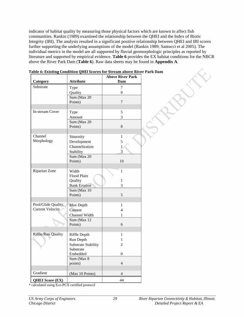
US Army Corps of Engineers 29 River Riparian Connectivity & Habitat, Illinois Chicago District Detailed Project Report & EA
indicator of habitat quality by measuring those physical factors which are known to affect fish communities. Rankin (1989) examined the relationship between the QHEI and the Index of Biotic Integrity (IBI). The analysis resulted in a significant positive relationship between QHEI and IBI scores further supporting the underlying assumptions of the model (Rankin 1989; Santucci et al 2005). The individual metrics in the model are all supported by fluvial geomorphologic principles as reported by literature and supported by empirical evidence. Table 6 provides the EX habitat conditions for the NBCR above the River Park Dam (Table 6). Raw data sheets may be found in Appendix A. Table 6: Existing Condition QHEI Scores for Stream above River Park Dam
Category Attribute Above River Park
Dam Substrate Type 7
Quality 0 Sum (Max 20 Points) 7
In-stream Cover Type 5
Amount 3 Sum (Max 20 Points) 8
Channel Morphology
Sinuosity 1 Development 5 Channelization 1 Stability 3 Sum (Max 20 Points) 10
Riparian Zone Width 1
Flood Plain Quality 1 Bank Erosion 3 Sum (Max 10 Points) 5
Pool/Glide Quality, Current Velocity
Max Depth 1 Current 4 Channel Width 1 Sum (Max 12 Points) 6
Riffle/Run Quality Riffle Depth 1 Run Depth 1 Substrate Stability 2 Substrate
Embedded 0 Sum (Max 8
points) 4 Gradient (Max 10 Points) 4
QHEI Score (EX) 44 * calculated using Eco-PCX certified protocol
US Army Corps of Engineers 30 River Riparian Connectivity & Habitat, Illinois Chicago District Detailed Project Report & EA
2.5.2 QHEI as the Habitat Suitability Index (HSI)
The Habitat Suitability Index (HSI) is the quality portion of the USACE’s habitat assessment procedure to analyze measures, alternatives or plans in terms of ecosystem benefits/outputs. The QHEI has acceptable application for USACE HSI procedures in that the scoring of metrics and calculating an overall score is simple, and output interpretation is straightforward (see MEMORANDUM FOR CECW-LRD Recommendation for Regional Approval for Use of the Qualitative Habitat Evaluation Index 11 December 2014). The data required for input was gathered first hand by USACE (2015). Since the QHEI model output is a score between 0-100, it is easily indexed to a score between 0 to 1.0; this provides uniform and useful information across USACE ecosystem studies. Existing condition (EX) HSI score for the NBCR 44 out of 100, which is classified as a “poor” habitat. The equation to normalize the QHEI score is: QHEI Score / 100 = HSIQHEI
44/100 = .44QHEI
2.5.3 Stream Acres as Quantity Measure
USACE planning guidelines require that there be a quantity component to the habitat assessment for determining Future-Without (FWOP) and Future-With (FWP) project conditions. Since the plant community assessment utilizes acres as the quantity unit, acres were used for riverine habitat to make the analyses equivalent and avoid double counting. About 1.0 acres of channel could be directly affected by this project. About 356-acres could be indirectly affect by this project should fish be allowed passage to this available habitat. However, due to the fragmentation of the dam and the inability for fish to recolonize the NBCR, there are actually 0-acres of habitat available in the EX condition. Past fish surveys at upstream sites of LaBagh Woods and Eugene Field Park (USACE 2005) revealed no fishes, as the fish survey on 03 September 2015 revealed no fishes within the NBCR directly behind the dam at River Park. Acres = 0 because this area is blocked from use by fishes and mussels.
2.5.4 Stream Average Annual Habitat Units (AAHUs)
In order to equally assess measures, alternatives or plans, the benefit portion of the analysis must be annualized just as the costs are. The method per USACE planning guidelines typically assigns benefits over a 50-year period of analysis0. This study used 50-years as a reasonable period of analysis, noting that the benefits may actually be accrued in perpetuity. Habitat Units (HUs) were calculated by: HSIQHEI x Stream Acres Affected = Habitat Units (HUs)
.44 x 0.0 = 0 HUEX
FWOP and FWP Average Annual HSI are calculated by: HSIn50 / 50 years = AAHSI
Average Annual Habitat Units (AAHUs) are calculated by: AAHSI x Stream Acres Affected = AAHUs

US Army Corps of Engineers 31 River Riparian Connectivity & Habitat, Illinois Chicago District Detailed Project Report & EA
Even though there may be apparent be/nefits to be gained, there are still minor benefits existing in the Future-Without Project condition within the impoundment, as evident by the QHEI score of 44. To ensure that existing benefits are not claimed by potential actions, only the net benefits gained are utilized. This unit is called the Net Average Annual Habitat Unit (NAAHU), which is represented as: FWP AAHUs – FWOP AAHUs = Net Average Annual Habitat Units (NAAHUQHEI)
In the case of the NBCR at River Park, there are no (EX) benefits due to zero (0) acres of habitat being accessible by fishes and mussels; therefore, the EX AAHU = 0.0.
2.5.5 Floristic Quality Assessment (FQA) The Floristic Quality Assessment (FQA) is based on the Chicago Region’s floristic coefficients of conservatism (C value) and native species richness developed by Swink and Wilhelm (1979). The C value is a numerical number between 0 and 10 that classifies a plant species as a weed (C = 0 – 3), a high quality, sensitive native plant (C = 7 – 10) and those species in between (C = 4 – 6). The C value of the FQA can be used to quantify the past, present and future effects on native plant communities. The mean C value for each plant community is calculated by: 𝐶𝐶̅ = Sum of the Coefficient of Conservatism / # of Native Species Plants are exceptional indicators of short and long-term disturbance in terms of their immediate response to changes in geomorphology, soils and hydrology of an area. In turn, the change in plant community species and structure affects the animal assemblages utilizing them. Plant/animal associations for most Chicago Region plants may be found on the Illinois Wild Flower Home Page (http://www.illinoiswildflowers.info/). Table 7 provides the (EX) habitat conditions for the study area’s native riparian plant communities. FQA spread sheets may be found in Appendix A. Table 7: Existing Condition Mean C Values for the Study Area Plant Communities
Aquatic Bed* River Bank Riparian Savanna** Total Species Richness 0 41 24 Native Species Richness 0 28 14 Mean C w/Adventives 0 1.51 2.38 FQI w/Adventives 0 9.68 11.64
*synonymous with Canal on Figure 5; **synonymous with Park Land on Figure 5
2.5.6 Mean C Value as the Habitat Suitability Index (HSI) The quality portion of the USACE’s habitat assessment procedure to analyze plant community measures, alternatives or plans in terms of ecosystem benefits/outputs. The FQA has acceptable usability for USACE HSI procedures in that the scoring of metrics and calculating an overall score is simple, and output interpretation is straightforward (http://cw-environment.usace.army.mil/model-library.cfm?CoP=Restore&Option=View&Id=318). The data required for input was gathered and quality checked by USACE botanists. Since the FQA model output (Coefficient of Conservatism) is a score between 0-10, it is easily indexed to a score between 0 to 1.0; this provides uniform and useful information across USACE ecosystem studies. Baseline floristic quality was surveyed in September 2015, which will serve as a comparison for predictions of changes to the plant community based on alternative future scenarios. Existing condition (EX) HSI scores for the study area are presented in (Table 10).
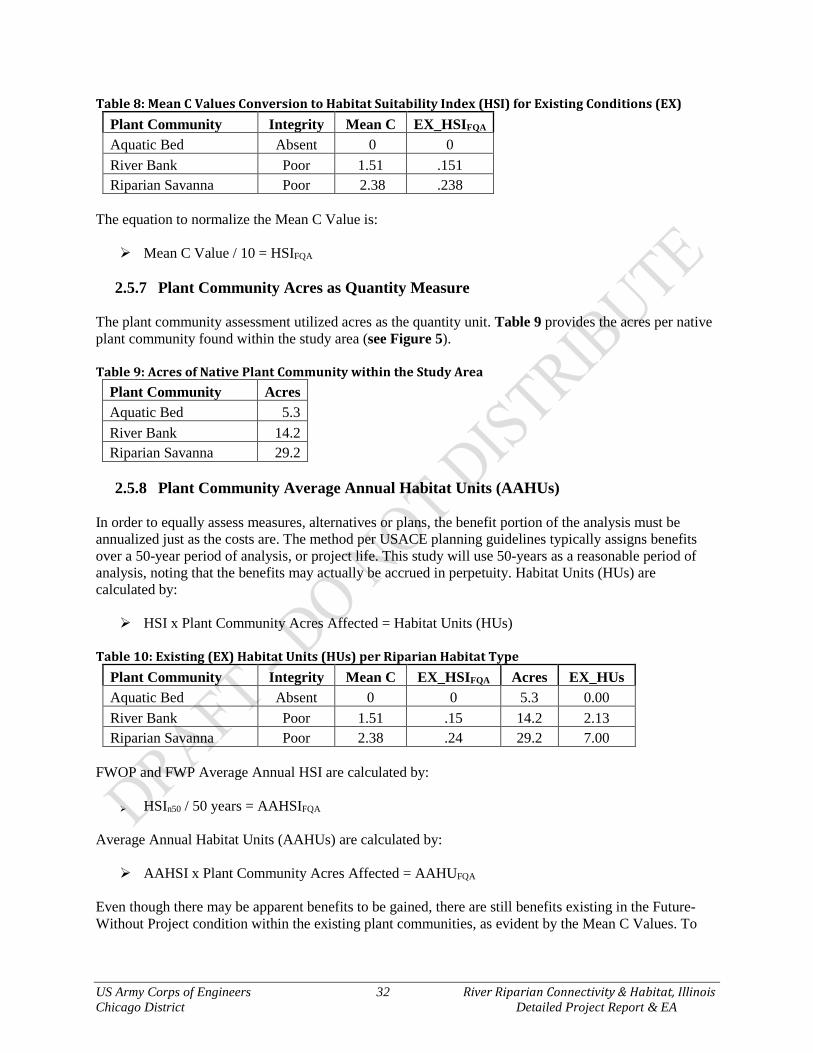
US Army Corps of Engineers 32 River Riparian Connectivity & Habitat, Illinois Chicago District Detailed Project Report & EA
Table 8: Mean C Values Conversion to Habitat Suitability Index (HSI) for Existing Conditions (EX) Plant Community Integrity Mean C EX_HSIFQA Aquatic Bed Absent 0 0 River Bank Poor 1.51 .151 Riparian Savanna Poor 2.38 .238
The equation to normalize the Mean C Value is: Mean C Value / 10 = HSIFQA
2.5.7 Plant Community Acres as Quantity Measure
The plant community assessment utilized acres as the quantity unit. Table 9 provides the acres per native plant community found within the study area (see Figure 5). Table 9: Acres of Native Plant Community within the Study Area
Plant Community Acres Aquatic Bed 5.3 River Bank 14.2 Riparian Savanna 29.2
2.5.8 Plant Community Average Annual Habitat Units (AAHUs)
In order to equally assess measures, alternatives or plans, the benefit portion of the analysis must be annualized just as the costs are. The method per USACE planning guidelines typically assigns benefits over a 50-year period of analysis, or project life. This study will use 50-years as a reasonable period of analysis, noting that the benefits may actually be accrued in perpetuity. Habitat Units (HUs) are calculated by: HSI x Plant Community Acres Affected = Habitat Units (HUs)
Table 10: Existing (EX) Habitat Units (HUs) per Riparian Habitat Type
Plant Community Integrity Mean C EX_HSIFQA Acres EX_HUs Aquatic Bed Absent 0 0 5.3 0.00 River Bank Poor 1.51 .15 14.2 2.13 Riparian Savanna Poor 2.38 .24 29.2 7.00
FWOP and FWP Average Annual HSI are calculated by:
HSIn50 / 50 years = AAHSIFQA
Average Annual Habitat Units (AAHUs) are calculated by: AAHSI x Plant Community Acres Affected = AAHUFQA
Even though there may be apparent benefits to be gained, there are still benefits existing in the Future-Without Project condition within the existing plant communities, as evident by the Mean C Values. To

US Army Corps of Engineers 33 River Riparian Connectivity & Habitat, Illinois Chicago District Detailed Project Report & EA
ensure that existing benefits are not claimed by potential actions, only the net benefits gained are utilized. This unit is called the Net Average Annual Habitat Unit (NAAHU), which is represented as: FWP AAHUs – FWOP AAHUs = Net Average Annual Habitat Units (NAAHUFQA)
2.6 Future Without-Project Conditions / No Action In general, the Chicago River system was transformed from a naturally diverse, free-flowing prairie slough, into an impounded and homogenized system of manmade drainage conduits and navigation canals predominantly lined with Asiatic and weedy (adventive) riparian plant communities. As described above in the Inventory discussion, the native species richness, abundance and health was severely degraded from the natural state. There are no current or future plans for large scale connectivity and habitat restoration projects that include these areas. Other foreseen restoration projects up and down the river primarily focus on water quality and recreational improvements; these activities would continue in the near future and support restoration within the watershed. There are no legal mandates or requirements by any State or Federal Agencies to remove the study area dam. Also, the three upstream dams – Tam O’Shanter, Winnetka and Chic Evans – are anticipated to be removed within the next 1 to 2 years by a partnership between the ILDNR and the Forest Preserve District of Cook County. The Chicago Department of Transportation is proposing a diversion tunnel from the NBCR to the NSC, which will divert 100-year flows from NBCR and prevent the flows from entering the River Riparian study reach. Positive affects are anticipated for habitat and fishes within the stream channel due to this future project. The project would aid in alleviating such high flows that both habitat and fishes are blown out of the reach and over the existing dam. In terms of riverine and riparian plant community habitat, the segments of river within the study area have reached a stable but degraded state, and are not expected to further degrade. There could be loss of additional plant, mussel and fish species if some natural event or man induced accident would adversely affect one of the fragmented segments of river; however, these events are unpredictable. The existing conditions (EX HSI), therefore, would be quite indicative of the Future Without-Project conditions (FWOP HSI) for both riverine and riparian communities. Climate change is considered to have a negligible impact on the study area during the 50-year period of analysis in terms of ecosystem structure and function; however, project performance is preserved under a wide range of possible climate change scenarios during the 50-year period of analysis. There is a potential for average global temperatures to increase, weather to become flashier, and droughty periods with singular high rainfall events. The key to sustainability within these conditions is to have highly diverse (heterogeneous genotypes) riparian plant communities established so that they can ebb and wan with the changing climate patterns, which is termed adaptation or natural selection. The antropogenic changes to the Chicago River system have caused greater adverse changes than climate change is anticipated to induce, and the river already has a high degree of hydrologic flashiness due to the urban nature of the watershed. Minor increases or decreases in stream flows would have no significant bearing on habitat and connectivity, whereas natural riverine functions and structure would allow the ecological system to adapt accordingly.
FWOP Conditions Quantified In terms of ecosystem health, the existing conditions (EX HSIQHEI and EX HSIFQA) would be quite indicative of the Future Without-Project Conditions (FWOP HSIQHEI and FWOP HSIFQA), since without a Federal project, management efforts would not be able to remedy the adverse effects caused by past impairments. The effects induced by past impairments have imparted its damage long ago (1920s – 1970s) and the affected area is now in relative equilibrium, both in the river and riparian zone. The assumptions and analysis determined that the riverine EX and FWOP conditions are considered to be equivalent.

US Army Corps of Engineers 34 River Riparian Connectivity & Habitat, Illinois Chicago District Detailed Project Report & EA
Figure 6: Riverine & Riparian FWOP Average Annual Habitat Suitability Index Forecast Table 11: Riverine & Riparian FWOP AAHSI & AA Habitat Units
Condition Habitat Types Acres EX_HSI AAHSI EX_HUs FWOP AAHUs Existing Stream 0.0 0.44 0.0
EX Aquatic Bed 5.3 0.00 0.0 River Bank 14.2 0.15 2.1 Riparian Savanna 29.2 0.24 7.0
No Action Stream 0.0 0.44 0.0 FWOP Aquatic Bed 5.3 0.00 0.0
River Bank 14.2 0.15 2.1 Riparian Savanna 29.2 0.24 7.0
0
0.05
0.1
0.15
0.2
0.25
0.3
0.35
0.4
0.45
0.5
1 6 11 16 21 26 31 36 41 46 51
AA
HSI
Year
Stream
Aquatic Bed
River Bank
Savanna
US Army Corps of Engineers 35 River Riparian Connectivity & Habitat, Illinois Chicago District Detailed Project Report & EA
CHAPTER 3 – Problems & Opportunities This chapter provides a description of identified problems within the study area along with opportunities for improvement. It also outlines the overall project goal along with a list of planning objectives and constraints. 3.1 Problems and Opportunities Human activity over the past two centuries has altered the geomorphology, hydrology, hydraulics, sediment transport, groundwater recharge/discharge, soils and plant communities historically present within the watershed, floodplain and river channel of the Chicago River system. These modifications have subsequently caused structural habitat degradation, fragmentation, pollution and invasive species issues, all of which are intertwined. Although common animal species such as Beaver, Fox, Coyote and residential city birds are frequently observed in these ruderal (human induced) thicket habitats, alterations to the system have significantly reduced species richness, abundance and distribution of native plant and animal assemblages, and suppress biodiversity a whole. As a result, ecosystem heterogeneity and clean water have become a great concern for the watershed. These trending problems can be lessened and ultimately reversed via on-the-ground and institutional efforts. This study provides a look at lines of opportunity to provide restored acres of river, wetland, fish, wildlife and important migratory bird habitat.
3.1.1 Study Area Problems Stream habitat has become severely degraded through a combination of relocating channels, channelization, siltation, bank armoring, concrete linings, damming and other modifications. Stream channelization has effectively removed in-stream habitat and river morphology from the project reach and maintains a canal like configuration. Natural soils and substrates are no longer sequestered and moved through the river system and existing natural substrates have been covered or scoured away due to the increased imperviousness of the watershed, removal of a natural floodplain and subsequent confined channel conditions. Also, there is very little submergent or emergent vegetation within the river itself due to the lack of proper bank toe and stream bed geomorphology and growing medium. Bank erosion has been accelerated in certain areas by the presence of Eurasiatic shrubs and trees that have shaded the banks to a point where deep-rooted grass, rush, and sedge plants cannot survive. The absence of these plants allows the soils to be eroded away by river and sheet flow. The current soils on banks and riparian zone have been compacted and altered to such an extent that they do not allow infiltration and cause direct runoff to the NBCR. The stream banks are subject to erosion because of slope steepness, excessive runoff, and lack of ground cover. The ground cover itself has deteriorated due to a lack of adequate light and the invasion of non-native species such as Honeysuckle, Buckthorn, Siberian Elm, Japanese Knotweed and similar species. In turn the siltation and runoff has degraded the nearby aquatic habitat. Although water quality is not a mission of the USACE, water quality parameters are still considered abiotic habitat requirements. Run-of-the-river dams play a notable role in the widespread occurrence of substandard water quality in many rivers throughout the country. Dissolved oxygen concentrations in rivers have been shown to widely fluctuate on a daily basis in impounded areas; these concentrations often reach substandard levels, last for most of the day, and occur when water temperatures are high and discharge is low, creating unsuitable conditions for aquatic organisms. Also, pollutants that can be naturally cleaned by a flowing river tend to collect in the impounded areas, further compounding the unfavorable conditions for freshwater mussels, fishes and macroinvertebrates.

US Army Corps of Engineers 36 River Riparian Connectivity & Habitat, Illinois Chicago District Detailed Project Report & EA
The majority of the native riparian savanna habitats have been eliminated as well. Mowed turf grass with ornamental trees is maintained for open space within the park. Due to the large amount of fill placed within the study area it is probable that the natural soils of the site have been completely lost and the current fill is severely compacted. A natural seed bank is also unlikely due to the extreme amounts of infilling and earth moving. When evaluating the entire suite of species that utilize the river and riparian corridor within the study area, it becomes clear that many native insect, fish, amphibian, reptile and bird species are limited due to the need functional and connected habitat zones. The lack of riparian savanna connecting to bank, connecting to the stream has resulted in the loss of native species, primarily amphibians, reptiles and birds. The habitat quality assessments of the riverine and riparian habitats utilizing the QHEI and FQA, respectfully, provided a qualitative basis for confirming these holistic and chronic problems.
3.1.2 Specific Study Area Opportunities Based on site qualitative and quantitative investigations and aside from the massive hydrogeomorphic changes to the system, the main aquatic resource problems within the NBCR in which the 506 Authority may take opportunity to address are as follows: Lack of passage for mussel and fish species to access habitat within the NBCR
o Mussels depend on fish passage for dispersal, fish being glochidial (larval) hosts Lack of riverine (lotic/flowing) velocities and forces that riverine species require Lack of natural sediment (substrate) transport
o Impaired substrate composition and sorting o Lack of natural macro-habitat features
Islands, deep pools, riffles, native aquatic vegetation, bars, undercut banks o Eliminated ability to naturally filter and clean water and sediments (substrates)
Moving water facilitates cleansing as substrates (sediment) move through the river becoming exposed to saprophytes (animals, bacteria, fungi) and oxygen
Lack of native species richness and composition of riparian zone plant communities o Poor structural diversity (monotypic thickets) o Poor food sources from non-seed/berry producing trees and shrubs o Noxious chemical sources from non-native plants (i.e. Buckthorn, Garlic Mustard) o Poor/eliminated longitudinal (along the river) and lateral (up the bank) connectivity
3.2 Goal & Objectives
3.2.1 Goal The goal of this study is to determine a cost effective and ecologically beneficial plan which would restore a sustainable and connected riverine and riparian habitat, while considering No Action as a baseline alternative.
3.2.2 Objectives
Federal Ecosystem Objectives The Federal objective of water and related land resources planning is to contribute to national economic and/or ecosystem development in accordance with national environmental statutes, applicable executive orders, and other Federal planning requirements and policies. The use of the term “Federal objective”
US Army Corps of Engineers 37 River Riparian Connectivity & Habitat, Illinois Chicago District Detailed Project Report & EA
should be distinguished from planning/study objectives, which are more specific in terms of expected or desired outputs whereas the Federal objective is considered more of a National goal. Water and related land resources project plans shall be formulated to alleviate problems and take advantage of opportunities in ways that contribute to study objectives and to the Federal objective. Contributions to national improvements are increases in the net value of the output of national goods, services and ecosystem integrity. Contributions to the Federal objective include increases in the net value of those goods, services and ecosystems that are or are not marketable. Restoration of the Nation’s environment is achieved when damage to the environment is reversed, lessened, eliminated or avoided and important cultural and natural aspects of our nation’s heritage are preserved. The objectives and requirements of applicable laws and executive orders are considered throughout the planning process in order to meet the Federal objective. The following laws and executive orders that specifically provided guidance for this study are not limited to, but include:
Great Lakes Fishery & Ecosystem Restoration of WRDA 2000, as amended Endangered Species Act of 1973, as amended (16 USC 1531 et seq.) Fish and Wildlife Coordination Act, as amended (16 USC 661) Migratory Bird Treaty Act of 1918, as amended (16 USC 703 et seq.) Responsibilities of Federal Agencies to Protect Migratory Birds (E.O. 13186) Clean Water Act of 1977, as amended (33 USC. 1251 et seq.) National Environmental Policy Act of 1969 (42 U.S.C. 4321 et seq.) Invasive Species (E.O. 13112) Nonindigenous Aquatic Nuisance Prevention & Control Act of 1990, as amended (16 U.S.C. 4701 et seq.) National Invasive Species Act of 1996 (Public Law 104 – 332) Protection of Wetlands (E.O. 11990) Protection and Enhancement of Environmental Quality (E.O. 11514) Floodplain Management (E.O. 11988) Preparing the United States for the Impacts of Climate Change (E.O. 13653)
GLFER Authority Ecosystem Objectives
Based upon the authorizing legislation and the desires of the ecosystem and fishery management communities, the objective of the Great Lakes Fishery and Ecosystem Restoration Program is to provide ecosystem and fishery managers, and others interested in ecosystem restoration, with a planning, design, and construction tool. The following GLFER objectives apply to this project:
φ Preserve and restore aquatic and associated riparian habitat as part of an ecosystem approach to fishery management
φ The restoration of ecosystems to promote naturally reproducing fish communities based on native fish populations
φ Control the introduction and/or spread of invasive species φ Evaluate the success of projects in order to make future projects better φ Assure coordination between locally implemented restoration actions and basin wide restoration
plans Since the proposed study is in accord with GLFER 506 objectives, and ecosystem restoration is a high priority mission, there is strong Federal interest providing habitat outputs to the Great Lakes basin. There is also Federal interest in other related outputs of the potential alternatives, which include increase in diversity and abundance of native species, restoring natural riverine and riparian habitat, and increasing acres and quality of ecotypes in the Lake Michigan basin.
US Army Corps of Engineers 38 River Riparian Connectivity & Habitat, Illinois Chicago District Detailed Project Report & EA
Responsibilities of Federal Agencies to Protect Migratory Birds (E.O. 13186) Migratory birds are of great ecological and economic value to this country and to other countries. They contribute to biological diversity and bring tremendous enjoyment to millions of Americans who study, watch, feed, or hunt these birds throughout the United States and other countries. The United States has recognized the critical importance of this shared resource by ratifying international, bilateral conventions for the conservation of migratory birds. Such conventions include the Convention for the Protection of Migratory Birds with Great Britain on behalf of Canada 1916, the Convention for the Protection of Migratory Birds and Game Mammals-Mexico 1936, the Convention for the Protection of Birds and Their Environment- Japan 1972, and the Convention for the Conservation of Migratory Birds and Their Environment-Union of Soviet Socialist Republics 1978. These migratory bird conventions impose substantive obligations on the United States for the conservation of migratory birds and their habitats, and through the Migratory Bird Treaty Act (Act), the United States has implemented these migratory bird conventions with respect to the United States. This Executive Order directs executive departments and agencies to take certain actions to further implement the Act (….)
(g) "Federal agency" means an executive department or agency, but does not include independent establishments as defined by 5 U.S.C. 104. (h) "Action" means a program, activity, project, official policy (such as a rule or regulation), or formal plan directly carried out by a Federal agency. Each Federal agency will further define what the term "action" means with respect to its own authorities and what programs should be included in the agency-specific Memoranda of Understanding required by this order. Actions delegated to or assumed by nonfederal entities, or carried out by nonfederal entities with Federal assistance, are not subject to this order. Such actions, however, continue to be subject to the Migratory Bird Treaty Act.
This study/project has great potential to provide critical migratory bird food and cover. The potential for returning ecosystem functions to a long stretch of migratory corridor along the Chicago River within the Lake Michigan Route of the Mississippi Flyway.
Planning Objectives As part of the USACE Civil Works mission, the federal objective of ecosystem restoration projects is to restore the structure, function and dynamic processes of degraded ecosystems to a less degraded, more natural condition. The non-Federal sponsor has an ecosystem restoration objective that partners well with the Federal objective stated above. Study objectives are statements that describe the desired results of the planning process by solving the problems associated with the study purpose, problems and opportunities. Objectives must be clearly defined and provide information on the effect desired, the subject of the objective (what will be changed by accomplishing the objective), the location where the expected result will occur, the timing of the effect (when would the effect occur) and the duration of the effect. Two (2) planning objectives were identified by the study team, the non-Federal sponsor and various stakeholders. These will be used as targets for solving aquatic resource problems within the study area:
Objective 1 – Reestablish Quality and Connectivity of Riverine Habitats Currently, the NBCR within the study area is impaired by 1 run-of-the-river dam and long stretches of canal with no habitat structure. Due to the highly urbanized watershed and canal maintenance (woody debris removal, clearing & snagging), there is no natural recovery mechanism for habitat structure. These impairments are specific to impeding riverine hydraulics, sediment transport, substrate sorting, resulting

US Army Corps of Engineers 39 River Riparian Connectivity & Habitat, Illinois Chicago District Detailed Project Report & EA
in a loss of structural habitat heterogeneity (geomorphology). The effects desired by meeting this objective are to provide riverine functions and/or structure to restore, connect and sustain habitats. The targeted location of these affects would be in the segments of river that are currently impounded or have no habitat structure. These affects would be sustained over the life of the project and optimistically in perpetuity. This objective seeks to reestablish natural fluvialgeomorphic parameters (hydraulics, substrates) and structures to support riverine and riparian habitats within the study area. Improvement is measured via the predicted increase in quality of riverine habitat (FWP HSI (QHEI) and FWP HSI (FQA)).
Objective 2 – Reestablish Quality and Connectivity of Riparian Habitats Currently, the study area is devoid of any natural riparian plant communities. Aside from small patches of native grasses and forbs planted by the CPD, the lack of native plants has effectively reduced native species richness of insect, amphibian, reptile, bird and mammal species. The effect desired by meeting this objective is to return tracts of healthy native riparian zone. The targeted location of these affects would be within the park zones adjacent to the river. These affects would be sustained over the life of the project and optimistically in perpetuity. This objective seeks to reestablish native riparian plant community species richness and structure for resident and transient riparian animal species. Improvement is measured via the predicted increase in distribution in plant quality as measured by the increase in habitat quality (FWP HSI (FQA)). 3.3 Planning Constraints The PDT has identified the following planning constraints for this study:
1. Minimize adverse changes to human recreational uses of the river and riparian parks 2. Avoid and minimize adverse changes to municipal infrastructure such as , stormwater outfalls,
transportation, reclamation facilities, utilities, etc. 3. Avoid inducing flood conditions both up and down stream of projects

US Army Corps of Engineers 40 River Riparian Connectivity & Habitat, Illinois Chicago District Detailed Project Report & EA
CHAPTER 4 – Plan Formulation & Evaluation The formulation, evaluation, and comparison of alternative plans comprise the third, fourth, and fifth steps of the USACE planning process. These steps are often referred to collectively as plan formulation. Plan formulation is an iterative process that involves cycling through these steps to develop a reasonable range of alternative plans, and then evaluating and comparing those plans to select a final recommended plan, which is feasible for implementation. Plan formulation for ecosystem restoration presents a challenge because alternatives have non-monetary benefits. To facilitate the plan formulation process, the Study Team used the methodology outlined in USACE Engineering Regulation, ER 1105-2-100, Planning Guidance Notebook. The steps in the methodology are:
1. Identify a primary project purpose. For this study, ecosystem restoration (ER) is identified as the primary purpose.
2. Formulate and screen management measures to achieve planning objectives and avoid/minimize planning constraints. Measures are the building blocks of alternative plans.
3. Formulate, evaluate, and compare an array of alternatives to achieve the primary purpose and identify cost effective plans.
4. Perform an incremental cost analysis on the cost effective plans to determine the National Ecosystem Restoration (NER) plan.
4.1 Habitat Measures The alteration, fragmentation, and finally loss of natural habitats are major causes of the increasingly rapid decline in biotic diversity on Earth (Burgess & Sharpe 1981; Harris 1984; Saunders et al. 1987; Marzluff & Ewing 2001). To solve such problems one must consider not only the dynamics of the target species, but also the changes in the abiotic structure and processes surroundings (Per Angelstam 1992). Therefore, the following measures specifically address the resource problems by taking the opportunity to target the abiotic conditions of the NBCR fluvialgeomorphic setting as the two planning objectives illustrate.
4.1.1 Habitat Management Measures Habitat measure overview is shown on Figure 7, with Plates 2, 3 and 4 zooming in on the particular parks to provide higher resolution of measures. Stream Channel (SC) The historic information on the Chicago River shows that the Chicago River within the study area was formerly a sluggish prairie slough with an immense abundance of hydrophytic submergent and emergent macrophytes; however, most reaches of stream have been channelized, which increase slope dramatically from the winding prairie slough condition. This reach of stream is indicative of this type of situation. This measure would remove the small low-head dam that currently serves no civil purpose and effectively blocks fish and mussel passage into the entire NBCR. Two options would be assessed under this measure: A) remove the entire concrete channel and install boulder/cobble step pools, or B) remove a portion of the concrete channel, install boulder/cobble step pools and cover the remaining concrete areas with natural alluvium of cobble, gravel and sand. In addition, small native aquatic bed pockets would be added to hydraulically calm zones through the use of submergent native Pondweeds (Potamogeton spp.) and Eel Grass (Vallisneria americana). This measure is independent and does not include invasive and exotic

US Army Corps of Engineers 41 River Riparian Connectivity & Habitat, Illinois Chicago District Detailed Project Report & EA
species removal. Approximately 1.0-ac of stream would be restored, which would open up about 68 miles of NBCR stream. Measure activities include: Option A Remove all concrete within the 390-ft channel Install riffles, step-pools while dam is in place Remove dam at mouth of stream and replace with boulder-step pool Provide low quantity of natural alluvium of cobbles, gravels and sands After year 2, plant hydraulic dead pockets with native Pondweeds and Eel Grass
Option B Remove a portion of the concrete within the 390-ft channel Install a fewer number of riffles, step-pools while dam is in place Remove dam at mouth of stream and replace with boulder step-pool Provide high quantity of natural alluvium of cobbles, gravels and sands After year 2, plant hydraulic dead pockets with native Pondweeds and Eel Grass
Photo 7: Concrete Stream Can Be Restored with Natural Materials to Mimic Natural Habitat Structure Aquatic Beds (AB) The historic information on the Chicago River shows that the Chicago River within the study area was formerly a sluggish prairie slough with an immense abundance of hydrophytic submergent and emergent macrophytes. Native aquatic bed vegetation would be restored primarily through the use of submergent native Pondweeds (Potamogeton spp.) and Eel Grass (Vallisneria americana), and short stature emergent macrophytes. A subset of fell trees from the river bank restoration or savanna restoration would be utilized as additional habitat structure within the aquatic bed habitat as well. This measure is independent and does not include invasive and exotic species removal. Approximately 5.3-ac of aquatic bed would be restored. Aquatic bed macrophyte species would be primarily plugged and minimally seeded over the whole area. These plantings would be protected with anti-predatory (Canada Geese and Common Carp) meshing/fencing until established. Native plant species lists for the FWP condition are located in Appendix H. Some conservative species to be reestablished include but are not limited to: Emory’s Sedge, American Water-Willow, Leafy Pond Weed, Three Square, and American Eel Grass. Measure activities include: Provide a mix of sand, silt and organic leaf litter compost as soil amendment (if necessary) and
provide proper hydrogeomorphology to ensure healthy plant establishment
River Park EX Stream
Red Mill Pond FWP Stream
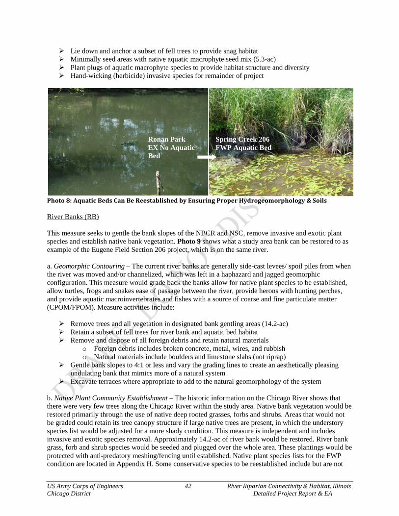
US Army Corps of Engineers 42 River Riparian Connectivity & Habitat, Illinois Chicago District Detailed Project Report & EA
Lie down and anchor a subset of fell trees to provide snag habitat Minimally seed areas with native aquatic macrophyte seed mix (5.3-ac) Plant plugs of aquatic macrophyte species to provide habitat structure and diversity Hand-wicking (herbicide) invasive species for remainder of project
Photo 8: Aquatic Beds Can Be Reestablished by Ensuring Proper Hydrogeomorphology & Soils River Banks (RB) This measure seeks to gentle the bank slopes of the NBCR and NSC, remove invasive and exotic plant species and establish native bank vegetation. Photo 9 shows what a study area bank can be restored to as example of the Eugene Field Section 206 project, which is on the same river. a. Geomorphic Contouring – The current river banks are generally side-cast levees/ spoil piles from when the river was moved and/or channelized, which was left in a haphazard and jagged geomorphic configuration. This measure would grade back the banks allow for native plant species to be established, allow turtles, frogs and snakes ease of passage between the river, provide herons with hunting perches, and provide aquatic macroinvertebrates and fishes with a source of coarse and fine particulate matter (CPOM/FPOM). Measure activities include: Remove trees and all vegetation in designated bank gentling areas (14.2-ac) Retain a subset of fell trees for river bank and aquatic bed habitat Remove and dispose of all foreign debris and retain natural materials
o Foreign debris includes broken concrete, metal, wires, and rubbish o Natural materials include boulders and limestone slabs (not riprap)
Gentle bank slopes to 4:1 or less and vary the grading lines to create an aesthetically pleasing undulating bank that mimics more of a natural system
Excavate terraces where appropriate to add to the natural geomorphology of the system b. Native Plant Community Establishment – The historic information on the Chicago River shows that there were very few trees along the Chicago River within the study area. Native bank vegetation would be restored primarily through the use of native deep rooted grasses, forbs and shrubs. Areas that would not be graded could retain its tree canopy structure if large native trees are present, in which the understory species list would be adjusted for a more shady condition. This measure is independent and includes invasive and exotic species removal. Approximately 14.2-ac of river bank would be restored. River bank grass, forb and shrub species would be seeded and plugged over the whole area. These plantings would be protected with anti-predatory meshing/fencing until established. Native plant species lists for the FWP condition are located in Appendix H. Some conservative species to be reestablished include but are not
Ronan Park EX No Aquatic Bed
Spring Creek 206 FWP Aquatic Bed
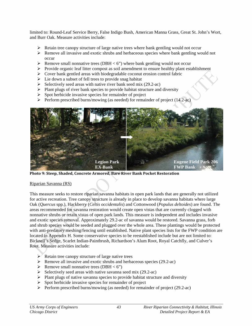
US Army Corps of Engineers 43 River Riparian Connectivity & Habitat, Illinois Chicago District Detailed Project Report & EA
limited to: Round-Leaf Service Berry, False Indigo Bush, American Manna Grass, Great St. John’s Wort, and Burr Oak. Measure activities include: Retain tree canopy structure of large native trees where bank gentling would not occur Remove all invasive and exotic shrubs and herbaceous species where bank gentling would not
occur Remove small nonnative trees (DBH < 6”) where bank gentling would not occur Provide organic leaf litter compost as soil amendment to ensure healthy plant establishment Cover bank gentled areas with biodegradable coconut erosion control fabric Lie down a subset of fell trees to provide snag habitat Selectively seed areas with native river bank seed mix (29.2-ac) Plant plugs of river bank species to provide habitat structure and diversity Spot herbicide invasive species for remainder of project Perform prescribed burns/mowing (as needed) for remainder of project (14.2-ac)
Photo 9: Steep, Shaded, Concrete Armored, Bare River Bank Pocket Restoration Riparian Savanna (RS) This measure seeks to restore riparian savanna habitats in open park lands that are generally not utilized for active recreation. Tree canopy structure is already in place to develop savanna habitats where large Oak (Quercus spp.), Hackberry (Celtis occidentalis) and Cottonwood (Populus deltoides) are found. The areas recommended for savanna restoration would create open vistas that are currently clogged with nonnative shrubs or retain vistas of open park lands. This measure is independent and includes invasive and exotic species removal. Approximately 29.2-ac of savanna would be restored. Savanna grass, forb and shrub species would be seeded and plugged over the whole area. These plantings would be protected with anti-predatory meshing/fencing until established. Native plant species lists for the FWP condition are located in Appendix H. Some conservative species to be reestablished include but are not limited to: Bicknell’s Sedge, Scarlet Indian-Paintbrush, Richardson’s Alum Root, Royal Catchfly, and Culver’s Root. Measure activities include: Retain tree canopy structure of large native trees Remove all invasive and exotic shrubs and herbaceous species (29.2-ac) Remove small nonnative trees (DBH < 6”) Selectively seed areas with native savanna seed mix (29.2-ac) Plant plugs of native savanna species to provide habitat structure and diversity Spot herbicide invasive species for remainder of project Perform prescribed burns/mowing (as needed) for remainder of project (29.2-ac)
Legion Park EX Bank
Eugene Field Park 206 FWP Bank

US Army Corps of Engineers 44 River Riparian Connectivity & Habitat, Illinois Chicago District Detailed Project Report & EA
Photo 10: Park Land to Savanna Restoration
Figure 7: River Riparian Measures Overview Map
Legion Park EX Park Land
Eugene Field Park 206 FWP Savanna
US Army Corps of Engineers 45 River Riparian Connectivity & Habitat, Illinois Chicago District Detailed Project Report & EA
4.1.2 Habitat Measures Cost & Assumptions
Plan formulation level cost estimates were prepared for each measure (Table 12). These cost estimates do not represent Total Project Cost (TPC) estimates, but rather individual restoration measures that are the building blocks of a complete plan. These plan formulation level cost estimates were developed by Cost Engineering using data from current similar construction contracts, cost data and publications, and informal discussions with vendors. Costs include construction, staging, access, haul road construction, preliminary real estate estimates, adaptive management, monitoring and operations and maintenance. A preliminary real estate estimate for plan formulation purposes was provided by per acre Real Estate. The measures were used to provide a monetary basis for the assessment of project alternatives. Annualizing costs is a method whereby the project costs are discounted to a base year then amortized over the period of analysis. The base year for this project was determined to be the year in which the first phase of the project is to be completed (calendar year 2016). Costs that occur prior to this year need to be compounded to the base year, while those occurring after the base year need to be discounted to the base year. The period of analysis for this project is 50 years. The present value method was used to discount future costs to the base year. Costs are compounded or converted to present value for the base year then amortized over the 50-year period of analysis to determine the average annual cost. The discount rate was determined by the appropriate Economic Guidance Memorandum Economic Guidance Memorandum 15-01, Federal Interest Rates for Corps of Engineers Projects, which is 3.375%. The construction period is only 1 year for this type of project. Calculation of the measures Average Annual Cost (AA Cost) was completed via the Certified IWR Planning Suite Annualization Calculator (Table 12). Table 12: Total and Average Annual Costs per Measure INTENTIONAL REMOVED **provided by TS-DC w/15% Contingency † based on 5 years monitoring all components * 5-years IDC at 3.375%
4.1.3 Habitat Measure Benefits The evaluation of habitat benefits is a comparison of the FWOP HIS and acres and FWP HSI and acres scenarios for each measure. The EX and FWOP conditions for this study are the same since the degradation in habitat quality has reached equilibrium. A comparison of the FWOP and FWP net gain in HUs was performed in order to determine if a measures, or group of measures (alternatives), would have beneficial effects to the NBCR ecosystem. The FWOP and FWP scenarios were evaluated using the QHEI and FQA methodology (Section 2.5 Habitat Quality Forecasting). Calculation sheets for the FWP QHEI and FQA are provided in Appendix H. The FWP calculations for QHEI and FQA scores translate the change in score should the measures be implemented under a Federal project. The QHEI stream parameters of substrate, in-stream cover, channel morphology, bank erosion, riparian zone, riffle/pool, and gradient were adjusted based on the changes that would be induced by measure SCa or SCb. The average Mean CFQA scores per plant communities were based on the change in species composition for Aquatic Bed, River Bank and Riparian Savanna. The following calculations ultimately provide the Net Average Annual Habitat Units (NAAHUs) and are presented in Table 13. Riverine FWPQHEI
Direct Stream Area Affected → (520-ft x 80-ft) = 1.0 acres
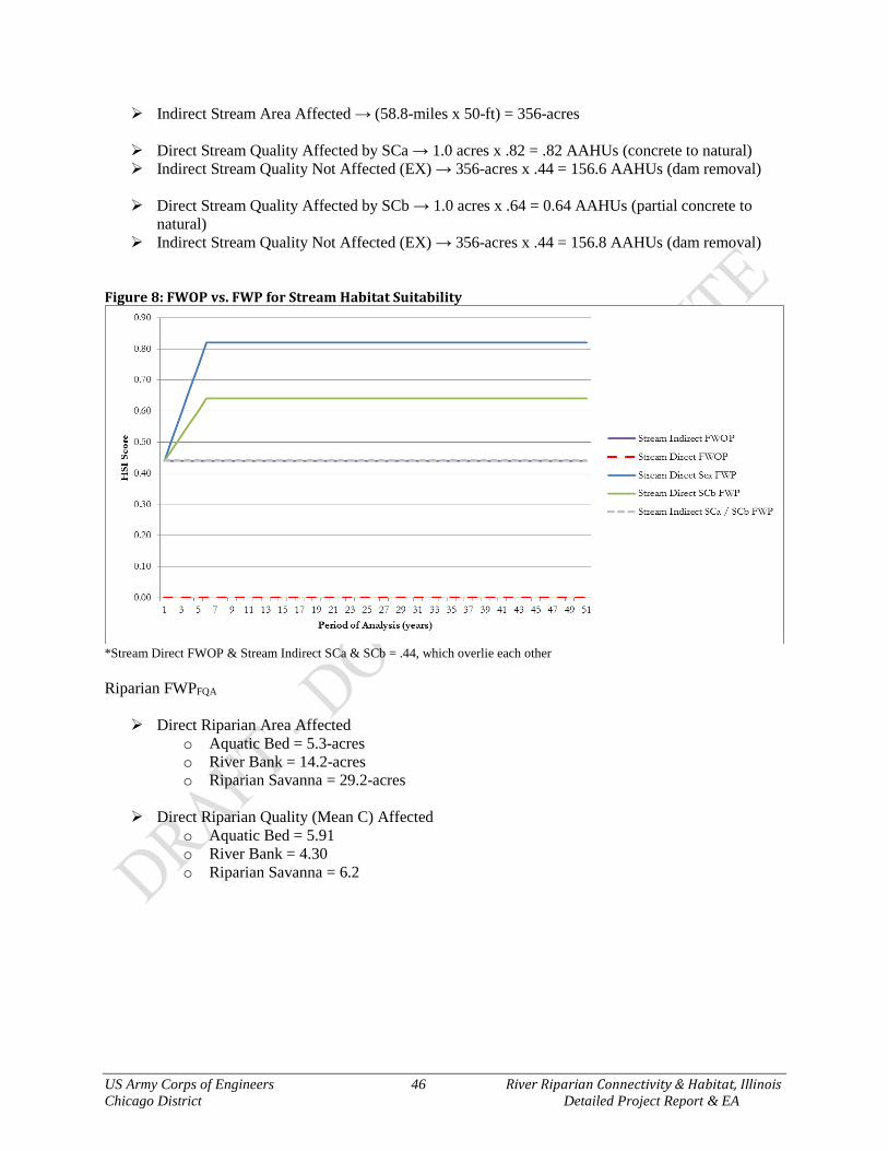
US Army Corps of Engineers 46 River Riparian Connectivity & Habitat, Illinois Chicago District Detailed Project Report & EA
Indirect Stream Area Affected → (58.8-miles x 50-ft) = 356-acres Direct Stream Quality Affected by SCa → 1.0 acres x .82 = .82 AAHUs (concrete to natural) Indirect Stream Quality Not Affected (EX) → 356-acres x .44 = 156.6 AAHUs (dam removal)
Direct Stream Quality Affected by SCb → 1.0 acres x .64 = 0.64 AAHUs (partial concrete to
natural) Indirect Stream Quality Not Affected (EX) → 356-acres x .44 = 156.8 AAHUs (dam removal)
Figure 8: FWOP vs. FWP for Stream Habitat Suitability
*Stream Direct FWOP & Stream Indirect SCa & SCb = .44, which overlie each other Riparian FWPFQA Direct Riparian Area Affected
o Aquatic Bed = 5.3-acres o River Bank = 14.2-acres o Riparian Savanna = 29.2-acres
Direct Riparian Quality (Mean C) Affected
o Aquatic Bed = 5.91 o River Bank = 4.30 o Riparian Savanna = 6.2

US Army Corps of Engineers 47 River Riparian Connectivity & Habitat, Illinois Chicago District Detailed Project Report & EA
Figure 9: FWOP vs. FWP for Riparian Plant Community Habitat Suitability Table 13: Net Average Annual (50-years) Habitat Units per Measure
Description Habitat Types Acres AAHSI AAHUs NAAHUs No Action / FWOP Stream Direct 0.0 0.44 0.00 Stream Indirect 0.0 0.44 0.00 Stream Total 0.0 0.00 Aquatic Bed 5.3 0.00 0.00 River Bank 14.2 0.15 2.14 Riparian Savanna 29.2 0.24 6.95
Action / FWP Stream Direct SCa 1.0 0.80 0.80 0.80 Stream Indirect SCa 356.0 0.44 156.64 156.64 Stream (SCa) Total 357.0 157.44 157.44 Stream Direct SCb 1.0 0.63 0.63 0.63 Stream Indirect SCb 356.0 0.44 156.64 156.64 Stream (SCb) Total 357.0 157.27 157.27 Aquatic Bed (AB) 5.3 0.58 3.07 3.07 River Bank (RB) 14.2 0.42 6.02 3.87 Riparian Savanna (RS) 29.2 0.61 17.73 10.78
4.2 Alternative Plan Generation Six (6) measures, including the No Action measure, were input into the IWR-Planning Suite in terms of costs and benefits shown in Table 14. Stream Channel Option A (SCa) and Stream Channel Option B (SCb) are not combinable as they propose different methods for stream channel restoration. The three riparian plant community measures, Aquatic Bed (AB), River Bank (RB), and Riparian Savanna (RS) are independent and combinable with each other and with the Stream Channel Options (SCa or SCb). Based on these inputs and criteria, the IWR Planning software generated eighteen (18) alternative combinations for ecosystem restoration. These alternative combinations were processed for Cost Effectiveness analyses

US Army Corps of Engineers 48 River Riparian Connectivity & Habitat, Illinois Chicago District Detailed Project Report & EA
via the Certified IWR Planning Suite Cost Effective and Incremental Cost Analysis, which are presented in the following sections. Table 14: Measure AA Costs & Net AA Habitat Units (NAAHUs)
Code* Measure AA Cost NAAHUs NA No Action (FWOP) $ - 0 SCa Stream Channel Option A $ 60,878 0.80 SCb Stream Channel Option B $ 51,987 0.63 AB Aquatic Bed $ 88,988 3.07 RB River Bank $ 199,818 3.87 RS Riparian Savanna $ 184,980 10.78
*for use in the IWR-Planning Suite Software 4.3 Cost Effectiveness/Incremental Cost Analysis Cost effectiveness and incremental cost analysis (CE/ICA) are two distinct analyses that must be conducted to evaluate the effects of alternative plans according to USACE policy. First, it must be shown through cost effectiveness analysis that a restoration plan’s output cannot be produced more cost effectively by another alternative. Cost effective means that, for a given level of non-monetary output, no other plan costs less and no other plan yields more output at a lower cost. Incremental cost analysis means that the subset of cost effective plans are examined sequentially to ascertain which plans are most efficient in the production of environmental benefits. Those most efficient plans are called “best buys.” As a group of measures, they provide the greatest increase in output for the least increases in cost. They have the lowest incremental costs per unit of output. In most analyses, there will be a series of best buy plans, in which the relationship between the quantity of outputs and the unit cost is evident. As the scale of best buy plans increases (in terms of output produced), average costs per unit of output and incremental costs per unit of output will increase as well. The incremental analysis by itself will not point to the selection of any single plan. The results of the incremental analysis must be synthesized with other decision-making criteria (i.e., significance of outputs, acceptability, completeness, effectiveness, risk and uncertainty, reasonableness of costs) to help the study team select and recommend a particular plan.
4.3.1 Cost Effectiveness The cost effectiveness analysis was used to ensure that certain options would be screened out if they produced the same amount or less output at a greater cost than other options with a lesser cost. Eighteen (18) alternative combinations were analyzed for cost effectiveness. Of these, Eleven (11) cost effective combinations were identified (Figure 10), with a subset of four (4) plans being identified as “Best Buys”. The No Action plan is always deemed cost effective. Six (6) alternative combinations were screened out as non-cost effective.
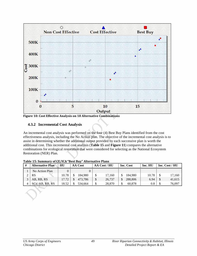
US Army Corps of Engineers 49 River Riparian Connectivity & Habitat, Illinois Chicago District Detailed Project Report & EA
Figure 10: Cost Effective Analysis on 18 Alternative Combinations
4.3.2 Incremental Cost Analysis An incremental cost analysis was performed on the four (4) Best Buy Plans identified from the cost effectiveness analysis, including the No Action plan. The objective of the incremental cost analysis is to assist in determining whether the additional output provided by each successive plan is worth the additional cost. This incremental cost analysis (Table 15 and Figure 11) compares the alternative combinations for ecological restoration that were considered for selecting as the National Ecosystem Restoration (NER) Plan. Table 15: Summary of CE/ICA “Best Buy” Alternative Plans
# Alternative Plan HU AA Cost AA Cost / HU Inc. Cost Inc. HU Inc. Cost / HU
1 No Action Plan 0 0 2 RS 10.78 $ 184,980 $ 17,160 $ 184,980 10.78 $ 17,160 3 AB, RB, RS 17.72 $ 473,786 $ 26,737 $ 288,806 6.94 $ 41,615 4 SCa, AB, RB, RS 18.52 $ 534,664 $ 28,870 $ 60,878 0.8 $ 76,097

US Army Corps of Engineers 50 River Riparian Connectivity & Habitat, Illinois Chicago District Detailed Project Report & EA
Figure 11: Incremental Cost and Output of “Best Buy” Alternative Plans There is a break point between “best buy” Alternative plans 3 and 4. The following significance and four (4) planning criteria discussion, and in particular Figure 12 of the Effectiveness section, details why it is both worth it and important to implement Alternative Plan 4. 4.4 Significance of Ecosystem Outputs Due to the challenges associated with comparing non-monetized benefits, the concept of output significance plays an important role in ecosystem restoration evaluation. Along with information from cost effectiveness and incremental cost analyses, information on the significance of ecosystem outputs will help determine whether the proposed environmental investment is worth its cost and whether a particular alternative should be recommended. Statements of significance provide qualitative information to help decision makers evaluate whether the value of the resources of any given restoration alternative are worth the costs incurred to produce them. The significance of the River Riparian Study Area habitat restoration outputs are herein recognized in terms of institutional, public, and/or technical importance.
Institutional Recognition Institutional recognition means that the importance of an environmental resource is acknowledged in the laws, adopted plans, and other policy statements of public agencies, tribes, or private groups. Sources of institutional recognition include public laws, executive orders, rules and regulations, treaties, and other policy statements of the Federal Government; plans, laws, resolutions, and other policy statements of states with jurisdiction in the planning area; laws, plans, codes, ordinances, and other policy statements of regional and local public entities with jurisdiction in the planning area; and charters, bylaws, and other policy statements of private groups.
2
2
3
4
US Army Corps of Engineers 51 River Riparian Connectivity & Habitat, Illinois Chicago District Detailed Project Report & EA
Migratory Bird Treaty Act (1918) The Migratory Bird Treaty Act is the domestic law that implements the United States' commitment to four international conventions for the protection of migratory birds and their habitats. The Act protects species or families of birds that live, reproduce, or migrate within or across international borders at some point during their annual life cycle. The four Migratory Bird Conventions are:
Convention for the Protection of Migratory Birds with Great Britain on behalf of Canada (1916) Convention for the Protection of Migratory Birds and Game Mammals - Mexico (1936) Convention for the Protection of Migratory Birds and Their Environment - Japan (1972) Convention for the Protection of Migratory Birds and Their Environment - Union of Soviet Socialist
Republics (1978) The Mississippi Flyway There are 4 principal North American flyways – the Atlantic, Mississippi, Central and Pacific. The Mississippi Flyway’s eastern boundary runs along western Lake Erie, whereas the western boundary is somewhat ambiguous as it merges unnoticeably into the Central Flyway. The longest migration route in the Western Hemisphere lies in the Mississippi Flyway from the Arctic coast of Alaska to Patagonia, in which some shorebird species fly this nearly 3,000 mile route twice. Parts of all four flyways merge together over Panama. The Lake Michigan route of the Mississippi Flyway includes the Chicago River, which flows parallel to the Lake Michigan shoreline. This route of the flyway is ideal for migratory waterfowl due to it being uninterrupted by mountains, dotted with tens of thousands of lakes, wetlands, ponds, streams and rivers, and is well timbered in certain reaches. Illinois and Indiana urban zones and farmland do not provide the type and variety of food and shelter required by nearly all migrating birds. In comparison, Lake Michigan's shoreline provides a variety of plant life and habitat for resting and refueling. Chicago's parks and even residential backyards are particularly important because they are the only patches of habitat left within a concrete watershed. The preservation of open space along water bodies is critical to the survival of millions of birds that migrate through Chicago every spring and fall. The River Riparian study area has great potential to provide critical migratory bird habitat with the restoration measures implemented. Currently, 119 species of nesting and migratory birds known from the Chicago Region have been observed at within the study area. Alternative Plan 4 is in full support of the Migratory Bird Treaty Act, whereas Alternative Plan 2 and 3 excludes restoring and connecting the NBCR providing an additional 356 acres of accessible stream habitat. EO 13186 – Responsibilities of Federal Agencies to Protect Migratory Birds – Federal agencies shall restore or enhance the habitat of migratory birds and prevent or abate pollution or detrimental alteration of the environment for migratory birds. This project would restore fish passage, fish habitat, aquatic bed, river bank, and riparian savanna, thus providing forage and shelter for numerous migratory bird species. This project lies within a significant portion of the Mississippi Flyway along the coast of Lake Michigan that particularly favors both ecological and economically valuable waterfowl species. Approximately 14 waterfowl that are known to be hunted within the United States have been observed and identified within the study area of River Riparian Restoration project area. These species include Hooded Merganser, Common Merganser, Red-Breasted Merganser, Redhead, Northern Shoveler, Wood Duck, Goldeneye, Ruddy Duck, American Coot, Mallard, Blue Winged Teal, Canada Goose, Bufflehead, and Canvasback. These species of waterfowl over winter as far south as South America and breed as far north as Alaska, resulting in a migration route that traverses as many as 14 states. Therefore, the
US Army Corps of Engineers 52 River Riparian Connectivity & Habitat, Illinois Chicago District Detailed Project Report & EA
restoration of waterways within the Mississippi and Great Lakes Flyways, like River Riparian, may provide recreational hunting benefits to as many as 14 states. Alternative Plan 4 fulfills the USACE’s role and responsibility by utilizing its Ecosystem Restoration Mission, authority and supporting polices to restore diverse habitats for Migratory Waterfowl and fishes that support these bird species, whereas Alternative Plan 2 and 3 excludes restoring and connecting the NBCR providing an additional 356 acres of accessible stream habitat. EO 13340 Great Lakes A National Treasure - Identified the Great Lakes as a national treasure and defined a Federal policy to support local and regional efforts to restore and protect the Great Lakes ecosystem through the establishment of regional collaboration. A number of activities have been accomplished by Federal agencies working in partnership with state, tribal and local governments in response to the Executive Order. The USACE has been a major participant in these activities. The Executive Order established the Great Lakes Interagency Task Force. The Task Force worked with the governors of the eight Great Lakes states, mayors, and tribal leaders to establish the Great Lakes Regional Collaboration. The initial goal of the Collaboration was to develop a “strategy for the protection and restoration of the Great Lakes” within 1 year. Alternative Plan 4 would restore physical characteristics of Lake Michigan coastal habitats, which is in full support of this Act. The Collaboration developed the strategy by using teams consisting of 1,500 stakeholders for the following eight priority issues identified by the Great Lakes governors and mayors with items in bold relative to this project:
1. Toxic contaminants 5. Contaminated sediments/AOCs 2. Non-point source pollution 6. Indicators/information 3. Coastal health 7. Sustainable development 4. Habitat/species 8. Invasive species
Fish and Wildlife Conservation Act of 1980 – all Federal departments and agencies to the extent practicable and consistent with the agency’s authorities should promote the conservation of non-game fish, wildlife, and their habitats. Alternative Plan 4 would restore physical characteristics of Lake Michigan coastal habitats, whereas Alternative Plan 2 and 3 excludes restoring and connecting the NBCR providing an additional 356 acres of accessible stream habitat. EO 11514 Protection and Enhancement of Environmental Quality – the Federal Government shall provide leadership in protecting and enhancing the quality of the Nation’s environment to sustain and enrich human life. Improving both the habitat and aesthetic values of the Chicago River would be achieved via Alternative 4. This project would provide leadership by providing an example to other large metropolitan areas that industrialized and urbanized areas can be reclaimed for the public and nature to enhance environmental quality. EO 11990 Protection of Wetlands – each agency shall provide leadership and shall take action to minimize the destruction, loss or degradation of wetlands, and to preserve and enhance the natural and beneficial values of wetlands. Alternative Plan 4 would restore physical characteristics of Lake Michigan coastal habitats, whereas Alternative Plan 2 and 3 excludes restoring and connecting the NBCR providing an additional 356 acres of accessible stream habitat. EO 13112 Invasive Species – This executive order calls for actions “to prevent the introduction of invasive species and provide for their control and to minimize the economic, ecological, and human health impacts that invasive species cause...” This EO utilizes the laws of the United States of America, including the National Environmental Policy Act of 1969, as amended (42 U.S.C.§ 4321 et seq.), Nonindigenous Aquatic Nuisance Prevention and Control Act of 1990, as amended (16 U.S.C.§ 4701 et seq.), Lacey Act, as amended (18 U.S.C.§ 42), Federal Plant Pest Act (7 U.S.C.§ 150aa et seq.), Federal

US Army Corps of Engineers 53 River Riparian Connectivity & Habitat, Illinois Chicago District Detailed Project Report & EA
Noxious Weed Act of 1974, as amended (7 U.S.C.§ 2801 et seq.), Endangered Species Act of 1973, as amended (16 U.S.C.§ 1531 et seq.), and other pertinent statutes. Completed in 2001, the National Invasive Species Management Plan, served as a comprehensive “blueprint” for federal action on invasive species, as well as NISC’s primary coordination tool. This coordination tool provided the first comprehensive national plan for invasive species action. It called for about 170 specific actions within nine categories of activity, about 100 of which have been established or completed. Actions identified in the 2001 Plan continue to be implemented. The 2008 through2012 National Invasive Species Management Plan (2008 Plan) was the first revision of the 2001 Plan. The 2008 Plan focused upon five “Strategic Goals”: Prevention; Early Detection and Rapid Response; Control and Management; Restoration; and Organizational Collaboration. To accomplish these strategic goals, critical support for efforts such as research, data and information management, education and outreach, and international cooperation elements were included in the plan. The 2008 Plan identified prevention as the first line of defense, and calls for preventing the introduction and establishment of invasive species to reduce their impact on the environment, the economy, and health of the United States. Executive Order (EO) 13112 also includes specific duties for federal agencies in regard to invasive or nuisance aquatic species. Excerpts from the order relating to federal agencies are contained in the following paragraphs:
(a) Each Federal agency whose actions may affect the status of invasive species shall, to the extent practicable and permitted by law, (1) identify such actions; (2) subject to the availability of appropriations, and within Administration budgetary limits, use relevant programs and authorities to: (i) prevent the introduction of invasive species; (ii) detect and respond rapidly to and control populations of such species in a cost-effective and environmentally sound manner; (iii) monitor invasive species populations accurately and reliably; (iv) provide for restoration of native species and habitat conditions in ecosystems that have been invaded; (v) conduct research on invasive species and develop technologies to prevent introduction and provide for environmentally sound control of invasive species; and (vi) promote public education on invasive species and the means to address them; and
Alternative Plan 3 and 4 fully addresses the intent of EO 13112. Endangered Species Act of 1973 – all Federal departments and agencies shall seek to conserve endangered species and threatened species. The purpose of the act is to conserve ecosystems upon which endangered and threatened species depend. Implementation of Alternative Plan 4 would improve hunting habitat for the state threatened Black-Crown Night-Heron (Nycticorax nycticorax). Also, this alternative would provide fish passage and stream habitat for state listed Banded Killifish (Fundulus diaphanus). Clean Water Act – restore the chemical and biological integrity of the Nation’s waters. Although water quality improvement is not within the USACE Mission, policy acknowledges that habitat restoration provides incidental water quality improvements most of the time. The Clean Water Act also has provisions for wetland and biological integrity protection. The No Action Alternative does not support this Act by denying opportunity to improve water quality and increase viable wetland acres. Alternatives 3 and 4 support the Clean Water Act since water quality improvements would be realized. EO 13653 Preparing the United States for the Impacts of Climate Change – The impacts of climate change — including an increase in prolonged periods of excessively high temperatures, more heavy downpours, an increase in wildfires, more severe droughts, permafrost thawing, ocean acidification, and sea-level rise — are already affecting communities, natural resources, ecosystems, economies, and public
US Army Corps of Engineers 54 River Riparian Connectivity & Habitat, Illinois Chicago District Detailed Project Report & EA
health across the Nation. These impacts are often most significant for communities that already face economic or health-related challenges, and for species and habitats that are already facing other pressures. Managing these risks requires deliberate preparation, close cooperation, and coordinated planning by the Federal Government, as well as by stakeholders, to facilitate Federal, State, local, tribal, private-sector, and nonprofit-sector efforts to improve climate preparedness and resilience; help safeguard our economy, infrastructure, environment, and natural resources; and provide for the continuity of executive department and agency (agency) operations, services, and programs. The Federal Government must build on recent progress and pursue new strategies to improve the Nation's preparedness and resilience. In doing so, agencies should promote: (1) engaged and strong partnerships and information sharing at all levels of government, (2) risk-informed decision-making and the tools to facilitate it, (3) adaptive learning, in which experiences serve as opportunities to inform and adjust future actions, and (4) preparedness planning. Alternatives 3 and 4 support this EO via the sequestration of carbon and carbon dioxide by increasing the acreage and biomass of native plant material above and below ground. Even dead plant material in the form of peat, detritus and mucks prevents carbon from entering the atmosphere. Converting homogenous spaces to diverse structures and native plants would ultimately absorb more sunlight than reflect it into the atmosphere and in turning heating up the planet.
Public Recognition Public recognition means that some segment of the general public recognizes the importance of an environmental resource, as evidenced by people engaged in activities that reflect an interest or concern for that particular resource. Such activities may involve membership in an organization, financial contributions to resource-related efforts, and providing volunteer labor and correspondence regarding the importance of the resource. Friends of the Chicago River Since 1979, the Friends of the Chicago River (Friends) has worked to improve the health of the Chicago River for the benefit of people and wildlife; and by doing so, has laid the foundation for the river to be a beautiful, continuous, and easily accessible corridor of open space in the Chicago region. Friends’ work spans the entire 156-mile Chicago River system and its surrounding watershed. The Friends focus on a “greener” river with healthy habitat, an accessible river that people can use and enjoy, and a river cared for by a broad group of supporters. Friends work in partnership with municipalities, businesses, community groups, schools, peer organizations, government agencies and individuals on projects that benefit the river. The Friends “believe the river can be both ecologically healthy and a catalyst for community revitalization.” Chicago River Corridor Development Plan, City of Chicago, 1999 This plan specifically references the River Riparian study area for habitat restoration, greenway expansion, passive recreational activities and improved access to the Chicago River. The plan calls for restoring and protecting landscapes and natural habitats along the river, particularly fish habitat. Given the river’s industrial history, little of its pre-settlement “natural” character remains. As redevelopment proceeds, care should be taken to create landscaped buffers and wetlands, both to soften harsh urban edges and to support wildlife.
US Army Corps of Engineers 55 River Riparian Connectivity & Habitat, Illinois Chicago District Detailed Project Report & EA
Chicago Nature & Wildlife Plan, City of Chicago, Department of Planning & Development, 2006 The Chicago Nature and Wildlife Plan and its associated Chicago Nature Areas Directory identifies more than 4,800 acres of prairies, savannas, dunes, woodlands, wetlands and potential restoration areas at 98 sites throughout Chicago. As the first plan of its kind in Chicago's history, the Nature and Wildlife plan established a framework to protect and expand ecosystems for the benefit of wildlife and people. The original plan was adopted by Chicago Plan Commission, the Chicago Park District and the Forest Preserve District of Cook County in 2006. The "Chicago Nature and Wildlife Plan Update: A Strategy to Enhance Urban Ecosystems (2011-2016)" was produced by the Mayor's Nature and Wildlife Advisory Committee to continue Chicago's commitment to expand and improve our important urban natural areas. The plan update reviews progress made since the original plan and sets priorities for the next five years. Stakeholder Support Support of the River Riparian Ecosystem Restoration Project presented in this Detailed Project Report includes, but are not limited to: the US Environmental Protection Agency (USEPA), US Fish and Wildlife Service (USFWS), Illinois Environmental Protection Agency (IEPA), Illinois Department of Natural Resources (IDNR), the Metropolitan Water Reclamation District of Greater Chicago (MWRDGC), the Audubon Society Chicago, the Field Museum of Natural History, the John G. Shedd Aquarium, Friends of the Chicago River, Friends of the Parks are all critical and involved stakeholders. The Audubon Society, Field Museum of Natural History, and the Shedd Aquarium have National and Global interests in persevering and restoring biodiversity.
Technical Recognition Technical recognition means that the resource qualifies as significant based on its “technical” merits, which are based on scientific knowledge or judgment of critical resource characteristics. Whether a resource is determined to be significant may of course vary based on differences across geographical areas and spatial scale. While technical significance of a resource may depend on whether a local, regional, or national perspective is undertaken, typically a watershed or larger (e.g., ecosystem, landscape, or ecoregion) context should be considered. Technical significance should be described in terms of one or more of the following criteria or concepts: scarcity, representation, status and trends, connectivity, limiting habitat, and biodiversity. Scarcity is a measure of a resource’s relative abundance within a specified geographic range. Generally, scientists consider a habitat or ecosystem to be rare if it occupies a narrow geographic range (i.e., limited to a few locations) or occurs in small groupings. Unique resources, unlike any others found within a specified range, may also be considered significant, as well as resources that are threatened by interference from both human and natural causes. Representation is a measure of a resource’s ability to exemplify the natural habitat or ecosystems within a specified range. The presence of a large number and percentage of native species, and the absence of exotic species, implies representation as does the presence of undisturbed habitat. Status and Trend measures the relationship between previous, current and future conditions. Connectivity is the measure of a resource’s connection to other significant natural habitats. Limiting Habitat is the measure of resources present supporting significant species.

US Army Corps of Engineers 56 River Riparian Connectivity & Habitat, Illinois Chicago District Detailed Project Report & EA
Technical Summary – Wildlife conservation in urban habitats is increasingly important due to current urbanization trends (Fernández-Juricic and Jokimäki 2001). Alternative Plan 4 focuses on restoring more diverse habitats along portions of the Chicago River system, which is representative of scarce riverine habitat of quality within the Chicago city limits. Habitats include an open medium gradient stream, fringe marsh along the waterway toe and riparian buffer of wet to mesic savanna. These habitats were known to be much more widespread at one point in history; with recent efforts to reestablish these along the Chicago River system. In terms of connectivity, this alternative first and foremost allows fish access to the Chicago River North Branch, which is currently blocked by the dam at River Park. Removal of this structure would open 48.8 miles of riverine habitat for fishes and mussels. This alternative also adds connectivity to the increasing patches of habitat within the City of Chicago, lessening the distance species have to travel over inhospitable areas of urbanized lands. The coastal zone of Lake Michigan in Illinois is trending towards wide spread improvement and connectivity, indicative of projects such as the Ravine projects along the north shore, 63rd Street Dune and Beach 506, Northerly Island 506, and various smaller parks being restored by the Chicago Park District. Connectivity within the site is important as well, especially between different plant communities for amphibians, reptiles, small mammals and insects. Hydrologic gradients provide the basis for plant community species richness and structure, and because of the gradients, these plant communities seamlessly connect to each other. This makes it critical to restore in-between habitats such as fringing marsh and bank, which connects the submersed riverine habitat with riparian savanna. Species such as the Snapping Turtle, Tiger Salamander require these habitats and transition zones in order to reproduce. Certain keystone fishes, such as Northern Pike and Grass Pickerel require spawning habitat for reproduction and recruitment, and just as well need the fringe marsh along the Chicago River for spawning and nursery habitat (Stephenson 1990, Jude and Papas 1992). The State Threatened Banded Killifish’s critical spawning and foraging habitat is fringe marsh. The fringe area of many lakes and ponds is also critical in that they provide structure and food to maintain diverse macroinvertebrate populations that support both aquatic and terrestrial species (Krieger 1992). Many species of water fowl also require fringe marsh for both nesting and rearing of young. The proposed habitat restoration would have great potential to support various state threatened species, including the Banded Killifish, Yellow-Headed Black-bird, and Black-Crown Night-Heron. 4.5 Acceptability, Completeness, Effectiveness & Efficiency Acceptability, completeness, effectiveness, and efficiency are the four evaluation criteria USACE uses in evaluating alternative plans. Alternatives considered in any planning study, not just ecosystem restoration studies, should meet minimum subjective standards of these criteria in order to qualify for further consideration and comparison with other plans.
Acceptability An ecosystem restoration plan should be acceptable to state and Federal resource agencies and local governments. There should be evidence of broad-based public consensus and support for the plan. The tentatively recommended plan must be acceptable to the non-Federal cost-sharing partner. The River Riparian 506 Connectivity & Habitat Restoration study was developed in a collaborative fashion, in which planning and design meetings screened and refined habitat restoration measures. The Federal, State and local groups that participated in these activities (see) are discussed in the previous section. Alternative 1, No Action, provides no ecosystem improvements and is not acceptable to the Federal Objective, the non-Federal sponsor’s goals and stakeholder desires. Alternative 4 is the most acceptable in terms of the Federal Objective and non-Federal sponsor/stakeholder vision for reestablishing a sustainable and viable ecosystem within the River Riparian study area. Alternatives 2 and 3 provide limited benefits but generally leaves critical aquatic habitat types stream and connectivity in a degraded state. Taking the Federal Objective, study objectives, municipal planning initiatives and

US Army Corps of Engineers 57 River Riparian Connectivity & Habitat, Illinois Chicago District Detailed Project Report & EA
documents, and non-Federal sponsor/stakeholder needs into consideration, Alternative 4 provides the most diverse habitat possible and therefore would be the most acceptable.
Completeness A plan must provide and account for all necessary investments or other actions needed to ensure the realization of the planned restoration outputs. This may require relating the plan to other types of public or private plans if these plans are crucial to the outcome of the restoration objective. Real estate, operations and maintenance, monitoring, and sponsorship factors must be considered. Where there is uncertainty concerning the functioning of certain restoration features an adaptive management plan should be proposed and must be accounted for in the implementation plan. All of the factors were considered in the development or post formulation assessment of alternative plan costs/outputs, consistency with other Federal and non-Federal Plans, real estate, operation and maintenance (O&M), monitoring and non-Federal sponsorship. Alternative 1 does not provide any action to restore degraded habitats and therefore is incomplete in realization of ecosystem improvements. Alternatives 2 and 3 are incomplete in terms of restoring all potential aquatic habitats and is inconsistent with State (ILDNR dam removal) and local plans for reestablishing a healthy coastal zone. Alternative 4 is the most complete in that it would change study area from a degraded ditch corridor into a more diverse and native riverine habitat system for fish, wildlife and migratory birds. Alternative 4 would have the least O&M and adaptive management features since the alternatives are complete from ecological systems context.
Effectiveness A plan must provide and account for meeting goals and objectives of the study to ensure the realization of the planned restoration outputs. Objective 1 – Reestablish Quality and Connectivity of Riverine Habitats: This objective seeks to reestablish natural hydrologic and geomorphic parameters to support critical riverine habitats within the River Riparian study area. Objective 2 – Reestablish Quality and Connectivity of Riparian Habitats: This objective seeks to reestablish natural hydrologic and geomorphic parameters to support critical riparian habitats within the River Riparian study area. Alternative 1 takes no action, and therefore does not meet the two planning objectives since the
future without-project conditions do not foresee natural recovery of this system. Alternative 2 would basically restore about 29.2-acres of riparian zone with no restoration of
stream, river bank or aquatic bed habitats. This alternative does not fully address Objective 1 (only provides allochthonus inputs and minor woody debris) and partially begins to address Objective 2.
Alternative 3 builds upon Alternative 2 by adding aquatic bed (5.3-ac) and river bank (14.2-ac)
habitat restoration to support the riparian savanna. This alternative addresses Objective 2, but does not have required components to fully address Objective 1.
Alternative 4 builds upon Alternative 3 by adding dam removal and stream channel restoration. This addition would provide 1-ac of stream channel restoration and 356-ac of stream connectivity (opens 48.8-miles of the NBCR). This alternative would provide about 49.7-acres of restored

US Army Corps of Engineers 58 River Riparian Connectivity & Habitat, Illinois Chicago District Detailed Project Report & EA
habitat and 356-ac of connected habitat. Figure 12 shows that dam removal is highly effective for connectivity purposes. This alternative fully addresses Objectives 1 and 2 within the purview of the Section 506 authority and USACE policies.
Figure 12: Indirect Effectiveness of Dam Removal (SCa)
Efficiency An ecosystem restoration plan must represent a cost-effective means of solving habitat problems and seizing opportunities to improve the environment. It must be determined that the plan’s restoration outputs cannot be produced more cost effectively than any other plan via the USACE’s Six-Step Planning Process. Six (6) measures, including No Action, were refined to seize site specific opportunities, address River Riparian study area problems, and were further honed by targeting two ecosystem objectives. Using the USACE Institute for Water Resources Planning Suite Software, eighteen (18) alternative combinations were generated from the measures. Through the CE/ICA analyses, eleven (11) cost effective combinations were identified, which is inclusive of the four (4) Best Buy Plans. The No Action plan is always deemed cost effective and a Best Buy Plan. Four (4) alternative combinations were screened out as non-cost effective. Only the four (4) Best Buy Plans were considered for selection, therefore Alternatives 2, 3 and 4 are deemed highly efficient.
4.6.3 Risk and Uncertainty When the costs and outputs of alternative restoration plans are uncertain and/or there are substantive risks that outcomes will not be achieved, which may be the case, the selection of a recommended alternative becomes more complex. It is essential to document the assumptions made and uncertainties encountered during the course of planning analyses. Restoration of some types of ecosystems may have relatively low risk. For example, removal of drainage tiles to restore hydrology to a wetland area. Other activities may
SCa highly effective for connectivity
RS
RB/ AB

US Army Corps of Engineers 59 River Riparian Connectivity & Habitat, Illinois Chicago District Detailed Project Report & EA
have higher associated risks such as restoration of coastal marsh for example, which exist in areas subject to hurricanes. When identifying the NER plan, the associated risk and uncertainty of achieving the proposed level of outputs must be considered. For example, if two plans have similar outputs but one plan costs slightly more, according to cost effectiveness guidelines, the more expensive plan would be dropped from further consideration. However, it might be possible that, due to uncertainties beyond the control or knowledge of the planning team, the slightly more expensive plan will actually produce greater ecological output than originally estimated, in effect qualifying it as a cost effective plan. But without taking into account the uncertainty inherent in the estimate of outputs, that plan would have been excluded from further consideration. Overall, there is very low risk associated with Alternatives 2, 3 or 4 not performing as predicted. Sufficient investigations to the level of project complexity were performed to ensure that the restored plant communities would not revert to invasive, weedy species again by (a) lessons learned from constructed park like plant restoration projects i.e. Horner Park 206, Eugene Field Park 206, 63rd Street Dune & Beach 506 and Northerly Island 506, (b) designing plant communities to the hydrology and geomorphology instead of planting communities not indicative of system, and (c) a dedicated non-Federal sponsor that has a Natural Areas Program, will maintain the project as constructed with intended ecological benefits. Complete eradication of invasive species always presents a certain level of risk and uncertainty as the chances of reinvasion are likely to occur without proper management, increasingly so when native species have not yet established. A prominent issue is that invasive plant species are adapted for colonizing areas that are disturbed and have ruined soils. Measures that alleviate ruined soil properties consist of minor grading and adding leaf litter compost to the top 6 inches of soil during late summer or early fall. Incorporating soil amendments decreases bulk density, hold moisture longer and increase organic matter and microbial activity. This would further the soil’s ability to provide for native plants and reduce the vulnerability of the plant community to noxious weed invasion. This measure has been found to work on several Chicago District habitat restoration projects where the soils were physically ruined. The other end of the spectrum would be the addition of inorganic substrates to reverse the overly organic substrates currently in place. The only situation worse than a plant community completely comprised of weedy, nonnative species, is no plant community at all. Native plantings also have an associated risk of not establishing due to a variety of unforeseen events. Predation from herbivorous animals is likely since Common Carp and Canada Geese are quite abundant in the area. Weather also plays a large role in the establishment success of new plantings. Periods of drought, flood or early frost can alter the survival percentage of plantings. To mitigate these risks, planting over several years, overplanting and/or adaptive management and monitoring may be incorporated into the overall plan. In addition, climate change may or may not affect project outcomes. Increased temperatures or rainfall may lead to changes in the ecosystem of the project area; however, Lake Michigan primarily drives the weather in the Chicagoland area and may partly mitigate climate change concerns for the near future. This climate concern is alleviated by having a broader pallet of adaptive plant species to compensate for climatic shifts. Concerns of erosive forces are not apparent for this project since it is in a stable and sheltered area, protected from wind, waves and flowing streams. 4.7 Plan Comparison & Tentatively Selected Plan (TSP) Recommendation When selecting a single alternative plan for recommendation from those that have been considered, the criteria used to select the NER plan include all the evaluation criteria discussed above. Selecting the NER plan requires careful consideration of the plan that meets planning objectives and constraints and

US Army Corps of Engineers 60 River Riparian Connectivity & Habitat, Illinois Chicago District Detailed Project Report & EA
reasonably maximizes environmental benefits while passing tests of cost effectiveness and incremental cost analyses, significance of outputs, acceptability, completeness, efficiency, and effectiveness. This restoration project was planned in cooperation with the Chicago Park District and various Federal, State and local stakeholders. Also, this restoration project makes a significant contribution to regional, national, and international programs that include the North American Waterfowl Management Plan, Lake-wide Management Plans, and the Coastal Zone Management Plan. This plan included an opportunity for open comment to allow all stakeholder parties to contribute. All costs associated with a plan were considered, and tests of cost effectiveness and incremental cost analysis have been satisfied for the alternatives analyzed. The cost estimates were based on current ecosystem restoration projects that are in construction and design phases. Having established confidence in the estimated implementation costs, the remaining test of reasonableness is to assess the value of the resource to be improved based on the cost to implement the improvement. The importance of Migratory Birds in terms of human uses and aesthetics has been documented through numerous sources, most importantly the Migratory Bird Treaty Act (1918) and EO 13186 Responsibilities of Federal Agencies to Protect Migratory Birds. Non-monetary values associated with the River Riparian restoration project include a variety of ecological, social and educational benefits. The project will provide important stop-over habitat for birds traveling along the Great Lakes portion of the Mississippi Flyway, a migratory route recognized as nationally significant by the Audubon Society. An estimated 5 million birds, and more specifically tropical song birds and waterfowl, utilize this route. In addition, the native habitat types planned will benefit native resident species. A variety of aquatic species such as fish, macroinvertebrates, and amphibians will greatly benefit through the addition of important foraging, refuge, and spawning habitat. The restoration of the River Riparian study area as a natural area will markedly increase the ecological integrity of the surrounding area and is well worth the investment. The plan that reasonably maximizes net National Ecosystem Restoration benefits and is consistent with the Federal objective, authorities and policies, is identified as the NER plan. This NER Plan is considered as the Preferred Plan for direct, indirect and cumulative effects assessment under NEPA as discussed in the following Chapter. The NER/Preferred Plan was determined to be Alternative 4 (Figure 13 and Plate 5).
4.7.2 NER / Tentatively Selected / Preferred Plan When selecting a single alternative plan for recommendation from those that have been considered, the criteria used to select the National Ecosystem Restoration (NER) plan include all the evaluation criteria discussed above. Selecting the NER plan requires careful consideration of the plan that meets planning objectives and constraints and reasonably maximizes environmental benefits while passing tests of cost effectiveness and incremental cost analyses, significance of outputs, acceptability, completeness, efficiency, and effectiveness. The plan that reasonably maximizes net NER benefits and is consistent with the Federal objective, authorities and policies, is identified as the NER Plan. This NER Plan is synonymous with the Tentatively Selected Plan and the Preferred Plan for direct, indirect and cumulative effects assessment under NEPA in the following Chapter. The NER Plan was determined to be Alternative Plan 4.
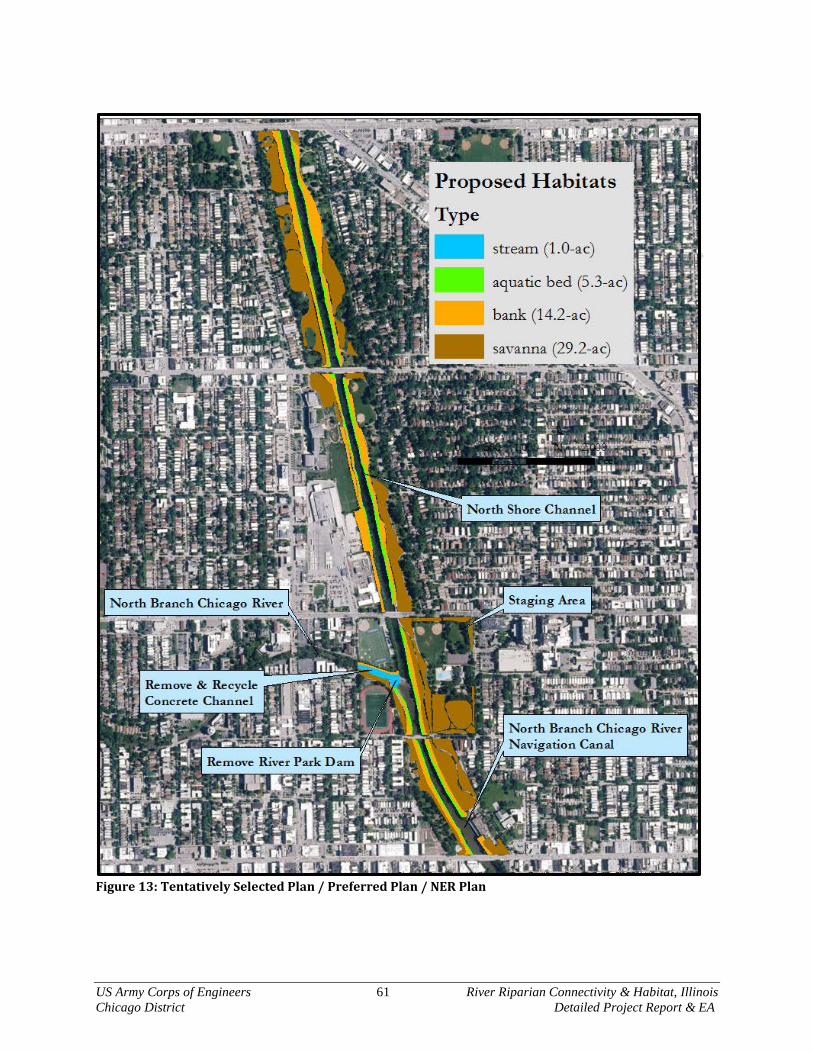
US Army Corps of Engineers 61 River Riparian Connectivity & Habitat, Illinois Chicago District Detailed Project Report & EA
Figure 13: Tentatively Selected Plan / Preferred Plan / NER Plan
US Army Corps of Engineers 62 River Riparian Connectivity & Habitat, Illinois Chicago District Detailed Project Report & EA
CHAPTER 5 – INTEGRATED ENVIRONMENTAL ASSESSMENT This chapter involves prediction of direct, indirect and cumulative environmental effects to current conditions stemming from implementation of the Preferred Plan/NER Plan. 5.1 Need and Purpose Before the late 1800’s, the River Riparian study area was a marshy ecosystem interspersed with prairie and savanna. Over a period of several decades, this ecosystem was severely altered by human activities, which included digging the North Shore Channel, moving the North Branch Chicago River, lining the new ditch channels with concrete and filling in of all surrounding wetlands with mixed soils and manmade refuse. Currently, the River Riparian study area no longer provides a diversity of high quality native habitats sufficient to maintain moderate levels of biodiversity. Based on site inventory and characterization by the USACE, a set of Problems and Opportunities were developed by the study team, non-Federal Sponsors and supporting stakeholders. These drive the need for action, which is summarized as the historic loss of significant migratory bird, fish and wildlife habitats. The purpose of this feasibility study and integrated environmental assessment is to identify the most environmentally beneficial, cost effective and publicly supported habitat restoration project to restore stream, wetland and riparian habitats. 5.2 Alternatives Considered Section 4.1 provides discussion on the suite of measures that were developed to address study problems and meeting objectives. These measures that were processed through the IWR Planning Suite program to generate cost effective plans. The cost effective and incremental cost analysis takes implementation and real estate costs and ecosystem outputs into consideration. Ecosystem outputs were measured via the Qualitative Habitat Evaluation Index (QHEI) and the Floristic Quality Index (FQI). Four (4) alternative plans, including the No Action Plan, were deemed best case scenarios for project implementation. Alternative 4 was selected as the National Ecosystem Restoration (NER) Plan, which for the purposes of this Environmental Assessment is synonymous with the Preferred Plan or Tentatively Selected Plan (TSP). Rationale for selecting the NER/Preferred Plan is presented in Section 4.6. Alternative Plan 1 – No Action Alternative Plan 2 – (RS) Riparian Savanna 29.2-ac Only Alternative Plan 3 – (RS) Riparian Savanna 29.2-ac, (RB) River Bank 14.2-ac, (AB) Aquatic Bed
5.3-ac Alternative Plan 4 – (RS) Riparian Savanna 29.2-ac, (RB) River Bank 14.2-ac, (AB) Aquatic Bed
5.3-ac, and (SCa) Stream Channel (direct restoration = 1-ac; connectivity = 356-ac) 5.3 The Affected Environment A detailed description of the affected environment can be found in Chapter 2 – Study Area inventory and Forecasting. Based on data collection, analysis, and modeling conducted under this feasibility study and coordination with Federal, State and local governmental agencies and published studies by academia, it was determined that the physical, chemical and biological conditions of the River Riparian study area are in a state of habitat equilibrium albeit highly degraded from the natural state. As a result, dominant species present at the site are tolerant to habitat loss, anthropogenic disturbance and poor water quality are present (synanthropic species), such as Gray Squirrel, Coyote, Deer, Mallard Duck, Beaver, Muskrat, Common Carp, Largemouth Bass, Bullhead, etc. Slight improvements in water quality and some vegetation patches that have occurred are not enough for native plant and animal communities to

US Army Corps of Engineers 63 River Riparian Connectivity & Habitat, Illinois Chicago District Detailed Project Report & EA
reestablish, resulting in missing critical structural habitat components. The No Action Alternative conditions are synonymous with the Future Without-Project Conditions, which are presented in Section 2.6. 5.4 Direct and Indirect Effects of the Preferred Plan In addition to the effects discussed in the following sections, a 404(b)(1) analysis is provided in Appendix A. This analysis further documents whether or not there are effects to the aquatic environment resulting from the construction activities of the preferred plan.
5.4.1 Physical Resources
Geology, Glacial Stratigraphy and Soils The study area lies over the Dolton Member and Carmi Members of the Equality Formation. These glacial materials are for the most part buried within the study area by manmade fills on bank and riparian areas, only being moderately exposed in the bed of the stream and canal channels. Since the minor surficial grading would not disturb this geomorphic feature or displace glacial materials present, there would be no adverse effects resulting from implementation of the Preferred Plan/NER Plan. In terms of ecological function, all soils within the study area are considered manmade, and relatively unsuitable for a diverse array of native microbial, plant and insect growth. These soils primarily consist of mixed topsoil’s, clay, and gravels and fines derived from concrete and urban dirt. Geomorphic features and soils effects resulting from the implementation of the Preferred Plan/NER Plan are considered to be negligible. Sediment within the NB Chicago River will not be impacted. Sediment near the River Park Dam will be restored in that the existing concrete substrate will be removed, allowing natural sediment and sediment –related processes to be recovered.
Water Quality Currently, water quality within the study area is considered to be poor and has various impairments associated with human contact and use; however, water quality is sufficient enough to allow moderately conservative species to inhabit the area. The Preferred Plan/NER Plan would have incidental water quality benefits through the removal of a grade control dam, concrete lined channel, and highly eroding banks, all which would improve dissolved oxygen, lower temperatures, filter nutrients, and prevent fine materials from entering the stream. The subsequent establishment of aquatic bed and riparian savanna species would also provide moderate water quality improvements through filtering water, cover banks and provide high quality allochthonous material to the waterways. Adverse short term or long term effects to water quality stemming from construction activities are not anticipated, since erosion controls and best management practices will follow the Illinois Urban Manual. Turbidity and erosion will be controlled during construction activities and until the project area is stabilized with new plant growth.
Hazardous, Toxic and Radioactive Wastes No HTRW or recognized environmental conditions (RECs) were identified in the Phase I Environmental Site Assessment (ESA) in the project area. It is unlikely that site soils contain concentrations of contaminants above de minimis concentrations of analytes found in soils in the Chicago area. Excess materials generated during grading activity will be incorporated into the project as much as practicable. However, given the limited space available for incorporating materials into adjacent upland areas, disposal of excess soils offsite will be necessary. All materials generated from the site will be disposed at
US Army Corps of Engineers 64 River Riparian Connectivity & Habitat, Illinois Chicago District Detailed Project Report & EA
a clean construction and demolition debris (CCDD) facility registered with the Illinois Environmental Protection Agency. Coordination with CCDD facilities within the Chicago city limits will be conducted during design phase to ensure appropriate disposal facilities are identified. Chicago Park District, or other appropriate site owner signatory, will be obtained for the LPC-662 Owner Certification for CCDD facilities required in 35 Ill. Adm. Code Part 1100.
Hydrology The natural hydrology of the study area is no longer present. Hydrology expression within the riparian zones of the manmade canals no longer occurs, and all waters ultimately end up in the low lying NSC and NBCR. The hydrology within the NSC and NBCR are primarily controlled by stormwater inputs, effluent inputs and the Chicago and Lockport Lock & Dam Controlling Works. Therefore, all hydrology within the study are is controlled by man. Implementation of the Preferred Plan/NER Plan would be geared towards habitat supported by the current hydrologic regime, and only manipulates hydraulics and geomorphology. Since the Preferred Plan/NER Plan would be implemented in a fashion as to not manipulate hydrology, no adverse effects resultant from implementing the Preferred Plan/NER Plan are expected.
Hydraulics The natural prairie slough hydraulic regime of the NBCR is no longer intact in any reach of the river. The NSC was not a natural stream and was excavated by man. In the process of modifying these areas, a new hydraulic regime was induced by man, which are not conducive or aid natural fluvial processes, but continue to exacerbate rates of erosion, habitat elimination within the channels, and do not provide hydraulic habitat during low and normal flows. Therefore, all in-channel hydraulics within the study are induced by man and are not supportive of ecological functions. Implementation of the Preferred Plan/NER Plan would be geared towards adding structure to low and normal flow elevations in the form of Large Woody Debris and fluvial stone riffles, step-pools and boulder clusters. There would also be the addition of Large Woody Debris bank armoring above the normal flow elevations to alleviate bank scour and erosion of substandard materials to be incorporated into a river’s sediment transport regime. Since the Preferred Plan/NER Plan would be implemented in a fashion as to a) manipulate low and normal flow hydraulics to induce velocity diversification for fishes and macroinvertebrates, and b) to alleviate large scale erosion of banks above the normal flow elevation, no adverse effects resultant from implementing the Preferred Plan/NER Plan are expected to the hydraulic regime within the study area.
Air Quality The local air quality in Chicago and Cook County is considered ‘non-attainment’ under the Clean Air Act for ozone, and lead. The project is within the non-attainment zone. Once implemented, the project itself will be neutral in terms of air quality, with no features that either emit or sequester air pollutants to a large degree. During the project construction, heavy equipment would cause minor, temporary air quality impacts, however all equipment will be in compliance with current air quality control requirements for diesel exhaust, fuels, and similar requirements. A general conformity analysis was not conducted due to the short and temporary nature of any air quality impacts.
5.4.2 Ecological Resources
Plant Communities All plant communities that naturally once existed within the River Riparian study area were destroyed during the construction of the Chicago Waterway System and surrounding Chicago neighborhoods. The

US Army Corps of Engineers 65 River Riparian Connectivity & Habitat, Illinois Chicago District Detailed Project Report & EA
resulting steep banks, drained-away hydrology, and low quality of soil-like materials induced substandard conditions for native plants; therefore, invasive and non-native weedy species have dominated the bank areas (Eurasiatic thicket). Plant communities within the riparian parks above the bank line exhibit typical park-like setting of turf grass with scattered native and non-native ornamental trees. Aquatic plant communities within the NBCR and NSC are absent. The Preferred Plan/NER Plan recommends gentling steep bank slopes, removing non-native plant species, adding high organic carbon soil amendments and 5 years of establishing native aquatic bed and riparian savanna. Based on this, there would be no adverse effects to natural plant communities within River Riparian study area. Plant community effects resulting from the implementation of the Preferred Plan/NER Plan are considered to be highly beneficial. Plant lists for with and without project conditions are provided in Appendix H.
Macroinvertebrates Sampling and studies by the MWRDGC show that macroinvertebrates within the study area are very poor, with highly tolerant Oligochaetes dominating the samples. This is the usual for concrete lined, urban muck laden and impounded channels. The Preferred Plan/NER Plan would remove concrete, remove a dam, place natural substrates, large woody debris, aquatic beds and diversify hydraulics within the NBCR and NSC. The change alone from concrete to natural cobble would dramatically increase macroinvertebrate diversity. The removal of the grade control structure at the mouth of the NBCR would allow mussel passage and colonization to about 58 miles of river. Establishing a higher diversity of native grasses, flowers, shrubs and trees within the riparian zone would also boost the invertebrate diversity (see plant lists in Appendix H, and faunal associations at the Illinois Wildflower Webpage for invertebrate use of plants). Based on this, there would be no short or long term adverse effects to aquatic or terrestrial macroinvertebrate communities within the study area. Invertebrate effects resulting from the implementation of the Preferred Plan/NER Plan are considered to be highly beneficial.
Fishes Naturally, the NBCR was a sluggish prairie slough with no defined channel, dominated by aquatic vegetation (see Photo 3). Fishes that would have occupied this type of stream were typically of the sensitive variety, including Chestnut Lamprey, Brassy Minnow, Blackchin Shiner, Iowa Darter, Least Darter, Warmouth, etc. There are local American Indian accounts of “Red Tail” being harvested for food from the Chicago River – this species would have most likely been the Shorthead Redhorse (Moxostoma macrolepidotum) sucker, which is present in Chicago Harbor. The NBCR was then filled in, and a new channel created and lined with concrete in order to build the City of Chicago. Currently, there are no native fishes within the concrete lined channel portion of the Chicago River based on USACE sampling in 2008 and 2015. The NSC was created by man; therefore, there were never fishes in the area of the canal when it was drier prairie and savanna. The Preferred Plan/NER Plan would remove concrete, remove a dam, place natural substrates, large woody debris, aquatic beds and diversify hydraulics within the NBCR and NSC. The change alone from the dam and concrete to a free-flowing cobble stream would dramatically increase fish diversity. The removal of the grade control structure at the mouth of the NBCR would allow fish passage and colonization to about 58 miles of river. Establishing a higher diversity of native grasses, flowers, shrubs and trees within the riparian zone would also boost the invertebrate diversity, which in-turn would boost fishes that feed upon them. Based on this, there would be no short or long term adverse effects to native fish communities within the study area. Fishes effects resulting from the implementation of the Preferred Plan/NER Plan are considered to be highly beneficial.
Reptiles & Amphibians Reptiles, and especially amphibians are easily affected by habitat and water quality degradation. The massive changes to the NBCR within the study area effectively eliminated sensitive species of amphibian
US Army Corps of Engineers 66 River Riparian Connectivity & Habitat, Illinois Chicago District Detailed Project Report & EA
and reptiles, leaving tolerant species behind, such as Painted and Snapping Turtles. The Preferred Plan/NER Plan recommends bank grading, large woody debris and native plantings to facilitate amphibian and reptile migration, reproduction and health. Based on this, there would be no adverse effects to reptile and amphibian communities within River Riparian study area or the surrounding area resulting from implementation of the Preferred Plan/NER Plan. Reptile and amphibian community effects resulting from the implementation of the Preferred Plan/NER Plan are considered to be beneficial.
Birds The River Riparian study area is located within the Great Lakes portion of the Mississippi Flyway, which is nationally recognized as an important route for many migratory and resident birds. The Preferred Plan/NER Plan recommends the removal of invasive plant species and the establishment of native plants which provide habitat and higher quality food sources for organisms and plants that support migratory birds and in particular, water birds (herons, ducks, mergansers, grebes, etc). Coordination with the USFWS has established a window of no invasive species clearing between 01 March and 01 October. Limited removal of native trees and shrubs would be limited to those bank areas that require grading. Based on this, there would be no adverse effects to migratory and residential birds within the study area or the surrounding area resulting from implementation of the Preferred Plan/NER Plan. Bird species effects resulting from the implementation of the Preferred Plan/NER Plan are considered to be beneficial.
Mammals Currently, only those mammal species indicative of urban life are present within the study area. Based on this, there would be no adverse effects to small or large mammals within the study area resulting from implementation of the Preferred Plan/NER Plan. Mammal species effects resulting from the implementation of the Preferred Plan/NER Plan are considered to be beneficial, but minor.
Threatened and Endangered Species Federal – Currently, there are no Federally Endangered or Threatened Species, or their critical habitats within the River Riparian study area. Based on this, there would be no adverse effects to Federally Listed Species resulting from implementation of the Preferred Plan/NER Plan. Regardless of this determination, there will be a no tree clearing window between 01 March and 01 October to ensure migratory birds and any transient bats are protected. State – The Illinois Natural Heritage Database was queried on 16 September 2015 for important resource areas and State Listed Species. An ILDNR EcoCAT #1603286 report was submitted and processed for the study area under investigation within. Boundaries for the report consisted of the park boundaries for River Park, Legion Park and Ronan Park along the North Branch of the Chicago River and North Shore Channel. The EcoCAT report can be found in Appendix A, with the results summarized as follows: The Illinois Natural Heritage Database contains no record of State-listed threatened or endangered species, Illinois Natural Area Inventory sites, dedicated Illinois Nature Preserves, or registered Land and Water Reserves in the vicinity of the project location. Although the EcoCAT report identifies no State T&E species, USACE biologists observed Black-Crown Night-Heron (BCNH) below the River Park Dam and along the NSC hunting. This species’ presence and hunting behavior is ubiquitous throughout the Chicago River system and Lake Michigan shoreline, including downtown Chicago and other highly degraded areas. This species is of minimal concern for modification of riverine habitats where they only hunt and do not nest. All nests observed by USACE and CPD biologists on 20 November 2015 that were big enough to potentially be BCNH nests were confirmed to be squirrel nests. Perching habitats for hunting would mostly remain intact with additional

US Army Corps of Engineers 67 River Riparian Connectivity & Habitat, Illinois Chicago District Detailed Project Report & EA
large woody debris and planting of native trees and shrubs to provide more high quality hunting habitats for this bird. The Preferred/NER Plan would restore sustainable, connected, native stream and riparian habitat and plant community. This is undertaken by ensuring hydrogeomorphic features are sufficient and that invasive plant species no longer have a dominating affect. Based on this, there would be no adverse effects to state Threatened and Endangered Species within the River Riparian study area resulting from implementation of the Preferred Plan/NER Plan. Effects to State listed species resulting from the implementation of the Preferred Plan/NER Plan are considered to be beneficial.
5.4.3 Cultural Resources
Archaeological and Historical Properties
There are no properties or structures within the River Riparian study area that are currently listed on the National Register of Historic Properties or protected. Clearance is expected to be provided by the Illinois Historic and Preservation Agency in response to the information provided in this document. Native American groups having an historic cultural interest in northeast Illinois have been notified via (letter dated 15 September 2015).
Social Properties The River Riparian study area is located along the NBCR and NSC, with the outskirts of the park surrounded by residential and some commercial properties. These parks are heavily used by the public for both passive and active recreational purposes. The Preferred Plan/NER Plan will not have any adverse effects on the area’s social properties since only changes to the parks would be to gentle the banks to a lesser slope and remove Eurasiatic thickets, which would create a safer and aesthetically pleasing environment for park users. Also, greater access to the river would be provide through implementation of these measures, in particular paths down to the river and canoe passage to the NBCR.
Recreational Activities The River Riparian study area is located along the NBCR and NSC, with the outskirts of the park surrounded by residential and some commercial properties. These parks are heavily used by the public for both passive and active recreational purposes. The Preferred Plan/NER Plan will not have any adverse effects on the area’s recreational properties since only changes to the parks would be to gentle the banks to a lesser slope and remove Eurasiatic thickets, which would create a safer and aesthetically pleasing environment for park users. All active recreation zones (i.e. sports fields, tennis courts, biking tracks, etc.) are not part of the project. Any bike paths that would need to be moved for river bank grading would be replaced brand new. Also, greater access to the river would be provide through implementation of these measures, in particular paths down to the river and canoe passage to the NBCR. One major benefit of the Preferred/NER Plan would be that the grade control structure at River Park would be removed and transformed into a natural stream, this will allow unimpeded canoe passage from the Lake County line all the way to downtown Chicago.
5.4.4 17 Points of Environmental Quality The 17 points are defined by Section 122 of the Rivers, Harbors and Flood Control Act of 1970 (P.L. 91-611) from (ER 1105-2-240 of 13 July 1978). Effects to these points are discussed as follows:

US Army Corps of Engineers 68 River Riparian Connectivity & Habitat, Illinois Chicago District Detailed Project Report & EA
Noise – Any of the alternative plans would cause minor and temporary increases in noise levels beyond the current conditions. Theeffects would stem from machinery utilized to remove concrete from about a 400-foot length of channel, invasive species or topographic grading. The concrete removal has potential to create a lot of noise; however, the small work area, very short duration and the location of the activity lessens these effects to temporary and minor. Based on the congestion of the area, the high volumes of traffic and road construction, it will be difficult to notice a change in the environmental point from the existing condition. The NER plan shows where the concrete will be removed and processed (see Figure 13). Displacement of People – None of the alternative plans will displace any people. Aesthetic Values – Primary visual changes stemming from the Preferred/NER plan would be a) Eurasiatic thicket removal on the banks, bank slope gentling and the removal of a dam and concrete channel. After native plant communities are established, the aesthetic values would be soften towards a natural native system instead of a concrete Eurasiatic system. Community Cohesion – Any of the alternative plans would not disrupt community cohesion, but provide restored open space for community activities and increased acres of available park space for passive recreation. Desirable Community Growth – Any of the alternative plans would not adversely affect community growth. Desirable Regional Growth – Any of the alternative plans would not adversely or beneficially affect regional growth. Tax Revenues – Any of the alternative plans would not adversely or beneficially affect tax revenues. Property Values – Any of the alternative plans would not have adverse effects on property values, but have the potential to increase surrounding land values since the aesthetics would improve due to project restoration measures. Public Facilities – Any of the alternative plans would not adversely affect public facilities within the study area, and enhance canoeing and river trail facilities. Public Services – Any of the alternative plans would not adversely or beneficially affect public services. Employment – Any of the alternative plans would not adversely affect employment and would temporarily increase employment during construction activities. Business and Industrial Activity – Any of the alternative plans would not adversely or beneficially affect local commerce. Displacement of Farms – There are no farms within the study area. Man-made Resources – Any of the alternative plans would not adversely or beneficially affect man-made resources. Natural Resources – The No Action Plan allows for the River Riparian study area ecosystem to remain degraded. The Preferred Plan/NER Plan would improve natural resources such as fish, wildlife, migratory birds, water quality, natural food production, fishing, bird watching, paddling, etc.
US Army Corps of Engineers 69 River Riparian Connectivity & Habitat, Illinois Chicago District Detailed Project Report & EA
Air Quality – Any of the alternative plans would be de minimis in terms of CAA compliance. Temporary vehicle emission impacts would meet current federal regulations. Water Quality – Any of the alternative plans would not adversely affect water quality. The Preferred Plan/NER Plan would incidentally improve water quality by removing concrete from the NBCR channel, removing a dam, adding large woody debris and aquatic macrophytes for bacterial filtering of waters, and establishment of dense riparian native plant communities, which would reduce run-off to the river and provide the stream healthy allochthonus materials. 5.5 Cumulative Effects Consideration of cumulative effects requires a broader perspective than examining just the direct and indirect effects of a proposed action. It requires that reasonably foreseeable future impacts be assessed in the context of past and present effects to important resources. Often it requires consideration of a larger geographic area than just the immediate “project” area. One of the most important aspects of cumulative effects assessment is that it requires consideration of how actions by others (including those actions completely unrelated to the proposed action) have and will affect the same resources. In assessing cumulative effects, the key determinant of importance or significance is whether the incremental effect of the proposed action will alter the sustainability of resources when added to other present and reasonably foreseeable future actions. Cumulative environmental effects for the proposed ecosystem restoration project were assessed in accordance with guidance provided by the Council on Environmental Quality (CEQ) and the U.S. Environmental Protection Agency (USEPA 315-R-99-002). This guidance provides an eleven-step process for identifying and evaluating cumulative effects in NEPA analyses.
5.5.1 Scope of Cumulative Effects Analysis Through this environmental assessment, the cumulative effects issues and assessment goals are established, the spatial and temporal boundaries are determined, and the reasonably foreseeable future actions are identified. Cumulative effects are assessed to determine if the sustainability of any of the resources is adversely affected with the goal of determining the incremental impact to key resources that would occur should the proposal be permitted. The spatial boundary for the assessment was broadened to consider watershed effects. The spatial boundary being considered is normally in the general area of the proposed ecological restoration; however, the area may be expanded on a case-by-case basis if some particular resource condition necessitates broadening the boundary. The analysis will include River Riparian study area the Chicago River watershed. Three temporal boundaries were considered: Past – mid to late1800s because this is the approximate time that the landscape developed for
agricultural and industrial use and the build-out of Chicago Present – 2016 when the decision is being made on the most beneficial ecological restoration. Future – 2066, the year used for determining project life end, although the ecological restoration
should last until a geologic event disturbs the area. Projecting the reasonably foreseeable future actions is difficult. The proposed action (ecosystem restoration) is reasonably foreseeable; however, the actions by others that may affect the same resources are not as clear. Projections of those actions must rely on judgment as to what are reasonable based on existing trends and where available, projections from qualified sources. Reasonably foreseeable does not include unfounded or speculative projections. Some future projections were taken from watershed and

US Army Corps of Engineers 70 River Riparian Connectivity & Habitat, Illinois Chicago District Detailed Project Report & EA
specific studies generated for the general project area. In this case, reasonably foreseeable future actions include: Further improvements in water quality due to large-scale projects, small BMPs, laws and policies,
and education Further improvements in aquatic and riparian habitat in and along the Lake Michigan system Further improvements in connectivity between Lake Michigan system habitats
5.5.2 Cumulative Effects on Resources
The plan formulation process took into account existing and planned projects, studies and known ecological restoration projects in the study area. Existing Projects were identified in Section 1.5.2 that have the potential for affecting or being affected by a potential River Riparian restoration project. Prior studies and reports, listed in Section 1.5 were reviewed to ensure that the modeled conditions are the best possible representation of actual conditions. The Technical Recognition Section also takes existing and future habitat restoration projects into consideration for assessing project effects. Finally, the study team also worked with Federal, State and local agencies to coordinate ongoing planning to address local environmental and infrastructure issues.
Physical Resources The past has brought alteration to the physical resources of the entire Chicago River system. Geology, soils, topography, hydrology, hydraulics, water quality and fluvial geomorphology have all been modified or obliterated to build Chicago and Chicago suburbs. Large portions of the Chicago River were moved and lined with concrete and the NSC was dug through and obliterated natural habitats of marsh, prairie and savanna. As a result, all natural physical resources were impacted due to watershed-scale alterations, as well as daily operating procedures (i.e. road salting, CSO discharge, controlled hydrology, concrete channels, etc.). It is reasonably foreseeable that projects within the Chicago River system for ecological restoration purposes would occur and begin to lessen the past significant and adverse effects. A known flood reduction project to be implemented by CDOT has the potential to further improve channel hydraulics for habitat and fishes in the NBCR between Foster Ave and the confluence of the NSC. The CDOT is proposing a diversion tunnel from the NBCR to the NSC, which will divert 100-year flows from NBCR and prevent those flows from entering the River Riparian study reach. Positive effects are anticipated for habitat and fishes within the stream channel due to this future project. The project would aid in alleviating such high flows that both habitat and fishes are blown out of the reach and over the existing dam. Given the past, current and future condition of the Chicago River system, the implementation of ecosystem restoration and infrastructure projects would be minor terms of the vast array and quantity of adverse effects caused by past development and current management parameters of the system; however, they are important in terms of beginning to address physical natural resource issues within the watershed. There are no irrecoverable loss of resources identified in terms of geology, soils, substrates, topography, hydrology, water quality and fluvial geomorphology due to implementation of the Preferred Plan/NER Plan. Cumulative beneficial effects to the Chicago River system are anticipated in terms of soils, substrates, hydraulics, and minor water quality.
Ecological Resources Resulting from the massive physical resource impacts to the entire Chicago River system, the obliteration of natural communities and functions followed suit. The watershed was once a diverse mosaic of marsh, prairie, savanna, woodland, sloughs and glacial ponds that had a steady and dependable hydrology. The extreme physical resource modifications have caused most of the natural land use to be converted into concrete, and prairie sloughs to lined concrete channels and ditches. To place ecological conditions into

US Army Corps of Engineers 71 River Riparian Connectivity & Habitat, Illinois Chicago District Detailed Project Report & EA
perspective, it is estimated that only about 2 percent of the remaining 14 percent of open space in Illinois is considered high quality ecosystem land use, and that this 2 percent also suffers from fragmentation. No longer is there a natural landscape mosaic within the Chicago River watershed to provide enough natural habitats for fish and wildlife habitat or to attenuate large rainfall events. The existing fragmented concrete channel (NBCR), ditch (NSC) and Eurasiatic thickets lining these waterways, appear to provide an ecosystem setting, but are actually low diversity, low abundant amalgamation of systems that primarily provide sources of noxious weeds and erosion. Considering these past, current and future conditions of the watershed, the implementation of the Preferred Plan/NER Plan within River Riparian study area is minor in terms of the vast array and quantity of significant, adverse effects caused by the building of Chicago; however, it is instrumental in beginning to reverse the trend set by the anthropogenically induced problems the watershed suffers. Therefore, there are no irrecoverable losses of resources identified in terms of plant, insect, fish, amphibian, reptile, bird, and mammal taxa or to their required habitats due to implementation of the Preferred Plan/NER Plan. Cumulative beneficial effects to the coastal Lake Michigan system are anticipated in terms of fish and wildlife and their preferred habitats.
Cultural and Historic Resources There are no properties or structures within the study area that are currently protected, or listed on the National Register of Historic Properties; therefore, no cumulative effects are expected to archaeological or cultural resources resulting from implementation of the Preferred Plan/NER Plan. The aesthetic, visual, and accessibility social parameters within the parks would be greatly improved, contributing to the cumulative efforts of restoring Chicago Parks for both people and wildlife.
Cumulative Effects Summary The cumulative effects of the Preferred Plan/NER Plan are considered to be beneficial and environmentally important, but not significant from the cumulative/watershed effects perspective. The environment and its human community are expected to benefit from replacing unsightly and overgrown Eurasiatic plant communities with rich and abundant native plant communities, gentling steep banks, removing concrete channel and removing a grade control dam that impeded fish, mussel and canoe passage. 5.6 Compliance with Environmental Statutes The Preferred Plan presented in this integrated Environmental Assessment are in compliance with appropriate statutes, executive orders and memoranda including the Natural Historic Preservation Act of 1966; the Endangered Species Act of 1973; the Fish and Wildlife Coordination Act; EO 12898 (environmental justice); EO 11990 (protection of wetlands); EO 11988 (floodplain management); and the Rivers and Harbors Act of 1899. The potential project is in compliance with the Clean Air Act; the Clean Water Act, and the National Environmental Policy Act of 1969. There were no adverse environmental effects identified which cannot be avoided should the proposal be implemented [1502.16 (102(2)(C)(ii))]. This proposal reverses some of the adverse effects of how man’s local and short-term uses of the environment, while maintenance and restoring the long term productivity of a portion of Lake Michigan’s coastal zone [1502.16 (102(2)(C)(iv))]. There have been no irreversible and irretrievable commitments of resources identified resulting from the proposed action should it be implemented [1502.16 (102(2)(C)(v))]. The proposed project supports land-use plans identified in the: [City of Chicago, Department of Planning & Development. 1999. Chicago River Corridor Development Plan; City of Chicago, Department of Planning & Development. 2006. Chicago Nature & Wildlife Plan; Friends of the Chicago River. 2006. North Branch Dam Fish Passage Alternatives Assessment Report] in terms of natural area restoration [NEPA 1502.16].
US Army Corps of Engineers 72 River Riparian Connectivity & Habitat, Illinois Chicago District Detailed Project Report & EA
Energy Requirements & Natural or Depleteable Resources The only energy requirements to sustain this project would be the power of the sun, wind, water and animals. The sun imperative for plant growth. Wind, water and animal power is needed to distribute native plant seeds in the late fall and through the winter months. Water power will create the hydraulic forces needed to attract and provide for riverine animals and keep substrates healthy and loose. Temporary use of fossil fuel burning vehicles would be used in the first two years of construction on an intermittent basis to grade surficial soils, remove weeds, place habitat features and plant native seeds and plugs. Since long term energy requirements to sustain this project are highly sustainable in the sun, wind, water and creature, it is expected there would be no irrecoverable loss to energy resources resulting from implementation of the Preferred/NER Plan, with additional benefits of carbon sequestration.
Environmental Justice EO 12898 (environmental justice) requires that, to the greatest extent practicable and permitted by law, and consistent with the principles set forth in the report on the National Performance Review, each Federal agency make achieving environmental justice part of its mission by identifying and addressing, as appropriate, disproportionately high and adverse human health or environmental effects of its programs, policies, and activities on minority populations and low-income populations in the United States and its territories and possessions, the District of Columbia, the Commonwealth of Puerto Rico, and the Commonwealth of the Mariana Islands. This potential project would not treat different groups of people differently with the results of the project would be able to be enjoyed by the entire City of Chicago. All project areas are publicly owned and nested on the interior of the three contiguous parks.
Clean Air Act The local air quality in Chicago and Cook County are considered ‘non-attainment’ under the Clean Air Act for ozone, and lead. The project is within the non-attainment zone. Due to the small scale and short duration of this project, the main sources of emissions would be vehicle emissions and dust associated with the construction activities. The project does not include any stationary sources of air emissions, and a General Conformity Analysis was not completed. The temporary mobile source emissions from this project are de minimis in terms of the National Ambient Air Quality Standards and the State Implementation Plan. All construction vehicles will comply with federal vehicle emission standards. USACE and its Contractors comply with all Federal vehicle emissions requirements. USACE follows EM 385-1-1 for worker health and safety, and requires all construction activities to be completed in compliance with Federal health and safety requirements.
Section 401 of the Clean Water Act A Section 404(b)(1) analysis restricted by the conditions set forth in Regional Permit 5 and 7 (supersedes Nation-wide Permit 27 in the Chicago District) was completed for the Preferred/NER Plan and is located in Appendix A. Features addressed by the 404(b)(1) include temporary stream flow redirection, concrete channel removal, grade control dam removal, placement of natural substrates of fluvial boulder, cobble, gravel and sand to replace concrete channel, aquatic soil mix for establishing aquatic beds of Eel Grass and Pondweeds, large woody debris, and minor bank toe modifications during bank slope gentling. There would be no net loss in acres of open water or wetland, with net increase in acres of wetland. No adverse effects were determined; highly beneficial effects to Clean Water Act parameters are expected. Since project activities under the jurisdiction of Section 401 are all restorative in terms of the aquatic ecosystem and water quality, Section 401 Water Certification is garnered via Regional Permit 5 as this project fits all of the requirements. Regional Permit 7 is also being utilized for temporary water redirection in order to remove the concrete channel are restore natural substrates. A courtesy copy of the NEPA Document and

US Army Corps of Engineers 73 River Riparian Connectivity & Habitat, Illinois Chicago District Detailed Project Report & EA
404(b)(1) Analysis was provided to the IEPA for their records and comment opportunity. If there is any modification to the plan that increases fill quantities during the next phase (design), IEPA will be notified.
USFWS Coordination Coordination with the USFWS commenced with a project scoping letter dated 15 September 2015. This environmental assessment identified the NER/Preferred Plan to have “no effects” on federally endangered species or their habitats as determined by following the protocol and guidelines provided by Region 3 Fish & Wildlife Service (http://www.fws.gov/midwest/endangered/section7/index.html); which precludes the need for further consultation under Section 7. Coordination under the FWCA of the NER/Preferred Plan will completed during the Agency and public review period as requested by USFWS in an email dated 15 October 2015. Once the USFWS reviews the document during the 30-day Agency Review period, it is anticipated that a letter of “No Objection” would be provided, concurring that the habitat restored would be valuable to migratory and residential birds. A “No Invasive Species Clearing” window between 01 March and 01 October would be established via coordination with the USFWS and the local birding community to protect migratory birds.
State of Illinois Natural Resources Coordination Coordination with the ILDNR commenced with a project scoping letter dated 15 September 2015. The Office of Water Resources provided information in reminder of permits to apply for, which the district concurs with. No outstanding issues were identified. The grade control structure at River Park is on the ILDNR’s list for removal for habitat purposes and is supported by the state. The Impact Assessment Section provided information in terms of how the Albany Park Tunnel project being implemented by the City of Chicago’s Department of Transportation (CDOT). Since USACE planning is aiding USACE regulatory with the permitting of this project, all pertinent information and consideration have been incorporated into this document. Based on the nature of the Albany Tunnel Project, the habitat restoration project at River Park would see reduced channel forces during the 100 year and above floods, which will aid in preventing habitat and fishes from being blown out of the river channel from Eugene Field to the NSC confluence. There are concerns for fish being entrained in the drop structure once dam removal allows fish to gain access to this reach again; therefore, there are mitigation requirements for CDOT to abate this potential impact. The concern for Banded Killifish is abated by providing aquatic bed and large woody debris habitat within the NSC. It is expected ILDNR will provide concurrence during the 30-day Agency Review period after the final documents are reviewed.
Coastal Zone Management, Illinois Consistency is automatically garnered with use of Regional Permit 5. There are no aspects of the Preferred/NER plan that are in conflict with the Illinois Coastal Zone Management Plan.
State of Illinois Historic Preservation Act Coordination with the Illinois Historic Preservation Agency (IHPA) commenced with a project scoping letter dated 15 September 2015. Section 106 consultations for this project with the (IHPA indicated "no historic properties effected". IHPA has concurred with this determination in a letter dated January 21, 2016.
US Army Corps of Engineers 74 River Riparian Connectivity & Habitat, Illinois Chicago District Detailed Project Report & EA
5.7 Draft Finding of No Significant Impact (FONSI) The draft Finding of No Significant Impact (FONSI) may be found at the front of this document. An Environmental Assessment was completed for the proposed habitat restoration River Riparian study area, Chicago, Illinois. The Environmental Assessment has found that there would be no adverse effects resulting from implementation of the Preferred Plan/NER Plan. A 30-day Agency and Public Review period was held from 25 May 2016 to 25 June 2016. All pertinent comments received were incorporated document. The Final NEPA document and supporting appendices were placed on the Chicago District’s Civil Works webpage for maximum distribution. The FONSI will be updated with accurate dates and Agency responses after the 30-day Agency and Public Review.

US Army Corps of Engineers 75 River Riparian Connectivity & Habitat, Illinois Chicago District Detailed Project Report & EA
CHAPTER 6 – PLAN IMPLEMENTATION This chapter outlines details for implementing the Preferred Plan/NER Plan. Plan implementation details include sequencing, environmental assessment findings, mitigation requirements, permit requirements, agency and stakeholder views, project schedule, total project costs and cost sharing requirements. 6.1 Project Authorization Study and implementation authorization by Congress is provided by the Great Lakes Fishery and Ecosystem Restoration (Section 506 WRDA 2000, as amended). Following completion and approval of this feasibility study, USACE implementing guidance allows the Chicago District to enter into a Project Partnership Agreement for completing design, plans and specifications, construction and subsequent monitoring. 6.2 NER Plan Implementation and Sequencing Alternative 4 was selected as the National Ecosystem Restoration (NER) (synonymous with the Preferred Plan and Tentatively Selected Plan). Rationale for selecting the NER/Preferred Plan is presented in Section 4.6. Alternative Plan 4 consists of the following measures presented in Section 4.1: SCa (Stream Channel & Dam Removal), RS (Riparian Savanna), (RB) River Bank and (AB) Aquatic Bed. The implementation of all of these measures would restore riverine fish habitat and connectivity, riverine aquatic beds with Eel Grass and Pondweeds, gentle and plant banks with native trees, shrubs, grasses and flowers, and riparian savanna. The implementation of these features is generally described as follows and according to the measures descriptions in Section 4.1. More detail would be added to the plan should this project commence to the design and implementation phase, for example, specifying spatial distribution of native plugs within a given zone and species clumping, planting centers, soil amendment percentages, temporary predator controls, and establishment activities. General construction activities and sequencing would include: (1) Site Preparation – The first task would be to install safety fencing, signage and other temporary safety features (barricades, temporary path reroutes, timing of construction activities, appropriate field apparel for access to the site, etc.) in order to keep the public out of the site during heavy construction. Staging areas and access and construction haul roads would be created and demarcated as well. The road system provides incidental ecosystem restoration benefits, for example, keeping equipment and pedestrians from disturbing wildlife and impacting planted restoration areas; there are 640,000 to 680,000 people who live nearby the heavily utilize the park system. Instructive signage for workers would be set up as well to signify off limit work areas and site restrictions. (2) Invasive Species Eradication – All invasive plant species would be physically and if need be, chemically eradicated from the planting zones. A “No Invasive Species Clearing” window between 01 March and 01 October which is typically established for all USACE, Chicago District ecosystem projects in conjunction with the Region 3 USFWS and the local birding community. All woody species removed not selected for Large Woody Debris habitat would be chipped and utilized for project features or appropriately recycled. Based on lessons learned from Chicago District restoration projects, the addition of these wood chips greatly aids in starting a plant community where soils lack or have no organic material, aiding as well in soil water retention for early plant establishment phases. Those species having allelopathic chemicals or the potential to provide an invasive species seed source would be destroyed on site via fire or appropriately disposed; such species include European Buckthorn, Black Alder, etc. Herbicide application would also be employed; all required permits for licensed herbicide application practices near water ways would be applied for and adhered to.

US Army Corps of Engineers 76 River Riparian Connectivity & Habitat, Illinois Chicago District Detailed Project Report & EA
(3) Geomorphic Contouring – Once targeted woody and invasive species are removed, NSC banks would be graded to provide a suitable hydrogeomorphology for establishing native riparian plant species. These areas will be contoured and all excess soils will be incorporated into the landscape design; all materials will be managed on site and not removed. Grading activities would be limited to areas along the bank where they are too steep to plant native riparian communities. Graded areas will be planted with native seeds, plugs or shrubs and immediately stabilized to prevent erosion. Haul roads would be created within the graded areas to maintain the movement and hauling of materials during construction to defined paths in order to prevent new plantings and habitat from becoming damaged and for construction site safety. Large boulders, dolomitic limestone slabs and woody debris would be transported via the haul roads and placed at various locations along the North Shore Channel where severe erosion points exist or the opportunity for providing sustainable habitat structure is available. The stone and large woody debris material would not intrude into the navigation channel or impede or attenuate flood-flows. Aquatic soil amendments identified above would be placed along the toe of the North Shore Channel in slackwater areas where emergent and submergent aquatic macrophytes can be established. These would be place by small machines or hand from the bank to achieve the appropriate hydrogeomorphic setting and to provide a kick-start growth medium for native aquatic macrophytes. (4) Concrete Channel Removal – Recent and past fish surveys show that there are usually no fish present with in the reaches of the NBCR that have a concrete lined channel. The V-shaped smooth concrete channel therefore would be broken and removed in order to restore natural riverine substrates and morphology. A temporary coffer-dam system or pipe by-pass system would be used to pass half the channel flows through the 390-foot restoration zone in order to work in the dry; any system implemented would impact less than .25-ac, be quickly removable prior to imminent flooding and would not increase any stage of flows. In order to increase channel stability and reduce project costs, removed concrete would be cleaned and crushed on site and then line the newly exposed channel before it is covered and top-dressed with natural riverine substrates and morphologic features. Excess concrete not needed for the channel design would be appropriately removed from site and recycled. (5) North Branch Channel Restoration – After the concrete channel is removed, turned to rubble, and placed as a bedding layer, riverine morphologic features of riffles and step-pools would be installed. These riffles and step-pools would be created from large boulders and cobbles that are locked into the channel bed and banks. Remaining channel areas outside these riffles and step-pools would be lined with natural riverine substrates of sand, gravel and cobbles as well; these will be placed based on predicted channel velocities for the bank-full width condition and adaptive management during construction. (6) Concrete Dam Removal – After the channel above the dam is restored and stabilized with riffles, step-pools and stone material, the grade control dam would be removed, turned to rubble, and placed in the large scour hole caused by the dam. All rebar and foreign material would be removed and properly disposed of. A final large fluvial stone riffle and apron would be placed over where the dam and scour hole formerly existed. The combination design of the dam removal and channel restoration would provide a) fish and mussel passage and b) fish and mussel habitat. (7) Native Plant Community Establishment – Next would be to establish native plant communities of aquatic bed and riparian savanna over the remaining 4 years of the construction period. Planting lists are presented as Future With-Project Planting Lists located in Appendix B. Zones would be seeded and planted with seed and live plugs. Live plug areas will require predatory control, primarily stringing and caging to prevent Beaver, Canada Goose and Common Carp predation. Again, the duration of the construction contract would primarily be for spot herbicide application and additional planting; most activities similar to public landscaping activities. The haul roads created for moving large materials would then be utilized to maintain and establish native plant communities along the two mile project area.

US Army Corps of Engineers 77 River Riparian Connectivity & Habitat, Illinois Chicago District Detailed Project Report & EA
(8) BMPs – Soil erosion and sediment control measures would be incorporated into the design documents and will comply with local and federal environmental requirements. A 5 year period of BMPs and erosion prevention would be implemented by the contractor. The minimum measures required at the project site may include: Hydroseeding, seeding, and mulching to stabilize disturbed areas Installation of silt fences around graded slopes and stockpile areas Protection of the waterway where grading occurs with silt fencing prevent sediments from
traveling into the waterway Stabilizing construction entrances to limit soil disturbance at the ingress/egress from the site Installing erosion blanket over unprotected finished grades that are to be unplanted for at least
two weeks (9) Recreational Features – Specific components of recreation are not specified for this project. Incidental recreational benefits of canoe passage are inherent with most dam removal projects. (10) Operations & Maintenance – Once the construction contract is complete, the non-Federal sponsors will maintain the project and associated habitat benefits. These activities would primarily include invasive plant species control, additional native plantings, woody debris management, minor additions of river cobbles and public access control. The haul roads created for construction and establishment are required and would be finished with suitable, non-toxic materials such as gravel or concrete to sustain their longevity throughout the O&M phase. 6.3 Real Estate Considerations This Real Estate Plan Appendix G was prepared in support of the AFB-level feasibility study of the River Riparian Connectivity & Habitat restoration study. The Real Estate Plan identifies and describes the area proposed for construction, operation and maintenance of the Project, in addition to the real estate requirements and procedures for implementation of a recommended Plan. Non-Federal Sponsor Lands – The Non-Federal Sponsor owns in fee approximately 3.49 acres required for the Project. Additionally, the CPD leases the approximately 51.89 acres required for ecosystem restoration from MWRDGC. Non-Standard Estates – An ecosystem restoration easement is proposed for the 51.89 acres owned by MWRDGC and leased by the CPD. LERRDs Crediting – Currently crediting amount is estimated to be $32,000 6.4 Permit Requirements The following required permits are anticipated and will be obtained prior to implementation of plan components: 401 Water Quality Certification (Certified with Regional Permit 5 and 7) National Pollutant Discharge Elimination System (NPDES) General Permit (327 IAC 15) –
Illinois Environmental Protection Agency Illinois Coastal Management Plan Consistency Determination (granted with Region Permit 5)

US Army Corps of Engineers 78 River Riparian Connectivity & Habitat, Illinois Chicago District Detailed Project Report & EA
Permits for Controlled Burns and Herbicide Application are obtained during construction by the contractor.
Illinois DNR Floodway Construction Permit Illinois DNR Dam Safety Permit (required for removal)
6.5 Monitoring Plan The entire monitoring plan is located in Appendix H. Below is a summary of monitoring aspects, which can change depending on construction parameters. Ecosystem restoration monitoring plans, activities, results and cost sharing are governed by Section 2039 of WRDA 2007 Monitoring Ecosystem Restoration: (a) In General - In conducting a feasibility study for a project (or a component of a project) for ecosystem restoration, the Secretary shall ensure that the recommended project includes, as an integral part of the project, a plan for monitoring the success of the ecosystem restoration. (b) Monitoring Plan - The monitoring plan shall--
(1) include a description of the monitoring activities to be carried out, the criteria for ecosystem restoration success, and the estimated cost and duration of the monitoring; and (2) specify that the monitoring shall continue until such time as the Secretary determines that the
criteria for ecosystem restoration success will be met. (c) Cost Share - For a period of 10 years from completion of construction of a project (or a component of a project) for ecosystem restoration, the Secretary shall consider the cost of carrying out the monitoring as a project cost. If the monitoring plan under subsection (b) requires monitoring beyond the 10-year period, the cost of monitoring shall be a non-Federal responsibility.
Monitoring Components Component 1 – Structural Sustainability This component covers the structural sustainability of the implemented features. It is a qualitative assessment of whether each feature is retaining its physical character and project purpose. The most important information derived from this component would be to determine if adaptive management measures are needed or not. This monitoring would take place once a every other year for 10-years. Assessments would be conducted by walking through the project and visually assessing each of the components or project features that are listed below. This is intended to be fairly quick and to notice problems before they require complete overhauls that may adversely impact other project features. Structural components are currently broken down into the following: Component 2 – Biological Response This component would specifically monitor species richness and relative abundance of fishes and birds. Plant communities would be monitored for species richness, % coverage of native, % coverage of invasive species, and tree and shrub health. It would take incidental records of all other organisms observed i.e. reptiles, amphibians, mammals. Component 3 – Planning Goal & Objectives The goal of this proposed project is to restore connectivity, native riparian corridor and create a more complex ecosystem to benefit fish, plants, amphibians, reptiles, mammals, and migratory birds. Planning objectives are:
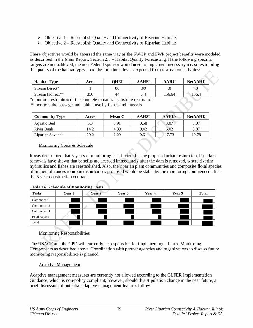
US Army Corps of Engineers 79 River Riparian Connectivity & Habitat, Illinois Chicago District Detailed Project Report & EA
Objective 1 – Reestablish Quality and Connectivity of Riverine Habitats Objective 2 – Reestablish Quality and Connectivity of Riparian Habitats
These objectives would be assessed the same way as the FWOP and FWP project benefits were modeled as described in the Main Report, Section 2.5 – Habitat Quality Forecasting. If the following specific targets are not achieved, the non-Federal sponsor would need to implement necessary measures to bring the quality of the habitat types up to the functional levels expected from restoration activities:
Habitat Type Acre QHEI AAHSI AAHU NetAAHU Stream Direct* 1 80 .80 .8 .8 Stream Indirect** 356 44 .44 156.64 156.4
*monitors restoration of the concrete to natural substrate restoration **monitors the passage and habitat use by fishes and mussels
Community Type Acres Mean C AAHSI AAHUs NetAAHU Aquatic Bed 5.3 5.91 0.58 3.07 3.07 River Bank 14.2 4.30 0.42 6.02 3.87 Riparian Savanna 29.2 6.20 0.61 17.73 10.78
Monitoring Costs & Schedule
It was determined that 5-years of monitoring is sufficient for the proposed urban restoration. Past dam removals have shown that benefits are accrued immediately after the dam is removed, where riverine hydraulics and fishes are reestablished. Also, the riparian plant communities and composite floral species of higher tolerances to urban disturbances proposed would be stable by the monitoring commenced after the 5-year construction contract. Table 16: Schedule of Monitoring Costs
Tasks Year 1 Year 2 Year 3 Year 4 Year 5 Total
Component 1 Component 2 Component 3 Final Report Total
Monitoring Responsibilities
The USACE and the CPD will currently be responsible for implementing all three Monitoring Components as described above. Coordination with partner agencies and organizations to discuss future monitoring responsibilities is planned.
Adaptive Management Adaptive management measures are currently not allowed according to the GLFER Implementation Guidance, which is non-policy compliant; however, should this stipulation change in the near future, a brief discussion of potential adaptive management features follow:

US Army Corps of Engineers 80 River Riparian Connectivity & Habitat, Illinois Chicago District Detailed Project Report & EA
Adaptive management measures are not the same as typical operation and maintenance activities described in the following section. These measures are technically response actions to changes that adversely affect how the system was predicted to respond. In so being adaptive, there are no absolute measures that can be defined prior to issue arising. The primary concerns for this project are restoration and establishment of native plant communities. Descriptions of adaptive managements below are brief and will be further detailed once a complete set of plans and specifications are drafted. This is necessary since the adaptive management measures will need to be based upon contracting bid items, final feature designs and predicted adverse responses. It is also noted that these measures have relatively low costs to regain lasting benefits. Fish Habitat – Failure of habitat to support the expected species would primarily result from stability issues within the channel. Conditions unforeseen, such as unexpected floods or other human activities could cause these issues to arise. Adaptive management actions would be undertaken to offset these instability issues, such as adding stone, adjusting orientation of the structures, varying dimensions of structures, etc. Bird Habitat – Migrating bird species are predominantly searching for food and refuge from predators on their way to either their breeding or wintering grounds. Different bird species require different food resources. Failure to attract migrating birds may be due to low resources. Adaptive management actions will be to increase the abundance and diversity of resources available during different times of the growing season in order to attract the greatest variety of migrating bird species. Actions can include, but are not limited to, increasing the number and diversity of fruit bearing trees and shrubs, increasing the diversity of flowering tree and herbaceous species in order to attract different insect species, etc. Native Plantings – The risk of large scale plant failure is low, mostly due to the species selection of those adapted to the conditions found within River Riparian. Most of the requirements for native plant communities are covered under routine operation and maintenance. If for some reason extensive patches of native plant community begin to fail, the cause would need to be determined in order to design and implement repair measures. Accidental or intentional human induced instances have damaged or removed native plantings in the past as well. No matter what the solution would be for the cause of the problem, it would certainly be coupled with reestablishing native plant patches by replanting. It may be that other thriving areas would be able to have live plants and seed transferred to the damaged patch. Or it may be that plants and seed would need to be repurchased. Actions would include, but not limited to, installing native seed over the winter months, installation live plugs, adding in soil amendments to reduce available nutrients in order to increase the soil suitability for native plant species, etc. 6.6 Operation & Maintenance The O&M costs of the project are estimated to an average annual cost of about $63,000 over 50 years. A detailed O&M Manual containing all the duties will be provided to the non-Federal sponsor after construction is closed out. The O&M for Chicago District ecosystem projects are practical and minimal due to initial project design efforts and design targets for sustainability, where O&M costs are predicted to drop as the communities naturalize and come to equilibrium. Mostly if not all of the O&M activities are no different than the specific activities that take place during construction, but to a lesser degree. The O&M described here is not the same as the Adaptive Management measures described in the previous section. Table 17: Operations & Maintenance Costs per Year
TASK Annual Frequency Acres Treated Cost/Acre Total AACost Burning 0.33 15 $
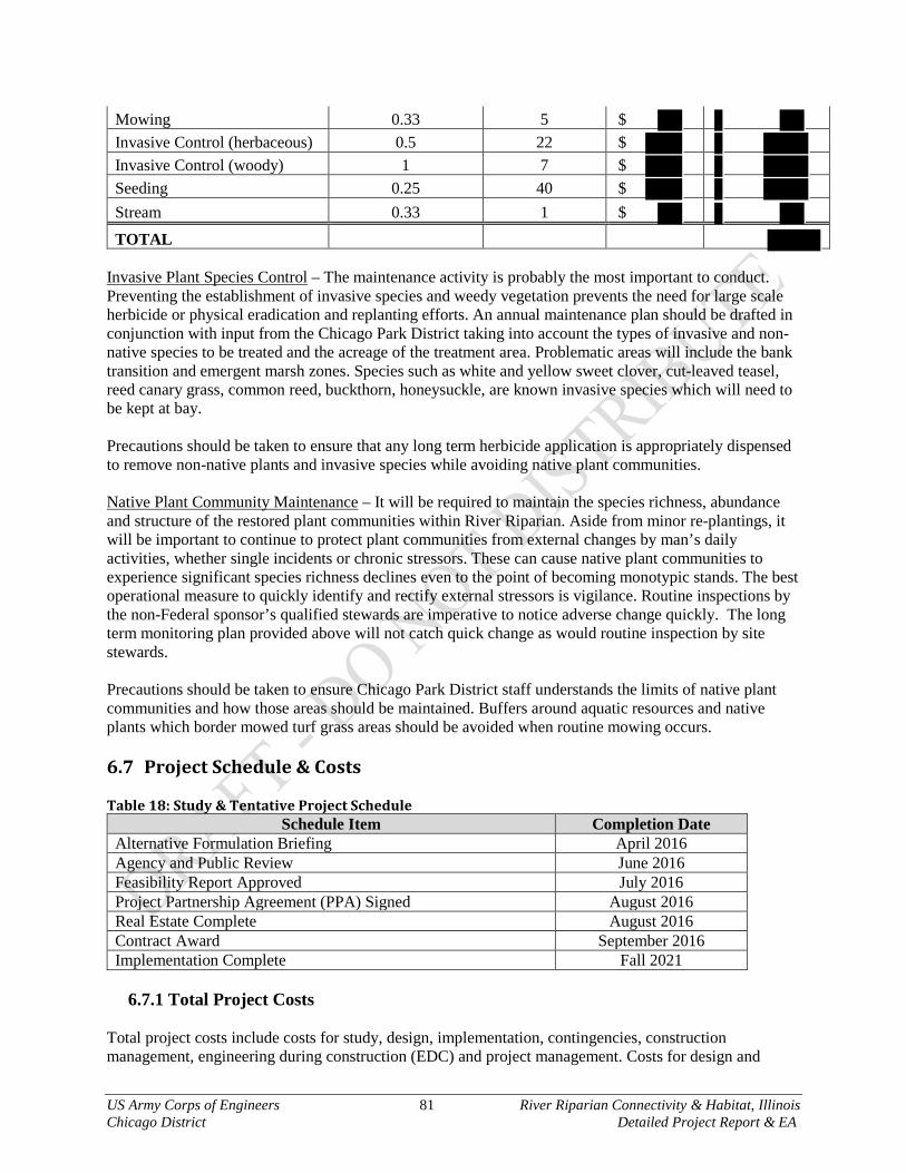
US Army Corps of Engineers 81 River Riparian Connectivity & Habitat, Illinois Chicago District Detailed Project Report & EA
Mowing 0.33 5 $ Invasive Control (herbaceous) 0.5 22 $ Invasive Control (woody) 1 7 $ Seeding 0.25 40 $ Stream 0.33 1 $
TOTAL Invasive Plant Species Control – The maintenance activity is probably the most important to conduct. Preventing the establishment of invasive species and weedy vegetation prevents the need for large scale herbicide or physical eradication and replanting efforts. An annual maintenance plan should be drafted in conjunction with input from the Chicago Park District taking into account the types of invasive and non-native species to be treated and the acreage of the treatment area. Problematic areas will include the bank transition and emergent marsh zones. Species such as white and yellow sweet clover, cut-leaved teasel, reed canary grass, common reed, buckthorn, honeysuckle, are known invasive species which will need to be kept at bay. Precautions should be taken to ensure that any long term herbicide application is appropriately dispensed to remove non-native plants and invasive species while avoiding native plant communities. Native Plant Community Maintenance – It will be required to maintain the species richness, abundance and structure of the restored plant communities within River Riparian. Aside from minor re-plantings, it will be important to continue to protect plant communities from external changes by man’s daily activities, whether single incidents or chronic stressors. These can cause native plant communities to experience significant species richness declines even to the point of becoming monotypic stands. The best operational measure to quickly identify and rectify external stressors is vigilance. Routine inspections by the non-Federal sponsor’s qualified stewards are imperative to notice adverse change quickly. The long term monitoring plan provided above will not catch quick change as would routine inspection by site stewards. Precautions should be taken to ensure Chicago Park District staff understands the limits of native plant communities and how those areas should be maintained. Buffers around aquatic resources and native plants which border mowed turf grass areas should be avoided when routine mowing occurs. 6.7 Project Schedule & Costs Table 18: Study & Tentative Project Schedule
Schedule Item Completion Date Alternative Formulation Briefing April 2016 Agency and Public Review June 2016 Feasibility Report Approved July 2016 Project Partnership Agreement (PPA) Signed August 2016 Real Estate Complete August 2016 Contract Award September 2016 Implementation Complete Fall 2021
6.7.1 Total Project Costs
Total project costs include costs for study, design, implementation, contingencies, construction management, engineering during construction (EDC) and project management. Costs for design and

US Army Corps of Engineers 82 River Riparian Connectivity & Habitat, Illinois Chicago District Detailed Project Report & EA
management are estimated based on a percentage of estimated implementation costs and contingencies. These costs will be revised prior to the execution of a Project Partnership Agreement (PPA) and actual costs for these activities will be used to remedy final cost sharing responsibilities during project close-out. Total project costs were escalated to the mid-point of estimated construction using factors contained in EM 1110-2-1304, Civil Works Construction Cost Index System (CWCCIS). Table 19 provides a summary of the Fully Funded Project costs for the NER Plan as presented in the Cost Certification TPC. Using the fully funded escalated costs and the implementation schedule, a summary of funding requirements by fiscal year was developed as presented in Table 20 for the NER Plan. Table 19: NER Plan Total Feasibility, Design and Implementation Cost (First Cost FY15) INTENTIONALLY REMOVED Certified Cost Tables to be provided by Cost MXD, signed 2016_02_09 *MXD did not include in Cost Cert **Provided by LRD Real Estate Table 20: NER Plan Cost Apportionment (First Cost FY15) INTENTIONALLY REMOVED
6.7.2 Financial Capability of Non-Federal Sponsor In accordance with regulation ER1105-2-100, Appendix D, the non-Federal sponsor has sufficient funds currently available. The non-Federal sponsor is committed to its specific cost share of the Design & Implementation (D&I) Phase, and expresses willingness to share in the costs of construction to the extent that can be funded.

US Army Corps of Engineers 83 River Riparian Connectivity & Habitat, Illinois Chicago District Detailed Project Report & EA
CHAPTER 7 – RECOMMENDATION I have considered all significant aspects of the problems and opportunities as they relate to the project resource problems of the River Riparian Connectivity & Habitat Section 506 restoration project. Those aspects include environmental, social, and economic effects, as well as engineering feasibility. I recommend that the NER Plan be implemented as a Federal project, with such modifications thereof as in the discretion of the Commander, USACE may be advisable. The estimated Fully Funded Costs FY16 of the NER Plan is $14,619,000 and the estimated annual operations, maintenance, repair, replacement and rehabilitation (OMRR&R) cost is $63,000. The Federal portion of the estimated total project cost is $9,502,350 for Design & Implementation. The non-Federal share of the estimated first cost of the project is about $5,116,650 and will be covered by lands, easements, rights-of-way, utility or public facility relocations, and dredged or excavated material disposal areas (LERRDs) of $32,000, WIK of $0 and a cash contribution of $4,972,650. As established in PL99-662, as amended, project costs are shared with the non-Federal sponsor in accordance with project outputs. The Chicago Park District has agreed to serve as the local cost-sharing sponsor for the River Riparian Connectivity & Habitat Section 506 restoration project. The cost-sharing requirements and provisions will be formalized with the signing of the Project Partnership Agreement (PPA) between the local sponsor and USACE prior to initiation of contract award activities. In this agreement, the local sponsor will agree to pay 35 percent of the total project costs. Federal implementation of the recommended project would be subject to the non-Federal sponsor agreeing to comply with applicable Federal laws and policies, including but not limited to:
1. Provide 35 percent of the separable project costs allocated to environmental restoration as further specified below a) Provide the non-Federal share of all complete planning and design work upon execution of the PCA b) Provide all lands, easements, and rights-of-way, including suitable borrow and dredged or excavated
material disposal areas, and perform or ensure the performance of all relocations determined by the government to be necessary for the construction and O&M of the project
c) Provide or pay to the government the cost of providing all features required for the construction of the project
d) Provide, during construction, any additional costs as necessary to make its total contribution equal to 35 percent of the separable project costs allocated to environmental restoration
2. Contribute all project costs in excess of the USACE implementation guidance limitation of $10,000,000 3. For so long as the project remains authorized, operate, maintain, repair, replace, and rehabilitate the
completed project or the functional portion of the project at no cost to the government in accordance with applicable federal and state laws and any specific directions prescribed by the government
4. Give the government a right to enter, at reasonable times and in a reasonable manner, upon land that the local sponsor owns or controls for access to the project for the purpose of inspection and, if necessary, for the purpose of completing, operating, maintaining, repairing, replacing, or rehabilitating the project
5. Assume responsibility for operation, maintenance, repair, replacement, and rehabilitation (OMRR&R) of the project or completed functional portions of the project, including mitigation features, without cost to the government in a manner compatible with the project’s authorized purpose and in accordance with applicable federal and state laws and specific directions prescribed by the government in the OMRR&R manual and any subsequent amendments thereto
6. Comply with Section 221 of Public Law (P.L.) 91-611, Flood Control Act of 1970, as amended, and Section 103 of the WRDA of 1986, as amended, which provides that the Secretary of the Army shall not commence the construction of any water resource project or separable element thereof until the nonfederal sponsor has entered into a written agreement to furnish its required cooperation for the project or separable element
7. Hold and save the United States free from damages due to construction of or subsequent maintenance of the project except those damages due to the fault or negligence of the United States or its contractors

US Army Corps of Engineers 84 River Riparian Connectivity & Habitat, Illinois Chicago District Detailed Project Report & EA
8. Keep and maintain books, records, documents, and other evidence pertaining to costs and expenses incurred pursuant to the project to the extent and in such detail as will properly reflect total project costs
9. Perform or cause to be performed such investigations for hazardous substances that are determined necessary to identify the existence and extent of any hazardous substances regulated under the Comprehensive Environmental Response, Compensation, and Liability Act (CERCLA), 42 U.S. Code 9601 through 9675, that may exist in, on, or under lands, easements, or rights-of-way necessary for the construction, and O&M of the project, except that the nonfederal sponsor shall not perform investigations of lands, easements, or rights-of-way that the government determines to be subject to navigation servitude without prior written direction by the government
10. Assume complete financial responsibility for all necessary cleanup and response costs for CERCLA-regulated material located in, on, or under lands, easements, or rights-of-way that the government determines necessary for the construction and O&M of the project
11. To the maximum extent practicable, conduct OMRR&R of the project in a manner that will not cause liability to arise under CERCLA
12. Prevent future encroachment or modifications that might interfere with proper functioning of the project 13. Comply with the applicable provisions of the Uniform Relocation Assistance and Real Property
Acquisition Policies Act of 1970, P.L. 91-646, as amended in Title IV of the Surface Transportation and Uniform Relocation Assistance Act of 1987, P.L. 100-17, and the uniform regulation contained in Part 24 of Title 49, Code of Federal Regulations (CFR), in acquiring lands, easements, and rights-of-way for construction and subsequent O&M of the project, and inform all affected persons of applicable benefits, policies, and procedures in connection with said acts
14. Comply with all applicable federal and state laws and regulations, including Section 601 of Title VI of the Civil Rights Act of 1964, P.L. 88-352, and Department of Defense Directive 5500.11 issued pursuant thereto and published in 32 CFR, Part 300, as well as Army Regulation 600-7 entitled “Non-Discrimination on the Basis of Handicap in Programs and Activities Assisted or Conducted by the Department of the Army”
15. Provide 35 percent of that portion of the total cultural resource preservation, mitigation, and data recovery costs attributable to environmental restoration that are in excess of 1 percent of the total amount authorized to be appropriated for environmental restoration
16. Do not use federal funds to meet the nonfederal sponsor’s share of total project costs unless the federal granting agency verifies in writing that the expenditure of such funds is authorized to be used to carry out the Project.
The recommendations contained herein reflect the information available at this time and current departmental policies governing formulation of individual projects. They do not reflect program and budgeting priorities inherent in the formulation of a national Civil Works construction program nor the perspective of higher review levels within the Executive Branch. _________________________________
Christopher T. Drew Colonel, U.S. Army District Commander
US Army Corps of Engineers 85 River Riparian Connectivity & Habitat, Illinois Chicago District Detailed Project Report & EA
Bibliography Agostinho, A. A., Gomes, L. C., Fernandez, D. R. and Suzuki, H. I. (2002), Efficiency of fish ladders for neotropical ichthyofauna. River Res. Applic., 18: 299–306. doi: 10.1002/rra.674 Brown, J. J., Limburg, K. E., Waldman, J. R., Stephenson, K., Glenn, E. P., Juanes, F. and Jordaan, A. (2013), Fish and hydropower on the U.S. Atlantic coast: failed fisheries policies from half-way technologies. Conservation Letters, 6: 280–286. doi: 10.1111/conl.12000 Bunt, C.M., T. Castro-Santos, A. Haro. 2012. Performance of Fish Passage Structures at Upstream Barriers to Migration. River Research and Applications. 28:457-478. Burgess, R.L. & D.M Sharpe 1981. Forest island dynamics in man-dominated landscapes. 1981 pp. xvii + 311 pp. City of Chicago, Department of Planning & Development. 1999. Chicago River Corridor Development Plan. City of Chicago, Department of Planning & Development. 2006. Chicago Nature & Wildlife Plan. Dunker, J.J. and K.J. Johnson. 2015. Hydrology of and current monitoring issues for the Chicago Area Waterway System, Northeastern Illinois. USGS Scientific Investigations Report 2015-5115. 48pp. Friends of the Chicago River. 2006. North Branch Dam Fish Passage Alternatives Assessment Report. Completed by Montgomery Watson Harza. Illinois Environmental Protection Agency. 2008. North Branch Chicago River Watershed: TMDL Stage 1 Report Kemp, P. S. (2012), Bridging the Gap between Gish Behaviour, Performance and Hydrodynamics: an Ecohydraulics Approach to Fish Passage Research. River Res. Applic., 28: 403–406. doi: 10.1002/rra.1599 Knaepkens, G., Baekelandt, K. and Eens, M. (2006), Fish pass effectiveness for bullhead (Cottus gobio), perch (Perca fluviatilis) and roach (Rutilus rutilus) in a regulated lowland river. Ecology of Freshwater Fish, 15: 20–29. doi: 10.1111/j.1600-0633.2005.00117.x Marzluff J.M. & K. Ewing 2001. Restoration of Fragmented Landscapes for the Conservation of Birds: A General Framework and Specific Recommendations for Urbanizing Landscapes. Restoration Ecology. Volume 9, Issue 3 MWRDGC. 2009. Design and Modeling of a Combined Canoe Chute/Fish Passage for the North Branch Dam, Chicago, Illinois. Noonan, M. J., Grant, J. W. A. and Jackson, C. D. (2012), A quantitative assessment of fish passage efficiency. Fish and Fisheries, 13: 450–464. doi: 10.1111/j.1467-2979.2011.00445.x Per Angelstam 1992. Conservation of Communities – The Importance of Edges, Surroundings and Landscape Mosaic Structure. Ecological Principles of Nature Conservation. Conservation Ecology Series: Principles, Practices and Management pp 9-70 Pelicice, F. M. and Agostinho, A. A. (2008), Fish-Passage Facilities as Ecological Traps in Large Neotropical Rivers. Conservation Biology, 22: 180–188. doi: 10.1111/j.1523-1739.2007.00849.x Raymond, H.L. 1979. Effects of Dams and Impoundments on Migrations of Juvenile Chinook Salmon and Steelhead from the Snake River, 1966 to 1975. Transactions of the American Fisheries Society Vol. 108, Iss. 6, 1979 Santucci, V.J., S.R. Gephard, S.M. Pescitelli. 2005. Effects of Multiple Low-Head Dams on Fish, Macroinvertebrates, Habitat, and Water Quality in the Fox River, Illinois. North American Journal of Fisheries Management 25:975–992

US Army Corps of Engineers 86 River Riparian Connectivity & Habitat, Illinois Chicago District Detailed Project Report & EA
Saunders et al. 1987. Changes in the Avifauna of a region, district and remnant as a result of fragmentation of native vegetation: the wheat belt of Western Australia. A case study. Biological Conservation. Volume 50, Issues 1-4. Pp 99-135 Tiemann, J.S., H.R. Dodd, N. Owens, D.H. Wahl. Effects of Lowhead Dams on Unionids in the Fox River, Illinois. Northereastern Naturalist. 14(1):125-138 Tiemann, J.S., D.P. Gillette, M.L. Wildhaber, D.R. Edds. 2004. Effects of Lowhead Dams on Riffle-Dwelling Fishes and Macroinvertebrates in a Midwestern River. Transactions of the American Fisheries Society 133:705–717 USACE, Chicago District. 2013. North Branch of the Chicago River Dams – Forest Preserve District of Cook County Section 22 Planning Assistance to States.
Related Documents