UNESCO - EOLSS SAMPLE CHAPTER FRESH SURFACE WATER – River Morphology and Channel Processes - Iware Matsuda RIVER MORPHOLOGY AND CHANNEL PROCESSES Iware Matsuda College of Economics, Kanto Gakuin University, Yokohama, Japan Keywords: Channel processes, river morphology, drainage basin, river system, stream order, Horton's laws, alluvial plain, channel pattern, sediment load, rejuvenation. Contents 1. Introduction 2. Channel Processes 3. Drainage Patterns 4. Channels in Alluvial Plains Glossary Bibliography Biographical sketch To cite this chapter Summary Channel processes reflected in river morphology are erosion, transportation and sedimentation. These processes develop drainage basins. Every drainage basin has its own shape. Some indices are proposed to explain the shape of a drainage basin quantitatively. As for channels in a drainage basin, concept of stream order is introduced and is related to the total length and the gradient of channels and the area of drainage basins. A drainage pattern means a plan of a river system, and reflects a variety of information about geology and predominant slope of the drainage basin. Sediment loads are classified into bed load and suspended load. In contact with a river bed, bed load consisting of material of larger diameter than fine sand, is brought to the lower reaches. Fine materials such as clay and silt are held in suspension in stream water and are carried without contact with the river bed. The three main channel patterns in alluvial plains are: braided, meandering and straight. Channels on an alluvial fan show a braided pattern, and their depth is shallow. The river bed is composed of gravelly deposits. Channels in a flood plain meander and have a river bed composed of sand. Channels bifurcate in a delta, and bifurcated channels have muddy river beds and tend to be straight. The movement of water and the kinds of sediment load affect the depth and width of a channel. 1. Introduction Rain water flowing down slopes comes together to form a stream flow. The space where a stream flow runs is a channel. A river is the general term for a channel and the water in it. The area supplying water into a channel is a drainage basin. The boundary between drainage basins is a water divide. A river system is composed of the main stream and many tributaries. However, there are many cases where several tributaries have similar length and flow, and it is difficult to determine which is the main stream. A drainage pattern is a plan of a river system. A river develops various landforms ©Encyclopedia of Life Support Systems (EOLSS)

Welcome message from author
This document is posted to help you gain knowledge. Please leave a comment to let me know what you think about it! Share it to your friends and learn new things together.
Transcript

UNESCO - EOLS
S
SAMPLE C
HAPTER
FRESH SURFACE WATER – River Morphology and Channel Processes - Iware Matsuda
RIVER MORPHOLOGY AND CHANNEL PROCESSES Iware Matsuda College of Economics, Kanto Gakuin University, Yokohama, Japan Keywords: Channel processes, river morphology, drainage basin, river system, stream order, Horton's laws, alluvial plain, channel pattern, sediment load, rejuvenation. Contents 1. Introduction 2. Channel Processes 3. Drainage Patterns 4. Channels in Alluvial Plains Glossary Bibliography Biographical sketch To cite this chapter Summary Channel processes reflected in river morphology are erosion, transportation and sedimentation. These processes develop drainage basins. Every drainage basin has its own shape. Some indices are proposed to explain the shape of a drainage basin quantitatively. As for channels in a drainage basin, concept of stream order is introduced and is related to the total length and the gradient of channels and the area of drainage basins. A drainage pattern means a plan of a river system, and reflects a variety of information about geology and predominant slope of the drainage basin. Sediment loads are classified into bed load and suspended load. In contact with a river bed, bed load consisting of material of larger diameter than fine sand, is brought to the lower reaches. Fine materials such as clay and silt are held in suspension in stream water and are carried without contact with the river bed. The three main channel patterns in alluvial plains are: braided, meandering and straight. Channels on an alluvial fan show a braided pattern, and their depth is shallow. The river bed is composed of gravelly deposits. Channels in a flood plain meander and have a river bed composed of sand. Channels bifurcate in a delta, and bifurcated channels have muddy river beds and tend to be straight. The movement of water and the kinds of sediment load affect the depth and width of a channel. 1. Introduction Rain water flowing down slopes comes together to form a stream flow. The space where a stream flow runs is a channel. A river is the general term for a channel and the water in it. The area supplying water into a channel is a drainage basin. The boundary between drainage basins is a water divide. A river system is composed of the main stream and many tributaries. However, there are many cases where several tributaries have similar length and flow, and it is difficult to determine which is the main stream. A drainage pattern is a plan of a river system. A river develops various landforms
©Encyclopedia of Life Support Systems (EOLSS)
UNESCO - EOLS
S
SAMPLE C
HAPTER
FRESH SURFACE WATER – River Morphology and Channel Processes - Iware Matsuda
through channel processes. The main channel processes or fluvial processes are erosion, transportation and sedimentation. Erosion predominates in the upper reach area of a drainage basin, and valleys composed of channels and slopes are formed. The materials brought to the lower reaches in a channel are sediment load. Weathering of the rocks composing slopes is the main cause of production of sediment load. Sediment load is deposited to form an alluvial plain. Three basic channel patterns are detected in alluvial plains. They are braided, meandering and straight. River morphology is explained by channel patterns and channel forms, and is decided by such factors as discharge, water surface slope, water velocity, depth and width of the channel, and river bed materials, etc. These factors are not independent but inter-related to each other. 2. Channel processes 2.1. Erosion Running water carries out two processes. One is erosion and the other is corrosion. Erosion is a hydraulic action and is derived from the energy of running water. Gravel being brought by running water scours the channel and removes sediment from the river bed. Erosion makes a channel broader and deeper. These processes are also called lateral erosion and deepening erosion respectively. If deepening erosion predominates, a canyon is formed. Lateral erosion forms a channel with a broader river bed. Stream water reacts chemically with rocks and dissolves them. This process is called corrosion. Karst landforms composed of calcareous limestone provide a well-known example created mainly by corrosion. Valleys in mountains can be very deep. Deep valleys are formed not only by stream water but also by the effects of weathering. The rocks composing slopes have been weathered for a long period of time, and become rock fragments or rock wastes including other fine materials. Gravity, in combination with heavy rain falling on the slopes, causes the weathered materials to fall down into the valley bottom. These process result in downstream extension of the valley and retreat of the upper slopes. The weathered materials deposited in a valley bottom are scoured by running water and carried to the lower reaches. 2.2 Transportation The higher the water velocity, the more capacity a river has for transporting sediment load. There are three different processes in transporting sediment load. They are corrosion, suspension and traction. Corrosion is the process in which stream water corrodes rocks and brings them invisibly into solution. Such fine materials as clay, silt, fine sand and materials lighter than water are transported in the water or on the water surface without contact with the river bed. This process is called suspension, and materials carried in suspension are the suspended loads. Suspended load creates the turbidity of stream water. Gravel of larger diameter slides or rolls, and sand hops or bounds on a river bed. These processes are called traction. Sediment load carried by traction is known as bed load.
©Encyclopedia of Life Support Systems (EOLSS)

UNESCO - EOLS
S
SAMPLE C
HAPTER
FRESH SURFACE WATER – River Morphology and Channel Processes - Iware Matsuda
2.3 Sedimentation A flood caused by heavy rain carries a huge volume of bed load from mountains to the plain. When a flood flows from the mountains to a plain, the capacity to transport bed load is suddenly reduced. Particles of bed load are deposited in order of their size, and an alluvial plain is formed. An alluvial fan composed of gravel is formed in the uppermost reaches of an alluvial plain. The surface of an alluvial fan is like a segment of a cone. The radial profile toward the lower reach is concave and the cross-sectional profile is convex. A delta being developed near a river mouth consists of fine materials and sand. The morphology of a delta is derived from the interaction of fluvial and marine processes. If neither of these two processes is superior to the other, an arcuate delta is likely to be formed. This form indicates a state of maturity in a delta. In the case of sediment load entering a calm bay, a ‘bird foot delta’ is developed. In some cases, strong coastal currents and sea waves move the sediment supplied by river, and a cuspate delta with several lines of sand bar can form. A flood plain consisting of natural levees and back swamps occupies the transitional area between an alluvial fan and a delta. A natural levee is composed of sand and silt. Clayey deposits distribute in back swamps are lower and wetter than natural levees. The channels on an alluvial fan are interconnected and show a braided pattern. When a large flood flows down from mountains, the channels on an alluvial fan often change their course, and the newborn channel is maintained until the next flood. The former channel is abandoned and is supplied water only by groundwater. The lower reaches of the abandoned river remain as a feature on floodplains and deltas. Figure 1 is the landform classification map of Nobi plain, Aichi prefecture, in central Japan.The Kiso, Ibi and Nagara Rivers develop the plain. Since an active fault runs between the plain and the western ranges, the western part of the plain is down-faulting and very flat lowland is formed. Typical landforms in an alluvial plain are distributed along the Kiso River, flowing into the plain from the northeastern mountains. They are the alluvial fan, natural levees, back swamps and the delta. Many abandoned channels flowing down from the alluvial fan can be detected in the lower reach area.
©Encyclopedia of Life Support Systems (EOLSS)

UNESCO - EOLS
S
SAMPLE C
HAPTER
FRESH SURFACE WATER – River Morphology and Channel Processes - Iware Matsuda
Figure 1. Landform classification of Nobi Plain.1: mountain and hill; 2: river terrace; 3: alluvial cone; 4: alluvial fan; 5: natural levee; 6: back swamp and river course;
7:higher delta; 8: lower delta; 9: reclaimed land; 10: abandoned channel. 2.4. A Graded River As erosion proceeds, the gradient of a river bed becomes progressively gentler, and the energy of running water decreases. Eventually the capacity of running water for transporting sediment load will come to match the supply. In this condition, neither erosion nor sedimentation occurs on the river bed and its gradient does not vary. Such rivers are named graded rivers. Although the gradient of a river bed does not change, the materials composing the bed are removed and replaced. The gradient of a river bed of a graded river decreases gradually towards the lower reaches, and the longitudinal cross-section of the channel conforms almost to an exponential line. When a sudden
©Encyclopedia of Life Support Systems (EOLSS)

UNESCO - EOLS
S
SAMPLE C
HAPTER
FRESH SURFACE WATER – River Morphology and Channel Processes - Iware Matsuda
change occurs in the gradient of part of a channel, almost all the river system might be affected. Such changes can be natural or human–made, such as construction of dikes and bridges; these changes break the state of equilibrium. 2.5. Rejuvenation and River Terrace Rejuvenation occurs when a channel being in a state of equilibrium or progressive sedimentation changes its predominant process to erosion. The main causes of rejuvenation are uplift of the ground, lowering of sea level due to glacial eustasy (lowering of base level), decrease of sediment load and increase of discharge due to climate change, etc. Various landforms are formed by reactivated channel process. 2.5.1 River Terrace When channel rejuvenation occurs, a channel begins to deepen and a new gorge is formed in an alluvial plain. As a result, the surface of the former alluvial plain becomes higher than the river bed, and river water ceases to overflow onto it. The former alluvial plain then becomes a river terrace. A river terrace has two components: terrace surface and terrace slope. If sedimentation and erosion are repeated again and again, several steps of a river terrace can be formed. Physical weathering predominated in high mountains during the last glacial age, supplying an abundance of rock fragments. Valley bottoms were buried by very thick deposits. The supply of rock fragments decreased in the post-glacial age, however, and rejuvenation occurred to form river terraces. River terraces formed by climate change are called a climatic terrace. Since a climatic terrace has a steeper gradient than an alluvial plain formed under the recent climate, these two surfaces intersect each other in the lower reaches and the former is buried under the latter. 2.5.2 Incised River Usually, channels in a flood plain are meandering. A meander is a sinuous bend in a river, and a river may meander continuously for hundreds of kilometers through a flood plain. The term is derived from the River Meanderes in Turkey. If a meandering channel has been rejuvenated, a channel begins to under-cut a river bed while keeping a meandering course. As a result, a meandering valley is formed, and the river running in the valley is called an incised river. If under-cutting proceeds rapidly, the valley walls can have bilateral symmetry. This type of meandering is named an entrenched meander. If the position of a channel is gradually moved, this type of meandering is called an ingrown meander. In the case of an ingrown meander, the valley wall of the undercut slope becomes steeper, and asymmetrical valley slopes are created. 2.5.3 Antecedent River When a part of a drainage basin is uplifted by crustal movement, rejuvenation of channels is initiated. If uplift movement is slower than under-cutting, the channel course is kept and a gorge is formed. A river that forms a gorge along a meandering course is called an antecedent river. If uplift movement is faster than under-cutting, the
©Encyclopedia of Life Support Systems (EOLSS)
UNESCO - EOLS
S
SAMPLE C
HAPTER
FRESH SURFACE WATER – River Morphology and Channel Processes - Iware Matsuda
river bed becomes discontinuous on either side of the uplifted area. The upper reaches of the river are dammed up, and a nickpoint appears on the downstream side. The nickpoint, the source of the truncated river, moves back toward the upper course, often creating a waterfall. Another cause of development of a nickpoint is that the rate of erosion of rocks is larger in the lower reaches than it is in the upper reaches. Niagara Falls is a typical example of this. 2.6 River Capture When rapid head erosion proceeds into an adjacent drainage basin, the valley head eventually works its way towards another channel, and it becomes connected with the upper reaches of the formerly separate basin. This phenomenon is called river capture. The point where river capture takes place is called an elbow of capture. The lower reaches of the captured river are deprived of the headwaters and a dry valley named a beheaded river or a wind gap remains. On the other hand, there is an increase in the discharge of the river with the enlarged drainage basin and under-cutting is accelerated to form a gorge. River capture can happen several times in the evolution of a drainage basin. 3. Drainage Patterns 3.1. Drainage Basins 3.1.1 Shape of Drainage Basins Every basin has a unique shape. Horton (1932) proposed the form factor in order to express the shape of a basin quantitatively. The form factor (F) is defined as F=B/L, where B and L are the mean basin width and the maximum basin length, respectively. Since a drainage basin is composed of very complex slopes, the area of a drainage basin is measured from horizontal projection of these slopes. If the area of a drainage basin is A, the mean basin width B is B=A/L. Accordingly, F=A/L2. Generally, F is less than 1 because the maximum basin length is longer than the mean basin width. After Horton advocated the form factor, other ways of expressing the shape of a basin were proposed. Two examples are the circularity ratio (Miller, 1953) and the elongation ratio (Schumm, 1956). The circularity ratio is the ratio of the area of a drainage basin to the area of a circle having the same perimeter as a drainage basin. The elongation ratio of a drainage basin is the ratio of the diameter of a circle with the same area to the length of the basin.
©Encyclopedia of Life Support Systems (EOLSS)
UNESCO - EOLS
S
SAMPLE C
HAPTER
FRESH SURFACE WATER – River Morphology and Channel Processes - Iware Matsuda
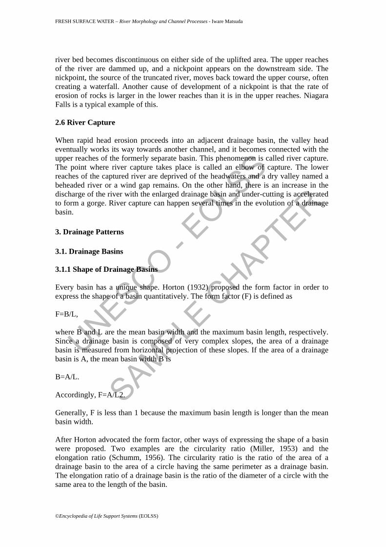
3.1.2 Stream order Figure 2 shows stream order after Horton (1945) and Strahler (1957). According to Horton’s order, the main stream has the highest order from the river-mouth to the head of a stream and the largest tributary has lower stream order by 1, than the main stream. Since Horton’s order was complicated, Strahler proposed an improvement. According to Strahler’s order, the stream originating in the uppermost part of a drainage basin is given the first order. If two first order streams join, the stream order becomes the second in the lower reaches, i.e. if two nth order streams join, an (n+1)th stream is born. Where a stream joins with another stream having a lower order, the stream order doesn’t change. Strahler’s order, being generally easier to understand, is more popular than Horton's.
Figure 2. Example of stream order, as proposed by (a) Horton, and (b) Strahler. Horton (1945), Schumm (1956) and others discussed the relationship between stream order and factors composing a drainage basin. The most important results are as follows: • As stream order increases, the number and the mean gradient of streams
decrease in an inverse geometric ratio. • As stream order increases, the mean length of streams and the mean area of
drainage basin increase. The shortest and the steepest streams have the smallest drainage basins.
On the other hand, Hack (1957) deduced the empirical equation: L=cAr and Q=jAm, where L is the length in a geometric ratio, A is the area of a drainage basin and Q is the discharge. This means that as stream order increases, the discharge increases in a geometric ratio.
©Encyclopedia of Life Support Systems (EOLSS)
UNESCO - EOLS
S
SAMPLE C
HAPTER
FRESH SURFACE WATER – River Morphology and Channel Processes - Iware Matsuda
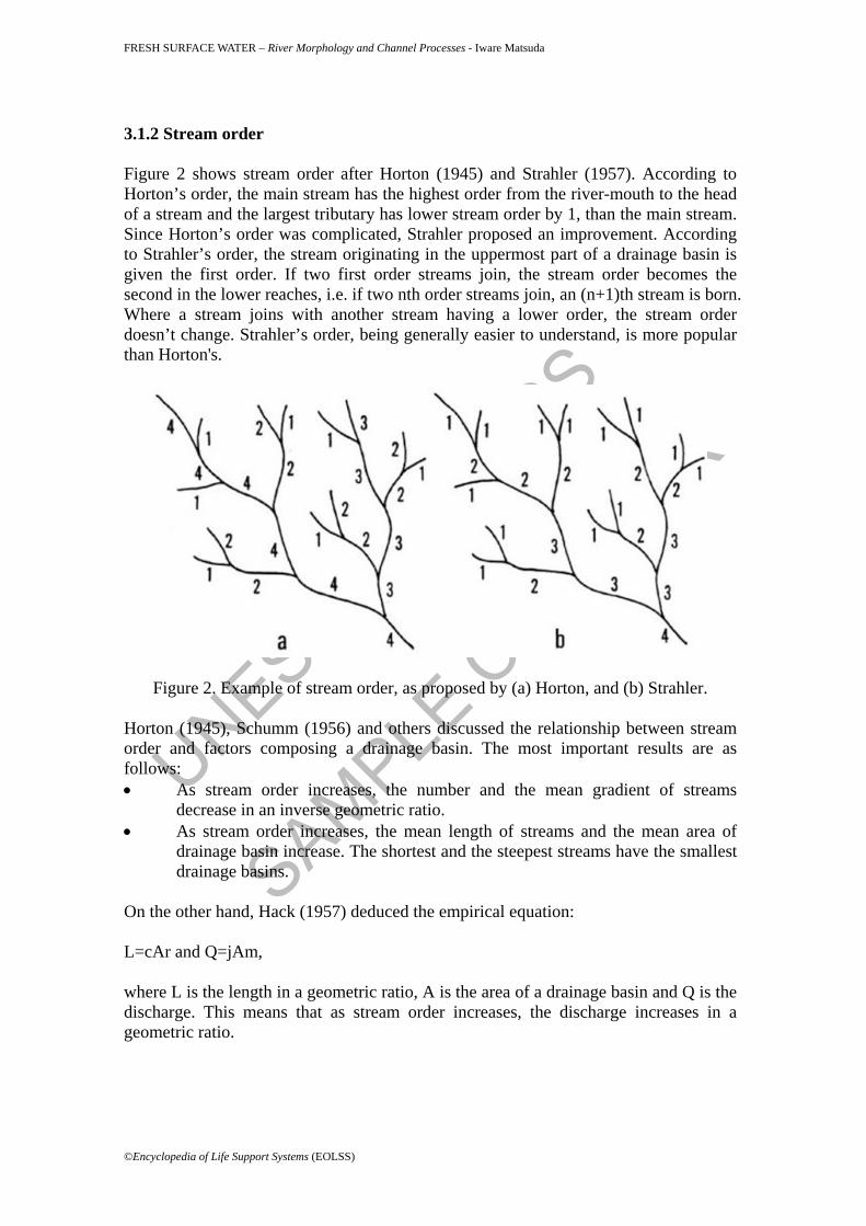
3.2 Drainage patterns A drainage map is a plan of all streams or river systems in a drainage basin. It presents some characteristics of drainage basins through drainage pattern and drainage texture. It is possible to deduce the geology of the basin, the strike and dip of depositional rocks, existence of faults and other information about geological structure from drainage patterns. Drainage texture reflects climate, permeability of rocks, vegetation, and relief ratio, etc. Howard (1967) related drainage patterns to geological information. Some typical patterns are shown on Figure 3. A dendritic pattern (a) is most common. This pattern is formed in a drainage basin composed of fairly homogeneous rock without control by the underlying geologic structure. The longer the time of formation of a drainage basin is, the more easily the dendritic pattern is formed. A parallel pattern (b) is apt to appear in areas where the strata of sedimentary rocks decline in the same direction. Channels are formed in the steepest direction. If faults or large joints develop, a rectangular pattern (c) is likely to be formed. A trellised pattern (d) shows a questa which is developed in a drainage basin composed of alternation of tilted hard and soft strata. Another case results from parallel folding. A radial pattern (e) appears on a newly born volcano or an area composed of rocks with domed structure. Channels develop along the maximum gradient of mountain slopes. An annular pattern (f) is apt to be formed in an area with a dome structure. If the gradient of the land surface is very gentle, a systematic stream pattern may not be created.
Figure 3. Drainage patterns.a: dendritic; b: parallel; c: rectangular; d: trellised; e: radial; f: annular
Quantitative expression of drainage texture is so difficult that qualitative expressions such as coarse, medium and fine are usually used. Drainage texture contains two
©Encyclopedia of Life Support Systems (EOLSS)
UNESCO - EOLS
S
SAMPLE C
HAPTER
FRESH SURFACE WATER – River Morphology and Channel Processes - Iware Matsuda
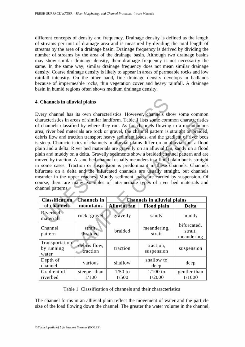
different concepts of density and frequency. Drainage density is defined as the length of streams per unit of drainage area and is measured by dividing the total length of streams by the area of a drainage basin. Drainage frequency is derived by dividing the number of streams by the area of the drainage basin. Although two drainage basins may show similar drainage density, their drainage frequency is not necessarily the same. In the same way, similar drainage frequency does not mean similar drainage density. Coarse drainage density is likely to appear in areas of permeable rocks and low rainfall intensity. On the other hand, fine drainage density develops in badlands because of impermeable rocks, thin vegetation cover and heavy rainfall. A drainage basin in humid regions often shows medium drainage density. 4. Channels in alluvial plains Every channel has its own characteristics. However, channels show some common characteristics in areas of similar landform. Table 1 lists some common characteristics of channels classified by where they run. As for channels flowing in a mountainous area, river bed materials are rock or gravel, the channel pattern is straight or braided, debris flow and traction transport heavy sediment loads, and the gradient of river beds is steep. Characteristics of channels in alluvial plains differ on an alluvial fan, a flood plain and a delta. River bed materials are gravelly on an alluvial fan, sandy on a flood plain and muddy on a delta. Gravelly sediments show a braided channel pattern and are moved by traction. A sand bed channel usually meanders in a flood plain but is straight in some cases. Traction or suspension is predominant in these channels. Channels bifurcate on a delta and the bifurcated channels are usually straight, but channels meander in the upper reaches. Muddy sediment loads are carried by suspension. Of course, there are many examples of intermediate types of river bed materials and channel patterns.
Channels in alluvial plains Classification of channels
Channels in mountains Alluvial fan Flood plain Delta
Riverbed materials rock, gravel gravelly sandy muddy
Channel pattern
strait, braided braided meandering,
strait
bifurcated, strait,
meandering Transportation by running water
debris flow, traction traction traction,
suspension suspension
Depth of channel various shallow shallow to
deep deep
Gradient of riverbed
steeper than 1/100
1/50 to 1/500
1/100 to 1/2000
gentler than 1/1000
Table 1. Classification of channels and their characteristics
The channel forms in an alluvial plain reflect the movement of water and the particle size of the load flowing down the channel. The greater the water volume in the channel,
©Encyclopedia of Life Support Systems (EOLSS)

UNESCO - EOLS
S
SAMPLE C
HAPTER
FRESH SURFACE WATER – River Morphology and Channel Processes - Iware Matsuda
the wider and deeper is the channel. Sediment loads are classified into suspended load and bed load. A channel that brings a heavy bed load has a large width-depth ratio and shows little meandering. Gravelly bed load is deposited to form bars. When bars divide a channel, a braided channel pattern is formed. Channels having a braided pattern are generally wide, shallow and steep. Channels in which suspension is predominant are narrow and deep. That is, the width-depth ratio is small. If the gradient of a channel or the velocity of running water is small, a straight pattern is likely to be formed. On the other hand, if the gradient of a channel or the velocity of running water is large, a meandering pattern is readily developed. The gradient of a channel is in proportion to the volume of sediment load and is inversely proportional to the water volume. The steeper the gradient of the channel, the larger the diameter of sediment load. Consequently, the channel profile is concave-upward in general, i.e. the gradient of the channel becomes steeper toward the upper reaches. The horizontal sinuosity of a channel is defined by the ratio of the channel length to the valley length or the ratio of the gradient of an alluvial plain to that of a channel. Since rivers on an alluvial fan often change their channel courses; the drainage pattern is radial, but the channel density is small. Channels often tend to dry up in the central part because running water permeates under the river bed. On the other hand, many springs appear in a fan toe area. Many channels originate from these springs. The gradient of channels decreases from the head of an alluvial fan, and reaches 1 to 100 or less at the fan toe. If raised embankments are constructed on a channel running on an alluvial fan, the river bed becomes higher than the surrounding land surface. Raised bed rivers appear frequently on alluvial fans formed in temperate humid climates. Channel density is larger in a flood plain than in an alluvial fan. Although channels meander, meandering zones are fairly straight and parallel. Pools are formed at the bending parts of a channel. The flow of water changes direction at a pool, and strikes against the opposite bank. Accordingly, the curvature of meandering is enlarged. When a meandering channel turns its course by about 360 degrees, both necks in the upper and lower reaches meet each other. As a result, the lobe between the necks is cut off to make an ox-bow lake. Generally speaking, the gradient of channels is 0.1 – 1.0 to 100 in a floodplain. The channel depth is larger in a floodplain than in an alluvial fan. Navigation is possible, and most of channels are tidal. The channel density becomes larger in a delta due to bifurcation. A ‘bird foot delta’ develops in a bay where the water is not influenced by strong currents or longshore drift. Bifurcation continues to form a radial channel pattern. The height of a river bed is lower than the surrounding land, and the gradient of a channel is generally less than 0.1 to 100. The channel depth is large and navigation is possible. All channels are tidal. Glossary Alluvial plain: A plain formed by fluvial processes. Arcuate delta: A delta the shoreline of which shows an arc or a part of an arc. Cuspate delta: A delta the shoreline of which protrudes seaward near the river
©Encyclopedia of Life Support Systems (EOLSS)

UNESCO - EOLS
S
SAMPLE C
HAPTER
FRESH SURFACE WATER – River Morphology and Channel Processes - Iware Matsuda
mouth. Channel process: Morphogenetic processes being carried out by running water in a
channel. Main processes are erosion, transportation and sedimentation.
Drainage pattern: A plan of a river system in a drainage basin. Each pattern reflects geological structure, prevailing direction of a slope, etc.
Drainage texture: Fineness of drainage network. Two concepts of density and frequency of channels are combined.
Graded river: A river in which the gradient of the river bed does not vary. In this condition, erosion is in proportion to sedimentation.
Horton's laws: Two laws suggested by R. E. Horton. He defined stream order and discussed the relation between the order of streams and the number or length of streams.
Rejuvenation: Renewal of former processes. Erosion is one of the fluvial processes reactivated.
Sediment load: Materials brought down a channel by river water. Suspended load: Materials brought by river water without touching the river bed. Bibliography Hack, J.T. (1957). Studies of longitudinal stream profiles in Virginia and Maryland. United States Geological Survey Professional Paper, 294-B, 45-79. [Relations between the gradient of a river bed and sediment load were discussed for the rivers flowing in this high rainfall region.]
Horton, R. E. (1932). Drainage basin characteristics. Transaction of American Geological Union, 13, 350-361. [The first article providing quantitative description of river basin shape. Horton proposed the basin factors for analyzing basin shape.]
Horton, R.E. (1945). Erosional development of streams and their drainage basin: Hydrophysical approach to quantitative morphology. Bulletin of Geological Society of America, 56, 275-370.[Horton tried morphometric analysis on a basin by proposing the stream order and deduce the famous Horton’s laws.]
Howard, A.D. (1967). Drainage analysis in geologic interpretation: a summation. Bulletin of American Association of Petroleum Geology., 51, 2246-59. [Some basic drainage patterns were described and related to geological conditions.]
Miller, V.C. (1953). A quantitative geomorphic study of drainage basin characteristics in the Clinch Mountain area, Virginia and Tennessee. Columbia University, Department of Geology, Technical Report, No.3, Contract N6 ONR 271-300. [Miller proposed the circular ratio for expressing characteristics of basin shape.]
Schumm, S. (1956). Evolution of drainage systems and slopes in badland at Perth Amboy, New Jersey. Bulletin of Geological Society of America, 67, 597-646. [The elongation ratio was proposed to show characteristics of basin shape, and drainage basin evolution was discussed.] Biographical Sketch Iware Matsuda majors in geomorphology and Quaternary geology. His special theme is the historical development of alluvial plains. He was on the staff of the Department of Geography, Faculty of Science, Tokyo Metropolitan University from 1965 to 1992. In 1992, he moved to College of Economics, Kanto Gakuin University. He has been Dean of the College since 2000. At the university, he lectures on applied geomorphology, focusing on analysis of natural hazards from a geological and geomorphological point of view. He has been a member of the Committee of Earthquake Hazard Assessment of the Tokyo Metropolitan
©Encyclopedia of Life Support Systems (EOLSS)

UNESCO - EOLS
S
SAMPLE C
HAPTER
FRESH SURFACE WATER – River Morphology and Channel Processes - Iware Matsuda
Government for many years. He has been engaged in assessment of earthquake damage in Tokyo Metropolis and other self-governing bodies. He has visited many places which suffered from flood damage as well as earthquake damage. His study fields are not restricted to his own country. He has carried out field surveys in Bangladesh, Mexico, New Zealand, Philippines, Spain, Turkey, USA, and Venezuela, among others. To cite this chapter Iware Matsuda, (2004), RIVER MORPHOLOGY AND CHANNEL PROCESSES, in Fresh Surface Water, [Ed. James C.I. Dooge], in Encyclopedia of Life Support Systems (EOLSS), Developed under the Auspices of the UNESCO, Eolss Publishers, Oxford ,UK, [http://www.eolss.net]
©Encyclopedia of Life Support Systems (EOLSS)
Related Documents