Water Matters: Our Plan! Final River Basin Management Plan for the Western River Basin District in Ireland (2009-2015) Incorporating Amendments of the Minister for the Environment, Heritage and Local Government, issued on 6 th July 2010

Welcome message from author
This document is posted to help you gain knowledge. Please leave a comment to let me know what you think about it! Share it to your friends and learn new things together.
Transcript
Water Matters Our Plan
Final River Basin Management Plan for the Western River Basin District in Ireland (2009-2015)
Incorporating Amendments of the Minister for the Environment Heritage and Local Government issued on 6th July 2010
Western RBMP ii
Acknowledgement
Maps used in this document have been produced using Ordnance Survey Ireland data reproduced under OSi Licence number 201015CCMAGalway County Council Unauthorised reproduction infringes Ordnance Survey Ireland and Government of Ireland copyright copy Ordnance Survey Ireland 2010lsquo
Front cover image was provided courtesy of Dr Ruth Little
Western RBMP iii
FOREWORD Clean water is one of our most important national resources Human activities have led to deterioration in water quality over many years The Water Framework Directive was adopted by the EU in order to halt and reverse the decline in water quality The Directive sets very strict deadlines for meeting water quality objectives especially in protected areas This plan sets out how we aim to achieve the objectives of the Directive in the Western River Basin District
Informed by pilot projects from the 1990lsquos and through extensive research carried out since 2003 local authorities have developed this plan to provide an objective scientific approach to meeting the required water standards In preparing the plan all known pressures on waters have been identified and quantified at the level of individual water bodies Measures to address the pressures have been examined and the likelihood of water quality recovery has been assessed All public bodies and other stakeholders have been consulted extensively in the process
The planlsquos targets are ambitious yet they are no more than we are obliged to do by EU and national legislation Further legislative change may be required to control specific activities Responsibility for taking measures lies with all public bodies whose activities impact on water quality or who regulate such activities Local authorities must perform their own activities in a way that will promote achievement of objectives and additionally must carry out a range of environmental monitoring and enforcement activities to ensure that other stakeholderslsquo actions will lead to water quality improvements
Local authorities today face an immense challenge to meet an ever increasing demand for services across all of their functions We are required to work within tight resource constraints and depend heavily on funding provided by the Department of the Environment Heritage and Local Government for capital works and indeed day to day expenditure Under the circumstances it is ever more important that we plan carefully for the application of resources to satisfy obligations placed upon us by national legislation and to lead the general development of our administrative areas
Following adoption of this plan local authorities will develop implementation programmes and identify all resource implications and funding requirements It is likely that the resource requirements will exceed the current capacity of Local Authorities Meeting the commitments contained in the plan will depend on the Department of Environment Heritage and Local Government together with other Government Departments making provision for the required resources and funding
Western RBMP iv
Western RBMP v
Table of Contents
1 Introduction 1
11 The Western River Basin District 1
12 The authorities and their roles 2
13 The development of the plan 3
14 Layout of this plan 5
2 Description of the Western RBD 6
21 The Waters of the Western District 6
22 Key issues in the Western RBD 7
3 The status of the waters Of the Western RBD 22
31 Monitoring and Classification 22
32 Surface water status 24
4 The objectives for the Western District 37
41 The core objectives 37
42 Alternative objectives 39
43 The full picture 53
5 The programme of measures for the Western RBD 58
51 Recent legislation supporting the implementation of the programme of measures 58
52 The programme of measures 60
53 Targeted research to support the plan 75
54 Other measures being considered 75
55 Water Management Unit action plans 75
56 Summary programme of measures for the Western RBD 77
6 Integrating plans and programmes 80
61 Introduction 80
7 Implementation of the Plan 85
71 Review of arrangements 85
72 Implementation process 86
73 Public participation 87
Western RBMP vi
Glossary
AA Appropriate Assessment for Natura 2000 sites as required under the Habitats Directive
Acidification The rough canopies of mature evergreen forests are efficient scavengers of particulate and gaseous contaminants in polluted air This results in a more acidic deposition under the forest canopies than in open land Chemical processes at the roots of trees evergreens in particular further acidify the soil and soil water in forest catchments When the forests are located on poorly buffered soils these processes can lead to a significant acidification of the run-off water and consequent damage to associated streams and lakes
Alien species Invasive alien species are non-native plants or animals that successfully establish themselves in aquatic and fringing habitats and damage our natural flora and fauna
Artificial water body A body of surface water created by human activity
Biodiversity Word commonly used for biological diversity and defined as assemblage of living organisms from all habitats including terrestrial marine and other aquatic ecosystems and the ecological complexes of which they are part
Coastal Waters Is that area of surface water on the landward side of a line every point of which is at a distance of one nautical mile on the seaward side from the nearest point of the baseline from which the breadth of territorial waters is measured extending where appropriate up to the outer limit of transitional waters
DAFF Department of Agriculture Fisheries and Food
DECNR Department of Energy Communications and Natural Resources
DEHLG Department of the Environment Heritage and Local Government
Diffuse sources (of pollution)
These are primarily associated with run-off and other discharges related to different land uses such as agriculture and forestry from septic tanks associated with rural dwellings and from the land spreading of industrial municipal and agricultural wastes
Ecology The study of the relationship among organisms and between those organisms and their non-living environment
Ecosystem A community of interdependent organisms together with the environment they inhabit and with which they interact and which is distinct from adjacent communities and environments
Ecological status Is an expression of the structure and functioning of aquatic ecosystems associated with surface waters Such waters are classified as being of good ecological status when they meet the requirements of the Directive
EPA Environment Protection Agency
Eutrophic A eutrophic lake is a lake with high primary productivity the result of high nutrient content
Eutrophication Enrichment of water by nutrients (phosphorus and nitrogen) The nutrients accelerate plant growth which disturbs the balance of aquatic plants and animals and affects water quality
Fisheries Inland Fisheries Ireland (formerly the Western Regional Fisheries Board and
Western RBMP vii
the North Western Regional Fisheries Board in the Western District)
Forest Service The Forest Service of the Department of Agriculture Fisheries and Food
Good status Is a general term meaning the status achieved by a surface water body when both the ecological status and its chemical status are at least good or for groundwater and when both its quantitative status and chemical status are at least good
Groundwater All water which is below the surface of the ground in the saturation zone and in direct contact with the ground or subsoil This zone is commonly referred to as an aquifer which is a subsurface layer or layers of rock or other geological strata of sufficient porosity and permeability to allow a significant flow of groundwater or the abstraction of significant quantities of groundwater
GSI Geological Survey of Ireland
Heavily modified water body
If as a result of physical alterations by human activity a water body is changed substantially in character it as designated by an individual Member State and in accordance with the provisions of Annex II of the Water Framework Directive
HSE Health Service Executive
Hydromorphology A study of the quantity and dynamics of water flow within a riverchannel lake etc that has variations in its width depth structure and substrate of bed and riparian zone
Inland surface waters
All standing or flowing water on the surface of the land (such reservoirs lakes rivers and coastal waters) and all groundwater on the landward side of the baseline from which the breadth of territorial waters is measured
Leachate The liquid produced when water percolates through any permeable material It can contain either dissolved or suspended material or usually both
Mitigation measures Measures to avoidprevent minimisereduce or as fully as possible offsetcompensate for any significant adverse effects on the environment as a result of implementing a plan or programme
Natura Impact Statement
Natura Impact Statement (NIS) - the statement prepared following Appropriate Assessment for Natura 2000 sites as required under the Habitats Directive
DEHLG-NPWS National Parks and Wildlife Service of the Department of Environment Heritage and Local Government
Oligotrophic Term applied to water bodies that are poorly nourished unproductive
OSWTS On-Site Wastewater Treatment Systems
Pesticide Control Service
Pesticide Control Service of the Department of Agriculture Fisheries and Food
Programme of measures
Defines in detail those actions which are required to achieve the environmental objectives of the Directive within a river basin district
Quantitative status An expression of the degree to which a body of groundwater is affected by direct and indirect abstractions If this complies with Directive requirements the status is good
Western RBMP viii
River Basin Means the area of land from which all surface water run-off flows through a sequence of streams rivers and lakes into the sea at a single river mouth estuary or delta
River Basin Districts (RBD)
Administrative areas for coordinated water management and are comprised of multiple river basins (or catchments) with cross-border basins (ie those covering the territory of more than one Member State) assigned to an international RBD
Sedimentation The deposition by settling of a suspended material
SNIFFER Scotland and Northern Ireland Forum for Environmental Research (SNIFFER)
Special Area of Conservation (SAC)
Site designated according to the habitats directive (Council Directive 9243EEC of 21 May 1992 on the conservation of natural habitats and of wild fauna and flora)
Special Protection Area (SPA)
An area designated under the European Directive on the Conservation of Wild Birds
Statutory Instrument Any order regulation rule scheme or byelaw made in exercise of a power conferred by statute
Surface water Means inland waters except groundwater which are on the land surface (such as reservoirs lakes rivers transitional waters coastal waters) which occur within a river basin
Transitional waters Bodies of surface water in the vicinity of river mouths which are partly saline in character as a result of their vicinity to coastal waters but which are substantially influenced by freshwater flows
Water body A discrete and significant element of surface water such as a river lake or reservoir or a distinct volume of groundwater within an aquifer
Water Framework Directive
The Water Framework Directive is European legislation that promotes a new approach to water management through river basin planning The legislation addresses inland surface waters estuarine waters coastal waters and groundwater
Water Management Unit
Water Management Unit ndash geographical sub unit of a river basin district consisting of a number of water bodies relevant to a particular sub catchment
Western RBMP ix
Executive Summary
The Western River Basin District is a largely rural area with many high quality waters and protected sites that depend on water The fertile soils of the eastern part of the basin support agriculture whereas further west the landscape is mountainous with many habitat protected areas The basin has an extensive coastline and encompasses many offshore islands The great natural beauty of the basin is a haven for a thriving tourist industry with many popular holiday resorts and with its waters providing major boating and fishing interests Water is integral to the economy of the Western RBD generating and sustaining wealth through activities such as agriculture forestry aquaculture industry services transport and tourism However water is a fragile resource that needs to be protected
The Water Framework Directive (WFD) was adopted in 2000 It requires governments to take a new approach to managing all their waters rivers lakes groundwater estuaries (transitional) and coastal waters Member states must ensure that their waters achieve at least good status by 2015 and that status doesnlsquot deteriorate in any waters To achieve good status and preserve the best waters it is necessary to prepare and implement management plans for those waters
This plan is for the Western District of Ireland It covers the period 2009ndash2015 The key parties in its implementation are
the districtlsquos local authorities Clare Galway City Galway County Leitrim Mayo Roscommon and Sligo) which acted jointly to make the plan Galway County Council as the coordinating local authority will aim to coordinate the work of the authorities and public participation in the district
the Environmental Protection Agency which is responsible for reporting to the European Union coordinating activities at national level and certain other tasks such as assigning status monitoring programmes and review of the plan
the Department of the Environment Heritage and Local Government which has a coordinating role in relation to implementation of the Water Framework Directive and through the Local Government Fund and Water Services Investment Programme plays a significant role in determining priority for investment in infrastructure and the availability of resources to local authorities
other public authorities identified under the 2003 Water Policy Regulations which are required to exercise their functions in a manner which is consistent with the objectives of the river basin management plan
individual Government Departments which have responsibility for implementing policy and programmes in their respective policy areas
the Water Framework Directive National Advisory Committee which will oversee implementation of the plan at national level It is chaired by the Department of the Environment Heritage and Local Government and involves representatives from the Department of Agriculture Fisheries and Food the Environmental Protection Agency the City and County Managers Association (representing local authorities) and other Government Departments as appropriate
The Environmental Protection Agency has classified the surface waters in the Western District according to their ecological status and chemical status groundwater is classified on a system that combines chemical and quantitative status It found that
66 of rivers 82 of lakes 26 of estuaries and 63 of coastal waters are satisfactory with high or good ecological status
34 of rivers 17 of lakes 12 of estuaries are less than good (moderate poor or bad)
Western RBMP x
most of the surface waters tested so far have good chemical status
68 of groundwaters have good combined status
Bar Chart of Water Status
0 10 20 30 40 50 60 70 80 90 100
Rivers and Canals
Lakes and Reservoirs
Estuaries
Coastal Waters
Groundwaters
Satisfactory Unsatisfactory Yet to be determined
The final status assessment based on the data collected during the first monitoring cycle (2007-2009) will be presented by the EPA in 2011
The Water Framework Directive sets out four core objectives to be achieved generally by 2015
prevent deterioration
restore good status
reduce chemical pollution
achieve protected areas objectives
The Water Framework Directive also allows alternative objectives to be set for certain waters It is estimated that implementing the measures in this plan will mean that good status will be achieved by 2015 in 74 of rivers 95 of lakes 35 of estuaries 63 of coastal waters and 68 of groundwaters with further improvements during the second and third planning cycles The expected trends in status over three planning cycles to 2027 are
Western RBMP xi
Expected Trends over 3 RBMP cycles (to 2027)
00 100 200 300 400 500 600 700 800 900 1000
Rivers amp canals
Lakes amp reservoirs
Estuaries
Coastal
Groundwaters
GES or GEP 2009 GES or GEP 2015 GES or GEP 2021 GES or GEP 2027 Yet to be determined
The draft plan aimed to achieve good status for 92 of rivers by 2015 in the final plan that proportion is 74 with the step to 100 compliance to be achieved over the following two planning cycles to 2027 This change results from detailed consideration of the timescales in which recovery of status can be achieved
The principal suspected causes of less than satisfactory water in the state are discharges principally of nutrients from agricultural activities and from municipal wastewater treatment works Industrial discharges wastewater from unsewered properties and discharges from several other activities have also been identified as contributing Action should concentrate in the first instance on these issues which pose the greatest threat to the water environment but it is also important to address other possible sources of water pollution and impact including issues such as water abstraction and physical modification and issues specific to the Western RBD This plan identifies a programme of measures to protect and restore water status by addressing the main pressures (that is sources of pollution or status impact) in the district
Many of the measures are already provided for in national legislation and are being implemented These include for example the Urban Waste Water Treatment Regulations 2001 to 2010 and the Good Agricultural Practice for the Protection of Waters Regulations of 2009 Other measures have been recently introduced (for example new Bathing Water Regulations 2008) or are under preparation (for example proposed authorisation regulations for abstractions and physical modifications) The key measures include
Control of urban waste water discharges
Control of unsewered waste water discharges
Control of agricultural sources of pollution
Water pricing policy
Sub-basin management plans and programmes of measures for the purpose of achieving environmental water quality objectives for Natura 2000 sites designated for the protection of Freshwater Pearl Mussel populations
Pollution reduction programmes for the purpose of achieving water quality standards for designated shellfish waters and
Western RBMP xii
Control of environmental impacts from forestry
The action programme intended to achieve the planlsquos environmental objectives sets out
what the measure is
where and when it will be applied
who will take the action
More detailed information is also set out in a series of detailed water management unit (WMU) action plans WMUs are at a smaller geographical scale than river basin districts and allow for more focussed planning and implementation There are fourteen water management units in the Western RBD The action plans for these WMUs will be developed further to become implementation programmes and will be revised to reflect any updates (for example in relation to status) as implementation of the plan proceeds
Western RBMP page 1
1 Introduction This River Basin Management Plan for the Western River Basin District covering the period 2009 to 2015 aims to protect all waters within the district and where necessary improve waters and achieve sustainable water use Waters include rivers canals lakes reservoirs groundwaters protected areas (including wetlands and other water-dependent ecosystems) estuaries (transitional) and coastal waters
In accordance with the EU Water Framework Directive Ireland is committed to manage all waters through a catchment based process and the River Basin Management Plan is the mechanism for achieving this
The implementation of the plan will bring incremental improvement leading to the majority of waters reaching at least ―good status at the latest by 2027 benefiting the whole community by providing long-term sustainable access to and use of those waters Where waters are currently at less than good status they must be improved until they reach good status and there must be no deterioration in the existing status of waters
11 The Western River Basin District
Planning is based on river basins or catchments so that all activities with a potential to impact on waters are managed in an integrated manner Individual river basins are grouped into river basin districts the districts do not respect administrative boundaries but are defined by catchment areas of rivers There are eight river basin districts covering the island of Ireland four wholly within Ireland one in Northern Ireland and three cross border These cross-border districts are called International River Basin Districts (IRBDs)
Map11 River Basin Districts
The Western District is wholly within the Irish Republic It is bordered to the northwest by the North Western International River Basin District to the east and south by the Shannon International River Basin District and to the north and west by the Atlantic Ocean The basin area includes practically all of Mayo and Sligo the Galway City area significant portions of
Western RBMP page 2
Galway and Leitrim counties and smaller portions of Roscommon and County Clare It also includes offshore islands such as the Aran Islands and Inishboffin
The basin area extends over some 12193 km2 square kilometres with some 2700 km of coastline and an extensive off shore area Large areas of the district have been designated as Special Areas of Conservation (SAC) under the European Union (Natural Habitats) Regulations 1997 and Natural Heritage Areas (NHA) designated under the Wildlife (amendment) Act 2000 Special attention must be paid to the needs of these areas where species are dependent on the water habitat resulting in receptor water bodies been designated as more sensitive to pressures
The basin is dominated in the eastern part east of the great western lakes principally by well drained karst limestone overlain by grassland generally used for agricultural purposes This area stores large quantities of groundwater which both feeds into the lake systems and also provides a significant source of drinking water to the region The western part of the basin is dominated by wet peatland and forestry
The basin is relatively sparsely populated less than half a million people with urban infrastructure comprising about 003 of the basin area The principal urban areas are Galway City Castlebar Sligo Oughterard Tuam Ballinrobe Ballina Gort Loughrea Westport Clifden Swinford Tobercurry Ballaghadereen Ballyhaunis and Claremorris The major urban areas are located largely on the Coast or beside rivers but many people live in small villages or single dwellings
The fertile soils of the eastern part of the basin support beef dairy sheep and some pig farming as well as minor crop cultivation Further west the landscape is mountainous with many coniferous forest plantations and some sheep and cattle grazing The great natural beauty of the basin is a haven for a thriving tourist industry with many popular holiday resorts In particular the Moy River is renowned internationally as a salmon fishery and is closely followed by the Corrib Mask and Conn lake systems which provide major boating and fishing interests
12 The authorities and their roles A detailed list of the authorities involved in the management of the Western RBD is included in the contacts background documents available at wwwwfdirelandie
This plan has been developed by the county councils of Clare Galway Leitrim Mayo Sligo and Roscommon and by Galway City Council These local authorities acting jointly are the competent authorities for making this plan as defined by the European Communities (Water Policy) Regulations 2003 (SI No 722 of 2003) Similar plans have been drawn up by councils in the adjoining districts (the Shannon IRBD and North Western IRBD) Public bodies identified in the 2003 Water Policy Regulations are required to exercise their functions in a manner which is consistent with the objectives of any river basin management plan Galway County Council is the coordinating local authority in the Western RBD Public authorities at district level have been coordinated through a Management Group and public participation has been facilitated through an RBD Advisory Council
The Environmental Protection Agency is the competent authority for reporting to the European Union coordinating certain activities and for other tasks assigned in the 2003 Water Policy Regulations In relation to the planlsquos development the Agencylsquos particular responsibilities include assigning status monitoring programmes and the review of the plans The Environmental Protection Agencylsquos powers under Section 63 of the EPA Act (No 7 of 1992) as amended by the Protection of the Environment Act (No 27 of 2003) authorise them to supervise
Western RBMP page 3
the performance of all public authorities with statutory functions in relation to environmental protection
The Department of the Environment Heritage and Local Government which has a coordinating role in relation to implementation of the Water Framework Directive and through the Local Government Fund and Water Services Investment Program Water plays a significant role in determining priority for investment in infrastructure and the availability of resources to local authorities
Individual Government Departments have responsibility for implementing policy and programmes in their respective policy areas
Implementation of the plan will be overseen at national level by a National Advisory Committee chaired by the Department of the Environment Heritage and Local Government with representatives from the Department of Agriculture Fisheries and Food Department of Enterprise Trade and Employment the Environmental Protection Agency the City and County Managers Association (representing local authorities) and other Government Departments as appropriate
This plan has been prepared in consultation with all stakeholders Implementation of the plan will be challenging and will place obligations on all relevant authorities and stakeholders Local authorities through this plan are committed to achieving the aims and objectives of the Water Framework Directive by implementing the measures specified to the best of their ability
13 The development of the plan Public authorities have in preparing this plan been undertaking technical work coordination and consultations since 2000
131 Investigation and technical work River canal lake reservoir estuary and coastal water bodies and groundwater bodies in the district have been delineated based on physical characteristics (typology) Potential sources of pollution (pressures) were identified and impacts assessed Monitoring was carried out and the status of waters was classified based on the results of this monitoring The characterisation report and monitoring programme background documents are available from wwwwfdirelandie
A draft of this plan was published in December 2008 The main technical studies undertaken to finalise the plan during 2009 included
An assessment of the timescales for water quality to recover once remedial measures are implemented in order to determine likely restoration timescales This included an investigation of the rate of nutrient loss from agricultural lands and the likely timescales for status recovery following implementation of the Good Agricultural Practice Regulations (SI 101 of 2009)
Prioritisation of wastewater treatment plants for investigation and where necessary remedial works based on an assessment of compliance with the urban wastewater treatment regulations current operational performance and known impacts on water quality Where protected areas (for example bathing waters shellfish waters water dependent Natura 2000 sites) were impacted by discharges these were also taken into account
Preparation of catchment management plans for designated freshwater pearl mussel populations and Pollution Reduction Plans for designated shellfish waters in order to develop measures for these protected areas
An assessment of the cost of measures for wastewater discharges and on-site systems
Western RBMP page 4
During 2009 the Environmental Protection Agency updated the delineation of water bodies This involved splitting some water bodies in order to better represent their status The Agency also updated status classification based on 2008 monitoring information
The outputs from the above studies were used to modify and update the objectives and measures presented in this final plan Detailed action plans were prepared for more locally focused catchment areas called Water Management Units These extract the key measures and objectives in the overall plan presenting them for the geographical areas in which implementation will be coordinated
132 Consultation Consultation has been an important aspect throughout the development of this plan The following public participation background documents (at wwwwfdirelandie) were produced
the process of characterising basins and assessing the impacts of human activity on them including an economic analysis of water uses The Characterisation and Analysis of Irelandrsquos River Basin Districts [2004]
the milestones for developing river basin management plans Timetable and Work Programme for making a River Basin Management Plan for the Western River Basin District in Ireland [2006]
the identification of the most significant water issues and how they affect waters including what is being done and what is planned to do about them Water Matters ndash Have Your Say Western River Basin District [2007]
a summary of consultations and stakeholder engagement Digest of submissions and responses to Significant Water Management Issues Reports for Ireland Western River Basin Districts [2008]
the strategic environmental assessment scoping process Strategic Environmental Assessment for the Water Framework Directive River Basin Management Plans and Programmes of Measures - Western ndash Scoping Document [2008]
the draft river basin management plan Water Matters ldquoHelp Us Planrdquo Draft River Basin Management Plan for the Western River Basin District [2008]
the strategic environmental assessment environmental report Strategic Environmental Assessment for the Water Framework Directive River Basin Management Plans and Programmes of Measures - Western ndash Environmental Report [2008]
the digest of submissions on the draft plan which details the comments made and their responses and summarises where these have been addressed in the preparation of the final plan Digest of submissions and responses to the draft River Basin Management Plan for the Western River Basin District [2010]
The management plan was considered during its preparation by the RBD Advisory Council which consists of representatives from local authorities (County and Town Councilors) and community and stakeholder groups (agriculture angling industry and non-governmental organisations)
Voluntary groups are also involved in Water Framework Directive activities SWAN (Sustainable Water Network) wwwswanirelandie is an umbrella network of 25 of Irelandlsquos leading national and local environmental organisations specifically constituted to address public participation requirements of the Water Framework Directive
The plans were also considered by a Public Authorities Management Group which facilitates information exchange consultation cooperation and liaison within and between Irelandlsquos public authorities
Western RBMP page 5
Significant water management issues were discussed with interest groups and county councils and at a series of public consultation events in 2007 and 2008 Draft plan public consultation events were held between December 2008 and June 2009 including the following public meetings
Date Location Venue
27 April 2009 Sligo Town Sligo Park hotel
29 April 2009 Castlebar Co Mayo Regional Training Centre
30 April 2009 Galway City County Hall Prospect Hill
A total of 43 submissions were received in relation to the draft River Basin Management Plan for the Western RBD across the following sectoral interest groups local and public authorities non-governmental organisations business and private individuals A summary of the issues raised and responses is contained in the draft plan submissions digest in the public participation background documents which are available at wwwwfdirelandie
133 Planning This plan is the result of a systematic process of identifying risks to waters assessing the status of waters setting objectives and developing measures to achieve those objectives It has resulted from a significant body of technical preparatory work and public stakeholder participation
This plan establishes water status objectives and identifies the measures to achieve those objectives It also identifies the organisations that are responsible for implementing measures The plan will remain in force until 2015 The data used to develop the plan (for example status assessments and the results of research and investigation programmes) will be continually updated and reviewed to ensure that measures achieve their objectives A second plan will be prepared to cover the period 2015ndash2021 and a third covering the period 2021ndash2027
Much of the detailed information behind this plan has been incorporated into a computer-based interactive plan tool Water Maps on wwwwfdirelandie The plan is also supported by a large number of background documents also on wwwwfdirelandie They provide in-depth information about technical and detailed aspects of the plan including pressures status economic analysis public participation arrangements competent authorities and related plans and programmes
14 Layout of this plan Chapter 2 describes the Western RBD identifying its waters protected areas and the key water management issues
Chapter 3 establishes the status of the waters in the district summarising the monitoring programme and classification of waters
Chapter 4 covers the objectives for protecting and restoring waters during the first and where necessary subsequent planning cycles
Chapter 5 identifies the measures to achieve the objectives the Western RBD action programme is supported by a series of more locally focused Water Management Unit action plans
Western RBMP page 6
Chapter 6 considers the linkages of this plan with other plans and describes the wider climate change and environmental assessments of this plan
Chapter 7 considers the implementation arrangements of this plan
This river basin management plan sets out a realistic approach to securing environmental objectives and is in compliance with the requirements of the Water Framework Directive Its contents have been checked against the Directivelsquos requirements to ensure that the plan provides all the information needed The compliance statement background document is available at wwwwfdirelandie
2 Description of the Western RBD
21 The waters of the Western District
211 Surface waters The District is rich in waters comprising 89 river catchments with over 14200 km of river It has both lowland rivers (wide valleys slow flows) and upland rivers (steep valleys flashy flows) The main rivers are the Corrib draining Lough Corrib Mask and Carra the Moy draining Lough Conn and Cuilin OwenmoreBallysadare Dunkellin and Bonet Smaller catchments such as the Erriff drain directly in the coastal areas to the sea Some river systems like the Gort River draining the Slieve Aughty Mountains in the south of the basin drain to the sea via underground routes The main lakes are the Corrib (165 km2) Conn (107 km2)) Mask (82 km2) Carra (15 km2) Gill (14 km2) Arrow (12 km2) Cuilin (10 km2) and Carrowmore (9 km2) These are important fisheries recreational waters but also provide the sources of major regional water supplies
The 4707 km2 of marine waters are mostly off the coasts of Sligo Mayo Galway and Clare Major features include many islands headlands and inlets Ballyvaughan Bay Sligo Bay Killala Bay Blacksod Bay Clew Bay Killary Harbour Cill Chiaraacutein Bay Galway Bay Kinvara Bay and the Moy and Corrib estuaries Map 21 provides an overview of the Western River Basin District
212 Groundwaters There are 105 groundwaters in the Western RBD ranging in size from less than 1km2 to over 1350 km2 In the east of the District including the area east of the Great Western Lakes of Corrib Mask and Carra permeable rocks and soils allow groundwater to be stored in underground aquifers and these provide significant drinking water supply Similarly the main groundwater bodies in the North ClareBurren area also comprise permeable rocks overlain by thin soils Elsewhere in Connemara for example the rocks and soils hinder water seepage so aquifers are generally of low yield
213 Heavily modified and artificial waters No surface waters in the District are regarded as being substantially changed (heavily modified is the term used) but Lower Lough Corrib and the Corrib River are strong candidates for future designation as the sluice barrage at Galway City controls their water level Only two waters are man made (artificial) the Eglington and Cong Canals The benefits from such modifications need to be retained so these waters are subject to a different set of standards
214 Protected areas A significant proportion of waters in the district are already protected under other legislation because they require special protection due to their sensitivity to pollution or their particular
Western RBMP page 7
economic social or environmental importance All of the areas requiring special protection in the Western RBD have been identified mapped and listed in a register of protected areas background document (available at wwwwfdirelandie) They include the Moy and Corrib systems (important freshwater fish systems) and Shellfish waters such as Aughinish Bay Inner Galway Bay South Cill Chiaraacutein Bay Killary Harbour and Newport Bay Lough Corrib Lough Mask Lough Rea and Lough Gill are important sources of drinking water There are many special areas of conservation including the Connemara Bog Complex Twelve BensGarraun Complex MweelanNephin Complex Glenamoy Bog Complex Ox Mountains Bogs and the Ben Bulben Gleniff and Gelnade Complex They also include four Freshwater Pearl Mussel catchments protected under the EU Habitats Directive (the Owenriff and Dawros catchments in County Galway and the Bundorragha and Newport catchments in County Mayo)
Table 21 Protected Areas in the Western District
Protected Area Implementing Legislation Number
Drinking waters The European Communities (Drinking Water) (No 2) Regulations 2007 (SI 278 of 2007)
167 surface
105 groundwater
Shellfish waters European Communities (Quality of Shellfish Waters) Regulations 2006 (SI 268 of 2006) as amended in 2009
17
Bathing waters Bathing Water Quality Regulations SI 79 of 2008 31
Nutrient sensitive areas Urban Waste Water Treatment Regulations 2001 (SI 254 of 2001) as amended in 2004 (SI 440 of 2004) and 2010 (SI 48 of 2010)
1
Special areas of conservation
European Communities (Natural Habitats) Regulations SI 94 of 1997 as amended in 1998 and 2005
Environmental Objectives (Freshwater Pearl Mussel) Regulations (SI 296 of 2009)
121
Special protection areas European Communities (Natural Habitats) Regulations SI 94 of 1997 as amended in 1998 and 2005
38
A full list of all the protected areas in the Western RBD is presented in Appendix 3 Map 22 provides an overview of the protected areas
22 Key issues in the Western RBD The key water management issues in the Western RBD and their possible effects on water status are set out in this section The locations of these impacts and pressures are shown on Maps 24 to 210
221 Protecting high quality areas In the Western RBD there are 185 rivers (192) that are classified by the EPA as high status Of the lakes estuaries and coastal waters surveyed 188 lakes (5864) 7 estuaries (103) and 13 coastal waters (433) are classified as high status According to the 2009 Environmental Protection Agency indicators report the number of high quality river sites nationally has almost halved over the last 20 years and the Western RBD is one of the districts that has seen the greatest decline in high quality river sites High quality areas include rivers lakes and estuarine and coastal areas little affected by human activity they are still at or near un-impacted natural conditions supporting a naturally diverse mix of aquatic wildlife These
Western RBMP page 8
sites are important for supporting aquatic species which are sensitive to enrichment or siltation such as the protected but declining freshwater pearl mussel (Margaritifera margaritifera) and juvenile salmon (Salmo salar) The presence of high status sites along a river system can contribute significantly to the overall species diversity and re-colonisation of species to rehabilitated stretches These sites play an important part in conserving individual species and overall catchment biodiversity The deterioration or loss of high quality and protected areas is often due to their sensitivity to land use changes in surrounding catchments such as agriculture forestry peat harvesting and rural development activities High quality areas in the Western RBD are shown in Map 23
Map 21 The Western River Basin District
Western RBMP page 9
Map 22 Protected areas in the Western RBD
Western RBMP page 10
Map 23 High Quality Areas in the Western RBD
Western RBMP page 11
222 Pressures Agriculture
The Environmental Protection Agencylsquos diffuse risk model indicates that 91 rivers and 14 lakes in the Western RBD are at risk of failing to achieve the required standards due to diffuse pollution Sources of diffuse pollution include agriculture forestry peatland and urban land uses Nutrients (phosphorus and nitrogen) can be carried into waters from farmyards from manure store leaks or from fields treated with nutrient-rich organic and chemical fertilisers Animal slurry manure and silage effluent can cause organic pollution Nutrient enriched water accelerates plant growth and disturbs the balance of aquatic plants and animals and affects water quality Nutrient enrichment is the most widespread threat to water quality in the Western RBD The breakdown of organic material uses up oxygen that aquatic plants and animals need to survive and suspended solids and ammonia can cause fish kills Slurry can also contaminate drinking water with bacteria parasites and viruses Overgrazing can increase erosion rates significantly disturbing siltation and hydrology regimes and can cause physical damage and loss of habitat in rivers Agricultural land uses in the Western RBD are illustrated in Map 24
Wastewater and industrial discharges
In the Western RBD there are 13 rivers are at risk of failing to achieve the required standards due to municipal wastewater and industrial discharges According to the Environmental Protection Agency 2009 report on urban waste water discharges Clifden is among the 28 agglomerations nationally requiring secondary treatment that did not have the required level of treatment in place and were non-compliant with the requirements of the Urban Waste Water Treatment Regulations Urban sewers carry wastewater to treatment plants from homes and industrial or commercial sources as well as storm water from roads roofs and recreational areas Pollutants include nutrients bacteria organic materials and dangerous substances from homes and industries metals and hydrocarbons from urban runoff and pesticides from parks golf courses and gardens The wastewater is treated to remove many pollutants then discharged to surface waters or very occasionally to groundwater Inadequately treated effluents and spills or leakage from sewerage networks can impact on receiving waters damaging water quality and downstream uses (for example bathing waters or shellfish waters) Urban runoff can be contaminated with pollutants (such as from vehicle exhausts) and impact on surface and groundwater quality through direct discharges Overflows from sewer networks leaking from defective underground pipes or seepage from containment areas can also lead to surface and groundwater pollution The location of wastewater and industrial discharges in the Western RBD are illustrated in Map 25
Wastewater from unsewered properties
In the Western RBD there are approximately 10096 unsewered properties located in areas where the hydrogeological characteristics mean that inadequate percolation is available There are 70 rivers that have been assessed to be at risk of failing to achieve the required standards due to unsuitable hydrogeological conditions and the high density and location of unsewered properties in these areas Many rural houses and businesses rely on on-site systems (conventional septic tanks or proprietary systems) via soil percolation areas to treat and dispose of wastewater To work properly these treatment facilities must be located in suitable areas and designed constructed and maintained to appropriate standards If they are not working properly nutrients organic material chemicals and bacteria may seep from wastewater into groundwater contaminating nearby drinking water wells or damaging the quality of receiving rivers lakes or marine waters The locations of unsewered properties in the Western RBD are shown in Map 26
Western RBMP page 12
Forestry
In the Western RBD there are 34867 hectares of private forestry and 75175 hectares of public forestry A risk assessment of acidification eutrophication and sedimentation pressures based on percentage forestry cover and underlying geology and soils has identified 51 river that are at risk of failing to achieve the required standards due to potential impacts from forestry Where mature plantations of evergreen trees have been established on acid-sensitive soils it can lead to increased acidity and heavy metal concentrations in the run-off waters from such soils Forestry activities can introduce extra nutrients in naturally nutrient-poor areas that can lead to problems such as excessive algal growth Road-making and stream-crossing can cause erosion and sediment loss on susceptible soils afforestation and clearfelling of forests may change flow patterns and pesticides can damage aquatic organisms if applied incorrectly Map 27 shows the locations of private and public forestry in the Western RBD
Landfills quarries mines and contaminated lands
Assessments of groundwaters in the Western RBD indicate that 4 groundwater bodies are at risk of failing to achieve the required standards due to contamination from landfills The status assessment by the EPA shows that 71 groundwaters (68) in the Western RBD currently are at good status with 34 (32) at bad status Pollutants (mainly metals and fuel) from landfills and urban areas can seep into the ground and travel through groundwaters to enter surface waters affecting their quality damaging aquatic plants and animals and impairing water uses Water table lowering at some quarry sites can affect nearby wetland areas and the transfer of groundwater to surface waters can change water chemistry Quarries can also be significant sources of silt which can adversely affect downstream aquatic habitats and species These issues are site specific knowledge of these sites in the Western RBD (shown in Map 25) is being updated by the Environmental Protection Agency and local authorities to confirm impact and assess the scale of this problem if any and extent of the pressure
Physical modifications and damage
In the Western RBD 187 of river channels have been drained There are 150 rivers where water status has the potential to be impacted Further investigative monitoring is underway to confirm impact on status Waters are physically modified for water supply navigation transport flood protection hydropower aquaculture and land drainage Such modifications can reduce the diversity of plant and animal communities either directly by affecting habitats or indirectly by changing natural processes Rivers need a mix of pools and shallow riffles and variation of flow patterns to provide habitats for fish Where rivers have been drained these features are often removed Migratory fish need to access upstream spawning areas However weirs can restrict fish access if they are not designed to allow fish passage consequently spawning success and population sizes can be reduced Hard structures like ports and harbours can replace or reduce natural habitat Land drainage and development overgrazing deforestation and cattle access can cause impacts such as bank erosion and siltation or increased risk of flooding due to faster runoff Map 28 shows the rivers that have been physically modified and coastline that has been reinforced in the Western RBD
Water Abstractions
Most water abstractions are currently sustainable in the Western RBD however abstraction poses a potential risk to 204 rivers and 24 lakes due to their possible impact on river flows and lake levels particularly during periods of low flow Large amounts of water are abstracted daily for domestic use and for use in agriculture industry and recreation Most of this water is treated to a high standard to remove impurities and make it fit for consumption Too much abstraction reduces flow in springs and rivers and lowers water levels in lakes wetlands and wells That can make water supplies unsustainable and adversely affect aquatic plants and animals and wetland areas In extreme cases river beds may dry up lake shores can become exposed and
Western RBMP page 13
in coastal areas salt water may seep into groundwater Future population growth and climate change may reduce the available water resource in some areas in the future Map 29 shows the abstraction locations in the Western RBD and the volumes of water abstracted
Dangerous substances
Recently introduced dangerous substances monitoring programmes have identified two water bodies in the Western RBD the Deel a tributary of the Moy and the Corrib estuary which are failing chemical status As the monitoring programme is new the extent of the problem with dangerous substances is not known A wide range of chemicals harmful to the aquatic environment and which may be toxic to people plants and animals are contained in everyday products used in households industry forestry agriculture construction sites and water or wastewater treatment works Runoff from roads and urban areas can contain dangerous substances arising from the combustion of hydrocarbon fuels Some dangerous substances can be toxic to aquatic plants and animals at very low concentrations They can persist in waters and sediments and accumulate in the bodies of aquatic organisms poisoning them and causing problems higher up the food chain or interfering with their natural breeding processes
Aquaculture
The Western RBD has 17 designated shellfish waters and 65 licensed fish farms Mussels pacific and native oysters clams and scallops are the main shellfish species farmed in Ireland salmon and rainbow trout are the principal finfish Counties Galway Cork and Donegal have the highest numbers of aquaculture licences and Mayo also has high numbers of such licences Aquaculture activities (including harvesting) unless appropriately managed and controlled can affect water quality physical habitat biodiversity and indigenous species populations Finfish farming can cause increased nutrient loading and organic pollution around cages Misuse of authorised chemicals and medicines to control disease and possible infection of wild fish with sea lice if not appropriately managed are other concerns Map 210 illustrates the location of aquaculture activities in the Western RBD
Invasive alien species
The African Curly leaved pondweed (found in the upper part of Lough Corrib) and Zebra Mussels (Lough Corrib system Lough Gill and Lough Arrow) have established in the Western District waters Nationally the Environmental Protection Agency has identified eight key aquatic species of non-native animals or plants that have successfully established themselves in aquatic and fringing habitats and are damaging natural flora and fauna and poses the threat of spreading into more waters within the Western RBD These species pose a major threat to the diversity of native plants and animals for example by preying on them out-competing for habitat or food altering habitat or introducing pathogens or parasites Inland Fisheries Ireland has developed a Biosecurity Plan for Lough Mask to prevent the spread of alien species to this important lake They are developing methodologies to check the spread of the African pondweed in Lough Corrib
Cruising and boating
Cruising and boating are important recreational and tourism activities on the Corrib and Mask systems These activities can give rise to localised water problems including discharge from onboard toilets physical disturbance by boat wakes and potential engine oil spillage
Climate change
The specific impacts of climate change are difficult to predict but it is likely that they will add to water management challenges in the future Heavier winter rainstorms may cause more flash flooding increasing diffuse pollution loads from soil run-off and raising demand for flood
Western RBMP page 14
controls Summer droughts are more likely and there may be a reduction in drinking water supplies Temperature changes might give invasive alien species a competitive advantage thus affecting biodiversity Sea level rise may also impinge on water management More detail on how climate change has been considered in developing these plans is provided in Chapter 6
Western RBMP page 15
Map 24 Agricultural land uses in the Western RBD
Western RBMP page 16
Map 25 Point source pollution issues in the Western RBD
Western RBMP page 17
Map 26 Unsewered property locations in the Western RBD
Western RBMP page 18
Map 27 Forestry locations in the Western RBD
Western RBMP page 19
Map 28 Physical modification pressures in the Western RBD
Western RBMP page 20
Map 29 Abstraction pressures in the Western RBD
Western RBMP page 21
Map 210 Aquaculture activities in the Western RBD
Western RBMP page 22
3 The status of the waters of the Western RBD
31 Monitoring and classification The Environmental Protection Agency has developed a new Water Framework Directive compliant programme for the monitoring of water quality and quantity to establish a coherent and comprehensive overview of water status within Ireland This programme was specifically introduced to implement the Water Framework Directive It builds on previous monitoring programmes providing a more comprehensive assessment of water quality and quantity It includes three primary monitoring networks surveillance operational and investigative
The surveillance monitoring programme is designed to be representative of general status providing data on long term trends large and significant international waters and validating risk assessments undertaken to characterise water bodies A full range of parameters are examined at surveillance monitoring sites
Operational monitoring is intended to assess the effectiveness of programmes of measures including measures for combating pollution measures for addressing other impacts and measures for maintaining high or good status The monitoring programme therefore includes both water bodies that are below good status and water bodies that are at good or high status
Investigative monitoring is applied where the reason for status failures is unknown to ascertain the magnitude and impacts of pollution and to establish the factors causing water bodies to fail to achieve environmental objectives
Monitoring of surface waters includes ecological and chemical parameters and also water level and rate of flow For groundwater bodies the programme covers the monitoring of chemical and quantitative status Protected areas and wetlands are also monitored The new monitoring programme became operational in 2007 It includes monitoring required under other specific EU Directives and replaced existing programmes for monitoring rivers and lakes groundwaters and coastal and estuarine waters The structure and content of the monitoring programme are the outcome of a major research and development process undertaken to implement the Water Framework Directive Monitoring tasks are assigned to the Environmental Protection Agency Inland Fisheries Ireland (formerly Central Fisheries Board) Marine Institute Office of Public Works National Parks and Wildlife Service Waterways Ireland and local authorities
The national monitoring programme is representativelsquo which means that certain water bodies are considered to be representative of others with similar physical characteristics (typology) and with similar risks to water status These representative (donor) water bodies are monitored and their status is extrapolated to the unmonitored (recipient) water bodies Monitored water bodies may have more than one monitoring site in some cases Nationally monitoring is carried out at 1840 out of 4585 river water bodies (this includes 3077 sites) 224 out of 816 lake water bodies 151 out of 757 groundwater bodies (this includes 297 sites) and 117 out of 309 coastal and transitional water bodies (this includes 185 monitoring sites) The Western RBD monitoring programme assesses 326 out of 963 river water bodies (at 600 sites) 76 out of 322 lakes 19 out of 105 groundwater bodies (at 31 sites) and 17 out of 98 coastal and transitional water bodies (at 42 monitoring sites)
The Environmental Protection Agency has developed new biological classification systems for seven biological element descriptors (rivers ndash macroinvertebrates (quality element) and phytobenthos lakes - phytoplankton biomass and macrophytes coastal and transitional waters - phytoplankton biomass opportunistic macroalgae and rocky shore reduced species list) to assist in the status assessment of surface water bodies These classification systems have been intercalibrated to ensure comparability of results across EU member states New standards for seven physico-chemical parameters and 62 chemical substances have also been
Western RBMP page 23
developed The new standards have been established by the Surface Waters Environmental Quality Objectives Regulations (SI 272 of 2009) and Groundwaters Environmental Quality Objectives Regulations (SI 9 of 2010) The Environmental Protection Agency will continue to develop the required biological classification systems and have them intercalibrated at EU level The Agency is continuing to review water quality standards and may recommend additional standards where considered necessary The new classification systems are more rigorous than previous systems as they measure a greater range of biological elements and pollutants Failure of a single biological element or chemical standard can downgrade the overall status of the waters
Details of the Water Framework Directive monitoring programme new classification standards and the status setting process for surface and groundwaters are available in the monitoring and status background documents on wwwwfdirelandie
The Environmental Protection Agency has made interim status assessments of surface waters according to their ecological status and chemical status based on the results of the monitoring carried out in 2007 and 2008 Groundwaters have been assessed based on a system that combines chemical and quantitative status This plan presents the best current understanding of status of the waters in the Western RBD using these new classification systems standards and monitoring information
Status will be updated by the Environmental Protection Agency as monitoring data and the new scientific tools used to interpret it are applied and improved Final status based on the results of the completed first monitoring cycle carried out in 2007-2009 will be reported in 2011 Monitoring of inland waters including rivers lakes and groundwaters is now well established The coastal and estuarine monitoring programmes have yet to be fully implemented Status will be updated as monitoring information becomes available
A fully compliant WFD monitoring programme for transitional and coastal waters will be initiated as a matter of priority and made operational at the latest by December 2011 The classification of all transitional and coastal waters will be completed as soon as EPA deems sufficient monitoring data is available
To complete an interim classification of transitional and coastal waters a project led by the Marine Institute and scheduled for completion in September 2010 is underway The project will identify and process existing data in respect of these waters that can be used to assign status for the reference period 2007-2009 where such information is currently unavailable
The programme of measures will be reviewed and revised if there are significant changes to status as a result of updates
The detailed status of the districtlsquos individual rivers canals lakes reservoirs estuaries coastal waters or groundwaters can be viewed using the interactive map Water Maps on wwwwfdirelandie Details are also mapped and tabulated in Water Management Unit action plans a Groundwater action plan and a Transitional amp Coastal Water action plan (background documents are available at wwwwfdirelandie)
Western RBMP page 24
32 Surface water status
Surface Water Status
Surface Water Chemical Status
Priority substances amp priority hazardous
substances at EU level eg pesticides hydrocarbons
Surface Water Ecological Status
Supporting water quality Physico-chemical
conditions eg oxygen Specific pollutants eg locally important metals
Biology eg fish invertebrates
macrophytes phytoplankton
Supporting hydrology amp morphology
eg flow depth water level
Western RBMP page 25
Map 31 Surface water and groundwater monitoring sites in the Western River Basin District
Western RBMP page 26
321 Surface water ecological status Quality elements representing plants insects and fish along with supporting water quality hydrology and morphological conditions are sampled and analysed in rivers canals lakes reservoirs estuarine waters and coastal waters to allow water bodies to be classified into one of five classes of ecological status high good moderate poor and bad
In order to make the biological classification systems comparable and consistent with the Water Framework Directive the value for the boundaries between the classes of high and good status and between good and moderate status were established through an EU intercalibration exercise involving all member states
Heavily modified or artificial water bodies are classified according to ecological potential which is the expression of the quality of the structure and functioning of their associated aquatic ecosystems These waters are classified as either good ecological potential or better that is maximum ecological potential or moderate ecological potential or worse
The surface water ecological classification combines three factors
biology
supporting water quality conditions (general conditions and specific pollutants)
supporting hydrology and morphology (physical condition)
Overall ecological status is determined by the poorest scoring element assessed in the water body
Western RBMP page 27
Biology
The biological classification systems describe the extent to which human activity has altered aquatic animal and plant communities by comparison with undisturbed conditions The animals and plants are
Table 31 Aquatic plants and animals in the surface water biology classification system
Rivers and lakes Marine (estuaries and coastal waters) Animals Fish
Aquatic invertebrates (for example insects crustaceans molluscs worms)
Fish (in estuaries)
Aquatic invertebrates living in soft sediments on the seabed and rocky shores
Plants Diatoms (microscopic plant organisms)
Macrophytes (larger aquatic plants)
Filamentous algae Phytoplankton (a microscopic plant containing the green pigment chlorophyll) in lakes and deep rivers
Seaweeds
Seagrasses
Marine phytoplankton
Western RBMP page 28
Map 32 Surface water ecological status in the Western RBD
Western RBMP page 29
Supporting water quality conditions
Water quality conditions must be adequate to support a healthy aquatic biological community Environmental standards have been established for general physico-chemical and specific pollutant parameters which aim to protect ecological status These supporting water quality factors that affect ecological status are general physico-chemical conditions which include oxygen nutrients transparency (water
clarity) temperature acid status and salinity
specific pollutants of concern in Ireland including certain metals pesticides and hydrocarbon compounds
Supporting hydrology and morphology
Hydrology and morphology (physical) conditions must be adequate to support a healthy aquatic biological community Hydrology conditions include river flow lake level and tidal patterns and are assessed using the national hydrometric monitoring programme Morphology is assessed by surveying channel substrate and bed shape using new classification systems developed for the purpose of river basin planning The overall ecological status (or ecological potential) of water bodies in the Western RBD based on all three combined factors is summarised in Table 32 Table 32 Surface Water Ecological Statuspotential in the Western District
Surface water Category
River and canals
number ( of total)
length km ( of total)
Lakes and reservoirs
number ( of total)
area km2 ( of total)
Estuaries
number ( of total)
area km2 ( of total)
Coastal
number ( of total)
area km2 ( of total)
High 185 (192)
532 (147)
188 (584)
358 (77)
7 (103)
333 (250)
13 (433)
4412 (96)
Good 454 (472)
1622 (447)
77 (239)
1477 (317)
11 (162)
465 (349)
6 (200)
1917 (42)
Moderate 152 (158)
689 (190)
54 (168)
2807 (602)
8 (118)
510 (383)
0
0
Poor 162 (168)
724 (199)
2 (06)
21 (05)
0
0
0
0
Bad 10 (10)
61 (17 )
0
0
0
0
0
0
Yet to be determined
0 (0)
0 (0)
1 (03)
01 (001)
42 (618)
233 (175)
11 (367)
39416 (862)
Western RBMP page 30
River and canal status
192
472
158
16810
High Good Moderate Poor Bad Not Cl
Lake status
584239
16806 03
High Good Moderate Poor Bad Not Cl
Estuary status
103
162
118617
High Good Moderate Poor Bad Not Cl
Coastal status
433
200
367
High Good Moderate Poor Bad Not Cl
Figure 31 Ecological status of surface waters in the Western RBD
322 Surface water chemical status
EU wide standards have been established for priority and priority hazardous substances which include certain metals pesticides hydrocarbons volatiles and hormone-disrupting compounds These standards have been transposed in Irish legislation (SI 272 of 2009) Exceedance of a standard results in a water body failing good chemical status There are two classes for the chemical status of surface waters good or fail
One river the Deel below Crossmolina to the Lough Conn out of 9 sites monitored to date in the Western RBD has failed chemical status (due to a breach of Polyaromatic Hydrocarbon standard) work is underway to identify the source and to determine appropriate measures to reduce chemical pollution One estuary the Corrib estuary has also failed chemical status (due to exceedance of standard for Brominated diphenylether (BDE) ndash a fire retardant)
Western RBMP page 31
Table 33 Surface water chemical status in the Western District
Surface water Category River and canals
number ( of total monitored)
length km ( of total monitored)
Lakes and reservoirs
number ( of total monitored)
area km2 ( of total monitored)
Estuaries
number ( of total monitored)
area km2 ( of total monitored)
Coastal
number ( of total monitored)
area km2 ( of total monitored)
Good 8 (892)
72 (847)
11 (100)
1752 (100)
5 (833)
479 (832)
3 (100)
1326 (100
Fail 1 (108)
14 (153)
0
0
1 (167)
97 (168)
0
0
Western RBMP page 32
Map 33 Surface water chemical status in the Western RBD
Western RBMP page 33
33 Groundwater
The groundwater monitoring programme (Map 31) has been developed to be representative of such waters in Ireland to improve knowledge of groundwater quality and quantity and the links between groundwater and the ecological health of associated surface water receptors Monitoring points were selected to be representative of the variations in hydrogeology and human pressures across a groundwater body and to reflect the averagelsquo concentrations for pollutants across the whole groundwater body The monitoring programme includes
a quantitative monitoring network (based on the assessment of water levels and water balance estimations)
a surveillance and operational water quality monitoring network
appropriate monitoring to support the achievement of protected areas objectives for example drinking water and Habitats protected areas
The number and location of monitoring points is influenced by the hydrogeological characteristics of the Western RBD Twenty seven (27) groundwater quality and twelve (12) groundwater level monitoring points are located in areas underlain by productive bedrock (43 of district comprising Karstic and Productive fissured bedrock ) and sandgravel aquifers (1 of the district) Four groundwater quality monitoring points are located in areas of poorly productive rocks which underlie 56 of the district and which are characterised by high surface runoff low bedrock transmissivity and storage properties low well yields small localised underground flow systems and occasional narrow high transmissivity zones Consequently achieving a representative network in these rocks is problematical
Classification of groundwater bodies differs from that undertaken for surface water bodies in that the surface water standards relate to ecological status and these standards define the classification boundaries Groundwater status does not directly assess ecology but the classification process takes account of the ecological needs of the relevant rivers lakes and terrestrial ecosystems that depend on contributions from groundwater Another key component of the groundwater classification is assessment of the impact of pollution on the uses (or potential uses) of groundwater from the groundwater body for example water supply Threshold values have been developed by the Environmental Protection Agency for forty pollutants that are causing a risk to groundwater bodies They include inorganic substances metals pesticides and organic substances Exceedance of a relevant threshold value at a representative monitoring point triggers further investigation to confirm whether the criteria for poor groundwater chemical status are being met If the criteria for poor chemical status are met then a body or a group of bodies of groundwater is classified as being at poor chemical status
Western RBMP page 34
Map 34 Groundwater status in the Western River Basin District
Western RBMP page 35
Table 34 Groundwater status in the Western District
Groundwater Chemical Status
Number ( of total)
Area km2 ( of total)
Quantitative Status
Number ( of total)
Area km2 ( of total)
Combined status
Number ( of total)
Area km2 ( of total)
Good 71 (68)
7649 (65)
105 (100)
11732 (100)
71 (68)
7649 (65)
Poor 34 (32)
4083 (35)
0
0
34 (32)
4083 (35)
Groundwater combined status
676
324
Good Poor
Figure 32 Combined status of groundwater in the Western RBD
Western RBMP page 36
34 Protected areas
For water bodies containing water dependent protected areas the assessment of status takes into account the water related objectives set for that protected area by the EU legislation under which the individual protected area was established Where standards or objectives for protected area water bodies are not met arising from a failure to meet the required water quality or hydrological standards then less than good ecological status is assigned by the EPA in accordance with the provisions of the Surface Water Environmental Objectives Regulations (SI 272 of 2009)
This is the case for three of the four designated freshwater pearl mussel populations in the Western RBD These did not meet their protected area objectives due to water quality conditions and therefore status has been downgraded The catchments do not achieve favorable conservation status and fail most of the requirements as specified in the European Communities Environmental Objectives (Freshwater Pearl Mussel) Regulations (SI 296 of 2009) These freshwater pearl mussel catchments are
Dawros (Co Galway) ndash evidence suggest that the quality of the populationlsquos habitat is failing due to siltation and nutrient enrichment The population demographic profile suggests that there are insufficient numbers of juveniles present to provide sustainable replacement of the current adult numbers Status was downgraded in one river water body
Newport (Co Mayo) - the quality of the populationlsquos habitat is failing through siltation and its population demographic profile where it is evident that there are not the numbers of juveniles present in the population to provide sustainable replacement of the current adult numbers Status was downgraded in two river water bodies
Owenriff (Co Galway) - this river flows into Lough Corrib through Oughterard Surveys show that adult mussels remain in relatively intact numbers in the best habitats of the Owenriff while losses are still occurring in the poorer habitats However juvenile numbers are much lower than those considered to be sustainable Status was downgraded in three river water bodies
One freshwater pearl mussel population is at favourable status
Bundorrogha (Co Mayo) ndash the river system flows into Killary Harbour and the population is presently meeting its protected area status The Freshwater Pearl mussel population is currently at Favourable Conservation Status following the 2009 survey in the Bundorragha This improvement in status since the previous survey is primarily attributable to reduction in siltation and macrophyte abundance on the Bundorragha River It has very large populations of adults all ages of juveniles and some juveniles in more than one area
Western RBMP page 37
4 The objectives for the Western District Having identified the status of the waters according to the best available information the next stage is to set environmental objectives for the waters Objective setting considered waters that require protection from deterioration as well as waters that require restoration and the timescales needed for recovery This section of the plan sets out the objectives that the plan aims to achieve The Water Framework Directive has four core environmental objectives it also allows alternative objectives to be set in certain circumstances
The recent Surface Waters Environmental Objectives Regulations (SI 272 of 2009) and new Groundwaters Environmental Objectives Regulations (SI 9 of 2010) establish the legal basis for setting objectives for waters These regulations also place a legal obligation on public authorities to aim to achieve these objectives through their functions
Local authorities have set objectives for all waters in the Western RBD
41 The core objectives The plan establishes four core environmental objectives to be achieved generally by 2015
bull prevent deterioration
bull restore good status
bull reduce chemical pollution
bull achieve water related protected areas objectives
Tables 41 to 44 show which of the objectives apply to the waters of the Western RBD More information is available in the objectives background documents and the web-based interactive map Water Maps on wwwwfdirelandie
411 Prevent deterioration The Directive requires implementation of the measures necessary to prevent deterioration in status of all surface waters and groundwaters
The Environmental Protection Agency has highlighted as a key concern the decline in high status waters over the past two decades
Table 41 Water bodies currently at high or good status
Current status
Rivers and Canals Number () Length km ()
Lakes and Reservoirs Number () Area km2 ()
Estuaries Number () Area km2 ()
Coastal Number () Area km2
()
Groundwater
Number () Area km2 ()
High or good 639 (663)
2154 (594)
265 (823)
1835 (394)
18 (265)
798 (599)
19 (633)
633 (138)
71 (68)
7649 (652)
412 Restore good status The objective for surface waters is to improve waters where necessary with the aim of achieving at least good ecological status
The objective for groundwaters is to restore good status reversing significant and sustained declining quality trends
Western RBMP page 38
Restoring good status is to be achieved generally by 2015 where it is technically feasible environmentally sustainable and not disproportionately expensive to do so However despite the implementation of measures some waters will take longer than others to reach their target because of the slower natural rates of recovery caused by local conditions (for example existing high soil phosphorus levels soil characteristics and hydrogeological conditions)
The classification results for the Western RBD show that 324 rivers and canals 56 lakes and reservoirs and 8 estuaries are currently below good status and require restoration to good status No coastal waters are currently classed as Moderate or less
Table 42 Water bodies currently at less than good status
Rivers amp canals Number () Length km ()
Lakes amp Reservoirs Number () Area km2 ()
Estuaries Number () Area km2 ()
Coastal Number () Area km2 ()
Groundwater
Number () Area km2 ()
Less than good
324 (337)
1475 (407)
56 (174)
283 (606)
8 (118)
510 (383)
0 (0)
0 (0)
34 (32)
4083 (348)
413 Reduce chemical pollution in surface waters The core objective is to progressively reduce surface water pollution from priority substances and cease or phase out emissions discharges and losses of priority hazardous substances Chemical standards for forty-one substances were established by the EU The chemical monitoring programme has been completed for freshwaters and groundwaters but the full set of results for 2009 were not available for consideration in the current assessment The corresponding data for transitional and coastal waters is not available Based on the limited information available to date the level of failures appears to be very low One river the Deel a tributary of the Moy out of 9 sites monitored in the Western RBD is failing chemical status one estuary the Corrib estuary out of 6 monitored is also failing chemical status work is underway to identify the source and to determine appropriate measures to reduce chemical pollution
Table 43 Water bodies currently failing chemical pollution standards
Current status
Rivers and canals Number () Length km ()
Lakes and reservoirs Number () Area km2 ()
Estuaries Number () Area km2 ()
Coastal Number () Area km2 ()
Failing chemical status
1 (8) 14 (15)
0 (0) 0 (0)
1 (167) 97 (168)
0 (0) 0 (0)
414 Achieve protected areas objectives Some protected areas do not currently meet their protected areas objectives due to water quality conditions The objective for the water bodies associated with these protected areas is to restore them so that they meet all applicable water standards In the Western RBD amongst the most sensitive of these protected sites are three designated sites with freshwater pearl mussel populations that are in unfavourable conservation status due to water quality deterioration particularly heavy siltation and also nutrient enrichment (Owenriff and Dawros rivers in County Galway and the Newport River in County Mayo)
Western RBMP page 39
Table 44 Water bodies associated with protected areas
Current status Rivers and Canals Number () Length km ()
Lakes and Reservoirs Number () Area km2 ()
Estuaries Number () Area km2 ()
Coastal Number () Area km2 ()
Waters supporting protected areas
702 (72)
2949 (81)
292 (907)
453 (971)
62 (912)
119 (891)
30 (100)
4574 (100)
42 Alternative objectives In establishing objectives account has been taken of
technical economic environmental or recovery constraints In these cases alternative timescales may be set for the waters in question
the nature and uses of certain artificial or heavily modified waters for which alternative objectives may be set to account for their sustainable use
new physical modifications and sustainable developments Again alternative objectives may be set to cater for these projects
In these cases measures must still be taken to achieve best possible status by 2015 even where alternative objectives are set This plan establishes alternative objectives for certain water bodies in accordance with the Surface Waters Environmental Objectives Regulations (SI 272 of 2009) and Groundwaters Environmental Objectives Regulations (SI 9 of 2010) Further information on alternative objectives can be found on wwwwfdirelandie
421 Extended deadlines Extended deadlines usually of one planning cycle (6 years to 2021) and in some cases two cycles (to 2027) may be applied to some water bodies due to technical economic environmental or recovery constraints
In some cases further investigations are required to confirm the extent of impacts or to identify appropriate measures and implement them The effectiveness of some measures is uncertain and status recovery is expected to take longer than the first planning cycle The reasons why timescale extensions are required to restore certain waters to good status in the Western RBD are set out in Table 45 The waters where timescale extensions have been set are presented in Maps 41 to 48
Objectives will be kept under review during each planning cycle In some limited circumstances it may be necessary to apply a less stringent objective if assessments demonstrate that good status cannot be achieved by 2027
Western RBMP page 40
Table 45 Reasons why extended timescales are required in certain water bodies in the Western RBD
Issue and extension required R
iver
s
Lake
s
Tran
sitio
nal
Coa
stal
Gro
undw
ater
Likely failing status element Constraint Action to 2015
Wastewater discharges from some treatment plants
Extend to 2021
Map 41
13 0 0 0 0 Mainly phosphorus levels or oxygen conditions supporting ecological status
Practical constraint the time required to plan and design upgrades to treatment plants and to achieve approvals and licensing means it is not technically possible to achieve good status in 2015 Case by case assessment showed that infrastructure provision is critical to achieving good status
Local authorities to upgrade plants through the Water Service Investment Programme and operate and manage plants in accordance with discharge authorisation
Mines
Extend to 2027
Contaminated sites
Extend to 2021
Map 42
0 0 0 0 0 Chemical and supporting elements affecting ecological status
Physical recovery scientific data indicates status recovery may take a significant number of years possibly more than three planning cycles (18 years) In addition for some cases there may be no technical solution and in others Disproportionate Cost Analysis may suggest that the required measures would not be economically justified
EPA proposes to co-ordinate environmental research in addition to the ongoing monitoring of these sites in order to address knowledge gaps This will help to identify potential technical solutions to control pollution from these sites
Agriculture nitrogen losses to groundwaters
Extend to 2027
Map 43
0 0 0 0 0 Nitrogen levels in groundwaters
Physical recovery research has found that even with full implementation of the Good Agricultural Practice regulations (Fenton et al in press) recovery from elevated nitrate levels in groundwater bodies will take up to 20 years The studies into the rate of loss of phosphorus and nitrogen from Irish soils are available in objectives background documents
EPA to monitor status and trends under WFD programmes Local authorities to review objectives if necessary
Western RBMP page 41
Issue and extension required R
iver
s
Lake
s
Tran
sitio
nal
Coa
stal
Gro
undw
ater
Likely failing status element Constraint Action to 2015
Agriculture phosphorus losses to surface waters by runoff
Extend to 2021
Map 43
4 1 0 0 0 Phosphorus levels supporting ecological status
Physical recovery research (Schulte et al in press) has found that reductions from high soil phosphorus levels (Index 4) to environmentally sustainable levels (Index 3) takes an average of 7 to 15 years even with full implementation of the Good Agricultural Practice Regulations (SI 272 of 2009) and therefore nutrient losses to waters may persist The downstream catchment effect on lake recovery is dependent on river recovery timescale
DAFFDEHLG to review outcomes of agricultural catchment programmes (ACPs) and Nitrates Action Programme (NAP)
Agriculture phosphorus losses to surface waters via groundwaters in karst areas
Extend to 2021
Map 43
144 14 0 0 34 Phosphorus levels supporting ecological status
Certainty of cause where groundwaters contribute significantly to surface water phosphorus loadings in karst areas the extent of impact and potential measures need to be investigated This poses a technical constraint as the cause of the problem has not yet been established with certainty and it is not yet clear what (if any) additional agricultural measures are required or how effective technical solutions would be
Review outcomes of ACPs and NAP DEHLG-DEHLG-NPWS to map turloughs zones of contribution DAFF to increase farm inspections in karst areas with turloughs and consider piloting of environmentally friendly farming scheme
Forestry acidification risks
Extend to 2027
Map 44
1 0 0 0 0 pH invertebrates fish
Certainty of cause the extent to which ecological restoration can be achieved is not known and poses a technical constraint A forestlsquos life cycle is several decades evaluation and implementation of measures and water quality response will require three cycles
EPA and Fisheries Boards to monitor catchments Forest Service to investigate research and trial measures
Dangerous substances chemical pollution amp chemical status failures
1 0 1 0 0 Priority substances specific pollutants
Certainty of cause the national monitoring programme has been recently expanded to include a much broader range of substances More time is needed to find the extent causes and sources of chemical status non-compliance and to investigate and implement measures In that light there is a
EPA to monitor waters and establish a register of discharges emissions and losses Local Authorities to prepare pollution reduction programmes In accordance
Western RBMP page 42
Issue and extension required R
iver
s
Lake
s
Tran
sitio
nal
Coa
stal
Gro
undw
ater
Likely failing status element Constraint Action to 2015
Extend to 2021
Map 45
technical constraint and objectives will need review in 2015
with the Surface Waters Environmental Objectives Regulations 2009
Physical modifications channelisation risks
Extend to 2021
Map 46
8 0 0 0 0 Fish Physical recovery research in Ireland shows that certain forms of river enhancement of drained channels can significantly improve fish life while maintaining channel conveyance capacity The primary technical feasibility criteria include sufficient water quality and gradient Recovery takes 5 to 10 years so objectives may require review in 2015 Where impact is suspected but fish status is not available investigation is required during this plan to confirm impact
OPW (with CFB as service provider) to improve rivers with arterially drained channels focussing on salmonids Local Authorities to undertake works in Drainage District water bodies EPA and Fisheries Boards to monitor catchments
Physical damage due to overgrazing
Extend to 2021
Map 46
24 0 0 0 0 Fish and invertebrates (where there is a problem of siltation on a river bed)
Physical recovery overgrazing pressures have been addressed by commonage de-stocking programmes in certain catchments In some cases physical damage to rivers (for example bank erosion) will not recover naturally and may require physical enhancement works Site-specific studies are needed to investigate and if appropriate design and cost river enhancement works However physical recovery and recovery of fish populations take from 3 to15 years after river enhancement so objectives may need review in 2015
EPA and Fisheries Boards to monitor catchments at risk from overgrazing DAFF to monitor stocking rates EPA proposes to co-ordinate environmental research to address knowledge gaps in relation to these sites
Nitrogen losses to estuaries
Extend to 2021
Map 47
0 0 1 0 0 Eutrophication in transitional and coastal waters
Certainty of cause estuaries are eutrophic due to nitrogen inputs from upstream catchments Evidence suggests that this may be due to elevated nitrogen in groundwaters resulting from land applications of nitrogen on free draining soils [Fenton et al in press] These groundwaters may
EPA and local authorities to monitor and review objectives under WFD programmes Review outcomes of ACPs and NAP
Western RBMP page 43
Issue and extension required R
iver
s
Lake
s
Tran
sitio
nal
Coa
stal
Gro
undw
ater
Likely failing status element Constraint Action to 2015
be contributing significant nitrogen loads to river catchments which discharge to the estuaries This poses a technical constraint as the source of the problem has not yet been established with certainty and it is not yet clear what (if any) measures are required or how effective technical solutions would be
Delayed recovery of highly impacted sites
Extend to 2021
Map 48
80 2 0 0 0 Overall ecological status
Recent EPA surveys suggest that recovery is slower for waters where status is more than one band below good (ie poor or bad) Recovery rates have been assessed on a case-by-case basis considering the pressures acting It is expected that as a result of the complex mix of pressures present and the level of impact restoration of status to good in certain poor and bad status sites will extend beyond the first plan period
It is anticipated that some of the measures in the freshwater pearl mussel Sub-basin Management Plans may not be fully implemented by 2015 In addition natural recovery timescales suggest that there will be insufficient improvement by 2015 in the species habitat to allow the quality elements to pass the criteria in the FPM Regulations Consequently the species and its habitat will remain in unfavourable conservation status beyond the first plan period
Programme of measures to be implemented and EPA to monitor and report on status recovery rates
Implementation of Sub-basin Management Plans in accordance with the FPM Regulations (SI 296 of 2009
Combined total number
253 16 1 0 34
Total as of all waters
26 5 1 0 32
Western RBMP page 44
Map 41 Extended timescales for wastewater discharges from some treatment plants in the Western RBD
Western RBMP page 45
Map 42 Extended timescales for mines and contaminated sites in the Western RBD
Western RBMP page 46
Map 43 Extended timescales for agricultural nutrient losses in the Western RBD
Western RBMP page 47
Map 44 Extended timescales for forestry in the Western RBD
Western RBMP page 48
Map 45 Extended timescales for chemical status failures in the Western RBD
Western RBMP page 49
Map 46 Extended timescales for physical modifications in the Western RBD
Western RBMP page 50
Map 47 Extended timescales for nitrogen losses to Estuaries in the Western RBD
Western RBMP page 51
Map 48 Extended timescales for delayed recovery of highly impacted sites in the Western RBD
Western RBMP page 52
422 Heavily Modified and artificial water bodies Some surface waters have been substantially changed in character or have been artificially constructed for uses such as navigation water storage public supply flood defense and land drainage Two such waters have been designated as artificial waters in the Western RBD There are no designated heavily modified waters in the basin
The objective for heavily modified waters and artificial waters is to achieve good ecological potential generally by 2015 This objective allows the important function of these waters to be retained while ensuring that the ecology is protected or improved as far as possible A detailed screening process was undertaken to designate artificial and heavily modified waters and to establish objectives for these see the artificial and heavily modified background document on wwwwfdirelandie The method used is based on a common approach agreed between EU member states The method requires that a set of agreed mitigation measures are implemented to improve the hydromorphological characteristics (water flow and physical conditions) as much as possible without having significant adverse impacts on the function of these waters or the wider environment
The application of this methodology required case specific knowledge and judgements to be made on whether a mitigation measure would have a significant impact on the use Where ecological monitoring data is available and all appropriate mitigation measures are in place a water body is assessed as meeting good ecological potential otherwise the action plan includes the investigations and mitigation measures needed to achieve good ecological potential
Artificial waters Action by relevant public authority
Eglington canal
Cong canal
Study to investigate good ecological potential
None at good ecological potential
Table 46 Heavily modified and artificial waters
Category Rivers amp canals Number () Length km ()
Lakes amp reservoirs Number () Area km2 ()
Estuaries Number () Area km2 ()
Coastal Number () Area km2 ()
Artificial waters
2 (02) 3 (008)
0 (0) 0 (0)
0 (0) 0 (0)
0 (0) 0 (0)
Heavily modified waters
0 (0) 0 (0)
0 (0) 0 (0)
0 (0) 0 (0)
0 (0) 0 (0)
Total as of all waters 002 0 0 0
423 New modifications or sustainable development Alternative objectives can also be set in cases where certain developments may cause a failure to achieve good status or to maintain high status This is subject to the developments being of overriding public interest andor there being overriding benefits to human health and safety Alternative options for delivering these benefits must be considered and all practicable steps must be taken to mitigate adverse impact on the water body as required by Regulation 33 of the European Communities Environmental Objectives (Surface Waters) Regulations SI No 272 of 2009
Western RBMP page 53
The proposed Conn (Crossmolina) and Dunkellin river Flood Relief Schemes are new physical modifications in the Western RBD which may require alternative objectives to be determined by a detailed assessment if the scheme progresses
The absence from the plan of possible future developments does not preclude them from progressing but they must be reported to the EC during subsequent plan updates Such developments might for example include impoundment of Lough Cutra near Gort as a source of regional water supply development of Galway Port or specific road projects by the National Roads Authority through the Transport 21 initiative and National Road Development Strategy and future flood relief schemes
Table 47 Waters where there will be new modifications or developments
Type Rivers and canals Number ()
Lakes and reservoirs Number ()
Estuaries Number ()
Coastal Number ()
Total as of all waters
1 (01) 1 (03) 0 (0) 0 (0)
43 The full picture Table 48 shows target timescales for improvement of the Western RBDlsquos waters over the plans three cycles By 2015 many surface waters that are currently of moderate quality will be restored to good status most bad and poor waters will improve status
Table 48 Timescale for achieving surface water and groundwater objectives
Deadline
Rivers amp canals
Lakes amp reservoirs Estuaries Coastal Groundwaters
Number () Number () Number () Number () Number ()
Length km () Area km2 () Area km2 () Area km2 () Area km2 ()
2009 638 (661) 265 (823) 17 (250) 19 (633) 71 (676)
2137 (585) 1836 (394) 701(527) 6329 (138) 7649 (652)
2015 710 (736) 305 (951) 24 (353) 19 (633) 71 (676)
2295 (631) 4416 (944) 121 (909) 6329 (138) 7649 (652)
2021 962 (997) 321 (997) 26 (382) 19 (633) 105 (100)
3622 (996) 4664 (997) 1307 (982) 6329 (138) 11731 (100)
2027 963 (998) 321 (997) 26 (382) 19 (633) 105 (100)
3629 (998) 4664 (997) 1307 (982) 6329 (138) 11731 (100)
Objectives have not been set for water bodies where status has not yet been determined
It is estimated that implementing the measures in this plan will achieve good status by 2015 in 710 rivers and canals 305 lakes and reservoirs 24 estuaries 19 coastal waters and 71 groundwaters with further improvements during the second and third planning cycles Graphs 41 ndash 45 illustrate the expected trends in status expected over three planning cycles to 2027 Maps 49 and 410 summarise the environmental objectives for the districts surface waters and groundwaters
Western RBMP page 54
Between publication of the draft plan and finalisation of this plan a detailed assessment was made of the expected timescales for recovery of waters following implementation of measures This assessment indicates that longer recovery timescales can be expected for a larger number of water bodies In the draft plans 92 of rivers and canals 100 of lakes and reservoirs 100 of estuaries 100 of coastal waters and 100 of groundwaters were expected to achieve good status by 2015 It is now expected that the good status will be achieved by 2015 in 74 of rivers and canals 95 of lakes and reservoirs 35 of estuaries 63 of coastal waters and 68 of groundwaters
Objectives will be reviewed and may need to be amended during the lifetime of the plan and in 2015 where significant new information on status pressures or recovery rates becomes available For example the status of certain waters experiencing morphological pressures has yet to be determined Impacts due to morphological alterations and damage are being assessed for the first time Fish status is believed to be the most sensitive biological element to morphological impact however fish status is also being assessed for the first time Consequently it will take several years before an adequate knowledge of morphological impacts is established
Western RBMP page 55
Graph 41 ndash Status trends over three planning cycles rivers and canals (number)
Graph 42 ndash Status trends over three planning cycles lakes and reservoirs (number
Graph 43 ndash Status trends over three planning cycles estuaries (number)
Graph 44 ndash Status trends over three planning cycles coastal waters (number)
Graph 45 ndash Status trends over three planning cycles groundwaters (number)
Western RBMP page 56
Map 49 Overall surface waters objectives in the Western RBD
Western RBMP page 57
Map 410 Overall groundwaters objectives in the Western RBD
Water matters December 2009 page 58
5 The programme of measures for the Western RBD Chapter 4 set out the objectives for the Western RBD This chapter describes the measures to be taken to achieve those objectives Many of the measures are already provided for in national legislation and are being implemented These include for example the Urban Waste Water Treatment Regulations 2001 to 2010 and the Good Agricultural Practice for the Protection of Waters Regulations of 2009 Others measures have been recently introduced (for example new Bathing Water Regulations 2008) or are under preparation (for example proposed authorisation regulations for abstractions and physical modifications) A full and detailed list of measures is provided in Appendices 4 and 5 and there is more information about the measures in the national programme of measures background document and also the suite of programme of measures mdash technical studies background documents where the specific measures for key water management issues are explained (available on wwwwfdirelandie)
The following sections describe
legislation recently introduced to give further legal effect to measures required to achieve the objectives established in all river basin plans in Ireland
the key measures to be implemented during the first planning cycle
range of other potential measures which are being considered but which require further development
the more detailed action plans established for the Water Management Units within the Western RBD and
the key measures to be implemented in the Water Management Units
51 Recent legislation supporting the implementation of the programme of measures
Significant progress has been made in recent years in putting the necessary legislation in place to support the implementation of river basin plans and programmes of measures in Ireland The core requirements of the Water Framework Directive (200060EC) were transposed under the Water Policy Regulations (SI 722 of 2003 as amended) In addition the Surface Waters Environmental Objectives Regulations (SI 272 of 2009) and the Groundwater Environmental Objectives Regulations (SI 9 of 2010) were made to give effect to the measures needed to achieve surface water and groundwater environmental objectives established in river basin management plans The Regulations place a legal obligation on public authorities to aim to achieve those objectives in the context of their statutory functions For example both sets of Regulations require the relevant authorities to review all pollutant discharge authorisations to take account of the objectives established in river basin plans
These authorisations include inter alia
licences issued under the Water Pollution Acts
IPPC licences
licences issued under the Waster Water Discharge (Authorisation) Regulations 2007
Certificates of Authorisation under the Waste Management Regulations 2008
Other legislation introduced in recent years gives effect to various measures required by the Water Framework Directive These include
the Waste Water Discharge (Authorisation) Regulations (SI 684 of 2007) which establish an authorisation system of local authority wastewater discharges operated by the Environmental Protection Agency
Water matters December 2009 page 59
the Water Services Act (No 30 of 2007) which introduces strategic planning in relation to water services provision strengthening the administrative arrangements for planning the delivery of water services at national and local level Water Services Strategic Plans prepared by water services authorities in accordance with Section 36 of this Act must take full account of the proper planning and sustainable development of their functional areas including amongst other things the provisions of river basin management plans prepared for the relevant area
the Bathing Water Quality Regulations (SI 79 of 2008) which transposed the new Bathing Waters Directive (20067EC) establishes a new classification system for bathing water quality and require monitoring and management plans to preserve protect and improve the quality of bathing waters 31 in the Western RBD
the European Communities Environmental Objectives (Freshwater Pearl Mussel) Regulations (SI 296 of 2009) which set legally binding objectives for water quality in rivers or parts of rivers inhabited by freshwater pearl mussels (Margaritifera) and designated as a Special Area of Conservation to protect those species The Regulations also require authorities to take the steps necessary to attain those objectives They also require the Minister for Environment Heritage and Local Government subject to consultations to prepare a programme of measures for the attainment of the ecological objectives in rivers containing protected populations and to publish a sub-basin management plan for each relevant river Four sub-basins are located in the Western RBD
the Quality of Shellfish Waters Regulations 2006 (SI 268 of 2006) which set water quality requirements provide for the designation of shellfish growing areas and also for the establishment of pollution reduction programmes for the designated waters in order to support shellfish life and growth The Regulations were amended in 2009 (SI 55 of 2009 and SI 494 of 2009) to designate an additional fifty shellfish waters There are now a total of 64 shellfish waters nationally 17 are located in the Western RBD
the Good Agricultural Practice for Protection of Waters Regulations (SI 101 of 2009) which provide statutory support for good agricultural practice to protect waters against pollution from agricultural sources and include measures aimed at achieving that objective These regulations revised and replaced previous regulations made in 2006 and 2007 and provided for strengthened enforcement provisions and for better farmyard management
amendments to the Urban Waste Water Treatment Regulations (SI 48 of 2010) which designate an additional 10 sites as Sensitive Areas This brings the total number of sites designated nationally to 43 (one located in the Western RBD the Castlebar River County Mayo mdash downstream of the sewage treatment works at Knockthomas to entry into Lough Cullin)
the European Communities (Control Of Dangerous Substances From Offshore Installations) Regulations 2009 (SI 358 of 2009) which provide for the permitting of discharges of certain dangerous substances from offshore installations into the Irish territorial sea by the Minister for Communications Energy and Natural Resources The Regulations also provide for the preparation of a pollution reduction programme by the Minister
The Planning and Development Bill 2010 due to be enacted in the middle of this year includes important new provisions in support of the Water Framework Directive Firstly the Bill includes a new mandatory objective requiring local authorities to integrate water management with planning policies and objectives in the preparation of their development plan It specifically requires local authorities to ensure that the development plan supports the promotion of compliance with environmental standards and objectives established under both the Surface Waters and Groundwater Regulations In order to ensure that both
Water matters December 2009 page 60
development planning and management are fully compliant with Water Framework Directive objectives the Department of the Environment Heritage and Local Government will issue Section 28 guidance to planning authorities on the new Planning Bill and its relationship with the implementation of the RBMPs after enactment and not later than 2011 This will be supported by regional seminars
Secondly significant new provisions are included in the Bill in relation to the regulation of quarries The Bill requires each planning authority to identify quarries in its administrative area which having regard to the dates of implementation of the EIA Directive and the Habitats Directive respectively would have required environmental impact assessment or appropriate assessment and which have not had either or both of these assessments as appropriate Where the quarries identified commenced operations before the establishment of the planning code in 1964 or since obtained permission and are registered they will be required to apply for a new consent known as a ―substitute consent with a remedial EIA However where the quarry commenced after October 1964 and never obtained planning permission or failed to register in 2004-2005 under Section 261 of the Act if required to do so it will be subject to enforcement action
Thirdly the Bill removes the exemption status for infill of wetlands carried out under the Land Reclamation Act Other forms of planning exemption for wetland infill will be restricted or removed in forthcoming amendments to the Planning Regulations
The legislative framework will be further enhanced to protect and improve water quality through the introduction of strengthened controls on abstractions of water and physical modifications of water bodies A scoping study on the legislative requirements in this area is underway and work on the drafting of new WFD-compliant regulations to include a modernised system of registration and prior authorisation will commence later in 2010 These regulations will be in place at the latest by end 2012
New legislation will be proposed to provide for prior consideration of the nature location and cumulative effects of certain agri-development projects to ensure that the obligations under the Environmental Impact Assessment (EIA) Directive are fully met This is in response to the November 2008 ECJ ruling that Ireland was over reliant on size thresholds to determine whether an EIA is required in relation to certain agri-developments
The categories of agri-development include
projects for the restructuring of rural land holdings
projects for the use of uncultivated land or semi-natural areas for intensive agricultural purposes and
water management projects for agriculture including irrigation and land drainage projects
The combined result of the above legislative changes will strengthen controls on physical development activities and bring greater coherence between the planning code and the objectives of the river basin management plans
52 The programme of measures The key provisions of the programme of measures are summarised in the following sections The details of measures for the Western RBD are contained in the Water Management action plans for the district
521 Control of urban waste water discharges According to assessments from the Environmental Protection Agency municipal wastewater discharge is one of the two most important sources of pollution in Irish rivers accounting for 38 of the number of polluted river sites recorded (the other source being agricultural
Water matters December 2009 page 61
activities) The latest Agency report on water quality covering the period 2004-2006 underlines why the control of urban waste water discharges is so important in the Irish context Of the 39 locations assessed as seriously polluted in this period 21 were suspected to be so classified as a result of municipal mostly sewage discharges With regard to cases of moderate pollution detected in the period the bulk of these were suspected to be caused by municipal sources also
The main effect of pollution from municipal sources is nutrient enrichment (that results in greatly enhanced plant and algal growth) caused by nutrients (nitrogen and phosphorus) Another frequently encountered effect is siltation The majority of instances of moderate pollution attributed to lsquomunicipallsquo sources are locations downstream of sewage discharges from towns
There has been and continues to be significant improvements in the management of municipal wastewater discharges Over the period 2000 to 2006 euro23 billion was invested in wastewater treatment meeting 90 of Irelandlsquos infrastructure needs A further estimated euro25 billion will be invested during the period 2007 to 2013 Although the focus to date has been on the provision of infrastructure operational aspects also need significant improvement In the 20062007 reporting period non-compliance with the Urban Waste Water Treatment regulations for very large treatment plant discharges (gt15000 population equivalent) was high (48) while the majority (81) of smaller treatment plants (lt2000 population equivalent) did not comply with the required standards (EPA 2009)
Ireland has enacted two major pieces of legislation in recent times that together constitute key elements in the legislative framework in the area of urban waste water First the Waste Water Discharge Authorisation Regulations made in 2007 providing for authorisation in accordance with emission limit values and secondly the Surface Waters Regulations 2009 providing statutory quality standards for a range of substances in water
5211 Urban waste water treatment Regulations (2001-2010) The main objective in relation to wastewater is to meet the requirements of the EU Urban Waste Water Treatment Regulations (2001-2010) in full The purpose of the Regulations is to protect the environment from the adverse effects of urban waste water discharges and discharges from certain industrial sectors The Regulations require
scheduled provision of urban waste water collecting systems ndash depending on the size of the agglomeration and on the type of water body to which the waste water is discharged
scheduled provision of urban waste water treatment plants ndash depending on the size of the agglomeration and on the type of water body to which the waste water is discharged
provision for industrial waste water which enters collecting systems and urban waste water treatment plants to receive any pre-treatment that is required to protect the health of staff the environment and the fabric and integrity of plant and
monitoring by local authorities of discharges from urban waste water treatment plants including the transmission of results to the EPA
The Urban Waste Water Treatment Regulations (2001-2010) have also designated 43 water bodies as sensitive and in need of special protection due to the threat of eutrophication This number includes an additional ten sensitive waters designated in recent amending Regulations (SI 48 of 2010)
The Environmental Protection Agency has responsibility for enforcing the Regulations in order to secure improvements in the quality of discharges from urban waste water treatment plants through a strategic risk based enforcement programme Based on audits and monitoring returns the Environmental Protection Agency has pointed out various improvements that are needed to comply fully with the Regulations namely
Water matters December 2009 page 62
Put in place appropriate treatment at those locations across the country where wastewater is being discharged with either no treatment or inappropriate treatment
Provide secondary treatment for those agglomerations that do not have the required level of treatment
Carry out monitoring and analysis in accordance with the Urban Waste Water Treatment Regulations for all treatment plants including those that are managed and operated by third parties on behalf of the local authority
Local authorities to review the operation of all urban waste water treatment plants in their functional areas including those below 500 population equivalent Corrective action programmes must be developed as a priority where discharges cause environmental pollution in the waters to which the effluents discharge
5212 Waste water discharge (authorisation) Regulation (SI 684 of 2007) The Waste Water Discharge (Authorisation) Regulations of 2007 (SI 684 of 2007) were introduced for the purpose of making local authority waste water discharges subject to an authorisation regime The Regulations give effect to obligations under the Water Framework Directive requiring prior authorisation of point source discharges liable to cause pollution This includes all discharges losses and emission of pollutants from wastewater works The regulations also address and implement measures required under a number of other Directives (that is Drinking Water Ground Water Habitats Shellfish Bathing Water and Birds) The main provisions of the Regulations are as follows
the Environmental Protection Agency is the competent authority for the purposes of authorising urban waste water discharges
the Environmental Protection Agency sets emission limits for pollutants likely to be in the waste water concerned and the timeframe within which these limits are to be achieved
the Environmental Protection Agency has the power to review a discharge authorisation
water services authorities must apply to the Environmental Protection Agency for a licencecertificate authorising all waste water discharges from sewage works
discharges from agglomerations with population equivalents greater than 500 must be licensed
discharges from agglomerations with a population equivalent below 500 must be certified
failure by water services authorities to comply with conditions attaching to an authorisation granted by the Environmental Protection Agency is an offence
the provision of false or misleading information or failure to provide a response to a licence review initiated by the Environmental Protection Agency is also an offence
Authorisations have been introduced on a phased basis having commenced in December 2007 All discharges to the aquatic environment from waste water works owned managed and operated by water service authorities require a waste water discharge licence or certificate of authorisation from the Environmental Protection Agency The authorities are required to apply to the Agency for a licence or certificate of authorisation by specified dates depending on the population equivalent of the area served by the waste water works
The Environmental Protection Agency has developed a draft enforcement plan to ensure compliance with the requirements of licencesauthorisations by water services authorities The enforcement approach to these licences is to be risk based and focuses on the development and implementation of a strategic enforcement plan in conjunction with the relevant stakeholders
Water matters December 2009 page 63
The Waste Water Discharge (Authorisation) Regulations establish a clear linkage between decisions that planning authorities and An Bord Pleanaacutela make on individual planning applicationsappeals and parallel obligations on local authorities as water services authorities The ―Combined Approach1 in the Waste Water Discharge (Authorisation) Regulations 2007 require water services authorities to comply with emission limits for the discharge of wastewaters to water bodies arising from the stricter of either or both the Urban Waste Water Regulations (SI No 254 of 2001) and emission limits based on achieving the environmental quality standards for the receiving waters The Environmental Protection Agency is required under the Waste Water Regulations to apply the combined approach when issuing licences ensuring that the licence issued and discharge limits set therein comply in full with the requirements of the EU Urban Waste Water Treatment Directive
Where a planning authority or An Bord Pleanaacutela forms an opinion that the discharge from a proposed development would result in non-compliance with or a significant breach of the combined approach then the planning authority or the Board must either
refuse permission or approval for the development
impose conditions on any grant of permission or approval to ensure that the discharge will not cause non-compliance with or a significant breach of relevant limits or
decide not to proceed with the development (as in the case of local authoritylsquos own development)
5213 Water Services Investment Programme The Water Services Investment Programme (WSIP) is the instrument through which all major public water and wastewater infrastructure schemes are delivered The Department of Environment Heritage and Local Government in collaboration with the water services authorities is responsible for prioritising approving scheduling and financing individual schemes The Programme is implemented through City and County Councils which as water services authorities are responsible for design procurement contract supervision and post-completion operation and maintenance
The availability of waste water services is an important pre-requisite for environmental sustainability and economic activity across all sectors Continuing substantial investment is needed to sustain progress on eliminating the deficit in national water services capacity and to attract and support investment that will stimulate economic activity and recovery and increase the productive capacity of the economy
The main drivers for investment in waste water infrastructure under the Programme are works required to
ensure compliance with the Urban Waste Water Treatment Directives
ensure compliance with bathing water requirements and elimination of pollution black spots
ensure compliance with shellfish waters requirements
meet strategic priorities for example schemes in cities and towns facing shortages in water services capacity
comply with Environmental Protection Agency licensing requirements for municipal waste water discharges
meet the requirements of the Water Framework Directive
1 ldquocombined approachrdquo in relation to a waste water works means the control of discharges and emissions to waters whereby the emission limits for the discharge are established on the basis of the stricter of either or both the limits and controls required under the Urban Waste Water Regulations and the limits determined under statute or Directive for the purpose of achieving the environmental objectives established for surface waters groundwater or protected areas for the water body into which the discharge is made
Water matters December 2009 page 64
Obligations under the Urban Wastewater Treatment Directive have been a central focus of the Water Services Investment Programme As a result Irelandlsquos compliance with the requirements of that Directive for the provision of secondary treatment rose to approximately 90 by the end of 2007 compared to 25 at the beginning of the last National Development Plan in 2000 All remaining schemes required for full compliance were included in the Water Services Investment Programme 2007 ndash 2009
5214 Priorities for follow up actions Water services authorities in collaboration with the Department of Environment Heritage and Local Government have undertaken a review of priorities for a range of follow up actions in order to ensure that
investment under the Water Services Investment Programme is aligned with the high level goals outlined above
investment is appropriately targeted at key schemes and
other appropriate steps are taken
These actions include investment in infrastructure further investigation improvements in operational performance and the management of treatment capacity This review has formed the basis for prioritising investment in the next phases of the Water Services Investment Programme (2010-2012) and other actions described below The criteria used to prioritise included information on design capacity of treatment plants actual capacity projected growth in loadings to the plant compliance of effluent with the standards specified in the urban waste water treatment Regulations and observed impacts on receiving waters
The review identified the following six categories of urban agglomerations where waste water treatment facilities are to be subject to a range of follow up actions
Category 1 - Agglomerations with treatment plants requiring identifiable Capital Works This includes plants deemed to be operating above original design capacity or where constraints on assimilative capacity or sensitivity of receiving waters impose requirements for more stringent discharge standards
Category 2 - Agglomerations with treatment plants requiring further investigation prior to Capital Works This category includes agglomerations where the available information suggests that the plant should not result in pressure on the water body but water quality assessment does not support that In these cases the measure is to examine the agglomeration and determine the source of the pressure At this time it is not possible to determine the additional measures that will be required and consequently any works identified as necessary will not be in place to before the end of the first River Basin Management planning cycle
Category 3 - Agglomerations requiring the implementation of actions identified in Pollution Reduction Programmes (PRPs) for Shellfish Waters designated under the European Communities (Quality of Shellfish Waters) Regulations (2006-2009) PRPs for agglomerations discharging to shellfish waters impose additional microbiological discharge standards that must be complied with This may require additional capital works in some cases Implementation of the PRPs commenced in early 2010 As part of implementation the need for additional works to achieve all water quality standards will be examined Where works are identified as necessary they shall be priorities for investment under the WSIP
Category 4 - Agglomerations with treatment plants requiring improved operational performance through the implementation of Performance Management Systems ranging from improved monitoring of loadings flows and discharge standards to implementation of documented operational management systems Work is to commence immediately
Category 5 - Agglomerations requiring investigation of Combined Storm Overflows (CSOs) In these cases the discharge standards for the waste water treatment plant were
Water matters December 2009 page 65
acceptable but observed impacts on the receiving waters suggested that untreated waste water discharges were occurring The measure is to investigate all suspect CSOs In cases where the investigation identifies maintenance or management issues they can be readily addressed and may result in early recovery of receiving waters However as the result of the investigation cannot be predicted at this time and the time scale for any identified capital works is unknown works are unlikely be in place before the end of the first planning cycle
Category 6 - Agglomerations where existing waste water treatment capacity is currently adequate but predicted loadings (based on assumed 3 growth in load per annum) would result in overloading The measure is to manage development so that treatment capacity is in accordance with the requirements of the Urban Waste Water Discharges (Authorisations) Regulations of 2007
522 Control of unsewered waste water discharges The Environmental Protection Agency recently published a new binding Code of Practice for Wastewater Treatment Systems and Disposal Systems serving Single Houses (October 2009) following extensive public consultation The new Code of Practice updates the earlier manual published in 2000 and sets standards for new developments The publication of the new Code of Practice is a very significant step forward in ensuring environmentally sustainable rural development in line with the statutory Planning Guidelines on Sustainable Rural Housing (2005) issued by the Department of Environment Heritage and Local Government The purpose of the new Code of Practice is to provide guidance on the provision of wastewater treatment and disposal systems for new single houses It is intended to assist planning authorities developers system manufacturers and designers system installers and system operators to deal with the complexities of on-site systems
The Environmental Protection Agency Code of Practice provides guidance on
Methods for assessing site suitability for on-site wastewater treatment systems and for identifying minimum environmental protection requirements
Selection of suitable wastewater treatment systems for sites in un-sewered rural areas
The design and installation of septic tank systems filter systems packaged treatment systems and tertiary treatment systems
Maintenance requirements for on-site wastewater treatment systems
The Department issued a circular letter (Reference PSSP 110) to all planning authorities and An Bord Pleanaacutela in January 2010 on foot of the new Environmental Protection Agency Code of Practice The circular advises authorities of the new arrangements to apply for the assessment of on-site waste water disposal systems for single houses in the light of the new Code of Practice The circular emphasises that the Code is a key element in ensuring that the planning system fully addresses the protection of water quality when assessing development proposals for new housing in rural areas and in line with the Planning Guidelines for Sustainable Rural Housing issued by the Department in 2005 Planning authorities must ensure that developments in un-sewered areas undergo a site suitability assessment and that both the site itself and the on-site waste water treatment system to be installed are appropriate and meet the required standards
It is also the Departmentlsquos intention to amend the Technical Guidance Document supporting the 1997 Building Regulations (SI 497 of 1997) relating to standards for ―drainage and waste water disposal (TGD-H of 2005) This will involve incorporating new and additional guidance based on the new Environmental Protection Agency Code of Practice The Department will also issue a Circular Letter to all Local Building Control Authorities drawing their attention to the amended guidance document
In relation to existing unsewered properties improvements are required regarding the operational performance maintenance and monitoring arrangements of septic tanks and
Water matters December 2009 page 66
other on-site waste water treatment systems serving such properties In response the Minister for Environment Heritage and Local Government intends to bring forward and consult on proposals for legislation during 2010 It is intended that this legislation will be in place by quarter 3 of 2010 The proposed legislation will provide standards for the performance operation and maintenance of septic tanks and similar on-site wastewater treatment systems to ensure compliance with the environmental quality standards established in the groundwater and surface water regulations transposing the Water Framework Directive It will also provide for the monitoring and inspection of the performance of such treatment systems and will set out the responsibilities of households served by those systems including requirements to carry out remedial actions where necessary
523 Control of agricultural sources of pollution The control of pollution from agriculture remains a significant challenge to achieving water quality standards in Ireland The Environmental Protection Agency estimates that agricultural sources accounts for 31 of pollution incidences The main measure for addressing pollution from agricultural sources is the Good Agricultural Practices Regulations (SI 101 of 2009) commonly known as the ―Nitrates Regulations These Regulations also give effect to several other EU Directives including those relating to dangerous substances in water waste management protection of groundwater public participation in policy development and water policy (the Water Framework Directive) The Nitrates Regulations are the main instrument for controlling pollution from agriculture providing statutory support for good agricultural practice to protect waters against pollution There have been significant improvements in terms of agricultural pollution control since the introduction of the original Good Agricultural Practice Regulations in 2006 The Regulations require a ―National Action Programme of measures aimed at protecting waters from pollution and they introduced a binding code of good agricultural practice which is applicable to all farmers The regulations have been supported by significant investment in farm waste management (euro2 billion since 2006)
A key requirement of the Good Agricultural Practice Regulations is the monitoring and evaluation of the National Action Programme This consists of
collection of accurate baseline data
implementation of the Action Programme measures
collection of data over the monitoring period and
evaluation of effectiveness by comparison of data collected after implementation with baseline data targets levels and limits
Water quality monitoring for the purposes of the National Action Programme has been integrated into the previously outlined National water monitoring programme established in 2007 under the Water Framework Directive and is carried out by local authorities and the Environmental Protection Agency
Despite the improvements in agriculture pollution control in recent years further work is needed to ensure full compliance While the Regulations are in the early stage of implementation it is clear that an effective inspection and enforcement regime is needed to ensure full compliance
Enforcement of the Nitrates Regulations is primarily the responsibility of the local authorities acting under the direct supervision of the Environmental Protection Agency Local authorities have a duty under the Regulations to initiate the necessary farm inspection programmes to assess the level of compliance with the Regulations These inspections are
Water matters December 2009 page 67
to be co-ordinated with inspections carried out by other public authorities such as the Department of Agriculture Fisheries and Food
Following discussions between the Minister for the Environment Heritage and Local Government the Minister for Agriculture Fisheries and Food and the local authorities it has been agreed that starting in 2010 inspectors from the Department of Agriculture Fisheries and Food will on behalf of the local authorities carry out a programme of systematic inspections for the purposes of checking compliance with the Nitrates Regulations Local authorities will continue to retain responsibility for undertaking pollution investigations based on local priorities in accordance with their duties under the full scope of water quality legislation and in line with their respective environmental inspection plans prepared in accordance with the European Unionlsquos Recommendation on Minimum Criteria for Environmental Inspections (RMCEI) The aim of this approach is to ensure that the combined resources of Department of Agriculture Fisheries and Food and the local authorities are used to best effect and that duplication of on-farm inspections is avoided
The selection of farms for inspection by Department of Agriculture Fisheries and Food will be based on risk-assessment criteria taking into account the level of agricultural pressures sensitivity of catchments and water quality targets established in River Basin Management Plans This arrangement together with inspections undertaken by Department of Agriculture Fisheries and Food for the purpose of cross compliance will result in a total of approximately 3000 farms being inspected nationally per annum If a farm is found to be non-compliant it may be subject to penalty under the single farm payment scheme and follow up inspections and enforcement action will be the remit of local authorities As noted above local authorities will continue to carry out inspections based on local priorities as required under the full scope of water quality legislation
The Agricultural Catchments Programme (ACP) is an important component of the National Action Programme Its main purpose is to provide a scientific evaluation of the effectiveness of the National Action Programme measures and where necessary to underpin the basis for any modifications of the measures that might be required to achieve Water Framework Directive water quality objectives The ACP is an agri-environmental and socio-economic research programme at the catchment scale supported by a team of scientists advisors and technicians and managed by Teagasc It will initially run for a four-year period (2008 ndash2011) The ACP is working closely with farmers in six catchments nationally to monitor and evaluate the environmental and socio-economic effects of the NAP measures One of these is located in the Western RBD The catchments were selected to represent various typical agricultural enterprise types and typical environmental risks to groundwater and surface water Two of these catchments contain a high proportion of tillage One of these is located on free-draining soils where the greatest risk is of nitrogen loss through leaching and the other is located on heavier soils where phosphorus loss through surface run-off is more likely There are four grassland-dominated catchments One of these involves high risk of nitrogen loss while the other three relate predominantly to risk of phosphorus loss (with varying levels of risk of nitrogen loss)
The ACP is intended to identify challenges in implementation of the National Action Programme and will provide a basis for modifications to the programme andor recommendations for new agricultural measures for the protection of water where necessary (Further information is available at httpwwwteagascieagcatchments)
The Nitrates Regulations represent a major step forward in protecting waters from agricultural sources of pollution and are expected to deliver significant improvement in water quality when fully effective Evidence suggests however that they will not be sufficient to fully deliver the requirements of the Water Framework Directive in some areas of the country eg
Water matters December 2009 page 68
The WFD National monitoring programme has indicated a number of patterns of concern Elevated nitrate concentrations have been consistently observed in the east and southeast of the country in both groundwater and surface waters (EPA 2008 and 2009) The presence of intensive agricultural practices on free draining soils in the southeast suggests that diffuse agricultural sources are the cause of the elevated nitrate concentrations Also the estuaries of the south-east and south of the country such as the Slaney Blackwater and Bandon were found to be the most seriously eutrophic It is suspected that the nitrogen loads from upstream catchments is a significant contributing factor as nitrogen is the main growth-limiting nutrient in seawater
The vulnerable nature of the karst limestone aquifers in the west (Galway Mayo and Roscommon) may explain the elevated phosphate concentrations in groundwater The groundwater may be contributing to eutrophication in rivers and lakes in these areas Phosphorus deposited as organic or chemical fertiliser on shallow soils over fissured karst limestone may enter groundwater readily and may then discharge to rivers through springs Approximately 20 of the area of Ireland consists of karstified limestone
Elevated phosphorus levels have also been observed in areas covered by heavy gley soils with high phosphorus content (Index 4)
In some of the high-status sites referred to in Section 221 above
The four scenarios described above pose particular difficulties for water quality management and the agricultural sector in the areas mentioned Even with the full implementation of the Nitrates Regulations and the National Action Programme it is unlikely that the objective of good status for groundwater andor surface waters will be met by the 2015 deadline in those areas and the need for supplementary measures will arise The nature and extent of such measures will be considered when the findings of the ACP start to become available in 2012 Challenges include slow natural rates of water quality recovery which may extend up to 20 years and certain ground conditions (hydrogeological and soil characteristics) which cause groundwater bodies to be vulnerable to pollution from nutrient inputs from agricultural activities Time extensions for achieving water quality objectives have been applied to waters in such areas in order to provide adequate time to investigate the extent of impacts to identify and implement appropriate management measures and to allow time for water quality to recover
524 Water pricing policy The Water Framework Directive intends that water pricing policy should act as an incentive towards efficient water usage so as to ―contribute to the environmental objectives of the directive and to recover ―an adequate contribution of the costs of water services from the main user groups including industry agriculture and households
Since 1998 Governmentlsquos National Water Pricing Policy has been to charge non-domestic customers for water and waste water services to recover the full costs of providing such services to these customers Metering of all non-domestic uses is largely complete The installation of meters on the supply of non-domestic customers facilitates the equitable transparent and efficient implementation of water pricing policy
In relation to the domestic sector the cost of capital operational and maintenance costs for water services have been met in full from the Exchequer since 1997 Following a recent Government decision legislation is to be introduced by the Minister for Environment Heritage and Local Government to enable local authorities to charge domestic users for water services in a manner which provides incentives for efficient water use and which
Water matters December 2009 page 69
recovers an adequate contribution of the costs of water services Proposals will also be brought forward for a metering programme for domestic users
525 Sub-basin management plans and programmes of measures for the purpose of achieving environmental water quality objectives for Natura 2000 sites designated for the protection of Freshwater Pearl Mussel populations
Under the European Communities Environmental Objectives (Freshwater Pearl Mussel) Regulations 2009 (SI 296 of 2009) the Minister for Environment Heritage and Local Government is required to have sub-basin management plans with programmes of measures prepared to achieve environmental water quality objectives established for Natura 2000 sites designated for the protection of Freshwater Pearl Mussel populations
There are twenty-seven designated populations listed in the Regulations four of these are located in the Western RBD (Bundorragha Dawros Newport and Owenriff) Twenty six of the twenty-seven ntionally designated populations are failing good ecological status due to inadequate water conditions A sub-basin management plan is required for each catchment containing a designated freshwater pearl mussel population Plans are being prepared in consultation with the relevant public authorities and are expected to be completed by mid 2010 Each sub-basin management plan is required to
specify environmental objectives and targets
provide for the investigation of sources of pressures leading to the unfavourable conservation status of the freshwater pearl mussel
establish a programme of measures including a timeframe for the reduction of pressures giving rise to unfavourable conservation status
lay down a detailed programme of monitoring to be implemented in order to evaluate the effectiveness of measures and progress made towards restoring favourable conservation status
A duty is placed on each public authority to take such steps as are necessary in the context of their functions to implement the measures identified in the sub-basin management plans The measures included in sub-basin management plans are complementary and additional to measures contained in a river basin management plan prepared by local authorities Sub-basin management plans are to be reviewed every 6 years and revised where necessary
526 Pollution reduction programmes for the purpose of achieving water quality standards for designated shellfish waters
Under the European Communities (Quality of Shellfish Waters) Regulations (2006-2009) the Minister for Environment Heritage and Local Government is required to have Pollution Reduction Programmes (PRP) prepared for each designated shellfish water The purpose of each programme is to take reasonably practicable steps to protect and where necessary improve water quality in the designated shellfish growing areas with the aim of achieving the environmental water quality standards established for them Nationally there are sixty-four designated shellfish waters seventeen are located in the Western RBD Following consultations with the relevant public authorities all shellfish PRPs and Strategic Environmental Assessments (SEA) of each were completed by January 2010 Implementation has now commenced
The PRP for each shellfish growing area consists of a characterisation of the surrounding catchment area and pressures that may influence water quality (for example known waste water discharges and the nature of agricultural activities) an assessment of water quality in the area and a schedule of detailed catchment level actions planned to control known sources of pollution
Water matters December 2009 page 70
All relevant public authorities are required to perform their statutory functions in a manner that as far as practicable will promote compliance with the water quality standards established for designated shellfish waters The Marine Institute is carrying out a monitoring programme to assess the condition of waters in the shellfish growing area and to verify compliance or otherwise with the water quality standards The Marine Institute will submit a report on water quality in each designated area to the Minister each year including identification of any non-compliance with water quality standards to enable investigation to be undertaken The PRPs will be reviewed by the Minister at intervals not exceeding three years and will be updated and amended as needed from time to time
The PRP schedule of actions identifies the measures required timescales and the public authority responsible for undertaking the action The measures are complementary and additional to measures contained in a river basin management plan focussing on the pressures acting on each designated shellfish water
527 Control of environmental impacts from forestry The National Forestry Inventory (2007) shows that forest now occupies 10 of the total land area of Ireland 57 of forest is in public ownership and 43 in private Conifers comprise 74 of the total stock An estimated 43 of the total stocked forest estate is on peat type soils These plantations are currently being harvested for the Irish timber sector There are over 110042 hectares of public and private forestry in the Western RBD A typical forest lifecycle for conifer plantations is 40 years that for broadleaves is longer
Research into the interaction between forestry and water has continued since the 1980s and the findings have been integrated into Forest Service guidance and codes of practice While there are many positive benefits of forests such as biodiversity enhancement through broadleaf plantation some potential negative pressures have been identified through recent research These pressures include
artificial acidification of waters arising from the presence of coniferous afforestation on acid-sensitive soils Afforestation on well buffered acid mineral soils does not exert an acidifying effect Some 5 of national stocked areas are located in areas with acid-sensitive soils that can exert an acidifying effect on waters
nutrient enrichment and sedimentation impacts arising from forestry operations (mainly fertilisation and high levels of felling activity) in catchments with forest cover of over 50 on peat soils Observed impacts from forest stands on mineral soils were significantly less than those on peats Some 1 of forest stands are located in such settings
Research has shown that these problems were generally associated with forest stands planted before 1990 the year in which the Forest Service Guidelines controlling forestry began to be introduced This is significant as these older forest stands may have drainage networks directly connected to the river networks and were generally planted right down to the stream edge Research has highlighted the complex nature of the interaction between forest forestry activities and water A number of forestry research projects are currently ongoing2 investigating practical mitigation measures to address the pressures that water 2 EPA-COFORD funded project HYDROFOR (due for completion in 2013) is investigating the impacts of forests and forestry operations on Irelandrsquos aquatic ecology
EPA-funded EFFECT project (due for completion in 2011) is assessing the impacts of POMs on stream water
quality focusing on areas of coniferous forest looking in particular at how management measures affect stream biology
COFORD-funded SANIFAC project (due for completion in 2010) which is looking into the effects of clearfelling on the hydrology chemistry and biology of the receiving waters involving monitoring pre and post clearfelling
COFORD-funded FORFLUX project (due for completion in 2010) looking into understanding the long-term implications of the interaction of the forest with the atmosphere the soil and surface waters
Water matters December 2009 page 71
bodies may experience from forests and forestry operations The Environmental Protection Agency is also considering additional future research needs to investigate the effectiveness of pollution control measures to address problems of acidification siltation and nutrient enrichment from fertilisation The Forest Service will review the Forestry and Water Quality Guidelines (published July 2000) during the first cycle of the river basin management plans to ensure that they reflect the new water quality objectives and standards
To date forestry in Ireland has been controlled under the Forestry Act 1946 and through a grant support system administered by the Forest Service of the Department of Agriculture Fisheries and Food through its guidance documents and codes of practice To strengthen sustainable forestry management a new Forestry Bill replacing the 1946 Forestry Act has been drafted A number of provisions are of particular importance to water protection namely
All forestry operations whether licensed approved or exempt must be carried out in accordance with any guidelines and regulations issued by the Minister for Agriculture Fisheries and Food Non-adherence to relevant guidelines code of practice standards conditions or regulations issued by the Minister will be an offence
It is intended to introduce more flexibility and clarity to the issue of the compulsory replanting after felling It is proposed to allow for change of land use from forestry to other sustainable uses It is proposed to give the Minister the power to waive the replanting obligation in certain limited circumstances (for example ―public good infrastructure projects woodland development including eco-clusters limited housing and recreation areas that are environmentally sensitive to commercial forestry etc)
In addition Aerial Fertilisation Regulations (2006-2007) were introduced to control nutrient pollution from the aerial application of fertilisers to forests To undertake aerial fertilisation of a forest an Aerial Fertilisation Licence must first be obtained from Department of Agriculture Fisheries and Food The Regulations lay down a number of conditions which must be met before the Minister may grant a licence They also specify certain exclusion zones
In March 2008 the Minister for Agriculture Fisheries and Food and the Minister for the Environment Heritage and Local Government published guidelines for the protection of Natura 2000 sites designated for the protection Freshwater Pearl Mussel populations from forestry activities The guidelines are intended to ensure that forest operations such as afforestation forest road construction harvesting and forest planning are compatible with the protection of this particularly sensitive species The guidelines describe a range of measures intended to reduce any potential negative impacts on the species arising from forest operations They complement all other Forest Service Guidelines the Code of Best Forest Practice and other regulations The implementation of the guidelines is mandatory
To address the problem of acidification of waters in acid sensitive catchments from afforestation a protocol was agreed between the Department of Environment Heritage and Local Government the Forest Service the Environmental Protection Agency and COFORD in 2001 for dealing with grant-aid applications in acid sensitive areas All applications received by the Forest Service for grant-aid for afforestation in areas identified as being acid-sensitive are checked for acid buffering capacity as determined by alkalinity levels in run-off water Soils with moderate acid buffering capacity are referred to the Environmental Protection Agency for recommendation with regard to grant-aid Depending on the alkalinity levels
Afforestation may be grant aided in areas where the minimum alkalinity of the run-off water is greater than 15mg CaCO3 l-1(calcium carbonate)
Where the minimum alkalinity of the run-off water is in the range 8-15mg CaCO3 l-1 full partial or no afforestation may be allowed following discussion and agreement between the Environmental Protection Agency and the Forest Service
Water matters December 2009 page 72
Afforestation is not grant aided in areas where the minimum alkalinity of the run-off water is less than 8mg CaCO3 l-1
New regulations to update the European Communities (Environmental Impact Assessment) (Amendment) Regulations 2001 (SI No 538 of 2001) will be finalised this year The new regulations will provide for statutory EIA screening for all sub-threshold afforestation and forest road development (but excluding access to public roads which will require planning permission and EIA if necessary) It will also transpose the Public Participation Directive insofar as it concerns forestry and will introduce penalties for unauthorised development
528 National Action Plan for sustainable use of pesticides The Minister for Agriculture Fisheries and Food is currently developing a National Action Plan for the sustainable use of pesticides in consultation with other stakeholders The National Action Plan is a requirement of Directive 2009128EC (establishing a framework for Community action to achieve the sustainable use of pesticides) and must be communicated to the Commission and to other Member States by 14 December 2012 The Directive is aimed at ensuring more sustainable use of pesticides thereby reducing the impact of pesticides on human health and on the environment (including the aquatic environment)
The National Action Plan will include quantitative targets for reducing risks and impacts of pesticide use on the environment The plan will address areas such as training and certification of pesticide users distributors and advisors calibration and certification of pesticide application equipment and integrated pest management techniques The plan will have a particular focus on the protection of the aquatic environment and drinking water supplies from potential impacts of pesticide use and will specifically address the issue of safeguard zones around water abstraction points
The list of Water Framework Directive Priority Substances is due to be reviewed by 13 January 2011 It has been proposed that sixteen substances including the pesticide cypermethrin will be taken forward for environmental quality standard derivation
529 Landfills and contaminated lands The Waste Management (Certification of Historic Unlicensed Waste Disposal and Recovery Activity) Regulations 2008 (SI No 524 of 2008) introduced a statutory requirement for local authorities to register all closed landfills as defined under the regulations by the 30th June 2009 321 sites have been registered throughout the State
Almost all initial Tier 1 risk assessments (desk study and site walk over) have been completed for each site More in-depth Tier 2 risk assessments (on-site monitoring) were applied to 18 sites under a pilot project initiated in October 2009 funded by the Department of the Environment Heritage and Local Government A second pilot project to support the application of Tier 3 risk assessments (more detailed site investigations) was announced in March 2010
All sites must be authorised by the EPA The authorisation called a Certificate of Authorisation (COA) will specify the appropriate management measures to be applied at each site on a case-by-case basis The EPA will be required to have regard to the environmental quality standards established by the 2009 Surface Waters regulations and the 2010 Groundwater regulations when undertaking its investigations and specifying the appropriate management measures for the purposes of these regulations
With regard to historic mines an inventory and risk assessment was completed in March 2010 in response to the extractive industries waste Directive (200621EC) The Historic Mine Sites - Inventory and Risk Classification (HMS-IRC) Project was a joint project of the Environmental Protection Agency (EPA) and the Department of Communications Energy and Natural Resources (DCENR)
Water matters December 2009 page 73
The objectives of the project were
to identify any significant risks to the environment including human and animal health risks at these historic mine sites so that these risks ultimately can be managed and the sites made safe
to plan for the forthcoming EU Directive 200621EC on the Management of Wastes from the Extractive Industries
This Directive requires the preparation of an inventory of closed waste facilities in the State by 1st May 2012 The inventory does not include closed stone sand and gravel quarries which also require management under the Directive
A total of 32 mine sites and districts were investigated Of these 27 mine sitesdistricts (encompassing 82 individual sites) were scored relative to each other for the purpose of future actions
The project has resulted in the most comprehensive inventory of historic mines in Ireland that includes a detailed geochemical analysis It gathers together all the existing information on historic mine sites in Ireland along with significant new information derived from site investigations that will point the way towards future rehabilitation work on mines in Ireland Rehabilitation works will have regard to the environmental quality standards established by the 2009 Surface Waters regulations and the 2010 Groundwater regulations
5210 Aquaculture Finfish aquaculture is licensed by the Department of Agriculture Fisheries and Food under the Fisheries (Amendment) Act 1997 Licences issued under the Act set limits on the amount of fish that may be grown as well the use of chemicals and medicines at the facility Licences lay down requirements for monitoring which include benthic monitoring water quality monitoring and sea lice monitoring Benthic monitoring is undertaken each year and includes visual examination of the seabed beneath the cages as well as analysis for organic carbon and redox
The European Communities (Control of Dangerous Substances in Aquaculture) Regulations 2008) SI No 466 of 2008) give effect to Directive 200611EC of the European Parliament and of the Council on pollution caused by certain dangerous substances into the aquatic environment in so far as the Directive relates to the protection of waters in the marine environment from aquaculture activities
The Regulations inter alia require that the level of discharge of an emission set by a licensing authority must be based on the relevant environmental quality standards or objectives set by the Minister for the Environment Heritage and Local Government in accordance with the Water Framework Directive
All licences will be reviewed to ensure compliance with the WFD objectives (as laid down in the 2009 Surface Water Regulations) for the receiving waterbody taking into account the assimilative capacity of receiving waters
5211 Measures to address the pressures on coastal waters There are many pressures on the coastal zone ranging from certain fishing practices through to recreational pressures coastal development dredging activities and dumping at sea the extraction of marine aggregates and marine waste and litter The impact of nutrient enrichment and the process of eutrophication is a major concern in the marine environment assessment is mainly based on data collected by EPA National Regulations to implement the EU directives on urban waste water treatment and nitrates from agricultural sources are among the most important measures in place to combat eutrophication Ireland has applied the EU nitrates directive across its whole territory and has designated the relevant estuarine waters as sensitivelsquo where required to do so under the Urban Waste Water Directive Nutrient reduction is required at the larger urban agglomerations discharging into sensitive
Water matters December 2009 page 74
waters
Work undertaken for the purpose of the WFD Article 5 risk assessments concluded that 35 of transitional water bodies and 18 of coastal water bodies were at risklsquo or probably at risklsquo of failing to meet the WFD objective of good status due to physical alteration Morphological pressures on the marine environment include coastal defence built structures (urbanisation and ports and harbours) and dredging
The proposed amendment to the legislative framework to regulate physical modifications having an adverse impact on the water environment (Section 51) will inter alia provide a formal legal mechanism to address these pressures in the marine environment including providing for the exemption provisions of Article 4(7) of the WFD where this is justified within the rules of the Directive The proposed regulations will be subject to prior public consultation and will be in place at the latest by end 2012
Additional measures will be developed to address other pressures in the context of integrated coastal zone management
5212 Invasive Alien Species Regulations will be introduced in 2010 to restrict the trade in invasive alien species including the banning of certain proscribed species The proposed regulations are intended to ban the possession of listed species for the purpose of sale or dispersal or to transfer the species from one place to another within the countrylsquo Where a problem already exists in relation to an invasive alien species the regulations will provide for Ministerial powers to make a threat response plan and for the power to compel the relevant public authorities to address the threat The regulations will be put out for public consultation shortly
The Department of the Environment Heritage and Local Government and the Northern Ireland Environment Agency have funded a series of invasive species projects and are implementing the recommendations of the original report Risk assessments have been undertaken of high risk invasive species and rapid mechanisms increased stakeholder involvement and best practice guidelines are being developed
5213 Peat extraction Peat excavation can impact on water quality through release of nutrients (particularly phosphorus) contributing to eutrophication and through peat silt entering river systems and impacting on aquatic life Peat harvesting is one of the pressures contributing to the loss of high quality and protected areas
All excavation of peat in areas above 50 hectares must be licensed under the IPPC regime and private peat producers falling into this category that are not already licensed will be brought into the IPPC system by the EPA
Below this threshold planning legislation applies and the Local Government (Planning and Development) (Amendment) Regulations 2001 reduced the planning threshold for peat extraction from 50 to 10 hectares The 2001 EIA Regulations reduced the threshold for mandatory EIA from 50 to 30 hectares and this provision will be enforced
It is proposed to amend the Planning and Development Act to ensure effective enforcement against ongoing unauthorised peat extraction irrespective of when the extraction may have commenced The Department of the Environment Heritage and Local Government has funded research into the use of remote sensing to identify and gather evidence in relation to unauthorised peat extraction
It should be noted that in respect of discharges from smaller private enterprises local authorities have the option to licence activity under the Water Pollution Acts and this option should be exercised on a risk-assessment basis in pursuit of WFD water quality objectives
Water matters December 2009 page 75
53 Targeted research to support the plan The development of the plan has identified a number of priority areas where research is needed to improve knowledge and to help identify appropriate measures to further protect and improve water quality In relation to agriculture a major research project has been outlined at 523 above
As regards other sectors and issues identified the following projects are either underway or will be commissioned in 2010
The 2009 Indicators Report from the EPA noted the serious decline in the number of high quality sites over the past 20 years (see Section 221 above) A research project to identify the reasons behind this loss and to propose management strategies to address the matter will commence in 2010 with a timeline for delivery early in 2011
SIMBIOSYS a major 4 year project aimed at assessing the impacts of aquaculture on marine biodiversity commenced in April 2008 and is due for completion in 2012 The project includes the development of innovative approaches to reduce impacts
A scoping desk study aimed at assessing and managing exceedances of specific pollutants priority amp hazardous substances in surface waters and preventing and limiting inputs of hazardous and non-hazardous substances into groundwaters will be included in a call for proposals in 2010
A study to assess disposal options for treated wastewater from single houses in low permeability soilsubsoil settings will be included in a call for proposals in 2010
54 Other measures being considered A range of other potential measures which are being considered but which require further development are outlined below Agreed measures in relation to these issues can be introduced through update of Water Management Unit Action Plans during the implementation process
Protection of high quality waters Additional measures may be required in order to protect and restore these sensitive areas and in particular to reduce the impacts of development forestry and farming
Mines and Contaminated Sites Additional measures may be required in order to address issues caused by mines and contaminated sites Further research may be required in order to address knowledge gaps
Physical impact of channelisation on river status Eight rivers have been identified in the Western RBD where channelisation measures are required Further monitoring is required in order to identify where ecological status has been impacted by arterial drainage on other rivers in the RBD Remediation measures may be required for these also
Sustainable flood management Section 612 notes that implementation of the Floods Directive and the Water Framework Directive is to be coordinated Sustainable flood management measures such as floodplain reclamation and restoration have ancillary benefits for climate change adaptation biodiversity and nutrient attenuation and have an important role to play in flood risk management planning
55 Water Management Unit action plans Information on status objectives and measures in the Western RBD has been compiled for smaller more manageable geographical areas than river basin districts termed water
Water matters December 2009 page 76
management unit action plans There are fourteen water management units (WMUs) in the Western RBD (Map 51) These units represent smaller river and lake basins where management of the pressures investigations and measures will be focused and refined during implementation of this plan In addition action plans focusing on groundwater and transitional and coastal water management have been prepared for the Western RBD The full set of detailed water management unit action plans are available in action plan background documents that accompany this final plan (and are also available on line at wwwwfdirelandie)
WMU action plans are a key document to the plan They
bull map the local geographical area showing key point sources of pollutants
bull describe map and tabulate water status
bull estimate phosphorus loadings from various sources3
bull summarise the risks in relation to key water management issues
bull identify the key measures to address these issues (drawn from the programme of measures)
bull tabulate objectives identifying protected area locations and cases where alternative objectives were chosen
The WMU action plans are the basis for detailed implementation programmes which will guide and monitor the progress of implementation between 2009 and 2015 The principal measures identified in WMU action plans to address the key issues in the Western RBD include
bull wastewater treatment plant discharge licensing prioritised upgrade and operational improvement of some plants
bull licence review and enforcement regarding industrial activities and trade discharges
bull farm inspections and enforcement under the Good Agricultural Practice Regulations
bull monitoring inspection and enforcement of standards relating to the operation of unsewered property wastewater treatment systems
bull compliance with codes of practice and Forest Service Protocol in the forestry sector
bull implementing Freshwater Pearl Mussel sub-basin plans (available at wwwwfdirelandie) for the following four areas Bundorragha Dawros Newport and Owenriff
bull implementing Shellfish Waters Pollution Reduction Programmes (available at wwwenvironie) for the following seventeen sites Achill Sound North Achill Sound South Aughinish Bay Ballinakill Harbour BallyvaughanPoulnaclough Bay Blacksod Bay ClarinbridgeKinvarra Clew Bay Clifden Bay Ardbear Bay Drumcliff Bay Cill Chiaraacuten Bay Kilalla Bay Killary Harbour Mannin Bay Outer Galway Bay ndash Indreabhaacuten Sligo Bay and Streamstown Bay
bull appropriate regulation of future activities such as abstraction schemes or physical modification schemes
bull coordination of public authority actions and education and awareness activities where appropriate to engage stakeholders and implement actions in a collaborative and proactive manner
3 Phosphorus loadings were estimated using methods from the OSPAR Guidelines for Harmonised Quantification and Reporting Procedures for Nutrients It must be noted that these represent nutrient source estimates and do not imply water quality impact
Water matters December 2009 page 77
bull an environmental research programme and investigations to include verification of impacts on some waters and the identification and piloting of a number of new management measures
In drawing up the implementation plan the WMU action plans will be revised so that for each water body where extended deadlines apply the water body shall be identified by name and the reason or reasons for the time extension will be set out clearly
Economic assessment may be required in certain instances when selecting between alternative measures and when determining whether any particular measure should be applied Guidance on economic assessment and a baseline report on the economic analysis of water use in Ireland are available as economic background documents on wwwwfdirelandie The Environmental Protection Agency has begun some additional work with regard to quantifying the benefits of the water environment The costs of wastewater discharge and on-site systems measures in the Western RBD have been estimated Economic analysis has not been used to justify deferral of measures or extension of objectives in the district
56 Summary programme of measures for the Western RBD Table 51 provides a summary of the key measures to be implemented in the Water Management Units in the Western RBD
Water matters page 78
Table 51 Summary programme of measures for the Western RBD Water Management Units
CarrowniskyKillary
Clare River Clarin Kilcolgan
Clew Bay Conn Corrib Galway Coast
Garavogue Kinvara Mask Mayo West Moy Owenmore West Galway
Control of urban waste water discharges Treatment plants requiring capital works 0 2 1 0 2 1 0 2 1 1 0 4 2 1
Treatment plants requiring further investigation 0 0 0 1 2 0 2 2 2 1 1 1 1 3
Treatment plants requiring attention to meet Shellfish water PRPs
0
0 0 0 0 0 0 4 1 0 0 0 0 1
Treatment plants requiring improvements in operational performance
0 0 2 3 4 2 0 0 1 2 2 4 3 0
Urban agglomerations requiring investigation of CSOs
0 2 1 0 2 0 0 1 1 1 0 2 2 0
Agglomerations that require management of development 0 0 1 2 1 2 0 2 1 1 0 1 3 0
Properties that will be subject to performance operational and maintenance standards for on-site waste water treatment systems
Total 964
At risk0
Total 14056 At risk 3309
Total 8638
At risk 2890
Total 5038
At risk 1403
Total 9363
At risk 1147
Total 11021 At risk 3671
Total 4292
At risk 509
Total 6436
At risk 912
Total 5040
At risk 0
Total 7149
At risk1090
Total 6035
At risk 0
Total 14144 At risk
555
Total 8186
At risk 472
Total 7989
At risk 138
Sub-basin plans for Natura 2000 sites designated for the protection of Freshwater pearl mussel populations
1 0 0 1 0 1 0 0 0 0 0 0 0 1
Pollution Reduction Programmes for designated shellfish waters
1 0 1 1 1 0 1 2 3 0 4 1 0 5
IPPC licences with discharges to waters that require review 0 1 5 1 4 3 0 5 1 4 2 1 2 0
Licences for discharges to waters under the Water Pollution Acts that require review
9 20 21 12 12 11 22 14 8 7 17 12 7 39
Planned agricultural inspections under the Good agricultural practice Regulations
It is not possible at this stage to provide a breakdown of inspections to be carried out in each of the WMUs for the Western RBD It has been agreed that farms will be inspected by inspectors from the Department of Agriculture Fisheries and Food for the purposes of checking compliance with the European Communities (Good Agricultural Practice for the Protection of Waters) Regulation 2009 (SI 101 of 2009) In addition local
authorities will continue to retain responsibility for undertaking pollution investigations based on local priorities in accordance with their duties under a range of environmental legislation and in line their respective environmental inspection plans prepared in accordance with the European Unionlsquos Recommendation on Minimum Criteria for Environmental Inspections (RMCEI)
Water matters page 79
Map 51 Water Management Units in the Western District
Water matters December 2009 page 80
6 Integrating plans and programmes
61 Introduction In order to effectively protect our water it is important that the River Basin Management Plans are integrated with other plans such as bull land use and spatial plans bull conservation plans habitat and species protection plans (including freshwater pearl
mussel subbasin plans) bull water services strategic plans bull pollution reduction plans and programmes (including surface water pollution reduction
plans groundwater controls groundwater protection schemes the National Action Programme discharge authorisation programmes under the Water Pollution Acts and Environmental Protection Agency Act shellfish water and bathing water plans)
bull waste management plans bull sludge management plans bull major accident emergency plans bull forest management plans bull flood risk management plans 611 Land use planning Any potential impacts from future development on waters can be mitigated by properly incorporating the objectives established in this plan into development plans to ensure sustainable development At strategic level Irelandlsquos National Spatial Strategy and elements of the National Development Plan are the key mechanisms to ensure a balance between social economic and development needs At regional and local levels the potential risks to water objectives from future developments will be subject to Strategic Environmental Assessment when preparing statutory planning guidelines and development plans such as bull regional planning guidelines bull county and city development plans and local area plans bull planning schemes for strategic development zones In addition planning authorities must consider potential risks to waters during the detailed development proposal stages using the Environmental Impact Assessment procedure
Regional planning guidelines require that development plans incorporate water objectives established in river basin management plans The Planning and Development Bill 2010 aims to strengthen the legal basis of planning guidelines by requiring development plans to set out a core strategy that demonstrates that the development objectives in the development plan are consistent as far as practicable with national and regional development objectives set out in the National Spatial Strategy and regional planning guidelines A planning authority is required to ensure when making a development plan that the plan is consistent with any regional planning guidelines in force for its area
River basin management plans will be revised in 2015 and 2021 All regional planning guidelines are currently under review and will be reviewed every six years thereafter All development plans and local plans are required to take account of these regional guidelines and must be reviewed every six years Guidance on integrating development planning and river basin planning will be issued by the Department of the Environment Heritage and Local Government in due course
Water matters December 2009 page 81
612 Flood risk management plans The Report of Irelandlsquos Flood Policy Review Group 2004 set out a new policy on the management of flood risks which is consistent with the new Floods Directive (200760EC) This includes the preparation of catchment-based Flood Risk Management Plans that will set out the long-term strategy and a prioritised set of measures for managing flood risks both structural and non-structural Regulations transposing the Floods Directive have been made (SI 122 of 2010) Implementation of the Water Framework Directive and the Floods Directive is to be coordinated The principal requirements of the Floods Directive are bull undertaking a preliminary flood risk assessment (by 2011) bull preparing flood hazard and risk maps (by 2013) bull preparing flood risk management plans (by 2015) bull coordination with the Water Framework Directive bull cooperation between member states in relation to transboundary river basins bull public participation consultation and dissemination of information and results 613 Planning for climate change River basin management provides an effective mechanism to prepare for and adapt to climate change by incorporating adaptation into the programme of measures However due to the high level of uncertainty in present climate predictions a flexible approach is required This river basin plan is adaptable to climate change in that the actions are no regretslsquo that is they are worthwhile whatever the extent of future climate change The Water Framework Directive monitoring programme will collect information that improves understanding of climate change In accordance with EU guidance information is provided in this section of the plan on climate trends and impacts paving the way for further action in later river basin management cycles Climate change background documents referred to in this section are available at wwwwfdirelandie
Projected climate impacts have been summarised in a number of recent publications including ―A Summary of the State of Knowledge on Climate Change Impacts for Ireland (EPA) and ―Climate Change Meeting the Challenge of Adaptationlsquo (Irish Academy of Engineering) These provide expert reviews of impacts and recommendations that are relevant to the management of the river basin district They predict a wide range of significant changes notably temperature rise increased precipitation sea level rise increased storm surge wetter winters and drier summers other changes are expected in ground and surface water runoff and surface fresh water temperatures This will lead to enhanced evapotranspiration from soils and evaporation from waters
Many of these changes will impact on aquatic ecosystems and on water management For example they could potentially change the movement of diffuse pollutants and the seasonal response to temperature for example more extreme rainfall events will accelerate the movement of diffuse pollutant plumes through soils and aquifers into water bodies with less time for natural biological treatment within the soil or seasonal timing of agricultural spreading may need to be modified as rainfall and temperatures change A northward shift in the spatial distribution of species has been observed across Europe Continued increases in occurrence of invasive species may affect indigenous vulnerable species in the river basin district thereby altering natural biodiversity and requiring special protection measures
Flood and drought management both of which will assume greater importance under climate change scenarios will need to take a sustainable catchment-based approach Measures to reconnect wetlands and riparian ecosystems to the river channels may have an important role to play eg in terms of water storage nutrient attenuation and can also contribute towards providing habitat for native species
Studies such as those referred to above have highlighted the likely impacts of climate change
Water matters December 2009 page 82
As part of the process of developing a national response to the impacts of climate change the EPA will shortly be commencing a project which will bring together all the available information on vulnerabilities on a sector by sector basis It is anticipated that this material will be available by the end of 2010 this will assist in assessing the risk of climate change and in prioritising adaptive actions
On foot of a commitment contained in the National Climate Change Strategy the Department of Environment Heritage and Local Government is currently in the process of developing a National Climate Change Adaptation Framework This work is proceeding in parallel with development of the Climate Change Bill which will contain specific provisions in relation to adaptation at national sectoral and local levels
The purpose of the Bill is to provide a statutory basis for key national policies and measures on climate change including national emission reduction targets for 2020 and 2050 and a Climate Change Committee to advise Government The Bill will provide the statutory framework within which national policy on transition to a low-carbon climate resilient and environmentally sustainable society can be pursued as a national priority
The Heads of Bill and the Adaptation Framework will be published as soon as possible
With due regard to the uncertainties of climate prediction modelling actions in this plan have been ―climate checked that is their resilience to predicted trends has been considered The report Adapting the Plan to Climate Changelsquo available at wwwwfdirelandie concludes that climate issues may be relatively significant for measures and actions related to
bull biodiversity and protected areas bull abstractions bull river and marine morphology Measures contained within this plan and the monitoring programme will need to take account of changes to temperature to ground and surface water flows and to sediment movement and to allow for their link with changes to habitats and species particularly habitat fragmentation and alien species
In order to ensure sustainable water use abstraction controls will need to take account of future changes in rainfall patterns and consequent impacts on availability of water resources Water conservation programmes and increased storage capacity will improve climate resilience Buffer zones around water bodies are a win-win measure ensuring that habitats are better able to cope and migrate with changing climatic conditions while improving soil and subsoil water retention
The climate check also highlighted more general climate considerations For example design standards for critical infrastructure (such as combined sewer overflows) may need to be adapted to cope with more frequent storm flow surges
In summary the programme of measures will need to be resilient to climate change impacts This is especially important for expensive and long-term investments such as large infrastructure projects Planning for protected areas droughts water scarcity and flood prevention will also become increasingly crucial During the period of this plan preparations will be made for more detailed climate-proofing of actions in the next plan
614 Strategic Environmental Assessment and Appropriate Assessment for Natura 2000 Sites
To ensure that the plan does not have adverse consequences for the wider environment (beyond its focus on waters) an Environmental Report was prepared as part of the Strategic Environmental Assessment (SEA) of the river basin management plan and programme of measures for the Western RBD in accordance with national and EU legislation Similarly an
Water matters December 2009 page 83
Appropriate Assessment (AA) for Natura 2000 Sites was carried out to ascertain any impacts to Protected Areas and a Natura Impact Statement (NIS) was prepared Statutory consultation about these assessments was undertaken with the relevant bodies in Ireland (Environmental Protection Agency Department of the Environment Heritage and Local Government and Department of Communications Energy and Natural Resources) Views on the Environmental Report the Habitats Directive Assessment Report and the draft plan were also sought during a consultation period from December 2008 to June 2009 The comments made in the submissions received on the three documents were used to refine and amend the contents of the final plan their influence is discussed in detail in the SEA Statement All SEA and AA reports including the SEA Statement are available with the environmental assessment background documents at wwwwfdirelandie
The SEA considered three alternative scenarios
bull Business as Usual implementation of the Basic Measures
bull Business as Usual Plus as above but with added Other Basic Measures bull Individual Additional or Supplementary Measures
The alternatives were tested against defined SEA Environmental Objectives and cover each of a series of SEA environmental topic issues from the legislation The objectives took account of the current state of the environment feedback received and relevant national and EU plans programmes and legislation
Topic issue Objective
Biodiversity flora amp fauna
Prevent damage to terrestrial aquatic and soil biodiversity particularly EU designated sites and protected species
Population Contribute to sustainable development
Human health Protect and reduce risk to human health in undertaking water management activities
Soil Avoid damage to the function and quality of the soil resource in the district
Water Prevent deterioration of the status of waters with regard to quality quantity and improve status for rivers lakes transitional and coastal waters and groundwaters to at least good status as appropriate to the Water Framework Directive
Air quality Minimise emissions to air as a result of plan activities
Climatic factors Minimise contribution to climate change by emission of greenhouse gasses associated with plan implementation
Material assets 1 Maintain level of protection provided by existing morphological infrastructure eg flood defenses coastal barriers groynes
Material assets 2 Provide new and upgrade existing water management infrastructure to protect human health and ecological status of water bodies
Material assets 3 Support economic activities within the district without conflicting with the objectives of the Water Framework Directive
Material assets 4 Protect water as an economic resource
Cultural heritage Avoid damage to cultural heritage resources in the district
Landscape Avoid damage to designated landscapes in the district
Water matters December 2009 page 84
The SEA Statement documents how the recommendations of both the Environmental Report and Natura Impact Statement as well as the views of the statutory consultees and other submissions received during consultation have influenced the preparation of the final Western RBD plan and programme of measures It also provides information on the arrangements put in place to monitor and mitigate any significant environmental effects of implementing the plan
The SEA has allowed integration of sustainability objectives in the decision-making process The SEA has included valuable mitigation which recognises the multiple stakeholders in the district and has a focussed agenda to help achieve a balance between land uses that are not always compatible
An extensive list of mitigation measures was included as part of the Western RBD plan There is a summary of SEA mitigation measures on wwwwfdirelandie A total of 84 mitigation measures have been recommended including a number of measures identified during the Appropriate Assessment for Natura 2000 Sites These are broadly categorised as requirement for Environmental Assessment at the project level where measures were
anticipated to impact on EU Designated sites and on built heritage in particular recommendations for changes to land-use planning recommendation for education and awareness campaigns to inform stakeholders of how
they are impacting on our waters and what they can do to mitigate their impacts guidance to assist sector specific changes requirement to take account of cumulative impacts in nutrient planning and loading measures to contribute to climate change abatement including use of renewable energy recognition that pollution pathways other than water should be considered and further studies to inform information gaps and assist in monitoring
Linked with the SEA Environmental Objectives are targets and Indicators which will be used to monitor the impact of the plan on the wider environment The targets and indicators document is on wwwwfdirelandie
Water matters December 2009 page 85
7 Implementation of the Plan The River Basin District is the basic unit of planning implementation monitoring and reporting under the Water Framework Directive The work to date on implementing the Directive has been organised and delivered on this basis with the coordinating local authorities interacting with other local authorities EPA and other public authorities and stakeholders This interaction has posed a challenge and while progress has been made full coordination has not been achieved The process of developing the plans has been complex and a significant amount of work has been carried out in monitoring assessment classification and setting objectives for water bodies
Delivery of the River Basin Plans will be challenging with responsibility for implementation of the plans currently assigned across a range of organizations with no single body having ultimate responsibility The current administrative systems are fragmented along administrative lines and do not facilitate analysis identification and implementation of the most cost-effective solutions to manage water quality at river basin level An RBD can cover the areas of responsibility of a large number of bodies eg 18 local authorities in the case of the Shannon RBD Furthermore the implementation of many of the measures necessary to achieve the objectives of the plans is the responsibility of national rather than local authorities Furthermore it is recognized that improved enforcement of existing legislation is key to successful implementation of the RBMPs
As we move to the implementation stage there is a need to strengthen and adjust the existing administrative structures to ensure effective delivery of the plans including enforcement of relevant legislation across local regional and national levels Recommendations in relation to revised structures for water management have been put forward over the past two years by the OECD Forfas and in the report of the Special Group on Public Service Numbers and Expenditure
In tandem with the finalisation of the River Basin Management Plans proposals to introduce water charging are being advanced and a major report on the efficiency of local government is being finalised It is likely that recommendations for structural change will emerge from both processes
71 Review of arrangements In the short-term funding will continue to be provided to support the RBD Offices so that these can coordinate the efforts of the various authorities to oversee manage enforce and report on the implementation of the plans The National Advisory Committee will continue to exercise an oversight role In addition the annual review provided for under the Water Services Investment Programme will continue to be guided by the information coming through from the river basin management planning process
There are clear advantages in strengthening the delivery approach at a RBD level for both infrastructure delivery and implementation of the RBMPs It is considered that this approach has potential to improve efficiencies and co-operation build and retain appropriate expertise in identified areas and strengthen the capacity to plan and deliver strategically important projects and give a broader strategic context for locally delivered programmes It would also facilitate the collation of key data at a regional level and support more coordinated and synchronised planning and decision making
Against this background the Department of the Environment Heritage and Local Government will review by end 2010 the governance and structures for implementation of the river basin management plans This review will include inter alia consideration of the following priority areas data management sampling and monitoring legislative requirements inspection and enforcement reporting public participation Since one of the key challenges will be the implementation and enforcement of WFD requirements over a wide range of public bodies it is important that structures resulting from the review must have a clear RBD remit and be
Water matters December 2009 page 86
provided with the resources and statutory power to oversee and enforce implementation over all relevant public bodies
72 Implementation process The implementation of the RBMP at water body WMU level will be an extremely complex exercise involving the reviewing and coordination of all water management practices and land-use practices that impact on water to ensure they are in line with the plan the relevant regulations (eg for surface waters and groundwater) and the Directive To ensure consistent implementation across all RBDs and WMUs the following principles must be adhered to when implementation plans are being developed and delivered
1 All relevant information held by all public bodies shall be made fully available
2 All information gaps shall be clearly identified with a timeline for completing necessary work to fill gaps in time for the review of the Article 5 characterisation analysis
3 An appropriate standardised management system shall be developed by 2012 to assess all of the activities that impact water status in the catchment
4 There shall be a whole-system management approach to implementation that takes account of cumulative impacts to prevent deterioration in the status of any water body unless an Article 4-compliant exemption has been set out
5 In the selection of supplementary measures and where appropriate and required by the Directive a better environmental alternative check must be carried out before an Article 4- compliant exemption is applied
6 Water Framework Directive and Natura 2000 objectives and requirements shall be addressed in an integrated manner with implementation measures ensuring compliance with any standards and objectives for Natura 2000 sites by 2015
7 Where the management system indicates that implementation of basic measures will not avoid deterioration of status or will not restore water bodies to good status by 2015 a transparent cost effectiveness analysis incorporating environmental and resources costs and benefits shall be conducted to select the most appropriate supplementary measures to achieve this unless an Article 4 exemption is set out
8 Public participation must be integrated into the Plan
Critical to managing the implementation process will be effective data management and interpretation the streamlining of the regulatory systems that control activities that may impact on waters and ensuring that the regulation of activities is consistent across public authorities
These issues will be considered during the review of water governance and structures mentioned above However there are several initiatives already underway which will facilitate improvements in implementation
The Environmental Protection Agency and local authorities with support from the Local Government Computer Services Board are developing the Environmental Data Exchange Network (EDEN) The aim of EDEN is to eliminate the difficulties encountered in the sharing and reporting of environmental data sourced from a wide range of environmental datasets applications and IT systems in place within the many organisations involved in work related to the Water Framework Directive In time it is intended that EDEN will be a fully distributed data-sharing network allowing all stakeholders to easily share environmental data The Environmental Protection Agency and local authorities are also currently investigating web-based catchment management systems that will best facilitate the management visualisation and interpretation of environmental datasets at catchment level
For the purpose of promoting consistency in environmental regulation and enforcement local authorities the Environmental Protection Agency and the Department of Environment Heritage and Local Government are also jointly involved in the preparation of guidance and training for
Water matters December 2009 page 87
local authority personnel through the Environmental Services Training Group (ESTG) Guidance and training currently being developed includes (a) the authorisation of discharges to water and sewer under the Water Pollution Acts and (b) protocols for agricultural inspections and enforcement Other guidance and training will be prepared as appropriate
73 Public participation Public participation is a central principle of the Water Framework Directive and a programme for encouraging active involvement and participation of the public in the implementation of the plan will be developed by 2011 and delivered as an integral part of the implementation process for the RBD One of the mechanisms for ensuring participation from stakeholders has been through the operation of statutory Advisory Councils comprising of representatives of the local authorities (elected members) representative bodies NGOs and the social partners
As part of the review referred to above the Department of the Environment Heritage and Local Government following consultation with relevant stakeholders will bring forward any necessary proposals for reform of existing structures in order to maximise the effective active involvement of stakeholder bodies in implementation of the plans
In tandem with this and to support public participation public awareness initiatives will also be implemented commencing with a programme of information and awareness-raising to be delivered through The Library Council The disposal of dangerous household and gardening chemicals will be one of the issues addressed in the awareness campaign This will include the development of ENFOpointslsquo building on the Minister for the Environment Heritage and Local Governmentlsquos plans to enhance the role of libraries in the provision of environmental information services Access to information relevant to the implementation process will also be made publicly available in readily accessible formats to facilitate fully informed participation of the public
Water matters December 2009 page 88
Appendix 1 Background documents
Background documents published both nationally and by the Western RBD to facilitate understanding of the Water Framework Directive can be found at wwwwfdirelandie
Contacts
Western River Basin District competent authorities Western River Basin District Advisory Council Membership
Click here
Characterisation Report
Submission in accordance with Article 5 of Directive 200060EC of the European Parliament and of the Council of 23 October 2000 establishing a framework for Community action in the field of water policy and in accordance with EC-DG Environment D2 document ―Reporting Sheets for 2005 Reporting dated 19 November 2004 Click here
The Characterisation and Analysis of Irelandlsquos River Basin Districts National Summary Report Click here
Western River Basin District Article 5 Characterisation Technical Summary Report Click here
Compendium of public submissions and responses Click here
Characterisation Report background documents Click here
Approach to Delineation of Groundwater Bodies Technical Requirements for Groundwater and Related Aspects The Calcareous Non-Calcareous (―Siliceous) Classification of Bedrock Aquifers in
the Republic of Ireland Reference Conditions for Irish Rivers ndash Description of River Types and Communities Summary Note of Irish Lake Typology to be applied in Irelandlsquos River Basin Districts Heavily Modified amp Artificial Water Bodies Preliminary Identification Methodology
Guidance on Thresholds and Methodology to be Applied in Irelandlsquos River Basin Districts
Economic Analysis of Water Use in Ireland Final Report Guidance on the Assessment of the Impact of Groundwater Abstractions Methodology for Risk Characterisation of Irelandlsquos Groundwater Advice on the Implementation of Guidance on Monitoring Groundwater Point Source Pressure Risk Assessment for Groundwaters Guidance on the Assessment of Pressures and Impacts on Groundwater Dependent
Terrestrial Ecosystems Verifying the Predictive Risk Assessment Methodology for Mobile Diffuse Inorganic
Pollutants Guidance on the Application of Groundwater Risk Assessment to Areas Designated
for the Protection of Habitats and Species Guidance on Pressures and Impacts Methodology Guidance for Practitioners on the Methodology to be Applied In Irelandlsquos River Basin
Districts - Alien Species Risk Assessment Methodology
Water matters December 2009 page 89
Linking catchment characteristics and water chemistry to the ecological status of Irish rivers
Guidance on Thresholds and Methodology to be Applied in Irelandlsquos River Basin Districts
o Bathing Waters Impact Data Risk Assessment Methodology o Fishing amp Aquaculture Risk Assessment Methodology o Surface Water Hydrology Risk Assessment Methodology o Surface Water Lakes Risk Assessment Methodology o Fresh Water Pearl Mussel (Margaritifera) Risk Assessment Methodology o Marine Direct Impact Risk Assessment Methodology o Surface Water Morphological Risk Assessment Methodology o Surface Water Point Source Discharges Risk Assessment Methodology o Rivers Diffuse Pollution Risk Assessment Methodology
Monitoring Programme
Water Framework Directive Monitoring Programme Prepared to meet the requirements of the EU Water Framework Directive (200060EC) and National Regulations implementing the Water Framework Directive (SI No 722 of 2003) and National Regulations implementing the Nitrates Directive (SI No 788 of 2005) Click here
Signficant Water Management Issues Report
Water Matters ―Have your sayrdquo Western River Basin District Summary Leaflet not found Click here
Water Matters ―Have your sayrdquo Western River Basin District Booklet Click here
Digest of submissions and responses to Significant Water Management Issues Reports Western River Basin District Click here
Significant Water Management Issues background documents Click here
Dangerous Substances Usage Bottom-up studylsquo ndash Background Report Freshwater Morphology POMS Study - Progress Update in support of SWMI Report Abstraction Pressure Assessment - Background document to the Water matters
Report Groundwater risk from Urban Pressures - Background document to the Water
matters Report Urban Pressures ndash Background document to the Water matters Report Groundwater risk from Diffuse Mobile Organics (Pesticides) - Background document
to the Water matters Report Forest and Water - Support Document to Water Matters Report Onsite Waste Water Treatment Systems ndash Background document to the Water
matters Reports Municipal amp Industrial Regulation (discharges) - Progress Update in support of the
SWMI Report Marine Morphology Progress Update in support of the SWMI Report Heavily Modified Water Bodies amp Artificial Water Bodies - Progress Update in
support of the SWMI Report
Water matters December 2009 page 90
Draft River Basin Management Plan
Water Matters ―Help Us Plan Summary Leaflet Click here
Water Matters ―Help Us Plan Draft River Basin Management Plan for the Western River Basin District Click here
Register of Protected Areas and High Status Sites
Register of Protected Areas document and lists Click here
Water Framework Directive Annex IV Protected Areas Water Dependant Habitats and Species and High Status Sites Click here
Programmes of Measures ndash technical studies
National Summary Programme of Measures Report Click here
Water Framework Directive Risk Assessment Update Click here
Municipal and Industrial Regulation
Recommendations For Programmes of Measures for Point Source Discharges to Surface Waters Resulting from Municipal and Industrial Regulated Activities Click here
Forest and Water
Forests and Surface Water Eutrophication and Sedimentation For Water Final Draft Report
Forests and Surface water Eutrophication - Sedimentation Literature Review Programme of Measures and Standards For Forest and Water Forestry and Surface Water Acidification (For Water) Forests and Surface water Acidification Literature Review Priority action relevant pollutant and general component candidate substances for
surface waters in Ireland Click here
On-site Wastewater Treatment Systems
Unsewered Wastewater Treatment Systems National Study Final Report National Identification and Mapping of Sewered and Unsewered Areas An assessment into the potential impact of on-site wastewater treatment systems on
surface water quality Summary Report Click here
Dangerous Substances
Dangerous Substances Usage Programme of Measures Study Literature Review and Final Report
Summary Document - Dangerous Substances Screening Summary Report and
Water matters December 2009 page 91
appendices Veterinary treatments and other substances used in finfish aquaculture in Ireland
Click here
Freshwater Morphology
A Freshwater Morphology Programme of Measures and Standards Study Aerial Survey Feature extraction typology generation and development of a GIS tool to assist in Irish river and lake morphological assessment
Freshwater Morphological Assessment in Rivers Risk Assessment Refinement Classification and Management Outcome Report
Assessment of the Risk of Barriers to Fish Migration in the Nore Catchment Review of Best Practice Measures Channelisation Recovery Assessment Cost Effectiveness and Feasibility of River Enhancement Schemes Comparative Studies of Morphological Fieldwork Techniques Outcome Report Analysis of Irish Recovery Datasets Legislation Review Literature Review Recommendations for Programmes of Measures Final Report
Click here
Marine Morphology
Marine Morphology National Methodology Report Click here
Abstractions
Assessment Methodology for Surface Water Abstractions from Lakes Groundwater Abstractions Pressure Assessment A review of the environmental flow methods focusing on their use with various biotic
groups to assess the effects of abstraction pressures in Ireland The Assessment of Abstraction Pressures in Rivers in Ireland Revised River Risk Assessment for Abstractions Pressures
Click here
Urban Pressures
The Assessment of Urban Pressures in River and Transitional Water bodies in Ireland
Urban Groundwater Pressures Assessment Click here
Surface Water Groundwater Interactions
Further Characterisation Study An integrated approach to quantifying groundwater and surface water contributions to streamflow Click here
Diffuse Mobile Organics
Water matters December 2009 page 92
Risk to Groundwater from Diffuse Mobile Organics Click here
Status
Report on the Interim Classification of Ecological Potential and Identification of Measures for Irelandlsquos Artificial Water Bodies (AWBs)
Report on the Interim Classification of Ecological Potential And identification of measures for Irelandlsquos Heavily Modified Water Bodies (HMWBs) Interim Classification of Irish Coastal and Transitional Waters for the purposes of the
EU Water Framework Directive November 2008 Interim Lake Status Report Interim Classification of Rivers for the purposes of the EU Water Framework
Directive Interim Classification of Groundwater for the purposes of the EU Water Framework
Directive Click here
Economic
Review of Water Resource Benefit Values Economic Analysis of Water Use in Ireland Final Rep
Click here
WMU Action Plans
Clare River Water Management Unit Action Plan Clarin Kilcolgan Water Management Unit Action Plan Clew Bay Water Management Unit Action Plan Conn Water Management Unit Action Plan Corrib Water Management Unit Action Plan Galway Coast Water Management Unit Action Plan Garravogue Water Management Unit Action Plan Carrownisky Killary Water Management Unit Action Plan Kinvara Water Management Unit Action Plan Owenmore Water Management unit Mask Water Management Unit Action Plan Mayo West Water Management Unit Action Plan Moy Water Management Unit Action Plan West Galway Water Management Unit Action Plan
Click here
Ospar Guidance
OSPAR Guidelines for Harmonised Quantification and Reporting Procedures for Nutrients (HARP-NUT) Click here
Climate Change
A Summary of the State of Knowledge on Climate Change Impacts for Ireland Climate
Water matters December 2009 page 93
Change Research Programme (CCRP) 2007-2013 Report Series No 1 Click here
2009 SNIFFER Workshop Report June 2009 Click here
Ireland at Risk Critical Infrastructure Adaptation for Climate Change The Irish Academy for Engineers 2009 (Carroll E Sparks T Donnelly A and Cooney T 2009
Click here
Biology and Environment Proceedings of the Royal Irish Academy 109B 115ndash126) Click here
Adapting the Plans to Climate Change Final Report Click here
Environmental Assessment
Scoping Document
Strategic Environmental Assessment for the Water Framework Directive River Basin Management Plans and Programmes of Measures - Western River Basin District Click here
Environmental Report
Strategic Environmental Assessment for the Water Framework Directive River Basin Management Plans and Programmes of Measures - Western River Basin District Click here
Habitats Directive Article 6 Assessment
Water Framework Directive River Basin Management Plans and Programmes of Measures - Western River Basin District Click here
Artificial and heavily modified water bodies
Programmes of Measures and Standards Overall Summary Report - Heavily Modified Water Bodies and Artificial Water Bodies Click here
Objectives
Objectives Setting Background Document Click here
Lag Time A Methodology For The Estimation Of Vertical Horizontal Travel amp Flushing Timescales To Nitrate Threshold Concentrations In Irish Aquifers
Modelling phosphorus decline expectations of the Water Framework Directive in Ireland
Papers undergoing peer review ndash link to be added
Links to Plans and Programmes
Water matters December 2009 page 94
Register of Plans and Programmes Click here
Guidance
River Basin Management Planning ndash A Practical Guide for Public Authorities Click here
Public participation
Consultation Paper on Public Participation in River Basin Management Click here
Public Consultation Events flyers and newspaper notices Click here
Timetable and Work Programme for making a River Basin Management Plan for the Western River Basin District Click here
Western River Basin District Draft River Basin Management Plan Submissions Digest Report Click here
Compliance statement
Western River Basin District Compliance Report Click here
More Detailed Plans and Programmes
Freshwater Pearl Mussel Sub-basin Management Plans
Freshwater Pearl Mussel ndash Bundorragha Sub-Basin Management Plan Freshwater Pearl Mussel - Dawros Sub-Basin Management Plan Freshwater Pearl Mussel ndash Newport Sub-Basin Management Plan Freshwater Pearl Mussel - Owenriff Sub-Basin Management Plan
Click here Monitoring Methods Report Freshwater Pearl Mussel Sub-basin Plans Click here
Shellfish Pollution Reduction Programmes
Achill Sound North Shellfish Pollution Reduction Programme Achill Sound North Shellfish Characterisation Report Achill Sound South Pollution Reduction Programme Achill Sound South Characterisation Report Aughinish Shellfish Pollution Reduction Programme Aughinish Characterisation Report Blacksod Bay Shellfish Pollution Reduction Programme Blacksod Bay Shellfish Characterisation Report Ballinakill Harbour Shellfish Pollution Reduction Programme Ballinakill Harbour Characterisation Report Ballyvaughan Poulnaclough Shellfish Pollution Reduction Programme Ballyvaughan Poulnaclough Characterisation Report Clarinbridge Kinvara Pollution Reduction Programme Clarinbridge Kinvara Characterisation Report Clew Bay Shellfish Pollution Reduction Programme
Water matters December 2009 page 95
Clew Bay Characterisation Report Clifden Bay Ardbear Bay Shellfish Pollution Reduction Programme Clifden Bay Ardbear Bay Characterisation Report Drumcliff Bay Shellfish Pollution Reduction Programme Drumcliff Bay Characterisation Report Cill Chiaraacutein Bay Pollution Reduction Programme Cill Chiaraacutein Bay Shellfish Characterisation Report Killala Bay Pollution Reduction Programme Killala Bay Characterisation Report Killary Harbour Shellfish Pollution Reduction Programme Killary Harbour Characterisation Report Mannin Bay Shellfish Pollution Reduction Programme Mannin Bay Characterisation Report Outer Galway Bay Indreabhaacuten Shellfish Pollution Reduction Programme Outer Galway Bay Indreabhaacuten Characterisation Report Sligo Bay Shellfish Pollution Reduction Programme Sligo Bay Characterisation Report Streamstown Bay Shellfish Pollution Reduction Programme Streamstown Bay Characterisation Report National Toolkit of Measures Strategic Environmental Assessment documents Habitats Directive Assessment documents
Click here
Miscellaneous
DIRECTIVE 200060EC OF THE EUROPEAN PARLIAMENT AND OF THE COUNCIL of 23 October 2000 establishing a framework for Community action in the field of water policy Click here
European Community (Water Policy) Regulations 2003 (SI No 722 of 2003) Click here
European Communities (Water Policy) (Amendment) Regulations 2005 (SI No 413 of 2005) Click here
Water matters December 2009 page 96
Appendix 2 Contact Details for Local Authorities Local Authority Title Telephone General Email Address
Clare Director of Services 065 6846331 enviroffclarecocoie Clare County Council
New road Office Ennis Co Clare
Senior Engineer 065 6846331
Galway Director of Services 091 476401 environmentgalwaycocoie Galway County Council
Aras an Chontae Prospect Hill Galway
Senior Engineer 091 476402
Galway City Director of Services 091 536400 environmentgalwaycityie Galway City Council
City Hall College Road Galway
Senior Engineer 091 536400
Leitrim Director of Services 071 9620005 environmentleitrimcocoie
Leitrim County Council Aacuteras an Chontae Carrick on Shannon Co Leitrim Senior Engineer 071 9620005
Mayo Director of Services 094 9024444 environmentmayococoie Mayo County Council
Castlebar Co Mayo
Senior Engineer 094 9024444
Roscommon Director of Services 090 6637260 environmentroscommoncocoie
Roscommon County Council The Courthouse Roscommon Senior Engineer 090 6637260
Sligo Director of Services 071 9111900 envirosligococoie Sligo County Council
County Hall Riverside Sligo
Senior Engineer 071 9111900
Water matters December 2009 page 97
Appendix 3 Protected Areas in the Western RBD
Drinking Water - Groundwater Drinking Water River Water Body Drinking Water - Lake Water Body Aghagower Abbert (River) Lyle (River) Acorrymore ( Lough ) Ballina Abbert (River) Mannin (River) Arrow ( Lough ) Ballyvaughan Uplands Arrow [Unshin] (River) Manulla (River) Ballin Lough Ballyvaughn Bealnabrack (River) Meander (River) Barnahallia Lough Belmullet Bellananaminnaun (River) Moyour (River) Carra ( Lough ) Belmullet Sg Black (River) Munkin (River) Carrowmore Lake Caherglassaun Bonet (River) Newport (River) Carrowmore Lough Carrowmore East Bunowen (River) Owenbeg (River) Clogher Lough Clare-Corrib Camoge (River) Owenboliska Corrib Lower (Lough) Clarinbridge Carney (River) Owencam (River) Corrib Upper (Lough) Cong-Robe Castlehill (River) Owenglin (River) Cutra ( Lough ) Corrib Sg Clare (River) Owenlobnaglaur (River) Easky Lough Coy Clarinbridge (River) Owenmore (River) Gill (Lough) Dunmore Coole (River) Owenriff (River) Holan ( Lough ) Errif (KinloughTullaghan) Corrib (River) Rathavisteen (River) Labe ( Lough ) Foxford Craughwell (River) Robe (River) Lackagh Lough Kilkelly Charlestown Cregg (River) Saint Clerans (River) Loughaunore Kinvara-Gort Dawros (River) Shanvaus (River) Mask ( Lough ) Laherdaun Deel (River) Sinking (River) Moher Lough Lough Mannagh Dooyertha (River) Skerdagh (River) Talt ( Lough ) Maam-Clonbur Glencullin (River) Sonnagh (River) Tully ( Lough ) Malranny Glore (River) Spaddagh (River) Moy Sg Gortnaleck (River) Srafaungal (River) Newport Graigabbey (River) Sruffaunanulra Rahasane Gweestion (River) Strade (River) Riverstown Keel (River) Streamstown (River) Roo West Kilcogan (River) Togher (River) Ross Lake Killimor (River) Trimoge (River) Shrule Kilsellagh (river) Waterdale (River) Swinford Lugnamannaun (River) Yellow (River)
Water matters December 2009 page 98
Special Areas of Conservation 002268 Achill Head 000479 Cloughmoyne 000461 Ardkill Turlough 000480 Clyard Kettle-Holes 002244 Ardrahan Grassland 002034 Connemara Bog Complex 001403 Arroo Mountain 000252 Coole-Garryland Complex 001228 Aughrusbeg Machair And Lake 000485 Corraun Plateau 000463 Balla Turlough 001251 Cregduff Lough 002081 Ballinafad 001955 CroaghaunSlievemore 002295 Ballinduff Turlough 000484 Cross Lough (Killadoon) 000474 Ballymaglancy Cave Cong 000627 Cummeen StrandDrumcliff Bay (Sligo Bay) 000622 Ballysadare Bay 001257 DogS Bay 000996 Ballyvaughan Turlough 000492 Doocastle Turlough 002118 Barnahallia Lough 001497 Doogort MachairLough Doo 001922 Bellacorick Bog Complex 002181 Drummin Wood 000466 Bellacorick Iron Flush 000495 Duvillaun Islands 002005 Bellacragher Saltmarsh 001926 East Burren Complex 000623 Ben Bulben Gleniff And Glenade Complex (includes Glencar lake) 001501 Erris Head 000020 Black Head-Poulsallagh Complex 000497 Flughany Bog 002032 Boleybrack Mountain 000268 Galway Bay Complex 000471 Brackloon Woods 001919 Glenade Lough 001656 Bricklieve Mountains amp Keishcorran 000500 Glenamoy Bog Complex 000472 Broadhaven Bay 002180 Gortacarnaun Wood 000625 Bunduff Lough And MachairTrawaluaMullaghmore 001271 Gortnandarragh Limestone Pavement 000238 Caherglassaun Turlough 000503 Greaghans Turlough 002294 Cahermore Turlough 000278 Inishbofin And Inishshark 002293 Carrowbaun Newhall And Ballylee Turloughs 001275 Inisheer Island 000475 Carrowkeel Turlough 000507 Inishkea Islands 000476 Carrowmore Lake Complex 000212 Inishmaan Island 000242 Castletaylor Complex 000213 Inishmore Island 002243 Clare Island Cliffs 001513 Keel MachairMenaun Cliffs 001482 Clew Bay Complex 002320 Kildun Souterrain 001899 Cloonakillina Lough 000504 KilglassanCaheravoostia Turlough Complex 002111 Kilkieran Bay And Islands 001932 MweelreaSheeffryErriff Complex 000458 Killala BayMoy Estuary 002144 Newport River 000286 Kiltartan Cave (Coole) 000532 Oldhead Wood 001285 Kiltiernan Turlough 001309 Omey Island Machair 002265 Kingstown Bay 000534 OwenduffNephin Complex 001669 Knockalongy And Knockachree Cliffs 002006 Ox Mountains Bogs
Water matters December 2009 page 99
Special Areas of Conservation 000516 Lackan Saltmarsh And Kilcummin Head 000318 Peterswell Turlough 000295 Levally Lough 000322 Rahasane Turlough 000296 Lisnageeragh Bog And Ballinastack Turlough 002298 River Moy 001673 Lough Arrow 000324 Rosroe Bog 001529 Lough Cahasy Lough Baun And Roonah Lough 001312 Ross Lake And Woods 001774 Lough CarraMask Complex 001311 Rusheenduff Lough 000297 Lough Corrib 000525 Shrule Turlough 002117 Lough Coy 000541 Skealoghan Turlough 000299 Lough Cutra 000542 Slieve Fyagh Bog 002177 Lough Dahybaun 000328 Slyne Head Islands 000606 Lough Fingall Complex 002074 Slyne Head Peninsula 000522 Lough Gall Bog 001913 Sonnagh Bog 001976 Lough Gill 001680 Streedagh Point Dunes 000633 Lough Hoe Bog 000636 Templehouse And Cloonacleigha Loughs 000301 Lough Lurgeen BogGlenamaddy Turlough 001321 Termon Lough 000634 Lough Nabrickkeagh Bog 002031 The Twelve BensGarraun Complex 002119 Lough Nageeron 002179 Towerhill House 000304 Lough Rea 002130 Tully Lough 002008 Maumturk Mountains 000330 Tully Mountain 001536 Mocorha Lough 000637 Turloughmore (Sligo) 000054 Moneen Mountain 000638 Union Wood 002352 Monivea Bog 001898 Unshin River 000527 Moore Hall (Lough Carra) 000470 MulletBlacksod Bay Complex 002129 Murvey Machair
Water matters December 2009 page 100
Special Protected Areas 004135 Ardboline Island and Horse Island SPA 004068 Inishmurray SPA 004133 Aughris Head SPA 004031 Inner Galway Bay SPA 004129 Ballysadare Bay SPA 004036 Killala BayMoy Estuary SPA 004177 Bills Rocks SPA 004050 Lough Arrow SPA 004037 Blacksod BayBroadhaven SPA 004051 Lough Carra SPA 004052 Carrowmore Lake SPA 004053 Lough Conn SPA 004136 Clare Island SPA 004042 Lough Corrib SPA 004107 Coole-Garryland SPA 004054 Lough Cullin (Mayo) SPA 004142 Cregganna Marsh SPA 004056 Lough Cutra SPA 004212 Cross Lough (Killadoon) SPA 004062 Lough Mask SPA 004055 Cross Lough (Mullet) SPA 004134 Lough Rea SPA 004170 Cruagh Island SPA 004088 Lough Scannive SPA 004035 Cummeen Strand SPA 004098 OwenduffNephin Complex SPA 004013 Drumcliff Bay SPA 004089 Rahasane Turlough SPA 004111 Duvillaun Islands SPA 004168 Slieve Aughty Mountains SPA 004067 High Island (Galway) SPA 004187 SligoLeitrim Uplands SPA 004074 Illanmaster SPA 004123 Slyne Head Islands SPA 004084 Inishglora and Inishkeeragh SPA 004072 Stags of Broadhaven SPA 004004 Inishkea Islands SPA 004093 Termoncarragh Lake and Annagh Machair SPA
Water matters December 2009 page 101
Shellfish Waters Bathing Waters Achill Sound North An Traacute Moacuter Coill Rua Indreabhaacuten Mullaghroe Achill Sound South Bathing Place at Loughrea Lake Mulranny Aughinish Bertra Rinroe Carratigue Ballinakill Bishopsquarter Rosses Point BallyvaughanPoulnaclough Bay Carrawmore Salthill Blacksod Bay Ceacuteibh an Spideacuteil Silver Strand ClarinKinvara Cill Mhuirbhigh Inis Moacuter The Harbour Clare Island Clew Clifden Traacute an Doacuteiliacuten An Cheathruacute Rua Clifden BayArdbear Bay Dooega Achill Traacute Chaladh Fiacutenis Carna Drumcliff Doogort Traacute na bhForbacha Na Forbacha Kilkieran EllyBay Belmullet Traacute na mBan An Spideacuteal Killala Bay Enniscrone Traught Kinvara Killary Goirtiacuten Cloch na Roacuten Mannin Bay Golden Strand Achill Outer Galway Bay Indreabhaacuten Keel Achill Sligo Bay Keem Achill Streamstown Killala Ross Strand Louisburgh Old Head Beach Louisburgh Silver Strand
Water matters page 102
Appendix 4 National legislation transposing eleven key EU Directives relevant to water quality
The 11 key EU Directives National legislation
Bathing Waters Directive (20067EC)
Bathing Water Quality Regulations SI 79 of 2008
Birds Directive (79409EEC) European Communities (Natural Habitats) Regulations SI 94 of 1997 as amended in 1998 and 2005
Habitats Directive (9243EEC) European Communities (Natural Habitats) Regulations SI 94 of 1997 as amended by in 1998 and 2005
Environmental Objectives (Freshwater Pearl Mussel) Regulations SI 296 of 2009
Drinking Waters Directive (9883EC) European Communities (Drinking Water) (No2) Regulations SI 278 of 2007
Water Services Act (No 30 of 2007)
Major Accidents and Emergencies Directive (9682EC)
European Communities (Control of Major Accident Hazards Involving Dangerous Substances) Regulations SI 74 of 2006
Planning and Development Act No 30 of 2000 as amended 2002
Environmental Impact Assessment (85337EEC) as amended by Directive 200335EC
Planning and Development Act No 30 of 2000 as amended 2002
Planning and Development Regulations SI 600 of 2001 as amended 2006 to 2007
Environmental Impact Assessment Regulations SI 349 of 1989 as amended 1994 to 2006
Sewage Sludge Directive (86278EEC)
Waste Management (Use of Sewage Sludge in Agriculture) Regulations SI 148 of 1998 as amended 2001
Waste Management Act (No 10 of 1996) as amended 2001
Urban Wastewater Treatment Directive (91271EEC)
Urban Waste Water Treatment Regulations SI 254 of 2001 as amended in 2004 and 2010
Water Services Act (No 30 of 2007)
Plant Protection Products Directive EU Regulation (EC) No 11072009
Authorisation Placing on the Market Use amp Control of Plant Protection Products Regulations SI 83 of 2003 as amended from 2003 to 2009
Nitrates Directive (91676EEC) European Communities (Good Agricultural Practice for the Protection of Waters) Regulations SI 101 of 2009
Integrated Pollution Prevention Control Directive (20081EC)
Environmental Protection Agency Acts No 7 of 1992 and No 27 of 2003 and Environmental Protection Agency (Licensing) Regulations SI 85 of 1994 as amended in 1995 1996 2004 and 2008
Water matters December 2009 page 103
Appendix 5 Western RBD Action Programme
What Who leads When amp where
CO-ORDINATING ACTIONS Water Policy Regulations (SI 722 of 2003) as amended in 2005 Purpose provide statutory basis for the provisions of the Water Framework Directive Relevant Actions Each public authority must exercise its functions in a manner which is consistent with and contributes to achieving the objectives of the plan Coordinate activities for the purposes of Articles 4 5 7 10 11 and 13 of the Directive and report to the European Commission Maintain a register of protected areas Coordinate plan implementation at district level Support ongoing public participation and RBD Advisory Councils Conduct public awareness and targeted education campaigns including disseminating information using tools such as Water Maps
Public authorities in Regulations EPA Local authorities Local amp public authorities DEHLG local authorities
2009ndash2015 National 2009ndash2015 National 2009ndash2015 Whole RBD 2009ndash2015 Whole RBD 2009ndash2015 National
Surface Water Objectives Regulations (SI 272 of 2009) and Groundwater Objectives Regulations (SI 9 of 2010) Purpose to give effect to the measures needed to achieve the environmental objectives under Water Framework Directive and the Dangerous Substances Directive Relevant Actions Where necessary align the following plans and programmes with river basin management plans land use and spatial plans conservation and heritage plans water services strategic plans pollution reduction plans including national action plan IPPC programme local authority discharge
authorisation programmes groundwater and surface water pollution reduction programmes shellfish waters pollution reduction programmes bathing waters management plans waste management plans freshwater
Local authorities NPWS DEHLG EPA Coillte OPW
2009ndash2015 National
Water matters December 2009 page 104
What Who leads When amp where pearl mussel sub-basin plans groundwater protection schemes eel and salmon fishery conservation plans
waste and sludge management plans major accident emergency plans forest management plans flood risk management plans (forthcoming)
Other potential measures which are being considered but which require further development as outlined in Section 53 Agreed measures in relation to these issues can be introduced through update of Water Management Unit Action Plans during the implementation process Protection of high quality waters Mines and Contaminated Sites Physical impact of channelisation on river status Control of Abstractions Impoundments and Physical modifications Estuarine and Coastal (Marine) Monitoring Integration of Water Quality and Planning Further research
To be confirmed 2009ndash2015 National
Develop guidance and training for local authorities as required Environmental Services National Training Group
2009ndash2015 National
BATHING WATERS DIRECTIVE (20067EC)
Bathing Water Quality Regulations (SI 79 of 2008) Purpose to ensure that the quality of bathing water is maintained or improved to comply with bathing water standards in order to protect public health and the environment Relevant actions Identify bathing waters Monitor and classify bathing water quality status Develop Bathing Waters Management Plans including any necessary measures to achieve bathing water quality standards Disseminate bathing water quality information to the public Cooperate on cross border bathing waters including exchange of information and joint action
2009ndash2015 Designated sites
BIRDS AND HABITATS DIRECTIVES (79409EEC and 9243EEC)
Water matters December 2009 page 105
What Who leads When amp where European Communities (Natural Habitats) Regulations (SI 94 of 1997) as amended in 1998 and 2005 Purpose to ensure the protection of habitats and species of European importance Relevant actions Designate sites hosting habitats and species of European importance for inclusion in the Natura 2000 network as needed Establish appropriate conservation measures and management plans where necessary to ensure achievement of favourable conservation status Ensure that appropriate assessment is carried out and a Natura Impact Statement prepared in relation to activities which are likely to impact on designated sites and where necessary regulate activities Introduce compensatory measures to ensure the coherence of the Natura 2000 network if damaging activities are allowed to go ahead Promote education on the need to protect species and habitats encourage research necessary to achieve the aims of the regulations Environmental Objectives (Freshwater Pearl Mussel) Regulations (SI 296 of 2009) Purpose To set legally binding objectives for water quality in rivers or parts of rivers inhabited by freshwater pearl mussels Margaritifera and designated as Special Area of Conservation (SAC) so as to protect this species The regulations also require steps to be taken to attain those objectives Relevant actions Establish environmental quality objectives Undertake monitoring assess conservation status and investigate pollution Develop management plans (sub-basin plans of River Basin Management Plans) including any necessary measures to ensure achievement of environmental quality objectives Examine discharge authorisations to designated areas and establish if they require review Monitor the implementation of the sub-basin management plans and ensure their implementation
NPWS DEHLG Relevant parties NPWS DEHLG DEHLG NPWS Public authorities DEHLG
2009ndash2015 Designated sites
DRINKING WATER DIRECTIVE (9883EC) European Communities (Drinking Water) (No 2) Regulations (SI 278 of 2007) Purpose to ensure that drinking water intended for human consumption is wholesome and clean
2009ndash2015 Designated sites
Water matters December 2009 page 106
What Who leads When amp where Relevant actions Monitor for compliance with drinking water quality standards Maintain a register of water supplies Immediately investigate non-compliances and inform consumers Prepare Action Programmes where the drinking water quality standards are not met Prohibit water supplies considered to pose a potential danger to human health Ensure compliance with the regulations and supervise group water schemes Water Services Act (No 30 of 2007) Purpose to facilitate the provision of safe and efficient water services and water service infrastructure for domestic and non-domestic requirements Relevant actions Monitor public water supplies and monitor and supervise private drinking water supplies Develop Water Services Strategic Plans including measures to meet the Actlsquos requirements including achievement of drinking water standards Prohibit or restrict water supplies that pose a potential threat to human health or the environment Inform consumers of non-compliances and ensure that remedial actions are taken where necessary Prohibit or restrict certain water uses if there is a deficiency of supply Implement a Rural Water Programme and a licensing system for the Group Water Scheme sector Supervise and monitor water services authorities and issue compliance notices in relation to non-compliances Plan and supervise investment under the Water Services Investment Programme Supervise public water supplies
Local authorities Local authorities HSE EPA Local authorities DEHLG EPA
MAJOR ACCIDENTS AND EMERGENCY DIRECTIVE (9682EC) European Communities (Control of Major Accident Hazards Involving Dangerous Substances) Regulations (SI 74 of 2006) Purpose to ensure that operators of establishments where dangerous substances are present take all necessary measures to prevent the occurrence of major accidents and to limit the consequences of accidents for people and the environment Relevant actions Prepare on-site emergency plans identifying major hazards and specifying prevention and mitigation measures
Operators
2009ndash2015 Qualifying sites
Water matters December 2009 page 107
What Who leads When amp where Prepare off-site emergency plans for action outside the establishment in the event of a major accident Require written notification of activities involving specified dangerous substances Require operators to demonstrate safe operation and storage and to investigate their operations in the event of a major accident Organise inspections and measures where necessary Supply information on major accidents to public authorities Planning and Development Act (No 30 of 2000) as amended in 2002 Purpose to provide for the proper planning and development of urban and rural areas Relevant actions Ensure that adequate controls are in place for relevant new developments
Local authorities DETE Local authorities
2009ndash2015 Qualifying sites
ENVIRONMENTAL IMPACT ASSESSMENT DIRECTIVE (85337EEC) Environmental Impact Assessment Regulations (SI 349 of 1989) as amended from 1994 to 2006 Purpose require that certain developments be assessed for likely environmental effects before planning permission is granted Relevant actions Require certain developments by either the private or the public sector to prepare Environmental Impact Assessments for consideration before planning permission is granted (taking account of objectives established in river basin management plans) and make them available to the public
Planning authorities
2009ndash2015 National
SEWAGE SLUDGE DIRECTIVE (86278EEC) Use of Sewage Sludge in Agriculture Regulations (SI 148 of 1998) as amended in 2001 Purpose require that sewage sludge is used in accordance with a nutrient management plan Relevant actions Supervise the supply and use of sewage sludge in agriculture and ensure that it is used in accordance with nutrient management plans Maintain a register of sludge biosolids movements and use and make it available to the public Ensure adherence to the code of practice in relation to the use of biosolids in agriculture Waste Management Act (No 10 of 1996) Purpose to regulate waste management in order to protect human health and the environment
Local authorities
2009ndash2015 National 2009ndash2015 National
Water matters December 2009 page 108
What Who leads When amp where Relevant actions Prepare sludge management plans for the management of wastewater sludge (taking account of WFD objectives) Require measures to be taken in relation to the holding recovery or disposal of waste in order to prevent or limit environmental pollution where necessary Require land owners to prepare nutrient management plans where necessary
Local authorities
URBAN WASTEWATER TREATMENT DIRECTIVE (91271EEC) Urban Wastewater Treatment Regulations (SI 254 of 2001) as amended in 2004 and 2010 (SI 48 of 2010) Purpose to ensure that the environment is not adversely affected by the disposal of inadequately treated urban waste water through the provision of urban wastewater collection systems and treatment plants Relevant actions Design construct operate maintain and monitor treatment plants to achieve requirements in relation to treatment standards nutrient sensitive areas and WFD objectives Choose discharge points so as to minimise impact on the environment Ensure that sewage sludge can be disposed of safely Financial investments can be made under the Water Services Investment Programme Water Services Act (No 30 of 2007) Purpose to facilitate the provision of safe and efficient water services and water service infrastructure for domestic and non-domestic requirements Relevant actions Plan and supervise provision of wastewater services under the Water Services Investment Programme Prepare and implement Water Services Strategic Plans to support sustainable provision of wastewater services
Local authorities DEHLG Local authorities
2009ndash2015 National 2009ndash2015 National
PLANT PROTECTION PRODUCTS DIRECTIVE (91414EEC) Authorisation Placing on the Market Use amp Control of Plant Protection Products Regulations (SI 83 of 2003) as amended from 2003 to 2009 Purpose to authorise plant protection product for use or placing on the market to ensure that no harmful effects arise for human and animal health and that there is no unacceptable impact on the environment
2009ndash2015 National
Water matters December 2009 page 109
What Who leads When amp where Relevant actions Notify the DEHLG of all new information on potentially dangerous effects of authorised plant protection products on the environment or groundwater The conditions of authorisation are selected to minimise risks for consumers workers and the environment The use of a plant protection product in a manner other than specified on its approved label is illegal
Relevant person as defined in the Regulations
NITRATES DIRECTIVE (91676EEC) eGood Agricultural Practice for the Protection of Waters Regulations (SI 101 of 2009) Purpose provide statutory support for good agricultural practice to protect waters against pollution from agricultural sources and give further effect to several EU Directives including the Nitrates Directive dangerous substances in water waste management protection of groundwater public participation in policy development and water policy (the Water Framework Directive) Relevant actions Review the nitrates National Action Programme to determine its effectiveness including Agricultural Catchment Programme studies in consultation with all interested parties Ensure implementation of the National Action Programme Monitor as necessary for the purposes of the Regulations Provide recommendations and direction to local authorities with respect to monitoring inspections and measures Carry out monitoring to establish the extent of pollution in surface and groundwaters attributable to agriculture and determine trends in the occurrence and extent of such pollution Carry out farm inspections (to coordinate with other farm inspection programmes) Additional actions Agriculture Consider increasing farm inspections in karst areas with turloughs and piloting of environmentally friendly farming scheme Map turloughs zones of contribution
DEHLG DAFF EPA Local authorities DAFF DAFF NPWS
2009ndash2015 National
INTEGRATED POLLUTION PREVENTION CONTROL DIRECTIVE (20081EC) Environmental Protection Agency Acts (No 7 of 1992 No 27 of 2003) and Environmental Protection Agency (Licensing) Regulations (SI 85 of 1994) as amended in 1995 1996 2004 and 2008 Purpose to prevent or reduce emissions to water land and air to reduce waste and to use energy and resources efficiently
2009ndash2015 National
Water matters December 2009 page 110
What Who leads When amp where Relevant actions Ensure that operators of certain industrial and agricultural installations obtain IPPC licenses with conditions and ELVs based on BAT and relevant national and European legislation Enforce licence conditions including monitoring Maintain a register of licences and make available to the Commission and to the public Undertake reviews of existing licences as required (taking account of WFD and Environmental Quality Objectives) Ensure cross border consultation where necessary Obtain the consent of sanitary authorities for discharges to sewers
EPA Operator
COST RECOVERY FOR WATER SERVICES Water Pricing Policy Purpose to promote the conservation and efficient use of water resources in accordance with the Water Framework Directive Relevant actions Develop and implement strategy to achieve water metering of domestic users connected to public water supplies Introduce legislation to allow local authorities to charge domestic users for water services Develop charging methodology for water services and introduce water charges for domestic users
DEHLG DEHLG Local Authorities
2009ndash2015 National
PROMOTION OF EFFICIENT AND SUSTAINABLE WATER USE Water Services Act (No 30 of 2007) Purpose to facilitate the provision of safe and efficient water services and water service infrastructure for domestic and non-domestic requirements Relevant actions Develop and implement strategy to achieve water metering of domestic users connected to public water supplies Facilitate the provision of efficient water services Rehabilitate and repair water works
DEHLG Local Authorities Premises
2009ndash2015 National
Water matters December 2009 page 111
What Who leads When amp where Ensure that water distribution systems are in a fit state and free from leaks National Water Conservation (Leakage Reduction) Programme Purpose to establish water conservation and leakage control strategies Relevant actions Establish and maintain GIS-based water management systems Establish an ongoing leakage control programme Rehabilitate and replace defective water supply networks Develop water conservation public awareness campaigns Provide project-specific funding designed to meet specific leakage reduction targets
owneroccupier Local authorities DEHLG
2009ndash2015 National
PROTECTION OF DRINKING WATER SOURCES Groundwater Protection Schemes Purpose to protect groundwater sources by enabling regulatory authorities to take account of the potential risks to groundwater when considering the control and location of potentially polluting activities Relevant actions Control the location and nature of developments and activities in accordance with groundwater protection schemes Good Agricultural Practice for the Protection of Waters Regulations (SI 101 of 2009) Purpose the protection of waters against pollution caused by nitrates from agricultural sources
Relevant actions Exclude chemical and organic fertilisers and farm manures from within specified distances of wells boreholes springs or abstractions points Planning and Development Act (No 30 of 2000) Purpose to provide for the proper planning and development of urban and rural areas Relevant actions Control of developments and activities in order to protect water resources
Local authorities Farmers Local authorities An Bord Pleanaacutela DEHLG
2009ndash2015 National 2009ndash2015 National 2009ndash2015 National 2009ndash2015
Water matters December 2009 page 112
What Who leads When amp where Water Policy Regulations (SI 722 of 2003) as amended in 2005 Purpose to provide a statutory basis for the provisions of the Water Framework Directive including the establishment and maintenance of a Register of Protected Areas Relevant actions Keep Register of Protected Areas which includes protected drinking waters updated Also identify and protect all surface and groundwater bodies that are used or may be used in the future as sources of drinking water for more than 50 people or where the rate of abstraction is gt 10m3 per day Establish monitoring programmes for bodies of water providing gt100 cubic metres as an average Ensure that there is no deterioration of quality in identified bodies of water so as to reduce the level of purification treatment required Consideration is also being given to the designation of safeguard zones around current and future abstractions under the Drinking Water Regulations Environmental Objectives (Groundwater) Regulations (SI 9 of 2010) Purpose The establishment of legally binding quality objectives for all bodies of groundwater and environmental quality standards for pollutants Public authorities are required to examine and where appropriate review existing discharge authorisations to ensure that the emission limits laid down in authorisations support compliance with the new water quality objectivesstandards Relevant actions Perform functions in a manner that does not knowingly cause or allow deterioration in the quantitative status of a body of groundwater All direct discharges of pollutants into groundwater are prohibited subject to certain exemptions Point source discharges and diffuse sources liable to cause groundwater pollution must be controlled so as to prevent or limit the input of pollutants into groundwater Identify hazardous and non-hazardous substances for the purpose of preventing and limiting pollutant inputs Where necessary or appropriate issue advice andor give directions to a public authority or authorities
EPA To be assigned To be assigned Public authorities Local authorities EPA EPA EPA
Designated sites
Water matters December 2009 page 113
What Who leads When amp where concerned on the measures to be taken to prevent and limit inputs of pollutants into groundwater Where necessary or appropriate issue advice andor give directions to a public authority or authorities concerned on the measures to be taken to prevent and limit inputs of pollutants into groundwater Where necessary or appropriate (a) review or cause to have reviewed existing codes of practice including other such mechanisms and controls already in place for the purpose of preventing or limiting the input of pollutants into groundwater (b) identify such other areas andor activities requiring the introduction of similar type controls so as to prevent or limit the input of pollutants into groundwater (c) direct a public authority to undertake a review and where necessary update a code of practice or in the case of an activity requiring the introduction of new controls prepare a new code of practice or system of control for the activity in question A public authority must comply with the direction given by the Agency within the timeframe prescribed Examine and if necessary review all existing discharge authorisations to groundwater to take into account the new quality standards and to prevent or limit inputs of pollutants to groundwater Environmental Objectives (Surface Water) Regulations (SI 272 of 2009) Purpose The establishment of legally binding objectives for all surface waters Relevant actions Achieve compliance with drinking water protected area objectives Water Services Act (No 30 of 2007) Purpose to facilitate the provision of safe and efficient water services and water service infrastructure for domestic and non-domestic requirements Relevant actions Monitor public water supplies and monitor and supervise private drinking water supplies Develop Water Services Strategic Plans including measures to meet the Actlsquos requirements including achievement of drinking water standards Prohibit or restrict certain water uses if there is a deficiency of supply Implement a Rural Water Programme and a licensing system for the Group Water Scheme sector
EPA EPA Relevant authorities Public authorities Local authorities
Water matters December 2009 page 114
What Who leads When amp where Supervise and monitor water services authorities and issue compliance notices in relation to non-compliances Plan and supervise investment under the Water Services Investment Programme Supervise public water supplies
DEHLG EPA
ABSTRACTION AND IMPOUNDMENTS Environmental Impact Assessment Regulations (SI 349 of 1989) as amended from 1994 to 2006 Purpose require that certain developments be assessed for likely environmental effects before planning permission can be granted Relevant actions Undertake environmental impact assessment for drilling for water supplies above specified thresholds groundwater abstraction and artificial groundwater recharge schemes above specified thresholds and works for the transfer of water resources between river basins above specified thresholds Water Pollution Act (No 1 of 1977) as amended in 1990 Purpose to provide for the control of water pollution thereby protecting possible drinking water sources Relevant actions Maintain registers of abstractions and make available to the public Water Supplies Act (No 1 of 1942) Purpose require that provisional orders be obtained by local authorities abstracting drinking water supplies Relevant actions Local authorities must adhere to conditions set down in provisional orders when abstracting drinking water from a water source Planning and Development Act (No 30 of 2000) as amended in 2002 Purpose to provide for the proper planning and development of urban and rural areas Relevant actions Local authorities must obtain planning permission for groundwater abstractions for public drinking water
Local authorities Local authorities Local authorities DEHLG Local authorities
2012ndash2015 National 2012ndash2015 National 2009ndash2015 Prioritised sites 2009ndash2015 Prioritised sites
Water matters December 2009 page 115
What Who leads When amp where supplies Additional actions Abstractions Good practice measures are available in the Programmes of Measures ndash technical studies ndash Abstractions and National Summary Programme of Measures background documents
An Bord Pleanaacutela
POINT SOURCE DISCHARGES Environmental Objectives (Surface Water) Regulations (SI 272 of 2009) Purpose The establishment of legally binding quality objectives for all surface waters and environmental quality standards for pollutants Public authorities are required to examine and where appropriate review existing discharge authorisations to ensure that the emission limits laid down in authorisations support compliance with the new water quality objectivesstandards Relevant actions Establish measures to achieve the quality objectives and standards Where necessary consult with other public authorities Set emission limits based on BAT when authorising new discharges to ensure achievement of the quality objectives Review all existing discharge authorisations to take into account the new quality standards Prepare programmes for the monitoring and inspection of farm installations to verify compliance Classify waters and make the classification available in GIS Establish an inventory of emissions discharges and losses of priority substances priority hazardous substances and other pollutants Prepare a plan for the progressive reduction of pollution by priority substances and the ceasing or phasing out emissions discharges and losses of priority hazardous substances Environmental Objectives (Groundwater) Regulations (SI 9 of 2010) Purpose The establishment of legally binding quality objectives for all bodies of groundwater and environmental quality standards for pollutants Public authorities are required to examine and where appropriate review existing discharge authorisations to ensure that the emission limits laid down in authorisations support compliance with the new water quality objectivesstandards
Public authorities Local authorities EPA DEHLG EPA Coordinating local authority
2009ndash2015 National 2009ndash2015 National
Water matters December 2009 page 116
What Who leads When amp where Relevant actions All direct discharges of pollutants into groundwater are prohibited subject to certain exemptions Point source discharges and diffuse sources liable to cause groundwater pollution must be controlled so as to prevent or limit the input of pollutants into groundwater Identify hazardous and non-hazardous substances for the purpose of preventing and limiting pollutant inputs Where necessary or appropriate issue advice andor give directions to a public authority or authorities concerned on the measures to be taken to prevent and limit inputs of pollutants into groundwater Where necessary or appropriate issue advice andor give directions to a public authority or authorities concerned on the measures to be taken to prevent and limit inputs of pollutants into groundwater Where necessary or appropriate (a) review or cause to have reviewed existing codes of practice including other such mechanisms and controls already in place for the purpose of preventing or limiting the input of pollutants into groundwater (b) identify such other areas andor activities requiring the introduction of similar type controls so as to prevent or limit the input of pollutants into groundwater (c) direct a public authority to undertake a review and where necessary update a code of practice or in the case of an activity requiring the introduction of new controls prepare a new code of practice or system of control for the activity in question A public authority must comply with the direction given by the Agency within the timeframe prescribed Examine and if necessary review all existing discharge authorisations to groundwater to take into account the new quality standards and to prevent or limit inputs of pollutants to groundwater Water Pollution Act (No 1 of 1977) as amended in 1990 and Water Pollution Regulations (SI 108 of 1978) as amended in 1992 and 1996 Purpose to provide for the control of water pollution through prosecution for water pollution offences use of pollution control conditions in the licensing of effluent discharges issue of notices specifying measures to prevent water pollution
Local authorities EPA EPA EPA EPA EPA Relevant authorities
2009ndash2015 National
Water matters December 2009 page 117
What Who leads When amp where Relevant actions License discharges to surface waters and sewers from small scale industrial and commercial sources Review licenses at intervals of not less than 3 years Keep registers of discharge licenses and make them available to the public Prosecute for water pollution offences attach appropriate pollution control conditions in the licensing of effluent discharges from industry etc made to waters or to sewers issue notices specifying measures to be taken within a prescribed period to prevent water pollution Issue notices to stop pollution of waters and requiring the mitigation or remedying within a period specified seek court orders including High Court injunctions Notify local authorities of accidental discharges and spillages of polluting materials which enter or are likely to enter waters Wastewater Discharge Authorisation Regulations (SI 684 of 2007) Purpose to provide for the authorisation by the EPA of urban waste water discharges by local authorities Relevant actions Authorise Local Authority WWTPs (taking account of WFD objectives) Review licenses at intervals not less than 6 years Enforce compliance with WWTP licensing conditions Maintain a register of WWTP licences and certificates and make available on request Water Services Act (No 30 of 2007) Purpose to facilitate the provision of safe and efficient water services and water service infrastructure for domestic and non-domestic requirements Relevant actions Prepare and implement Water Services Strategic Plans Duty of care on owners of premises to ensure that treatment systems for wastewater are kept in good condition Additional actions Urban Wastewater Treatment Plants Measures for improved management keep register of plant capacity and update annually install facilities to monitor influent loads and effluent discharges in accordance with EPA guidelines and best practice put auditable procedures in place to monitor compliance of licensed discharges implement training procedures for
Local authorities Local authorities Fisheries Boards NPWS Relevant persons EPA Local Authorities Relevant Persons Local Authorities
2009ndash2015 National 2009ndash2015 National 2009ndash2015 Prioritised Sites
Water matters December 2009 page 118
What Who leads When amp where staff involved with licensing of discharges monitor receiving water quality upstream and downstream of the point of discharge
Optimise treatment plant performance by the implementation of a performance management system supported by the use of decision making tools Actions have been identified for certain categories of treatment plant Category 1 - Agglomerations with treatment plants requiring identifiable Capital Works
Category 2 - Agglomerations with treatment plants requiring further investigation prior to Capital Works
Category 3 - Agglomerations requiring the implementation of actions identified in Pollution Reduction Plans for Shellfish Waters designated under the Shellfish Water Regulations
Category 4 - Agglomerations with treatment plants requiring improved operational performance through the implementation of Performance Management Systems
Category 5 - Agglomerations requiring investigation of Combined Storm Overflows (CSOs)
Category 6 - Agglomerations where existing waste water treatment capacity is currently adequate but predicted loadings (based on assumed 3 growth in load per annum) would result in overloading requiring management of development
Good practice measures are available in the Programmes of Measures ndash technical studies ndash Municipal and Industrial Regulations Urban Pressures and National Summary Programme of Measures background documents Minerals Development Act (No 31 of 1940) as amended from 1960 to 1999 Purpose to provide for the development and working of the mineral resources of the State whilst managing potential impact on the water environment Relevant actions Grant Prospecting Licenses for exploration of specified minerals in specified areas subject to conditions Grant Minerals or Mining Licenses with respect to State owned minerals Grant Mining Permissions to work substances in small quantities Grant Unworked Minerals Licenses with respect to unworked minerals
Local Authorities DCENR
2009ndash2015 National 2009ndash2015 Prioritised Sites
Water matters December 2009 page 119
What Who leads When amp where Energy Act (No 40 of 2006) Purpose to regulate the energy industry whilst managing potential impact on the water environment Relevant actions Prepare Mine Rehabilitations Plans for the long-term rehabilitation of mine sites where it is considered necessary for the purposes of public or animal health or the environment Waste Management Act (No 10 of 1996) as amended in 2001 Purpose to regulate waste management in order to protect human health and the environment Relevant actions Prepare an inventory of closed waste disposal or recovery sites European Communities (Quality of Shellfish Waters) Regulations (SI 268 of 2006) as amended in 2009 Purpose to protect or improve shellfish waters in order to support shellfish life and growth by setting water quality requirements to be met Relevant actions Undertake monitoring and investigate pollution Develop and implement Shellfish Pollution Reduction Programmes including any necessary measures to achieve shellfish water quality standards European Communities (Freshwater Pearl Mussel) Regulations (SI 296 of 2009) Purpose For the purpose of achieving the water quality objectives established for designated sites for the protection of freshwater pearl mussel populations Relevant actions Public authorities that authorise discharge to any of the listed rivers to set down emission limit values that aim to achieve the prescribed ecological quality targets and to examine existing authorisations within a set time and review them as appropriate
DCENR Local authorities EPA GSI DEHLG Local authorities Public authorities
2009ndash2015 Prioritised Sites 2009ndash2015 Designated sites 2009ndash2015 Designated sites
DIFFUSE SOURCE DISCHARGES
Water Pollution Act (No 1 of 1977) as amended in 1990 and Water Pollution Regulations (SI 108 of 1978) as amended in 1992 and 1996 Purpose to provide for the control of water pollution through prosecution for water pollution offences use of
2009ndash2015 National
Water matters December 2009 page 120
What Who leads When amp where pollution control conditions in the licensing of effluent discharges made to waters or to sewers issue of notices specifying measures to be taken to prevent water pollution Relevant actions Serve notices or directions on persons requiring measures to be taken in order to prevent or control pollution of waters where necessary Notify local authorities of accidental discharges and spillages of polluting materials which enter or are likely to enter waters Planning and Development Act (No 30 of 2000) as amended in 2002 Purpose to provide for the proper planning and development of urban and rural areas Relevant actions Grant permission for on-site waste water treatment systems subject to site suitability assessment EPA Code of Practice for Wastewater Treatment Systems serving Single Houses (2009) Purpose to provide guidance on the provision of wastewater treatment and disposal systems for new single houses Relevant actions the guidance addresses the following Assess site suitability for on-site wastewater treatment systems and identify minimum environmental protection requirements Select suitable wastewater treatment systems for sites in un-sewered rural areas Design and install septic tank systems filter systems packaged treatment systems and tertiary treatment systems Maintenance requirements for on-site wastewater treatment systems The guidance is supported by DEHLG circular letter (Reference PSSP 110) and Planning Guidelines on Sustainable Rural Housing (2005)
Local authorities Fisheries Boards NPWS Relevant persons Local authorities Planning authorities developers manufacturers designers installers and operators Planning authorities amp An Bord Pleanaacutela
2009ndash2015 National 2009ndash2015 National
Water matters December 2009 page 121
What Who leads When amp where
Amend the Technical Guidance Document supporting the 1997 Building Regulations (SI 497 of 1997) relating to standards for ―drainage and waste water disposal (TGD-H of 2005) and issue a supporting Circular Letter to all Local Building Control Authorities For existing unsewered properties bring forward and consult on proposals for legislation to provide standards for the performance operation and maintenance of septic tanks and similar on-site wastewater treatment systems and also for the monitoring and inspection of the performance of such treatment systems and set out the responsibilities of households served by those systems including requirements to carry out remedial actions where necessary Additional actions On-site systems Good practice measures are available in the Programmes of Measures ndash technical studies ndash On-site wastewater treatment systems and National Summary Programme of Measures background documents Forestry Act (No 13 of 1946) as amended in 1976 and 1988 and Aerial Fertilisation Regulations (SI 592 of 2006) as amended in 2007 and codes of practice guidance documents administered through a grant support system Purpose to provide for the development and regulation of forestry Relevant actions
Promote forestry with financial incentives License forestry activity and where necessary attach additional conditions in sensitive areas
Encourage sustainable commercial afforestation Ensure compliance with guidance and codes of practice
A new Forestry Bill replacing the 1946 Forestry Act has been drafted to strengthen sustainable forestry management Provisions relating to water protection are
All forestry operations must be carried out in accordance with any guidelines and regulations issued by the Minister for Agriculture Fisheries and Food
Allowing for change of land use from forestry to other sustainable uses
DEHLG Minister for the Environment Heritage and Local Government Forest Service Forest Service Minister for the Department of Agriculture Fisheries and Food
2010 2009ndash2015 National
Water matters December 2009 page 122
What Who leads When amp where In acid sensitive catchments apply a protocol agreed between the Department of Environment Heritage and Local Government the Forest Service the EPA and COFORD for dealing with grant-aid applications in acid sensitive areas All relevant applications received by the Forest Service are checked for alkalinity levels in run-off water Borderline cases are referred to the Environmental Protection Agency for recommendations
2008 guidelines for the protection of Natura 2000 sites designated for the protection Freshwater Pearl Mussel populations from forestry activities are intended to ensure that forest operations such as afforestation forest road construction harvesting and forest planning are compatible with the protection of this particularly sensitive species The guidelines describe a range of measures intended to reduce any potential negative impacts on the species arising from forest operations
Strategic Plan for the Development of Forestry
Purpose to provide for the development and regulation of forestry
Relevant actions
Adhere to forest management plans and the principles of sustainable forest management
Ensure implementation of the National Forestry Standard and adherence to the code of best forest practice
Additional actions Forestry
Good practice measures are available in the Programmes of Measures ndash technical studies ndash Forest and Water and National Summary Programme of Measures background documents Environmental Objectives (Freshwater Pearl Mussel) Regulations (SI 296 of 2009) Purpose For the purpose of achieving the water quality objectives established for designated sites for the protection of freshwater pearl mussel populations Relevant actions Develop management plans (sub-basin plans of River Basin Management Plans) including any necessary measures to ensure achievement of environmental quality objectives
Forest Service EPA Forest Service All stakeholders Forest Service NPWS relevant public authorities
2009ndash2015 National 2009ndash2015 Designated sites
AUTHORISATION OF DISCHARGES TO GROUNDWATERS Environmental Objectives (Groundwater) Regulations (SI 9 of 2010) Purpose to provide for specifying the criteria for classifying groundwater status and identifying significant
2009ndash2015
Water matters December 2009 page 123
What Who leads When amp where increasing pollution trends provide for a proportionate riskndashbased response to groundwater protection Relevant actions Review all existing discharge authorisations to take into account the new quality standards Wastewater Discharge Authorisation Regulations (SI 684 of 2007) Purpose Where a local authority proposes to discharge urban waste water effluent to groundwater an authorisation by the Environmental Protection Agency is required Relevant actions Authorisation of Local Authority WWTPs effluent discharges discharging to groundwater Water Pollution Act (No 1 of 1977) as amended in 1990 Purpose to provide for the control of water pollution Relevant actions License discharges to groundwaters from small scale industrial and commercial sources Review licenses at intervals of not less than 3 years Keep registers of discharge licenses and make them available to the public
Local authorities
EPA
Local authorities
National
2009ndash2015
National
2009ndash2015
National
PRIORITY SUBSTANCES Environmental Objectives (Surface Water) Regulations (SI 272 of 2009) Purpose to provide for quality objectives for surface waters EQSs for pollutants review of discharge authorisations classification of surface waters inventories of priority substances Relevant actions Prepare a plan for the progressive reduction of pollution by priority substances and the ceasing or phasing out of emissions discharges and losses of priority hazardous substances Establish an inventory of emissions discharges and losses of priority substances priority hazardous substances and other pollutants and publish a summary of the inventory Chemicals Act (No 13 of 2008) Purpose to provide for the regulation of certain dangerous chemicals
EPA coordinating local authority
2009ndash2015 National 2009ndash2015 National
Water matters December 2009 page 124
What Who leads When amp where Relevant actions Administration and enforcement of the European Registration Evaluation and Authorisation of Chemicals regulations (REACH) Identify and manage risks linked to the chemicals manufactured or imported and registration of chemicals produced or imported in quantities greater than 1 tonne European Pollutant Release and Transfer Register Regulations (SI 123 of 2007) Purpose the prevention and reduction of pollution by the establishment of a publicly accessible pollutant release and transfer register Relevant actions Submit required data in relation to releases of pollutants and off-site transfers of pollutants and waste Provide for electronic collection assessment of data and report data to the EU Commission in relation to releases of pollutants and off-site transfers of pollutants and waste Enforce regulations
Health and Safety Authority Manufacturers or importers of chemicals Operators EPA
2009ndash2015 National
PHYSICAL MODIFICATIONS Planning and Development Act (No 30 of 2000) as amended in 2002 Environmental Impact Assessment Regulations (SI 349 of 1989) as amended from 1994 to 2006 Purpose to provide for the proper planning and development of urban and rural areas Require that certain developments be assessed for likely environmental effects before planning permission is granted Relevant actions Consider the environmental impacts of developments as part of the planning process Additional actions Physical modifications Good practice measures are available in the Programmes of Measures ndash technical studies ndash Freshwater Morphology Marine Morphology and National Summary Programme of Measures background documents Investigate the ecological potential of heavily modified waters and implement identified mitigation measures
Local authorities Relevant public authorities
2009ndash2015 National 2009ndash2015 Prioritised sites
OTHER ACTIVITIES IMPACTING ON WATER STATUS
Water matters December 2009 page 125
What Who leads When amp where Alien species Introduce new regulations under the Wildlife Act to control introduction or possession of any species of flora or fauna which may be detrimental to native species
DEHLG 2009ndash2015
National
PREVENTION OR REDUCTION OF THE IMPACT OF ACCIDENTAL POLLUTION INCIDENTS Framework of Major Emergency Management Purpose framework for emergency preparedness and response capability identifying hazards and risk to society the economy but also the environment including our natural water resource Relevant actions Prepare Major Emergency Plans with supporting plans procedures and arrangements Initiate a major emergency development programme for the implementation of the Major Emergency Plans Co-ordinate the inter-agency aspects of major emergency preparedness and management in assigned regions Ensure and promote implementation of the Framework
Local authorities An Garda Siacuteochaacutena HSE Dept of Justice Equality amp Law Reform Dept of Health amp Children DEHLG
2009ndash2015 National
OTHER ISSUES Climate change all measures have been assessed to ensure that the plan adequately considers the potential impacts of climatic change (see Chapter 6) ndash this will be reviewed as climate change information improves Invasive alien species support measures being developed by the national alien species study (conducted by QUERCUS) and local investigations at district level including the Inland Fisheries Ireland (formerly the Central Fisheries Board) Study into the African curly leaved pondweed on Lough Corrib and the Inland Fisheries Ireland Bio-security Plan for Lough Mask Cruising and boating enforce pump-out control and speed restrictions at district level
DEHLG EPA NPWS Inland Fisheries Ireland local authorities Waterways Ireland local authorities
2009ndash2015 National 2009ndash2015 National 2009ndash2015 Prioritised sites
Water matters December 2009 page 126
What Who leads When amp where Peat extraction enforce licensing controls and rehabilitation plans at district level Aquaculture strengthen regulation (applying appropriate assessment and developing biodiversity approaches at EU level) Propose national standards and implement shellfish pollution reduction plans A multi-department Marine Coordination Group has been established
EPA local authorities Bord na Moacutena DAFF local authorities DEHLG
2009ndash2015 Prioritised sites 2009ndash2015 Designated sites
Water matters December 2009 page 127
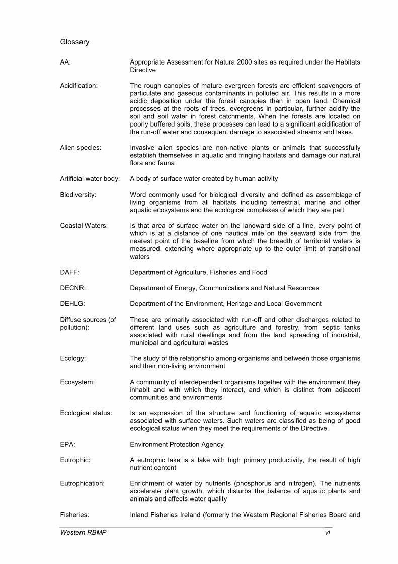


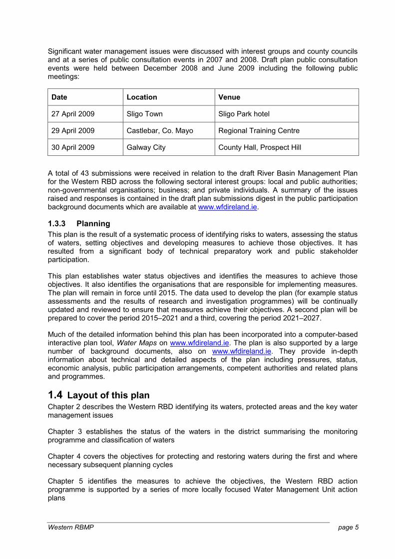

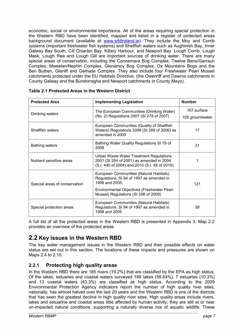


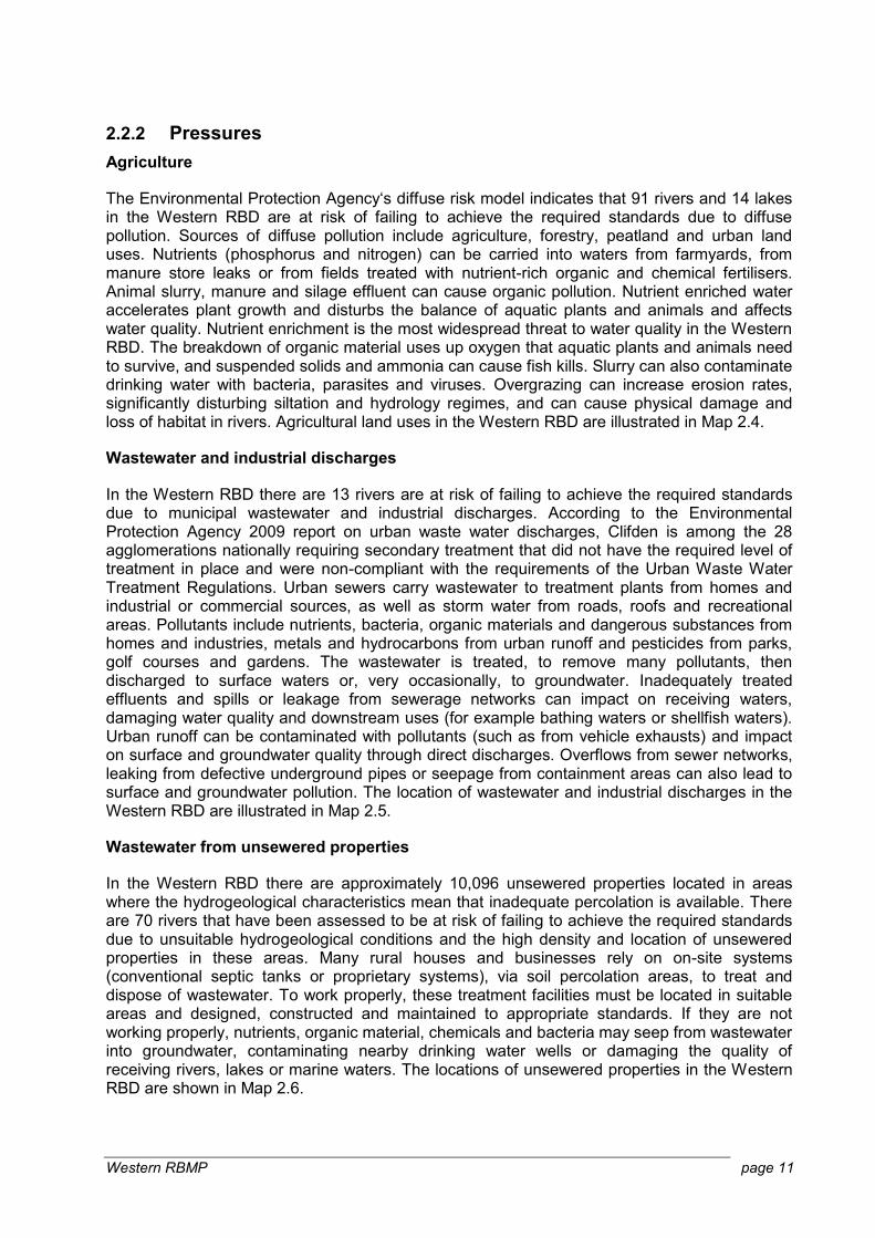


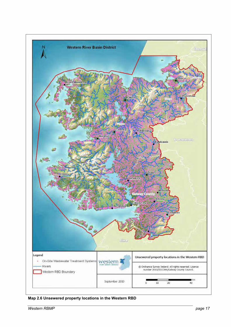


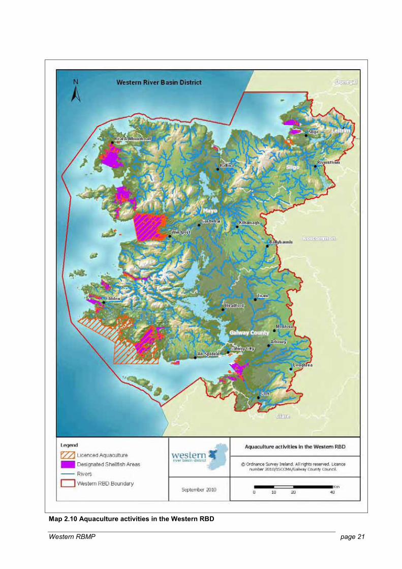
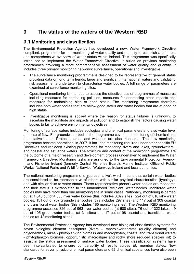


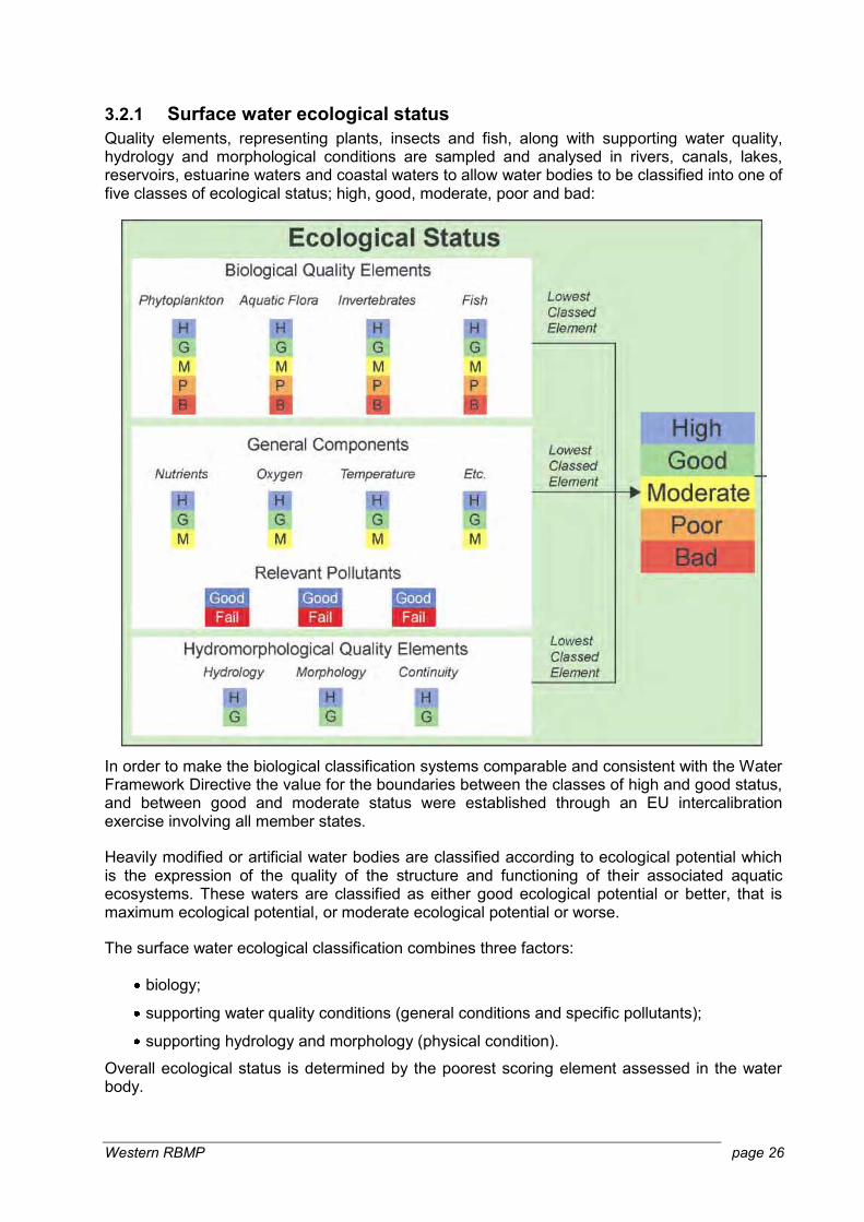


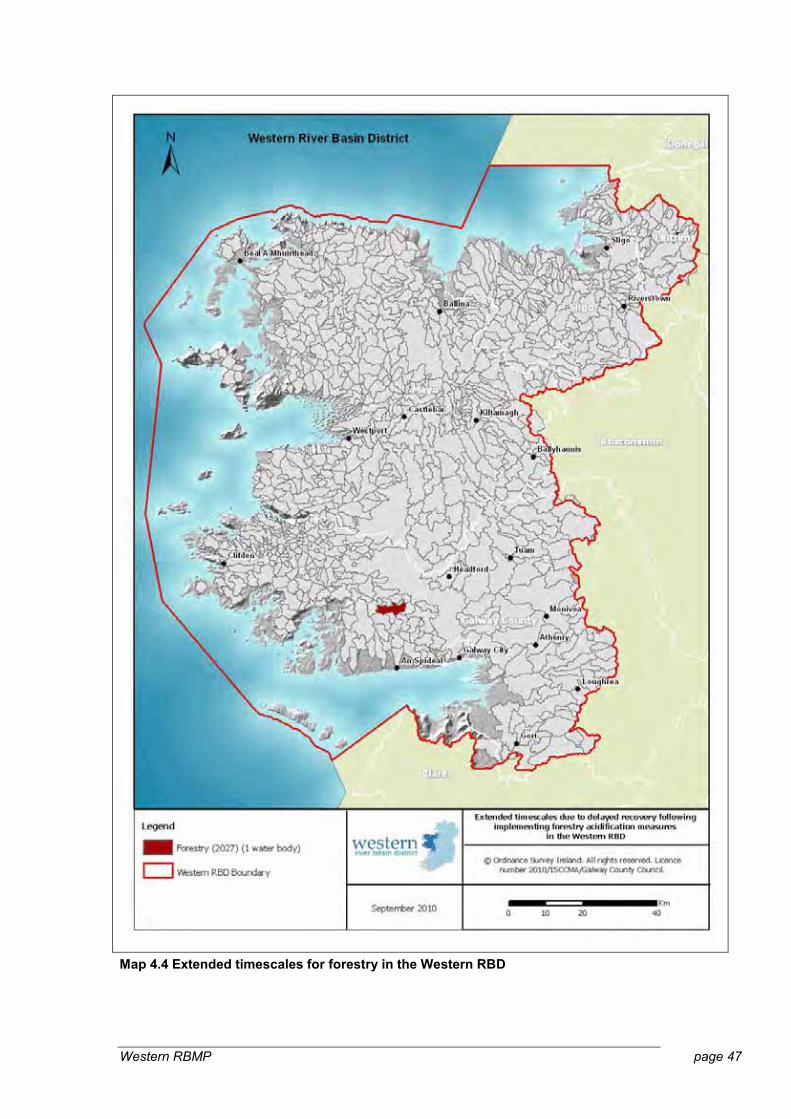


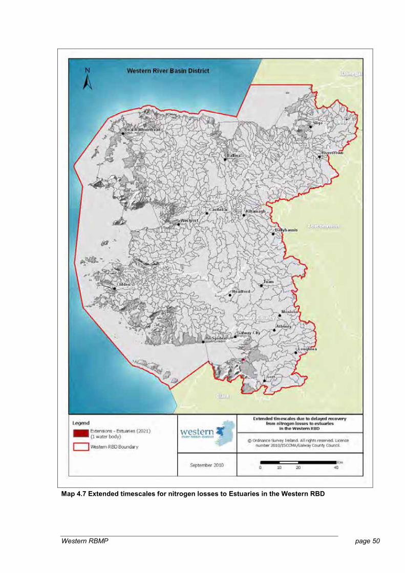


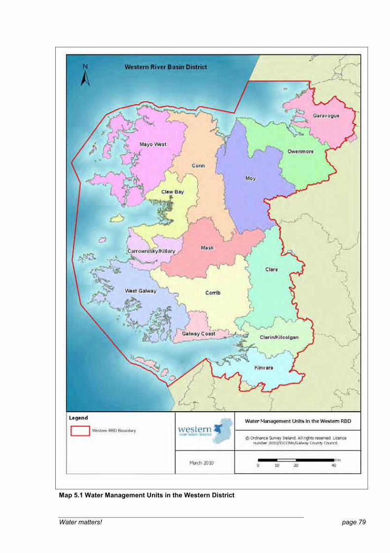


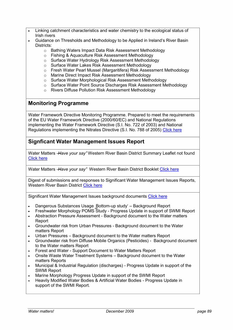
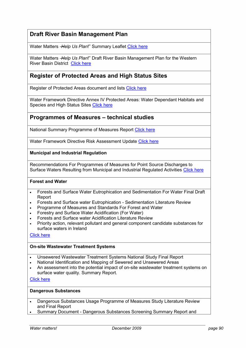
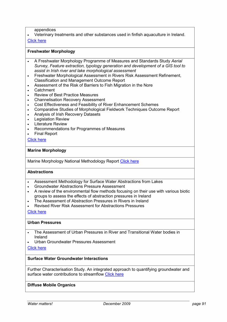


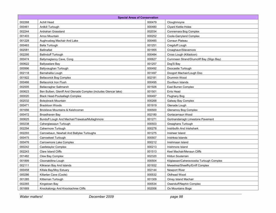


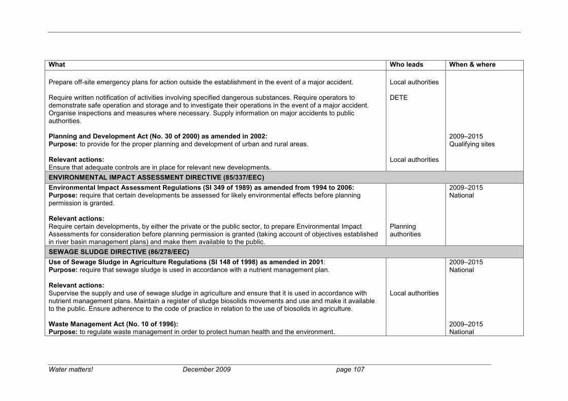


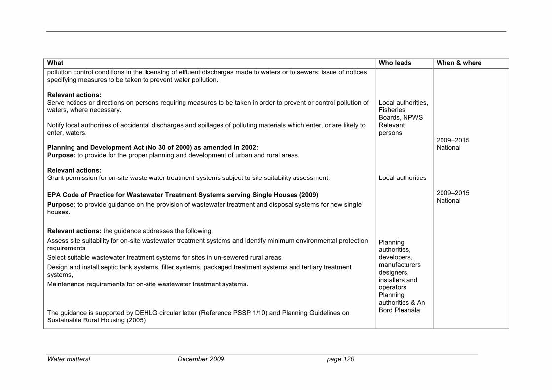


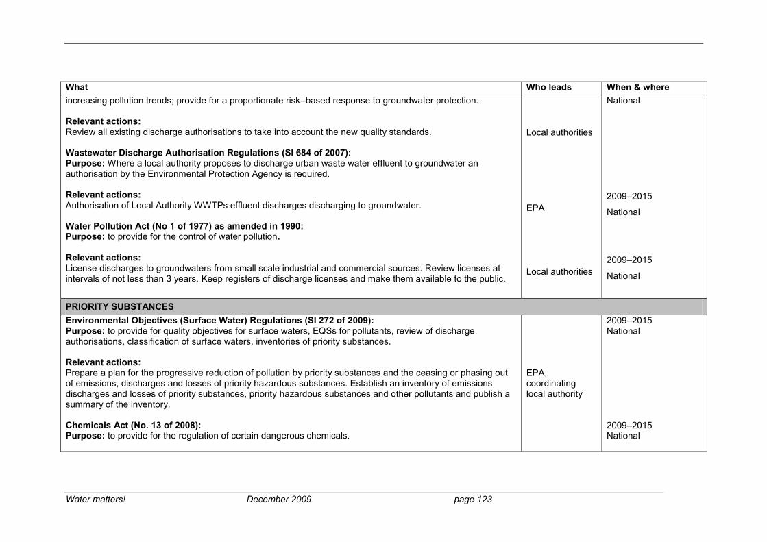


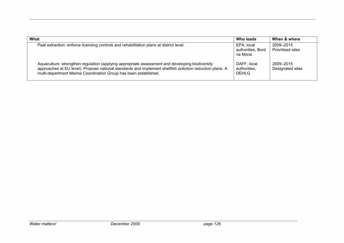

Related Documents