Simple Operating Systems (Pty) Ltd). Co. Reg. No. 2012/190711/07 Trading as The Biodiversity Company www.thebiodiversitycompany.com [email protected] 1 Riparian Habitat and Wetland Delineation Impact Assessment for the proposed Surface Water Developments for Augmentation of the Western Cape Water Supply System November 2016 REFERENCE 10598 VERSION FINAL Prepared for: Nemai Consulting 147 Bram Fischer Drive, Ferndale, Randburg Tel: +27 11 781 1730 Fax: +27 781 1731 [email protected] www.nemai.co.za Prepared by: The Biodiversity Company 420 Vale Ave. Ferndale, 2194 Cell: +27 81 319 1225 Fax: +27 86 527 1965 [email protected] www.thebiodiversitycompany.com

Welcome message from author
This document is posted to help you gain knowledge. Please leave a comment to let me know what you think about it! Share it to your friends and learn new things together.
Transcript
Simple Operating Systems (Pty) Ltd). Co. Reg. No. 2012/190711/07
Trading as The Biodiversity Company
www.thebiodiversitycompany.com
1
Riparian Habitat and Wetland Delineation Impact Assessment for the proposed Surface Water
Developments for Augmentation of the Western Cape Water Supply System
November 2016
REFERENCE
10598
VERSION
FINAL
Prepared for:
Nemai Consulting
147 Bram Fischer Drive, Ferndale, Randburg
Tel: +27 11 781 1730
Fax: +27 781 1731
www.nemai.co.za
Prepared by:
The Biodiversity Company
420 Vale Ave. Ferndale, 2194
Cell: +27 81 319 1225
Fax: +27 86 527 1965
www.thebiodiversitycompany.com
PROJECT: Western Cape Water Supply System
Nemai Consulting
Simple Operating Systems (Pty) Ltd). Co. Reg. No. 2012/190711/07
Trading as The Biodiversity Company
www.thebiodiversitycompany.com
i
Report name
Riparian Habitat and Wetland Delineation Impact Assessment for the proposed Surface Water Developments for Augmentation of the Western Cape Water Supply System
Reference code 10598
Submitted to Nemai Consulting
Report writer Andrew Husted
MSc Aquatic Health SACNASP 400213/11
Andrew Husted, is Pr Sci Nat registered in the following fields of practice: Ecological Science, Environmental Science and Aquatic Science. Andrew Husted is an Aquatic, Wetland and Biodiversity Specialist with 12 years’ experience in the environmental consulting field. Andrew is an accredited wetland practitioner, recognised by the DWS, and also the Mondi Wetlands programme as a competent wetland consultant.
Report reviewer Peter Kimberg
BSc Hons Zoology SACNASP 400085/15
Peter Kimberg is a biodiversity consultant with 12 years of experience conducting ecological assessments. He has conducted assessments across southern Africa and in 15 countries in sub-Saharan Africa. He has extensive experience conducting biodiversity studies throughout South Africa, with considerable experience working within Gauteng, and is therefore familiar with the local conditions and local legislature.
PROJECT: Western Cape Water Supply System
Nemai Consulting
Simple Operating Systems (Pty) Ltd). Co. Reg. No. 2012/190711/07
Trading as The Biodiversity Company
www.thebiodiversitycompany.com
ii
EXECUTIVE SUMMARY
The Biodiversity Company was appointed to conduct a Riparian Habitat and Wetland Delineation
Impact Assessment for the project. This specialist study aimed to assess the local watercourses
and wetland (including riparian) systems associated with the proposed project infrastructure
alternatives. The study was completed in fulfilment of the Environmental Impact Assessment (EIA)
and Environmental Authorisation process for the proposed Surface Water Developments of the
Western Cape Water Supply System (Berg River-Voëlvlei Augmentation Scheme) in the Western
Cape Province. The scheme involves the transfer of approximately 23 million m3 per annum from
the Berg River to the existing Voëlvlei Dam.
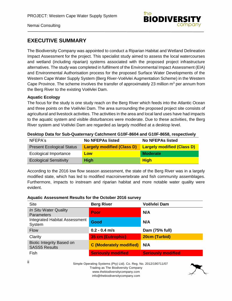
Aquatic Ecology
The focus for the study is one study reach on the Berg River which feeds into the Atlantic Ocean
and three points on the Voëlvlei Dam. The area surrounding the proposed project site consists of
agricultural and livestock activities. The activities in the area and local land uses have had impacts
to the aquatic system and visible disturbances were moderate. Due to these activities, the Berg
River system and Voëlvlei Dam are regarded as largely modified at a desktop level.
Desktop Data for Sub-Quaternary Catchment G10F-8604 and G10F-8658, respectively
NFEPA’s No NFEPAs listed No NFEPAs listed
Present Ecological Status Largely modified (Class D) Largely modified (Class D)
Ecological Importance Low Moderate
Ecological Sensitivity High High
According to the 2016 low flow season assessment, the state of the Berg River was in a largely
modified state, which has led to modified macroinvertebrate and fish community assemblages.
Furthermore, impacts to instream and riparian habitat and more notable water quality were
evident.
Aquatic Assessment Results for the October 2016 survey
Site Berg River Voëlvlei Dam
In Situ Water Quality Parameters
Poor N/A
Integrated Habitat Assessment System
Good N/A
Flow 0.2 - 0.4 m/s Dam (75% full)
Clarity 35 cm (Eutrophic) 20cm (Turbid)
Biotic Integrity Based on SASS5 Results
C (Moderately modified) N/A
Fish Seriously modified Seriously modified
PROJECT: Western Cape Water Supply System
Nemai Consulting
Simple Operating Systems (Pty) Ltd). Co. Reg. No. 2012/190711/07
Trading as The Biodiversity Company
www.thebiodiversitycompany.com
iii
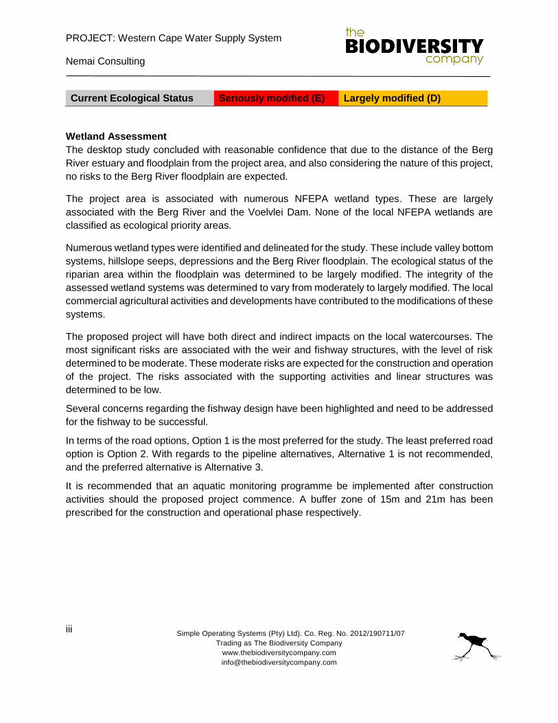
Current Ecological Status Seriously modified (E) Largely modified (D)
Wetland Assessment
The desktop study concluded with reasonable confidence that due to the distance of the Berg
River estuary and floodplain from the project area, and also considering the nature of this project,
no risks to the Berg River floodplain are expected.
The project area is associated with numerous NFEPA wetland types. These are largely
associated with the Berg River and the Voelvlei Dam. None of the local NFEPA wetlands are
classified as ecological priority areas.
Numerous wetland types were identified and delineated for the study. These include valley bottom
systems, hillslope seeps, depressions and the Berg River floodplain. The ecological status of the
riparian area within the floodplain was determined to be largely modified. The integrity of the
assessed wetland systems was determined to vary from moderately to largely modified. The local
commercial agricultural activities and developments have contributed to the modifications of these
systems.
The proposed project will have both direct and indirect impacts on the local watercourses. The
most significant risks are associated with the weir and fishway structures, with the level of risk
determined to be moderate. These moderate risks are expected for the construction and operation
of the project. The risks associated with the supporting activities and linear structures was
determined to be low.
Several concerns regarding the fishway design have been highlighted and need to be addressed
for the fishway to be successful.
In terms of the road options, Option 1 is the most preferred for the study. The least preferred road
option is Option 2. With regards to the pipeline alternatives, Alternative 1 is not recommended,
and the preferred alternative is Alternative 3.
It is recommended that an aquatic monitoring programme be implemented after construction
activities should the proposed project commence. A buffer zone of 15m and 21m has been
prescribed for the construction and operational phase respectively.
PROJECT: Western Cape Water Supply System
Nemai Consulting
Simple Operating Systems (Pty) Ltd). Co. Reg. No. 2012/190711/07
Trading as The Biodiversity Company
www.thebiodiversitycompany.com
iv
Table of Contents
1. INTRODUCTION ................................................................................................................. 1
1.1 Background ..................................................................................................................... 1
1.2 Project options ................................................................................................................. 1
1.3 Aim & objectives .............................................................................................................. 2
2. LIMITATIONS ...................................................................................................................... 3
3. KEY LEGISLATIVE REQUIREMENTS ................................................................................ 3
3.1 National Water Act (NWA, 1998) ..................................................................................... 3
3.2 National Environmental Management Act (NEMA, 1998) ................................................. 5
4. PROJECT AREA ................................................................................................................. 5
5. METHODOLOGY............................................................................................................... 10
5.1 Aquatic ecology ..............................................................................................................10
5.1.1 In situ water quality ..................................................................................................10
5.1.2 Habitat Assessment .................................................................................................11
5.1.3 Aquatic macroinvertebrates ......................................................................................14
5.1.4 Biotic Integrity Based on SASS5 Results .................................................................15
5.1.5 Fish ..........................................................................................................................16
Expected fish species ........................................................................................................16
Presence of Species of Conservation Concern ..................................................................17
5.2 Wetland assessment ......................................................................................................20
5.2.1 Desktop assessment ................................................................................................20
5.2.2 Wetland delineation ..................................................................................................20
5.2.3 Riparian delineation .................................................................................................21
5.2.4 Wetland classification ...............................................................................................21
5.2.5 Wetland – Present Ecological Status (PES) .............................................................22
5.2.6 Riparian – PES ........................................................................................................23
5.3 Risk assessment ............................................................................................................23
6. RESULTS & DISCUSSIONS ............................................................................................. 24
6.1 Desktop aquatic ecology .................................................................................................24
PROJECT: Western Cape Water Supply System
Nemai Consulting
Simple Operating Systems (Pty) Ltd). Co. Reg. No. 2012/190711/07
Trading as The Biodiversity Company
www.thebiodiversitycompany.com
v
6.1.1 NFEPA’s for sub-quaternary catchments G10F -8604 and G10F - 8658 ..................24
6.2 Aquatic ecology ..............................................................................................................27
6.2.1 In situ water quality ..................................................................................................27
6.2.2 Habitat assessment ..................................................................................................29
6.2.3 Aquatic macroinvertebrates ......................................................................................31
6.2.4 Biotic Integrity based on SASS5 Results ..................................................................32
6.2.5 Fish ..........................................................................................................................32
6.2.6 Current Ecological Status .........................................................................................35
6.3 Wetland assessment ......................................................................................................36
6.3.1 Desktop assessment ............................................................................................36
6.3.2 Wetland delineation ..................................................................................................40
6.3.4 Wetland functional description ..................................................................................44
6.3.5 Riparian assessment ................................................................................................45
6.3.6 Riparian – Present Ecological Status ........................................................................46
6.3.7 Wetland – Present Ecological Status ........................................................................47
7. RISK ASSESSMENT ......................................................................................................... 50
7.1 Low level weir construction mitigation measures ............................................................55
7.2 Fishway construction mitigation measures ......................................................................55
7.3 Fishway specifics to be changed ....................................................................................58
7.4 Pipeline mitigation measures ..........................................................................................59
7.5 General mitigation measures ..........................................................................................60
7.6 Summer release installation options ...............................................................................61
7.7 Project options ................................................................................................................63
8. MONITORING ................................................................................................................... 64
9. BUFFER ZONE ................................................................................................................. 65
10. CONCLUSIONS ................................................................................................................ 65
11. REFERENCES .................................................................................................................. 67

PROJECT: Western Cape Water Supply System
Nemai Consulting
Simple Operating Systems (Pty) Ltd). Co. Reg. No. 2012/190711/07
Trading as The Biodiversity Company
www.thebiodiversitycompany.com
vi
Figures
Figure 1: The location of the project area in relation to the local setting ..................................... 5
Figure 2: The location of the sample reach and sites for the Berg River and Voelvlei Dam
respectively ................................................................................................................................ 9
Figure 3: The location of the project area in relation to the WMA and quaternary catchment ....10
Figure 4: Kick and sweep sampling method, SASS5 (South African Scoring System Version 5)
.................................................................................................................................................15
Figure 5: Biological Bands for the South Western Coastal Belt – Lower zone, calculated using
percentiles ................................................................................................................................16
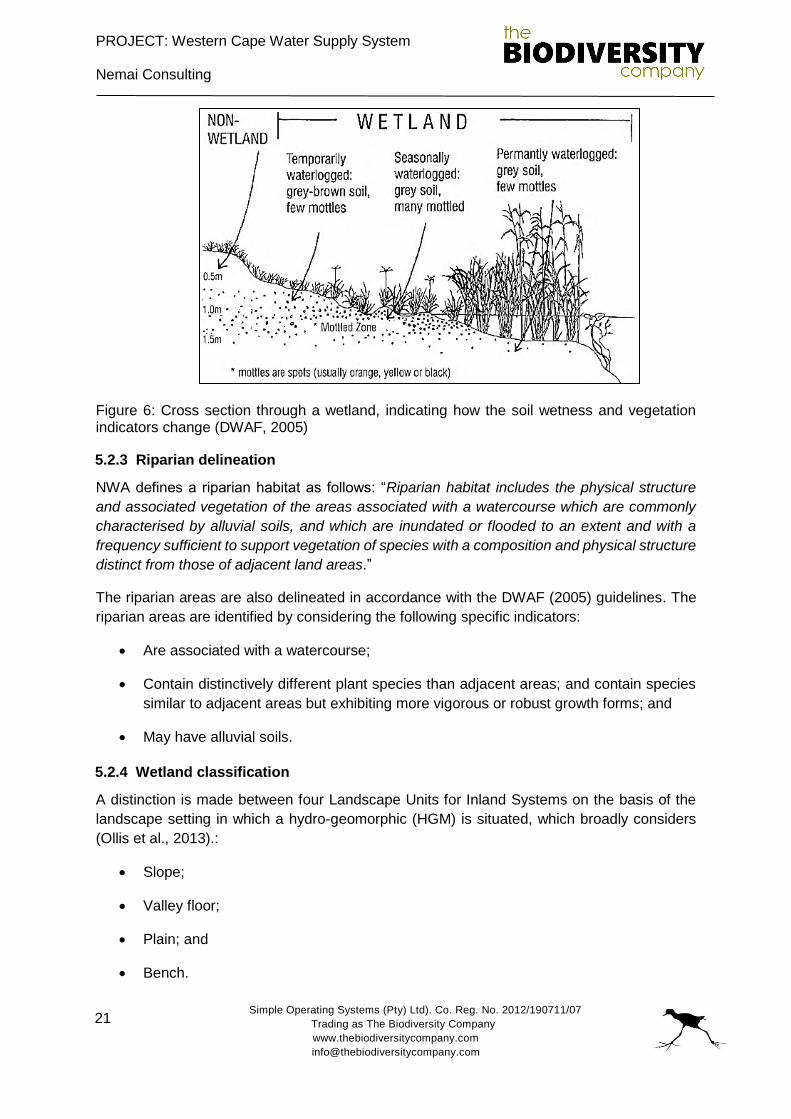
Figure 6: Cross section through a wetland, indicating how the soil wetness and vegetation
indicators change (DWAF, 2005) ..............................................................................................21
Figure 7: Eutrophic conditions experienced in the Berg River ...................................................28
Figure 8: Fish seen feeding and spawning in the Voëlvlei Dam .................................................34
Figure 9: The land types associated for the study area .............................................................37
Figure 10: The ecological status of the local vegetation types for the study area ......................38
Figure 11: The level of protection afforded to the local vegetation types ...................................39
Figure 12: The extent of NFEPA wetlands associated with the project area ..............................40
Figure 13: Photographs of some wetland indicators considered for the study. A: Vegetation,
Zantedeschia aethiopica. B: Vegetation: Phragmites sp & Typha capensis. C: Topography,
channel. D: Topography, depressions .......................................................................................42
Figure 14: The delineated wetland HGM units for the study ......................................................43
Figure 15: Photographs of the riparian areas assessed for the study ........................................46
Figure 16: The delineated HGM units in relation to the proposed project components ..............48
Figure 17: Different views of the rock ramp type of fishway .......................................................57
Figure 18: Diagram of rock ramp type fishway ..........................................................................58
Figure 19: Summer release discharge point into the Berg River with proposed pipeline (Blue) .62
Figure 20: Highly eroded discharge point (photo courtesy Nemai Consulting) ...........................63
Tables
Table 1: Photographs, co-ordinates and descriptions for the aquatic sites sampled ................... 6
Table 2: Invertebrate Habitat Assessment System Scoring Guidelines .....................................11
Table 3: Criteria used in the assessment of habitat integrity (from Kleynhans, 1996) ................11
Table 4: Descriptive classes for the assessment of modifications to habitat integrity (from
Kleynhans, 1996) ......................................................................................................................12
Table 5: Criteria and weights used for the assessment of habitat integrity and habitat integrity
(from Kleynhans, 1996) .............................................................................................................13
Table 6: Intermediate habitat integrity categories (From Kleynhans, 1996) ...............................14
PROJECT: Western Cape Water Supply System
Nemai Consulting
Simple Operating Systems (Pty) Ltd). Co. Reg. No. 2012/190711/07
Trading as The Biodiversity Company
www.thebiodiversitycompany.com
vii
Table 7: Biological Bands / Ecological categories for interpreting SASS data (adapted from Dallas,
2007) ........................................................................................................................................15
Table 8: Expected species list for the sub-quaternary catchment ..............................................17
Table 9: The PES categories and descriptions for WET-Health (Macfarlane et al, 2008) ..........23
Table 10: Generic ecological categories for EcoStatus components (modified from Kleynhans
1996 & Kleynhans 1999) ...........................................................................................................23
Table 11: Significance ratings matrix .........................................................................................24
Table 12: Present Ecological Status for the Berg Sub-quaternary reach G10F-8604 (Sites BR1,
BR2) (DWA, 2013) ....................................................................................................................25
Table 13: Present Ecological Status for the Berg Sub-quaternary reach G10F-8658 (Sites ALT1,
ALT2, ALT3) (DWA, 2013) ........................................................................................................26
Table 14: In situ water quality results for the site with reference to the Target Water Quality
Requirements (TWQR) .............................................................................................................27
Table 15: IHAS score at the two sites during the survey ...........................................................29
Table 16: Results for the IHIA ...................................................................................................30
Table 17: Results for the riparian habitat integrity assessment ..................................................30
Table 18: Macroinvertebrate assessment results ......................................................................31
Table 19: Intolerance rating and sensitivity of fish species ........................................................32
Table 20: Fish species recorded during the October 2016 survey .............................................32
Table 21: Fish species collected during the October 2016 survey .............................................33
Table 22: Catch per unit effort (CPUE) during the October survey ............................................34
Table 23: Current Ecological Status assessment based on the PES of the various assessment
components ..............................................................................................................................35
Table 24: An indication of the identified wetland types for each HGM unit .................................43
Table 25: VEGRAI score for the riparian vegetation of the Berg River ......................................47
Table 26: Summary of the scores for the wetland PES .............................................................49
Table 27: Potential risks associated with the project .................................................................52
Table 28: Risk rating assessment .............................................................................................53
Table 29: Risk rating assessment continued .............................................................................54
Table 30: The list of project preferences for the aquatic and wetland studies for the project option
and alternatives .........................................................................................................................63
PROJECT: Western Cape Water Supply System
Nemai Consulting
Simple Operating Systems (Pty) Ltd). Co. Reg. No. 2012/190711/07
Trading as The Biodiversity Company
www.thebiodiversitycompany.com
viii
List of Abbreviations
ASPT Average Score Per Taxon
BA Basic Assessment
DD Data Deficient DO Dissolved Oxygen
DWAF Department of Water Affairs and Forestry
DWS Department of Water and Sanitation
EAP Environmental Assessment Practitioner
EC Electrical conductivity
EI Ecological Importance
EIS Ecological Importance and Sensitivity
EPT Ephemeroptera (Mayflies), Plecoptera (Stoneflies) and Trichoptera (Caddisflies)
ES Ecological Sensitivity
ESA Ecological Support Area
FEPA Freshwater Ecosystem Priority Areas
GSM HGM
Gravel, Sand, and Mud Hydro-geomorphic
IHAS Invertebrate Habitat Assessment System
IHIA Intermediate Habitat Integrity Assessment
IT Invertebrate Tolerance
LC Least Concern NEM:BA National Environment Management Biodiversity Act’s
NEMA National Environmental Management Act
NFEPA National Freshwater Ecosystem Priority Areas
NT Near Threatened NWA National Water Act
PES Present Ecological Status
RHP River Health Project
SANBI South African National Biodiversity Institute
SASS South African Scoring System
SIC Stones In Current
SOOC Stones Out OF Current
SQR Sub-quaternary reach
TWQR Target Water Quality Range
VU Vulnerable WMA Water Management Area
WULA Water Use Licence
PROJECT: Western Cape Water Supply System
Nemai Consulting
Simple Operating Systems (Pty) Ltd). Co. Reg. No. 2012/190711/07
Trading as The Biodiversity Company
www.thebiodiversitycompany.com
ix
DECLARATION
I, Andrew Husted declare that:
I act as the independent specialist in this application;
I will perform the work relating to the application in an objective manner, even if this results
in views and findings that are not favourable to the applicant;
I declare that there are no circumstances that may compromise my objectivity in
performing such work;
I have expertise in conducting the specialist report relevant to this application,
including knowledge of the Act, regulations and any guidelines that have relevance to the
proposed activity;
I will comply with the Act, regulations and all other applicable legislation;
I have no, and will not engage in, conflicting interests in the undertaking of the activity;
I undertake to disclose to the applicant and the competent authority all material information
in my possession that reasonably has or may have the potential of influencing - any
decision to be taken with respect to the application by the competent authority; and - the
objectivity of any report, plan or document to be prepared by myself for submission to the
competent authority;
All the particulars furnished by me in this form are true and correct; and
I realise that a false declaration is an offence in terms of Regulation 71 and is punishable
in terms of Section 24F of the Act.
Andrew Husted
The Biodiversity Company
8 November 2016
PROJECT: Western Cape Water Supply System
Nemai Consulting
Simple Operating Systems (Pty) Ltd). Co. Reg. No. 2012/190711/07
Trading as The Biodiversity Company
www.thebiodiversitycompany.com
x
DECLARATION
I, Dale Kindler declare that:
I act as the independent specialist in this application;
I will perform the work relating to the application in an objective manner, even if this results
in views and findings that are not favourable to the applicant;
I declare that there are no circumstances that may compromise my objectivity in
performing such work;
I have expertise in conducting the specialist report relevant to this application, including
knowledge of the Act, regulations and any guidelines that have relevance to the proposed
activity;
I will comply with the Act, regulations and all other applicable legislation;
I have no, and will not engage in, conflicting interests in the undertaking of the activity;
I undertake to disclose to the applicant and the competent authority all material information
in my possession that reasonably has or may have the potential of influencing any decision
to be taken with respect to the application by the competent authority; and the objectivity
of any report, plan or document to be prepared by myself for submission to the competent
authority;
all the particulars furnished by me in this form are true and correct; and
I realise that a false declaration is an offence in terms of Regulation 71 and is punishable
in terms of Section 24F of the Act.
Dale Kindler
The Biodiversity Company
8 November 2016
PROJECT: Western Cape Water Supply System
Nemai Consulting
Simple Operating Systems (Pty) Ltd). Co. Reg. No. 2012/190711/07
Trading as The Biodiversity Company
www.thebiodiversitycompany.com
1
1. INTRODUCTION
Nemai Consulting was appointed to undertake the Environmental Authorisation process for
the Proposed Surface Water Developments for Augmentation of the Western Cape Water
Supply System.
The Biodiversity Company was subsequently appointed by Nemai Consulting to conduct a
Riparian Habitat and Wetland Delineation Impact Assessment for the project. This specialist
study aimed to assess the local watercourses and wetland (including riparian) systems
associated with the proposed project infrastructure alternatives.
The fieldwork was conducted from 25-27 October, which is considered to be the onset of the
dry season period.
1.1 Background
The Western Cape Water Supply System serves the City of Cape Town, surrounding urban
centres and irrigators. It consists of infrastructure components owned and operated by both
the City of Cape Town and the Department of Water and Sanitation (DWS). In 2007, the
Western Cape Reconciliation Strategy Study was commissioned by DWS to determine future
water requirements for a 25 year planning horizon. The Study investigated a number of options
and found that whilst 556 million m3 per annum would be available from 2007, the estimated
water requirement in 2011 would be 560 million m3/a, with the implication that the system
supply will then be fully utilised and thus additional interventions will thus be required.
Based on the above, DWS identified the need for augmentation of the Western Cape Water
Supply System by 2019 and proceeded with pre-feasibility and feasibility studies into potential
surface water development options. Initially, six options were assessed at a pre-feasibility level
of detail. These options were then prioritized to identify the two most viable options. These
were:
Berg River-Voëlvlei Augmentation Scheme (also known as the First Phase
Augmentation of Voëlvlei Dam); and
Breede-Berg Transfer Scheme (also known as the Michell’s Pass Diversion Scheme).
Ultimately, the Feasibility Study found that the Berg River-Voëlvlei Augmentation Scheme
option was the most favourable surface water intervention and as such the Department of
Water and Sanitation proposes to implement this scheme which involves the transfer of
approximately 23 million m3 per annum from the Berg River to the existing Voëlvlei Dam.
1.2 Project options
The project components include the following:
A 160 m long low level weir, abstraction works (peak abstraction discharge of 6 m3/s)
and 4 m3/s raw water pump station on the Berg River;
A rising main pipeline from the Berg River to Voëlvlei Dam;
PROJECT: Western Cape Water Supply System
Nemai Consulting
Simple Operating Systems (Pty) Ltd). Co. Reg. No. 2012/190711/07
Trading as The Biodiversity Company
www.thebiodiversitycompany.com
2
A potential new summer release connection at the existing Swartland Water Treatment
Works (WTW) to facilitate summer releases into the Berg River for environmental
requirements thus eliminating the need to utilize the existing canal from which water
losses occur; and
The summer release outlet will be located within the same servitude as the main
pipeline and will have gabion-type structures at the discharge point.
All the infrastructure and activities that require environmental authorisation need to be
assessed as part of the Environmental Impact Assessment (EIA). In this regard, the following
associated infrastructure was identified:
Abstraction works;
Rising main pipeline and pump station;
Diversion weir;
Access roads during construction;
Access roads during operation; and
Construction camp (footprint).
Three pipeline routes were investigated during the Technical Feasibility Study and will be
assessed as part of the EIA. These routes are related to three potential discharge options into
the dam from the diversion weir site. These routes are as follows:
Pipeline route to Northern Discharge Point = 8 115 m;
Pipeline route to Central Discharge Point = 5 000 m; and
Pipeline route to Southern Discharge Point = 6 300 m.
Whilst design flows of 4 and 6m3/s were considered for the rising main during the Technical
Feasibility Study, the EIA will only assess the 4m3/s option which was deemed most feasible
during the Technical Feasibility Study.
1.3 Aim & objectives
Three pipeline routes, access routes and discharge points’ alternatives were provided for the
Specialists to assess. The aim of the study is to recommend which alternative layout is
preferred and to provide supporting motivation. The following primary objectives were
considered for the study:
Assessing and delineating watercourses (river crossings and wetland crossings as well
as wetlands within a 500m radius of project footprint) at varying levels of detail and
rigour, based on the risks posed to the affected watercourses;
Conduct a comprehensive desktop assessment for the local systems;
PROJECT: Western Cape Water Supply System
Nemai Consulting
Simple Operating Systems (Pty) Ltd). Co. Reg. No. 2012/190711/07
Trading as The Biodiversity Company
www.thebiodiversitycompany.com
3
Determine the ecological status of the local watercourses and wetland systems where
applicable;
Conduct an assessment of the fishway, comprising a vertical slotted fishway or a rock-
ramp type;
Conduct a risk assessment for the receiving systems in light of the proposed project.
Where applicable provide suggestions to avoid impacts, and where impacts are
unavoidable prescribe measures to mitigate these impacts; and
Provide recommendations and a monitoring programme for the project.
2. LIMITATIONS
The following limitations are expected for the project
According to the DWAF (2005) wetland and riparian area delineation guidelines, key
indicators are required for the demarcation of these systems. Due to the fact that the
local land uses include commercial agricultural activities and the establishment of
infrastructure which includes roads, railways and settlements, the implementation of
the required indicators was somewhat inhibited. In an attempt to address this, desktop
data and imagery were considered to supplement the study findings.
Due to the extent of the study area, only areas (or systems) expected to be directly
impacted on because of the project alternatives were ground truthed. These areas
formed the focus and basis for the baseline study, and impact assessment. The
adjacent and extending watercourses were identified, delineated and assessed at a
desktop level only.
3. KEY LEGISLATIVE REQUIREMENTS
3.1 National Water Act (NWA, 1998)
The DWS is the custodian of South Africa’s water resources and therefore assumes public
trusteeship of water resources, which includes watercourses, surface water, estuaries, or
aquifers. The National Water Act (NWA) (Act No. 36 of 1998) allows for the protection of water
resources, which includes:
The maintenance of the quality of the water resource to the extent that the water
resources may be used in an ecologically sustainable way;
The prevention of the degradation of the water resource; and
The rehabilitation of the water resource.
A watercourse means:
A river or spring;
PROJECT: Western Cape Water Supply System
Nemai Consulting
Simple Operating Systems (Pty) Ltd). Co. Reg. No. 2012/190711/07
Trading as The Biodiversity Company
www.thebiodiversitycompany.com
4
A natural channel in which water flows regularly or intermittently;
A wetland, lake or dam into which, or from which, water flows; and
Any collection of water which the Minister may, by notice in the Gazette, declare to be
a watercourse, and a reference to a watercourse includes, where relevant, its bed and
banks.
The NWA recognises that the entire ecosystem, and not just the water itself, and any given
water resource constitutes the resource and as such needs to be conserved. No activity may
therefore take place within a watercourse unless it is authorised by the DWS. Any area within
a wetland or riparian zone is therefore excluded from development unless authorisation is
obtained from the DWS in terms of Section 21 (c) and (i).
However, according to General Notice 509 as published in the Government Gazette No. 40229
of 2016, it must be noted that as defined by the Replacement General Authorisation in terms
of Section 39 of the National Water Act, on account of the extremely sensitive nature of
wetlands and estuaries, the section 21(c) and (i) water use General Authorisation does not
apply to:
To the use of water in terms of section 21(c) or (i) of the Act for the rehabilitation of a
wetland;
To the use of water in terms of section 21(c) or (i) of the Act within the regulated area
of a watercourse where the Risk Class is Medium or High;
In instances where an application must be made for a water use license for the
authorisation of any other water use as defined in section 21 of the Act that may be
associated with a new activity;
Where storage of water results from the impeding or diverting of flow or altering the
bed, banks, course or characteristics of a watercourse; and
To any water use in terms of section 21(c) or (i) of the Act associated with construction,
installation or maintenance of any sewerage pipelines, pipelines carrying hazardous
materials and to raw water and wastewater treatment works.
For the purposes of this project, a wetland area is defined according to the NWA (Act No. 36
of 1998): “Land which is transitional between terrestrial and aquatic systems where the water
table is usually at or near the surface, or the land is periodically covered with shallow water,
and which land in normal circumstances supports or would support vegetation typically
adapted to life in saturated soil”.
It must be noted that the NWA definition is not concerned with marine systems and clearly
distinguishes wetlands from estuaries, classifying the latter as a water course (SANBI, 2009).
Wetlands therefore have one or more of the following attributes to meet the NWA wetland
definition (DWAF, 2005):
PROJECT: Western Cape Water Supply System
Nemai Consulting
Simple Operating Systems (Pty) Ltd). Co. Reg. No. 2012/190711/07
Trading as The Biodiversity Company
www.thebiodiversitycompany.com
5
A high water table that results in the saturation at or near the surface, leading to
anaerobic conditions developing in the top 50cm of the soil;
Wetland or hydromorphic soils that display characteristics resulting from prolonged
saturation, i.e. mottling or grey soils; and
The presence of, at least occasionally, hydrophilic plants, i.e. hydrophytes (water
loving plants).
3.2 National Environmental Management Act (NEMA, 1998)
The National Environmental Management Act (NEMA) (Act 107 of 1998) and the associated
Environmental Impact Assessment (EIA) Regulations as amended in December 2014, states
that prior to any development taking place within a wetland or riparian area, an environmental
authorisation process needs to be followed.
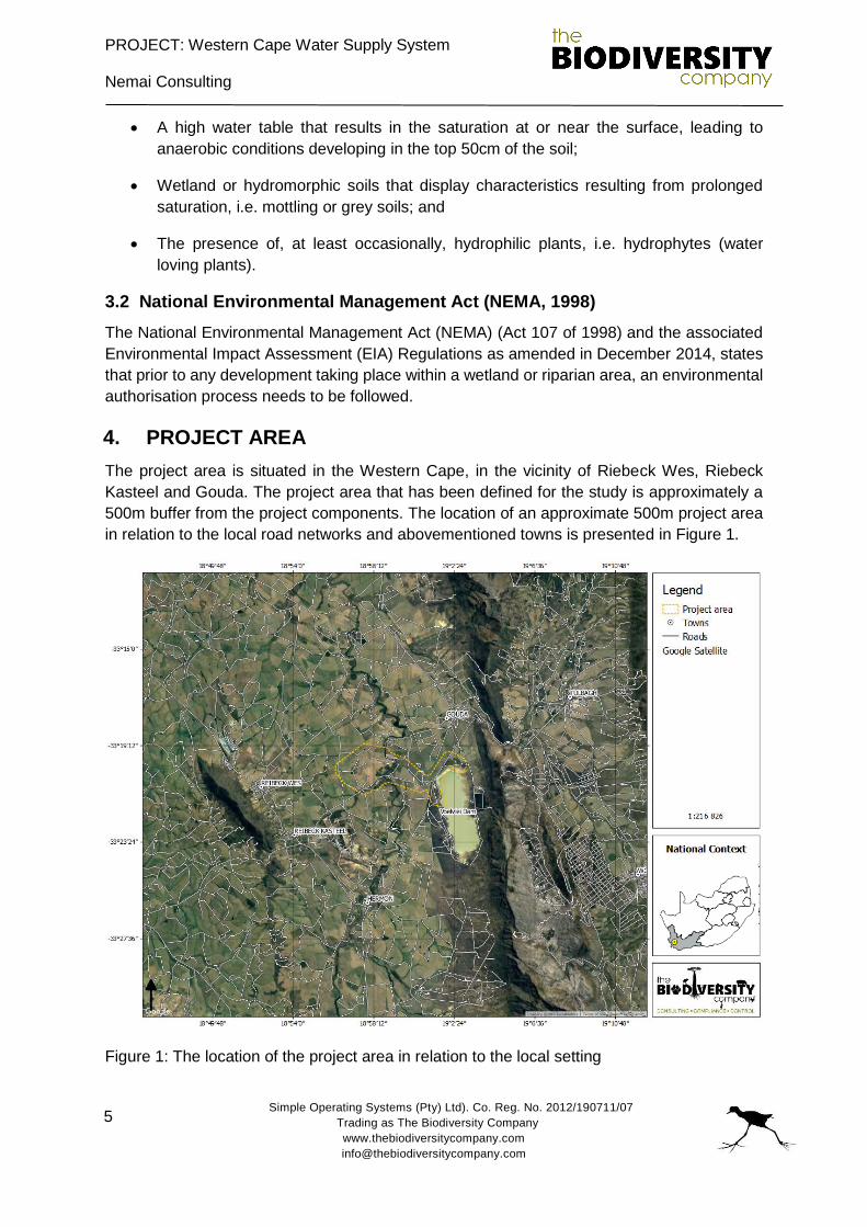
4. PROJECT AREA
The project area is situated in the Western Cape, in the vicinity of Riebeck Wes, Riebeck
Kasteel and Gouda. The project area that has been defined for the study is approximately a
500m buffer from the project components. The location of an approximate 500m project area
in relation to the local road networks and abovementioned towns is presented in Figure 1.
Figure 1: The location of the project area in relation to the local setting
PROJECT: Western Cape Water Supply System
Nemai Consulting
Simple Operating Systems (Pty) Ltd). Co. Reg. No. 2012/190711/07
Trading as The Biodiversity Company
www.thebiodiversitycompany.com
6
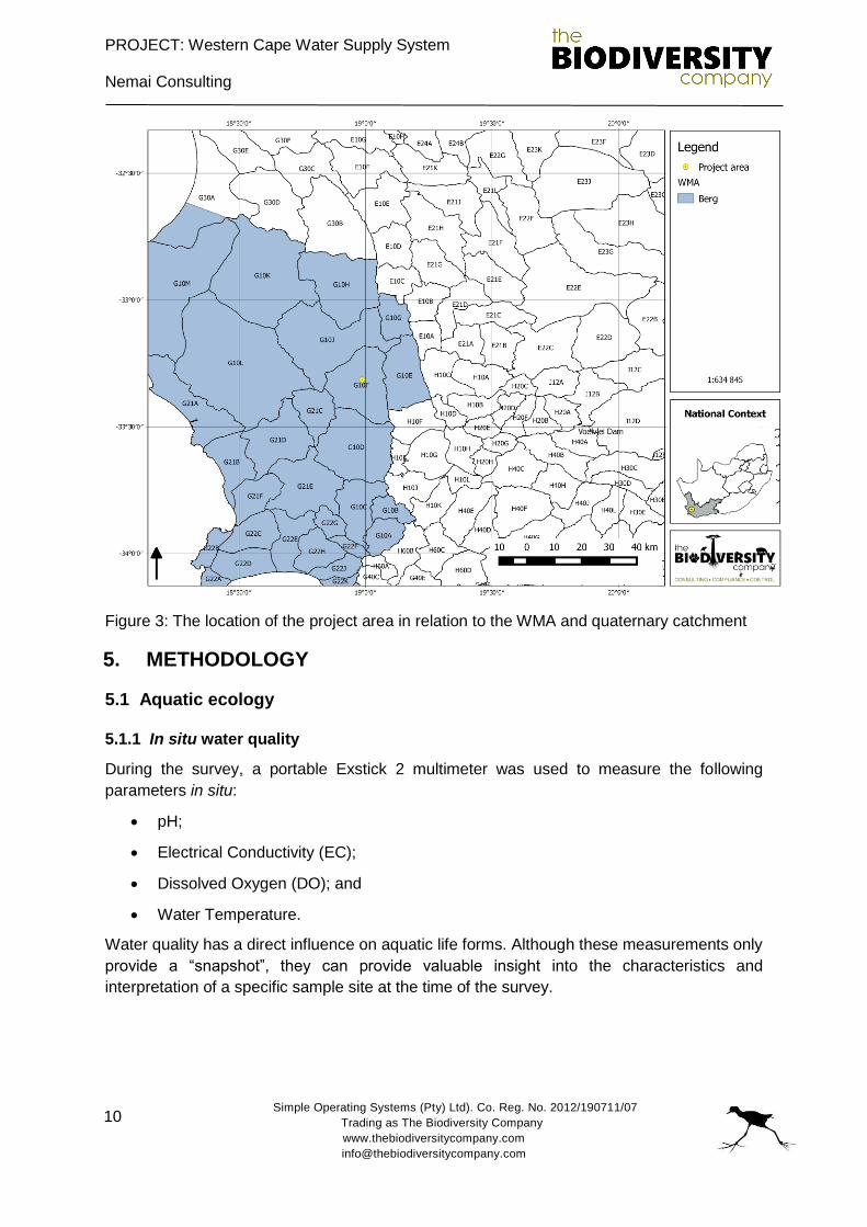
The proposed Berg River-Voëlvlei Augmentation project is situated in the quaternary
catchment G10F (Figure 3), within the Berg Water Management Area (WMA 19). The study
area is in the Zonquasdrift area in the Western Cape Province, South Africa. The area
surrounding the proposed project consists predominantly of large-scale commercial
agricultural and livestock activities.
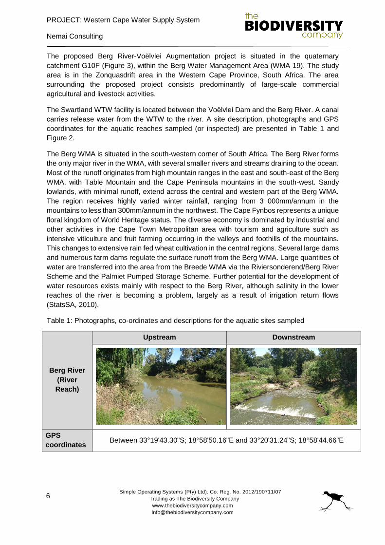
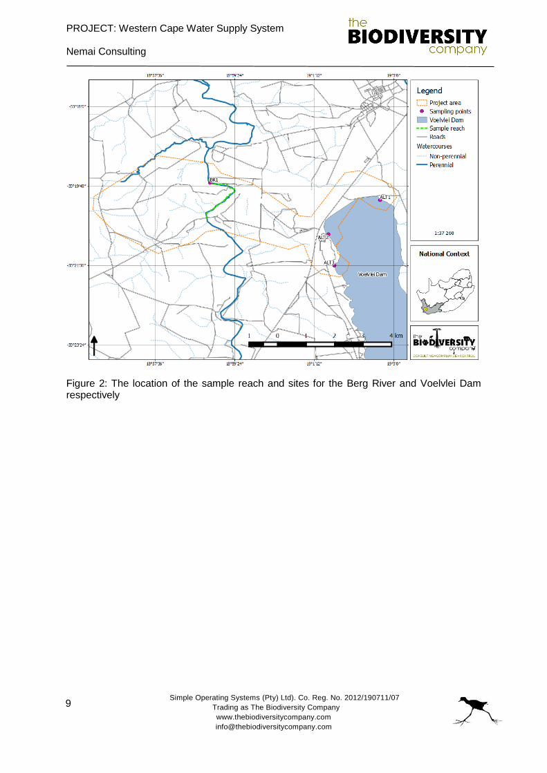
The Swartland WTW facility is located between the Voëlvlei Dam and the Berg River. A canal
carries release water from the WTW to the river. A site description, photographs and GPS
coordinates for the aquatic reaches sampled (or inspected) are presented in Table 1 and
Figure 2.
The Berg WMA is situated in the south-western corner of South Africa. The Berg River forms
the only major river in the WMA, with several smaller rivers and streams draining to the ocean.
Most of the runoff originates from high mountain ranges in the east and south-east of the Berg
WMA, with Table Mountain and the Cape Peninsula mountains in the south-west. Sandy
lowlands, with minimal runoff, extend across the central and western part of the Berg WMA.
The region receives highly varied winter rainfall, ranging from 3 000mm/annum in the
mountains to less than 300mm/annum in the northwest. The Cape Fynbos represents a unique
floral kingdom of World Heritage status. The diverse economy is dominated by industrial and
other activities in the Cape Town Metropolitan area with tourism and agriculture such as
intensive viticulture and fruit farming occurring in the valleys and foothills of the mountains.
This changes to extensive rain fed wheat cultivation in the central regions. Several large dams
and numerous farm dams regulate the surface runoff from the Berg WMA. Large quantities of
water are transferred into the area from the Breede WMA via the Riviersonderend/Berg River
Scheme and the Palmiet Pumped Storage Scheme. Further potential for the development of
water resources exists mainly with respect to the Berg River, although salinity in the lower
reaches of the river is becoming a problem, largely as a result of irrigation return flows
(StatsSA, 2010).
Table 1: Photographs, co-ordinates and descriptions for the aquatic sites sampled
Berg River
(River
Reach)
Upstream Downstream
GPS
coordinates Between 33°19'43.30"S; 18°58'50.16"E and 33°20'31.24"S; 18°58'44.66"E
PROJECT: Western Cape Water Supply System
Nemai Consulting
Simple Operating Systems (Pty) Ltd). Co. Reg. No. 2012/190711/07
Trading as The Biodiversity Company
www.thebiodiversitycompany.com
7
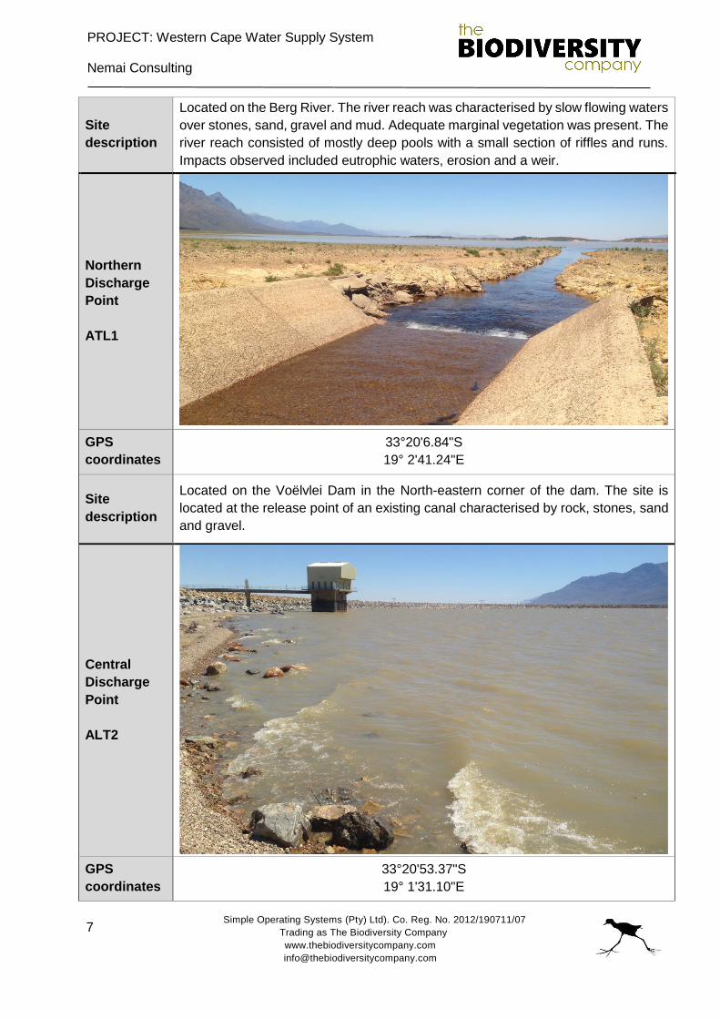
Site
description
Located on the Berg River. The river reach was characterised by slow flowing waters
over stones, sand, gravel and mud. Adequate marginal vegetation was present. The
river reach consisted of mostly deep pools with a small section of riffles and runs.
Impacts observed included eutrophic waters, erosion and a weir.
Northern
Discharge
Point
ATL1
GPS
coordinates
33°20'6.84"S
19° 2'41.24"E
Site
description
Located on the Voëlvlei Dam in the North-eastern corner of the dam. The site is
located at the release point of an existing canal characterised by rock, stones, sand
and gravel.
Central
Discharge
Point
ALT2
GPS
coordinates
33°20'53.37"S
19° 1'31.10"E
PROJECT: Western Cape Water Supply System
Nemai Consulting
Simple Operating Systems (Pty) Ltd). Co. Reg. No. 2012/190711/07
Trading as The Biodiversity Company
www.thebiodiversitycompany.com
8
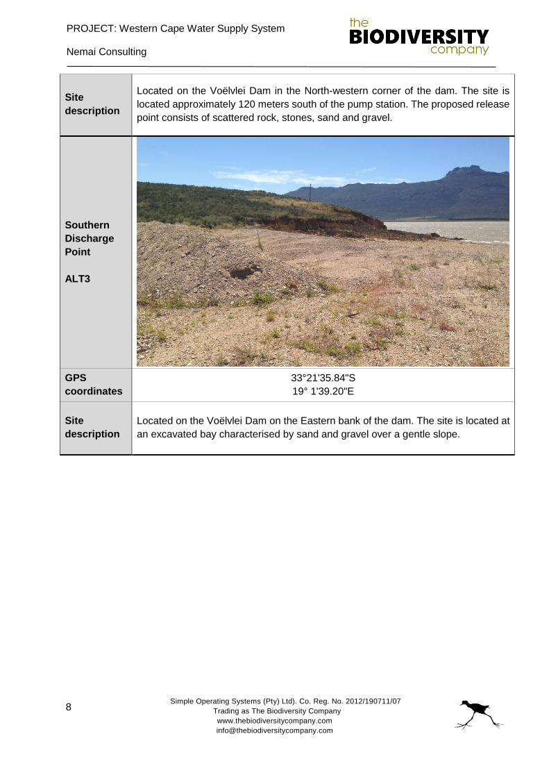
Site
description
Located on the Voëlvlei Dam in the North-western corner of the dam. The site is
located approximately 120 meters south of the pump station. The proposed release
point consists of scattered rock, stones, sand and gravel.
Southern
Discharge
Point
ALT3
GPS
coordinates
33°21'35.84"S
19° 1'39.20"E
Site
description
Located on the Voëlvlei Dam on the Eastern bank of the dam. The site is located at
an excavated bay characterised by sand and gravel over a gentle slope.
PROJECT: Western Cape Water Supply System
Nemai Consulting
Simple Operating Systems (Pty) Ltd). Co. Reg. No. 2012/190711/07
Trading as The Biodiversity Company
www.thebiodiversitycompany.com
9
Figure 2: The location of the sample reach and sites for the Berg River and Voelvlei Dam respectively
PROJECT: Western Cape Water Supply System
Nemai Consulting
Simple Operating Systems (Pty) Ltd). Co. Reg. No. 2012/190711/07
Trading as The Biodiversity Company
www.thebiodiversitycompany.com
10
Figure 3: The location of the project area in relation to the WMA and quaternary catchment
5. METHODOLOGY
5.1 Aquatic ecology
5.1.1 In situ water quality
During the survey, a portable Exstick 2 multimeter was used to measure the following
parameters in situ:
pH;
Electrical Conductivity (EC);
Dissolved Oxygen (DO); and
Water Temperature.
Water quality has a direct influence on aquatic life forms. Although these measurements only
provide a “snapshot”, they can provide valuable insight into the characteristics and
interpretation of a specific sample site at the time of the survey.
PROJECT: Western Cape Water Supply System
Nemai Consulting
Simple Operating Systems (Pty) Ltd). Co. Reg. No. 2012/190711/07
Trading as The Biodiversity Company
www.thebiodiversitycompany.com
11
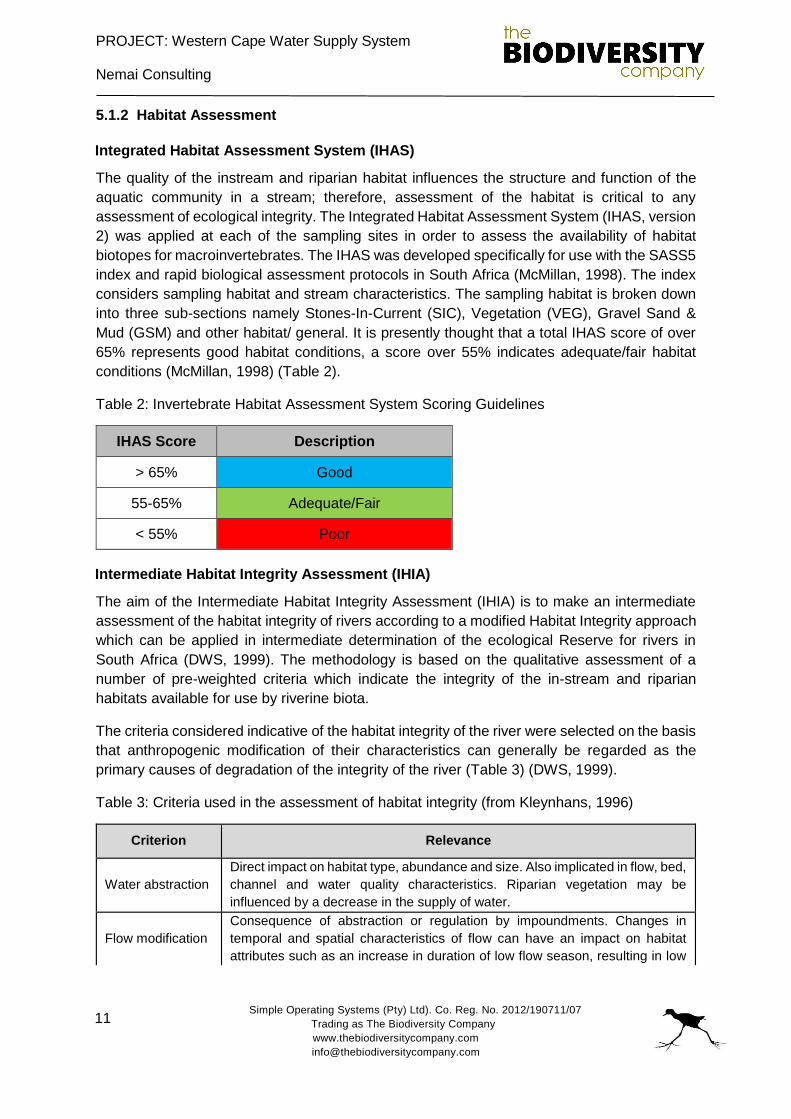
5.1.2 Habitat Assessment
Integrated Habitat Assessment System (IHAS)
The quality of the instream and riparian habitat influences the structure and function of the
aquatic community in a stream; therefore, assessment of the habitat is critical to any
assessment of ecological integrity. The Integrated Habitat Assessment System (IHAS, version
2) was applied at each of the sampling sites in order to assess the availability of habitat
biotopes for macroinvertebrates. The IHAS was developed specifically for use with the SASS5
index and rapid biological assessment protocols in South Africa (McMillan, 1998). The index
considers sampling habitat and stream characteristics. The sampling habitat is broken down
into three sub-sections namely Stones-In-Current (SIC), Vegetation (VEG), Gravel Sand &
Mud (GSM) and other habitat/ general. It is presently thought that a total IHAS score of over
65% represents good habitat conditions, a score over 55% indicates adequate/fair habitat
conditions (McMillan, 1998) (Table 2).
Table 2: Invertebrate Habitat Assessment System Scoring Guidelines
IHAS Score Description
> 65% Good
55-65% Adequate/Fair
< 55% Poor
Intermediate Habitat Integrity Assessment (IHIA)
The aim of the Intermediate Habitat Integrity Assessment (IHIA) is to make an intermediate
assessment of the habitat integrity of rivers according to a modified Habitat Integrity approach
which can be applied in intermediate determination of the ecological Reserve for rivers in
South Africa (DWS, 1999). The methodology is based on the qualitative assessment of a
number of pre-weighted criteria which indicate the integrity of the in-stream and riparian
habitats available for use by riverine biota.
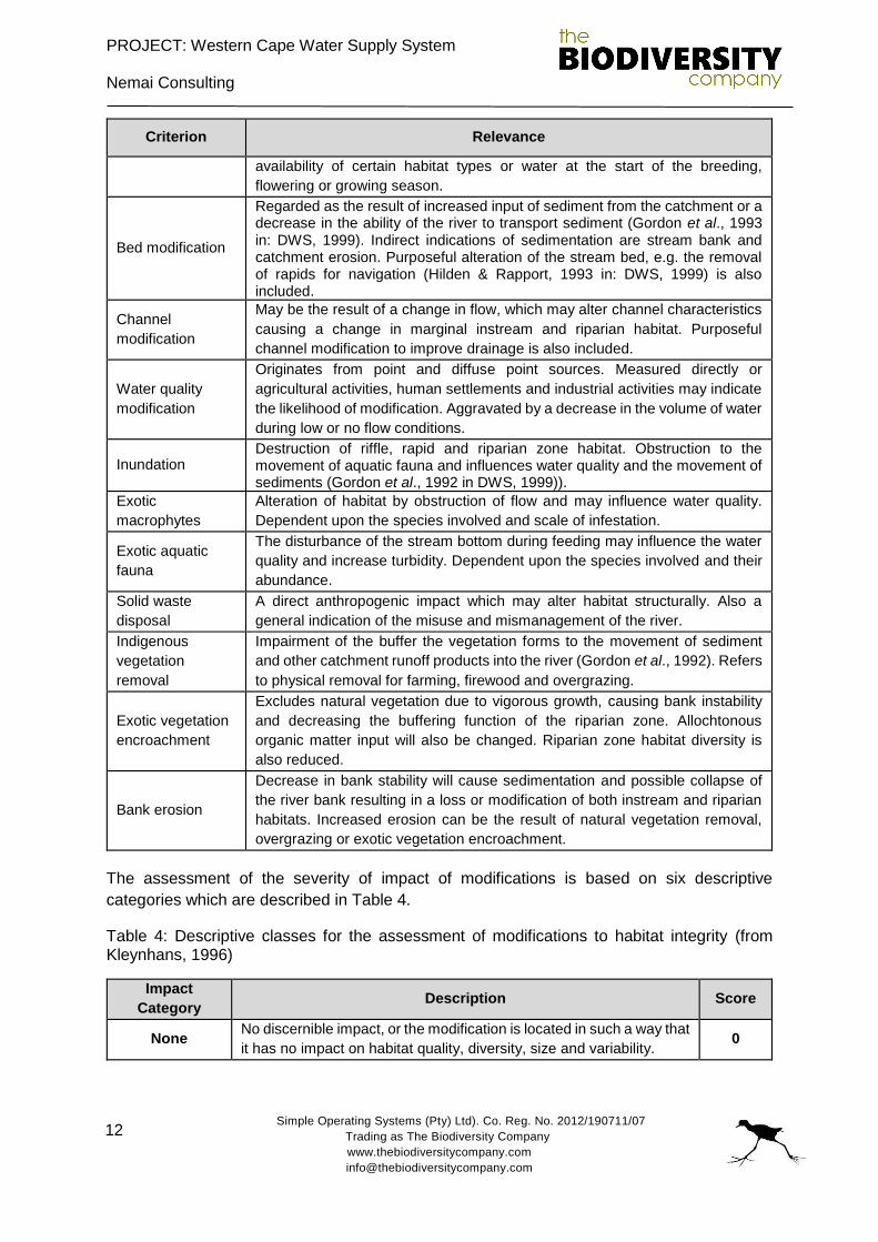
The criteria considered indicative of the habitat integrity of the river were selected on the basis
that anthropogenic modification of their characteristics can generally be regarded as the
primary causes of degradation of the integrity of the river (Table 3) (DWS, 1999).
Table 3: Criteria used in the assessment of habitat integrity (from Kleynhans, 1996)
Criterion Relevance
Water abstraction
Direct impact on habitat type, abundance and size. Also implicated in flow, bed,
channel and water quality characteristics. Riparian vegetation may be
influenced by a decrease in the supply of water.
Flow modification
Consequence of abstraction or regulation by impoundments. Changes in
temporal and spatial characteristics of flow can have an impact on habitat
attributes such as an increase in duration of low flow season, resulting in low
PROJECT: Western Cape Water Supply System
Nemai Consulting
Simple Operating Systems (Pty) Ltd). Co. Reg. No. 2012/190711/07
Trading as The Biodiversity Company
www.thebiodiversitycompany.com
12
Criterion Relevance
availability of certain habitat types or water at the start of the breeding,
flowering or growing season.
Bed modification
Regarded as the result of increased input of sediment from the catchment or a decrease in the ability of the river to transport sediment (Gordon et al., 1993 in: DWS, 1999). Indirect indications of sedimentation are stream bank and catchment erosion. Purposeful alteration of the stream bed, e.g. the removal of rapids for navigation (Hilden & Rapport, 1993 in: DWS, 1999) is also included.
Channel
modification
May be the result of a change in flow, which may alter channel characteristics
causing a change in marginal instream and riparian habitat. Purposeful
channel modification to improve drainage is also included.
Water quality
modification
Originates from point and diffuse point sources. Measured directly or
agricultural activities, human settlements and industrial activities may indicate
the likelihood of modification. Aggravated by a decrease in the volume of water
during low or no flow conditions.
Inundation Destruction of riffle, rapid and riparian zone habitat. Obstruction to the movement of aquatic fauna and influences water quality and the movement of sediments (Gordon et al., 1992 in DWS, 1999)).
Exotic
macrophytes
Alteration of habitat by obstruction of flow and may influence water quality.
Dependent upon the species involved and scale of infestation.
Exotic aquatic
fauna
The disturbance of the stream bottom during feeding may influence the water
quality and increase turbidity. Dependent upon the species involved and their
abundance.
Solid waste
disposal
A direct anthropogenic impact which may alter habitat structurally. Also a
general indication of the misuse and mismanagement of the river.
Indigenous
vegetation
removal
Impairment of the buffer the vegetation forms to the movement of sediment
and other catchment runoff products into the river (Gordon et al., 1992). Refers
to physical removal for farming, firewood and overgrazing.
Exotic vegetation
encroachment
Excludes natural vegetation due to vigorous growth, causing bank instability
and decreasing the buffering function of the riparian zone. Allochtonous
organic matter input will also be changed. Riparian zone habitat diversity is
also reduced.
Bank erosion
Decrease in bank stability will cause sedimentation and possible collapse of
the river bank resulting in a loss or modification of both instream and riparian
habitats. Increased erosion can be the result of natural vegetation removal,
overgrazing or exotic vegetation encroachment.
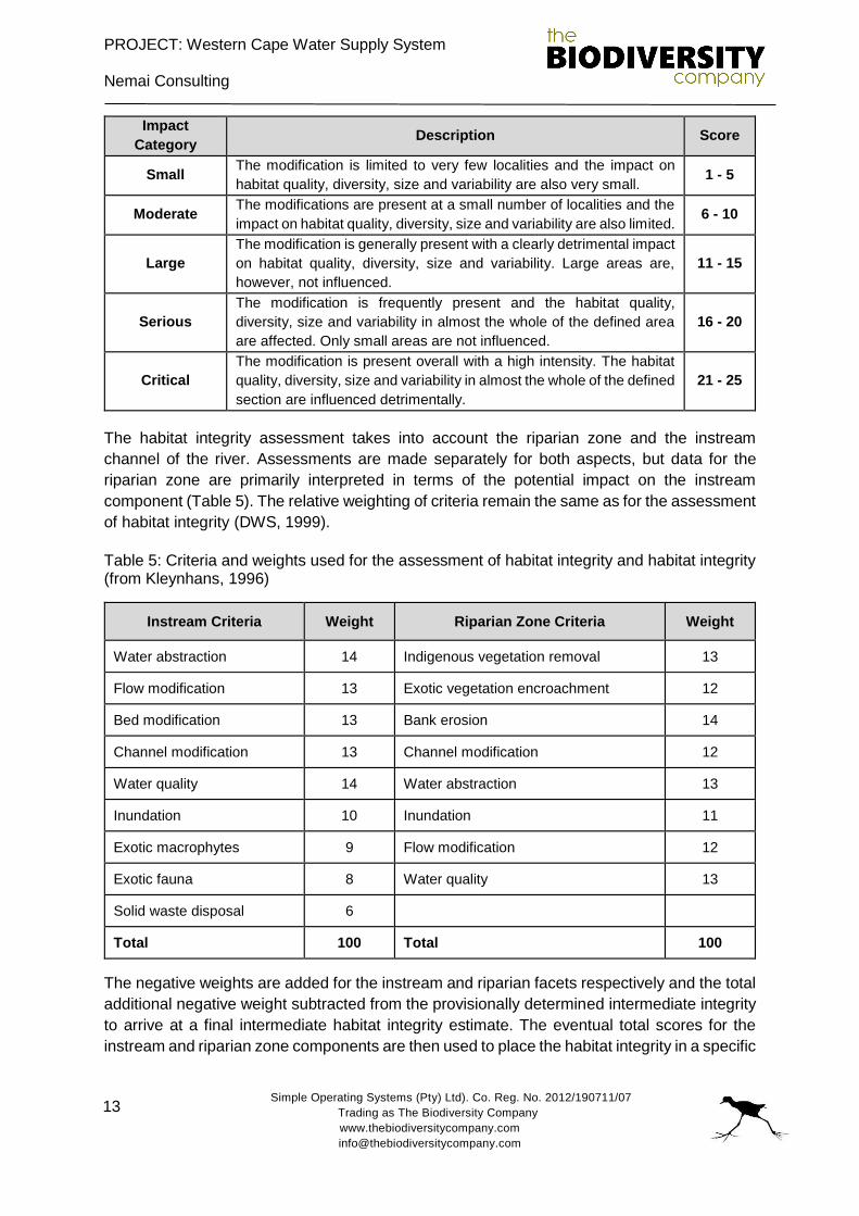
The assessment of the severity of impact of modifications is based on six descriptive
categories which are described in Table 4.
Table 4: Descriptive classes for the assessment of modifications to habitat integrity (from Kleynhans, 1996)
Impact
Category Description Score
None No discernible impact, or the modification is located in such a way that
it has no impact on habitat quality, diversity, size and variability. 0
PROJECT: Western Cape Water Supply System
Nemai Consulting
Simple Operating Systems (Pty) Ltd). Co. Reg. No. 2012/190711/07
Trading as The Biodiversity Company
www.thebiodiversitycompany.com
13
Impact
Category Description Score
Small The modification is limited to very few localities and the impact on
habitat quality, diversity, size and variability are also very small. 1 - 5
Moderate The modifications are present at a small number of localities and the
impact on habitat quality, diversity, size and variability are also limited. 6 - 10
Large
The modification is generally present with a clearly detrimental impact
on habitat quality, diversity, size and variability. Large areas are,
however, not influenced.
11 - 15
Serious
The modification is frequently present and the habitat quality,
diversity, size and variability in almost the whole of the defined area
are affected. Only small areas are not influenced.
16 - 20
Critical
The modification is present overall with a high intensity. The habitat
quality, diversity, size and variability in almost the whole of the defined
section are influenced detrimentally.
21 - 25
The habitat integrity assessment takes into account the riparian zone and the instream
channel of the river. Assessments are made separately for both aspects, but data for the
riparian zone are primarily interpreted in terms of the potential impact on the instream
component (Table 5). The relative weighting of criteria remain the same as for the assessment
of habitat integrity (DWS, 1999).
Table 5: Criteria and weights used for the assessment of habitat integrity and habitat integrity (from Kleynhans, 1996)
Instream Criteria Weight Riparian Zone Criteria Weight
Water abstraction 14 Indigenous vegetation removal 13
Flow modification 13 Exotic vegetation encroachment 12
Bed modification 13 Bank erosion 14
Channel modification 13 Channel modification 12
Water quality 14 Water abstraction 13
Inundation 10 Inundation 11
Exotic macrophytes 9 Flow modification 12
Exotic fauna 8 Water quality 13
Solid waste disposal 6
Total 100 Total 100
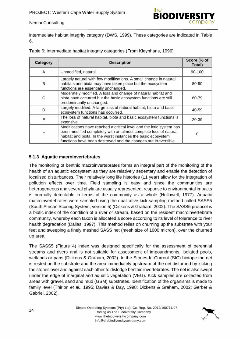
The negative weights are added for the instream and riparian facets respectively and the total
additional negative weight subtracted from the provisionally determined intermediate integrity
to arrive at a final intermediate habitat integrity estimate. The eventual total scores for the
instream and riparian zone components are then used to place the habitat integrity in a specific
PROJECT: Western Cape Water Supply System
Nemai Consulting
Simple Operating Systems (Pty) Ltd). Co. Reg. No. 2012/190711/07
Trading as The Biodiversity Company
www.thebiodiversitycompany.com
14
intermediate habitat integrity category (DWS, 1999). These categories are indicated in Table
6.
Table 6: Intermediate habitat integrity categories (From Kleynhans, 1996)
Category Description Score (% of
Total)
A Unmodified, natural. 90-100
B Largely natural with few modifications. A small change in natural habitats and biota may have taken place but the ecosystem functions are essentially unchanged.
80-90
C Moderately modified. A loss and change of natural habitat and biota have occurred but the basic ecosystem functions are still predominantly unchanged.
60-79
D Largely modified. A large loss of natural habitat, biota and basic ecosystem functions has occurred.
40-59
E The loss of natural habitat, biota and basic ecosystem functions is extensive.
20-39
F
Modifications have reached a critical level and the lotic system has been modified completely with an almost complete loss of natural habitat and biota. In the worst instances the basic ecosystem functions have been destroyed and the changes are irreversible.
0
5.1.3 Aquatic macroinvertebrates
The monitoring of benthic macroinvertebrates forms an integral part of the monitoring of the
health of an aquatic ecosystem as they are relatively sedentary and enable the detection of
localised disturbances. Their relatively long life histories (±1 year) allow for the integration of
pollution effects over time. Field sampling is easy and since the communities are
heterogeneous and several phyla are usually represented, response to environmental impacts
is normally detectable in terms of the community as a whole (Hellawell, 1977). Aquatic
macroinvertebrates were sampled using the qualitative kick sampling method called SASS5
(South African Scoring System, version 5) (Dickens & Graham, 2002). The SASS5 protocol is
a biotic index of the condition of a river or stream, based on the resident macroinvertebrate
community, whereby each taxon is allocated a score according to its level of tolerance to river
health degradation (Dallas, 1997). This method relies on churning up the substrate with your
feet and sweeping a finely meshed SASS net (mesh size of 1000 micron), over the churned
up area.
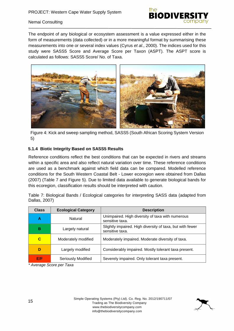
The SASS5 (Figure 4) index was designed specifically for the assessment of perennial
streams and rivers and is not suitable for assessment of impoundments, isolated pools,
wetlands or pans (Dickens & Graham, 2002). In the Stones-In-Current (SIC) biotope the net
is rested on the substrate and the area immediately upstream of the net disturbed by kicking
the stones over and against each other to dislodge benthic invertebrates. The net is also swept
under the edge of marginal and aquatic vegetation (VEG). Kick samples are collected from
areas with gravel, sand and mud (GSM) substrates. Identification of the organisms is made to
family level (Thirion et al., 1995; Davies & Day, 1998; Dickens & Graham, 2002; Gerber &
Gabriel, 2002).
PROJECT: Western Cape Water Supply System
Nemai Consulting
Simple Operating Systems (Pty) Ltd). Co. Reg. No. 2012/190711/07
Trading as The Biodiversity Company
www.thebiodiversitycompany.com
15
The endpoint of any biological or ecosystem assessment is a value expressed either in the
form of measurements (data collected) or in a more meaningful format by summarising these
measurements into one or several index values (Cyrus et al., 2000). The indices used for this
study were SASS5 Score and Average Score per Taxon (ASPT). The ASPT score is
calculated as follows: SASS5 Score/ No. of Taxa.
Figure 4: Kick and sweep sampling method, SASS5 (South African Scoring System Version
5)
5.1.4 Biotic Integrity Based on SASS5 Results
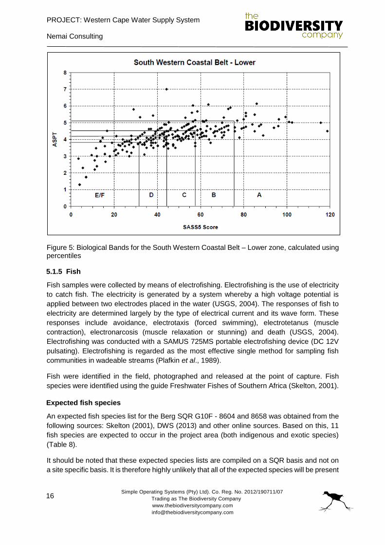
Reference conditions reflect the best conditions that can be expected in rivers and streams
within a specific area and also reflect natural variation over time. These reference conditions
are used as a benchmark against which field data can be compared. Modelled reference
conditions for the South Western Coastal Belt - Lower ecoregion were obtained from Dallas
(2007) (Table 7 and Figure 5). Due to limited data available to generate biological bands for
this ecoregion, classification results should be interpreted with caution.
Table 7: Biological Bands / Ecological categories for interpreting SASS data (adapted from Dallas, 2007)
Class Ecological Category Description
A Natural Unimpaired. High diversity of taxa with numerous sensitive taxa.
B Largely natural Slightly impaired. High diversity of taxa, but with fewer sensitive taxa.
C Moderately modified Moderately impaired. Moderate diversity of taxa.
D Largely modified Considerably impaired. Mostly tolerant taxa present.
E/F Seriously Modified Severely impaired. Only tolerant taxa present.
* Average Score per Taxa
PROJECT: Western Cape Water Supply System
Nemai Consulting
Simple Operating Systems (Pty) Ltd). Co. Reg. No. 2012/190711/07
Trading as The Biodiversity Company
www.thebiodiversitycompany.com
16
Figure 5: Biological Bands for the South Western Coastal Belt – Lower zone, calculated using percentiles
5.1.5 Fish
Fish samples were collected by means of electrofishing. Electrofishing is the use of electricity
to catch fish. The electricity is generated by a system whereby a high voltage potential is
applied between two electrodes placed in the water (USGS, 2004). The responses of fish to
electricity are determined largely by the type of electrical current and its wave form. These
responses include avoidance, electrotaxis (forced swimming), electrotetanus (muscle
contraction), electronarcosis (muscle relaxation or stunning) and death (USGS, 2004).
Electrofishing was conducted with a SAMUS 725MS portable electrofishing device (DC 12V
pulsating). Electrofishing is regarded as the most effective single method for sampling fish
communities in wadeable streams (Plafkin et al., 1989).
Fish were identified in the field, photographed and released at the point of capture. Fish
species were identified using the guide Freshwater Fishes of Southern Africa (Skelton, 2001).
Expected fish species
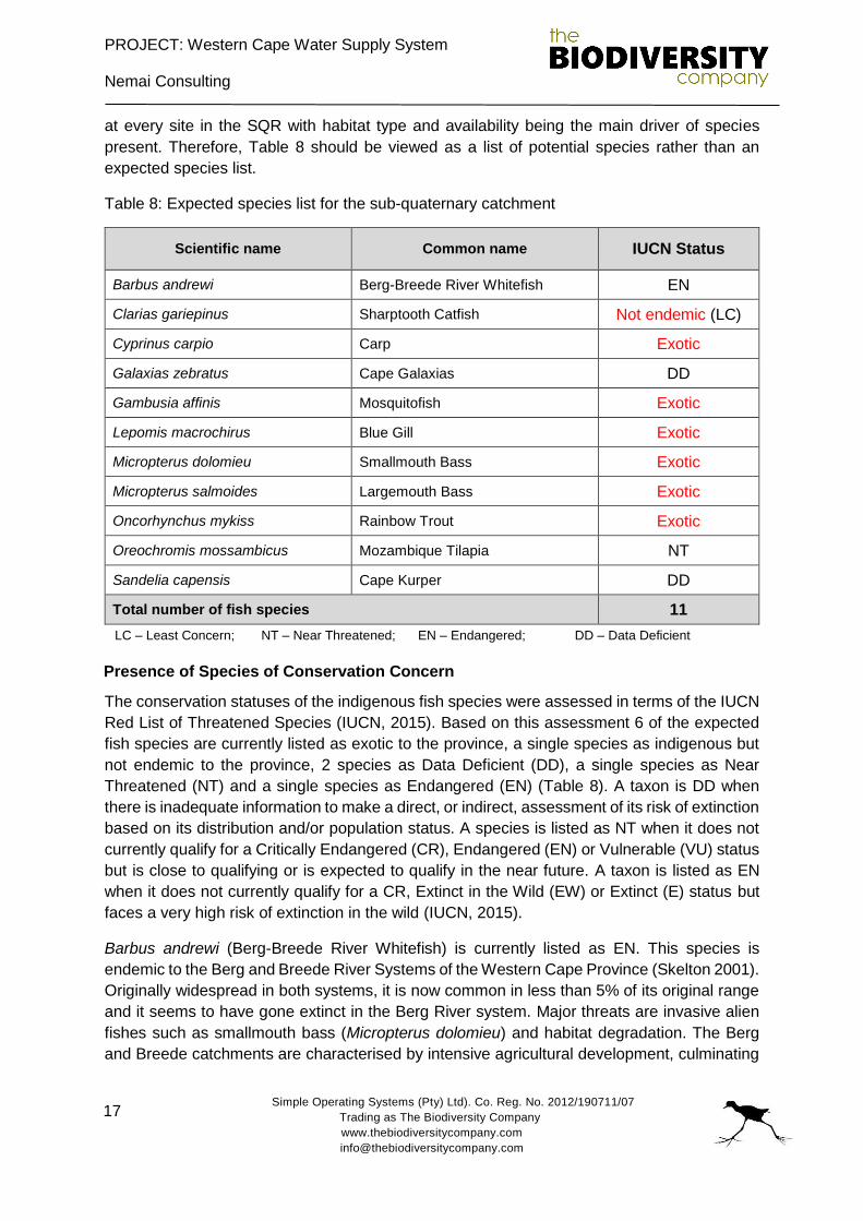
An expected fish species list for the Berg SQR G10F - 8604 and 8658 was obtained from the
following sources: Skelton (2001), DWS (2013) and other online sources. Based on this, 11
fish species are expected to occur in the project area (both indigenous and exotic species)
(Table 8).
It should be noted that these expected species lists are compiled on a SQR basis and not on
a site specific basis. It is therefore highly unlikely that all of the expected species will be present
PROJECT: Western Cape Water Supply System
Nemai Consulting
Simple Operating Systems (Pty) Ltd). Co. Reg. No. 2012/190711/07
Trading as The Biodiversity Company
www.thebiodiversitycompany.com
17
at every site in the SQR with habitat type and availability being the main driver of species
present. Therefore, Table 8 should be viewed as a list of potential species rather than an
expected species list.
Table 8: Expected species list for the sub-quaternary catchment
Scientific name Common name IUCN Status
Barbus andrewi Berg-Breede River Whitefish EN
Clarias gariepinus Sharptooth Catfish Not endemic (LC)
Cyprinus carpio Carp Exotic
Galaxias zebratus Cape Galaxias DD
Gambusia affinis Mosquitofish Exotic
Lepomis macrochirus Blue Gill Exotic
Micropterus dolomieu Smallmouth Bass Exotic
Micropterus salmoides Largemouth Bass Exotic
Oncorhynchus mykiss Rainbow Trout Exotic
Oreochromis mossambicus Mozambique Tilapia NT
Sandelia capensis Cape Kurper DD
Total number of fish species 11
LC – Least Concern; NT – Near Threatened; EN – Endangered; DD – Data Deficient
Presence of Species of Conservation Concern
The conservation statuses of the indigenous fish species were assessed in terms of the IUCN
Red List of Threatened Species (IUCN, 2015). Based on this assessment 6 of the expected
fish species are currently listed as exotic to the province, a single species as indigenous but
not endemic to the province, 2 species as Data Deficient (DD), a single species as Near
Threatened (NT) and a single species as Endangered (EN) (Table 8). A taxon is DD when
there is inadequate information to make a direct, or indirect, assessment of its risk of extinction
based on its distribution and/or population status. A species is listed as NT when it does not
currently qualify for a Critically Endangered (CR), Endangered (EN) or Vulnerable (VU) status
but is close to qualifying or is expected to qualify in the near future. A taxon is listed as EN
when it does not currently qualify for a CR, Extinct in the Wild (EW) or Extinct (E) status but
faces a very high risk of extinction in the wild (IUCN, 2015).
Barbus andrewi (Berg-Breede River Whitefish) is currently listed as EN. This species is
endemic to the Berg and Breede River Systems of the Western Cape Province (Skelton 2001).
Originally widespread in both systems, it is now common in less than 5% of its original range
and it seems to have gone extinct in the Berg River system. Major threats are invasive alien
fishes such as smallmouth bass (Micropterus dolomieu) and habitat degradation. The Berg
and Breede catchments are characterised by intensive agricultural development, culminating
PROJECT: Western Cape Water Supply System
Nemai Consulting
Simple Operating Systems (Pty) Ltd). Co. Reg. No. 2012/190711/07
Trading as The Biodiversity Company
www.thebiodiversitycompany.com
18
in over-abstracted and polluted rivers that have become a haven for other alien fish species
such as Cyprinus carpio and Oreochromis mossambicus. These two species are competitors
to Barbus andrewi. CapeNature, the provincial conservation agency, has established a
dedicated whitefish fund to capacitate recovery efforts. These efforts involve angler
awareness, riparian land-owner education and promoting this species as an angling
alternative to bass (Micropterus) and trout (Oncorhynchus mykiss and Salmo trutta) within its
distribution range. Barbus andrewi have been stocked into several farm dams to create “safe”
populations for later recovery efforts. Such efforts will involve the eradication of alien fish
species from rivers with suitable Barbus andrewi habitat (IUCN, 2015).
Clarias gariepinus (Sharptooth Catfish) is currently listed as Least Concern (LC). It is a very
common and abundant fish species across Africa that is capable of living in any type of habitat,
favouring slower flow and structure. Although the species is listed as LC and is an indigenous
fish species to South Africa, it does not occur naturally in the Western Cape and is therefore
an exotic in this region. This large fish species has the ability to breathe air outside of water
while crossing dry land in damp conditions between water bodies. Clarias gariepinus is tolerant
of polluted waters and is both a predator and scavenger of any food item. An important angling
and food species. They are known to hunt other fish and may become problematic through
predating on fish endemic to the Western Cape.
Cyprinus carpio (Carp) is currently listed as VU. A species is listed as VU when it does not
currently qualify for CR or EN status, but is close to qualifying for or is likely to qualify for a
threatened category in the near future (IUCN, 2015). It should be noted that although C. carpio
is listed as vulnerable (in its native waters), it remains an exotic species in South African
waters. Cyprinus carpio is known to be a habitat modifier through its feeding methods that
involve stirring up the sediment in search of plant roots and other sources of protein, often
increasing the turbidity of the water body (IUCN, 2015). According to the National
Environmental Management: Biodiversity Act (NEMBA) 10 of 2004, the catch and release of
C. carpio is prohibited in catchments in which they don’t occur.
Gambusia affinis (Mosquitofish) is a species of freshwater fish native to the USA and is
currently listed as one of the world’s worst invasive species. The common name 'mosquitofish'
stems from the diet which predominantly consists of mosquito larvae (and other invertebrate
larvae). An adult female G. affinis can consume hundreds of mosquito larvae in a day.
According to NEMBA, G affinis falls under Category 1b in national parks, provincial reserves,
mountain catchment areas and forestry reserves declared in terms of the Protected Areas Act.
NEMBA Category 2 for breeding for the purpose of feeding stock for zoos and animal breeders
and NEMBA Category 3 for all other discrete catchment systems in which it occurs (ISSS,
2016a). Adults are known to be extremely aggressive, attacking other fish, shredding their fins
or killing them. Gambusia affinis are known to prey on eggs, larvae and juveniles of various
fishes, including largemouth bass and common carp. They are also known to prey on adults
of smaller species. (ISSS, 2016a, Skelton, 2001).
Lepomis macrochirus (Bluegill) was introduced in South Africa in 1938 as a fodder species for
bass and is now established in many streams and dams. They are considered a pest species
as they tend to overpopulate waters, living for longer than 10 years, preying on invertebrates
PROJECT: Western Cape Water Supply System
Nemai Consulting
Simple Operating Systems (Pty) Ltd). Co. Reg. No. 2012/190711/07
Trading as The Biodiversity Company
www.thebiodiversitycompany.com
19
and indigenous fish species (Skelton, 2001). Habitat includes warm shallow water bodies, and
slow-flowing rivers and streams. Lepomis macrochirus often are associated with overhanging
marginal vegetation and silt, sand, or gravel substrates. They seldom venture deeper than 5
meters. Eggs are laid in nests made in shallow water by males, on bottoms of gravel, sand, or
mud that contains pieces of debris (IUCN, 2015).
Oncorhynchus mykiss (Rainbow Trout) are found in cold, well oxygenated water. They are
currently listed under NEMBA as a Category 2 invasive species, meaning that this species is
restricted by activity. Oncorhynchus mykiss have been linked to the decline of some
indigenous fish species and they are efficient predators preying on smaller fish species. They
are known to feed on amphibians and invertebrates, leading to local declines (ISSS, 2016b).
Oreochromis mossambicus (Mozambique tilapia) is currently listed as NT. The most serious
threat facing O. mossambicus is hybridization with the rapidly spreading introduced species
Oreochromis niloticus (Nile tilapia) (IUCN, 2016). Hybridization has already been documented
throughout the northern part of the species' range, with most of the evidence coming from the
Limpopo River catchment (IUCN, 2016). Given the rapid spread of O. niloticus it is anticipated
that O. mossambicus will qualify as threatened under Criterion A due to rapid population
decline through hybridization (IUCN, 2016). Oreochromis mossambicus occurs in all but fast
flowing waters and is tolerant of high salinities. It feeds on algae and invertebrates. The
clearest morphological indicator of hybridization between O. mossambicus and O. niloticus is
barring on the caudal fin.
Micropterus dolomieu (Largemouth bass) is a small introduced predatory fish that has caused
a decline in indigenous species through environmental degradation and predation. According
to NEMBA, M. dolomieu falls under Category 1b in National Parks, Provincial Reserves,
Mountain Catchment Areas and Forestry Reserves declared in terms of the Protected Areas
Act. NEMBA - Category 2 for release into damns within discrete catchment systems in which
it occurs and NEMBA - Category 3 in all rivers, wetlands, natural lakes and estuaries in which
it occurs (ISSS, 2016c). Micropterus dolomieu has had a devastating effect on indigenous fish
species, it is long lived (15 years) becoming primarily piscivorous as adults also eating crabs
(Skelton, 2001). Initially introduced in 1937 as an angling species but also for indigenous
species control of whitefish and scaly (Skelton, 2001).
Micropterus salmoides (Largemouth bass), is an introduced predatory fish species that was
first introduced into South African waters in 1928, originating from Central America (Skelton,
2001). It has since become well established in several South African rivers and dams where
it has been shown to have a significant impact on indigenous fish populations and alter
invertebrate communities (Skelton, 2001, Weyl et al. 2010, Ellender et al. 2011). Although it
is primarily piscivorous it will voraciously feed on practically any small animals including crabs,
frogs, small reptiles and even small mammals (Weyl & Hecht 1998, Skelton, 2001, Weyl &
Lewis, 2006, Skelton & Weyl 2011). Spawning occurs in the spring (October to November),
during this time the male builds a conical nest on the substrate in which the female lays the
eggs. The male defends the nest and fry after hatching (Skelton, 2001). It prefers clear,
standing or slow flowing water with aquatic submerged or floating aquatic macrophytes and is
known to thrive in dams and impoundments (Skelton, 2001). Micropterus salmoides is a very
PROJECT: Western Cape Water Supply System
Nemai Consulting
Simple Operating Systems (Pty) Ltd). Co. Reg. No. 2012/190711/07
Trading as The Biodiversity Company
www.thebiodiversitycompany.com
20
popular angling species with various angling competitions held around the country every year.
Micropterus salmoides is listed as an “invasive species regulated by area” in the Draft Alien
and Invasive Species Regulations, 2009 (DWAF, 2009). The management of invasive fish and
conservation of biodiversity is a high priority in NEMA and the NEMBA.
5.2 Wetland assessment
5.2.1 Desktop assessment
The desktop assessment consisted of relevant information as presented by the South African
National Biodiversity Institutes (SANBI’s) Biodiversity Geographic Information Systems (BGIS)
website (http://bgis.sanbi.org). Wetland specific information resources taken into
consideration during the desktop assessment of the study area included:
Aerial imagery (Google Earth);
The National Freshwater Ecosystem Priority Areas (NFEPAs, 2011);
The Western Cape Biodiversity Framework (2014); and
Contour data.
5.2.2 Wetland delineation
The wetland areas were delineated in accordance with the DWAF (2005) guidelines, a cross
section is presented in Figure 5. The outer edges of the wetland areas are identified by
considering the following four specific indicators:
The Terrain Unit Indicator helps to identify those parts of the landscape where wetlands
are more likely to occur;
The Soil Form Indicator identifies the soil forms, as defined by the Soil Classification
Working Group (1991), which are associated with prolonged and frequent saturation;
The Soil Wetness Indicator identifies the morphological "signatures" developed in the
soil profile as a result of prolonged and frequent saturation; and
The Vegetation Indicator identifies hydrophilic vegetation associated with frequently
saturated soils.
Vegetation is used as the primary wetland indicator, which must be present under normal
circumstances. However, in practise, the soil wetness indicator tends to be the most important,
and the other three indicators are used in a confirmatory role.
PROJECT: Western Cape Water Supply System
Nemai Consulting
Simple Operating Systems (Pty) Ltd). Co. Reg. No. 2012/190711/07
Trading as The Biodiversity Company
www.thebiodiversitycompany.com
21
Figure 6: Cross section through a wetland, indicating how the soil wetness and vegetation indicators change (DWAF, 2005)
5.2.3 Riparian delineation
NWA defines a riparian habitat as follows: “Riparian habitat includes the physical structure
and associated vegetation of the areas associated with a watercourse which are commonly
characterised by alluvial soils, and which are inundated or flooded to an extent and with a
frequency sufficient to support vegetation of species with a composition and physical structure
distinct from those of adjacent land areas.”
The riparian areas are also delineated in accordance with the DWAF (2005) guidelines. The
riparian areas are identified by considering the following specific indicators:
Are associated with a watercourse;
Contain distinctively different plant species than adjacent areas; and contain species
similar to adjacent areas but exhibiting more vigorous or robust growth forms; and
May have alluvial soils.
5.2.4 Wetland classification
A distinction is made between four Landscape Units for Inland Systems on the basis of the
landscape setting in which a hydro-geomorphic (HGM) is situated, which broadly considers
(Ollis et al., 2013).:
Slope;
Valley floor;
Plain; and
Bench.

PROJECT: Western Cape Water Supply System
Nemai Consulting
Simple Operating Systems (Pty) Ltd). Co. Reg. No. 2012/190711/07
Trading as The Biodiversity Company
www.thebiodiversitycompany.com
22
The HGM Units, which are defined primarily according to:
Landform, which defines the shape and localised setting of a wetland;
Hydrological characteristics, which describe the nature of water movement into,
through and out of the wetland; and
Hydrodynamics, which describe the direction and strength of flow through the wetland.
Seven primary HGM units are recognised for Inland Systems on the basis of hydrology and
geomorphology (Ollis et al., 2013) namely:
River: a linear landform with clearly discernible bed and banks, which permanently or
periodically carries a concentrated flow of water;
Channelled valley-bottom wetland: a valley-bottom wetland with a river channel
running through it;
Unchannelled valley-bottom wetland: a valley-bottom wetland without a river channel
running through it;
Floodplain wetland: the mostly flat or gently sloping land adjacent to and formed by an
alluvial river channel, under its present climate and sediment load, which is subject to
periodic inundation by over-topping of the channel bank;
Depression: a landform with closed elevation contours that increases in depth from the
perimeter to a central area of greatest depth, and within which water typically
accumulates;
Wetland Flat: a level or near-level wetland area that is not fed by water from a river
channel, and which is typically situated on a plain or a bench. Closed elevation
contours are not evident around the edge of a wetland flat; and
Seep: a wetland area located on (gently to steeply) sloping land, which is dominated
by the colluvial (i.e. gravity-driven), unidirectional movement of material down-slope.
Seeps are often located on the side-slopes of a valley but they do not, typically, extend
into a valley floor.
The above terms have been used in order to ensure consistency with the wetland classification
terms in South Africa.
5.2.5 Wetland – Present Ecological Status (PES)
WET-Health is a tool designed to assess the health or integrity of a wetland. Wetland health
is defined as a measure of the deviation of wetland structure and function from the wetland’s
natural reference condition. This technique attempts to assess hydrological, geomorphological
and vegetation health in three separate modules. The ecological status categories and
descriptions are provided in Table 9.

PROJECT: Western Cape Water Supply System
Nemai Consulting
Simple Operating Systems (Pty) Ltd). Co. Reg. No. 2012/190711/07
Trading as The Biodiversity Company
www.thebiodiversitycompany.com
23
Table 9: The PES categories and descriptions for WET-Health (Macfarlane et al, 2008)
Category Description Range
A Unmodified,natural 0-0.9
B Largely natural with few modifications. A slight change in ecosystem processes is discernible and a small loss of natural habitats and biota may have taken place.
1-1.9
C Moderately modified. A moderate change in ecosystem process and loss of natural habitats has taken place but the natural habitat remains predominantly intact.
2-3.9
D Largely Modified. A large change in ecosystem processes and loss of natural habitat and biota has occurred.
4-5.9
E The change in ecosystem processes and loss of natural habitat and biota is great but some remaining natural habitat features are still recognizable.
6-7.9
F Modifications have reached a critical level and the ecosystem processes have been modified completely with an almost complete loss of natural habitat and biota.
8-10
5.2.6 Riparian – PES
The PES assessment determines the level of disturbance to or modification of riparian habitats
relative to their natural state or reference condition. Systems are rated on a scale of A to F,
with A being a natural or unimpacted system and F being a completely modified and disturbed
system (Table 10).
A level 3 Riparian Vegetation Response Assessment Index (VEGRAI) (Kleynhans et. al.,
2007) assessment was undertaken to determine the status of the riparian habitats. This
method assesses the current condition of riparian habitats based on the response of riparian
vegetation to observed impacts.
Table 10: Generic ecological categories for EcoStatus components (modified from Kleynhans 1996 & Kleynhans 1999)
Description Category
Unmodified, natural A
Largely natural with few modifications. A small change in natural habitats and biota may have taken place but the ecosystem functions are essentially unchanged.
B
Moderately modified. Loss and change of natural habitat and biota have occurred, but the basic ecosystem functions are still predominantly unchanged
C
Largely modified. A large loss of natural habitat, biota and basic ecosystem functions has occurred.
D
Seriously modified. The loss of natural habitat, biota and basic ecosystem functions is extensive.
E
Critically modified. Modifications have reached a critical level and the lotic system has been modified completely with an almost complete loss of natural habitat and biota. In the worst instances the basic ecosystem functions have been destroyed and the changes are irreversible
F
5.3 Risk assessment
The risk assessment was conducted in accordance with the DWS risk-based water use
authorisation approach and delegation guidelines.
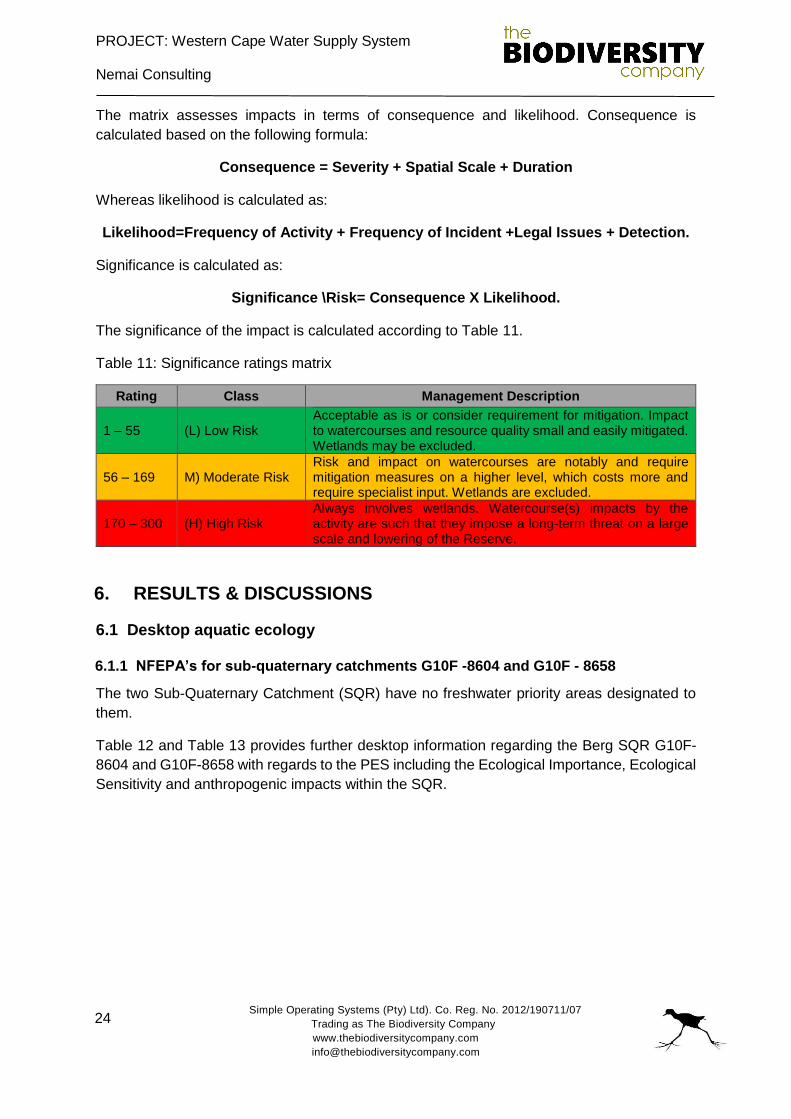
PROJECT: Western Cape Water Supply System
Nemai Consulting
Simple Operating Systems (Pty) Ltd). Co. Reg. No. 2012/190711/07
Trading as The Biodiversity Company
www.thebiodiversitycompany.com
24
The matrix assesses impacts in terms of consequence and likelihood. Consequence is
calculated based on the following formula:
Consequence = Severity + Spatial Scale + Duration
Whereas likelihood is calculated as:
Likelihood=Frequency of Activity + Frequency of Incident +Legal Issues + Detection.
Significance is calculated as:
Significance \Risk= Consequence X Likelihood.
The significance of the impact is calculated according to Table 11.
Table 11: Significance ratings matrix
Rating Class Management Description
1 – 55 (L) Low Risk Acceptable as is or consider requirement for mitigation. Impact to watercourses and resource quality small and easily mitigated. Wetlands may be excluded.
56 – 169 M) Moderate Risk Risk and impact on watercourses are notably and require mitigation measures on a higher level, which costs more and require specialist input. Wetlands are excluded.
170 – 300 (H) High Risk Always involves wetlands. Watercourse(s) impacts by the activity are such that they impose a long-term threat on a large scale and lowering of the Reserve.
6. RESULTS & DISCUSSIONS
6.1 Desktop aquatic ecology
6.1.1 NFEPA’s for sub-quaternary catchments G10F -8604 and G10F - 8658
The two Sub-Quaternary Catchment (SQR) have no freshwater priority areas designated to
them.
Table 12 and Table 13 provides further desktop information regarding the Berg SQR G10F-
8604 and G10F-8658 with regards to the PES including the Ecological Importance, Ecological
Sensitivity and anthropogenic impacts within the SQR.
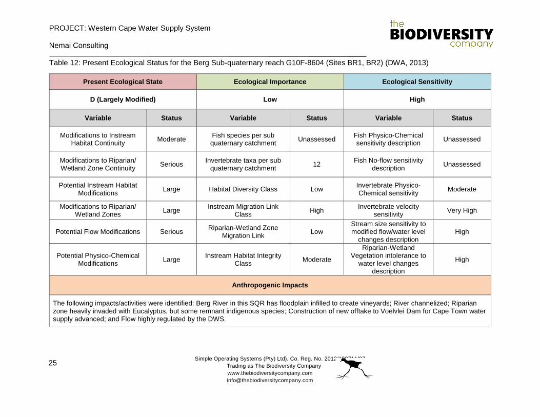
PROJECT: Western Cape Water Supply System
Nemai Consulting
Simple Operating Systems (Pty) Ltd). Co. Reg. No. 2012/190711/07
Trading as The Biodiversity Company
www.thebiodiversitycompany.com
25
Table 12: Present Ecological Status for the Berg Sub-quaternary reach G10F-8604 (Sites BR1, BR2) (DWA, 2013)
Present Ecological State Ecological Importance Ecological Sensitivity
D (Largely Modified) Low High
Variable Status Variable Status Variable Status
Modifications to Instream Habitat Continuity
Moderate Fish species per sub quaternary catchment
Unassessed Fish Physico-Chemical sensitivity description
Unassessed
Modifications to Riparian/ Wetland Zone Continuity
Serious Invertebrate taxa per sub
quaternary catchment 12
Fish No-flow sensitivity description
Unassessed
Potential Instream Habitat Modifications
Large Habitat Diversity Class Low Invertebrate Physico-Chemical sensitivity
Moderate
Modifications to Riparian/ Wetland Zones
Large Instream Migration Link
Class High
Invertebrate velocity sensitivity
Very High
Potential Flow Modifications Serious Riparian-Wetland Zone
Migration Link Low
Stream size sensitivity to modified flow/water level
changes description High
Potential Physico-Chemical Modifications
Large Instream Habitat Integrity
Class Moderate
Riparian-Wetland Vegetation intolerance to
water level changes description
High
Anthropogenic Impacts
The following impacts/activities were identified: Berg River in this SQR has floodplain infilled to create vineyards; River channelized; Riparian zone heavily invaded with Eucalyptus, but some remnant indigenous species; Construction of new offtake to Voëlvlei Dam for Cape Town water supply advanced; and Flow highly regulated by the DWS.
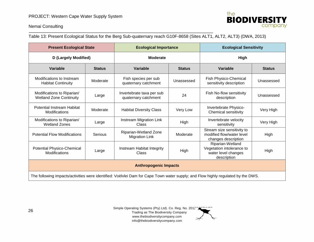
PROJECT: Western Cape Water Supply System
Nemai Consulting
Simple Operating Systems (Pty) Ltd). Co. Reg. No. 2012/190711/07
Trading as The Biodiversity Company
www.thebiodiversitycompany.com
26
Table 13: Present Ecological Status for the Berg Sub-quaternary reach G10F-8658 (Sites ALT1, ALT2, ALT3) (DWA, 2013)
Present Ecological State Ecological Importance Ecological Sensitivity
D (Largely Modified) Moderate High
Variable Status Variable Status Variable Status
Modifications to Instream Habitat Continuity
Moderate Fish species per sub quaternary catchment
Unassessed Fish Physico-Chemical sensitivity description
Unassessed
Modifications to Riparian/ Wetland Zone Continuity
Large Invertebrate taxa per sub
quaternary catchment 24
Fish No-flow sensitivity description
Unassessed
Potential Instream Habitat Modifications
Moderate Habitat Diversity Class Very Low Invertebrate Physico-Chemical sensitivity
Very High
Modifications to Riparian/ Wetland Zones
Large Instream Migration Link
Class High
Invertebrate velocity sensitivity
Very High
Potential Flow Modifications Serious Riparian-Wetland Zone
Migration Link Moderate
Stream size sensitivity to modified flow/water level
changes description High
Potential Physico-Chemical Modifications
Large Instream Habitat Integrity
Class High
Riparian-Wetland Vegetation intolerance to
water level changes description
High
Anthropogenic Impacts
The following impacts/activities were identified: Voëlvlei Dam for Cape Town water supply; and Flow highly regulated by the DWS.
PROJECT: Western Cape Water Supply System Nemai Consulting
Simple Operating Systems (Pty) Ltd). Co. Reg. No. 2012/190711/07
Trading as The Biodiversity Company
www.thebiodiversitycompany.com
27
6.2 Aquatic ecology
6.2.1 In situ water quality
In situ water quality analyses was conducted at in the Berg River. These results are important to
assist in the interpretation of biological results due to the direct influence water quality has on
aquatic life forms. The results of the survey are presented in Table 14.
Table 14: In situ water quality results for the site with reference to the Target Water Quality Requirements (TWQR)
Red – exceeded TWQR
pH
Most fresh waters are usually relatively well buffered and more or less neutral, with a pH range
from 6.5 to 8.5, and most are slightly alkaline due to the presence of bicarbonates of the alkali
and alkaline earth metals (Barbour et al, 1996). The pH target for fish health is presented as
ranging between 6.5 and 9.0 (Table 14).
An elevated pH value of 10.37 was measured in the Berg River. This exceeded the recommended
guideline range having a limiting effect on local aquatic biota at the time of the survey. This high
pH value may be a concern to the Berg River biota and potentially the Voëlvlei Dam and aquatic
biota if it persists at elevated levels once the water pipeline is operational.
Electrical Conductivity (EC)
EC is a measure of the ability of water to conduct an electrical current. This ability is a result of
the presence in water of ions such as carbonate, bicarbonate, chloride, sulphate, nitrate, sodium,
potassium, calcium and magnesium, all of which carry an electrical charge.
The EC value measured in the Berg River (365 µS/cm) was below the recommended guideline
value and would not be a limiting factor of aquatic biota at the time of the survey.
Dissolved Oxygen (DO)
The maintenance of adequate DO is critical for the survival of aquatic biota as it is required for
the respiration of all aerobic organisms (DWS, 1996). Therefore, DO concentration provides a
useful measure of the health of an ecosystem (DWS, 1996). The median guideline for DO for the
protection of freshwater fish, determined by a variety of fish faunas is > 4 - 5 mg/ℓ (Doudoroff &
Site pH Conductivity
(µS/cm) DO (mg/l)
DO Saturation
(%)
Temperature (°C)
TWQR 6.5-9.0 <700 >5.00 80-120 5-30
BR1 10.37 365 10.2 178 27.9
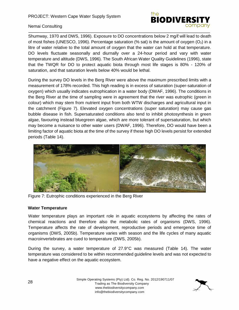
PROJECT: Western Cape Water Supply System
Nemai Consulting
Simple Operating Systems (Pty) Ltd). Co. Reg. No. 2012/190711/07
Trading as The Biodiversity Company
www.thebiodiversitycompany.com
28
Shumway, 1970 and DWS, 1996). Exposure to DO concentrations below 2 mg/ℓ will lead to death
of most fishes (UNESCO, 1996). Percentage saturation (% sat) is the amount of oxygen (O2) in a
litre of water relative to the total amount of oxygen that the water can hold at that temperature.
DO levels fluctuate seasonally and diurnally over a 24-hour period and vary with water
temperature and altitude (DWS, 1996). The South African Water Quality Guidelines (1996), state
that the TWQR for DO to protect aquatic biota through most life stages is 80% - 120% of
saturation, and that saturation levels below 40% would be lethal.
During the survey DO levels in the Berg River were above the maximum prescribed limits with a
measurement of 178% recorded. This high reading is in excess of saturation (super-saturation of
oxygen) which usually indicates eutrophication in a water body (DWAF, 1996). The conditions in
the Berg River at the time of sampling were in agreement that the river was eutrophic (green in
colour) which may stem from nutrient input from both WTW discharges and agricultural input in
the catchment (Figure 7). Elevated oxygen concentrations (super saturation) may cause gas
bubble disease in fish. Supersaturated conditions also tend to inhibit photosynthesis in green
algae, favouring instead bluegreen algae, which are more tolerant of supersaturation, but which
may become a nuisance to other water users (DWAF, 1996). Therefore, DO would have been a
limiting factor of aquatic biota at the time of the survey if these high DO levels persist for extended
periods (Table 14).
Figure 7: Eutrophic conditions experienced in the Berg River
Water Temperature
Water temperature plays an important role in aquatic ecosystems by affecting the rates of
chemical reactions and therefore also the metabolic rates of organisms (DWS, 1996).
Temperature affects the rate of development, reproductive periods and emergence time of
organisms (DWS, 2005b). Temperature varies with season and the life cycles of many aquatic
macroinvertebrates are cued to temperature (DWS, 2005b).
During the survey, a water temperature of 27.9°C was measured (Table 14). The water
temperature was considered to be within recommended guideline levels and was not expected to
have a negative effect on the aquatic ecosystem.

PROJECT: Western Cape Water Supply System
Nemai Consulting
Simple Operating Systems (Pty) Ltd). Co. Reg. No. 2012/190711/07
Trading as The Biodiversity Company
www.thebiodiversitycompany.com
29
Conclusion
If the elevated pH and DO values persist for extended periods of time in the Berg River together
with strong sunlight and vigorous photosynthetic activity, they may give rise to gas bubbles
disease, fish kills and algal blooms (Alabaster and Llyod, 1982). These algal blooms may produce
toxic by-products which may be an issue once water is pumped into the Voëlvlei Dam.
6.2.2 Habitat assessment
Invertebrate Habitat Assessment System (IHAS)
The IHAS index was developed by McMillan (1998) for use in conjunction with the SASS5
protocol. The IHAS results for the survey are presented in Table 15.
Table 15: IHAS score at the two sites during the survey
Site Berg River Voëlvlei Dam
Score 79 N/A
Suitability Good N/A
Flow 0.2 - 0.4 m/s Dam (75% full)
Clarity (cm) 35cm (Eutrophic) 20cm (Turbid)
According to the IHAS results, habitat availability for aquatic macroinvertebrates was Good in the
Berg River (Table 15). The Berg River reach sampled was characterised mostly by deep slow
water with adequate marginal vegetation. These deep runs were mostly too deep to sample. A
short section of shallow water was sampled. This section consisted of alternating areas of slow
to fast flowing waters over stones, sand and gravel with some mud parches. Fair marginal
vegetation was present. The section was characterised by a variety of riffles, runs and pools. The
water clarity was somewhat limited due to eutrophic conditions experienced, blocking light
penetration through the water column.
Intermediate Habitat Integrity Assessment (IHIA)
The IHIA assesses the intensity and extent of anthropogenic changes to interpret the impact on
the habitat integrity of the system. Modifications of the interrelated abiotic factors such as
hydrology, geomorphology and physico-chemical conditions influence river habitat integrity.
Therefore, modifications to instream and riparian habitat are rated based on survey data and
available data sources that include Google Earth mapping.
The results of the instream and riparian habitat integrity assessment for the systems associated
with the Berg River-Voëlvlei Augmentation Scheme are presented in Table 16 and Table 17,
respectively.
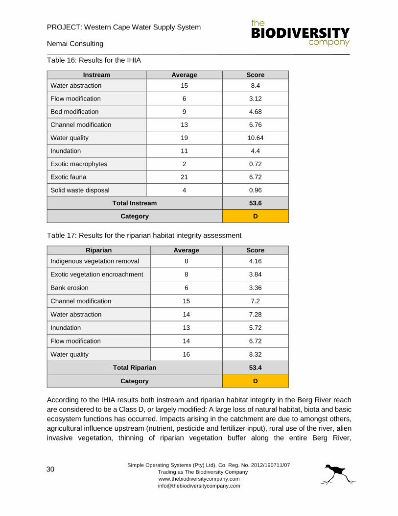
PROJECT: Western Cape Water Supply System
Nemai Consulting
Simple Operating Systems (Pty) Ltd). Co. Reg. No. 2012/190711/07
Trading as The Biodiversity Company
www.thebiodiversitycompany.com
30
Table 16: Results for the IHIA
Instream Average Score
Water abstraction 15 8.4
Flow modification 6 3.12
Bed modification 9 4.68
Channel modification 13 6.76
Water quality 19 10.64
Inundation 11 4.4
Exotic macrophytes 2 0.72
Exotic fauna 21 6.72
Solid waste disposal 4 0.96
Total Instream 53.6
Category D
Table 17: Results for the riparian habitat integrity assessment
Riparian Average Score
Indigenous vegetation removal 8 4.16
Exotic vegetation encroachment 8 3.84
Bank erosion 6 3.36
Channel modification 15 7.2
Water abstraction 14 7.28
Inundation 13 5.72
Flow modification 14 6.72
Water quality 16 8.32
Total Riparian 53.4
Category D
According to the IHIA results both instream and riparian habitat integrity in the Berg River reach
are considered to be a Class D, or largely modified: A large loss of natural habitat, biota and basic
ecosystem functions has occurred. Impacts arising in the catchment are due to amongst others,
agricultural influence upstream (nutrient, pesticide and fertilizer input), rural use of the river, alien
invasive vegetation, thinning of riparian vegetation buffer along the entire Berg River,
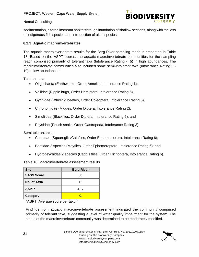
PROJECT: Western Cape Water Supply System
Nemai Consulting
Simple Operating Systems (Pty) Ltd). Co. Reg. No. 2012/190711/07
Trading as The Biodiversity Company
www.thebiodiversitycompany.com
31
sedimentation, altered instream habitat through inundation of shallow sections, along with the loss
of indigenous fish species and introduction of alien species.
6.2.3 Aquatic macroinvertebrates
The aquatic macroinvertebrate results for the Berg River sampling reach is presented in Table
18. Based on the ASPT scores, the aquatic macroinvertebrate communities for the sampling
reach comprised primarily of tolerant taxa (Intolerance Rating < 5) in high abundances. The
macroinvertebrate communities also included some semi-intolerant taxa (Intolerance Rating 5 -
10) in low abundances:
Tolerant taxa:
Oligochaeta (Earthworms, Order Annelida, Intolerance Rating 1);
Veliidae (Ripple bugs, Order Hemiptera, Intolerance Rating 5),
Gyrinidae (Whirligig beetles, Order Coleoptera, Intolerance Rating 5),
Chironomidae (Midges, Order Diptera, Intolerance Rating 2);
Simuliidae (Blackflies, Order Diptera, Intolerance Rating 5); and
Physidae (Pouch snails, Order Gastropoda, Intolerance Rating 3).
Semi-tolerant taxa:
Caenidae (Squaregills/Cainflies, Order Ephemeroptera, Intolerance Rating 6);
Baetidae 2 species (Mayflies, Order Ephemeroptera, Intolerance Rating 6); and
Hydropsychidae 2 species (Caddis flies, Order Trichoptera, Intolerance Rating 6).
Table 18: Macroinvertebrate assessment results
Site Berg River
SASS Score 50
No. of Taxa 12
ASPT* 4.17
Category C
*ASPT: Average score per taxon
Findings from aquatic macroinvertebrate assessment indicated the community comprised
primarily of tolerant taxa, suggesting a level of water quality impairment for the system. The
status of the macroinvertebrate community was determined to be moderately modified.
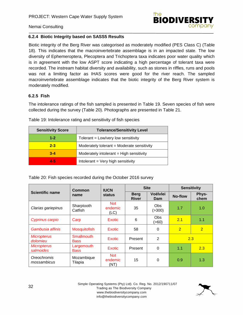
PROJECT: Western Cape Water Supply System
Nemai Consulting
Simple Operating Systems (Pty) Ltd). Co. Reg. No. 2012/190711/07
Trading as The Biodiversity Company
www.thebiodiversitycompany.com
32
6.2.4 Biotic Integrity based on SASS5 Results
Biotic integrity of the Berg River was categorised as moderately modified (PES Class C) (Table
18). This indicates that the macroinvertebrate assemblage is in an impacted state. The low
diversity of Ephemeroptera, Plecoptera and Trichoptera taxa indicates poor water quality which
is in agreement with the low ASPT score indicating a high percentage of tolerant taxa were
recorded. The instream habitat diversity and availability, such as stones in riffles, runs and pools
was not a limiting factor as IHAS scores were good for the river reach. The sampled
macroinvertebrate assemblage indicates that the biotic integrity of the Berg River system is
moderately modified.
6.2.5 Fish
The intolerance ratings of the fish sampled is presented in Table 19. Seven species of fish were
collected during the survey (Table 20). Photographs are presented in Table 21.
Table 19: Intolerance rating and sensitivity of fish species
Sensitivity Score Tolerance/Sensitivity Level
1-2 Tolerant = Low/very low sensitivity
2-3 Moderately tolerant = Moderate sensitivity
3-4 Moderately intolerant = High sensitivity
4-5 Intolerant = Very high sensitivity
Table 20: Fish species recorded during the October 2016 survey
Scientific name Common name
IUCN status
Site Sensitivity
Berg River
Voëlvlei Dam
No-flow Phys-chem
Clarias gariepinus Sharptooth Catfish
Not endemic
(LC) 35
Obs (>300)
1.7 1.0
Cyprinus carpio Carp Exotic 6 Obs (>60)
2.1 1.1
Gambusia affinis Mosquitofish Exotic 58 0 2 2
Micropterus dolomieu
Smallmouth Bass
Exotic Present 2 2.3
Micropterus salmoides
Largemouth Bass
Exotic Present 0 1.1 2.3
Oreochromis mossambicus
Mozambique Tilapia
Not endemic
(NT) 15 0 0.9 1.3
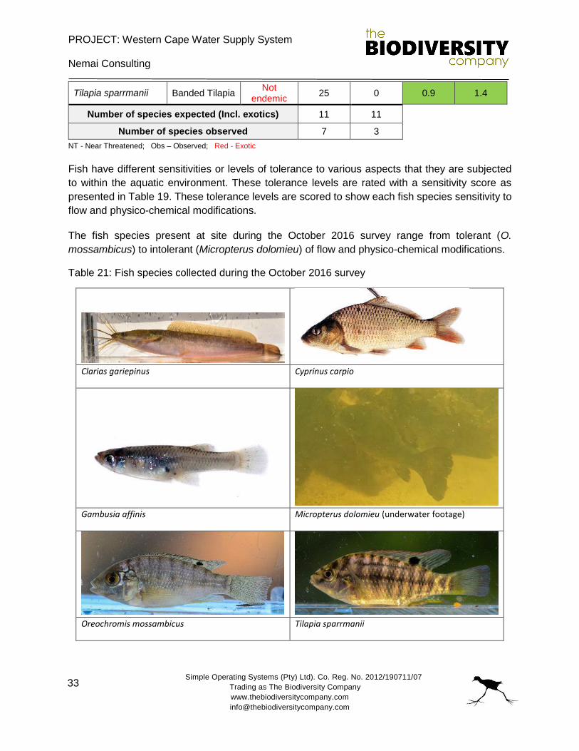
PROJECT: Western Cape Water Supply System
Nemai Consulting
Simple Operating Systems (Pty) Ltd). Co. Reg. No. 2012/190711/07
Trading as The Biodiversity Company
www.thebiodiversitycompany.com
33
Tilapia sparrmanii Banded Tilapia Not
endemic 25 0 0.9 1.4
Number of species expected (Incl. exotics) 11 11
Number of species observed 7 3
NT - Near Threatened; Obs – Observed; Red - Exotic
Fish have different sensitivities or levels of tolerance to various aspects that they are subjected
to within the aquatic environment. These tolerance levels are rated with a sensitivity score as
presented in Table 19. These tolerance levels are scored to show each fish species sensitivity to
flow and physico-chemical modifications.
The fish species present at site during the October 2016 survey range from tolerant (O.
mossambicus) to intolerant (Micropterus dolomieu) of flow and physico-chemical modifications.
Table 21: Fish species collected during the October 2016 survey
Clarias gariepinus Cyprinus carpio
Gambusia affinis Micropterus dolomieu (underwater footage)
Oreochromis mossambicus Tilapia sparrmanii
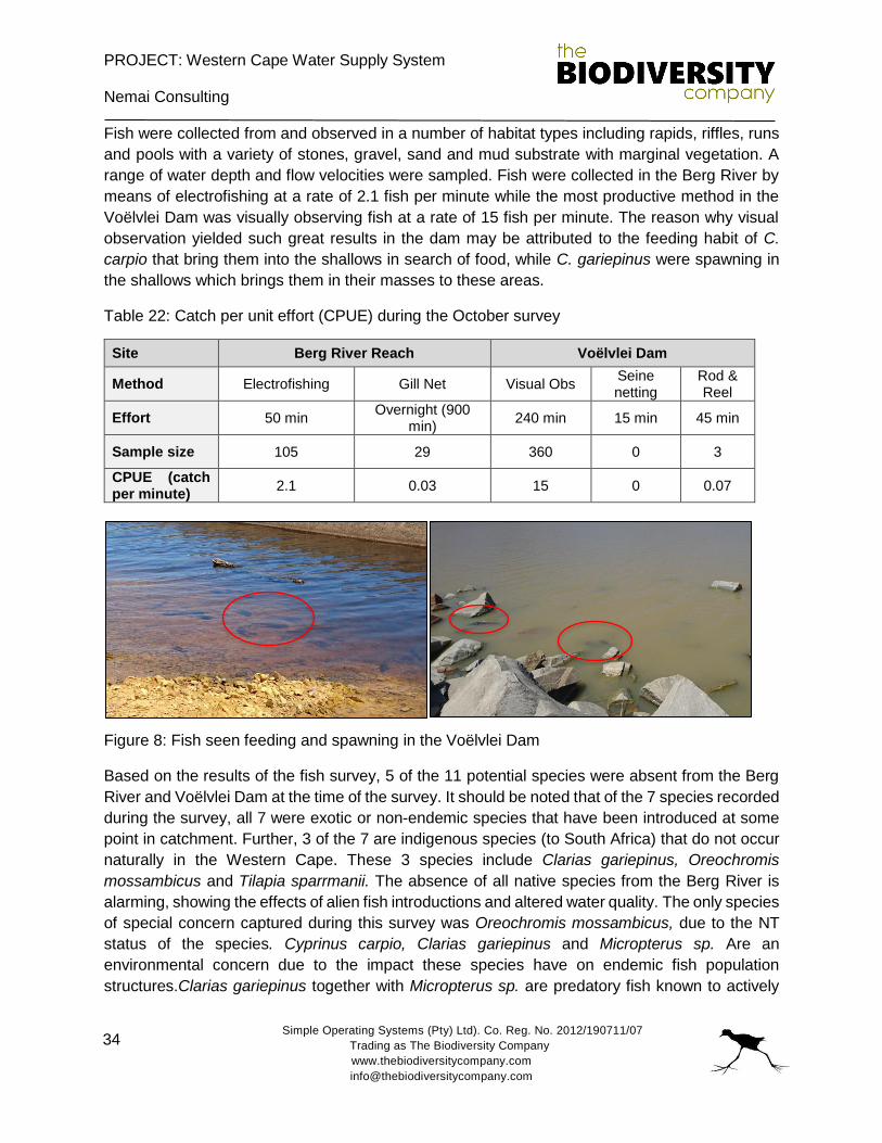
PROJECT: Western Cape Water Supply System
Nemai Consulting
Simple Operating Systems (Pty) Ltd). Co. Reg. No. 2012/190711/07
Trading as The Biodiversity Company
www.thebiodiversitycompany.com
34
Fish were collected from and observed in a number of habitat types including rapids, riffles, runs
and pools with a variety of stones, gravel, sand and mud substrate with marginal vegetation. A
range of water depth and flow velocities were sampled. Fish were collected in the Berg River by
means of electrofishing at a rate of 2.1 fish per minute while the most productive method in the
Voëlvlei Dam was visually observing fish at a rate of 15 fish per minute. The reason why visual
observation yielded such great results in the dam may be attributed to the feeding habit of C.
carpio that bring them into the shallows in search of food, while C. gariepinus were spawning in
the shallows which brings them in their masses to these areas.
Table 22: Catch per unit effort (CPUE) during the October survey
Site Berg River Reach Voëlvlei Dam
Method Electrofishing Gill Net Visual Obs Seine netting
Rod & Reel
Effort 50 min Overnight (900
min) 240 min 15 min 45 min
Sample size 105 29 360 0 3
CPUE (catch per minute)
2.1 0.03 15 0 0.07
Figure 8: Fish seen feeding and spawning in the Voëlvlei Dam
Based on the results of the fish survey, 5 of the 11 potential species were absent from the Berg
River and Voëlvlei Dam at the time of the survey. It should be noted that of the 7 species recorded
during the survey, all 7 were exotic or non-endemic species that have been introduced at some
point in catchment. Further, 3 of the 7 are indigenous species (to South Africa) that do not occur
naturally in the Western Cape. These 3 species include Clarias gariepinus, Oreochromis
mossambicus and Tilapia sparrmanii. The absence of all native species from the Berg River is
alarming, showing the effects of alien fish introductions and altered water quality. The only species
of special concern captured during this survey was Oreochromis mossambicus, due to the NT
status of the species. Cyprinus carpio, Clarias gariepinus and Micropterus sp. Are an
environmental concern due to the impact these species have on endemic fish population
structures.Clarias gariepinus together with Micropterus sp. are predatory fish known to actively
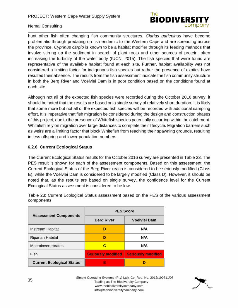
PROJECT: Western Cape Water Supply System
Nemai Consulting
Simple Operating Systems (Pty) Ltd). Co. Reg. No. 2012/190711/07
Trading as The Biodiversity Company
www.thebiodiversitycompany.com
35
hunt other fish often changing fish community structures. Clarias gariepinus have become
problematic through predating on fish endemic to the Western Cape and are spreading across
the province. Cyprinus carpio is known to be a habitat modifier through its feeding methods that
involve stirring up the sediment in search of plant roots and other sources of protein, often
increasing the turbidity of the water body (IUCN, 2015). The fish species that were found are
representative of the available habitat found at each site. Further, habitat availability was not
considered a limiting factor for indigenous fish species but rather the presence of exotics have
resulted their absence. The results from the fish assessment indicate the fish community structure
in both the Berg River and Voëlvlei Dam is in poor condition based on the conditions found at
each site.
Although not all of the expected fish species were recorded during the October 2016 survey, it
should be noted that the results are based on a single survey of relatively short duration. It is likely
that some more but not all of the expected fish species will be recorded with additional sampling
effort. It is imperative that fish migration be considered during the design and construction phases
of this project, due to the presence of Whitefish species potentially occurring within the catchment.
Whitefish rely on migration over large distances to complete their lifecycle. Migration barriers such
as weirs are a limiting factor that block Whitefish from reaching their spawning grounds, resulting
in less offspring and lower population numbers.
6.2.6 Current Ecological Status
The Current Ecological Status results for the October 2016 survey are presented in Table 23. The
PES result is shown for each of the assessment components. Based on this assessment, the
Current Ecological Status of the Berg River reach is considered to be seriously modified (Class
E), while the Voëlvlei Dam is considered to be largely modified (Class D). However, it should be
noted that, as the results are based on single survey, the confidence level for the Current
Ecological Status assessment is considered to be low.
Table 23: Current Ecological Status assessment based on the PES of the various assessment components
Assessment Components PES Score
Berg River Voëlvlei Dam
Instream Habitat D N/A
Riparian Habitat D N/A
Macroinvertebrates C N/A
Fish Seriously modified Seriously modified
Current Ecological Status E D
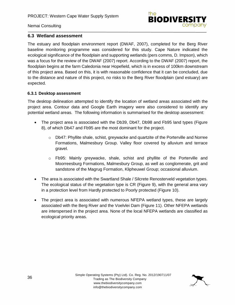
PROJECT: Western Cape Water Supply System
Nemai Consulting
Simple Operating Systems (Pty) Ltd). Co. Reg. No. 2012/190711/07
Trading as The Biodiversity Company
www.thebiodiversitycompany.com
36
6.3 Wetland assessment
The estuary and floodplain environment report (DWAF, 2007), completed for the Berg River
baseline monitoring programme was considered for this study. Cape Nature indicated the
ecological significance of the floodplain and supporting wetlands (pers comms, D. Impson), which
was a focus for the review of the DWAF (2007) report. According to the DWAF (2007) report, the
floodplain begins at the farm Caledonia near Hopefield, which is in excess of 100km downstream
of this project area. Based on this, it is with reasonable confidence that it can be concluded, due
to the distance and nature of this project, no risks to the Berg River floodplain (and estuary) are
expected.
6.3.1 Desktop assessment
The desktop delineation attempted to identify the location of wetland areas associated with the
project area. Contour data and Google Earth imagery were also considered to identify any
potential wetland areas. The following information is summarised for the desktop assessment:
The project area is associated with the Db39, Db47, Db98 and Fb95 land types (Figure
8), of which Db47 and Fb95 are the most dominant for the project.
o Db47: Phyllite shale, schist, greywacke and quartzite of the Porterville and Norree
Formations, Malmesbury Group. Valley floor covered by alluvium and terrace
gravel.
o Fb95: Mainly greywacke, shale, schist and phyllite of the Porterville and
Moorreesburg Formations, Malmesbury Group, as well as conglomerate, grit and
sandstone of the Magrug Formation, Klipheuwel Group; occasional alluvium.
The area is associated with the Swartland Shale / Silcrete Renosterveld vegetation types.
The ecological status of the vegetation type is CR (Figure 9), with the general area vary
in a protection level from Hardly protected to Poorly protected (Figure 10).
The project area is associated with numerous NFEPA wetland types, these are largely
associated with the Berg River and the Voelvlei Dam (Figure 11). Other NFEPA wetlands
are interspersed in the project area. None of the local NFEPA wetlands are classified as
ecological priority areas.
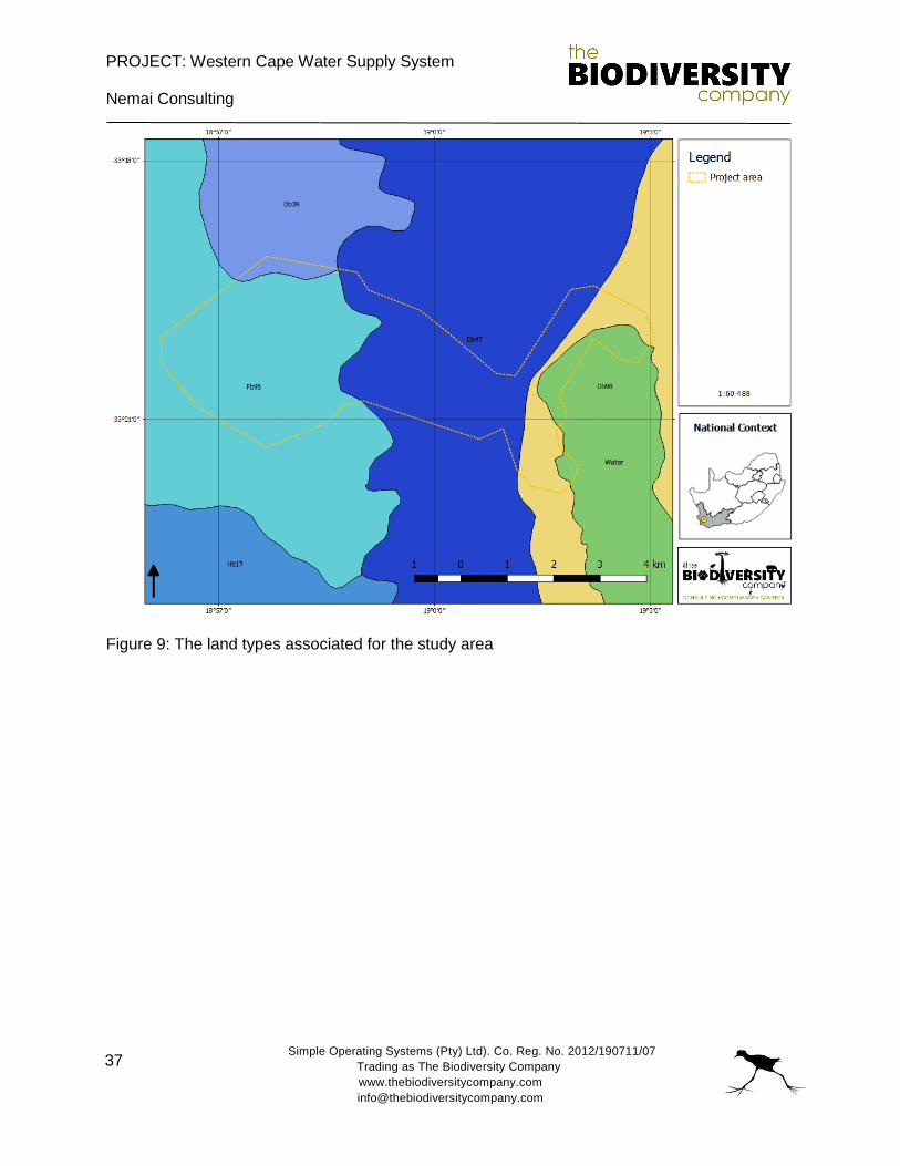
PROJECT: Western Cape Water Supply System
Nemai Consulting
Simple Operating Systems (Pty) Ltd). Co. Reg. No. 2012/190711/07
Trading as The Biodiversity Company
www.thebiodiversitycompany.com
37
Figure 9: The land types associated for the study area
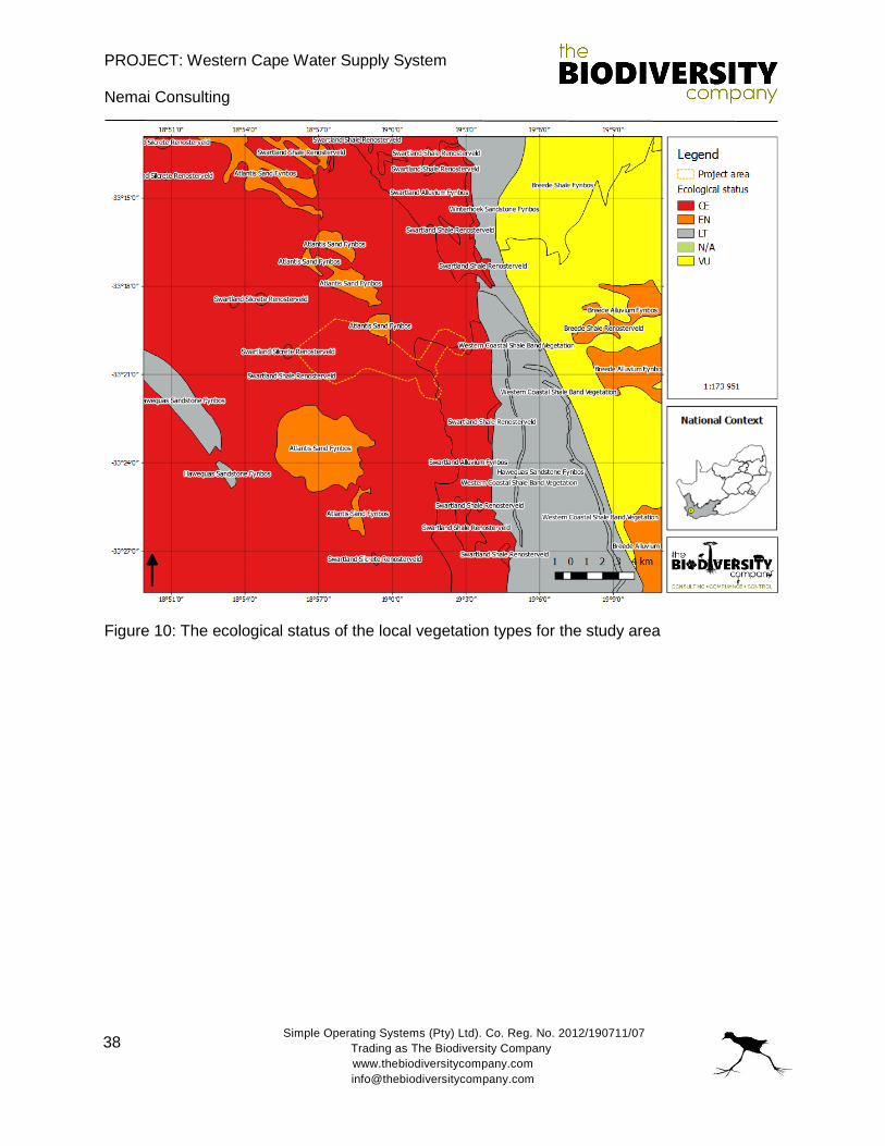
PROJECT: Western Cape Water Supply System
Nemai Consulting
Simple Operating Systems (Pty) Ltd). Co. Reg. No. 2012/190711/07
Trading as The Biodiversity Company
www.thebiodiversitycompany.com
38
Figure 10: The ecological status of the local vegetation types for the study area
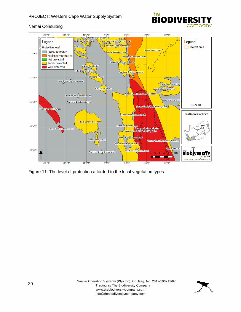
PROJECT: Western Cape Water Supply System
Nemai Consulting
Simple Operating Systems (Pty) Ltd). Co. Reg. No. 2012/190711/07
Trading as The Biodiversity Company
www.thebiodiversitycompany.com
39
Figure 11: The level of protection afforded to the local vegetation types
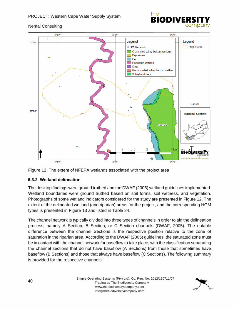
PROJECT: Western Cape Water Supply System
Nemai Consulting
Simple Operating Systems (Pty) Ltd). Co. Reg. No. 2012/190711/07
Trading as The Biodiversity Company
www.thebiodiversitycompany.com
40
Figure 12: The extent of NFEPA wetlands associated with the project area
6.3.2 Wetland delineation
The desktop findings were ground truthed and the DWAF (2005) wetland guidelines implemented.
Wetland boundaries were ground truthed based on soil forms, soil wetness, and vegetation.
Photographs of some wetland indicators considered for the study are presented in Figure 12. The
extent of the delineated wetland (and riparian) areas for the project, and the corresponding HGM
types is presented in Figure 13 and listed in Table 24.
The channel network is typically divided into three types of channels in order to aid the delineation
process, namely A Section, B Section, or C Section channels (DWAF, 2005). The notable
difference between the channel Sections is the respective position relative to the zone of
saturation in the riparian area. According to the DWAF (2005) guidelines, the saturated zone must
be in contact with the channel network for baseflow to take place, with the classification separating
the channel sections that do not have baseflow (A Sections) from those that sometimes have
baseflow (B Sections) and those that always have baseflow (C Sections). The following summary
is provided for the respective channels:
PROJECT: Western Cape Water Supply System
Nemai Consulting
Simple Operating Systems (Pty) Ltd). Co. Reg. No. 2012/190711/07
Trading as The Biodiversity Company
www.thebiodiversitycompany.com
41
A Sections: Headward channels situated well above the zone of saturation and the
channel bed is never in contact with the zone of saturation. These channels carry storm
runoff but the flow is of short duration. These steep, eroding, headward watercourses do
not have a riparian habitat due to limited deposition of alluvial (or hydromorphic) soils and
are not flooded with sufficient frequency to support vegetation of a type that is distinct from
the adjacent land areas.
B Sections: Channels in the zone of the fluctuating water table with baseflow at any point
in the channel when the saturated zone is in contact with the channel bed. The gradient
of the channel bed is flat enough for deposition of material to take place and initial signs
of flood plain development observed.
C Sections: Always in contact with the zone of saturation and therefore always have
baseflow. Channel gradients in these sections are very flat and a flood plain is usually
present.
The setting of the project area is characterised by all three channel networks. The project has
attempted to identify and distinguish between these channels, delineating the wetland areas in
the process.
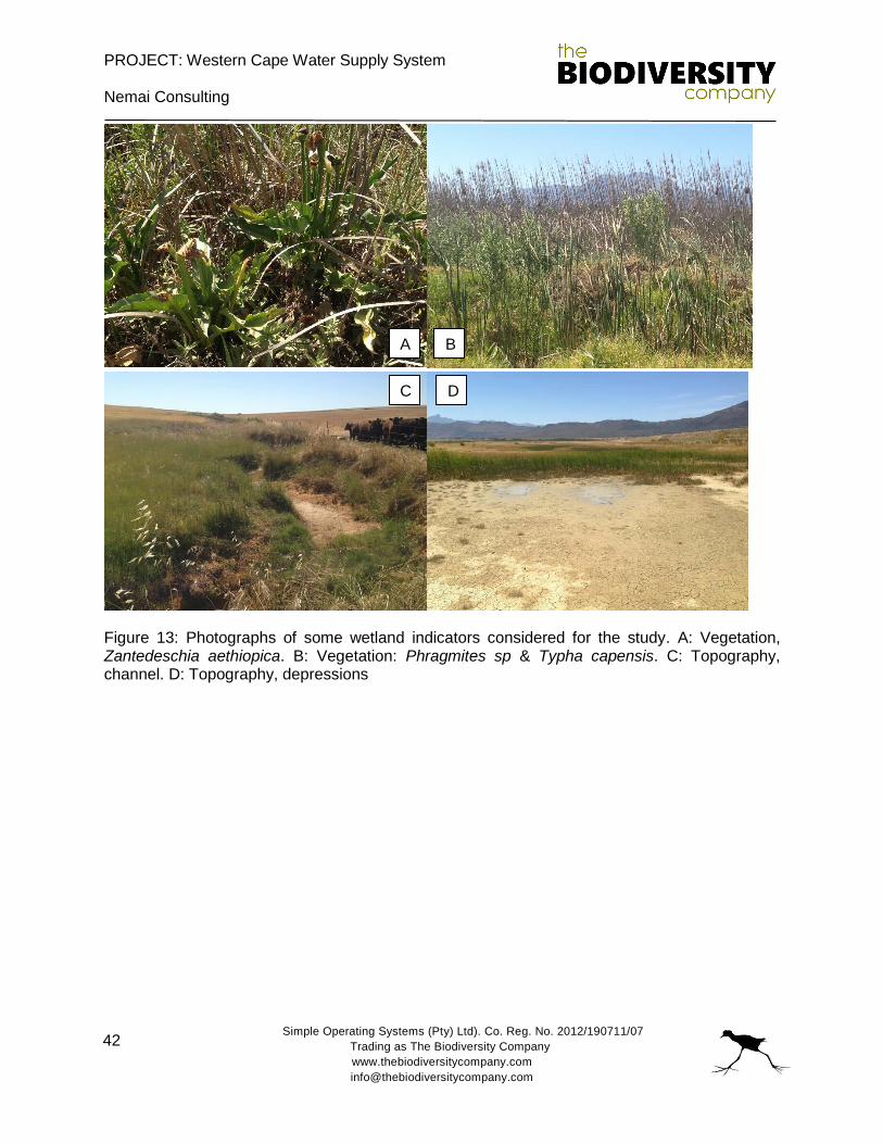
PROJECT: Western Cape Water Supply System
Nemai Consulting
Simple Operating Systems (Pty) Ltd). Co. Reg. No. 2012/190711/07
Trading as The Biodiversity Company
www.thebiodiversitycompany.com
42
Figure 13: Photographs of some wetland indicators considered for the study. A: Vegetation, Zantedeschia aethiopica. B: Vegetation: Phragmites sp & Typha capensis. C: Topography, channel. D: Topography, depressions
A B
C D
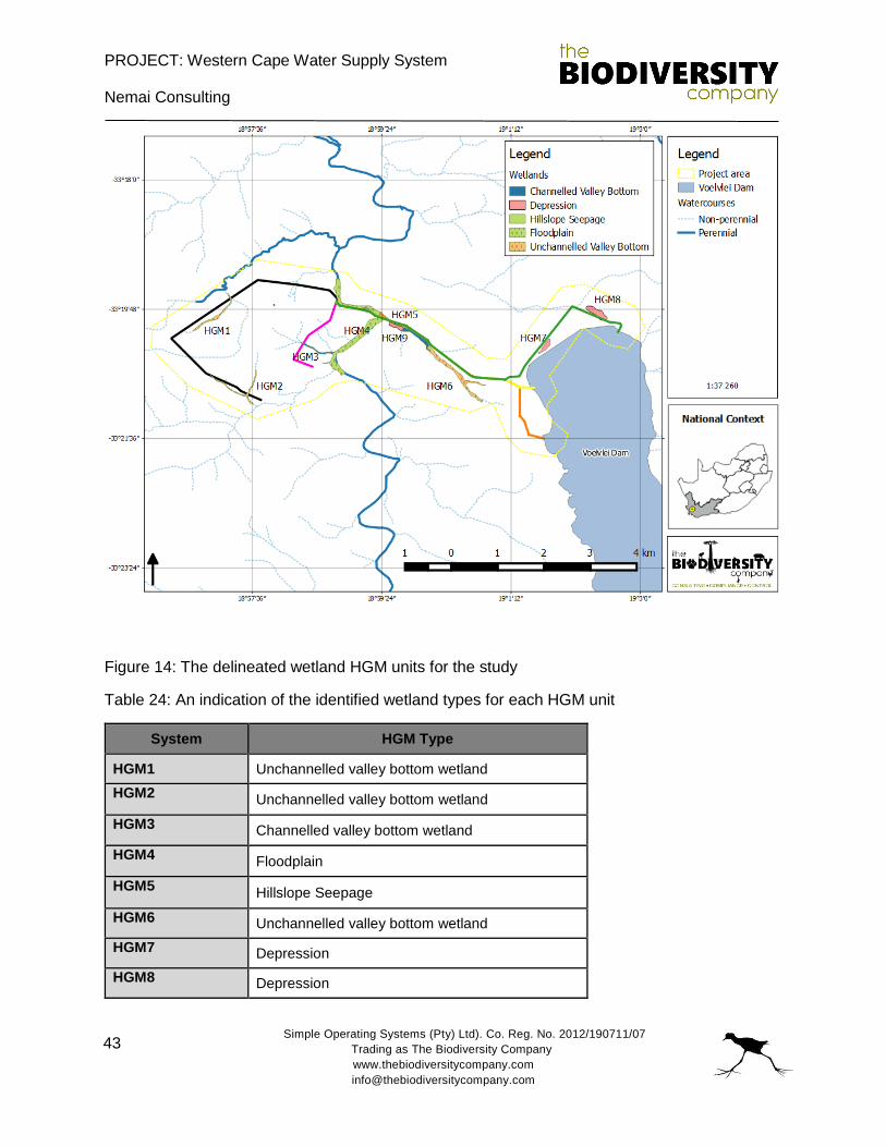
PROJECT: Western Cape Water Supply System
Nemai Consulting
Simple Operating Systems (Pty) Ltd). Co. Reg. No. 2012/190711/07
Trading as The Biodiversity Company
www.thebiodiversitycompany.com
43
Figure 14: The delineated wetland HGM units for the study
Table 24: An indication of the identified wetland types for each HGM unit
System HGM Type
HGM1 Unchannelled valley bottom wetland
HGM2 Unchannelled valley bottom wetland
HGM3 Channelled valley bottom wetland
HGM4 Floodplain
HGM5 Hillslope Seepage
HGM6 Unchannelled valley bottom wetland
HGM7 Depression
HGM8 Depression
PROJECT: Western Cape Water Supply System
Nemai Consulting
Simple Operating Systems (Pty) Ltd). Co. Reg. No. 2012/190711/07
Trading as The Biodiversity Company
www.thebiodiversitycompany.com
44
HGM9 Depression
6.3.4 Wetland functional description
The expectant services associated with each of the delineated HGM units is discussed below,
this is in accordance with WET-EcoServices (Kotze et al., 2007).
Floodplains
The general features that are typical of floodplain wetlands such as oxbows, levees and point
bars were identified in floodplains on site. Flood attenuation is likely to be high early in the season
until the floodplain soils are saturated (McCartney, 2000 in Kotze et al., 2005; McCartney et al.,
1998 in Kotze et al., 2005), and the oxbows and other depressions are filled. In the late season,
the flood attenuation capacity is usually reduced, but is nevertheless still likely to be achieved to
some extent, particularly in drier years (Kotze et al., 2005). The floodplains are generally unlikely
to contribute significantly to stream flow augmentation. The generally clayey nature of floodplain
soils retains water which is likely to be lost through evapotranspiration, thereby limiting their
contribution to stream flow augmentation and groundwater recharge (Kotze et al., 2005). In
general, once the flood overflows the river banks, the velocity of flow decreases laterally,
permitting the deposition of particles within the floodplain landscape. Phosphorous and any
toxicants bound to trapped sediments are therefore likely to be effectively retained on the
floodplains, and this is a key mechanism through which wetlands trap phosphates (Boto and
Patrick, 1979 in Kotze et al., 2005; Hemond and Benoit, 1988 in Kotze et al., 2005). Generally,
the inundation period in floodplains is short, but in the oxbow depression portions of the floodplain
inundation is more prolonged and some of the deposited phosphates may be released as a
consequence of change in redox potential, given that phosphorus is held more tightly to soil
particles under oxidized conditions than under reduced conditions (Cronk and Siobhan Fennessy,
2001; Keddy, 2002).
Channelled valley bottom wetlands
Channelled valley bottom wetlands resemble floodplains, however, they are characterized by less
active deposition of sediment and also the absence of oxbows and other floodplain features such
as natural levees and meander scrolls (Kotze et al., 2007). These systems are generally narrower
and have a steeper gradient, with the contribution from lateral groundwater input relative to the
main stream channel being generally greater. These systems contribute less towards flood
attenuation and sediment trapping. Some nitrate and toxicant removal potential would be
expected, particularly from the water being delivered from the adjacent hillslopes.
Unchannelled valley bottom wetlands
The valley bottom wetlands without channels are located at the lowest position in a landscape
where the water drained from the local slopes accumulate. These wetland systems play important
functions such as sediment trapping, flood attenuation and nutrient-cycling. The valley bottom
PROJECT: Western Cape Water Supply System
Nemai Consulting
Simple Operating Systems (Pty) Ltd). Co. Reg. No. 2012/190711/07
Trading as The Biodiversity Company
www.thebiodiversitycompany.com
45
without a channel wetland on site receives extensive amounts of sediment and flow from the
surrounding slopes. This allows an opportunity for contact between solute-laiden water and the
wetland vegetation, thus providing an opportunity for flood and contaminant (nutrients, pesticides,
herbicides) attenuation. Extensive areas of these wetlands remain saturated as stream channel
input is spread diffusely across the valley bottom, even at low flows (Kotze et al., 2007). These
wetlands also tend to have a high organic content (Kotze et al., 2007).
Hillslope seepages
According to Kotze et al. (2007), hillslope systems are normally associated with groundwater
discharges, although flows through them may be supplemented by surface water contributions.
The accumulation of organic matter and fine sediments in the wetland soils results in the wetland
slowing down the sub-surface movement of water down the slope. Some general ecological
services of the unit include the following:
Contribute to some surface flow attenuation;
Contribution of water to the stream during dry seasons;
Provide water quality enhancement benefits; and
High potential to remove nitrogen and nitrates.
Seepage wetlands provide a variety of water quality enhancement benefits, such as, removing
excess nutrients and inorganic pollutants produced by agriculture, industry and domestic waste
(Postel and Carpenter, 1997). Sub-surface flow that is characteristic of hillslope wetlands enables
the systems to be effective in removing nitrates (Muscutt et al. 1993).
Depressions
According to Goudie and Thomas (1985) and Marshal and Harmse (1992) depressions can
receive both surface and groundwater flows, which then accumulate due to a generally impervious
Layer, preventing the drainage of water. The ability of these systems to attenuate flows is limited,
however, these systems do capture runoff, reducing the volume of surface water draining to the
river reach during storm events (Kotze et al., 2007). Depressions are also unlikely to regulate
streamflow. Additionally, depressions are also not considered effective for sediment trapping. The
water quality in depressions is influenced by the pedology, geology, and local climate (Allan et
al., 1995).
6.3.5 Riparian assessment
Riparian areas were delineated primarily based on alluvial soils and vegetation structure.
Additionally, for the purpose of the ground truthing exercise, the extent of the riparian areas also
considered the following:
The ability of the systems to receive run-off flow following precipitation events under
natural conditions, with limited base flow present for the project area;
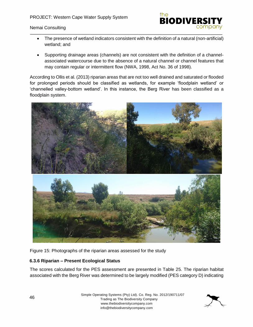
PROJECT: Western Cape Water Supply System
Nemai Consulting
Simple Operating Systems (Pty) Ltd). Co. Reg. No. 2012/190711/07
Trading as The Biodiversity Company
www.thebiodiversitycompany.com
46
The presence of wetland indicators consistent with the definition of a natural (non-artificial)
wetland; and
Supporting drainage areas (channels) are not consistent with the definition of a channel-
associated watercourse due to the absence of a natural channel or channel features that
may contain regular or intermittent flow (NWA, 1998, Act No. 36 of 1998).
According to Ollis et al. (2013) riparian areas that are not too well drained and saturated or flooded
for prolonged periods should be classified as wetlands, for example ‘floodplain wetland’ or
‘channelled valley-bottom wetland’. In this instance, the Berg River has been classified as a
floodplain system.
Figure 15: Photographs of the riparian areas assessed for the study
6.3.6 Riparian – Present Ecological Status
The scores calculated for the PES assessment are presented in Table 25. The riparian habitat
associated with the Berg River was determined to be largely modified (PES category D) indicating

PROJECT: Western Cape Water Supply System
Nemai Consulting
Simple Operating Systems (Pty) Ltd). Co. Reg. No. 2012/190711/07
Trading as The Biodiversity Company
www.thebiodiversitycompany.com
47
a system that has experienced a large loss of natural habitat, biota and basic ecosystem function.
Some of the noted impacts and disturbances to the riparian habitat include:
Clearing of vegetation to accommodate large-scale agricultural activities on either side of
the river, resulting in the narrowing and the loss of riparian habitat;
Alien vegetation encroachment within the riparian zone. These species are outcompeting
endemic species and becoming well established in the habitat; and
The flooding regime of the Berg River has been altered as a result of surrounding land-
uses, local water schemes and the development of the catchment. This has had an impact
on the structuring and support of the riparian area.
Table 25: VEGRAI score for the riparian vegetation of the Berg River
Component Results
LEVEL 3 VEGRAI (%) 49.3
VEGRAI EC D
Category Largely Modified
AVERAGE CONFIDENCE 3.1
MARGINAL 48.9
NON MARGINAL 49.6
6.3.7 Wetland – Present Ecological Status
A total of nine (9) HGM units were identified and delineated for the study. The locations of the
HGM units with respect to the proposed project components are presented in Figure 15. The PES
for the assessed wetland systems is presented in Table 26.
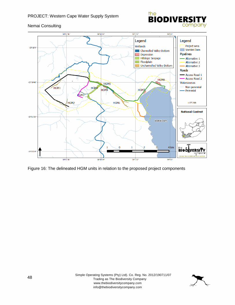
PROJECT: Western Cape Water Supply System
Nemai Consulting
Simple Operating Systems (Pty) Ltd). Co. Reg. No. 2012/190711/07
Trading as The Biodiversity Company
www.thebiodiversitycompany.com
48
Figure 16: The delineated HGM units in relation to the proposed project components
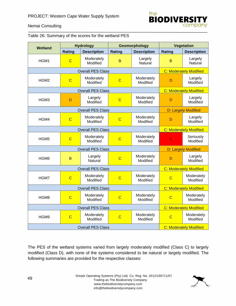
PROJECT: Western Cape Water Supply System
Nemai Consulting
Simple Operating Systems (Pty) Ltd). Co. Reg. No. 2012/190711/07
Trading as The Biodiversity Company
www.thebiodiversitycompany.com
49
Table 26: Summary of the scores for the wetland PES
Wetland Hydrology Geomorphology Vegetation
Rating Description Rating Description Rating Description
HGM1 C Moderately
Modified B
Largely Natural
B Largely Natural
Overall PES Class C: Moderately Modified
HGM2 C Moderately
Modified C
Moderately Modified
D Largely Modified
Overall PES Class C: Moderately Modified
HGM3 D Largely Modified
C Moderately
Modified D
Largely Modified
Overall PES Class D: Largely Modified
HGM4 C Moderately
Modified C
Moderately Modified
D Largely Modified
Overall PES Class C: Moderately Modified
HGM5 C Moderately
Modified C
Moderately Modified
E Seriously Modified
Overall PES Class D: Largely Modified
HGM6 B Largely Natural
C Moderately
Modified D
Largely Modified
Overall PES Class C: Moderately Modified
HGM7 C Moderately
Modified C
Moderately Modified
C Moderately
Modified
Overall PES Class C: Moderately Modified
HGM8 C Moderately
Modified C
Moderately Modified
C Moderately
Modified
Overall PES Class C: Moderately Modified
HGM9 C Moderately
Modified C
Moderately Modified
C Moderately
Modified
Overall PES Class C: Moderately Modified
The PES of the wetland systems varied from largely moderately modified (Class C) to largely
modified (Class D), with none of the systems considered to be natural or largely modified. The
following summaries are provided for the respective classes:
PROJECT: Western Cape Water Supply System
Nemai Consulting
Simple Operating Systems (Pty) Ltd). Co. Reg. No. 2012/190711/07
Trading as The Biodiversity Company
www.thebiodiversitycompany.com
50
Moderately modified: A moderate change in ecosystem processes and loss of natural
habitats has taken place but the natural habitat remains predominantly intact.
Largely modified: A large change in ecosystem processes and loss of natural habitat and
biota and has occurred.
7. RISK ASSESSMENT
The project is for the proposed Berg River-Voëlvlei Augmentation Scheme, and the associated
low level weir and fishway. The Augmentation Scheme will involve the construction of a water
pipeline (5 to 8.1 km in length (depending on the alternative authorised) and 1.7m in diameter)
and an instream weir that will pump water from the weir in the Berg River to the release point in
the Voëlvlei Dam. Due to the fact that this project is for the construction of new infrastructure, a
number of impacts are expected to result in modified conditions in both the Berg River and local
wetlands (and watercourses), as well as the Voëlvlei Dam.
The existing canal is concrete and does not sustain any of the adjacent wetland systems.
Seepage and interflow is not facilitated by the current canal, and the proposed project does not
pose a risk to the wetlands, due to the loss of these water movements.
The baseline assessment has concluded that the assessed water resources are predominantly in
a modified state, largely as a result of local large-scale commercial farming activities, and also
the development of the area.
Some of the potential impacts (or risks) that have been identified for the study and that will be
considered for the risk assessment include the following:
Erosion and scouring at the discharge area in the dam.
The construction of a weir will result in modified flows across the Berg River system. This
will include modifications to the flooding regime of the system.
The weir may also create a migratory barrier for the movement of fish across the system.
Inadequate measures to allow fish movement upstream of the weir, especially smaller
species that cannot navigate strong flows (Galaxias zebratus and Sandelia capensis – if
present).
Inadequate measures to protect river bed material from flows immediately downstream of
the weir resulting in scouring and erosion of substrates from below the structure.
Exotic vegetation encroachment into the marginal and riparian zones may occur in cleared
areas, resulting in competition and loss of indigenous vegetation.
PROJECT: Western Cape Water Supply System
Nemai Consulting
Simple Operating Systems (Pty) Ltd). Co. Reg. No. 2012/190711/07
Trading as The Biodiversity Company
www.thebiodiversitycompany.com
51
The placement of infrastructure within wetlands which will result in the loss of wetland
resources.
The traversing of wetlands by linear structures which may impact on these systems,
potentially resulting in the partial loss of these systems. However, there is also the
opportunity to improve upon existing crossings which will in turn improve the status and
functioning of traversed wetlands.
Findings from the DWS aspect and impact register / risk assessment are provided below:
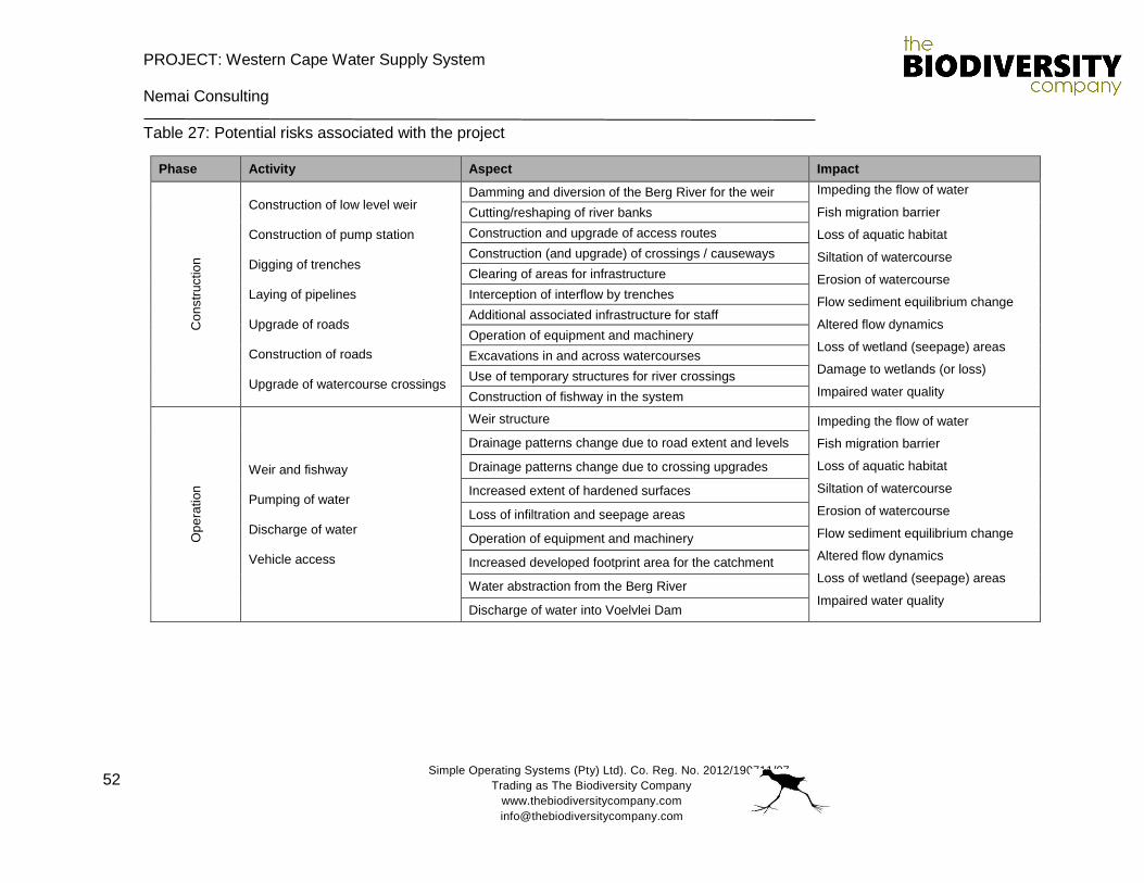
PROJECT: Western Cape Water Supply System
Nemai Consulting
Simple Operating Systems (Pty) Ltd). Co. Reg. No. 2012/190711/07
Trading as The Biodiversity Company
www.thebiodiversitycompany.com
52
Table 27: Potential risks associated with the project
Phase Activity Aspect Impact
Con
str
uctio
n
Construction of low level weir Construction of pump station Digging of trenches Laying of pipelines Upgrade of roads Construction of roads Upgrade of watercourse crossings
Damming and diversion of the Berg River for the weir Impeding the flow of water
Fish migration barrier
Loss of aquatic habitat
Siltation of watercourse
Erosion of watercourse
Flow sediment equilibrium change
Altered flow dynamics
Loss of wetland (seepage) areas
Damage to wetlands (or loss)
Impaired water quality
Cutting/reshaping of river banks
Construction and upgrade of access routes
Construction (and upgrade) of crossings / causeways
Clearing of areas for infrastructure
Interception of interflow by trenches
Additional associated infrastructure for staff
Operation of equipment and machinery
Excavations in and across watercourses
Use of temporary structures for river crossings
Construction of fishway in the system
Op
era
tion
Weir and fishway Pumping of water Discharge of water Vehicle access
Weir structure Impeding the flow of water
Fish migration barrier
Loss of aquatic habitat
Siltation of watercourse
Erosion of watercourse
Flow sediment equilibrium change
Altered flow dynamics
Loss of wetland (seepage) areas
Impaired water quality
Drainage patterns change due to road extent and levels
Drainage patterns change due to crossing upgrades
Increased extent of hardened surfaces
Loss of infiltration and seepage areas
Operation of equipment and machinery
Increased developed footprint area for the catchment
Water abstraction from the Berg River
Discharge of water into Voelvlei Dam
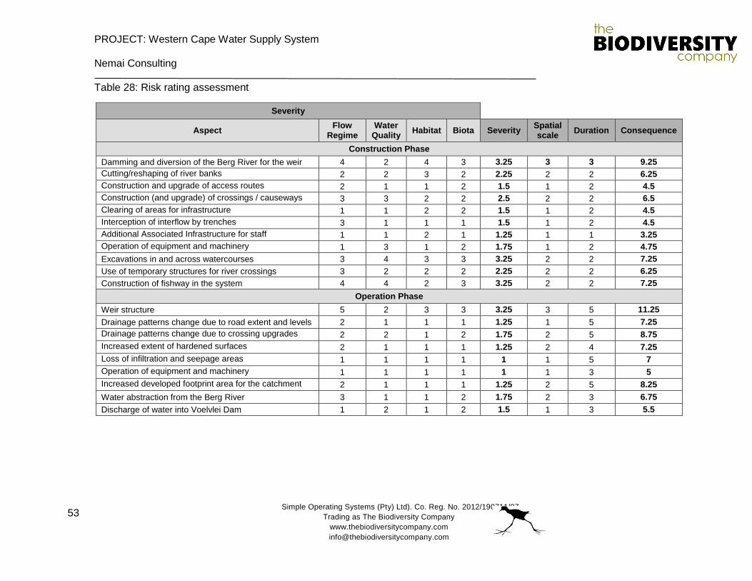
PROJECT: Western Cape Water Supply System
Nemai Consulting
Simple Operating Systems (Pty) Ltd). Co. Reg. No. 2012/190711/07
Trading as The Biodiversity Company
www.thebiodiversitycompany.com
53
Table 28: Risk rating assessment
Severity
Aspect Flow
Regime Water
Quality Habitat Biota Severity
Spatial scale
Duration Consequence
Construction Phase
Damming and diversion of the Berg River for the weir 4 2 4 3 3.25 3 3 9.25
Cutting/reshaping of river banks 2 2 3 2 2.25 2 2 6.25
Construction and upgrade of access routes 2 1 1 2 1.5 1 2 4.5
Construction (and upgrade) of crossings / causeways 3 3 2 2 2.5 2 2 6.5
Clearing of areas for infrastructure 1 1 2 2 1.5 1 2 4.5
Interception of interflow by trenches 3 1 1 1 1.5 1 2 4.5
Additional Associated Infrastructure for staff 1 1 2 1 1.25 1 1 3.25
Operation of equipment and machinery 1 3 1 2 1.75 1 2 4.75
Excavations in and across watercourses 3 4 3 3 3.25 2 2 7.25
Use of temporary structures for river crossings 3 2 2 2 2.25 2 2 6.25
Construction of fishway in the system 4 4 2 3 3.25 2 2 7.25
Operation Phase
Weir structure 5 2 3 3 3.25 3 5 11.25
Drainage patterns change due to road extent and levels 2 1 1 1 1.25 1 5 7.25
Drainage patterns change due to crossing upgrades 2 2 1 2 1.75 2 5 8.75
Increased extent of hardened surfaces 2 1 1 1 1.25 2 4 7.25
Loss of infiltration and seepage areas 1 1 1 1 1 1 5 7
Operation of equipment and machinery 1 1 1 1 1 1 3 5
Increased developed footprint area for the catchment 2 1 1 1 1.25 2 5 8.25
Water abstraction from the Berg River 3 1 1 2 1.75 2 3 6.75
Discharge of water into Voelvlei Dam 1 2 1 2 1.5 1 3 5.5
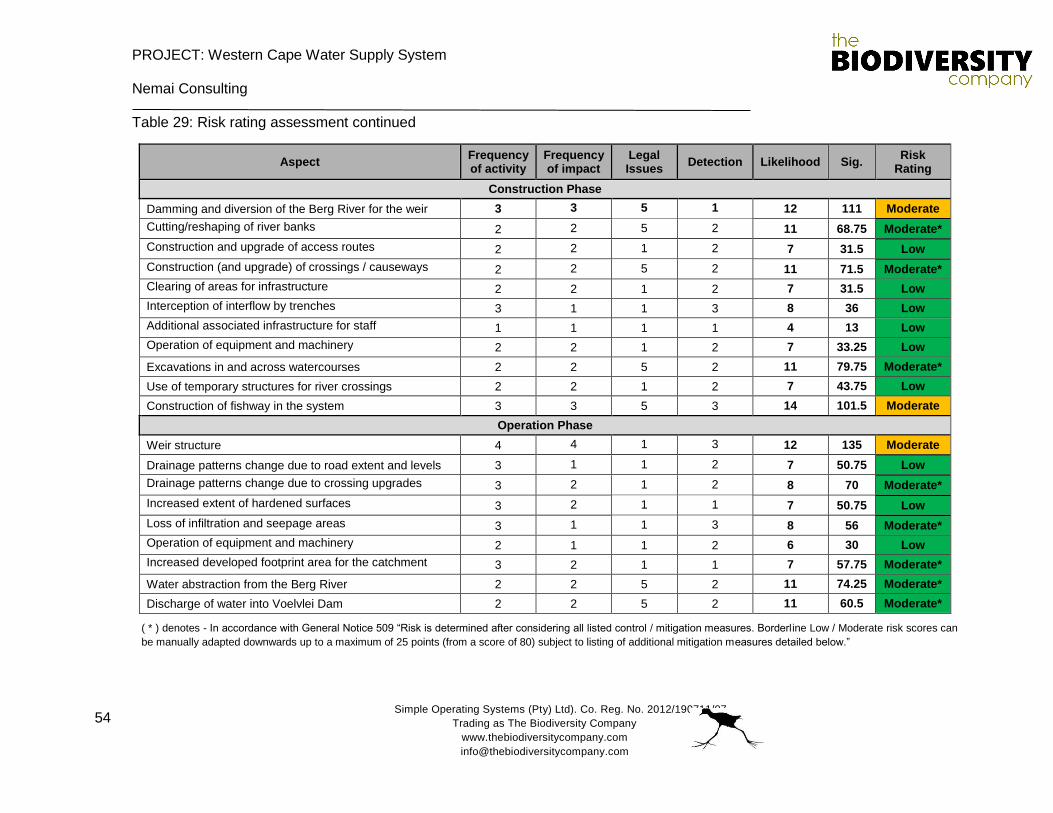
PROJECT: Western Cape Water Supply System
Nemai Consulting
Simple Operating Systems (Pty) Ltd). Co. Reg. No. 2012/190711/07
Trading as The Biodiversity Company
www.thebiodiversitycompany.com
54
Table 29: Risk rating assessment continued
Aspect Frequency of activity
Frequency of impact
Legal Issues
Detection Likelihood Sig. Risk
Rating
Construction Phase
Damming and diversion of the Berg River for the weir 3 3 5 1 12 111 Moderate
Cutting/reshaping of river banks 2 2 5 2 11 68.75 Moderate*
Construction and upgrade of access routes 2 2 1 2 7 31.5 Low
Construction (and upgrade) of crossings / causeways 2 2 5 2 11 71.5 Moderate*
Clearing of areas for infrastructure 2 2 1 2 7 31.5 Low
Interception of interflow by trenches 3 1 1 3 8 36 Low
Additional associated infrastructure for staff 1 1 1 1 4 13 Low
Operation of equipment and machinery 2 2 1 2 7 33.25 Low
Excavations in and across watercourses 2 2 5 2 11 79.75 Moderate*
Use of temporary structures for river crossings 2 2 1 2 7 43.75 Low
Construction of fishway in the system 3 3 5 3 14 101.5 Moderate
Operation Phase
Weir structure 4 4 1 3 12 135 Moderate
Drainage patterns change due to road extent and levels 3 1 1 2 7 50.75 Low
Drainage patterns change due to crossing upgrades 3 2 1 2 8 70 Moderate*
Increased extent of hardened surfaces 3 2 1 1 7 50.75 Low
Loss of infiltration and seepage areas 3 1 1 3 8 56 Moderate*
Operation of equipment and machinery 2 1 1 2 6 30 Low
Increased developed footprint area for the catchment 3 2 1 1 7 57.75 Moderate*
Water abstraction from the Berg River 2 2 5 2 11 74.25 Moderate*
Discharge of water into Voelvlei Dam 2 2 5 2 11 60.5 Moderate*
( * ) denotes - In accordance with General Notice 509 “Risk is determined after considering all listed control / mitigation measures. Borderline Low / Moderate risk scores can
be manually adapted downwards up to a maximum of 25 points (from a score of 80) subject to listing of additional mitigation measures detailed below.”
PROJECT: Western Cape Water Supply System
Nemai Consulting
Simple Operating Systems (Pty) Ltd). Co. Reg. No. 2012/190711/07
Trading as The Biodiversity Company
www.thebiodiversitycompany.com
55
The risk assessments indicated that the largest risks are associated with the weir structure
specifically, and not the supporting activities and structures. The most significant risks were
determined to be moderate, with the remaining risks determined to be low. The two moderate
risks for the construction phase are associated with the damming and diversion of the Berg River,
and also the construction of the fishway structure. The most significant risk (moderate) considered
for the operational phase of the project is the weir structure itself.
The relatively low risk rating for the project may be attributed to the modified statuses of the
assessed watercourses. In addition to this, the extent of the impacts, except for the formal weir
structure, are generally expected to be both site and area specific.
Mitigations measures have been prescribed for the assessed risks, with due consideration for the
moderate risks associated with the project.
7.1 Low level weir construction mitigation measures
The following weir construction specific mitigation measures are provided:
The footprint area of the weir should be kept a minimum. The footprint area must be clearly
demarcated to avoid unnecessary disturbances to adjacent areas;
Exposed river banks / soils must be stabilised to prevent the erosion of these surfaces.
Signs of erosion must be addressed immediately to prevent further erosion of the area;
The weir should not concentrate flows at the overspill area. It is important to spread flows
across the river system by having a wider overspill area, avoiding concentrated flows.
Care must be taken not to spread flows outside of the existing channel path;
It is imperative that the new low level weir cater for fish migration, especially during very
low flows;
A V-shaped centre positioned spillway is recommended for the weir design. This will allow
for fish migration over the weir under different flow levels (see diagram Figure 17 and
Figure 18); and
Large aggregate outsourced or from the project area (if available) can be used for energy
dissipation in the channel downstream of the weir to reduce the likelihood of scouring the
river bed and sedimentation of the catchment. It is preferable that larger aggregate be
used to avoid flows removing aggregate material from the site.
7.2 Fishway construction mitigation measures
A rock-ramp type of fishway is preferred over the vertical slotted fishway. The rock-ramp type of
fishway is self-cleaning requiring little to no maintenance compared to the vertical slotted fishway.
PROJECT: Western Cape Water Supply System
Nemai Consulting
Simple Operating Systems (Pty) Ltd). Co. Reg. No. 2012/190711/07
Trading as The Biodiversity Company
www.thebiodiversitycompany.com
56
It caters for all fish types with different swimming abilities and is aesthetically pleasing due to its
natural look. From a construction point of view, it requires less complex calculations for design
dimensions and simulates a natural river type of environment that fish will adopt more easily thus
having a higher success rate.
The following fishway construction specific mitigation measures are provided:
The fishway should have water passing through it during both high flows and low flows to
encourage fish to make use of the fishway no matter the flow levels. It may be required
that an Instream Flow assessment be conducted for the project in order to prescribe water
allowances for the system;
The fishway should cater for both rheophilic (fast moving water) and anti-rheophilic (slow
moving water) fish species. This can be achieved through having several different flow
velocity areas across the fishway;
It is recommended that a rough stone surface be cast into the fishway channel floor to
cater for climbing and crawling species;
Rocks used for the fishway should have flat sides with rounded edges (typical of quarried
rock) rather than rounded rocks, as they provide a variety of water velocity and depths that
easy for fish to navigate;
Rock material needs to be concreted in place to prevent them from washing away during
high flows;
Rock should be placed with a cascade pattern creating numerous step-like riffles, but
should also incorporate a large variety of rock sizes placed at random to create a diversity
of hydraulic conditions (microhabitats) within the fishway;
Pools or depressions of varying sizes and depths should be created at random throughout
the length and width of the fishway and should be placed behind large rocks to create
lower velocity resting areas (eddies) for fish. The more pools incorporated in the design,
the more successful the fishway will be;
Guidelines for fishway design:
o Channel slope – between 1/8 and 1/10 is recommended for South African fish;
o Fishway entrance – furthest point upstream that the fish can penetrate, usually
in a suitable pool (low turbulence with sufficient depth) located at the base of the
low level weir;
o Fishway exit – located in a quiet area, sheltered, low velocity to prevent fish from
being swept downstream and to afford protection from predators:
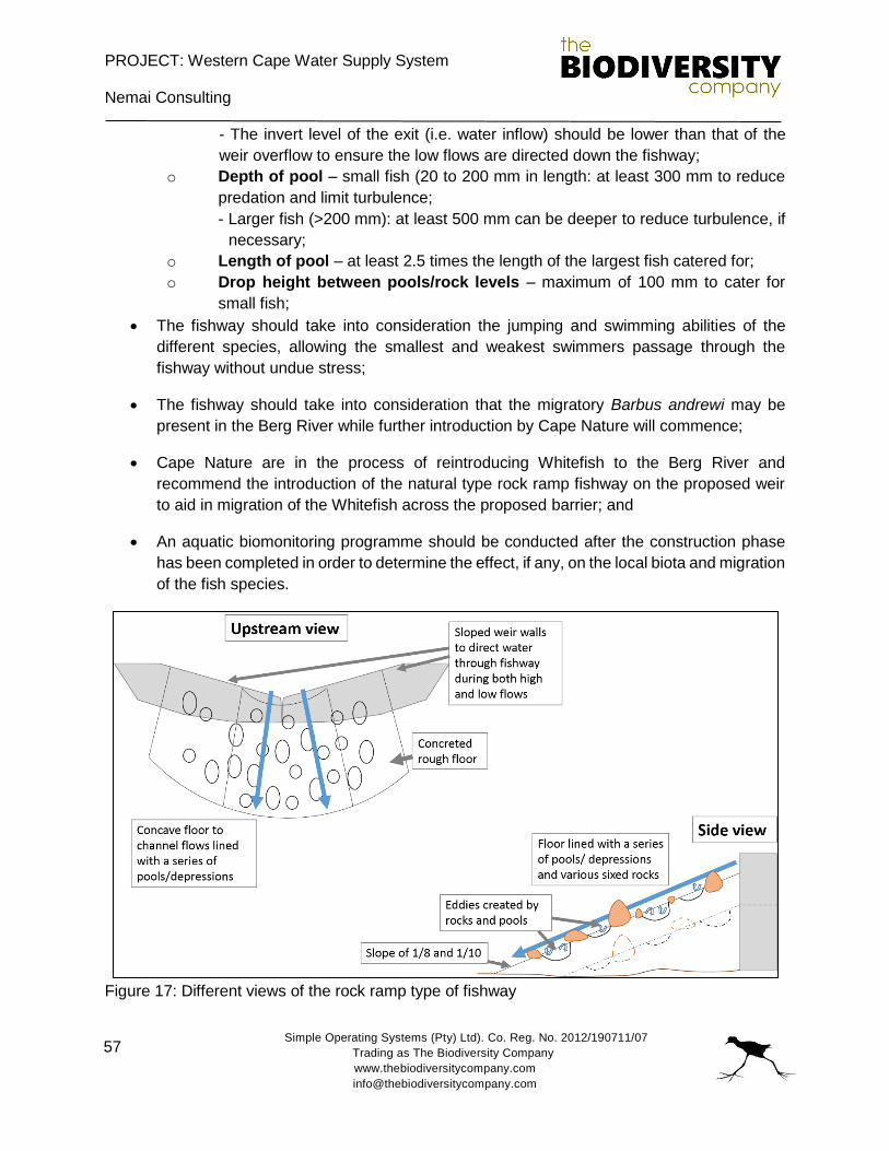
PROJECT: Western Cape Water Supply System
Nemai Consulting
Simple Operating Systems (Pty) Ltd). Co. Reg. No. 2012/190711/07
Trading as The Biodiversity Company
www.thebiodiversitycompany.com
57
- The invert level of the exit (i.e. water inflow) should be lower than that of the
weir overflow to ensure the low flows are directed down the fishway;
o Depth of pool – small fish (20 to 200 mm in length: at least 300 mm to reduce
predation and limit turbulence;
- Larger fish (>200 mm): at least 500 mm can be deeper to reduce turbulence, if
necessary;
o Length of pool – at least 2.5 times the length of the largest fish catered for;
o Drop height between pools/rock levels – maximum of 100 mm to cater for
small fish;
The fishway should take into consideration the jumping and swimming abilities of the
different species, allowing the smallest and weakest swimmers passage through the
fishway without undue stress;
The fishway should take into consideration that the migratory Barbus andrewi may be
present in the Berg River while further introduction by Cape Nature will commence;
Cape Nature are in the process of reintroducing Whitefish to the Berg River and
recommend the introduction of the natural type rock ramp fishway on the proposed weir
to aid in migration of the Whitefish across the proposed barrier; and
An aquatic biomonitoring programme should be conducted after the construction phase
has been completed in order to determine the effect, if any, on the local biota and migration
of the fish species.
Figure 17: Different views of the rock ramp type of fishway
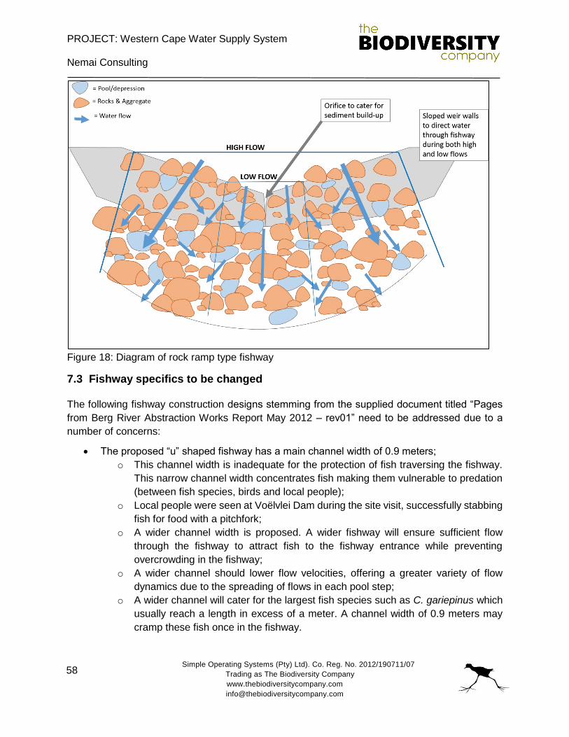
PROJECT: Western Cape Water Supply System
Nemai Consulting
Simple Operating Systems (Pty) Ltd). Co. Reg. No. 2012/190711/07
Trading as The Biodiversity Company
www.thebiodiversitycompany.com
58
Figure 18: Diagram of rock ramp type fishway
7.3 Fishway specifics to be changed
The following fishway construction designs stemming from the supplied document titled “Pages
from Berg River Abstraction Works Report May 2012 – rev01” need to be addressed due to a
number of concerns:
The proposed “u” shaped fishway has a main channel width of 0.9 meters;
o This channel width is inadequate for the protection of fish traversing the fishway.
This narrow channel width concentrates fish making them vulnerable to predation
(between fish species, birds and local people);
o Local people were seen at Voëlvlei Dam during the site visit, successfully stabbing
fish for food with a pitchfork;
o A wider channel width is proposed. A wider fishway will ensure sufficient flow
through the fishway to attract fish to the fishway entrance while preventing
overcrowding in the fishway;
o A wider channel should lower flow velocities, offering a greater variety of flow
dynamics due to the spreading of flows in each pool step;
o A wider channel will cater for the largest fish species such as C. gariepinus which
usually reach a length in excess of a meter. A channel width of 0.9 meters may
cramp these fish once in the fishway.
PROJECT: Western Cape Water Supply System
Nemai Consulting
Simple Operating Systems (Pty) Ltd). Co. Reg. No. 2012/190711/07
Trading as The Biodiversity Company
www.thebiodiversitycompany.com
59
There is no mention of the depth of the fishway design;
o A minimum depth of 500mm is recommended.
The entrance to the fishway should not be a barrier during the lowest of flows. Rather the
entrance opening should be at the same level as the lowest water level to cater for fish
migration.
A fatal flaw in many fishway designs is insufficient flow discharge from the fishway
entrance. Without sufficient discharge, fish are not attracted to the fishway entrance.
In order for the fishway to be successful, the raised issues need to be addressed. Raised issues
and recommendations are based on fishway guidelines and South African case studies (Bok et
al., 2007).
7.4 Pipeline mitigation measures
The following pipeline mitigation measures are provided:
It is not advisable to only set a mesh on the pipeline at the abstraction point, due to the
mesh becoming clogged with debris. It is recommended that an abstraction sump be
considered for the design, in addition to the mesh. The sump will ensure no blockages of
the pipeline, and the mesh will prevent the transfer of fish which may result in fish fatalities;
Pipeline trenches and sandy bedding material may produce preferential flow paths for
water across the project area perpendicular to the general direction of flow instead of
angle. This risk can be reduced by installing clay plugs at intervals down the length of the
trench to force water out of the trench and down the natural topographical gradient;
Pipelines crossing watercourses should preferably span the systems above ground. This
prevents disruptions to sub surface flow dynamics;
When a pipeline spans a river, it should be attached to any existing crossing or bridge
structures (if present). If pier support structures are needed for the pipeline to span a
system, then piers should be placed outside of preferential flow paths with the least
number of pier structures used as possible;
Trenches and foundations should be side dug (where possible) from the existing access
routes. In the absence of access routes, temporary routes may be considered;
Trenches should be dug on-line (where applicable) creating narrower trenches;
Where trench breakers are required, these must be imported appropriately and installed
by the backfill crew, ahead of backfilling;
Ensure careful separation of soil types/ strata as identified for the removal of soil. The soils
must be removed in such a way that they can be easily reinstated in the reverse order for
backfilling;
PROJECT: Western Cape Water Supply System
Nemai Consulting
Simple Operating Systems (Pty) Ltd). Co. Reg. No. 2012/190711/07
Trading as The Biodiversity Company
www.thebiodiversitycompany.com
60
To ensure correct backfilling, the soil that is removed from the trench at its deepest point
must be laid closest to the trench. The first layer of topsoil must be laid furthest away from
the trench;
It may be necessary to import small amounts of padding material upon which the pipe
safely rests in the trench prior to backfilling. This material must be stored outside the
wetland areas until it is required to be placed within the trench, and bunded with sandbags;
Any large boulders encountered during trenching operations must not be returned to the
trench, but removed off site; and
If any spoil is generated this can be transported to another location and re-used if it is
required, removed correctly to a licensed facility, or offered to the landowner.
7.5 General mitigation measures
The following general mitigation measures are provided:
The delineated aquatic and wetland areas outside of the specific project site area must be
avoided where possible;
The construction vehicles and machinery must make use of existing access routes as
much as possible, before adjacent areas are considered for access;
Laydown yards, camps and storage areas must be beyond the aquatic and wetland areas;
The contractors used for the project should have spill kits available to ensure that any fuel
or oil spills are clean-up and discarded correctly;
It is preferable that construction takes place during the dry season to reduce the erosion
potential of the exposed surfaces;
Temporary storm water channels and preferential flow paths should be filled with
aggregate and logs (branches included) to dissipate and slow flows limiting erosion;
Contamination of the Berg River system with unset cement or cement powder should be
negated as it is detrimental to aquatic biota. Pre-cast structures should be made use of
(where possible) to avoid the mixing of these materials on site, reducing the likelihood of
cement in the river system;
All chemicals and toxicants to be used for the Augmentation Scheme construction must
be stored outside the channel system and in a bunded area;
All machinery and equipment should be inspected regularly for faults and possible leaks,
these should be serviced off-site;
PROJECT: Western Cape Water Supply System
Nemai Consulting
Simple Operating Systems (Pty) Ltd). Co. Reg. No. 2012/190711/07
Trading as The Biodiversity Company
www.thebiodiversitycompany.com
61
All contractors and employees should undergo induction which is to include a component
of environmental awareness. The induction is to include aspects such as the need to avoid
littering, the reporting and cleaning of spills and leaks and general good “housekeeping”;
Adequate sanitary facilities and ablutions on the servitude must be provided for all
personnel throughout the project area. Use of these facilities must be enforced (these
facilities must be kept clean so that they are a desired alternative to the surrounding
vegetation);
Have action plans on site, and training for contractors and employees in the event of spills,
leaks and other impacts to the aquatic systems;
All removed soil and material must not be stockpiled within the system. Stockpiling should
take place outside of the riparian and wetland areas. All stockpiles must be protected from
erosion, stored on flat areas where run-off will be minimised, and be surrounded by bunds;
Erosion and sedimentation into the channel must be minimised through the effective
stabilisation (gabions and Reno mattresses) and the re-vegetation of any disturbed banks;
Temporary and permanent erosion control methods may include silt fences, flotation silt
curtains, retention basins, detention ponds, interceptor ditches, seeding and sodding,
riprap of exposed embankments, erosion mats, and mulching;
Any exposed earth should be rehabilitated promptly by planting suitable vegetation
(vigorous indigenous grasses) to protect the exposed soil;
No dumping of construction material on-site may take place;
All waste generated on-site during construction must be adequately managed. Separation
and recycling of different waste materials should be supported; and
An alien invasive plant management plan needs to be compiled and implemented post
construction to prevent the growth of invasives on cleared areas.
7.6 Summer release installation options
The summer release point into the Berg River has two gabion-type structure options to mitigate
further erosion of the receiving system. The outlet will be via a short T-connection or Y-connection.
This installation may provide opportunities to rehabilitate this portion of the river. The summer
release point location is provided in Figure 19 and a photo showing the highly-eroded area is
presented in Figure 20.

PROJECT: Western Cape Water Supply System
Nemai Consulting
Simple Operating Systems (Pty) Ltd). Co. Reg. No. 2012/190711/07
Trading as The Biodiversity Company
www.thebiodiversitycompany.com
62
A Y-connection may be better suited as the discharged flow velocity will be deflected and
dissipated as it hits and flows against the Y-shape. A T-shape connection may result in the flows
being redirected into the channel banks, further eroding them.
Figure 19: Summer release discharge point into the Berg River with proposed pipeline (Blue)
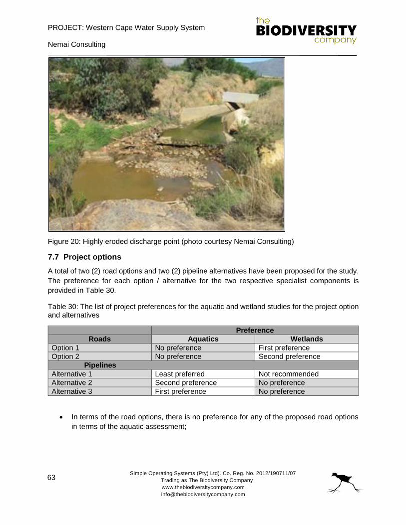
PROJECT: Western Cape Water Supply System
Nemai Consulting
Simple Operating Systems (Pty) Ltd). Co. Reg. No. 2012/190711/07
Trading as The Biodiversity Company
www.thebiodiversitycompany.com
63
Figure 20: Highly eroded discharge point (photo courtesy Nemai Consulting)
7.7 Project options
A total of two (2) road options and two (2) pipeline alternatives have been proposed for the study.
The preference for each option / alternative for the two respective specialist components is
provided in Table 30.
Table 30: The list of project preferences for the aquatic and wetland studies for the project option and alternatives
Preference
Roads Aquatics Wetlands
Option 1 No preference First preference
Option 2 No preference Second preference
Pipelines
Alternative 1 Least preferred Not recommended
Alternative 2 Second preference No preference
Alternative 3 First preference No preference
In terms of the road options, there is no preference for any of the proposed road options
in terms of the aquatic assessment;

PROJECT: Western Cape Water Supply System
Nemai Consulting
Simple Operating Systems (Pty) Ltd). Co. Reg. No. 2012/190711/07
Trading as The Biodiversity Company
www.thebiodiversitycompany.com
64
With regards to local wetlands, Option 1 is the most preferred option, due to the route
being predominantly aligned with existing access routes. It is likely that four (4) crossings
may have to be upgraded for this option, which includes one wetland system;
The second preferred road option is Option 2 for the roads, which is expected to require
the crossing of three (3) watercourses, with one wetland system being traversed;
Alternative 3 has a discharge area with existing excavation scars with a gentle gradient
which is expected to mitigate any likely scouring (desirable). Owing to this, this alternative
is the preferred alternative for the aquatic assessment;
Alternative 2 has the shortest route path (desirable) and the discharge point enters the
dam at a steep gradient that would result in large scale scouring with subsequent increase
in turbidity (not desirable), and due to this risk, this alternative is the second preference
for the aquatic assessment;
Alternative 1 has the longest route path (not desirable) and will discharge into an area of
the dam that received clean water from surrounding systems. Owing to the length of this
pipeline, and the potential mixing of clean water, this is the least preferred option for the
aquatic assessment;
With regards to the wetland study, Alternative 1 for the pipelines is not recommended
owing to the fact that the structure will transect a depression system, resulting in impacts
to the system; and
Further to the wetland study, there is no preference for either Alternative 2 or Alternative
3 as no risks to wetlands are posed by either alternative.
8. MONITORING
An aquatic ecologist with fishway experience should monitor the construction phase of the project,
in order to assess compliance and to also provide guidance for riparian and fishway related
matters that arise.
Should the construction phase be monitored and guided by a specialist, the expected impacts for
the phase of the project will be mitigated and the operational phase concerns pro-actively
managed to reduce the overall negative ecological impact of the project.
An aquatic monitoring survey needs to be conducted after the construction activities have been
completed, in the operation phase of the project so that impacts can be assessed and adaptive
management practices implemented if necessary. A number of sensitive aquatic biota should be
specifically monitored to identify fluctuation in abundances and diversity, including fish and
macroinvertebrates. The frequency of the monitoring programme should be as follows:
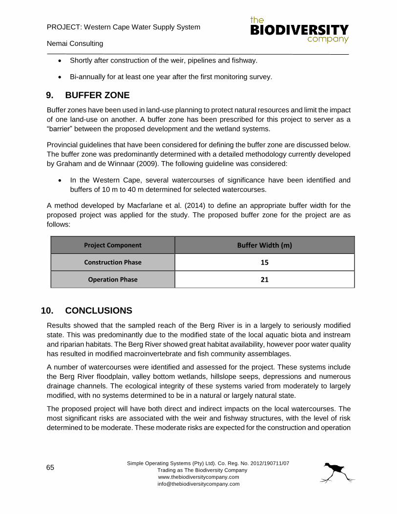
PROJECT: Western Cape Water Supply System
Nemai Consulting
Simple Operating Systems (Pty) Ltd). Co. Reg. No. 2012/190711/07
Trading as The Biodiversity Company
www.thebiodiversitycompany.com
65
Shortly after construction of the weir, pipelines and fishway.
Bi-annually for at least one year after the first monitoring survey.
9. BUFFER ZONE
Buffer zones have been used in land-use planning to protect natural resources and limit the impact
of one land-use on another. A buffer zone has been prescribed for this project to server as a
“barrier” between the proposed development and the wetland systems.
Provincial guidelines that have been considered for defining the buffer zone are discussed below.
The buffer zone was predominantly determined with a detailed methodology currently developed
by Graham and de Winnaar (2009). The following guideline was considered:
In the Western Cape, several watercourses of significance have been identified and
buffers of 10 m to 40 m determined for selected watercourses.
A method developed by Macfarlane et al. (2014) to define an appropriate buffer width for the
proposed project was applied for the study. The proposed buffer zone for the project are as
follows:
Project Component Buffer Width (m)
Construction Phase 15
Operation Phase 21
10. CONCLUSIONS
Results showed that the sampled reach of the Berg River is in a largely to seriously modified
state. This was predominantly due to the modified state of the local aquatic biota and instream
and riparian habitats. The Berg River showed great habitat availability, however poor water quality
has resulted in modified macroinvertebrate and fish community assemblages.
A number of watercourses were identified and assessed for the project. These systems include
the Berg River floodplain, valley bottom wetlands, hillslope seeps, depressions and numerous
drainage channels. The ecological integrity of these systems varied from moderately to largely
modified, with no systems determined to be in a natural or largely natural state.
The proposed project will have both direct and indirect impacts on the local watercourses. The
most significant risks are associated with the weir and fishway structures, with the level of risk
determined to be moderate. These moderate risks are expected for the construction and operation
PROJECT: Western Cape Water Supply System
Nemai Consulting
Simple Operating Systems (Pty) Ltd). Co. Reg. No. 2012/190711/07
Trading as The Biodiversity Company
www.thebiodiversitycompany.com
66
of the project. The risks associated with the supporting activities and linear structures was
determined to be low.
In terms of the road options, Option 2 is the most preferred for the study. The least preferred road
option is Option 1. With regards to the pipeline alternatives, Alternative 1 is not recommended,
and the preferred alternative is Alternative 3.
It is recommended that an aquatic monitoring programme be implemented after construction
activities should the proposed project commence. A buffer zone of 15m and 21m has been
prescribed for the construction and operational phase respectively.
PROJECT: Western Cape Water Supply System
Nemai Consulting
Simple Operating Systems (Pty) Ltd). Co. Reg. No. 2012/190711/07
Trading as The Biodiversity Company
www.thebiodiversitycompany.com
67
11. REFERENCES
Alabaster JS & Lloyd R. 1982. Water Quality Criteria for Freshwater Fish. Cambridge University
Press.
Allan DG, Seaman M and Kaletja B, 1995. The endorheic pans of South Africa. In: Cowan GI
(ed.) Wetlands of South Africa. Department of Environmental Affairs and Tourism, Pretoria,
South Africa, pp. 75-101.
Barbour, M.T., Gerritsen, J. & White, J.S. 1996. Development of a stream condition index (SCI)
for Florida. Prepared for Florida Department of Environmental Protection: Tallahassee, Florida.
Brinson, M. M. (1993). A hydrogeomorphic classification for wetlands. Wetlands Research
Program Technical Report WRP-DE-4. U. S. Army Corps of Engineers, Waterway Experiment
Station. Vicksburg, MS: Bridgham and Richardson.
Dallas, H.F. 1997. A preliminary evaluation of aspects of SASS (South African Scoring System)
or the rapid bioassessment of water in rivers with particular reference to the incorporation of
SASS in a national biomonitoring programme. South African Journal of Aquatic Science, 23:
79-94.
Dallas, H.F. 2007. River Health Programme: South African Scoring System (SASS) Data
Interpretation Guidelines. Report produced for the Department of Water Affairs and Forestry
(Resource Quality Services) and the Institute of Natural Resources.
Darwall, W.R.T., Smith, K.G., Tweddle, D. and Skelton, P. (eds). 2009. The Status and
Distribution of Freshwater Biodiversity in Southern Africa. Gland, Switzerland: IUCN and
Grahamstown, South Africa: SAIAB. viii+120pp.
Department of Water Affairs and Forestry (DWAF). 1996. South African Water Quality Guidelines.
Volume 7: Aquatic Ecosystems.
Department of Water Affairs and Forestry (DWAF). 2005b. River EcoClassification: Manual for
EcoStatus Determination. First Draft for Training Purposes. Department of Water Affairs and
Forestry.
Department of Water Affairs and Forestry (DWAF). 2005. Final draft: A practical field procedure
for identification and delineation of wetlands and Riparian areas.
Department of Water Affairs and Forestry (DWAF). 2007. Berg River baseline monitoring
programme. Final report, Volume 3: Estuary and floodplain environment. DWAF Report No. P
WMA 19/G10/00/1907.
PROJECT: Western Cape Water Supply System
Nemai Consulting
Simple Operating Systems (Pty) Ltd). Co. Reg. No. 2012/190711/07
Trading as The Biodiversity Company
www.thebiodiversitycompany.com
68
Department of Water Affairs (DWAF). 2013. A Desktop Assessment of the Present Ecological
State, Ecological Importance and Ecological Sensitivity per Sub Quaternary Reaches for
Secondary Catchments in South Africa. Draft. Compiled by RQS-RDM.
Dickens, C. W. S. and Graham, P.M. 2002. The South African Scoring System (SASS) Version
5: Rapid bioassessment method for rivers. African Journal of Aquatic Science. 27 (1): 1 -10.
Doudoroff, P. & Shumway, D. L., 1970. Dissolved Oxygen Requirements of Freshwater Fish. In:
Food and Agricultural Organisation of the United Nations. Rome: FAO Fisheries Technical
Paper No.86.
Driver, A., J.L. Nel, K. Snaddon, K. Murray, D.J. Roux, L. Hill, E.R. Swartz, J. Manual, and N.
Funke. 2011. Implementation manual for freshwater ecosystem priority areas. WRC Report
No. 1801/1/11. Pretoria: Water Research Commission.
Ellery, W.N., D.C. Kotze, T.S. McCarthy, H. Beckedahl, N. Quinn and L. Ramsay. (2005). The
Origin and Evolution of Wetlands. Water Research Commission Report, (draft).
Finlayson CM, Begg GW, Howes J, Davies J, Tagi K and Lowry J. (2002). A Manual for an
Inventory of Asian Wetlands: Version 1.0. Wetlands International Global Series 10, Kuala
Lumpur, Malaysia.
Gerber, A. & Gabriel, M.J.M. 2002. Aquatic Invertebrates of South African Rivers Field Guide.
Institute for Water Quality Studies. Department of Water Affairs and Forestry. 150pp
Goudies AS and Thomas SG, 1985. Pans in southern Africa with particular reference to South
Africa and Zimbabwe. Zeitschrift fur Geomorphologie, 29: 1-19.
Graham, M. And G. De Winnaar. 2009. Developing guidelines to determine appropriate buffers
for the protection of freshwater wetlands from various land use impacts in Kwazulu-Natal
(Draft): 1-24.
Hellawell, J.M. 1977. Biological Surveillance and Water Quality Monitoring. In: JS Alabaster (Ed).
Biological monitoring of inland fisheries. Applied Science, London. Pp 69-88.
Impson Dean, Cape Nature, Personal Communication, Date: 09/11/2016.
International Union for Conservation of Nature and Natural Resources (IUCN). 2015.4. Red list
of threatened species. www.iucnredlist.org
Invasive Species South Africa (ISSS). 2016a. Legislation/item/831-mosquitofish-gambusia-
affinis. Accessed online: 21 October 2016 at http://www.invasives.org.za
Invasive Species South Africa (ISSS). 2016b. Legislation/item/663-rainbow-trout-oncorhynchus-
mykiss. Accessed online: 21 October 2016 at http://www.invasives.org.za
PROJECT: Western Cape Water Supply System
Nemai Consulting
Simple Operating Systems (Pty) Ltd). Co. Reg. No. 2012/190711/07
Trading as The Biodiversity Company
www.thebiodiversitycompany.com
69
Invasive Species South Africa (ISSS). 2016c. Legislation/item/450-smallmouth-bass-
micropterus-dolomieu. Accessed online: 21 October 2016 at http://www.invasives.org.za
Jones, M.G.W. and J.A. Day, (2003). A Field Classification System for the Wetlands of the
Western Cape. Freshwater Research Unit, University of Cape Town.
Kirkwood, D., Pence, G.Q.K. & von Hase, A. 2010 Western Cape Biodiversity Framework: Critical
Biodiversity Areas and Ecological Support Areas of the Western Cape. A C.A.P.E. Land-use
planning project. Unpublished Project Report.
Kleynhans, C.J. 1996. A qualitative procedure for the assessment of the habitat integrity status of
the Luvuvhu River. Journal of Aquatic Ecosystem Health 5: 41 - 54. Kleynhans, C.J. 1999. A
procedure for the determination of the ecological reserve for the purposes of the national water
balance model for South African Rivers. Institute for Water Quality Studies. Department of
Water Affairs and Forestry, Pretoria.
Kleynhans CJ, Mackenzie J, Louw MD. 2007. Module F: Riparian Vegetation Response
Assessment Index in River EcoClassification: Manual for EcoStatus Determination (version 2).
Joint Water Research Commission and Department of Water Affairs and Forestry report. WRC
Report No.
Kleynhans, C.J., M.D. Louw, and J. Moolman. 2007. Reference frequency of occurrence of fish
species in South Africa. Report produced for the Department of Water Affairs and Forestry
(Resource Quality Services) and the Water Research Commission.
Kleynhans CJ, Louw MD. 2007. Module A: EcoClassification and EcoStatus determination in
River EcoClassification: Manual for EcoStatus Determination (version 2). Joint Water
Research Commission and Department of Water Affairs and Forestry report. WRC Report No.
TT 329/08.
Kleynhans CJ, Thirion C and Moolman J. 2005. A Level 1 Ecoregion Classification System for
South Africa, Lesotho and Swaziland. Report No. N/0000/00/REQ0104. Resource Quality
Services, Department of Water Affairs and Forestry, Pretoria.
Kotze, D.C., Marneweck, G.C., Batchelor, A.L, Lindley, D.S. and Collins, N.B. (2005). A rapid
assessment procedure for describing wetland benefits. Mondi Wetland Project.
Macfarlane D.M., Dickens J and Von Hase, F. 2009. Development of a methodology to determine
the appropriate buffer zone width and type for developments associated with wetlands,
watercourses and estuaries. Deliverable 1: Literature. INR Report No. 400/09Review
Marshall TR and Harmse JT, 1992. A review of the origin and propagation of pans. South African
Geographer, 19: 9-21.
PROJECT: Western Cape Water Supply System
Nemai Consulting
Simple Operating Systems (Pty) Ltd). Co. Reg. No. 2012/190711/07
Trading as The Biodiversity Company
www.thebiodiversitycompany.com
70
Nel, J.L., A. Driver, W.F. Strydom, A. Maherry, C. Petersen, L. Hill, D.J. Roux, S. Nienaber, H.
van Deventer, E.R. Swartz, L.B. Smith-Adao. 2011. Atlas of freshwater ecosystem priority
areas in South Africa: Maps to support sustainable development of water resources. Water
Research Commission, WRC Report NO. TT 500/11, South Africa
North West Department of Agriculture, Conservation, Environment and Rural Development.
(2009). North West Provincial Biodiversity Conservation Assessment Technical Report,
Version 1.2., March 2009. North West Department of Agriculture, Conservation, Environment
and Rural Development, Mmbatho.
Ollis, DJ, Snaddon, CD, Job, NM & Mbona, N. (2013). Classification System for Wetlands and
other Aquatic Ecosystems in South Africa. User Manual: Inland Systems. SANBI Biodiversity
Series 22. South African National Biodiversity Institute, Pretoria.
Pence, G Q.K. 2014. Western Cape Biodiversity Framework 2014 Status Update: Critical
Biodiversity Areas of the Western Cape. Unpublished CapeNature project report. Cape Town,
South Africa.
Plafkin, J.L., Barbour, M.T., Porter, K.D., Gross S.K., Hughes, R.M., 1989. Rapid Bio-assessment
protocols for use in streams and rivers: benthic macroinvertebrates and fish. U.S.
Environmental Protection Agency.
Postel S and Carpenter S, _997. Freshwater ecosystem services.In: Daily G (ed.) Nature’s
Services: Societal Dependence on Natural Ecosystems, Island Press: Washington DC.
SANBI. 2009. Further Development of a Proposed National Wetland Classification System for
South Africa. Primary Project Report. Prepared by the Freshwater Consulting Group (FCG) for
the South African National Biodiversity Institute (SANBI).
Semeniuk CA and Semeniuk V (1995). A geomorphic approach to global classification for inland
wetlands. Vegetatio 118: 103–124.
Skelton, P.H. 2001. A complete guide to the freshwater fishes of southern Africa. Struik
Publishers, South Africa.
Soil Classification Working Group, 1991. Soil classification. A taxonomic system for South Africa.
Institute for Soil, Climate and Water, Pretoria.
South African National Biodiversity Institute (SANBI). 2014c. Species Status Database.
http://www.speciesstatus.sanbi.org/default.aspx
Statistics South Africa (StatsSA). 2010. Water Management Areas in South Africa.
http://www.statssa.gov.za/publications/d04058/d04058.pdf. Accessed 20th February 2015.
PROJECT: Western Cape Water Supply System
Nemai Consulting
Simple Operating Systems (Pty) Ltd). Co. Reg. No. 2012/190711/07
Trading as The Biodiversity Company
www.thebiodiversitycompany.com
71
Thirion, C.A., Mocke, A. & Woest, R. 1995. Biological monitoring of streams and rivers using
SASS4. A User’s Manual. Internal Report No. N 000/00REQ/1195. Institute for Water Quality
Studies. Department of Water Affairs and Forestry. 46
Related Documents


