Report No. WRM 46 January 2008 Water resource management series Government of Western Australia Department of Water Riparian condition of the Salt River Waterway assessment in the zone of ancient drainage Looking after all our water needs

Welcome message from author
This document is posted to help you gain knowledge. Please leave a comment to let me know what you think about it! Share it to your friends and learn new things together.
Transcript

Report No. WRM 46January 2008
Water resource management serieswww.water.wa.gov.au
Government of Western AustraliaDepartment of Water
Riparian condition of the Salt River Waterway assessment in the zone of ancient drainage
Looking after all ourwater needs


Funded by the Avon Catchment Council, the Government of Western Australia and the Australian Government through the Natural Heritage Trust and the National Action Plan for Salinity and Water Quality
Department of Water
Water resource management series
Report No. WRM 46
January 2008
Riparian condition of the Salt River
Waterway assessment in the zone of ancient drainage
Australian Government
AVONRIVERCAREPROJECT

Department of Water 168 St Georges Terrace Perth Western Australia 6000 Telephone +61 8 6364 7600 Facsimile +61 8 6364 7601 www.water.wa.gov.au
© Government of Western Australia 2007
January 2008
This work is copyright. You may download, display, print and reproduce this material in unaltered form only (retaining this notice) for your personal, non-commercial use or use within your organisation. Apart from any use as permitted under the Copyright Act 1968, all other rights are reserved. Requests and inquiries concerning reproduction and rights should be addressed to the Department of Water.
ISSN 1326-6934 (pbk) ISSN 1835-3592 (pdf) ISBN 978-1-920947-95-8 (pbk) ISBN 978-1-921094-84-2 (pdf)
AcknowledgementsKate Gole, Department of Water Northam, gratefully acknowledges the funding provided by the Department of Water, the Avon Catchment Council and the State and Australian Governments, through the Natural Heritage Trust and the National Action Plan for Salinity and Water Quality.
Firstly, I would like to acknowledge the Ballardong Noongar people, traditional custodians of Salt River Budjar (Country).
I would also like to thank the following people for their contributions to this project:
• landholders along the Salt River, especially Jim Parker, Chris and Sasha Squires, Jack Wilson, Colin Stacey and Ray Johnson
• Alan Cole, landholder and chair of the Avon Waterways Committee• Winnie McHenry and Janet Winmar from the Badjaling Aboriginal Community, for their
perspectives on Salt River and sharing their knowledge of bush tucker and medicine• Bern Kelly, Michael Allen and Martin Revell, Department of Water Northam, and Ross Sheridon,
Department of Water Perth, for project support and reviewing the report• Judit Bonisch, Hamish West, Andrew Dennison, Aidan Power and Chris Roach, Department of
Water Perth, for map production and GIS support• Chrystal King, Department of Water Perth for her assistance with field surveys• Shenaye Mehmet, Department of Water Northam, for her assistance with field surveys• Prue Dufty, Department of Water Northam, for her assistance with field surveys and plant
identification• Brad Degens, Department of Water Perth, for providing information on groundwater acidification• Robin Smith, Department of Water Perth, for reviewing the report.
Cover photograph: The colours in these playa lakes on the Salt River are the result of algal blooms and microbial mats (Photo Kate Gole)
All photographs have been taken by Kate Gole unless otherwise stated.

Riparian condition of the Salt River Water resource management series, no. WRM 46
Department of Water iii
Contents
Abbreviations ...............................................................................................................vi
Summary .................................................................................................................... vii
1 Introduction ............................................................................................................1
1.1 Avon River Basin ...........................................................................................1
1.2 Managing natural resources in the Avon River Basin ....................................1
1.3 The need for waterway assessment in the zone of ancient drainage ............2
2 Nature of the Salt River study area ........................................................................5
2.1 Salt River study area .....................................................................................5
2.2 Nature of the Salt River landscape ................................................................5
2.2.1 Broad valley floors ..............................................................................5
2.2.2 Valley slopes and uplands ..................................................................6
2.2.3 Post-clearing changes to vegetation communities ..............................9
2.3 Hydrology and water quality ........................................................................10
2.4 Land tenure .................................................................................................13
2.5 Valleys of salt, channels of water, pools of life ............................................14
2.5.1 Natural values ...................................................................................14
2.5.2 Heritage and spiritual values .............................................................16
2.5.3 Recreation values .............................................................................18
2.5.4 Economic values ...............................................................................18
2.6 Post-clearing changes to naturally saline waterways ..................................19
2.6.1 Changes in hydrology .......................................................................19
2.6.2 Acidification .......................................................................................19
2.6.3 Impacts on fringing vegetation ..........................................................20
2.6.4 Impacts on aquatic communities .......................................................21
3 Waterway assessment in the zone of ancient drainage .......................................22
3.1 Aims of waterway assessment in the zone of ancient drainage ..................22
3.2 What is different about waterways in the zone of ancient drainage? ..........22
4 Waterway assessment method ............................................................................25
4.1 Site selection ...............................................................................................25
4.2 Recording of survey information ..................................................................25

Water resource management series, no. WRM 46 Riparian condition of the Salt River
iv Department of Water
4.3 Floodplain features ......................................................................................26
4.4 Description of the riparian vegetation .........................................................26
4.4.1 Pre-European vegetation types ........................................................26
4.4.2 Vegetation structure and cover .........................................................26
4.4.3 Vegetation condition ..........................................................................29
4.4.4 Species presence .............................................................................29
4.5 Links to protected remnant vegetation ........................................................30
4.6 Aquatic vegetation .......................................................................................30
4.7 Water quality data ........................................................................................30
4.8 Management ................................................................................................30
4.9 Fauna species .............................................................................................31
4.10 How is the information that is collected used? ............................................31
5 Main findings and management recommendations .............................................32
5.1 Vegetation condition ....................................................................................32
5.2 Management issues ....................................................................................34
5.3 Salinity and waterlogging .............................................................................34
5.3.1 Engineering options ..........................................................................35
5.3.2 Revegetation .....................................................................................37
5.3.3 Recommendations for the management of salinity and waterlogging ..............................................................................38
5.4 Flood management ......................................................................................39
5.4.1 Recommendations for the management of flood flows .....................41
5.5 Tributaries ....................................................................................................41
5.5.1 Recommendations for tributary management ..................................43
5.6 Management of remnant vegetation ............................................................43
5.6.1 Recommendations for remnant vegetation management ................44
5.7 Riparian revegetation ..................................................................................45
5.7.1 Recommendations for riparian revegetation ....................................45
5.8 Fencing and stock access ...........................................................................46
5.8.1 Recommendations for fencing ..........................................................46
5.9 Pest species ................................................................................................46
5.9.1 Recommendations for the management of pest species ..................47
5.10 Flora and fauna ...........................................................................................47
5.10.1 Recommendations for flora and fauna conservation ........................48

Riparian condition of the Salt River Water resource management series, no. WRM 46
Department of Water v
5.11 Fire risk ........................................................................................................48
5.12 Rubbish .......................................................................................................49
5.12.1 Advice for rubbish management .......................................................49
6 Glossary ..............................................................................................................50
7 References ...........................................................................................................53
Appendices1 Water quality data for Kwolyn Hill and Gairdners Crossing gauging stations ......58
2 Survey form ..........................................................................................................65
3 Survey site reports ...............................................................................................70
4 Flora and fauna lists for the Salt River study area .............................................114
5 Examples of suitable species for saltland pasture .............................................118
6 Examples of local native species suitable for revegetation ................................119
Figures 1 Soil landscape units of the zone of ancient drainage .............................................7
2 Gradient along the Salt River from the Quairading–Corrigin Rd to Glenluce Rd ....10
3 Total annual discharge measured at (a) Kwolyn Hill and (b) Gairdners Crossing ..12
4 The area of vegetation surveyed within each vegetation condition rating............33
Tables1 Crown reserves in close proximity to the Salt River floodplain ............................13
2 Methods used to assess waterway health ...........................................................23
3 Vegetation condition .............................................................................................29
4 Gradients for selected tributaries of the Salt River ...............................................41
Maps1 Avon River Basin and subcatchments ................................................................ viii
2 Salt River study area ..............................................................................................4
3.1 Salt River survey sites SR1-SR3 .........................................................................27
3.2 Salt River survey sites SR4-SR10 .......................................................................28

Water resource management series, no. WRM 46 Riparian condition of the Salt River
vi Department of Water
AbbreviationsACC Avon Catchment Council
ANDA Avon Natural Diversity Alliance
AWC Avon Waterways Committee
DAF Department of Agriculture and Food
DEC Department of Environment and Conservation
EEI Engineering Evaluation Initiative
GAWA Greening Australia Western Australia
NAP National Action Plan for Salinity and Water Quality
NRM Natural Resource Management
RRP River Recovery Plan
SPA Saltland Pastures Association
WDE Wheatbelt Drainage Evaluation
WWF WWF-Australia

Riparian condition of the Salt River Water resource management series, no. WRM 46
Department of Water vii
Summary
Management of water resources in the Avon River Basin is a high priority under the Avon Catchment Council’s Avon River Basin Natural Resource Management Strategy and Investment Plans (Avon Catchment Council, 2005a, b). Through the Avon Rivercare Project, the Department of Water has initiated a project to investigate the riparian condition and management needs of waterways in the Avon River Basin within the zone of ancient drainage. The Salt River project is the first of these waterway assessments.
The Salt River study area extends 40 km upstream from the Quairading–Corrigin Rd to Glenluce Rd at the Caroline Gap, where the Yilgarn and Lockhart rivers converge, and includes the channels and salt lakes of the Salt River, its floodplain and areas of remnant vegetation close to the floodplain.
The purpose of the Salt River waterway assessment is to investigate its current condition, identify threatening processes and propose management recommendations for improving its condition. Sources of advice and funding are also identified to enable the implementation of the proposed management recommendations.
The key management issues in the Salt River floodplain are
• increasing salinity and waterlogging in the valley floor• loss of riparian vegetation fringing the Salt River and its tributaries • management of flood flows• impedance of flood flows by road crossings • increased stream flow causing erosion and sedimentation in tributaries• pest species degrading riparian vegetation • lack of corridors linking areas of remnant vegetation• fire risk• dumping of rubbish in floodplain areas.
Of these, the most crucial are increasing salinity levels and waterlogging in the valley floor. These are processes that need to be managed at a catchment scale, through partnerships between landholders, all levels of government and non-government agencies.
Information gained through the Salt River waterway assessment will be used by waterway managers, including the Avon Catchment Council, the Department of Water, the Department of Environment and Conservation, the Avon Waterways Committee, local shires and landholders, to plan and prioritise for the future management of the waterway.
Kate Gole, Natural Resource Management Officer Department of Water, Swan Avon Region, Avon District

YILGARN
LOCKHART
MORTLOCK
AVON
York
Moora
Wagin
Gingin
ToodyayYanchep
Newdegate
Lake King
Wickepin
Yealering
Merredin
NorsemanCorrigin
Pingelly
Narrogin
Brookton
Beverley
Katanning
Cunderdin
Cervantes
Bullsbrook
Coolgardie
Lake Grace
Dalwallinu
Mount Barker
Kellerberrin
Wongan Hills
Southern Cross
Margaret River
COLLIE
NORTHAM
BUNBURY
MANDURAH
ESPERANCE
BUSSELTON
KALGOORLIE
PERTHFREMANTLE
Lockhart River
Mortlock River
Brockm
anR
iver
PingrupRiver
Avon River
Salt
Rive
r
Mor
tlock
Riv
erN
orth
Mortlock River East
Camm River
YilgarnRiver
Belka River
Wogalin Gully
Vertical Datum: AHDHorizontal Datum: GDA 94Projection: MGA 94 Zone 50
SOURCESDOW acknowledges the following datasets andtheir Custodians in the production of this map:
Dataset Name CUSTODIAN ACRONYM Metadata Date
Map 1AVON RIVER BASIN
AND SUBCATCHMENTS
Datum andProjection Information
Project InformationRequestee: Kate GoleMap Author: Judit BonischTask ID: 6549File Location: \\Pentecost\gis_projects\RS\Sn\96299\0002Filename: map1_avon_river_basin_and_subcatchmentsDate: 31/08/2006
This map is a product of the Department of Water,Water Resources Business Operations Division,
and was created on 31/08/2006.
This map was produced with the intent that it be used for theSalt River Reconnaissance Study at the scale of 1:3,000,000.
While the Department of Water has made allreasonable efforts to ensure the accuracy of these data
the department accepts no responsibility for anyinaccuracies and persons relying on these data do so
at their own risk.
KWOLYIN
QUAIRADING
Study AreaTownsRoads, 1M, GAWA Coastline 1M, GAHydrographic Catchments-Catchments
DLIGAGADoE
08/200430/05/200230/06/200123/03/2005
LEGEND
Major town/cityTown
RiverMajor road
Avon River BasinSubcatchmentAVON
25 0 25 50 75
Kilometres
LOCALITY MAP
Salt
Riv
er
Lockhart River
Yilg
arn
Riv
er
viii

Riparian condition of the Salt River Water resource management series, no. WRM 46
Department of Water 1
1 Introduction
1.1 Avon River Basin
The Avon River Basin is one of Western Australia’s most extensive river systems, draining approximately 120 000 km2 from Dalwallinu in the north, Southern Cross in the north-east and Lake King in the south-east.
There are four main subcatchments within the Avon River Basin.
• The Yilgarn River catchment, which drains an area of approximately 55 900 km2. It originates north-east of Southern Cross from Lake Seabrook and Lake Deborah and flows to the south-west past Merredin until its confluence with the Lockhart River at the Caroline Gap, south of Kellerberrin.
• The Lockhart River catchment, which drains an area of approximately 32 400 km2. It originates at Lake Magenta, south of Newdegate, and flows north-west through Kondinin, Corrigin and Bruce Rock to the Caroline Gap. The catchment also includes the Pingrup River, which originates at Chinocup Lake, south of Lake Grace, and the Camm River, which originates at Lake King.
• The Mortlock River System, which drains an area of approximately 16 770 km2. It consists of the Mortlock River, Mortlock River North, Mortlock River East and Mortlock River South and joins the Avon River at Northam.
• The Avon River catchment, which drains an area of approximately 15 500 km2 and includes the Salt River, Avon River South Branch, Dale River, Mackie River, Toodyay Brook, Brockman River and Wooroloo Brook catchments.
Map 1 shows the major subcatchments of the Avon River Basin and the location of the Salt River study area.
1.2 Managing natural resources in the Avon River Basin
The Avon Catchment Council (ACC) is the peak natural resource management (NRM) body in the diverse Avon River Basin. The ACC has recently completed the Avon River Basin NRM Strategy (Avon Catchment Council 2005a) and the Avon Investment Plan (Avon Catchment Council 2005b), which provide direction and priorities for investment into actions to bring about change in the condition of water, land, vegetation and other landscape assets.
Supporting the Avon NRM Strategy, the Ballardong NRM Working Group (2006) has completed Ballardong Noongar Budjar: ‘Healthy Country – Healthy People’ which presents the Noongar perspective on caring for Country and involving the Ballardong people in natural resource management in the Avon River Basin.

Water resource management series, no. WRM 46 Riparian condition of the Salt River
2 Department of Water
The Avon Natural Diversity Alliance (ANDA) was formed to facilitate the delivery of projects from the Avon Investment Plan. The Department of Water, the Department of Environment and Conservation (DEC), Greening Australia Western Australia (GAWA) and WWF-Australia (WWF) are working in partnership with the ACC to deliver a range of natural diversity projects.
Management of water resources, including waterways and lakes, is a high priority. Through the Avon Rivercare Project, the Department of Water has initiated a project to investigate the riparian condition and management needs of waterways in the Avon River Basin within the zone of ancient drainage. The Salt River study is the first of these waterway assessments.
1.3 The need for waterway assessment in the zone of ancient drainage
As part of the Avon Rivercare Project, River Recovery Plans (RRP) have been completed along the length of the Avon River, from Walyunga National Park to Lake Yealering, as well as for several major tributaries, the Avon River South Branch and the Dale River.
Foreshore and channel assessments have been completed for major tributaries of the Avon, including Toodyay Brook, Spencers Brook, Talbot Brook, the Mortlock River system, the Mackie River and the Dale River, and work has begun on studies of other tributaries, including Jimperding Brook, near Toodyay.
In recognition of the importance of the Yenyening Lakes, an initial management strategy was completed in 1996 (Yenyening Lakes Management Group 1996) and reviewed and updated in 2002 (Water and Rivers Commission 2002). The strategy covers the area from Qualandary Crossing upstream to the Quairading–Corrigin Rd.
However, few studies of these types have been completed for waterways in the Avon River Basin within the zone of ancient drainage. There is a need to gain an understanding of the current condition of waterways and riparian zones in the Yilgarn and Lockhart catchments and the best ways in which to manage them.
The geomorphology of waterways within the zone of ancient drainage differs from that of waterways in the zone of rejuvenated drainage, such as the main channel of the Avon River and parts of the Mortlock River System. Waterway assessment methods, such as the foreshore and channel assessment method developed by Pen and Scott (1995), are therefore not appropriate for waterways in the zone of ancient drainage. Hence, there is a need for a new methodology to assess the riparian condition of these waterways.

Riparian condition of the Salt River Waterresourcemanagementseries,no.WRM46
DepartmentofWater �
ThemainaimsoftheSaltRiverstudyareto:
• developandfieldtestamethodforassessingtheriparianconditionandmanagementneedsofwaterwaysinthezoneofancientdrainage
• gainanunderstandingofthecurrentriparianconditionoftheSaltRiver
• providerivermanagerswithinformationonthecurrentstateoftheSaltRivertoaidindecision-makingprocesses
• providelandholdersandlandmanagerswithinformationonbestpracticewaterwaysmanagement.
InformationgainedthroughtheassessmentoftheSaltRiverwillbeusedbywaterwaysmanagers,suchastheDepartmentofWater,theDEC,theACC,theAvonWaterwaysCommittee(AWC),landholdersandlocalshires,toplanandprioritiseforfuturemanagement,forexampletheallocationoffundingforwaterwayrestorationandrevegetation,andtheallocationofmaterialsthroughtheAvonFencingProject.

#
#
SHIRE OF QUAIRADING SHIRE OF BRUCE
SHIRE OF TAMMIN SHIRE OF KELLERBERRIN
Warralling
Salt River
Salt
Rive
r
Lockhart River
Yilgarn
River
##
#
Hommajelly Gully
KarrakinGully
Dorakin Gully
Creek
Kitk
itter
ing
Cree
k
Conallan Creek
South Yoting Creek
Kevill's Lake
300
300
300
300
300
350
350
350
250
250
250
250
250
250
300
350
250
300
250
300
Badjaling West Nature ReserveCrown Reserve 10121
S
S
Vertical Datum: AHDHorizontal Datum: GDA 94Projection: MGA 94 Zone 50
LEGEND
LOCALITY MAP
SOURCES
DoW acknowledges the following datasets and theircustodians in the production of this map:
Dataset Name - CUSTODIAN ACRONYM - Metadata Date
´0 5
Kilometres
Datum andProjection Information
Project InformationRequestee:Kate GoleMap Author:Judit BonischTask ID:6549Filename J:\RS\Sn\96299\0002Date:30/08/2006
This map is a product of the Department of Water,Regional Operation, and was printed on 30/08/2006.
This map was produced with the intent that it be used forSthe alt River Reconnaissance Study at a scale of 1:150,000.
While the Department of Water has made allreasonable efforts to ensure the accuracy of this data,
the department accepts no responsibility for anyinaccuracies, and persons relying on these data do so
at their own risk.
TownsRoad Centrelines, DLICadastreTopographic ContoursLM_salinitymap_00_25m_llLocal Government AuthoritiesGeographic NamesHydrography, Linear
DLIDLIDLIDLIDLIDLIDLIDoE
08/200401/04/200401/12/200512/09/2002
200008/07/200415/07/200501/02/2004
Map 2SALT RIVER STUDY AREA
S Major town/city (>5000)
S Town (>500)
S Minor town (<500)
Contour
LGA boundary
Main roads
Hydrography, linear
Cadastre
Nature reserve
Mt Caroline Nature ReserveCrown Reserve 11047
QUAIRADING
BADJALING
YOTINGPANTAPIN
KWOLYIN
Old Beverley Rd
Quairading-York Road
Bruce Rock–Quairading Rd
BadjalingSth
Rd
Kellerberrin
Gle
nluc
eR
d
Mount Stirling Rd
Cubbine Rd
BadjalingNorth
Rd–Corrigin Rd
Crown Reserve 11024
Mount Stirling Nature ReserveCrown Reserve 11048
Moulien Nature ReserveCrown Reserve 28289
Crown Reserve 30299
Crown Reserve 28319
Badjaling North Nature ReserveCrown Reserve 10121
Badjaling Nature ReserveCrown Reserve 23758
Crown Reserve 974
Yoting North Nature ReserveCrown Reserve 11717
–YotingR
d
Quairading
Study area start point
Study area end point
4

Riparian condition of the Salt River Water resource management series, no. WRM 46
Department of Water 5
2 Nature of the Salt River study area
2.1 Salt River study area
The Salt River and Yenyening Lakes form the connection between the salt-lake chains in the broad valleys of the zone of ancient drainage in the east and the rejuvenated Avon River in the west. The study area for this project includes the channels and salt lakes of the Salt River, its floodplain and areas of remnant vegetation close to the floodplain, from the Quairading–Corrigin Rd approximately 40 km upstream to the Caroline Gap, where the Yilgarn and Lockhart rivers converge. Map 2 shows the location of the study area.
2.2 Nature of the Salt River landscape
The Salt River system lies within the zone of ancient drainage. The landscape is characterised by broad, flat valley floors linked by chains of salt lakes and long, gently-sloped valley sides punctuated by rocky outcrops that rise to an undulating sandplain, the last remnants of the ancient lateritic profile that once covered the entire landscape (Lantzke 1992).
The Salt River study area falls within the Mt Caroline Vegetation System of the Avon Botanical District (Beard 1980). Soil types, landscape features and vegetation associations within the catchment are closely linked (Figure 1).
2.2.1 Broadvalleyfloors
The broad valley floors are characterised by salt lakes (playas), braided, discontinuous channels bordered by lunettes (wind-blown sediment deposits) and flat to undulating saline plains (Commander et al. 2001). These landscape features correspond to the Merredin, Baandee, Nangeenan and Belka landscape units shown in Figure 1 (Lantzke 1992).
The lakes themselves tend to be bare of vegetation and fringed by salt-tolerant species such as samphire (Halosarcia species), saltbush (Atriplex species) and bluebush (Maireana species). Bordering the lakes are flats dominated by Melaleuca thickets, including broom bush (Melaleuca uncinata), grading into woodlands of York gum (Eucalyptus loxophleba), salmon gum (Eucalyptus salmonophloia), gimlet (Eucalyptus salubris) and morrel (Eucalyptus longicornis) over Melaleucas and succulents (Weaving 1997; Lantzke 1992).
Lunettes form on the lee side of the lakes from saline, wind-blown deposits of sands and clays. Vegetation associations vary, but often mallee woodlands can be found growing just above the salt flats.

Water resource management series, no. WRM 46 Riparian condition of the Salt River
6 Department of Water
2.2.2 Valleyslopesanduplands
Very gentle slopes, corresponding to the Collgar landscape unit (see Figure 1), fringe the broad alluvial floodplain and are dominated by woodlands of York gum (Eucalyptus loxophleba), salmon gum (Eucalyptus salmonophloia) and gimlet (Eucalyptus salubris) over jam (Acacia acuminata) and sheoak (Allocasuarina species). The Booraan unit comprises long hillslopes of hardsetting sandy loams associated with salmon gum (Eucalyptus salmonophloia), wandoo (Eucalyptus wandoo) and gimlet (Eucalyptus salubris) woodlands over a sparse understorey of Acacia species (Weaving 1997; Weaving & Grein 1994; Lantzke 1992).
The Ulva landscape unit is an undulating sandplain above lateritic breakaways. This unit is all that remains of the old lateritic profile that once covered the entire landscape. The Booraan and Collgar units are formed from the dissection of this surface. The sandplain soils are characterised by kwongan communities of acorn banksia (Banksia prionotes), sandplain woody pear (Xylomelum angustifolium) and sheoak (Allocasuarina species) over an open understorey of Hakea and Acacia species. Tamma (Allocasuarina campestris) thickets with scattered wandoo (Eucalyptus wandoo) occur on the laterite breakaways (Weaving 1997; Weaving & Grein 1994; Lantzke 1992).
The steep rocky hills of the Danberrin unit include the red-streaked granites of Mt Caroline and Mt Stirling, which together define the Caroline Gap, where the Yilgarn
Photo 1 The diversity of salt-tolerant species within the Salt River floodplain

Figure1 Soil landscape units of the zone of ancient drainage (adapted from Lantzke, 1992)
SOIL LANDSCAPE UNIT Merredin Baandee Nangeenan Belka Collgar Danberrin Steep Rocky Hills Booraan UlvaMAJOR SOIL TYPES Red-brown sandy loam
over clay valley soil. Red clay valley soil. Grey clay valley soil Grey to brown cracking clay.
Salt lake and channels. Soils fringing the salt lakes.
Powdery surfaced calcereous soil.
Deep sandy surfaced valley soil. Shallow sandy surfaced valley soil.
Loamy sand over clay Rocky red-brown loamy sand/sandy loam. Brownish grey granitic loamy sand. Red-brown doleritic clay loam.
Steep rocky hill soils. Sandy loam over clay. Shallow hardsetting grey sandy loam over clay. Loamy sand over clay.
Yellow gradational loamy sand. Deep yellow sand. Pale sand over gravel/loamy sand. Deep pale sand. Shallow mottled zone. Deep yellow acid sand.
VEGETATIONSalmon gum Gimlet
Barley grass Bluebush Saltbush Samphire Bare ground
Morrel Salmon gum York gum White gum Gimlet
Mallee species York gum Jam Sheoak White gum Salmon gum
Jam York gum Sheoak White gum
Salmon gum White gum Mallee Gimlet
Banksia Sandplain pear Tammar Sandplain mallee Woodjil Flame grevillea Christmas tea
7

Water resource management series, no. WRM 46 Riparian condition of the Salt River
8 Department of Water
Photo 2 Glistening, coppery bark and elegantly fluted branches make gimlet (Eucalyptus salubris) easy to recognise

Riparian condition of the Salt River Water resource management series, no. WRM 46
Department of Water 9
and Lockhart rivers converge. The granite outcrops support low open woodlands of York gum (Eucalyptus loxophleba) and salmon gum (Eucalyptus salmonophloia) over Acacia and sheoak (Allocasuarina) species shrubland with an understorey of grasses and annual herbs. Pockets of soil on the slopes and summits of the outcrops support a range of sedges and herbs, including Borya species, under jam (Acacia acuminata) and Grevillea species (Weaving 1997; Weaving & Grein 1994; Lantzke 1992).
2.2.3 Post-clearingchangestovegetationcommunities
While the Salt River is naturally saline, widespread clearing has fragmented remnant vegetation and increased waterlogging and salinity levels across the floodplain. The native riparian vegetation is adapted to natural waterlogging and salinity levels; however, the increased salinity and frequency of inundation has led to a decline in vegetation condition and caused deaths in some areas. The overall result is a simplification of the vegetation communities, as the Melaleuca thickets and Eucalyptus woodlands that once covered the floodplain are replaced by salt-tolerant plants such as samphire (Halosarcia).
Photo 3 The distinct orange flowers of Banksia prionotes, which characterises the kwongan vegetation of the sandy uplands

Water resource management series, no. WRM 46 Riparian condition of the Salt River
10 Department of Water
Figure 2 Gradient along the Salt River from the Quairading–Corrigin Rd to Glenluce Rd
216
218
220
222
224
226
228
0 2 4 6 8 10 12 14 16 18 20 22 24 26 28 30 32 34 36 38 40Distance (km)
Hei
ght (
m A
HD
)
Quairading-Corrigin Rd
South Yoting Creek confluence
Bruce Rock-Quairading Rd
Mt Stirling Rd
Kellerberrin-Yoting Rd
Glenluce Rd
Gradient = 0.26 m/km
Kevill’s Lake system
2.3 Hydrology and water quality
The Salt River receives streamflow from the Yilgarn and Lockhart catchments upstream and numerous tributaries, including:
• South Yoting Creek, which flows west from Pantapin South Rd and joins the Salt River floodplain near Stacey Bus Rd
• Warraling Creek, which channels flows from Dorakine Gully, Conallan Creek and Kitkittering Creek and joins the floodplain in the vicinity of Yoting Rd
• Hommajelly Gully, which joins the floodplain in the vicinity of Mt Stirling Rd
• further 11 unnamed subcatchments of differing sizes.
The gradient along the Salt River is very low. It has been estimated at between 0.26 m/km (Figure 2) and 0.35 m/km (Salama 1997). A key feature of this grade is that it is interrupted by large relatively flat salt lakes that store large volumes of water before they fill and overflow.
The low gradient and the nature of the waterway, with braided, disconnected channels punctuated by salt lakes, means that the river does not flow as one linked system unless major summer rainfall events or prolonged wet winters occur.

Riparian condition of the Salt River Water resource management series, no. WRM 46
Department of Water 11
Annual average rainfall across the study area is between 320 and 350 mm and is highly seasonal, with approximately 80 per cent of the annual total falling between April and September (Australian Bureau of Meteorology 2006) and is also highly variable between years.
The low gradient of the valley floor, the geomorphology of the waterway, particularly storage in salt-lake chains, and rainfall variability result in highly variable streamflow in the Salt River.
Summer rainfall events tend to be the most extreme events, resulting in large flows. Cyclonic rainfall between 21 and 22 January 2000, for example, exceeded 100 mm at a number of locations across the Lockhart catchment, with subsequent flood flows in the Lockhart and Salt rivers. Cyclone Claire, which passed through the Wheatbelt in March 2006, also resulted in summer flows, albeit significantly smaller than those in 2000.
There is no gauging station within the study area; however, Figure 3 shows the variability in total annual discharge at two Department of Water gauging stations situated immediately upstream from the Salt River: Kwolyn Hill on the Lockhart River and Gairdners Crossing on the Yilgarn River.
Salt loads are also highly variable. Between 1993 and 2002 the Yilgarn River contributed an average of 4 gigalitres (GL) of annual flow to Yenyening Lakes and an annual salt load of 64 kilotonnes (kt). During that time, annual flow varied from 0 to 29 GL and salt load from 0 to 377 kt. In comparison, the Lockhart River contributed an average of 13 GL of annual flow and an annual salt load of 99 kt. Annual flows varied from 0 to 90 GL and salt loads from 0 to 343 kt (Mayer et al. 2005).
Limited nutrient sampling has been undertaken at the two Department of Water gauging stations. These have been snapshot samples, which only indicate nutrient concentrations on the day of sampling and therefore make it difficult to draw conclusions about long-term trends. The available results are detailed in Appendix 1 along with a summary of water-quality data from both gauging stations to date.
At the Kwolyn Hill gauging station, total nitrogen ranged from 0.2 to 4.4 mg/L (21 samples collected between 10 June 1997 and 31 January 2006) and total phosphorus from 0.0 to 0.8 mg/L (22 samples collected between 27 July 1994 and 31 January 2006). At the Gairdners Crossing gauging station, total nitrogen ranged from 0.5 to 3.7 mg/L (10 samples collected between 27 July 1994 and 31 January 2006) and total phosphorus from 0 to 0.1 mg/L (10 samples collected between 24 September 1996 and 30 January 2006).
At Kwolyn Hill, pH ranged from 3.2 (moderately acidic) to 8.7 (slightly alkaline) with an average of 5.9 (slightly acidic). At Gairdners Crossing, pH ranged from 6.2 (slightly acidic) to 8.9 (slightly alkaline) with an average of 7.5 (neutral). Again, these are snapshot samples that indicate pH on the day of sampling and it is therefore difficult to draw conclusions about long-term trends.

Water resource management series, no. WRM 46 RiparianconditionoftheSaltRiver
12 Department of Water
Photo 4 Soaks within the Salt River floodplain provide stock-quality water
While water in the salt lakes and channels of the Salt River is largely unsuitable for stock, there are a number of dams and soaks within the floodplain that supply stock-quality water for at least part of the year (Photo 4). Some of these soaks are filled with groundwater seeping from sandhills adjacent to the floodplain.
1976
1979
1982
1985
1988
1991
1994
1997
2000
2003
(b)(a)
1977
1980
1983
1986
1989
1992
1995
1998
2001
2004
Year Year
0
10
20
30
40
50
60
70
80
90To
tala
nnua
lflo
w(G
L)
0
10
20
30
40
50
60
70
80
90
Tota
lann
ualf
low
(GL)
Figure 3 Total annual discharge in gigalitres (GL) measured at (a) Kwolyn Hill gauging station 615012 on the Lockhart River and (b) Gairdners Crossing gauging station 615015 on the Yilgarn River.

Riparian condition of the Salt River Water resource management series, no. WRM 46
Department of Water 13
Table1 CrownreservesincloseproximitytotheSaltRiverfloodplain
Reserve name Reserve number
Vesting Proprietor Date vested
Unnamed CR 28319 Conservation of flora and fauna CC 1966Unnamed CR 974 Resting place; waterway Unknown 1893Badjaling West Nature Reserve
CR 28318 Conservation of flora and fauna CC 1966
Badjaling Nature Reserve
CR 23758 Conservation of flora and fauna CC 1953
Badjaling North Nature Reserve
CR 10121 Conservation of flora and fauna CC 1906
Unnamed CR 30299 Conservation of flora and fauna CC & DPI 1970Yoting North Nature Reserve
CR 11717 Conservation of flora and fauna; waterway
DPI & WRC 1927
Moulien Nature Reserve
CR 28289 Conservation of flora and fauna DPI & CC 1966
Unnamed CR 11024 Conservation of flora and fauna CC 1908Mt Stirling Wildlife Sanctuary
CR 11048 Conservation of flora and fauna CC 1908
Mt Caroline Nature Reserve
CR 11047 Conservation of flora and fauna CC 1908
Abbreviations: CR – Crown Reserve; CC – Conservation Commission of Western Australia; DPI – Department of Planning and Infrastructure; WRC – Water and Rivers Commission (now Department of Water)
2.4 Land tenure
The majority of the land in the Salt River floodplain is freehold land used for agricultural purposes, although there are also a number of Crown reserves within, or in close proximity to the Salt River floodplain. These reserves are mostly vested for conservation purposes (Table 1).
The reserves vary in conservation value. Mt Stirling, Mt Caroline and Badjaling nature reserves have the highest conservation values. Remnant vegetation communities are in good to pristine condition and the reserves are home to protected flora and fauna. These reserves are under pressure from a number of threats, including increasing salinity levels and waterlogging, fragmentation due to land clearing and weed invasion.
Other reserves located fully within the Salt River floodplain, such as Badjaling North, Badjaling West and Moulien Nature Reserves, are degrading from increasing salinity levels and waterlogging.

Water resource management series, no. WRM 46 Riparian condition of the Salt River
14 Department of Water
2.5 Valleys of salt, channels of water, pools of life
Professor Jenny Davis of Murdoch University describes naturally saline waterways in the western Wheatbelt as ‘valleys of salt, channels of water, pools of life’ (Davis 2004). There is a perception in some parts of the community that these waterways have little value; however, many people – the traditional owners, scientists, conservationists and landholders included – appreciate the fact that these waterways retain heritage, social, economic and environmental values, even in the face of the degradation resulting from increasing salinity and waterlogging levels. However current waterway condition needs to improved, or at least maintained, for these values to continue in the face of increasing degradation.
2.5.1 Naturalvalues
Biodiversity
As an example of the diversity that naturally saline waterways support, the vegetation survey undertaken by the Wildflower Society of Western Australia of Yenyening Lakes Nature Reserve, downstream of the Salt River study area, described 22 vegetation
Photo 5 Chains of seasonal playa lakes, provide important habitat in a landscape with very little permanent water, as well as a vital recreation area for the local community

Riparian condition of the Salt River Water resource management series, no. WRM 46
Department of Water 15
units with 294 plant species, including 2 Declared Rare Flora and 8 Priority Flora species (Wildflower Society of Western Australia 2003).
There are also a number of Declared Rare and Priority flora species within the Salt River study area. The following species are found within, or adjacent to, the Salt River floodplain:
• Declared Rare: Banksia cuneata (Quairading or matchstick banksia), which is found in low woodlands of acorn banksia (Banksia prionotes) and woody pear (Xylomen angustifolium) growing on yellow sands
• Declared Rare: Ptilotus fasciculatus, which grows on the saline flats of the Salt River in the Caroline Gap
• Declared Rare: Tetratheca dettiodea (granite tetratheca), which grows in loamy soils associated with granite outcrops
• Declared Rare: Roycea pyncnophylloides (saltmat), which grows in sandy and clay soils on the saline flats of the Salt River in the Caroline Gap
• Priority 2: Acacia cowaniana, which is associated with soil pockets on granite outcrops
• Priority 2: Eremophila brevifolia (spotted eremophila)
• Priority 4: Gastrolobium callistachys (rock poison), which is associated with sandy soils on the margins of granite outcrops (Weaving 1997; Department of Conservation and Land Management 2006).
The species-rich plant communities provide habitat for a myriad of insect, reptile, frog, bird and mammal species. An amazing diversity of insects, including ants, spiders, butterflies, native bees and beetles provides a food source for reptiles such as skinks, goannas and snakes. Several species of burrowing frog, such as the western spotted frog (Helioporus albopunctatus) and the turtle frog (Myobactrachus gouldii), live in Wheatbelt woodlands, burying themselves deep in the soil during the day to avoid the heat and feeding at night (Bamford 1995).
The woodland and kwongan vegetation supports many bird species, such as the white-browed babbler (Pomatostomus temporalis), red-capped robin (Petroica goodenovii), mulga parrot (Psephotus haematonotus) and a variety of honeyeaters that make the most of nectar from the diversity of flowering plants. Many wetland birds, such as the grey teal (Anas gibberifrons), black swan (Cygnus atratus), pink-eared duck (Malacorhynchus membranaceus) and black-winged stilt (Himantopus himantopus) rely on Wheatbelt lakes to feed and breed. Migratory birds, such as the curlew sandpiper (Calidris ferruginea), red-necked stint (Calidris ruficollis) and common greenshank (Tringa nebularia), use saline wetlands as resting and feeding stopovers during annual migrations.

Water resource management series, no. WRM 46 Riparian condition of the Salt River
16 Department of Water
These birds are supported by rich invertebrate assemblages. A recent survey of 223 Wheatbelt wetlands found 957 species of aquatic invertebrates. The wetlands varied in water quality from fresh (< 500 mg/L) to hypersaline (> 30 000 mg/L) and included naturally saline playas and coastal lakes, freshwater wetlands such as claypans and pools on granite outcrops, secondary salinised wetlands, rivers and palaeodrainage flats. While the vast majority of species occur in fresh water, 134 species are adapted to naturally saline wetlands (Pinder et al. 2005; Halse et al. 2004).
Habitat loss and predation have led to a decline in the numbers of native mammals in the Wheatbelt, with the exception of some species such as red and grey kangaroos (Macropus rufus and M. fuliginous) and euros (Macropus robustus). Some species of bat (Nyctophilus species) are still relatively common, sheltering by day in hollow logs and hunting insects at night. Short-beaked echidna (Tachyglossus aculeatus) are relatively common. One was seen at Badjaling North Nature Reserve during the survey and they are known to occur in Badjaling Nature Reserve (W. McHenry pers. comm. 2006).
The black-flanked rock-wallaby (Psephotus haematonotus) is found within a small number of reserves within the Wheatbelt, including Mt Caroline and Mt Stirling nature reserves. It is listed as vulnerable under both the Wildlife Conservation Act 1950 (WA) and the Environment Protection and Biodiversity Conservation Act 1999 (Cwlth). Fox-baiting programs undertaken by the Department of Environment and Conservation through the Western Shield program have been very successful. Population numbers have increased to the point where, in 2001 and 2002, animals were translocated from Mt Caroline and Querekin to Walyunga National Park, Avon Valley National Park and Paruna Wildlife Sanctuary.
Water balance and flood control
The chains of salt lakes and braided channels in the broad valley floors of the eastern Wheatbelt provide natural drainage and play an essential role in flood conveyance and storage of flood waters.
Saline lakes are an integral part of the balance between surface and groundwater, and act as both recharge and discharge areas (Coleman 2003).
Widespread clearing of native vegetation has led to increases in streamflow, which has changed water balances and flood control (Hatton et al. 2003).
2.5.2 Heritageandspiritualvalues
Ballardong Noongar Budjar lies over the Avon River Basin and has been home to the Ballardong Noongar people for thousands of years. Budjar is the Noongar word for Country, and it encompasses everything associated with the land, including attachment and cultural, physical and spiritual aspects. Traditionally, Ballardong Noongar people knew their Budjar intimately. Budjar not only provided them with their

Riparian condition of the Salt River Water resource management series, no. WRM 46
Department of Water 17
needs and wants but connected them spiritually to their inheritance and obligations to the land (Ballardong NRM Working Group 2006).
In traditional times Noongar people lived in complete harmony with the land, waterways and sky. The six seasons, described by the prevailing weather conditions, indicated the best times to hunt particular animals and gather certain plants and medicines.
Waterways (Gogulgar) were, and still are, sacred places. Salt River and other Gogulgar in the catchment were important for spiritual reasons and because they provided water and foods – waterbirds, eggs, fish, plants and medicines. The adjacent woodlands also provided food and medicines. Birds such as bush turkeys, reptiles such as goannas and bobtails and mammals such as kangaroos (Yonga) and echidna were all good tucker. Mallee hen were sought after for their eggs. Care was always taken to leave some eggs in the nest (Ballardong NRM Working Group 2006; W. McHenry pers. comm. 2006).
Berries, nuts and seeds were gathered from a variety of plants, and still are today. Seeds were gathered from Acacia plants, such as jam (Mangart). Quandong berries are still used to make jam, and the flowers from the black toothbrush grevillea are a sweet treat. Betadine bush (sandplain cypress) provides a sticky sap to treat minor cuts and bites (W. McHenry pers. comm. 2006).
The traditional custodians of Salt River Budjar have seen many changes to the river, the surrounding country and the plants and animals that depend on them. Water in the lakes used to be relatively fresh and the lakes were home for fish and waterbirds such as swans. Now the tea-tree shrublands that used to fringe the lakes and cover the floodplain have largely been replaced with samphire flats, and the fish and many of the birds are gone (W. McHenry pers. comm. 2006).
Ballardong Noongar people today want to have a healthy Country. This means growing a variety of trees, having abundant wildlife, seeing the return of native plants and animals that used to be here, restoring waterways and landscapes and having people interacting with and enjoying the natural environment (Ballardong NRM Working Group 2006).
This quote is from Ballardong Noongar Budjar: ‘Healthy Country – Healthy People’, a document prepared by the Ballardong NRM Working Group, a standing committee of the Avon Catchment Council, as a supporting document to the Avon NRM Strategy. The document represents the Ballardong Noongar perspective on caring for Country and reconnecting with the land. The document also puts forward a vision and blueprint for Noongar people to be involved in managing their Country:
For all people to respect and understand Noongar culture and from there have a greater attachment to the land (Budjar), and to work in partnerships to create a positive and sustainable future for all (Ballardong NRM Working Group 2006).

Photo 6 Cropping in the Salt River floodplain
Water resource management series, no. WRM 46 RiparianconditionoftheSaltRiver
18 Department of Water
2.5.3 Recreationvalues
Lakes are important recreational areas for local communities, providing opportunities for canoeing, birdwatching and photography. Some lakes are used for waterskiing. Kevill’s Lake, Lakes Mears, Lake Baandee and several lakes in the Yenyening system including Ski, Ossigs and Racecourse lakes, are all used for skiing, both by members of the local communities and by others in the region.
2.5.4 Economicvalues
Floodplains also have economic value, with some areas being utilised for cropping and grazing. In many places, reasonable yields are produced by crops and pastures grown up to the edge of the samphire (Halosarcia species) and saltbush (Atriplex species) flats, and in and around the salt lakes (Photo 6).
For many landholders, the samphire and saltbush flats, in conjunction with stubble on surrounding paddocks, provide valuable summer and autumn grazing for sheep. Shallow soaks and dams within the floodplain provide stock-quality water for part of the year.

Riparian condition of the Salt River Water resource management series, no. WRM 46
Department of Water 19
2.6 Post-clearing changes to naturally saline waterways
While naturally saline waterways still retain many natural, social, heritage and economic values, they are under increasing pressure from widespread land clearing.
2.6.1 Changesinhydrology
Land clearing in the Wheatbelt has been widespread. Only 3.6 per cent of the original extent of native vegetation remains in the Shire of Quairading, with 5.5 per cent in the Shire of Tammin and 7.4 per cent in the Shire of Kellerberrin (Shepherd et al. 2002).
The pre-clearing vegetation pattern persists in the upper landscape; however, the remnant vegetation is now highly fragmented, and in the valley floors increasing salinity and waterlogging continue to modify these communities.
With clearing, the water balance has changed to one of reduced annual evaporation and increased runoff and groundwater recharge. Runoff through and into river valleys has increased fivefold, and increased groundwater recharge is filling deep sedimentary materials and bringing highly saline water to the surface (Davis 2004; Hatton et al. 2003).
Prior to clearing, virtually all of the annual rainfall was evaporated or transpired, and during dry periods the vegetation drew on groundwater. There was little surface runoff and there were few defined drainage lines in areas that now have well-defined streamlines (Davis, 2004; Hatton et al. 2003).
Before widespread land clearing, salt lakes generally contained water for several months through late winter and spring, although they occasionally flooded in summer or autumn from cyclonic rain. Salinity levels tended to be low when the lakes filled and increased as the lakes dried (Halse et al. 2003). Increased surface runoff and groundwater discharge resulting from land clearing mean that salt lakes are now wetter for much longer periods of the year.
2.6.2 Acidification
Increased discharge of acidic groundwater is another post-clearing threat to Wheatbelt wetlands and waterways that has only recently been recognised. While surface waters, on average, tend to be neutral to alkaline (pH 7–8), groundwaters in the eastern Wheatbelt valleys and other areas with abundant salt lakes can be acidic, with pH readings less than 4.5 (Rogers & George 2005). With watertables continuing to rise in these areas, there is a threat of increasing interaction of acidic groundwaters with surface environments.
Acidic groundwaters discharge naturally through seeps and into waterways. However, activities such as deep drainage and groundwater pumping can accelerate discharge rates (Fitzpatrick et al. 2005).
The causes of the acidification are only broadly known. Most acid in groundwaters

Water resource management series, no. WRM 46 Riparian condition of the Salt River
20 Department of Water
is due to a process called ferrolysis (or iron hydrolysis), which is where high concentrations of dissolved iron react with oxygen in the atmosphere producing iron precipitates (commonly iron oxy-hydroxides) and acidic hydrogen ions (Fitzpatrick et al. 2005; Gray 2001).
2Fe2+ + ½O2 + 5H2O ⇔ 2Fe(OH)3 + 4H+
Ferric ions + Oxygen + Water ⇔ Iron oxy-hydroxide + Acid
In many groundwaters in the Wheatbelt this appears to have already occurred, possibly because of recent rises in groundwater levels due to land clearing. However, further acidification is also possible when shallow groundwaters with high concentrations of dissolved iron are exposed to the air by drainage or groundwater pumping.
Another source of acidity is the oxidation of pyritic materials in soils, where sulphide-containing materials are exposed to air, releasing significant amounts of sulphuric acid (Fitzpatrick et al. 2005; Gray 2001). The high concentrations of dissolved iron that now exist in many groundwaters may be the result of pyrite oxidation in deep underlying sediments during previous climatic periods.
2FeS2 + 7O2 + 2H2O ⇔ 2Fe2+ + 4SO42- + 4H+
Pyrite + Oxygen + Water ⇔ Ferric ions + Sulphuric acid
However, the contribution of this process to groundwater acidity, prior to drainage, is unclear, since the release of such acidity is generally thought to occur after drainage. Shallow pyritic materials are likely to occur in many low-lying areas around salt lakes and waterways. The construction of drains through such areas will cause oxidation and the subsequent release of acid from such materials.
Few plant and animal communities are adapted to acidic conditions. Secondary acidification poses a significant threat to biodiversity, both in aquatic and riparian ecosystems. Low pH waters can leach high concentrations of naturally occurring heavy metals such as aluminium, cobalt, copper, zinc and lead from soils (Fitzpatrick et al. 2005), which can be transported to, and accumulate in, aquatic environments.
2.6.3 Impactsonfringingvegetation
The long history of naturally saline lakes and waterways in the south-west of Western Australia has led to the evolution of a rich diversity of saline-adapted flora and fauna. The threat to these species posed by secondary salinisation is often discounted because species are perceived to be salt-tolerant (Halse et al. 2003).
Increased salinity and waterlogging, changes in hydroperiod, increased nutrient loads and acidification have wrought changes to the fringing and aquatic vegetation and their associated fauna.
The increased depth and duration of waterlogging is responsible for many plant

Riparian condition of the Salt River Water resource management series, no. WRM 46
Department of Water 21
deaths and, as is the case in the rejuvenated waterways to the west, loss of fringing vegetation has had an impact on the ecology. The vegetation itself, as well as fallen branches, twigs and leaf litter, provide habitat, food and nesting sites for a range of terrestrial and aquatic fauna.
As well as an increase in depth and duration of waterlogging, secondary salinisation has had a significant effect on the ecology of saline wetlands and waterways. Plant communities adjacent to naturally saline wetlands and waterways have adapted to seasonal fluctuations in salinity and waterlogging levels. The presence of permanent saline groundwater close to the surface under valley floors and adjacent slopes has caused a decline in vegetation health, changed the species composition of vegetation communities and affected regeneration rates.
Prior to the changes resulting from land clearing and secondary salinisation, wetlands were covered by sheoak (Allocasuarina species), paperbark (Melaleuca species) and tea tree (Leptospermum species), forming a dense canopy over low shrubs. Many wetlands supported beds of rushes and sedges and some had aquatic vegetation, such as nardoo (Marsillea species) (Sanders 1991).
Increasing waterlogging and salinity levels have led to the death of fringing vegetation. Salt- and waterlogging-tolerant species such as samphire (Halosarcia species) have colonised large areas, where previously they were restricted to small patches. Saline-adapted aquatic plants (Ruppia and Lepilaena species) have replaced the freshwater nardoo (Marsillea species) (Sanders 1991). Sharp rush (Juncus acutus) has replaced native rush and sedge species, invading saline and waterlogged areas on the edges of the floodplain, tributaries and groundwater seeps.
2.6.4 Impactsonaquaticcommunities
Generally, the species richness of macroinvertebrate communities decreases with increased salinity; however, the trend is not always that simple. Changes in hydrology, in combination with other threats such as greater nutrient loads, acidification, sedimentation and simplified vegetation communities, have also significantly influenced the biota of saline waterways (Pinder et al. 2005; Timms 2005; Halse et al. 2003).
As salinities increase, the aquatic vegetation communities dominated by salt-tolerant submerged macrophytes, such as Ruppia and Lepilaena, give way to phytoplankton-dominated communities and then to benthic-microbial-mat-dominated communities characterised by cyanobacteria and halophilic (salt-tolerant) bacteria (Strehlow et al. 2005; Davis et al. 2003).
The biodiversity of aquatic fauna seems strongly linked to the type of aquatic vegetation present in the wetland. A richer and more abundant macroinvertebrate fauna tends to be associated with wetlands containing submerged aquatic vegetation. Therefore, as salinity increases drive changes in aquatic vegetation communities, there tends to be a simplification of the macroinvertebrate community with a flow-on effect to other fauna in the food web (Strehlow et al. 2005; Davis 2004).

Water resource management series, no. WRM 46 Riparian condition of the Salt River
22 Department of Water
3 Waterway assessment in the zone of ancient drainage
3.1 Aims of waterway assessment in the zone of ancient drainage
The main aim of the waterway assessment is to gain a ‘snapshot’ understanding of the current riparian condition and management needs of waterways, and their associated floodplains, in the zone of ancient drainage by:
• describing the nature of the waterway and floodplain
• identifying and describing areas of riparian vegetation, and areas of remnant vegetation closely linked to riparian vegetation;
• identifying threatening processes impacting on waterway health.
In the context of this study, riparian condition is the current condition of the riparian vegetation compared to a pristine state with all vegetation layers intact, no impacts from threatening processes and all natural processes operating.
3.2 What is different about waterways in the zone of ancient drainage?
The first step in the project was to review a number of existing methods, listed in Table 2, developed to assess riparian condition for their suitability for application in the zone of ancient drainage. All of the methods reviewed have been developed for waterways that are characterised by chains of deep pools linked by a well-defined channel or series of braided channels, such as those found in the south-west of Western Australia (Photos 7 and 8).
The geomorphology of waterways in the zone of ancient drainage is very different, being characterised by chains of salt lakes, or playas, linked by shallow, braided, discontinuous channels set within broad floodplains that can be kilometres wide (Photos 9 and 10). Consequently, none of the assessment methods reviewed were applicable without major changes.
A new method, described in Chapter 4, is therefore proposed to gain an understanding of the current riparian condition and managements needs of waterways in the zone of ancient drainage.

Riparian condition of the Salt River Water resource management series, no. WRM 46
Department of Water 23
Table2 Methodsusedtoassesswaterwayhealth(Nevill 2005; Parsons et al. 2002)
Method Reference Description of the method Application
Foreshore and channel assessment
Pen & Scott 1995
Grades foreshore condition following the general process of river valley degradation.
Used to:• assess foreshore
condition• determine priorities for
management.
Rapid appraisal of riparian condition (RARC)
Jansen et al. 2005
Assesses ecological condition of riparian habitats using indicators that reflect functional aspects of the physical, plant community and landscape components of the riparian zone.
Used to:• determine relationships
between riparian condition and land management practices
• Determine priorities for management.
Tropical RARC
Land and Water Australia, Canberra
Assesses ecological condition of riparian habitats in tropical areas using indicators that reflect functional aspects of the physical, plant community and landscape components of the riparian zone.
Used to:• determine relationships
between riparian condition and land management practices
• Determine priorities for management.
AUSRIVAS National River Health Program
Assesses biological condition using macroinvertebrate data. Individual site data are compared against data from reference sites and the differences between them are used as an indication of site condition.
Used to:• assess river health• infer environmental
impacts• provide an indirect ‘river
type’ reference.
Index of stream condition
Department of Sustainability and Environment 2004
Uses a rating system to measure stream condition and the degree of disturbance on the basis of a comparison to a reference state. Compares hydrology, physical form, riparian vegetation, water quality and macroinvertebrate populations to what would be expected in a pristine system.
Used to:• benchmark stream
condition• assess the effectiveness
of intervention policies.
Geomorphic river styles
Brierley & Fryirs 2000
Uses regional-scale method for defining river types based on geomorphic characteristics, by comparison of contemporary stream condition with undisturbed condition, and predicting future condition.
Used to:• assess geomorphic
value and condition• assign conservation
values.

Water resource management series, no. WRM 46 Riparian condition of the Salt River
24 Department of Water
Photo 7 A typical reach of the Avon River
Photo 9 Chains of playa lakes that characterise this reach of the Salt River
Photo 8 A braided section of the Dale River, a major tributary of the Avon River
Photo 10 Salt River, just upstream from the Yenyening Lakes, characterised by braided, discontinuous channels set within a broad floodplain

Riparian condition of the Salt River Water resource management series, no. WRM 46
Department of Water 25
4 Waterway assessment method
This chapter describes a new method that is proposed for gaining an understanding of the current riparian condition and management needs of waterways in the zone of ancient drainage, as it was used to assess the condition of the Salt River.
The waterway assessment method has been developed to be relatively quick and easy to carry out. As there is no reliance on water-quality data, the surveys can be carried out at any time of year.
4.1 Site selection
Given the size of the floodplains in the zone of ancient drainage, which can be kilometres wide, the waterway assessment methodology relies on information collected at a number of representative sites.
For the Salt River assessment, 10 survey sites were selected using aerial photography, at a scale of 1:20 000. Sites were selected that met one or more of the following criteria:
• represented the full range of geomorphological features within the study area
• had high environmental, social and/or cultural value, such as nature reserves or lakes used for waterskiing
• contained vegetation communities in good or degraded condition.
Bushland sites in close proximity to the Salt River floodplain were chosen as well as riparian sites. In a highly fragmented landscape, and in the absence of reference sites where riparian vegetation is largely intact and in pristine condition, bushland sites were considered to be important reference sites.
The locations of the 10 study sites within the Salt River study area are shown on Maps 3.1 and 3.2 and described in each site report in Appendix 3.
4.2 Recording of survey information
To ensure consistency, information collected during the site surveys was recorded on a survey form, included as Appendix 2. Information collected for the 10 sites surveyed during the Salt River waterway assessment is summarised in Appendix 3.

Water resource management series, no. WRM 46 Riparian condition of the Salt River
26 Department of Water
4.3 Floodplain features
Floodplain features define the physical nature of the waterway and give indications of habitat and potential management issues.
Natural and constructed features within the floodplain are identified, including playa lakes, channel form, lunettes, tributaries, drains and dams.
4.4 Description of the riparian vegetation
Healthy, undisturbed riparian vegetation is vital to waterway health. The plant species that comprise the fringing vegetation are quite diverse and, together with the many species of insects, birds and mammals that this vegetation shelters, the riparian ecosystems contain significant biodiversity. Fringing vegetation also drops leaf litter and small twigs into the water. As well as providing habitat for aquatic animals, this litter is an important part of the aquatic food web.
A comparison of the current condition and structure of riparian vegetation with a pristine reference state indicates how waterway condition has changed over time. Identification of threatening processes impacting on vegetation condition gives an indication of why vegetation condition and structure have changed, and how they might change in the future.
The description of riparian vegetation has been adapted and modified from relevant sections of the Bushland Plant Survey method developed by Keighery (1994). The method was initially developed to document vegetation communities on the Swan Coastal Plain in order to provide information needed for decisions on the conservation status of bushland areas and for determining management priorities. The survey method does not require a high level of technical knowledge and can be easily modified for use in regions other than the Swan Coastal Plain (Keighery 1994).
4.4.1 Pre-Europeanvegetationtypes
Information collected during the surveys, and anecdotal information from landholders are used to gain an understanding of the original vegetation type(s) at each survey site. Pre-European vegetation types are listed in each site report in Appendix 3.
Beard vegetation associations are broad vegetation types mapped at a scale of 1:250 000. The vegetation associations identified for each survey site fit under the Mt Caroline Vegetation System described in Section 2.2.
4.4.2 Vegetationstructureandcover
For each vegetation layer present within the site, an estimation of crown cover is used to record plant cover. Crown cover is the total area under an imaginary line bounding the extremities of all plants in each layer. Rather than attempt to determine an exact percentage of cover, a simplified estimation process, using cover classes,

–
SHIRE OF QUAIRADING
QUAIRADING
Vertical Datum: AHDHorizontal Datum: GDA 94Projection: MGA 94 Zone 50
LEGEND
LOCALITY MAP
SOURCES
DOW acknowledges the following datasets and theircustodians in the production of this map:
Dataset Name - CUSTODIAN ACRONYM - Metadata Date
Map 3.1SALT RIVER SURVEY SITES
SR1 - SR3
0 4
Kilometres
Datum andProjection Information
Project InformationRequestee:Kate GoleMap Author:Judit BonischTask ID:6549Filename, J:\RS\Sn\96299\0002Date:30/08/2006
This map is a product of the Department of Water,Regional Support Division, and printed on 30/08/2006.
This map was produced with the intent that it be used forthe Salt River Reconnaissance Study at a scale of 1:100,000.
While the Department of Water has made allreasonable efforts to ensure the accuracy of these data,
the department accepts no responsibility for anyinaccuracies and persons relying on this data do so
at their own risk.
TownsRoad Centrelines, DLICadastreTopographic ContoursLM_salinitymap_00_25m_llLocal Government AuthoritiesGeographic NamesHydrography, Linear
DLIDLIDLIDLIDLIDLIDLIDoE
08/200401/04/200401/12/200512/09/2002
200008/07/200415/07/200501/02/2004
Warralling Creek
Salt
Riv
er
SR1-Parker's
SR3-Badjaling North Nature Reserve
SR2-Badjaling Nature Reserve
South Yoting Creek
Dorakin Gully
Quairading York Road
Bruce Rock–Quairading Rd
BadjalingSth
Rd
BadjalingNorth
Rd
Old Beverley Rd
BADJALING
YOTING
Quairadin
Corrigin
Rd
Survey sites
LGA Boundaries
Freeway
Highway
Main roads
Hydrography, linear
Cadastre
Major town/city (> 5000)
Town (> 500)
Minor town (< 500)
Mou
ntSt
irlin
gRd
g–
27

Vertical Datum: AHDHorizontal Datum: GDA 94Projection: MGA 94 Zone 50
LEGEND
LOCALITY MAP
SOURCES
DoW acknowledges the following datasets and theircustodians in the production of this map:
Dataset Name - CUSTODIAN ACRONYM - Metadata Date
Map 3.2SALT RIVER SURVEY SITES
SR4 - SR10
0 4
Kilometres
Datum andProjection Information
Project InformationRequestee:Kate GoleMap Author:Judit BonischTask ID:6549Filename, J:\RS\Sn\96299\0002Date:30/08/2006
TownsRoad Centrelines, DLICadastreTopographic ContoursLM_salinitymap_00_25m_llLocal Government AuthoritiesGeographic NamesHydrography, Linear
DLIDLIDLIDLIDLIDLIDLIDoE
08/200401/04/200401/12/200512/09/2002
200008/07/200415/07/200501/02/2004
Hommajelly
Salt River
Salt
Rive
r
Lockhart River
Yilg
arn
Riv
er
Kevill's Lake
SR9-Mt Caroline Nature Reserve
SR10-Mt Stirling Wildlife Sanctuary
SR7-Crown Reserve No 11024
SR8-Hammond's
SR6-Moulien Nature Reserve
SR5-Kevill's Lake
SR4-Wilson's
Gully
-YotingRd
Gle
nluc
eR
d
Mount Stirling Rd
Cubbine Rd
Kellerberrin
Bruce Rock–Quairading Rd
Survey sites
Local Government Authorities
Freeway
Highway
Main roads
Hydrography, linear
Cadastre
Major town/city (> 5000)
Town (> 500)
Minor town (< 500)
Shire of Tammin
Shire of Quairading
Shire of Kellerberring
Shire of Bruce Rock
BadjalingNorth
RdThis map is a product of the Department of Water,Regional Support Division, and printed on 30/08/2006.
This map was produced with the intent that it be used forthe Salt River Reconnaissance Study at a scale of 1:100,000.
While the Department of Water has made allreasonable efforts to ensure the accuracy of these data,
the department accepts no responsibility for anyinaccuracies and persons relying on this data do so
at their own risk.
28

Riparian condition of the Salt River Water resource management series, no. WRM 46
Department of Water 29
was adopted. Because of the presence of extensive areas of rock outcrop in several of the sites, an additional layer was added and the percentage cover estimated using the same concept as for vegetation layers. The dominant species in each layer are identified and, if more than three species dominate, the layer is described as mixed.
4.4.3 Vegetationcondition
The percentage of the survey site that falls within each vegetation category is recorded. Due to the presence of revegetated areas within several survey sites, an additional category was added to those adapted from Keighery 1994.
The vegetation condition rating (Table 3) is related to vegetation structure, the impact of disturbance on each vegetation layer and the ability of the community to regenerate. Linked to the vegetation condition rating is a description of disturbance factors and the degree of threat they pose to gain an understanding of why vegetation condition has declined. Examples include salinity and waterlogging, clearing, weed invasion, fire risk, prevalence of feral animals and stock access.
4.4.4 Speciespresence
Native and introduced plant species are also identified as an indication of species diversity. Where plants cannot be identified to species or genus level they are identified as, for example, ‘Shrub 1’. Regeneration of overstorey and middlestorey species is also noted.
It must be noted that extensive flora surveys are not undertaken. Like other information collected as part of the surveys, the species lists for each site represent a snapshot of the species present at the time of the survey, and it is highly likely that plant species occur within each site that are not identified during the survey.
Species found at each site are listed in the individual site reports in Appendix 3, and a full species list for all survey sites is summarised in Appendix 4.
Table3 Vegetationcondition (adapted from Keighery 1994)
Condition Description
Revegetation –
Pristine No obvious signs of disturbance.
Excellent Vegetation structure intact; disturbance affecting individual species and weeds are non-aggressive species.
Very good Vegetation structure altered; obvious signs of disturbance.
Good Vegetation structure significantly altered by very obvious signs of multiple disturbances. Retains basic vegetation structure or ability to regenerate.
Degraded Basic vegetation structure severely impacted by disturbance. Regeneration to good condition would require intensive management.
Completely degraded Vegetation structure no longer intact and the area is without / almost without native species.

Water resource management series, no. WRM 46 Riparian condition of the Salt River
30 Department of Water
4.5 Links to protected remnant vegetation
In highly fragmented landscapes, such as those in the Salt River catchment, the remaining remnant vegetation acts as a living link between adjacent habitats, allowing fauna and flora to move around the landscape.
The approximate distance and direction to areas of protected remnant vegetation within 10 km is recorded for each site. Protected remnant vegetation includes nature reserves and Crown reserves vested for conservation purposes.
4.6 Aquatic vegetation
Aquatic ecosystems in Wheatbelt lakes are characterised either by salt-tolerant submerged macrophyte communities, phytoplankton-dominated communities or benthic-microbial-mat-dominated communities. The biodiversity of aquatic macroinvertebrates seems strongly linked to the type of aquatic vegetation present. A richer, more abundant macroinvertebrate fauna tends to be associated with submerged macrophyte communities, such as those characterised by Ruppia and Lepilaena species (Strehlow et al. 2005; Davis 2004).
In the absence of long-term macroinvertebrate monitoring within the study area, the type of aquatic vegetation present is identified, where possible, as an indication of the relative abundance of the macroinvertebrate fauna.
4.7 Water quality data
Where possible, water quality data, including pH, salinity and temperature, are collected. With the exception of lakes, water quality is sampled only when water is flowing. Data collected during the survey comprise a ‘snapshot’ of water quality at the time of sampling and cannot be used to make comments on long-term trends.
4.8 Management
Information is collected on any current management activities, such as fencing, revegetation and groundwater and surface-water management. Any issues in need of management, such as weed control, revegetation and surface water management, are also identified.

Riparian condition of the Salt River Water resource management series, no. WRM 46
Department of Water 31
4.9 Fauna species
Native and introduced fauna species are also identified, with a focus on identifying bird species. Birds are easier to find and identify than many other native fauna species, they are a major component of most ecosystems and they are sensitive to many kinds of disturbance (Birds Australia 2005). Where possible, birds are classified as remnant-dependent or priority species, based on a classification used by Greening Australia Western Australia (GAWA 2004) as an indication of the importance of the remnant for birds.
It must be noted that extensive fauna surveys are not undertaken. Like other information collected as part of the surveys, the species lists for each site represent a snapshot of those present at the time of the survey, and it is highly likely that within each site species occur that were not identified.
Species recorded at each site are listed in the individual site reports in Appendix 3, and a full species list for all survey sites is presented in Appendix 4.
4.10 How is the information that is collected used?
In Chapter 5, the information collected during the surveys is used to:
• draw conclusions about current riparian condition
• identify issues impacting on current condition
• make recommendations for management.

Water resource management series, no. WRM 46 Riparian condition of the Salt River
32 Department of Water
5Mainfindingsandmanagementrecommendations
This chapter presents the main findings from the surveys along with management recommendations and possible sources of advice and funding for their implementation.
5.1 Vegetation condition
There have been significant changes to the original vegetation communities associated with the Salt River study area. Widespread clearing, and the subsequent increase in salinity and associated waterlogging, have altered the original vegetation communities and continue to degrade the remnant valley-floor vegetation.
Information from mapping of the pre-European vegetation communities (Hopkins et al. 2001; Beard 1980), observations made during the field surveys and anecdotal information from landholders indicate that the playa lakes and floodplain were once fringed with samphire (Halosarcia species) grading into Melaleuca and tea tree (Leptosperma) species thickets with a saltbush understorey and Eucalyptus woodlands
Photo 11 Salt-tolerant species have colonised extensive areas where Melaleuca thickets used to occur
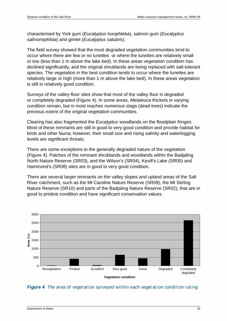
Riparian condition of the Salt River Water resource management series, no. WRM 46
Department of Water 33
characterised by York gum (Eucalyptus loxophleba), salmon gum (Eucalyptus salmonophloia) and gimlet (Eucalyptus salubris).
The field survey showed that the most degraded vegetation communities tend to occur where there are few or no lunettes or where the lunettes are relatively small or low (less than 1 m above the lake bed). In these areas vegetation condition has declined significantly, and the original shrublands are being replaced with salt-tolerant species. The vegetation in the best condition tends to occur where the lunettes are relatively large or high (more than 1 m above the lake bed). In these areas vegetation is still in relatively good condition.
Surveys of the valley-floor sites show that most of the valley floor is degraded or completely degraded (Figure 4). In some areas, Melaleuca thickets in varying condition remain, but in most reaches numerous stags (dead trees) indicate the previous extent of the original vegetation communities.
Clearing has also fragmented the Eucalyptus woodlands on the floodplain fringes. Most of these remnants are still in good to very good condition and provide habitat for birds and other fauna; however, their small size and rising salinity and waterlogging levels are significant threats.
There are some exceptions to the generally degraded nature of the vegetation (Figure 4). Patches of the remnant shrublands and woodlands within the Badjaling North Nature Reserve (SR03), and the Wilson’s (SR04), Kevill’s Lake (SR05) and Hammond’s (SR08) sites are in good to very good condition.
There are several larger remnants on the valley slopes and upland areas of the Salt River catchment, such as the Mt Caroline Nature Reserve (SR09), the Mt Stirling Nature Reserve (SR10) and parts of the Badjaling Nature Reserve (SR02), that are in good to pristine condition and have significant conservation values.
0
500
1000
1500
2000
2500
3000
Revegetation Pristine Excellent Very good Good Degraded Completelydegraded
Vegetation condition
Are
a(h
a)
Figure 4 The area of vegetation surveyed within each vegetation condition rating

Water resource management series, no. WRM 46 Riparian condition of the Salt River
34 Department of Water
5.2 Management issues
The management issues impacting on the Salt River that were identified from the site surveys are:
• increasing salinity and waterlogging in the valley floor• loss of riparian vegetation fringing the Salt River and its tributaries • management of flood flows• impedance of flood flows by road crossings• increased streamflow causing erosion and sedimentation in tributaries• pest species degrading riparian vegetation• lack of corridors linking areas of remnant vegetation• fire risk• dumping of rubbish in floodplain areas.
Management recommendations addressing these issues are detailed below. Many of these recommendations have multiple benefits. For example, revegetating and fencing tributaries of the Salt River will improve bank stability, reduce sedimentation, improve water quality and contribute to biodiversity conservation by facilitating the movement of flora and fauna through the landscape.
These management recommendations will be implemented through partnerships between waterways managers including the Department of Water, DEC, ACC, AWC, landholders, local shires and community groups, using a wide variety of funding sources.
5.3 Salinity and waterlogging
Increasing salinity levels and waterlogging are the most significant threats in the Salt River floodplain. Streamflow salinity in the Salt River is influenced by the salt loads from the Yilgarn and Lockhart rivers and tributaries, fresher seepage from sand lenses adjacent to the floodplain and saline seepage from rising groundwater beneath the valley floor.
Salinity, waterlogging and changes to the hydroperiod have already had an effect on vegetation condition and water quality, impacting on the ecological, economic and social values of the Salt River.
Research has shown that different approaches need to be taken for different types of salinity impacts, depending on catchment characteristics and the types of assets that are impacted – land, water, biodiversity or infrastructure. There is no ‘one-size-fits-all’ approach, and not all management strategies are suitable for all situations.
The following sections give a brief overview of some of the options for salinity management, including engineering works and revegetation. In the engineering options section, details are provided about two major programs: the Engineering

Riparian condition of the Salt River Water resource management series, no. WRM 46
Department of Water 35
Evaluation Initiative (EEI) and Wheatbelt Drainage Evaluation (WDE). Both programs are evaluating engineering options for the Wheatbelt, and findings from the programs may influence salinity management in the Salt River catchment.
5.3.1 Engineeringoptions
Increasing numbers of land managers are considering engineering works, including deep drainage, groundwater pumping and surface-water management, to reduce waterlogging problems and lower soil salinities.
There are widely differing opinions about the scale at which engineering options should be implemented. Some consider that all water should be retained ‘on-farm’ and others that significant arterial drainage networks, including deep drains and groundwater pumping, should be used for ocean discharge.
Pressure for widespread implementation of engineering options is matched by concerns about downstream impacts, particularly from regional arterial drainage schemes, on water quality, changes to the natural hydroperiod and increased flood risk, and their impacts on natural waterway values and built assets, such as roads.
It is within this context that the EEI and WDE programs were developed.
Engineering evaluation and implementation in the Wheatbelt
The EEI and the WDE aim to evaluate the suite of issues associated with implementing engineering solutions to salinity in the Wheatbelt. These programs are being delivered under the National Action Plan for Salinity and Water Quality (NAP) through partnerships between government departments, catchment groups, research bodies and regional NRM groups, including the ACC.
The EEI program (December 2002 to June 2007) aimed at finding and demonstrating better ways to implement engineering to tackle salinity without damaging the environment. It focused on the:
• engineering options, such as deep drainage, groundwater pumping and surface water management, at farm scale
• social, economic and environmental aspects of regional arterial drainage• downstream impacts of drainage and safe disposal options.
The WDE program (July 2005 to June 2008) is using learnings from EEI projects in the following four main implementation areas. It changes the focus from a science-based drainage evaluation under the EEI to a planning phase for drainage as part of broader catchment-water management:
• drainage management and governance, which will provide greater certainty to regional NRM groups, drainage proponents and the State Government as to how catchment – and regional – scale drainage projects should be implemented

Photo 12 Deep drain in the Salt River catchment
Water resource management series, no. WRM 46 Riparian condition of the Salt River
36 Department of Water
• regional drainage evaluation, which will provide a framework from which catchment – and farm – scale drainage can occur
• catchment feasibility studies, investigating drainage options for priority catchments including the Yenyening Lakes catchment
• wetland assessment, which involves the classification of potential receiving environments (Ruprecht et al. 2004).
Deep drainage
Deep drains collect and transport groundwater, and at times surface water, across the landscape to detention basins or into natural wetlands and waterways. They are typically used where the natural drainage system is unable to remove excess water and salt, and the resultant waterlogging and salinity significantly impact on agricultural production.
Groundwater pumping
Groundwater pumping can be an effective method of disposing of saline water. It is most effective in soils with lighter textures that drain water more freely and leach salts more quickly.

Riparian condition of the Salt River Water resource management series, no. WRM 46
Department of Water 37
Surface water management
Surface water management uses earthworks, such as grade and interceptor banks, shallow drainage channels and dams, to capture surface runoff and subsurface flow higher in the landscape, reducing recharge to valley floors. Harvested water is usually relatively fresh and can be used for farm water supply. Techniques such as modified tillage, use of perennial crops and revegetation can be used in conjunction with engineered structures to manage recharge.
Earthworks are used extensively in the Salt River catchment for surface-water management. Fresher flows are captured in dams for on-farm use, but significant amounts of saline surface water are directed into tributaries, such as South Yoting Creek, Hommajelly Gully and Warraling Creek, and into the Salt River. Due to low gradients and impedance of flows by road crossings, this excess surface water is likely to contribute to waterlogging problems in the valley floor.
5.3.2 Revegetation
Revegetation options for salinity management involve planting recharge and/or discharge areas. At a local scale, the re-introduction of perennials is effective in reducing groundwater recharge. However, there is less evidence that revegetation is an effective and economically viable strategy at a catchment scale, unless most or all of the catchment is revegetated. Using perennial plants to reduce recharge remains a challenge, and research efforts are focusing on developing new perennial options that are profitable in their own right as well as effective in impacting on watertable levels (Pannell & Ewing 2006; Ruprecht et al. 2004; Hatton 2002).
The overall aim of revegetation – to improve soil productivity and lower watertables – can be achieved in a number of ways. Planting local native species for salinity control on either recharge or discharge areas also has benefits for conservation and biodiversity. Planting species that can be harvested for timber or used as fodder crops can have economic benefits.
Perennial plants have benefits beyond recharge control. Depending on the species, they can play a vital role in controlling soil erosion, they can act as wind breaks to protect stock and crops and they can have biodiversity benefits. Revegetated landscapes also have improved aesthetics.
Biodiversity plantings
Planting local native species for conservation and biodiversity is discussed in Section 5.7.
Commercial plantings
There are a number of perennial species suitable for planting on Wheatbelt recharge areas including various Eucalyptus species, tagasaste (Chamaecytisus prolifer),

Water resource management series, no. WRM 46 Riparian condition of the Salt River
38 Department of Water
Acacia species, Melaleuca species and sandalwood (Santalum spicatum). All of these species have economic benefits, either from harvesting of wood or use as fodder.
Site conditions, such as waterlogging, salinity, fertility and acidity, largely determine species selection for discharge areas. Slightly to moderately saline sites are suitable for saltland pasture. Saltbush (Atriplex) and bluebush (Maireana) species are commonly planted for saltland pasture. Understorey plants such as puccinellia (Puccinellia ciliata) and tall wheat grass (Thinopyrum elongatum) have also successfully been introduced into saltland pastures to increase the nutritional value of the fodder (Pannell & Ewing 2006; Barrett-Lennard & Malcolm 1995). However, these grasses can become weeds very easily, and native grasses should be used where possible. Appendix 5 provides some details on species that may be suitable for the Salt River catchment.
Saltland pastures can provide valuable feed for maintaining stock condition during the feed gap in summer and autumn. The protein content varies between species but tends to be quite high (10–22 per cent). However, most species are relatively low in energy and high in salt, and higher quality forage also needs to be provided, either from supplementary feeding, access to crop stubbles in adjacent paddocks or the establishment of salt-tolerant understorey species (Pannell & Ewing 2006; Phelan 2004; Barrett-Lennard & Malcolm 1995).
5.3.3 Recommendationsforthemanagementofsalinityandwaterlogging
Salinity and waterlogging are processes that need to be managed at a catchment scale. Given this, and the fact that salinity management needs to be tailored for different salinity impacts, the following general management recommendations are proposed:
• the detention of surface water, water quality permitting, higher in the catchment to slow recharge to valley floors
• revegetation of tributaries to slow movement of surface water on to valley floors without increasing flood risk
• evaluation of commercial revegetation options, including agroforestry and saltland pasture
• identification of recharge areas, such as sand lenses, suitable for revegetation for local watertable control, with either local native or commercial species
• groundwater and surface water quality and quantity to continue to be monitored as part of Department of Water’s ongoing water quality monitoring programs.
Engineering options for the catchment are being evaluated as part of the Yenyening Catchment Engineering, Salinity and Water Management Feasibility Study.

Riparian condition of the Salt River Water resource management series, no. WRM 46
Department of Water 39
5.4 Flood management
Low gradients, braided, discontinuous channels and road crossings all contribute to slow flows through the Salt River, exacerbating widespread waterlogging problems across the floodplain.
Landholders are concerned about the impacts of large, saline flows and waterlogging on the productivity of floodplain areas and adjacent paddocks.
There are also some concerns that sediment and vegetation are blocking channels and causing localised ponding and flooding. Sediment slugs may be removed, provided that disturbance to the channel is minimised.
Logs and branches in waterways play an important role in providing habitat and protecting banks from erosion; in some circumstances logs and branches may be causing problems. Landholders who are planning to move any materials in waterways are encouraged to contact the Department of Water.
Large flood flows cannot be avoided; however, strategies may exist to reduce ponding in smaller events. The function of the floodplain for flood management needs to be maintained, but there may be opportunities to improve pipes and culverts at road crossings to reduce ponding or enhance floodways to improve flow continuity through the construction of shallow surface-water conveyance structures. Both these options would require detailed on-site assessment and full consideration of downstream flooding risk.
Road crossings are major control points for flood flows. There are eight road crossings across the Salt River floodplain: Quairading–Corrigin Rd, Solomon South Rd, Badjaling North Rd, Badjaling South Rd, Bruce Rock–Quairading Rd, Mt Stirling Rd, Kellerberrin–Yoting Rd and Glenluce Rd.
As well as physically impeding surface flows, subsurface compaction to create a stable road base interferes with subsurface flows, further contributing to ponding problems.
Bruce-Rock–Quairading Rd is a major road, and a substantial bridge crosses the main channel. The floodplain is relatively narrow at this point (approximately 100 m) and the crossing is unlikely to contribute to localised flooding in normal flow events. A culvert conducts flows from a secondary channel.
The Quairading–Corrigin Rd is another major road crossing. The floodplain is approximately 2.5 km wide at this point and has 3 culverts, one on the main channel and two on smaller channels. Roads such as Glenluce and Mt Stirling have culverts or pipes to carry low to moderate flows, with larger flows flooding over the road in most years. Even during normal years these roads cause ponding problems, are exacerbated in larger events, such as the flood of 2000.

Water resource management series, no. WRM 46 Riparian condition of the Salt River
40 Department of Water
Photo 13 Water from Tropical Cyclone Clare ponding behind the Kellerberrin–Yoting Rd crossing
The Badjaling South Rd crossing is another crossing associated with flooding problems. The two small culverts under the road cannot cope with the volume of flow through the drain. Additionally the channel and floodplain of the drain close to the road crossing are choked with sediment and vegetation, including samphire (Halosarcia species) and sharp rush (Juncus acutus), further impeding flows. Low gradients also contribute to the problem.
Flows backing up from the crossing flood local roads and the Badjaling Aboriginal Community almost every year. Shrublands and woodlands surrounding the community and within the adjacent Badjaling Nature Reserve are also being affected. Periodic inundation has killed the original vegetation and it has been replaced with sharp rush (Juncus acutus) and samphire (Halosarcia) species.
Options for improving flow continuity during small to medium flood events include upgrading culverts and pipes. However, even in large flood events, some roads will still act to impede flows. It may be possible to modify some roads so that they act as causeways, with small to medium flows conducted through pipes or culverts and larger flows flooding over the road.
Relocation of roads has been considered in other Wheatbelt catchments, such as the Lake Bryde Recovery Catchment. However this is very costly and would result in access problems. This option would only be worth considering to protect high-value assets.

Riparian condition of the Salt River Water resource management series, no. WRM 46
Department of Water 41
5.4.1 Recommendationsforthemanagementoffloodflows
It is the nature of waterways in the zone of ancient drainage to retain water in the braided valley floors; however, road crossings contribute significantly to localised flooding. The recommendations proposed for flood management are:
• evaluation of road crossings in terms of flood risk
• analysis of the costs and benefits associated with upgrading pipes and culverts to increase conveyance through road crossings and thus forestall significant flooding problems.
5.5 Tributaries
Tributaries in the Salt River catchment start higher in the landscape as depressions and salt scalds and become more incised down the long valley slopes.
All of the major tributaries have gradients that far exceed that of the Salt River (Table 4). When tributaries reach the broad, flat floodplain they tend to spread out through shallow undefined channels causing localised ponding.
Most tributaries are linked to networks of contour or grade banks and some have been modified to carry saline surface flows away more quickly. In some cases alternative channels have been cut to define the confluence with the Salt River and reduce localised flooding.
Reaches of some tributaries, such as South Yoting Creek, have been fenced and revegetated; however, most are unfenced and have little or no fringing vegetation.
Table4 GradientsforselectedtributariesoftheSaltRiver*
Tributary name Relief (m AHD)
Length (km)
Gradient (m/km)
South Yoting Creek 220–260 30.0 1.3
Unnamed – ‘Badjaling’ 220–290 13.0 5.4
Warraling Creek 220–250 8.5 3.5
Dorakin Gully** 230–280 13.5 3.7
Conallan Gully** 250–260 7.0 1.3
Hommajelly Gully 220–250 14.5 1.4
Salt River – – 0.261–0.352
* Gradients are for the main channel of each tributary, which has been defined as the third order stream channel
** Dorakin and Connallan gullies are tributaries of Warraling Creek 1 Robin Smith, Department of Water, pers. comm.2 Beard (1999) and Salama (1997)
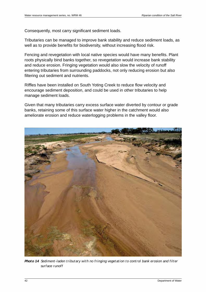
Water resource management series, no. WRM 46 Riparian condition of the Salt River
42 Department of Water
Consequently, most carry significant sediment loads.
Tributaries can be managed to improve bank stability and reduce sediment loads, as well as to provide benefits for biodiversity, without increasing flood risk.
Fencing and revegetation with local native species would have many benefits. Plant roots physically bind banks together, so revegetation would increase bank stability and reduce erosion. Fringing vegetation would also slow the velocity of runoff entering tributaries from surrounding paddocks, not only reducing erosion but also filtering out sediment and nutrients.
Riffles have been installed on South Yoting Creek to reduce flow velocity and encourage sediment deposition, and could be used in other tributaries to help manage sediment loads.
Given that many tributaries carry excess surface water diverted by contour or grade banks, retaining some of this surface water higher in the catchment would also ameliorate erosion and reduce waterlogging problems in the valley floor.
Photo 14 Sediment-laden tributary with no fringing vegetation to control bank erosion and filter surface runoff

Riparian condition of the Salt River Water resource management series, no. WRM 46
Department of Water 43
5.5.1 Recommendationsfortributarymanagement
To reduce erosion and sedimentation problems and increase the value of tributaries as landscape links between areas of remnant vegetation, the following recommendations are proposed:
• revegetation of the riparian zones of tributaries with local native species to provide corridors linking areas of remnant vegetation higher in the landscape with riparian areas
• improvement of bank stability to reduce bank erosion and sedimentation, through revegetation with local native species
• fencing of revegetated areas to control stock access
• installation of riffles, where appropriate, to reduce flow velocity and trap sediments before they reach the floodplain.
5.6 Management of remnant vegetation
As is the case in much of the Wheatbelt, remnant vegetation in the Salt River catchment is highly fragmented and remains in patches of varying size, shape and condition on both private and public lands.
Riparian vegetation fringing the Salt River and its tributaries has been significantly altered by the combined effects of land clearing, salinity and waterlogging. In many areas of the floodplain the original Melaleuca and Leptospermum shrublands have been replaced with samphire (Halosarcia) and saltbush (Atriplex) species. Remnant Melaleuca shrublands and Eucalyptus woodlands are under threat from waterlogging, rising salinity levels, fragmentation and weed invasion.
In some areas, the remaining riparian vegetation is closely linked to large areas of good-quality, protected remnant vegetation. The patches of Eucalyptus woodland and Melaleuca shrubland on Hammond’s property, adjacent to Gardiner Rd, have good links to other areas of remnant vegetation such as the Mt Caroline and Mt Stirling nature reserves. In other areas, the links are more fragmented due to the altered nature of the riparian vegetation and lack of vegetation along tributaries and road reserves.
There has been much debate over whether a single large area of remnant vegetation has more value for conservation and biodiversity than several small areas. In general, larger remnants are likely to contain more species than smaller remnants, tend to be more resilient in terms of recovery following disturbances, such as fires and floods, and are better able to maintain ecological functions such as nutrient cycling. Larger remnants are also more resistant to edge effects, such as weed invasion.

Water resource management series, no. WRM 46 Riparian condition of the Salt River
44 Department of Water
However, the number of species also depends on the variety of habitat within each remnant. Because of the high level of species diversity in the Wheatbelt, small remnants can have high conservation values. In our highly fragmented landscape, all remnant vegetation, from isolated paddock trees to large nature reserves, has some conservation value.
Connectivity between remnants is very important to allow species to disperse across the landscape. All of the survey sites have protected remnants within a radius of 10 km; however, in most areas there is little linkage between them, via either ‘stepping stones’ or corridors, such as road reserves. The Salt River itself is not a significant corridor, due to clearing and degradation of the riparian vegetation. There are, however, some exceptions, with remnant vegetation in good condition linking Hammond’s (study site SR8) with both Mt Caroline Nature Reserve ( study site SR9) and Crown Reserve 11024 (study site SR7). Badjaling Nature Reserve (study site SR2) and Badjaling North Nature Reserve (study site SR3) are also linked.
Remnant vegetation within Crown reserves vested for conservation is protected; however, where good-quality remnant vegetation remains on private land it needs to be protected and, if possible, linked to nearby remnants. Examples in the Salt River study area include the salmon gum (Eucalyptus salmonophloia) and gimlet (Eucalyptus salubris) woodland adjacent to Gardiner Road on the Hammonds’ property (study site SR8), the vegetation communities associated with Kevill’s Lake (study site SR5) and those growing on groundwater seeps at the base of the sandhills on the Parkers’ property (study site SR1). These vegetation communities are regarded as endangered, with less than 10 per cent of the pre-European extent remaining (Department of Natural Resources and Environment 2002).
5.6.1 Recommendationsforremnantvegetationmanagement
To manage remnant vegetation, including riparian vegetation, and improve landscape linkages to facilitate the movement of fauna and flora in the Salt River catchment, the following recommendations are proposed:
• fence remnant vegetation to exclude stock and allow natural regeneration
• control priority pest species
• identify areas on private land that can be revegetated to create or strengthen links between good quality remnants
• investigate reconstruction of landscape links on public lands such as road reserves.

Riparian condition of the Salt River Water resource management series, no. WRM 46
Department of Water 45
5.7 Riparian revegetation
Revegetating floodplain areas with local native species has a number of benefits including:
• localised salinity control
• conservation and biodiversity benefits
• filtering of nutrients and sediment from surface runoff
• improved aesthetics.
Revegetation projects, whether large or small, need to be practical and realistic in terms of both establishment and maintenance especially in altered landscapes. Rising groundwater and salinity levels, declining water quality and changes to the natural hydroperiod mean that some local native species may not be suitable for revegetation in some areas. Plant species selected for revegetation projects need to be suited to the current site conditions.
Some factors to take into consideration when planning revegetation could include the objectives of the revegetation project, position of the site in the landscape, soil condition, water quality and weed species and cover as well as budget.
Appendix 6 lists some species considered suitable for revegetation projects in the Salt River catchment. The list includes species found during the survey and those known to be local native species suited to saline waterways.
5.7.1 Recommendationsforriparianrevegetation
To create or strengthen links with good-quality riparian and bushland remnants, the following recommendations are proposed:
• investigate riparian areas to be revegetated with local native species
• fence areas of good quality riparian vegetation to exclude stock and promote natural regeneration
• fence revegetated areas to exclude stock.

Water resource management series, no. WRM 46 Riparian condition of the Salt River
46 Department of Water
5.8 Fencing and stock access
In some areas, stock have access to the Salt River floodplain for several months of the year during the summer and autumn feed gaps to graze on saltbush in conjunction with stubble from surrounding paddocks. On the whole, stock impacts on the river and its floodplain are minimal, although, in areas where remnant woodlands and shrublands remain, stock are likely to be impacting on natural regeneration.
5.8.1 Recommendationsforfencing
The following recommendations are proposed:
• good quality remnant vegetation to be fenced to exclude stock and to allow natural regeneration
• revegetation to be fenced to exclude stock
• tributaries to be fenced to exclude stock and improve bank stability.
5.9 Pest species
Introduced plant species and signs of feral animals were noted at all of the survey sites. A total of 32 introduced plant species and 3 fauna species were identified. Common weeds include sharp rush (Juncus acutus), puccinellia (Puccinellia ciliata), wild oats (Fatua avena) and barley grass (Hordeum leporinum). The floodplain area is too salty and waterlogged for many weed species, and sharp rush and puccinellia are the only weeds seen during the survey that could cause significant problems. Both have the potential to spread and suppress natural regeneration. In the nature reserves and woodland areas on the edge of the floodplain a variety of agricultural weeds are invading the understorey, suppressing natural regeneration in some areas.
Rabbits (Oryctolagus cuniculus) and foxes (Vulpes vulpes) are very common pest species in the Wheatbelt, and signs of both were seen in almost all survey sites. Regular fox baiting is carried out within Mt Caroline Nature Reserve.
While native to the area, kangaroos (Macropus species) are also of concern as they can damage crops, fences and native vegetation. Kangaroos can be managed under certain circumstances. More information is available from the DEC’s Merredin office on (08) 9041 2488 or (08) 9041 2408.
A full list of the introduced flora and fauna species identified during the survey is detailed in Appendix 4. This list is not complete, and it is highly likely that species are present in the local area that were not recorded.

Riparian condition of the Salt River Water resource management series, no. WRM 46
Department of Water 47
5.9.1 Recommendationsforthemanagementofpestspecies
The following recommendations for the management of pest species are proposed:
• the occurrence of priority pest species to be mapped to identify priority areas for their control
• pressure from rabbit (Oryctolagus cuniculus) grazing on private and public lands to be managed through a coordinated baiting program
• local kangaroo (Macropus species) population to be managed to reduce grazing pressure on native vegetation, crops and pastures
• eradication techniques for sharp rush (Juncus acutus) to be trialled, their effectiveness to be monitored and the results to be communicated to landholders.
5.10 Flora and fauna
The landscape within the Salt River catchment is highly fragmented, with only a few large areas of remnant vegetation remaining, including Badjaling, Mt Stirling, Mt Caroline and Charles Gardner nature reserves and the bushland area surrounding Quairading.
There is a high diversity of species within this remnant vegetation. A total of 164 native plant species were identified during the surveys. The remaining remnant vegetation also provides habitat for fauna, including black-flanked rock-wallaby (Petrogale lateralis) and echidna (Tachyglossus aculeatus), both of which were seen during the surveys, as well as a number of bird species.
During the surveys there was a focus on identifying bird species rather than other types of fauna, such as mammals, as birds are generally easier to find and identify.
Up to 60 per cent of Wheatbelt bird species are in decline, in either range and/or abundance, including species such as the scarlet robin (Petroica boodang), grey shrike thrush (Colluricincla harmonica) and white-browed babbler (Pomatostomus temporalis), which only occur in largely intact remnants. The yellow plumed honeyeater (Lichenostomus ornatus), once the most common woodland honeyeater in Western Australia, has almost disappeared from the Wheatbelt. Many wetland species have also been affected, and the ranges of both the Australasian bittern (Botaurus poiciloptilus) and purple swamphen (Porphyrio porphyrio) have contracted. Other species, such as the Australian ringneck (Barnardius zonarius) and Australian raven (Corvus coronoides), have benefited from land clearing and increased in numbers while some, such as the galah (Eolophus roseicapilla) and crested pigeon (Ocyphaps lophotes), have extended their range into the Wheatbelt from the more open areas to the north (Birds Australia 2005).

Water resource management series, no. WRM 46 Riparian condition of the Salt River
48 Department of Water
A total of 41 bird species were identified during the surveys. The most common species are the Australian ringneck (Barnardius zonarius), commonly known as the twenty-eight parrot, Australian raven (Corvus coronoides), yellow-throated miner (Manorina flavigula) and galah (Eolophus roseicapilla). These are all species whose main habitat is in farmland areas.
Several priority and remnant-dependent species were identified during the surveys. Priority species are those that have been identified as being at threat of local extinction if remnant vegetation is lost or degraded, and include the rufous whistler (Pachycephala rufiventris) and red-capped robin (Petroica goodenovii). Remnant-dependent species are those likely to decline in number if remnant vegetation is lost or degrades, and include yellow-rumped thornbill (Acanthiza chrysorrhoa), white-browed babbler (Pomatostomus temporalis) and western gerygone (Gerygone fusca) (GAWA 2004). In broad terms, the presence of these species indicates that remaining remnant vegetation, including bushland and riparian vegetation, is important on both local and regional scales for bird habitat.
A full list of the flora and fauna species identified during the survey is detailed in Appendix 4. This list is not complete, and it is highly likely that species are present in the local area that were not recorded.
5.10.1 Recommendationsforfloraandfaunaconservation
The following recommendations for the conservation of flora and fauna are proposed:
• identification of priority areas, on both private and public lands, for the reconstruction of landscape links between areas of remnant vegetation
• revegetation for fauna and flora conservation to include local native middlestorey and understorey species
• retention of fallen logs and branches within remnants to provide fauna habitat, especially for birds and reptiles
• eradication of introduced plant species, particularly sharp rush (Juncus acutus), and their replacement with local native species.
5.11 Fire risk
Fire risk in the floodplain area itself is relatively low, as most areas are dominated by samphire (Halosarcia species) flats. Fire risk is much more significant in areas such as the Badjaling, Mt Caroline and Mt Stirling nature reserves. The DEC maintains fire breaks and fire access tracks on DEC-managed lands adjacent to private property (Department of Conservation and Land Management 2005). The main threat is from stubble fires on farmland. In most areas, access to the floodplain area for fire-fighting is relatively good and, due to a lack of fringing vegetation, fires would be relatively easy to contain.

Riparian condition of the Salt River Water resource management series, no. WRM 46
Department of Water 49
5.12 Rubbish
During the survey, several rubbish dumps were identified within the Salt River floodplain, including old fencing materials and household rubbish. Rubbish in river environments is unsightly; however, most materials do not pose a significant threat. Dumping of chemicals and oils, and the containers used to store them, does pose a threat to the river environment and should be avoided.
5.12.1Adviceforrubbishmanagement
Under Western Australia’s Litter Act 1979, dumping of rubbish on crown lands, such as road reserves, council lands and nature reserves, is illegal and can be reported to a local shire or DEC office.
Clean empty containers used to store crop production, and on-farm animal-health chemicals, can be disposed of through the drumMUSTER program. For more details, including collection points and the date of the next scheduled collection, contact your local shire:
• Shire of Quairading on (08) 9645 1001• Shire of Kellerberrin on (08) 9045 4006• Shire of Tammin on (08) 9637 1101.

Water resource management series, no. WRM 46 Riparian condition of the Salt River
50 Department of Water
6 Glossary
Acid(ic) See pH.
Alkaline See pH.
Alluvial Transported by water flow processes, for example ‘alluvial plain’.
Alluvium Sediment deposited by flowing water.
Aquifer A layer of rock or soil capable of receiving, storing and transmitting quantities of water.
Catchment The area of land that intercepts rainfall and contributes the collected water to a common point through surface and groundwater.
Confluence A flowing together or intermingling, for example where a tributary joins the main channel.
Discharge Volumetric outflow rate of water, typically measured in cubic metres per second. Applies to both groundwater and surface water.
Discharge area or zone An area where groundwater discharges to the surface.
Ecosystem A biological community of interacting organisms and their physical environment.
Floodplain A broad, flat, low-lying area of land within the valley floor that is inundated during a 100-year flood. Includes the floodfringe and floodway.
Flood – 100 year The 100-year flood has a statistical probability of occurring, on average, once every 100 years. The 100-year flood level is the contour to which this flood will rise.
Floodfringe The area of the floodplain, outside of the floodway, that is affected by flooding.
Floodway The river channel and portion of the floodplain that forms the main flow path for flood waters once the main channel has overflowed.
Geomorphology The study of the origin, characteristics and development of landforms.
Gigalitre (GL) 1 000 000 000 litres or 1 million cubic metres or 1 million kilolitres (kL).
Groundwater Water that occupies the pores and crevices of rock or soil.

Riparian condition of the Salt River Water resource management series, no. WRM 46
Department of Water 51
Hydrology The study of water, its properties, distribution and utilisation, on and below the earth’s surface.
Kilolitre (kL) 1000 litres or one cubic metre.
Kilotonne (kt) 1 000 000 kilograms or 1000 tonnes.
Macroinvertebrates Aquatic invertebrates (animals without backbones) that are retained on a 0.25 mm mesh net and therefore big enough to be seen with the naked eye.
Natural resource management
The ecologically sustainable management of the land, water, air and biodiversity resources for the benefit of existing and future generations.
Nutrient load The amount of nutrient (usually nitrogen and/or phosphorus) reaching a waterway over a given time period from its catchment area.
pH The concentration of hydrogen ions in solution indicating the acidity or alkalinity. A pH value of 7 is neutral, above 7 is alkaline and below 7 is acidic.
Recharge Volumetric inflow rate of water to an aquifer, typically measured in cubic metres per second.
Recharge area or zone An area through which water percolates to replenish (recharge) an aquifer. Unconfined aquifers are recharged through rainfall. Confined aquifers are recharged in specific areas where water leaks from overlying aquifers, or where the aquifer rises to meet the surface.
Remnant vegetation An area of vegetation remaining after a major disturbance such as land clearing.
Riparian zone An area including the floodplain and adjacent verge. The width of the riparian zone varies greatly, from tens of metres to kilometres, depending on the type of waterway and its catchment.
Riparian vegetation Vegetation growing within the riparian zone.
River basin The area drained by a waterway and its tributaries (see Catchment).
Runoff Water that flows over the soil surface when rainfall is greater than the infiltration capacity of the soil. Flow in waterways results from rainfall runoff.

Water resource management series, no. WRM 46 Riparian condition of the Salt River
52 Department of Water
Salinity A measure of the total soluble (dissolved) salts in water. Commonly measured in terms of total dissolved solids (TDS), in milligrams per litre (mg/L), or electrical conductivity, in millisiemens per metre (mS/m) or millisiemens per centimetre (mS/cm). Water resources are classified as fresh, marginal, brackish or saline on the basis of salinity. Refer to Appendix 1 for a salinity classification in relation to sea water.
Salinisation An increase in the concentration of soluble salts in soil or water.
Sediment load The amount of sediment reaching a waterway from its catchment area over a given time period. Also refers to the amount of sediment being transported by a waterway.
Surface water Water flowing or held in waterways.
Tributary A waterway that flows into a larger waterway.
Verge Upland area adjacent to the floodplain.
Water quality The physical, chemical and biological measures of water.
Waterlogging Excess water close to the soil surface.
Watertable Saturated level of unconfined groundwater. Wetlands in low-lying areas may be surface expressions of groundwater.
Waterway Surface water bodies, including streams, rivers, lakes, wetlands, estuaries, coastal lagoons and inlets. Can be seasonally or permanently inundated.

Riparian condition of the Salt River Water resource management series, no. WRM 46
Department of Water 53
7 References
Australian Bureau of Meteorology 2006, Western Australian Climate Averages, Australian Bureau of Meteorology, Canberra, viewed May 2006 <www.bom.gov.au/weather/wa>.
Avon Catchment Council 2005a, The Avon NRM Strategy: The Regional Natural Resource Management Strategy for the Avon River Basin, Avon Catchment Council, Northam.
Avon Catchment Council 2005b, Avon Investment Plan 2005–2006, Avon Catchment Council, Northam.
Ballardong NRM Working Group 2006, Draft Ballardong Noongar Budjar: ‘Healthy Country – Healthy People’, supporting document to the Avon NRM Strategy, Ballardong NRM Working Group, Northam.
Bamford, M. 1995, Exploring Wheatbelt Woodlands, Department of Conservation and Land Management, Perth.
Barrett-Lennard, E.G. & Malcolm, C.V. 1995, Saltland Pastures in Australia – A Practical Guide, Bulletin 4312, Western Australia Department of Agriculture, Perth.
Beard, J.S. 1980, The Vegetation of the Kellerberrin Area, Western Australia: Map and Explanatory Memoir 1:250 000 series, Vegetation Survey of Western Australia, Vegmap Publications, Perth.
Beard, J.S. 1999, ‘Evolution of the river systems of the south-west drainage division, Western Australia’, Journal of the Royal Society of Western Australia, vol. 82, pp. 147–164.
Birds Australia 2005, ‘The state of Australia’s birds: Woodlands and birds’, supplement to Wingspan, vol. 15, no. 4, Birds Australia, Melbourne.
Brierley, G.J. & Fryirs, K. 2000, ‘River styles: a geomorphic approach to catchment characterization: implications for river rehabilitation in the Bega catchment, New South Wales, Australia’, Environmental Management, vol. 25, no. 6, pp. 661–679.
Butler, R. 2001, Native Perennial Grass Based Pastures for Livestock, Department of Agriculture Farmnote 43/2001, Department of Agriculture Western Australia, Perth.
Coleman, M. 2003, ‘Saline discharges into natural wetlands in Western Australia: Preliminary review of issues and options’, prepared for the Department of Environmental Protection by Actis Environmental Services, Mundijong.

Water resource management series, no. WRM 46 Riparian condition of the Salt River
54 Department of Water
Commander, P., Schoknecht, N., Verboom, W. & Casetta, P. 2001, ‘The geology, physiography and soils of Wheatbelt valleys’, Conference Papers from Dealing with Salinity in Wheatbelt Valleys: Processes, Prospects and Practical Options, ed Viv Read and Associates, pp. 1–39, State Salinity Council, Perth and Avon Working Group, Northam.
Davis, J.A. 2004, ‘Valleys of salt, channels of water, pools of life – environmental aspects of salinity engineering’, 1st National Salinity Engineering Conference Proceedings, ed S. Dogramaci & A. Waterhouse, Institution of Engineers, Australia, Canberra.
Davis, J.A., McGuire, M., Halse, S.A., Hamilton, D., Horwitz, P., McComb, A.J., Froend, R.H., Lyons, M., & Sim, L. 2003, ‘What happens when you add salt: predicting impacts of secondary salinisation on shallow aquatic ecosystems by using an alternative-states model’, Australian Journal of Botany, vol. 51, pp. 715–724.
Department of Conservation and Land Management 2005, ‘Good neighbour policy’ (draft), Department of Conservation and Land Management, Perth.
Department of Conservation and Land Management 2006, FloraBase – the Western Australia Flora, Department of Conservation and Land Management, Perth, viewed May 2006 <florabase.calm.wa.gov.au>.
Department of Fisheries 2007, Aquaculture Species Salinity Calculator, Department of Fisheries, Perth, viewed January 2007 <www.fisheries.wa.gov.au>.
Department of Natural Resources and Environment 2002, Biodiversity Action Planning: Action Planning for Native Biodiversity at Multiple Scales – Catchment Bioregional, Landscape, Local, Victorian Department of Natural Resources and Environment, Melbourne.
Department of Sustainability and Environment 2004, Index of Stream Condition: The Second Benchmark of Victorian Stream Condition, Victorian Department of Sustainability and Environment, Melbourne.
Fitzpatrick, R.W., Baker, A.K.M, Raven, M., Rogers, S., Degens, B., George, R. & Kirby, J. 2005, ‘Mineralogy, biogeochemistry, hydro-pedology and risks of sediments, salt efflorescences and soils in open drains in the Wheatbelt of Western Australia’, Regolith 2005 – Ten Years of CRC LEME, CRC for Landscape Environments and Mineral Exploration, Perth.
Gray, D. 2001, ‘Hydrogeochemistry in the Yilgarn Craton’, Geochemistry, Exploration, Environment, Analysis, vol. 1, pp. 253–264.
Greening Australia Western Australia 2004, Birds of the Central Wheatbelt rev ed, Greening Australia Western Australia, Perth.

Riparian condition of the Salt River Water resource management series, no. WRM 46
Department of Water 55
Halse, S.A., Lyons, M.N. , Pinder, A.M. & Shiel, R.J. 2004, ‘Biodiversity patterns and their conservation in wetlands of the Western Australian Wheatbelt’, Records of the Western Australian Museum, Supplement No 67, pp. 337–364.
Halse, S.A., Ruprecht, J.K. & Pinder, A.M. 2003, ‘Salinisation and prospects for biodiversity in rivers and wetlands of south-west Western Australia’, Australian Journal of Botany, vol. 51, pp. 673–688.
Hatton, T.J. 2002, Engineering Our Way Forward Through Australia’s Salinity Challenge, CSIRO Land and Water Technical Report 4/02, CSIRO Land and Water, Perth.
Hatton, T.J., Ruprecht, J. & George, R.J. 2003, ‘Preclearing hydrology of the Western Australian Wheatbelt: Target for the future?’, Plant and Soil, vol. 257, pp. 341–356.
Hopkins, A.J.M., Beeston, G.R. & Harvey, J.M. 2001, A Database on the Vegetation of Western Australia, Stage 1, CALMScience, Western Australia.
Jansen, A., Robertson, A., Thompson, L. & Wilson, A. 2005, Rapid Appraisal of Riparian Condition, version 2, River Management Technical Guideline No 4A, Land and Water Australia, Canberra.
Keighery, B. 1994. Bushland Plant Survey: A Guide to Plant Community Survey for the Community. Wildflower Society of Western Australia, Perth.
Lantzke, N. 1992, Soils of the Northam Advisory District: The zone of ancient drainage, Bulletin No. 4244, Western Australia Department of Agriculture, Perth.
Lefroy, E.C., Hobbs, R.J. & Atkins, L.J. 1991, Revegetation guide to the central Wheatbelt. Bulletin No 4231, Western Australia Department of Agriculture, Perth.
Mayer, X., Ruprecht, J. & Bari, M. 2005, Stream Salinity Status and Trends in South-west Western Australia, Salinity and Land Use Impacts Series Report No. SLUI 38, Department of Environment, Perth.
Mitchell, A.A. & Wilcox, D.G. 1994, Arid Shrubland Plants of Western Australia, University of Western Australia Press and Western Australia Department of Agriculture, Perth.
Neville, J. 2005, ‘Australian approaches to waterway assessment’ (draft), OnlyOnePlanet Australia.
Oversby, B. 2004, Riparian Plants of the Avon Catchment: A Field Guide, Department of Environment, Perth.
Pannell, D.J. & Ewing, M.A. 2006, Managing Secondary Dryland Salinity: Options and Challenges, CRC for Plant-Based Management and Salinity, University of Western Australia, Perth.

Water resource management series, no. WRM 46 Riparian condition of the Salt River
56 Department of Water
Parsons, M., Thoms, M. & Norris, R. 2002, Australia River Assessment System: Review of Physical River Assessment Systems – A Biological Perspective, Monitoring River Health Initiative, Technical Report No. 21, Environment Australia, Canberra.
Pen, L. & Scott, M. 1995, Stream Foreshore Assessment in Farming Areas, Blackwood Catchment Coordinating Group, Boyup Brook.
Phelan, S. 2004, Saltland pastures for the south-eastern Wheatbelt, Department of Agriculture Farmnote No. 74/2004, Western Australia Department of Agriculture, Perth.
Pinder, A.M., Halse, S.A., McRae, J.M. & Shiel, R.J. 2005, ‘Occurrence of aquatic invertebrates of the Wheatbelt region of Western Australia in relation to salinity’, Hydrobiologia, vol. 543, pp. 1–24.
Rogers, S. & George, R. 2005, ‘WA Wheatbelt drainage – acidic groundwater, not just a salt issue’, Focus on Salt, vol. 33, pp. 8–9.
Runciman, H.V. & Malcolm, C.V. 1989, Forage Shrubs and Grasses for Revegetating Saltland, Bulletin No. 4153, Department of Agriculture, Perth.
Ruprecht, J.K, Ali, R. & Hatton, T. 2004, ‘Regional drainage evaluation – Avon River Basin’, 1st National Salinity Engineering Conference Proceedings, ed S. Dogramaci & A. Waterhouse, Institution of Engineers, Australia, Canberra.
Salama, R.B. 1997, ‘Geomorphology, geology and palaeohydrology of the broad alluvial valleys of the Salt River System, Western Australia’, Australia Journal of Earth Sciences, vol. 44, pp. 751–765.
Sanders, A. 1991, Oral Histories Documenting Changes in Wheatbelt Wetlands, Department of Conservation and Land Management, Perth.
Shepherd, D., Beeston, G. & Hopkins, A. 2002, Native Vegetation Extent in Western Australia, Technical Report 249, Western Australia Department of Agriculture, Perth.
Strehlow, K., Davis, J., Sim, L., Chambers, J., Halse, S., Hamilton, D., Horwitz, P., McComb, A. & Froend, R. 2005, ‘Temporal changes between ecological regimes in a range of primary and secondary salinised wetlands’, Hydrobiologia, vol. 552, pp. 17–31.
Swan River Trust 1999, Swan-Canning Cleanup Program Action Plan: An Action Plan to Clean Up the Swan-Canning Rivers and Estuary, Swan River Trust and Water and Rivers Commission, Perth.
Timms, B.V. 2005, ‘Salt lakes in Australia: present problems and prognosis for the future’, Hydrobiologia, vol. 552, pp. 1–15.

Riparian condition of the Salt River Water resource management series, no. WRM 46
Department of Water 57
Water and Rivers Commission 2002, Yenyening Lakes Management Strategy 2002–2012, Water Resource Management Series, No. WRM 32, Water and Rivers Commission, Perth.
Weaving, S. 1997, ‘Remnant vegetation and natural resources of the Lower Avon and Upper Hotham catchment: an atlas’, Agriculture Western Australia, Perth.
Weaving, S. & Grein, S. 1994, Native Vegetation Handbook for the Shire of Kellerberrin, Western Australian Department of Agriculture, Perth.
Wildflower Society of Western Australia 2003, A Vegetation Survey of Yenyening Lakes Nature Reserve and Adjoining Vegetation, Wildflower Society of Western Australia, Perth.
Yenyening Lakes Management Group 1996, Management Strategy for the Yenyening Lakes and Adjoining Area, Yenyening Lakes Management Group, Brookton.

Water resource management series, no. WRM 46 Riparian condition of the Salt River
58 Department of Water
Appendix 1: Water quality data for Kwolyn Hill and Gairdners Crossing gauging stations
TotalnitrogenandtotalphosphorusconcentrationsattheDepartmentofWater’sKwolynHillgaugingstation615012ontheLockhartRiver
Date collected Total N (mg/L) Classification Total P (mg/L) Classification*27 July 1994 – – 0.5 Very high/Extreme10 June 1997 1.5 Moderate 0.0 Low22 July 1997 3.1 Very high 0.0 Low26 August 1997 2.9 High 0.0 Low3 September 1998 0.2 Low 0.0 Low22 March 1999 2.0 Moderate/High 0.0 Low20 May 1999 0.8 Low 0.0 Low21 July 1999 2.0 Moderate/High 0.0 Low22 September 1999 1.3 Moderate 0.0 Low24 January 2000 4.4 Extreme 0.2 Moderate/High10 February 2000 1.9 Moderate 0.1 Low/Moderate9 March 2000 2.5 High 0.1 Low/Moderate30 March 2000 2.3 High 0.1 Low/Moderate5 April 2000 2.4 High 0.0 Low23 January 2001 3.3 Very high 0.0 Low23 February 2001 2.6 High 0.0 Low31 July 2001 1.7 Moderate 0.1 Low/Moderate18 February 2003 2.5 High 0.3 High/Very high2 August 2004 2.0 Moderate/High 0.1 Low/Moderate15 August 2005 3.3 Very high 0.0 Low31 January 2006 0.6 Low 0.0 Low
* Refer to nutrient classification table below
TotalnitrogenandtotalphosphorusconcentrationsatDepartmentofWater’sGairdnersCrossinggaugingstation615015ontheYilgarnRiver
Date collected Total N (mg/L) Classification Total P (mg/L) Classification*24 September 1996 1.1 Moderate 0.1 Low/Moderate3 September 1998 1.6 Moderate 0.1 Low/Moderate22 March 1999 0.7 Low 0.1 Low/Moderate20 May 1999 1.3 Moderate 0.1 Low/Moderate20 July 1999 2.4 High 0.0 Low24 January 2000 3.7 Very high 0.1 Low/Moderate31 July 2001 0.5 Low 0.0 Low18 February 2003 1.8 Moderate 0.1 Low/Moderate2 August 2004 1.2 Moderate 0.1 Low/Moderate30 January 2006 0.7 Low 0.1 Low/Moderate
* Refer to nutrient classification table below

Riparian condition of the Salt River Water resource management series, no. WRM 46
Department of Water 59
Nutrientclassification(adapted from Swan River Trust 1999)
Classification Total nitrogen concentration (mg/L)
Total phosphorus concentration (mg/L)
Extreme > 4 > 0.5Very high 3 – 4 0.3 – 0.5High 2 – 3 0.2 – 0.3Moderate 1 – 2 0.1 – 0.2Low < 1 < 0.1
Salinityclassificationwithacomparisontoseawater(adapted from Mayer et al. 2005 and Department of Fisheries 2007)
Classification mg/L mS/m mS/cm grains/gallonFresh 0 – 500 0 – 91 0.0 – 0.9 0 – 35Marginal 500 – 1000 91 – 182 0.9 – 1.8 35 – 70Brackish 1 000 – 2 000 182 – 364 1.8 – 3.6 70 – 140Moderately saline 2 000 – 5 000 364 – 909 3.6 – 9.1 140 – 350Saline 5 000 – 10 000 909 – 1818 9.1 – 18.2 350 – 700Highly saline 10 000 – 35 000 1818 – 6363 18.2 – 63.6 700 – 2450Brine > 35 000 > 6 363 > 63.6 > 2 450
SummaryofwaterqualityandstreamflowdataforDepartmentofWater’sKwolynHillgaugingstation615012ontheLockhartRiver
Variable Unit Min. Max. Average No. of readings
First reading
Last reading
Acidity (CaCO3) mg/L 6.8 320.0 163.4 2 24 Jan 00 15 Aug 05Acidity (CaCO3) (H2O2 pretreat.) mg/L 570.0 570.0 570.0 1 15 Aug 05 15 Aug 05Acidity to pH 8.3 (CaCO3) mg/L 140.0 160.0 150.0 2 02 Aug 04 02 Aug 04Ag (tot.) mg/L 0.0 0.0 0.0 1 15 Aug 05 15 Aug 05Ag (unfilt. undig.) mg/L 0.0 0.0 0.0 1 02 Aug 04 02 Aug 04Al (sol.) mg/L 21.0 56.0 38.5 2 02 Aug 04 15 Aug 05Al (tot.) mg/L 0.2 56.0 18.8 3 12 Sept 96 15 Aug 05Al (unfilt. undig.) mg/L 22.0 22.0 22.0 1 02 Aug 04 02 Aug 04Alkalinity (CO3-CO3) mg/L 0.0 2.0 0.4 16 05 Jun 81 18 Aug 88Alkalinity (CO3-CaCO3) mg/L 1.0 1.0 1.0 2 24 Jan 00 15 Aug 05Alkalinity (HCO3-CaCO3) mg/L 1.0 22.0 11.5 2 24 Jan 00 15 Aug 05Alkalinity (HCO3-HCO3) mg/L 0.0 66.0 31.8 16 05 Jun 81 18 Aug 88Alkalinity (tot.) (CaCO3) mg/L 0.0 192.0 29.2 22 23 Sept 74 15 Aug 05As (tot.) mg/L 0.0 0.0 0.0 1 15 Aug 05 15 Aug 05As (unfilt. undig.) mg/L 0.0 0.0 0.0 1 02 Aug 04 02 Aug 04B (tot.) mg/L 4.7 4.7 4.7 1 15 Aug 05 15 Aug 05B (unfilt. undig.) mg/L 1.6 1.6 1.6 1 02 Aug 04 02 Aug 04Ba (tot.) mg/L 0.1 0.1 0.1 1 15 Aug 05 15 Aug 05Ba (unfilt. undig.) mg/L 0.1 0.1 0.1 1 02 Aug 04 02 Aug 04Br (sol.) mg/L 140.0 140.0 140.0 1 15 Aug 05 15 Aug 05

Water resource management series, no. WRM 46 Riparian condition of the Salt River
60 Department of Water
Variable Unit Min. Max. Average No. of readings
First reading
Last reading
Br (unfilt. undig.) mg/L 89.0 89.0 89.0 1 02 Aug 04 02 Aug 04C (sol. org.) {DOC} mg/L 5.4 15.0 10.2 5 12 Sept 96 02 Aug 04Ca (sol.) mg/L 23.0 1700.0 598.6 21 05 Jun 81 15 Aug 05Ca (tot.) mg/L 1800.0 1800.0 1800.0 1 15 Aug 05 15 Aug 05Ca (unfilt. undig.) mg/L 1100.0 1100.0 1100.0 1 02 Aug 04 02 Aug 04Cd (sol.) mg/L 0.0 0.0 0.0 2 02 Aug 04 02 Aug 04Cd (tot.) mg/L 0.0 0.0 0.0 1 15 Aug 05 15 Aug 05Cl (sol.) mg/L 780.0 130000.0 25100.8 54 28 Aug 73 15 Aug 05Colour (TCU) TCU 3.0 100.0 31.0 8 20 May 99 17 Apr 00Colour (hazen) Hu 17.0 45.0 29.4 5 26 Jul 77 23 Aug 78Colour (true) Hu 5.0 310.0 13.8 190 28 Aug 73 22 Mar 99Cond comp 25°C (lab.) µS/m 190000.0 13000000.0 6792857.1 7 10 Jun 97 15 Aug 05Cond uncomp (in situ) µS/m 117600.0 13700000.0 4685735.7 28 06 Oct 83 31 Jan 06Cond uncomp (lab.) µS/m 160000.0 18700000.0 4829356.9 232 28 Aug 73 15 Aug 05Cr (tot.) mg/L 0.0 0.0 0.0 1 15 Aug 05 15 Aug 05Cr (unfilt. undig.) mg/L 0.0 0.0 0.0 1 02 Aug 04 02 Aug 04Cs (unfilt. undig.) mg/L 0.0 0.0 0.0 1 02 Aug 04 02 Aug 04Cu (tot.) mg/L 0.0 0.0 0.0 1 15 Aug 05 15 Aug 05Cu (unfilt. undig.) mg/L 0.0 0.0 0.0 1 02 Aug 04 02 Aug 04Discharge rate m3/s 0.2 0.2 0.2 1 28 Aug 73 28 Aug 73F (sol.) mg/L 0.8 1.4 1.1 2 02 Aug 04 15 Aug 05Fe (sol.) mg/L 0.8 1.6 1.2 2 02 Aug 04 15 Aug 05Fe (tot.) mg/L 0.0 2.3 0.6 14 25 May 92 15 Aug 05Fe (unfilt. undig.) mg/L 0.8 0.8 0.8 1 02 Aug 04 02 Aug 04Hardness (tot.) (CaCO3) {Ca+Mg}
mg/L 1145.8 41030.0 8150.0 21 23 Sept 74 09 Jul 98
Hg (tot.) mg/L 0.0 0.0 0.0 1 15 Aug 05 15 Aug 05Hg (unfilt. undig.) mg/L 0.0 0.0 0.0 1 02 Aug 04 02 Aug 04K (sol.) mg/L 12.0 420.0 207.3 3 24 Jan 00 15 Aug 05K (tot.) mg/L 28.0 655.0 135.8 18 05 Jun 81 09 Jul 98Mg (sol.) mg/L 49.0 9060.0 1789.0 21 05 Jun 81 15 Aug 05Mn (sol.) mg/L 2.6 5.9 4.3 2 02 Aug 04 15 Aug 05Mn (tot.) mg/L 0.0 5.9 1.1 14 25 May 92 15 Aug 05Mn (unfilt. undig.) mg/L 3.0 3.0 3.0 1 02 Aug 04 02 Aug 04Mo (tot.) mg/L 0.0 0.0 0.0 1 15 Aug 05 15 Aug 05Mo (unfilt. undig.) mg/L 0.0 0.0 0.0 1 02 Aug 04 02 Aug 04N (sum sol. ox.) {NOx-N, TON}
mg/L 0.0 1.0 0.4 12 27 Jul 94 15 Aug 05
N (tot kjel) {TKN} mg/L 0.2 3.3 1.7 9 27 Jul 94 15 Aug 05N (tot.) {TN, pTN} mg/L 0.2 4.4 2.1 21 10 Jun 97 31 Jan 06NH3-N/NH4-N (sol.) mg/L 1.7 2.1 1.9 3 27 Jul 94 26 Aug 97NO2-N (sol.) mg/L 0.0 0.0 0.0 2 02 Aug 04 15 Aug 05NO3 (sol.) mg/L 1.0 11.0 2.0 16 05 Jun 81 18 Aug 88

Riparian condition of the Salt River Water resource management series, no. WRM 46
Department of Water 61
Variable Unit Min. Max. Average No. of readings
First reading
Last reading
NO3-N (sol.) mg/L 3.0 3.0 3.0 1 24 Jan 00 24 Jan 00Na (sol.) mg/L 430.0 67500.0 13785.2 21 05 Jun 81 15 Aug 05Ni (sol.) mg/L 0.1 0.1 0.1 1 02 Aug 04 02 Aug 04Ni (tot.) mg/L 0.1 0.1 0.1 1 15 Aug 05 15 Aug 05Ni (unfilt. undig.) mg/L 0.1 0.1 0.1 1 02 Aug 04 02 Aug 04O - DO mg/L 4.4 9.7 8.0 4 03 Sept 98 18 Feb 03O - DO% % 47.2 80.2 63.7 2 13 Aug 04 31 Jan 06O - DO (in situ) mg/L 3.2 12.2 7.6 9 21 Jul 99 31 Jan 06P (tot.) {TP, pTP} mg/L 0.0 0.8 0.1 22 27 Jul 94 31 Jan 06PO4-P (sol. react.) {SRP, FRP}
mg/L 0.0 0.1 0.0 5 27 Jul 94 15 Aug 05
Pb (sol.) mg/L 0.1 0.1 0.1 1 02 Aug 04 02 Aug 04Pb (tot.) mg/L 0.3 0.3 0.3 1 15 Aug 05 15 Aug 05Pb (unfilt. undig.) mg/L 0.1 0.1 0.1 1 02 Aug 04 02 Aug 04S(2-) (sol.) mg/L 474.0 579.0 526.5 2 12 Sept 96 09 Jul 98SO4 (sol.) mg/L 89.0 5200.0 2929.7 3 24 Jan 00 15 Aug 05SO4 (tot.) mg/L 391.0 7140.0 2364.3 16 05 Jun 81 18 Aug 88Sample depth (SLE) m 10.3 10.3 10.3 1 22 Mar 99 22 Mar 99Se (tot.) mg/L 0.0 0.0 0.0 1 15 Aug 05 15 Aug 05SiO2 (sol. react.) mg/L 1.0 77.0 11.8 19 05 Jun 81 02 Aug 04SiO2-Si (sol. react.) mg/L 3.3 52.0 27.7 2 24 Jan 00 15 Aug 05Start date-time date 30 17 Jun 83 17 Jul 96Suspended solids (EDI) mg/L 30.8 30.8 30.8 1 28 Feb 78 28 Feb 78Suspended solids (gulp) mg/L 10.1 10.1 10.1 1 10 Jun 80 10 Jun 80Suspended solids < 63u (gulp)
mg/L 19.4 350.0 115.8 4 25 Jul 83 18 Feb 03
TDSalts (sum of ions) mg/L 6415.0 215920.0 44621.3 16 05 Jun 81 18 Aug 88TDSolids (calc. @180°C-by cond.)
mg/L 16442.0 81714.0 53398.7 3 23 Sept 74 05 Jul 76
TDSolids (evap. @180°C) mg/L 68000.0 101000.0 84500.0 2 02 Aug 04 15 Aug 05TSS mg/L 5.0 410.0 70.8 8 10 Jun 97 31 Jan 06Th (unfilt. undig.) mg/L 0.0 0.0 0.0 1 02 Aug 04 02 Aug 04Turbidity NTU 0.3 330.0 18.6 179 03 Aug 78 31 Jan 06Turbidity (JCU) JTU 25.0 25.0 25.0 3 23 Sept 74 05 Jul 76U (tot.) mg/L 0.0 0.0 0.0 1 15 Aug 05 15 Aug 05U (unfilt. undig.) mg/L 0.0 0.0 0.0 1 02 Aug 04 02 Aug 04V (tot.) mg/L 0.0 0.0 0.0 1 15 Aug 05 15 Aug 05V (unfilt. undig.) mg/L 5.0 5.0 5.0 1 02 Aug 04 02 Aug 04Water level (SLE) m 9.9 11.5 10.3 192 29 May 75 13 Aug 04Water level status (none) 0.0 0.0 0.0 141 26 Jul 77 18 Feb 03Water temperature (in situ) °C 3.9 34.4 16.0 196 28 Aug 73 31 Jan 06Water temperature (test) °C 16.0 30.3 24.1 232 28 Aug 73 15 Aug 05Zn (sol.) mg/L 0.1 0.1 0.1 1 02 Aug 04 02 Aug 04

Water resource management series, no. WRM 46 Riparian condition of the Salt River
62 Department of Water
Variable Unit Min. Max. Average No. of readings
First reading
Last reading
Zn (tot.) mg/L 0.1 0.1 0.1 1 15 Aug 05 15 Aug 05Zn (unfilt. undig.) mg/L 0.1 0.1 0.1 1 02 Aug 04 02 Aug 04pH (none) 3.2 8.7 5.9 135 23 Sept 74 31 Jan 06pH (in situ) (none) 4.5 8.6 6.7 13 31 Aug 83 23 Feb 01
SummaryofwaterqualityandstreamflowdataforDepartmentofWater’sGairdnersCrossinggaugingstation615015ontheYilgarnRiver
Variable Unit Min. Max. Average No. of readings
First reading
Last reading
Acidity (CaCO3) mg/L 4.5 4.5 4.5 1 24 Jan 00 24 Jan 00Acidity to pH 8.3 (CaCO3) mg/L 18.0 18.0 18.0 1 02 Aug 04 02 Aug 04Ag (unfilt. undig.) mg/L 0.0 0.0 0.0 1 02 Aug 04 02 Aug 04Al (sol.) mg/L 0.1 0.1 0.1 1 02 Aug 04 02 Aug 04Al (tot.) mg/L 0.1 0.1 0.1 1 09 Jul 98 09 Jul 98Al (unfilt. undig.) mg/L 0.2 0.2 0.2 1 02 Aug 04 02 Aug 04Alkalinity (CO3-CO3) mg/L 0.0 5.0 1.0 19 05 Jun 81 18 Aug 88Alkalinity (CO3-CaCO3) mg/L 1.0 1.0 1.0 1 24 Jan 00 24 Jan 00Alkalinity (HCO3-CaCO3) mg/L 23.0 23.0 23.0 1 24 Jan 00 24 Jan 00Alkalinity (HCO3-HCO3) mg/L 3.0 198.0 65.3 19 05 Jun 81 18 Aug 88Alkalinity (tot.) (CaCO3) mg/L 2.5 162.4 55.7 21 05 Jun 81 02 Aug 04As (unfilt. undig.) mg/L 0.0 0.0 0.0 1 02 Aug 04 02 Aug 04B (unfilt. undig.) mg/L 1.8 1.8 1.8 1 02 Aug 04 02 Aug 04Ba (unfilt. undig.) mg/L 0.1 0.1 0.1 1 02 Aug 04 02 Aug 04Br (unfilt. undig.) mg/L 39.0 39.0 39.0 1 02 Aug 04 02 Aug 04C (sol. org.) {DOC} mg/L 8.4 15.0 11.8 4 09 Jul 98 02 Aug 04Ca (sol.) mg/L 120.0 832.0 405.9 22 05 Jun 81 02 Aug 04Ca (unfilt. undig.) mg/L 500.0 500.0 500.0 1 02 Aug 04 02 Aug 04Cd (sol.) mg/L 0.0 0.0 0.0 2 02 Aug 04 02 Aug 04Cl (sol.) mg/L 1615.6 27500.0 9149.7 42 29 Jul 76 02 Aug 04Colour (TCU) TCU 8.0 47.0 26.7 3 20 May 99 24 Jan 00Colour (hazen) Hu 17.0 50.0 29.0 3 30 Mar 78 23 Aug 78Colour (true) Hu 5.0 75.0 20.0 118 05 Jun 81 22 Mar 99Cond comp 25°C (lab.) µS/m 750000.0 4400000.0 2575000.0 2 31 Jul 01 02 Aug 04Cond uncomp (in situ) µS/m 663000.0 6710000.0 2969642.9 14 20 Jul 95 30 Jan 06Cond uncomp (lab.) µS/m 439000.0 6730000.0 2722142.0 162 29 Jul 76 02 Aug 04Cr (unfilt. undig.) mg/L 0.0 0.0 0.0 1 02 Aug 04 02 Aug 04Cs (unfilt. undig.) mg/L 0.0 0.0 0.0 1 02 Aug 04 02 Aug 04Cu (unfilt. undig.) mg/L 0.0 0.0 0.0 1 02 Aug 04 02 Aug 04F (sol.) mg/L 0.8 0.8 0.8 1 02 Aug 04 02 Aug 04Fe (sol.) mg/L 0.1 0.1 0.1 1 02 Aug 04 02 Aug 04Fe (tot.) mg/L 0.1 0.8 0.4 4 22 Jul 92 24 Jan 00Fe (unfilt. undig.) mg/L 0.3 0.3 0.3 1 02 Aug 04 02 Aug 04

Riparian condition of the Salt River Water resource management series, no. WRM 46
Department of Water 63
Variable Unit Min. Max. Average No. of readings
First reading
Last reading
Hardness (tot.) (CaCO3) {Ca+Mg}
mg/L 1325.2 8809.9 4247.1 20 05 Jun 81 09 Jul 98
Hg (unfilt. undig.) mg/L 0.0 0.0 0.0 1 02 Aug 04 02 Aug 04K (sol.) mg/L 30.0 120.0 75.0 2 24 Jan 00 02 Aug 04K (tot.) mg/L 42.0 173.0 97.9 20 05 Jun 81 09 Jul 98Mg (sol.) mg/L 170.0 1730.0 764.3 22 05 Jun 81 02 Aug 04Mn (sol.) mg/L 0.2 0.2 0.2 1 02 Aug 04 02 Aug 04Mn (tot.) mg/L 0.1 1.3 0.5 4 22 Jul 92 24 Jan 00Mn (unfilt. undig.) mg/L 0.4 0.4 0.4 1 02 Aug 04 02 Aug 04Mo (unfilt. undig.) mg/L 0.0 0.0 0.0 1 02 Aug 04 02 Aug 04N (sum sol. ox.) {NOx-N, TON} mg/L 0.0 0.5 0.2 6 24 Sept 96 02 Aug 04N (tot. kjel.) {TKN} mg/L 0.3 1.6 1.0 4 24 Sept 96 20 May 99N (tot.) {TN, pTN} mg/L 0.5 3.7 1.5 10 24 Sept 96 30 Jan 06NO2-N (sol.) mg/L 0.0 0.0 0.0 1 02 Aug 04 02 Aug 04NO3 (sol.) mg/L 1.0 7.0 2.5 19 05 Jun 81 18 Aug 88NO3-N (sol.) mg/L 2.3 2.3 2.3 1 24 Jan 00 24 Jan 00Na (sol.) mg/L 1800.0 14800.0 6706.8 22 05 Jun 81 02 Aug 04Ni (sol.) mg/L 0.0 0.0 0.0 1 02 Aug 04 02 Aug 04Ni (unfilt. undig.) mg/L 0.0 0.0 0.0 1 02 Aug 04 02 Aug 04O - DO mg/L 5.9 9.6 8.6 4 03 Sept 98 18 Feb 03O - DO% % 69.2 84.5 76.9 2 13 Aug 04 30 Jan 06O - DO (in situ) mg/L 5.1 10.6 7.9 4 20 Jul 99 30 Jan 06P (tot.) {TP, pTP} mg/L 0.0 0.1 0.1 10 24 Sept 96 30 Jan 06Pb (sol.) mg/L 0.0 0.0 0.0 1 02 Aug 04 02 Aug 04Pb (unfilt. undig.) mg/L 0.0 0.0 0.0 1 02 Aug 04 02 Aug 04S(2-) (sol.) mg/L 570.0 570.0 570.0 1 09 Jul 98 09 Jul 98SO4 (sol.) mg/L 360.0 1700.0 1030.0 2 24 Jan 00 02 Aug 04SO4 (tot.) mg/L 482.0 2280.0 1229.6 19 05 Jun 81 18 Aug 88SiO2 (sol react) mg/L 0.2 6.0 2.8 21 05 Jun 81 02 Aug 04SiO2-Si (sol react) mg/L 2.8 2.8 2.8 1 24 Jan 00 24 Jan 00Start date-time date 31 17 Jun 83 24 Sept 96Suspended solids (EDI) mg/L 20.2 546.7 121.3 8 27 Feb 78 22 Mar 78Suspended solids (ETR) mg/L 38.8 38.8 38.8 1 14 Mar 78 14 Mar 78Suspended solids < 63u (gulp)
mg/L 120.0 482.3 246.6 8 08 Jul 83 18 Feb 03
Suspended solids < 63u (pump)
mg/L 263.0 765.0 514.0 2 05 Aug 85 05 Mar 86
TDSalts (sum of ions) mg/L 7246.0 47298.0 21764.4 19 05 Jun 81 18 Aug 88TDSolids (evap @180°C) mg/L 30000.0 30000.0 30000.0 1 02 Aug 04 02 Aug 04TSS mg/L 16.0 140.0 92.0 3 31 Jul 01 30 Jan 06Th (unfilt. undig.) mg/L 0.0 0.0 0.0 1 02 Aug 04 02 Aug 04Turbidity NTU 0.6 1650.0 85.8 105 03 Aug 78 30 Jan 06U (unfilt. undig.) mg/L 0.0 0.0 0.0 1 02 Aug 04 02 Aug 04

Water resource management series, no. WRM 46 Riparian condition of the Salt River
64 Department of Water
Variable Unit Min. Max. Average No. of readings
First reading
Last reading
V (unfilt. undig.) mg/L 0.5 0.5 0.5 1 02 Aug 04 02 Aug 04Water level (SLE) m 10.0 11.0 10.3 137 27 Feb 78 13 Aug 04Water level (SLE) (maximum) m 10.4 10.4 10.4 1 19 Aug 87 19 Aug 87Water level status (none) 0.0 0.0 0.0 116 27 Feb 78 18 Feb 03Water temperature (in situ) deg C 7.0 34.4 17.8 92 29 Jul 76 30 Jan 06Water temperature (test) deg C 17.5 25.2 23.9 163 29 Jul 76 02 Aug 04Zn (sol.) mg/L 0.0 0.0 0.0 1 02 Aug 04 02 Aug 04Zn (unfilt. undig.) mg/L 0.0 0.0 0.0 1 02 Aug 04 02 Aug 04pH (none) 6.2 8.9 7.5 102 03 Aug 78 30 Jan 06pH (in situ) (none) 6.4 9.0 8.0 5 31 Aug 83 26 Jul 00

Riparian condition of the Salt River Water resource management series, no. WRM 46
Department of Water 65
Appendix 2: Survey form
General details
Recorder’s name: ………………………………………… Survey date: ……………………………………...
Site number: ……………………………………………… Site name…………………………………………
Landholder: .……………………………………………… Contact Number : ………………………………..
Property address: …………………………………………………………………………………………………...
Site position in landscape
Valley floorValley slope
UplandsRocky outcrop
Floodplain features
Natural features:Salt lakes (playas)
Permanent waterSeasonally wet
Braided channel DiscontinuousContinuous
Lunettes (dunes)Tributary
Constructed features:DrainDamOther…………………………….
Vegetation description (from Keighery, 1994)
Beard vegetation association
Number Description7 Medium woodland; York gum and wandoo694 Shrublands; scrub-heath on yellow sandplain banksia-xylomelum association in the Geraldton
Sandplain and Avon Wheatbelt Region951 Succulent steppe with sparse woodland and thicket; York gum and Kondinin blackbutt over tea-tree
thicket and samphire954 Shrublands; thicket, jam and Allocasuarina huegeliana1023 Medium woodland; York gum, wandoo and salmon gum1041 Low woodland; Allocasuarina huegeliana and jam1049 Medium woodland; wandoo, York gum, salmon gum, morrel and gimlet1147 Shrublands; scrub-heath in the south-east Avon Wheatbelt Region
Vegetation structure and cover (both native and weed species)
Vegetation layer Canopy cover class* Dominant species**TreesMalleesShrubsGrassesHerbsRushes and sedgesLitterBare groundRock outcrop*Canopy cover class Very open 2-10% Sparse 20-30% Open 30-70% Closed 70-100%**More than 3 dominant species described as mixed

Water resource management series, no. WRM 46 Riparian condition of the Salt River
66 Department of Water
Native species list
Record number of species if all species cannot be identified by name
Regeneration Yes No Species: ……………………
Weed species list
Record number of species if all species cannot be identified by name

Riparian condition of the Salt River Water resource management series, no. WRM 46
Department of Water 67
Vegetation condition (from Keighery, 1994)
Condition Description % of sitePristine No obvious signs of disturbanceExcellent Vegetation structure intact, disturbance affecting individual
species and weeds are non-aggressive speciesVery good Vegetation structure altered, obvious signs of disturbanceGood Vegetation structure significantly altered by very obvious
signs of multiple disturbances. Retains basic vegetationstructure or ability to regenerate
Degraded Basic vegetation structure severely impacted by disturbance.Regeneration to good condition requires intensivemanagement
Completely degraded Vegetation structure no longer intact and the area iswithout/almost without native species
Disturbance factors affecting vegetation condition score
Threat level
Disturbance factorH
igh
Med
ium
Low
SalinityWaterloggingPonding from road crossingDrainageClearingFire riskWeed invasionStock accessVehicle accessRubbishPlant diseaseErosionService corridorsFeral animalsRecreationPoint source dischargeOther
Linkages to protected remnant vegetation
Site name Area (ha) Approximate distance anddirection from site
Aquatic vegetation (if water is present)Is the aquatic environment dominated by:
MacrophytesPhytoplanktonBenthic microbial mats
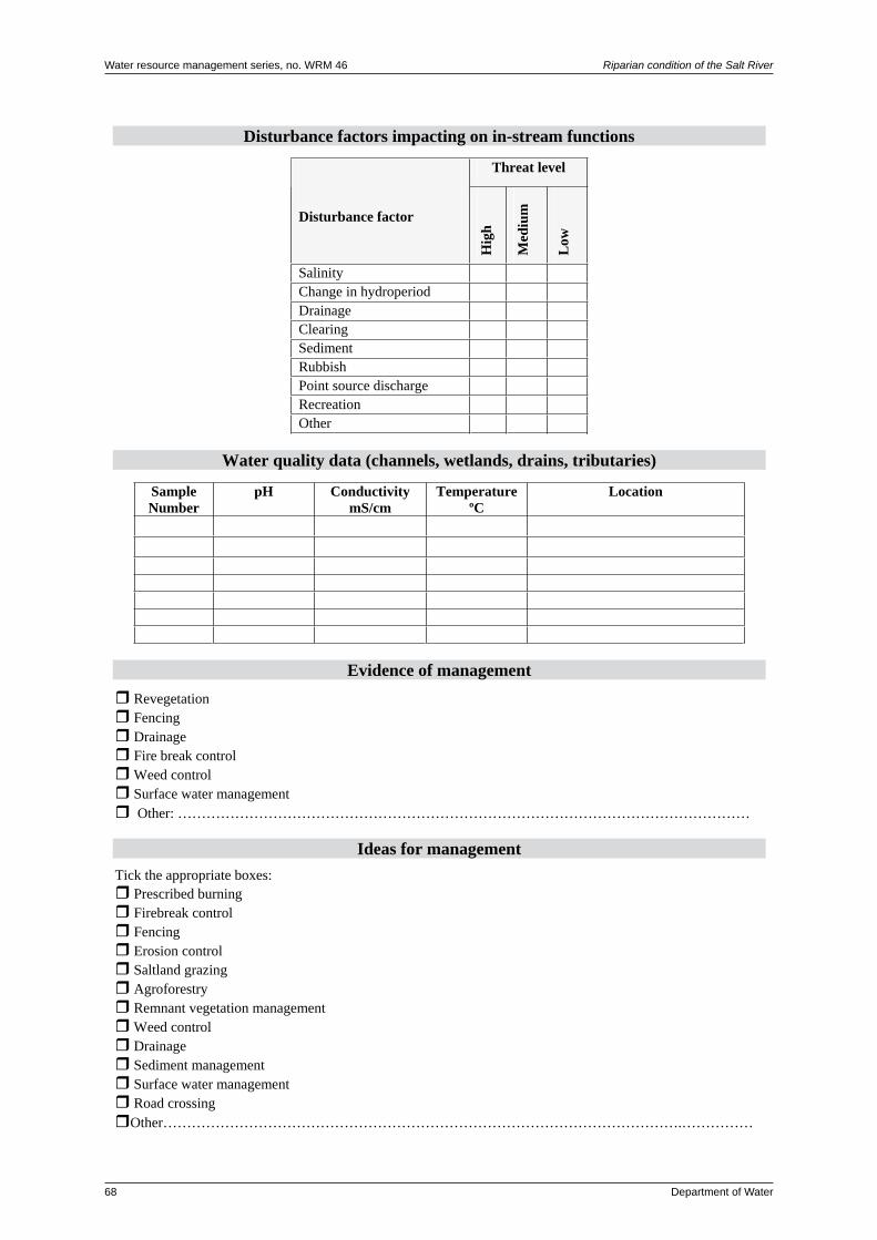
Water resource management series, no. WRM 46 Riparian condition of the Salt River
68 Department of Water
Disturbance factors impacting on in-stream functions
Threat level
Disturbance factor
Hig
h
Med
ium
Low
SalinityChange in hydroperiodDrainageClearingSedimentRubbishPoint source dischargeRecreationOther
Water quality data (channels, wetlands, drains, tributaries)
SampleNumber
pH ConductivitymS/cm
TemperatureºC
Location
Evidence of management RevegetationFencingDrainage
Fire break controlWeed control Surface water management Other: …………………………………………………………………………………………………………
Ideas for management Tick the appropriate boxes:
Prescribed burning Firebreak control FencingErosion controlSaltland grazingAgroforestryRemnant vegetation managementWeed controlDrainageSediment management
Surface water managementRoad crossing
Other……………………………………………………………………………………………….……………

Riparian condition of the Salt River Water resource management series, no. WRM 46
Department of Water 69
Fauna list
Photographs
Number Description

Water resource management series, no. WRM 46 Riparian condition of the Salt River
70 Department of Water
Appendix 3: Survey site reports
SiteSR01–Parker’s
General details
Site name Parker’s (private property)
Surveyed by Kate Gole and Prue Dufty
Survey date 19.05.2006
Site description
Landform This site spans the Salt River floodplain. The main channel of the Salt River flows down the left-hand side of the site (facing upstream); however, numerous braided channels cover the floodplain. There are also small seasonally-inundated playa lakes in some areas.
Site size Approximately 1656 ha.
Vegetation description
Beard vegetation association 951: Succulent steppe with sparse woodland and thicket – York gum and Kondinin blackbutt over tea-tree thicket and samphire
Vegetation structure and cover
Vegetation layer Canopy cover class
Dominant species
Trees 2–10% Eucalyptus species
Mallees 2–10% Eucalyptus species
Shrubs 2–10% Melaleuca species and Santalum acuminatum
Grasses 2–10% Annual weed species, some native species
Herbs 30–70% Halosarcia species and Atriplex species
Rushes and sedges 2–10% Typha domingensis, Garnia trifida and Cyperus gymnacaulos
Litter –
Rock outcrop –
Bare ground 10–30%
Summary
The vegetation in the floodplain area changes with small changes in topography. A brackish seep at the base of a slope with deep sandy soils is dominated by Melaleuca species, Casuarina obesa and Santalum acuminatum with an understorey of grassy annual weeds, native grasses and sedges such as Typha domingensis, Cyperus gymnacaulos and Garnia trifida. Large areas of the floodplain are covered by a variety of Atriplex and Halosarcia species. On gentle rises adjacent to, and approximately 0.5 m above, floodway areas, remnants of sparse Melaleuca and Eucalyptus woodlands are found. These areas are under significant pressure from salinity and waterlogging.

Riparian condition of the Salt River Water resource management series, no. WRM 46
Department of Water 71
Native species Scientific name Common nameAtriplex hymenotheca SaltbushAtriplex species Saltbush (2 species)Cassytha species DodderCasuarina obesa Swamp sheoakCyperus gymnacaulos Spiny flat sedgeEucalyptus species Eucalypt (3 species)Garnia trifida Coast saw sedgeHalosarcia species Samphire (3 species)Melaleuca halmoaturorum Melaleuca species* Melaleuca (2 species)Poaceae species GrassPtilotus polystachyus Prince of Wales featherSantalum acuminatum QuandongTypha domingensis Native bulrush
* Regeneration of overstorey species was noted.
Weed species Scientific name Common nameArctotheca calendula CapeweedAsteraceae species A thistleAvena fatua Wild oatsBromus species Brome grassCucumis myriocarpus Pie melonConzya bonariensis FleabaneCotula coronopifolia WaterbuttonsDittrichia graveolens StinkwortHordeum leporinum Barley grassJuncus acutus Sharp rushLupinus cosentinii Blue lupinPoaceae species Grass (2 species)Solanum species Nightshade
Other plant lists for the general areaWeaving, S. (1997) Weaving, S. & Grein, S. (1994)
Vegetation conditionCondition Description % of sitePristine No obvious signs of disturbance.Excellent Vegetation structure intact; disturbance affecting individual species and
weeds are non-aggressive species.Very good Vegetation structure altered; obvious signs of disturbance.Good Vegetation structure significantly altered by very obvious signs of multiple
disturbances. Retains basic vegetation structure or ability to regenerate.5
Degraded Basic vegetation structure severely impacted by disturbance. Regeneration to good condition would require intensive management.
5
Completely degraded
Vegetation structure no longer intact and the area is without / almost without native species.
90

Water resource management series, no. WRM 46 Riparian condition of the Salt River
72 Department of Water
Disturbance factors contributing to vegetation condition scoreDisturbance factor Level of threat Disturbance factor Level of threat
H M L H M LSalinity x RubbishWaterlogging x Plant diseasePonding from road crossing
x Erosion
Drainage Service corridorsClearing x Feral animals xFire risk RecreationWeed invasion x Point source
dischargeStock access x OtherVehicle access xCommentsThe valley floor vegetation has been significantly altered due to clearing, both in the floodplain itself and in the wider catchment. Pockets of vegetation within the floodplain were first cleared and cropped in the early 1900s. Increased salinity and waterlogging levels have resulted in the replacement of the original vegetation communities, comprising Melaleuca thickets and Eucalyptus woodland, with extensive samphire (Halosarcia species) and saltbush (Atriplex species) flats. Stock have access to the floodplain area for several months of the year from November/December. The saltbush (Atriplex species), in conjunction with stubble in surrounding paddocks, provides reasonable quality fodder during the summer–autumn feed gap. Impacts from grazing on the floodplain appear to be relatively low. Relatively heavy grazing of saltbush helps to stimulate regrowth and maintains yields. It is possible that stock are impacting on regeneration of native species in the remaining patches of Melaleuca and Eucalyptus.Ponding from the road crossing has also impacted on vegetation, especially following the 2000 flood. Saltbush species particularly were affected by prolonged waterlogging following the flood.While weeds are invading the understorey, the salt and waterlogging levels mean that they are not significant threats, with the exception of sharp rush (Juncus acutus), which has the potential to colonise further areas if left uncontrolled. Rabbits are in their highest numbers for approximately the last 10 years. Their control would benefit regeneration of native species in the remaining patches of remnant vegetation.
Links to protected areas of remnant vegetationName Area
(ha)Approximate distance and direction from site
Quairading Springs Nature Reserve 29 1.5 km NWBadjaling Nature Reserve 286 2.5 km NEQuairading townsite 276 3 km NWBadjaling North Nature Reserve 29 4 km NEQuairading Nature Reserve and Crown Reserve 630 4.5 km NW
Aquatic vegetationNo water present.

Riparian condition of the Salt River Water resource management series, no. WRM 46
Department of Water 73
Disturbance factors impacting on in-stream functionDisturbance factor Level of threat Disturbance factor Level of threat
H M L H M LSalinity x RubbishChange in hydroperiod
x Point source discharge
Drainage RecreationClearing x OtherSediment
Water qualityThe brackish seep discharges groundwater on the edge of the floodplain all year, and consequently the main channel downstream of the seep also contains water all year. No water-quality readings were taken but the seep supports plant species that were not found anywhere else within the site. Water from a nearby soak, fed from the same groundwater source as the seep, tasted slightly salty and is of stock-water quality. This suggests that the salinity is approximately 1000–1500 mg/L (see Appendix 1 for a salinity classification table). There are eight shallow soaks/dams across the floodplain that vary in water quality but are utilised for stock watering.
ManagementThe vegetation associated with the brackish seep at the base of the sandhill would benefit from being fenced from stock to enable natural regeneration; however, the seep is on the edge of the main channel, which presents difficulties for fence placement.
FaunaScientific name Common nameBirdsAnthus australis Richard’s pipitAquila audax Wedge-tailed eagleArtamus cyanopterus Dusky woodswallowBarnardius zonarius race zonarius Australian ringneck (twenty-eight parrot)Columba livia Rock dove*Corvus coronoides Australian ravenHirundo neoxena Welcome swallowOcyphaps lophotes Crested pigeonPomatostomus temporalis White-browed babblerRhipidura rufiventris Grey fantailRhipidura leucophrys Willy wagtailPsephotus haematonotus Mulga parrotMammalsMacropus rufus Red kangarooVulpes vulpes European red fox*Oryctolagus cuniculus European wild rabbit*
* Introduced species
Other fauna lists for the general areaLefroy et al. (1991)Weaving, S. (1997)Weaving, S. & Grein, S. (1994)

Water resource management series, no. WRM 46 Riparian condition of the Salt River
74 Department of Water
Vegetation growing on the groundwater seep on the edge of the Salt River floodplain
This reach of the main channel is groundwater-fed with seepage from the base of a sandhill. The channel is fringed by Melaleuca and Eucalyptus over Halosarcia and Atriplex

Riparian condition of the Salt River Water resource management series, no. WRM 46
Department of Water 75
SiteSR02–BadjalingNatureReserve
General details
Site name Badjaling Nature Reserve (Department of Environment and Conservation) Crown Reserve 23758
Surveyed by Kate Gole, Prue Dufty and Chrystal King
Survey date 15.05.2006 and 08.06.2006
Site description
Landform Most of the site is dominated by uplands and hillslopes with deep yellow sands. A significant drain flows through the reserve, joining the Salt River floodplain in the southern corner of the reserve.
Site size Approximately 286 ha.
Location Located south of the Bruce Rock – Quairading Rd and bounded by the Badjaling North Rd to the west and the Badjaling Aboriginal Community to the south. Part of the reserve is located within the Salt River floodplain.
Vegetation description
Beard vegetation association 694: Shrublands – scrub-heath on yellow sandplain banksia-xylomelum association in the Geraldton Sandplain and Avon Wheatbelt Region
Beard vegetation association 951: Succulent steppe with sparse woodland and thicket – York gum and Kondinin blackbutt over tea-tree thicket and samphire
Beard vegetation association 1147: Shrublands – scrub-heath in the south-east Avon Whealtbelt Region
Vegetation structure and cover
Vegetation layer Canopy cover class
Dominant species
Trees 2–10% Allocasuarina, Banksia prionotes, Eucalyptus species
Mallees –
Shrubs 30–70% Casuarina, Melaleuca, Hakea and Xyolmelum
Grasses 2–10% Puccinellia ciliata and native species
Herbs 2–10% Various native species
Rushes and sedges 2–10% Juncus acutus
Litter 2–10%
Rock outcrop –
Bare ground 20–30%
Summary
The deep, yellow sandplain soils of the upland area and slopes are dominated by Banksia prionotes, Allocasuarina and Xyolmelum shrublands with a middlestorey of Casuarina and Melaleuca species and an understorey of native grasses, herbs and sedges. The native vegetation in waterlogged areas of the valley has been replaced with the introduced Juncus acutus, Puccinellia ciliata and Halosarcia and Atriplex species. On the southern fringe of the reserves there is a sparse Eucalyptus woodland with a middlestorey of Melaleuca species and Santalum acuminatum.

Water resource management series, no. WRM 46 Riparian condition of the Salt River
76 Department of Water
Native species Scientific name Common nameAcacia acuminata* JamAcacia microbotrya Manna wattleAcacia tratmanianaAcacia species Acacia (2 species)Actinostrobus arenarius Sandplain cypressAllocasuarina huegeliana Rock sheoakAllocasuarina campestris TammaAllocasuarina species Sheoak (2 species)Atriplex semibaccata Berry saltbushAtriplex species Saltbush (3 species)Banksia prionotes* Acorn banksiaBanksia cuneata Quairading banksiaBorya species PincushionsDianella revoluta Blueberry lilyEucalyptus loxophleba subsp. loxophleba York gumEucalyptus salmonophloia Salmon gumEremophila speciesGrevillea hookeriana Black toothbrushGrevillea eriostachya Flame grevilleaGrevillea paniculataHakea platysperma Cricket ball hakeaHalosarcia pergranulata Black-seeded samphireHalosarcia species Samphire (2 species)Lycium australe Australian boxthornMaireana brevifolia Small leaf bluebushMelaleuca species Melaleuca uncinata Broom bushPoaceae species Grass (2 species)Ptilotus polystachyus Prince of Wales featherSantalum acuminatum QuandongXylomelum angustifolium Sandplain woody pear
Variety of rushes and sedges (5 species)Variety of annual herbsVariety of shrubs (10 species)
* Regeneration of overstorey species was noted.
Weed species Scientific name Common nameArctotheca calendula CapeweedAvena fatua Wild oatsCitrullus lanatus Paddy melonCucumis myriocarpus Pie melonDittrichia graveolens StinkwortHeliotropium curassavicum Smooth heliotropeHordeum leporinum Barley grassHypochaeris species Flat weedJuncus acutus Sharp rushOxalis pes-caprae SoursobPoacea species Grass speciesPuccinellia ciliata Puccinellia
Other plant lists for the general areaWeaving, S. (1997) Weaving, S. & Grein, S. (1994)

Riparian condition of the Salt River Water resource management series, no. WRM 46
Department of Water 77
Vegetation conditionCondition Description % of sitePristine No obvious signs of disturbance. 50Excellent Vegetation structure intact; disturbance affecting individual species and
weeds are non-aggressive species.10
Very good Vegetation structure altered; obvious signs of disturbance.Good Vegetation structure significantly altered by very obvious signs of multiple
disturbances. Retains basic vegetation structure or ability to regenerate.Degraded Basic vegetation structure severely impacted by disturbance.
Regeneration to good condition would require intensive management.Completely degraded
Vegetation structure no longer intact and the area is without / almost without native species.
40
Disturbance factors contributing to vegetation condition scoreDisturbance factor Level of threat Disturbance factor Level of threat
H M L H M LSalinity x RubbishWaterlogging x Plant diseasePonding from road crossing
x Erosion
Drainage Service corridors xClearing Feral animalsFire risk RecreationWeed invasion x Point source
dischargeStock access OtherVehicle accessCommentsThe valley floor vegetation is under pressure from increased waterlogging and salinity levels, and in some areas has been completely replaced by weed species. It is possible that ponding caused by Badjaling Rd North and Solomon South Rd is contributing to the waterlogging problems. The majority of the vegetation on the uplands and slopes is in pristine to excellent condition, with weeds impacting along Badjaling Rd and through the transition zone between the valley floor and hill slope.
Links to protected areas of remnant vegetationName Area
(ha)Approximate distance and direction from site
Badjaling North Nature Reserve 29 0.5 km NCrown Reserve 12333 40 1.8 km SECrown Reserve 13217 24 4.8 km SEQuairading townsite 276 6.5 km NECrown Reserve 6775 14 8.5 km NW
Aquatic vegetationNo water present.

Water resource management series, no. WRM 46 Riparian condition of the Salt River
78 Department of Water
Disturbance factors impacting on in-stream functionDisturbance factor Level of threat Disturbance factor Level of threat
H M L H M LSalinity x RubbishChange in hydroperiod
x Point source discharge
Drainage RecreationClearing OtherSediment
Water qualityNo water quality data collected.
ManagementStock are excluded from the reserve. The reserve would benefit from the control of sharp rush (Juncus acutus) and puccinellia (Puccinellia ciliata) in the waterlogged areas of the valley floor and revegetation with local native species.A significant drain flows through the reserve. Where it enters the reserve from private property the tributary has sandy banks, is incising and widening and carrying a significant sediment load from farmland upstream. Upstream from the reserve the tributary is almost entirely unvegetated. Within the reserve the tributary has some fringing vegetation, including acacia, samphire and saltbush species. The channel within the reserve has been modified and it has also been deepened and widened further upstream. Where the tributary joins the Salt River floodplain there is no defined channel, and water discharges into a wetland area, which is choked with puccinellia and sharp rush. It has been modified in its upper reaches, by deepening and widening.
FaunaScientific name Common nameBirdsAnas superciliosa Pacific black duckBarnardius zonarius race zonarius Australian ringneck (twenty-eight parrot)Corvus coronoides Australian ravenEgretta novaehollandiae White-faced heronEolophus roseicapilla GalahGrallina cyanoleuca Australian magpie-larkPetroica goodenovii Red-capped robinRhipidura leucophrys Willy wagtailSmicronis brevirostris race occidentalis WeebillTadorna tadornoidies Australian shelduckMammalsMacropus rufus Red kangarooOryctolagus cuniculus European wild rabbit*Vulpes vulpes European red fox*
* Introduced species
Other fauna lists for the general areaLefroy et al. (1991)Weaving, S. (1997) Weaving, S. & Grein, S. (1994)

Riparian condition of the Salt River Water resource management series, no. WRM 46
Department of Water 79
Santalum acuminatum shrubland on the edge of Badjaling Nature Reserve
Sandplain vegetation in Badjaling Nature Reserve, with Banksia prionotes in flower

Water resource management series, no. WRM 46 Riparian condition of the Salt River
80 Department of Water
SiteSR03–BadjalingNorthNatureReserve
General detailsSite name Badjaling North Nature Reserve (Department of Environment and Conservation)
Crown Reserve 10121Surveyed by Kate Gole and Chrystal KingSurvey date 07.06.2006
Site descriptionLandform The site is within the Salt River floodplain. Upstream of the Bruce Rock – Quairading
Rd there is a well-defined channel, and downstream the floodplain widens and the channel becomes braided.
Site size Approximately 29 ha.Location The site spans the Bruce Rock – Quairading Rd and Badjaling Rd North.
Vegetation descriptionBeard vegetation association 951: Succulent steppe with sparse woodland and thicket – York gum and Kondinin blackbutt over tea-tree thicket and samphire
Vegetation structure and coverVegetation layer Canopy
cover classDominant species
Trees – –Mallees 2–10% Eucalyptus speciesShrubs 2–10% Melaleuca speciesGrasses 2–10%Herbs 20–30% Halosarcia and AtriplexRushes and sedges – –Litter 2–10%Bare ground 2–10%Rock outcrop –SummaryA section of the site (approximately 25 per cent) that has previously been cleared has been revegetated with a variety of Eucalyptus, Melaleuca and Allocasuarina species. Some remnant Eucalyptus woodland and Melaleuca shrubland remains. Halosarcia and Atriplex species are common in the understorey, occurring as a thick fringe along the main channel of the Salt River.
Native species Scientific name Common nameRemnant vegetationAcacia acuminata JamAcacia speciesAllocasuarina huegeliana* Rock sheoakAllocasuarina species Sheoak Atriplex semibaccata Berry saltbush

Riparian condition of the Salt River Water resource management series, no. WRM 46
Department of Water 81
Native species Scientific name Common nameRemnant vegetationAtriplex species Saltbush (4 species)Carpobrotus species PigfaceChloris truncata Windmill grassDianella revoluta Blueberry lilyEragrotis dielsii Mallee lovegrassEucalyptus loxophelba subsp. loxophelba* York gumEucalyptus species EucalyptHakea pressii Needle bushHakea speciesHalosarcia species Samphire (3 species)Lycium australe Australian boxthornMelaleuca species Melaleuca (3 species)Poacea species Grass (2 species)Ptilotus polystachyus Prince of Wales feather (local name bulla-mulla)Santalum acuminatum Quandong Unidentified shrubs (2 species)RevegetationAllocasuarina huegeliana* Rock sheoakEucalyptus loxophelba subsp. loxophelba* York gumEucalyptus species Eucalypt (2 species)
Variety of shrub species (2 species)
* Regeneration of overstorey species was noted
Weed species Scientific name Common nameAvena fatua Wild oatsHordeum leporinum Barley grassPoacea species Grass
Other plant lists for the general areaLefroy et al. (1991)Weaving, S. (1997) Weaving, S. & Grein, S. (1994)
Vegetation conditionCondition Description % of site– Revegetation. 25Pristine No obvious signs of disturbance.Excellent Vegetation structure intact; disturbance affecting individual species and
weeds are non-aggressive species.

Water resource management series, no. WRM 46 Riparian condition of the Salt River
82 Department of Water
Vegetation conditionCondition Description % of siteVery good Vegetation structure altered, obvious signs of disturbance.Good Vegetation structure significantly altered by very obvious signs of
multiple disturbances. Retains basic vegetation structure or ability to regenerate.
20
Degraded Basic vegetation structure severely impacted by disturbance. Regeneration to good condition would require intensive management.
15
Completely degraded
Vegetation structure no longer intact and the area is without / almost without native species.
40
Disturbance factors contributing to vegetation condition scoreDisturbance factor Level of threat Disturbance factor Level of threat
H M L H M LSalinity x RubbishWaterlogging x Plant diseasePonding from road crossing
Erosion
Drainage Service corridors xClearing x Feral animalsFire risk RecreationWeed invasion x Point source
dischargeStock access OtherVehicle accessCommentsThe site is being impacted by increasing salinity and waterlogging levels. Parts of the site have been cleared in the past, although they have now been revegetated with a variety of native species. The Bruce Rock – Quairading Rd passes through the site. There is a substantial bridge over the main channel of the Salt River, and ponding from the crossing in small to medium events does not appear to be an issue. The channel downstream from the road crossing has been deepened at some point. There are some weed species invading the vegetation from the road and some rubbish within the road reserve.
Links to protected areas of remnant vegetationName Area
(ha)Approximate distance and direction from site
Badjaling Nature Reserve 286 0.5 km SCrown Reserve 12333 40 4.5 km SQuairading townsite 276 7 km WCrown Reserve 18155 7 7 km NWCrown Reserve 13217 24 7.5 km SQuairading Nature Reserve and Crown Reserve 630 10 km WQuairading Springs Nature Reserve 29 10 km SW
Aquatic vegetationNo water present.

Riparian condition of the Salt River Water resource management series, no. WRM 46
Department of Water 83
Disturbance factors impacting on in-stream functionDisturbance factor Level of threat Disturbance factor Level of threat
H M L H M LSalinity x Rubbish
Change in hydroperiod
x Point source discharge
Drainage Recreation
Clearing x Other
Sediment
Water qualityNo water quality data collected.
ManagementThe reserve would benefit from weed control, in particular of wild oats (Avena fatua), in the revegetated area. The revegetation is in good condition and understorey species have been established, either through direct seeding or natural regeneration. Part of the reserve is fenced and, although the fencing is in poor to moderate condition, there are no signs of stock access.
Fauna
Scientific name Common name
Birds
Barnardius zonarius race zonarius Australian ringneck (twenty-eight parrot)
Eolophus roseicapilla Galah
Manorina flavigula Yellow-throated miner
Himantopus himantopus Black-winged stilt
Hirundo species Martin
Corvus coronoides Australian raven
Rhipidura fuliginosa Grey fantail
Ocyphaps lophotes Crested pigeon
Mammals
Macropus rufus Red kangaroo
Oryctolagus cuniculus European wild rabbit*
Tachyglossus aculeatus Short-beaked echidna
* Introduced species
Other fauna lists for the general areaLefroy et al. (1991)
Weaving, S. (1997)
Weaving, S. & Grein, S. (1994)

Water resource management series, no. WRM 46 Riparian condition of the Salt River
84 Department of Water
Shrublands in good condition in Badjaling North Nature Reserve
Revegetation in Badjaling North Nature Reserve

Riparian condition of the Salt River Water resource management series, no. WRM 46
Department of Water 85
SiteSR04–Wilson’s
General detailsSite name Wilson’s (private property)Surveyed by Kate Gole and Chrystal KingSurvey date 07.06.2006
Site descriptionLandform This site sits within the Salt River floodplain. South of the Mt Stirling Rd the
floodplain is broad, with a relatively well defined main channel. On the southern edge of the site, upstream from the Hommajelly Gully confluence, the main channel is more defined and the floodplain not as wide. Water is present in a reach of the main channel due to groundwater pumping.
Site size Approximately 540 ha.
Vegetation descriptionBeard vegetation association 951: Succulent steppe with sparse woodland and thicket; York gum and Kondinin blackbutt over tea-tree thicket and samphireBeard vegetation association 1049: Medium woodland; wandoo, York gum, salmon gum, morrel and gimlet
Vegetation structure and coverVegetation layer Canopy
cover classDominant species
Trees – -Mallees 2–10% EucalyptusShrubs 2–10% Acacia and MelaleucaGrasses 2–10% Hordeum leporinumHerbs 30–70% Halosarcia and AtriplexRushes and sedges 2–10% Native speciesLitter –Bare ground 2–10%Rock outcrop –SummaryThere are several small patches (approximately 5 per cent of the site) characterised by sparse Eucalypt woodland over Melaleuca and Acacia species with a native understorey of Halosarcia, Atriplex, rush and sedge species. A diverse range of Halosarcia and Atriplex species dominates 95 per cent of the site.
Native species Scientific name Common nameAcacia acuminata JamAcacia speciesAtriplex semibaccata Berry saltbushAtriplex species Saltbush (2 species)Borya species PincushionsCasuarina speciesDianella revulata Blueberry lilyEremophila speciesEucalyptus loxophelba subsp. loxophelba York gumEucalyptus species Eucalypt

Water resource management series, no. WRM 46 Riparian condition of the Salt River
86 Department of Water
Halosarcia lylei Samphire Halosarcia doleiformis Samphire Halosarcia species Samphire (3 species)Melaleuca species Newcastelia species Lambs tailPoacea species Grass speciesPtilotus polystachyus Prince of Wales featherSantalum acuminatum Quandong
Variety of rushes and sedges (3 species) Variety of annual herbs
No regeneration of overstorey species was noted.
Weed species Scientific name Common nameHordeum leporinum Barley grass
Other plant lists for the general areaWeaving, S. (1997) Weaving, S. & Grein, S. (1994)
Vegetation conditionCondition Description % of sitePristine No obvious signs of disturbance.Excellent Vegetation structure intact; disturbance affecting individual species and
weeds are non-aggressive species.Very good Vegetation structure altered; obvious signs of disturbance.Good Vegetation structure significantly altered by very obvious signs of
multiple disturbances. Retains basic vegetation structure or ability to regenerate.
5
Degraded Basic vegetation structure severely impacted by disturbance. Regeneration to good condition would require intensive management.
Completely degraded
Vegetation structure no longer intact and the area is without / almost without native species.
95
Disturbance factors contributing to vegetation condition scoreDisturbance factor Level of threat Level of threat
H M L H M LSalinity x Rubbish xWaterlogging x Plant diseasePonding from road crossing
Erosion
Drainage Service corridorsClearing x Feral animals xFire risk RecreationWeed invasion x Point source
dischargeStock access x OtherVehicle access x

Riparian condition of the Salt River Water resource management series, no. WRM 46
Department of Water 87
Comments
The majority of the site is degraded from clearing, waterlogging and rising salinity levels. In one corner of the site, some remnant woodland remains, but over 95 per cent of the site, the original vegetation has been almost entirely replaced with samphire and saltbush species. Stock have access to the floodplain for part of the year, to graze on saltbush during the summer/autumn feed gap.There are very few weeds in the floodplain area.
Links to protected areas of remnant vegetation
Name Area (ha)
Approximate distance and direction from site
Yoting North Nature Reserve 36 4 km E
Crown Reserve 18155 7 4.5 km W
Mooraning Nature Reserve 40 6 km W
Badjaling Nature Reserve 276 6 km S
Badjaling North Nature Reserve 29 5.5 km S
Aquatic vegetation
No water present.
Disturbance factors impacting on in-stream function
Level of threat Level of threat
H M L H M L
Salinity x Rubbish x
Change in hydroperiod
x Point source discharge
Drainage Recreation
Clearing x Other
Sediment
Water qualityNo water quality data collected.
Management
Hommajelly Gully, a major tributary of the Salt River, has been significantly modified (refer to Photo 14). An extensive network of contour banks directs surface runoff into the gully. Water quality in the gully is mostly unsuitable for stock. Significant flows enter the Salt River from the gully every year, back flooding the Salt River when full. The gully did not flood during Deluge 2000.The gully previously flooded over the floodplain area every winter, and the main channel frequently shifted alignment, making the area difficult to manage. Approximately 10 years ago the channel was deepened and widened from the Salt River confluence back approximately 2 km.

Water resource management series, no. WRM 46 Riparian condition of the Salt River
88 Department of Water
FaunaScientific name Common nameAnas superciliosa Pacific black duck
Barnardius zonarius race zonarius Australian ringneck (twenty-eight parrot)
Corvus coronoides Australian raven
Elseyornis melanops Black-fronted dotterel
Eolophus roseicapilla Galah
Grallina cyanoleuca Australian magpie-lark
Manorina flavigula Yellow-throated miner
Tadorna tadornoidies Australian shelduck
MammalsMacropus rufus Red kangaroo
Oryctolagus cuniculus European wild rabbit*
Vulpes vulpes European red fox*
* Introduced species
Other fauna lists for the general areaLefroy et al. (1991)
Weaving, S. (1997)
Weaving, S. & Grein, S. (1994)
Groundwater pumping feeds water into this reach of the Salt River for most of the year

Riparian condition of the Salt River Water resource management series, no. WRM 46
Department of Water 89
SiteSR05–Kevill’sLake
General detailsSite name Kevill’s Lake (private property, leased by the Quairading Ski Club)Surveyed by Kate Gole and Shenaye MehmetSurvey date 31.08.2006
Site descriptionLandform This site is within the Salt River floodplain and is characterised by a series of
permanently inundated playa lakes bordered by lunettes. Site size Approximately 278 ha.
Vegetation descriptionBeard vegetation association 951: Succulent steppe with sparse woodland and thicket – York gum and Kondinin blackbutt over tea-tree thicket and samphireBeard vegetation association 1023: Medium woodland – York gum, wandoo and salmon gum
Vegetation structure and coverVegetation layer Canopy
cover classDominant species
Trees 2–10% Eucalyptus speciesMallees 2–10% Eucalyptus speciesShrubs 2–10% Mixed speciesGrasses 2–10% Mixed native and annual speciesHerbs 20–30% Halosarcia species and Atriplex speciesRushes and sedges 2–10% Mixed speciesLitter –Bare rock –SummaryThe vegetation is characterised by a diverse range of samphire (Halosarcia species), saltbush (Atriplex species) and bluebush (Maireana species) on the shores of the salt lakes, grading into shrubland, dominated by Melaleuca, Leptospermum and Acacia species, and Eucalyptus woodland.
Native speciesScientific name Common nameRemnant vegetationAcacia acuminata* JamAcacia species Acacia (6 species)Acacia tratmanianaAmyema species Mistletoe speciesAtriplex semibaccata Berry saltbush
Atriplex species Saltbush (4 species)Borya species PincushionCaladenia flava Cowslip orchidCalytrix species Carpobrotus species Pigface (2 species)Cassytha species Dodder speciesCasuarina obesa Swamp sheoakDampiera speciesDianella revoluta Blueberry lilyDrosera species Sundew (2 species)

Water resource management series, no. WRM 46 Riparian condition of the Salt River
90 Department of Water
Eragrotis dielsii Mallee lovegrassEucalyptus loxophelba subsp. loxophelba York gumEucalytus species Eucalypt (2 species)Eremophila species Eremophila (2 species)Exocarpos aphyllus Leafless ballartGrevillea paniculataGrevillea hookeriana Black toothbrushGrimmea species Moss speciesHakea recurvaHakea speciesHalosarcia lyleiHalosarcia pergranulata subsp. pergranulata Blackseed samphireHalosarcia species Samphire (5 species)Hibbertia species Hibbertia (2 species) Leptospermum species Leptospermum (2 species)Lycium australe Australian boxthornMaireana brevifolia Small leaf bluebushMaireana species Bluebush (2 species)Melaleuca species Melaleuca (5 species)Melaleuca uncinata* Broom bushNewcastelia species Lambs tailPittosporum angustifolium* Native willowPoacea species Grass (4 species)Ptilotus polystachyus Prince of Wales feather (local name bulla-mulla)Santalum acuminatum QuandongSclerolaena speciesThysanotus species Thysanotus (2 species)
Lichen (3 species)Herb (10 species)Rush and sedge (4 species)Cowslip orchidShrub (11 species)Aquatic species (probably Ruppia species)
RevegetationAcacia species Acacia (2 species)Eucalypt species Eucalypt (2 species) Hakea species
* Regeneration of overstorey species was noted.Weed species Scientific name Common nameArctotheca calendula CapeweedAsteraceae species Asteraceae (2 species)Avena fatua Wild oatsCotula coronopifolia WaterbuttonsHeliotropium curassavicum Smooth heliotropeHypochaeris radicata FlatweedTamarix aphylla TamariskArctotheca calendula Capeweed
Other plant lists for the general areaWeaving, S. (1997)Weaving, S. & Grein, S. (1994)

Riparian condition of the Salt River Water resource management series, no. WRM 46
Department of Water 91
Vegetation conditionCondition Description % of site– Revegetation. 5Pristine No obvious signs of disturbance.Excellent Vegetation structure intact; disturbance affecting individual species and
weeds are non-aggressive speciesVery good Vegetation structure altered; obvious signs of disturbance. 60Good Vegetation structure significantly altered by very obvious signs of
multiple disturbances. Retains basic vegetation structure or ability to regenerate.
10
Degraded Basic vegetation structure severely impacted by disturbance. Regeneration to good condition would require intensive management.
20
Completely degraded
Vegetation structure no longer intact and the area is without / almost without native species.
5
Disturbance factors contributing to vegetation condition scoreDisturbance factor Level of threat Disturbance factor Level of threat
H M L H M LSalinity x Rubbish xWaterlogging x Plant diseasePonding from road crossing
Erosion
Drainage Service corridorsClearing Feral animals xFire risk Recreation xWeed invasion x Point source
dischargeStock access OtherVehicle access xCommentsIn some areas the vegetation is under pressure from increased salinity levels and changes in hydroperiod, resulting in deaths of the Melaleuca and Leptospermum shrublands. With the exception of the samphire community immediately adjacent to the lakes, annual weeds, including wild oats (Avena fatua) and capeweed (Arctotheca calendula), have invaded the understorey. Native species still dominate the understorey, with a wide variety of small shrubs and herbs including Dampiera, Drosera and Hibbertia species. The Quairading Ski Club is located on the edge of Kevill’s Lake. There is some rubbish, but it is not impacting significantly on the vegetation. The water level in Kevill’s Lake is regulated by a gate system that has changed the natural hydroperiod and impacted on fringing vegetation.
Links to protected areas of remnant vegetationName Area
(ha)Approximate distance and direction from site
Yoting North Nature Reserve 36 3 km EMooranning Nature Reserve 40 5 km NWCrown Reserve 18155 7 6 km SWBadjaling Nature Reserve 276 9 km SCharles Gardner Nature Reserve 798 9 km NBadjaling North Nature Reserve 29 10 km SCrown Reserve 11024 22 10 km NE
Aquatic vegetationOne species of aquatic plant was found during the survey, probably a Ruppia species.

Water resource management series, no. WRM 46 Riparian condition of the Salt River
92 Department of Water
Disturbance factors impacting on in-stream functionDisturbance factor Level of threat Disturbance factor Level of threat
H M L H M LSalinity x RubbishChange in hydroperiod
x Point source discharge
Drainage Recreation xClearing OtherSediment
Water qualityNo water quality data collected.
ManagementAn area of the site has been revegetated with a variety of species, including Eucalyptus, Acacia and Hakea species.Weeds, including wild oats (Avena fatua) and capeweed (Arctotheca calendula), have invaded the understorey; however, the majority of the understorey species are native. Spot weed control would be beneficial in some areas, such as along the access tracks and in the revegetated area, to prevent the further spread of weed species.Two gates and a pump control water levels and movement between Kevill’s Lake and the adjacent lake, which receives the majority of the flow from upstream. It is likely that the change in the hydroperiod in Kevill’s Lake has impacted on vegetation.
FaunaScientific name Common nameBirdsCorvus coronoides Australian ravenAnas gracilis Grey tealAnas superciliosa Pacific black duckAnthochaera carunculata Red wattlebirdBarnardius zonarius race zonarius Australian ringneck (twenty-eight parrot)Cracticus torqutus Grey butcherbirdEoloptus roseicapillus GalahFalco cenchroides Nankeen kestrelHirundo neoxena Welcome swallowHirundo species MartinMalurus species WrenPolytelis anthopeplus Regent parrotPomatostomus temporalis White-browed babblerRhipidura leucophrys Willy wagtailTadorna tadornoidies Australian shelduckZosterops lateralis Silvereye
Honeyeater speciesMammalsMacropus rufus Red kangarooOryctolagus cuniculus European wild rabbit*Vulpes vulpes European red fox*
* Introduced species
Other fauna lists for the general areaLefroy et al. (1991)Weaving, S. (1997) Weaving, S. & Grein, S. (1994)

Riparian condition of the Salt River Water resource management series, no. WRM 46
Department of Water 93
Dead Melaleuca shrubs fringing one of the smaller playa lakes
A wide variety of samphire (Halosarcia), saltbush (Atriplex) and bluebush (Maireana) species fringe Kevill’s Lake

Water resource management series, no. WRM 46 Riparian condition of the Salt River
94 Department of Water
SiteSR06–MoulienNatureReserve
General detailsSite name Moulien Nature Reserve Crown (Department of Environment and Conservation)
Crown Reserve No 28289 Surveyed by Kate Gole and Chrystal KingSurvey date 07.06.2006
Site descriptionLandform This site is within the Salt River floodplain and is characterised by a braided channel
and seasonally inundated playa lakes.Site size Approximately 145 ha.Location Accessed through private property via Tammin South Rd.
Vegetation descriptionBeard vegetation association 951: Succulent steppe with sparse woodland and thicket – York gum and Kondinin blackbutt over tea-tree thicket and samphire
Vegetation structure and coverVegetation layer Canopy
cover classDominant species
Trees –Mallees 2–10% Eucalyptus speciesShrubs 2–10% Melaleuca speciesGrasses 2–10% Hordeum leporinumHerbs 30–70% Halosarcia and Atriplex speciesRushes and sedges –Litter –Bare ground 20–30%Rock outcrop –SummaryThe original vegetation has almost entirely been replaced with Halosarcia and Atriplex species. There are a few small pockets of remnant Eucalyptus woodland and Melaleuca shrubland in poor condition. Significant numbers of stags are present.
Native species Scientific name Common nameAtriplex species Saltbush (2 species)Carpobrotus species Pigface Eucalyptus species Exocarpos aphyllus Leafless ballartHalosarcia species Samphire (4 species)Lycium australe Australian boxthornMelaleuca species
No regeneration of overstorey species was noted.
Weed species Scientific name Common nameCucumis myriocarpus Pie melonHordeum leporinum Barley grass

Riparian condition of the Salt River Water resource management series, no. WRM 46
Department of Water 95
Other plant lists for the general areaWeaving, S. (1997) Weaving, S. & Grein, S. (1994)
Vegetation conditionCondition Description % of sitePristine No obvious signs of disturbance.Excellent Vegetation structure intact; disturbance affecting individual species and
weeds are non-aggressive species.Very good Vegetation structure altered; obvious signs of disturbance.Good Vegetation structure significantly altered by very obvious signs of multiple
disturbances. Retains basic vegetation structure or ability to regenerate.Degraded Basic vegetation structure severely impacted by disturbance.
Regeneration to good condition would require intensive management.Completely degraded
Vegetation structure no longer intact and the area is without / almost without native species.
100
Disturbance factors contributing to vegetation condition scoreDisturbance factor Level of threat Disturbance factor Level of threat
H M L H M LSalinity x RubbishWaterlogging x Plant diseasePonding from road crossing
Erosion
Drainage Service corridorsClearing Feral animals xFire risk RecreationWeed invasion Point source dischargeStock access OtherVehicle access xCommentsThe site is highly degraded from rising salinity and waterlogging levels. The original vegetation of Eucalyptus woodland over Melaleuca and tea tree (Leptospermum) species has been almost entirely replaced with Halosarcia and Atriplex species. Significant numbers of stags remain.
Links to protected areas of remnant vegetationName Area
(ha)Approximate distance and direction from site
Yoting North Nature Reserve 36 4 km SCharles Gardner Nature Reserve 798 4.5 km NWMt Stirling Nature Reserve 223 4.5 km ECrown Reserve 11024 22 5 km NWGundaring Nature Reserve 128 6.5 km EMoranning Nature Reserve 40 7.5 km WMt Caroline Nature Reserve 352 8 km NW
Aquatic vegetationNo water present.

Water resource management series, no. WRM 46 Riparian condition of the Salt River
96 Department of Water
Disturbance factors impacting on in-stream functionDisturbance factor Level of threat Disturbance factor Level of threat
H M L H M LSalinity x RubbishChange in hydroperiod x Point source dischargeDrainage RecreationClearing x OtherSediment
Water qualityNo water quality data collected.
ManagementThe landholder was unaware that the block was vested as a nature reserve and it is managed as part of their property. The block is fenced along the floodplain boundary and stock are entirely excluded from the floodplain but there are no boundary fences within the floodplain.
FaunaScientific name Common nameMacropus rufus Red kangarooOryctolagus cuniculus European wild rabbit*
* Introduced species
Other fauna lists for the general areaLefroy et al. (1991)Weaving, S. (1997) Weaving, S. & Grein, S. (1994)
The original Melaleuca shrublands in Moulien Nature Reserve have almost entirely been replaced with samphire (Halosarcia species) flats

Riparian condition of the Salt River Water resource management series, no. WRM 46
Department of Water 97
SiteSR07–CrownReserve11024
General detailsSite name Nature Reserve (Department of Environment and Conservation) Crown Reserve 11024 Surveyed by Kate Gole and Chrystal KingSurvey date 06.06.2006
Site descriptionLandform This site is located on a long, gentle slope adjacent to the Salt River floodplain. A
small tributary flows through the northern corner of the reserve.Site size Approximately 22 ha.Location Located on the corner of the Kellerberrin–Yoting Rd and Gardiner Rd, north of the
Salt River
Vegetation descriptionBeard vegetation association 1049: Medium woodland – wandoo, York gum, salmon gum, morrel and gimlet
Vegetation structure and coverVegetation layer Canopy
cover classDominant species
Trees 2–10% Eucalyptus loxophleba and Eucalyptus salmonophloiaMallees – –Shrubs 2–10% Hakea pressii and Acacia speciesGrasses 20–30% Mix of native speciesHerbs 2–10% Mix of native speciesRushes and sedges – –Litter 2–10%Rock outcrop –Bare ground 20–30%SummaryThe site is characterised by a sparse woodland of Eucalyptus salmonophloia and Eucalyptus loxophleba, with a middlestorey of Acacia species and Hakea pressii over an understorey of Atriplex species and herbs. A number of Halosarcia species, Atriplex species and annual grassy weeds are associated with a minor tributary that flows through the top of the reserve.
Native species Scientific name Common nameAcacia acuminata JamAcacia species Wattle (3 species)Atriplex species SaltbushDianella revulata Blueberry lily Eucalyptus loxophleba subsp. loxophleba* York gumEucalyptus salmonophloia* Salmon gumGrevillea paniculataHakea pressii Needle bushHalosarcia species Samphire (3 species)Maireana breviflolia Small leaf bluebushPoacea species Grass (5 species)Ptilotus polystachyus Prince of Wales feather (local name bulla-mulla)Santalum acuminatum Quandong Variety of herbs (3 species) Variety of shrubs (6 species) Lichen (2 species)
* Regeneration of overstorey species was noted

Water resource management series, no. WRM 46 Riparian condition of the Salt River
98 Department of Water
Weed species Scientific name Common nameAvena fatua Wild oatsBromus species Brome grassCucumis myriocarpus Pie melonErodium botrys CorkscrewHordeum leporinum Barley grassLactuca serriola Prickly lettucePoacea species Grass (2 species)
Other plant lists for the general areaWeaving, S. (1997) Weaving, S. & Grein, S. (1994)
Vegetation conditionCondition Description % of sitePristine No obvious signs of disturbance.Excellent Vegetation structure intact; disturbance affecting individual species and
weeds are non-aggressive species.Very good Vegetation structure altered; obvious signs of disturbance. 30Good Vegetation structure significantly altered by very obvious signs of multiple
disturbances. Retains basic vegetation structure or ability to regenerate.70
Degraded Basic vegetation structure severely impacted by disturbance. Regeneration to good condition would require intensive management.
Completely degraded
Vegetation structure no longer intact and the area is without / almost without native species.
Disturbance factors contributing to vegetation condition scoreDisturbance factor Level of threat Disturbance factor Level of threat
H M L H M LSalinity Rubbish xWaterlogging Plant diseasePonding from road crossing
Erosion
Drainage Service corridorsClearing x Feral animals xFire risk x RecreationWeed invasion x Point source dischargeStock access OtherVehicle access xCommentsThere has been some clearing for soil removal, possibly for use as road base. There is significant regeneration of Eucalyptus species in these areas. Weeds have invaded the understorey in some disturbed areas, including around the track on the eastern side of the reserve and around the tributary. There are signs of rabbits (Oryctolagus cuniculus), with one warren found.
Links to protected areas of remnant vegetationName Area
(ha)Approximate distance and direction from site
Mt Stirling Nature Reserve 223 2 km SMt Caroline Nature Reserve 352 2 km EGundaring Nature Reserve 128 5 km SGlenluce Nature Reserve 243 6 km ENangeen Hill Wildlife Sanctuary 178 7.5 km SE

Riparian condition of the Salt River Water resource management series, no. WRM 46
Department of Water 99
ManagementThe reserve is fenced off from farmland on the eastern boundary and bounded on the other sides by the Kellerberrin–Yoting Rd and Gardiner Rd. Some control of grassy annual weeds would be beneficial, especially around the tributary. The tributary is incised and eroding, with a number of unconsolidated sediment slugs in the channel. The sediment source is most likely erosion from surrounding paddocks. In most places the banks are relatively stable, being vegetated with samphire, saltbush and annual weeds. The tributary would benefit from weed control and revegetation to further stabilise the banks. The culvert at the Kellerberrin–Yoting Rd is choking with sediment.
FaunaScientific name Common nameBirdsBarnardius zonarius race zonarius Australian ringneck (twenty-eight parrot)Cacatua species Corella speciesCorvus coronoides Australian ravenCracticus nigrogularis Pied butcherbirdEolophus roseicapilla GalahGymnorhina tibicen Australian magpieManorina flavigula Yellow-throated minerMammalsMacropus rufus Red kangarooMus musculus House mouse*Oryctolagus cuniculus European wild rabbit*Vulpes vulpes European red fox*
* Introduced species
Other fauna lists for the general areaLefroy et al. (1991)Weaving, S. (1997) Weaving, S. & Grein, S. (1994)
Salmon gum (Eucalyptus salmonophloia) woodlands in good to very good condition characterise this site

Water resource management series, no. WRM 46 Riparian condition of the Salt River
100 Department of Water
SiteSR08–Hammond’s
General detailsSite name Hammond’s (private property)Surveyed by Kate Gole and Chrystal KingSurvey date 08.06.2006
Site descriptionLandform The site is situated within the Salt River floodplain and is characterised by braided
channels and seasonally inundated playa lakes, bordered by lunettes.Site size Approximately 509 ha.
Vegetation descriptionBeard vegetation association 951: Succulent steppe with sparse woodland and thicket – York gum and Kondinin blackbutt over tea-tree thicket and samphireBeard vegetation association 1049: Medium woodland – wandoo, York gum, salmon gum, morrel and gimlet
Vegetation structure and coverVegetation layer Canopy
cover classDominant species
Trees 2–10% Eucalyptus speciesMallees 2–10% Eucalyptus speciesShrubs 2–10% Mixed speciesGrasses 2–10% Mixed native and weed speciesHerbs 30–70% Halosarcia and Atriplex speciesRushes and sedges –Litter 2–10%Bare ground 20–30%Rock outcrop –SummaryMost of the site is dominated by Halosarcia species and Atriplex species flats, which are replacing the original Melaleuca and Leptospermum species shrublands on the edges of the playa lakes. There are several areas up to approximately 0.5 m above the valley floor where Melaleuca shrublands and Eucalyptus salubris and Eucalyptus salmonophloia woodlands remain.
Native species Scientific name Common nameAcacia acuminata* JamAcacia speciesAtriplex semibaccata Berry saltbushAtriplex species Saltbush (4 species)Carpobrotus species PigfaceCassytha species DodderDianella revulata Blueberry lilyEragrotis dielsii Mallee lovegrassEucalyptus loxophelba subsp. loxophelba* York gumEucalyptus salmonophloia* Salmon gumEucalyptus salubris GimletEucalyptus speciesExocarpos aphyllus Leafless ballartGrevillea paniculata

Riparian condition of the Salt River Water resource management series, no. WRM 46
Department of Water 101
Native species Scientific name Common nameHakea speciesHalosarcia species Samphire (3 species)Lycium australe Australian boxthornLysiana casuarinae (on Exocarpus aphyllus) MistletoeMaireana brevifolia Small leaf bluebushMelaleuca species Melaleuca (3 species)Poacea species Grass (2 species)Ptilotus polystachyus Prince of Wales feather (local name bulla-mulla)Santalum acuminatum Quandong Lichen (2 species) Moss species Mistletoe (1 species) Variety of shrub species (14 species) Variety of annual herbs
* Regeneration of overstorey species was noted.
Other plant lists for the general areaLefroy et al. (1991)Weaving, S. (1997) Weaving, S. & Grein, S. (1994)
Vegetation conditionCondition Description % of sitePristine No obvious signs of disturbance.Excellent Vegetation structure intact; disturbance affecting individual species and
weeds are non-aggressive species.Very good Vegetation structure altered; obvious signs of disturbance.Good Vegetation structure significantly altered by very obvious signs of multiple
disturbances. Retains basic vegetation structure or ability to regenerate.15
Degraded Basic vegetation structure severely impacted by disturbance. Regeneration to good condition would require intensive management.
15
Completely degraded
Vegetation structure no longer intact and the area is without / almost without native species.
70
Disturbance factors contributing to vegetation condition scoreDisturbance factor Level of threat Disturbance factor Level of threat
H M L H M LSalinity x RubbishWaterlogging x Plant diseasePonding from road crossing
x Erosion
Drainage Service corridorsClearing Feral animals xFire risk RecreationWeed invasion x Point source
dischargeStock access x OtherVehicle access x

Water resource management series, no. WRM 46 Riparian condition of the Salt River
102 Department of Water
Comments
The majority (70 per cent) of the site is highly degraded from salinity and waterlogging, and the original vegetation has been replaced with samphire (Halosarcia) and saltbush (Atriplex) species. There are several patches of remnant vegetation in degraded to good condition, characterised by Eucalyptus woodland and Melaleuca shrubland over saltbush (Atriplex) species grading into samphire and saltbush flats. Stock graze the site occasionally and are not likely to be impacting significantly on the vegetation, although they may be affecting regeneration of native species. Weeds are invading sections of the site, and control at this stage would be beneficial to prevent them colonising further. Signs of rabbits were noted, it is possible they may be affecting regeneration of native species.
Links to protected areas of remnant vegetation
Name Area (ha)
Approximate distance and direction from site
Crown Reserve 11024 22 0.25 km W
Mt Caroline Nature Reserve 352 0.5 km N
Mt Stirling Nature Reserve 223 1 km S
Gundaring Nature Reserve 128 3 km S
Nangeen Hills Wildlife Sanctuary 178 3.5 km SE
Aquatic vegetation
No water present.
Disturbance factors impacting on in-stream function
Disturbance factor Level of threat Disturbance factor Level of threat
H M L H M L
Salinity x Rubbish
Change in hydroperiod
x Point source discharge
Drainage Recreation
Clearing x Other
Sediment
Water quality
No water quality data collected.
Management
The boundary fences are in poor to moderate condition. Several areas of remnant vegetation, in particular the gimlet woodlands bordering Glenluce Rd, are in good condition and would benefit from fencing and protection from stock grazing. It is possible that ponding from the Kellerberrin–Yoting Rd crossing impacts on vegetation upstream. The Glenluce Rd crossing does not appear to be impacting on vegetation downstream.

Riparian condition of the Salt River Water resource management series, no. WRM 46
Department of Water 103
Fauna
Scientific name Common name
Birds
Barnardius zonarius race zonarius Australian ringneck (twenty-eight parrot)
Columba livia Rock dove*
Corvus coronoides Australian raven
Cracticus nigrogularis Pied butcherbird
Elanus notatus Black-shouldered kite
Eolophus roseicapilla Galah
Falco berigora Brown falcon
Gymnorhina tibicen Australian magpie
Hirundo species Martin
Malurus species Wren
Ocyphaps lophotes Crested pigeon
Honeyeater
Mammals
Macropus rufus Red kangaroo
Oryctolagus cuniculus European wild rabbit*
* Introduced species
Other fauna lists for the general area
Lefroy et al. (1991)
Weaving, S. (1997)
Weaving, S. & Grein, S. (1994)

Water resource management series, no. WRM 46 Riparian condition of the Salt River
104 Department of Water
Samphire (Halosarcia) flats where Melaleuca shrublands used to occur
Gimlet (Eucalyptus salubris) woodland in good condition

Riparian condition of the Salt River Water resource management series, no. WRM 46
Department of Water 105
SiteSR09–MtCarolineNatureReserve
General detailsSite name Mt Caroline Nature Reserve (Department of Environment and Conservation) Crown
Reserve 11047Surveyed by Kate Gole and Chrystal KingSurvey date 06.06.2006
Site descriptionLandform This site is dominated by granite outcrop and rocky hillslopes.Site size Approximately 352 ha.Location Located north of Gardiner Rd and east of the Kellerberin–Yoting Rd. Together with
Mt Stirling to the south, forms the Caroline Gap, where the Yilgarn and Lockhart rivers converge.
Vegetation descriptionBeard vegetation association 1041: Low woodland – Allocasuarina huegeliana and jamBeard vegetation association 1049: Medium woodland – wandoo, York gum, salmon gum, morrel and gimlet
Vegetation structure and coverVegetation layer Canopy
cover classDominant species
Trees 2–10% Eucalyptus loxophleba and Eucalyptus salmonophloiaMallees – –Shrubs 20–30% Mixed speciesGrasses 2–10% Mix of native and weed speciesHerbs 2–10% Annual herbs Rushes and sedges 2–10% Mixed speciesLitter 2–10%Rock outcrop 30–70% Bare ground 2–10%SummaryThe majority of the site is dominated by expanses of granite surrounded by sparse Eucalyptus woodland. Eucalyptus loxophleba and Eucalyptus salmonophloia are the dominant overstorey species, with a middle storey of mixed shrubs including Acacia and Allocasurina species and an understorey of rushes and sedges and a variety of native herb species. Weeds, including Avena fatua, are invading the understorey.
Native species Scientific name Common nameAcacia acuminata* JamAcacia species* Wattle (2 species)Allocasuarina huegeliana* Rock sheoakAllocasuarina species* SheoakAmyema miraculosa (growing on Santalum acuminatum)
Mistletoe
Borya species PincushionsCallistemon phoeniceus Lesser bottlebrushCassytha species Dodder speciesCheilanthes species Rock fern

Water resource management series, no. WRM 46 Riparian condition of the Salt River
106 Department of Water
Native species Scientific name Common nameDianella revulata Blueberry lilyDrosera species SundewEucalyptus loxophleba subsp. loxophleba York gumEucalyptus salmonophloia Salmon gumEucalyptus caesia subsp. caesia Silver princessGrevillea speciesGrimmea species Moss speciesGrevillea paniculataMelaleuca species*Poacea species Grass speciesPtilotus polystachyus Prince of Wales featherSantalum acuminatum QuandongSolanum species
Lichen (2 species)Rush or sedge (1 species)Variety of shrubs (6 species)Variety of unidentified annual herbs
* Regeneration of overstorey species was noted.
Weed species Scientific name Common nameArctotheca calendula CapeweedAsteraceae species Daisy speciesAvena fatua Wild oatsCitrullus lanatus Paddy melonCucumis myriocarpus Pie melonHypochaeris species FlatweedRiza maxima Blowfly grassSolanum species Nightshade
Other plant lists for the general areaWeaving, S. (1997) Weaving, S. & Grein, S. (1994)
Vegetation conditionCondition Description % of sitePristine No obvious signs of disturbance.Excellent Vegetation structure intact; disturbance affecting individual species and
weeds are non-aggressive species.Very good Vegetation structure altered; obvious signs of disturbance. 80Good Vegetation structure significantly altered by very obvious signs of multiple
disturbances. Retains basic vegetation structure or ability to regenerate.20
Degraded Basic vegetation structure severely impacted by disturbance. Regeneration to good condition would require intensive management.
Completely degraded
Vegetation structure no longer intact and the area is without / almost without native species.

Riparian condition of the Salt River Water resource management series, no. WRM 46
Department of Water 107
Disturbance factors contributing to vegetation condition scoreDisturbance factor Level of threat Disturbance factor Level of threat
H M L H M LSalinity Rubbish xWaterlogging Plant diseasePonding from road crossing
Erosion
Drainage Service corridorsClearing x Feral animalsFire risk x RecreationWeed invasion x Point source dischargeStock access OtherVehicle access xCommentsThere has been some clearing up to 10 m from the fence line. Some of this area is regenerating naturally and a firebreak (1–2 vehicle widths wide) is well maintained. The fire risk is high, with annual grassy weeds such as wild oats (Avena fatua) in the understorey and a large load of woody debris on the ground. Grassy annual weeds have invaded the whole site, but are being kept under control through grazing from rabbits (Oryctolagus cuniculus), kangaroos (Macropus rufus) and black-flanked rock-wallabies (Petrogale lateralis); they are more prevalent in the disturbed area around the perimeter of the site. There is vehicle access through private property and on the firebreak. There is some rubbish, but this is not a significant management problem. Grazing from rabbits, kangaroos and wallabies may be impacting on regeneration of some species. There are signs of grazing on rush, sedge, grass and herb species.
Links to protected areas of remnant vegetationName Area
(ha)Approximate distance and direction from site
Crown Reserve 11024 22 2 km WGlenluce Nature Reserve 243 2 km EMt Stirling Nature Reserve 223 3 km SNangeen Hill Wildlife Sanctuary 178 5 km SEGundaring Nature Reserve 128 5.5 km S
ManagementThe reserve is fox-baited every month to protect the black-flanked rock-wallaby (Petrogale lateralis), which is listed under the Wildlife Protection Act 1950 (WA) and the Environment Protection and Biodiversity Conservation Act 1999 (Cwlth).The whole reserve is fenced. On the southern boundary there is a very good netting fence to 2 m. Plain wire and rabbit netting fences in poor to moderate condition bound the other sides. Fence condition is not a significant issue, provided surrounding paddocks are not grazed. Currently, there are no signs of stock access in the reserve. A well-maintained firebreak of 1–2 vehicle widths has been put in around the perimeter of the reserve. Grazing by rabbits, kangaroos and black-flanked rock-wallabies is reducing fire risk from annual weeds.Vegetation is regenerating naturally in disturbed areas adjacent to the firebreak. Spot weed control along firebreaks would be beneficial to prevent weeds spreading into bushland.

Water resource management series, no. WRM 46 Riparian condition of the Salt River
108 Department of Water
Fauna
Scientific name Common name
Birds
Acanthiza chrysorrhoa Yellow-rumped thornbill
Barnardius zonarius race zonarius Australian ringneck (twenty-eight parrot)
Corvus coronoides Australian raven
Cracticus torqutus Grey butcherbird
Gerygone fusca Western gerygone
Ocyphaps lophotes Crested pigeon
Petroica goodenovii Red-capped robin
Psephotus haematonotus Mulga parrot
Rhipidura fuliginosa Grey fantail
Rhipidura leucophrys Willy wagtail
Honeyeater species
Mammals
Macropus rufus Red kangaroo
Oryctolagus cuniculus European wild rabbit*
Petrogale lateralis Black-flanked rock-wallaby
Reptiles
Dragon species
* Introduced species
Other fauna lists for the general area
Lefroy et al. (1991)
Weaving, S. (1997)
Weaving, S. & Grein, S. (1994)

Riparian condition of the Salt River Water resource management series, no. WRM 46
Department of Water 109
Habitat for the black-flanked rock-wallaby (Petrogale lateralis)
Melaleuca and Allocasuarina shrubland growing in soil pockets on the Mt Caroline summit

Water resource management series, no. WRM 46 Riparian condition of the Salt River
110 Department of Water
SiteSR10–MtStirlingWildlifeSanctuary
General detailsSite name Mt Stirling Wildlife Sanctuary (Department of Environment and Conservation) Crown
Reserve 11048Surveyed by Kate Gole and Prue DuftySurvey date 15.05.2006
Site descriptionLandform This site is dominated by granite outcrops and rocky hillslopes.Site size Approximately 223 ha.Location Bounded by the Kellerberrin–Yoting Rd to the west, Glenluce Rd to the east and the
Salt River floodplain to the north. Together with Mt Caroline to the north, forms the Caroline Gap, where the Yilgarn and Lockhart rivers converge.
Vegetation descriptionBeard vegetation association 954: Shrublands – thicket, jam and Allocasuarina huegelianaBeard vegetation association 1023: Medium woodland – York gum, wandoo and salmon gum
Vegetation structure and coverVegetation layer Canopy
cover classDominant species
Trees 20–30% Eucalyptus loxophlebaMallees – –Shrubs 2–10% Acacia acuminata, Acacia microbotrya, Grevillea
speciesGrasses 30–70% Annual grassy weeds including Avena fatuaHerbs 2–10% Variety of native speciesRushes and sedges 2–10% Lepidosperma speciesLitter 2–10%Rock outcrop 70–100%Bare ground 2–10%SummaryThe majority of the site is dominated by expanses of granite. Pockets of soil on the granite outcrops support small patches of sparse Acacia acuminata and Grevillea species shrubland. In damper areas, the understorey consists of a patchwork of moss, annual herbs, rush and sedge species. An open woodland of Eucalyptus loxophleba, Acacia acuminata and Acacia microbotrya surrounds the base of the outcrop with an understorey of annual grassy weeds, including Avena fatua.
Native species Scientific name Common nameAcacia acuminata* JamAcacia microbotrya Manna wattleBorya species PincushionsCallistemon species BottlebrushCassytha species DodderCheilanthes species Rock fernEucalyptus loxophleba subsp. loxophleba York gumGrevillea speciesGrimmea species Moss Melaleuca species

Riparian condition of the Salt River Water resource management series, no. WRM 46
Department of Water 111
Native species Scientific name Common namePterostylis species Orchid Ptilotus polystachyus Prince of Wales feather
Rush or sedge (1 species)
* Regeneration of overstorey species was noted
Weed species Scientific name Common nameAvena fatua Wild oatsCitrullus lanatus Paddy melonErodium botrys CorkscrewsFumaria capreolata White fumitoryHypochaeris species FlatweedRiza maxima Blowfly grassRumex species DockSchinus tererinthifolia Pepper treeSolanum species Nightshade
Other plant lists for the general areaWeaving, S. (1997) Weaving, S. & Grein, S. (1994)
Vegetation conditionCondition Description % of sitePristine No obvious signs of disturbance.Excellent Vegetation structure intact; disturbance affecting individual species and
weeds are non-aggressive species.Very good Vegetation structure altered; obvious signs of disturbance. 80Good Vegetation structure significantly altered by very obvious signs of
multiple disturbances. Retains basic vegetation structure or ability to regenerate.
20
Degraded Basic vegetation structure severely impacted by disturbance. Regeneration to good condition would require intensive management.
Completely degraded
Vegetation structure no longer intact and the area is without / almost without native species.
Disturbance factors contributing to vegetation condition scoreDisturbance factor Level of threat Disturbance factor Level of threat
H M L H M LSalinity Rubbish xWaterlogging Plant diseasePonding from road crossing
Erosion
Drainage Service corridorsClearing Feral animals xFire risk x RecreationWeed invasion x Point source dischargeStock access OtherVehicle access x

Water resource management series, no. WRM 46 Riparian condition of the Salt River
112 Department of Water
CommentsThe understorey of the York gum (Eucalyptus loxophleba) and Jam (Acacia acuminata) woodland at the base of the outcrops has been almost entirely replaced with grassy annual weeds such as wild oats (Avena fatula). Very little regeneration of shrub and Eucalyptus species was noted. Consequently the fire risk is moderate. There is vehicle access at two points, from the Kellerberrin–Yoting Rd and Glenluce Rd. Some rubbish has accumulated around the old church. Rabbit (Oryctolagus cuniculus) scats were noted.
Links to protected areas of remnant vegetationName Area
(ha)Approximate distance and direction from site
Gundaring Nature Reserve 128 1.5 km SCrown Reserve 11024 22 2 km NMt Caroline Nature Reserve 352 3 km NNangeen Hill Wildlife Sanctuary 178 4.5 km EGlenluce Nature Reserve 243 4.5 km NEYoting North Nature Reserve 36 6 km SWCharles Gardner Nature Reserve 798 9 km SW
ManagementThe reserve is fenced on two sides, separating it from surrounding farmland. The fencing is in moderate to good condition and is stockproof. Weed control would be beneficial, reducing fire risk and assisting native species to re-establish in the understorey. Control of the rabbit population would also benefit the regeneration of native plant species.
FaunaScientific name Common nameBirdsBarnardius zonarius race zonarius Australian ringneck (twenty-eight parrot)Corvus coronoides Australian ravenGymnorhina tibicen Australian magpieLichenostomus virescens Singing honeyeaterPachycephala rufiventris Rufous whistlerPetroica goodenovii Red-capped robinPomatostomus temporalis White-browed babblerRhipidura leucophrys Willy wagtailMammalsMacropus rufus Red kangarooOryctolagus cuniculus European wild rabbit*
* Introduced species
Other fauna lists for the general areaLefroy et al. (1991)Weaving, S. (1997) Weaving, S. & Grein, S. (1994)

Riparian condition of the Salt River Water resource management series, no. WRM 46
Department of Water 113
The Caroline Gap, where the Lockhart and Yilgarn rivers converge, from Mt Stirling (photo taken by Prue Dufty, Department of Water Northam)
Mt Stirling from the air

Water resource management series, no. WRM 46 Riparian condition of the Salt River
114 Department of Water
Appendix 4: Flora and fauna lists for the Salt River study area
Nativeplantspeciesfoundduringthesurvey*
Scientific name Common nameAcacia acuminata Jam Acacia microbotrya Manna wattleAcacia species Acacia (12 species)Acacia tratmanianaActinostrobus arenarius Sandplain cypressAllocasuarina campestris TammaAllocasuarina huegeliana Rock sheoakAllocasuarina species Sheoak (2 species)Amyema species Mistletoe (2 species)Amyema species (growing on Santalum acuminatum)
Mistletoe species
Atriplex hymenotheca Saltbush speciesAtriplex semibaccata Berry saltbushAtriplex species Saltbush (6 species)Banksia cuneata Quairading banksiaBanksia prionotes Acorn banksiaBorya species PincushionCaladenia flava Cowslip orchidCallistemon phoeniceus Lesser bottlebrushCarpobrotus species Pigface (2 species)Cassytha species Dodder speciesCasuarina obesa Swamp sheoakCasuarina speciesCheilanthes species Rock fernChloris truncata Windmill grassCyperus gymnacaulos Spiny flat sedgeDampiera speciesDianella revoluta Blueberry lilyDrosera species Sundew (2 species)Eragrotis dielsii Mallee lovegrassEremophila species Eremophila (3 species)Eucalyptus Eucalypt (3 species)Eucalyptus caesia subsp. caesia Silver princessEucalyptus loxophelba subsp. loxophelba York gumEucalyptus salmonophloia Salmon gumEucalytpus salubris GimletExocarpos aphyllus Leafless ballartGarnia trifida Coast saw sedgeGrevillea eriostachya Flame grevilleaGrevillea paniculata

Riparian condition of the Salt River Water resource management series, no. WRM 46
Department of Water 115
Scientific name Common nameGrevillea hookeriana Black toothbrushGrevillea speciesGrimmea species Moss speciesHakea pressii Needle bushHakea recurvaHakea species Hakea (3 species)Halosarcia doleiformis Samphire speciesHalosarcia lylei Samphire speciesHalosarcia pergranulata Black-seeded samphireHalosarcia species Samphire (9 species)Hibbertia species Hibbertia species (2 species)Lycium australe Australian boxthornMaireana brevifolia Small leaf bluebushMaireana species Bluebush (3 species)Melaleuca halmoaturorumMelaleuca species Melaleuca (4 species)Melaleuca uncinata Broom bushNewcastelia species Lambs tailPittosporum angustifolium Native willowPoacea species Grass (5 species)Pterostylis species Orchid speciesPtilotus polystachyus Prince of Wales feather (local name bulla-mulla)Santalum acuminatum QuandongSclerolaena speciesSolanum speciesTypha domingensis Native bulrushXylomelum angustifolium Sandplain woody pear
Lichen (3 species)Variety of annual herbs (up to 15 species)Variety of rushes and sedges (up to 6 species)Variety of shrubs (up to 30 species)
* Plant list is not complete. There are likely to be species within each site that were not identified during the survey.
Introducedplantspeciesfoundduringthesurvey*
Scientific name Common nameArctotheca calendula CapeweedAsteraceae species Asteraceae (4 species)Avena fatua Wild oatsBromus species Brome grassChenopodium species Fat hen or goosefootCitrullus lanatus Paddy melonConzya bonariensis FleabaneCotula coronopifolia WaterbuttonsCucumis myriocarpus Pie melonDittrichia graveolens Stinkwort

Water resource management series, no. WRM 46 Riparian condition of the Salt River
116 Department of Water
Scientific name Common nameErodium botrys CorkscrewFumaria capreolata White fumitoryGeraniaceae species GeraniumHeliotropium curassavicum Smooth heliotropeHordeum leporinum Barley grassHypochaeris radicata FlatweedJuncus acutus Spiny rushLactuca serriola Prickly lettuceLupinus cosentinii Blue lupinOxalis pes-caprae SoursobPoaceae species Grass (up to 4 species)Puccinellia ciliata PuccinelliaRiza maxima Blowfly grassRumex species DockSchinus tererinthifolia Pepper treeSolanum species NightshadeTamarix aphylla Tamarisk
* Plant list is not complete. There are likely to be species within each site that were not identified during the survey.
Other plant lists for the general areaWeaving, S. (1997) Weaving, S. & Grein, S. (1994)
Nativeandintroducedfaunaspeciesfoundduringthesurvey*
Scientific name Common name Conservation status
Habitat type**
BirdsAcanthiza chrysorrhoa Yellow-rumped thornbill Remnant-dependant WoodlandAnas gracilis Grey teal Farmland FarmlandAnas superciliosa Pacific black duckAnthus australis Richard’s pipit Farmland FarmlandAnthochaera carunculata Red wattlebird Remnant-dependant WoodlandAquila audax Wedge-tailed eagle Bird of preyArtamus cyanopterus Dusky woodswallowBarnardius zonarius race zonarius Australian ringneck Farmland WoodlandCacatua species Corella species Farmland FarmlandColumba livia Rock dove* Introduced speciesCorvus coronoides Australian raven Farmland FarmlandCracticus nigrogularis Pied butcherbird Farmland WoodlandCracticus torqutus Grey butcherbird Remnant-dependant WoodlandEgretta (Ardea) novaehollandiae White-faced heron Farmland FarmlandElanus notatus Black-shouldered kite Bird of preyElseyornis melanops Black-fronted dotterelEoloptus roseicapillus Galah Farmland WoodlandFalco cenchroides Nankeen kestrel Bird of preyFalco longipennis Australian hobby Bird of prey

Riparian condition of the Salt River Water resource management series, no. WRM 46
Department of Water 117
Scientific name Common name Conservation status
Habitat type**
BirdsGerygone fusca Western gerygone Remnant-dependant WoodlandGrallina cyanoleuca Australian magpie-lark Farmland WoodlandGymnorhina tibicen Australian magpie Farmland WoodlandHimantopus himantopus Black-winged stiltHirundo neoxena Welcome swallow Farmland FarmlandHirundo species Martin Farmland FarmlandLichenostomus virescens Singing honeyeater Remnant-dependant ShrublandMalurus species WrenManorina flavigula Yellow-throated miner Farmland WoodlandOcyphaps lophotes Crested pigeon Farmland FarmlandPachycephala rufiventris Rufous whistler Priority WoodlandPetroica goodenovii Red-capped robin Priority WoodlandPolytelis anthopeplus Regent parrotPomatostomus temporalis White-browed babbler Remnant-dependant ShrublandPsephotus haematonotus Mulga parrot Farmland FarmlandRhipidura fuliginosa Grey fantail Remnant-dependant WoodlandRhipidura leucophrys Willy wagtail Farmland WoodlandSmicronis brevirostris race occidentalis
WeebillRemnant-dependant Woodland
Tadorna tadornoidies Australian shelduck Farmland FarmlandZosterops lateralis Silvereye
Honeyeater (2 species)MammalsMacropus rufus Red kangarooMus musculus House mouse* Introduced speciesOryctolagus cuniculus European wild rabbit* Introduced speciesPetrogale lateralis Black-flanked rock-
wallaby Vulnerable***Tachyglossus aculeatus Short-beaked echidnaVulpes vulpes European red fox* Introduced speciesReptiles
Dragon species* Plant list is not complete. There are likely to be species within each site that were not identified during the survey** Greening Australia Western Australia (2004)*** Wildlife Conservation Act 1950 (WA) and Environment Protection and Biodiversity Conservation Act 1999 (Cwlth)
Other fauna lists for the general areaLefroy et al. (1991)Weaving, S. (1997) Weaving, S. & Grein, S. (1994)

Water resource management series, no. WRM 46 Riparian condition of the Salt River
118 Department of Water
Appendix 5: Examples of suitable species for saltland pasture
Speciessuitableforsaltlandpasture(Sourced from: Oversby 2004; Phelan 2004; Butler 2001; Barrett-Lennard & Malcolm 1995; Mitchell & Wilcox 1994; Runciman & Malcolm 1989)
Species name Occurrence and useSaltbush speciesBerry (creeping) saltbush (Atriplex semibaccata)
Grows on fine-textured non-saline to moderately saline soils near salt lakes and in woodlands. Slightly salt-tolerant and very drought tolerant. Is introduced easily by direct seeding or tubestock. Seeds can be readily harvested from January to March. It is short-lived but regenerates easily. Must be managed carefully, as it is palatable to sheep and prone to being eaten out. Local native species.
Swamp (river) saltbush (Atriplex amnicola)
Grows on a variety of soil types that are irregularly inundated and waterlogged. Very salt-tolerant, moderately waterlogging (once mature) and moderately drought tolerant. Plants can be grown from tubestock, cuttings or direct seeded. Seed can be collected from December to February. Good forage for sheep (up to 10 per cent crude protein); recovers well from grazing. Local native species.
Wavy leaf saltbush (Atriplex undulata)
Grows on saline soils and is tolerant of waterlogging, but less so than swamp saltbush. Can be established through direct seeding and it self seeds. Palatable to stock and recovers well from grazing. Not native to Western Australia.
Old man saltbush (Atriplex nummularia)
Grows on alkaline moderately saline soils but is sensitive to waterlogging. Is not as palatable as other Atriplex species. Is long-lived and recovers from grazing but is brittle and easily damaged from trampling. Can be direct seeded or grown from tubestock but does not readily self seed. Seed can be collected from September to October. Native species of semi-arid and arid southern and central Australia.
Grey saltbush (Atriplex cinerea)
Grows on saline seepages and is moderately tolerant of waterlogging. Grows best from cuttings but can be direct seeded. Palatability varies with ecotype. Native species of coastal areas in southern Australia.
Samphire speciesVarious species Grow on a variety of highly saline soils. Very tolerant of salt and
waterlogging. Can be grown from tubestock and cuttings or direct seeded and then allowed to spread naturally. Can survive moderate grazing but have high salt content so must be grazed in conjunction with crop stubbles or other feed sources. Sheep must also have access to fresh water.
Bluebush speciesSmall leaf bluebush (Maireana brevifolia)
Grows on a wide variety of soil types on the drier end of the floodway and floodfringe. It is very tolerant of drought, salt-tolerant but only slightly tolerant of waterlogging. Plants can be grown from tubestock, direct seeded or self seeded. At up to 16 per cent crude protein, it is more palatable to sheep than Atriplex species and recovers well from grazing. Local native species.
Grass speciesVariety of native species
There are a number of summer-active native grass species considered suitable for pastures. They vary in palatability, nutrition and tolerance to saline conditions, waterlogging and grazing. Contact the Department of Agriculture and Food for more information.

Riparian condition of the Salt River Water resource management series, no. WRM 46
Department of Water 119
Appendix 6: Examples of local native species suitable for revegetationLocalnativespeciessuitableforrevegetatingfloodplainareasintheSaltRivercatchment(sourced from Oversby 2004; Mitchell & Wilcox 1994; Lefroy et al. 1991)
Species name Revegetation tipsUnderstoreyBerry (creeping) saltbush (Atriplex semibaccata)
Grows on fine-textured non-saline to moderately saline soils near salt lakes and in woodlands. Slightly salt-tolerant and very drought tolerant. Is introduced easily by direct seeding or tubestock. Seeds can be readily harvested from January to March. It is short-lived but regenerates easily.
Swamp (river) saltbush (Atriplex amnicola)
Grows on a variety of soil types that are irregularly inundated and waterlogged. Very salt-tolerant, moderately waterlogging (once mature) and moderately drought tolerant. Plants can be grown from tubestock or cuttings or direct seeded. Seed can be collected from December to February.
Small leaf bluebush (Maireana brevifolia)
Grows on a wide variety of soil types associated with the drier floodways and floodfringes of saline waterways. Slightly tolerant of waterlogging and very tolerant of drought and salinity. Plants can be grown from tubestock or direct seeded, with seeds collected between December and March. Also self seeds.
Lake fringe rhagodia (Rhagodia drummondii)
Grows on a variety of soil types, especially sandy soils, associated with salt lakes and saline waterways. Slightly tolerant of waterlogging and very tolerant of drought and salinity. Plants can be grown from tubestock or by direct seeding.
Spiny flat sedge (Cyperus gymnocaulos)
Grows on a variety of soil types associated with fresh to saline waterways, including floodways, seeps and lake edges, especially in disturbed areas or waterways with high nutrient levels. Moderately salt-tolerant but does not tolerate inundation for very long. Can be propagated by transplanting stems or by direct seeding with seed collected from January to February, however the most effective technique is to transplant the plantlets into damp soil.
Coast saw sedge (Gahnia trifida)
Grows on a variety of soils types associated with fresh to saline waterways including floodways, seeps, clay pans and lake edges. Moderately waterlogging and very salt-tolerant. Can be propagated successfully from creeping stems and less successfully by direct seeding, using seed collected between January and March.
Shore rush (Juncus acutus)
Grows on any moist soil type associated with brackish to saline waterways including floodways, seeps, swamps and lake edges. Very tolerant of waterlogging and salinity. Can be propagated successfully from creeping stems and by direct seeding, using seed collected between December and February.
Native marine couch (Sporobolus virginicus)
Grows on a variety of soil types but prefers lighter soils associated with fresh to moderately saline waterways including floodways and lake edges. Very tolerant of waterlogging and moderately salt-tolerant. Easily propagated by transplanting creeping stems and also by direct seeding with seed collected from January to March.
Mallee lovegrass (Erogrostis dielssii)
Grows on a variety of soil types but prefers lighter soils associated with saline waterways including floodways and lake edges. Moderately tolerant of waterlogging, salinity and drought. Can be grown from tubestock or direct seeded.
Samphire species (Halosarcia species)
Halosarcia species grow on a variety of soil types associated with saline waterways, salt flats and lake edges. Very tolerant of salinity and waterlogging. Can be grown from tubestock or cuttings or direct seeded.

Water resource management series, no. WRM 46 Riparian condition of the Salt River
120 Department of Water
MiddlestoreyGrevillea paniculata
Grows on a variety of soil types, particularly sandy soils, associated with fresh floodfringes. Not tolerant of waterlogging or salinity. Can be grown from tubestock.
Needlebush (Hakea preissii)
Grows on many soils types, including grey clays, duplex soils and alluvial loams, associated with floodfringes, floodways and sand rises of saline waterways. Moderately salt and waterlogging tolerant. Can be grown from tubestock.
Jam (Acacia acuminata)
Grows on a variety of soil types, especially red loams, associated with fresh to slightly saline floodfringes and drier floodways. Slightly waterlogging and salt-tolerant and very drought tolerant. Can be grown from tubestock or direct seeded with seeds collected from November to December.
Manna wattle (Acacia microbotrya)
Grows on a wide range of soil types associated with fresh to slightly saline floodways and floodfringes. Slightly waterlogging and salt-tolerant. Can be grown from tubestock or direct seeded with seed collected from early October to December.
Broombush (Melaleuca uncinata)
Grows on a variety of soil types. Has a variable tolerance to waterlogging and salinity.
Lesser bottle brush (Callistemon phoeniceus)
Grows on a variety of soil types associated with fresh to saline floodways, floodfringes and winter wet depressions. Depending on the provenance, it has a high to moderate tolerance to waterlogging, salinity and drought. Plants can be grown from tubestock or direct seeded, using seed collected throughout the year.
Swamp sheoak (Casuarina obesa)
Suitable for a variety of floodway soils. Very salt and waterlogging tolerant. Plant tubestock or direct seed.
OverstoreyYork gum (Eucalyptus loxophleba)
Grows on a variety of soils associated with floodfringes and the drier ends of floodways. Does not tolerate waterlogging but some provenances are moderately salt-tolerant. Can be grown from tubestock or direct seeded, using seed collected throughout the year.
Salmon gum (Eucalyptus salmonophloia)
Grows on red and brown duplex soils on the lower slopes and valley floors. Moderately tolerant of salinity.
Salt river gum (Eucalyptus sargentii)
Grows on a variety of soil types associated with salt lakes and saline waterways. Tolerates some waterlogging and is moderately to highly tolerant of salinity, depending on the provenance. Plants can be grown from tubestock or direct seeded. Seed can collected at any time from unopened mature fruit.
Gimlet (Eucalyptus salubris)
Grows on red and brown duplex soils on the lower slopes and valley floors. Moderately tolerant of salinity.
Red Morrel (Eucalyptus longicornis)
Grows on saline fine-textured loams and clays on valley floors.
Yorrell (Eucalyptus yilgarnensis)
Grows on saline fine-textured loams and clays on valley floors.


Report No. WRM 46December 2007
Water resource management serieswww.water.wa.gov.au
Government of Western AustraliaDepartment of Water
Riparian condition of the Salt River Waterway assessment in the zone of ancient drainage
ISBN 978-1-920947-95-8 (pbk) ISBN 978-1-921094-84-2 (pdf)
Related Documents


