Richmond Valley Development Control Plan 2021 Endorsed by Richmond Valley Council 22 June 2021 Commenced 1 August 2021

Welcome message from author
This document is posted to help you gain knowledge. Please leave a comment to let me know what you think about it! Share it to your friends and learn new things together.
Transcript
Richmond Valley Development Control Plan 2021
Endorsed by Richmond Valley Council 22 June 2021
Commenced 1 August 2021
Richmond Valley Development Control Plan 2021
Contents Page 3
Contents Introduction
Part A Residential Development
A-1 Dwelling Houses in the R1 General Residential and RU5 Village Zones
A-2 Dwelling Houses in the RU1 Primary Production, R5 Large Lot Residential and E3 Environmental Management Zones
A-3 Dual Occupancies in the R1 General Residential and RU5 Village Zones
A-4 Dual Occupancies in the RU1 Primary Production, R5 Large Lot Residential and E3 Environmental Management Zones
A-5 Secondary Dwellings in the R1 General Residential, RU5 Village and R5 Large Lot Residential Zones
A-6 Ancillary Residential Development in the R1 General Residential and RU5 Village Zones
A-7 Ancillary Residential Development in the RU1 Primary Production, R5 Large Lot Residential and E3 Environmental Management Zones
A-8 Multi Dwelling Housing and Residential Flat Buildings
A-9 Shop Top Housing
A-10 Seniors Housing & Affordable Housing
A-11 Explanatory Notes
Part B Commercial Development
Part C Industrial Development
Part D Rural Land Uses
D-1 Roadside Stalls
D-2 Kiosks
D-3 Intensive Livestock Agriculture
Part E Tourist and Visitor Accommodation
E-1 Eco-tourist facilities
E-2 Bed and Breakfast Accommodation
E-3 Serviced Apartments
E-4 Hotel and Motel Accommodation
E-5 Backpackers Accommodation
E-6 Farm Stay Accommodation
E-7 Manufactured Home Estates, Caravan Parks and Camping Grounds
Part F Signage
Part G Subdivision
Part H Natural Resources and Hazards
H-1 Flood Planning
H-2 Acid Sulfate Soils (ASS)
H-3 Natural Resource (NRS)
Introduction
Contents Page 4
Part I Other Considerations
I-1 Environmental Heritage
I-2 Development in, on, over or under Public Road
I-3 Setbacks
I-4 Car Parking Provisions
I-5 Landscaping Guidelines
I-6 Animal Boarding and Training Establishments
I-7 Noise Impact Assessment (NIA)
I-8 Social Impact Assessment (SIA)
I-9 Water Sensitive Urban Design (WSUD)
I-10 Crime Prevention Through Environmental Design (CPTED)
I-11 Land Use Risk Conflict Risk Assessment (LUCRA)
I-12 Context and Site Analysis
I-13 Use of Shipping Containers
I-14 Sex Services Premises, Restricted Premises and Home Occupation (Sex Services)
I-15 Lane Widening and Access to Narrow Streets
I-16 Historic New Italy Village Area
Richmond Valley Development Control Plan 2021
Introduction Page 5
Introduction
1. Name of Plan
This plan is known as the Richmond Valley Development Control Plan 2021 (the DCP).
This DCP shall be read in conjunction with the Richmond Valley Local Environmental Plan 2012 (the LEP). The DCP supplements the LEP by providing general information, detailed guidelines and controls relating to the design and scale of development, and provides an insight into the decision making process.
The LEP and this DCP provide Council’s land use planning and development controls for the Richmond Valley LGA.
2. Commencement
This DCP was prepared pursuant to Section 3.43 of the Environmental Planning and Assessment Act 1979 (the EP&A Act), and Part 3 of the Environmental Planning and Assessment Regulation 2000 (the Regulation).
This DCP was approved by Richmond Valley Council on 22 June 2021 and becomes effective from 1 August 2021.
This DCP is subject to amendment and reference should be made to the table of amendments contained in Section 10.
3. Aims of this DCP
The aims of this DCP are to:
(1) provide detailed provisions with respect to development to achieve the purpose of the Richmond Valley Local Environmental Plan 2012;
(2) outline requirements for development which meets community expectations and addresses key environmental planning issues relevant to the LGA;
(3) repeal all pre-existing DCPs as they apply within the local government area of Richmond Valley Council.
4. Land to which this Plan applies
This DCP applies to all land within the Richmond Valley Local Government Area.
Introduction
Introduction Page 6
5. Relationship to other Plans
This DCP is to be read in conjunction with the Richmond Valley Local Environmental Plan 2012. Where there is an inconsistency between this DCP and the LEP, or any other Environmental Planning Instrument (EPI) applying to that land, the provisions of the LEP or EPI shall prevail.
This DCP is also to be read in conjunction with the following:
• Environmental Planning and Assessment Act 1979; • Environmental Planning and Assessment Regulation 2000; • Relevant State Environmental Planning Policies (SEPPs) and deemed
SEPPs; • Local Government Act 1993; • Building Code of Australia (BCA); • Relevant Australian Standards as identified throughout this DCP; • Land and Environment Court Planning Principles; and • Any other policy or document identified for consideration throughout this
DCP.
Note. It is advised to check www.legislation.nsw.gov.au for the most current list and version of applicable Acts, Regulations, SEPPs and the LEP.
Where there is an inconsistency between the requirements of the standards or controls within this DCP, Council shall determine, based upon a merit consideration, which standards shall prevail to the extent of the inconsistency.
6. Repeal of DCPs
Upon the commencement of this DCP the Richmond Valley Development Control Plan 2015 shall be repealed and ceases to operate.
7. Savings
(1) This DCP shall only apply to development applications lodged after its commencement.
(2) All development control plans repealed by this DCP shall continue to apply for the purposes of assessing development applications made, but not determined, at the time this DCP commenced. Notwithstanding, the intent of this DCP, and changes incorporated into it, may be considered when assessing those development applications.
8. Structure of this plan
(1) This plan is structured into Parts as follows:
Administration
Introduction
Development Controls Grouped by Land Use Type
Part A – Residential Development
Introduction
Introduction Page 7
Part B – Commercial Development
Part C – Industrial Development
Part D – Rural Land Uses
Part E – Tourist and Visitor Accommodation
Subject Based Development Controls
Part F – Signage
Part G – Subdivision
Part H – Natural Resources and Hazards
Part I – Other Considerations
(2) How Parts and Chapters within this DCP Operate
Each Part, and to a limited extent the Chapters within the Parts, can be read in isolation from the remainder of this DCP. Notwithstanding, each Part and Chapter remains a component of the DCP so it should not be construed that they are separate documents or DCPs.
Parts and Chapters may reference provisions or criteria from other Parts and Chapters of the DCP where additional detail has been provided to explain the standard or principle. That way lengthy detail for a specific subject need not be reproduced in each Chapter. For example, Part A – Residential Development may refer to CPTED in regard to the design and sighting of development. CPTED is addressed in detail within Chapter 10 of Part I (I-10) and provides detailed guidelines on the principles for crime prevention through environmental design.
9. Amendments to this plan
This development control plan has been amended as follows:
Nil
10. Definitions
This development control plan uses terms that are defined in the Standard Instrument – Principal Local Environmental Plan.
Commonly used terms are defined below.
See also the Explanatory Notes in Part A-11 of the DCP.
Acid Sulfate Soils (ASS) means a soil type typically found under low lying coastal areas that, when oxidised (exposed to air), produce sulfuric acid. See Part H-2 of this DCP for further details.
Acid Sulfate Soils Manual means the manual published by the NSW Acid Sulfate Soils Management Advisory Committee and contains information on the chemistry, detection, & management of ASS.
Introduction
Introduction Page 8
Advertisement has the same meaning as in the EP&A Act. The term is defined in the Act as a sign, notice, device or representation in the nature of an advertisement visible from any public place or public reserve or from any navigable water.
Advertising Structure has the same meaning as in the EP&A Act. The term is defined in the Act as a structure used or to be used principally for the display of an advertisement. Advertising structures are a type of “signage” for the purposes of the Richmond Valley LEP 2012.
Building Lines – see setbacks
CPTED (Crime Prevention Through Environmental Design) provides an assessment process to evaluate and mitigate potential risks from crime.
Development Assessment Panel (DAP) is an internal panel of Richmond Valley Council that has been established to consider all aspects of submitted development applications, and to act as a technical support first contact with developers.
Development Control Plan means a plan that supports an LEP, and/or defines advertised development. Such plans contain development standards and guiding principles for the regulation of development.
EP&A Act means the Environmental Planning and Assessment Act 1979.
Foreshore Building Line Setback mean an area of a property, measured from the shoreline of a waterway, in which buildings are not permitted to be erected. See Part I-3 for details.
FSA mean Floor Space Area.
Gross Floor Area (GFA) means the sum of the floor area of each floor of a building measured from the internal face of the external walls, or from the internal face of walls separating the building from any other building, measured at a height of 1.4 metres above the floor, and includes:
(a) the area of a mezzanine, and (b) habitable rooms in a basement or an attic, and (c) any shop, auditorium, cinema, and the like, in a basement or attic,
but excludes: (d) any area for common vertical circulation, such as lifts and stairs, and (e) any basement:
(i) storage, and (ii) vehicular access, loading areas, garbage and services, and
(f) plant rooms, lift towers and other areas used exclusively for mechanical services or ducting, and
(g) car parking to meet any requirements of the consent authority (including access to that car parking), and
(h) any space used for the loading or unloading of goods (including access to it), and
(i) terraces and balconies with outer walls less than 1.4 metres high, and (j) voids above a floor at the level of a storey or storey above.
Landscaped Area means a part of a site used for growing plants, grasses and trees, but does not include any building, structure or hard paved area.
Introduction
Introduction Page 9
LUCRA (Land Use Conflict Risk Assessment) means an assessment of potential land use conflict between a proposed development and existing development, and should include mitigation measures to minimise any potential for conflict.
MBH or Maximum Building Height means the maximum building height established on the Height of Buildings Map in the Richmond Valley Local Environmental Plan 2012.
Parent Lot when used in this DCP means the land before it has/was subdivided.
Principal Private Open Space (POS) is defined as an area set aside for the exclusive use of the dwelling for which it is intended to benefit and is to be directly accessible from an indoor living area of that dwelling. It should be capable of being gated and excluded from access by other ‘units’ and the public.
Regulation 2000 means the Environmental Planning and Assessment Regulation 2000.
Setback (or building line) is the horizontal distance between the property boundary and—
(a) the external wall of a building, or (b) the outside face of any balcony, deck or the like, or (c) the supporting posts of a carport or verandah roof whichever distance is
the shortest.
Side & Rear Boundary Setback mean an area at the side and rear of a property, measured from the boundary adjacent to a neighbour, in which buildings are not permitted to be erected. See Part I-3 for details.
Street Setback mean an area at the front of a property, measured from the front boundary adjacent to a road, in which buildings are not permitted to be erected. See Part I-3 for details.
Voluntary Planning Agreement (VPA) means a legal agreement, initiated by a developer, with Council to contribute money, land and/or undertake a public interest as part of a development proposal.
WSUD (Water Sensitive Urban Design) relates to designing development to conserve water and to minimise impacts on the environment from waste water and stormwater.
Richmond Valley Development Control Plan 2021
Page A-1
Part A Residential Development
The Richmond Valley Development Control Plan 2021 (DCP) seeks to provide achievable Residential Development controls to complement and improve upon existing street amenity and liveability within the Richmond Valley Council area. The DCP provides uniform control requirements across the entire LGA and seeks to elevate and standardise the overall quality and liveability for residential accommodation.
Each of the Chapters listed below relates to development principles and standards specific for Residential Accommodation types:
Chapter Page No. in this Part
Part A Preamble ................................................................. 2Part A Residential Development Objectives ...................... 3Part A Density Maps .......................................................... 3Part A-1 Dwelling Houses in the R1 General Residential and
RU5 Village Zones ..................................................... 15Part A-2 Dwelling Houses in the RU1 Primary Production,
R5 Large Lot Residential and E3 Environmental Management Zones .................................................. 27
Part A-3 Dual Occupancies in the R1 General Residential and RU5 Village Zones ............................................... 33
Part A-4 Dual Occupancy in the RU1 Primary Production, R5 Large Lot Residential and E3 Environmental Management Zones .................................................. 49
Part A-5 Secondary Dwellings in the R1 General Residential, RU5 Village and R5 Large Lot Residential Zones ........................................................................ 56
Part A-6 Ancillary Residential Development in the R1 General Residential and RU5 Village Zones ............... 65
Part A-7 Ancillary Residential Development in the RU1 Primary Production, R5 Large Lot Residential and E3 Environmental Management Zones .......................... 79
Part A-8 Multi Dwelling Housing and Residential Flat Buildings ................................................................... 83
Part A-9 Shop Top Housing .............................................. 95Part A-10 Seniors Housing and Affordable Housing ....... 101Part A-11 DCP Explanatory Notes .................................. 103
This DCP applies to all land within the Richmond Valley Local Government Area.
Date adopted by Council: 22/06/2021
Effective Date: 01/08/2021
Amendments: Nil
PA
RT
A –
RE
SID
EN
TIA
L D
EV
ELO
PM
EN
T
Part A Residential Development
Part A – Residential Development Page A-2
Part A Preamble
The following land use definitions describe the different forms of residential accommodation:
Dual occupancy means a dual occupancy (attached) or a dual occupancy (detached).
Dual occupancy (attached) means 2 dwellings on one lot of land that are attached to each other, but does not include a secondary dwelling.
Dual occupancy (detached) means 2 detached dwellings on one lot of land, but does not include a secondary dwelling.
Dwelling house means a building containing only one dwelling.
Multi dwelling housing means 3 or more dwellings (whether attached or detached) on one lot of land, each with access at ground level, but does not include a residential flat building.
Residential flat building means a building containing 3 or more dwellings, but does not include an attached dwelling or multi dwelling housing.
Secondary dwelling means a self-contained dwelling that:
(a) is established in conjunction with another dwelling (the principal dwelling), and
(b) is on the same lot of land as the principal dwelling, and (c) is located within, or is attached to, or is separate from, the principal
dwelling.
Note. Secondary dwellings cannot be subdivided or strata titled from the principal dwelling.
This DCP does not prescribe development standards for Attached dwellings or Semi-detached dwellings or manor houses as these styles are uncommon in the Richmond Valley LGA.
If a development is proposing either an attached dwelling or semi-detached dwelling the proponents are recommended to consult with Council early in the pre-planning process. Where the proposed development matches one of development types found in the Low Rise Housing Diversity Design Guide for Development Applications (July 2020) prepared by the NSW Government, these controls will guide development.
For manor houses and dual occupancy (one above the other), Council will rely on the standards prescribed for these forms of development in the Low Rise Housing Diversity Design Guide for Development Applications (July 2020) prepared by the NSW Government, other than requiring compliance with the street setback requirements applying to all residential development in the applicable zone. The common street setbacks help ensure that the proposed development is consistent with the desired character of the locality.
Attached dwellings, semi detached dwellings and manor houses are forms of development which are not supported in the L1 Low Density areas identified in this DCP.
PA
RT
A –
RE
SID
EN
TIA
L D
EV
ELO
PM
EN
T
Part A Residential Development
Part A – Residential Development Page A-3
Part A Residential Development Objectives
(1) To provide achievable standards for residential accommodation while fostering a high standard of design and amenity for occupants, neighbours and the wider community.
(2) Promote a wider choice in housing to satisfy the demand of a variety of household types and lifestyles.
Part A Density Maps
Objectives
These densities have been applied to the urban zones to:
identify the type and scale of residential development desired in urban towns and villages, having regard to the environmental capacity of each location and the proximity to services and facilities.
To ensure a variety and choice of housing is available which meets the needs of different household types and lifestyles.
Controls
1. Residential densities used within this DCP consist of:
L1—Low Density Areas within rural villages and urban areas characterised by single dwelling houses and some dual occupancy development. Localities where site constraints, setting and character of the area and/or distances from services generally make higher density development inappropriate.
M1—Low-Medium Density Areas within rural villages and towns where there is a mix of dual occupancy and dwelling houses; interspersed with some multi dwelling housing, of a form and scale consistent with the lower density character of the area.
M2—High-Medium Density Areas of Casino and Coraki that are mostly located close to services and amenities, where more diverse forms of housing such as multi dwelling houses (villas and townhouses) are intended to form an important part of the housing mix. Dual occupancies and dwelling houses are also located in these areas.
H1—High Density Located in the B3 Commercial Core of the Casino town centre and a small area of Casino along Hickey street between Convent Parade and Pratt Street which is zoned R1 General Residential. These zones have a maximum building height of 14 metres under the Richmond Valley LEP 2012. The High Density classification provides opportunity for higher density development in the form of residential flat buildings in the R1 General Residential zone and for mixed use development in the B3 Commercial Core zone.
PA
RT
A –
RE
SID
EN
TIA
L D
EV
ELO
PM
EN
T
Part A Residential Development
Part A – Residential Development Page A-4
2. Residential density controls apply in the following locations:
Map A1 – Broadwater & Rileys Hill Map A2 – Casino Map A3 – Coraki Map A4 – Evans Head Map A5 – Woodburn
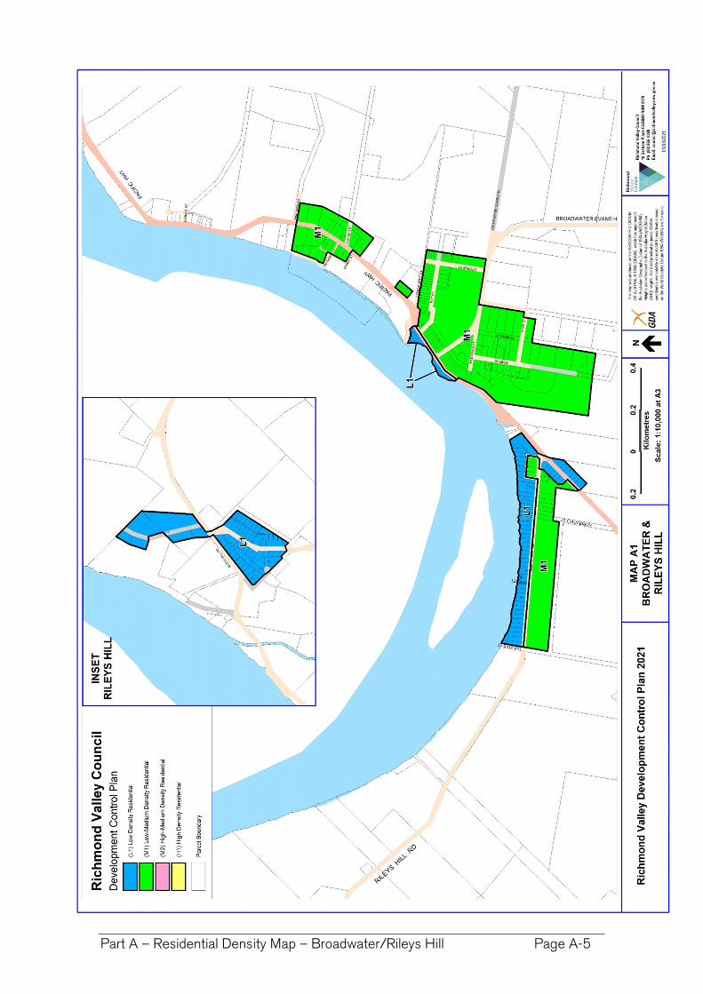
Part A – Residential Density Map – Broadwater/Rileys Hill Page A-5
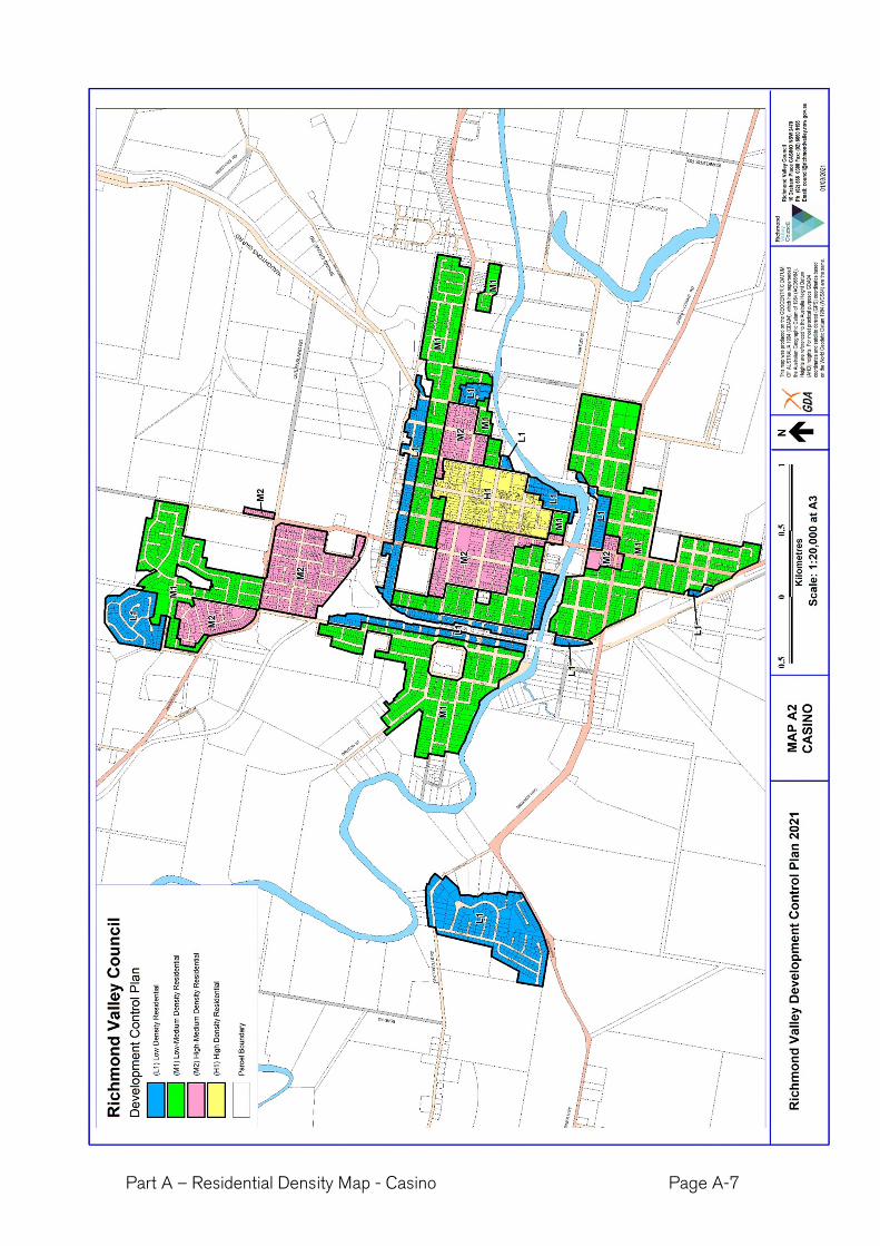
Part A – Residential Density Map - Casino Page A-7
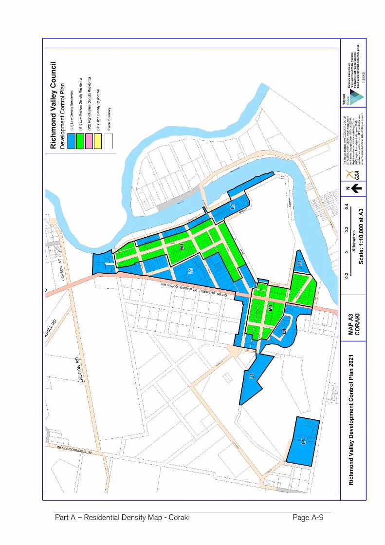
Part A – Residential Density Map - Coraki Page A-9
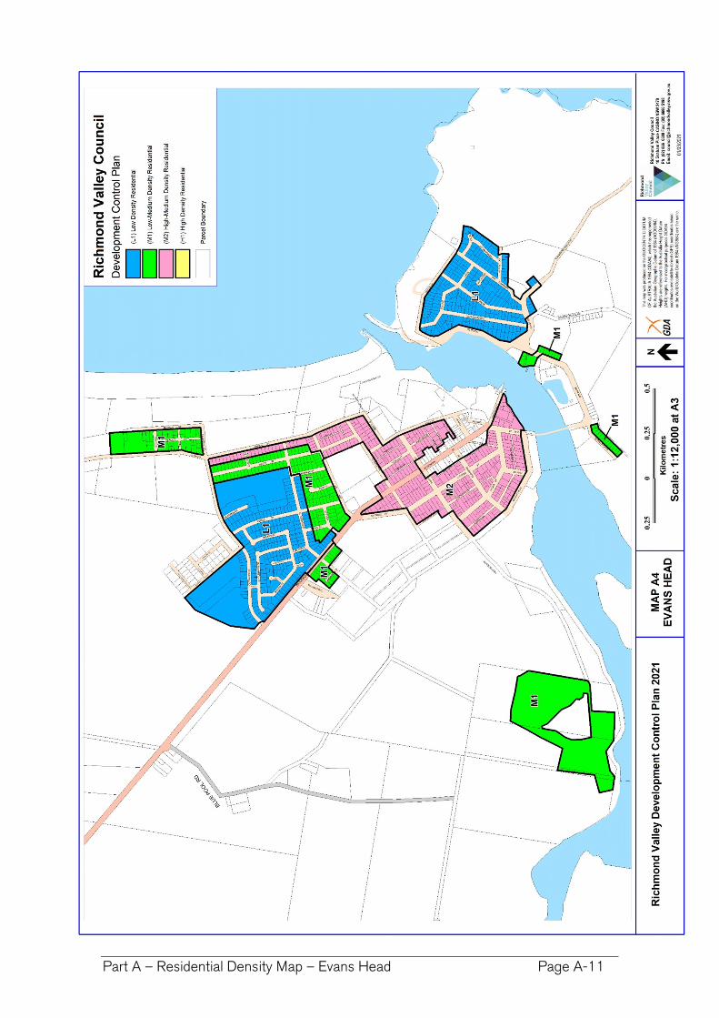
Part A – Residential Density Map – Evans Head Page A-11
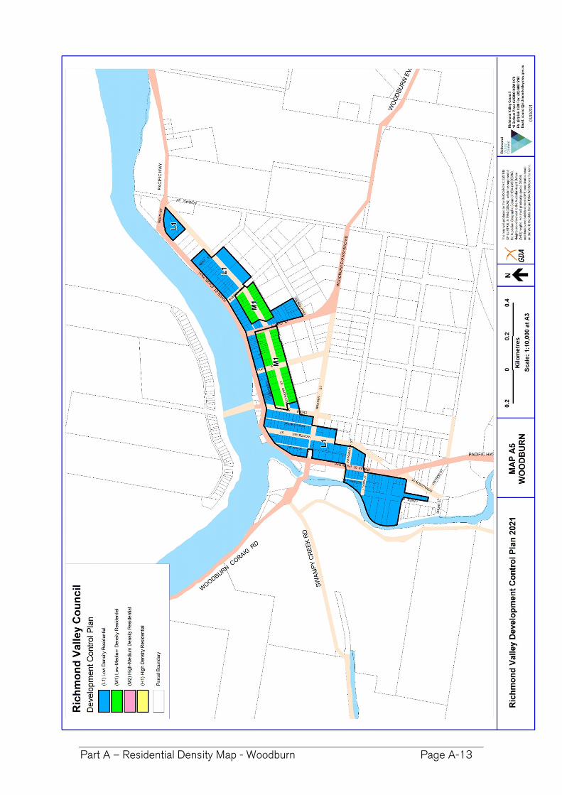
Part A – Residential Density Map - Woodburn Page A-13
PA
RT
A-1
–D
WE
LLIN
G H
OU
SE
S Z
ON
E R
1 &
RU
5
Part A-1 Dwelling Houses in the R1 General Residential and RU5 Village Zones
Part A-1 – Dwelling Houses – Zones R1 & RU5 Page A-15
Part A-1 Dwelling Houses in the R1 General Residential and RU5 Village Zones
Preamble
This chapter establishes objectives and design criteria for construction of a new dwelling house, or alterations and/or additions to an existing dwelling house on a lot of land in the following urban zones, where dwelling houses are permitted under the Richmond Valley LEP 2012:
R1 General Residential
RU5 Village
PA
RT
A-1
–D
WE
LLIN
G H
OU
SE
S Z
ON
E R
1 &
RU
5
Part A-1 Dwelling Houses in the R1 General Residential and RU5 Village Zones
Part A-1 – Dwelling Houses – Zones R1 & RU5 Page A-16
A-1.1 Hazards and Constraints
Objectives Design Criteria
(a) To alert applicants to the range of potential site constraints including natural hazards constraints, that may apply to a lot.
These constraints may impact on the siting and form of the development and require preparation of additional planning reports as part of the development applications.
1. The development design must take into account any hazards or constraints applying to the land, which may include the following: (a) Flood – Habitable floors to be above Flood Planning
Level (FPL). – see Council for flood levels and Part H-1 of the DCP.
(b) Bushfire – comply with Planning for Bushfire Protection 2019. A Bushfire Report is required.
(c) Acid Sulfate Soils (ASS) - see clause 6.1 of RVLEP & Part H-2 of this DCP.
(d) Coastal Development – A statement addressing the matters in SEPP (Coastal Management) 2018 is required.
(e) Contaminated Lands – Land to be of a standard compatible with residential development. Contaminated Land should be based upon consideration of current and historic land uses, the likely presence of asbestos and lead paints, and the land uses identified in SEPP 55.
(f) Natural Resource Sensitivity – confirm whether any one or more overlays applies – See clauses 6.6 to 6.10 of RVLEP:
Terrestrial Biodiversity (Native Vegetation and/or Wildlife Corridors)
Key Fish Habitat - referral to NSW Fisheries may be required.
Wetland - buffer of 50 metres recommended.
Steep Land - engineering required and consideration of scenic impacts.
Drinking Water Catchments – assess impacts on water quality
(g) Clearing of native vegetation - A report is provided addressing the Biodiversity Conservation Act 2019 and a map showing the vegetation to be removed is provided.
(h) Heritage – on or adjoining the site. See Part I-1 & RVLEP(i) Easements, Clear Zones, Zone of Influence for Services –
see Council for locations and zone of influence and clear zone requirements.
(j) Aircraft Noise - Any development within the 20 ANEF contour is to be constructed to comply with AS 2021:2015 Acoustics – Aircraft Noise Intrusion
(k) Dwellings that are within 100 m of a classified road or 80m from a rail corridor need to comply with relevant noise control treatment for sleeping areas and other habitable rooms in Appendix C of RMS Development Near Rail Corridors and Busy Roads - Interim Guideline.
Note. Information regarding the constraints and hazards applying can be found from:
A Section 10.7 Planning Certificate
The Department of Planning, Industry and Environment’s eSpatial viewer
The Biodiversity Values Map
By contacting Councils development concierge for assistance.
PA
RT
A-1
–D
WE
LLIN
G H
OU
SE
S Z
ON
E R
1 &
RU
5
Part A-1 Dwelling Houses in the R1 General Residential and RU5 Village Zones
Part A-1 – Dwelling Houses – Zones R1 & RU5 Page A-17
A-1.2. Building Height
Maximum height of building
Objectives Design Criteria
(a) To comply with the maximum building height requirement in the Richmond Valley LEP 2012.
1. The maximum height is as specified in the Height of Buildings Map in Richmond Valley Local Environmental Plan 2012. (a) Generally, the maximum height is 8.5 m. (b) Some residential areas of Evans Head have a 9.5 m
maximum height.
A-1.3. Building Setbacks
Note: The explanatory notes section provides further detail on the types of setbacks and how setbacks are measured.
Setbacks to StreetsObjectives Design Criteria
(a) The development provides a setback from the front boundary or public space that: i. defines the street edge; ii. creates a clear threshold and
transition from public to private space;
iii. assists in achieving visual privacy to ground floor dwellings from the street;
iv. contributes to the streetscape character and landscape; and
v. relates to the existing streetscape and setback pattern or the desired future streetscape pattern if different to the existing.
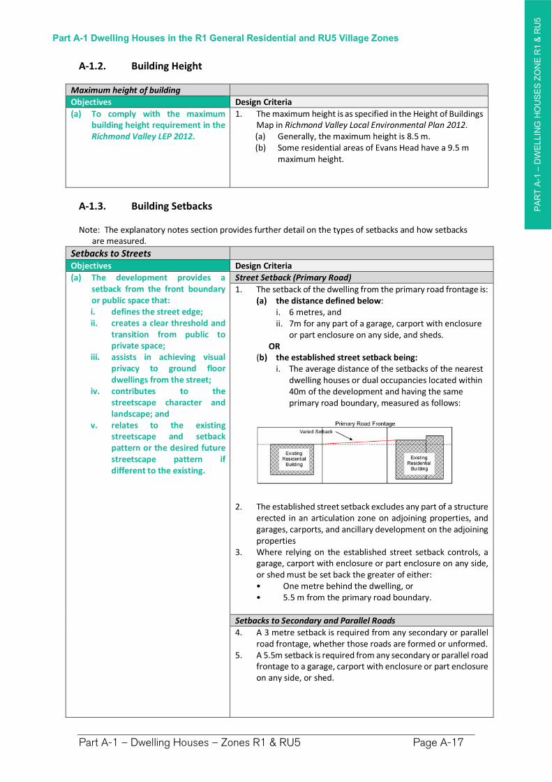
Street Setback (Primary Road)
1. The setback of the dwelling from the primary road frontage is:(a) the distance defined below:
i. 6 metres, and ii. 7m for any part of a garage, carport with enclosure
or part enclosure on any side, and sheds. OR
(b) the established street setback being:i. The average distance of the setbacks of the nearest
dwelling houses or dual occupancies located within 40m of the development and having the same primary road boundary, measured as follows:
2. The established street setback excludes any part of a structure erected in an articulation zone on adjoining properties, and garages, carports, and ancillary development on the adjoining properties
3. Where relying on the established street setback controls, a garage, carport with enclosure or part enclosure on any side, or shed must be set back the greater of either: • One metre behind the dwelling, or • 5.5 m from the primary road boundary.
Setbacks to Secondary and Parallel Roads
4. A 3 metre setback is required from any secondary or parallel road frontage, whether those roads are formed or unformed.
5. A 5.5m setback is required from any secondary or parallel road frontage to a garage, carport with enclosure or part enclosure on any side, or shed.
PA
RT
A-1
–D
WE
LLIN
G H
OU
SE
S Z
ON
E R
1 &
RU
5
Part A-1 Dwelling Houses in the R1 General Residential and RU5 Village Zones
Part A-1 – Dwelling Houses – Zones R1 & RU5 Page A-18
Setbacks to StreetsObjectives Design Criteria
Roads subject to Widening
6. The street setback to a road subject to widening shall be increased by width of land to be resumed by the widening as follows: (a) Lane Widening proposed in Chapter I-15 of this DCP—
the setback shall be increased by 3 metres to accommodate the proposed widening,
(b) land identified as Classified Road (SP2) on the Richmond Valley LEP 2012 Land Reservation Acquisition Map—the setback shall increase by the width of identified resumption.
Side Boundary SetbacksObjectives Design Criteria
(b) The development provides side boundary setbacks that reflects the character and separation of buildings within the surrounding area.
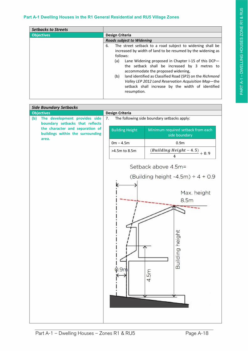
7. The following side boundary setbacks apply:
Building Height Minimum required setback from each side boundary
0m – 4.5m 0.9m
>4.5m to 8.5m (��������������− �.�)
�+ �.�
PA
RT
A-1
–D
WE
LLIN
G H
OU
SE
S Z
ON
E R
1 &
RU
5
Part A-1 Dwelling Houses in the R1 General Residential and RU5 Village Zones
Part A-1 – Dwelling Houses – Zones R1 & RU5 Page A-19
Rear Boundary SetbacksObjectives Design Criteria
(c) The development provides a rear boundary setback that: i. is consistent with the
character of the locality, ii. ensures dwellings do not
visually dominate or compromise the character of adjacent dwellings,
iii. provides privacy and solar access for outdoor areas of adjoining properties,
iv. provides opportunity for landscaping and private open space.
(d) Buildings are to be designed and sited to acknowledge the private open space of surrounding development and spatial character of rear yards. Extensive development should not visually dominate the outlook from the rear yards of neighbouring.
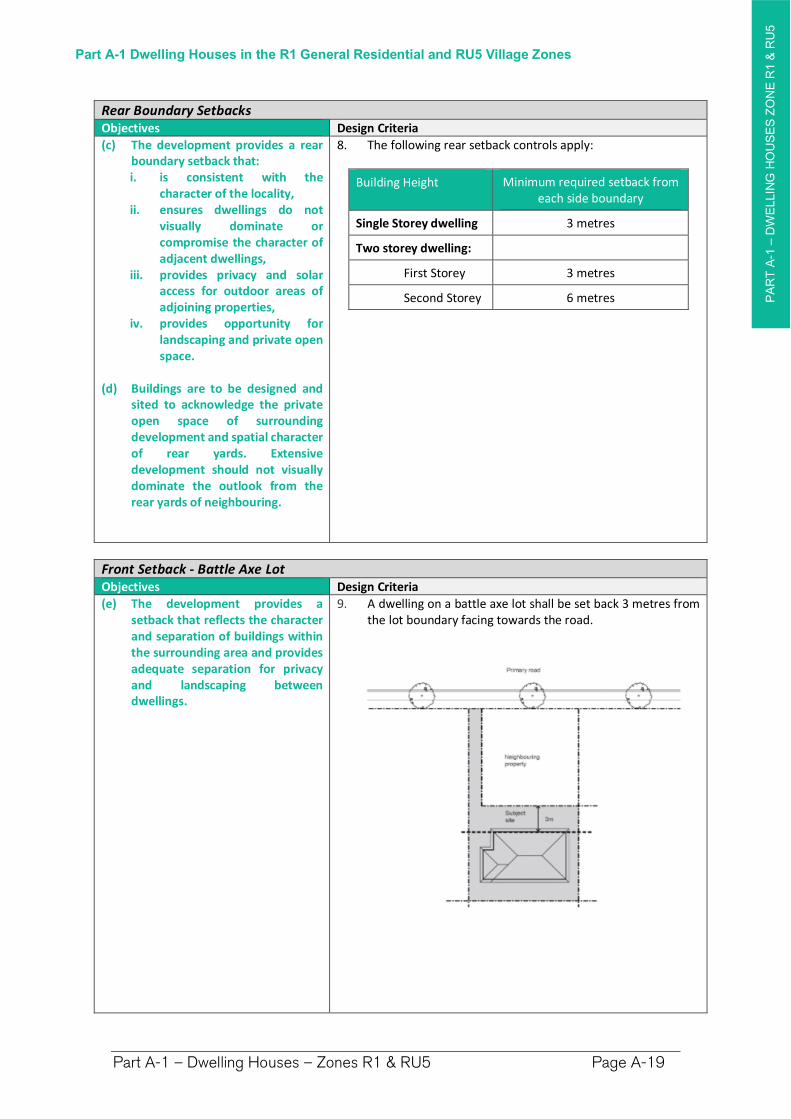
8. The following rear setback controls apply:
Building Height Minimum required setback from each side boundary
Single Storey dwelling 3 metres
Two storey dwelling:
First Storey 3 metres
Second Storey 6 metres
Front Setback - Battle Axe LotObjectives Design Criteria
(e) The development provides a setback that reflects the character and separation of buildings within the surrounding area and provides adequate separation for privacy and landscaping between dwellings.
9. A dwelling on a battle axe lot shall be set back 3 metres from the lot boundary facing towards the road.
PA
RT
A-1
–D
WE
LLIN
G H
OU
SE
S Z
ON
E R
1 &
RU
5
Part A-1 Dwelling Houses in the R1 General Residential and RU5 Village Zones
Part A-1 – Dwelling Houses – Zones R1 & RU5 Page A-20
Increased Setbacks on Certain LandObjectives Design Criteria
(f) Encourage building design and locations that have regard for the existing characteristics of the site and locality.
10. Site constraints may require greater setbacks from front, rear and/or side boundaries. For example: (a) A foreshore building line setback will apply to land
fronting waterways having a W1 Natural Waterways, or W2 Recreational Waterways zoning under the Richmond Valley LEP 2012. See Part I-3.5 Foreshore Building Line Setbacks.
(b) Bushfire Prone Lands and Grasslands Planning for Bushfire Protection, published by the NSW Rural Fire Service, may require increased setbacks.
(c) Land Use Conflict Buffers may be required to separate conflicting land uses, such as dwellings from industries, grazing, cropping or other rural activities. Further details see Part I-11 - LUCRA.
Underground Infrastructure and EasementsObjectives Design Criteria
(g) Development does not impact upon easements and underground infrastructure.
11. Ensure development is clear of any easements and infrastructure services such as water supply, stormwater drainage pipelines, swales and overland flow paths, and sewer mains, including any additional constraints from the Zone of Influence – see Council for locations.
12. Development within the Zone of Influence shall, as an absolute minimum, be outside of the Clear Zone as determined by Council assessment of the relevant depth and pipe diameter.
13. Increased depth of footings are generally required between the Clear Zone and the edge of the Zone of Influence (any relaxation will be subject to assessment of the location, the criticality of the infrastructure, the soil type, the development scale, and the type of development, etc).
14. Referrals to other authorities such as Essential Energy may be required. See State Environmental Planning Policy (Infrastructure).
A-1.4 Gross Floor Area/ Floor Space Ratio
Objectives Design Criteria
(a) The bulk and scale of development is appropriate for the context, minimises impacts on surrounding properties and allows for articulation of the built form.
1. The following maximum gross floor area applies for all development on the site:
Lot Area (m2) Maximum GFA
0 to 2000 25% of lot area + 300m2
>2000 800m2
PA
RT
A-1
–D
WE
LLIN
G H
OU
SE
S Z
ON
E R
1 &
RU
5
Part A-1 Dwelling Houses in the R1 General Residential and RU5 Village Zones
Part A-1 – Dwelling Houses – Zones R1 & RU5 Page A-21
A-1.5 Landscaped Area and Landscape Design
Landscaped Area
Objectives Design Criteria
(a) To provide adequate opportunities for the retention of existing and provision of new vegetation that: i. contributes to biodiversity; ii. enhances tree canopy; and iii. minimises urban runoff.
(b) Existing natural features of the site that contribute to neighbourhood character are retained, and visual and privacy impacts on existing neighbouring dwellings are reduced.
(c) Existing street trees are protected.
1. The minimum landscaped area is 30% of the site area. 2. Landscaped Area means a part of a site used for growing
plants, grasses and trees, but does not include any building, structure or hard paved area.
Gravel or similar surfaced areas that allow infiltration can contribute to the achievement of the minimum landscaped area, where they form part of the overall landscape design, but not where the gravel comprises a vehicular accessway or parking area or any other use which is not landscaping.
3. On a battle axe lot, the area of any access handle is to be excluded from the lot area used to calculate the minimum landscaped area requirements.
4. The minimum dimension of any area included in the landscaped area calculation is 1.5m.
5. At least 50% of the street setback is to be landscaped area. 6. The following is to be provided:
Front: 1 tree with mature height of 8m if primary road setback is greater than 5m. If the primary road setback is less than 5m, a tree with a mature height of 5m.
Rear: 1 tree with mature height of 3m. 7. Trees need to be sited clear of below ground and overhead
services Note. A list of suitable species is found in Part I-5 of the DCP.
8. Mature trees are to be retained, particularly those along the boundary, (except those where approval is granted by Council for their removal).
9. Landscape features on the site including trees and rock outcrops are to be retained where they contribute to the streetscape character or are located within the rear setback.
10. Development is to be designed to protect any existing street trees.
A-1.6 Principal Private Open Spaces
Objective Design Criteria
(a) Dwellings provide appropriately sized private open space to enhance residential amenity.
1. The area of principal private open space provided for each dwelling is: at least 25m² with a minimum length and width of 3m.
(b) Principal private open space is appropriately located to enhance liveability for residents.
2. The principal private open space is located behind the front building line.
3. The principal private open space is located adjacent to the living room, dining room or kitchen to extend the living space.
PA
RT
A-1
–D
WE
LLIN
G H
OU
SE
S Z
ON
E R
1 &
RU
5
Part A-1 Dwelling Houses in the R1 General Residential and RU5 Village Zones
Part A-1 – Dwelling Houses – Zones R1 & RU5 Page A-22
A-1.7 Building Design
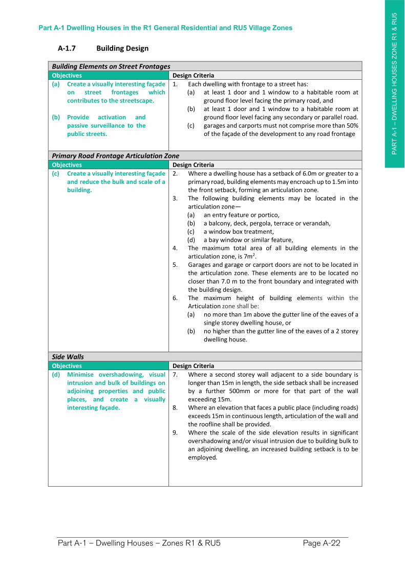
Building Elements on Street Frontages Objectives Design Criteria
(a) Create a visually interesting façade on street frontages which contributes to the streetscape.
(b) Provide activation and passive surveillance to the public streets.
1. Each dwelling with frontage to a street has: (a) at least 1 door and 1 window to a habitable room at
ground floor level facing the primary road, and (b) at least 1 door and 1 window to a habitable room at
ground floor level facing any secondary or parallel road.(c) garages and carports must not comprise more than 50%
of the façade of the development to any road frontage
Primary Road Frontage Articulation Zone Objectives Design Criteria
(c) Create a visually interesting façade and reduce the bulk and scale of a building.
2. Where a dwelling house has a setback of 6.0m or greater to a primary road, building elements may encroach up to 1.5m into the front setback, forming an articulation zone.
3. The following building elements may be located in the articulation zone— (a) an entry feature or portico, (b) a balcony, deck, pergola, terrace or verandah, (c) a window box treatment, (d) a bay window or similar feature,
4. The maximum total area of all building elements in the articulation zone, is 7m2.
5. Garages and garage or carport doors are not to be located in the articulation zone. These elements are to be located no closer than 7.0 m to the front boundary and integrated with the building design.
6. The maximum height of building elements within the Articulation zone shall be: (a) no more than 1m above the gutter line of the eaves of a
single storey dwelling house, or (b) no higher than the gutter line of the eaves of a 2 storey
dwelling house.
Side Walls Objectives Design Criteria
(d) Minimise overshadowing, visual intrusion and bulk of buildings on adjoining properties and public places, and create a visually interesting façade.
7. Where a second storey wall adjacent to a side boundary is longer than 15m in length, the side setback shall be increased by a further 500mm or more for that part of the wall exceeding 15m.
8. Where an elevation that faces a public place (including roads) exceeds 15m in continuous length, articulation of the wall and the roofline shall be provided.
9. Where the scale of the side elevation results in significant overshadowing and/or visual intrusion due to building bulk to an adjoining dwelling, an increased building setback is to be employed.
PA
RT
A-1
–D
WE
LLIN
G H
OU
SE
S Z
ON
E R
1 &
RU
5
Part A-1 Dwelling Houses in the R1 General Residential and RU5 Village Zones
Part A-1 – Dwelling Houses – Zones R1 & RU5 Page A-23
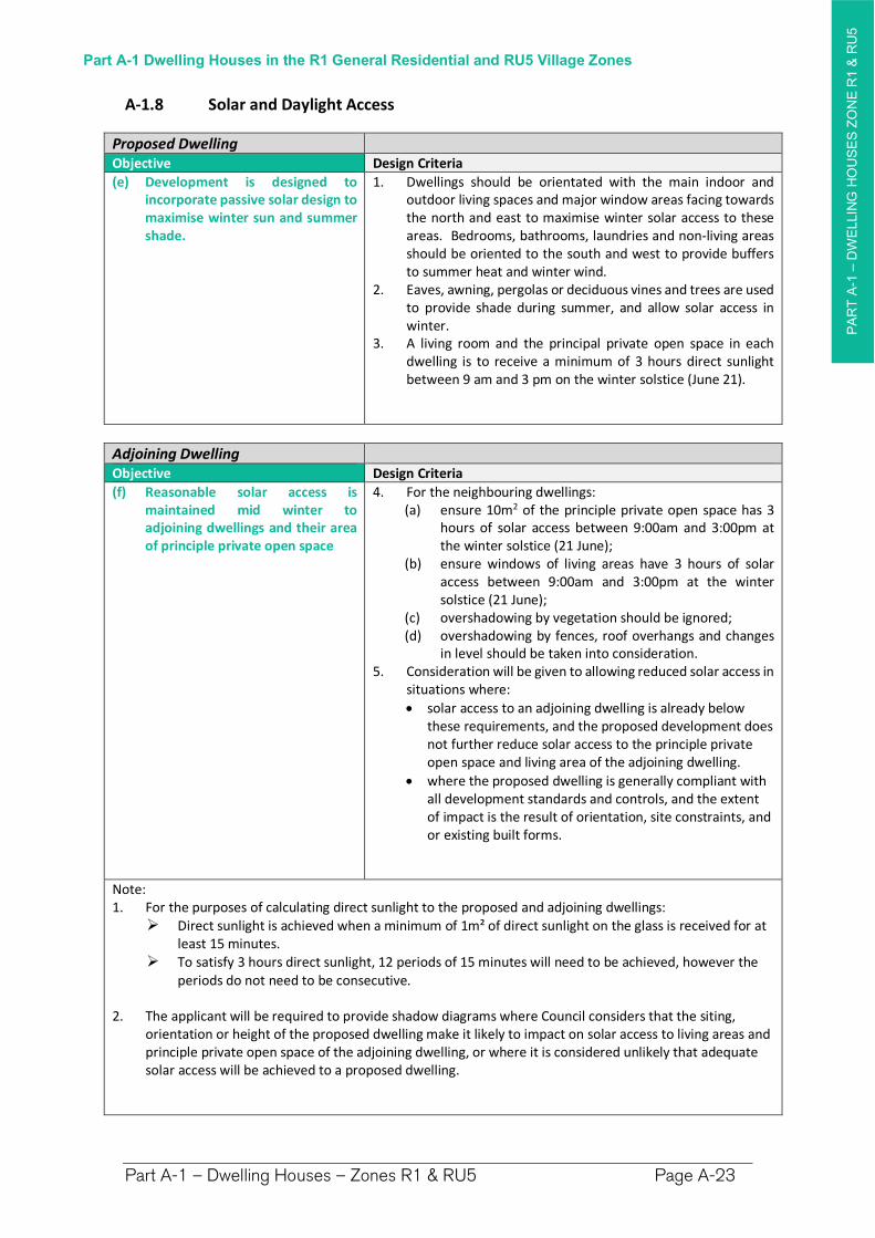
A-1.8 Solar and Daylight Access
Proposed Dwelling Objective Design Criteria
(e) Development is designed to incorporate passive solar design to maximise winter sun and summer shade.
1. Dwellings should be orientated with the main indoor and outdoor living spaces and major window areas facing towards the north and east to maximise winter solar access to these areas. Bedrooms, bathrooms, laundries and non-living areas should be oriented to the south and west to provide buffers to summer heat and winter wind.
2. Eaves, awning, pergolas or deciduous vines and trees are used to provide shade during summer, and allow solar access in winter.
3. A living room and the principal private open space in each dwelling is to receive a minimum of 3 hours direct sunlight between 9 am and 3 pm on the winter solstice (June 21).
Adjoining Dwelling Objective Design Criteria
(f) Reasonable solar access is maintained mid winter to adjoining dwellings and their area of principle private open space
4. For the neighbouring dwellings: (a) ensure 10m2 of the principle private open space has 3
hours of solar access between 9:00am and 3:00pm at the winter solstice (21 June);
(b) ensure windows of living areas have 3 hours of solar access between 9:00am and 3:00pm at the winter solstice (21 June);
(c) overshadowing by vegetation should be ignored; (d) overshadowing by fences, roof overhangs and changes
in level should be taken into consideration. 5. Consideration will be given to allowing reduced solar access in
situations where:
solar access to an adjoining dwelling is already below these requirements, and the proposed development does not further reduce solar access to the principle private open space and living area of the adjoining dwelling.
where the proposed dwelling is generally compliant with all development standards and controls, and the extent of impact is the result of orientation, site constraints, and or existing built forms.
Note: 1. For the purposes of calculating direct sunlight to the proposed and adjoining dwellings:
Direct sunlight is achieved when a minimum of 1m² of direct sunlight on the glass is received for at least 15 minutes.
To satisfy 3 hours direct sunlight, 12 periods of 15 minutes will need to be achieved, however the periods do not need to be consecutive.
2. The applicant will be required to provide shadow diagrams where Council considers that the siting, orientation or height of the proposed dwelling make it likely to impact on solar access to living areas and principle private open space of the adjoining dwelling, or where it is considered unlikely that adequate solar access will be achieved to a proposed dwelling.
PA
RT
A-1
–D
WE
LLIN
G H
OU
SE
S Z
ON
E R
1 &
RU
5
Part A-1 Dwelling Houses in the R1 General Residential and RU5 Village Zones
Part A-1 – Dwelling Houses – Zones R1 & RU5 Page A-24
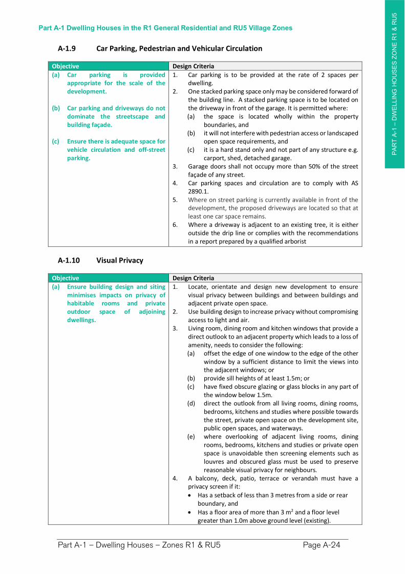
A-1.9 Car Parking, Pedestrian and Vehicular Circulation
Objective Design Criteria
(a) Car parking is provided appropriate for the scale of the development.
(b) Car parking and driveways do not dominate the streetscape and building façade.
(c) Ensure there is adequate space for vehicle circulation and off-street parking.
1. Car parking is to be provided at the rate of 2 spaces per dwelling.
2. One stacked parking space only may be considered forward of the building line. A stacked parking space is to be located on the driveway in front of the garage. It is permitted where: (a) the space is located wholly within the property
boundaries, and (b) it will not interfere with pedestrian access or landscaped
open space requirements, and (c) it is a hard stand only and not part of any structure e.g.
carport, shed, detached garage. 3. Garage doors shall not occupy more than 50% of the street
façade of any street. 4. Car parking spaces and circulation are to comply with AS
2890.1. 5. Where on street parking is currently available in front of the
development, the proposed driveways are located so that at least one car space remains.
6. Where a driveway is adjacent to an existing tree, it is either outside the drip line or complies with the recommendations in a report prepared by a qualified arborist
A-1.10 Visual Privacy
Objective Design Criteria
(a) Ensure building design and siting minimises impacts on privacy of habitable rooms and private outdoor space of adjoining dwellings.
1. Locate, orientate and design new development to ensure visual privacy between buildings and between buildings and adjacent private open space.
2. Use building design to increase privacy without compromising access to light and air.
3. Living room, dining room and kitchen windows that provide a direct outlook to an adjacent property which leads to a loss of amenity, needs to consider the following: (a) offset the edge of one window to the edge of the other
window by a sufficient distance to limit the views into the adjacent windows; or
(b) provide sill heights of at least 1.5m; or (c) have fixed obscure glazing or glass blocks in any part of
the window below 1.5m. (d) direct the outlook from all living rooms, dining rooms,
bedrooms, kitchens and studies where possible towards the street, private open space on the development site, public open spaces, and waterways.
(e) where overlooking of adjacent living rooms, dining rooms, bedrooms, kitchens and studies or private open space is unavoidable then screening elements such as louvres and obscured glass must be used to preserve reasonable visual privacy for neighbours.
4. A balcony, deck, patio, terrace or verandah must have a privacy screen if it:
Has a setback of less than 3 metres from a side or rear boundary, and
Has a floor area of more than 3 m2 and a floor level greater than 1.0m above ground level (existing).
PA
RT
A-1
–D
WE
LLIN
G H
OU
SE
S Z
ON
E R
1 &
RU
5
Part A-1 Dwelling Houses in the R1 General Residential and RU5 Village Zones
Part A-1 – Dwelling Houses – Zones R1 & RU5 Page A-25
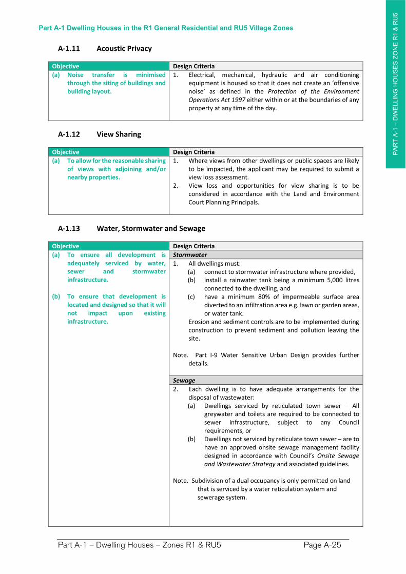
A-1.11 Acoustic Privacy
Objective Design Criteria
(a) Noise transfer is minimised through the siting of buildings and building layout.
1. Electrical, mechanical, hydraulic and air conditioning equipment is housed so that it does not create an ‘offensive noise’ as defined in the Protection of the Environment Operations Act 1997 either within or at the boundaries of any property at any time of the day.
A-1.12 View Sharing
Objective Design Criteria
(a) To allow for the reasonable sharing of views with adjoining and/or nearby properties.
1. Where views from other dwellings or public spaces are likely to be impacted, the applicant may be required to submit a view loss assessment.
2. View loss and opportunities for view sharing is to be considered in accordance with the Land and Environment Court Planning Principals.
A-1.13 Water, Stormwater and Sewage
Objective Design Criteria
(a) To ensure all development is adequately serviced by water, sewer and stormwater infrastructure.
(b) To ensure that development is located and designed so that it will not impact upon existing infrastructure.
Stormwater
1. All dwellings must: (a) connect to stormwater infrastructure where provided, (b) install a rainwater tank being a minimum 5,000 litres
connected to the dwelling, and (c) have a minimum 80% of impermeable surface area
diverted to an infiltration area e.g. lawn or garden areas, or water tank.
Erosion and sediment controls are to be implemented during construction to prevent sediment and pollution leaving the site.
Note. Part I-9 Water Sensitive Urban Design provides further details.
Sewage
2. Each dwelling is to have adequate arrangements for the disposal of wastewater: (a) Dwellings serviced by reticulated town sewer – All
greywater and toilets are required to be connected to sewer infrastructure, subject to any Council requirements, or
(b) Dwellings not serviced by reticulate town sewer – are to have an approved onsite sewage management facility designed in accordance with Council’s Onsite Sewage and Wastewater Strategy and associated guidelines.
Note. Subdivision of a dual occupancy is only permitted on land that is serviced by a water reticulation system and sewerage system.
PA
RT
A-1
–D
WE
LLIN
G H
OU
SE
S Z
ON
E R
1 &
RU
5
Part A-1 Dwelling Houses in the R1 General Residential and RU5 Village Zones
Part A-1 – Dwelling Houses – Zones R1 & RU5 Page A-26
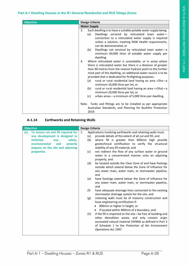
Objective Design Criteria
Water Supply
3. Each dwelling is to have a suitable potable water supply being:(a) Dwellings serviced by reticulated town water—
connection to a reticulated water supply is required unless a solution, meeting NSW Health requirements, can be demonstrated, or
(b) Dwellings not serviced by reticulated town water—a minimum 60,000 litres of potable water supply per dwelling.
4. Where reticulated water is unavailable, or in areas where there is reticulated water but there is a distance of greater than 90 metres from the nearest hydrant point to the further most part of the dwelling, an additional water source is to be provided that is dedicated for firefighting purposes: (a) rural or rural residential land having an area <2ha—a
minimum 10,000 litres per lot, or (b) rural or rural residential land having an area =>2ha)—a
minimum 20,000 litres per lot, or (c) urban areas – a minimum of 5,000 litres per dwelling.
Note. Tanks and fittings are to be installed as per appropriate Australian Standards, and Planning for Bushfire Protection 2019.
A-1.14 Earthworks and Retaining Walls
Objective Design Criteria
(a) To ensure cut and fill required for any development is designed to minimise any safety, environmental and amenity impacts on the site and adjoining properties.
1. Applications involving earthworks and retaining walls must: (a) provide details of the extent of all cut and fill, and (b) where fill is greater than 600mm high provide
geotechnical certification to verify the structural stability of any fill material, and
(c) not redirect the flow of any surface water or ground water in a concentrated manner onto an adjoining property, and
(d) be located outside the Clear Zone of and have footings outside which extend below the Zone of Influence for any sewer main, water main, or stormwater pipeline, and
(e) have footings extend below the Zone of Influence for any sewer main, water main, or stormwater pipeline, and
(f) have adequate drainage lines connected to the existing stormwater drainage system for the site, and
(g) retaining walls must be of masonry construction and have engineering certification if:
900mm or higher in height, or
if located within 900mm of a boundary, and (h) if the fill is imported to the site—be free of building and
other demolition waste, and only contain virgin excavated natural material (VENM) as defined in Part 3 of Schedule 1 to the Protection of the Environment Operations Act 1997.
PA
RT
A-2
PA
RT
A-2
–D
WE
LLIN
G H
OU
SE
S Z
ON
ES
RU
!, R
5 &
E3
Part A-2 Dwelling Houses in the RU1 Primary Production, R5 Large Lot Residential and E3 Environmental Management Zones
Part A-2 – Dwelling Houses – Zones RU1, R5 & E3 Page A-27
Part A-2 Dwelling Houses in the RU1 Primary Production, R5 Large Lot Residential and E3 Environmental Management Zones
Preamble
This chapter makes provision for construction of a dwelling house on a lot of land in the following rural zones, where dwelling houses are permitted under the Richmond Valley LEP 2012:
RU1 Primary Production
E3 Environmental Management
R5 Large Lot Residential
For a dwelling house to be constructed on a lot of land in these zones, the lot must have a Dwelling Opportunity under the Richmond Valley Local Environmental Plan 2012. Consult with Council to determine whether a dwelling opportunity exists for that land.
PA
RT
A-2
PA
RT
A-2
–D
WE
LLIN
G H
OU
SE
S Z
ON
ES
RU
!, R
5 &
E3
Part A-2 Dwelling Houses in the RU1 Primary Production, R5 Large Lot Residential and E3 Environmental Management Zones
Part A-2 – Dwelling Houses – Zones RU1, R5 & E3 Page A-28
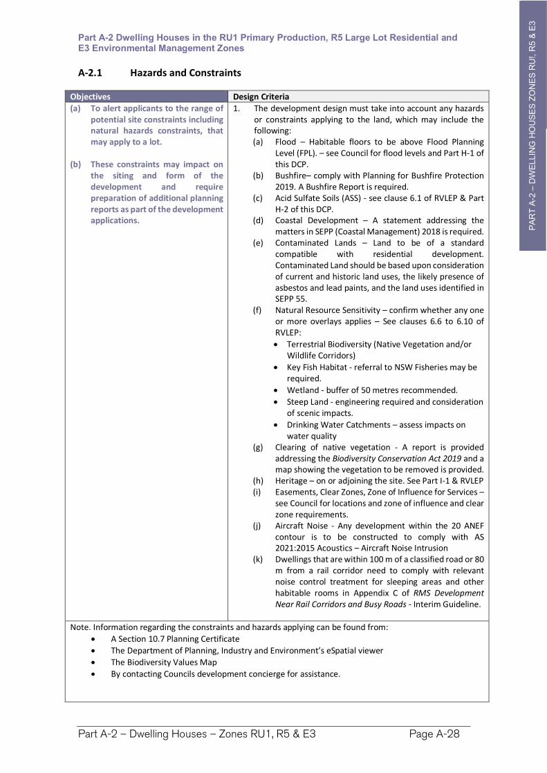
A-2.1 Hazards and Constraints
Objectives Design Criteria
(a) To alert applicants to the range of potential site constraints including natural hazards constraints, that may apply to a lot.
(b) These constraints may impact on the siting and form of the development and require preparation of additional planning reports as part of the development applications.
1. The development design must take into account any hazards or constraints applying to the land, which may include the following: (a) Flood – Habitable floors to be above Flood Planning
Level (FPL). – see Council for flood levels and Part H-1 of this DCP.
(b) Bushfire– comply with Planning for Bushfire Protection 2019. A Bushfire Report is required.
(c) Acid Sulfate Soils (ASS) - see clause 6.1 of RVLEP & Part H-2 of this DCP.
(d) Coastal Development – A statement addressing the matters in SEPP (Coastal Management) 2018 is required.
(e) Contaminated Lands – Land to be of a standard compatible with residential development. Contaminated Land should be based upon consideration of current and historic land uses, the likely presence of asbestos and lead paints, and the land uses identified in SEPP 55.
(f) Natural Resource Sensitivity – confirm whether any one or more overlays applies – See clauses 6.6 to 6.10 of RVLEP:
Terrestrial Biodiversity (Native Vegetation and/or Wildlife Corridors)
Key Fish Habitat - referral to NSW Fisheries may be required.
Wetland - buffer of 50 metres recommended.
Steep Land - engineering required and consideration of scenic impacts.
Drinking Water Catchments – assess impacts on water quality
(g) Clearing of native vegetation - A report is provided addressing the Biodiversity Conservation Act 2019 and a map showing the vegetation to be removed is provided.
(h) Heritage – on or adjoining the site. See Part I-1 & RVLEP (i) Easements, Clear Zones, Zone of Influence for Services –
see Council for locations and zone of influence and clear zone requirements.
(j) Aircraft Noise - Any development within the 20 ANEF contour is to be constructed to comply with AS 2021:2015 Acoustics – Aircraft Noise Intrusion
(k) Dwellings that are within 100 m of a classified road or 80 m from a rail corridor need to comply with relevant noise control treatment for sleeping areas and other habitable rooms in Appendix C of RMS Development Near Rail Corridors and Busy Roads - Interim Guideline.
Note. Information regarding the constraints and hazards applying can be found from:
A Section 10.7 Planning Certificate
The Department of Planning, Industry and Environment’s eSpatial viewer
The Biodiversity Values Map
By contacting Councils development concierge for assistance.
PA
RT
A-2
PA
RT
A-2
–D
WE
LLIN
G H
OU
SE
S Z
ON
ES
RU
!, R
5 &
E3
Part A-2 Dwelling Houses in the RU1 Primary Production, R5 Large Lot Residential and E3 Environmental Management Zones
Part A-2 – Dwelling Houses – Zones RU1, R5 & E3 Page A-29
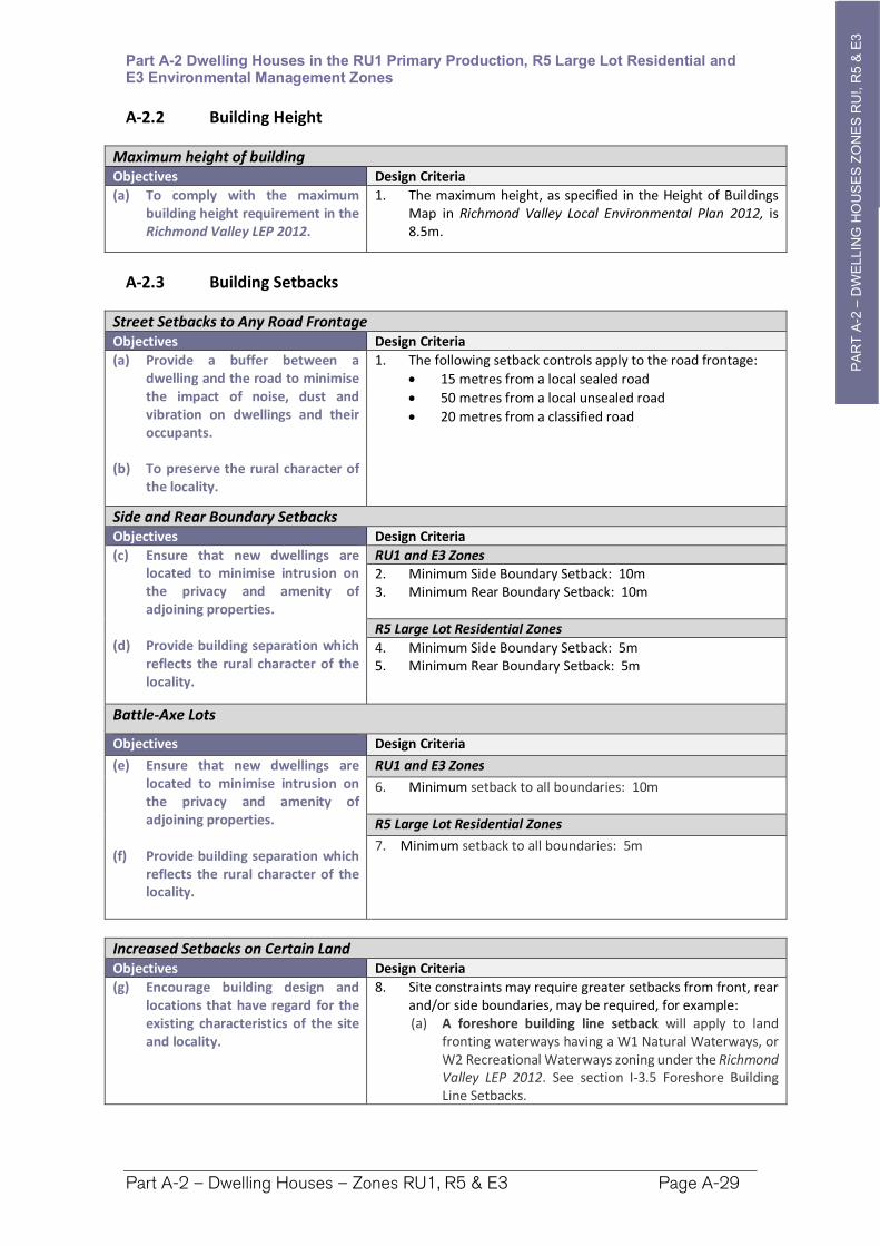
A-2.2 Building Height
Maximum height of building Objectives Design Criteria
(a) To comply with the maximum building height requirement in the Richmond Valley LEP 2012.
1. The maximum height, as specified in the Height of Buildings Map in Richmond Valley Local Environmental Plan 2012, is 8.5m.
A-2.3 Building Setbacks
Street Setbacks to Any Road Frontage Objectives Design Criteria
(a) Provide a buffer between a dwelling and the road to minimise the impact of noise, dust and vibration on dwellings and their occupants.
(b) To preserve the rural character of the locality.
1. The following setback controls apply to the road frontage:
15 metres from a local sealed road
50 metres from a local unsealed road
20 metres from a classified road
Side and Rear Boundary Setbacks Objectives Design Criteria
(c) Ensure that new dwellings are located to minimise intrusion on the privacy and amenity of adjoining properties.
(d) Provide building separation which reflects the rural character of the locality.
RU1 and E3 Zones2. Minimum Side Boundary Setback: 10m3. Minimum Rear Boundary Setback: 10m
R5 Large Lot Residential Zones
4. Minimum Side Boundary Setback: 5m 5. Minimum Rear Boundary Setback: 5m
Battle-Axe Lots
Objectives Design Criteria
(e) Ensure that new dwellings are located to minimise intrusion on the privacy and amenity of adjoining properties.
(f) Provide building separation which reflects the rural character of the locality.
RU1 and E3 Zones
6. Minimum setback to all boundaries: 10m
R5 Large Lot Residential Zones
7. Minimum setback to all boundaries: 5m
Increased Setbacks on Certain Land Objectives Design Criteria
(g) Encourage building design and locations that have regard for the existing characteristics of the site and locality.
8. Site constraints may require greater setbacks from front, rear and/or side boundaries, may be required, for example: (a) A foreshore building line setback will apply to land
fronting waterways having a W1 Natural Waterways, or W2 Recreational Waterways zoning under the Richmond Valley LEP 2012. See section I-3.5 Foreshore Building Line Setbacks.
PA
RT
A-2
PA
RT
A-2
–D
WE
LLIN
G H
OU
SE
S Z
ON
ES
RU
!, R
5 &
E3
Part A-2 Dwelling Houses in the RU1 Primary Production, R5 Large Lot Residential and E3 Environmental Management Zones
Part A-2 – Dwelling Houses – Zones RU1, R5 & E3 Page A-30
Increased Setbacks on Certain Land Objectives Design Criteria
(b) Bushfire Prone Lands and Grasslands Planning for Bushfire Protection, published by the NSW Rural Fire Service, may require increased setbacks.
(c) Land Use Conflict Buffers may be required to separate conflicting land uses, e.g. dwellings from industries or rural activities. Further details See Part I-11 - LUCRA.
Setbacks to Easements and Infrastructure Objectives Design Criteria
(h) Development does not impact upon easements and underground infrastructure.
9. Ensure development is clear of any easements and infrastructure services such as water supply, stormwater drainage pipelines, swales and overland flow paths, and sewer mains, including any additional constraints from the Zone of Influence – see Council for locations.
10. Development within the Zone of Influence shall, as an absolute minimum, be outside of the Clear Zone as determined by Council assessment of the relevant depth and pipe diameter.
11. Increased depth of footings are generally required between the Clear Zone and the edge of the Zone of Influence (any relaxation will be subject to assessment of the location, the criticality of the infrastructure, the soil type, the development scale, and the type of development, etc).
A-2.4 Car Parking and Access
Objective Design Criteria
(a) Car parking is provided appropriate for the scale of the development.
1. 2 car parking spaces are to be provided, located behind the building line.
A-2.5 Visual Privacy
Objective Design Criteria
(a) Ensure building design and siting minimises impacts on privacy of habitable rooms and private outdoor space of adjoining dwellings.
1. Locate, orientate and design new development to ensure visual privacy between buildings, and also between buildings and adjacent private open space.
A-2.6 Acoustic Privacy
Objective Design Criteria
(a) Noise transfer is minimised through the siting of buildings and building layout.
1. Electrical, mechanical, hydraulic and air conditioning equipment is housed so that it does not create an ‘offensive noise’ as defined in the Protection of the Environment Operations Act 1997 either within or at the boundaries of any property at any time of the day.
PA
RT
A-2
PA
RT
A-2
–D
WE
LLIN
G H
OU
SE
S Z
ON
ES
RU
!, R
5 &
E3
Part A-2 Dwelling Houses in the RU1 Primary Production, R5 Large Lot Residential and E3 Environmental Management Zones
Part A-2 – Dwelling Houses – Zones RU1, R5 & E3 Page A-31
A-2.7 View Sharing
Objective Design Criteria
(a) To allow for the reasonable sharing of views with adjoining and/or nearby properties.
1. Where views from other dwellings or public spaces are likely to be impacted, the applicant may be required to submit a view loss assessment.
2. View loss and opportunities for view sharing is to be considered in accordance with the Land and Environment Court Planning Principals.
A-2.8 Local Character and Context
Objectives Design Criteria
(a) The built form relates to the local character of the area and the context.
(b) Encourage building design and locations that have regard for the existing characteristics of the site and locality.
1. The design of dwelling and associated buildings should be in keeping with the rural character of the locality. Traditional construction materials (i.e. timber, corrugated roofing or similar) and natural colours (grey, greens and browns) are encouraged;
2. Extensive use of highly reflective materials and/or colours is not acceptable for roof or wall cladding.
A-2.9 Water, Stormwater and Sewage
Objective Design Criteria
(a) To ensure all development is adequately serviced by water, sewer and stormwater infrastructure.
(b) To ensure that development is located and designed so that it will not impact upon existing infrastructure.
Stormwater
1. All dwellings must: (a) connect to urban water, sewer & stormwater
infrastructure where provided, (b) install a rainwater tank being a minimum 5,000 litres
connected to the dwelling, and (c) have a minimum 80% of impermeable surface area
diverted to an infiltration area e.g. lawn or garden areas, or water tank.
Erosion and sediment controls are to be implemented during construction to prevent sediment and pollution leaving the site.
Note. Part I-9 Water Sensitive Urban Design provides further details.
Sewage
2. Dwellings not serviced by reticulated town sewer—are to have an approved onsite sewage management facility designed in accordance with Council’s Onsite Sewage and Wastewater Strategy and associated guidelines.
Water Supply
3. Each dwelling is to have a suitable potable water supply being: (a) Dwellings serviced by reticulated town water—
connection to a reticulated water supply is required unless a solution, meeting NSW Health requirements, can be demonstrated, or
PA
RT
A-2
PA
RT
A-2
–D
WE
LLIN
G H
OU
SE
S Z
ON
ES
RU
!, R
5 &
E3
Part A-2 Dwelling Houses in the RU1 Primary Production, R5 Large Lot Residential and E3 Environmental Management Zones
Part A-2 – Dwelling Houses – Zones RU1, R5 & E3 Page A-32
Objective Design Criteria
(b) Dwellings not serviced by reticulated town water—a minimum 60,000 litres of potable water supply per dwelling.
4. Where reticulated water is unavailable, or in areas where there is reticulated water but there is a distance of greater than 90 metres from the nearest hydrant point to further most part of the dwelling, an additional water source is to be provided that is dedicated for firefighting purposes: (a) rural or rural residential land having an area <2ha—
a minimum 10,000 litres per lot, or (b) rural or rural residential land having an area
=>2ha)—a minimum 20,000 litres per lot. (c) urban areas – a minimum of 5,000 litres per dwelling
Note. Tanks and fittings are to be installed as per appropriate Australian Standards, and Planning for Bushfire Protection 2019.
A-2.10 Earthworks and Retaining Walls
Objective Design Criteria
(a) To ensure cut and fill required for any development is designed to minimise any safety, environmental and amenity impacts on the site and adjoining properties.
1. Applications involving earthworks and retaining walls must:(a) provide details of the extent of all cut and fill, and (b) where fill is greater than 600mm high provide
geotechnical certification to verify the structural stability of any fill material, and
(c) not redirect the flow of any surface water or ground water in a concentrated manner onto an adjoining property, and
(d) be located outside the Clear Zone of and have footings outside which extend below the Zone of Influence for any sewer main, water main, or stormwater pipeline, and
(e) have adequate drainage lines connected to the existing stormwater drainage system for the site, and
(f) retaining walls must be of masonry construction and have engineering certification if:
900mm or higher in height, or
if located within 900mm of a boundary, and (g) if the fill is imported to the site—be free of building and
other demolition waste, and only contain virgin excavated natural material (VENM) as defined in Part 3 of Schedule 1 to the Protection of the Environment Operations Act 1997.
PA
RT
A-3
–D
UA
L O
CC
UP
AN
YC
ZO
NE
R1 &
RU
5
Part A-3 Dual Occupancy in the R1 General Residential and RU5 Village Zones
Part A-3 – Dual Occupancy – Zones R1 & RU5 Page A-33
Part A-3 Dual Occupancies in the R1 General Residential and RU5 Village Zones
Preamble
This chapter makes provision for dual occupancy development in the following urban zones, in which attached and detached dual occupancy is permitted under the Richmond Valley LEP 2012:
R1 General Residential
RU5 Village
PA
RT
A-3
–D
UA
L O
CC
UP
AN
YC
ZO
NE
R1 &
RU
5
Part A-3 Dual Occupancy in the R1 General Residential and RU5 Village Zones
Part A-3 – Dual Occupancy – Zones R1 & RU5 Page A-34
A-3.1 Minimum Lot Sizes and Subdivision
Minimum lot size for carrying out dual occupancy development Objectives Design Criteria
(a) To achieve planned residential density consistent with the local housing strategy.
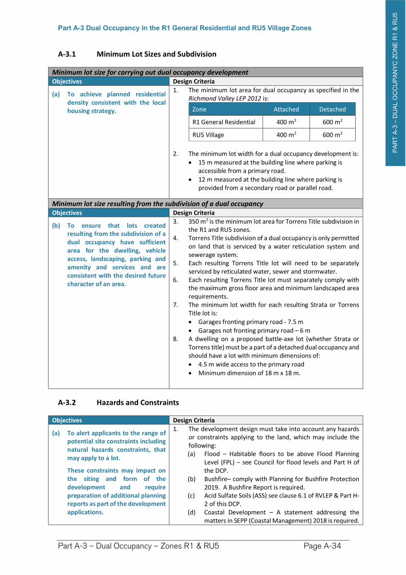
1. The minimum lot area for dual occupancy as specified in the Richmond Valley LEP 2012 is:
Zone Attached Detached
R1 General Residential 400 m2 600 m2
RU5 Village 400 m2 600 m2
2. The minimum lot width for a dual occupancy development is:
15 m measured at the building line where parking is accessible from a primary road.
12 m measured at the building line where parking is provided from a secondary road or parallel road.
Minimum lot size resulting from the subdivision of a dual occupancy Objectives Design Criteria
(b) To ensure that lots created resulting from the subdivision of a dual occupancy have sufficient area for the dwelling, vehicle access, landscaping, parking and amenity and services and are consistent with the desired future character of an area.
3. 350 m2 is the minimum lot area for Torrens Title subdivision in the R1 and RU5 zones.
4. Torrens Title subdivision of a dual occupancy is only permitted on land that is serviced by a water reticulation system and sewerage system.
5. Each resulting Torrens Title lot will need to be separately serviced by reticulated water, sewer and stormwater.
6. Each resulting Torrens Title lot must separately comply with the maximum gross floor area and minimum landscaped area requirements.
7. The minimum lot width for each resulting Strata or Torrens Title lot is:
Garages fronting primary road - 7.5 m
Garages not fronting primary road – 6 m 8. A dwelling on a proposed battle-axe lot (whether Strata or
Torrens title) must be a part of a detached dual occupancy and should have a lot with minimum dimensions of:
4.5 m wide access to the primary road
Minimum dimension of 18 m x 18 m.
A-3.2 Hazards and Constraints
Objectives Design Criteria
(a) To alert applicants to the range of potential site constraints including natural hazards constraints, that may apply to a lot.
These constraints may impact on the siting and form of the development and require preparation of additional planning reports as part of the development applications.
1. The development design must take into account any hazards or constraints applying to the land, which may include the following: (a) Flood – Habitable floors to be above Flood Planning
Level (FPL) – see Council for flood levels and Part H of the DCP.
(b) Bushfire– comply with Planning for Bushfire Protection 2019. A Bushfire Report is required.
(c) Acid Sulfate Soils (ASS) see clause 6.1 of RVLEP & Part H-2 of this DCP.
(d) Coastal Development – A statement addressing the matters in SEPP (Coastal Management) 2018 is required.
PA
RT
A-3
–D
UA
L O
CC
UP
AN
YC
ZO
NE
R1 &
RU
5
Part A-3 Dual Occupancy in the R1 General Residential and RU5 Village Zones
Part A-3 – Dual Occupancy – Zones R1 & RU5 Page A-35
Objectives Design Criteria
(e) Contaminated Lands – Land to be of a standard compatible with residential development. Contaminated Land should be based upon consideration of current and historic land uses, the likely presence of asbestos and lead paints, and the land uses identified in SEPP 55.
(f) Natural Resource Sensitivity – confirm whether any one or more overlays applies – See clauses 6.6 to 6.10 of RVLEP:
Terrestrial Biodiversity (Native Vegetation and/or Wildlife Corridors)
Key Fish Habitat - referral to NSW Fisheries may be required.
Wetland - buffer of 50 metres recommended.
Steep Land - engineering required and consideration of scenic impacts.
Drinking Water Catchments – assess impacts on water quality
(g) Clearing of native vegetation - A report is provided addressing the Biodiversity Conservation Act 2019 and a map showing the vegetation to be removed is provided.
(h) Heritage – on or adjoining the site. See Part I-1 & RVLEP (i) Easements, Clear Zones, Zone of Influence for Services –
see Council for locations and zone of influence and clear zone requirements.
(j) Aircraft Noise - Any development within the 20 ANEF contour is to be constructed to comply with AS 2021:2015 Acoustics – Aircraft Noise Intrusion
(k) Dwellings that are within 100 m of a classified road or 80 m from a rail corridor need to comply with relevant noise control treatment for sleeping areas and other habitable rooms in Appendix C of RMS Development Near Rail Corridors and Busy Roads - Interim Guideline.
Note. Information regarding the constraints and hazards applying can be found from;
A Section 10.7 Planning Certificate
The Department of Planning, Industry and Environment’s eSpatial viewer
The Biodiversity Values Map
By contacting Councils development concierge for assistance.
A-3.3 Building Height
Maximum height of building Objectives Design Criteria
(a) The building height is consistent with the desired scale and character of the street and locality and provides an acceptable impact on the amenity of adjoining properties.
1. The maximum height is as specified in the Height of BuildingsMap in Richmond Valley Local Environmental Plan 2012. (a) Generally the maximum height is 8.5m. (b) Some areas of Evans Head have a 9.5m maximum
height. 2. For detached dual occupancies in a battle axe arrangement,
the dwelling furthest from the street: 5.4m from ground level (existing).
PA
RT
A-3
–D
UA
L O
CC
UP
AN
YC
ZO
NE
R1 &
RU
5
Part A-3 Dual Occupancy in the R1 General Residential and RU5 Village Zones
Part A-3 – Dual Occupancy – Zones R1 & RU5 Page A-36
Maximum height of building Objectives Design Criteria
3. When flood related requirements apply to the land, consideration may be given to varying this height requirement.
4. The maximum number of storeys excluding basements is:
2, or
for detached dual occupancies in a battle axe arrangement, the dwelling furthest from the street: 1
A-3.4 Building Setbacks
Setbacks to Streets – Parent Lot Objectives Design Criteria
(a) The development provides a setback from the front boundary or public space that:
i. defines the street edge;
ii. creates a clear threshold and transition from public to private space;
iii. assists in achieving visual privacy to ground floor dwellings from the street;
iv. contributes to the streetscape character and landscape; and relates to the existing streetscape and setback pattern or the desired future streetscape pattern if different to the existing.
Front Setback to a Primary Road
1. The setback of the dwelling from the street is the lesser of the following: (a) the distance defined below:
i. 6 metres, and ii. Garages, carports with enclosure or part enclosure
on any side, and sheds must be 1.0 metre behind the building line
OR (b) the established street setback provisions below:
i. The average distance of the setbacks of the nearest dwelling houses or dual occupancies located within 40m of the development and having the same primary road boundary, measured as follows:
2. A calculation based on the established street setback excludes any part of a structure erected within an articulation zone on adjoining properties, and any garages, carports, and ancillary development on the adjoining properties
3. Where relying on the established street setback controls to set the front building line, a garage, carport with enclosure or part enclosure on any side, or shed must be set back either:
One metre behind the dwelling or
5.5m from the primary road boundary; Whichever is the greater.
Note. Further information on measuring setbacks is found in the explanatory notes section of the DCP.
PA
RT
A-3
–D
UA
L O
CC
UP
AN
YC
ZO
NE
R1 &
RU
5
Part A-3 Dual Occupancy in the R1 General Residential and RU5 Village Zones
Part A-3 – Dual Occupancy – Zones R1 & RU5 Page A-37
Setbacks to Streets – Parent Lot Objectives Design Criteria
Setbacks to Secondary and Parallel Roads
4. On land having frontage to more than 1 road alignment whether those roads are formed or unformed, a 3 metre setback applies to any secondary or parallel street frontage.
5. Garages and sheds and carports fully or partly enclosed on any side are required to be set back 5.5 metres from a secondary or parallel road frontage.
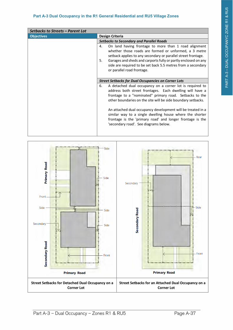
Street Setbacks for Dual Occupancies on Corner Lots
6. A detached dual occupancy on a corner lot is required to address both street frontages. Each dwelling will have a frontage to a "nominated" primary road. Setbacks to the other boundaries on the site will be side boundary setbacks.
An attached dual occupancy development will be treated in a similar way to a single dwelling house where the shorter frontage is the 'primary road' and longer frontage is the 'secondary road'. See diagrams below.
Street Setbacks for Detached Dual Occupancy on a Corner Lot
Street Setbacks for an Attached Dual Occupancy on a Corner Lot
PA
RT
A-3
–D
UA
L O
CC
UP
AN
YC
ZO
NE
R1 &
RU
5
Part A-3 Dual Occupancy in the R1 General Residential and RU5 Village Zones
Part A-3 – Dual Occupancy – Zones R1 & RU5 Page A-38
Roads Subject to Road Widening Objectives Design Criteria
(b) Development provides for adequate street setbacks following planned road widening.
6. The street setback to a road subject to widening shall be increased by width of land to be resumed by the widening as follows: (a) Lane Widening proposed in Chapter I-15 of this DCP—
the setback shall be increased by 3 metres to accommodate the proposed widening.
Side Boundary Setbacks – Parent Lot Objectives Design Criteria
(c) The development provides side boundary setbacks that reflects the character and separation of buildings within the surrounding area.
7. The following side boundary setbacks apply:
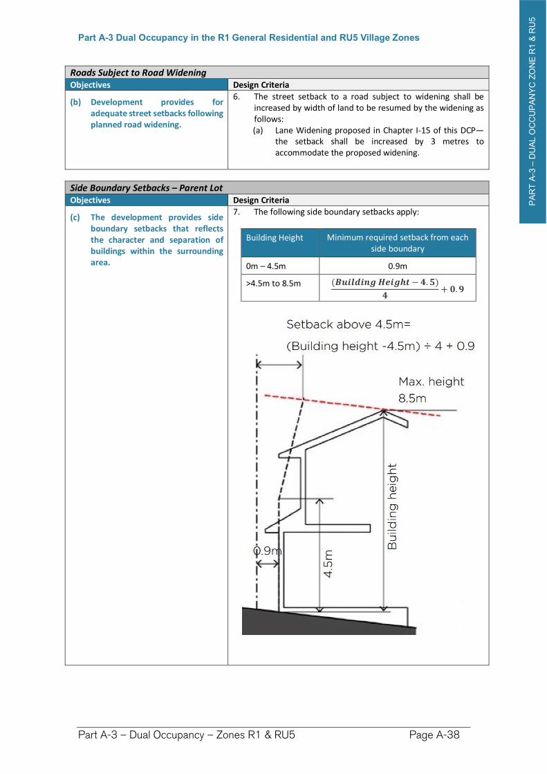
Building Height Minimum required setback from each side boundary
0m – 4.5m 0.9m
>4.5m to 8.5m (��������������− �.�)
�+ �.�
PA
RT
A-3
–D
UA
L O
CC
UP
AN
YC
ZO
NE
R1 &
RU
5
Part A-3 Dual Occupancy in the R1 General Residential and RU5 Village Zones
Part A-3 – Dual Occupancy – Zones R1 & RU5 Page A-39
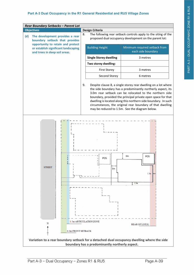
Rear Boundary Setbacks – Parent Lot Objectives Design Criteria
(d) The development provides a rear boundary setback that provides opportunity to retain and protect or establish significant landscaping and trees in deep soil areas.
8. The following rear setback controls apply to the siting of the proposed dual occupancy development on the parent lot:
Building Height Minimum required setback from each side boundary
Single Storey dwelling 3 metres
Two storey dwelling:
First Storey 3 metres
Second Storey 6 metres
9. Despite clause 8, a single storey rear dwelling on a lot where the side boundary has a predominantly northerly aspect, its 3.0m rear setback can be relocated to the northern side boundary, provided the principal private open space for that dwelling is located along this northern side boundary. In such circumstances, the original rear boundary of that dwelling may be reduced to 1.5m. See the diagram below.
Variation to a rear boundary setback for a detached dual occupancy dwelling where the side boundary has a predominantly northerly aspect.
PA
RT
A-3
–D
UA
L O
CC
UP
AN
YC
ZO
NE
R1 &
RU
5
Part A-3 Dual Occupancy in the R1 General Residential and RU5 Village Zones
Part A-3 – Dual Occupancy – Zones R1 & RU5 Page A-40
Front Setback –Proposed Dual Occupancy Sited on a Battle Axe Parent Lot Objectives Design Criteria
(e) The development provides a setback that reflects the character and separation of buildings within the surrounding area and provides adequate separation for privacy and landscaping between dwellings.
10. If the parent lot on which a dual occupancy is proposed is a battle axe lot, any dwelling shall be set back 3 metres from the front boundary (the boundary facing towards the street).
Setbacks Between Detached Dual Occupancy Dwellings Objectives Design Criteria
(f) Provide adequate separation between buildings to provide visual separation and daylight access.
(g) The setbacks resulting from subdivision of detached dual occupancy development are consistent with the development pattern of the locality.
11. For a dual occupancy (detached) where one dwelling is located behind the other a 6 metre separation is to be provided between the two dwellings, comprising:
3m rear setback for the dwelling closest to the street.
3m front setback for the rear dwelling. 12. The rear dwelling also needs to comply with the rear setback
requirement in clause 8. 13. For a dual occupancy (detached) on a corner lot, where each
dwelling has frontage to a different street, the minimum separation between the two dwellings is 1.8 m between the external walls, to help create a pattern of development consistent with other dwellings in the locality.
Increased Setbacks on Certain Land Objectives Design Criteria
(h) Encourage building design and locations that have regard for the existing characteristics of the site and locality.
(i) Ensure development is clear of easements, infrastructure clear zones and sewer zones of influence.
14. Site constraints may require greater setbacks from front, rear and/or side boundaries, may be required, for example: (a) A foreshore building line setback will apply to land
fronting waterways having a W1 Natural Waterways, or W2 Recreational Waterways zoning under the Richmond Valley LEP 2012. See section I-3.5 Foreshore Building Line Setbacks.
(b) Bushfire Prone Lands and Grasslands Planning for Bushfire Protection, published by the NSW Rural Fire Service, may require increased setbacks
(c) Land Use Conflict Buffers may be required to separate conflicting land uses, e.g. dwellings from industries or rural activities. Further details See Part I-11 - LUCRA.
Easements, Infrastructure Clear Zones and Sewer Zones of Influence Objectives Design Criteria
(j) Development does not impact upon easements and underground infrastructure.
15. Ensure development is clear of any easements and infrastructure services such as water supply, stormwater drainage pipelines, swales and overland flow paths, and sewer mains, including any additional constraints from the Zone of Influence – see Council for locations.
16. Development within the Zone of Influence shall, as an absolute minimum, be outside of the Clear Zone as determined by Council assessment of the relevant depth and pipe diameter.
PA
RT
A-3
–D
UA
L O
CC
UP
AN
YC
ZO
NE
R1 &
RU
5
Part A-3 Dual Occupancy in the R1 General Residential and RU5 Village Zones
Part A-3 – Dual Occupancy – Zones R1 & RU5 Page A-41
Easements, Infrastructure Clear Zones and Sewer Zones of Influence Objectives Design Criteria
17. Increased depth of footings are generally required between the Clear Zone and the edge of the Zone of Influence (any relaxation will be subject to assessment of the location, the criticality of the infrastructure, the soil type, the development scale, and the type of development, etc).
A-3.5 Gross Floor Area
Gross Floor Area Objectives Design Criteria
(a) To ensure that buildings are compatible with the bulk, scale and character of the locality, and allows for articulation of the built form.
1. The following maximum gross floor area applies for all development on the site in the L1, M1 and M2 density zones:
Lot Area (m2) Maximum GFA
0 to 2000 25% of lot area + 300m2
>2000 800m2
A-3.6 Landscaped Area and Landscaping
Landscaped Area Objectives Design Criteria
(a) To provide adequate opportunities for the retention of existing and provision of new vegetation that:
- contributes to biodiversity;
- enhances tree canopy; and
- minimises urban runoff
(b) Maximise the livability and amenity of residential development.
(c) Ensure that landscaped areas are an integral component of residential development.
1. The minimum landscaped area in the L1, M1 and M2 density zones is 30% of the site area.
2. Landscaped Area means a part of a site used for growing plants, grasses and trees, but does not include any building, structure or hard paved area.
Gravel or similar surfaced areas that allow infiltration can contribute to the achievement of the minimum landscaped area, where they form part of the overall landscape design, but not where the gravel comprises a vehicular accessway or parking area or any other use which is not landscaping.
On a battle axe lot, the area of any access handle is to be excluded from the lot area used to calculate the minimum landscaped area requirements.
3. The minimum dimension of any area included in the landscaped area calculation is 1.5m.
4. At least 50% of the area forward of the building line is to be landscaped area.
Landscaping Objectives Design Criteria
(d) Landscape design supports healthy plant and tree growth and provides sufficient space for the growth of medium sized trees.
5. A landscape plan is provided, and also includes an ongoing maintenance plan.
6. The following is to be provided:
Front: 1 tree with mature height of 8m if primary road setback is greater than 5m. If the primary road setback is less than 5m, a tree with a mature height of 5m.
Rear: 1 tree with mature height of 3m.
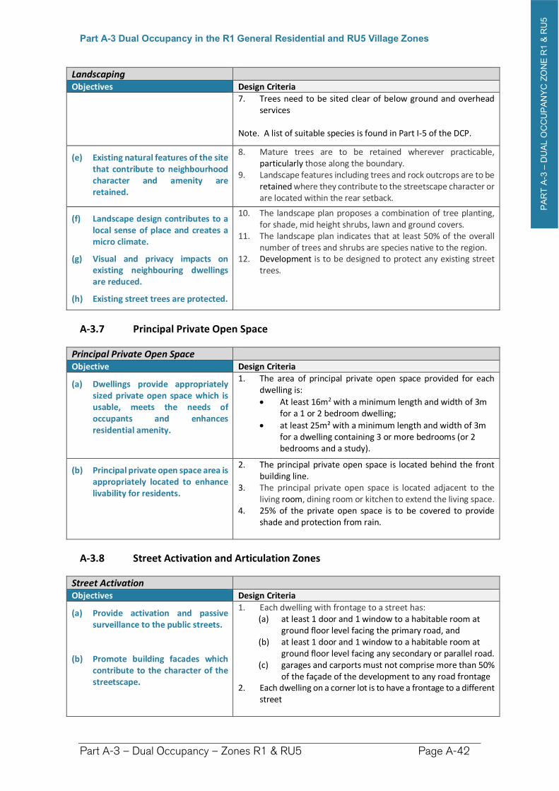
PA
RT
A-3
–D
UA
L O
CC
UP
AN
YC
ZO
NE
R1 &
RU
5
Part A-3 Dual Occupancy in the R1 General Residential and RU5 Village Zones
Part A-3 – Dual Occupancy – Zones R1 & RU5 Page A-42
Landscaping Objectives Design Criteria
7. Trees need to be sited clear of below ground and overhead services
Note. A list of suitable species is found in Part I-5 of the DCP.
(e) Existing natural features of the site that contribute to neighbourhood character and amenity are retained.
8. Mature trees are to be retained wherever practicable, particularly those along the boundary.
9. Landscape features including trees and rock outcrops are to be retained where they contribute to the streetscape character or are located within the rear setback.
(f) Landscape design contributes to a local sense of place and creates a micro climate.
(g) Visual and privacy impacts on existing neighbouring dwellings are reduced.
(h) Existing street trees are protected.
10. The landscape plan proposes a combination of tree planting, for shade, mid height shrubs, lawn and ground covers.
11. The landscape plan indicates that at least 50% of the overall number of trees and shrubs are species native to the region.
12. Development is to be designed to protect any existing street trees.
A-3.7 Principal Private Open Space
Principal Private Open Space Objective Design Criteria
(a) Dwellings provide appropriately sized private open space which is usable, meets the needs of occupants and enhances residential amenity.
1. The area of principal private open space provided for each dwelling is:
At least 16m2 with a minimum length and width of 3m for a 1 or 2 bedroom dwelling;
at least 25m² with a minimum length and width of 3m for a dwelling containing 3 or more bedrooms (or 2 bedrooms and a study).
(b) Principal private open space area is appropriately located to enhance livability for residents.
2. The principal private open space is located behind the front building line.
3. The principal private open space is located adjacent to the living room, dining room or kitchen to extend the living space.
4. 25% of the private open space is to be covered to provide shade and protection from rain.
A-3.8 Street Activation and Articulation Zones
Street ActivationObjectives Design Criteria
(a) Provide activation and passive surveillance to the public streets.
(b) Promote building facades which contribute to the character of the streetscape.
1. Each dwelling with frontage to a street has: (a) at least 1 door and 1 window to a habitable room at
ground floor level facing the primary road, and (b) at least 1 door and 1 window to a habitable room at
ground floor level facing any secondary or parallel road.(c) garages and carports must not comprise more than 50%
of the façade of the development to any road frontage 2. Each dwelling on a corner lot is to have a frontage to a different
street
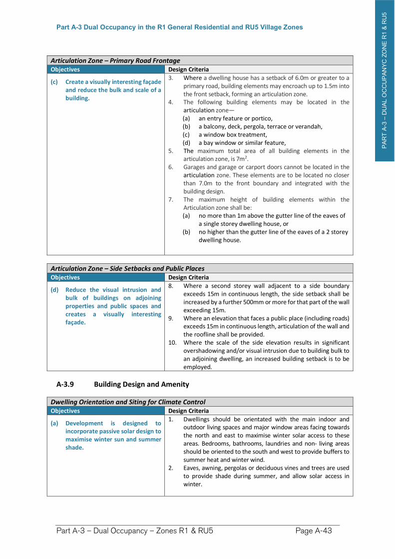
PA
RT
A-3
–D
UA
L O
CC
UP
AN
YC
ZO
NE
R1 &
RU
5
Part A-3 Dual Occupancy in the R1 General Residential and RU5 Village Zones
Part A-3 – Dual Occupancy – Zones R1 & RU5 Page A-43
Articulation Zone – Primary Road Frontage Objectives Design Criteria
(c) Create a visually interesting façade and reduce the bulk and scale of a building.
3. Where a dwelling house has a setback of 6.0m or greater to a primary road, building elements may encroach up to 1.5m into the front setback, forming an articulation zone.
4. The following building elements may be located in the articulation zone— (a) an entry feature or portico, (b) a balcony, deck, pergola, terrace or verandah, (c) a window box treatment, (d) a bay window or similar feature,
5. The maximum total area of all building elements in the articulation zone, is 7m2.
6. Garages and garage or carport doors cannot be located in the articulation zone. These elements are to be located no closer than 7.0m to the front boundary and integrated with the building design.
7. The maximum height of building elements within the Articulation zone shall be: (a) no more than 1m above the gutter line of the eaves of
a single storey dwelling house, or (b) no higher than the gutter line of the eaves of a 2 storey
dwelling house.
Articulation Zone – Side Setbacks and Public Places Objectives Design Criteria
(d) Reduce the visual intrusion and bulk of buildings on adjoining properties and public spaces and creates a visually interesting façade.
8. Where a second storey wall adjacent to a side boundary exceeds 15m in continuous length, the side setback shall be increased by a further 500mm or more for that part of the wall exceeding 15m.
9. Where an elevation that faces a public place (including roads) exceeds 15m in continuous length, articulation of the wall and the roofline shall be provided.
10. Where the scale of the side elevation results in significant overshadowing and/or visual intrusion due to building bulk to an adjoining dwelling, an increased building setback is to be employed.
A-3.9 Building Design and Amenity
Dwelling Orientation and Siting for Climate Control Objectives Design Criteria
(a) Development is designed to incorporate passive solar design to maximise winter sun and summer shade.
1. Dwellings should be orientated with the main indoor and outdoor living spaces and major window areas facing towards the north and east to maximise winter solar access to these areas. Bedrooms, bathrooms, laundries and non- living areas should be oriented to the south and west to provide buffers to summer heat and winter wind.
2. Eaves, awning, pergolas or deciduous vines and trees are used to provide shade during summer, and allow solar access in winter.
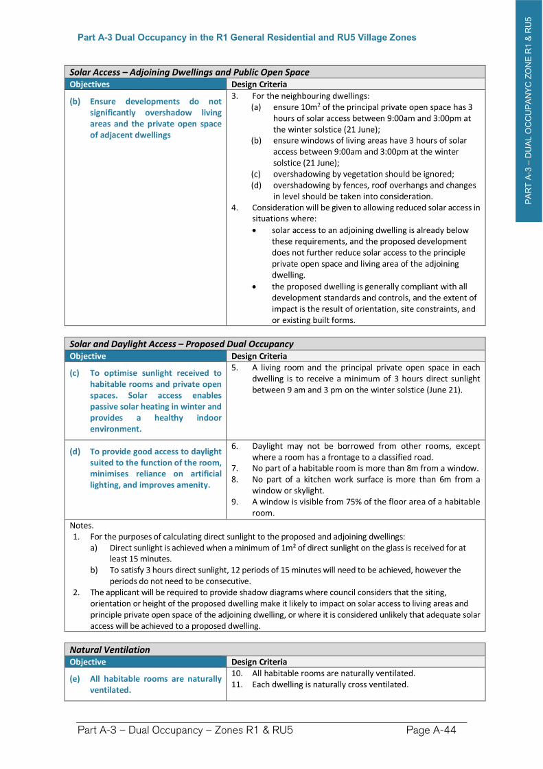
PA
RT
A-3
–D
UA
L O
CC
UP
AN
YC
ZO
NE
R1 &
RU
5
Part A-3 Dual Occupancy in the R1 General Residential and RU5 Village Zones
Part A-3 – Dual Occupancy – Zones R1 & RU5 Page A-44
Solar Access – Adjoining Dwellings and Public Open Space Objectives Design Criteria
(b) Ensure developments do not significantly overshadow living areas and the private open space of adjacent dwellings
3. For the neighbouring dwellings: (a) ensure 10m2 of the principal private open space has 3
hours of solar access between 9:00am and 3:00pm at the winter solstice (21 June);
(b) ensure windows of living areas have 3 hours of solar access between 9:00am and 3:00pm at the winter solstice (21 June);
(c) overshadowing by vegetation should be ignored; (d) overshadowing by fences, roof overhangs and changes
in level should be taken into consideration. 4. Consideration will be given to allowing reduced solar access in
situations where:
solar access to an adjoining dwelling is already below these requirements, and the proposed development does not further reduce solar access to the principle private open space and living area of the adjoining dwelling.
the proposed dwelling is generally compliant with all development standards and controls, and the extent of impact is the result of orientation, site constraints, and or existing built forms.
Solar and Daylight Access – Proposed Dual Occupancy Objective Design Criteria
(c) To optimise sunlight received to habitable rooms and private open spaces. Solar access enables passive solar heating in winter and provides a healthy indoor environment.
5. A living room and the principal private open space in each dwelling is to receive a minimum of 3 hours direct sunlight between 9 am and 3 pm on the winter solstice (June 21).
(d) To provide good access to daylight suited to the function of the room, minimises reliance on artificial lighting, and improves amenity.
6. Daylight may not be borrowed from other rooms, except where a room has a frontage to a classified road.
7. No part of a habitable room is more than 8m from a window. 8. No part of a kitchen work surface is more than 6m from a
window or skylight. 9. A window is visible from 75% of the floor area of a habitable
room.
Notes. 1. For the purposes of calculating direct sunlight to the proposed and adjoining dwellings:
a) Direct sunlight is achieved when a minimum of 1m² of direct sunlight on the glass is received for at least 15 minutes.
b) To satisfy 3 hours direct sunlight, 12 periods of 15 minutes will need to be achieved, however the periods do not need to be consecutive.
2. The applicant will be required to provide shadow diagrams where council considers that the siting, orientation or height of the proposed dwelling make it likely to impact on solar access to living areas and principle private open space of the adjoining dwelling, or where it is considered unlikely that adequate solar access will be achieved to a proposed dwelling.
Natural Ventilation Objective Design Criteria
(e) All habitable rooms are naturally ventilated.
10. All habitable rooms are naturally ventilated.11. Each dwelling is naturally cross ventilated.
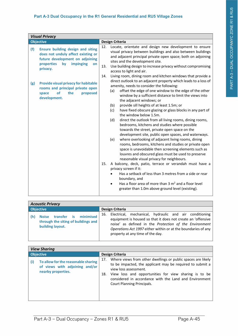
PA
RT
A-3
–D
UA
L O
CC
UP
AN
YC
ZO
NE
R1 &
RU
5
Part A-3 Dual Occupancy in the R1 General Residential and RU5 Village Zones
Part A-3 – Dual Occupancy – Zones R1 & RU5 Page A-45
Visual Privacy Objective Design Criteria
(f) Ensure building design and siting does not unduly affect existing or future development on adjoining properties by impinging on privacy.
(g) Provide visual privacy for habitable rooms and principal private open space of the proposed development.
12. Locate, orientate and design new development to ensure visual privacy between buildings and also between buildings and adjacent principal private open space; both on adjoining sites and the development site.
13. Use building design to increase privacy without compromising access to light and air.
14. Living room, dining room and kitchen windows that provide a direct outlook to an adjacent property which leads to a loss of amenity, needs to consider the following: (a) offset the edge of one window to the edge of the other
window by a sufficient distance to limit the views into the adjacent windows; or
(b) provide sill heights of at least 1.5m; or (c) have fixed obscure glazing or glass blocks in any part of
the window below 1.5m. (d) direct the outlook from all living rooms, dining rooms,
bedrooms, kitchens and studies where possible towards the street, private open space on the development site, public open spaces, and waterways.
(e) where overlooking of adjacent living rooms, dining rooms, bedrooms, kitchens and studies or private open space is unavoidable then screening elements such as louvres and obscured glass must be used to preserve reasonable visual privacy for neighbours.
15. A balcony, deck, patio, terrace or verandah must have a privacy screen if it:
Has a setback of less than 3 metres from a side or rear boundary, and
Has a floor area of more than 3 m2 and a floor level greater than 1.0m above ground level (existing).
Acoustic Privacy Objective Design Criteria
(h) Noise transfer is minimised through the siting of buildings and building layout.
16. Electrical, mechanical, hydraulic and air conditioning equipment is housed so that it does not create an ‘offensive noise’ as defined in the Protection of the Environment Operations Act 1997 either within or at the boundaries of any property at any time of the day.
View Sharing Objective Design Criteria
(i) To allow for the reasonable sharing of views with adjoining and/or nearby properties.
17. Where views from other dwellings or public spaces are likely to be impacted, the applicant may be required to submit a view loss assessment.
18. View loss and opportunities for view sharing is to be considered in accordance with the Land and Environment Court Planning Principals.
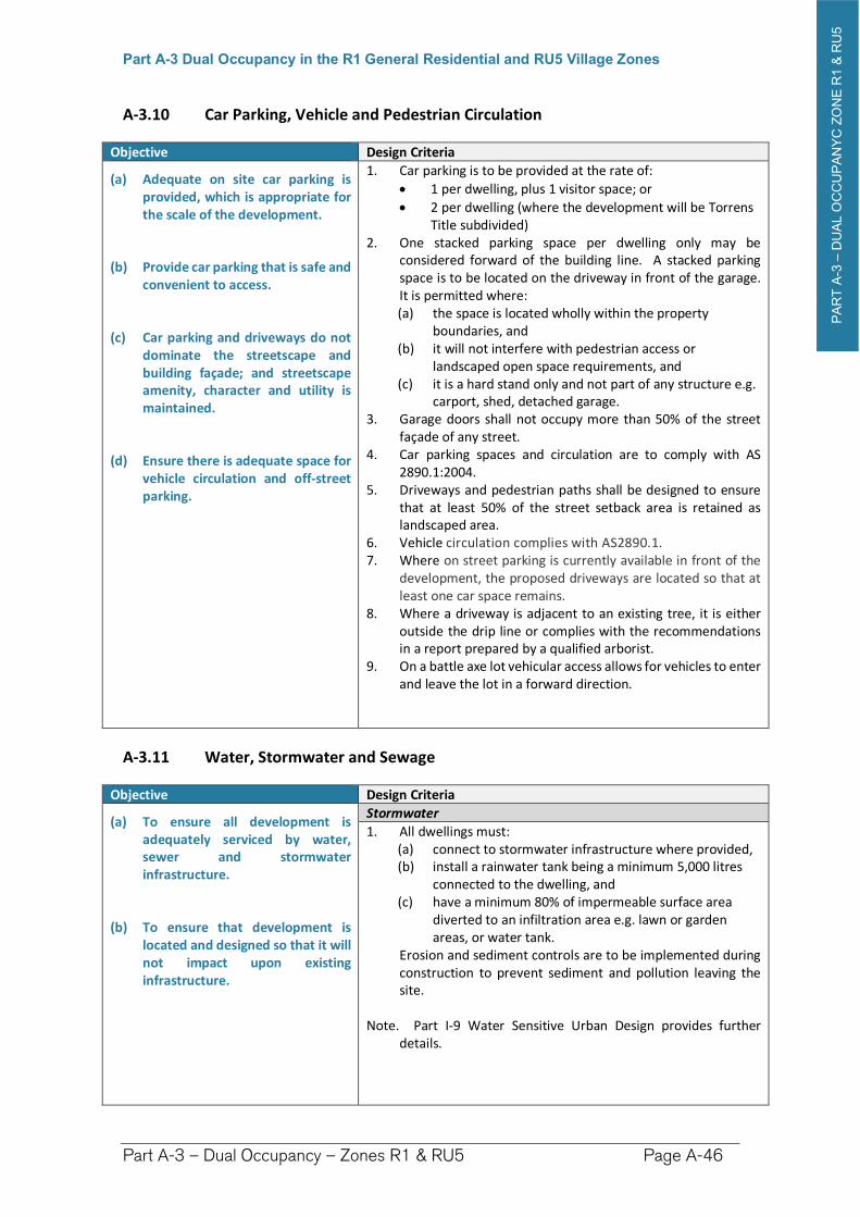
PA
RT
A-3
–D
UA
L O
CC
UP
AN
YC
ZO
NE
R1 &
RU
5
Part A-3 Dual Occupancy in the R1 General Residential and RU5 Village Zones
Part A-3 – Dual Occupancy – Zones R1 & RU5 Page A-46
A-3.10 Car Parking, Vehicle and Pedestrian Circulation
Objective Design Criteria
(a) Adequate on site car parking is provided, which is appropriate for the scale of the development.
(b) Provide car parking that is safe and convenient to access.
(c) Car parking and driveways do not dominate the streetscape and building façade; and streetscape amenity, character and utility is maintained.
(d) Ensure there is adequate space for vehicle circulation and off-street parking.
1. Car parking is to be provided at the rate of:
1 per dwelling, plus 1 visitor space; or
2 per dwelling (where the development will be Torrens Title subdivided)
2. One stacked parking space per dwelling only may be considered forward of the building line. A stacked parking space is to be located on the driveway in front of the garage. It is permitted where: (a) the space is located wholly within the property
boundaries, and (b) it will not interfere with pedestrian access or
landscaped open space requirements, and (c) it is a hard stand only and not part of any structure e.g.
carport, shed, detached garage. 3. Garage doors shall not occupy more than 50% of the street
façade of any street. 4. Car parking spaces and circulation are to comply with AS
2890.1:2004. 5. Driveways and pedestrian paths shall be designed to ensure
that at least 50% of the street setback area is retained as landscaped area.
6. Vehicle circulation complies with AS2890.1.7. Where on street parking is currently available in front of the
development, the proposed driveways are located so that at least one car space remains.
8. Where a driveway is adjacent to an existing tree, it is either outside the drip line or complies with the recommendations in a report prepared by a qualified arborist.
9. On a battle axe lot vehicular access allows for vehicles to enter and leave the lot in a forward direction.
A-3.11 Water, Stormwater and Sewage
Objective Design Criteria
(a) To ensure all development is adequately serviced by water, sewer and stormwater infrastructure.
(b) To ensure that development is located and designed so that it will not impact upon existing infrastructure.
Stormwater
1. All dwellings must: (a) connect to stormwater infrastructure where provided, (b) install a rainwater tank being a minimum 5,000 litres
connected to the dwelling, and (c) have a minimum 80% of impermeable surface area
diverted to an infiltration area e.g. lawn or garden areas, or water tank.
Erosion and sediment controls are to be implemented during construction to prevent sediment and pollution leaving the site.
Note. Part I-9 Water Sensitive Urban Design provides further details.
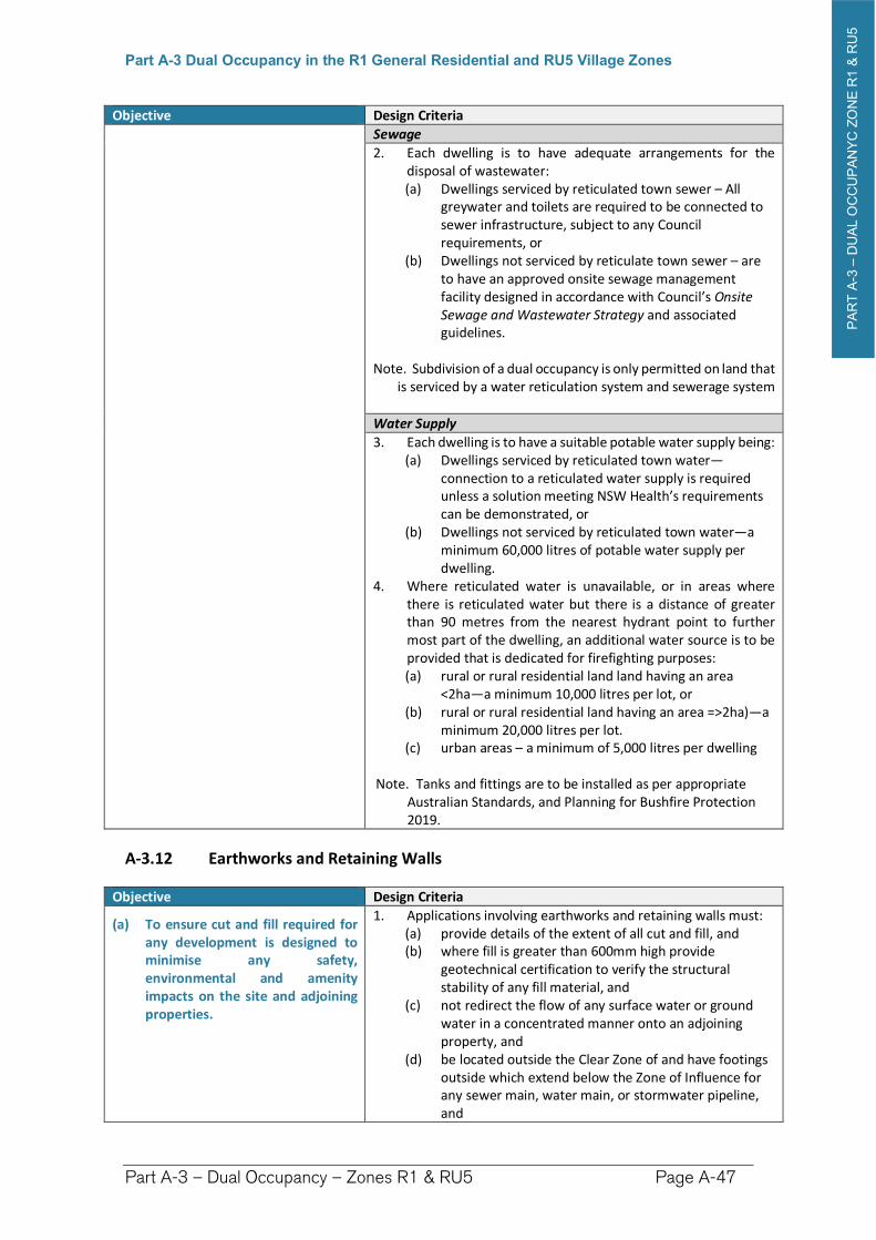
PA
RT
A-3
–D
UA
L O
CC
UP
AN
YC
ZO
NE
R1 &
RU
5
Part A-3 Dual Occupancy in the R1 General Residential and RU5 Village Zones
Part A-3 – Dual Occupancy – Zones R1 & RU5 Page A-47
Objective Design Criteria
Sewage
2. Each dwelling is to have adequate arrangements for the disposal of wastewater: (a) Dwellings serviced by reticulated town sewer – All
greywater and toilets are required to be connected to sewer infrastructure, subject to any Council requirements, or
(b) Dwellings not serviced by reticulate town sewer – are to have an approved onsite sewage management facility designed in accordance with Council’s Onsite Sewage and Wastewater Strategy and associated guidelines.
Note. Subdivision of a dual occupancy is only permitted on land that is serviced by a water reticulation system and sewerage system
Water Supply
3. Each dwelling is to have a suitable potable water supply being:(a) Dwellings serviced by reticulated town water—
connection to a reticulated water supply is required unless a solution meeting NSW Health’s requirements can be demonstrated, or
(b) Dwellings not serviced by reticulated town water—a minimum 60,000 litres of potable water supply per dwelling.
4. Where reticulated water is unavailable, or in areas where there is reticulated water but there is a distance of greater than 90 metres from the nearest hydrant point to further most part of the dwelling, an additional water source is to be provided that is dedicated for firefighting purposes: (a) rural or rural residential land land having an area
<2ha—a minimum 10,000 litres per lot, or (b) rural or rural residential land having an area =>2ha)—a
minimum 20,000 litres per lot. (c) urban areas – a minimum of 5,000 litres per dwelling
Note. Tanks and fittings are to be installed as per appropriate Australian Standards, and Planning for Bushfire Protection 2019.
A-3.12 Earthworks and Retaining Walls
Objective Design Criteria
(a) To ensure cut and fill required for any development is designed to minimise any safety, environmental and amenity impacts on the site and adjoining properties.
1. Applications involving earthworks and retaining walls must: (a) provide details of the extent of all cut and fill, and (b) where fill is greater than 600mm high provide
geotechnical certification to verify the structural stability of any fill material, and
(c) not redirect the flow of any surface water or ground water in a concentrated manner onto an adjoining property, and
(d) be located outside the Clear Zone of and have footings outside which extend below the Zone of Influence for any sewer main, water main, or stormwater pipeline, and
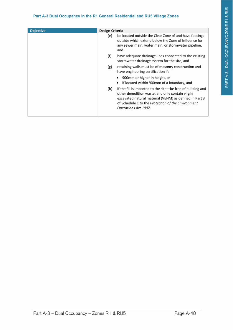
PA
RT
A-3
–D
UA
L O
CC
UP
AN
YC
ZO
NE
R1 &
RU
5
Part A-3 Dual Occupancy in the R1 General Residential and RU5 Village Zones
Part A-3 – Dual Occupancy – Zones R1 & RU5 Page A-48
Objective Design Criteria
(e) be located outside the Clear Zone of and have footings outside which extend below the Zone of Influence for any sewer main, water main, or stormwater pipeline, and
(f) have adequate drainage lines connected to the existing stormwater drainage system for the site, and
(g) retaining walls must be of masonry construction and have engineering certification if:
900mm or higher in height, or
if located within 900mm of a boundary, and
(h) if the fill is imported to the site—be free of building and other demolition waste, and only contain virgin excavated natural material (VENM) as defined in Part 3 of Schedule 1 to the Protection of the Environment Operations Act 1997.
PA
RT
A-4
–D
UA
L O
CC
UP
AN
CY
ZO
NE
RU
1, R
5 &
E3
Part A-4 Dual Occupancy in the RU1 Primary Production, R5 Large Lot Residential and E3 Environmental Management Zones
Part A-5 – Secondary Dwellings – Zones R1, RU5 & R5 Page A-49
Part A-4 Dual Occupancy in the RU1 Primary Production, R5 Large Lot Residential and E3 Environmental Management Zones
Preamble
This chapter makes provision for dual occupancy development in the following rural zones, in which attached and/or detached dual occupancy is permitted under the Richmond Valley LEP 2012:
RU1 Primary Production Zone
E3 Environmental Management Zone
R5 Large Lot Residential Zone
For a dual occupancy to be constructed on a lot of land in these zones, the lot must have a Dwelling Opportunity under the Richmond Valley Local Environmental Plan 2012. Consult with Council to determine whether a dwelling opportunity exists for that land.
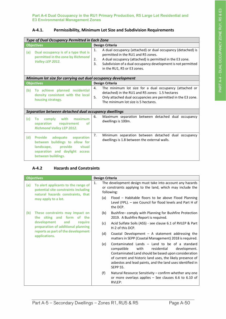
PA
RT
A-4
–D
UA
L O
CC
UP
AN
CY
ZO
NE
RU
1, R
5 &
E3
Part A-4 Dual Occupancy in the RU1 Primary Production, R5 Large Lot Residential and E3 Environmental Management Zones
Part A-5 – Secondary Dwellings – Zones R1, RU5 & R5 Page A-50
A-4.1. Permissibility, Minimum Lot Size and Subdivision Requirements
Type of Dual Occupancy Permitted in Each Zone Objectives Design Criteria
(a) Dual occupancy is of a type that is permitted in the zone by Richmond Valley LEP 2012.
1. A dual occupancy (attached) or dual occupancy (detached) is permitted in the RU1 and R5 zones.
2. A dual occupancy (attached) is permitted in the E3 zone. 3. Subdivision of a dual occupancy development is not permitted
in the RU1, R5 or E3 zones.
Minimum lot size for carrying out dual occupancy development Objectives Design Criteria
(b) To achieve planned residential density consistent with the local housing strategy.
4. The minimum lot size for a dual occupancy (attached or detached) in the RU1 and R5 zones: 1.5 hectares
5. Only attached dual occupancies are permitted in the E3 zone. The minimum lot size is 5 hectares.
Separation between detached dual occupancy dwellings
(c) To comply with maximum separation requirement of Richmond Valley LEP 2012.
6. Maximum separation between detached dual occupancy dwellings is 100m.
(d) Provide adequate separation between buildings to allow for landscape, provide visual separation and daylight access between buildings.
7. Minimum separation between detached dual occupancy dwellings is 1.8 between the external walls.
A-4.2 Hazards and Constraints
Objectives Design Criteria
(a) To alert applicants to the range of potential site constraints including natural hazards constraints, that may apply to a lot.
(b) These constraints may impact on the siting and form of the development and require preparation of additional planning reports as part of the development applications.
1. The development design must take into account any hazards or constraints applying to the land, which may include the following:
(a) Flood – Habitable floors to be above Flood Planning Level (FPL). – see Council for flood levels and Part H of the DCP.
(b) Bushfire– comply with Planning for Bushfire Protection 2019. A Bushfire Report is required.
(c) Acid Sulfate Soils (ASS) - see clause 6.1 of RVLEP & Part H-2 of this DCP.
(d) Coastal Development – A statement addressing the matters in SEPP (Coastal Management) 2018 is required.
(e) Contaminated Lands – Land to be of a standard compatible with residential development. Contaminated Land should be based upon consideration of current and historic land uses, the likely presence of asbestos and lead paints, and the land uses identified in SEPP 55.
(f) Natural Resource Sensitivity – confirm whether any one or more overlays applies – See clauses 6.6 to 6.10 of RVLEP:
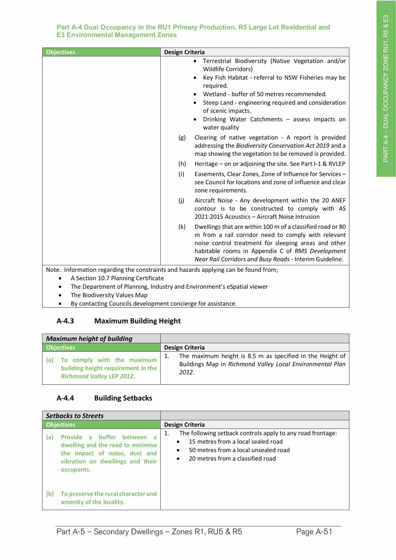
PA
RT
A-4
–D
UA
L O
CC
UP
AN
CY
ZO
NE
RU
1, R
5 &
E3
Part A-4 Dual Occupancy in the RU1 Primary Production, R5 Large Lot Residential and E3 Environmental Management Zones
Part A-5 – Secondary Dwellings – Zones R1, RU5 & R5 Page A-51
Objectives Design Criteria
Terrestrial Biodiversity (Native Vegetation and/or Wildlife Corridors)
Key Fish Habitat - referral to NSW Fisheries may be required.
Wetland - buffer of 50 metres recommended.
Steep Land - engineering required and consideration of scenic impacts.
Drinking Water Catchments – assess impacts on water quality
(g) Clearing of native vegetation - A report is provided addressing the Biodiversity Conservation Act 2019 and a map showing the vegetation to be removed is provided.
(h) Heritage – on or adjoining the site. See Part I-1 & RVLEP
(i) Easements, Clear Zones, Zone of Influence for Services – see Council for locations and zone of influence and clear zone requirements.
(j) Aircraft Noise - Any development within the 20 ANEF contour is to be constructed to comply with AS 2021:2015 Acoustics – Aircraft Noise Intrusion
(k) Dwellings that are within 100 m of a classified road or 80 m from a rail corridor need to comply with relevant noise control treatment for sleeping areas and other habitable rooms in Appendix C of RMS Development Near Rail Corridors and Busy Roads - Interim Guideline.
Note. Information regarding the constraints and hazards applying can be found from;
A Section 10.7 Planning Certificate
The Department of Planning, Industry and Environment’s eSpatial viewer
The Biodiversity Values Map
By contacting Councils development concierge for assistance.
A-4.3 Maximum Building Height
Maximum height of building Objectives Design Criteria
(a) To comply with the maximum building height requirement in the Richmond Valley LEP 2012.
1. The maximum height is 8.5 m as specified in the Height of Buildings Map in Richmond Valley Local Environmental Plan 2012.
A-4.4 Building Setbacks
Setbacks to Streets Objectives Design Criteria
(a) Provide a buffer between a dwelling and the road to minimise the impact of noise, dust and vibration on dwellings and their occupants.
(b) To preserve the rural character and amenity of the locality.
1. The following setback controls apply to any road frontage:
15 metres from a local sealed road
50 metres from a local unsealed road
20 metres from a classified road
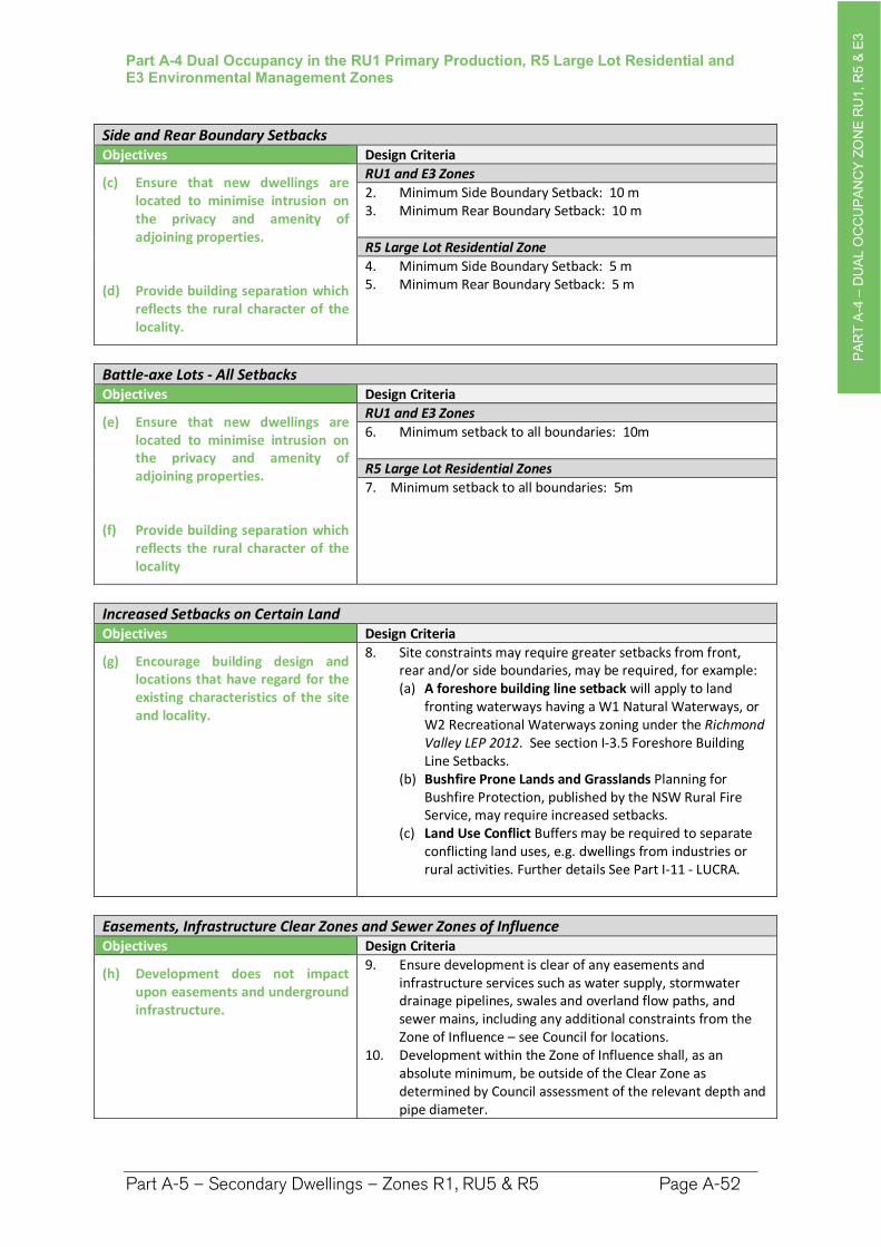
PA
RT
A-4
–D
UA
L O
CC
UP
AN
CY
ZO
NE
RU
1, R
5 &
E3
Part A-4 Dual Occupancy in the RU1 Primary Production, R5 Large Lot Residential and E3 Environmental Management Zones
Part A-5 – Secondary Dwellings – Zones R1, RU5 & R5 Page A-52
Side and Rear Boundary Setbacks Objectives Design Criteria
(c) Ensure that new dwellings are located to minimise intrusion on the privacy and amenity of adjoining properties.
(d) Provide building separation which reflects the rural character of the locality.
RU1 and E3 Zones
2. Minimum Side Boundary Setback: 10 m 3. Minimum Rear Boundary Setback: 10 m
R5 Large Lot Residential Zone
4. Minimum Side Boundary Setback: 5 m 5. Minimum Rear Boundary Setback: 5 m
Battle-axe Lots - All Setbacks Objectives Design Criteria
(e) Ensure that new dwellings are located to minimise intrusion on the privacy and amenity of adjoining properties.
(f) Provide building separation which reflects the rural character of the locality
RU1 and E3 Zones
6. Minimum setback to all boundaries: 10m
R5 Large Lot Residential Zones
7. Minimum setback to all boundaries: 5m
Increased Setbacks on Certain Land Objectives Design Criteria
(g) Encourage building design and locations that have regard for the existing characteristics of the site and locality.
8. Site constraints may require greater setbacks from front, rear and/or side boundaries, may be required, for example: (a) A foreshore building line setback will apply to land
fronting waterways having a W1 Natural Waterways, or W2 Recreational Waterways zoning under the Richmond Valley LEP 2012. See section I-3.5 Foreshore Building Line Setbacks.
(b) Bushfire Prone Lands and Grasslands Planning for Bushfire Protection, published by the NSW Rural Fire Service, may require increased setbacks.
(c) Land Use Conflict Buffers may be required to separate conflicting land uses, e.g. dwellings from industries or rural activities. Further details See Part I-11 - LUCRA.
Easements, Infrastructure Clear Zones and Sewer Zones of Influence Objectives Design Criteria
(h) Development does not impact upon easements and underground infrastructure.
9. Ensure development is clear of any easements and infrastructure services such as water supply, stormwater drainage pipelines, swales and overland flow paths, and sewer mains, including any additional constraints from the Zone of Influence – see Council for locations.
10. Development within the Zone of Influence shall, as an absolute minimum, be outside of the Clear Zone as determined by Council assessment of the relevant depth and pipe diameter.
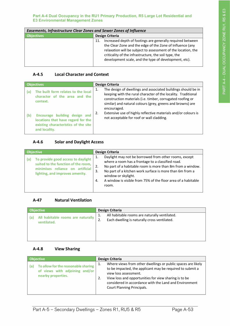
PA
RT
A-4
–D
UA
L O
CC
UP
AN
CY
ZO
NE
RU
1, R
5 &
E3
Part A-4 Dual Occupancy in the RU1 Primary Production, R5 Large Lot Residential and E3 Environmental Management Zones
Part A-5 – Secondary Dwellings – Zones R1, RU5 & R5 Page A-53
Easements, Infrastructure Clear Zones and Sewer Zones of Influence Objectives Design Criteria
11. Increased depth of footings are generally required between the Clear Zone and the edge of the Zone of Influence (any relaxation will be subject to assessment of the location, the criticality of the infrastructure, the soil type, the development scale, and the type of development, etc).
A-4.5 Local Character and Context
Objectives Design Criteria
(a) The built form relates to the local character of the area and the context.
(b) Encourage building design and locations that have regard for the existing characteristics of the site and locality.
1. The design of dwellings and associated buildings should be in keeping with the rural character of the locality. Traditional construction materials (i.e. timber, corrugated roofing or similar) and natural colours (grey, greens and browns) are encouraged.
2. Extensive use of highly reflective materials and/or colours is not acceptable for roof or wall cladding.
A-4.6 Solar and Daylight Access
Objective Design Criteria
(a) To provide good access to daylight suited to the function of the room, minimises reliance on artificial lighting, and improves amenity.
1. Daylight may not be borrowed from other rooms, except where a room has a frontage to a classified road.
2. No part of a habitable room is more than 8m from a window. 3. No part of a kitchen work surface is more than 6m from a
window or skylight. 4. A window is visible from 75% of the floor area of a habitable
room.
A-47 Natural Ventilation
Objective Design Criteria
(a) All habitable rooms are naturally ventilated.
1. All habitable rooms are naturally ventilated. 2. Each dwelling is naturally cross ventilated.
A-4.8 View Sharing
Objective Design Criteria
(a) To allow for the reasonable sharing of views with adjoining and/or nearby properties.
1. Where views from other dwellings or public spaces are likely to be impacted, the applicant may be required to submit a view loss assessment.
2. View loss and opportunities for view sharing is to be considered in accordance with the Land and Environment Court Planning Principals.
PA
RT
A-4
–D
UA
L O
CC
UP
AN
CY
ZO
NE
RU
1, R
5 &
E3
Part A-4 Dual Occupancy in the RU1 Primary Production, R5 Large Lot Residential and E3 Environmental Management Zones
Part A-5 – Secondary Dwellings – Zones R1, RU5 & R5 Page A-54
A-4.9 Car Parking
Objective Design Criteria
(a) Car parking is provided appropriate for the scale of the development.
1. 2 car parking spaces are provided for each dual occupancy dwelling, located behind the building line.
A-4.10 Water, Stormwater and Sewage
Objective Design Criteria
(a) To ensure all development is adequately serviced by water, sewer and stormwater infrastructure.
(b) To ensure that development is located and designed so that it will not impact upon existing infrastructure.
Stormwater
1. All dwellings must:(a) connect to urban water, sewer & stormwater
infrastructure where provided, (b) install a rainwater tank being a minimum 5,000 litres
connected to the dwelling, and (c) have a minimum 80% of impermeable surface area
diverted to an infiltration area e.g. lawn or garden areas, or water tank.
Erosion and sediment controls are to be implemented during construction to prevent sediment and pollution leaving the site.
Note. Part I-9 Water Sensitive Urban Design provides further details.
Sewage
2. Dwellings not serviced by reticulated town sewer—are to have an approved onsite sewage management facility designed in accordance with Council’s Onsite Sewage and Wastewater Strategy and associated guidelines.
Water Supply
3. Each dwelling is to have a suitable potable water supply being: (a) Dwellings serviced by reticulated town water—
connection to a reticulated water supply is required, or (b) Dwellings not serviced by reticulated town water—a
minimum 60,000 litres of potable water supply per dwelling.
4. Where reticulated water is unavailable, or in areas where there is reticulated water but there is a distance of greater than 90 metres from the nearest hydrant point to further most part of the dwelling, an additional water source is to be provided that is dedicated for firefighting purposes: (a) rural or rural residential land having an area <2ha—a
minimum 10,000 litres per lot, or (b) rural or rural residential land having an area =>2ha)—a
minimum 20,000 litres per lot.
PA
RT
A-4
–D
UA
L O
CC
UP
AN
CY
ZO
NE
RU
1, R
5 &
E3
Part A-4 Dual Occupancy in the RU1 Primary Production, R5 Large Lot Residential and E3 Environmental Management Zones
Part A-5 – Secondary Dwellings – Zones R1, RU5 & R5 Page A-55
A-4.11 Earthworks and Retaining Walls
Objective Design Criteria
(a) To ensure cut and fill required for any development is designed to minimise any safety, environmental and amenity impacts on the site and adjoining properties.
1. Applications involving earthworks and retaining walls must: (a) provide details of the extent of all cut and fill, and (b) where fill is greater than 600mm high provide
geotechnical certification to verify the structural stability of any fill material, and
(c) not redirect the flow of any surface water or ground water in a concentrated manner onto an adjoining property, and
(d) be located outside the Clear Zone of and have footings outside which extend below the Zone of Influence for any sewer main, water main, or stormwater pipeline, and
(e) have adequate drainage lines connected to the existing stormwater drainage system for the site, and
(f) retaining walls must be of masonry construction and have engineering certification if:
900mm or higher in height, or if located within 900mm of a boundary, and
(g) if the fill is imported to the site—be free of building and other demolition waste, and only contain virgin excavated natural material (VENM) as defined in Part 3 of Schedule 1 to the Protection of the Environment Operations Act 1997.
PA
RT
A-5
–S
EC
ON
DA
RY
DE
WE
LLIN
GS
ZO
NE
R1, R
U5 &
R5
Part A-5 Secondary Dwellings in the R1 General Residential, RU5 Village and R5 Large Lot Residential Zones
Part A-5 – Secondary Dwellings – Zones R1, RU5 & R5 Page A-56
Part A-5 Secondary Dwellings in the R1 General Residential, RU5 Village and R5 Large Lot Residential Zones
Preamble
This chapter contains the development controls for the construction of a secondary dwelling in the following zones, where secondary dwellings are permitted under the Richmond Valley LEP 2012, and on lots where there is an existing approved dwelling:
R1 General Residential Zone
RU5 Village Zone
R5 Large Lot Residential Zone
Secondary dwellings are not permitted in the RU1 Primary Production or E3 Environmental Protection zones. See Dual Occupancy provisions for these zones.
Subdivision of secondary dwellings is not permitted in any zone.
This chapter needs to be read in conjunction with the Dwelling House DCP Chapter that applies to the land.
A-5.1 Minimum Lot Sizes
Minimum lot size for secondary dwelling Objectives Design Criteria
(a) To achieve planned residential density consistent with the local housing strategy.
1. The minimum lot size for a secondary dwelling is:
DCP Area Attached Detached
R1 General Residential No minimum 450m2
RU5 Village No minimum 450m2
R5 Large Lot Residential No minimum 450m2
Note. The minimum lot sizes for a secondary dwelling in the R1 and R5 zones are established by the State Environmental Planning Policy (Affordable Rental Housing).
PA
RT
A-5
–S
EC
ON
DA
RY
DE
WE
LLIN
GS
ZO
NE
R1, R
U5 &
R5
Part A-5 Secondary Dwellings in the R1 General Residential, RU5 Village and R5 Large Lot Residential Zones
Part A-5 – Secondary Dwellings – Zones R1, RU5 & R5 Page A-57
A-5.2 Hazards and Constraints
Objectives Design Criteria
(a) To alert applicants to the range of potential site constraints including natural hazards constraints, that may apply to a lot.
(b) These constraints may impact on the siting and form of the development and require preparation of additional planning reports as part of the development applications.
1. The development design must take into account any hazards or constraints applying to the land, which may include the following: (a) Flood – Habitable floors to be above Flood Planning
Level (FPL). – see Council for flood levels and Part H of the DCP.
(b) Bushfire– comply with Planning for Bushfire Protection 2019. A Bushfire Report is required.
(c) Acid Sulfate Soils (ASS) see clause 6.1 of RVLEP & Part H-2 of this DCP.
(d) Coastal Development – A statement addressing the matters in SEPP (Coastal Management) 2018 is required.
(e) Contaminated Lands – Land to be of a standard compatible with residential development. Contaminated Land should be based upon consideration of current and historic land uses, the likely presence of asbestos and lead paints, and the land uses identified in SEPP 55.
(f) Natural Resource Sensitivity – confirm whether any one or more overlays applies – See clauses 6.6 to 6.10 of RVLEP:
Terrestrial Biodiversity (Native Vegetation and/or Wildlife Corridors)
Key Fish Habitat - referral to NSW Fisheries may be required.
Wetland - buffer of 50 metres recommended.
Steep Land - engineering required and consideration of scenic impacts.
Drinking Water Catchments – assess impacts on water quality
(g) Clearing of native vegetation - A report is provided addressing the Biodiversity Conservation Act 2019 and a map showing the vegetation to be removed is provided.
(h) Heritage – on or adjoining the site. See Part I-1 & RVLEP (i) Easements, Clear Zones, Zone of Influence for Services –
see Council for locations and zone of influence and clear zone requirements.
(j) Aircraft Noise - Any development within the 20 ANEF contour is to be constructed to comply with AS 2021:2015 Acoustics – Aircraft Noise Intrusion
(k) Dwellings that are within 100 m of a classified road or 80 m from a rail corridor need to comply with relevant noise control treatment for sleeping areas and other habitable rooms in Appendix C of RMS Development Near Rail Corridors and Busy Roads - Interim Guideline.
Note. Information regarding the constraints and hazards applying can be found from;
A Section 10.7 Planning Certificate
The Department of Planning, Industry and Environment’s eSpatial viewer
The Biodiversity Values Map
By contacting Councils development concierge for assistance.
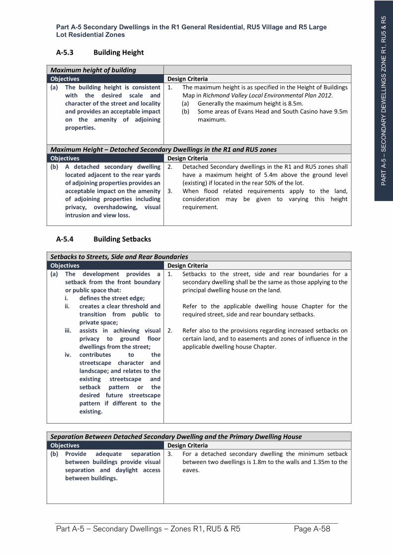
PA
RT
A-5
–S
EC
ON
DA
RY
DE
WE
LLIN
GS
ZO
NE
R1, R
U5 &
R5
Part A-5 Secondary Dwellings in the R1 General Residential, RU5 Village and R5 Large Lot Residential Zones
Part A-5 – Secondary Dwellings – Zones R1, RU5 & R5 Page A-58
A-5.3 Building Height
Maximum height of building Objectives Design Criteria
(a) The building height is consistent with the desired scale and character of the street and locality and provides an acceptable impact on the amenity of adjoining properties.
1. The maximum height is as specified in the Height of Buildings Map in Richmond Valley Local Environmental Plan 2012. (a) Generally the maximum height is 8.5m. (b) Some areas of Evans Head and South Casino have 9.5m
maximum.
Maximum Height – Detached Secondary Dwellings in the R1 and RU5 zones Objectives Design Criteria
(b) A detached secondary dwelling located adjacent to the rear yards of adjoining properties provides an acceptable impact on the amenity of adjoining properties including privacy, overshadowing, visual intrusion and view loss.
2. Detached Secondary dwellings in the R1 and RU5 zones shall have a maximum height of 5.4m above the ground level (existing) if located in the rear 50% of the lot.
3. When flood related requirements apply to the land, consideration may be given to varying this height requirement.
A-5.4 Building Setbacks
Setbacks to Streets, Side and Rear Boundaries Objectives Design Criteria
(a) The development provides a setback from the front boundary or public space that: i. defines the street edge; ii. creates a clear threshold and
transition from public to private space;
iii. assists in achieving visual privacy to ground floor dwellings from the street;
iv. contributes to the streetscape character and landscape; and relates to the existing streetscape and setback pattern or the desired future streetscape pattern if different to the existing.
1. Setbacks to the street, side and rear boundaries for a secondary dwelling shall be the same as those applying to the principal dwelling house on the land.
Refer to the applicable dwelling house Chapter for the required street, side and rear boundary setbacks.
2. Refer also to the provisions regarding increased setbacks on certain land, and to easements and zones of influence in the applicable dwelling house Chapter.
Separation Between Detached Secondary Dwelling and the Primary Dwelling House Objectives Design Criteria
(b) Provide adequate separation between buildings provide visual separation and daylight access between buildings.
3. For a detached secondary dwelling the minimum setback between two dwellings is 1.8m to the walls and 1.35m to the eaves.
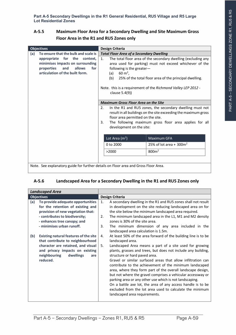
PA
RT
A-5
–S
EC
ON
DA
RY
DE
WE
LLIN
GS
ZO
NE
R1, R
U5 &
R5
Part A-5 Secondary Dwellings in the R1 General Residential, RU5 Village and R5 Large Lot Residential Zones
Part A-5 – Secondary Dwellings – Zones R1, RU5 & R5 Page A-59
A-5.5 Maximum Floor Area for a Secondary Dwelling and Site Maximum Gross
Floor Area in the R1 and RU5 Zones only
Objectives Design Criteria
(a) To ensure that the bulk and scale is appropriate for the context, minimises impacts on surrounding properties and allows for articulation of the built form.
Total Floor Area of a Secondary Dwelling
1. The total floor area of the secondary dwelling (excluding any area used for parking) must not exceed whichever of the following is the greater— (a) 60 m2, (b) 25% of the total floor area of the principal dwelling.
Note. this is a requirement of the Richmond Valley LEP 2012 - clause 5.4(9))
Maximum Gross Floor Area on the Site
2. In the R1 and RU5 zones, the secondary dwelling must not result in all buildings on the site exceeding the maximum gross floor area permitted on the site.
3. The following maximum gross floor area applies for all development on the site:
Lot Area (m2) Maximum GFA
0 to 2000 25% of lot area + 300m2
>2000 800m2
Note. See explanatory guide for further details on Floor area and Gross Floor Area.
A-5.6 Landscaped Area for a Secondary Dwelling in the R1 and RU5 Zones only
Landscaped Area Objectives Design Criteria (a) To provide adequate opportunities
for the retention of existing and provision of new vegetation that: - contributes to biodiversity; - enhances tree canopy; and - minimises urban runoff.
(b) Existing natural features of the site that contribute to neighbourhood character are retained, and visual and privacy impacts on existing neighbouring dwellings are reduced.
1. A secondary dwelling in the R1 and RU5 zones shall not result in development on the site reducing landscaped area on for the site below the minimum landscaped area required.
2. The minimum landscaped area in the L1, M1 and M2 density zones is 30% of the site area.
3. The minimum dimension of any area included in the landscaped area calculation is 1.5m.
4. At least 50% of the area forward of the building line is to be landscaped area.
5. Landscaped Area means a part of a site used for growing plants, grasses and trees, but does not include any building, structure or hard paved area.
Gravel or similar surfaced areas that allow infiltration can contribute to the achievement of the minimum landscaped area, where they form part of the overall landscape design, but not where the gravel comprises a vehicular accessway or parking area or any other use which is not landscaping.
On a battle axe lot, the area of any access handle is to be excluded from the lot area used to calculate the minimum landscaped area requirements.
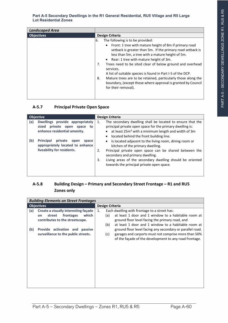
PA
RT
A-5
–S
EC
ON
DA
RY
DE
WE
LLIN
GS
ZO
NE
R1, R
U5 &
R5
Part A-5 Secondary Dwellings in the R1 General Residential, RU5 Village and R5 Large Lot Residential Zones
Part A-5 – Secondary Dwellings – Zones R1, RU5 & R5 Page A-60
Landscaped Area Objectives Design Criteria
6. The following is to be provided:
Front: 1 tree with mature height of 8m if primary road setback is greater than 5m. If the primary road setback is less than 5m, a tree with a mature height of 5m.
Rear: 1 tree with mature height of 3m. 7. Trees need to be sited clear of below ground and overhead
services. A list of suitable species is found in Part I-5 of the DCP. 8. Mature trees are to be retained, particularly those along the
boundary, (except those where approval is granted by Council for their removal).
A-5.7 Principal Private Open Space
Objective Design Criteria
(a) Dwellings provide appropriately sized private open space to enhance residential amenity.
(b) Principal private open space appropriately located to enhance liveability for residents.
1. The secondary dwelling shall be located to ensure that the principal private open space for the primary dwelling is:
at least 25m² with a minimum length and width of 3m
located behind the front building line.
Is located adjacent to the living room, dining room or kitchen of the primary dwelling.
2. Principal private open space can be shared between the secondary and primary dwelling.
3. Living areas of the secondary dwelling should be oriented towards the principal private open space.
A-5.8 Building Design – Primary and Secondary Street Frontage – R1 and RU5
Zones only
Building Elements on Street Frontages Objectives Design Criteria
(a) Create a visually interesting façade on street frontages which contributes to the streetscape.
(b) Provide activation and passive surveillance to the public streets.
1. Each dwelling with frontage to a street has: (a) at least 1 door and 1 window to a habitable room at
ground floor level facing the primary road, and (b) at least 1 door and 1 window to a habitable room at
ground floor level facing any secondary or parallel road.(c) garages and carports must not comprise more than 50%
of the façade of the development to any road frontage.
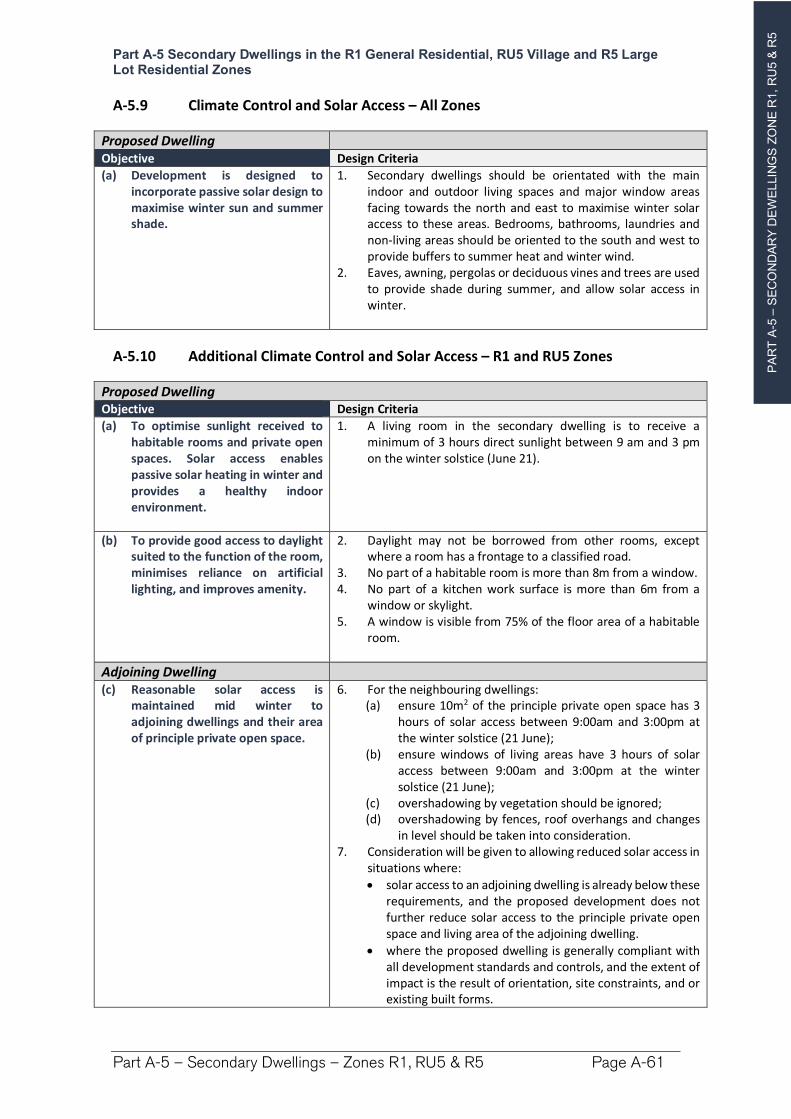
PA
RT
A-5
–S
EC
ON
DA
RY
DE
WE
LLIN
GS
ZO
NE
R1, R
U5 &
R5
Part A-5 Secondary Dwellings in the R1 General Residential, RU5 Village and R5 Large Lot Residential Zones
Part A-5 – Secondary Dwellings – Zones R1, RU5 & R5 Page A-61
A-5.9 Climate Control and Solar Access – All Zones
Proposed Dwelling Objective Design Criteria
(a) Development is designed to incorporate passive solar design to maximise winter sun and summer shade.
1. Secondary dwellings should be orientated with the main indoor and outdoor living spaces and major window areas facing towards the north and east to maximise winter solar access to these areas. Bedrooms, bathrooms, laundries and non-living areas should be oriented to the south and west to provide buffers to summer heat and winter wind.
2. Eaves, awning, pergolas or deciduous vines and trees are used to provide shade during summer, and allow solar access in winter.
A-5.10 Additional Climate Control and Solar Access – R1 and RU5 Zones
Proposed Dwelling Objective Design Criteria
(a) To optimise sunlight received to habitable rooms and private open spaces. Solar access enables passive solar heating in winter and provides a healthy indoor environment.
1. A living room in the secondary dwelling is to receive a minimum of 3 hours direct sunlight between 9 am and 3 pm on the winter solstice (June 21).
(b) To provide good access to daylight suited to the function of the room, minimises reliance on artificial lighting, and improves amenity.
2. Daylight may not be borrowed from other rooms, except where a room has a frontage to a classified road.
3. No part of a habitable room is more than 8m from a window. 4. No part of a kitchen work surface is more than 6m from a
window or skylight. 5. A window is visible from 75% of the floor area of a habitable
room.
Adjoining Dwelling (c) Reasonable solar access is
maintained mid winter to adjoining dwellings and their area of principle private open space.
6. For the neighbouring dwellings: (a) ensure 10m2 of the principle private open space has 3
hours of solar access between 9:00am and 3:00pm at the winter solstice (21 June);
(b) ensure windows of living areas have 3 hours of solar access between 9:00am and 3:00pm at the winter solstice (21 June);
(c) overshadowing by vegetation should be ignored; (d) overshadowing by fences, roof overhangs and changes
in level should be taken into consideration. 7. Consideration will be given to allowing reduced solar access in
situations where:
solar access to an adjoining dwelling is already below these requirements, and the proposed development does not further reduce solar access to the principle private open space and living area of the adjoining dwelling.
where the proposed dwelling is generally compliant with all development standards and controls, and the extent of impact is the result of orientation, site constraints, and or existing built forms.
PA
RT
A-5
–S
EC
ON
DA
RY
DE
WE
LLIN
GS
ZO
NE
R1, R
U5 &
R5
Part A-5 Secondary Dwellings in the R1 General Residential, RU5 Village and R5 Large Lot Residential Zones
Part A-5 – Secondary Dwellings – Zones R1, RU5 & R5 Page A-62
Proposed Dwelling Objective Design Criteria
Notes. 1. For the purposes of calculating direct sunlight to the proposed and adjoining dwellings:
Direct sunlight is achieved when a minimum of 1m² of direct sunlight on the glass is received for at least 15 minutes.
To satisfy 3 hours direct sunlight, 12 periods of 15 minutes will need to be achieved, however the periods do not need to be consecutive.
2. The applicant will be required to provide shadow diagrams where council considers that the siting, orientation or height of the proposed dwelling make it likely to impact on solar access to living areas and principle private open space of the adjoining dwelling.
A-5.11 Car Parking and Access
Objective Design Criteria
(a) Car parking is provided appropriate for the scale of the development.
1. No additional car parking is required for a secondary dwelling.2. The secondary dwelling shall not result in car parking for the
primary dwelling being less than 2 spaces, located as specified in the dwelling house controls.
A-5.12 Visual Privacy
Objective Design Criteria
(a) Ensure building design and siting minimises impacts on privacy of habitable rooms and private outdoor space of adjoining dwellings.
1. Locate, orientate and design new development to ensure visual privacy between buildings and between buildings and adjacent private open space.
2. Use building design to increase privacy without compromising access to light and air.
3. Living room, dining room and kitchen windows that provide a direct outlook to an adjacent property which leads to a loss of amenity, needs to consider the following: (a) offset the edge of one window to the edge of the other
window by a sufficient distance to limit the views into the adjacent windows; or
(b) provide sill heights of at least 1.5m; or (c) have fixed obscure glazing or glass blocks in any part of
the window below 1.5m. (d) direct the outlook from all living rooms, dining rooms,
bedrooms, kitchens and studies where possible towards the street, private open space on the development site, public open spaces, and waterways.
(e) where overlooking of adjacent living rooms, dining rooms, bedrooms, kitchens and studies or private open space is unavoidable then screening elements such as louvres and obscured glass must be used to preserve reasonable visual privacy for neighbours.
4. In the R1 and RU5 zones: A balcony, deck, patio, terrace or verandah must have a
privacy screen if it:
Has a setback of less than 3 metres from a side or rear boundary, and
Has a floor area of more than 3 m2 and a floor level greater than 1.0m above ground level (existing).
PA
RT
A-5
–S
EC
ON
DA
RY
DE
WE
LLIN
GS
ZO
NE
R1, R
U5 &
R5
Part A-5 Secondary Dwellings in the R1 General Residential, RU5 Village and R5 Large Lot Residential Zones
Part A-5 – Secondary Dwellings – Zones R1, RU5 & R5 Page A-63
A-5.13 Acoustic Privacy
Objective Design Criteria
(a) Noise transfer is minimised through the siting of buildings and building layout.
1. Electrical, mechanical, hydraulic and air conditioning equipment is housed so that it does not create an ‘offensive noise’ as defined in the Protection of the Environment Operations Act 1997 either within or at the boundaries of any property at any time of the day.
A-5.14 View Sharing
Objective Design Criteria
(a) To allow for the reasonable sharing of views with adjoining and/or nearby properties.
1. Where views from other dwellings or public spaces are likely to be impacted, the applicant may be required to submit a view loss assessment.
2. View loss and opportunities for view sharing is to be considered in accordance with the Land and Environment Court Planning Principals.
A-5.15 Water, Stormwater and Sewage
Objective Design Criteria
(a) To ensure all development is adequately serviced by water, sewer and stormwater infrastructure.
(b) To ensure that development is located and designed so that it will not impact upon existing infrastructure.
Stormwater
1. A secondary dwelling must: (a) connect to urban water, sewer & stormwater
infrastructure where provided, (b) install a rainwater tank being a minimum 2,000 litres
connected to the dwelling, and (c) have a minimum 80% of impermeable surface area
diverted to an infiltration area e.g. lawn or garden areas, or water tank.
Erosion and sediment controls are to be implemented during construction to prevent sediment and pollution leaving the site.
Note. Part I-9 Water Sensitive Urban Design provides further details.
Sewage
2. A secondary dwelling is to have adequate arrangements for the disposal of wastewater: (a) On a site serviced by reticulated town sewer—All
greywater and toilets is required to be connected to sewer infrastructure, subject to any Council requirements, or
b) On a site not serviced by reticulated town sewer— is to have an approved onsite sewage management facility designed in accordance with Council’s Onsite Sewage and Wastewater Strategy and associated guidelines.
PA
RT
A-5
–S
EC
ON
DA
RY
DE
WE
LLIN
GS
ZO
NE
R1, R
U5 &
R5
Part A-5 Secondary Dwellings in the R1 General Residential, RU5 Village and R5 Large Lot Residential Zones
Part A-5 – Secondary Dwellings – Zones R1, RU5 & R5 Page A-64
Objective Design Criteria
Water Supply
3. Each dwelling is to have a suitable potable water supply being:(a) Dwellings serviced by reticulated town water—
connection to a reticulated water supply is required unless a solution meeting NSW Health’s requirements can be demonstrated, or
(b) Dwellings not serviced by reticulated town water—a minimum 60,000 litres of potable water supply per lot.
(4) Where reticulated water is unavailable, an additional water source is to be provided that is dedicated for firefighting purposes: (a) land having an area <2ha—a minimum 10,000 litres per
lot, or (b) land having an area =>2ha)—a minimum 20,000 litres
per lot. (c) urban lots – 5000 litres serving both the primary and
secondary dwelling
Note. Tanks and fittings are to be installed as per appropriate Australian Standards, and Planning for Bushfire Protection 2019.
A-5.16 Earthworks and Retaining Walls
Objective Design Criteria
(a) To ensure cut and fill required for any development is designed to minimise any safety, environmental and amenity impacts on the site and adjoining properties.
1. Applications involving earthworks and retaining walls must: (a) provide details of the extent of all cut and fill, and (b) where fill is greater than 600mm high provide
geotechnical certification to verify the structural stability of any fill material, and
(c) not redirect the flow of any surface water or ground water in a concentrated manner onto an adjoining property, and
(d) be located outside the Clear Zone of and have footings outside which extend below the Zone of Influence for any sewer main, water main, or stormwater pipeline, and
(e) have footings extend below the Zone of Influence for any sewer main, water main, or stormwater pipeline, and
(f) have adequate drainage lines connected to the existing stormwater drainage system for the site, and
(g) retaining walls must be of masonry construction and have engineering certification if:
900mm or higher in height, or
if located within 900mm of a boundary, and (h) if the fill is imported to the site—be free of building and
other demolition waste, and only contain virgin excavated natural material (VENM) as defined in Part 3 of Schedule 1 to the Protection of the Environment Operations Act 1997.
PA
RT
A-6
–A
NC
ILLA
RY
RE
SID
EN
TIA
L D
EV
ELO
PM
EN
T Z
ON
E R
1 &
RU
5
`
Part A-6 Ancillary Residential Development in the R1 General Residential and RU5 Village Zones
Part A-6 – Ancillary Development – Zones R1 & RU5 Page A-65
Part A-6 Ancillary Residential Development in the R1 General Residential and RU5 Village Zones
Preamble
Ancillary residential developments are types of minor development that would ordinarily be associated with the occupation and use of a dwelling and that generally have minimal environmental impact.
Many of these forms of development can be undertaken as Exempt Development under the State Environmental Planning Policy (Exempt and Complying Development Codes) 2008. These controls are intended to apply in those circumstances where a development does not utilise the State provisions.
This Chapter addresses ancillary residential development in the R1 General Residential and RU5 Village zones where the urban lot sizes can create significant constraints to the scale and number of ancillary developments that can be placed on a lot without adversely impacting on the surrounding properties, the environment or the character of the area. It is in these zones where most guidance is required to balance the ability of residents to develop their property, with the impact of such development on adjoining properties and the general locality, including public areas.
This section comprises two parts:
Part 1 – General ancillary development. This section contains controls which apply to
all ancillary development.
Part 2 – Additional Controls for Specific Development Types.
Overall Objectives for Ancillary Development
(1) Balance the ability of the individual residents to erect ancillary structures which contribute to their enjoyment of their property while protecting the amenity and acoustic and visual privacy of neighbours.
(2) Ensure that ancillary structures are compatible with the established character, scale and setting of the locality.
(3) Minimise the potential environmental impacts of ancillary development.
(4) Manage the cumulative impact of ancillary development, particularly the visual impact when viewed from the public domain and neighbouring properties.
(5) Ensure new ancillary development minimises overshadowing, view loss and visual intrusion for neighbouring properties.
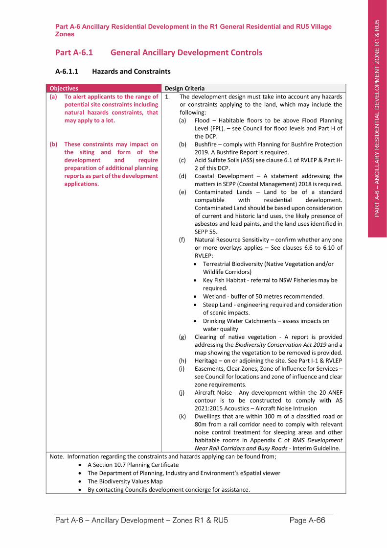
PA
RT
A-6
–A
NC
ILLA
RY
RE
SID
EN
TIA
L D
EV
ELO
PM
EN
T Z
ON
E R
1 &
RU
5
`
Part A-6 Ancillary Residential Development in the R1 General Residential and RU5 Village Zones
Part A-6 – Ancillary Development – Zones R1 & RU5 Page A-66
Part A-6.1 General Ancillary Development Controls
A-6.1.1 Hazards and Constraints
Objectives Design Criteria
(a) To alert applicants to the range of potential site constraints including natural hazards constraints, that may apply to a lot.
(b) These constraints may impact on the siting and form of the development and require preparation of additional planning reports as part of the development applications.
1. The development design must take into account any hazards or constraints applying to the land, which may include the following: (a) Flood – Habitable floors to be above Flood Planning
Level (FPL). – see Council for flood levels and Part H of the DCP.
(b) Bushfire – comply with Planning for Bushfire Protection 2019. A Bushfire Report is required.
(c) Acid Sulfate Soils (ASS) see clause 6.1 of RVLEP & Part H-2 of this DCP.
(d) Coastal Development – A statement addressing the matters in SEPP (Coastal Management) 2018 is required.
(e) Contaminated Lands – Land to be of a standard compatible with residential development. Contaminated Land should be based upon consideration of current and historic land uses, the likely presence of asbestos and lead paints, and the land uses identified in SEPP 55.
(f) Natural Resource Sensitivity – confirm whether any one or more overlays applies – See clauses 6.6 to 6.10 of RVLEP:
Terrestrial Biodiversity (Native Vegetation and/or Wildlife Corridors)
Key Fish Habitat - referral to NSW Fisheries may be required.
Wetland - buffer of 50 metres recommended.
Steep Land - engineering required and consideration of scenic impacts.
Drinking Water Catchments – assess impacts on water quality
(g) Clearing of native vegetation - A report is provided addressing the Biodiversity Conservation Act 2019 and a map showing the vegetation to be removed is provided.
(h) Heritage – on or adjoining the site. See Part I-1 & RVLEP (i) Easements, Clear Zones, Zone of Influence for Services –
see Council for locations and zone of influence and clear zone requirements.
(j) Aircraft Noise - Any development within the 20 ANEF contour is to be constructed to comply with AS 2021:2015 Acoustics – Aircraft Noise Intrusion
(k) Dwellings that are within 100 m of a classified road or 80m from a rail corridor need to comply with relevant noise control treatment for sleeping areas and other habitable rooms in Appendix C of RMS Development Near Rail Corridors and Busy Roads - Interim Guideline.
Note. Information regarding the constraints and hazards applying can be found from;
A Section 10.7 Planning Certificate
The Department of Planning, Industry and Environment’s eSpatial viewer
The Biodiversity Values Map
By contacting Councils development concierge for assistance.
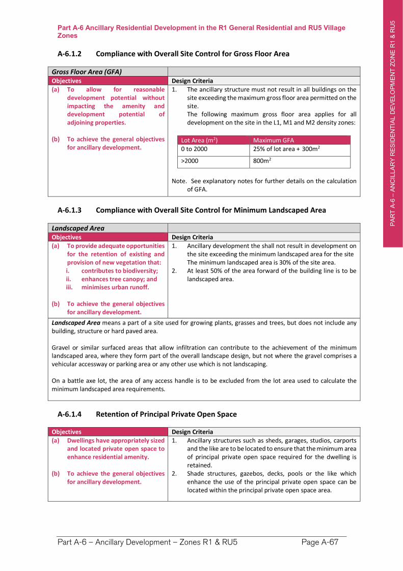
PA
RT
A-6
–A
NC
ILLA
RY
RE
SID
EN
TIA
L D
EV
ELO
PM
EN
T Z
ON
E R
1 &
RU
5
`
Part A-6 Ancillary Residential Development in the R1 General Residential and RU5 Village Zones
Part A-6 – Ancillary Development – Zones R1 & RU5 Page A-67
A-6.1.2 Compliance with Overall Site Control for Gross Floor Area
Gross Floor Area (GFA) Objectives Design Criteria
(a) To allow for reasonable development potential without impacting the amenity and development potential of adjoining properties.
(b) To achieve the general objectives for ancillary development.
1. The ancillary structure must not result in all buildings on the site exceeding the maximum gross floor area permitted on the site.
The following maximum gross floor area applies for all development on the site in the L1, M1 and M2 density zones:
Lot Area (m2) Maximum GFA
0 to 2000 25% of lot area + 300m2
>2000 800m2
Note. See explanatory notes for further details on the calculation of GFA.
A-6.1.3 Compliance with Overall Site Control for Minimum Landscaped Area
Landscaped Area Objectives Design Criteria
(a) To provide adequate opportunities for the retention of existing and provision of new vegetation that: i. contributes to biodiversity; ii. enhances tree canopy; and iii. minimises urban runoff.
(b) To achieve the general objectives for ancillary development.
1. Ancillary development the shall not result in development on the site exceeding the minimum landscaped area for the site
The minimum landscaped area is 30% of the site area. 2. At least 50% of the area forward of the building line is to be
landscaped area.
Landscaped Area means a part of a site used for growing plants, grasses and trees, but does not include any building, structure or hard paved area.
Gravel or similar surfaced areas that allow infiltration can contribute to the achievement of the minimum landscaped area, where they form part of the overall landscape design, but not where the gravel comprises a vehicular accessway or parking area or any other use which is not landscaping.
On a battle axe lot, the area of any access handle is to be excluded from the lot area used to calculate the minimum landscaped area requirements.
A-6.1.4 Retention of Principal Private Open Space
Objectives Design Criteria
(a) Dwellings have appropriately sized and located private open space to enhance residential amenity.
(b) To achieve the general objectives for ancillary development.
1. Ancillary structures such as sheds, garages, studios, carports and the like are to be located to ensure that the minimum area of principal private open space required for the dwelling is retained.
2. Shade structures, gazebos, decks, pools or the like which enhance the use of the principal private open space can be located within the principal private open space area.
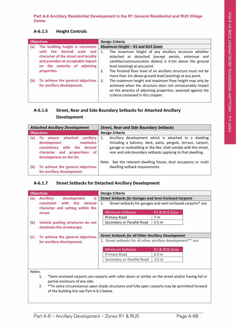
PA
RT
A-6
–A
NC
ILLA
RY
RE
SID
EN
TIA
L D
EV
ELO
PM
EN
T Z
ON
E R
1 &
RU
5
`
Part A-6 Ancillary Residential Development in the R1 General Residential and RU5 Village Zones
Part A-6 – Ancillary Development – Zones R1 & RU5 Page A-68
A-6.1.5 Height Controls
Objectives Design Criteria
(a) The building height is consistent with the desired scale and character of the street and locality and provides an acceptable impact on the amenity of adjoining properties.
(b) To achieve the general objectives for ancillary development.
Maximum Height – R1 and RU5 Zones
1. The maximum height of any ancillary structure whether attached or detached (except aerials, antennae and satellite/communication dishes) is 4.5m above the ground level (existing) at any point.
2. The finished floor level of an ancillary structure must not be more than 1m above ground level (existing) at any point.
3. The maximum height and maximum floor height may only be achieved when the structure does not unreasonably impact on the amenity of adjoining properties, assessed against the criteria contained in this chapter.
A-6.1.6 Street, Rear and Side Boundary Setbacks for Attached Ancillary
Development
Attached Ancillary Development Street, Rear and Side Boundary SetbacksObjectives Design Criteria
(a) To ensure attached ancillary development maintains consistency with the desired character and proportions of development on the lot.
(b) To achieve the general objectives for ancillary development.
1. Ancillary development which is attached to a dwelling including a balcony, deck, patio, pergola, terrace, carport, garage or outbuilding or the like, shall comply with the street, rear and side boundary setbacks applying to that dwelling.
Note. See the relevant dwelling house, dual occupancy or multi dwelling setback requirements.
A-6.1.7 Street Setbacks for Detached Ancillary Development
Objectives Design Criteria
(a) Ancillary development is consistent with the desired character and setting within the street.
(b) Vehicle parking structures do not dominate the streetscape.
(c) To achieve the general objectives for ancillary development.
Street Setbacks for Garages and Semi Enclosed Carports
1. Street setbacks for garages and semi enclosed carports* are:
Minimum Setbacks R1 & RU5 Zone
Primary Road 7 m
Secondary or Parallel Road 5.5 m
Street Setbacks for all Other Ancillary Development
2. Street setbacks for all other ancillary development** are:
Minimum Setbacks R1 & RU5 Zone Primary Road 6.0 m
Secondary or Parallel Road 3.0 m
Notes. 1. *Semi enclosed carports are carports with roller doors or similar on the street and/or having full or
partial enclosure of any side. 2. **In some circumstances open shade structures and fully open carports may be permitted forward
of the building line see Part A-6.2 below.
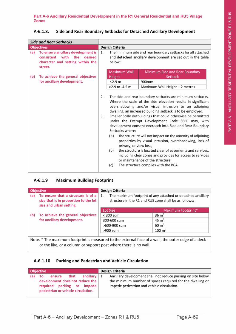
PA
RT
A-6
–A
NC
ILLA
RY
RE
SID
EN
TIA
L D
EV
ELO
PM
EN
T Z
ON
E R
1 &
RU
5
`
Part A-6 Ancillary Residential Development in the R1 General Residential and RU5 Village Zones
Part A-6 – Ancillary Development – Zones R1 & RU5 Page A-69
A-6.1.8. Side and Rear Boundary Setbacks for Detached Ancillary Development
Side and Rear Setbacks Objectives Design Criteria
(a) To ensure ancillary development is consistent with the desired character and setting within the street.
(b) To achieve the general objectives for ancillary development.
1. The minimum side and rear boundary setbacks for all attached and detached ancillary development are set out in the table below:
Maximum Wall Height
Minimum Side and Rear Boundary Setback
≤2.9 m 900mm
>2.9 m -4.5 m Maximum Wall Height – 2 metres
2. The side and rear boundary setbacks are minimum setbacks. Where the scale of the side elevation results in significant overshadowing and/or visual intrusion to an adjoining dwelling, an increased building setback is to be employed.
3. Smaller Scale outbuildings that could otherwise be permitted under the Exempt Development Code SEPP may, with development consent encroach into Side and Rear Boundary Setbacks where:
(a) the structure will not impact on the amenity of adjoining properties by visual intrusion, overshadowing, loss of privacy, or view loss,
(b) the structure is located clear of easements and services, including clear zones and provides for access to services or maintenance of the structure,
(c) The structure complies with the BCA.
A-6.1.9 Maximum Building Footprint
Objective Design Criteria
(a) To ensure that a structure is of a size that is in proportion to the lot size and urban setting.
(b) To achieve the general objectives for ancillary development.
1. The maximum footprint of any attached or detached ancillary structure in the R1 and RU5 zone shall be as follows:
Lot Size Maximum Footprint*
< 300 sqm 36 m2
300-600 sqm 45 m2
>600-900 sqm 60 m2
>900 sqm 100 m2
Note. * The maximum footprint is measured to the external face of a wall, the outer edge of a deck or the like, or a column or support post where there is no wall.
A-6.1.10 Parking and Pedestrian and Vehicle Circulation
Objective Design Criteria
(a) To ensure that ancillary development does not reduce the required parking or impede pedestrian or vehicle circulation.
1. Ancillary development shall not reduce parking on site below the minimum number of spaces required for the dwelling or impede pedestrian and vehicle circulation.
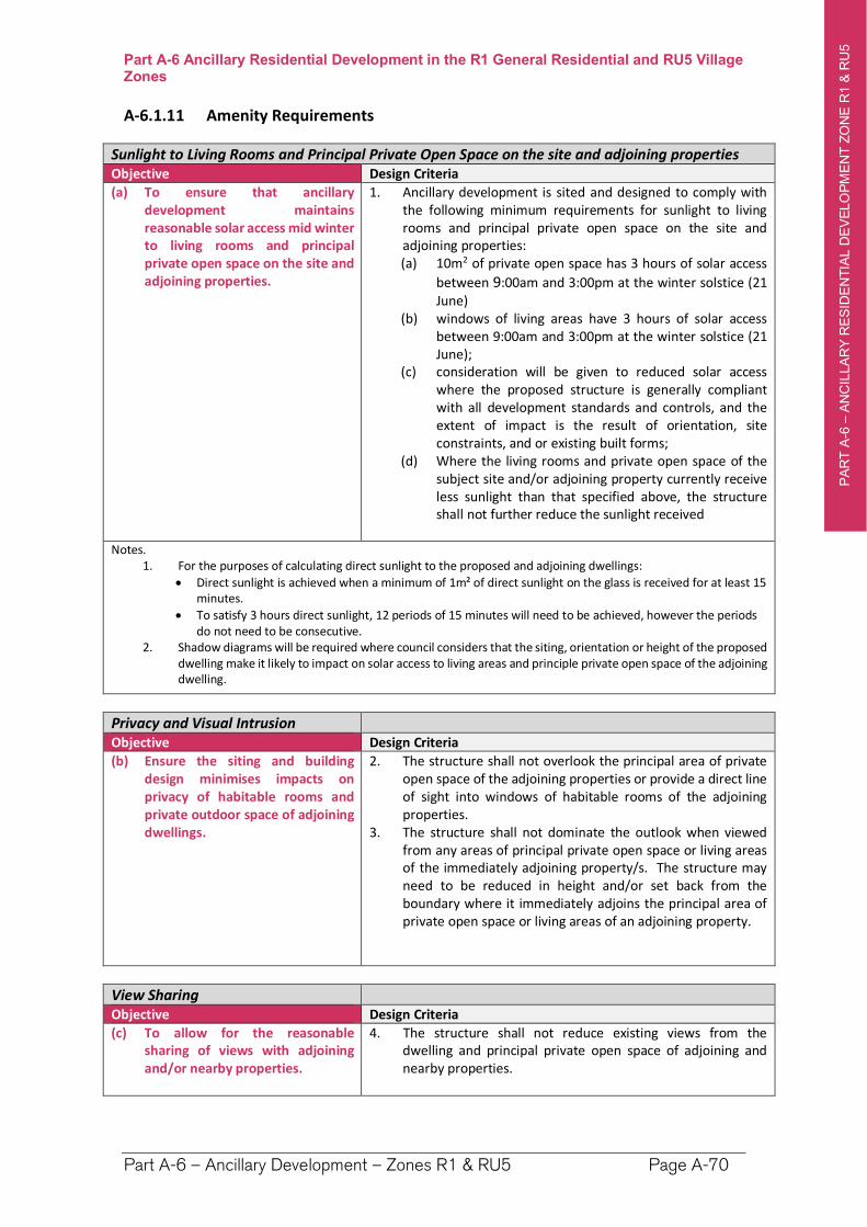
PA
RT
A-6
–A
NC
ILLA
RY
RE
SID
EN
TIA
L D
EV
ELO
PM
EN
T Z
ON
E R
1 &
RU
5
`
Part A-6 Ancillary Residential Development in the R1 General Residential and RU5 Village Zones
Part A-6 – Ancillary Development – Zones R1 & RU5 Page A-70
A-6.1.11 Amenity Requirements
Sunlight to Living Rooms and Principal Private Open Space on the site and adjoining properties Objective Design Criteria
(a) To ensure that ancillary development maintains reasonable solar access mid winter to living rooms and principal private open space on the site and adjoining properties.
1. Ancillary development is sited and designed to comply with the following minimum requirements for sunlight to living rooms and principal private open space on the site and adjoining properties: (a) 10m2 of private open space has 3 hours of solar access
between 9:00am and 3:00pm at the winter solstice (21 June)
(b) windows of living areas have 3 hours of solar access between 9:00am and 3:00pm at the winter solstice (21 June);
(c) consideration will be given to reduced solar access where the proposed structure is generally compliant with all development standards and controls, and the extent of impact is the result of orientation, site constraints, and or existing built forms;
(d) Where the living rooms and private open space of the subject site and/or adjoining property currently receive less sunlight than that specified above, the structure shall not further reduce the sunlight received
Notes. 1. For the purposes of calculating direct sunlight to the proposed and adjoining dwellings:
Direct sunlight is achieved when a minimum of 1m² of direct sunlight on the glass is received for at least 15 minutes.
To satisfy 3 hours direct sunlight, 12 periods of 15 minutes will need to be achieved, however the periods do not need to be consecutive.
2. Shadow diagrams will be required where council considers that the siting, orientation or height of the proposed dwelling make it likely to impact on solar access to living areas and principle private open space of the adjoining dwelling.
Privacy and Visual Intrusion Objective Design Criteria
(b) Ensure the siting and building design minimises impacts on privacy of habitable rooms and private outdoor space of adjoining dwellings.
2. The structure shall not overlook the principal area of private open space of the adjoining properties or provide a direct line of sight into windows of habitable rooms of the adjoining properties.
3. The structure shall not dominate the outlook when viewed from any areas of principal private open space or living areas of the immediately adjoining property/s. The structure may need to be reduced in height and/or set back from the boundary where it immediately adjoins the principal area of private open space or living areas of an adjoining property.
View Sharing Objective Design Criteria
(c) To allow for the reasonable sharing of views with adjoining and/or nearby properties.
4. The structure shall not reduce existing views from the dwelling and principal private open space of adjoining and nearby properties.
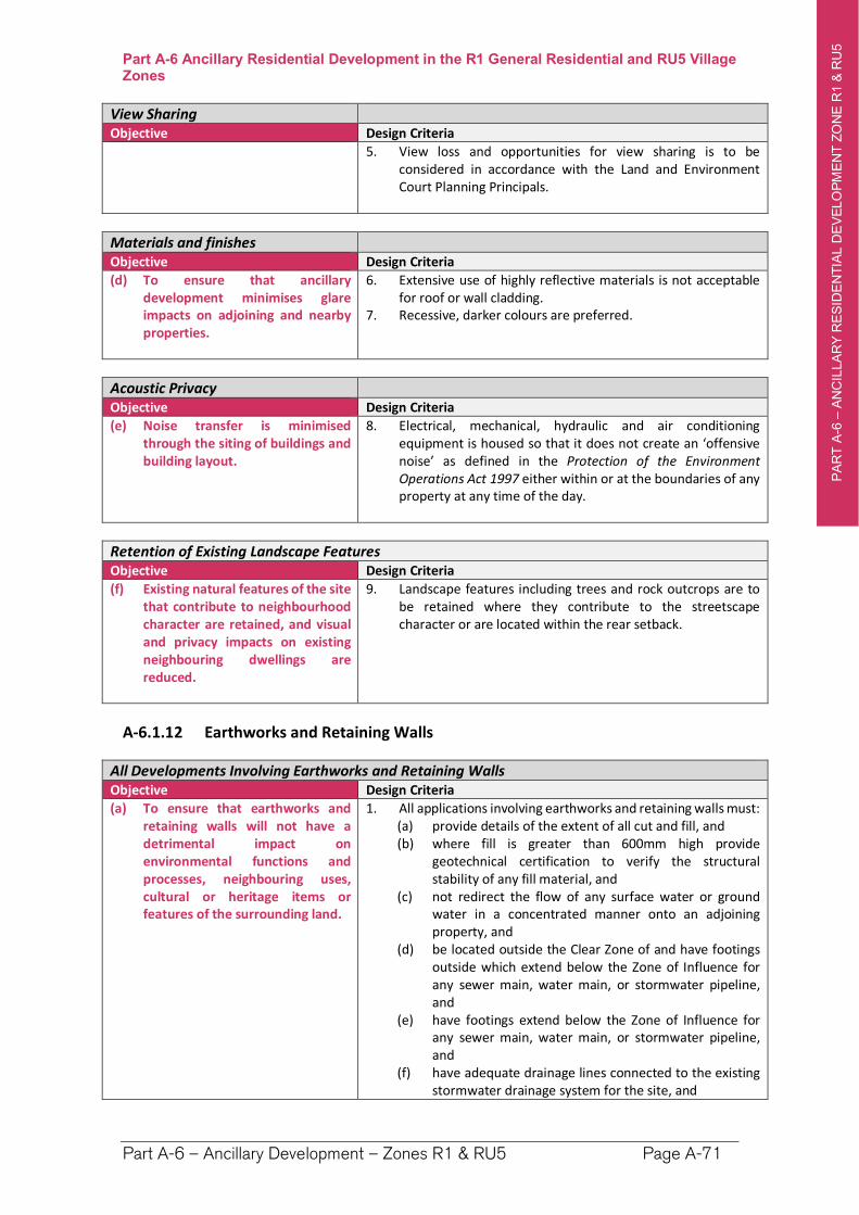
PA
RT
A-6
–A
NC
ILLA
RY
RE
SID
EN
TIA
L D
EV
ELO
PM
EN
T Z
ON
E R
1 &
RU
5
`
Part A-6 Ancillary Residential Development in the R1 General Residential and RU5 Village Zones
Part A-6 – Ancillary Development – Zones R1 & RU5 Page A-71
View Sharing Objective Design Criteria
5. View loss and opportunities for view sharing is to be considered in accordance with the Land and Environment Court Planning Principals.
Materials and finishes Objective Design Criteria
(d) To ensure that ancillary development minimises glare impacts on adjoining and nearby properties.
6. Extensive use of highly reflective materials is not acceptable for roof or wall cladding.
7. Recessive, darker colours are preferred.
Acoustic Privacy Objective Design Criteria
(e) Noise transfer is minimised through the siting of buildings and building layout.
8. Electrical, mechanical, hydraulic and air conditioning equipment is housed so that it does not create an ‘offensive noise’ as defined in the Protection of the Environment Operations Act 1997 either within or at the boundaries of any property at any time of the day.
Retention of Existing Landscape Features Objective Design Criteria
(f) Existing natural features of the site that contribute to neighbourhood character are retained, and visual and privacy impacts on existing neighbouring dwellings are reduced.
9. Landscape features including trees and rock outcrops are to be retained where they contribute to the streetscape character or are located within the rear setback.
A-6.1.12 Earthworks and Retaining Walls
All Developments Involving Earthworks and Retaining Walls Objective Design Criteria
(a) To ensure that earthworks and retaining walls will not have a detrimental impact on environmental functions and processes, neighbouring uses, cultural or heritage items or features of the surrounding land.
1. All applications involving earthworks and retaining walls must:(a) provide details of the extent of all cut and fill, and (b) where fill is greater than 600mm high provide
geotechnical certification to verify the structural stability of any fill material, and
(c) not redirect the flow of any surface water or ground water in a concentrated manner onto an adjoining property, and
(d) be located outside the Clear Zone of and have footings outside which extend below the Zone of Influence for any sewer main, water main, or stormwater pipeline, and
(e) have footings extend below the Zone of Influence for any sewer main, water main, or stormwater pipeline, and
(f) have adequate drainage lines connected to the existing stormwater drainage system for the site, and
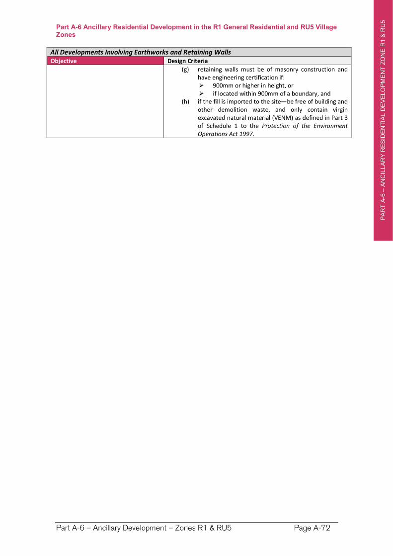
PA
RT
A-6
–A
NC
ILLA
RY
RE
SID
EN
TIA
L D
EV
ELO
PM
EN
T Z
ON
E R
1 &
RU
5
`
Part A-6 Ancillary Residential Development in the R1 General Residential and RU5 Village Zones
Part A-6 – Ancillary Development – Zones R1 & RU5 Page A-72
All Developments Involving Earthworks and Retaining Walls Objective Design Criteria
(g) retaining walls must be of masonry construction and have engineering certification if: 900mm or higher in height, or if located within 900mm of a boundary, and
(h) if the fill is imported to the site—be free of building and other demolition waste, and only contain virgin excavated natural material (VENM) as defined in Part 3 of Schedule 1 to the Protection of the Environment Operations Act 1997.
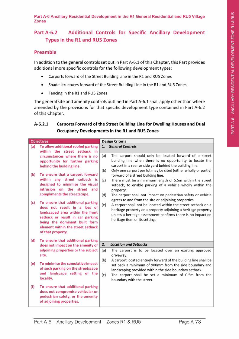
PA
RT
A-6
–A
NC
ILLA
RY
RE
SID
EN
TIA
L D
EV
ELO
PM
EN
T Z
ON
E R
1 &
RU
5
`
Part A-6 Ancillary Residential Development in the R1 General Residential and RU5 Village Zones
Part A-6 – Ancillary Development – Zones R1 & RU5 Page A-73
Part A-6.2 Additional Controls for Specific Ancillary Development
Types in the R1 and RU5 Zones
Preamble
In addition to the general controls set out in Part A-6.1 of this Chapter, this Part provides additional more specific controls for the following development types:
Carports forward of the Street Building Line in the R1 and RU5 Zones
Shade structures forward of the Street Building Line in the R1 and RU5 Zones
Fencing in the R1 and RU5 Zones
The general site and amenity controls outlined in Part A-6.1 shall apply other than where amended by the provisions for that specific development type contained in Part A-6.2 of this Chapter.
A-6.2.1 Carports Forward of the Street Building Line for Dwelling Houses and Dual
Occupancy Developments in the R1 and RU5 Zones
Objectives Design Criteria
(a) To allow additional roofed parking within the street setback in circumstances where there is no opportunity for further parking behind the building line.
(b) To ensure that a carport forward within any street setback is designed to minimise the visual intrusion on the street and compliments the streetscape.
(c) To ensure that additional parking does not result in a loss of landscaped area within the front setback or result in car parking being the dominant built form element within the street setback of that property.
(d) To ensure that additional parking does not impact on the amenity of adjoining properties or the subject site.
(e) To minimise the cumulative impact of such parking on the streetscape and landscape setting of the locality.
(f) To ensure that additional parking does not compromise vehicular or pedestrian safety, or the amenity of adjoining properties.
1. General Controls
(a) The carport should only be located forward of a street building line when there is no opportunity to locate the carport in a rear or side yard behind the building line.
(b) Only one carport per lot may be sited (either wholly or partly) forward of a street building line.
(c) There must be a minimum length of 5.5m within the street setback, to enable parking of a vehicle wholly within the property.
(d) The carport shall not impact on pedestrian safety or vehicle egress to and from the site or adjoining properties.
(e) A carport shall not be located within the street setback on a heritage property or a property adjoining a heritage property unless a heritage assessment confirms there is no impact on heritage item or its setting.
2. Location and Setbacks
(a) The carport is to be located over an existing approved driveway.
(b) A carport located entirely forward of the building line shall be set back a minimum of 900mm from the side boundary and landscaping provided within the side boundary setback.
(c) The carport shall be set a minimum of 0.5m from the boundary with the street.
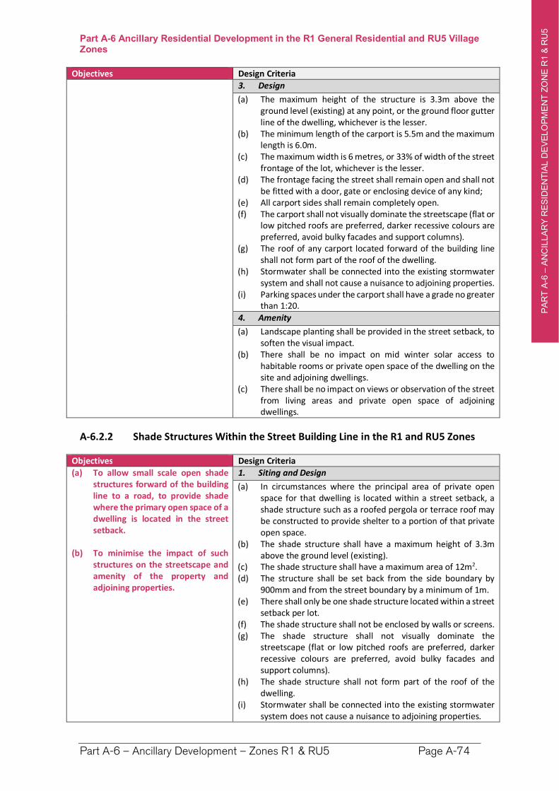
PA
RT
A-6
–A
NC
ILLA
RY
RE
SID
EN
TIA
L D
EV
ELO
PM
EN
T Z
ON
E R
1 &
RU
5
`
Part A-6 Ancillary Residential Development in the R1 General Residential and RU5 Village Zones
Part A-6 – Ancillary Development – Zones R1 & RU5 Page A-74
Objectives Design Criteria
3. Design
(a) The maximum height of the structure is 3.3m above the ground level (existing) at any point, or the ground floor gutter line of the dwelling, whichever is the lesser.
(b) The minimum length of the carport is 5.5m and the maximum length is 6.0m.
(c) The maximum width is 6 metres, or 33% of width of the street frontage of the lot, whichever is the lesser.
(d) The frontage facing the street shall remain open and shall not be fitted with a door, gate or enclosing device of any kind;
(e) All carport sides shall remain completely open. (f) The carport shall not visually dominate the streetscape (flat or
low pitched roofs are preferred, darker recessive colours are preferred, avoid bulky facades and support columns).
(g) The roof of any carport located forward of the building line shall not form part of the roof of the dwelling.
(h) Stormwater shall be connected into the existing stormwater system and shall not cause a nuisance to adjoining properties.
(i) Parking spaces under the carport shall have a grade no greater than 1:20.
4. Amenity
(a) Landscape planting shall be provided in the street setback, to soften the visual impact.
(b) There shall be no impact on mid winter solar access to habitable rooms or private open space of the dwelling on the site and adjoining dwellings.
(c) There shall be no impact on views or observation of the street from living areas and private open space of adjoining dwellings.
A-6.2.2 Shade Structures Within the Street Building Line in the R1 and RU5 Zones
Objectives Design Criteria
(a) To allow small scale open shade structures forward of the building line to a road, to provide shade where the primary open space of a dwelling is located in the street setback.
(b) To minimise the impact of such structures on the streetscape and amenity of the property and adjoining properties.
1. Siting and Design
(a) In circumstances where the principal area of private open space for that dwelling is located within a street setback, a shade structure such as a roofed pergola or terrace roof may be constructed to provide shelter to a portion of that private open space.
(b) The shade structure shall have a maximum height of 3.3m above the ground level (existing).
(c) The shade structure shall have a maximum area of 12m2. (d) The structure shall be set back from the side boundary by
900mm and from the street boundary by a minimum of 1m. (e) There shall only be one shade structure located within a street
setback per lot. (f) The shade structure shall not be enclosed by walls or screens.(g) The shade structure shall not visually dominate the
streetscape (flat or low pitched roofs are preferred, darker recessive colours are preferred, avoid bulky facades and support columns).
(h) The shade structure shall not form part of the roof of the dwelling.
(i) Stormwater shall be connected into the existing stormwater system does not cause a nuisance to adjoining properties.
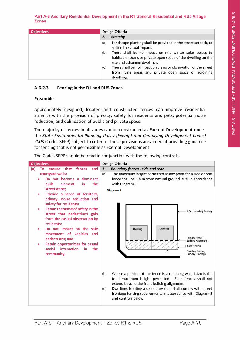
PA
RT
A-6
–A
NC
ILLA
RY
RE
SID
EN
TIA
L D
EV
ELO
PM
EN
T Z
ON
E R
1 &
RU
5
`
Part A-6 Ancillary Residential Development in the R1 General Residential and RU5 Village Zones
Part A-6 – Ancillary Development – Zones R1 & RU5 Page A-75
Objectives Design Criteria
2. Amenity
(a) Landscape planting shall be provided in the street setback, to soften the visual impact.
(b) There shall be no impact on mid winter solar access to habitable rooms or private open space of the dwelling on the site and adjoining dwellings.
(c) There shall be no impact on views or observation of the street from living areas and private open space of adjoining dwellings.
A-6.2.3 Fencing in the R1 and RU5 Zones
Preamble
Appropriately designed, located and constructed fences can improve residential amenity with the provision of privacy, safety for residents and pets, potential noise reduction, and delineation of public and private space.
The majority of fences in all zones can be constructed as Exempt Development under the State Environmental Planning Policy (Exempt and Complying Development Codes) 2008 (Codes SEPP) subject to criteria. These provisions are aimed at providing guidance for fencing that is not permissible as Exempt Development.
The Codes SEPP should be read in conjunction with the following controls.
Objectives Design Criteria
(a) To ensure that fences and courtyard walls:
Do not become a dominant built element in the streetscape;
Provide a sense of territory, privacy, noise reduction and safety for residents;
Retain the sense of safety in the street that pedestrians gain from the casual observation by residents;
Do not impact on the safe movement of vehicles and pedestrians; and
Retain opportunities for casual social interaction in the community.
1. Boundary fences - side and rear
(a) The maximum height permitted at any point for a side or rear fence shall be 1.8 m from natural ground level in accordance with Diagram 1.
(b) Where a portion of the fence is a retaining wall, 1.8m is the total maximum height permitted. Such fences shall not extend beyond the front building alignment.
(c) Dwellings fronting a secondary road shall comply with street frontage fencing requirements in accordance with Diagram 2 and controls below.
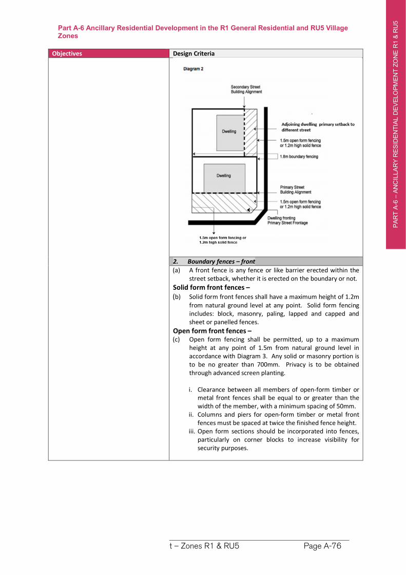
PA
RT
A-6
–A
NC
ILLA
RY
RE
SID
EN
TIA
L D
EV
ELO
PM
EN
T Z
ON
E R
1 &
RU
5
`
Part A-6 Ancillary Residential Development in the R1 General Residential and RU5 Village Zones
Part A-6 – Ancillary Development – Zones R1 & RU5 Page A-76
Objectives Design Criteria
2. Boundary fences – front
(a) A front fence is any fence or like barrier erected within the street setback, whether it is erected on the boundary or not.
Solid form front fences – (b) Solid form front fences shall have a maximum height of 1.2m
from natural ground level at any point. Solid form fencing includes: block, masonry, paling, lapped and capped and sheet or panelled fences.
Open form front fences – (c) Open form fencing shall be permitted, up to a maximum
height at any point of 1.5m from natural ground level in accordance with Diagram 3. Any solid or masonry portion is to be no greater than 700mm. Privacy is to be obtained through advanced screen planting.
i. Clearance between all members of open-form timber or metal front fences shall be equal to or greater than the width of the member, with a minimum spacing of 50mm.
ii. Columns and piers for open-form timber or metal front fences must be spaced at twice the finished fence height.
iii. Open form sections should be incorporated into fences, particularly on corner blocks to increase visibility for security purposes.
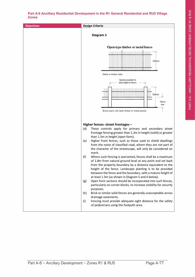
PA
RT
A-6
–A
NC
ILLA
RY
RE
SID
EN
TIA
L D
EV
ELO
PM
EN
T Z
ON
E R
1 &
RU
5
`
Part A-6 Ancillary Residential Development in the R1 General Residential and RU5 Village Zones
Part A-6 – Ancillary Development – Zones R1 & RU5 Page A-77
Objectives Design Criteria
Higher fences- street frontages – (d) These controls apply for primary and secondary street
frontage fencing greater than 1.2m in height (solid) or greater than 1.5m in height (open form).
(e) Higher front fences, such as those used to shield dwellings from the noise of classified road, where they are not part of the character of the streetscape, will only be considered on merit.
(f) Where such fencing is warranted, fences shall be a maximum of 1.8m from natural ground level at any point and set back from the property boundary by a distance equivalent to the height of the fence. Landscape planting is to be provided between the fence and the boundary, with a mature height of at least 1.5m (as shown in Diagram 5 and 6 below).
(g) Open form sections should be incorporated into such fences, particularly on corner blocks, to increase visibility for security purposes.
(h) Brick or similar solid fences are generally unacceptable across drainage easements.
(i) Fencing must provide adequate sight distance for the safety of pedestrians using the footpath area.
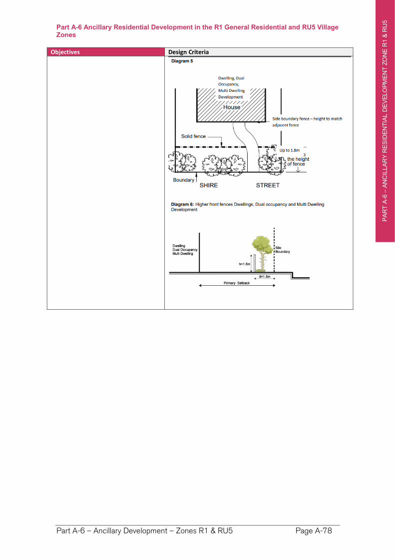
PA
RT
A-6
–A
NC
ILLA
RY
RE
SID
EN
TIA
L D
EV
ELO
PM
EN
T Z
ON
E R
1 &
RU
5
`
Part A-6 Ancillary Residential Development in the R1 General Residential and RU5 Village Zones
Part A-6 – Ancillary Development – Zones R1 & RU5 Page A-78
Objectives Design Criteria
PA
RT
A-7
–A
NC
ILLA
RY
DE
VE
LO
PM
EN
T Z
ON
ES
RU
1, R
5 &
E3
`
Part A-7 Ancillary Residential Development in the RU1 Primary Production, R5 Large Lot Residential and E3 Environmental Management Zones
Part A-7 – Ancillary Development – Zones RU1, R5 & E3 Page A-79
Part A-7 Ancillary Residential Development in the RU1 Primary Production, R5 Large Lot Residential and E3 Environmental Management Zones
Preamble
Ancillary residential developments are types of minor development that would ordinarily be associated with the occupation and use of a dwelling and that generally have minimal environmental impact.
Many of these forms of development can be undertaken as Exempt Development under the State Environmental Planning Policy (Exempt and Complying Development Codes) 2008 (Codes SEPP). These controls are intended to apply in those circumstances where a development does not utilise the State provisions.
This Chapter addresses ancillary residential development in the RU1 Primary Production, E3 Environmental Protection and R5 Large Lot Residential zones.
Ancillary residential development can only be approved on a lot if there is an existing approved residential development located on that land. For example, the controls in this Chapter do not apply to a development application for a shed on a lot of land where there is no dwelling house.
Overall Objectives for Ancillary Development
(1) Balance the ability of the individual residents to erect ancillary residential structures which contribute to their enjoyment of their dwelling, while protecting the amenity and acoustic and visual privacy of neighbours.
(2) Ensure that ancillary structures are compatible with the established character, scale and setting of the locality.
(3) Minimise the potential environmental impacts of ancillary development.
(4) Manage the cumulative impact of ancillary development, particularly the visual impact when viewed from the public domain and neighbouring properties.
(5) Ensure new ancillary development minimises overshadowing and view loss for neighbouring properties.
PA
RT
A-7
–A
NC
ILLA
RY
DE
VE
LO
PM
EN
T Z
ON
ES
RU
1, R
5 &
E3
`
Part A-7 Ancillary Residential Development in the RU1 Primary Production, R5 Large Lot Residential and E3 Environmental Management Zones
Part A-7 – Ancillary Development – Zones RU1, R5 & E3 Page A-80
A-7.1 Hazards and Constraints
Objectives Design Criteria
(a) To alert applicants to the range of potential site constraints including natural hazards constraints, that may apply to a lot.
(b) These constraints may impact on the siting and form of the development and require preparation of additional planning reports as part of the development applications.
1. The development design must take into account any hazards or constraints applying to the land, which may include the following: (a) Flood – Habitable floors to be above Flood Planning
Level (FPL). – see Council for flood levels and Part H of the DCP.
(b) Bushfire – comply with Planning for Bushfire Protection 2019. A Bushfire Report is required.
(c) Acid Sulfate Soils (ASS) see clause 6.1 of RVLEP & Part H-2 of this DCP.
(d) Coastal Development – A statement addressing the matters in SEPP (Coastal Management) 2018 is required.
(e) Contaminated Lands – Land to be of a standard compatible with residential development. Contaminated Land should be based upon consideration of current and historic land uses, the likely presence of asbestos and lead paints, and the land uses identified in SEPP 55.
(f) Natural Resource Sensitivity – confirm whether any one or more overlays applies – See clauses 6.6 to 6.10 of RVLEP:
Terrestrial Biodiversity (Native Vegetation and/or Wildlife Corridors)
Key Fish Habitat - referral to NSW Fisheries may be required.
Wetland - buffer of 50 metres recommended.
Steep Land - engineering required and consideration of scenic impacts.
Drinking Water Catchments – assess impacts on water quality
(g) Clearing of native vegetation - A report is provided addressing the Biodiversity Conservation Act 2019 and a map showing the vegetation to be removed is provided.
(h) Heritage – on or adjoining the site. See Part I-1 & RVLEP(i) Easements, Clear Zones, Zone of Influence for Services
– see Council for locations and zone of influence and clear zone requirements.
(j) Aircraft Noise - Any development within the 20 ANEF contour is to be constructed to comply with AS 2021:2015 Acoustics – Aircraft Noise Intrusion
(k) Dwellings that are within 100 m of a classified road or 80m from a rail corridor need to comply with relevant noise control treatment for sleeping areas and other habitable rooms in Appendix C of RMS Development Near Rail Corridors and Busy Roads - Interim Guideline.
Note. Information regarding the constraints and hazards applying can be found from:
A Section 10.7 Planning Certificate
The Department of Planning, Industry and Environment’s eSpatial viewer
The Biodiversity Values Map
By contacting Councils development concierge for assistance.
PA
RT
A-7
–A
NC
ILLA
RY
DE
VE
LO
PM
EN
T Z
ON
ES
RU
1, R
5 &
E3
`
Part A-7 Ancillary Residential Development in the RU1 Primary Production, R5 Large Lot Residential and E3 Environmental Management Zones
Part A-7 – Ancillary Development – Zones RU1, R5 & E3 Page A-81
A-7.2 Height Controls
Objectives Design Criteria
(a) The building height is consistent with the desired scale and character of the locality and provides an acceptable impact on the amenity of adjoining properties.
1. The maximum height is as specified in the Height of Buildings Map in Richmond Valley Local Environmental Plan 2012 is 8.5m.
2. The structure shall be designed to ensure that its height does not result in any unreasonable impact on adjoining properties or the character and scenic quality of the locality.
A-7.3 Street, Rear and Side Boundary Setbacks for Ancillary Development
Attached Ancillary Development Street, Rear and Side Boundary Setbacks Objectives Design Criteria
(a) Provide setbacks from roads and adjoining properties which reflect the rural character of the locality.
(b) To achieve the general objectives for ancillary development.
1. The following setback controls apply in all zones to any road frontage: • 15 metres from a local sealed road • 50 metres from a local unsealed road • 20 metres from a classified road
2. In the RU1 and E3 zones, the following side and rear boundary setback requirements apply: (a) Minimum Side Boundary Setback: 10 m (b) Minimum Rear Boundary Setback: 10 m
3. In the R5 Zone, the following side and rear boundary setback requirements apply: (a) Minimum Side Boundary Setback: 5 m (b) Minimum Rear Boundary Setback: 5 m
A-7.4 Local Character and Context
Objectives Design Criteria
(a) Building design, materials and location are compatible with the existing characteristics of the site and locality.
1. Ancillary buildings and structures associated with the dwelling must be designed, located and landscaped to reduce visual impacts on adjoining properties and public places.
2. The design of the ancillary buildings should be in keeping with the rural character of the locality. Traditional construction materials (i.e. timber, corrugated roofing or similar) and natural colours (grey, greens and browns) are encouraged.
3. Extensive use of highly reflective materials and/or colours is not acceptable for roof or wall cladding.
A-7.5 Retention of Existing Landscape Features
Objective Design Criteria
(a) Existing natural features of the site that contribute to the environment and character of the area retained, and visual and privacy impacts on existing neighbouring dwellings are reduced.
1. Ancillary development should be located to retain existing landscape features including trees and rock outcrops, where they contribute to the environmental and scenic qualities of the locality.
PA
RT
A-7
–A
NC
ILLA
RY
DE
VE
LO
PM
EN
T Z
ON
ES
RU
1, R
5 &
E3
`
Part A-7 Ancillary Residential Development in the RU1 Primary Production, R5 Large Lot Residential and E3 Environmental Management Zones
Part A-7 – Ancillary Development – Zones RU1, R5 & E3 Page A-82
A-7.6 Earthworks and Retaining Walls
All Developments Involving Earthworks and Retaining Walls Objective Design Criteria
(a) To ensure that earthworks and retaining walls will not have a detrimental impact on environmental functions and processes, neighbouring uses, cultural or heritage items or features of the surrounding land.
1. All applications involving earthworks and retaining walls must:(a) provide details of the extent of all cut and fill, and (b) where fill is greater than 600mm high provide
geotechnical certification to verify the structural stability of any fill material, and
(c) not redirect the flow of any surface water or ground water in a concentrated manner onto an adjoining property, and
(d) be located outside the Clear Zone of and have footings outside which extend below the Zone of Influence for any sewer main, water main, or stormwater pipeline, and
(e) have footings extend below the Zone of Influence for any sewer main, water main, or stormwater pipeline, and
(f) have adequate drainage lines connected to the existing stormwater drainage system for the site, and
(g) retaining walls must be of masonry construction and have engineering certification if:
900mm or higher in height, or
if located within 900mm of a boundary, and (h) if the fill is imported to the site—be free of building and
other demolition waste, and only contain virgin excavated natural material (VENM) as defined in Part 3 of Schedule 1 to the Protection of the Environment Operations Act 1997.
PA
RT
A-8
–M
ULT
IDW
ELLIN
G H
OU
SIN
G &
RE
SID
EN
TIA
L F
LA
T B
UIL
DIN
GS
Part A-8 Multi Dwelling Housing and Residential Flat Buildings
Part A-8 – Multi Dwelling Housing and Residential Flat Buildings Page A-83
Part A-8 Multi Dwelling Housing and Residential Flat Buildings
Preamble
Well-designed higher density housing is encouraged to provide diversity of housing choice and efficient use of land. Both multi dwelling housing and residential flat buildings are types of higher density housing.
Multi dwelling housing and Residential Flat Buildings are permitted in Zones R1 General Residential and RU5 Village. However:
multi dwelling housing is limited to the M1 – Medium Density, M2 – Medium-High Density and H – High Density areas.
Residential flat buildings are limited to the M2 – Medium-High Density and H – High Density areas.
The following definitions apply to development in this Part:
Multi dwelling housing means 3 or more dwellings (whether attached or detached) on one lot of land, each with access at ground level, but does not include a residential flat building.
Residential flat building means a building containing 3 or more dwellings, but does not include an attached dwelling or multi dwelling housing.
Note. Residential accommodation (including multi dwelling housing and residential flat buildings) is prohibited in the Commercial Zones B1, B2, and B3 – however Shop Top housing is permitted. Refer to Part A-4 – Shop Top Housing.
PA
RT
A-8
–M
ULT
IDW
ELLIN
G H
OU
SIN
G &
RE
SID
EN
TIA
L F
LA
T B
UIL
DIN
GS
Part A-8 Multi Dwelling Housing and Residential Flat Buildings
Part A-8 – Multi Dwelling Housing and Residential Flat Buildings Page A-84
Part A-8.1 Controls Common to Multi Dwelling Housing and Residential
Flat Buildings
A-8.1.1 Hazards and Constraints
Objectives Design Criteria
(a) To alert applicants to the range of potential site constraints including natural hazards constraints, that may apply to a lot.
These constraints may impact on the siting and form of the development and require preparation of additional planning reports as part of the development applications.
1. The development design must take into account any hazards or constraints applying to the land, which may include the following: (a) Flood – Habitable floors to be above Flood Planning
Level (FPL). – see Council for flood levels and Part H of the DCP.
(b) Bushfire – comply with Planning for Bushfire Protection 2019. A Bushfire Report is required.
(c) Acid Sulfate Soils (ASS) see clause 6.1 of RVLEP & Part H-2 of this DCP.
(d) Coastal Development – A statement addressing the matters in SEPP (Coastal Management) 2018 is required.
(e) Contaminated Lands – Land to be of a standard compatible with residential development. Contaminated Land should be based upon consideration of current and historic land uses, the likely presence of asbestos and lead paints, and the land uses identified in SEPP 55.
(f) Natural Resource Sensitivity – confirm whether any one or more overlays applies – See clauses 6.6 to 6.10 of RVLEP:
Terrestrial Biodiversity (Native Vegetation and/or Wildlife Corridors)
Key Fish Habitat - referral to NSW Fisheries may be required.
Wetland - buffer of 50 metres recommended.
Steep Land - engineering required and consideration of scenic impacts.
Drinking Water Catchments – assess impacts on water quality
(g) Clearing of native vegetation - A report is provided addressing the Biodiversity Conservation Act 2019 and a map showing the vegetation to be removed is provided.
(h) Heritage – on or adjoining the site. See Part I-1 & RVLEP (i) Easements, Clear Zones, Zone of Influence for Services –
see Council for locations and zone of influence and clear zone requirements.
(j) Aircraft Noise - Any development within the 20 ANEF contour is to be constructed to comply with AS 2021:2015 Acoustics – Aircraft Noise Intrusion
(k) Dwellings that are within 100 m of a classified road or 80m from a rail corridor need to comply with relevant noise control treatment for sleeping areas and other habitable rooms in Appendix C of RMS Development Near Rail Corridors and Busy Roads - Interim Guideline.
Note. Information regarding the constraints and hazards applying can be found from:
A Section 10.7 Planning Certificate
The Department of Planning, Industry and Environment’s eSpatial viewer
The Biodiversity Values Map
By contacting Councils development concierge for assistance.
PA
RT
A-8
–M
ULT
IDW
ELLIN
G H
OU
SIN
G &
RE
SID
EN
TIA
L F
LA
T B
UIL
DIN
GS
Part A-8 Multi Dwelling Housing and Residential Flat Buildings
Part A-8 – Multi Dwelling Housing and Residential Flat Buildings Page A-85
A-8.1.2 Water, Stormwater and Sewage
Objective Design Criteria
(a) To ensure all development is adequately serviced by water, sewer and stormwater infrastructure.
(b) To ensure that development is located and designed so that it will not impact upon existing infrastructure.
Stormwater
1. All dwellings must connect to Council’s stormwater infrastructure.
2. A Stormwater Management Plan must be prepared as part of the development application. It is recommended to contact Council early in the design progress regarding stormwater requirements, which may vary depending on site characteristics and the form of development.
Sewage
3. Multi dwelling and residential flat building development is only permitted on sites serviced by reticulated town sewer.
4. The proposal must comply with Councils sewage management requirements. These requirements vary depending on the site and scale of the development. It is recommended that consultation with Council occur early in the design process.
Water Supply
5. Multi dwelling and residential flat development is only permitted on sites serviced by reticulated town water.
6. It is recommended that early consultation with Council occurs to ensure that the reticulated water system in the locality can adequately service the proposed development.
7. In bushfire prone areas additional firefighting water supply may be required where the development cannot be serviced by a fire hydrant.
A-8.1.3 Earthworks and Retaining Walls
Objective Design Criteria
(a) To ensure cut and fill required for any development is designed to minimise any safety, environmental and amenity impacts on the site and adjoining properties.
1. Applications involving earthworks and retaining walls must: (a) provide details of the extent of all cut and fill, and (b) where fill is greater than 600mm high provide
geotechnical certification to verify the structural stability of any fill material, and
(c) not redirect the flow of any surface water or ground water in a concentrated manner onto an adjoining property, and
(d) be located outside the Clear Zone of and have footings outside which extend below the Zone of Influence for any sewer main, water main, or stormwater pipeline, and
(e) have footings extend below the Zone of Influence for any sewer main, water main, or stormwater pipeline, and
(f) have adequate drainage lines connected to the existing stormwater drainage system for the site, and
(g) retaining walls must be of masonry construction and have engineering certification if:
900mm or higher in height, or
if located within 900mm of a boundary, and (h) if the fill is imported to the site—be free of building and
other demolition waste, and only contain virgin excavated natural material (VENM) as defined in Part 3 of Schedule 1 to the Protection of the Environment Operations Act 1997.
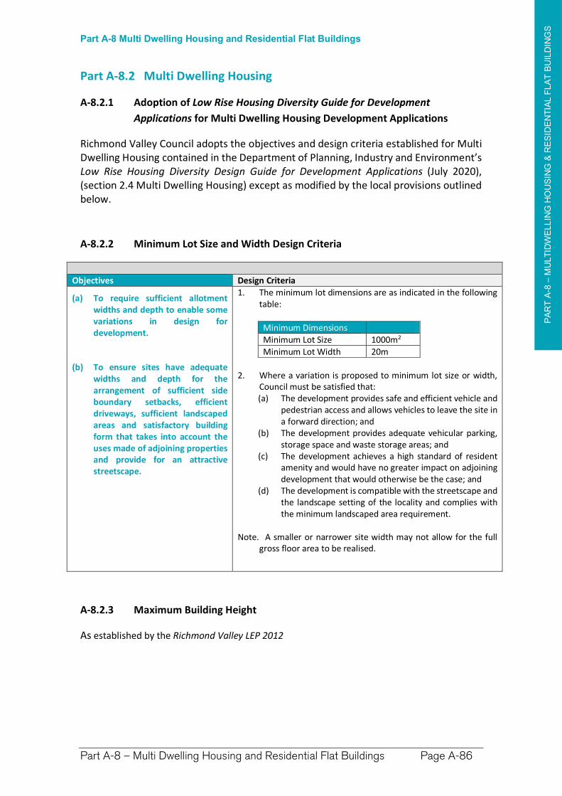
PA
RT
A-8
–M
ULT
IDW
ELLIN
G H
OU
SIN
G &
RE
SID
EN
TIA
L F
LA
T B
UIL
DIN
GS
Part A-8 Multi Dwelling Housing and Residential Flat Buildings
Part A-8 – Multi Dwelling Housing and Residential Flat Buildings Page A-86
Part A-8.2 Multi Dwelling Housing
A-8.2.1 Adoption of Low Rise Housing Diversity Guide for Development
Applications for Multi Dwelling Housing Development Applications
Richmond Valley Council adopts the objectives and design criteria established for Multi Dwelling Housing contained in the Department of Planning, Industry and Environment’s Low Rise Housing Diversity Design Guide for Development Applications (July 2020), (section 2.4 Multi Dwelling Housing) except as modified by the local provisions outlined below.
A-8.2.2 Minimum Lot Size and Width Design Criteria
Objectives Design Criteria
(a) To require sufficient allotment widths and depth to enable some variations in design for development.
(b) To ensure sites have adequate widths and depth for the arrangement of sufficient side boundary setbacks, efficient driveways, sufficient landscaped areas and satisfactory building form that takes into account the uses made of adjoining properties and provide for an attractive streetscape.
1. The minimum lot dimensions are as indicated in the following table:
Minimum Dimensions
Minimum Lot Size 1000m2
Minimum Lot Width 20m
2. Where a variation is proposed to minimum lot size or width, Council must be satisfied that: (a) The development provides safe and efficient vehicle and
pedestrian access and allows vehicles to leave the site in a forward direction; and
(b) The development provides adequate vehicular parking, storage space and waste storage areas; and
(c) The development achieves a high standard of resident amenity and would have no greater impact on adjoining development that would otherwise be the case; and
(d) The development is compatible with the streetscape and the landscape setting of the locality and complies with the minimum landscaped area requirement.
Note. A smaller or narrower site width may not allow for the full gross floor area to be realised.
A-8.2.3 Maximum Building Height
As established by the Richmond Valley LEP 2012
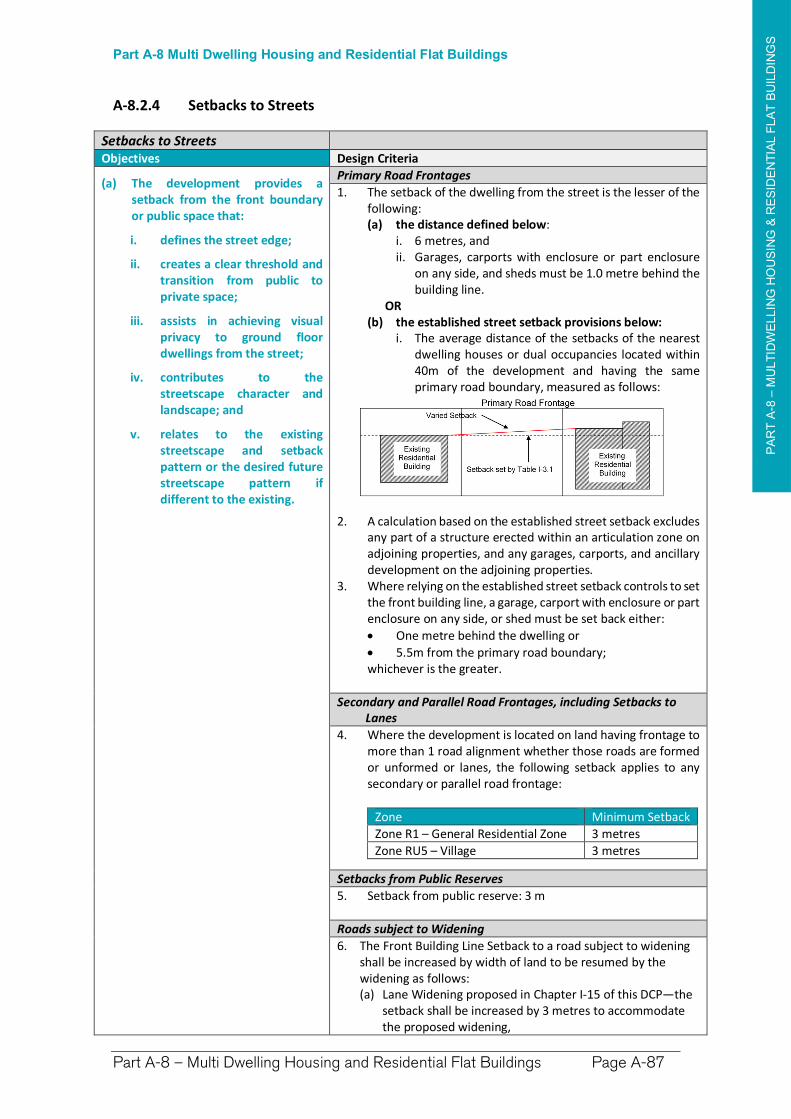
PA
RT
A-8
–M
ULT
IDW
ELLIN
G H
OU
SIN
G &
RE
SID
EN
TIA
L F
LA
T B
UIL
DIN
GS
Part A-8 Multi Dwelling Housing and Residential Flat Buildings
Part A-8 – Multi Dwelling Housing and Residential Flat Buildings Page A-87
A-8.2.4 Setbacks to Streets
Setbacks to Streets Objectives Design Criteria
(a) The development provides a setback from the front boundary or public space that:
i. defines the street edge;
ii. creates a clear threshold and transition from public to private space;
iii. assists in achieving visual privacy to ground floor dwellings from the street;
iv. contributes to the streetscape character and landscape; and
v. relates to the existing streetscape and setback pattern or the desired future streetscape pattern if different to the existing.
Primary Road Frontages
1. The setback of the dwelling from the street is the lesser of the following: (a) the distance defined below:
i. 6 metres, and ii. Garages, carports with enclosure or part enclosure
on any side, and sheds must be 1.0 metre behind the building line.
OR (b) the established street setback provisions below:
i. The average distance of the setbacks of the nearest dwelling houses or dual occupancies located within 40m of the development and having the same primary road boundary, measured as follows:
2. A calculation based on the established street setback excludes any part of a structure erected within an articulation zone on adjoining properties, and any garages, carports, and ancillary development on the adjoining properties.
3. Where relying on the established street setback controls to set the front building line, a garage, carport with enclosure or part enclosure on any side, or shed must be set back either:
One metre behind the dwelling or
5.5m from the primary road boundary; whichever is the greater.
Secondary and Parallel Road Frontages, including Setbacks to Lanes
4. Where the development is located on land having frontage to more than 1 road alignment whether those roads are formed or unformed or lanes, the following setback applies to any secondary or parallel road frontage:
Zone Minimum Setback
Zone R1 – General Residential Zone 3 metres
Zone RU5 – Village 3 metres
Setbacks from Public Reserves
5. Setback from public reserve: 3 m
Roads subject to Widening
6. The Front Building Line Setback to a road subject to widening shall be increased by width of land to be resumed by the widening as follows: (a) Lane Widening proposed in Chapter I-15 of this DCP—the
setback shall be increased by 3 metres to accommodate the proposed widening,
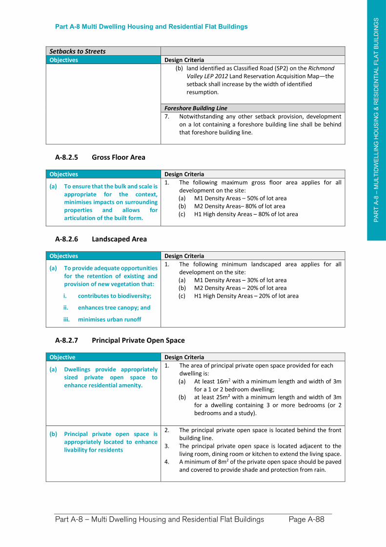
PA
RT
A-8
–M
ULT
IDW
ELLIN
G H
OU
SIN
G &
RE
SID
EN
TIA
L F
LA
T B
UIL
DIN
GS
Part A-8 Multi Dwelling Housing and Residential Flat Buildings
Part A-8 – Multi Dwelling Housing and Residential Flat Buildings Page A-88
Setbacks to Streets Objectives Design Criteria
(b) land identified as Classified Road (SP2) on the Richmond Valley LEP 2012 Land Reservation Acquisition Map—the setback shall increase by the width of identified resumption.
Foreshore Building Line
7. Notwithstanding any other setback provision, development on a lot containing a foreshore building line shall be behind that foreshore building line.
A-8.2.5 Gross Floor Area
Objectives Design Criteria
(a) To ensure that the bulk and scale is appropriate for the context, minimises impacts on surrounding properties and allows for articulation of the built form.
1. The following maximum gross floor area applies for all development on the site: (a) M1 Density Areas – 50% of lot area (b) M2 Density Areas– 80% of lot area (c) H1 High density Areas – 80% of lot area
A-8.2.6 Landscaped Area
Objectives Design Criteria
(a) To provide adequate opportunities for the retention of existing and provision of new vegetation that:
i. contributes to biodiversity;
ii. enhances tree canopy; and
iii. minimises urban runoff
1. The following minimum landscaped area applies for all development on the site: (a) M1 Density Areas – 30% of lot area (b) M2 Density Areas – 20% of lot area (c) H1 High Density Areas – 20% of lot area
A-8.2.7 Principal Private Open Space
Objective Design Criteria
(a) Dwellings provide appropriately sized private open space to enhance residential amenity.
1. The area of principal private open space provided for each dwelling is: (a) At least 16m2 with a minimum length and width of 3m
for a 1 or 2 bedroom dwelling; (b) at least 25m² with a minimum length and width of 3m
for a dwelling containing 3 or more bedrooms (or 2 bedrooms and a study).
(b) Principal private open space is appropriately located to enhance livability for residents
2. The principal private open space is located behind the front building line.
3. The principal private open space is located adjacent to the living room, dining room or kitchen to extend the living space.
4. A minimum of 8m2 of the private open space should be paved and covered to provide shade and protection from rain.
PA
RT
A-8
–M
ULT
IDW
ELLIN
G H
OU
SIN
G &
RE
SID
EN
TIA
L F
LA
T B
UIL
DIN
GS
Part A-8 Multi Dwelling Housing and Residential Flat Buildings
Part A-8 – Multi Dwelling Housing and Residential Flat Buildings Page A-89
A-8.2.8 Car Parking
Objective Design Criteria
(a) Car parking is provided appropriate for the scale of the development.
1. Minimum parking requirements are: (a) 1 per dwelling (<150 m2 GFA), plus (b) 1.5 per dwelling (>= 150 m2 GFA), plus (c) 1 visitor space per 4 dwellings.
A-8.2.9 View Sharing
Objective Design Criteria
(a) To allow for the reasonable sharing of views with adjoining and/or nearby properties.
1. Where views from other dwellings or public spaces are likely to be impacted, the applicant may be required to submit a view loss assessment.
2. View loss and opportunities for view sharing is to be considered in accordance with the Land and Environment Court Planning Principals.
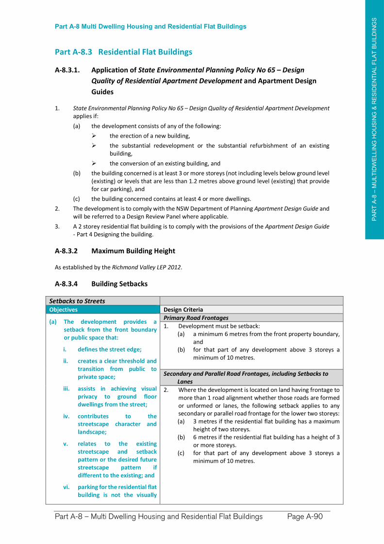
PA
RT
A-8
–M
ULT
IDW
ELLIN
G H
OU
SIN
G &
RE
SID
EN
TIA
L F
LA
T B
UIL
DIN
GS
Part A-8 Multi Dwelling Housing and Residential Flat Buildings
Part A-8 – Multi Dwelling Housing and Residential Flat Buildings Page A-90
Part A-8.3 Residential Flat Buildings
A-8.3.1. Application of State Environmental Planning Policy No 65 – Design
Quality of Residential Apartment Development and Apartment Design
Guides
1. State Environmental Planning Policy No 65 – Design Quality of Residential Apartment Developmentapplies if:
(a) the development consists of any of the following:
the erection of a new building,
the substantial redevelopment or the substantial refurbishment of an existing building,
the conversion of an existing building, and
(b) the building concerned is at least 3 or more storeys (not including levels below ground level (existing) or levels that are less than 1.2 metres above ground level (existing) that provide for car parking), and
(c) the building concerned contains at least 4 or more dwellings.
2. The development is to comply with the NSW Department of Planning Apartment Design Guide and will be referred to a Design Review Panel where applicable.
3. A 2 storey residential flat building is to comply with the provisions of the Apartment Design Guide- Part 4 Designing the building.
A-8.3.2 Maximum Building Height
As established by the Richmond Valley LEP 2012.
A-8.3.4 Building Setbacks
Setbacks to StreetsObjectives Design Criteria
(a) The development provides a setback from the front boundary or public space that:
i. defines the street edge;
ii. creates a clear threshold and transition from public to private space;
iii. assists in achieving visual privacy to ground floor dwellings from the street;
iv. contributes to the streetscape character and landscape;
v. relates to the existing streetscape and setback pattern or the desired future streetscape pattern if different to the existing; and
vi. parking for the residential flat building is not the visually
Primary Road Frontages
1. Development must be setback: (a) a minimum 6 metres from the front property boundary,
and (b) for that part of any development above 3 storeys a
minimum of 10 metres.
Secondary and Parallel Road Frontages, including Setbacks to Lanes
2. Where the development is located on land having frontage to more than 1 road alignment whether those roads are formed or unformed or lanes, the following setback applies to any secondary or parallel road frontage for the lower two storeys:(a) 3 metres if the residential flat building has a maximum
height of two storeys. (b) 6 metres if the residential flat building has a height of 3
or more storeys. (c) for that part of any development above 3 storeys a
minimum of 10 metres.
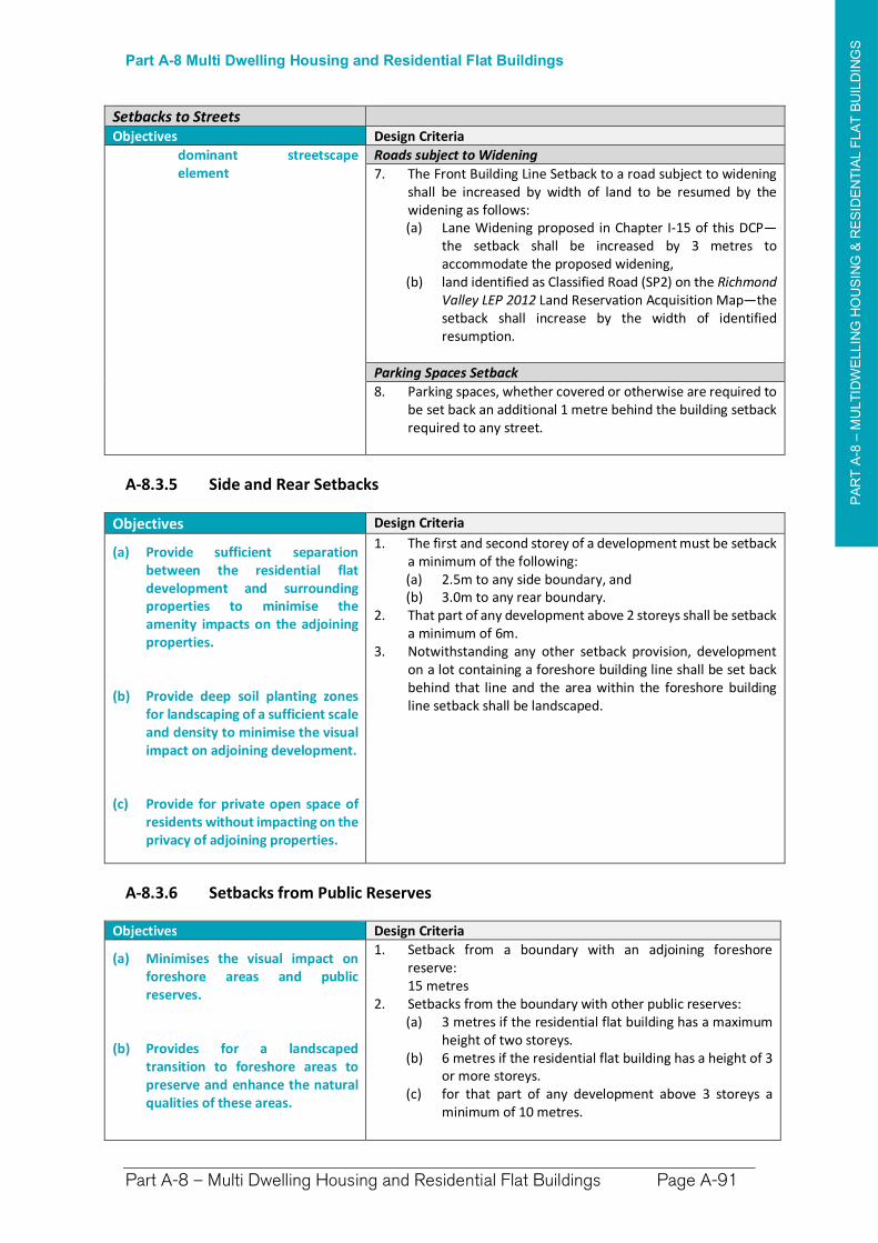
PA
RT
A-8
–M
ULT
IDW
ELLIN
G H
OU
SIN
G &
RE
SID
EN
TIA
L F
LA
T B
UIL
DIN
GS
Part A-8 Multi Dwelling Housing and Residential Flat Buildings
Part A-8 – Multi Dwelling Housing and Residential Flat Buildings Page A-91
Setbacks to StreetsObjectives Design Criteria
dominant streetscape element
Roads subject to Widening
7. The Front Building Line Setback to a road subject to widening shall be increased by width of land to be resumed by the widening as follows: (a) Lane Widening proposed in Chapter I-15 of this DCP—
the setback shall be increased by 3 metres to accommodate the proposed widening,
(b) land identified as Classified Road (SP2) on the Richmond Valley LEP 2012 Land Reservation Acquisition Map—the setback shall increase by the width of identified resumption.
Parking Spaces Setback
8. Parking spaces, whether covered or otherwise are required to be set back an additional 1 metre behind the building setback required to any street.
A-8.3.5 Side and Rear Setbacks
Objectives Design Criteria
(a) Provide sufficient separation between the residential flat development and surrounding properties to minimise the amenity impacts on the adjoining properties.
(b) Provide deep soil planting zones for landscaping of a sufficient scale and density to minimise the visual impact on adjoining development.
(c) Provide for private open space of residents without impacting on the privacy of adjoining properties.
1. The first and second storey of a development must be setback a minimum of the following: (a) 2.5m to any side boundary, and (b) 3.0m to any rear boundary.
2. That part of any development above 2 storeys shall be setback a minimum of 6m.
3. Notwithstanding any other setback provision, development on a lot containing a foreshore building line shall be set back behind that line and the area within the foreshore building line setback shall be landscaped.
A-8.3.6 Setbacks from Public Reserves
Objectives Design Criteria
(a) Minimises the visual impact on foreshore areas and public reserves.
(b) Provides for a landscaped transition to foreshore areas to preserve and enhance the natural qualities of these areas.
1. Setback from a boundary with an adjoining foreshore reserve:
15 metres 2. Setbacks from the boundary with other public reserves:
(a) 3 metres if the residential flat building has a maximum height of two storeys.
(b) 6 metres if the residential flat building has a height of 3 or more storeys.
(c) for that part of any development above 3 storeys a minimum of 10 metres.
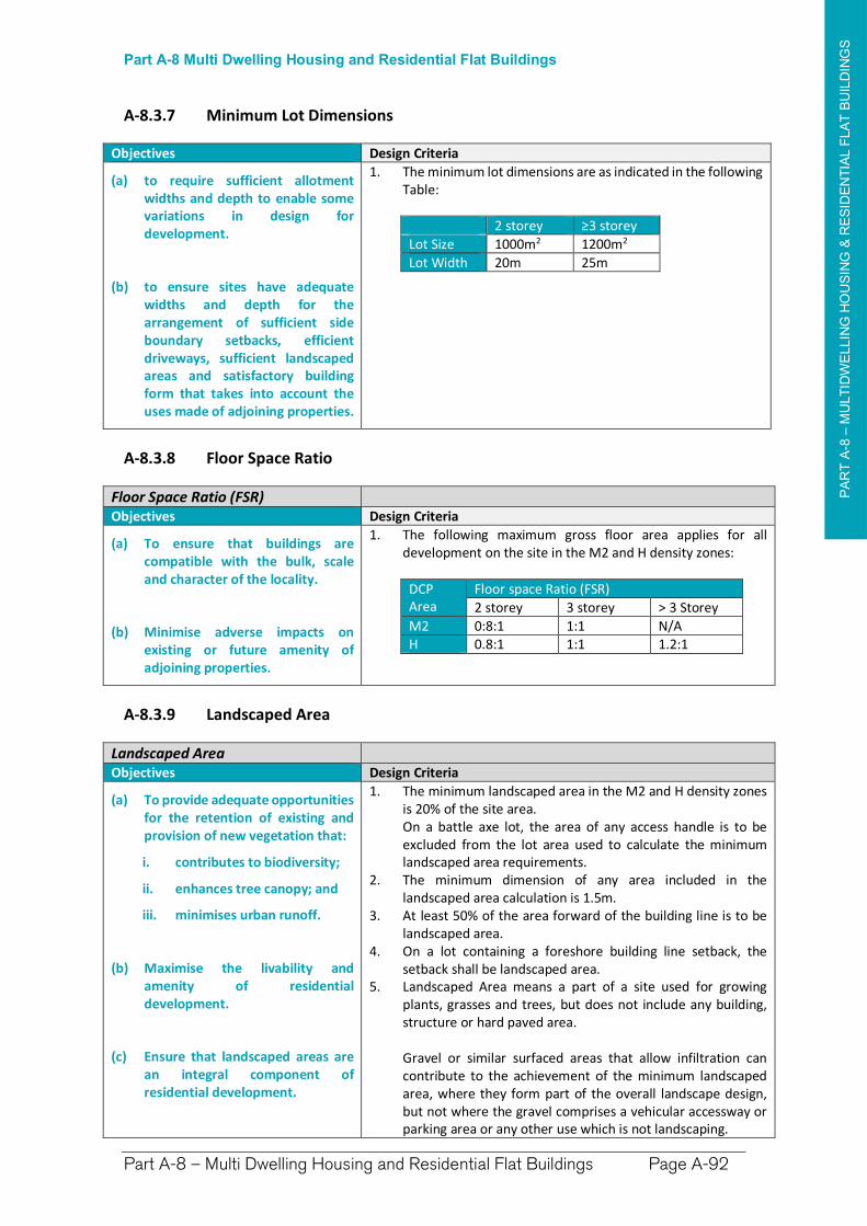
PA
RT
A-8
–M
ULT
IDW
ELLIN
G H
OU
SIN
G &
RE
SID
EN
TIA
L F
LA
T B
UIL
DIN
GS
Part A-8 Multi Dwelling Housing and Residential Flat Buildings
Part A-8 – Multi Dwelling Housing and Residential Flat Buildings Page A-92
A-8.3.7 Minimum Lot Dimensions
Objectives Design Criteria
(a) to require sufficient allotment widths and depth to enable some variations in design for development.
(b) to ensure sites have adequate widths and depth for the arrangement of sufficient side boundary setbacks, efficient driveways, sufficient landscaped areas and satisfactory building form that takes into account the uses made of adjoining properties.
1. The minimum lot dimensions are as indicated in the following Table:
2 storey ≥3 storey
Lot Size 1000m2 1200m2
Lot Width 20m 25m
A-8.3.8 Floor Space Ratio
Floor Space Ratio (FSR) Objectives Design Criteria
(a) To ensure that buildings are compatible with the bulk, scale and character of the locality.
(b) Minimise adverse impacts on existing or future amenity of adjoining properties.
1. The following maximum gross floor area applies for all development on the site in the M2 and H density zones:
DCP Area
Floor space Ratio (FSR)
2 storey 3 storey > 3 Storey
M2 0:8:1 1:1 N/A H 0.8:1 1:1 1.2:1
A-8.3.9 Landscaped Area
Landscaped Area Objectives Design Criteria
(a) To provide adequate opportunities for the retention of existing and provision of new vegetation that:
i. contributes to biodiversity;
ii. enhances tree canopy; and
iii. minimises urban runoff.
(b) Maximise the livability and amenity of residential development.
(c) Ensure that landscaped areas are an integral component of residential development.
1. The minimum landscaped area in the M2 and H density zones is 20% of the site area.
On a battle axe lot, the area of any access handle is to be excluded from the lot area used to calculate the minimum landscaped area requirements.
2. The minimum dimension of any area included in the landscaped area calculation is 1.5m.
3. At least 50% of the area forward of the building line is to be landscaped area.
4. On a lot containing a foreshore building line setback, the setback shall be landscaped area.
5. Landscaped Area means a part of a site used for growing plants, grasses and trees, but does not include any building, structure or hard paved area.
Gravel or similar surfaced areas that allow infiltration can contribute to the achievement of the minimum landscaped area, where they form part of the overall landscape design, but not where the gravel comprises a vehicular accessway or parking area or any other use which is not landscaping.
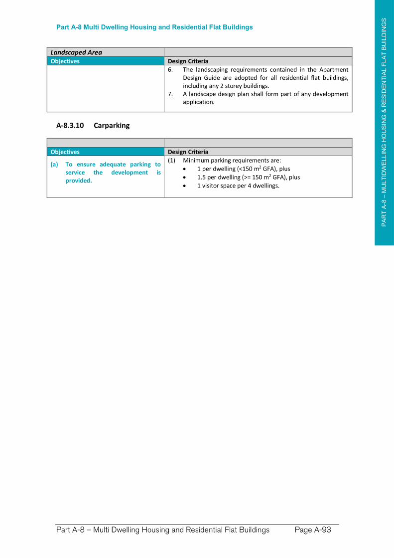
PA
RT
A-8
–M
ULT
IDW
ELLIN
G H
OU
SIN
G &
RE
SID
EN
TIA
L F
LA
T B
UIL
DIN
GS
Part A-8 Multi Dwelling Housing and Residential Flat Buildings
Part A-8 – Multi Dwelling Housing and Residential Flat Buildings Page A-93
Landscaped Area Objectives Design Criteria
6. The landscaping requirements contained in the Apartment Design Guide are adopted for all residential flat buildings, including any 2 storey buildings.
7. A landscape design plan shall form part of any development application.
A-8.3.10 Carparking
Objectives Design Criteria
(a) To ensure adequate parking to service the development is provided.
(1) Minimum parking requirements are:
1 per dwelling (<150 m2 GFA), plus
1.5 per dwelling (>= 150 m2 GFA), plus
1 visitor space per 4 dwellings.
PA
RT
A-9
–S
HO
P T
OP
HO
US
INGPart A-9 Shop Top Housing
Part A-9 – Shop Top Housing Page A-95
Part A-9 Shop Top Housing
Preamble
Shop Top Housing forms an important mixed development style which contributes important housing supply without compromising valuable commercial development area.
The Richmond Valley Local Environmental Plan 2012 provides the definition:
Shop Top Housing means one or more dwellings located above ground floor retail premises or business premises.
The Chapter relates to Shop Top Housing undertaken in Zones B1 Neighbourhood, B2 Local Centre and B3 Commercial Core.
Design of Shop Top Housing
Shop Top Housing is best designed in accordance with the separate components of which it is made up. The ground floor Commercial component may be assessed as per Part B – Commercial Development. The second floor, although comprising a residential component, may exhibit densities similar to what may be permitted as 2nd floor development in Part B – Commercial, however must satisfy many provisions as per above ground floor residential as outlined below.
A-9.1 Height of Buildings
Maximum Height of Buildings
(1) The maximum height a structure may be built is shown in the Height of Buildings Map in Richmond Valley Local Environmental Plan 2012.
(a) Generally the maximum height is 8.5m.
(b) Some areas of Evans Head and South Casino have 9.5m maximum.
(c) The High density area in proximity to the Casino CBD has a 14m maximum.
A-9.2 Building Setbacks, Footprint & Floor Space Area
(1) Density on the Ground Floor Commercial component as per Part B – Commercial Development.
(2) Zone B1 – Neighbourhood Centre—development is required to most closely align with residential development and the surrounding area.
If there are commercial examples to draw upon nearby, and generally the streetscape is dominated by similar ‘older’ style development, higher density ‘shopfront’/’awning’ development may be acceptable if the design aligns closely.
(3) Zone B2 & B3—As per Part B – Commercial Development for first 2 storeys.
PA
RT
A-9
–S
HO
P T
OP
HO
US
INGPart A-9 Shop Top Housing
Part A-9 – Shop Top Housing Page A-96
(4) Density Area H1 – High Density—there is likely to be little or no examples of the ideal form to follow, however the podium style typology described within Chapter A-4.3 will be considered atop Commercial density.
(5) Setbacks for residential development shall have regard to the existing and desired character of the locality and the amenity of residents of the building and nearby residential properties, and the setbacks of the ground floor commercial development. Guidance can be found in Part I-3 of this DCP.
(6) The residential component should also comply with the provisions of the Apartment Design Guide– Part 4 designing the building.
Developments exceeding Three Storeys
(6) Developments exceeding three storeys may only be proposed within areas with a building height limit of 14 metres within and near the Casino CBD area.
The Density provisions apply to residential flat buildings will be applied to development 3 storeys or greater. Setbacks and apartment design will need to be designed to comply with the requirements of the Apartment Design Guide.
Any building height three (3) storeys and higher as a stand-alone development must be set back a minimum of six (6) metres from the side and rear boundaries, from the ceiling height of the second storey up. When proposed within a commercial area, lesser or even zero building line setback from the side boundaries may be permissible dependent upon dominant adjacent building bulk and form. Council reserves the right to ultimate resolution as to the proposal’s built form and setbacks.
A-9.3 Visual and Amenity Impacts
(1) Shop Top Housing is located above retail or business premises in the Commercial areas. Mixed use developments are generally to take the form of podium buildings with an upper level setback to residential development. The visual impact of development is to have regard for the commercial activities and style of buildings.
Particular attention is to be given within Heritage Conservation Areas or nearby Heritage buildings.
Bulk and Form
(2) The proposed Development should be consistent with the bulk and form of existing elements within the streetscape, particularly immediately adjoining and adjacent. Consistency with existing streetscape elements includes:
Overall Scale and Height Roof Forms and Pitch Materials of External Front Walls Street Set-backs and Spacings between Buildings
Character
(3) The proposed development should be consistent with the prevailing character of the neighbourhood, the following elements are to be considered:
Overall architectural Style (i.e. ‘Victorian’, ‘Federation’, ‘Bungalow’, ‘Brick & Tile’ etc.). Maintaining or Continuing existing Horizontal Lines or any ‘Stepping’. Finishes and Decorative Detailing (and to a lesser extent colour) (i.e Collar Ties, Finials,
Verandah Brackets, Balustrades, etc.). Architectural Elements (i.e. Verandahs, Awnings, etc). A heritage item, or a development proposed within a Heritage Conservation Area should
have high regard for detail within Chapter I-1 Heritage within this DCP.
Reducing the impact of continuous walls
(4) Windows or structures (entranceways, porticos, windows including bay windows, balconies etc.) are to be used to break up the façade. Any section of front façade may not exceed five metres without a building element to disrupt continuous wall area.
In addition, any side wall may not exceed 14 metres in length without a recess, or building element, in the wall to break the continuity and lessen visual and ‘bulky’ impacts.
PA
RT
A-9
–S
HO
P T
OP
HO
US
INGPart A-9 Shop Top Housing
Part A-9 – Shop Top Housing Page A-97
Amenity
(5) The design of the shop top housing development is to have regard amenity controls in Part B – Development in Commercial Centres to ensure that the impact of commercial development on the residential component is minimised and the development as a whole does not unreasonably impact on the amenity of any nearby sensitive land uses such as residential accommodation.
A-9.4 Driveways and Access
(1) Generally one (1) access per street or lane frontage is appropriate. In instances where there is ample width to the development lot, two (2) accesses may be permitted if the development has frontage to appropriately constructed and dimensioned streets or laneways.
Each access must be compliant with all other provisions within this Plan and any other requirements set by the Northern Rivers Local Government Development, Design and Construction Manual, or as otherwise specified by Council.
(2) Council’s Works Department will determine whether line of sight distances are adequate dependent upon vegetation, distance from intersections, orientation and gradient.
(3) In general, all infrastructure may be required to be upgraded, whether existing or required to be provided as a part of new development:
Layback, Dish or Pipe guttering. Kerb and Driveway light or heavy duty aprons dependent on whether for domestic or
commercial/industrial/units use. Any road damaged as a result of works undertaken. Turf and any other disturbed vegetation. All work shall be designed and constructed in accordance with all relevant and current Australian Standards. AS2890 is relevant for all access and parking specifications. AS2890 or any subsequent standard for this purpose must be complied with for all works.
(4) In limited cases lane widening may be required as part of proposed development. Council will assess the need for road widening or re-alignment when considering a development application for the land. Such consideration of a development application will have regard to the existing and likely future traffic needs in the locality and those areas designated as requiring road widening are outlined within Chapter I-15.
A-9.5 Car Parking
Car Parking Requirements
(1) Residential Element - One (1) car-parking space must be provided per dwelling (unit) wholly within the building lines and setbacks of the development, plus
one visitor car parking space, or part thereof, for every ten (10) units, which must also be wholly within the building lines and setbacks of the development.
(2) Commercial Element – parking must be provided at the rates required for commercial development in Part B of this DCP.
(2) All work shall be designed and constructed in accordance with all relevant and current Australian Standards. AS2890 is relevant for all access and parking specifications.
(3) Where existing Gross Floor Area is being converted to Shop Top Housing—no additional car parking shall be required for the conversion of that floor area, however, any car parking provided on site must be retained.
Accessibility – Car Parking
(4) Car parking provision for mobility impaired must be provided minimum one (1) per development and located closest to the most suitable entranceway.
(5) Unit development must provide one (1) mobility impaired space per five (5) units, or as prescribed by most recent Australian Standards and requirements.
Additional relevant detail is available within Chapter I-4 – Car Parking.
PA
RT
A-9
–S
HO
P T
OP
HO
US
INGPart A-9 Shop Top Housing
Part A-9 – Shop Top Housing Page A-98
A-9.6 Earthworks and Retaining Walls
(1) Applications involving earthworks and retaining walls must:
(a) provide details of the extent of all cut and fill, and
(b) where fill is greater than 600mm high provide geotechnical certification to verify the structural stability of any fill material, and
(c) not redirect the flow of any surface water or ground water in a concentrated manner onto an adjoining property, and
(d) be located outside the Clear Zone of and have footings outside which extend below the Zone of Influence for any sewer main, water main, or stormwater pipeline, and
(e) have footings extend below the Zone of Influence for any sewer main, water main, or stormwater pipeline, and
(f) have adequate drainage lines connected to the existing stormwater drainage system for the site, and
(g) retaining walls must be of masonry construction and have engineering certification if:
900mm or higher in height, or if located within 900mm of a boundary, and
(h) if the fill is imported to the site—be free of building and other demolition waste, and only contain virgin excavated natural material (VENM) as defined in Part 3 of Schedule 1 to the Protection of the Environment Operations Act 1997.
A-9.7 Overshadowing, Solar Access and Orientation
Overshadowing
(1) The proposed development must maintain adequate solar access to adjoining residential accommodation, in accordance with the provisions of this DCP for the relevant form of adjoining development.
(2) Council may require a shadow diagram if it suspects there will be excessive overshadowing of an adjacent lot or public land.
Solar Access
(3) Consideration should also be given to the orientation of design elements and the location of central living rooms and open space areas within any proposed development to maximise:
Energy Conservation - Development should orientate living areas to best maximise conservation of heat gained from solar access, and utilise predominating breezes and other natural light, wind, water occurrences to provide maximum efficiency within dwellings reducing the need for artificial energy usage.
Sunlight Infusion - Important daytime living areas within a dwelling should be orientated toward the northernmost areas of the design to provide warmth and light.
Solar Power Generating Equipment - North-facing roofing should have consideration for the ideal slope, surface area, orientation and structural integrity to facilitate the immediate or possible future installation of Solar Power receptacles (Solar Hot Water Systems and Photovoltaic Cells).
Orientation
(4) The proposed development should be orientated in a way to benefit street and front yard surveillance (as satisfying CPTED principles, see below). The orientation of the development should also have regard for the other existing elements within the streetscape, and the way and style in which they are orientated.
PA
RT
A-9
–S
HO
P T
OP
HO
US
INGPart A-9 Shop Top Housing
Part A-9 – Shop Top Housing Page A-99
A-9.8 Safety and Security
(1) Safety considerations and principles are particularly important for residential design. Safety and security considerations are referred to as Crime Prevention Through Environmental Design (CPTED) and are outlined in detail in Chapter – I-10.
Good design features include:
(a) the ability for occupants or people in the street to view their surroundings well (natural surveillance) e.g. windows from living areas and entranceways focused on the front street.
(b) avoiding hiding and entrapment areas e.g. recesses, high solid fencing, dense landscape.
(c) gardens should be designed to include low growing plants (less than 600mm) combined with larger trees with canopies higher than 1.8m.
(d) good lighting and security.
A-9.9 Additional Notes and Provisions
Lane Widening and Access
(1) Primary access to laneways will not be permitted unless it can be demonstrated that:
(a) the lane can and will be upgraded to an acceptable standard, including dish drains/guttering, crossings and surface sealing. Upgrading of rear lane access shall be in accordance with Council’s Policy – Vehicular Accessway, or any succeeding documentation, or
(b) the lane is subject to future lane widening. Council will assess the need for road widening or re-alignment when considering a development application for the land.
Waste Minimisation and Management
(2) Prior to construction, a dwelling must have a Waste Management Plan submitted and approved in accordance with Richmond Valley Council Waste Minimisation and Management Policy.
PA
RT
A-1
0 –
SE
NIO
RS
AN
D A
FF
OR
DA
BLE
HO
US
INGPart A-10 Seniors and Affordable Housing
Part A-10 – Seniors and Affordable Housing Page A-101
Part A-10 Seniors Housing and Affordable Housing
A-10.1 General Objectives
The general objectives of this Chapter are:
(1) Provide information regarding Seniors Living and Affordable Housing options.
(2) Establish the setback requirements for seniors housing and affordable housing.
(3) Establish the design and amenity requirements for seniors housing and affordable housing.
A-10.2 Legislative Provisions
(1) The following State Environmental Planning Policies provide development controls for the provision of Seniors Housing and Affordable Housing.
(a) SEPP (Housing for Seniors or People with a Disability)
This SEPP aims to encourage developments for the elderly and disabled. The State policy seeks to provide incentives and guidelines for ‘high quality’ accommodation and offers floor-space-ratio and other density concessions to developments meeting desirable criteria as accommodation providers to a disadvantaged sector of the community.
(b) SEPP (Affordable Rental Housing) 2009
This policy provides for a relaxation of local provisions if demonstrated that multi-development provision of affordable rental housing. The policy provides incentives for new affordable rental housing, facilitates the retention of existing affordable rentals, and provides incentives for role expansion of not-for-profit providers. It also aims to support local centres by providing housing for workers close to places of work, and facilitate development of housing for the homeless and other disadvantaged people. As with all SEPPs, it operates almost independently and overrides the LEP on the proviso that proposals in accordance with this policy are proposed within residentially zoned land in accordance with the new LEP. Reference should be made to the SEPP (Affordable Rental Housing) 2009 for further detail regarding requirements of development proposed under this policy.
(2) Notwithstanding these Policies, Chapters A-2 Dual Occupancy, A-3 Multi Dwelling Housing and Residential Flat Buildings, and A-4 Shop Top Housing may be used to provide for Seniors Housing and Affordable Housing.
A-10.3 Setbacks
The proposed development shall comply with the setback requirements for residential accommodation in the zone in which the development is proposed. See Part I-3 of this DCP for details.
A-10.4 Urban Design Controls
The proposed development (both seniors living or affordable housing) shall be designed in accordance with the Seniors Living Policy – Urban Design Guidelines for Infill Development (2004) prepared by the Urban Design Advisory Service.
PA
RT
A-1
1–
EX
PLA
NA
TO
RY
NO
TE
S
Part A-11 Explanatory Notes
Part A-11 – DCP Explanatory Notes Page A-103
Part A-11 DCP Explanatory Notes
Preamble
Explanatory notes are provided to assist in interpretation of the commonly used design criteria in the DCP. It provides definitions and examples to assist applicants understand and apply the controls.
The explanatory notes primarily address design criteria used in Part A – Residential Development, but other parts also adopt some of the design criteria explained in this section.
Table of Contents
A-11.1 Building Height
A-11.2 Building Setbacks
A-11.3 Gross Floor Area
A-11.4 Landscaped Area
A-11.5 Sewer Zones of Influence and Clear Zones
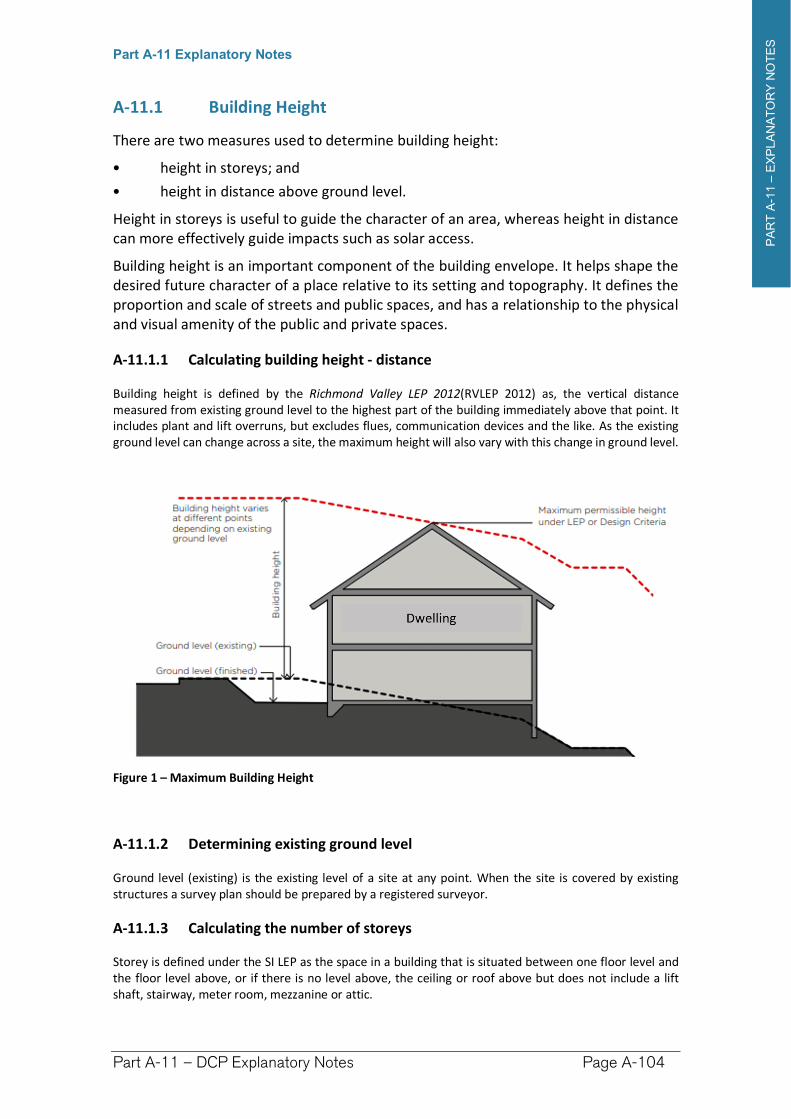
PA
RT
A-1
1–
EX
PLA
NA
TO
RY
NO
TE
S
Part A-11 Explanatory Notes
Part A-11 – DCP Explanatory Notes Page A-104
A-11.1 Building Height
There are two measures used to determine building height:
• height in storeys; and
• height in distance above ground level.
Height in storeys is useful to guide the character of an area, whereas height in distance can more effectively guide impacts such as solar access.
Building height is an important component of the building envelope. It helps shape the desired future character of a place relative to its setting and topography. It defines the proportion and scale of streets and public spaces, and has a relationship to the physical and visual amenity of the public and private spaces.
A-11.1.1 Calculating building height - distance
Building height is defined by the Richmond Valley LEP 2012(RVLEP 2012) as, the vertical distance measured from existing ground level to the highest part of the building immediately above that point. It includes plant and lift overruns, but excludes flues, communication devices and the like. As the existing ground level can change across a site, the maximum height will also vary with this change in ground level.
Figure 1 – Maximum Building Height
A-11.1.2 Determining existing ground level
Ground level (existing) is the existing level of a site at any point. When the site is covered by existing structures a survey plan should be prepared by a registered surveyor.
A-11.1.3 Calculating the number of storeys
Storey is defined under the SI LEP as the space in a building that is situated between one floor level and the floor level above, or if there is no level above, the ceiling or roof above but does not include a lift shaft, stairway, meter room, mezzanine or attic.
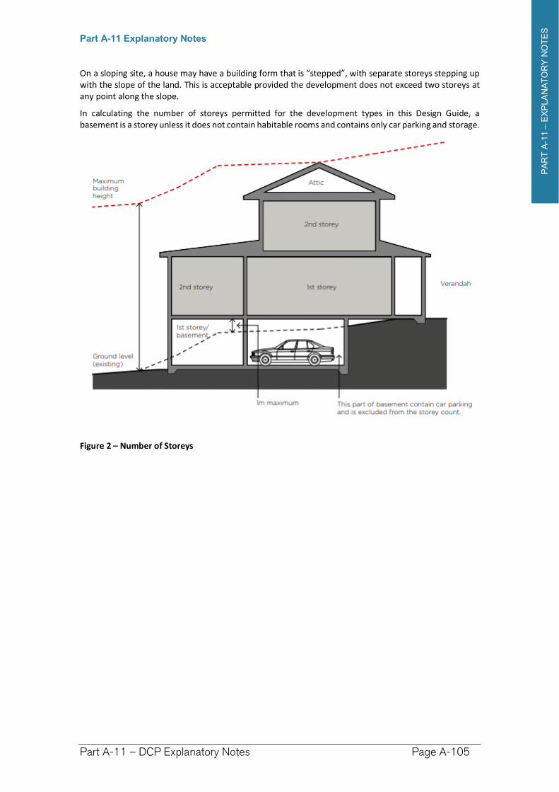
PA
RT
A-1
1–
EX
PLA
NA
TO
RY
NO
TE
S
Part A-11 Explanatory Notes
Part A-11 – DCP Explanatory Notes Page A-105
On a sloping site, a house may have a building form that is “stepped”, with separate storeys stepping up with the slope of the land. This is acceptable provided the development does not exceed two storeys at any point along the slope.
In calculating the number of storeys permitted for the development types in this Design Guide, a basement is a storey unless it does not contain habitable rooms and contains only car parking and storage.
Figure 2 – Number of Storeys
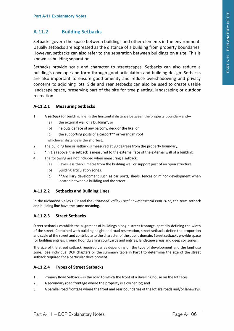
PA
RT
A-1
1–
EX
PLA
NA
TO
RY
NO
TE
S
Part A-11 Explanatory Notes
Part A-11 – DCP Explanatory Notes Page A-106
A-11.2 Building Setbacks
Setbacks govern the space between buildings and other elements in the environment. Usually setbacks are expressed as the distance of a building from property boundaries. However, setbacks can also refer to the separation between buildings on a site. This is known as building separation.
Setbacks provide scale and character to streetscapes. Setbacks can also reduce a building's envelope and form through good articulation and building design. Setbacks are also important to ensure good amenity and reduce overshadowing and privacy concerns to adjoining lots. Side and rear setbacks can also be used to create usable landscape space, preserving part of the site for tree planting, landscaping or outdoor recreation.
A-11.2.1 Measuring Setbacks
1. A setback (or building line) is the horizontal distance between the property boundary and—
(a) the external wall of a building*, or
(b) he outside face of any balcony, deck or the like, or
(c) the supporting posts of a carport** or verandah roof
whichever distance is the shortest.
2. The building line or setback is measured at 90 degrees from the property boundary.
3. *In 1(a) above, the setback is measured to the external face of the external wall of a building.
4. The following are not included when measuring a setback:
(a) Eaves less than 1 metre from the building wall or support post of an open structure
(b) Building articulation zones.
(c) **Ancillary development such as car ports, sheds, fences or minor development when located between a building and the street.
A-11.2.2 Setbacks and Building Lines
In the Richmond Valley DCP and the Richmond Valley Local Environmental Plan 2012, the term setback and building line have the same meaning.
A-11.2.3 Street Setbacks
Street setbacks establish the alignment of buildings along a street frontage, spatially defining the width of the street. Combined with building height and road reservation, street setbacks define the proportion and scale of the street and contribute to the character of the public domain. Street setbacks provide space for building entries, ground floor dwelling courtyards and entries, landscape areas and deep soil zones.
The size of the street setback required varies depending on the type of development and the land use zone. See individual DCP chapters or the summary table in Part I to determine the size of the street setback required for a particular development.
A-11.2.4 Types of Street Setbacks
1. Primary Road Setback – is the road to which the front of a dwelling house on the lot faces.
2. A secondary road frontage where the property is a corner lot; and
3. A parallel road frontage where the front and rear boundaries of the lot are roads and/or laneways.
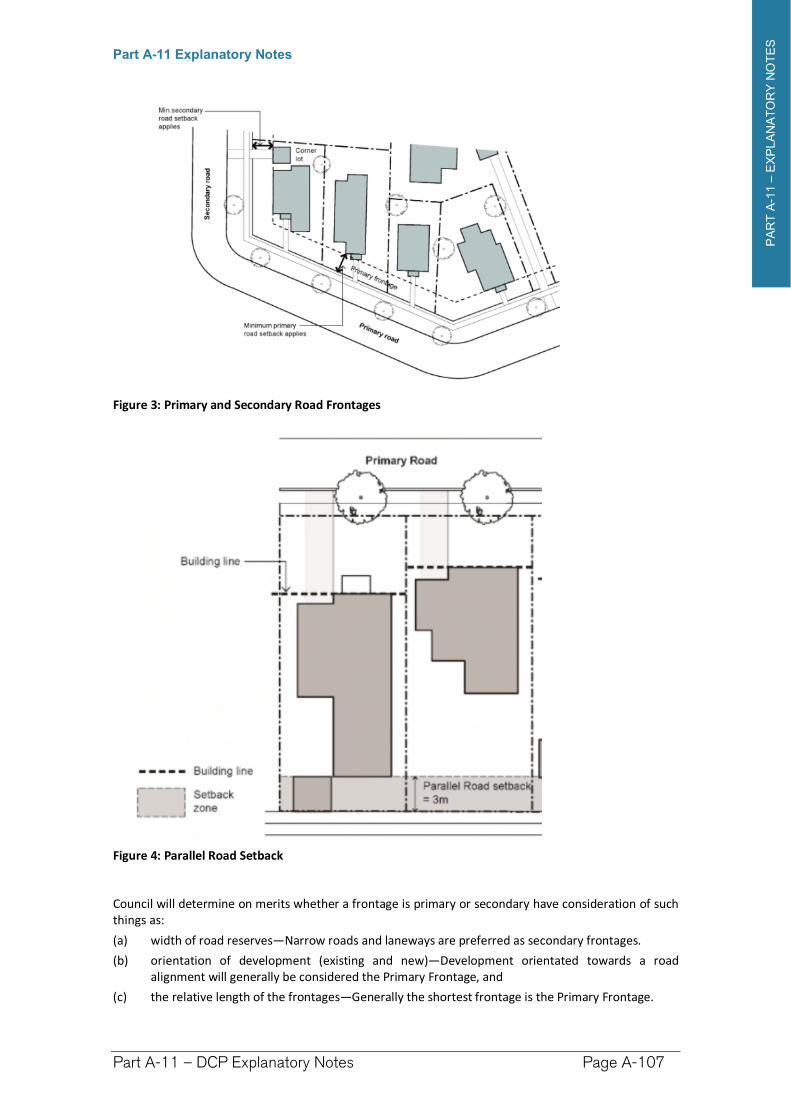
PA
RT
A-1
1–
EX
PLA
NA
TO
RY
NO
TE
S
Part A-11 Explanatory Notes
Part A-11 – DCP Explanatory Notes Page A-107
Figure 3: Primary and Secondary Road Frontages
Figure 4: Parallel Road Setback
Council will determine on merits whether a frontage is primary or secondary have consideration of such things as:
(a) width of road reserves—Narrow roads and laneways are preferred as secondary frontages.
(b) orientation of development (existing and new)—Development orientated towards a road alignment will generally be considered the Primary Frontage, and
(c) the relative length of the frontages—Generally the shortest frontage is the Primary Frontage.
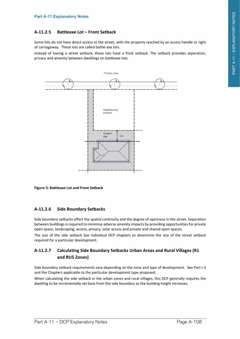
PA
RT
A-1
1–
EX
PLA
NA
TO
RY
NO
TE
S
Part A-11 Explanatory Notes
Part A-11 – DCP Explanatory Notes Page A-108
A-11.2.5 Battleaxe Lot – Front Setback
Some lots do not have direct access to the street, with the property reached by an access handle or right of carriageway. These lots are called battle-axe lots.
Instead of having a street setback, these lots have a front setback. The setback provides separation, privacy and amenity between dwellings on battleaxe lots.
Figure 5: Battleaxe Lot and Front Setback
A-11.2.6 Side Boundary Setbacks
Side boundary setbacks affect the spatial continuity and the degree of openness in the street. Separation between buildings is required to minimise adverse amenity impacts by providing opportunities for private open space, landscaping, access, privacy, solar access and private and shared open spaces.
The size of the side setback See individual DCP chapters to determine the size of the street setback required for a particular development.
A-11.2.7 Calculating Side Boundary Setbacks Urban Areas and Rural Villages (R1
and RU5 Zones)
Side boundary setback requirements vary depending on the zone and type of development. See Part I-3 and the Chapters applicable to the particular development type proposed.
When calculating the side setback in the urban zones and rural villages, this DCP generally requires the dwelling to be incrementally set back from the side boundary as the building height increases.
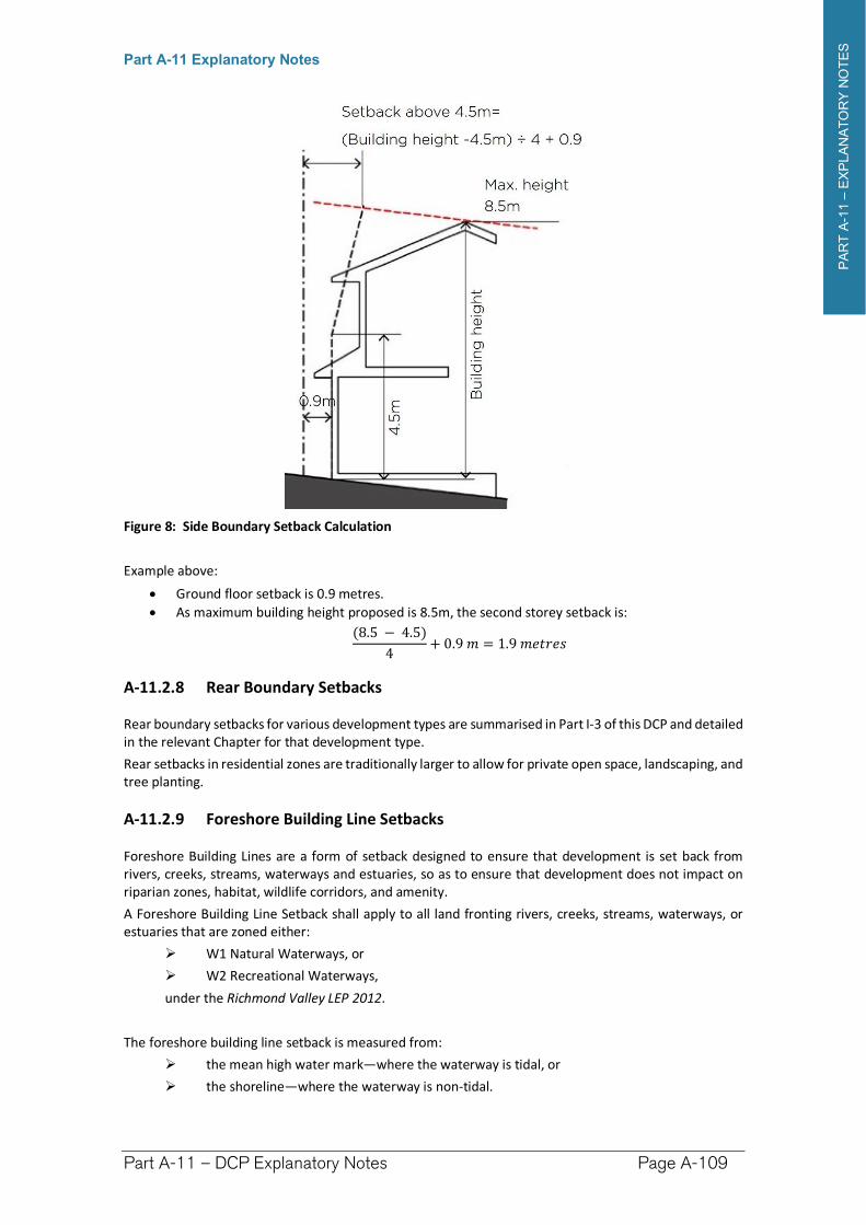
PA
RT
A-1
1–
EX
PLA
NA
TO
RY
NO
TE
S
Part A-11 Explanatory Notes
Part A-11 – DCP Explanatory Notes Page A-109
Figure 8: Side Boundary Setback Calculation
Example above:
Ground floor setback is 0.9 metres.
As maximum building height proposed is 8.5m, the second storey setback is:
(8.5 − 4.5)
4+ 0.9 � = 1.9 ������
A-11.2.8 Rear Boundary Setbacks
Rear boundary setbacks for various development types are summarised in Part I-3 of this DCP and detailed in the relevant Chapter for that development type.
Rear setbacks in residential zones are traditionally larger to allow for private open space, landscaping, and tree planting.
A-11.2.9 Foreshore Building Line Setbacks
Foreshore Building Lines are a form of setback designed to ensure that development is set back from rivers, creeks, streams, waterways and estuaries, so as to ensure that development does not impact on riparian zones, habitat, wildlife corridors, and amenity.
A Foreshore Building Line Setback shall apply to all land fronting rivers, creeks, streams, waterways, or estuaries that are zoned either:
W1 Natural Waterways, or
W2 Recreational Waterways,
under the Richmond Valley LEP 2012.
The foreshore building line setback is measured from:
the mean high water mark—where the waterway is tidal, or
the shoreline—where the waterway is non-tidal.
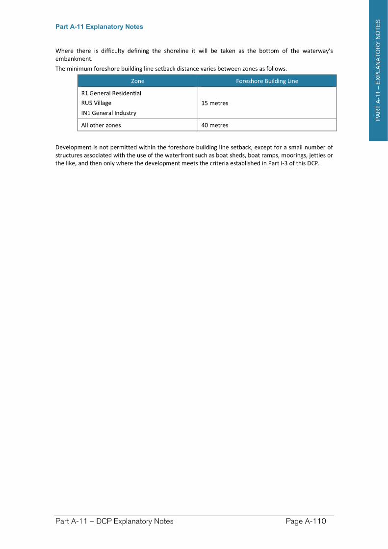
PA
RT
A-1
1–
EX
PLA
NA
TO
RY
NO
TE
S
Part A-11 Explanatory Notes
Part A-11 – DCP Explanatory Notes Page A-110
Where there is difficulty defining the shoreline it will be taken as the bottom of the waterway’s embankment.
The minimum foreshore building line setback distance varies between zones as follows.
Zone Foreshore Building Line
R1 General Residential
RU5 Village
IN1 General Industry
15 metres
All other zones 40 metres
Development is not permitted within the foreshore building line setback, except for a small number of structures associated with the use of the waterfront such as boat sheds, boat ramps, moorings, jetties or the like, and then only where the development meets the criteria established in Part I-3 of this DCP.
PA
RT
A-1
1–
EX
PLA
NA
TO
RY
NO
TE
S
Part A-11 Explanatory Notes
Part A-11 – DCP Explanatory Notes Page A-111
A-11.3 Gross Floor Area
Gross Floor area (GFA) provides a limit to the floor space on a site, indicating the intended physical floor space density and way of managing the development potential of a site.
GFA is not a measure of the maximum capacity of the site. It may not be possible to reach the maximum allowable floor space due to other development controls or constraints specific to the site such as individual lot size or shape, existing landscape features, setback and landscaped area requirements, neighbouring properties or heritage considerations. Vehicle circulation and parking have a significant influence on the GFA achievable on a site.
A-11.3.1 Calculating gross floor area
The information below provides a general guide to gross floor area. For further details on calculating gross floor area - see the definition of gross floor area in the Richmond Valley LEP 2012.
Gross floor area means the sum of the floor area of each floor of a building measured from the internal face of external walls, or from the internal face of walls separating the building from any other building, measured at a height of 1.4 metres above the floor.
All enclosed buildings on the site are counted when calculating the maximum gross floor area, including all dwellings and all other buildings on the site such as sheds, workshops, additional garage spaces, and the like.
Gross floor area excludes garages provided to meet the minimum parking numbers required by DCP for that form of development. As a general rule of thumb:
If one car space is required for that type of development and a single garage is provided, the floor area of that garage (about 20m2) is not counted as gross floor area.
If two car spaces are required and a double garage is provided, the floor area of that garage (about 40m2) is not counted as gross floor area.
Additional garages beyond those required to meet the parking space requirements of the DCP are counted in the gross floor area calculation.
Open carports are not counted as gross floor areas.
Common vertical circulation servicing more than one dwelling, including stairs and lifts are excluded from the gross floor area. Private vertical circulation used by only one tenant is included in the gross floor area calculation.
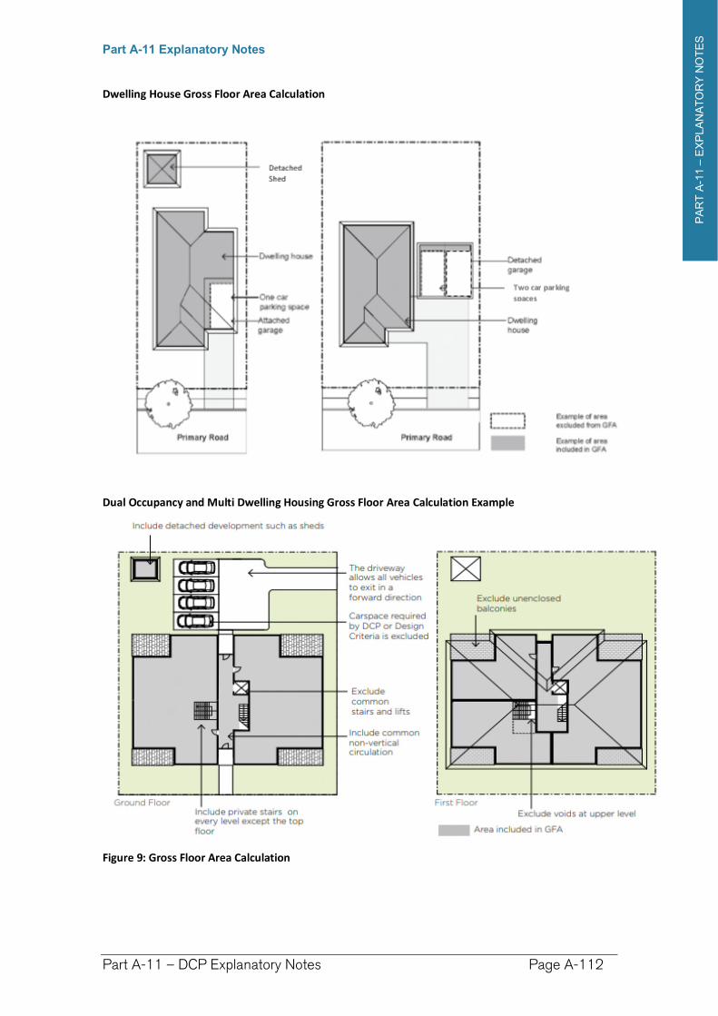
PA
RT
A-1
1–
EX
PLA
NA
TO
RY
NO
TE
S
Part A-11 Explanatory Notes
Part A-11 – DCP Explanatory Notes Page A-112
Dwelling House Gross Floor Area Calculation
Dual Occupancy and Multi Dwelling Housing Gross Floor Area Calculation Example
Figure 9: Gross Floor Area Calculation
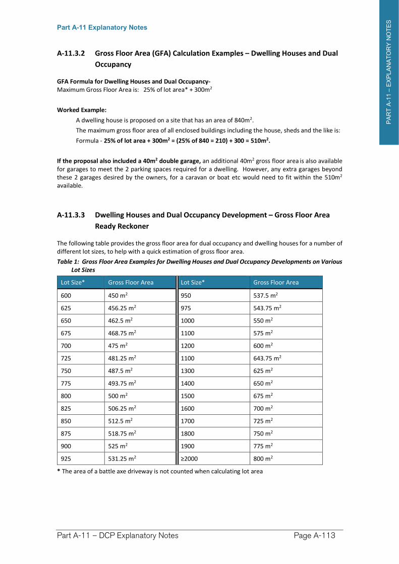
PA
RT
A-1
1–
EX
PLA
NA
TO
RY
NO
TE
S
Part A-11 Explanatory Notes
Part A-11 – DCP Explanatory Notes Page A-113
A-11.3.2 Gross Floor Area (GFA) Calculation Examples – Dwelling Houses and Dual
Occupancy
GFA Formula for Dwelling Houses and Dual Occupancy- Maximum Gross Floor Area is: 25% of lot area* + 300m2
Worked Example:
A dwelling house is proposed on a site that has an area of 840m2.
The maximum gross floor area of all enclosed buildings including the house, sheds and the like is:
Formula - 25% of lot area + 300m2 = (25% of 840 = 210) + 300 = 510m2.
If the proposal also included a 40m2 double garage, an additional 40m2 gross floor area is also available for garages to meet the 2 parking spaces required for a dwelling. However, any extra garages beyond these 2 garages desired by the owners, for a caravan or boat etc would need to fit within the 510m2
available.
A-11.3.3 Dwelling Houses and Dual Occupancy Development – Gross Floor Area
Ready Reckoner
The following table provides the gross floor area for dual occupancy and dwelling houses for a number of different lot sizes, to help with a quick estimation of gross floor area.
Table 1: Gross Floor Area Examples for Dwelling Houses and Dual Occupancy Developments on Various Lot Sizes
Lot Size* Gross Floor Area Lot Size* Gross Floor Area
600 450 m2 950 537.5 m2
625 456.25 m2 975 543.75 m2
650 462.5 m2 1000 550 m2
675 468.75 m2 1100 575 m2
700 475 m2 1200 600 m2
725 481.25 m2 1100 643.75 m2
750 487.5 m2 1300 625 m2
775 493.75 m2 1400 650 m2
800 500 m2 1500 675 m2
825 506.25 m2 1600 700 m2
850 512.5 m2 1700 725 m2
875 518.75 m2 1800 750 m2
900 525 m2 1900 775 m2
925 531.25 m2 ≥2000 800 m2
* The area of a battle axe driveway is not counted when calculating lot area
PA
RT
A-1
1–
EX
PLA
NA
TO
RY
NO
TE
S
Part A-11 Explanatory Notes
Part A-11 – DCP Explanatory Notes Page A-114
A-11.4 Landscaped Area
Landscaped Area means a part of a site used for growing plants, grasses and trees, but does not include any building, structure or hard paved area.
Gravel or similar surfaced areas that allow infiltration can contribute to the achievement of the minimum landscaped area, where they form part of the overall landscape design, but not where the gravel comprises a vehicular accessway or parking area or any other use which is not landscaping.
Landscaping, in particular tree planting, helps to clean the air, reduces urban heat, offers shade, provides habitat for wildlife and adds aesthetic appeal to the urban landscape. It can also assist the infiltration of rain water to the water table and reduce storm-water runoff. Landscaped areas can retain existing significant vegetation and enhance vegetation corridors. In larger developments, landscaped areas can provide shade and amenity for residents in communal open spaces.
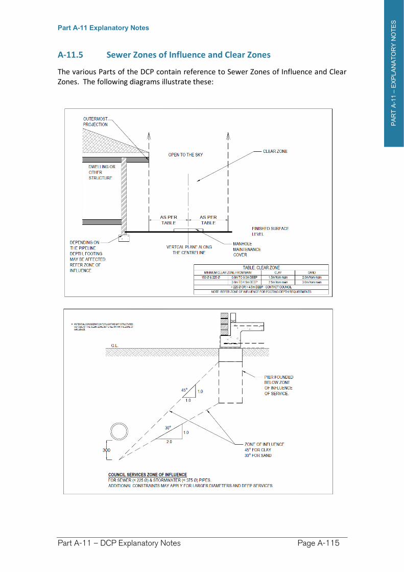
PA
RT
A-1
1–
EX
PLA
NA
TO
RY
NO
TE
S
Part A-11 Explanatory Notes
Part A-11 – DCP Explanatory Notes Page A-115
A-11.5 Sewer Zones of Influence and Clear Zones
The various Parts of the DCP contain reference to Sewer Zones of Influence and Clear Zones. The following diagrams illustrate these:
Richmond Valley Development Control Plan 2021
Part B Commercial Development
The Development Control Plan (DCP) applies to development within the commercial centres of Richmond Valley Council, including development within B1 Neighbourhood Centre Zone, B2 Local Centre Zone, B3 Commercial Core Zone and the existing commercial precincts in the RU5 Village Zone at Woodburn and Coraki.
Reference to Commercial Centres in this Chapter means the above mentioned zones and commercial precincts.
The controls also guide development of commercial premises in all other land use zones where such development is permitted under the Richmond Valley LEP 2012.
The controls in this Chapter set out the requirements for:
1. Developments which involve construction of new buildings in commercial centres precincts, or alterations and/or additions to existing buildings in these locations.
2. Change of use of an existing premises.
Many forms of development can be undertaken as Exempt or Complying Development under the State Environmental Planning Policy (Exempt and Complying Development) 2008. These controls are intended to apply where a development does not utilise the State provisions.
Table B-1 indicates the relevant sections of this DCP for developments which include construction of a new building or additions and/or alterations to the existing building or a change of use only.
This DCP applies to all land within the Richmond Valley Local Government Area.
Date adopted by Council: 22/06/2021
Effective Date: 01/08/2021
Amendments: Nil
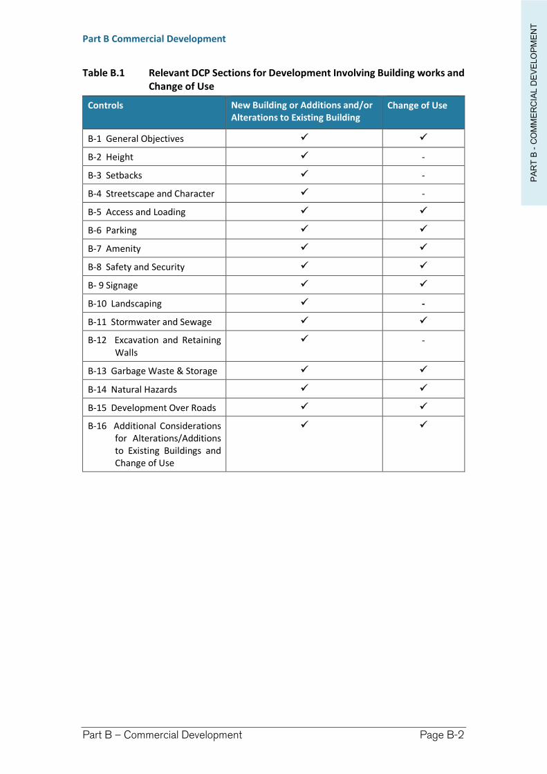
PA
RT
B -
CO
MM
ER
CIA
L D
EV
ELO
PM
EN
T
Part B Commercial Development
Part B – Commercial Development Page B-2
Table B.1 Relevant DCP Sections for Development Involving Building works and Change of Use
Controls New Building or Additions and/or Alterations to Existing Building
Change of Use
B-1 General Objectives
B-2 Height -
B-3 Setbacks -
B-4 Streetscape and Character -
B-5 Access and Loading
B-6 Parking
B-7 Amenity
B-8 Safety and Security
B- 9 Signage
B-10 Landscaping -
B-11 Stormwater and Sewage
B-12 Excavation and Retaining Walls
-
B-13 Garbage Waste & Storage
B-14 Natural Hazards
B-15 Development Over Roads
B-16 Additional Considerations for Alterations/Additions to Existing Buildings and Change of Use
PA
RT
B -
CO
MM
ER
CIA
L D
EV
ELO
PM
EN
T
Part B Commercial Development
Part B – Commercial Development Page B-3
B-1 General Objectives
The general objectives of this Part are to:
(a) encourage functional and attractive commercial centres within the towns and villages of the Richmond Valley Council area which serve the needs of businesses, the community and visitors.
(b) encourage development in commercial centres which has a high regard for existing streetscape components, particularly features important to heritage and the built environment.
(c) maintain an urban form throughout the main streets and business districts replicating existing characteristics where appropriate, and encouraging newer built form in the periphery for future expansion of existing commercial areas which responds appropriately to the character of its locality.
(d) Within RU5 Village zones, to: i. promote commercial development in appropriate locations that reflects
the pattern of existing development and contributes to the vitality and viability of the existing commercial core areas, and
ii. to encourage development that responds appropriately to surrounding development in terms of its scale, character and nature and intensity of use.
(e) To provide for reasonable amenity within commercial centres and for adjoining residential development.
(f) To provide guidance for development of commercial premises where permissible in other zones.
B-2 Building Height
B-2.1 Objectives
(a) The building height is consistent with the desired scale and character of the street and locality and provides an acceptable impact on the amenity of adjoining properties.
B-2.2 Design Criteria
(1) Determining maximum height for proposed development within commercial precincts
The maximum height a development may be built is depicted within the Height of Buildings Map – Sheet HOB_INDEX within the Richmond Valley Local Environmental Plan 2012. Richmond Valley has a general maximum height limit of 8.5 metres, with parts of the B2 Local Centre zone in South Casino having a maximum height of 9.5 metres and areas within the Casino Commercial Core Zone (Casino CBD) having a maximum height of 14 metres.
PA
RT
B -
CO
MM
ER
CIA
L D
EV
ELO
PM
EN
T
Part B Commercial Development
Part B – Commercial Development Page B-4
(2) Consistency in Scale
Building height within the core of a commercial centre is required to be in proportion to any existing CBD street or other commercial district hierarchy, particularly as viewed from the primary street.
Development on the fringe of a commercial centre should be of a scale and character respectful to adjacent one or two storey residential development.
B-3 Building Setbacks
B-3.1 Objectives
1. Establish the desired spatial proportions of the street and define the street edge.
2. Ensure new development is compatible with the streetscape character.
3. Strengthen the urban form of commercial centres with consistent street wall heights.
4. Reinforce the desired spatial character of an area.
5. Mitigate the visual intrusion and associated impacts of building bulk on neighbouring properties, particularly on the interface with residential development.
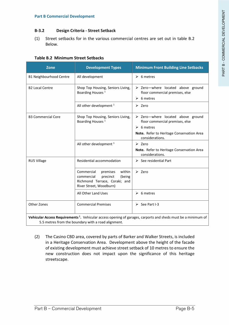
PA
RT
B -
CO
MM
ER
CIA
L D
EV
ELO
PM
EN
T
Part B Commercial Development
Part B – Commercial Development Page B-5
B-3.2 Design Criteria - Street Setback
(1) Street setbacks for in the various commercial centres are set out in table B.2 Below.
Table B.2 Minimum Street Setbacks
Zone Development Types Minimum Front Building Line Setbacks
B1 Neighbourhood Centre All development 6 metres
B2 Local Centre Shop Top Housing, Seniors Living, Boarding Houses 1
Zero—where located above ground floor commercial premises, else
6 metres
All other development 1 Zero
B3 Commercial Core Shop Top Housing, Seniors Living, Boarding Houses 1
Zero—where located above ground floor commercial premises, else
6 metres
Note. Refer to Heritage Conservation Area considerations.
All other development 1 Zero
Note. Refer to Heritage Conservation Area considerations.
RU5 Village Residential accommodation See residential Part
Commercial premises within commercial precinct (being Richmond Terrace, Coraki; and River Street, Woodburn)
Zero
All Other Land Uses 6 metres
Other Zones Commercial Premises See Part I-3
Vehicular Access Requirements 1. Vehicular access opening of garages, carports and sheds must be a minimum of 5.5 metres from the boundary with a road alignment.
(2) The Casino CBD area, covered by parts of Barker and Walker Streets, is included in a Heritage Conservation Area. Development above the height of the facade of existing development must achieve street setback of 10 metres to ensure the new construction does not impact upon the significance of this heritage streetscape.
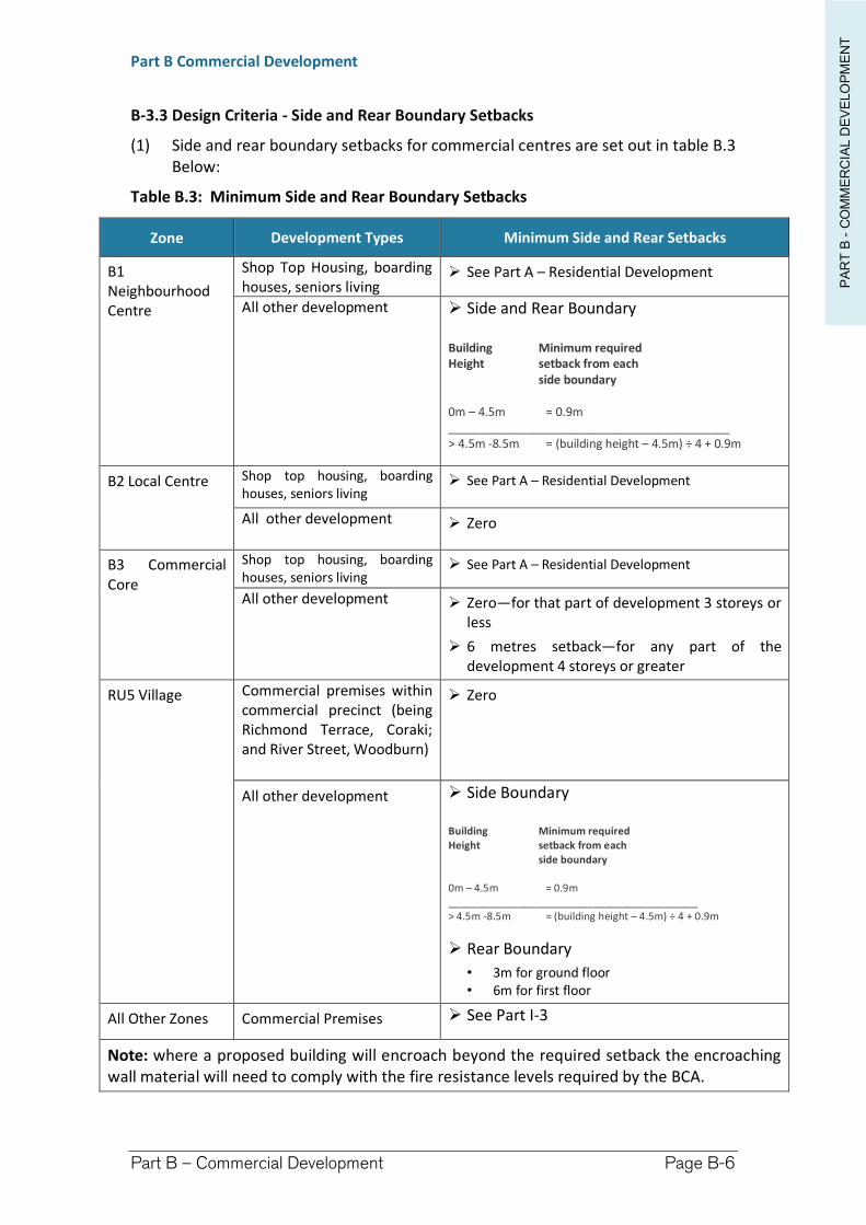
PA
RT
B -
CO
MM
ER
CIA
L D
EV
ELO
PM
EN
T
Part B Commercial Development
Part B – Commercial Development Page B-6
B-3.3 Design Criteria - Side and Rear Boundary Setbacks
(1) Side and rear boundary setbacks for commercial centres are set out in table B.3 Below:
Table B.3: Minimum Side and Rear Boundary Setbacks
Zone Development Types Minimum Side and Rear Setbacks
B1 Neighbourhood Centre
Shop Top Housing, boarding houses, seniors living
See Part A – Residential Development
All other development Side and Rear Boundary
Building Minimum required Height setback from each
side boundary
0m – 4.5m = 0.9m ___________________________________________ > 4.5m -8.5m = (building height – 4.5m) ÷ 4 + 0.9m
B2 Local Centre Shop top housing, boarding houses, seniors living
See Part A – Residential Development
All other development Zero
B3 Commercial Core
Shop top housing, boarding houses, seniors living
See Part A – Residential Development
All other development Zero—for that part of development 3 storeys or less
6 metres setback—for any part of the development 4 storeys or greater
RU5 Village Commercial premises within commercial precinct (being Richmond Terrace, Coraki; and River Street, Woodburn)
Zero
All other development Side Boundary
Building Minimum required Height setback from each
side boundary
0m – 4.5m = 0.9m ___________________________________________ > 4.5m -8.5m = (building height – 4.5m) ÷ 4 + 0.9m
Rear Boundary
• 3m for ground floor • 6m for first floor
All Other Zones Commercial Premises See Part I-3
Note: where a proposed building will encroach beyond the required setback the encroaching wall material will need to comply with the fire resistance levels required by the BCA.
PA
RT
B -
CO
MM
ER
CIA
L D
EV
ELO
PM
EN
T
Part B Commercial Development
Part B – Commercial Development Page B-7
B-4 Streetscape and Character
B-4.1 Objectives
(a) Development is consistent with the prevailing character of the street and neighbourhood and integrates effectively into its location.
(b) Development respects the scale and qualities of important community buildings and landmarks within the precinct.
(c) Commercial development on an interface with residential development or other sensitive land uses is compatible with its surroundings.
(b) Development preserves and enhances the heritage value of a heritage item and heritage conservation area.
B-4.2 Design Criteria
(1) The design of a building must relate to its locality in terms of scale, form proportions and materials; and contribute to the development of an attractive streetscape and town character.
(2) Proposed commercial development of a heritage item, or adjacent to a heritage item or proposed within the Casino heritage conservation area must comply with the applicable heritage requirements in Part I-1 of this DCP.
(3) Commercial development, particularly in the main streets and business districts, is to be consistent with existing streetscape elements, including:
i. Overall scale and setbacks ii. Roof form and pitch iii. Materials and colour of external walls, awnings, and embellishments such
as decorative detail on gable ends iv. Scale and position of windows and other architectural features v. Landscaping
(4) New development shall incorporate active retail or office uses and provide direct and inviting access from the street level.
(5) For commercial premises permitted in residential areas, the street setback and landscaping is to comply with the requirements applying for residential development in the street.
B-5 Access and Loading
B-5.1 Objectives
(a) To provide for access and loading/unloading facilities which maintain a safe and convenient pedestrian and traffic environment and do not adversely impact on any surrounding sensitive land uses.
B-5.2 Design criteria
(1) Vehicular access, parking and loading/unloading must comply with:
(a) Australian Standard AS2890; and (b) Council’s Vehicular Accessway Policy.
PA
RT
B -
CO
MM
ER
CIA
L D
EV
ELO
PM
EN
T
Part B Commercial Development
Part B – Commercial Development Page B-8
(2) Loading areas for new developments should be located so as to:
(a) reduce on-street loading; and (b) be freely available for use at all times.
(3) Access and Loading Requirements – Change of Use
A development application involving a change of use must demonstrate that existing access and loading facilities are suitable for the intended use, or can be modified to provide adequate and safe access and loading arrangements for the proposed new use.
(4) Lane Widening
In limited cases, lane widening may be required as part of proposed development in Casino. Those areas designated as requiring road widening are outlined within Part I-15 of this DCP. Council will assess the need for road widening or re-alignment when considering a development application for the land and will have regard to the existing and likely future traffic needs of the locality.
B-6 Car Parking
B-6.1 Objectives
(a) Provide sufficient parking to satisfy the demand for parking generated by commercial land uses.
(b) Parking does not compromise on street and off street safety for vehicles, pedestrian and cyclists.
(c) Minimise amenity impacts on neighbouring properties including streetscape, noise and light spill.
B-6.2 Design criteria
(1) Car parking is required to be provided onsite in order to protect the street and amenity of the area from unnecessary congestion. The number of car parking spaces required on a property is dependent upon the type of development proposed and any past credit for car parking which may be assumed from historic uses conducted on the site.
(2) On site parking is only permitted within the street setback where it is not inconsistent with the established development pattern in a commercial centre, and the landscaping requirements outline in this chapter are achieved.
(3) For commercial premises in the R1 General Residential Zone or the residential precincts in the RU5 Zone, on site parking within the street setback is not supported unless the landscaped area requirements outlined below can be satisfied.
(4) Table B.1 contains the minimum car parking requirements for commercial premises.
(5) Parking Requirements – Change of Use
(a) A flat rate of parking shall apply to all existing floor area in the Business Zones of B1 Neighbourhood Centre, B2 Local Centre, & B3 Commercial
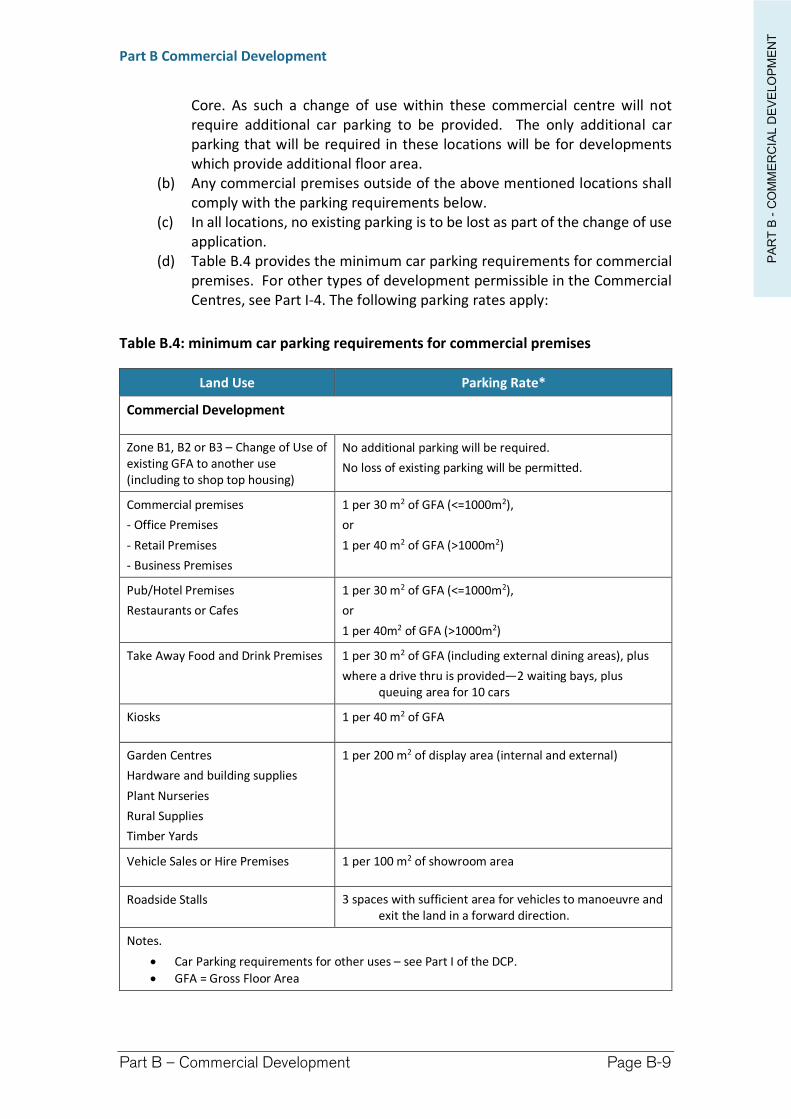
PA
RT
B -
CO
MM
ER
CIA
L D
EV
ELO
PM
EN
T
Part B Commercial Development
Part B – Commercial Development Page B-9
Core. As such a change of use within these commercial centre will not require additional car parking to be provided. The only additional car parking that will be required in these locations will be for developments which provide additional floor area.
(b) Any commercial premises outside of the above mentioned locations shall comply with the parking requirements below.
(c) In all locations, no existing parking is to be lost as part of the change of use application.
(d) Table B.4 provides the minimum car parking requirements for commercial premises. For other types of development permissible in the Commercial Centres, see Part I-4. The following parking rates apply:
Table B.4: minimum car parking requirements for commercial premises
Land Use Parking Rate*
Commercial Development
Zone B1, B2 or B3 – Change of Use of existing GFA to another use (including to shop top housing)
No additional parking will be required.
No loss of existing parking will be permitted.
Commercial premises
- Office Premises
- Retail Premises
- Business Premises
1 per 30 m2 of GFA (<=1000m2),
or
1 per 40 m2 of GFA (>1000m2)
Pub/Hotel Premises
Restaurants or Cafes
1 per 30 m2 of GFA (<=1000m2),
or
1 per 40m2 of GFA (>1000m2)
Take Away Food and Drink Premises 1 per 30 m2 of GFA (including external dining areas), plus
where a drive thru is provided—2 waiting bays, plus queuing area for 10 cars
Kiosks 1 per 40 m2 of GFA
Garden Centres
Hardware and building supplies
Plant Nurseries
Rural Supplies
Timber Yards
1 per 200 m2 of display area (internal and external)
Vehicle Sales or Hire Premises 1 per 100 m2 of showroom area
Roadside Stalls 3 spaces with sufficient area for vehicles to manoeuvre and exit the land in a forward direction.
Notes.
Car Parking requirements for other uses – see Part I of the DCP.
GFA = Gross Floor Area
PA
RT
B -
CO
MM
ER
CIA
L D
EV
ELO
PM
EN
T
Part B Commercial Development
Part B – Commercial Development Page B-10
B-7 Amenity
B-7.1 Objectives
(a) Development is compatible with the surrounding development.
B-7.2 Design criteria
(1) Development in commercial centres which has an interface with residential accommodation and other sensitive uses such as parks, childcare centres and community facilities sensitive is to be compatible with its surroundings, having regard to:
(a) the physical impacts of the development (including noise, odour, overshadowing, view loss, privacy, traffic and parking, loading, hours of operation, constraints on development of the adjoining sites), and
(b) the visual impact (whether the proposal is in harmony with the buildings around it and the character of the street).
(2) The control above also applies to commercial premises in all other zones.
(3) Depending on the type of development proposed and its hours of operation, a noise or social impact assessment may be required. Part I of the DCP contains design criteria for noise and social impact. Where required to do so under the provisions of Part I, the development shall provide for noise and/or social impact reports, and design the development to meet any recommendations in the report/s.
B-8 Safety and Security
B-8.1 Objectives
(a) Reduce opportunities for crime through building layout, orientation and location, and the strategic use of design, landscaping and lighting.
B-8.2 Design criteria
(1) The design of any proposed development needs to demonstrate compliance with the Crime Prevention Through Environmental Design (CPTED) guidelines.
More information concerning Crime Prevention Through Environmental Design (CPTED) is outlined within Part I-10 of this DCP.
B-9 Signage
B-9.1 Objectives
(a) Ensure that signage:
i. is compatible with the desired amenity and visual character of an area.
ii. is in keeping with the scale and character of surrounding development and does not dominate or clutter the streetscape.
PA
RT
B -
CO
MM
ER
CIA
L D
EV
ELO
PM
EN
T
Part B Commercial Development
Part B – Commercial Development Page B-11
iii. does not reduce the safety of any road, pedestrian path or waterway.
B-9.2 Design criteria
(1) All signage intended for the development in commercial centres must be outlined within formal application for the development. Part F of this DCP relates to signage. In addition, some forms of Business Identification Signage may be carried out as exempt development under State Environmental Planning Policy (Exempt and Complying Development Codes) 2008.
(2) If the property is heritage listed, adjoins a heritage item or in a heritage conservation area, any new or replacement signage, shall complement the heritage characteristics of the building or locality having regard to the colour scheme, location, design and number of signs proposed. Refer to the heritage provisions in Part I-1 Environmental Heritage for further information.
(3) An elevation of the proposed development detailing signage size, colour and style for approval purposes, is required to form part of the development application.
B-10 Landscaping
B-10.1 Objectives
(a) Make a positive contribution to streetscape amenity by softening the visual impact of built form including car parking, and providing shade.
B-10.2 Design criteria
(1) Where onsite carparking is located within the street frontage within a commercial centre, a 2m wide landscape strip is to be provided within the site along each street boundary.
(2) A landscaping component is also required in commercial centres in situations where adjoining uses and overall built form also incorporates landscaping. Where the proposed development adjoins residential development, particularly where car parking areas are required, landscaping shall be incorporated to screen these areas from adjoining land uses.
(3) In Zone B1 – Neighbourhood Centre and for the development of commercial premises outside of the commercial centres, landscaping is to be provided as part of the development where the existing built form incorporates landscaping components.
(4) For commercial premises permitted in residential areas, a minimum of 50% of the street setback is to be landscaped area.
(5) A landscaping Plan may be required and should be prepared in consultation with Part I-5 – Landscaping.
PA
RT
B -
CO
MM
ER
CIA
L D
EV
ELO
PM
EN
T
Part B Commercial Development
Part B – Commercial Development Page B-12
B-11 Stormwater, Sewage and Water
B-11.1 Objectives
(a) To ensure all commercial development is adequately serviced for sewerage, water and stormwater disposal stormwater and makes adequate provision for the disposal of liquid trade waste.
B-11.2 Design criteria
(1) Where water and sewer connections are not available to a lot in an urban area, Council will require the extension of Council’s main to service that lot at the developers cost.
For all infrastructure connections within the property the proponent is required to take into consideration possible subsidence areas (‘Zone of influence’). The Zone of Influence is calculated based on soil type and the depth of the piped infrastructure. The zone must be observed on all plans and all footings either must avoid this zone or be appropriately engineered in accordance with Council standards. See the Explanatory Notes Section of the DCP for further details regarding zones of influence.
(2) Stormwater
All urban lots are required to connect or maintain adequate connection to town infrastructure where provided and have consideration for Water Sensitive Urban Design principles. All stormwater is to be directed to the street drainage system, or to an inter allotment drainage easement where available.
(3) Sewage
All greywater and toilets are required to be connected to sewer infrastructure, where provided.
(4) Liquid Trade Waste
Where a commercial development generates liquid trade waste, mechanisms for disposal of liquid waste must be identified as part of the development application. Approval from Council is required to discharge liquid trade wastes into the sewerage system. Refer to Council’s Policy - Discharge of Liquid Trade Waste to the Sewerage System. In areas not connected to the sewerage system, the development application must also demonstrate how liquid trade waste for the proposed development will be managed.
(5) Water
All commercial development is required to be connected to water infrastructure, where provided.
B-12 Earthworks and Retaining Walls
B-12.1 Objectives
(a) To ensure cut and fill required for any development is designed to minimise any safety, environmental and amenity impacts on the site and adjoining properties.
PA
RT
B -
CO
MM
ER
CIA
L D
EV
ELO
PM
EN
T
Part B Commercial Development
Part B – Commercial Development Page B-13
B-12.2 Design criteria
(1) All earthworks and retaining walls proposed for the development must be detailed within the development application.
(2) Timber retaining walls are not permitted for boundary retaining walls including road and park reserve boundaries.
(3) Retaining walls are not permitted within easements unless it can be shown that there is; no impact on underground pipes, no restriction on the free flow of overland stormwater, no constraint on the access by maintenance vehicles.
Consideration of Acid Sulfate Soils (ASS)
(4) Acid Sulfate Soils are relatively prevalent within the lower river regions of Richmond Valley, and due consideration of the risk and structural adequacies must be considered within any application proposing earthworks and retaining walls. ASS considerations must accompany any engineering certification. Further information may be obtained in Part H-2 of this DCP.
Engineering Certification Required
(5) Retaining walls in excess of 1 metre in height require engineering certification. All materials to be utilised as fill, ballast or for retaining walls must be accompanied by a geotechnical certification to verify structural stability and that they are free from contamination.
(6) Erosion and Sediment Control safeguards and practices are required to be implemented during construction.
Note. Any material resulting from demolition, including concrete and brick which may be sourced as ballast, is classified as a waste. It is an offence under the Protection of the Environment Operations Act to transport waste to a place that cannot lawfully be used to deposit waste. Ballast or fill cannot be sourced from a demolition site unless it has been certified as clean and de-classified as waste.
B-13 Garbage Waste and Storage
B-13.1 Objectives
(a) Ensure appropriate waste storage and collection facilities.
(b) Enable the servicing of the waste management system on site, and the efficient collection of waste and recyclables by collection service providers, with minimum disruption and impact on the community.
(c) Ensure bin storage areas/rooms do not dominate the streetscape.
B-13.2 Design criteria
(1 A garbage and waste storage area for recyclable and non-recyclable waste materials and receptacles for those materials must—
(a) be provided as part of the development, and
PA
RT
B -
CO
MM
ER
CIA
L D
EV
ELO
PM
EN
T
Part B Commercial Development
Part B – Commercial Development Page B-14
(b) be located entirely within the lot on which the development is being carried out and not on a road or road reserve, and
(c) comply with the following appendices in the document entitled Better Practice Guidelines for Waste Management and Recycling in Commercial and Industrial Facilities (ISBN 978-1-74293-944-5), published by the NSW Environment Protection Authority in December 2012:
(i) Appendices A and B, for the size and location of garbage and storage areas and the size of waste receptacles,
(ii) Appendices C and D, for the design of openings of waste storage areas and loading bay turning circles for waste removal vehicles,
(iii) Appendix E, for standard signs for waste storage areas,
(iv) Appendix F for the design and operational capacity of waste storage areas.
(2) The waste storage area must:
(a) be screened, and
(b) be located behind the primary road frontage building line, and
(c) not be located in any car parking, loading or landscaped area, and
(d) not be located on any side of the building that faces an adjoining lot on which there is a dwelling.
PA
RT
B -
CO
MM
ER
CIA
L D
EV
ELO
PM
EN
T
Part B Commercial Development
Part B – Commercial Development Page B-15
B-14 Natural Hazards and Constrains
B-14.1 Objectives
(a) To minimise the impact of natural hazards on development within Commercial Centres..
(b) To ensure commercial development is appropriate for a particular hazard environment
B-14.2 Design criteria
(1) Flooding
Commercial development is required to be designed to endure flooding events of a 1 in 100 year ARI frequency, or as otherwise assessed within an updated Risk Management Plan.
Commercial development must have its floor levels located:
in the Casino area—above the 1 in 100 year ARI flood event, in the Mid-Richmond area—above the 1 in 20 year ARI Flood event. A
storage area with a floor level greater than or equal to the the 1 in 100 year ARI flood level is to be provided for stock/equipment subject to water damage.
in areas of the Council outside a formal flood study area—to be determined on researching historic data, anecdotal information, and a risk assessment.
Council can provide property specific flood information for areas within formal flood studies covering the Mid-Richmond and Casino areas.
All potential flood risks associated with the development must be considered, including potential risks to emergency personnel (SES) in the event evacuation may be required. Flood consideration is mostly directed toward dwellings and habitable areas, however Council must also consider flood impacts upon other assets and access to and from the development. Part H1 – Flooding provides additional detail concerning flooding issues.
(2) Acid Sulfate Soils (ASS)
All works which are likely to impact on ASS will require extra consideration during the construction phase of the development. DCP Part H-2 – Acid Sulfate Soils provides additional information concerning the risks posed by various classes of ASS.
(3) Contaminated Lands
Contaminated lands may require rehabilitation prior to development being initiated. In exceptional circumstances and where no other remediation method is achievable, containment of the source of contamination may be considered. The foremost option is to locate any proposed development outside any area considered unsafe, however rehabilitation is the most common option for Commercial Development.
PA
RT
B -
CO
MM
ER
CIA
L D
EV
ELO
PM
EN
T
Part B Commercial Development
Part B – Commercial Development Page B-16
B-15 Development over Roads
B-15.1 Objectives
(a) To facilitate safe and appropriate commercial development over roads.
B-15.2 Design criteria
(1) Commercial Development often incorporates some form of development over public roads. This development may be in the form of Footway Activities (kerbside dining, footpath trading, erection of signage), erection of awnings and verandahs, flagpoles etc.
(2) Appropriate approvals and consents will be required to carry out any activity or construction on a public road. See Part I-2 for further information.
B-16 Additional Considerations for Alterations and Additions and Change of Use to existing commercial premises
B-16.1 Objectives
(a) Identify common additional design considerations that may be required for alterations or additions to existing commercial premises, and/or change of use of commercial premises.
B-16.2 Design criteria
(1) A proposal for alterations or additions to an existing commercial building, or to change to use of the building may require building to be upgraded to comply with the Building Code of Australia. Any upgrade requirements should be taken into account at development application stage as they may impact upon the design of the project or the heritage values of the property.
(2) Common upgrades may include:
access for people with a disability to comply with premises standard – affects issues including access and bathroom facilities
Light and ventilation
Fire safety
Energy efficiency
Sanitary and other facilities
Consultation with a suitably qualified building consultant early in the process is recommended to understand the requirements and any potential design, heritage and cost implications for the proposal.
3. Other Legislative Requirements
Some forms of commercial development may also be subject to requirements of other legislation, which govern the fit-out and operational requirements of the proposed development.
PA
RT
B -
CO
MM
ER
CIA
L D
EV
ELO
PM
EN
T
Part B Commercial Development
Part B – Commercial Development Page B-17
Common requirements are:
if the new use is food and drink premises—the premises must comply with AS 4674–2004 Construction and fit-out of food premises, and details must form part of the development application.
if the use involves skin penetration, details as to how the fit-out will comply with the requirements of the Public Health Act and Regulations is required.
Water supply, sewerage (including trade waste provision), and stormwater drainage work under s68 of the Local Government Act.
Access for people with a disability will need to comply AS 1428.1.
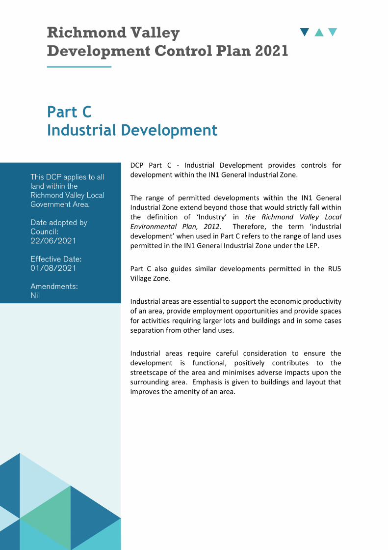
Richmond Valley Development Control Plan 2021
Part C Industrial Development
DCP Part C - Industrial Development provides controls for development within the IN1 General Industrial Zone.
The range of permitted developments within the IN1 General Industrial Zone extend beyond those that would strictly fall within the definition of ‘Industry’ in the Richmond Valley Local Environmental Plan, 2012. Therefore, the term ‘industrial development’ when used in Part C refers to the range of land uses permitted in the IN1 General Industrial Zone under the LEP.
Part C also guides similar developments permitted in the RU5 Village Zone.
Industrial areas are essential to support the economic productivity of an area, provide employment opportunities and provide spaces for activities requiring larger lots and buildings and in some cases separation from other land uses.
Industrial areas require careful consideration to ensure the development is functional, positively contributes to the streetscape of the area and minimises adverse impacts upon the surrounding area. Emphasis is given to buildings and layout that improves the amenity of an area.
This DCP applies to all land within the Richmond Valley Local Government Area.
Date adopted by Council: 22/06/2021
Effective Date: 01/08/2021
Amendments: Nil
PA
RT
C -
IND
US
TR
IAL D
EV
ELO
PM
EN
T
Part C Industrial Development
Part C – Industrial Development Page C-2
C-1 General Objectives
The general objectives are to:
(a) ensure new development within the IN1 General Industrial zone provides functional and efficient areas for buildings, vehicle movements and parking, storage areas and landscaping.
(b) provide for a wide range of light industrial development, and increased employment opportunities within appropriate areas.
(c) encourage development within industrial areas which is functional, compatible with the desired streetscape and provides buildings and land uses that are appropriate to their context.
(d) Development within industrial areas is compatible with the surrounding development.
(e) Guide similar development forms permissible in the RU5 Village zone.
C-2 Building Height
C-2.1 Objectives
(a) The building height is consistent with the desired scale and character of the street and locality and provides an acceptable impact on the amenity of adjoining properties.
C-2.2 Design criteria
(1) Building Height
The Richmond Valley LEP 2012 establishes a maximum building height of 8.5m within the IN1 General Industrial Zone.
(2) Consistency in Scale
Development adjoining non-industrial land uses, particularly residential development or public spaces, shall provide a suitable transition in height and scale to avoid overshadowing, privacy, bulk and scale impacts to the adjoining land uses.
C-3 Building Setbacks
C-3.1 Objectives
(a) Provide adequate separation between industrial development and adjoining properties and public spaces.
(b) Achieve an appropriate transition between industrial development on the fringe of Industrial zones and surrounding development.
(c) Ensure new industrial development is compatible with the desired streetscape character.
(d) Mitigate the visual intrusion of building bulk on neighbouring properties, particularly on the interface with residential development and other sensitive land uses.
PA
RT
C -
IND
US
TR
IAL D
EV
ELO
PM
EN
T
Part C Industrial Development
Part C – Industrial Development Page C-3
C-3.2 Design criteria - Street, Side and Rear Boundary Setbacks
(1) Street Setbacks – IN1 General Industrial Zone
(a) Buildings must have a minimum 6 metre setback from the primary road frontage.
(b) A secondary or parallel road frontage adjoining residential development – must have a minimum setback of 3 metres.
(c) A secondary or parallel road frontage not adjoining residential development—must have a minimum setback of 2 metres.
(2) Side and Rear Boundary Setbacks – IN1 General Industrial Zone
(a) Where industrial development sites share side or rear boundary with residential land uses, or other sensitive land uses, the minimum side and rear boundary setbacks apply:
Building Minimum required setback from Height from each side boundary
0m – 4.5m = 0.9m ___________________________________________ > 4.5m = (building height – 4.5m) ÷ 4 + 0.9m
(b) In all other cases, a nil setback to the rear and side boundaries may apply, subject to requirements of the Building Code of Australia and consideration of adverse impacts upon any adjoining property as outlined below.
(3) Street, Side and Rear Boundary Setbacks – RU5 Village Zone
(a) Refer to the setback requirements in Part I-3.
(4) Circumstances Which Require Increased Setbacks
(a) The setbacks for development in the IN1 General Industrial and industrial development in the RU5 Village Zone 3 are minimum setbacks. Where the scale of the side or rear elevation is likely to result in significant overshadowing, visual intrusion, privacy or amenity impacts on adjoining sensitive land uses, an increased setback may be required.
(5) Foreshore Building Line Setbacks
If a foreshore building line setback applies, no part of the building or any parking will be permitted within the foreshore building line setback, which is:
(a) in Zone IN1—15 metres
(b) In Zone RU5 – 15 metres
See Part I-3 for further details regarding the Foreshore Building Line.
(6) Heavy Industrial Storage Establishments –
(a) Heavy industrial storage establishments are likely to require significantly greater separation from other development, particularly sensitive land uses. The suitability of a particular location and setbacks required for this type of development will need to be determined on a case by case basis.
PA
RT
C -
IND
US
TR
IAL D
EV
ELO
PM
EN
T
Part C Industrial Development
Part C – Industrial Development Page C-4
(b) Heavy industrial storage establishment means a building or place used for the storage of goods, materials, plant or machinery for commercial purposes and that requires separation from other development because of the nature of the processes involved, or the goods, materials, plant or machinery stored, and includes any of the following—
a hazardous storage establishment,
a liquid fuel depot,
an offensive storage establishment.
C-4 Streetscape and Built Form
C-4.1 Objectives
(a) Ensure that all elements of a development make a positive contribution to the locality, particularly where sites are located at the entrances to towns, are visible from main roads, residential areas or other public places such as parks and reserves.
(b) to utilise the building design, materials, layout, parking, landscaping and screening to improve the amenity of the area.
(c) integrate new development with existing surrounding land uses in the area.
(d) to provide attractive and functional areas between the public road and the building frontage.
(e) To ensure development relates sympathetically to nearby and adjoining sites particularly residential land uses and public spaces.
(f) To reduce land use conflict between residential and non-residential land uses
C-4.2 Design criteria
(1) General Requirements
To ensure that the external appearance of building elements make a positive contribution to the streetscape, the following principles should be employed:
(a) Use non-industrial aspects of the development, e.g. Offices, to address and activate the street.
(b) Where visible from the street, the façade should be articulated as outlined below.
(c) Where blank walls are unavoidable in a street facade, landscape screen planting is to be utilised to reduce visual impact of the building when viewed from the public domain or residential development.
(d) Ventilation, exhaust systems, motors and other similar plant shall be suitably screened where located on the exterior of the building.
(e) The following materials are not suitable for use on any elevation facing a street, residential dwelling, or where visible from public place such as a park or reserve, or town entry road, unless suitable screening or landscaping can be applied:
un-rendered and uncoloured brick or concrete block.
uncoloured corrugated iron, cliplock or any other similar metal.
PA
RT
C -
IND
US
TR
IAL D
EV
ELO
PM
EN
T
Part C Industrial Development
Part C – Industrial Development Page C-5
Highly reflective materials are not acceptable for roof or wall cladding.
(f) No area for work or storage purposes is permitted within street setbacks.
(2) Articulation zone
(a) An articulation zone element may encroach up to 1.5 metres into the setback of a primary road frontage.
(b) The following building elements may be located in the articulation zone:
Part of a reception, office or showroom area, or the like, with at least one window (minimum area 4m2) facing towards the street and a clearly visible entry door (not a roller door)
An open form entry feature, awning or portico
(c) The maximum total area of all building elements within the articulation zone is 15m2 or two thirds of the width of the façade, whichever is greater.
(d) Blank walls are not permitted in the articulation zone.
(e) The maximum height of an articulation zone element is 4 metres above the ground floor level of the development.
(f) The area under an open articulation element such an awning shall not to be used for parking, storage or as a work area.
(g) Materials and finishes shall comply with the general design criteria in C-4(1) above.
(3) Open Storage and Work Areas
If open storage or work areas are proposed, full details of the materials stored and work practices in the area are to be provided. Such areas to be located at the rear of buildings, screened from view with permanent screening such as fencing, and may be required to be set back from boundaries, particularly where these adjoin sensitive land uses.
Open work areas are not suitable for any activity likely to generate dust, noise or odours.
(4) Signage
Some Business Identification Signage may be undertaken as Exempt Development in accordance with State Environmental Planning Policy (Exempt and Complying Development Codes) 2008.
Part F of the DCP provides further information on signage.
C-5 Landscaping
C-5.1 Objectives
(a) Landscaping allows for the visual impact of development to be softened and contributes to streetscape amenity.
C-5.2 Design criteria
(1) Landscaping should be concentrated in the street setbacks of the premises although may also be required on other boundaries where it adjoins non-industrial land uses and public places.
PA
RT
C -
IND
US
TR
IAL D
EV
ELO
PM
EN
T
Part C Industrial Development
Part C – Industrial Development Page C-6
(2) A Landscaping plan shall be submitted providing the following minimum requirements:
A minimum 2.0 metre deep landscaping strip must be provided within the property, along the site boundary.
Along a secondary or parallel roads, a 1.0 metre deep landscaping strip must be provided within the property, along the site boundary.
Landscaping areas are required to be located within an edged garden bed.
Landscaping should include at least one canopy tree, in conjunction with screen shrubs and ground covers.
Species should be selected for their relatively fast growth, low water demand, and easy maintenance characteristics.
Avoid landscaping that obscures natural surveillance.
Landscaping is to be protected from vehicle damage by a dwarf wall or kerb and is to be maintained throughout the duration of the development.
Refer to Chapter I-5 for further details on landscaping.
C-6 Fencing
C-6.1 Objectives
(a) To allow for fencing which meets the needs of the development for safety and security, while maintain an attractive streetscape.
C-6.2 Design criteria
(1) Fencing within the setback to the primary road frontage should be open form, with a maximum height of 1.5 metres.
(2) Where there is a demonstrated security requirement at the site, chain wire or mesh fencing with a maximum height of 1.8 metres may be permitted forward of the front building line.
(3) The style and height of the fence behind the front building line must be of a compatible style with the surrounding area where it adjoins public spaces or residential areas.
(4) An electrical fence, barbed wire, or other similar styles of security fencing will only be supported where there is a demonstrated security requirement at the site, and will not be supported within the street setback area or on a shared boundary with residential development.
(5) Acoustic fencing and or other treatments may be required for noise generating development adjacent to sensitive receivers.
C-7 Noise and Other Amenity Impacts
C-7.1 Objectives
(a) Ensure industrial development minimises the noise impact on surrounding uses.
(b) Ensure industrial development provides adequate amenity for adjoining properties and public land
PA
RT
C -
IND
US
TR
IAL D
EV
ELO
PM
EN
T
Part C Industrial Development
Part C – Industrial Development Page C-7
C7.2 Design criteria – Noise
(1) Sources of development noise, from machinery, vehicles, loading areas, motors and plant, are to be located away from sensitive receivers and/or be acoustically treated.
(2) All noise generating equipment must be designed to protect the acoustic amenity of neighbours and surrounding land uses. All noise generating equipment must be acoustically treated and/or screened to meet the project specific noise criteria as determined by the NSW Industrial Noise Policy.
(3) Potential noise generating development, particularly where sensitive noise receivers are nearby, should include an acoustic assessment prepared in accordance with the New South Wales Industrial Noise Policy. See Chapter I-7 for further details.
C-7.3 Design Criteria - Other Amenity Impacts
(1) Industrial development on an interface with residential accommodation and other sensitive uses such as parks, childcare centres and community facilities sensitive is to be compatible with its surroundings, having regard to the physical impacts of the development (including noise, odour, overshadowing, view loss, privacy, traffic and parking, loading, hours of operation, constraints on development of the adjoining sites).
C-8 Safety and Security
C-8.1 Objectives
(a) Reduce opportunities for crime through building layout, orientation and location, and the strategic use of design, landscaping and lighting.
C-8.2 Design criteria
(1) The design of any proposed development need to demonstrate compliance with the Crime Prevention Through Environmental Design (CPTED) guidelines.
More information concerning Crime Prevention Through Environmental Design (CPTED) is outlined within Chapter I-10 of this DCP.
(2) Safer design features include: Having clearly defined public/private spaces, good natural surveillance by incorporating open windows or doors where people are working, avoiding steps in the building which create hiding and entrapment areas and adequate security.
C-9 Parking, Loading and Access
C-9.1 Objectives
(a) To ensure sufficient car parking is provided on-site to satisfy the likely peak parking demands of the development.
(b) To create an attractive streetscape.
(c) To ensure facilities are provided within an industrial development for the loading and unloading of goods.
(d) To ensure access to sites minimises the impact on adjoining residential development.
PA
RT
C -
IND
US
TR
IAL D
EV
ELO
PM
EN
T
Part C Industrial Development
Part C – Industrial Development Page C-8
C-9.1 Design criteria - Vehicular Access and Loading Facilities
(1) Vehicular access shall be:
(a) to a standard determined by Council’s Engineering section,
(b) generally in accordance with Council’s Vehicular Accessway Policy, the Northern Rivers Development and Design Manual, and Australian Standards (AS2890).
Generally the following standards will apply:
Provision is to be made for a minimum six (6) metre wide heavy duty driveway.
All loading and unloading areas shall be located wholly within the property.
Council will assess the need for pavement widening or re-alignment in some instances.
(2) To minimise impacts on adjoining residential development, site access points should not be located on secondary or parallel roads on an interface with residential development.
C-9.2 Design Criteria - On-Site Carparking
(1) Car parking shall be required in accordance with Table C-6 and Chapter I-4.
Refer to Chapter I-4 for a number of exceptions to the required
(2) An accessible space with compliant travel paths to the principal entrance is to be provided.
Table C-6 Minimum On-site Car Parking Requirements for Industrial Development (see Chapter I-4 for further development types)
Land Use Parking Rate*
Industrial Development
Vehicle repair stations 4 per hoist & workbay
Body Repair Stations 2 per hoist & workbay
General (Light) Industry 1 per 50 m2 of GFA
Bulky goods premises
Warehouse or distribution centre
1 per 300 m2 of GFA
Waste or Resource Management Facility 1 per employee
Storage Sheds Adequate manoeuvring areas (trailer and vehicles) with isles wide enough for 2 vehicles to pass safely
Depot
Truck Depot
Transport Depot
Sufficient off-street employee and visitor parking to satisfy peak demand, plus
1 truck space for each vehicle present at the time of peak vehicle accumulation.
Rural Industries 1 per 50 m2 of GFA
Notes.
GFA = Gross Floor Area
Reference to the number of employees is reference to the peak number of employees on duty at any one time.

PA
RT
C -
IND
US
TR
IAL D
EV
ELO
PM
EN
T
Part C Industrial Development
Part C – Industrial Development Page C-9
C-10 Stormwater and Sewage and Services
C-10.1 Objectives
(a) To ensure adequate provision is made for connection of sewage, water and stormwater.
(b) To ensure adequate provision is made for other services
C-10.2 Design criteria
Sewage and Stormwater
(1) All stormwater is to be directed to Council’s stormwater drainage system or to an inter-allotment drainage easement via an approved method.
Surface water must not be directed onto adjoining properties.
Water Sensitive Urban Design principles shall apply, refer to Chapter I- 9 for details.
(2) Erosion and Sediment Control measures are to be provided.
(3) All greywater and toilets are required to be connected to sewer infrastructure.
Liquid Trade Waste
(4) Where a commercial development generates liquid trade waste, mechanisms for disposal of liquid waste must be identified as part of the development application. Approval from Council is required to discharge liquid trade wastes into the sewerage system. Refer to Council’s Policy - Discharge of Liquid Trade Waste to the Sewerage System. In areas not connected to the sewerage system, the development application must also demonstrate how liquid trade waste for the proposed development will be managed.
Water
(5) All commercial development is required to be connected to water infrastructure, where provided.
Impacts on Infrastructure Services
(6) Consideration of the location and design of existing services shall be given and include:
Electricity and telecommunications,
Water, sewer and stormwater,
Zone of influence and clear zone impacts on underground infrastructure.
C-11 Waste
C-11.1 Objectives
(a) Adequate, efficient and safe waste management facilities are provided for all types of waste generated by development within the site.
(b) Waste facilities are designed and located to minimise amenity impacts.
PA
RT
C -
IND
US
TR
IAL D
EV
ELO
PM
EN
T
Part C Industrial Development
Part C – Industrial Development Page C-10
C-11.2 Design criteria
(1) A waste storage area is to be provided for all developments to store bins for general waste and recyclables.
(2) Waste storage areas must not be within:
(a) Any street setback; or
(b) The parking area; or
(c) The landscaping area; or
(d) Between the foreshore building line and any waterway; or
(e) In close proximity to any adjoining residential development.
(3) The location and design of the waste storage area must not detract from the amenity of adjoining sensitive landuses or the character of the streetscape, interfere with the manoeuvrability, efficiency or safety of site access or
(4) Waste and recycling facilities must be designed to prevent litter and contamination of the stormwater drainage system.
(5) Details of the types of waste to be generated by a development and the proposed waste and recycling facilities are to be provided along with the proposed management practices.
C-12 Earthworks and Retaining Walls
C-12.1 Objectives
(1) To ensure cut and fill required for any development is designed to minimise any safety, environmental and amenity impacts on the site and adjoining properties.
C-12.2 Design criteria
(1) All earthworks and retaining walls proposed for the development must be detailed within the development application.
Consideration of Acid Sulfate Soils (ASS)
(2) Acid Sulfate Soils are relatively prevalent within the lower river regions of Richmond Valley, and due consideration of the risk and structural adequacies must be considered within any application proposing earthworks and retaining walls. ASS considerations must accompany any engineering certification. Further information may be obtained in Chapter H-2 of this DCP.
Engineering Certification Required
(3) Retaining walls in excess of 1 metre in height require engineering certification. All materials to be utilised as fill, ballast or for retaining walls must be accompanied by a geotechnical certification to verify structural stability and that they are free from contamination.
(4) Erosion and Sediment Control safeguards and practices are required to be implemented during construction.
(5) Any material resulting from demolition, including concrete and brick which may be sourced as ballast, is classified as a waste. It is an offence under the Protection of the
PA
RT
C -
IND
US
TR
IAL D
EV
ELO
PM
EN
T
Part C Industrial Development
Part C – Industrial Development Page C-11
Environment Operations Act to transport waste to a place that cannot lawfully be used to deposit waste. Ballast or fill cannot be sourced from a demolition site unless it has been certified as clean and de-classified as waste.
C-13 Natural Hazards and Constrains
C-13.1 Objectives
(1) To minimise the impact of natural hazards on industrial development.
C-13.2 Design criteria
(2) Flooding
Industrial development is required to be designed to endure flooding events of a 1 in 100 year ARI frequency, or as otherwise assessed within an updated Risk Management Plan.
Industrial development must have its floor levels located:
in the Casino area—above the 1 in 100 year ARI flood event,
in the Mid-Richmond area—above the 1 in 20 year ARI Flood event. A storage area with a floor level greater than or equal to the the 1 in 100 year ARI flood level is to be provided for stock/equipment subject to water damage.
in areas of the Council outside a formal flood study area—to be determined on researching historic data, anecdotal information, and a risk assessment.
Council can provide property specific flood information for areas within formal flood studies covering the Mid-Richmond and Casino areas.
All potential flood risks associated with the development must be considered, including potential risks to emergency personnel (SES) in the event evacuation may be required. Flood consideration is mostly directed toward dwellings and habitable areas, however Council must also consider flood impacts upon other assets and access to and from the development. Chapter H1 – Flooding provides additional detail concerning flooding issues.
(3) Acid Sulfate Soils (ASS)
All works which are likely to impact on ASS will require extra consideration during the construction phase of the development. DCP Part H-2 – Acid Sulfate Soils provides additional information concerning the risks posed by various classes of ASS.
(4) Contaminated Lands
Contaminated lands may require rehabilitation prior to development being initiated. In exceptional circumstances and where no other remediation method is achievable, containment of the source of contamination may be considered. The foremost option is to locate any proposed development outside any area considered unsafe, however rehabilitation is the most common option for Commercial Development.
PA
RT
C -
IND
US
TR
IAL D
EV
ELO
PM
EN
T
Part C Industrial Development
Part C – Industrial Development Page C-12
C-14 Additional Considerations for Specific Uses
C-14.1 Alterations and Additions and Change of Use to an Existing Building
C-14.1.1 Objectives
(a) Identify common additional design considerations that may be required for alterations or additions to existing industrial premises, and/or change of use of industrial premises.
C-14.1.2 Design criteria
(1) A proposal for alterations or additions to an existing building, or to change to use of the building may require building to be upgraded to comply with the Building Code of Australia. Any upgrade requirements should be taken into account at development application stage as these may impact upon the design of the project.
Common upgrades may include:
access for people with a disability to comply with premises standard – affects issues including access and bathroom facilities
Light and ventilation
Fire safety
Energy efficiency
Sanitary and other facilities
Consultation with a suitably qualified building consultant early in the process is recommended to understand the requirements and any potential design and cost implications for the proposal.
C-14.2 Chemicals and Dangerous Goods
C-14.2.1 Objectives
(a) Developments involving the storage or use of chemicals and dangerous goods are designed and located to minimise the impact on the health and safety of the community and the environment.
C-14.2.2 Design criteria
(1) Developments involving the use or storage of fuels, oils and chemicals are required to have a storage area located above the 1 in 100 year flood event or an approved plan of management.
(2) Developments having larger quantities of Hazardous Materials will require an assessment be undertaken in accordance with State Environmental Planning Policy No 33 – Hazardous and Offensive Development.
C-14.3 Industrial Retail Outlets
C-14.3.1 Objectives
(a) To outline planning provisions for industrial retail outlets
PA
RT
C -
IND
US
TR
IAL D
EV
ELO
PM
EN
T
Part C Industrial Development
Part C – Industrial Development Page C-13
C-14.3.2 Design Criteria
(1) Clause 5.4 of the LEP provides for miscellaneous permissible uses with subsection (4) permitting retailing of goods produced on the premises. Consent may be granted for a retail component not exceeding 20% of the combined gross floor area of the premises.
(2) The development application must demonstrate that the proposed industrial retail outlet complies with this requirement.
(3) Sufficient on site parking is to be provided for customers of the industrial retail outlet in accordance with the parking rates for retail premises in Part I-3 of the DCP.
Note. industrial retail outlet means a building or place that—
(a) is used in conjunction with an industry (other than an artisan food and drink industry) or rural industry, and
(b) is situated on the land on which the industry or rural industry is located, and
(c) is used for the display or sale (whether by retail or wholesale) of only those goods that have been manufactured on the land on which the industry or rural industry is located, but does not include a warehouse or distribution centre.
Richmond Valley Development Control Plan 2021
Part D.
Rural Land Uses
This Part primarily contains standards, requirements and considerations for development relating to rural land use types. It should be noted that not all rural land uses are covered by this Part and many maybe addressed in other Parts of this DCP. For example, dwellings in rural areas would be addressed in Part A, or Animal Boarding or Training Establishments are addressed in Chapter I-6.
Chapters contained within this Part are:
Chapter Page No. in this Part
Part D-1 Roadside Stalls ........................................ 5
Part D-2 Kiosks (as General Stores) ..................... 11
Part D-3 Intensive Livestock Agriculture .............. 15
Rural land uses cover a large range of land use types and activities including agriculture, rural industries, forestry, animal boarding or training establishments, Tourist and visitor accommodation, dwelling houses & dual occupancies, rural workers’ accommodation, roadside stalls, kiosks and so on. Further examples can be seen in Figure D.1.
It is not the intent of this Part to capture all rural land uses but instead to concentrate on those warranting additional detail or explanation.
Agriculture is the main term associated with rural lands and consists of a vast range of primary production activities for the commercial production of food and fibre. Likewise, reference to rural development (other than agriculture) is equally vast.
The type of Rural development covered in this Part include:
roadside stalls,
kiosks (the new term covering general stores), and
Intensive Livestock Agriculture (previously known as animal establishments, or intensive animal establishments).
This DCP applies to all land within the Richmond Valley Local Government Area.
Date adopted by Council: 22/066/2021
Effective Date: 01/08/2021
Amendments: Nil
PA
RT
D –
RU
RA
L L
AN
D U
SE
S
Part D Rural Development
Part D – Rural Land Uses Page D-2
Other rural land uses or activities that are addressed elsewhere in this DCP are as follows:
rural subdivision—Part G Subdivision,
dwelling houses, dual occupancies, rural workers’ dwellings—Part A Residential Accommodation
farm stay accommodation, eco-tourist facilities, caravan parks and camping grounds—Part E Visitor Accommodation, Caravan Parks and Camping Grounds
caravan parks, camping grounds—Part E Manufactured Home Estates, Caravan Parks and Manufactured Home Estates
Animal boarding or training establishments, and non-commercial animal boarding or training establishments—Chapter I-9 Animal Boarding and Training Establishments.
Information on standards and considerations presented within this Part are not exhaustive. Additional information may be required to address issues under section 79C of the EP&A Act.
It is recommended that preliminary discussions take place at an early planning stage for such developments to identify any specific issues needing consideration.
Undefined Land use terms
The Group term for agriculture, see structure of term in figure D.1, has scope to incorporation land uses that have not yet been specifically defined by the Standard Instrument LEP. Such land uses adopt the permissibility of the “parent” term, in this case Agriculture. The same can be said of other rural activities.
This DCP does not contain specific Chapters covering such undefined terms. As the case may be, the DCP provisions for a closely representative term may be used where applicable. Applicants will be required to undertake formal pre-lodgement consultation with Council under these circumstances. Council reserves the right to provide written guidelines or instructions to an applicant regarding such applications.
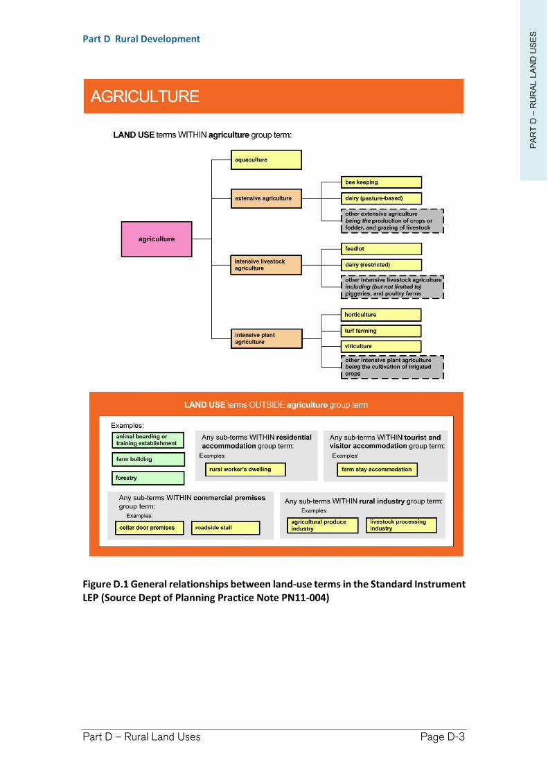
PA
RT
D –
RU
RA
L L
AN
D U
SE
S
Part D Rural Development
Part D – Rural Land Uses Page D-3
Figure D.1 General relationships between land-use terms in the Standard Instrument LEP (Source Dept of Planning Practice Note PN11-004)
Richmond Valley Development Control Plan 2021
Part D-1
Roadside Stalls
Roadside Stalls can provide legitimate means of distributing locally produced goods to consumers within localities and to people who commute through rural areas. In addition, Roadside Stalls greatly minimise distribution energy costs as they negate the need to transport produce to a point of sale as they are sold close to property where it was grown or produced.
Roadside stalls and Roadside Vending
There is a very important distinction between ‘Roadside Stalls’ which are situated entirely within a private property, and ‘Roadside Traders’ or ‘Roadside Vendors’ which are situated and attended entirely within a public road.
This Chapter relates to the development consent requirements for ‘Roadside Stalls’.
‘Roadside Vendors’ do not require development consent as they are itinerant users and require Council approval under section 68 of the Local Government Act 1993. If works are required a section 138 approval may be required under the Roads Act 1993. These approvals are not covered by this DCP. A Roadside Trading Application Form may be sourced from Council and may require a lease agreement to be drawn up between Council and the applicant, payment of annual fees, and submission of certificates of currency for public liability insurance.
A combination of ‘Roadside Stall’ and ‘Roadside Trading’ may also be proposed where circumstantial limitations arise and the activity might require the use of both private land and a public road.
This DCP applies to all land within the Richmond Valley Local Government Area.
Date adopted by Council: 22/06/2021
Effective Date: 01/08/2021
Amendments: Nil
PA
RT
D-1
-R
OA
DS
IDE
ST
ALLS
Part D Rural Development
Part D-1 – Roadside Stalls Page D-6
D-1.1 General Objectives
The general objectives of this Chapter are to:
(1) provide for the sale of local grown and/or manufactured produce in appropriate rural locations on private land throughout the Local Government Area, as subject to development consent.
(2) promote locally grown production of food.
(3) encourage smaller scale agricultural pursuits which are more manageable for the rural landowner and more likely to be profitable and rewarding due to reduced production overheads.
(4) provide adequate design considerations to avoid unacceptable adverse impact upon amenity of the surrounding locality (Noise, traffic etc) and any endangerment to local road users.
D-1.2 Planning Requirements
Objectives
(1) to summarise LEP provisions relating to Roadside Stalls.
Controls
(1) The dictionary to the Richmond Valley Local Environmental Plan 2012 defines-
Roadside stalls as means a place or temporary structure used for the retail sale of agricultural produce or hand crafted goods (or both) produced from the property on which the stall is situated or from an adjacent property.
Note. See clause 5.4 for controls relating to the gross floor area of roadside stalls.
Roadside stalls are a type of retail premises—see the definition of that term in this Dictionary.
(2) Land use Permissibility
Roadside stalls are permissible with development consent in the following Land Zones under the LEP:
RU1 Primary Production
R5 Large Lot Residential
E3 Environmental Management
B2 Local Centre
B3 Commercial Core
(3) Additional LEP Controls
(a) Clause 5.4(8) of the LEP applies additional controls for Roadside Stalls restricting such developments to an area no more than 10m2. This provides an opportunity to establish a small stall of approximately 2x5 metres.
(b) Council considers the 10m2 only applies to the stall’s display area and allowance will be made for additional awnings to be attached to the stall for weather protection.
PA
RT
D-1
-R
OA
DS
IDE
ST
ALLS
Part D Rural Development
Part D-1 – Roadside Stalls Page D-7
D-1.3 Development Application Requirements
Objectives
(1) to describe the information that should be included in a Statement of Environmental Effects, including site selection criteria, to support a development application for a Roadside Stall.
(2) outline assessment criteria and procedures for development applications to operate roadside stalls.
(3) identify conditions of consent that should ensure the roadside stall can be operated in a safe manner.
Controls
(1) Retailing is prohibited in rural zones, however, special considerations are in place to permit Roadside stalls with development consent.
(2) Consent may be granted for roadside stalls within Zones RU1, R5 or E3 where it can be demonstrated that it will not adversely impact upon the amenity, access and safety of the local area and commuters.
(3) Development application for a Roadside Stall
Development application for a Roadside Stall should include the following:
Show accurately on a plan where components of the stall are to be sited. Include a scale and location of all residences on adjoining land that are within 250 metres of the proposed stall.
The reason for the establishment of the Roadside Stall.
A description of produce intended for sale at the Roadside Stall.
Show clearly where access to the property is proposed detailing adequate manoeuvring area(s) to ensure visiting vehicles enter and exit the property in a forward motion. Car parking wholly within the property for a minimum of three vehicles should also be provided.
Entrance/exit-way(s) to the local road network must be constructed to Council specification and provide suitable line-of-sight distance for exiting vehicles. As a guide, around 150 metres is required to safely de-accelerate and pull off the road in a 100 km/h speed zone. In all instances, Council reserves the right to determine whether the placement and access to a stall is suitable and safe. All works required to be undertaken must be financed by the owner of the property or proponent of the Roadside Stall, including any works proposed on the road reserve verge.
The physical construction and display area of the Roadside Stall shall have a gross floor area not exceeding 10m2 (in accordance with clause 5.4(8) of the LEP) and a height not exceeding 2.4 metres.
The Statement of Environmental Effects (SEE) accompanying the application is required to designate hours of operation for the Roadside Stall as well as any operational detail which will constitute a Management Plan for the stall operation. In addition, the management plan shall detail
PA
RT
D-1
-R
OA
DS
IDE
ST
ALLS
Part D Rural Development
Part D-1 – Roadside Stalls Page D-8
the source and nature of produce on sale, with reference to the permissible produce list provided below.
If the proposal will require the construction of a stall, design specifications shall be provided to demonstrate structural stability to the satisfaction of Council. Roadside Stalls are required to be small-scale semi permanent structures which may easily be dismantled if abandoned or removed upon expiry of the consent period.
Display or storage of food items must be a minimum of 700 mm above the floor or ground level and must preclude dust, vermin, pests and animals to the satisfaction of Council.
(4) Site Suitability
The suitability of the site for the purpose of accommodating a Roadside Stall will be assessed during the application process. Particular attention should be paid, but will not necessarily be limited to, satisfactorily addressing the following requirements:
Line-of-sight distance – turnout(s) from the stall must provide adequate vision for drivers of vehicles exiting the property,
Car-parking must be provided wholly within the property for a minimum of three (3) vehicles,
Maintaining road safety is paramount and signage can distract and be extremely hazardous to drivers. Therefore, temporary signage for the stall will not be permitted to be erected by the proponent within or along the road. All other signage will be determined on merit, however, Council may deem it to be in the interest of safety that only signs warning the approach of a stall are appropriate.
Additional works may be required to be undertaken within the Council road reserve to ensure the safety of all road users and may be required solely at the discretion of Council. Works within the road reserve will require additional approval in accordance with section 138 of the Roads Act 1993.
(5) Each development application will be considered and decided on its individual merits and is subject to all other requirements with other State & Council policies and those found elsewhere within this DCP. Depending on the nature of produce for retail, there may be additional health requirements concerning food preparation, handling and labelling of produce.
(6) Concurrence of State roads authority may be required
Roadside Stalls fronting a Classified Road and that will involve direct vehicular access to, or within 90 metres of, that Classified Road, will require concurrence from the State roads authority. It is recommended that discussions are held with Council and the State roads authority early in the planning process.
PA
RT
D-1
-R
OA
DS
IDE
ST
ALLS
Part D Rural Development
Part D-1 – Roadside Stalls Page D-9
(7) Conditions, Management Plan & Operation of the Roadside Stall
(a) Limited Consent
Any approval granted will be restricted to an operating period of 5 years after which this period may be extended upon application for a further period of 5 years as an amendment to the original consent. The granting of a limited consent facilitates the possible need for Council to review any changes or impacts the stall might have made on local traffic, and have regard to any possible road redesigns. A review also allows for a review of the management plan and operational compliance of the Roadside Stall.
Extension of the consent period will require lodgement of a section 96 Application to Vary a Development Consent.
(b) Standard Conditions
The following conditions of consent (or similar wording) shall be applied to any consent granted for a roadside stall:
Only offer for sale at the stall:
Fruit, vegetables and other produce grown or made on the property or from adjoining properties.
Cut fruit and vegetables grown on the property and manufactured food items, will be subject to health and hygiene requirements.
One simply worded sign (i.e. ‘Fruit Stall’), located at the entrance to the stall will be permitted as per ‘business identification signage’ (or otherwise as per merit consideration and condition of consent).
Entry/exit points to the development must be in accordance with Council requirements, with vehicle manoeuvring to enable vehicles to enter and exit the property in forward manner.
Any chemical treatment of food items shall be disclosed alongside the sale price of the item, including treatment during the growing of the fruit, nut or vegetable as well as any treatment following harvest. Any bottled preserves shall identify ingredients as per health requirements and perishables will require refrigeration.
Adherence to the hours of operation and management plan specified within the application and the accompanying Statement of Environmental Effects (SEE).
Richmond Valley Development Control Plan 2021
Part D-2
Kiosks (as General Stores)
Kiosks are a type of small scale retail premises selling food, light refreshments and convenience goods.
The Standard Instrument LEP no longer defines a land use term for ‘General Store’ therefore the term ‘Kiosk’ has been recommended by the Department of Planning as the substitute.
This DCP applies to all land within the Richmond Valley Local Government Area.
Date adopted by Council: 22/06/2021
Effective Date: 01/08/2021
Amendments: Nil
PA
RT
D-2
–K
IOS
KSPart D Rural Development
Part D-2 – Kiosks Page D-12
D-2.1 General Objectives
The general objectives of this Chapter are to:
(1) provide for small scale retail premises that can service the local community.
(2) ensure the premises are of a scale that is in keeping with the character of the locality.
D-2.2 Planning Requirements
Objectives
(1) to summarise LEP provisions relating to Kiosks in rural areas.
Controls
(1) The dictionary to the Richmond Valley Local Environmental Plan 2012 defines-
kiosk means premises that are used for the purposes of selling, food, light refreshments and other small convenience items such as newspapers, films and the like.
Note. See clause 5.4 for controls relating to the gross floor area of a kiosk.
Kiosks are a type of retail premises—see the definition of that term in the Dictionary to the LEP.
(2) Land use Permissibility
Kiosks are permissible with development consent in the following Land Zones under the LEP:
RU1 Primary Production
RU5 Village (as part of the group term Commercial Premises)
R1 General Residential (as part of the group term Commercial Premises)
B1 Neighbourhood Centre
B2 Local Centre
B3 Commercial Core
RE1 Public Recreation
RE2 Private Recreation
E3 Environmental Management
however, this Chapter only relates to Kiosks in Rural zones.
(3) Additional LEP Controls
(a) Clause 5.4(6) of the LEP applies additional controls for Kiosks restricting such developments to an area no more than 150 m2 of gross floor area.
PA
RT
D-2
–K
IOS
KSPart D Rural Development
Part D-2 – Kiosks Page D-13
D-2.3 Development Application Requirements
Objectives
(1) to describe the information that should be included in a Statement of Environmental Effects, including site selection criteria, to support a development application for a Kiosk.
(2) outline assessment criteria and procedures for development applications to operate Kiosk.
(3) identify conditions of consent that should ensure the Kiosk can be operated in a safe manner.
Controls
(1) Retailing and other commercial premises are prohibited in rural zones, , however, special considerations are in place to permit Kiosks with development consent.
(2) kiosks are permitted with development consent where it can be demonstrated that it will not adversely impact upon the amenity, access and safety of the local area.
(3) Development application for a Kiosk
An application for a kiosk should include the following information:
Show accurately on a plan where components of the Kiosk are to be sited. Include a scale and location of all residences on adjoining land that are within 250 metres of the proposed stall.
A description of the types of products and services intended to be sold or provided at the premises.
Show clearly where access to the property is proposed detailing adequate manoeuvring area(s) to ensure visiting vehicles enter and exit the property in a forward motion. Car parking wholly within the property with a minimum of 1 car parking space per 40 m2 of gross floor area.
Kiosks in rural areas should be operated in conjunction with a dwelling house on the same land.
Entrance/exit-way(s) to the local road network must be constructed to Council specification and provide suitable line-of-sight distance for exiting vehicles. As a guide, around 150 metres is required to safely de-accelerate and pull off the road in a 100km an hour speed zone. In all instances, Council reserves the right to determine whether the placement and access to a Kiosk is suitable and safe. All works required to be undertaken must be financed by the owner of the property or proponent of the kiosk, including any works proposed on the road reserve verge.
The physical construction and display area of the kiosk shall have a gross floor area not exceeding 150 m2 (in accordance with clause 5.4(6) of the LEP).
The Statement of Environmental Effects (SEE) accompanying the application is required to designate hours of operation for the kiosk.
PA
RT
D-2
–K
IOS
KSPart D Rural Development
Part D-2 – Kiosks Page D-14
If the proposal will require the construction of a stall, design specifications shall be provided to demonstrate structural stability to the satisfaction of Council. Roadside Stalls are required to be small-scale semi permanent structures which may easily be dismantled if abandoned or removed upon expiry of the consent period.
(4) Site Suitability
The suitability of the site for the purpose of accommodating a kiosk will be assessed during the application process. Particular attention should be paid, but will not necessarily be limited to, satisfactorily addressing the following requirements:
Line-of-sight distance – turnout(s) from the kiosk must provide adequate vision for drivers of vehicles exiting the property.
Car-parking must be provided wholly within the property.
Maintaining road safety is paramount and signage can distract and be extremely hazardous to drivers. Signage for the premises will not be permitted to be erected by the proponent within or along the road reserve. All other signage will be determined on merit, however, Council may deem it to be in the interest of safety that only signs warning the approach of a Kiosk are appropriate.
Additional works may be required to be undertaken within the Council road reserve to ensure the safety of all road users and may be required solely at the discretion of Council. Works within the road reserve will require additional approval in accordance with section 138 of the Roads Act 1993.
(5) Each development application will be considered and decided on its individual merits and is subject to all other requirements with other State & Council policies and those found elsewhere within this DCP. Depending on the nature of produce for retail, there may be additional health requirements concerning food preparation, handling and labelling of produce.
(6) Concurrence of State roads authority may be required
Kiosks fronting a Classified Road and that will involve direct vehicular access to, or within 90 metres of, that Classified Road, will require concurrence from the State Roads authority. It is recommended that discussions are held with Council and the State Roads authority early in the planning process.
Richmond Valley Development Control Plan 2021
Part D-3
Intensive Livestock Agriculture
Intensive Livestock Agriculture is permissible in areas designated by the following zones:
RU1 Primary Production
IN1 General Industry
Such development is prohibited in all other zones.
By definition, Intensive Livestock Agriculture is for the keeping or breeding of livestock, for commercial purposes, where they are wholly or substantially fed by a supplementary feed source. However, it explicitly excludes extensive agriculture (primarily pasture based grazing of livestock) and aquaculture (see SEPP62 – Sustainable Aquaculture for details).
This DCP applies to all land within the Richmond Valley Local Government Area.
Date adopted by Council: 22/06/2021
Effective Date: 01/08/2021
Amendments: Nil
PA
RT
D-3
–IN
TE
NS
IVE
LIV
ES
TO
CK
AG
RIC
ULA
TU
REPart D Rural Development
Part D-3 – Intensive Livestock Agriculture Page D-16
D-3.1 General Objectives
The general objectives of this Chapter are to:
(1) define what is considered to be Intensive Livestock Agriculture for the purposes of the Richmond Valley LEP 2012.
(2) determining the maximum number of animals that may be kept before an establishment is considered to be commercial in nature and therefore Intensive Livestock Agriculture.
(3) guide what information will be required to support an application for Intensive Livestock Agriculture.
(4) provide controls to protect rural amenity.
(5) provide adequate design considerations to avoid unacceptable adverse impacts to a locality.
D-3.2 What is Intensive Livestock Agriculture?
Objectives
(1) define Intensive Livestock Agriculture in the context of the Richmond Valley LEP 2012.
(2) establish what is considered to be Intensive.
Controls
(1) The Richmond Valley LEP 2012 is a Standard Instrument LEP. The dictionary to the Standard Instrument LEP defines:
Intensive Livestock Agriculture means the keeping or breeding, for commercial purposes, of cattle, poultry, pigs, goats, horses or other livestock that are fed wholly or substantially on externally-sourced fee, and includes any of the following:
(a) dairies (restricted),
(b) feedlots,
(c) piggeries,
(d) poultry farms,
but does not include extensive agriculture, aquaculture or the operation of facilities for drought or similar emergency relief.
Note. Intensive livestock agriculture is a type of agriculture—see the definition of that term in the Dictionary to the LEP.
(2) Intensive Livestock Agriculture is prohibited in all zones except:
RU1 Primary Production
IN1 General Industry
(3) Development consent is required to operate an Intensive Livestock Agriculture.
PA
RT
D-3
–IN
TE
NS
IVE
LIV
ES
TO
CK
AG
RIC
ULA
TU
REPart D Rural Development
Part D-3 – Intensive Livestock Agriculture Page D-17
(4) What does intensive mean?
For the purposes of this Chapter, intensive is where the population density of livestock kept on the land, or within premises, will exceed the general carrying capacity of the land, and necessitates supplementary feeding. This supplementary feed may be sourced from elsewhere on the property, or from external sources.
D-3.3 Development Application requirements
Objectives
(1) to assist with the presentation of information to accompany a development application.
Controls
(1) The keeping of agricultural livestock at concentrated populations will warrant the lodgement of a development application.
(2) Council may consider on merit whether a population is considered too small to be commercial. Notwithstanding, the following guide is provided:
yards or buildings that can accommodate more than ten (10) cattle, and where the animals have access to pasture based grazing for less than 10 hours in a 24 hour period,
piggery (including free range) containing more than five (5) breeding sows,
poultry farm (including free range) containing more than twenty (20) birds,
rabbit farm consisting of over twenty rabbits (20).
(3) Areas where Intensive Livestock Agriculture is unlikely to be supported-
Proximity to established residential, rural residential developments and to future residential or rural residential developments as delineated within Urban or Rural Land Use Strategies prepared for Richmond Valley.
Proximity to either approved, established and operating forms of intensive livestock agriculture or animal boarding and training establishments.
In addition, Council cannot support the establishment of Intensive Animal Establishments where cumulative developments may present an increased amenity risk. The establishment of intensive livestock agriculture adjoining or close to sites will be considered and ultimately determined on a merit basis with the onus strongly on the applicant to demonstrate through detailed analysis why additional establishments will not be a risk.
Intensive Poultry sheds will not be supported where they are:
(i) within 1.5 kilometres from any existing poultry establishment, or
(ii) within 500 metres of areas identified within Land Release Strategies, or
(iii) if the road access is unsealed.
PA
RT
D-3
–IN
TE
NS
IVE
LIV
ES
TO
CK
AG
RIC
ULA
TU
REPart D Rural Development
Part D-3 – Intensive Livestock Agriculture Page D-18
(4) Development Application Requirements
A Development Application for an Intensive Animal Establishment must include but not necessarily be limited to the following detail within a comprehensive Statement of Environmental Effects:
(a) Odour - Odour Modelling Report prepared by a suitably qualified person which outlines the extent of impacts of any odours both from the proposed land use and any cumulative impacts due to any existing land uses which may already emit offensive odours. Such report is to be prepared with regard for likely climatic and prevailing conditions. The Odour Report is also to submit operational procedures to further mitigation any impacts and to identify the extent of reduction based upon these practices.
(b) Noise - A Noise Impact Report prepared by a suitably qualified person which outlines the extent of impacts of noise from the proposed use including the full extent and activities to be operating on site and also the activities associated with the proposal including the type and numbers of traffic which will be generated by the land use. The Report is also to make recommendations for the mitigation of any noise impacts and is to identify the extent of noise reduction as a result of these measures being implemented. Section I-7 – Noise Impact Assessment (NIA) provides additional detail as to what is required for the preparation of a detailed application involving NIA.
(c) Traffic and Road Haulage - A Traffic Report is required to be submitted and must be prepared by a suitably qualified person, detailing, but not necessarily limited to:
the types and numbers of traffic to be generated by the proposal;
details of the existing condition, widths, depths of pavement and its suitability or otherwise for the carriage of transport to be associated with the land use;
proposed upgrading to be undertaken by the applicant including location(s) of width or depth of pavement, sealing of pavement and extension of stormwater pipes or culverts along the route(s).
Detailed plans showing where access to the property is proposed and adequate manoeuvring area(s) are provided to ensure visiting vehicles enter and exit the property in a forward motion. Car parking is to be provided wholly within the property for a minimum of three vehicles, however more may be required based upon detail supplied as to staffing numbers and operational procedures.
(d) Access - Entrance/exit-way(s) to the local road network must be constructed to Council specification and provide suitable line-of-sight distance for exiting vehicles. As a guide, around 150 metres is required to safely de-accelerate and pull off the road in a 100km an hour speed zone. In all instances, Council reserves the right to determine whether the placement and access is suitable and safe. All works required to be
PA
RT
D-3
–IN
TE
NS
IVE
LIV
ES
TO
CK
AG
RIC
ULA
TU
REPart D Rural Development
Part D-3 – Intensive Livestock Agriculture Page D-19
undertaken must be financed by the owner of the property or proponent of the development, including any works proposed on the road reserve verge.
(e) Statement of Environmental Effects - The Statement of Environmental Effects (SEE) accompanying the application is required to describe in detail all aspects of the operation of the establishment which may then be transcribed into a Management Plan for the land use.
(f) Environmental Management Plan - An Environmental Management Plan shall be prepared for the operation of the animal establishment detailing, but not necessarily limited to the following matters:
Treatment and disposal of litter and effluent;
Odour Management;
Noise Management;
Biosecurity measures for the control and quarantine of exotic, endemic or emergency diseases;
Disposal of dead animals;
Food Storage and Vermin control;
Erosion control measures;
Water and Drainage management;
Chemicals and Fuel storage;
Complaints register;
Guidelines for the Operation, e.g. NSW Meat Chicken Farming Guidelines (NSW);
Water storage and harvesting methods; and
Dust and air-borne particulate matter management.
(g) On-Site Sewage Management - The preparation and review of On- Site Sewage Effluent Disposal for these forms of land use is to be undertaken in accordance with Council's On-Site Sewage and Wastewater Strategy and associated guidelines. Further effluent treatment methods and devices may be required for solids disposal and it is recommended pre-lodgement discussions be held with Council to confirm the treatment level and technique.
(h) Land Use Conflict Risk Assessment (LUCRA) - A LUCRA component to provide a site specific conflict risk assessment relevant to the location and sensitivity of adjacent, adjoining and nearby landuses to ultimately determine the feasibility of the establishment in the location proposed and any required management response to potential conflicts. Section I-11 addresses the requirements of a LUCRA in detail and should be referenced comprehensively for this component of the application.
(5) Public Exhibition and Consultation
The Public Exhibition and any required consultation shall be conducted in accordance with the Richmond Valley Council Community Participation Plan 2020 and generally requires a minimum 14 day exhibition period.
PA
RT
D-3
–IN
TE
NS
IVE
LIV
ES
TO
CK
AG
RIC
ULA
TU
REPart D Rural Development
Part D-3 – Intensive Livestock Agriculture Page D-20
(6) Site Suitability
The suitability of the site for the purpose of accommodating an Animal Establishment will be assessed during the application process. Particular attention should be made, but not limited to, the following site suitability specifications so as to minimise poor site choices and wasted resources.
(a) Large and isolated rural allotment so as to provide ample distance between sensitive receivers in respect to noise, odour and biohazard ‘buffer’ requirements.
(b) Adequate access so as to provide ample entry turnout and line-of-sight distance relevant to the intended vehicular type and numbers proposed for the use of the property. The local road network from the larger arterial roads must be of a suitable width, grade and condition to be able to adequately support the intended establishment. The proponent may be required to upgrade the road (and any associated works) to a condition suitable and/or pay contributions for use of the local road network based upon the assessment of Council.
(c) Relatively Flood and Bushfire Free.
(d) Relatively free of other Environmental Constraints – in particular those indicated within a Natural Resource Sensitivity map and associated provisions (see Section H-3 – Natural Resource Sensitivity for further detail and requirements).
Richmond Valley Development Control Plan 2021
Part E Visitor Accommodation, Caravan Parks and Manufactured Home Estates
This Part primarily contains standards, requirements and considerations for development relating to tourism, short-stay or temporary accommodation within the Richmond Valley Council area. However, it also incorporates additional land uses for caravan parks, camping grounds and manufactured home estates which may also provide for permanent accommodation.
Each of the Chapters listed below relates to development principles and standards specific for that land use type:
Chapter Page No. in this Part
Part E-2 Bed and Breakfast Accommodation ........... 4 Part E-3 Serviced Apartments ............................... 15Part E-4 Hotel and Motel Accommodation ............ 31Part E-5 Backpacker’s Accommodation ................. 39Part F-6 Farm Stay Accommodation ...................... 49Part E-7 Manufactured Home Estates, Caravan Parks
and Camping Grounds ............................ 55
This Part primarily covers the land use terms that together form the ‘Group-term’ Tourist and visitor accommodation, but it also includes other types of land uses involving short-stay accommodation such as Eco-tourist Facilities, Manufactured Home Estates, Caravan Parks, and Camping Grounds. This Part has been divided into Chapters with each chapter specifying different development standards and considerations. Each Chapter in turn contains major headings for introduction, objectives, development principles and development standards.
This DCP applies to all land within the Richmond Valley Local Government Area.
Date adopted by Council: 22/06/2021
Effective Date: 01/08/2021
Amendments: Nil
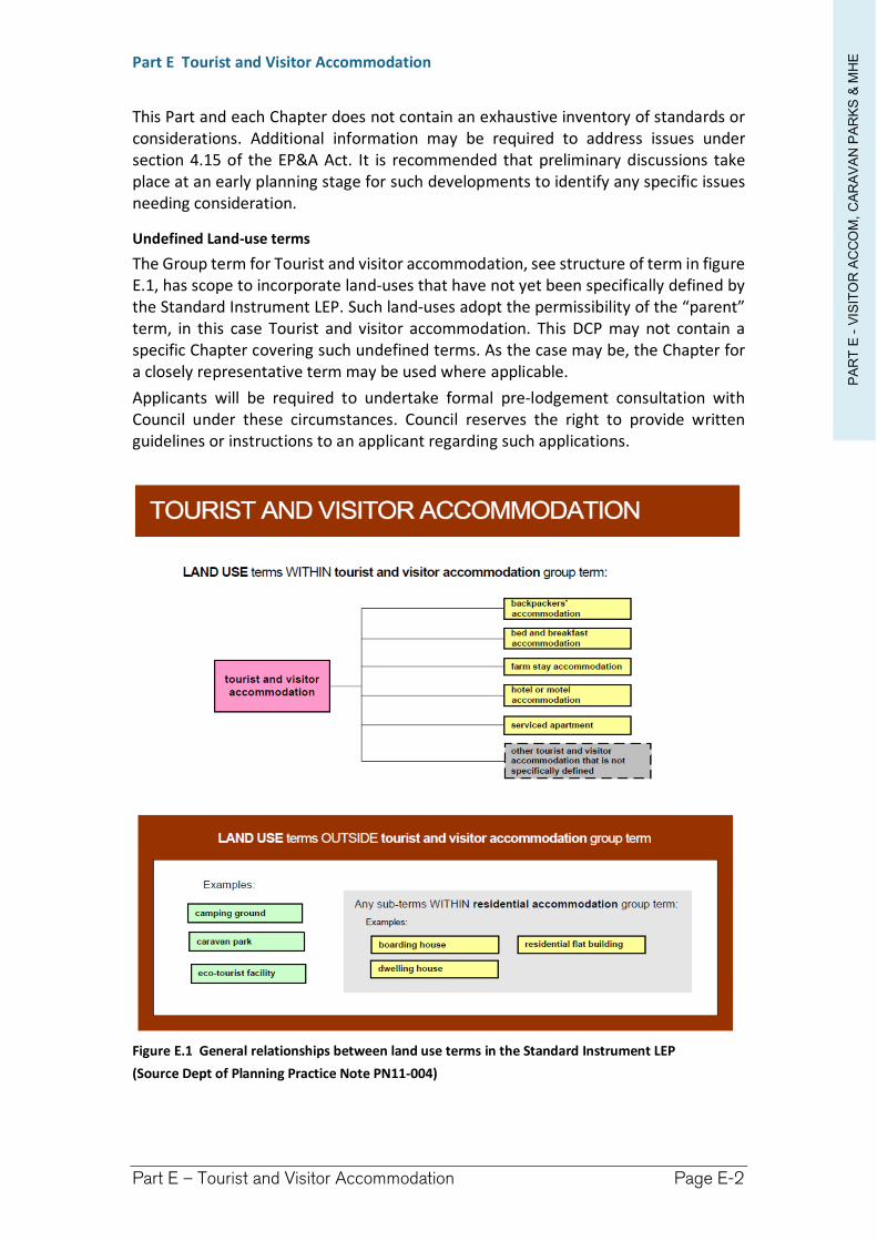
PA
RT
E -
VIS
ITO
R A
CC
OM
, C
AR
AV
AN
PA
RK
S &
MH
EPart E Tourist and Visitor Accommodation
Part E – Tourist and Visitor Accommodation Page E-2
This Part and each Chapter does not contain an exhaustive inventory of standards or considerations. Additional information may be required to address issues under section 4.15 of the EP&A Act. It is recommended that preliminary discussions take place at an early planning stage for such developments to identify any specific issues needing consideration.
Undefined Land-use terms
The Group term for Tourist and visitor accommodation, see structure of term in figure E.1, has scope to incorporate land-uses that have not yet been specifically defined by the Standard Instrument LEP. Such land-uses adopt the permissibility of the “parent” term, in this case Tourist and visitor accommodation. This DCP may not contain a specific Chapter covering such undefined terms. As the case may be, the Chapter for a closely representative term may be used where applicable.
Applicants will be required to undertake formal pre-lodgement consultation with Council under these circumstances. Council reserves the right to provide written guidelines or instructions to an applicant regarding such applications.
Figure E.1 General relationships between land use terms in the Standard Instrument LEP
(Source Dept of Planning Practice Note PN11-004)
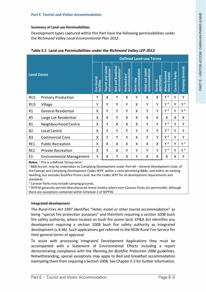
PA
RT
E -
VIS
ITO
R A
CC
OM
, C
AR
AV
AN
PA
RK
S &
MH
EPart E Tourist and Visitor Accommodation
Part E – Tourist and Visitor Accommodation Page E-3
Summary of Land use Permissibilities
Development types captured within this Part have the following permissibilities under the Richmond Valley Local Environmental Plan 2012.
Table E.1 Land use Permissibilities under the Richmond Valley LEP 2012
Land Zones
Defined Land-use Terms
Eco
-to
uri
st
faci
litie
s
Tou
rist
an
d v
isit
or
acco
mm
od
atio
n 1
Be
d a
nd
bre
akf
ast
ac
com
mo
dat
ion
2
Bac
kpa
cker
s’
acco
mm
od
atio
n
Farm
sta
y ac
com
mo
dat
ion
Ho
tel a
nd
mo
tel
acco
mm
od
atio
n
Serv
iced
ap
art
men
ts
Man
ufa
ctu
red
H
om
e E
stat
es
Ca
rava
n P
arks
Ca
mp
ing
Gro
un
ds
RU1 Primary Production Y X Y X Y X X Y 4 Y Y
RU5 Village Y Y Y Y X Y Y Y 4 Y Y 3
R1 General Residential X Y Y Y X Y Y Y 4 Y Y 3
R5 Large Lot Residential X X Y X X X X X X X
B1 Neighbourhood Centre X Y X X X Y Y Y 4 Y Y
B2 Local Centre X Y Y Y Y Y Y Y 4 Y Y
B3 Commercial Core X Y Y Y X Y Y Y 4 Y Y
RE1 Public Recreation X X X X X X X Y 4 Y Y 3
RE2 Private Recreation X Y X Y Y Y Y Y 4 Y Y 3
E3 Environmental Management Y X Y X Y X X X X Y
Notes. 1 This is a defined ‘Group-term’. 2 B&B Accom. may be undertaken as Complying Development under Part 4A – General Development Code, of the Exempt and Complying Development Codes SEPP, within a zone permitting B&Bs, and within an existing dwelling, but excludes Bushfire Prone Land. See the Codes SEPP for all development requirements and standards. 3 Caravan Parks may include camping grounds. 4 SEPP36 generally permits Manufactured Home Estates where ever Caravan Parks are permissible, although there are exceptions contained within Schedule 2 of SEPP36.
Integrated development
The Rural Fires Act 1997 identifies “Hotel, motel or other tourist accommodation” as being “special fire protection purposes” and therefore requiring a section 100B bush fire safety authority, where located on bush fire prone land. EP&A Act identifies any development requiring a section 100B bush fire safety authority as integrated development (s.4.46). Such applications get referred to the NSW Rural Fire Service for their general terms of approval.
To assist with processing Integrated Development Applications they must be accompanied with a Statement of Environmental Effects including a report demonstrating compliance with the Planning for Bushfire Protection 2006 guidelines. Notwithstanding, special exceptions may apply to Bed and breakfast accommodation exempting them from requiring a Section 100B. See Chapter E-2 for further information.
Richmond Valley Development Control Plan 2021
Part E-1 Eco-tourist facilities
Eco-tourist facilities are defined within the Richmond Valley LEP 2012 (the LEP) and relate to the establishment of short-term accommodation that has been sensitively designed to enhance and manage environmental or cultural values of the land. They should not be confused with the generic term “Eco-tourism” which relates holistically to nature based tourism, including accommodation.
The LEP defines Eco-tourist facilities as a stand alone term, outside the Group-term for Tourist and visitor accommodation. This has be done so that such development can be permitted within more sensitive environments.
Clause 5.13 Eco-tourist facilities within the LEP, along with the definition of Eco-tourist facilities, provide that such development be designed and located so as to minimise bulk, scale, overall physical footprint, as well as any ecological and visual impact.
This Chapter provides an explanation of the LEP provisions and establishes development assessment considerations as well as design standards.
The Department of Planning’s guideline Tourism Development Near Natural Areas (1989) has been consulted in the preparation of this Chapter.
This DCP applies to all land within the Richmond Valley Local Government Area.
Date adopted by Council: 22/06/2021
Effective Date: 01/08/2021
Amendments: Nil
PA
RT
E-1
-E
CO
-TO
UR
IST
FA
CIL
ITIE
S
Part E Tourist and Visitor Accommodation
Part E-1 – Eco-tourist Facilities Page E-6
E-1.1 General Objectives
The general objectives of this Chapter are to:
(1) compliment the objectives for eco-tourist facilities as provided by the LEP
(2) promote developments that enhance rather than erode the values of adjacent natural areas
(3) assist potential developers and landowners in developing appropriate eco-tourist facility projects, taking into account location, scale, site, design, operations and feasibility, and
(4) provide guidelines for assessing applications.
E-1.2 Permissibility
(1) Richmond Valley Local Environmental Plan 2012
(a) Definitions and LEP Provisions
Eco-tourist facilities are defined within the Dictionary attached to the LEP. Critical to the definition is the accommodation must be temporary or short stay, that it be located on or adjacent to an area of special ecological or cultural features, and that it be sensitively designed for the environment hosting the development. Further development considerations are contained within clause 5.13 Eco-tourist facilities under the LEP.
The LEP definition and clause 5.13 are reproduced below.
Extract from Richmond Valley Local Environmental Plan 2012
Definition of Eco-tourist Facility
Eco-tourist facility means a building or place that: (a) provides temporary or short-term accommodation to visitors on a commercial basis, and (b) is located in or adjacent to an area with special ecological or cultural features, and (c) is sensitively designed and located so as to minimise bulk, scale, and overall physical footprint and
any ecological or visual impact. It may include facilities that are used to provide information or education to visitors and to exhibit or display items.
Note. See clause 5.13 for requirements in relation to the granting of development consent for eco-tourist facilities.
Eco-tourist facilities are not a type of tourist and visitor accommodation—see the definition of that term in this dictionary.
Clause 5.13 Eco-tourist facilities
(1) The objectives of this clause are as follows: (a) to maintain the environmental and cultural values of land on which development for the purposes
of eco-tourist facilities is carried out, (b) to provide for sensitively designed and managed eco-tourist facilities that have minimal impact on
the environment both on and off-site. (2) This clause applies if development for the purposes of an eco-tourist facility is permitted with development
consent under this Plan. (3) The consent authority must not grant consent under this Plan to carry out development for the purposes of
an eco-tourist facility unless the consent authority is satisfied that: (a) there is a demonstrated connection between the development and the ecological, environmental
and cultural values of the site or area, and (b) the development will be located, constructed, managed and maintained so as to minimise any
impact on, and to conserve, the natural environment, and
PA
RT
E-1
-E
CO
-TO
UR
IST
FA
CIL
ITIE
S
Part E Tourist and Visitor Accommodation
Part E-1 – Eco-tourist Facilities Page E-7
(c) the development will enhance an appreciation of the environmental and cultural values of the site or area, and
(d) the development will promote positive environmental outcomes and any impact on watercourses, soil quality, heritage and indigenous flora and fauna will be minimal, and
(e) the site will be maintained (or regenerated where necessary) to ensure the continued protection of natural resources and enhancement of the natural environment, and
(f) waste generation during construction and operation will be avoided and that any waste will be appropriately removed, and
(g) the development will be located to avoid visibility above ridgelines and against escarpments and from watercourses and that any visual intrusion will be minimised through the choice of design, colours materials and landscaping with local indigenous flora, and
(h) any infrastructure services to the site will be provided without significant modification to the environment, and
(i) any power and water to the site will, where possible, be provided through the use of passive heating and cooling, renewable energy sources and water efficient design, and
(j) the development will not adversely affect the agricultural productivity of adjoining land, and (k) the following matters are addressed or provided for in a management strategy for minimising any
impact on the natural environment: (i) measures to remove any threat of serious or irreversible environmental damage, (ii) the maintenance (or regeneration where necessary) of habitats, (iii) efficient and minimal energy and water use and waste output, (iv) mechanisms for monitoring and reviewing the effect of the development on the natural
environment, (v) maintaining improvements on an on-going basis in accordance with relevant ISO 14000
standards relating to management and quality control.
(b) Land use Permissibilities
Eco-tourist facilities are permissible with development consent in the following Land Zones under the LEP:
RU1 Primary Production
RU5 Village
E3 Environmental Management.
E-1.3 Issues for Eco-tourist facilities
(1) Conservation Issues
Conservation issues essentially relate to maintenance of environmental and cultural resources within the site and their protection for the long term. They include:
maintenance of visual character and scenic values.
maintenance of natural systems for their physical values and for the protection of ecology and biodiversity including rare and endangered species.
maintenance of natural areas not reserved in the Parks system including SEPP14 Coastal Wetlands, and other “E” type environmental Land Zonings.
protection of elements of particular ecological, scientific or visual significance.
maintenance of recreation settings ranging from a wilderness area to a higher level of development facilities.
PA
RT
E-1
-E
CO
-TO
UR
IST
FA
CIL
ITIE
S
Part E Tourist and Visitor Accommodation
Part E-1 – Eco-tourist Facilities Page E-8
the provision of information, education and interpretation facilities to increase public awareness of the environmental values of the area.
maintenance of cultural heritage values, both Aboriginal and Non-Aboriginal.
(2) Development Issues
These issues relate to the encouragement of appropriate forms of development and balancing the levels of facilities, the intensity of development, and the nature of recreation use with the natural and cultural values of the site. It is important that such development:
respect the natural character of the site and its surrounds.
not detract from the natural and cultural values and include appropriate management to safeguard these values.
provide a return to investors.
result in direct and indirect economic benefits to the community.
(3) Planning Issues
The essential planning issues are centred on achieving environmentally sensitive development. The key concept underlying these issues is that of “environmentally sustainable development” which should provide benefits but not decrease the natural values or options available to future generations. They include:
recognition of the characteristics of acceptable and unacceptable development.
provide guidelines to assist in preparing appropriate development proposals that are likely to be supported by the consent authority.
establish development parameters to encourage the concept of sustainability for adjacent natural and cultural areas, and sustainable use of natural resources.
E-1.4 Design standards/controls
(1) Location
The definition of Eco-tourist facilities has a strong emphasis on being located within or adjacent to areas with special ecological or cultural features. These features need to be described with reference to the sites physical, ecological and cultural values and how they will be enhanced by the proposal.
Development applications for Eco-tourist facilities within Zone RU5 Village must be accompanied by a Social Impact Assessment.
Critical to this Social Impact Assessment will be an evaluation of potential impacts upon adjacent residential properties and the amenity of the neighbourhood.
(2) Environmental
Site restoration works should be incorporated into the development so as to enhance the sites special ecological or cultural features.
PA
RT
E-1
-E
CO
-TO
UR
IST
FA
CIL
ITIE
S
Part E Tourist and Visitor Accommodation
Part E-1 – Eco-tourist Facilities Page E-9
Buffering the Eco-tourist facilities to special ecological or cultural features will reduce potential impacts. For example, buildings should be sited within existing clearings.
Minimise ecological impacts by:
reducing the scale of proposals.
incorporating the proposal into the environment.
clustering the development to reduce the need for multiple asset protection zones.
being serviced by a centralised On-site Sewage Management System.
Reducing the extent of internal access roads.
Have regard to the Coastal SEPP and the NSW Coastal Policy in the design and siting of a development.
Avoid prime agricultural land (State or Regionally significant farmland).
(3) Hours of Operation – Neighbour Friendly
Facilities such as swimming pool operation and use to be restricted where there is potential to impact upon neighbours.
Management will be responsible for inappropriate behaviour of guests in public places surrounding the establishment.
(4) Access
Most visitors to the Area will be travelling by private car. Therefore, the land must be serviced by a road of appropriate standard or upgraded (as a condition of consent) to such a standard. Furthermore, internal access must be appropriate so as to facilitate arrival but also safe evacuation in emergencies. Where a road or internal access is to be upgraded or provided new, the impact of construction and operation must be considered.
Site access onto a public road must be safe for guests as well as the travelling public. Consideration will be given to speed limits along the road, the design speed for the road, available sight distances along the road, design of the intersection, the volume of traffic to be generated.
As a general rule vehicular access to the Pacific Highway/Motorway is prohibited.
Direct vehicular access to other Classified roads is undesirable, however may be permitted where the Roads and Maritime Services agree to access arrangements.
Entry and exit to the property must be in a forward direction.
(5) Hazards
Landform and stability
Preference will be given to a stable landform where risk of erosion, subsidence, and landslip are minimised.
Siting of developments on slopes having a grade greater than 1 in 4 should be avoided.

PA
RT
E-1
-E
CO
-TO
UR
IST
FA
CIL
ITIE
S
Part E Tourist and Visitor Accommodation
Part E-1 – Eco-tourist Facilities Page E-10
Bushfire prone land
Where located on Bushfire Prone Land (see Council’s Bushfire Prone Land maps) the proposal will be Integrated Development.
The proposal must be assessed against the Planning for Bushfire Protection guidelines (2006) either complying with the deemed to satisfy provisions or supplying an alternative solution.
Vegetation removal for asset protection needs to be balanced with retention of natural and cultural features of the site. In this regard preference will be given to a concentrated rather than dispersed layout. Council may permit habitat loss where there will be a positive biodiversity off-set established within the development site and where appropriate consents under the Native Vegetation Act can be achieved. Such consents should be investigated prior to lodging the development application.
Flood
See Chapter H-1 Flooding.
Habitable floors are to be located above the flood planning level, defined as a level 500mm above the 1 in 100 year ARI flood event for the site.
Development will not be permitted within an identified high flood hazard area.
Climate Change
Development must incorporate adaptive design for climate change.
Development should be located beyond the 100 year predicted coastal erosion zone. Where such modelling is unavailable for coastal sites it must be provided with the Development Application to justify the development layout.
Buffers should be naturally enhanced to protect the development from coastal hazards, eg. Dune restoration and rehabilitation.
An Adaptation Plan must be developed where the development site is adjacent to coastal hazards. Buffering development from such hazards must be the primary focus. Subsequent enhancement of natural protective measures will be encouraged. Engineered solutions to protect development from hazards are considered inconsistent with the principles of Eco-tourism facilities. Planned retreat is considered the ultimate solution to protect development. Therefore, structures should be designed to be readily relocated away from the hazard front. If planned retreat is not an option then abandoning the development (demolition) may be required.
Emergency management plan
For proposals located within hazard areas, an Emergency Management Plan should be prepared and include emergency evacuation procedures for guests.
PA
RT
E-1
-E
CO
-TO
UR
IST
FA
CIL
ITIE
S
Part E Tourist and Visitor Accommodation
Part E-1 – Eco-tourist Facilities Page E-11
Natural Resources
It is more than likely that Eco-tourist facilities will be located within one or more of the mapped Natural Resources identified within the LEP. These include biodiversity (native vegetation, habitat corridors), wetlands, riparian and waterways (key fish habitat), and landslip risk (steep slopes).
Clauses 6.6, 6.7, 6.8 & 6.10 of the LEP require the assessment of the various Natural Resources as a head of consideration for development applications. See Chapter H-3 Natural Resources (NRS) for further details.
(6) Design
Have regard to appropriate design guidelines, eg Chapter A of this DCP contains design guidelines for residential accommodation, Coastal Development Guidelines, Eco-tourism guidelines.
Design, Scale and Density
Scale of the development should be in perspective to the site and its special features.
Emphasis should be given to providing a low-tech environmental experience for guests.
Minimum land area for Eco-tourist facilities, in Zone RU1, RE1, RE2 or E3, shall be 10ha.
Density
o Zone R1 and RU5—1 unit/cabin per 200m2 of land area
o RU1, RE1 & RE —1 unit/cabin per 1 ha of land area
o E3—1 unit/cabin per 2 ha of land area
o Density for dormitory style accommodation will be a calculated at 1 unit/cabin = 4 persons accommodated.
Units/cabins will be restricted to a maximum of 2 bedrooms and a capacity to accommodate a maximum of 4 guests at any one time, dormitory style accommodation being excepted.
Setbacks
See Chapter I-3 for front, rear/side boundary building line setbacks and foreshore building lines.
Adopt the largest development setback from the following table, where multiple standards apply.
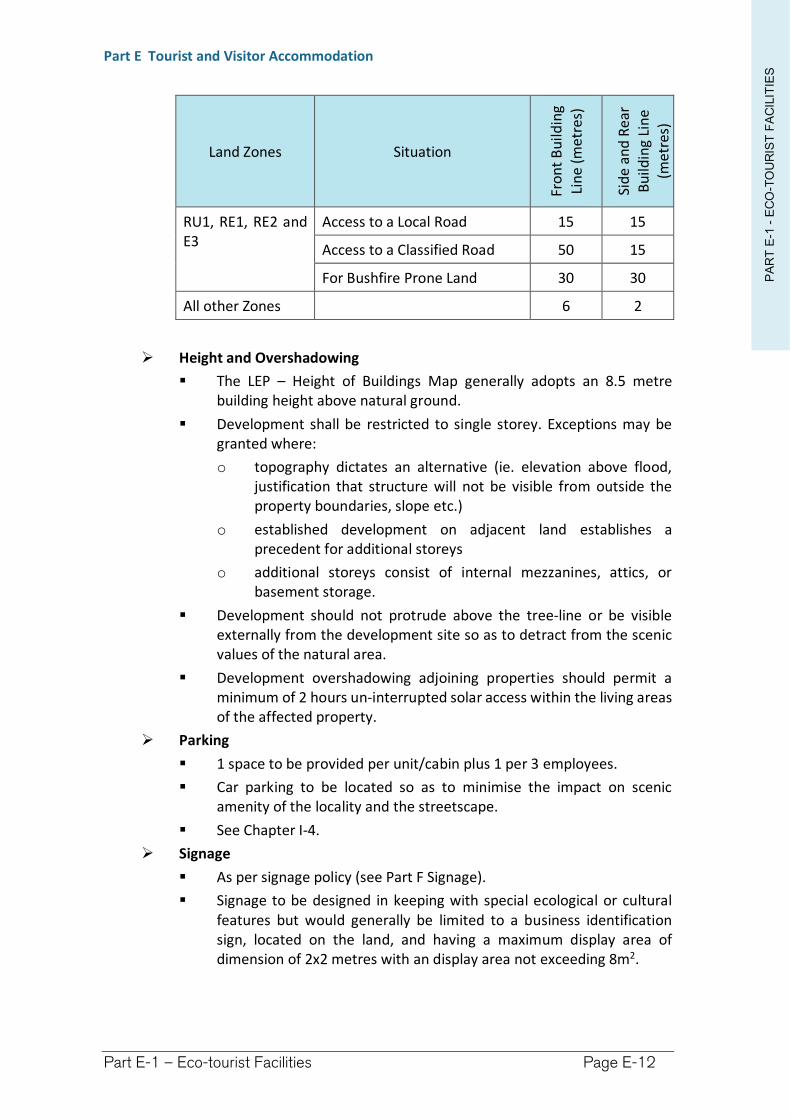
PA
RT
E-1
-E
CO
-TO
UR
IST
FA
CIL
ITIE
S
Part E Tourist and Visitor Accommodation
Part E-1 – Eco-tourist Facilities Page E-12
Land Zones Situation
Fro
nt
Bu
ildin
g
Lin
e(m
etre
s)
Sid
e an
d R
ear
Bu
ildin
g Li
ne
(met
res)
RU1, RE1, RE2 and E3
Access to a Local Road 15 15
Access to a Classified Road 50 15
For Bushfire Prone Land 30 30
All other Zones 6 2
Height and Overshadowing
The LEP – Height of Buildings Map generally adopts an 8.5 metre building height above natural ground.
Development shall be restricted to single storey. Exceptions may be granted where:
o topography dictates an alternative (ie. elevation above flood, justification that structure will not be visible from outside the property boundaries, slope etc.)
o established development on adjacent land establishes a precedent for additional storeys
o additional storeys consist of internal mezzanines, attics, or basement storage.
Development should not protrude above the tree-line or be visible externally from the development site so as to detract from the scenic values of the natural area.
Development overshadowing adjoining properties should permit a minimum of 2 hours un-interrupted solar access within the living areas of the affected property.
Parking
1 space to be provided per unit/cabin plus 1 per 3 employees.
Car parking to be located so as to minimise the impact on scenic amenity of the locality and the streetscape.
See Chapter I-4.
Signage
As per signage policy (see Part F Signage).
Signage to be designed in keeping with special ecological or cultural features but would generally be limited to a business identification sign, located on the land, and having a maximum display area of dimension of 2x2 metres with an display area not exceeding 8m2.
PA
RT
E-1
-E
CO
-TO
UR
IST
FA
CIL
ITIE
S
Part E Tourist and Visitor Accommodation
Part E-1 – Eco-tourist Facilities Page E-13
Infrastructure
Energy Efficiency
o Eco-tourist facilities should embrace renewable energy sources
o Consideration should be given to the nature of renewable energy sources to ensure their impact on the amenity of the locality is not impacted upon ((having regard to the type of systems proposed and their potential environmental impacts (visual, noise, alterations to natural systems) and impacts upon neighbours).
o BASIX energy and resource efficiency principles should be employed in the design of the development.
o Orientation of buildings should favourably capture local climatic conditions to maximise potential for passive heating and cooling of buildings.
Development that cannot be connected to a public reticulated sewage treatment system will need to demonstrate that the development can be serviced with On-site Sewage Management System (OSMS). Refer to Council’s OSMS Strategy.
Water efficiency
o Water Sensitive Urban Design needs to be incorporated into the design. This includes roof water harvesting and on site storage, stormwater detention, erosion/sediment control, AAA rated plumbing and devices.
o Sites not connected to the mains water supply should provide a minimum of 10,000 litres rainwater tank capacity per unit/cabin and an additional 5,000 litres capacity per unit/cabin dedicated for fire fighting purposes. A reduction in this capacity may be considered where an alternative source of suitable water can be demonstrated.
Landscaping
The natural features of the surrounding environment should be drawn into the development precinct as part of landscaping.
Landscaping should include a minimum 50m2 per unit/cabin.
Education and experience
Eco-tourism embraces environmental and cultural education. An Educational Strategy should be supplied with the Development Application to demonstrate the types of programs to be employed, and the audience targeted by those programs.
Public Health and Food Safety
All public health requirements shall be complied with, in particular, but not limited to, the Public Health Act 1991.
All proposed bars and food preparation areas shall comply with the NSW Food Standards Code and AS4674-2004 (current at the time of DCP – refer to any succeeding legislative requirements).
PA
RT
E-1
-E
CO
-TO
UR
IST
FA
CIL
ITIE
S
Part E Tourist and Visitor Accommodation
Part E-1 – Eco-tourist Facilities Page E-14
Refuse Facilities
Refuse facilities shall be made for the storage and removal of rubbish in accordance with Council Policy and for the suitable screening of the refuge storage area.
Disposal of refuse on-site will not be permitted.
(7) Temporary or Short-term Accommodation
No person shall be permitted to reside on the land, other than within Residential Accommodation, for a period exceeding 3 months in any continuous 12 month period.
(8) Notification and advertising
See Chapter I-15 for details.
Tourist and visitor accommodation is identified as Category “B” development, therefore, requiring a published notice and written notice for 14 days.
(9) No subdivision unless compliant with Lot Size Map
The subdivision of such developments will not be permitted unless compliant with minimum lot sizes provided on the Lot Size Map for the land.
(10) Waste Minimisation and Management
The construction phase of any development must have a plan submitted and approved in accordance with Richmond Valley Council Waste Minimisation and Management Policy.
Richmond Valley Development Control Plan 2021
Part E-2 Bed and Breakfast Accommodation
This Chapter provides guidance for the establishment of bed and breakfast accommodation, a type of Tourist and visitor accommodation, in the Richmond Valley Council area.
This DCP applies to all land within the Richmond Valley Local Government Area.
Date adopted by Council: 22/06/2021
Effective Date: 01/08/2021
Amendments: Nil
PA
RT
E-2
-B
ED
AN
D B
RE
AK
FA
ST
ES
T.Part E Tourist and Visitor Accommodation
Part E-2 – Bed and Breakfast Establishments Page E-16
E-2.1 Objectives
The objectives of this Chapter are to:
(1) describe the permissibility of Bed and breakfast accommodation under the LEP
(2) ensure that Bed and breakfast accommodation is kept in scale with surrounding development so as to minimise its impacts on the amenity of the neighbourhood
(3) provide for minimal signage
(4) ensure that infrastructure and facilities are satisfactory to service the development and needs of guests
(5) ensure the safety of the occupants having regard to natural hazards, such as bush fire
(6) describe other legislative considerations.
E-2.2 Design principles
(1) Richmond Valley Local Environmental Plan 2012
(a) Definition and LEP Provisions
Bed and breakfast accommodation is defined within the Dictionary attached to the LEP. Critical to the definition is that the accommodation must be short stay, be located within a dwelling, and operated on a commercial basis by the permanent residents of the dwelling. Clause 5.4 of the LEP applies additional controls that restrict Bed and breakfast accommodation to a maximum of 3 guest bedrooms.
Extract from Richmond Valley Local Environmental Plan 2012
Definition of Bed and Breakfast Accommodation
bed and breakfast accommodation means an existing dwelling in which temporary or short-term accommodation is provided on a commercial basis by the permanent residents of the dwelling and where: (a) meals are provided for guests only, and (b) cooking facilities for the preparation of meals are not provided within guests’ rooms, and (c) dormitory-style accommodation is not provided.
Note. See clause 5.4 for controls relating to the number of bedrooms for bed and breakfast accommodation. Bed and breakfast accommodation is a type of tourist and visitor accommodation—see the definition of that term in this Dictionary.
(b) Permissibility of Bed and breakfast accommodation
Bed and breakfast accommodation may be undertaken with development consent under the LEP, or as Complying Development under State Environmental Planning Policy (Exempt and Complying Development Codes) 2008 (the Codes SEPP) in the following zones:
RU1 Primary Production
RU5 Village #
R1 General Residential #
R5 Large Lot Residential
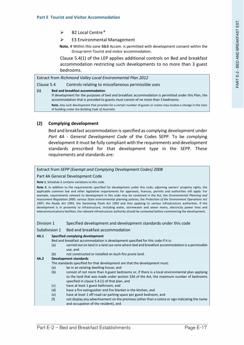
PA
RT
E-2
-B
ED
AN
D B
RE
AK
FA
ST
ES
T.Part E Tourist and Visitor Accommodation
Part E-2 – Bed and Breakfast Establishments Page E-17
B2 Local Centre #
E3 Environmental Management
Note. # Within this zone B&B Accom. is permitted with development consent within the Group-term Tourist and visitor accommodation.
Clause 5.4(1) of the LEP applies additional controls on Bed and breakfast accommodation restricting such developments to no more than 3 guest bedrooms.
Extract from Richmond Valley Local Environmental Plan 2012
Clause 5.4 Controls relating to miscellaneous permissible uses
(1) Bed and breakfast accommodation If development for the purposes of bed and breakfast accommodation is permitted under this Plan, the accommodation that is provided to guests must consist of no more than 3 bedrooms.
Note. Any such development that provides for a certain number of guests or rooms may involve a change in the class
of building under the Building Code of Australia.
(2) Complying development
Bed and breakfast accommodation is specified as complying development underPart 4A - General Development Code of the Codes SEPP. To be complying development it must be fully compliant with the requirements and development standards prescribed for that development type in the SEPP. These requirements and standards are:
Extract from SEPP (Exempt and Complying Development Codes) 2008
Part 4A General Development Code Note 1. Schedule 3 contains variations to this code.
Note 2. In addition to the requirements specified for development under this code, adjoining owners’ property rights, the applicable common law and other legislative requirements for approvals, licences, permits and authorities still apply. For example, requirements relevant to development in this code may be contained in the Act, the Environmental Planning and Assessment Regulation 2000, various State environmental planning policies, the Protection of the Environment Operations Act 1997, the Roads Act 1993, the Swimming Pools Act 1992 and Acts applying to various infrastructure authorities. If the development is in proximity to infrastructure, including water, stormwater and sewer mains, electricity power lines and telecommunications facilities, the relevant infrastructure authority should be contacted before commencing the development.
Division 1 Specified development and development standards under this code
Subdivision 1 Bed and breakfast accommodation
4A.1 Specified complying development Bed and breakfast accommodation is development specified for this code if it is: (a) carried out on land in a land use zone where bed and breakfast accommodation is a permissible
use, and (b) not constructed or installed on bush fire prone land.
4A.2 Development standards The standards specified for that development are that the development must: (a) be in an existing dwelling house, and (b) consist of not more than 4 guest bedrooms or, if there is a local environmental plan applying
to the land that was made under section 33A of the Act, the maximum number of bedrooms specified in clause 5.4 (1) of that plan, and
(c) have at least 1 guest bathroom, and (d) have a fire extinguisher and fire blanket in the kitchen, and (e) have at least 1 off-road car parking space per guest bedroom, and (f) not display any advertisement on the premises (other than a notice or sign indicating the name
and occupation of the resident), and
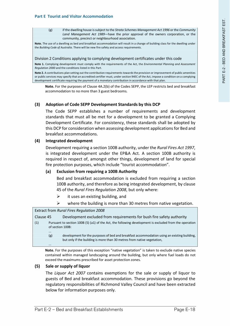
PA
RT
E-2
-B
ED
AN
D B
RE
AK
FA
ST
ES
T.Part E Tourist and Visitor Accommodation
Part E-2 – Bed and Breakfast Establishments Page E-18
(g) if the dwelling house is subject to the Strata Schemes Management Act 1996 or the Community Land Management Act 1989—have the prior approval of the owners corporation, or the community, precinct or neighbourhood association.
Note. The use of a dwelling as bed and breakfast accommodation will result in a change of building class for the dwelling under
the Building Code of Australia. There will be new fire safety and access requirements.
Division 2 Conditions applying to complying development certificates under this code Note 1. Complying development must comply with the requirements of the Act, the Environmental Planning and Assessment Regulation 2000 and the conditions listed in this Part.
Note 2. A contributions plan setting out the contribution requirements towards the provision or improvement of public amenities or public services may specify that an accredited certifier must, under section 94EC of the Act, impose a condition on a complying development certificate requiring the payment of a monetary contribution in accordance with that plan.
Note. For the purposes of Clause 4A.2(b) of the Codes SEPP, the LEP restricts bed and breakfast accommodation to no more than 3 guest bedrooms.
(3) Adoption of Code SEPP Development Standards by this DCP
The Code SEPP establishes a number of requirements and development standards that must all be met for a development to be granted a Complying Development Certificate. For consistency, these standards shall be adopted by this DCP for consideration when assessing development applications for Bed and breakfast accommodations.
(4) Integrated development
Development requiring a section 100B authority, under the Rural Fires Act 1997, is integrated development under the EP&A Act. A section 100B authority is required in respect of, amongst other things, development of land for special fire protection purposes, which include “tourist accommodation”.
(a) Exclusion from requiring a 100B Authority
Bed and breakfast accommodation is excluded from requiring a section 100B authority, and therefore as being integrated development, by clause 45 of the Rural Fires Regulation 2008, but only where:
it uses an existing building, and
where the building is more than 30 metres from native vegetation.
Extract from Rural Fires Regulation 2008
Clause 45 Development excluded from requirements for bush fire safety authority
(1) Pursuant to section 100B (5) (a1) of the Act, the following development is excluded from the operation of section 100B: ... (g) development for the purposes of bed and breakfast accommodation using an existing building,
but only if the building is more than 30 metres from native vegetation, ...
Note. For the purposes of this exception “native vegetation” is taken to exclude native species contained within managed landscaping around the building, but only where fuel loads do not exceed the maximums prescribed for asset protection zones.
(5) Sale or supply of liquor
The Liquor Act 2007 contains exemptions for the sale or supply of liquor to guests of Bed and breakfast accommodation. These provisions go beyond the regulatory responsibilities of Richmond Valley Council and have been extracted below for information purposes only.
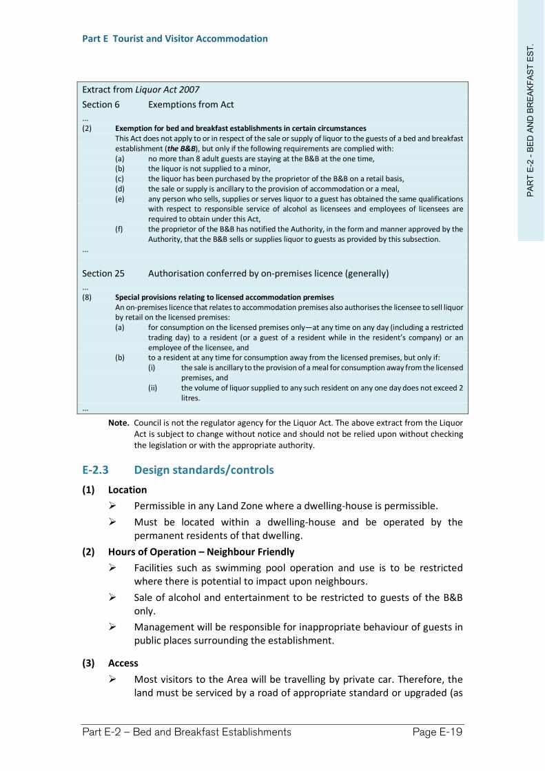
PA
RT
E-2
-B
ED
AN
D B
RE
AK
FA
ST
ES
T.Part E Tourist and Visitor Accommodation
Part E-2 – Bed and Breakfast Establishments Page E-19
Extract from Liquor Act 2007
Section 6 Exemptions from Act
... (2) Exemption for bed and breakfast establishments in certain circumstances
This Act does not apply to or in respect of the sale or supply of liquor to the guests of a bed and breakfast establishment (the B&B), but only if the following requirements are complied with: (a) no more than 8 adult guests are staying at the B&B at the one time, (b) the liquor is not supplied to a minor, (c) the liquor has been purchased by the proprietor of the B&B on a retail basis, (d) the sale or supply is ancillary to the provision of accommodation or a meal, (e) any person who sells, supplies or serves liquor to a guest has obtained the same qualifications
with respect to responsible service of alcohol as licensees and employees of licensees are required to obtain under this Act,
(f) the proprietor of the B&B has notified the Authority, in the form and manner approved by the Authority, that the B&B sells or supplies liquor to guests as provided by this subsection.
...
Section 25 Authorisation conferred by on-premises licence (generally)
... (8) Special provisions relating to licensed accommodation premises
An on-premises licence that relates to accommodation premises also authorises the licensee to sell liquor by retail on the licensed premises: (a) for consumption on the licensed premises only—at any time on any day (including a restricted
trading day) to a resident (or a guest of a resident while in the resident’s company) or an employee of the licensee, and
(b) to a resident at any time for consumption away from the licensed premises, but only if: (i) the sale is ancillary to the provision of a meal for consumption away from the licensed
premises, and (ii) the volume of liquor supplied to any such resident on any one day does not exceed 2
litres. ...
Note. Council is not the regulator agency for the Liquor Act. The above extract from the Liquor Act is subject to change without notice and should not be relied upon without checking the legislation or with the appropriate authority.
E-2.3 Design standards/controls
(1) Location
Permissible in any Land Zone where a dwelling-house is permissible.
Must be located within a dwelling-house and be operated by the permanent residents of that dwelling.
(2) Hours of Operation – Neighbour Friendly
Facilities such as swimming pool operation and use is to be restricted where there is potential to impact upon neighbours.
Sale of alcohol and entertainment to be restricted to guests of the B&B only.
Management will be responsible for inappropriate behaviour of guests in public places surrounding the establishment.
(3) Access
Most visitors to the Area will be travelling by private car. Therefore, the land must be serviced by a road of appropriate standard or upgraded (as
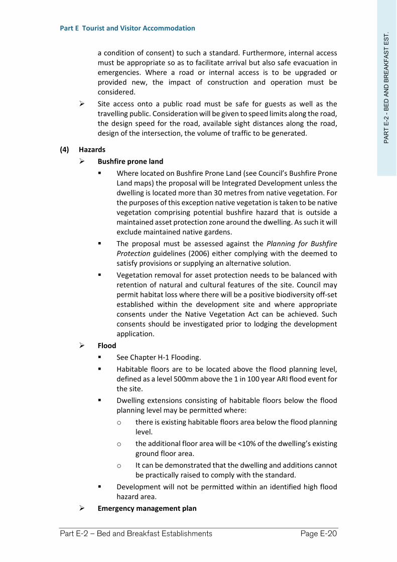
PA
RT
E-2
-B
ED
AN
D B
RE
AK
FA
ST
ES
T.Part E Tourist and Visitor Accommodation
Part E-2 – Bed and Breakfast Establishments Page E-20
a condition of consent) to such a standard. Furthermore, internal access must be appropriate so as to facilitate arrival but also safe evacuation in emergencies. Where a road or internal access is to be upgraded or provided new, the impact of construction and operation must be considered.
Site access onto a public road must be safe for guests as well as the travelling public. Consideration will be given to speed limits along the road, the design speed for the road, available sight distances along the road, design of the intersection, the volume of traffic to be generated.
(4) Hazards
Bushfire prone land
Where located on Bushfire Prone Land (see Council’s Bushfire Prone Land maps) the proposal will be Integrated Development unless the dwelling is located more than 30 metres from native vegetation. For the purposes of this exception native vegetation is taken to be native vegetation comprising potential bushfire hazard that is outside a maintained asset protection zone around the dwelling. As such it will exclude maintained native gardens.
The proposal must be assessed against the Planning for Bushfire Protection guidelines (2006) either complying with the deemed to satisfy provisions or supplying an alternative solution.
Vegetation removal for asset protection needs to be balanced with retention of natural and cultural features of the site. Council may permit habitat loss where there will be a positive biodiversity off-set established within the development site and where appropriate consents under the Native Vegetation Act can be achieved. Such consents should be investigated prior to lodging the development application.
Flood
See Chapter H-1 Flooding.
Habitable floors are to be located above the flood planning level, defined as a level 500mm above the 1 in 100 year ARI flood event for the site.
Dwelling extensions consisting of habitable floors below the flood planning level may be permitted where:
o there is existing habitable floors area below the flood planning level.
o the additional floor area will be <10% of the dwelling’s existing ground floor area.
o It can be demonstrated that the dwelling and additions cannot be practically raised to comply with the standard.
Development will not be permitted within an identified high flood hazard area.
Emergency management plan
PA
RT
E-2
-B
ED
AN
D B
RE
AK
FA
ST
ES
T.Part E Tourist and Visitor Accommodation
Part E-2 – Bed and Breakfast Establishments Page E-21
For proposals located within hazard areas, an Emergency Management Plan should be prepared and include emergency evacuation procedures for guests.
(5) Design
Scale Density
Maximum of 3 guest bedrooms may be provided, having the capacity to accommodate a maximum of 8 guests.
Parking
1 off-street car parking space to be provided per guest bedroom plus 1 for residents of the dwelling.
Signage
As per signage policy (Part F)
A single Business identification sign will be permitted having a maximum display area of 0.75m2.
The sign may only be erection on the land containing the Bed and breakfast accommodation.
Such a sign may be erected as exempt development.
Infrastructure
Where the dwelling is serviced by an On-site Sewage Management System (OSMS) the system must be assessed to ensure it is capable of handle the additional effluent loads resulting from the bed and breakfast accommodation. Refer to Council’s OSMS Strategy.
Water efficiency
o Water Sensitive Urban Design needs to be incorporated into the design. This includes installation of roof water harvesting and on site storage, stormwater detention, erosion/sediment control, AAA rated plumbing and devices.
o Sites not connected to the mains water supply should provide a minimum of 60,000 litres rainwater tank capacity plus an additional 10,000 litres per guest bedroom, and an additional 10,000 litres capacity dedicated for fire fighting purposes. A reduction in this capacity may be considered where an alternative source of suitable water can be demonstrated.
Recommended to have at least one dedicated guest bathroom (separate to domestic bathrooms).
Public Health and Food Safety
All public health requirements shall be complied with, in particular, but not limited to, the Public Health Act 1991.
All proposed food preparation areas shall comply with the NSW Food Standards Code and AS4674-2004 (current at the time of DCP – refer to any succeeding legislative requirements).
Sale of food or beverages shall be restricted to guests being accommodated at the premises.
PA
RT
E-2
-B
ED
AN
D B
RE
AK
FA
ST
ES
T.Part E Tourist and Visitor Accommodation
Part E-2 – Bed and Breakfast Establishments Page E-22
Cooking facilities shall not be provided within guest bedrooms.
(6) Notification and advertising
See Chapter I-15.
Tourist and visitor accommodation is identified as Category “B” development, therefore, requiring a published notice and written notice for 14 days.
(7) Waste Minimisation and Management
The construction phase of any development must have a plan submitted and approved in accordance with Richmond Valley Council Waste Minimisation and Management Policy.
Richmond Valley Development Control Plan 2021
Part E-3 Serviced Apartments
This Chapter provides guidance for the establishment of Serviced apartments, a type of Tourist and visitor accommodation, in the Richmond Valley Council area.
This DCP applies to all land within the Richmond Valley Local Government Area.
Date adopted by Council: 22/06/2021
Effective Date: 01/08/2021
Amendments: Nil
PA
RT
E-3
-S
ER
VIC
ED
AP
AR
TM
EN
TS
Part E Tourist and Visitor Accommodation
Part E-3 – Serviced Apartments Page E-24
E-3.1 Objectives
The objectives of this Chapter are to:
(1) describe the permissibility of Serviced apartments under the LEP
(2) ensure that Serviced apartments are kept in scale with surrounding development so as to minimise its impacts on the amenity of the neighbourhood
(3) ensure that infrastructure and facilities are satisfactory to service the development and needs of guests
(4) ensure the safety of the occupants having regard to natural hazards, such as bush fire
(5) describe other legislative considerations.
E-3.2 Design principles
(1) Richmond Valley Local Environmental Plan 2012
(a) Definition
Serviced apartments is a standard definition within the Dictionary attached to the LEP. Critical to the definition is that they provide self-contained, short stay accommodation with regular servicing or cleaning.
Extract from Richmond Valley Local Environmental Plan 2012
Definition of Serviced Apartments
serviced apartment means a building (or part of a building) providing self-contained accommodation to tourists or visitors on a commercial basis and that is regularly serviced or cleaned by the owner or manager of the building or part of the building or the owner’s or manager’s agents.
Note. Serviced apartments are a type of tourist and visitor accommodation—see the definition of that term in this
Dictionary.
(b) Permissibility of Serviced Apartments
Serviced apartments may be undertaken with development consent under the LEP within these specified zones:
RU5 Village #
R1 General Residential #
B1 Neighbourhood Centre
B2 Local Centre
B3 Commercial Core
RE2 Private Recreation #
Note. # Within this zone Serviced apartments are permitted with development consent within the group term Tourist and visitor accommodation.
E-3.3 Design standards/controls
(1) Location
Development applications for Tourist and visitor accommodation, other than Bed and breakfast accommodation, within Zone R1 or RU5 must be accompanied by a Social Impact Assessment.
PA
RT
E-3
-S
ER
VIC
ED
AP
AR
TM
EN
TS
Part E Tourist and Visitor Accommodation
Part E-3 – Serviced Apartments Page E-25
Critical to this assessment will be an evaluation of potential impacts upon adjacent residential properties and the amenity of the neighbourhood.
(2) Hours of Operation – Neighbour Friendly
Facilities such as swimming pool operation and use to be restricted where there is potential to impact upon neighbours.
Sale of alcohol and entertainment to be restricted guests only.
Management will be responsible for inappropriate behaviour of guests in public places surrounding the establishment.
(3) Access
Most visitors to the Area will be travelling by private car. Therefore, the land must be serviced by a road of appropriate standard or upgraded (as a condition of consent) to such a standard. Furthermore, internal access must be appropriate so as to facilitate arrival but also safe evacuation in emergencies. Where a road or internal access is to be upgraded or provided new, the impact of construction and operation must be considered.
Site access onto a public road must be safe for guests as well as the travelling public. Consideration will be given to speed limits along the road, the design speed for the road, available sight distances along the road, design of the intersection, the volume of traffic to be generated.
Provision is to be made for a minimum 4.5 metre wide crossing from the kerb and channelling to the road frontage of the property in accordance with relevant design standards of Council.
No vehicular access shall be permitted to any road or laneway having a reserve width <10 metres.
Where service vehicles are required to enter the site, adequate loading/unloading facilities are to be provided on-site to ensure that vehicles leave the property in a forward direction. Where side loading/unloading is proposed a turn around bay is to be provided on site.
(4) Hazards
Bushfire prone land
Where located on Bushfire Prone Land (see Council’s Bushfire Prone Land maps) the proposal will be Integrated Development.
The proposal must be assessed against the Planning for Bushfire Protection guidelines (2006) either complying with the deemed to satisfy provisions or supplying an alternative solution.
Flood
See Chapter H-1 Flooding.
Habitable floors are to be located above the flood planning level defined as a level 500mm above the 1 in 100 year ARI flood event for the site.
Development will not be permitted within an identified high flood hazard area.
PA
RT
E-3
-S
ER
VIC
ED
AP
AR
TM
EN
TS
Part E Tourist and Visitor Accommodation
Part E-3 – Serviced Apartments Page E-26
Climate Change
Development must incorporate adaptive design for climate change.
Development should be located beyond the 100 year predicted coastal erosion zone. Where such modelling is unavailable for coastal sites it must be provided with the Development Application to justify the development layout.
An Adaptation Plan must be developed where the development site is adjacent to coastal hazards. Buffering development from such hazards must be the primary focus. Subsequent enhancement of natural protective measures will be encouraged. Planned retreat is considered the ultimate solution to protect development, therefore, structures should be designed to be readily relocated away from the hazard front. If planned retreat is not an option abandoning the development (demolition) may be required.
Emergency management plan
For proposals located within hazard areas, an Emergency Management Plan should be prepared and include emergency evacuation procedures for guests.
(5) Design
Have regard to appropriate design guidelines, eg Part A contains design guidelines for residential accommodation, Coastal Development Guidelines.
Scale and Density
The same density, site coverage, floor space ratios, and landscaping requirements as residential flat development shall be applied to Serviced apartments.
See Chapter A3.
Privacy and Security
The design consideration of proposed buildings is to maintain the level of privacy enjoyed by adjoining properties.
The outlook to public and communal spaces should be maximised whilst maintaining internal privacy within the site.
The design is to avoid dark and non-visible areas, provide clear, safe access points and provide suitable open spaces to cater for recreational uses. Appropriate lighting for the location is to be installed and there is to be clear definition between public and private spaces. See CPTED guidelines in Chapter I10.
Built Form
Long building lines are to be stepped, appropriately broken with patios, change in materials or appropriate landscaping.
Heritage
Heritage impact must be minimised by consideration of the Heritage Item and/or Conservation Area’s significance in the design.
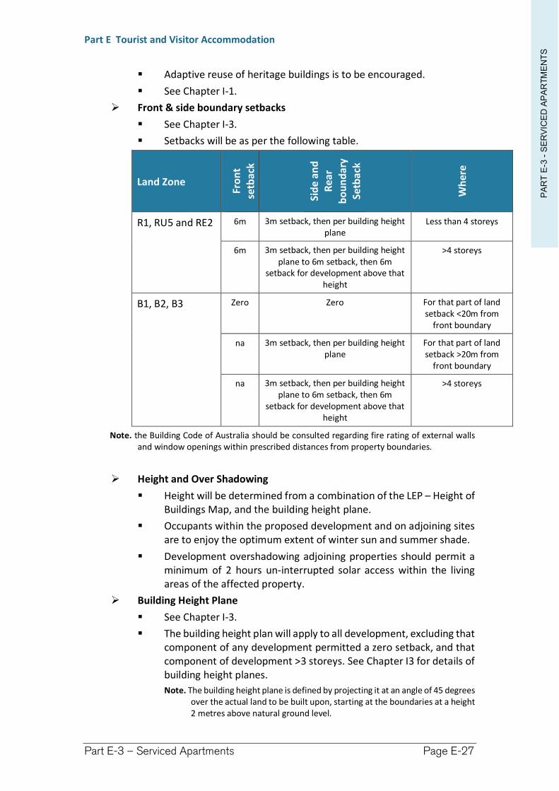
PA
RT
E-3
-S
ER
VIC
ED
AP
AR
TM
EN
TS
Part E Tourist and Visitor Accommodation
Part E-3 – Serviced Apartments Page E-27
Adaptive reuse of heritage buildings is to be encouraged.
See Chapter I-1.
Front & side boundary setbacks
See Chapter I-3.
Setbacks will be as per the following table.
Land Zone
Fro
nt
setb
ack
Sid
e an
d
Rea
r
bo
un
dar
y Se
tbac
k
Wh
ere
R1, RU5 and RE2 6m 3m setback, then per building height plane
Less than 4 storeys
6m 3m setback, then per building height plane to 6m setback, then 6m
setback for development above that height
>4 storeys
B1, B2, B3 Zero Zero For that part of land setback <20m from
front boundary
na 3m setback, then per building height plane
For that part of land setback >20m from
front boundary
na 3m setback, then per building height plane to 6m setback, then 6m
setback for development above that height
>4 storeys
Note. the Building Code of Australia should be consulted regarding fire rating of external walls and window openings within prescribed distances from property boundaries.
Height and Over Shadowing
Height will be determined from a combination of the LEP – Height of Buildings Map, and the building height plane.
Occupants within the proposed development and on adjoining sites are to enjoy the optimum extent of winter sun and summer shade.
Development overshadowing adjoining properties should permit a minimum of 2 hours un-interrupted solar access within the living areas of the affected property.
Building Height Plane
See Chapter I-3.
The building height plan will apply to all development, excluding that component of any development permitted a zero setback, and that component of development >3 storeys. See Chapter I3 for details of building height planes.
Note. The building height plane is defined by projecting it at an angle of 45 degrees over the actual land to be built upon, starting at the boundaries at a height 2 metres above natural ground level.
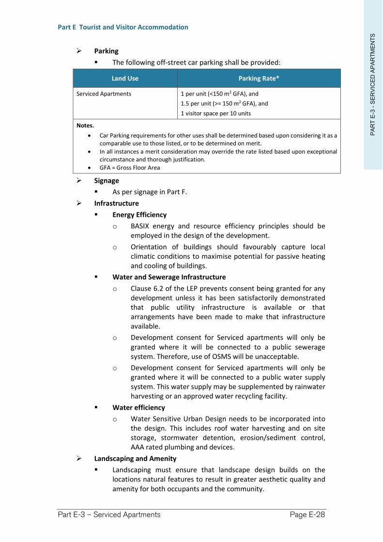
PA
RT
E-3
-S
ER
VIC
ED
AP
AR
TM
EN
TS
Part E Tourist and Visitor Accommodation
Part E-3 – Serviced Apartments Page E-28
Parking
The following off-street car parking shall be provided:
Land Use Parking Rate*
Serviced Apartments 1 per unit (<150 m2 GFA), and
1.5 per unit (>= 150 m2 GFA), and
1 visitor space per 10 units
Notes.
Car Parking requirements for other uses shall be determined based upon considering it as a comparable use to those listed, or to be determined on merit.
In all instances a merit consideration may override the rate listed based upon exceptional circumstance and thorough justification.
GFA = Gross Floor Area
Signage
As per signage in Part F.
Infrastructure
Energy Efficiency
o BASIX energy and resource efficiency principles should be employed in the design of the development.
o Orientation of buildings should favourably capture local climatic conditions to maximise potential for passive heating and cooling of buildings.
Water and Sewerage Infrastructure
o Clause 6.2 of the LEP prevents consent being granted for any development unless it has been satisfactorily demonstrated that public utility infrastructure is available or that arrangements have been made to make that infrastructure available.
o Development consent for Serviced apartments will only be granted where it will be connected to a public sewerage system. Therefore, use of OSMS will be unacceptable.
o Development consent for Serviced apartments will only be granted where it will be connected to a public water supply system. This water supply may be supplemented by rainwater harvesting or an approved water recycling facility.
Water efficiency
o Water Sensitive Urban Design needs to be incorporated into the design. This includes roof water harvesting and on site storage, stormwater detention, erosion/sediment control, AAA rated plumbing and devices.
Landscaping and Amenity
Landscaping must ensure that landscape design builds on the locations natural features to result in greater aesthetic quality and amenity for both occupants and the community.
PA
RT
E-3
-S
ER
VIC
ED
AP
AR
TM
EN
TS
Part E Tourist and Visitor Accommodation
Part E-3 – Serviced Apartments Page E-29
Council will encourage developments which enhance natural environmental performance by co-ordinating water and soil management, solar access, micro-climate, tree canopy and habitat values.
The minimum landscaped open space shall be 35% of the site area.
Each lower floor dwelling is to have a minimum 25m2 of private open space with direct connection to indoor living areas.
A landscaping and open space plan is to be submitted with the development application.
Council will encourage the incorporation of access to sunlight, natural ventilation, visual and acoustic privacy, efficient layouts and outlook in addition to the integration of these design elements with detailed landscape and streetscape plans external to the site.
The design and use of building colour, bulk, materials of construction and angle and height of roof line are to be in harmony with the surrounding built and natural environment.
Any new development (including additions and alterations to existing buildings) is to allow for the reasonable sharing of views. In areas with significant views (as determined by Council), a view loss assessment should accompany the development application.
Public Health and Food Safety
All public health requirements shall be complied with, in particular, but not limited to, the Public Health Act 1991.
All proposed bars and food preparation areas shall comply with the NSW Food Standards Code and AS4674-2004 (current at the time of DCP – refer to any succeeding legislative requirements).
Refuse Facilities
Refuse facilities shall be made for the storage and removal of rubbish in accordance with Council Policy and for the suitable screening of the refuge storage area.
(6) Temporary or Short-term Accommodation
No person shall be permitted to reside on the land, other than within Residential Accommodation, for a period exceeding 3 months in any continuous 12 month period.
(7) Notification and advertising
See Chapter I-15.
Tourist and visitor accommodation is identified as Category “B” development, therefore, requiring a published notice and written notice for 14 days.
(8) Subdivision
Strata subdivision or Community Title subdivision of units may be granted development consent.
(9) Waste Minimisation and Management
PA
RT
E-3
-S
ER
VIC
ED
AP
AR
TM
EN
TS
Part E Tourist and Visitor Accommodation
Part E-3 – Serviced Apartments Page E-30
The construction phase of any development must have a plan submitted and approved in accordance with Richmond Valley Council Waste Minimisation and Management Policy.
Richmond Valley Development Control Plan 2021
Part E-4 Hotel and Motel Accommodation
This Chapter provides guidance for the establishment of Hotel and motel accommodation, a type of Tourist and visitor accommodation, in the Richmond Valley Council area.
This DCP applies to all land within the Richmond Valley Local Government Area.
Date adopted by Council: 22/06/2021
Effective Date: 01/08/2021
Amendments: Nil
PA
RT
E-4
-H
OT
EL A
ND
MO
TE
L A
CC
OM
MO
DA
TIO
N
Part E Tourist and Visitor Accommodation
Part E-4 – Hotel and Motel Accommodation Page E-32
E-4.1 Objectives
The objectives of this Chapter are to:
(1) describe the permissibility of Hotel and motel accommodation under the LEP.
(2) ensure that Hotel and motel accommodation are kept in scale with surrounding development so as to minimise its impacts on the amenity of the neighbourhood.
(3) ensure that infrastructure and facilities are satisfactory to service the development and needs of guests.
(4) ensure the safety of the occupants having regard to natural hazards, such as bush fire.
(5) describe other legislative considerations.
E-4.2 Design principles
(1) Richmond Valley Local Environmental Plan 2012
(a) Definition
Hotel and motel accommodation is defined within the Dictionary attached to the LEP. Critical to the definition is that the accommodation is for short stay.
Extract from Richmond Valley Local Environmental Plan 2012
Definition of Hotel or motel accommodation
hotel or motel accommodation means a building or place (whether or not licensed premises under the Liquor Act 2007) that provides temporary or short-term accommodation on a commercial basis and that: (a) comprises rooms or self-contained suites, and (b) may provide meals to guests or the general public and facilities for the parking of guests’
vehicles, but does not include backpackers’ accommodation, a boarding house, bed and breakfast accommodation or farm stay accommodation.
Note. Hotel or motel accommodation is a type of tourist and visitor accommodation—see the definition of that term in this Dictionary.
(b) Permissibility of Hotel and Motel Accommodation
Hotel and Motel Accommodation may be undertaken with development consent under the LEP within these specified zones:
RU5 Village #
R1 General Residential #
B1 Neighbourhood Centre
B2 Local Centre
B3 Commercial Core
RE2 Private Recreation #
Note. # Within this zone Hotel and Motel Accommodation are permitted with development consent within the group term Tourist and visitor accommodation.
PA
RT
E-4
-H
OT
EL A
ND
MO
TE
L A
CC
OM
MO
DA
TIO
N
Part E Tourist and Visitor Accommodation
Part E-4 – Hotel and Motel Accommodation Page E-33
E-4.3 Design standards/controls
(1) Location
Development applications for Tourist and visitor accommodation, other than Bed and breakfast accommodation, within Zone R1 or RU5 must be accompanied by a Social Impact Assessment.
Critical to this assessment will be an evaluation of potential impacts upon adjacent residential properties and the amenity of the neighbourhood.
(2) Environmental
Hours of Operation – Neighbour Friendly
Facilities such as swimming pool operation and use to be restricted where there is a potential to impact upon neighbours.
Sale of alcohol and entertainment to be restricted.
Management responsible for inappropriate behaviour of guests in public places surrounding the establishment.
(3) Access
Most visitors to the Area will be travelling by private car. Therefore, the land must be serviced by a road of appropriate standard or upgraded (as a condition of consent) to such a standard. Furthermore, internal access must be appropriate so as to facilitate arrival but also safe evacuation in emergencies. Where a road or internal access is to be upgraded or provided new, the impact of construction and operation must be considered.
Site access onto a public road must be safe for guests as well as the travelling public. Consideration will be given to speed limits along the road, the design speed for the road, available sight distances along the road, design of the intersection, the volume of traffic to be generated.
Provision is to be made for a minimum 4.5 metre wide crossing from the kerb and channelling to the road frontage of the property in accordance with relevant design standards of Council.
The primary vehicular access to the land shall not be permitted to any road or laneway having a reserve width <10 metres.
Where service vehicles are required to enter the site, adequate loading/unloading facilities are to be provided on-site to ensure that vehicles leave the property in a forward direction. Where side loading/unloading is proposed a turnaround bay is to be provided on site.
(4) Hazards
Bushfire prone land
Where located on Bushfire Prone Land (see Council’s Bushfire Prone Land maps) the proposal will be Integrated Development.
The proposal must be assessed against the Planning for Bushfire Protection guidelines (2006) either complying with the deemed to satisfy provisions or supplying an alternative solution.
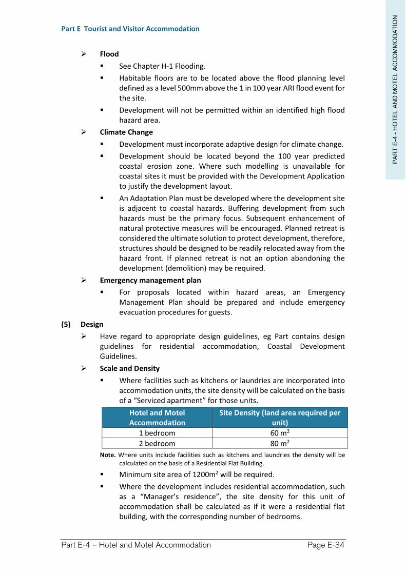
PA
RT
E-4
-H
OT
EL A
ND
MO
TE
L A
CC
OM
MO
DA
TIO
N
Part E Tourist and Visitor Accommodation
Part E-4 – Hotel and Motel Accommodation Page E-34
Flood
See Chapter H-1 Flooding.
Habitable floors are to be located above the flood planning level defined as a level 500mm above the 1 in 100 year ARI flood event for the site.
Development will not be permitted within an identified high flood hazard area.
Climate Change
Development must incorporate adaptive design for climate change.
Development should be located beyond the 100 year predicted coastal erosion zone. Where such modelling is unavailable for coastal sites it must be provided with the Development Application to justify the development layout.
An Adaptation Plan must be developed where the development site is adjacent to coastal hazards. Buffering development from such hazards must be the primary focus. Subsequent enhancement of natural protective measures will be encouraged. Planned retreat is considered the ultimate solution to protect development, therefore, structures should be designed to be readily relocated away from the hazard front. If planned retreat is not an option abandoning the development (demolition) may be required.
Emergency management plan
For proposals located within hazard areas, an Emergency Management Plan should be prepared and include emergency evacuation procedures for guests.
(5) Design
Have regard to appropriate design guidelines, eg Part contains design guidelines for residential accommodation, Coastal Development Guidelines.
Scale and Density
Where facilities such as kitchens or laundries are incorporated into accommodation units, the site density will be calculated on the basis of a “Serviced apartment” for those units.
Hotel and Motel Accommodation
Site Density (land area required per unit)
1 bedroom 60 m2
2 bedroom 80 m2
Note. Where units include facilities such as kitchens and laundries the density will be calculated on the basis of a Residential Flat Building.
Minimum site area of 1200m2 will be required.
Where the development includes residential accommodation, such as a “Manager’s residence”, the site density for this unit of accommodation shall be calculated as if it were a residential flat building, with the corresponding number of bedrooms.
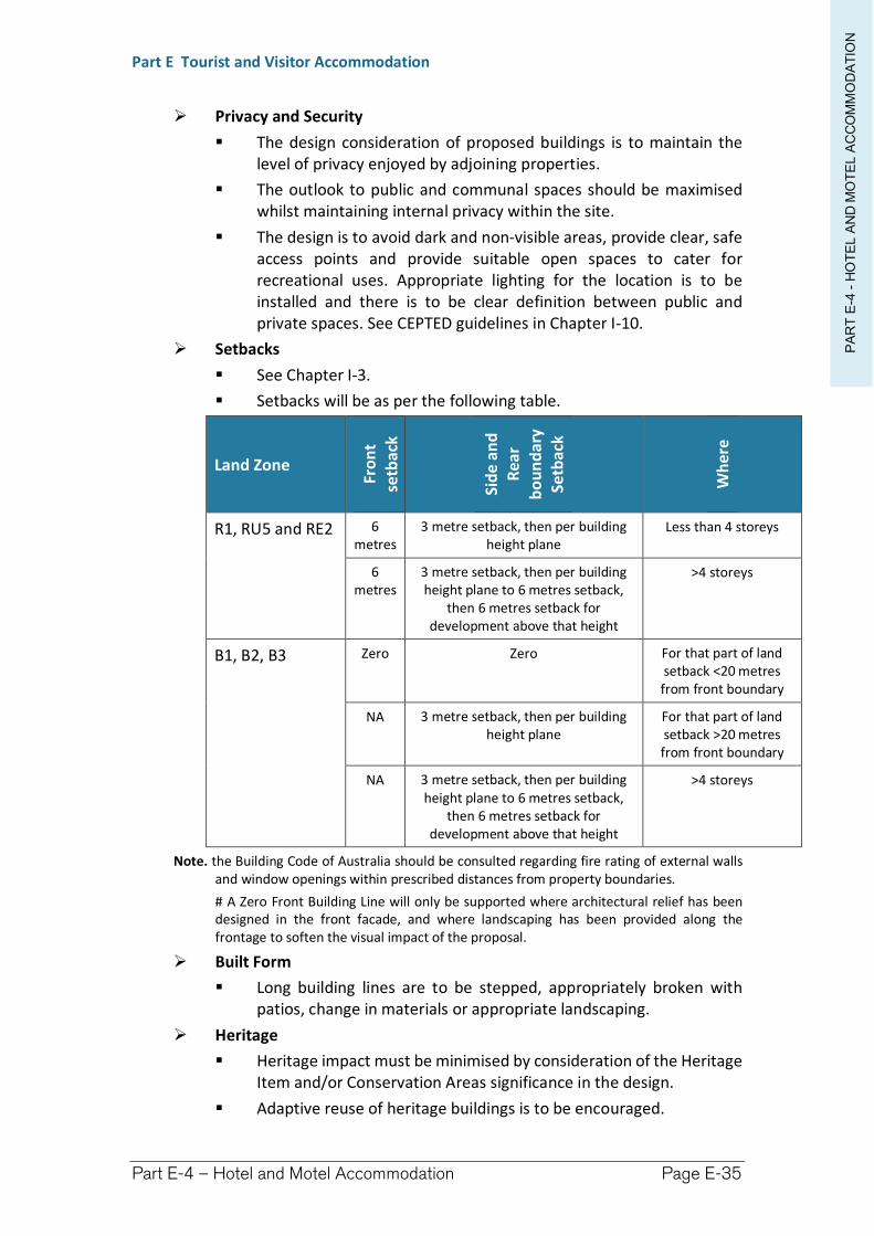
PA
RT
E-4
-H
OT
EL A
ND
MO
TE
L A
CC
OM
MO
DA
TIO
N
Part E Tourist and Visitor Accommodation
Part E-4 – Hotel and Motel Accommodation Page E-35
Privacy and Security
The design consideration of proposed buildings is to maintain the level of privacy enjoyed by adjoining properties.
The outlook to public and communal spaces should be maximised whilst maintaining internal privacy within the site.
The design is to avoid dark and non-visible areas, provide clear, safe access points and provide suitable open spaces to cater for recreational uses. Appropriate lighting for the location is to be installed and there is to be clear definition between public and private spaces. See CEPTED guidelines in Chapter I-10.
Setbacks
See Chapter I-3.
Setbacks will be as per the following table.
Land Zone
Fro
nt
setb
ack
Sid
e an
d
Rea
r
bo
un
dar
y Se
tbac
k
Wh
ere
R1, RU5 and RE2 6 metres
3 metre setback, then per building height plane
Less than 4 storeys
6 metres
3 metre setback, then per building height plane to 6 metres setback,
then 6 metres setback for development above that height
>4 storeys
B1, B2, B3 Zero Zero For that part of land setback <20 metres from front boundary
NA 3 metre setback, then per building height plane
For that part of land setback >20 metres from front boundary
NA 3 metre setback, then per building height plane to 6 metres setback,
then 6 metres setback for development above that height
>4 storeys
Note. the Building Code of Australia should be consulted regarding fire rating of external walls and window openings within prescribed distances from property boundaries.
# A Zero Front Building Line will only be supported where architectural relief has been designed in the front facade, and where landscaping has been provided along the frontage to soften the visual impact of the proposal.
Built Form
Long building lines are to be stepped, appropriately broken with patios, change in materials or appropriate landscaping.
Heritage
Heritage impact must be minimised by consideration of the Heritage Item and/or Conservation Areas significance in the design.
Adaptive reuse of heritage buildings is to be encouraged.
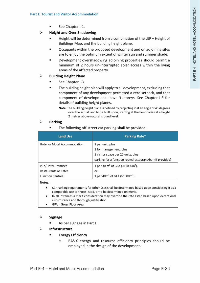
PA
RT
E-4
-H
OT
EL A
ND
MO
TE
L A
CC
OM
MO
DA
TIO
N
Part E Tourist and Visitor Accommodation
Part E-4 – Hotel and Motel Accommodation Page E-36
See Chapter I-1.
Height and Over Shadowing
Height will be determined from a combination of the LEP – Height of Buildings Map, and the building height plane.
Occupants within the proposed development and on adjoining sites are to enjoy the optimum extent of winter sun and summer shade.
Development overshadowing adjoining properties should permit a minimum of 2 hours un-interrupted solar access within the living areas of the affected property.
Building Height Plane
See Chapter I-3.
The building height plan will apply to all development, excluding that component of any development permitted a zero setback, and that component of development above 3 storeys. See Chapter I-3 for details of building height planes.
Note. The building height plane is defined by projecting it at an angle of 45 degrees over the actual land to be built upon, starting at the boundaries at a height 2 metres above natural ground level.
Parking
The following off-street car parking shall be provided:
Land Use Parking Rate*
Hotel or Motel Accommodation 1 per unit, plus
1 for management, plus
1 visitor space per 20 units, plus
parking for a function room/restaurant/bar (if provided)
Pub/Hotel Premises
Restaurants or Cafes
Function Centres
1 per 30 m2 of GFA (<=1000m2),
or
1 per 40m2 of GFA (>1000m2)
Notes.
Car Parking requirements for other uses shall be determined based upon considering it as a comparable use to those listed, or to be determined on merit.
In all instances a merit consideration may override the rate listed based upon exceptional circumstance and thorough justification.
GFA = Gross Floor Area
Signage
As per signage in Part F.
Infrastructure
Energy Efficiency
o BASIX energy and resource efficiency principles should be employed in the design of the development.
PA
RT
E-4
-H
OT
EL A
ND
MO
TE
L A
CC
OM
MO
DA
TIO
N
Part E Tourist and Visitor Accommodation
Part E-4 – Hotel and Motel Accommodation Page E-37
o Orientation of buildings should favourably capture local climatic conditions to maximise potential for passive heating and cooling of buildings.
Water and Sewerage Infrastructure
o Clause 6.2 of the LEP prevents development consent being granted for any development unless it has been satisfactorily demonstrated that public utility infrastructure is available or that arrangements have been made to make that infrastructure available.
o Development consent for Hotel and motel accommodation will only be granted where it will be connected to a public sewerage system. Therefore, use of OSMS will be unacceptable.
o Development consent for Hotel and motel accommodation will only be granted where it will be connected to a public water supply system. This water supply may be supplemented by rainwater harvesting or an approved water recycling facility.
Water efficiency
o Water Sensitive Urban Design needs to be incorporated into the design. This includes roof water harvesting and on site storage, stormwater detention, erosion/sediment control, AAA rated plumbing and devices.
Landscaping and Amenity
Landscaping must ensure that landscape design builds on the natural features of the location to result in greater aesthetic quality and amenity for both occupants and the community.
Council will encourage developments which enhance natural environmental performance by co-ordinating water and soil management, solar access, micro-climate, tree canopy and habitat values.
The minimum landscaped open space will be determined on merits. A Landscaping Plan must be submitted with the development application.
Landscaping will be required to soften the visual impact of the proposal towards the streetscape, especially where a zero front building line is proposed.
Council will encourage the incorporation of access to sunlight, natural ventilation, visual and acoustic privacy, efficient layouts and outlook in addition to the integration of these design elements with detailed landscape and streetscape plans external to the site.
The design and use of building colour, bulk, materials of construction and angle and height of roof line are to be in harmony with the surrounding built and natural environment.
PA
RT
E-4
-H
OT
EL A
ND
MO
TE
L A
CC
OM
MO
DA
TIO
N
Part E Tourist and Visitor Accommodation
Part E-4 – Hotel and Motel Accommodation Page E-38
Any new development (including additions and alterations to existing buildings) is to allow for the reasonable sharing of views. In areas with significant views (as determined by Council), a view loss assessment should accompany the development application.
Public Health and Food Safety
All public health requirements shall be complied with, in particular, but not limited to, the Public Health Act 1991.
All proposed bars and food preparation areas shall comply with the NSW Food Standards Code and AS4674-2004 (current at the time of DCP – refer to any succeeding legislative requirements).
Refuse Facilities
Refuse facilities shall be made for the storage and removal of rubbish in accordance with Council Policy and for the suitable screening of the refuge storage area.
(6) Temporary or Short-term Accommodation
No person shall be permitted to reside on the land, other than within Residential Accommodation, for any continuous period exceeding 3 months in any 12 month period.
(7) Notification and advertising
See Chapter I-15.
Hotel and motel accommodation is identified as Category “B” development, therefore, requiring a published notice and written notice for 14 days.
(8) Waste Minimisation and Management
The construction phase of any development must have a plan submitted and approved in accordance with Richmond Valley Council Waste Minimisation and Management Policy.
Richmond Valley Development Control Plan 2021
Part E-5 Backpacker’s Accommodation
This Chapter provides guidance for the establishment of Backpacker accommodation, a type of Tourist and visitor accommodation, in the Richmond Valley Council area.
This DCP applies to all land within the Richmond Valley Local Government Area.
Date adopted by Council: 22/06/2021
Effective Date: 01/08/2021
Amendments: Nil
PA
RT
E-5
-B
AC
KP
AK
ER
’S A
CC
OM
MO
DA
TIO
N
Part E Tourist and Visitor Accommodation
Part E-5 – Backpacker’s Accommodation E.40
E-5.1 Objectives
The objectives of this Chapter are to:
(1) describe the permissibility of backpacker accommodation under the LEP.
(2) ensure that Backpacker accommodation are kept in scale with surrounding development.
(3) ensure that Backpacker accommodation is designed and managed so as to minimise its impacts on the amenity of the neighbourhood.
(4) ensure that infrastructure and facilities are satisfactory to service the development and needs of guests.
(5) ensure the safety of the occupants having regard to natural hazards, such as bush fire.
(6) describe other legislative considerations.
E-5.2 Design principles
(1) Richmond Valley Local Environmental Plan 2012
(a) Definition
Backpacker accommodation is a standard definition within the Dictionary attached to the LEP. Critical to the definition is that accommodation is short stay on a per bed basis with shared facilities and amenities.
Extract from Richmond Valley Local Environmental Plan 2012
Definition of Backpackers’ accommodation
backpackers’ accommodation means a building or place that: (a) provides temporary or short-term accommodation on a commercial basis, and (b) has shared facilities, such as a communal bathroom, kitchen or laundry, and (c) provides accommodation on a bed or dormitory-style basis (rather than by room).
Note. Backpackers’ accommodation is a type of tourist and visitor accommodation—see the definition of that term in this Dictionary.
(b) Permissibility of Backpacker Accommodation
Backpacker Accommodation may be undertaken with development consent under the LEP within these specified zones:
RU5 Village #
R1 General Residential #
B2 Local Centre
B3 Commercial Core
RE2 Private Recreation #
Note. # Within this zone Backpacker Accommodation are permitted with development consent within the group term Tourist and visitor accommodation.
PA
RT
E-5
-B
AC
KP
AK
ER
’S A
CC
OM
MO
DA
TIO
N
Part E Tourist and Visitor Accommodation
Part E-5 – Backpacker’s Accommodation E.41
E-5.3 Design standards/controls
(1) Environmental
Development applications for Tourist and visitor accommodation, other than Bed and breakfast accommodation, within Zone R1 or RU5 must be accompanied by a Social Impact Assessment.
Critical to this assessment will be an evaluation of potential impacts upon adjacent residential properties and the amenity of the neighbourhood.
(2) Environmental
Hours of Operation – Neighbour Friendly
Facilities such as swimming pool operation and use, and laundry facilities to be restricted where there is a potential to impact upon neighbours and guest bedrooms.
Sale of alcohol, provision of entertainment, and use of outdoor communal areas are also to be restricted.
Restrictions should at least apply during the hours of 10pm to 8am.
Management will be responsible for inappropriate behaviour of guests within the establishment and public places surrounding the establishment.
(3) Access to Roads, Transport, Services and Facilities
The land must be serviced by a road of appropriate standard or upgraded (as a condition of consent) to such a standard. Furthermore, internal access must be appropriate so as to facilitate arrival but also safe evacuation in emergencies. Where a road or internal access is to be upgraded or provided new, the impact of construction and operation must be considered.
Site access onto a public road must be safe for guests as well as the travelling public. Consideration will be given to speed limits along the road, the design speed for the road, available sight distances along the road, design of the intersection, the volume of traffic to be generated.
Consideration should be given to locating Backpacker accommodation within close proximity to public transport and within easy access to facilities and services.
(4) Hazards
Landform and stability
Preference will be given to a stable landform where risk of erosion, subsidence, and landslip are minimised.
Slopes having a grade greater than 1 in 4 should be avoided.
Bushfire prone land
Where located on Bushfire Prone Land (see Council’s Bushfire Prone Land maps) the proposal will be Integrated Development.
The proposal must be assessed against the Planning for Bushfire Protection guidelines (2006) either complying with the deemed to satisfy provisions or supplying an alternative solution.
PA
RT
E-5
-B
AC
KP
AK
ER
’S A
CC
OM
MO
DA
TIO
N
Part E Tourist and Visitor Accommodation
Part E-5 – Backpacker’s Accommodation E.42
Vegetation removal for asset protection needs to be balanced with retention of natural and cultural features of the site. In this regard preference will be given to a concentrated rather than dispersed layout. Council may permit habitat loss where there will be a positive biodiversity off-set established within the development site and where appropriate consents under the Native Vegetation Act can be achieved. Such consents should be investigated prior to lodging the development application.
Flood
See Chapter H-1 Flooding.
Habitable floors are to be located above the flood planning level defined as a level 500mm above the 1 in 100 year ARI flood event for the site.
Development will not be permitted within an identified high flood hazard area.
Climate Change
Development must incorporate adaptive design for climate change.
Development should be located beyond the 100 year predicted coastal erosion zone. Where such modelling is unavailable for coastal sites it must be provided with the Development Application to justify the development layout.
Buffers should be naturally enhanced to protect the development from coastal hazards, eg. Dune restoration and rehabilitation.
An Adaptation Plan must be developed where the development site is adjacent to coastal hazards. Buffering development from such hazards must be the primary focus. Subsequent enhancement of natural protective measures will be encouraged. Planned retreat is considered the ultimate solution to protect development, therefore, structures should be designed to be readily relocated away from the hazard front. If planned retreat is not an option abandoning the development (demolition) may be required.
Emergency management plan
For proposals located within hazard areas, an Emergency Management Plan should be prepared and include emergency evacuation procedures for guests.
Natural Resources
It is more than likely that Eco-tourist facilities will be located within one or more of the mapped Natural Resources in the LEP. These include biodiversity (native vegetation, habitat corridors), wetlands, riparian and waterways (key fish habitat), and landslip risk (steep slopes).
Clauses 6.6, 6.7, 6.8 & 6.10 require the assessment of the various Natural Resources. See Chapter H-4 for further details.
PA
RT
E-5
-B
AC
KP
AK
ER
’S A
CC
OM
MO
DA
TIO
N
Part E Tourist and Visitor Accommodation
Part E-5 – Backpacker’s Accommodation E.43
(5) Design
Have regard to appropriate design guidelines, eg Part A contains design guidelines for residential accommodation, Coastal Development Guidelines.
The layout of Backpacker accommodation should be designed and constructed to respect the amenity of immediately adjoining land uses, particularly that of residential accommodation.
Design, Scale and Density
Bedrooms and Occupancy rates
o The maximum number of persons accommodated in a guest bedroom, or in a dormitory, is to be determined on the basis of 5m2 per person.
o Bedrooms providing shared or dormitory-style accommodation must accommodate no more than 10 guests.
o Shared bedrooms or dormitory-style accommodation must provide lockable secure storage facilities with a minimum capacity of 0.6m2 per person to allow guests to individually store baggage and travel items within their sleeping room.
o Staff accommodation is to be provided separate to that of guest accommodation.
Communal Areas
o Communal recreation areas must be provided within the premises at a minimum rate of 2m2 per person.
o Communal recreation areas should be provided internal to the building, however, where areas are to be provided outdoors they may only account for up to a maximum of 20% of the minimum area required.
o Each area provided (whether internal or external) must have a minimum total area of 30m2 and a minimum width of 3 metres.
o Bedrooms, bathrooms, laundries, reception areas, storage, kitchens, car parking, loading docks, driveways, clothes drying areas, corridors, landscaped gardens, and the like are not counted when calculating the area of communal areas. Dining areas may be included as a communal area.
Kitchen
o An internal self-catering kitchen with a separate dining room must be provided on site for the use of guests.
o The kitchen and dining room must allow for 15% of the maximum number of guests to prepare and consume meals at any one time.
o Kitchen facilities in sleeping rooms will not be permitted.
o All public health requirements shall be complied with, in particular, but not limited to, the Public Health Act 1991.
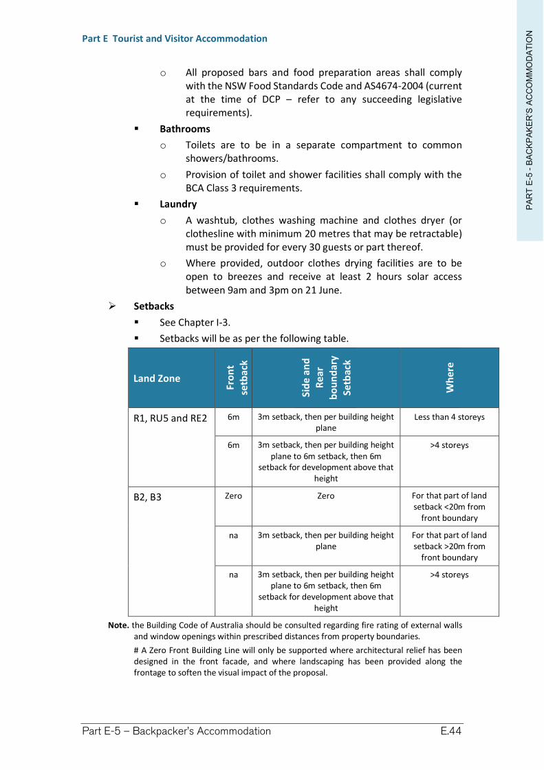
PA
RT
E-5
-B
AC
KP
AK
ER
’S A
CC
OM
MO
DA
TIO
N
Part E Tourist and Visitor Accommodation
Part E-5 – Backpacker’s Accommodation E.44
o All proposed bars and food preparation areas shall comply with the NSW Food Standards Code and AS4674-2004 (current at the time of DCP – refer to any succeeding legislative requirements).
Bathrooms
o Toilets are to be in a separate compartment to common showers/bathrooms.
o Provision of toilet and shower facilities shall comply with the BCA Class 3 requirements.
Laundry
o A washtub, clothes washing machine and clothes dryer (or clothesline with minimum 20 metres that may be retractable) must be provided for every 30 guests or part thereof.
o Where provided, outdoor clothes drying facilities are to be open to breezes and receive at least 2 hours solar access between 9am and 3pm on 21 June.
Setbacks
See Chapter I-3.
Setbacks will be as per the following table.
Land Zone
Fro
nt
setb
ack
Sid
e an
d
Rea
r
bo
un
dar
y Se
tbac
k
Wh
ere
R1, RU5 and RE2 6m 3m setback, then per building height plane
Less than 4 storeys
6m 3m setback, then per building height plane to 6m setback, then 6m
setback for development above that height
>4 storeys
B2, B3 Zero Zero For that part of land setback <20m from
front boundary
na 3m setback, then per building height plane
For that part of land setback >20m from
front boundary
na 3m setback, then per building height plane to 6m setback, then 6m
setback for development above that height
>4 storeys
Note. the Building Code of Australia should be consulted regarding fire rating of external walls and window openings within prescribed distances from property boundaries.
# A Zero Front Building Line will only be supported where architectural relief has been designed in the front facade, and where landscaping has been provided along the frontage to soften the visual impact of the proposal.
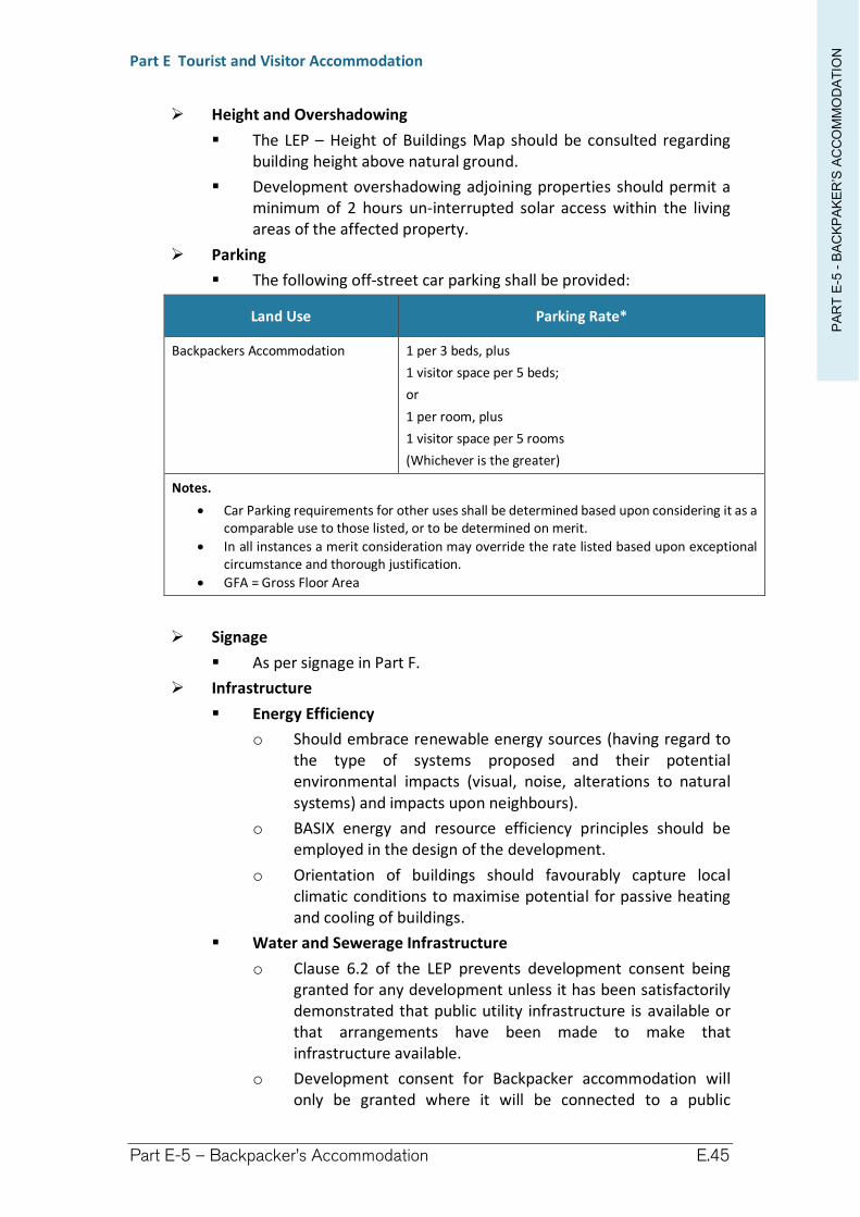
PA
RT
E-5
-B
AC
KP
AK
ER
’S A
CC
OM
MO
DA
TIO
N
Part E Tourist and Visitor Accommodation
Part E-5 – Backpacker’s Accommodation E.45
Height and Overshadowing
The LEP – Height of Buildings Map should be consulted regarding building height above natural ground.
Development overshadowing adjoining properties should permit a minimum of 2 hours un-interrupted solar access within the living areas of the affected property.
Parking
The following off-street car parking shall be provided:
Land Use Parking Rate*
Backpackers Accommodation 1 per 3 beds, plus
1 visitor space per 5 beds;
or
1 per room, plus
1 visitor space per 5 rooms
(Whichever is the greater)
Notes.
Car Parking requirements for other uses shall be determined based upon considering it as a comparable use to those listed, or to be determined on merit.
In all instances a merit consideration may override the rate listed based upon exceptional circumstance and thorough justification.
GFA = Gross Floor Area
Signage
As per signage in Part F.
Infrastructure
Energy Efficiency
o Should embrace renewable energy sources (having regard to the type of systems proposed and their potential environmental impacts (visual, noise, alterations to natural systems) and impacts upon neighbours).
o BASIX energy and resource efficiency principles should be employed in the design of the development.
o Orientation of buildings should favourably capture local climatic conditions to maximise potential for passive heating and cooling of buildings.
Water and Sewerage Infrastructure
o Clause 6.2 of the LEP prevents development consent being granted for any development unless it has been satisfactorily demonstrated that public utility infrastructure is available or that arrangements have been made to make that infrastructure available.
o Development consent for Backpacker accommodation will only be granted where it will be connected to a public
PA
RT
E-5
-B
AC
KP
AK
ER
’S A
CC
OM
MO
DA
TIO
N
Part E Tourist and Visitor Accommodation
Part E-5 – Backpacker’s Accommodation E.46
sewerage system. Therefore, use of OSMS will be unacceptable.
o Development consent for Backpacker accommodation will only be granted where it will be connected to a public water supply system. This water supply may be supplemented by rainwater harvesting or an approved water recycling facility.
Water efficiency
o Water Sensitive Urban Design needs to be incorporated into the design. This includes roof water harvesting and on site storage, stormwater detention, erosion/sediment control, AAA rated plumbing and devices.
o Development must have access to a mains water supply system. This supply may be supplemented by alternative water sources.
Landscaping and Amenity
Landscaping must ensure that landscape design builds on the natural features of the location to result in greater aesthetic quality and amenity for both occupants and the community.
Council will encourage developments which enhance natural environmental performance by co-ordinating water and soil management, solar access, micro-climate, tree canopy and habitat values.
The minimum landscaped open space will be determined on merits. A Landscaping Plan must be submitted with the development application.
Landscaping will be required to soften the visual impact of the proposal towards the streetscape, especially where a zero front building line is proposed.
Council will encourage the incorporation of access to sunlight, natural ventilation, visual and acoustic privacy, efficient layouts and outlook in addition to the integration of these design elements with detailed landscape and streetscape plans external to the site.
The external appearance of the building should be designed to complement or improve on the streetscape, particularly in areas of identified and valued character.
The design and use of building colour, bulk, materials of construction and angle and height of roof line are to be in harmony with the surrounding built and natural environment.
Any new development (including additions and alterations to existing buildings) is to allow for the reasonable sharing of views. In areas with significant views (as determined by Council), a view loss assessment should accompany the development application.
PA
RT
E-5
-B
AC
KP
AK
ER
’S A
CC
OM
MO
DA
TIO
N
Part E Tourist and Visitor Accommodation
Part E-5 – Backpacker’s Accommodation E.47
Refuse Facilities
Refuse facilities shall be made for the storage and removal of rubbish in accordance with Council Policy and for the suitable screening of the refuge storage area.
(6) Temporary or Short-term Accommodation
No person shall be permitted to reside on the land for a period longer than 30 days or for a period exceeding 3 months in any continuous 12 month period, excluding Residential accommodation or staff accommodation provided on site.
(7) Notification and advertising
See Chapter I-15.
Tourist and visitor accommodation is identified as Category “B” development, therefore, requiring a published notice and written notice for 14 days.
(8) Waste Minimisation and Management
The construction phase of any development must have a plan submitted and approved in accordance with Richmond Valley Council Waste Minimisation and Management Policy.

Richmond Valley Development Control Plan 2021
Part E-6 Farm Stay Accommodation
This Chapter provides guidance for the establishment of Farm stay accommodation, a type of Tourist and visitor accommodation, in the Richmond Valley Council area.
This DCP applies to all land within the Richmond Valley Local Government Area.
Date adopted by Council: 22/06/2021
Effective Date: 01/08/2021
Amendments: Nil
PA
RT
E-6
-F
AR
MS
TA
Y A
CC
OM
MO
DA
TIO
NPart E Tourist and Visitor Accommodation
Part E-6 – Farm Stay Accommodation Page E-50
E-6.1 Objectives
The objectives of this Chapter are to:
(1) describe the permissibility of Farm stay accommodation under the LEP
(2) ensure that Farm stay accommodation is kept in scale with surrounding development
(3) ensure that Farm stay accommodation is designed and managed so as to minimise its impacts on the amenity of the neighbourhood
(4) ensure that infrastructure and facilities are satisfactory to service the development and needs of guests
(5) ensure the safety of the occupants having regard to natural hazards, such as bush fire
(6) describe other legislative considerations.
E-6.2 Design principles
(1) Richmond Valley Local Environmental Plan 2012
(a) Definition and LEP Clauses
Farm stay accommodation is a standard definition within the Dictionary attached to the LEP. Critical to the definition is that accommodation is short stay and that it is ancillary to a working farm.
Clause 5.4(1) of the LEP applies additional controls on Farm stay accommodation restricting such developments to no more than 10 guest bedrooms.
Extract from Richmond Valley Local Environmental Plan 2012
Definition of Farm stay accommodation
farm stay accommodation means a building or place that provides temporary or short-term accommodation to paying guests on a working farm as a secondary business to primary production.
Note. See clause 5.4 for controls relating to the number of bedrooms.
Farm stay accommodation is a type of tourist and visitor accommodation—see the definition of that term in this Dictionary.
Clause 5.4 Controls relating to miscellaneous permissible uses
(5) Farm stay accommodation If development for the purposes of farm stay accommodation is permitted under this Plan, the accommodation that is provided to guests must consist of no more than 10 bedrooms.
(b) Permissibility of Farm Stay Accommodation
Farm Stay Accommodation may be undertaken with development consent under the LEP within these specified zones:
RU1 Primary Production
B2 Local Centre #
RE2 Private Recreation #
E3 Environmental Management
Note. # Within this zone Far Stay Accommodation are permitted with development consent within the group term Tourist and visitor accommodation.
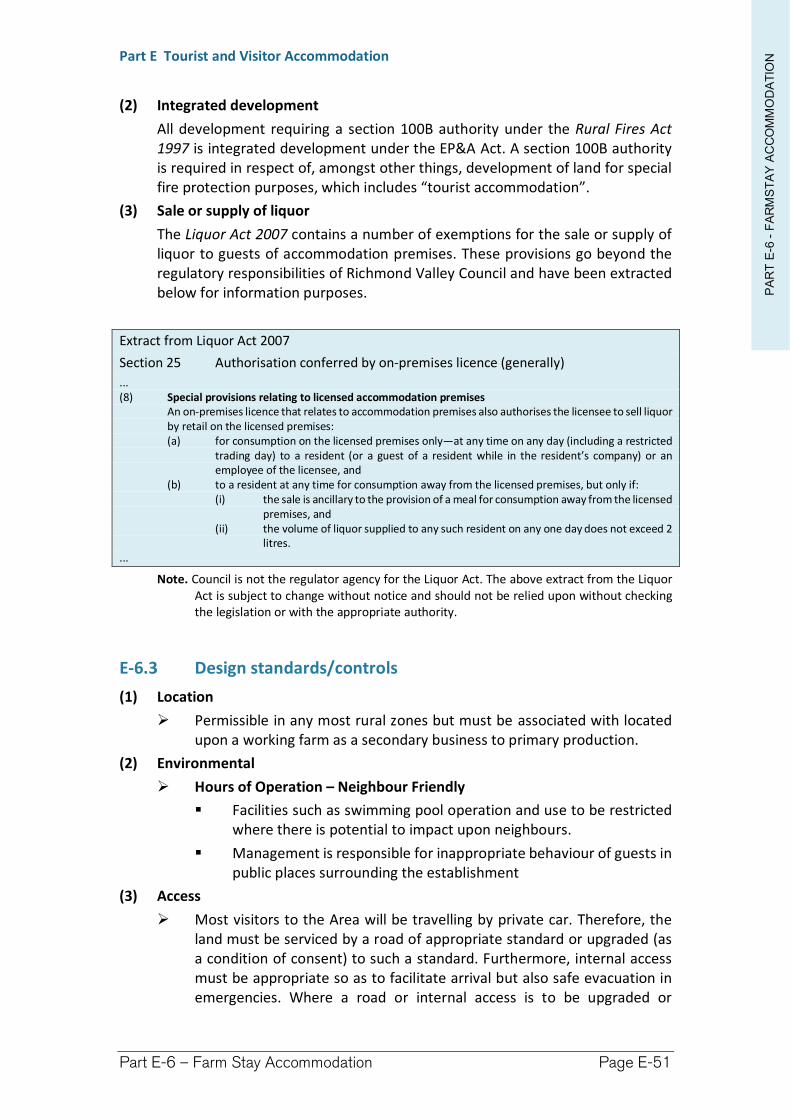
PA
RT
E-6
-F
AR
MS
TA
Y A
CC
OM
MO
DA
TIO
NPart E Tourist and Visitor Accommodation
Part E-6 – Farm Stay Accommodation Page E-51
(2) Integrated development
All development requiring a section 100B authority under the Rural Fires Act 1997 is integrated development under the EP&A Act. A section 100B authority is required in respect of, amongst other things, development of land for special fire protection purposes, which includes “tourist accommodation”.
(3) Sale or supply of liquor
The Liquor Act 2007 contains a number of exemptions for the sale or supply of liquor to guests of accommodation premises. These provisions go beyond the regulatory responsibilities of Richmond Valley Council and have been extracted below for information purposes.
Extract from Liquor Act 2007
Section 25 Authorisation conferred by on-premises licence (generally)
... (8) Special provisions relating to licensed accommodation premises
An on-premises licence that relates to accommodation premises also authorises the licensee to sell liquor by retail on the licensed premises: (a) for consumption on the licensed premises only—at any time on any day (including a restricted
trading day) to a resident (or a guest of a resident while in the resident’s company) or an employee of the licensee, and
(b) to a resident at any time for consumption away from the licensed premises, but only if: (i) the sale is ancillary to the provision of a meal for consumption away from the licensed
premises, and (ii) the volume of liquor supplied to any such resident on any one day does not exceed 2
litres. ...
Note. Council is not the regulator agency for the Liquor Act. The above extract from the Liquor Act is subject to change without notice and should not be relied upon without checking the legislation or with the appropriate authority.
E-6.3 Design standards/controls
(1) Location
Permissible in any most rural zones but must be associated with located upon a working farm as a secondary business to primary production.
(2) Environmental
Hours of Operation – Neighbour Friendly
Facilities such as swimming pool operation and use to be restricted where there is potential to impact upon neighbours.
Management is responsible for inappropriate behaviour of guests in public places surrounding the establishment
(3) Access
Most visitors to the Area will be travelling by private car. Therefore, the land must be serviced by a road of appropriate standard or upgraded (as a condition of consent) to such a standard. Furthermore, internal access must be appropriate so as to facilitate arrival but also safe evacuation in emergencies. Where a road or internal access is to be upgraded or
PA
RT
E-6
-F
AR
MS
TA
Y A
CC
OM
MO
DA
TIO
NPart E Tourist and Visitor Accommodation
Part E-6 – Farm Stay Accommodation Page E-52
provided new, the impact of construction and operation must be considered.
Site access onto a public road must be safe for guests as well as the travelling public. Consideration will be given to speed limits along the road, the design speed for the road, available sight distances along the road, design of the intersection, the volume of traffic to be generated.
(4) Hazards
Bushfire prone land
Where located on Bushfire Prone Land (see Council’s Bushfire Prone Land maps) the proposal will be Integrated Development unless the dwelling is located more than 30 metres from native vegetation. In this regard “native vegetation” is taken to mean naturally occurring bushland.
The proposal must be assessed against the Planning for Bushfire Protection guidelines (2006) either complying with the deemed to satisfy provisions or supplying an alternative solution.
Vegetation removal for asset protection needs to be balanced with retention of natural and cultural features of the site. Council may permit habitat loss where there will be a positive biodiversity off-set established within the development site and where appropriate consents under the Native Vegetation Act can be achieved. Such consents should be investigated prior to lodging the development application.
Flood
See Chapter H-1 Flooding.
Habitable floors are to be located above the flood planning level. The Flood Planning Level is a height 500mm above the 1 in 100 year ARI flood event for the site.
Extensions to an existing dwelling may be permitted at a level below the flood planning level where the additional floor area has an area less than 10% of the dwelling’s existing ground floor area.
Development will not be permitted within an identified high hazard area.
Emergency management plan
The Plan should be developed include an evacuation plan for guests.
(5) Design
Have regard to appropriate design guidelines, eg Part A contains design guidelines for residential accommodation, Coastal Development Guidelines.
Scale and Density
Proposed accommodation shall be restricted to a maximum of 10 guest bedrooms accommodating up to 25 guests.
PA
RT
E-6
-F
AR
MS
TA
Y A
CC
OM
MO
DA
TIO
NPart E Tourist and Visitor Accommodation
Part E-6 – Farm Stay Accommodation Page E-53
Siting of Accommodation
Any proposed buildings for Farm stay accommodation shall be sited within a 50 metre radius from the principal dwelling-house.
Privacy and Security
The design consideration of proposed buildings is to maintain the level of privacy enjoyed by adjoining properties.
The outlook to public and communal spaces should be maximised whilst maintaining internal privacy within the site.
Parking
1 off-street car parking space to be provided per guest bedroom (plus 1 for residents of the dwelling).
Where the accommodation is provided within dormitory-style accommodation the rate will be 1 off-street car parking space per 3 guests or part thereof.
Signage
As per signage within Part F.
Infrastructure
Where the dwelling is serviced by an On-site Sewage Management System (OSMS) the system must be assessed to ensure it can handle additional loads resulting from the Farm stay accommodation. Refer to Council’s OSMS Strategy.
Water efficiency
o Water Sensitive Urban Design needs to be incorporated into the design. This includes installation of roof water harvesting and on site storage, stormwater detention, erosion/sediment control, AAA rated plumbing and devices.
o Sites not connected to the mains water supply should provide a minimum of 10,000 litres rainwater tank capacity per guest bedroom and an additional 10,000 litres capacity dedicated for fire fighting purposes. A reduction in this capacity may be considered where an alternative source of suitable water can be demonstrated.
Public Health and Food Safety
All public health requirements shall be complied with, in particular, but not limited to, the Public Health Act 1991.
All proposed food preparation areas shall comply with the NSW Food Standards Code and AS4674-2004 (current at the time of DCP – refer to any succeeding legislative requirements).
Sale of food or beverages shall be restricted to guests being accommodated at the premises unless consent is granted for Food and drink premises.
Cooking facilities shall not be provided within guest bedrooms.
PA
RT
E-6
-F
AR
MS
TA
Y A
CC
OM
MO
DA
TIO
NPart E Tourist and Visitor Accommodation
Part E-6 – Farm Stay Accommodation Page E-54
Refuse Facilities
Refuse facilities shall be made for the storage and removal of rubbish in accordance with Council Policy and for the suitable screening of the refuge storage area.
Disposal of refuse on-site will not be permitted.
(6) Notification and advertising
See Chapter I-15.
Tourist and visitor accommodation is identified as Category “B” development, therefore, requiring a published notice and written notice for 14 days.
(7) Waste Minimisation and Management
The construction phase of any development must have a plan submitted and approved in accordance with Richmond Valley Council Waste Minimisation and Management Policy.
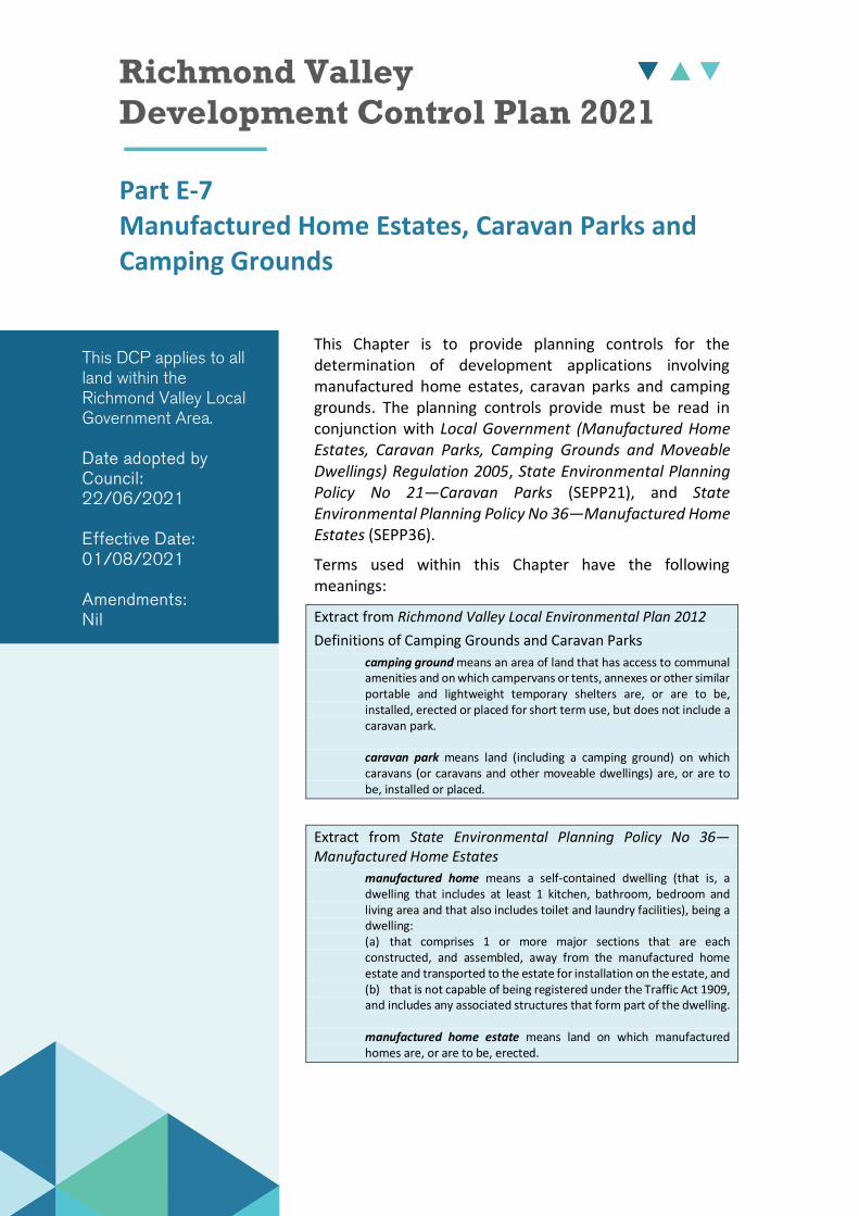
Richmond Valley Development Control Plan 2021
Part E-7 Manufactured Home Estates, Caravan Parks and Camping Grounds
This Chapter is to provide planning controls for the determination of development applications involving manufactured home estates, caravan parks and camping grounds. The planning controls provide must be read in conjunction with Local Government (Manufactured Home Estates, Caravan Parks, Camping Grounds and Moveable Dwellings) Regulation 2005, State Environmental Planning Policy No 21—Caravan Parks (SEPP21), and State Environmental Planning Policy No 36—Manufactured Home Estates (SEPP36).
Terms used within this Chapter have the following meanings:
Extract from Richmond Valley Local Environmental Plan 2012
Definitions of Camping Grounds and Caravan Parks
camping ground means an area of land that has access to communal amenities and on which campervans or tents, annexes or other similar portable and lightweight temporary shelters are, or are to be, installed, erected or placed for short term use, but does not include a caravan park.
caravan park means land (including a camping ground) on which caravans (or caravans and other moveable dwellings) are, or are to be, installed or placed.
Extract from State Environmental Planning Policy No 36—Manufactured Home Estates
manufactured home means a self-contained dwelling (that is, a dwelling that includes at least 1 kitchen, bathroom, bedroom and living area and that also includes toilet and laundry facilities), being a dwelling: (a) that comprises 1 or more major sections that are each constructed, and assembled, away from the manufactured home estate and transported to the estate for installation on the estate, and (b) that is not capable of being registered under the Traffic Act 1909, and includes any associated structures that form part of the dwelling.
manufactured home estate means land on which manufactured homes are, or are to be, erected.
This DCP applies to all land within the Richmond Valley Local Government Area.
Date adopted by Council: 22/06/2021
Effective Date: 01/08/2021
Amendments: Nil
PA
RT
E-7
-M
HE
, C
AR
AV
AN
PA
RK
S &
CA
MP
GR
OU
ND
S
Part E Tourist and Visitor Accommodation
Part E-7 – MHE, Caravan Parks and Camping Grounds Page E-56
E-7.1 Objectives
The objective of this Chapter is to apply local controls over manufactured home estates, caravan parks and camping grounds where there is provision for such controls in applicable Acts, Regulations, or Environmental Planning Instruments.
E-7.2 Principles & Development Standards
(1) Caravan Parks
(a) Richmond Valley LEP 2012 permissibility
Richmond Valley LEP 2012 permits caravan parks, with development consent, on land within:
Zone RU1 Primary Production
Zone RU5 Village
Zone R1 General Residential
Zone RE1 Public Recreation, and
Zone RE2 Private Recreation.
(b) State Environmental Planning Policy 21—Caravan Parks
Clauses 8 & 10 of SEPP21 require a Council to determine a number of things including whether it is particularly suitable for a caravan park to be used for long-term residence and whether there are adequate community facilities and services available, see below.
Extract from State Environmental Planning Policy No 21—Caravan Parks
Clause 8 Development consent required for caravan parks
... (2) Before granting development consent to the use of land for the purposes of a caravan park, a Council
must determine: (a) the number of sites (if any) within that land that the Council considers are suitable for long-
term residence, within the meaning of the Local Government (Caravan Parks and Camping Grounds) Transitional Regulation 1993, and
(b) the number of sites (if any) within that land that the Council considers are not suitable for long-term residence, but are suitable for short-term residence, within the meaning of that Regulation.
(3) A Council must not grant development consent to the use of land for the purposes of a caravan park unless it imposes as a condition of that consent a condition specifying the maximum number of sites (if any) within that land that may be used for long-term residence.
...
Clause 10 Matters to be considered by Councils
A Council may grant a development consent required by this Policy only after it has considered the following: (a) whether, because of its location or character, the land concerned is particularly suitable for use
as a caravan park for tourists or for long-term residence, (b) whether there is adequate provision for tourist accommodation in the locality of that land, and
whether existing or potential tourist accommodation will be displaced by the use of sites for long-term residence,
(c) whether there is adequate low-cost housing, or land available for low-cost housing, in that locality,
(d) whether necessary community facilities and services are available within the caravan park to which the development application relates or in the locality (or both), and whether those facilities and services are reasonably accessible to the occupants of the caravan park,
...
PA
RT
E-7
-M
HE
, C
AR
AV
AN
PA
RK
S &
CA
MP
GR
OU
ND
S
Part E Tourist and Visitor Accommodation
Part E-7 – MHE, Caravan Parks and Camping Grounds Page E-57
(c) Development Standards for Long-term Residents
(i) Where may long-term residences be granted consent
Development consent may only be granted for a caravan park, or extension to an existing caravan park, having a component of long-term residential accommodation, where:
the land is zoned urban (being in Zone R1 General Residential or Zone RU5 Village)—there are no more than 50% of sites to be used for long-term residences; or
the land has another zone—long-term residences are prohibited.
Notwithstanding, long-term residences may be permitted within other zones that adjoin land zoned urban, where a Site Compatibility Certificate has been obtained from Council. The Site Compatibility Certificate considerations prescribed by SEPP36 will be used by Council.
(ii) Essential Services
Development consent for a caravan park containing long-term residences may only be granted where:
it can be demonstrated that reasonable access is available to community facilities and services.
the park is serviced by reticulated water and sewer systems.
the land is considered suitable because of flooding.
the land is not affected to an unacceptable level by an offensive or hazardous industry or any form of pollution.
(iii) Conditions of consent
A condition of consent will be required to specify the maximum number of sites (if any) within the land that may be used for long-term residence.
(iv) Waste Minimisation and Management
The construction phase of any development must have a plan submitted and approved in accordance with Richmond Valley Council Waste Minimisation and Management Policy.
(2) Camping grounds
(a) Richmond Valley LEP 2012 permissibility
Richmond Valley LEP 2012 permits camping grounds, with development consent, on land within:
Zone RU1 Primary Production
Zone E3 Environmental Management
The definition of caravan park includes a camping ground. Therefore camping grounds are also permissible, with development consent, on land within:
PA
RT
E-7
-M
HE
, C
AR
AV
AN
PA
RK
S &
CA
MP
GR
OU
ND
S
Part E Tourist and Visitor Accommodation
Part E-7 – MHE, Caravan Parks and Camping Grounds Page E-58
Zone RU5 Village
Zone R1 General Residential
Zone RE1 Public Recreation, and
Zone RE2 Private Recreation.
(3) Manufactured Home Estates
(a) State Environmental Planning Policy 36—Manufactured Home Estates
Manufactured home estates are regulated by SEPP36 and are a key alternative type of medium density residential development and affordable housing.
SEPP36 generally requires that manufactured home estates may be carried out with development consent on any land where development for the purposes of a caravan park may be carried out. However, there are exceptions for categories of land identified within Schedule 2 of SEPP36. Furthermore, the estates must be adequately serviced and have access to essential community facilities and services.
(b) Excluded lands (Schedule 2)
Manufacture home estates are excluded from the following lands by virtue of Schedule 2 of SEPP36:
land within-
Zone RE1 Public Recreation—(open space other than open space (private recreation)).
environmental protection—Zone E2 Environmental Conservation, Zone E3 Environmental Management, and Zone W1 Natural Waterway.
Zone RU1 Primary Production—where not adjacent to or adjoining land zoned for urban use (Zone R1 General Residential and Zone RU5 Village).
land identified in Richmond Valley LEP 2012 as-
Terrestrial Biodiversity.
Wetlands.
Riparian Land and Waterways.
a Drinking Water Catchment.
land described within an environmental planning instrument or strategy as-
an extractive resource.
services corridor.
airport/industry buffer area.
habitat corridor.
containing significant remnant vegetation.
littoral rainforest.
PA
RT
E-7
-M
HE
, C
AR
AV
AN
PA
RK
S &
CA
MP
GR
OU
ND
S
Part E Tourist and Visitor Accommodation
Part E-7 – MHE, Caravan Parks and Camping Grounds Page E-59
water catchment.
wetlands.
land considered unsuitable for residential development because of flooding.
land affected to an unacceptable level by an offensive or hazardous industry or any form of pollution.
Richmond Valley Development Control Plan 2021
Part F Signage
Well designed signage which respects the environment and character of the locality will be appreciated by both residents and visitors whilst enhancing commercial activity. Conversely, when placed without proper thought or planning, signage can be counter productive, obtrusive and dangerous for both pedestrians and road users. Too many signs can result in visual ‘clutter’ having a detrimental impact on the general public, the business operator and the visual amenity of the locality.
The Standard Instrument LEP provides a defined term for signage (a group term) and includes sub-term definitions for advertising structure, building identification signage, and business identification signage. As such signage comprises of signs, notices, devices, representations or advertisements that advertise or promote goods, services or events.
Figure F.1 General relationships for signage in the Standard Instrument LEP (Source Department of Planning – Practice Note PN11-004).
This DCP applies to all land within the Richmond Valley Local Government Area.
Date adopted by Council: 22/06/2021
Effective Date: 01/08/2021
Amendments: Nil
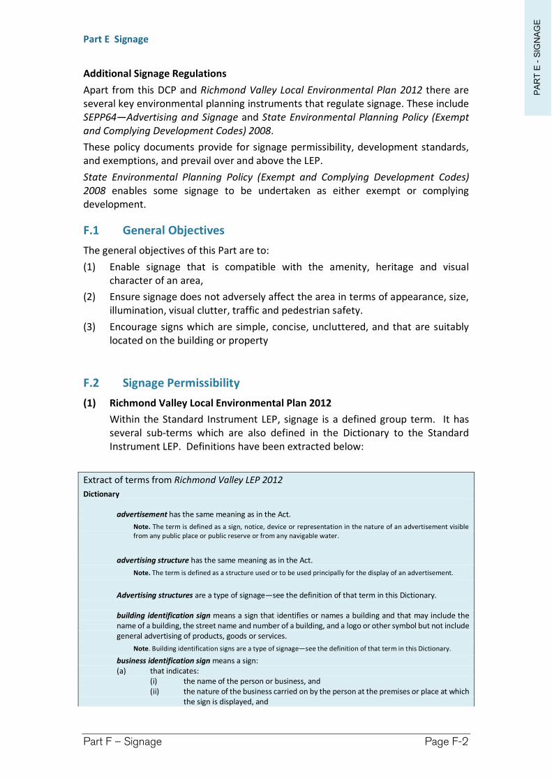
PA
RT
E -
SIG
NA
GE
Part E Signage
Part F – Signage Page F-2
Additional Signage Regulations
Apart from this DCP and Richmond Valley Local Environmental Plan 2012 there are several key environmental planning instruments that regulate signage. These include SEPP64—Advertising and Signage and State Environmental Planning Policy (Exempt and Complying Development Codes) 2008.
These policy documents provide for signage permissibility, development standards, and exemptions, and prevail over and above the LEP.
State Environmental Planning Policy (Exempt and Complying Development Codes) 2008 enables some signage to be undertaken as either exempt or complying development.
F.1 General Objectives
The general objectives of this Part are to:
(1) Enable signage that is compatible with the amenity, heritage and visual character of an area,
(2) Ensure signage does not adversely affect the area in terms of appearance, size, illumination, visual clutter, traffic and pedestrian safety.
(3) Encourage signs which are simple, concise, uncluttered, and that are suitably located on the building or property
F.2 Signage Permissibility
(1) Richmond Valley Local Environmental Plan 2012
Within the Standard Instrument LEP, signage is a defined group term. It has several sub-terms which are also defined in the Dictionary to the Standard Instrument LEP. Definitions have been extracted below:
Extract of terms from Richmond Valley LEP 2012
Dictionary
advertisement has the same meaning as in the Act.
Note. The term is defined as a sign, notice, device or representation in the nature of an advertisement visible from any public place or public reserve or from any navigable water.
advertising structure has the same meaning as in the Act.
Note. The term is defined as a structure used or to be used principally for the display of an advertisement.
Advertising structures are a type of signage—see the definition of that term in this Dictionary.
building identification sign means a sign that identifies or names a building and that may include the name of a building, the street name and number of a building, and a logo or other symbol but not include general advertising of products, goods or services.
Note. Building identification signs are a type of signage—see the definition of that term in this Dictionary.
business identification sign means a sign: (a) that indicates:
(i) the name of the person or business, and (ii) the nature of the business carried on by the person at the premises or place at which
the sign is displayed, and
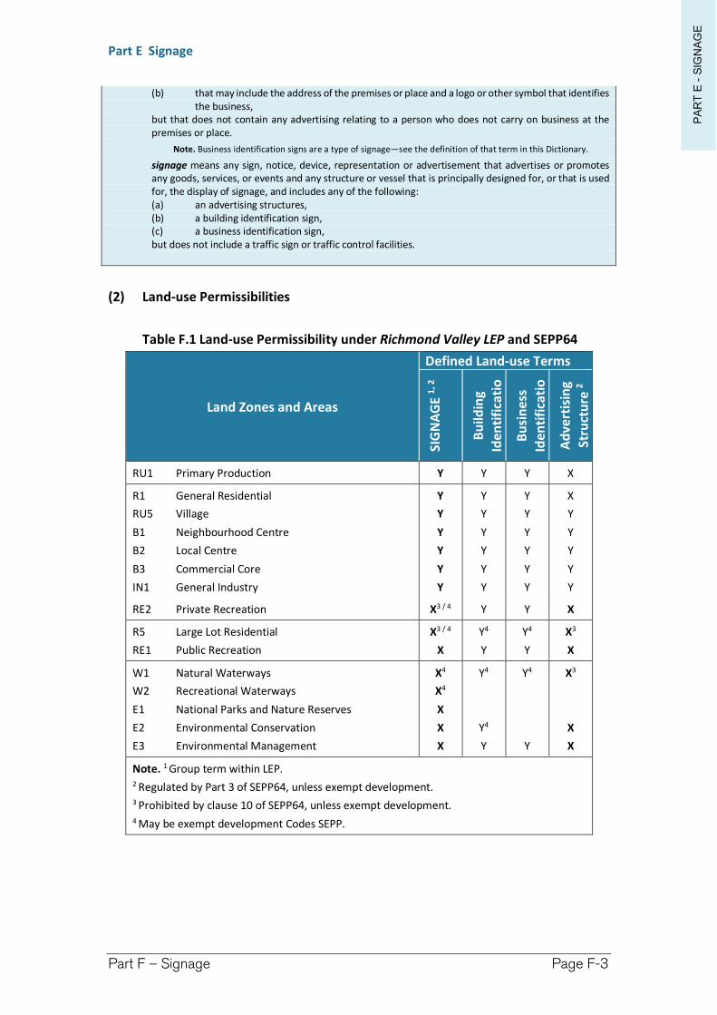
PA
RT
E -
SIG
NA
GE
Part E Signage
Part F – Signage Page F-3
(b) that may include the address of the premises or place and a logo or other symbol that identifies the business,
but that does not contain any advertising relating to a person who does not carry on business at the premises or place.
Note. Business identification signs are a type of signage—see the definition of that term in this Dictionary.
signage means any sign, notice, device, representation or advertisement that advertises or promotes any goods, services, or events and any structure or vessel that is principally designed for, or that is used for, the display of signage, and includes any of the following: (a) an advertising structures, (b) a building identification sign, (c) a business identification sign, but does not include a traffic sign or traffic control facilities.
(2) Land-use Permissibilities
Table F.1 Land-use Permissibility under Richmond Valley LEP and SEPP64
Land Zones and Areas
Defined Land-use Terms
SIG
NA
GE
1, 2
Bu
ildin
g
Iden
tifi
cati
on
Sig
nB
usi
nes
s
Iden
tifi
cati
on
Sig
nA
dve
rtis
ing
Stru
ctu
re2
RU1 Primary Production Y Y Y X
R1 General Residential
RU5 Village
B1 Neighbourhood Centre
B2 Local Centre
B3 Commercial Core
IN1 General Industry
Y
Y
Y
Y
Y
Y
Y
Y
Y
Y
Y
Y
Y
Y
Y
Y
Y
Y
X
Y
Y
Y
Y
Y
RE2 Private Recreation X3 / 4 Y Y X
R5 Large Lot Residential
RE1 Public Recreation
X3 / 4
X
Y4
Y
Y4
Y
X3
X
W1 Natural Waterways
W2 Recreational Waterways
E1 National Parks and Nature Reserves
E2 Environmental Conservation
E3 Environmental Management
X4
X4
X
X
X
Y4
Y4
Y
Y4
Y
X3
X
X
Note. 1 Group term within LEP. 2 Regulated by Part 3 of SEPP64, unless exempt development. 3 Prohibited by clause 10 of SEPP64, unless exempt development. 4 May be exempt development Codes SEPP.
PA
RT
E -
SIG
NA
GE
Part E Signage
Part F – Signage Page F-4
F.3 Structures over Public Roads
(1) Chapter I-2 provides guidelines for the erection of structures in, on, over or under a public road. In summary, owners consent (generally Council) will be required to erect any structure, including signage over a public road.
Other approvals may also be required to undertake works within a public road including under the Roads Act 1993 and Local Government Act 1993. Such approvals may still be required even if the signage is exempt development.
F.4 Development Controls Relating to Signage
All signage types
(1) All signage types must-
(a) relate to the use of the land, be visually interesting and be of high quality design and materials.
(b) not detract from the amenity or visual qualities of an area. The sign must have a scale, proportion and form appropriate for the streetscape.
(c) be compatible with the building design in its colour, materials and finishes. Solid block painting of walls particularly in bright colours is to be avoided.
(d) not be constructed over or obscure architectural elements of the building.
(e) not exceed, for total signage per street frontage, one top hamper, one fascia sign, one wall sign or projecting wall sign, and one under awning sign. An additional free standing sign may be permitted in an appropriate location.
Note. Council may require sites with existing “clutter” signage to be removed as part of an approval process.
(f) not be attached to a vehicle, include flashing or animated displays, be located above rooftops or project beyond the building elevation.
(g) if illuminated, have concealed cables, not cause unacceptable glare, and may be required to have intensity dimmers and restricted hours of operation.
(h) not cause a traffic distraction, obscure or interfere with road traffic sign or signals. If visible from a busy road the sign must be consistent with The Transport Corridor Outdoor Advertising and Signage Guidelines published by the Department of Planning.
(2) Signage located over Council owned land will only be approved where it is located over a footpath area within the central business district.
Under Awning Signs
(3) Under awning signage requirements are-
(a) Maximum of one sign per tenancy;
(b) Not project beyond the awning;
PA
RT
E -
SIG
NA
GE
Part E Signage
Part F – Signage Page F-5
(c) Erected at right angles to the building; and
(d) Be located at least 2.6m above ground level.
Projecting Wall Signs or Above Awning signs
(4) Projecting Wall Sign or Above Awning Signage requirements are-
(a) Maximum of one sign of this type per building elevation that does not contain a flush wall sign.
(b) Be at least 500mm below the wall height including any parapet.
(c) Not be less than 3.0m above ground level.
(d) Projects not more than 2.5m from the wall for a wall sign, or 2.6m above the awning for an above awning sign.
(e) Have a thickness of not more than 300mm.
(f) Not exceeding 5m2 for each side of the sign.
(g) Wholly located upon the subject land or have the consent of the adjoining land owner. Where located over Council owned land e.g. footpath the requirements of Chapter I-2 apply.
Flush Wall Signs
(5) Flush Wall Signage requirements are-
(a) Either attached to or painted onto a wall that does not include a projecting wall sign or an above awning sign.
(b) Maximum of one per building elevation.
(c) Maximum of 25% of the wall area.
(d) Must be at least 500mm below the wall height including any parapet.
(e) Not project more than 300mm from the wall.
(f) Be wholly located within the property boundary or have the consent of the adjoining landowner.
Top Hamper Signs
(6) Top Hamper Signage requirements are-
(a) Located immediately above a doorway or window and below the awning.
(b) Not exceed the width of the window or opening.
(c) Freestanding, Pole or Pylon Signs
(d) Only permitted in Commercial or Industrial areas, advertising the business or products sold on the land.
(e) Limit of one structure per road frontage. Where multiple tenancies exist locate individual panels for each business on the same structure.
(f) Must not project beyond the boundary of the premises.
(g) Maximum width of 2.5m
(h) Height must not exceed 6m.
(i) Must not contain any moving, flashing or animated components.
PA
RT
E -
SIG
NA
GE
Part E Signage
Part F – Signage Page F-6
Electronic, Variable Message or Display Signage
(7) Where any signage type will be Electronic in style, with the ability to change its display, will be permitted within Business and Industrial Zones only.
(8) Electronic signage must be located and managed not to cause any traffic distraction or hazard.
(9) Electronic signage must be consistent with SEPP64 and The Transport Corridor Outdoor Advertising and Signage Guidelines published by the Department of Planning & Environment. Assessment in accordance with Part 3 of the document will be required. In particular the following requirements will apply-
(a) The speed limit of the road must not be greater than 70 kilometres per hour
(b) The time to change the display must not be greater than 1 second
(c) The display must be completely static from its first appearance to the commencement of a change to another display
(d) A driver should not expect to see more than one (1) message in the period of exposure
(e) The level of illumination must be adjustable
(f) The sign must not-
obscure or limit the view of the driver of a motor vehicle on a public road, or
be mistaken for a traffic control device, or
cause inconvenience or danger in the use of a public road, or
be otherwise hazardous to traffic.
F.5 State Environmental Planning Policy No 64—Advertising and Signage (SEPP64)
(1) SEPP64 applies to all signage and aims to ensure that it:
is compatible with the desired amenity and visual character of an area;
provides effective communication in suitable locations, and
is of high quality design and finish.
It also provides:
time-limited consents (maximum 15 years),
development assessment criteria,
prohibitions on signage (other than business identification signs, building identification signs, exempt development signs, and signage on vehicles) within:
environmentally sensitive areas/ natural or other conservation area (Zones E2 and E3)
heritage areas — Casino Central Business District Conservation Area
open space — Zone RE1
PA
RT
E -
SIG
NA
GE
Part E Signage
Part F – Signage Page F-7
waterways — Zone W1 and W2
residential (but not mixed residential and business zones) — Zone R1 and R5
national park/nature reserve — Zone E1
development standards for specified types of signage, these being:
advertisements on rural or non-rural land,
transport corridors,
advertisements with a display area >20 m2 or higher than 8 metres above ground,
advertisements with a display area >20 m2 and within 250 metres of, and visible from, a classified road,
advertising display area >45 m2,
roof or sky advertisements,
wall advertisements,
freestanding advertisements,
advertisements on bridges,
special promotional advertisements,
building wrap advertisements, and
advertisements within navigable waters.
Extract from SEPP64
Schedule 1 Assessment criteria
1 Character of the area • Is the proposal compatible with the existing or desired future character of the area or locality in which
it is proposed to be located? • Is the proposal consistent with a particular theme for outdoor advertising in the area or locality?
2 Special areas • Does the proposal detract from the amenity or visual quality of any environmentally sensitive areas,
heritage areas, natural or other conservation areas, open space areas, waterways, rural landscapes or residential areas?
3 Views and vistas • Does the proposal obscure or compromise important views? • Does the proposal dominate the skyline and reduce the quality of vistas? • Does the proposal respect the viewing rights of other advertisers?
4 Streetscape, setting or landscape • Is the scale, proportion and form of the proposal appropriate for the streetscape, setting or landscape? • Does the proposal contribute to the visual interest of the streetscape, setting or landscape? • Does the proposal reduce clutter by rationalising and simplifying existing advertising? • Does the proposal screen unsightliness? • Does the proposal protrude above buildings, structures or tree canopies in the area or locality? • Does the proposal require ongoing vegetation management?
5 Site and building • Is the proposal compatible with the scale, proportion and other characteristics of the site or building,
or both, on which the proposed signage is to be located? • Does the proposal respect important features of the site or building, or both? • Does the proposal show innovation and imagination in its relationship to the site or building, or both?
6 Associated devices and logos with advertisements and advertising structures • Have any safety devices, platforms, lighting devices or logos been designed as an integral part of the
signage or structure on which it is to be displayed?

PA
RT
E -
SIG
NA
GE
Part E Signage
Part F – Signage Page F-8
7 Illumination • Would illumination result in unacceptable glare? • Would illumination affect safety for pedestrians, vehicles or aircraft? • Would illumination detract from the amenity of any residence or other form of accommodation? • Can the intensity of the illumination be adjusted, if necessary? • Is the illumination subject to a curfew?
8 Safety • Would the proposal reduce the safety for any public road? • Would the proposal reduce the safety for pedestrians or bicyclists? • Would the proposal reduce the safety for pedestrians, particularly children, by obscuring sightlines
from public areas?
Richmond Valley Development Control Plan 2021
Part G Subdivision
Subdivision of land is defined within Section 4B of the EP&A Act.
It generally provides that subdivision of land is the division of land into 2 or more parts that can be used separately or transferred. The term covers freehold title subdivisions as well as strata title and community title subdivisions.
Exclusions from the term subdivision include opening or widening of public roads, consolidation of lots, etc.
This DCP Part applies to the subdivision of land within the Richmond Valley Council area and offers an interpretation of various LEP provisions and development standards.
This DCP applies to all land within the Richmond Valley Local Government Area.
Date adopted by Council: 22/06/2021
Effective Date: 01/08/2021
Amendments: Nil
PA
RT
G -
SU
BD
IVIS
ION
Part G Subdivision
Part G – Subdivision Page G-2
G.1 General Objectives
The general objectives of this Part are to:
(a) provide guidelines to assist with the design and construction of subdivisions so that they are compatible with the natural and built environments within which they are sited,
(b) provide development standards and requirements for the subdivision of land, (c) provide criteria for consideration during the preparation of a development
application and its subsequent assessment, and
G.2 Subdivision Design Standards
G.2.1 Objectives
(a) to identify design considerations for the layout of subdivisions. (b) to achieve the most effective and efficient use of land having regard to
topographic, climatic, ecological, and agricultural features, along with land uses patterns, zoning and infrastructure/servicing.
G.2.2 Design Criteria
(1) Applicants are to comply with the following Design Criteria unless it can be demonstrated that an alternative solution to all or any of the design criteria will achieve an improved development outcome.
(2) Site Analysis
(a) A site analysis plan is required to identify opportunities and constraints relating to the subdivision pattern and potential end use of the land.
(b) A site analysis plan should be prepared having regard to the following, where relevant:
waterways (creeks, rivers, streams),
natural resources such as significant vegetation, habitat corridors, key fish habitat, wetlands, and various requirements for coastal protection,
flood prone land,
steep land/land slip,
bush fire hazard,
access points (vehicles, pedestrians, cyclists),
soil conditions (acid sulfate soils, contaminated land),
surrounding land uses,
service connections,
easements, zones of influence and clear zones,
archaeological sites,
topography (contours to Australian Height Datum at 1 metre intervals),
aspect,
PA
RT
G -
SU
BD
IVIS
ION
Part G Subdivision
Part G – Subdivision Page G-3
drainage systems,
existing buildings, driveways, septic tanks and disposal areas, and
street and lot layout of locality.
(3) Subdivision and Road Design
(a) Subdivisions should be designed having regard to the environmental constraints of the site, having regard to:
Koala Habitat,
Protection of native vegetation and habitats under the Biodiversity Conservation Act,
Acid Sulfate Soils,
Contaminated Land,
Flood Prone Land,
Landform Modification,
Coastal Hazards, and
Bush Fire Hazard.
(b) The road hierarchy of subdivisions should also reflect road function, and should be designed accordingly.
(c) The layout of new roads should be designed so as to:
provide road links to adjoining properties,
facilitate the use of public transport,
achieve efficient access to all lots,
encourage safe levels of vehicle speed,
provide adequate sight distances (particularly at intersections),
provide efficient access for service vehicles (bushfire and garbage trucks),
provide for safe and functional vehicle and pedestrian movement,
adopt CPTED design principles (refer to Chapter I-10), and
provide for landscaping, utility services, driveways, mailboxes, street lighting, etc.
(d) The layout of main roads should follow a reasonably regular configuration to make the subdivision easy to navigate, and should:
provide memorable places to aid navigation,
provide people with directional choice to enable traffic to run smoothly and not confuse or overtly hinder thoroughfare,
(e) Cul-de-sacs should be avoided, but be short in length if utilised.
(f) Lots are to be designed to allow the construction of a dwelling which does not involve more than 1 metre cut or fill, measured from natural ground level, outside the dwellings external walls. Geotechnical reports are required for subdividing steep land.
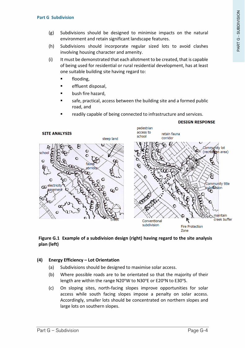
PA
RT
G -
SU
BD
IVIS
ION
Part G Subdivision
Part G – Subdivision Page G-4
(g) Subdivisions should be designed to minimise impacts on the natural environment and retain significant landscape features.
(h) Subdivisions should incorporate regular sized lots to avoid clashes involving housing character and amenity.
(i) It must be demonstrated that each allotment to be created, that is capable of being used for residential or rural residential development, has at least one suitable building site having regard to:
flooding,
effluent disposal,
bush fire hazard,
safe, practical, access between the building site and a formed public road, and
readily capable of being connected to infrastructure and services.
Figure G.1 Example of a subdivision design (right) having regard to the site analysis plan (left)
(4) Energy Efficiency – Lot Orientation
(a) Subdivisions should be designed to maximise solar access.
(b) Where possible roads are to be orientated so that the majority of their length are within the range N20oW to N30oE or E20oN to E30oS.
(c) On sloping sites, north-facing slopes improve opportunities for solar access while south facing slopes impose a penalty on solar access. Accordingly, smaller lots should be concentrated on northern slopes and large lots on southern slopes.
PA
RT
G -
SU
BD
IVIS
ION
Part G Subdivision
Part G – Subdivision Page G-5
(5) Density (Minimum Lot Size) and dimensions
Subdivisions are not to produce lots which have areas less than that set out in the Lot Size Map in the Richmond Valley LEP 2012.
(a) Residential Subdivisions
i. Battle Axe Lots
Battle axe allotments are largely to be avoided, except in circumstances to provide access to a small number of allotments which would otherwise be difficult, or cost prohibitive to access by formal road system.
If a small number of battleaxe lots are utilised, they are required to be larger in size, exclusive of the access handle (i.e. 1000 m2 where regular lots are 600-800 m2).
The handle should have a minimum width of 4.5 metres in areas requiring line-of-sight and should be constructed of concrete at the subdivision stage.
Note. The subdivision of dual occupancies under clause 4.1C would have regard for, but not necessarily required to adhere to the abovementioned standards.
ii. Minimum Frontage
Allotments should have a minimum frontage to a public road of 15 metres, to be measured at the front boundary building line.
A subdivision which will involve a lot having vehicular access to a lane will only be permitted after the lot has been substantially developed (i.e. vacant lots off laneways are not to be created), and the lot adjoining the lane is to have 2 metres wide frontage fenced and paved to the primary road, to provide for pedestrian access, mailbox, services (water, sewer, electricity, communication).
iii. Strata/Community Title
Inspection of existing buildings will be required to ensure compliance with all relevant building and fire regulations standards.
Certification of all building work, including final occupation certificates, will be required prior to release of the strata/subdivision certificate.
iv. Dual Occupancy
Both dwellings within the development must be complete prior to release of the subdivision certificate. As such no vacant allotments can be created.
Each allotment must comply with BCA requirements for fire separations.
See also the subdivision requirements in Part A Residential Development
PA
RT
G -
SU
BD
IVIS
ION
Part G Subdivision
Part G – Subdivision Page G-6
(b) Rural Subdivisions
i. Battle Axe Lots
Battle axe allotments are to be avoided.
Reciprocal rights of carriageway are not supported as to avoid conflict between neighbours over maintenance.
Where justified, the access handle should be a minimum 10 metres wide, and should be no longer than 200 metres.
(c) Commercial Subdivisions
i. Battle Axe Lots
Battle axe allotments are not permitted for subdivisions in Zones B1, B2 and B3.
Each allotment to be subdivided must demonstrate that the resultant allotment is capable of being developed for commercial development based upon its lot size, dimensions, frontage, access and services.
(6) Services
(a) Urban Areas
i. Subdivisions in urban areas are generally required to provide infrastructure to all lots including:
road;
footpath;
kerb and gutter;
drainage (including interallotment drainage);
reticulated sewer and water;
telecommunications;
street lighting; and
electricity.
(b) Large Lot Residential Areas
i. Subdivisions are to provide infrastructure to all lots:
a. including road and drainage, incorporating sealed driveways to be provided to battle axe shaped lots.
ii. It must be demonstrated that each allotment can be adequately serviced by on-site sewage effluent disposal (OSMS).
(c) Rural Areas
i. Subdivisions in rural areas may permit access by right-of-carriageway.
ii. The right-of-carriageway is to be constructed to provide all weather two-wheel drive vehicular access with adequate drainage provision, however, the length of the access handle should be no longer than 200 metres, particularly when located on bush fire prone land.
iii. It must be demonstrated that each allotment can be adequately serviced by on-site sewage effluent disposal (OSMS).
PA
RT
G -
SU
BD
IVIS
ION
Part G Subdivision
Part G – Subdivision Page G-7
(7) Stormwater Drainage
(a) Stormwater drainage shall be designed and provided in accordance with Council’s specifications.
(b) The design details will need to be certified by Council before the drainage is provided, and will need to be completed to Council’s satisfaction prior to the issue of the Subdivision Certificate.
(c) Stormwater is to be gravity drained to Council’s drainage system. In some circumstances inter-allotment drainage and easements over downstream properties may be required. This will necessitate a letter of consent from the owner(s) of the downstream properties to be submitted with the development application.
(d) Drainage from sites should reflect the pre-existing or natural situation in terms of location, quantity, quality and velocity.
(e) Water Sensitive Urban Design principles should be employed, particularly with larger subdivisions.
(8) Utility Services
(a) Utility services must be extended to all lots within a subdivision in accordance with the following table (except for common property in community title and strata subdivisions).
Utility Service Urban Area Rural Residential Area
Rural area
Council’s water main Yes No 4 No 4
Council’s sewer main Yes No 3 No 3
Telephone Yes 1 Yes 1 No
Electricity Yes 1 Yes 1 Yes 2
Note. 1 In greenfield subdivisions these services must be underground. 2 Unless the applicant can demonstrate that alternative methods of providing electricity exists or that the provision of this service is cost prohibitive. 3 Subject to demonstrating the capability of the lots to accommodate on-site effluent disposal. 4 Each allotment would be serviced by rain water tank to be provided as part of the construction of subsequent development.
Note. Richmond Valley LEP 2012 requires that a development application demonstrates that the following services that are essential for the proposed development are available or that adequate arrangements have been made to make them available when required—
i. the supply of water, ii. the supply of electricity,
iii. the disposal and management of sewage, iv. stormwater drainage or on-site conservation, v. suitable road access.
PA
RT
G -
SU
BD
IVIS
ION
Part G Subdivision
Part G – Subdivision Page G-8
(9) Erosion and Sediment Control
(a) Subdivisions should be designed to minimize the disturbance of lands with topographical constraints.
(b) Conditions on the development consent will indicate whether erosion and sediment controls will be necessary, and if so, these controls will need to be in place before site works commence. The controls will need to be provided in accordance with Landcom (2004) Blue Book – Managing Urban Stormwater: Soils and Construction.
(10) Street Tree Masterplan
(a) A Street Tree Masterplan will be required for subdivisions on greenfield sites. The Masterplan aims to guide street tree planting, providing for a more appealing streetscape which complements its natural setting.
(b) Planting proposed by the Masterplan is to be determined having regard to:
site and dwelling boundaries,
location and canopy of existing trees, noting any trees that overhang the sit,
adjacent streets and trees,
any connection to open space networks or proposed public reserves,
paving materials and drainage
treatment,
details of any existing fencing and walls, and
location of underground services.
(11) Developer Contributions
(a) In many cases the payment of contributions are required to cover the cost of services and facilities which are provided by Council. These contributions are often levied with subdivision, prior to the issue of the Subdivision Certificate. Contributions levied on developments may include:
section 64 contributions under the Local Government Act 1993 for such services as water, sewer and drainage, and/or
section 7.12 contributions under the Environmental Planning and Assessment Act 1979 which consists of a levee up to 1% of the cost of the development.
(b) Conditions on the development consent will indicate whether these contributions are required.
(c) The value of these contributions are outlined in Council’s Revenue Policy which is available on-line.
(12) Adoption of Northern Rivers Local Government Development Design and Construction Manuals
(a) The Northern Rivers Local Government Development Design and Construction Manuals are utilised for the design and construction of civil
PA
RT
G -
SU
BD
IVIS
ION
Part G Subdivision
Part G – Subdivision Page G-9
engineering works associated with development approvals. The Manual is contained within 3 volumes being:
Development & Design Manual,
Construction Manual, and
Standard Drawings.
(b) For the purposes of engineering and subdivision works reference should be made to the standards contained within the manuals.
(c) Where doubt exists regarding standards contained within the Manuals, or a subject has not been adequately covered, consultation should be made with Council or any relevant Council policy for clarification or reference to alternatively appropriate standards.
Richmond Valley Development Control Plan 2021
Part H Natural Resources and Hazards
This is a subject based Part relating to natural hazards and natural resources and sensitivities provided for within the Richmond Valley Local Environmental Plan 2012.
It provides more detailed information to assist applicants address the requirements contained within the LEP in the preparation of the development application.
There are a range of other environmental and hazard requirements that may apply to a site under other legislation or environmental planning instruments, including bush fire, koala habitat, contaminated lands and coastal management. These matters are not addressed in the DCP.
This Part contains the following Chapters:
Chapter Page No. in this Part
Part H-1 Flood Planning ................................................... 3
Part H-2 Acid Sulfate Soils ................................................ 9
Part H-3 Natural Resources (NRS) .................................. 19
This DCP applies to all land within the Richmond Valley Local Government Area.
Date adopted by Council: 22/06/2021
Effective Date: 01/08/2021
Amendments: Nil
Richmond Valley Development Control Plan 2021
Part H-1
Flood Planning
This Chapter provides guidance for development of land below the Flood Planning Level and should be read in conjunction with the NSW Floodplain Development Manual and Council’s adopted Floodplain Risk Management Plan(s).
This DCP applies to all land within the Richmond Valley Local Government Area.
Date adopted by Council: 22/06/2021
Effective Date: 01/08/2021
Amendments: Nil
PA
RT
H-1
-F
LO
OD
PLA
NN
INGPart H-1 Flood Planning
Part H-1 – Flood Planning Page H-4
H-1.1 General Objectives
The general objectives of this Chapter are to:
(1) align flood planning with the NSW Government’s Floodplain Policy.
(2) explain the relevance of the adopted Flood Planning Level.
(3) call up Flood Planning Development Controls from Council’s Floodplain Risk Management Plans, which adopt a flood planning approach taking into account social and environmental considerations alongside economic benefits to reach the most objective balance.
(4) explain the adopted floodplain risk hazard categories and encourage suitable development compatible with flood hazard.
(5) make allowances for alterations to existing development, or on compassionate grounds such as when a building has been lost to fire or storm.
H-1.2 Floodplain Risk Management Plans
Objectives
(a) to explain the flood risk categories adopted by Council’s Floodplain Risk Management Plan(s).
(b) to recognise the 1 in 100 year ARI design flood for appropriate flood planning development controls.
(c) explain the probability of the various design flood events occurring.
Controls
(1) Council had 2 adopted Floodplain Risk Management Plans, one each for of Casino and the Mid-Richmond.
(2) These Plans have modelled a number of design floods ranging from a 1 in 20 year event to the Probable Maximum Flood (PMF). The models have been calibrated for each event frequency, based upon anecdotal and recorded information, to improve their resilience.
(3) The NSW Floodplain Development Manual advocates a merits based approach to selection of appropriate flood planning levels (FPLs) recognising the need to consider the full range of flood sizes, up to and including the PMF, and the corresponding risks associated with each flood. With few exceptions, it recognises that it is neither feasible nor socially or economically justifiable to adopt the PMF as the basis for flood planning. Council’s Flood Plain Risk Management Plans retain the NSW 1 in 100 year ARI design flood as the reference flood for planning purposes, except for more critical development in accordance with the adopted Matrix of Development Type v Flood Hazard Category.
Note. A 1 in 100 year ARI flood event may also be referred to as a 1% AEP flood—measured as having a 1% probability of occurring or being exceeded in any single year.
PA
RT
H-1
-F
LO
OD
PLA
NN
INGPart H-1 Flood Planning
Part H-1 – Flood Planning Page H-5
Other flood design levels often cited are 1 in 20 year (or 5% Flood), 1 in 50 year (or 2% Flood), 1 in 500 year (or 0.2% Flood), and PMF (the ultimate flood event that can occur).
(5) The Risk Plans also reference Floodplain Hazard Categories. These are tools for assessing the suitability and minimum requirements for development based on a combination of depth (D) and velocity (V). These categories are:
(a) High Floodway Hazard (HFH) - based on a 100 year design flood – Flow paths that carry significant volumes of flood water during a 100 year flood. Danger to life and limb, evacuation difficult, potential for structural damage, high social disruption, and economic losses. V>2m/s or VxD>1 [for D>1m] or D+(0.3xV)>1 [for V>1m/s]
(b) High Depth Hazard (HDH) - based on a 100 year design flood – Area where floodwaters are deep but are not flowing with high velocity. V<1m/s and VxD<1 or D+(0.3xV)>1
(c) High Isolation Hazard (HIH) - based on a 100 year design flood – As per High Depth but with no easy access to safe refuge (ie more than 500m to high ground)
(d) Possible High Depth Hazard (HFH) or Low Hazard (LH) - based on a 100 year design flood – Insufficient ground level information. Final category dependent on the exact ground levels at the particular site.
(e) Low Hazard (LH) - based on a 100 year design flood – Flood depths and velocities are sufficiently low that people and their possessions can be evacuated.- based on a
(f) Rare Low Hazard (RLH) - based on PMF - Any land that is inundated in the PMF event and has not been assigned one of the other hazard categories. These areas are generally above the 100 year design flood.
(g) Rare High Floodway Hazard (RHFH) - based on 500 year design flood - Flow paths that carry significant volumes of flood water during a 500 year design flood.
These areas may or may not be affected by the 100 year design flood. Danger to life and limb, evacuation difficult, potential for structural damage, high social disruption, and economic losses. V > 2m/s or VxD>1 [for D >1m] or D+(0.3xV)>1 [for V>1m/s]
H-1.3 Flood Planning Level
Objectives
(a) to explain the Flood Planning Level.
Controls
(1) Council’s Floodplain Risk Management Plans have adopted the 1 in 100 year ARI flood event to be most appropriate for flood planning.
(2) The Richmond Valley LEP 2012 (clause 6.5) adopts the 1 in 100 year ARI flood event from the Risk Plans, plus a 500mm freeboard, as the Flood Planning Level (FPL).
PA
RT
H-1
-F
LO
OD
PLA
NN
INGPart H-1 Flood Planning
Part H-1 – Flood Planning Page H-6
(3) All development at or below the FPL must take into account flood hazards in the area, thereby reducing the risk to life and lowering the health, social, and psychological trauma associated with flooding, and greatly reducing property damage. Additional requirements exist for more critical development.
H-1.4 Flood Planning Controls for development
Objectives
(a) to adopt appropriate flood planning controls from the Floodplain Risk Management Plans, where applicable.
(b) allow some flexibility in the flood planning controls, without compromising the safety of residents and the community, for minor extensions or where there are compassionate grounds.
Controls
(1) Council’s Floodplain Risk Management Plans adopt various flood development control requirements. The Risk Plans should be the primary source of appropriate development controls, however, some have been reproduced below.
(2) Residential development
(a) The floor level of habitable rooms are to be erected above the Flood Planning Level.
(b) No new residential development is permitted where the flood depth of a 1 in 100 year ARI flood event is >2 metres.
(c) Some exceptions will be permitted for minor extensions to existing dwellings, or on compassionate grounds, such as where an existing dwelling must be rebuilt after it has been damaged.
(3) Commercial & Industrial Development
(a) Areas within the Mid Richmond Floodplain Risk Management Plan are required to have floor levels located above a 1 in 20 year ARI flood level. A storage area with a floor level greater than or equal to the the 1 in 100 year ARI flood level is to be provided for stock/equipment subject to water damage.
(b) Areas within the Casino Floodplain Risk Management Plan are requirement to have floor levels located above the 1 in 100 year ARI flood level.
(c) A combination of design, flood level and freeboard will be used to determine the suitability of development through consultation of the Risk Plans.
(4) Other Development
(a) A combination of design, flood level and freeboard will be used to determine the suitability of development through consultation of the Risk Plans.
PA
RT
H-1
-F
LO
OD
PLA
NN
INGPart H-1 Flood Planning
Part H-1 – Flood Planning Page H-7
H-1.5 Flood information
Objectives
(a) to ensure that flood information is freely available to the community.
Design Criteria
(1) Flood information relevant to individual properties, based upon contemporary design flood modelling, is available free of charge from Council. These models extend along the length of the Richmond River from just north of Casino to below Broadwater and include parts of the lower Bungawalbin Creek and the Evans River to the ocean discharge.
(2) For localities outside a modelled area, the proponent of a development may be required to predict the flood planning level by conducting a localised flood assessment utilising anecdotal evidence of past flood heights and consequences.
A registered Surveyor must be used to establish the level of flooding over the land and issue a Compliance Certificate along with details of the source of the flood information, and the height of natural ground level, the flood level and finished floor level for the building site. In addition, a diagram shall be provided identifying the location of the building site and any other relevant information such as location of bench marks used to source the flood information.
Richmond Valley Development Control Plan 2021
Part H-2
Acid Sulfate Soils
Acid Sulfate Soils (ASS) occur in low lying coastal areas of the LGA that are subject to occasional flooding and high water tables. The soils are usually buried below alluvial sediments, of variable depth, so the ASS may be found close to the surface or several metres deep.
If left undisturbed these soils are relatively harmless, however, when exposed to air, by excavation or dewatering, the oxygen reacts with pyrite in the soil to produce sulfuric acid.
Sulfuric acid has the potential to dissolve metals, such as iron and aluminium, from the soil. When ground water carrying these metals is discharged into waterways the metals can be concentrated to toxic levels. Acid water also corrodes concrete and aluminium, rusts steel, kills water bugs, and causes disease in fish. Acidic waterways may be crystal clear, cloudy white, yellow, orange or blue/green (the colours generally representing flocculation of concentrated minerals and/or metals that have been leached from the adjoining soils). The bed and banks of these waterways may also have an orange (iron) floc, black ooze, or green copper coloured appearance.
Black ooze (monosulfidic black ooze) forms in some waterways and when disturbed contribute to deoxygenation and fish kills.
Acidic soils become infertile because their nutrients are unavailable to plants, and toxic concentrations of metals may stunt or kill plants.
In appearance the soils can range from black gel, to a dull grey clay, to grey sands and peat, and may contain yellow or orange streaks.
Acid tolerant species, such as sedges, rushes or paperbarks, are indicative vegetation types for these soils. However, in extreme situations the soil could be scalded bare, with a red, orange or yellow colouration.
This DCP applies to all land within the Richmond Valley Local Government Area.
Date adopted by Council: 22/06/2021
Effective Date: 01/08/2021
Amendments: Nil
PA
RT
H-2
-A
CID
SU
LF
AT
E S
OIL
SPart H-2 Acid Sulfate Soils
Part H-2 – Acid Sulfate Soils Page H-10
H-3.1 General Objectives
The general objectives of this Chapter are:
(1) to identify what are acid sulfate soils.
(2) explain the provisions of Richmond Valley LEP 2012 Clause 6.1 Acid Sulfate Soils, and the Acid Sulfate Soils Map.
(3) to ensure effective management of areas affected by acid sulfate soils.
(4) provide guidance to landowners, consultants and the general community on the procedures involved in the management of areas affected by acid sulfate soils.
(5) to outline the preliminary assessment process for acid sulfate soils.
(6) to assist with the preparation of an acid sulfate soil management plan, which is necessary when the nature of development poses an acid sulfate soil risk.
H-3.2 Acid Sulfate Soils Map
Objectives
(a) to reference the acid sulfate soils map and outline each of the 5 classes depicted.
Design Criteria
(1) Clause 6.1 Acid Sulfate Soils Map calls upon the Acid Sulfate Soils Map.
(2) This map represents the predicted location and likely depth of acid sulfate soil in the Richmond Valley Council area. It was derived from the NSW Acid Sulfate Soils Risk Maps, that were produced by the NSW Soil Conservation Service in June 1995, by removing reference to probability.
(3) The map identifies 5 classes of acid sulfate soil, see figure H-3.1-
Class 1 – representing the bed of creeks and rivers where acid sulfate soil is likely.
Class 2 – representing where acid sulfate soils may be present at or below the natural ground surface.
Class 3 – representing where acid sulfate soils may be present from and below a metre of the nature ground surface.
Class 4 – representing where acid sulfate soils may be present from and below 2 metres of the nature ground surface.
Class 5 – representing a 500 metre buffer to classes 1, 2, 3 & 4. This class is not expected to have acid sulfate soil present but works in this area must avoid lowering the watertable of an adjoining class.
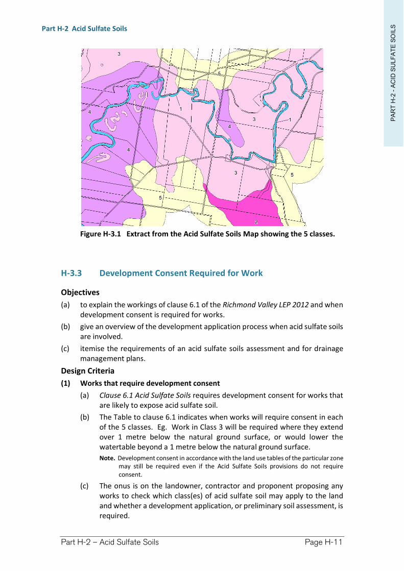
PA
RT
H-2
-A
CID
SU
LF
AT
E S
OIL
SPart H-2 Acid Sulfate Soils
Part H-2 – Acid Sulfate Soils Page H-11
Figure H-3.1 Extract from the Acid Sulfate Soils Map showing the 5 classes.
H-3.3 Development Consent Required for Work
Objectives
(a) to explain the workings of clause 6.1 of the Richmond Valley LEP 2012 and when development consent is required for works.
(b) give an overview of the development application process when acid sulfate soils are involved.
(c) itemise the requirements of an acid sulfate soils assessment and for drainage management plans.
Design Criteria
(1) Works that require development consent
(a) Clause 6.1 Acid Sulfate Soils requires development consent for works that are likely to expose acid sulfate soil.
(b) The Table to clause 6.1 indicates when works will require consent in each of the 5 classes. Eg. Work in Class 3 will be required where they extend over 1 metre below the natural ground surface, or would lower the watertable beyond a 1 metre below the natural ground surface.
Note. Development consent in accordance with the land use tables of the particular zone may still be required even if the Acid Sulfate Soils provisions do not require consent.
(c) The onus is on the landowner, contractor and proponent proposing any works to check which class(es) of acid sulfate soil may apply to the land and whether a development application, or preliminary soil assessment, is required.
PA
RT
H-2
-A
CID
SU
LF
AT
E S
OIL
SPart H-2 Acid Sulfate Soils
Part H-2 – Acid Sulfate Soils Page H-12
Extract from Richmond Valley Local Environmental Plan 2012
Clause 6.1 Acid sulfate soils
(1) The objective of this clause is to ensure that development does not disturb, expose or drain acid sulfate soils and cause environmental damage.
(2) Development consent is required for the carrying out of works described in the Table to this subclause on land shown on the Acid Sulfate Soils Map as being of the class specified for those works.
(3) Development consent must not be granted under this clause for the carrying out of works unless an acid sulfate soils management plan has been prepared for the proposed works in accordance with the Acid Sulfate Soils Manual and has been provided to the consent authority.
(4) Despite subclause (2), development consent is not required under this clause for the carrying out of works if: (a) a preliminary assessment of the proposed works prepared in accordance with the Acid Sulfate
Soils Manual indicates that an acid sulfate soils management plan is required the works, and (b) the preliminary assessment has been provided to the consent authority and the consent
authority has confirmed the assessment by notice in writing to the person proposing to carry out the works.
(5) Despite subclause (2), development consent is not required under this clause for the carrying out of any of the following works by a public authority (including ancillary work such as excavation, construction of access ways or the supply of power): (a) emergency work, being the repair or replacement of the works of the public authority required
to be carried out urgently because the works have been damaged, have ceased to function or pose a risk to the environment or to public health and safety,
(b) routine management work, being the periodic inspection, cleaning, repair or replacement of the works of the public authority (other than work that involves the disturbance of more than 1 tonne of soil),
(c) minor work, being work that costs less than $20,000 (other than drainage work). (6) Despite subclause (2), development consent is not required under this clause to carry out any works if:
(a) the works involve the disturbance of less than 1 tonne of soil, such as occurs in carrying out agriculture, the construction or maintenance of drains, extractive industries, dredging, the construction of artificial water bodies (including canals, dams and detention basins) or foundations or flood mitigation works, or
(b) the works are not likely to lower the watertable. (7) Despite subclause (2), development consent is not required under this clause for the carrying out of
works for the purpose of agriculture if: (a) a production area entitlement is n force in respect of the land when the works are carried out,
and (b) the works are carried out in accordance with a drainage management plan, and (c) the works are not carried out in respect of a major drain identified on the Acid Sulfate Soils
Map, and (d) the works are not carried out on land in Zone E2 Environmental Conservation or on land to
which State Environmental Planning Policy No 14—Coastal Wetlands applies. (8) In this clause:
drainage management plan means an irrigation and drainage management plan that: (a) has been prepared in accordance with the NSW Sugar Industry Best Practice Guidelines for Acid
Sulfate Soils (2005), and
Class of land Works1 Any works2 Works below the natural ground surface.
Works by which the watertable is likely to be lowered.
3 Works more than 1 metre below the natural ground surface. Works by which the watertable is likely to be lowered more than 1 metre below the natural ground surface.
4 Works more than 2 metres below the natural ground surface. Works by which the watertable is likely to be lowered more than 2 metres below the natural ground surface.
5 Works within 500 metres of adjacent Class 1, 2, 3 or 4 land that is below 5 metres Australian Height Datum and by which the watertable is likely to be lowered below 1 metre Australian Height Datum on adjacent Class 1, 2, 3 or 4 land.
PA
RT
H-2
-A
CID
SU
LF
AT
E S
OIL
SPart H-2 Acid Sulfate Soils
Part H-2 – Acid Sulfate Soils Page H-13
(b) specifies the management practices to be adopted, to avoid or minimise an acid hazard on the land, and
(c) provides information about: (i) the depth, location and nature of acid sulfate soils on the land, and (ii) the location and dimensions of existing, new and redesigned drains on the land, and (iii) the nature of any earth moving activities to be carried out on the land, such as laser
levelling, construction or enlargement of dams, and (d) is endorsed by the Sugar Milling Cooperative as being appropriate for the land. NSW Sugar Industry Best Practice Guidelines for Acid Sulfate Soils (2005) means guidelines approved by the Director-General of the Department of Infrastructure, Planning and Natural Resources on 25 May 2005. production area entitlement means a contractual arrangement between the Sugar Milling Cooperative and a grower member of that Cooperative for the production of sugar cane for milling. Sugar Milling Co-operative means the New South Wales Sugar Milling Co-operative Limited (ACN 051 052 209) or its successor. Note. The NSW Sugar Industry Best Practice Guidelines for Acid Sulfate Soils (2005) is available on the Department of Planning and Environment’s website.
(2) Development Application Procedures
(a) Figure H-3.2 provides a flow-diagram outlining the general procedure landowners, applicants and proponents will need to follow when proposing to undertake certain works within land classes 1 - 5 on the Acid Sulfate Soil Map.
(b) During the preparation of a soil assessment or management plan, applicants are advised to liaise with the local offices of the:
Department of Primary Industries (Agriculture and Fisheries), and
Environment Protection Authority (Pollution).
(c) Applications accompanied by copies of correspondence from the above agencies, which provide comments on the Soil Assessment or Management Plan, will be determined by Council more expeditiously than those applications not providing this information. Applications, not accompanied by relevant advice, will be referred to the relevant Departments for comment prior to consideration by Council.
(3) Soils Assessment and/or Soil Management Plan
(a) Development applications triggering assessment under clause 6.1 must be accompanied by a preliminary soils assessment, and/or soil management plan.
(b) A preliminary soils assessment must be prepared by a suitably qualified person. The assessment must include matters outlined in the Acid Sulfate Soil Manual. As illustrated in Figure H3.3, an Applicant has an opportunity to assume the proposed development site contains Acid Sulfate Soil. This will by-pass the need to undertake a preliminary soils assessment, however, it will still necessitate a soil management plan to be prepared.
(4) Drainage Management Plans
(a) Where a property contains a series of drains or works that would require development consent for each individual section, the owner is encouraged to submit a drainage management plan for the whole property. This plan would form part of the development application. Such a management
PA
RT
H-2
-A
CID
SU
LF
AT
E S
OIL
SPart H-2 Acid Sulfate Soils
Part H-2 – Acid Sulfate Soils Page H-14
plan would cover all the drains on that specific property, including their maintenance and rehabilitation details, as needed.
(b) Council encourages this approach by landowners as it promotes better overall management and provides Council with a more complete overview of the location, ongoing maintenance and interaction of such drains.
(c) A property owner who has prepared a drainage management plan may also enter into a joint application with adjoining property owners, however, the applicant should be aware that in the case of a joint development consent any amendment to the drainage management plan would require the written support of each landowner involved in the consent.
(5) Determination by Council
(a) Where development consent is granted for drainage work, no further development consent will be required to maintain those works provided the ongoing maintenance and management is carried out in accordance with the terms and conditions of the consent.
(b) An applicant working under a drainage management plan is encouraged to contact Council if there is any question as to the terms and conditions of consent. New owners of land should also contact Council regarding the terms and conditions of any development consent issued by Council and applying to the property. When a property is bought or sold the consent stays with the land and the new owner must comply with the terms of the consent.
(6) Consultation
(a) As stipulated in Section H3.4, proponents, applicants and developers are advised to consult with the following government agencies when preparing a soil assessments or soil management plan.
(b) When considering a development application, Council shall consult with:
the Environment Protection Authority—where a management plan is submitted (unless advice is supplied that indicates the EPA is satisfied with the Management Plan)
Department of Primary Industries (Agriculture)—where the development specifically relates to agricultural purposes which involves enhancing and/or maintaining agricultural production
Department of Primary Industries (Fisheries)—as integrated development where it involves runoff into a Key Fish Habitat
(c) The matters on which the Departments shall be consulted are the adequacy of the soil assessment and/or management plan, the conclusions of those assessments and in the case of the Department of Primary Industries (Agriculture), its likely impact on the agricultural production.
(d) Council shall give Government agencies 21 days to respond to the consultation. If no response is forthcoming within that period Council may proceed to finalise assessment of the application. It should be noted that
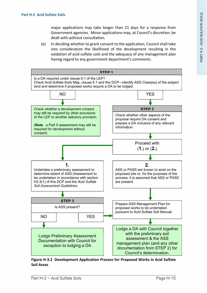
PA
RT
H-2
-A
CID
SU
LF
AT
E S
OIL
SPart H-2 Acid Sulfate Soils
Part H-2 – Acid Sulfate Soils Page H-15
major applications may take longer than 21 days for a response from Government agencies. Minor applications may, at Council’s discretion, be dealt with without consultation.
(e) In deciding whether to grant consent to the application, Council shall take into consideration the likelihood of the development resulting in the oxidation of acid sulfate soils and the adequacy of any management plan having regard to any government department’s comments.
Figure H-3.2 Development Application Process for Proposed Works in Acid Sulfate Soil Areas
STEP 1
Is a DA required under clause 6.1 of the LEP? Check Acid Sulfate Soils Map, clause 6.1 and this DCP—identify ASS Class(es) of the subject land and determine if proposed works require a DA to be lodged.
NO YES
Check whether a development consent may still be required by other provisions of the LEP or another statutory provision.
(Note. a Part 5 assessment may still be required for development without consent)
STEP 2
Check whether other aspects of the proposal require DA consent and prepare a DA inclusive of any relevant information.
Proceed with
(1.) or (2.)
1. Undertake a preliminary assessment to determine extent of ASS (Assessment to be undertaken in accordance with section H3.3(1) of this DCP and the Acid Sulfate Soil Assessment Guidelines.
2. ASS or PASS are known to exist on the proposed site or, for the purposes of the process, it is assumed that ASS or PASS are present.
STEP 3
Is ASS present? Prepare ASS Management Plan for proposed works to be undertaken pursuant to Acid Sulfate Soil Manual.
NO YES
Lodge Preliminary Assessment Documentation with Council for
exception to lodging a DA
Lodge a DA with Council together with the preliminary soil assessment & the ASS
management plan (and any other documentation from STEP 2) for
Council’s determination.
PA
RT
H-2
-A
CID
SU
LF
AT
E S
OIL
SPart H-2 Acid Sulfate Soils
Part H-2 – Acid Sulfate Soils Page H-16
H-3.4 Exceptions to requiring development consent
Objectives
(a) to explain development consent exceptions provided for in clause 6.1 of the Richmond Valley LEP 2012.
Design Criteria
(1) Preliminary assessment process
(a) When work involves disturbing soil, or lowering the watertable, a preliminary assessment can be undertaken to determine whether acid sulfate soils are present and if the proposed works are likely to disturb these soils.
(b) The purpose of a preliminary assessment is to:
(i) establish the characteristics of the proposed works;
(ii) establish whether acid sulfate soils are present on the site and if they are in such concentrations so as to warrant the preparation of an acid sulfate soils management plan;
(iii) provide information to assist in designing a soil and water assessment program; and
(iv) provide information to assist in decision making.
(c) The preliminary assessment process is outlined in Figure H-3.3.
(d) Development consent under clause 6.1 is not required for the carrying out of works if:
(i) a preliminary assessment of the proposed works has been undertaken and supplied to Council;
(ii) the preliminary assessment indicates that an acid sulfate soils management plan need not be carried out for the works; and
(iii) Council has provided a written confirmation that it accepts the findings of the assessment.
(e) A preliminary assessment must be undertaken in accordance with the Acid Sulfate Soils Manual by a suitably qualified person.
(f) Submitting Preliminary Assessments - to assist Council with processing preliminary assessments they should be accompanied by:
(i) a letter requesting Council advice;
(ii) identify the proposed works;
(iii) identify the land (Lot and Deposited Plan numbers);
(iv) contain a map identifying-
the property; location of sample points; and
(v) identify the nature of the proposed works.
(2) Emergency works by a Public Authority
(a) Public Authorities are exempt from requiring development consent for certain works under the provisions of State Environmental Planning Policy
PA
RT
H-2
-A
CID
SU
LF
AT
E S
OIL
SPart H-2 Acid Sulfate Soils
Part H-2 – Acid Sulfate Soils Page H-17
(Infrastructure) 2007 (iSEPP). However, clause 20(2)(d) of the iSEPP requires that exempt development shall have no more than minimal impact on the environment. Due to the environmental significance of Acid Sulfate Soils, the provisions of the iSEPP may be revoked and will default to a consentable use under clause 6.1.
(b) Notwithstanding clause 6.1(5) provides that development consent is not required for the carrying out of the following works by a public authority:
emergency work;
routine management work; and
minor work.
(c) Such works are without consent under Part 4 of the Environmental Planning and Assessment Act 1979, but will require assessment under Part 5 of the Act to determine whether the activity will have a significant impact on the environment.
(3) Minor works
(a) Consent under clause 6.1 is not required to carry out works involving the disturbance of less than 1 tonne of soil (acid sulfate soil), or where the works are not likely to lower the watertable.
(b) Liming the excavated soil material will neutralise any potential acid production. Liming rates should be determined from lab testing of the soils (refer to the Acid Sulfate Soil Manual). Notwithstanding, small volumes of excavated material where the liming rate is unknown can assume a worst case scenario and apply lime at a rate of 24 kg per m2.
(4) Agricultural works in sugar cane areas
(a) Clause 6.1(7) provides an exemption from requiring development consent under the clause for sugar cane farms with Production Area Entitlements (PAE). It provides that development consent is not required where that work is undertaken in accordance with a drainage management plan.
(b) Clause 6.1(7) operates under the NSW Sugar Industry Best Practice Guidelines for Acid Sulfate Soils (2005) with the support of the NSW Sugar Milling Cooperative.
(c) The contents of Drainage Management Plans are determined by the above guidelines, and the Acid Sulfate Soils Manual.
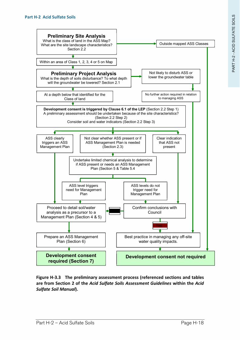
PA
RT
H-2
-A
CID
SU
LF
AT
E S
OIL
SPart H-2 Acid Sulfate Soils
Part H-2 – Acid Sulfate Soils Page H-18
Figure H-3.3 The preliminary assessment process (referenced sections and tables are from Section 2 of the Acid Sulfate Soils Assessment Guidelines within the Acid Sulfate Soil Manual).
Preliminary Site Analysis What is the class of land in the ASS Map?
What are the site landscape characteristics? Section 2.2
Preliminary Project Analysis What is the depth of soils disturbance? To what depth
will the groundwater be lowered? Section 2.1
Development consent is triggered by Clause 6.1 of the LEP (Section 2.2 Step 1) A preliminary assessment should be undertaken because of the site characteristics?
(Section 2.2 Step 2) Consider soil and water indicators (Section 2.2 Step 3)
ASS clearly triggers an ASS
Management Plan
Not clear whether ASS present or if ASS Management Plan is needed
(Section 2.3)
Clear indication that ASS not
present
No further action required in relation to managing ASS
Undertake limited chemical analysis to determine if ASS present or needs an ASS Management
Plan (Section 5 & Table 5.4
ASS level triggers need for Management
Plan
ASS levels do not trigger need for
Management Plan
Proceed to detail soil/water analysis as a precursor to a
Management Plan (Section 4 & 5)
Confirm conclusions with Council
Prepare an ASS Management Plan (Section 6)
Best practice in managing any off-site water quality impacts.
Yes
No
Development consent not required Development consent required (Section 7)
At a depth below that identified for the Class of land
Outside mapped ASS Classes
Not likely to disturb ASS or lower the groundwater table
Within an area of Class 1, 2, 3, 4 or 5 on Map

Richmond Valley Development Control Plan 2021
Part H-3
Natural Resources (NRS)
Richmond Valley Local Environmental Plan 2012 contains several clauses relating to management of natural resources. These are:
clause 6.6 Terrestrial biodiversity
clause 6.7 Landslide risk
clause 6.8 Riparian land and watercourses
clause 6.9 Drinking water catchments
clause 6.10 Wetlands
These NRS clauses and the associated mapping do not prohibit development or trigger requirements for development consent. Rather, the provisions identify additional heads of consideration to assess the level of impact of the development on the mapped natural resource feature(s), and whether there may be mitigation measures employed to reduce those impacts. In this way, the mapped NRS layers serve as a reference to inform landowners and Council as to the likely presence of environmentally sensitive land issues without placing excessive restrictions over the entire land through an Environmental E Zoning.
This DCP applies to all land within the Richmond Valley Local Government Area.
Date adopted by Council: 22/06/2021
Effective Date: 01/08/2021
Amendments: Nil
PA
RT
H-3
-N
AT
UR
AL R
ES
OU
CE
SPart H-3 Natural Resources
Part H-3 – Natural Resources Page H-20
H-4.1 General Objectives
The general objectives of this Chapter are to:
(1) provide background information on each of the Natural Resource Sensitivities mapped within the LEP.
(2) provide protective responses and mitigation measures for sensitive environmental locations throughout Richmond Valley.
(3) provide consistency as to how protection of natural resources are implemented throughout Richmond Valley LGA.
(4) require adequate design considerations to avoid unacceptable adverse impacts upon sensitive environs.
H-4.2 LEP NRS Mapping
Objectives
(a) to explain what has been captured in each type of NRS mapping in the Richmond Valley LEP 2012.
Design Criteria
(1) The LEP contains mapping for each of the following NRS constraints, while clauses 6.6 to 6.10 prescribe development application heads of considerations.
Terrestrial Biodiversity Map—representing native vegetation and habitat (wildlife) corridors;
Landslip Risk Map—representing steep land with a slopes greater than 18 degrees (33%);
Riparian Lands and Watercourses Map—representing key fish habitat plus a 40 metre buffer;
Wetlands Map—representing wetlands and floodplain wetland vegetation communities; and
Drinking Water Catchments Map—representing the watershed catchment for Casino’s Jabour Weir, and a 500 metre buffer area around each of the Rous Water Groundwater Bores at Woodburn.
Refer to figures H-4.1 and H-4.2 for samples for each of these NRS overlays.
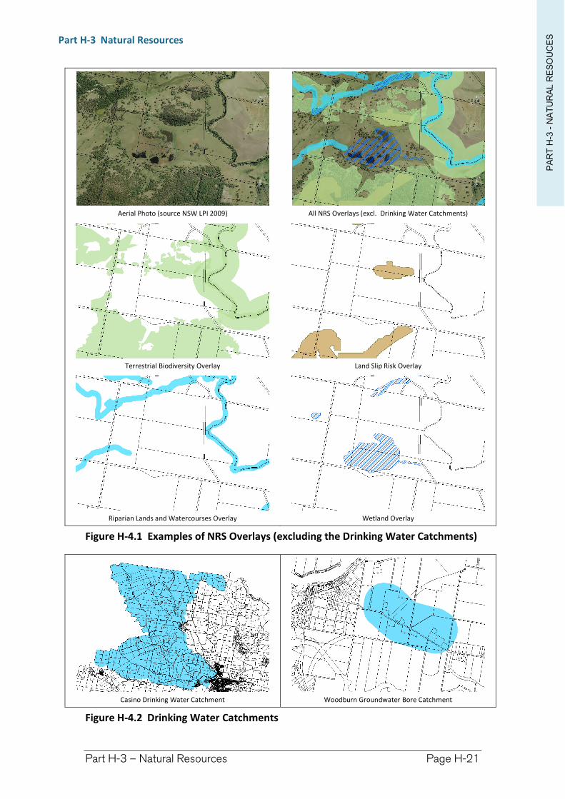
PA
RT
H-3
-N
AT
UR
AL R
ES
OU
CE
SPart H-3 Natural Resources
Part H-3 – Natural Resources Page H-21
Aerial Photo (source NSW LPI 2009) All NRS Overlays (excl. Drinking Water Catchments)
Terrestrial Biodiversity Overlay Land Slip Risk Overlay
Riparian Lands and Watercourses Overlay Wetland Overlay
Figure H-4.1 Examples of NRS Overlays (excluding the Drinking Water Catchments)
Casino Drinking Water Catchment Woodburn Groundwater Bore Catchment
Figure H-4.2 Drinking Water Catchments
PA
RT
H-3
-N
AT
UR
AL R
ES
OU
CE
SPart H-3 Natural Resources
Part H-3 – Natural Resources Page H-22
H-4.3 Terrestrial Biodiversity
Objectives
(a) to assist with the interpretation of the Terrestrial Biodiversity NRS provisions of the LEP.
Design Criteria
(1) Terrestrial Biodiversity mapping consists of 2 combined data sets depicting natural vegetation and habitat (wildlife) corridors.
(2) Clause 6.6 of the Richmond Valley LEP 2012 requires consideration of whether a development is likely to have:
an adverse impact on habitat, the survival of fauna and habitat connectivity; and/or
cause fragmentation of the habitat, and
whether there are any actions that can be taken to avoid an impact, to minimise the impact, or to mitigate the impact.
Extract from Richmond Valley Local Environmental Plan 2012
Clause 6.6 Terrestrial biodiversity (1) The objective of this clause is to maintain terrestrial biodiversity by:
(a) protecting native fauna and flora, and (b) protecting the ecological processes necessary for their continued existence, and (c) encouraging the conservation and recovery of native fauna and flora and their habitats.
(2) This clause applies to land identified as “Biodiversity” on the Terrestrial Biodiversity Map. (3) Before determining a development application for development on land to which this clause applies,
the consent authority must consider: (a) whether the development:
(i) is likely to have any adverse impact on the condition, ecological value and significance of the fauna and flora on the land, and
(ii) is likely to have any adverse impact on the importance of the vegetation on the land to the habitat and survival of native fauna, and
(iii) has any potential to fragment, disturb or diminish the biodiversity structure, function and composition of the land, and
(iv) is likely to have any adverse impact on the habitat elements providing connectivity on the land, and
(b) any appropriate measures proposed to avoid, minimise or mitigate the impacts of the development.
(4) Development consent must not be granted for development on land to which this clause applies unless the consent authority is satisfied that: (a) the development is designed, sited and will be managed to avoid any significant adverse
environmental impact, or (b) if that impact cannot be reasonably avoided by adopting feasible alternatives—the
development is designed, sited and will be managed to minimise that impact, or (c) if that impact cannot be minimised—the development will be managed to mitigate that
impact.
(3) Natural Vegetation
As a reflection of the ‘precautionary principle’ aligned with ESD principles, all naturally vegetated areas have been mapped. It is proposed that assessment of development will determine whether there is likely to be a significant impact on this natural resource.
PA
RT
H-3
-N
AT
UR
AL R
ES
OU
CE
SPart H-3 Natural Resources
Part H-3 – Natural Resources Page H-23
It is recognised that not all vegetation mapped will actually be ecologically sensitive, and it is accepted that much of it may constitute regrowth or be highly disturbed. It is further accepted that this mapping is a snap shot in time (around 2009), and that changes in the environment will not be reflected in the LEP mapping. It was for this reason that the mapping was adopted as an overlay rather than an environmental zoning.
The requirement for additional assessment will be negated in situations where the vegetation is obviously not naturally occurring, or has been removed.
(4) Habitat Corridors
Habitat corridor data was supplied by the National Parks and Wildlife Service based upon predictive modelling to establish strategic links between significant compartments of native vegetation. Additional mapping obtained by Council identifies the need to incorporate riparian zones as corridors.
It is recognised that habitat corridors can function effectively without necessarily being vegetated. As such an assessment of impact and consideration of mitigation measure need only address how the development might prevent the free passage of fauna through the development site.
(5) Possible Mitigation Measures
(a) Terrestrial Biodiversity—Habitat Corridors
Habitat corridors are likely pathways for fauna to move between important conservation areas. They needn’t be vegetated to function properly.
Mitigation measures to minimise impacts could include:
relocating the development outside the wildlife corridor.
revegetate a compensatory area of vegetation so that the corridor can continue to function in and around the development.
remove obstacles that prevent the passage of fauna through the development site, such as fences, long continuous buildings, dogs and cats, etc.
provide alternative means for fauna to traverse the site, such as land bridges, under or over passes, ropes.
Avoid locating development close to riparian zones.
(b) Terrestrial Biodiversity—Vegetation
This NRS Overlay identifies native vegetation that was visible in aerial photography in 2009. Assessment of the vegetation will be required to determine if it is significant habitat. Clearing of native vegetation is regulated by the Native Vegetation Act and Threatened Species Conservation Act 1995 as well as the Commonwealth’s Environment Protection and Biodiversity Conservation Act 1999.
Mitigation measures to minimise impacts could include:
purchasing Biodiversity Credits to offset habitat loss.
negotiate a conservation agreement, and/or remediation of land, as offsets to habitat loss.
PA
RT
H-3
-N
AT
UR
AL R
ES
OU
CE
SPart H-3 Natural Resources
Part H-3 – Natural Resources Page H-24
H-4.4 Landslip Risk
Objectives
(a) to assist with the interpretation of the Landslip Risk NRS provisions of the LEP.
Design Criteria
(1) This mapping represents steep slopes greater than 18 degrees or (33% grade). These steeper lands may be susceptible to mass movement and higher levels of erosion.
(2) Data for this NRS mapping was supplied by the Department of Planning and Environment from its Far North Coast Regional Strategy. The data was used as an NRM overlay because there wasn’t enough confidence in its accuracy to include it within an Environmental E Zone such as Zone E3 Environmental Conservation.
(3) Clause 6.7 of the Richmond Valley LEP 2012 requires consideration of:
measures to avoid, minimise or mitigation the risk of landslide as a result of the development; and/or
how waste water, stormwater and drainage will be managed.
(4) Possible Mitigation Measures
Development on steep lands requires consideration of geomorphic conditions (mass movement and erosion), as well as an assessment of scenic amenity.
Mitigation measures that could be employed-
Minimise vegetation removal.
Rehabilitate exposed slopes with native vegetation, especially using plants with large root systems.
Avoid cutting into steep slopes, especially at the base of the slope.
Avoid siting heavy loads at the top of steep slopes.
Stormwater drainage will need to be dispersed, or contained within protective drainage lines.
Minimise water infiltration into steep slopes where it can weaken ground stability and cause mass movement.
Extract from Richmond Valley Local Environmental Plan 2012
Clause 6.7 Landslide risk (1) The objectives of this clause are to ensure that development on land susceptible to landslide:
(a) matches the underlying geotechnical conditions of the land, and (b) is restricted on unsuitable land, and (c) does not endanger life or property.
(2) This clause applies to land identified as “Landslide risk” on the Landslide Risk Map. (3) Before determining a development application for development on land to which this clause applies,
the consent authority must consider the following matters to decide whether or not the development takes into account the risk of landslide: (a) site layout, including access, (b) the development’s design and construction methods, (c) the amount of cut and fill that will be required for the development, (d) waste water management, stormwater and drainage across the land, (e) the geotechnical constraints of the site,
PA
RT
H-3
-N
AT
UR
AL R
ES
OU
CE
SPart H-3 Natural Resources
Part H-3 – Natural Resources Page H-25
(f) any appropriate measures proposed to avoid, minimise or mitigate the impacts of the development.
(4) Development consent must not be granted for development on land to which this clause applies unless: (a) the consent authority is satisfied that:
(i) the development is designed, sited and will be managed to avoid any landslide risk or significant adverse impact on the development and the land surrounding the development, or
(ii) if that risk or impact cannot be reasonably avoided—the development is designed, sited and will be managed to minimise that risk or impact, or
(iii) if that risk or impact cannot be minimised—the development will be managed to mitigate that risk or impact, and
(b) the consent authority is satisfied that the development will appropriately manage waste water, stormwater and drainage across the site so as to not affect the rate, volume and quality of water leaving the land.
H-4.5 Riparian Land and Watercourses
Objectives
(a) to assist with the interpretation of the Terrestrial Biodiversity NRS provisions of the LEP.
Design Criteria
(1) This mapping consists of Key Fish Habitat data supplied by the Department of Primary Industries—Fisheries. This mapping represents rivers, creeks, streams, drains and wetlands, with a 40 metre riparian zone applied, identified by Fisheries as strategically important for fish habitat.
(2) Fisheries permits, under the Fisheries Management Act 1994, are required for work within the identified key fish habitats.
(3) Clause 6.8 of the Richmond Valley LEP 2012 requires consideration of whether a development is likely to have an adverse impact on:
water quality and flows; or
aquatic habitats; or
bank stability; or
the passage of aquatic organisms along the watercourse; and
whether there will be an increase in water extraction, and appropriate measures to avoid, minimise or mitigate impacts.
(4) Possible Mitigation Measures
Development in, or within 40 metres of, a watercourse could result in removal of vegetation, destabilisation of river banks, pollution of waterways, increased recreational activity, increase water removal, or any number of similar impacts.
Mitigation measures that could be employed-
Harmful elements of the development should be resited away from sensitive areas.
Stormwater and wastewaters should be treated before discharge into waterways.
PA
RT
H-3
-N
AT
UR
AL R
ES
OU
CE
SPart H-3 Natural Resources
Part H-3 – Natural Resources Page H-26
Stormwater flows should not be concentrated so they erode stream or river banks.
Avoid removal of riparian vegetation and disturbance of stream banks.
Consider stabilising disturbed embankments by remediating them with native vegetation.
Do not construct in stream barriers that can prevent the passage of aquatic organisms.
Note. Additional permits may be required from relevant State agencies in accordance with the Water Management Act and/or Fisheries Management Act to do work in a Key Fish Habitat.
Extract from Richmond Valley Local Environmental Plan 2012
Clause 6.8 Riparian land and watercourses (1) The objective of this clause is to protect and maintain the following:
(a) water quality within watercourses, (b) the stability of the bed and banks of watercourses, (c) aquatic and riparian habitats, (d) ecological processes within watercourses and riparian areas.
(2) This clause applies to land identified as “Key Fish Habitat” on the Riparian Land and Waterways Map. (3) Before determining a development application for development on land to which this clause applies,
the consent authority must consider: (a) whether or not the development is likely to have any adverse impact on the following:
(i) the water quality and flows within the watercourse, (ii) aquatic and riparian species, habitats and ecosystems of the watercourse, (iii) the stability of the bed and banks of the watercourse, (iv) the free passage of fish and other aquatic organisms within or along the watercourse, (v) any future rehabilitation of the watercourse and its riparian areas, and
(b) whether or not the development is likely to increase water extraction from the watercourse, and
(c) any appropriate measures proposed to avoid, minimise or mitigate the impacts of the development.
(4) Development consent must not be granted for development on land to which this clause applies unless the consent authority is satisfied that: (a) the development is designed, sited and will be managed to avoid any significant adverse
environmental impact, or (b) if that impact cannot be avoided by adopting feasible alternatives—the development is
designed, sited and will be managed to minimise that impact, or (c) if that impact cannot be minimised—the development will be managed to mitigate that
impact.
H-4.6 Drinking Water Catchments
Objectives
(a) to assist with the interpretation of the Terrestrial Biodiversity NRS provisions of the LEP.
Design Criteria
(1) Protection of drinking water catchments is considered important primarily for its public health implications but also for the future health of the waterways.
(2) Two (2) drinking water catchments have been mapped.
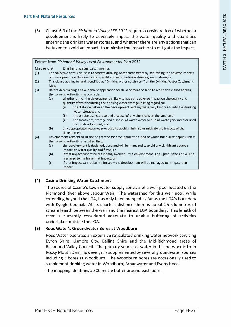
PA
RT
H-3
-N
AT
UR
AL R
ES
OU
CE
SPart H-3 Natural Resources
Part H-3 – Natural Resources Page H-27
(3) Clause 6.9 of the Richmond Valley LEP 2012 requires consideration of whether a development is likely to adversely impact the water quality and quantities entering the drinking water storage, and whether there are any actions that can be taken to avoid an impact, to minimise the impact, or to mitigate the impact.
Extract from Richmond Valley Local Environmental Plan 2012
Clause 6.9 Drinking water catchments (1) The objective of this clause is to protect drinking water catchments by minimising the adverse impacts
of development on the quality and quantity of water entering drinking water storages. (2) This clause applies to land identified as “Drinking water catchment” on the Drinking Water Catchment
Map. (3) Before determining a development application for development on land to which this clause applies,
the consent authority must consider: (a) whether or not the development is likely to have any adverse impact on the quality and
quantity of water entering the drinking water storage, having regard to: (i) the distance between the development and any waterway that feeds into the drinking
water storage, and (ii) the on-site use, storage and disposal of any chemicals on the land, and (iii) the treatment, storage and disposal of waste water and solid waste generated or used
by the development, and (b) any appropriate measures proposed to avoid, minimise or mitigate the impacts of the
development. (4) Development consent must not be granted for development on land to which this clause applies unless
the consent authority is satisfied that: (a) the development is designed, sited and will be managed to avoid any significant adverse
impact on water quality and flows, or (b) if that impact cannot be reasonably avoided—the development is designed, sited and will be
managed to minimise that impact, or (c) if that impact cannot be minimised—the development will be managed to mitigate that
impact.
(4) Casino Drinking Water Catchment
The source of Casino’s town water supply consists of a weir pool located on the Richmond River above Jabour Weir. The watershed for this weir pool, while extending beyond the LGA, has only been mapped as far as the LGA’s boundary with Kyogle Council. At its shortest distance there is about 25 kilometres of stream length between the weir and the nearest LGA boundary. This length of river is currently considered adequate to enable buffering of activities undertaken outside the LGA.
(5) Rous Water’s Groundwater Bores at Woodburn
Rous Water operates an extensive reticulated drinking water network servicing Byron Shire, Lismore City, Ballina Shire and the Mid-Richmond areas of Richmond Valley Council. The primary source of water in this network is from Rocky Mouth Dam, however, it is supplemented by several groundwater sources including 3 bores at Woodburn. The Woodburn bores are occasionally used to supplement drinking water in Woodburn, Broadwater and Evans Head.
The mapping identifies a 500 metre buffer around each bore.
PA
RT
H-3
-N
AT
UR
AL R
ES
OU
CE
SPart H-3 Natural Resources
Part H-3 – Natural Resources Page H-28
H-4.7 Wetlands
Objectives
(a) to assist with the interpretation of the Terrestrial Biodiversity NRS provisions of the LEP.
Design Criteria
(1) Wetland mapping was originally sourced from Wetland Care Australia but has been updated by consultants engaged by Council.
(2) The mapping is inclusive of naturally occurring wetlands as well as artificial wetlands such as farm dams.
(3) Clause 6.10 of the Richmond Valley LEP 2012 requires consideration of whether a development is likely to have a significant adverse impact on:
the condition and provision of quality wetland habitat; or
water quality and flows; and
whether there are any actions that can be taken to avoid an impact, to minimise the impact, or to mitigate the impact.
(4) Possible Mitigation Measures
Development within, or that drains into, a wetland could cause the removal of vegetation, pollute the wetland, lower the watertable, or cause any number of similar impacts.
Mitigation measures that could be employed-
On-site Sewage Management Systems may require:
upgrading to a higher treatment standards.
resiting the system away from the receiving wetland area.
diversion of stormwater around and away from the disposal area.
water treatment interceptors to improve water quality before it reaches the wetland, or that diverts runoff away from the wetland.
Stormwater runoff may require diversion around or away from the wetland, or have appropriate water treatment to improve water quality before it reaches the wetland.
Avoid constructing drains next to wetlands where they could lower the watertable and alter hydrology in the wetland area.
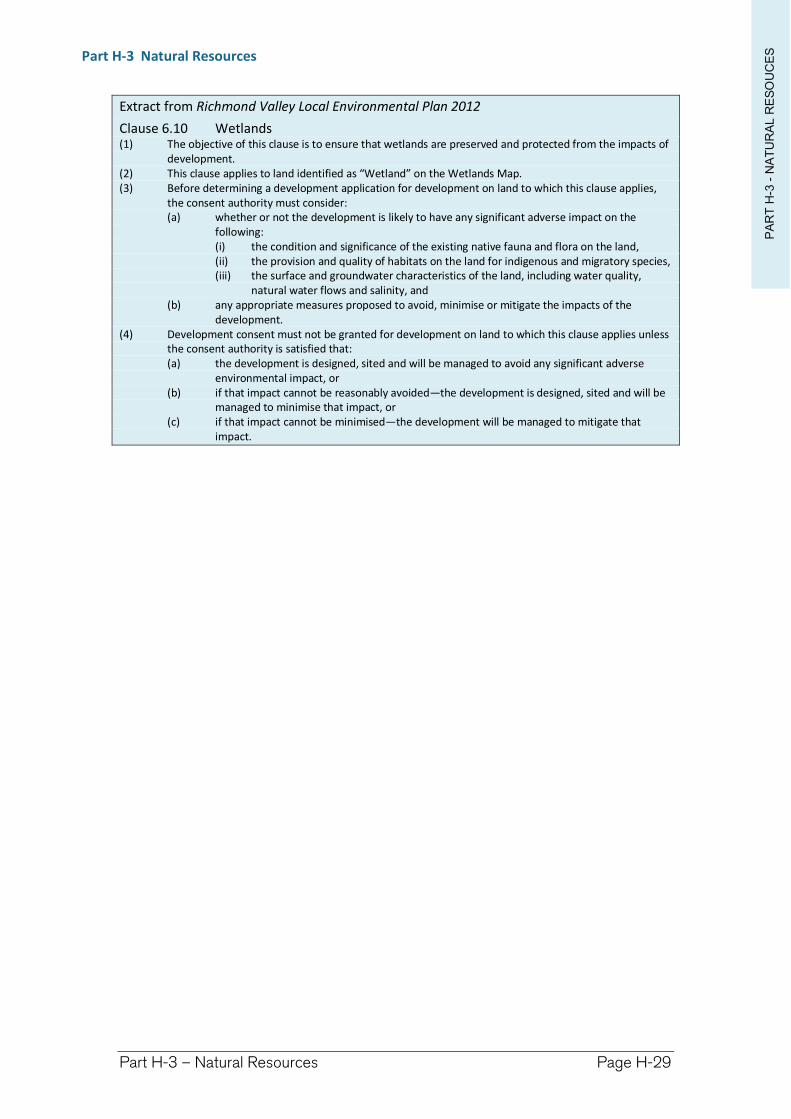
PA
RT
H-3
-N
AT
UR
AL R
ES
OU
CE
SPart H-3 Natural Resources
Part H-3 – Natural Resources Page H-29
Extract from Richmond Valley Local Environmental Plan 2012
Clause 6.10 Wetlands (1) The objective of this clause is to ensure that wetlands are preserved and protected from the impacts of
development. (2) This clause applies to land identified as “Wetland” on the Wetlands Map. (3) Before determining a development application for development on land to which this clause applies,
the consent authority must consider: (a) whether or not the development is likely to have any significant adverse impact on the
following: (i) the condition and significance of the existing native fauna and flora on the land, (ii) the provision and quality of habitats on the land for indigenous and migratory species, (iii) the surface and groundwater characteristics of the land, including water quality,
natural water flows and salinity, and (b) any appropriate measures proposed to avoid, minimise or mitigate the impacts of the
development. (4) Development consent must not be granted for development on land to which this clause applies unless
the consent authority is satisfied that: (a) the development is designed, sited and will be managed to avoid any significant adverse
environmental impact, or (b) if that impact cannot be reasonably avoided—the development is designed, sited and will be
managed to minimise that impact, or (c) if that impact cannot be minimised—the development will be managed to mitigate that
impact.
Richmond Valley Development Control Plan 2021
Part I Other Considerations
This Part is a compilation of subject based development controls. It provides:
Controls for miscellaneous land uses not covered in the main chapters of the DCP,
More detailed design information and planning controls covering topics that apply to many forms of development.
This Chapter contains:
Chapter Page No. in this Part
Part I-1 Environmental Heritage ..................................... 3Part I-2 Development In, On, Over or Under a Public
Road ........................................................................ 25Part I-3 Building Setbacks ............................................. 35Part I-4 Car Parking Provisions ..................................... 45Part I-5 Landscaping Guidelines ................................... 55Part I-6 Animal Boarding and Training Establishments . 65Part I-7 Noise Impact Assessment ................................ 73Part I-8 Social Impact Assessment ................................ 85Part I-9 Water Sensitive Urban Design—WSUD ............ 93Part I-10 Crime Prevention through Environmental
Design—CPTED .......................................................117Part I-11 Land Use Conflict Risk Assessment—LUCRA..127Part I-12 Context and Site Analysis ..............................135Part I-13 Use of shipping containers ............................141Part I-14 Sex Services Premises, Restricted Premises and
Home Occupation (Sex Services) .............................145Part I-15 Lane Widening and Access to Narrow Streets
...............................................................................163Part I-16 Historic New Italy Village Area ......................167
This DCP applies to all land within the Richmond Valley Local Government Area.
Date adopted by Council: 22/06/2021
Effective Date: 01/08/2021
Amendments: Nil
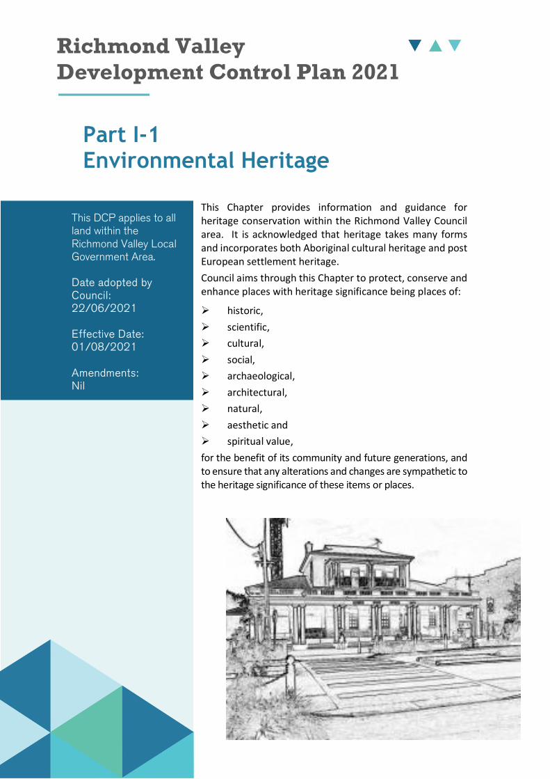
Richmond Valley Development Control Plan 2021
Part I-1 Environmental Heritage
This Chapter provides information and guidance for heritage conservation within the Richmond Valley Council area. It is acknowledged that heritage takes many forms and incorporates both Aboriginal cultural heritage and post European settlement heritage.
Council aims through this Chapter to protect, conserve and enhance places with heritage significance being places of:
historic,
scientific,
cultural,
social,
archaeological,
architectural,
natural,
aesthetic and
spiritual value,
for the benefit of its community and future generations, and to ensure that any alterations and changes are sympathetic to the heritage significance of these items or places.
This DCP applies to all land within the Richmond Valley Local Government Area.
Date adopted by Council: 22/06/2021
Effective Date: 01/08/2021
Amendments: Nil
PA
RT
I-1
-H
ER
ITA
GEPart I Other Consideration
Part I-1 – Environmental Heritage Page I-4
I-1.1 General Objectives
The general objectives of this Chapter are to:
(1) recognise the heritage of Richmond Valley Council area.
(2) provide guidance on the implementation of the heritage provisions of the Richmond Valley LEP 2012.
(3) recognise the people of the Bundjalung Nation as the first inhabitants of this area and acknowledge the area is rich in cultural heritage.
(4) acknowledge the Due Diligence Code of Conduct for the Protection of Aboriginal Objects and encourage all applicants and land owners to follow these guidelines.
I-1.2 Richmond Valley Local Environmental Plan 2012
Objectives
(1) to outline the heritage provisions of the Richmond Valley LEP 2012 (the LEP).
Controls
(1) Clause 5.10 of the LEP contains Heritage Conservation provisions.
The clause generally requires consent to demolish, move, or alter heritage items or items within a conservation area, however there are nominated exceptions. These points are explained further in this Chapter.
Schedule 5 and the Heritage Map identify heritage items and conservation areas under the LEP. Data collected from Heritage Studies is maintained by Council and available to the public on-line from the NSW Office of Environment and Heritage’s website at:
http://www.environment.nsw.gov.au/heritageapp/heritagesearch.aspx
Note. Search for Local Government Area = “Richmond Valley Council”.
(2) Furthermore the clause provides special consideration of Aboriginal places of heritage significance and archaeological sites.
Where Development Consent is Required
(3) Development consent is required to:
(a) demolish or move, or alter the exterior of any:
heritage item, or
Aboriginal object, or
building, work, relic or tree within a heritage conservation area.
Note. Alter includes, in the case of a building, making changes to its detail, fabric, finish or appearance. For example - this might include changing the exterior colour scheme.
(b) make structural changes to the interior of a heritage building.
(c) make non-structural changes to the interior of a heritage building where the interior has been specified within Schedule 5.
(d) disturb or excavate an archaeological site where it is likely that a relic will be discovered, exposed, moved, damaged or destroyed.
PA
RT
I-1
-H
ER
ITA
GEPart I Other Consideration
Part I-1 – Environmental Heritage Page I-5
(e) disturb or excavate an Aboriginal place of heritage significance.
(f) erect a building on land:
containing a heritage item, or
that is within a conservation area, or
on which an Aboriginal object is located or that is within an Aboriginal place of heritage significance.
(g) subdivide land:
containing a heritage item, or
that is within a conservation area, or
on which an Aboriginal object is located or that is within an Aboriginal place of heritage significance.
Where Development Consent is Not Required
(4) Development consent under clause 5.10 is not required if:
(a) Council has responded in writing, to the applicant’s notification of the proposal, and indicated that it is satisfied that the proposed development:
is of a minor nature, or
is for the maintenance of the heritage item, Aboriginal object, Aboriginal place, archaeological site or a building, work, relic, tree or place within a conservation area, and
would not adversely affect the heritage item, Aboriginal object, Aboriginal place, archaeological site or a building, work, relic, tree or place within a conservation area.
Note. See Appendix I-1.1 for an Exceptions Application Form.
(b) the development or work is consistent with Local Site Specific Exemptions adopted for a specific item, place or area.
(c) the development is within a cemetery or burial ground to:
create new graves or monuments, or
excavate or disturb land for the purpose of conserving or repairing a monument or grave marker, and
there will be no disturbance to human remains, relics, Aboriginal objects in the form of grave goods, or to an Aboriginal place of heritage significance.
(d) it involves removal of a tree or other vegetation that Council is satisfied is a risk to human life or property.
(e) is exempt development.
Assessment of heritage significance
(5) Prior to granting development consent, consideration is required of the effect of the proposed development on the heritage significance of the item or area.
To assist with this assessment, additional information may be required in the form of a Heritage Impact Statement, a Heritage Conservation Management Plan, or a Heritage Management Document.

PA
RT
I-1
-H
ER
ITA
GEPart I Other Consideration
Part I-1 – Environmental Heritage Page I-6
(6) A Heritage Impact Statement prepared by a qualified heritage consultant will be required for significant alterations to heritage items, including demolition.
I-1.3 General Heritage Principles
Objective
(1) to outline the hierarchy of statutory heritage provisions.
Controls
Heritage Legislation
(1) Heritage is protected and managed by various levels of government under a number of State and Federal Acts, as well as international conventions and treaties.
The majority of heritage items in the Richmond Valley Council area are listed at a local level. These items are assessed by Council and subject to the controls in clause 5.10 of the LEP, and this DCP. A few items are listed at the State level and need to obtain necessary approvals for works through the Heritage Act 1977, via the NSW State Government.
Underpinning all heritage conservation is the ICOMOS Burra Charter which is a set of heritage conservation principles which are adopted by governments and practioners Australia wide. These include the following main principles:
Understand the place before you propose work;
Assess Significance;
Prepare a statement of significance;
Also other conservation broad principles:
Develop policy and options;
If proposing changes, avoid areas of high and moderate significance and make changes in areas of low significance;
DAMANBALAP—Do As Much As Necessary But As Little As Possible;
Repair rather than Replace; and
Make alterations reversible where possible.
Heritage Studies
(2) The list of heritage items in Schedule 5 of the LEP is supported by community based heritage studies which were completed by Council in 2004 and 2007 (being the Copmanhurst Community Based Heritage Study, and Richmond Valley Community Based Heritage Study, respective). The final study reports are available on the Heritage Study web page.
Data collected from Heritage Studies is maintained by Council and available to the public on-line from the NSW Office of Environment and Heritage’s website at: http://www.environment.nsw.gov.au/heritageapp/heritagesearch.aspx
PA
RT
I-1
-H
ER
ITA
GEPart I Other Consideration
Part I-1 – Environmental Heritage Page I-7
I-1.4 General Heritage Maintenance – When do I need consent?
Objectives
(1) to encourage ongoing maintenance of heritage fabric.
(2) to protect heritage fabric from unsympathetic alterations.
Controls
(1) Maintaining heritage items is the most practical way to protect the significance and history of a building, work, relic or place.
Generally speaking, the cost of maintenance increases exponentially the longer it is delayed.
Common maintenance tasks are:
It is essential to keep a building dry and waterproof.
It is a priority to stabilise a building, even where more extensive restoration is not proposed until a later date.
Keep trees and branches pruned and clear of roofs and walls.
Ensure roof and site drainage systems are dispersing away from the edge of the building. Check condition of gutters, drainpipes and drains regularly and keep clear of debris.
Regular monitoring of walls and cladding for structural soundness and protection from water, wind, dust and vermin.
Weed and prune plants, and repair significant garden structures.
Regularly check and repair broken fencing.
Maintain adequate under floor ventilation.
(2) Council offers incentives for the maintenance of heritage items through an annual heritage grants program.
Further details are contained in Section I-1.9.
Note. Heritage listings apply to the curtilage, or surrounds, of the listing which will include outbuildings, sheds, trees, and fences. Most listings apply to the entire property and not just the residence or main building.
Exempt and Complying Development
(3) There is a certain amount of small scale development that can be undertaken as exempt development in relation to heritage items and heritage conservation areas. Refer to State Environmental Planning Policy (Exempt and Complying Development Codes) 2008.
Richmond Valley Council is registered with the NSW Planning and Environment’s Electronic Housing Code (EHC), which is a web based search engine that can identify if exempt or complying development can be undertaken on an identified property. The EHC can be accessed at:
http://www.onegov.nsw.gov.au/new/agencies/ehc
PA
RT
I-1
-H
ER
ITA
GEPart I Other Consideration
Part I-1 – Environmental Heritage Page I-8
Outside the exempt codes, the LEP requires consent for alterations to fabric, finish and appearance. Re-roofing, repainting and fencing etc. will therefore require prior consent from Council for local items. State listed items can make similar exemption applications through the NSW Heritage Office.
Minor Works and Maintenance
(4) Most maintenance and works of a minor nature can be handled through a written request.
Appendix I-1.1 contains an Exceptions Application Form for minor works or maintenance (no fee), but application can also be done by lodging a letter or email.
Note. Approval is required to be in writing from Council prior to work commencing.
Residential Fences Around Heritage Items and in Conservation Areas
(5) All fences require consent on any boundary of a heritage item.
Front fences, if any, should be based on historical research and appropriate to the age and style of the heritage item.
Fences are not to exceed a height of 1.2 metres forward of the front building line setback.
Side and rear boundary fences should be constructed in a traditional manner using traditional timber or other sympathetic materials.
Colorbond or sheet metal fences are not an appropriate treatment for the setting of a heritage item or conservation area, and will not be supported.
Solar Panels
(6) Photovoltaic panels may be installed as exempt development onto heritage items (State and local) or in a heritage conservation area, under clause 30 of State Environmental Planning Policy (Infrastructure) 2007, but only where (and not limited to):
the system is not attached to any wall or roof of a building facing a primary road frontage,
the system does not protrude more than 0.5m from any building to which it is attached, and
the system is limited to no more than 10kW.
I-1.5 Demolition or Relocation of Heritage
Objectives
(1) to avoid or prevent demolition or relocation of heritage items.
(2) to only consider demolition or relocation as a last resort.
Controls
(1) Demolition or relocation of heritage items is generally not supported.
(2) All alternative solutions should be thoroughly explored before electing to pursue such options.
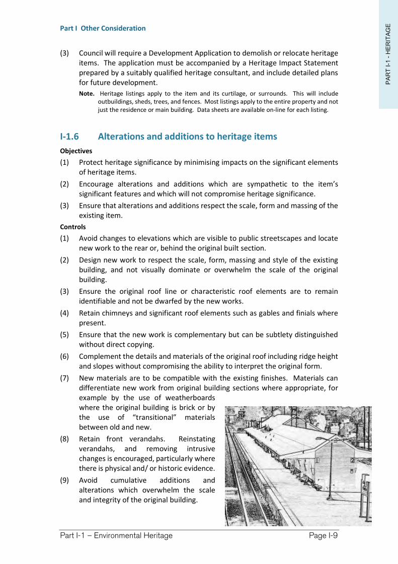
PA
RT
I-1
-H
ER
ITA
GEPart I Other Consideration
Part I-1 – Environmental Heritage Page I-9
(3) Council will require a Development Application to demolish or relocate heritage items. The application must be accompanied by a Heritage Impact Statement prepared by a suitably qualified heritage consultant, and include detailed plans for future development.
Note. Heritage listings apply to the item and its curtilage, or surrounds. This will include outbuildings, sheds, trees, and fences. Most listings apply to the entire property and not just the residence or main building. Data sheets are available on-line for each listing.
I-1.6 Alterations and additions to heritage items
Objectives
(1) Protect heritage significance by minimising impacts on the significant elements of heritage items.
(2) Encourage alterations and additions which are sympathetic to the item’s significant features and which will not compromise heritage significance.
(3) Ensure that alterations and additions respect the scale, form and massing of the existing item.
Controls
(1) Avoid changes to elevations which are visible to public streetscapes and locate new work to the rear or, behind the original built section.
(2) Design new work to respect the scale, form, massing and style of the existing building, and not visually dominate or overwhelm the scale of the original building.
(3) Ensure the original roof line or characteristic roof elements are to remain identifiable and not be dwarfed by the new works.
(4) Retain chimneys and significant roof elements such as gables and finials where present.
(5) Ensure that the new work is complementary but can be subtlety distinguished without direct copying.
(6) Complement the details and materials of the original roof including ridge height and slopes without compromising the ability to interpret the original form.
(7) New materials are to be compatible with the existing finishes. Materials can differentiate new work from original building sections where appropriate, for example by the use of weatherboards where the original building is brick or by the use of “transitional” materials between old and new.
(8) Retain front verandahs. Reinstating verandahs, and removing intrusive changes is encouraged, particularly where there is physical and/ or historic evidence.
(9) Avoid cumulative additions and alterations which overwhelm the scale and integrity of the original building.
PA
RT
I-1
-H
ER
ITA
GEPart I Other Consideration
Part I-1 – Environmental Heritage Page I-10
New Garages and Sheds
(10) The following principles should be adopted in relation to new outbuildings:
The size of the shed or outbuilding should not dominate the site or adversely affect the setting of the heritage item or conservation areas.
Locate the building to retain as much garden and space around the original and shadow lines.
Use an uncoloured building where possible.
Minimise intrusion of driveways through rear garden spaces.
Use a roof pitch of approximately 15-20 degrees to give a more traditional appearance compared to low flat roofs.
Use a barge roll and fascia with an overhanging eave of 300mm to create a traditional appearance metal roof in relation to similar traditional weatherboard and iron buildings.
Use a material which harmonises with the main building. Metal cladding in a C profile which resembles horizontal weatherboard appearance, or cement traditional profiled weatherboards, are low maintenance options which look good in proximity to traditional timber weatherboard dwellings.
Do not dominate the facade with more than 2 garage doors to the street.
Use a ribbon strip concrete driveway to minimise hard surfacing of driveway areas in the setting of a heritage item.
If windows are proposed ensure that they are proportioned in keeping with the main building, eg. vertically rather than horizontally.
I-1.7 Materials, finishes and colours
Objectives
(1) to ensure appropriate materials, finishes and colours are used which are suitable to the period of a building.
Controls
(1) Materials for repairs and maintenance should match as closely as possible to the original. Materials for new works such as extensions should be compatible and complementary to the original, but do not need to match exactly. Eg. a weatherboard extension may be suitable at the rear of an original sandstone brick house in keeping with outbuildings which were generally of a more lightweight nature.
(2) Colour schemes are to reflect the period and detail of the property.
(3) Painting or rendering face brick is generally not supported because it extremely difficult, if not impossible, to return to its original brick.
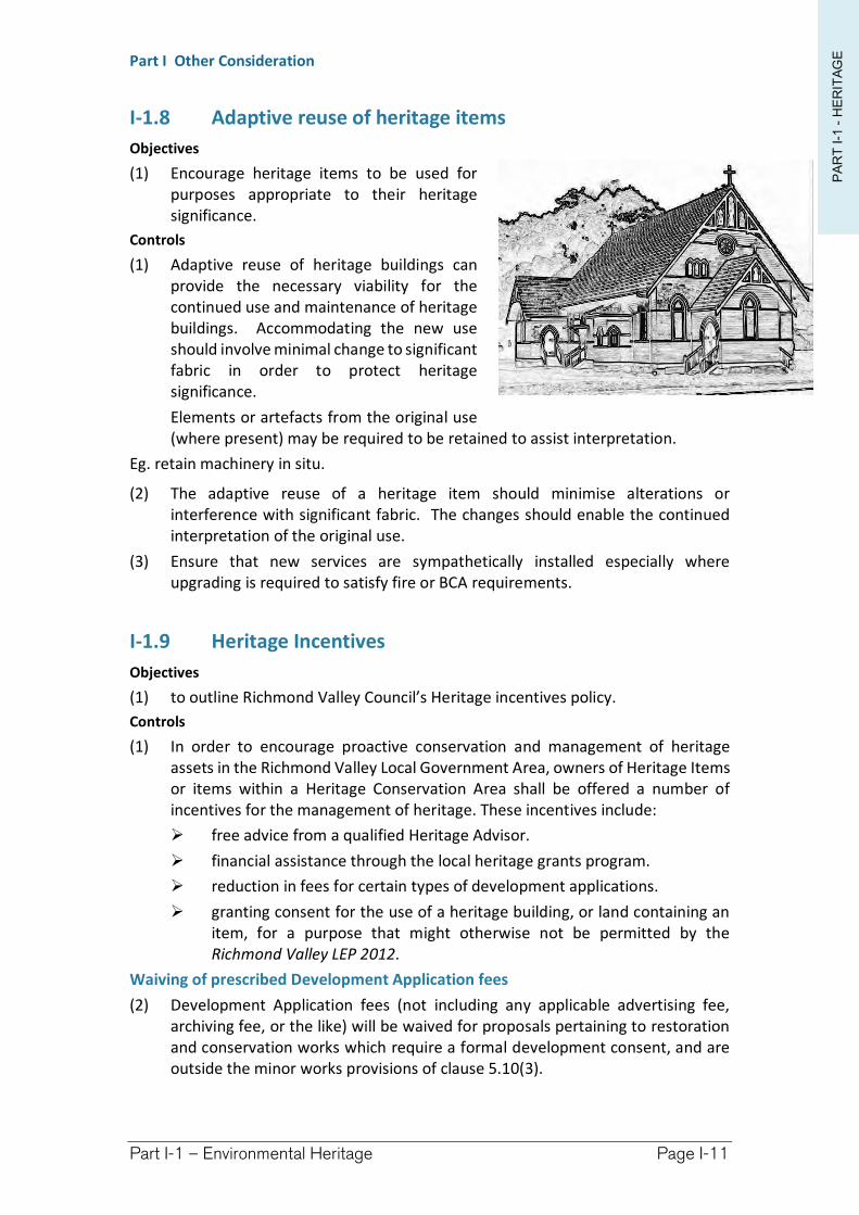
PA
RT
I-1
-H
ER
ITA
GEPart I Other Consideration
Part I-1 – Environmental Heritage Page I-11
I-1.8 Adaptive reuse of heritage items
Objectives
(1) Encourage heritage items to be used for purposes appropriate to their heritage significance.
Controls
(1) Adaptive reuse of heritage buildings can provide the necessary viability for the continued use and maintenance of heritage buildings. Accommodating the new use should involve minimal change to significant fabric in order to protect heritage significance.
Elements or artefacts from the original use (where present) may be required to be retained to assist interpretation.
Eg. retain machinery in situ.
(2) The adaptive reuse of a heritage item should minimise alterations or interference with significant fabric. The changes should enable the continued interpretation of the original use.
(3) Ensure that new services are sympathetically installed especially where upgrading is required to satisfy fire or BCA requirements.
I-1.9 Heritage Incentives
Objectives
(1) to outline Richmond Valley Council’s Heritage incentives policy.
Controls
(1) In order to encourage proactive conservation and management of heritage assets in the Richmond Valley Local Government Area, owners of Heritage Items or items within a Heritage Conservation Area shall be offered a number of incentives for the management of heritage. These incentives include:
free advice from a qualified Heritage Advisor.
financial assistance through the local heritage grants program.
reduction in fees for certain types of development applications.
granting consent for the use of a heritage building, or land containing an item, for a purpose that might otherwise not be permitted by the Richmond Valley LEP 2012.
Waiving of prescribed Development Application fees
(2) Development Application fees (not including any applicable advertising fee, archiving fee, or the like) will be waived for proposals pertaining to restoration and conservation works which require a formal development consent, and are outside the minor works provisions of clause 5.10(3).
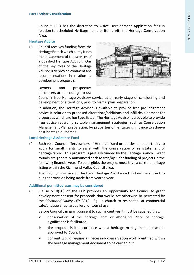
PA
RT
I-1
-H
ER
ITA
GEPart I Other Consideration
Part I-1 – Environmental Heritage Page I-12
Council’s CEO has the discretion to waive Development Application fees in relation to scheduled Heritage Items or items within a Heritage Conservation Area.
Heritage Advice
(3) Council receives funding from the Heritage Branch which partly funds the engagement of the services of a qualified Heritage Advisor. One of the key roles of the Heritage Advisor is to provide comment and recommendations in relation to development proposals.
Owners and prospective purchasers are encourage to use Council’s free Heritage Advisory service at an early stage of considering and development or alterations, prior to formal plan preparation.
In addition, the Heritage Advisor is available to provide free pre-lodgement advice in relation to proposed alterations/additions and infill development for properties which are heritage listed. The Heritage Advisor is also able to provide free advice regarding suitable management strategies, such as Conservation Management Plan preparation, for properties of heritage significance to achieve best heritage outcomes.
Local Heritage Assistance Fund
(4) Each year Council offers owners of Heritage listed properties an opportunity to apply for small grants to assist with the conservation or reinstatement of heritage fabric. This program is partially funded by the Heritage Branch. Grant rounds are generally announced each March/April for funding of projects in the following financial year. To be eligible, the project must have a current heritage listing within the Richmond Valley Council area.
The ongoing provision of the Local Heritage Assistance Fund will be subject to budget provision being made from year to year.
Additional permitted uses may be considered
(5) Clause 5.10(10) of the LEP provides an opportunity for Council to grant development consent for proposals that would not otherwise be permitted by the Richmond Valley LEP 2012. Eg. a church to residential or commercial cafe/antique shop, art gallery, or tourist use.
Before Council can grant consent to such incentives it must be satisfied that:
conservation of the heritage item or Aboriginal Place of heritage significance is facilitated.
the proposal is in accordance with a heritage management document approved by Council.
consent would require all necessary conservation work identified within the heritage management document to be carried out.
PA
RT
I-1
-H
ER
ITA
GEPart I Other Consideration
Part I-1 – Environmental Heritage Page I-13
the proposal would not adversely affect the heritage significance of the item, including its setting.
the proposed development would not adversely impact on the amenity of the surrounding area.
(6) Process for Approving a Heritage Management Document containing Additional Development Incentives
Approval of a Heritage Management Document containing incentives for development that would be otherwise prohibited by the Richmond Valley LEP 2012 or this DCP must only be granted where the following procedures have been followed. This is to ensure the process is transparent, and that heritage significance and conservation outcomes justify the development incentives being sought.
the Heritage Management Document must be advertised and notified for a minimum period of 21 days.
the Heritage Management Document must be reported to Council, along with a summary of submissions received, and detail:
the incentives proposed and how they depart from the standards contained within the LEP and/or DCP.
the conservation measures proposed to be undertaken to justify the development incentives.
an evaluation of whether the heritage significance and conservation measures proposed justify proposed development incentives.
(7) Types of Development Incentives that may/may not be considered
Examples of the types of incentives that may be considered are:
Erection of an additional dwelling on rural land where the heritage item is a dwelling and will be restored and maintained on the land.
Slightly higher densities for residential flat buildings.
Examples of the types of incentives that would not be supported:
Rural subdivision below minimum lot size so as to create additional lots with dwelling opportunities.
I-1.10 Development in the vicinity of a heritage item
Objectives
(1) Encourage development in the vicinity of a heritage item to be designed and sited to protect the significance of the heritage item.
Controls
(1) Development in the vicinity of a heritage item can have an impact upon the heritage significance of the item, in particular through impacting its setting. Determining whether a property is within the setting of a heritage item is a necessary component of the site analysis for proposals. Advice from Council’s Heritage Advisor may be required to determine this. The analysis should consider historical property boundaries, significant vegetation and landscaping, archaeological features, and significant views.
PA
RT
I-1
-H
ER
ITA
GEPart I Other Consideration
Part I-1 – Environmental Heritage Page I-14
(a) The adaptive reuse of a heritage item is to minimise alterations or interference.
(b) Alterations and additions to buildings and structures, and new development are to be designed to respect and compliment the heritage item in terms of building envelope, proportions, materials, colours, finishes and building street alignment.
(c) Development in the vicinity of a heritage item is to minimise the impact on the setting of the item by:
Providing an adequate area around the heritage item to allow its interpretation.
Providing an adequate area around the heritage item to allow its interpretation.
Retaining original or significant landscaping associated with the heritage item.
Protecting and allowing the interpretation of archaeological features associated with the heritage item.
Retaining and respecting significant views to and from the heritage item.
I-1.11 Development in the Casino Central Business District Conservation Area
Objectives
(1) Retain original intact shop fronts, and any remaining evidence of original shopfronts.
(2) Encourage reinstatement of traditional features and sympathetic new work.
(3) Encourage use of traditional colour schemes based on the period of the building.
(4) Encourage signs that complement, rather than dominate, the architectural characteristics of the building.
(5) Prevent proliferation of signs on buildings.
(6) Encourage infill development and the replacement of non-contributory buildings, see Figure F9.1, to reflect the historic character of the precinct and capturing nearby characteristics of contributory buildings.
(7) Do not locate service elements (solar panels, solar heating, antennas, satellite dishes, air conditioning units and the like) where they are visible from the street.
Controls
(1) The Casino Central Business District Conservation Area extends along Barker and Walker Streets Casino, see Figure I-1.1. This commercial precinct comprises buildings from the Victorian, Edwardian and Inter War periods. While most shopfronts at ground level have been altered, the above awning period detail has in the main been retained.
Important considerations for future proposals are sympathetic facade treatments, signage and colour schemes. Council has detailed guidelines for
PA
RT
I-1
-H
ER
ITA
GEPart I Other Consideration
Part I-1 – Environmental Heritage Page I-15
alterations and additions, and colour schemes for buildings from a Main Street Study conducted by the former Casino Council in 1992.
Facade treatment
(2) Retain original elements and features, especially facades above awning level, of contributory buildings and heritage listed items (see Figure I-1.1).
(3) Encourage reinstatement of front verandahs and awnings based on historic information.
(4) Where original shopfronts, verandahs or awnings have been altered, their replacement should be based on historic information and/or the interpretation of period details.
(5) Additional storeys can be considered if:
set at least 10 metres back from road frontage(s).
the design and materials used for the extensions minimise detrimental impact on contributory building facades.
(6) Service elements (solar panels, solar heating, antennas, satellite dishes, air conditioning units and the like) are to be placed to the rear of the properties or on rear outbuildings, preferably so they are not visible from Barker or Walker Streets.
(7) Rendering or painting face brick is not supported.
Infill development
(8) Infill development should:
Design infill and replacement buildings are to reflect the general historic character of the precinct and capture characteristic elements from contributory buildings and heritage items in the vicinity, see Figure I-1.1.
Maintain a two storey building height at the street frontage. This two storey height restriction may be relaxed where such construction is setback 10 metres from road frontages. Refer to facade treatment above.
Where sites are amalgamated, use articulation to reflect the former subdivision pattern.
Maintain a balance of solid areas over voids—Large areas of plate glass curtain walls are generally not suitable and may not be supported.
Use awnings and verandahs to reduce the bulk and scale of buildings.
Use of articulation in facades such as string courses, cornices, pilasters and other features that break up the scale of facades is encouraged.
Signage
(9) Signage should:
Painting of facades in bold, primary, vivid, intense or neon colours is not supported.
Corporate identify should be expressed through limited area of signage in appropriate locations, however, Corporate colours may also need to be amended as a requirement of consent, to a more subtle version of the standard colour palette in order to be sympathetic to the values of the Heritage Conservation Area or Heritage Item context.
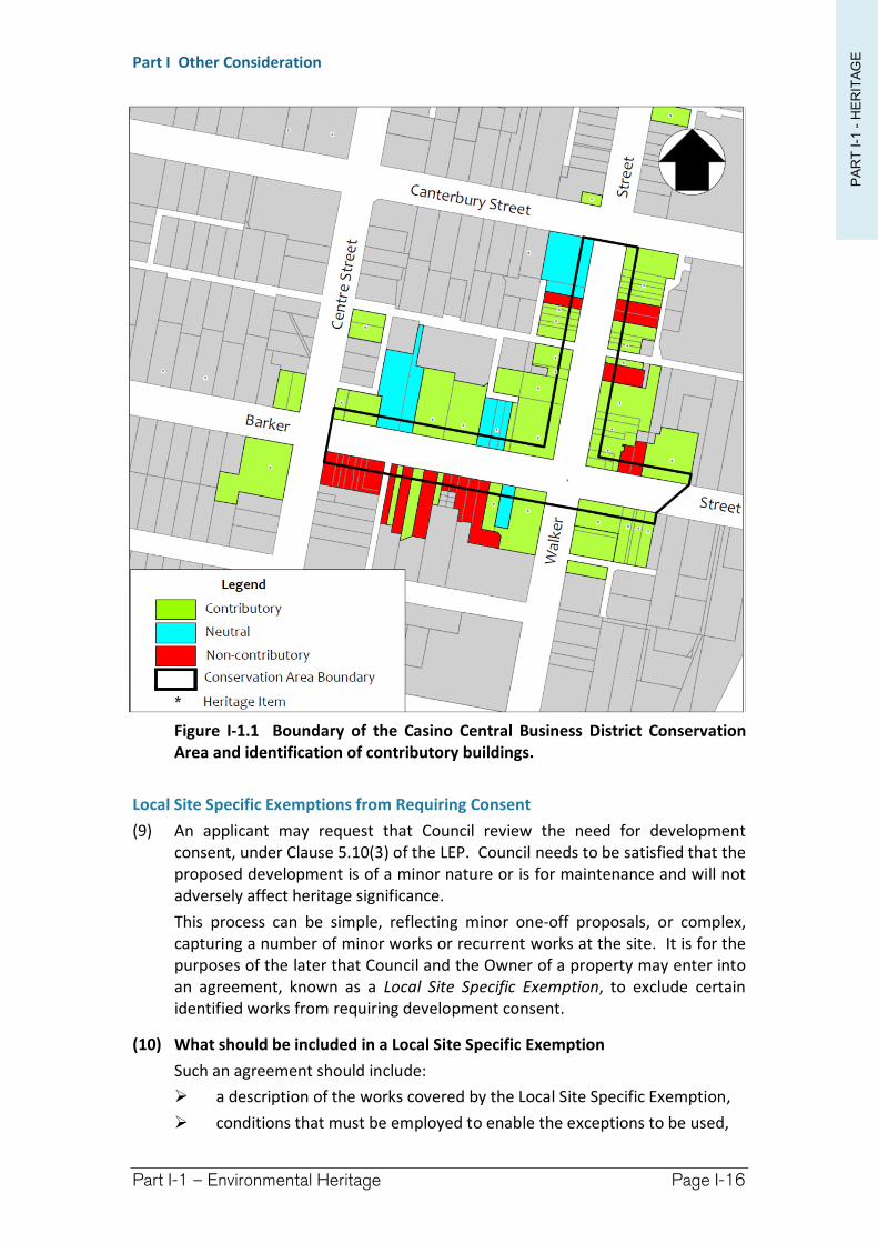
PA
RT
I-1
-H
ER
ITA
GEPart I Other Consideration
Part I-1 – Environmental Heritage Page I-16
Figure I-1.1 Boundary of the Casino Central Business District Conservation Area and identification of contributory buildings.
Local Site Specific Exemptions from Requiring Consent
(9) An applicant may request that Council review the need for development consent, under Clause 5.10(3) of the LEP. Council needs to be satisfied that the proposed development is of a minor nature or is for maintenance and will not adversely affect heritage significance.
This process can be simple, reflecting minor one-off proposals, or complex, capturing a number of minor works or recurrent works at the site. It is for the purposes of the later that Council and the Owner of a property may enter into an agreement, known as a Local Site Specific Exemption, to exclude certain identified works from requiring development consent.
(10) What should be included in a Local Site Specific Exemption
Such an agreement should include:
a description of the works covered by the Local Site Specific Exemption,
conditions that must be employed to enable the exceptions to be used,

PA
RT
I-1
-H
ER
ITA
GEPart I Other Consideration
Part I-1 – Environmental Heritage Page I-17
a description of the land to which the agreement applies,
a statement of heritage significance, and
a period of time after which the agreement will expire.
(11) Agreement runs with the land
Once an agreement has been endorsed it will run with the land. This means a new owner of that property is not required to enter into a new agreement for them to be used.
(12) Withdrawal of Agreement
Council or the Owner may at any time withdraw support to a Local Site Specific Exemption. Such a withdrawal needs to be in writing and is effective immediately. Where it is Council that withdraws its support for an agreement it shall identify the reasons in its written notice.
I-1.12 Aboriginal Cultural Heritage
Objectives
(1) To outline planning regulations as related to the management and protection of Aboriginal Cultural Heritage.
(2) To outline Council expectations when undertaking Due Diligence assessment of Cultural Heritage.
Controls
(1) Richmond Valley Council acknowledges the peoples of the Bundjalung Nation as the traditional custodians of this region. These traditional owners include the people of the Banjalang, Birihnbal, Galibal, Nyangbal and Wiyabal tribes who engaged in a rich and complex ritual life with language, customs, spirituality and law – the heart of which was connection to country.
Aboriginal cultural heritage consists of places and items that are of significance to Aboriginal people because of their traditions, observances, lore, customs, beliefs and history. It provides evidence of the lives and existence of Aboriginal people before European settlement through to the present. Aboriginal cultural heritage is dynamic and may comprise physical (tangible) or non-physical (intangible) elements. It includes things made and used in traditional societies, such as stone tools, art sites and ceremonial or burial grounds. It also includes more contemporary and/or historical elements such as old mission buildings, massacre sites and cemeteries. Tangible heritage is situated in a broader cultural landscape and needs to be considered in that context and in a holistic manner.
While a number of sites of Aboriginal archaeological and heritage significance are known and have been recorded within the Richmond Valley LGA, specific surveys for Aboriginal objects have not been done over much of the area. Therefore, there is potential for Aboriginal cultural heritage to exist in many locations even though they have not been formally recorded.
PA
RT
I-1
-H
ER
ITA
GEPart I Other Consideration
Part I-1 – Environmental Heritage Page I-18
Aboriginal Heritage and the LEP
(2) Clause 5.10(8) of the Richmond Valley LEP requires development consent to carry out development within an Aboriginal place of heritage significance. The dictionary defines an Aboriginal place of heritage significance as land identified in an Aboriginal heritage study adopted by Council. At this point Council has not undertaken an Aboriginal heritage study. It is a high priority within Council’s Community Strategic Plan but subject to resourcing. As such, and for the purposes of the LEP, clause 5.10(8) will be ineffective until such time as a Study has been prepared, undergone community consultation, been accepted by the Aboriginal community and adopted by Council.
Aboriginal Heritage and the National Parks and Wildlife Act
(3) The National Parks and Wildlife Act 1974 (NPW Act), administered by the Office of Environment and Heritage (OEH), is the primary legislation for the protection of some aspects of Aboriginal cultural heritage in New South Wales.
Part 6 of the NPW Act provides specific protection for Aboriginal objects and declared Aboriginal places by establishing offences of harm. There are a number of defences and exemptions to the offence of harming an Aboriginal object or Aboriginal place. One of the defences is that the harm was carried out under an Aboriginal Heritage Impact Permit (AHIP)
(4) Aboriginal objects
Aboriginal objects are physical evidence of the use of an area by Aboriginal people. They can also be referred to as ‘Aboriginal sites’, ‘relics’ or ‘cultural material’.
Aboriginal objects include:
physical objects, such as stone tools, Aboriginal-built fences and stockyards, scarred trees and the remains of fringe camps
material deposited on the land, such as middens
the ancestral remains of Aboriginal people.
Handicrafts made by Aboriginal people for sale are not 'Aboriginal objects' under the NPW Act.
(5) Aboriginal places
The NPW Act can also protect areas of land that have no Aboriginal objects, that is, they may have no physical evidence of Aboriginal occupation or use. These areas can be declared ‘Aboriginal places’.
The Minister can declare an area to be an ‘Aboriginal place’ if the Minister believes that the place is or was of special significance to Aboriginal culture. An area can have spiritual, natural resource usage, historical, social, educational or other type of significance.
(6) Aboriginal Heritage Information Management System (AHIMS) Database
OEH keeps a register of notified Aboriginal objects and declared Aboriginal places in NSW. The register is called the Aboriginal Heritage Information Management System (AHIMS).
PA
RT
I-1
-H
ER
ITA
GEPart I Other Consideration
Part I-1 – Environmental Heritage Page I-19
You can search AHIMS to discover if an Aboriginal object has been recorded, or an Aboriginal place declared, on a parcel of land. Or use the AHIMS Web Service (AWS) to carry out an internet-based search for information about recorded Aboriginal objects, gazetted Aboriginal places and features of significance.
Please note that surveys for Aboriginal objects have not been done in many parts of NSW. Aboriginal objects may exist on a parcel of land even though they have not been recorded in AHIMS.
If you discover something you believe should be registered as an Aboriginal object, contact the Aboriginal Heritage Information Unit.
(7) Due Diligence
Anyone who exercises due diligence in determining that their actions will not harm Aboriginal objects has a defence against prosecution for the strict liability offence if they later harm an object.
The Due Diligence Code of Practice for the Protection of Aboriginal Objects in NSW, can be used by individuals or organisations who are contemplating undertaking activities which could harm Aboriginal objects. This code will provide a process whereby a reasonable determination can be made as to whether or not Aboriginal objects will be harmed by an activity, whether further investigation is warranted and whether the activity requires an AHIP application.
Due diligence may also be exercised by complying with industry-specific codes of practice that have been adopted under the National Parks and Wildlife Regulation 2009.
For further information of undertaking a Due Diligence assessment refer to the Code. A copy of the Code can be downloaded from the Office of Environment and Heritage website at:
http://www.environment.nsw.gov.au/resources/cultureheritage/ddcop/10798ddcop.pdf
(8) Aboriginal Heritage Impact Permit (AHIP)
An Aboriginal Heritage Impact Permit (AHIP) is the statutory instrument that OEH issues under section 90 of the National Parks and Wildlife Act 1974 to manage harm or potential harm to Aboriginal objects and places.
When administering its statutory functions under Part 6 of the NPW Act, OEH requires proponents to consult with Aboriginal people about the Aboriginal cultural heritage values of Aboriginal objects and/or places within the proposed project area.
For the purposes of these requirements community consultation must be undertaken in accordance with the Aboriginal Cultural Heritage Consultation Requirements for Proponents 2010. This guideline establishes a process for the open and honest communication between the proponent and Aboriginal people who have cultural heritage knowledge relevant to the proposed project area.
(9) Integrated Development
Any development requiring an AHIP is integrated development under section 4.46 of the EP&A Act. As such the applicant is required to tick the appropriate
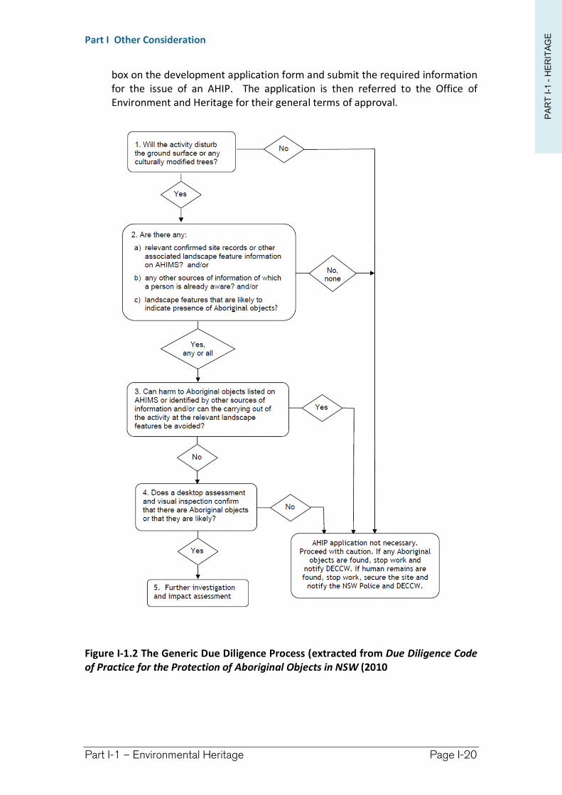
PA
RT
I-1
-H
ER
ITA
GEPart I Other Consideration
Part I-1 – Environmental Heritage Page I-20
box on the development application form and submit the required information for the issue of an AHIP. The application is then referred to the Office of Environment and Heritage for their general terms of approval.
Figure I-1.2 The Generic Due Diligence Process (extracted from Due Diligence Code of Practice for the Protection of Aboriginal Objects in NSW (2010
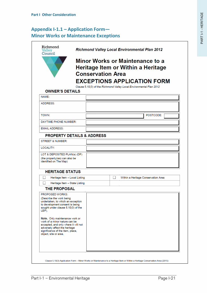
PA
RT
I-1
-H
ER
ITA
GEPart I Other Consideration
Part I-1 – Environmental Heritage Page I-21
Appendix I-1.1 – Application Form— Minor Works or Maintenance Exceptions
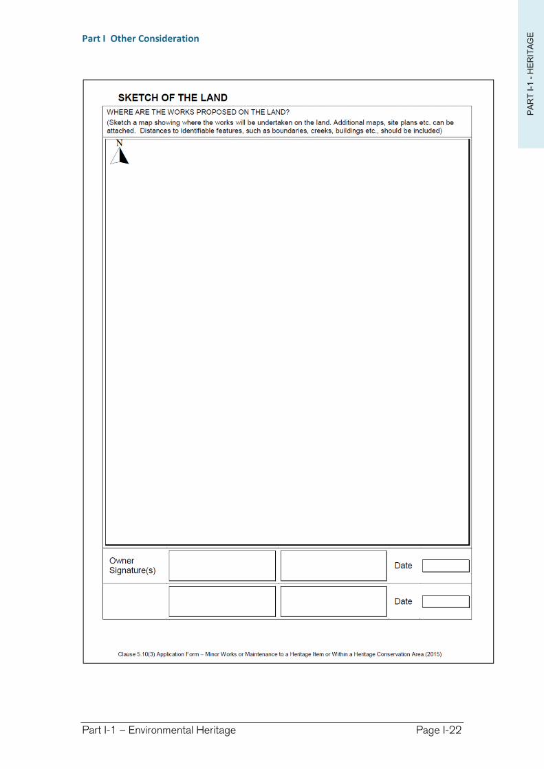
PA
RT
I-1
-H
ER
ITA
GEPart I Other Consideration
Part I-1 – Environmental Heritage Page I-22
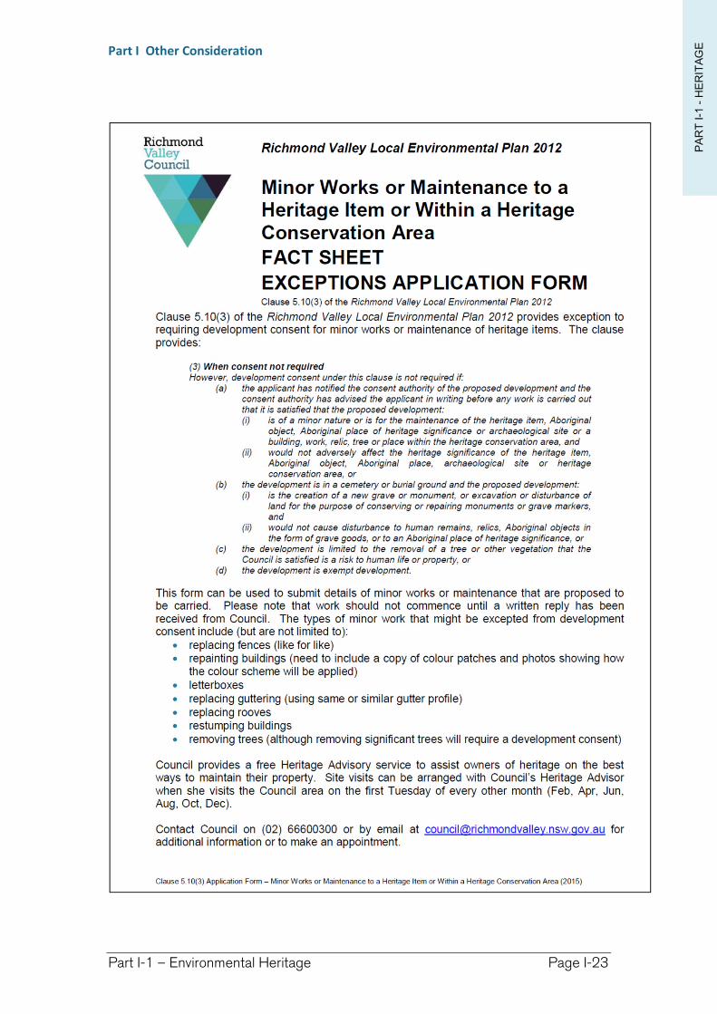
PA
RT
I-1
-H
ER
ITA
GEPart I Other Consideration
Part I-1 – Environmental Heritage Page I-23
Richmond Valley Development Control Plan 2021
Part I-2 Development In, On, Over or Under a Public Road
The term public road is defined within the Roads Act 1993and applies to public lands declared by reservation to be road. Public roads therefore form a network of corridors that provide access for the conveyance of vehicular, pedestrian, and stock traffic throughout the landscape. Public roads may be:
formed—containing constructed and maintained carriageway, or
unformed—there has never been a constructed and maintained carriageway—these are commonly known “paper roads”.
A public road may also be leased:
as an enclosure permit—where an unformed road is leased to an adjoining property owner and is often fenced into the property;
for commercial purposes—such as alfresco dining, footpath trading, roadside vending; and
for encroachments of structures—such as awnings over the footpath, or gantries to carry services from one side of the road to the other.
All works and activities within public roads need the consent of the owner. They may also require development consent and/or some other approval, such as under the Roads Act 1993, or Local Government Act 1993. It is the purpose of this Chapter to explain the minimum standards for construction in, on, over or under a public road and to identify Council’s consent or approval requirements.
This DCP applies to all land within the Richmond Valley Local Government Area.
Date adopted by Council: 22/06/2021
Effective Date: 01/08/2021
Amendments: Nil
PA
RT
I-2
–D
EV
ELO
PM
EN
T O
VE
R P
UB
LIC
RO
AD
S
Part I Other Consideration
Part I-2 – Development Over Public Roads Page I-26
I-2.1 General Objectives
The general objectives of this Chapter are to:
(1) identify development standards for various types of construction where erected in, on, over or under a public road.
(2) outline Council’s administrative requirements for the erection of structures in, on, over or under a public road.
(3) identify Council requirements for kerbside trading.
I-2.2 Roads Authority
Objective
(1) To identify the Roads Authority for roads of particular classification or status and whom is responsible for regulating various kerbside and in road activities.
Controls
(1) Public road reserves consist of public land, so they are available for the entire community to use for access whether formed, unformed, or leased. They are however also owned and controlled by either Council or the Department of Lands, depending upon how they were originally created and whether they have been dedicated.
Generally the rule of thumb for ownership of a public road is:
unformed—normally Crown lands being owned and controlled by the Department of Lands, while
formed—most often dedicated under the care and control of the local council.
This rule of thumb isn’t correct in all cases so the status of a particular public road reserve should be checked with Council or the Department of Lands prior to undertaking any works or activities.
(2) Classified Roads
Classified Roads are defined within the Roads Act 1993 and include freeways, highways and main roads. The following roads within Richmond Valley Council’s area are Classified Roads:
Pacific Highway,
Bruxner Highway,
Summerland Way,
Casino-Coraki Road
Coraki-Woodburn Road, and
Woodburn-Evans Head Road
Bentley Road (Lismore-Kyogle)
The Roads Act 1993 declares that the land on which a Classified Road is situated is owned by the local roads authority (council), but the road infrastructure constructed within the public road reserve may be owned and controlled by NSW Roads and Maritime. As such works and activities within a Classified Road
PA
RT
I-2
–D
EV
ELO
PM
EN
T O
VE
R P
UB
LIC
RO
AD
S
Part I Other Consideration
Part I-2 – Development Over Public Roads Page I-27
will require owner consent from the local council, but concurrence will also be required from NSW Roads and Maritime to access/intersect the road infrastructure, or to do works that may impact upon the functionality and safety of the road infrastructure.
(3) Roads Act Approvals
All works and structures to be carried out or erected within a public road require approval under section 138 of the Roads Act 1993. This includes works in, on, over or under a public road. Such approvals are required from the appropriate roads authority, being either Council, Roads and Maritime Services, or the Crown, depending on the road ownership and whether it is a Classified Road.
I-2.3 Structures in, on, over or under a Public Road
Objective
(1) To establish the minimum requirements for private/commercial structures to be erected in, on, over or under a public road.
Controls
Roads Act 1993
(1) As a general rule all construction in a road reserve requires Section 138 Approval under the Roads Act.
Consideration will be given to the following when determining such applications.
Projections for protection from the sun or for decoration
(2) Projections designed or intended as protection from the sun, and projections of a decorative nature such as cornices, eaves, sills, mullions and architraves, may project beyond the alignment of a public road if the road reserve is not less than 12.2 metres wide and the projections:
(a) extend not more than 450 mm beyond the road alignment,
(b) are at least 2600 mm above the pathway level of the road over which they project (including any fittings, fixtures, advertisements or the like),
(c) are no closer than 600 mm to any kerb and gutter, table drain or carriageway located within the road reserve, and
(d) are constructed of masonry, reinforced concrete or other approved fire-resisting material.
Sunblind canopies, sun louvres and the like
(3) Sunblind canopies, sun louvres and the like may project beyond the alignment of a public road and the projections:
(a) in their fully open position, extend not more than 450 mm beyond the road alignment,
(b) are at least 2600 mm above the pathway level of the road over which they project (including any fittings, fixtures, advertisements or the like),
(c) do not extend any closer than 600 mm to any kerb and gutter, table drain or carriageway located within the road reserve, and
(d) are constructed of approved non-combustible material throughout.
PA
RT
I-2
–D
EV
ELO
PM
EN
T O
VE
R P
UB
LIC
RO
AD
S
Part I Other Consideration
Part I-2 – Development Over Public Roads Page I-28
Footings under public roads
(4) Footings may project beyond the road alignment to the extent of not more than:
(a) 450 mm—if the projecting parts are more than 1350 mm below pathway level at the road alignment, and
(b) 750 mm—if the projecting parts are more than 3000 mm below pathway level at the road alignment,
but in no case may the projections extend under the carriageway of the road.
Traps on sewerage service pipes
(5) Traps on sewerage service pipes must not be installed in a public road.
Pipes and services
(6) Pipes and services must not project beyond the road alignment, except as provided.
Rainwater heads may project not more than 450 mm and rainwater downpipes may project not more than 150 mm above a height of 2700 mm above the pathway level.
In the case of an existing building, the council may consent to the projection of essential service pipes.
Flagpoles
(7) Flagpoles may project beyond the road alignment if:
no part of a pole, or a flag suspended from it, shall be located within 3600 mm of the pathway level of the road below the pole,
it does not project over the carriageway of the road, and
no interference with public services is caused.
Construction of projections
(8) Projections beyond the road alignment are to be constructed so that they may be removed at any time after their erection without causing the building, of which they are part, to be structurally unsafe, and without causing a reduction in the required fire-resistance rating of any structural member of the building.
Awnings or Verandahs over roads
(9) The council may require that any or all awnings or verandahs proposed to be erected over a public road be of a cantilever type.
(10) Cantilevered awnings or verandahs
The width of a cantilever awning or verandah that extends beyond a road alignment, from the alignment of the road to the outside edge of the fascia plate is to be at least 600 mm less than the width of the footway over which it is to be erected. However, the decorative treatment on the fascia plate of any such awning may project for a distance not exceeding 75 mm.
The maximum width of a cantilever awning that extends beyond the road alignment must not exceed 3660 mm.
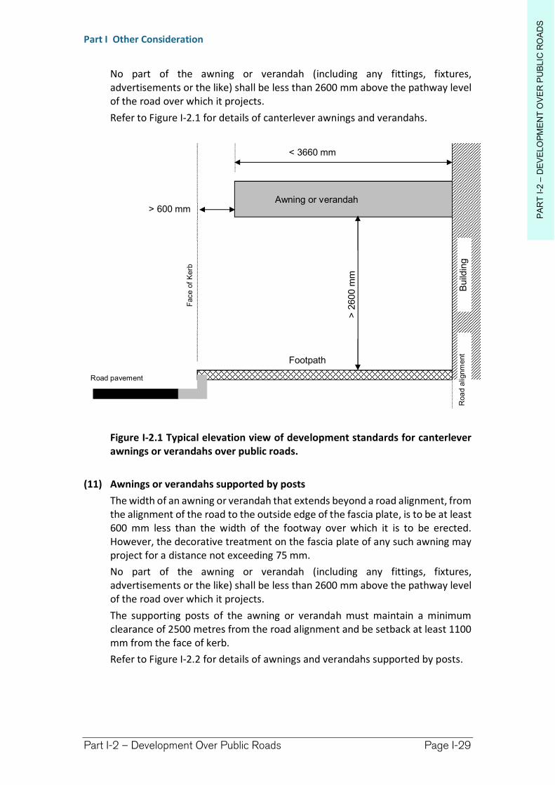
PA
RT
I-2
–D
EV
ELO
PM
EN
T O
VE
R P
UB
LIC
RO
AD
S
Part I Other Consideration
Part I-2 – Development Over Public Roads Page I-29
No part of the awning or verandah (including any fittings, fixtures, advertisements or the like) shall be less than 2600 mm above the pathway level of the road over which it projects.
Refer to Figure I-2.1 for details of canterlever awnings and verandahs.
Figure I-2.1 Typical elevation view of development standards for canterlever awnings or verandahs over public roads.
(11) Awnings or verandahs supported by posts
The width of an awning or verandah that extends beyond a road alignment, from the alignment of the road to the outside edge of the fascia plate, is to be at least 600 mm less than the width of the footway over which it is to be erected. However, the decorative treatment on the fascia plate of any such awning may project for a distance not exceeding 75 mm.
No part of the awning or verandah (including any fittings, fixtures, advertisements or the like) shall be less than 2600 mm above the pathway level of the road over which it projects.
The supporting posts of the awning or verandah must maintain a minimum clearance of 2500 metres from the road alignment and be setback at least 1100 mm from the face of kerb.
Refer to Figure I-2.2 for details of awnings and verandahs supported by posts.
> 600 mm
< 3660 mm
> 2
600
mm
Road pavement
Face o
f K
erb
Footpath
Awning or verandah
Build
ing
Roa
d a
lignm
ent
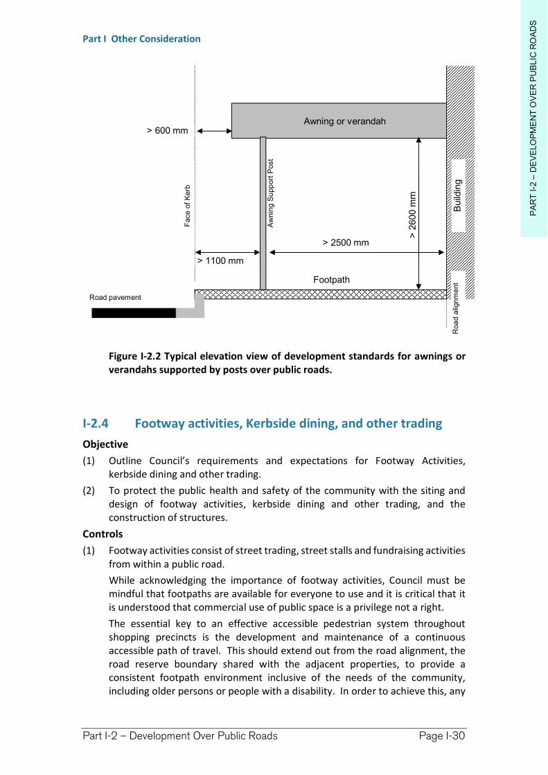
PA
RT
I-2
–D
EV
ELO
PM
EN
T O
VE
R P
UB
LIC
RO
AD
S
Part I Other Consideration
Part I-2 – Development Over Public Roads Page I-30
Figure I-2.2 Typical elevation view of development standards for awnings or verandahs supported by posts over public roads.
I-2.4 Footway activities, Kerbside dining, and other trading
Objective
(1) Outline Council’s requirements and expectations for Footway Activities, kerbside dining and other trading.
(2) To protect the public health and safety of the community with the siting and design of footway activities, kerbside dining and other trading, and the construction of structures.
Controls
(1) Footway activities consist of street trading, street stalls and fundraising activities from within a public road.
While acknowledging the importance of footway activities, Council must be mindful that footpaths are available for everyone to use and it is critical that it is understood that commercial use of public space is a privilege not a right.
The essential key to an effective accessible pedestrian system throughout shopping precincts is the development and maintenance of a continuous accessible path of travel. This should extend out from the road alignment, the road reserve boundary shared with the adjacent properties, to provide a consistent footpath environment inclusive of the needs of the community, including older persons or people with a disability. In order to achieve this, any
> 600 mm
> 2
600
mm
Road pavement
Face o
f K
erb
Footpath
Awning or verandah
Build
ing
> 2500 mm
> 1100 mm A
wnin
g S
upp
ort
Post
Roa
d a
lignm
ent
PA
RT
I-2
–D
EV
ELO
PM
EN
T O
VE
R P
UB
LIC
RO
AD
S
Part I Other Consideration
Part I-2 – Development Over Public Roads Page I-31
street furniture, signs, traders, activities or displays should be located towards the kerbside not along the road alignment. This is consistent with best practice guidelines issued by the Human Rights and Equal Opportunity Commission.
Suitable and Unsuitable Locations
(2) Footway activities may be approved in all Richmond Valley Council public roads under the control and/or management of Council, where local conditions are favourable for their operation.
Footway activities are not permitted in areas where there exists high to very high pedestrian use or other public uses, such as adjacent to taxi ranks, bus stops, loading zones, fire hydrants, within potentially hazardous locations such as on street corners or an unprotected elevated location, or outside emergency exits.
The location of landscaping, trees, artwork, street furniture and other public infrastructure, as well as the width of the street and footpath, may preclude the establishment of footway activities. Furthermore, such things as Alcohol Free Zones will restrict the capacity of an activity to sell or enable the consumption of alcohol within a public road.
Another consideration will be Crime Prevention Through Environmental Design(CPTED) which provides guidelines on the sitting of development but also how it should be designed to reduce the potential for crime. See Chapter I-10 for further details.
Activities to be located within Trading Zone
(3) All street trading activities, street stalls and other fundraising activities should be located within the “Trading Zone” as depicted within Figure I-2.3.
Exceptions to this requirement may be extended for kerbside dining or alfresco dining where the trading zone is proposed to be extended beyond the gutter/road carriageway as part of the development application, or in areas with low pedestrian activity.
Pedestrian Zone to be Clear of Obstructions
(4) All footway activities, commercial trading or other uses of footpaths, must retain a clear pedestrian zone that is free of obstructions so as to maintain a safe and efficient passageway.
The recommended minimum width of the pedestrian zone shall be 1.8 metres, measured from the road alignment (the front boundary adjacent to the public road) or shopfront into the road reserve, refer to Figure I-2.3.
Kerbside Dining
(5) Kerbside dining will require approval under section 125 of the Roads Act 1993, Development consent under the EP&A Act, and where permanent structures are proposed, a section 138 approval under the Roads Act 1993.
The following matter will be considered by Council when determining any consent or approval for kerbside dining:
(a) Kerbside dining to be located adjacent to primary food premises
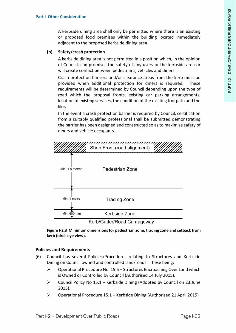
PA
RT
I-2
–D
EV
ELO
PM
EN
T O
VE
R P
UB
LIC
RO
AD
S
Part I Other Consideration
Part I-2 – Development Over Public Roads Page I-32
A kerbside dining area shall only be permitted where there is an existing or proposed food premises within the building located immediately adjacent to the proposed kerbside dining area.
(b) Safety/crash protection
A kerbside dining area is not permitted in a position which, in the opinion of Council, compromises the safety of any users or the kerbside area or will create conflict between pedestrians, vehicles and diners.
Crash protection barriers and/or clearance areas from the kerb must be provided when additional protection for diners is required. These requirements will be determined by Council depending upon the type of road which the proposal fronts, existing car parking arrangements, location of existing services, the condition of the existing footpath and the like.
In the event a crash protection barrier is required by Council, certification from a suitably qualified professional shall be submitted demonstrating the barrier has been designed and constructed so as to maximise safety of diners and vehicle occupants.
Figure I-2.3 Minimum dimensions for pedestrian zone, trading zone and setback from kerb (birds eye view).
Policies and Requirements
(6) Council has several Policies/Procedures relating to Structures and Kerbside Dining on Council owned and controlled land/roads. These being:
Operational Procedure No. 15.5 – Structures Encroaching Over Land which is Owned or Controlled by Council (Authorised 14 July 2015).
Council Policy No 15.1 – Kerbside Dining (Adopted by Council on 23 June 2015).
Operational Procedure 15.1 – Kerbside Dining (Authorised 21 April 2015)
Shop Front (road alignment)
Pedestrian Zone
Trading Zone
Kerbside Zone
Kerb/Gutter/Road Carriageway
Min. 1.8 metres
Min. 600 mm
Min. 1 metre
PA
RT
I-2
–D
EV
ELO
PM
EN
T O
VE
R P
UB
LIC
RO
AD
S
Part I Other Consideration
Part I-2 – Development Over Public Roads Page I-33
(7) Leases and licences
Council may authorise footway activities, kerbside dining, or structural encroachments (such as shop front awnings) within a public road subject to a lease or licence agreement.
Such leases or licensing will be done in accordance with section 125 &/or 138 of the Roads Act 1993.
Council may adopt a Policy in regard to the workings of such leases or licenses. However, generally speaking, a licence will be required to undertake footway activities using moveable furnishings and fixtures, while a lease may be required if the fixtures and furnishings are permanent. Notwithstanding, such arrangements will be at the discretion of Council.
(8) Public Liability and Professional Indemnity
Council requires that all activities in, on, over or under public roads, or within public places generally, require its authorisation but also relevant consents and approvals prior to commencement.
The person or organisation conducting the activity shall is required to hold current public liability insurance, workers compensation insurance, and professional indemnity insurance, with copies of certificates of currency to be periodically submitted to Council.
Note. The insurances will need to show the footway activity/kerbside dining as a coverage on the policies. Public Liability insurance cover of $20,000,000 is the current minimum requirement.
(9) Periodic Inspection of Structures
Any private structures constructed in, on, over or under a public road must be maintained to a safe standard at all times by the owner of the premises to which it is connected.
Council may require such structures to be covered by a lease or licence and it may be a requirement for such to be periodically inspected and certified by a suitably qualified professional.
Council may adopt a policy in regards to the leasing or licensing of such premises and for periodic inspections.
To minimise Council’s Public Liability exposure for such structures over the public road, it will require registration of a Positive Covenant over the adjacent privately owned land.
(10) Development application requirements
Where development consent is required for kerbside trading, or for a structure in, on, over or under a public road, the application should contain:
a completed development application form accompanied by the relevant fee and per Council’s Revenue Policy.
Consent for the lodgement of the development application will be required from the owner (usually Council), and the owner of the adjoining premises within which the principal business is operated.
PA
RT
I-2
–D
EV
ELO
PM
EN
T O
VE
R P
UB
LIC
RO
AD
S
Part I Other Consideration
Part I-2 – Development Over Public Roads Page I-34
site plans identifying the relevant areas in relationship to the applicant’s premises.
plans of the proposed kerbside dining area, whether it be for a permanent structure, or a moveable area including the location of all structure, street furniture, bollards, barriers, walls, tables and the like.
a plan identifying any proposed landscaping.
consideration of the condition and grade of the footpath and whether any improvements to the footpath are required, and any potential loss of car parking as a result of the proposal.
for larger scale developments, artist impressions, sketches and elevations of the proposed dining area may be required.
an assessment regarding the impact that the dining area will have upon vehicular movements and pedestrian movements, particularly for the visually impaired, disabled and elderly.
details of the premises seeking approval for kerbside dining such as hours of operation, service of alcohol etc.
where necessary, an assessment of the proposed development in accordance with the principles of Crime Prevention Through Environmental Design (CPTED).
All plans supplied must be to scale, and clearly identify furniture and other structures, include dimensions for such things as the pedestrian zone, trading zone and kerbside zone, and identify the location of the principal premises.
In granting development consent, Council may impose conditions requiring:
the dining facilities to be moveable in nature.
the facility may only be operated at certain specified times.
the consent is subject to having a current lease or licence arrangement with Council.
whether the consumption of alcohol will be permitted in the kerbside dining area.
Richmond Valley Development Control Plan 2021
Part I-3 Building Setbacks
Included in this Chapter are:
Street Setbacks
Side and Rear Boundary Setbacks
Foreshore Building Lines
This Chapter identifies requirements for setbacks for development from road frontages, side and rear boundaries and foreshores for all development types in the various land use zones which apply in Richmond Valley Shire.
Where a form of development is proposed that is not specifically addressed in other parts of the DCP, this chapter provides the applicable setback requirements.
Further detail on the setback types can be found in the Explanatory Notes Section, in Part A-11 of the DCP.
This DCP applies to all land within the Richmond Valley Local Government Area.
Date adopted by Council: 22/06/2021
Effective Date: 01/08/2021
Amendments: Nil
PA
RT
I-3
–B
UIL
DIN
G S
ET
BA
CK
S
Part I Other Consideration
Part I-3 – Building Setbacks Page I-36
I-3.1 General Objectives
The general objectives of this Chapter are to:
(1) adopt consistent front building setbacks throughout the LGA that provide for streetscape and neighbourhood amenity, while having regard to physical constraints as may occur.
(2) adopt minimum side and rear boundary setbacks having regard to neighbourhood amenity, height, design and scale of proposed development, and the Building Code of Australia (“BCA”).
(3) adopt a foreshore building line to setback development fronting waterways so as to ensure that it will not impact on natural foreshore processes or affect the significance and amenity of the area.
I-3.2 Setback Types
Objectives
(1) to identify street, side boundary and rear boundary setbacks are to be measured.
Measuring Setbacks
1. A setback is the horizontal distance between the property boundary and—
(a) the external wall* of a building, or
(b) the outside face of any balcony, deck or the like, or
(c) the supporting posts of a carport ** or verandah roof whichever distance is the shortest.
2. The building line or setback is measured at 90 degrees from the property boundary.
3. *In (1)(a) above, the setback is measured to the external face of the external wall of a building.
4. The following are not included when measuring a setback:
(a) Eaves less than 1 metre from the building wall or support post of an open structure
(b) Building articulation zones.
(c) **Ancillary development such as car ports, sheds, fences or minor development when located between a building and the street.
I-3.3 Street Setbacks
Objectives
(1) to establish minimum street setbacks for development types.
(2) to provide for safe vehicle egress from properties.
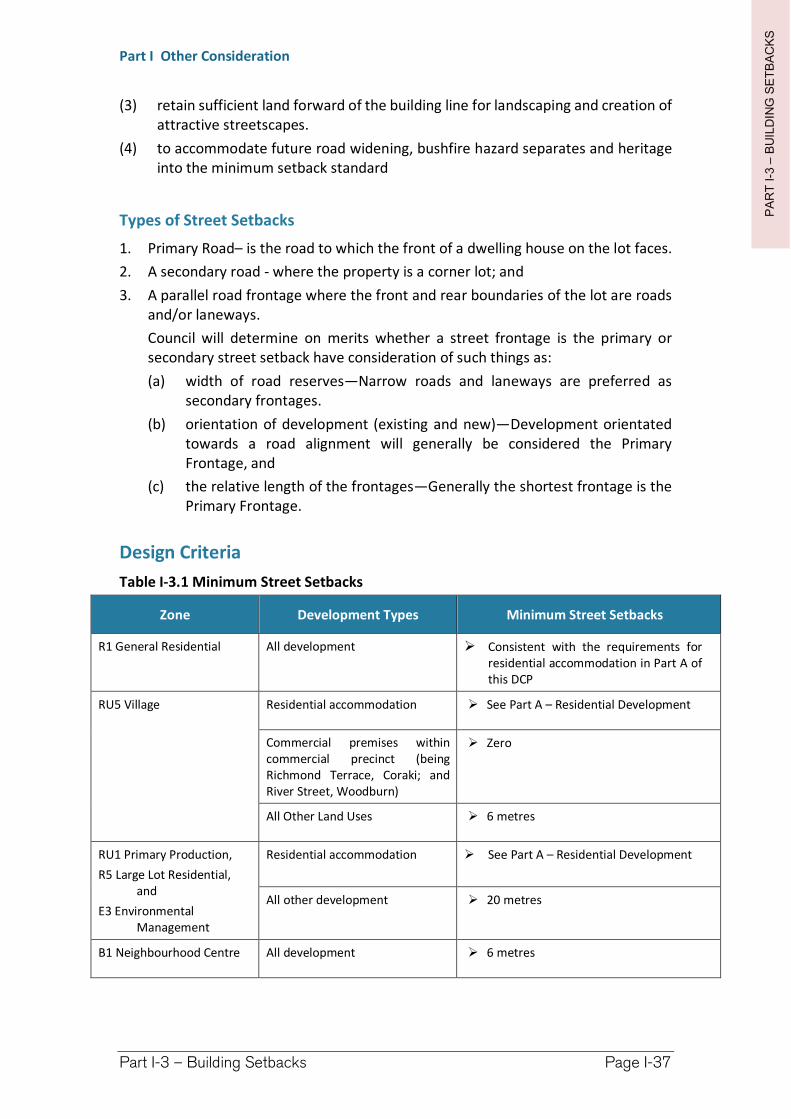
PA
RT
I-3
–B
UIL
DIN
G S
ET
BA
CK
S
Part I Other Consideration
Part I-3 – Building Setbacks Page I-37
(3) retain sufficient land forward of the building line for landscaping and creation of attractive streetscapes.
(4) to accommodate future road widening, bushfire hazard separates and heritage into the minimum setback standard
Types of Street Setbacks
1. Primary Road– is the road to which the front of a dwelling house on the lot faces.
2. A secondary road - where the property is a corner lot; and
3. A parallel road frontage where the front and rear boundaries of the lot are roads and/or laneways.
Council will determine on merits whether a street frontage is the primary or secondary street setback have consideration of such things as:
(a) width of road reserves—Narrow roads and laneways are preferred as secondary frontages.
(b) orientation of development (existing and new)—Development orientated towards a road alignment will generally be considered the Primary Frontage, and
(c) the relative length of the frontages—Generally the shortest frontage is the Primary Frontage.
Design Criteria
Table I-3.1 Minimum Street Setbacks
Zone Development Types Minimum Street Setbacks
R1 General Residential All development Consistent with the requirements for residential accommodation in Part A of this DCP
RU5 Village Residential accommodation See Part A – Residential Development
Commercial premises within commercial precinct (being Richmond Terrace, Coraki; and River Street, Woodburn)
Zero
All Other Land Uses 6 metres
RU1 Primary Production,
R5 Large Lot Residential, and
E3 Environmental Management
Residential accommodation See Part A – Residential Development
All other development 20 metres
B1 Neighbourhood Centre All development 6 metres
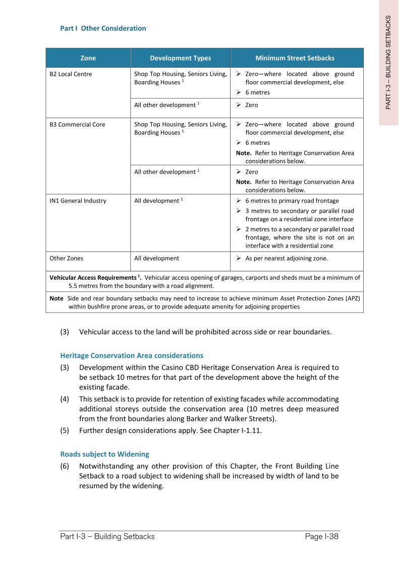
PA
RT
I-3
–B
UIL
DIN
G S
ET
BA
CK
S
Part I Other Consideration
Part I-3 – Building Setbacks Page I-38
Zone Development Types Minimum Street Setbacks
B2 Local Centre Shop Top Housing, Seniors Living, Boarding Houses 1
Zero—where located above ground floor commercial development, else
6 metres
All other development 1 Zero
B3 Commercial Core Shop Top Housing, Seniors Living, Boarding Houses 1
Zero—where located above ground floor commercial development, else
6 metres
Note. Refer to Heritage Conservation Area considerations below.
All other development 1 Zero
Note. Refer to Heritage Conservation Area considerations below.
IN1 General Industry All development 1 6 metres to primary road frontage
3 metres to secondary or parallel road frontage on a residential zone interface
2 metres to a secondary or parallel road frontage, where the site is not on an interface with a residential zone
Other Zones All development As per nearest adjoining zone.
Vehicular Access Requirements 1. Vehicular access opening of garages, carports and sheds must be a minimum of 5.5 metres from the boundary with a road alignment.
Note Side and rear boundary setbacks may need to increase to achieve minimum Asset Protection Zones (APZ) within bushfire prone areas, or to provide adequate amenity for adjoining properties
(3) Vehicular access to the land will be prohibited across side or rear boundaries.
Heritage Conservation Area considerations
(3) Development within the Casino CBD Heritage Conservation Area is required to be setback 10 metres for that part of the development above the height of the existing facade.
(4) This setback is to provide for retention of existing facades while accommodating additional storeys outside the conservation area (10 metres deep measured from the front boundaries along Barker and Walker Streets).
(5) Further design considerations apply. See Chapter I-1.11.
Roads subject to Widening
(6) Notwithstanding any other provision of this Chapter, the Front Building Line Setback to a road subject to widening shall be increased by width of land to be resumed by the widening.
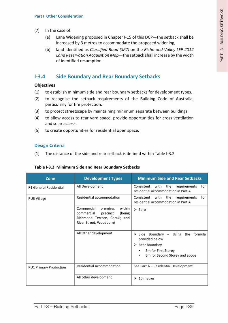
PA
RT
I-3
–B
UIL
DIN
G S
ET
BA
CK
S
Part I Other Consideration
Part I-3 – Building Setbacks Page I-39
(7) In the case of:
(a) Lane Widening proposed in Chapter I-15 of this DCP—the setback shall be increased by 3 metres to accommodate the proposed widening,
(b) land identified as Classified Road (SP2) on the Richmond Valley LEP 2012 Land Reservation Acquisition Map—the setback shall increase by the width of identified resumption.
I-3.4 Side Boundary and Rear Boundary Setbacks
Objectives
(1) to establish minimum side and rear boundary setbacks for development types.
(2) to recognise the setback requirements of the Building Code of Australia, particularly for fire protection.
(3) to protect streetscape by maintaining minimum separate between buildings.
(4) to allow access to rear yard space, provide opportunities for cross ventilation and solar access.
(5) to create opportunities for residential open space.
Design Criteria
(1) The distance of the side and rear setback is defined within Table I-3.2.
Table I-3.2 Minimum Side and Rear Boundary Setbacks
Zone Development Types Minimum Side and Rear Setbacks
R1 General Residential All Development Consistent with the requirements for residential accommodation in Part A
RU5 Village Residential accommodation Consistent with the requirements for residential accommodation in Part A
Commercial premises within commercial precinct (being Richmond Terrace, Coraki; and River Street, Woodburn)
Zero
All Other development Side Boundary – Using the formula provided below
Rear Boundary
• 3m for First Storey • 6m for Second Storey and above
RU1 Primary Production Residential Accommodation See Part A – Residential Development
All other development 10 metres
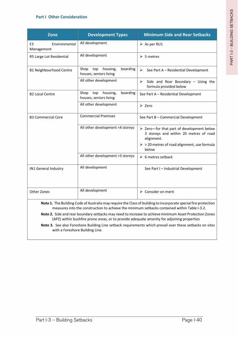
PA
RT
I-3
–B
UIL
DIN
G S
ET
BA
CK
S
Part I Other Consideration
Part I-3 – Building Setbacks Page I-40
Zone Development Types Minimum Side and Rear Setbacks
E3 Environmental Management
All development As per RU1
R5 Large Lot Residential All development 5 metres
B1 Neighbourhood Centre Shop top housing, boarding houses, seniors living
See Part A – Residential Development
All other development Side and Rear Boundary – Using the formula provided below
B2 Local Centre Shop top housing, boarding houses, seniors living
See Part A – Residential Development
All other development Zero
B3 Commercial Core Commercial Premises See Part B – Commercial Development
All other development <4 storeys Zero—for that part of development below 3 storeys and within 20 metres of road alignment.
> 20 metres of road alignment, use formula below
All other development >3 storeys 6 metres setback
IN1 General Industry All development See Part I – Industrial Development
Other Zones All development Consider on merit
Note 1. The Building Code of Australia may require the Class of building to incorporate special fire protection measures into the construction to achieve the minimum setbacks contained within Table I-3.2.
Note 2. Side and rear boundary setbacks may need to increase to achieve minimum Asset Protection Zones (APZ) within bushfire prone areas, or to provide adequate amenity for adjoining properties
Note 3. See also Foreshore Building Line setback requirements which prevail over these setbacks on sites with a Foreshore Building Line.
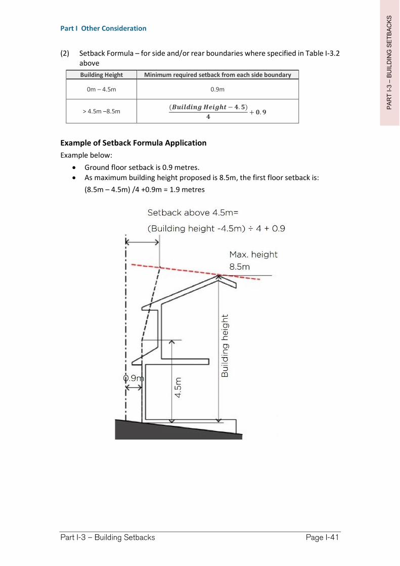
PA
RT
I-3
–B
UIL
DIN
G S
ET
BA
CK
S
Part I Other Consideration
Part I-3 – Building Setbacks Page I-41
(2) Setback Formula – for side and/or rear boundaries where specified in Table I-3.2 above
Building Height Minimum required setback from each side boundary
0m – 4.5m 0.9m
> 4.5m –8.5m(��������������− �.�)
�+ �.�
Example of Setback Formula Application
Example below:
Ground floor setback is 0.9 metres.
As maximum building height proposed is 8.5m, the first floor setback is:
(8.5m – 4.5m) /4 +0.9m = 1.9 metres
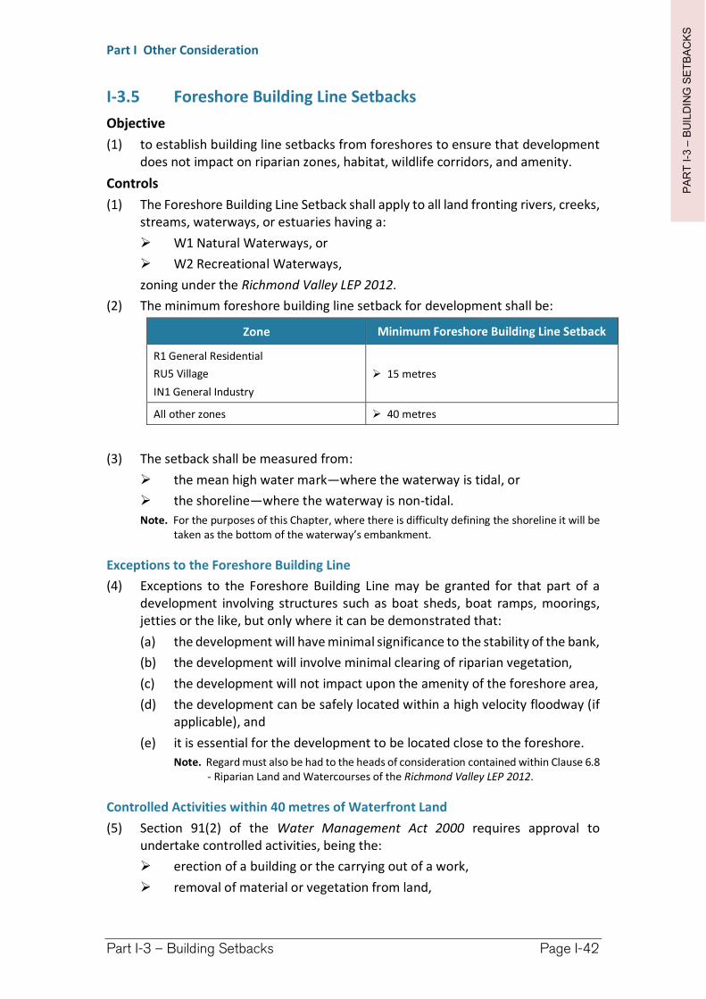
PA
RT
I-3
–B
UIL
DIN
G S
ET
BA
CK
S
Part I Other Consideration
Part I-3 – Building Setbacks Page I-42
I-3.5 Foreshore Building Line Setbacks
Objective
(1) to establish building line setbacks from foreshores to ensure that development does not impact on riparian zones, habitat, wildlife corridors, and amenity.
Controls
(1) The Foreshore Building Line Setback shall apply to all land fronting rivers, creeks, streams, waterways, or estuaries having a:
W1 Natural Waterways, or
W2 Recreational Waterways,
zoning under the Richmond Valley LEP 2012.
(2) The minimum foreshore building line setback for development shall be:
Zone Minimum Foreshore Building Line Setback
R1 General Residential
RU5 Village
IN1 General Industry
15 metres
All other zones 40 metres
(3) The setback shall be measured from:
the mean high water mark—where the waterway is tidal, or
the shoreline—where the waterway is non-tidal.
Note. For the purposes of this Chapter, where there is difficulty defining the shoreline it will be taken as the bottom of the waterway’s embankment.
Exceptions to the Foreshore Building Line
(4) Exceptions to the Foreshore Building Line may be granted for that part of a development involving structures such as boat sheds, boat ramps, moorings, jetties or the like, but only where it can be demonstrated that:
(a) the development will have minimal significance to the stability of the bank,
(b) the development will involve minimal clearing of riparian vegetation,
(c) the development will not impact upon the amenity of the foreshore area,
(d) the development can be safely located within a high velocity floodway (if applicable), and
(e) it is essential for the development to be located close to the foreshore.
Note. Regard must also be had to the heads of consideration contained within Clause 6.8 - Riparian Land and Watercourses of the Richmond Valley LEP 2012.
Controlled Activities within 40 metres of Waterfront Land
(5) Section 91(2) of the Water Management Act 2000 requires approval to undertake controlled activities, being the:
erection of a building or the carrying out of a work,
removal of material or vegetation from land,
PA
RT
I-3
–B
UIL
DIN
G S
ET
BA
CK
S
Part I Other Consideration
Part I-3 – Building Setbacks Page I-43
deposition of material on land, or
carrying out of any other activity that effects the quantity or flow of water in a water source,
within waterfront land.
Waterfront land is defined in that Act as land between the bed of any river, lake, estuary, and a line drawn parallel to, and 40 metres from, the highest bank, the shore, or mean high water mark, respectively.
(6) A Development Application requiring a controlled activity approval is Integrated Development pursuant to Section 4.46 of the EP&A Act.
Richmond Valley Development Control Plan 2021
Part I-4 Car Parking Provisions
Access to public transport in regional areas is often minimal with the car being the most practical alternative. It is therefore important to consider the car in the planning of development and public spaces to ensure access is reasonably available to customers and employees, and the streetscape remains attractive to users.
This DCP balances the provision of sufficient parking to meet demand, close to desired destinations and in an orderly manner, while not being too excessive so as to stifle development opportunities or be unattractive.
Parking will be required by development based upon estimated demand for different land use types, however, the DCP incorporates opportunities to be flexible where alternative parking strategies, parking rates and solutions can be demonstrated. This flexibility includes consideration of a locality’s unique circumstances—For example, Evans Head is a coastal community with a large seasonal population of tourists that are generally active. While there is ample car parking in the CBD during the off-season, the season population swell creates a parking shortfall. One strategy to address this shortfall could be to encourage more pedestrian and cycling to the CBD by diverting resources away from new car parking and towards an improved pathway network.
This DCP applies to all land within the Richmond Valley Local Government Area.
Date adopted by Council: 22/06/2021
Effective Date: 01/08/2021
Amendments: Nil
PA
RT
I-4
–C
AR
PA
RK
ING
Part I Other Consideration
Part I-4 – Car Parking Page I-46
I-4.1 General Objectives
The general objectives of this Chapter are to:
(1) facilitate an appropriate level of car parking to cater for a mix of development types.
(2) establish a flat rate of car parking for developments within business zones.
(3) provide for the adequate design of car parks, manoeuvring areas and road access.
(4) minimise the visual impact of car parking.
(5) allow for the unique aspects of a locality to be considered when a variation to parking, or a Voluntary VPA is proposed.
I-4.2 On-site Parking
Objective
(1) to provide for an appropriate level of on-site car parking to cater for the demand of development types.
Controls
(1) On-site car parking is required to be provided at the rates established in the Section I-4.4 General Car Parking Rates for:
(a) new development,
(b) additional gross floor area—within an existing development, and
(c) a change of use—where the new use has a higher demand for car parking.
I-4.3 General Car Parking Rates
Objective
(1) to establish the minimum car parking rates to cater for a variety of development types.
Controls
(1) Table I-4.1 contains the minimum on-site car parking requirements for a variety of development types.
(3) When a proposal contains different development types, the car parking required for each type shall be calculated and added together.
(2) The total number of car parking spaces calculated for a development should be rounded up to the nearest whole number.
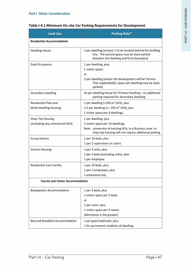
PA
RT
I-4
–C
AR
PA
RK
ING
Part I Other Consideration
Part I-4 – Car Parking Page I-47
Table I-4.1 Minimum On-site Car Parking Requirements for Development
Land Use Parking Rate*
Residential Accommodation
Dwelling House 2 per dwelling (at least 1 to be located behind the building line. The second space may be stack parked between the dwelling and front boundary)
Dual Occupancy 1 per dwelling, plus
1 visitor space;
or
2 per dwelling (where the development will be Torrens Title subdivided)(1 space per dwelling may be stack parked)
Secondary Dwelling As per dwelling house for Primary Dwelling – no additional parking required for Secondary Dwelling
Residential Flats and
Multi-dwelling Housing
1 per dwelling (<150 m2 GFA), plus
1.5 per dwelling (>= 150 m2 GFA), plus
1 visitor space per 4 dwellings
Shop Top Housing
(excluding any commercial GFA)
1 per dwelling, plus
1 visitor space per 10 dwellings
Note. conversion of existing GFA, in a Business zone, to shop top housing will not require additional parking
Group Homes 1 per 10 beds, plus
1 per 2 supervisors or carers
Seniors Housing 1 per 3 units, plus
1 per 5 beds (excluding units), plus
1 per employee
Residential Care Facility 1 per 10 beds, plus
1 per 2 employees, plus
1 ambulance bay
Tourist and Visitor Accommodation
Backpackers Accommodation 1 per 3 beds, plus
1 visitor space per 5 beds;
or
1 per room, plus
1 visitor space per 5 rooms
(Whichever is the greater)
Bed and Breakfast Accommodation 1 per guest bedroom, plus
1 for permanent residents of dwelling
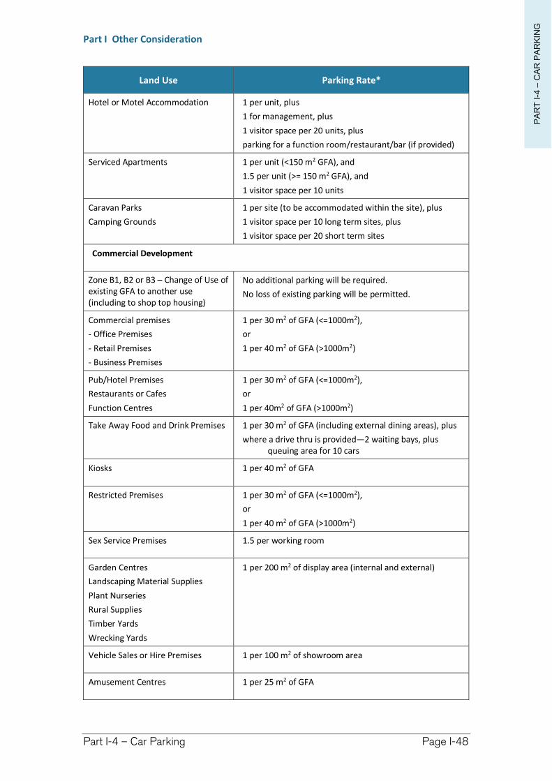
PA
RT
I-4
–C
AR
PA
RK
ING
Part I Other Consideration
Part I-4 – Car Parking Page I-48
Land Use Parking Rate*
Hotel or Motel Accommodation 1 per unit, plus
1 for management, plus
1 visitor space per 20 units, plus
parking for a function room/restaurant/bar (if provided)
Serviced Apartments 1 per unit (<150 m2 GFA), and
1.5 per unit (>= 150 m2 GFA), and
1 visitor space per 10 units
Caravan Parks
Camping Grounds
1 per site (to be accommodated within the site), plus
1 visitor space per 10 long term sites, plus
1 visitor space per 20 short term sites
Commercial Development
Zone B1, B2 or B3 – Change of Use of existing GFA to another use (including to shop top housing)
No additional parking will be required.
No loss of existing parking will be permitted.
Commercial premises
- Office Premises
- Retail Premises
- Business Premises
1 per 30 m2 of GFA (<=1000m2),
or
1 per 40 m2 of GFA (>1000m2)
Pub/Hotel Premises
Restaurants or Cafes
Function Centres
1 per 30 m2 of GFA (<=1000m2),
or
1 per 40m2 of GFA (>1000m2)
Take Away Food and Drink Premises 1 per 30 m2 of GFA (including external dining areas), plus
where a drive thru is provided—2 waiting bays, plus queuing area for 10 cars
Kiosks 1 per 40 m2 of GFA
Restricted Premises 1 per 30 m2 of GFA (<=1000m2),
or
1 per 40 m2 of GFA (>1000m2)
Sex Service Premises 1.5 per working room
Garden Centres
Landscaping Material Supplies
Plant Nurseries
Rural Supplies
Timber Yards
Wrecking Yards
1 per 200 m2 of display area (internal and external)
Vehicle Sales or Hire Premises 1 per 100 m2 of showroom area
Amusement Centres 1 per 25 m2 of GFA
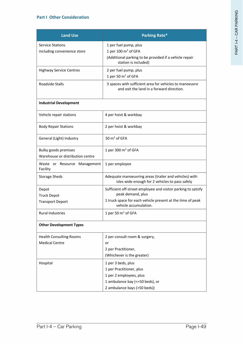
PA
RT
I-4
–C
AR
PA
RK
ING
Part I Other Consideration
Part I-4 – Car Parking Page I-49
Land Use Parking Rate*
Service Stations
including convenience store
1 per fuel pump, plus
1 per 100 m2 of GFA
(Additional parking to be provided if a vehicle repair station is included)
Highway Service Centres 2 per fuel pump, plus
1 per 50 m2 of GFA
Roadside Stalls 3 spaces with sufficient area for vehicles to manoeuvre and exit the land in a forward direction.
Industrial Development
Vehicle repair stations 4 per hoist & workbay
Body Repair Stations 2 per hoist & workbay
General (Light) Industry 50 m2 of GFA
Bulky goods premises
Warehouse or distribution centre
1 per 300 m2 of GFA
Waste or Resource Management Facility
1 per employee
Storage Sheds Adequate manoeuvring areas (trailer and vehicles) with isles wide enough for 2 vehicles to pass safely
Depot
Truck Depot
Transport Deport
Sufficient off-street employee and visitor parking to satisfy peak demand, plus
1 truck space for each vehicle present at the time of peak vehicle accumulation.
Rural Industries 1 per 50 m2 of GFA
Other Development Types
Health Consulting Rooms
Medical Centre
2 per consult room & surgery,
or
2 per Practitioner,
(Whichever is the greater)
Hospital 1 per 3 beds, plus
1 per Practitioner, plus
1 per 2 employees, plus
1 ambulance bay (<=50 beds), or
2 ambulance bays (>50 beds))
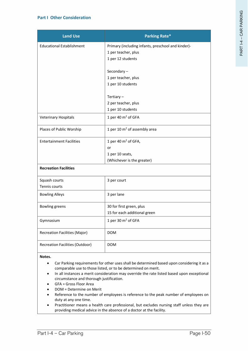
PA
RT
I-4
–C
AR
PA
RK
ING
Part I Other Consideration
Part I-4 – Car Parking Page I-50
Land Use Parking Rate*
Educational Establishment Primary (including infants, preschool and kinder)-
1 per teacher, plus
1 per 12 students
Secondary –
1 per teacher, plus
1 per 10 students
Tertiary –
2 per teacher, plus
1 per 10 students
Veterinary Hospitals 1 per 40 m2 of GFA
Places of Public Worship 1 per 10 m2 of assembly area
Entertainment Facilities 1 per 40 m2 of GFA,
or
1 per 10 seats,
(Whichever is the greater)
Recreation Facilities
Squash courts
Tennis courts
3 per court
Bowling Alleys 3 per lane
Bowling greens 30 for first green, plus
15 for each additional green
Gymnasium 1 per 30 m2 of GFA
Recreation Facilities (Major) DOM
Recreation Facilities (Outdoor) DOM
Notes.
Car Parking requirements for other uses shall be determined based upon considering it as a comparable use to those listed, or to be determined on merit.
In all instances a merit consideration may override the rate listed based upon exceptional circumstance and thorough justification.
GFA = Gross Floor Area
DOM = Determine on Merit
Reference to the number of employees is reference to the peak number of employees on duty at any one time.
Practitioner means a health care professional, but excludes nursing staff unless they are providing medical advice in the absence of a doctor at the facility.
PA
RT
I-4
–C
AR
PA
RK
ING
Part I Other Consideration
Part I-4 – Car Parking Page I-51
I-4.4 Exceptions to General Car Parking Requirements
Objective
(1) to provide flexibility in how car parking is provided by development.
(2) to provide guidance on what should be considered when considering a car parking variation.
(3) to authorise variations to car parking development standards by delegation.
Controls
(1) Council may agree to alternative car parking arrangements for development as provided in this section.
(2) Support for a car parking reduction shall only be given where:
(a) it is supported by a parking study demonstrating the minimum car parking rates of this DCP are unreasonable for the proposed development having regard to the circumstances of the case; and
(b) the short fall in car parking will not significantly impact on the community.
(3) Notwithstanding subclause (2), Council may support a car parking reduction if it considers a development will have a significant community interest.
(4) Car parking may be provided off-site where Council is satisfied with an alternative arrange to provide the parking elsewhere in the vicinity of the development.
(5) Council’s Chief Executive Officer (CEO), or his sub-delegate(s), is authorised to accept car parking variations.
I-4.5 Consideration of Streetscape
Objective
(1) to ensure that car parking does not impact on the amenity of a locality or the streetscape.
Controls
(1) Large commercial car parks should be located behind buildings so that shops and offices can open onto the street.
(2) Industrial sites may locate car park forward of the building line where there is at least a 1 metre wide strip of landscaping provided along the property frontage to soften the visual impact of the hard stand surface.
(3) Car parking areas should be screened from public places or contain elements that will soften its impact on the streetscape.
I-4.6 Car parking construction and design
Objective
(1) to ensure that car parks, manoeuvring areas, loading bays, and road access is functional and safe.
PA
RT
I-4
–C
AR
PA
RK
ING
Part I Other Consideration
Part I-4 – Car Parking Page I-52
Controls
(1) A vehicle parking, manoeuvring, and access plan is to be submitted to Council for approval. The Plan should:
(a) show delineated car parking spaces, including those designated as disabled spaces, and loading bays.
(b) clearly show where access to the property is proposed and detailing manoeuvring area(s) and the direction of traffic flow.
(c) be designed to meet the relevant Australian Standards (ie. AS2890 – Parking facilities).
(d) demonstrate compliance with any Council design standards for driveways, parking, and/or manoeuvring (unless an Australian Standard applies).
(e) contain specifications for the construction of entrance/exits to public roads, including line-of-sight distances for exiting vehicles.
(f) show how underground car parking will be ventilated.
(2) All works required to be undertaken, including those on public land, must be funded by the Applicant/Owner of the development, unless other arrangements have been made such as through a VPA.
(3) Council reserves the right to determine whether the placement of an access onto a public road is suitable and safe.
(4) Car parking spaces should be constructed of a hard stand surface, and be clearly delineated.
I-4.7 Additional Developer Contribution in Lieu of Providing Car Parking
Objective
(1) to provide a mechanism for Council to accept developer contributions in lieu of providing car parking.
Controls
(1) Council may consider accepting additional developer contributions in lieu of providing car parking by a development.
(2) The additional developer contributions must be authorised through a Voluntary Planning Agreement (VPA) process, under Section 7.4 of the Environmental Planning and Assessment Act 1979, and will be in addition to any Section 94A Contributions that may also apply to the development.
(2) It will be at Council’s discretion if it will accept these additional developer contributions (and the VPA), and only in the following circumstances:
(a) where Council is satisfied that there will not be a significant impact associated with the parking not being provided by the development.
(b) that any infrastructure or facilities to be provided by the additional developer contributions will be available for use by the public and that
PA
RT
I-4
–C
AR
PA
RK
ING
Part I Other Consideration
Part I-4 – Car Parking Page I-53
there will be expectations that they be reserved for the sole use of the development and its staff/clients/customers.
(c) that there be no expectations placed on Council to use the additional developer contributions expeditiously to coincide with construction of the development.
(3) Notwithstanding Section 7.4 of the Act, a VPA must establish:
(a) the amount of any payment, description of land to be dedicated, and/or the nature of any public benefit, that is to be provided by the developer to Council;
(b) when the payment, dedication, or public benefit is/are required to be made to Council (usually prior to issue of Construction Certificate);
(c) how and when the money, land, and/or public benefit should be used by Council.
(4) The value of additional developer contributions shall be based upon:
(a) the equivalent cost of constructing the shortfall in car parking, excluding the land component; or
(b) a valuation per car parking space as provided within Council’s Revenue Policy.
(5) The VPA should include an indexation of the additional developer contributions to CPI.
(6) A template VPA is available from Council.

Richmond Valley Development Control Plan 2021
Part I-5 Landscaping Guidelines
These guidelines are included within the DCP to assist proponents in providing landscaping where required as part of the development proposed. It is recommended that larger developments engage the services of a professional landscape designer/architect as part of the overall design consideration of the development as a whole.
Landscaping allows for the built environment to blend more successfully with the natural environment and contributes to streetscape amenity for all to enjoy. Streets devoid of vegetation provide no shade and fail to soften harsh and contrasting solid construction elements found within streetscapes. The landscaping requirement for new residential development helps to ensure important elements and liveability are incorporated to preserve existing streetscapes. Landscaping promotes more vibrant and liveable streetscapes as well as improving water quality and providing cooling shade.
This DCP applies to all land within the Richmond Valley Local Government Area.
Date adopted by Council: 22/06/2021
Effective Date: 01/08/2021
Amendments: Nil
PA
RT
I-5
–LA
ND
SC
AP
NG
GU
IDE
LIN
ES
Part I Other Consideration
Part I-5 – Landscaping Guidelines Page I-56
I-5.1 General Objectives
Landscaping serves to provide a number of important development objectives within Richmond Valley. Good landscaping provided in conjunction with new development;
(1) Facilitates the integration of proposed development into the surrounding streetscape or rural environ;
(2) Presents a new development favourably and introduces the proposal into a neighbourhood in a manner which will promote acceptance;
(3) Contributes to native flora and supporting fauna (both urban and rural) in the environ in which the development is proposed and furthers Environmentally Sustainable Development principles;
(4) Integrates an important component of inter-allotment design by providing essential infiltration areas, as necessary for achieving Water Sensitive Urban Design (WSUD) principles;
(5) Embellishes a new development aesthetically and softens the impact visually of individual components, and the overall design as a whole; and
(6) Provides essential leisure and recreational opportunities as part of the development, promoting health and wellbeing of residents and employees.
I-5.2 Landscaping Principles
Open Space
(1) The provision of Open Space provides a feeling of functionality and liveability. Development put before Council must be able to demonstrate that adequate open space and landscaping for each of the dwellings provides good functionality and a liveable environment for all intended inhabitants.
Open Space includes Landscape Open Space and Private Open Space.
It is a requirement that all Residential Development include a component of Open Space. In particular at least 25m2 of Private Space – should be provided for each dwelling within a development, to enable equitable division of area per unit.
Landscaping/Landscape Open Space
(2) The Landscape Open Space is the area of pervious surfaces. It includes gardens and lawns as well as gravel or similar surfaced areas that allow infiltration. Landscape open space is required to be: (a) At least 10% of the area of the lot, inclusive of (b) a lawn and/or garden area being at least 50% of the area forward of the
building line (between the dwelling(s) and the road boundary).
It is a requirement that landscaping provision provides adequate softening of the development, particularly from the front (and secondary) street aspect(s). Particular consideration shall be made to designing the landscaped areas for minimal ongoing maintenance requirements whilst providing good screening and privacy.
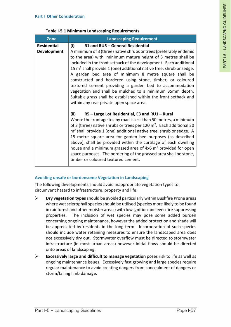
PA
RT
I-5
–LA
ND
SC
AP
NG
GU
IDE
LIN
ES
Part I Other Consideration
Part I-5 – Landscaping Guidelines Page I-57
Table I-5.1 Minimum Landscaping Requirements
Zone Landscaping Requirement
Residential Development
(i) R1 and RU5 – General Residential A minimum of 3 (three) native shrubs or trees (preferably endemic to the area) with minimum mature height of 3 metres shall be included in the front setback of the development. Each additional 15 m2 shall provide 1 (one) additional native tree, shrub or sedge. A garden bed area of minimum 8 metre square shall be constructed and bordered using stone, timber, or coloured textured cement providing a garden bed to accommodation vegetation and shall be mulched to a minimum 35mm depth. Suitable grass shall be established within the front setback and within any rear private open space area.
(ii) R5 – Large Lot Residential, E3 and RU1 – Rural Where the frontage to any road is less than 50 metres, a minimum of 3 (three) native shrubs or trees per 120 m2. Each additional 30 m2 shall provide 1 (one) additional native tree, shrub or sedge. A 15 metre square area for garden bed purposes (as described above), shall be provided within the curtilage of each dwelling house and a minimum grassed area of 4x6 m2 provided for open space purposes. The bordering of the grassed area shall be stone, timber or coloured textured cement.
Avoiding unsafe or burdensome Vegetation in Landscaping
The following developments should avoid inappropriate vegetation types to circumvent hazard to infrastructure, property and life:
Dry vegetation types should be avoided particularly within Bushfire Prone areas where wet sclerophyll species should be utilised (species more likely to be found in rainforest and other moister areas) with low ignition and even fire suppressing properties. The inclusion of wet species may pose some added burden concerning ongoing maintenance, however the added protection and shade will be appreciated by residents in the long term. Incorporation of such species should include water retaining measures to ensure the landscaped area does not excessively dry out. Stormwater overflow must be directed to stormwater infrastructure (in most urban areas) however initial flows should be directed onto areas of landscaping.
Excessively large and difficult to manage vegetation poses risk to life as well as ongoing maintenance issues. Excessively fast growing and large species require regular maintenance to avoid creating dangers from concealment of dangers or storm/falling limb damage.
PA
RT
I-5
–LA
ND
SC
AP
NG
GU
IDE
LIN
ES
Part I Other Consideration
Part I-5 – Landscaping Guidelines Page I-58
Provision of vegetation with flora and/or fauna value to further Environmentally Sustainable Development
The most significant environmental impact resulting from nearly all development in both urban and rural areas is the resultant reduction of flora and habitat important for sustaining fauna. In the process of accommodating landscaping for visual amenity purposes, it is also desirable to advance environmental and in particular ecological outcome as part of the process.
In particular, wherever possible, existing vegetation should be retained on the site to be developed and he landscaping plan incorporated to augment the natural landscaping already provided.
I-5.3 Landscaping Design Considerations
Incorporate Native Flora which is regionally or even locally endemic
(1) Completely avoid any species which is considered a noxious or environmental weed.
Incorporate as many locally endemic species as possible. Utilise species which have been included within the suggested species list at the
end of this chapter.
Hazards and Safety
(2) Appropriate planning of landscaping can avoid creating future hazards or safety issues. Consider the following:
In fire prone areas utilise only species which are considered fire retardant and generate little dry debris.
Do not use excessively large species within close proximity to the development where there is a risk of storm or falling limb damage.
Do not plant species close to buildings or infrastructure which are known to cause damage. Although the following tree species listed in Table I-5.2 are predominantly exotic and unlikely to be preferred species for landscaping and garden purposes, care should be taken to avoid propagating these species within the vicinity of sewer/water pipes, or other susceptible materials such as paving, On-site Sewage Management Systems, subterranean wiring, etc.
(3) Crime Prevention Through Environmental Design (CPTED) principles Chapter I-10 contains detail concerning CPTED provisions.
Avoid landscaping which obscures natural surveillance.
As with 'blind corners' or general concealed areas, the large size of certain vegetation obstructs visibility and makes people feel uneasy and unsafe. Perceiving that something may be 'behind those bushes' can discourage genuine use of a space.
Avoid medium height vegetation with concentrated top to bottom foliage. Plants such as low hedges and shrubs (1 to 1.2m high), creepers, ground covers or high canopied vegetation are good for natural surveillance.
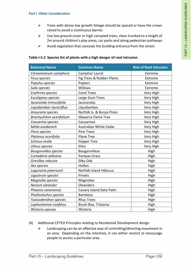
PA
RT
I-5
–LA
ND
SC
AP
NG
GU
IDE
LIN
ES
Part I Other Consideration
Part I-5 – Landscaping Guidelines Page I-59
Trees with dense low growth foliage should be spaced or have the crown raised to avoid a continuous barrier.
Use low ground cover or high canopied trees, clean trunked to a height of 2m around children's play areas, car parks and along pedestrian pathways
Avoid vegetation that conceals the building entrance from the street.
Table I-5.2 Species list of plants with a high danger of root intrusion
Botanical Name Common Name Risk of Root Intrusion
Cinnamomum camphora Camphor Laurel Extreme
Ficus species Fig Trees & Rubber Plants Extreme
Populus species Poplars Extreme
Salix species Willows Extreme
Erythrina species Coral Trees Very High
Eucalyptus species Large Gum Trees Very High
Jacaranda mimosifolia Jacarandas Very High
Liquidambar styraciflua Liquidambas Very High
Araucaria species Norfolk Is. & Bunya Pines Very High
Brachychiton acerifolium Illawarra Flame Tree Very High
Casuarina species Casuarinas Very High
Melia azedarach Australian White Cedar Very High
Pinus species Pine Trees Very High
Platanus acerifolia Plane Tree Very High
Schinus molle Pepper Tree Very High
Ulmus species Elms Very High
Bouganvillea species Bouganvilleas High
Cortaderia selloana Pampas Grass High
Grevillea robusta Silky Oak High
Ilex species Hollies High
Lagunaria patersonii Norfolk Island Hibiscus High
Ligustrum species Privets High
Magnolia species Magnolias High
Nerium oleander Oleanders High
Phoenix canariensis Canary Island Date Palm High
Phyllostachus species Bamboos High
Toxicodendron species Rhus Trees High
Lophostemon confetus Brush Box, Tristania High
Wisteria species Wisteria High
(4) Additional CPTED Principles relating to Residential Development design
Landscaping can be an effective way of controlling/directing movement in an area. Depending on the intention, it can either restrict or encourage people to access a particular area.
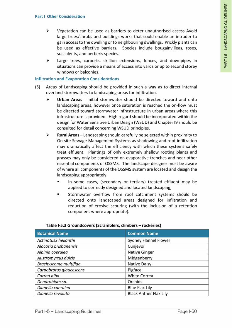
PA
RT
I-5
–LA
ND
SC
AP
NG
GU
IDE
LIN
ES
Part I Other Consideration
Part I-5 – Landscaping Guidelines Page I-60
Vegetation can be used as barriers to deter unauthorised access Avoid large trees/shrubs and buildings works that could enable an intruder to gain access to the dwelling or to neighbouring dwellings. Prickly plants can be used as effective barriers. Species include bougainvilleas, roses, succulents, and berberis species.
Large trees, carports, skillion extensions, fences, and downpipes in situations can provide a means of access into yards or up to second storey windows or balconies.
Infiltration and Evaporation Considerations
(5) Areas of Landscaping should be provided in such a way as to direct internal overland stormwaters to landscaping areas for infiltration.
Urban Areas - Initial stormwater should be directed toward and onto landscaping areas, however once saturation is reached the on-flow must be directed toward stormwater infrastructure in urban areas where this infrastructure is provided. High regard should be incorporated within the design for Water Sensitive Urban Design (WSUD) and Chapter I9 should be consulted for detail concerning WSUD principles.
Rural Areas – Landscaping should carefully be selected within proximity to On-site Sewage Management Systems as shadowing and root infiltration may dramatically affect the efficiency with which these systems safely treat effluent. Plantings of only extremely shallow rooting plants and grasses may only be considered on evaporative trenches and near other essential components of OSSMS. The landscape designer must be aware of where all components of the OSSMS system are located and design the landscaping appropriately.
In some cases, (secondary or tertiary) treated effluent may be applied to correctly designed and located landscaping,
Stormwater overflow from roof catchment systems should be directed onto landscaped areas designed for infiltration and reduction of erosive scouring (with the inclusion of a retention component where appropriate).
Table I-5.3 Groundcovers (Scramblers, climbers – rockeries)
Botanical Name Common Name
ActinotusS helianthi Sydney Flannel Flower
Alocasia brisbanensis Cunjevoi
Alpinia coerulea Native Ginger
Austromyrtus dulcis Midgenberry
Brachyscome multifida Native Daisy
Carpobrotus glaucescens Pigface
Correa alba White Correa
Dendrobium sp. Orchids
Dianella caerulea Blue Flax Lily
Dianella revoluta Black Anther Flax Lily
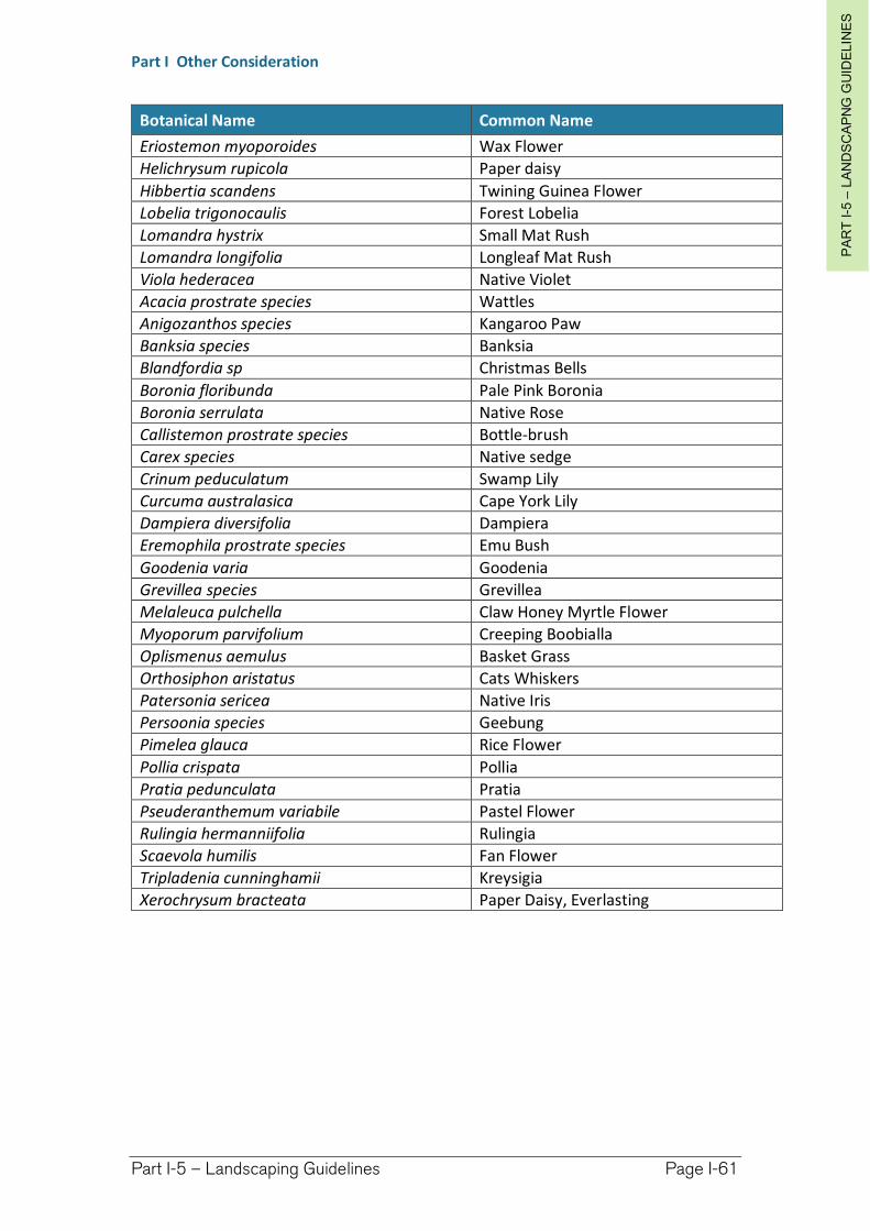
PA
RT
I-5
–LA
ND
SC
AP
NG
GU
IDE
LIN
ES
Part I Other Consideration
Part I-5 – Landscaping Guidelines Page I-61
Botanical Name Common Name
Eriostemon myoporoides Wax Flower
Helichrysum rupicola Paper daisy
Hibbertia scandens Twining Guinea Flower
Lobelia trigonocaulis Forest Lobelia
Lomandra hystrix Small Mat Rush
Lomandra longifolia Longleaf Mat Rush
Viola hederacea Native Violet
Acacia prostrate species Wattles
Anigozanthos species Kangaroo Paw
Banksia species Banksia
Blandfordia sp Christmas Bells
Boronia floribunda Pale Pink Boronia
Boronia serrulata Native Rose
Callistemon prostrate species Bottle-brush
Carex species Native sedge
Crinum peduculatum Swamp Lily
Curcuma australasica Cape York Lily
Dampiera diversifolia Dampiera
Eremophila prostrate species Emu Bush
Goodenia varia Goodenia
Grevillea species Grevillea
Melaleuca pulchella Claw Honey Myrtle Flower
Myoporum parvifolium Creeping Boobialla
Oplismenus aemulus Basket Grass
Orthosiphon aristatus Cats Whiskers
Patersonia sericea Native Iris
Persoonia species Geebung
Pimelea glauca Rice Flower
Pollia crispata Pollia
Pratia pedunculata Pratia
Pseuderanthemum variabile Pastel Flower
Rulingia hermanniifolia Rulingia
Scaevola humilis Fan Flower
Tripladenia cunninghamii Kreysigia
Xerochrysum bracteata Paper Daisy, Everlasting
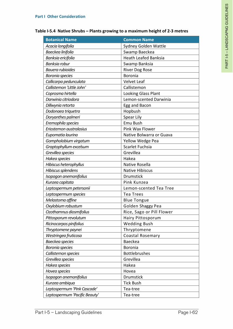
PA
RT
I-5
–LA
ND
SC
AP
NG
GU
IDE
LIN
ES
Part I Other Consideration
Part I-5 – Landscaping Guidelines Page I-62
Table I-5.4 Native Shrubs – Plants growing to a maximum height of 2-3 metres
Botanical Name Common Name
Acacia longifolia Sydney Golden Wattle
Baeckea linifolia Swamp Baeckea
Banksia ericifolia Heath Leafed Banksia
Banksia robur Swamp Banksia
Bauera rubioides River Dog Rose
Boronia species Boronia
Callicarpa pedunculata Velvet Leaf
Callistemon 'Little John' Callistemon
Coprosma hirtella Looking Glass Plant
Darwinia citriodora Lemon-scented Darwinia
Dillwynia retorta Egg and Bacon
Dodonaea triquetra Hopbush
Doryanthes palmeri Spear Lily
Eremophila species Emu Bush
Eriostemon australasius Pink Wax Flower
Eupomatia laurina Native Bolwarra or Guava
Gompholobium virgatum Yellow Wedge Pea
Graptophyllum excelsum Scarlet Fuchsia
Grevillea species Grevillea
Hakea species Hakea
Hibiscus heterophyllus Native Rosella
Hibiscus splendens Native Hibiscus
Isopogon anemonifolius Drumstick
Kunzea capitata Pink Kunzea
Leptospermum petersonii Lemon-scented Tea Tree
Leptospermum species Tea Trees
Melastoma affine Blue Tongue
Oxylobium robustum Golden Shaggy Pea
Ozothamnus diosmifolius Rice, Sago or Pill Flower
Pittosporum revolutum Hairy Pittosporum
Ricinocarpos pinifolius Wedding Bush
Thryptomene paynei Thryptomene
Westringea fruticosa Coastal Rosemary
Baeckea species Baeckea
Boronia species Boronia
Callisternon species Bottlebrushes
Grevillea species Grevillea
Hakea species Hakea
Hovea species Hovea
Isopogon anemonifolius Drumstick
Kunzea ambiqua Tick Bush
Leptospermum 'Pink Cascade' Tea-tree
Leptospermum 'Pacific Beauty' Tea-tree
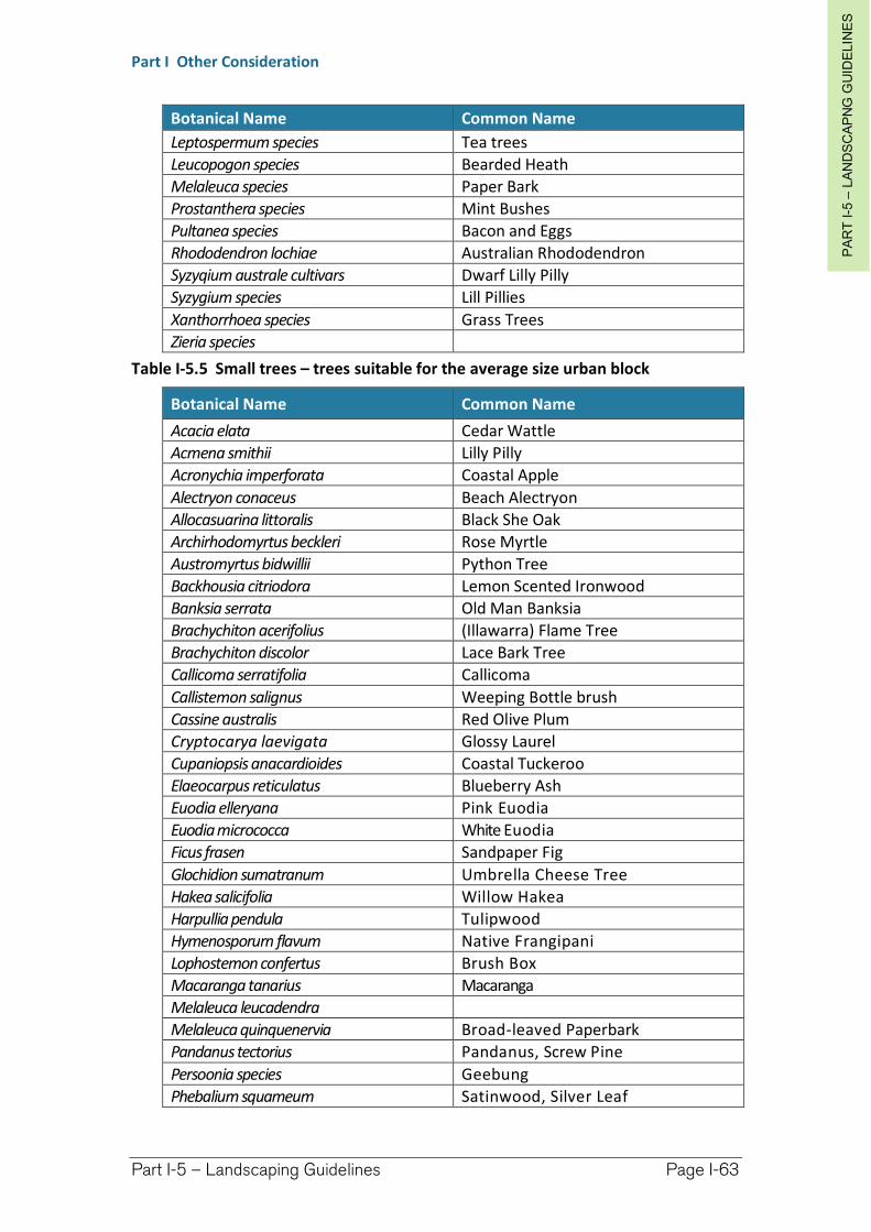
PA
RT
I-5
–LA
ND
SC
AP
NG
GU
IDE
LIN
ES
Part I Other Consideration
Part I-5 – Landscaping Guidelines Page I-63
Botanical Name Common Name
Leptospermum species Tea trees
Leucopogon species Bearded Heath
Melaleuca species Paper Bark
Prostanthera species Mint Bushes
Pultanea species Bacon and Eggs
Rhododendron lochiae Australian Rhododendron
Syzyqium australe cultivars Dwarf Lilly Pilly
Syzygium species Lill Pillies
Xanthorrhoea species Grass Trees
Zieria species
Table I-5.5 Small trees – trees suitable for the average size urban block
Botanical Name Common Name
Acacia elata Cedar Wattle
Acmena smithii Lilly Pilly
Acronychia imperforata Coastal Apple
Alectryon conaceus Beach Alectryon
Allocasuarina littoralis Black She Oak
Archirhodomyrtus beckleri Rose Myrtle
Austromyrtus bidwillii Python Tree
Backhousia citriodora Lemon Scented Ironwood
Banksia serrata Old Man Banksia
Brachychiton acerifolius (Illawarra) Flame Tree
Brachychiton discolor Lace Bark Tree
Callicoma serratifolia Callicoma
Callistemon salignus Weeping Bottle brush
Cassine australis Red Olive Plum
Cryptocarya laevigata Glossy Laurel
Cupaniopsis anacardioides Coastal Tuckeroo
Elaeocarpus reticulatus Blueberry Ash
Euodia elleryana Pink Euodia
Euodia micrococca White Euodia
Ficus frasen Sandpaper Fig
Glochidion sumatranum Umbrella Cheese Tree
Hakea salicifolia Willow Hakea
Harpullia pendula Tulipwood
Hymenosporurn flavum Native Frangipani
Lophostemon confertus Brush Box
Macaranga tanarius Macaranga
Melaleuca leucadendra
Melaleuca quinquenervia Broad-leaved Paperbark
Pandanus tectorius Pandanus, Screw Pine
Persoonia species Geebung
Phebalium squameum Satinwood, Silver Leaf
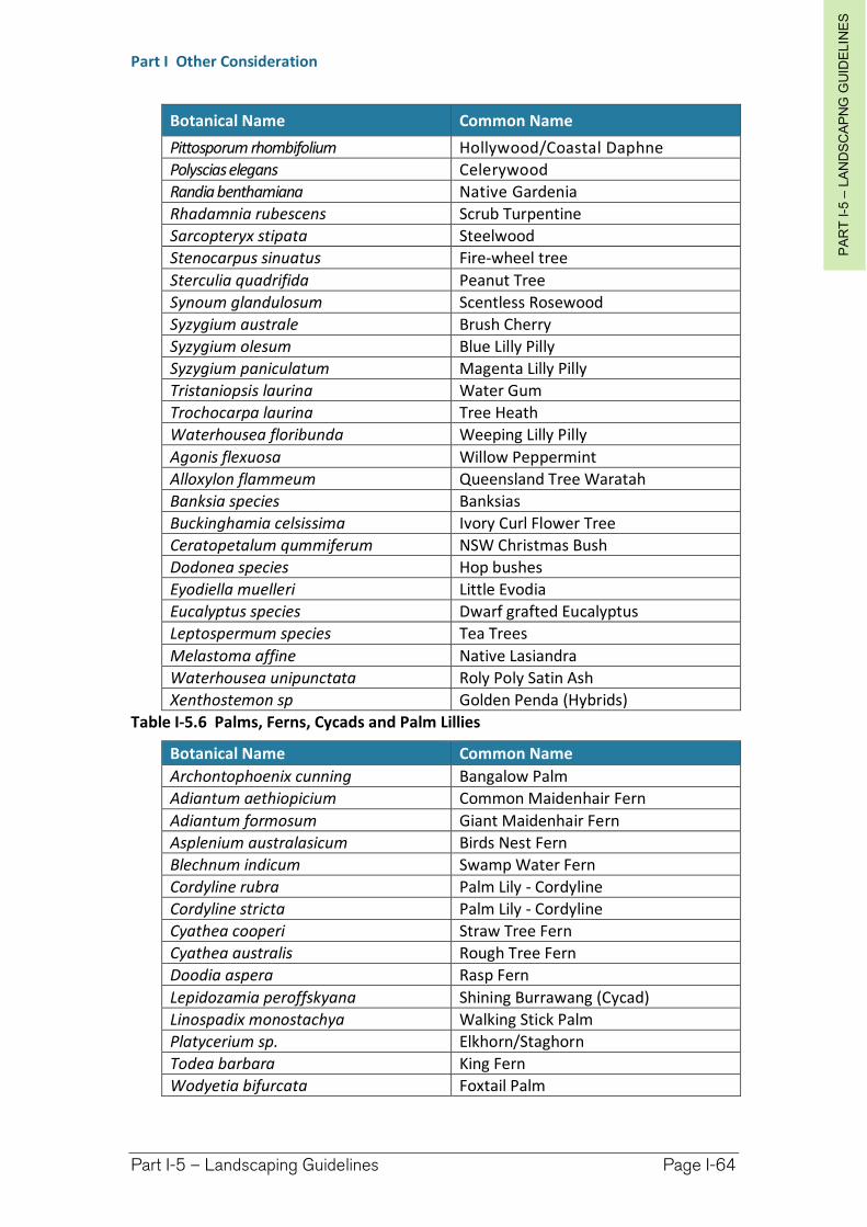
PA
RT
I-5
–LA
ND
SC
AP
NG
GU
IDE
LIN
ES
Part I Other Consideration
Part I-5 – Landscaping Guidelines Page I-64
Botanical Name Common Name
Pittosporum rhombifolium Hollywood/Coastal Daphne
Polyscias elegans Celerywood
Randia benthamiana Native Gardenia
Rhadamnia rubescens Scrub Turpentine
Sarcopteryx stipata Steelwood
Stenocarpus sinuatus Fire-wheel tree
Sterculia quadrifida Peanut Tree
Synoum glandulosum Scentless Rosewood
Syzygium australe Brush Cherry
Syzygium olesum Blue Lilly Pilly
Syzygium paniculatum Magenta Lilly Pilly
Tristaniopsis laurina Water Gum
Trochocarpa laurina Tree Heath
Waterhousea floribunda Weeping Lilly Pilly
Agonis flexuosa Willow Peppermint
Alloxylon flammeum Queensland Tree Waratah
Banksia species Banksias
Buckinghamia celsissima Ivory Curl Flower Tree
Ceratopetalum qummiferum NSW Christmas Bush
Dodonea species Hop bushes
Eyodiella muelleri Little Evodia
Eucalyptus species Dwarf grafted Eucalyptus
Leptospermum species Tea Trees
Melastoma affine Native Lasiandra
Waterhousea unipunctata Roly Poly Satin Ash
Xenthostemon sp Golden Penda (Hybrids)
Table I-5.6 Palms, Ferns, Cycads and Palm Lillies
Botanical Name Common Name
Archontophoenix cunning Bangalow Palm
Adiantum aethiopicium Common Maidenhair Fern
Adiantum formosum Giant Maidenhair Fern
Asplenium australasicum Birds Nest Fern
Blechnum indicum Swamp Water Fern
Cordyline rubra Palm Lily - Cordyline
Cordyline stricta Palm Lily - Cordyline
Cyathea cooperi Straw Tree Fern
Cyathea australis Rough Tree Fern
Doodia aspera Rasp Fern
Lepidozamia peroffskyana Shining Burrawang (Cycad)
Linospadix monostachya Walking Stick Palm
Platycerium sp. Elkhorn/Staghorn
Todea barbara King Fern
Wodyetia bifurcata Foxtail Palm

Richmond Valley Development Control Plan 2021
Part I-6 Animal Boarding and Training Establishments
Animal Boarding or Training Establishments are permissible in areas designated by the following zones:
RU1 Primary Production
IN1 General Industry
RE1 Public Recreation
RE2 Private Recreation
E3 Environmental Management
Such development is prohibited in all other zones.
By definition, Animal Boarding or Training Establishmentsare places used for the breeding, boarding, training, keeping or caring of animals (other than for the agistment of horses), for commercial purposes.
The keeping of animals for agricultural purposes is separately defined as ‘Intensive livestock agriculture’ by the Standard LEP and covered by Chapter H-3 in the DCP.
This Chapter will designate the maximum number of animals that may be kept, breed, trained, boarded or cared for before being considered commercial in nature, and therefore, requiring development consent to operate.
For the purposes of this chapter, ‘keep’ or ‘kept’ also includes the breeding, boarding, training or caring for animals.
This DCP applies to all land within the Richmond Valley Local Government Area.
Date adopted by Council: 22/06/2021
Effective Date: 01/08/2021
Amendments: Nil
PA
RT
I-6
–A
NIM
AL B
OA
RD
ING
& T
RA
ININ
G E
ST
Part I Other Consideration
Part I-6 – Animal Boarding and Training Establishments Page I-66
I-6.1 General Objectives
The general objectives of this Chapter are to:
(1) define what is considered to be an Animal Boarding and Training Establishments for the purposes of the Richmond Valley LEP 2012.
(2) determining the maximum number of animals that may be kept before an establishment is considered to be commercial in nature and therefore an Animal Boarding and Training Establishment.
(3) guide what information will be required to support an application for an Animal Boarding and Training Establishment.
(4) provide controls to protect urban and rural amenity.
(5) provide adequate design considerations to avoid unacceptable adverse impacts to a locality.
I-6.2 What are Animal Boarding and Training Establishments?
Objective
(1) define Animal Boarding and Training Establishments in the context of the Richmond Valley LEP 2012.
Controls
(1) The Richmond Valley LEP 2012 is a Standard Instrument LEP. The dictionary to the Standard Instrument LEP defines:
Animal boarding and training establishments means a building or place used for the breeding, boarding, training, keeping or caring of animals for commercial purposes (other than for the agistment of horses), and includes any associated riding school or ancillary veterinary hospital.
(2) Animal Boarding and training establishments are prohibited in all zones except:
RU1 Primary Production
IN1 General Industry
RE1 Public Recreation
RE2 Private Recreation
E3 Environmental Management
(3) Development consent is required to operate an Animal Boarding and training establishment, unless it is identified as exempt development under State Environmental Planning Policy (Exempt and Complying Development Codes) 2008 and another Environmental Planning Instrument.
I-6.3 Non-Commercial Keeping of Animals
Objective
(1) to establish when the keeping of animals is considered to be an Animal Boarding and Training Establishment,
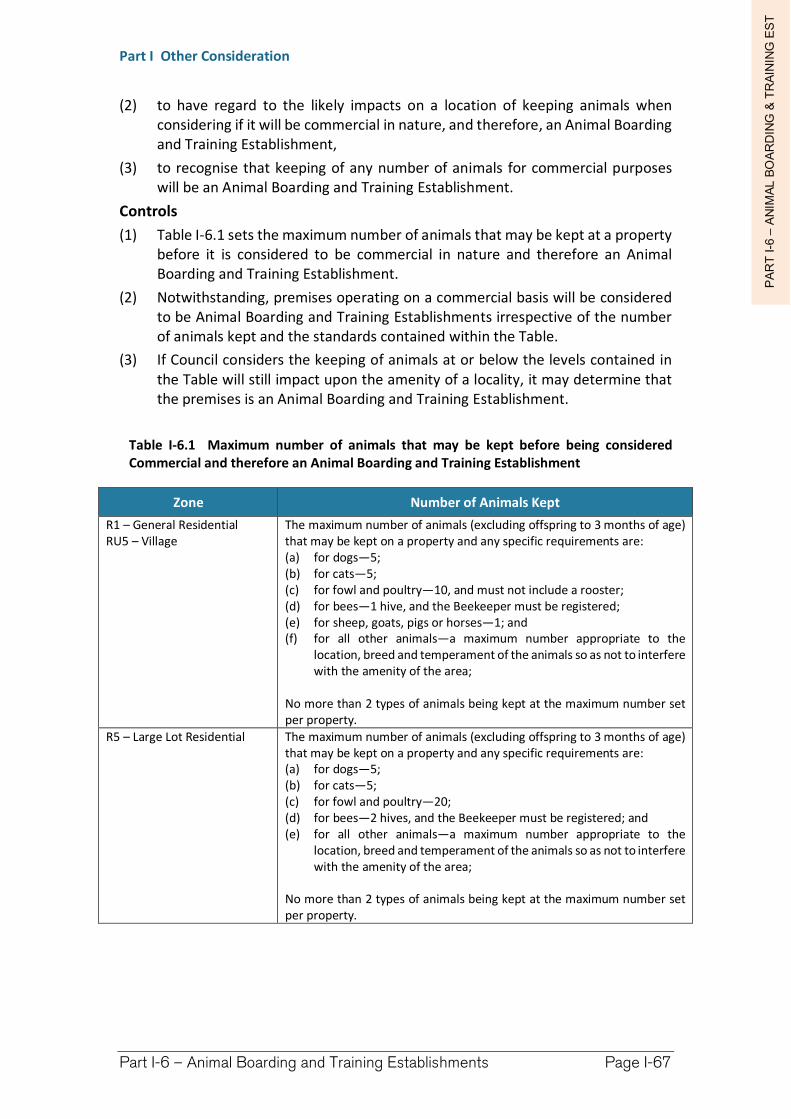
PA
RT
I-6
–A
NIM
AL B
OA
RD
ING
& T
RA
ININ
G E
ST
Part I Other Consideration
Part I-6 – Animal Boarding and Training Establishments Page I-67
(2) to have regard to the likely impacts on a location of keeping animals when considering if it will be commercial in nature, and therefore, an Animal Boarding and Training Establishment,
(3) to recognise that keeping of any number of animals for commercial purposes will be an Animal Boarding and Training Establishment.
Controls
(1) Table I-6.1 sets the maximum number of animals that may be kept at a property before it is considered to be commercial in nature and therefore an Animal Boarding and Training Establishment.
(2) Notwithstanding, premises operating on a commercial basis will be considered to be Animal Boarding and Training Establishments irrespective of the number of animals kept and the standards contained within the Table.
(3) If Council considers the keeping of animals at or below the levels contained in the Table will still impact upon the amenity of a locality, it may determine that the premises is an Animal Boarding and Training Establishment.
Table I-6.1 Maximum number of animals that may be kept before being considered Commercial and therefore an Animal Boarding and Training Establishment
Zone Number of Animals Kept
R1 – General ResidentialRU5 – Village
The maximum number of animals (excluding offspring to 3 months of age) that may be kept on a property and any specific requirements are: (a) for dogs—5; (b) for cats—5; (c) for fowl and poultry—10, and must not include a rooster; (d) for bees—1 hive, and the Beekeeper must be registered; (e) for sheep, goats, pigs or horses—1; and (f) for all other animals—a maximum number appropriate to the
location, breed and temperament of the animals so as not to interfere with the amenity of the area;
No more than 2 types of animals being kept at the maximum number set per property.
R5 – Large Lot Residential The maximum number of animals (excluding offspring to 3 months of age) that may be kept on a property and any specific requirements are: (a) for dogs—5; (b) for cats—5; (c) for fowl and poultry—20; (d) for bees—2 hives, and the Beekeeper must be registered; and (e) for all other animals—a maximum number appropriate to the
location, breed and temperament of the animals so as not to interfere with the amenity of the area;
No more than 2 types of animals being kept at the maximum number set per property.
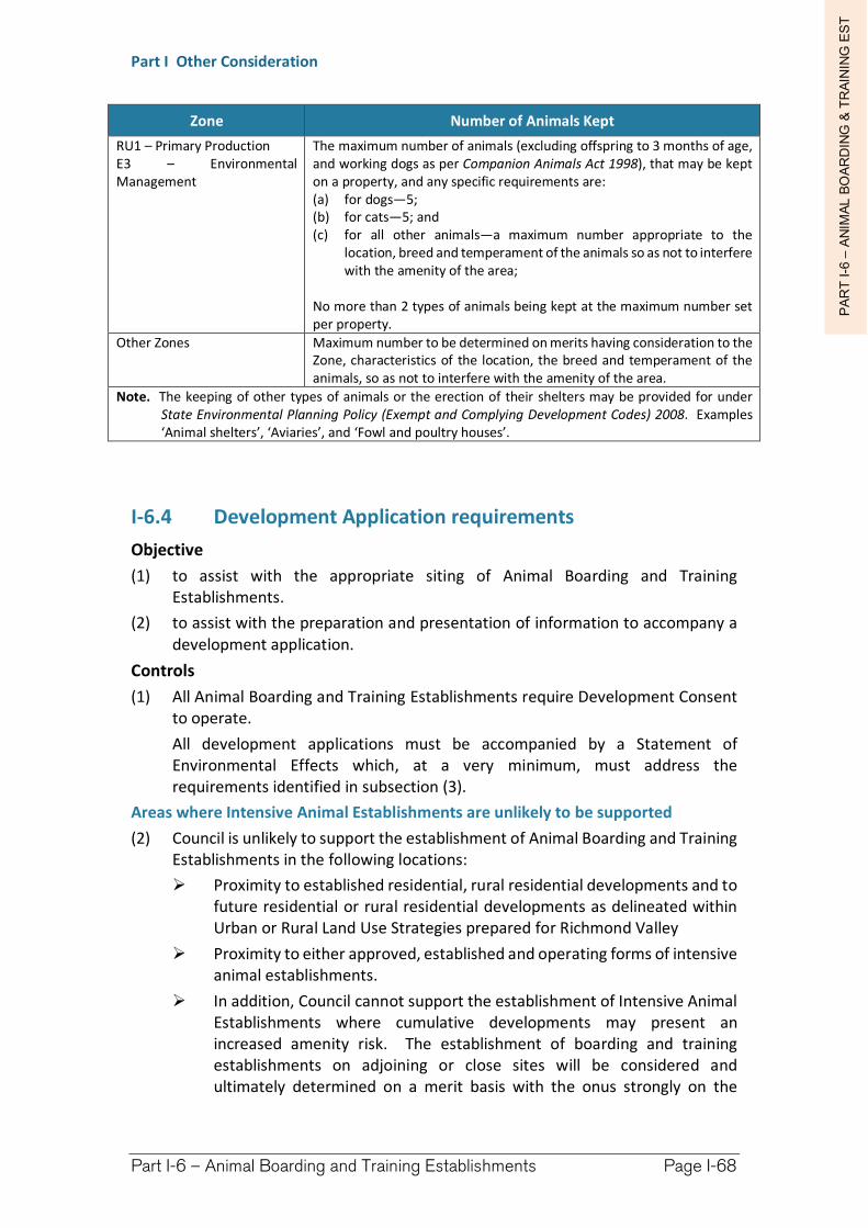
PA
RT
I-6
–A
NIM
AL B
OA
RD
ING
& T
RA
ININ
G E
ST
Part I Other Consideration
Part I-6 – Animal Boarding and Training Establishments Page I-68
Zone Number of Animals Kept
RU1 – Primary Production E3 – Environmental Management
The maximum number of animals (excluding offspring to 3 months of age, and working dogs as per Companion Animals Act 1998), that may be kept on a property, and any specific requirements are: (a) for dogs—5; (b) for cats—5; and (c) for all other animals—a maximum number appropriate to the
location, breed and temperament of the animals so as not to interfere with the amenity of the area;
No more than 2 types of animals being kept at the maximum number set per property.
Other Zones Maximum number to be determined on merits having consideration to the Zone, characteristics of the location, the breed and temperament of the animals, so as not to interfere with the amenity of the area.
Note. The keeping of other types of animals or the erection of their shelters may be provided for under State Environmental Planning Policy (Exempt and Complying Development Codes) 2008. Examples ‘Animal shelters’, ‘Aviaries’, and ‘Fowl and poultry houses’.
I-6.4 Development Application requirements
Objective
(1) to assist with the appropriate siting of Animal Boarding and Training Establishments.
(2) to assist with the preparation and presentation of information to accompany a development application.
Controls
(1) All Animal Boarding and Training Establishments require Development Consent to operate.
All development applications must be accompanied by a Statement of Environmental Effects which, at a very minimum, must address the requirements identified in subsection (3).
Areas where Intensive Animal Establishments are unlikely to be supported
(2) Council is unlikely to support the establishment of Animal Boarding and Training Establishments in the following locations:
Proximity to established residential, rural residential developments and to future residential or rural residential developments as delineated within Urban or Rural Land Use Strategies prepared for Richmond Valley
Proximity to either approved, established and operating forms of intensive animal establishments.
In addition, Council cannot support the establishment of Intensive Animal Establishments where cumulative developments may present an increased amenity risk. The establishment of boarding and training establishments on adjoining or close sites will be considered and ultimately determined on a merit basis with the onus strongly on the
PA
RT
I-6
–A
NIM
AL B
OA
RD
ING
& T
RA
ININ
G E
ST
Part I Other Consideration
Part I-6 – Animal Boarding and Training Establishments Page I-69
applicant to demonstrate through detailed analysis why additional establishments will not be a risk.
Development Application Requirements
(3) A Development Application for an Animal Boarding and Training Establishment must include but not necessarily be limited to the following detail within a Statement of Environmental Effects:
(a) Odour - Odour Modelling Report prepared by a suitably qualified person which outlines the extent of impacts of any odours both from the proposed land use and any cumulative impacts due to any existing land uses which may already emit offensive odours. Such report is to be prepared with regard for likely climatic and prevailing conditions. The Odour Report is also to submit operational procedures to further mitigation any impacts and to identify the extent of reduction based upon these practices.
(b) Noise - A Noise Impact Report prepared by a suitably qualified person which outlines the extent of impacts of noise from the proposed use including the full extent and activities to be operating on site and also the activities associated with the proposal including the type and numbers of traffic which will be generated by the land use. The Report is also to make recommendations for the mitigation of any noise impacts and is to identify the extent of noise reduction as a result of these measures being implemented. Section I-7 – Noise Impact Assessment (NIA) provides additional detail as to what is required for the preparation of a detailed application involving NIA.
(c) Traffic and Road Haulage - A Traffic Report is required to be submitted and must be prepared by a suitably qualified person, detailing, but not necessarily limited to:
the types and numbers of traffic to be generated by the proposal;
details of the existing condition, widths, depths of pavement and its suitability or otherwise for the carriage of transport to be associated with the land use;
proposed upgrading to be undertaken by the applicant including location(s) of width or depth of pavement, sealing of pavement and extension of stormwater pipes or culverts along the route(s).
Detailed plans showing where access to the property is proposed and adequate manoeuvring area(s) are provided to ensure visiting vehicles enter and exit the property in a forward motion. Car parking is to be provided wholly within the property for a minimum of three vehicles, however more may be required based upon detail supplied as to staffing numbers and operational procedures.
(d) Access - Entrance/exit-way(s) to the local road network must be constructed to Council specification and provide suitable line-of-sight distance for exiting vehicles. As a guide, around 150 metres is required to safely de-accelerate and pull off the road in a 100km an hour speed zone.
PA
RT
I-6
–A
NIM
AL B
OA
RD
ING
& T
RA
ININ
G E
ST
Part I Other Consideration
Part I-6 – Animal Boarding and Training Establishments Page I-70
In all instances, Council reserves the right to determine whether the placement and access is suitable and safe. All works required to be undertaken must be financed by the owner of the property or proponent of the development, including any works proposed on the road reserve verge.
(e) Statement of Environmental Effects - The Statement of Environmental Effects (SEE) accompanying the application is required to describe in detail all aspects of the operation of the establishment which may then be transcribed into a Management Plan for the land use.
(f) Environmental Management Plan - An Environmental Management Plan shall be prepared for the operation of the animal establishment detailing, but not necessarily limited to the following matters:
Treatment and disposal of litter and effluent;
Odour Management;
Noise Management;
Biosecurity measures for the control and quarantine of exotic, endemic or emergency diseases;
Disposal of dead animals;
Food Storage and Vermin control;
Erosion control measures;
Water and Drainage management;
Chemicals and Fuel storage;
Complaints register;
Guidelines for the Operation, e.g. Greyhound Racing Control Board;
Water storage and harvesting methods; and
Dust and air-borne particulate matter management.
(g) On-Site Sewage Management - The preparation and review of On- Site Sewage Effluent Disposal for these forms of land use is to be undertaken in accordance with Council's On-Site Sewage and Wastewater Strategy and associated guidelines. Further effluent treatment methods and devices may be required for solids disposal and it is recommended pre-lodgement discussions be held with Council to confirm the treatment level and technique.
(h) Land Use Conflict Risk Assessment (LUCRA) - A LUCRA component to provide a site specific conflict risk assessment relevant to the location and sensitivity of adjacent, adjoining and nearby landuses to ultimately determine the feasibility of the establishment in the location proposed and any required management response to potential conflicts. Section I-11 addresses the requirements of a LUCRA in detail and should be referenced comprehensively for this component of the application.
PA
RT
I-6
–A
NIM
AL B
OA
RD
ING
& T
RA
ININ
G E
ST
Part I Other Consideration
Part I-6 – Animal Boarding and Training Establishments Page I-71
Public Exhibition and Consultation
(4) The Public Exhibition and any required consultation shall be conducted in accordance with the Richmond Valley Council Community Participation Plan 2020 and generally requires a minimum 14 day exhibition period.
Site Suitability
(5) The suitability of the site for the purpose of accommodating an Animal Establishment will be assessed during the application process. Particular attention should be made, but not limited to, the following site suitability specifications so as to minimise poor site choices and wasted resources.
(a) Large and isolated rural allotment so as to provide ample distance between sensitive receivers in respect to noise, odour and biohazard ‘buffer’ requirements.
(b) Adequate access so as to provide ample entry turnout and line-of-sight distance relevant to the intended vehicular type and numbers proposed for the use of the property. The local road network from the larger arterial roads must be of a suitable width, grade and condition to be able to adequately support the intended establishment. The proponent may be required to upgrade the road (and any associated works) to a condition suitable and/or pay contributions for use of the local road network based upon the assessment of Council.
(c) Relatively Flood and Bushfire Free.
(d) Relatively free of other Environmental Constraints – in particular those indicated within a Natural Resource Sensitivity map and associated provisions (see Chapter H-4 – Natural Resource Sensitivity for further detail and requirements).
Richmond Valley Development Control Plan 2021
Part I-7 Noise Impact Assessment
Environmental noise emitted from a premise or land-use can impact negatively upon neighbours, or even entire neighbourhoods. It can affect the health and wellbeing of individuals and community as a whole. In NSW, laws have been enacted to enforce noise reduction and protect people from resultant annoying and harmful effects.
Although Council has authority to regulate noise impacts if verified offensive noise complaints are received, it is more practical to ensure offensive noise impacts are prevented through initial intelligent design. Operational procedures should also be instigated to minimise noise at the time when the land-use is established or when significant changes are proposed.
This section of the DCP provides guidance and examples where noise impact assessment is required as part of a comprehensive development application. Noise impact assessment is generally required to be an integral component of a development application (DA) where the proposed development and/or associated activity may potentially impact neighbouring properties and public land. The provisions within this section of the DCP particularly seek to protect noise-sensitive land uses from any negative impacts resulting from any proposed development.
This DCP applies to all land within the Richmond Valley Local Government Area.
Date adopted by Council: 22/06/2021
Effective Date: 01/08/2021
Amendments: Nil
PA
RT
I-7
–N
OIS
E IM
PA
CT
AS
SE
SS
ME
NT
Part I Other Consideration
Part I-7 – Noise Impact Assessment Page I-74
I-7.1 Objectives
The objectives of this Chapter are to:
(1) Provide examples of development types that require Noise Impact Assessment (NIA) as an integral part of an application for the development.
(2) Describe the level of detail required to satisfy qualitative and quantitative assessment of noise impacts within an application or proposal. Effective NIA requires accurate deduction of all potential and likely noise impacts upon adjoining land uses and the community as a whole.
(3) Establish conditions and procedures to be applied to any relevant approval for development/proposals in order to offset possible negative resulting noise impacts. Conditions may apply to any aspect of the proposed development, including building design & materials, operational procedures (particularly hours of operation), and/or any combination of operation and construction controls as a result of the findings of the NIA. Precautionary measures are required to be anticipated by the proponent which may then be conditioned on any consent Council may grant. Conditions may be imposed by Council with some negotiation possible with the offsetting of major impacts, however it will be required the proponent suggest mediating measures within the NIA.
(4) Provide mechanisms for avoiding the creation of ‘offensive noise’ through development control initiated through the approval process.
(5) Provide for any additional advertising and notification procedures for the development application process in relation to noise matters.
I-7.2 Definition of Noise
Noise-sensitive land uses include all that are residential, institutional, public and recreation in nature. Examples include (but are not limited to) campgrounds, hospitals, places of worship, schools, day care facilities, long-term care facilities, libraries, auditoriums, community centres, offices, conference rooms, reading rooms, hotels, motels and some parts of retail stores.
Noise may be generated as a direct consequence of the operation of a development and involves sound impacts from:
machinery of any kind
vehicles within the site (forklifts, trucks reversing, loading, etc)
any ancillary operation noise
Indirect noise generation may also be required to be assessed and may include:
pedestrian and/or vehicle movements to and from the site of the development, with particular attention to the times of day or night these movements may occur. Pedestrian movement may involve intoxicated patrons which will have a greater influence on the amount of noise potentially generated from the development.
security or fire alarms, night access facilities, security personnel movements, etc
PA
RT
I-7
–N
OIS
E IM
PA
CT
AS
SE
SS
ME
NT
Part I Other Consideration
Part I-7 – Noise Impact Assessment Page I-75
I-7.3 Legislative Provisions
(1) Although there is no specific provisions concerning Noise Impact Assessment within the Richmond Valley Local Environmental Plan 2012 (the LEP), noise impact considerations are included within the overall aims and objectives of the Plan.
Section 4.15 of the Environmental Planning and Assessment Act 1979 also requires that when determining a development application, a consent authority must take into consideration the likely social impacts of that development in the locality.
Richmond Valley Council (RVC) has a statutory obligation to consider noise impacts when determining development proposals. Applicants may be required to provide noise assessment within application details, when deemed necessary in the opinion of Council and/or the assessing officer.
Noise assessment is an important tool to accurately assess the potential impact of a proposal or application for development on surrounding land uses and the locality. Although this section of the DCP is most relevant for development applications from private firms or individuals, it may also be a useful resource for authorities (including Council) as to where to what degree of Noise Impact Assessment (NIA) should be incorporated into proposals and application.
Extract from Protection of the Environment Operations Act 1997
Definition of Offensive Noise
Offensive noise means noise: (a) that, by reason of its level, nature, character or quality, or the time at which it is made or any
other circumstances: (i) is harmful to (or is likely to be harmful to) a person who is outside the premises from
which it is emitted, or (ii) interferes unreasonably with (or is likely to interfere unreasonably with) the comfort
or repose of a person who is outside the premises from which it is emitted, or (b) that is of a level, nature, character or quality prescribed by the regulations or that is made at a
time, or in any other circumstances prescribed by the regulations.
I-7.4 Determining What Noise Impact Assessment is required
Is a Noise Impact Statement required?
(1) The question as to whether the proposal will require a degree of Noise Impact Assessment can be answered by responding in the affirmative to any one or more of the following;
Does the proposal involve a land-use which is likely to generate noise contrary to the majority of existing surrounding land-uses?
Is the use one which might be considered to ordinarily generate some form of noise as a consequence of a consent being granted?
Will the proposal likely give rise to an increase in noise within the locality, either directly or indirectly through traffic movements, pedestrian access, operational equipment noise, etc?
PA
RT
I-7
–N
OIS
E IM
PA
CT
AS
SE
SS
ME
NT
Part I Other Consideration
Part I-7 – Noise Impact Assessment Page I-76
Is the proposal likely to impact upon neighbourhood amenity and/or community meeting places (including pedestrian commuting conduits, parklands, etc) through the direct or indirect emission of noise?
The majority of development proposals will only require suitable comment regarding potential noise impacts within or as part of the Statement of Environmental Effects (SEE) accompanying a formal application. Full Noise Impact Assessment (NIA) is required for more comprehensive proposals which are likely to have larger potential noise impact upon neighbourhoods and localities.
The main distinction in the levels of NIA invoked below is the depth and range of reporting required within the proposal application. Section 3.4 outlines the detail required for various levels of Noise Impact Assessment which may be attributed to the development types listed below.
There is a high likelihood that most larger scale developments and proposals will require comprehensive noise reporting or assessment, in many cases these developments may also be ‘designated’ and require multiple additional approvals or concurrence from State and/or Commonwealth agencies.
The responsibility of the proponent
(2) It is the proponent’s responsibility to ensure appropriate measures have been incorporated into the development design and that all applicable sound level criteria are met (subject to approval and review) for the extent and life of the development. The proponent’s responsibilities also involve the following:
Determining feasibility of the project including constraints applicable before any project action or construction commitment is made;
Ensuring all noise generating criteria likely to be associated with the development are included within the assessment provided and an acceptance that additional costs are likely to be borne by the proponent if the noise report is inadequate;
Assessing all outdoor and indoor acoustical environments; measurements and readings must be supplied and extrapolated using commonly accepted and contemporaneous units and criteria;
Ensuring that the required control measures are incorporated in the development.
Determine What Level of Noise Impact Assessment is Required
(3) There are 3 levels of Noise Impact Assessment. The appropriate level of assessment is dependent upon the nature of the development. Use the following guidelines to determine what level of assessment is required:
(a) High degree NIA
Development types which will require an extensive and comprehensive degree of Noise Impact Assessment accompanying the application:
Developments likely to generate noise and/or vibration impacts which could potentially significantly impact receivers within the vicinity and locality, such as:
PA
RT
I-7
–N
OIS
E IM
PA
CT
AS
SE
SS
ME
NT
Part I Other Consideration
Part I-7 – Noise Impact Assessment Page I-77
animal boarding and/or training establishments (particularly dog & cat) – see Chapter I-6 for further detail of other requirements
Any proposed use involving the operation of more than four (4) mechanical vehicles such as automobiles, motorbikes, go-carts, jet skis or similar at one time.
extractive industries of any kind (quarrying) which involve heavy machinery use which are within 500 metres of any residential development, particularly involving noise generation of any kind (directly or indirectly) outside of usual operating hours (see below). Quarries which involve blasting and/or crushing require comprehensive noise assessment and are generally considered to significantly affect residences within 1000 metres.
industries, whether urban or rural utilising machinery use (within 100 and 750 metres of residential development respectively) involving noise generation of any kind (directly or indirectly) particularly when outside of usual operating hours (see below for details of usual operating hours)
Any other proposed noise emitting development situated within 50 metres (in an urban area) or 350 metres (within a rural area) of noise sensitive land-uses. If after-hours operation is proposed the trigger is within 100 metres (urban) or 750 metres (rural) of noise sensitive land-uses (standard hours given below).
Pubs, clubs and discothèques, etc (registered clubs) or any other music generating development (such as rehearsal rooms/halls, venues)
Late or very early hour premises such as Service Stations and fast or other food premises within 100 metres of residents; Depots, Entertainment Facilities, Function Centres, and any other similar premise.
Any other development Council’s Planning or Environmental Health Officers interpret to likely present comparable noise impacts to those listed above.
(b) Moderate degree NIA required
Development types which will require a reasonable and comprehensive degree of Noise Impact Assessment accompanying the application:
Developments, such as:
Larger retail complexes, Neighbourhood Shops (late or early hours),
industries, whether rural or urban which involve machinery use (within 1000 and 200 metres of sensitive land-use respectively) involving noise generation of any kind (directly or
PA
RT
I-7
–N
OIS
E IM
PA
CT
AS
SE
SS
ME
NT
Part I Other Consideration
Part I-7 – Noise Impact Assessment Page I-78
indirectly) outside of usual operating hours (see below for details of usual operating hours),
Childcare (caring for in excess of 15 children) within 50 metres of residential or other noise sensitive land-use (nslu).
Places of Public Worship and public assembly,
Recreation facilities (indoor and outdoor, inc. water),
Schools (exceeding 15 pupils under 18 years),
passenger transport facilities within 100m of a sensitive land-use,
developments involving wind, water, or other means of harnessing energy from the environment turbines which make noise in the process.
Group Homes (transitional and permanent), Boarding Houses, Hostels and the like.
Forms of Tourist Development which involve transitory guest accommodation catering for in excess of 10 guests, such as backpacker accommodation, which are within 200 metres of noise-sensitive land-uses.
Expansion or change of a non-conforming ‘existing’ or ‘continuing’ use (lesser NIA may be sufficient if noise impacts are negligible, subject to Council’s consensus).
Home occupations, business or industry which intends to involve any form of noise generating machinery and is situated adjacent or adjoining other residential development or any other noise-sensitive land-use.
Larger Urban Industries and Rural Industries with over 15 employees.
Amusement Centres and Entertainment Facilities.
Places of Public Worship (between 20 - 30 worshipers - high degree NIA required above if within 100 metres of a sensitive land-use).
Seniors Housing and Residential Care Facilities (to be assessed as a sensitive receiver based upon existing land-uses within the vicinity).
Any other development that Council’s Planning Officers interpret to likely present comparable social impacts to those listed above. This may include any development listed as requiring a high degree of NIA in I-7.3(3)(a) above with less perceived potential impacts.
(c) Low degree NIA required
Circumstances where a Noise Impact statement is sufficient - Development types which require low degree of Noise Impact Assessment accompanying the application:
Developments such as:
Small retail complexes
Medical Centres,
PA
RT
I-7
–N
OIS
E IM
PA
CT
AS
SE
SS
ME
NT
Part I Other Consideration
Part I-7 – Noise Impact Assessment Page I-79
Urban Industries and small rural industries within suitable setting
Educational Establishments
Child Care Centres
Expansion or change of a non-conforming ‘existing’ or ‘continuing’ use.
Places of Public Worship (less than 20 worshipers).
Any other development Council’s Planning Officers interpret to likely present comparable low degree of noise impact to those listed above. This may include any development listed as requiring a moderate degree of NIA in I-7.4(3)(b) above with reduced potential impacts, with Council’s concurrence.
I-7.5 Design Standards and Noise Impact Assessment
Main Considerations - Checklist for all levels of NIA
(1) The applicant will be required to address noise impacts of the proposal within the Statement of Environmental Effects (SEE) or any Environmental Impact Assessment accompanying the application, with care to address the following main considerations:
An indication of the type and duration of all potential noise events likely to be generated from the land, and not just a direct result of the land use proposed. Examples of direct and indirect noise generation are given above (in the preamble). All anticipated noise sources shall be included within an exhaustive itinerary.
A comprehensive list of all adjoining land uses and comment as to the compatibility of the proposal with those land uses existing, with particular attention to noise issues.
Any suggestions by the proponent as to operational and/or design implementation which might lessen the impact of noise sourced from the development.
Any required or suggested advertising and/or consultation with neighbours and key stakeholders.
Standard hours of operation for any noise generating development
(2) The standard hours of operation for noise generating development are equivalent to the normal hours of unrestricted business operation. It cannot be assumed operation within these hours is acceptable if the noise generated is considered to be in excess of that which would ordinarily be expected to be experienced.
(a) Operating Hours:
Monday to Friday: 7 a.m. until 6 p.m.
Saturday: 8 a.m. until 1 p.m.
Sundays and Public Holidays: No Operations.
PA
RT
I-7
–N
OIS
E IM
PA
CT
AS
SE
SS
ME
NT
Part I Other Consideration
Part I-7 – Noise Impact Assessment Page I-80
(b) Unloading, pick-ups and deliveries:
Monday to Friday: 8 a.m. until 5 p.m.
Saturday: 9 a.m. until 12 noon
Sundays and Public Holidays: No Operations.
Any development proposed to operate outside of the Standard Hours of Operation should be treated as a higher impact development requiring a higher level of noise assessment. 24 hour operation will almost certainly require the highest level of noise assessment.
Minimum Requirements for a Noise Impact Assessment
(3) Chapter I-7.4(3) provides a guide to determining what level of Noise Impact Assessment is required for development types. The following guide provides the minimum requirements for preparing the Noise Impact Assessment based on the level required:
(a) High level SIA
Minimum Requirements for Noise Impact Assessment as per development stipulated within Section I-7.4(3)(a):
A comprehensive report shall be provided detailing any inconsistencies with nearby existing land uses and the use proposed. Each adjoining land-use should be addressed individually with a comprehensive summary supplied to outline all noise impacts and considerations. The NIA must provide a detailed response as to whether any of the main considerations within I-7.4(1) relate to the proposal or the location. If an affirmative response to any I-7.4(1) consideration is recorded, the applicant must provide detail as to how negative impact will be mitigated and measures incorporated into the design and/or operating procedure of the development to alleviate all noise impacts.
The NIA shall outline all potential impacts upon adjoining land-uses and key stakeholders. A report shall be comprehensive and prepared by a suitably qualified acoustic engineer with particular reference to best practice principles and other contemporary studies (see subsection (4) below).
The NIA is required to outline all potential impacts upon adjoining land-uses and key stakeholders identified as a result of a comprehensive scoping component of the assessment. The acoustic engineer is required to address all impacted receivers and as well as suggesting ongoing monitoring measures to improve upon existing land-use operation and reporting procedures. Representative contact details should be made readily available to any member of the effected public to record and respond to offensive noise events. The operating procedures of the development shall incorporate monitoring and response procedures which will ensure ongoing noise level compliance.
PA
RT
I-7
–N
OIS
E IM
PA
CT
AS
SE
SS
ME
NT
Part I Other Consideration
Part I-7 – Noise Impact Assessment Page I-81
The NIA shall incorporate a record of consultation with immediate neighbouring land-uses and key stakeholders. Comments and issues raised should be documented preferably written and signed ‘letterhead’ with responses from the applicant as to how the issues raised support the development, or suggest mitigating measures which may be incorporated to lessen the impact of the issue raised.
The applicant is required to provide a comprehensive analysis of all potential impacts identified as a result of in-depth analysis of the location and active/passive use of the proposal site and surrounds. All impacts should be reported alongside all impacts resulting from community & stakeholder consultation. The proponent is also required to present suggested impact minimisation of all perceived impacts.
The NIA should entail a component of community consultation, record in detail all resulting discussion and comments received, and outline how any potential negative impacts raised may be incorporated into the development design and operation. Community consultation should concentrate on immediate neighbouring land-uses and main stake-holders.
(b) Moderate level NIA
Minimum Requirements for Noise Impact Assessment as per development stipulated within Section I-7.4(3)(b):
A comprehensive summary as to whether there are any inconsistencies with nearby existing land uses and the use proposed. Each adjoining land-use should be addressed individually (possibly in tabulated form) and a paragraph summary supplied to outline all noise impacts and considerations. The NIA must provide a detailed response as to whether any of the main considerations within I-7.4(1) relate to the proposal or the location. If an affirmative response to any I-7.4(1) consideration is recorded, the applicant should demonstrate how negative impact may be mitigated and potentially incorporated into the design or operating procedure of the development.
The NIA shall outline all potential impacts upon adjoining land-uses and key stakeholders. A report shall be comprehensive and prepared by person or persons suitably qualified in acoustic reporting with reference to best practice principles concerning contemporary acoustic reporting. Acoustic levels recorded (both background and peak shall be provided and incorporated into reasoning within the report.
The NIA should entail a component of community consultation, record in detail all resulting discussion and comments received, and outline how any potential negative impacts raised may be incorporated into the development design and operation.
PA
RT
I-7
–N
OIS
E IM
PA
CT
AS
SE
SS
ME
NT
Part I Other Consideration
Part I-7 – Noise Impact Assessment Page I-82
Community consultation should concentrate on immediate neighbouring land-uses and main stake-holders.
(c) Low level Noise Impact Assessment
Minimum Requirements for where Noise Impact comment is required i.e. development stipulated within Section I-7.4(3)(c):
A statement summary as to whether there are any inconsistencies with the existing land uses and the use proposed. Each land use should be addressed individually (possibly in tabulated form) and a statement summary supplied.
Comment should detail whether any of the main considerations above relate to the proposal or the location of the proposal. A short response to each of the questions within I-7.4(1) will suffice, in particular:
Is the proposal likely to impact upon adjoining land-uses (particularly if they are noise-sensitive), neighbourhood amenity and/or community land/meeting places (including pedestrian commuting conduits, parklands, etc)?
Comment should outline the likely impacts upon adjoining land-uses and key stakeholders. Comment need not be prepared by a suitably qualified person however must address all potential impacts and suggest possible mitigating measures.
Comment does not need to entail predictive acoustic readings however should endeavour to quantitatively and qualitatively itemise all noise generating sources likely to be audible beyond the subject property boundary. In instances where the noise source is likely to generate sound which could be reasonably expected to be a nuisance, detail shall be provided as to how impact may be mitigated.
Guidelines and Best Practice to be adopted for Reporting
(4) The following publications and guidelines provide the most contemporaneous Noise Impact Assessment methods at the time of writing. It is expected the noise assessment guidelines and techniques listed below (or successive guidelines) be extensively referenced and adopted for development applications requiring NIA of the type examined within this DCP chapter. This list is not comprehensive and is subject to superseding guidelines, improvements and review.
New South Wales Industrial Noise Policy – Environmental Noise Management – Environment Protection Authority (EPA, 2000).
Department of Environment and Conservation (NSW) – Noise Guide for Local Government – Environmental Noise Management (2004).
NSW Department of Planning – Development near Rail Corridors and Busy Roads (Interim Guidelines 2008 or later).
PA
RT
I-7
–N
OIS
E IM
PA
CT
AS
SE
SS
ME
NT
Part I Other Consideration
Part I-7 – Noise Impact Assessment Page I-83
I-7.6 Advertising and Notification
(1) The Richmond Valley Council Community Participation Plan 2020 addresses advertising and notification requirements for development applications.
However, it is considered prudent, however that the applicant begin Noise Impact Assessment very early in the preparation of the development application process. Early preparation and notification provides a means to accurately present all noise impacts to adjoining owners and the general public during the exhibition process. Monitoring directly from nearby noise-sensitive environs (including indoors) can often be the most revealing means of collecting relevant data, and the facilitating process can be a means to make positive contact with affected individuals and stakeholders.
Early engagement can be beneficial to demonstrate the intent of the proponent to conduct an equitable assessment of the proposal’s impacts. Timely and thoughtful assessment techniques can provide opportunity to demonstrate how the development might proceed with minimal noise impacts. Transparency in this process can introduce and discuss mitigating measures to reduce impacts of noise on sensitive receivers.
(2) It is highly recommended consultation concerning noise impact be initiated and include noise impacts as a major component of discussion and education with adjoining and affected parties. It is recommended the consultation process be initiated one month before the advertising period in order to adequately inform nearby residents and tenants as to the proposal and any possible consequence.
I-7.7 Additional Information regarding Noise Impact Measurement, Compliance and Management
(1) Proposals which involve situating Noise Sensitive Development within the influence of existing or proposed noise generating operations:
Taking all reasoning and provisions outlined within the previous sections of this DCP into account, Council will require suitable NIA included within formal application for the potentially affected proposed development. The opinion of Council is absolute in determining these matters, and includes consideration, but is not limited to, the following:
Road and Rail Transport Corridors (whether existing or proposed – including instances where the infrastructure and/or planning is in place, has been initiated, or continuance is undecided,
Industrial, Commercial, Extractive or Agricultural practices adopted, or likely to be adopted within the surrounding area,
Any likely or prevailing environmental factors, such as wind, topography, water bodies which may project sound further, etc,
Areas recognised as potential development areas, as prescribed through the zoning, DCP designation, or any State or local strategy.
PA
RT
I-7
–N
OIS
E IM
PA
CT
AS
SE
SS
ME
NT
Part I Other Consideration
Part I-7 – Noise Impact Assessment Page I-84
Any knowledge of the proposed increase in production in nearby noise generating developments, including likelihood of escalation of ‘existing’ or ‘continuing’ use.
(2) Noise Impact Assessment Compliance – Legal Considerations
Council may impose Noise Control Orders in relation to ‘Offensive Noise’ matters which attract fines for non-compliance.
Police have the authority to issue a Noise Abatement Direction for unacceptable noise which is an offence to ignore.
Generally, persistent noise, such as that from an engine, is not acceptable before 7.00 a.m. or after 8.00 p.m.
Richmond Valley Development Control Plan 2021
Part I-8 Social Impact Assessment
This section of the DCP provides guidance and examples where social impact assessment is required as part of a comprehensive development application, management plan or other form of proposal assessment. The most notable instance of where social impact assessment is required is where proposed activity and/or development is likely to potentially impact a particular social group, community section or community in entirety.
This DCP applies to all land within the Richmond Valley Local Government Area.
Date adopted by Council: 22/06/2021
Effective Date: 01/08/2021
Amendments: Nil
PA
RT
I-8
–S
OC
IAL IM
PA
CT
AS
SE
SS
ME
NT
Part I Other Consideration
Part I-8 – Social Impact Assessment Page I-86
I-8.1 General Objectives
The general objectives of this Chapter are to:
(1) Provide a concise checklist to determine whether social impact Provide assessment is required as part of a development proposal or application.
(2) Provide for qualitative assessment of social impacts within an application or proposal accurately interpreting the possible and likely impacts upon a social sector or community as a whole. The social consideration is required to balance environmental and economic considerations and provide a balanced and integrated assessment of all impacts.
(3) Allow for easy identification of the social constituents within a community likely to be impacted by a proposal or development. If the proposal is permitted to proceed, monitoring of possible impacts upon the identified stakeholders may take place over the lifespan of the development.
(4) Social Impact Assessment should determine conditions and procedures which need to be followed to offset possible negative social impacts resulting from of the proposal. Precautionary measures are required to be anticipated by the proponent that can then be conditioned on any consent Council may grant. Conditions may be interpreted and negotiated between Council and the proponent, however it required the proponent suggest mediating measures within the SIA. This section of the DCP should be read in conjunction with and regard for Clause 1.2 of the Richmond Valley Local Environmental Plan 2012 (the LEP).
I-8.2 Statutory Requirements
(1) Although there is no specific provision concerning Social Impact Assessment within the Richmond Valley Local Environmental Plan 2012 (the LEP), Social considerations are requirements of many considerations regarding impacts, and are included within the overall aims and objectives of the Plan.
(2) Section 4.15 of the Environmental Planning and Assessment Act 1979 requires that when determining a development application, a consent authority must consideration the likely social impacts of that development in the locality.
(3) Richmond Valley Council (RVC) has a statutory obligation to consider social impacts of development proposals in determining development proposals and may therefore require applicants to provide social impact assessment as part of the application.
I-8.3 When is a Social Impact Assessment required?
(1) The question as to whether the proposal will require a Social Impact Assessment can be answered by responding in the affirmative to any one or more of the following:
(a) Will the proposal disadvantage or benefit any particular social group, or the locality or the community within Richmond Valley (RVC) as a whole?
PA
RT
I-8
–S
OC
IAL IM
PA
CT
AS
SE
SS
ME
NT
Part I Other Consideration
Part I-8 – Social Impact Assessment Page I-87
(b) Will the proposal be likely to give rise to an increase or reduction in employment opportunities in the locality?
(c) Will the proposal be likely to give rise to an increased demand for community facilities or services within the locality, or RVC area as a whole?
(d) Will the proposal be likely to affect the supply of, or demand for, housing within the locality or LGA?
(e) Is the proposal likely to impact upon neighbourhood amenity and/or community meeting places (including pedestrian commuting conduits, parklands, etc)?
(f) Is the proposal likely to create any element of security or risk for any occupants, nearby residents or passing pedestrians?
Social Impact Statements or Social Impact Assessment (SIA)?
(2) The majority of development proposals will only require suitable comment within or as part of the Statement of Environmental Effects (SEE) accompanying an application.
A full SIA is required for more comprehensive proposals which are likely to have larger potential impact upon social identity and cohesiveness.
The main distinction in the levels of SIA, see Section I-8.3(3), is the depth and range of social implications of the proposal.
There is a high likelihood that most larger scale developments and proposals will require comprehensive SIA, particularly those which are ‘designated development’ or requiring multiple additional approvals or concurrences from State and/or Commonwealth Agencies.
Determine What Level of Social Impact Assessment is Required
(3) There are 3 levels of Social Impact Assessment. The appropriate level of assessment is dependent upon the nature of the development. Use the following guidelines to determine what level of assessment is required:
(a) High degree SIA
Development types which will require an extensive and comprehensive degree of Social Impact Assessment accompanying the application:
Major Developments, such as:
Major new retail complexes, incorporating 4 or more shops.
Hospitals, Institutions, Rehabilitation Centres, and the like.
Childcare (caring for in excess of 15 children).
Tourist developments, Backpacker Accommodation and other transitory guest accommodation catering for in excess of 10 guests.
Sex Service Premises and Restricted Premises.
Residential Development in excess of twelve (12) proposed dwellings on a single allotment, regardless of any strata potential.
Urban and Rural Industries employing over 20 people.
PA
RT
I-8
–S
OC
IAL IM
PA
CT
AS
SE
SS
ME
NT
Part I Other Consideration
Part I-8 – Social Impact Assessment Page I-88
Service Stations, Depots, Entertainment Facilities, Function Centres, Registered Clubs and any other similar premise which may propose hours after 11.00 pm from the onset of operation, or potential at any time in the future.
Any other development Council’s Planning or Environmental Health Officers interpret to likely present comparable social impacts to those listed above.
(b) Moderate degree SIA
Development types which will require an extensive degree of Social Impact Assessment accompanying the application:
Developments, such as:
Small retail complexes, Neighbourhood Shops.
Medical Centres.
Childcare (caring for in 7 - 15 children).
Recreation facilities (indoor and outdoor, including water).
Schools.
Group Homes (transitional and permanent), Boarding Houses, Hostels and the like.
Expansion or change of a non-conforming ‘existing’ or ‘continuing’ use.
Home occupation (sex services), swingers clubs, sex/lingerie party premises, and the like.
Demolition of a building with heritage significance or change of use of a building or place acknowledged to have social or heritage significance (as determined by Council).
Larger Urban Industries and Rural Industries with over 10 employees.
Amusement Centres and Entertainment Facilities.
Car Parks over 20 spaces.
Places of Public Worship.
Seniors Housing and Residential Care Facilities.
Any other development Council’s Planning Officers interpret to likely present comparable social impacts to those listed above. This may include any development listed as requiring a high degree of SIA in Section I-8.3(3)(a) with reduced potential impacts.
(c) Low degree SIA
Circumstances where a Social Impact statement is sufficient - Development types which require low degree of Social Impact Assessment accompanying the application:
Developments, such as:
Small retail complexes.
Medical Centres.
PA
RT
I-8
–S
OC
IAL IM
PA
CT
AS
SE
SS
ME
NT
Part I Other Consideration
Part I-8 – Social Impact Assessment Page I-89
Urban Industries and small rural industries.
Educational Establishments.
Expansion or change of a non-conforming ‘existing’ or ‘continuing’ use.
Educational Establishments.
Demolition of a building with heritage significance or change of use of a building or place acknowledged as having social or heritage significance.
Any other development Council’s Planning Officers interpret to likely present comparable social impacts to those listed above. This may include any development listed as requiring a moderate degree of SIA in Section I-8.3(3)(b) with reduced potential impacts.
I-8.4 Design Standards and Social Impact Assessment
Main Considerations - Checklist for all levels of NIA
(1) A Social Impact Statement should at least address these main considerations:
Access and mobility (consideration of existing and proposed).
Employment impacts.
Accommodation and housing impacts.
Crime and public safety impacts (refer to the CPTED Section I-10).
Adjoining land uses and compatibility of the proposal.
Advertising and/or consultation with neighbours and key stakeholders.
(a) High level SIA
Minimum Requirements for Social Impact Assessment as per development stipulated within Section I-8.3(3)(a).
The SIA should detail whether any of the main considerations above relate to the proposal or the land location. A comprehensive response to each of the questions within I-8.3(1) will be required, and in instances where an affirmative is recorded, the applicant shall provide a mitigating solution to be incorporated into the design and/or operating procedure of the development. Particular attention to detail should be provided in response to the following criteria:
Is the proposal likely to impact upon neighbourhood amenity and community meeting places (including pedestrian commuting conduits, parklands, etc)?
Is the proposal likely to create any element of security or risk for any occupants, nearby residents or passing pedestrians?
The SIA is required to outline all potential impacts upon adjoining land-uses and key stakeholders after completing a comprehensive scoping component to identify all impacted stakeholders. The SIA
PA
RT
I-8
–S
OC
IAL IM
PA
CT
AS
SE
SS
ME
NT
Part I Other Consideration
Part I-8 – Social Impact Assessment Page I-90
must be prepared by a suitably qualified or specialist person and reference best practice principles and other contemporary studies.
The SIA shall incorporate a record of consultation with immediate neighbouring land-uses and key stakeholders. Comments and issues raised should be documented preferably written and signed ‘letterhead’ with responses from the applicant as to how the issues raised support the development, or suggest mitigating measures which may be incorporated to lessen the impact of the issue raised.
The applicant is required to provide a comprehensive analysis of all potential impacts identified as a result of in-depth analysis of the location and active/passive use of the proposal site and surrounds. All impacts should be reported alongside all impacts resulting from community & stakeholder consultation. The proponent is also required to present suggested impact minimisation of all perceived impacts.
In addition to other SIA requirements listed here, consideration should also be made regarding the following:
impact upon particular social groups, such as indigenous, children, aged, ethnic, youth, persons with a disability, etc.
social equity (in particular any potential for any disadvantaged groups to be displaced or further disadvantaged).
whether some form of ongoing monitoring should be proposed for the early duration of the proposal, and if so, how a review of impacts can influence management practices. A conditional consent might require monitoring and review of potentially high social impact developments after a nominated period of time.
a Community Focus Meeting may be appropriate to scope potential impact issues and all affected stakeholders. In exceptional circumstances it could be advantageous to hold further focus meetings as a monitoring and facilitating tool. The outcomes of successfully run Community Focus Meetings would provide Terms of Reference (TOR) for accurate predictive modelling within SIA presented alongside a development application.
some degree of quantitative (statistical) analysis may be useful to demonstrate the likelihood of impacts recognised within the TOR within the SIA.
(b) Moderate level SIA
Minimum Requirements for Social Impact Assessment as per development stipulated within Section I-8.3(3)(b).
The SIA should detail whether any of the main considerations above relate to the proposal or the land location. A response to each of the questions within I-8.3(1) will be required, and in instances where
PA
RT
I-8
–S
OC
IAL IM
PA
CT
AS
SE
SS
ME
NT
Part I Other Consideration
Part I-8 – Social Impact Assessment Page I-91
an affirmative is recorded, the applicant should provide a response as to how any negative impact may be mitigated and potentially incorporated into the design or operating procedure of the development.
The SIA shall outline the likely impacts upon adjoining land-uses and key stakeholders. Comment should be comprehensive and prepared by a suitably qualified or specialist person with particular reference to best practice principles and other contemporary studies.
The SIA should entail a component of community consultation, record in detail all resulting discussion and comments received, and outline how any potential negative impacts raised may be incorporated into the development design and operation. Community consultation should concentrate on immediate neighbouring land-uses and main stake-holders.
Comment should give particularly attention to any increased demand for community facilities/services within the locality or increase/ decrease in the demand or provision of accommodation (housing).
(c) Low level SIA
Minimum Requirements for where Social Impact comment is required i.e. development stipulated within Section I-8.3(3)(c).
Comment should detail whether any of the main considerations above relate to the proposal or the location of the proposal. A short response to each of the questions within I-8.3(1) will suffice, in particular:
Is the proposal likely to impact upon neighbourhood amenity and community meeting places (including pedestrian commuting conduits, parklands, etc)?
Is the proposal likely to create any element of security or risk for any occupants, nearby residents or passing pedestrians?
Comment should outline the likely impacts upon adjoining land-uses and key stakeholders. Comment may only require one or two paragraphs and is able to be prepared by a non-specialist.
Comment does not need to entail community consultation however should outline perceived impacts and any potential negative impact the development may have on the locality. In response to any potential negative impact, a response to each and a possible solution should be nominated as to how the impact may be mitigated and incorporated into the development design and operation.
Comment must outline if the proposal could likely give rise to an increased demand for community facilities or services within the locality or increase or decrease provision of accommodation (housing).

Richmond Valley Development Control Plan 2021
Part I-9 Water Sensitive Urban Design—WSUD
Water Sensitive Urban Design, also known as WSUD(pronounced wiz-ud), is a multidisciplinary approach for integrating land use and water management (water supply, stormwater and wastewater) planning with the aim of minimising the impacts of urban development on the natural water cycle.
Many elements of WSUD are now incorporated into BASIX, Building Sustainability Index, which make it mandatory to achieve water and energy efficiency in new development.
Elements of WSUD that still prevail are:
erosion and sediment control during construction,
minimum rain water tank capacity for residential development,
stormwater management, and
aiming to maintain baseline water quality targets.
This DCP applies to all land within the Richmond Valley Local Government Area.
Date adopted by Council: 22/06/2021
Effective Date: 01/08/2021
Amendments: Nil
PA
RT
I-9
–W
SU
D
Part I Other Consideration
Part I-9 – Water Sensitive Urban Design Page I-94
I-9.1. General Objectives
The general objectives of this Chapter are to:
(1) ensure that adequate water quality management principles are incorporated into development design and this is carried through into the construction phase.
I-9.2. General Principles of Waste Water Management
(1) The application of a number of general principles will assist development in meeting the objectives of this plan. The general principles include:
The waste management hierarchy;
The “Treatment Train”; and
Water Sensitive Urban Design.
Waste Management Hierarchy
(1) The waste management hierarchy is a universally accepted principle. Although developed for waste management the principles can be applied to urban development to reduce some of the impacts from cradle (source, individual dwelling level) to grave (end of pipe, disposal). The waste management hierarchy consists of:
Avoid (most cost and resource efficient)
Reduce
Re-Use
Recycle
Disposal (most expensive and resource inefficient).
The waste management hierarchy can be applied to water, wastewater, stormwater quality and stormwater volumes.
Treatment Train
(2) The “Treatment Train” is a concept for stormwater quality treatment described in the NSW EPA Managing Urban Stormwater Series.
To gain optimum stormwater quality outcomes it is desirable to combine 2 or more Stormwater Quality Devices or management approaches. This combination of treatment devices forms a stormwater treatment “train.” The Treatment Train consists of:
Primary Level Treatment – screening of gross pollutants, sedimentation of coarse particles.
Secondary Level Treatment – Sedimentation of finer particles, filtration.
Tertiary Level Treatment – enhanced sedimentation and drainage, biological uptake, adsorption onto sediments.
PA
RT
I-9
–W
SU
D
Part I Other Consideration
Part I-9 – Water Sensitive Urban Design Page I-95
I-9.3 WSUD Principles
(1) Figures I-9.1 & I-9.2 provide diagrammatic examples of common WSUD features utilising a source control approach. Figures I-9.3 & I-9.4 provide diagrammatic examples for WSUD approaches for larger subdivision and neighbourhood scale developments.
(a) WSUD Road Design and Lot Layout Principles
Principles of WSUD road design and layout are:
The design should promote the retention of the existing land form. Cut and fill is to be avoided and minimised where possible.
The design and layout should retain water courses.
The design should minimise stormwater runoff and peaks by avoiding the channelling and concentration of flow and making use of existing site topography, natural drainage lines, soils and vegetation to treat, detain, retain and infiltrate stormwater.
Street layout should be designed to fit the topography so as to avoid the requirements for cut and fill.
Streets are not to be constructed within natural drainage lines.
Street design and layout should take into account native vegetation.
The street layout should avoid extended street lengths running perpendicular to the slope so as to reduce runoff velocities.
Carriageway widths should be designed to minimise the amount of impermeable area but recognising that there will be a demand for which must be addressed either within the properties or on street.
Street design is to take into account the cleansing of stormwater through the use of landscaping, grass swales, filter strips, infiltration pits and oil/grit separators.
The design of the road cross section is to take into account the major stormwater runoff events whilst allowing for vehicle safety.
The piped drainage scheme should take into account possible decreased flows, where the decreases to the design events can be demonstrated through modelling or other to Council’s satisfaction, as a result of the adoption of “sustainable water” measures within individual lots onsite.
(b) WSUD Drainage Principles
The trunk drainage design should be based on a system of natural watercourses and floodplains where applicable designed to mimic natural conditions and in particular natural flows as far as possible and to minimise maintenance.
These waterway corridors form the spine for the open space and habitat corridor system.
The drainage system should incorporate multiple objective open space uses where possible.
The width of the habitat corridors should be based on:
PA
RT
I-9
–W
SU
D
Part I Other Consideration
Part I-9 – Water Sensitive Urban Design Page I-96
the width required for flood event management.
the width required for habitat connectivity.
the width required for buffer areas.
the width required under policy.
The natural alignment and profile of the watercourse/s is to be retained where possible.
Water and stormwater quality improvement devices such as detention ponds, constructed wetlands, gross pollutant traps, litter traps, sediment ponds should be placed off line to maintain the physical integrity and aesthetics of the creek system.
Open space planning around the trunk drainage system is to incorporate public safety with flood criteria.
Indigenous vegetation should be retained and rehabilitated.
The primary transport system should be an existing natural or designed natural style channel. Concrete channels and pipelines are to be avoided where possible.
Trunk drainage may account for reductions in certain storm events and pollutant transfer as a result of initiatives to reduce and treat stormwater at the lot level and through street design and layout but must allow for possible failure of the local upstream attenuation systems.
Stormwater outlets and discharge into bushland areas are to be fitted with energy dissipation devices and protection so as to prevent scour and erosion.
Where existing natural watercourses are being used to convey stormwater from a development, particular attention must be given to the low flow situation to maintain the existing moisture levels that the flora and fauna are accustomed to and dependent upon.
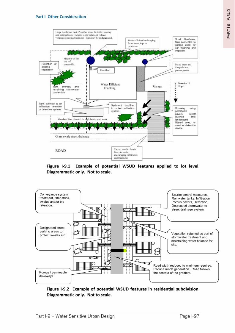
PA
RT
I-9
–W
SU
D
Part I Other Consideration
Part I-9 – Water Sensitive Urban Design Page I-97
Figure I-9.1 Example of potential WSUD features applied to lot level. Diagrammatic only. Not to scale.
Figure I-9.2 Example of potential WSUD features in residential subdivision. Diagrammatic only. Not to scale.
ROAD
Source control measures, Rainwater tanks, Infiltration, Porous pavers, Detention, Decreased stormwater to street drainage system.
Road width reduced to minimum required. Reduce runoff generation. Road follows the contour of the gradient.
Conveyance system treatment, filter strips, swales and/or bio retention.
Designated street parking areas to protect swales etc.
Porous / permeable driveways.
Vegetation retained as part of stormwater treatment and maintaining water balance for site.
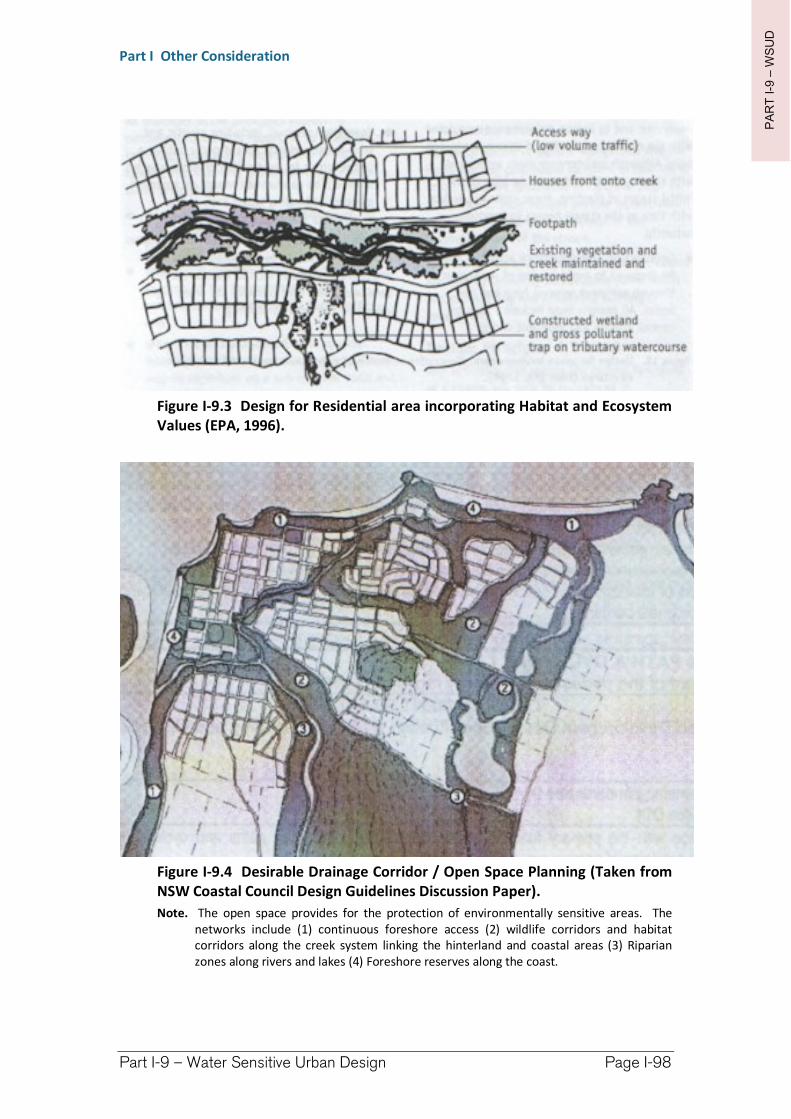
PA
RT
I-9
–W
SU
D
Part I Other Consideration
Part I-9 – Water Sensitive Urban Design Page I-98
Figure I-9.3 Design for Residential area incorporating Habitat and Ecosystem Values (EPA, 1996).
Figure I-9.4 Desirable Drainage Corridor / Open Space Planning (Taken from NSW Coastal Council Design Guidelines Discussion Paper).
Note. The open space provides for the protection of environmentally sensitive areas. The networks include (1) continuous foreshore access (2) wildlife corridors and habitat corridors along the creek system linking the hinterland and coastal areas (3) Riparian zones along rivers and lakes (4) Foreshore reserves along the coast.
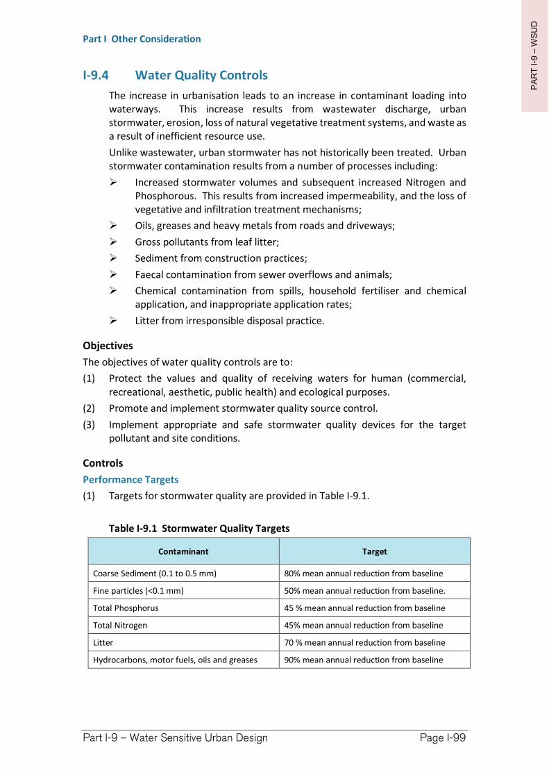
PA
RT
I-9
–W
SU
D
Part I Other Consideration
Part I-9 – Water Sensitive Urban Design Page I-99
I-9.4 Water Quality Controls
The increase in urbanisation leads to an increase in contaminant loading into waterways. This increase results from wastewater discharge, urban stormwater, erosion, loss of natural vegetative treatment systems, and waste as a result of inefficient resource use.
Unlike wastewater, urban stormwater has not historically been treated. Urban stormwater contamination results from a number of processes including:
Increased stormwater volumes and subsequent increased Nitrogen and Phosphorous. This results from increased impermeability, and the loss of vegetative and infiltration treatment mechanisms;
Oils, greases and heavy metals from roads and driveways;
Gross pollutants from leaf litter;
Sediment from construction practices;
Faecal contamination from sewer overflows and animals;
Chemical contamination from spills, household fertiliser and chemical application, and inappropriate application rates;
Litter from irresponsible disposal practice.
Objectives
The objectives of water quality controls are to:
(1) Protect the values and quality of receiving waters for human (commercial, recreational, aesthetic, public health) and ecological purposes.
(2) Promote and implement stormwater quality source control.
(3) Implement appropriate and safe stormwater quality devices for the target pollutant and site conditions.
Controls
Performance Targets
(1) Targets for stormwater quality are provided in Table I-9.1.
Table I-9.1 Stormwater Quality Targets
Contaminant Target
Coarse Sediment (0.1 to 0.5 mm) 80% mean annual reduction from baseline
Fine particles (<0.1 mm) 50% mean annual reduction from baseline.
Total Phosphorus 45 % mean annual reduction from baseline
Total Nitrogen 45% mean annual reduction from baseline
Litter 70 % mean annual reduction from baseline
Hydrocarbons, motor fuels, oils and greases 90% mean annual reduction from baseline
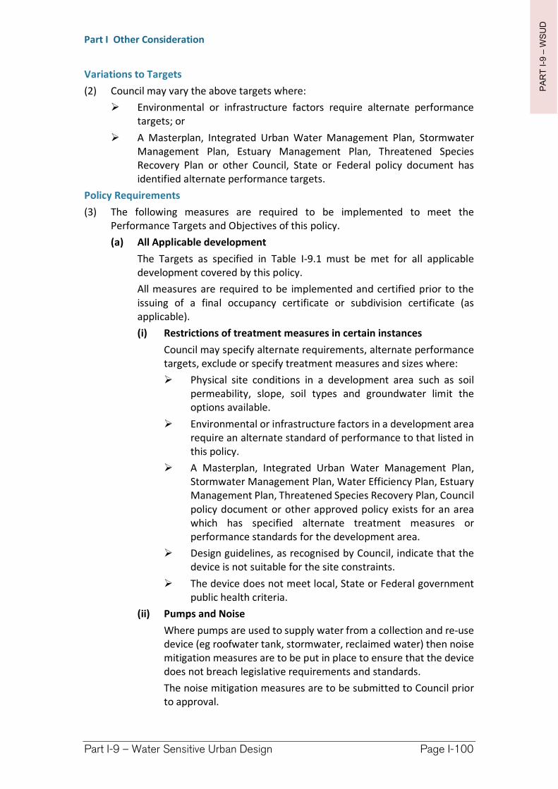
PA
RT
I-9
–W
SU
D
Part I Other Consideration
Part I-9 – Water Sensitive Urban Design Page I-100
Variations to Targets
(2) Council may vary the above targets where:
Environmental or infrastructure factors require alternate performance targets; or
A Masterplan, Integrated Urban Water Management Plan, Stormwater Management Plan, Estuary Management Plan, Threatened Species Recovery Plan or other Council, State or Federal policy document has identified alternate performance targets.
Policy Requirements
(3) The following measures are required to be implemented to meet the Performance Targets and Objectives of this policy.
(a) All Applicable development
The Targets as specified in Table I-9.1 must be met for all applicable development covered by this policy.
All measures are required to be implemented and certified prior to the issuing of a final occupancy certificate or subdivision certificate (as applicable).
(i) Restrictions of treatment measures in certain instances
Council may specify alternate requirements, alternate performance targets, exclude or specify treatment measures and sizes where:
Physical site conditions in a development area such as soil permeability, slope, soil types and groundwater limit the options available.
Environmental or infrastructure factors in a development area require an alternate standard of performance to that listed in this policy.
A Masterplan, Integrated Urban Water Management Plan, Stormwater Management Plan, Water Efficiency Plan, Estuary Management Plan, Threatened Species Recovery Plan, Council policy document or other approved policy exists for an area which has specified alternate treatment measures or performance standards for the development area.
Design guidelines, as recognised by Council, indicate that the device is not suitable for the site constraints.
The device does not meet local, State or Federal government public health criteria.
(ii) Pumps and Noise
Where pumps are used to supply water from a collection and re-use device (eg roofwater tank, stormwater, reclaimed water) then noise mitigation measures are to be put in place to ensure that the device does not breach legislative requirements and standards.
The noise mitigation measures are to be submitted to Council prior to approval.
PA
RT
I-9
–W
SU
D
Part I Other Consideration
Part I-9 – Water Sensitive Urban Design Page I-101
All connections to be undertaken by qualified plumber and electrician.
(iii) Stormwater Quality Improvement Devices (SQID)
The following measures apply to Stormwater Quality Improvement Devices implemented for any development:
The selection, installation and location of water quality treatment devices must take into account the ability to access, maintain and inspect the device in its operational condition by the householder, site owner, Council, private owner and/or regulatory authorities as applicable.
Natural treatment processes using filtration, infiltration and vegetation are to be adopted in preference to ‘hard” (eg concrete pre-fabricated) treatment measures where site, operational and maintenance conditions allow.
All treatment measures are to be designed, installed and maintained in accordance with Council, or relevant authority, requirements.
All SQIDs must have an overflow to the drainage system.
SQIDs must be designed by a suitably qualified person or body approved or recognised by Council.
Subdivision scale SQIDs are to be designed and sized in recognition of any lot level stormwater treatment and runoff volume reductions in place for the development area.
Subdivision scale SQIDs are to have access points for staff and vehicles to allow maintenance and inspection. If maintenance requires heavy vehicles then access must be provided so that machinery does not become bogged.
The type of SQID selected must be compatible with the vehicle, plant and/or machinery available in the area for maintenance.
Subdivision/streetscape scale SQID’s must be provided with a site plan showing access points for operation and maintenance of a type suitable for the vehicles required.
Where relevant SQID’s must be retained free of landscaping and overhead lines near the SQID to operate and manoeuvre maintenance machinery.
Where relevant SQID’s must have land retained near the SQID to dewater and stockpile material from de-sludging / de-silting, and vegetation harvesting maintenance if relevant for the types of SQID.
SQID’s, apart from conveyance controls, are to be off line from the man-made main drainage system unless there is no other option.
SQID’s are not to be located on any natural watercourse.
PA
RT
I-9
–W
SU
D
Part I Other Consideration
Part I-9 – Water Sensitive Urban Design Page I-102
SQID’s must be designed with the aim to blend into the surrounds and be aesthetically pleasing.
Systems are to be preferably “dry” systems (i.e. free draining system so pollutants can dry out, and therefore not stored in liquid) wherever possible. Wet sump systems are not preferred due to increased disposal and waste management costs.
An Operations and Maintenance manual is to be produced for each SQID where it will become a Council asset.
The justification for SQID selection will be required to be submitted by Council if a Stormwater Management Plan is required for the proposed development.
SQIDs which are to be handed over to Council and which cannot meet WHS criteria, such as minimising the risk of needle stick injury, enclosed space or manhandling, to Council’s satisfaction will not be approved.
The developer will be required to operate, monitor and pay for all expenses in relation to the SQID for a period of 6 months. At the end of the period the asset will be handed over to Council in its as “designed” state along with:
Invoices for all expenses incurred in that period from operations and maintenance.
Details of all monitoring results obtained during the six month period.
Details of all incidents including, but not limited to OHS & R incidents, public safety incidents, defects, repairs, failure of the system and complaints received whether related to the systems performance or other.
Three (3) copies of the Operations and Maintenance manual for the device/s.
(iv) Private SQID Requirements
Where a SQID is not a Council asset the following additional requirements apply:
Access to the device is to be available at all reasonable times for Council or relevant authority to inspect the device.
The operator of the SQID will be required to submit to Council annual returns and a fee for the licensing of the SQID.
The annual returns will consist of:
The name and address of the operator of the device.
The manufacturers name, type and location of the device.
The date/s maintenance was undertaken.
PA
RT
I-9
–W
SU
D
Part I Other Consideration
Part I-9 – Water Sensitive Urban Design Page I-103
The name of the person/company who undertook the disposal of the material.
The location of the waste disposal site.
An estimation on the volumes of material removed.
A description of the material disposed (eg wet liquid, dry material, predominately leaf litter and sand, predominately fast food waste etc).
Details of any amendments to the device (if applicable) and the reason for amendments.
Updated Operations and Maintenance manuals (if applicable).
(b) Additions & Change of use
The following requirements may also apply for additions and change of use:
(i) For Development Other Then Residential Development
If it cannot be demonstrated that a change of use or addition will not result in a significant increase to stormwater and/or pollution generation then Council may require:
measures to be incorporated to off-set any increase in stormwater and/or pollution generation.
a Stormwater Management Plan.
(ii) For Residential Development
Council may require measures to meet the requirements of a Threatened Species Recovery Plan, Integrated Urban Water Management Plan, Stormwater Management Plan, Master Plan or other Council, State or Federal policy where the addition or redevelopment may impinge upon the objectives and/or targets of that policy.
(c) Residential Dwellings/Dual Occupancies
The following additional requirements apply:
Residential lots and dual occupancies must meet targets through the implementation of measures as indicated in Table I-9.2.
(d) Subdivision, Commercial, Industrial, Tourism and Other Development to which this Policy Applies
The following additional requirements apply:
Development must demonstrate adherence to the objectives and targets of this policy by:
Undertaking a Stormwater Management Plan where requested.
Achieving water quality targets by utilising water quality treatment devices in a method consistent with the waste
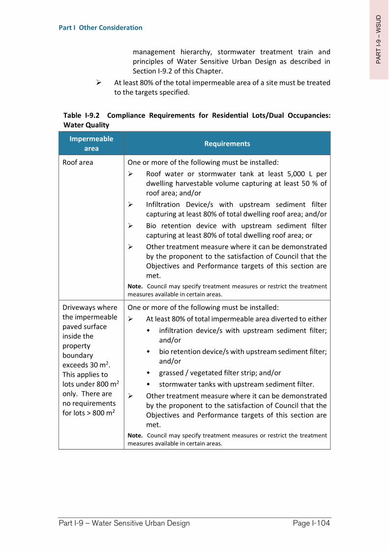
PA
RT
I-9
–W
SU
D
Part I Other Consideration
Part I-9 – Water Sensitive Urban Design Page I-104
management hierarchy, stormwater treatment train and principles of Water Sensitive Urban Design as described in Section I-9.2 of this Chapter.
At least 80% of the total impermeable area of a site must be treated to the targets specified.
Table I-9.2 Compliance Requirements for Residential Lots/Dual Occupancies: Water Quality
Impermeable area
Requirements
Roof area One or more of the following must be installed:
Roof water or stormwater tank at least 5,000 L per dwelling harvestable volume capturing at least 50 % of roof area; and/or
Infiltration Device/s with upstream sediment filter capturing at least 80% of total dwelling roof area; and/or
Bio retention device with upstream sediment filter capturing at least 80% of total dwelling roof area; or
Other treatment measure where it can be demonstrated by the proponent to the satisfaction of Council that the Objectives and Performance targets of this section are met.
Note. Council may specify treatment measures or restrict the treatment measures available in certain areas.
Driveways where the impermeable paved surface inside the property boundary exceeds 30 m2. This applies to lots under 800 m2
only. There are no requirements for lots > 800 m2
One or more of the following must be installed:
At least 80% of total impermeable area diverted to either
infiltration device/s with upstream sediment filter; and/or
bio retention device/s with upstream sediment filter; and/or
grassed / vegetated filter strip; and/or
stormwater tanks with upstream sediment filter.
Other treatment measure where it can be demonstrated by the proponent to the satisfaction of Council that the Objectives and Performance targets of this section are met.
Note. Council may specify treatment measures or restrict the treatment measures available in certain areas.
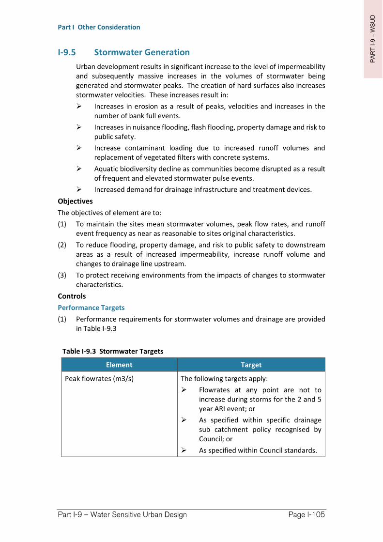
PA
RT
I-9
–W
SU
D
Part I Other Consideration
Part I-9 – Water Sensitive Urban Design Page I-105
I-9.5 Stormwater Generation
Urban development results in significant increase to the level of impermeability and subsequently massive increases in the volumes of stormwater being generated and stormwater peaks. The creation of hard surfaces also increases stormwater velocities. These increases result in:
Increases in erosion as a result of peaks, velocities and increases in the number of bank full events.
Increases in nuisance flooding, flash flooding, property damage and risk to public safety.
Increase contaminant loading due to increased runoff volumes and replacement of vegetated filters with concrete systems.
Aquatic biodiversity decline as communities become disrupted as a result of frequent and elevated stormwater pulse events.
Increased demand for drainage infrastructure and treatment devices.
Objectives
The objectives of element are to:
(1) To maintain the sites mean stormwater volumes, peak flow rates, and runoff event frequency as near as reasonable to sites original characteristics.
(2) To reduce flooding, property damage, and risk to public safety to downstream areas as a result of increased impermeability, increase runoff volume and changes to drainage line upstream.
(3) To protect receiving environments from the impacts of changes to stormwater characteristics.
Controls
Performance Targets
(1) Performance requirements for stormwater volumes and drainage are provided in Table I-9.3
Table I-9.3 Stormwater Targets
Element Target
Peak flowrates (m3/s) The following targets apply:
Flowrates at any point are not to increase during storms for the 2 and 5 year ARI event; or
As specified within specific drainage sub catchment policy recognised by Council; or
As specified within Council standards.
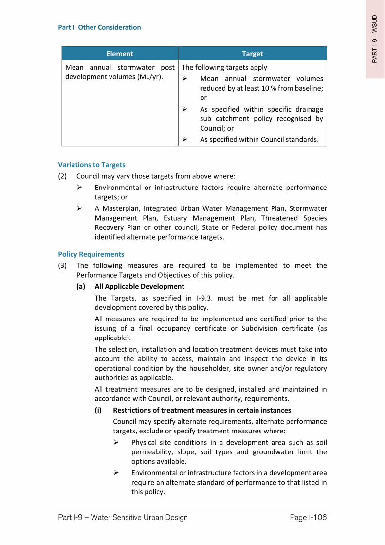
PA
RT
I-9
–W
SU
D
Part I Other Consideration
Part I-9 – Water Sensitive Urban Design Page I-106
Element Target
Mean annual stormwater post development volumes (ML/yr).
The following targets apply
Mean annual stormwater volumes reduced by at least 10 % from baseline; or
As specified within specific drainage sub catchment policy recognised by Council; or
As specified within Council standards.
Variations to Targets
(2) Council may vary those targets from above where:
Environmental or infrastructure factors require alternate performance targets; or
A Masterplan, Integrated Urban Water Management Plan, Stormwater Management Plan, Estuary Management Plan, Threatened Species Recovery Plan or other council, State or Federal policy document has identified alternate performance targets.
Policy Requirements
(3) The following measures are required to be implemented to meet the Performance Targets and Objectives of this policy.
(a) All Applicable Development
The Targets, as specified in I-9.3, must be met for all applicable development covered by this policy.
All measures are required to be implemented and certified prior to the issuing of a final occupancy certificate or Subdivision certificate (as applicable).
The selection, installation and location treatment devices must take into account the ability to access, maintain and inspect the device in its operational condition by the householder, site owner and/or regulatory authorities as applicable.
All treatment measures are to be designed, installed and maintained in accordance with Council, or relevant authority, requirements.
(i) Restrictions of treatment measures in certain instances
Council may specify alternate requirements, alternate performance targets, exclude or specify treatment measures where:
Physical site conditions in a development area such as soil permeability, slope, soil types and groundwater limit the options available.
Environmental or infrastructure factors in a development area require an alternate standard of performance to that listed in this policy.
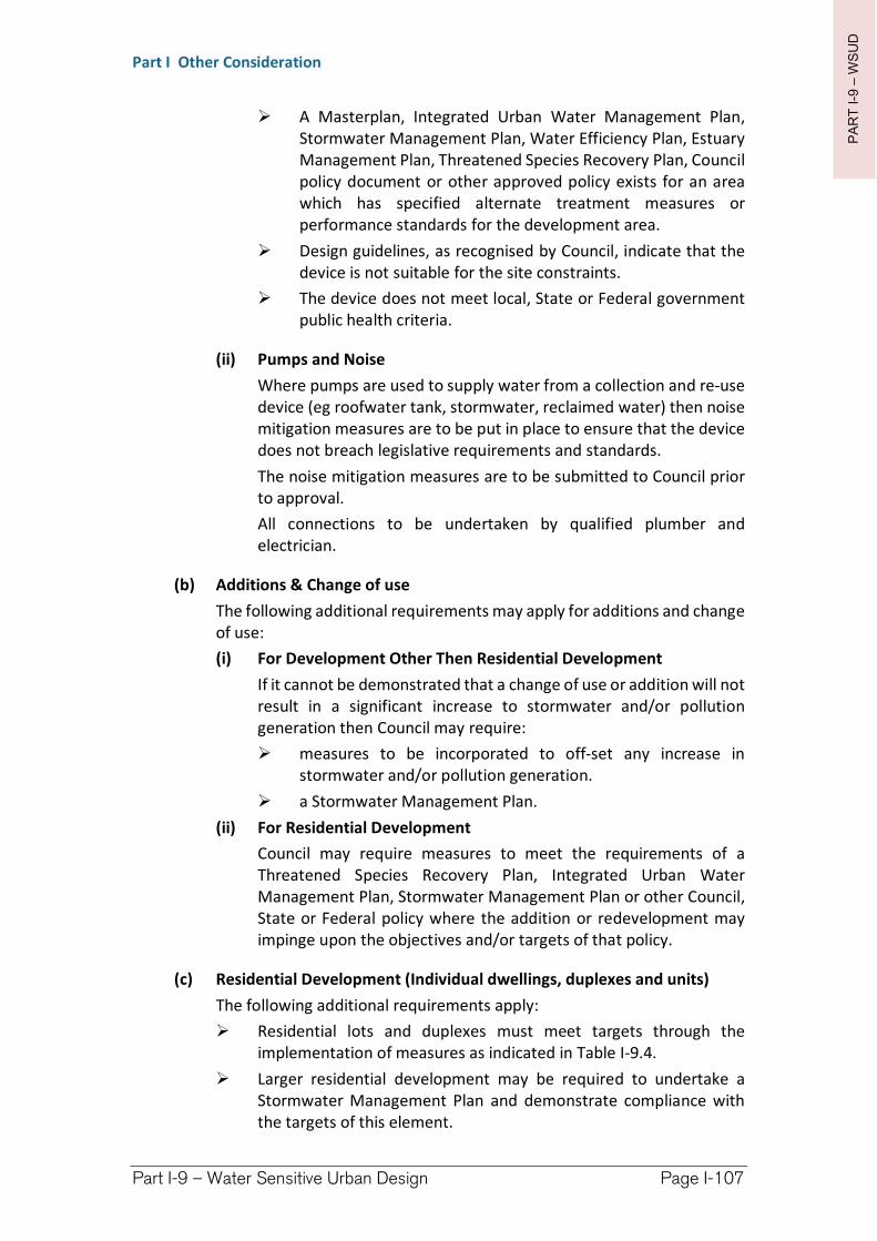
PA
RT
I-9
–W
SU
D
Part I Other Consideration
Part I-9 – Water Sensitive Urban Design Page I-107
A Masterplan, Integrated Urban Water Management Plan, Stormwater Management Plan, Water Efficiency Plan, Estuary Management Plan, Threatened Species Recovery Plan, Council policy document or other approved policy exists for an area which has specified alternate treatment measures or performance standards for the development area.
Design guidelines, as recognised by Council, indicate that the device is not suitable for the site constraints.
The device does not meet local, State or Federal government public health criteria.
(ii) Pumps and Noise
Where pumps are used to supply water from a collection and re-use device (eg roofwater tank, stormwater, reclaimed water) then noise mitigation measures are to be put in place to ensure that the device does not breach legislative requirements and standards.
The noise mitigation measures are to be submitted to Council prior to approval.
All connections to be undertaken by qualified plumber and electrician.
(b) Additions & Change of use
The following additional requirements may apply for additions and change of use:
(i) For Development Other Then Residential Development
If it cannot be demonstrated that a change of use or addition will not result in a significant increase to stormwater and/or pollution generation then Council may require:
measures to be incorporated to off-set any increase in stormwater and/or pollution generation.
a Stormwater Management Plan.
(ii) For Residential Development
Council may require measures to meet the requirements of a Threatened Species Recovery Plan, Integrated Urban Water Management Plan, Stormwater Management Plan or other Council, State or Federal policy where the addition or redevelopment may impinge upon the objectives and/or targets of that policy.
(c) Residential Development (Individual dwellings, duplexes and units)
The following additional requirements apply:
Residential lots and duplexes must meet targets through the implementation of measures as indicated in Table I-9.4.
Larger residential development may be required to undertake a Stormwater Management Plan and demonstrate compliance with the targets of this element.
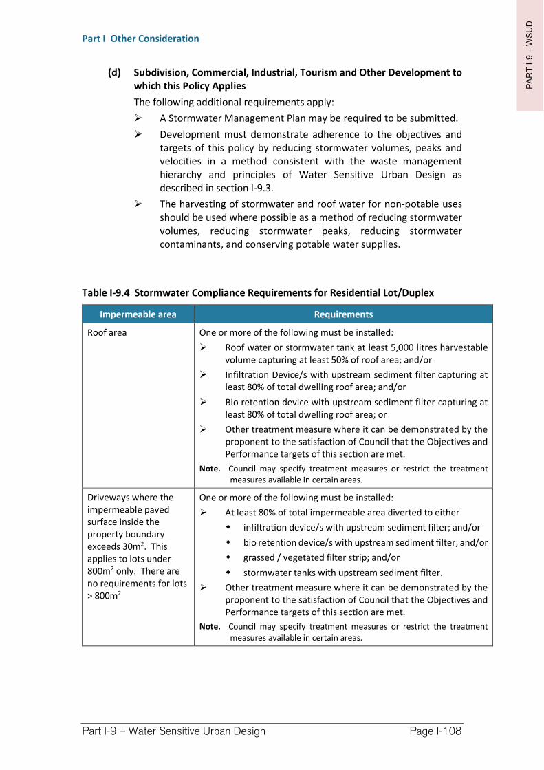
PA
RT
I-9
–W
SU
D
Part I Other Consideration
Part I-9 – Water Sensitive Urban Design Page I-108
(d) Subdivision, Commercial, Industrial, Tourism and Other Development to which this Policy Applies
The following additional requirements apply:
A Stormwater Management Plan may be required to be submitted.
Development must demonstrate adherence to the objectives and targets of this policy by reducing stormwater volumes, peaks and velocities in a method consistent with the waste management hierarchy and principles of Water Sensitive Urban Design as described in section I-9.3.
The harvesting of stormwater and roof water for non-potable uses should be used where possible as a method of reducing stormwater volumes, reducing stormwater peaks, reducing stormwater contaminants, and conserving potable water supplies.
Table I-9.4 Stormwater Compliance Requirements for Residential Lot/Duplex
Impermeable area Requirements
Roof area One or more of the following must be installed:
Roof water or stormwater tank at least 5,000 litres harvestable volume capturing at least 50% of roof area; and/or
Infiltration Device/s with upstream sediment filter capturing at least 80% of total dwelling roof area; and/or
Bio retention device with upstream sediment filter capturing at least 80% of total dwelling roof area; or
Other treatment measure where it can be demonstrated by the proponent to the satisfaction of Council that the Objectives and Performance targets of this section are met.
Note. Council may specify treatment measures or restrict the treatment measures available in certain areas.
Driveways where the impermeable paved surface inside the property boundary exceeds 30m2. This applies to lots under 800m2 only. There are no requirements for lots > 800m2
One or more of the following must be installed:
At least 80% of total impermeable area diverted to either
infiltration device/s with upstream sediment filter; and/or
bio retention device/s with upstream sediment filter; and/or
grassed / vegetated filter strip; and/or
stormwater tanks with upstream sediment filter.
Other treatment measure where it can be demonstrated by the proponent to the satisfaction of Council that the Objectives and Performance targets of this section are met.
Note. Council may specify treatment measures or restrict the treatment measures available in certain areas.
PA
RT
I-9
–W
SU
D
Part I Other Consideration
Part I-9 – Water Sensitive Urban Design Page I-109
Infiltration and detention should be encouraged within the design. Measures may include, but are not limited to:
Hard areas such as roads and streetscape parking areas can be designed so as to detain stormwater to decrease flow peaks.
Open space areas, such as parks and landscaped areas, should be provided with a dual function to infiltrate and detain stormwater whilst incorporating public safety considerations.
The sites natural infiltration and detention features should be utilised where practical. This includes retaining key vegetation features to slow down water movement.
Infiltration and detention should be used in the conveyance system where possible.
Using driveways and culverts as check dams may slow down stormwater in the conveyance system and encourage infiltration.
Infiltration, retention and detention system should be designed with dual purpose where possible. When implementing dual purpose adequate controls and signage must be provided to protect public safety. Examples of dual purpose include, but are not limited to:
Sports fields and detention areas.
Landscaping and infiltration areas, detention, retention ponds.
Car park areas and detention.
Open space, parkland and infiltration, detention areas and ponds.
The creation of impermeable area and increases to stormwater generation should be reduced as much as practical. Measures may include, but are not limited to:
Road widths should be kept to the minimum required by Council specifications.
Porous/ permeable pavers should be used where site conditions allow for pedestrian, light vehicles traffic areas, street car parking and footpaths.
Using natural drainage designs and existing site features instead of piped and concreted drainage features where site conditions allow.
Develop a train of stormwater treatment from the lot level to street system to discharge from the development.
Increases to stormwater velocities via concentration and channelling of flow should be avoided as much as practical. Measures may include, but are not limited to:
Allowing stormwater to sheet flow over vegetated filter strips to encourage infiltration, decrease velocities and treatment before entry into the conveyance system.
PA
RT
I-9
–W
SU
D
Part I Other Consideration
Part I-9 – Water Sensitive Urban Design Page I-110
Use natural drainage designs and existing site features instead of piped and concreted drainage features, where site conditions allow, reducing stormwater velocities and encouraging infiltration.
Streets should be designed so that they run parallel to the gradient of slopes where practical. Having long sections of street running directly down a slope should be avoided where practical.
Significant topographical features, vegetation features and natural drainage features should be retained where possible.
Energy dissipaters should be provided at the outlets from all formed drainage systems where an outlet exits to a water body, dunal system, bushland, area of erosive soils, bio retention device, grass swale, infiltration area, wetland, vegetated filter strip or other easily disturbed environment.
I-9.6 Riparian areas, Habitat corridors, Vegetation and Landform
(1) One of the key features of Water Sensitive Urban Design is to retain existing vegetation and landform features. This assists in reducing the impacts of flooding in urban areas by providing storage. Vegetation corridors assist in infiltrating, detaining and treating stormwater, maintaining water balance and providing aesthetics. Riparian vegetation in particular plays a crucial role in treating overland flow. The retention of vegetation along waterways and maintenance of habitat corridors is critical to maintaining biodiversity. Providing links allows flora and fauna to move through area’s preventing localised extinctions.
The maintenance of an area’s landform is also important. Cut and fill at the lot level increases soil disturbance and increases the likelihood of erosion and sedimentation. Alteration of the sites topography also results in changes to overland flow paths, increases the risk of nuisance flooding to downstream and neighbouring properties, and in a worse case may contribute to destabilising an area.
(2) Objectives
The objectives of element are to:
To maintain habitat connectivity for critical areas and species.
To reduce declines in biodiversity.
To maintain vegetation this may assist in treating stormwater and providing habitat.
To undertake revegetation in a manner so as to maintain habitat connectivity.
To reduce erosion and sedimentation as a result of site destabilisation from cut and fill.
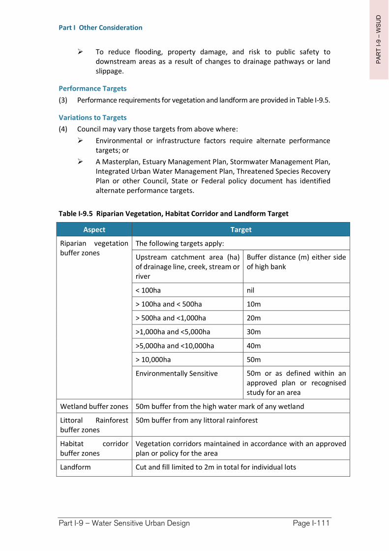
PA
RT
I-9
–W
SU
D
Part I Other Consideration
Part I-9 – Water Sensitive Urban Design Page I-111
To reduce flooding, property damage, and risk to public safety to downstream areas as a result of changes to drainage pathways or land slippage.
Performance Targets
(3) Performance requirements for vegetation and landform are provided in Table I-9.5.
Variations to Targets
(4) Council may vary those targets from above where:
Environmental or infrastructure factors require alternate performance targets; or
A Masterplan, Estuary Management Plan, Stormwater Management Plan, Integrated Urban Water Management Plan, Threatened Species Recovery Plan or other Council, State or Federal policy document has identified alternate performance targets.
Table I-9.5 Riparian Vegetation, Habitat Corridor and Landform Target
Aspect Target
Riparian vegetation buffer zones
The following targets apply:
Upstream catchment area (ha) of drainage line, creek, stream or river
Buffer distance (m) either side of high bank
< 100ha nil
> 100ha and < 500ha 10m
> 500ha and <1,000ha 20m
>1,000ha and <5,000ha 30m
>5,000ha and <10,000ha 40m
> 10,000ha 50m
Environmentally Sensitive 50m or as defined within an approved plan or recognised study for an area
Wetland buffer zones 50m buffer from the high water mark of any wetland
Littoral Rainforest buffer zones
50m buffer from any littoral rainforest
Habitat corridor buffer zones
Vegetation corridors maintained in accordance with an approved plan or policy for the area
Landform Cut and fill limited to 2m in total for individual lots
PA
RT
I-9
–W
SU
D
Part I Other Consideration
Part I-9 – Water Sensitive Urban Design Page I-112
Policy Requirements
(5) The following measures are required to be implemented to meet the Performance Targets and Objectives of this policy.
Cut and fill is restricted to the targets of this policy.
Buffer zones are to be left undisturbed in accordance with the targets of this policy.
Where possible street and lot layout should be undertaken so that habitat is retained and connected to remnant habitat in adjoining areas outside of the immediate boundaries of the proposed development.
Vegetation and topography should be retained along the sites natural drainage lines to a width of at least 5m either side of the mean water mark.
Council may require reinstatement of riparian vegetation where identified by an existing policy, approved masterplan, estuary management plan, threatened species recovery plan, or in or neighbouring an environmentally sensitive area.
Species selection for landscaping and vegetation reinstatement should be locally endemic species and ideally utilising seed stock from the area.
The retention or reinstatement of vegetation and provision habitat connectivity should be undertaken with dual purpose such as park space, detention / infiltration basins, water treatment (filter strip) as appropriate.
Landscaping and vegetation reinstatement should be undertaken to provide habitat connectivity with remnant vegetation in adjoining areas, outside the boundaries of the development area, where possible.
I-9.7 Construction, Erosion and Sediment Control
(1) The construction/building phase can deliver significant impacts on the environment predominantly through the physical removal of vegetation and disturbance of soil. Of-site environmental impacts may also result due to the inappropriate storage of machinery, materials and waste products. Compaction of infiltration areas may result due to vehicles traversing an area. Streambank and/or habitat disturbance may result with the inappropriate removal of vegetation and failure to prevent access to easily disturbed areas. The staging and planning of construction and building works is imperative for successful sediment and erosion control and site rehabilitation.
(2) Objectives
To protect water quality from impacts during the construction phase.
To protect key vegetation during the construction phase.
To protect the site’s natural properties, such as soil permeability, from compaction.
To ensure construction waste is managed appropriately.
To stage ground disturbance and progressively revegetate the site to reduce the area contributing sediment.
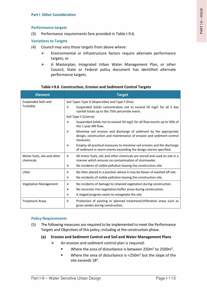
PA
RT
I-9
–W
SU
D
Part I Other Consideration
Part I-9 – Water Sensitive Urban Design Page I-113
Performance targets
(3) Performance requirements fare provided in Table I-9.6.
Variations to Targets
(4) Council may vary those targets from above where:
Environmental or infrastructure factors require alternate performance targets; or
A Masterplan, Integrated Urban Water Management Plan, or other Council, State or Federal policy document has identified alternate performance targets.
Table I-9.6 Construction, Erosion and Sediment Control Targets
Element Target
Suspended Soils and Turbidity
Soil Types Type D (dispersible) and Type F (fine)
Suspended Solids concentration not to exceed 50 mg/L for all 5 day rainfall totals up to the 75th percentile event.
Soil Type C (Coarse)
Suspended Solids not to exceed 50 mg/L for all flow events up to 50% of the 1 year ARI flow.
Minimise soil erosion and discharge of sediment by the appropriate design, construction and maintenance of erosion and sediment control measures.
Employ all practical measures to minimise soil erosion and the discharge of sediment in storm events exceeding the design storms specified.
Motor fuels, oils and other chemicals
All motor fuels, oils and other chemicals are stored and used on site in a manner which ensures no contamination of stormwater.
No incidents of visible pollution leaving the construction site.
Litter No litter placed in a position where it may be blown of washed off site.
No incidents of visible pollution leaving the construction site.
Vegetation Management No incidents of damage to retained vegetation during construction.
No incursion into vegetation buffer areas during construction.
A staged program exists to revegetate the site.
Treatment Areas Protection of existing or planned treatment/infiltration areas such as grass swales during construction.
Policy Requirements
(5) The following measures are required to be implemented to meet the Performance Targets and Objectives of this policy, including at the construction phase.
(a) Erosion and Sediment Control and Soil and Water Management Plans
An erosion and sediment control plan is required:
Where the area of disturbance is between 250m2 to 2500m2.
Where the area of disturbance is <250m2 but the slope of the site exceeds 18o.
PA
RT
I-9
–W
SU
D
Part I Other Consideration
Part I-9 – Water Sensitive Urban Design Page I-114
A Soil and Water Management Plan is required where the area of soil disturbance >2,500m2.
(b) Erosion and Sediment Control
All erosion and sediment control measures are to be installed prior to the commencement of any work, including cutting and filling.
All sediment control measures are to be constructed to prevent sediment from leaving the site or entering downstream properties, drainage lines or watercourses.
Disturbance of the site must only occur on areas indicated in the approved plans.
A sediment control fence must be installed at the downslope perimeter of the disturbed area to prevent sediment and other debris from leaving the site.
Direct up slope runoff around the site, by use of a diversion bank or channels. These devices may require measures to control erosion depending on the volume of flow anticipated.
When roof structures and piped or artificial stormwater systems are in place, discharge water is to be managed in a manner that reduces the likelihood of erosion. On completion of the roof area of a building, guttering and downpipes are to be connected to the stormwater system.
The stormwater system must prevent sediment from being eroded from the site and deposited downstream.
All erosion and sediment control measures are to be regularly maintained in good working order at all times and inspected for adequacy following any rainfall event.
All disturbed areas are to be made erosion resistant by revegetation, turfing or stabilised by paving on completion of the works.
(c) Stockpiles, storage and waste management
Stockpiles of erodible materials (sand, soil, spoil and vegetation) must be protected by a sediment fence or bund and temporary cover such as a tarp of vegetated if the stockpile will be stored on site for an extended period of time.
No construction materials, building materials, fill material, chemicals, waste, bins, skips or other, are to be stored either in the gutter, footpath, drainage line or outside of the site boundary.
Petroleum and other chemical products must be prevented from entering the stormwater system or contaminating the soil.
Impervious bunds must be constructed around all fuel, oil or chemical storage areas with an enclosed volume large enough to contain 110% of the volume held in the largest tank.
Waste on site is to be stored in a manner which:
Prevents rainwater entry.
PA
RT
I-9
–W
SU
D
Part I Other Consideration
Part I-9 – Water Sensitive Urban Design Page I-115
Has stormwater diverted around it to prevent contamination of surface waters.
Prevents windblown litter from escaping.
Adequate trade waste and litter bins must be provided onsite and serviced regularly.
Concrete wastes or washings from concrete mixers must not be deposited in any location where those wastes or washings can flow, or can be washed into any areas of retained vegetation or receiving waters.
(d) Vehicle access
For individual dwellings vehicular access is to be restricted to one stabilised access point. Location will be identified on the Erosion and Sediment Control Plan submitted to Council.
For larger Subdivision works vehicular access must be confined to a maximum of two locations or as agreed with Council. Such locations will be shown on the Soil and Water Management Plan or Erosion and Sediment Control Plan.
Access to construction sites of 1 hectare or more, shall be fitted with a shakedown device.
The shakedown device shall be located along the haul route, immediately before the intersection with the public road.
Regular maintenance of shake down devices is required to ensure no material is deposited on public roads.
Should material be deposited on any public street, it shall be swept up and removed before the end of that working day.
If after using shakedown device, material is still adhering to truck wheels and being deposited on public roads, a wheel washing device must be installed and used at site exit locations to ensure no further material is carted off site and deposited on public roads.
Runoff from access surfaces must be drained into an adjacent sediment trapping device before leaving the site. Where appropriate, devices to remove soil particles from vehicles must be placed at site exit locations.
On subdivision work, priority must be given to road and shoulder stabilisation based on erosion hazards.
On subdivision work newly sealed hard stand areas must be swept thoroughly after sealing/surfacing to prevent excess aggregate or gravel entering street drains.
(e) Protection of Stormwater Treatment Areas and Existing Infrastructure
Existing or planned stormwater treatment areas such as Infiltration, grass swale or bio filtration areas are to be clearly marked and identified as no go areas. No materials are to be stockpiled in these areas. Vehicles are not to traverse the area or be parked in the area.
PA
RT
I-9
–W
SU
D
Part I Other Consideration
Part I-9 – Water Sensitive Urban Design Page I-116
The site should be kept free from heavy pedestrian use to maintain infiltration properties.
The footpath or nature strip adjoining construction and building sites must not be disturbed by construction activities other than shown on the plan for:
access to the site;
installation of services;
other works specifically approved by Council.
(f) Vegetation Removal and Protection
No vegetation is to be removed prior to approval of Council to start work on any stage, and not before the approved sediment control measures are in place.
Vegetation removal is to be staged to avoid the complete removal of vegetation on site, and allow the regeneration of vegetation cover.
For Subdivision works a plan must be undertaken which shows the staging of vegetation removal, vegetation retention, “no go” areas and regeneration works.
The removal or disturbance of native trees, shrubs and ground covers shall be minimised.
Vegetation which is to remain on site is to be clearly marked and fenced off. The immediate area around vegetation to be retained is to be kept free of vehicle storage, vehicle thoroughfare and material storage.
Retained vegetation and buffers must be protected by a suitable fence barrier. Fenced areas shall be clearly signposted “No Access Area”.
Where practical vegetative debris must be salvaged either as logs or woodchip for later reuse to control erosion or to rehabilitate the site. Non salvageable material, such as stumps and roots, may be removed.
Water body buffer zones are to be clearly marked and identified as no go areas. No materials are to be stockpiled in buffer zones. Vehicles are not to traverse or be parked in the buffer zone. The site should be kept free from pedestrian use.
Richmond Valley Development Control Plan 2021
Part I-10 Crime Prevention through Environmental Design—CPTED
Crime Prevention through Environmental Design (CPTED) utilises crime prevention strategies that focus on planning, design and structure of individual development which ultimately promote safer towns and neighbourhoods. CPTED serves to implement design and place management principles to reduce the likelihood essential crime ingredients from intersecting in the built environment; offenders, potential victims/ targets and opportunities. The following section of the DCP is adapted from Safer by Design guidelines provided by the NSW Police Force.
This section provides more detail than those provided elsewhere within the DCP however comprehensive guidelines should be sought from the NSW Police Force. The general principles contained here and in the publications listed below should be used to provide guidance when preparing and assessing more comprehensive developments within Richmond Valley. It is unlikely minor developments such as single dwellings and dual-occupancies will require more than those provided within the relevant DCP sections for those purposes, however larger developments will require more detailed guideline adherence and may require referral to the Police for comment.
The NSW Police assessment tools Safer By Design Evaluation and a Companion to the Safer By Design Evaluation are based upon Australian Risk Management Standard 4360:1999. The Safer By Design Evaluationprocess that identifies and quantifies crime hazards and location risk. The evaluation measures include crime likelihood (statistical probability), consequence (crime outcome), distributions of reported crime (hotspot analysis), socio-economic conditions (relative disadvantage), situational hazards and crime opportunity.
This DCP applies to all land within the Richmond Valley Local Government Area.
Date adopted by Council: 22/06/2021
Effective Date: 01/08/2021
Amendments: Nil
PA
RT
I-1
0–
CP
TE
D
Part I Other Consideration
Part I-10 – Crime Prevention Through Environmental Design Page I-118
I-10.1 General Objectives
CPTED generally tries to minimise crime opportunities by:
(1) Maximising risks to offenders (increasing the likelihood of detection, challenge and apprehension);
(2) Maximising the efforts required to commit crime (increasing the time, energy and resources required to commit crime);
(3) Minimising the actual and perceived benefits of crime (removing, minimising or concealing crime attractors and rewards); and
(4) Minimising excuse making opportunities (removing conditions that encourage/facilitate rationalisation of inappropriate behaviour).
I-10.2 CPTED Principles
Territorial Reinforcement
(1) Community ownership of public space sends positive signals to the community. Places that feel owned and cared for are likely to be used, enjoyed and revisited. People who have guardianship or ownership of areas are more likely to provide effective supervision and to intervene in crime than passing strangers and criminals rarely commit crime in areas where the risk of detection and challenge are high. Effective guardians are often ordinary people who are spatially ‘connected’ to a place and feel an association with, or responsibility for it.
Territorial Re-enforcement uses actual and symbolic boundary markers, spatial legibility and environmental cues to ‘connect’ people with space, to encourage communal responsibility for public areas and facilities, and to communicate to people where they should/should not be and what activities are appropriate.
Surveillance
(2) People feel safe in public areas when they can see and interact with others, particularly people connected with that space, such as shopkeepers or adjoining residents. Criminals are often deterred from committing crime in places that are well supervised.
Natural surveillance is achieved when normal space users can see and be seen by others. This highlights the importance of building layout, orientation and location; the strategic use of design; landscaping and lighting – it is a by-product of well-planned, well-designed and well-used space.
Technical/mechanical surveillance is achieved through mechanical/electronic measures such as CCTV, help points and mirrored building panels. It is commonly used as a ‘patch’ to supervise isolated, high risk locations.
PA
RT
I-1
0–
CP
TE
D
Part I Other Consideration
Part I-10 – Crime Prevention Through Environmental Design Page I-119
Formal (or Organised) surveillance is achieved through the tactical positioning of guardians. An example would be the use of on-site supervisors, e.g. security guards at higher risk locations.
Access Control
(3) Access control treatments restrict, channel and encourage people and vehicles into, out of and around the development. Way-finding, desire-lines and formal/informal routes are important crime prevention considerations. Effective access control can be achieved by using physical and symbolic barriers that channel and group pedestrians into areas, therefore increasing the time and effort required for criminals to commit crime.
Natural access control includes the tactical use of landforms and waterways features, design measures including building configuration; formal and informal pathways, landscaping, fencing and gardens.
Technical/Mechanical access control includes the employment of security hardware. Crime, Design and Urban Planning: From theory to Practice Formal (or Organised) access control includes on-site guardians such as employed security officers.
Formal (or Organised) access control includes on-site guardians such as employed security officers.
Space/Activity Management
(4) Space/Activity Management strategies are an important way to develop and maintain natural community control. Space management involves the formal supervision, control and care of the development. All space, even well planned and well-designed areas need to be effectively used and maintained to maximise community safety. Places that are infrequently used are commonly abused. There is a high correlation between urban decay, fear of crime and avoidance behaviour.
I-10.3 Design standards/controls
Developments which require CPTED Principles to be applied
(1) This plan applies to all land in the Richmond Valley Local Government Area. Applicants are advised to contact our Development Assessment staff to clarify whether this plan will apply in their specific situation. If it does, the Statement of Environmental Effects and site analysis that accompany the development application should address this plan. A security management plan may be required to be submitted with the development application. The security management plan should set out all relevant methods to be used to prevent crime and improve safety of the development.
The following types of development proposals are required to be referred to the NSW Police Force for comment. The following list is not comprehensive, and the decision as to whether a proposed development is required to be submitted for police comment lies with the consent authority.
Multiple units, townhouse/villa developments (20 or more)
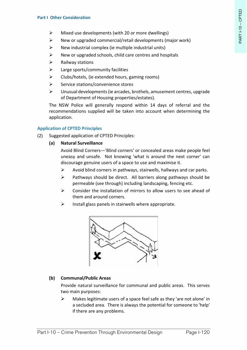
PA
RT
I-1
0–
CP
TE
D
Part I Other Consideration
Part I-10 – Crime Prevention Through Environmental Design Page I-120
Mixed use developments (with 20 or more dwellings)
New or upgraded commercial/retail developments (major work)
New industrial complex (ie multiple industrial units)
New or upgraded schools, child care centres and hospitals
Railway stations
Large sports/community facilities
Clubs/hotels, (ie extended hours, gaming rooms)
Service stations/convenience stores
Unusual developments (ie arcades, brothels, amusement centres, upgrade of Department of Housing properties/estates).
The NSW Police will generally respond within 14 days of referral and the recommendations supplied will be taken into account when determining the application.
Application of CPTED Principles
(2) Suggested application of CPTED Principles:
(a) Natural Surveillance
Avoid Blind Corners—'Blind corners' or concealed areas make people feel uneasy and unsafe. Not knowing 'what is around the next corner' can discourage genuine users of a space to use and maximise it.
Avoid blind corners in pathways, stairwells, hallways and car parks.
Pathways should be direct. All barriers along pathways should be permeable (see through) including landscaping, fencing etc.
Consider the installation of mirrors to allow users to see ahead of them and around corners.
Install glass panels in stairwells where appropriate.
(b) Communal/Public Areas
Provide natural surveillance for communal and public areas. This serves two main purposes:
Makes legitimate users of a space feel safe as they 'are not alone' in a secluded area. There is always the potential for someone to 'help' if there are any problems.
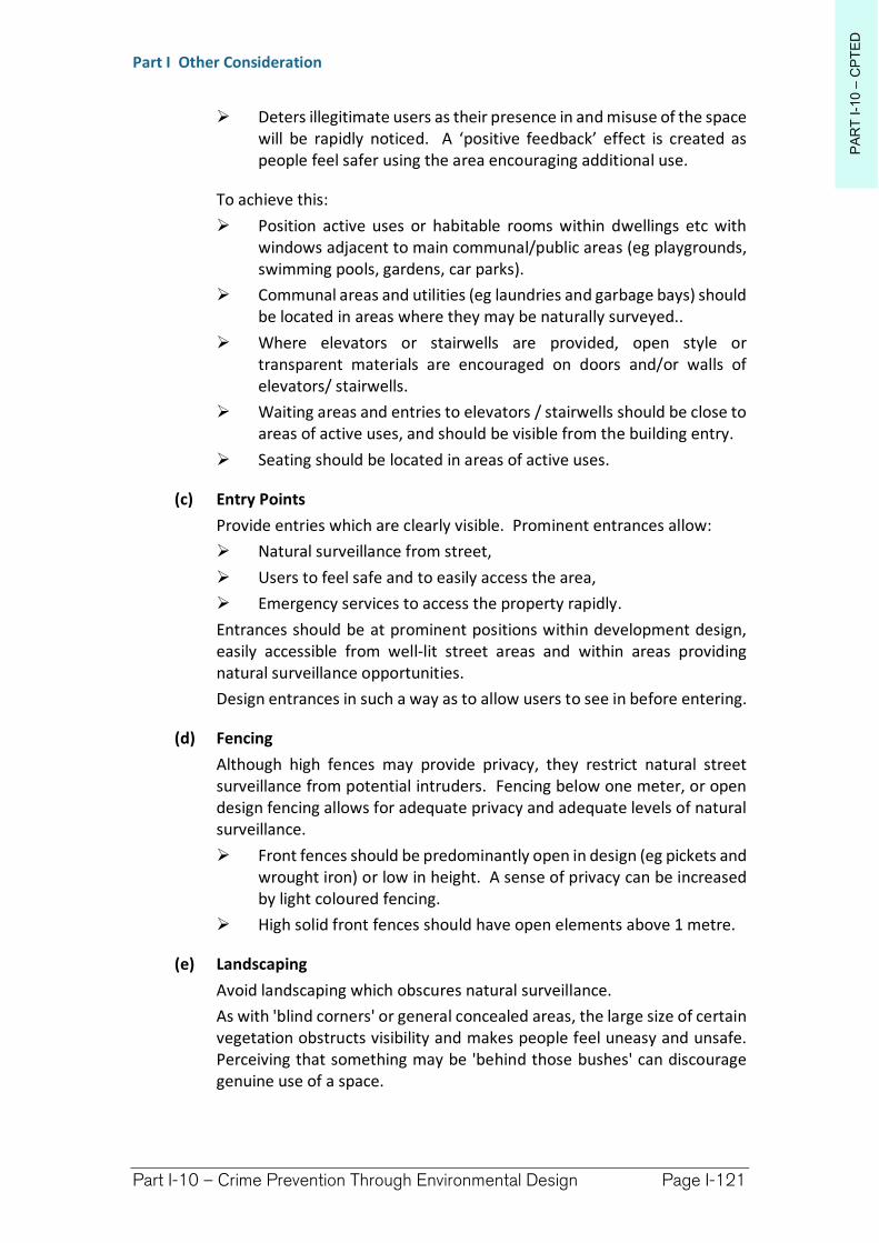
PA
RT
I-1
0–
CP
TE
D
Part I Other Consideration
Part I-10 – Crime Prevention Through Environmental Design Page I-121
Deters illegitimate users as their presence in and misuse of the space will be rapidly noticed. A ‘positive feedback’ effect is created as people feel safer using the area encouraging additional use.
To achieve this:
Position active uses or habitable rooms within dwellings etc with windows adjacent to main communal/public areas (eg playgrounds, swimming pools, gardens, car parks).
Communal areas and utilities (eg laundries and garbage bays) should be located in areas where they may be naturally surveyed..
Where elevators or stairwells are provided, open style or transparent materials are encouraged on doors and/or walls of elevators/ stairwells.
Waiting areas and entries to elevators / stairwells should be close to areas of active uses, and should be visible from the building entry.
Seating should be located in areas of active uses.
(c) Entry Points
Provide entries which are clearly visible. Prominent entrances allow:
Natural surveillance from street,
Users to feel safe and to easily access the area,
Emergency services to access the property rapidly.
Entrances should be at prominent positions within development design, easily accessible from well-lit street areas and within areas providing natural surveillance opportunities.
Design entrances in such a way as to allow users to see in before entering.
(d) Fencing
Although high fences may provide privacy, they restrict natural street surveillance from potential intruders. Fencing below one meter, or open design fencing allows for adequate privacy and adequate levels of natural surveillance.
Front fences should be predominantly open in design (eg pickets and wrought iron) or low in height. A sense of privacy can be increased by light coloured fencing.
High solid front fences should have open elements above 1 metre.
(e) Landscaping
Avoid landscaping which obscures natural surveillance.
As with 'blind corners' or general concealed areas, the large size of certain vegetation obstructs visibility and makes people feel uneasy and unsafe. Perceiving that something may be 'behind those bushes' can discourage genuine use of a space.
PA
RT
I-1
0–
CP
TE
D
Part I Other Consideration
Part I-10 – Crime Prevention Through Environmental Design Page I-122
Avoid medium height vegetation with concentrated top to bottom foliage. Plants such as low hedges and shrubs (1 to 1.2m high), creepers, ground covers or high canopied vegetation are good for natural surveillance.
Trees with dense low growth foliage should be spaced or have the crown raised to avoid a continuous barrier.
Use low ground cover or high canopied trees, clean trunked to a height of 2 metres around children's play areas, car parks and along pedestrian pathways
Avoid vegetation that conceals the building entrance from the street.
(f) Lighting
Adequate lighting is essential in making people feel safe and in deterring illegitimate users. Good lighting design should;
Allow people to be able to see ahead progressively into areas along paths and accessways,
(ii) Encourages legitimate users to use a facility after daylight hours with the result their presence will deter potential illegitimate users,
Facilitates formal surveillance (by Police or security patrols).
Care should be taken to ensure lighting does not produce glare or dark shadows. Entrances, exits, service areas, pathways, car parks etc. should be well lit after dark when they are likely to be used.
Use diffused flood lights and/or movement sensitive lights.
Direct these lights towards access / egress routes to illuminate potential offenders, rather than towards buildings or resident observation points.
Lighting should have a wide beam of illumination, which reaches to the beam of the next light, or the perimeter of the site or area being traversed. Avoid lighting spillage onto neighbouring properties as this can cause nuisance and reduce opportunities for natural surveillance.
PA
RT
I-1
0–
CP
TE
D
Part I Other Consideration
Part I-10 – Crime Prevention Through Environmental Design Page I-123
As a guide, the areas should be lit to enable users to identify a face 15m away.
Use energy efficient lamps /fittings /switches to save energy.
(g) Mixed Land Uses
Mixed land uses allow for natural surveillance of areas across a range of hours and times (ie weekday or weekend, AM or PM). To the extent that all other provisions within this DCP allow, mixed land uses offer a way of ensuring surveillance of an area will promote increased use and security.
Locate shops and businesses on lower floors and residences on upper floors. In this way, residents can observe the businesses after hours while the residences can be observed by the businesses during business hours.
Incorporate car wash services, taxi ranks, bus shelters, kiosks and other food vendors within car parks.
Include kiosks, food vendors and restaurants within parks.
Refer to the relevant planning instruments, public land registers and Plans of Management for permissible uses within areas to promote increased surveillance and use.
(h) Security
Traditional security related equipment will help make a space more difficult for intruders to break into, however its overuse may impinge on adequate levels of natural surveillance.
Security grilles and security doors should be permeable (see through).
Avoid solid shutters on front windows and doors.
Security grilles, shutters and doors should allow natural observation of the street and be sympathetic to the architectural style of the building.
(i) Building Identification
Clear building identification prevents unintended access and assists persons trying to find the building - particularly emergency vehicles in an urgent situation.
Street numbers should be at least 7cm high, and positioned between 0.6m and 1.5m above ground level on the street frontage.
Street numbers should be made of durable materials, preferably reflective or luminous, and unobstructed (eg by foliage).
Location maps and directional signage should be provided for larger development.
Security grilles, shutters and doors should allow natural observation of the street and be sympathetic to the architectural style of the building.
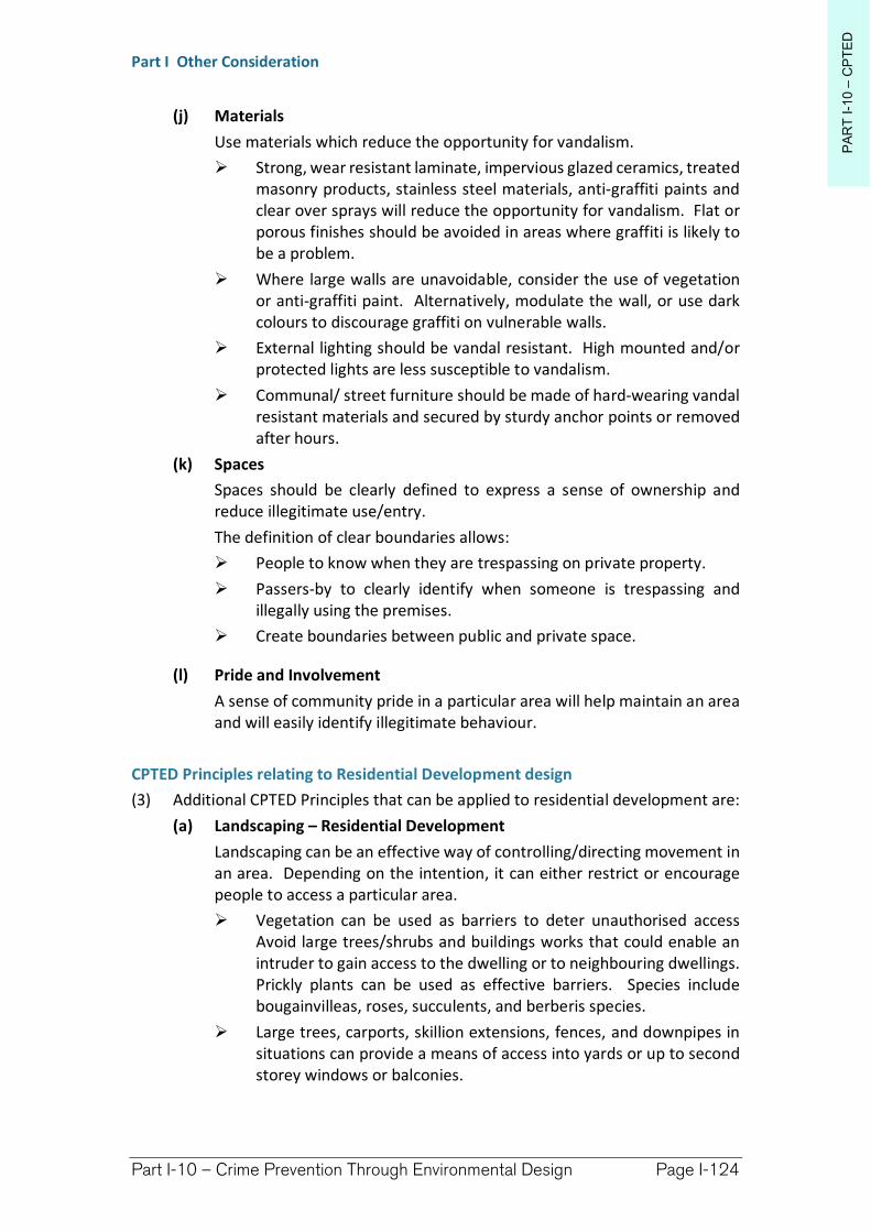
PA
RT
I-1
0–
CP
TE
D
Part I Other Consideration
Part I-10 – Crime Prevention Through Environmental Design Page I-124
(j) Materials
Use materials which reduce the opportunity for vandalism.
Strong, wear resistant laminate, impervious glazed ceramics, treated masonry products, stainless steel materials, anti-graffiti paints and clear over sprays will reduce the opportunity for vandalism. Flat or porous finishes should be avoided in areas where graffiti is likely to be a problem.
Where large walls are unavoidable, consider the use of vegetation or anti-graffiti paint. Alternatively, modulate the wall, or use dark colours to discourage graffiti on vulnerable walls.
External lighting should be vandal resistant. High mounted and/or protected lights are less susceptible to vandalism.
Communal/ street furniture should be made of hard-wearing vandal resistant materials and secured by sturdy anchor points or removed after hours.
(k) Spaces
Spaces should be clearly defined to express a sense of ownership and reduce illegitimate use/entry.
The definition of clear boundaries allows:
People to know when they are trespassing on private property.
Passers-by to clearly identify when someone is trespassing and illegally using the premises.
Create boundaries between public and private space.
(l) Pride and Involvement
A sense of community pride in a particular area will help maintain an area and will easily identify illegitimate behaviour.
CPTED Principles relating to Residential Development design
(3) Additional CPTED Principles that can be applied to residential development are:
(a) Landscaping – Residential Development
Landscaping can be an effective way of controlling/directing movement in an area. Depending on the intention, it can either restrict or encourage people to access a particular area.
Vegetation can be used as barriers to deter unauthorised access Avoid large trees/shrubs and buildings works that could enable an intruder to gain access to the dwelling or to neighbouring dwellings. Prickly plants can be used as effective barriers. Species include bougainvilleas, roses, succulents, and berberis species.
Large trees, carports, skillion extensions, fences, and downpipes in situations can provide a means of access into yards or up to second storey windows or balconies.
PA
RT
I-1
0–
CP
TE
D
Part I Other Consideration
Part I-10 – Crime Prevention Through Environmental Design Page I-125
(b) Security – Residential Development
Traditional security systems can be very effective in reducing illegitimate access. It is important however to be reasonable and not over secure a location as this may make genuine users feel unsafe and even restrict legitimate access.
Install quality locks on external windows and doors.
Install viewers on entry doors.
If security grilles are used on windows they should be open able from inside in case of emergencies.
Ensure skylights and/or roof tiles cannot be readily removed or opened from outside.
Consider monitored alarm systems.
Provide lockable gates on side and rear access ways.
Building supervisors or security guards may be a security consideration in larger unit developments, holiday units, caravan parks, etc.
Ideally no more than two entry points to a dwelling.
Main entry doors should be fitted with a door viewer and door chain.
(c) Ownership– Residential Development
Research indicates that well maintained and 'cared for' properties are less likely to experience crime.
Ensure the speedy repair or cleaning of damaged or vandalised property.
Provide for the swift removal of graffiti.
Application of CPTED Principles relative to Public Services
(4) ATMs, Help Points, Bicycle Storage, Public Phones, and other Public services should be located in areas of high activity.
Public services should be located in highly visible areas that are well lit.
Locate public services away from possible places to hide, eg fire exits.
Avoid locating public services in recesses.
Design areas around ATM's to incorporate reflective materials so that users can observe people behind.
Consider conflicting uses when designing public space (e.g. do not put a public phone or seat near an ATM as this provides a potential thief with an opportunity to loiter).
Richmond Valley Development Control Plan 2021
Part I-11 Land Use Conflict Risk Assessment—LUCRA
A wide range of issues can constitute land use conflicts and interface issues. Conflicts may arise within Richmond Valley between agricultural (and other rural) practices [sources] and neighbouring occupants [receptors]. Managing potential instances where land use conflict might occur is most desirable before real conflict becomes realised and untenable. Rural land conflict occurs most generally between rural agricultural practices and rural residential style landowners, however these conflicts can also occur on the fringe of urban and rural areas.
Rural land use conflict issues most common on the North Coast of NSW include; absentee landholders, access, clearing, lack of co-operation, dogs, dust, poorly located dwellings, electric fences, general fence maintenance, firearms, heritage management, lighting, litter, noise, odours, pesticides, poisoning, pollution, smoke, bushfire maintenance, soil erosion, straying livestock, theft/vandalism, vegetation removal, trespass, visual amenity, water, and weed maintenance issues.
This DCP applies to all land within the Richmond Valley Local Government Area.
Date adopted by Council: 22/06/2021
Effective Date: 01/08/2021
Amendments: Nil
PA
RT
I-1
1–
LU
CR
A
Part I Other Consideration
Part I-11 – Land Use Conflict Risk Assessment Page I-128
I-11.1 General Objectives
The general objectives of this Chapter are:
(1) To reduce the incidence and likelihood of land use conflict within Richmond Valley.
(2) To introduce methods and guidelines to reduce the likelihood and manage existing land use conflict within the Local Government Area (LGA).
(3) To reproduce current guidelines and ‘buffer distances’ (at the time of DCP formulation) between conflicting land uses in accordance with best practice principles (Living and Working in Rural Areas – A handbook for managing land use conflict issues on the NSW North Coast (LWRA Handbook)). ‘Buffer distances’ provided within this section of the DCP serve as a benchmark for proposed development within Richmond valley, with some opportunity for modification or review based upon demonstrated exceptional circumstance.
(4) To introduce the concept of Land Use Conflict Risk Assessment (LUCRA) as part of the development assessment process. Where it is deemed necessary by the consent authority or consultant representing the applicant, a LUCRA shall be provided alongside all other reports provided to support proposed development. Land use buffers provided here and within the LWRA Handbook can be used to determine whether land use conflict risk assessment need to be addressed in detail within a formal development application.
Living and Working in Rural Areas – A handbook for managing land use conflict issues on the NSW North Coast (LUCRA Handbook) – is the publication from which most of the following DCP guidelines have been reproduced.
I-11.2 LUCRA Design principles
(1) A LUCRA is not an alternative to locating proposed development away from existing land-uses. The first choice for locating new development should always be outside of the buffer distance area for the proposed and neighbouring existing land-uses. A LUCRA should support the proposed siting of the new development based upon technical reasoning and measurements demonstrating land use conflict is unlikely to occur.
(2) Circumstances where proposed development requires a LUCRA
A LUCRA is required where a proposed development for a particular land-use has a buffer distance which infringes upon nearby existing land-uses and/or development. Buffer distances of existing land uses, key environmental assets and/or development also trigger the need for LUCRA if the development proposed infringes existing land-use/development/key environmental asset buffers. Buffer distances for development types are given within Tables I-11.1, I-11.2 & I-11.3 below.
A LUCRA is also required if development is proposed with the vicinity of an existing landuse which, due to extraordinary circumstances deemed by the consent authority, applicant or representing consultant for the applicant,
PA
RT
I-1
1–
LU
CR
A
Part I Other Consideration
Part I-11 – Land Use Conflict Risk Assessment Page I-129
requires an increased buffer distance. In exceptional circumstances a buffer distance may be reduced based upon accepted technical reasoning. Reduction of buffer distance could be based upon one or more of the relevant elements given below, however more commonly these elements may increase buffer distances.
(3) Buffer distances applied to proposed and existing land uses
Buffer distances may vary from those stated within the DCP as the distances are based upon generic situations between proposals based on local topographic, climate, environmental and social considerations. The minimum buffer distances do not apply to existing developments that have already been approved. The conditions of consent placed on these developments form the minimum standards that these developments should achieve.
Proponents, land owners and consultants undertaking conflict risk assessment will be required to reach consensus concerning the effort and detail should be applied to a LUCRA. The consent authority and any other involved regulatory authorities should be consulted prior to the lodgement of a formal application for a development requiring LUCRA to determine the level and direction of detail required.
I-11.3 Buffers
(1) Types of Buffers
Separation buffers are the most common and involve establishing a physical separation between land uses where conflict could arise. The aim of doing this is to reduce the impacts of the uses solely by distance separation, rather than by any physical means such as earthworks or vegetation planting. These can be fixed separation distances or variable.
Fixed separation distances generally apply in the absence of evidence that an alternate lesser buffer will be effective in the circumstances.
Variable separation distances are calculated based on the site specific circumstances given factors such as the scale of the development, risk of conflict and risk to the adjoining environment have regard to accepted procedures for assessing these risks. The odour assessment process in NSW involving stationary sources is a form of a variable buffer as it varies according to specifics of the development and the site. Biological and vegetated buffers are buffers created by vegetation planting and physical landscaping works. They are most commonly designed to reduce visual impact and reduce the potential for airborne-created conflict such as chemical spray drift and dust and can help provide environmental protection through vegetated filter strips and riparian plantings. Landscape and ecological buffers refer to the use of existing vegetation to help reduce the impacts from development. They are mostly used to protect a sensitive environment by maintaining or enhancing existing habitat and wildlife corridors.
Property management buffers refer to the use of alternative or specialised management practices or actions at the interface between uses where the
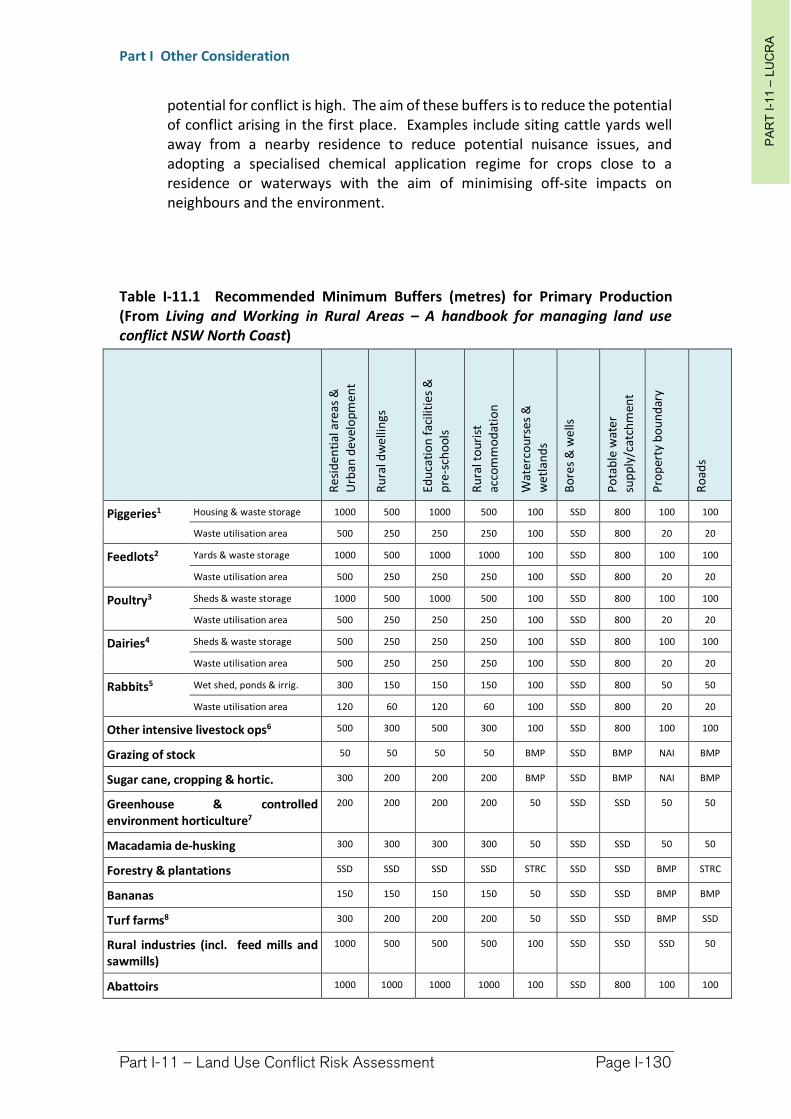
PA
RT
I-1
1–
LU
CR
A
Part I Other Consideration
Part I-11 – Land Use Conflict Risk Assessment Page I-130
potential for conflict is high. The aim of these buffers is to reduce the potential of conflict arising in the first place. Examples include siting cattle yards well away from a nearby residence to reduce potential nuisance issues, and adopting a specialised chemical application regime for crops close to a residence or waterways with the aim of minimising off-site impacts on neighbours and the environment.
Table I-11.1 Recommended Minimum Buffers (metres) for Primary Production (From Living and Working in Rural Areas – A handbook for managing land use conflict NSW North Coast)
Res
ide
nti
al a
reas
&
Urb
an d
eve
lop
me
nt
Ru
ral d
we
llin
gs
Ed
uca
tio
n fa
cilit
ies
&
pre
-sch
oo
ls
Ru
ral t
ou
rist
ac
com
mo
dat
ion
Wat
erco
urs
es
&
wet
lan
ds
Bo
res
& w
ells
Po
tab
le w
ate
r su
pp
ly/c
atch
men
t
Pro
per
ty b
ou
nd
ary
Ro
ads
Piggeries1 Housing & waste storage 1000 500 1000 500 100 SSD 800 100 100
Waste utilisation area 500 250 250 250 100 SSD 800 20 20
Feedlots2 Yards & waste storage 1000 500 1000 1000 100 SSD 800 100 100
Waste utilisation area 500 250 250 250 100 SSD 800 20 20
Poultry3 Sheds & waste storage 1000 500 1000 500 100 SSD 800 100 100
Waste utilisation area 500 250 250 250 100 SSD 800 20 20
Dairies4 Sheds & waste storage 500 250 250 250 100 SSD 800 100 100
Waste utilisation area 500 250 250 250 100 SSD 800 20 20
Rabbits5 Wet shed, ponds & irrig. 300 150 150 150 100 SSD 800 50 50
Waste utilisation area 120 60 120 60 100 SSD 800 20 20
Other intensive livestock ops6 500 300 500 300 100 SSD 800 100 100
Grazing of stock 50 50 50 50 BMP SSD BMP NAI BMP
Sugar cane, cropping & hortic. 300 200 200 200 BMP SSD BMP NAI BMP
Greenhouse & controlled environment horticulture7
200 200 200 200 50 SSD SSD 50 50
Macadamia de-husking 300 300 300 300 50 SSD SSD 50 50
Forestry & plantations SSD SSD SSD SSD STRC SSD SSD BMP STRC
Bananas 150 150 150 150 50 SSD SSD BMP BMP
Turf farms8 300 200 200 200 50 SSD SSD BMP SSD
Rural industries (incl. feed mills and sawmills)
1000 500 500 500 100 SSD SSD SSD 50
Abattoirs 1000 1000 1000 1000 100 SSD 800 100 100
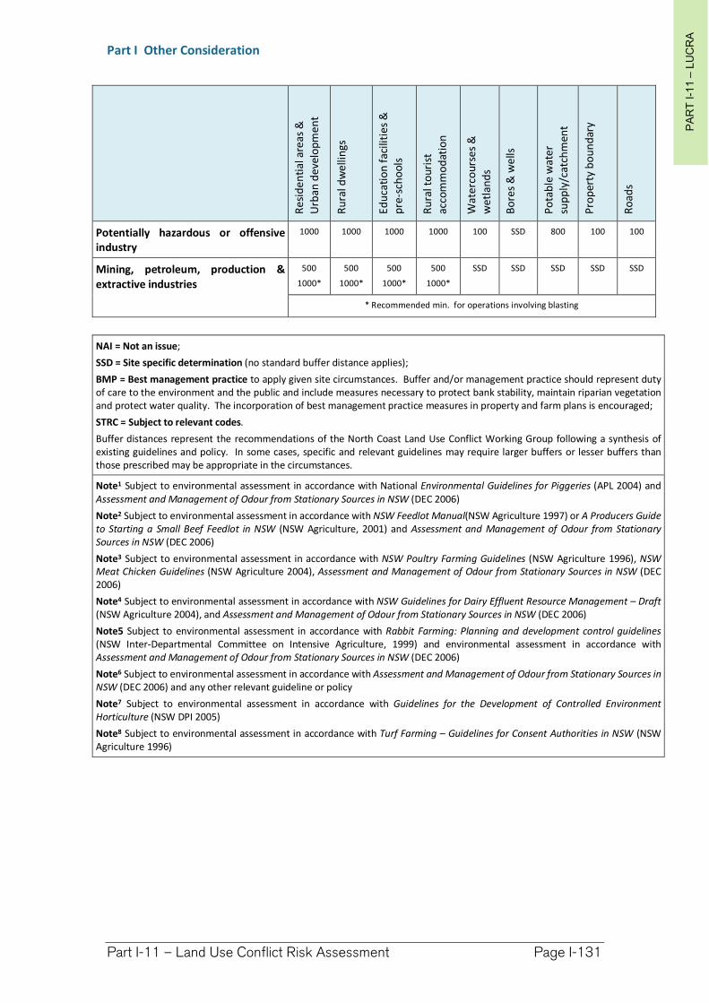
PA
RT
I-1
1–
LU
CR
A
Part I Other Consideration
Part I-11 – Land Use Conflict Risk Assessment Page I-131
Re
sid
en
tial
are
as &
Urb
an d
evel
op
me
nt
Ru
ral d
we
llin
gs
Ed
uca
tio
n f
acili
tie
s &
p
re-s
cho
ols
Ru
ral t
our
ist
acco
mm
od
atio
n
Wat
erco
urs
es
&
we
tlan
ds
Bo
res
& w
ells
Po
tab
le w
ater
su
pp
ly/c
atch
men
t
Pro
per
ty b
ou
nd
ary
Ro
ads
Potentially hazardous or offensive industry
1000 1000 1000 1000 100 SSD 800 100 100
Mining, petroleum, production & extractive industries
500
1000*
500
1000*
500
1000*
500
1000*
SSD SSD SSD SSD SSD
* Recommended min. for operations involving blasting
NAI = Not an issue;
SSD = Site specific determination (no standard buffer distance applies);
BMP = Best management practice to apply given site circumstances. Buffer and/or management practice should represent duty of care to the environment and the public and include measures necessary to protect bank stability, maintain riparian vegetation and protect water quality. The incorporation of best management practice measures in property and farm plans is encouraged;
STRC = Subject to relevant codes.
Buffer distances represent the recommendations of the North Coast Land Use Conflict Working Group following a synthesis of existing guidelines and policy. In some cases, specific and relevant guidelines may require larger buffers or lesser buffers than those prescribed may be appropriate in the circumstances.
Note1 Subject to environmental assessment in accordance with National Environmental Guidelines for Piggeries (APL 2004) and Assessment and Management of Odour from Stationary Sources in NSW (DEC 2006)
Note2 Subject to environmental assessment in accordance with NSW Feedlot Manual(NSW Agriculture 1997) or A Producers Guide to Starting a Small Beef Feedlot in NSW (NSW Agriculture, 2001) and Assessment and Management of Odour from Stationary Sources in NSW (DEC 2006)
Note3 Subject to environmental assessment in accordance with NSW Poultry Farming Guidelines (NSW Agriculture 1996), NSW Meat Chicken Guidelines (NSW Agriculture 2004), Assessment and Management of Odour from Stationary Sources in NSW (DEC 2006)
Note4 Subject to environmental assessment in accordance with NSW Guidelines for Dairy Effluent Resource Management – Draft(NSW Agriculture 2004), and Assessment and Management of Odour from Stationary Sources in NSW (DEC 2006)
Note5 Subject to environmental assessment in accordance with Rabbit Farming: Planning and development control guidelines(NSW Inter-Departmental Committee on Intensive Agriculture, 1999) and environmental assessment in accordance with Assessment and Management of Odour from Stationary Sources in NSW (DEC 2006)
Note6 Subject to environmental assessment in accordance with Assessment and Management of Odour from Stationary Sources in NSW (DEC 2006) and any other relevant guideline or policy
Note7 Subject to environmental assessment in accordance with Guidelines for the Development of Controlled Environment Horticulture (NSW DPI 2005)
Note8 Subject to environmental assessment in accordance with Turf Farming – Guidelines for Consent Authorities in NSW (NSW Agriculture 1996)
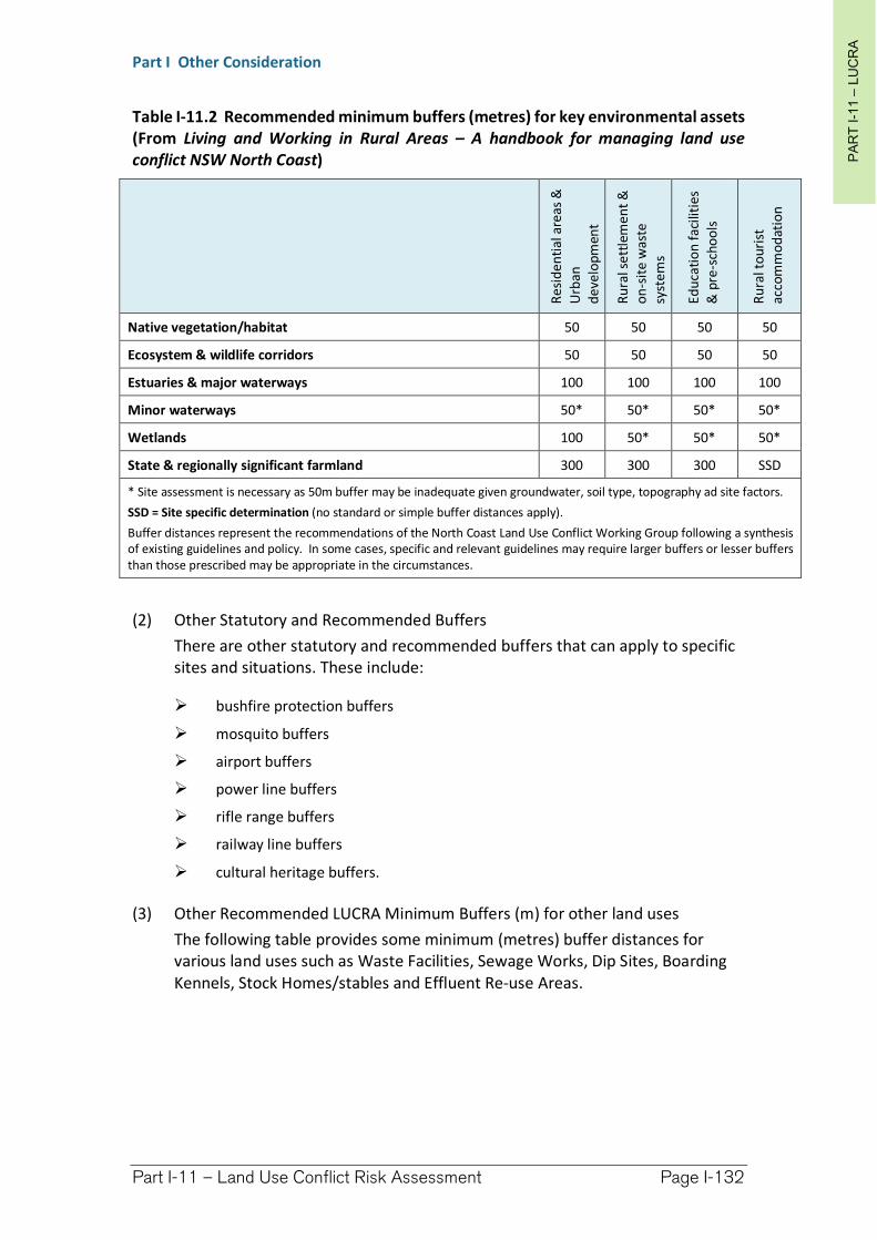
PA
RT
I-1
1–
LU
CR
A
Part I Other Consideration
Part I-11 – Land Use Conflict Risk Assessment Page I-132
Table I-11.2 Recommended minimum buffers (metres) for key environmental assets (From Living and Working in Rural Areas – A handbook for managing land use conflict NSW North Coast)
Res
ide
nti
al a
reas
&
Urb
an
de
velo
pm
ent
Ru
ral s
ett
lem
en
t &
o
n-s
ite
was
te
syst
em
s
Ed
uca
tio
n fa
cilit
ies
& p
re-s
cho
ols
Ru
ral t
ou
rist
ac
com
mo
dat
ion
Native vegetation/habitat 50 50 50 50
Ecosystem & wildlife corridors 50 50 50 50
Estuaries & major waterways 100 100 100 100
Minor waterways 50* 50* 50* 50*
Wetlands 100 50* 50* 50*
State & regionally significant farmland 300 300 300 SSD
* Site assessment is necessary as 50m buffer may be inadequate given groundwater, soil type, topography ad site factors.
SSD = Site specific determination (no standard or simple buffer distances apply).
Buffer distances represent the recommendations of the North Coast Land Use Conflict Working Group following a synthesis of existing guidelines and policy. In some cases, specific and relevant guidelines may require larger buffers or lesser buffers than those prescribed may be appropriate in the circumstances.
(2) Other Statutory and Recommended Buffers
There are other statutory and recommended buffers that can apply to specific sites and situations. These include:
bushfire protection buffers
mosquito buffers
airport buffers
power line buffers
rifle range buffers
railway line buffers
cultural heritage buffers.
(3) Other Recommended LUCRA Minimum Buffers (m) for other land uses
The following table provides some minimum (metres) buffer distances for various land uses such as Waste Facilities, Sewage Works, Dip Sites, Boarding Kennels, Stock Homes/stables and Effluent Re-use Areas.
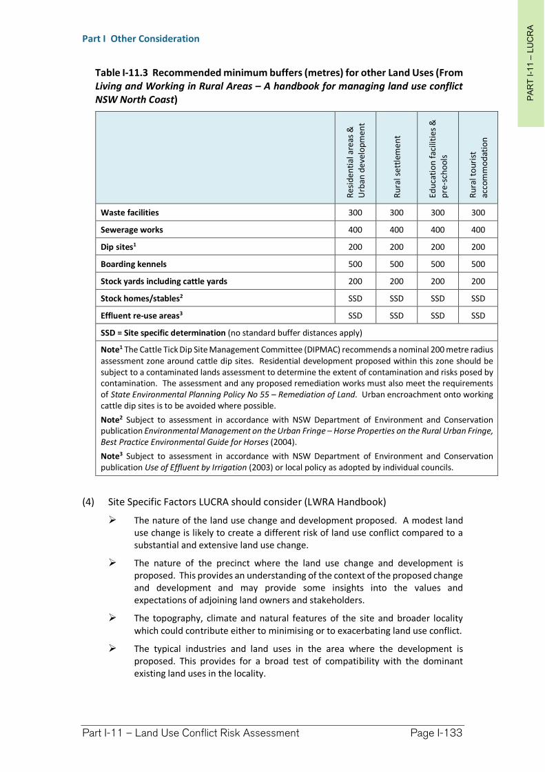
PA
RT
I-1
1–
LU
CR
A
Part I Other Consideration
Part I-11 – Land Use Conflict Risk Assessment Page I-133
Table I-11.3 Recommended minimum buffers (metres) for other Land Uses (From Living and Working in Rural Areas – A handbook for managing land use conflict NSW North Coast)
Re
sid
en
tial
are
as &
U
rban
de
velo
pme
nt
Ru
ral s
ett
lem
ent
Ed
uca
tio
n f
acili
tie
s &
p
re-s
cho
ols
Ru
ral t
ou
rist
ac
com
mo
dat
ion
Waste facilities 300 300 300 300
Sewerage works 400 400 400 400
Dip sites1 200 200 200 200
Boarding kennels 500 500 500 500
Stock yards including cattle yards 200 200 200 200
Stock homes/stables2 SSD SSD SSD SSD
Effluent re-use areas3 SSD SSD SSD SSD
SSD = Site specific determination (no standard buffer distances apply)
Note1 The Cattle Tick Dip Site Management Committee (DIPMAC) recommends a nominal 200 metre radius assessment zone around cattle dip sites. Residential development proposed within this zone should be subject to a contaminated lands assessment to determine the extent of contamination and risks posed by contamination. The assessment and any proposed remediation works must also meet the requirements of State Environmental Planning Policy No 55 – Remediation of Land. Urban encroachment onto working cattle dip sites is to be avoided where possible.
Note2 Subject to assessment in accordance with NSW Department of Environment and Conservation publication Environmental Management on the Urban Fringe – Horse Properties on the Rural Urban Fringe, Best Practice Environmental Guide for Horses (2004).
Note3 Subject to assessment in accordance with NSW Department of Environment and Conservation publication Use of Effluent by Irrigation (2003) or local policy as adopted by individual councils.
(4) Site Specific Factors LUCRA should consider (LWRA Handbook)
The nature of the land use change and development proposed. A modest land use change is likely to create a different risk of land use conflict compared to a substantial and extensive land use change.
The nature of the precinct where the land use change and development is proposed. This provides an understanding of the context of the proposed change and development and may provide some insights into the values and expectations of adjoining land owners and stakeholders.
The topography, climate and natural features of the site and broader locality which could contribute either to minimising or to exacerbating land use conflict.
The typical industries and land uses in the area where the development is proposed. This provides for a broad test of compatibility with the dominant existing land uses in the locality.
PA
RT
I-1
1–
LU
CR
A
Part I Other Consideration
Part I-11 – Land Use Conflict Risk Assessment Page I-134
The land uses and potential land uses in the vicinity of the proposed development or new land use. Identifying and describing what’s happening within a minimum 1000 metre radius of the subject land and development site help to establish the specific land uses in the locality that are most likely to have some effect on and be affected by the proposed land use or development. This description of surrounding land uses should include discrete land uses such as dwellings, schools, and public places as well as rural industry activities such as intensive animal industries, cropping, agricultural processing industries, aquaculture, mining, petroleum production and extractive industries, plantations and farm forestry.
Describe and record the main activities of the proposed land use and development as well as how regular these activities are likely to be. Note infrequent activities that are likely to create conflict with neighbouring land uses and be the source of neighbour disputes given our knowledge of issues that can be a trigger for complaints and conflict.
Describe and record the main activities of the adjoining and surrounding land uses as well as how regular these activities are, including periodic and seasonal activities that have the potential to be a source of complaint or conflict.
Compare and contrast the proposed and adjoining/surrounding land uses for incompatibility and conflict issues.

Richmond Valley Development Control Plan 2021
Part I-12 Context and Site Analysis
Development that is designed in context enhances the sense of place, reinforces the role and character of localities and improves the quality of the environment for the community.
When designing a development for a site it is essential to respond to the local and broader urban context by identifying the area’s defining elements. The design should be informed by this.
In order to understand this context, a site analysis should be undertaken as a first step in preparing for a development. This should identify the opportunities and constraints of the site and create a platform from which to develop a design. A site analysis demonstrates that the proposed development is the best possible solution and makes the best contribution to its surroundings.
This DCP applies to all land within the Richmond Valley Local Government Area.
Date adopted by Council:
Effective Date:
Amendments:
This DCP applies to all land within the Richmond Valley Local Government Area.
Date adopted by Council: 22/06/2021
Effective Date: 01/08/2021
Amendments: Nil
PA
RT
I-1
2–
CO
NT
EX
T &
SIT
E A
NA
LY
SISPart I Other Consideration
Part I-12 – Context and Site Analysis Page I-136
I-12.1 General Objectives
The general objectives of this Chapter are to:
(1) improve the quality of development through better planning, design and consideration for the local community and environments.
I-12.2 Site Analysis
(1) The broader elements of a site analysis should include things such as:
Underlying urban structure e.g. the broad land use patterns, the spatial structure
Subdivision and street patterns
Topography and landscape
Public domain
Transport and access
Building typologies eg. detached dwellings, residential flat buildings etc
Open space and water networks
Cultural, archaeological and physical heritage
Views and vistas.
These elements should be considered in relation to the site and its area, but also relative to the existing planning framework and controls.
(2) It is important to recognise that places and communities evolve over time and anticipation of spatial change needs to be balanced with existing themes, forms and patterns which have helped establish the character of the locality.
(3) All development applications should submit a site analysis, except development applications for the purposes of:
Change of use
Minor alterations and additions, and
Swimming pools.
The degree of detail required will vary according to the nature, type and scale of the development and its surroundings. The level of detail required should be clarified with Council.
(4) A site analysis assessment should document the key opportunities and constraints of a site and its surroundings and show how these, in conjunction with the provisions of this DCP have determined the final proposal for the site.
(5) The site analysis may include plans, sketches, photographs and supporting written information and should include the following information:
(a) Identifying Information
orientation
scale and north point
date
Property Details
PA
RT
I-1
2–
CO
NT
EX
T &
SIT
E A
NA
LY
SISPart I Other Consideration
Part I-12 – Context and Site Analysis Page I-137
site dimensions, property boundaries and site area
easements for drainage, services and rights of carriageway
Landform and Vegetation
spot levels and contours
differences in ground levels on site as well as between the site and adjoining properties
existing vegetation on/or affecting the site, location, height, canopy cover and species types
important views - from the site and from adjoining land
identification of any contaminated soils on the site and extent of any known landfill
landscape features - cliffs, rock outcrops, embankments, retaining walls, foreshores
soil type and depth
flood liable land, existing means of stormwater drainage, existing stormwater detention systems, flow paths, drainage easements, watercourses, channels etc;
sun and shade characteristics
prevailing winds
Access
vehicle and pedestrian access to and from the site
public roads, laneways, pathways
on corner sites, the provision of a splay corner if required by Council
driveways, parking areas, loading bays on the site and within the vicinity of the site
public transport services (particularly for affordable housing, and housing for seniors or persons with disabilities)
Existing Development
existing buildings - on the site and on adjoining land. Show location, distance from the boundary, height, current use. Include elevations showing adjacent buildings
existing neighbourhood character, including the pattern of development, built form, building materials and colours, fencing and garden styles
overshadowing of and by adjoining buildings
fence and wall locations, heights, materials
swimming pools
privacy - adjoining private open spaces, doors and windows
street frontage features - poles, trees, kerbs, footpaths, crossings, street furniture
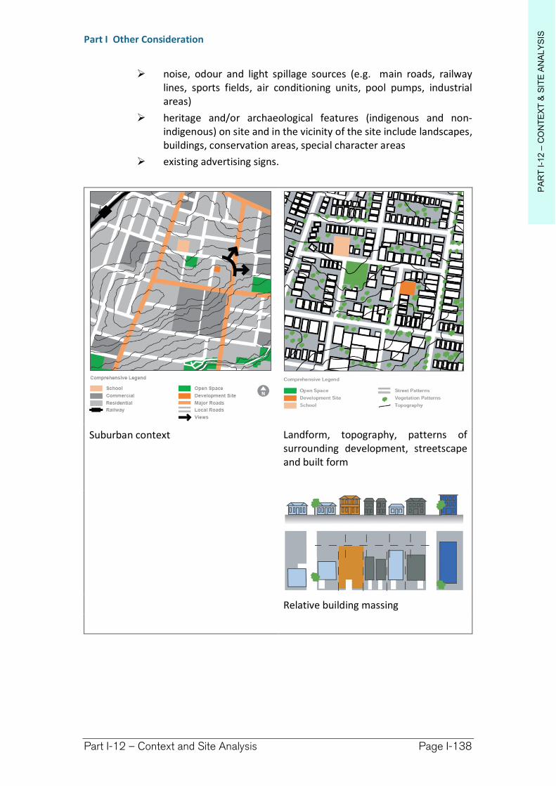
PA
RT
I-1
2–
CO
NT
EX
T &
SIT
E A
NA
LY
SISPart I Other Consideration
Part I-12 – Context and Site Analysis Page I-138
noise, odour and light spillage sources (e.g. main roads, railway lines, sports fields, air conditioning units, pool pumps, industrial areas)
heritage and/or archaeological features (indigenous and non-indigenous) on site and in the vicinity of the site include landscapes, buildings, conservation areas, special character areas
existing advertising signs.
Suburban context Landform, topography, patterns of surrounding development, streetscape and built form
Relative building massing
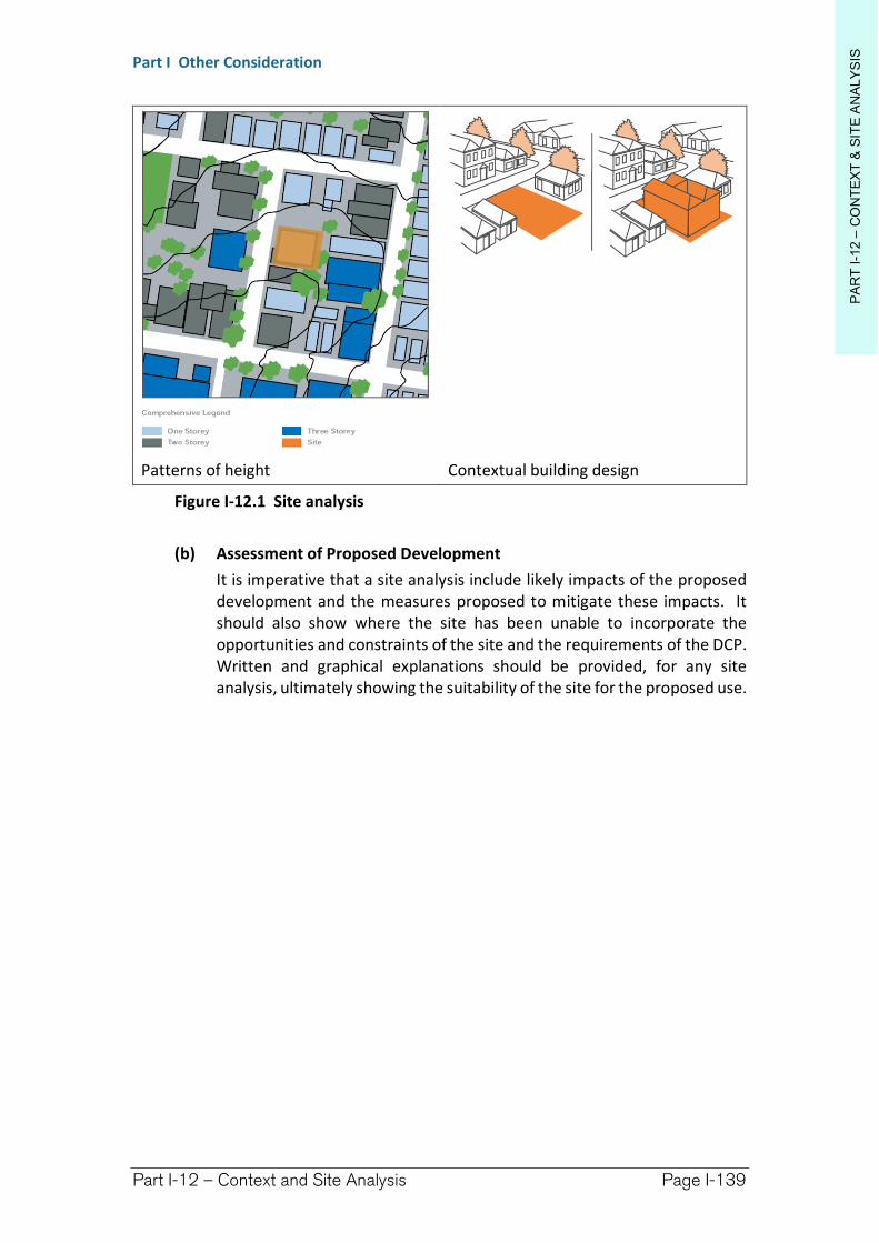
PA
RT
I-1
2–
CO
NT
EX
T &
SIT
E A
NA
LY
SISPart I Other Consideration
Part I-12 – Context and Site Analysis Page I-139
Patterns of height Contextual building design
Figure I-12.1 Site analysis
(b) Assessment of Proposed Development
It is imperative that a site analysis include likely impacts of the proposed development and the measures proposed to mitigate these impacts. It should also show where the site has been unable to incorporate the opportunities and constraints of the site and the requirements of the DCP. Written and graphical explanations should be provided, for any site analysis, ultimately showing the suitability of the site for the proposed use.
Richmond Valley Development Control Plan 2021
Part I-13 Use of shipping containers
The use of shipping containers for any purpose requires development consent unless the shipping containers are fully located within a building as part of an approved use, or are part of the operation of a freight transport facility or related approved activity.
This DCP applies to all land within the Richmond Valley Local Government Area.
Date adopted by Council: 22/06/2021
Effective Date: 01/08/2021
Amendments: Nil
PA
RT
I-1
3–
SH
IPP
ING
CO
NT
AIN
ER
S
Part I Other Consideration
Part I-13 – Use of Shipping Containers Page I-142
I-13.1 General Objectives
The general objectives of this chapter are:
(1) to protect the amenity and/or streetscape of a locality where shipping containers are granted development consent, and
(2) to apply development controls through guidelines for the installation of shipping containers.
I-13.2 Design principles
(1) Permanent use of containers
Containers visible from public places should not be visually intrusive when viewed from that public place or from an adjacent property;
Containers are to be maintained in good condition and installed in a structurally stable manner;
Containers are not to be located over services or utilities; and
The use of the container must relate directly to and be ancillary to the predominant lawful use of the property.
(2) Temporary use of containers
Containers are located so as to minimise visual impact; and
Containers are used for temporary purposes for a time not exceeding six months.
I-13.3 Acceptable solutions
(1) Permanent use of containers
Containers are limited to two containers per property;
Containers are to be fully screened from a public place and any adjoining property;
Containers are not to be stacked unless fully contained within a building;
Containers are to be maintained free of major rust, and painted in a colour consistent with other development on the site;
Containers are to be installed and tied down to a concrete slab or foundation capable of supporting the combined weight of the container and contents;
Containers are not located within the front or side setback distances (as provided for within the relevant zone—see Chapter I3);
Containers are not located over water, sewer or stormwater lines, or over an easement;
PA
RT
I-1
3–
SH
IPP
ING
CO
NT
AIN
ER
S
Part I Other Consideration
Part I-13 – Use of Shipping Containers Page I-143
A means must be provided whereby persons within the container can exit the container, should is be closed from outside, OR an internal alarm is to be installed and maintained and regularly tested.
(2) Temporary use of containers
No more than one container is used for temporary purposes;
The temporary purpose is not to exceed six months;
Containers are not to be located within front or side building line setback distances (as provided for within the relevant zone—see Chapter I-3);
Containers are to be in good condition, free of major rust and painted in a colour scheme consistent with other development on the site or surrounding lands;
Containers are to be located so as to minimise visual intrusion to the public realm and adjoining properties;
Containers are only to be used in conjunction with an approved use or development on the land;
Containers are to be placed on hard-stand surfaces such as compacted gravel or the like.
I-13.4 Alternative approaches and design suggestions
(1) Alternative approaches and design solutions will be considered on merit but must be consistent with the performance outcomes of this Chapter.
Richmond Valley Development Control Plan 2021
Part I-14 Sex Services Premises, Restricted Premises and Home Occupation (Sex Services)
This section provides planning controls for the determination of development applications and regulation of sex services premises, restricted premises and home occupation (sex services) within the Richmond Valley Council area (RVC).
Since the decriminalisation of sex services premises in 1995, local councils have become the regulatory authority for legitimate businesses involving sex services and shops. Sex services premises and shops cannot be excluded from any council area as it would be contrary to the intent of the 1995 reforms and does not uphold guiding EP&A Act principles discriminating against legitimate land uses.
Council’s responsibility in relation to ‘sex services premises’ centres primarily on land use planning under the Environmental Planning and Assessment Act 1979. Responsibility for safe health practices in the workplace rests with the NSW Department of Health, while the WorkCover Authority is the primary authority regarding occupational health and safety issues in any workplace. Sex workers and brothel owners/proprietors must comply with Section 13 of the Public Health Act 1991. (Information given here was current at the time of DCP creation – refer to these agencies and legislation for succeeding provisions).
It is likely that despite the controls provided here, sex services could be provided within Richmond Valley by escort or outcall services operated illegally and through means over which Council has no authority. Guidelines are provided here to manage genuine applications for legal premises, provide some guidance for the application process, and outline steps Council may take to control premises and activities operating illegally within premises.
This DCP applies to all land within the Richmond Valley Local Government Area.
Date adopted by Council:
Effective Date:
Amendments:
This DCP applies to all land within the Richmond Valley Local Government Area.
Date adopted by Council: 22/06/2021
Effective Date: 01/08/2021
Amendments: Nil
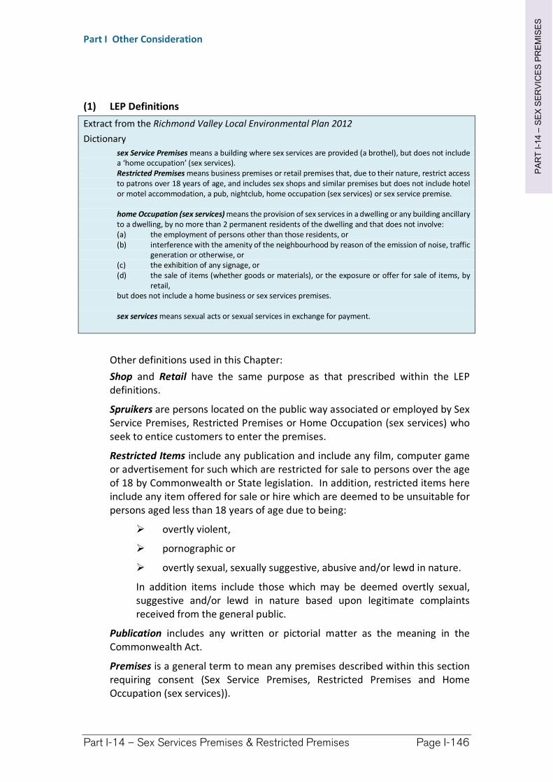
PA
RT
I-1
4–
SE
X S
ER
VIC
ES
PR
EM
ISE
S
Part I Other Consideration
Part I-14 – Sex Services Premises & Restricted Premises Page I-146
(1) LEP Definitions
Extract from the Richmond Valley Local Environmental Plan 2012
Dictionary
sex Service Premises means a building where sex services are provided (a brothel), but does not include a ‘home occupation’ (sex services). Restricted Premises means business premises or retail premises that, due to their nature, restrict access to patrons over 18 years of age, and includes sex shops and similar premises but does not include hotel or motel accommodation, a pub, nightclub, home occupation (sex services) or sex service premise.
home Occupation (sex services) means the provision of sex services in a dwelling or any building ancillary to a dwelling, by no more than 2 permanent residents of the dwelling and that does not involve: (a) the employment of persons other than those residents, or (b) interference with the amenity of the neighbourhood by reason of the emission of noise, traffic
generation or otherwise, or (c) the exhibition of any signage, or (d) the sale of items (whether goods or materials), or the exposure or offer for sale of items, by
retail, but does not include a home business or sex services premises.
sex services means sexual acts or sexual services in exchange for payment.
Other definitions used in this Chapter:
Shop and Retail have the same purpose as that prescribed within the LEP definitions.
Spruikers are persons located on the public way associated or employed by Sex Service Premises, Restricted Premises or Home Occupation (sex services) who seek to entice customers to enter the premises.
Restricted Items include any publication and include any film, computer game or advertisement for such which are restricted for sale to persons over the age of 18 by Commonwealth or State legislation. In addition, restricted items here include any item offered for sale or hire which are deemed to be unsuitable for persons aged less than 18 years of age due to being:
overtly violent,
pornographic or
overtly sexual, sexually suggestive, abusive and/or lewd in nature.
In addition items include those which may be deemed overtly sexual, suggestive and/or lewd in nature based upon legitimate complaints received from the general public.
Publication includes any written or pictorial matter as the meaning in the Commonwealth Act.
Premises is a general term to mean any premises described within this section requiring consent (Sex Service Premises, Restricted Premises and Home Occupation (sex services)).
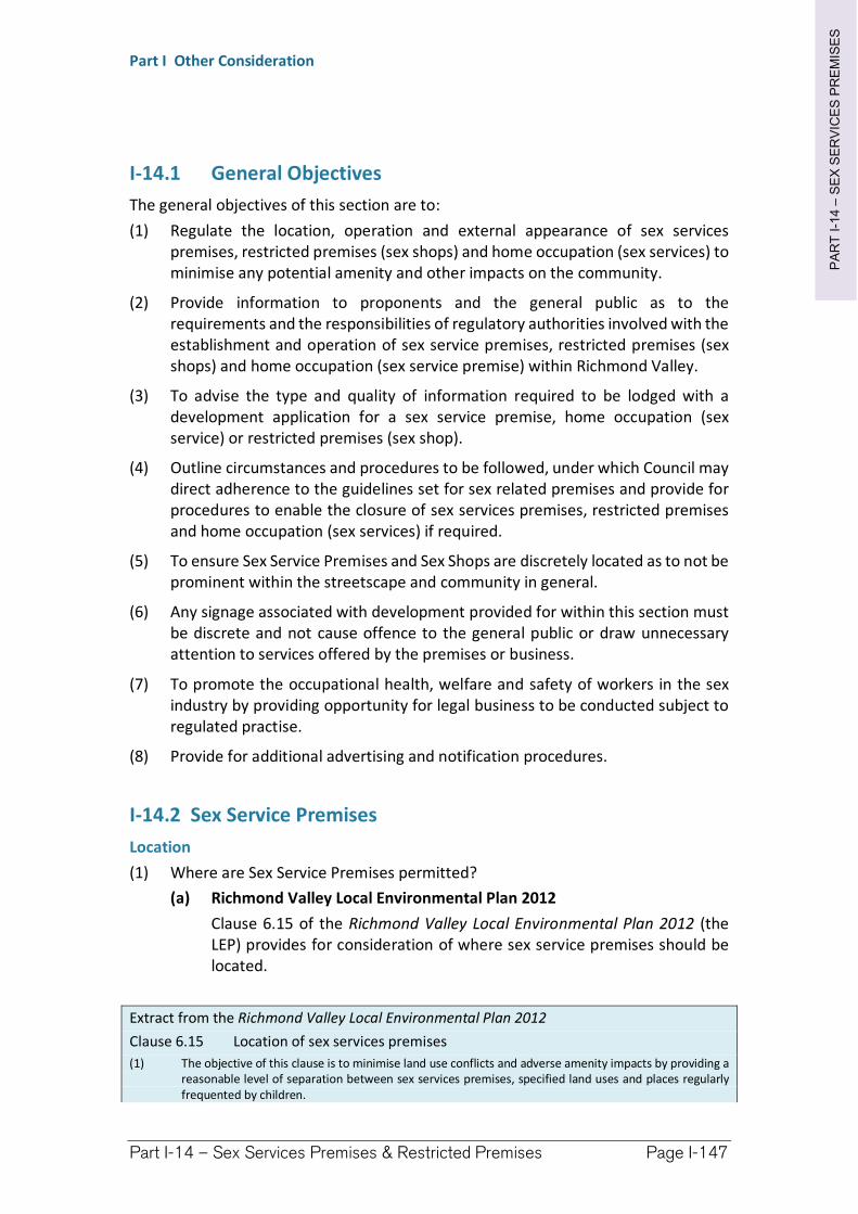
PA
RT
I-1
4–
SE
X S
ER
VIC
ES
PR
EM
ISE
S
Part I Other Consideration
Part I-14 – Sex Services Premises & Restricted Premises Page I-147
I-14.1 General Objectives
The general objectives of this section are to:
(1) Regulate the location, operation and external appearance of sex services premises, restricted premises (sex shops) and home occupation (sex services) to minimise any potential amenity and other impacts on the community.
(2) Provide information to proponents and the general public as to the requirements and the responsibilities of regulatory authorities involved with the establishment and operation of sex service premises, restricted premises (sex shops) and home occupation (sex service premise) within Richmond Valley.
(3) To advise the type and quality of information required to be lodged with a development application for a sex service premise, home occupation (sex service) or restricted premises (sex shop).
(4) Outline circumstances and procedures to be followed, under which Council may direct adherence to the guidelines set for sex related premises and provide for procedures to enable the closure of sex services premises, restricted premises and home occupation (sex services) if required.
(5) To ensure Sex Service Premises and Sex Shops are discretely located as to not be prominent within the streetscape and community in general.
(6) Any signage associated with development provided for within this section must be discrete and not cause offence to the general public or draw unnecessary attention to services offered by the premises or business.
(7) To promote the occupational health, welfare and safety of workers in the sex industry by providing opportunity for legal business to be conducted subject to regulated practise.
(8) Provide for additional advertising and notification procedures.
I-14.2 Sex Service Premises
Location
(1) Where are Sex Service Premises permitted?
(a) Richmond Valley Local Environmental Plan 2012
Clause 6.15 of the Richmond Valley Local Environmental Plan 2012 (the LEP) provides for consideration of where sex service premises should be located.
Extract from the Richmond Valley Local Environmental Plan 2012
Clause 6.15 Location of sex services premises
(1) The objective of this clause is to minimise land use conflicts and adverse amenity impacts by providing a reasonable level of separation between sex services premises, specified land uses and places regularly frequented by children.
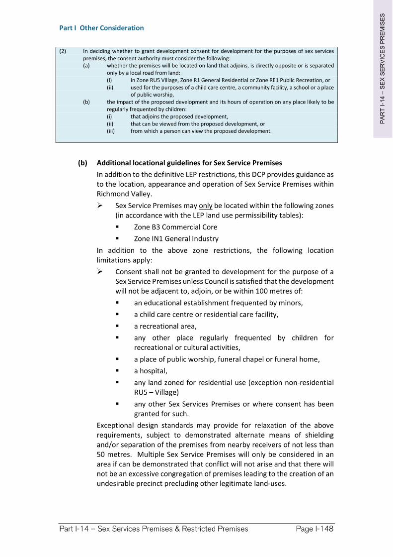
PA
RT
I-1
4–
SE
X S
ER
VIC
ES
PR
EM
ISE
S
Part I Other Consideration
Part I-14 – Sex Services Premises & Restricted Premises Page I-148
(2) In deciding whether to grant development consent for development for the purposes of sex services premises, the consent authority must consider the following: (a) whether the premises will be located on land that adjoins, is directly opposite or is separated
only by a local road from land: (i) in Zone RU5 Village, Zone R1 General Residential or Zone RE1 Public Recreation, or (ii) used for the purposes of a child care centre, a community facility, a school or a place
of public worship, (b) the impact of the proposed development and its hours of operation on any place likely to be
regularly frequented by children: (i) that adjoins the proposed development, (ii) that can be viewed from the proposed development, or (iii) from which a person can view the proposed development.
(b) Additional locational guidelines for Sex Service Premises
In addition to the definitive LEP restrictions, this DCP provides guidance as to the location, appearance and operation of Sex Service Premises within Richmond Valley.
Sex Service Premises may only be located within the following zones (in accordance with the LEP land use permissibility tables):
Zone B3 Commercial Core
Zone IN1 General Industry
In addition to the above zone restrictions, the following location limitations apply:
Consent shall not be granted to development for the purpose of a Sex Service Premises unless Council is satisfied that the development will not be adjacent to, adjoin, or be within 100 metres of:
an educational establishment frequented by minors,
a child care centre or residential care facility,
a recreational area,
any other place regularly frequented by children for recreational or cultural activities,
a place of public worship, funeral chapel or funeral home,
a hospital,
any land zoned for residential use (exception non-residential RU5 – Village)
any other Sex Services Premises or where consent has been granted for such.
Exceptional design standards may provide for relaxation of the above requirements, subject to demonstrated alternate means of shielding and/or separation of the premises from nearby receivers of not less than 50 metres. Multiple Sex Service Premises will only be considered in an area if can be demonstrated that conflict will not arise and that there will not be an excessive congregation of premises leading to the creation of an undesirable precinct precluding other legitimate land-uses.
PA
RT
I-1
4–
SE
X S
ER
VIC
ES
PR
EM
ISE
S
Part I Other Consideration
Part I-14 – Sex Services Premises & Restricted Premises Page I-149
External Appearance
(2) Premises must be compatible with the surrounding built form in order to discretely blend into the streetscape and area. Colour selection for finishes must not be garish and detail for decorative finishes shall be subdued in nature.
(3) Entranceways for pedestrian and vehicle access shall be well lit, however must not form a prominent feature within the streetscape. All access shall provide equitable treatment of users including disability access. A single main entrance for clientele shall be provided which is out of sight of the streetscape and the general public.
(4) Sex workers or any sex related products shall not be displayed from any window or doorway of the premises. No signage or graphics shall be displayed on any exterior surface of the premises, apart from that prescribed within the signage section below.
Operation Safety & Security (also see CPTED)
(5) Sex workers or any sex related products shall not be displayed from any window or doorway of the premises. All activities, including the greeting of clientele, shall be confined to the interior of the building and shall not be visible in any way or form from the outside of the premises.
(6) Internal Car parking areas shall be well lit, and signage visible within the premise grounds shall be subtly lit and directional in nature only.
(7) No spruikers of any kind shall operate within the road reserve, nor any internal car parking area, or on the land outside the building.
Car Parking
(8) On site car parking shall be provided at the rate of 1.5 spaces per working room. (See Chapter I-4 detailing car parking provisions).
Car parking provided shall be easy for clientele to locate.
Signage
(9) Signage must be strictly limited to the identification of the premises by name and/or street number (the name in itself may not be reasonably construed to be rude or offensive to the average person). One sign (or two signs on a corner allotment – one per frontage) a maximum of 0.35m2 may be displayed and may be dully illuminated producing an overall luminescence per sign (measured at a distance of 400mm each not in excess of 20 candela (the intensity of one twenty (20) watt light globe measured at a 400mm distance). Additional signage not of an excessive or lewd nature may be provided within the car parking area if it cannot be viewed from adjoining streets or properties or provide excessive spillage of light.
(10) Additionally, the following provisions must apply to signage:
Must not contain any characters, depictions, pictures or drawings
PA
RT
I-1
4–
SE
X S
ER
VIC
ES
PR
EM
ISE
S
Part I Other Consideration
Part I-14 – Sex Services Premises & Restricted Premises Page I-150
Must not be representative by shape and/or form other than the number of the premises.
Must not be illuminated, flash or move in any way.
Additional Controls
(11) All applications shall comply with the necessary services and facilities required for Class 5/6 Buildings in accordance with the Building Code of Australia (BCA – as current, or superseded from the time of the DCP creation). It should be noted that all requirements for equitable provision of services and amenities, particularly those relating to disability access shall be provided throughout the development.
(12) All public health requirements shall be complied with, in particular, but not limited to, the Public Health Act 1991. All proposed bars and food preparation areas shall comply with the NSW Food Standards Code and AS4674-2004 (current at the time of DCP – refer to any succeeding legislative requirements).
(13) The use of the premises shall not give rise to:
transmission of vibration to any place of different occupancy
a sound level at any point on the boundary of a site greater than the background levels specified in Australian Standard AS 1055 – Acoustics Description and measurement of environmental noise, or
an "offensive noise" as defined in the Noise Control Act 1975.
I-14.3 Restricted Premises
(1) Restricted premises can potentially take many forms. Restricted premises may involve hire and/or selling of any item deemed to be unsuitable for persons aged less than 18 years of age due to being;
overtly violent,
pornographic, or
overtly sexual, sexually suggestive, abusive and/or lewd in nature.
In addition, items for display, sale and hire may be deemed overtly sexual, suggestive and/or lewd in nature if legitimate complaints are received from the public. Council reserves the right to determine whether premises should be deemed ‘restricted’ if legitimate complaints are received if steps are not taken by the business to allay public concern. Commonwealth legislation and determinations (given below in section (f) below) should generally be referenced when making a determination as to whether a premise should be deemed ‘restricted’.
Often restricted premises are incorporated into existing or affiliated businesses. Examples include bookstores which might include an ‘over 18’s’ section displaying pornographic publications, or video hire premises which might have an additional shielded section for adult movie hire. Some precautions should be taken to prevent these businesses from impacting upon sensitive members of the public.
PA
RT
I-1
4–
SE
X S
ER
VIC
ES
PR
EM
ISE
S
Part I Other Consideration
Part I-14 – Sex Services Premises & Restricted Premises Page I-151
Location
(2) Restricted premises shall be located away from sensitive receivers and pedestrian movements of children. Guidelines are given below to minimise the potential for exposure of items to minors and more sensitive members of the public. At the discretion of Council, where the restricted goods area comprises only a section of a larger business (15% or less), some relaxation of the following requirements shall be permitted dependent upon the absence of advertising and signage on any exterior of the business premise. These requirements should also be considered a guide for businesses wishing to incorporate a component into existing trade.
(a) Richmond Valley Local Environmental Plan 2012
Restricted Premises may only be located within the following zones (in accordance with the LEP land use permissibility tables)
B3 – Commercial Core
RU5 – Village
(b) Additional locational guidelines for Restricted Premises
In addition to the above zone restrictions, the following location limitations apply:
Consent shall not be granted to development for the purpose of a Restricted Premise unless Council is satisfied that the development will not be adjacent to, adjoin or be within 50 metres of;
an educational establishment frequented by minors, a child care centre or residential care facility, a recreational area, any other place regularly frequented by children for
recreational or cultural activities, a place of public worship, funeral chapel or funeral home, a hospital, any land zoned for residential use (exception non-residential
RU5 – Village), any other Sex Services Premises or where consent has been
granted for such.
Exceptional design standards may provide for relaxation of the above requirements, subject to demonstrated highly effective screening of the restricted premises component and/or separation of the premises from nearby receivers of not less than 25 metres. Multiple Restricted Premises will only be considered in an area if can be demonstrated that conflict will not arise and that there will not be an excessive congregation of premises leading to the creation of an undesirable precinct precluding other legitimate land-uses.
External Appearance
(3) Premises must be compatible with the surrounding built form in order to discretely blend into the streetscape and area. Colour selection for finishes must not be garish and detail for decorative finishes shall be subdued in nature.
PA
RT
I-1
4–
SE
X S
ER
VIC
ES
PR
EM
ISE
S
Part I Other Consideration
Part I-14 – Sex Services Premises & Restricted Premises Page I-152
(4) Entranceways for pedestrian access shall be well lit, however must not form a prominent feature within the streetscape. All access shall provide equitable treatment of users including disability access.
(5) No restricted products or products of an otherwise overtly violent, sexual or lewd nature shall be displayed from any window or doorway of the premises or in any other way that may be viewed from the street. Signage or graphics displayed on any exterior surface of the premises may announce the nature of products for sale or hire (i.e. “adult movies”) however may not be descriptive in nature (See signage section e below).
Operation Safety & Security (see CPTED)
(6) Employees and the owner of the premises shall be vigilant in allowing only access to areas where restricted items are on display for sale and/or hire. All advertising and display of restricted items shall be only permitted within restricted areas.
(7) Any car parking associated with the restricted premises shall be well lit and signage visible within the premise grounds shall be subtly lit and directional in nature only.
(8) No spruikers of any kind shall operate within the road reserve, nor any internal car parking area, or on the land outside the building.
Car Parking
(9) On site car parking shall be provided at the rate of one space per 30m2 of Gross Floor Area (GFA) (<=1000m2), or per 40m2 of GFA (>1000m2).
Car parking provided shall be easy for clientele to locate.
Signages
(10) Signage must be limited to the identification of the premises as providing restricted items of sale and/or hire. Signage shall not be descriptive in nature and must only serve to notify items of a restrictive nature are available for sale or hire within the premises. Signage constituting the name of the business can be in accordance with normal provisions relating to ‘business identification signs’, however the name of the business and description of the premises to the extent it is advertised as signage may not be overtly violent, sexual or otherwise lewd in nature. In circumstances where the sale and/or hire of restricted items constitute the majority of the business, signage shall be limited to an area not exceeding 6m2 of the total exterior of the premises.
(11) Additionally, the following provisions must apply to signage:
Signage relating to the sale or hire of restricted items (including items of an overtly violent, sexual or otherwise lewd nature) must be restricted to six metres squared (6m2) of the total exterior of the premises.
Must not contain any characters, depictions, pictures or drawings
Must not be representative by shape and/or form other than the number of the premises.
Must not be illuminated, flash or move in any way
PA
RT
I-1
4–
SE
X S
ER
VIC
ES
PR
EM
ISE
S
Part I Other Consideration
Part I-14 – Sex Services Premises & Restricted Premises Page I-153
Additional Controls and Information
(12) Australian Commonwealth Law generally prescribes what publications may be sold and the nature of how they may be displayed and to whom.
The Classification (Markings for Publications) Determination 2007(Commonwealth) prescribes the classification markings and how they are to be displayed on the covers and packaging of publications.
Areas where restricted publications are exhibited must conform with NSW Legislation requirements (Classification (Publications, Films and Computer Games) Enforcement Act 1995 (or any succeeding relevant legislation)), in particular Division 2 – Restricted publication areas. Some reproductions of the requirements of this Act are referenced below.
All publications must be classified by the Classification Board before they can be sold (whether retail or wholesale) in Australia. Unclassified publications, whether locally made or imported, may not be sold in Australia (pursuant to relevant legislation). Foreign classifications are not applicable in Australia so imported restricted items need to be classified by the Australian Classification Board before being offered for sale.
In order for any premises (or part of any premises) to be a restricted publications area, the following requirements must be complied with: the premises must be so constructed that no part of the interior of
the premises is visible to any person outside the premises, each entrance to the premises must be fitted with a gate or door
capable of excluding persons from the interior of the premises, and the premises must be kept closed by means of any such gate or door at all times while the premises are closed to the public,
the proprietor of the premises, or some other adult person appointed by the proprietor for that purpose, must remain on or near the premises, and must be in charge of the premises, at all times while the premises are open to the public,
at each entrance to the premises there must be prominently displayed, so as to be able to be read from outside the premises, a notice, printed in clearly legible letters at least 15 mm in height, containing the following words: “RESTRICTED PUBLICATIONS AREA — PERSONS UNDER 18 MAY NOT ENTER. MEMBERS OF THE PUBLIC ARE WARNED THAT SOME MATERIAL DISPLAYED IN THIS AREA MAY CAUSE OFFENCE.”
All public health requirements shall be complied with, in particular, but not limited to, the Public Health Act 1991. All proposed bars and food preparation areas shall comply with the NSW Food Standards Code and AS4674-2004 (current at the time of DCP – refer to any succeeding legislative requirements).
The use of the premises shall not give rise to: transmission of vibration to any place of different occupancy
PA
RT
I-1
4–
SE
X S
ER
VIC
ES
PR
EM
ISE
S
Part I Other Consideration
Part I-14 – Sex Services Premises & Restricted Premises Page I-154
a sound level at any point on the boundary of a site greater than the background levels specified in Australian Standard AS 1055 – Acoustics Description and measurement of environmental noise, or
an "offensive noise" as defined in the Noise Control Act 1975.
I-14.4 Home Occupation (Sex Services)
Location
(1) Where are Sex Service Premises permitted?
(a) Richmond Valley Local Environmental Plan 2012
Sex Service Premises may only be located within the following zones (in accordance with the LEP land use permissibility tables)
RU1 – Primary Production B3 – Commercial Core IN1 – General Industrial – (only for pre-existing dwellings within the
industrial zone)
(b) Additional locational guidelines for Restricted Premises
In addition to the above zone restrictions, the following location limitations apply:
Consent shall not be granted to development for the purpose of a Home Occupation (Sex Services) unless Council is satisfied that the development will not be adjacent to, adjoin or be within 50 metres of; an educational establishment frequented by minors, a child care centre or residential care facility, a recreational area, any other place regularly frequented by children for
recreational or cultural activities, a place of public worship, funeral chapel or funeral home, a hospital, any land zoned for residential use (exception non-residential
RU5 – Village) any other Sex Services Premises or where consent has been
granted for such.
Exceptional design standards may provide for relaxation of the above requirements, subject to demonstrated alternate means of shielding and/or separation of the premises from nearby receivers of not less than 50 metres. Multiple Sex Service Premises will only be considered in an area if can be demonstrated that conflict will not arise and that there will not be an excessive congregation of premises leading to the creation of an undesirable precinct precluding other legitimate land-uses.
External Appearance
(2) Premises must be compatible with the surrounding built form in order to discretely blend into the streetscape and area. Colour selection for finishes must not be garish and detail for decorative finishes shall be subdued in nature.
PA
RT
I-1
4–
SE
X S
ER
VIC
ES
PR
EM
ISE
S
Part I Other Consideration
Part I-14 – Sex Services Premises & Restricted Premises Page I-155
(3) Entranceways for pedestrian and vehicle access shall be well lit, however must not form a prominent feature within the streetscape. All access shall provide equitable treatment of users including disability access. A single main entrance for clientele shall be provided which is out of sight of the streetscape and the general public.
(4) Sex workers or any sex related products shall not be displayed from any window or doorway of the premises. No signage or graphics shall be displayed on any exterior surface of the premises, apart from that prescribed within the signage section below.
Operation Safety & Security (also see CPTED)
(5) Sex workers or any sex related products shall not be displayed from any window or doorway of the premises. All activities, including the greeting of clientele, shall be confined to the interior of the building and shall not be visible in any way or form from the outside of the premises.
(6) Internal Car parking areas shall be well lit and signage visible within the premise grounds shall be subtly lit and directional in nature only.
(7) No spruikers of any kind shall operate within the road reserve, nor any internal car parking area, or on the land outside the building.
Car Parking
(8) On site car parking shall be provided at the rate of 1 space per working employee of the premises. Note. This is in addition to car parking required for the residence.
Car parking provided shall be easy for clientele to locate.
Signage
(9) Signage must be strictly limited to the identification of the premises by name and/or street number (the name in itself may not be reasonably construed to be rude or offensive to the average person). One sign of a maximum of 0.35m2 may be displayed and may be dully illuminated producing an overall luminescence per sign (measured at a distance of 400mm each not in excess of 20 candela (the intensity of one twenty (20) watt light globe measured at a 400mm distance).
(10) Additionally, the following provisions must apply to signage:
Must not contain any characters, depictions, pictures or drawings
Must not be representative by shape and/or form other than the number of the premises.
Must not be illuminated, flash or move in any way.
Additional Controls – Sex Service Premises
(11) All applications shall comply with the necessary services and facilities required for Class 5/6 Buildings in accordance with the Building Code of Australia (BCA – as current, or superseded from the time of the DCP creation). It should be noted that all requirements for equitable provision of services and amenities, particularly those relating to disability access shall be provided throughout the development.
PA
RT
I-1
4–
SE
X S
ER
VIC
ES
PR
EM
ISE
S
Part I Other Consideration
Part I-14 – Sex Services Premises & Restricted Premises Page I-156
(12) All public health requirements shall be complied with, in particular, but not limited to, the Public Health Act 1991. All proposed bars and food preparation areas shall comply with the NSW Food Standards Code and AS4674-2004 (current at the time of DCP – refer to any succeeding legislative requirements).
(13) The use of the premises shall not give rise to:
transmission of vibration to any place of different occupancy
a sound level at any point on the boundary of a site greater than the background levels specified in Australian Standard AS 1055 – Acoustics Description and measurement of environmental noise, or
an "offensive noise" as defined in the Noise Control Act 1975.
I-14.5 Application (DA) Requirements
(1) The Requirements for Development Applications for the sensitive land-uses described within this section (Sex Service Premise, Restricted Premises and Home Occupation (Sex Services)) have some general similarities. The level of detail and effort required will vary dependent on the nature and scale of the business proposed. It shall be at Council’s discretion as to the nature of detail required, however all potential sensitive receivers discussed elsewhere within this DCP section shall be clearly identified (including likely transitory pedestrian movements) and the likely impact thoroughly documented. Applicants should ensure open dialogue between the proponent and Council is maintained throughout the process.
(2) Social Impact Statement (SIS) – see also Section I-8 regarding SIS
All land-uses described within this section of the DCP will require Social Impact Statement of sufficient detail to address all potential future impacts from the proposed development. Any proposed Sex Service Premises will require particularly detailed study. All potential sensitive receivers discussed elsewhere within this DCP section shall be clearly identified (including likely transitory pedestrian movements). The SIS shall be of an acceptable standard (verified by the NSW Police) prior to advertising and notification described below.
(3) Statement of Environmental Effects (SEE)
The provision of a SIS shall in no way reduce the need for a Statement of Environmental Effect (SEE). The requirements of a SEE are prescribed in detail within Section I-12 of the DCP and outlined within a factsheet accompanying the Development Application documentation.
(4) Additional Advertising and Notification Procedures
All land-uses described within this section of the DCP will require additional advertising and notification procedures to inform all potential impacted citizens of the development proposed. A stringent notification procedure will call upon relevant agencies, authorities and community/interest groups to provide comment regarding all potential future impacts from the proposed development. These agencies/authorities/community groups shall include, but not be limited to the following;
PA
RT
I-1
4–
SE
X S
ER
VIC
ES
PR
EM
ISE
S
Part I Other Consideration
Part I-14 – Sex Services Premises & Restricted Premises Page I-157
NSW Police (assessment considering CPTED principles)
Identified Impacted Citizens (as per the SIS) Department of Human Services (f/n/a Community Services)
The applicant shall provide enough current copies of the SIS to enable distribution to all agencies and authorities to be notified.
(5) Additional Considerations
Disclosure of interests of all persons involved in the ownership of the proposed occupation or business described within this DCP section. Subsequent to any development consent being issued, a condition may be imposed that any initial and future ownership of the premises by an individual who has been tried and convicted of an indictable offence shall be disclosed to NSW Police and the Consent Authority.
Note. Whilst any record against an owner in itself cannot be considered grounds to move to shut down premises it should be considered carefully in conjunction with other matters discussed within Chapter I-14.6.
All legislative references contained throughout refer to those current at the time of the formulation of this section of the DCP. It is the responsibility of the applicant to ensure current legislative requirements are met within the application in relation to Sex Service Premises, Restricted Premises and Home Occupations (sex service), whether it is relative to alternatively named premises or legislation which could be reasonably construed to be the contemporary equivalent.
I-14.6 Closure of Premises
(1) An application may be made by Council to the NSW Land and Environment Court under Section 17 of the Disorderly Houses Amendment Act 1995 (DHAA) for premises not to be used as a brothel. The Act operates in addition to Council powers under the Environmental Planning and Assessment Act 1979 (EP&A) and provides for the serving of notice on a brothel operating without development consent or outside the terms of consent. Relevant sections of the abovementioned legislation have been included for reference within this section. The legislation provided was current at the time of formulation of the DCP and any possible superseding legal procedures and requirements should be investigated.
Any actions undertaken relevant to this section shall consider the fairness of the assessment process if at any time in the future complaints are received from a nearby use which was not in existence at the time of the granting of consent for the business or occupation carried out.
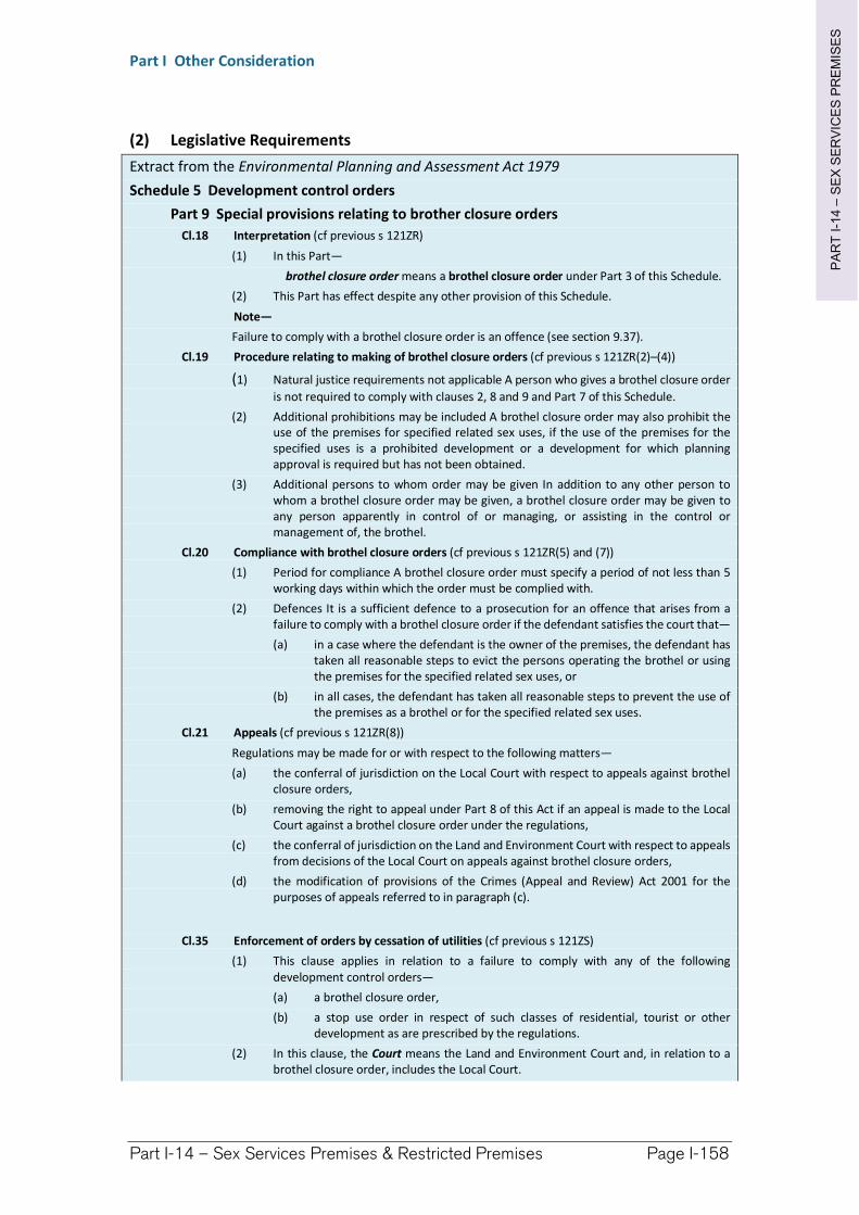
PA
RT
I-1
4–
SE
X S
ER
VIC
ES
PR
EM
ISE
S
Part I Other Consideration
Part I-14 – Sex Services Premises & Restricted Premises Page I-158
(2) Legislative Requirements
Extract from the Environmental Planning and Assessment Act 1979
Schedule 5 Development control orders
Part 9 Special provisions relating to brother closure orders
Cl.18 Interpretation (cf previous s 121ZR)
(1) In this Part—
brothel closure order means a brothel closure order under Part 3 of this Schedule.
(2) This Part has effect despite any other provision of this Schedule.
Note—
Failure to comply with a brothel closure order is an offence (see section 9.37).
Cl.19 Procedure relating to making of brothel closure orders (cf previous s 121ZR(2)–(4))
(1) Natural justice requirements not applicable A person who gives a brothel closure order
is not required to comply with clauses 2, 8 and 9 and Part 7 of this Schedule.
(2) Additional prohibitions may be included A brothel closure order may also prohibit the use of the premises for specified related sex uses, if the use of the premises for the specified uses is a prohibited development or a development for which planning approval is required but has not been obtained.
(3) Additional persons to whom order may be given In addition to any other person to whom a brothel closure order may be given, a brothel closure order may be given to any person apparently in control of or managing, or assisting in the control or management of, the brothel.
Cl.20 Compliance with brothel closure orders (cf previous s 121ZR(5) and (7))
(1) Period for compliance A brothel closure order must specify a period of not less than 5 working days within which the order must be complied with.
(2) Defences It is a sufficient defence to a prosecution for an offence that arises from a failure to comply with a brothel closure order if the defendant satisfies the court that—
(a) in a case where the defendant is the owner of the premises, the defendant has taken all reasonable steps to evict the persons operating the brothel or using the premises for the specified related sex uses, or
(b) in all cases, the defendant has taken all reasonable steps to prevent the use of the premises as a brothel or for the specified related sex uses.
Cl.21 Appeals (cf previous s 121ZR(8))
Regulations may be made for or with respect to the following matters—
(a) the conferral of jurisdiction on the Local Court with respect to appeals against brothel closure orders,
(b) removing the right to appeal under Part 8 of this Act if an appeal is made to the Local Court against a brothel closure order under the regulations,
(c) the conferral of jurisdiction on the Land and Environment Court with respect to appeals from decisions of the Local Court on appeals against brothel closure orders,
(d) the modification of provisions of the Crimes (Appeal and Review) Act 2001 for the purposes of appeals referred to in paragraph (c).
Cl.35 Enforcement of orders by cessation of utilities (cf previous s 121ZS)
(1) This clause applies in relation to a failure to comply with any of the following development control orders—
(a) a brothel closure order,
(b) a stop use order in respect of such classes of residential, tourist or other development as are prescribed by the regulations.
(2) In this clause, the Court means the Land and Environment Court and, in relation to a brothel closure order, includes the Local Court.
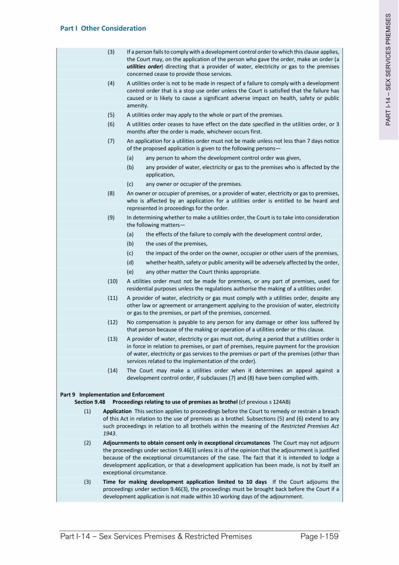
PA
RT
I-1
4–
SE
X S
ER
VIC
ES
PR
EM
ISE
S
Part I Other Consideration
Part I-14 – Sex Services Premises & Restricted Premises Page I-159
(3) If a person fails to comply with a development control order to which this clause applies, the Court may, on the application of the person who gave the order, make an order (a utilities order) directing that a provider of water, electricity or gas to the premises concerned cease to provide those services.
(4) A utilities order is not to be made in respect of a failure to comply with a development control order that is a stop use order unless the Court is satisfied that the failure has caused or is likely to cause a significant adverse impact on health, safety or public amenity.
(5) A utilities order may apply to the whole or part of the premises.
(6) A utilities order ceases to have effect on the date specified in the utilities order, or 3 months after the order is made, whichever occurs first.
(7) An application for a utilities order must not be made unless not less than 7 days notice of the proposed application is given to the following persons—
(a) any person to whom the development control order was given,
(b) any provider of water, electricity or gas to the premises who is affected by the application,
(c) any owner or occupier of the premises.
(8) An owner or occupier of premises, or a provider of water, electricity or gas to premises, who is affected by an application for a utilities order is entitled to be heard and represented in proceedings for the order.
(9) In determining whether to make a utilities order, the Court is to take into consideration the following matters—
(a) the effects of the failure to comply with the development control order,
(b) the uses of the premises,
(c) the impact of the order on the owner, occupier or other users of the premises,
(d) whether health, safety or public amenity will be adversely affected by the order,
(e) any other matter the Court thinks appropriate.
(10) A utilities order must not be made for premises, or any part of premises, used for residential purposes unless the regulations authorise the making of a utilities order.
(11) A provider of water, electricity or gas must comply with a utilities order, despite any other law or agreement or arrangement applying to the provision of water, electricity or gas to the premises, or part of the premises, concerned.
(12) No compensation is payable to any person for any damage or other loss suffered by that person because of the making or operation of a utilities order or this clause.
(13) A provider of water, electricity or gas must not, during a period that a utilities order is in force in relation to premises, or part of premises, require payment for the provision of water, electricity or gas services to the premises or part of the premises (other than services related to the implementation of the order).
(14) The Court may make a utilities order when it determines an appeal against a development control order, if subclauses (7) and (8) have been complied with.
Part 9 Implementation and Enforcement Section 9.48 Proceedings relating to use of premises as brothel (cf previous s 124AB)
(1) Application This section applies to proceedings before the Court to remedy or restrain a breach of this Act in relation to the use of premises as a brothel. Subsections (5) and (6) extend to any such proceedings in relation to all brothels within the meaning of the Restricted Premises Act 1943.
(2) Adjournments to obtain consent only in exceptional circumstances The Court may not adjourn the proceedings under section 9.46(3) unless it is of the opinion that the adjournment is justified because of the exceptional circumstances of the case. The fact that it is intended to lodge a development application, or that a development application has been made, is not by itself an exceptional circumstance.
(3) Time for making development application limited to 10 days If the Court adjourns the proceedings under section 9.46(3), the proceedings must be brought back before the Court if a development application is not made within 10 working days of the adjournment.
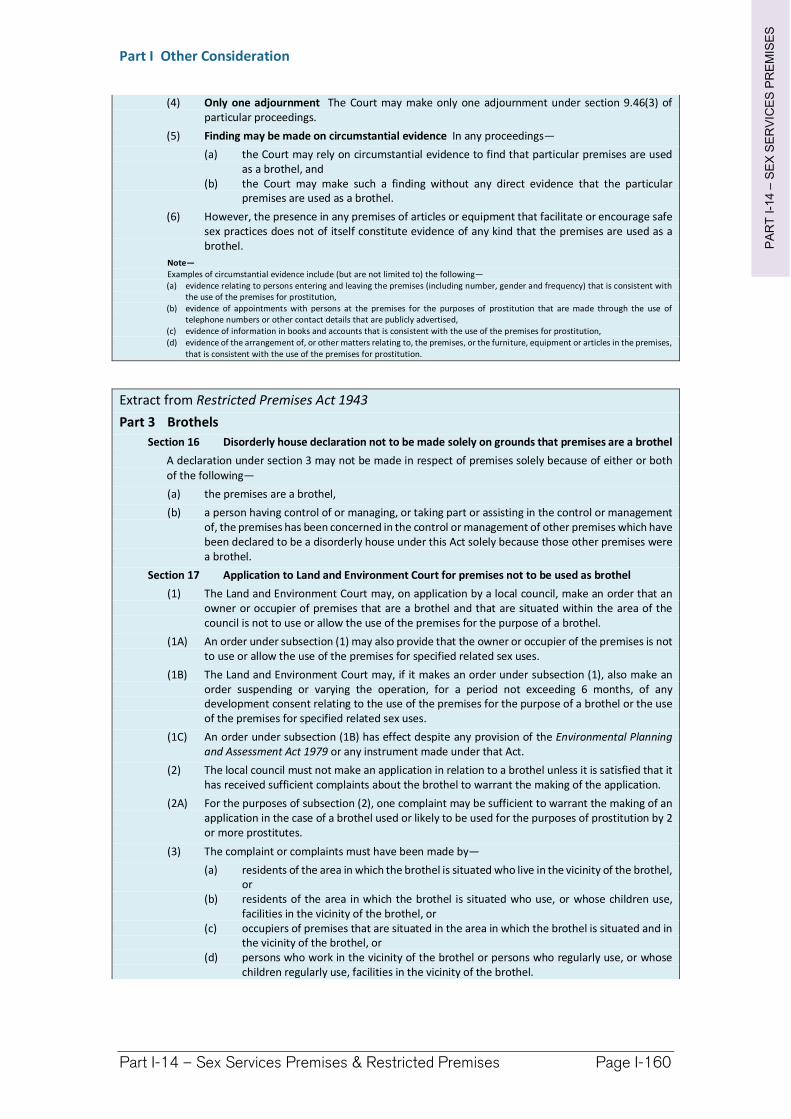
PA
RT
I-1
4–
SE
X S
ER
VIC
ES
PR
EM
ISE
S
Part I Other Consideration
Part I-14 – Sex Services Premises & Restricted Premises Page I-160
(4) Only one adjournment The Court may make only one adjournment under section 9.46(3) of particular proceedings.
(5) Finding may be made on circumstantial evidence In any proceedings—
(a) the Court may rely on circumstantial evidence to find that particular premises are used as a brothel, and
(b) the Court may make such a finding without any direct evidence that the particular premises are used as a brothel.
(6) However, the presence in any premises of articles or equipment that facilitate or encourage safe sex practices does not of itself constitute evidence of any kind that the premises are used as a brothel.
Note— Examples of circumstantial evidence include (but are not limited to) the following— (a) evidence relating to persons entering and leaving the premises (including number, gender and frequency) that is consistent with
the use of the premises for prostitution, (b) evidence of appointments with persons at the premises for the purposes of prostitution that are made through the use of
telephone numbers or other contact details that are publicly advertised, (c) evidence of information in books and accounts that is consistent with the use of the premises for prostitution, (d) evidence of the arrangement of, or other matters relating to, the premises, or the furniture, equipment or articles in the premises,
that is consistent with the use of the premises for prostitution.
Extract from Restricted Premises Act 1943
Part 3 Brothels
Section 16 Disorderly house declaration not to be made solely on grounds that premises are a brothel
A declaration under section 3 may not be made in respect of premises solely because of either or both of the following—
(a) the premises are a brothel,
(b) a person having control of or managing, or taking part or assisting in the control or management of, the premises has been concerned in the control or management of other premises which have been declared to be a disorderly house under this Act solely because those other premises were a brothel.
Section 17 Application to Land and Environment Court for premises not to be used as brothel
(1) The Land and Environment Court may, on application by a local council, make an order that an owner or occupier of premises that are a brothel and that are situated within the area of the council is not to use or allow the use of the premises for the purpose of a brothel.
(1A) An order under subsection (1) may also provide that the owner or occupier of the premises is not to use or allow the use of the premises for specified related sex uses.
(1B) The Land and Environment Court may, if it makes an order under subsection (1), also make an order suspending or varying the operation, for a period not exceeding 6 months, of any development consent relating to the use of the premises for the purpose of a brothel or the use of the premises for specified related sex uses.
(1C) An order under subsection (1B) has effect despite any provision of the Environmental Planning and Assessment Act 1979 or any instrument made under that Act.
(2) The local council must not make an application in relation to a brothel unless it is satisfied that it has received sufficient complaints about the brothel to warrant the making of the application.
(2A) For the purposes of subsection (2), one complaint may be sufficient to warrant the making of an application in the case of a brothel used or likely to be used for the purposes of prostitution by 2 or more prostitutes.
(3) The complaint or complaints must have been made by—
(a) residents of the area in which the brothel is situated who live in the vicinity of the brothel, or
(b) residents of the area in which the brothel is situated who use, or whose children use, facilities in the vicinity of the brothel, or
(c) occupiers of premises that are situated in the area in which the brothel is situated and in the vicinity of the brothel, or
(d) persons who work in the vicinity of the brothel or persons who regularly use, or whose children regularly use, facilities in the vicinity of the brothel.
PA
RT
I-1
4–
SE
X S
ER
VIC
ES
PR
EM
ISE
S
Part I Other Consideration
Part I-14 – Sex Services Premises & Restricted Premises Page I-161
(4) The application must state the reasons why the local council is of the opinion that the operation of the brothel should cease based on one or more of the considerations referred to in subsection (5) (a), (b), (c), (d), (e) or (f).
(5) In making an order under subsection (1) the Land and Environment Court is to take into consideration only the following—
(a) whether the brothel is operating near or within view from a church, hospital, school or any place regularly frequented by children for recreational or cultural activities,
(b) whether the operation of the brothel causes a disturbance in the neighbourhood when taking into account other brothels operating in the neighbourhood or other land use within the neighbourhood involving similar hours of operation and creating similar amounts of noise and vehicular and pedestrian traffic,
(c) whether sufficient off-street parking has been provided if appropriate in the circumstances,
(d) whether suitable access has been provided to the brothel, (e) whether the operation of the brothel causes a disturbance in the neighbourhood because
of its size and the number of people working in it, (f) whether the operation of the brothel interferes with the amenity of the neighbourhood, (g) any other matter that the Land and Environment Court considers is relevant.
(5A) In making an order under subsection (1B), the Land and Environment Court is to take into consideration only the following—
(a) the likelihood that the premises will continue to be used for a brothel or will be used for related sex uses (whether or not by a person who is subject to the order under subsection (1)),
(b) having regard to the kinds of matters considered before granting the order under subsection (1), the effect on the amenity of the neighbourhood of any such use or uses,
(c) the permitted uses for the land on which the premises are situated under any applicable environmental planning instruments or approval under the Environmental Planning and Assessment Act 1979,
(d) any other matter that the Land and Environment Court considers is relevant.
(6) This section extends to premises within an area that is not a local government area, and in that case a reference to a local council is to be read—
(a) in relation to Lord Howe Island—as a reference to the Lord Howe Island Board, and (b) in relation to such part of the land in the Western Division of the State as is not in a local
government area—as a reference to the Western Lands Commissioner, and (c) in relation to any other area that is not a local government area—as a reference to the
prescribed authority for the area.
(7) In this section—
church, hospital and school have the same meanings as in the Summary Offences Act 1988. development consent has the same meaning as it has in Division 2A of Part 6 of the Environmental
Planning and Assessment Act 1979. local council includes a person or body that— (a) exercises planning or regulatory functions in respect of the area in which premises are
situated, and (b) is authorised by the Minister administering the Environmental Planning and Assessment
Act 1979 to exercise the functions of a local council under this section. Western Division means that part of the State that is the Western Division within the meaning of
the Crown Land Management Act 2016. Section 17A Evidence of use of premises as brothel
(1) This section applies to proceedings before the Land and Environment Court on an application under section 17 for premises not to be used as a brothel.
(2) In any proceedings to which this section applies—
(a) the Court may rely on circumstantial evidence to find that particular premises are used as a brothel, and
(b) the Court may make such a finding without any direct evidence that the particular premises are used as a brothel.
(3) However, the presence in any premises of articles or equipment that facilitate or encourage safe sex practices does not of itself constitute evidence of any kind that the premises are used as a brothel.
Note—
PA
RT
I-1
4–
SE
X S
ER
VIC
ES
PR
EM
ISE
S
Part I Other Consideration
Part I-14 – Sex Services Premises & Restricted Premises Page I-162
Examples of circumstantial evidence include (but are not limited to) the following—
(a) evidence relating to persons entering and leaving the premises (including number, gender and frequency) that is consistent with the use of the premises for prostitution,
(b) (Repealed) (c) evidence of appointments with persons at the premises for the purposes of prostitution that are made through
the use of telephone numbers or other contact details that are publicly advertised, (d) evidence of information in books and accounts that is consistent with the use of the premises for prostitution, (e) evidence of the arrangement of, or other matters relating to, the premises or the furniture, equipment or
articles in the premises, that is consistent with the use of the premises for prostitution.
Section 18 Rules of the Land and Environment Court
(1) Rules may be made under the Land and Environment Court Act 1979 for or with respect to any matters that by or under the provisions of this Part are required or permitted to be prescribed for carrying out or giving effect to those provisions.
(2) Subsection (1) does not limit the rule-making powers conferred by the Land and Environment Court Act 1979.
(3) Circumstances where Council will Act to Close Premises
Before initiating any process to suspend or close business trading on premises described within this section of the DCP, Council must have regard for the following:
Disruption and nuisance to the local area as a result of clientele visiting, loitering or conducting any unlawful activity in proximity to the premises.
Breach of the consent condition requiring the NSW Police Force and the Council to be notified if any person in part or whole, past or present ownership of the premises if they have been found guilty of an indictable offence (within 28 days of conviction).
Disruption and nuisance to the local area as a result of persons not visiting the premises, but shown to be loitering as a result of the existence and operation of the premises.
Council, in due consideration of any and all justified issues raised by the public, and documented incidents of antisocial and/or unlawful behaviour relating to persons visiting or loiter within the vicinity of the premises, will make a determination based upon the probability the premises has affected or will negatively affect the social structure of the local area and/or the community.
Richmond Valley Development Control Plan 2021
Part I-15 Lane Widening and Access to Narrow Streets
Many streets and lanes in the Council area are narrow with minimal road pavement construction. In their current form they present obstacles to developing land where they are required as a primary frontage for access.
To facilitate development along these streets and lanes, Council has a lane widening policy aimed at resuming land to increase the width of the road reserve so the road pavements can be widened to handle increase traffic volumes. In other instances, Council has elected not to widen lanes opting instead to change them to ‘one-way’ streets and to require some level of road construction to be funded by development fronting the narrow lane.
This Chapter addresses Council’s requirements for lane widening and access to narrow lanes.
This DCP applies to all land within the Richmond Valley Local Government Area.
Date adopted by Council:
Effective Date:
Amendments:
This DCP applies to all land within the Richmond Valley Local Government Area.
Date adopted by Council: 22/06/2021
Effective Date: 01/08/2021
Amendments: Nil
PA
RT
I-1
5–
LA
NE
WID
EN
ING
Part I Other Consideration
Part I-15 – Lane Widening Page I-164
I-15.1 General Objectives
The general objectives of this Chapter are to:
(1) identify roads that may be subject to future lane widening.
(2) identify the minimum road standards for narrow lanes to be used as primary access to development.
I-15.2 Lane Widening
Objective
(1) To identify those properties that may be subject to future lane widening.
(2) To identify a process for resuming land for lane widening.
Controls
(1) Those lanes identified in Figure I-15.1 will be subject to future lane widening. Council may resume a strip of land, usually about 3 metres in width, from the full frontage of the lane to be dedicated as public road.
(2) Land may be resumed for lane widening in either of 2 ways.
(a) Dedication of land free of charge to Council—where land is being redeveloped and identifies the lane as a primary access frontage,
(b) Resumption of land and owner compensation under the Land Acquisition (Just Terms Compensation) Act 1991—where land is required to be resumed for lane widening and there has never been a condition of development consent requiring the land’s dedication to be free of charge to Council.
(3) Dedication of Lane Widening
The dedication of lane widening to Council free of cost will occur at either of 2 opportunities:
(a) if the land is to be subdivided—the land will be identified on the subdivision plan “to be dedicated to Council as public road”.
(b) for other development types—the dedication will be completed via a resumption process initiated by Council.
Note. The legal and surveying costs associated with resuming land (see item (3)(b)) will be the responsibility of Council.
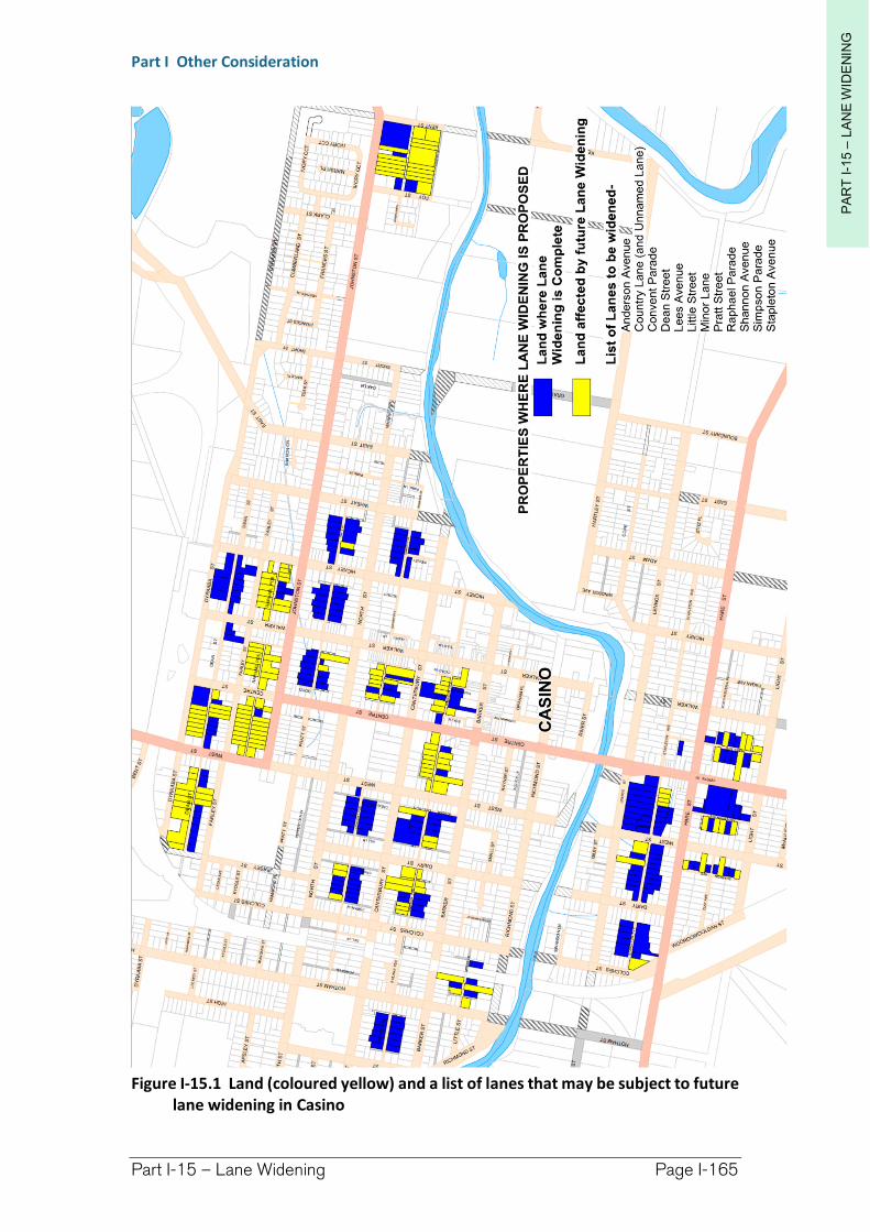
PA
RT
I-1
5–
LA
NE
WID
EN
ING
Part I Other Consideration
Part I-15 – Lane Widening Page I-165
Figure I-15.1 Land (coloured yellow) and a list of lanes that may be subject to future lane widening in Casino
PA
RT
I-1
5–
LA
NE
WID
EN
ING
Part I Other Consideration
Part I-15 – Lane Widening Page I-166
I-15.3 Development requirements when accessing narrow streets
Objective
(1) To ensure narrow streets are capable of handling additional road traffic from development.
(2) To require developments to contribute towards the upgrading of narrow streets where they will used for vehicular access to development.
Controls
(1) For the purposes of this section, a narrow street is generally one that has a road reserve width of less than 10 metres (measured from boundary to boundary).
(2) Council will only grant development consent to use a narrow street for vehicular access when it considers:
(a) the street to be safe—having regard to its design standard,
(b) the street to be is capable of handling additional vehicular traffic, including that of future development that might arise once a narrow street has been opened to development access,
(c) whether the narrow street is subject to-
(i) future lane widening—in which case a condition of consent will require dedication of the lane widening to Council free of charge, or
(d) a “one-way” traffic restriction,
Note. Development consent may be refused if a narrow street is not identified for future lane widening or “one-way”.
(e) the condition of the narrow street and whether the development should contribute towards pavement sealing and stormwater drainage works.
(3) In regards to narrow street upgrading requirements, the extent of necessary infrastructure will be at the discretion of Council and subject to negotiation.
Richmond Valley Development Control Plan 2021
Part I-16 Historic New Italy Village Area
New Italy was settled by Italian migrant families in 1882. The settlement consisted of 53 selections, ranging from 40 to 120 acres, having a total area of about 3030.75 acres (1226.5ha).
In 2002 the New Italy Settlement Landscape was recognised as having State significance being:
evidence of a settlement built through the tenacity, forbearance and technical skills (esp. horticultural and architectural) of a unique group of Australian settlers, and
also significant to those displaced Italian migrants who were allowed assisted passage to Australia by Sir Henry Parkes after the ill-fated Marquis de Rays expedition of 1881.
The State significance of the area was recognised under the Heritage Act 1977, being represented through the State Heritage listing of 3 sites, they being:
the New Italy Museum complex (listed in August 2002),
the former School site (listed in August 2002), and
Vineyard Haven (listed in December 2004).
Additional information on the New Italy Settlement and the State Heritage listed sites can be obtained from the NSW Heritage website – www.heritage.nsw.gov.au .
The Richmond Valley Council Heritage Study (2007) also recognised the significance of the New Italy Settlement area through local listing of a number of heritage items and archaeological sites. These items were included in Schedule 5 of the LEP.
A further action resulting from the Study was the recognition that other, yet undiscovered, sites may exist within the New Italy area. To safeguard these potential items the “Historic New Italy Village Area” has been
This DCP applies to all land within the Richmond Valley Local Government Area.
Date adopted by Council: 22/06/2021
Effective Date: 01/08/2021
Amendments: Nil
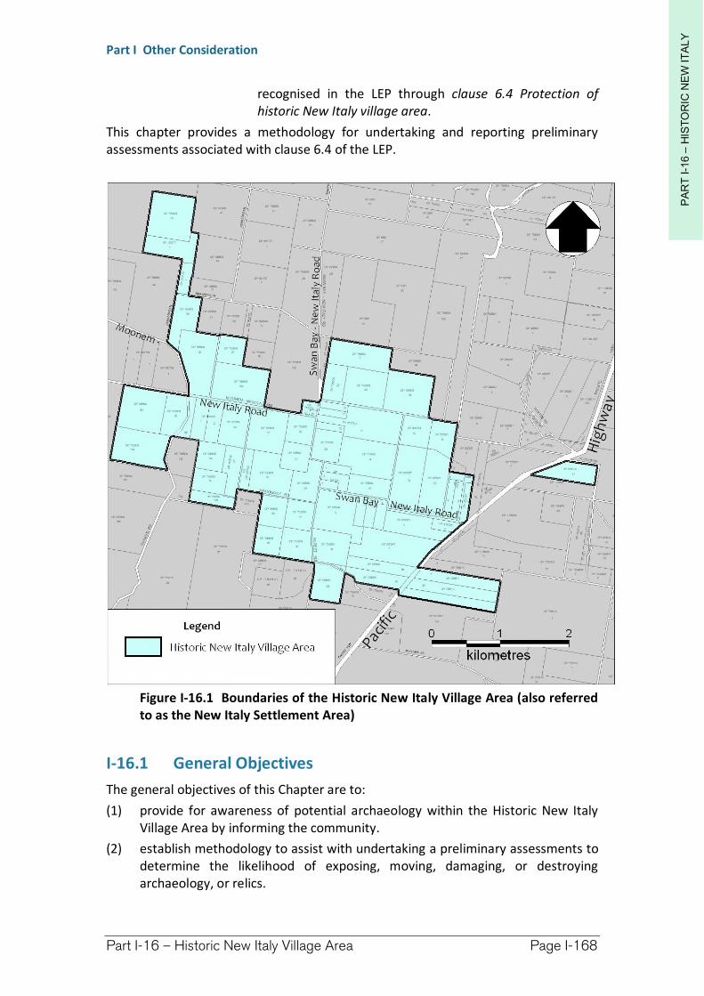
PA
RT
I-1
6 –
HIS
TO
RIC
NE
W IT
ALY
Part I Other Consideration
Part I-16 – Historic New Italy Village Area Page I-168
recognised in the LEP through clause 6.4 Protection of historic New Italy village area.
This chapter provides a methodology for undertaking and reporting preliminary assessments associated with clause 6.4 of the LEP.
Figure I-16.1 Boundaries of the Historic New Italy Village Area (also referred to as the New Italy Settlement Area)
I-16.1 General Objectives
The general objectives of this Chapter are to:
(1) provide for awareness of potential archaeology within the Historic New Italy Village Area by informing the community.
(2) establish methodology to assist with undertaking a preliminary assessments to determine the likelihood of exposing, moving, damaging, or destroying archaeology, or relics.
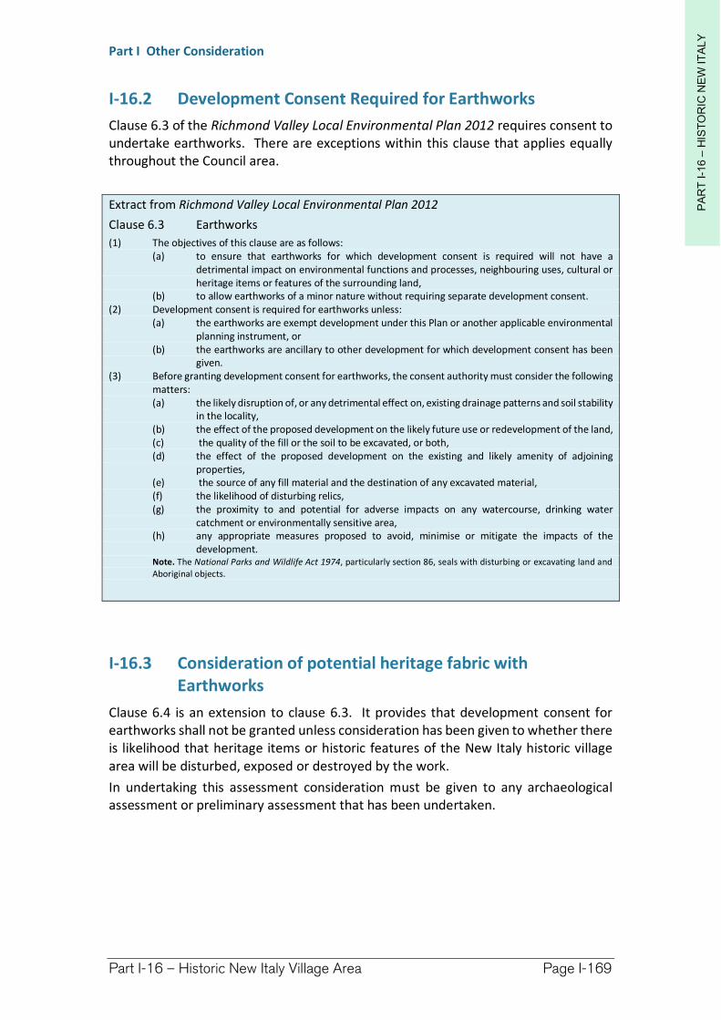
PA
RT
I-1
6 –
HIS
TO
RIC
NE
W IT
ALY
Part I Other Consideration
Part I-16 – Historic New Italy Village Area Page I-169
I-16.2 Development Consent Required for Earthworks
Clause 6.3 of the Richmond Valley Local Environmental Plan 2012 requires consent to undertake earthworks. There are exceptions within this clause that applies equally throughout the Council area.
Extract from Richmond Valley Local Environmental Plan 2012
Clause 6.3 Earthworks
(1) The objectives of this clause are as follows: (a) to ensure that earthworks for which development consent is required will not have a
detrimental impact on environmental functions and processes, neighbouring uses, cultural or heritage items or features of the surrounding land,
(b) to allow earthworks of a minor nature without requiring separate development consent. (2) Development consent is required for earthworks unless:
(a) the earthworks are exempt development under this Plan or another applicable environmental planning instrument, or
(b) the earthworks are ancillary to other development for which development consent has been given.
(3) Before granting development consent for earthworks, the consent authority must consider the following matters: (a) the likely disruption of, or any detrimental effect on, existing drainage patterns and soil stability
in the locality, (b) the effect of the proposed development on the likely future use or redevelopment of the land, (c) the quality of the fill or the soil to be excavated, or both, (d) the effect of the proposed development on the existing and likely amenity of adjoining
properties, (e) the source of any fill material and the destination of any excavated material, (f) the likelihood of disturbing relics, (g) the proximity to and potential for adverse impacts on any watercourse, drinking water
catchment or environmentally sensitive area, (h) any appropriate measures proposed to avoid, minimise or mitigate the impacts of the
development. Note. The National Parks and Wildlife Act 1974, particularly section 86, seals with disturbing or excavating land and Aboriginal objects.
I-16.3 Consideration of potential heritage fabric with Earthworks
Clause 6.4 is an extension to clause 6.3. It provides that development consent for earthworks shall not be granted unless consideration has been given to whether there is likelihood that heritage items or historic features of the New Italy historic village area will be disturbed, exposed or destroyed by the work.
In undertaking this assessment consideration must be given to any archaeological assessment or preliminary assessment that has been undertaken.

PA
RT
I-1
6 –
HIS
TO
RIC
NE
W IT
ALY
Part I Other Consideration
Part I-16 – Historic New Italy Village Area Page I-170
Extract from Richmond Valley Local Environmental Plan 2012
Clause 6.4 Protection of historic New Italy area
(1) The objectives of this clause are as follows: (a) to protect the area known as “New Italy”, (b) to ensure that earthworks for which development consent is required will not have a
detrimental impact on cultural or heritage items or features of the historic New Italy village area.
(2) This clause applies to land as shown coloured blue and labelled “Historic New Italy Village Area” on the Key Sites Map.
(3) Before granting development consent for earthworks on land to which this clause applies, the consent authority must consider the following matters: (a) the likelihood that the proposed development will expose, move, damage or destroy an item
that may have local heritage significance, (b) the outcome of any preliminary or archaeological assessment of the local heritage significance
of the land (if an assessment has been carried out or has been provided by the owner). Note. Clause 5.10 deals with the conservation of heritage items and relics.
I-16.4 Heritage Act approvals
Consent under Division 9 of the Heritage Act 1977 will be required to expose, move, damage or destroy any historic or cultural features (other than identified local heritage items within Schedule 5 of the LEP) that may be discovered, whether or not it resulted from an assessment under clause 6.4. Relevant sections of the Heritage Act has been extracted below.
Extract from the Heritage Act 1977
Section 4 Definitions harm means: (a) in relation to a building or work—demolish, or (b) in relation to a relic or moveable object—damage, despoil, move or alter, or (c) in relation to a place or precinct—damage, despoil or develop the land that comprises the place
or is within the precinct or damage or destroy any tree or other vegetation on, or remove any tree or other vegetation from, the place or precinct.
item means a place, building, work, relic, moveable object or precinct. relic means any deposit, artefact, object or material evidence that: (a) relates to the settlement of the area that comprises New South Wales, not being Aboriginal
settlement, and (b) is of State or local heritage significance.
Division 9 Protection of certain relics
Section 138 Definitions In this Division: excavation permit means an excavation permit referred to in section 139. historic shipwreck has the same meaning as it has in Part 3C. historic shipwrecks permit means a historic shipwrecks permit referred to in section 51. permit means an excavation permit or historic shipwrecks permit. relic includes a historic shipwreck.
Section 139 Excavation permit required in certain circumstances (1) A person must not disturb or excavate any land knowing or having reasonable cause to suspect that the
disturbance or excavation will or is likely to result in a relic being discovered, exposed, moved, damaged or destroyed unless the disturbance or excavation is carried out in accordance with an excavation permit.
(2) A person must not disturb or excavate any land on which the person has discovered or exposed a relic except in accordance with an excavation permit.
(3) This section does not apply to a relic that is subject to an interim heritage order made by the Minister or a listing on the State Heritage Register.
PA
RT
I-1
6 –
HIS
TO
RIC
NE
W IT
ALY
Part I Other Consideration
Part I-16 – Historic New Italy Village Area Page I-171
(4) The Heritage Council may by order published in the Gazette create exceptions to this section, either unconditionally or subject to conditions, in respect of any of the following: (a) any relic of a specified kind or description, (b) any disturbance or excavation of a specified kind or description, (c) any disturbance or excavation of land in a specified location or having specified features or
attributes, (d) any disturbance or excavation of land in respect of which an archaeological assessment
approved by the Heritage Council indicates that there is little likelihood of there being any relics in the land.
(5) This section does not prevent a person from disturbing or excavating land in which a historic shipwreck is situated in accordance with a historic shipwrecks permit in force in respect of that shipwreck.
Section 140 Application for permit (1) A person may make an application to the Heritage Council for the issue to the person of a permit. (2) The application shall be in the approved form and shall be accompanied by such fee as may be prescribed.
Section 141 Determination of application (1) The Heritage Council may determine an application for a permit:
(a) by issuing a permit, either unconditionally or subject to such conditions as it thinks proper to impose, or
(b) by refusing to issue a permit. (2) Where the Heritage Council fails to determine an application for a permit within 21 days after the date
of that application, it shall, for the purpose only of section 142, be deemed to have determined that application by refusing to issue a permit.
Section 146 Notification of discovery of relic A person who is aware or believes that he or she has discovered or located a relic (in any circumstances, and whether or not the person has been issued with a permit) must: (a) within a reasonable time after he or she first becomes aware or believes that he or she has
discovered or located that relic, notify the Heritage Council of the location of the relic, unless he or she believes on reasonable grounds that the Heritage Council is aware of the location of the relic, and
(b) within the period required by the Heritage Council, furnish the Heritage Council with such information concerning the relic as the Heritage Council may reasonably require.
Section 146A Disposition of certain relics (1) As soon as practicable after a relic is obtained from an excavation carried out by the holder of a permit,
the holder shall notify the Minister of the existence of the relic. (2) The holder shall furnish the Minister with such information concerning the relic as the Minister may
reasonably require.
Section 146B Minister may direct that relic be given to museum or other conservation body (1) The Minister may, by notice in writing, direct any person:
(a) who is or has been the holder of a permit, or (b) who, in the Minister’s opinion, has obtained a historic shipwreck as a consequence of having
removed the relic without a historic shipwrecks permit, in contravention of section 51, or (c) who, in the Minister’s opinion, has obtained a relic as a consequence of having excavated land
without an excavation permit, in contravention of section 139, to deliver the relic to a specified person or body (such as a museum) who in the opinion of the Minister has the facilities and expertise to conserve the relic.
(2) Such a direction may be given on the ground that the person has obtained the relic as a consequence of: (a) having removed the relic without a historic shipwrecks permit, in contravention of section 51,
or (b) having excavated land without an excavation permit, in contravention of section 139, whether or not the person has been prosecuted or convicted of an offence in respect of the alleged contravention.
Section 146C Forfeiture of certain relics (1) A relic the subject of a direction under section 146B shall be forfeited to the Crown. (2) No compensation is payable to any person as a consequence of the forfeiture of a relic under this section.
PA
RT
I-1
6 –
HIS
TO
RIC
NE
W IT
ALY
Part I Other Consideration
Part I-16 – Historic New Italy Village Area Page I-172
I-16.5 Education
One of the objectives of this Chapter is to inform the community of the likely presence of archaeology in the New Italy area. This can be achieved by informing the community, especially new property owners or prospective purchases of land, that they should have regard to potential heritage in the area and take appropriate actions to avoid harming such heritage. This objective can be achieved by the:
inclusion of clause 6.4 within the Richmond Valley LEP 2012
inclusion of this Chapter within the Richmond Valley DCP 2012, and
informing the community of the LEP and DCP requirements, the reasons for them, and where they apply in section 10.7 Planning Certificates, and the like.
I-16.6 Preliminary Assessment
Due diligence is a process where reasonable and practical steps are taken to determine whether a person’s actions could, in this case, harm archaeology or relics within the New Italy Settlement Area. The Preliminary Assessment process forms a key element of due diligence.
The preliminary assessment methodology documented in this Chapter has been designed to be simple and straight forward, while fulfilling due diligence requirements.
I-16.7 Items Likely to be Found
(1) Sites discovered by a preliminary assessment are more than likely to be archaeological in nature but may include any of the following:
stone or timber lined wells
remnants of buildings
earth mounds from mud brick buildings
old fence lines
trees, orchards and/or vine plantings, or
drainage lines.
(2) Notification of Discovery
There is a statutory requirement under section 146 of the Heritage Act 1977 to notify the NSW Heritage Branch of all relic discoveries. This notification should also be directed to Council.
Contact details:
NSW Heritage
Level 6, 10 Valentine Ave, PARRAMATTA 2150
Locked Bag 5020, PARRAMATTA NSW 2124
Phone 02 98738500 Fax 02 98738599
Email [email protected]
Richmond Valley Council
10 Graham Place, Casino NSW 2470
Locked Bag 10, CASINO NSW 2470
Phone 02 66600300 Fax 02 66625198
Email [email protected]
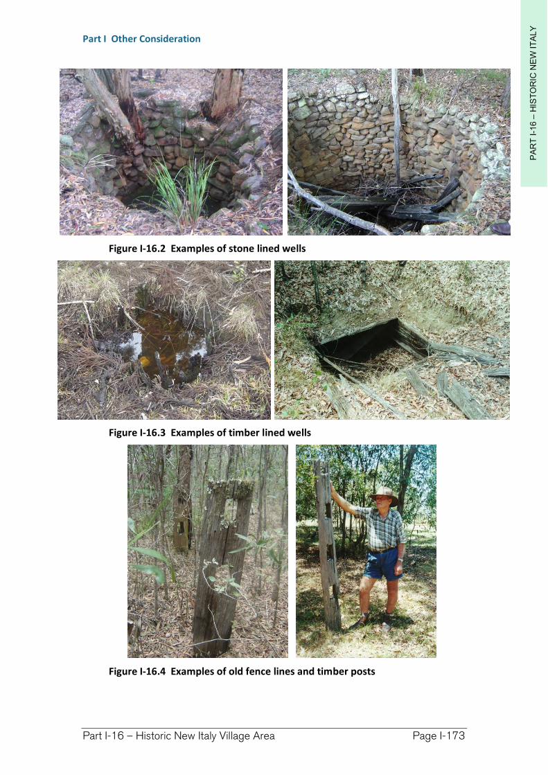
PA
RT
I-1
6 –
HIS
TO
RIC
NE
W IT
ALY
Part I Other Consideration
Part I-16 – Historic New Italy Village Area Page I-173
Figure I-16.2 Examples of stone lined wells
Figure I-16.3 Examples of timber lined wells
Figure I-16.4 Examples of old fence lines and timber posts
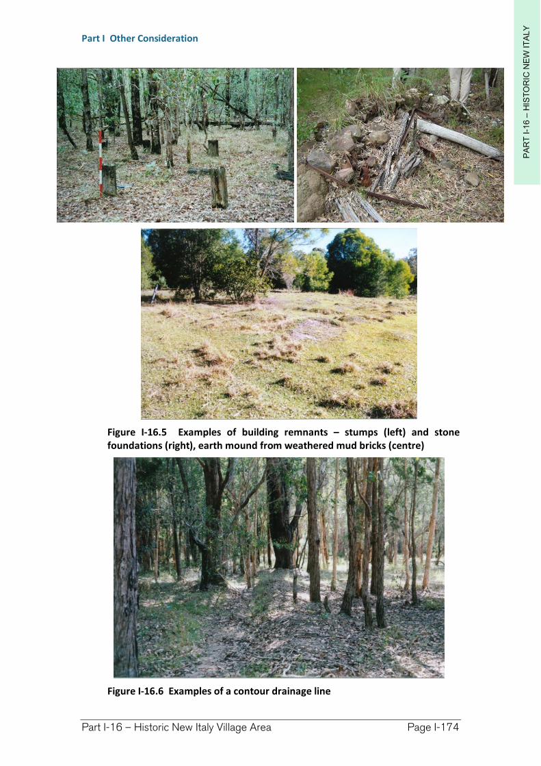
PA
RT
I-1
6 –
HIS
TO
RIC
NE
W IT
ALY
Part I Other Consideration
Part I-16 – Historic New Italy Village Area Page I-174
Figure I-16.5 Examples of building remnants – stumps (left) and stone foundations (right), earth mound from weathered mud bricks (centre)
Figure I-16.6 Examples of a contour drainage line
PA
RT
I-1
6 –
HIS
TO
RIC
NE
W IT
ALY
Part I Other Consideration
Part I-16 – Historic New Italy Village Area Page I-175
(3) Mitigation
The best means of protecting heritage is to mitigate against its harm. This can be as simple as:
relocating earthworks to a more suitable site, or
maintaining a buffer between the works and the item.
If mitigation of harm is not possible approval will be required to relocate, damage or destroy the item under the Heritage Act 1977.
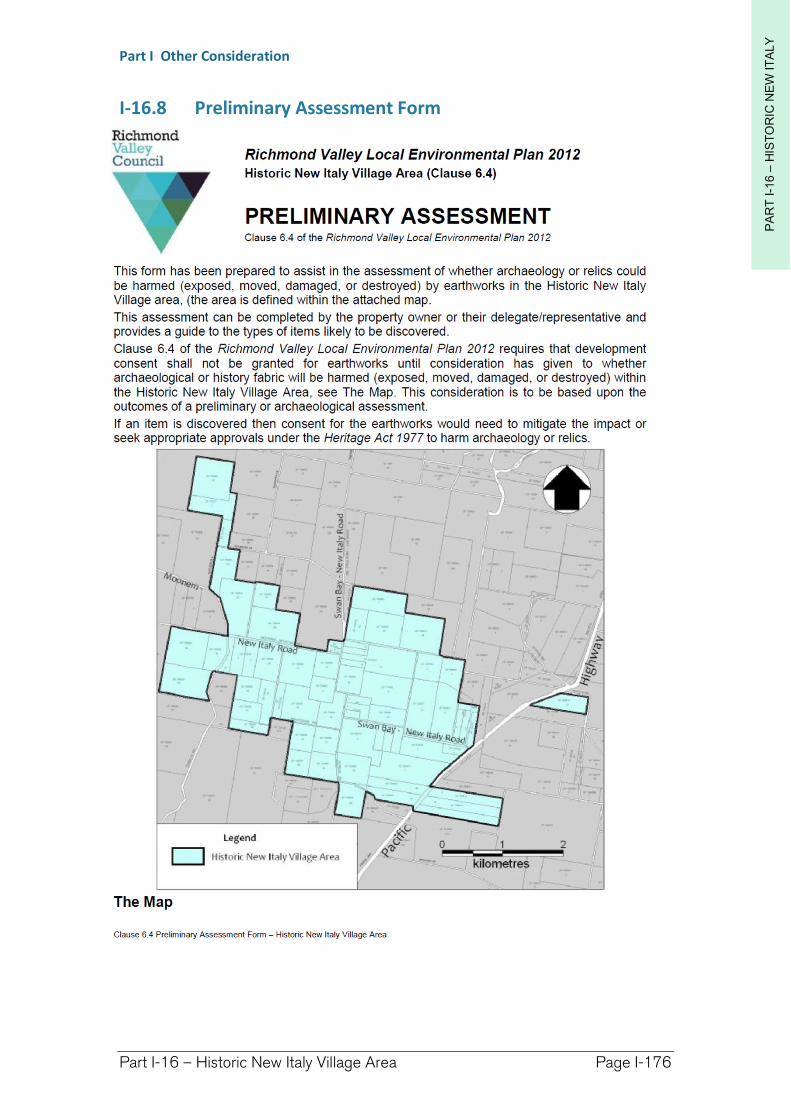
PA
RT
I-1
6 –
HIS
TO
RIC
NE
W IT
ALY
Part I Other Consideration
Part I-16 – Historic New Italy Village Area Page I-176
I-16.8 Preliminary Assessment Form
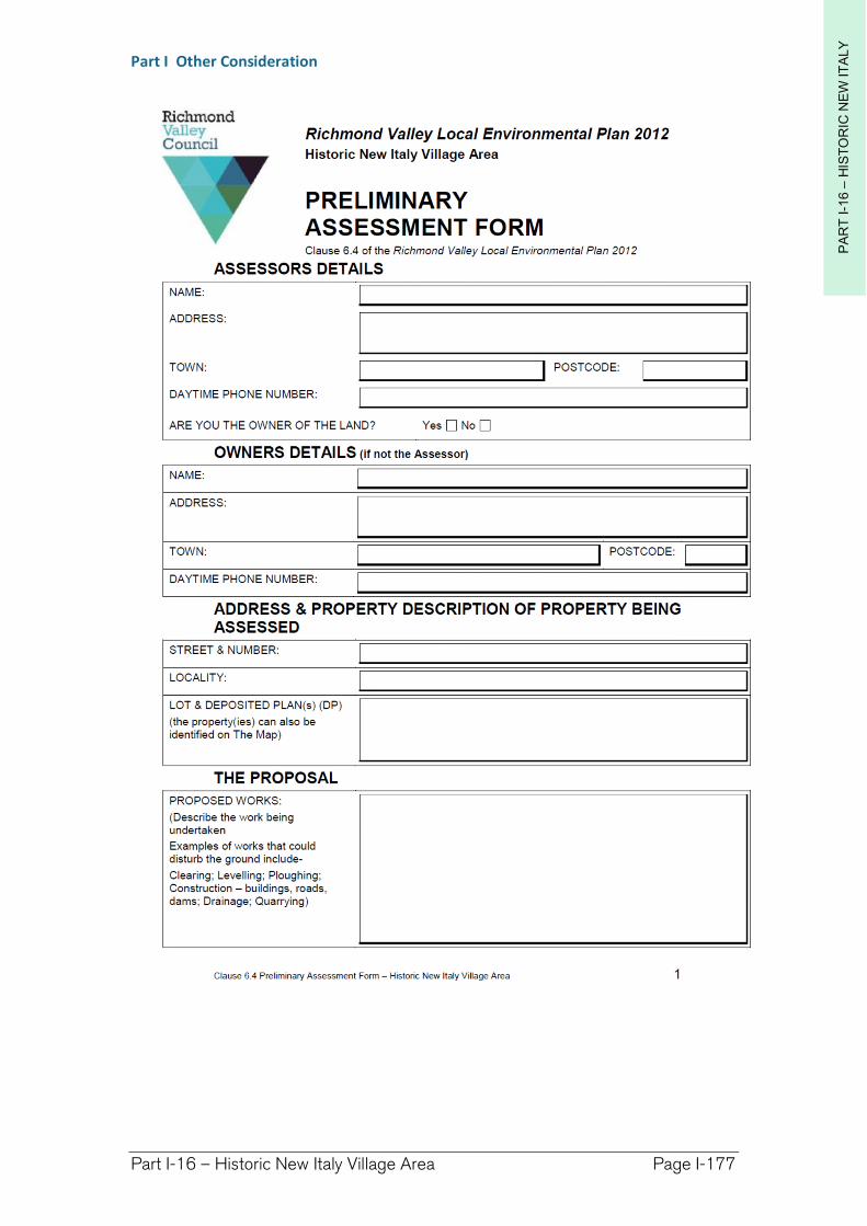
PA
RT
I-1
6 –
HIS
TO
RIC
NE
W IT
ALY
Part I Other Consideration
Part I-16 – Historic New Italy Village Area Page I-177
PA
RT
I-1
6 –
HIS
TO
RIC
NE
W IT
ALY
Part I Other Consideration
Part I-16 – Historic New Italy Village Area Page I-178
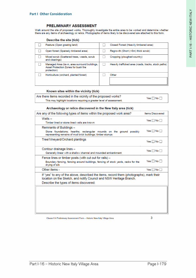
PA
RT
I-1
6 –
HIS
TO
RIC
NE
W IT
ALY
Part I Other Consideration
Part I-16 – Historic New Italy Village Area Page I-179
PA
RT
I-1
6 –
HIS
TO
RIC
NE
W IT
ALY
Part I Other Consideration
Part I-16 – Historic New Italy Village Area Page I-180
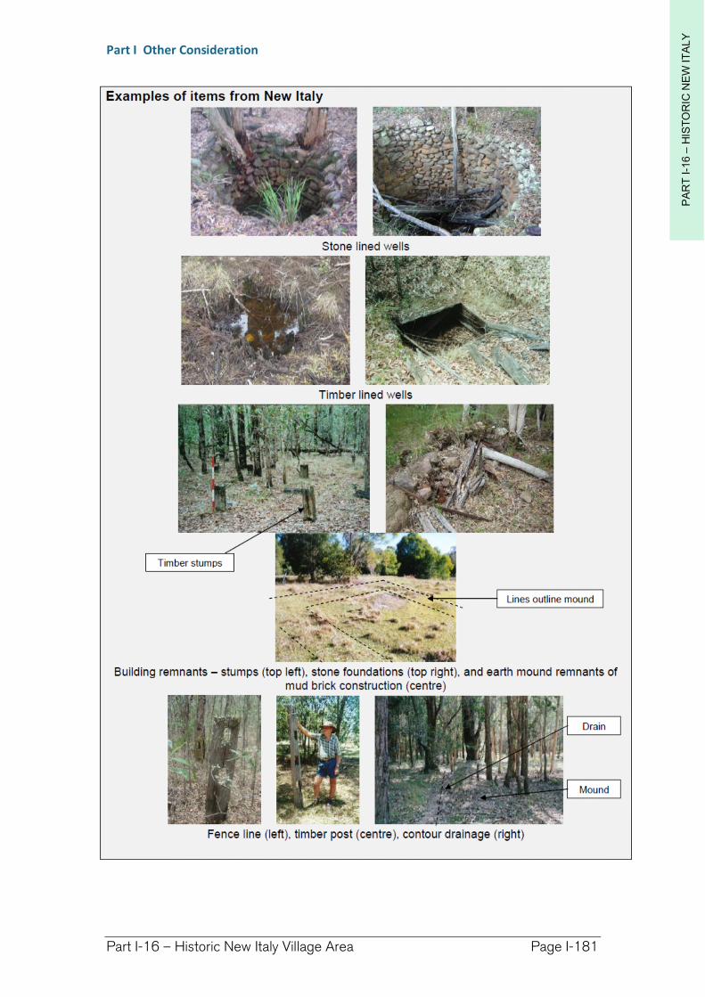
PA
RT
I-1
6 –
HIS
TO
RIC
NE
W IT
ALY
Part I Other Consideration
Part I-16 – Historic New Italy Village Area Page I-181
Related Documents