Richfield Prunes, Pistachios & Walnuts 210 +/- acres • 3 Parcels AG-LAND Investment Brokers 275 Sale Lane • Red Bluff, CA 96080 530-529-4400 • Fax 530-527-5042 Corning, CA - Tehama County

Welcome message from author
This document is posted to help you gain knowledge. Please leave a comment to let me know what you think about it! Share it to your friends and learn new things together.
Transcript
Richfield Prunes, Pistachios & Walnuts210 +/- acres • 3 Parcels
AG-LAND Investment Brokers275 Sale Lane • Red Bluff, CA 96080
530-529-4400 • Fax 530-527-5042
Corning, CA - Tehama County

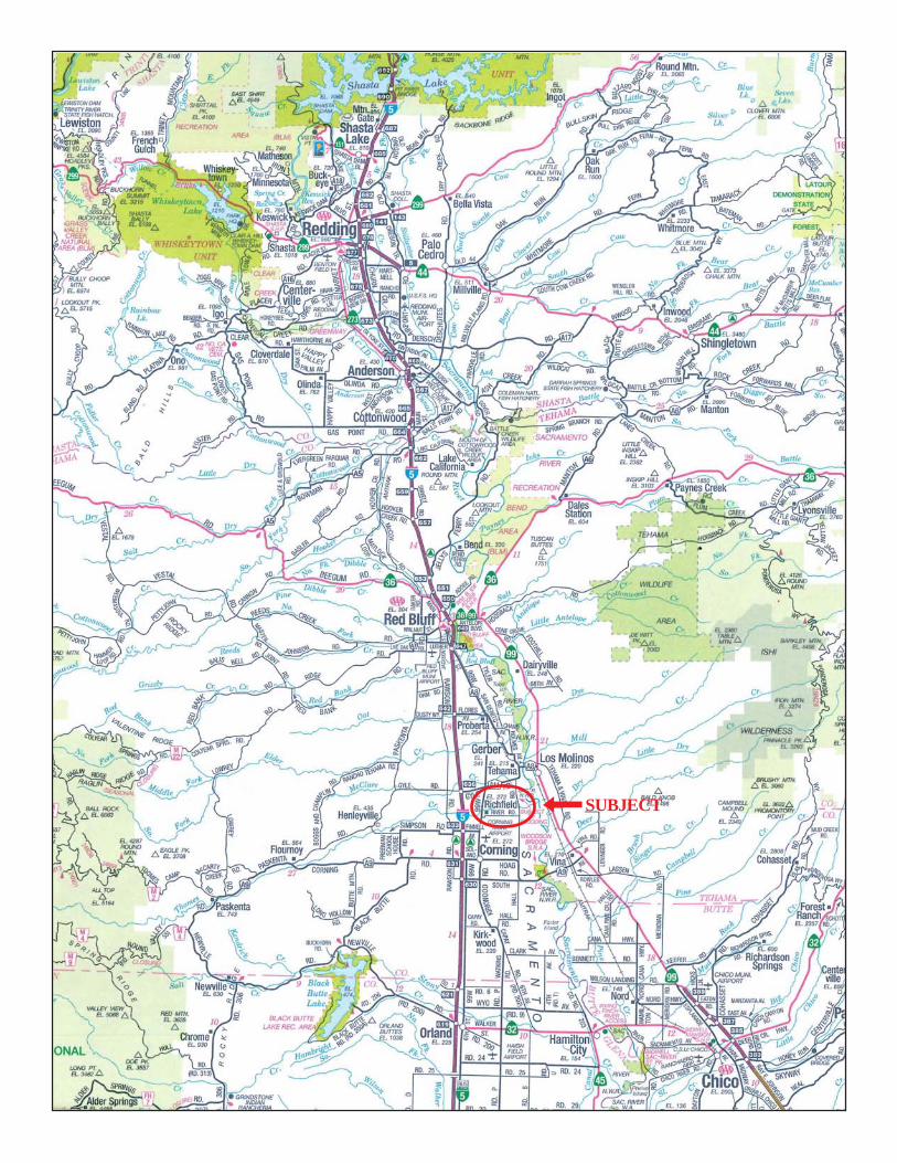
SUBJECTj

AG-LAND INVESTMENT BROKERS 275 Sale Lane / P. O. Box 896
Red Bluff, CA 96080
530.529.4400 office / 530.527.5042 fax
The information contained herein is from sources deemed reliable, however, accuracy is not guaranteed. AG-LAND Investment Brokers assumes no
liability as to errors, omissions or future operating and investment results. Buyer assumes responsibility to perform their own investigation and due diligence. This offering is subject to prior sale, price change or withdrawal from market without notice.
Richfield Prunes, Pistachios & Walnuts
Corning, California Property: 210 assessed acres, approximately 174 acres planted to bearing
prunes and non-bearing pistachios and walnuts. Primarily Class 1 & 2 level soils
irrigated using 3 groundwater wells. Want 294 acres in Richfield with good soil, water
and climate? Under separate agreement, we have 84 additional acres of Class 1 soil
listed for sale only a 4 minute drive from this offering. Call for details.
Location: Between Corning and Red Bluff, south of Thomes Creek, within the
community known as Richfield. The community is a mix of agricultural and rural home
sites. The east property line fronts Walnut Road and the south property line fronts
Orangewood Road. Both roads are County paved roads.
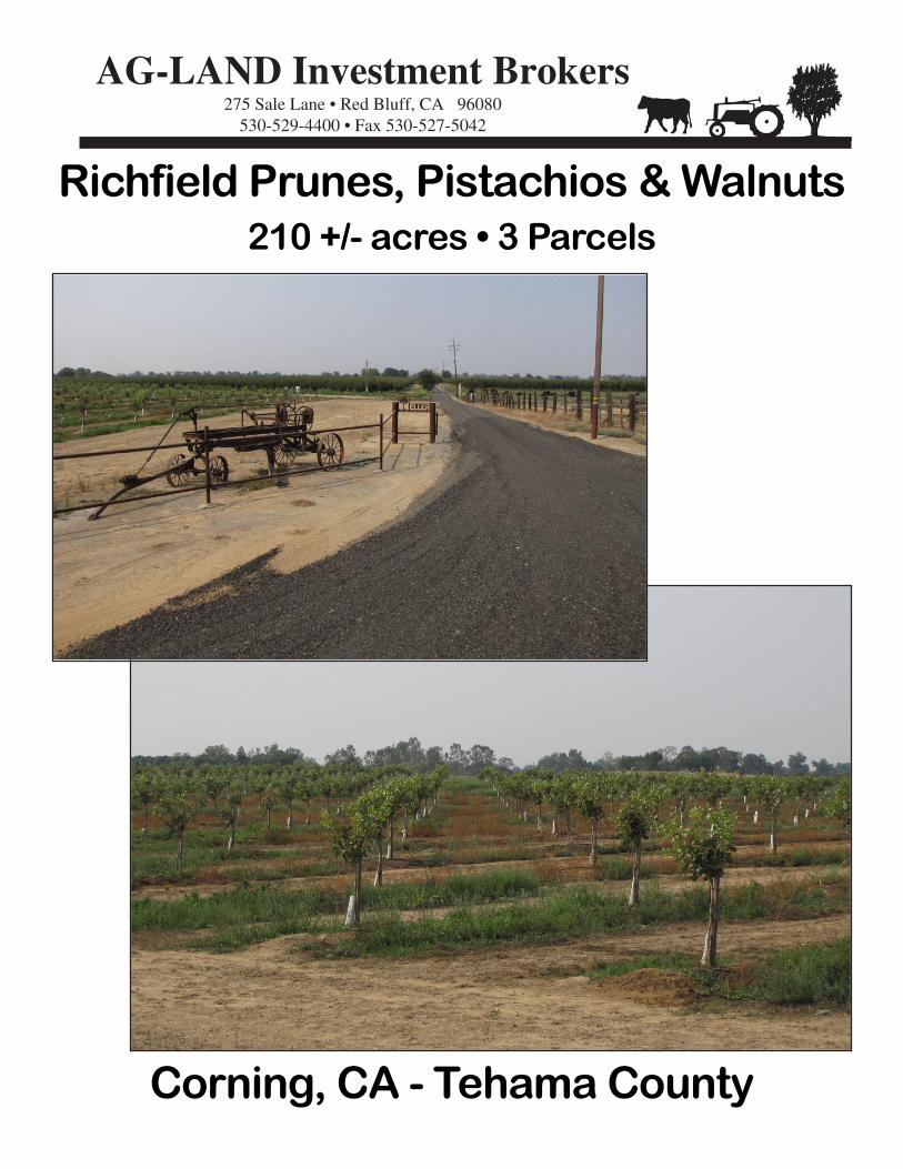
Water: Irrigation water is provided using 3 groundwater wells. The south
well drilled in 2015 was completed to 267 feet and is setup with a 50Hp turbine & VFD
electric panel. In 2017, new submersible pumps were installed in the east well (40Hp)
and west well (20Hp).
Irrigation: Depending upon the block, the orchards are irrigated using double
drip lines, drip line with micro, fan jet or rotator. A small block is flood irrigated.
Soils: Per Natural Resources Conservation Service, approximately 40% of
the farm has Class 1 soil, Wy - Wyo Loam. 46% has Class 2 soils, AvA - Arbuckle
Gravelly Loam. 11% has Class 3 soils, KoB - Kimball Gravelly Loam Class III. The
balance of the soils are Class 4 soils and lands within a seasonal creek or county road.
Prunes: Approximately 120 acres planted to bearing French prunes. 20 acres
planted in 2013, 80 acres planted in the 1990’s and 20 acres planted in the 1980’s. Tree
stand is in the 90% with replants in place. Tree spacing varies by blocks. Blocks are
level to grade. 2017 total production was 328.3 dry tons, 2.73 tons per acre.
Pistachios: Approximately 40 acres of Kerman pistachios planted in 2017 on
UCB1 rootstock w/ 5% pollinators. Topography is sloping to undulating. Tree spacing
is 17’ x 19’, 134 trees per acre. Trees are on a continual program of training and tying.
AG-LAND INVESTMENT BROKERS 275 Sale Lane / P. O. Box 896
Red Bluff, CA 96080
530.529.4400 office / 530.527.5042 fax
The information contained herein is from sources deemed reliable, however, accuracy is not guaranteed. AG-LAND Investment Brokers assumes no
liability as to errors, omissions or future operating and investment results. Buyer assumes responsibility to perform their own investigation and due diligence. This offering is subject to prior sale, price change or withdrawal from market without notice.
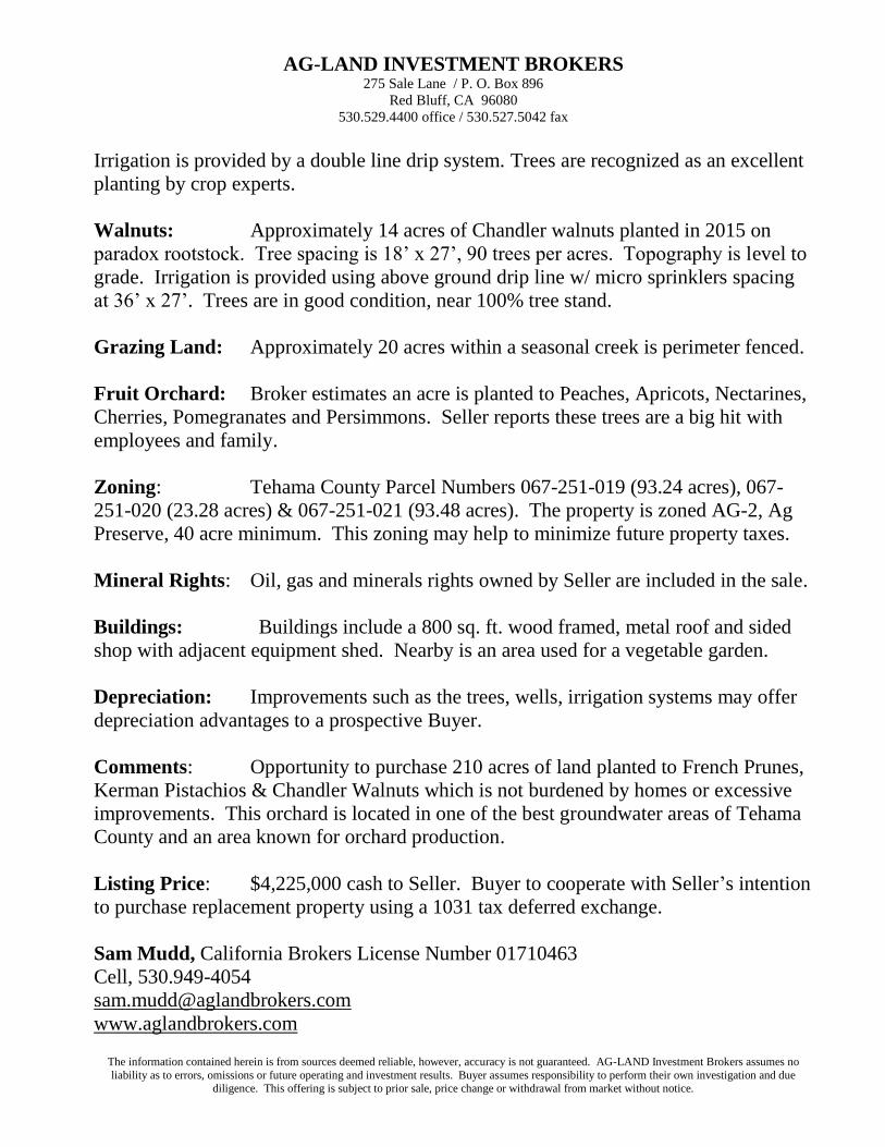
Irrigation is provided by a double line drip system. Trees are recognized as an excellent
planting by crop experts.
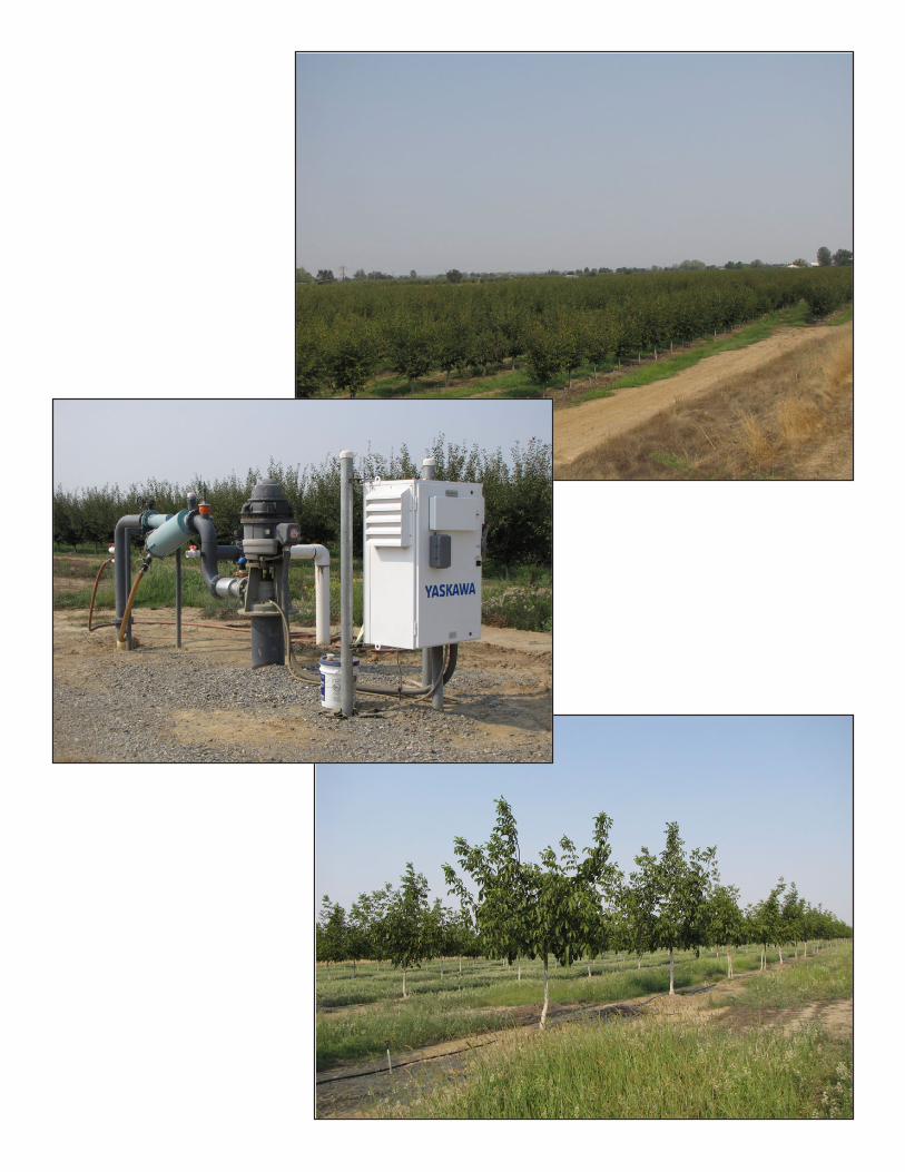
Walnuts: Approximately 14 acres of Chandler walnuts planted in 2015 on
paradox rootstock. Tree spacing is 18’ x 27’, 90 trees per acres. Topography is level to
grade. Irrigation is provided using above ground drip line w/ micro sprinklers spacing
at 36’ x 27’. Trees are in good condition, near 100% tree stand.
Grazing Land: Approximately 20 acres within a seasonal creek is perimeter fenced.
Fruit Orchard: Broker estimates an acre is planted to Peaches, Apricots, Nectarines,
Cherries, Pomegranates and Persimmons. Seller reports these trees are a big hit with
employees and family.
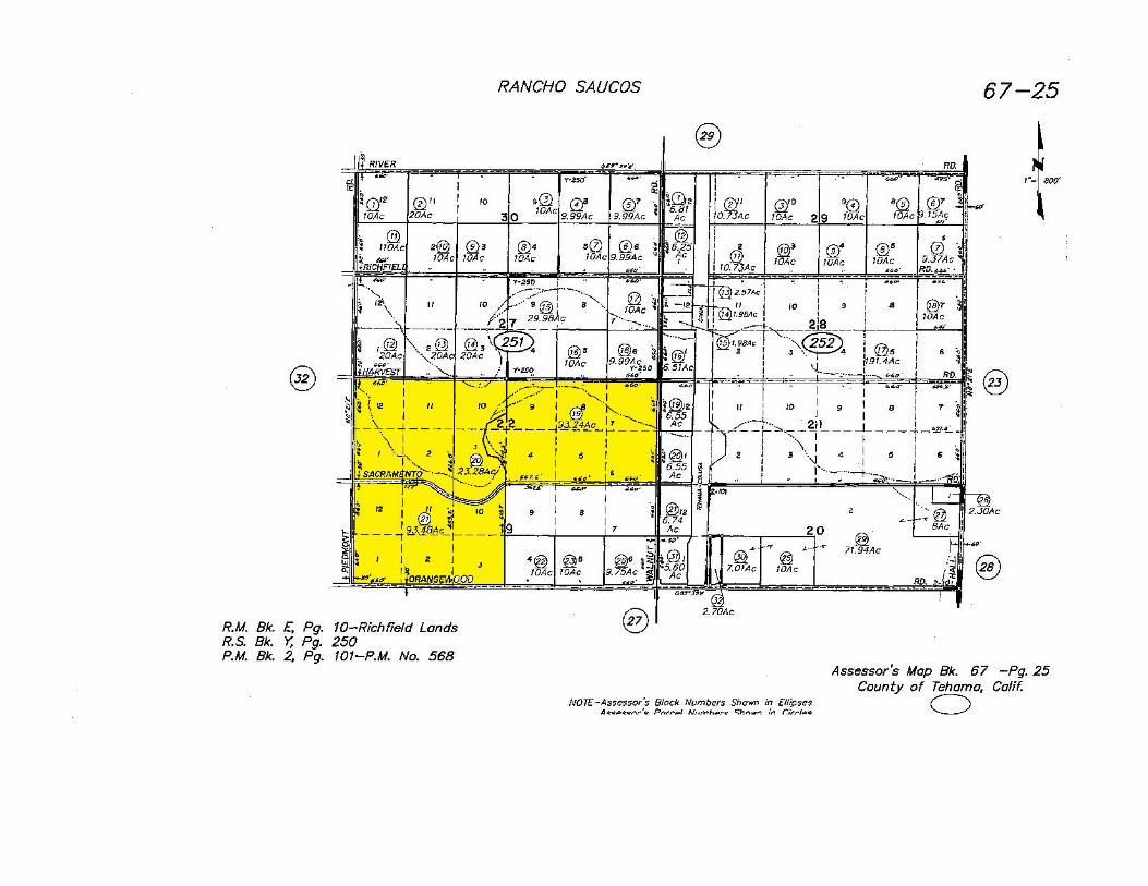
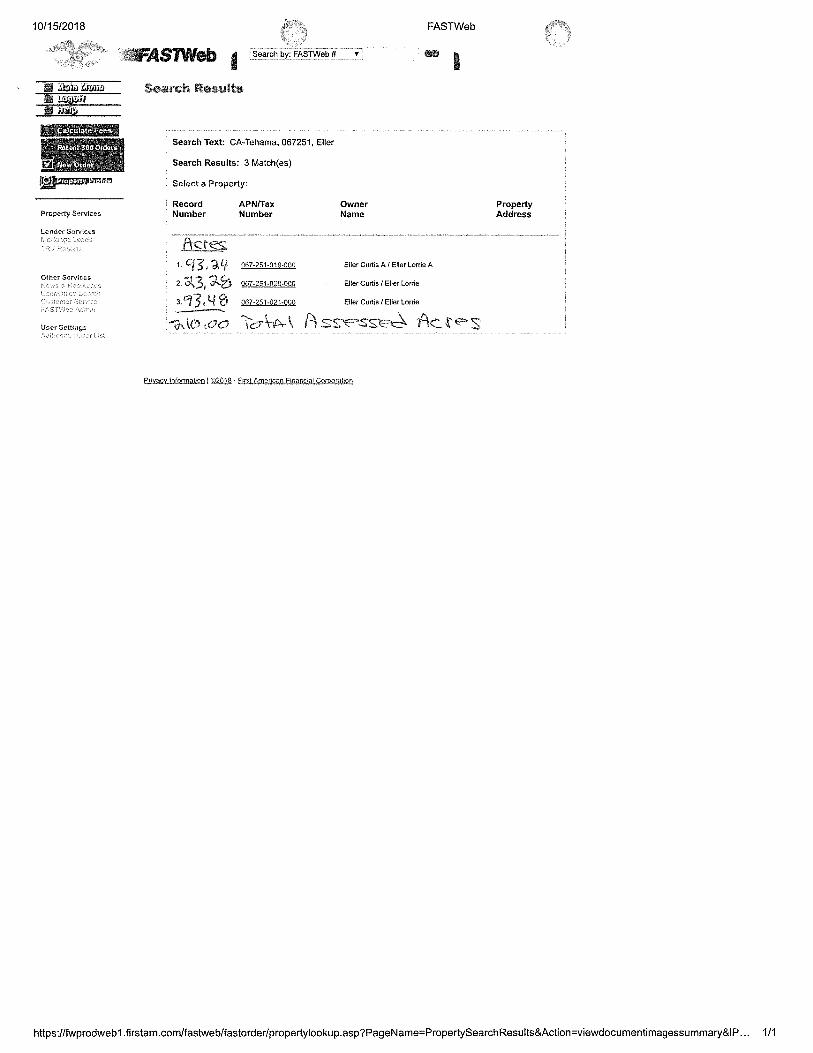
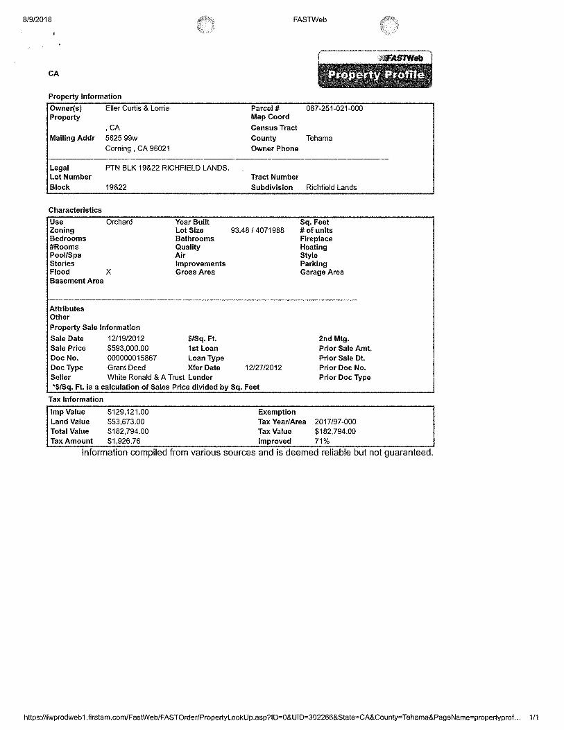
Zoning: Tehama County Parcel Numbers 067-251-019 (93.24 acres), 067-
251-020 (23.28 acres) & 067-251-021 (93.48 acres). The property is zoned AG-2, Ag
Preserve, 40 acre minimum. This zoning may help to minimize future property taxes.
Mineral Rights: Oil, gas and minerals rights owned by Seller are included in the sale.
Buildings: Buildings include a 800 sq. ft. wood framed, metal roof and sided
shop with adjacent equipment shed. Nearby is an area used for a vegetable garden.
Depreciation: Improvements such as the trees, wells, irrigation systems may offer
depreciation advantages to a prospective Buyer.
Comments: Opportunity to purchase 210 acres of land planted to French Prunes,
Kerman Pistachios & Chandler Walnuts which is not burdened by homes or excessive
improvements. This orchard is located in one of the best groundwater areas of Tehama
County and an area known for orchard production.
Listing Price: $4,225,000 cash to Seller. Buyer to cooperate with Seller’s intention
to purchase replacement property using a 1031 tax deferred exchange.
Sam Mudd, California Brokers License Number 01710463
Cell, 530.949-4054
www.aglandbrokers.com
AG-LAND INVESTMENT BROKERS 275 Sale Lane / P. O. Box 896
Red Bluff, CA 96080
530.529.4400 office / 530.527.5042 fax
The information contained herein is from sources deemed reliable, however, accuracy is not guaranteed. AG-LAND Investment Brokers assumes no
liability as to errors, omissions or future operating and investment results. Buyer assumes responsibility to perform their own investigation and due diligence. This offering is subject to prior sale, price change or withdrawal from market without notice.
Bert Owens, California Brokers License Number 01707128
Cell, 530.524.4900
www.aglandbrokers.com


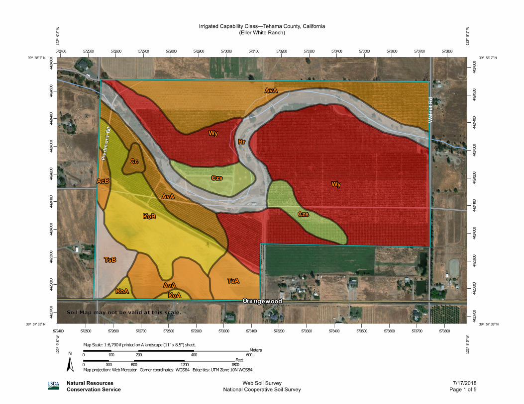
Irrigated Capability Class—Tehama County, California(Eller White Ranch)
Natural ResourcesConservation Service
Web Soil SurveyNational Cooperative Soil Survey
7/17/2018Page 1 of 5
4423
700
4423
800
4423
900
4424
000
4424
100
4424
200
4424
300
4424
400
4424
500
4424
600
4423
700
4423
800
4423
900
4424
000
4424
100
4424
200
4424
300
4424
400
4424
500
4424
600
572400 572500 572600 572700 572800 572900 573000 573100 573200 573300 573400 573500 573600 573700 573800
572400 572500 572600 572700 572800 572900 573000 573100 573200 573300 573400 573500 573600 573700 573800
39° 58' 7'' N12
2° 9
' 8'' W
39° 58' 7'' N
122°
8' 5
'' W
39° 57' 35'' N
122°
9' 8
'' W
39° 57' 35'' N
122°
8' 5
'' W
N
Map projection: Web Mercator Corner coordinates: WGS84 Edge tics: UTM Zone 10N WGS840 300 600 1200 1800
Feet0 100 200 400 600
MetersMap Scale: 1:6,790 if printed on A landscape (11" x 8.5") sheet.
Soil Map may not be valid at this scale.
MAP LEGEND MAP INFORMATION
Area of Interest (AOI)Area of Interest (AOI)
SoilsSoil Rating Polygons
Capability Class - I
Capability Class - II
Capability Class - III
Capability Class - IV
Capability Class - V
Capability Class - VI
Capability Class - VII
Capability Class - VIII
Not rated or not available
Soil Rating LinesCapability Class - I
Capability Class - II
Capability Class - III
Capability Class - IV
Capability Class - V
Capability Class - VI
Capability Class - VII
Capability Class - VIII
Not rated or not available
Soil Rating PointsCapability Class - I
Capability Class - II
Capability Class - III
Capability Class - IV
Capability Class - V
Capability Class - VI
Capability Class - VII
Capability Class - VIII
Not rated or not available
Water FeaturesStreams and Canals
TransportationRails
Interstate Highways
US Routes
Major Roads
Local Roads
BackgroundAerial Photography
The soil surveys that comprise your AOI were mapped at 1:20,000.
Warning: Soil Map may not be valid at this scale.
Enlargement of maps beyond the scale of mapping can cause misunderstanding of the detail of mapping and accuracy of soil line placement. The maps do not show the small areas of contrasting soils that could have been shown at a more detailed scale.
Please rely on the bar scale on each map sheet for map measurements.
Source of Map: Natural Resources Conservation ServiceWeb Soil Survey URL: Coordinate System: Web Mercator (EPSG:3857)
Maps from the Web Soil Survey are based on the Web Mercator projection, which preserves direction and shape but distorts distance and area. A projection that preserves area, such as the Albers equal-area conic projection, should be used if more accurate calculations of distance or area are required.
This product is generated from the USDA-NRCS certified data as of the version date(s) listed below.
Soil Survey Area: Tehama County, CaliforniaSurvey Area Data: Version 11, Sep 14, 2017
Soil map units are labeled (as space allows) for map scales 1:50,000 or larger.
Date(s) aerial images were photographed: Feb 21, 2015—Oct 7, 2016
The orthophoto or other base map on which the soil lines were compiled and digitized probably differs from the background imagery displayed on these maps. As a result, some minor shifting of map unit boundaries may be evident.
Irrigated Capability Class—Tehama County, California(Eller White Ranch)
Natural ResourcesConservation Service
Web Soil SurveyNational Cooperative Soil Survey
7/17/2018Page 2 of 5

Irrigated Capability Class
Map unit symbol Map unit name Rating Acres in AOI Percent of AOI
AcB Altamont clay, terrace, 3 to 10 percent slopes
2 2.0 1.0%
AvA Arbuckle gravelly loam, 0 to 2 percent slopes, MLRA 17
2 45.9 22.2%
Cc Clear Lake clay, 0 to 4 percent slopes, MLRA 17
2 1.5 0.7%
Czs Cortina very gravelly fine sandy loam
4 12.0 5.8%
KoA Kimball gravelly loam, 0 to 3 percent slopes
3 2.1 1.0%
KoB Kimball gravelly loam, 3 to 8 percent slopes
3 23.8 11.5%
Rr Riverwash 24.6 11.9%
TaA Tehama loam, 0 to 3 percent slopes, MLRA 17
2 6.1 3.0%
TsB Tuscan loam, 1 to 5 percent slopes
6.8 3.3%
Wy Wyo loam, 0 to 3 percent slopes
1 81.9 39.6%
Totals for Area of Interest 206.9 100.0%
Irrigated Capability Class—Tehama County, California Eller White Ranch
Natural ResourcesConservation Service
Web Soil SurveyNational Cooperative Soil Survey
7/17/2018Page 3 of 5
Description
Land capability classification shows, in a general way, the suitability of soils for most kinds of field crops. Crops that require special management are excluded. The soils are grouped according to their limitations for field crops, the risk of damage if they are used for crops, and the way they respond to management. The criteria used in grouping the soils do not include major and generally expensive landforming that would change slope, depth, or other characteristics of the soils, nor do they include possible but unlikely major reclamation projects. Capability classification is not a substitute for interpretations that show suitability and limitations of groups of soils for rangeland, for woodland, or for engineering purposes.
In the capability system, soils are generally grouped at three levels-capability class, subclass, and unit. Only class and subclass are included in this data set.
Capability classes, the broadest groups, are designated by the numbers 1 through 8. The numbers indicate progressively greater limitations and narrower choices for practical use. The classes are defined as follows:
Class 1 soils have few limitations that restrict their use.
Class 2 soils have moderate limitations that reduce the choice of plants or that require moderate conservation practices.
Class 3 soils have severe limitations that reduce the choice of plants or that require special conservation practices, or both.
Class 4 soils have very severe limitations that reduce the choice of plants or that require very careful management, or both.
Class 5 soils are subject to little or no erosion but have other limitations, impractical to remove, that restrict their use mainly to pasture, rangeland, forestland, or wildlife habitat.
Class 6 soils have severe limitations that make them generally unsuitable for cultivation and that restrict their use mainly to pasture, rangeland, forestland, or wildlife habitat.
Class 7 soils have very severe limitations that make them unsuitable for cultivation and that restrict their use mainly to grazing, forestland, or wildlife habitat.
Class 8 soils and miscellaneous areas have limitations that preclude commercial plant production and that restrict their use to recreational purposes, wildlife habitat, watershed, or esthetic purposes.
Rating Options
Aggregation Method: Dominant Condition
Component Percent Cutoff: None Specified
Irrigated Capability Class—Tehama County, California Eller White Ranch
Natural ResourcesConservation Service
Web Soil SurveyNational Cooperative Soil Survey
7/17/2018Page 4 of 5

Tie-break Rule: Higher
Irrigated Capability Class—Tehama County, California Eller White Ranch
Natural ResourcesConservation Service
Web Soil SurveyNational Cooperative Soil Survey
7/17/2018Page 5 of 5
AG-LAND INVESTMENT BROKERS275 Sale Lane, Suite 2 / P. O. Box 896
Red Bluff, CA 96080530.529.4400 office / 530.527.5042 fax
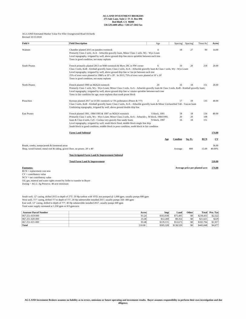
AG-LAND Estimated Market Value For Eller Orangewood Road OrchardsRevised 10/15/2018
Field # Field Description Age Spacing Spacing Trees/Ac Acres
Walnuts Chandler planted 2015 on paradox rootstock 4 18 27 90 14.00Primarily Class 2 soils, AvA - Arbuckle gravelly loam, Minor Class 1 soils, Wy - Wyo LoamLevel topography, irrigated by well, above ground drip line micro sprinkler between each treeTrees in good condition, not many replants
South Prunes French primarily planted 2013 on M40 rootstock & Myro 29C in NW corner 6 10 20 218 20.00Class 3 soils, KoB - Kimball gravelly loam; Class 2 soils, AvA - Arbuckle gravelly loam & Class 1 soils, Wy - Wyo LoamLevel topography, irrigated by well, above ground drip line w/ fan jet between each tree25% of trees were planted in 1980's at 20' x 20'. In 2013, 75% of trees were planted at 10' x 20'Trees in good condition, not many replants
North Prunes French planted 1990 on M2624 rootstock 29 16 18 151 20.00Primarily Class 1 soils, Wy - Wyo Loam; Minor Class 2 soils, AvA - Arbuckle gravelly loam & Class 3 soils, KoB - Kimball gravelly loam;Level topography, irrigated by well, above ground drip line w/ rotator sprinkler between each treeTrees in fair condition for age, more replants than south prune block
Pistachios Kerman planted 2017 on UCB1 rootstock w/ 5% pollenators (Peters & ???) 2 17 19 135 40.00Class 3 soils, KoB - Kimball gravelly loam; Class 2 soils, AvA - Arbuckle gravelly loam & Minor Unclassified TsB - Tuscan loamUndulating topography, irrigated by well, above ground double drip line
East Prunes French planted 1991, 1984/1995 & 1997 on M2624 rootstock S block, 1991 18 18 134 80.00Primarily Class 1 soils, Wy - Wyo Loam; Minor Class 2 soils, AvA - Arbuckle gravellyM block, 1984/1995 20 20 109loam & Class 4 soils, CzS - Cortina very gravely fine sandy loam; N block, 1997 16 18 151Level topography, irrigated by well, south block flood, middle block single line dripSouth block in good condition, middle block in poor condition, north block in fair condition
Farm Land Subtotal 174.00
Age Condion Sq. Ft. RCN CV
Roads, creeks, sumps/ponds & farmstead areas 36.00Shop, wood framed, metal roof & siding, gravel floor, no power, 20' x 40' Average 800 15.00 40.00%
Non-Irrigated Farm Land & Improvement Subtotal
Total Farm Land & Improvement 210.00
Footnotes: Average price per planted acre 174.00RCN = replacement cost newCV = contributory valueNCV = net contributory valueOil, gas, mineral and water rights owned by Seller to transfer to BuyerZoning = AG-2, Ag Preserve, 40 acre minimum
South well, 12" casing, drilled 2015 to depth of 275', 50 Hp turbine with VFD, test pumped @ 1,000 gpm, usually pumps 600 gpmWest well, ???" casing, drilled ??? to depth of ???', 20 Hp submersible installed 2017, usually pumps 350- 400 gpmEast well, 12" casing, drilled to depth of ???', 40 Hp submersible installed 2017, usually pumps 600 gpmTotal water supply estimated at 1,550 gpm or 8.9 gpm/acre
Assessor Parcel Number Acres Imp Land Other Total Pro. Tax067-251-019-000 93.24 $163,938 $75,495 $0 $239,433 $2,522067-251-020-000 23.28 $12,269 $9,352 $0 $21,621 $229067-251-021-000 93.48 $129,121 $53,673 $0 $182,794 $1,927Total 210.00 $305,328 $138,520 $0 $443,848 $4,677
AG-LAND Investment Brokers assumes no liability as to errors, omissions or future operating and investment results. Buyer assumes responsibility to perform their own investigation and duediligence.
Related Documents