Nat. Hazards Earth Syst. Sci., 9, 25–42, 2009 www.nat-hazards-earth-syst-sci.net/9/25/2009/ © Author(s) 2009. This work is distributed under the Creative Commons Attribution 3.0 License. Natural Hazards and Earth System Sciences Revision of the Portuguese catalog of tsunamis M. A. Baptista 1 and J. M. Miranda 2 1 Instituto Superior Engenharia de Lisboa, CGUL, IDL, Lisboa, Portugal 2 University of Lisbon, CGUL, IDL, Lisbon, Portugal Received: 19 August 2008 – Revised: 19 November 2008 – Accepted: 28 November 2008 – Published: 9 January 2009 Abstract. Catastrophic tsunamis are described in historical sources for all regions around the Gulf of Cadiz, at least since 60 BC. Most of the known events are associated with mod- erate to large earthquakes and among them the better stud- ied is 1 November 1755. We present here a review of the events which effects, on the coasts of the Portuguese main- land and Madeira Island, are well described in historical doc- uments or have been measured by tide gauges since the in- stallation of these instruments. For a few we include new relevant information for the assessment of the tsunami gen- eration or effects, and we discard events that are included in existing compilations but are not supported by quality his- torical sources or instrumental records. We quote the most relevant quantitative descriptions of tsunami effects on the Portuguese coast, including in all pertinent cases a critical re- view of the coeval sources, to establish a homogenous event list. When available, instrumental information is presented. We complement all this information with a summary of the conclusions established by paleo-tsunami research. 1 Introduction Catastrophic tsunamis are described in historical records re- lated with all countries around the Gulf of Cadiz (El Mrabet, 1991; Campos, 1992; Baptista et al., 1998a), a key tsunami prone area in Europe associated with the western segment of the Eurasia-Nubia plate boundary. Tsunami events are a consequence of the compressive tectonic environment of the Ibero-Maghrebian area (Baptista et al., 1998b; Zitellini et al., 2001; Gracia et al., 2002; Gutscher et al., 2006), the tran- scurrent motion along the Gloria Fault and surrounding area (Kaabouben et al., 2008) or the effect of far away sources (e.g. Azores or Grand Banks). Events generated within the Correspondence to: M. A. Baptista ([email protected]) Gulf of Cadiz affect a large area, particularly SW Portu- gal, South Spain and Morocco; the largest ones affect the SW Irish and UK coasts and the Caribbean (e.g. Haslet and Bryant, 2008). The oldest catalog of earthquakes and tsunamis written in Portuguese is called “Historia Universal dos Terramotos que tem havido no mundo de que h´ a noticia desde a sua criac ¸˜ ao at´ e ao s´ eculo presente” (Universal History of Earth- quakes occurred around the world, since its creation up to the current century) published by Mendonc ¸a (1758). This book refers to previous written Portuguese sources such as Brito (1597) and Sousa (1678) that are themselves compi- lations of historical facts where earthquakes and tsunamis are reported among other miscellaneous events, as written Portuguese sources prior to the fourteenth century are rather scarce. Mendonc ¸a (1758) devotes part of his book to the 1755 event and its aftershock sequence. For all events prior to 1755 we also extensively considered the answers to the Marques de Pombal inquiry, question ten: “Do you remem- ber other earthquakes in the past, at your place, and what damage it caused?” Most answers were transcribed directly from the Arquivos do Minist´ erio do Reino (1756) by Runa and Freire (1991). The second relevant compilation was written by Per- rey (1847), and is called “Sur les Tremblements de Terre de la Peninsule Iberique” (About Earthquakes in the Iberian Peninsula). Perrey (1847) often quotes Mendonc ¸a (1758) for the Portuguese events but in some cases he gives information on original sources which were obtained and cross checked. A few years after Perrey, Robert Mallet (1852) presented a new catalog of earthquakes between 1606 BC and 1850 AD where several historical events are reviewed. Rodriguez (1932) published the first modern catalog of seismic events for Iberia, where several tsunami events are described. Heck (1947) published a list of seismic sea waves where the events of 27 December 1722, 1 November 1755 and 31 March 1761 are included, but mainly based on Mal- let (1852) descriptions. Berninghausen (1964) published Published by Copernicus Publications on behalf of the European Geosciences Union.

Welcome message from author
This document is posted to help you gain knowledge. Please leave a comment to let me know what you think about it! Share it to your friends and learn new things together.
Transcript

Nat. Hazards Earth Syst. Sci., 9, 25–42, 2009www.nat-hazards-earth-syst-sci.net/9/25/2009/© Author(s) 2009. This work is distributed underthe Creative Commons Attribution 3.0 License.
Natural Hazardsand Earth
System Sciences
Revision of the Portuguese catalog of tsunamis
M. A. Baptista1 and J. M. Miranda 2
1Instituto Superior Engenharia de Lisboa, CGUL, IDL, Lisboa, Portugal2University of Lisbon, CGUL, IDL, Lisbon, Portugal
Received: 19 August 2008 – Revised: 19 November 2008 – Accepted: 28 November 2008 – Published: 9 January 2009
Abstract. Catastrophic tsunamis are described in historicalsources for all regions around the Gulf of Cadiz, at least since60 BC. Most of the known events are associated with mod-erate to large earthquakes and among them the better stud-ied is 1 November 1755. We present here a review of theevents which effects, on the coasts of the Portuguese main-land and Madeira Island, are well described in historical doc-uments or have been measured by tide gauges since the in-stallation of these instruments. For a few we include newrelevant information for the assessment of the tsunami gen-eration or effects, and we discard events that are included inexisting compilations but are not supported by quality his-torical sources or instrumental records. We quote the mostrelevant quantitative descriptions of tsunami effects on thePortuguese coast, including in all pertinent cases a critical re-view of the coeval sources, to establish a homogenous eventlist. When available, instrumental information is presented.We complement all this information with a summary of theconclusions established by paleo-tsunami research.
1 Introduction
Catastrophic tsunamis are described in historical records re-lated with all countries around the Gulf of Cadiz (El Mrabet,1991; Campos, 1992; Baptista et al., 1998a), a key tsunamiprone area in Europe associated with the western segmentof the Eurasia-Nubia plate boundary. Tsunami events are aconsequence of the compressive tectonic environment of theIbero-Maghrebian area (Baptista et al., 1998b; Zitellini et al.,2001; Gracia et al., 2002; Gutscher et al., 2006), the tran-scurrent motion along the Gloria Fault and surrounding area(Kaabouben et al., 2008) or the effect of far away sources(e.g. Azores or Grand Banks). Events generated within the
Correspondence to:M. A. Baptista([email protected])
Gulf of Cadiz affect a large area, particularly SW Portu-gal, South Spain and Morocco; the largest ones affect theSW Irish and UK coasts and the Caribbean (e.g. Haslet andBryant, 2008).
The oldest catalog of earthquakes and tsunamis writtenin Portuguese is called “Historia Universal dos Terramotosque tem havido no mundo de que ha noticia desde a suacriacao ate ao seculo presente” (Universal History of Earth-quakes occurred around the world, since its creation up tothe current century) published by Mendonca (1758). Thisbook refers to previous written Portuguese sources such asBrito (1597) and Sousa (1678) that are themselves compi-lations of historical facts where earthquakes and tsunamisare reported among other miscellaneous events, as writtenPortuguese sources prior to the fourteenth century are ratherscarce. Mendonca (1758) devotes part of his book to the1755 event and its aftershock sequence. For all events priorto 1755 we also extensively considered the answers to theMarques de Pombal inquiry, question ten: “Do you remem-ber other earthquakes in the past, at your place, and whatdamage it caused?” Most answers were transcribed directlyfrom the Arquivos do Ministerio do Reino (1756) by Runaand Freire (1991).
The second relevant compilation was written by Per-rey (1847), and is called “Sur les Tremblements de Terrede la Peninsule Iberique” (About Earthquakes in the IberianPeninsula). Perrey (1847) often quotes Mendonca (1758) forthe Portuguese events but in some cases he gives informationon original sources which were obtained and cross checked.A few years after Perrey, Robert Mallet (1852) presented anew catalog of earthquakes between 1606 BC and 1850 ADwhere several historical events are reviewed.
Rodriguez (1932) published the first modern catalog ofseismic events for Iberia, where several tsunami events aredescribed. Heck (1947) published a list of seismic sea waveswhere the events of 27 December 1722, 1 November 1755and 31 March 1761 are included, but mainly based on Mal-let (1852) descriptions. Berninghausen (1964) published
Published by Copernicus Publications on behalf of the European Geosciences Union.

26 M. A. Baptista and J. M. Miranda: Portuguese catalog of tsunamis
a list of tsunamis and seismic seiches for eastern Atlanticsouth of the Bay of Biscay, in the Bulletin of Seimolog-ical Society of America; this compilation starts with the26 January 1531 event and does not consider any previ-ous tsunami event. This list includes, among others, eventson 26 December 1746, 28 April 1758 and 4 July 1809.These events, not included in the GITEC catalog (Tinti et al.,1999) are analysed here. For the aftershock sequence of the1755 earthquake the author reports only one tsunami event(29 March 1756), as we do. We must also refer the pioneer-ing work of Moreira (1968) that also gathered a number ofmareographic records, some of them used here.
Most major tsunamis are known only from historicalsources. In recent times, the press is also an importantsource of information, particularly in what concerns floodingand harbor effects. Descriptions presented here come fromcoeval sources except for the events prior to 1500, due tothe fact that these sources are quite rare in Portugal. After1881 we have access to tsunami instrumental data in the Por-tuguese coasts: the first Portuguese tide station was installedat Cascais in 1881 and the second one at Lagos in 1908. Alltide records from these stations were checked for tsunamieffects related withM>6 seismic events in the SW Iberianmargin. In particular tide records of Cascais and Lagos wereobtained for the events of 25 November 1941, 28 Febru-ary 1969 (Gjevik et al., 1997), 26 May 1975 (Kaaboubenet al., 2008), and 1 January 1980. Mareograms obtained inthe Portuguese tide gauge network have also been used forthe 1929 Grand Banks tsunami (Fine et al., 2005). Unfor-tunately no stations were operating during the Cadiz earth-quake of 1964 and so we cannot evaluate its effect on thePortuguese coasts. In some cases, complementary tide gaugestations installed at Portuguese harbors (e.g. Leixoes) werealso used to assess tsunami effects.
Very large non-seismic tsunamis have been evoked as apossible source of tsunami hazard in Portugal (e.g. Ward andDay, 2001) but up to now their effects on the Portuguesecoasts have not been proved either by instruments, histori-cal documents or sedimentary record. However, we consideras non-seismic events the 1930 rock fall in Madeira Islands,which effects are described in this work, and the 1929 GrandBanks tsunami that was recorded in the Azores and Leixoes(close to Oporto, northern Portugal). There are some addi-tional evidences for other non-seismic events but their iden-tification in historical records is up to now inconclusive.
In this work we discuss only the events that produced ef-fects on the Portuguese mainland coasts. In this sense, wedo not consider those generated in the Azores plateau andonly recorded there, which have been the object of a recentpublication by Andrade et al. (2006). All locations are com-plemented with their geographical coordinates (cf. Table 1),to allow the use of tsunami historical information by nonPortuguese researchers. In what concerns the 1 November1755 tsunami the descriptions are summarized, because ithas been the subject of a number of previous works (Solares
et al., 1979, 2004; Baptista et al., 1998a, b); however, a listof tsunami effects is included in the present study, as com-plementary information to support hazard studies. A similarsituation arises in what concerns the 27 December 1722, the31 March 1761 and the 26 May 1975 events.
2 Description of the historical events
2.1 The 60 BC Portugal and Galicia tsunami
TheM=8.5 earthquake dated 60 BC is the oldest event oftenconsidered in Portuguese earthquake catalogs (LNEC, 1986;Sousa et al., 1992; Martins and Victor, 2001). Sousa (1678)gives one of the rare descriptions of the tsunami: “[. . . ]About these years, or slightly before, took place that remark-able earthquake on the coasts of Portugal and Galicia, withwhich many places were ruined [. . . ]. And the sea leaving insome places its ordinary limits occupied a part of the land,uncovering it in other places where it was never seen before[. . . ] At Cape St. Vincent a bull gave birth to a mare [. . . ].Very sad augury to the coasts of Lusitania, this monster, inthe opinion of the professors [. . . ]”. Mendonca (1758) re-ports this event but only quoting Sousa (1678).
2.2 The 382 AD Cape St. Vincent tsunami
The 382 AD tsunami is briefly described by Brito (1597):“[. . . ] the rise of the sea subverted a part of the land and over-topped some islands [. . . ] of which some rocks remained inthe middle of the sea, which can be seen close or inside theocean, mainly in Cape St. Vincent [. . . ]”. The Martins andVictor (2001) catalog evaluates the magnitude of the corre-sponding earthquake as 7.5.
2.3 The 26 January 1531 Tagus Estuary tsunami
On the 26 January 1531, between 4 and 5 a.m., a strongshock was felt in Lisbon and along the Tagus Valley. Theshock heavily destroyed Lisbon downtown and neighbouringareas, causing approximately 1000 casualties (Vogt, 1985;Justo and Salwa, 1998). The downtown of Lisbon and sev-eral dwellings along estuary were flooded by the river andships in the harbour were left in dry. The maximum reportedearthquake intensity isX (MSK) making it one of the mostdisastrous earthquakes in the history of Portugal. Approx-imate epicentre coordinates inferred from the macroseismicfield are 38.9◦ N, 9.0◦ W (Martins and Victor, 2001) but itstectonic source remained uncertain. Justo and Salwa (1998)locate it NE of Lisbon, up Tagus estuary and it was probablygenerated north of the Tagus Estuary close to Vila Franca deXira town (−9◦ E, 38.9◦ N).
The description of a large tempest in the sea is often re-peated: “[. . . ] several vessels were swallowed by the pits ofthe grown and turbulent sea [. . . ]” (Laurent Surius, 1567;Babinet, 1861); “Many ships submerged with the tempest
Nat. Hazards Earth Syst. Sci., 9, 25–42, 2009 www.nat-hazards-earth-syst-sci.net/9/25/2009/

M. A. Baptista and J. M. Miranda: Portuguese catalog of tsunamis 27
Table 1. Geographical coordinates of the locations included in the text.
Location Longitude Latitude Location Longitude Latitude
Adra −3.017◦ E 36.750◦ N Lagos −8.673◦ E 37.102◦ NAgueda −8.448◦ E 40.574◦ N Machico −16.764◦ E 32.718◦ NAlandroal −7.400◦ E 38.533◦ N Malaga −4.417◦ E 36.717◦ NAlbufeira −8.252◦ E 37.089◦ N Matosinhos −8.680◦ E 41.183◦ NAngra (Terceira) −27.217◦ E 38.650◦ N Monte Gordo −7.449◦ E 37.182◦ NAssumar −7.383◦ E 39.133◦ N Mount’s bay −5.525◦ E 50.129◦ NAveiro −8.654◦ E 40.641◦ N Newlyn −5.547◦ E 50.105◦ NAyamonte −7.410◦ E 37.215◦ N Oporto −8.610◦ E 41.150◦ NBarcelona 2.170◦ E 41.388◦ N Penzance −5.528◦ E 50.118◦ NBenavente −8.820◦ E 38.978◦ N Pombal −8.627◦ E 39.914◦ NBuarcos −8.883◦ E 40.167◦ N Ponta Delgada −25.670◦ E 37.738◦ NCabo Ruivo −9.097◦ E 38.750◦ N Pontinha (Madeira) −16.918◦ E 32.641◦ NCacilhas −9.149◦ E 38.686◦ N Porto da Cruz −16.819◦ E 32.767◦ NCadiz −6.292◦ E 36.530◦ N Porto Santo −16.332◦ E 33.059◦ NCasablanca −7.632◦ E 33.605◦ N Puerto de Santa Maria −6.228◦ E 36.597◦ NCascais −9.422◦ E 38.697◦ N Punta Umbria −6.967◦ E 37.182◦ NCastro Marim −7.445◦ E 37.217◦ N Quarteira −8.104◦ E 37.068◦ NCoimbra −8.429◦ E 40.211◦ N Santa Cruz de Tenerife −16.255◦ E 28.470◦ NConceicao de Tavira −7.605◦ E 37.146◦ N S Jorge (Azores) −28.053◦ E 38.645◦ NDonana spit −6.589◦,E 37.018◦ N Santiago de Compostella −8.544◦ E 42.878◦ NDouro embankment −8.669◦ E 41.137◦ N Cape St. Vincent −8.994◦ E 37.025◦ NEspinhel −08◦29′ E 40◦34′ N Scilly Island −6.323◦ E 49.936◦ NFaro −7.935◦ E 37.015◦ N Setubal −8.893◦ E 38.525◦ NFigueira da Foz −8.851◦ E 40.151◦ N Sines −8.876◦ E 37.951◦ NFunchal −16.913◦ E 32.644◦ N Tavira −7.650◦ E 37.126◦ NGibraltar −5.353◦ E 36.145◦ N Terreiro do Paco −9.137◦ E 38.708◦ NGirao Cape −17.006◦ E 32.657◦ N Troia −8.859◦ E 38.454◦ NGuincho Beach −9.474◦ E 38.730◦ N Valedelagrana −6.226◦ E 36.578◦ NKinsale −8.513◦ E 51.695◦ N Varzea Sao Bras and S. Lourenco −7.226◦ E 38.859◦ NHorta (Faial Island) −28.624◦ E 38.532◦ N Viana do Castelo −8.830◦ E 41.695◦ NLa Coruna −8.395◦ E 43.371◦ N Vigario Beach −16.980◦ E 32.649◦ NLagoa −8.453◦ E 37.135◦ N Vila Franca de Xira −8.990◦ E 38.954◦ N
that intensified (Codex 9857). Resende (1554) stated that“water rose with no wind”, emphasizing the fact that theweather conditions associated with a tempest were missing.Most of the observations concerning water disturbance comefrom inside the estuary: Couto (1778) describes the sea agita-tion close to Lisbon downtown: “[. . . ] in the sea the tempestwas so great that destroyed and broke all ships staying in Lis-bon harbor, some say that the Tagus river opened by its mid-dle splitting its waters into a pathway and showing the sandbed”. Also Osorio (1919) describes “[. . . ] the ships, sailorssaid, seemed to go in the sky; and (then) against the rocks;and the river open by its middle and close again” (Osorio,1919). The Codex 8009 from the Portuguese National Li-brary quotes: “[. . . ] Tagus with its violent tide fluxes and thefurious agitation of the waves, rose in such a way that it sub-merged many ships, one claims that it opened in the middleof its waters, showing the sand of its bottom [. . . ]”.
An undated manuscript founded inside a copy of the 1495Portuguese version of De Vita Cristi (that was supposed tobe the first printed book in Portugal) describes: “[. . . ] car-avels at sea, fishing at 40 fathom depth, found themselves indry land”. “[. . . ] an awful earth quake with much roar fromthe sea, and rivers, which came out of their reach, so that,the Tagus, that divided into several branches, some islets,which we call lezirias [. . . ]” (Oliveira, no date). Upriver, inVila-Franca-de-Xira, the description is: “[. . . ] some sailorssay [. . . ] in this same river they saw the sky opening andit seemed like a burning oven and they saw coming out ofit a large thunder with a large flame: and it was close toVila Franca (Osorio, 1919)”. Perrey (1847) describes thefollowing: “The sea awfully inflated swallowed a number ofvessels. Tagus water, violently pushed by sea flood, spreadabove the margins and showed the dry riverbed”; however,he gives no specific source for the information.
www.nat-hazards-earth-syst-sci.net/9/25/2009/ Nat. Hazards Earth Syst. Sci., 9, 25–42, 2009

28 M. A. Baptista and J. M. Miranda: Portuguese catalog of tsunamis
Beside the above descriptions, extra information can beobtained from the Inquiry conducted by the Marquis of Pom-bal. The priest of Varzea Sao Bras and S. Lourenco, fromElvas municipality “[. . . ] In the same year, the 26th of thesame month, another earthquake happened in Lisbon, and itwas felt in a distance larger than sixty leagues [. . . ] and manyship submerged in the sea” (Sousa, vol. II, p. 370, 1919). Thepriest from Benavente also comments: “[. . . ] Also in thetime of King D. Manuel, [. . . ] there was one so big that onesaw river Tagus rising so high that it poured and overflowedboth streams” (idem).
2.4 The 27 December 1722 Tavira tsunami
On 27 December 1722 an earthquake stroke Tavira (Al-garve) at approximately 5–6 p.m. It was felt all over Algarve,from San Vincent Cape up to the Spanish border (Mendonca,1758). This information is reproduced in most seismic cat-alogs (e.g. Rodriguez, 1932; Runa and Freire, 1991; Mar-tins and Victor, 2001). The flooding of Tavira area is welldocumented and persisted in the collective memory of thepopulation. According to the “Chronica Serafica da SantaProvincia dos Algarves” (Belem, cap. XXII, 200–201, 1750)some days after, a thanksgiving procession took place in thetown of Tavira, which was repeated every year since, in thesame day of 27 December, with the presence of the Senate,the Communities and a large amount of people, “to keep thememory of the great benefit, although the large damage suf-fered, the entire town could have been entirely submerged”(Belem, 1750).
Using numerical tsunami modeling and multi-channelseismic processing, Baptista et al. (2007) estimated that thesource of the 1722 Tavira earthquake had a magnitude circaMw=6.5, and an epicenter close to−7.82◦ E, 37.02◦ N, in thesubmarine area close to the Algarve shore.
2.5 The 1 November 1755 transatlantic tsunami
There are several compilations of historical documents con-cerning the 1 November 1755 tsunami and earthquake (e.g.Solares et al., 1979; Levret, 1991; Baptista et al., 1998a,b; Solares and Arroyo, 2004). It devastated the Iberian andnorth Morocco coasts, causing great damage and casualties.It was observed all over North Atlantic coasts and in cen-tral and south America. The magnitude of the earthquakewas recently re-evaluated from the macroseismic field asMw=8.5±0.3 (Solares and Arroyo, 2004).
Reports describe 10–15 m waves at Cape St. Vincent andalong the Gulf of Cadiz. In Lisbon the number of casual-ties, due exclusively to the tsunami, is estimated as closeto 900 and the run in, in Lisbon downtown, is estimatedas 250 m (Baptista, 1998a). The effects of the tsunami aredescribed in Madeira, Cadiz and Cornwall, and agitation of
closed waters was observed in faraway places like Scotlandand Switzerland (see Chambers, 1757; Bewick, 1757; Bor-lase, 1755; Mendonca, 1758, and Trembley, 1755, publishedin 1757).
Lisbon: The water in the Tagus Estuary rose several times,and in a few minutes made three fluxes and refluxes ris-ing above the highest spring tides two spans or fifteen En-glish feet [. . . ] when the high tide had run up three partsof it (Sachetti, 1756, published in 1757). “[. . . ] the sea re-treated, showing its bottom along the margins never seen be-fore” (Mendonca, 1758). According to an anonymous let-ter dated the 18 November 1755 (Nozes, 157–189, 1990)“[. . . ] suddenly I heard a great uproar: “the sea is rising”[. . . ] suddenly an enormous water mass appeared at a closedistance rising like a mountain [. . . ]”. Three years later,Mendonca (1758) describes: “[. . . ] all of a sudden the sea en-tered the bar with a furious inundation [. . . ] however cross-ing the previous limits, overtopped many buildings and inun-dated Sao Paulo quarter [. . . ]”. Silva (1756) describes “[. . . ]it flooded in some places with its flux and reflux [. . . ] theCustom House, the Terreiro and the Vedoria [. . . ]”. These(and similar) descriptions allow to conclude that the water in-vaded Lisbon downtown in approximately 250 m, being con-tained partially by the old city wall built by King D. Fer-nando.
Setubal: The Gentleman’s Magazine of 1755 quotes aletter dated 4 December from Utrecht where we can read:“[. . . ] Letters by the last post advice that no traces are leftof St Ubes [Setubal], the repeated shocks and the vast surfof the sea having jointly concurred to swallow it up. It couldthe less withstand them, as it was situate at the head of a littlegulf formed by the tide at the mouth of the [Sado] . . . ” (Ur-ban, 1755). The Sea destroyed the city walls entering the cityalmost a quarter of a mile, carrying the boats to the streets (inSousa, 1919). The sea carried 2 boats for more than 50 steps(∼45 m) in land (Mendonca, 1758).
Porto: (or Oporto) is the second Portuguese town afterLisbon, located close to the Douro embankment in northernPortugal. The 1755 tsunami is described here in the follow-ing way: “The river which rose and fell surprisingly everyquarter of an hour, for upwards of four hours at least, four orfive feet, and sometimes more (Ellicot, 1757). In the Gen-tlemen’s magazine we can read: “[. . . ] The effect it had onthe river was amazing; the tide rose considerably higher thanwas ever known except in case of flood; and the flux and re-flux was so sudden, that in a minute or two it rose and fellfive or six feet and continued for two or three hours. “[. . . ]It ran up at the first with so much violence that it broke aDutchman’s hawser. Two of our Brazil fleet were going out,and had got to the bar, but the sea was so violently affected,that it forced them in again; they ran foul of each other, andwere greatly damaged. The agitation was so great in the seaabout a league beyond the bar, that, ‘tis imagined the air gotvent there“[. . . ] (Urban, 1755).
Nat. Hazards Earth Syst. Sci., 9, 25–42, 2009 www.nat-hazards-earth-syst-sci.net/9/25/2009/

M. A. Baptista and J. M. Miranda: Portuguese catalog of tsunamis 29
Figueira da Foz: “[. . . ] however the biggest new was onthe sea [. . . ] by 10 o’clock and a quarter of the day, it startedrising such water mounts [. . . ] growing above the naturalorder 44 palms, more or less [. . . ] for 3 or 4 times [. . . ] un-covering rocks and sand never seen before [. . . ]” (Arquivosdo Ministerio do Reino, 1756).
Algarve: “[. . . ] The Sea of that coast raised so many poles(one pole∼2.10 m) above its ordinary surface, that it floodedmany fields, and when retreating destroyed some fortresses,and all the town of Albufeira, leaving a large amount of fishon the bushes [. . . ]” (Gazeta de Lisboa, 1755; Mendonca,1758). Almost one century afterwards Lopes (1841) de-scribes: “[. . . ] By 9 and1/2 in the morning [. . . ] a greatthunder was heard and 3 or 4 minutes after the land shookwith violence; the sea retreated partially more than 20 fathomleaving the beach dry; and immediately rushing over the landwith such an impetus that it entered more than one league,overtopping the higher rocks; retreating and breaching threetimes in a few minutes, dragging in the flux and reflux enor-mous masses of cliffs and buildings, thus destroying almostall maritime villages”.
Lagos: Following MDJF (1756) “[. . . ] the sea enteredonshore 7 poles high: the very strong city walls suffered withthis misfortune [. . . ]”. An eyewitness report in Rocha (1991;in Costa et al., 2005) says: ”[. . . ] an awful earthquake withalteration in the sea, that in a few minutes ruined the city [. . . ]the sea rising up till 13 and half palms high [. . . ].
Albufeira: “[. . . ] it was the defeat; those that es-caped the earthquake could not escape from the sea” (MDJF,1756). The priest reports in “Memorias Paroquiais”(IANTT,1758) [. . . ]the sea out of its limits entered the city and tookall the quartier of Saint Ana, that included 7 streets, and manymore houses, without leaving, in its flux and reflux any signof the houses and made many casualties [. . . ]. The newspa-per Gazeta de Lisboa (1755), reports: ”[. . . ]when the sea re-treated took the fortress [. . . ] and the whole city of Albufeira[. . . ] leaving lots of fish in fields [. . . ].
Faro: The city of Faro, separated from the sea by a barrierisland, was protected against tsunami effects, according tothe report of Castro (1786): “[. . . ] Faro had the fortune thatits river was on low tide [. . . ]. We could see the rising of thewaves at the coast in such height that each one (all together)mounted the island without splitting itself. Entering the river[. . . ] distributed in an number of foam waves[. . . ]in the citythey cause minor impression, where the waters did not ex-ceed the limits of a great tide [. . . ]” (Castro, 1786). “[. . . ]suffered the same calamity, submerging half of the place withall their houses never seen afterwards [. . . ] (MDJF, 1756).
Monte Gordo – Tavira: “[. . . ] The waves took all thehuts from Monte Gordo beach, where there was commerceof fisheries, till the Conceicao de Tavira, and destroyed allthe islands (barrier islands) on the shore till Quarteira [. . . ](Relacam, 1756; in Costa et al., 2005).
Castro Marim: “[. . . ] the sea incursion made remarkabledamage [. . . ]” (MDJF, 1756).
Lagoa: The newspaper Gazeta de Lisboa (1755) de-scribes: “[. . . ] the sea on this coast raised many poles aboveits surface, entering the margins and inundating the fields;and when retreating, took with it the existing Fortresses”.
Madeira: “[. . . ] November the 1st, 1755, in the city ofFunchal, on the Island of Madeira, at half an hour past nineo’clock in the morning, was perceived the shock of an earth-quake [. . . ] About an hour and a half after the shock hadceased, the sea, which was calm (it being a fine day, and nowind stirring) was observed to retire suddenly some paces,and, arising with a great swell, without the least noise, assuddenly advancing, overflowed the shore, and entered intothe city. It arose full fifteen feet perpendicular above highwater mark [. . . ]” (Heberden, 1755 letter published in 1757).[. . . ] the sea all on a sudden rises as though it were the mainbody of it [. . . ] November 3. Thank God we have no returnof the earthquake, nor was the rising of the sea attended withany bad consequences in our part of the Island; though wehear, that at Machico and Porto da Cruz it did considerabledamage [. . . ] and when the sea recoiled, it was so far fromits usual limits, as to discover the foundation of rocks, thatnever had been seen and which lay as far distant from theshore as our islet [. . . ] the distance referred from the shore tothe islet, something more than 200 yards (Chambers, 1755).
Porto Santo: ”[. . . ] on the 1st November 1755, we feltin this island the shock of a violent earthquake [. . . ] the seacome out of its ordinary limits, about 10 o’clock, in the morn-ing, running in a quarter mile [. . . ] to a place called EstancoVelho. In spite of the fact that this is not a coeval source theresults are coherent with the reports of Madeira Island (Anaisde Porto Santo, in Sousa, 1919).
2.6 The 16 November 1755 La Coruna tsunami
According to Mendonca (1758) “[. . . ] On the 16 Novem-ber, about half past three there was a big explosion. It wasfelt in Santiago de Compostella and Coruna, where it causedsome damage as well as flux and reflux of the sea [. . . ]”.The catalog of Rodriguez (1932) reports this event quotingMendonca (1758). Perrey (1847) includes the following de-scription: “The 16th, 3 hours 30 minutes in the afternoon, atLisbon, the land subsided, and made the same effect as a try-ing ship; the sea inflated in a prodigious way”.
2.7 The 29 March 1756 Lisbon tsunami
Perrey (1847) describes: “The 29th, in the morning, at Lis-bon, one violent shock; the water of Tagus raised notice-ably”; this author quotes the Journal Historique (1756) thatreports the aftershock and the agitation in the waters of TagusRiver, after several letters received from Lisbon. There is nodescription in Mendonca (1758) and the earthquake is notincluded in the catalogs of LNEC (1986), Martins and Vic-tor (2001) or Sousa et al. (1992). Rodriguez (1932) includedthe same description in his catalog.
www.nat-hazards-earth-syst-sci.net/9/25/2009/ Nat. Hazards Earth Syst. Sci., 9, 25–42, 2009

30 M. A. Baptista and J. M. Miranda: Portuguese catalog of tsunamis
2.8 The 31 March 1761 North Atlantic tsunami
Most of the original information concerning the 1761 earth-quake and tsunami comes from the newspapers published inLisbon (Gazeta de Lisboa) and London (The London Chroni-cle) and from the inquiry made at that time by the president ofthe Real y Supremo Consejo de Castilla (Royal and SupremeCouncil of Castilla) also bishop of Cartagena, Diego de Ro-jas y Contreras, who sent a letter to all local authorities ask-ing information about 31 March 1761 earthquake, includ-ing reports of the earthquake occurrence, number of victimsand damage (De La Torre, 1997). A series of letters pub-lished in the Philosophical Transactions of the Royal Soci-ety, reproduce and complete the basic descriptions. The firststudy of the 1761 earthquake and tsunami was published byBorlase (1762) in the Philosophical Transactions. Eightyfive years later Perrey (1847) and ninety years later Mal-let (1852) re-compiled all available data. These compilationswere used in most of the modern studies (e.g. Moreira, 1984;De La Torre, 1997). All this information is compiled at Bap-tista et al. (2006).
About one hour and a quarter after the earthquake, atsunami was observed in Lisbon (Baptista et al., 2006). Itsamplitude is estimated as eight feet, affecting several shipsthat were left dry at some intervals (Molloy, 1761). Sea waterchanges were also observed along the Spanish coasts, namelyAyamonte, Puerto de Santa Maria, Cadiz and Barcelona butBaptista et al. (2006) didn’t find quantitative details on arrivaltime or run-up. The tsunami was also observed very sensi-bly in Funchal and in Terceira (Azores). Good descriptionsof the tsunami came from southern Ireland and UK, partic-ularly Kinsale, where it was observed about six o’clock inthe evening, Mounts bay (Cornwall), Penzance and ScillyIslands. There is also a reference for Barbados, where thetide ebbed and flowed, in about eight minutes, between eigh-teen inches and two feet, which was attributed to the 1761tsunami.
Baptista et al. (2006) used backward ray tracing tech-niques to propose that the 1761.03.31 earthquake had its epi-center close to−13◦ E 34.5◦ N and a magnitude close to 8.5.
A 1773 French document that was made available to us byPaul-Louis Blanc (personal communication) describing theeffects of 12 April 1773 earthquake in Cadiz, that did notgenerate a tsunami in that Spanish town, refers indirectly tothe 1761 event: “Hopefully the sea remained quiet, even ifwe feared that it came above itself, as [it happened] in themonth of March 1761” (Journal Historique, 1773). This con-firms the previous assumption on the approximate location ofthe source and on the regional character of the 1761 tsunami.
2.9 The 18 December 1926 Lisbon tsunami
On 18 December 1926, an earthquake occurred in Lisbon,at 2:45 p.m. The epicenter coordinates attributed by Mar-tins and Victor (2001) are:−9.20◦ E and 38.70◦ N. There
is at least one instrumental record in Coimbra, also usedto locate the epicenter. The Lisbon newspaper Diario deNotıcias (1926) reports “[. . . ] Great agitation in the Tagus, itwas felt in most boats that were leaned to the wall [. . . ]. A cu-rious report by several persons, that were using the Tagus fer-ries, is that the fishes were alarmed with the agitation of thesea and came to the surface in groups [. . . ]. Groups of braveindividuals approached the “Column Quay” to watch whatwas going on in the river [. . . ]”. This event shares some sim-ilarity with the 1531 Tagus event. Berninghausen (1964) re-ports the 1926 tsunami quoting the Seismological Dispatchesof the University of Georgetwon. Cascais tide gauge stationshows no clear tsunami waveform; the Seismological Dis-patches of Georgetown university for this year report: ”[. . . ]Lisbon, Portugal, Dec. 18 A violent earthquake lasting threeseconds, today alarmed all Lisbon [. . . ]” and for the nextday: ”[. . . ] Lisbon, Portugal Dec. 19 – Lisbon has experi-enced a severe earthquake. The first shock Saturday lastedten seconds. It was accompanied by subterraneous noise;the waters of the Tagus river rose considerably and soon thesurface was covered with thousands of fish [. . . ] (Tendorf,1926).
2.10 The 18 November 1929 Grande Banks tsunami
On 18 November 1929, 20:32 UTC, aM=7.2 earthquake oc-curred at the southern edge of the Grand Banks triggering alarge submarine slump with a volume estimated as 200 km3
(Fine et al., 2005) that moved along the Laurentian slope,rupturing 12 transatlantic cables and generating a tsunamithat crossed the north Atlantic. The tsunami was recordedalong the eastern seaboard as far south as South Carolina andacross the Atlantic Ocean and in Portugal in Ponta Delgadaand Leixoes (close to Oporto). Recently Fine et al. (2005)include observations of tide records in Portugal for Lagos(south coast), Leixoes (north coast) and Azores. This eventis one of very few slide-generated teletsunamis (Fine et al.,2005) and the maximum amplitude in the Portuguese main-land coasts was observed at Leixoes where it reach ampli-tudes close to 0.19 m. In Ponta Delgada (Azores) the maxi-mum observed amplitude was 0.14 m.
2.11 The 4 March 1930 Camara de Lobos (Madeira)Rock Fall
An enormous wave, caused by a massive rock fall close toGirao Cape in Madeira (cf. Fig. 1), entered the Vigario Beach200–300 m in land (Freitas, 1989). The wave caused about20 casualties, most of them women surrounded by their chil-dren, who were washing their laundry in the Vigario streamclose to the sea. During the water reflux it was possible to seewomen and children carried out by the water and other debris(Rosa and Fernandes, 1930). Two other slides occurred in1894 and in September 2004 at the archipelago of Madeira(Rodrigues, 2005), their effects on the coast need further in-vestigation to be included in the catalog.
Nat. Hazards Earth Syst. Sci., 9, 25–42, 2009 www.nat-hazards-earth-syst-sci.net/9/25/2009/

M. A. Baptista and J. M. Miranda: Portuguese catalog of tsunamis 31
2.12 The 8 May 1939 North Atlantic tsunami
An earthquake of magnitudeMs=7.1, occurred with epicen-tre 37.40◦ N, −23.90◦ E, Azores, (Buforn et al., 1988). Asmall tsunami was recorded at the tide stations of Ponta Del-gada (S. Miguel) and Angra (Terceira Island). Accordingto the local newspaper “Correio dos Acores” (1939) thatquotes the information from the Azores Meteorological Ser-vice, the maximum peak to peak amplitude was 0.3 m atPonta Delgada. The first shock occurred at 1:47 a.m. (GTM);three tsunami waves were recorded at Angra at 2:25, 2:29and 2:45 a.m. The amplitude of Ponta Delgada tide station(0.30 m) is taken from Moreira (1968) because the originalrecord is not available. We checked other tide gauge stationsof the Portuguese network to conclude that this tsunami wasnot registered in mainland Portugal.
2.13 The 25 November 1941 North Atlantic tsunami
The earthquake occurred at 6:03 p.m. on 25 November 1941.The epicentre coordinates are 37.42◦ N, −19.01◦ E and themagnitude 8.2 (Martins and Victor, 2001) and the surfacewave magnitude is 8.4. A small tsunami was registered at thetide stations of Cascais, Lagos, Leixoes, Douro (Portugal),Casablanca (Morocco), Pontinha (Madeira), Ponta Delgada(Azores), Newlin (Cornwall, UK), being the maximum am-plitude observed 0.45 m (peak to peak) at Casablanca (Mo-gador) in Morocco.
The Portuguese newspapers report tsunami visual observa-tions at Tagus estuary: “[. . . ] the phenomenon was also feltin Tejo (Tagus), where the waters surge for several seconds.The ships anchored in the river oscillate; this fact causedsome fear among the crews. In the docks the small shipscrashed against each other without damage [. . . ]”(Diario deNoticias, 1941a); At Douro estuary the sea overtopped thebeaches to the streets: at Douro estuary the panic was notless, caused by the shock but also by the roaring of the seathat furiously overtopped the beaches and flood the streets,reaching St. Bartolomeu Street [. . . ]”; in Vila Franca de Xira:“[. . . ] The men at the pier saw, with panic, great waves andthe Tagus rebelled threatening the walls, at the same timethe ships in the river oscillate like fragile “nut barks” [. . . ]”Diario de Noticias (1941b).
The Gibraltar Chronicle, from 26 November 1941, reports(p. 2) that “World records big earthquake – Lisbon sways un-der shock” and says: “[. . . ] London, November 26, Probablythe biggest earthquake tremor known, has just been recordedon the instruments of scientists all over the world [. . . ] how-ever can not agree as to the exact location [. . . ] it must haveoccurred under the Atlantic Ocean. Some place it betweenthe Azores and Madeira [. . . ]” (Gibraltar Chronicle, 1941a)On November 27 the same newspaper refers: that yesterday’searthquake was under the Atlantic, 790 km offshore Portu-gal in line with the Azores Island of Sao Miguel” GibraltarChronicle (1941b).
Fig. 1. Cape Girao: Recent Aerial photo showing the scar of the1930 landlside.
2.14 The 28 February 1969 Horseshoe tsunami
An Ms=7.9 earthquake occurred the 28 February 1969, at2 h 40 min (TUC) on the SW Iberia margin. Its epicentrewas located at−10.57◦ E, 36.01◦ N, and its estimated focaldepth was 22 km (Fukao, 1973). It generated a small ampli-tude tsunami that was recorded in the tide gauges of main-land Portugal: Cascais, Lagos, Faro; along Tagus estuaryclose to Lisbon: Terreiro do Paco, Cacilhas, Cabo Ruivo;in the Azores Islands: Horta (Faial Island); in Morocco:Casablanca; Spain: Cadiz and in Canaries Islands. The max-imum amplitude observed was 0.6 m at Casablanca. Thisevent is discussed in detail in Baptista et al. (1992), Hein-rich (1994) and Gjevik et al. (1997).
Most of the information available regards tide gaugerecords but in the harbor of Matosinhos the fishermen off-shore, close to the coast, felt a sudden and strong agitation inthe sea, but they were unable to evaluate what happen in thecoast (in Diario da Manha, 29 March 1969).
There is some information concerning seaquake observa-tions (Ambraseys, 1985). The ship “Manuel Alfredo” thatwas 240 km offshore Sines, was suddenly surprised by astrong noise and the crew thought that the ship ran into rocks,then the crew realized it was not possible due to the loca-tion of the ship. The crew observed that the water, in thesea, looked as it was boiling. Some minutes later they knewthrough a Moroccan radio that an earthquake happened. Thepassengers that were asleep, in their cabins, did not panicand stayed quiet. A 32 000-tone ship located close to theHorseshoe Abyssal Plain suffered serious structural damageand was obliged to return to Lisbon, where it was dry-dockedand surveyed (Ambraseys, 1985).
www.nat-hazards-earth-syst-sci.net/9/25/2009/ Nat. Hazards Earth Syst. Sci., 9, 25–42, 2009

32 M. A. Baptista and J. M. Miranda: Portuguese catalog of tsunamis
2.15 The 17 July 1969 tsunami
Moreira (1968) gathered a group of three mareograms fromthe tide stations of Santa Cruz de Tenerife (Canary Islands),Angra (Terceira Island), Lagos and Cascais, where a cleartsunami signal can be observed. The maximum peak-to-peakamplitude observed on the Portuguese coast is 0.06 m at La-gos. There is no significant earthquake that we can correlatewith this event and so we consider it source as “unknown”.
2.16 The 26 May 1975 Gloria Fault tsunami
The 26 May 1975 earthquake, of magnitudeMs=7.9, oc-curred in the North Atlantic close to the Azores archipelago.Its epicentre, as given by USGS, was−17.5◦ E, 35.9◦ N,200 km south of the Gloria Fault. The tsunami wave wasrecorded in a set of coastal tide gauges where amplitudesrange up to 30 cm in Lagos (see Fig. 2 for locations).Kaabouben et al. (2008) presented recently an analysis of thetsunami data to analyse the earthquake focal mechanism.
According to Diario dos Acores (1975a, b): ”About8:15 a.m. (local time) three seismic station of the archipelagorecorded an earthquake [. . . ] with epicentre−16◦ E, 37◦ N,that is 840 km the East-Southeast of S. Miguel. About9:40 a.m. (local time), at the artificial harbour and in the“old sardine pier” it was observed a fast withdraw of the sea,returning just after, reaching the high tide mark. In thoseplaces, fertile areas of the bottom remained uncover, andsome boats touched the bottom”. “[. . . ] In Ponta Delgadaand Horta it was observed a tsunami, caused by the earth-quake and the tide gauge (in Horta) recorded an oscillationwith maximum amplitude of 34.5 cm”. In Portugal mainland,the maximum observed amplitude was 30.0 cm at Lagos tidegauge.
2.17 The 1 January 1980 Azores tsunami
On 1 January 1980 an earthquake occurred between Terceiraand S Jorge islands at 16:42:40 (Azores). The hypocentralcoordinates for this shock were (NEIC) 38.81◦ N, −27.78◦ E,H=10 km, the magnitude isMs=6.7, Mw=6.8 (Hirn et al.,1980; Borges et al., 2007). This strike slip event generateda small amplitude tsunami recorded at Angra (Terceira Is-land) and the maximum amplitude observed was 0.3 m peakto peak. The following tide records were checked to confirmthe tsunami in Portugal mainland: Aveiro, Viana do Castelo,Faro, Sines; no tsunami signal was found.
3 Pre-historical events
To expand the time span of the tsunami catalog to pre-historictimes the most important information available regards pale-otsunami studies based on the identification of high energydeposits on the sedimentary record. The observation of re-cent events shows that water run-up and swash transport ma-
terials landwards from the sea bottom, forming at some dis-tance inland sand sheets and washover fans with variable tex-tures and grain sizes, sometimes including cobbles, bouldersor even large blocks. Textural variations, sediment content,micro and macrofauna, landward variations in thickness andheight can be used as markers of tsunami deposits (see Luqueet al., 2002 and references herein). A number of studies havebeen conducted in the southwestern coasts of Portugal andSpain (e.g. Andrade, 1992; Dawson et al., 1995; Luque etal., 2001; Ruiz et al., 2005) contributing for the identifica-tion of a series of possible events that probably struck thePortuguese coasts during and before Roman times.
3.1 The 6.0–7.0 kyr BP paleotsunami
The oldest claimed Holocene tsunami deposit around CadizGulf was identified by Scheffers and Kelletat (2005) near theGuincho Beach, NW Lisbon. It corresponds to a series ofgiant boulders and cobbles, located 14 m above mean sealevel, where radiocarbon dating is 6000–7000 yr BP (Schef-fers and Kelletat, 2005). Similar records were not found onthe southwestern coast of Spain, but sea level height, close toits Holocene maximum, generated flooding in estuaries dur-ing this period (Dabrio et al., 2000) that could prevent theidentification.
3.2 The 5.3–5.5 kyr BP paleotsunami
A later event was identified by Vizcaino et al. (2006), us-ing a turbidite paleoseismological approach based on thesynchronicity between mass wasting deposits filling distantbasins. Radiocarbon dating of an important debris flow ona core made offshore, close to Marques de Pombal fault,concluded for an age of 5488±98 yr BP. Ruiz et al. (2005)also claimed to have identified a high energy event approx-imately dated 5309 yr BP which caused the breakthrough ofthe Donana spit. If we consider both independent identifica-tions as the signature of the same event, we can attribute it anage of 5.3–5.5 kyr BP.
3.3 The 4.2 kyr BP paleotsunami
Ruiz et al. (2005) based on the paleogeographic evolution ofDonana National Park claimed the existence of a high energyevent in 4153 yr BP.
3.4 The 3.6 kyr BP paleotsunami
The only positive identification of a high energy event forthe epoch 3.6 kyr BP was made by Vizcaino et al. (2006)based on a debris flow found in the already described Mar-ques de Pombal core. They attribute it a radiocarbon age of3552±35 yr BP. Having no other positive identification fromcoastal tsunami deposits we cannot discard the possibility ofa large earthquake that did not generate a significant tsunami,
Nat. Hazards Earth Syst. Sci., 9, 25–42, 2009 www.nat-hazards-earth-syst-sci.net/9/25/2009/

M. A. Baptista and J. M. Miranda: Portuguese catalog of tsunamis 33
Fig. 2. Location of the presumed source for most of the events included in Table 2. We include in the figure the events of 1939 and 1980generated in the Azores but with no significant impact on the mainland Portuguese coasts.
while producing an important debris flow on the SW Por-tuguese coast. Ruiz et al. (2005) identified two other highenergy events in 3862 yr BP and 3763 yr BP, which could beinterpreted as a single tsunami layer (Ruiz et al., 2007).
3.5 The 2.4–2.7 kyr BP paleotsunami
Lario (1996) identified a large erosional episode between2700 and 2400 yr BP in Punta Umbria that changed thedrainage system and attributed it to a high energy event.
3.6 The 2.2–2.3 kyr BP paleotsunami
A high energy event 2200–2300 yr BP was positively iden-tified by Luque et al. (2002) on the Valedelagrana Spit Bar(Bay of Cadiz, Spain), with the input of coarse sands intotidal marsh deposits, similar to the sedimentary signature ofthe 1755 event in the same place. Vizcaino et al. (2006)found a similar result for a debris flow in the Marques dePombal core, attributing it a radiocarbon age of 2293±35 yrBP. Luque et al. (2001) consider that the sedimentary sig-
nature found in Cadiz Bay corresponds to the impact of atsunami similar to 1 November 1755 and also that it matchesthe tsunami occurring in roman times in 218 BC, included inthe Rodriguez (1932) tsunami catalog.
4 The Tsunami catalog
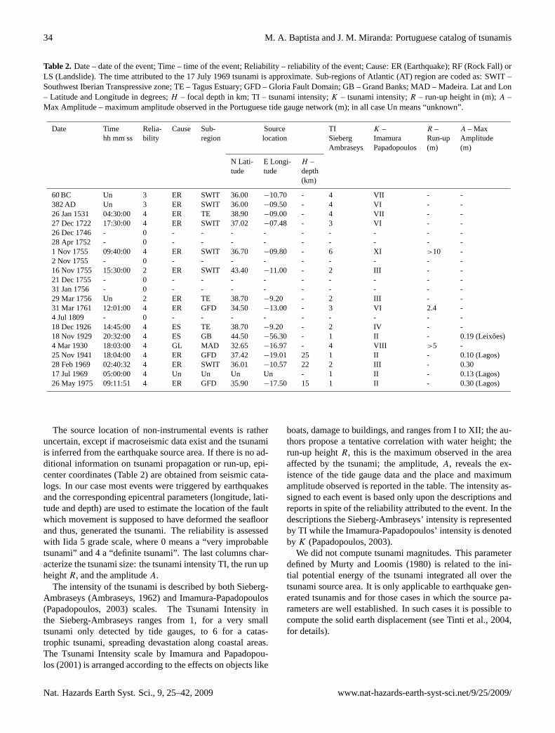
4.1 Structure of the catalog
We present in Table 2 a synopsis of all events included inthe Portuguese tsunami catalog. The fields considered therecharacterize the source (location, date and time, sub-region),the cause classified as Earthquake (submarine earthquake,ER, earthquake associated, EA, earthquake landslide, EL,earthquake marine slide, ES), Volcano (submarine eruption,VO, volcano associated, VA, volcanic landslide, VL, vol-canic marine slide, VS) or Slump (gravitative landslide, GL,gravitative marine slide, GS, gravitational snow avalanche,GA, glacier calving, GC), the reliability (states the uncer-tainty on the occurrence of each event), and the tsunami size(intensity, run up height, and amplitude).
www.nat-hazards-earth-syst-sci.net/9/25/2009/ Nat. Hazards Earth Syst. Sci., 9, 25–42, 2009
34 M. A. Baptista and J. M. Miranda: Portuguese catalog of tsunamis
Table 2. Date – date of the event; Time – time of the event; Reliability – reliability of the event; Cause: ER (Earthquake); RF (Rock Fall) orLS (Landslide). The time attributed to the 17 July 1969 tsunami is approximate. Sub-regions of Atlantic (AT) region are coded as: SWIT –Southwest Iberian Transpressive zone; TE – Tagus Estuary; GFD – Gloria Fault Domain; GB – Grand Banks; MAD – Madeira. Lat and Lon– Latitude and Longitude in degrees;H – focal depth in km; TI – tsunami intensity;K – tsunami intensity;R – run-up height in (m);A –Max Amplitude – maximum amplitude observed in the Portuguese tide gauge network (m); in all case Un means “unknown”.
Date Time Relia- Cause Sub- Source TI K – R – A – Maxhh mm ss bility region location Sieberg Imamura Run-up Amplitude
Ambraseys Papadopoulos (m) (m)
N Lati- E Longi- H –tude tude depth
(km)
60 BC Un 3 ER SWIT 36.00 −10.70 - 4 VII - -382 AD Un 3 ER SWIT 36.00 −09.50 - 4 VI - -26 Jan 1531 04:30:00 4 ER TE 38.90 −09.00 - 4 VII - -27 Dec 1722 17:30:00 4 ER SWIT 37.02 −07.48 - 3 VI - -26 Dec 1746 - 0 - - - - - - - - -28 Apr 1752 - 0 - - - - - - - - -1 Nov 1755 09:40:00 4 ER SWIT 36.70 −09.80 - 6 XI >10 -2 Nov 1755 - 0 - - - - - - - - -16 Nov 1755 15:30:00 2 ER SWIT 43.40 −11.00 - 2 III - -21 Dec 1755 - 0 - - - - - - - - -31 Jan 1756 - 0 - - - - - - - - -29 Mar 1756 Un 2 ER TE 38.70 −9.20 - 2 III - -31 Mar 1761 12:01:00 4 ER GFD 34.50 −13.00 - 3 VI 2.4 -4 Jul 1809 - 0 - - - - - - - - -18 Dec 1926 14:45:00 4 ES TE 38.70 −9.20 - 2 IV - -18 Nov 1929 20:32:00 4 ES GB 44.50 −56.30 - 1 II - 0.19 (Leixoes)4 Mar 1930 18:03:00 4 GL MAD 32.65 −16.97 - 4 VIII >5 -25 Nov 1941 18:04:00 4 ER GFD 37.42 −19.01 25 1 II - 0.10 (Lagos)28 Feb 1969 02:40:32 4 ER SWIT 36.01 −10.57 22 2 III - 0.3017 Jul 1969 05:00:00 4 Un Un Un Un - 1 II - 0.13 (Lagos)26 May 1975 09:11:51 4 ER GFD 35.90 −17.50 15 1 II - 0.30 (Lagos)
The source location of non-instrumental events is ratheruncertain, except if macroseismic data exist and the tsunamiis inferred from the earthquake source area. If there is no ad-ditional information on tsunami propagation or run-up, epi-center coordinates (Table 2) are obtained from seismic cata-logs. In our case most events were triggered by earthquakesand the corresponding epicentral parameters (longitude, lati-tude and depth) are used to estimate the location of the faultwhich movement is supposed to have deformed the seafloorand thus, generated the tsunami. The reliability is assessedwith Iida 5 grade scale, where 0 means a “very improbabletsunami” and 4 a “definite tsunami”. The last columns char-acterize the tsunami size: the tsunami intensity TI, the run upheightR, and the amplitudeA.
The intensity of the tsunami is described by both Sieberg-Ambraseys (Ambraseys, 1962) and Imamura-Papadopoulos(Papadopoulos, 2003) scales. The Tsunami Intensity inthe Sieberg-Ambraseys ranges from 1, for a very smalltsunami only detected by tide gauges, to 6 for a catas-trophic tsunami, spreading devastation along coastal areas.The Tsunami Intensity scale by Imamura and Papadopou-los (2001) is arranged according to the effects on objects like
boats, damage to buildings, and ranges from I to XII; the au-thors propose a tentative correlation with water height; therun-up heightR, this is the maximum observed in the areaaffected by the tsunami; the amplitude,A, reveals the ex-istence of the tide gauge data and the place and maximumamplitude observed is reported in the table. The intensity as-signed to each event is based only upon the descriptions andreports in spite of the reliability attributed to the event. In thedescriptions the Sieberg-Ambraseys’ intensity is representedby TI while the Imamura-Papadopoulos’ intensity is denotedby K (Papadopoulos, 2003).
We did not compute tsunami magnitudes. This parameterdefined by Murty and Loomis (1980) is related to the ini-tial potential energy of the tsunami integrated all over thetsunami source area. It is only applicable to earthquake gen-erated tsunamis and for those cases in which the source pa-rameters are well established. In such cases it is possible tocompute the solid earth displacement (see Tinti et al., 2004,for details).
Nat. Hazards Earth Syst. Sci., 9, 25–42, 2009 www.nat-hazards-earth-syst-sci.net/9/25/2009/

M. A. Baptista and J. M. Miranda: Portuguese catalog of tsunamis 35
4.2 Unreliable events
The re-appraisal of the different data sources and the anal-ysis of new ones, that was performed in this study, led usto discard some events, presented in the preliminary GITECcatalogue (Tinti et al., 1996), mainly because they have beenincluded in previous catalogs of tsunamis in Iberia (e.g. Per-rey, 1847; Mallet, 1952; Rodriguez, 1932; Berninghausen,1964; Moreira, 1991; Campos, 1992). We discard the 26 De-cember 1746, the 28 April 1752, the 2 November 1755, the21 December 1755, the 31 January 1756 and the 4 July 1890events.
The 26th December 1746 event: Berninghausen (1964)reports this event quoting Mallet (1852): “[. . . ] the tide wasvery low (at the time of the shock) and it was observed thatthe sea, which had been quite calm, rose considerably [. . . ].The seismic catalog of Martins and Victor (2001) reports2 earthquakes in 1746, with no specific day and/or month.The shocks are located at−8.5◦ E, 40.3◦ N, and −7.9◦ E,38.2◦ N, both with magnitude 3.0. Mendonca (1758) reportsonly one event for this year, in Lima (Peru). Moreira (1991)reports events in 1746 with no specific date, felt in Assumar,Pombal,Agueda, Espinhel, Alandroal. Some answers fromquestion number ten of the Marques de Pombal Inquiry thatare transcribed in Moreira (1991) and Runa and Freire (1991)refer to an earthquake ten years before 1756, but no referenceis made to a tsunami, as it would be expected as the above lo-calities are inland, far away from the sea. Perrey (1847), Mal-let (1852) and Rodriguez (1932) do not mention this event.
The 28 April 1752 event: This event is listed in Per-rey (1847), Rodriguez (1932) and Berninghausen (1964).The description of Berninghausen (1964), quoting Mal-let (1852), says: ”[. . . ] April 28. Portugal. A violent earth-quake at Buarcos and Aveiro was accompanied by inunda-tion”. Mendonca (1758) refers only one event in this year(1752) but on 6 September, at Clermont and Rion (France).We checked the answers given to the Inquiry made by theMarques de Pombal for Buarcos, Aveiro and Figueira da Foz.Several answers report an event on 23 August 1753. Mor-eira (1984) also excludes this event on the basis that it is nei-ther reported by Gazeta de Lisboa nor by Mendonca (1758).The catalog of Martins and Victor (2001) includes 2 eventsin 1752 and none in 1753.
The 2 November 1755 event:The 2 November 1755event is one among a large sequence of aftershocks ofthe 1755 earthquake, which stood until March 1756. On2 November the day after the earthquake, a shock was feltand the sea was described as agitated (Rodriguez, 1932). Allcoeval sources report extensively the aftershocks but the ex-act date of this event is rather uncertain (Rodriguez, 1932).The epicentre coordinates are considered to be 37.00◦ N and−10.50◦ E by the Martins and Victor (2001) catalog but themagnitude if this event is listed asMb=3, incompatible withthe generation of a tsunami. According to the on-line ver-sion of the Spanish Tsunami Catalog (Instituto Geografico
Nacional, 2005) water flux and reflux was also describedin Gibraltar but a tsunami reliability of zero is attributed.Mendonca (1758) reports aftershocks during the followingday, “in the 24 hours after the earthquake the earth continuedshaking” but no tsunami is reported.
The 21 December 1755 event:A description of a tsunamithe 21 December 1755 is included in Rodriguez (1932):“[. . . ] At about 9 an earthquake occurred in Lisbon, with twoshakings of short duration but so violent that caused damageand ruin in the city. The Tagus overflowed. 300 people diedin the rubbles and drowned in the waters of this river [. . . ]the realm of Algarve suffered a lot. At the coast the sea ad-vanced one league. People at Spanish frontier suffered less[. . . ]”. Rodriguez (1932) quotes no original source for theinformation.
This event is not mentioned in any coeval sources of thePortuguese archives. Mendonca (1758) devotes the final partof his catalog to the aftershocks sequence of the 1755 earth-quake and there is only one event with associated tsunami(the Coruna 16 November 1755 event): “[. . . ] on the 21, by9 o’clock (in the day) there was one that caused so violentconcussions, that caused in Lisbon and surroundings someruins. If it lasted more, there would certainly be more dam-age”. (Mendonca, 1758, p. 62)
The 31 January 1756 Lisbon event:According to Ro-driguez (1932) on 31 January 1756 a tidal wave flooded thecoast and left some fish on the sand. However, this catalogis the only reference to such event: a contemporary source(Mendonca, 1758) reports: “[. . . ] On January 1756 therewere many earthquakes, that I cannot find any memories, andthat I cannot remember, because I just noticed the greaterones on April the 25th (this year) and later on [. . . ]”. Per-rey (1847) does not include any information on this event. Inthe absence of conclusive information from the earthquakeitself, not included in the catalogs of LNEC (1986), Martinsand Victor (2001) or Sousa et al. (1992), we conclude thatRodriguez (1932) description must not be taken into consid-eration.
The 4 July 1809 event:Berninghausen (1964), quotingMallet (1852), reports a tsunami in Portugal on 4 July 1809.The description is: “[. . . ] Portugal. No shock listed. An ex-traordinary flux and reflux of the sea is observed near Lisbon[. . . ]”. The Portuguese newspaper for this month Gazeta deLisboa, July 1809, does not report any sea disturbance. InRodriguez (1932), quoting Perrey (1847) there is only oneevent reported for Lisbon on 26 October the same year, butno reference to any sea disturbance. Mallet (1852) mentionsa flux and reflux in Spezia near Genoa and says that the samephenomenon was observed in Lisbon. As there is no evi-dence of any Portuguese historical source, we shall not con-sider this event in the catalog.
The 2 February 1816 event: It is listed in Ro-driguez (1932) earthquake catalog and is reported in theLisbon newspaper Gazeta de Lisboa. The original sourcejust mentions a “light shock” and no reference is made to a
www.nat-hazards-earth-syst-sci.net/9/25/2009/ Nat. Hazards Earth Syst. Sci., 9, 25–42, 2009

36 M. A. Baptista and J. M. Miranda: Portuguese catalog of tsunamis
tsunami or any sea agitation, while Rodriguez (1932) refersa strong shock and states that a ship 270 leagues away fromLisbon felt the shock. We were not able to find any coevalsource to support the evidence of this event and this entrywhich was previously considered as reliability 1 tsunami isnow eliminated from the catalog, after a reanalysis of allavailable sources.
The 14 August 1978 event: While reported by Cam-pos (1992) it was not recorded in any of the tide stations ofPortugal mainland: Cascais, Lagos, Figueira da Foz, Setubal-Troia. This fact and the small magnitude of the event 4.9(according to Carrilho et al., 2004) lead us to eliminate thisentry of the Portuguese catalog. The signal was recorded inCadiz (Campos, 1992) with amplitude 0.12 m peak to peak.
4.3 Tsunamigenic source areas
The events described above were generated in the complexplate boundary domain that extends between the Azores andwestern Mediterranean (cf. Fig. 2 for locations). The averagemean velocity between the Nubian and the Eurasian platesas deduced from spatial geodesy (Fernandes et al., 2007)reaches only 5 mm/yr close to the Iberian margin, creating asituation where very large earthquakes can only be generatedevery 2 kyr in a single tectonic source. This order of magni-tude is coherent with our present catalog and, in particular,the deductions from paleotsunami research.
We can consider five main potential tsunami source areaswith specific tectonic styles and so, with different tsunami-genic mechanisms (see Fig. 3 for locations). The first cor-responds to the Azores, the second to the Gloria Fault andneighboring interplate domain, the third one to the South-west Iberian Transpressive (SWIT) domain, the fourth tothe Alboran-Cadiz wedge (ACW) and the fifth to the GrandBanks area. Finally, we must also consider regions where lo-cal tsunamis have been generated: the Tavira off-shore, GiraoCape (in Madeira Island) and the Tagus Estuary.
The Azores are a transtensive domain that incorporatesan active spreading axis between the Eurasian and Nubianplates. It is an area of active volcanism, where most of theearthquakes are extensional events or strike slips with lowtsunamigenic potential. Two instrumental events were gener-ated in the Azores domain (8 May 1939 and 1 January 1980)but they had only regional impact. The descriptions concern-ing the Azores tsunami of 26 July 1691 apparently show sim-ilar characteristics but there are no instrumental data avail-able. From the descriptions and data included in this workwe conclude that tsunamis generated in the Azores do notaffect the Portuguese mainland.
The Gloria Fault Domain (GFD) corresponds to the plateboundary between 24◦ W and 19◦ W. It is an area of scarceseismicity characterised by right strike slip motion (Bufornet al., 1988). In spite of this, several instrumental tsunamievents have been identified (8 May 1939, 25 November 1941,26 May 1975) and, according to Baptista et al. (2006) it is
also the probable location of the 31 March 1761 tsunamisource. These events not only follow the Gloria Fault it-self but also a second source zone also striking almost EW,ca. 200 km south (Lynnes and Ruff, 1985). This can corre-spond to either the development of a tectonic block or there-activation of a previous transform domain (Kaabouben etal., 2008). Tsunamigenic earthquakes generated along theGloria Fault Domain are almost pure strike events, with mo-ment magnitudes larger than 8 and average slip close than10 m. This type of seismic source is able to generate smalltsunamis with amplitudes of some dozens of cm, but in somecases, with significant effects on harbours.
The SW Iberian Transpressive (SWIT) domain is inter-preted as a complex plate boundary, where most of the dam-aging earthquakes and tsunamis that affected the coasts ofPortugal, Morocco and Spain, here including the 1 Novem-ber 1755 mega-tsunami, were generated. Here we can iden-tify four most important features which characteristics andlevel of activity have been studied by geophysical and tec-tonic methods, each of them corresponding to a long tec-tonic source able to generate aM>8 earthquake: the north-ern flank of the Gorringe Bank, the Horseshoe, the Marquesde Pombal and the Portimao Bank faults. Most of the damag-ing tsunamis, here including 1 November 1755 and the pale-otsunamis described in the text were generated here. The twolarge historical pre-1755 events (60 BC and 382 AD) wereprobably generated also in this area.
The Gorringe Bank is a large uplifted block of oceaniclithosphere approximately 180 km long and 60–70 km wide,trending N55E. It is a huge morphological high that reaches25 m below sea level. This lithospheric block is usually inter-preted as an almost continuous section of oceanic crust andupper mantle and is associated with a large isostatic anomaly(ca. 300 mGal) interpreted as a sign of the lack of isostaticequilibrium (Bergeron and Bonnin, 1991) and, thus, a poten-tial seismogenic and tsunamigenic feature. However there isno historical or instrumental tsunami event which source canbe conclusively located there.
The Horseshoe Fault (Gracia et al., 2003; Zitellini et al.,2004) is a reverse fault oriented perpendicular to the presentday kinematic displacement of Nubia with respect to Iberia.It is one of the most important tectonic accidents identifiedin the area but, while close to the source area of 28 February1969 earthquake, the geometry of the fault does not matchthe structure as mapped by seismo-stratigraphy.
The Marques de Pombal Fault (Zitellini et al., 2001) is alarge active compressive tectonic structure located 100 kmoffshore SW Cape St. Vincent. It displays a pronounceddrag fold on the fault hanging-wall and the height of theescarpment is taller in the north where it reaches 1.2 km.The northernmost segment is offset by a WNW-ESE wrenchfault. Mass wasting deposits associated with the uplift arealso visible, such as, debris flow deposits and ridges that cor-respond to turbidity levees (Gracia et al, 2003; Terrinha etal., 2003). This is the most relevant active structure mapped
Nat. Hazards Earth Syst. Sci., 9, 25–42, 2009 www.nat-hazards-earth-syst-sci.net/9/25/2009/

M. A. Baptista and J. M. Miranda: Portuguese catalog of tsunamis 37
Fig. 3. Sketch of the main tsunamigenic zones for Portugal. Main active geological features described in the text are labeled as follows: SVF- St. Vincent Fault; TF - Tavira Fault; MPF Marques de Pombal Fault; GB - Gorringe Bank; HF - Horseshoe Fault; PBF - Portimao BankFault; ACW - Alboran-Cadiz Wedge; HAP Horseshoe Abyssal Plain. Grand Banks area is outside the picture.
in the SW Iberian area and was proposed as the source ofthe 1755 event. However, its length as deduced from multi-channel seismic data is too small to account for the knownearthquake and tsunami magnitude.
The Portimao Bank Fault (PBF) was recently mapped bythe NEAREST team (Terrinha et al., personal communica-tion) along the southern flank of the Portimao Bank.
The Alboran-Cadiz wedge was considered by Gutscheret al. (2006) as a potential seismogenic and tsunamigenicfeature. This interpretation was mainly based on thermo-mechanical modeling, and on the estimated relative velocityvis-a-vis the surrounding lithosphere, which was consideredas twice the relative motion between Nubia and Eurasia, i.e.close to 1 cm/yr. There are no large instrumental events thatcan be attributed to this source area. However, since pre-vious attempts to model the whole 1755 tsunami and earth-quake observations with a single source within SWIT werenot completely successful, we must include ACW as a po-tential source. The positive identification of large magnitudepre-historic events around the Gulf of Cadiz also reinforcesthis hypothesis.
The 1929 Grand Banks tsunami is the only known eventgenerated outside the abovementioned source areas. How-ever, even in this case of a very large landslide triggered by anearthquake, the maximum observed amplitude reached only13 cm on the mainland Portuguese coasts.
Among the areas where local events are known, partic-ular attention must be drawn to the Tagus Estuary (TE): itis the site of two well established events (1531 and 1926)and the possible location of a third one (16 November 1755).The two other local events (on Cape Girao and Tavira) haveunknown repeatability. In the case of Cape Girao rock fall,the basic characteristics to generate another event apparentlypersist: steepness and lithology of the cliff, short distance tobeaches with human occupation. In the case of Tavira, theexistence of previous similar events must still be searchedparticularly with paleotsunami methods.
www.nat-hazards-earth-syst-sci.net/9/25/2009/ Nat. Hazards Earth Syst. Sci., 9, 25–42, 2009

38 M. A. Baptista and J. M. Miranda: Portuguese catalog of tsunamis
5 Discussion and conclusions
The list of tsunamis in the Portuguese coasts includes17 reliable events since 60 BC. Fourteen of them were gen-erated by earthquakes.
A group of five events can be considered as regional orAtlantic wide, and generated important damage: 60 BC, 382,1755, 1761 and 1929. With the exception of the Grand Banksevent, all of them were generated byM>=8 earthquakes, oc-curring in large segments of the Eurasia-Nubia plate bound-ary close to Iberia. They caused inundation of large areas,affected infrastructures close to shore, and the run-out at theharbors destroyed anchored ships. At least in the case ofthe 1755 tsunami there were many casualties. Morphologi-cal changes are claimed for three of them (60 BC, 382 and1755).
The only tsunami generated far from the plate boundary isthe 1929 Grand Banks event, which was caused by a largesubmarine landslide but its effect on the Portuguese coastswas only detected by tide gauges and even its probable effecton harbors is not documented.
Three events, well recorded by coastal tide gauges in anumber of different places (1941, 1969, and 1975), showedmoderate wave heights (<= 1m), with small or negligible in-undation effects. The first two were generated in the GloriaFault Domain, as major strike slip shocks; the third was gen-erated south of the Gorringe Bank, as a thrust, by aM=8earthquake. All showed significant effects in the harbors ofthe Portuguese mainland, Madeira and/or Azores.
Three events (1531, 1722 and 1926) can be considered lo-cal tsunamis: they were generated by small size faults andprobablyM<7 earthquakes, but close enough to the shoreto have generated important impact in close areas. A simi-lar situation concerns the 4 March 1930 rock fall in MadeiraIsland. The importance of local events is particularly highat Algarve (southern Portuguese coast) and at Lisbon estu-ary, where at least two events are well established (1531 and1926). A third event (1756) can also be considered to havebeen generated close to Lisbon, according to the availableinformation. Local tsunamis must be considered in the eval-uation of tsunami hazard, particularly in the areas of Algarveand Lisbon. Their origin is seismic but, seen the small mag-nitudes of some of the earthquakes in cause, the existence ofa significant landslide component must be considered. In thecase of the 1926 Tagus event, and taking into considerationthe low presumed magnitude of the associated earthquake,and the lack of coherent tsunami signal in Cascais tide gauge,out of the Lisbon bar, we consider as the most probable causean earthquake marine slide in the Estuary.
If we consider the period after 60 BC, which is usually thestarting date for most earthquake catalogs of Portugal, wecan verify that events with magnitude larger than 7.5, andepicenter offshore generated tsunamis. The exceptions arethe 29 June 1033 and the 24 August 1356 events (Martinsand Victor, 2001) both poorly known.
Small tsunamigenic earthquakes are only known after1881. Table 2 includes five events observed during the XXCentury, with wave amplitudes smaller than 35 cm, thanksto the mareographic network, which allowed the detectionof tsunami events with intensities reachingK∼I in thePapadopoulos-Imamura scale. Before 1881 the detectionthreshold is larger and only events withK>2 or 3 are pre-served in written documents.
The new events included in this revision point to the factthat the level of completeness of tsunami catalogs is still low,even if we limit to the instrumentation period (after 1881).Future work must include more historical research, particu-larly roman sources, and systematic screening of all availablemareograms. There is also the need for the evaluation of allnaval archives, particularly Portuguese, Spanish, British andFrench, as naval captains may have kept logs that may haverecorded some important events.
Acknowledgements.The present work was made in the frameworkof work-packages WP1 and WP2 of TRANSFER, WorkingGroup 1 of NEAMTWS – IOC (UNESCO) and benefited fromintermediate results of NEAREST project. We thank both prin-cipal investigators of TRANSFER and NEAREST Stefano Tintiand Nevio Zitellini for their support during this study and theTRANSFER colleagues Alessandra Maramai and Helene Hebertfor sending data not available in Lisbon. We also thank Paul-Louis Blanc from the Centre des Faibles Radioactivites, CEAFrance, for making available some important texts and Fer-nando Marques for clarifications on the Madeira 1930 event andDomingos Rodrigues for making available the photo presented inFig. 1. We thank the collaboration of the following institutions:the Gibraltar Garrison Library (Lorna M Swift); the UniversityArchives, Georgetown University (Lynn Conway); The BritishAssociation for the Advancement of Science (Rupa Kundu);Instituto Hidrografico, Portugal (Joana Reis), Instituto GeograficoPortugues (Goncalo Crisostomo); the library of Instituto D. Luiz,Portugal (Cristina Domingues), and the Administration Board ofthe Douro and Leixoes harbors. A part of the historical researchincluded here was performed by Salome Heitor, during GITECproject 1992–1994. Coordinates in Table 1 were obtained fromGoogle Earth.
Edited by: S. TintiReviewed by: S. Haslett and another anonymous referee
References
Ambraseys, N. N.: Data for the investigation of the seismic sea-waves in the Eastern Mediterranean, B. Seismol. Soc. Am., 52,895–913, 1962.
Ambraseys, N. N.: Intensity Attenuation and Magnitude IntensityRelationships for Northwest European Earthquakes, Earthq. Eng.Struct. D., 13, 733–778, 1985.
Andrade, C.: Tsunami generated forms in the Algarve barrier is-lands (South Portugal), Science of Tsunami Hazards, 10, 21–34,1992.
Nat. Hazards Earth Syst. Sci., 9, 25–42, 2009 www.nat-hazards-earth-syst-sci.net/9/25/2009/

M. A. Baptista and J. M. Miranda: Portuguese catalog of tsunamis 39
Andrade, C., Borges, P., and Freitas, M. C.: Historical tsunamisin the Azores Archipelago (Portugal), J. Volcanol. Geoth. Res.,156, 172–185, 2006.
Arquivos do Ministerio do Reino: Maco no 638, Documentacaosobre o tremor de terra de 1 de Novembro de 1755, ANTT, Ar-quivo Nacional da Torre do Tombo, Lisboa, Portugal, 1756 (inPortuguese).
Babinet, J.: Note dans les Comptes Rendus de la Academie desSciences de Paris, LII, 369 pp., 1861 (in French).
Baptista, M. A., Heitor, S., Miranda, J. M., Miranda, P. M. A.,and Victor, L. M.: The 1755 Lisbon tsunami: Evaluation of thetsunami parameters, J. Geodyn., 25, 143–157, 1998a.
Baptista, M. A., Miranda, J. M., Chierici, F., and Zitellini, N.: Newstudy of the 1755 earthquake source based on multi-channel seis-mic survey data and tsunami modeling, Nat. Hazards Earth Syst.Sci., 3, 333–340, 2003,http://www.nat-hazards-earth-syst-sci.net/3/333/2003/.
Baptista, M. A., Miranda, J. M., Lopes, F. C., and Luıs, J. F.: TheSource of the 1722 Algarve Earthquake: Evidence from MCSand Tsunami Data, J. Seismol., 11(4), 371–380, 2007.
Baptista, M. A., Miranda, J. M., and Luıs, J. F.: In Search of the31th March 1761 Earthquake and Tsunami Source, B. Seismol.Soc. Am., 96(2), 713–721, 2006.
Baptista, M. A., Miranda, P. M. A., and Victor, L. M.: Maximumentropy analysis of portuguese tsunami data, The tsunamis of28.02.1969 and 26.05.1975, Science of Tsunami Hazards, 10,9–20, 1992.
Baptista, M. A., Miranda, P. M. A., Miranda, J. M., and Victor,L. M.: Constrains on the source of the 1755 Lisbon tsunami in-ferred from numerical modelling of historical data, J. Geodyn.,25, 159–174, 1998b.
Belem, Fr. J.: Chronica Serafica da Santa Provıncia dos Algarves,da Regular Observancia do Nosso Senhor Padre S. Francisco,Em que se trata de sua Origem, Progressos e Fundacoes de seusConventos, Parte Primeira, Lisboa, cap. XXII, 200–201, 1750 (inPortuguese).
Bergeron, A. and Bonin, J.: The deep structure of Gorringe Bank(NE Atlantic) and its surrounding area, Geophys. J. Int., 105(2),491–502, 1991.
Berninghausen, W. H.: Tsunamis and seismic seiches reported fromthe eastern Atlantic south of the Bay of Biscay, B. Seismol. Soc.Am., 54, 439–442, 1964.
Bewick, B.: An Account of the Earthquake at Cadiz, November 1,1755, in a Letter from Benjamin Bewick, Merchant there, to Mr.Joseph Paice, Merchant in London, Lett. XIV, for the Year 1756,Philosophical Transactions, Vol. XLIX, Part II, London, 1757.
Borges, J. F., Bezzeghoud, M., Buforn, E., Pro, C., and Fitas, A.:The 1980, 1997 and 1998 Azores earthquakes and some seismo-tectonic implications, Tectonophysics, 435(1–4), 37–54, 2007.
Borlase, W.: Letter to the Rev. Charles Lytleton, L. L. Dean of Ex-eter, Lett. XV, printed for L. Davis and C. Reymers, Printers tothe Royal Society, against Gray’s Inn Gate, in Holbourn, for theYear 1756, Philosophical Transactions, Vol. XLIX, Part II, Lon-don 1757, London, 1755.
Borlase, W.: Some Account of the extraordinary Agitation of theWaters in Mount’s-bay, and other Places, on the 31st of March1761, in: A Letter for the Reverend Dr. C Lyttelton, Philos. T.Roy. Soc. 52, 418–431, 1762.
Brito, F. B.: Monarquia Lusitana, Lisboa Imprensa Nacional – Casada Moeda, Facsimile, 1973–88, 1597.
Buforn, E., Udias, A., and Colombas, M.: Seismicity, source mech-anisms and tectonics of the Azores – Gibraltar plate-boundary,Tectonophysics, 152, 89–118, 1988.
Campos, M. L.: El Riesgo de tsunamis en Espana, Analysis y Valo-racion Geografica, Monografia do Instituto Geografico Nacional,Madrid-Espanha, 1–204, 1992.
Carrilho, F., Nunes, J. C., Pena, J., and Senos, M. L.: CatalogoSısmico de Portugal Continental e Regiao Adjacente para operıododo 1970–2000, Instituto de Meteorologia, ISBN 972-9083-12-6, 231 pp., 2004.
Castro, D. A. L. F.: Historia Geral de Portugal e suas conquis-tas, Database Fundo Antigo, Academia de Ciencias de Lisboa,Livro 1, Capitulo IV, Manuscript 691, 21–36, 1786 (in Por-tuguese).
Chambers, C.: Another Account of the Same Earthquake at Madeirain a Letter from Charles Chambers to his Father, in London,dated at Madeira, Novem. I, 1755, Communicated by Lewis Cru-sius, D. D. F. R. S., Lett. XVIII, for the Year 1756, PhilosophicalTransactions, Vol. XLIX, Part II, London, 1757.
Codex 8009: Breve notıcia de alguns terramotos, Arquivo Nacionalda Torre do Tombo, Lisboa, Portugal, no date (in Portuguese).
Codex 9857: Incomplete Reference. Reserved documents of theLisbon National Library, Lisboa, Portugal, no date (in Por-tuguese).
Correio dos Acores: Portuguese newspaper published in the Azoresthe 26 December 1939, 1939 (in Portuguese).
Costa, A., Andrade, C., Seabra, C., Matias, L., Baptista, M. A.,and Nunes, S.: 1755, Terramoto no Algarve, Editor Centro deCiencia Viva do Algarve, ISBN 972-99778-0-1, 2005 (in Por-tuguese).
Couto, D.: DaAsia, Decada 4, Livro 7, Cap XI, Lisboa, 1778 (inPortuguese).
da Silva, F. C.: Theatro Universal de novidades polıticas, marciaise elementares e prognosticos para o anno de 1757, o primeirodepois do bissexto, Calculado ao meu dano da Cidade de Lisboapela altura de 38 gr e 43 minutos de elevacam do polo, Lisboa,oficina de Manoel Soares, 1756 (in Portuguese).
Dabrio, C. J., Zazo, C., Goy, J. L., Sierro, F. J., Borja, F., Lario,J., Gonzalez, J. A., and Flores, J. A.: Depositional history ofestuarine infill during the Late Pleistocene-Holocene postglacialtransgression, Mar. Geol., 162, 381–404, 2000.
Dawson, A. G., Hindson, R., Andrade, C., Freitas, C., Parish, R.,and Bateman, M.: Tsunami sedimentation associated with theLisbon earthquake of 1 November AD 1755: Boca do Rio, Al-garve, Portugal, The Holocene, 5(2), 209–215, 1995
De la Torre, F. R.: Revision del Catalogo Sısmico Iberico (anos1760 a 1800) Estudio realizado para el Instituto GeograficoNacional, mediante convenio de investigacion numero 7.070,Madrid, 1997 (in Spanish).
Diario da Manha: Portuguese Newspaper published 29 March 1969,1969 (in Portuguese).
Diario de Noticias no219 876: Portuguese newspaper published the26 December 1926, p. 1, p. 3, 1926 (in Portuguese).
Diario de Noticias da Madeira no20 368: Portuguese newspaperpublished the 26 November 1941, year 66, 1–2, 1941a (in Por-tuguese).
www.nat-hazards-earth-syst-sci.net/9/25/2009/ Nat. Hazards Earth Syst. Sci., 9, 25–42, 2009

40 M. A. Baptista and J. M. Miranda: Portuguese catalog of tsunamis
Diario de Notıcias da Madeira no 20 369: Portuguese newspaperpublished the 27 November 1941, year 66, 1, 1941b (in Por-tuguese).
Diario dos Acores no29 792: Portuguese newspaper published the26 May 1975, year 106, 1–2, 1975a (in Portuguese).
Diario dos Acores no29 793. Portuguese newspaper published the27 May 1975, year 106, 1, 1975b (in Portuguese).
El Mrabet, T.: Tarikh azalazil bi Al Maghrib. These 3eme cycle.Univ. Md V, Faculte des Lettres et des Sciences Humaines Rabat,370 pp., 1991 (in Arabic).
Ellicot, J.: Letter to Tilman Henkel, Esq. Merchant in London,concerning the Eartqhuake at Oporto in Portugal, Nov. 1. 1756,Communicated by Mr. John Ellicot, F. R. S., Lett. VIII, for theYear 1756 Philosophical Transactions, Vol. XLIX, Part II,, Lon-don 1757.
Fernandes, R. M. S., Miranda. J. M., Meijninger, B. M. L. , Bos,M. S., Noomen, R., Bastos, L., Ambrosius, B. A. C., and Riva,R. E. M.: Surface Velocity Field of the Ibero-Maghrebian Seg-ment of the Eurasia-Nubia Plate Boundary, Geophys. J. Int.,169(1), 315–324, 2007.
Fine, I. V., Rabinovich, A. B., Bornholdd, B. D., Thomson,R. E., and Kulikov, E. A.: The Grand Banks landslide-generatedtsunami of November 18, 1929: preliminary analysis and numer-ical modeling, Mar. Geol., 215, 45–57, 2005.
Freitas, M. P.: A Vaga da Morte. Girao, Revista de Temas Culturaisdo concelho de Camara de Lobos, no2, 1o Semestres de 1989,52–54, 1989 (in Portuguese).
Fukao, Y.: Thrust faulting at a lithosphere plate boundary, The Por-tugal earthquake of 28.02.1969, Earth Planet. Sc. Lett., 18, 205–216, 1973.
Gazeta de Lisboa: Newspaper published in Lisbon, No47, Bib-lioteca Nacional de Lisboa, Portugal, 1755 (in Portuguese).
Gibraltar Chronicle: 26 November 1941, Gibraltar Garrison Li-brary, Gibraltar UK, p. 2, 1941a.
Gibraltar Chronicle: 27 November 1941, Gibraltar Garrison Li-brary, Gibraltar UK, p. 3, 1941b.
Gjevik, B., Pedersen, G., Dybesland, E., Harbitz, C. B., Miranda,P. M. A., Baptista, M. A., Mendes-Victor, L., Heinrich, P.,Roche R., and Guesima, M.: Modeling tsunamis from earth-quake sources near Gorringe Bank southwest of Portugal, J. Geo-phys. Res., 102(C13), 27 931–27 949, 1997.
Gracia, E., Danobeitia, J., Verges, J., and PARSIFAL Team: Map-ping active faults offshore Portugal (36◦ N–38◦ N): Implicationsfor seismic hazard assessment along the southwest Iberian mar-gin, Geology, 31(1), 83–86, 2002.
Gracia, E., Danobeitia, J., Verges, J., Bartolome, R., andCordoba, D.: Crustal architecture and tectonic evolution ofthe Gulf of Cadiz (SW Iberian margin) at the convergence ofthe Eurasian and African plates, Tectonics, 22(4), 1033, doi:10.1029/2001TC901045, 2003.
Gutscher, M.-A., Baptista, M. A., and Miranda, J. M.: The Gibral-tar Arc seismogenic zone (part 2): constraints on a shalloweast dipping fault plane source for the 1755 Lisbon earthquakeprovided by tsunami modelling and seismic intensity, Tectono-physics, 426, 153–166, doi:10.1016/j.tecto.2006.02.025, 2006.
Haslett, S. K. and Bryant, E. A.: Historic tsunami in Britain sinceAD 1000: a review, Nat. Hazards Earth Syst. Sci., 8, 587–601,2008,http://www.nat-hazards-earth-syst-sci.net/8/587/2008/.
Heberden, W.: An account of the Earthquake in the Island of
Madeira, Nov. 1, 1755, in: A Letter from Dr. Tho. Heberdento his brother Dr. William Heberden, F. R. S., Lett. XVII, forthe Year 1756, Philosophical Transactions, Vol. XLIX, Part II,London, 1757.
Heck, N. H.: List of Seismic Sea Waves, B. Seismol. Soc. Am.,37(4), 269–284, 1947.
Heinrich, P., Baptista, M. A., and Miranda, P. M. A.: NumericalSimulations of the 1969 Tsunami along the Portuguese coasts,Science of Tsunami Hazards, 12(1), 3–25, 1994.
Hirn, A., Haessler, H., Hoang, T., Wittlinger, G., and Mendes-Victor, L.: Aftershock Sequence of the January 1, 1980, Earth-quake and Present Day Tectonics in the Azores, Geophys. Res.Lett., 7, 501–504, 1980.
IANTT: Instituto do Arquivo Nacional da Torre do Tombo, Di-cionario Geografico, Freguesia de Boliqueime, 7(301), 977–980,1758 (in Portuguese).
Imamura, F. and Papadopoulos, G.: The tsunami Intensity scale,2001, International Tsunami Symposium, Seattle, USA, 569–577, 2001.
Instituto Geografico Nacional: Terremotos y Tsunamis in Espana,CD ISBN 84-9810346-O, 2005 (in Spanish).
Journal Historique: Journal Historique sur Les Matieres du Temscontenant quelques nouvelles de Litterature, et autres Remar-ques curieuses, Suite des Tremblements de Terre, p. 462, 1756(in French).
Journal Historique: Suite de La Clef ou Journal Historique sur LesMatieres du Tems, contenant quelques nouvelles de Litterature,et autres Remarques curieuses, Juin 1773, Premiere Partie,Tome CXIII, Paris 462-464, 1773 (in French).
Justo, J. L. and Salwa, C.: The 1531 Lisbon earthquake, B. Seismol.Soc. Am., 88, 319–328, 1998.
Kaabouben, F., Brahim A. I., Toto E. A., Baptista M. A., Mi-randa J. M., Soares P., Luis J. F.: On the focal mechanism ofthe 26.05.1975 North Atlantic event contribution from tsunamimodeling, J. Seismol., 12(4), 575–583, doi:10.1007/s10950-008-9110-6, 2008.
Lario, J.: Ultimo y Presente Interglacial en elarea de conexionAtl antico - Mediterraneo (Sur de Espana). Variaciones del niveldel mar, paleoclimas y paleoambientes. Ph.D. thesis, Universi-dad Complutense de Madrid, 269 pp., 1996 (in Spanish).
Levret, A.: The effects of the November 1, 1755 Lisbon earthquakein Morocco, Tectonophysics, 193, 83–94, 1991.
LNEC: A Sismicidade Historica e a Revisao do Catalogo Sısmico.Proc. 36/11/7368. Laboratorio Nacional de Engenharia Civil.Ministerio do Equipamento Social, 1986 (in Portuguese).
Lopes, J. B. S.: Corografia ou memoria economica do reino do Al-garve. Ed. Academia de Ciencias Lisboa, 169 pp., 1841 (in Por-tuguese).
Luque, L., Lario, J., Zazo, C., Goy, J. L., Dabrio, C. J., Silva, P.G.: Tsunami deposits as paleoseismic indicators: examples fromthe Spanish coast. Acta Geologica Hispanica, 36(3–4), 197–211,2001.
Luque, L., Lario, J., Silva, P. G., Zazo, G., Goy, J. L., Dabrio, C.J.: Sedimentary record of a tsunami during Roman times, Bay ofCadiz, Spain. Journal of Quaternary Science, 17 (5-6), 623-631,2002.
Lynnes, C. S., and Ruff, L. J.: Source process and tectonic impli-cations of the great 1975 North Atlantic earthquake, Geophys. J.R. Astr. Soc., 82, 497-510, 1985.
Nat. Hazards Earth Syst. Sci., 9, 25–42, 2009 www.nat-hazards-earth-syst-sci.net/9/25/2009/

M. A. Baptista and J. M. Miranda: Portuguese catalog of tsunamis 41
Mallet, R.: Catalogue of Recorded Earthquakes 1606 B. C.–1850A. D. Reports on the State of Science. Third Report on the Factsof Earthquake Phenomena, British Assoc., For the Advancementof Science, London, 1852–1854, 1852.
Martins, I. and Victor, L. A. M.: Contribution to the Study of Seis-micity in the West Margin of Iberia. Univ Lisboa, IGIDL Pub 25,ISSN 0870-2748, 2001.
Mendonca, J. M.: Historia Universal dos Terramotos que temhavido no mundo de que ha noticia desde a sua criacao ateao seculo presente, Biblioteca Nacional de Lisboa, Portugal,272 pp., 1758 (in Portuguese).
Molloy, M.: An Accopunt of the Earthquake in Lisbon 31st March1761, Philos. T. Roy. Soc., London 1757, 52, 142-143, 1761.
Moreira, V. S.: Tsunamis Observados em Portugal, publicacaoGEO134. Servico Meteorologico Nacional, Portugal, 18 pp., (inPortuguese), 1968.
Moreira, V. S.: Sismicidade Historica de Portugal Continental, In-stituto Nacional de Meteorologia e Geofisica, Portugal, 28 pp.,1984 (in Portuguese).
Moreira, V. S.: Review of Historical Seismicity in the Gulf of CadizArea before the 1 November 1755 earthquake – A CEC, ProjectRHISE, annual report, Instituto Nacional de Meteorologia e Ge-ofisica, Portugal, 1991 (in Portuguese).
Murty, T. S. and Loomis, H.: A new objective tsunami magnitudescale, Mar. Geod., 4, 267–282, 1980.
Nozes, J.: O terremoto de 1755: Testemunhos Britanicos, BritishHistorical Society of Portugal, edited by: Lisoptima, 277 pp.,ISBN 9 729 394,032, 1990.
Oliveira: Syncope Universal Historico em que em brevissimasumma, se descrevem, recupiladas, as mais celebres historias domundo, 1a parte, Manuscript, Reserved Section of the LisbonNational Library, Codice 11 004, Lisboa, Portugal, no date (inPortuguese).
Oliveira, F.: Theatro Lamentavel: Scena Funesta Relacam Ver-dadeira do Terramoto do Primeiro de Novembro de 1755 Coma notıcia do estrago, que cauzou em Lisboa, e suas vizinhancas,ruina do reino do Algarve e sustos de todo o Portugal, Coimbra,Officina de Francisco de Oliveira, Impressor da Universidade,21 pp., 1756 (in Portuguese).
Osorio, B.: O terramoto de Lisboa de 1531, Separata do Boletim deI cIasse da Academia das Ciencias de Lisboa, Coimbra, 12 pp.,1919 (in Portuguese).
Papadoupolos, G.: Tsunami hazard in the Eastern Mediterranean:strong earthquakes and tsunamis in the Corinth Gulf, centralGreece, Nat. Hazards, 29, 437–464, 2003.
Perrey, A.: Sur les tremblements de terre de la Peninsule Iberique,Annales des sciences physiques et naturelles, d’agriculture etd’industrie, X. Societe Royale d’agriculture, d’histoire naturelleet des arts utiles, Lyon, 463–514, 1847 (in French).
Resende, G.: Miscelania e Variedade de Historias, Costumes, casose cousas que em seu tempo aconteceram, edited 1917, Lisboa1554 (in Portuguese).
Rodigues, D.: Analise do risco do movimentos de vertente e ordena-mento do territorio na Madeira, Aplicacao ao caso do Machico,Ph.D. thesis, University of Madeira, Portugal, 2005.
Rodriguez, G.: Catalogo sısmico de a zona compreendida entre losmeridianos 5 e 20W de Greenwich e los paralelos 45 y 25 N. Im-prenta de Romano Velasco, Madrid-Spain, 1932 (in Spanish).
Rosa, J. F. and Fernandes, J. P.: A Vaga da Morte, Tipografia doDiario da Madeira, Funchal, 1930 (in Portuguese).
Runa, L. M. L. F. and Freire, A. G. N. M.: Terramoto de Lisboa de 1de Novembro de 1755, Grupo de Proteccao e Seguranca Nuclear,Lisboa, Portugal, 1991 (in Portuguese).
Ruiz, F., Rodrıguez-Ramırez, A., Caceres, L. M., Vidal, J. R., Car-retero, M. I., Abada, M., Olıas, M., and Pozo, M.: Evidence ofhigh-energy events in the geological record: Mid-holocene evo-lution of the southwestern Donana National Park (SW Spain),Palaeogeogr. Palaeocl., 229, 212–229, 2005.
Ruiz, F., Abad, M., Vidal, J. R., Caceres, L. M., Gonzalez-Regalado, M. L., Carretero, M. I., Pozo, M., and Toscano, F. G.:The geological record of the oldest historical tsunamis in south-western Spain, Rivista Italiana di Paleontologia e Stratigrafia,114(1), 145–154, 2008.
Sachetti, J. M.: A Copy of Part of Two Letters Written by JohnMendes Sacheti, M. D. F. R. S. Dated From the Fields of Lisbon,on the 7th of November, and the 1st of November 1755, Lett. IV,for the Year 1756, Philosophical Transactions, Vol. XLIX, Part II,London, 1757.
Scheffers, A. and Kelletat, D.: Tsunami Relics on the Coastal Land-scape West of Lisbon, Portugal, Science of Tsunami Hazards,23(1), p. 3, 2005.
Solares, J. M. M. and Arroyo, A. L.: The great historical 1755earthquake. Effects and damage in Spain, J. Seismol., 8, 275 pp.,2004.
Solares, J. M., Lopez-Arroyo, A., and Mezcua, J.: Isoseismalmap of the 1755 Lisbon earthquake obtained from Spanish data,Tectonophysics, 53, 301–313, 1979.
Sousa, M. F.: Europa portuguesa segunda edicion correta, ilustraday anadida en tantos lugares y con tales ventajas que es labornueva por su autor Manuel de Faria y Sousa, tomo I [–III], printedby: Craesbeeck de Mello, d’Antonio, 1678–1680, Biblioteca Na-cional de Lisboa, Portugal, Tomo I 491 pp., Tomo II 224pp.,Tomo III 594 pp., 1678 (in Portuguese).
Sousa, F. L. P.: O terremoto do 1◦ de Novembro de 1755 em Portu-gal e um estudo demografico, Servicos Geologicos, 4 vols., 1–4,72–73, 403–510, 806–831, 1919 (in Portuguese).
Sousa, M. L., Martins, A., and Oliveira, C. S.: Compilacao deratalogos sısmicos da Regiao Iberica, Laboratorio Nacional deEngenharia Civil, Lisboa, Rep. 36/92-NDA, 1–250, 1992 (in Por-tuguese).
Tendorf, F. J.: Seismological Dispatches, University of George-town, USA, 1926.
Terrinha, P., Pinheiro, L. M., Henriet, J. P., Matias, L., Ivanov,M. K., Monteiro, J. H., Akhmetzhanov, A., Volkonskaya,A., Cunha, T., Shaskin, P., and Rovere, M.: Tsunamigenic-seismogenic structures, neotectonics, sedimentary processes andslope instability on the southwest Portuguese Margin, Mar.Geol., 195(1–4), 55–73, 2003.
Tinti, S., Baptista, M. A., Harbitz, C. B., and Maramai, A.: Theunified European catalogue of tsunamis: a GITEC experience,Proc. International Conference on Tsunamis, Paris, 26–28 May1998, 84–99, 1999.
Tinti, S. and Maramai, A.: Catalogue of tsunamis generated in Italyand in Cote d’Azur, France: a step towards a unified catalogue oftsunamis in Europe, Ann. Geofis., 39, 1253–1299, 1996.
www.nat-hazards-earth-syst-sci.net/9/25/2009/ Nat. Hazards Earth Syst. Sci., 9, 25–42, 2009

42 M. A. Baptista and J. M. Miranda: Portuguese catalog of tsunamis
Tinti, S., Maramai, A., and Graziani, L.: The New Catalogue ofItalian Tsunamis, Nat. Hazards, Kluwer Acad. Press, 33, 439–465, 2004.
Trembley, A.: An Account of the Earthquake felt at Geneva,Novem. 9. 1755, in a Letter from Mons. Trembley, Professorof Mathematics there, to his Brother Mr. Abraham Trembley,F. R. S. Translated from the French. Lett. XX, for the Year 1756Philosophical Transactions, Vol. XLIX, Part II,, London, 1757.
Urban, S.: The Gentleman’s Magazine, printed by: D. Henry, D.and Cave, R., St. John’ Gate, London, 554–564, 1755a.
Urban, S.: Supplement to the Gentleman’s Magazine for the year1755, printed by: Henry, D. and Cave, R., St. John’ Gate, Lon-don, 587–591, 1755b.
Vizcaino, A., Gracia, E., Escutia, C., Asioli, A., Garcia-Orellana, J.,Lebreiro., S., Cacho, I., Thouveny, N., Larrasoana, J. C., Diez,S., and Danobeitia, J. J.: Characterizing Holocene PaleoseismicRecord in the SW Portuguese Margin, Geophys. Res. Abstr., 8,08 469, SRef-ID: 1607-7962/gra/EGU06-A-08469, 2006.
Vogt, J.: Revision d’Anciens Seismes Ibero-Maghrebins, in: LesEffects du Seisme de Lisbonne du ler Novembre 1755 sur le Ter-ritoire Marocain, Esquisse des lntensites Maximales ObservdesDues aux Grands Seismes Ibero-Maghrebins, edited by: Lev-ret, A., Commissariat a l’Energie Atomique, 319 pp., 1985 (inFrench).
Ward, S. N. and Day, S.: Cumbre Vieja Volcano, Potential collapseand tsunami at La Palma, Canary Islands, Geophys. Res. Lett.,28(17), 3397–3400, 2001.
Zitellini, N., Mendes, L. A., Cordoba, D., Danobeitia, J., Nicolich,R., Pellis, G., Ribeiro, A., Sartori, R., Torelli, L., Bartolome, R.,Bortoluzzi, G., Calafato, A., Carrilho, F., Casoni, L., Chierici, F.,Corela, C., Correggiari, A., Della Vedova, B., Gracia, E., Jornet,P., Landuzzi, M., Ligi, M., Magagnoli, A., Marozzi, G., Ma-tias, L., Penitenti, D., Rodriguez, P., Rovere, M., Terrinha, P.,Vigliotti, L., and Ruiz, A. Z.: Source of 1755 Lisbon earthquakeand tsunami investigated, EOS, Nr. 26, 285, 290–291, 2001.
Zitellini, N., Rovere, M., Terrinha, P., Chierici, F., Matias L., andthe BIGSETS Team: Neogene through Quaternary tectonic re-activation of SW Iberian passive margin, Pure Appl. Geophys.,161, 565–587, 2004.
Nat. Hazards Earth Syst. Sci., 9, 25–42, 2009 www.nat-hazards-earth-syst-sci.net/9/25/2009/
Related Documents