November 2010 v2 MONTEREY COUNTY COMMUNITY WILDFIRE PROTECTION PLAN November, 2010 MONTEREY COUNTY, CALIFORNIA Monterey Fire Safe Council 2221 Garden Road Monterey, CA 93940 831-333-2606 www.firesafemonterey.org

Welcome message from author
This document is posted to help you gain knowledge. Please leave a comment to let me know what you think about it! Share it to your friends and learn new things together.
Transcript

November 2010 v2
MONTEREY COUNTY
COMMUNITY WILDFIRE PROTECTION PLAN
November, 2010
MONTEREY COUNTY, CALIFORNIA
Monterey Fire Safe Council2221 Garden Road
Monterey, CA 93940831-333-2606
www.firesafemonterey.org
Monterey County Community Wildfire Protection PlanNovember 2010 v2
i
Congressional Direction for the 10-Year Comprehensive Strategy
Conference Report for the Fiscal Year 2001 Interior and Related AgenciesAppropriations Act (Public Law 106-291)
The Secretaries should also work with the Governors on a long-term strategy to deal with thewildland fire and hazardous fuels situation, as well as needs for habitat restoration andrehabilitation in the Nation. The managers expect that a collaborative structure, with the Statesand local governments as full partners, will be the most efficient and effective way ofimplementing a long-term program.
The managers are very concerned that the agencies need to work closely with the affected States,including Governors, county officials, and other citizens. Successful implementation of thisprogram will require close collaboration among citizens and governments at all levels. Themanagers direct the Secretaries to engage Governors in a collaborative structure to cooperativelydevelop a coordinated, National ten-year comprehensive strategy with the States as full partnersin the planning, decision-making, and implementation of the plan.
Key decisions should be made at local levels.

Monterey County Community Wildfire Protection PlanNovember 2010 v2
ii
Preamble
This MCCWPP is an advisory document that was prepared by a committee of the Monterey FireSafe Council in collaboration with public agencies pursuant to the Healthy Forests RestorationAct. The committee comprises citizens (or their representatives) living in at-risk communities,and the contents of the MCCWPP are opinions of these citizens following the proceduresoutlined in The Wildland Fire Leadership Council's handbook, Preparing a Community WildfireProtection Plan, A Handbook for Wildland Urban Interface Communities. More specifically,landscape and fire science discussions, WUI designation, priority of at-risk communities,regulatory interpretation and other discussions set forth in the MCCWPP are findings andrecommendations by these citizens to help protect their communities from wildfires. Because theMCCWPP is an advisory document, the MCCWPP does not legally commit any public agency toa specific course of action or conduct and thus, is not a project subject to CEQA or NEPA. Atleast twelve counties in California have signed CWPPs without considering the CWPP as aproject subject to CEQA.
However, if and once grant funding is received from state or federal agencies and prior to workperformed pursuant to this MCCWPP or a local CWPP, or prior to issuance of discretionarypermits or other entitlements by any public agencies to which CEQA or NEPA may apply, thelead agency must consider whether the proposed activity is a project under CEQA or NEPA. Ifthe lead agency makes a determination that the proposed activity is a project subject to CEQA orNEPA, the lead agency must perform environmental review pursuant to CEQA or NEPA.

Monterey County Community Wildfire Protection PlanNovember 2010 v2
iii
TABLE OF CONTENTS
Section Page
1.0 Introduction 1
2.0 MCCWPP Development Process 3
2.1 Federal Agencies 4
2.2 State and Local Agencies 5
2.3 Interested Parties 5
2.4 Funding/Grant Management 7
3.0 Monterey County Planning Area 7
3.1 Site Characteristics 7
3.1.1 Topography 7
3.1.2 Vegetation/Fuels 8
3.1.3 Climate and Weather Conditions 12
3.1.4 Fire History 13
3.1.5 Population and Housing 15
3.1.6 Land Ownership 15
3.1.7 Unique Community Conditions 16
3.1.7.1 Uniformity of Ingress and Egress Safety 16
3.1.7.2 Unique Values and Level of Preparedness 16
3.1.8 Fire Threat 17
3.2 Existing Fire Plans 17
3.2.1 California Department of Forestry and Fire Protection 17
3.2.2 Bureau of Land Management 17
3.2.3 United States Forest Service 19
3.2.4 Pebble Beach Community Services District 19
3.2.5 Other Plans 19
3.3 Regulatory Framework 20
3.3.1 Applicable Federal laws 20
3.3.1.1 Healthy Forests Restoration Act 20
3.3.1.2 Wilderness Acts 21
3.3.1.2.1 Wilderness Act of 1964 21
3.3.1.2.2 The Endangered American Wilderness Act of 1978 22
3.3.1.2.3 The California Wilderness Act of 1984 23
3.3.1.2.4 Los Padres Condor Range and River Protection Act (1992) 24
3.3.1.2.5 Big Sur Wilderness and Conservation Act of 2002 24

Monterey County Community Wildfire Protection PlanNovember 2010 v2
iv
3.3.1.3 Los Padres National Forest Management Plan 25
3.3.1.4 National Environmental Policy Act 26
3.3.1.5 Federal Endangered Species Act 27
3.3.2 Applicable State Laws 28
3.3.2.1 California Constitution 28
3.3.2.2 Division 4 of Public Resources Code — Forests, Forestry and Rangeand Forage Lands 28
3.3.2.2.1 Board of Forestry and Fire Protection and Department of Forestryand Fire Protection 28
3.3.2.2.2 State Responsibility Areas 29
3.3.2.2.3 Title 14 CCR 1299 and Defensible Space Guidelines 29
3.3.2.2.3.1 California Environmental Quality Act Review of 14 CCR 1299 and Guidelines 30
3.3.2.2.4 Public Resources Code Section 4291 31
3.3.2.2.5 Access Roads 31
3.3.2.3 California Coastal Act and Local Coastal Programs 32
3.3.2.3.1 Big Sur Coast Land Use Plan and Implementation Plan 32
3.3.2.3.2 North County Land Use Plan and Implementation Plan 33
3.3.2.3.3 Carmel Area Land Use Plan and Implementation Plan 34
3.3.2.3.4 Del Monte Forest Land Use Plan and Implementation Plan 36
3.3.2.4 California Environmental Quality Act 36
3.3.2.4.1 MCCWPP Not a Project Subject to CEQA 37
3.3.2.4.2 Implementation of MCCWPP 38
3.3.2.5 California Endangered Species Act and Native Plant Protection Act 38
3.3.2.6 Forest Practice Rules and Z'berg-Nejedly Forest Practice Act 39
3.3.2.7 California Smoke Management Guidelines 40
3.3.2.8 California Wilderness Act of 1974 40
3.3.3 Applicable Local Laws, Regulations, and Policies 41
3.3.3.1 Monterey County General Plan 41
3.3.3.2 MBUAPCD Smoke Management Plan 42
4.0 Fuel Reduction Zone Descriptions 43
4.1 Wildland-Urban Interface 43
4.1.1 Introduction 43
4.1.2 Wildland-Urban Interface Discussion 43
4.2 Hazardous Fuel Reduction Zones 46
4.3 Fire Threat Treatment Areas 46
4.3.1 Defensible Space 46
4.3.2 Survivable Space 47
Monterey County Community Wildfire Protection PlanNovember 2010 v2
v
4.3.3 Mitigation Zones 47
4.3.4 Threat Zones 47
5.0 Fire Fuel Hazard, Threat and Risk 47
5.1 Fire Fuel Hazard 48
5.2 Fire Threat 48
5.2.1 Field Fire Threat Assessment 49
5.3 FRAP Fire Risk 50
5.4 Prioritization of Need for Fuel Reduction Work 50
5.5 Detailed Priority Threat Descriptions 53
5.6 Special Study Areas: FRAP Fire Behavior Modeling 53
6.0 Hazard Reduction 53
6.1 Reduction of Structure Ignitability 54
6.2 Hazardous Fuel Reduction and Fuelbreaks 57
6.2.1 Access Roads 57
6.2.2 Defensible Space Fuel Treatments 58
6.3 Hazardous Fuel Treatments 60
6.3.1 Strategic Firebreaks/Fuelbreaks and Other Treatments 61
6.3.2 Vegetation Thinning 61
6.3.3 Tree Removal 61
6.3.4 Tree and Shrub Pruning 61
6.3.4.1 Vertical Separation 62
6.3.4.2 Horizontal Separation 62
6.3.4.3 Vegetation Grouping 62
6.3.5 Dead/Dying Plant Removal 62
6.3.6 Exotic/Invasive Plant Removal 63
6.3.7 Mowing 63
6.3.8 Chipping and Mastication 63
6.3.9 Grazing 63
6.3.10 Prescribed Burning 63
6.3.11 CAL FIRE Vegetation Management Program 64
6.3.12 Crushing 64
6.3.13 Lopping and Scattering 64
6.3.14 Fireline Explosives 65
6.3.15 Herbicides 65
6.4 Community Fire Safe Prescriptions 65
6.5 Air Quality 66

Monterey County Community Wildfire Protection PlanNovember 2010 v2
vi
7.0 Environmental Benefits 66
7.1 Greenhouse Gases 66
7.2 Use of Biomass 66
8.0 Strategy and Action Plan 67
8.1 Localized Fire Plans and CWPPs 68
8.2 Long Term Maintenance/Monitoring 69
8.3 Public Education and Outreach 70
9.0 Recommendations 71
9.1 Recommendations to the Secretary of Agriculture 72
9.1.1 Maintain the Ventana Fuelbreak (Big Box Firebreak) 72
9.1.2 Maintain the Bixby Mountain Fuelbreak 75
9.1.3 Establish Agreement with CAL FIRE to Defend the Bixby MountainFuelbreak/Firebreak 76
9.1.4 Pre-attack Planning by USFS in Cooperation with CAL FIRE and Local FireDepartments 76
9.1.5 Letter of Delegation and Expedited Process to Open and/or ConstructFirebreaks Upon Start of Wildfires 77
9.1.6 Support the Santa Lucia Fire Defense System (In Progress) 77
9.1.7 Manage Hazardous Fuels on National Forest System Lands to Protect AllAt-Risk Communities 78
9.1.8 Priorities for Fuel Reduction Funding on Private Lands 78
9.1.9 Fund Emergency Ingress and Egress to the Los Padres National Forest 78
9.1.10 Incorporate CWPPs Into the USFS's Fire Management Plan and Pre-attackPlanning 79
9.2 Recommendations to the Secretary of the Interior 79
9.2.1 Maintain Former Fort Ord Fuel Break System 79
9.2.2 Install and Maintain Sierra de Salinas-Gabilan Fuel Reduction Projectand Strategic Fuel Break System 80
9.2.3 Pinnacles National Monument Hazardous Fuel Reduction 80
9.2.4 Prescribed Fire Hazardous Fuel Reduction at Toro Creek and Creekside 80
9.2.5 Manage Hazardous Fuels on BLM Lands to Protect At-Risk Communities 80
9.2.6 Priorities for Fuel Reduction Funding on Private Lands 81
9.2.7 Fund Emergency Ingress and Egress to Lands Administered by BLM 81
9.2.8 Incorporate CWPP's Into BLM's Pre-attack Planning 81
9.3 Recommendation to Congress 81

Monterey County Community Wildfire Protection PlanNovember 2010 v2
vii
9.3.1 Enact Legislation to Enable and Require that Fuelbreaks and Firebreaks beMaintained, if Fuelbreak/Firebreak Recommendations to the Secretary ofAgriculture are not Implemented Within Three Years 81
9.4 Recommendations to all Federal, State and Local Regulatory Agencies withJurisdiction in Monterey County 82
9.4.1 Establish an Annual Goal for Hazardous Fuel Reduction Work inMonterey County 82
9.4.2 Establishment of Hazardous Fuel Reduction Zones and Approval ofHazardous Fuel Reduction Work 83
9.4.3 Lead Agency for California Environmental Quality Act Purposes 83
9.4.4 Within HFRZs, Allow and Facilitate Creation of Survivable Space 83
9.4.5 Allow and Facilitate use of Large Burn Piles During Winter Rainswith a Minimum of Regulatory Requirements 84
9.4.6 Consider the Option of Biomass for Use of Woody Debris From FuelMitigation Activities 84
9.4.7 Monterey Fire Safe Council and California Department of Fish and GameDevelop Localized Handouts Describing Species That are Protected by Stateand/or Federal Law 84
9.4.8 Reduction of Structural Ignitability 85
9.5 Recommendations to CAL FIRE and Other Fire Authorities HavingJurisdiction 85
9.5.1 Designate Hazardous Fuel Reduction Zones 85
9.5.2 Support Ready, Set, Go! to Include Those Who May be Trapped by Fire 85
9.5.3 Support Community Emergency Response Teams 86
9.5.4 Support Annual Treatment Goals in Implementation of the CAL FIRERange Improvement and Vegetation Management Programs 86
9.5.5 Prioritize CAL FIRE Resources to Support the Recommendations inthis MCCWPP 87
9.6 Recommendations to Monterey County and to Municipalities andDistricts Within Monterey County 87
9.6.1 Include Language to Allow and Facilitate Hazardous Fuel Reduction Workin all Planning Documents, Ordinances, Rules and Regulations 87
10.0 MCCWPP Agreement 88
11.0 References 90
12.0 Resources 90

Monterey County Community Wildfire Protection PlanNovember 2010 v2
viii
Tables
Table 1 MCCWPP Development Team 3
Table 2 Federal Agencies Involved 4
Table 3 State and Local Agency Representatives 5
Table 4 Interested Parties Involved 5
Table 5 Monterey County Land Cover/Fuels Distribution 11
Table 6 Monterey County Fires in Excess of 10,000 Acres 13
Table 7 Monterey County Housing Density 15
Table 8 Monterey County Land Ownership 16
Table 9 Monterey County Fire Threat 17
Table 10 BLM FMU Characteristics and Objectives in Monterey County 18
Table 11 Monterey County Fuel Hazard Rating 48
Table 12 Monterey County Fire Threat Rating 49
Table 13 Prioritization of Need for Fuel Reduction Work, by Community 50
Table 14 Misapplication Examples During Non-emergency Situations 59
Appendices
Appendix A Glossary of Terms
Appendix B Monterey County Maps
B-1 Monterey County Topography
B-2 Monterey County Vegetation/Fuels Distribution
B-3 Monterey County Fire History
B-4 Monterey County Land Ownership Distribution
B-5 Monterey County Fire Threat Rating
B-6 Monterey County State Responsibility Area
B-7 WUI Zones in Monterey County
B-8 Fire Fuel Hazard Rating
Appendix C Ready, Set, Go!
Appendix D Recommended Fuel Reduction Projects
Appendix E General Guidelines for Creating Defensible Space
Appendix F CEQA Flowchart
Appendix G Forest Practice Rules Checklist
Appendix H Sample Threat Assessment Study Summaries
Appendix I Detailed Priority Threat Descriptions
Appendix J Comments on the 2010 MCCWPP
Appendix K USFS Defensible Fuel Profile Zone Letter
Appendix L Sample Fire Prescription
Appendix M Table of Acronyms

Monterey County Community Wildfire Protection PlanNovember 2010 v2
1
1.0 Introduction
The Monterey County Community Wildfire Protection Plan (MCCWPP) was developed by theMonterey Fire Safe Council (MFSC), including the Monterey County Wildfire Working Group(MC2WG) which is serving as its MCCWPP committee, with input from the CaliforniaDepartment of Forestry and Fire Protection (CAL FIRE), the United States Forest Service(USFS), the Bureau of Land Management (BLM) and other stakeholders. Other stakeholdersinclude: community members, forest and rangeland property owners, and local fire agencieswithin State Responsibility Area (SRA) and other interested parties, along with wildfireprotection planning consultants from Dudek.
It is recommended that this document serve as an advisory plan to guide wildfireprevention and preparation activities throughout Monterey County, subject tocompliance with all other applicable local, state and federal laws and regulations.
This MCCWPP makes the connection between Strategic Fuelbreaks, Defensible Space,Defensible Polygons, and incident management, providing communities and agencies guidanceto wildfire prevention and protection. Recommendations made herein include hazardous fuelmitigation activities and methods for reducing structural ignitability.
This MCCWPP covers Monterey County, California, and includes such information as:
Large destructive fires.
The County's physical characteristics.
Landscape-scale and watershed-based fire hazard and fire threat assessment work completedto date.
Fire hazard risk areas.
Uniformity of ingress and egress safety.
Strategic Fuelbreaks.
Defensible Polygons.
Hazardous fuel reduction treatments, methods and projects.
Methods for reducing structural ignitability. (See Section 6.1.)
Regulatory framework for hazardous fuel reduction projects.
Methods and preplanned evacuation (e.g., Ready, Set, Go! and "prepare, stay and defend orleave early" (PSDLE) concepts).
Wildland-urban interface (WUI) zone boundaries.
The purposes of this MCCWPP are to:
Provide wildfire planning recommendations at a county wide scale.
Provide recommendations for hazardous fuel assessment and reduction within the County,emphasizing WUI zones, to protect lives, structures and infrastructure from wildfire.
Reduce the potential for wildfire-originated structure ignitions.

Monterey County Community Wildfire Protection PlanNovember 2010 v2
2
Reduce wildfire costs and losses.
Reduce the potential for ignitability of structures and address human activities that may causewildfires.
Reduce the spread of wildfire within WUI zones.
Provide advice to help implement the national and state fire plans, the 10-YearComprehensive Strategy, and the 10-Year Comprehensive Strategy Implementation Plan.
Present recommended priorities of at-risk communities.
Help qualify Monterey County communities, agencies, and others for grant funding from avariety of sources.
Facilitate efficient use of taxpayer dollars, and mobilize the coordination of community,private, local, state, and federal agency projects and funding priorities.
Promote the importance of preparing localized fire plans and community wildfire protectionplans (CWPPs) that address issues each community considers appropriate, which may varysubstantively from the county wide provisions and maps in this MCCWPP, provided suchlocal fire plans and CWPPs receive all necessary approvals from local, state or federalagencies.
This MCCWPP recognizes:
The success of initial attack fire suppression policy.
That 2 percent of the state's wildfires that escape initial attack are responsible for 90 percentof wildfire costs and losses.
That hazardous fuel buildup around structures, infrastructure, roads, highways, watershedsand areas where there is hazardous fuel accumulation due to past fire suppression practices orother hazardous conditions brought about by severe weather events, disease, or otherdisturbances in Monterey County is a threat to lives, property and the environment due to itspotential for high intensity wildfire.
That extreme weather events can cause high-intensity uncontrolled wildfire, largelyirrespective of vegetation age or density, though higher hazardous fuel density and steeptopography will increase fire intensity given the same weather conditions.
That of the factors that affect wildfire behavior and intensity, hazardous fuel is the onlyfactor humans can control, and during mild weather conditions, hazardous fuel density canhave a greater ability to alter fire spread probabilities than weather.
That failure to plan for and implement hazardous fuel reduction work to address wildfireduring extreme weather events puts lives, property and the environment at risk.
That low and moderate intensity fire has a role in maintaining ecosystem balance andbiological resiliency.
That efforts to reduce large, damaging wildfires are protective of the environment as well asof lives and property.
This MCCWPP is intended to be a living document with long term community involvementconsistent with requirements of the Healthy Forests Restoration Act (HFRA), including guidance

Monterey County Community Wildfire Protection PlanNovember 2010 v2
3
established by the Wildland Fire Leadership Council (for example, as described in Preparing aCommunity Wildfire Protection Plan, A Handbook for Wildland–Urban Interface Communities).
Appendix A provides a glossary of technical and regulatory terms used in this document.
2.0 MCCWPP Development Process
This section lists the representatives or organizations either involved in the development of theMCCWPP or who/which provided information for the completion of this MCCWPP. Theorganization, roles, and responsibilities are indicated in Table 1 below.
Table 1. MCCWPP Development Team
Organization Roles/Responsibilities
Monterey Fire Safe Council (MFSC) Provides review and guidance for MCCWPP preparation,prepares sections of the MCCWPP, and is involved withMCCWPP review team and approval process. Coordinatescommunity involvement, planning information andresources web site, web site forms and information, memberinput, meeting attendance and coordination. Responsible forgrant administration, documents, forms and grantmanagement.
Property owners, community members,stakeholders, forest and rangeland propertyowners, and interested parties
Provide community guidance, input, concerns, priorities,commitment to projects, and collaborative engagement withagencies and MCCWPP co-operators.
California Department of Forestry and FireProtection (CAL FIRE)
Primary fire suppression for SRA lands within the County --Provides input and expertise on minimum standards, SRAlands, and hazardous fuel reduction.
Local Fire Districts and Volunteer FireDepartments
Provide community guidance, input, concerns, priorities,commitment to projects, and collaborative engagement withagencies and MCCWPP co-operators.
Bureau of Land Management (BLM) Primary fire suppression for BLM lands within the County -- Provides input and expertise on MCCWPP preparation,existing and proposed projects, and hazardous fuel reductionefforts.
United States Forest Service (USFS) Primary fire suppression for USFS lands within the County -- Provides input and expertise on MCCWPP preparation,existing and proposed projects, and hazardous fuel reductionefforts.
Dudek Wildfire protection planners -- Prepared wildfire hazardreduction plan, recommendations for hazardous fuelreduction and structural ignition reduction, initialdevelopment of the MCCWPP with guidance and input fromthe MFSC, community risk and value assessment,development of community protection priorities, andestablishment of hazardous fuels treatment project areas andmethods.

Monterey County Community Wildfire Protection PlanNovember 2010 v2
4
Organization Roles/Responsibilities
Monterey County Planning Department Identifies regulatory framework for coordinating land use
plans with the MCCWPP.
Monterey County Wildfire Working Group(MC2WG)
Coordinates preparation of the MCCWPP by gathering andincorporating agency and community input.
2.1 Federal Agencies
Representatives of the federal agencies in Monterey County are listed in Table 2 below.
Table 2. Federal Agencies Involved
Agency Representative Initial MCCWPPIntent Letter Sent
Date Invited toParticipate in AgencyMeeting
United States ForestService (USFS)Monterey Ranger District,Los Padres National Forest(LPNF)
John Bradford
Sherry A. Tune
May 1, 2006 January 15, 2009
Bureau of LandManagement (BLM)Hollister Field Office
Michael Chiodini
Rick Cooper
May 1, 2006 January 15, 2009
National Park Service(NPS)
Albert Faria May 1, 2006 January 15, 2009
United States Fish andWildlife Service(USFWS)
Terry Palmisano May 1, 2006 January 15, 2009
USDA Natural ResourcesConservation Service(USDA NRCS)
Robert LaFleur May 1, 2006 January 15, 2009
Tribal Governments Louise J. Ramirez May 1, 2006 January 15, 2009

Monterey County Community Wildfire Protection PlanNovember 2010 v2
5
2.2 State and Local Agencies
Representatives of the state/local agencies that have jurisdictional responsibilities in MontereyCounty are listed in Table 3 below.
Table 3. State and Local Agency Representatives
Agency Representative Initial MCCWPPIntent Letter Sent
Date Invited toParticipate in AgencyMeeting
California Department of Parksand Recreation (CDPR)
Loren Rex May 1, 2006 January 15, 2009
California Department of Fishand Game (CDFG)
Chuck Hughes May 1, 2006 January 15, 2009
California Department ofTransportation (Caltrans)
Mike Mendoza May 1, 2006 January 15, 2009
California Highway Patrol,Monterey
Debbie Hershey May 1, 2006 January 15, 2009
Monterey County PlanningDepartment
Carl Holm March 1, 2009 March 1, 2009
Monterey Bay Unified AirPollution Control District(MBUAPCD)
Betsy Hibbits or BobNunes
May 1, 2006 January 15, 2009
Monterey County Office ofEmergency Services (OES)
Phil Yenovkian May 1, 2006 January 15, 2009
Monterey County Public Works Ed Muniz May 1, 2006 January 15, 2009
Monterey Peninsula RegionalParks District
Tim Jensen May 1, 2006 January 15, 2009
American Red Cross, Monterey Sharon Crino May 1, 2006 January 15, 2009
2.3 Interested Parties
Parties from the communities in Monterey County that have shown interest in fire managementor may be interested in this MCCWPP are listed in Table 4 below.
Table 4. Interested Parties Involved
Interested Parties Initial MCCWPP Intent Letter Sent
Fire Safe CouncilsMonterey Fire Safe Council
May 1, 2006
Local Landowners/ManagersBig Sur Land Trust
El Sur Ranch
Mason Ranch
May 1, 2006

Monterey County Community Wildfire Protection PlanNovember 2010 v2
6
Interested Parties Initial MCCWPP Intent Letter Sent
Monterey County Cattlemen's AssociationMonterey San Benito Range Improvement
Association
Packard Ranch
Santa Lucia Preserve
Rancho Rico
Environmental OrganizationsMonterey Bay Chapter, California Native Plant
Society
The Nature Conservancy
The Sierra Club, Ventana Chapter
May 1, 2006
Local Utility CompaniesPacific Gas & Electric
May 1, 2006
Homeowners AssociationsCachagua-Jamesburg Community Task Force
Carmel Highlands Association
Coast Property Owners Association (CPOA)
Corral de Tierra Homeowners Association
Friends, Artists, and Neighbors of Elkhorn Slough(FANS)
Laguna Seca Homeowners Association
Lower Carmel River Advisory Committee
Mal Paso Creek Property Association
Prunedale Neighbors Group (PNG)
Prunedale Preservation Alliance (PPA)
Rancho Bolsa Nueva Homeowners Association
Rancho Rio Vista Homeowners Association
Rancho San Clemente Homeowners Association
Rancho Tierra Grande Homeowners Association
San Jerardo Housing Co-op
Sunset West Homeowners Association
Toro Park Homeowners Association
White Oaks Homeowners AssociationWhite Rock Homeowners Association
May 1, 2006
(Not all)
Other PartiesDavey Resource Group
May 1, 2006
As part of preparing this MCCWPP, the MFSC held three separate public meetings where publiccomments were taken and incorporated into the MCCWPP. The public meetings were held onMarch 24, March 25, and March 26, 2009 in Big Sur at the Big Sur Lodge conference room,Carmel Valley at the Hidden Valley Facility, and Monterey at the Monterey Fair Grounds,respectively.

Monterey County Community Wildfire Protection PlanNovember 2010 v2
7
2.4 Funding/Grant Management
Funding for preparation of a portion of this MCCWPP was made available from a National FirePlan grant made possible by federal financial assistance provided to the California Fire SafeCouncil from the Bureau of Land Management (BLM). That portion of the project was fundedvia WUI Community Rural Fire Assistance, CFDA # 15.228. The grant number was08BLM0149. The grant period extended from February 2008 to April 2009. Grant managementand reporting are being conducted by the MFSC.
3.0 Monterey County Planning Area
This MCCWPP covers Monterey County, California. Located in central coastal California,Monterey County encompasses over 2.1 million acres, with a population of approximately425,960 distributed among 12 cities and unincorporated County areas.1 Monterey County citiesencompass a total of about 38,016 acres or about 1.8 percent of the County's land area. Totalpopulation of Monterey County cities is about 320,000. The remainder of Monterey County'sinhabitants (about 106,000, or 25 percent) live in unincorporated areas. About 1.2 million acresin Monterey County are forest and rangeland.
In 2006, the MFSC contracted with CAL FIRE's Fire and Resource Assessment Program(FRAP), Ron Montague, National Fire Wise Coordinator, and Doug Campbell, Fire BehaviorAnalyst, to more thoroughly evaluate wildfire threat and risk in Monterey County. While state-level risk analyses are made publicly available by FRAP, the analysis conducted for MontereyCounty fuels distribution, fire threat, and fire risk ratings is more detailed and experience-specific, with focused results that were instrumental in identifying overall threat to MontereyCounty communities. A more detailed discussion of the FRAP fire threat analysis is presented inSection 3.1.8.
3.1 Site Characteristics
This section presents a discussion of the variables affecting fire behavior and risk assessment forMonterey County.
3.1.1 Topography
The topography of Monterey County is extremely variable. Within the Salinas Valley, slopes arerelatively flat across the valley floor (0-10 percent). Elevations in this region range from sealevel, where the valley meets the Pacific Ocean in the north, up to nearly 400 feet above meansea level (AMSL) in the southern portions of the valley. More significant topographic variationis found in the eastern and western portions of the County, often characterized by steep slopes,deeply incised canyons, and narrow valleys. The elevation within Monterey County ranges fromsea level to over 5,800 feet AMSL.2 Slope measurements reach up to 175 percent gradients,most notably in the Los Padres National Forest (LPNF) located in the western portion of theCounty and the Gabilan Range located along the eastern County boundary.3 All maps are
1 County of Monterey 2008.2 FRAP 2006.3 FRAP 2006.
Monterey County Community Wildfire Protection PlanNovember 2010 v2
8
included in Appendix B. Topography for Monterey County is graphically presented on the mapin Appendix B-1.
The regional topographic conditions within Monterey County have considerable effect onwildland fire behavior, as well as on the ability of firefighters to access and respond to wildfires.Steep slope and canyon alignments are conducive to channeling, deflecting, concentrating, ordispersing winds, and creating extremely erratic wildfire conditions, especially during wind-driven fire events.4
3.1.2 Vegetation/Fuels
The Monterey Fire Safe Council’s findings on the vegetation type and distribution in the Countyand the vegetation’s role in affecting fire behavior are based substantially on a special FireThreat Assessment conducted in 2006 by CAL FIRE’s Fire Resource Assessment Program(FRAP) using best available data for Monterey County.
By agreement with the MFSC, the Sierra Club, and the Ventana Wilderness Alliance, a moredetailed review of the scientific basis for these findings will be augmented by a collaboration ofthe MFSC/MC2WG Science Review Team and Dr. Scott Stephens. Dr. Stephens will addressscientific knowledge of the fire ecosystem, both ecological impacts of disturbance, andeffectiveness of treatments for each biological community type in Monterey County. The SierraClub has agreed to provide funding for Dr. Stephens’ work.
This work should be completed, reviewed, and formally inserted into this Section 3.1.2 to theMCCWPP no later than April 1, 2011, as part of a subsequent amendment to the MCCWPP.
Vegetation/Fuels
The following is a brief review of the vegetation conditions and fire threat assessment protocol inMonterey County:
California and Monterey County are fire prone, fire-adapted ecosystems. Protection andconservation of both human and natural wildland communities from fire threat can be achievedthrough maintenance of the fire adapted ecosystem supporting human and natural wildlandcommunity function, resilience, and sustainability over time.
Ecosystems can be managed such that the structure, composition, and function of all elements,including their frequency, distribution, and natural extinction, may be conserved. Addressing thescience of both fire threat to human communities and threat to ecosystem simultaneously allows
4 Davis, F.W., & Borchert, M.I., 2006. Central Coast Bioregion. In: Sugijara, N.G., Van Wagtendonk, J.W.,Shaffer, K.E., Fites-Kaufman, J., and Thode, A.E., eds. Fire in California’s ecosystems. University of CaliforniaPress, Berkeley, pp. 321-349.
Hanson & Usner 1993. The Natural History of Big Sur. University of California Press, Berkeley, pp. 232-238.
U.S. Department of Agriculture, Forest Service (USDA FS). 2000. "Policy Implications of Large Fire Management:A Strategic Assessment of Factors Influencing Costs." A Report by the Strategic Overview of Large Fire CostsTeam. Washington, DC: Forest Service, U.S. Department of Agriculture. 43 pp.

Monterey County Community Wildfire Protection PlanNovember 2010 v2
9
stakeholders, utilizing an adaptive management decision process, to determine priorities and besttreatment methods to be applied.
The Fire Equation
In addition to weather and topography, vegetation (or fuel) plays a major role in affecting firebehavior and shaping fire hazard potential. Vegetation distribution throughout the county variesby location and topography, with dramatic differences observed between coastal, valley, andinland regions.
Frequent presence of low and moderate intensity fire shaped the landscape, the vegetation, andits ecology. Lightning, Native Americans, and early settlers provided ignition sources before firesuppression policy interrupted these processes. Prior to 1800, approximately 4.4 million acresburned annually in California5.
Over the past century, federal land management agencies and others have learned that the activesuppression of fires has resulted in large contiguous areas of hazardous fire fuel beds with largeconcentrations of down-dead and ladder fuels that contribute to costly, suppression-resistant,high heat intensity wildfires, that threaten communities, both human and natural wildland. Over-crowding, resource depletion, and disease susceptibility due to high vegetation densities (stemspacing) are some of the effects resulting from long-term fire suppression.
Hazardous levels of fire fuels can cause fire intensities to exceed firefighting tactical ability tocontain and control. High intensity fire contributes to long distance spotting of flaming embers.Structural losses in wildland fires initially occur due to spotting, flying embers and firebrands,and backing and creeping surface fires. Once a structure is ignited, most structural losses are dueto structure-to-structure ignition; relatively few are destroyed by a flaming fire front.
Fire intensity is a measure of total heat (BTU), which is a function of available fire fuel,considering the condition of the fuel, the conditions of the fire environment, weather, andtopography. High intensity fire occurs when fire environment conditions come into alignmentand burnable fuel volume is greatest.
Fire intensity is subjectively quantified as low, moderate, and high for given conditions within afire regime or ecosystem/bioregion. The most obvious indications of fire intensity are the lengthof the flames, the rate of spread, and flame duration. Hazardous fuel reduction is about reducingfire intensity.
Can a fire safe protocol be developed that identifies Wildland Urban Interface Zones andHazardous Fuel Reduction Zones (HFRZ), and supports functioning, resilient, sustainablecommunities, both human and natural wildland communities, using an adaptive managementdecision process? We have the opportunity to approach the problem as one of a choice betweenpotentially destructive high intensity wildfire under severe conditions and desirable low andmoderate intensity prescribed fire, or ecosystem-sensitive hazardous fuel reduction based on the
5Stephens, S.L. et al., Prehistoric fire area and emissions from California’s forests, woodlands, shrublands, and
grasslands, Forest Ecol. Manage. (2007), doi:10.1016/j.foreco.2007.06.005

Monterey County Community Wildfire Protection PlanNovember 2010 v2
10
principles of fire surrogates; hand crew and mechanical treatments are a safe and economicallyviable method of reducing fuel loads to reduce fire threat and maintain ecological function.
In the HFRZ the desired fire intensity is low to moderate, within tactical firefighting capability.In the Defensible Space Zone, the desirable fire intensity is zero for the protection of citizens andfirefighters. The goal is firefighter and citizen safety, using safe rules of tactical firefightingengagement, according to the FAHJ.
Fire Threat Assessment is the art and science of predicting fire intensity and threat from fire.This characterization is then mapped to inform the creation of the boundaries of effective SafetyZones, Defensible Space, and designation of HFRZ. Effective pre fire, pre-attack planningidentifies existing roads, topography, and strategic fuel breaks as anchor points to “connect thedots” to firefighter and citizen safety: Safety Zones, Defensible Space Zones, and valuesprotected.
To determine treatment distances and intensity, each community or project area is analyzed usinga fire threat assessment that proactively performs hypothetical scenarios of potential firesituations. The rules of safe tactical engagement are applied to delineate and inform theprioritization and identify the appropriate level of pre fire treatment necessary for effectivemitigation and protection.
The wildland fire service utilizes the “Haul Chart” (see below) as a rule of thumb reference guidefor quickly assessing fire behavior, fire intensity, and fire effects, relative to firefighter safety.
The scales of the Haul Chart are basedon the same science, base codes andalgorithms of the BEHAVE, FARSITE,and FLAMMAP fire modeling toolsused by FRAP and pre-attack planners.For a full explanation of fire behaviorand fire spread algorithms, seeRothermel’s publications on hismathematical model6 and wildland firemanagement. 7
ROS = Rate of Spread in chains perhour. 1 chain = 66 feet.
Flame Length Color Code:
Blue < 1 foot flame length;Green < 3 foot flame length;Tan < 8 foot flame length;Magenta <15 foot flame length;Red +15 foot flame length
6 Rothermel, Richard C., 1972. A mathematical model for fire spread predictions in wildland fuels. USDA For.Serv. Res. Pap. INT-115, 40 p. lntermt. For. and Range Exp. Stn. Ogden, Utah.7 Rothermel, Richard C., and Charles W. Philpot. 1973. Fire in wildland management: predicting changes inchaparral flammability. J. For. 71(10):640-643.
Monterey County Community Wildfire Protection PlanNovember 2010 v2
11
The values represented in the Haul Chart characterize safe direct tactical engagement offirefighters, correlating to low intensity flame lengths no greater than 4-8 feet high. These arethe safety standards firefighters apply to hazardous fuel reduction and the creation of DefensibleSpace and Safety Zones during a conflagration.
CONCLUSIONS:
This Section 3.1.2 should be completed, reviewed, and formally inserted into thisMCCWPP no later than April 1, 2011.
Fire Science and Fire Ecology are complementary.
Utilize an adaptive management decision process.
More research is needed to investigate comparative fire effects upon the varied landscapeecosystems of Monterey County.
Develop environmentally sensitive hazardous fuel reduction protocols and treatments toreduce high intensity fire potential by reducing potential flame length and duration.
Refine WUI map for Monterey County. Refine FRAP maps and pertinent data. Refinemapping and designation of biological communities.
MCCWPP integration with USFS “FireScape Monterey”.
“Connect the dots” between Defensible Space and Strategic Fuelbreaks.
Science Review Team Members:
Dr. Scott Stephens Associate Professor of Fire Sciences, UC BerkeleyJonathan Pangburn Registered Professional Forester, CAL FIREMichael Emmett Mal Paso Homeowners’ AssociationJoe Rawitzer Monterey-San Benito Range Improvement Association
Wildland Fire Safe CouncilRobin Hamelin Battalion Chief, CAL FIRE
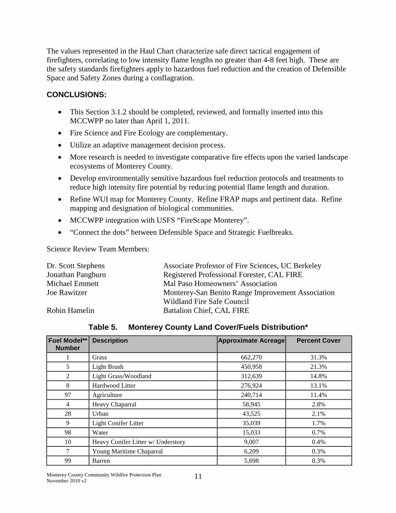
Table 5. Monterey County Land Cover/Fuels Distribution*
Fuel Model**Number
Description Approximate Acreage Percent Cover
1 Grass 662,270 31.3%
5 Light Brush 450,958 21.3%
2 Light Grass/Woodland 312,639 14.8%
8 Hardwood Litter 276,924 13.1%
97 Agriculture 240,714 11.4%
4 Heavy Chaparral 58,945 2.8%
28 Urban 43,525 2.1%
9 Light Conifer Litter 35,039 1.7%
98 Water 15,033 0.7%
10 Heavy Conifer Litter w/ Understory 9,007 0.4%
7 Young Maritime Chaparral 6,209 0.3%
99 Barren 5,698 0.3%
Monterey County Community Wildfire Protection PlanNovember 2010 v2
12
Fuel Model**Number
Description Approximate Acreage Percent Cover
30 Maritime Live Oak Forest 95 0.0%
6 Moderate Brush 70 0.0%
Total: 2,117,126 100.0%
*FRAP Monterey Fire Risk Analysis, 2006** Fuel Model is a rating of vegetation and dead woody material and their volume, type, condition, arrangement,distribution and location.
3.1.3 Climate and Weather Conditions
Localized weather patterns may vary significantly in different portions of the County as humiditylevels and plant moisture content near the coast can be higher than inland locations due to theinfluence of the Pacific Ocean. The northwestern portions of the County adjacent to the PacificOcean exhibit a typical coastal weather pattern with morning low clouds and fog burning off bymidday with maximum temperatures reaching over 80 degrees F. Onshore wind speeds inexcess of 15 miles per hour (mph) are normal. Several miles inland, fog and the marine layer aretypically only nominal factors, and it is not unusual for peak summer temperatures to reach 90 to100 degrees F. In the southern and eastern (leeward side of the Santa Lucia Mountain Range)portions of the County, clouds and fog are less prevalent, allowing maximum temperatures toreach 90 to 100 degrees F with minimum humidities dropping to 10 percent or less (CAL FIRE2009). Afternoon winds in the Salinas Valley and surrounding terrain may often exceed 15 mph.Average annual rainfall in Monterey County is approximately 19 inches; however actual annualrainfall can vary dramatically from one location to another. Fluctuations in wind patterns areexpected due to the influence of topography, although predominant wind direction is northwestwith average speeds between 7 and 10 mph (CAL FIRE 2009).
Joining of marine and land air masses over uneven topography significantly compounds firebehavior in Monterey County. Erratic fire behavior due to rapidly shifting winds and humiditiesunder "normal" conditions is common. Fire behavior under rare or extreme fire weatherconditions constitute the greatest threat of destructive uncontrolled wildland fires, andhistorically are immune to planned tactical response and aggressive initial attack. Duringextreme fire-weather conditions, fuel factors like age, density and moisture content may beovershadowed by weather factors such as high wind and low humidity.8 Nevertheless, under thesame weather conditions, higher fuel loads in a given vegetation type will generally result in firesthat are more difficult to suppress and have higher heat intensity. Given that humans cannotcontrol weather, and that fuel density is largely within our control, this MCCWPP emphasizeshazardous fuel reduction and reduction of structural ignitability as the primary means ofaddressing the destructive force of wildfire. However, the importance of weather should not beignored. Fire planning and fuel treatments should assume worst case weather conditions, or riskloss of life and property and harm to the environment in the event of wildfire during extremelyadverse weather conditions.
8 Spatiotemporal Analysis of Controls on Shrubland Fire Regimes: Age Dependency and Fire Hazard, Max Moritz,Ecology, 2003, volume 84, number 2, p. 359.

Monterey County Community Wildfire Protection PlanNovember 2010 v2
13
During warmer and drier offshore wind flow regimes, which occur several times each year, windpatterns shift from onshore northwest to offshore east-northeast in the northern section of theCounty, and east-southeast in the southern portions of the County, often with above-averagevelocities. These conditions are associated with "Severe Fire Weather" and "Red Flag" firewarnings.
3.1.4 Fire History
Fire history is an important component in understanding fire frequency, fire type, significantignition sources, and vulnerable areas/communities. The topography, vegetation, and climaticcondition associated with Monterey County combine to create a unique situation capable ofsupporting large-scale, often damaging wildfires. The history of wildfires in Monterey County issignificant, and is graphically portrayed in Appendix B-3.
Based on historical fire perimeter data (FRAP 2008),9 portions of the County are moresusceptible to wildfires, with some areas having burned up to six times during the recorded firehistory period. Specifically, the western portion of the County within and adjacent to the LPNFexhibits more frequent fires over the recorded history. Fire size within the County is alsoextremely variable, with fire sizes ranging from less than 5 acres to over 100,000 acres.
A number of notable fires have occurred in WUI zones in Monterey County. Fires that occurredunder extreme fire weather or red flag conditions are the Los Laureles Fire (1970), Molera Fire(1972) and Cherry Canyon Fire (1985). The Morse [Pebble Beach] Fire (1987), Fort Ord Escape(2003), and the Eucalyptus Fire (2005) occurred under normal Monterey County weatherconditions. The Morse Fire burned about 160 acres, destroying 31 homes in a short period oftime and causing approximately $18,000,000 in damage.
The greatest threat to the WUI in Monterey County occurs under extreme fire weatherconditions. Areas in Monterey County share a similar risk as the Oakland Hills area, where theTunnel Fire in 1991 was the most destructive and deadly WUI wildfire in California history: 26dead and 2,900 homes destroyed in less than five hours.
Notable Monterey County wildfires in the WUI and those in excess of 10,000 acres are presentedin Table 6.
Table 6. Notable Monterey County Fires
Fire Name Year Approximate Acreage Burned
Marble-Cone Fire 1977 173,000
Basin Complex Fire 2008 162,000
Big Sur Fire 1906 150,000
Kirk Fire 1999 86,000
9 Based on polygon GIS data for CAL FIRE and USFS -- fires measuring 10 acres and greater between 1950 and2007.

Monterey County Community Wildfire Protection PlanNovember 2010 v2
14
Fire Name Year Approximate Acreage Burned
Indians Fire 2008 76,000
Gorda-Rat Fire 1985 56,000
Unnamed Fire 1924 55,000
Buckeye Fire 1970 42,000
Pine Canyon Fire 1924 42,000
Cherry Fire 1985 41,000
Wild Fire 1996 26,000
Sam Jones Fire 1953 24,000
Casey Fire 1953 21,000
Unnamed Fire 1928 21,000
Tule Canyon 1942 21,000
Reliz Canyon 1942 19,000
Unnamed Fire 1944 18,000
Miller Canyon Fire 1928 18,000
Chalk Fire 2008 16,000
Unnamed Fire 1913 15,000
Rico Fire 2006 15,000
Paloma Fire 1944 14,600
Unnamed Fire 1985 14,000
Devil Fire 1954 13,000
Unnamed Fire 1913 12,000
Fort Ord Escape 2003 1500
Los Laureles 1970 450
Morse (Pebble Beach) 1987 160
The average interval between large wildfires in excess of 10,000 acres burning within MontereyCounty is 7.3 years, with intervals as short as 1 year and as long as 16 years. The medianinterval between such fires is 7 years. Most recently, three large fires in 2008 (the BasinComplex Fire, the Indians Fire, and the Chalk Fire) burned over 250,000 acres within MontereyCounty combined. The Basin Complex Fire (Basin Fire), the largest of these fires, started onJune 21, 2008, triggered a state of emergency announcement by Governor Schwarzenegger onJune 23, 2008, and ultimately burned over 160,000 acres, destroying 58 structures and causing 9

Monterey County Community Wildfire Protection PlanNovember 2010 v2
15
injuries, before it was contained on July 27, 2008 (InciWeb 2008). Fire suppression costs forthese fires alone exceeded $200 million.
3.1.5 Population and Housing
The estimated population of Monterey County is 425,960 people within 12 incorporated citiesand unincorporated County lands (County of Monterey 2008). The largest population center isthe City of Salinas, with approximately 150,000 people, followed by unincorporated Countyareas that include approximately 106,000 people. Other relatively large cities in the Countyinclude Seaside (approximately 34,000 people), Monterey (approximately 30,000 people), andSoledad (approximately 28,000 people). The remaining population is spread out among theremaining eight cities. The County includes approximately 138,000 housing units (US Census2008).
Table 7. Monterey County Housing Density
Housing Density* Approximate Acreage Percent
One unit per 40 acres, or less 2,019,515 95.4%
One unit per 5 acres to one unit per20 acres
37,162 1.8%
One unit per acre to one unit per 5acres
22,131 1.0%
Greater than one unit per acre 38,318 1.8%
Total: 2,117,126 100.0%
* FRAP Monterey Fire Risk Analysis, 2006
3.1.6 Land Ownership
Over 70 percent of the land within Monterey County is privately owned. Other significantownership includes the USFS - LPNF (14.3 percent), U.S. Army installations (9.7 percent), andthe Bureau of Land Management (1.9 percent). The current distribution of land ownershipwithin Monterey County is presented in Table 8. Land ownership distribution for MontereyCounty is presented in the Land Ownership map in Appendix B-4.

Monterey County Community Wildfire Protection PlanNovember 2010 v2
16
Table 8. Monterey County Land Ownership
Ownership Type* Approximate Acreage Percent
Private 1,512,658 71.5%
USFS (LPNF) 302,627 14.3%
US Army (Fort Ord, Presidio, FortHunter Liggett, Camp Roberts)
204,460 9.7%
BLM 40,555 1.9%
California State Parks 26,005 1.2%
City/County Park 22,741 1.1%
CDFG 3,318 0.2%
California State Lands Commission 2,948 0.1%
NPS (Pinnacles National Monument) 1,190 0.1%
US Navy 581 >0.0%
Other Military 43 >0.0%
Total: 2,117,126 100.0%
*FRAP Land Ownership data, 2008
3.1.7 Unique Community Conditions
3.1.7.1 Uniformity of Ingress and Egress Safety
Safety of ingress and egress is not uniform in all areas. It is possible that some communities maybecome trapped without the option to evacuate, forcing them to shelter in place and defendthemselves. Examples are Big Sur coast, Palo Colorado, Partington Ridge, Los Burros Road,Cachagua and White Rock.
3.1.7.2 Unique Values and Level of Preparedness
Certain communities have shown increased interest in higher levels of preparedness andinvolvement in protecting their property. The California Constitution provides the following:
All people are by nature free and independent and have inalienable rights. Among theseare enjoying and defending life and liberty, acquiring, possessing, and protectingproperty, and pursuing and obtaining safety, happiness, and privacy.
CAL FIRE's policy is Ready, Set, Go! (see Appendix C). While early evacuation is the safestoption, there may be times when homeowners cannot evacuate or choose not to evacuate. Itcannot be overemphasized that creation of defensible/survivable space and the use of firewisematerials and firesafe practices are extremely important for reducing risk in the event ahomeowner cannot, or chooses not to evacuate. An excellent resource for firewise informationcan be found at http://firecenter.berkeley.edu/toolkit/homeowners.html.

Monterey County Community Wildfire Protection PlanNovember 2010 v2
17
3.1.8 Fire Threat
Based on vegetation/fuel distribution, topography, and fire history, fire threat was evaluated forMonterey County during the 2006 FRAP/MFSC analysis. This analysis characterizes fire threatas the summation of fire probability (based on fire history) and hazard or expected fire behavior(based on fuels, weather, topography and on-the-ground fire experience). The FRAP fire threatanalysis rates areas of the County into five separate categories, including little/none, moderate,high, very-high, or extreme. Table 9 presents fire threat acreages for Monterey County, whilethe map in Appendix B-5 graphically presents the distribution of fire threat ratings across theCounty. It is important to note that 83.5 percent of Monterey County's land area is categorizedas high, very-high, or extreme fire threat.
Table 9. Monterey County Fire Threat
Fire Threat Rating* Acreage Percent
Little to None 261,698 12.4%
Moderate 87,911 4.2%
High 719,366 34.0%
Very-High 646,759 30.5%
Extreme 401,394 19.0%
Total: 2,117,127 100.0%
* FRAP Monterey Fire Risk Analysis, 2006
3.2 Existing Fire Plans
The following sections describe existing fire management plans prepared by agencies and/orlocal districts that affect fuel management activities in Monterey County.
3.2.1 California Department of Forestry and Fire Protection (CAL FIRE)
The 2009 Fire Plan10 prepared by CAL FIRE San Benito – Monterey Unit (BEU) addresses thegoals and objectives set forth in the California Fire Plan, focusing on overall wildfire riskreduction at a local level (CAL FIRE 2009). The Plan outlines local stakeholders, discusses thelocal fire environment, evaluates assets at risk, and identifies priority fuel treatment areas.
The priorities outlined in this MCCWPP are intended for inclusion in future CAL FIRE BEU fireplan updates.
3.2.2 Bureau of Land Management (BLM)
The BLM Hollister Fire Management Plan (FMP) presents fire management strategies for BLMland in Monterey County (BLM 2008). It identifies resource values and conditions pertaining tofire management on BLM land and recommends strategies for wildland fire suppression,
10 Online at: http://cdfdata.fire.ca.gov/fire_er/fpp_planning_plans_details?plan_id=95

Monterey County Community Wildfire Protection PlanNovember 2010 v2
18
prescribed fire, non-fire hazardous fuels treatment, and community assistance/protection. Thestrategies outlined in the BLM FMP are utilized in preparing the annual agency work plan andassociated budgets. Management guidelines in the FMP prioritize public/firefighter safety,reduction of hazardous fuels, and wildfire risk reduction through prevention, mitigation,education, and other actions.
The FMP also identifies and describes BLM-specific fire management units (FMU) and providestarget hazardous fuel treatment objectives, treatment types, special conditions, and at-riskcommunities/assets associated with each FMU. Table 10 summarizes the BLM FMUcharacteristics and management objectives within Monterey County.
Table 10. BLM FMU Characteristics and Objectives in Monterey County
FireManagementUnit/ID
BLMAcreage
Fuel Type/
Fuel Model
Target RxBurn
Acreage
TargetMechanicalTreatmentAcreage
Comments
Fort Ord BLMLand FMU
CA-190-02
7,253 Maritimechaparral
Fuel Model 4
500 ac.(annual);5,000 ac.(decadal)
500 ac.(annual);5,000 ac.(decadal)
Former Fort Ord military base.Habitat Management Plan(HMP)-covered species present.Rx burns in 1997, 2003, 2005.
At-risk communities: Del ReyOaks, Marina, Salinas, Sand City,and Seaside.
Sierra deSalinas,Williams HillFMU
CA-190-09
23,581 Californiachaparral
Fuel Model 4
100 ac.(annual);1,000 ac.(decadal)
100 ac.(annual);1,000 ac.(decadal)
Monterey knobcone pine presentin FMU.At-risk values: oil/gas reserves,habitat, communication sites,sensitive plant species.
Parkfield FMU
CA-190-10
5,099 Californiachaparral andgrasslandFuel Model 4and 1
1,000 ac.(annual);5,000 ac.(decadal)
1,000 ac.(annual);5,000 ac.(decadal)
Rugged terrain in Diablo Range.
At-risk values: oil/gas reserves,communication site at CharleyMountain, fire lookout at SmithMountain, homes.
VentanaContiguousWSA FMU
CA-190-11
655 Californiachaparral
Fuel Model 4
100 ac.(annual); 500ac. (decadal)
none Steep terrain, adjacent to LPNF.At-risk values: City of Carmel,White Rock gun club adjacent tothe west side of FMU, habitat,LPNF, Rancho San Clemente andSanta Lucia Preserve (wildlifepreserve and residentialcommunity), Palo Corona/Monterey Peninsula RegionalParks District.

Monterey County Community Wildfire Protection PlanNovember 2010 v2
19
3.2.3 United States Forest Service (USFS)
The 2008 LPNF Fire Management Plan is a strategic document that addresses the firemanagement program and guides fire management activities based on the 2006 Los PadresNational Forest Land Management Plan (LPNF Management Plan). The Monterey RangerDistrict, responsible for management of USFS lands in Monterey County, segregates areas of theNational Forest into two primary Fire Management Units (FMU) that are differentiated bymanagement objectives, fire suppression expectations, and values at risk. The Developed andGeneral Forest unit (FMU1) encompasses the majority of at-risk communities identified throughthe National Fire Plan, which focuses on public and firefighter safety, cost containment, and fullsuppression as primary objectives.
Fire prevention planning and management within FMU1 focuses on maintaining defensiblespace around structures/improvements, and strategically treating hazardous fuels to interrupt firespread and enhance suppression efforts.
The Wilderness, Research, Natural, and Special Interest Areas (FMU2) are generally removedfrom developed areas and focus primarily on public and firefighter safety and Minimum ImpactSuppression Tactics (MIST), where applicable.
The USFS prepared the LPNF Management Plan and an associated Environmental ImpactStatement (EIS), and a Record of Decision (ROD) was issued in April 2006. The LPNFManagement Plan includes fire and fuel management planning as discussed further in Section3.3.1.3.
3.2.4 Pebble Beach Community Services District
The Fire Defense Plan for the Pebble Beach Community Services District (2009 FDP) isincluded in the CAL FIRE BEU Fire Plan. The 2009 FDP addresses fire and life safety relatedto wildland fires within the Del Monte Forest area of Pebble Beach. The plan addressesemergency access and hazardous fuel treatment standards for open space areas and undevelopedvacant parcels. The plan outlines roadside fuel treatment methods, firebreak maintenancecriteria, road and access gate identification standards, environmental protection, and targets fuelbreak areas.
3.2.5 Other Plans
In addition to the aforementioned plans dealing with wildland fire issues in Monterey County,several other plans have been or are in the process of being prepared, including the following:
Santa Lucia Preserve Fuel Management Plan. Addresses habitat-based fire managementconcerns for the Santa Lucia Preserve
Monterey County Emergency Permit, Sudden Oak Death - Permit for removal of deadtrees infected with SOD in the Palo Colorado Canyon and Big Sur areas of MontereyCounty
Aromas Tri-County FPD Fire Plan
Big Sur Community Wildfire Protection Plan

Monterey County Community Wildfire Protection PlanNovember 2010 v2
20
Cachagua-Jamesburg Community Wildfire Protection Plan
Carmel Highlands FPD Community Wildfire Protection Plan
Cypress FPD Community Wildfire Protection Plan
Mid Coast (Palo Colorado area) Community Wildfire Protection Plan
Fort Ord
Pinnacles National Park
Fort Hunter Liggett
The status of the above plans can be determined by contacting CAL FIRE.
3.3 Regulatory Framework
This section discusses the complex framework of federal, state and local laws and regulationsthat relate to hazardous fuel reduction work.
3.3.1 Applicable Federal Laws
3.3.1.1 Healthy Forests Restoration Act
Devastating wildfires in the western United States at the turn of this century resulted in action bythe Western Governors Association in concert with the Secretaries of Agriculture and Interior,counties, southern governors, and tribes, to address the hazardous fuels problem at a nationallevel. In 2002, the Western Governors Association agreed on a plan called A CollaborativeApproach for Reducing Wildland Fire Risks to Communities and the Environment: 10-YearStrategy.
In 2003, Congress enacted the Healthy Forests Restoration Act of 2003 (HFRA). The HFRAimproves the ability of the United States Secretary of Agriculture and Secretary of Interior toconduct hazardous fuel reduction projects on National Forest System lands and BLM lands, toprotect communities, watersheds, and infrastructure from catastrophic wildfire. The provisionsof the HFRA include the following: (1) a streamlined National Environmental Policy Act(NEPA) process for hazardous fuel treatments and other activities that would reduce hazardousfuels on Federal land and, (2) incentives for local communities to prepare Community WildfireProtection Plans (CWPP) that prioritize where hazardous fuel reduction should take place onFederal lands, and where federal fuel reduction funds should be expended on private lands (e.g.,fuel reduction grants).
This MCCWPP was prepared pursuant to provisions of the HFRA, recognizing that certain largefederal land holdings influence wildfire risk to nearby state, county and private lands, and localcommunities. In accordance with section 101 of the HFRA, this MCCWPP: (1) identifies andprioritizes areas for hazardous fuel reduction treatments and recommends the types and methodsof treatment on federal and non-federal land that will protect at-risk communities, watershedsand essential infrastructure; and (2) recommends measures to reduce structural ignitabilitythroughout at-risk communities. Pursuant to section 103 of the HFRA, through the preparationof this MCCWPP and subsequent community-specific CWPPs, federal fuel reduction fundingpriorities on federal and non-federal land should be allocated to protecting those at-risk
Monterey County Community Wildfire Protection PlanNovember 2010 v2
21
communities described in this MCCWPP and local CWPPs, and to those hazardous fuelreduction projects recommended priorities in Appendix D.
3.3.1.2 Wilderness Acts
Monterey County contains 290,000 acres of federal and state wilderness designated as theVentana Wilderness Area, Silver Peak Wilderness Area and Limekiln State Park Wilderness.These designated wilderness areas encompass 14% of Monterey County and are located in thenorthern Santa Lucia Mountains. Each wilderness area has been the subject of multiple acts ofCongress. Congressional records indicate exceptions were made to wilderness prohibitions sothat these wilderness areas can and will be managed to protect communities and watersheds fromwildfire.
3.3.1.2.1 Wilderness Act of 1964
The Wilderness Act of 1964 (Wilderness Act) states as follows:
In order to assure that an increasing population, accompanied by expandingsettlement and growing mechanization, does not occupy and modify all areaswithin the United States and its possessions, leaving no lands designated forpreservation and protection in their natural condition, it is hereby declared to bethe policy of the Congress to secure for the American people of present and futuregenerations the benefits of an enduring resource of wilderness. Wildernessareas…shall be administered for the use and enjoyment of the American people insuch matter as will leave them unimpaired for future use as wilderness, and so asto provide for the protection of these areas, the preservation of their wildernesscharacter and for the gathering and dissemination of information regarding theiruse and enjoyment as wilderness…
Wilderness is defined under Section 2(c) of the Wilderness Action of 1964 as follows:
A wilderness, in contrast with those areas where man and his own worksdominate the landscape, is hereby recognized as an area where the earth and itscommunity of life are untrammeled by man, where man himself is a visitor whodoes not remain. An area of wilderness is further defined to mean in this Act anarea of undeveloped Federal land retaining its primeval character and influence,without permanent improvements or human habitation, which is protected andmanaged so as to preserve its natural conditions and which (1) generally appearsto have been affected primarily by the forces of nature, with the imprint of man'swork substantially unnoticeable; (2) has outstanding opportunities for solitude ora primitive and unconfined type of recreation; (3) has at least five thousand acresof land or is of sufficient size as to make practicable its preservation and use in anunimpaired condition; and (4) may also contain ecological, geological, or otherfeatures of scientific, educational, scenic, or historical value.
Monterey County Community Wildfire Protection PlanNovember 2010 v2
22
The Wilderness Act of 1964 (Wilderness Act) generally prohibits use of motor vehicles andmotorized equipment within wilderness areas.
However, the Wilderness Act also provides a special provision for "fire, insects and diseases"and for administration and personal heath and safety emergencies as exceptions to itsprohibitions as follows: 11
Prohibition provisions: commercial enterprise, permanent or temporary roads, mechanicaltransports, and structures or installations; exceptions: area administration and personalhealth and safety emergencies. Except as specifically provided for in this Act [16 USCS§§ 1131 et seq.], and subject to existing private rights, there shall be no commercialenterprise and no permanent road within any wilderness area designated by this Act [16USCS §§ 1131 et seq.] and, except as necessary to meet minimum requirements for theadministration of the area for the purpose of this Act [16 USCS §§ 1131 et seq.](including measures required in emergencies involving the health and safety of personswithin the area), there shall be no temporary road, no use of motor vehicles, motorizedequipment or motorboats, no landing of aircraft, no other form of mechanical transport,and no structure or installation within any such area. (16 USCS § 1133(c).)
3.3.1.2.2 The Endangered American Wilderness Act of 1978
The Endangered American Wilderness Act of 1978 (Wilderness Act of 1978) builds upon theabove referenced exceptions in the Wilderness Act, applying additional exceptions for firepresuppression measures and techniques specifically to the Ventana Wilderness to guarantee thecontinued viability of watersheds and the continued health and safety of communities. TheWilderness Act of 1978 reads in pertinent part as follows (emphasis added):12
In order to guarantee the continued viability of the Ventana watershed and toinsure the continued health and safety of the communities serviced by suchwatershed, the management plan for the Ventana area to be prepared followingdesignation as wilderness shall authorize the Forest Service to take whateverappropriate actions are necessary for fire prevention and watershed protectionincluding, but not limited to, acceptable fire pre-suppression and fire suppressionmeasures and techniques. Any special provisions contained in the managementplan for the Ventana Wilderness area shall be incorporated in the planning for theLos Padres National Forest. …
Specific to forest fires, the report on the Wilderness Act of 1978 by the Senate Committee onEnergy and Natural Resources reads in pertinent part as follows (emphasis added):13
Due to the extreme hazard of forest fires in the Los Padres National Forest, thecommittee adopted the special management language for the Santa Lucia andVentana Wilderness areas approved by the House authorizing the Forest Service
11 16 USC 1133(d)(1); see, Sierra Club v. Lyng (1987) 663 F.Supp. 556.12 The Endangered American Wilderness Act of 1974, section 2(d).13 Senate Report 95-490 on H.R. 3454 (The Endangered American Wilderness Act of 1978), 95th Congress 1stsession October 11, 1977, Senate Committee on Energy and Natural Resources.

Monterey County Community Wildfire Protection PlanNovember 2010 v2
23
"to take whatever appropriate actions are necessary for fire prevention andwatershed protection included [sic] but not limited to acceptable fire pre-suppression and fire suppression measures and techniques."
3.3.1.2.3 The California Wilderness Acts of 1984
The California Wilderness Act of 1984 (State Wilderness Act of 1984) signed into law byPresident Ronald Reagan on September 28, 1984 adding 2,750 acres to the Ventana WildernessArea
Section 103 of the State Wilderness Act of 1984 states in relevant parts as follows:
Within the National Forest wilderness areas designated by this title …as providedin section 4(b) of the Wilderness Act, the Secretary concerned shall administersuch areas so as to preserve their wilderness character and to devote them to thepublic purposes of recreational, scenic, scientific, educational, conservation, andhistorical use.
Section 103(b)(2) of this Act referenced the following exception in the Wilderness Act for thecontrol of fire:14
As provided in subsection 4(d)(l) of the Wilderness Act, the Secretary concernedmay take such measures as are necessary in the control of fire, insects, anddiseases, subject to such conditions as he deems desirable. (Section 103(b)(2)).
Specific to addressing the threat of fire, the report by the House Committee on Interior andInsular Affairs on the Wilderness Act of 1984 reads in pertinent part as follows (emphasisadded):15
Fire management—Due to the arid climate, high seasonal temperatures andbuildup of fuel that exists in so many California roadless areas, especially inSouthern California, fire management is a key concern. … Not only does thethreat of wildfire pose a danger to public safety, but uncontrolled fires can alsocause severe damage to watersheds, water quality and other beneficial wildernessvalues.
To address this concern in the [Wilderness Act of 1984], the Committee reiteratedthe fire provisions of Section 4(d)(1) of the Wilderness Act. … As the Committeestressed … this provision is intended to grant the Forest Service with the means ofutilizing such measures or tools as it deems "necessary" and "desirable" in thecontrol of [sic] pre-suppression of fire in wilderness areas. In some instances, theForest Service has exercised this broad authority [for] fire roads, fuel breaks orother management. … The major point to be made however, is that theWilderness Act permits the Forest Service to utilize measures necessary to control
14 16 USC 1133.15 House Report 98-40 on H.R. 1437 (P.L. 98-425), 98th Congress 1st session, March 18, 1983, House Committeeon Interior and Insular Affairs.
Monterey County Community Wildfire Protection PlanNovember 2010 v2
24
wildfire, or the threat of fire, in wilderness areas. Obviously, such measuresshould, to the maximum extent practicable, be implemented consistent withmaintaining the wilderness character of areas, while at the same time protectingthe public health and safety and protecting private property located immediatelyadjacent to wilderness areas.
3.3.1.2.4 Los Padres Condor Range and River Protection Act (1992)
The Los Padres Condor Range and River Protection Act of 1992 (Los Padres Act of 1992) wassigned into law by President George H. W. Bush on June 19, 1992 adding 38,000 acres to theVentana Wilderness Area and creating the 14,500 acre Silver Peak Wilderness Area.
Section 1 of the Los Padres Act of 1992 states as follows:
The Congress finds that --- (1) areas of undeveloped national Forest System landswithin the Los Padres National Forest have outstanding natural characteristicswhich will, if properly preserved, contribute as an enduring resource ofwilderness for the benefit of the American people; and (2) it is in the nationalinterest that certain of these areas be designated as components of the NationalWilderness Preservation System and Wild and Scenic River System or reservedfrom mineral entry in order to preserve such areas and their specific multiplevalues for watershed preservation, wildlife habitat protection, scenic and historicpreservation, scientific research, educational use, primitive recreation, solitude,physical and mental challenge, and inspiration for the benefit of all of theAmerican people of present and future generations.
In the Act, Congress sets forth the following exceptions to the Wilderness Act prohibitionswhich allow for fire pre-suppression measures within wilderness in order to protect watershedsand communities. Section 3(b) of the Los Padres Act of 1992 reads as follows (emphasisadded):
FIRE PREVENTION AND WATERSHED PROTECTION —In order toguarantee the continued viability of the watersheds of the wilderness areasdesignated by this Act and to ensure the continued health and safety of thecommunities serviced by such watersheds, the Secretary of Agriculture may takesuch measures as are necessary for fire prevention and watershed protectionincluding, but not limited to, acceptable fire pre-suppression and fire suppressionmeasures and techniques.
3.3.1.2.5 Big Sur Wilderness and Conservation Act of 2002
The Big Sur Wilderness and Conservation Act of 2002 (Wilderness Act of 2002) expanded theVentana Wilderness and the Silver Peak Wilderness. Congress provided exceptions towilderness prohibitions to allow for fire pre-suppression measures and techniques. Section 4 ofthe Wilderness Act of 2002 reads as follows (emphasis added):

Monterey County Community Wildfire Protection PlanNovember 2010 v2
25
SEC. 4. WILDERNESS FIRE MANAGEMENT.
(a) REVISION OF MANAGEMENT PLANS.—The Secretary of Agricultureshall, by not later than 1 year after the date of the enactment of this Act, amendthe management plans that apply to each of the Ventana Wilderness and the SilverPeak Wilderness, respectively, to authorize the Forest Supervisor of the LosPadres National Forest to take whatever appropriate actions in such wildernessareas are necessary for fire prevention and watershed protection consistent withwilderness values, including best management practices for fire pre-suppressionand fire suppression measures and techniques.
(b) INCORPORATION INTO FOREST PLANNING.—Any special provisionscontained in the management plan for the Ventana Wilderness and Silver PeakWilderness pursuant to subsection (a) shall be incorporated into the managementplan for the Los Padres National Forest.
3.3.1.3 Los Padres National Forest Management Plan (LPNF Management Plan)
Consistent with the Wilderness Act of 1978 and the Wilderness Act of 2002, the USFS preparedthe LPNF Management Plan. An EIS and a ROD was adopted for the LPNF Management Planin April 2006. The ROD includes the following language to describe the overall intent of theplan:
[W]e will be doing fuels work in the Wildland/Urban Interface (WUI) Defenseand Threat zones for community protection. In these areas, the emphasis is onvegetation treatments that are expected to create conditions allowing fire fightersto work safely in the area. Wildlife habitat requirements are still an emphasis.However, to be absolutely clear, the protection of human life and property is ourhighest priority. While we do the work in the WUI Defense and Threat zones, wewill try to maintain habitat in a condition that will support the species that livethere, but we will meet the criteria for community defense. If there is a trade-off,human life and property will be the priority.16
The LPNF Management Plan describes the WUI and WUI zones as follows:
There are extensive areas within and adjacent to the national forests of southernCalifornia meeting the definition of Wildland/Urban Interface (WUI) as describedin the Healthy Forests Restoration Act of 2003. WUI (as defined by the Act) is avariable width … as defined in individual community fire protection plans. Thisforest plan further identifies a direct protection zone (WUI Defense Zone) and anindirect protection zone (WUI Threat Zone) that fall within the broader definitionof WUI. A WUI Defense Zone is the area directly adjoining structures andevacuation routes that is converted to a less-flammable state to increase defensiblespace and firefighter safety. The WUI Threat Zone is an additional strip ofvegetation modified to reduce flame heights and radiant heat. The Threat Zonegenerally extends approximately 1 1/4 miles out from the Defense Zone
16 Record of Decision, Los Padres National Forest Land Management Plan, page 11

Monterey County Community Wildfire Protection PlanNovember 2010 v2
26
boundary. Yet, actual extents of Threat Zones are based on fire history, local fuelconditions, weather, topography, existing and proposed fuel treatments, andnatural barriers to fire and community protection plans, and therefore couldextend well beyond the 1 1/4 mile. The two zones together are designed to makemost structures more defendable.17
The EIS for the LPNF Management Plan analyzed impacts well beyond the 1 1/4 mile distancefor WUI Threat Zone18 The LPNF Management Plan includes fire and fuel managementplanning. Forest Goal 1.2 discusses community protection through vegetation treatment in theWUI and strategically located fuelbreaks and associated burns. The LPNF Management Planalso states that existing fuelbreaks are to be maintained using prescribed fire, fireline explosives,grazing, herbicide or mechanical methods.19
3.3.1.4 National Environmental Policy Act (NEPA)
The purpose of the NEPA is to declare a national policy that will encourage productive andenjoyable harmony between man and his environment; to promote efforts which will prevent oreliminate damage to the environment and biosphere, and stimulate the health and welfare ofman; to enrich the understanding of the ecological systems and natural resources important to theNation; and to establish a Council of Environmental Quality.20
Any proposed hazardous fuel treatment projects on federal land or requiring federal discretionaryapproval will require compliance with NEPA. Hazardous fuel reduction treatments on non-federal land that do not use federal funding and do not require federal discretionary approvalgenerally do not require NEPA review. If NEPA review applies, projects implementing ahazardous fuel reduction recommendation in a CWPP on Federal land, that is within a WUI, orwithin 1.5 miles of an at-risk community, are afforded expedited NEPA review under the HFRA.Further environmental review under NEPA may be required by the USFS prior to the USFS’simplementation of individual projects in the LPNF Management Plan.
Moreover, hazardous fuel reduction treatments recommended for USFS and BLM land in aCWPP must be considered in the NEPA analysis by the USFS or BLM as an alternative to theagency's proposed project. As provided by the HFRA, if a federal fuel reduction project iswithin a WUI, but more than 1.5 miles from the at-risk community's boundary, only onealternative other than the proposed project is required to be considered.21 If the hazardous fuelreduction project is within 1.5 miles of the boundary of the at-risk community, an alternative tothe proposed project is not required to be considered, unless the proposed agency action does notimplement the recommendations in an adopted CWPP "for the same general location and basic
17 Appendix K, Guidelines for Development and Maintenance of WUI Defense and Threat Zones, page 81 in Part3, Design Criteria for Southern California National Forests, of the Land Management Plan [for the Los PadresNational Forest, 2005].18 Final Environmental Impact Statement, Volume 1, Land Management Plan [for the Southern California NationalForests], page 315.19 Page 22, Los Padres National Forest Land Management Plan, Part 2, Los Padres National Forest Strategy.20 42 USC 432121 Note that without this provision, 2 or more alternatives must be considered, one of which must be a "no action"alternative.

Monterey County Community Wildfire Protection PlanNovember 2010 v2
27
method of treatments", in which case the recommendations in the CWPP should be evaluated asan alternative to the proposed agency action in accordance with HFRA.22 This streamlinedNEPA process does not apply to certain hazardous fuel reduction treatments within wildernessareas. The USFS prepared the LPNF Management Plan and an associated EIS, and a ROD wasissued in April 2006. The key community protection factors in the ROD for the LPNFManagement Plan are stated in the ROD as follows:23
Emphasizes the protection of lives and property;
Includes the flexibility to adjust WUIs according to CWPPs; and
Retains access.
The LPNF Management Plan also discusses the maintenance of existing fuelbreaks usingprescribed fire, fireline explosives, grazing, herbicides or mechanical methods. Herbicide usemay delay need for mechanical treatment, especially when there is a diminished workforce. TheDepartments of Agriculture and Interior enacted categorical exclusions to NEPA for hazardousfuel reduction activities and rehabilitation activities for lands and infrastructure impacted by firesor fire suppression.24 The categorical exclusions are limited to (1) those activities identifiedthrough a collaborative framework as described in the 10-Year Comprehensive StrategyImplementation Plan; (2) fuel reduction activities that are within a WUI, or, if outside the WUI,in Condition Classes 2 or 3 in Fire Regime Groups I, II, or III; (3) hazardous fuels reductionactivities using fire, limited to 4,500 acres; (4) mechanical hazardous fuels reduction activities,limited to 1,000 acres; (5) fuel reduction and rehabilitation activities that are not in wildernessareas or where they would impair the suitability of wilderness study areas for preservation aswilderness; and (6) fire rehabilitation activities of not more than 4,200 acres. At the time of thiswriting (September 2010), certain categorical exclusions were under legal challenges.
3.3.1.5 Federal Endangered Species Act (ESA)
The purposes of the ESA are to provide a means whereby the ecosystems upon whichendangered and threatened species depend may be conserved; to provide a program for theconservation of such endangered and threatened species; and to take such steps as may beappropriate and practicable pursuant to various international treaties and conventions.25
Section 7 of the ESA requires federal agencies, such as the U.S. Fish & Wildlife Service(USFWS), to ensure that any action authorized, funded or carried out by them is not likely tojeopardize the continued existence of listed species or modify their critical habitat. Section 9 ofthe ESA provides that it is unlawful for any person subject to the jurisdiction of the United Statesto take, possess, deliver or sell any species that has been listed as threatened or endangeredpursuant to the ESA.26
22 Title 16 USC 6514(d).23 Record of Decision, Los Padres National Forest Land Management Plan, page 5.24 Federal Register, Vol. 68, No. 108, June 5, 2003.25 16 USC 1531 (a) & (b).26 16 USC 1538. The term "take" means to, "harass, harm, pursue, hunt, shoot, wound, kill, trap, capture, orcollect, or to attempt to engage in any such conduct." (16 USC 1532(19).)

Monterey County Community Wildfire Protection PlanNovember 2010 v2
28
In accordance with the ESA, hazardous fuel reduction activities proposed in this MCCWPP mustavoid a taking of federally listed threatened or endangered species, or, if a take cannot beavoided, the take must be authorized pursuant to the ESA. The USFWS has the authority toallow the take of threatened or endangered species or impacts to their critical habitat incidental tofire prevention/protection activities.27
3.3.2 Applicable State Laws
3.3.2.1 California Constitution
Article 1, Section 1 of the California Constitution reads as follows:
All people are by nature free and independent and have inalienable rights.Among these are enjoying and defending life and liberty, acquiring, possessing,and protecting property, and pursuing and obtaining safety, happiness, andprivacy.
While no rights are absolute, fundamental rights such as the rights to defend life, protectproperty, and pursue and obtain safety, may be infringed only to the minimum extent necessaryto promote a compelling government interest.
3.3.2.2 Division 4 of California Public Resources Code (PRC) – Forests,Forestry and Range and Forage Lands
3.3.2.2.1 Board of Forestry and Fire Protection and Department of Forestry andFire Protection (CAL FIRE)
The Board of Forestry and Fire Protection (Board of Forestry) is a government-appointed bodywithin CAL FIRE. The Board of Forestry is responsible for developing the general forest policyof the state, for determining the guidance policies of CAL FIRE, and for representing the state'sinterest in federal forestland in California. Together, the Board of Forestry and CAL FIRE workto carry out the California Legislature's mandate to protect and enhance the state's unique forestand wildland resources.
The Board of Forestry is charged with protecting the forest resources of all the wildland areas ofCalifornia that are not under federal jurisdiction. These resources include: major commercialand non-commercial stands of timber, areas reserved for parks and recreation, the woodland andbrush-range watersheds, and all such lands in private and state ownership that contribute toCalifornia's forest resource wealth.28
Under California Public Resources Code (PRC) section 4111, the Board of Forestry has theauthority to "make and enforce such regulations as are necessary and proper for the organization,
27For example, a memorandum of understanding (MOU) was executed by and between USFWS, the California
Department of Fish and Game (CDFG), CAL FIRE and other fire agencies and districts for hazardous fuel reductionactivities in San Diego County.
28 http://www.bof.fire.ca.gov/about_the_board/

Monterey County Community Wildfire Protection PlanNovember 2010 v2
29
maintenance, government, and direction of the fire protective system for the prevention andsuppression of forest fires."
3.3.2.2.2 State Responsibility Areas (SRA)
PRC section 4102 defines the term "State Responsibility Areas" (SRAs) as "the areas of the statein which the financial responsibility of preventing and suppressing fires has been determined by[CAL-FIRE] ... to be primarily the responsibility of the state." (Emphasis added.)
Lands in SRAs include:
1. Lands covered wholly or in part by forests or by trees producing or capable of producingforest products.
2. Lands covered wholly or in part by timber, brush, undergrowth, or grass, whether ofcommercial value or not, which protect the soil from excessive erosion, retard runoff ofwater or accelerate water percolation, if such lands are sources of water which areavailable for irrigation or for domestic or industrial use.
3. Lands in areas which are principally used or useful for range or forage purposes, whichare contiguous to the lands described in subdivisions (a) and (b) Division 4 of the PRC,Forests, Forestry and Range and Forage Lands, which contains statutes related to fuelreduction on certain land.29
The map in Appendix B-6 shows that most of Monterey County is within SRA.
3.3.2.2.3 Title 14 CCR 1299 and Defensible Space Guidelines
In 2006, the Board of Forestry promulgated a regulation to implement the defensible spaceprovisions of PRC section 4291. The regulation was codified in Title 14, section 1299 of theCalifornia Code of Regulations (14 CCR 1299).
14 CCR 1299(b) provides the following specific mandatory language: "Any vegetation fuelsidentified as a fire hazard by the fire inspection official of the authority having jurisdiction shallbe removed or modified provided it is required by subsection (a)(1) & (a)(2)."
Subsections (a)(1) and (a)(2) state as follows:
(a) A person that owns, leases, controls, operates, or maintains a building orstructure in, upon, or adjoining any mountainous area, forest-covered lands,brush-covered lands, grass-covered lands, or any land that is covered withflammable material, and is within State Responsibility Area, shall do thefollowing:
(1) Within 30 feet from each building or structure, maintain a firebreak byremoving and clearing away all flammable vegetation and other combustiblegrowth pursuant to PRC § 4291(a). Single specimens of trees or other
29 PRC section 4126.
Monterey County Community Wildfire Protection PlanNovember 2010 v2
30
vegetation may be retained provided they are well-spaced, well-pruned, andcreate a condition that avoids spread of fire to other vegetation or to a buildingor structure.
(2) Within the 30 feet to 100 feet zone (Reduced Fuel Zone) from each buildingor structure (or to the property line, whichever is nearer to the structure),provide a fuelbreak by disrupting the vertical and/or horizontal continuity offlammable and combustible vegetation with the goal of reducing fire intensity,inhibiting fire in the crowns of trees, reducing the rate of fire spread, andproviding a safer environment for firefighters to suppress wildfire pursuant toPRC § 4291(b).
Subsection (c) broadens and adds flexibility to CAL FIRE's authority by stating the following:
Within the intent of the regulations, the fire inspection official of the authorityhaving jurisdiction may approve alternative practices which provide for the samepractical effects as the stated guidelines.
The creation of defensible space is a requirement subject to penalties if property owners do notcomply with the mandatory requirement.
14 CCR 1299(c) also references a guidance document for implementation of this regulation,which is entitled, General Guidelines for Creating Defensible Space (Guidelines), as publishedby the Board of Forestry by resolution adopted on February 8, 2006. The Guidelines providecriteria intended to instruct individuals and fire officials on acceptable ways to comply with14 CCR 1299, and are incorporated into section 14 CCR 1299 by reference. See Appendix E forthe Guidelines.
3.3.2.2.3.1 California Environmental Quality Act (CEQA) Review of 14 CCR 1299and Guidelines
The Board of Forestry considered adoption of 14 CCR 1299 and its associated Guidelines a"project" subject to CEQA (Project), and the scope of the CEQA review was the Project'sultimate effect on the environment. Generally, CEQA defines the term "project" as an activitycarried out, supported by, or authorized by a public agency, "which may cause either a directphysical change in the environment, or a reasonably foreseeable indirect physical change in theenvironment. ..."30 CEQA is discussed further in Section 3.3.2.4 of this MCCWPP.
At the time of the Board of Forestry's adoption of the Guidelines on February 8, 2006, the Boardof Forestry deliberated on the issue of CEQA and concluded that the Class 4 categoricalexemption applied and that the Project "is consistent with the CEQA statutory exemption undersection 21080(b)(4) specifying that actions [are] necessary to prevent or mitigate anemergency."31
30 PRC section 21065; 14 CCR 15378(a).31 Item 9 of Meeting Minutes.
Monterey County Community Wildfire Protection PlanNovember 2010 v2
31
3.3.2.2.4 Public Resources Code Section 4291 (PRC 4291)
PRC 4291 requires that any person who owns, leases, controls, operates, or maintains a buildingor structure in, upon, or adjoining a mountainous area, forest-covered lands, brush-covered lands,grass-covered lands, or land that is covered with flammable material, shall maintain defensiblespace of 100 feet from each side and from the front and rear of the structure, or as furtherprovided in PRC 4291, but not beyond the property line unless allowed by state law, localordinance, or regulation, and with the consent of the adjacent landowner.
The statute provides that the amount of fuel modification necessary shall take into account theflammability of the structure as affected by building material, building standards, location, andtype of vegetation.
PRC 4291 provides that a distance greater than 100 feet may be required by state law, localordinance, rule, or regulation, with limitations on requiring fuel modification beyond theproperty line, including consent by the adjacent landowner.
PRC 4291 also provides that an insurance company that insures an occupied dwelling oroccupied structure may require a greater distance if a fire expert, designated by the Director ofForestry and Fire Protection, provides findings that such hazardous fuel reduction is necessary tosignificantly reduce the risk of transmission of flame or heat sufficient to ignite the structure, andthere is no other feasible mitigation measure possible to reduce the risk of ignition or spread ofwildfire to the structure. The greater distance may not be beyond the property line unlessallowed by state law, local ordinance, rule, or regulation. The statute also requires otherhazardous fuel reduction measures, such as a minimum distance of 10 feet between trees and theoutlet of a chimney or stovepipe.
PRC 4291 further provides that the Director of Forestry and Fire Protection may authorizeremoval of vegetation that is not consistent with the standards of PRC 4291.
PRC section 4291.1 describes the penalties for PRC 4291 violations. Penalties range from a fineof not less than $100, to not less than $500, depending upon the number of violations during afive year period. PRC section 4291.1 also provides that under certain conditions, CAL FIREmay contract to have hazardous fuel reduction work done and bill the person convicted of theviolation for the cost of the work.
3.3.2.2.5 Access Roads
Under 14 CCR 1273, all road and street networks, whether public or private (unless exempt),must provide safe access for emergency equipment and civilian evacuation concurrently. Thereare roads that do not meet this standard and cannot feasibly be upgraded. Fuel reduction alongaccess roads is a necessary maintenance activity in order to provide safe access for fireequipment and resident evacuation during fires. Emergency access is part of defensible space.32
32 The Guidelines adopted to implement PRC 4291 define Defensible Space to include emergency vehicle access;"Defensible space: … The area is characterized by the establishment and maintenance of emergency vehicle access.…" (General Guidelines for Creating Defensible Space, 2006, page 3.)

Monterey County Community Wildfire Protection PlanNovember 2010 v2
32
3.3.2.3 California Coastal Act (CCA) and Local Coastal Programs
The California Coastal Commission (CCC) was established temporarily by voter initiative in1972 (Proposition 20) and later made permanent by the Legislature through adoption of theCalifornia Coastal Act (CCA). The CCA serves as a comprehensive planning and regulatoryprogram to manage conservation and development within the California coastal zone.
The California Coastal Commission (CCC), in partnership with coastal cities and counties, plansand regulates the use of land in the coastal zone. The California Coastal Act (CCA) providesthat land uses that meet its definition of "development"33 require a coastal development permit(CDP) from either the CCC or the local government that has been delegated permittingauthority.34 As relevant here, the term "development" in the CCA includes the followingdefinition: "Development" means… the removal or harvesting of major vegetation …35
(Emphasis added.)
Monterey County has been delegated CDP permitting authority through the adoption andcertification of Local Coastal Programs (LCP). However, the CCC retains appellate authority.The need for a CDP is reviewed against the policies of the certified LCP. Monterey County hasdivided its portion of the coastal zone into four separate coastal planning areas: (1) Big Sur, (2)North County, (3) Carmel, and (4) Del Monte Forest. Each coastal planning area has its owncoastal land use plan and coastal implementation plan. When adopted and certified, these coastalplans underwent environmental review that was the functional equivalent of CEQA, and CEQAreview was therefore not required.36 The following sections discuss policies related to fireprevention and protection in these four coastal land use plans, which are in certified LCPs.
3.3.2.3.1 Big Sur Coast Land Use Plan (Big Sur LUP) and Implementation Plan(Big Sur CIP)
The Big Sur LUP recognizes that the entire Big Sur area is "subject to fire hazard to life,property, vegetation, and wildlife."37 The Big Sur LUP cautions, "Fire danger is ever present insummer and can be extremely hazardous for residents."38
In addition to numerous policies for new development in the Big Sur LUP, the plan provides thefollowing broad policy to support fire protection agencies:
Monterey County should support and assist the efforts of the various fireprotection agencies and districts to identify and minimize fire safety hazards tothe public. (Big Sur LUP Policy 3.7.3.C.5.)
33 PRC section 30106 for the CCA's definition of development.34 PRC sections 30106, 30101.5 and 30600(a).35 PRC section 3010636 The CCC obtained certification from the Secretary of Resources that its regulatory program is the functionalequivalent of CEQA in 1979, and the LCP approval process has been exempt from EIR requirements ever since.Santa Barbara County Flower and Nursery Growers Association, Inc. v. County of Santa Barbara, (2004) 121Cal.App.4th 864; Title 14 CCR section 15251, subdivision (f); Title 14 CCR section 15265.37 Page 40, Big Sur LUP.38 Page 6, Big Sur LUP
Monterey County Community Wildfire Protection PlanNovember 2010 v2
33
As stated in Section 3.3.2.3, the term "development" in the CCA includes the removal orharvesting of major vegetation. Big Sur LUP Policy 5.4.2.13 states as follows (emphasis added):
A coastal development permit must be obtained for the removal of trees and othermajor vegetation. However, in the Big Sur Coast area, the following will not beconsidered as removal of major vegetation:
a. Removal of non-native or planted trees, except where this would result [in]the exposure of structures in the critical viewshed;
b. Removal of hazardous trees which pose an imminent danger to life orproperty, or threaten contagion of nearby forested areas, subject to verificationby the County or California Department of Forestry;
c. Thinning of small (less than 12" diameter) or dead trees from density [sic]forested areas, especially as needed to reduce unsafe fuel accumulationsadjacent to existing occupied buildings; and,
d. Prescribed burning, crushing, lopping or other methods of brush clearingwhich do not materially disturb underlying soils.
The Big Sur CIP mimics the language of Policy 5.4.2.13 in its Forest Resources DevelopmentStandards (Big Sur CIP section 20.145.060.) The Big Sur CIP's Forest Resources DevelopmentStandards provide development standards for the protection and maintenance of Big Sur's forestresources. Section 20.145.060 of the Forest Resources Development Standards states as follows:"A coastal development permit must be obtained for the removal of trees and other majorvegetation with the following exceptions…." (Emphasis added.) The same subsections (athrough d) provided in Policy 5.4.2.13 of the Big Sur LUP follows that sentence.39
3.3.2.3.2 North County Land Use Plan (North County LUP) and ImplementationPlan (North County CIP)
The North County LUP recognizes the high dangers of wildland fires in North County. It states,"Wildland fires are a danger to lives and property, and continued residential development inNorth County increases the risk of fire."40 The North County LUP acknowledges that "most ofNorth County has a moderate to high fire potential because of its vegetation or 'heavy' fuelloading."41
To address the heavy fuel loads in North County, North County LUP Policy 2.3.3.A.2 providesthe following:
A fuel reduction program should be developed for North County's oak woodlandand chaparral to reduce the potential risk of wildfires, to maintain the vigor ofplant communities, and to maintain the diversity and value of habitat areas.
39 To the extent the language in the CIP fails to implement the language in the LUP, the language in the LUPcontrols.40 Page 50, North County LUP.41 Page 50, North County LUP.
Monterey County Community Wildfire Protection PlanNovember 2010 v2
34
Controlled burning should be strictly limited and managed in maritime chaparralareas.
Policy 2.8.3.C.5 of the North County LUP states the following to maintain fire access in NorthCounty:
Roads serving residential development in high fire hazard areas shall be adequateto serve emergency equipment.
Finally, Policy 2.8.3.C.7 provides the following broad provision to support fire agencies anddistricts in North County:
Monterey County should support the efforts of the various fire protection agenciesand districts to identify and minimize fire safety hazards to the public.
North County CIP Policy 20.144.050.A.1 states the following:
A coastal development permit must be obtained for the removal of trees and othermajor vegetation with the following exceptions:
a. Removal of non-native or planted trees, except where this would be ridgelinetree removal as per Section 20.144.050.D.8 or where the trees are consideredto be of significant or landmark status, as defined in Section 20.144.050.D.1;
b. Removal of hazardous trees which pose an immediate danger to life orstructures;
c. Removal of native trees less than 12" diameter when measured at breastheight, or removal of oak trees less than 6" in diameter measured 2 feet abovethe ground, or removal of marine trees less than 6" in diameter measured atbreast height; and prescribed burning, crushing, lopping, or other methods ofclearing brush which do not materially disturb underlying soils.
3.3.2.3.3 Carmel Area Land Use Plan (Carmel LUP) and Implementation Plan(Carmel CIP)
The Carmel LUP recognizes the high risk of damage to life and property from fires in theunincorporated areas of Carmel as follows: "Poor roads and limited accessibility in areas ofrugged terrain such as steep mountain slopes and canyons increase the response time forfirefighting equipment and may hinder escape. The risk of damage to life and property,therefore, is more severe and fire control more difficult."42
In addition to numerous policies set forth for new development, the Carmel LUP Policy 2.7.4.5provides the following broad policy to support the fire protection agencies and districts in theCarmel area:
42 Page 54 Carmel LUP.

Monterey County Community Wildfire Protection PlanNovember 2010 v2
35
Monterey County should support and assist the efforts of the various fireprotection agencies and districts to identify and minimize fire safety hazards tothe public.
Moreover, the following General Policy 2.5.3.9 of the Carmel LUP addresses hazardous fuelreduction activity in the Carmel area:
Fuel hazard reduction and prescribed burning shall be considered acceptablemanagement techniques for forested areas in private or public ownership wheresuch action will enhance the vigor of the forest habitat or will reduce hazardousfuel loads.
Recommended Action 2.3.5.7 in the Carmel LUP recommends the following activities to reducefuel loads in certain areas of unincorporated Carmel:
To reduce accumulated fuel loads, maintain the health and vigor of the pine andcypress forests, facilitate reproduction of the Gwen and Monterey cypress, andreduce the spread of Monterey pine into certain areas such as Northern CoastalPrairie, the State Department of Parks and Recreation should develop a fuelhazard reduction and prescribed burning program. Such a program should not beexecuted, however, until it is proven practical and prudent. In the meantime, theCalifornia Department of Parks and Recreation should give serious considerationto contracting for manual removal of fuel-hazardous materials.
Carmel CIP Policy 20.146.060.A.1 provides the following:
A coastal development permit must be obtained for the removal of trees and othermajor vegetation with the following exceptions:
a. Removal of non-native or planted trees, except where this would result in theexposure of structures in the critical view shed area; where defined as habitat;where previously protected by coastal permit or forest management plan orscenic/conservation easement;
b. Removal of hazardous trees which pose an immediate danger to life orstructures;
c. Thinning of small (less than 12" in diameter) or dead trees from denselyforested areas, especially as needed to reduce unsafe fuel accumulationsadjacent to existing occupied buildings;
d. Prescribed burning, crushing, lopping or other methods of brush clearingwhich do not materially disturb underlying soils.
Monterey County Community Wildfire Protection PlanNovember 2010 v2
36
3.3.2.3.4 Del Monte Forest Land Use Plan (Del Monte LUP) and ImplementationPlan (Del Monte CIP)
The Del Monte LUP recognizes the high fire hazards in the Del Monte Forest as follows: "Mostforested areas of the Del Monte Forest are considered high fire hazard areas…"43 The plan alsowarns, "Land uses and development in areas of geologic, flood, and fire hazard shall be carefullyregulated through the best available planning practices in order to minimize risks to life andproperty, or damage to the environment.
Policy 48 of the Del Monte LUP acknowledges the PRC 4291 requirement and states as follows:
The fire hazard policies contained in the Safety Element of the Monterey CountyGeneral Plan and the clearance requirements of the State Forest and Fire Law(Section 4291 of the Public Resources Code) shall be regularly and consistentlyapplied.
Del Monte CIP Policy 20.147.050.A.1 states as follows:
A coastal development permit must be obtained for the removal of trees and othermajor vegetation with the following exceptions:
a. Removal of non-native or planted trees, except where this would result in theexposure of structures in the critical viewshed area; where defined as habitat;where previously protected by coastal permit or forest management plan orscenic/conservation easement;
b. Removal of hazardous trees which pose an immediate danger to life orstructures or where a diseased tree is determined by a qualified professionalforester to represent a severe and serious infection hazard to the rest of theforest; and
c. Except for Monterey Cypress in its indigenous range, thinning of small (lessthan 12" in diameter) or dead trees from densely forested areas, especially asneeded to reduce unsafe fuel accumulations adjacent to existing occupiedbuildings; and
d. Prescribed burning, crushing, lopping or other methods of brush clearingwhich do not materially disturb underlying soils.
3.3.2.4 California Environmental Quality Act (CEQA)
The purpose of CEQA is to maintain a quality environment for the people of this state; provide ahigh-quality environment that at all times is healthful and pleasing to the senses and intellect ofman; understand the relationship between the maintenance of high-quality ecological systemsand the general welfare of the people of the state, including their enjoyment of the naturalresources of the state; understand that the capacity of the environment is limited, and that thegovernment of the state must take immediate steps to identify any critical thresholds for thehealth and safety of the people of the state and take all coordinated actions necessary to prevent
43 Page 30, Del Monte LUP.

Monterey County Community Wildfire Protection PlanNovember 2010 v2
37
such thresholds being reached; and regulate activities of private individuals, corporations, andpublic agencies which are found to affect the quality of the environment so that majorconsideration is given to preventing environmental damage, while providing a decent home andsatisfying living environment for every Californian.44
A public agency must comply with CEQA when the agency undertakes an activity defined byCEQA as a "project." PRC section 21065 defines a "project" subject to CEQA as follows:
"Project" means an activity which may cause either a direct physical change in theenvironment, or a reasonably foreseeable indirect physical change in theenvironment, and which is any of the following:
(a) An activity directly undertaken by any public agency.
(b) An activity undertaken by a person which is supported, in whole or in part,through contracts, grants, subsidies, loans, or other forms of assistance from oneor more public agencies.
(c) An activity that involves the issuance to a person of a lease, permit, license,certificate, or other entitlement for use by one or more public agencies.
If the activity does not meet the definition of a "project" above, CEQA does not apply andCEQA analysis is not required. Even if the activity qualifies as a project, CEQA analysis maynot be required if it is statutorily exempt or categorically exempt. For example, PRC section21080(b)(4) and 14 CCR 15269(c) provide a statutory exemption for specific actions necessaryto prevent or mitigate an emergency.
Class 4 categorical exemption, i.e., minor alteration to land, consists of minor public or privatealterations in the condition of land, water, and/or vegetation. As relevant to fuel mitigationactivities, subsection (I) of Class 4 states as follows:
Fuel management activities within 30 feet of structures to reduce the volume offlammable vegetation, provided that the activities will not result in the taking ofendangered, rare, or threatened plant or animal species or significant erosion andsedimentation of surface waters. This exemption shall apply to fuel managementactivities within 100 feet of a structure if the public agency having fire protectionresponsibility for the area has determined that 100 feet of fuel clearance isrequired due to extra hazardous fire conditions.
3.3.2.4.1 MCCWPP Not a Project Subject to CEQA
This MCCWPP is an advisory document subject to compliance with all other applicable local,state and federal laws, and comprises recommendations by the community to variousgovernmental agencies. The MCCWPP does not legally commit any agency to a specific courseof action or conduct, including by the act of signing the MCCWPP. The MCCWPP is not aproject subject to CEQA or NEPA. However, if any agency adopts a regulation or ordinance, ormakes a discretionary decision to implement an action recommended in the MCCWPP that has
44 PRC section 21000.

Monterey County Community Wildfire Protection PlanNovember 2010 v2
38
the potential to cause a significant adverse impact on the environment, such discretionary actionmight be considered a project subject to CEQA or NEPA, and an environmental analysis of thatproposed action may be required, unless one of the factors discussed in Section 3.3.2.4.2 belowapplies.
3.3.2.4.2 Implementation of MCCWPP
Implementation of vegetation management activities recommended in this MCCWPP might be aproject subject to CEQA as shown in the Flowchart included as Appendix F, unless:
An environmental review has already been completed that can be relied upon by anagency or agencies,
A statutory or categorical exemption applies to the activity, or,
The project does not involve any discretionary approval by a public agency, does notinvolve public funding, and will not be carried out by a public agency.
3.3.2.5 California Endangered Species Act (CESA) and Native Plant ProtectionAct (NPPA)
The California Endangered Species Act (CESA)45 generally parallels the main provisions of thefederal Endangered Species Act and is administered by the California Department of Fish andGame (CDFG). A lead agency is required to consult with CDFG if any action it undertakes islikely to jeopardize the continued existence of any endangered or threatened species. CESAsection 2080 of the State Fish and Game Code states:
No person shall import into this state, export out of this state, or take, possess,purchase, or sell within this state, any species, or any part or product thereof, thatthe commission determines to be an endangered species or a threatened species,or attempt any of those acts, except as otherwise provided in this chapter [or] theNative Plant Protection Act.
The California Native Plant Protection Act (NPPA) was "enacted to preserve, protect andenhance endangered or rare native plants of this state." The NPPA authorizes the California Fishand Game Commission to designate species of native plants as endangered or rare. The NPPAprovides:
No person shall import into this state, or take, possess, or sell within this state,except as incident to the possession or sale of the real property on which the plantis growing, any native plant, or any part or product thereof, that the commissiondetermines to be an endangered native plant or rare native plant, except asotherwise provided in this chapter.
45 Fish & Game Code section 2050, et seq.

Monterey County Community Wildfire Protection PlanNovember 2010 v2
39
The NPPA grants authority to the Commission to adopt regulations governing the take of anyendangered or rare native plants.46 The NPPA includes provisions that provide exclusions fromthe NPPA regulation.
Section 1912 of the Fish and Game Code states that the provisions of this chapter "shall not beapplicable to emergency work necessary to protect life or property."47 The NPPA also states:
[T]he provisions of this chapter are not intended and shall not be construed asauthorizing any public agency to mandate, prescribe, or otherwise regulatemanagement practices, including [among others] … clearing of land for … firecontrol measures."48 (Emphasis added.)
Under the provisions of Fish and Game Code sections 1912 and 1913, emergency work and landclearing for fire control measures are excluded from NPPA regulation. As applicable to theinterpretation of provisions in the CESA, Attorney General's Published Opinion No. 98-10549
states the following with regard to section 2080 of the CESA:50
We thus conclude in answer to the … question that a landowner may destroy aplant on his property that is listed as threatened or endangered under CESA when… (7) incidental to specified emergency projects, or (8) incidental to … theclearing of certain property under the provisions of NPPA.
3.3.2.6 Forest Practice Rules and Z'berg-Nejedly Forest Practice Act
The Z'berg-Nejedly Forest Practice Act of 1973 (Forest Practice Act)51 was enacted to create andmaintain an effective and comprehensive system of regulation and use of all timberlands.Extensive regulations have been promulgated to implement the Forest Practice Act, theCalifornia Forest Practice Rules (Rules).52
CAL FIRE is responsible for administering the Rules on all non-federal timberland. The Rulesapply regardless of zoning and include lands inside city limits. The removal of California native"commercial" timber species from forested lots, areas of pending new construction, and fromaround existing structures may be regulated by the Rules. Appendix G contains a checklist
46 California Fish & Game Code §1907(a).47 Section 1912 includes the following notification requirement: "[N]otification by the person or agencyperforming such emergency work shall be made to the department within 14 days of the commencement of suchwork."48 California Fish and Game Code §1913(a).49 81 Ops. Cal. Atty. Gen. 222.50 Fish and Game Code section 2080 reads, "No person shall import into this state, export out of this state, or take,possess, purchase, or sell within this state, any species, or any part or product thereof, that the commissiondetermines to be an endangered species or a threatened species, or attempt any of those acts, except as otherwiseprovided in this chapter, the Native Plant Protection Act (Chapter 10 (commencing with Section 1900) of this code),or the California Desert Native Plants Act (Division 23 (commencing with Section 80001) of the Food andAgricultural Code)." (Emphasis Added.)51 PRC section 4511 et seq (to 4628)52 14 CCR 895 et seq (to 1115.3).

Monterey County Community Wildfire Protection PlanNovember 2010 v2
40
prepared by CAL FIRE for the purpose of helping individuals decide if the Rules will apply to atree-removal activity.
3.3.2.7 California Smoke Management Guidelines
The California Air Resources Board (CARB) promulgated regulations, the Smoke ManagementGuidelines, on March 23, 2000.53 The Smoke Management Guidelines apply to prescribed andagricultural burns, and required each air district in the state to develop a Smoke ManagementProgram for their region by July 1, 2001. The regulation also established the overall frameworkeach air district was to follow in developing the program for their area. The requirements of theSmoke Management for the North Central Coast Air Basin, which includes Monterey, SantaCruz and San Benito Counties, are outlined in the Monterey Bay Unified Air Pollution ControlDistrict's (MBUAPCD) Rule 438, Open Outdoor Fires.
3.3.2.8 California Wilderness Act of 1974
The California Wilderness Act of 1974 states as follows:
In order to assure that an increasing population, accompanied by expandingsettlement and growing mechanization, does not occupy and modify all areas onstate-owned lands within California, leaving no areas designated for preservationand protection in their natural condition, it is hereby declared to be the policy ofthe State of California to secure for present and future generations the benefits ofan enduring resource of wilderness.
A California wilderness preservation system to be composed of state-owned areas wasestablished through the State Wilderness Act of 1974 and was designated by the Legislature as"wilderness areas" or “state wildernesses”. Relevant parts of section 5093.33 of the StateWilderness Act describes the wilderness areas and state wildernesses areas administered for theuse and enjoyment of the people in such manner as will leave them unimpaired for future use andenjoyment as wilderness, provide for the protection of such areas, preserve their wildernesscharacter, and provide for the gathering and dissemination of information regarding their use andenjoyment as wilderness. No state-owned areas shall be designated as "wilderness areas" exceptas provided for in this chapter or by subsequent legislative enactment.
A wilderness area, in contrast to those areas where man and his own works dominate thelandscape, is hereby recognized as an area where the earth and its community of life areuntrammeled by man, where man himself is a visitor who does not remain. A wilderness area isfurther defined to mean an area of relatively undeveloped state-owned land which has retained itsprimeval character and influence or has been substantially restored to a near natural appearance,without permanent improvements or human habitation, other than semi-improved campgroundsand primitive latrines, and which is protected and managed so as to preserve its naturalconditions and which:
(1) Appears generally to have been affected primarily by the forces of nature, with theimprint of man's work substantially unnoticeable.
53 17 CCR 80100 et seq.

Monterey County Community Wildfire Protection PlanNovember 2010 v2
41
(2) Has outstanding opportunities for solitude or a primitive and unconfined type ofrecreation.
(3) Has at least 5,000 acres of land, either by itself or in combination with contiguousareas possessing wilderness characteristics, or is of sufficient size as to make practicableits preservation and use in an unimpaired condition.
(4) May also contain ecological, geological, or other features of scientific, educational,scenic, or historical value.
Assembly Bill 2945 was signed into law by Governor Arnold Schwarzenegger on September 30,2008 amending the California Wilderness Act to create the 413 acre Limekiln State ParkWilderness.
3.3.3 Applicable Local Laws, Regulations, and Policies
3.3.3.1 2010 Monterey County General Plan
Monterey County’s 2010 General Plan recognizes the high risk of fire in Monterey County, andthe need to minimize that risk. The 2010 General Plan states as follows:
Monterey County experiences a variety of types of fires: wildland, structural, andchemical. Over half of the land area in Monterey County is mountainous andcovered with highly combustible vegetation. Wildland fires are part of theecosystem that are both a beneficial and destructive force. Monterey County hassome older communities (Chualar, Spreckels, San Lucas, Bradley, North County,and Carmel Valley Village) where structural failure could occur as a result of out-dated electrical or mechanical conditions. In addition to wildland and structuralfires, Monterey County is subject to fire hazards from oil and natural gas fields,gasoline storage wells and flammable chemicals.
The California Department of Forestry and Fire Protection (CAL FIRE) ischarged with Wildland fire protection for much of Monterey County. CAL FIREprovides wildland fire protection to 1.3 million acres of State Responsibility Area(SRA) from seven fire stations and one conservation camp located in MontereyCounty. In addition to the CAL FIRE equipment located within Monterey County,there are two air tankers, an aerial command aircraft and a helicopter located inadjacent San Benito County. The state funded fire equipment located in MontereyCounty is sufficient to meet the stated CAL FIRE goal of controlling 95% of SRAwild fires in the first burning period.
Older buildings that do not have adequate fire protection devices pose a high firehazard risk. Structural fire protection in the county (Local Responsibility Area orLRA) is the responsibility of local government and is provided by various fireprotection districts and special districts, of which five have contracts with CALFIRE to manage and staff their departments. Pebble Beach Community ServicesDistrict, Cypress Fire Protection District, Carmel Highlands Fire ProtectionDistrict, Aromas Tri-County Fire Protection District, and South Monterey CountyFire Protection District all contract with CAL FIRE.

Monterey County Community Wildfire Protection PlanNovember 2010 v2
42
To assure that the County is prepared to anticipate, respond and recover from fire emergencies,Monterey County adopted Policy S-5.1, which states as follows:
The County shall participate in developing emergency plans that providepreparation for, as well as a coordinated and effective response to, emergency anddisaster events. Plans include, but are not limited to, a multi-jurisdictional LocalHazard Mitigation Plan (LHMP) and Community Wildfire Protection Plans(CWPPs).
This MCCWPP was drafted in anticipation of and pursuant to the above policy.
3.3.3.2 MBUAPCD Smoke Management Program (SMP) 54
As required in 17 CCR 80100 to 80330, the MBUAPCD’s Smoke Management Program (SMP)requires that burn managers obtain a smoke management permit from the District for certaintypes of burns. Not all types of burns require a District permit. For example, "back yard" andagricultural burning activities do not trigger the permit requirement.
The permit is obtained through District Rule 438 - Open Outdoor Fires, which also requires thatburn projects be registered annually, have a smoke management plan and be conducted onpermissive burn days with District authorization. Collectively, the requirements of Rule 438,including the permit and project specific smoke management plan, fulfill the requirements of theMBUAPCD’s SMP.
The MBUAPCD adopted Rule 438 in 2003, in consultation with the Open Burn Task Force,which was a group of local, state and federal fire officials, as well as private and governmentalland managers. Rule 438 allows and permits landowners and agencies to conduct landscapescale prescribed burning for the purposes of hazardous fuel reduction and habitat and rangeimprovement. The MBUAPCD plans to begin revising Rule 438 in 2009, which will allow forinput related to this MCCWPP from the reconvened Open Burn Task Force.
The MBUAPCD recognizes the need to reduce the accumulation of hazardous fuels in our areain order to reduce the threat of catastrophic wildfires, which history demonstrates can seriouslyimpact the air quality of the entire region. Through the MBUAPCD's SMP, which encouragesgood smoke management practices, the MBUAPCD will work collaboratively with landownersand fire and land management agencies to reduce the wildfire threat while protecting airquality. The MBUAPCD also encourages the use of alternative practices whenever practical,such as chipping, mechanical removal, mowing, composting or recycling.
District Rule 402 provides that nuisance may apply to burn projects. Rule 402 basically meansthat no one can create a public nuisance with smoke from their fire.
Environmental review for impacts from burn projects permitted through the MBUAPCD’s SMPis addressed in the MBUAPCD’s Program EIR for the SMP entitled, Monterey Bay Unified AirPollution Control District Proposed Smoke Management Program, State Clearing House# 200112114. The Program EIR was approved by the MBUAPCD Board on May 15, 2002.
54 This section incorporates comments from MBUAPCD staff.
Monterey County Community Wildfire Protection PlanNovember 2010 v2
43
4.0 Fuel Reduction Zone Descriptions
This section recommends zones where hazardous fuel reduction work should take place. Section5 discusses the framework used to assess fire threat. Section 6 discusses recommendedhazardous fuel reduction treatments within various zones based upon the fire threat assessment.
4.1 Wildland-Urban Interface
4.1.1 Introduction
The wildlands of Monterey County are fire dependent, a living landscape that has evolved withfire over time, sometimes referred to as a "firescape." Native Americans of the Central Coast litfires as a management tool. Early explorers report numerous smoke columns across theMonterey County landscape as their ships sailed the central coast. Today, you can see theresidual effects of traditional use of fire management in the burn-hollowed redwoods, sycamores,and great oaks throughout the county.
Historical fire suppression policy is contributing to an ever increasing wildfire threat tocommunities and the environment due to hazardous fuels accumulation. On balance, current firesuppression policy is beneficial, however, resulting hazardous fuels accumulation must beaddressed.Pre-suppression strategic fire defense planning identifies and characterizes fire threat,and helps communities prioritize hazardous fire fuel reduction activities.
4.1.2 Wildland-Urban Interface (WUI) Discussion
In general, a WUI is that area where hazardous fuel reduction work should be performed toprotect communities, infrastructure and watersheds from wildfire. The WUI zone may extend avariable distance from structures and infrastructure, taking into account such factors astopography, fire fuels, weather, and fire history. Many communities will extend the WUI to thesurrounding watershed ridge breaks (i.e., firesheds), which are usually consistent with historicalor anticipated fire suppression control points (e.g., firebreaks and/or fuelbreaks).
The HFRA empowers at-risk communities with the ability to determine where the boundaries fortheir WUI zones will be by showing where the WUI zone is in a CWPP.55 The California FireAlliance recommends that CWPPs designate a "generous WUI," noting that certain benefits ofthe HFRA are lost for areas that are not included in WUI.56
The HFRA aims to protect more than structures. The HFRA also aims to protect rangelands,infrastructure (e.g., water systems, power transmission and communications systems),watersheds and other assets.57 To build flexibility into CWPPs, it is important to extend WUI toinclude these assets that may benefit from reduction of hazardous fuels.
55 "WILDLAND-URBAN INTERFACE.—The term 'wildland-urban interface' means—
(A) an area within or adjacent to an at-risk community that is identified in recommendations to the Secretary in acommunity wildfire protection plan …" (HFRA section 101(16)(A).)56 CWPP Enhancement Guidance – Lessons Learned!, California Fire Alliance.57 Title 16 USC 6501.

Monterey County Community Wildfire Protection PlanNovember 2010 v2
44
For example, it is reported that the Los Padres Dam on the Carmel River lost about 700 acre-feetof its 2,500 acre-foot holding capacity during the winter following the Marble Cone Fire of1977,58 due in part to the severity of the fire from high fuel loads.59 Monterey County relies onreservoirs in the Salinas River basin to supply water to support the county's agriculture industry,which sustains about 40 percent of the County's economy. Reservoirs are essential infrastructurefor the communities they serve. Through benefits provided by the HFRA, watersheds, whichsupply reservoirs, may be protected against the production of high levels of silt runoff that canresult from high intensity wildfires and reduce reservoir capacity.
Much of the County's rangelands are used for grazing cattle and other livestock, which alsocontributes to the well being of communities in the County. Though the term wildland-urbaninterface brings to mind the fringes of densely populated urban areas, Congress defined at-riskcommunities to be broadly inclusive,60 to provide flexibility for receiving the maximum benefitsof the HFRA.61
This MCCWPP describes and refers to hazardous fire fuel treatment areas as Hazardous FuelReduction Zones, Defensible Space, Survivable Space, Mitigation Zones and Threat Zones,which are generally within the WUI zone.
It is important to each community at risk from wildfires that it be named as an at-risk communityor community at-risk in a CWPP, and that its community and WUI zone boundaries be set wherethey will help protect the community from wildfire. This is especially true for at-riskcommunities near land managed by the USFS and BLM. For example, the HFRA provides thatif a hazardous fuel reduction project proposed on Federal land is inside a WUI zone and within 1½ miles of the boundary of an at-risk community, NEPA review for the project need not considerany alternative but the project.62 Moreover, if a CWPP describes a hazardous fuel reductionproject that is inside a WUI zone and within 1 ½ miles of an at-risk community, and a proposedagency action does not implement the recommendations in the CWPP with regard to the generallocation and basic method of fuel treatments, the agency is required to evaluate therecommendations in the CWPP as an alternative to the agency's proposed action when doing its
58 Fall 2008 Stage-Volume Relationship for Los Padres Reservoir, Carmel River, California, 2009.59 Sequential Changes in Bed Habitat Conditions in the Upper Carmel River Following the Marble-Cone Fire ofAugust, 1977, 1981.60 Title 16 USC 6511(1).61 The Ventana Chapter of the Sierra Club submitted comments on the January 2010 MCCWPP stating that theWUI boundary was overextended. The chapter alleged that a WUI definition it found that was published in theFederal Register in 2001 is "federal law" and implied that the definition was the legal definition for WUI that mustbe applied when developing CWPPs. However, the referenced definition was an initial definition, was not publishedas a rule or proposed rule, is not found in any federal statute or regulation, and was not used by Congress when itpassed the HFRA in 2003. The definition for WUI used for developing this MCCWPP is the definition in theHFRA, and is the lawful definition for WUI to be used when developing CWPPs. Other CWPPs have used theHFRA's WUI definition to extend a "generous" WUI to maximize the benefits available through the HFRA. (See,for example the Santa Cruz County CWPP, which extends WUI throughout most of the County’s non-urban areas.)
Were the initial definition to be applied, the landscape scale protection of watersheds, rangeland and infrastructurecontemplated by the HFRA would be frustrated, as flexibility would be lost as to where benefits of the HFRA mightbe applied.62 Title 16 USC 6514(d)(2).
Monterey County Community Wildfire Protection PlanNovember 2010 v2
45
NEPA review for the project.63 It is therefore appropriate for this MCCWPP to recommend at-risk communities, and to map recommended WUI zone boundaries for Monterey County. TheWUI boundaries recommended in this MCCWPP are identified pursuant to the provisions of theHFRA. They fully encompass at-risk communities, watersheds, forests and rangelands acrossthe landscape; are broadly inclusive to allow for flexibility; and may be refined or redefined inlocal CWPPs. The recommended priority of at-risk communities for reduction of hazardousfuels within the WUI is discussed in Section 5.4.
Notwithstanding the area of WUI that this MCCWPP identifies in recommendations to theSecretaries of Agriculture and Interior (Secretaries), specific locations where reduction ofhazardous fuels are recommended are generally limited to those listed in Appendix D and thoserecommended in Section 9.
To address concerns about unintended consequences of the area of WUI identified, it isimportant to emphasize that this WUI is designated pursuant to the HFRA in the context ofhazardous fuel reduction to protect communities and infrastructure and "enhance efforts toprotect watersheds and address threats to forest and rangeland health, including catastrophicwildfire, across the landscape."64 More specifically, the recommended activities within the WUIare listed below:
Fuel mitigation work around ingress/egress/emergency roads; Fuel mitigation work around structures; Reduction of structural ignitability; Maintenance of strategic fuelbreaks; and Fuel mitigation work to protect infrastructure and watersheds.
It is important to note that the WUI designation should not be used for purposes of expediting orencouraging development, removing trees and other vegetation for unrelated purposes, or for anyother purpose that is not contemplated by the HFRA. The WUI identified to the Secretaries inrecommendations in this MCCWPP should have no application but the purposes of the HFRA.
Subject to the priority of at-risk communities recommended to the Secretaries in Section 5.4, theWUI zones, shown on the map in Appendix B-7, are areas within the County where hazardousfuel reduction and reduction of structural ignitability activities may occur. The WUI map is lowresolution and may require a higher resolution map to further refine the WUI boundary.Additional refinement may occur in the local CWPPs, or in areas where local CWPPs are notprepared, the WUI may be refined in the scope of work description.
Such activities within the WUI include: Strategic Fuelbreaks; Safety Zones; DefensiblePolygons; shaded fuelbreaks; strategically placed landscape area treatments (SPLATS/SPOTS);building construction or modifications that improve the structure's ability to withstand a wildfire,survivable space around structures, prescribed fire, and other treatments. These activities mayneed to be conducted to reduce hazardous fuel, structure ignition potential and threats to wildlifehabitat, while providing for increased citizen and firefighter safety.
63 HFRA section 104(d)(3) (Title 16 USC 6514(d)(3)).64 HFRA, 16 USC 6501(3).
Monterey County Community Wildfire Protection PlanNovember 2010 v2
46
4.2 Hazardous Fuel Reduction Zones
A Hazardous Fuel Reduction Zone (HFRZ) is an area designated by the Fire Authority HavingJurisdiction (FAHJ), based upon the FAHJ's experience, knowledge and anticipated firebehavior, as containing hazardous fuel that presents a potential threat to lives, communities,structures, infrastructure, access roads, and/or watersheds in the event of wildfire. HFRZs mayalso include areas where fuelbreaks, firebreaks and other treatments may be needed to protectsuch areas from wildfires originating outside the area. HFRZs may vary in size, and areindependent from, though may include, Defensible Space, Mitigation Zones and Threat Zones.The concept of HFRZs is specific to the Monterey County area, and was developed to help focuson locations where hazardous fuel reduction work is most needed, as determined by the FAHJ.
The intent is that HFRZs identify areas where hazardous fuels present a potential threat to lives,communities, structures, infrastructure, access roads, and/or watersheds in the event of wildfire,especially under extreme adverse fire-weather conditions. In such areas, large quantities ofhazardous fuels may need to be reduced to help protect communities and infrastructure fromwildfire. One of the goals within HFRZs is to restore such areas to a fuel density that, in thejudgment of the FAHJ, approximates the fuel density the area would have if fire suppression hadnot been practiced in the area, and to protect any remaining hazardous fuel from ignition. Due tothe extensive time that can be required to reduce hazardous fuel accumulations, and the shorttime it can take for a wildfire to start and progress to catastrophic proportions, removal, disposaland continued maintenance of hazardous fuels on an ongoing basis is recommended.
The FAHJ may also provide oversight for new construction and may require certain buildingconstruction to improve the structure's ability to withstand a wildfire.
It is intended that any of the treatments in Section 6 may be applied in HFRZs, provided they canbe applied safely. The following list activities recommended within the HFRZ:
Fuel mitigation work around ingress/egress/emergency roads; Fuel mitigation work around structures; Reduction of structural ignitability; Maintenance of strategic fuelbreaks; and Fuel mitigation work to protect infrastructure and watersheds.
4.3 Fire Threat Treatment Areas
Within the WUI zone, this MCCWPP identifies four fire threat treatment areas: DefensibleSpace, Survivable Space, Mitigation Zones and Threat Zones.
4.3.1 Defensible Space
Defensible Space includes the area within the perimeter of a parcel (or beyond if permission isobtained from the adjacent landowner(s)) where basic wildfire protection practices areimplemented, providing a key point of defense from an approaching wildfire or escapingstructure fire. The area is characterized by the establishment and maintenance of emergencyvehicle access, emergency water reserves, street names and building identification, structure

Monterey County Community Wildfire Protection PlanNovember 2010 v2
47
defense measures to reduce the likelihood of structure ignition, and fuel modification measures.Defensible Space is intended to protect lives and property and to ensure the safety of thosedefending the area from wildfire. Defensible Space implies that tactical resources will beavailable to defend assets during a wildfire.
4.3.2 Survivable Space
Survivable Space includes structure defense measures to reduce the likelihood of structureignition and the area around a structure where fuels have been modified to provide a highlikelihood, under the site's conditions (e.g., vegetation type, construction materials and terrain),that the structure (and people if present) will survive in the event of a wildfire, underextraordinarily adverse weather conditions, without the presence of firefighters or othersdefending the structure. Survivable Space applies where there is potential that tactical resourceswill not be available to defend assets during a wildfire.
4.3.3 Mitigation Zones
Mitigation Zones are strategically prioritized target areas within the Threat Zone wherehazardous fuel reduction activity will be of high value to protect life, property, and theenvironment, and to support safe tactical suppression capability. The Mitigation Zone includesand extends from the Defensible/Survivable Space to distances determined by considering suchanticipated factors as fuel, topography, weather, fire history, flame length, firebrand spotting andtactical suppression capability. Hazardous fuel reduction work in Mitigation Zones may serve tomitigate the fire threat exacerbated by years of fire suppression and/or regulations thatdiscourage vegetation removal.
4.3.4 Threat Zones
Threat Zones extend out from Defensible/Survivable Space to major landscape/watershedfeatures such as roads, rivers, or ridges. Threat Zones generally extend to the boundary of theWUI, and may include strategic fuelbreaks and/or other treatments placed in coordination withmajor watershed features, and with the Mitigation Zones and Defensible Space, creating anchorpoints for wildfire suppression. Areas entirely surrounded by such fuelbreaks, other treatmentsor watershed features are known as Defensible Polygons. Hazardous fuel treatments in theThreat Zone will often be prescribed fire, prescribed grazing (wildlife, livestock) and fuelbreaks.
5.0 Fire Fuel Hazard, Threat, and Risk
In 2006, the MFSC contracted with CAL FIRE's FRAP and a fire threat assessment teamconsisting of local fire chiefs and experienced fire veterans to evaluate wildfire threat and risk inMonterey County, and to field validate the FRAP computer-based assessment models on a site-specific basis.
This section presents a summary of the 2006 FRAP analyses including the fire hazard, threat,and risk assessment protocol for Monterey County, and the prioritization of threats to at-riskcommunities. There is concern that the 2006 FRAP analyses understated fire risk and threat. Anew 2010 FRAP analysis is under development by CAL FIRE which should provide updatedmaps based on new data, science, and technology.

Monterey County Community Wildfire Protection PlanNovember 2010 v2
48
Fire fuel hazard is a rating of vegetation and dead woody material and their volume, type,condition, arrangement, distribution and location (i.e., Fuel Model), and topography.
Fire threat is a rating that combines fire fuel hazard, fire history and weather conditions.
Fire risk is a rating that combines fire threat plus the value of assets that would be threatened inthe event of wildfire.
5.1 Fire Fuel Hazard
Fire fuel hazards were evaluated in the 2006 FRAP Monterey Fire Risk Analysis. Fire fuelhazard was analyzed based on such factors as the Fuel Model and topography. Fire fuel hazardanalysis utilized updated county wide vegetation maps, aerial photography and terrain modelingin combination with field validation and air review. The refined vegetation/fuels data forMonterey County was then analyzed and the resulting data was used to classify fire fuel hazardrating. (Appendix B-8)
Table 11 presents fire fuel hazard rating acreages for Monterey County.
Table 11. Monterey County Fire Fuel Hazard Rating
Fire Fuel Hazard Rating* Acreage Percent
Little to None 261,455 12.3%
Moderate 410,187 19.4%
High 960,478 45.4%
Very-High 485,007 22.9%
Total: 2,117,127 100.0%
* FRAP Monterey Fire Risk Analysis, 2006
5.2 Fire Threat
Fire threat was evaluated for Monterey County during the 2006 FRAP analysis based on firehazard, weather, and fire history. This analysis characterizes fire threat as the combination offire probability (based on fire history) and hazard or expected fire behavior (based on fuels,weather, and topography and on-the-ground fire experience). The FRAP fire threat analysis ratesareas of the County into five separate categories, including little/none, moderate, high, very-high,or extreme. According to the 2006 FRAP analysis, 83.5 percent of Monterey County lies withina high, very-high, or extreme fire threat area.
Assessment of fire threat assists in prioritization of hazardous fuel reduction projects. The firethreat assessment informs strategic management decisions. A cooperative approach tocommunity wildfire protection with local input can then be accomplished. Table 12 presents firethreat acreages for Monterey County, while the map in Appendix B-5 graphically presents thedistribution of fire threat ratings across the County.

Monterey County Community Wildfire Protection PlanNovember 2010 v2
49
Table 12. Monterey County Fire Threat Rating
Fire Threat Rating* Acreage Percent
Little to None 261,698 12.4%
Moderate 87,911 4.2%
High 719,366 34.0%
Very-High 646,759 30.5%
Extreme 401,394 19.0%
Total: 2,117,127 100.0%
(FRAP, 2006.)
5.2.1 Field Fire Threat Assessment
The field fire threat assessment was used to provide on-the-ground site-specific validation of the2006 FRAP fire threat analysis. This threat assessment process characterizes the wildfireenvironment to inform prioritization decisions for the community and agencies. Considerationof fire threat helps effectively locate Safety Zones, Strategic Fuelbreaks and fuel reduction bufferzones, and determine minimum fuel break widths, and extent of hazardous fuel reductionrequired to help ensure citizen and firefighter safety.
To complement the FRAP analysis, the fire threat assessment team provided field verification ofthreat, including identification of:
Factors of fire behavior change (fuels, slope, topography, weather).
Fire behavior decision points [predetermined locations (i.e. proximity to structures,change in slope, etc.) or set of meteorological thresholds that may require a change intactics to deal with changing conditions (location or weather)].
Fire severity alignment scenarios (situations in which the slope, fuels, and/or weatheralign to create an increase in fire activity and subsequent fire severity and possibly fireintensity).
Direction of fire spread (influenced by prevailing winds, topography, and fuels).
Tactical suppression thresholds of control (identification of potential wildfire controllines or anchor points, such as ridges, roads, and drainages).
Fire history (the number and geographic extent of previous fires in a given area).
Tactical fire suppression capacity (level of firefighting resources available).
Examples of fire defense plans are the Pebble Beach Fire Defense Plan, and theBLM/Department of Defense (DOD) Fire Defense Plan for Fort Ord. See Appendix I for a mapwith proposed BLM fuel treatment areas on former Fort Ord.

Monterey County Community Wildfire Protection PlanNovember 2010 v2
50
5.3 FRAP Fire Risk
Fire risk is a rating that combines fire threat plus the value of assets that would be threatened inthe event of wildfire. An objective of the FRAP fire risk analysis for Monterey County was toanalyze data to be used for pre-suppression fire planning purposes. The data can be used toidentify treatment areas and potential measures to mitigate wildfire risk, and develop productsthat can be used in community outreach. The methodology employed by FRAP in this processincluded geographic information systems (GIS) based field, air, and infrared imagery analysis torefine fire fuels data throughout the county and develop fire fuel hazard rating, fire threat, andfire risk data for analysis and presentation purposes.
The risk analysis performed by FRAP included an assessment of risk to ecosystems, risk to soils,and risk to communities.
5.4 Prioritization of Need for Fuel Reduction Work
Table 13 provides recommended prioritization of areas within Monterey County where wildfirehazardous fuel reduction work may be needed. The communities listed qualify as at-riskcommunities pursuant to the HFRA and/or communities at-risk as listed by the California FireAlliance, as indicated in the table. The communities in Table 13 may be characterized as beingat risk of harm from wildfire.
Table 13. Prioritization of Need for Fuel Reduction Work, by Community
Community orArea at Risk
See NoteA
See NoteB
See NoteC
FuelHazard
Risk ofWildfire
Occurrence
StructuralIgnitability
OverallPriority
Aromas X High Medium Medium High
Big Sur X X X High High High High
Bryson-Hesperia X High High High High
Cachagua-Jamesburg
X High Medium High High
California StateUniversityMonterey Bay
X High Medium High High
Carmel X Medium Low High High
Carmel Highlands X X High Medium High High
Carmel Valley(also includesJamesburg -Cachagua)
X X X High Medium High High
Carmel ValleyVillage
X X X High Medium High High

Monterey County Community Wildfire Protection PlanNovember 2010 v2
51
Community orArea at Risk
See NoteA
See NoteB
See NoteC
FuelHazard
Risk ofWildfire
Occurrence
StructuralIgnitability
OverallPriority
Castroville *** Low Low Medium Low
Chualar Canyon *** High High High High
Corral de Tierra *** High High High High
Del Monte Forest/Pebble Beach
X X High Medium High High
Del Rey Oaks X X High Medium High High
Elkhorn X Medium Medium Medium Medium
Former Fort Ord X X High Medium High High
Fort HunterLiggett
X High High High High
Gabilan Range X High High Medium High
Gonzales X Low Low Low Low
Greenfield X X Low Low Low Low
Highway 68Corridor
*** High High High High
Jack's Peak *** High Medium High High
King City X X Medium Medium Medium Medium
Las Lomas X Medium Medium Medium Medium
Las Palmas/Indian Springs
X High High Medium High
Lucia X X High High High High
Manzanita Park *** High High High High
Marina X X Low Medium Medium Medium
Monterey X X Medium Medium High High
Pacific Grove X X Medium Low High High
Pajaro X Medium Medium Medium Medium
Palo Colorado ** X ** High High High High
Pine Canyon(North)
X Medium High Medium Medium
Pine Canyon(South)
X High High Medium High
PinnaclesNational
X X High Medium Low High
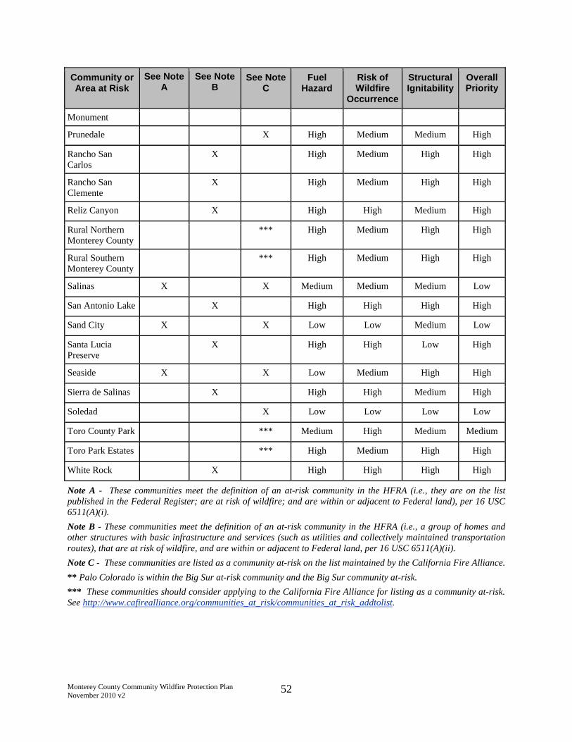
Monterey County Community Wildfire Protection PlanNovember 2010 v2
52
Community orArea at Risk
See NoteA
See NoteB
See NoteC
FuelHazard
Risk ofWildfire
Occurrence
StructuralIgnitability
OverallPriority
Monument
Prunedale X High Medium Medium High
Rancho SanCarlos
X High Medium High High
Rancho SanClemente
X High Medium High High
Reliz Canyon X High High Medium High
Rural NorthernMonterey County
*** High Medium High High
Rural SouthernMonterey County
*** High Medium High High
Salinas X X Medium Medium Medium Low
San Antonio Lake X High High High High
Sand City X X Low Low Medium Low
Santa LuciaPreserve
X High High Low High
Seaside X X Low Medium High High
Sierra de Salinas X High High Medium High
Soledad X Low Low Low Low
Toro County Park *** Medium High Medium Medium
Toro Park Estates *** High Medium High High
White Rock X High High High High
Note A - These communities meet the definition of an at-risk community in the HFRA (i.e., they are on the listpublished in the Federal Register; are at risk of wildfire; and are within or adjacent to Federal land), per 16 USC6511(A)(i).
Note B - These communities meet the definition of an at-risk community in the HFRA (i.e., a group of homes andother structures with basic infrastructure and services (such as utilities and collectively maintained transportationroutes), that are at risk of wildfire, and are within or adjacent to Federal land, per 16 USC 6511(A)(ii).
Note C - These communities are listed as a community at-risk on the list maintained by the California Fire Alliance.
** Palo Colorado is within the Big Sur at-risk community and the Big Sur community at-risk.
*** These communities should consider applying to the California Fire Alliance for listing as a community at-risk.See http://www.cafirealliance.org/communities_at_risk/communities_at_risk_addtolist.

Monterey County Community Wildfire Protection PlanNovember 2010 v2
53
5.5 Detailed Priority Threat Descriptions
Recommended prioritization of communities for hazardous fuel reduction work is provided inTable 13 above. Certain areas, listed in alphabetical order below, are described in more detail inAppendix I.
Bryson-Hesperia
Fort Ord
Highway 68 Corridor
North County
Palo Colorado
Pine Canyon (South)
Santa Lucia Fire Defense System
Sierra de Salinas-Gabilan Fuel Reduction Project and Strategic Fuel Break System
Tularcitos Ridge
White Rock
5.6 Special Study Areas: FRAP Fire Behavior Modeling
Three representative areas within Monterey County were selected for special study by FRAP:Fort Ord, Carmel Valley, and the North County. Fire behavior modeling was conducted byFRAP utilizing the refined topography and fuels data, and refined local 3D wind modeling dataobtained from the Monterey Naval Postgraduate School Meteorology Section. EmployingFlamMap and FARSITE computer models, simulations were conducted for each area.65 Twoignition scenarios and two weather scenarios (moderate and severe) were evaluated to assess firebehavior potential.
The study summarizes (1) the FRAP findings for each area, based on modeling results, and (2)the field validation performed by the fire threat assessment team.
(See Appendix H)
6.0 Hazard Reduction
Hazard reduction includes the following:
Reduction of structure ignitability
Hazardous fuel reduction and fuelbreaks
Defensible space (PRC 4291)
Fuel treatments
Community fire safe prescriptions
65 http://www.fs.fed.us/psw/topics/fire_science/craft/craft/Resources/Fire_models_tools.htm
Monterey County Community Wildfire Protection PlanNovember 2010 v2
54
6.1 Reduction of Structure Ignitability
Current California Fire and Building Codes and Monterey County amendments to those Codesprovide for strict fire safe construction for new construction in State Responsibility Areas(SRAs). SRAs encompass essentially most of the sloped areas of the County that are notfederally owned. Examples of the requirements under the Codes are Class A rated roofingmaterials, boxed eaves, special venting devises, boxed deck, fire resistant siding and residentialsprinklers. Reducing structural ignitability is an effective way of reducing structure losses in theevent of wildfire. In cooperation with CAL FIRE, the Monterey Fire Safe Council supports andpromotes firewise activities by (1) educating citizens on ways to reduce structural ignitabilityand (2) seeking funding to support the use of fire resistant building materials and other strategiesto reduce the impact of human activities on wildfires.
Threat to structures by a burning wildfire is a progressive process. Typically, the first threat isfrom ashes cast in front of a fire by winds or the fire convection column. In some cases, ashesmay retain enough heat and/or flame that secondary ignitions are possible. Next, embers andfirebrands are blown in front of an advancing fire. These have more surface area and mass thanashes and consequently more heat, and are often a cause of ignition of structures and vegetation,sometimes far in advance of the wildfire front. Finally, the wildfire flame front and associatedradiant heat can expose combustible material, including vegetation and structures, to sufficientheat to cause ignition.
Studies reveal that the exposure of a structure to a wildland flame front is usually less than sixminutes. The majority of structure losses from wildland fire occur not from the flaming firefront but from burning embers and firebrands. Anywhere a flying bee can go, a burning embercan go.
Preventing structure ignition requires addressing each of these causes of ignition, as any onesource can lead to loss of the structure if ignition is initiated.
To prevent structure ignition caused by ashes, embers and firebrands, roof materials should beClass A rated, such as Class A composition shingles, clay tiles or cement tiles. Heat can beconducted through metal coverings and ignite wood or other combustible materials behind it, sometal roof coverings (and siding) should be backed with materials that will result in a systemwith a Class A rating.
Rain gutters, roof valleys, clerestories, and other areas that may collect combustible debris suchas leaves and pine needles should be kept clean. Follow CAL FIRE's Guidelines (see Section6.2.1 and Appendix E), including removing vegetation and combustible materials to mineral soilwithin 30 feet of structures so flammable materials cannot be ignited by embers and transfer fireto the structure. Openings for underfloor vents and roof and soffit vents should be covered withwire mesh, and should be completely blocked if a wildfire is approaching. Combustiblematerials such as firewood and patio furniture should be kept away from structures so theycannot transfer fire to structures if they are ignited.
Radiant heat can pass through windows and ignite curtains, papers and other combustiblematerials inside structures. To prevent ignition inside structures from radiant heat, combustible

Monterey County Community Wildfire Protection PlanNovember 2010 v2
55
materials should be moved away from windows if a wildfire is approaching. It is recommendedthat CAL FIRE's Guidelines be followed to reduce vegetation density around structures, whichshould reduce fire intensity and radiant heat during a wildfire.
Various other measures may help reduce the likelihood of structure ignition during a wildfire.For example, decks and balconies can be conduits for fire to ignite a residential structure. Byboxing in the undersides of decks and balconies, especially with fire resistant materials, thechances of ignition are reduced. A relatively recent development includes aluminized fiberglassfabric used to "wrap" a house with reflective fire-resistant fabric, much like when a house iswrapped for termite control. Water gels are available that can be sprayed on structures as a fireapproaches (though effectiveness is time-limited due to evaporation). These methods requirepreparation well before wildfire approaches, including purchasing special materials andequipment to have them ready to use and learning how to use them. There is no assurance thesemeasures will prevent a structure from igniting, but they will likely increase the odds of structuresurvival.
New building code provisions for wildland areas are generally required for new construction.Owners of existing structures should consider voluntarily using wildland construction materialswhen maintaining buildings. For example, if windows are being replaced, the property ownercould consider replacing them with tempered glass, which may help avoid window breakageduring a wildfire. Windows broken by the heat from an approaching fire can provide a path forthe fire to enter a structure. Owners of structures may consider purchasing and pre-fitting fireresistant material to place over the outside of windows when there is a threat from approachingfire, to help prevent windows from transmitting radiant heat, and to help avoid breakage andwindow openings from becoming a path for fire to enter structures. A brochure on fire safestructures is available at http://anrcatalog.ucdavis.edu/pdf/8393.pdf.
Maintaining defensible/survivable space around structures is an effective means of reducingstructure ignitability by reducing the opportunity for ignition. Removal of vegetationovergrowth in the WUI reduces overall wildfire intensity, thus, reducing the energy in theconvection column and lowering its potential for transporting ashes, embers and firebrands overdistance, and reducing radiant heat and potential for direct flame impingement, which lowerstructure ignition potential.
It is recommended that grant funding be sought for the following measures to help reducestructural ignitability:
To assist owners who want to replace existing ignitable materials on structures with fireresistant materials.
To develop educational materials to inform owners how to protect their residencesthrough actions such as cleaning rain gutters, roof valleys and clerestories; theimportance of maintaining defensible/survival space around structures; and theimportance in the event of fire, of covering vent openings, clearing flammable materialfrom on and under decks and moving wood piles.
To form a defensible space/Firewise Program in neighborhoods throughout MontereyCounty.

Monterey County Community Wildfire Protection PlanNovember 2010 v2
56
To summarize, individuals and community members can reduce structural ignitability throughoutMonterey County by implementing defensible space/Firewise Programs to include thefollowing: 66
Assess risk/structure ignitability.
Consider fire resistant exterior siding and roofing materials.
Maintain defensible space around structures.
Clean roofs and gutters annually.
Develop a community phone tree in case of a fire emergency.
Develop agreements with the County to use the reverse 911 system.
Remove ladder fuels.
Clean and screen chimney.
Maintain green grass and fire resistant plants (or bare earth as discussed above) within 30feet of house.
Move all flammable materials at least 30 feet from buildings and structures.
Remove dead, dying, or diseased shrubs trees, dried grass, fallen branches and driedleaves around the defensible space of structure.
Attach a hose that can reach to all parts of the house.
Where it is necessary to maintain a survival space, the following activities may be taken:
Clean roof surfaces and gutters of pine needles, leaves, branches, etc., to reduceflammable materials.
Remove portions of any tree extending within 10 feet of the flue opening of any stove orchimney.
Maintain a screen constructed of non-flammable material over flue opening of everychimney or stovepipe. Mesh openings of the screen should not exceed ½ inch.
Remove branches from trees to height of 15 feet.
Create a fuelbreak around the structure.
Dispose of stove or fireplace ashes and charcoal briquettes only after soaking them in ametal pail of water.
Store gasoline in an approved safety can away from occupied buildings.
Garden hose should be connected to outlet.
66 In a July 13, 2010 comment letter to the January 2010 MCCWPP, the Ventana Chapter of the Sierra Clubprovided various excerpts from approved CWPPs that include discussions of methods for reducing structuralignitability. The discussions in the July 13, 2010 comment letter are reflected below, and some of the discussionsbelow are duplicative of those above.

Monterey County Community Wildfire Protection PlanNovember 2010 v2
57
Have fire tools handy such as: ladder long enough to reach the roof, shovel, rake andbucket for water.
6.2 Hazardous Fuel Reduction and Fuelbreaks
Hazardous fuel reduction work may be performed by private property owners, contractors and/orpublic agencies, subject to compliance with all applicable local, state and federal laws. Fundingmay be from private sources, grants, agency budgets or a combination of these.
A strategic watershed/fireshed approach is advocated by this MCCWPP to protect communities,infrastructure and watersheds, as promoted by the HFRA. Utilization of historic and existingroads, firebreaks (during a fire) and fuelbreaks is recommended as top priority. Strategiccoordination and connection of firebreaks and fuelbreaks is key to protecting communities. ThisMCCWPP recommends, as a priority, the long term maintenance and restoration of existing andhistoric Strategic Fuelbreaks in state responsibility areas and on federal land. It is recommendedthat CAL FIRE, fire districts, volunteer fire departments, the DOD, BLM, National Park Service(NPS), and USFS cooperate with each other and communities to establish and maintain anetwork of Strategic Fuelbreaks to protect at-risk communities from wildfire.
6.2.1 Access Roads
In a July 13, 2010 comment letter to the January 2010 MCCWPP, the Ventana Chapter of theSierra Club provided various references67 that include discussions of fire access and escaperoutes. The discussions in the July 13, 2010 comment letter are reflected below.
Roads are an essential part of any fire and fuels management plan, providing the principal accessto the communities, homes and wild places in the watershed. Additionally, roads may offer adefensible space from which firefighters can conduct direct attack on wildfires and also providestrategic locations for roadside shaded fuelbreaks. Roadside shaded fuelbreaks provide not onlydefensible space for firefighters, but also a safe escape route for residents in the event of awildfire.
Roadside protection should occur within a corridor that extends up to 100 feet out from eitherside of the road. This treatment is designed to protect evacuation routes for community residentsand provide safety for firefighters entering a community to provide protection in the event of awildfire. Brush and shrubs that have spacing 3 times the height of the residual plants should beremoved immediately adjacent to the road to keep flames from directly impinging the roadway.Spacing between trees should be at least 20 feet between crowns of residual trees, with anaverage crown base height [distance from the ground to the base of the leaf (needle) crown] of atleast 20 feet. Trees immediately adjacent to the road should be few. Flame lengths should beless than 2 feet if there is enough fuel reduction to keep flames from traveling directly across theroadway.
The MFSC generally supports the Sierra Club position, and would add that under extraordinaryconditions fuel treatments along roads may need to extend beyond 100 feet given conditions such
67 Keswick CWPP – Fire Access and Escape Routes; Lexington Hills CWPP – Fire Access and Escape Routes;Fallen Leaf – Fire Access and Escape Routes.

Monterey County Community Wildfire Protection PlanNovember 2010 v2
58
as terrain, vegetation type and potential weather conditions. The MFSC also notes that trees thatmay fall on a road and block it during a wildfire should be removed or trimmed to avoid thepotential for this hazard.
6.2.2 Defensible Space Fuel Treatments
Maintaining properties with appropriate defensible space is a key factor to protecting lives andproperty. Any of the fuel treatments in Section 6.3 have the potential to be used to createdefensible space when they can be used safely.
PRC 4291 and related regulations require certain hazardous fuel reduction measures, andencourage others. The goal is to create "Defensible Space" to enable safe defense of structuresduring a wildfire, and to provide for such related needs as emergency vehicle access and safeevacuation routes. As discussed previously, detailed information on defensible space is found inthe Guidelines, published by CAL FIRE.68 The Guidelines are incorporated by reference into 14CCR 1299, which was developed to implement PRC 4291. The Guidelines should be reviewedby all landowners to which PRC 4291 applies.69
The Guidelines provide both general and specific defensible space fuel reduction guidance.Important general concepts are expressed in the following Guideline excerpts:
While individual property owners are not required to clear beyond 100 feet,groups of property owners are encouraged to extend clearances beyond the 100foot requirement in order to create community-wide defensible spaces.
Properties with greater fire hazards will require more clearing. Clearingrequirements will be greater for those lands with steeper terrain, larger and denserfuels, fuels that are highly volatile, and in locations subject to frequent fires.
More specifically, the Guidelines outline two distinct zones: from a structure outward to 30 feetand from 30 to 100 feet from structures (Reduced Fuel Zone). It is important to note that thesedistances are generally the maximum area that is required to be maintained by the statute, but arebased upon flat ground and moderate vegetation fuel loads. Required fuel reduction work oversubstantially greater distances is desirable where terrain and vegetation type vary from this norm.PRC 4291 provides conditions under which a greater distance may be required by an insurancecompany, when approved by a fire expert approved by the Director of CAL FIRE, or whenrequired by local rule or regulation; however, such voluntary fuel reduction work may requireseparate permits and must comply with all local, state and federal laws.
The Guidelines are included in Appendix E. See the Guidelines for more detail on fuel reductionrequirements for defensible space, and for detailed information on various treatments fordifferent vegetation types and terrain.
68 Online at: http://www.fire.ca.gov/cdfbofdb/pdfs/4291finalguidelines2_23_06.pdf69 PRC 4291 applies to every "person who owns, leases, controls, operates, or maintains a building or structure in,upon, or adjoining a mountainous area, forest-covered lands, brush-covered lands, grass-covered lands, or land thatis covered with flammable material."
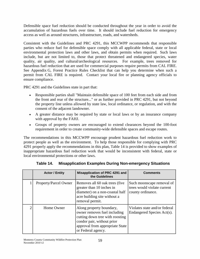
Monterey County Community Wildfire Protection PlanNovember 2010 v2
59
Defensible space fuel reduction should be conducted throughout the year in order to avoid theaccumulation of hazardous fuels over time. It should include fuel reduction for emergencyaccess as well as around structures, infrastructure, roads, and watersheds.
Consistent with the Guidelines and PRC 4291, this MCCWPP recommends that responsibleparties who reduce fuel for defensible space comply with all applicable federal, state or localenvironmental protection laws and other laws, and obtain permits when required. Such lawsinclude, but are not limited to, those that protect threatened and endangered species, waterquality, air quality, and cultural/archeological resources. For example, trees removed forhazardous fuel reduction that are used for commercial purposes require permits from CAL FIRE.See Appendix G, Forest Practice Rules Checklist that can help you determine when such apermit from CAL FIRE is required. Contact your local fire or planning agency officials toensure compliance.
PRC 4291 and the Guidelines state in part that:
Responsible parties shall "Maintain defensible space of 100 feet from each side and fromthe front and rear of the structure..." or as further provided in PRC 4291, but not beyondthe property line unless allowed by state law, local ordinance, or regulation, and with theconsent of the adjacent landowner.
A greater distance may be required by state or local laws or by an insurance companywith approval by the FAHJ.
Groups of property owners are encouraged to extend clearances beyond the 100-footrequirement in order to create community-wide defensible spaces and escape routes.
The recommendations in this MCCWPP encourage prudent hazardous fuel reduction work toprotect people as well as the environment. To help those responsible for complying with PRC4291 properly apply the recommendations in this plan, Table 14 is provided to show examples ofinappropriate hazardous fuel reduction work that would be inconsistent with federal, state orlocal environmental protections or other laws.
Table 14. Misapplication Examples During Non-emergency Situations
Actor / Entity Misapplication of PRC 4291 andthe Guidelines
Comments
1 Property/Parcel Owner Removes all 60 oak trees (fivegreater than 10 inches indiameter) on a non-coastal halfacre building site without aremoval permit.
Such moonscape removal oftrees would violate currentcounty ordinance.
2 Home Owner Along property boundary,owner removes fuel includingcutting down tree with roostingcondor pair, without priorapproval from appropriate Stateor Federal agency.
Violates state and/or federalEndangered Species Act(s).
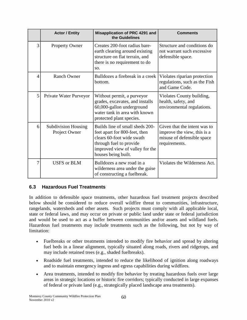
Monterey County Community Wildfire Protection PlanNovember 2010 v2
60
Actor / Entity Misapplication of PRC 4291 andthe Guidelines
Comments
3 Property Owner Creates 200-foot radius bare-earth clearing around existingstructure on flat terrain, andthere is no requirement to doso.
Structure and conditions donot warrant such excessivedefensible space.
4 Ranch Owner Bulldozes a firebreak in a creekbottom.
Violates riparian protectionregulations, such as the Fishand Game Code.
5 Private Water Purveyor Without permit, a purveyorgrades, excavates, and installs60,000-gallon undergroundwater tank in area with knownprotected plant species.
Violates County building,health, safety, andenvironmental regulations.
6 Subdivision HousingProject Owner
Builds line of small sheds 200-feet apart for 800-feet, thenclears 60-foot wide swaththrough fuel to provideimproved view of valley for thehouses being built.
Given that the intent was toimprove the view, this is amisuse of defensible spacerequirements.
7 USFS or BLM Bulldozes a new road in awilderness area under the guiseof constructing a fuelbreak.
Violates the Wilderness Act.
6.3 Hazardous Fuel Treatments
In addition to defensible space treatments, other hazardous fuel treatment projects describedbelow should be considered to reduce overall wildfire threat to communities, infrastructure,rangelands, watersheds and other assets. Such projects must comply with all applicable local,state or federal laws, and may occur on private or public land under state or federal jurisdictionand would be used to act as a buffer between communities and/or assets and wildland fuels.Hazardous fuel treatments may include treatments such as the following, but not by way oflimitation:
Fuelbreaks or other treatments intended to modify fire behavior and spread by alteringfuel beds in a linear alignment, typically situated along roads, rivers and ridgetops, andmay include retained trees (e.g., shaded fuelbreaks).
Roadside fuel treatments, intended to reduce the likelihood of ignition along roadwaysand to maintain emergency ingress and egress capabilities during wildfires.
Area treatments, intended to modify fire behavior by treating hazardous fuels over largeareas in strategic locations or historic fire corridors; typically conducted in large expansesof federal or private land (e.g., strategically placed landscape area treatments).

Monterey County Community Wildfire Protection PlanNovember 2010 v2
61
Prescribed burning, intended to reduce hazardous fuel loads in key locations and reduceoverall wildfire intensity and negative smoke impacts while considering vegetation typecharacteristics and disturbance regimes.
The following hazardous fuel treatment prescriptions are recommended to reduce vegetation fuelin treatment areas. Within the recommended WUI zones, the goal is to reduceunderstory/surface fuel flame length to under four feet around access roads, structures,infrastructure, and watersheds.
6.3.1 Strategic Fuelbreaks and Other Treatments
It is recommended that strategic fuelbreaks and other treatments be established and maintainedthroughout the County, where indicated in this MCCWPP or local CWPPs, or where determinedto be appropriate by the FAHJ including, but not limited to, existing and historic firecontainment lines. Fuelbreaks and other treatments should incorporate adjacent buffers in whichwildfire fuels are modified in such manner and for such distance as will ensure a high probabilitythe fuelbreak or other treatment will be effective under adverse weather conditions and permiteffective tactical suppression actions.
6.3.2 Vegetation Thinning
Thinning of vegetation involves an overall reduction of woody biomass to break up horizontallyand vertically continuous fuels. Site specific conditions and fire threat potential should dictatethinning percentages and distance in relation to structures, emergency access routes, and otherassets. Factors such as topography and vegetation type may also be considered.
6.3.3 Tree Removal
Removal of trees should focus primarily on removing dead and dying trees. However, in areaswith hazardous fuels, live tree removal may be necessary to improve vegetation spacing andreduce overall fuel continuity. Where trees require removal, root systems should generally beleft intact where needed to maintain slope stability. In such cases, annual treatment of stumpgrowth or re-sprouting may be needed to maintain reduced fuel load volumes.
Along access roads, spacing between trees should be at least 20 feet between crowns of residualtrees, with an average crown base height (distance from the ground to the base of the leaf[needle] crown) of at least 20 feet. Trees immediately adjacent to the road should be few.70
Trees that may fall on a road and block it during a wildfire should be removed or trimmed toavoid the potential for this hazard.
6.3.4 Tree and Shrub Pruning
Trees or large tree-form shrubs (reaching four feet or taller at maturity) that are to be retained indefensible space should be trimmed or pruned to reduce both vertical and horizontal fuelcontinuity. Pruning should eventually attain at least 8 foot (16 foot preferable where attainable)
70 July 13, 2010 comment letter to the January 2010 MCCWPP from the Ventana Chapter of the Sierra Club.

Monterey County Community Wildfire Protection PlanNovember 2010 v2
62
vertical clearance from the highest slope point within the canopy, yet should not exceed 50percent reduction of live crown (canopy).
Along access roads, brush and shrubs that have spacing 3 times the height of the residual plantsshould be removed immediately adjacent to the road to keep flames from directly impinging theroadway. Flame lengths should be less than 2 feet if there is enough fuel reduction to keepflames from traveling directly across the roadway.71
6.3.4.1 Vertical Separation
At a minimum, pruning of vegetation off the ground should provide vertical clearance thatmeasures three times the height of the understory vegetation or ten feet, whichever is higher (seeCAL FIRE's Guidelines for more details). Pruning tree limbs up to 16 feet or more may bedesirable in some terrain and vegetation types. Vertical separation serves to minimize thepotential for a ground fire to transition to a crown fire. This process will remove ladder fuels andreduce the potential for fire spread from lower shrubs to higher trees and structures.
6.3.4.2 Horizontal Separation
Pruning of vegetation should result in horizontal clearance that measures three times the heightof the plant material height or 20 feet, whichever is greater. Horizontal separation of 40 feet ormore may be desirable, depending upon slopes and vegetation types. Horizontal separationserves to minimize fire spread from plant to plant and from plant to structure. In defensiblespace, an alternative to crown separation is to use the Guidelines' option 4b, which provides forretaining a closed canopy while removing surface fuels/understory and lower branches fromtrees.
6.3.4.3 Vegetation Grouping
Maintaining groups of shrubs is recommended to provide a mosaic pattern in the landscape.However, shrub groups should be separated from other shrub groups according to the horizontalseparation criteria discussed above.
6.3.5 Dead/Dying Plant Removal
Removal of dead and dying plant material from the WUI will help reduce low fuel moisturebiomass and highly flammable fine fire fuels. This practice should also be conducted incombination with vegetation thinning efforts and may help reach or completely satisfy thinningobjectives in some areas.
71 See previous footnote.

Monterey County Community Wildfire Protection PlanNovember 2010 v2
63
6.3.6 Exotic/Invasive Plant Removal
Removal of non-native and invasive plants from the WUI will help reduce the presence ofundesirable species and enhance thinning efforts aimed at reducing overall biomass levels.Typical undesirable exotic species may include, but are not limited to:
Palm trees (various species)
Eucalyptus trees (Eucalyptus spp.)
Pepper trees (Schinus spp.)
Fennel (Foeniculum vulgare)
Mustard (Brassica spp.)
French broom (Genista monspessulana)
Poison hemlock (Conium maculatum)
Thistle (various species)
Harding grass (Phalaris aquatica)
Jubata grass (Cortaderia jubata)
Pampas grass (Cortaderia selbana)
Cape ivy (Delairea odorata)
6.3.7 Mowing
Mowing of grasses and exotic weeds should be conducted to maintain grass heights at fourinches or lower. Focus should be primarily on invasive weed prevention, suppression andmonitoring, and properly timed and implemented grassland management (e.g. mowing, grazing)that promotes the establishment of less volatile native perennial grasses. Mowing should beperformed before 10 AM during the dry season to reduce the chance of starting a fire fromsparks caused by the mowing equipment.
6.3.8 Chipping and Mastication
Chipping/mastication and spreading of existing dead biomass or biomass from hazardous fuelreduction efforts may be an effective method of hazardous fuel reduction and weed suppression.However, chip or mulch depth should generally not exceed six inches.
6.3.9 Grazing
Livestock (including goats) have proven to be an effective method for reducing hazardous fuelvolumes in WUI areas.
6.3.10 Prescribed Burning
Preplanned controlled burning is currently conducted by private landowners throughoutMonterey County, by CAL FIRE as a function of the state Vegetation Management Program(VMP), and on land administered by the BLM, DOD, and USFS.

Monterey County Community Wildfire Protection PlanNovember 2010 v2
64
Burning under desirable conditions restores fire to the ecosystem and is normally one of the mostcost effective methods for strategically reducing hazardous fuels by 50 to 80 percent. Rangelandproperty owners and stakeholders have identified the goal of accomplishing 20,000 acres oflandscape-scale prescribed fire projects on private property in State Responsibility Areasannually in Monterey County. Large-scale prescribed burning is conducted by privatelandowners under permit and with the cooperation of the Monterey Bay Unified Air PollutionControl District (MBUAPCD), CAL FIRE, USFS, BLM, and various local fire agencies.Landowners may also contract with CAL FIRE to perform burns under the statewide VegetationManagement Program. For more information about obtaining a Smoke Management Permit,visit www.mbuapcd.org and under "Programs," click on "Smoke Management."
Preplanned burning under low and moderate wildfire hazard conditions is the preferredalternative to unplanned wildfire events occurring under severe fire weather conditions. TheMonterey San Benito Range Improvement Association Wildland Fire Safe Council72 activelyassists landowners and cooperating agencies in the coordination of prioritized projects.
See Appendix L for a sample fire prescription for safe controlled burns in chaparral.
Depending on site conditions, piling and burning is a form of prescribed fire that can be morefeasible and cost effective than chipping or hauling material to landfills. Project location andsetting determines which approach is the most environmentally friendly and effective alternative.Piling and burning can generally be safely conducted during the winter rainy season.
6.3.11 CAL FIRE Vegetation Management Program
The CAL FIRE VMP provides a means for landowners to contract with CAL FIRE forhazardous fuel reduction and prescribed burn projects. Under contract with CAL FIRE,landowners share the costs of regulatory compliance, preparation, and treatment according to thepublic vs private benefit. Statewide, CAL FIRE is authorized to treat up to 180,000 acresannually under the VMP. The cooperative and coordinated utilization of the CAL FIRE VMP isimportant to the success of this MCCWPP.
6.3.12 Crushing
Crushing breaks and presses brush and/or slash on or into the ground surface. This occurs whenequipment drives over slash. This method involves the use of heavy ground-based equipmentthat crushes slash to a depth not exceeding two feet. The closer crushed material is to the forestfloor, the quicker decomposition occurs and the less chance of fire reaching the above canopylayers.
6.3.13 Lopping and Scattering
Lopping is the cutting of limbs, branches, treetops, small diameter trees, or other woody plantresidue into lengths so that the remaining slash will lie close to the ground. Scattering is thespreading of lopped slash evenly over the ground so that the remaining slash will lie no morethan three (3) feet off the ground. This method is suited to areas with lower brush and/or slash
72 Contact via email at: [email protected]

Monterey County Community Wildfire Protection PlanNovember 2010 v2
65
accumulations and is effective for such accumulations in meeting height requirements,facilitating use of the treated area by humans and animals, improving aesthetics, and distributingmaterial more uniformly and closer to the ground for faster decomposition. Lopping is alsouseful as preparation for piling and burning, especially in areas with higher fuel density wherescattering would contribute to wildfire hazard (e.g., see Section 6.3.10).
6.3.14 Fireline Explosives
Fireline explosives are linear explosive charges placed and detonated in lengths of up to a halfmile or more to create a fireline through surface and ground fuels. The explosive component istypically a water gel compounded to reduce flame generation to avoid igniting a fire. Firelineexplosives may be advantageous in locations where mechanized equipment cannot be used toconstruct firelines. Four people using fireline explosives can construct fireline as fast as 25 to 40people with handtools.73 Less specialized explosive charges may be advantageous to drop treesthat are too hazardous for sawyers to cut, such as snags and those with widowmakers. Droppingpartially rotted standing Sudden Oak Death killed Tanoaks is an example of when such use ofexplosives may be beneficial.
6.3.15 Herbicides
Herbicides are chemicals that have been developed to control or kill specific groups of plantspecies. Three primary types of herbicide exist: foliar active, soil active, and those that are bothfoliar and soil active. Herbicides that are foliar active enter the plant through the leaves andoccasionally the stem. Soil active herbicides are taken up through the roots of the plant.Herbicides are most effective when used in accordance with a sound prescription. A singletreatment provides long-term reduction of hazardous live fuels and changes in speciescomposition, but the effect on total live and dead fuels is not immediate.74 Herbicides can beused as an effective tool for managing vegetation and forest health. Herbicides can havedetrimental effects on water quality and lethal effects on non-target organisms. Therefore, theyshould be used consistent with the instructions under which their use was approved by theEnvironmental Protection Agency, and with an appreciation of their potential for harm ifmisused.
6.4 Community Fire Safe Prescriptions
Community Fire Safe Prescriptions are envisioned to be site-specific fuel treatments and firebehavior parameters within the Defensible Space, Mitigation Zones, Threat Zones and HFRZs toreduce the risk of wildfire within and near a community. These treatments and parameters maybe developed for some locations on a site-specific basis, to prevent the spread of wildfire to morewildland or structures, and to prevent the spread of a structure fire to neighboring structures orthe wildland.
73 Wenger, Karl. Forestry Handbook: Second Edition, John Wiley & Sons, 1984. Page 222.74 University of Florida. Fuel Reduction Options for Landowners at the Wildland-Urban Interface, Technical Paperfor Master of Forest Resources & Conservation.

Monterey County Community Wildfire Protection PlanNovember 2010 v2
66
6.5 Air Quality
As discussed in Section 3.3.3.2, the MBUAPCD works closely with communities, landowners,agencies and the MFSC to allow burning of hazardous fire fuels consistent with air quality goals.
The MBUAPCD may require a permit for burning within the District.75 Contact the MBUAPCDto determine if a permit is required. For large project burns, the MBUAPCD cooperates withagencies, landowners, the CARB meteorology section, and fire weather forecasters to seek burnconditions that will be conducive to successful smoke dispersion and minimal impacts tocommunities.
Requirements for efficient pile burning procedures are available from the MBUAPCD.
7.0 Environmental Benefits
7.1 Greenhouse Gases
Globally, fires are a significant contributor of carbon dioxide and other greenhouse gases in theatmosphere. While burning vegetation is carbon neutral, high intensity fires due to hazardousfuel accumulation may result in more vegetation burning than would burn if lower fuel loadswere present, contributing more carbon dioxide to the atmosphere than would generally occurwith lower fuel loads present. Researchers found that large scale fires contributed to most of theyear-to-year changes in atmospheric carbon dioxide totals during the period from 1997 to 2001.76
Fires were found to account for approximately one-fifth of the total global emissions of carbondioxide.77 Fuel reduction and fire suppression efforts will need to occur expeditiously or greateramounts of carbon will be released by large higher intensity wildfires, further exacerbating theglobal warming problem.
7.2 Use of Biomass
Where practical, use of biomass woody debris resulting from hazardous fuel mitigation efforts issupported by this MCCWPP. Biomass is plant matter, which can be used for purposes such asgenerating electricity or producing heat. Wood biomass includes wood chips, wood pellets andother low-grade wood wastes. In areas where the location of biomass sources and of biomassutilization make transportation of biomass practical, biomass may offer many benefits includingthose listed below:
75 See the following web page for a summary of when permits are required (when in doubt, contact theMBUAPCD):http://www.mbuapcd.org/~mbuapcd/index.php?option=com_content&view=article&id=56&catid=21&Itemid=80#Standards176 University of Maryland University College(2004) El Nino Fires Released Clouds of Greenhouse Gases.77 Levine, Joel S.; Cofer, Wesley R., III. 2000. Boreal forest fire emissions and the chemistry of the atmosphere. In:Kasischke, Eric S.; Stocks, Brian J., eds. Fire, climate change, and carbon cycling in the boreal forest. EcologicalStudies Vol. 138. New York: Springer-Verlag: 31-48.
Monterey County Community Wildfire Protection PlanNovember 2010 v2
67
Biomass energy is good for the environment. Biomass energy systems help keep forestshealthy by providing a market for low-grade “cull” wood, which removal improves thewell-being of the forest.
Biomass fuel is a local product. Dollars spent on biomass fuel stay in the regionaleconomy, creating jobs.
Biomass is easy to use and has high energy content. Wood pellets or wood chips are aclean-burning, high energy, carbon neutral renewable fuel that is convenient to use andrequires less storage space than other biomass fuels.
8.0 Strategy and Action Plan
It is recommended that this document serve as an advisory document to assist in the developmentof fire safe activities and policies throughout Monterey County, subject to the issuance of allnecessary permits and compliance all local, state and federal laws.
This MCCWPP makes the connection between Strategic Fuelbreaks, Defensible Space,Defensible Polygons, and the incident management, providing communities and agencies acooperative guidance to wildfire protection.
This MCCWPP provides a general framework for coordinated interagency multi-jurisdictionalstrategic community wildfire protection planning for Monterey County.
Government agencies and private landowners responsible for managing the vegetation in andnear the recommended at-risk communities within Monterey County will be invited to submithazardous fuel reduction projects that provide communities wildfire protection and reduce risk.The Recommended Hazardous Fuel Reduction Projects table in Appendix D presents a list ofhazardous fuel reduction projects currently recommended. Whether the projects will actually beinitiated or conducted depends upon such factors as continued availability of leaders/organizers,availability of funding, continued interest by landowners, and potential changes to existingconditions before projects are funded and started, and issuance of all necessary permits andcompliance with all local, state and federal laws.
The MFSC, along with local communities, intends to assess hazardous fuel reduction progressannually and invite agencies, landowners, and involved citizens to submit projects that providecommunity, watershed and infrastructure protection. Project identification and implementationare an on-going processes and the table in Appendix D may be updated by the MFSC as needed.
This MCCWPP is a living document and has been created to allow for ongoing management,updates, and community input intended for reducing the severity of wildland fires and reducingthe vulnerability of assets to wildland fires in Monterey County. The following sections discusslong term management objectives intended to promote fire safe communities and the overallreduction of wildfire costs and losses in Monterey County.

Monterey County Community Wildfire Protection PlanNovember 2010 v2
68
8.1 Localized Fire Plans and CWPPs
This MCCWPP provides wildfire planning recommendations and information at a county widescale. The preparation of localized fire plans and CWPPs at the community or neighborhoodscale are recommended and supported. This document is intended to provide a guide forcommunities or neighborhoods to develop localized fire plans and CWPPs. However, local areasmay rely on this MCCWPP for the purpose of seeking grant funds to perform hazardous fuelreduction work without the need for a local CWPP. Such work would need to comply with therequirements of all applicable local, state and federal laws, including environmental protectionlaws, as well as with all requirements of the grant agreement, including development of specificdetails on the scope of work. It is the intention of this MCCWPP that local CWPPs should havepriority and authority over the county-level recommendations included in this MCCWPP, subjectto all local, state and federal laws. Pursuant to the HFRA, a local CWPP must be agreed to bythe local fire department(s), CAL FIRE and the applicable local government (city or the Countyof Monterey). Local CWPPs may identify site-specific constraints, fuels treatment options,specific vegetation prescriptions, at-risk community boundaries and refined or redefined WUIboundaries, emergency preparedness and other issues important to community wildfire safety,and accordingly, may deviate from the MCCWPP.
When developing local CWPPs, one should bear in mind that in some locations, coordination oflarge strategic firebreaks and fuelbreaks is important to the protection of multiple communities.Those drafting local CWPPs should consider the needs of other communities and communicatewith them before deciding on such treatments. Fire does not recognize political boundaries, sothose working to protect communities must interact and cooperate with other communities inorder to be effective.
It is anticipated that the findings, projects, and recommendations included in the localized fireplans and CWPPs will be integrated into this MCCWPP during routine maintenance and updatesof the document. Currently, localized fire plans or CWPPs are being considered for the areas ofBig Sur, Palo Colorado, Cachagua, Pebble Beach, Carmel Highlands and Carmel Valley.
The following recommendations are intended to provide guidance for the preparation oflocalized fire plans and CWPPs. Localized fire plans and CWPPs should be prepared asprovided in the HFRA, including within the context of the collaborative agreements and theguidance of the Wildland Fire Leadership Council, which calls for collaboration between a broadspectrum of affected parties, and may provide the following information:
Define or redefine WUI boundaries for the community based on factors such as localtopography, fuel types and densities, the desire to protect watersheds, propertylines/ownerships, location of historic fuelbreaks and proximity to federal land, all asdesirable to promote hazardous fuel reduction to protect the community from wildfires.
Define or redefine the boundaries for the community.
Identify and define a description of essential infrastructure such as roads, water supplysystems, and power or communication structures, including an estimate of its value. TheHFRA provides that CWPPs should make recommendations for hazardous fuel reduction
Monterey County Community Wildfire Protection PlanNovember 2010 v2
69
treatments on federal land and non-federal land to protect such infrastructure fromdamage by wildfire.
Requests for hazardous fuel reduction work on land managed by the USFS and/or theBLM.
Prioritize locations where fuel reduction grants should be made to fund projects onprivate land.
Collaborate with Monterey County and the incorporated cities within the County, whenrequired, and other agencies to facilitate and streamline hazardous fuel mitigation workdescribed herein.
Implement measures to reduce structural ignitability.
Identify additional stakeholders or at-risk communities not included in this MCCWPP.
Include in the decision-making process affected individuals including residents andprivate property owners in the community, CAL FIRE and the FAHJ (e.g. local firedistrict, volunteer fire department, city fire department, etc.) and the local government(city or Monterey County). The USFS, BLM, environmental groups, and otherstakeholders should be consulted during the drafting process.
Identify and address site-specific environmental regulations and necessary permittingrequirements.
Identify and address hazardous fuel treatment prescriptions, funding sources, andmonitoring protocols.
Identify opportunities for additional public education and safety training.
Identify local evacuation routes and safe zones, and involve law enforcement officialsresponsible for emergency evacuation and implementation of Ready, Set, Go! andPSDLE78 concepts in the planning process.
Include tribal contact information and provision for notifying tribal representatives in theevent ancestral remains are uncovered.
8.2 Long Term Maintenance/Monitoring
Long term maintenance and monitoring of hazardous fuel reduction efforts within MontereyCounty is important to maintaining reduced hazardous fuel loads in critical threat areas andidentifying new or additional projects necessary for reducing overall wildfire risk tocommunities. The following actions by the MFSC are intended to reduce community wildfirerisk:
It is recommended that the FAHJ conduct annual monitoring of treated areas.Maintenance of hazardous fuels is recommended for access roads, structures,infrastructure, and watersheds within the WUI and can typically be completed at a costless than that for the initial effort. Monitoring efforts can identify areas in need ofadditional hazardous fuel reduction treatments.
78 Example at www.ruralfire.qld.gov.au/Bushfire_Safety/Safety_in_Rural_Areas/Planning_and_Survival.html
Monterey County Community Wildfire Protection PlanNovember 2010 v2
70
Long term maintenance of the MCCWPP is essential. Maintaining the MCCWPPdocument is critical to tracking completed projects and on-going hazardous fuel reductionefforts, and most importantly, to address and define new priority areas and associatedhazardous fuel reduction projects. A two to three year review/edit cycle is recommended.
Collaboration with Monterey County and the incorporated cities in the County (whenrequired) and other agencies is important for facilitating and expediting hazardous fuelmitigation work described herein. To facilitate collaboration, it is recommended thatMonterey County authorize a position to be the primary contact for fire related andhazardous fuel mitigation related activities, such as a Forester for Monterey Countyresiding within the MFSC.
The Recommended Hazardous Fuel Reduction Projects included in Appendix D of thisMCCWPP shall be updated at least annually by the MFSC. Input from those in an at-riskcommunity (including interested individuals and the local fire authority) shall be giventhe highest priority for informing such updates for their community. The MFSC shallconsider requests from project proponents to update Appendix D in a timely manner.Note that Appendix D may be updated without requiring resigning by signatories to thisMCCWPP.
8.3 Public Education and Outreach
Public outreach and education is an important component in community fire preparednessefforts. The MFSC sponsors ongoing fire prevention and public education programs countywide and supports and promotes firewise activities by educating its citizens in ways to reducestructure ignitability. The following MFSC actions are intended to support the wildfire hazardreduction goals of this MCCWPP by incorporating community education, wildfire readiness, andpreparedness:
Maintain the MFSC website as a portal for public information regarding hazardous fuelreduction efforts throughout the County and advice on reduction of structural ignitability.
Post the MCCWPP, updates, and specific project descriptions on the MFSC website.
Provide a list of local fuel reduction contractors and consultants on the MFSC website.
Develop printed educational materials for distribution in the at-risk communities.
Conduct public outreach/education in communities where fuel reduction projects areproposed prior to initiation of work.
Develop strategic partnerships and funding opportunities with local industry to supporthazardous fuel reduction and firewise demonstration projects.
Organize site visits to recently burned areas (e.g., one-year, three-year, ten-year post fire),and contrast with old burns.

Monterey County Community Wildfire Protection PlanNovember 2010 v2
71
9.0 Recommendations
In order to mitigate impending catastrophic fires, the recommendations below should beaccomplished with all deliberate speed.
The measures recommended in this MCCWPP to protect lives, property and the environment, areintended to facilitate hazardous fuel reduction work in Monterey County, subject to the issuanceof all necessary permits and compliance with all local, state and federal laws.
Note on the Collaborative Process Used to Develop the MCCWPP, Including theRecommendations
A CWPP, as defined under HFRA, is a plan that is, "developed within the context of thecollaborative agreements and the guidance established by the Wildland Fire LeadershipCouncil."79 The Wildland Fire Leadership Council provides a handbook, Preparing aCommunity Wildfire Protection Plan, A Handbook for Wildland-Urban Interface Communities,(Handbook) that outlines the process to be used to develop a CWPP.80
The MCCWPP was developed using the Handbook as a guide, and accordingly, the developmentprocess was an open and collaborative process. This MCCWPP was written over the course ofyears. Table 4 lists organizations that were sent letters of intent to develop the MCCWPP, andinvited to participate. Some groups that were not included in the original notice were added asthe MFSC became aware of their interest.
Participants in this process included fire professionals, concerned citizens, and representativesfrom various organizations including homeowners associations and conservation groups.
During this collaborative process, the working draft was placed on the Internet in an on-linedocument collaboration application (Acrobat Buzzword), and invitations to participate and entercomments were sent out to a lengthy email list of interested parties, thus affording interestedparties an opportunity to collaborate using this convenient and accessible interface.
The January 2010 MCCWPP, which was signed by 18 agencies including CAL FIRE; theMonterey County Fire Chiefs Association and local fire districts, departments and volunteer firebrigades; USFS; BLM; the Presidio of Monterey/Fort Ord; and the California Department ofParks and Recreation, contained recommendations to amend local, state and federal laws andregulations to expedite fuel mitigation and fire preparedness efforts, to better protect lives,property and the environment.
However, after the January MCCWPP was finalized and signed by these 18 agencies, commentson the January 2010 MCCWPP were received from various environmental groups. In the spiritof collaboration and in response to these comments, the MFSC removed from the MCCWPP,among other things, recommendations to amend various environmental laws that in the opinionof the MFSC are needed to better protect lives, property and the environment. Letters fromvarious organizations commenting on the January 2010 MCCWPP are included in Appendix J.
79 Title 16 USC 6511(c)(A).80 Download the handbook at http://www.forestsandrangelands.gov/communities/documents/cwpphandbook.pdf

Monterey County Community Wildfire Protection PlanNovember 2010 v2
72
The MFSC prepared a letter in response to these comments from these organizations, which isalso included in Appendix J.
In response to those comments, the September 2010 MCCWPP was revised to address them.However, during Monterey County’s review of the September 2010 MCCWPP, MontereyCounty and various environmental organizations requested additional changes to the document.The MFSC amended the September 2010 MCCWPP to respond to the additional comments,which are also included in Appendix J, resulting in the November 2010 MCCWPP. TheNovember 2010 MCCWPP was further amended to this version 2 (v2), after Monterey Countyagain deferred signing the MCCWPP.
9.1 Recommendations to the Secretary of Agriculture
Pursuant to sections 101(3)(B), 103, 104 and 105 of the HFRA,81 this MCCWPP recommendsthe following to the Secretary of Agriculture:
9.1.1 Maintain the Ventana Fuelbreak (Big Box Firebreak)
Background: The Ventana Fuelbreak (formerly the Big Box Firebreak), which generallysurrounds much of the Monterey District of the LPNF, protects the following at-riskcommunities from fires originating in the LPNF, and protects the LPNF from fires originating inthe following at-risk communities:
Arroyo Seco
Big Sur
Big Sur, South Coast
Bryson-Hesperia
Cachagua
Carmel Highlands
Carmel Valley
Carmel Valley Village
Indians
Jamesburg
Lockwood
Palo Colorado
Pine Canyon (south)
Rancho San Carlos
Rancho San Clemente
Reliz Canyon
San Antonio Lake
Tassajara
White Rock
81 16 USC 6511(3)(B)), 6511(16)(A), 6513 & 6514.

Monterey County Community Wildfire Protection PlanNovember 2010 v2
73
The image below shows the Basin Fire burning toward Carmel Valley in 2008. The Basin Firewas stopped on the north at the Big Box/Ventana Firebreak. Most of the northern portion of theBig Box/Ventana Firebreak (near Carmel Valley) is in the Ventana Wilderness. The photo wastaken from the Los Tulares area in Carmel Valley, looking generally southward, on or about July15, 2008. The fog in the foreground is over the valley floor.
Recommendation: Reduce the risk to communities by maintaining the Ventana Fuelbreak,and treatment on both sides of it in a condition and for such distance that will ensure a highprobability the fuelbreak or other treatment will be effective under adverse weather conditionsand permit effective tactical suppression actions. The fuelbreak should serve to allow firefightersto work safely in the area; to change fire direction; to drop fire to the ground; and to stop thespread of wildfire under adverse fire conditions. The width of treatment should be determinedutilizing such factors as fuel loads, topography, predominant winds, values at risk and firebehavior modeling. To the extent the Ventana Fuelbreak and the treatments on both sides of itare on non-federal land, this recommendation should be construed as recommending that federalfunds be made available for their maintenance (e.g., through grants). The location of theVentana Fuelbreak is shown on the map in Appendix B-7 by the line representing the Big BoxFirebreak.
Rationale: The Big Box Firebreak was used to protect at-risk communities surrounding theLPNF from the 178,000 acre Marble Cone Fire in 1977, the 86,000 acre Kirk Complex Fire in1999, and the 163,000 acre Basin Fire and 81,000 acre Indians Fire in 2008.
Monterey County Community Wildfire Protection PlanNovember 2010 v2
74
The Basin Fire burned on the west side of an 8 mile segment of the western portion of the BigBox Firebreak, consuming 26 homes and 32 other structures in the Big Sur at-risk community,and threatening approximately 300 homes in the Palo Colorado at-risk community. Maintainingand defending the Ventana Fuelbreak and treatments on both sides of it will reduce the threat ofharm to firefighters and to the communities surrounding the Los Padres National Forest. Asnoted in Section 3.3.1.2., "Due to the extreme hazard of fires in the Los Padres National Forest"Congress has provided special management language for wilderness areas in the Los PadresNational Forest, including allowing pre-suppression measures such as those recommended in thisMCCWPP.82
The recommendation to maintain the Ventana Fuelbreak and its side-treatments before fire startsis to help ensure they can be used effectively and safely without delay to stop the spread of fire,to protect lives, property and the environment. However, it is important to note that a fire,whether natural or human-caused could occur outside fuelbreaks/firebreak, which would makethe fuelbreaks/firebreaks ineffective for slowing or stopping fires.
Note 1: Firebreak vs. Fuelbreak – Comments on the January 2010 MCCWPP includedconcerns over the use of the term, "firebreak" instead of the term "fuelbreak". In an attempt toreach consensus, this November 2010 MCCWPP deleted the recommendation to maintain“firebreak” in its recommendations. The USFS and BLM have stated that as a matter of policy,the agencies can only maintain strategic fuelbreaks, and not firebreaks. These agencies state thatfirebreaks are, instead, opened and/or created during a wildfire. This MCCWPP recommendsmeasures to allow mechanized equipment into wilderness areas, when necessary, to open and/orconstruct firebreaks and fight wildfire without any procedural delays.
Note 2: Use of Fuelbreaks – Fuelbreaks typically contain vegetation, though at reducedvolume. Fuelbreaks are generally maintained over substantially wider distance than firebreaks,depending upon such factors as topography and vegetation type and density. Due to theirvegetation, fuelbreaks must be properly designed and maintained for such distance as will ensurea high probability the fuelbreak or other treatment will be effective under adverse weatherconditions and permit effective tactical suppression action.
Fuelbreaks may be improved with heavy equipment to be firebreaks during fires, if time allowsand resources are available. During catastrophic events like the 2008 Lightning Siege inCalifornia, which started over 2,000 fires statewide83 including the Basin Fire, availability ofresources can be problematic.
Note 3: Wilderness Expansion – The Ventana Wilderness was created in 1969encompassing approximately 98,000 acres.84 The 1968 report from the Secretary of Agricultureto President Johnson on the proposed Ventana Wilderness states, "The boundary of this proposedWilderness is very important and has been intentionally established wherever possible to allowthe construction of peripheral fuelbreaks, and fire control access. Approximately 70 percent of
82 Section 3.3.1.2.2, quoting Senate Report 95-490 on H.R. 3454 (The Endangered American Wilderness Act of1978), 95th Congress 1st session October 11, 1977, Senate Committee on Energy and Natural Resources.83 http://www.fire.ca.gov/index_incidents_overview.php84 Public law 91-58, August 18, 1969.

Monterey County Community Wildfire Protection PlanNovember 2010 v2
75
the boundary of this area would be located 250 feet below the crest of the ridge to permit themachine construction of effective fuelbreaks."85
The boundary of the Ventana Wilderness has been expanded four times, and now encompassesover 236,000 acres. In 2002, wilderness boundaries in the Monterey Ranger District of theLPNF were expanded in twelve areas, in some locations to within 30 to 100 feet of roads. Someof the roads serve as escape routes in event of fire and some double as firebreaks. In at least onelocation, wilderness was expanded over the Big Box Firebreak.
Because of past procedural delays in obtaining authorization for using mechanized equipment inwilderness, and to help avoid such procedural delays in the future, this MCCWPP makesrecommendations for additional training and communication, and expedited procedures, forimproving and/or creating firebreaks without procedural delay once wildfire has started.
Note 4: Sierra Club’s Expert’s Support for Maintaining Existing Firebreaks – Aspart of the comments to the January 2010 MCCWPP,86 the Ventana Chapter of the Sierra Clubincluded as an exhibit, an opinion memo by Dr. Scott Stephens, Associate Professor of FireScience at the University of California, Berkeley. Mr. Stephens stated in his memo thefollowing: "The CWPP specifies where existing fire and fuel breaks are located throughout thecounty (Pg 72, 73 & 74). Since these are already installed maintaining them into the futuremakes sense. They can act as anchor points for fire suppression operations and safety areas forfire fighters." As acknowledged by Dr. Stephens, the existing Big Box Firebreak should bemaintained, before fire starts, and treatments should be provided on each side to help ensure thefirebreak can be safely manned and effectively used during wildfires.
9.1.2 Maintain the Bixby Mountain Fuelbreak
Recommendation: Reduce the risk to communities by maintaining the Bixby MountainFuelbreak, and treatments on both sides of it in a condition and for such distance as will ensure ahigh probability the fuelbreak or other treatment will be effective under adverse weatherconditions and permit effective tactical suppression actions. The fuebreak should result in a highprobability that the fuelbreak will serve to allow firefighters to work safely in the area; to changefire direction and spread; to drop fire to the ground; and to stop the spread of wildfire underadverse fire conditions. The width of treatment should be determined utilizing such factors asfuel loads, topography, predominant winds, values at risk and fire behavior modeling. To theextent the Bixby Mountain Fuelbreak or its side-treatments are on non-federal land, thisrecommendation should be construed as recommending that federal funds be made available fortheir maintenance (e.g., through grants). The location of the Bixby Mountain Fuelbreak is shownon the map in Appendix B-7 as the Bixby Mountain Firebreak.
Rationale: The Bixby Mountain Firebreak protected the Palo Colorado at-risk communityfrom the Basin Fire in 2008. This community contains almost half the residential population inthe greater Big Sur at-risk community. Much of the land on which the Bixby Mountain
85 90th Congress, 2d Session, House Document No, 292, Part 9.86 July 13, 2010 Letter to Monterey Fire Safe Council from Lippe GaffneyWagner LLP.
Monterey County Community Wildfire Protection PlanNovember 2010 v2
76
Firebreak is located is currently in private ownership, and some of the land is owned by theUSFS.
The Bixby Mountain Fuelbreak is the "backup" firebreak referred to in the rationale for Section9.1.1, which was successfully used to stop the Basin Fire from burning into the greater PaloColorado area. The Bixby Mountain Firebreak is strategically critical for wildfires burning northfrom the Los Padres National Forest southeast of Bixby Mountain. Recommendation 9.1.1would restore the Bixby Mountain Fuelbreak to its historic role as a backup/secondary fuelbreak.For additional explanation, see the rationale discussion for the Ventana Fuelbreak above.However, it is important to note that a fire, whether natural or human-caused could occur outsidefuelbreaks/firebreaks, which would make the fuelbreaks/firebreaks ineffective for slowing orstopping fires.
9.1.3 Establish Agreement with CAL FIRE to Defend the Bixby MountainFuelbreak/Firebreak
Recommendation: To the extent the Bixby Mountain Fuelbreak is on Federal land, establishagreements for CAL FIRE to defend the Bixby Mountain Fuelbreak during wildfires in a mannerconsistent with CAL FIRE's fire suppression policies.
Rationale: The USFS and CAL FIRE differ in their policies regarding defense of firebreaksand fuelbreaks that protect rural communities from wildfire. As noted above, the BixbyMountain Firebreak is currently located primarily on private land, which is SRA over whichCAL FIRE currently has jurisdiction. During the Basin Complex Fire, CAL FIRE successfullyimproved and defended the Bixby Mountain Firebreak, protecting hundreds of homes in theBixby, Palo Colorado, Rocky Creek and Garrapata watersheds. Given that CAL FIRE hassuccessfully defended the Bixby Mountain Firebreak, defense of the fuelbreak should becontracted out to CAL FIRE should the USFS acquire or own lands on which the fuelbreak islocated, and the agreement should specify that defense of the fuelbreak will be consistent withCAL FIRE's suppression policies.
9.1.4 Pre-attack Planning by USFS in Cooperation with CAL FIRE and Local FireDepartments
Recommendation: It is recommended that the USFS prepare, and update as needed, a pre-attack plan that identifies the Ventana (Big Box) Firebreak and the Bixby Mountain Firebreak ascritical strategic firebreaks. The Pre-attack plan needs to address the urgency and procedures forobtaining approvals to improving the firebreaks when a wildfire threatens communities at risk. Itis further recommended that the pre-attack plan be prepared and updated in cooperation withlocal communities, CAL FIRE, and local fire departments responsible for wildfire suppressionand/or structure protection in communities that may be impacted by wildfires originating in theMonterey Ranger District of the LPNF. It is also recommended that copies of the pre-attack planand its updates be provided to CAL FIRE and to such local fire departments upon completion, inorder that they may have them in their possession before fires start. The pre-attack plan shouldalso be provided to Monterey County for incorporation into the County's Emergency OperationalPlan.

Monterey County Community Wildfire Protection PlanNovember 2010 v2
77
Rationale: Pre-attack planning can be used to avoid delays improving firebreaks that arecritical to protecting communities from wildfires that originate in the LPNF. See the FireFrequency Map at Appendix B-3 for a graphical indication that most major wildfires inMonterey County start in the LPNF. Because of past procedural delays in obtainingauthorization for using mechanized equipment in wilderness, and because of the potential forrapid spread of wildfires in the LPNF under severe fire conditions, and because incidentcommanders from outside the area may not be familiar with local conditions, it is important toprepare documentation in advance of wildfires that will avoid procedural delays improvingcritical firebreaks once a wildfire has started.
9.1.5 Letter of Delegation and Expedited Process to Open and/or ConstructFirebreaks Upon Start of Wildfires
Recommendation: It is recommended that the USFS ensure that all fire managementpersonnel while managing a wildfire will understand the process for requesting authorization touse mechanized equipment in wilderness to avoid any procedural delays. This process should beconveyed to the initial attack Incident Commander and Incident Command Team through a letterof delegation. It is further recommended that to the extent existing procedures have potential todelay the use of motorized equipment in wilderness during wildfires, the USFS should alter orsupplement existing procedures to implement an expedited process to ensure that mechanizedequipment can be used in wilderness in the Monterey Ranger District of the LPNF duringwildfires, without procedural delay.
Rationale: Use of motorized equipment in wilderness is generally restricted until after a firehas started. Even after a wildfire is burning delays obtaining authorization to use motorizedequipment in wilderness have been known to occur. To avoid procedural delays obtainingauthorization to use motorized equipment in wilderness during wildfires, the USFS shouldimplement procedures to ensure that all fire management personnel understand the process forrequesting authorization to use mechanized equipment in wilderness, or if needed to avoidpotential for such delays, USFS should alter or supplement existing procedures to implement anexpedited authorization process.
9.1.6 Support the Santa Lucia Fire Defense System (In Progress)
Background: The Santa Lucia Fire Defense System (in progress), including but not limited tothe Ventana Fuelbreak, is a network of interconnecting fire lines and fuelbreaks that protects at-risk communities from fires originating in the LPNF (including those at-risk communities notprotected by the Ventana and Bixby Mountain Fuelbreaks), and protects the LPNF from firesoriginating in at-risk communities. Development of the Santa Lucia Fire Defense System(SLFDS) is supported by private landowners adjacent to LPNF and BLM threat areas. Initialwork was started on the SLFDS as part of the USFS FireScape Monterey (in progress), and theBLM Sierra de Salinas-Gabilan Fuel Reduction Project and Strategic Fuel Break System.
Recommendation: Support funding for installation and maintenance of fuelbreaks and fuelreduction buffer zones on Federal and non-federal lands within the SLFDS.
Monterey County Community Wildfire Protection PlanNovember 2010 v2
78
Rationale: New and existing firebreaks and fuelbreaks in the area proposed to be encompassedby the SLFDS were used to protect at-risk communities surrounding the LPNF from the 163,000acre Basin Fire and 81,000 acre Indians Fire in 2008. The Ventana Fuelbreak will be part of theSLFDS.
For additional explanation, see the rationale discussion for the Ventana Fuelbreak, above.However, it is important to note that a fire, whether natural or human-caused could occur outsidefuelbreaks/firebreak, which would make the fuelbreaks/firebreaks ineffective for slowing orstopping fires.
9.1.7 Manage Hazardous Fuels on National Forest System Lands to Protect AllAt-Risk Communities
Recommendation: Manage vegetation on National Forest System lands in Monterey Countyto protect all at-risk communities named in this MCCWPP. Recommended activities includemodifying hazardous fuels and installing and maintaining effective fuelbreaks, SPLATS and fuelreduction buffer zones in a manner that will result in a high probability that wildfires originatingon National Forest System lands can be kept from spreading to at-risk communities underextreme conditions.
Rationale: Though much of the LPNF burned over in the recent Basin, Indians and Chalk fires,much of the burned over areas still have dead vegetation that is capable of reburning. The risk ofwildfire and danger to communities is therefore not eliminated on much of this Federal land.Moreover, given the favorable environmental conditions, vegetation will rapidly regrow, and theproblem of overgrowth must be addressed.
9.1.8 Priorities for Hazardous Fuel Reduction Funding on Private Lands
Recommendation: Award grants and allocate other federal funding through the Departmentof Agriculture for hazardous fuel reduction work on private lands and lands owned by state andlocal government in Monterey County in accordance with the priorities of this MCCWPP inTable 13 and Appendix D, subject to compliance with all local, state and federal laws.
Rationale: Pursuant to the HFRA, one purpose of a CWPP is to prioritize hazardous fuelreduction projects to protect at-risk communities. The prioritization of hazardous fuel reductionprojects in this MCCWPP is based upon community priorities, state of the art fire modelinganalysis (e.g., FRAP fire threat analysis), on-the-ground fire threat assessment, and the expertopinion of fire professionals familiar with Monterey County's WUI areas.
9.1.9 Fund Emergency Ingress and Egress to the Los Padres National Forest(LPNF)
Recommendation: Fund fuel reduction work along roads that provide emergency ingress andegress to the LPNF and to at-risk communities near the LPNF.
Rationale: Access to the LPNF during a wildfire is critical to USFS firefighting operations.Where such access roads also provide emergency ingress and egress for at-risk communities, the

Monterey County Community Wildfire Protection PlanNovember 2010 v2
79
added benefit of protecting lives and property in at-risk communities justifies a high priority forfuel reduction work along such roads.
9.1.10 Incorporate CWPPs Into the USFS's Fire Management Plan and Pre-attack Planning
Recommendation: Incorporate the maps and community pre-attack strategic fire defenseplanning that may be prepared pursuant to this MCCWPP and local CWPPs into the USFSincident management team's planning processes. Maps that are prepared should includefirebreaks and fuelbreaks, evacuation plans, Safety Zones, and WUI and at-risk communityboundaries, as provided in CWPPs.
Rationale: This recommendation would promote effective support of, and communication andengagement with, communities that may be affected by wildfires originating on Federal land,and avoid unnecessary displacement and disharmony among residents. The intent is to providefor a full range of strategic and tactical options to manage wildland fires to accomplish resourceand protection objectives. This is in keeping with the 1995/2001 Federal Fire Policy andGuidance for Implementation of Federal Wildland Fire Management Policy (February 13,2009).87
9.2 Recommendations to the Secretary of the Interior
Pursuant to sections 101(3)(B), 103, 104 and 105 of the HFRA,88 this MCCWPP recommendsthe following in this Section 9.2 to the Secretary of the Interior:
9.2.1 Maintain Former Fort Ord Fuelbreak System
Recommendation: Maintain existing Strategic Fuelbreaks and Defensible Polygons, as wellas existing roads and trails in the former Fort Ord Fuelbreak System. Provide for young seralstage buffer zones at BLM borderlands adjacent to developed areas.
Coordinate with existing and future communities adjacent to BLM borders to reducehazardous fuel loads through fuel treatments that involve a public/private commitment toreduce fire hazards along WUI areas.
Develop workforce and interagency prescribed fire skills at Fort Ord.
Support firewise principles on parcels that will be developed adjacent to current andfuture BLM lands at Fort Ord.
Rationale: BLM Borderlands at Fort Ord lie directly adjacent to communities at-risk.According to the Habitat Conservation Plan (HCP), a range of seral stages will bemanaged, including older age stands of chaparral and sage adjacent to at-risk communities andidentified as high fire threat.
87 See, http://www.nifc.gov/policies/guidance/GIFWFMP.pdf88 16 USC 6511(3)(B)), 6511(16)(A), 6513 & 6514.

Monterey County Community Wildfire Protection PlanNovember 2010 v2
80
9.2.2 Install and Maintain Sierra de Salinas-Gabilan Fuel Reduction Project andStrategic Fuel Break System
Recommendation: Install and maintain strategic fuelbreaks, reduced fuel buffer zones anddefensible polygons as well as roads and trails in the Sierra de Salinas-Gabilan Fuel ReductionProject and Strategic Fuelbreak System.
Rationale: The Sierra de Salinas-Gabilan Fuel Reduction Project and Strategic Fuel BreakSystem lie in the upland watershed of the Salinas River. With heavy rains following a highintensity wildfire event, post-fire erosion can be catastrophic to the downstream communitiesand the Salinas Valley’s agricultural crops, including world class vineyards. For example, the2008 fires caused significant damage to many of Monterey County’s premium wines from smoketaint.
9.2.3 Pinnacles National Monument Hazardous Fuel Reduction
Recommendation: At Pinnacles National Monument, support cooperative Sierra de Salinas-Gabilan Fuel Reduction Project and Strategic Fuel Break System to include memorandums ofunderstanding and cooperative agreements between NPS and landowners.
Rationale: See rationale in Section 9.2.2 above.
9.2.4 Prescribed Hazardous Fuel Reduction at Toro Creek and Creekside
Recommendation: Support prescribed hazardous fuel reduction at Toro Creek and CreeksideBLM Borderlands (Highway 68) in coordination with adjacent landowners and Salinas RuralFire District.
Rationale: Should conditions in these areas preclude mechanical treatment, prescribed fire isthe preferred alternative.
9.2.5 Manage Hazardous Fuels on BLM Lands to Protect At-Risk Communities
Recommendation: Manage hazardous fuels on lands administered by the BLM in MontereyCounty to protect all at-risk communities recommended in this MCCWPP that may be threatenedby wildfires originating on such lands. Recommended activities include modifying hazardousfuels and installing and maintaining fuelbreaks, shaded fuelbreaks, SPLATS and fuel reductionbuffer zones in a manner that will result in a high probability that wildfires originating on landsadministered by BLM will not spread to at-risk communities under extraordinarily adverseconditions.
Rationale: Wildfire danger exists on lands that are administered by the BLM in MontereyCounty. The problem of hazardous fuels will need to be addressed to protect adjacent at-riskcommunities.

Monterey County Community Wildfire Protection PlanNovember 2010 v2
81
9.2.6 Priorities for Fuel Reduction Funding on Private Lands
Recommendation: Award grants and allocate other federal funding through the Departmentof Interior related to hazardous fuel reduction work on private lands and lands owned by stateand local government in Monterey County in accordance with the priorities in Table 13 andAppendix D, subject to issuance of all necessary permits and compliance with all local, state andfederal laws.
Rationale: Pursuant to the HFRA, one purpose of a CWPP is to prioritize hazardous fuelreduction projects to protect at-risk communities. The prioritization of hazardous fuel reductionprojects recommended in this MCCWPP is based upon community priorities, FRAP analysis, on-the-ground fire threat assessment, and the expert opinion of fire professionals familiar withMonterey County's WUI areas.
9.2.7 Fund Emergency Ingress and Egress to Lands Administered by BLM
Recommendation: Fund fuel reduction work along roads that provide emergency ingress andegress to lands administered by BLM in Monterey County, and to at-risk communities that maybe threatened by wildfires originating on such lands, in order that such roads may be used duringa wildfire.
Rationale: Access to lands administered by BLM during a wildfire is critical to firefightingoperations. Where such access roads also provide emergency ingress and egress for at-riskcommunities, the added benefit of protecting lives and property in at-risk communities justifies ahigh priority for fuel reduction work along such roads.
9.2.8 Incorporate CWPPs Into BLM's Pre-attack Planning
Recommendation: Incorporate the maps and community pre-attack strategic fire defenseplanning that may be prepared pursuant to this MCCWPP and local CWPPs into the incidentmanagement team's planning process. Essential maps that may be prepared include thoseshowing firebreaks and fuelbreaks, evacuation plans, Safety Zones, those showing boundaries ofcommunities at-risk and those showing WUI boundaries, as provided in CWPPs.
Rationale: This recommendation would promote effective support of, and communication andengagement with, communities that may be affected by wildfires originating on Federal land,and avoid unnecessary displacement and disharmony among residents.
9.3 Recommendation to Congress
9.3.1 Enact Legislation to Enable and Require that Fuelbreaks be Maintained, ifFuelbreak Recommendations to the Secretary of Agriculture are not ImplementedWithin Three Years
Recommendation: Should the fuelbreaks and side-treatments described in Sections 9.1.1 and9.1.2 not be installed, maintained and defended as recommended, within three years from thedate this MCCWPP is signed by the signatories required by the HFRA, it is recommended that

Monterey County Community Wildfire Protection PlanNovember 2010 v2
82
Congress enact legislation to clearly enable and require the recommendations in Sections 9.1.1and 9.1.2.
Rationale: Though Congressional documents, for decades, have repeatedly stated that theUSFS is free to use whatever presuppression methods and techniques it finds are necessary tomanage wildfire fuels to protect communities near California's wilderness areas, and the VentanaWilderness and Silver Peak Wilderness areas in particular,89 little or no such preparation hastaken place. When wildfires come, communities remain vulnerable, with their survivaldepending almost entirely on the weather and the location of random lightning strikes or human-caused ignition.
After fire starts, bulldozers, hydraulic excavators, trucks, chainsaws, and other motorizedequipment must be approved for use in areas designated as wilderness. Obtaining such approvalcan be delayed as fire spreads.90 Once approval is obtained motorized equipment is used in arace to reopen overgrown firebreaks and fuelbreaks. However, depending on the weather andwhere lightning strikes, there is no assurance that work can be done in time. This scenario playsout every 10 to 20 years in the Monterey Ranger District of the LPNF (e.g., Marble Cone Fire(1977), Kirk Fire (1999), Basin Fire (2008)).
9.4 Recommendations to all Federal, State and Local Regulatory Agencies withJurisdiction in Monterey County
This MCCWPP makes the following recommendations to all federal, state and local regulatoryagencies with jurisdiction in Monterey County, subject to compliance with all local, state andfederal laws.
9.4.1 Establish an Annual Goal for Hazardous Fuel Reduction Work in MontereyCounty
Recommendation: An annual acreage goal for hazardous fuel reduction work in areas wheresuch fuel presents a potential threat to lives, structures, infrastructure, access roads or watershedsin Monterey County should be established by agreement among fire organizations such as CALFIRE, the Monterey County Fire Chiefs Association and the MFSC, for the purpose of restoringvegetation density and ecosystem fire resiliency to a state that approximates the condition an areawould likely have (in the judgment of the FAHJ) had fire suppression not been practiced in thearea.
Rationale: Hazardous fuels in certain areas of Monterey County present a potential threat tolives, communities, structures, infrastructure, access roads, and watersheds in the event ofwildfire. Significant portions of Monterey County are rated by CAL FIRE's FRAP program ashigh, very-high or extreme threat from wildfire. Without an annual goal for performance ofhazardous fuel reduction work in these certain areas that present a potential threat to lives,
89 See Section 3.3.1.2 in this MCCWPP, Wilderness Acts, for acts of Congress and Congressional reports related towilderness areas in Monterey County.90 Reference: Chief Hutchinson’s statement at September 21, 2010 Board of Supervisors Hearing. Other fireprofessionals who worked on the Basin Fire have reported that delays of several days occurred before approval foruse of heavy equipment could be obtained for some areas.
Monterey County Community Wildfire Protection PlanNovember 2010 v2
83
communities, structures, infrastructure, access roads, and watersheds in the event of wildfire, it isnot possible to gauge whether the hazardous fuel problem is being adequately addressed.
9.4.2 Establishment of Hazardous Fuel Reduction Zones (HFRZ) and Approvalof Hazardous Fuel Reduction Work
Recommendation: It is recommended that the FAHJ be empowered to designate particularareas within its jurisdiction where hazardous fuel presents a potential threat to lives,communities, structures, infrastructure, access roads, and watersheds in the event of wildfire, asHFRZ. It is also recommended that the FAHJ be empowered to approve hazardous fuelreduction work that requires regulatory oversight.
Rationale: The FAHJs are the recognized experts at wildfire prevention, suppression and fuelsmanagement, and under state law, enforce compliance with hazardous fuel reductionrequirements. Moreover, FAHJs bear the added burden of fire suppression in SRAs. Given thatHFRZs are intended to mitigate hazardous fuel conditions, and that hazardous fuels in certainareas of Monterey County present a potential threat to lives, communities, structures,infrastructure, access roads, and watersheds in the event of wildfire, FAHJs are the appropriateagencies to designate HFRZs and to approve fuel reduction work within them.
9.4.3 Lead Agency for California Environmental Quality Act (CEQA) Purposes
Recommendation: For all hazardous fuel reduction work to which CEQA is applicable, thisMCCWPP recommends that CAL FIRE be the lead agency for CEQA purposes for fuelreduction work on private land in SRA in Monterey County.
Rationale: CAL FIRE is recognized as the expert at wildfire prevention, suppression and fuelsmanagement, and under state law enforces compliance with hazardous fuel reductionrequirements.91 Vast portions of Monterey County contain hazardous fuels, which could resultin catastrophic high-intensity wildfire. Such areas are in need of hazardous fuel treatment at theearliest opportunity to protect lives, property and the environment. CAL FIRE is best positionedto analyze the impacts from treatment alternatives related to hazardous fuel reduction work, andto do so with minimum cost and delay. Environmental analysis for the USFS FireScapeMonterey may be used by CAL FIRE as the functional equivalent for such CEQA analysis to theextent permitted by law.
9.4.4 Within HFRZs, Allow and Facilitate Creation of Survivable Space
Recommendation: For structures within HFRZs, creation of survivable space should beallowed and facilitated as a means of encouraging early evacuation in the event of wildfire, andreducing risk to firefighting personnel and others.
Rationale: Survivable space is an effective means of protecting lives and property, and shouldbe allowed and facilitated. Due to conditions such as high hazardous fuel content, steep terrain,poor access roads or potential for overwhelming scale of wildfire, it is likely that for some
91 CAL FIRE is currently the lead agency for fuel reduction undertaken pursuant to PRC 4291 and relatedregulations, within the SRA.

Monterey County Community Wildfire Protection PlanNovember 2010 v2
84
structures in certain locations, firefighting professionals will not be present to defend assets fromwildfire. Landowners who have been allowed to prepare survivable space are more likely toevacuate early if they know their structure has a good chance of survival without anyone presentdefending it. Moreover, survivable space provides potential refuge for those caught byunexpected change in fire conditions.
9.4.5 Allow and Facilitate use of Large Burn Piles During Winter Rains with aMinimum of Regulatory Requirements
Recommendation: This MCCWPP recommends that the MBUAPCD allow and facilitate useof large burn piles during winter rains to dispose of piled vegetation debris.
Rationale: Large quantities of vegetation and deadwood must be disposed of in MontereyCounty at low cost. The quantity and remote location of hazardous fuels can make it impracticalto transport the material to landfills or to chip it. Large burn piles are an efficient means ofdisposing of vegetation cuttings and deadwood. The MBUAPCD should facilitate a process toallow landowners to use pile burning as a safe means of material disposal. Proper disposal ofvegetation overgrowth and deadwood is key to the success of the hazardous fuel reduction workrecommended in this MCCWPP, and safe burning of large piles is an appropriate means ofdisposal.
9.4.6 Consider the Option of Biomass for Use of Woody Debris From FuelMitigation Activities
Recommendation: This MCCWPP recommends that all relevant agencies consider the optionof biomass for use of woody debris resulting from hazardous fuel reduction effort, where suchuse is practical and would help facilitate fuel reduction activities. The agencies should evaluatetechnological options that may be available to make vegetation a practical renewable energysource.
Rationale: Biomass is commonly plant matter grown to generate electricity or produce heat.Wood biomass includes wood chips, wood pellets and other low-grade wood wastes. Biomasshas many benefits, which are described in Section 7.2. The following summarizes these benefits:(1) biomass energy is good for the environment – biomass energy systems help keep forestshealthy by providing a market for low-grade "cull" wood, whose removal improves the well-being of forests and woodlands; (2) dollars spent on biomass fuel stay in the regional economy,creating jobs; and (3) wood pellets or wood chips are a clean-burning, high energy renewablefuel that is convenient to use.
9.4.7 Monterey Fire Safe Council and California Department of Fish and GameDevelop Localized Handouts Describing Species That are Protected by Stateand/or Federal Law
Recommendation: It is recommended that the Monterey Fire Safe Council (MFSC) and theCalifornia Department of Fish and Game (CDFG) work together to prepare localized handouts,containing descriptions and photos of species that are protected by state and/or federal law, toinform those performing hazardous fuel work to avoid the take of listed species.

Monterey County Community Wildfire Protection PlanNovember 2010 v2
85
Rationale: Species that are listed as threatened or endangered pursuant to state or federal lawgenerally must be avoided and cannot be taken. The MFSC and CDFG should work together todevelop localized handouts describing and illustrating protected species in order that the publiccan be informed about which species to avoid while performing hazardous fuel reduction work.The handouts should be localized to each fire district or area of responsibility, and madeavailable through local fire departments and districts, and should focus on only those protectedspecies that may be found in the applicable area.
9.4.8 Reduction of Structural Ignitability
Recommendation: This MCCWPP recommends that the MFSC coordinate a CountywideFire Education Program. The purpose of this program is to educate community members onmethods of reducing structural ignitability through (1) training courses; (2) educationalbrochures and flyers; and (3) voluntary home inspection program. Grant funding could be usedto encourage voluntary participation by homeowners to implement Firewise tasks. The purposeof the education program is to show the homeowners what they can do around their own propertyto prevent a wildfire from igniting their home. The education program should cover use ofFirewise landscaping; use of Firewise roof and other construction materials; methods formaintaining a structure to help prevent ignition; and preparation of a family disaster planincluding information on how to create a survival space.
Rationale: Community education is a key component of a successful fire prevention program.Through community education, awareness is raised and the public becomes engaged in thesolution. Community-wide commitment to hazardous fuels reduction and reduction of structuralignitability is essential to establishing an effective fire prevention strategy. Educatingcommunity members about Firewise technique is critical to preventing fires that may otherwiseresult in loss of lives, property, and the environment.
9.5 Recommendations to CAL FIRE and Other Fire Authorities HavingJurisdiction (FAHJ)
9.5.1 Designate Hazardous Fuel Reduction Zones (HFRZs)
Recommendation: CAL FIRE and other FAHJs should designate HFRZs in areas wherehazardous fuel presents a potential threat to lives, communities, structures, infrastructure, accessroads, and/or watersheds in the event of wildfire.
Rationale: This MCCWPP relies on the designation of HFRZs to identify areas that present apotential threat to lives, communities, structures, infrastructure, access roads, and/or watershedsin the event of wildfire. If HFRZs are not designated, lives, property and the environment maycontinue to be put at risk.
9.5.2 Support Ready, Set, Go! to Include Those Who May be Trapped by Fire
Recommendation: Support Ready, Set, Go! while acknowledging that in some locationsindividuals may be trapped by fire and/or be unable to evacuate, and that some individuals mayelect to follow the concept of PSDLE.

Monterey County Community Wildfire Protection PlanNovember 2010 v2
86
Rationale: Ready, Set, Go! guidelines require community readiness and preparation fortrapped-by-fire, evacuation-not-possible incidents as stated in the Ready, Set, Go! visionstatement:
Residents of communities take personal responsibility for living in the WildlandUrban Interface (WUI), possesses knowledge and skills to effectively preparetheir home for survival when wildfire is threatening, evacuate early and safelywhen ordered, and, if trapped, practice learned skills to survive the wildfire.
9.5.3 Support Community Emergency Response Teams (CERT)
Recommendation: Support implementation of Community Emergency Response Team(CERT) training and integrate CERT with Coordinated Emergency Response Plans throughoutMonterey County.
Rationale: This recommendation is to prepare and integrate citizen's actions with county-wideemergency and disaster preparation.
9.5.4 Support Annual Treatment Goals in the CAL FIRE Range Improvementand Vegetation Management Programs (VMP)
Recommendation: Proactively support safe landscape scale fire hazard reduction burning.Prioritize assignment of CAL FIRE, local government, and other agency resources to supportstrategic hazardous fuel reduction, Range Improvement, and VMP projects in Monterey County.Prioritize future projects proposed as part of this MCCWPP implementation process with a goalof treating 20,000 acres annually.
CAL FIRE should acknowledge and proactively support Range Improvement and VMP projectswith fire safety standby personnel and equipment in accordance with the provisions of PRCsections 449192 and 4480.93 Both sections provide authority for meeting goals of this MCCWPP.
92 PRC section 4491 states as follows: "Cooperation by the department, as provided in this article, with any persondesiring to use prescribed burning as a means of converting brush-covered lands into forage lands, which has as itsobjective prevention of high intensity wildland fires, watershed management, range improvement, vegetationmanagement, forest improvement, wildlife habitat improvement, and maintenance of air quality, or any combinationthereof, is declared to be for a public purpose. This article shall be administered by the director or, if responsibilitytherefor is delegated by the director, by the chief of a county fire department in a county contracting with thedepartment pursuant to the provisions of Section 4129. In furtherance of the provisions of this article, the departmentshall provide advisory service to applicants for permits as to precautions to be taken by the applicant to preventdamage to the property of others by reason of the prescribed burning, and shall provide standby fire protection, tosuch extent as personnel, fire crews, and firefighting equipment are available.93 PRC section 4480 states as follows: "In any area of the state where there are substantially more requests forprescribed burning operations or other hazardous fuel reduction pursuant to this article than can be conducteddirectly by the department in a single fiscal year, the director may, with the approval of the Director of Finance,enter into an agreement with private consultants or contractors or with other public agencies for furnishing all or apart of the state's share of the responsibility for planning the operation, preparing the site, and conducting theprescribed burning or other hazardous fuel reduction. The private consultant or contractor or other public agency,and the work assignments of its employees, shall be supervised by the fire boss when conducting prescribed burningoperations, or designated officer of the department when conducting other hazardous fuel reduction, as provided in

Monterey County Community Wildfire Protection PlanNovember 2010 v2
87
Rationale: One purpose of a CWPP is to coordinate agency efforts and landowner initiativewith funding sources to accomplish the goals of the CWPP through effective utilization ofresources. Interagency cooperation, community support, and landowner initiative are necessaryfor achieving the objectives of this MCCWPP, which include prescribed fire goals of 20,000acres treated annually within the County.
PRC sections 4491 and 4480 authorize CAL FIRE to cooperate with and support landowners andother agencies in the implementation of hazardous fuel reduction projects.
9.5.5 Prioritize CAL FIRE Resources to Support the Recommendations in thisMCCWPP
Recommendation: CAL FIRE should prioritize Unit resources to emphasize strategic pre-firemitigation and pre-attack activities, and integrate this MCCWPP and community strategic pre-attack fire defense and evacuation plans into the Unit Workplan and incident management team'splanning process.
Rationale: Community priorities and Unit priorities need to be synchronized to allow foreffective pre-fire planning.
9.6 Recommendations to Monterey County and to Municipalities and DistrictsWithin Monterey County
9.6.1 Include Language to Allow and Facilitate Hazardous Fuel Reduction Workin all Planning Documents, Ordinances, Rules and Regulations
Recommendation: This MCCWPP recommends that Monterey County and all municipalitiesand districts with jurisdiction in Monterey County include in planning documents, ordinances,rules, regulations and department policies, language to allow and facilitate hazardous fuelreduction work wherever it would advance protecting lives, property or the environment.
Rationale: The source of the police power that justifies the existence of local and regionalgovernment entities is the protection of public health and safety. Various well intentionedplanning policies, ordinances, rules and regulations can have the consequence of adding costs,delays and limitations that discourage or preclude hazardous fuel reduction work where it isneeded to protect lives, property or the environment. In order to allow and facilitate hazardousfuel reduction work, it is critical that all plans, ordinances, rules and regulations includeallowances for hazardous fuel reduction work to facilitate such work with the least amount ofregulatory hindrance permissible under state and federal law. It is important to understand thatthe intent is to restore areas with hazardous fuels to an approximation of the fuel loads theywould have had fire suppression not been practiced in the area, as determined by the FAHJ.
subdivision (c) of Section 4476. No agreement may be entered into pursuant to this section unless the directordetermines that it will enable the prescribed burning operation to be conducted at a cost equal to, or less than, thecost that would otherwise be incurred by the state."

Monterey County CommuNovember 2010 v2
C O
10.0 MCCWPP Agreement
This MCCWPP is a voluntary guideline prepared primarily by various citizen groups withcollaborative input from government agencies at the federal, state and local level. It iscomprised of a statement of existing conditions and laws, and recommends solutions toindividuals and to various government agencies and legislators. This MCCWPP does not legallycommit any agency to a specific course of action or conduct, including by the act of signing theMCCWPP.
In the spirit of collaboration encouraged by the Healthy Forests Restoration Act of 2003, thefollowing entities mutually agree with the contents of this Monterey County CommunityWildfire Protection Plan:
State Agency Responsible for Forestry
________________________________
Richard C. Hutchinson Jr., Unit/Fire ChiefSan Benito-Monterey Unit, CAL FIRE
Local Fire Chiefs
Michael Urquides Monterey County Fire Chiefs Association
Richard C. Hutch
Aromas Tri-County FPD, Carmel HighlandsFPD, Pebble Beach CSD Fire Department,
C ris Orman
Michael Urquide
Martha Karstens
Cheryl Goetz
Roderic McMaha
Jack Riso
C O P Y
C O P Y
C O P Y
C O P Y
nity
P Y
ins
s
n
on Jr. Cypress FPD, South Monterey County FPD
North County Fire Protection DistrictC O P Y
hCarmel Valley FPD,Monterey County Regional Fire District
C O P Y
C O P Y
Big Sur Volunteer Fire Brigade
Mid Coast Fire Brigade
Wildfire Pro
C
Cachagua FPD
tection Plan 88
Presidio of Monterey/Fort OrdO P Y

Local Government
_______________________________________
Simon Salinas, ChairMonterey County Board of Supervisors
Other Agencies and Groups
The following signatories are not required, but are included to express the spirit of collaborationin which this MCCWPP was developed:
Monterey CoNovember 20
C_______Sherry AUSFS, M
_______MathewMontereyDepartm
unty Community Wildfire Protection Plan10 v2
89
O P Y_______________________ ______. Tune, District Ranger Rick Coonterey Ranger District, LPNF Bureau
_______________________ ______L. Fuzie, District Superintendent Kelly E
District, California Montereent of Parks & Recreation
C
C O P Y
________________________oper, Hollister Districtof Land Management
O P Y
__riny
C
______________________O'Brien, PresidentFire Safe Council
O P Y

Monterey County Community Wildfire Protection PlanNovember 2010 v2
90
11.0 References
Bureau of Land Management (BLM) 2008. Bureau of Land Management, Hollister Field Office.Fire Management Plan 2008.
CAL FIRE 2009. California Department of Forestry and Fire Protection, San Benito – MontereyUnit: 2009 Fire Plan.
County of Monterey 2008. County of Monterey FactFinder. Online at:http://www.co.monterey.ca.us/factfinder/pdf/2008FactFinder.pdf
Fire and Resource Assessment Program (FRAP) 2008. GIS data, online at:http://frap.cdf.ca.gov/
Fire and Resource Assessment Program (FRAP) 2006. Monterey Fire Risk Analysis, Report toMonterey Fire Safe Council, Contract No. 8CA03405. 6 June 2006.
Fire in California Ecosystems, Sugihara/Wagtendonk/Shaffer/Fites-Kaufman/Thodewww.ucpress.edu
InciWeb: Incident Information System. 2008. Online at: http://www.inciweb.org/
Los Padres National Forest (LPNF) 2008. Fire Management Plan.
Monterey County 2007. Draft 2007 Monterey County General Plan. Online at:http://www.co.monterey.ca.us/planning/gpu/draftNov2007/default.htm
Spatiotemporal Analysis of Controls on Shrubland Fire Regimes: Age Dependency and FireHazard, Moritz, 2003, Ecology, Vol. 84, No. 2, pg. 360.
As part of the CAL FIRE 2005 Fire Plan, Pebble Beach Community Service District (PBCSD)2005. Fire Defense Plan for Pebble Beach.
12.0 Resources
Bureau of Land Management, Hollister Field Office
http://www.blm.gov/ca/st/en/fo/hollister.html
California Department of Forestry and Fire Protection (CAL FIRE)
http://www.fire.ca.gov/
http://www.fire.ca.gov/communications/communications_firesafety_100feet.php
http://www.fire.ca.gov/communications/downloads/fact_sheets/Checklist.pdf
California Fire Alliance
http://www.cafirealliance.org/
Fire and Resource Assessment Program (FRAP)

Monterey County Community Wildfire Protection PlanNovember 2010 v2
91
http://frap.cdf.ca.gov/
The Firesafe Council
http://www.firesafecouncil.org/
FIREWISE Communities
http://www.firewise.org/
United States Forest Service, Los Padres National Forest
http://www.fs.fed.us/r5/lospadres/

Monterey County Community Wildfire Protection PlanNovember 2010 v2
APPENDIX A
Glossary of Terms

Monterey County Community Wildfire Protection Plan GlossaryNovember 2010 v2 1
APPENDIX A – Glossary of Terms
At-Risk Community – Means as defined in the Healthy Forests Restoration Act of 2003 (HRFA),namely:
An area –
(A) that is comprised of –
(i) an interface community as defined in the notice entitled "Wildland Urban InterfaceCommunities Within the Vicinity of Federal Lands That Are at High Risk FromWildfire" issued by the Secretary of Agriculture and the Secretary of the Interior inaccordance with title IV of the Department of the Interior and Related AgenciesAppropriations Act, 2001 (114 Stat. 1009) (66 Fed. Reg. 753, January 4, 2001); or
(ii) a group of homes and other structures with basic infrastructure and services (such asutilities and collectively maintained transportation routes) within or adjacent to Federalland;
(B) in which conditions are conducive to a large-scale wildland fire disturbance event; and
(C) for which a significant threat to human life or property exists as a result of a wildland firedisturbance event.
(See the definition for "Community At-Risk," below.)
Building – Any structure used or intended for supporting or sheltering any use or occupancy.(NFPA, NFPA 1144, 2002, p. 4.)
Combustible – Any material that, in the form in which it is used and under the conditionsanticipated, will ignite and burn or will add appreciable heat to an ambient fire. (NFPA, NFPA1144, 2002, p. 5.)
Community At-Risk – A community that is listed as a community at-risk on the list maintainedby the California Fire Alliance (see,www.cafirealliance.org/communities_at_risk/communities_at_risk_list). A community at-riskdiffers from an at-risk community in that a community at-risk is not required to be near landmanaged by the United States Forest Service (USFS) or the Bureau of Land Management (BLM)("With California's extensive urban [sic] Wildland-Urban Interface situation, the list ofcommunities extends beyond just those adjacent to Federal lands." see,www.cafirealliance.org/communities_at_risk/.)
(See the definition for "At-Risk Community," above.)
Community Fire Safe Prescriptions – Community Fire Safe Prescriptions are envisioned to besite-specific fuel treatments and parameters within the Defensible Space, Mitigation Zones,Threat Zones and HFRZs to reduce the risk of wildfire within and near a community. Thesetreatments and parameters may be developed for some locations on a site-specific basis, toprevent the spread of wildfire to more wildland or structures, and to prevent the spread of astructure fire to neighboring structures or the wildland.
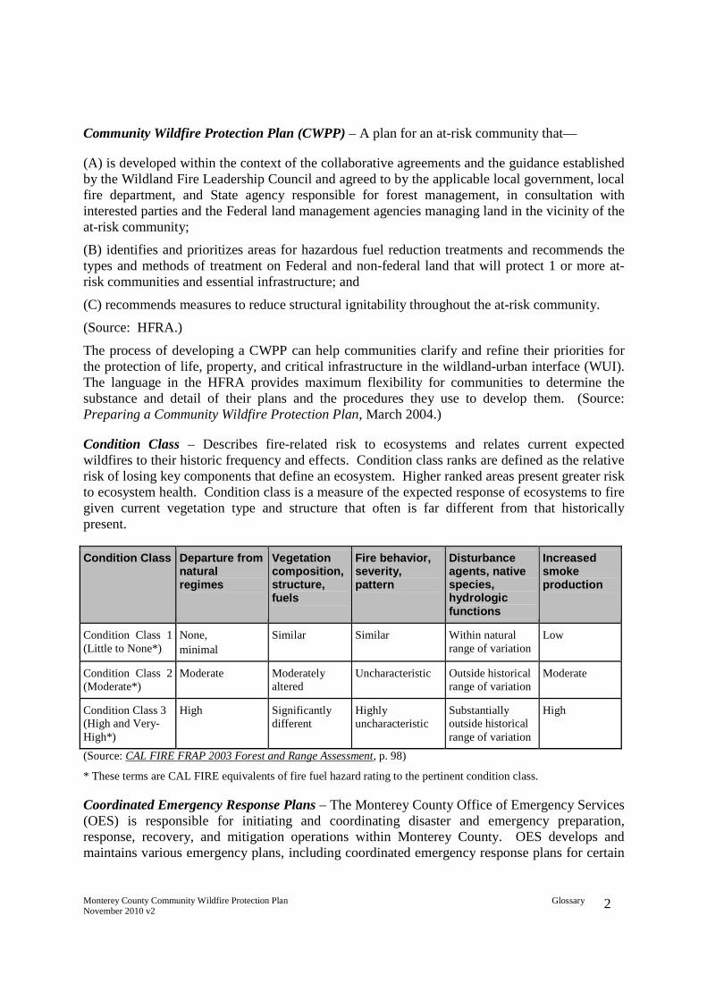
Monterey County Community Wildfire Protection Plan GlossaryNovember 2010 v2 2
Community Wildfire Protection Plan (CWPP) – A plan for an at-risk community that—
(A) is developed within the context of the collaborative agreements and the guidance establishedby the Wildland Fire Leadership Council and agreed to by the applicable local government, localfire department, and State agency responsible for forest management, in consultation withinterested parties and the Federal land management agencies managing land in the vicinity of theat-risk community;
(B) identifies and prioritizes areas for hazardous fuel reduction treatments and recommends thetypes and methods of treatment on Federal and non-federal land that will protect 1 or more at-risk communities and essential infrastructure; and
(C) recommends measures to reduce structural ignitability throughout the at-risk community.
(Source: HFRA.)
The process of developing a CWPP can help communities clarify and refine their priorities forthe protection of life, property, and critical infrastructure in the wildland-urban interface (WUI).The language in the HFRA provides maximum flexibility for communities to determine thesubstance and detail of their plans and the procedures they use to develop them. (Source:Preparing a Community Wildfire Protection Plan, March 2004.)
Condition Class – Describes fire-related risk to ecosystems and relates current expectedwildfires to their historic frequency and effects. Condition class ranks are defined as the relativerisk of losing key components that define an ecosystem. Higher ranked areas present greater riskto ecosystem health. Condition class is a measure of the expected response of ecosystems to firegiven current vegetation type and structure that often is far different from that historicallypresent.
Condition Class Departure fromnaturalregimes
Vegetationcomposition,structure,fuels
Fire behavior,severity,pattern
Disturbanceagents, nativespecies,hydrologicfunctions
Increasedsmokeproduction
Condition Class 1(Little to None*)
None,
minimal
Similar Similar Within naturalrange of variation
Low
Condition Class 2(Moderate*)
Moderate Moderatelyaltered
Uncharacteristic Outside historicalrange of variation
Moderate
Condition Class 3(High and Very-High*)
High Significantlydifferent
Highlyuncharacteristic
Substantiallyoutside historicalrange of variation
High
(Source: CAL FIRE FRAP 2003 Forest and Range Assessment, p. 98)
* These terms are CAL FIRE equivalents of fire fuel hazard rating to the pertinent condition class.
Coordinated Emergency Response Plans – The Monterey County Office of Emergency Services(OES) is responsible for initiating and coordinating disaster and emergency preparation,response, recovery, and mitigation operations within Monterey County. OES develops andmaintains various emergency plans, including coordinated emergency response plans for certain
Monterey County Community Wildfire Protection Plan GlossaryNovember 2010 v2 3
geographical threat areas (e.g., Big Sur). These plans are intended to enhance inter-jurisdictionalcoordination by maintaining agreements with local, state and federal agencies to providecoordinated emergency response.
Defensible Polygon – An area surrounded by firebreaks, fuelbreaks, shaded fuelbreaks or similarmeans of controlling the spread of fire, such that there is an increased probability that wildfiremay be stopped from passing in or out of the area, and danger to those working to control the fireis reduced.
Defensible Space – Defensibe Space includes the area within the perimeter of a parcel (orbeyond if permission is obtained from the adjacent landowner(s)) where basic wildfire protectionpractices are implemented, providing the key point of defense from an approaching wildfire orescaping structure fire. The area is characterized by the establishment and maintenance ofemergency vehicle access, emergency water reserves, street names and building identification,structure defense measures to reduce the likelihood of structure ignition, and fuel modificationmeasures. Defensible space intended to protect lives and property and to ensure the safety ofthose defending the area from wildfire. Defensible Space implies that tactical resources will beavailable to defend assets during a wildfire. (See the definition for "survivable space," below.)
Disaster – Disaster is characterized by the scope of an emergency. An emergency becomes adisaster when it exceeds the capability of the local resources to manage it. Disasters often resultin great damage, loss, or destruction. (Greene, R.W., Confronting Catastrophe, ESRI Press,2002, p. 110.)
Dudek – An environmental consulting firm headquartered in Encinitas, California.
Emergency – A situation that calls for immediate action to avoid serious harm to the publicpeace, health, safety, or general welfare. (California Government Code section 11342.545.)
Evacuation/Escape Route – A route away from dangerous areas of a fire; should be preplanned.(FIREWISE Communities, 2009, http://www.firewisewiki.org/main/index.php/Escape_Route.)
Federal land – means:
Land of the National Forest System (as defined in section 1609 (a) of [title 16 UnitedStates Code]) administered by the Secretary of Agriculture, acting through the Chiefof the Forest Service; and
Public lands (as defined in section 1702 of title 43), the surface of which isadministered by the Secretary of the Interior, acting through the Director of theBureau of Land Management.
(HFRA, Title 16 United States Code (USC) section 6502.)
Fire Authority Having Jurisdiction (FAHJ) – The organization, office, or individualresponsible for approving equipment, materials, an installation, or a procedure. (NFPA, NFPA1144, 2002, p. 4.)
Monterey County Community Wildfire Protection Plan GlossaryNovember 2010 v2 4
Fire Behavior – The manner in which a fire reacts to the influences of fuel, weather, andtopography. (FIREWISE Communities, 2009,http://www.firewisewiki.org/main/index.php/Fire_behavior.)
Fire Frequency – A broad measure of the rate of fire occurrence in a particular area. Forhistorical analyses, fire frequency is often expressed using the fire return interval calculation.(CDF FRAP 2003 Forest and Range Assessment, p. A-12.)
Fire Hazard – A fuel complex, defined by volume, type, condition, arrangement, and locationthat determine the degree of ease of ignition and of resistance to control. (FIREWISECommunities, 2009, http://www.firewisewiki.org/main/index.php/Fire_hazard.)
Fire Protection – All measures taken to reduce the burden of fire on the quality of life. Fireprotection includes, but is not limited to, fire prevention, fire suppression, built-in fire protectionsystems, and other such measures discussed in the planning and building codes. (NFPA, NFPA1141, 1998, p. 4.)
Fire Regime – A measure of the general pattern of fire frequency and severity typical to aparticular area or type of landscape. The regime can include other metrics of the fire, includingseasonality and typical fire size, as well as a measure of the pattern of variability incharacteristics. (CDF FRAP 2003 Forest and Range Assessment, p. A-12.)
Fire Threat – The combination of two factors: 1) fire frequency, or the likelihood of a given areaburning, and 2) potential fire behavior (hazard). Components include surface fuels, topography,fire history, and weather conditions. (Source: CDF FRAP 2003 Forest and Range Assessment, p.A-12, http://frap.cdf.ca.gov/assessment2003/.)
Fire Threat Assessment – Provides field verification of threat, including identification of:
Factors of fire behavior change
Fire behavior decision points
Fire severity alignment scenarios
Direction of fire spread
Tactical suppression thresholds of control
Fire history
Tactical fire suppression capacity
Determinations of fire threat are based upon anticipated fire flame length, rate of spread, fireintensity, fire front duration or residence time, and fire brand ember spotting distances under arange of weather scenarios.
Fire Weather – Weather conditions that influence fire starts, fire behavior or fire suppression.(FIREWISE Communities, 2009, http://www.firewisewiki.org/main/index.php/Fire_weather.)
Firebreak – A natural or constructed barrier used to stop or check fires that may occur, or toprovide a control line from which to work. (FIREWISE Communities, 2009,http://www.firewisewiki.org/main/index.php/Firebreak.) A firebreak is at least 10 feet wide,

Monterey County Community Wildfire Protection Plan Glossary November 2010 v2
5
frequently 20 to 30 feet wide, and contains no vegetation or other combustible matter. (The Use of Fuelbreaks in Landscape Fire Management, 1998, James K. Agee et al.)
Fuelbreak – A natural or manmade change in fuel characteristics which affects fire behavior so that fires burning into them can be more readily controlled. (National Wildfire Coordinating Group (NWCG), Glossary of Wildland Fire Terminology.)
Fuels – All combustible material within the WUI or intermix, including vegetation and structures. (FIREWISE Communities, 2009, http://www.firewisewiki.org/main/index.php/Fuels.)
Fuel Loading – The volume of fuel in a given area generally expressed in tons per acre. (FIREWISE Communities, 2009, http://www.firewisewiki.org/main/index.php/Fuel_loading.)
Fuel Models – Description of the types of vegetative combustible material, for example:
• Light Fuels – grasses, forbs • Medium Fuels – short light brush and small trees • Heavy Fuels – tall dense brush, timber and hardwoods • Slash Fuels – logs, chunks, bark, branches, stumps, and broken understory trees and
brush.
Fuel Modification – Any manipulation or removal of fuels to reduce fire intensity, rate of spread, and/or the likelihood of ignition or the resistance to fire control. (FIREWISE Communities, 2009, http://www.firewisewiki.org/main/index.php/Fuel_modification.)
Fuel Reduction Buffer Zone – The term refers to the Strategic Placement of Treatments (SPOTS) within the Mitigation Zone or the Threat Zone. This zone is an area where a younger age class (or earlier seral class) is maintained in a strategic location to reduce the risk of fire spread to adjacent lands, such as residential areas.
Geographic Information Systems (GIS) – The combination of skilled persons, spatial and descriptive data, analytic methods, and computer software and hardware – all organized to automate, manage, and deliver information though geographic presentation (i.e., maps). (Zeiler, M., Modeling Our World, ESRI Press, 1999, p. 46.)
Ground Fuels – All combustible materials such as grass, duff, loose surface litter, tree or shrub roots, rotting wood, leaves, peat or sawdust that typically support combustion. (FIREWISE Communities, 2009, http://www.firewisewiki.org/main/index.php/Ground_fuels.)
Hazard – Refers generally to physical characteristics that may cause an emergency. Earthquake faults, flood zones, and highly flammable brush fields are all examples of hazards. (Greene, R.W., Confronting Catastrophe, ESRI Press, 2002, p. 110.) Also see Fire Hazard.

Monterey County Community Wildfire Protection Plan GlossaryNovember 2010 v2 6
Hazardous Fuel – Combustible material that accumulates in the forest or other wildlands and isconcentrated on the ground surface as surface fuel or just above the ground surface as ladderfuel, or in the tree canopy as crown fuel.
Hazardous Fuel Reduction Zone (HFRZ) – An area designated by the FAHJ, based upon theFAHJ's experience and knowledge, as containing hazardous fuel that presents a potential threatto lives, communities, structures, infrastructure, access roads, and/or watersheds in the event ofwildfire. HFRZs may also include areas where fuelbreaks, firebreaks and other treatments maybe needed to protect such areas from wildfires originating outside the area. HFRZs may vary insize, and are independent from, though may include, Defensible Space, Mitigation Zones andThreat Zones.
Hazardous Vegetation Overgrowth –Vegetation growth that, in the judgment of the FAHJ,exceeds the vegetation density that would exist in the area had fire suppression not beenpracticed or had proper fuels mitigation measures been accomplished, which in the judgment ofthe FAHJ, presents a threat of increased probability of ignition or high intensity wildfire.
Healthy Forests Restoration Act of 2003 (HFRA) – Gives incentives for communities to engagein comprehensive forest planning and prioritization. This legislation includes statutoryincentives for the USFS and the BLM to give consideration to the priorities of local communitiesas they develop and implement forest management and hazardous fuel reduction priorities. TheAct emphasizes the need for federal agencies to work collaboratively with communities indeveloping hazardous fuel reduction projects, and it places priority on treatment areas identifiedby communities themselves in a CWPP. (Source: Preparing a Community Wildfire ProtectionPlan. March, 2004.)
Hydrophobic – Repels water, as with soils that repel water after a high heat intensity wildfire. Athin layer of soil at or below the mineral soil surface can become hydrophobic after intenseheating. The hydrophobic layer is the result of a waxy substance that is derived from plantmaterial burned during a hot fire. This waxy substance penetrates the soil as a gas and solidifiesafter cooling, forming a waxy coating around soil particles. The layer appears similar to non-hydrophobic layers. (After the Fires: Hydrophobic Soils, Randy Brookes, University of IdahoCooperative Extension Series, http://www.cnr.uidaho.edu/extforest/F5.pdf.)
Intermix – An area where improved property and wildland fuels meet with no clearly definedboundary. (NFPA, NFPA 1144, 2002, p. 5.)
Ladder Fuels – Fuels that provide vertical continuity allowing fire to carry from surface fuelsinto the crowns of trees or shrubs with relative ease. (FIREWISE Communities, 2009,http://www.firewisewiki.org/main/index.php/Ladder_fuels.)
Mitigation – Action that moderates the severity of a fire or risk. (NFPA, NFPA 1144, 2002, p.5.)
Mitigation Zone – Mitigation Zones are strategically prioritized target areas within the ThreatZone where fire fuel reduction activity will be of high value to protect life, property, and theenvironment, and to support safe tactical suppression capability.
Monterey County Community Wildfire Protection Plan GlossaryNovember 2010 v2 7
National Fire Protection Association (NFPA) – An international nonprofit organization,established in 1896, to reduce the worldwide burden of fire and other hazards on the quality oflife by providing and advocating consensus codes and standards, research, training, andeducation. (NFPA, 2009,http://www.nfpa.org/categoryList.asp?categoryID=143&URL=About%20Us.)
NFPA-1144 Standard for Protection of Life and Property from Wildfire (NFPA 1144) –Standard developed by the NFPA to be used to provide minimum planning, construction,maintenance, education, and management elements for the protection of life, property, and othervalues that could be threatened by wildland fire. The standard shall be used to provide minimumrequirements to parties responsible for fire protection, land use planning, property development,property maintenance, and others responsible for or interested in improving fire and life safety inareas where wildland fire could threaten lives, property, and other values. (NFPA, NFPA 1144,2002, p. 4.)
Nitrogen Fixer – Plants whose roots are colonized by certain bacteria that extract nitrogen fromthe air and convert or "fix" it into a form required for their growth. When the bacteria are donewith this nitrogen, it becomes available to the plant itself. An example of a nitrogen fixer isclover. (http://landscaping.about.com/cs/lazylandscaping/g/nitrogenfixer.htm.)
Noncombustible – Any material that, in the form in which it is used and under the conditionsanticipated will not ignite and burn, nor will add appreciable heat to an ambient fire. (NFPA,NFPA 1144, 2002, p. 5.)
Overstory – That portion of the trees in a forest that forms the upper or uppermost layer.(FIREWISE Communities, 2009, http://www.firewisewiki.org/main/index.php/Overstory.)
Risk – The potential or likelihood of an emergency to occur. For example, the risk of damage toa structure from wildfire is high if it is built upon, or adjacent to, a highly flammable brush fieldor other area deemed to have a high fire threat. (Greene, R.W., Confronting Catastrophe, ESRIPress, 2002, p. 110.)
Safety Zone – An area cleared of flammable materials used for escape in the event the line isoutflanked or in case a spot fire causes fuels outside the control line to render the line unsafe. Infiring operations, crews progress so as to maintain a Safety Zone close at hand allowing the fuelsinside the control line to be consumed before going ahead. Safety Zones may also beconstructed as integral parts of fuelbreaks; they are greatly enlarged areas which can be usedwith relative safety by firefighters and their equipment in the event of blowup in the vicinity.(National Wildfire Coordinating Group, 2009, http://www.nwcg.gov/pms/pubs/glossary/s.htm.)
Shaded Fuelbreak – A reduction in vegetation created by altering surface fuels, increasing theheight to the base of the live crown, and opening the canopy by removing trees. This type offuelbreak spans a wide range of understory and overstory prescriptions and methods of creationthrough manual, mechanical, and prescribed fire means. (The Use of Fuelbreaks in LandscapeFire Management, 1998, James K. Agee et al.)
Monterey County Community Wildfire Protection Plan GlossaryNovember 2010 v2 8
Slope – The variation of terrain from the horizontal; the number of feet rise or fall per 100 feetmeasured horizontally, expressed as a percentage (FIREWISE Communities, 2009,http://www.firewisewiki.org/main/index.php/Slope). Upward or downward incline or slant(NFPA, NFPA 1144, 2002, p. 5).
State Responsibility Area (SRA) – The area "in which the financial responsibility of preventingand suppressing fires is primarily the responsibility of the state" (PRC section 4125). This isfurther expanded in PRC sections 4125-4128.136
Strategically Placed Landscape Area Treatments (SPLATS) – Areas of forest thinning designedto slow the spread of fire. They are placed on the landscape so that a spreading fire does nothave a clear path of untreated fuels from the bottom of the slope to the ridge top. These are to bedesigned to burn at lower intensities and slower rates of spread during wildfires than comparableuntreated areas. In the example of a large parking lot with speed bumps, the SPLATs are thespeed bumps that slow down fires. (University of California Sierra Nevada AdaptiveManagement Project http://snamp.cnr.berkeley.edu/about/snamp-glossary/.)
Strategic Fuelbreak – See the definition for "fuelbreak," above.
Strategic Placement of Treatments (SPOTS) – See the definition for "strategically placelandscape area treatments," above. SPLATS and SPOTS are synonymous, although SPOTS isnewer and may be the preferred term.
Surface Fuels – Surface fuels include understory plants generally less than 6 feet tall (dead andalive), the litter layer, downed woody materials, and often brush and midstory tree and shrubfuels. Surface fuel availability for consumption is determined by moisture content, particle size,horizontal continuity, compactness, and fuel type (particularly fuels with high volatilecompounds).
Survivable Space – Survivable Space includes structure defense measures to reduce thelikelihood of structure ignition and the area around a structure where vegetation has beenmodified to provide a high likelihood, under the site's conditions (e.g., vegetation type,construction materials and terrain), that the structure (and people if present) will survive in theevent of a wildfire, under extraordinarily adverse weather conditions, without the presence offirefighters or others defending the structure. Survivable space applies where there is potentialthat tactical resources will not be available to defend assets during a wildfire. (See the definitionfor "defensible space," above.)
Threat Zone – Threat Zones extend out from Defensible/Survivable Space to majorlandscape/watershed features such as roads, rivers, or ridges. Threat Zones generally extend tothe boundary of the WUI, and may include strategic firebreaks and fuelbreaks placed incoordination with major watershed features, and with the Mitigation Zones and DefensibleSpace, creating anchor points for wildfire suppression.
136 Also see, http://frap.cdf.ca.gov/projects/population/sra_definition.html
Monterey County Community Wildfire Protection Plan GlossaryNovember 2010 v2 9
Understory – Low growing vegetation (herbaceous, brush or reproduction) growing under astand of trees. The term also includes that portion of trees in a forest stand below the overstory.(FIREWISE Communities, 2009, http://www.firewisewiki.org/main/index.php/Understory.)
Water Supply – A source of water for firefighting activities or other purposes. (NFPA, NFPA1144, 2002, p. 5.)
Wildfire – Any unplanned fire occurring in a wildland or wildland-urban interface area that doesnot meet management objectives and thus requires a suppression response. Wildland fireprotection agencies use this term generally to indicate a vegetation fire. Wildfire often replacessuch terms as forest fire, brush fire, range fire, and grass fire.
Wildland – A region with minimal development as evidenced by few structures; transportationnetworks may traverse region. Region typically contains natural vegetation and may be used forrecreational or agricultural purposes. (CDF FRAP 2003 Forest and Range Assessment, p. A-17.)
Wildland-Urban Interface (WUI) – For purposes of this MCCWPP, WUI shall mean those areasdesignated on the map in Appendix B-7, unless the local CWPP designates different areas asWUI, in which case the local CWPP shall prevail. In the absence of such mapping, section 101(16) of the HFRA defines WUI as "(I) an area extending ½ mile from the boundary of an at-riskcommunity; (II) an area within 1 ½ miles of the boundary of an at-risk community, including anyland that (1) has a sustained steep slope that creates the potential for wildfire behaviorendangering the at-risk community; (2) has a geographic feature that aids in creating an effectivefire break, such as a road or ridge top; or (3) is in condition class 3, as documented by theSecretary in the project-specific environmental analysis; (III) an area that is adjacent to anevacuation route for an at-risk community that the Secretary determines, in cooperation with theat-risk community, requires hazardous fuels reduction to provide safer evacuation from the at-risk community." A CWPP offers the opportunity to establish a localized definition andboundary for the wildland-urban interface (HFRA, 16 USC 6511(16); Preparing a CommunityWildfire Protection Plan, 2004.)

Monterey County Community Wildfire Protection PlanNovember 2010 v2
APPENDIX B
Monterey County Maps

Monterey County Community Wildfire Protection PlanNovember 2010 v2

Monterey County Community Wildfire Protection PlanNovember 2010 v2

Monterey County Community Wildfire Protection PlanNovember 2010 v2

Monterey County Community Wildfire Protection PlanNovember 2010 v2
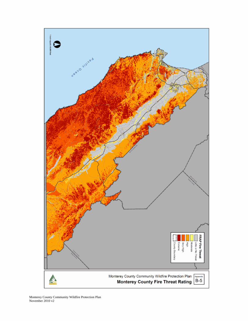
Monterey County Community Wildfire Protection PlanNovember 2010 v2

Monterey County Community Wildfire Protection PlanNovember 2010 v2

Monterey County Community Wildfire Protection Plan November 2010 v2

Monterey County Community Wildfire Protection PlanNovember 2010 v2
Monterey County Community Wildfire Protection PlanNovember 2010 v2
APPENDIX C
Ready, Set, Go!

May 14, 2009
Ready, Set,
Go!
Our vision for the future is that ...
Communities situated in high fire hazard environments are designed,
constructed, retrofitted, managed, and maintained in a manner that may
require little fire suppression assistance during wildfires. Residents these
communities take personal responsibility for living in the Wildland Urban
interface (WUI), possess the knowledge and skills to effectively prepare their
home for survival when wildfire is threatening, evacuate early and safely
when ordered, and if trapped, practice learned skills to survive the wildfire.

Table of Contents
Introduction……………………………………………………………………………………. 1
Background/Problem Statement………………………………………………………….… 2
Program Goals……………………………………………………………………………….. 3
Factors for Success………………………………………………………………………..… 3
Preparation of Structures……………………………………………………………………. 5
Human Understanding and Decision Making ..............................................................6
Contingency Planning ................................................................................................6
Recommended Actions and Desired Results ..............................................................7
Links and Resources .....................................................................................................8

1
Introduction
"Changing climate and drought conditions, the build-up of hazardous fuels, and morehomes in fire-prone landscapes are changing how we experience wildfire in America."International Association of Fire Chiefs, Wildland Fire Policy Committee, 2009.
Local government, like its State and Federal widland fire agency partners, have seen adramatic increase in the severity, risks to life, property and the environment and costsassociated with wildland fires over the past decade.
The Ready, Set, Go program is not an original message, it is a new approach atpackaging existing public education to gain active public involvement toward reducinglife and property loss associated with wildland fires. The program is presented in threesteps:
1. READY - Prepare yourself, your family and your property.2. SET - Monitor fire weather I activity and prepare to evacuate.3. GO - Leave early when directed to by public safety officials.
A subsequent step is included to educate people how to survive, if trapped by a wildfire.
The Ready, Set, Go program is a collaborative process that is effective in improvingcoordination and communication between emergency response agencies and thecommunity. Spending an adequate amount of time developing the Ready, Set, Goprogram in each community can help clarify and refine priorities to protect life, property,infrastructure, and valued resources.
The Ready, Set, Go program is organized in seven sections:
1. Background / Problem Statement2. Program Goals3. Factors for Success4. Preparation of Structures and People5. Human Understanding and Decision Making6. Contingency Planning7. Recommended Actions and Desired Results
Fire resources are maximized during major fire incidents, particularly during the initialattack, and the public must become part of the overall strategy provide communitysafety. This program is just one option to explore and it can be customized to work inany community as no one program will work everywhere.

2
1. Background I Problem Statement
The problem is that there is a higher frequency of wildfires occurring and weatherprojections indicate this trend is not changing soon. Research is showing that climatechange is a major contributing factor. Weather combined with the ever growing fuelsmanagement issues; indicate that wildland fires will be part of our future.
The problem is that fires can be more costly to everyone in the Wildland Urban Interface(WUI) or the areas where homes are intermixed within forests and wildlands. Anincreasing number of homes are at risk from wildfire as residential developmentcontinues to encroach on forest and wildland areas.
The problem is that no two wildfires behave in the same manner and, during the pastdecade, these wildfires are acting more erratically and the deaths and property lossesare escalating. The residents who choose to stay or get trapped also cause a safetyissue for public safety officials who, with already limited resources, must now try toeffect rescues during these wildfires.
Historically, the fire service has conducted public education efforts to try to get thepublic's support in reducing fire losses. This effort began with the Smokey Bearadvertising campaign to prevent wildfires. Now the focus is on getting communities tobecome fire-ready. There are several national and local programs that teach thesetenets to create Fire Adaptive Communities. The problem is how to get the publiceducation message listened to and turned into action by the public.
The fire problem within the WUI areas consists of two primary fuel types:accumulation of natural and exotic vegetation and the structures and ornamentallandscaping that people create. Natural vegetation reduction or management is a long-term process that is becoming more difficult due to climate change and environmentalconditions. This effort must continue to help restore our ecosystem and reduce firesize.
The structure fuel component is created as the population increases within traditionalrural areas of the country. This structure fuel type is now greatly escalating the overallcost of wildland fires, both in terms of the fire suppression costs and property loss. Newbuilding codes and planning conditions are proving themselves to be effective atcombating losses in new developments-but the existing structures in the WUI remainthe biggest threat and the largest mitigation yield. Our greatest opportunity to reduce theimpacts of wildfire lies in the implementation of "pre-fire activities", i.e., actions that takeplace before a wildfire occurs that improve the survivability of people and their homes.These actions on structural fuels are usually more permanent in nature than therecurring efforts required on natural fuels.
The problem is people tend to have the expectation that, when they call 911, they willget a response to fit their needs. With an increase in population that has not had acorresponding public safety service increase; fire managers may not be able torealistically meet those public expectations. The public must take personal responsibility
3
for the specific hazards associated within their choice of habitation. Government mustalso fund public services commensurate with growth.
Over time, there is a growing problem with the number of residents that defy evacuationorders. Some of these residents are successful in staying and defending their property,but have limited training or experience and have based their actions on past wildfireexperiences. Some people who have stayed died in the face of a rapidly moving anddestructive wildfire.
Evacuations are a local issue, based upon many factors (incident type, activity, numberof people affected, fire preparedness level, road system, transportation system,relocation centers, available resources to implement plan, etc.), therefore evacuationalternatives must be determined locally. Fire and law enforcement incident commandersmust evaluate all contributing factors when creating evacuation plans to achieve thehighest level of public safety while balancing the challenges of a dynamic incident.
The problem is that there needs to be adequate evacuation resources, uniform andconsistent evacuation terminology (refer to FIRESCOPE 2007 Field Operation Guide420-1), model practices, notification ability and re-entry procedures so residents can re-enter as early and safely as possible.
2. Program Goals
A. Protect life and property by creating and maintaining Fire Adaptive Communities.B. Improve evacuation procedures.C. Improve firefighter and public safety.D. Encourage personal responsibility toward the overall solution.E. Acceptance of the strategy to: Prepare your property and yourselfF. leave early, follow evacuation orders and survive.
3. Factors for Success
Fire agencies have been providing public education messages for many years, so onemight ask; "Why is Ready, Set, Go different from past efforts?" The following factors willbe instrumental in gaining program effectiveness:
Collaboration between the public, government and neighbors. In 1997, FEMAestablished Project Impact to help communities reduce their disaster tolls by buildingpartnerships among businesses, agencies, churches, neighborhoods and others. Thiseffort showed that amazing things can happen when working in close partnerships withone another by making long-term changes in their disaster profiles. Project Impactidentified common issues that communities face when dealing with tornados andhurricanes with the thought that, if they modify key factors that contribute tosafety/damage, then the community would be better off when the next disaster occurs.Project Impact sought to change that culture to make hazard mitigation an integral partof the community and the people's lives.
Use of science - Home Ignition Zone research. Traditional beliefs that homes were
4
ignited by the flaming fire front are being disproved by scientific research studies. JackCohen (USFS Researcher) has done several field tests to determine how homes can beignited and the results indicate that ember intrusion is the primary cause of homeignitions.
Target audience identification. Each fire agency must recognize their target audience towhom they intend to reach out to. This includes understanding the social, economic anddemographic nature of these communities. Example, a rural community (intermix) maybe more self sufficient than an urban home subdivision (interface) and thecommunication message needs to fit the character of the community so the targetaudience can readily relate. This applies to printed materials and visual graphics onvideos. Fire agencies should also review the national public survey on how the publicreceives our current messages (PIFE study, 2008).
Recognition that government cannot be the answer all the time. The CommunityEmergency Response Team (CERT) training began as an offshoot of earthquakepreparedness training. During a major earthquake, studies found that the limitedemergency resources would be prioritized to critical infrastructure targets. Thisrecognition of priorities also found that the CERT program would focus on neighborhelping neighbor and that the population needs to accept personal responsibility fortheir own preparedness and actions. It meant-that residents had to accept the premiseof: If you choose to live in a hazard area, then you must become more self-sufficient.
Recognizing Long-Lasting Change Takes Time. The emotions-following a disaster areusually short-lived, recognizing this is paramount in allowing change agents to takeadvantage of this opportunity. Change management requires opportunities,perseverance and focus on the goal. One must be committed to the change beingimplemented, not be deterred easily and recognize that true change occurs over time,not immediately. Commitment builds trust among participants.
Setting Priorities. Stakeholders (public, fire agencies, law enforcement, media, disasterrelief organizations, utility companies and local government) may have a limited budgetand time commitment toward achieving the entire program tenets. Therefore, throughlocal discussions, these stakeholders should reach consensus on their specific programpriorities that will benefit their community. A phased-in program is better than noprogram at all.
Leave Early and Early Return. The public generally trusts public safety officials becauseof their training and experience. They should accept evacuation orders and leave early,but be ready for an early return if possible. Public safety officials will need to have re-entry plans developed as evacuation orders are issued, but they must assure thepublic's safety before re-entry is directed.
Understanding that no programs can be universally applied and there are clear,understandable messages. Public officials must issue direction based upon the generalpopulation. Specific direction and modifications can occur, but only when there are clearcommunications with the affected populace, usually in small groups with effective two-

5
way communications.
Creating Public Education Tools to Reach the Masses. There needs to be a variety ofmedia tools to conduct outreach for the overall goals. Community group meetings willonly obtain a small percentage of residents. We must understand the needs of oururban, suburban and rural communities and develop a variety of tools and methods toreach into each residence. It's usually not the strategy or principles that fail; it's the buy-in and action of the targeted stakeholders.
Focus on our Saves and not the Losses. After every emergency incident, the mediacarries the story of how many lives and property were lost because these are tangiblenumbers. What's harder to quantify are the number of homes and lives saved. Publicofficials need to identify these numbers and communicate this message better.
4. Preparation of Structures and People
In the Institute for Business and Home Safety (lBHS) Mega Fire Report (2008) followingthe Witch fire in San Diego, California, they reported the key to protecting lives andreducing property losses begins with hardening structures. Hardening structuresfocuses on new construction and/or retrofitting existing structures to modern buildingcodes that recognize the wildland fire threat and .the installation of home fire sprinklers.Studies have shown that most structures within the wildland are not destroyed fromdirect flame impingement, but rather from the ember environment. Embers may precedethe flaming fire-front, carried by the winds and distributing burning brands or embersover long distances. These embers fall, or are wind driven into receptive fuels atstructures, often going undetected for some time. As the fire front passes, these-small-embers may ignite incipient fires that spread to the home and then from home to homein a neighborhood. Key retrofits include fire-safe roofs and vent rescreening to 1/8 inchmesh or approved vents.
In new developments, updated fire and building codes are addressing proper homelocations and construction types. Older, existing residences need to make retrofits toimprove-the structure's survivability. These actions need to include defensible spaceareas, water supply, access, identification and ornamental landscaping. There are alsomaintenance issues involved in living within the WUI. Residents should reduce theability of embers to start small fires by cleaning leaves, pine needles, twigs andbranches off roofs and rain gutters.
They should also remove combustibles near the structure like firewood stacked by thehouse, patio furniture, attached wood fences and ornamental landscaping.
People need to mentally prepare themselves to handle the stress of a wildfire. Theyneed to create situational awareness of wildfires by understanding what the fireenvironment is like. Then they need to create their own Wildfire Action Plan with achecklist to enhance their preparedness status.

6
5. Human Understanding and Reaction
Researchers indicate that it takes a significant amount of mental preparation byhomeowners to not panic and flee when flames are licking at their doors. "The noisealone of a wildfire front is phenomenal. Then the sun goes away, and the sky goes darkin the middle of the day. It's haunting and the people need to understand that beforethey ever think about staying."(http://news.ucanr.orginewsstorymain.cfm?story=1180)
Ready, Set, Go is a program that tries to provide real-life wildfire situational awarenessfor the public. Fire agencies will instruct what it's like before, during and after a firestormfrom a firefighter's perspective. The public will learn that even experienced firefightersnever treat one fire like the next as fire, fuel and weather conditions constantly change,making every fire different. Hopefully, the public will learn from the firefighter'sexperience and when a trusted public safety official issues evacuation orders, the publicwill leave early so they don't become trapped.
Studies have shown that people who are taught about certain tactics and train onexercising those tactics have a higher level of repeating those skills as a reaction, notdecision making during adverse conditions, based upon training and experience. Thefire service cannot readily expect that the public with only limited training will act andmake decisions as trained firefighters do during a firestorm condition. The "fight or flight"syndrome occurs during these times and may manifest itself as panic or irrationalbehavior. This is why this program focuses on the reaction to: LEAVE EARLY!
6. Contingency Planning (how to survive, if trapped)
Everyone who lives within a WUI area should have a contingency plan developedbefore a fire starts in case they can't, or are prevented, from evacuating. Fire serviceofficials do not endorse anyone defying an evacuation order, but they realize somepeople may get trapped and should have basic survival skills. These skills are basedupon public education information that provides the resident with some situationalawareness, proper actions to take before, during and after a fire.
Some residents have experienced a wildfire and may have the expectation that one firebehaves like another. This false assumption can lead to complacency and reducepreparedness. Just as experienced firefighters know that every fire behaves differently,residents must be educated on fire behavior to understand its complexity and danger.

7
7. Recommended Actions and Desired Results
This program is just one option for a local government or fire agency to consideradopting. It is a generic baseline public education program that can be modified to fit acommunity's needs and desires. There also needs to be collaboration betweenstakeholder groups involved; public, law enforcement, media, disaster relieforganizations, utility companies, government officials and the fire service.
Program implementation tools and processes include:
A. Conduct regional community meetings to provide an overview of the wildland fireproblem and the basic tenets of Ready, Set, Go. An overview video message and theWildfire Action Plan are available as educational resources. The program should beintroduced by high ranking fire officials and public education specialists.
B. The next step is to begin to reach the masses by mailing Wildfire Action Plans totargeted groups and conducting small focus groups via CERT, FIREWISE groups, FireSafe Councils, Community Wildfire Prevention Programs (CWPP), etc. These smallgroup meetings are best instructed by the local fire company who has ties to thesegroups. The public relies on these firefighters every day and trust what they say. Thesefirefighters are also the ones who can modify and/or provide specific information tothese residents based on local conditions. A video message is available that shows thehands-on actions homeowners must take to implement the Ready, Set, Go program at theirown home.
C. The public education program needs to have commitment of all stakeholder groupswithin the same media market, so there is a consistent message being transmitted to thepublic. This is not a one-time public education campaign. To be successful, it needs tobe an on-going effort to reach residents who continue to relocate into WUI areas andmay not have any experience with wildfires. The printed Wildfire Action Plans and videomessages were designed as a more passive method to reach the masses and can bemailed or posted on fire agency Web sites.
Remember - There's only one action when ordered to evacuate -"LEAVE"-

8
Links and Resources
General Resources
California Fire Alliance-CWPP Resources: http://cafirealiiance.org/cwpp
Firewise website: http://firewise.org
Key Public Opinion Research Findings on the Ecological Role of Fire and the Benefits of FireManagement, Partners in Fire Education (PI FE) study, 2008
The Healthy Forests Initiative and Healthy Forests Restoration Act:
http://www.fsJed.us/projects/hfi/field-guide/web/page15.php
International Association of Fire Chief's Leader's Guide for Developing a Community Wildfire
Protection Plan: http://www.iafc.orgiassociations/4685/files/CWPP_rev062005.pdf
National Database of State and Local Wildfire Mitigation Programs, a source for information onordinances: http://ww.wildfireprograms.usda.govTribal Wildfire Resource Guide (2006), Intertribal Timber Council:http://www.itcnet.org/issues_projects/issues/forest_managementlreports.html
Nevada's "Living with Fire" program
BLM Partnership Web Site: http://www.blm.gov/partnerships/tools.htm
Western Collaborative Assistance Network: http://westcanhelp.org/
Forest Service Partnership Resource Center:
http://www. partnershipresourcecenter .org/index.shtml
FIRESCOPE 2007 Field Operations Guide ICS 420-1, Chapter 20 "Protection Action Guidelines) Project Impact 1997, FEMA Rural Voices for Conservation Coalition (Collaboration issue paper):
http://www.sustainablenorthwest.org/quick-links/resources/rvcc-issue-papers Strategies for assisting low-income and underserved communities develop and implement
CWPPs: http://ri.uoregon.edu/programs/CCE/communityfireplanning.html
Reducing Structural ignitability
Australian Safe in Place Information:http://www.rfs.nsw.gov.au/dsp_content.cfm?CAT _ID=202 andhttp://www.rfs.nsw.gov.au/dsp_content.dm?caUd=515
California Ignition-Resistant Building and Fire Codes:
http://www.fire.ca.gov/fire_prevention/fire_prevention_wildland_codes.php
Firewise Guide to Landscape and Construction, booklet:https://www.cmsassociates.comifirewise.nsflavcatalog?open
Wildfire! Preventing Home Ignitions DVD, explains the research of Jack Cohen, USDA ForestService, on how homes ignite and how to minimize potential for ignition:https://www.cmsassociates.com/firewise.nsf/avcatalog?open
Reducing Structural Ignitability: Articles and Publications
Cohen, Jack. Structural Vulnerability and the Home Ignition Zone: The key to preventing
residential fire disasters during extreme wildfire, letter from Jack Cohen to Douglas McDonald,
Feb. 4, 2008
Cohen J. 2001. Wildland-urban fire-a different approach. In:
Proceedings of the Firefighter Safety Summit, Nov. 6-8, 2001, Missoula, MT. Fairfax, VA:
International Association of Wildland Fire & other articles by Jack Cohen:
http://www.nps.gov/fire/public/pub_publications.cfm.
Institute for Business & Home Safety, (IBHS) 2008 Mega Fires - Witch Fire Study

9
ICC, International Wildland-Urban Interface Code 2006, International Code Council, CountryClub Hills, IL, 2006
NFPA 1141, Standard for Fire Protection Infrastructure for Land Development in Suburban and
Rural Areas, 2008 edition, National Fire Protection Association, Quincy, MA, 2007
NFPA 1144, Standard for Reducing Structural Ignitions from Wildland Fire, 2008 edition,
National Fire Protection Association, Quincy, MA, 2007
Fuels Reduction and Restoration Resources
The National Association of State Foresters Field Guidance for Identifying and PrioritizingCommunities at Risk:http://www.stateforesters.org/reports/COMMUNITIESATRISKFG.pdf
Management Tools for CWPP Implementation: Stewardship Contracting and Biomass Utilization
http://ri.uoregon.edu/programs/CCE/communityfireplanning.html
Woody Biomass Utilization Desk Guide:
http://www.forestsandrangelands.gov/Woody_Biomass/documents/biomass_deskguide.pdf USDA Forest Service Stewardship Contracting Resource page:
http://www.fs.fed.us/forestmanagementiprojects/stewardship/index.shtml
Monitoring and Evaluation Resources
Community Wildfire Protection Plan Monitoring and Evaluation Guide:
http://ri.uoregon.edu/programs/CCE/communityfireplanning.html
Public Response to Wildfire: Is the Australian "Stay and Defend or Leave Early" Approach an
Option for Wildfire Management in the United States, 2008, Sarah M. McCaffrey and Alan
Rhodes
Multiparty Monitoring Resources:
Rural Voices for Conservation Coalition-Multiparty Monitoring Issue Paper:
http://ri.uoregon.edu/programs/CCE/communityfireplanning.html
USDA Forest Service Collaborative Restoration Program-Multiparty Monitoring Guidelines:
http://www.fs.fed.us/r3/spf/cfrp/monitoring/index.shtml
Red Lodge Clearinghouse: http://www.redlodgeciearinghouse.org/resources/handbook full.htm
Monterey County Community Wildfire Protection PlanNovember 2010 v2
APPENDIX D
Recommended Fuel Reduction Projects

Monterey County Community Wildfire Protection PlanNovember 201 v20
APPENDIX D – Recommended Hazardous Fuel Reduction Projects
NOTE: This table may be updated by the MFSC without approval from the signatories to thisMCCWPP.
At-RiskCommunity orArea
Project/Treatment
Agency/Landowner
Funding Needs Time Table Community
Recommendation
2009
Aguajito/Jack's Peak
Residentialchipping program
Private Agency budget Annually Yes
Aromas Residentialchipping program
Private Agency budgets Annually Yes
Big Sur Partington Ridgehazard fuelremoval
Private Grant funding 2009 Yes
Big Sur Big Sur FuelReduction
Private Grant funding 2009 Yes
Cachagua Tularcitos RidgeStrategicFuelbreak; RxFire Treatments
Private Private/Grantfunding
2009 Yes
Carmel Highlands ResidentialChipper Program
Private Agency budget Annually Yes
Carmel Highlands Empty LotProgram
Private Grant funding 2009 Yes
Carmel Valley Rancho TierraGrande chipping
Private Grant funding 2009 Yes
Corral de Tierra Fort Ord fuelreduction,mowing
BLM Agency budget 2009 Yes
County wide ResidentialChipper Program
CAL FIRE Grant funding 2009 Yes
Del Rey Oaks Henneken Roadfuelbreak
BLM Agency budget 2009 Yes
Del Rey Oaks Manzanita Roadfuelbreak
BLM Agency budget 2009 Yes
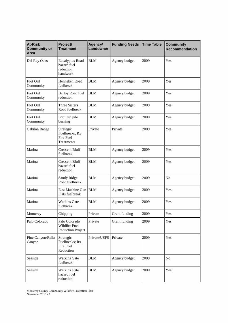
Monterey County Community Wildfire Protection PlanNovember 2010 v2
At-RiskCommunity orArea
Project/Treatment
Agency/Landowner
Funding Needs Time Table Community
Recommendation
Del Rey Oaks Eucalyptus Roadhazard fuelreduction,handwork
BLM Agency budget 2009 Yes
Fort OrdCommunity
Henneken Roadfuelbreak
BLM Agency budget 2009 Yes
Fort OrdCommunity
Barloy Road fuelreduction
BLM Agency budget 2009 Yes
Fort OrdCommunity
Three SistersRoad fuelbreak
BLM Agency budget 2009 Yes
Fort OrdCommunity
Fort Ord pileburning
BLM Agency budget 2009 Yes
Gabilan Range StrategicFuelbreaks; RxFire FuelTreatments
Private Private 2009 Yes
Marina Crescent Blufffuelbreak
BLM Agency budget 2009 Yes
Marina Crescent Bluffhazard fuelreduction
BLM Agency budget 2009 Yes
Marina Sandy RidgeRoad fuelbreak
BLM Agency budget 2009 No
Marina East Machine GunFlats fuelbreak
BLM Agency budget 2009 Yes
Marina Watkins Gatefuelbreak
BLM Agency budget 2009 Yes
Monterey Chipping Private Grant funding 2009 Yes
Palo Colorado Palo ColoradoWildfire FuelReduction Project
Private Grant funding 2009 Yes
Pine Canyon/RelizCanyon
StrategicFuelbreaks; RxFire FuelReduction
Private/USFS Private 2009 Yes
Seaside Watkins Gatefuelbreak
BLM Agency budget 2009 No
Seaside Watkins Gatehazard fuelreduction,
BLM Agency budget 2009 Yes

Monterey County Community Wildfire Protection PlanNovember 2010 v2
At-RiskCommunity orArea
Project/Treatment
Agency/Landowner
Funding Needs Time Table Community
Recommendation
handwork
Seaside Sheep grazing BLM Agency budget 2009 Yes
Sierra de Salinas StrategicFuelbreaks; RxFire FuelReduction
Private/BLM Private 2009 Yes
Toro Park Estates Fuelbreak Private Grant funding 2009 Yes
Toro Park Estates Creekside Condohazard fuelreduction
BLM Agency budget 2009 Yes
Toro County Park Recreation Siteshazard fuelreduction
BLM Agency budget 2009 Yes
White Rock StrategicFuelbreaks; RxFire FuelTreatments
Private Private 2009 Yes
2010
Big Sur Fuel Reduction Private Grant funding 2010 Yes
Cacahagua Tularcitos RidgeStrategicFuelbreak; RxFire Treatment
Private Private/GrantFunding
2010 Yes
Carmel Highlands ResidentialChipper Program
Private Grant funding 2010 Yes
Carmel Valley Rancho TierraGrandedemonstrationgarden
Private Grant funding 2010 Yes
Corral de Tierra Lookout Ridgefuelbreak
BLM Agency budget 2010 Yes
Fort OrdCommunity
Eucalyptus Roadfuelbreak
BLM Agency budget 2010 Yes
Fort OrdCommunity
Sandstone Ridgefuelbreak
BLM Agency budget 2010 No
Fort OrdCommunity
Barloy Roadfuelbreak
BLM Agency budget 2010 Yes
Fort Ord Fuelbreak hazard BLM Agency budget 2010 Yes

Monterey County Community Wildfire Protection PlanNovember 2010 v2
At-RiskCommunity orArea
Project/Treatment
Agency/Landowner
Funding Needs Time Table Community
Recommendation
Community reduction
King City Sierra de Salinasfuel treatment
StrategicFuelbreaks, RxFire Treatment
BLM/Private Private 2010 Yes
Marina Cuervo VMP Private Grant funding 2010 Yes
Marina Fort Ord mowing BLM Agency budget 2010 Yes
Marina Merill Roadfuelbreak
BLM Agency budget 2010 Yes
Palo Colorado Palo ColoradoWildfire FuelReduction Project
Private Grant funding 2010 Yes
Salinas Reservationroadside hazardreduction
BLM Agency budget 2010 Yes
Seaside Barloy Roadfuelbreak
BLM Agency budget 2010 Yes
Seaside Guidotti Bridgehazard fuelreduction
BLM Agency budget 2010 Yes
Seaside Engineer Canyonhazard fuelreduction.Handwork
BLM Agency budget 2010 Yes
2011
Highway68/Laureles Grade
Ryan Ranchfuelbreak
Private Grant funding 2011 Yes
Reliz Canyon Fuelbreak USFS/Private Grant funding 2011 Yes
2012
Del Rey Oaks Fuelbreak Private Grant funding 2012 Yes

Monterey County Community Wildfire Protection PlanNovember 2010 v2
APPENDIX E
General Guidelines for Creating Defensible Space Guidelines

General Guidelines for Creating Defensible Space
State Board of Forestry and Fire Protection (BOF) California Department of Forestry and Fire Protection
Adopted by BOF on February 8, 2006
Pending Filing with Office of Administrative Law
General Guidelines for Creating Defensible Space 1 February 8, 2006
Contents
A. Purpose of Guidelines ............................................................................................................ 2 B. Definitions ................................................................................................................................ 3 C. Fuel Treatment Guidelines ...................................................................................................... 4 1. Firebreak within 30 feet of building........................................................................ 4 2. Dead and dying woody fuels removal .................................................................... 4 3. Down logs or stumps............................................................................................... 4 4a. Fuel Separation ........................................................................................................ 4 4b. Defensible Space With Continuous Tree Canopy ................................................. 8
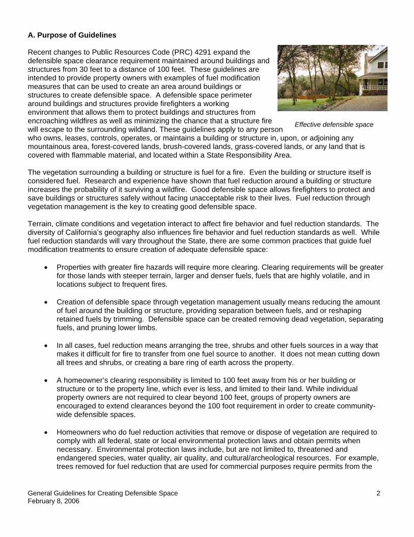
General Guidelines for Creating Defensible Space 2 February 8, 2006
Effective defensible space
A. Purpose of Guidelines Recent changes to Public Resources Code (PRC) 4291 expand the defensible space clearance requirement maintained around buildings and structures from 30 feet to a distance of 100 feet. These guidelines are intended to provide property owners with examples of fuel modification measures that can be used to create an area around buildings or structures to create defensible space. A defensible space perimeter around buildings and structures provide firefighters a working environment that allows them to protect buildings and structures from encroaching wildfires as well as minimizing the chance that a structure fire will escape to the surrounding wildland. These guidelines apply to any person who owns, leases, controls, operates, or maintains a building or structure in, upon, or adjoining any mountainous area, forest-covered lands, brush-covered lands, grass-covered lands, or any land that is covered with flammable material, and located within a State Responsibility Area. The vegetation surrounding a building or structure is fuel for a fire. Even the building or structure itself is considered fuel. Research and experience have shown that fuel reduction around a building or structure increases the probability of it surviving a wildfire. Good defensible space allows firefighters to protect and save buildings or structures safely without facing unacceptable risk to their lives. Fuel reduction through vegetation management is the key to creating good defensible space.
Terrain, climate conditions and vegetation interact to affect fire behavior and fuel reduction standards. The diversity of California’s geography also influences fire behavior and fuel reduction standards as well. While fuel reduction standards will vary throughout the State, there are some common practices that guide fuel modification treatments to ensure creation of adequate defensible space:
• Properties with greater fire hazards will require more clearing. Clearing requirements will be greater for those lands with steeper terrain, larger and denser fuels, fuels that are highly volatile, and in locations subject to frequent fires.
• Creation of defensible space through vegetation management usually means reducing the amount
of fuel around the building or structure, providing separation between fuels, and or reshaping retained fuels by trimming. Defensible space can be created removing dead vegetation, separating fuels, and pruning lower limbs.
• In all cases, fuel reduction means arranging the tree, shrubs and other fuels sources in a way that
makes it difficult for fire to transfer from one fuel source to another. It does not mean cutting down all trees and shrubs, or creating a bare ring of earth across the property.
• A homeowner’s clearing responsibility is limited to 100 feet away from his or her building or
structure or to the property line, which ever is less, and limited to their land. While individual property owners are not required to clear beyond 100 feet, groups of property owners are encouraged to extend clearances beyond the 100 foot requirement in order to create community-wide defensible spaces.
• Homeowners who do fuel reduction activities that remove or dispose of vegetation are required to
comply with all federal, state or local environmental protection laws and obtain permits when necessary. Environmental protection laws include, but are not limited to, threatened and endangered species, water quality, air quality, and cultural/archeological resources. For example, trees removed for fuel reduction that are used for commercial purposes require permits from the

General Guidelines for Creating Defensible Space 3 February 8, 2006
California Department of Forestry and Fire Protection. Also, many counties and towns require tree removal permits when cutting trees over a specified size. Contact your local resource or planning agency officials to ensure compliance.
The methods used to manage fuel can be important in the safe creation of defensible space. Care should be taken with the use of equipment when creating your defensible space zone. Internal combustion engines must have an approved spark arresters and metal cutting blades (lawn mowers or weed trimmers) should be used with caution to prevent starting fires during periods of high fire danger. A metal blade striking a rock can create a spark and start a fire, a common cause of fires during summertime. Vegetation removal can also cause soil disturbance, soil erosion, regrowth of new vegetation, and introduce non-native invasive plants. Always keep soil disturbance to a minimum, especially on steep slopes. Erosion control techniques such as minimizing use of heavy equipment, avoiding stream or gully crossings, using mobile equipment during dry conditions, and covering exposed disturbed soil areas will help reduce soil erosion and plant regrowth. Areas near water (riparian areas), such as streams or ponds, are a particular concern for protection of water quality. To help protect water quality in riparian areas, avoid removing vegetation associated with water, avoid using heavy equipment, and do not clear vegetation to bare mineral soil. B. Definitions Defensible space: The area within the perimeter of a parcel where basic wildfire protection practices are implemented, providing the key point of defense from an approaching wildfire or escaping structure fire. The area is characterized by the establishment and maintenance of emergency vehicle access, emergency water reserves, street names and building identification, and fuel modification measures. Aerial fuels: All live and dead vegetation in the forest canopy or above surface fuels, including tree branches, twigs and cones, snags, moss, and high brush. Examples include trees and large bushes. Building or structure: Any structure used for support or shelter of any use or occupancy. Flammable and combustible vegetation: Fuel as defined in these guidelines. Fuel Vegetative material, live or dead, which is combustible during normal summer weather. For the purposes of these guidelines, it does not include fences, decks, woodpiles, trash, etc. Homeowner: Any person who owns, leases, controls, operates, or maintains a building or structure in, upon, or adjoining any mountainous area, forest-covered lands, brush-covered lands, grass-covered lands, or any land that is covered with flammable material, and located within a State Responsibility Area. Ladder Fuels: Fuels that can carry a fire vertically between or within a fuel type. Reduced Fuel Zone: The area that extends out from 30 to 100 feet away from the building or structure (or to the property line, whichever is nearer to the building or structure). Surface fuels: Loose surface litter on the soil surface, normally consisting of fallen leaves or needles, twigs, bark, cones, and small branches that have not yet decayed enough to lose their identity; also grasses, forbs, low and medium shrubs, tree seedlings, heavier branches and downed logs.

General Guidelines for Creating Defensible Space 4 February 8, 2006
C. Fuel Treatment Guidelines The following fuel treatment guidelines comply with the requirements of 14 CCR 1299 and PRC 4291. All persons using these guidelines to comply with CCR 1299 and PRC 4291 shall implement General Guidelines 1., 2., 3., and either 4a or 4b., as described below.
General Guidelines:
1. Maintain a firebreak by removing and clearing away all flammable vegetation and other combustible
growth within 30 feet of each building or structure, with certain exceptions pursuant to PRC §4291(a). Single specimens of trees or other vegetation may be retained provided they are well-spaced, well-pruned, and create a condition that avoids spread of fire to other vegetation or to a building or structure.
2. Dead and dying woody surface fuels and aerial fuels within the Reduced Fuel Zone shall be
removed. Loose surface litter, normally consisting of fallen leaves or needles, twigs, bark, cones, and small branches, shall be permitted to a depth of 3 inches. This guideline is primarily intended to eliminate trees, bushes, shrubs and surface debris that are completely dead or with substantial amounts of dead branches or leaves/needles that would readily burn.
3. Down logs or stumps anywhere within 100 feet from the building or structure, when embedded in
the soil, may be retained when isolated from other vegetation. Occasional (approximately one per acre) standing dead trees (snags) that are well-space from other vegetation and which will not fall on buildings or structures or on roadways/driveways may be retained.
4. Within the Reduced Fuel Zone, one of the following fuel treatments (4a. or 4b.) shall be
implemented. Properties with greater fire hazards will require greater clearing treatments. Combinations of the methods may be acceptable under §1299(c) as long as the intent of these guidelines is met.
4a. Reduced Fuel Zone: Fuel Separation
In conjunction with General Guidelines 1., 2.,
and 3., above, minimum clearance between fuels surrounding each building or structure will range from 4 feet to 40 feet in all directions, both horizontally and vertically. Clearance distances between vegetation will depend on the slope, vegetation size, vegetation type (brush, grass, trees), and other fuel characteristics (fuel compaction, chemical content etc.). Properties with greater fire hazards will require greater separation between fuels. For example, properties on steep slopes having large sized vegetation will require greater spacing between individual trees and bushes (see Plant Spacing Guidelines and Case Examples below). Groups of vegetation (numerous plants growing together less than 10 feet in total foliage width) may be treated as a single plant. For example, three individual manzanita plants growing together with a total foliage width of eight feet can be “grouped” and considered as one plant and spaced according to the Plant Spacing Guidelines in this document.
.
Defensible Space: Reduced Fuel Zone
30 ft. Reduced Fuel Zone:
30 ft. to 100 ft.

General Guidelines for Creating Defensible Space 5 February 8, 2006
Vertical clearance between aerial fuels
4 ft to 40 ft. depending on slope and vegetation size/type
10 ft. to 30 ft. depending on slope and vegetation type and size
4 ft. to 40 ft depending on slope and vegetation type and size
Grass generally should not exceed 4 inches in height. However, homeowners may keep grass and other forbs less than 18 inches in height above the ground when these grasses are isolated from other fuels or where necessary to stabilize the soil and prevent erosion.
Clearance requirements include:
• Horizontal clearance between aerial fuels, such as the outside edge of the tree crowns or
high brush. Horizontal clearance helps stop the spread of fire from one fuel to the next.
Trees Shrubs
Horizontal clearance between aerial fuels
• Vertical clearance between lower limbs of aerial fuels and the nearest surface fuels and grass/weeds. Vertical clearance removes ladder fuels and helps prevent a fire from moving from the shorter fuels to the taller fuels.
Effective vertical and horizontal fuel
separation Photo Courtesy
Plumas Fire Safe Council.
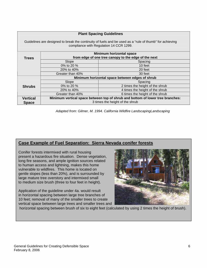
General Guidelines for Creating Defensible Space 6 February 8, 2006
Adapted from: Gilmer, M. 1994. California Wildfire LandscapingLandscaping
Plant Spacing Guidelines
Guidelines are designed to break the continuity of fuels and be used as a “rule of thumb” for achieving compliance with Regulation 14 CCR 1299.
Minimum horizontal space
from edge of one tree canopy to the edge of the next Slope Spacing
0% to 20 % 10 feet 20% to 40% 20 feet
Trees
Greater than 40% 30 feet Minimum horizontal space between edges of shrub
Slope Spacing 0% to 20 % 2 times the height of the shrub 20% to 40% 4 times the height of the shrub
Shrubs
Greater than 40% 6 times the height of the shrub Vertical Space
Minimum vertical space between top of shrub and bottom of lower tree branches: 3 times the height of the shrub
Case Example of Fuel Separation: Sierra Nevada conifer forests Conifer forests intermixed with rural housing present a hazardous fire situation. Dense vegetation, long fire seasons, and ample ignition sources related to human access and lightning, makes this home vulnerable to wildfires. This home is located on gentle slopes (less than 20%), and is surrounded by large mature tree overstory and intermixed small to medium size brush (three to four feet in height). Application of the guideline under 4a. would result in horizontal spacing between large tree branches of 10 feet; removal of many of the smaller trees to create vertical space between large trees and smaller trees and horizontal spacing between brush of six to eight feet (calculated by using 2 times the height of brush).

General Guidelines for Creating Defensible Space 7 February 8, 2006
Case Example of Fuel Separation: Southern California chaparral Mature, dense and continuous chaparral brush fields on steep slopes found in Southern California represents one of the most hazardous fuel situations in the United States. Chaparral grows in an unbroken sea of dense vegetation creating a fuel-rich path which spreads fire rapidly. Chaparral shrubs burn hot and produce tall flames. From the flames come burning embers which can ignite homes and plants. (Gilmer, 1994). All these factors results in a setting where aggressive defensible space clearing requirements are necessary. Steep slopes (greater than 40%) and tall, old brush (greater than 7 feet tall), need significant modification. These settings require aggressive clearing to create defensible space, and would require maximum spacing. Application of the guidelines would result in 42 feet horizontal spacing (calculated as 6 times the height of the brush) between retained groups of chaparral.
Case Example of Fuel Separation: Oak Woodlands Oak woodlands, the combination of oak trees and other hardwood tree species with a continuous grass ground cover, are found on more than 10 million acres in California. Wildfire in this setting is very common, with fire behavior dominated by rapid spread through burning grass.
Given a setting of moderate slopes (between 20% and 40%), wide spacing between trees, and continuous dense grass, treatment of the grass is the primary fuel reduction concern. Property owners using these guidelines would cut grass to a maximum 4 inches in height, remove the clippings, and consider creating 20 feet spacing between trees.
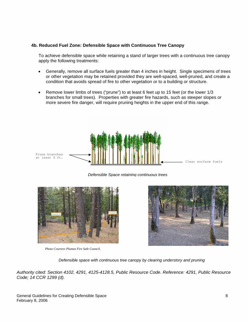
General Guidelines for Creating Defensible Space 8 February 8, 2006
Clear surface fuels
Prune branches at least 6 ft.
Defensible Space retaining continuous trees
4b. Reduced Fuel Zone: Defensible Space with Continuous Tree Canopy
To achieve defensible space while retaining a stand of larger trees with a continuous tree canopy apply the following treatments:
• Generally, remove all surface fuels greater than 4 inches in height. Single specimens of trees
or other vegetation may be retained provided they are well-spaced, well-pruned, and create a condition that avoids spread of fire to other vegetation or to a building or structure.
• Remove lower limbs of trees (“prune”) to at least 6 feet up to 15 feet (or the lower 1/3
branches for small trees). Properties with greater fire hazards, such as steeper slopes or more severe fire danger, will require pruning heights in the upper end of this range.
Authority cited: Section 4102, 4291, 4125-4128.5, Public Resource Code. Reference: 4291, Public Resource Code; 14 CCR 1299 (d).
Photo Courtesy Plumas Fire Safe Council.
Defensible space with continuous tree canopy by clearing understory and pruning

Monterey County Community Wildfire Protection PlanNovember 2010 v2
APPENDIX F
CEQA Flowchart

Monterey County Community Wildfire Protection PlanNovember 2010 v2
APPENDIX G
Forest Practice Rules Checklist

Monterey County Community Wildfire Protection PlanNovember 2010 v2
APPENDIX G – Forest Practice Rules Checklist
Revised: June 4, 2008 updated with post fire documents on 8/20/08
TREE REMOVAL INFORMATION COMMONLY ASSOCIATED WITHBUILDING PERMITS AND OTHER DEVELOPMENT PROJECTS
STATE REGULATIONS
In addition to Fire Code Regulations for State Responsibility Areas noted in the 4290 Checklist,the California Department of Forestry and Fire Protection (CAL FIRE) is responsible foradministering Timber Harvesting Regulations conducted throughout California on all non-federal timberland. This applies regardless of zoning and includes lands inside of city limits.The removal of California native "commercial" timber species from forested lots, areas ofpending new construction, and from around existing structures is included under theseregulations. The following information is compiled from Title 14, California Code ofRegulations and the Public Resources Code to assist in the determination of the necessity of aTimber Harvest Plan (THP), Timberland Conversion Permit (TCP), or other type of timberharvest plan exemption or emergency document.
The following checklist can be used to determine if a permit is required from CAL FIRE forremoval of trees.
Determining if a harvesting permit is required from CAL FIRE:
1. Is the project occurring on timberland?
Yes….Go to question #2. In Monterey and San Benito Counties, qualifyingcommercial timber species include Coast Redwood,Douglas Fir, Monterey Pine, Coulter Pine, Ponderosa Pine,Jeffrey Pine, White Alder, Cottonwood, Pacific Madrone,California Black Oak and Tanoak. Timberland includesareas where the above species are now growing naturally orhave grown naturally in the recorded past, even if notcurrently present.
No….This does not constitute timber operations and a THP or other harvest document isNOT required by CAL FIRE. STOP HERE
2. Are you cutting trees and plan to sell, barter, exchange or trade any type of wood product?

Monterey County Community Wildfire Protection PlanNovember 2010 v2
Yes…. A THP or other timber harvest plan exemption document is required by CALFIRE prior to cutting any trees. Refer to Section II titled "Types of Harvest Documents."
No…. A THP or other timber harvest plan exemption document may still be required byCAL FIRE. Go to question #3.
3. Are you cutting or removing trees from timberland, and converting the area to a non-timberuse? NOTE: These requirements apply even if the wood products are not sold commercially orthe trees aren't of merchantable size.
a) Yes, and the area involved is less than three acres… Do not harvest without anapproved Less than 3-acre conversion exemption (14 CCR 1104.1)
b) Yes, and the area involved is greater than three acres…A TCP and THP are required.
c) Yes, and the area is an approved subdivision under the Subdivision Map Act ... AnExemption for Conversion of Non-TPZ137 Land for Subdivision Development (14 CCR1104.2) can meet the TCP requirement and either a THP or Less than 3-acre conversionexemption are required.
d) No…. If questions number 1, 2, and 3 above are answered no, a THP or other harvestdocument is not required by CAL FIRE.
NOTE: In San Benito and Monterey Counties, the most common examples of conversionsinclude commercial developments or construction of individual residential structures on landsclassified as timberland.
Types of Harvest Documents:
Timber Harvest Plans are detailed documents that allow timber operations and provide analysisof environmental impacts, and will not be discussed in detail. The harvest documents requiredfor Timberland Conversions are addressed in Section I, question 3 above. The following listdescribes the most commonly used harvest exemptions and emergencies from Title 14 of theCalifornia Code of Regulations.
1. §1038(c)138 Removal of Fire Hazard Trees Within 150 Feet of a StructureExemption
This exemption is required for the cutting or removal of trees in compliance with sections 4290and 4291 from within 150 feet of existing permitted structures which is intended to reduce thefuels and fire hazard. This exemption is required only if wood products are offered for sale,barter, exchange or trade. A Registered Professional Forester services are not required, howevera Licensed Timber Operator must be listed on the exemption. Extensive slash disposalrequirements apply and the exemption is valid for one year. See 14 CCR 1038 (c).
137 TPZ: Zoning classified as Timberland Production Zone.138 (14 CCR 961.2) Notwithstanding 14 CCR 1038, exemptions from plan filing requirements in the CoastalCommission Special Treatment Areas shall only be allowed for minor operations where no live trees are cut.

Monterey County Community Wildfire Protection PlanNovember 2010 v2
2. §1038(a) and (b) Christmas Tree; Dead, Dying, or Diseased; Fuelwood orSplit Products Exemption
This exemption is required when removing trees that are dead or are obviously dying from insectattack or disease (harvest can not exceed 10 percent of the average volume per acre), or whenremoving fuelwood or other miscellaneous products such as Christmas trees, fencing, etc. Thisexemption is required only if wood products are offered for sale, barter, exchange or trade.Registered Professional Forester services are not required, however a Licensed Timber Operatormust be listed on the exemption. The exemption is valid for one year. See 14 CCR 1038 (a &b).
3. §1104.1(a) Less Than Three Acre Conversion Exemption
This one-time exemption is required for property owners who intend to cut or remove trees forstructures and other needed improvements. This exemption is required whether or not woodproducts are offered for sale, barter, exchange or trade. A Registered Professional Forester mustprepare this exemption. Building contractors are ineligible to perform this work, unless they arealso a Licensed Timber Operator. The exemption is valid for one year. See 14 CCR 1104.1.
4. §1104.1(b) and (c) Public Agency, Public and Private Utility Right of WayExemptions
These exemptions are used for construction or maintenance of right-of-way by a public agencyon its own or any other public property; or the clearing of trees from timberland by a private orpublic utility for construction of gas, water, sewer, oil, electric, and communications (transmittedby wire, television, radio, or microwave) rights-of-way, and for maintenance and repair of theutility and right-of-way. This exemption can only be used to remove trees that are marked orfelled as hazard trees in established utility right-of-ways, or for construction of right of ways thathave been approved by the county.
5. §1052 Emergency
Before cutting or removing timber on an emergency basis, a Registered Professional Forester(RPF) on behalf of a timber owner or operator shall submit a Notice of Emergency TimberOperations to the Director. A Notice of Emergency Timber Operations can be filed for removalof damaged, dead, or dying trees due to fire. Per the 14 CCR 895.1 definition of "dying trees," itis up to the RPF to designate dying trees for harvest. Given the provisions of this definition, itwould be the RPF's responsibility to designate only those trees that are likely to die within oneyear.
Some of the applicable laws and regulations that apply are summarized on the following pages.The rules cited may not be quoted, and are not intended to be authoritative. The code section hasbeen included to provide reference to the official law or rule language can be found atwww.leginfo.ca.gov/calaw.html, or the official publications by Barclays Official CaliforniaCode of Regulations (1-800-888-3600).
Monterey County Community Wildfire Protection PlanNovember 2010 v2
If you have any questions or need additional information on the different types of harvestdocuments that may be applicable to your project, please contact the Unit Forester or the AreaForester where the project is located.
Area Forester Telephone
All of San Benito Jonathan Pangburn (831) 333-2600and Monterey Counties
or contact Mike Bacca – Forest Practice Manager (559) 243-4114Southern Region
Z'berg-Nejedly Forest Practice Act of 1973
CAL FIRE has enforcement responsibility for the Z'berg-Nejedly Forest Practice Act of 1973.CAL FIRE is also the lead agency for those parts of projects involving the scope of the ForestPractice Act. This involves the regulation of "Timber Operations", as defined in Section 4527 ofthe Public Resources Code (PRC), on all non-federal private lands.
PRC 4526 – Timberland
"Timberland" means land, other than land owned by the federal government, which is availablefor, and capable of, growing a crop of trees of any commercial species used to produce lumberand other forest products, including Christmas trees.
PRC 4527 - Timber Operations
"Timber Operations" means the cutting or removal or both of timber or other solid wood forestproducts, including Christmas trees, from timberlands for commercial purposes, together with allthe work incidental thereto, including, but not limited to, construction and maintenance of roads,fuelbreaks, stream crossings, landings, and skid trails. "Commercial purposes" includes (1) Thecutting or removal of trees which are processed into logs, lumber, or other wood products andoffered for sale, barter, exchange or trade, or; (2) The cutting or removal of trees or other forestproducts during the conversion of timberlands to land uses other than the growing of timberwhich are subject to the provisions of Section 4621, including, but not limited to, residential orcommercial developments, production of other agricultural crops, recreational developments, skidevelopments, water development projects, and transportation projects. Removal or harvest ofincidental vegetation from timberlands, such as berries, ferns, greenery, mistletoe, herbs, andother products, which action cannot normally be expected to result in a threat to forest, air, water,or soil resources, does not constitute timber operations.
PRC 4581 – Necessity of timber harvest plan
No person shall conduct timber operations unless a timber harvesting plan prepared by aregistered professional forester has been submitted for such operations.
Other pertinent rule sections regarding conversion of timberlands: 14 CCR 1100-1110 and PRC4621.
APPENDIX H
Sample Threat Assessment Study Summaries

APPENDIX H – Special Study Areas: FRAP Fire Behavior Modeling and ThreatAssessment Protocol
Three representative areas within Monterey County were selected for special study: Fort Ord,Carmel Valley, and the North County. Fire behavior modeling was conducted by FRAP utilizingthe refined topography and fuels data, and refined local 3D wind modeling data obtained fromthe Monterey Naval Postgraduate School Meteorology Section. Employing FlamMap andFARSITE computer based models, simulations were conducted for each area. Two ignitionscenarios and two weather scenarios (moderate and severe) were evaluated to assess firebehavior potential. The following summarizes the FRAP findings for each area, based onmodeling results, and the field validation performed by the fire threat assessment team.
A. Former Fort Ord
During severe weather conditions, wildfire in maritime chaparral on Fort Ord is expected toproduce high spread rates, moderate to high intensity, and typically close range and long rangespotting of up to one mile (BEHAVE, Jim Bishop, 2002; Barry Callenberger, 2006). Due to thedistribution of flammable maritime chaparral and sage fire fuel types and rapidly fluctuatingwinds and relative humidities in combination with solar preheating, Fort Ord presents a uniqueand challenging fire threat.
Historical fire suppression experience at Fort Ord documents difficulty of control for firesoccurring under moderate weather with limited tactical effectiveness against fires not containedby first responders. Of concern is the capability of a fire to leave the Fort Ord property, affectingadjacent properties and assets. Modeling results indicate this potential under moderate andsevere weather conditions. Recommendations resulting from FARSITE modeling efforts andfield validation indicate that a 200-300 foot wide linear fuelbreak along South Boundary Roadsomewhat slows the frontal spread of the accelerating fire front of an uncontrolled wildland fire,but does little to reduce spotting and escaped spot fires. Direct attack is unsafe and is neitherrecommended nor effective.
The presence of Unexploded Ordnance (UXO) in substantial portions of the Fort Ord maritimechaparral fuel beds presents a danger to direct attack suppression and the deployment of tacticalair support in those areas, most significantly at Del Rey Oaks, where UXO is present proximateto the development boundary. UXO fragmentation distance can be up to 1,701 feet.Nevertheless, current policy allows tactical air support down to 100 feet in these areas.
A comprehensive system of interconnected Strategic Fuelbreaks, Defensible Polygons, and areduced fire fuel reduction buffer zone maintained by rotational prescribed burn application ofone to ten years of Fort Ord's chaparral fuel bed is indicated by the Bureau of LandManagement's and US Army's Fire Management Plans. Coordination of attack strategy andcommunity evacuation from within adjacent fire jurisdictions in the pre attack and CountyEmergency Operational Plan (EOP) is essential.
Documented ground level wind streams have the potential to drive uncontrolled wildland fire toidentified topographical decision points at Laguna Seca/Pasadera/York School/Ryan Ranch,Canyon Del Rey, East Garrison, "The Bluffs," and Seaside.
(See FRAP Figures 14 and 15 at the end of this appendix.)
B. Carmel Valley
Modeling efforts evaluated assume ignitions along the Laureles Grade with variations in windand fuel moisture conditions. Under severe weather conditions, fires burn rapidly in light, flashyfuels. Those in light and heavier shrub fuels progress slightly slower, although high heatintensity and short- and mid-range spotting are problematic making direct attack ineffective. Ofnote is the slowing of fire progression when encountering oak woodland/forest vegetation typesunder both weather conditions, although the benefit is usually offset by the increasing number ofmiles of uncontained flaming fire perimeter threatening residences, structures, and steepwatershed in a short period of time.
(See FRAP Figures 10 and 11 at the end of this appendix.)
C. North County
Simulations for the North County area indicate potential fire growth in annual grasslandsassumed to be rested from grazing pressure. Under severe weather conditions, fire spread israpid in light, flashy fuels, but slows when it reaches closed-canopy oak forests. Presence ofsignificant stands of manzanita and Eucalyptus tree torching and fire brand spotting encouragefire growth. Of note in this area is the potential for a relatively broad fire front and significantfire perimeter distance. Issues of evacuation routes, timing, and large fire potential may receivefurther consideration.
(See FRAP Figures 12 and 13 at the end of this appendix.)
MCCWPP Fire Threat Assessment Protocol
To complement the FRAP analysis, the fire threat assessment team provided field verification ofthreat, including identification of :
Factors of fire behavior change (fuels, slope, topography, weather).
Fire behavior decision points (predetermined locations (i.e. proximity to structures,change in slope, etc.) or set of meteorological thresholds that may require a change intactics to deal with changing conditions (location or weather)).
Fire severity alignment scenarios (situations in which the slope, fuels, and/or weatheralign to create an increase in fire activity and subsequent fire severity and possibly fireintensity).
Direction of fire spread (influenced by prevailing winds, topography, and fuels).
Tactical suppression thresholds of control (identification of potential wildfire controllines or anchor points, such as ridges, roads, and drainages).
Fire history (the number and geographic extent of previous fires in a given area).
Tactical fire suppression capacity (level of firefighting resources available).
Fire behavior prediction tools such as BEHAVE, FARSITE, and Campbell Prediction System(CPS) are utilized.
MCWPP Interagency Fire Threat Assessment Team
Chris Orman MoCo Fire Chiefs Fire Chief, North County Fire
Tom Plymale USFS Division Chief, Monterey District
Mario Marquez BLM Fire Management Officer
Jonathan Pangburn CALFIRE Registered Professional Forester
Jack Riso POM/Fort Ord Fire Chief
Steve Davis USFS Fuels Chief, LPNF
Bob Nunes MBUAPCD Meteorologist
Wendell Nuss NPS Meteorologist
Joe Rawitzer MC2WG Fire Behavior Specialist
With technical assistance provided by Mark Rosenberg and Dave Sapsis, FRAP Fire Scientists,and Doug Campbell, Fire Behavior Analyst.


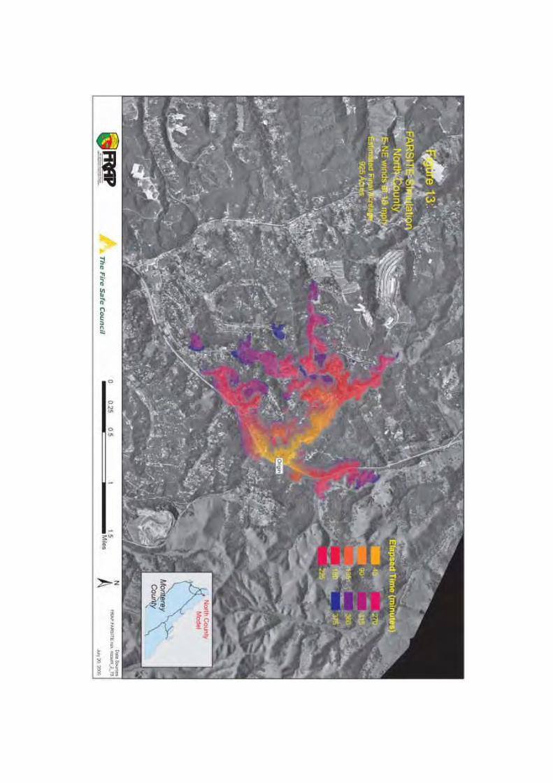


APPENDIX I
Detailed Priority Threat Descriptions

APPENDIX I - Detailed Priority Threat Descriptions
The following areas are listed in alphabetical order. See the map at the end of this appendix forthe location of the following areas.
A. Bryson-Hesperia
Bryson Hesperia in southwest Monterey County is adjacent to San Antonio and NacimientoResevoirs in a rural suburban WUI intermixed with grass, dense chaparral, and oak woodland.Bryson Hesperia borders Los Padres National Forest and Fort Hunter Liggett. Project includescreation of defensible space around structures, ingress and egress, neighborhood fuel reduction,and a series of cooperative interconnecting Strategic Fuelbreaks, Defensible Polygons, andhazardous fuel reduction prescribed burns.
B. Former Fort Ord
The Former Fort Ord Lands are encircled with WUI boundaries of Monterey, Del Rey Oaks,Seaside, Marina, East Garrison, Toro Park/Serra Village, Los Laureles, Laguna Seca, Pasadera,Ryan Ranch, Hidden Hills, and Highway 68. These undeveloped lands may present the singlegreatest hazardous fuel and fire threat to WUI in Monterey County. The area is currently dividedinto two federal jurisdictions, although local governments also manage some of the undevelopedlands in these areas. The federal lands include: 1) lands that BLM manages and controls (i.e.about 7,200 acres), and 2) lands that the Army manages and controls (i.e. about 6,500 acres) untilsuch time they are transferred to the BLM. Lands managed and controlled by the Army willlikely continue to be managed by the Army until 2020-2025 while the Army conducts amunitions and explosives of concern (MEC) remediation of these former range areas under theComprehensive Environmental Response, Compensation and Liability Act (CERCLA). Afterthe lands have been remediated, the BLM has indicated an interest in managing these formerrange lands for the Army as part of the base closure process.
The highest fire threat in the area consists of the 6,500 acres of maritime chaparral within theformer Fort Ord Multi Range Area (MRA) where the presence of MEC hampers tacticalfirefighting effectiveness and presents additional life threat to firefighters and the public,especially at Del Rey Oaks and Seaside. Within the MRA, the Army maintains a system offuelbreak roads that facilitate prescribed burning as part of the steps to remove brush for MECremediation. The Army intends to prescribe burn up to 800 acres per year in the MRA tofacilitate the MEC remediation. Generally, the Army maintains 15 foot wide roads with 15 feetof vegetation cutting on both sides of each fuelbreak road. Some of these roads are in poorand/or sandy condition and wildfire suppression efforts can be hampered. The Army is workingto gravel many of these roads and/or road segments in coordination with the BLM. Aroundindividual burn units, the Army has generally mechanically cut 200 feet of vegetation alongprimary containment lines to support the burning of standing vegetation, with width dependingupon the age/expected flame lengths of the adjoining vegetation, however, secondary and tertiarycontainment lines are generally 15 foot wide roads with 15 feet of vegetation cutting on bothsides of the road.

Along General Jim Moore Boulevard, the City of Seaside and Del Rey Oaks have land that isadjacent to the Army's former MRA. These lands will require careful firewise planning asdevelopments are being contemplated. These parcels currently require a 200 foot setback fromthe Army lands (i.e. future BLM lands) where flammable structures may not be developedwithout preparation and approval of a firewise plan. The Healthy Forests Restoration Actprovides that at-risk communities may recommend in a CWPP that fuel reduction work beperformed on lands administered by the Bureau of Land Management, which may enable thisproblem to be addressed by fuel reduction work on Federal land rather than by restricting use ofprivate land.
After the MRA lands are remediated and transferred to the BLM, the lands will be managed inperpetuity as a habitat reserve under the BLM's Resource Management Plan (RMP) and theArmy's Habitat Management Plan (HMP). The HCP/RMP dictate a change in the historicalvegetation distribution at Fort Ord. Until 1991, the majority of maritime and coastal chaparralhas burned at one to ten year intervals in defensible polygon mosaics. According to the HCP, thefrequent fire interval mosaics will be replaced by a mixed age distribution. This will increase theaverage age class from 1-10 years with average fire fuel loads of 1 to7 tons per acre, to 10 to50+years, with average fire fuel loads of 5 to 35 tons per acre. Without the historic mosaic andfirebreaks, the threat from both wind driven fires and fuel driven fires that progress beyondinitial attack increases significantly.
Management as a habitat reserve will involve the BLM promulgating a mixed-age structure ofmaritime chaparral and periodic prescribed burning. The BLM anticipates that this prescribedburning may treat up to 1,500 acres each decade. The BLM intends to use the Army's fuelbreakroads in long-term management of the area, and may develop new fuelbreaks to support futureprescribed burning operations.
Failure to assertively maintain reduced hazardous fuel zones, with prescribed burning or othermeans, will increase the likelihood of high-intensity uncontrolled wildland fires under severe fireweather conditions. Uncontrolled wildland fires originating at former Fort Ord threaten theHighway 68 corridor, specifically at Ryan Ranch, York School, Pasadera, Laguna Seca, andHidden Hills. Del Rey Oaks, Monterey, Seaside, and the Bluffs off Reservation Road as well areidentified in the county wide fire threat assessment, and document the at-risk community firethreat profile.
C. Highway 68
Wildland fires originating at Fort Ord and Laguna Seca threaten the areas contiguous to theHighway 68 corridor. Ryan Ranch, York School, Pasadera, Hidden Hills, Corral de Tierra, ToroPark, Del Rey Oaks, Monterey, Seaside, and the Bluffs are indicated as high threat by modeledFARSITE fire growth projections and fire threat assessment team evaluations. BLM landadjacent to Creekside and Toro Creek near Reservation Road has also been identified as a highpriority for treatment.

D. North County
Presence of significant stands of manzanita and Eucalyptus trees subject to torching and firebrand spotting encourage fire growth in North County. Royal Oaks subdivision, Manzanita Park,Elkhorn Slough, Pesante Canyon, Mallory Canyon, and Long Valley present a complex of fireproblems and public safety issues. Fire models and field verification for the North County areaindicate rapid fire growth and a relatively broad fire front and asymmetric fire perimeter undersevere fire weather conditions. Neighborhood-level evacuation routes, timing, safety zones, andlarge fire potential may receive further consideration and evaluation by the fire threat assessmentteam. Project includes enforcement of PRC 4291 defensible space around structures, providingimproved ingress, egress, and evacuation planning, neighborhood fuel reduction, and a series ofcooperative interconnecting strategic fuelbreaks, identification of defensible polygons, andhazardous fuel reduction prescribed burns.
E. Pine Canyon (South)
Pine Canyon west of King City is a rural suburban WUI intermixed with dense chaparral. Theupper reaches of Reliz Canyon joins the upper watershed of Pine Canyon at the border ofVentana Wilderness, Department of Defense (Fort Hunter Liggett), and multiple privateownerships. A series of cooperative interconnecting strategic fuelbreaks, defensible polygons,and hazardous fuel reduction prescribed burns are planned. Cooperating agencies: CAL FIRE,USFS, BLM, FHLFD, NRCS, AND MBUAPCD.
F. Santa Lucia Fire Defense System (in Progress)
WUI occurs in and near the LPNF and Ventana Wilderness in Monterey County, at multiplelocations where the wilderness boundary and/or LPNF boundary occur within the boundaries ofan at-risk community's WUI. In the event of wildfire, at-risk communities such as Big Sur, PaloColorado, White Rock, Carmel Valley, Jamesburg-Cachagua, Arroyo Seco, Reliz Canyon, PineCanyon (South), Sierra de Salinas, Bryson Hesperia, and South Coast are threatened by and arethreats to the LPNF and Ventana Wilderness, depending upon the fire's origin. Maintenance ofhistoric and present firebreaks, fuelbreaks and hazardous fuel reduction zones both within andoutside the LPNF/Ventana Wilderness is determined to be a high priority by this MCCWPP, andthis MCCWPP makes recommendations in Section 9 and Appendix D accordingly.
The Santa Lucia Fire Defense System (in progress) is a network of interconnecting fire lines andfuelbreaks that protects at-risk communities from fires originating in the LPNF, and protects theLPNF from fires originating in at-risk communities. Development of the Santa Lucia FireDefense System (SLFDS) is supported by private landowners adjacent to LPNF and BLM threatareas. Initial work was started on the SLFDS as part of the USFS Monterey Defensible FuelProfile Zone (DFPZ) and the BLM Sierra de Salinas-Gabilan Fuel Reduction Project andStrategic Fuel Break System.

G. Sierra De Salinas-Gabilan Fuel Reduction Project and Strategic FuelbreakSystem
The Sierra de Salinas rises on the west side of the Salinas Valley and extends from Fort Ord andToro Park to Arroyo Seco in the north, continuing through Reliz Canyon to Camp Roberts in thesouth.
The ridge top of the northern Sierra de Salinas has historically been a Strategic Fuelbreak and isknown as the Paloma Ridge Fire Trail. Ownership is principally private, with approximately8,000 acres of Bureau of Land Management jurisdiction intermingled. BLM and landowners arecooperatively managing hazardous fuel reduction treatments. Structures and high value worldclass vineyards are at risk from high intensity wildfire, smoke damage, and erosion due tohazardously overgrown contiguous brush fields in the watershed. Stakeholders, fire districts,CAL FIRE, and the Bureau of Land Management are planning and defining interconnectinghazardous fuel treatment defensible polygons from Fort Ord and Toro Park south to the JolonGrade.
The Gabilan Range runs on the east side of the Salinas Valley from the San Juan Grade in thenorth, south to the San Luis Obispo county line. In some locations the ridge top of the GabilanRange is the Monterey-San Benito county line, part of which has historically been a StrategicFuelbreak and fire access road. BLM has designated treatment within the Sierra de Salinas-Gabilan Fuel Reduction and Strategic Fuel Break Project. Stakeholders and agencies havecooperatively delineated contiguous strategic fuel breaks and prescribed fire units formingDefensible Polygons from San Juan Grade south to the Topo Ranch and Pinnacles National Park.
Prioritization is given to hazardous fuel reduction and annual maintenance of strategic fuelbreaksand defensible polygons with manual and mechanical treatments, livestock grazing, and frequentcontrolled burns. The Bureau of Land Management is in the process of establishing a permitprocedure to allow adjacent private landowners to maintain fuelbreaks, conduct prescribed burnsto include BLM lands, and to ultimately form strategic management response agreementsbetween landowners and agencies for the project area.
A combination of cooperative Range Improvement burn projects and Vegetation ManagementProgram projects are planned with the objective of treating 10,000 acres annually.
H. Tularcitos Ridge
Tularcitos Ridge in the Jamesburg-Cachagua community is adjacent to Los Padres NationalForest in a rural suburban WUI intermixed with dense chaparral and heavy mixed woodland. Theproject is subdivided into Tularcitos Ridge North, which extends from Sky Ranch to RanchoGalante, and Tularcitos Ridge South, which extends from Rancho Galante to Trampa Canyonand Tassajara Road. Project includes maintenance of defensible space around structures, ingressand egress, neighborhood fuel reduction, and a series of cooperative interconnecting StrategicFuelbreaks, Defensible Polygons, and hazardous fuel reduction prescribed burns are planned.

I. White Rock
White Rock consists of approximately 100 residences at the confluence of White Rock Creekand Black rock Creek adjacent to the LPNF Ventana Wilderness boundary in the Carmel Valleyarea. Fuel reduction in the White Rock area may include maintenance of strategic fuelbreaks andhazardous fire fuel reduction projects, fire and non-fire.


Monterey County Community Wildfire Protection PlanNovember 2010 v2
APPENDIX J
Comments on the 2010 MCCWPP

1
Monterey Fire Safe Council2221 GARDEN ROAD, MONTEREY, CA 93940 (831) 333-2606 [email protected]
------------------------------------------------------------------------------------------------------------------
Protecting lives and property from harm by wildfire,we pledge our expertise, attention and support for fire safe
projects throughout Monterey County.
November 20, 2010Honorable Simon SalinasChair, Monterey County Board of Supervisors168 West Alisal St., 3rd FloorSalinas, CA 93901
Dear Chairman Salinas and Members of the Board:
The Monterey Fire Safe Council (MFSC) is the author of the enclosed Monterey CountyCommunity Wildfire Protection Plan (MCCWPP). The November 2010 MCCWPP has beensignificantly revised at the request of the Ventana Wilderness Alliance, Ventana Chapter of theSierra Club, LandWatch, California Chaparral Institute, Monterey County staff and other interestgroups, and differs significantly in principle and content from the original January 2010 andSeptember 2010 MCCWPPs that had already been signed by the current 18 signatories of theNovember 2010 MCCWPP.
Notwithstanding the foregoing, the MFSC continues to fully support the discussions andrecommendations that were removed from the January 2010 and September 2010 MCCWPPs toobtain Monterey County's signature on the November 2010 MCCWPP. The MFSC objects tothe removal of those discussions and recommendations, which were intended to encourage themaintenance of firebreaks and reduce regulatory burdens that hinder hazardous fuel reductionwork, in order to better protect life, property, and the environment, in that order of priority.
In order to foster continued discourse on the need to maintain firebreaks and the need tochange laws and policies to expedite the hazardous fuel reduction work recommended in theMCCWPP, the MFSC is providing herewith the discussions and recommendations that werechanged or removed from the January 2010 and September 2010 MCCWPPs as they were editedto the November 2010 MCCWPP. The MFSC believes that these discussions andrecommendations are essential components in solving the problem of wildfireprotection/prevention in Monterey County.
We ask that you carefully consider these discussions and recommendations during yourdeliberation on the November 2010 MCCWPP, and accordingly, direct your staff to work withthe MFSC to solve the indicated problems.
The MFSC is supported in its position by the wildfire protection agencies that havejoined the MFSC in signing this letter.

2
Discussions and Recommendations Changed in and/or Removed from theNovember 2010 MCCWPP to Obtain Monterey County's Signature on the MCCWPP
I. Note on the Collaborative Process used to write the MCCWPP
The MCCWPP was developed by a committee of the Monterey Fire Safe Council(MFSC) using Wildland Fire Leadership Council’s Preparing a Community Wildfire ProtectionPlan, A Handbook for Wildland-Urban Interface Communities, (Handbook) as a guide, andaccordingly, the development process was an open and collaborative process.
The MCCWPP was written over the course of years. Table 4 of the MCCWPP listsorganizations that were sent letters of intent to develop the MCCWPP, and invited to participatein drafting it. Some groups that were not included in the original notice were added as theMFSC became aware of their interest. Participants in this process included fire professionals,concerned citizens, and representatives from various organizations including homeownersassociations and conservation groups.
During this collaborative process, the working draft was placed on the Internet in an on-line document collaboration application (Acrobat Buzzword), and invitations to participate andenter comments were sent out to a lengthy email list of interested parties, thus affordinginterested parties an opportunity to collaborate using this convenient and accessible interface.
The January 2010 MCCWPP, which was signed by 18 agencies including CAL FIRE; theMonterey County Fire Chiefs Association and local fire districts, departments and volunteer firebrigades; USFS; BLM; the Presidio of Monterey/Fort Ord; and the California Department ofParks and Recreation), contained recommendations to amend local, state and federal laws andregulations to expedite fuel mitigation and fire preparedness efforts, to better protect lives,property and the environment, in that order of priority.
However, after the MCCWPP was finalized and signed by these 18 agencies, commentson the January 2010 MCCWPP were received from various environmental groups, some ofwhich were invited to the meetings and had access to the document for submitting comments inAcrobat Buzzword. These late comments by some who chose not to participate during the twoyear collaborative process, included a request to remove the recommendations to change lawsfrom the MCCWPP and strongly implied litigation against Monterey County if it signed theMCCWPP as then drafted.
In response to these comments, the MCCWPP was revised in the September 2010MCCWPP. During Monterey County’s review of the September 2010 MCCWPP, MontereyCounty staff and various environmental organizations requested additional changes to thedocument such as removing the following key discussions and recommendations from theMCCWPP: (1) recommended changes to laws to avoid hindrance of fuel reduction work, (2)recommendations that firebreaks be maintained, (3) the priority of protecting life, property andthe environment in that order, (4) recommendations to Monterey County and other governmentalagencies to interpret all laws and regulations to expedite hazardous fuel reduction work, and (5)fire science discussion. In order to help ensure signing of the MCCWPP by Monterey County tocomplete the document under the Healthy Forests Restoration Act (HFRA), revisions were made
3
that compromised the basic principles of the MFSC and potentially reduce the protection of life,property and the environment from wildfires in Monterey County.
II. Protecting Life Property and the Environment, in that Order of Priority
The January 2010 and September 2010 MCCWPPs contained numerous references to theneed for all laws and regulations to be interpreted in the manner that is most protective of lives,property and the environment, in that order of priority. This important concept has beenremoved from the November MCCWPP at the request of environmental groups and MontereyCounty staff.
This order of priorities was inspired by The Emergency California-Nevada Tahoe BasinFire Commission Report to the governors of California and Nevada, prepared by the TahoeBasin Fire Commission in 2008 after the Angora Fire, which destroyed 254 homes. TheCommission found that a contributing factor to the devastation was overregulation of vegetationremoval by various agencies. For example, see Finding 7 on page 22 of the report, which can befound athttp://resources.ca.gov/TahoeFireCommission/downloads/Final%20Docs/TahoeReport.pdf. TheCommission repeatedly states the need for this order of priorities (i.e., life, property, and theenvironment). For example, see Category 5 (page 10 in the report), Recommendation 16 (page79), Recommendation 74 (page 104), Recommendation 89 (page 110), Finding 2 (page 122),Finding 47 (page 224).
The MFSC recommends that Monterey County and other regulatory agencies adopt thisorder of priorities, and implement it, to reduce regulatory hindrances to performance ofhazardous fuel reduction work to the minimum required by state and federal law.
III. Discussion of Vegetation/Fuels in Monterey County
Vegetation (or fuel) (as well as weather and topography) plays a major role in affectingfire behavior and shaping fire hazard potential. Vegetation distribution throughout the Countyvaries by location and topography, with dramatic differences observed between coastal andinland regions. Current land cover/fuels distribution within the County is characterized byfourteen different vegetation/fuel types, as presented in the table below. Dominant vegetativecover within Monterey County is herbaceous or grassland cover (31.3 percent), distributedprimarily in the low-lying valley areas along the Highway 101 corridor. While this fuel type canburn quickly under strong, dry wind patterns, it does not produce the high heat intensity and highflame lengths associated with chaparral fuel types. Other significant vegetative cover typesinclude light brush (21.3 percent), light grass/woodland (14.8 percent), and hardwood litter (13.1percent). These vegetation types are primarily associated with the steeper, upland areas in thesouthern, western, and northern portions of the County. Fire behavior in brush fuel typesproduces flame lengths greater than 12 feet, and resistance to control is high. Fire behavior inwoodlands is variable, depending on surface fuel conditions and the presence of ladder fuels.However, crown fire is common if slope and wind conditions are favorable to allowing fire toenter into the crowns.

4
The distribution of fuels in Monterey County is graphically presented in Appendix B-2 ofthe MCCWPP.1
Table - Monterey County Land Cover/Fuels Distribution*
Fuel Model**Number
Description Approximate Acreage Percent Cover
1 Grass 662,270 31.3%
5 Light Brush 450,958 21.3%
2 Light Grass/Woodland 312,639 14.8%
8 Hardwood Litter 276,924 13.1%
97 Agriculture 240,714 11.4%
4 Heavy Chaparral 58,945 2.8%
28 Urban 43,525 2.1%
9 Light Conifer Litter 35,039 1.7%
98 Water 15,033 0.7%
10 Heavy Conifer Litter w/ Understory 9,007 0.4%
7 Young Maritime Chaparral 6,209 0.3%
99 Barren 5,698 0.3%
30 Maritime Live Oak Forest 95 0.0%
6 Moderate Brush 70 0.0%
Total: 2,117,126 100.0%
*FRAP Monterey Fire Risk Analysis, 2006
** Fuel Model is a rating of vegetation and dead woody material and their volume, type, condition, arrangement,distribution and location.
Variations in vegetative cover type and species composition have a direct effect on firebehavior. Some vegetation types and their associated plant species have increased flammabilitybased on plant physiology (resin content), biological function (flowering, retention of dead plantmaterial), physical structure (leaf size, branching patterns), and overall fuel loading. For
1 Higher resolution vegetation cover maps are currently under development by CAL FIRE (FRAP), USGS andlocal universities. Due to the small scale patch mosaic characteristics of Monterey County's landscape, these mapsmay provide a more accurate representation of forest and vegetation cover than those currently available. TheWatershed Institute at CSUMB has produced a 30 meter resolution map of the Central Coast Bioregion. The map isbeing edited to provide GIS data and ground cover percentages limited to the boundaries of Monterey County. Firstapproximations suggest that both Mixed Conifer/Montane Forests and Oak Woodland/Mixed Forest cover may begreater than current estimates due to the lower resolution used in current maps.
5
example, the overgrowth of native shrub species that compose chaparral vegetation types presenta high potential hazard based on such criteria.2
Vegetation type and condition plays a significant role in fire behavior. A critical factor toconsider is the dynamic nature of vegetation types. Fire presence and absence at varying cyclesor regimes affects vegetation type succession. Biomass and associated fuel loading will increaseover time, assuming that fire disturbance does not occur or hazardous fuel reduction efforts arenot implemented.
Over the past century, public policy has required the active suppression of fires, whichhas resulted in large contiguous areas of overgrown and overmature hazardous fuel beds with alarge concentration of down-dead fuel that contribute to high-cost, suppression-resistant, highintensity wildfires, thereby threatening communities, natural vegetation types, wildlife habitatand lives and property. On balance, current fire suppression policy is beneficial, however, it hasresulted in hazardous fuel loads that should be reduced to lower the risk of high intensitywildfires.3
Lack of fire has changed habitat that is critical for certain wildlife species. When thenumber and extent of forest openings, or gaps, is reduced as forest density increases due to firesuppression, key shade-intolerant herbaceous and shrub species are also diminished (particularlynitrogen fixers such as Ceanothus spp.). Wildlife that depends on these plants, such as deer, hasless available habitat.4
These overgrowth conditions affect the abundance and diversity of wildlife speciesdirectly by creating unfavorable habitat conditions for some species. For example, denseunderstory growth may adversely affect habitat quality for California spotted owls and northerngoshawks by limiting their access to prey.5
Problems associated with vegetation changes that increase the risk of unnatural high-intensity wildland fires tend to be especially prevalent at elevations common in mountainous
2 Griffin, J.R. 1978. The Marble-Cone fire ten months later. Fremontia 6(2):8–14.
Hanson & Usner 1993. The Natural History of Big Sur. University of California Press, Berkeley, pp. 232-238.
Minnich, R.A., and Chou, Y.H. 1997. Wildland fire patch dynamics in the chaparral of southern California and northern Baja California. Int. J. Wildland Fire 7, 221–248.3 Agee, J. K. 1993. Fire ecology of Pacific Northwest forests. Island Press, Wash., D.C. p. 493.
Agee, J.K. 2002. The fallacy of passive management: managing for firesafe forest reserves. Conservation Biologyin Practice 3(1):18-25.
Franklin, J.F. & Agee, J.K. 2003. Forging a Science-Based National Forest Fire Policy. Issues in Science andTechnology. Fall 2003 pp. 1-8.
Moghaddas, J.J 2006. A Fuel Treatment Reduces Potential Fire Severity and Increases Suppression Efficiency in aSierran Mixed Conifer Forest. In: Andrews, Patricia L.; Butler, Bret W., comps. 2006. Fuels Management—Howto Measure Success: Conference Proceedings. 28-30 March 2006; Portland, OR. Proceedings RMRS-P-41. FortCollins, CO: U.S. Department of Agriculture, Forest Service, Rocky Mountain Research Station.4 Page I-6, Environmental Impact Statement, Final Yosemite [National Park] Fire Management Plan (YosemiteEIS); citing Bonnicksen and Stone 1982; www.nps.gov/archive/yose/planning/fire/pdf/fire.pdf. This paragraph andthe following three paragraphs are taken almost verbatim from the above referenced document.5 Yosemite EIS, page IV-34; citing Weatherspoon et al. 1992, Maurer 2000.
6
areas of Monterey County. There, the natural mosaic of diverse vegetation types and ages can bereplaced by dense, continuous stands of shrubs and trees because of the success of firesuppression.6
The density of trees and shrubs can create a hazardous arrangement, both horizontallyand vertically, of closely-standing burnable vegetation, or fuel ladders, in the understory. Fuelladders help fires ascend into the larger trees, or overstory. This combination of fuel ladders anda high density of fuels can also increase the potential for insect and pathogen infestations which,if they cause tree die-off, increase the potential for fire. In the event of high-intensityuncontrolled wildfire, whole landscapes can be denuded and reverted to shrub communities,watershed processes can be compromised, and other environmental values can be greatlyaltered.7
California is a fire-adapted ecosystem. However, abnormal high-intensity wildfiredisturbances can have dramatic impacts on plants and plant composition.
The normal post-fire response to moderate and low-intensity fire for most species isdiverse vegetative reproduction and desirable stimulation of flowering and fruiting. However,fire suppression can contribute to high vegetation density, which in turn increases fire intensityin the event of a wildfire. Unnaturally high heat intensity fires alter natural processes and canresult in hydrophobic layers in soils, vegetation type-conversion and loss of habitat. Thecombustion of aboveground biomass alters seedbeds and temporarily eliminates competition formoisture, nutrients, heat, and light. Species that can rapidly take advantage of the availableresources will flourish.
Hydrophobic soil conditions resulting from unnatural high intensity wildfires can causedebris flows and mudflows, which have potential to alter streambed and riverbed conditions andwater turbidity. Altered streambed and water quality conditions can in turn result in adverseimpacts on species that rely on natural streambed conditions and water quality for survival.
For purposes of establishing new, or maintaining historic Strategic Fuelbreaks andwildfire buffer zones in overgrown areas in and around at-risk communities, it is possible to altersuccessional pathways to reduce fire intensity for varying vegetation types through appliedvegetation management, prescribed fire application, manual and mechanical alteration, andprescribed grazing, restoring an approximation of natural conditions. This concept is a keycomponent in the overall establishment and maintenance of the Strategic Fuelbreaks, MitigationZones, and other hazardous fuel reduction measures included in this MCCWPP.
Sudden Oak Death - Of concern within Monterey County is the presence of the SuddenOak Death (SOD) pathogen (Phytophthora ramorum) that primarily affects tanoaks (Lithocarpusdensiflorus), coast live oaks (Quercus agrifolia), and other oak and tree species found in forestand woodland environments, both coastal and inland. Other affected species include Californiabay trees (Umbellularia californica), rhododendron, coast redwood (Sequoia sempervirens) andmany other tree and plant species. The potential for SOD is concentrated primarily in the coastal
6 Yosemite EIS, page I-7.7 Yosemite EIS, page I-7.

7
portions of Monterey County, as the pathogen is a water mold that requires moist environmentsfor survival and spore dissemination. The SOD pathogen infects the water flow system ofsusceptible trees and shrubs, eventually blocking this flow and resulting in rapid plant/treemortality. Precautions must be used when handling infected plant material and/or tools used intrimming/removal of infected wood if they will be transported outside Monterey County. Moreinformation on SOD can be found via the California Oak Mortality Task Force(http://www.suddenoakdeath.org/index.html).
Pitch Canker - Also of concern is the continuing effect of pitch canker disease on thepine forests in Monterey County. Although the disease affects a number of pine species, thelargest impact is on the signature Monterey pine trees (Pinus radiata) in the forested coastalareas of the County. Pitch canker occurs in response to a fungal infection and is characterizedby resinous cankers on the trunk, branches or roots accompanied by needle wilt, limb diebackand eventual tree mortality. Monterey Pines in close association with disturbed or developedareas have a higher disease rate than native stands. The fungus (Fusarium circinatum) is spreadthrough distribution of the fungal spores by contact with infected material and by insect vectorsincluding several species of bark, twig and cone beetles. A management and research programwas adopted in 1995 under the direction of the Pine Pitch Canker Task Force(http://frap.cdf.ca.gov/pitch_canker/). Precautions to prevent the spread of the disease weredeveloped as part of the Pitch Canker Action Plan (available at the above website) and aresimilar to those outlined in the above discussion of Sudden Oak Death.
The implication of these forest diseases and insect infestations in relation to fireprevention and protection is the relatively rapid mortality that occurs, resulting in increased deadfuel loads. Standing dead fuels contribute to increased wildfire hazard and require treatmentand/or removal, especially within wildland-urban interface areas.
The Wilderness Act provides a special provision for "fire, insects and diseases" that listsexceptions to the act's prohibitions, which includes among others, the use of mechanizedequipment within wilderness when needed to address these problems.8
IV. Regulatory Framework Discussion and Interpretation of Laws and Regulations
The MFSC recommends that the complex framework of federal, state and local laws andregulations that affect the ability to perform wildfire fuel reduction work be interpreted by allregulatory agencies in the manner most favorable to allowing and facilitating such work where itis needed to protect lives, property or the environment, in that order of priority.
Long term benefits to plants and wildlife from wildfire fuel reduction outweigh short-term impacts that may result from vegetation management activities. Vegetation in some areashas not burned for multiple natural fire-return intervals, which, together with regulations thatmay make it difficult and costly to remove excess vegetation, can result in hazardousovergrowth. Such overgrowth can adversely impact the ability of wildlife to forage, andthreatens all species, including protected species, with unnatural high heat intensity wildfirewhen fire inevitably occurs.
8 16 USC 1133(d)(1) and Sierra Club v. Lyng (1987) 663 F.Supp. 556.

8
The goal is to enable and encourage landowners to perform the essential task ofmanaging vegetation, to advance and foster much needed wildfire fuel reduction work asexpeditiously as possible. To the extent that favorable interpretation of regulations is notadequate to avoid regulatory hindrances, the MFSC recommends changes to law to allow andfacilitate reduction of hazardous fuel loads in Monterey County.
In order to understand this complex regulatory framework, applicable federal, state andlocal laws are summarized below.
A. Applicable Federal Laws
1. Healthy Forests Restoration Act
Devastating wildfires in the western United States at the turn of this century resulted inaction by the Western Governors Association in concert with the Secretaries of Agriculture andInterior, counties, southern governors, and tribes, to address the wildfire fuel overgrowthproblem at a national level. In 2002, the Western Governors Association agreed on a plan calledA Collaborative Approach for Reducing Wildland Fire Risks to Communities and theEnvironment: 10-Year Strategy.
In 2003, Congress enacted the Healthy Forests Restoration Act of 2003 (HFRA). TheHFRA improves the ability of the United States Secretary of Agriculture and Secretary ofInterior to conduct hazardous fuel reduction projects on National Forest System lands and BLMlands, to protect communities, watersheds, and infrastructure from catastrophic wildfire. Themajor provisions of the HFRA include the following: (1) a streamlined National EnvironmentalPolicy Act (NEPA) process for wildfire fuel treatments and other activities that would reducehazardous wildfire fuels on Federal land and, (2) incentives for local communities to prepareCommunity Wildfire Protection Plans (CWPP) that prioritize where fuel reduction should takeplace on Federal lands, and where federal fuel reduction funds should be expended on privatelands (e.g., fuel reduction grants).
The MCCWPP was prepared pursuant to provisions of the HFRA, recognizing thatcertain large federal land holdings influence wildfire risk to nearby state, county and privatelands, and local communities. In accordance with section 101 of the HFRA, this MCCWPP: (1)identifies and prioritizes areas for hazardous fuel reduction treatments and recommends the typesand methods of treatment on federal and non-federal land that will protect at-risk communities,watersheds and essential infrastructure; and (2) recommends measures to reduce structuralignitability throughout at-risk communities. Pursuant to section 103 of the HFRA, through thepreparation of the MCCWPP and subsequent community-specific CWPPs, federal fuel reductionfunding priorities on federal and non-federal land should be allocated to protecting those at-riskcommunities described in the MCCWPP and local CWPPs, and to those fuel reduction projectsprioritized in Appendix D of the MCCWPP.

9
2. Wilderness Acts
Approximately 86 percent of the Monterey Ranger District of the LPNF is designated aswilderness, totaling about 263,000 acres or 12.5 percent of Monterey County's land area.
The wilderness is designated as two areas, (1) the Ventana Wilderness and (2) the SilverPeak Wilderness. Each wilderness area has been the subject of multiple acts of Congress.Congress has repeatedly stated its intent that exceptions are made to wilderness prohibitions sothese wilderness areas can and will be managed to protect communities and watersheds fromwildfire.
2.1. Wilderness Act of 1964
The Wilderness Act of 1964 (Wilderness Act) generally prohibits use of motor vehiclesand motorized equipment within wilderness areas.
However, the Wilderness Act also provides a special provision for "fire, insects anddiseases" as exceptions to its prohibitions, including, among others, the use of mechanizedequipment within wilderness areas to plan for and combat these specific dangers.9
The MFSC recommends to the Secretary of Agriculture that certain firebreaks andfuelbreaks in the LPNF be maintained year round. Some of these firebreaks and fuelbreaks arein wilderness, hence this exception to Wilderness Act prohibitions on use of motorizedequipment is important to the protection of lives, property and the environment.
2.2. The Endangered American Wilderness Act of 1978
The Endangered American Wilderness Act of 1978 (Wilderness Act of 1978) builds uponthe above referenced exceptions in the Wilderness Act, applying additional exceptions for firepresuppression measures and techniques specifically to the Ventana Wilderness to guarantee thecontinued viability of watersheds and the continued health and safety of communities. TheWilderness Act of 1978 authorizes the USFS to take whatever appropriate actions are necessaryfor fire prevention, reading in pertinent part:10
In order to guarantee the continued viability of the Ventana watershed andto insure the continued health and safety of the communities serviced bysuch watershed, the management plan for the Ventana area to be preparedfollowing designation as wilderness shall authorize the Forest Service totake whatever appropriate actions are necessary for fire prevention andwatershed protection including, but not limited to, acceptable firepresuppression and fire suppression measures and techniques. Any specialprovisions contained in the management plan for the Ventana Wildernessarea shall be incorporated in the planning for the Los Padres NationalForest. …
9 See, 16 USC 1133(d)(1) and, Sierra Club v. Lyng (1987) 663 F.Supp. 556.10 See, the Endangered American Wilderness Act of 1974, section 2(d).

10
The legislative history of the Wilderness Act of 1978 clarifies that Congress intended theabove language to allow exceptions to wilderness prohibitions due to the extreme hazard offorest fires in the LPNF. The report on the Wilderness Act of 1978 by the Senate Committee onEnergy and Natural Resources reads in pertinent part as follows:11
Due to the extreme hazard of forest fires in the Los Padres NationalForest, the committee adopted the special management language for theSanta Lucia and Ventana Wilderness areas approved by the Houseauthorizing the Forest Service "to take whatever appropriate actions arenecessary for fire prevention and watershed protection included [sic] butnot limited to acceptable fire pre-suppression and fire suppressionmeasures and techniques."
2.3. The California Wilderness Act of 1984
The California Wilderness Act of 1984 (Wilderness Act of 1984) expanded the VentanaWilderness, and section 103(b)(2) of this Act referenced the following exception in theWilderness Act for the control of fire:12
As provided in subsection 4(d)(l) of the Wilderness Act, the Secretaryconcerned may take such measures as are necessary in the control of fire,insects, and diseases, subject to such conditions as he deems desirable. …
Legislative history on the Wilderness Act of 1984 explains that the intent of Congresswas to emphasize the authority of the Secretary of Agriculture to address the threat of fire inwhatever manner the USFS determines to be necessary in California wilderness areas due toovergrown forests and California's arid climate. Expressing this intent, the report by the HouseCommittee on Interior and Insular Affairs on the Wilderness Act of 1984 reads in pertinent partas follows:13
Fire management—Due to the arid climate, high seasonal temperaturesand buildup of fuel that exists in so many California roadless areas,especially in Southern California, fire management is a key concern. …Not only does the threat of wildfire pose a danger to public safety, butuncontrolled fires can also cause severe damage to watersheds, waterquality and other beneficial wilderness values.
To address this concern in the [Wilderness Act of 1984], the Committeereiterated the fire provisions of Section 4(d)(1) of the Wilderness Act. …As the Committee stressed … this provision is intended to grant the ForestService with the means of utilizing such measures or tools as it deems"necessary" and "desirable" in the control of [sic] presuppression of fire in
11 See, Senate Report 95-490 on H.R. 3454 (The Endangered American Wilderness Act of 1978), 95th Congress1st session October 11, 1977, Senate Committee on Energy and Natural Resources.12 16 USC 1133.13 See, House Report 98-40 on H.R. 1437 (P.L. 98-425), 98th Congress 1st session, March 18, 1983, HouseCommittee on Interior and Insular Affairs.

11
wilderness areas. In some instances, the Forest Service has exercised thisbroad authority [for] fire roads, fuel breaks or other management. … Themajor point to be made however, is that the Wilderness Act permits theForest Service to utilize measures necessary to control wildfire, or thethreat of fire, in wilderness areas. Obviously, such measures should, to themaximum extent practicable, be implemented consistent with maintainingthe wilderness character of areas, while at the same time protecting thepublic health and safety and protecting private property locatedimmediately adjacent to wilderness areas.
2.4. Los Padres Condor Range and River Protection Act (1992)
The Los Padres Condor Range and River Protection Act (Los Padres Act of 1992)expanded the Ventana Wilderness and created the Silver Peak Wilderness in Monterey County.In the Act, Congress again reiterated exceptions to the Wilderness Act prohibitions which allowfor fire presuppression measures within wilderness in order to protect watersheds andcommunities. Section 3(b) of the Los Padres Act of 1992 reads as follows:
FIRE PREVENTION AND WATERSHED PROTECTION —In order toguarantee the continued viability of the watersheds of the wilderness areasdesignated by this Act and to ensure the continued health and safety of thecommunities serviced by such watersheds, the Secretary of Agriculturemay take such measures as are necessary for fire prevention and watershedprotection including, but not limited to, acceptable fire presuppression andfire suppression measures and techniques.
2.5. Big Sur Wilderness and Conservation Act of 2002
The Big Sur Wilderness and Conservation Act of 2002 (Wilderness Act of 2002)expanded the Ventana Wilderness and the Silver Peak Wilderness. Congress again providedexceptions to wilderness prohibitions to allow for fire presuppression measures and techniques.Section 4 of the Wilderness Act of 2002 reads as follows:
SEC. 4. WILDERNESS FIRE MANAGEMENT.
(a) REVISION OF MANAGEMENT PLANS.—The Secretary ofAgriculture shall, by not later than 1 year after the date of the enactment ofthis Act, amend the management plans that apply to each of the VentanaWilderness and the Silver Peak Wilderness, respectively, to authorize theForest Supervisor of the Los Padres National Forest to take whateverappropriate actions in such wilderness areas are necessary for fireprevention and watershed protection consistent with wilderness values,including best management practices for fire presuppression and firesuppression measures and techniques.
(b) INCORPORATION INTO FOREST PLANNING.—Any specialprovisions contained in the management plan for the Ventana Wilderness

12
and Silver Peak Wilderness pursuant to subsection (a) shall beincorporated into the management plan for the Los Padres National Forest.
2.6. Los Padres National Forest Management Plan (LPNF Management Plan)
Consistent with the Wilderness Act of 1978 and the Wilderness Act of 2002, the USFSprepared the LPNF Management Plan. An EIS and a ROD was adopted for the LPNFManagement Plan in April 2006. The ROD includes the following language to describe theoverall intent of the plan:
[W]e will be doing fuels work in the Wildland/Urban Interface (WUI)Defense and Threat zones for community protection. In these areas, theemphasis is on vegetation treatments that are expected to create conditionsallowing fire fighters to work safely in the area. Wildlife habitatrequirements are still an emphasis. However, to be absolutely clear, theprotection of human life and property is our highest priority. While we dothe work in the WUI Defense and Threat zones, we will try to maintainhabitat in a condition that will support the species that live there, but wewill meet the criteria for community defense. If there is a trade-off,human life and property will be the priority.14
The LPNF Management Plan describes the WUI and WUI zones as follows:
There are extensive areas within and adjacent to the national forests ofsouthern California meeting the definition of Wildland/Urban Interface(WUI) as described in the Healthy Forests Restoration Act of 2003. WUI(as defined by the Act) is a variable width … as defined in individualcommunity fire protection plans. This forest plan further identifies adirect protection zone (WUI Defense Zone) and an indirect protectionzone (WUI Threat Zone) that fall within the broader definition of WUI. AWUI Defense Zone is the area directly adjoining structures and evacuationroutes that is converted to a less-flammable state to increase defensiblespace and firefighter safety. The WUI Threat Zone is an additional stripof vegetation modified to reduce flame heights and radiant heat. TheThreat Zone generally extends approximately 1 1/4 miles out from theDefense Zone boundary. Yet, actual extents of Threat Zones are based onfire history, local fuel conditions, weather, topography, existing andproposed fuel treatments, and natural barriers to fire and communityprotection plans, and therefore could extend well beyond the 1 1/4 mile.The two zones together are designed to make most structures moredefendable.15
14 Record of Decision, Los Padres National Forest Land Management Plan, page 1115 Appendix K, Guidelines for Development and Maintenance of WUI Defense and Threat Zones, page 81 in Part3, Design Criteria for Southern California National Forests, of the Land Management Plan [for the Los PadresNational Forest, 2005].

13
Thus, the LPNF Management Plan provides for fire presuppression measures in WUIareas, where the WUI areas are defined in the MCCWPP and local CWPPs, including WUI thatis within the national forest.
Moreover, the EIS for the LPNF Management Plan analyzed impacts from constructingfuelbreaks at distances up to 7.5 miles from structures, or more, depending upon the distance firemay burn in the area during a 24 hour period (calling this area the "WUI environment"):
Fuelbreak construction and maintenance … usually would occur outsidethe Defense zones, in both the WUI Threat zone and in the WUIenvironment (a distance of up to 7.5 miles from developments, or thedistance that fires may burn in a 24-hour period during normal summerconditions).16
The LPNF Management Plan includes fire and fuel management planning. Forest Goal1.2 discusses community protection through vegetation treatment in the WUI and strategicallylocated fuelbreaks and associated burns. The LPNF Management Plan also states that existingfuelbreaks are to be maintained using prescribed fire, fireline explosives, grazing, herbicide ormechanical methods.17 As explained above, such measures in the LPNF Management Plan areallowed in wilderness (it is specifically mandated), pursuant to the wilderness acts and theexpress intent of Congress, to the extent they are needed to protect communities and watershedsfrom wildfire.
3. National Environmental Policy Act (NEPA)
Any proposed fuel treatment projects on federal land or requiring federal discretionaryapproval will require compliance with NEPA. Fuel reduction treatments on non-federal land thatdo not use federal funding and do not require federal discretionary approval generally do notrequire NEPA review. If NEPA review applies, projects implementing a fuel reductionrecommendation in a CWPP on Federal land, that is within a WUI, or within 1.5 miles of an at-risk community, are afforded expedited NEPA review under the HFRA.
Moreover, fuel reduction treatments recommended for USFS and BLM land in a CWPPmust be considered in the NEPA analysis by the USFS or BLM as an alternative to the agency'sproposed project. As provided by the HFRA, if a federal fuel reduction project is within a WUI,but more than 1.5 miles from the at-risk community's boundary, the USFS and BLM are requiredto consider only one alternative other than the proposed project.18 If the fuel reduction project iswithin 1.5 miles of the boundary of the at-risk community, the USFS and BLM are not requiredto consider any alternative to the proposed project. This expedited NEPA process does not applyto certain fuel reduction treatments within wilderness areas. As discussed previously, the USFSprepared the LPNF Management Plan and an associated EIS, and a ROD was issued in April
16 Final Environmental Impact Statement, Volume 1, Land Management Plan [for the Southern California NationalForests], page 315,17 See, page 22, Los Padres National Forest Land Management Plan, Part 2, Los Padres National Forest Strategy.18 Note that without this provision, 2 or more alternatives must be considered, one of which must be a "no action"alternative.
14
2006. The key community protection factors in the ROD for the LPNF Management Plan arelisted below:19
Emphasizes the protection of lives and property;
Includes the flexibility to adjust WUIs according to CWPPs; and
Retains access.
As noted above, the LPNF Management Plan also discusses the maintenance of existingfuelbreaks using prescribed fire, fireline explosives, grazing, herbicides or mechanical methods.Herbicide use may delay need for mechanical treatment, especially when there is a diminishedworkforce. Most of the fuelbreaks are in high-hazard chaparral areas and are designed to limitwildland fire size and provide firefighter access and improve firefighter safety. A few of thefuelbreaks are in coniferous forest and serve to limit fire spread from or towards communities ortimber stands in poor condition. Most of the existing fuelbreaks are on ridgetops or alongroads.20 The potential environmental impacts associated with the following activities were fullyanalyzed in the EIS and, therefore, comply with NEPA: (1) the establishment of WUIs, (2) fuelreduction activities, and (3) the maintenance of existing fuelbreaks in the LPNF, as described inthe LPNF Management Plan.
The Departments of Agriculture and Interior enacted categorical exclusions to NEPA forhazardous fuel reduction activities and rehabilitation activities for lands and infrastructureimpacted by fires or fire suppression.21 The categorical exclusions are limited to (1) thoseactivities identified through a collaborative framework as described in the 10-YearComprehensive Strategy Implementation Plan; (2) fuel reduction activities that are within aWUI, or, if outside the WUI, in Condition Classes 2 or 3 in Fire Regime Groups I, II, or III; (3)hazardous fuels reduction activities using fire, limited to 4,500 acres; (4) mechanical hazardousfuels reduction activities, limited to 1,000 acres; (5) fuel reduction and rehabilitation activitiesthat are not in wilderness areas or where they would impair the suitability of wilderness studyareas for preservation as wilderness; and (6) fire rehabilitation activities of not more than 4,200acres.
4. Federal Endangered Species Act (ESA)
In accordance with the ESA, fuel reduction activities proposed in the MCCWPP mustavoid a take of federally listed threatened or endangered species, or, if a take cannot be avoided,the take must be authorized pursuant to the ESA. The USFWS has the authority to expresslyauthorize the take of threatened or endangered species or impacts to their critical habitatincidental to fire prevention/protection activities. Such authorization may be received pursuantto a memorandum of understanding between the USFWS, fire authorities, and other interestedentities, as demonstrated in the memorandum of understanding (MOU) executed by and betweenUSFWS, the California Department of Fish and Game (CDFG), CAL FIRE and other fire
19 Record of Decision, Los Padres National Forest Land Management Plan, page 5.20 See, Los Padres National Forest Land Management Plan, Part 2 Los Padres National Forest Strategy, page 22.21 See, Federal Register, Vol. 68, No. 108, June 5, 2003.

15
agencies and districts for fuel reduction activities in San Diego County. The purpose of SanDiego County's memorandum of understanding (San Diego MOU) is,
[T]o establish guidelines by which the CDF, Fire Chiefs and the Districtscan continue to protect lives and property from the threat of fire byrequiring the abatement of flammable vegetation pursuant to State Law,County and District ordinances and Cities' municipal codes and toestablish a cooperative mechanism whereby the [US Fish and Wildlife]Service and [the] Department [of Fish and Game] may assess, minimize,and help account for potential adverse impacts to sensitive species andhabitats resulting from vegetation abatement activities.22
In addition to creation of defensible space, the San Diego MOU states:
The management purposes for which this San Diego MOU is issued are:
***
4. Any measures as deemed necessary by the Fire Chief and inaccordance with the Guideline section of this MOU.
The San Diego MOU also provides in section IV:
Property owners, their lessees, [CAL FIRE], fire districts and cities shallnot be required to perform biological surveys as a condition precedent toperformance of the fire protection activities established by the guidelinesset forth in Section 1.
Because the MCCWPP aims to ensure that wildfire fuel reduction work that is needed toprotect lives, property or the environment, in that order of priority, can be achieved with as littleregulatory hindrance as possible, the MCCWPP recommends that a similar MOU be entered intoby and between applicable regulatory agencies to allow the take of listed species and impacts tocritical habitats incidental to the fuel reduction activities described in the MCCWPP and in localCWPPs, without requiring biological surveys, incidental take permits, mitigation measures,conservation plans, or other requirements as a condition to performance of such activities.
B. Applicable State Laws
1. California Constitution
Article 1, Section 1 of the California Constitution reads as follows:
All people are by nature free and independent and have inalienable rights.Among these are enjoying and defending life and liberty, acquiring,possessing, and protecting property, and pursuing and obtaining safety,happiness, and privacy.
22 San Diego MOU can be found at the following link:
http://www.co.san-diego.ca.us/dplu/docs/MemoofUnder.pdf

16
While no rights are absolute, fundamental rights such as the rights to defend life, protectproperty, and pursue and obtain safety, may be infringed only to the minimum extent necessaryto promote a compelling government interest. The MFSC recognizes that wildfire fuelovergrowth is a threat to lives, property and the environment, and seeks to help residents ofhazardously overgrown areas in Monterey County exercise their right to defend their lives,protect their property, and pursue and obtain safety by enabling them to complete wildfire fuelreduction work and provide for emergency ingress and egress with the least regulatory hindrancepermissible under law.
2. Division 4 of California Public Resources Code (PRC) – Forests, Forestry andRange and Forage Lands
2.1 Title 14 CCR 1299 and Defensible Space Guidelines
In 2006, the Board of Forestry and Fire Protection, which a government-appointedbody within CAL FIRE, promulgated a regulation to implement the defensible space provisionsof PRC section 4291. The regulation was codified in Title 14, section 1299 of the CaliforniaCode of Regulations (14 CCR 1299).
14 CCR 1299(b) provides the following specific mandatory language: "Anyvegetation fuels identified as a fire hazard by the fire inspection official of the authority havingjurisdiction shall be removed or modified provided it is required by subsection (a)(1) & (a)(2)."
Subsections (a)(1) and (a)(2) state as follows:
(a) A person that owns, leases, controls, operates, or maintains a buildingor structure in, upon, or adjoining any mountainous area, forest-coveredlands, brush-covered lands, grass-covered lands, or any land that iscovered with flammable material, and is within State Responsibility Area,shall do the following:
(1) Within 30 feet from each building or structure maintain a firebreak byremoving and clearing away all flammable vegetation and othercombustible growth pursuant to PRC § 4291(a). Single specimens of treesor other vegetation may be retained provided they are well-spaced, well-pruned, and create a condition that avoids spread of fire to othervegetation or to a building or structure.
(2) Within the 30 feet to 100 feet zone (Reduced Fuel Zone) from eachbuilding or structure (or to the property line, whichever is nearer to thestructure), provide a fuelbreak by disrupting the vertical and/or horizontalcontinuity of flammable and combustible vegetation with the goal ofreducing fire intensity, inhibiting fire in the crowns of trees, reducing therate of fire spread, and providing a safer environment for firefighters tosuppress wildfire pursuant to PRC § 4291(b).
Subsection (c) broadens and adds flexibility to CAL FIRE's authority by stating thefollowing:

17
Within the intent of the regulations, the fire inspection official of theauthority having jurisdiction may approve alternative practices whichprovide for the same practical effects as the stated guidelines. (Emphasisadded.)
The mandatory language provided in 14 CCR 1299 does not provide or allow for anydiscretion by any other agency to prohibit or disapprove the defensible space activities requiredunder 14 CCR 1299. That is, the creation of defensible space is an absolute requirement and notsubject to any discretionary approval.
14 CCR 1299(c) also references a guidance document for implementation of thisregulation, which is entitled, General Guidelines for Creating Defensible Space (Guidelines), aspublished by the Board of Forestry by resolution adopted on February 8, 2006. The Guidelinesprovide criteria intended to instruct individuals and fire officials on acceptable ways to complywith 14 CCR 1299, and are incorporated into section 14 CCR 1299 by reference. See AppendixJ for the Guidelines.
2.1.1 California Environmental Quality Act (CEQA) Review of 14 CCR1299 and Guidelines
The Board of Forestry considered adoption of 14 CCR 1299 and itsassociated Guidelines a "project" subject to CEQA (Project), and the scope of theCEQA review was the Project's ultimate effect on the environment. Generally,CEQA defines the term "project" as an activity carried out, supported by, orauthorized by a public agency, "which may cause either a direct physical changein the environment, or a reasonably foreseeable indirect physical change in theenvironment. ..."23 CEQA is discussed further in Section 3.3.2.4 of thisMCCWPP.
CAL FIRE24 is the lead agency for the Project, because it has the principalresponsibility for carrying out or approving the Project. CAL FIRE, as the leadagency, is responsible for preparing the appropriate CEQA review for theProject.25
An initial CEQA review26 concluded that the Project was categoricallyexempt from CEQA. This initial review considered impacts to water quality, fish,wildlife and plant habitat, and aesthetic settings. The Board of Forestry thenpublished a Notice of Public Hearing on January 24, 2006. As part of the Notice,the Board of Forestry discussed the possibility that the Project may fall withinexceptions to the categorical exemption due to the Project's potential to causesignificant adverse environmental effects.
23 PRC section 21065; 14 CCR 15378(a).24 The Board of Forestry is a government-appointed body within CAL-FIRE.25 See, PRC section 21067; 14 CCR 15050.26 Initial Statement of Reasons, published on October 28, 2005.

18
CAL FIRE then conducted further, more detailed environmental review ofthe Project's "potential significant effects to arthropod species and invasion [sic]native plants from fuel modification, air quality impacts, cumulative effects oftreatment, historical or archeological impacts, significant effects from unusualcircumstances, and Scenic Highways."27 It is important to note that CEQA doesnot require findings of the nonexistence of each of the exceptions to a categoricalexemption. Rather, where there is some information or evidence in the recordthat the project might have a significant environmental effect, CEQA requires thelead agency to consider the issue of significant effects and cumulative impacts ofa proposed project in determining whether the project is exempt from CEQA.28
The preliminary environmental review process included consultations withvarious responsible agencies.29 For example, the Board of Forestry consultedwith the CDFG to evaluate the Project's potential to impact ground cover andunderstory habitats. Upon consultation with the CDFG, the Board of Forestryconcluded as follows: "The clearing requirements under this law, regulation andguidelines have been brought to the attention of the California Department of Fishand Game, the responsible agency to [sic] for considering effects of regulationsproposed by the Board of Forestry on the state's fish and wildlife resources. Theagency has reply [sic] that the activity is not of concern to CDFG staff."30
The Board of Forestry noted in its Public Comment and PreliminaryResponse that the Project does not relieve landowner responsibility for complyingwith other environmental protection laws such as the ESA and Migratory BirdTreaty Act. However, in discussing a "take" issue associated with soildisturbance in impaired watersheds, the Board of Forestry concluded thefollowing: "Treatments within riparian zone, particularly for watercourses listed… as impaired … is determined by the [Forestry] Board not to be a Take, as theterm means the actual harm to a species, not a general degradation of habitatunless that degradation has a direct adverse impact on a species." To support thisconclusion, the Board of Forestry discussed recent case law (although it did notcite the specific case) where challenges to projects based on a "take" of criticalhabitat were overturned because no harm to a species was demonstrated.31
Upon completing the preliminary environmental review, the Board ofForestry determined the Project to be categorically exempt under CEQA under theClass 4(i) exemption, minor alterations to land, water, or vegetation. Subsection(i) states as follows:
Fuel management activities within 30 feet of structures to reducethe volume of flammable vegetation, provided that the activities
27 Page 6, Notice.28 See, Association for Protection etc. Values v. City of Ukiah, 2 Cal. App. 4th 720, 732.29 Public Comment and Preliminary Response, dated January 11, 2006.30 Page 19, Public Comment and Preliminary Response.31 Pages 42-43, Public Comment and Preliminary Response.
19
will not result in the taking of endangered, rare, or threatened plantor animal species or significant erosion and sedimentation ofsurface waters. This exemption shall apply to fuel managementactivities within 100 feet of a structure if the public agency havingfire protection responsibility for the area has determined that 100feet of fuel clearance is required due to extra hazardous fireconditions.
The Board of Forestry also concluded that the Project does not fall withinan exception to the categorical exemption.
The Board of Forestry further determined that the proposed activities in 14CCR 1299 and the Guidelines are necessary "to prevent or mitigate anemergency." The Board of Forestry stated "that an emergency exists and theactivity proposed is necessary to prevent or mitigate forest fire emergencies."32
Using this basis, the Board of Forestry referenced PRC section 21080(b)(4).Section 21080 lists "specific actions necessary to prevent or mitigate anemergency" as an exemption to the environmental review requirements of thePRC's environmental quality division.
At the time of the Board of Forestry's adoption of the Guidelines onFebruary 8, 2006, the Board of Forestry deliberated on the issue of CEQA andconcluded not only that the categorical exemption applies, but also that theProject "is consistent with the CEQA statutory exemption under section21080(b)(4) specifying that actions [are] necessary to prevent or mitigate anemergency."33
2.1.2 14 CCR 1299 and Guidelines – CEQA Determination
The Board of Forestry concluded that the activities proposed pursuant to14 CCR 1299 and the Guidelines are categorically exempt, and that an exceptionto the categorical exemption does not apply. The Board of Forestry alsoconcluded that an emergency exists, that the Project is necessary to avoid theemergency, and that the Project is exempt from environmental review under astatutory exemption and under PRC 21080.
It is important to note that if a project is subject to a categoricalexemption, no formal environmental evaluation is required.34 An activity that iscategorically exempt may be implemented without any CEQA compliancewhatsoever.35
32 Page 8, Notice.33 Item 9 of Meeting Minutes.34 City of Pasadena v. State (1993) 14 CA4th 81.35 Association for Protection of Envrt'l Values v. City of Ukiah (1991) 2 CA4th 720, 726.

20
Other agencies such as Monterey County can be considered a "responsibleagency" for the Project's CEQA review. Responsible agencies are bound bycertain decisions made by the lead agency, including the decision on whether anEnvironmental Impact Report (EIR) should be prepared for a proposed project.36
Once the lead agency has acted, the responsible agencies generally rely on thelead agency's CEQA conclusion and ordinarily are not allowed to prepare aseparate EIR or negative declaration.37 Here, CAL FIRE, as the lead agency,made the CEQA determination that can be relied upon by Monterey County. Ifthe County decides to allow the fuel modification activities described in 14 CCR1299 and the Guidelines, no further review is required by CEQA for that decision.
2.2 Public Resources Code Section 4291 (PRC 4291)
PRC 4291 requires that any person who owns, leases, controls, operates, ormaintains a building or structure in, upon, or adjoining a mountainous area, forest-covered lands,brush-covered lands, grass-covered lands, or land that is covered with flammable material, shallmaintain defensible space of 100 feet from each side and from the front and rear of the structure,or as further provided in PRC 4291, but not beyond the property line unless allowed by state law,local ordinance, or regulation, and with the consent of the adjacent landowner.
The statute provides that the amount of fuel modification necessary shall take intoaccount the flammability of the structure as affected by building material, building standards,location, and type of vegetation.
PRC 4291 provides that a distance greater than 100 feet may be required by statelaw, local ordinance, rule, or regulation, with limitations on requiring fuel modification beyondthe property line, including consent by the adjacent landowner.
PRC 4291 also provides that an insurance company that insures an occupieddwelling or occupied structure may require a greater distance if a fire expert, designated by theDirector of Forestry and Fire Protection, provides findings that such fuel reduction is necessaryto significantly reduce the risk of transmission of flame or heat sufficient to ignite the structure,and there is no other feasible mitigation measure possible to reduce the risk of ignition or spreadof wildfire to the structure. The greater distance may not be beyond the property line unlessallowed by state law, local ordinance, rule, or regulation. The statute also requires other fuelreduction measures, such as a minimum distance of 10 feet between trees and the outlet of achimney or stovepipe.
PRC 4291 further provides that the Director of Forestry and Fire Protection mayauthorize removal of vegetation that is not consistent with the standards of PRC 4291.
36 PRC section 21080.1(a); 14 CCR 15050(c).37 Bakman v. Department of Transp. (1979) 99 CA3d 665.

21
According to People v. Rhoades,38 PRC 4291 is a regulatory measure designed topreserve California's forests from uncontrolled wildland fires. Thus, fuel reduction pursuant toPRC 4291 protects not only California's vegetated lands, but also structures from wildfires.
PRC section 4291.1 describes the penalties for PRC 4291 violations. Penaltiesrange from a fine of not less than $100, to not less than $500, depending upon the number ofviolations during a five year period. PRC section 4291.1 also provides that under certainconditions, CAL FIRE may contract to have fuel reduction work done and bill the personconvicted of the violation for the cost of the work.
3. California Coastal Act (CCA) and Local Coastal Programs
The California Coastal Commission (CCC), in partnership with coastal cities andcounties, plans and regulates the use of land in the coastal zone. The Coastal Coastal Act (CCA)provides that land uses that meet its definition of "development"39 require a coastal developmentpermit (CDP) from either the CCC or the local government that has been delegated permittingauthority.40 As relevant here, the term "development" in the CCA includes the followingdefinition: "Development" means… the removal or harvesting of major vegetation …41
(Emphasis added.)
Monterey County has been delegated CDP permitting authority through the adoptionand certification of Local Coastal Programs (LCP). However, the CCC retains appellateauthority. The need for a CDP is reviewed against the policies of the certified LCP.Monterey County has divided its portion of the coastal zone into four separate coastalplanning areas: (1) Big Sur, (2) North County, (3) Carmel, and (4) Del Monte Forest. Eachcoastal planning area has its own coastal land use plan and coastal implementation plan.When adopted and certified, these coastal plans underwent environmental review that wasthe functional equivalent of CEQA, and CEQA review was therefore not required.42 Thefollowing sections discuss these four coastal land use plans, which are in certified LCPs.
3.1 Big Sur Coast Land Use Plan (Big Sur LUP) and Implementation Plan(Big Sur CIP)
As stated above, the term "development" in the CCA includes the removalor harvesting of major vegetation. However, the Big Sur LUP expressly states thatcertain vegetation removal activities will not be considered removal of major vegetation.Because these certain vegetation removal activities are not considered removal of major
38 People v. Rhoades (1970) 12 Cal App 3d 720.39 See, PRC section 30106 for the CCA's definition of development.40 See, PRC sections 30106, 30101.5 and 30600(a).41 PRC section 3010642 The CCC obtained certification from the Secretary of Resources that its regulatory program is the functionalequivalent of CEQA in 1979, and the LCP approval process has been exempt from EIR requirements ever since.Santa Barbara County Flower and Nursery Growers Association, Inc. v. County of Santa Barbara, (2004) 121Cal.App.4th 864; Title 14 CCR section 15251, subdivision (f); Title 14 CCR section 15265.
22
vegetation, these activities do not fall within the CCA's definition of "development" andno CDP is required to implement them.
Big Sur LUP Policy 5.4.2.13 states as follows:
A coastal development permit must be obtained for the removal of treesand other major vegetation. However, in the Big Sur Coast area, thefollowing will not be considered as removal of major vegetation:
a. Removal of non-native or planted trees, except where this would result[in] the exposure of structures in the critical viewshed;
b. Removal of hazardous trees which pose an imminent danger to life orproperty, or threaten contagion of nearby forested areas, subject toverification by the County or California Department of Forestry;
c. Thinning of small (less than 12" diameter) or dead trees from density[sic] forested areas, especially as needed to reduce unsafe fuelaccumulations adjacent to existing occupied buildings; and
d. Prescribed burning, crushing, lopping or other methods of brushclearing which do not materially disturb underlying soils.
(Emphasis added.)
The exception to the exemption provided in subsection (a) (i.e., criticalviewshed) indicates that the drafters intended to call out exceptions where they apply.Here, Policy 5.4.2.13 did not call out any other exception to the exemption, such asvegetation removal in environmentally sensitive habitat areas. Thus, the only applicableexception to this exemption can be interpreted to be the removal of non-native or plantedtrees that would result in the exposure of structures in the critical viewshed.
The Big Sur CIP mimics the language of Policy 5.4.2.13 in its Forest ResourcesDevelopment Standards (Big Sur CIP section 20.145.060.) The Big Sur CIP's Forest ResourcesDevelopment Standards provide development standards for the protection and maintenance ofBig Sur's forest resources. Section 20.145.060 of the Forest Resources Development Standardsstates as follows: "A coastal development permit must be obtained for the removal of trees andother major vegetation with the following exceptions…." (Emphasis added.) The samesubsections (a through d) provided in Policy 5.4.2.13 of the Big Sur LUP follows that sentence.43
The following paraphrases the activities that are not "removal of majorvegetation" under Big Sur LUP Policy 5.4.2.13 and the Big Sur CIP's Forest ResourcesDevelopment Standards, and therefore, are not classified as "development" in the Big Sur coastalplanning area: 1) the removal of nonnative, planted, and hazardous trees; (2) thinning of livetrees that are 12 inches or less in diameter, and all dead trees, in densely forested areas; and (3)brush clearance which does not materially disturb the underlying soil. Essentially all of the fuelmodification activities needed to create defensible space, and most other fuel reduction work
43 To the extent the language in the CIP fails to implement the language in the LUP, the language in the LUPcontrols.
23
described in the MCCWPP, can be accomplished in a manner which falls within the abovedescribed CDP exemptions.
Because these fuel modification activities are specifically removed from theCCA's definition of "development," a CDP cannot be required for performing these activities.Moreover, the CCA's definition of "development" refers to "removal" of vegetation. For thisreason, selective trimming and limbing of vegetation that leaves roots intact should not require aCDP. In summary, the Big Sur LUP and Coastal Implementation Plan may reasonably beinterpreted not to require a CDP for removal or trimming of vegetation for the creation ofdefensible space and other wildfire fuel reduction measures when accomplished in the mannerdescribed in the stated CDP exemptions.
3.2 North County Land Use Plan (North County LUP) andImplementation Plan (North County CIP)
Similar to the exemption to CDP requirement provided in the Big Sur LUP andCIP, North County CIP Policy 20.144.050.A.1 provides the following exceptions to the CDPrequirement for major vegetation removal activities as they relate to fuel mitigation:
A coastal development permit must be obtained for the removal of treesand other major vegetation with the following exceptions:
a. Removal of non-native or planted trees, except where this would beridgeline tree removal as per Section 20.144.050.D.8 or where thetrees are considered to be of significant or landmark status, as definedin Section 20.144.050.D.1;
b. Removal of hazardous trees which pose an immediate danger to life orstructures;
c. Removal of native trees less than 12" diameter when measured atbreast height, or removal of oak trees less than 6" in diametermeasured 2 feet above the ground, or removal of marine trees less than6" in diameter measured at breast height; and prescribed burning,crushing, lopping, or other methods of clearing brush which do notmaterially disturb underlying soils.
(Emphasis added.)
The exceptions to the CDP exception provided in subsection (a) (i.e., ridgeline trees ortrees of significant or landmark status) indicate that the drafters intended to call out exceptionswhere they apply. Here, section 20.144.050.A.1 did not call out any other exception to theexemption, such as major vegetation removal in environmentally sensitive habitat areas. Thus,the only applicable exceptions to this CDP exception appear to be the removal of ridgeline treesor trees of significant or landmark status.
The above listed vegetation removal activities apply to essentially all of the fuelmodification activities needed to create defensible space, and for most other fuel reduction workdescribed in the MCCWPP. The North County CIP may reasonably be interpreted not to requirea CDP for removal or trimming of vegetation for the creation of defensible space and other
24
wildfire fuel reduction measures when accomplished in the manner described in the stated CDPexception.
3.3 Carmel Area Land Use Plan (Carmel LUP) and Implementation Plan(Carmel CIP)
Similar to the provisions in the Big Sur and North County CIPs, Carmel CIPPolicy 20.146.060.A.1 provides exceptions to the CDP requirement for major vegetation removalactivities as they relate to fuel mitigation:
A coastal development permit must be obtained for the removal of treesand other major vegetation with the following exceptions:
a. Removal of non-native or planted trees, except where thiswould result in the exposure of structures in the critical viewshed area; where defined as habitat; where previously protectedby coastal permit or forest management plan orscenic/conservation easement;
b. Removal of hazardous trees which pose an immediate dangerto life or structures;
c. Thinning of small (less than 12" in diameter) or dead treesfrom densely forested areas, especially as needed to reduceunsafe fuel accumulations adjacent to existing occupiedbuildings;
d. Prescribed burning, crushing, lopping or other methods ofbrush clearing which do not materially disturb underlying soils.
(Emphasis Added.)
The exceptions to the CDP exception provided in subsection (a) indicate that thedrafters intended to call out exceptions where they apply. Thus, the only applicable exceptionsto this CDP exception can be interpreted to be as follows: exposure of structures in the criticalview shed area; where defined as habitat; and where previously protected by coastal permit orforest management plan or scenic/conservation easement.
The above listed vegetation removal activities apply to essentially all of the fuelmodification activities needed to create defensible space, and for most other fuel reduction workdescribed in the MCCWPP. The Carmel CIP may reasonably be interpreted not to require aCDP for removal or trimming of vegetation for the creation of defensible space and otherwildfire fuel reduction measures when accomplished in the manner described in the stated CDPexception.

25
3.4 Del Monte Forest Land Use Plan (Del Monte LUP) andImplementation Plan (Del Monte CIP)
Similar to the provisions in the Big Sur, North County, and Carmel CIPs, DelMonte CIP Policy 20.147.050.A.1 provides exceptions to the CDP requirement for majorvegetation removal activities as they relate to fuel mitigation:
A coastal development permit must be obtained for the removal of treesand other major vegetation with the following exceptions:
a. Removal of non-native or planted trees, except where this would resultin the exposure of structures in the critical viewshed area; wheredefined as habitat; where previously protected by coastal permit orforest management plan or scenic/conservation easement;
b. Removal of hazardous trees which pose an immediate danger to life orstructures or where a diseased tree is determined by a qualifiedprofessional forester to represent a severe and serious infection hazardto the rest of the forest; and
c. Except for Monterey Cypress in its indigenous range, thinning ofsmall (less than 12" in diameter) or dead trees from densely forestedareas, especially as needed to reduce unsafe fuel accumulationsadjacent to existing occupied buildings; and
d. Prescribed burning, crushing, lopping or other methods of brushclearing which do not materially disturb underlying soils.
(Emphasis added.)
The exceptions to the CDP exception provided in subsections (a) and (c) indicatethat the drafters intended to call out exceptions where they apply. Thus, the only applicableexceptions to this CDP exception can be interpreted to be as follows: exposure of structures inthe critical view shed area; where defined as habitat; where previously protected by coastalpermit or forest management plan or scenic/conservation easement; and for Monterey Cypress inits indigenous range.
The above listed vegetation removal activities apply to essentially all of the fuelmodification activities needed to create defensible space, and for most other fuel reduction workdescribed in the MCCWPP. The Del Monte CIP may reasonably be interpreted not to require aCDP for removal or trimming of vegetation for the creation of defensible space and otherwildfire fuel reduction measures when accomplished in the manner described in the stated CDPexception.
4. California Environmental Quality Act (CEQA)
A public agency must comply with the California Environmental Quality Act (CEQA)when the agency undertakes an activity defined by CEQA as a "project." PRC section 21065defines a "project" subject to CEQA as follows:
26
"Project" means an activity which may cause either a direct physical change in theenvironment, or a reasonably foreseeable indirect physical change in theenvironment, and which is any of the following:
(a) An activity directly undertaken by any public agency.
(b) An activity undertaken by a person which is supported, in whole or in part,through contracts, grants, subsidies, loans, or other forms of assistance from oneor more public agencies.
(c) An activity that involves the issuance to a person of a lease, permit, license,certificate, or other entitlement for use by one or more public agencies.
If the activity does not meet the definition of a "project" above, the CaliforniaEnvironmental Quality Act (CEQA) does not apply and CEQA analysis is not required. Even ifthe activity qualifies as a project, CEQA analysis may not be required. The legislature hasexempted many types of projects from CEQA by statute. Because CEQA is a legislativeenactment, the legislature is free to create exemptions regardless of their consistency withCEQA's environmental purposes.44 Statutory exemptions are enacted to lift the burden ofenvironmental review from specified classes of projects that may have significant effects;limiting a statutory exemption to projects that will not adversely affect the environment woulddefeat the purpose of the exemption.45
CEQA also requires the Secretary of the Resources Agency to designate in the CEQAGuidelines classes of projects that the Secretary has found do not have a significant effect on theenvironment.46 These exemptions are generally referred to as "categorical exemptions."47 Publicagencies may not require preparation of an environmental document for a project that iscategorically exempt unless the activity falls within one of the exceptions to the categoricalexemption.48
4.1 MCCWPP Not a Project Subject to CEQA
The MCCWPP is a voluntary guideline and comprises recommendations by thecommunity to various governmental agencies. The MCCWPP does not legally commit anyagency to a specific course of action, including by the act of signing the MCCWPP. TheMCCWPP is not a project subject to CEQA or NEPA.
4.2 Implementation of MCCWPP
Implementation of vegetation management activities recommended in theMCCWPP might be a project subject to CEQA, unless:
44 See Napa Valley Wine Train, Inc. v. PUC (1990) 50 C3d 370, 381.45 See, e.g., Surfrider Found. V. California Coastal Commission (1994) 26 CA4th 151.46 PRC 21979(b)(1), 21084(a).47 14 CCR 15354.48 14 CCR 15300.2 & 15300.4
27
An environmental review has already been completed that can be relied upon byan agency or agencies,
A statutory or categorical exemption applies to the activity, or,
The project does not involve any discretionary approval by a public agency, doesnot involve public funding, and will not be carried out by a public agency.
4.2.1 Monterey County a Responsible Agency
As discussed in above, CAL FIRE promulgated a regulation necessary toimplement a legislative amendment to PRC 4291. The implementing regulation isfound at 14 CCR 1299. 14 CCR 1299 includes, by reference, a document entitled,General Guidelines for Creating Defensible Space (Guidelines).49 The Guidelinesprovide criteria intended to instruct individuals and fire officials on acceptableways to comply with PRC 4291. Hereafter, 14 CCR 1299 and the Guidelines,together, are called the Defensible Space Regulations.
CAL FIRE considered adoption of the Defensible Space Regulations a"project" subject to CEQA (Project), and the scope of the CEQA review is theProject's ultimate effect on the environment, including creation of defensiblespace throughout California, consistent with the Defensible Space Regulations.Accordingly, CAL FIRE conducted an environmental review of the ultimateeffect of the Project on the environment. Upon completing its initial review, CALFIRE concluded that the activities proposed pursuant to the Defensible SpaceRegulations are categorically exempt, and that an exception to the categoricalexemption does not apply. This categorical exemption is discussed further above.CAL FIRE also concluded that an emergency exists; that the Project is necessaryto avoid the emergency; and that the Project is exempt from environmental reviewunder a statutory exemption and under PRC section 21080. This statutoryexemption is discussed further below.
CAL FIRE is the lead agency for the Project because it has the principalresponsibility for carrying out or approving the Project. Monterey County, on theother hand, can be considered a "responsible agency" for the Project's CEQAreview. Responsible agencies are bound by certain decisions made by the leadagency, including the decision on whether an EIR should be prepared for aproposed project.50 Once the lead agency has acted, the responsible agencies
49 See, Title 14 CCR 1299(d), which reads, "Guidance for implementation of this regulation is contained in thepublication: 'General Guidelines for Creating Defensible Space' as published by the Board of Forestry and FireProtection by resolution adopted on February 8, 2006." Also see the Initial Statement of Reasons, which states, "Theguideline document describes criteria for conformance with proposed regulation and existing statute. This documentis incorporated by reference pursuant to Title 1, California Code of Regulations (CCR), Regulation GeneralProvisions, and section 20."50 PRC section 21080.1(a); 14 CCR 15050(c).

28
generally rely on the lead agency's CEQA conclusion and ordinarily are notallowed to prepare a separate EIR or negative declaration.51
That is, CAL FIRE, as the lead agency, made the CEQA determinationwhich can be relied upon by Monterey County. If the County decides to allow thefuel modification activities described in the Defensible Space Regulations, nofurther review is required by CEQA for that decision.
4.2.2 Statutory Exemption
PRC section 21080(b)(4) and 14 CCR 15269(c) provide a statutoryexemption for specific actions necessary to prevent or mitigate an emergency.This statutory exemption may apply to mitigating hazardous fuel loads and workneeded to maintain emergency access.
As discussed in the coastal land use plans/local coastal programs, manyareas of Monterey County are hazardously overgrown and specific actions arenecessary to prevent or mitigate emergencies caused by wildfires. The statutoryexemption should apply to those areas of Monterey County that are hazardouslyovergrown as determined by the Fire Authority Having Jurisdiction (FAHJ).
As discussed above, the authority to make this determination was grantedto the FAHJ under 14 CCR 1299(b), which provides the following mandatorylanguage:
Any vegetation fuels identified as a fire hazard by the fireinspection official of the authority having jurisdiction shall beremoved or modified provided it is required by subsection (a)(1) &(a)(2).
4.2.3 Categorical Exemption
The Class 4 categorical exemption, i.e., minor alteration to land, mayapply to fuel reduction and fire access maintenance activities. Class 4 activitiesconsist of minor public or private alterations in the condition of land, water,and/or vegetation. As relevant to fuel mitigation activities, subsection (I) of Class4 states as follows:
Fuel management activities within 30 feet of structures to reducethe volume of flammable vegetation, provided that the activitieswill not result in the taking of endangered, rare, or threatened plantor animal species or significant erosion and sedimentation ofsurface waters. This exemption shall apply to fuel managementactivities within 100 feet of a structure if the public agency havingfire protection responsibility for the area has determined that 100
51 Bachman v. Department of Tramps. (1979) 99 CA3d 665.

29
feet of fuel clearance is required due to extra hazardous fireconditions.
If a project is found by the lead agency to be subject to a categoricalexemption (which occurred with the Defensible Space Regulations), no formalenvironmental evaluation is required.52 An activity that is determined to becategorically exempt may be implemented without any further CEQAcompliance.53
5. California Endangered Species Act (CESA) and Native Plant Protection Act (NPPA)
The California Endangered Species Act (CESA)54 generally parallels the mainprovisions of the federal Endangered Species Act and is administered by the CDFG. A leadagency is required to consult with CDFG if any action it undertakes is likely to jeopardize thecontinued existence of any endangered or threatened species.
The California Native Plant Protection Act (NPPA) was "enacted to preserve, protectand enhance endangered or rare native plants of this state." The NPPA authorizes the CaliforniaFish and Game Commission to designate species of native plants as endangered or rare. TheNPPA provides:
The NPPA grants authority to the Commission to adopt regulations governing thetaking of any endangered or rare native plants.55 However, the NPPA also includes specificprovisions that provide exclusions from the NPPA regulation.
Section 1912 of the Fish and Game Code states that the provisions of this chapter "shallnot be applicable to emergency work necessary to protect life or property."56 As stated above,CAL FIRE, in promulgating the Defensible Space Regulations, determined that an emergencyexists and that the fuel modification activities proposed are necessary to prevent or mitigate thisemergency. Accordingly, the activities pursuant to the Defensible Space Regulations may beconsidered emergency work and fall within the exclusion provision of Fish and Game Codesection 1912.
The NPPA also states:
[T]he provisions of this chapter are not intended and shall not be construedas authorizing any public agency to mandate, prescribe, or otherwise
52 City of Pasadena v. State (1993) 14 CA4th 81.53 Association for Protection of Evart's Values v. City of Ukiah (1991) 2 CA4th 720, 726.54 Fish & Game Code section 2050, et seq.55 California Fish & Game Code §1907(a).56 Section 1912 includes the following notification requirement: "[N]notification by the person or agencyperforming such emergency work shall be made to the department within 14 days of the commencement of suchwork."

30
regulate management practices, including [among others] … clearing ofland for … fire control measures."57 (Emphasis added.)
Under the provisions of Fish and Game Code sections 1912 and 1913, emergencywork and land clearing for fire control measures are excluded from NPPA regulation. Fuelmodification activities to create defensible space and those proposed in the MCCWPP are landclearing for fire control measures, and as such are excluded from the NPPA regulatoryrequirements.
This interpretation is supported by the Attorney General's Published Opinion No. 98-105.58 Former California Assembly member Keith Oberg requested the Attorney General'sopinion on the following question: "Under what circumstances may a landowner destroy a planton his property that is listed as threatened or endangered under the California EndangeredSpecies Act?" Opinion No. 98-105 cites section 2080 of CESA. Section 2080 states as follows:
No person shall import into this state, export out of this state, or take, possess,purchase, or sell within this state, any species, or any part or product thereof,that the commission determines to be an endangered species or a threatenedspecies, or attempt any of those acts, except as otherwise provided in thischapter, the Native Plant Protection Act (Chapter 10 (commencing withSection 1900) of this code), or the California Desert Native Plants Act(Division 23 (commencing with Section 80001) of the Food and AgriculturalCode)). (Emphasis Added.)
Opinion No. 98-105 then cites the above mentioned NPPA provisions that provide theexclusions from the NPPA regulations, concluding that threatened and endangered plants may bedestroyed59 by a landowner as authorized by CESA or NPPA. Opinion No. 98-105 concludes asfollows:
We thus conclude in answer to the … question that a landowner may destroy aplant on his property that is listed as threatened or endangered under CESAwhen … (7) incidental to specified emergency projects, or (8) incidental to …the clearing of certain property under the provisions of NPPA.
Thus, the NPPA provides express allowance to take endangered and rare plant species forthe purposes of fire control measures, which provision may be applicable to fuel reduction work.Further (as discussed previously), the emergency work exception may be applicable to fuelreduction work in those areas determined by the FAHJ to be hazardously overgrown.
57 California Fish and Game Code §1913(a).58 81 Ops. Cal. Atty. Gen. 222.59 With reference to plants, the term "take" as used in section 2080 means to destroy. (§ 96 ["'Take' means … kill…"]; see Department of Fish & Game v. Anderson-Cottonwood Irrigation Dist. (81 Ops. Cal. Atty. Gen. 222.)

31
V. Firebreaks, Fuelbreaks and Wilderness Discussion
A. Firebreaks
Comments to the January 2010 MCCWPP included concerns over the use of the term,"firebreak" instead of the term "fuelbreak". Unpaved rural roads in Monterey County areessentially the same as firebreaks except for their lack of strategic placement, and somestrategically located roads double as firebreaks (e.g., the North Coast Ridge Road). As withunpaved roads, existing firebreaks may be maintained year round at low cost with littleenvironmental impact by use of suitable techniques. Miles of trails are maintained in MontereyCounty each year, including in wilderness areas, some up to 4 feet wide and constructed muchlike narrow firebreaks, with all vegetation removed. Though trails in wilderness serve relativelyfew users and are typically for recreational use, a Ventana Firebreak located on the existing BigBox Firebreak would serve to protect the lives and homes of thousands of residents in at-riskcommunities around the LPNF. Firebreaks could also help protect the Monterey Peninsula'stourist economy by helping protect Highway 1 south of Carmel from closure, and could helpprotect Monterey County's wine grape economy from impacts by smoke taint.
B. Sierra Club’s Expert’s Support for Maintaining Existing Firebreaks
As part of the comments on the January 2010 MCCWPP,60 the Ventana Chapter of theSierra Club included as an exhibit, an opinion memo by Dr. Scott Stephens, Associate Professor offire Science at the University of California, Berkeley. Mr. Stephens stated in his memo thefollowing: "The CWPP specifies where existing fire and fuel breaks are located throughout thecounty (Pg 72, 73, 74). Since these are already installed maintaining them into the future makessense. They can act as anchor points for fire suppression operations and safety areas for firefighters." As acknowledged by Dr. Stephens, the existing Big Box/Ventana Fuelbreak/Firebreakshould be maintained, before fire starts, and treatments should be provided on each side to helpensure the fuelbreak/firebreak can be safely manned and effectively used during wildfires.
C. Use of Fuelbreaks
Fuelbreaks typically contain vegetation, though at reduced volume. Fuelbreaks aregenerally maintained over substantially wider distance than firebreaks, depending upon suchfactors as topography and vegetation type and density. Due to their vegetation, fuelbreaks areless likely to stop the spread of fire, and are primarily used to slow fires and lower fire intensity,making it safer for firefighters to be present on firebreaks during wildfires and for increasingfirebreak defensibility and effectiveness.
Fuelbreaks may be improved with heavy equipment to be firebreaks during fires, if timeallows and resources are available. During catastrophic events like the 2008 Lightning Siege inCalifornia, which started over 2,000 fires statewide61 including the Basin Fire, availability ofresources can be problematic.
60 July 13, 2010 Letter to Monterey Fire Safe Council from Lippe Gaffney Wagner LLP.61 http://www.fire.ca.gov/index_incidents_overview.php

32
D. Wilderness Expansions
The Ventana Wilderness was created in 1969 encompassing approximately 98,000 acres.62
The 1968 report from the Secretary of Agriculture to President Johnson on the proposed VentanaWilderness states, "The boundary of this proposed Wilderness is very important and has beenintentionally established wherever possible to allow the construction of peripheral fuelbreaks, andfire control access. Approximately 70 percent of the boundary of this area would be located 250 feetbelow the crest of the ridge to permit the machine construction of effective fuelbreaks."63 Theboundary of the Ventana Wilderness has been expanded four times, and now encompasses over236,000 acres.
In 2002, wilderness boundaries in the Monterey Ranger District of the LPNF were moved intwelve areas, in some locations to within 30 to 100 feet of roads. Some of the roads serve as escaperoutes in event of fire and some double as firebreaks. In at least one location, wilderness wasexpanded over the Big Box Firebreak. These 2002 wilderness expansions are said to have blockedthe USFS from conducting 8 out of 10 fuel reduction projects64 that were part of what was called theMonterey Defensible Fuel Profile Zone. The Monterey Defensible Fuel Profile Zone was beingscoped in 2001, and was intended to make use of roads as escape routes safer during wildfires. TheCoast Ridge Road was such an escape route and is also part of the Big Box Firebreak.65 All of thefuel reduction projects in the Monterey Defensible Space Fuel Profile Zone were outside wildernessprior to 2002.66
During the Basin Fire in 2008, wilderness designation appears to have caused delays openingportions of the Big Box Firebreak due to prohibitions against use of heavy equipment in wildernesswithout approval from up the USFS's chain of command.67 In one critical location the Basin Firecrossed over the Big Box Firebreak where wilderness was moved over the firebreak in 2002. Workwas started to improve the firebreak with handcrews, but not completed in time.68 After crossing theBig Box Firebreak, the Basin Fire went on to threaten over 300 homes in the Palo Colorado, Bixby,
62 Public law 91-58, August 18, 1969.63 90th Congress, 2d Session, House Document No, 292, Part 9.64 Statement of former Executive Director of the MFSC who was active in 2001 during scoping of the MontereyDefensible Fuel Profile Zone project.65 The project scoping letter for the Monterey Defensible Fuel Profile Zone is included in Appendix K, whichstates, "Trained specialists with the Forest Service are planning to apply fuels reduction treatments to establishdefensible fuel profile zones (DFPZs) within ten identified units that cover a total of approximately 18,760 acres.Primary focuses for this project are travel corridors (roads and trails), campgrounds, National Forest System Landsadjacent to private property, administrative sites, and existing firelines." Page 1, USFS project scoping letter, August13, 2001.66 "Forest Service personnel are preparing to conduct an analysis of the proposed project area within the boundaryof the Monterey Ranger District on selected lands outside the Ventana and Silver Peak Wilderness areas." Page 1,USFS project scoping letter, August 13, 2001 (underline added), see Appendix K.67 Statement of CAL FIRE official who worked on the Basin Fire.68 USFS East Basin Complex Final Rehab Map (Rehab Map), showing a hand line (near helispot H-26) continuingoff from the dozer line where the Big Box Firebreak enters the Ventana Wilderness, at the location where wildernesswas expanded over the Big Box Firebreak in 2002 by the Condor Range and River Protection Act. The Basin Firecrossed over this area before the Big Box Firebreak could be reopened with hand crews, where a dozer line veered tobypass the wilderness.

33
Garrapata and Rocky Creek watersheds and was stopped at the sole backup firebreak on BixbyMountain.
VI. Recommendations
A. Recommendations to the Secretary of Agriculture
1. Maintain the Ventana Fuelbreak/Firebreak (Big Box Firebreak)
Recommendation: Reduce the risk to communities by maintaining the VentanaFuelbreak/Firebreak, and treatment on both sides of it, at all times, in a condition that willresult in a high probability that the fuelbreak/firebreak will serve to allow firefighters to worksafely in the area, to change fire direction and spread, to drop fire to the ground, and to stopthe spread of wildfire under adverse fire conditions. The width of treatment should bedetermined utilizing such factors as fuel loads, topography, predominant winds, values at riskand fire behavior modeling. To the extent the Ventana Fuelbreak/Firebreak and thetreatments on both sides of it are on non-federal land, this recommendation should beconstrued as recommending that federal funds be made available for their maintenance (e.g.,through grants). The location of the Ventana Fuelbreak/Firebreak is shown on the map inAppendix B-7 by the line representing the Big Box Firebreak.
Rationale: The Big Box Firebreak was used to protect at-risk communities surrounding theLPNF from the 178,000 acre Marble Cone Fire in 1977, the 86,000 acre Kirk Complex Firein 1999, and the 163,000 acre Basin Fire and 81,000 acre Indians Fire in 2008. The BasinFire burned on the west side of an 8 mile segment of the western portion of the Big BoxFirebreak, consuming 26 homes and 32 other structures in the Big Sur at-risk community,and threatening approximately 300 homes in the Palo Colorado at-risk community.Maintaining and defending the Ventana Fuelbreak/Firebreak and treatments on both sides ofit will reduce the threat of harm to firefighters and to the communities surrounding the LosPadres National Forest. As noted in a Congressional committee report,69 "Due to the extremehazard of fires in the Los Padres National Forest" Congress has provided special managementlanguage for wilderness areas in the Los Padres National Forest, including allowing pre-suppression measures such as those recommended in this MCCWPP. 70 The recommendationto maintain the Ventana Fuelbreak/Firebreak and its side-treatments before fire starts is tohelp ensure they can be used effectively and safely without delay to stop the spread of fire, toprotect lives, property and the environment.
2. Maintain the Bixby Mountain Fuelbreak/Firebreak
Recommendation: Reduce the risk to communities by maintaining the Bixby MountainFuelbreak/Firebreak, and treatments on both sides of it, at all times, in a condition that willresult in a high probability that the fuelbreak/firebreak will serve to allow firefighters to worksafely in the area, to change fire direction and spread, to drop fire to the ground, and to stopthe spread of wildfire under adverse fire conditions. The width of treatment should be
69 Senate Report 95-490 on H.R. 3454 (The Endangered American Wilderness Act of 1978), 95th Congress 1st
session October 11, 1977, Senate Committee on Energy and Natural Resources.70 Section 3.3.1.2.2, quoting Senate Report 95-490 on H.R. 3454 (The Endangered American Wilderness Act of1978), 95th Congress 1st session October 11, 1977, Senate Committee on Energy and Natural Resources.

34
determined utilizing such factors as fuel loads, topography, predominant winds, values at riskand fire behavior modeling. This recommendation includes lands that may be acquired bythe USFS in the future, on which the Bixby Mountain Fuelbreak/Firebreak or its side-treatments are located. To the extent the Bixby Mountain Fuelbreak/Firebreak or its side-treatments are on non-federal land, this recommendation should be construed asrecommending that federal funds be made available for their maintenance (e.g., throughgrants). The location of the Bixby Mountain Fuelbreak/Firebreak is shown on the map inAppendix B-7 as the Bixby Mountain Firebreak.
Rationale: The Bixby Mountain Firebreak protected the Palo Colorado at-risk communityfrom the Basin Fire in 2008. This community contains almost half the residential populationin the greater Big Sur at-risk community. Much of the land on which the Bixby MountainFirebreak is located is currently in private ownership. However, the USFS has acquired landin the area, including the 1,200 acre Brazil Ranch and about 460 acres of neighboring RanchoCalera. A third ranch, Rancho Aguilla, makes up much of the remaining private landbetween the LPNF and the Brazil Ranch, and much of the Bixby Mountain Firebreak is onRancho Aguilla. The Bixby Mountain Fuelbreak/Firebreak is the "backup" firebreak referredto in the rationale for Section 9.1.1, which was used to stop the Basin Fire from burning intothe greater Palo Colorado area. As a result of the 2002 wilderness expansions the BixbyMountain Firebreak effectively became the only firebreak for wildfires burning north fromthe Los Padres National Forest southeast of Bixby Mountain. Recommendation 9.1.1 wouldrestore the Bixby Mountain Fuelbreak/Firebreak to its historic role as a backup/secondaryfuelbreak/firebreak. For additional explanation, see the rationale discussion for the VentanaFuelbreak/Firebreak above.
B. Recommendations to Congress
1. Enact Legislation to Enable and Require Firebreaks to be Maintained
Recommendation: Should the fuelbreaks/firebreaks and side-treatments described inSections V.A.1 and V.A.ll above not be installed, maintained and defended as recommended,within three years from the date the MCCWPP is signed by the signatories required by theHFRA, it is recommended that Congress enact legislation to clearly enable and require therecommendations in Sections V.A.1 and V.A.ll.
Rationale: Though Congressional documents, for decades, have repeatedly stated thatthe USFS is free to use whatever presuppression methods and techniques it finds arenecessary to manage wildfire fuels to protect communities near California's wildernessareas, and the Ventana Wilderness and Silver Peak Wilderness areas in particular,71 littleor no such preparation has taken place. When wildfires come, communities remainvulnerable, with their survival depending almost entirely on the weather and the locationof random lightning strikes.
After fire starts, bulldozers, hydraulic excavators, trucks, chainsaws, and other motorizedequipment must be approved for use in areas designated as wilderness. Obtaining such
71 See Section 3.3.1.2 in the MCCWPP, Wilderness Acts, for acts of Congress and Congressional reports related towilderness areas in Monterey County.

35
approval can be delayed as fire spreads.72 Once approval is obtained motorizedequipment is used in a race to reopen overgrown firebreaks and fuelbreaks. However,depending on the weather and where lightning strikes, there is no assurance that work canbe done in time. This scenario plays out every 10 to 20 years in the Monterey RangerDistrict of the LPNF (e.g., Marble Cone Fire (1977), Kirk Fire (1999), Basin Fire(2008)).
2. Statutory Exemption From the Endangered Species Act (ESA) for Wildfire FuelReduction Work
Recommendation: Provide a statutory exemption from the ESA for wildfire fuelreduction work in Monterey County.
Rationale: We heavily regulate and limit logging and other vegetation removal in muchof our nation, and we suppress wildfires. Under these conditions vegetation growswithout man-made or natural controls. Congress has acknowledged that the resultinghazardous overgrowth, including high-intensity catastrophic wildfires that result, is anational problem, especially in the western states. It is certainly a problem in MontereyCounty.
Hazardous overgrowth threatens lives, property and the environment, including protectedspecies. The cost, time and limitations required to comply with species protection lawspreclude or discourage landowners and agencies from doing fuel reduction work toproperly care for their land. This encourages more overgrowth, which increases thethreat to species, again, including protected species. The problem inevitably grows worseevery year. The long term benefits to species from appropriate fuel reduction workoutweighs the chance of short-term harm to species from such work. Congress shouldaddress this problem by providing a statutory exemption to the ESA.
C. Recommendations to the California Legislature and the Governor
Various state laws lack clarity with regard to allowance of fuel reduction work, orotherwise discourage or preclude such work. The MFSC recommends that such laws bechanged to ensure that wildfire fuel reduction work is allowed and facilitated in areaswhere hazardous overgrowth threatens lives, property or the environment.
State laws should acknowledge that Californians have fundamental inalienable rights,pursuant to Article 1, Section 1 of the California Constitution,73 to defend life, protectproperty, and pursue and obtain safety, and that hazardous overgrowth assaults each ofthese rights if individuals are not free to address it.
72 Fire professionals who worked on the Basin Fire have reported that delays of several days occurred beforeapproval for use of heavy equipment could be obtained for some areas.73 Article 1, section 1 reads as follows, "All people are by nature free and independent and have inalienable rights.Among these are enjoying and defending life and liberty, acquiring, possessing, and protecting property, andpursuing and obtaining safety, happiness, and privacy."

36
1. Governor’s Proclamation of a State of Emergency and for Planning andRegulatory Streamlining Improvements
Recommendation: The MFSC recommends that the Governor of the State of Californiaissue a Proclamation of a State of Emergency for Monterey County similar to theProclamation of Emergency made for Placer and El Dorado counties on May 27, 2008,74
modified to apply to Monterey County, to (1) provide immediate attention to regulationsand procedures "to eliminate or otherwise reduce the adverse effects of confusing,overlapping, or unnecessarily restrictive regulations and regulatory procedures" and (2)advocate planning and regulatory streamlining improvements to immediately empowerMonterey County residents to begin mitigating the threat of catastrophic wildfire byremoving hazardous fuel without regulatory hindrance.
Rationale: The Proclamation of Emergency made by the Governor for Placer and ElDorado counties, states the following:
The current regulatory environment within the Basin for fuels treatmentprojects is confusing, overly complex and often incompatible with theimmediate need to mitigate the threat of catastrophic wildfire, and thatsuch regulations and procedures require the immediate attention ofagencies and authorities having jurisdiction over the health and conditionsof the forests of the Basin including, but not limited to, the TahoeRegional Planning Agency (TRPA), in order to eliminate or otherwisereduce the adverse effects of confusing, overlapping, or unnecessarilyrestrictive regulations and regulatory procedures.
Monterey County has a similar regulatory environment, with confusing, overly complex,unwritten and often incompatible regulations that interfere with the immediate need tomitigate the threat of catastrophic wildfire. The Proclamation recognized that the TahoeBasin is "badly in need of dramatic and urgent wildfire mitigation actions across a widespectrum of fire suppression, fuels management, planning and regulatory streamliningimprovements."
Monterey County faces the same urgency, and accordingly, the MFSC advocatesplanning and regulatory streamlining improvements to immediately mitigate the threat ofcatastrophic wildfire, and asks the Governor to issue a Proclamation in support ofchanges to policy comparable to his Proclamation of Emergency for Placer and ElDorado counties, modified to address regulatory problems in Monterey County.
2. Amend the California Coastal Act (CCA) to Allow and Facilitate Wildfire FuelReduction Work
Recommendation: Amend the CCA to expressly state that wildfire fuel reduction workis allowed in Environmentally Sensitive Habitat Areas (ESHA), and in other areas in the
74 See Appendix N for the Governor's Proclamation for Placer and El Dorado counties.

37
coastal zone, without the need for permits, studies, mitigation or other requirements thatmay discourage or preclude performance of such work.
Rationale: Monterey County's coastal land use plans allow removal of hazardousovergrowth without the need for a coastal permit.75 However, it has been argued that theCCA should be interpreted to not allow this work in ESHA and other areas. The CCChas held that vast areas of vegetation are ESHA.76 If wildfire fuel reduction work is notallowed in ESHA and other coastal areas without regulatory hindrance, lives, propertyand the environment will be jeopardized by hazardous overgrowth. The CCA should beamended to avoid threats of litigation that may discourage or preclude wildfire fuelreduction work, by clearly stating such work is allowed in ESHA and elsewhere in thecoastal zone without the need for permits, studies, mitigation or other requirements.
3. Amend the California Endangered Species Act (CESA) to Allow Incidental Takeof Protected Species for Wildfire Fuel Reduction Work
Recommendation: Amend the CESA to allow incidental take of California protectedspecies for wildfire fuel reduction work without the need for permits, studies, mitigationor other requirements that may discourage or preclude performance of such work.
Rationale: As previously discussed, hazardous overgrowth threatens species and habitat,including protected species, and also threatens lives and property. In the 1990s, severalcounties were able to obtain a memorandum of understanding (MOU) pursuant to anearly version of section 2081 of the Fish and Game Code (F&GC), to allow an incidentaltake of protected species for wildfire fuel reduction work. The opportunity to obtain suchan MOU was effectively eliminated when the legislature amended F&GC 2081, andadded section 2081.1. As a result, such MOUs either have to have been approved beforeJanuary 1, 1998, or, must meet the requirements of the amended F&GC 2081, which nowrequires mitigation and other measures that add cost, delay and limitations thatdiscourage or preclude wildfire fuel reduction work. To enable wildfire fuel reductionwork to proceed as quickly as possible with the least potential for litigation and otherdelays, the legislature should directly address this issue by providing a clear statutoryexemption from the CESA for fuel reduction work.
4. Amend the California Environmental Quality Act (CEQA) to Provide aStatutory Exemption for Wildfire Fuel Reduction Work
Recommendation: Amend CEQA to provide a statutory exemption for wildfire fuelreduction work, without the need for permits, studies, mitigation, or other requirementsthat may discourage or preclude performance of such work.
75 See, Section 3.3.2.2.2 of this MCCWPP.76 For example, the Commission has found that maritime chaparral in central California is ESHA, and a CaliforniaDepartment of Fish and Game maritime chaparral expert has said that essentially all chaparral in California's coastalzone is maritime chaparral, with few exceptions.

38
Rationale: The CEQA Guidelines currently provide a categorical exemption for fuelmanagement activities in areas within 30 to 100 feet from structures.77 However, theexemption provides it applies only if the activities do not result in the take of threatened,rare or endangered species. To know if such species are present may require a biologicalsurvey, adding cost and delay to projects. Moreover, the exemption does not apply toother defensible space measures, such as emergency access routes over 100 feet fromstructures, or under conditions where distances greater than 100 feet are needed to protectlives or structures. Nor does the exemption apply to other fuel reduction work that maybe needed further than 100 feet from structures, such as community fuelbreaks. Astatutory exemption from CEQA is needed for wildfire fuel reduction work to ensure thatCEQA does not threaten lives, property or the environment by hindering fuel reductionwork.
B. Recommendations to All Governmental Agencies
1. Interpret All Federal, State and Local Laws to Allow and Facilitate HazardousFuel Reduction Work
Recommendation: The MFSC advocates that all federal, state and local regulatoryentities interpret all federal, state and local laws in the manner most conducive toallowing and facilitating safe hazardous fuel reduction work in Hazardous FuelReduction Zones, to protect life, property, or the environment.
Rationale: Some statutes, regulations, rules, policies, ordinances and court opinions maybe interpreted to have more than one meaning. Under one interpretation, they may havethe effect of discouraging or precluding hazardous fuel reduction work, and underanother interpretation, they may have the effect of allowing and/or facilitating hazardousfuel reduction work. Hazardous fuel may adversely impact wildlife and habitat,including threatened and endangered species. Moreover, such fuel makes suppressingand controlling wildfires more difficult, and, in the event of wildfire, threatens lives,property and the environment with high intensity fire. In order to avoid such threats fromhazardous fuel, the MFSC recommends that where laws are subject to more than oneinterpretation, all regulatory entities interpret the law in the manner that will act to allowand facilitate hazardous fuel reduction work.
2. Memorandum of Understanding (MOU) to Allow Incidental Take of ProtectedSpecies in HFRZ for Fuel Reduction Work
Recommendation: The FAHJ, USFWS and CDFG should enter into an MOU or otheragreement to allow the incidental take of protected species within Hazardous FuelRestricted Zones (FRZ) in Monterey County and for creation of defensible space andother wildfire fuel reduction work, without the need for mitigation, studies or othermeasures that may discourage or preclude such work.
77 See, CEQA Guidelines, Title 14, California Code of Regulations, section 15304(i).

39
Rationale: The MCCWPP acknowledges that vegetation overgrowth is a threat to lives,property and the environment, including protected species. Hazardous overgrowth canadversely and directly impact protected species by interfering with foraging and byconverting habitat to other vegetation types. Hazardous overgrowth can further causeadverse impacts on protected species by supporting unnatural, high heat intensitywildfires, which can kill wildlife and convert habitat types. Short term impacts fromwildfire fuel reduction work are outweighed by long term benefits to species. It iscounterproductive to long term species protection goals to discourage or precludewildfire fuel reduction work due to the chance of short term harm to species.
C. Recommendations to Monterey County and to Municipalities and DistrictsWithin Monterey County
1. Include Language to Allow and Facilitate Hazardous Fuel Reduction Work in allPlanning Documents, Ordinances, Rules and Regulations
Recommendation: The MFSC recommends that Monterey County and allmunicipalities and districts with jurisdiction in Monterey County include in planningdocuments, ordinances, rules, regulations and department policies, language to allow andfacilitate hazardous fuel reduction work wherever it would advance protecting lives,property or the environment, in that order of priority. Both removal and disposal ofhazardous fuels need accommodation. It is further recommended that Monterey County(1) clarify county policies and modify ordinances to remove any permit or feerequirements for hazardous fuel modification activities approved by the FAHJ, and (2)clarify that the FAHJ has authority to authorize removal of hazardous fuels in areaswhere hazardous fuels present a potential threat to lives, communities, structures,infrastructure, access roads and/or watersheds in the event of wildfire.
Rationale: The source of the police power that justifies the existence of local andregional government entities is the protection of public health and safety. Various wellintentioned planning policies, ordinances, rules and regulations can have the consequenceof adding costs, delays and limitations that discourage or preclude hazardous fuelreduction work where it is needed to protect lives, property or the environment. In orderto allow and facilitate hazardous fuel reduction work, it is critical that all plans,ordinances, rules and regulations include allowances for hazardous fuel reduction work tofacilitate and expedite such work with the least amount of regulatory hindrancepermissible under state and federal law. It is important to understand that the intent is torestore areas with hazardous fuels to an approximation of the fuel loads they would havehad fire suppression not been practiced in the area, as determined by the FAHJ.
2. Include Language to Allow and Facilitate Wildfire Fuel Reduction Work in allPlanning Documents, Ordinances, Rules and Regulations
Recommendation: The MFSC recommends that Monterey County and allmunicipalities and districts with jurisdiction in Monterey County include in all planningdocuments, ordinances, rules and regulations, language to allow and facilitate safewildfire fuel reduction work wherever it would advance protecting lives, property or the

environment, in that order of priority, from the threat of hazardous vegetationovergrowth. Both removal and disposal of vegetation needs accommodation.
Rationale: The source of the police power that justifies the existence of local andregional government entities is the protection of public health and safety. However,various well intentioned planning policies, ordinances, rules and regulations have theconsequence of adding costs, delays and limitations that discourage or preclude wildfirefuel reduction work where it is needed to protect lives, property or the environment,thereby threatening public health and safety and the environment. In order to allow andfacilitate wildfire fuel reduction work, it is critical that all plans, ordinances, rules andregulations be amended to avoid hindering the performance of such work.
Thank you for your consideration of the foregoing. The Monterey Fire Safe Councilstrongly supports these discussions and recommendations and looks forward to working with theCounty to implement these concepts at all levels of government, to enable citizens and agenciesto perform needed hazardous fuel reduction work with the least regulatory encumbrance and atthe lowest cost possible under applicable state and federal law.
Sincerely,
____________________________________
Kelly Erin O'Brien, PresidentMonterey Fire Safe Council
____________________________________
Richard C. Hutchinson Jr., Unit/Fire Chief
San Benito-Monterey Unit, CAL FIREAromas Tri-County FPD, Carmel Highlands FPDPebble Beach CSD Fire Department, Cypress FPDSouth Monterey County FPD
__
M
MCaM
40
__________________________________
ichael Urquides, President/Fire Chief
onterey County Fire Chiefs Associationrmel Valley FPDonterey County Regional FPD
_CN
_MB
_CM
_RC
______________________________________hris Orman, Chieforth County Fire Protection District
______________________________________artha Karstens, Chiefig Sur Volunteer Fire Brigade
______________________________________heryl Goetz, Chiefid Coast Fire Brigade
41
______________________________________oderic McMahan, Chiefachagua FPD


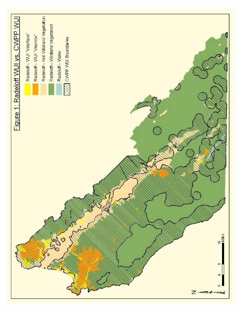

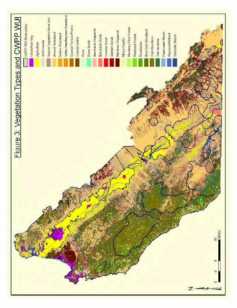
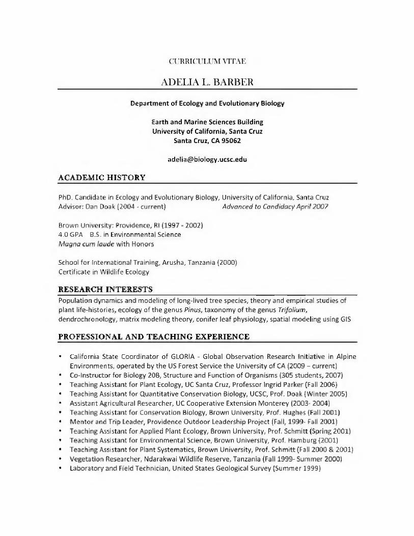


Monterey County Community Wildfire Protection PlanNovember 2010 v2
APPENDIX K
USFS Defensible Fuel Profile Zone Letter

Caring for the Land and Serving People Printed on Recycled Paper
Agriculture
United StatesDepartment of
Forest Service
Los Padres National Forest
Monterey Ranger District 406 S. Mildred King City, CA 93930 (831) 385-5434
File Code: 1950 Date: August 13, 2001
Dear Interested Party:
The Monterey Ranger District of the Los Padres National Forest is proposing to implement a defensible fuel profile zone (DFPZ) project (Monterey DFPZ Project) on National Forest system lands. Forest Service personnel are preparing to conduct an analysis of the proposed project area within the boundary of the Monterey Ranger District on selected lands outside the Ventana and Silver Peak Wilderness areas. Please see the enclosed map for a general location of the proposed project.
The purpose of this letter is to invite you to participate in the analysis process by providing your comments and any concerns you may have about this proposed project. To encourage your informed participation in this planning process, this letter includes a description of the proposed action and the purpose and need for action. PROPOSED ACTION
Trained specialists with the Forest Service are planning to apply fuels reduction treatments to establish defensible fuel profile zones (DFPZs) within ten identified units that cover a total of approximately 18,760 acres. Primary focuses for this project are travel corridors (roads and trails), campgrounds, National Forest System Lands adjacent to private property, administrative sites, and existing firelines. Treatments used to establish DFPZs include:
� Pruning, clearing and chipping hazardous fuels; � Burning of fuels using broadcast and spot burning methods; � Establishment of shaded areas by planting native tree species; and � Managing for native grasses.
Implementation would begin in the fall of 2001 and continue over the next ten years. Individual areas would be prioritized for burning to achieve desired results. Burning would be applied when moisture and air quality conditions meet prescription criteria. Prescription criteria are most likely to be met after fall season rains when moisture levels would limit fire severity and still be low enough to achieve desired levels of fuel consumption.
In general, fuel profiles would be changed to:
� Break-up horizontal and vertical continuity; � Reduce fire prone live fuels by managing for: younger vegetation, native grasses, and trees; � Reduce quantity of dead fuels; and � Use Forest Service facilities (campgrounds and administrative sites) to create models of
defensible space.

Page 2
Defensible Space DFPZs would be created on either side of roads, and around administrative and special use facilities to serve as safety zones, pre-attack zones, and escape routes during fire situations. A variable width buffer not to exceed 1,000 feet on each side of the road would be created by removing dead fuels, pruning live brush and trees, planting native trees, and managing for native grasses where appropriate. Treatments would vary depending on position on slope, soils conditions for plant establishment and growth, and aspect. Fuels around campgrounds would be managed so they could serve as safety zones in the event of fire. A 1,000-foot buffer would be created by removing dead fuels, pruning live brush and trees, and managing for native grasses where appropriate. Measures would be taken to ensure that unlawful access to open areas is controlled around campgrounds. Native grasses would be managed by burning and seeding where appropriate. This would be implemented in small (15 to 20 acre) areas over time in coordination with a qualified botanist. Natural seeding would be encouraged whenever possible. Where prescribed fire and/or reestablishment of native grasses are proposed, maintenance burning would be implemented about every seven years. Shaded DFPZs would be established by planting native tree species. Species mix for tree planting would be based on types of trees found presently or historically in the vicinity. Species to be considered would be: ponderosa pine, incense-cedar, sugar pine, Santa Lucia fir, and madrone. Any seeding or planting that occurs would be done using locally collected seed. The Forest Service would work with State and County Fire Departments in a cooperative effort to create safety zones around private homes and facilities. Treatment Units
The following table describes proposed actions by treatment unit.
UNIT ACRES PROPOSED ACTION
Arroyo 1,630 Establish variable width DFPZs up to 1,000 feet on each side of road. Apply prescribed fire at regular intervals and reestablish native grasses around the Horse Bridge/Santa Lucia Creek area. Establish variable width DFPZs along trails outside of wilderness.
Carmel 165 Prescribed fire would be applied to provide buffering between the wilderness and private property.
Cone 2,605 Establish variable width DFPZs up to 1,000 feet on each side of road. Plant trees to develop shaded DFPZs as part of roadside corridor where appropriate.
Manuel 400
Manage dozer lines and safety zones to favor native grasses. Fuels profiles would be managed so line could be used without repeated dozer entry. At specific locations where conditions are favorable, reestablish native grasses and/or plant trees to create a shaded DFPZ over ¼ mile segments.
Park 2,630 Create and maintain 1,000-foot DFPZs around campgrounds. Use prescribed fire to discourage the spread of noxious weeds.
Piney 1,710 Burn on a regular basis in the winter after the road has been closed.
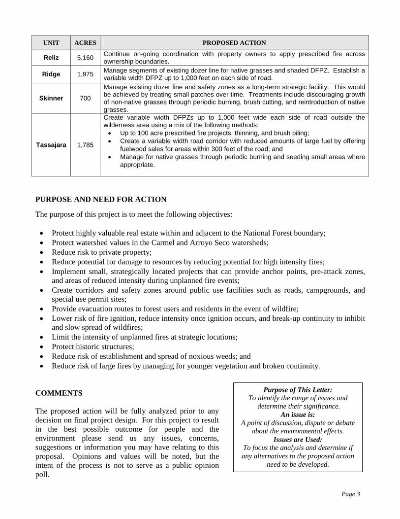
Page 3
UNIT ACRES PROPOSED ACTION
Reliz 5,160 Continue on-going coordination with property owners to apply prescribed fire across ownership boundaries.
Ridge 1,975 Manage segments of existing dozer line for native grasses and shaded DFPZ. Establish a variable width DFPZ up to 1,000 feet on each side of road.
Skinner 700
Manage existing dozer line and safety zones as a long-term strategic facility. This would be achieved by treating small patches over time. Treatments include discouraging growth of non-native grasses through periodic burning, brush cutting, and reintroduction of native grasses.
Tassajara 1,785
Create variable width DFPZs up to 1,000 feet wide each side of road outside the wilderness area using a mix of the following methods: • Up to 100 acre prescribed fire projects, thinning, and brush piling; • Create a variable width road corridor with reduced amounts of large fuel by offering
fuelwood sales for areas within 300 feet of the road; and • Manage for native grasses through periodic burning and seeding small areas where
appropriate.
PURPOSE AND NEED FOR ACTION
The purpose of this project is to meet the following objectives: • Protect highly valuable real estate within and adjacent to the National Forest boundary; • Protect watershed values in the Carmel and Arroyo Seco watersheds; • Reduce risk to private property; • Reduce potential for damage to resources by reducing potential for high intensity fires; • Implement small, strategically located projects that can provide anchor points, pre-attack zones,
and areas of reduced intensity during unplanned fire events; • Create corridors and safety zones around public use facilities such as roads, campgrounds, and
special use permit sites; • Provide evacuation routes to forest users and residents in the event of wildfire; • Lower risk of fire ignition, reduce intensity once ignition occurs, and break-up continuity to inhibit
and slow spread of wildfires; • Limit the intensity of unplanned fires at strategic locations; • Protect historic structures; • Reduce risk of establishment and spread of noxious weeds; and • Reduce risk of large fires by managing for younger vegetation and broken continuity.
COMMENTS The proposed action will be fully analyzed prior to any decision on final project design. For this project to result in the best possible outcome for people and the environment please send us any issues, concerns, suggestions or information you may have relating to this proposal. Opinions and values will be noted, but the intent of the process is not to serve as a public opinion poll.
Purpose of This Letter: To identify the range of issues and
determine their significance. An issue is:
A point of discussion, dispute or debate about the environmental effects.
Issues are Used: To focus the analysis and determine if any alternatives to the proposed action
need to be developed.
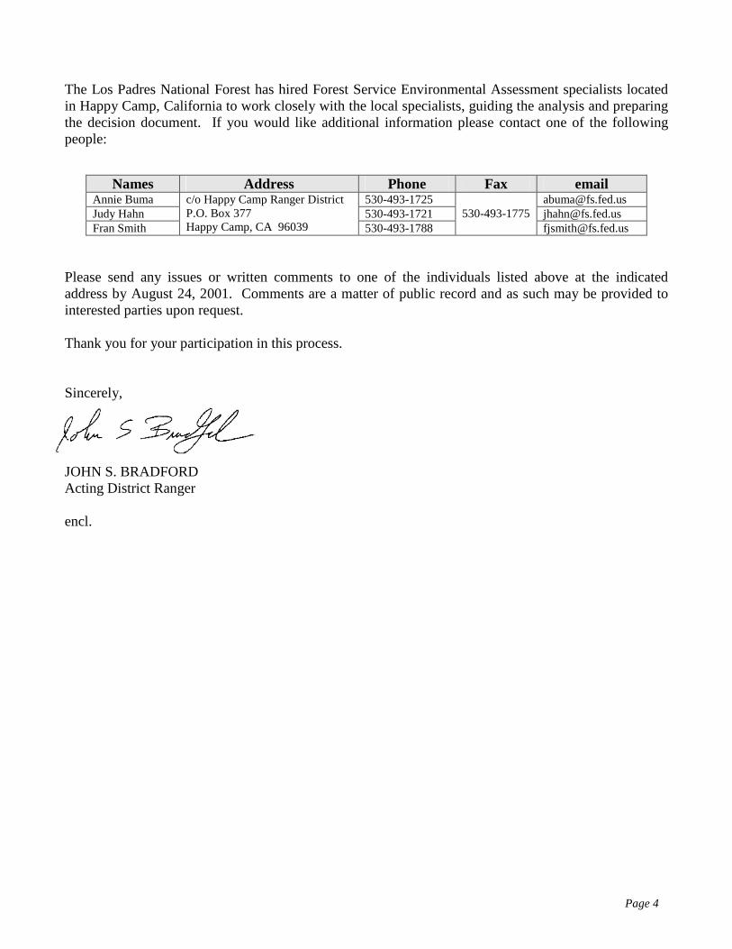
Page 4
The Los Padres National Forest has hired Forest Service Environmental Assessment specialists located in Happy Camp, California to work closely with the local specialists, guiding the analysis and preparing the decision document. If you would like additional information please contact one of the following people:
Names Address Phone Fax email Annie Buma 530-493-1725 [email protected] Judy Hahn 530-493-1721 [email protected] Fran Smith
c/o Happy Camp Ranger District P.O. Box 377 Happy Camp, CA 96039 530-493-1788
530-493-1775 [email protected]
Please send any issues or written comments to one of the individuals listed above at the indicated address by August 24, 2001. Comments are a matter of public record and as such may be provided to interested parties upon request. Thank you for your participation in this process. Sincerely,
JOHN S. BRADFORD Acting District Ranger encl.
APPENDIX L
Sample Fire Prescription

APPENDIX L – Sample Fire Prescription for Safe Controlled Burn in Chaparral
Rx Factors
CHAPARRAL
FUEL MODEL 4
Hot Moderate Cool
Fuel Load tons/acre 10 10 10
Relative Humidity %: 15% 18-25% 60%
Wind Speed (MFWS): 15 5-8 0
Wind Direction: ALL SSW ALL
Temperature
(Dry Bulb °)
95 70-75 40
Live Fuel Moisture%: 55 65-75 120
1 hr. T/L %: 4 5-7 10
10 hr. T/L: 5 6-8 14
100 hr. T/L 6 7-9 18
Soil/Duff Moisture %: Dry Dry/moist Moist
Probability ofSpot Fire Ignition
70 50-60 40
Flame Length (ft) 48 26 10
Effective Wind Speed (MPH) 12.6 6-8 1.9
Scorch Height (ft) N/A N/A N/A
Forward Rate of Spread (chains/hour) 449.6 140 18.7
Backing Rate of Spread (chains/hour) 6.7 6.0 2.8
Spotting Distance (miles) 1.4 .2 0

Monterey County Community Wildfire Protection PlanNovember 2010 v2
APPENDIX M
Acronym Table
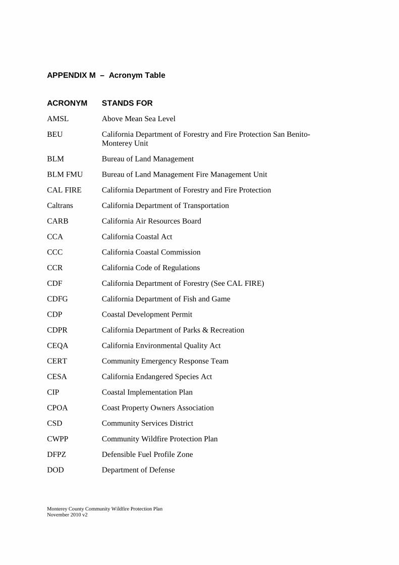
Monterey County Community Wildfire Protection PlanNovember 2010 v2
APPENDIX M – Acronym Table
ACRONYM STANDS FOR
AMSL Above Mean Sea Level
BEU California Department of Forestry and Fire Protection San Benito-Monterey Unit
BLM Bureau of Land Management
BLM FMU Bureau of Land Management Fire Management Unit
CAL FIRE California Department of Forestry and Fire Protection
Caltrans California Department of Transportation
CARB California Air Resources Board
CCA California Coastal Act
CCC California Coastal Commission
CCR California Code of Regulations
CDF California Department of Forestry (See CAL FIRE)
CDFG California Department of Fish and Game
CDP Coastal Development Permit
CDPR California Department of Parks & Recreation
CEQA California Environmental Quality Act
CERT Community Emergency Response Team
CESA California Endangered Species Act
CIP Coastal Implementation Plan
CPOA Coast Property Owners Association
CSD Community Services District
CWPP Community Wildfire Protection Plan
DFPZ Defensible Fuel Profile Zone
DOD Department of Defense

Monterey County Community Wildfire Protection PlanNovember 2010 v2
EIR Environmental Impact Report
EIS Environmental Impact Statement
ESA Endangered Species Act
ESHA Environmentally Sensitive Habitat Area
F&GC California Fish & Game Code
FAHJ Fire Authority Having Jurisdiction
FANS Friends, Artists and Neighbors of Elkhorn Slough
FARSITE Fire behavior and growth simulating software
FlamMap Fire behavior mapping and analysis software
FMP Fire Management Plan
FMU Fire Management Unit
FPD Fire Protection District
FRAP Fire & Resource Assessment Program
GIS Geographic Information System
HCP Habitat Conservation Plan
HFRA Healthy Forest Restoration Act of 2003
HFRZ Hazardous Fuel Reduction Zone
HMP Habitat Management Plan
LCP Local Coastal Program
LPNF Los Padres National Forest
LUP Land Use Plan (coastal)
MBUAPCD Monterey Bay Unified Air Pollution Control District
MC2WG Monterey County Wildfire Working Group
MCCWPP Monterey County Community Wildfire Protection Plan
MFSC Monterey Fire Safe Council
MIST Minimum Impact Suppression Tactics
MOU Memorandum of Understanding

Monterey County Community Wildfire Protection PlanNovember 2010 v2
NEPA National Environmental Policy Act
NPPA California Native Plant Protection Act
NPS National Park Service
NRCS Natural Resources Conservation Service
OES Office of Emergency Services
PBCSD Pebble Beach Community Services District
PNG Prunedale Neighbors Group
PPA Prunedale Preservation Alliance
PRC Public Resources Code
PSDLE Prepare, Stay and Defend, or Leave Early
ROD Record of Decision
SLFDS Santa Lucia Fire Defense System
SMP Smoke Management Program
SOD Sudden Oak Death
SPLATS Strategically Placed Landscape Area Treatments
SPOTS Strategic Placement of Treatments
SRA State Responsibility Area
USDA United States Department of Agriculture
USFS United States Forest Service
USFWS United States Fish & Wildlife Service
VMP Vegetation Management Program
WSA Wilderness Study Area
WUI Wildland-Urban Interface
Related Documents