Reviewer #1 (Prof S. Uppasit) The authors thank Dr Sirirat Uppasit for her valuable comments on the manuscript. We agree with most of her comments and we explain how we will modify the manuscript to account for them. Comment #1 1. Interesting and systematic approaches. Comment #2 2. No details on characteristic of the study area such as topography (topographic elevation), geomorphology, hydrology (hydraulic length or flow path, flow direction), number and location of the meteorological station, hydrogeology (depth of shallow groundwater level, hydrogeologic or rock unit), soil permeability. Some of details on characteristic of the study area such as hydrology (mean annual rainfall and season) and meteorological station have already been in the current manuscript (P 6 L 8-12). Other details will be included in revised manuscript as to respond the Reviewer Comment on Comment #10.9. Comment #3 3. Typing errors: 3.1 Page 3 Line 15, full stop: should edit from the original as ‘Juahir et al., 2010;’ 3.2 P 3 L 19, Space: ‘discharge. Information’ 3.3 P 3 L 28, P 10 L10, P10 L16, Capital letter: ‘Van Breen Method’ 3.4 P 4 L 9, Capital letter: ‘Indonesia’ 3.5 P 4 L 10, Capital letter: ‘Sunjoto, 1993; 1994)’ 3.6 P 4 L 15, plural: ‘roofs’ 3.7 P 4 L 20, year: ‘Indriatmoko, 2010’ 3.8 P 8 L 18, parameter: ‘(Awell base _ K )+(Awell wall _ K ) 3.9 P 10 L 26, article: ‘the Quantum GIS’ 3.10 P 12 L 12, numbering: ‘Fig.10’ 3.11 P 12 L 25, wrong number: ‘infiltration well per 500 m2 means implementing 104 120 wells’ 3.12 P 13 L 3, wrong number: ‘only be 26 030 wells’. The authors are very thankful for the corrections. These corrections will be included in revised manuscript. Comment #4 No Quantum GIS citation both in text citation and reference. Quantum GIS citation will be included in text citation and reference in revised manuscript. “Ramadana, A.L. and Kusnanto, H., 2010, Open Source GIS: Quantum GIS Application for Environment Information System, PSLH-UGM Press, Yogyakarta.” Comment #5 How much area of a small catchment that valid for the rational method? A small catchment that valid for the retional method is less than 3 km 2 . Comment #6 Check the format of references: Bappeda, 2010; Triatmojo, 2008 Check writting references in English: Arafat, 2008; Bappeda, 2010; Indriatmoko, 2010; Iriani, et al., 2013; Suripin, 2004; Triatmodjo, 2008. Format of those references and writing references in English will be included in revised manuscript. Comment #7

Welcome message from author
This document is posted to help you gain knowledge. Please leave a comment to let me know what you think about it! Share it to your friends and learn new things together.
Transcript

Reviewer #1 (Prof S. Uppasit) The authors thank Dr Sirirat Uppasit for her valuable comments on the manuscript. We agree with most of her comments and we explain how we will modify the manuscript to account for them. Comment #1 1. Interesting and systematic approaches. Comment #2 2. No details on characteristic of the study area such as topography (topographic elevation), geomorphology, hydrology (hydraulic length or flow path, flow direction), number and location of the meteorological station, hydrogeology (depth of shallow groundwater level, hydrogeologic or rock unit), soil permeability. Some of details on characteristic of the study area such as hydrology (mean annual rainfall and season) and meteorological station have already been in the current manuscript (P 6 L 8-12). Other details will be included in revised manuscript as to respond the Reviewer Comment on Comment #10.9. Comment #3 3. Typing errors: 3.1 Page 3 Line 15, full stop: should edit from the original as ‘Juahir et al., 2010;’ 3.2 P 3 L 19, Space: ‘discharge. Information’ 3.3 P 3 L 28, P 10 L10, P10 L16, Capital letter: ‘Van Breen Method’ 3.4 P 4 L 9, Capital letter: ‘Indonesia’ 3.5 P 4 L 10, Capital letter: ‘Sunjoto, 1993; 1994)’ 3.6 P 4 L 15, plural: ‘roofs’ 3.7 P 4 L 20, year: ‘Indriatmoko, 2010’ 3.8 P 8 L 18, parameter: ‘(Awell base _ K )+(Awell wall _ K ) 3.9 P 10 L 26, article: ‘the Quantum GIS’ 3.10 P 12 L 12, numbering: ‘Fig.10’ 3.11 P 12 L 25, wrong number: ‘infiltration well per 500 m2 means implementing 104 120 wells’ 3.12 P 13 L 3, wrong number: ‘only be 26 030 wells’. The authors are very thankful for the corrections. These corrections will be included in revised manuscript. Comment #4 No Quantum GIS citation both in text citation and reference. Quantum GIS citation will be included in text citation and reference in revised manuscript.
“Ramadana, A.L. and Kusnanto, H., 2010, Open Source GIS: Quantum GIS Application for Environment Information System, PSLH-UGM Press, Yogyakarta.”
Comment #5 How much area of a small catchment that valid for the rational method? A small catchment that valid for the retional method is less than 3 km2. Comment #6 Check the format of references: Bappeda, 2010; Triatmojo, 2008 Check writting references in English: Arafat, 2008; Bappeda, 2010; Indriatmoko, 2010; Iriani, et al., 2013; Suripin, 2004; Triatmodjo, 2008. Format of those references and writing references in English will be included in revised manuscript. Comment #7

What is ‘the requirement of National Standard’ (on P 8 L 10)? Should clarify the meaning of this word. The requirement of National Standard means the Guide for determining suitable area for infiltration well. Comment #8 How would you get the criteria and numbers for determining the suitable areas? SNI No. 03-2453-2002 which contains engineering design procedure for infiltration well in yard.
Comment #9
Heading 2.2 Infiltration well application (more descriptive): 9.1 How about the well wall? Is it screened continuously along the bore or at specific depth intervals? It may be modified the well wall in Fig. 1 that seems cement wall. 9.2 How would you get the soil permeability? Is there any difference between the soil permeability in vertical and horizontal directions? (The number of infiltration wells will be changed when the permeability change.) 9.3 Symbols: soil permeability should be ‘k’, well radius should be ‘r’
Heading 2.2 “Infiltration well application” will be changed into “Requirement and Number of
Infiltration Wells”.
9.1 There are several types of infiltration wells and the one adopted in this study used cement wall.
9.2 Soil permeability map is available and the authors used that map for this study. Soil permeability
map which is available here is in vertical direction only, but it is sufficient for analysis as this study
only accounts recharge in vertical direction.
9.3 This will be adopted in revised manuscript.
Comment #10
Figures: 10.1 Fig.1: How about the well wall? 10.2 Fig.2, 3, 7 and 9 are not clear (should be used ‘pattern fill’) and their scale bar are not inconsistent (may be 0 to 5,000 m.) 10.3 Fig. 2: adding the index map showing the location of the study area (catchment) in Indonesia, location of the main city. 10.4 Fig. 3: Is there no ‘Green Land’ in the existing land use map? 10.5 Fig. 4: should edit from ‘rainfall,mm/hr’ as ‘Rainfall, mm h-1’ and from ‘duration, hours’ as ‘Duration, h’. 10.6 Fig. 6: Capital letter ‘Van Breeen’ 10.7 Fig.7: should be descriptive (a) Scenario 1 (C=0. 45), (b) Scenario 2 (C=0.47), (c) Scenario 3 (C=0. 74), (d) Scenario 4 (C=0.72) 10.8 Fig.8: How about the peak discharge (flood peak) of the current land use and each scenario? Where is description about this calculated value? 10.9 Fig. 9: The suitable area is not clear. Maps of soil permeability, depth to groundwater table, and slope should be included. 10.10 Fig. 10: Should be using the word ‘infiltration well’ instead of ‘absorption well’. Flood peak reduction shown in this figure is of the current condition or not?
10.1. Well wall is cement wall.
10.2. The comment has been adopted and will be included in revised manuscript.
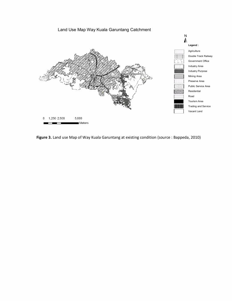
Figure 3. Land use Map of Way Kuala Garuntang at existing condition (source : Bappeda, 2010)
Land Use Map Way Kuala Garuntang Catchment
±Legend :
Agriculture
Double Track Railway
Government Office
Industry Area
Industry Purpose
Mining Area
Preserve Area
Public Service Area
Residential
Road
Tourism Area
Trading and Service
Vacant Land

(a) Scenario 1 (C = 0.45) (b) Scenario 2 (C = 0.47)
(c) Scenario 3 (C = 0.74) (d) Scenario 4 (C = 0.72)
Legend :
Figure 7. Land use map on the four land use change scenarios
Agriculture
Double Track Railway
Government Office
Green Land
Industry Area
Industry Purpose
Mining Area
Preserve Area
Public Service Area
Residential
Road
Tourism Area
Trading and Service
Vacant Land

10.3. The comment has been adopted and will be included in revised manuscript.
Figure 2. Way Kuala Garuntang catchment within the city of Bandar Lampung
10.4. There is no green land in the existing land use map.
10.5. The comment has been adopted and will be included in revised manuscript.
10.6. The comment has been adopted and will be included in revised manuscript.
10.7. The comment has been adopted and will be included in revised manuscript.
10.8. The authors hope that Figure 8 can tell about the impact of each scenario compared to existing
land use on flood peaks. While the description of flood peak at current land use is in P 11 Line 3-5.
10.9. Maps of soil permeability, depth to groundwater table and slope will be included in revised
manuscript. Suitable area map will be modified to make it clearer.
Legend :
Way Kuala Garuntang River
Way Kuala Garuntang Catchment
Bandar Lampung Border Administrative
Way Kuala Garuntang Catchment Map
±

(a) (b)
(c) (d)
Legend :
Permeability > 2 cm h-1
Depth < 3 m Depth > 3 m Slope < 30
Slope > 30 Suitable Area Not Suitable Area
Figure 9. Depth to groundwater table map (a), soil permeability map (b), slope map (c), suitable area
for infiltration well map (d).
10.10. The word absorption well will be changed to infiltration well. Yes, flood peak reduction shown
in Fig. 10 is of the current condition.
Related Documents