Margaret Glowacki DPD Shoreline Master Program Ordinance EXH C August 27, 2012 Version 1 Exhibit C to the DPD Shoreline Master Program Ordinance AUGUST 2012 Restoration and Enhancement Plan FINAL

Welcome message from author
This document is posted to help you gain knowledge. Please leave a comment to let me know what you think about it! Share it to your friends and learn new things together.
Transcript
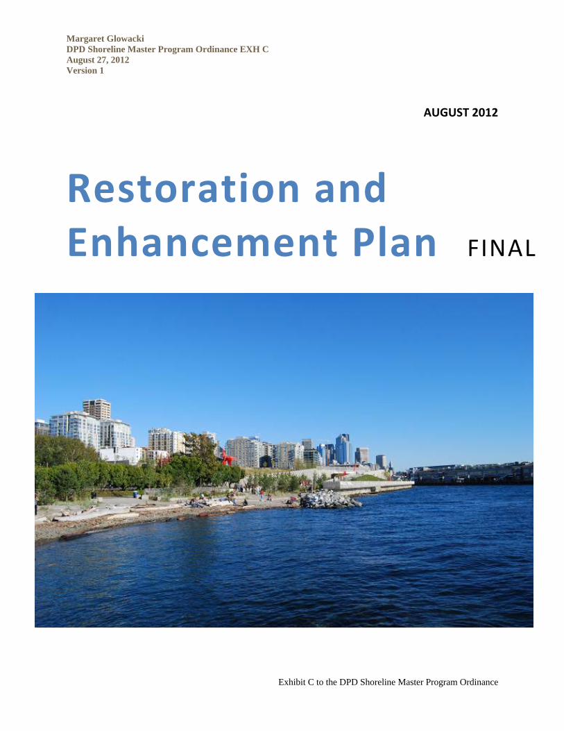
Margaret Glowacki DPD Shoreline Master Program Ordinance EXH C August 27, 2012 Version 1
Exhibit C to the DPD Shoreline Master Program Ordinance
AUGUST 2012
Restoration and Enhancement Plan FINAL
Margaret Glowacki DPD Shoreline Master Program Ordinance EXH C August 27, 2012 Version 1
Exhibit C to the DPD Shoreline Master Program Ordinance
FINAL
RESTORATION AND ENHANCEMENT PLAN
CITY OF SEATTLE SHORELINE MASTER PROGRAM
Prepared for City of Seattle
Department of Planning and Development
700 Fifth Avenue, Suite 2200
Seattle, Washington 98124
Prepared by Anchor QEA, LLC
1423 3rd Avenue, Suite 300
Seattle, Washington 98101
August 2012
Final Restoration Plan i
ACKNOWLEDGEMENTS AND COLLABORATORS
This report was prepared by Anchor QEA, LLC, with input from the City of Seattle Department of Planning and Development. Review of the report was conducted by the following City of Seattle departments: Public Utilities, Transportation and Parks and Recreation. The base information for this report is from Seattle’s Shoreline Characterization Report completed in March of 2009, available on DPD’s website at: http://www.seattle.gov/dpd/Planning/ ShorelineMasterProgramUpdate/ReportsMaterials/default.asp. The contributions of these authors and reviewers are acknowledged and appreciated.
Final Restoration Plan ii
TABLE OF CONTENTS
1 INTRODUCTION ....................................................................................................................... 1 1.1 Plan Purpose and Scope ................................................................................................. 2
1.1.1 What This Plan Contains ........................................................................................... 2 1.1.2 What This Plan Does Not Contain ............................................................................ 3
1.2 SMP Restoration Definition, Vision, and Goals ............................................................. 3
2 EXISTING RESTORATION PLANNING, PROGRAMS, AND PARTNERS .................................... 6 2.1 City of Seattle ................................................................................................................... 6 2.2 Carkeek Watershed Community Action Project............................................................. 9 2.3 Duwamish River Cleanup Coalition and Technical Advisory Group ............................. 9 2.4 Earth Corps ...................................................................................................................... 9 2.5 Fauntleroy Watershed Council ..................................................................................... 10 2.6 Friends of Madrona Woods .......................................................................................... 10 2.7 Friends of the Cedar River Watershed ......................................................................... 10 2.8 People for Puget Sound ................................................................................................ 10 2.9 Port of Seattle ................................................................................................................ 11 2.10 Puget Sound Partnership .............................................................................................. 11 2.11 Puget SoundKeeper Alliance ........................................................................................ 11 2.12 Seattle Aquarium ........................................................................................................... 11 2.13 University of Washington .............................................................................................. 12
3 RESTORATION STRATEGY ................................................................................................... 13 3.1 Restoration Strategies .................................................................................................. 13 3.2 Assessment of Existing Shoreline Impairments .......................................................... 15 3.3 Landscape Context Considerations in Restoration Planning ..................................... 16 3.4 Habitat Protection and Conservation ........................................................................... 18 3.5 Application of Restoration Strategies .......................................................................... 18 3.6 Project Identification ..................................................................................................... 19
4 APPLICABLE RESTORATION ACTIONS ................................................................................. 22 4.1 City-wide Impairments Summary .................................................................................. 22 4.2 Lake Washington ........................................................................................................... 24
4.2.1 Impairments ............................................................................................................. 24 4.2.2 Applicable Restoration Actions ............................................................................... 27
4.3 Lake Union and Ship Canal .......................................................................................... 33 4.3.1 Impairments ............................................................................................................. 34 4.3.2 Applicable Restoration Actions ............................................................................... 36
4.4 Duwamish River ............................................................................................................. 40
Final Restoration Plan iii
4.4.1 Impairments ............................................................................................................. 41 4.4.2 Applicable Restoration Actions ............................................................................... 43
4.5 Puget Sound, including Shilshole Bay and Elliott Bay ................................................ 54 4.5.1 Impairments ............................................................................................................. 54 4.5.2 Applicable Restoration Actions ............................................................................... 58
4.6 Green Lake .................................................................................................................... 64 4.6.1 Impairments ............................................................................................................. 64 4.6.2 Applicable Restoration Actions ............................................................................... 65
5 IMPLEMENTATION ............................................................................................................... 68 5.1 Implementation Strategy .............................................................................................. 68 5.2 Timeline, Benchmarks, and Monitoring ....................................................................... 68 5.3 Potential Funding .......................................................................................................... 69 5.4 Conclusions ................................................................................................................... 71
6 REFERENCES ....................................................................................................................... 72
List of Tables Table 1 Guidance for Suitability of Restoration Strategies based on Level of
Impairment ........................................................................................................... 17 Table 2 Restoration Actions and Watershed Processes Addressed ............................. 19 Table 3 Freshwater Reach Assignments Based on Reach and Sub-reach Impairment
Category ................................................................................................................ 23 Table 4 Marine Reach Assignments Based on Reach and Sub-reach Impairment
Category ................................................................................................................ 23 Table 5 Lake Washington Reach Assignments Based on Reach and Sub-reach
Impairment Category ........................................................................................... 24 Table 6 Impairment Category from Shoreline Characterization Report (City of Seattle
2009) for Various Watershed Processes at Lake Washington—City Shorelines ............................................................................................................. 26
Table 7 Applicable Restoration Actions—Lake Washington ........................................... 29 Table 8 Projects for Lake Washington ............................................................................ 31 Table 9 Lake Union Reach Assignments Based on Reach and Sub-reach Impairment
Category ................................................................................................................ 34 Table 10 Impairment Ranges from Shoreline Characterization Report (City of Seattle
2009) for Various Watershed Processes at Lake Union and Ship Canal—City Shorelines ............................................................................................................. 35
Table 11 Applicable Restoration Actions—Lake Union and Ship Canal .......................... 37 Table 12 Projects for Lake Union and the Ship Canal ..................................................... 39
Final Restoration Plan iv
Table 13 Duwamish River Reach Assignments Based on Reach and Sub-reach Impairment Category ........................................................................................... 41
Table 14 Impairment ranges from Shoreline Characterization Report (City of Seattle 2009) for various watershed processes at Duwamish River – City Shorelines ............................................................................................................. 42
Table 15 Applicable Restoration Actions—Duwamish River ............................................ 44 Table 16 Projects for the Duwamish River ........................................................................ 46 Table 17 Puget Sound (including Shilshole and Elliott Bay) Reach Assignments Based
on Reach and Sub-reach Impairment Category ................................................ 54 Table 18 Impairment Ranges from Shoreline Characterization Report (City of Seattle
2009) for Various Watershed Processes at Puget Sound—City Shorelines ..... 57 Table 19 Applicable Restoration Actions—Puget Sound .................................................. 59 Table 20 Projects for Puget Sound .................................................................................... 61 Table 21 Green Lake Reach Assignments based on Reach and sub-reach
Impairment ........................................................................................................... 64 Table 22 Impairment Ranges Impairment Ranges from Shoreline Characterization
Report (City of Seattle 2009) for Various Watershed Processes at Green Lake–City shorelines ........................................................................................... 65
Table 23 Applicable Restoration Actions—Green Lake .................................................... 67
List of Maps – Separate Documents Map A Map Folio – Maps 1 through 25
Final Restoration Plan v
LIST OF ACRONYMS AND ABBREVIATIONS ALEA Aquatic Lands Enhancement Account City City of Seattle CMP Campus Master Plan CSO combined sewer overflow CWCAP Carkeek Watershed Community Action Project DRCC/TAG Duwamish River Cleanup Coalition Ecology Washington State Department of Ecology GIS Geographic Information System ILF in-lieu fee LWD large woody debris LDR Plan Lower Duwamish River Habitat Restoration Plan OHW ordinary high water NOAA National Oceanic and Atmospheric Administration NPDES National Pollutant Discharge Elimination System NRDA Natural Resource Damage Assessment PSNERP Puget Sound Nearshore Ecosystem Restoration Project Plan Restoration and Enhancement Plan Port Port of Seattle PSNERP Puget Sound Nearshore Ecosystem Restoration Project PSP Puget Sound Partnership Puget Sound TRT Puget Sound Technical Recovery Team RCW Revised Code of Washington SDOT Seattle Department of Transportation SFLO Washington Department of Natural Resources Small Forest
Landowner Office SMA (or the Act) Washington State Shoreline Management Act SMP City of Seattle Shoreline Master Program SRFB Salmon Recovery Funding Board State State of Washington TIA total impervious surface area UW University of Washington WAC Washington Administrative Code
Final Restoration Plan vi
GLOSSARY The following terms will have these definitions in the context of this Restoration and Enhancement Plan. They are listed in alphabetical order. ecological function The work performed or role played individually or collectively by the
physical, chemical, and biological processes that contribute to the maintenance of the aquatic and terrestrial environments that constitute the natural environment.
goals Measures by which the City of Seattle’s vision can be met.
habitat An ecological or environmental area that is inhabited by and may have capacity to support the survival and growth of organisms.
impairment Habitat degradation; in this document, refers to the loss of ecological function of shorelines as described in the City of Seattle Shoreline Characterization Report (City of Seattle 2009).
impervious surface Any surface exposed to rainwater from which most water runs off. Common impervious surfaces include, but are not limited to, roof tops, walkways, patios, driveways, formal planters, parking lots or storage areas, concrete or asphalt paving, permeable paving, gravel surfaces subjected to vehicular traffic, compact gravel, packed earthen materials, and oiled macadam or other surfaces which similarly impede the natural infiltration of stormwater. Open, uncovered retention/detention facilities shall not be considered as impervious surfaces for the purposes of determining whether the thresholds for application of minimum requirements are exceeded. Open, uncovered retention/detention facilities shall be considered impervious surfaces for purposes of stormwater modeling.
measures of success
Measurable criteria that are currently quantified and which are suitable for before/after comparison. The City of Seattle may use these to evaluate site-specific or overall restoration action success; e.g., compare total linear feet of bulkhead in an area before and after a restoration action takes place.
project A site-specific set of habitat activities.
reach and sub-reach For the purposes of this report, a reach is a contiguous area within the shoreline jurisdiction that has somewhat consistent physical and biological conditions. Sub-reaches are contiguous areas of
Final Restoration Plan vii
shorelands with relatively consistent levels of impairment, contiguous areas with variations in impairment that fall within a distinct range, contiguous areas with impairment that follows a consistent trend and in rare cases contiguous areas with heterogeneous levels of impairment.
restoration “the reestablishment or upgrading of impaired ecological shoreline processes or functions. This may be accomplished through measures including but not limited to re-vegetation, removal of intrusive shoreline structures and removal or treatment of toxic materials. Restoration does not imply a requirement for returning the shoreline area to aboriginal or pre-European settlement conditions” (Washington Administrative Code [WAC] 173-26-020). In the context of this document, restoration is a blanket term encompassed by four restoration strategies, which are described under “restoration strategy” below.
restoration strategy Refers to the four strategies of protection, restoration of ecological processes, rehabilitation, and creation. These are the Puget Sound Technical Recovery Team’s (Puget Sound TRT’s) proposed general habitat management strategies, including protection, restoration, rehabilitation, and substitution, that are to be used by watershed groups and others working for regional salmonid recovery (Puget Sound TRT 2003):
Protection can be applied where habitat is presently functioning at a high level and supports natural habitat-forming or -sustaining processes. For example, conserve the natural sediment delivery processes from a feeder bluff to the intertidal zone by keeping that section of shoreline unarmored.
Restoration of ecological processes can be applied where habitat is impaired but natural processes can be recovered. For example, restore the natural sediment delivery processes from a feeder bluff to the intertidal zone by removing shoreline armoring that currently prevents bluff material from eroding and entering the intertidal zone.
Rehabilitation can be applied where habitat is impaired and restoration of full function and supporting processes appears infeasible; however, limited improvements to functions and
Final Restoration Plan viii
supporting processes can be achieved through partial re-establishment of ecosystem processes or functions. For example, rehabilitate the delivery of sediment from a feeder bluff to the intertidal zone in areas where armoring cannot/will not be removed, by moving any sediment that erodes from the bluff over the armoring and into the intertidal zone.
Creation can be applied where habitat function is lost through anthropogenic degradation and restoration and/or rehabilitation are not possible, but creation of habitat features to lead to replacement of lost function can be accomplished. For example, substitute the delivery of sediment from a feeder bluff to the intertidal zone in areas where armoring cannot/will not be removed, by importing sediment and placing it in the intertidal zone to “nourish” the beach.
restoration actions A list of the actions on which effort and funding could be applied.
shorelands Those lands extending landward for 200 feet in all directions as measured on a horizontal plane from the ordinary high water mark; floodways and contiguous floodplain areas landward two hundred feet from such floodways; and all wetlands and river deltas associated with the streams, lakes, and tidal waters.
structure The composition and arrangement of physical attributes that compose habitat and that are formed as a result of watershed processes.
sub-reach See “reach.”
vision Conceptual description of desired future shoreline condition.
watershed processes
The dynamic physical and chemical interactions that form and maintain the landscape at the geographic scales of watersheds to basins (hundreds to thousands of square miles; Stanley et al. 2005). These processes include the delivery, movement, and loss of water, large woody debris, sediment, phosphorus, nitrogen, toxins, and pathogens, as well as wave energy, tidal influences, and light energy.
Final Restoration Plan ES-1
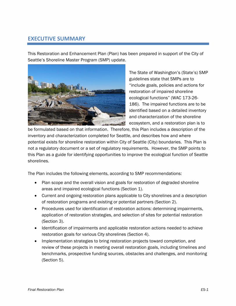
EXECUTIVE SUMMARY
This Restoration and Enhancement Plan (Plan) has been prepared in support of the City of Seattle’s Shoreline Master Program (SMP) update.
The State of Washington’s (State’s) SMP guidelines state that SMPs are to “include goals, policies and actions for restoration of impaired shoreline ecological functions” (WAC 173-26-186). The impaired functions are to be identified based on a detailed inventory and characterization of the shoreline ecosystem, and a restoration plan is to
be formulated based on that information. Therefore, this Plan includes a description of the inventory and characterization completed for Seattle, and describes how and where potential exists for shoreline restoration within City of Seattle (City) boundaries. This Plan is not a regulatory document or a set of regulatory requirements. However, the SMP points to this Plan as a guide for identifying opportunities to improve the ecological function of Seattle shorelines. The Plan includes the following elements, according to SMP recommendations:
Plan scope and the overall vision and goals for restoration of degraded shoreline areas and impaired ecological functions (Section 1).
Current and ongoing restoration plans applicable to City shorelines and a description of restoration programs and existing or potential partners (Section 2).
Procedures used for identification of restoration actions: determining impairments, application of restoration strategies, and selection of sites for potential restoration (Section 3).
Identification of impairments and applicable restoration actions needed to achieve restoration goals for various City shorelines (Section 4).
Implementation strategies to bring restoration projects toward completion, and review of these projects in meeting overall restoration goals, including timelines and benchmarks, prospective funding sources, obstacles and challenges, and monitoring (Section 5).
Executive Summary
Final Restoration Plan ES-2
Plan Purpose and Scope The scope of this Plan is as a non-regulatory document prepared under the SMP guidelines. As such, it contains the inventory-based process and results for identification of restoration actions and projects in the City of Seattle. The Plan scope does not include regulatory language, will not fully incorporate or directly align with outside restoration planning documents, and does not contain mitigation requirements, concepts, or projects. The State’s shoreline guidelines define restoration as “the re-establishment or upgrading of impaired ecological shoreline processes or functions.” In the context of this document, restoration is a blanket term covering four “restoration strategies” and is implemented by “restoration actions.” The four restoration strategies discussed in this document are: protection, restoration of ecological processes, rehabilitation, and creation.
SMP Restoration Definition, Vision, and Goals As part of the SMP update process, the City has developed an overall vision for shoreline restoration. Goals have been developed that describe the specific measures that should be undertaken to meet the vision and which, in most cases, can be used as metrics to monitor the City’s progress in achieving the vision.
Existing Restoration Planning, Programs and Partners Many groups are involved in shoreline restoration in and around the City, including the City of Seattle, the Port of Seattle, the University of Washington, the Puget Sound Partnership, watershed groups, and several local environmental nonprofit groups and community organizations. Within the City of Seattle organization, Seattle Public Utilities is part of salmon recovery planning for Water Resource Inventory Areas 8 and 9, the Cedar–Sammamish and Green–Duwamish watersheds respectively. Seattle Public Utilities has helped coordinate and fund both scientific research regarding salmonid use of shorelines and effectiveness monitoring of restoration projects in this role. Seattle Parks and Recreation has implemented many shoreline restoration projects along Lake Washington, the Ship Canal, the Duwamish River and Puget Sound and has received funding from both the King Conservation District and Salmon Recovery Funding Board for these projects. Seattle Department of Transportation is involved with planning for the replacement of the seawall along Seattle’s waterfront and has
Executive Summary
Final Restoration Plan ES-3
been testing alternatives to the homogenous surface with the goal of improving habitat for salmonid species and other aquatic organisms in Elliott Bay. The Port of Seattle (Port) has directly funded several shoreline restoration projects and is a contributor to shoreline restoration planning within the City of Seattle. The Port’s 2007 Seaport Shoreline Plan and 2009 Lower Duwamish River Habitat Restoration Plan (Port of Seattle 2009) outline opportunities and plans for fish and wildlife habitat along Seattle shorelines. The University of Washington (UW) plans for and implements shoreline restoration at its Seattle Campus through its Campus Master Plan, its certification by Salmon-Safe, its work in wetlands research, and by securing public access, open space, and water-dependent recreational areas along its shorelines. The Puget Sound Partnership (PSP) has created a plan for cleanup, restoration, and protection for Puget Sound through its 2011 Action Agenda. The Action Agenda has identified priority strategies for implementation, as well as near-term actions to support these strategies. Other nonprofit community groups involved in restoration in Seattle include Carkeek Watershed Community Action project, Duwamish River Cleanup Coalition and Technical Advisory Group, Earth Corps, Fauntleroy Watershed Council, Friends of Madrona Woods, Friends of the Cedar River Watershed, People for Puget Sound, Puget Soundkeeper Alliance, the Seattle Aquarium, and others.
Applicable Restoration Actions Determining the applicable actions to implement restoration strategies on the City shorelines relied upon a detailed shoreline analysis, which classified impairment levels of basic ecological functions. These results were presented in the City of Seattle Shoreline Characterization Report (City of Seattle 2009). Shorelines assessed were Lake Washington; Lake Union and the Ship Canal; the Duwamish River; Puget Sound, including Elliott Bay and Shilshole Bay; and Green Lake. The framework was based on a method used by regional scientists that provides a streamlined approach for characterizing watershed processes. Processes evaluated included delivery, movement, and loss of water, large woody debris (LWD), sediment, phosphorus, nitrogen, toxins, and pathogens, as they enter, pass through, and eventually leave the watershed; wave energy and tidal influences for marine shorelines; and light energy, including artificial light. The assessment identified the level of impact on
Executive Summary
Final Restoration Plan ES-4
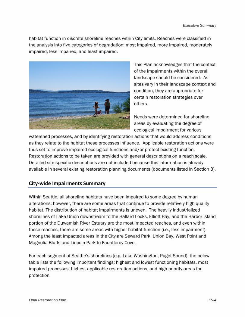
habitat function in discrete shoreline reaches within City limits. Reaches were classified in the analysis into five categories of degradation: most impaired, more impaired, moderately impaired, less impaired, and least impaired.
This Plan acknowledges that the context of the impairments within the overall landscape should be considered. As sites vary in their landscape context and condition, they are appropriate for certain restoration strategies over others. Needs were determined for shoreline areas by evaluating the degree of ecological impairment for various
watershed processes, and by identifying restoration actions that would address conditions as they relate to the habitat these processes influence. Applicable restoration actions were thus set to improve impaired ecological functions and/or protect existing function. Restoration actions to be taken are provided with general descriptions on a reach scale. Detailed site-specific descriptions are not included because this information is already available in several existing restoration planning documents (documents listed in Section 3).
City‐wide Impairments Summary Within Seattle, all shoreline habitats have been impaired to some degree by human alterations; however, there are some areas that continue to provide relatively high quality habitat. The distribution of habitat impairments is uneven. The heavily industrialized shorelines of Lake Union downstream to the Ballard Locks, Elliott Bay, and the Harbor Island portion of the Duwamish River Estuary are the most impacted reaches, and even within these reaches, there are some areas with higher habitat function (i.e., less impairment). Among the least impacted areas in the City are Seward Park, Union Bay, West Point and Magnolia Bluffs and Lincoln Park to Fauntleroy Cove. For each segment of Seattle’s shorelines (e.g. Lake Washington, Puget Sound), the below table lists the following important findings: highest and lowest functioning habitats, most impaired processes, highest applicable restoration actions, and high priority areas for protection.
Executive Summary
Final Restoration Plan ES-5
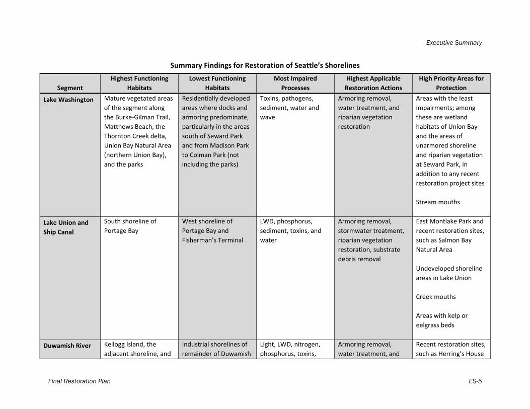
Summary Findings for Restoration of Seattle’s Shorelines
Segment
Highest Functioning
Habitats
Lowest Functioning
Habitats
Most Impaired
Processes
Highest Applicable
Restoration Actions
High Priority Areas for
Protection
Lake Washington Mature vegetated areas
of the segment along
the Burke‐Gilman Trail,
Matthews Beach, the
Thornton Creek delta,
Union Bay Natural Area
(northern Union Bay),
and the parks
Residentially developed
areas where docks and
armoring predominate,
particularly in the areas
south of Seward Park
and from Madison Park
to Colman Park (not
including the parks)
Toxins, pathogens,
sediment, water and
wave
Armoring removal,
water treatment, and
riparian vegetation
restoration
Areas with the least
impairments; among
these are wetland
habitats of Union Bay
and the areas of
unarmored shoreline
and riparian vegetation
at Seward Park, in
addition to any recent
restoration project sites
Stream mouths
Lake Union and
Ship Canal
South shoreline of
Portage Bay
West shoreline of
Portage Bay and
Fisherman’s Terminal
LWD, phosphorus,
sediment, toxins, and
water
Armoring removal,
stormwater treatment,
riparian vegetation
restoration, substrate
debris removal
East Montlake Park and
recent restoration sites,
such as Salmon Bay
Natural Area
Undeveloped shoreline
areas in Lake Union
Creek mouths
Areas with kelp or
eelgrass beds
Duwamish River Kellogg Island, the
adjacent shoreline, and
Industrial shorelines of
remainder of Duwamish
Light, LWD, nitrogen,
phosphorus, toxins,
Armoring removal,
water treatment, and
Recent restoration sites,
such as Herring’s House
Executive Summary
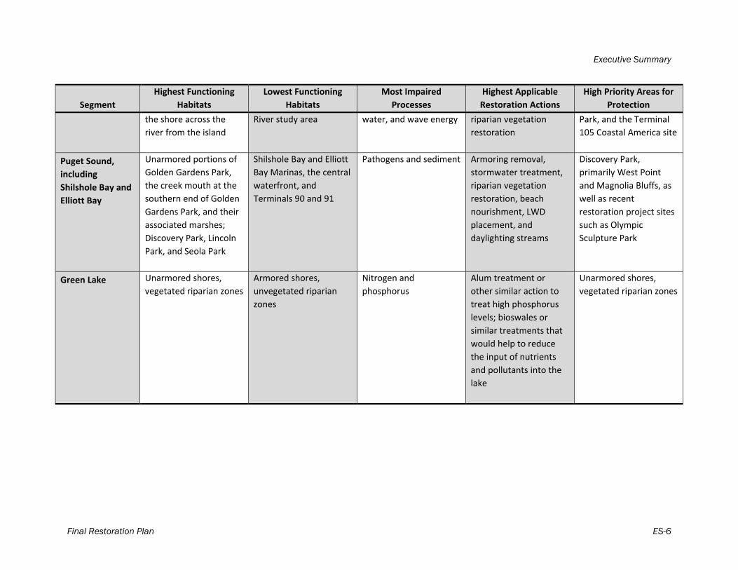
Final Restoration Plan ES-6
Segment
Highest Functioning
Habitats
Lowest Functioning
Habitats
Most Impaired
Processes
Highest Applicable
Restoration Actions
High Priority Areas for
Protection
the shore across the
river from the island
River study area
water, and wave energy
riparian vegetation
restoration
Park, and the Terminal
105 Coastal America site
Puget Sound,
including
Shilshole Bay and
Elliott Bay
Unarmored portions of
Golden Gardens Park,
the creek mouth at the
southern end of Golden
Gardens Park, and their
associated marshes;
Discovery Park, Lincoln
Park, and Seola Park
Shilshole Bay and Elliott
Bay Marinas, the central
waterfront, and
Terminals 90 and 91
Pathogens and sediment
Armoring removal,
stormwater treatment,
riparian vegetation
restoration, beach
nourishment, LWD
placement, and
daylighting streams
Discovery Park,
primarily West Point
and Magnolia Bluffs, as
well as recent
restoration project sites
such as Olympic
Sculpture Park
Green Lake Unarmored shores,
vegetated riparian zones
Armored shores,
unvegetated riparian
zones
Nitrogen and
phosphorus
Alum treatment or
other similar action to
treat high phosphorus
levels; bioswales or
similar treatments that
would help to reduce
the input of nutrients
and pollutants into the
lake
Unarmored shores,
vegetated riparian zones
Executive Summary
Final Restoration Plan ES-7
Implementation Implementation of this Plan will be a joint effort within the City and between the City and its partners. As is the case for most restoration work, the opportunities described in this Plan will require extensive cooperation and coordination with citizens, public agencies, private landowners, and other stakeholders. The City’s Comprehensive Plan will direct City departments to continue their work restoring the City’s shorelines and to use the Plan to guide their efforts. The City’s work as it relates to this Plan will be monitored and evaluated on a set timeline against a suite of benchmarks to determine consistency with the State’s SMP standard to improve ecological function over-time with the implementation of the Plan. This Plan will be implemented when Seattle’s Shoreline Master Program is adopted by the Washington State Department of Ecology, with a timeline based on 10-year intervals. At each interval, ecological benchmarks will be evaluated for change. There is currently no dedicated funding source for the restoration actions presented herein. Implementation of the work described in this Plan is dependent on grant funding, and a variety of other outside funding sources. It is expected that funding will be derived from various sources. Redevelopment of the shoreline is acknowledged as a key opportunity for restoration along urban shorelines such as Seattle’s. When shoreline property is redeveloped, opportunities exist not only to mitigate for redevelopment-related impacts but also to go beyond regulatory mitigation and provide restoration of shoreline ecological function.
Final Restoration Plan 1
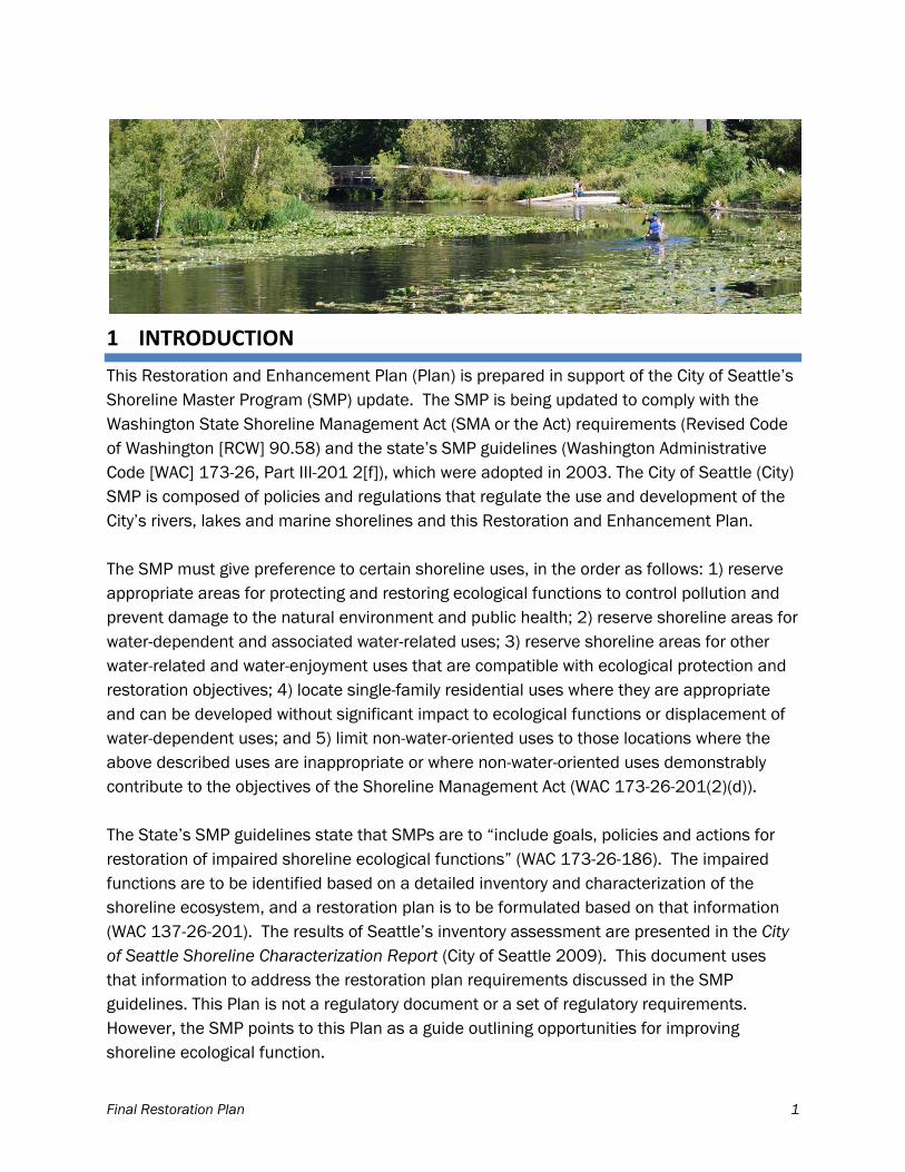
1 INTRODUCTION
This Restoration and Enhancement Plan (Plan) is prepared in support of the City of Seattle’s Shoreline Master Program (SMP) update. The SMP is being updated to comply with the Washington State Shoreline Management Act (SMA or the Act) requirements (Revised Code of Washington [RCW] 90.58) and the state’s SMP guidelines (Washington Administrative Code [WAC] 173-26, Part III-201 2[f]), which were adopted in 2003. The City of Seattle (City) SMP is composed of policies and regulations that regulate the use and development of the City’s rivers, lakes and marine shorelines and this Restoration and Enhancement Plan. The SMP must give preference to certain shoreline uses, in the order as follows: 1) reserve appropriate areas for protecting and restoring ecological functions to control pollution and prevent damage to the natural environment and public health; 2) reserve shoreline areas for water-dependent and associated water-related uses; 3) reserve shoreline areas for other water-related and water-enjoyment uses that are compatible with ecological protection and restoration objectives; 4) locate single-family residential uses where they are appropriate and can be developed without significant impact to ecological functions or displacement of water-dependent uses; and 5) limit non-water-oriented uses to those locations where the above described uses are inappropriate or where non-water-oriented uses demonstrably contribute to the objectives of the Shoreline Management Act (WAC 173-26-201(2)(d)). The State’s SMP guidelines state that SMPs are to “include goals, policies and actions for restoration of impaired shoreline ecological functions” (WAC 173-26-186). The impaired functions are to be identified based on a detailed inventory and characterization of the shoreline ecosystem, and a restoration plan is to be formulated based on that information (WAC 137-26-201). The results of Seattle’s inventory assessment are presented in the City of Seattle Shoreline Characterization Report (City of Seattle 2009). This document uses that information to address the restoration plan requirements discussed in the SMP guidelines. This Plan is not a regulatory document or a set of regulatory requirements. However, the SMP points to this Plan as a guide outlining opportunities for improving shoreline ecological function.
Introduction
Final Restoration Plan 2
The scope of this document, the vision for restored shorelines, and the context of this Plan in complying with the state’s SMP policies are discussed next.
1.1 Plan Purpose and Scope
This section describes the purpose and scope of this Plan, as well context for topics outside the scope of the Plan.
1.1.1 What This Plan Contains
The purpose of this Plan is to describe how and where shoreline ecological functions can be restored within City boundaries. (City boundaries, shoreline reaches, and shoreline restoration actions are shown on Map A [separate document].) The SMP guidelines articulate that the Plan is to include: 1) an identification of existing and ongoing projects and programs, additional projects and programs needed to achieve local restoration goals, and implementation strategies including identifying prospective funding sources for those projects and programs; 2) an identification of timelines and benchmarks for implementing restoration projects and programs and achieving local restoration goals; and 3) provisions for mechanisms or strategies to ensure that restoration projects and programs will be implemented according to plans and to appropriately review the effectiveness of the projects and programs in meeting the overall restoration goals. In accordance with the SMP guidelines, this Plan discusses the overall goals and applicable restoration actions of degraded shoreline areas and impaired ecological functions (Section 1). Then, the Plan identifies current and ongoing plans applicable to the City shorelines and a description of restoration partners and programs in the vicinity (Section 2). Section 3 includes a discussion of the procedures used in an analysis to identify degraded areas, impaired ecological functions, and sites with potential for restoration of City shorelines. The results of this analysis and the most applicable restoration actions for various City shorelines are provided in Section 4. Finally, the Plan identifies strategies to ensure that restoration actions will be implemented and to appropriately review its effectiveness in meeting the overall restoration goals (Section 5). This includes timelines and benchmarks for implementing the strategy, prospective funding sources for restoration actions, obstacles and challenges to achieving goals, and an overview of monitoring for the Plan.
Introduction
Final Restoration Plan 3
1.1.2 What This Plan Does Not Contain
While the Plan incorporates elements of other shoreline restoration planning documents that involve the City’s shorelines, the scope of this Plan under the SMA guidance does not extend to that of a master document combining and aligning priorities of other shoreline restoration documents, plans, or efforts. As previously stated, the scope is significantly smaller: this Plan is required to base its conclusions on a detailed inventory and characterization of the shoreline ecosystem. However, in recognition that the contributions of these other shoreline restoration documents, plans, or efforts can have significant value to ecosystems, the Plan has been constructed to consider and incorporate priorities where the goals and objectives of the SMA and other documents converge. It is important to clarify that restoration as it is discussed here is distinct from the concept of no net loss. The state’s SMP policies include a standard of no net loss of ecological functions that are necessary to be achieved in the specific SMP regulations and through the implementation of the new SMP regulations. The Washington State Department of Ecology (Ecology) has clarified that this means that “establishing uses or conducting development are identified and mitigated with a final result that is no worse than maintaining the current level of environmental resource productivity” and “no uses or development supersede the requirement for environmental protection” (Ecology 2004). Thus, mitigation activities are the method by which no net loss is achieved. The distinction between the SMP’s no net loss requirements and the requirements of the restoration plan is that the goals of the restoration plan is to go beyond no net loss by increasing ecological functions by repairing ecological processes or by increasing the amount, size, and/or functions of components of an ecosystem compared to the baseline conditions (Thom et al. 2005). Therefore, mitigation activities required to achieve no net loss because of impacts caused by a development project is not considered restoration under this Plan. The Plan does not include guidance for in-lieu fees (ILFs) as a restoration tool because ILFs are considered mitigation meeting the state’s requirement for “no net loss” (WAC 173-26-241(2)(a)(iv). The Plan is not a mitigation instrument or guidance document; an ILF program would be handled with City regulations outside the scope of this document.
1.2 SMP Restoration Definition, Vision, and Goals
Washington State’s shoreline guidelines define restoration as “the reestablishment or upgrading of impaired ecological shoreline processes or functions”. This may be accomplished through measures including but not limited to re-vegetation, removal of
Introduction
Final Restoration Plan 4
intrusive shoreline structures and removal or treatment of toxic materials. Restoration does not imply a requirement for returning the shoreline area to aboriginal or pre-European settlement conditions” (WAC 173-26-020). In the context of this document, “restoration “is a blanket term covering four “restoration strategies” and is implemented by “restoration actions.” Restoration strategies are described in detail in Section 3. The City’s vision for restoration in this SMP is based on science, policy, and public input. The Seattle’s Urban Blueprint for Habitat Protection and Restoration (Seattle 2003) is a document which provides the science behind the City’s desired future shoreline conditions and describes a variety of project actions that along with policy and public education actions can lead to restored habitats in Seattle. The SMA policy goals for SMPs were considered, (preferred shoreline uses, environmental protection, and public access). To develop the vision, the City undertook a community visioning process. During this process the citizens of Seattle expressed the desire to balance the three goals of the SMA and a strong interest in a natural and functioning shoreline (details on the visioning process are described in the Vision Report; City of Seattle 2012). Vision statements are summarized here. The City’s vision for restoration includes a shoreline with net gains in:
Preferred shoreline uses:
Thriving water-dependent industrial and commercial uses. Educational opportunities to reflect Seattle’s maritime history and water-
dependent business.
Environmental protection:
Shoreline ecological function by protecting and/or improving watershed processes and habitat features.
Salmon populations and other fish and wildlife that depend on resources or habitat associated with the shoreline (e.g. eagles, great blue herons, otters).
Public understanding of the impact of policy and land use changes on environmental health
Public access:
Variety of public access points for various users. Views of the water and connectivity in green spaces with pedestrian and bicycle
corridors. Public transit and parking that serves public shoreline access.
Introduction
Final Restoration Plan 5
This Plan describes a variety of applicable restoration actions that along with policy and public education actions can help the City to achieve the vision. Goals have been developed to meet the vision which can be used as metrics to monitor the City’s progress in achieving the vision. The City’s goals for shoreline restoration are to:
Protect and restore shoreline processes and functions, especially in those areas identified as having geological or biological significance.
Protect and restore softer, more natural shorelines that feature native plants and control of noxious weeds; more trees in more locations; and improved water quality.
Protect and restore a diversity of habitats and strengthen ecological and physical connections between habitats.
Support the monitoring and study of the shoreline systems that will provide a continuously updated baseline against which to judge the impact of any action.
Support programs that inform the public about shoreline conservation practices, and identify methods by which public and private shoreline owners or community groups may encourage wild, aquatic, and botanical life, and require such methods when appropriate and provide incentives for such projects.
These restoration goals can be met by applying appropriate restoration strategies and implementing restoration actions for Seattle shorelines (see Sections 4 and 5 of this Plan). An implementation strategy and benchmarks will be used to determine whether these goals are being met and the vision is being achieved (see Section 6 of this Plan).

Final Restoration Plan 6
2 EXISTING RESTORATION PLANNING, PROGRAMS, AND PARTNERS
There is a sizable body of literature on recent habitat and environmental planning that pertain to City shoreline ecosystems, flora, and fauna. These documents collectively describe a number of plans, projects, and status of the science within the City. The documents are:
Seattle’s Urban Blueprint for Habitat Protection and Restoration (Seattle 2003) Seattle Shoreline Park Inventory and Habitat Assessment (Anchor 2003) Marine Shoreline Inventory Report: Seattle WRIA 9 (Anchor 2004) Inventory and Assessment of Current and Historic Beach Feeding Sources/Erosion
and Accretion Areas for the Marine Shorelines of Water Resource Inventory Areas 8 and 9 (CGS 2005)
Lake Washington/Cedar/Sammamish Watershed Chinook Salmon Conservation Plan (WRIA 8 2005)
Salmon Habitat Plan, Green/Duwamish and Central Puget Sound Watershed Resource Inventory Area 9 (WRIA 9 2005)
Prioritization of Marine Shorelines of WRIA 9 for Juvenile Salmonid Habitat Protection and Restoration (Anchor 2006)
Synthesis of Salmon Research and Monitoring, investigations conducted in the western Lake Washington Basin (SPU and USACE 2008)
Lower Duwamish River Habitat Restoration Plan (Port of Seattle 2009) Draft Puget Sound Action Agenda (PSP 2011)
Many groups are involved in shoreline restoration in and around the City, including the City of Seattle, the Port of Seattle, the University of Washington, watershed groups, and many environmental nonprofit groups and community organizations. This restoration work is summarized below in alphabetical order following the City of Seattle. The summary is intended to be a list of key parties and may not include all groups that have contributed to shoreline restoration to date.
2.1 City of Seattle
Several City of Seattle departments are involved with planning and implementing shoreline restoration. Seattle Public Utilities (SPU) implemented the Aquatic Habitat Matching Grant Program, which has funded projects aimed to improve the environmental conditions in Seattle’s streams and shorelines. Two shoreline projects day lighted streams at their mouths; Madrona Creek, which feeds Lake Washington, and Fauntleroy Creek, which feeds
Existing Restoration Planning, Programs, and Partners
Final Restoration Plan 7
the Puget Sound. Additionally, SPU has secured funding for important monitoring work at several habitat projects in the City including: the seawall test panels along the Central Waterfront, the Olympic Sculpture Park, and Salmon Bay Natural Area. In addition, the City of Seattle is working to complete its Natural Resource Damage Assessment (NRDA) requirements in the Duwamish and continues to fund monitoring of the restoration sites to determine whether restoration sites converge with the monitored reference sites. Seattle Parks Department is active in undertaking shoreline restoration work and managing shorelines to a more natural state. Examples of this work include less riparian vegetation removal along Lake Washington Boulevard before the Seafair boat races and improvements at maintenance and operations facilities that minimize the potential for contaminating stormwater.
Over the past ten years Parks Department has made improvements including one or more of the following: bulkhead removal, beach creation, beach nourishment and riparian plantings; at Chinook Beach Park, Seward Park, the Arboretum, Magnuson Park, Denny Blaine Park, Golden Gardens Park, Herrings House Park, Martha Washington Park, Lake Washington Boulevard at Alaska and
Adams Streets, Lake Washington Pritchard Preserve and Intertidal marsh restoration at Lowman Beach Park. Many of these projects received grants from the King Conservation District and the Salmon Regional Funding Board. Additionally, a marina was removed at Chinook Beach Park and wetlands were restored at the Montlake playfield (Portage Bay) and Lake Union Park. Seattle Parks Department also offers educational programs and employs beach naturalists at their shoreline parks and the Seattle Aquarium and Environmental Learning Centers. The beach naturalists program is partially funded by the King Conservation District. The City of Seattle is involved with government and non-government agencies partnering on shoreline restoration planning. Seattle is a partner with King County and other city governments for implementing the adopted Salmon Plans for WRIAs 8 and 9, administered

Existing Restoration Planning, Programs, and Partners
Final Restoration Plan 8
under Interlocal Agreements within each watershed. The City participates in the governing forums, which direct and oversee implementation as well as addresses policy and funding issues. Each WRIA has a 3 year work-plan, which are updated annually as more information is available or as opportunities arise to implement the plans. Seattle is the alternate for King County on the Stakeholder Advisory Group for the South Puget Sound Central Action area for the Puget Sound Partnership Ecosystem Coordination Board. Puget Sound Partnership Coordinated Monitoring Program – Seattle with other local jurisdictions and State and Federal agencies is participating in developing a model monitoring program to measure the impacts from stormwater runoff. This information will help inform the next National Pollutant Discharge Elimination System (NPDES) permit requirements. Through the Seattle Department of Transportation’s (SDOT) street vacation process public access and shoreline restoration is a requirement and SDOT’s shoreline street end permit requirements often require shoreline restoration. Additionally SDOT is involved with planning for the replacement of the seawall along Seattle’s waterfront and has been testing alternatives to the homogenous surface with the goal of improving habitat for salmonid species and other aquatic organisms in Elliott Bay. Bluefield Holdings, a Seattle "eco-development” company worked with former Seattle Mayor Greg Nickels and City Council on an agreement to lease and restore salmon habitat at seven city-owned parcels on the Duwamish River (City of Seattle 2008b). This work was initiated in an attempt to accelerate the completion of habitat restoration in the Duwamish, providing increased habitat function for the species that utilize this area. Following restoration implementation, the company made restoration credits available to the City for resolving natural resource liability in the Duwamish Waterway Superfund cleanup. Seattle is leading green roof monitoring at four sites over the course of three years. These projects are being monitored for stormwater quantity to inform the effectiveness for Ecology to apply appropriate credit for these types of projects. In addition to restoration work and monitoring, the City of Seattle has funded research on habitat use and behavior of juvenile Chinook salmon in the Lake Washington system. This research has been used by jurisdictions throughout Lake Washington to improve the management of their shorelines. The City of Seattle assisted with staff time and funding for four Green Shorelines workshops that were intended to both gather and provide information to regulatory agencies and the
Existing Restoration Planning, Programs, and Partners
Final Restoration Plan 9
public regarding the appropriate places for green shorelines and identifying the barriers to green shorelines. The City of Seattle funded a survey regarding green shorelines to determine barriers to these types of projects and University of Washington students supplemented the survey by including residents from other jurisdictions along Lake Washington. Additionally the City produced a Green Shores for Homes guidebook for residential home owners to provide information regarding alternatives shoreline treatments that provide increased ecological function and the City received a grant from the Environmental Protection Agency to develop additional guidance for home owners and to create incentives that will promote green shores.
2.2 Carkeek Watershed Community Action Project
The Carkeek Watershed Community Action Project (CWCAP) serves the Carkeek Watershed in northwest Seattle. The CWCAP currently sponsors several programs which support salmon and salmon habitat restoration, as well as beach and riparian health: Salmon Feeders, Salmon Count Program, Salmon Stewards, Beach Docents, Demonstration Garden Volunteers, Earth Day, and Salmon Celebration.
2.3 Duwamish River Cleanup Coalition and Technical Advisory Group
The Duwamish River Cleanup Coalition (DRCC/TAG) was formed in 2001 and works toward final cleanup of the Lower Duwamish River. The group is composed of environmental, tribal, and community organizations in the area who represent the priorities, values, and will of the local residents. The DRCC/TAG’s programs are many and varied, and include habitat restoration work as well as tours of the river, educational forums, youth programs, and neighborhood festivals and events on the river.
2.4 Earth Corps
Seattle-based EarthCorps is a nonprofit group that maintains a mission of local environmental service. It offers programs for young adults in conservation techniques and volunteer leadership. In addition, it provides a suite of restoration services to agencies, nonprofit organizations, community groups, and businesses throughout the state of Washington. In addition to its local work, EarthCorps also encourages international volunteers in its service learning programs.
Existing Restoration Planning, Programs, and Partners
Final Restoration Plan 10
2.5 Fauntleroy Watershed Council
Two groups, Friends of Fauntleroy Creek and Friends of Fauntleroy Park, merged in 2001 to form the Fauntleroy Watershed Council. The new group adopted an action plan to steward the creek and park. Under its action plan, the council now works to gather watershed, city, and regional stakeholders to maintain, restore, and address habitat and pollution topics in the Fauntleroy Park and Creek area.
2.6 Friends of Madrona Woods
Friends of Madrona Woods is a group of Seattle residents who volunteered to “adopt” the Madrona Park urban forest in cooperation with the Seattle Department of Parks and Recreation. Under its comprehensive plan, the group has facilitated invasive plant removal, trail improvement, and environmental education, along with other work. The group’s largest project to date was the 2009 daylighting of Madrona Park Creek and construction of a new wetland at the mouth of the creek on the Lake Washington shoreline.
2.7 Friends of the Cedar River Watershed
Friends of the Cedar River Watershed is a nonprofit organization working toward protection and restoration of the Cedar River/Lake Washington Watershed and associated communities. Its key service areas are ensuring long-term stewardship of the watershed, facilitating environmental education, public education on watershed restoration. To do this, it maintains several programs focused on restoration, habitat, and stewardship with its base of volunteers, community leaders, and educators.
2.8 People for Puget Sound
People for Puget Sound is a nonprofit group established to restore Puget Sound through education and action. Its vision includes Puget Sound environmental education for youth and adults, community involvement, and working for accountability in enforcement of environmental laws and regulations. A major component of their work is the Habitat Restoration program, which works to preserve and enhance ecosystems across the Sound.
Existing Restoration Planning, Programs, and Partners
Final Restoration Plan 11
2.9 Port of Seattle
The Port of Seattle (Port) funds and contributes to habitat restoration within the City of Seattle. The Port has planned a large body of future restoration work, as described in its 2009 Habitat Restoration Plan (Port of Seattle 2009). This plan discussed approximately 50 acres of restoration within the City of Seattle. The Port’s work has resulted in restoration of more than 30 acres of fish and wildlife habitat along Seattle shorelines, with an additional 9 acres in design and permitting stage, with construction planned for 2014 (Stebbins 2012).
2.10 Puget Sound Partnership
Through its 2011 Draft Action Agenda, the Puget Sound Partnership (PSP) has created a plan for cleanup, restoration, and protection for Puget Sound (PSP 2011). The Action Agenda places Seattle in its South Central Action Area and identifies priority strategies for implementation, as well as near-term actions to support these strategies. The strategies include the following, in brief: acquisition and protection of habitat, revisiting SMA statutes, organizing strategic funding for habitat restoration and protection, funding/implementing stormwater retrofits, implementing salmon recovery recommendations, following low impact development requirements, addressing toxics and excess nutrients and securing Model Toxics Control Account (MTCA) funding, restoring floodplains, and working with local governments to implement the Action Agenda.
2.11 Puget SoundKeeper Alliance
The Puget Soundkeeper Alliance is a staff and citizen group working toward better water quality, specifically, eliminating pollution releases in Puget Sound. It implements programs to patrol and monitor Puget Sound waters, conduct legal action under the Clean Water Act, and engage with business, government agencies, and citizens regarding water and pollution issues.
2.12 Seattle Aquarium
The Seattle Aquarium implements education programs, including school field trips, citizen science, beach naturalists, and camps and family programs to educate the public about issues affecting aquatic biota in Washington. In 2011, the Aquarium initiated a convention of the major organizations working in Puget Sound conservation to form the Marine
Existing Restoration Planning, Programs, and Partners
Final Restoration Plan 12
Conservation Network, which brings awareness, cooperation, and action to its member groups.
2.13 University of Washington
The University of Washington (UW) has undertaken several efforts for shoreline restoration at its Seattle Campus. The UW has been awarded certification by Salmon-Safe, a regional environmental certification program, is active in wetlands restoration research, and has ensured public access, open space, and water-dependent recreational areas along its shorelines. By the adoption and implementation of the 2003 Campus Master Plan (CMP), the UW committed to promote elements of open space, transportation and circulation, and potential development, all within the intention to conserve and develop the campus in the future. As one example of this work, under the CMP, the UW owns and maintains the Union Bay Natural Area in northern Lake Union for recreation and natural shoreline environment purposes.
Final Restoration Plan 13
3 RESTORATION STRATEGY
This Section describes the methods by which SMP restoration strategies and applicable restoration actions were determined for Seattle shorelines. Identifying the applicable restoration actions relied upon the results of Seattle’s Shoreline Characterization Report, which included a classification of impairment levels for basic ecological functions. The restoration actions identified are those actions that will lead to an improvement in the impaired ecological functions and/or those actions that protect existing functions.
3.1 Restoration Strategies
Restoration strategies are rooted in an understanding of how habitats are formed and maintained. The habitat type and habitat functions provided to specific species in shoreline and aquatic areas are products of the interaction of physical, chemical, and biological processes that occur in both the aquatic system and adjacent terrestrial areas (Naiman et al. 1995). In Ecology’s Guide to Watershed Planners to Understand Watershed Processes (Stanley et al. 2005; Ecology publication No. 05-06-027), the authors use the term watershed processes to refer to “the dynamic physical and chemical interactions that form and maintain the landscape at the geographic scales of watersheds to basins (hundreds to thousands of square miles).” These processes and human-caused stressors combine to create, maintain, or destroy habitat. This Plan considers ten processes in identifying the applicable restoration actions: delivery, movement, and loss of water, large woody debris (LWD), sediment, phosphorus, nitrogen, toxins, and pathogens, as they enter, pass through, and eventually leave the watershed. It also includes wave energy and tidal influences (tidal for marine shorelines only) because they are important processes affecting the shape and function of shorelines. Light energy is also included because light is an important control on vegetation and animal growth, distribution, and behavior. Changes in these processes impact the functions that the habitat supports for organisms. Therefore, the distribution and behavior of plants and animals are a response to the watershed processes that occur and the structure of habitat that is created. Where unfavorable changes have occurred in habitat structure and function due to interruption of these watershed processes, organisms are directly or indirectly negatively impacted, and there is a need to reinstate these processes for ecological health. The four restoration strategies used in this document are protection, restoration of ecological processes, rehabilitation, or creation. These are derived from the Puget Sound Technical Recovery Team’s (Puget Sound TRT’s) concept of general habitat management
Restoration Strategy
Final Restoration Plan 14
strategies developed for use used by watershed groups and others working for regional salmon recovery (Puget Sound TRT 2003), but apply well to shoreline habitats in general because salmon are highly dependent on shoreline areas for their growth and survival. The four strategies are described as follows.
Protection can be applied where habitat is presently functioning at a high level and supports natural habitat-forming or -sustaining processes. For example, conserve the natural sediment delivery processes from a feeder bluff to the intertidal zone by keeping that section of shoreline unarmored.
Restoration of ecological processes can be applied where habitat is impaired but natural processes can be recovered. For example, restore the natural sediment delivery processes from a feeder bluff to the intertidal zone by removing shoreline armoring that currently prevents bluff material from eroding and entering the intertidal zone.
Rehabilitation can be applied where habitat is impaired and restoration of full function and supporting processes appears infeasible; however, limited improvements to functions and supporting processes can be achieved through partial re-establishment of ecosystem processes or functions. For example, rehabilitate the delivery of sediment from a feeder bluff to the intertidal zone in areas where armoring cannot/will not be removed, by moving any sediment that erodes from the bluff over the armoring and into the intertidal zone.
Creation can be applied where habitat function is lost through anthropogenic degradation and restoration and/or rehabilitation are not possible, but creation of habitat features to lead to replacement of lost function can be accomplished. For example, substitute the delivery of sediment from a feeder bluff to the intertidal zone in areas where armoring cannot/will not be removed, by importing sediment and placing it in the intertidal zone to “nourish” the beach.
The order of these general strategies reflects the degree to which a watershed process would be re-established or protected if the action were taken. That is, protection maintains natural processes, process restoration fully establishes natural processes, rehabilitation will partially re-establish natural processes, and creation will provide habitat features but does not address processes. Ideally, the preference for use of the strategies would be: 1) protect, 2) restore processes, 3) rehabilitate, and 4) create. However, in a highly developed area, the order is dependent on the site conditions. Depending on the location of a restoration site, the preference order would be modified where there are considerations of feasibility and likelihood of project success (as is discussed in Section 3.2).
Restoration Strategy
Final Restoration Plan 15
3.2 Assessment of Existing Shoreline Impairments
To assess degraded shoreline areas within the City, a science-based geographic information system (GIS) model was used to characterize the relative degree of habitat function or impairment of the City’s shoreline habitat conditions. The results of this assessment are presented in the City of Seattle Shoreline Characterization Report (City of Seattle 2009). All City shorelines under SMP jurisdiction were evaluated, including those portions of the following waterbodies that occur in the City boundaries: Lake Washington, Lake Union and the Ship Canal, the Duwamish River, Puget Sound, including Elliott Bay and Shilshole Bay, and Green Lake. Associated wetlands along these shorelines also fall under shoreline management jurisdiction and were also evaluated the characterization report. The characterization framework incorporated and applied current knowledge of Seattle’s marine, estuarine, and lake shoreline ecology. The framework was based on a method that provides a streamlined approach for characterizing watershed processes developed by Stanley and others (2005), and adapted to this Plan using strategies identified by the Puget Sound Nearshore Ecosystem Restoration Project (PSNERP) Nearshore Science Team (Simenstad et al. 2006) and Battelle Marine Sciences Laboratory. The details of the assessment methods were largely patterned after King County’s SMP Appendix E, Technical Appendix (2007). This appendix may be consulted for further information. The City of Seattle Shoreline Characterization Report (City of Seattle 2009) identified the level of impact on habitat function in discrete shoreline areas, called “sub-reaches” within City limits. A consistent method was used for delineating sub-reaches in both marine and freshwater environments of the assessment area. The approach used aggregated areas based on a manual interpretation of natural breaks in the model results. These included areas of the shoreline with relatively consistent scores and areas with scores that varied within a distinct range, areas with a consistent trend in the scores along the shoreline, and in some cases distinct areas with extremely heterogeneous scores. Sub-reaches were grouped together to form reaches. Reach breaks were determined based on a transition in shoreline habitat condition or a change based on land use (e.g., include a park in one reach) or ecosystem (e.g., separate freshwater from marine). Reaches are depicted in Map A, Sub Reaches are depicted in the accompanying Map Folio, maps 1 - 25. Map A and the Map Folio are located in two separate documents. Reaches were classified into five categories of degradation: most impaired, more impaired, moderately impaired, less impaired, and least impaired. These categories were useful for interpreting the relative level of impact among reaches and were appropriate for comparison across all shoreline environments of Seattle.
Restoration Strategy
Final Restoration Plan 16
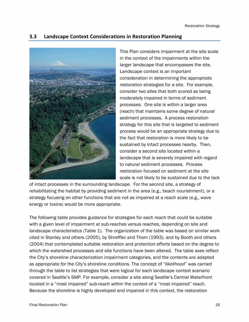
3.3 Landscape Context Considerations in Restoration Planning
This Plan considers impairment at the site scale in the context of the impairments within the larger landscape that encompasses the site. Landscape context is an important consideration in determining the appropriate restoration strategies for a site. For example, consider two sites that both scored as being moderately impaired in terms of sediment processes. One site is within a larger area (reach) that maintains some degree of natural sediment processes. A process restoration strategy for this site that is targeted to sediment process would be an appropriate strategy due to the fact that restoration is more likely to be sustained by intact processes nearby. Then, consider a second site located within a landscape that is severely impaired with regard to natural sediment processes. Process restoration focused on sediment at the site scale is not likely to be sustained due to the lack
of intact processes in the surrounding landscape. For the second site, a strategy of rehabilitating the habitat by providing sediment in the area (e.g., beach nourishment), or a strategy focusing on other functions that are not as impaired at a reach scale (e.g., wave energy or toxins) would be more appropriate. The following table provides guidance for strategies for each reach that could be suitable with a given level of impairment at sub-reaches versus reaches, depending on site and landscape characteristics (Table 1). The organization of the table was based on similar work cited in Stanley and others (2005), by Shreffler and Thom (1993), and by Booth and others (2004) that contemplated suitable restoration and protection efforts based on the degree to which the watershed processes and site functions have been altered. The table axes reflect the City’s shoreline characterization impairment categories, and the contents are adapted as appropriate for the City’s shoreline conditions. The concept of “likelihood” was carried through the table to list strategies that were logical for each landscape context scenario covered in Seattle’s SMP. For example, consider a site along Seattle’s Central Waterfront located in a “most impaired” sub-reach within the context of a “most impaired” reach. Because the shoreline is highly developed and impaired in this context, the restoration
Restoration Strategy
Final Restoration Plan 17
strategies that would be likely to succeed and be maintained over time are those that raise functionality by improving local habitat features, as opposed to restoring processes. For a highly modified reach, appropriate strategies would include rehabilitation and creation, which aim to improve existing habitat features at the site. Strategies that aim to restore processes here are less appropriate, since the process would not be sustainable long-term without some landscape level change to land use in the area. This said, a strategy of process restoration in an area like this could be appropriate if changes to landscape-level conditions occur and the opportunity for sustainable process restoration arises.
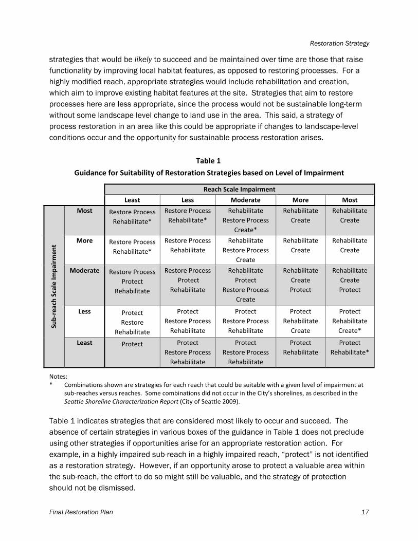
Table 1
Guidance for Suitability of Restoration Strategies based on Level of Impairment
Reach Scale Impairment
Least Less Moderate More Most
Sub‐reach Scale Im
pairm
ent
Most Restore Process
Rehabilitate*
Restore Process
Rehabilitate*
Rehabilitate
Restore Process
Create*
Rehabilitate
Create
Rehabilitate
Create
More Restore Process
Rehabilitate*
Restore Process
Rehabilitate
Rehabilitate
Restore Process
Create
Rehabilitate
Create
Rehabilitate
Create
Moderate Restore Process
Protect
Rehabilitate
Restore Process
Protect
Rehabilitate
Rehabilitate
Protect
Restore Process
Create
Rehabilitate
Create
Protect
Rehabilitate
Create
Protect
Less Protect
Restore
Rehabilitate
Protect
Restore Process
Rehabilitate
Protect
Restore Process
Rehabilitate
Protect
Rehabilitate
Create
Protect
Rehabilitate
Create*
Least Protect
Protect
Restore Process
Rehabilitate
Protect
Restore Process
Rehabilitate
Protect
Rehabilitate
Protect
Rehabilitate*
Notes: * Combinations shown are strategies for each reach that could be suitable with a given level of impairment at
sub‐reaches versus reaches. Some combinations did not occur in the City’s shorelines, as described in the Seattle Shoreline Characterization Report (City of Seattle 2009).
Table 1 indicates strategies that are considered most likely to occur and succeed. The absence of certain strategies in various boxes of the guidance in Table 1 does not preclude using other strategies if opportunities arise for an appropriate restoration action. For example, in a highly impaired sub-reach in a highly impaired reach, “protect” is not identified as a restoration strategy. However, if an opportunity arose to protect a valuable area within the sub-reach, the effort to do so might still be valuable, and the strategy of protection should not be dismissed.
Restoration Strategy
Final Restoration Plan 18
In this Plan, Table 1 is used as guidance to match potential restoration strategies to various shorelines within the City. For this analysis, each sub-reach of the City’s shorelines was fitted
to boxes in this table, depending on its impairment level and the impairment level of its landscape (results of the impairment assessment are described in Section 5).
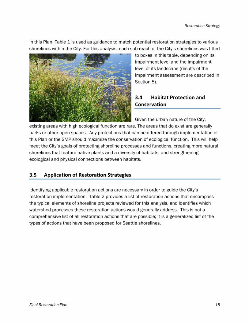
3.4 Habitat Protection and Conservation
Given the urban nature of the City,
existing areas with high ecological function are rare. The areas that do exist are generally parks or other open spaces. Any protections that can be offered through implementation of this Plan or the SMP should maximize the conservation of ecological function. This will help meet the City’s goals of protecting shoreline processes and functions, creating more natural shorelines that feature native plants and a diversity of habitats, and strengthening ecological and physical connections between habitats.
3.5 Application of Restoration Strategies
Identifying applicable restoration actions are necessary in order to guide the City’s restoration implementation. Table 2 provides a list of restoration actions that encompass the typical elements of shoreline projects reviewed for this analysis, and identifies which watershed processes these restoration actions would generally address. This is not a comprehensive list of all restoration actions that are possible; it is a generalized list of the types of actions that have been proposed for Seattle shorelines.
Restoration Strategy
Final Restoration Plan 19
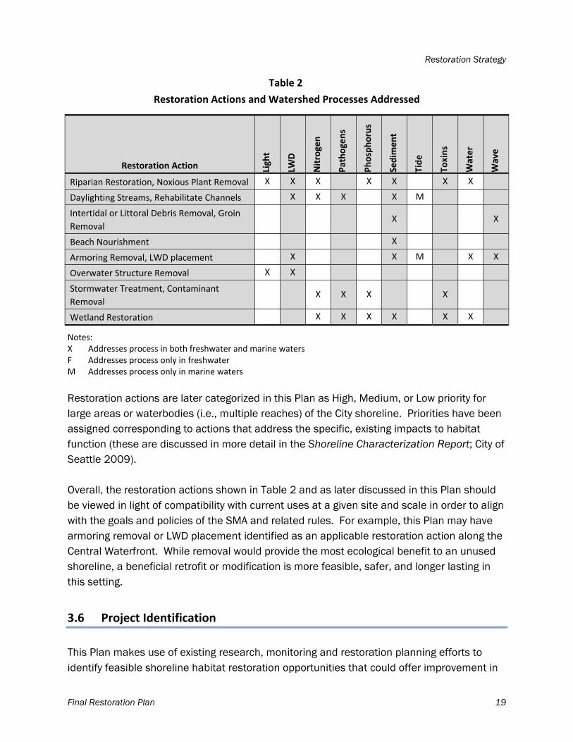
Table 2
Restoration Actions and Watershed Processes Addressed
Restoration Action Light
LWD
Nitrogen
Pathogens
Phosphorus
Sedim
ent
Tide
Toxins
Water
Wave
Riparian Restoration, Noxious Plant Removal X X X X X X X
Daylighting Streams, Rehabilitate Channels X X X X M
Intertidal or Littoral Debris Removal, Groin
Removal X X
Beach Nourishment X
Armoring Removal, LWD placement X X M X X
Overwater Structure Removal X X
Stormwater Treatment, Contaminant
Removal X X X X
Wetland Restoration X X X X X X
Notes: X Addresses process in both freshwater and marine waters F Addresses process only in freshwater M Addresses process only in marine waters
Restoration actions are later categorized in this Plan as High, Medium, or Low priority for large areas or waterbodies (i.e., multiple reaches) of the City shoreline. Priorities have been assigned corresponding to actions that address the specific, existing impacts to habitat function (these are discussed in more detail in the Shoreline Characterization Report; City of Seattle 2009). Overall, the restoration actions shown in Table 2 and as later discussed in this Plan should be viewed in light of compatibility with current uses at a given site and scale in order to align with the goals and policies of the SMA and related rules. For example, this Plan may have armoring removal or LWD placement identified as an applicable restoration action along the Central Waterfront. While removal would provide the most ecological benefit to an unused shoreline, a beneficial retrofit or modification is more feasible, safer, and longer lasting in this setting.
3.6 Project Identification
This Plan makes use of existing research, monitoring and restoration planning efforts to identify feasible shoreline habitat restoration opportunities that could offer improvement in
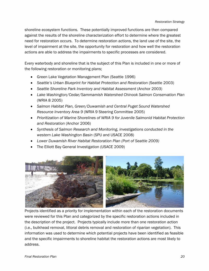
Restoration Strategy
Final Restoration Plan 20
shoreline ecosystem functions. These potentially improved functions are then compared against the results of the shoreline characterization effort to determine where the greatest need for restoration occurs. To determine restoration actions, the land use of the site, the level of impairment at the site, the opportunity for restoration and how well the restoration actions are able to address the impairments to specific processes are considered. Every waterbody and shoreline that is the subject of this Plan is included in one or more of the following restoration or monitoring plans;
Green Lake Vegetation Management Plan (Seattle 1996) Seattle’s Urban Blueprint for Habitat Protection and Restoration (Seattle 2003) Seattle Shoreline Park Inventory and Habitat Assessment (Anchor 2003) Lake Washington/Cedar/Sammamish Watershed Chinook Salmon Conservation Plan
(WRIA 8 2005) Salmon Habitat Plan, Green/Duwamish and Central Puget Sound Watershed
Resource Inventory Area 9 (WRIA 9 Steering Committee 2005) Prioritization of Marine Shorelines of WRIA 9 for Juvenile Salmonid Habitat Protection
and Restoration (Anchor 2006) Synthesis of Salmon Research and Monitoring, investigations conducted in the
western Lake Washington Basin (SPU and USACE 2008) Lower Duwamish River Habitat Restoration Plan (Port of Seattle 2009)
The Elliott Bay General Investigation (USACE 2009)
Projects identified as a priority for implementation within each of the restoration documents were reviewed for this Plan and categorized by the specific restoration actions included in the description of the project. Projects typically include more than one restoration action (i.e., bulkhead removal, littoral debris removal and restoration of riparian vegetation). This information was used to determine which potential projects have been identified as feasible and the specific impairments to shoreline habitat the restoration actions are most likely to address.
Restoration Strategy
Final Restoration Plan 21
Strictly based on the analysis the results of the Shoreline Characterization Report, projects in highly impaired areas have a greater capacity for improvement to shoreline ecological function than areas with low impairments. However, depending on the restoration strategy, some projects in highly impaired areas in urban industrial shoreline environments may not be consistent with the City’s vision for thriving water-dependent industrial and commercial uses (see Section 1.2 of this document) and the goals of the SMP to reserve shoreline areas for water-dependent and associated water-related uses (WAC 173-26-201). Some projects can also be less sustainable due to impairments of the processes necessary to sustain them over the long term (see section 3.2). Therefore, rather than setting high priorities for projects in the most impaired areas strictly based on high impairment, this Plan also sets priority for projects that have a priority status in one or more of the existing restoration plans, as well as actions that address the City’s overall vision.
Final Restoration Plan 22
4 APPLICABLE RESTORATION ACTIONS
A summary of city-wide impairments and detail on impairments and the applicable restoration actions and projects for Seattle’s shorelines is described below. Specific waterbodies are discussed in the following order: Lake Washington; Lake Union and the Ship Canal; the Duwamish River; Puget Sound, including Elliott and Shilshole Bays; and Green Lake. Impairments and restoration strategies are discussed on a reach scale, and then restoration actions that would be the most productive in meeting the overall plan goals are identified. Following the description of restoration actions, a short discussion highlights select projects that have been proposed and other restoration actions that address shoreline impairments identified in the Shoreline Characterization Report (City of Seattle 2009). For detailed descriptions of previously developed site-specific projects, see the existing restoration planning documents listed in Section 3.6.
4.1 City‐wide Impairments Summary
Within Seattle, all shoreline habitats have been impaired to some degree by human alterations. There are some areas, however, that continue to provide relatively high quality habitat to a diversity of species, and have relatively intact shoreline ecosystem processes. The distribution of habitat impairments is uneven; the heavily industrialized shorelines of Lake Union downstream to the Ballard Locks, Elliott Bay, and the Harbor Island portion of the Duwamish River Estuary are the most impacted reaches with respect to their historic function. Even within these most impacted reaches, there are some areas with higher habitat function (i.e., less impairment). The least impacted areas in Seattle include Seward Park, Union Bay, West Point and Magnolia Bluffs, and Lincoln Park to Fauntleroy Cove. These areas provide relatively high quality habitat and intact processes. Between these two ends of the impairment spectrum are reaches with moderate amounts of impairment. As explained in Section 3.1, as part of the shoreline characterization, each reach within the City was categorized as most, more, moderate, less, or least impaired. Reaches were comprised of smaller assessment units called sub-reaches which offer a finer scale indication of functional impairment (Maps 1 through 25). The restoration strategies for each sub-reach are determined by the level of impairment of that sub-reach and the reach that encompasses it (see Table 1). The number of sub-reaches with similar levels of impairment at the reach and sub-reach scale are shown below in Tables 3 and 4 for freshwater and marine shorelines, respectively. For freshwater habitats, many sub-reaches fall into the more impaired and most impaired categories at both the sub-reach and reach scale; according to Table 1, rehabilitation and creation are key strategies for a large number of
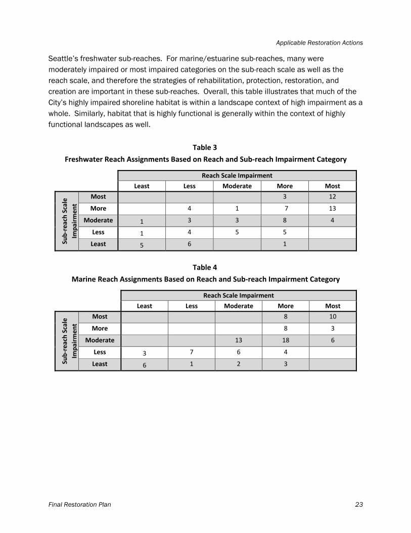
Applicable Restoration Actions
Final Restoration Plan 23
Seattle’s freshwater sub-reaches. For marine/estuarine sub-reaches, many were moderately impaired or most impaired categories on the sub-reach scale as well as the reach scale, and therefore the strategies of rehabilitation, protection, restoration, and creation are important in these sub-reaches. Overall, this table illustrates that much of the City’s highly impaired shoreline habitat is within a landscape context of high impairment as a whole. Similarly, habitat that is highly functional is generally within the context of highly functional landscapes as well.
Table 3
Freshwater Reach Assignments Based on Reach and Sub‐reach Impairment Category
Reach Scale Impairment
Least Less Moderate More Most
Sub‐reach Scale
Impairm
ent
Most 3 12
More 4 1 7 13
Moderate 1 3 3 8 4
Less 1 4 5 5
Least 5 6 1
Table 4
Marine Reach Assignments Based on Reach and Sub‐reach Impairment Category
Reach Scale Impairment
Least Less Moderate More Most
Sub‐reach Scale
Impairm
ent
Most 8 10
More 8 3
Moderate 13 18 6
Less 3 7 6 4
Least 6 1 2 3
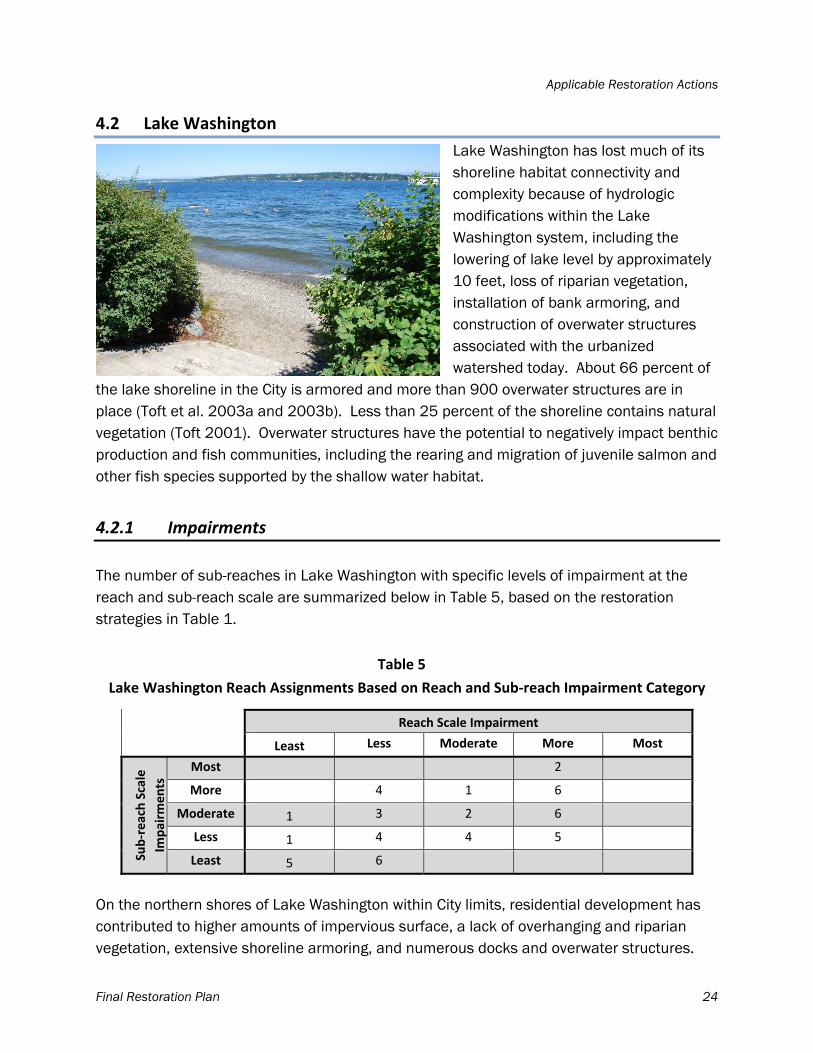
Applicable Restoration Actions
Final Restoration Plan 24
4.2 Lake Washington
Lake Washington has lost much of its shoreline habitat connectivity and complexity because of hydrologic modifications within the Lake Washington system, including the lowering of lake level by approximately 10 feet, loss of riparian vegetation, installation of bank armoring, and construction of overwater structures associated with the urbanized watershed today. About 66 percent of
the lake shoreline in the City is armored and more than 900 overwater structures are in place (Toft et al. 2003a and 2003b). Less than 25 percent of the shoreline contains natural vegetation (Toft 2001). Overwater structures have the potential to negatively impact benthic production and fish communities, including the rearing and migration of juvenile salmon and other fish species supported by the shallow water habitat.
4.2.1 Impairments
The number of sub-reaches in Lake Washington with specific levels of impairment at the reach and sub-reach scale are summarized below in Table 5, based on the restoration strategies in Table 1.
Table 5
Lake Washington Reach Assignments Based on Reach and Sub‐reach Impairment Category
Reach Scale Impairment
Least Less Moderate More Most
Sub‐reach Scale
Impairm
ents
Most 2
More 4 1 6
Moderate 1 3 2 6
Less 1 4 4 5
Least 5 6
On the northern shores of Lake Washington within City limits, residential development has contributed to higher amounts of impervious surface, a lack of overhanging and riparian vegetation, extensive shoreline armoring, and numerous docks and overwater structures.
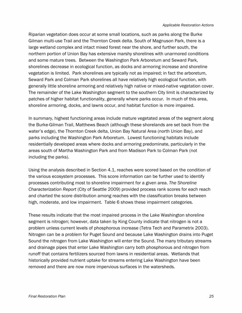
Applicable Restoration Actions
Final Restoration Plan 25
Riparian vegetation does occur at some small locations, such as parks along the Burke Gilman multi-use Trail and the Thornton Creek delta. South of Magnuson Park, there is a large wetland complex and intact mixed forest near the shore, and further south, the northern portion of Union Bay has extensive marshy shorelines with unarmored conditions and some mature trees. Between the Washington Park Arboretum and Seward Park, shorelines decrease in ecological function, as docks and armoring increase and shoreline vegetation is limited. Park shorelines are typically not as impaired; in fact the arboretum, Seward Park and Colman Park shorelines all have relatively high ecological function, with generally little shoreline armoring and relatively high native or mixed-native vegetation cover. The remainder of the Lake Washington segment to the southern City limit is characterized by patches of higher habitat functionality, generally where parks occur. In much of this area, shoreline armoring, docks, and lawns occur, and habitat function is more impaired. In summary, highest functioning areas include mature vegetated areas of the segment along the Burke-Gilman Trail, Matthews Beach (although these shorelands are set back from the water’s edge), the Thornton Creek delta, Union Bay Natural Area (north Union Bay), and parks including the Washington Park Arboretum. Lowest functioning habitats include residentially developed areas where docks and armoring predominate, particularly in the areas south of Martha Washington Park and from Madison Park to Colman Park (not including the parks). Using the analysis described in Section 4.1, reaches were scored based on the condition of the various ecosystem processes. This score information can be further used to identify processes contributing most to shoreline impairment for a given area. The Shoreline Characterization Report (City of Seattle 2009) provided process rank scores for each reach and charted the score distribution among reaches with the classification breaks between high, moderate, and low impairment. Table 6 shows these impairment categories. These results indicate that the most impaired process in the Lake Washington shoreline segment is nitrogen; however, data taken by King County indicate that nitrogen is not a problem unless current levels of phosphorous increase (Tetra Tech and Parametrix 2003). Nitrogen can be a problem for Puget Sound and because Lake Washington drains into Puget Sound the nitrogen from Lake Washington will enter the Sound. The many tributary streams and drainage pipes that enter Lake Washington carry both phosphorous and nitrogen from runoff that contains fertilizers sourced from lawns in residential areas. Wetlands that historically provided nutrient uptake for streams entering Lake Washington have been removed and there are now more impervious surfaces in the watersheds.
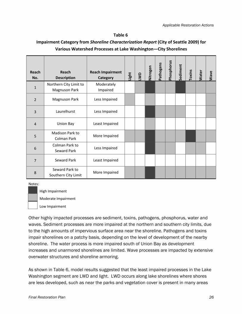
Applicable Restoration Actions
Final Restoration Plan 26
Table 6
Impairment Category from Shoreline Characterization Report (City of Seattle 2009) for
Various Watershed Processes at Lake Washington—City Shorelines
Reach
No.
Reach
Description
Reach Impairment
Category Light
LWD
Nitrogen
Pathogens
Phosphorus
Sedim
ent
Toxins
Water
Wave
1 Northern City Limit to
Magnuson Park
Moderately
Impaired
2 Magnuson Park Less Impaired
3 Laurelhurst Less Impaired
4 Union Bay Least Impaired
5 Madison Park to
Colman Park More Impaired
6 Colman Park to
Seward Park Less Impaired
7 Seward Park Least Impaired
8 Seward Park to
Southern City Limit More Impaired
Notes:
High Impairment
Moderate Impairment
Low Impairment
Other highly impacted processes are sediment, toxins, pathogens, phosphorus, water and waves. Sediment processes are more impaired at the northern and southern city limits, due to the high amounts of impervious surface area near the shoreline. Pathogens and toxins impair shorelines on a patchy basis, depending on the level of development of the nearby shoreline. The water process is more impaired south of Union Bay as development increases and unarmored shorelines are limited. Wave processes are impacted by extensive overwater structures and shoreline armoring. As shown in Table 6, model results suggested that the least impaired processes in the Lake Washington segment are LWD and light. LWD occurs along lake shorelines where shores are less developed, such as near the parks and vegetation cover is present in many areas
Applicable Restoration Actions
Final Restoration Plan 27
within shorelands (200 feet of the shoreline), light conditions are not likely to be limited in these areas. The City’s Lake Washington shoreline, however, does have approximately 750 residential docks that extend 30 to 100 feet from the shoreline and cover an estimated 4 percent of the lake surface area within 100 feet of the shore (Weitkamp et al. 2000). Residential structures are densely concentrated at the shoreline in many areas, creating a barrier between the shorelands and the water. Natural light conditions would be limiting in the shallow aquatic zones just waterward of these areas due to the overwater pier structures. Artificial lighting at night was not part of the characterization report; however, artificial light has been shown to impact fish predation (Tabor et al. 1998). Projects that reduce the amount of artificial light would benefit fish habitat within Seattle.
4.2.2 Applicable Restoration Actions
Based on these impairments, the applicable restoration actions for the Lake Washington segment determined to be High, Moderate, or Low in Table 7. This table was completed by combining the impairment levels for each reach presented in Table 6 with the restoration actions and watershed processes addressed that were described previously in Table 2. For example, Table 6 shows that in Reach 1 (Northern City Limit to Magnuson Park), the watershed process “nitrogen” and “sediment” are highly impaired. Table 2 identifies the restoration actions that would address nitrogen issues as: riparian restoration/noxious plant removal, daylighting streams/rehabilitating channels, stormwater treatment/contaminant removal, and wetland restoration and these five actions would be assigned as most applicable restoration actions for this reach. The sediment process was also highly impaired, so the actions of intertidal/littoral rubble/groin removal, beach nourishment, armoring removal/LWD placement, and wetland restoration would also be assigned as the most applicable restoration actions for this reach. The LWD process was moderately impaired, so riparian restoration/noxious plant removal, daylighting streams/rehabilitating channels, armoring removal/LWD placement, and overwater structure removal would be assigned as moderately applicable for this reach. However, riparian restoration/noxious plant removal and armoring removal/LWD placement were already assessed as being most applicable; therefore these actions remain highly applicable. Restoration actions to address “low impairment” light conditions would include riparian restoration/noxious plant removal and overwater structure removal, and riparian and overwater structure work are already assigned as most applicable, so these actions remain highly applicable. Additionally, the actions identified for restoration are also considered important for providing habitat for juvenile Chinook salmon.
Applicable Restoration Actions
Final Restoration Plan 28
Reaches that have the greatest need for restoration actions are those that are highest impaired in the Lake Washington segment, referenced by Reach Impairment Category in Table 7: Reach 5 (Madison Park to Colman Park) and Reach 8 (Seward Park to Southern City Limit). Previous restoration planning documents (see Section 3.6) do not identify any projects for Reach 5, but protecting high quality habitat where it exists in small patches has been suggested. The Seattle Shoreline Park Inventory and Habitat Assessment (Anchor 2003) recommended protecting the high quality aspects of swim beach habitat at Madison Park, Madrona Beach, and Colman Park. Compared to armored shorelines of most of Lake Washington, swim beaches typically have small substrates with gentle shoreline slopes that can provide refuge and feeding habitat for juvenile salmon and other small fish. Tabor and others (2004) noted relatively high juvenile Chinook salmon use of such areas in the southern parts of Lake Washington. Therefore, creating additional natural beach areas with riparian vegetation in the reach are appropriate restoration actions. Additional restoration actions that are applicable in this reach include those that would address toxin inputs and its upstream tributary subbasins, with actions such as riparian restoration, stormwater treatment/contaminant removal and wetland restoration, as suggested above. The remaining processes are “moderately” impacted; therefore, additional restoration actions would include overwater structure removal, LWD placement and removal of shoreline armoring.
Applicable Restoration Actions
Final Restoration Plan 29
Table 7
Applicable Restoration Actions—Lake Washington
Reach # Reach
Reach
Impairment
Category1
Reach Protection
Category2
Riparian
Restoration
Daylighting
Streams
(where piped
streams occur)
Nearshore
Debris
Removal/
Groin
Removal
Beach
Nourishment
Armoring
Removal
Overwater
Structure
Removal
Stormwater
treatment
Wetland
Restoration
1 Northern City Limit to
Magnuson Park
Moderately
Impaired Low High High High High High High High High
2 Magnuson Park Less Impaired Moderate Moderate Moderate Moderate Low Moderate Moderate Moderate Moderate
3 Laurelhurst Less Impaired Moderate High High Moderate Moderate Moderate Moderate High High
4 Union Bay Least Impaired High Moderate Moderate Low Low Low Low Moderate Moderate
5 Madison Park to
Colman Park More Impaired Low High High Moderate Moderate Moderate Moderate High High
6 Colman Park to
Seward Park Less Impaired Moderate High High Low Low Moderate Low High High
7 Seward Park Least Impaired High Low Low Low Low Low Low Low Low
8 Seward Park to
Southern City Limit More Impaired Low High High Moderate Moderate Moderate Moderate High High
Notes: a. Based on the results of the Shoreline Characterization Report (City of Seattle 2009). b. Reach was considered High priority for protection if reach impairment category was “least”; moderate priority if reach impairment category was “less”; low priority for all other reach impairment categories (“moderate,” “more,” and “most”).
Applicable Restoration Actions
Final Restoration Plan 30
In Reach 5, a project sponsored by Friends of Madrona Woods, affiliated with the Madrona Community Council, recontoured existing stream beds, constructed culverts to flow under 38th Avenue and Lake Washington Boulevard, and created a new stream channel and wetland cove at the lakeshore in Madrona Park. This project addressed the restoration actions of riparian and wetland restoration, as well as stream daylighting, all of which are listed as High priority in Table 7.
In Reach 8, several projects have been proposed and implemented, including completed beach nourishment and substrate enhancements at Seward Park and in-progress enhancements near South Alaska Street (Seattle 2003). Three littoral zone and shoreline riparian projects have been proposed or completed: one proposed at Pritchard Island Beach, and two completed, one at Martha Washington Park and the other
at Rainier Beach, also known as Chinook Beach (Anchor 2003). Additionally, daylighting Mapes Creek at its mouth is a proposed project that will occur in the next several years. The completed projects were too recent to be reflected in datasets used in the GIS model, but they address most of the applicable restoration actions because they provide riparian vegetation and improvements to substrate that will benefit fish and wildlife using the shoreline. Similar to the northern reach discussed previously, restoration actions are still needed that would address the nitrogen problem in the reach as well as its contributing drainage areas. High priority areas for habitat protection include those with the least impairments: the wetland habitats of Union Bay and the areas of unarmored shoreline and riparian vegetation at Seward Park, in addition to any recent restoration project sites. The Union Bay Natural Area contains areas of former landfill with specific landfill cap maintenance requirements that were incorporated into existing athletic field construction and maintenance programs, so any proposed protection for this area will need to incorporate recognition of these activities. In addition to the information regarding the level and detail of impairments and the applicable restoration actions to be taken on Lake Washington shorelines provided in The Shoreline Characterization Report (City of Seattle 2009), the Synthesis of Salmon Research and Monitoring, investigations conducted in the western Lake Washington Basin (SPU and
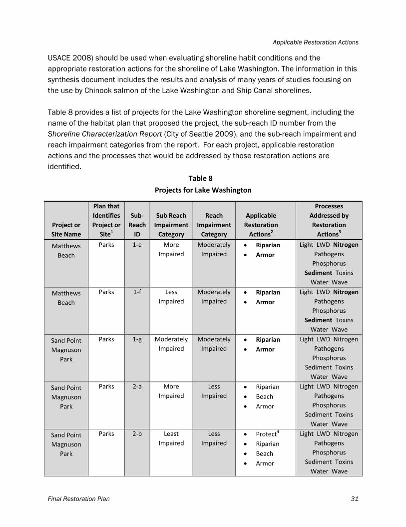
Applicable Restoration Actions
Final Restoration Plan 31
USACE 2008) should be used when evaluating shoreline habit conditions and the appropriate restoration actions for the shoreline of Lake Washington. The information in this synthesis document includes the results and analysis of many years of studies focusing on the use by Chinook salmon of the Lake Washington and Ship Canal shorelines. Table 8 provides a list of projects for the Lake Washington shoreline segment, including the name of the habitat plan that proposed the project, the sub-reach ID number from the Shoreline Characterization Report (City of Seattle 2009), and the sub-reach impairment and reach impairment categories from the report. For each project, applicable restoration actions and the processes that would be addressed by those restoration actions are identified.
Table 8
Projects for Lake Washington
Project or
Site Name
Plan that
Identifies
Project or
Site1
Sub‐
Reach
ID
Sub Reach
Impairment
Category
Reach
Impairment
Category
Applicable
Restoration
Actions2
Processes
Addressed by
Restoration
Actions3
Matthews
Beach
Parks 1‐e More
Impaired
Moderately
Impaired
Riparian
Armor
Light LWD Nitrogen
Pathogens
Phosphorus
Sediment Toxins
Water Wave
Matthews
Beach
Parks 1‐f Less
Impaired
Moderately
Impaired
Riparian
Armor
Light LWD Nitrogen
Pathogens
Phosphorus
Sediment Toxins
Water Wave
Sand Point
Magnuson
Park
Parks 1‐g Moderately
Impaired
Moderately
Impaired
Riparian
Armor
Light LWD Nitrogen
Pathogens
Phosphorus
Sediment Toxins
Water Wave
Sand Point
Magnuson
Park
Parks 2‐a More
Impaired
Less
Impaired
Riparian
Beach
Armor
Light LWD Nitrogen
Pathogens
Phosphorus
Sediment Toxins
Water Wave
Sand Point
Magnuson
Park
Parks 2‐b Least
Impaired
Less
Impaired
Protect4
Riparian
Beach
Armor
Light LWD Nitrogen
Pathogens
Phosphorus
Sediment Toxins
Water Wave
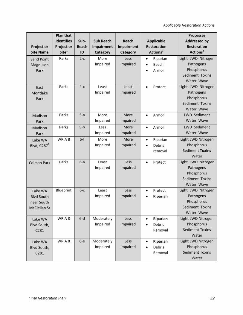
Applicable Restoration Actions
Final Restoration Plan 32
Project or
Site Name
Plan that
Identifies
Project or
Site1
Sub‐
Reach
ID
Sub Reach
Impairment
Category
Reach
Impairment
Category
Applicable
Restoration
Actions2
Processes
Addressed by
Restoration
Actions3
Sand Point
Magnuson
Park
Parks 2‐c More
Impaired
Less
Impaired
Riparian
Beach
Armor
Light LWD Nitrogen
Pathogens
Phosphorus
Sediment Toxins
Water Wave
East
Montlake
Park
Parks 4‐c Least
Impaired
Least
Impaired
Protect Light LWD Nitrogen
Pathogens
Phosphorus
Sediment Toxins
Water Wave
Madison
Park
Parks 5‐a More
Impaired
More
Impaired
Armor LWD Sediment
Water Wave
Madison
Park
Parks 5‐b Less
Impaired
More
Impaired
Armor LWD Sediment
Water Wave
Lake WA
Blvd, C2871
WRIA 8 5‐f More
Impaired
More
Impaired
Riparian
Debris
removal
Light LWD Nitrogen
Phosphorus
Sediment Toxins
Water
Colman Park Parks 6‐a Least
Impaired
Less
Impaired
Protect Light LWD Nitrogen
Pathogens
Phosphorus
Sediment Toxins
Water Wave
Lake WA
Blvd South
near South
McClellan St
Blueprint 6‐c Least
Impaired
Less
Impaired
Protect
Riparian
Light LWD Nitrogen
Pathogens
Phosphorus
Sediment Toxins
Water Wave
Lake WA
Blvd South,
C281
WRIA 8 6‐d Moderately
Impaired
Less
Impaired
Riparian
Debris
Removal
Light LWD Nitrogen
Phosphorus
Sediment Toxins
Water
Lake WA
Blvd South,
C281
WRIA 8 6‐e Moderately
Impaired
Less
Impaired
Riparian
Debris
Removal
Light LWD Nitrogen
Phosphorus
Sediment Toxins
Water
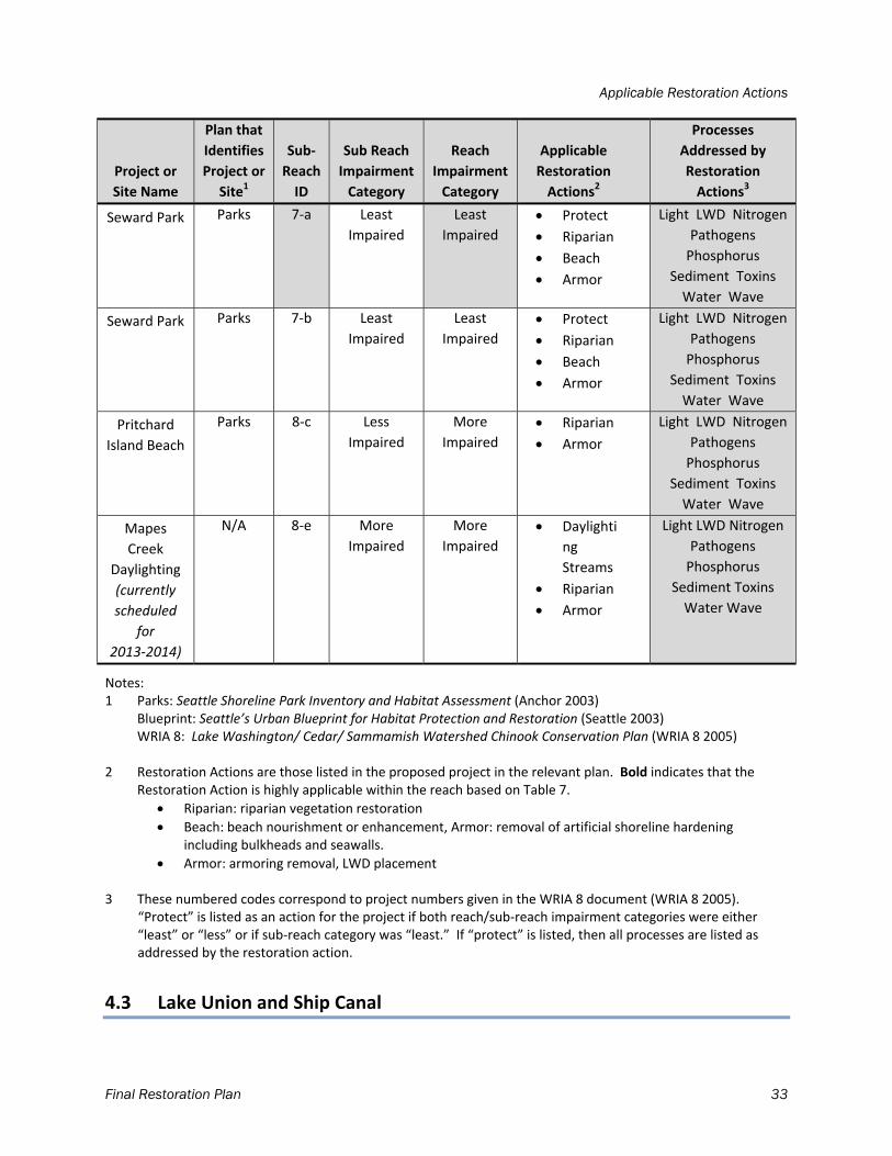
Applicable Restoration Actions
Final Restoration Plan 33
Project or
Site Name
Plan that
Identifies
Project or
Site1
Sub‐
Reach
ID
Sub Reach
Impairment
Category
Reach
Impairment
Category
Applicable
Restoration
Actions2
Processes
Addressed by
Restoration
Actions3
Seward Park Parks 7‐a Least
Impaired
Least
Impaired
Protect
Riparian
Beach
Armor
Light LWD Nitrogen
Pathogens
Phosphorus
Sediment Toxins
Water Wave
Seward Park Parks 7‐b Least
Impaired
Least
Impaired
Protect
Riparian
Beach
Armor
Light LWD Nitrogen
Pathogens
Phosphorus
Sediment Toxins
Water Wave
Pritchard
Island Beach
Parks 8‐c Less
Impaired
More
Impaired
Riparian
Armor
Light LWD Nitrogen
Pathogens
Phosphorus
Sediment Toxins
Water Wave
Mapes
Creek
Daylighting
(currently
scheduled
for
2013‐2014)
N/A 8‐e More
Impaired
More
Impaired
Daylighti
ng
Streams
Riparian
Armor
Light LWD Nitrogen
Pathogens
Phosphorus
Sediment Toxins
Water Wave
Notes: 1 Parks: Seattle Shoreline Park Inventory and Habitat Assessment (Anchor 2003) Blueprint: Seattle’s Urban Blueprint for Habitat Protection and Restoration (Seattle 2003) WRIA 8: Lake Washington/ Cedar/ Sammamish Watershed Chinook Conservation Plan (WRIA 8 2005) 2 Restoration Actions are those listed in the proposed project in the relevant plan. Bold indicates that the
Restoration Action is highly applicable within the reach based on Table 7.
Riparian: riparian vegetation restoration
Beach: beach nourishment or enhancement, Armor: removal of artificial shoreline hardening including bulkheads and seawalls.
Armor: armoring removal, LWD placement
3 These numbered codes correspond to project numbers given in the WRIA 8 document (WRIA 8 2005). “Protect” is listed as an action for the project if both reach/sub‐reach impairment categories were either “least” or “less” or if sub‐reach category was “least.” If “protect” is listed, then all processes are listed as addressed by the restoration action.
4.3 Lake Union and Ship Canal
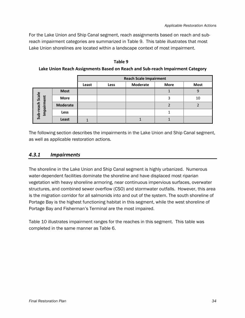
Applicable Restoration Actions
Final Restoration Plan 34
For the Lake Union and Ship Canal segment, reach assignments based on reach and sub-reach impairment categories are summarized in Table 9. This table illustrates that most Lake Union shorelines are located within a landscape context of most impairment.
Table 9
Lake Union Reach Assignments Based on Reach and Sub‐reach Impairment Category
Reach Scale Impairment
Least Less Moderate More Most
Sub‐reach Scale
Impairm
ent
Most 1 9
More 3 10
Moderate 2 2
Less 1
Least 1 1 1
The following section describes the impairments in the Lake Union and Ship Canal segment, as well as applicable restoration actions.
4.3.1 Impairments
The shoreline in the Lake Union and Ship Canal segment is highly urbanized. Numerous water-dependent facilities dominate the shoreline and have displaced most riparian vegetation with heavy shoreline armoring, near continuous impervious surfaces, overwater structures, and combined sewer overflow (CSO) and stormwater outfalls. However, this area is the migration corridor for all salmonids into and out of the system. The south shoreline of Portage Bay is the highest functioning habitat in this segment, while the west shoreline of Portage Bay and Fisherman’s Terminal are the most impaired. Table 10 illustrates impairment ranges for the reaches in this segment. This table was completed in the same manner as Table 6.
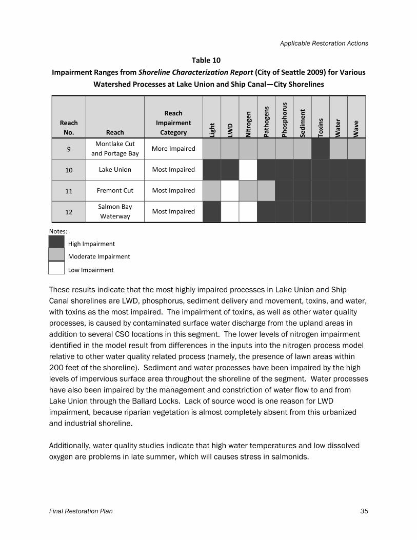
Applicable Restoration Actions
Final Restoration Plan 35
Table 10
Impairment Ranges from Shoreline Characterization Report (City of Seattle 2009) for Various
Watershed Processes at Lake Union and Ship Canal—City Shorelines
Reach
No. Reach
Reach
Impairment
Category Light
LWD
Nitrogen
Pathogens
Phosphorus
Sedim
ent
Toxins
Water
Wave
9 Montlake Cut
and Portage Bay More Impaired
10 Lake Union Most Impaired
11 Fremont Cut Most Impaired
12 Salmon Bay
Waterway Most Impaired
Notes:
High Impairment
Moderate Impairment
Low Impairment
These results indicate that the most highly impaired processes in Lake Union and Ship Canal shorelines are LWD, phosphorus, sediment delivery and movement, toxins, and water, with toxins as the most impaired. The impairment of toxins, as well as other water quality processes, is caused by contaminated surface water discharge from the upland areas in addition to several CSO locations in this segment. The lower levels of nitrogen impairment identified in the model result from differences in the inputs into the nitrogen process model relative to other water quality related process (namely, the presence of lawn areas within 200 feet of the shoreline). Sediment and water processes have been impaired by the high levels of impervious surface area throughout the shoreline of the segment. Water processes have also been impaired by the management and constriction of water flow to and from Lake Union through the Ballard Locks. Lack of source wood is one reason for LWD impairment, because riparian vegetation is almost completely absent from this urbanized and industrial shoreline. Additionally, water quality studies indicate that high water temperatures and low dissolved oxygen are problems in late summer, which will causes stress in salmonids.
Applicable Restoration Actions
Final Restoration Plan 36
4.3.2 Applicable Restoration Actions
Based on these impairments, applicable restoration actions for the Lake Union and Ship Canal waterbody are categorized as High, Moderate, or Low in Table 11. This table was completed in the same manner as Table 7. Given the reach impairment categories shown in Table 11, all restoration actions are applicable for all the reaches; Reach 9 (Montlake Cut and Portage Bay) is slightly less impaired than the other three reaches. The WRIA 8 2005 Salmon Conservation Plan identifies several actions that could benefit habitat and water quality in the Lake Union and Ship Canal area. In Reach 9 (Montlake Cut and Portage Bay) these activities include exploring methods to reduce salmonid predation in Portage Bay and exploring options for deepening the Montlake Cut to allow colder water from Lake Washington to flow into Lake Union. The impetus behind this project is to address water temperature issues in Lake Union to benefit juvenile salmon, and it could potentially change the movement of water in the reach and beyond. The Lake Washington/Cedar/Sammamish Watershed Chinook Salmon Conservation Plan notes that technical water quality and hydrodynamic issues would need to be evaluated before this project could move forward. Restoration of sediment processes has been proposed for the area on the south side of the Ship Canal through Salmon Bay (CGS 2005).
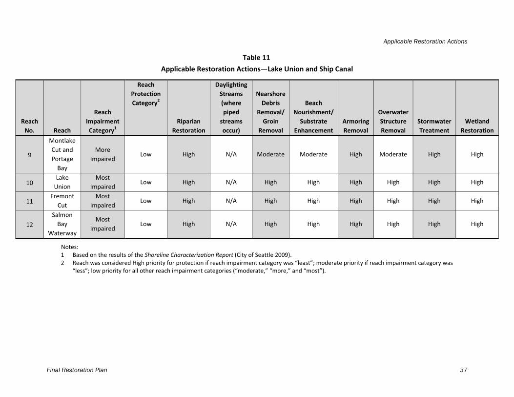
Applicable Restoration Actions
Final Restoration Plan 37
Table 11
Applicable Restoration Actions—Lake Union and Ship Canal
Reach
No. Reach
Reach
Impairment
Category1
Reach
Protection
Category2
Riparian
Restoration
Daylighting
Streams
(where
piped
streams
occur)
Nearshore
Debris
Removal/
Groin
Removal
Beach
Nourishment/
Substrate
Enhancement
Armoring
Removal
Overwater
Structure
Removal
Stormwater
Treatment
Wetland
Restoration
9
Montlake
Cut and
Portage
Bay
More
Impaired Low High N/A Moderate Moderate High Moderate High High
10 Lake
Union
Most
Impaired Low High N/A High High High High High High
11 Fremont
Cut
Most
Impaired Low High N/A High High High High High High
12
Salmon
Bay
Waterway
Most
Impaired Low High N/A High High High High High High
Notes: 1 Based on the results of the Shoreline Characterization Report (City of Seattle 2009). 2 Reach was considered High priority for protection if reach impairment category was “least”; moderate priority if reach impairment category was
“less”; low priority for all other reach impairment categories (“moderate,” “more,” and “most”).
Applicable Restoration Actions
Final Restoration Plan 38
In Reach 10 (Lake Union), Eastlake landowners and interested community and nonprofit groups have created a street-end park (Good Turn Park) at East Martin Street and Fairview Avenue. The park has enhanced substrate and riparian vegetation, both listed as High priority on Table 11. Also in Reach 10, an action proposed is to improve drainage from Wallingford. In Reach 11 (Fremont Cut), projects proposed are to improve water quality by implementing riparian restoration near the Ballard Bridge and treatment of run-off from the bridge (WRIA 8 2005). This would improve the following processes: LWD, nitrogen, pathogens, phosphorus, sediment, toxins, and water in this area. Reach 12 (Salmon Bay Waterway) terminates at the Ballard Locks, which constrain water flow between Lake Union and Puget Sound. There are two proposed projects in this area. One project proposes constructing a more natural, fairly wide, and long channel at the locks to allow for better salmon passage (WRIA 8 2005). This project would likely change movement of water in the reach and beyond, and the Lake Washington/ Cedar/ Sammamish Watershed Chinook Salmon Conservation Plan notes that there are significant design challenges and feasibility that would need to be evaluated before this project could move forward. Another project at Commodore Park, just downstream of the locks on the south bank, proposes to remove the seawall, re-grade the shoreline to a gentler slope, daylight Wolfe Creek (that flows into the park) and create a pocket estuary in this location (WRIA 8 2005). There are several other projects proposed at the locks, mostly related to improving fish passage and the location and size of the saltwater transition zone. Because the impairment level of the Lake Union and Ship Canal reaches is so high, essentially every category of restoration action in Table 11 is an applicable restoration action in this area, and projects most needed are those that combine restoration actions to address several processes at once. High priority areas for habitat protection include those with the least impairments, such as East Montlake Park, as well as any recent restoration project sites such as Salmon Bay Natural Area. Table 12 provides a list of priority projects for the Lake Union and the Ship Canal shoreline segment, including the name of the habitat plan that proposed the project, the sub-reach ID number from the Shoreline Characterization Report (City of Seattle 2009), and the sub-reach impairment and reach impairment categories from the report. For each project, applicable restoration actions and the processes that would be addressed by those restoration actions are identified.
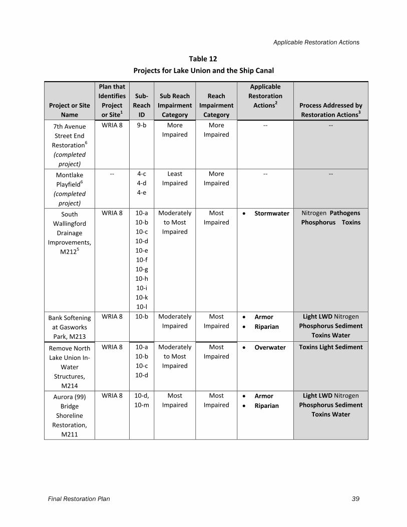
Applicable Restoration Actions
Final Restoration Plan 39
Table 12
Projects for Lake Union and the Ship Canal
Project or Site
Name
Plan that
Identifies
Project
or Site1
Sub‐
Reach
ID
Sub Reach
Impairment
Category
Reach
Impairment
Category
Applicable
Restoration
Actions2 Process Addressed by
Restoration Actions3
7th Avenue
Street End
Restoration6
(completed
project)
WRIA 8 9‐b More
Impaired
More
Impaired
‐‐ ‐‐
Montlake
Playfield6
(completed
project)
‐‐ 4‐c
4‐d
4‐e
Least
Impaired
More
Impaired
‐‐ ‐‐
South
Wallingford
Drainage
Improvements,
M2125
WRIA 8 10‐a
10‐b
10‐c
10‐d
10‐e
10‐f
10‐g
10‐h
10‐i
10‐k
10‐l
Moderately
to Most
Impaired
Most
Impaired
Stormwater Nitrogen Pathogens
Phosphorus Toxins
Bank Softening
at Gasworks
Park, M213
WRIA 8 10‐b Moderately
Impaired
Most
Impaired
Armor
Riparian
Light LWD Nitrogen
Phosphorus Sediment
Toxins Water
Remove North
Lake Union In‐
Water
Structures,
M214
WRIA 8 10‐a
10‐b
10‐c
10‐d
Moderately
to Most
Impaired
Most
Impaired
Overwater Toxins Light Sediment
Aurora (99)
Bridge
Shoreline
Restoration,
M211
WRIA 8 10‐d,
10‐m
Most
Impaired
Most
Impaired
Armor
Riparian
Light LWD Nitrogen
Phosphorus Sediment
Toxins Water
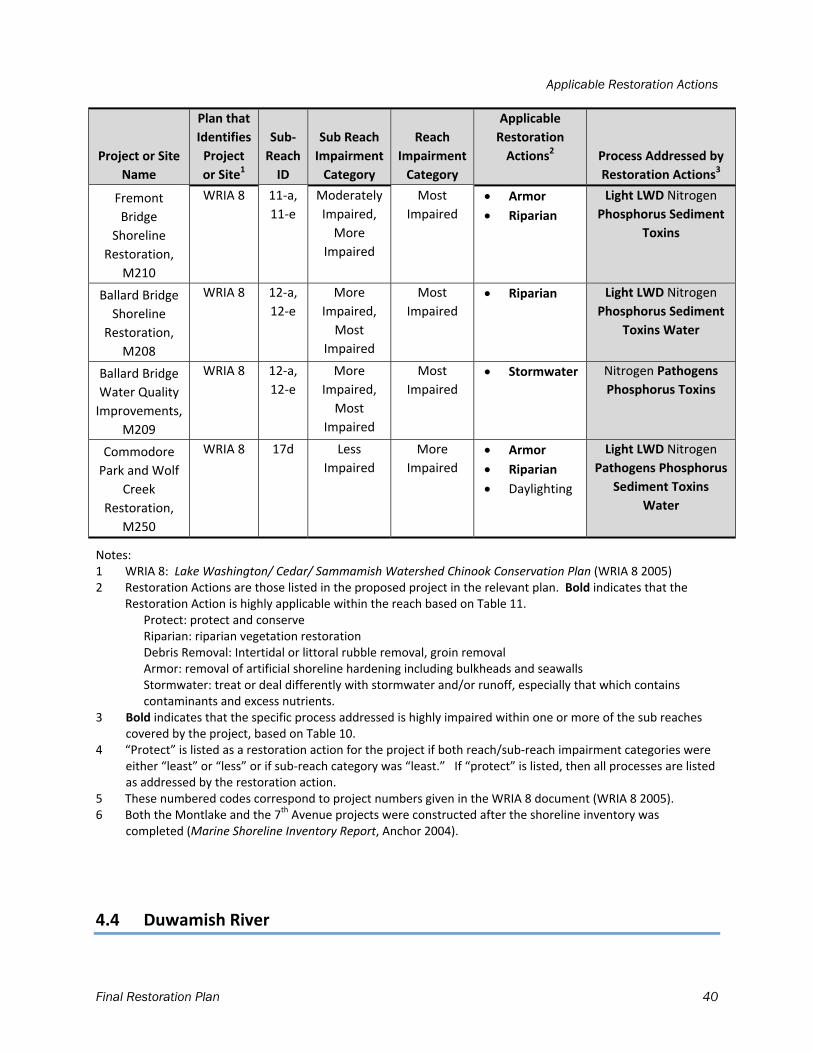
Applicable Restoration Actions
Final Restoration Plan 40
Project or Site
Name
Plan that
Identifies
Project
or Site1
Sub‐
Reach
ID
Sub Reach
Impairment
Category
Reach
Impairment
Category
Applicable
Restoration
Actions2 Process Addressed by
Restoration Actions3
Fremont
Bridge
Shoreline
Restoration,
M210
WRIA 8 11‐a,
11‐e
Moderately
Impaired,
More
Impaired
Most
Impaired
Armor
Riparian
Light LWD Nitrogen
Phosphorus Sediment
Toxins
Ballard Bridge
Shoreline
Restoration,
M208
WRIA 8 12‐a,
12‐e
More
Impaired,
Most
Impaired
Most
Impaired
Riparian Light LWD Nitrogen
Phosphorus Sediment
Toxins Water
Ballard Bridge
Water Quality
Improvements,
M209
WRIA 8 12‐a,
12‐e
More
Impaired,
Most
Impaired
Most
Impaired
Stormwater Nitrogen Pathogens
Phosphorus Toxins
Commodore
Park and Wolf
Creek
Restoration,
M250
WRIA 8 17d Less
Impaired
More
Impaired
Armor
Riparian
Daylighting
Light LWD Nitrogen
Pathogens Phosphorus
Sediment Toxins
Water
Notes: 1 WRIA 8: Lake Washington/ Cedar/ Sammamish Watershed Chinook Conservation Plan (WRIA 8 2005) 2 Restoration Actions are those listed in the proposed project in the relevant plan. Bold indicates that the
Restoration Action is highly applicable within the reach based on Table 11. Protect: protect and conserve Riparian: riparian vegetation restoration Debris Removal: Intertidal or littoral rubble removal, groin removal Armor: removal of artificial shoreline hardening including bulkheads and seawalls
Stormwater: treat or deal differently with stormwater and/or runoff, especially that which contains contaminants and excess nutrients.
3 Bold indicates that the specific process addressed is highly impaired within one or more of the sub reaches covered by the project, based on Table 10.
4 “Protect” is listed as a restoration action for the project if both reach/sub‐reach impairment categories were either “least” or “less” or if sub‐reach category was “least.” If “protect” is listed, then all processes are listed as addressed by the restoration action.
5 These numbered codes correspond to project numbers given in the WRIA 8 document (WRIA 8 2005). 6 Both the Montlake and the 7th Avenue projects were constructed after the shoreline inventory was
completed (Marine Shoreline Inventory Report, Anchor 2004).
4.4 Duwamish River
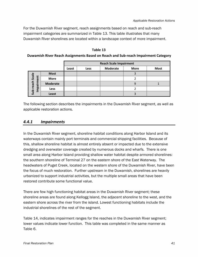
Applicable Restoration Actions
Final Restoration Plan 41
For the Duwamish River segment, reach assignments based on reach and sub-reach impairment categories are summarized in Table 13. This table illustrates that many Duwamish River shorelines are located within a landscape context of more impairment.
Table 13
Duwamish River Reach Assignments Based on Reach and Sub‐reach Impairment Category
Reach Scale Impairment
Least Less Moderate More Most
Sub‐reach Scale
Impairm
ent
Most 3
More 2
Moderate 9 1
Less 2
Least 3
The following section describes the impairments in the Duwamish River segment, as well as applicable restoration actions.
4.4.1 Impairments
In the Duwamish River segment, shoreline habitat conditions along Harbor Island and its waterways contain mainly port terminals and commercial shipping facilities. Because of this, shallow shoreline habitat is almost entirely absent or impacted due to the extensive dredging and overwater coverage created by numerous docks and wharfs. There is one small area along Harbor Island providing shallow water habitat despite armored shorelines: the southern shoreline of Terminal 27 on the eastern shore of the East Waterway. The headwaters of Puget Creek, located on the western shore of the Duwamish River, have been the focus of much restoration. Further upstream in the Duwamish, shorelines are heavily urbanized to support industrial activities, but the multiple small areas that have been restored contribute some functional value. There are few high functioning habitat areas in the Duwamish River segment; these shoreline areas are found along Kellogg Island, the adjacent shoreline to the west, and the eastern shore across the river from the island. Lowest functioning habitats include the industrial shorelines of the rest of the segment. Table 14, indicates impairment ranges for the reaches in the Duwamish River segment; lower values indicate lower function. This table was completed in the same manner as Table 6.
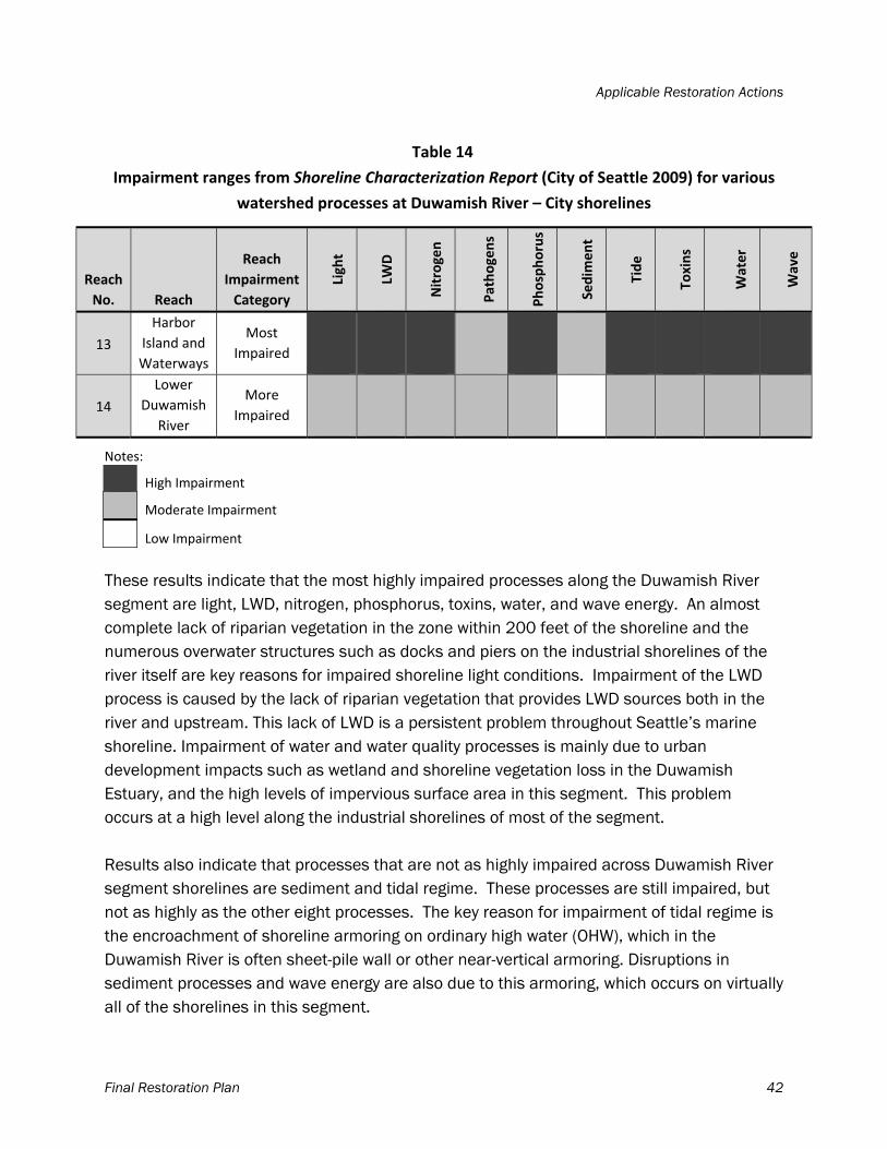
Applicable Restoration Actions
Final Restoration Plan 42
Table 14
Impairment ranges from Shoreline Characterization Report (City of Seattle 2009) for various
watershed processes at Duwamish River – City shorelines
Reach
No. Reach
Reach
Impairment
Category
Light
LWD
Nitrogen
Pathogens
Phosphorus
Sedim
ent
Tide
Toxins
Water
Wave
13
Harbor
Island and
Waterways
Most
Impaired
14
Lower
Duwamish
River
More
Impaired
Notes:
High Impairment
Moderate Impairment
Low Impairment
These results indicate that the most highly impaired processes along the Duwamish River segment are light, LWD, nitrogen, phosphorus, toxins, water, and wave energy. An almost complete lack of riparian vegetation in the zone within 200 feet of the shoreline and the numerous overwater structures such as docks and piers on the industrial shorelines of the river itself are key reasons for impaired shoreline light conditions. Impairment of the LWD process is caused by the lack of riparian vegetation that provides LWD sources both in the river and upstream. This lack of LWD is a persistent problem throughout Seattle’s marine shoreline. Impairment of water and water quality processes is mainly due to urban development impacts such as wetland and shoreline vegetation loss in the Duwamish Estuary, and the high levels of impervious surface area in this segment. This problem occurs at a high level along the industrial shorelines of most of the segment. Results also indicate that processes that are not as highly impaired across Duwamish River segment shorelines are sediment and tidal regime. These processes are still impaired, but not as highly as the other eight processes. The key reason for impairment of tidal regime is the encroachment of shoreline armoring on ordinary high water (OHW), which in the Duwamish River is often sheet-pile wall or other near-vertical armoring. Disruptions in sediment processes and wave energy are also due to this armoring, which occurs on virtually all of the shorelines in this segment.
Applicable Restoration Actions
Final Restoration Plan 43
4.4.2 Applicable Restoration Actions
Based on these impairments, the applicable restoration actions for the Duwamish River segment are categorized as High, Moderate, or Low in Table 15. This table was completed in the same manner as Table 7. Given the reach impairment categories shown in Table 15, all restoration actions are highly applicable in both reaches; the Lower Duwamish River reach is slightly less impaired than the Harbor Island and Waterways reach.
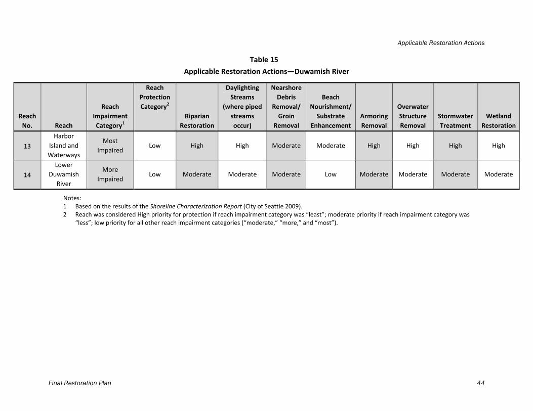
Applicable Restoration Actions
Final Restoration Plan 44
Table 15
Applicable Restoration Actions—Duwamish River
Reach
No. Reach
Reach
Impairment
Category1
Reach
Protection
Category2
Riparian
Restoration
Daylighting
Streams
(where piped
streams
occur)
Nearshore
Debris
Removal/
Groin
Removal
Beach
Nourishment/
Substrate
Enhancement
Armoring
Removal
Overwater
Structure
Removal
Stormwater
Treatment
Wetland
Restoration
13
Harbor
Island and
Waterways
Most
Impaired Low High High Moderate Moderate High High High High
14
Lower
Duwamish
River
More
Impaired Low Moderate Moderate Moderate Low Moderate Moderate Moderate Moderate
Notes: 1 Based on the results of the Shoreline Characterization Report (City of Seattle 2009). 2 Reach was considered High priority for protection if reach impairment category was “least”; moderate priority if reach impairment category was
“less”; low priority for all other reach impairment categories (“moderate,” “more,” and “most”).
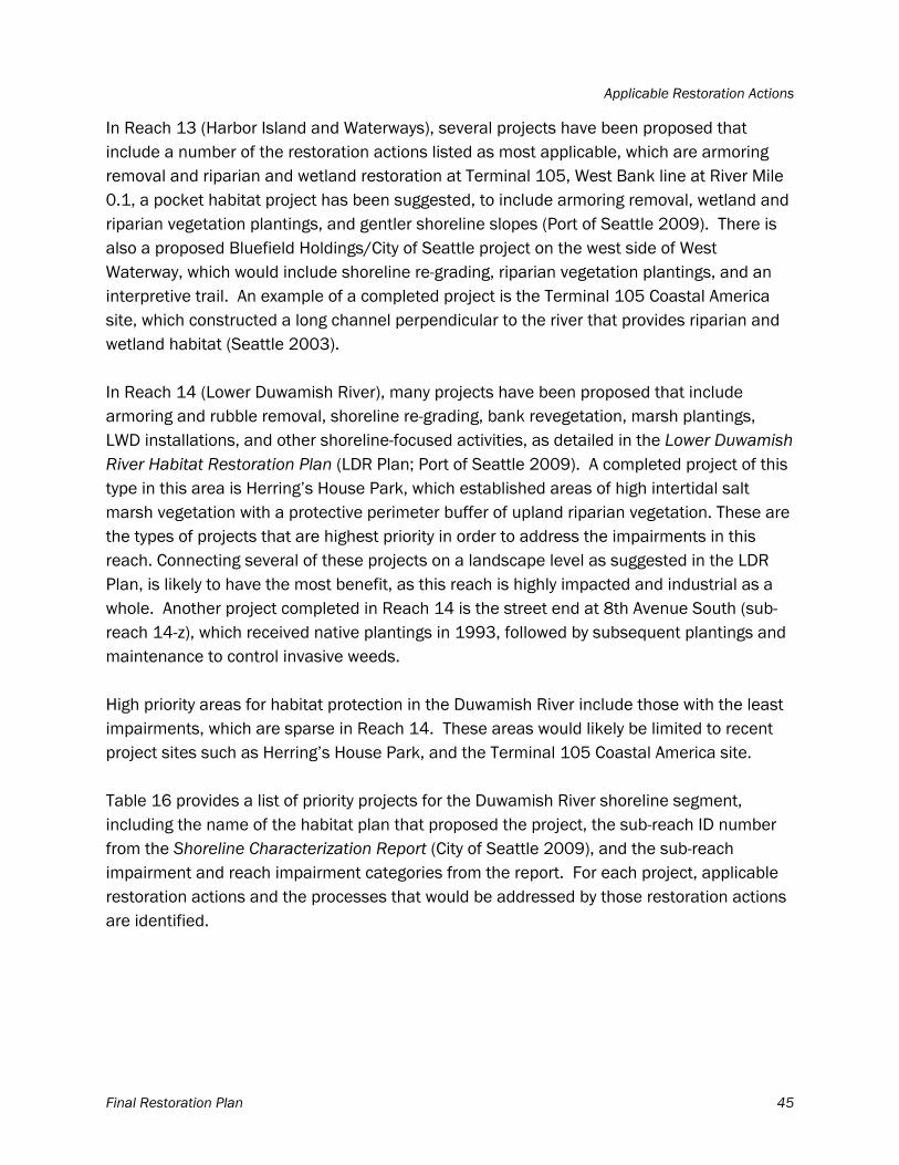
Applicable Restoration Actions
Final Restoration Plan 45
In Reach 13 (Harbor Island and Waterways), several projects have been proposed that include a number of the restoration actions listed as most applicable, which are armoring removal and riparian and wetland restoration at Terminal 105, West Bank line at River Mile 0.1, a pocket habitat project has been suggested, to include armoring removal, wetland and riparian vegetation plantings, and gentler shoreline slopes (Port of Seattle 2009). There is also a proposed Bluefield Holdings/City of Seattle project on the west side of West Waterway, which would include shoreline re-grading, riparian vegetation plantings, and an interpretive trail. An example of a completed project is the Terminal 105 Coastal America site, which constructed a long channel perpendicular to the river that provides riparian and wetland habitat (Seattle 2003). In Reach 14 (Lower Duwamish River), many projects have been proposed that include armoring and rubble removal, shoreline re-grading, bank revegetation, marsh plantings, LWD installations, and other shoreline-focused activities, as detailed in the Lower Duwamish River Habitat Restoration Plan (LDR Plan; Port of Seattle 2009). A completed project of this type in this area is Herring’s House Park, which established areas of high intertidal salt marsh vegetation with a protective perimeter buffer of upland riparian vegetation. These are the types of projects that are highest priority in order to address the impairments in this reach. Connecting several of these projects on a landscape level as suggested in the LDR Plan, is likely to have the most benefit, as this reach is highly impacted and industrial as a whole. Another project completed in Reach 14 is the street end at 8th Avenue South (sub-reach 14-z), which received native plantings in 1993, followed by subsequent plantings and maintenance to control invasive weeds. High priority areas for habitat protection in the Duwamish River include those with the least impairments, which are sparse in Reach 14. These areas would likely be limited to recent project sites such as Herring’s House Park, and the Terminal 105 Coastal America site. Table 16 provides a list of priority projects for the Duwamish River shoreline segment, including the name of the habitat plan that proposed the project, the sub-reach ID number from the Shoreline Characterization Report (City of Seattle 2009), and the sub-reach impairment and reach impairment categories from the report. For each project, applicable restoration actions and the processes that would be addressed by those restoration actions are identified.
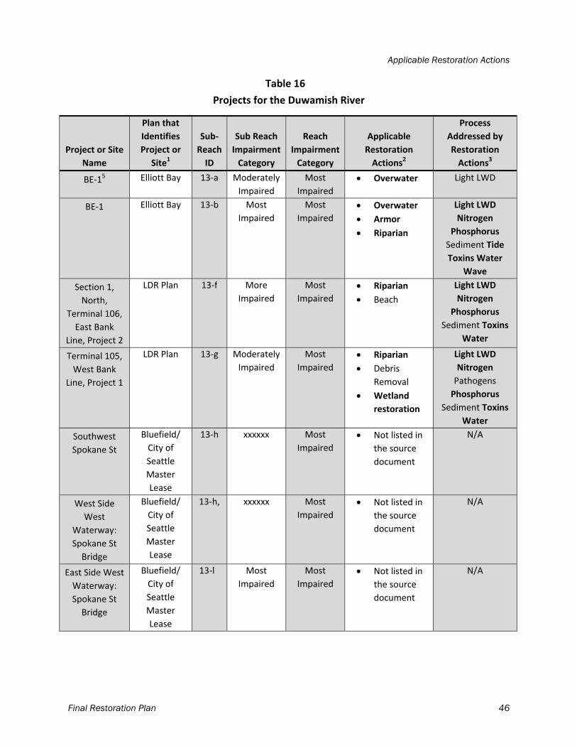
Applicable Restoration Actions
Final Restoration Plan 46
Table 16
Projects for the Duwamish River
Project or Site
Name
Plan that
Identifies
Project or
Site1
Sub‐
Reach
ID
Sub Reach
Impairment
Category
Reach
Impairment
Category
Applicable
Restoration
Actions2
Process
Addressed by
Restoration
Actions3
BE‐15 Elliott Bay 13‐a Moderately
Impaired
Most
Impaired
Overwater Light LWD
BE‐1 Elliott Bay 13‐b Most
Impaired
Most
Impaired
Overwater
Armor
Riparian
Light LWD
Nitrogen
Phosphorus
Sediment Tide
Toxins Water
Wave
Section 1,
North,
Terminal 106,
East Bank
Line, Project 2
LDR Plan 13‐f More
Impaired
Most
Impaired
Riparian
Beach
Light LWD
Nitrogen
Phosphorus
Sediment Toxins
Water
Terminal 105,
West Bank
Line, Project 1
LDR Plan 13‐g Moderately
Impaired
Most
Impaired
Riparian
Debris
Removal
Wetland
restoration
Light LWD
Nitrogen
Pathogens
Phosphorus
Sediment Toxins
Water
Southwest
Spokane St
Bluefield/
City of
Seattle
Master
Lease
13‐h xxxxxx Most
Impaired
Not listed in
the source
document
N/A
West Side
West
Waterway:
Spokane St
Bridge
Bluefield/
City of
Seattle
Master
Lease
13‐h, xxxxxx Most
Impaired
Not listed in
the source
document
N/A
East Side West
Waterway:
Spokane St
Bridge
Bluefield/
City of
Seattle
Master
Lease
13‐l Most
Impaired
Most
Impaired
Not listed in
the source
document
N/A
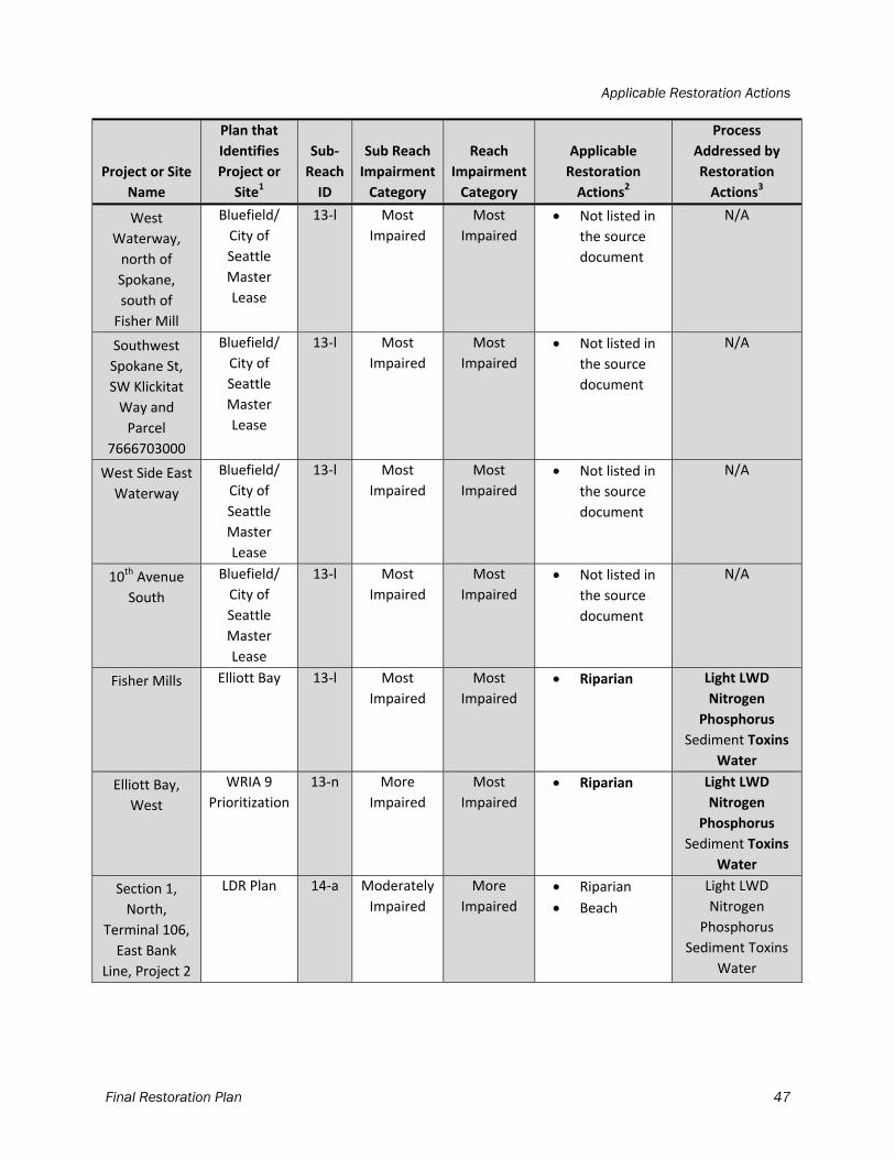
Applicable Restoration Actions
Final Restoration Plan 47
Project or Site
Name
Plan that
Identifies
Project or
Site1
Sub‐
Reach
ID
Sub Reach
Impairment
Category
Reach
Impairment
Category
Applicable
Restoration
Actions2
Process
Addressed by
Restoration
Actions3
West
Waterway,
north of
Spokane,
south of
Fisher Mill
Bluefield/
City of
Seattle
Master
Lease
13‐l Most
Impaired
Most
Impaired
Not listed in
the source
document
N/A
Southwest
Spokane St,
SW Klickitat
Way and
Parcel
7666703000
Bluefield/
City of
Seattle
Master
Lease
13‐l Most
Impaired
Most
Impaired
Not listed in
the source
document
N/A
West Side East
Waterway
Bluefield/
City of
Seattle
Master
Lease
13‐l Most
Impaired
Most
Impaired
Not listed in
the source
document
N/A
10th Avenue
South
Bluefield/
City of
Seattle
Master
Lease
13‐l Most
Impaired
Most
Impaired
Not listed in
the source
document
N/A
Fisher Mills Elliott Bay 13‐l Most
Impaired
Most
Impaired
Riparian Light LWD
Nitrogen
Phosphorus
Sediment Toxins
Water
Elliott Bay,
West
WRIA 9
Prioritization
13‐n More
Impaired
Most
Impaired
Riparian Light LWD
Nitrogen
Phosphorus
Sediment Toxins
Water
Section 1,
North,
Terminal 106,
East Bank
Line, Project 2
LDR Plan 14‐a Moderately
Impaired
More
Impaired
Riparian
Beach
Light LWD
Nitrogen
Phosphorus
Sediment Toxins
Water
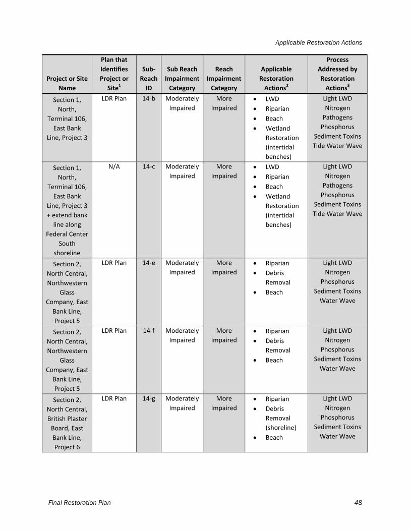
Applicable Restoration Actions
Final Restoration Plan 48
Project or Site
Name
Plan that
Identifies
Project or
Site1
Sub‐
Reach
ID
Sub Reach
Impairment
Category
Reach
Impairment
Category
Applicable
Restoration
Actions2
Process
Addressed by
Restoration
Actions3
Section 1,
North,
Terminal 106,
East Bank
Line, Project 3
LDR Plan 14‐b Moderately
Impaired
More
Impaired
LWD
Riparian
Beach
Wetland
Restoration
(intertidal
benches)
Light LWD
Nitrogen
Pathogens
Phosphorus
Sediment Toxins
Tide Water Wave
Section 1,
North,
Terminal 106,
East Bank
Line, Project 3
+ extend bank
line along
Federal Center
South
shoreline
N/A 14‐c Moderately
Impaired
More
Impaired
LWD
Riparian
Beach
Wetland
Restoration
(intertidal
benches)
Light LWD
Nitrogen
Pathogens
Phosphorus
Sediment Toxins
Tide Water Wave
Section 2,
North Central,
Northwestern
Glass
Company, East
Bank Line,
Project 5
LDR Plan 14‐e Moderately
Impaired
More
Impaired
Riparian
Debris
Removal
Beach
Light LWD
Nitrogen
Phosphorus
Sediment Toxins
Water Wave
Section 2,
North Central,
Northwestern
Glass
Company, East
Bank Line,
Project 5
LDR Plan 14‐f Moderately
Impaired
More
Impaired
Riparian
Debris
Removal
Beach
Light LWD
Nitrogen
Phosphorus
Sediment Toxins
Water Wave
Section 2,
North Central,
British Plaster
Board, East
Bank Line,
Project 6
LDR Plan 14‐g Moderately
Impaired
More
Impaired
Riparian
Debris
Removal
(shoreline)
Beach
Light LWD
Nitrogen
Phosphorus
Sediment Toxins
Water Wave
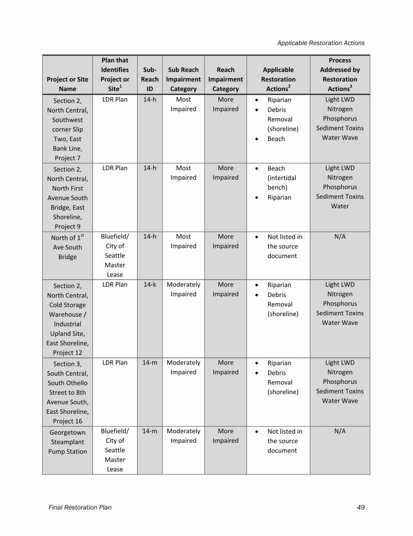
Applicable Restoration Actions
Final Restoration Plan 49
Project or Site
Name
Plan that
Identifies
Project or
Site1
Sub‐
Reach
ID
Sub Reach
Impairment
Category
Reach
Impairment
Category
Applicable
Restoration
Actions2
Process
Addressed by
Restoration
Actions3
Section 2,
North Central,
Southwest
corner Slip
Two, East
Bank Line,
Project 7
LDR Plan 14‐h Most
Impaired
More
Impaired
Riparian
Debris
Removal
(shoreline)
Beach
Light LWD
Nitrogen
Phosphorus
Sediment Toxins
Water Wave
Section 2,
North Central,
North First
Avenue South
Bridge, East
Shoreline,
Project 9
LDR Plan 14‐h Most
Impaired
More
Impaired
Beach
(intertidal
bench)
Riparian
Light LWD
Nitrogen
Phosphorus
Sediment Toxins
Water
North of 1st
Ave South
Bridge
Bluefield/
City of
Seattle
Master
Lease
14‐h Most
Impaired
More
Impaired
Not listed in
the source
document
N/A
Section 2,
North Central,
Cold Storage
Warehouse /
Industrial
Upland Site,
East Shoreline,
Project 12
LDR Plan 14‐k Moderately
Impaired
More
Impaired
Riparian
Debris
Removal
(shoreline)
Light LWD
Nitrogen
Phosphorus
Sediment Toxins
Water Wave
Section 3,
South Central,
South Othello
Street to 8th
Avenue South,
East Shoreline,
Project 16
LDR Plan 14‐m Moderately
Impaired
More
Impaired
Riparian
Debris
Removal
(shoreline)
Light LWD
Nitrogen
Phosphorus
Sediment Toxins
Water Wave
Georgetown
Steamplant
Pump Station
Bluefield/
City of
Seattle
Master
Lease
14‐m Moderately
Impaired
More
Impaired
Not listed in
the source
document
N/A
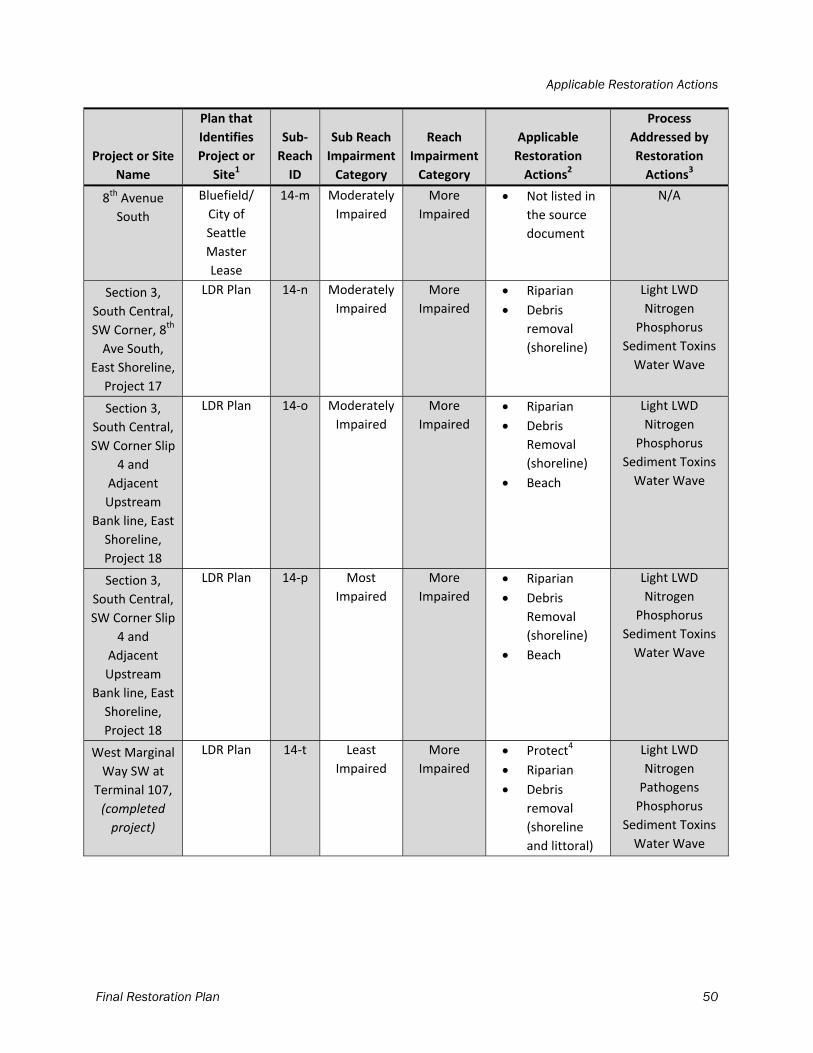
Applicable Restoration Actions
Final Restoration Plan 50
Project or Site
Name
Plan that
Identifies
Project or
Site1
Sub‐
Reach
ID
Sub Reach
Impairment
Category
Reach
Impairment
Category
Applicable
Restoration
Actions2
Process
Addressed by
Restoration
Actions3
8th Avenue
South
Bluefield/
City of
Seattle
Master
Lease
14‐m Moderately
Impaired
More
Impaired
Not listed in
the source
document
N/A
Section 3,
South Central,
SW Corner, 8th
Ave South,
East Shoreline,
Project 17
LDR Plan 14‐n Moderately
Impaired
More
Impaired
Riparian
Debris
removal
(shoreline)
Light LWD
Nitrogen
Phosphorus
Sediment Toxins
Water Wave
Section 3,
South Central,
SW Corner Slip
4 and
Adjacent
Upstream
Bank line, East
Shoreline,
Project 18
LDR Plan 14‐o Moderately
Impaired
More
Impaired
Riparian
Debris
Removal
(shoreline)
Beach
Light LWD
Nitrogen
Phosphorus
Sediment Toxins
Water Wave
Section 3,
South Central,
SW Corner Slip
4 and
Adjacent
Upstream
Bank line, East
Shoreline,
Project 18
LDR Plan 14‐p Most
Impaired
More
Impaired
Riparian
Debris
Removal
(shoreline)
Beach
Light LWD
Nitrogen
Phosphorus
Sediment Toxins
Water Wave
West Marginal
Way SW at
Terminal 107,
(completed
project)
LDR Plan 14‐t Least
Impaired
More
Impaired
Protect4
Riparian
Debris
removal
(shoreline
and littoral)
Light LWD
Nitrogen
Pathogens
Phosphorus
Sediment Toxins
Water Wave
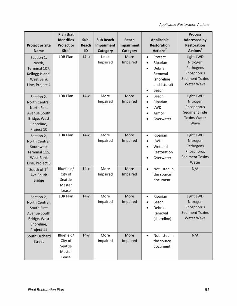
Applicable Restoration Actions
Final Restoration Plan 51
Project or Site
Name
Plan that
Identifies
Project or
Site1
Sub‐
Reach
ID
Sub Reach
Impairment
Category
Reach
Impairment
Category
Applicable
Restoration
Actions2
Process
Addressed by
Restoration
Actions3
Section 1,
North,
Terminal 107,
Kellogg Island,
West Bank
Line, Project 4
LDR Plan 14‐u Least
Impaired
More
Impaired
Protect
Riparian
Debris
Removal
(shoreline
and littoral)
Beach
Light LWD
Nitrogen
Pathogens
Phosphorus
Sediment Toxins
Water Wave
Section 2,
North Central,
North First
Avenue South
Bridge, West
Shoreline,
Project 10
LDR Plan 14‐x More
Impaired
More
Impaired
Beach
Riparian
LWD
Armor
Overwater
Light LWD
Nitrogen
Phosphorus
Sediment Tide
Toxins Water
Wave
Section 2,
North Central,
Southwest
Terminal 115,
West Bank
Line, Project 8
LDR Plan 14‐x More
Impaired
More
Impaired
Riparian
LWD
Wetland
Restoration
Overwater
Light LWD
Nitrogen
Pathogens
Phosphorus
Sediment Toxins
Water
South of 1st
Ave South
Bridge
Bluefield/
City of
Seattle
Master
Lease
14‐x More
Impaired
More
Impaired
Not listed in
the source
document
N/A
Section 2,
North Central,
South First
Avenue South
Bridge, West
Shoreline,
Project 11
LDR Plan 14‐y More
Impaired
More
Impaired
Riparian
Beach
Debris
Removal
(shoreline)
Light LWD
Nitrogen
Phosphorus
Sediment Toxins
Water Wave
South Orchard
Street
Bluefield/
City of
Seattle
Master
Lease
14‐y More
Impaired
More
Impaired
Not listed in
the source
document
N/A
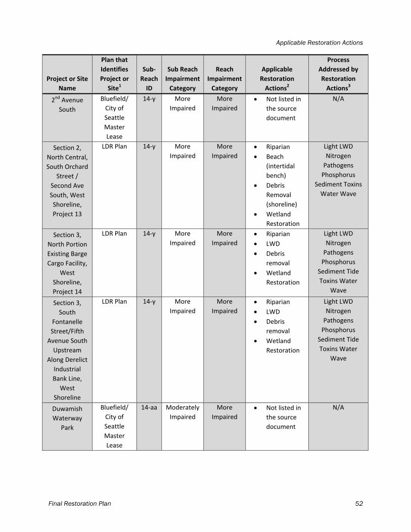
Applicable Restoration Actions
Final Restoration Plan 52
Project or Site
Name
Plan that
Identifies
Project or
Site1
Sub‐
Reach
ID
Sub Reach
Impairment
Category
Reach
Impairment
Category
Applicable
Restoration
Actions2
Process
Addressed by
Restoration
Actions3
2nd Avenue
South
Bluefield/
City of
Seattle
Master
Lease
14‐y More
Impaired
More
Impaired
Not listed in
the source
document
N/A
Section 2,
North Central,
South Orchard
Street /
Second Ave
South, West
Shoreline,
Project 13
LDR Plan 14‐y More
Impaired
More
Impaired
Riparian
Beach
(intertidal
bench)
Debris
Removal
(shoreline)
Wetland
Restoration
Light LWD
Nitrogen
Pathogens
Phosphorus
Sediment Toxins
Water Wave
Section 3,
North Portion
Existing Barge
Cargo Facility,
West
Shoreline,
Project 14
LDR Plan 14‐y More
Impaired
More
Impaired
Riparian
LWD
Debris
removal
Wetland
Restoration
Light LWD
Nitrogen
Pathogens
Phosphorus
Sediment Tide
Toxins Water
Wave
Section 3,
South
Fontanelle
Street/Fifth
Avenue South
Upstream
Along Derelict
Industrial
Bank Line,
West
Shoreline
LDR Plan 14‐y More
Impaired
More
Impaired
Riparian
LWD
Debris
removal
Wetland
Restoration
Light LWD
Nitrogen
Pathogens
Phosphorus
Sediment Tide
Toxins Water
Wave
Duwamish
Waterway
Park
Bluefield/
City of
Seattle
Master
Lease
14‐aa Moderately
Impaired
More
Impaired
Not listed in
the source
document
N/A
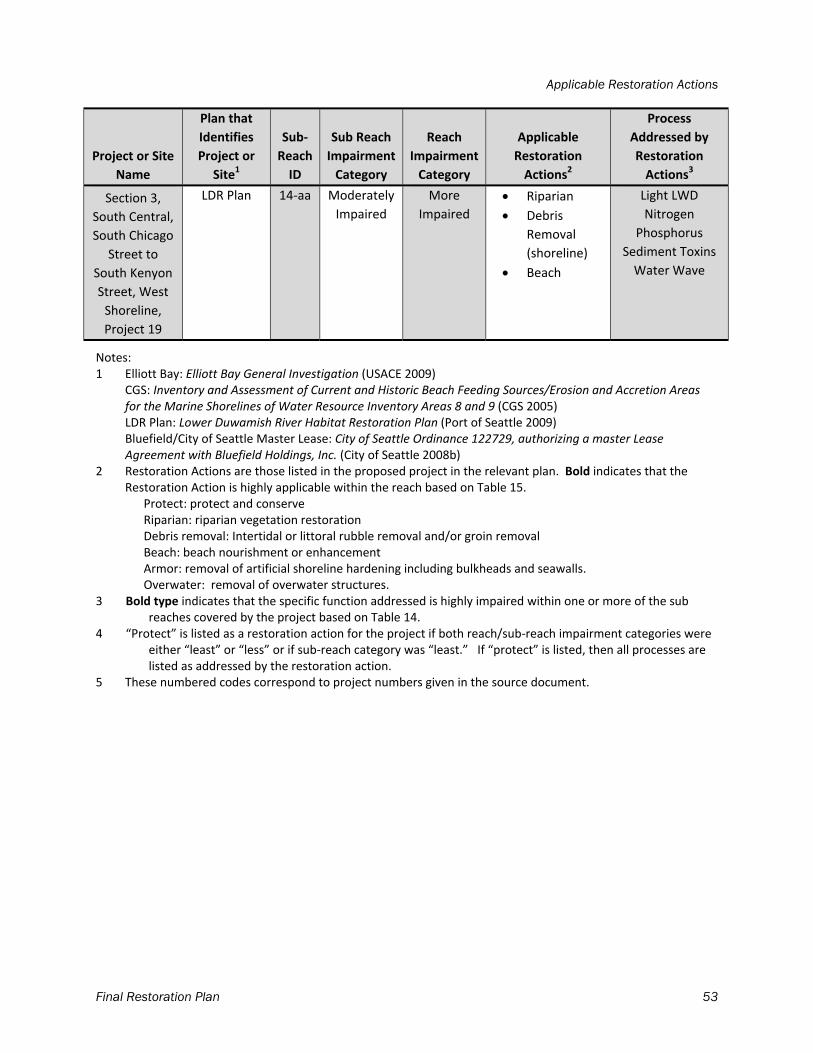
Applicable Restoration Actions
Final Restoration Plan 53
Project or Site
Name
Plan that
Identifies
Project or
Site1
Sub‐
Reach
ID
Sub Reach
Impairment
Category
Reach
Impairment
Category
Applicable
Restoration
Actions2
Process
Addressed by
Restoration
Actions3
Section 3,
South Central,
South Chicago
Street to
South Kenyon
Street, West
Shoreline,
Project 19
LDR Plan 14‐aa Moderately
Impaired
More
Impaired
Riparian
Debris
Removal
(shoreline)
Beach
Light LWD
Nitrogen
Phosphorus
Sediment Toxins
Water Wave
Notes: 1 Elliott Bay: Elliott Bay General Investigation (USACE 2009) CGS: Inventory and Assessment of Current and Historic Beach Feeding Sources/Erosion and Accretion Areas
for the Marine Shorelines of Water Resource Inventory Areas 8 and 9 (CGS 2005) LDR Plan: Lower Duwamish River Habitat Restoration Plan (Port of Seattle 2009) Bluefield/City of Seattle Master Lease: City of Seattle Ordinance 122729, authorizing a master Lease
Agreement with Bluefield Holdings, Inc. (City of Seattle 2008b) 2 Restoration Actions are those listed in the proposed project in the relevant plan. Bold indicates that the
Restoration Action is highly applicable within the reach based on Table 15. Protect: protect and conserve Riparian: riparian vegetation restoration Debris removal: Intertidal or littoral rubble removal and/or groin removal Beach: beach nourishment or enhancement Armor: removal of artificial shoreline hardening including bulkheads and seawalls. Overwater: removal of overwater structures. 3 Bold type indicates that the specific function addressed is highly impaired within one or more of the sub
reaches covered by the project based on Table 14. 4 “Protect” is listed as a restoration action for the project if both reach/sub‐reach impairment categories were
either “least” or “less” or if sub‐reach category was “least.” If “protect” is listed, then all processes are listed as addressed by the restoration action.
5 These numbered codes correspond to project numbers given in the source document.
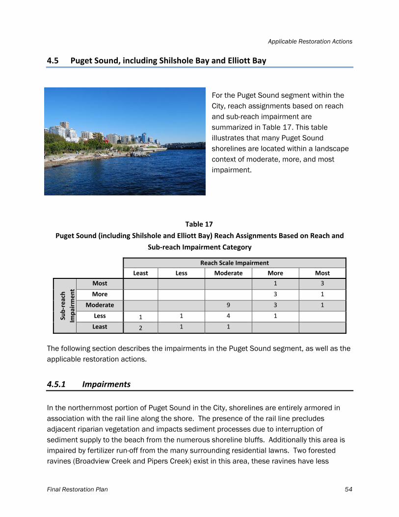
Applicable Restoration Actions
Final Restoration Plan 54
4.5 Puget Sound, including Shilshole Bay and Elliott Bay
For the Puget Sound segment within the City, reach assignments based on reach and sub-reach impairment are summarized in Table 17. This table illustrates that many Puget Sound shorelines are located within a landscape context of moderate, more, and most impairment.
Table 17
Puget Sound (including Shilshole and Elliott Bay) Reach Assignments Based on Reach and
Sub‐reach Impairment Category
Reach Scale Impairment
Least Less Moderate More Most
Sub‐reach
Impairm
ent
Most 1 3
More 3 1
Moderate 9 3 1
Less 1 1 4 1
Least 2 1 1
The following section describes the impairments in the Puget Sound segment, as well as the applicable restoration actions.
4.5.1 Impairments
In the northernmost portion of Puget Sound in the City, shorelines are entirely armored in association with the rail line along the shore. The presence of the rail line precludes adjacent riparian vegetation and impacts sediment processes due to interruption of sediment supply to the beach from the numerous shoreline bluffs. Additionally this area is impaired by fertilizer run-off from the many surrounding residential lawns. Two forested ravines (Broadview Creek and Pipers Creek) exist in this area, these ravines have less
Applicable Restoration Actions
Final Restoration Plan 55
impervious surface than the surrounding residential areas. Shilshole Bay Marina contains large amounts of overwater structures and shoreline armor. Near the Ballard Locks, further impaired conditions occur in a critical ecological position, as this area is the estuary for the Lake Washington/Lake Sammamish/Cedar River drainage. In this area, juvenile salmon make the physiologically demanding transition from fresh water to salt water, and the presence of the locks makes the transition quite abrupt. Ecological function improves moving through Discovery Park, as the eroding bluffs along the south shoreline and the vegetated creek drainage in the north are particularly high functioning areas. Toward Elliott Bay and the urban core, conditions deteriorate due to increasing shoreline armoring, overwater cover, and impervious surfaces, and decreasing riparian vegetation and intertidal habitat. In the downtown area, shorelines are entirely armored, have extensive overwater cover and fill, and are almost entirely impervious surface. CSOs and stormwater outfalls are present, and roads are in direct proximity to the shoreline. Along western Elliott Bay and toward West Seattle, shorelines are still armored but impervious surface area decreases. Near Lincoln Park in South Seattle, extensive vegetation and minimal impervious surfaces abound, but the area surrounding the Fauntleroy ferry terminal is highly impaired for toxins, pathogens, and sediment processes. At the south end of the project boundary, Seola Park offers high functioning habitat due to vegetated and minimally impacted shorelines. Impairments to water quality in the southern portion of this segment result from outfalls from large basins and culverts that carry pollutants from upland activities. In summary, the highest functioning habitats in the segment are found along the unarmored portions of Golden Gardens, the creek mouths, and their small associated wetlands, and Discovery, Lincoln, and Seola parks. Lowest functioning habitats in the segment include Shilshole Bay and Elliott Bay Marinas, the central waterfront, and Terminals 90 and 91. Table 18 indicates impairment ranges for the reaches in the Puget Sound segment; lower values indicate lower function. This table was completed in the same manner as Table 6. These results indicate that the most highly impaired processes in the City’s marine nearshore include pathogens and sediment. Key reasons for the impairment of sediment processes is the urban and shoreline residential and transportation (rail and road) development which disconnects sediment source bluffs from the shoreline. In addition, jetties, breakwaters, and groins present throughout the marine shoreline restrict sediment movement once it reaches the shore, creating a persistent problem. Impairment of water quality due to pathogens is mainly linked to urban development impacts such as CSOs in the
Applicable Restoration Actions
Final Restoration Plan 56
downtown core, and wetland and shoreline vegetation loss and increased impervious surface area from Elliott Bay throughout the downtown core. Other processes that are still impaired —but not as highly as the other two processes—include LWD, nitrogen, phosphorus, toxins, water, and wave energy. The reasons for impairment of the water quality processes of nitrogen, toxins, and phosphorus are the same as those listed above for pathogens. LWD processes have been disrupted on a large scale throughout the City’s Puget Sound shorelines due to removal of source trees and vegetation from the nearby shore to facilitate urban development and due to encroachment of armoring into intertidal areas, which restricts accumulation. In addition, source wood is no longer provided from river mouths in the region due to development in their watersheds. The water process has been impaired mainly by urban development and increased impervious surface area, now common on most City shorelines. Disruptions in wave energy along the Seattle shore include armoring, jetties, groins breakwaters, and overwater structures. These are interspersed throughout Seattle, but are particularly heavy near Shilshole and the downtown core. Tidal regime is the process least impaired in this segment, although it is still impaired. Impacts to tidal regime in Puget Sound are due to channelized streams, the Ballard Locks, and encroachment of armoring on OHW. Armoring and tidal encroachment occurs throughout almost the entire Seattle shoreline.
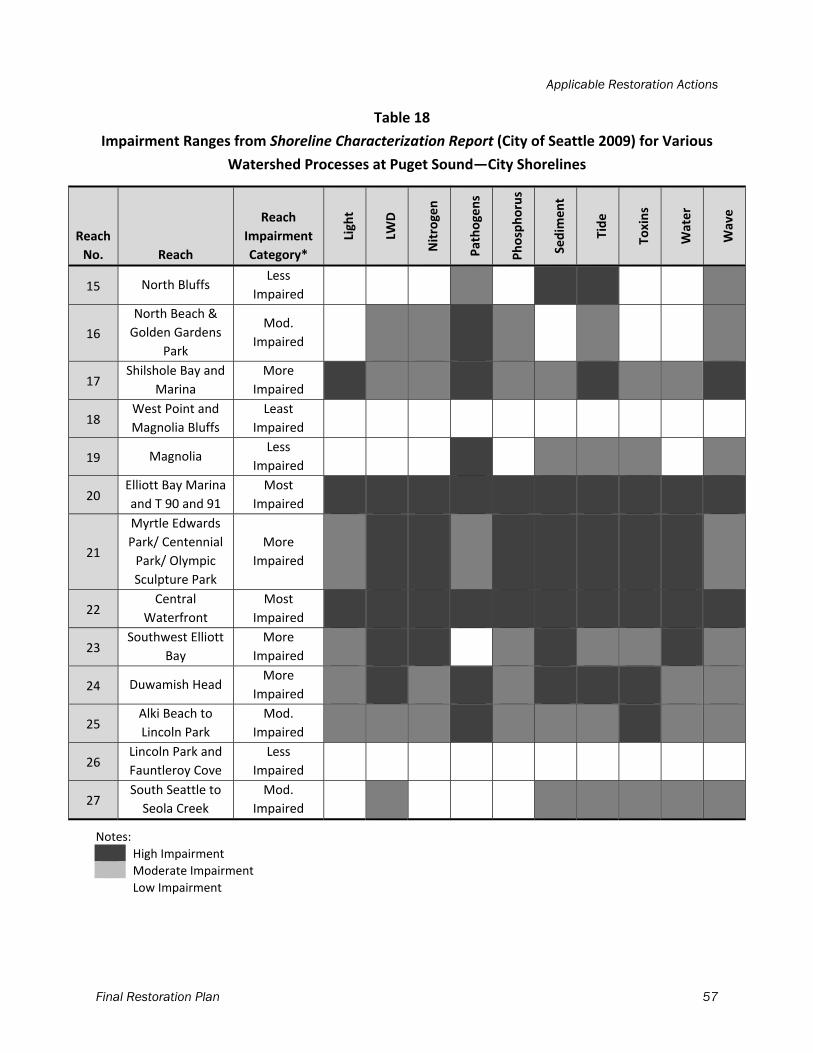
Applicable Restoration Actions
Final Restoration Plan 57
Table 18
Impairment Ranges from Shoreline Characterization Report (City of Seattle 2009) for Various
Watershed Processes at Puget Sound—City Shorelines
Reach
No. Reach
Reach
Impairment
Category*
Light
LWD
Nitrogen
Pathogens
Phosphorus
Sedim
ent
Tide
Toxins
Water
Wave
15 North Bluffs Less
Impaired
16
North Beach &
Golden Gardens
Park
Mod.
Impaired
17 Shilshole Bay and
Marina
More
Impaired
18 West Point and
Magnolia Bluffs
Least
Impaired
19 Magnolia Less
Impaired
20 Elliott Bay Marina
and T 90 and 91
Most
Impaired
21
Myrtle Edwards
Park/ Centennial
Park/ Olympic
Sculpture Park
More
Impaired
22 Central
Waterfront
Most
Impaired
23 Southwest Elliott
Bay
More
Impaired
24 Duwamish Head More
Impaired
25 Alki Beach to
Lincoln Park
Mod.
Impaired
26 Lincoln Park and
Fauntleroy Cove
Less
Impaired
27 South Seattle to
Seola Creek
Mod.
Impaired
Notes:
High Impairment
Moderate Impairment
Low Impairment
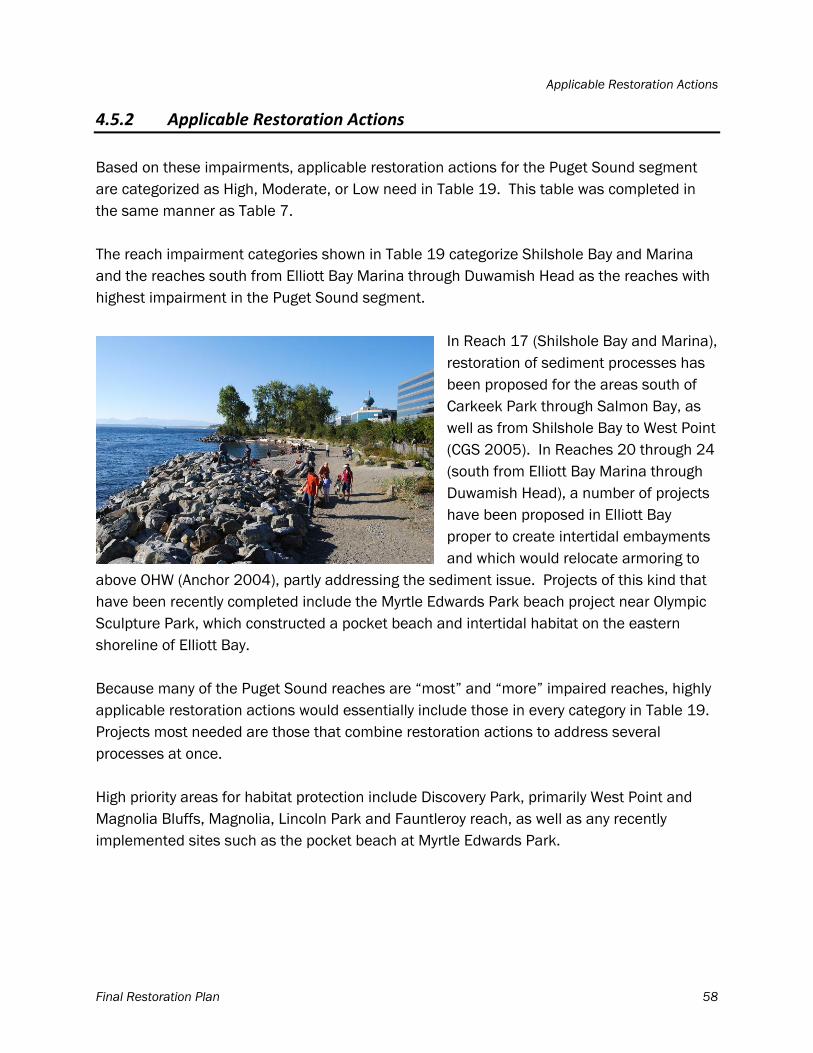
Applicable Restoration Actions
Final Restoration Plan 58
4.5.2 Applicable Restoration Actions
Based on these impairments, applicable restoration actions for the Puget Sound segment are categorized as High, Moderate, or Low need in Table 19. This table was completed in the same manner as Table 7. The reach impairment categories shown in Table 19 categorize Shilshole Bay and Marina and the reaches south from Elliott Bay Marina through Duwamish Head as the reaches with highest impairment in the Puget Sound segment.
In Reach 17 (Shilshole Bay and Marina), restoration of sediment processes has been proposed for the areas south of Carkeek Park through Salmon Bay, as well as from Shilshole Bay to West Point (CGS 2005). In Reaches 20 through 24 (south from Elliott Bay Marina through Duwamish Head), a number of projects have been proposed in Elliott Bay proper to create intertidal embayments and which would relocate armoring to
above OHW (Anchor 2004), partly addressing the sediment issue. Projects of this kind that have been recently completed include the Myrtle Edwards Park beach project near Olympic Sculpture Park, which constructed a pocket beach and intertidal habitat on the eastern shoreline of Elliott Bay. Because many of the Puget Sound reaches are “most” and “more” impaired reaches, highly applicable restoration actions would essentially include those in every category in Table 19. Projects most needed are those that combine restoration actions to address several processes at once. High priority areas for habitat protection include Discovery Park, primarily West Point and Magnolia Bluffs, Magnolia, Lincoln Park and Fauntleroy reach, as well as any recently implemented sites such as the pocket beach at Myrtle Edwards Park.
Applicable Restoration Actions
Final Restoration Plan 59
Table 19
Applicable Restoration Actions—Puget Sound
Reach
No. Reach
Reach
Impairment
Category1
Reach
Protection
Category2
Riparian
Work
Daylighting
Streams
(where piped
streams
occur)
Nearshore
Debris/
Jetty/Groin/
Breakwater
Removal
Beach
Nourishment/
Enhancement
Armoring
Removal
Overwater
Structure
Removal
Stormwater
Treatment
Wetland
Restoration
15 North
Bluffs
Less
Impaired Moderate Low High High High High Moderate Moderate Moderate
16
North
Beach and
Golden
Gardens
Park
Moderately
Impaired Low Moderate High Low Low Moderate Moderate High High
17
Shilshole
Bay and
Marina
More
Impaired Low High High High Moderate High High High High
18
West Point
and
Magnolia
Bluffs
Least
Impaired High Low Low Low Low Low Low Low Low
19 Magnolia Less
Impaired Moderate Moderate High Moderate Moderate Moderate Low High High
20
Elliott Bay
Marina and
Terminals
90 and 91
Most
Impaired Low High High High High High High High High
Applicable Restoration Actions
Final Restoration Plan 60
Reach
No. Reach
Reach
Impairment
Category1
Reach
Protection
Category2
Riparian
Work
Daylighting
Streams
(where piped
streams
occur)
Nearshore
Debris/
Jetty/Groin/
Breakwater
Removal
Beach
Nourishment/
Enhancement
Armoring
Removal
Overwater
Structure
Removal
Stormwater
Treatment
Wetland
Restoration
21
Myrtle
Edwards/
Centennial/
Olympic
Sculpture
Parks
More
Impaired Low High High High High High High High High
22 Central
Waterfront
Most
Impaired Low High High High High High High High High
23 Southwest
Elliott Bay
More
Impaired Low High High High High High High High High
24 Duwamish
Head
More
Impaired Low High High High High High High High High
25
Alki Beach
to Lincoln
Park
Moderately
Impaired Low High High Moderate Moderate Moderate Moderate High High
26
Lincoln
Park and
Fauntleroy
Cove
Less
Impaired Moderate Low Low Low Low Low Low Low Low
27
South
Seattle to
Seola Creek
Moderately
Impaired Low Moderate Moderate Moderate Moderate Moderate Moderate Moderate Moderate
Notes: 1 Based on the results of the Shoreline Characterization Report (City of Seattle 2009). 2 Reach was considered High priority for protection if reach impairment category was “least”; moderate priority if reach impairment category was
“less”; low priority for all other reach impairment categories (“moderate,” “more,” and “most”)
Applicable Restoration Actions
Final Restoration Plan 61
Table 20 provides a list of projects for the Puget Sound shoreline segment, including the name of the habitat plan that proposed the project, the sub-reach ID number from the Shoreline Characterization Report (City of Seattle 2009), and the sub-reach impairment and reach impairment categories from the report. For each project, applicable restoration actions and the processes that would be addressed by those restoration actions are identified.
Table 20
Projects for Puget Sound
Project or Site
Name
Plan that
Identifies
Project or Site1
Sub‐
Reach
ID
Sub Reach
Impairment
Category
Reach
Impairment
Category
Applicable
Restoration
Actions2
Process Addressed
by Restoration
Actions3
SN‐35 Northern
Railroad
(Carkeek)
CGS 15‐d Less Impaired Less
Impaired
Protect4 Light LWD Nitrogen
Pathogens
Phosphorus
Sediment Tide
Toxins Water Wave
Pipers Creek to
Golden
Gardens
Blueprint 15‐e Less Impaired Less
Impaired
Protect Light LWD Nitrogen
Pathogens
Phosphorus
Sediment Tide
Toxins Water Wave
KI‐2‐1 Carkeek
to Shilshole
CGS 16‐a/b Moderately/
Least
Impaired
Moderately
Impaired
Protect Light LWD Nitrogen
Pathogens
Phosphorus
Sediment Tide
Toxins Water Wave
KI‐2‐1/KI‐2‐2
South Golden
Gardens,
Shilshole N.
Salmon Bay
CGS 17‐b More
Impaired
More
Impaired
Debris
Removal
Overwater
Light LWD Sediment
Wave
KI‐2‐1/KI‐2‐2
South Golden
Gardens,
Shilshole N.
Salmon Bay, KI‐
2‐2 Salmon Bay
into Ship Canal,
North side
CGS 17‐c Moderately
Impaired
More
Impaired
Riparian
Debris
Removal
Beach
Armor
Overwater
Light LWD Nitrogen
Phosphorus
Sediment Tide
Toxins Water Wave
Locks ‐
Barnacle
Removal
Blueprint 17‐d Less Impaired More
Impaired
N/A N/A
Applicable Restoration Actions
Final Restoration Plan 62
Project or Site
Name
Plan that
Identifies
Project or Site1
Sub‐
Reach
ID
Sub Reach
Impairment
Category
Reach
Impairment
Category
Applicable
Restoration
Actions2
Process Addressed
by Restoration
Actions3
KI‐2‐4 Shilshole
Bay to
Westpoint
CGS 18‐b Least
Impaired
Least
Impaired
Protect Light LWD Nitrogen
Phosphorus
Pathogens
Sediment Tide
Toxins Water Wave
KI‐2‐4 Shilshole
Bay to
Westpoint
CGS 18‐d Less Impaired Least
Impaired
Protect
Riparian
Wetland
Restoration
Debris
Removal
Light LWD Nitrogen
Phosphorus
Pathogens
Sediment Tide
Toxins Water Wave
KI‐3‐2 Magnolia
Bluffs to Smith
Cove
CGS 18‐e Least
Impaired
Least
Impaired
Protect
Debris
Removal
Light LWD Nitrogen
Phosphorus
Pathogens
Sediment Tide
Toxins Water Wave
Magnolia Bluffs WRIA 9
Prioritization
19‐a Less Impaired Less
Impaired
Protect
Debris
Removal
(shoreline
and in‐water)
Light LWD Nitrogen
Phosphorus
Pathogens
Sediment Tide
Toxins Water Wave
Magnolia Bluffs WRIA 9
Prioritization
19‐b Least
Impaired
Less
Impaired
Protect
Debris
(shoreline
and in‐water)
Light LWD Nitrogen
Phosphorus
Pathogens
Sediment Tide
Toxins Water Wave
KI‐3‐2 Magnolia
Bluffs to Smith
Cove
CGS 19‐c Less Impaired Less
Impaired
Protect
Beach
Debris (in‐
water)
Light LWD Nitrogen
Phosphorus
Pathogens
Sediment Tide
Toxins Water Wave
KI‐3‐2/KI‐3‐3
Smith Cove
Marina and
Breakwater
CGS 20‐a Most
Impaired
Most
Impaired
Beach Sediment
KI‐3‐2/KI‐3‐3
Smith Cove
Marina and
Breakwater
CGS 20‐b Moderately
Impaired
Most
Impaired
Riparian
Beach
Stormwater
treatment
Debris (in‐
water)
Light LWD Nitrogen
Pathogens
Phosphorus
Sediment Tide
Toxins Water Wave
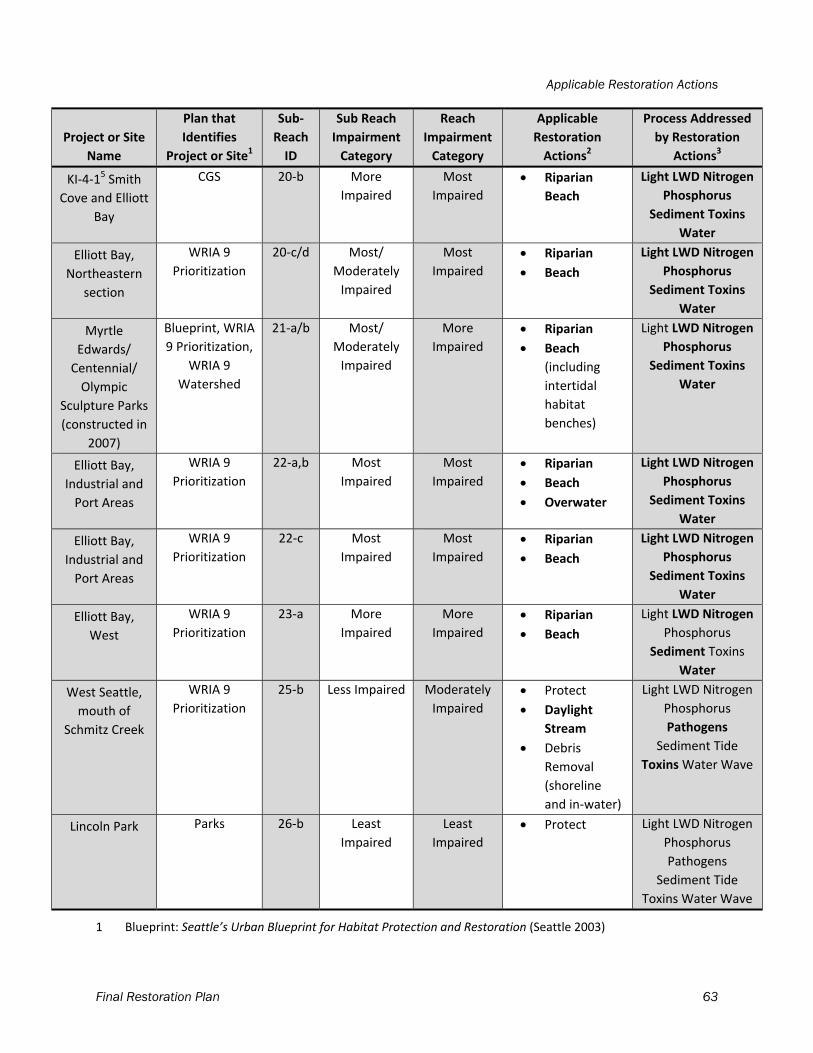
Applicable Restoration Actions
Final Restoration Plan 63
Project or Site
Name
Plan that
Identifies
Project or Site1
Sub‐
Reach
ID
Sub Reach
Impairment
Category
Reach
Impairment
Category
Applicable
Restoration
Actions2
Process Addressed
by Restoration
Actions3
KI‐4‐15 Smith
Cove and Elliott
Bay
CGS 20‐b More
Impaired
Most
Impaired
Riparian
Beach
Light LWD Nitrogen
Phosphorus
Sediment Toxins
Water
Elliott Bay,
Northeastern
section
WRIA 9
Prioritization
20‐c/d Most/
Moderately
Impaired
Most
Impaired
Riparian
Beach
Light LWD Nitrogen
Phosphorus
Sediment Toxins
Water
Myrtle
Edwards/
Centennial/
Olympic
Sculpture Parks
(constructed in
2007)
Blueprint, WRIA
9 Prioritization,
WRIA 9
Watershed
21‐a/b Most/
Moderately
Impaired
More
Impaired
Riparian
Beach
(including
intertidal
habitat
benches)
Light LWD Nitrogen
Phosphorus
Sediment Toxins
Water
Elliott Bay,
Industrial and
Port Areas
WRIA 9
Prioritization
22‐a,b Most
Impaired
Most
Impaired
Riparian
Beach
Overwater
Light LWD Nitrogen
Phosphorus
Sediment Toxins
Water
Elliott Bay,
Industrial and
Port Areas
WRIA 9
Prioritization
22‐c Most
Impaired
Most
Impaired
Riparian
Beach
Light LWD Nitrogen
Phosphorus
Sediment Toxins
Water
Elliott Bay,
West
WRIA 9
Prioritization
23‐a More
Impaired
More
Impaired
Riparian
Beach
Light LWD Nitrogen
Phosphorus
Sediment Toxins
Water
West Seattle,
mouth of
Schmitz Creek
WRIA 9
Prioritization
25‐b Less Impaired Moderately
Impaired
Protect
Daylight
Stream
Debris
Removal
(shoreline
and in‐water)
Light LWD Nitrogen
Phosphorus
Pathogens
Sediment Tide
Toxins Water Wave
Lincoln Park Parks 26‐b Least
Impaired
Least
Impaired
Protect Light LWD Nitrogen
Phosphorus
Pathogens
Sediment Tide
Toxins Water Wave
1 Blueprint: Seattle’s Urban Blueprint for Habitat Protection and Restoration (Seattle 2003)
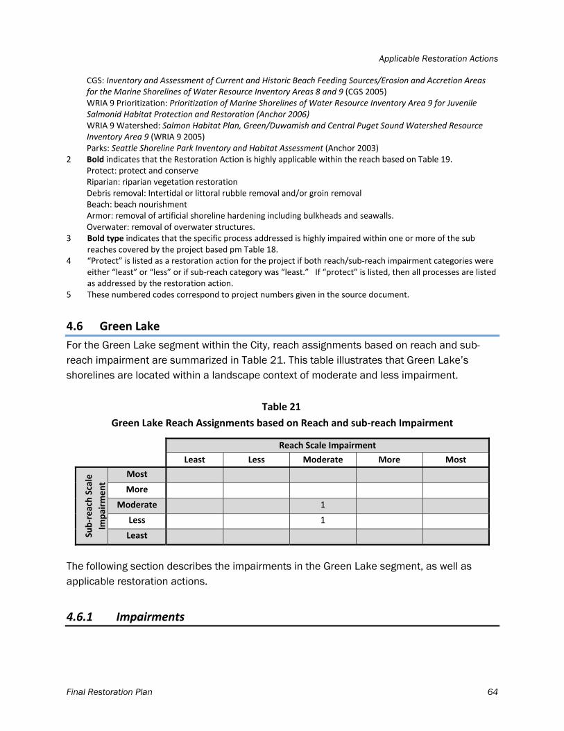
Applicable Restoration Actions
Final Restoration Plan 64
CGS: Inventory and Assessment of Current and Historic Beach Feeding Sources/Erosion and Accretion Areas for the Marine Shorelines of Water Resource Inventory Areas 8 and 9 (CGS 2005)
WRIA 9 Prioritization: Prioritization of Marine Shorelines of Water Resource Inventory Area 9 for Juvenile Salmonid Habitat Protection and Restoration (Anchor 2006)
WRIA 9 Watershed: Salmon Habitat Plan, Green/Duwamish and Central Puget Sound Watershed Resource Inventory Area 9 (WRIA 9 2005)
Parks: Seattle Shoreline Park Inventory and Habitat Assessment (Anchor 2003) 2 Bold indicates that the Restoration Action is highly applicable within the reach based on Table 19. Protect: protect and conserve Riparian: riparian vegetation restoration Debris removal: Intertidal or littoral rubble removal and/or groin removal Beach: beach nourishment Armor: removal of artificial shoreline hardening including bulkheads and seawalls. Overwater: removal of overwater structures. 3 Bold type indicates that the specific process addressed is highly impaired within one or more of the sub
reaches covered by the project based pm Table 18. 4 “Protect” is listed as a restoration action for the project if both reach/sub‐reach impairment categories were
either “least” or “less” or if sub‐reach category was “least.” If “protect” is listed, then all processes are listed as addressed by the restoration action.
5 These numbered codes correspond to project numbers given in the source document.
4.6 Green Lake
For the Green Lake segment within the City, reach assignments based on reach and sub-reach impairment are summarized in Table 21. This table illustrates that Green Lake’s shorelines are located within a landscape context of moderate and less impairment.
Table 21
Green Lake Reach Assignments based on Reach and sub‐reach Impairment
Reach Scale Impairment
Least Less Moderate More Most
Sub‐reach Scale
Impairm
ent
Most
More
Moderate 1
Less 1
Least
The following section describes the impairments in the Green Lake segment, as well as applicable restoration actions.
4.6.1 Impairments
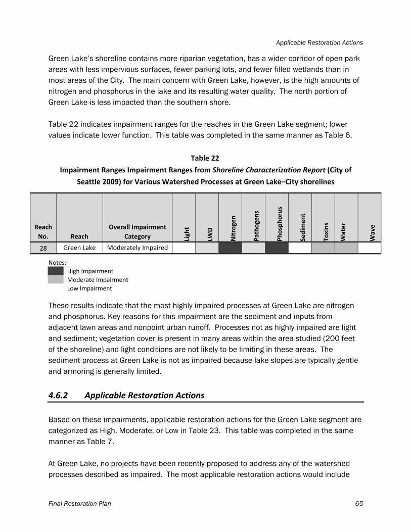
Applicable Restoration Actions
Final Restoration Plan 65
Green Lake’s shoreline contains more riparian vegetation, has a wider corridor of open park areas with less impervious surfaces, fewer parking lots, and fewer filled wetlands than in most areas of the City. The main concern with Green Lake, however, is the high amounts of nitrogen and phosphorus in the lake and its resulting water quality. The north portion of Green Lake is less impacted than the southern shore. Table 22 indicates impairment ranges for the reaches in the Green Lake segment; lower values indicate lower function. This table was completed in the same manner as Table 6.
Table 22
Impairment Ranges Impairment Ranges from Shoreline Characterization Report (City of
Seattle 2009) for Various Watershed Processes at Green Lake–City shorelines
Reach
No. Reach
Overall Impairment
Category Light
LWD
Nitrogen
Pathogens
Phosphorus
Sedim
ent
Toxins
Water
Wave
28 Green Lake Moderately Impaired
Notes:
High Impairment
Moderate Impairment
Low Impairment
These results indicate that the most highly impaired processes at Green Lake are nitrogen and phosphorus. Key reasons for this impairment are the sediment and inputs from adjacent lawn areas and nonpoint urban runoff. Processes not as highly impaired are light and sediment; vegetation cover is present in many areas within the area studied (200 feet of the shoreline) and light conditions are not likely to be limiting in these areas. The sediment process at Green Lake is not as impaired because lake slopes are typically gentle and armoring is generally limited.
4.6.2 Applicable Restoration Actions
Based on these impairments, applicable restoration actions for the Green Lake segment are categorized as High, Moderate, or Low in Table 23. This table was completed in the same manner as Table 7. At Green Lake, no projects have been recently proposed to address any of the watershed processes described as impaired. The most applicable restoration actions would include
Applicable Restoration Actions
Final Restoration Plan 66
bioswales or similar stormwater treatments that would help address the nutrient issues in the lake and continued alum treatment to reduce the internal phosphorous levels. High priority areas for habitat protection include those with the least impairments, which would include the areas with riparian vegetation and unarmored shorelines at the lake identified in the Green Lake Vegetation Plan1.
1 available at www.seattle.gov/parks/parkspaces/GreenLakePark/ VMP.htm.
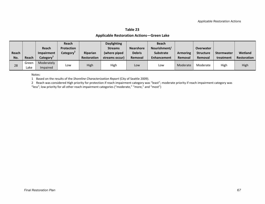
Applicable Restoration Actions
Final Restoration Plan 67
Table 23
Applicable Restoration Actions—Green Lake
Reach
No. Reach
Reach
Impairment
Category1
Reach
Protection
Category2 Riparian
Restoration
Daylighting
Streams
(where piped
streams occur)
Nearshore
Debris
Removal
Beach
Nourishment/
Substrate
Enhancement
Armoring
Removal
Overwater
Structure
Removal
Stormwater
treatment
Wetland
Restoration
28 Green
Lake
Moderately
Impaired Low High High Low Low Moderate Moderate High High
Notes: 1 Based on the results of the Shoreline Characterization Report (City of Seattle 2009). 2 Reach was considered High priority for protection if reach impairment category was “least”; moderate priority if reach impairment category was “less”; low priority for all other reach impairment categories (“moderate,” “more,” and “most”)
Final Restoration Plan 68
5 IMPLEMENTATION
5.1 Implementation Strategy
Implementation of the Plan will require close coordination within the City and between the City and the partners noted in Section 2 of this Plan, as well as with agency partners such as Washington Department of Fish and Wildlife, Ecology, U.S. Army Corps of Engineers, National Oceanographic and Atmospheric Administration’s National Marine Fisheries Service, and U.S. Fish and Wildlife Service. Within the City’s departments, the Department of Planning and Development is including language in the City’s Comprehensive Plan that will direct the City to continue to support restoration and to use this Plan as guidance. Seattle Public Utilities will help to implement this Plan through the Restore Our Waters initiative, which coordinates restoration of City shorelines. SDOT street end management will also use the restoration plan to guide actions on street ends. The recent adoption of the Parks and Green Spaces levy will provide $500,000 for street end work. Through the implementation of this work shoreline restoration will occur on street ends. Seattle Department of Parks and Recreation will use the restoration plan to guide the management and restoration planning of their shoreline property and will continue to seek funding for shoreline restoration projects.
5.2 Timeline, Benchmarks, and Monitoring
The City’s restoration work as it relates to this Plan will be monitored and evaluated on a set timeline against a suite of benchmarks to determine consistency with the State’s SMP policy standard of no net loss of ecological functions. This Plan will be implemented when the SMP is adopted by Ecology, with a timeline based on ten year intervals. At each 10 year interval, ecological benchmarks will be evaluated for change. These benchmarks will include variables occurring in currently available datasets such as GIS layers of shoreline features. Measurable benchmarks2 may include the following:
Linear distance of armoring above OHW mark Number of jetties/breakwaters/groins/boat ramps Area of overwater structures Linear distance with continuous trees adjacent to shore Linear distance with patchy trees adjacent to shore
2 Benchmarks apply for the area within 200 feet of the shoreline.
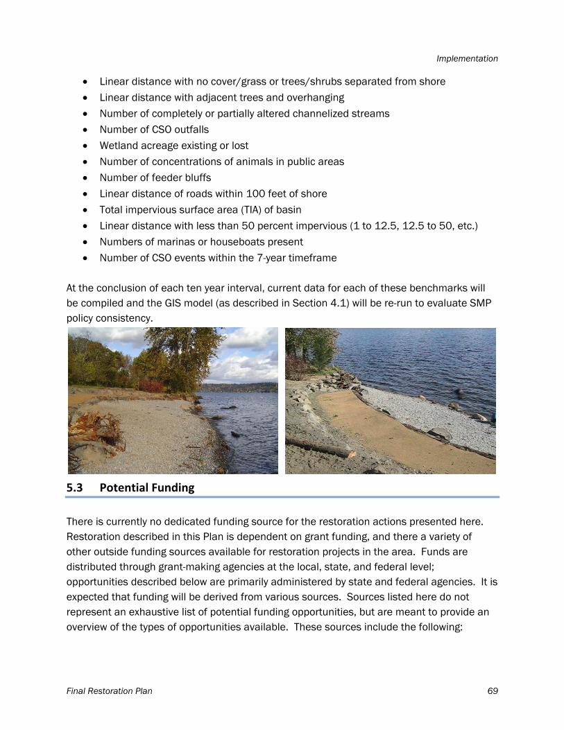
Implementation
Final Restoration Plan 69
Linear distance with no cover/grass or trees/shrubs separated from shore Linear distance with adjacent trees and overhanging Number of completely or partially altered channelized streams Number of CSO outfalls Wetland acreage existing or lost Number of concentrations of animals in public areas Number of feeder bluffs Linear distance of roads within 100 feet of shore Total impervious surface area (TIA) of basin Linear distance with less than 50 percent impervious (1 to 12.5, 12.5 to 50, etc.) Numbers of marinas or houseboats present Number of CSO events within the 7-year timeframe
At the conclusion of each ten year interval, current data for each of these benchmarks will be compiled and the GIS model (as described in Section 4.1) will be re-run to evaluate SMP policy consistency.
5.3 Potential Funding
There is currently no dedicated funding source for the restoration actions presented here. Restoration described in this Plan is dependent on grant funding, and there a variety of other outside funding sources available for restoration projects in the area. Funds are distributed through grant-making agencies at the local, state, and federal level; opportunities described below are primarily administered by state and federal agencies. It is expected that funding will be derived from various sources. Sources listed here do not represent an exhaustive list of potential funding opportunities, but are meant to provide an overview of the types of opportunities available. These sources include the following:
Implementation
Final Restoration Plan 70
Recreation and Conservation Office of Washington Ecology
Aquatic Weeds Financial Assistance Program Water Quality Program Coastal Protection Fund Coastal Zone Management Administration/Implementation Awards
Washington Department of Fish & Wildlife
Aquatic Lands Enhancement Account (ALEA) Volunteer Cooperative Projects Program
Landowner Incentive Program
National Fish and Wildlife Foundation
Bring Back the Natives: A Public-Private Partnership for Restoring Populations of Native Aquatic Species
Five-Star Restoration Matching Grants Program Marine Debris Prevention and Removal Program Native Plant Conservation Initiative Puget Sound Marine Conservation Fund The Migratory Bird Conservancy
King Conservation District Salmon Recovery Funding Board (SRFB) National Oceanic and Atmospheric Administration (NOAA) Restoration Center
Community-based Restoration Program NOAA CRP 3-Year Partnership Grants NOAA CRP Project Grants
American Sportfishing Association’s FishAmerica Foundation Grants Environmental Protection Agency Region 10: Pacific Northwest
The Clean Water State Revolving Fund Program Nonpoint Source Implementation Grant (319) Program Wetland Protection, Restoration, and Stewardship Discretionary Funding
U.S. Fish & Wildlife Service
Partners for Fish and Wildlife Program Puget Sound Program National Fish Passage Program Cooperative Endangered Species Conservation Fund
Implementation
Final Restoration Plan 71
North American Wetlands Conservation Act Grants Program
Puget Sound Nearshore Ecosystem Restoration Project Washington Department of Transportation City Fish Passage Grant Program Washington Department of Natural Resources Small Forest Landowner Office (SFLO) Private foundations, businesses, and other groups administer grant programs that
include funding for shoreline habitat and ecosystems, including:
The Russell Family Foundation William C. Kenney Watershed Protection Foundation Northwest Fund for the Environment Kongsgaard-Goldman Foundation The Bullitt Foundation The Compton Foundation Doris Duke Charitable Foundation The Hugh and Jane Ferguson Foundation Washington Trout Midsound Fisheries Enhancement Group People for Puget Sound The Seattle Aquarium
5.4 Conclusions
This Plan identifies the applicable restoration actions and the areas that should be protected based on the results of the Shoreline Characterization Report. As is the case for most restoration work, the restoration and protection actions described in this Plan will require extensive cooperation and coordination with citizens, public agencies, private landowners, and other stakeholders. Additionally some of the actions require the acquisition of private land, relocation of public infrastructure, changes in land use and potential restrictions on future development. It is the City’s intent to use this Plan to guide restoration and habitat protection efforts so these actions result in a net increase in shoreline ecosystem function over time consistent with the vision for the shoreline of its citizens.
Final Restoration Plan 72
6 REFERENCES
Anchor Environmental, L.L.C (Anchor). 2003. Seattle Shoreline Park Inventory and Habitat Assessment. Prepared for Seattle Parks and Recreation. June 2003.
Anchor. 2004. Marine Shoreline Inventory Report: WRIA 9. Prepared for Seattle Public Utilities. Anchor Environmental, L.L.C. Funded by King Conservation District and the Washington State Salmon Recovery Funding Board.
Anchor. 2006. Prioritization of Marine Shorelines of WRIA 9 for Juvenile Salmonid Habitat Protection and Restoration. Prepared for WRIA 9 Technical Committee. May 2006.
Booth, D.B., J.R. Karr, S. Schaumann, C.R. Konrad, S.A. Morley, M.G. Larson, and S.J. Burges. 2004. Reviving urban streams: land use, hydrology, biology, and human behavior. Journal of the American Water Resources Association 40(5): 1351-1364.
City of Seattle. 2003. Seattle’s Urban Blueprint for Habitat Protection and Restoration. City of Seattle Salmon Team. December 2003.
City of Seattle. 2008b. City of Seattle Ordinance 122729, authorizing a master Lease Agreement with Bluefield Holdings, Inc. Available online at: http://clerk.seattle.gov/~scripts/nph-brs.exe?s1=&s3=&s4=&s2=&s5=conlin%5 Bspon%5D+and+%40dtir%3E20080000+and+%40dtir%3C20090000&Sect4=and&l=20&Sect2=THESON&Sect3=PLURON&Sect5=CBOR1&Sect6=HITOFF&d=CBOR&p=2&u=%2F~public%2Fcbor1.htm&r=29&f=G.
City of Seattle. 2009. Draft Shoreline Characterization Report. March 2009. Available online at: http://www.seattle.gov/dpd/Planning/ShorelineMasterProgramUpdate.
City of Seattle. 2012. Vision Report. Seattle’s Shorelines Today and Tomorrow: Updating Seattle’s Shoreline Master Program. Available online at: http://www.seattle.gov/dpd/Planning/ShorelineMasterProgramUpdate.
Coastal Geologic Services, Inc (CGS). 2005. Inventory and Assessment of Current and Historic Beach Feeding Sources/Erosion and Accretion Areas for the Marine Shorelines of Water Resource Inventory Areas 8 and 9.
King County. 2007. King County Shoreline Master Program. Appendix E: Technical Appendix. Contains: Shoreline Inventory and Characterization Methodology and Results. May 2007.
Naiman, R.J., J.J. Magnuson, D.A. McKnight, J.A. Stanford, and J.R. Karr. 1995. Freshwater Ecosystems and Their Management: A National Initiative. Science 270: 584–585.
References
Final Restoration Plan 73
Port of Seattle. 2009. Lower Duwamish River Habitat Restoration Plan and Inventory of Port of Seattle Properties. January 2009.
Puget Sound Partnership (PSP). 2009. Draft Puget Sound Action Agenda.
Puget Sound Technical Recovery Team (Puget Sound TRT). 2003. Integrated Recovery Planning for Listed Salmon: Technical Guidance for Watershed Groups in Puget Sound.
Seattle Public Utilities and the U.S. Army Corps of Engineers (SPU and USACE). 2008. Synthesis of salmon research and monitoring, investigations conducted in the western Lake Washington Basin. Available online at: http://www.govlink.org/watersheds/8/pdf/LWGI_SalmonSyn123108.pdf
Seattle Department of Parks and Recreation. 1996. Green Lake Vegetation Management Plan. Available online at: http://www.seattle.gov/parks/Horticulture/VMP/GreenLake.htm
Simenstad, C, M Logsdon, K. Fresh, H. Shipman, M. Dethier, J. Newton. 2006. Conceptual model for assessing restoration of Puget Sound nearshore ecosystems. Puget Sound Nearshore Partnership Report No. 2006-03. Published by Washington Sea Grant Program, University of Washington, Seattle, Washington. Available at http://pugetsoundnearshore.org.
Stanley, S., J. Brown, and S. Grigsby. 2005. Protecting aquatic ecosystems: A guide for Puget Sound Planners to understand watershed processes. Washington State Department of Ecology. Publication #05-06-027. Olympia, WA. Available online at: http://www.ecy.wa.gov/b8iblio/0506027.html
Shreffler, D. K., and Thom, R. M. 1993. Restoration of urban estuaries: New approaches for site location and design by: Washington Department of Natural Resources: Battelle Pacific Northwest Laboratories; 1993107.
Tabor, Roger, and G. Brown, and V. Luiting. 1998. The Effect of Light Intensity on Predation of Sockeye Salmon Fry by Prickly Sculpin and Torrent Sculpin. Prepared by U.S. Fish and Wildlife Service; Publication FP137.PDF.
Tabor, Roger, and J A. Scheurer, H. A. Gearns, and E. P. Bixler. 2004. Nearshore Habitat Use by Juvenile Chinook Salmon in the Lentic Systems of the Lake Washington Basin, Annual Report 2002. Prepared by U.S. Fish and Wildlife Service for Seattle Public Utilities. 2004.
Tetra Tech ISG, Inc. and Parametrix, Inc. 2003. Lake Washington Existing Conditions Report. Prepared for King County Department of Natural Resources and Parks, Water and Land Resources Division.
References
Final Restoration Plan 74
Thom, R.M., and G. Williams, A. Borde, J. Southard, S. Sargeant, D. Woodruff, J.C. Laufle and S. Glasoe. 2005. Adaptively addressing uncertainty in estuarine and near coastal restoration projects. Journal of Coastal Research 40: 94-108.
Toft, J.D. 2001. Shoreline and dock modifications in Lake Washington, Technical Report SAFS-UW-0106. Published by School of Aquatic and Fishery Sciences, University of Washington. 2001.
Toft, J. and C. Simenstad, C. Young, and L. Stamatiou. 2003a, Inventory and Mapping of City of Seattle Shorelines along Lake Washington, the Ship Canal and Shilshole Bay. 33 pp. Prepares for Seattle Public Utilities. Published by School of Aquatic and Fishery Sciences, University of Washington. 2003.
Toft, J. and C. Simenstad, K. Dodd, and T Miller. 2003b. Inventory and Mapping of City of Seattle Shorelines along Lake Washington, the Ship Canal and Shilshole Bay. Prepared for City of Seattle. . Published by School of Aquatic and Fishery Sciences, University of Washington. 15 pp. 2003.
U.S. Army Corps of Engineers (USACE). 2009. Meeting between Pat Cagney, Linda Smith and Scott English from the Corps; Margaret Glowacki and Sandy Gurkewitz from the City of Seattle; Paul Schlenger and John Small from Anchor QEA. July 14, 2009.
Washington State Department of Ecology (Ecology). 2004. A Department of Ecology Report: What Does No Net Loss Mean in the 2003 SMA Guidelines? June 2004.
Williams, G.D., R.M. Thom, J.E. Starkes, J.S. Brennan, J.P. Houghton, D. Woodruff, P.L. Striplin, M.Miller, M. Pederson, A. Skillman, R. Kropp. A. Borde, C. Freeland, K. McArthur, V. Fagerness, S. Blanton, and L. Blackmore. 2001. Reconnaissance assessment of the state of the nearshore ecosystem: eastern shore of central Puget Sound, including Vashon and Maury islands (WRIAs 8 and 9). J.S. Brennan, editor. Report prepared for King County Dept. Natural Resources, Seattle, WA.
Williams G.D., R.M. Thom, and N.R. Evans. 2004. Bainbridge Island Nearshore Habitat Characterization and Assessment, Management Strategy Prioritization, and Monitoring Recommendations. PNWD-3391. Prepared for the City of Bainbridge Island, Washington, by Battelle Marine Sciences Laboratory, Seqium, Washington
Water Resource Inventory Area 8 Steering Committee (WRIA 8). 2005. Lake Washington/Cedar/Sammamish Watershed Chinook Salmon Conservation Plan. July 2005.
Water Resource Inventory Area 9 Steering Committee (WRIA 9). 2005. Salmon Habitat Plan, Green/Duwamish and Central Puget Sound Watershed Resource Inventory Area 9.
WRIA 8. 2005. Lake Washington/Cedar/Sammamish Watershed Chinook Salmon Conservation Plan. July 2005.
Related Documents