Stanislaus County Final ISMND Package Response to Comments Memo

Welcome message from author
This document is posted to help you gain knowledge. Please leave a comment to let me know what you think about it! Share it to your friends and learn new things together.
Transcript

Stanislaus County Final ISMND Package
Response to Comments Memo

FINAL MEMORANDUM
Hunter-Ranch-ISMND-RTC-Memo_Final-20220324.docx
Date: March 24, 2022
Prepared By: Ryan Stevenson, Staff Scientist (JJ&A/Trihydro) Jan Jacobson, Principal - Regulatory and Resource Resiliency Services (JJ&A/Trihydro)
Reviewed By: Christy McKinnon, Water Resources Manager; Stanislaus County Environmental Resources, Groundwater Resources Division
Subject: Response to Comments Public Draft Initial Study/Mitigated Negative Declaration (IS/MND) Well Permit Application Nos. 2021-69, 2021-70, 2021-71, 2021-72 and Two Future Permits Hunter Ranch, Stanislaus County, California
This memorandum documents the comments received regarding the Draft Initial Study/Mitigated Negative Declaration (IS/MND) for Well Permit Application Nos. 2021-69, 2021-70, 2021-71, 2021-72 and Two Future Permits for wells at the Hunter Ranch property (the Project) located in northern Stanislaus County 1 . Responses to comments are also provided in this memo.
PUBLIC NOTICING AND REVIEW PERIOD
A Notice of Intent (NOI) to adopt a Mitigated Negative Declaration for Well Permit Application Nos. 2021-69, 2021-70, 2021-71, 2021-72 submitted by Conde Farms (the Applicant) to develop three (3) previously installed test wells and install up to three (3) additional new irrigation wells for the planned almond orchard operations on Assessor’s Parcel Number 001-010-002 in unincorporated Stanislaus County (the Site) was transmitted to the California Office of Planning and Research State Clearinghouse (SCH) and the Stanislaus County Clerk on January 14, 2022. The notice described the proposed action and advertised the availability of the Draft IS/MND for review and public comment between January 14, 2022 and February 15, 2022. The County elected to re-notice on January 28, 2022 and extend their public review and comment period to March 2, 2022, to account for county website access limitations at the beginning of the first notice period. The following notifications and filings were made:
• State Clearinghouse: A Notice of Completion & Environmental Transmittal Form, the NOI, aSummary Form for Electronic Document Submittal (Form F), and the Public Draft IS/MND;
1 Jacobson James & Associates, a part of Trihydro, 2022. Public Draft Initial Study and Mitigated Negative Declaration, Hunter Ranch – Installation and Operation of up to Five Agricultural Wells and One Support Well, Well Permit Application Nos. 2021-69, 2021-70, 2021-71, 2021-72 and Two Future Permits, Stanislaus County, California. January 14.
Final Response to Comments, Well Permit Application Nos. 2021-69, 2021-70, 2021-71, 2021-72 and Two Future Permits, Hunter Ranch, Stanislaus County, California March 24, 2022 Page 2 of 8
• County Clerk: Two hard copies of the NOI, an electronic copy of the NOI was posted on the CountyClerk website;
• Adjacent property owners: A hard copy of the NOI via US Mail;
• Potentially Interested Agencies: A hard copy of the NOI was mailed to Oakdale Irrigation District,Rock Creek Water District, and the City of Oakdale Planning Division;
• Stanislaus County Environmental Review Committee : A copy of the NOI was distributed via email;
• Newspaper of Local Circulation: The description of the Project, the County’s intent to adopt theIS/MND, the public comment period, and the availability of documents for review were advertisedin the Modesto Bee on January 13 and again on January 28, 2022; and
• Electronic copies of the IS/MND and NOI were posted on the County’s Groundwater Resourceswebsite.
RESPONSE TO COMMENTS
Five comment letters were received. These letters do not raise any new issues or provide substantial evidence that the potential impacts of the proposed agricultural wells have not been adequately evaluated. The letters are attached and a brief summary of the letters and responses to comments is presented below.
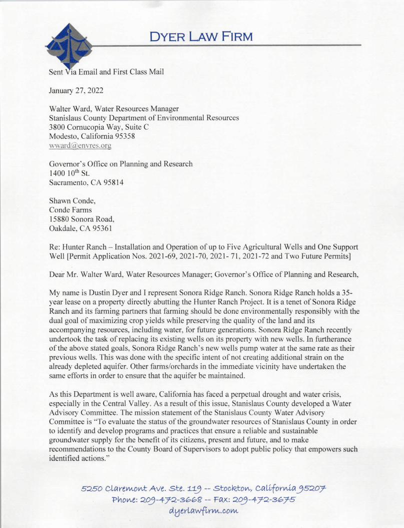
1. January 27, 2022 - Sonora Ridge Ranch (SRR) Letter regarding Hunter Ranch Project
SRR Comments:
In this letter, SRR provides an estimation of the proposed Project extraction rate, raises concerns aboutthe proposed Project’s impact to the aquifer, the orchards/farms which draw water from the aquifer, and to existing properties. SRR also expresses concern that the mitigation measures identified in the IS/MND do not adequately protect the aquifer or surrounding properties; and that one of the proposed mitigationmeasures (adoption of a Well Interference Monitoring and Mitigation Program [WAT-2]) would result inthe creation of a well monitoring burden and expenses for area property owner(s).
Response to SRR Comments:
The applicant has completed the necessary steps and analyses required by the County to comply withChapters 9.36 (Water Wells) and 9.37 (Groundwater) of the Stanislaus County Code for well permitapplications. Chapter 9.36 regulates “the location, construction, maintenance, abandonment anddestruction of wells which may affect the quality and potability of underground waters.” Chapter 9.37requires that applications for a well construction permit demonstrate that “extraction of groundwaterfrom the proposed well will not constitute unsustainable extraction of groundwater” (9.37.045 A).
The proposed wells include sanitary seals in accordance with Chapter 9.36 and meet the other setbackcriteria for protection of water quality.
To demonstrate compliance with Chapter 9.37, the applicant completed a Groundwater ResourcesImpact Assessment (GRIA – Attachment 4 of the IS/MND) as part of the well permit application. The
Final Response to Comments, Well Permit Application Nos. 2021-69, 2021-70, 2021-71, 2021-72 and Two Future Permits, Hunter Ranch, Stanislaus County, California March 24, 2022 Page 3 of 8
following information from the GRIA addresses the comments regarding the aquifer, orchards/farms obtaining water from the aquifer and potential impacts to existing properties.
• The commentor’s calculation of the Project’s water demand is incorrect and based on the assumption that all the proposed Project wells will pump at their maximum instantaneous capacity, rather than considering the water demand of the crop being irrigated which is the basis for the proposed Project. The water demand of the proposed Project is summarized in Table 1 of the GRIA. The Phase 1 water demand is calculated to be 683 acre-feet/year (610,000 gallons per day) and the Phase 2 water demand, if implemented, would roughly double that amount.
• The GRIA evaluated potential interference drawdown impacts from the proposed Project (GRIA, pages 18 to 20 and pages 22 to 25). The predicted drawdown effects after 20 years of Project pumping were compared to thresholds of significance adopted by the County and evaluated in the Program Environmental Impact Report (PEIR), Discretionary Well Permitting and Management Program, which was certified in 2018. The interference drawdown impacts of the Project were found to be less than significant at full buildout. However, the Project will be conducted in two phases to provide additional certainty that Project impacts will be less than or at most equal to those evaluated in the draft IS/MND.
The commentor has assumed that Mitigation Measure WAT-2 will be implemented. A reference to the WAT-2 Mitigation Measure is included because it is a part of the mitigation program under the PEIR. The IS/MND states that WAT-2 would be implemented only if interference drawdown effects are greater than those predicted in the GRIA. As summarized on pages 5 to 8 of the GRIA, this will not be possible because the project will be completed in phases and the second phase will only be implemented to the extent possible such that project impacts will not exceed those evaluated in the GRIA. The applicant has agreed to accept a permit condition that will prohibit groundwater extraction that would result in project-induced drawdowns that trigger implementation of this measure during the life of the project. Because the WAT-2 Mitigation Measure will not be implemented, adoption of a Well Interference Monitoring and Mitigation Program will not be triggered and there would be no associated monitoring or economic burden that would affect the area property owner(s).
2. February 3, 2022 - The Hatler Family Ranch
Hatler Family Ranch Comments:
The Hatler Family Ranch expresses concern that the Hunter Ranch Project will most likely cause them to drill additional wells to maintain their current water quality and volume. They also indicate that the numbers and depths of domestic wells for families in the area that could be affected are missing from the report.
Response to Hatler Family Ranch Comments:
The applicant has completed the necessary steps and analyses required by the County to comply with Chapters 9.36 (Water Wells) and 9.37 (Groundwater) of the Stanislaus County Code for well permit applications. Chapter 9.37 requires that applications for a well construction permit demonstrate that
Final Response to Comments, Well Permit Application Nos. 2021-69, 2021-70, 2021-71, 2021-72 and Two Future Permits, Hunter Ranch, Stanislaus County, California March 24, 2022 Page 4 of 8
“extraction of groundwater from the proposed well will not constitute unsustainable extraction of groundwater” (9.37.045 A).
To demonstrate compliance with Chapter 9.37, the applicant completed a Groundwater Resources Impact Assessment (GRIA – Attachment 4 of the IS-MND) as part of the well permit application. The following information from the GRIA speaks to the comments regarding the commenter’s well and existing wells in the area.
• The location of the Hatler Ranch well (the commenter’s well) is believed to have been identified as approximately 3,900 feet north of Highway 4 and 1,200 feet east of Milton Road, as shown on Figures 7 to 10 of the GRIA. As shown on Figure 7, the predicted drawdown at this well after 20 years of pumping under Phase 1 is approximately 4 feet, and the predicted drawdown from combined Phase 1 and Phase 2 pumping is approximately 8 feet (if Phase 2 pumping is initiated). The Hatler Ranch well is reported to be approximately 300 feet deep, so based on an estimated depth to groundwater of approximately 150 feet, the predicted Project drawdown would represent less than 10% of the available drawdown for this well. This amount of drawdown is unlikely to result in an observable reduction in pumping capacity; therefore, the potential impacts to the Hatler Ranch Well is expected to be less than significant.
• The locations of known domestic wells in the area are shown in the GRIA Figure 10, based on information obtained from the Department of Water Resources (DWR), review of aerial imagery and field observations from public roadways. The number and depth statistics for domestic wells for which the DWR has records are also shown on this figure, including both reported active wells and wells that are no longer being used or have been abandoned. The potential impacts from the Project pumping on domestic wells is discussed in the GRIA (pages 19 and 20, and 22 to 25). This analysis provides substantial and sufficient evidence to support assessment of the potential drawdown impacts from the Project to domestic wells and the conclusion that interference drawdown impacts to domestic wells will be less than significant.
3. February 12, 2022 – John Raggio
Mr. John Raggio Comments:
Mr. Raggio expressed concern with the predicted drawdown in the aquifers in the area, as their residential well is within the two mile drawdown radius of the proposed Hunter Ranch wells. Mr. Raggio asks how the depth of the proposed five wells will affect existing wells in the area that are 100-300 feet deep, as he is concerned that current ranchers/residences in the area may have to increase the depth of their wells or drill new wells. Mr. Raggio expressed concern that the 4,000 gallon per minute (gpm) maximum pumping capacity will affect the storage capacity of local wells. He asks if the project protects current ranchers’/residences’ wells from overdraft and if the project has funds to off-set any costs to ranchers/residences that may result from overdraft of the aquifers. Mr. Raggio also had questions about the number and location of monitoring wells to be used to determine any adverse effect on the aquifers. He expressed interest in learning more about the project as it moves
Final Response to Comments, Well Permit Application Nos. 2021-69, 2021-70, 2021-71, 2021-72 and Two Future Permits, Hunter Ranch, Stanislaus County, California March 24, 2022 Page 5 of 8
along and having his domestic well used as a monitoring well in Phase 1 before Phase 2 is implemented.
Response to Mr. John Raggio Comments:
The applicant has completed the necessary steps and analyses required by the County to comply with Chapters 9.36 (Water Wells) and 9.37 (Groundwater) of the Stanislaus County Code for well permit applications. Chapter 9.37 requires that applications for a well construction permit demonstrate that “extraction of groundwater from the proposed well will not constitute unsustainable extraction of groundwater” (9.37.045 A).
As the commenter noted, the applicant completed a Groundwater Resources Impact Assessment (GRIA – Attachment 4 of the IS-MND) as part of the well permit application. Drawdown at existing domestic and agricultural wells in the vicinity of the site is discussed on pages 18 to 23 of the GRIA. The findings of the report demonstrate compliance with Chapter 9.37.
The following responses are provided to the comments regarding the predicted aquifer drawdown associated with the project, the commenter’s well and existing wells in the area based on the GRIA information.
• 4,000 gallons per minute is the instantaneous maximum pumping rate possible if Phase 1 and 2 was fully built out and all wells were pumped at their maximum rate, which would not be sustained. The actual water demand of the crop being irrigated is the basis for the proposed Project. The water demand of the proposed Project is summarized in Table 1 of the GRIA. The Phase 1 water demand is calculated to be 683 acre-feet/year (610,000 gallons per day; 424 gallons per minute) and the Phase 2 water demand, if implemented, would roughly double that amount (~ 1,220,000 gallons per day; 850 gallons per minute).
• The location of the commenter’s well and other existing wells in the vicinity of the Project area is included on the GRIA Figures 9 and 10. The GRIA information regarding the depth of supply wells and groundwater was obtained through the process described below this paragraph. This information indicates that well depths in the area range from 235 to 390 feet and groundwater depth ranges from approximately 100 to 150 feet in the area of the Project site: Based on these well and groundwater depth data, the GRIA analysis concluded that the predicted Project drawdown would represent less than 10% of the available drawdown for wells in the area affected by project drawdown, which will not result in overdraft. This analysis provides substantial and sufficient evidence to support assessment of the potential drawdown impacts from the Project and the conclusion that interference drawdown impacts to domestic/ranch wells will be less than significant.
Final Response to Comments, Well Permit Application Nos. 2021-69, 2021-70, 2021-71, 2021-72 and Two Future Permits, Hunter Ranch, Stanislaus County, California March 24, 2022 Page 6 of 8
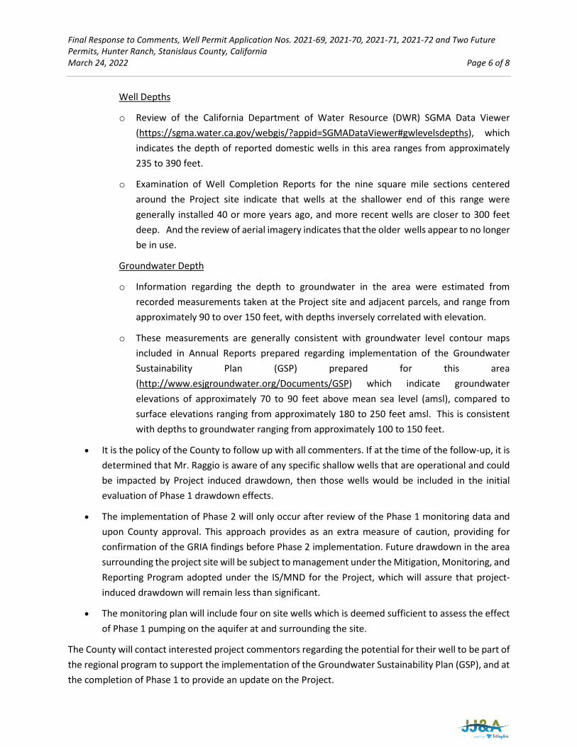
Well Depths
o Review of the California Department of Water Resource (DWR) SGMA Data Viewer (https://sgma.water.ca.gov/webgis/?appid=SGMADataViewer#gwlevelsdepths), which indicates the depth of reported domestic wells in this area ranges from approximately 235 to 390 feet.
o Examination of Well Completion Reports for the nine square mile sections centered around the Project site indicate that wells at the shallower end of this range were generally installed 40 or more years ago, and more recent wells are closer to 300 feet deep. And the review of aerial imagery indicates that the older wells appear to no longer be in use.
Groundwater Depth
o Information regarding the depth to groundwater in the area were estimated from recorded measurements taken at the Project site and adjacent parcels, and range from approximately 90 to over 150 feet, with depths inversely correlated with elevation.
o These measurements are generally consistent with groundwater level contour maps included in Annual Reports prepared regarding implementation of the Groundwater Sustainability Plan (GSP) prepared for this area (http://www.esjgroundwater.org/Documents/GSP) which indicate groundwater elevations of approximately 70 to 90 feet above mean sea level (amsl), compared to surface elevations ranging from approximately 180 to 250 feet amsl. This is consistent with depths to groundwater ranging from approximately 100 to 150 feet.
• It is the policy of the County to follow up with all commenters. If at the time of the follow-up, it is determined that Mr. Raggio is aware of any specific shallow wells that are operational and could be impacted by Project induced drawdown, then those wells would be included in the initial evaluation of Phase 1 drawdown effects.
• The implementation of Phase 2 will only occur after review of the Phase 1 monitoring data and upon County approval. This approach provides as an extra measure of caution, providing for confirmation of the GRIA findings before Phase 2 implementation. Future drawdown in the area surrounding the project site will be subject to management under the Mitigation, Monitoring, and Reporting Program adopted under the IS/MND for the Project, which will assure that project-induced drawdown will remain less than significant.
• The monitoring plan will include four on site wells which is deemed sufficient to assess the effect of Phase 1 pumping on the aquifer at and surrounding the site.
The County will contact interested project commentors regarding the potential for their well to be part of the regional program to support the implementation of the Groundwater Sustainability Plan (GSP), and at the completion of Phase 1 to provide an update on the Project.
Final Response to Comments, Well Permit Application Nos. 2021-69, 2021-70, 2021-71, 2021-72 and Two Future Permits, Hunter Ranch, Stanislaus County, California March 24, 2022 Page 7 of 8
4. February 14, 2022 – Central Valley Regional Water Quality Control Board (RWQCB)
RWQCB Comments:
In this letter, the RWQCB notes its responsibility for administering and enforcing a variety of regulatory programs to protect the quality of surface and groundwater in its jurisdiction. These programs address: (1) Regulatory Setting (Basin Plan, which incorporates several State and Federal regulatory programs; and the Anti-Degradation Policy), and (2) Permitting Requirements (Regulatory Compliance for Commercially Irrigated Agriculture per the Irrigated Lands Regulatory Program (ILRP) [coverage under a coalition group or individual coverage under General Order R5-2013-0100]); Construction Storm Water General Permits; Limited Threat General NPDES Permit; Clean Water Act Section 404 Permits; Clean Water Act Section 401 Permit - Water Quality Certifications; and Waste Discharge Requirements.
Response to RWQCB Comments:
The Project would provide irrigation water to an orchard, and the orchard’s operator must obtain regulatory coverage under the RWQCB’s ILRP, either by joining a coalition, obtaining coverage as an individual grower under general WDRs, or obtaining an Individual Permit. Compliance with the ILRP would assure that water quality standards and waste discharge requirements are not exceeded. Therefore, indirect impacts would be less than significant. Per the Groundwater Resources Impact Assessment (GRIA; IS/MND Attachment 4), the subsequent orchard development and operation activities will be performed in accordance with applicable rules and regulations under the General Agricultural Water Quality Protection Orders issued by the Regional Water Quality Control Board for the proposed Irrigated Lands Regulatory Program.
The IS/MND found that the Project would not result in a significant degradation of water quality or interfere with an active water quality cleanup project. The Project is an agricultural activity and land use that is not required to obtain construction, Limited Threat General NPDES, Clean Water Act Section 404 or 401 permits or waste discharge requirements. Therefore, these programs are not applicable to this Project.
5. February 28, 2022 – Bob Brennan
Mr. Brennan’s Comments:
Mr. Brennan expressed concern regarding baseline water level conditions in the area and suggested that the well located on their parcel be utilized as a baseline for water level in the immediate area. He also suggested delaying the implementation of Phase II of the Project until Phase I trees have matured.
Response to Mr. Brennan’s Comments:
The Brennan well is 45 years old and its current condition is not known (e.g., screen condition, siltation, etc.). The proposed monitoring program will include an on-site stock well installed in 2017 on the east side of the site between the pumping wells and the Brennan property that is completed with a screen interval to 280 feet. This well is in good condition and monitoring of this well will provide data to assess
Final Response to Comments, Well Permit Application Nos. 2021-69, 2021-70, 2021-71, 2021-72 and Two Future Permits, Hunter Ranch, Stanislaus County, California March 24, 2022 Page 8 of 8
drawdown impacts from the Project in the direction of the Brennan property and thus address the commenter’s concern.
The approach to the collection of monitoring data to make a decision regarding whether, and to what extent, to allow implementation of Phase 2 expansion of the Project is described in the GRIA and will be determined based on analysis of the aquifer water level data following an initial pumping period of at least three months. As noted on page 6 of the GRIA, if the observed drawdown during Phase I of the Project is greater than predicted, the model will be updated and used to establish an allowable pumping rate for Phase 1 and Phase 2 such that the drawdown will not exceed that predicted in the impact assessment. Pages 19 and 20 indicate the drawdown from pumping the proposed project wells is expected to be less than 10% of the available drawdown in nearby domestic and stock wells. The proposed monitoring and adaptive management approach will therefore be implemented to hold Phase 2 extraction to a rate that avoids exceeding 10% of the available drawdown at the commentor’s well.
Based on observations during pump testing conducted at the site, a three-month pumping and monitoring period is expected to be sufficient to assess the aquifer response to long-term pumping stress, including the escalation of water demand associated with the maturing of the newly planted trees. The results of this long-term pumping evaluation will be sent to the County for review and approval prior to implementation of Phase 2. In addition, long-term monitoring of the stock well on the east side of the applicant’s site is planned to assure that the long-term project impacts remain within the predicted parameters. For these reasons delay of Phase 2 implementation until the trees at the site are mature is not necessary from a hydrogeologic viewpoint and would place an unnecessary burden on the applicant.
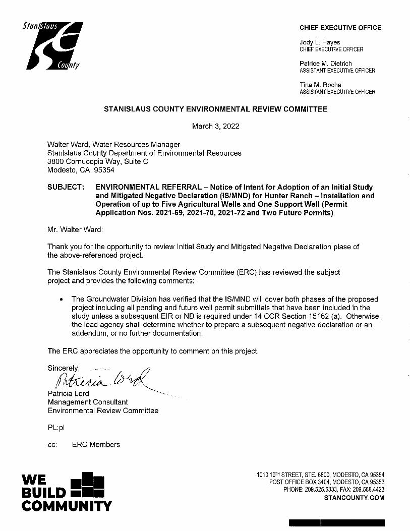
6. March 3, 2022 - Stanislaus County Environmental Review Committee (ERC)
ERC Comments:
The Groundwater Division has verified that the IS/MND will cover both phases of the proposed Project including all pending and future well permit submittals that have been included in the study unless a subsequent EIR or ND is required under 14 CCR Section 15162 (a). Otherwise, the lead agency shall determine whether to prepare a subsequent negative declaration or an addendum, or no further documentation.
Response to ERC Comments:
Comment noted as clarification that an Addendum will not be required / prepared for the future well permit submittals included as part of Phase II of the Project, as these are addressed by this IS/MND.
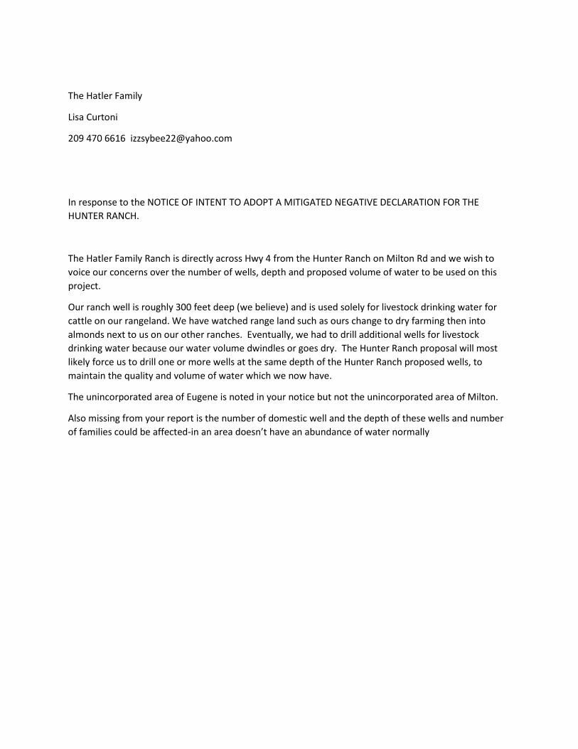
The Hatler Family
Lisa Curtoni
209 470 6616 [email protected]
In response to the NOTICE OF INTENT TO ADOPT A MITIGATED NEGATIVE DECLARATION FOR THE HUNTER RANCH.
The Hatler Family Ranch is directly across Hwy 4 from the Hunter Ranch on Milton Rd and we wish to voice our concerns over the number of wells, depth and proposed volume of water to be used on this project.
Our ranch well is roughly 300 feet deep (we believe) and is used solely for livestock drinking water for cattle on our rangeland. We have watched range land such as ours change to dry farming then into almonds next to us on our other ranches. Eventually, we had to drill additional wells for livestock drinking water because our water volume dwindles or goes dry. The Hunter Ranch proposal will most likely force us to drill one or more wells at the same depth of the Hunter Ranch proposed wells, to maintain the quality and volume of water which we now have.
The unincorporated area of Eugene is noted in your notice but not the unincorporated area of Milton.
Also missing from your report is the number of domestic well and the depth of these wells and number of families could be affected-in an area doesn’t have an abundance of water normally
Central Valley Regional Water Quality Control Board 14 February 2022
Walter Ward
Stanislaus County Department of Environmental Resources 3800 Cornucopia Way
Modesto, CA 95358 [email protected]
COMMENTS TO REQUEST FOR REVIEW FOR THE MITIGATED NEGATIVE DECLARATION, HUNTER RANCH PROJECT, SCH#2022010205, STANISLAUS COUNTY Pursuant to the State Clearinghouse’s 14 January 2022 request, the Central Valley Regional Water Quality Control Board (Central Valley Water Board) has reviewed the Request for Review for the Mitigated Negative Declaration for the Hunter Ranch Project, located in Stanislaus County. Our agency is delegated with the responsibility of protecting the quality of surface and groundwaters of the state; therefore our comments will address concerns surrounding those issues. I. Regulatory Setting
Basin Plan The Central Valley Water Board is required to formulate and adopt Basin Plans for all areas within the Central Valley region under Section 13240 of the Porter-Cologne Water Quality Control Act. Each Basin Plan must contain water quality objectives to ensure the reasonable protection of beneficial uses, as well as a program of implementation for achieving water quality objectives with the Basin Plans. Federal regulations require each state to adopt water quality standards to protect the public health or welfare, enhance the quality of water and serve the purposes of the Clean Water Act. In California, the beneficial uses, water quality objectives, and the Antidegradation Policy are the State’s water quality standards. Water quality standards are also contained in the National Toxics Rule, 40 CFR Section 131.36, and the California Toxics Rule, 40 CFR Section 131.38. The Basin Plan is subject to modification as necessary, considering applicable laws, policies, technologies, water quality conditions and priorities. The original Basin Plans were adopted in 1975, and have been updated and revised periodically as required, using Basin Plan amendments. Once the Central Valley Water Board has adopted a Basin Plan amendment in noticed public hearings, it must be approved by the State Water Resources Control Board (State Water Board), Office of Administrative Law (OAL) and in some cases, the United States Environmental Protection Agency (USEPA). Basin Plan amendments only become effective after
CAsiata
New Stamp
Hunter Ranch Project - 2 - 14 February 2022 Stanislaus County
they have been approved by the OAL and in some cases, the USEPA. Every three (3) years, a review of the Basin Plan is completed that assesses the appropriateness of existing standards and evaluates and prioritizes Basin Planning issues. For more information on the Water Quality Control Plan for the Sacramento and San Joaquin River Basins, please visit our website: http://www.waterboards.ca.gov/centralvalley/water_issues/basin_plans/ Antidegradation Considerations All wastewater discharges must comply with the Antidegradation Policy (State Water Board Resolution 68-16) and the Antidegradation Implementation Policy contained in the Basin Plan. The Antidegradation Implementation Policy is available on page 74 at: https://www.waterboards.ca.gov/centralvalley/water_issues/basin_plans/sacsjr_201805.pdf In part it states: Any discharge of waste to high quality waters must apply best practicable treatment or control not only to prevent a condition of pollution or nuisance from occurring, but also to maintain the highest water quality possible consistent with the maximum benefit to the people of the State. This information must be presented as an analysis of the impacts and potential impacts of the discharge on water quality, as measured by background concentrations and applicable water quality objectives. The antidegradation analysis is a mandatory element in the National Pollutant Discharge Elimination System and land discharge Waste Discharge Requirements (WDRs) permitting processes. The environmental review document should evaluate potential impacts to both surface and groundwater quality.
II. Permitting Requirements Regulatory Compliance for Commercially Irrigated Agriculture If the property will be used for commercial irrigated agricultural, the discharger will be required to obtain regulatory coverage under the Irrigated Lands Regulatory Program. There are two options to comply:
1. Obtain Coverage Under a Coalition Group. Join the local Coalition Group that supports land owners with the implementation of the Irrigated Lands Regulatory Program. The Coalition Group conducts water quality monitoring and reporting to the Central Valley Water Board on behalf of its growers. The Coalition Groups charge an annual membership fee, which varies by Coalition Group. To find the Coalition Group in your area, visit the Central Valley Water Board’s website at: https://www.waterboards.ca.gov/centralvalley/water_issues/irrigated_lands/regulatory_information/for_growers/coalition_groups/ or contact water board staff at (916) 464-4611 or via email at [email protected].

Hunter Ranch Project - 3 - 14 February 2022 Stanislaus County
2. Obtain Coverage Under the General Waste Discharge Requirements for Individual Growers, General Order R5-2013-0100. Dischargers not participating in a third-party group (Coalition) are regulated individually. Depending on the specific site conditions, growers may be required to monitor runoff from their property, install monitoring wells, and submit a notice of intent, farm plan, and other action plans regarding their actions to comply with their General Order. To enroll as an Individual Discharger under the Irrigated Lands Regulatory Program, call the Central Valley Water Board phone line at (916) 464-4611 or e-mail board staff at [email protected]. To find information on Agricultural and Irrigated land Fees, visit the State Water Resources Control Board website at https://www.waterboards.ca.gov/resources/fees/water_quality/#agwaiver and click the California Code of Regulations (Fee Schedule) linked text.
Construction Storm Water General Permit Dischargers whose project disturb one or more acres of soil or where projects disturb less than one acre but are part of a larger common plan of development that in total disturbs one or more acres, are required to obtain coverage under the General Permit for Storm Water Discharges Associated with Construction and Land Disturbance Activities (Construction General Permit), Construction General Permit Order No. 2009-0009-DWQ. Construction activity subject to this permit includes clearing, grading, grubbing, disturbances to the ground, such as stockpiling, or excavation, but does not include regular maintenance activities performed to restore the original line, grade, or capacity of the facility. The Construction General Permit requires the development and implementation of a Storm Water Pollution Prevention Plan (SWPPP). For more information on the Construction General Permit, visit the State Water Resources Control Board website at: http://www.waterboards.ca.gov/water_issues/programs/stormwater/constpermits.shtml
Limited Threat General NPDES Permit If the proposed project includes construction dewatering and it is necessary to discharge the groundwater to waters of the United States, the proposed project will require coverage under a National Pollutant Discharge Elimination System (NPDES) permit. Dewatering discharges are typically considered a low or limited threat to water quality and may be covered under the General Order for Limited Threat Discharges to Surface Water (Limited Threat General Order). A complete Notice of Intent must be submitted to the Central Valley Water Board to obtain coverage under the Limited Threat General Order. For more information regarding the Limited Threat General Order and the application process, visit the Central Valley Water Board website at: https://www.waterboards.ca.gov/centralvalley/board_decisions/adopted_orders/general_orders/r5-2016-0076-01.pdf
Hunter Ranch Project - 4 - 14 February 2022 Stanislaus County
Clean Water Act Section 404 Permit If the project will involve the discharge of dredged or fill material in navigable waters or wetlands, a permit pursuant to Section 404 of the Clean Water Act may be needed from the United States Army Corps of Engineers (USACE). If a Section 404 permit is required by the USACE, the Central Valley Water Board will review the permit application to ensure that discharge will not violate water quality standards. If the project requires surface water drainage realignment, the applicant is advised to contact the Department of Fish and Game for information on Streambed Alteration Permit requirements. If you have any questions regarding the Clean Water Act Section 404 permits, please contact the Regulatory Division of the Sacramento District of USACE at (916) 557-5250. Clean Water Act Section 401 Permit – Water Quality Certification If an USACE permit (e.g., Non-Reporting Nationwide Permit, Nationwide Permit, Letter of Permission, Individual Permit, Regional General Permit, Programmatic General Permit), or any other federal permit (e.g., Section 10 of the Rivers and Harbors Act or Section 9 from the United States Coast Guard), is required for this project due to the disturbance of waters of the United States (such as streams and wetlands), then a Water Quality Certification must be obtained from the Central Valley Water Board prior to initiation of project activities. There are no waivers for 401 Water Quality Certifications. For more information on the Water Quality Certification, visit the Central Valley Water Board website at: https://www.waterboards.ca.gov/centralvalley/water_issues/water_quality_certification/ Waste Discharge Requirements – Discharges to Waters of the State If USACE determines that only non-jurisdictional waters of the State (i.e., “non-federal” waters of the State) are present in the proposed project area, the proposed project may require a Waste Discharge Requirement (WDR) permit to be issued by Central Valley Water Board. Under the California Porter-Cologne Water Quality Control Act, discharges to all waters of the State, including all wetlands and other waters of the State including, but not limited to, isolated wetlands, are subject to State regulation. For more information on the Waste Discharges to Surface Water NPDES Program and WDR processes, visit the Central Valley Water Board website at:https://www.waterboards.ca.gov/centralvalley/water_issues/waste_to_surface_water/ Projects involving excavation or fill activities impacting less than 0.2 acre or 400 linear feet of non-jurisdictional waters of the state and projects involving dredging activities impacting less than 50 cubic yards of non-jurisdictional waters of the state may be eligible for coverage under the State Water Resources Control Board Water Quality Order No. 2004-0004-DWQ (General Order 2004-0004). For more information on the General Order 2004-0004, visit the State Water Resources Control Board website at: https://www.waterboards.ca.gov/board_decisions/adopted_orders/water_quality/2004/wqo/wqo2004-0004.pdf
Hunter Ranch Project - 5 - 14 February 2022 Stanislaus County
If you have questions regarding these comments, please contact me at (916) 464-4856 or [email protected].
Nicholas White Water Resource Control Engineer cc: State Clearinghouse unit, Governor’s Office of Planning and Research,
Sacramento

Stanislaus County Final ISMND Package
CEQA Initial Study – Mitigated Negative Declaration
ENVIRONMENTAL RESOURCES 3800 Cornucopia Drive, Suite C, Modesto, CA 95354
Phone: (209) 525-6700
__________________________________________________________________________________________________________
STRIVING TOGETHER TO BE THE BEST!
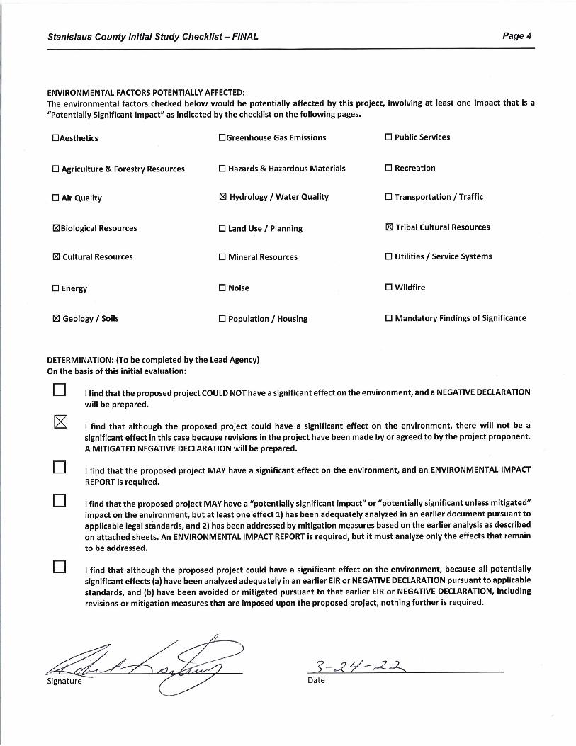
CEQA INITIAL STUDY – FINAL
(Adapted from 2019 CEQA Guidelines APPENDIX G Environmental Checklist Form, Final Text, Revised June 11, 2019)
1. Project title: Hunter Ranch – Installation and Operation of up to Five Agricultural Wells and One De Minimis Support Well [Permit Application Nos. 2021-69, 2021-70, 2021-71, 2021-72 and Two Future Permits]
2. Lead agency name and address: Stanislaus County Environmental Resources 3800 Cornucopia Way Modesto, California 95358
3. Contact person and phone number: Shawn Conde (209) 765-3125
4. Project location: Southwest corner of Milton Road and Highway 4, Eugene, CA
5. Project sponsor’s name and address: Shawn Conde, Conde Farms 15880 Sonora Road, Oakdale, CA 95361
6. General Plan designation: Agricultural
7. Zoning: General Agriculture (A-2-40)
8. Description of project:
Conde Farms (Applicant) plans to develop three (3) previously installed test wells and install up to three (3) additional new irrigation wells for the planned almond orchard operations on Assessor’s Parcel Number 001-010-002 in rural unincorporated Stanislaus County (the Site). The Site is located southwest of the intersection of State Highway 4 and Milton Road as shown on Figures 1 and 2. The Site is zoned A-2-40, General Agriculture, and occupies approximately 635 acres.
The proposed project will be implemented in phases as described below. The three existing test well locations, the three proposed new supply well locations, and the portions of the parcel to be served by the wells are shown on Figure 2.
• Phase I of the Project will consist of the conversion of two existing test wells into irrigation wells, the conversion of a third test well into a supply well for miscellaneous incidental water supply needs (<2 acre-feet per year [AFY]), and the long-term operation of the two irrigation wells to supply the water demand of approximately 175 acres of orchard for a period up to approximately 20 years.

Stanislaus County Initial Study Checklist – FINAL Page 2
• Monitoring will be conducted during the initial pumping for Phase I to assess whether groundwater drawdown is consistent with the groundwater flow model drawdown predictions presented in the Groundwater Resources Impact Assessment (GRIA). If so, then the Project will proceed to Phase II. If the observed drawdown is different from the predicted drawdown, the model will be updated as appropriate to match the observed drawdown. The updated model will then be used to establish the allowable additional Phase II pumping volume to ensure the drawdown remains less than or consistent with the originally predicted drawdown evaluated in the GRIA.
• Phase II of the Project will consist of construction of up to three additional irrigation wells to supply the water demand of up to an additional 175 acres of orchard for a period up to approximately 20 years.
The Applicant submitted well permit applications and received County approvals to construct the three test wells. Test wells PW-1 (Permit Application No. 2021-72) and PW-2 (Permit Application No. 2021-70) were constructed and will be converted to irrigation supply wells and operated as part of the Phase I scope of work. The third test well PW-2a (Permit Application No. 2021-71) will be operated for miscellaneous orchard operations support.
The Applicant has also submitted a well permit application (No. 2021-69) for one of the new supply wells identified as PW-3, to be installed as part of the Phase II scope of work. The Applicant will submit up to two additional well permit applications in the future (for proposed wells PW-4 and PW-5) as part of the Phase II scope of work. The future Phase II wells would be operated if groundwater drawdown from the installed and operating wells is consistent with or less than the GRIA drawdown predictions and upon approval from the County. This CEQA evaluation is considerate of the potential two future well applications to be submitted.
The proposed Project activities include: conversion of two (2) existing test wells to irrigation supply wells, conversion of one (1) test well into a supply well for de minimis miscellaneous incidental water supply needs, construction of up to three (3) new irrigation supply wells, construction of up to six (6) well pads with electrical sources, installation of well pumps, and long-term operation of the wells to support up to 350 acres of orchard operations. The proposed Project will support agricultural use of the Site, consistent with the A-2 (General Agriculture) zoning (Stanislaus County Code 21.20), and consistent with the declared policy of Stanislaus County to “encourage the development and improvement of its agricultural land for the production of food and other agricultural products” (Stanislaus County Code 9.32.020 A). However, the planned orchard is not part of the proposed Project as it is consistent with the County A-2-40 designated zoning purpose (County Code 21.20.010), does not require land use permits (County Code 21.20.030 and 21.20.040), and does not require land division (County Code 21.20.050).
The proposed conversion of existing test wells to operate as supply wells and installation of new irrigation supply wells are subject to the requirements included in the Stanislaus County Water Wells Ordinance (Stanislaus County Code Chapter 9.36) and the Groundwater Ordinance (Stanislaus County Code Chapter 9.37); with the exception of the miscellaneous supply well which is exempt from Chapter 9.37 as it is considered de minimis (< 2 AFY) per County Code 9.37.0301. The Stanislaus County Department of Environmental Resources (DER) must exercise discretion to determine if conversion of the existing three (3) test wells and installation of up to three (3) new irrigation supply wells will meet the requirements of the County Water Wells and Groundwater ordinances.
This Initial Study was prepared in accordance with the California Environmental Quality Act (CEQA) to specifically evaluate compliance with the County Water Wells and Groundwater ordinances and is aligned with the Program Environmental Impact Report (PEIR)2 adopted by the County in 2018. The PEIR evaluated potential impacts to environmental resources

Stanislaus County Initial Study Checklist – FINAL Page 3
associated with implementation of the County’s discretionary well permitting and management program. The PEIR determined that implementation of the well permitting program would result in less than significant impacts to 12 of the 17 environmental resource areas requiring consideration under CEQA at the time of the PEIR preparation, and less than significant impacts with mitigation measures applied for the remaining five resource areas. This Initial Study evaluates potential impacts to those five resource areas that were identified to require further analysis: Biological, Cultural, Geology/Soils, Hydrology/Water Resources and Noise. In addition, this Initial Study evaluates potential impacts to the additional resource areas added through CEQA updates since the PEIR was prepared: Tribal Cultural added per the 2018 CEQA update, Energy and Wildfire added per the 2019 CEQA update.
9. Surrounding land uses and setting: Agriculture
10. Other public agencies whose approval is required (e.g., permits, financing approval, or participation agreement.):
None
ATTACHMENTS Attachment 1: Flow Charts Attachment 2: Biological Resources Survey Attachment 3: Cultural Resource Record Search Report Attachment 4: Groundwater Resources Impact Assessment
1 This well is not exempt under Chapter 9.36 and is therefore part of the CEQA evaluation. 2 Jacobson James & Associations, 2018. Program Environmental Impact Report, Discretionary Well Permitting and Management Program, Stanislaus County, California. June 11.
Stanislaus County Initial Study Checklist – FINAL Page 5
EVALUATION OF ENVIRONMENTAL IMPACTS:
1) A brief explanation is required for all answers except “No Impact” answers that are adequately supported by the information sources a lead agency cites in the parentheses following each question. A “No Impact” answer is adequately supported if the referenced information sources show that the impact simply does not apply to projects like the one involved (e.g., the project falls outside a fault rupture zone). A “No Impact” answer should be explained where it is based on project-specific factors as well as general standards (e.g., the project will not expose sensitive receptors to pollutants, based on a project-specific screening analysis). 2) All answers must take account of the whole action involved, including off-site as well as on-site, cumulative as well as project-level, indirect as well as direct, and construction as well as operational impacts. 3) Once the lead agency has determined that a particular physical impact may occur, than the checklist answers must indicate whether the impact is potentially significant, less than significant with mitigation, or less than significant. “Potentially Significant Impact” is appropriate if there is substantial evidence that an effect may be significant. If there are one or more “Potentially Significant Impact” entries when the determination is made, an EIR is required. 4) “Negative Declaration: Less Than Significant With Mitigation Incorporated” applies where the incorporation of mitigation measures has reduced an effect from “Potentially Significant Impact” to a “Less Than Significant Impact.” The lead agency must describe the mitigation measures, and briefly explain how they reduce the effect to a less than significant level (mitigation measures from Section XVII, “Earlier Analyses,” may be cross-referenced). 5) Earlier analyses may be used where, pursuant to the tiering, program EIR, or other CEQA process, an effect has been adequately analyzed in an earlier EIR or negative declaration. Section 15063(c)(3)(D). In this case, a brief discussion should identify the following: a) Earlier Analysis Used. Identify and state where they are available for review.
b) Impacts Adequately Addressed. Identify which effects from the above checklist were within the scope of and adequately analyzed in an earlier document pursuant to applicable legal standards, and state whether such effects were addressed by mitigation measures based on the earlier analysis. c) Mitigation Measures. For effects that are “Less than Significant with Mitigation Measures Incorporated,” describe the mitigation measures which were incorporated or refined from the earlier document and the extent to which they address site-specific conditions for the project.
6) Lead agencies are encouraged to incorporate into the checklist references to information sources for potential impacts (e.g., general plans, zoning ordinances). References to a previously prepared or outside document should, where appropriate, include a reference to the page or pages where the statement is substantiated. 7) Supporting Information Sources: A source list should be attached, and other sources used or individuals contacted should be cited in the discussion. 8) This is only a suggested form, and lead agencies are free to use different formats; however, lead agencies should normally address the questions from this checklist that are relevant to a project’s environmental effects in whatever format is selected. 9) The explanation of each issue should identify: a) the significant criteria or threshold, if any, used to evaluate each question; and b) the mitigation measure identified, if any, to reduce the impact to less than significant.
Stanislaus County Initial Study Checklist – FINAL Page 6
I. AESTHETICS -- Except as provided in Public Resource Code
Section 21099, would the project: Potentially Significant
Impact
Less Than Significant
With Mitigation Included
Less Than Significant
Impact
No Impact
a) Have a substantial adverse effect on a scenic vista? X b) Substantially damage scenic resources, including, but not
limited to, trees, rock outcroppings, and historic buildings within a state scenic highway?
X
c) In non-urbanized areas, substantially degrade the existing visual character or quality of public views of the site and its surroundings? (Public views are those that are experienced from publicly accessible vantage point). If the project is in an urbanized area, would the project conflict with applicable zoning and other regulations governing scenic quality?
X
d) Create a new source of substantial light or glare which would adversely affect day or nighttime views in the area? X
Discussion: A Program level Initial Study completed in 2016 (2016 IS) determined that potential impacts to aesthetic resources associated with wells constructed or operated under the Stanislaus County Discretionary Well Permitting Program are less than significant. The 2016 IS was completed to scope a Program Environmental Impact Report that was subsequently completed in 2018 (2018 PEIR). The 2016 IS and 2018 PEIR findings are applicable to Aesthetics at locations throughout Stanislaus County (including the Site location for this proposed Project). The 2016 IS findings are applicable to unincorporated areas of Stanislaus County that are not under the jurisdiction of a public water agency. The proposed Project meets these criteria, therefore the findings from the 2018 PEIR are applicable to the proposed Project.
Note: The questions included in the above table reflect updates contained in the 2019 version of Appendix G that were not contained in the version of Appendix G used for the 2016 IS or 2018 PEIR. Specifically, potential impacts to “non-urbanized areas” are specified, and “public views” are clearly defined. These minor changes do not affect the “less than significant finding” for the proposed Project, and no further consideration of potential impacts to this resource is warranted.
Views from near the Site are primarily agricultural and rangeland. The addition of Project pump house pads and the subsequent agricultural use of the Site would not affect the open-space scenic quality of the views in the area and will be consistent with agricultural vistas. The aesthetic impacts related to the project are less than significant.
Mitigation: None.
References:
Jacobson James & Associates, Inc. and Tetra Tech, Inc., 2018. Final Program Environmental Impact Report for the Stanislaus County Discretionary Well Permitting and Management Program. Prepared for Stanislaus County Department of Environmental Resources. June 11.
Jacobson James & Associates, Inc. and Tetra Tech, Inc., 2016. Initial Study - Discretionary Well Permitting and Management Program, Stanislaus County, California. October 3.
Stanislaus County Initial Study Checklist – FINAL Page 7
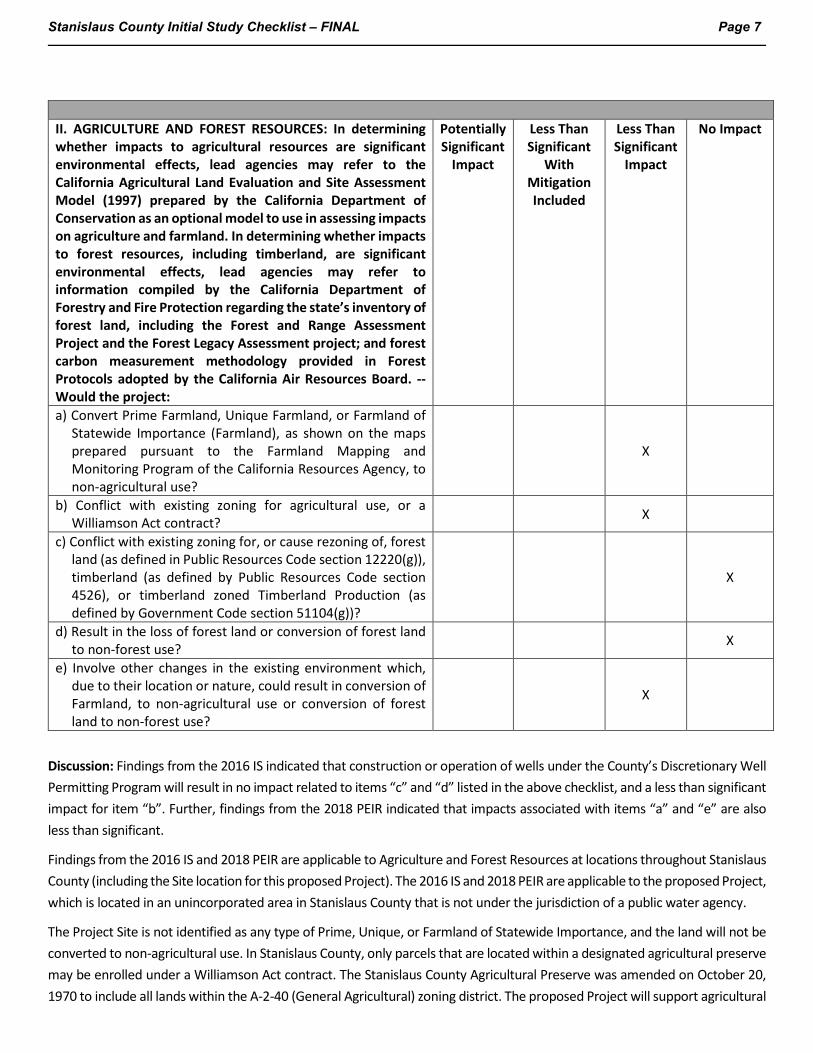
II. AGRICULTURE AND FOREST RESOURCES: In determining whether impacts to agricultural resources are significant environmental effects, lead agencies may refer to the California Agricultural Land Evaluation and Site Assessment Model (1997) prepared by the California Department of Conservation as an optional model to use in assessing impacts on agriculture and farmland. In determining whether impacts to forest resources, including timberland, are significant environmental effects, lead agencies may refer to information compiled by the California Department of Forestry and Fire Protection regarding the state’s inventory of forest land, including the Forest and Range Assessment Project and the Forest Legacy Assessment project; and forest carbon measurement methodology provided in Forest Protocols adopted by the California Air Resources Board. -- Would the project:
Potentially Significant
Impact
Less Than Significant
With Mitigation Included
Less Than Significant
Impact
No Impact
a) Convert Prime Farmland, Unique Farmland, or Farmland of Statewide Importance (Farmland), as shown on the maps prepared pursuant to the Farmland Mapping and Monitoring Program of the California Resources Agency, to non-agricultural use?
X
b) Conflict with existing zoning for agricultural use, or a Williamson Act contract? X
c) Conflict with existing zoning for, or cause rezoning of, forest land (as defined in Public Resources Code section 12220(g)), timberland (as defined by Public Resources Code section 4526), or timberland zoned Timberland Production (as defined by Government Code section 51104(g))?
X
d) Result in the loss of forest land or conversion of forest land to non-forest use? X
e) Involve other changes in the existing environment which, due to their location or nature, could result in conversion of Farmland, to non-agricultural use or conversion of forest land to non-forest use?
X
Discussion: Findings from the 2016 IS indicated that construction or operation of wells under the County’s Discretionary Well Permitting Program will result in no impact related to items “c” and “d” listed in the above checklist, and a less than significant impact for item “b”. Further, findings from the 2018 PEIR indicated that impacts associated with items “a” and “e” are also less than significant.
Findings from the 2016 IS and 2018 PEIR are applicable to Agriculture and Forest Resources at locations throughout Stanislaus County (including the Site location for this proposed Project). The 2016 IS and 2018 PEIR are applicable to the proposed Project, which is located in an unincorporated area in Stanislaus County that is not under the jurisdiction of a public water agency.
The Project Site is not identified as any type of Prime, Unique, or Farmland of Statewide Importance, and the land will not be converted to non-agricultural use. In Stanislaus County, only parcels that are located within a designated agricultural preserve may be enrolled under a Williamson Act contract. The Stanislaus County Agricultural Preserve was amended on October 20, 1970 to include all lands within the A-2-40 (General Agricultural) zoning district. The proposed Project will support agricultural

Stanislaus County Initial Study Checklist – FINAL Page 8
use of the Site, consistent with the A-2-40 (General Agriculture) zoning (Stanislaus County Code 21.20); and consistent with the declared policy of Stanislaus County to “encourage the development and improvement of its agricultural land for the production of food and other agricultural products” (Stanislaus County Code 9.32.020 A). The future agricultural operations are to be consistent with accepted customs and standards, per Stanislaus County Code 9.32.050. Therefore, the proposed Project is expected to result in a less than significant impact to agricultural and forest resources and no further consideration of potential impacts to this resource is warranted.
Mitigation: None.
References:
California Department of Conservation. California Important Farmland Finder. https://maps.conservation.ca.gov/DLRP/CIFF/. Accessed December 2021.
Jacobson James & Associates, Inc. and Tetra Tech, Inc., 2018. Final Program Environmental Impact Report for the Stanislaus County Discretionary Well Permitting and Management Program. Prepared for Stanislaus County Department of Environmental Resources. June 11.
Jacobson James & Associates, Inc. and Tetra Tech, Inc., 2016. Initial Study Discretionary Well Permitting and Management Program, Stanislaus County, California. October 3.
Stanislaus County Code Title 21 Chapter 21.20 Zoning
http://qcode.us/codes/stanislauscounty/view.php?topic=21-21_20-21_20_010&frames=on. Accessed December 2021.
Stanislaus County Code Title 9 Chapter 9.32 Agricultural Land Policies.
https://qcode.us/codes/stanislauscounty/view.php?topic=9-9_32-9_32_020&frames=on. Accessed December 2021.
Stanislaus County. Planning and Community Development – Planning Division, Williamson Act. https://www.stancounty.com/planning/pl/williamson-act.shtm
Stanislaus County Initial Study Checklist – FINAL Page 9
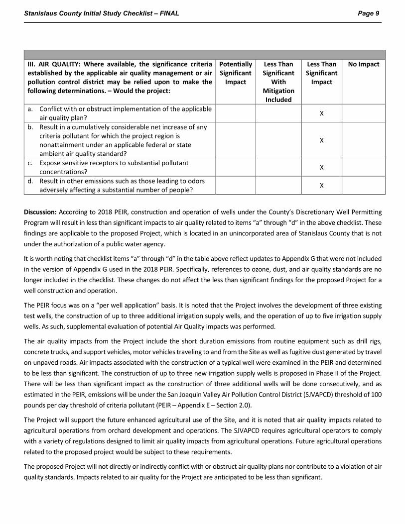
III. AIR QUALITY: Where available, the significance criteria established by the applicable air quality management or air pollution control district may be relied upon to make the following determinations. – Would the project:
Potentially Significant
Impact
Less Than Significant
With Mitigation Included
Less Than Significant
Impact
No Impact
a. Conflict with or obstruct implementation of the applicable air quality plan? X
b. Result in a cumulatively considerable net increase of any criteria pollutant for which the project region is nonattainment under an applicable federal or state ambient air quality standard?
X
c. Expose sensitive receptors to substantial pollutant concentrations? X
d. Result in other emissions such as those leading to odors adversely affecting a substantial number of people? X
Discussion: According to 2018 PEIR, construction and operation of wells under the County’s Discretionary Well Permitting Program will result in less than significant impacts to air quality related to items “a” through “d” in the above checklist. These findings are applicable to the proposed Project, which is located in an unincorporated area of Stanislaus County that is not under the authorization of a public water agency.
It is worth noting that checklist items “a” through “d” in the table above reflect updates to Appendix G that were not included in the version of Appendix G used in the 2018 PEIR. Specifically, references to ozone, dust, and air quality standards are no longer included in the checklist. These changes do not affect the less than significant findings for the proposed Project for a well construction and operation.
The PEIR focus was on a “per well application” basis. It is noted that the Project involves the development of three existing test wells, the construction of up to three additional irrigation supply wells, and the operation of up to five irrigation supply wells. As such, supplemental evaluation of potential Air Quality impacts was performed.
The air quality impacts from the Project include the short duration emissions from routine equipment such as drill rigs, concrete trucks, and support vehicles, motor vehicles traveling to and from the Site as well as fugitive dust generated by travel on unpaved roads. Air impacts associated with the construction of a typical well were examined in the PEIR and determined to be less than significant. The construction of up to three new irrigation supply wells is proposed in Phase II of the Project. There will be less than significant impact as the construction of three additional wells will be done consecutively, and as estimated in the PEIR, emissions will be under the San Joaquin Valley Air Pollution Control District (SJVAPCD) threshold of 100 pounds per day threshold of criteria pollutant (PEIR – Appendix E – Section 2.0).
The Project will support the future enhanced agricultural use of the Site, and it is noted that air quality impacts related to agricultural operations from orchard development and operations. The SJVAPCD requires agricultural operators to comply with a variety of regulations designed to limit air quality impacts from agricultural operations. Future agricultural operations related to the proposed project would be subject to these requirements.
The proposed Project will not directly or indirectly conflict with or obstruct air quality plans nor contribute to a violation of air quality standards. Impacts related to air quality for the Project are anticipated to be less than significant.
Stanislaus County Initial Study Checklist – FINAL Page 10
Mitigation: None.
References:
Jacobson James & Associates, Inc. and Tetra Tech, Inc., 2018. Final Program Environmental Impact Report for the Stanislaus County Discretionary Well Permitting and Management Program. Prepared for Stanislaus County Department of Environmental Resources. June 11.
Jacobson James & Associates, Inc. and Tetra Tech, Inc., 2016. Initial Study Discretionary Well Permitting and Management Program, Stanislaus County, California. October 3.
Stanislaus County Initial Study Checklist – FINAL Page 11
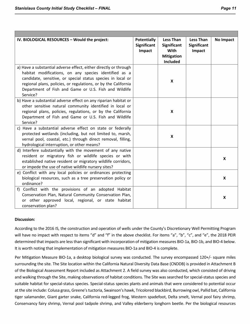
IV. BIOLOGICAL RESOURCES – Would the project: Potentially
Significant Impact
Less Than Significant
With Mitigation Included
Less Than Significant
Impact
No Impact
a) Have a substantial adverse effect, either directly or through habitat modifications, on any species identified as a candidate, sensitive, or special status species in local or regional plans, policies, or regulations, or by the California Department of Fish and Game or U.S. Fish and Wildlife Service?
X
b) Have a substantial adverse effect on any riparian habitat or other sensitive natural community identified in local or regional plans, policies, regulations, or by the California Department of Fish and Game or U.S. Fish and Wildlife Service?
X
c) Have a substantial adverse effect on state or federally protected wetlands (including, but not limited to, marsh, vernal pool, coastal, etc.) through direct removal, filling, hydrological interruption, or other means?
X
d) Interfere substantially with the movement of any native resident or migratory fish or wildlife species or with established native resident or migratory wildlife corridors, or impede the use of native wildlife nursery sites?
X
e) Conflict with any local policies or ordinances protecting biological resources, such as a tree preservation policy or ordinance?
X
f) Conflict with the provisions of an adopted Habitat Conservation Plan, Natural Community Conservation Plan, or other approved local, regional, or state habitat conservation plan?
X
Discussion:
According to the 2016 IS, the construction and operation of wells under the County’s Discretionary Well Permitting Program will have no impact with respect to items “d” and “f” in the above checklist. For items “a”, “b”, “c”, and “e”, the 2018 PEIR determined that impacts are less than significant with incorporation of mitigation measures BIO-1a, BIO-1b, and BIO-4 below. It is worth noting that implementation of mitigation measures BIO-1a and BIO-4 is complete.
Per Mitigation Measure BIO-1a, a desktop biological survey was conducted. The survey encompassed 120+/- square miles surrounding the site. The Site location within the California Natural Diversity Data Base (CNDDB) is provided in Attachment B of the Biological Assessment Report included as Attachment 2. A field survey was also conducted, which consisted of driving and walking through the Site, making observations of habitat conditions. The Site was searched for special-status species and suitable habitat for special-status species. Special-status species plants and animals that were considered to potential occur at the site include: Colusa grass, Greene’s tuctoria, Swainson’s hawk, Tricolored blackbird, Burrowing owl, Pallid bat, California tiger salamander, Giant garter snake, California red-legged frog, Western spadefoot, Delta smelt, Vernal pool fairy shrimp, Conservancy fairy shrimp, Vernal pool tadpole shrimp, and Valley elderberry longhorn beetle. Per the biological resources

Stanislaus County Initial Study Checklist – FINAL Page 12
survey (Attachment 2 – Table 3), it is unlikely special status plants occur in the Site and the likelihood of special species wildlife is very low. Less than significant impacts are anticipated related to fish, wildlife species, or plant and animal communities.
The surveys also identified potential Waters of the US or wetlands, including several seasonal wetlands, at the Site. A few intermittent creeks and a short section of Smith Creek are also located on the Site. Proposed Project activities include the complete avoidance of aquatic resources located on the Site, including implementation of 30-foot buffers between new orchard blocks and any delineated aquatic resources. If avoidance of the potential Waters of the U.S or wetlands is unavoidable, permits may be needed from the Army Corps of Engineers, California Department of Fish and Wildlife, and/or the Regional Water Quality Control Board prior to the placement of any fill material.
Based on the Groundwater Resources Impact Assessment (GRIA), groundwater levels in the Project area are 100 feet or more below ground surface. The seasonal wetlands located on the site are not expected to be connected to the water table. Since drawdown occurs at the water table, groundwater drawdown based on the pumping scenarios outlined in the GRIA, would not be expected to interfere with these wetlands. Maximum drawdown between the two outlined scenarios over the course of three months is modeled to be between 60 and 64 feet, while maximum drawdown over 20 years is modeled to be between 35 and 58 feet. The data reviewed do not indicate a connection between wetlands and the regional water table, no impacts to these wetlands are anticipated as a result of the pumping scenarios outlined in the GRIA.
If ground-disturbing activities take place between February 1 and September 15, in accordance with Mitigation Measure BIO-1b, a pre-construction survey will be conducted by a qualified biologist, and buffers will be observed, if warranted, as described in Mitigation Measure BIO-1b, outlined below.
Mitigation Measure BIO-1a. A qualified biologist shall investigate the potential presence or absence of sensitive habitats and wetlands, and special-status plants or wildlife in areas that will be disturbed by well construction or conversion of rangelands to cultivated use that is made possible by the well, prior to well permit approval or project implementation. Documentation could involve any of these tasks:
Desktop review of existing site records through the county records and general plan, California Natural Diversity Database (CNDDB), California Native Plant Society (CNPS) inventory, environmental documents and surveys to determine likelihood of occurrence near (within ½ mile) the well site, any rangeland converted to cultivated agricultural use that is supplied by the well, and any related construction areas.
• Conduct field reconnaissance. A field reconnaissance survey shall be conducted, including a habitat assessment to determine whether suitable conditions exist for special-status species.
• Determine the need for additional species-specific surveys or wetland delineation. If warranted, coordinate with appropriate agencies (U.S. Fish and Wildlife Service [USFWS], California Department of Fish and Wildlife [CDFW], or U.S. Army Corps of Engineers [USACE]) as may be necessary to determine appropriate survey timing and effort.
Coordinate with appropriate agencies and the County as may be necessary based on the results of additional species-specific surveys or wetland delineation to identify and implement mitigation measures as necessary to avoid, minimize, or otherwise mitigate potential impacts to special-status species, wetlands or other habitat to a less-than-significant level
Status: Complete. See Attachment 2.
Mitigation Measure BIO-1b. The applicant shall endeavor to conduct any drilling, construction work and/or ground-disturbing activities associated with installation of the proposed well or the conversion of rangeland to cultivated agricultural use that will be irrigated using the well during the non-breeding season of any birds and raptors protected under the Migratory Bird
Stanislaus County Initial Study Checklist – FINAL Page 13
Treaty Act (generally September 16 through January 31). If construction activities must be scheduled during the nesting season (generally February 1 to September 15), pre-construction surveys for raptors, migratory birds, and special-status bird species shall be done by a qualified biologist to identify active nests near the site. This shall include a buffer extending out from the construction or disturbance area to a distance of approximately ½ mile. If active nests are found, no drilling construction activities shall occur within 500 feet of the nest until the young have fledged and the nest is no longer active (as determined by the qualified biologist). Survey timing and frequency requirements differ among species; species-specific surveys should follow all timing and frequency requirements of CDFW and USFWS. Consultation with the CDFW and/or USFWS shall occur if required and may result in additional requirements.
Status: To be completed, if drilling, construction work and/or ground disturbing activities (associated with the proposed wells or the conversion of rangeland to cultivated agricultural use that will be irrigated using those wells) are scheduled between February 1 and September 15.
Mitigation Measure BIO-4. Evaluate well construction permit applications to assess the potential conflicts with local policies or ordinances that project biological resources and consider mitigation measures for significant effects on the environment on a project-specific basis.
Status: Complete.
Mitigation: Mitigation Measures BIO-1a, BIO-1b, and BIO-4, as described above. Mitigation Measures BIO-1a and BIO-4 have been completed, and BIO-1b will proceed as warranted based on the construction schedule.
References:
Jacobson James & Associates, Inc. and Tetra Tech, Inc., 2018. Final Program Environmental Impact Report for the Stanislaus County Discretionary Well Permitting and Management Program. Prepared for Stanislaus County Department of Environmental Resources. June 11.
Jacobson James & Associates, Inc. and Tetra Tech, Inc., 2016. Initial Study Discretionary Well Permitting and Management Program, Stanislaus County, California. October 3.
Stanislaus County Initial Study Checklist – FINAL Page 14
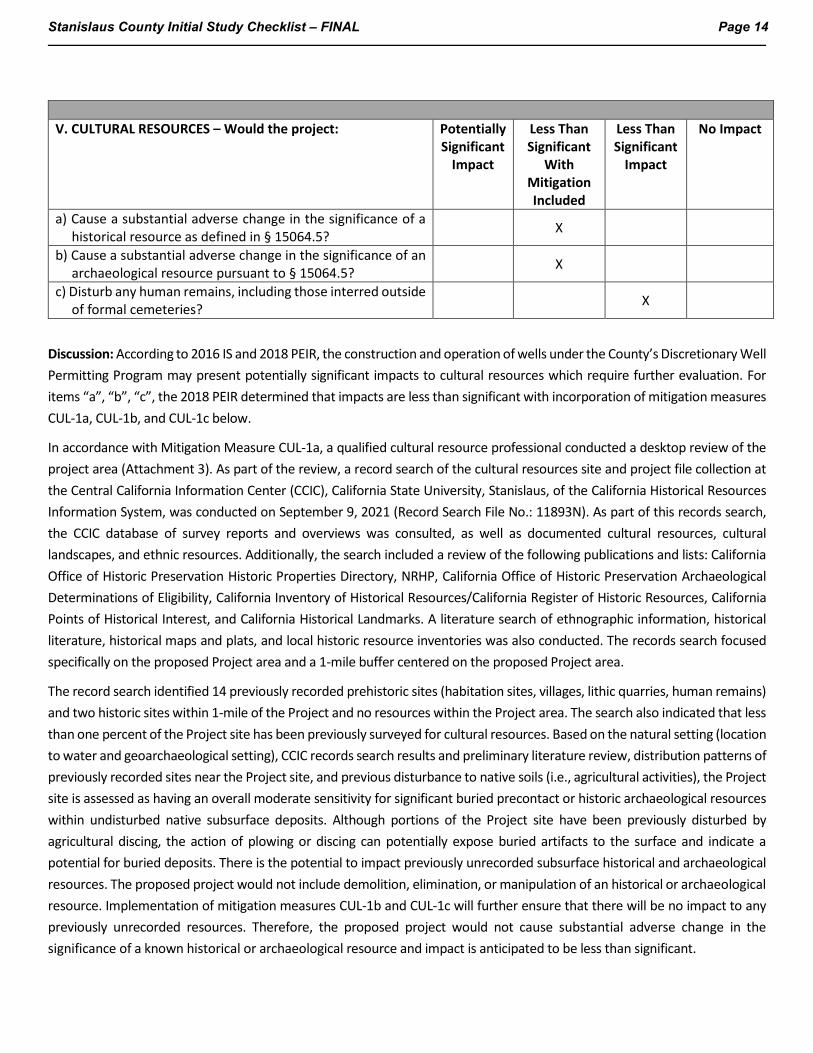
V. CULTURAL RESOURCES – Would the project: Potentially
Significant Impact
Less Than Significant
With Mitigation Included
Less Than Significant
Impact
No Impact
a) Cause a substantial adverse change in the significance of a historical resource as defined in § 15064.5? X
b) Cause a substantial adverse change in the significance of an archaeological resource pursuant to § 15064.5? X
c) Disturb any human remains, including those interred outside of formal cemeteries? X
Discussion: According to 2016 IS and 2018 PEIR, the construction and operation of wells under the County’s Discretionary Well Permitting Program may present potentially significant impacts to cultural resources which require further evaluation. For items “a”, “b”, “c”, the 2018 PEIR determined that impacts are less than significant with incorporation of mitigation measures CUL-1a, CUL-1b, and CUL-1c below.
In accordance with Mitigation Measure CUL-1a, a qualified cultural resource professional conducted a desktop review of the project area (Attachment 3). As part of the review, a record search of the cultural resources site and project file collection at the Central California Information Center (CCIC), California State University, Stanislaus, of the California Historical Resources Information System, was conducted on September 9, 2021 (Record Search File No.: 11893N). As part of this records search, the CCIC database of survey reports and overviews was consulted, as well as documented cultural resources, cultural landscapes, and ethnic resources. Additionally, the search included a review of the following publications and lists: California Office of Historic Preservation Historic Properties Directory, NRHP, California Office of Historic Preservation Archaeological Determinations of Eligibility, California Inventory of Historical Resources/California Register of Historic Resources, California Points of Historical Interest, and California Historical Landmarks. A literature search of ethnographic information, historical literature, historical maps and plats, and local historic resource inventories was also conducted. The records search focused specifically on the proposed Project area and a 1-mile buffer centered on the proposed Project area.
The record search identified 14 previously recorded prehistoric sites (habitation sites, villages, lithic quarries, human remains) and two historic sites within 1-mile of the Project and no resources within the Project area. The search also indicated that less than one percent of the Project site has been previously surveyed for cultural resources. Based on the natural setting (location to water and geoarchaeological setting), CCIC records search results and preliminary literature review, distribution patterns of previously recorded sites near the Project site, and previous disturbance to native soils (i.e., agricultural activities), the Project site is assessed as having an overall moderate sensitivity for significant buried precontact or historic archaeological resources within undisturbed native subsurface deposits. Although portions of the Project site have been previously disturbed by agricultural discing, the action of plowing or discing can potentially expose buried artifacts to the surface and indicate a potential for buried deposits. There is the potential to impact previously unrecorded subsurface historical and archaeological resources. The proposed project would not include demolition, elimination, or manipulation of an historical or archaeological resource. Implementation of mitigation measures CUL-1b and CUL-1c will further ensure that there will be no impact to any previously unrecorded resources. Therefore, the proposed project would not cause substantial adverse change in the significance of a known historical or archaeological resource and impact is anticipated to be less than significant.

Stanislaus County Initial Study Checklist – FINAL Page 15
The results of the CCIC record search indicate the possibility of previously unknown occurrences of sensitive cultural resources. Existing regulations require that if human remains and/or cultural items defined by California Health and Safety Code, Section 7050.5, are inadvertently discovered, all work in the vicinity of the find would cease, and the Stanislaus County Coroner would be contacted immediately. If the remains are found to be Native American as delineated by Health and Safety Code, Section 7050.5, the coroner would contact the NAHC by telephone within 24 hours. Less than significant impact is anticipated because of the existing regulations and procedures regarding the discovery of human remains.
If any previously unidentified archaeological, historical or paleontological resources, or human remains are discovered during the course of well drilling or development, Mitigation Measure CUL-1b and CUL-1c shall be implemented.
Mitigation Measure CUL-1a. For projects with anticipated ground disturbance that would extend beyond previously disturbed soils, a qualified cultural resources professional shall investigate the potential presence of archaeological or historical resources in the vicinity of the well, the well pad, any appurtenant access drives and electrical service lines, and any rangeland tracts converted to cultivated agricultural use that will be irrigated by the well, through a desktop review. The review shall include records at the Central California Information Center (CCIC), records at the University of California Berkeley Museum of Paleontology (UCMP), a Sacred Lands File search at the Native American Heritage Commission (NAHC), Native American tribal consultation, California Register of Historical Resources (CRHR), and the National Register of Historic Places (NRHP).
Status: Completed. See Attachment 3.
Mitigation Measure CUL-1b. If it is determined through implementation of Mitigation Measure CUL-1a that archaeological, historical or paleontological resources or human remains may be located on a site, or the area is judged to have a high degree of sensitivity relative to these resources, prior to any project-related ground disturbing or construction activities , a qualified archaeologist, historian or paleontologist (as applicable) shall conduct an archaeological/ historical/paleontological resources survey (as applicable). If it is determined that the ground disturbing or construction activities are in an area adjacent to or in one of these resources, relocation/reconfiguration of the proposed work would be performed avoid substantial changes to the resource.
Status: To be scheduled to align with construction activities.
Mitigation Measure CUL-1c. If the construction staff or others observe previously unidentified archaeological, historical or paleontological resources, or human remains during drilling or other ground-disturbing activities associated with well construction or conversion of rangeland to cultivated agricultural use, they will halt work within a 100-foot radius of the find(s), delineate the area of the find with flagging tape or rope (may also include dirt spoils from the find area), immediately notify the lead agency, and retain a qualified archaeologist, historian or paleontologist (as applicable) to review the observed resources. Construction will halt within the flagged or roped-off area. The archaeologist will assess the resource as soon as possible and determine appropriate next steps in coordination with the lead agency. Such finds will be formally recorded and evaluated. The resource will be protected from further disturbance or looting pending evaluation.
Status: Will be implemented, if needed.
Mitigation: Mitigation measures CUL-1b and CUL-1c as necessary.
References:
Jacobson James & Associates, Inc. and Tetra Tech, Inc., 2018. Final Program Environmental Impact Report for the Stanislaus County Discretionary Well Permitting and Management Program. Prepared for Stanislaus County Department of Environmental Resources. June 11.

Stanislaus County Initial Study Checklist – FINAL Page 16
Jacobson James & Associates, Inc. and Tetra Tech, Inc., 2016. Initial Study Discretionary Well Permitting and Management Program, Stanislaus County, California. October 3.
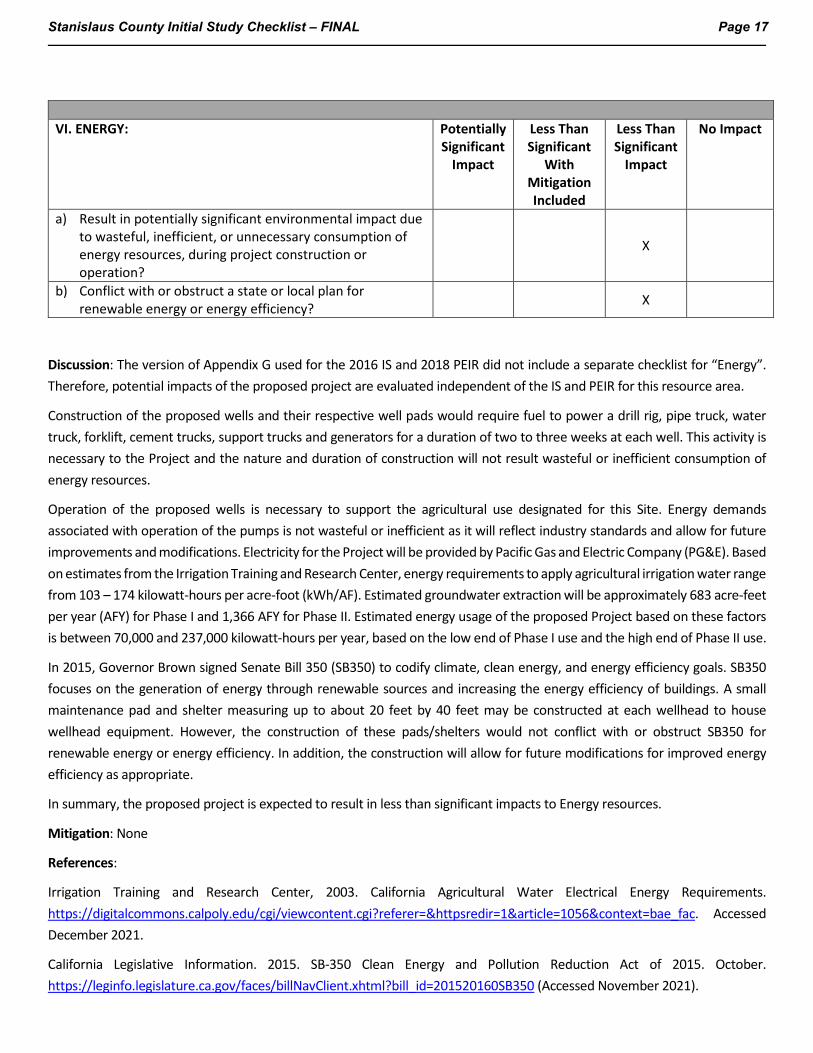
Stanislaus County Initial Study Checklist – FINAL Page 17
VI. ENERGY: Potentially
Significant Impact
Less Than Significant
With Mitigation Included
Less Than Significant
Impact
No Impact
a) Result in potentially significant environmental impact due to wasteful, inefficient, or unnecessary consumption of energy resources, during project construction or operation?
X
b) Conflict with or obstruct a state or local plan for renewable energy or energy efficiency? X
Discussion: The version of Appendix G used for the 2016 IS and 2018 PEIR did not include a separate checklist for “Energy”. Therefore, potential impacts of the proposed project are evaluated independent of the IS and PEIR for this resource area.
Construction of the proposed wells and their respective well pads would require fuel to power a drill rig, pipe truck, water truck, forklift, cement trucks, support trucks and generators for a duration of two to three weeks at each well. This activity is necessary to the Project and the nature and duration of construction will not result wasteful or inefficient consumption of energy resources.
Operation of the proposed wells is necessary to support the agricultural use designated for this Site. Energy demands associated with operation of the pumps is not wasteful or inefficient as it will reflect industry standards and allow for future improvements and modifications. Electricity for the Project will be provided by Pacific Gas and Electric Company (PG&E). Based on estimates from the Irrigation Training and Research Center, energy requirements to apply agricultural irrigation water range from 103 – 174 kilowatt-hours per acre-foot (kWh/AF). Estimated groundwater extraction will be approximately 683 acre-feet per year (AFY) for Phase I and 1,366 AFY for Phase II. Estimated energy usage of the proposed Project based on these factors is between 70,000 and 237,000 kilowatt-hours per year, based on the low end of Phase I use and the high end of Phase II use.
In 2015, Governor Brown signed Senate Bill 350 (SB350) to codify climate, clean energy, and energy efficiency goals. SB350 focuses on the generation of energy through renewable sources and increasing the energy efficiency of buildings. A small maintenance pad and shelter measuring up to about 20 feet by 40 feet may be constructed at each wellhead to house wellhead equipment. However, the construction of these pads/shelters would not conflict with or obstruct SB350 for renewable energy or energy efficiency. In addition, the construction will allow for future modifications for improved energy efficiency as appropriate.
In summary, the proposed project is expected to result in less than significant impacts to Energy resources.
Mitigation: None
References:
Irrigation Training and Research Center, 2003. California Agricultural Water Electrical Energy Requirements. https://digitalcommons.calpoly.edu/cgi/viewcontent.cgi?referer=&httpsredir=1&article=1056&context=bae_fac. Accessed December 2021.
California Legislative Information. 2015. SB-350 Clean Energy and Pollution Reduction Act of 2015. October. https://leginfo.legislature.ca.gov/faces/billNavClient.xhtml?bill_id=201520160SB350 (Accessed November 2021).
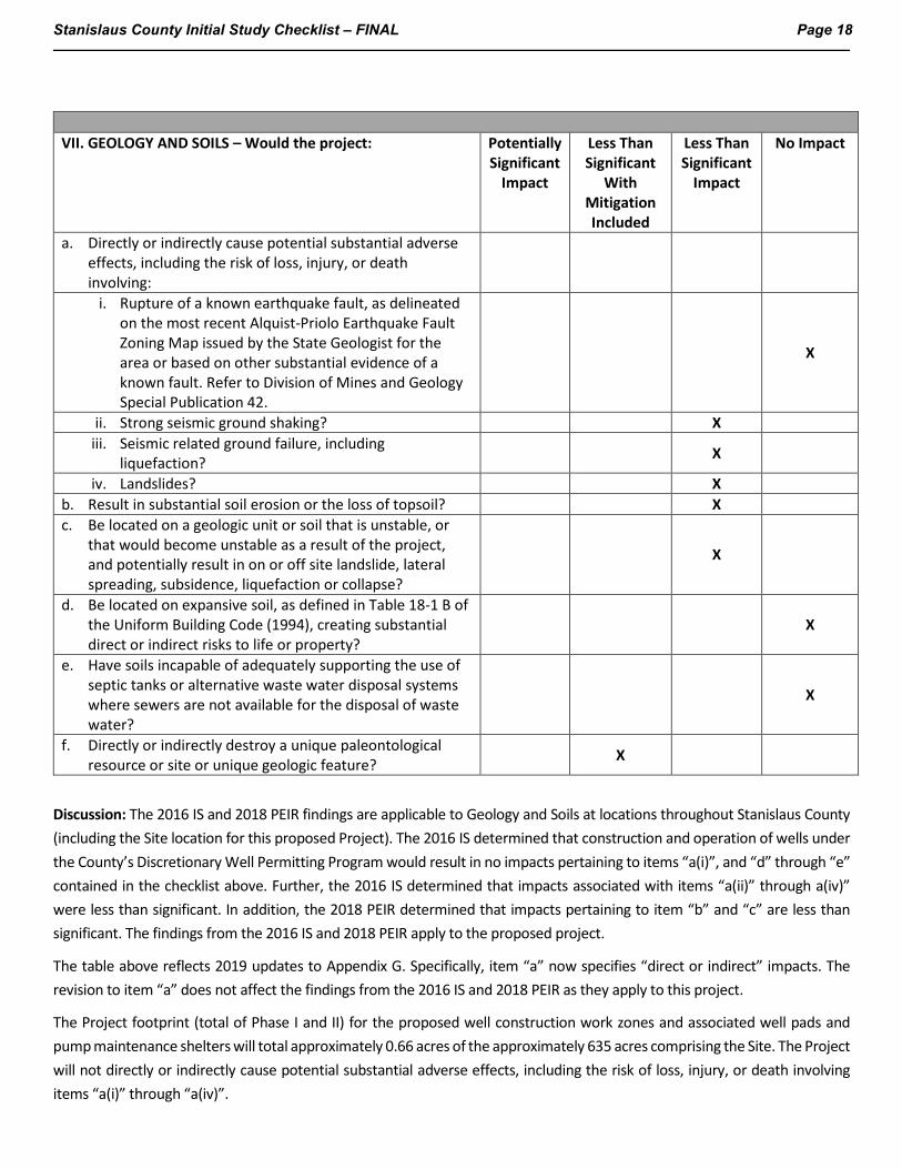
Stanislaus County Initial Study Checklist – FINAL Page 18
VII. GEOLOGY AND SOILS – Would the project: Potentially
Significant Impact
Less Than Significant
With Mitigation Included
Less Than Significant
Impact
No Impact
a. Directly or indirectly cause potential substantial adverse effects, including the risk of loss, injury, or death involving:
i. Rupture of a known earthquake fault, as delineated on the most recent Alquist-Priolo Earthquake Fault Zoning Map issued by the State Geologist for the area or based on other substantial evidence of a known fault. Refer to Division of Mines and Geology Special Publication 42.
X
ii. Strong seismic ground shaking? X iii. Seismic related ground failure, including
liquefaction? X
iv. Landslides? X b. Result in substantial soil erosion or the loss of topsoil? X c. Be located on a geologic unit or soil that is unstable, or
that would become unstable as a result of the project, and potentially result in on or off site landslide, lateral spreading, subsidence, liquefaction or collapse?
X
d. Be located on expansive soil, as defined in Table 18-1 B of the Uniform Building Code (1994), creating substantial direct or indirect risks to life or property?
X
e. Have soils incapable of adequately supporting the use of septic tanks or alternative waste water disposal systems where sewers are not available for the disposal of waste water?
X
f. Directly or indirectly destroy a unique paleontological resource or site or unique geologic feature? X
Discussion: The 2016 IS and 2018 PEIR findings are applicable to Geology and Soils at locations throughout Stanislaus County (including the Site location for this proposed Project). The 2016 IS determined that construction and operation of wells under the County’s Discretionary Well Permitting Program would result in no impacts pertaining to items “a(i)”, and “d” through “e” contained in the checklist above. Further, the 2016 IS determined that impacts associated with items “a(ii)” through a(iv)” were less than significant. In addition, the 2018 PEIR determined that impacts pertaining to item “b” and “c” are less than significant. The findings from the 2016 IS and 2018 PEIR apply to the proposed project.
The table above reflects 2019 updates to Appendix G. Specifically, item “a” now specifies “direct or indirect” impacts. The revision to item “a” does not affect the findings from the 2016 IS and 2018 PEIR as they apply to this project.
The Project footprint (total of Phase I and II) for the proposed well construction work zones and associated well pads and pump maintenance shelters will total approximately 0.66 acres of the approximately 635 acres comprising the Site. The Project will not directly or indirectly cause potential substantial adverse effects, including the risk of loss, injury, or death involving items “a(i)” through “a(iv)”.
Stanislaus County Initial Study Checklist – FINAL Page 19
Follow-on operations related to orchard construction and operations are consistent with the land use zoning. The Site generally slopes toward the south, with several drainages through the proposed orchard blocks. The agricultural activities that the Project supports will be performed in a manner that will generally following the existing contours of the land and would therefore not alter the existing drainage patterns that currently exist. No impervious surfaces would be created by the agricultural development and activities and, as such, there would not be substantial soil erosion or the loss of topsoil from the agricultural activities that the Project supports.
Checklist item “f” pertaining to unique paleontological or geologic resources was previously included in the “Cultural Resources” section of Appendix G. In the event that a unique paleontological resource is encountered during ground disturbing activities, then Mitigation Measure CUL-1b and CUL-1c identified in the PEIR will be implemented.
Mitigation: Mitigation Measures CUL-1b, and CUL-1c if necessary.
References:
Jacobson James & Associates, Inc. and Tetra Tech, Inc., 2018. Final Program Environmental Impact Report for the Stanislaus County Discretionary Well Permitting and Management Program. Prepared for Stanislaus County Department of Environmental Resources. June 11.
Jacobson James & Associates, Inc. and Tetra Tech, Inc., 2016. Initial Study Discretionary Well Permitting and Management Program, Stanislaus County, California. October 3.

Stanislaus County Initial Study Checklist – FINAL Page 20
VIII. GREENHOUSE GAS EMISSIONS – Would the project:
Potentially Significant
Impact
Less Than Significant
With Mitigation Included
Less Than Significant
Impact
No Impact
a) Generate greenhouse gas emissions, either directly or indirectly, that may have a significant impact on the environment?
X
b) Conflict with an applicable plan, policy or regulation adopted for the purpose of reducing the emissions of greenhouse gases?
X
Discussion: The 2016 IS and 2018 PEIR findings are applicable to Greenhouse Gas Emissions at locations throughout Stanislaus County (including the Site location for this proposed Project). The 2018 PEIR indicates that construction and operation of wells under the County’s Discretionary Well Permitting Program is expected to result in less than significant impacts to greenhouse gas emissions. These findings from the PEIR apply to the proposed project. Therefore, potential greenhouse gas emission impacts associated with the proposed project are presumed to be less than significant and do not warrant further consideration.
Follow-on operations related to orchard construction would be limited to indirect emissions from the use of electricity and infrequent motor vehicle emissions associated with installation of drip irrigation systems, planting, and routine maintenance. Less than significant impacts are anticipated.
Mitigation: None
References:
Jacobson James & Associates, Inc. and Tetra Tech, Inc., 2018. Final Program Environmental Impact Report for the Stanislaus County Discretionary Well Permitting and Management Program. Prepared for Stanislaus County Department of Environmental Resources. June 11.
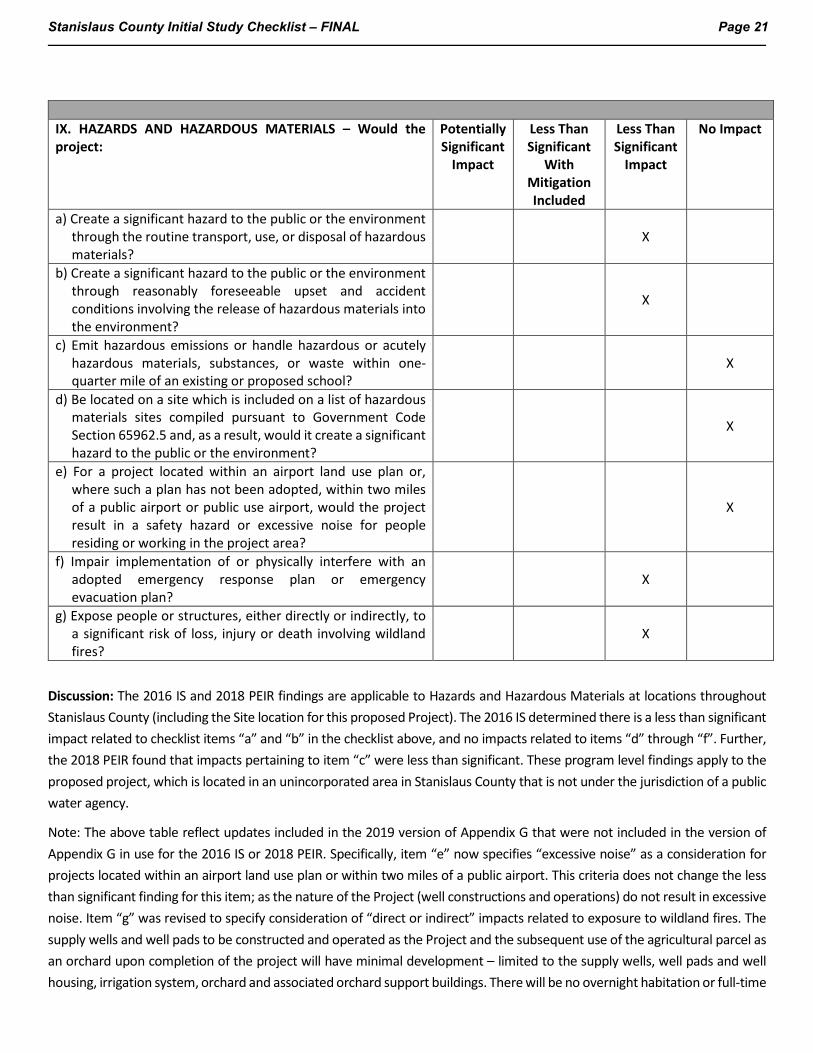
Stanislaus County Initial Study Checklist – FINAL Page 21
IX. HAZARDS AND HAZARDOUS MATERIALS – Would the project:
Potentially Significant
Impact
Less Than Significant
With Mitigation Included
Less Than Significant
Impact
No Impact
a) Create a significant hazard to the public or the environment through the routine transport, use, or disposal of hazardous materials?
X
b) Create a significant hazard to the public or the environment through reasonably foreseeable upset and accident conditions involving the release of hazardous materials into the environment?
X
c) Emit hazardous emissions or handle hazardous or acutely hazardous materials, substances, or waste within one-quarter mile of an existing or proposed school?
X
d) Be located on a site which is included on a list of hazardous materials sites compiled pursuant to Government Code Section 65962.5 and, as a result, would it create a significant hazard to the public or the environment?
X
e) For a project located within an airport land use plan or, where such a plan has not been adopted, within two miles of a public airport or public use airport, would the project result in a safety hazard or excessive noise for people residing or working in the project area?
X
f) Impair implementation of or physically interfere with an adopted emergency response plan or emergency evacuation plan?
X
g) Expose people or structures, either directly or indirectly, to a significant risk of loss, injury or death involving wildland fires?
X
Discussion: The 2016 IS and 2018 PEIR findings are applicable to Hazards and Hazardous Materials at locations throughout Stanislaus County (including the Site location for this proposed Project). The 2016 IS determined there is a less than significant impact related to checklist items “a” and “b” in the checklist above, and no impacts related to items “d” through “f”. Further, the 2018 PEIR found that impacts pertaining to item “c” were less than significant. These program level findings apply to the proposed project, which is located in an unincorporated area in Stanislaus County that is not under the jurisdiction of a public water agency.
Note: The above table reflect updates included in the 2019 version of Appendix G that were not included in the version of Appendix G in use for the 2016 IS or 2018 PEIR. Specifically, item “e” now specifies “excessive noise” as a consideration for projects located within an airport land use plan or within two miles of a public airport. This criteria does not change the less than significant finding for this item; as the nature of the Project (well constructions and operations) do not result in excessive noise. Item “g” was revised to specify consideration of “direct or indirect” impacts related to exposure to wildland fires. The supply wells and well pads to be constructed and operated as the Project and the subsequent use of the agricultural parcel as an orchard upon completion of the project will have minimal development – limited to the supply wells, well pads and well housing, irrigation system, orchard and associated orchard support buildings. There will be no overnight habitation or full-time

Stanislaus County Initial Study Checklist – FINAL Page 22
workers, as workers will be present seasonally. As such, there will be less than significant exposure of people or structures, directly or indirectly, to a significant risk of loss, injury or death involving wildland fires with regards to item “g”.
The proposed Project will support continued agricultural use of the Site. The follow-on operations related to orchard construction and operations, after Project completion, will be performed in accordance with applicable rules and regulations of the Stanislaus County CUPA and Department of Toxic Substances Control, as applicable.
Mitigation: None.
References:
Jacobson James & Associates, Inc. and Tetra Tech, Inc., 2018. Final Program Environmental Impact Report for the Stanislaus County Discretionary Well Permitting and Management Program. Prepared for Stanislaus County Department of Environmental Resources. June 11.
Jacobson James & Associates, Inc. and Tetra Tech, Inc., 2016. Initial Study Discretionary Well Permitting and Management Program, Stanislaus County, California. October 3.
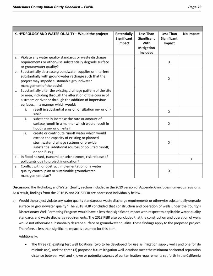
Stanislaus County Initial Study Checklist – FINAL Page 23
X. HYDROLOGY AND WATER QUALITY – Would the project: Potentially
Significant Impact
Less Than Significant
With Mitigation Included
Less Than Significant
Impact
No Impact
a. Violate any water quality standards or waste discharge requirements or otherwise substantially degrade surface or groundwater quality?
X
b. Substantially decrease groundwater supplies or interfere substantially with groundwater recharge such that the project may impede sustainable groundwater management of the basin?
X
c. Substantially alter the existing drainage pattern of the site or area, including through the alteration of the course of a stream or river or through the addition of impervious surfaces, in a manner which would:
i. result in substantial erosion or siltation on- or off-site? X
ii. substantially increase the rate or amount of surface runoff in a manner which would result in flooding on- or off-site?
X
iii. create or contribute runoff water which would exceed the capacity of existing or planned stormwater drainage systems or provide substantial additional sources of polluted runoff; or per IS <sig
X
d. In flood hazard, tsunami, or seiche zones, risk release of pollutants due to project inundation? X
e. Conflict with or obstruct implementation of a water quality control plan or sustainable groundwater management plan?
X
Discussion: The Hydrology and Water Quality section included in the 2019 version of Appendix G includes numerous revisions. As a result, findings from the 2016 IS and 2018 PEIR are addressed individually below.
a) Would the project violate any water quality standards or waste discharge requirements or otherwise substantially degrade surface or groundwater quality? The 2018 PEIR concluded that construction and operation of wells under the County’s Discretionary Well Permitting Program would have a less than significant impact with respect to applicable water quality standards and waste discharge requirements. The 2018 PEIR also concluded that the construction and operation of wells would not otherwise substantially degrade surface or groundwater quality. These findings apply to the proposed project. Therefore, a less than significant impact is assumed for this item.
Additionally:
• The three (3) existing test well locations (two to be developed for use as irrigation supply wells and one for de minimis use), and the three (3) proposed future irrigation well locations meet the minimum horizontal separation distance between well and known or potential sources of contamination requirements set forth in the California
Stanislaus County Initial Study Checklist – FINAL Page 24
and County Well Standards. The wells are not located within 50 feet of any sewer, 100 feet of a septic tank, leaching field, or animal enclosure, and not within 150 feet of a cesspool or seepage pit.
• The three (3) existing test wells to be developed for supply use were constructed with 20 feet surface seals and the three (3) proposed wells will have surface seals not less than 20 feet; as such, all proposed wells meet the California and County Well Standards for surface seal depths to be protective of water quality.
Per the Groundwater Resources Impact Assessment (GRIA – Attachment 4), the subsequent orchard development and operation activities will be performed in accordance with applicable rules and regulations under the General Agricultural Water Quality Protection Orders issued by the Regional Water Quality Control Board for the proposed Irrigated Lands Regulatory Program. Based on this information, potential impacts to water quality will be less than significant.
b) Would the project substantially decrease groundwater supplies or interfere substantially with groundwater recharge such that the project may impede sustainable groundwater management of the basin? The 2018 PEIR addressed this question through consideration of the following two questions that were developed for the PEIR to align with the County’s Groundwater Ordinance and the Sustainable Groundwater Management Act (SGMA):
• Would the project cause interference drawdown to existing wells that substantially interferes with their ability to support existing land uses, or land uses for which permits have been granted?
• Would the project cause groundwater drawdown or storage depletion that will interfere with the ability of other well operators to support existing or permitting land uses, or that would substantially increase the cost to pump groundwater in the area.
The PEIR included the mitigation measures WAT-2 and WAT-3 to be implemented, as needed, to ensure impacts to groundwater supplies and recharge are less than significant. Based on the phased nature of the proposed Project, an additional mitigation measure not identified in the PEIR is identified as applicable to the Project as WAT-2B.
Mitigation Measure WAT-2: Property owners and water agencies in the area where predicted drawdown exceeds 5 feet will be notified of the existence of the Interference Drawdown Monitoring and Mitigation Program, and will be invited to register any domestic wells in the predicted 5-foot drawdown area and any municipal, industrial, or irrigation wells in the predicted 20-foot drawdown area to participate in the program. To register for the program, well owners will be required to complete a Well Information Questionnaire regarding the construction, use, history and performance of their well, and to allow access for periodic measurement of water levels and assessment of well condition and performance by the County or a neutral third party. If well performance is found to be diminished by more than 20 percent or to be inadequate to meet pre-existing water demand due to interference drawdown, registered participants will be eligible to receive reimbursement for reasonable and customary costs for well replacement, deepening or rehabilitation, or pump lowering as needed to restore adequate well function. The cost of reimbursement shall be borne by the operator of the well causing the interference in proportion to the degree of their contribution to the drawdown that caused the diminished yield.
Status: Screening analysis completed (GRIA – Attachment 4). To evaluate potential interference drawdown impacts associated with the proposed project, a GRIA was completed and included in the supplemental well permit application packet. Analysis in the GRIA indicates that pumping as a result of Phase I and the expanded Phase II will result in drawdown in nearby existing irrigation wells and domestic wells. Anticipated interference drawdown in existing irrigation wells is not anticipated to be greater than 20 feet while predicted interference drawdown in domestic wells is anticipated to be less than 10% of their available drawdown. These interference drawdowns are anticipated to be less than significant and implementation of an
Stanislaus County Initial Study Checklist – FINAL Page 25
Interference Drawdown Monitoring and Mitigation Program, as specified in Mitigation Measure WAT-2 is not currently warranted.
To confirm the GRIA finding, the Project is divided into two phases and an Adaptive Management Program will be implemented. The Applicant’s identified purpose of splitting the project into two phases is to assess the drawdown response of the aquifer and whether it is consistent with the effects predicted in the GRIA. Phase I involves the conversion of two test wells to production wells for irrigation of 175 acres of almond orchard pumping at less than the sustainable yield. Phase I includes a monitoring and adaptive management program, which will inform the extent to which pumping may be expanded during the implementation of Phase II and allows for confirmation of the findings in the GRIA.
The Monitoring and Adaptive Management Program will be implemented as Mitigation Measure WAT-2b (see below).
Mitigation Measure WAT-2b: A Monitoring and Adaptive Management Program shall be implemented prior to implementation of the Project Phase 2 activities to confirm the GRIA findings. The program will include the following components as described in the GRIA:
• A monitoring plan will be developed and provided to the Stanislaus County DER for review and approval. The plan will describe the procedures to collect and analyze groundwater level monitoring data from two or more monitoring wells during the initial operation of PW-1 and PW-2. Each of the monitoring wells will be fitted with a recording pressure transducer. Drawdown data and groundwater extraction data will be gathered for a period of at least three months after project startup.
• The observed drawdown data will be compared to drawdown data simulated using the groundwater flow model developed for the Project and described in Section 4 of the GRIA. To this, the actual pumping rates from the initial startup period will be simulated using the model, and the predicted drawdown response at the monitoring well locations will be compared to the observed response. If the observed drawdown is different from the predicted drawdown, the model will be updated as appropriate to match the observed drawdown. The updated model will then be used to assess the allowable groundwater development extraction rate for Phase II of the Project, as follows:
o If the observed drawdown was less than or similar to the originally predicted drawdown, development of Phase II may include up to an additional 175 acres.
o If the observed drawdown was greater than the originally predicted drawdown, the updated model will be used to establish an allowable additional pumping volume for Phase II such that the drawdown predicted for expanded Phase II pumping remains less than or similar to the originally predicted drawdown described in Section 4 of the GRIA.
o The outcome of the analysis will be provided to the Stanislaus County DER for review and approval.
Mitigation Measure WAT-3: The County will identify additional Groundwater Level Management Zones in the unincorporated, non-district portions of the County where existing groundwater level trends constitute “chronic lowering of groundwater levels indicating a significant and unreasonable depletion of supply if continued over the planning and implementation horizon” as defined in Section 9.37.030(9)(a) of the Ordinance. In such areas, an applicant proposing installation of a new discretionary well is required to submit a Groundwater Extraction Offset Plan that describes how groundwater extraction from the well will be offset, resulting in no net additional groundwater demand to the pumped aquifer system. Alternatively, the
Stanislaus County Initial Study Checklist – FINAL Page 26
applicant must do a Groundwater Resources Investigation and implement a Groundwater Level Monitoring Program that demonstrates the proposed extraction will not result in, or contribute to, Undesirable Results as defined in the Ordinance.
Status: Screening analysis completed (GRIA – Attachment 4). Determined impacts less than significant.
The project is not located in a Groundwater Level Management Zone.
c) Would the project substantially alter the existing drainage pattern of the site or area, including through the alteration of the course of a stream or river or through the addition of impervious surfaces, in a manner which would:
i. Result in substantial erosion or siltation on- or off-site?
The 2018 PEIR determined that impacts associated with item “i” are less than significant with implementation of Mitigation Measure WAT-4.
Mitigation Measure WAT-4: Applications to construct new wells shall be evaluated to assess the potential for construction activities or conversion of previously uncultivated rangeland to change drainage patterns and result in significant on- or off-site erosion or sedimentation. If the potential for significant erosion or sedimentation is found to exist, the applicant will be required to prepare and submit and implement a Drainage, Erosion and Sedimentation Control Plan.
The proposed project involves the installation of up to five new agricultural supply wells, two during Phase I and up to three during Phase II. The wells will be completed with small concrete pads at the surface and fitted with electrical line-shaft turbine pumps. Electrical service will be extended to the well locations. A small maintenance pad and shelter measuring up to about 20 feet by 40 feet may be constructed at each wellhead to house wellhead equipment including pump controls, connection valves and headers to the irrigation system, and filters and fertigation equipment as needed.
All well installation work and associated ground disturbance will take place within areas that have already been tilled and as such are areas of previous ground disturbance. Installation of these concrete pads and maintenance shelters is not anticipated to result in substantial changes to surface topography, construction of slopes, or concentration of flow. No substantial increase in the rate or amount of surface run off resulting in flooding or substantial erosion due to the construction of the well, small concrete pads installed for the wells, or the maintenance shelters, on or off-site is anticipated.
Existing drainage patterns at the site are not anticipated to change based on the installation of the agricultural wells or their associated construction. Work areas for well installation are anticipated to be 50x100ft in already disturbed areas. Final well installation involves the installation of a small concrete pad and maintenance shelter at each well. The addition of a small impervious surface such as a small concrete pad or maintenance shelter is not anticipated to significantly alter the drainage pattern in the area of the well installation. Therefore, a Drainage, Erosion and Sediment Control Plan, as specified under Mitigation Measure WAT-4 is not warranted for the Project activities. The impact associated with item “i” is presumed to be less than significant.
The Site generally slopes toward the south, with several drainages through the proposed orchard blocks. The agricultural activities that the Project supports will be performed in a manner that will generally following the existing contours of the land and would therefore not alter the existing drainage patterns that currently exist. No impervious surfaces would be created by the agricultural development and activities. As such, there would not be
Stanislaus County Initial Study Checklist – FINAL Page 27
a substantial increase in the rate or amount of surface runoff which would result in substantial erosion or siltation on- or off-site from the agricultural activities that the Project supports. Less than significant impacts are anticipated.
Status: Determined impacts less than significant.
ii. Substantially increase the rate or amount of surface runoff in a manner which would result in flooding on- or off-site?
The 2018 PEIR determined that impacts associated with item “ii” are less than significant with implementation of Mitigation Measure WAT-5,
Mitigation Measure WAT-5. Applications to construct new wells shall be evaluated to assess the potential for construction activities or conversion of previously uncultivated rangeland to change drainage patterns and result in an increase in runoff and significant on- or off-site flooding. If the potential for significant flooding is found to exist, the applicant will be required to prepare and submit and implement a Drainage, Erosion and Sedimentation Control Plan.
The proposed Project is not expected to result in significant on- or off-site flooding because the proposed Project will not replace the pervious soil surface with impervious surfaces (with the exception of the small well pad footprints), the surface topography with be similar to surrounding areas.
As previously described, the Site generally slopes toward the south, with several drainages through the proposed orchard blocks. Significant on- or off-site flooding is not expected from the agricultural activities that the Project supports because (1) the work will be performed in a manner that will generally following the existing contours of the land and would therefore not alter the existing drainage patterns that currently exist, (2) no impervious surfaces would be created by the agricultural development and activities, and (3) the orchard will utilize micro drip irrigation. Therefore, impacts associated with item ii are presumed to be less than significant, and implementation of a Drainage, Erosion and Sedimentation Control Plan, as specified in Mitigation Measure WAT-5 is not warranted.
Status: Not warranted
iii. Create or contribute runoff water which would exceed the capacity of existing or planned stormwater drainage systems or provide substantial additional sources of polluted runoff
The 2016 IS determined that impacts associated with item iii above for wells permitted under the County’s Discretionary Well Permitting Program are less than significant. These findings applied to the proposed project.
d) Would the project in a flood hazard, tsunami, or seiche zones, risk release of pollutants due to project inundation? The Site is not located in a tsunami or seiche zone. Construction or operation of the proposed wells does not present a risk with respect to the release of pollutants during a flood event. Therefore, there is no impact with respect to this question.
e) Would the project conflict with or obstruct implementation of a water quality control plan or sustainable groundwater management plan? This question was addressed in part, in the 2018 PEIR. Specifically, the 2018 PEIR concluded that wells permitted under the County’s Discretionary Well Permitting Program would have a less than significant impact with respect to degradation of water quality in excess of water quality objectives for beneficial uses identified in the California Regional Water Quality Control Board (RWQCB) Water Quality Plan.

Stanislaus County Initial Study Checklist – FINAL Page 28
Stanislaus County’s Groundwater Ordinance is deliberately aligned with the requirements of Sustainable Groundwater Management Act (SGMA). Under the Ordinance, unless otherwise exempt, an applicant that wishes to install a new groundwater well must first provide substantial evidence the well is not unsustainably extracting groundwater as defined in the Ordinance and in SGMA. Based on the GRIA (Attachment 4) supplied by the applicant, the proposed project does not appear to conflict with or obstruct the implementation of a sustainable groundwater management plan. Therefore, no conflicts with the Stanislaus County’s Groundwater Ordinance are anticipated.
Mitigation: Mitigation Measures WAT-2 (contingent on findings of WAT-2b) and WAT-2b (to be implemented by the applicant prior to operating PW-1 and PW-2).
References:
Jacobson James & Associates, Inc. and Tetra Tech, Inc., 2018. Final Program Environmental Impact Report for the Stanislaus County Discretionary Well Permitting and Management Program. Prepared for Stanislaus County Department of Environmental Resources. June 11.
Jacobson James & Associates, Inc. and Tetra Tech, Inc., 2016. Initial Study Discretionary Well Permitting and Management Program, Stanislaus County, California. October 3.
California State Well Standards, Bulletins 74-81 and 74-90. https://water.ca.gov/Programs/Groundwater-Management/Wells/Well-Standards/Combined-Well-Standards. Accessed December 2021.
Stanislaus County Initial Study Checklist – FINAL Page 29
XI. LAND USE AND PLANNING – Would the project:
Potentially Significant
Impact
Less Than Significant
With Mitigation Included
Less Than Significant
Impact
No Impact
a. Physically divide an established community? X b. Cause a significant environmental impact due to a conflict
with any land use plan, policy, or regulation adopted for the purpose of avoiding or mitigating an environmental effect?
X
Discussion: The 2016 IS and 2018 PEIR findings are applicable to Land Use and Planning at locations throughout Stanislaus County (including the Site location for this proposed Project). The findings from the 2016 IS determined that construction and operation of wells under the County’s Discretionary Well Permitting Program would not result in the physical division of an established community. Further, the 2018 PEIR determined a less than significant impact due to a conflict with a land use plan, policy or regulation adopted for the purpose of avoiding or mitigating an environmental effect. These findings apply to the proposed project. Therefore, impacts to land use and planning associated with the proposed project are expected to be less than significant and no further consideration of this resource area is warranted.
The proposed Project will support agricultural use of the Site, consistent with the A-2-40 (General Agriculture) zoning (Stanislaus County Code 21.20), and consistent with the declared policy of Stanislaus County to “encourage the development and improvement of its agricultural land for the production of food and other agricultural products” (Stanislaus County Code 9.32.020 A). However, the planned orchard is not part of the proposed Project as it is consistent with the County A-2-40 designated zoning purpose (County Code 21.20.010), does not require land use permits (County Code 21.20.030 and 21.20.040), and does not require land division (County Code 21.20.050).
The proposed Project will support continued agricultural use of the Site, consistent with the County Code A-2-40 zoning (General Agricultural) and the agricultural use does not require land use permits (County Code 21.20.030 and 21.20.040) and does not require land division (County Code 21.20.050). This agricultural use will not divide an established community and does not conflict with any of the goals of the Land Use Element of the Stanislaus County General Plan. No impacts related to land use and planning are anticipated as a result of the proposed Project or the subsequent agricultural land use.
Mitigation: None
References:
Jacobson James & Associates, Inc. and Tetra Tech, Inc., 2018. Final Program Environmental Impact Report for the Stanislaus County Discretionary Well Permitting and Management Program. Prepared for Stanislaus County Department of Environmental Resources. June 11.
Jacobson James & Associates, Inc. and Tetra Tech, Inc., 2016. Initial Study Discretionary Well Permitting and Management Program, Stanislaus County, California. October 3.
Stanislaus County, 2015. Stanislaus County General Plan, Chapter One - Land Use Element. Adopted August 23, 2016.

Stanislaus County Initial Study Checklist – FINAL Page 30
XII. MINERAL RESOURCES -- Would the project:
Potentially Significant
Impact
Less Than Significant
With Mitigation Included
Less Than Significant
Impact
No Impact
a) Result in the loss of availability of a known mineral resource that would be of value to the region and the residents of the state?
X
b) Result in the loss of availability of a locally-important mineral resource recovery site delineated on a local general plan, specific plan or other land use plan?
X
Discussion: The 2016 IS determined that construction and operation of wells under the County’s Discretionary Well Permitting Program would result in no impacts to items “a” or “b” above. These findings apply to the proposed project. No additional consideration is required with respect to mineral resources.
The area encompassing the Project was designated as Mineral Resource Zone (MRZ)-3a in the Mineral Land Classification of Stanislaus County Special Report 173. A designation of MRZ-3a indicates an area containing known mineral occurrences of undetermined mineral resource significance and further exploration work within these areas could result in the reclassification of specific localities into MRZ-2a or MRZ-2b categories. In the event that mineral resources are located at the proposed Project, proposed activities would not interfere with the potential extraction of a mineral resource. No impacts are anticipated.
Mitigation: None
References:
California Department of Conservation, Division of Mines and Geology, 1993. Mineral Land Classification of Stanislaus
County, California, Special Report 173. Higgins, C., Dupras, D. 1993.
Jacobson James & Associates, Inc. and Tetra Tech, Inc., 2018. Final Program Environmental Impact Report for the Stanislaus County Discretionary Well Permitting and Management Program. Prepared for Stanislaus County Department of Environmental Resources. June 11.
Jacobson James & Associates, Inc. and Tetra Tech, Inc., 2016. Initial Study Discretionary Well Permitting and Management Program, Stanislaus County, California. October 3.
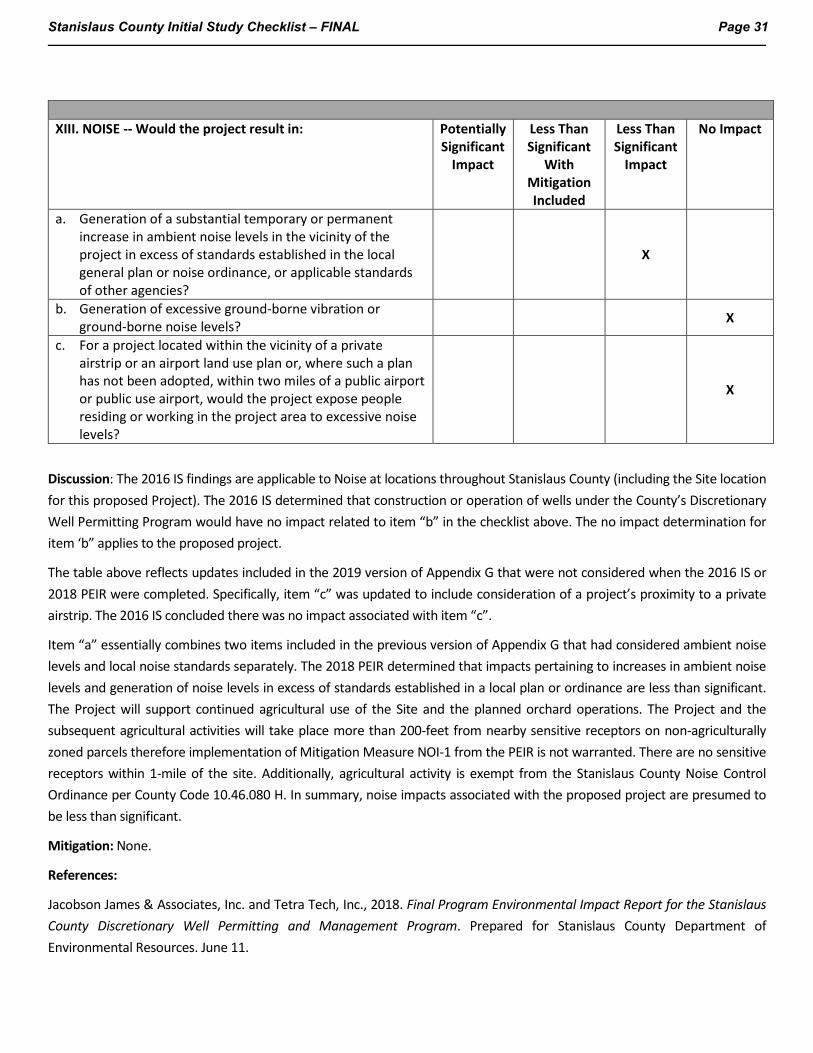
Stanislaus County Initial Study Checklist – FINAL Page 31
XIII. NOISE -- Would the project result in:
Potentially Significant
Impact
Less Than Significant
With Mitigation Included
Less Than Significant
Impact
No Impact
a. Generation of a substantial temporary or permanent increase in ambient noise levels in the vicinity of the project in excess of standards established in the local general plan or noise ordinance, or applicable standards of other agencies?
X
b. Generation of excessive ground-borne vibration or ground-borne noise levels? X
c. For a project located within the vicinity of a private airstrip or an airport land use plan or, where such a plan has not been adopted, within two miles of a public airport or public use airport, would the project expose people residing or working in the project area to excessive noise levels?
X
Discussion: The 2016 IS findings are applicable to Noise at locations throughout Stanislaus County (including the Site location for this proposed Project). The 2016 IS determined that construction or operation of wells under the County’s Discretionary Well Permitting Program would have no impact related to item “b” in the checklist above. The no impact determination for item ‘b” applies to the proposed project.
The table above reflects updates included in the 2019 version of Appendix G that were not considered when the 2016 IS or 2018 PEIR were completed. Specifically, item “c” was updated to include consideration of a project’s proximity to a private airstrip. The 2016 IS concluded there was no impact associated with item “c”.
Item “a” essentially combines two items included in the previous version of Appendix G that had considered ambient noise levels and local noise standards separately. The 2018 PEIR determined that impacts pertaining to increases in ambient noise levels and generation of noise levels in excess of standards established in a local plan or ordinance are less than significant. The Project will support continued agricultural use of the Site and the planned orchard operations. The Project and the subsequent agricultural activities will take place more than 200-feet from nearby sensitive receptors on non-agriculturally zoned parcels therefore implementation of Mitigation Measure NOI-1 from the PEIR is not warranted. There are no sensitive receptors within 1-mile of the site. Additionally, agricultural activity is exempt from the Stanislaus County Noise Control Ordinance per County Code 10.46.080 H. In summary, noise impacts associated with the proposed project are presumed to be less than significant.
Mitigation: None.
References:
Jacobson James & Associates, Inc. and Tetra Tech, Inc., 2018. Final Program Environmental Impact Report for the Stanislaus County Discretionary Well Permitting and Management Program. Prepared for Stanislaus County Department of Environmental Resources. June 11.

Stanislaus County Initial Study Checklist – FINAL Page 32
Jacobson James & Associates, Inc. and Tetra Tech, Inc., 2016. Initial Study Discretionary Well Permitting and Management Program, Stanislaus County, California. October 3.
Stanislaus County Airport Land Use Compatibility Plan adopted October 6, 2016 http://www.stancounty.com/planning/agenda-aluc/draft_alucp.pdf (Accessed October 2021)
Stanislaus County Noise Control Ordinance. http://qcode.us/codes/stanislauscounty/?view=desktop&topic=10-10_46-10_46_010
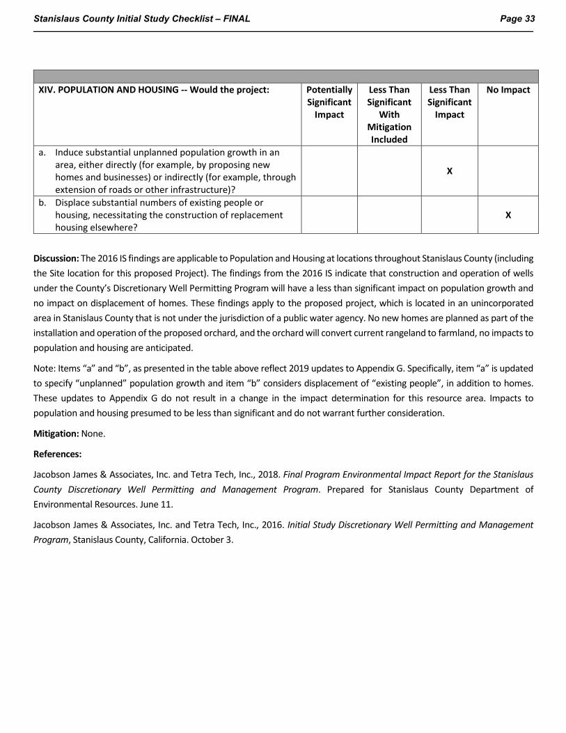
Stanislaus County Initial Study Checklist – FINAL Page 33
XIV. POPULATION AND HOUSING -- Would the project:
Potentially Significant
Impact
Less Than Significant
With Mitigation Included
Less Than Significant
Impact
No Impact
a. Induce substantial unplanned population growth in an area, either directly (for example, by proposing new homes and businesses) or indirectly (for example, through extension of roads or other infrastructure)?
X
b. Displace substantial numbers of existing people or housing, necessitating the construction of replacement housing elsewhere?
X
Discussion: The 2016 IS findings are applicable to Population and Housing at locations throughout Stanislaus County (including the Site location for this proposed Project). The findings from the 2016 IS indicate that construction and operation of wells under the County’s Discretionary Well Permitting Program will have a less than significant impact on population growth and no impact on displacement of homes. These findings apply to the proposed project, which is located in an unincorporated area in Stanislaus County that is not under the jurisdiction of a public water agency. No new homes are planned as part of the installation and operation of the proposed orchard, and the orchard will convert current rangeland to farmland, no impacts to population and housing are anticipated.
Note: Items “a” and “b”, as presented in the table above reflect 2019 updates to Appendix G. Specifically, item “a” is updated to specify “unplanned” population growth and item “b” considers displacement of “existing people”, in addition to homes. These updates to Appendix G do not result in a change in the impact determination for this resource area. Impacts to population and housing presumed to be less than significant and do not warrant further consideration.
Mitigation: None.
References:
Jacobson James & Associates, Inc. and Tetra Tech, Inc., 2018. Final Program Environmental Impact Report for the Stanislaus County Discretionary Well Permitting and Management Program. Prepared for Stanislaus County Department of Environmental Resources. June 11.
Jacobson James & Associates, Inc. and Tetra Tech, Inc., 2016. Initial Study Discretionary Well Permitting and Management Program, Stanislaus County, California. October 3.
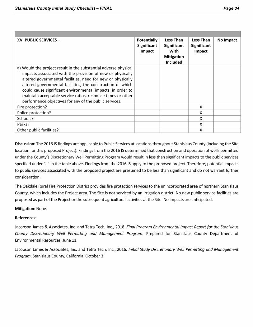
Stanislaus County Initial Study Checklist – FINAL Page 34
XV. PUBLIC SERVICES –
Potentially Significant
Impact
Less Than Significant
With Mitigation Included
Less Than Significant
Impact
No Impact
a) Would the project result in the substantial adverse physical impacts associated with the provision of new or physically altered governmental facilities, need for new or physically altered governmental facilities, the construction of which could cause significant environmental impacts, in order to maintain acceptable service ratios, response times or other performance objectives for any of the public services:
Fire protection? X Police protection? X Schools? X Parks? X Other public facilities? X
Discussion: The 2016 IS findings are applicable to Public Services at locations throughout Stanislaus County (including the Site location for this proposed Project). Findings from the 2016 IS determined that construction and operation of wells permitted under the County’s Discretionary Well Permitting Program would result in less than significant impacts to the public services specified under “a” in the table above. Findings from the 2016 IS apply to the proposed project. Therefore, potential impacts to public services associated with the proposed project are presumed to be less than significant and do not warrant further consideration.
The Oakdale Rural Fire Protection District provides fire protection services to the unincorporated area of northern Stanislaus County, which includes the Project area. The Site is not serviced by an irrigation district. No new public service facilities are proposed as part of the Project or the subsequent agricultural activities at the Site. No impacts are anticipated.
Mitigation: None.
References:
Jacobson James & Associates, Inc. and Tetra Tech, Inc., 2018. Final Program Environmental Impact Report for the Stanislaus County Discretionary Well Permitting and Management Program. Prepared for Stanislaus County Department of Environmental Resources. June 11.
Jacobson James & Associates, Inc. and Tetra Tech, Inc., 2016. Initial Study Discretionary Well Permitting and Management Program, Stanislaus County, California. October 3.
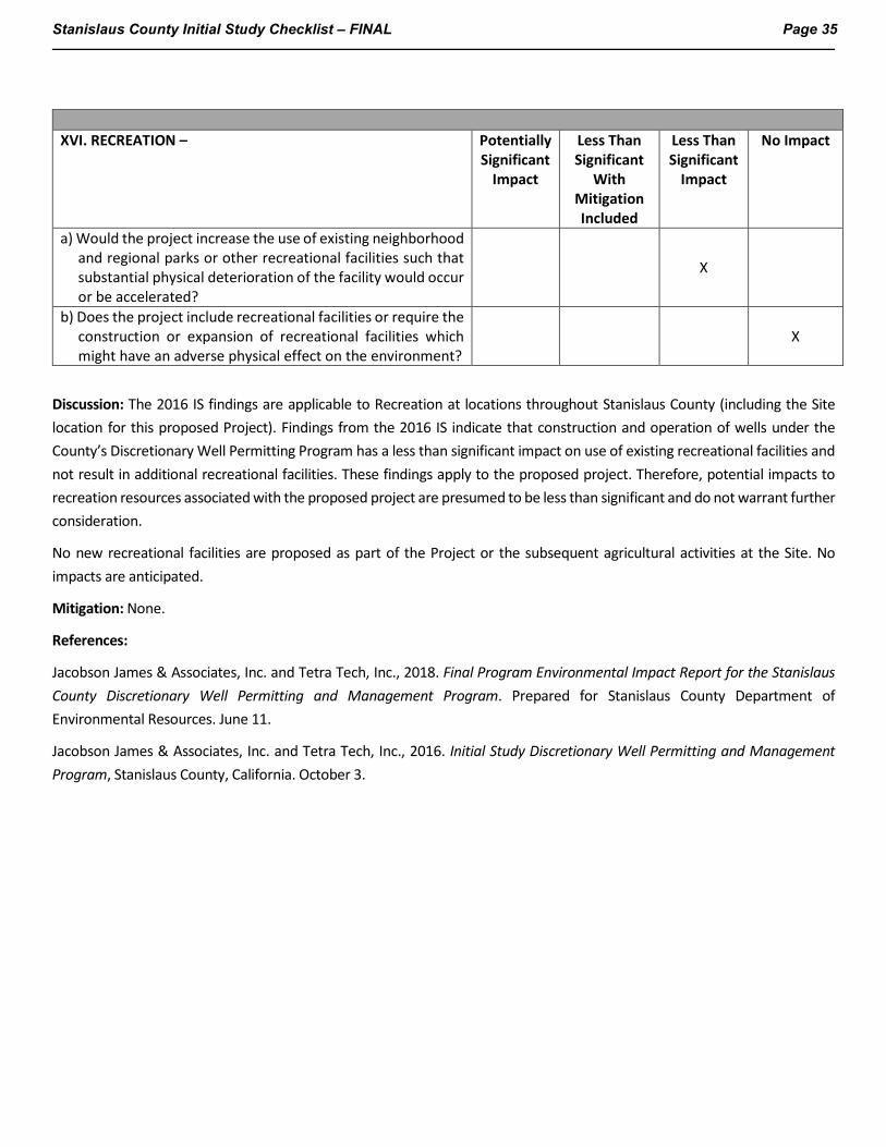
Stanislaus County Initial Study Checklist – FINAL Page 35
XVI. RECREATION –
Potentially Significant
Impact
Less Than Significant
With Mitigation Included
Less Than Significant
Impact
No Impact
a) Would the project increase the use of existing neighborhood and regional parks or other recreational facilities such that substantial physical deterioration of the facility would occur or be accelerated?
X
b) Does the project include recreational facilities or require the construction or expansion of recreational facilities which might have an adverse physical effect on the environment?
X
Discussion: The 2016 IS findings are applicable to Recreation at locations throughout Stanislaus County (including the Site location for this proposed Project). Findings from the 2016 IS indicate that construction and operation of wells under the County’s Discretionary Well Permitting Program has a less than significant impact on use of existing recreational facilities and not result in additional recreational facilities. These findings apply to the proposed project. Therefore, potential impacts to recreation resources associated with the proposed project are presumed to be less than significant and do not warrant further consideration.
No new recreational facilities are proposed as part of the Project or the subsequent agricultural activities at the Site. No impacts are anticipated.
Mitigation: None.
References:
Jacobson James & Associates, Inc. and Tetra Tech, Inc., 2018. Final Program Environmental Impact Report for the Stanislaus County Discretionary Well Permitting and Management Program. Prepared for Stanislaus County Department of Environmental Resources. June 11.
Jacobson James & Associates, Inc. and Tetra Tech, Inc., 2016. Initial Study Discretionary Well Permitting and Management Program, Stanislaus County, California. October 3.
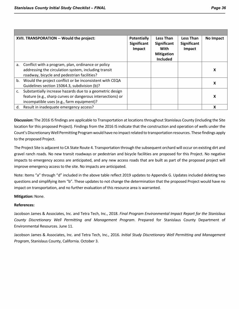
Stanislaus County Initial Study Checklist – FINAL Page 36
XVII. TRANSPORATION -- Would the project:
Potentially Significant
Impact
Less Than Significant
With Mitigation Included
Less Than Significant
Impact
No Impact
a. Conflict with a program, plan, ordinance or policy addressing the circulation system, including transit roadway, bicycle and pedestrian facilities?
X
b. Would the project conflict or be inconsistent with CEQA Guidelines section 15064.3, subdivision (b)? X
c. Substantially increase hazards due to a geometric design feature (e.g., sharp curves or dangerous intersections) or incompatible uses (e.g., farm equipment)?
X
d. Result in inadequate emergency access? X
Discussion: The 2016 IS findings are applicable to Transportation at locations throughout Stanislaus County (including the Site location for this proposed Project). Findings from the 2016 IS indicate that the construction and operation of wells under the Count’s Discretionary Well Permitting Program would have no impact related to transportation resources. These findings apply to the proposed Project.
The Project Site is adjacent to CA State Route 4. Transportation through the subsequent orchard will occur on existing dirt and gravel ranch roads. No new transit roadways or pedestrian and bicycle facilities are proposed for this Project. No negative impacts to emergency access are anticipated, and any new access roads that are built as part of the proposed project will improve emergency access to the site. No impacts are anticipated.
Note: Items “a” through “d” included in the above table reflect 2019 updates to Appendix G. Updates included deleting two questions and simplifying item “b”. These updates to not change the determination that the proposed Project would have no impact on transportation, and no further evaluation of this resource area is warranted.
Mitigation: None.
References:
Jacobson James & Associates, Inc. and Tetra Tech, Inc., 2018. Final Program Environmental Impact Report for the Stanislaus County Discretionary Well Permitting and Management Program. Prepared for Stanislaus County Department of Environmental Resources. June 11.
Jacobson James & Associates, Inc. and Tetra Tech, Inc., 2016. Initial Study Discretionary Well Permitting and Management Program, Stanislaus County, California. October 3.
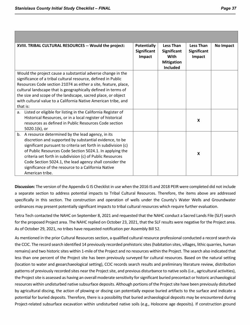
Stanislaus County Initial Study Checklist – FINAL Page 37
XVIII. TRIBAL CULTURAL RESOURCES -- Would the project: Potentially Significant
Impact
Less Than Significant
With Mitigation Included
Less Than Significant
Impact
No Impact
Would the project cause a substantial adverse change in the significance of a tribal cultural resource, defined in Public Resources Code section 21074 as either a site, feature, place, cultural landscape that is geographically defined in terms of the size and scope of the landscape, sacred place, or object with cultural value to a California Native American tribe, and that is:
a. Listed or eligible for listing in the California Register of Historical Resources, or in a local register of historical resources as defined in Public Resources Code section 5020.1(k), or
X
b. A resource determined by the lead agency, in its discretion and supported by substantial evidence, to be significant pursuant to criteria set forth in subdivision (c) of Public Resources Code Section 5024.1. In applying the criteria set forth in subdivision (c) of Public Resources Code Section 5024.1, the lead agency shall consider the significance of the resource to a California Native American tribe.
X
Discussion: The version of the Appendix G IS Checklist in use when the 2016 IS and 2018 PEIR were completed did not include a separate section to address potential impacts to Tribal Cultural Resources. Therefore, the items above are addressed specifically in this section. The construction and operation of wells under the County’s Water Wells and Groundwater ordinances may present potentially significant impacts to tribal cultural resources which require further evaluation.
Tetra Tech contacted the NAHC on September 8, 2021 and requested that the NAHC conduct a Sacred Lands File (SLF) search for the proposed Project area. The NAHC replied on October 23, 2021, that the SLF results were negative for the Project area. As of October 29, 2021, no tribes have requested notification per Assembly Bill 52.
As mentioned in the prior Cultural Resources section, a qualified cultural resource professional conducted a record search via the CCIC. The record search identified 14 previously recorded prehistoric sites (habitation sites, villages, lithic quarries, human remains) and two historic sites within 1-mile of the Project and no resources within the Project. The search also indicated that less than one percent of the Project site has been previously surveyed for cultural resources. Based on the natural setting (location to water and geoarchaeological setting), CCIC records search results and preliminary literature review, distribution patterns of previously recorded sites near the Project site, and previous disturbance to native soils (i.e., agricultural activities), the Project site is assessed as having an overall moderate sensitivity for significant buried precontact or historic archaeological resources within undisturbed native subsurface deposits. Although portions of the Project site have been previously disturbed by agricultural discing, the action of plowing or discing can potentially expose buried artifacts to the surface and indicate a potential for buried deposits. Therefore, there is a possibility that buried archaeological deposits may be encountered during Project-related subsurface excavation within undisturbed native soils (e.g., Holocene age deposits). If construction ground
Stanislaus County Initial Study Checklist – FINAL Page 38
disturbance depths range within native soils, there would be a potential to impact previously unrecorded subsurface archaeological resources. Therefore, mitigation measures CUL-1b and -1c were identified.
Mitigation Measure CUL-1b of the 2018 PEIR involves having a qualified individual present for ground disturbing and construction related activities in case unanticipated resources are uncovered. Implementation of mitigation measures CUL-1b and CUL-1c will further ensure that there will be no impact to any previously unrecorded resources. Therefore, the proposed project would not cause substantial adverse change in the significance of a tribal cultural resource and impact is anticipated to be less than significant.
Mitigation: Mitigation measures CUL-1b, and CUL-1c as necessary.
References:
Jacobson James & Associates, Inc. and Tetra Tech, Inc., 2018. Final Program Environmental Impact Report for the Stanislaus County Discretionary Well Permitting and Management Program. Prepared for Stanislaus County Department of Environmental Resources. June 11.
Jacobson James & Associates, Inc. and Tetra Tech, Inc., 2016. Initial Study Discretionary Well Permitting and Management Program, Stanislaus County, California. October 3.
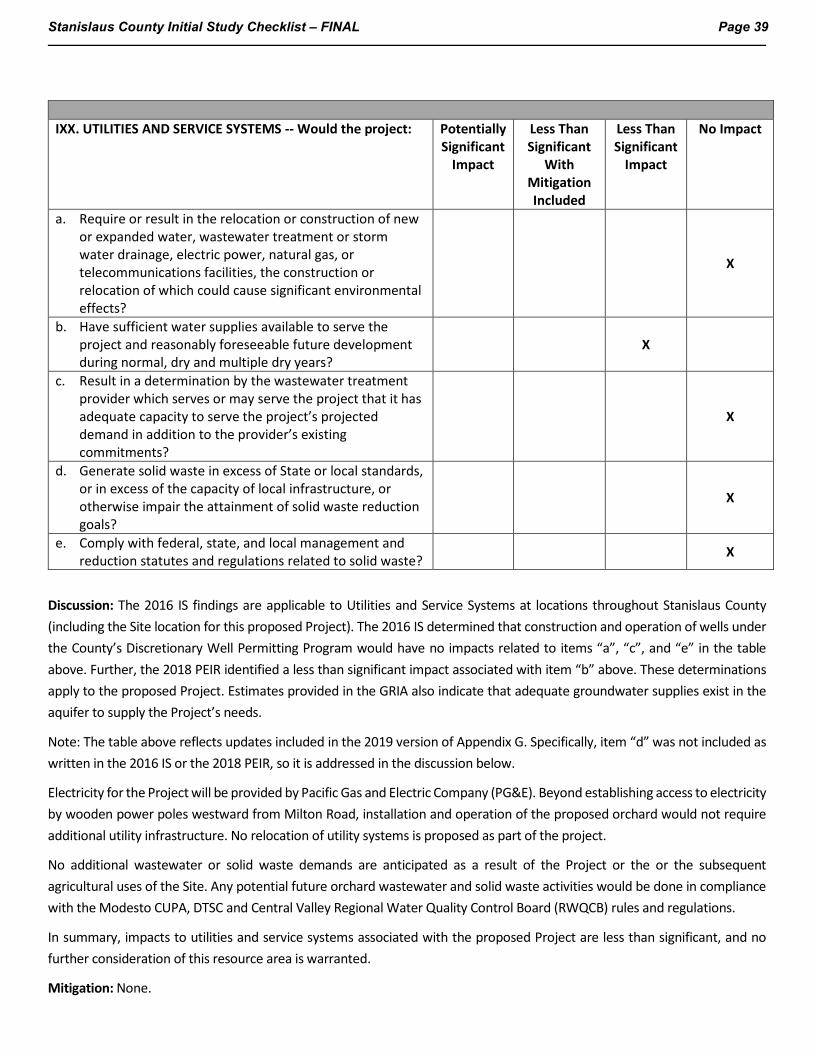
Stanislaus County Initial Study Checklist – FINAL Page 39
IXX. UTILITIES AND SERVICE SYSTEMS -- Would the project: Potentially
Significant Impact
Less Than Significant
With Mitigation Included
Less Than Significant
Impact
No Impact
a. Require or result in the relocation or construction of new or expanded water, wastewater treatment or storm water drainage, electric power, natural gas, or telecommunications facilities, the construction or relocation of which could cause significant environmental effects?
X
b. Have sufficient water supplies available to serve the project and reasonably foreseeable future development during normal, dry and multiple dry years?
X
c. Result in a determination by the wastewater treatment provider which serves or may serve the project that it has adequate capacity to serve the project’s projected demand in addition to the provider’s existing commitments?
X
d. Generate solid waste in excess of State or local standards, or in excess of the capacity of local infrastructure, or otherwise impair the attainment of solid waste reduction goals?
X
e. Comply with federal, state, and local management and reduction statutes and regulations related to solid waste? X
Discussion: The 2016 IS findings are applicable to Utilities and Service Systems at locations throughout Stanislaus County (including the Site location for this proposed Project). The 2016 IS determined that construction and operation of wells under the County’s Discretionary Well Permitting Program would have no impacts related to items “a”, “c”, and “e” in the table above. Further, the 2018 PEIR identified a less than significant impact associated with item “b” above. These determinations apply to the proposed Project. Estimates provided in the GRIA also indicate that adequate groundwater supplies exist in the aquifer to supply the Project’s needs.
Note: The table above reflects updates included in the 2019 version of Appendix G. Specifically, item “d” was not included as written in the 2016 IS or the 2018 PEIR, so it is addressed in the discussion below.
Electricity for the Project will be provided by Pacific Gas and Electric Company (PG&E). Beyond establishing access to electricity by wooden power poles westward from Milton Road, installation and operation of the proposed orchard would not require additional utility infrastructure. No relocation of utility systems is proposed as part of the project.
No additional wastewater or solid waste demands are anticipated as a result of the Project or the or the subsequent agricultural uses of the Site. Any potential future orchard wastewater and solid waste activities would be done in compliance with the Modesto CUPA, DTSC and Central Valley Regional Water Quality Control Board (RWQCB) rules and regulations.
In summary, impacts to utilities and service systems associated with the proposed Project are less than significant, and no further consideration of this resource area is warranted.
Mitigation: None.

Stanislaus County Initial Study Checklist – FINAL Page 40
References:
Jacobson James & Associates, Inc. and Tetra Tech, Inc., 2018. Final Program Environmental Impact Report for the Stanislaus County Discretionary Well Permitting and Management Program. Prepared for Stanislaus County Department of Environmental Resources. June 11.
Jacobson James & Associates, Inc. and Tetra Tech, Inc., 2016. Initial Study Discretionary Well Permitting and Management Program, Stanislaus County, California. October 3.
Stanislaus County Initial Study Checklist – FINAL Page 41
XX. WILDFIRE – Would the project: Potentially
Significant Impact
Less Than Significant
With Mitigation Included
Less Than Significant
Impact
No Impact
a. Substantially impair an adopted emergency response plan or emergency evacuation plan? X
b. Due to slope, prevailing winds, and other factors, exacerbate wildfire risks, and thereby expose project occupants to, pollutant concentrations from a wildfire or the uncontrolled spread of a wildfire?
X
c. Require the installation or maintenance of associated infrastructure (such as roads, fuel breaks, emergency water sources, power lines or other utilities) that may exacerbate fire risk or that may result in temporary or ongoing impacts to the environment?
X
d. Expose people or structures to significant risks, including downslope or downstream flooding or landslides, as a result of runoff, post-fire slope instability, or drainage changes?
X
Discussion: The Oakdale Rural Fire Protection District provides fire protection services to the unincorporated area of northern Stanislaus County, which includes the Project area. State Responsibility Areas are boundaries adopted by the Board of Forestry and Fire Protection. These designated State Responsibility Areas are areas where the California Department of Forestry and Fire (CAL FIRE), has a financial responsibility for fire suppression and prevention. These designated areas can be determined through review of the Stanislaus County Fire Hazard Severity Zone Maps for State Responsibility Area and Local Responsibility Area (CAL FIRE, 2007a and 2007b). Review of the Stanislaus County Fire Hazard Severity Zone Maps for State Responsibility Area and Local Responsibility Area indicate the proposed Project is located in a State Responsibility Area and located in an area of moderate fire hazard severity.
The proposed Project would not impair an adopted emergency response plan or emergency evacuation plan.
The Site is in a grassland environment. Routine fire prevention BMPs for construction activities will be implemented consistent with industry standards to prevent exposure of project occupants to pollutant concentrations from a wildfire or uncontrolled spread of wildfire. The BMP include:
• Before each workday, review CalFire and National Weather Service alerts for potential critical weather and dry conditions conducive to increased wildfire potential.
• Have clearly defined ingress and egress routes.
• Restrict smoking to inside vehicles or a clearly defined location with a water-based cigarette receptacle, and cleared of dry vegetation.
• Restrict vehicles from driving or parking on dry vegetation.
• If driving over vegetation is necessary, wet and remove the vegetation.
• Wet dry areas before commencing activities, and wet throughout the day, as appropriate.
Stanislaus County Initial Study Checklist – FINAL Page 42
• Have water sources available and require operators to carry fire extinguishers in their vehicles – in good working order and with current monthly and annual inspections.
• Assign on person as the Working Fire Watch, to monitor for fire ignitions at the jobsite while performing normal work duties.
The proposed Project includes extending power via new power poles west from Milton Road, with spacing ranging 300 to 500 ft apart. Electricity for the Project will be provided by PG&E. During periods of extreme weather, PG&E may temporarily turn power off to fire prone areas, which indirectly aids in the mitigation of wildfires at the Site.
Based on these findings, there would be less than significant impact.
Mitigation: None
References:
California Department of Forestry and Fire (CAL FIRE), 2007a. Stanislaus County Fire Hazard Severity Zone Maps in State Responsibility Area. November 7. https://osfm.fire.ca.gov/divisions/wildfire-prevention-planning-engineering/wildland-hazards-building-codes/fire-hazard-severity-zones-maps/ (Accessed May 4, 2020).
Cal Fire, 2007b. Stanislaus County Draft Fire Hazard Severity Zones in Local Responsibility Area. October 3. https://osfm.fire.ca.gov/divisions/wildfire-prevention-planning-engineering/wildland-hazards-building-codes/fire-hazard-severity-zones-maps/ (Accessed May 4, 2020).
Stanislaus County Initial Study Checklist – FINAL Page 43
XXI. MANDATORY FINDINGS OF SIGNIFICANCE -- Potentially
Significant Impact
Less Than Significant
With Mitigation Included
Less Than Significant
Impact
No Impact
a) Does the project have the potential to degrade the quality of the environment, substantially reduce the habitat of a fish or wildlife species, cause a fish or wildlife population to drop below self-sustaining levels, threaten to eliminate a plant or animal community, reduce the number or restrict the range of a rare or endangered plant or animal or eliminate important examples of the major periods of California history or prehistory?
X
b) Does the project have impacts that are individually limited, but cumulatively considerable? (“Cumulatively considerable” means that the incremental effects of a project are considerable when viewed in connection with the effects of past projects, the effects of other current projects, and the effects of probable future projects.)
X
c) Does the project have environmental effects which will cause substantial adverse effects on human beings, either directly or indirectly?
X
Discussion: Based on the evidence provided in this initial study, potential impacts related to mandatory findings of significance that are associated with the proposed Project are presumed to be less than significant. The Project and subsequent agricultural use actions involve avoiding aquatic resources, including 30 ft buffers between orchard blocks and delineated aquatic resources. Per the biological resources survey (Attachment 2), it is unlikely special status plants occur in the Site and the likelihood of special species wildlife is very low. Less than significant impacts are anticipated related to fish, wildlife species, or plant and animal communities per the Biological Resources discussion. Any potentially significant impacts would be reduced to less than significant levels through the implementation of the mitigation measures, as necessary, described in Section IV – Biological Resources, Section V – Cultural Resources, and Section X – Hydrology and Water Quality.
The GRIA (Attachment 4) indicates that 5-feet of drawdown would extend approximately 1.1 miles from the Site during Phase I after 20 years of pumping, and about 2.5 miles from the Site if Phase II were implemented. Drawdown exceeding 20-feet is limited to 0.15 miles south and southwest of the Site during Phase I and Phase II. Per the GRIA, “a monitoring and adaptive management program will be implemented during the early part of Phase I pumping and provide an evaluation and feedback mechanism that helps assure that groundwater extraction remains within the local sustainable yield, and does not cause or contribute to undesirable results.” Additionally, per the GRIA, groundwater levels in the area have remained relatively stable despite the agricultural activities occurring in the area. The monitoring proposed as part of the phasing of the Project will ensure that the implementation of the proposed Project will not result in adverse cumulative effects. Less than significant cumulative impacts are anticipated due to the proposed project.
As presented in this initial study, all potential impacts associated with the proposed Project would be reduced to less than significant levels with implementation of mitigation measures for 5 of the 20 resource areas: Biological Resources, Cultural Resources, Geology and Soils, Hydrology and Water Quality, and Tribal Cultural Resources. The proposed Project would not be expected to result in a considerable cumulative contribution to impacts on the environment with adherence to applicable

Stanislaus County Initial Study Checklist – FINAL Page 44
regulations and mitigation measures described in this initial study. As such, the proposed Project would result in a less than significant cumulative impact.
Additionally, the proposed Project is located in a rural portion of Stanislaus County and will not have a substantial adverse effect on human beings, either directly or indirectly.
Mitigation: None.
References:
Jacobson James & Associates, Inc. and Tetra Tech, Inc., 2018. Final Program Environmental Impact Report for the Stanislaus County Discretionary Well Permitting and Management Program. Prepared for Stanislaus County Department of Environmental Resources. June 11.
Jacobson James & Associates, Inc. and Tetra Tech, Inc., 2016. Initial Study Discretionary Well Permitting and Management Program, Stanislaus County, California. October 3.

Stanislaus County Initial Study Checklist – Final
Attachment 1 – Flow Charts
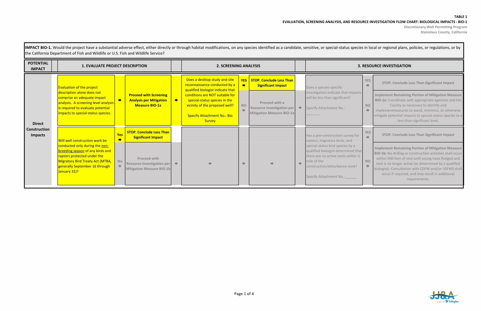
TABLE 1EVALUATION, SCREENING ANALYSIS, AND RESOURCE INVESTIGATION FLOW CHART: BIOLOGICAL IMPACTS ‐ BIO‐1
Discretionary Well Permitting ProgramStanislaus County, California
POTENTIAL IMPACT
YES
STOP. Conclude Less Than Significant Impact
YES
STOP. Conclude Less Than Significant Impact
Yes
STOP. Conclude Less Than Significant Impact
YES
STOP. Conclude Less Than Significant Impact
IMPACT BIO‐1. Would the project have a substantial adverse effect, either directly or through habitat modifications, on any species identified as a candidate, sensitive, or special‐status species in local or regional plans, policies, or regulations, or by the California Department of Fish and Wildlife or U.S. Fish and Wildlife Service?
Will well construction work be conducted only during the non‐breeding season of any birds and raptors protected under the Migratory Bird Treaty Act (MTBA, generally September 16 through January 31)?
1. EVALUATE PROJECT DESCRIPTION 2. SCREENING ANALYSIS
Implement Remaining Portion of Mitigation Measure BIO‐1a: Coordinate with appropriate agencies and the
County as necessary to identify and implementmeasures to avoid, minimize, or otherwise
mitigate potential impacts to special‐status species to a less‐than‐significant level.
3. RESOURCE INVESTIGATION
Has a pre‐construction survey for raptors, migratory birds, and special‐status bird species by a qualified biologist determined that there are no active nests within ½ mile of the construction/disturbance zone?
Specify Attachment No.:______
NO
Does a species‐specific investigation indicate that impacts will be less than significant?
Specify Attachment No.: _______
NO
Proceed with aResource Investigation per Mitigation Measure BIO‐1a
Does a desktop study and site reconnaissance conducted by a qualified biologist indicate that conditions are NOT suitable for
special‐status species in the vicinity of the proposed well?
Specify Attachment No.: Bio Survey
Evaluation of the project description alone does not comprise an adequate impact analysis. A screening level analysis is required to evaluate potential impacts to special‐status species.
Proceed with Screening Analysis per Mitigation
Measure BIO‐1a
Direct Construction
Impacts
Proceed with Resource Investigation per Mitigation Measure BIO‐1b
No
NO
Implement Remaining Portion of Mitigation Measure BIO‐1b: No drilling or construction activities shall occur
within 500‐feet of nest until young have fledged and nest is no longer active (as determined by a qualified
biologist). Consultation with CDFW and/or USFWS shall occur if required, and may result in additional
requirements.
Page 1 of 4

TABLE 1EVALUATION, SCREENING ANALYSIS, AND RESOURCE INVESTIGATION FLOW CHART: BIOLOGICAL IMPACTS ‐ BIO‐1
Discretionary Well Permitting ProgramStanislaus County, California
POTENTIAL IMPACT
Yes
STOP. Conclude Less Than Significant Impact
YES
STOP. Conclude Less Than Significant Impact
YES
STOP. Conclude Less Than Significant Impact
Yes
STOP. Conclude Less Than Significant Impact
YES
STOP. Conclude Less Than Significant Impact
Proceed with aScreening Analysis per the Discretionary Well Permit Process under the County Groundwater Ordinance
Will the proposed well be located within 50 feet of an existing well completed in the same aquifer, and will the combined operation of the existing and proposed well result in no net increase in local groundwater demand?
Direct Operation
Impacts
Proceed with a Surface‐Groundwater Interaction
Study per the Discretionary Well Permit Process under the County Groundwater Ordinance
For wells for which the answer to the above question is no, will the proposed well be located outside
a County‐designated Surface Water Protection Zone?
IMPACT BIO‐1. Would the project have a substantial adverse effect, either directly or through habitat modifications, on any species identified as a candidate, sensitive, or special‐status species in local or regional plans, policies, or regulations, or by the California Department of Fish and Wildlife or U.S. Fish and Wildlife Service?
1. EVALUATE PROJECT DESCRIPTION 2. SCREENING ANALYSIS 3. RESOURCE INVESTIGATION
NO
Proceed with a GDE Impact Study per the
Discretionary Well Permit Process under the County Groundwater Ordinance
Is the estimated drawdown beneath identified groundwater‐dependent ecosystems (GDEs) that are hydraulically connected to the pumped aquifer less than 0.5 foot?
Specify Attachment No.:_GRIA_
NO
Has a GDE Impact Study determined impacts to GDEs will be less than significant?
Specify Attachment No.:_GRIA_
No
Implement Remaining Portion of Mitigation Measure BIO‐1a: Coordinate with appropriate agencies and the
County as necessary to identify and implementmeasures to avoid, minimize, or otherwise
mitigate potential impacts to special‐status species to a less‐than‐significant level.
NO
No
Implement Remaining Portion of Mitigation Measure BIO‐1a: Coordinate with appropriate agencies and the
County as necessary to identify and implement measures to avoid, minimize, or otherwise mitigate potential impacts to special‐status species to a less‐
than‐significant level.
Has a Surface‐Groundwater Interaction Study determined impacts special status aquatic
species will be less than significant?
Specify Attachment No.:______
Page 2 of 4
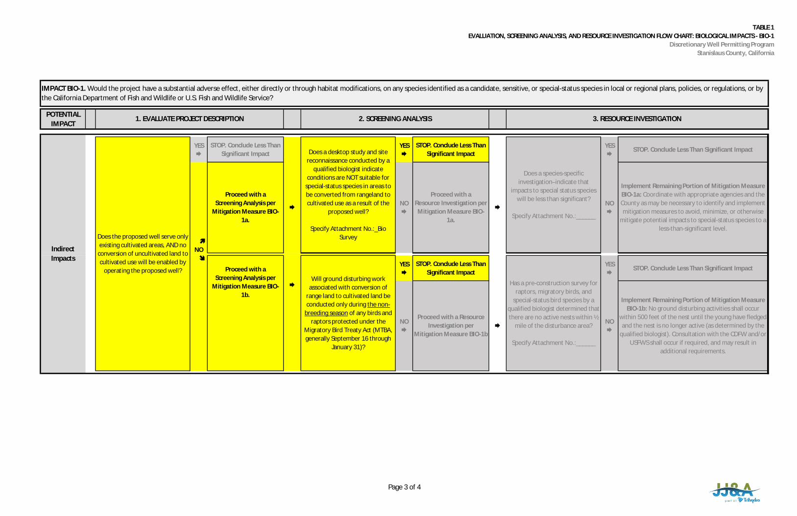
TABLE 1EVALUATION, SCREENING ANALYSIS, AND RESOURCE INVESTIGATION FLOW CHART: BIOLOGICAL IMPACTS - BIO-1
Discretionary Well Permitting ProgramStanislaus County, California
POTENTIALIMPACT
YES
STOP. Conclude Less ThanSignificant Impact
YES
STOP. Conclude Less ThanSignificant Impact
YES
STOP. Conclude Less Than Significant Impact
YES
STOP. Conclude Less ThanSignificant Impact
YES
STOP. Conclude Less Than Significant Impact
Will ground disturbing work
associated with conversion ofrange land to cultivated land beconducted only during the non-
breeding season of any birds andraptors protected under the
Migratory Bird Treaty Act (MTBA,generally September 16 through
January 31)?
Proceed with a ResourceInvestigation per
Mitigation Measure BIO-1b
NO
NO
Implement Remaining Portion of Mitigation MeasureBIO-1a: Coordinate with appropriate agencies and theCounty as may be necessary to identify and implementmitigation measures to avoid, minimize, or otherwise
mitigate potential impacts to special-status species to aless-than-significant level.
IndirectImpacts
Does the proposed well serve onlyexisting cultivated areas, AND no
conversion of uncultivated land tocultivated use will be enabled by
operating the proposed well?
NO
Does a desktop study and sitereconnaissance conducted by a
qualified biologist indicateconditions are NOT suitable for
special-status species in areas tobe converted from rangeland tocultivated use as a result of the
proposed well?
Specify Attachment No.:_BioSurvey
Does a species-specificinvestigation indicate that
impacts to special status specieswill be less than significant?
Specify Attachment No.:______
NO
Proceed with aResource Investigation perMitigation Measure BIO-
1a.
Proceed with aScreening Analysis per
Mitigation Measure BIO-1a.
Proceed with aScreening Analysis per
Mitigation Measure BIO-1b.
IMPACT BIO-1. Would the project have a substantial adverse effect, either directly or through habitat modifications, on any species identified as a candidate, sensitive, or special-status species in local or regional plans, policies, or regulations, or bythe California Department of Fish and Wildlife or U.S. Fish and Wildlife Service?
1. EVALUATE PROJECT DESCRIPTION 2. SCREENING ANALYSIS 3. RESOURCE INVESTIGATION
Has a pre-construction survey forraptors, migratory birds, and
special-status bird species by aqualified biologist determined thatthere are no active nests within ½
mile of the disturbance area?
Specify Attachment No.:______
Implement Remaining Portion of Mitigation MeasureBIO-1b: No ground disturbing activities shall occur
within 500 feet of the nest until the young have fledgedand the nest is no longer active (as determined by the
qualified biologist). Consultation with the CDFW and/orUSFWS shall occur if required, and may result in
additional requirements.
NO
Page 3 of 4
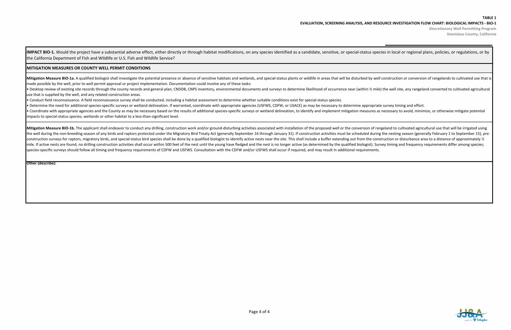
TABLE 1EVALUATION, SCREENING ANALYSIS, AND RESOURCE INVESTIGATION FLOW CHART: BIOLOGICAL IMPACTS ‐ BIO‐1
Discretionary Well Permitting ProgramStanislaus County, California
IMPACT BIO‐1. Would the project have a substantial adverse effect, either directly or through habitat modifications, on any species identified as a candidate, sensitive, or special‐status species in local or regional plans, policies, or regulations, or by the California Department of Fish and Wildlife or U.S. Fish and Wildlife Service?
Other (describe):
Mitigation Measure BIO‐1b. The applicant shall endeavor to conduct any drilling, construction work and/or ground‐disturbing activities associated with installation of the proposed well or the conversion of rangeland to cultivated agricultural use that will be irrigated using the well during the non‐breeding season of any birds and raptors protected under the Migratory Bird Treaty Act (generally September 16 through January 31). If construction activities must be scheduled during the nesting season (generally February 1 to September 15), pre‐construction surveys for raptors, migratory birds, and special‐status bird species shall be done by a qualified biologist to identify active nests near the site. This shall include a buffer extending out from the construction or disturbance area to a distance of approximately ½ mile. If active nests are found, no drilling construction activities shall occur within 500 feet of the nest until the young have fledged and the nest is no longer active (as determined by the qualified biologist). Survey timing and frequency requirements differ among species; species‐specific surveys should follow all timing and frequency requirements of CDFW and USFWS. Consultation with the CDFW and/or USFWS shall occur if required, and may result in additional requirements.
MITIGATION MEASURES OR COUNTY WELL PERMIT CONDITIONS
Mitigation Measure BIO‐1a. A qualified biologist shall investigate the potential presence or absence of sensitive habitats and wetlands, and special‐status plants or wildlife in areas that will be disturbed by well construction or conversion of rangelands to cultivated use that is made possible by the well, prior to well permit approval or project implementation. Documentation could involve any of these tasks:• Desktop review of existing site records through the county records and general plan, CNDDB, CNPS inventory, environmental documents and surveys to determine likelihood of occurrence near (within ½ mile) the well site, any rangeland converted to cultivated agriculturaluse that is supplied by the well, and any related construction areas.• Conduct field reconnaissance. A field reconnaissance survey shall be conducted, including a habitat assessment to determine whether suitable conditions exist for special‐status species.• Determine the need for additional species‐specific surveys or wetland delineation. If warranted, coordinate with appropriate agencies (USFWS, CDFW, or USACE) as may be necessary to determine appropriate survey timing and effort.• Coordinate with appropriate agencies and the County as may be necessary based on the results of additional species‐specific surveys or wetland delineation, to identify and implement mitigation measures as necessary to avoid, minimize, or otherwise mitigate potentialimpacts to special‐status species, wetlands or other habitat to a less‐than‐significant level.
Page 4 of 4
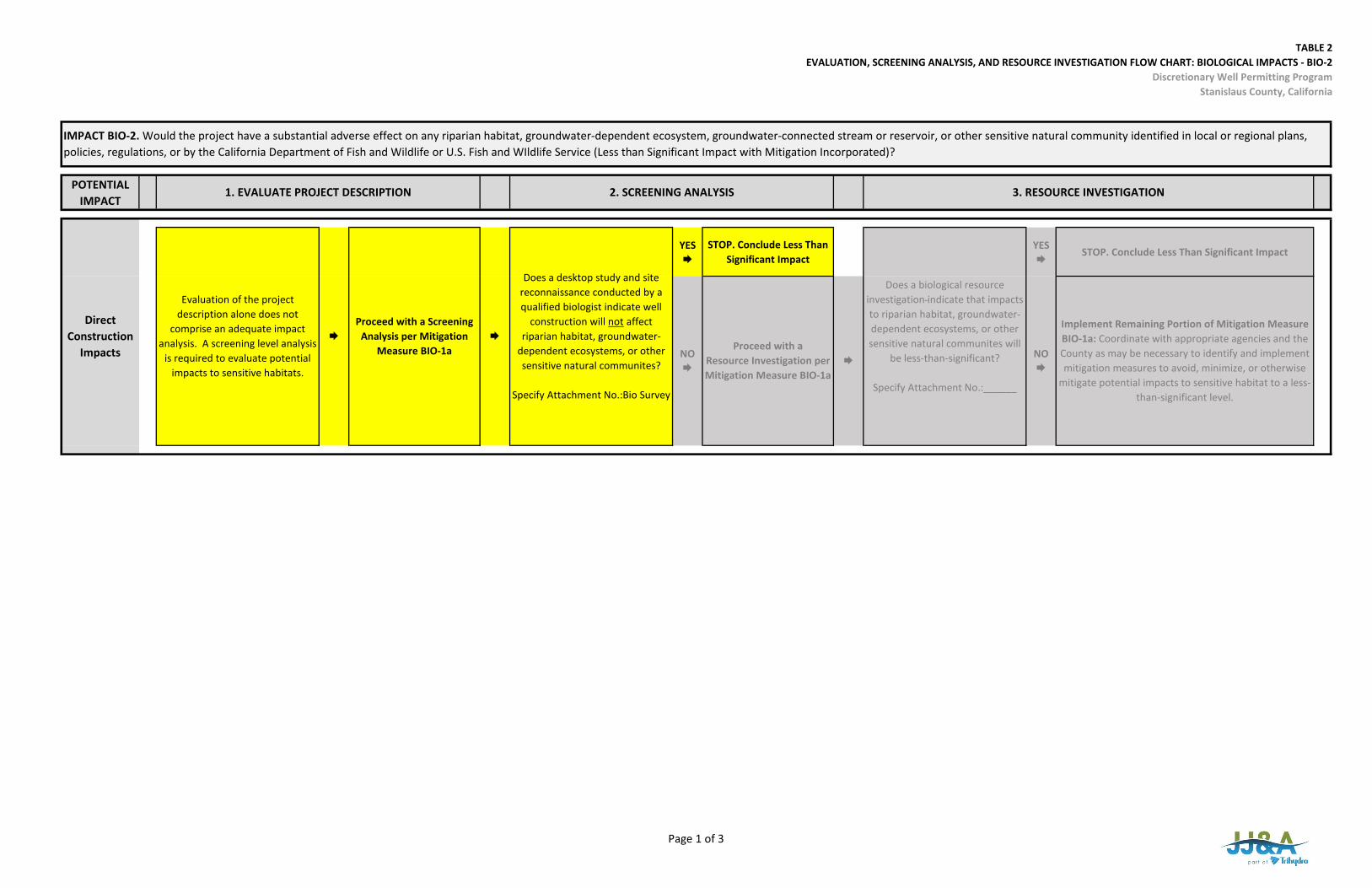
TABLE 2EVALUATION, SCREENING ANALYSIS, AND RESOURCE INVESTIGATION FLOW CHART: BIOLOGICAL IMPACTS ‐ BIO‐2
Discretionary Well Permitting ProgramStanislaus County, California
POTENTIAL IMPACT
YES
STOP. Conclude Less Than Significant Impact
YES
STOP. Conclude Less Than Significant Impact
NO
Implement Remaining Portion of Mitigation Measure BIO‐1a: Coordinate with appropriate agencies and the County as may be necessary to identify and implement mitigation measures to avoid, minimize, or otherwise
mitigate potential impacts to sensitive habitat to a less‐than‐significant level.
IMPACT BIO‐2. Would the project have a substantial adverse effect on any riparian habitat, groundwater‐dependent ecosystem, groundwater‐connected stream or reservoir, or other sensitive natural community identified in local or regional plans, policies, regulations, or by the California Department of Fish and Wildlife or U.S. Fish and WIldlife Service (Less than Significant Impact with Mitigation Incorporated)?
1. EVALUATE PROJECT DESCRIPTION 2. SCREENING ANALYSIS 3. RESOURCE INVESTIGATION
Direct Construction
Impacts
Evaluation of the project description alone does not
comprise an adequate impact analysis. A screening level analysis
is required to evaluate potential impacts to sensitive habitats.
Proceed with a Screening
Analysis per Mitigation Measure BIO‐1a
Does a desktop study and site reconnaissance conducted by a qualified biologist indicate well
construction will not affect riparian habitat, groundwater‐
dependent ecosystems, or other sensitive natural communites?
Specify Attachment No.:Bio Survey
Does a biological resource investigation indicate that impacts to riparian habitat, groundwater‐dependent ecosystems, or other sensitive natural communites will
be less‐than‐significant?
Specify Attachment No.:______
NO
Proceed with aResource Investigation per Mitigation Measure BIO‐1a
Page 1 of 3
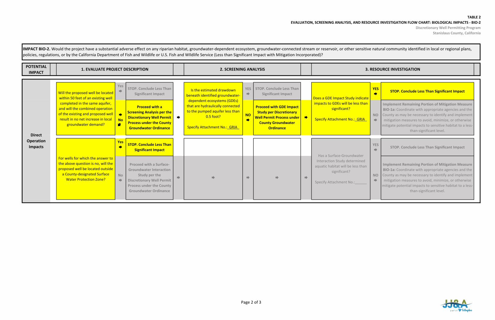
TABLE 2EVALUATION, SCREENING ANALYSIS, AND RESOURCE INVESTIGATION FLOW CHART: BIOLOGICAL IMPACTS ‐ BIO‐2
Discretionary Well Permitting ProgramStanislaus County, California
POTENTIAL IMPACT
IMPACT BIO‐2. Would the project have a substantial adverse effect on any riparian habitat, groundwater‐dependent ecosystem, groundwater‐connected stream or reservoir, or other sensitive natural community identified in local or regional plans, policies, regulations, or by the California Department of Fish and Wildlife or U.S. Fish and WIldlife Service (Less than Significant Impact with Mitigation Incorporated)?
1. EVALUATE PROJECT DESCRIPTION 2. SCREENING ANALYSIS 3. RESOURCE INVESTIGATION
Yes
STOP. Conclude Less Than Significant Impact
YES
STOP. Conclude Less Than Significant Impact
YES
STOP. Conclude Less Than Significant Impact
Yes
STOP. Conclude Less Than Significant Impact
YES
STOP. Conclude Less Than Significant Impact
Implement Remaining Portion of Mitigation Measure BIO‐1a: Coordinate with appropriate agencies and the County as may be necessary to identify and implement mitigation measures to avoid, minimize, or otherwise
mitigate potential impacts to sensitive habitat to a less‐than‐significant level.
For wells for which the answer to the above question is no, will the proposed well be located outside
a County‐designated Surface Water Protection Zone?
Has a Surface‐Groundwater Interaction Study determined
aquatic habitat will be less than significant?
Specify Attachment No.:______
No
Proceed with a Surface‐Groundwater Interaction
Study per the Discretionary Well Permit Process under the County Groundwater Ordinance
Implement Remaining Portion of Mitigation Measure BIO‐1a: Coordinate with appropriate agencies and the County as may be necessary to identify and implement mitigation measures to avoid, minimize, or otherwise
mitigate potential impacts to sensitive habitat to a less‐than‐significant level.
Will the proposed well be located within 50 feet of an existing well completed in the same aquifer,
and will the combined operation of the existing and proposed well result in no net increase in local
groundwater demand?
Is the estimated drawdown beneath identified groundwater‐
dependent ecosystems (GDEs) that are hydraulically connected to the pumped aquifer less than
0.5 foot?
Specify Attachment No.:_GRIA_
Does a GDE Impact Study indicate impacts to GDEs will be less than
significant?
Specify Attachment No.:_GRIA_No
Proceed with aScreening Analysis per the Discretionary Well Permit Process under the County Groundwater Ordinance
NO
NO
Direct Operation
Impacts
Proceed with GDE Impact Study per Discretionary
Well Permit Process under County Groundwater
Ordinance
NO
Page 2 of 3
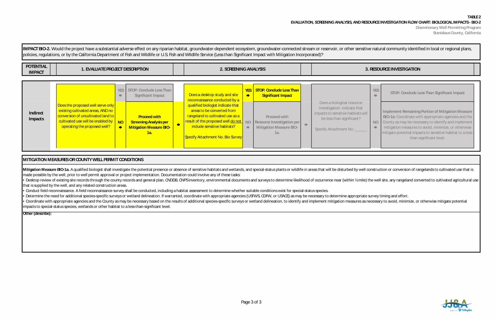
TABLE 2EVALUATION, SCREENING ANALYSIS, AND RESOURCE INVESTIGATION FLOW CHART: BIOLOGICAL IMPACTS - BIO-2
Discretionary Well Permitting ProgramStanislaus County, California
POTENTIALIMPACT
IMPACT BIO-2. Would the project have a substantial adverse effect on any riparian habitat, groundwater-dependent ecosystem, groundwater-connected stream or reservoir, or other sensitive natural community identified in local or regional plans,policies, regulations, or by the California Department of Fish and Wildlife or U.S. Fish and WIldlife Service (Less than Significant Impact with Mitigation Incorporated)?
1. EVALUATE PROJECT DESCRIPTION 2. SCREENING ANALYSIS 3. RESOURCE INVESTIGATION
YES
STOP. Conclude Less ThanSignificant Impact
YES
STOP. Conclude Less ThanSignificant Impact
YES
STOP. Conclude Less Than Significant Impact
Other (describe):
Implement Remaining Portion of Mitigation MeasureBIO-1a: Coordinate with appropriate agencies and theCounty as may be necessary to identify and implementmitigation measures to avoid, minimize, or otherwise
mitigate potential impacts to sensitive habitat to a less-than-significant level.
Proceed withScreening Analysis per
Mitigation Measure BIO-1a.
NO
MITIGATION MEASURES OR COUNTY WELL PERMIT CONDITIONS
Mitigation Measure BIO-1a. A qualified biologist shall investigate the potential presence or absence of sensitive habitats and wetlands, and special-status plants or wildlife in areas that will be disturbed by well construction or conversion of rangelands to cultivated use that ismade possible by the well, prior to well permit approval or project implementation. Documentation could involve any of these tasks:• Desktop review of existing site records through the county records and general plan, CNDDB, CNPS inventory, environmental documents and surveys to determine likelihood of occurrence near (within ½ mile) the well site, any rangeland converted to cultivated agricultural usethat is supplied by the well, and any related construction areas.• Conduct field reconnaissance. A field reconnaissance survey shall be conducted, including a habitat assessment to determine whether suitable conditions exist for special-status species.• Determine the need for additional species-specific surveys or wetland delineation. If warranted, coordinate with appropriate agencies (USFWS, CDFW, or USACE) as may be necessary to determine appropriate survey timing and effort.• Coordinate with appropriate agencies and the County as may be necessary based on the results of additional species-specific surveys or wetland delineation, to identify and implement mitigation measures as necessary to avoid, minimize, or otherwise mitigate potentialimpacts to special-status species, wetlands or other habitat to a less-than-significant level.
IndirectImpacts
Does the proposed well serve onlyexisting cultivated areas, AND no
conversion of uncultivated land tocultivated use will be enabled by
operating the proposed well?
Does a desktop study and sitereconnaissance conducted by aqualified biologist indicate that
areas to be converted fromrangeland to cultivated use as a
result of the proposed well do notinclude sensitive habitats?
Specify Attachment No.:Bio Survey
Does a biological resourceinvestigation indicate that
impacts to sensitvie habitats willbe less than significant?
Specify Attachment No.:______
NO
NO
Proceed withResource Investigation perMitigation Measure BIO-
1a.
Page 3 of 3
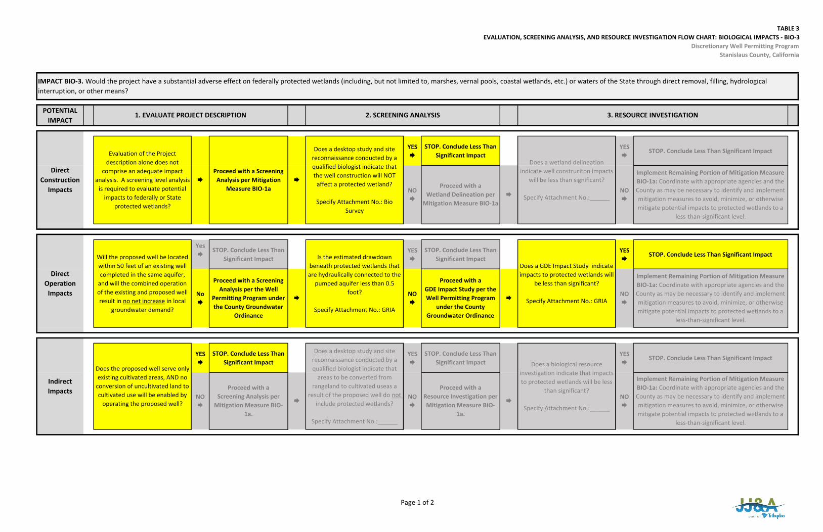
TABLE 3EVALUATION, SCREENING ANALYSIS, AND RESOURCE INVESTIGATION FLOW CHART: BIOLOGICAL IMPACTS ‐ BIO‐3
Discretionary Well Permitting ProgramStanislaus County, California
POTENTIAL IMPACT
YES
STOP. Conclude Less Than Significant Impact
YES
STOP. Conclude Less Than Significant Impact
Yes
STOP. Conclude Less Than Significant Impact
YES
STOP. Conclude Less Than Significant Impact
YES
STOP. Conclude Less Than Significant Impact
YES
STOP. Conclude Less Than Significant Impact
YES
STOP. Conclude Less Than Significant Impact
YES
STOP. Conclude Less Than Significant Impact
Implement Remaining Portion of Mitigation Measure BIO‐1a: Coordinate with appropriate agencies and the County as may be necessary to identify and implement mitigation measures to avoid, minimize, or otherwise mitigate potential impacts to protected wetlands to a
less‐than‐significant level.
NO
Does a GDE Impact Study indicate impacts to protected wetlands will
be less than significant?
Specify Attachment No.: GRIA
Is the estimated drawdown beneath protected wetlands that are hydraulically connected to the
pumped aquifer less than 0.5 foot?
Specify Attachment No.: GRIA
NO
Proceed with aResource Investigation per Mitigation Measure BIO‐
1a.
NO
Proceed with aGDE Impact Study per the Well Permitting Program
under the County Groundwater Ordinance
IMPACT BIO‐3. Would the project have a substantial adverse effect on federally protected wetlands (including, but not limited to, marshes, vernal pools, coastal wetlands, etc.) or waters of the State through direct removal, filling, hydrological interruption, or other means?
1. EVALUATE PROJECT DESCRIPTION 2. SCREENING ANALYSIS
Implement Remaining Portion of Mitigation Measure BIO‐1a: Coordinate with appropriate agencies and the County as may be necessary to identify and implement mitigation measures to avoid, minimize, or otherwise mitigate potential impacts to protected wetlands to a
less‐than‐significant level.
3. RESOURCE INVESTIGATION
Does a wetland delineation indicate well construciton impacts
will be less than significant?
Specify Attachment No.:______
Evaluation of the Project description alone does not
comprise an adequate impact analysis. A screening level analysis
is required to evaluate potential impacts to federally or State
protected wetlands?
Proceed with a Screening
Analysis per Mitigation Measure BIO‐1a
Direct Construction
Impacts NO
Proceed with aWetland Delineation per
Mitigation Measure BIO‐1a
Does a desktop study and site reconnaissance conducted by a qualified biologist indicate that the well construction will NOT
affect a protected wetland?
Specify Attachment No.: Bio Survey
NO
Direct Operation
Impacts
Will the proposed well be located within 50 feet of an existing well completed in the same aquifer,
and will the combined operation of the existing and proposed well result in no net increase in local
groundwater demand?
No
Proceed with a Screening Analysis per the Well
Permitting Program under the County Groundwater
Ordinance
NO
Implement Remaining Portion of Mitigation Measure BIO‐1a: Coordinate with appropriate agencies and the County as may be necessary to identify and implement mitigation measures to avoid, minimize, or otherwise mitigate potential impacts to protected wetlands to a
less‐than‐significant level.
Indirect Impacts
Does the proposed well serve only existing cultivated areas, AND no
conversion of uncultivated land to cultivated use will be enabled by
operating the proposed well?NO
Does a desktop study and site reconnaissance conducted by a qualified biologist indicate that
areas to be converted from rangeland to cultivated useas a
result of the proposed well do not include protected wetlands?
Specify Attachment No.:______
Does a biological resource investigation indicate that impacts to protected wetlands will be less
than significant?
Specify Attachment No.:______
Proceed with aScreening Analysis per
Mitigation Measure BIO‐1a.
Page 1 of 2

TABLE 3EVALUATION, SCREENING ANALYSIS, AND RESOURCE INVESTIGATION FLOW CHART: BIOLOGICAL IMPACTS ‐ BIO‐3
Discretionary Well Permitting ProgramStanislaus County, California
Other (describe):
MITIGATION MEASURES OR COUNTY WELL PERMIT CONDITIONS
Mitigation Measure BIO‐1a. A qualified biologist shall investigate the potential presence or absence of sensitive habitats and wetlands, and special‐status plants or wildlife in areas that will be disturbed by well construction or conversion of rangelands to cultivated use that is made possible by the well, prior to well permit approval or project implementation. Documentation could involve any of these tasks:• Desktop review of existing site records through the county records and general plan, CNDDB, CNPS inventory, environmental documents and surveys to determine likelihood of occurrence near (within ½ mile) the well site, any rangeland converted to cultivated agricultural usethat is supplied by the well, and any related construction areas.• Conduct field reconnaissance. A field reconnaissance survey shall be conducted, including a habitat assessment to determine whether suitable conditions exist for special‐status species.• Determine the need for additional species‐specific surveys or wetland delineation. If warranted, coordinate with appropriate agencies (USFWS, CDFW, or USACE) as may be necessary to determine appropriate survey timing and effort.• Coordinate with appropriate agencies and the County as may be necessary based on the results of additional species‐specific surveys or wetland delineation, to identify and implement mitigation measures as necessary to avoid, minimize, or otherwise mitigate potentialimpacts to special‐status species, wetlands or other habitat to a less‐than‐significant level.
Page 2 of 2

TABLE 4EVALUATION, SCREENING ANALYSIS, AND RESOURCE INVESTIGATION FLOW CHART: BIOLOGICAL IMPACTS ‐ BIO‐4
Discretionary Well Permitting ProgramStanislaus County, California
POTENTIAL IMPACT
YES
STOP. Conclude Less Than Significant Impact
YES
STOP. Conclude Less Than Significant Impact
YES
STOP. Conclude Less Than Significant Impact
YES
STOP. Conclude Less Than Significant Impact
YES
STOP. Conclude Less Than Significant Impact
YES
STOP. Conclude Less Than Significant Impact
Deny Permit based on proposed project
description or initiate the appropriate exemption
process.
IMPACT BIO‐4. Would the project conflict with any local policies or ordinances protecting biological resources such as a tree preservation policy or ordinance?
1. EVALUATE PROJECT DESCRIPTION 2. SCREENING ANALYSIS 3. RESOURCE INVESTIGATION
Direct Construction
Impacts
Evaluation of the Project description alone does not comprise an adequate impact analysis. A screening level analysis is required to evaluate potential conflicts with local ordinances and policies.
Proceed with a Screening
Analysis per Mitigation Measure BIO‐4
Would construction of the proposed well be consistent with local policies or ordinances protecting biological resources, including but not limited to:‐native hardwood habitats, ‐natural vegetation along streambanks, or‐habitats for rare or endangered wildlife or fish species?
Would the proposed mitigation measures or project changes decrease impacts to a
less‐than‐significant level?NO
Consider Mitigation Measures or Project
changes per Mitigation Measure BIO‐4.
NO
Deny Permit based on proposed project
description or initiate the appropriate exemption
process.
Direct Operation Impacts
Evaluation of the Project description alone does not comprise an adequate impact analysis. A screening level analysis is required to evaluate potential conflicts with local ordinances and policies.
Proceed with a Screening
Analysis per Mitigation Measure BIO‐4
Would operation of the proposed well be consistent with local policies or ordinances protecting biological resources, including but not limited to:‐native hardwood habitats, ‐natural vegetation along streambanks, or‐habitats for rare or endangered wildlife or fish species?
Would the proposed mitigation measures or project changes decrease impacts to a
less‐than‐significant level?NO
Consider Mitigation Measures or Project
changes per Mitigation Measure BIO‐4.
NO
MITIGATION MEASURES OR COUNTY WELL PERMIT CONDITIONS
Mitigation Measure BIO‐4. Evaluate well construction permit applications to assess potential conflicts with local policies or ordinances that protect biological resources, and consider mitigation measures for significant effects on the environment on a project‐specific basis.
Other (describe):
Deny Permit based on proposed project
description or initiate the appropriate exemption
process.
BIO‐4. Indirect Impacts
Evaluation of the Project description alone does not comprise an adequate impact analysis. A screening level analysis is required to evaluate potential conflicts with local ordinances and policies.
Proceed with a Screening
Analysis per Mitigation Measure BIO‐4
Would conversion or rangeland to agricultural use or other activities made possible by the proposed well be consistent with local policies or ordinances protecting biological resources, including but not limited to:‐native hardwood habitats, ‐natural vegetation along streambanks, or‐habitats for rare or endangered wildlife or fish species?
Would the proposed mitigation measures or project changes decrease impacts to a
less‐than‐significant level?NO
Consider Mitigation Measures or Project
changes per Mitigation Measure BIO‐4.
NO
Page 1 of 1
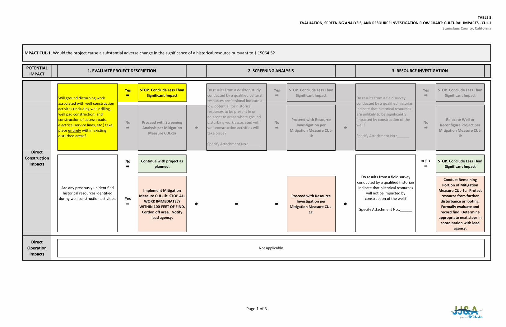
TABLE 5EVALUATION, SCREENING ANALYSIS, AND RESOURCE INVESTIGATION FLOW CHART: CULTURAL IMPACTS ‐ CUL‐1
Stanislaus County, California
POTENTIAL IMPACT
Yes
STOP. Conclude Less Than Significant Impact
Yes
STOP. Conclude Less Than Significant Impact
Yes
STOP. Conclude Less Than Significant Impact
No
Proceed with Screening Analysis per Mitigation
Measure CUL‐1a
No
Proceed with Resource Investigation per
Mitigation Measure CUL‐1b
No
Relocate Well or Reconfigure Project per
Mitigation Measure CUL‐1b
No
Continue with project as planned.
STOP. Conclude Less Than Significant Impact
Yes
Implement Mitigation Measure CUL‐1b: STOP ALL
WORK IMMEDIATELY WITHIN 100‐FEET OF FIND.
Cordon off area. Notify lead agency.
Proceed with Resource Investigation per
Mitigation Measure CUL‐1c.
Conduct Remaining Portion of Mitigation
Measure CUL‐1c: Protect resource from further disturbance or looting. Formally evaluate and record find. Determine
appropriate next steps in coordination with lead
agency.
Will ground disturbing work associated with well construction activites (including well drilling, well pad construction, and construction of access roads, electrical service lines, etc.) take place entirely within existing disturbed areas?
Do results from a desktop study conducted by a qualified cultural resources professional indicate a low potential for historical resources to be present in or adjacent to areas where ground disturbing work associated with well construction activities will take place?
Specify Attachment No.:______
Do results from a field survey conducted by a qualified historian indicate that historical resources are unlikely to be significantly impacted by construction of the well?
Specify Attachment No.:______
Are any previously unidentified historical resources identified
during well construction activities.
Do results from a field survey conducted by a qualified historian indicate that historical resources
will not be impacted by construction of the well?
Specify Attachment No.:______
IMPACT CUL‐1. Would the project cause a substantial adverse change in the significance of a historical resource pursuant to § 15064.5?
1. EVALUATE PROJECT DESCRIPTION 2. SCREENING ANALYSIS 3. RESOURCE INVESTIGATION
Direct Operation
ImpactsNot applicable
Direct Construction
Impacts
Page 1 of 3
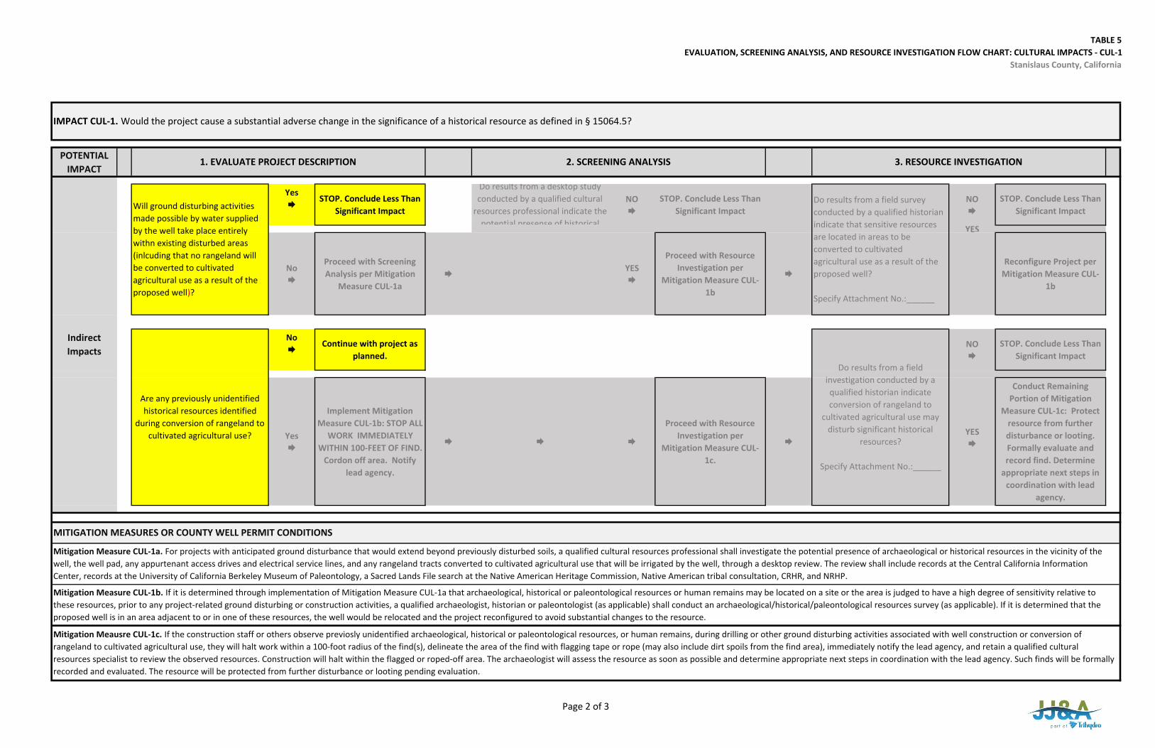
TABLE 5EVALUATION, SCREENING ANALYSIS, AND RESOURCE INVESTIGATION FLOW CHART: CULTURAL IMPACTS ‐ CUL‐1
Stanislaus County, California
POTENTIAL IMPACT
Yes
STOP. Conclude Less Than Significant Impact
Do results from a desktop study conducted by a qualified cultural
resources professional indicate the potential presense of historical
NO
STOP. Conclude Less Than Significant Impact
NO
STOP. Conclude Less Than Significant Impact
YES
No
Proceed with Screening Analysis per Mitigation
Measure CUL‐1a
YES
Proceed with Resource Investigation per
Mitigation Measure CUL‐1b
Reconfigure Project per
Mitigation Measure CUL‐1b
No
Continue with project as planned.
NO
STOP. Conclude Less Than Significant Impact
Yes
Implement Mitigation Measure CUL‐1b: STOP ALL
WORK IMMEDIATELY WITHIN 100‐FEET OF FIND.
Cordon off area. Notify lead agency.
Proceed with Resource Investigation per
Mitigation Measure CUL‐1c.
Conduct Remaining Portion of Mitigation
Measure CUL‐1c: Protect resource from further disturbance or looting. Formally evaluate and record find. Determine
appropriate next steps in coordination with lead
agency.
Indirect Impacts
Will ground disturbing activities made possible by water supplied by the well take place entirely withn existing disturbed areas (inlcuding that no rangeland will be converted to cultivated agricultural use as a result of the proposed well)?
Do results from a field survey conducted by a qualified historian indicate that sensitive resources are located in areas to be converted to cultivated agricultural use as a result of the proposed well?
Specify Attachment No.:______
IMPACT CUL‐1. Would the project cause a substantial adverse change in the significance of a historical resource as defined in § 15064.5?
1. EVALUATE PROJECT DESCRIPTION 2. SCREENING ANALYSIS 3. RESOURCE INVESTIGATION
Mitigation Meausre CUL‐1c. If the construction staff or others observe previosly unidentified archaeological, historical or paleontological resources, or human remains, during drilling or other ground disturbing activities associated with well construction or conversion of rangeland to cultivated agricultural use, they will halt work within a 100‐foot radius of the find(s), delineate the area of the find with flagging tape or rope (may also include dirt spoils from the find area), immediately notify the lead agency, and retain a qualified cultural resources specialist to review the observed resources. Construction will halt within the flagged or roped‐off area. The archaeologist will assess the resource as soon as possible and determine appropriate next steps in coordination with the lead agency. Such finds will be formally recorded and evaluated. The resource will be protected from further disturbance or looting pending evaluation.
Mitigation Measure CUL‐1b. If it is determined through implementation of Mitigation Measure CUL‐1a that archaeological, historical or paleontological resources or human remains may be located on a site or the area is judged to have a high degree of sensitivity relative to these resources, prior to any project‐related ground disturbing or construction activities, a qualified archaeologist, historian or paleontologist (as applicable) shall conduct an archaeological/historical/paleontological resources survey (as applicable). If it is determined that the proposed well is in an area adjacent to or in one of these resources, the well would be relocated and the project reconfigured to avoid substantial changes to the resource.
MITIGATION MEASURES OR COUNTY WELL PERMIT CONDITIONS
Mitigation Measure CUL‐1a. For projects with anticipated ground disturbance that would extend beyond previously disturbed soils, a qualified cultural resources professional shall investigate the potential presence of archaeological or historical resources in the vicinity of the well, the well pad, any appurtenant access drives and electrical service lines, and any rangeland tracts converted to cultivated agricultural use that will be irrigated by the well, through a desktop review. The review shall include records at the Central California Information Center, records at the University of California Berkeley Museum of Paleontology, a Sacred Lands File search at the Native American Heritage Commission, Native American tribal consultation, CRHR, and NRHP.
Are any previously unidentified historical resources identified
during conversion of rangeland to cultivated agricultural use?
Do results from a field investigation conducted by a qualified historian indicate conversion of rangeland to
cultivated agricultural use may disturb significant historical
resources?
Specify Attachment No.:______
YES
Page 2 of 3
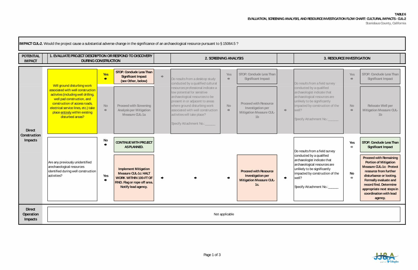
TABLE 6EVALUATION, SCREENING ANALYSIS, AND RESOURCE INVESTIGATION FLOW CHART: CULTURAL IMPACTS - CUL-2
Stanislaus County, California
POTENTIALIMPACT
Yes
STOP. Conclude Less ThanSignificant Impact(see Other, below)
Yes
STOP. Conclude Less ThanSignificant Impact
Yes
STOP. Conclude Less ThanSignificant Impact
No
Proceed with ScreeningAnalysis per Mitigation
Measure CUL-1a
No
Proceed with ResourceInvestigation per
Mitigation Measure CUL-1b
No
Relocate Well perMitigation Measure CUL-
1b
No
CONTINUE WITH PROJECTAS PLANNED.
Yes
STOP. Conclude Less ThanSignificant Impact
Yes
Implement MitigationMeasure CUL-1c: HALT
WORK WITHIN 100-FT OFFIND. Flag or rope off area.
Notify lead agency.
Proceed with ResourceInvestigation per
Mitigation Measure CUL-1c.
No
Proceed with RemainingPortion of Mitigation
Measure CUL-1c: Protectresource from furtherdisturbance or looting.Formally evaluate andrecord find. Determine
appropriate next steps incoordination with lead
agency.
IMPACT CUL-2. Would the project cause a substantial adverse change in the significance of an archaeological resource pursuant to § 15064.5 ?
1. EVALUATE PROJECT DESCRIPTION OR RESPOND TO DISCOVERYDURING CONSTRUCTION
2. SCREENING ANALYSIS 3. RESOURCE INVESTIGATION
Will ground disturbing workassociated with well constructionactivites (including well drilling,
well pad construction, andconstruction of access roads,
electrical service lines, etc.) takeplace entirely within existing
disturbed areas?
Do results from a desktop studyconducted by a qualified culturalresources professional indicate alow potential for sensitivearchaeological resources to bepresent in or adjacent to areaswhere ground disturbing workassociated with well constructionactivities will take place?
Specify Attachment No.:______
Do results from a field surveyconducted by a qualifiedarchaeologist indicate thatarchaeological resources areunlikely to be significantlyimpacted by construction of thewell?
Specify Attachment No.:______
Are any previously unidentifiedarechaeological resourcesidentified during well constructionactivities?
DirectConstruction
Impacts
Do results from a field surveyconducted by a qualifiedarchaeologist indicate thatarchaeological resources areunlikely to be significantlyimpacted by construction of thewell?
Specify Attachment No.:______
DirectOperation
ImpactsNot applicable
Page 1 of 3
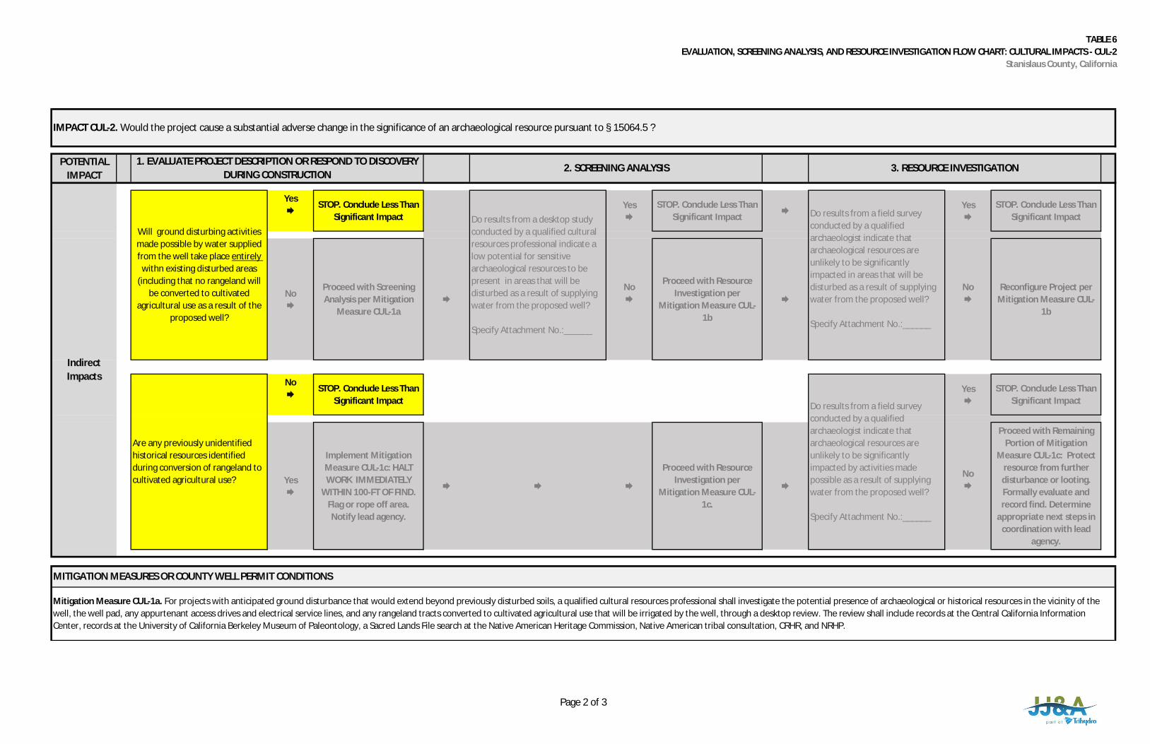
TABLE 6EVALUATION, SCREENING ANALYSIS, AND RESOURCE INVESTIGATION FLOW CHART: CULTURAL IMPACTS - CUL-2
Stanislaus County, California
POTENTIALIMPACT
Yes
STOP. Conclude Less ThanSignificant Impact
Yes
STOP. Conclude Less ThanSignificant Impact
Yes
STOP. Conclude Less ThanSignificant Impact
No
Proceed with ScreeningAnalysis per Mitigation
Measure CUL-1a
No
Proceed with ResourceInvestigation per
Mitigation Measure CUL-1b
No
Reconfigure Project perMitigation Measure CUL-
1b
No
STOP. Conclude Less ThanSignificant Impact
Yes
STOP. Conclude Less ThanSignificant Impact
Yes
Implement MitigationMeasure CUL-1c: HALTWORK IMMEDIATELY
WITHIN 100-FT OF FIND.Flag or rope off area.Notify lead agency.
Proceed with ResourceInvestigation per
Mitigation Measure CUL-1c.
No
Proceed with RemainingPortion of Mitigation
Measure CUL-1c: Protectresource from furtherdisturbance or looting.Formally evaluate andrecord find. Determine
appropriate next steps incoordination with lead
agency.
1. EVALUATE PROJECT DESCRIPTION OR RESPOND TO DISCOVERYDURING CONSTRUCTION
2. SCREENING ANALYSIS 3. RESOURCE INVESTIGATION
Do results from a field surveyconducted by a qualifiedarchaeologist indicate thatarchaeological resources areunlikely to be significantlyimpacted by activities madepossible as a result of supplyingwater from the proposed well?
Specify Attachment No.:______
MITIGATION MEASURES OR COUNTY WELL PERMIT CONDITIONS
Mitigation Measure CUL-1a. For projects with anticipated ground disturbance that would extend beyond previously disturbed soils, a qualified cultural resources professional shall investigate the potential presence of archaeological or historical resources in the vicinity of thewell, the well pad, any appurtenant access drives and electrical service lines, and any rangeland tracts converted to cultivated agricultural use that will be irrigated by the well, through a desktop review. The review shall include records at the Central California InformationCenter, records at the University of California Berkeley Museum of Paleontology, a Sacred Lands File search at the Native American Heritage Commission, Native American tribal consultation, CRHR, and NRHP.
IndirectImpacts
Will ground disturbing activitiesmade possible by water suppliedfrom the well take place entirely
withn existing disturbed areas(including that no rangeland will
be converted to cultivatedagricultural use as a result of the
proposed well?
Do results from a desktop studyconducted by a qualified culturalresources professional indicate alow potential for sensitivearchaeological resources to bepresent in areas that will bedisturbed as a result of supplyingwater from the proposed well?
Specify Attachment No.:______
Do results from a field surveyconducted by a qualifiedarchaeologist indicate thatarchaeological resources areunlikely to be significantlyimpacted in areas that will bedisturbed as a result of supplyingwater from the proposed well?
Specify Attachment No.:______
Are any previously unidentifiedhistorical resources identifiedduring conversion of rangeland tocultivated agricultural use?
IMPACT CUL-2. Would the project cause a substantial adverse change in the significance of an archaeological resource pursuant to § 15064.5 ?
Page 2 of 3
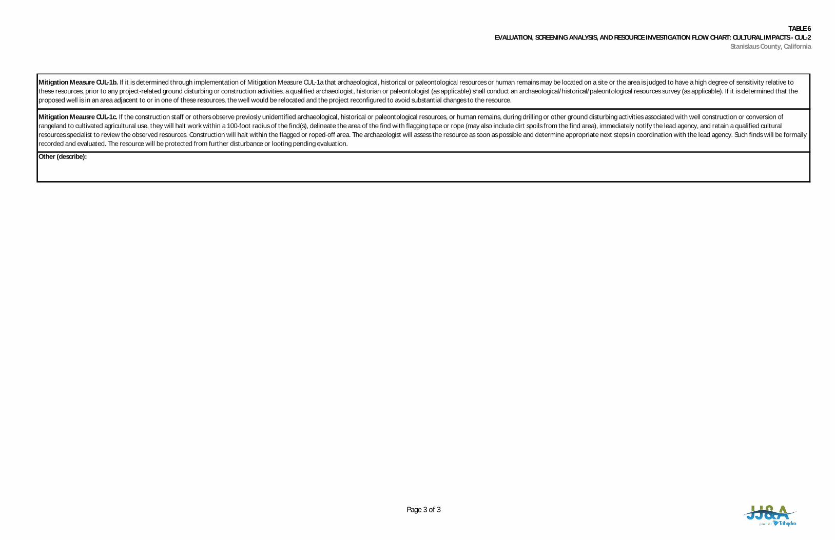
TABLE 6EVALUATION, SCREENING ANALYSIS, AND RESOURCE INVESTIGATION FLOW CHART: CULTURAL IMPACTS - CUL-2
Stanislaus County, California
Other (describe):
Mitigation Measure CUL-1b. If it is determined through implementation of Mitigation Measure CUL-1a that archaeological, historical or paleontological resources or human remains may be located on a site or the area is judged to have a high degree of sensitivity relative tothese resources, prior to any project-related ground disturbing or construction activities, a qualified archaeologist, historian or paleontologist (as applicable) shall conduct an archaeological/historical/paleontological resources survey (as applicable). If it is determined that theproposed well is in an area adjacent to or in one of these resources, the well would be relocated and the project reconfigured to avoid substantial changes to the resource.
Mitigation Meausre CUL-1c. If the construction staff or others observe previosly unidentified archaeological, historical or paleontological resources, or human remains, during drilling or other ground disturbing activities associated with well construction or conversion ofrangeland to cultivated agricultural use, they will halt work within a 100-foot radius of the find(s), delineate the area of the find with flagging tape or rope (may also include dirt spoils from the find area), immediately notify the lead agency, and retain a qualified culturalresources specialist to review the observed resources. Construction will halt within the flagged or roped-off area. The archaeologist will assess the resource as soon as possible and determine appropriate next steps in coordination with the lead agency. Such finds will be formallyrecorded and evaluated. The resource will be protected from further disturbance or looting pending evaluation.
Page 3 of 3
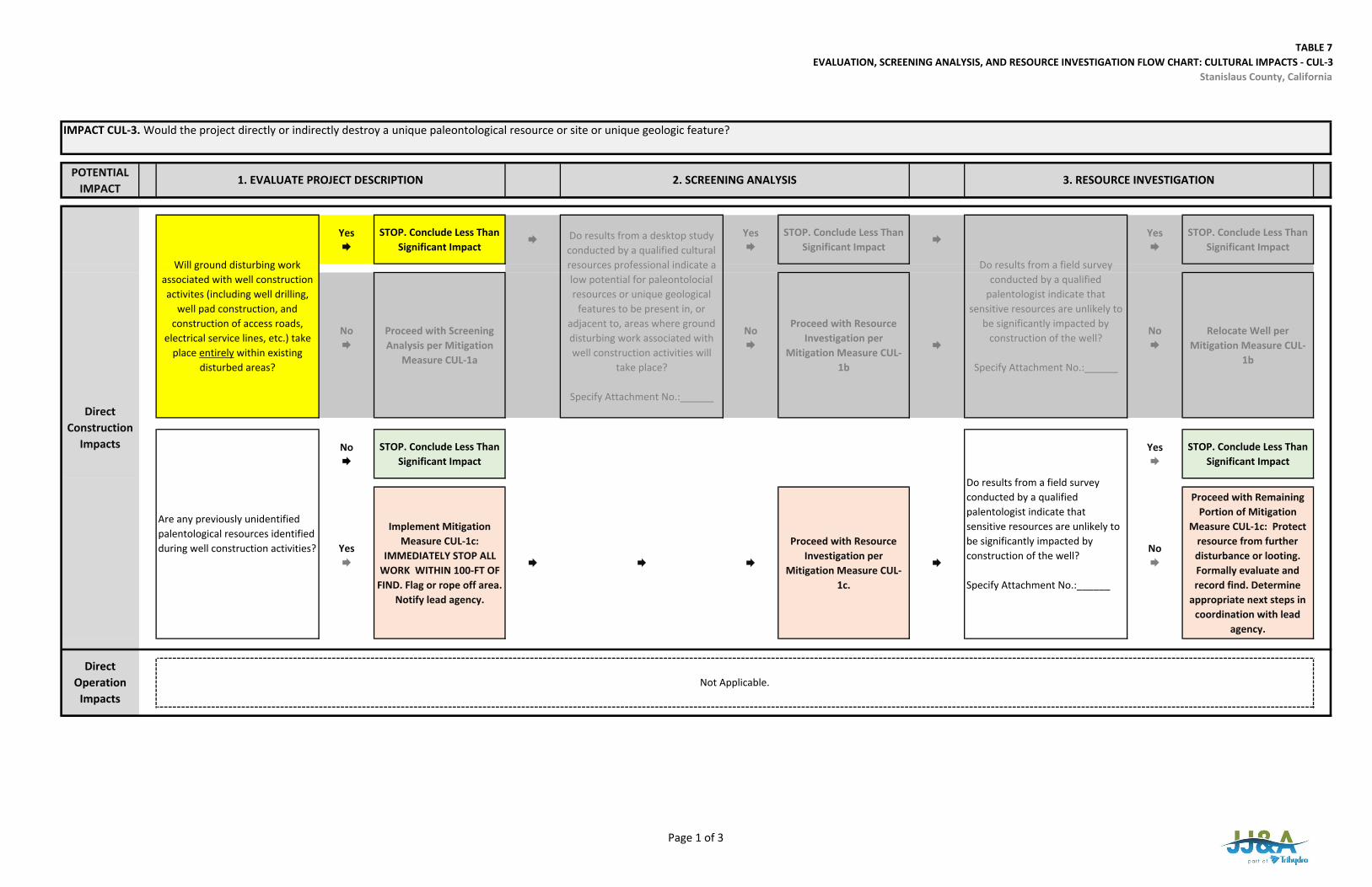
TABLE 7EVALUATION, SCREENING ANALYSIS, AND RESOURCE INVESTIGATION FLOW CHART: CULTURAL IMPACTS ‐ CUL‐3
Stanislaus County, California
POTENTIAL IMPACT
Yes
STOP. Conclude Less Than Significant Impact
Yes
STOP. Conclude Less Than Significant Impact
Yes
STOP. Conclude Less Than Significant Impact
No
Proceed with Screening Analysis per Mitigation
Measure CUL‐1a
No
Proceed with Resource Investigation per
Mitigation Measure CUL‐1b
No
Relocate Well per Mitigation Measure CUL‐
1b
No
STOP. Conclude Less Than Significant Impact
Yes
STOP. Conclude Less Than Significant Impact
Yes
Implement Mitigation Measure CUL‐1c:
IMMEDIATELY STOP ALL WORK WITHIN 100‐FT OF
FIND. Flag or rope off area. Notify lead agency.
Proceed with Resource Investigation per
Mitigation Measure CUL‐1c.
No
Proceed with Remaining Portion of Mitigation
Measure CUL‐1c: Protect resource from further disturbance or looting. Formally evaluate and record find. Determine
appropriate next steps in coordination with lead
agency.
IMPACT CUL‐3. Would the project directly or indirectly destroy a unique paleontological resource or site or unique geologic feature?
1. EVALUATE PROJECT DESCRIPTION 2. SCREENING ANALYSIS 3. RESOURCE INVESTIGATION
Will ground disturbing work associated with well construction activites (including well drilling,
well pad construction, and construction of access roads,
electrical service lines, etc.) take place entirely within existing
disturbed areas?
Do results from a desktop study conducted by a qualified cultural resources professional indicate a low potential for paleontolocial resources or unique geological
features to be present in, or adjacent to, areas where ground disturbing work associated with well construction activities will
take place?
Specify Attachment No.:______
Do results from a field survey conducted by a qualified
palentologist indicate that sensitive resources are unlikely to
be significantly impacted by construction of the well?
Specify Attachment No.:______
Are any previously unidentified palentological resources identified during well construction activities?
Do results from a field survey conducted by a qualified palentologist indicate that sensitive resources are unlikely to be significantly impacted by construction of the well?
Specify Attachment No.:______
Direct Construction
Impacts
Not Applicable.Direct
Operation Impacts
Page 1 of 3
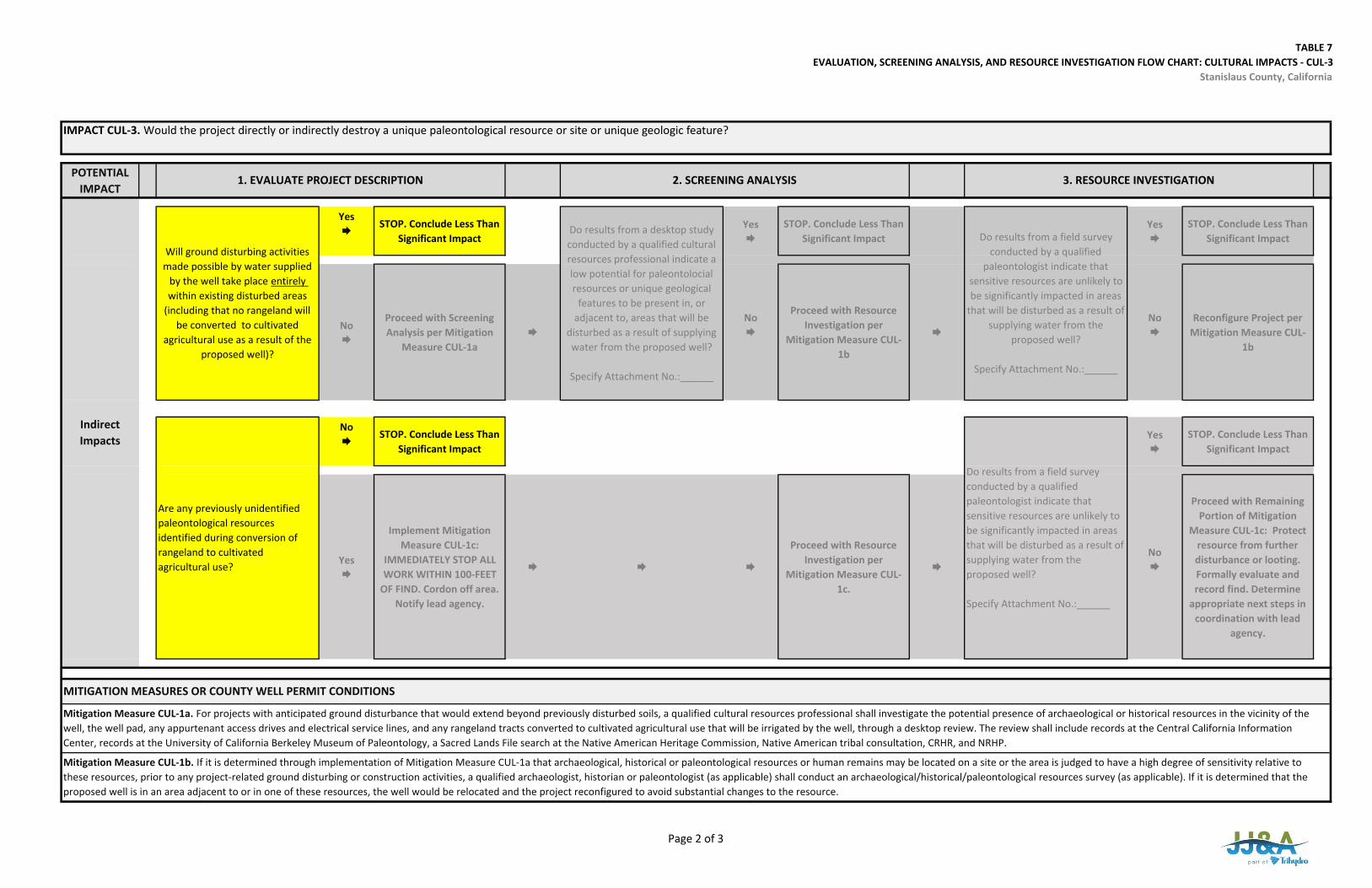
TABLE 7EVALUATION, SCREENING ANALYSIS, AND RESOURCE INVESTIGATION FLOW CHART: CULTURAL IMPACTS ‐ CUL‐3
Stanislaus County, California
POTENTIAL IMPACT
Yes
STOP. Conclude Less Than Significant Impact
Yes
STOP. Conclude Less Than Significant Impact
Yes
STOP. Conclude Less Than Significant Impact
No
Proceed with Screening Analysis per Mitigation
Measure CUL‐1a
No
Proceed with Resource Investigation per
Mitigation Measure CUL‐1b
No
Reconfigure Project per Mitigation Measure CUL‐
1b
No
STOP. Conclude Less Than Significant Impact
Yes
STOP. Conclude Less Than Significant Impact
Yes
Implement Mitigation Measure CUL‐1c:
IMMEDIATELY STOP ALL WORK WITHIN 100‐FEET
OF FIND. Cordon off area. Notify lead agency.
Proceed with Resource Investigation per
Mitigation Measure CUL‐1c.
No
Proceed with Remaining Portion of Mitigation
Measure CUL‐1c: Protect resource from further disturbance or looting. Formally evaluate and record find. Determine
appropriate next steps in coordination with lead
agency.
Do results from a field survey conducted by a qualified paleontologist indicate that sensitive resources are unlikely to be significantly impacted in areas that will be disturbed as a result of supplying water from the proposed well?
Specify Attachment No.:______
MITIGATION MEASURES OR COUNTY WELL PERMIT CONDITIONS
Mitigation Measure CUL‐1a. For projects with anticipated ground disturbance that would extend beyond previously disturbed soils, a qualified cultural resources professional shall investigate the potential presence of archaeological or historical resources in the vicinity of the well, the well pad, any appurtenant access drives and electrical service lines, and any rangeland tracts converted to cultivated agricultural use that will be irrigated by the well, through a desktop review. The review shall include records at the Central California Information Center, records at the University of California Berkeley Museum of Paleontology, a Sacred Lands File search at the Native American Heritage Commission, Native American tribal consultation, CRHR, and NRHP.
Mitigation Measure CUL‐1b. If it is determined through implementation of Mitigation Measure CUL‐1a that archaeological, historical or paleontological resources or human remains may be located on a site or the area is judged to have a high degree of sensitivity relative to these resources, prior to any project‐related ground disturbing or construction activities, a qualified archaeologist, historian or paleontologist (as applicable) shall conduct an archaeological/historical/paleontological resources survey (as applicable). If it is determined that the proposed well is in an area adjacent to or in one of these resources, the well would be relocated and the project reconfigured to avoid substantial changes to the resource.
Indirect Impacts
Will ground disturbing activities made possible by water supplied
by the well take place entirely within existing disturbed areas
(including that no rangeland will be converted to cultivated
agricultural use as a result of the proposed well)?
Do results from a desktop study conducted by a qualified cultural resources professional indicate a low potential for paleontolocial resources or unique geological
features to be present in, or adjacent to, areas that will be
disturbed as a result of supplying water from the proposed well?
Specify Attachment No.:______
Do results from a field survey conducted by a qualified
paleontologist indicate that sensitive resources are unlikely to be significantly impacted in areas
that will be disturbed as a result of supplying water from the
proposed well?
Specify Attachment No.:______
Are any previously unidentified paleontological resources identified during conversion of rangeland to cultivated agricultural use?
3. RESOURCE INVESTIGATION
IMPACT CUL‐3. Would the project directly or indirectly destroy a unique paleontological resource or site or unique geologic feature?
1. EVALUATE PROJECT DESCRIPTION 2. SCREENING ANALYSIS
Page 2 of 3

TABLE 7EVALUATION, SCREENING ANALYSIS, AND RESOURCE INVESTIGATION FLOW CHART: CULTURAL IMPACTS ‐ CUL‐3
Stanislaus County, California
Other (describe):
Mitigation Meausre CUL‐1c. If the construction staff or others observe previosly unidentified archaeological, historical or paleontological resources, or human remains, during drilling or other ground disturbing activities associated with well construction or conversion of rangeland to cultivated agricultural use, they will halt work within a 100‐foot radius of the find(s), delineate the area of the find with flagging tape or rope (may also include dirt spoils from the find area), immediately notify the lead agency, and retain a qualified cultural resources specialist to review the observed resources. Construction will halt within the flagged or roped‐off area. The archaeologist will assess the resource as soon as possible and determine appropriate next steps in coordination with the lead agency. Such finds will be formally recorded and evaluated. The resource will be protected from further disturbance or looting pending evaluation.
Page 3 of 3
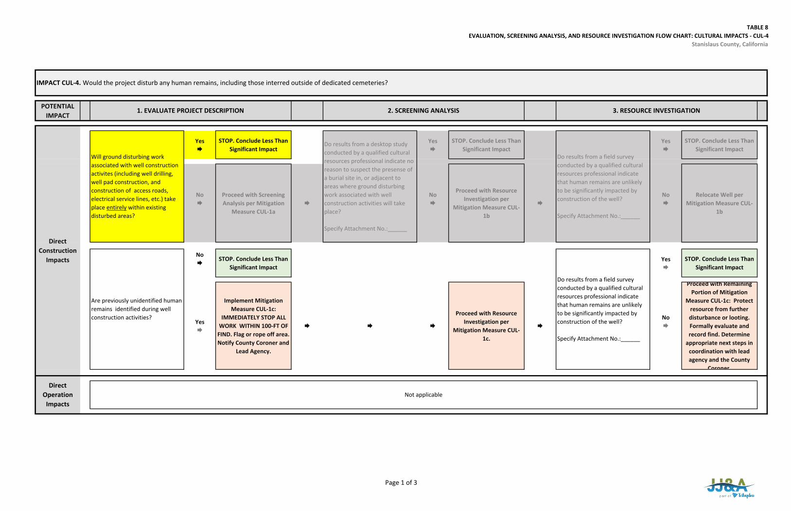
TABLE 8EVALUATION, SCREENING ANALYSIS, AND RESOURCE INVESTIGATION FLOW CHART: CULTURAL IMPACTS ‐ CUL‐4
Stanislaus County, California
POTENTIAL IMPACT
Yes
STOP. Conclude Less Than Significant Impact
Yes
STOP. Conclude Less Than Significant Impact
Yes
STOP. Conclude Less Than Significant Impact
No
Proceed with Screening Analysis per Mitigation
Measure CUL‐1a
No
Proceed with Resource Investigation per
Mitigation Measure CUL‐1b
No
Relocate Well per Mitigation Measure CUL‐
1b
No
STOP. Conclude Less Than Significant Impact
Yes
STOP. Conclude Less Than Significant Impact
Yes
Implement Mitigation Measure CUL‐1c:
IMMEDIATELY STOP ALL WORK WITHIN 100‐FT OF
FIND. Flag or rope off area. Notify County Coroner and
Lead Agency.
Proceed with Resource Investigation per
Mitigation Measure CUL‐1c.
No
Proceed with Remaining Portion of Mitigation
Measure CUL‐1c: Protect resource from further disturbance or looting. Formally evaluate and record find. Determine
appropriate next steps in coordination with lead agency and the County
Coroner
IMPACT CUL‐4. Would the project disturb any human remains, including those interred outside of dedicated cemeteries?
1. EVALUATE PROJECT DESCRIPTION 2. SCREENING ANALYSIS 3. RESOURCE INVESTIGATION
Will ground disturbing work associated with well construction activites (including well drilling, well pad construction, and construction of access roads, electrical service lines, etc.) take place entirely within existing disturbed areas?
Do results from a desktop study conducted by a qualified cultural resources professional indicate no reason to suspect the presense of a burial site in, or adjacent to areas where ground disturbing work associated with well construction activities will take place?
Specify Attachment No.:______
Do results from a field survey conducted by a qualified cultural resources professional indicate that human remains are unlikely to be significantly impacted by construction of the well?
Specify Attachment No.:______
Are previously unidentified human remains identified during well construction activities?
Do results from a field survey conducted by a qualified cultural resources professional indicate that human remains are unlikely to be significantly impacted by construction of the well?
Specify Attachment No.:______
Direct Construction
Impacts
Direct Operation
ImpactsNot applicable
Page 1 of 3
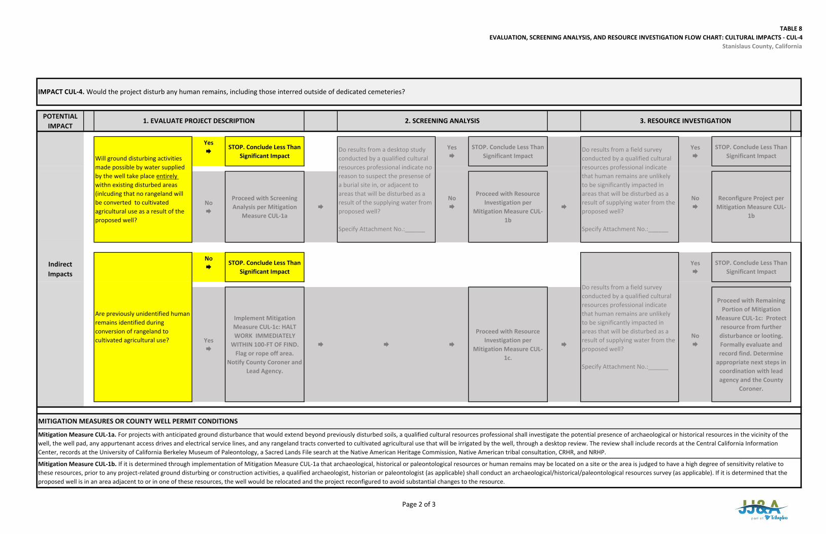
TABLE 8EVALUATION, SCREENING ANALYSIS, AND RESOURCE INVESTIGATION FLOW CHART: CULTURAL IMPACTS ‐ CUL‐4
Stanislaus County, California
POTENTIAL IMPACT
Yes
STOP. Conclude Less Than Significant Impact
Yes
STOP. Conclude Less Than Significant Impact
Yes
STOP. Conclude Less Than Significant Impact
No
Proceed with Screening Analysis per Mitigation
Measure CUL‐1a
No
Proceed with Resource Investigation per
Mitigation Measure CUL‐1b
No
Reconfigure Project per Mitigation Measure CUL‐
1b
No
STOP. Conclude Less Than Significant Impact
Yes
STOP. Conclude Less Than Significant Impact
Yes
Implement Mitigation Measure CUL‐1c: HALT WORK IMMEDIATELY
WITHIN 100‐FT OF FIND. Flag or rope off area.
Notify County Coroner and Lead Agency.
Proceed with Resource Investigation per
Mitigation Measure CUL‐1c.
No
Proceed with Remaining Portion of Mitigation
Measure CUL‐1c: Protect resource from further disturbance or looting. Formally evaluate and record find. Determine
appropriate next steps in coordination with lead agency and the County
Coroner.
Do results from a field survey conducted by a qualified cultural resources professional indicate that human remains are unlikely to be significantly impacted in areas that will be disturbed as a result of supplying water from the proposed well?
Specify Attachment No.:______
MITIGATION MEASURES OR COUNTY WELL PERMIT CONDITIONS
Mitigation Measure CUL‐1a. For projects with anticipated ground disturbance that would extend beyond previously disturbed soils, a qualified cultural resources professional shall investigate the potential presence of archaeological or historical resources in the vicinity of the well, the well pad, any appurtenant access drives and electrical service lines, and any rangeland tracts converted to cultivated agricultural use that will be irrigated by the well, through a desktop review. The review shall include records at the Central California Information Center, records at the University of California Berkeley Museum of Paleontology, a Sacred Lands File search at the Native American Heritage Commission, Native American tribal consultation, CRHR, and NRHP.
Mitigation Measure CUL‐1b. If it is determined through implementation of Mitigation Measure CUL‐1a that archaeological, historical or paleontological resources or human remains may be located on a site or the area is judged to have a high degree of sensitivity relative to these resources, prior to any project‐related ground disturbing or construction activities, a qualified archaeologist, historian or paleontologist (as applicable) shall conduct an archaeological/historical/paleontological resources survey (as applicable). If it is determined that the proposed well is in an area adjacent to or in one of these resources, the well would be relocated and the project reconfigured to avoid substantial changes to the resource.
Indirect Impacts
Will ground disturbing activities made possible by water supplied by the well take place entirely withn existing disturbed areas (inlcuding that no rangeland will be converted to cultivated agricultural use as a result of the proposed well?
Do results from a desktop study conducted by a qualified cultural resources professional indicate no reason to suspect the presense of a burial site in, or adjacent to areas that will be disturbed as a result of the supplying water from proposed well?
Specify Attachment No.:______
Do results from a field survey conducted by a qualified cultural resources professional indicate that human remains are unlikely to be significantly impacted in areas that will be disturbed as a result of supplying water from the proposed well?
Specify Attachment No.:______
Are previously unidentified human remains identified during conversion of rangeland to cultivated agricultural use?
3. RESOURCE INVESTIGATION
IMPACT CUL‐4. Would the project disturb any human remains, including those interred outside of dedicated cemeteries?
1. EVALUATE PROJECT DESCRIPTION 2. SCREENING ANALYSIS
Page 2 of 3
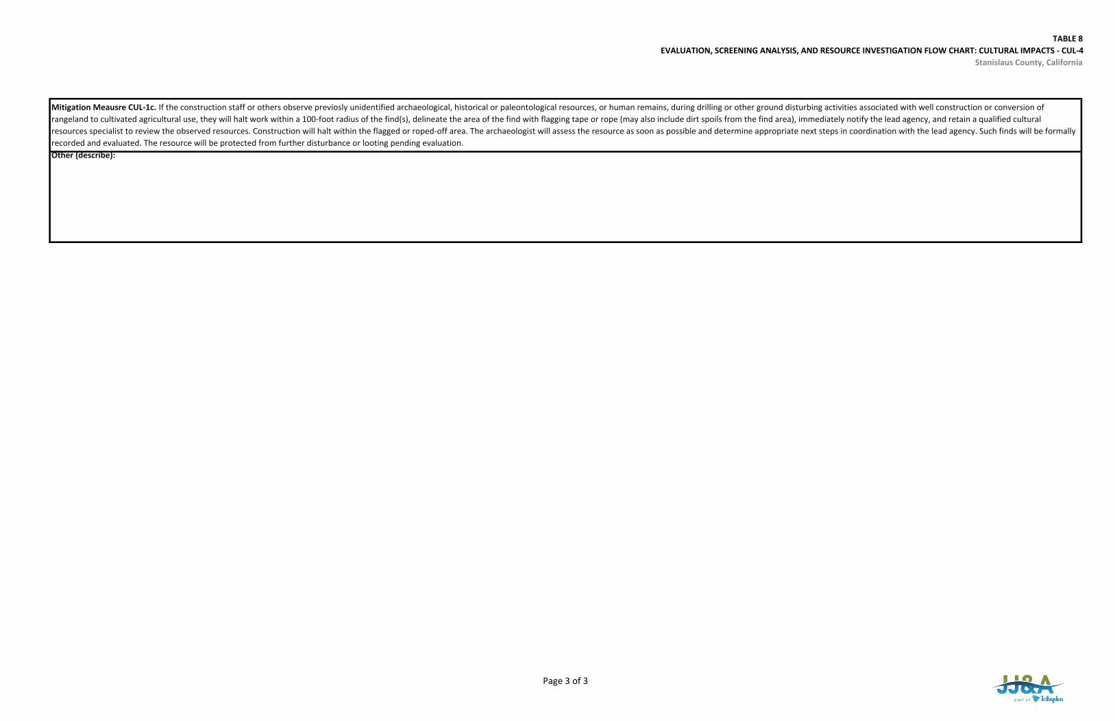
TABLE 8EVALUATION, SCREENING ANALYSIS, AND RESOURCE INVESTIGATION FLOW CHART: CULTURAL IMPACTS ‐ CUL‐4
Stanislaus County, California
Other (describe):
Mitigation Meausre CUL‐1c. If the construction staff or others observe previosly unidentified archaeological, historical or paleontological resources, or human remains, during drilling or other ground disturbing activities associated with well construction or conversion of rangeland to cultivated agricultural use, they will halt work within a 100‐foot radius of the find(s), delineate the area of the find with flagging tape or rope (may also include dirt spoils from the find area), immediately notify the lead agency, and retain a qualified cultural resources specialist to review the observed resources. Construction will halt within the flagged or roped‐off area. The archaeologist will assess the resource as soon as possible and determine appropriate next steps in coordination with the lead agency. Such finds will be formally recorded and evaluated. The resource will be protected from further disturbance or looting pending evaluation.
Page 3 of 3
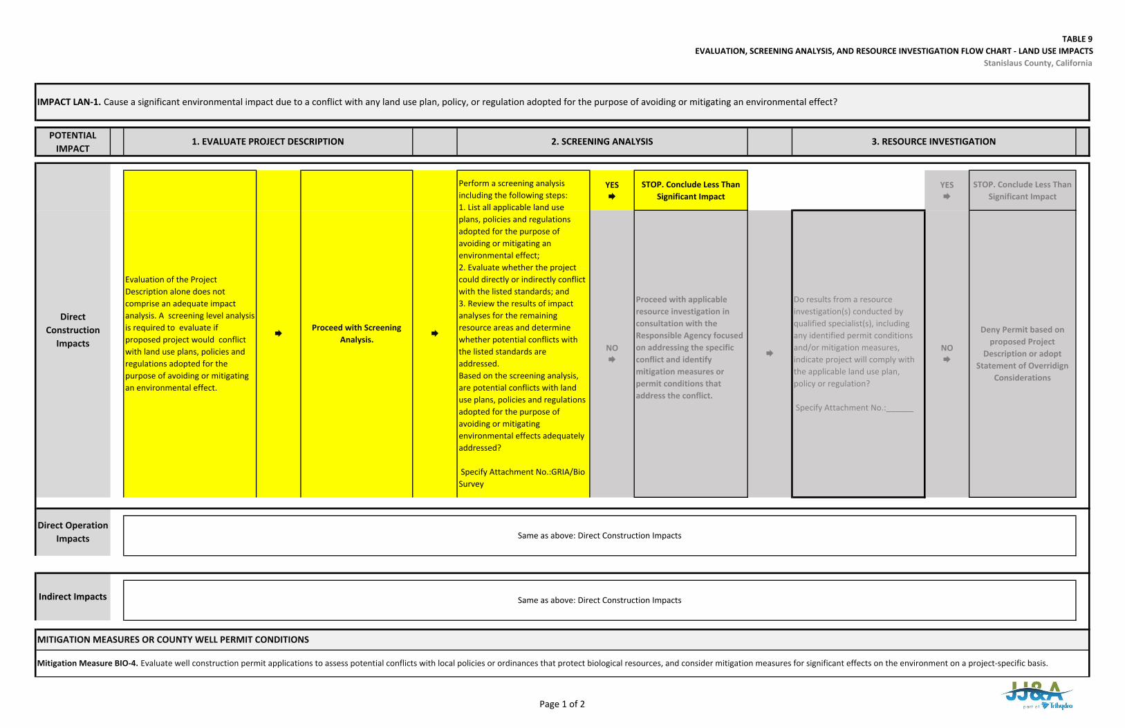
TABLE 9EVALUATION, SCREENING ANALYSIS, AND RESOURCE INVESTIGATION FLOW CHART ‐ LAND USE IMPACTS
Stanislaus County, California
POTENTIAL IMPACT
YES
STOP. Conclude Less Than Significant Impact
YES
STOP. Conclude Less Than Significant Impact
Same as above: Direct Construction Impacts
Same as above: Direct Construction Impacts
MITIGATION MEASURES OR COUNTY WELL PERMIT CONDITIONS
Mitigation Measure BIO‐4. Evaluate well construction permit applications to assess potential conflicts with local policies or ordinances that protect biological resources, and consider mitigation measures for significant effects on the environment on a project‐specific basis.
Indirect Impacts
Direct Operation Impacts
Deny Permit based on proposed Project
Description or adopt Statement of Overridign
Considerations
IMPACT LAN‐1. Cause a significant environmental impact due to a conflict with any land use plan, policy, or regulation adopted for the purpose of avoiding or mitigating an environmental effect?
1. EVALUATE PROJECT DESCRIPTION 2. SCREENING ANALYSIS 3. RESOURCE INVESTIGATION
Direct Construction
Impacts
Evaluation of the Project Description alone does not comprise an adequate impact analysis. A screening level analysis is required to evaluate if proposed project would conflict with land use plans, policies and regulations adopted for the purpose of avoiding or mitigating an environmental effect.
Proceed with Screening
Analysis.
Perform a screening analysis including the following steps:1. List all applicable land useplans, policies and regulations adopted for the purpose of avoiding or mitigating an environmental effect;2. Evaluate whether the projectcould directly or indirectly conflict with the listed standards; and 3. Review the results of impactanalyses for the remaining resource areas and determine whether potential conflicts with the listed standards are addressed.Based on the screening analysis, are potential conflicts with land use plans, policies and regulations adopted for the purpose of avoiding or mitigating environmental effects adequately addressed?
Specify Attachment No.:GRIA/Bio Survey
NO
Proceed with applicable resource investigation in consultation with the Responsible Agency focused on addressing the specific conflict and identify mitigation measures or permit conditions that address the conflict.
Do results from a resource investigation(s) conducted by qualified specialist(s), including any identified permit conditions and/or mitigation measures, indicate project will comply with the applicable land use plan, policy or regulation?
Specify Attachment No.:______
NO
Page 1 of 2
TABLE 9EVALUATION, SCREENING ANALYSIS, AND RESOURCE INVESTIGATION FLOW CHART ‐ LAND USE IMPACTS
Stanislaus County, California
Mitigation Measure WAT‐3. The County will identify additional Groundwater Level Management Zones in the unincorporated, non‐district portions of the County where existing groundwater level trends constitute “chronic lowering of groundwater levels indicating a significant and unreasonable depletion of supply if continued over the planning and implementation horizon” as defined in Section 9.37.030(9)(a) of the Ordinance. In such areas, an applicant proposing installation of a new discretionary well is required to submit a Groundwater Extraction Offset Plan that describes how groundwater extraction from the well will be offset, resulting in no net additional groundwater demand to the pumped aquifer system. Alternatively, the applicant must do a Groundwater Resources Investigation and implement a Groundwater Level Monitoring Program that demonstrates the proposed extraction will not result in, or contribute to, Undesirable Results as defined in the Ordinance.
Mitigation Measure NOI‐1. If well construction activities will take place closer than 200‐feet from a nearby sensitive receptor on non‐agriculturally zoned parcels, the project shall employ noise attenuating measures and/or work schedules such that the project would comply with the Stanislaus County Noise Ordinance and General Plan Noise Element. Noise mitigation shall include a combination of the measures to achieve construction noise at or below the maximum allowable noise level of 75 A‐weighted decibels from 7:00 p.m. to 7:00 a.m. If a well is located closer than 70 feet to sensitive receptors on non‐agriculturally zoned parcels, operating noise mitigation measures shall be implemented such that the project will comply with the Stanislaus County Noise Ordinance.
Other (describe):
Mitigation Measure CUL‐1a. For projects with anticipated ground disturbance that would extend beyond previously disturbed soils, a qualified cultural resources professional shall investigate the potential presence of archaeological or historical resources in the vicinity of the well, the well pad, any appurtenant access drives and electrical service lines, and any rangeland tracts converted to cultivated agricultural use that will be irrigated by the well, through a desktop review. The review shall include records at the Central California Information Center, records at the University of California Berkeley Museum of Paleontology, a Sacred Lands File search at the Native American Heritage Commission, Native American tribal consultation, CRHR, and NRHP.
Mitigation Measure CUL‐1b. If it is determined through implementation of Mitigation Measure CUL‐1a that archaeological, historical or paleontological resources or human remains may be located on a site or the area is judged to have a high degree of sensitivity relative to these resources, prior to any project‐related ground disturbing or construction activities, a qualified archaeologist, historian or paleontologist (as applicable) shall conduct an archaeological/historical/paleontological resources survey (as applicable). If it is determined that the proposed well is in an area adjacent to or in one of these resources, the well would be relocated and the project reconfigured to avoid substantial changes to the resource.
Mitigation Measure CUL‐1c. If the construction staff or others observe previously unidentified archaeological, historical or paleontological resources, or human remains, during drilling or other ground disturbing activities associated with well construction or conversion of rangeland to cultivated agricultural use, they will halt work within a 100‐foot radius of the find(s), delineate the area of the find with flagging tape or rope (may also include dirt spoils from the find area), immediately notify the lead agency, and retain a qualified cultural resources specialist to review the observed resources. Construction will halt within the flagged or roped‐off area. The archaeologist will assess the resource as soon as possible and determine appropriate next steps in coordination with the lead agency. Such finds will be formally recorded and evaluated. The resource will be protected from further disturbance or looting pending evaluation.
Mitigation Measure WAT‐2. Property owners and water agencies in the area where predicted drawdown exceeds 5 feet will be notified of the existence of the Interference Drawdown Monitoring and Mitigation Program, and will be invited to register any domestic wells in the predicted 5‐foot drawdown area and any municipal, industrial, or irrigation wells in the predicted 20‐foot drawdown area to participate in the program. To register for the program, well owners will be required to complete a Well Information Questionnaire regarding the construction, use, history and performance of their well, and to allow access for periodic measurement of water levels and assessment of well condition and performance by the county or a neutral third party. If well performance is found to be diminished by more than 20 percent or to be inadequate to meet pre‐existing water demand due to interference drawdown, registered participants will be eligible to receive reimbursement for reasonable and customary costs for well replacement, deepening or rehabilitation, or pump lowering as needed to restore adequate well function. The cost of reimbursement shall be borne by the operator of the well causing the interference in proportion to the degree of their contribution to the drawdown that caused the diminished yield.
Page 2 of 2
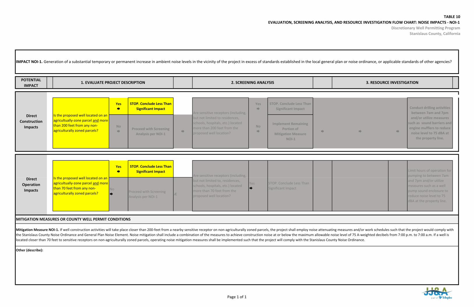
TABLE 10EVALUATION, SCREENING ANALYSIS, AND RESOURCE INVESTIGATION FLOW CHART: NOISE IMPACTS ‐ NOI‐1
Discretionary Well Permitting ProgramStanislaus County, California
POTENTIAL IMPACT
Yes
STOP. Conclude Less Than Significant Impact
Yes
STOP. Conclude Less Than Significant Impact
Yes
STOP. Conclude Less Than Significant Impact
IMPACT NOI‐1. Generation of a substantial temporary or permanent increase in ambient noise levels in the vicinity of the project in excess of standards established in the local general plan or noise ordinance, or applicable standards of other agencies?
Is the proposed well located on an agricultually‐zone parcel and more than 200 feet from any non‐agriculturally zoned parcels?
1. EVALUATE PROJECT DESCRIPTION 2. SCREENING ANALYSIS
3. RESOURCE INVESTIGATION
No
Direct Construction
Impacts Proceed with Screening Analysis per NOI‐1
No
Are sensitive receptors (including, but not limited to residences, schools, hospitals, etc.) located more than 200 feet from the proposed well location?
Implement Remaining Portion of
Mitigation Measure NOI‐1
Conduct drilling activities between 7am and 7pm and/or utilize measures
such as sound barriers and engine mufflers to reduce
noise level to 75 dBA at the property line.
MITIGATION MEASURES OR COUNTY WELL PERMIT CONDITIONS
Mitigation Measure NOI‐1. If well construction activities will take place closer than 200‐feet from a nearby sensitive receptor on non‐agriculturally zoned parcels, the project shall employ noise attenuating measures and/or work schedules such that the project would comply with the Stanislaus County Noise Ordinance and General Plan Noise Element. Noise mitigation shall include a combination of the measures to achieve construction noise at or below the maximum allowable noise level of 75 A‐weighted decibels from 7:00 p.m. to 7:00 a.m. If a well is located closer than 70 feet to sensitive receptors on non‐agriculturally zoned parcels, operating noise mitigation measures shall be implemented such that the project will comply with the Stanislaus County Noise Ordinance.
Other (describe):
Is the proposed well located on an agricultually‐zone parcel and more than 70 feet from any non‐agriculturally zoned parcels?
Are sensitive receptors (including, but not limited to, residences, schools, hospitals, etc.) located more than 70 feet from the proposed well location?
Direct Operation
Impacts
Limit hours of operation for pumping to between 7am and 7pm and/or utilize measures such as a well pump sound enclosure to reduce noise level to 75 dBA at the property line.
No
Proceed with Screening Analysis per NOI‐1
Æ
Yes
STOP. Conclude Less Than Significant Impact
Page 1 of 1
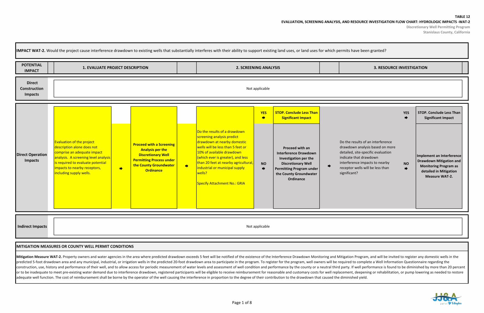
TABLE 12EVALUATION, SCREENING ANALYSIS, AND RESOURCE INVESTIGATION FLOW CHART: HYDROLOGIC IMPACTS -WAT-2
Discretionary Well Permitting ProgramStanislaus County, California
POTENTIAL IMPACT
YES
STOP. Conclude Less Than Significant Impact
YES
STOP. Conclude Less Than Significant Impact
MITIGATION MEASURES OR COUNTY WELL PERMIT CONDITIONS
Mitigation Measure WAT-2. Property owners and water agencies in the area where predicted drawdown exceeds 5 feet will be notified of the existence of the Interference Drawdown Monitoring and Mitigation Program, and will be invited to register any domestic wells in the predicted 5-foot drawdown area and any municipal, industrial, or irrigation wells in the predicted 20-foot drawdown area to participate in the program. To register for the program, well owners will be required to complete a Well Information Questionnaire regarding the construction, use, history and performance of their well, and to allow access for periodic measurement of water levels and assessment of well condition and performance by the county or a neutral third party. If well performance is found to be diminished by more than 20 percent or to be inadequate to meet pre-existing water demand due to interference drawdown, registered participants will be eligible to receive reimbursement for reasonable and customary costs for well replacement, deepening or rehabilitation, or pump lowering as needed to restore adequate well function. The cost of reimbursement shall be borne by the operator of the well causing the interference in proportion to the degree of their contribution to the drawdown that caused the diminished yield.
NO
Evaluation of the project description alone does not comprise an adequate impact analysis. A screening level analysis is required to evaluate potential impacts to nearby receptors, including supply wells.
Do the results of a drawdown screening analysis predict drawdown at nearby domestic wells will be less than 5 feet or 10% of available drawdown (which ever is greater), and less than 20 feet at nearby agricultural, industrial or municipal supply wells?
Specify Attachment No.: GRIA
Proceed with an Interference Drawdown
Investigation per the Discretionary Well
Permitting Program under the County Groundwater
Ordinance
Proceed with a Screening Analysis per the
Discretionary Well Permitting Process under the County Groundwater
Ordinance
Do the results of an interference drawdown analysis based on more detailed, site-specific evaluation indicate that drawdown interference impacts to nearby receptor wells will be less than significant?
Implement an Interference Drawdown Mitigation and
Monitoring Program as detailed in Mitigation
Measure WAT-2.
Indirect Impacts
IMPACT WAT-2. Would the project cause interference drawdown to existing wells that substantially interferes with their ability to support existing land uses, or land uses for which permits have been granted?
1. EVALUATE PROJECT DESCRIPTION 2. SCREENING ANALYSIS 3. RESOURCE INVESTIGATION
Not applicable
Not applicable
Direct Operation Impacts
Direct Construction
Impacts
NO
Page 1 of 8
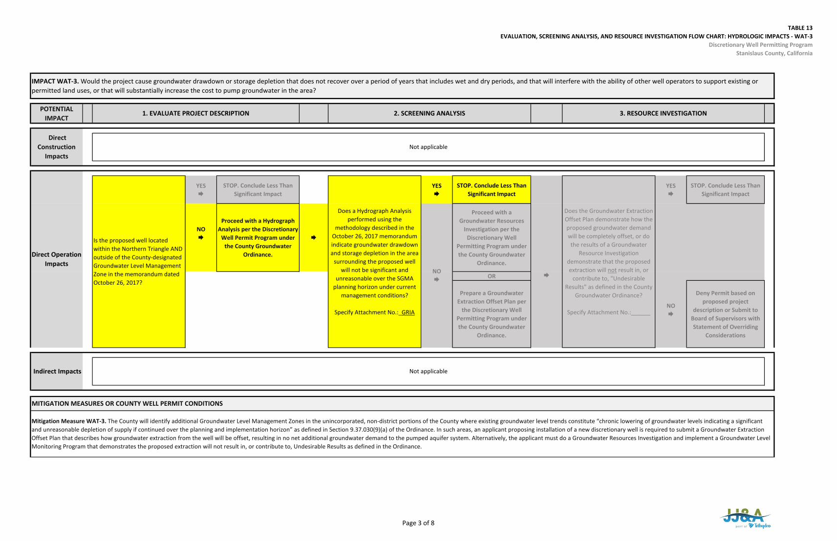
TABLE 13EVALUATION, SCREENING ANALYSIS, AND RESOURCE INVESTIGATION FLOW CHART: HYDROLOGIC IMPACTS - WAT-3
Discretionary Well Permitting ProgramStanislaus County, California
POTENTIAL IMPACT
YES
STOP. Conclude Less Than Significant Impact
YES
STOP. Conclude Less Than Significant Impact
YES
STOP. Conclude Less Than Significant Impact
NO
Proceed with a Hydrograph Analysis per the Discretionary
Well Permit Program under the County Groundwater
Ordinance.
Proceed with a Groundwater Resources
Investigation per the Discretionary Well
Permitting Program under the County Groundwater
Ordinance.
OR
Prepare a Groundwater Extraction Offset Plan per
the Discretionary Well Permitting Program under the County Groundwater
Ordinance.
NO
Deny Permit based on proposed project
description or Submit to Board of Supervisors with Statement of Overriding
Considerations
IMPACT WAT-3. Would the project cause groundwater drawdown or storage depletion that does not recover over a period of years that includes wet and dry periods, and that will interfere with the ability of other well operators to support existing or permitted land uses, or that will substantially increase the cost to pump groundwater in the area?
1. EVALUATE PROJECT DESCRIPTION 2. SCREENING ANALYSIS 3. RESOURCE INVESTIGATION
Direct Construction
ImpactsNot applicable
Mitigation Measure WAT-3. The County will identify additional Groundwater Level Management Zones in the unincorporated, non-district portions of the County where existing groundwater level trends constitute “chronic lowering of groundwater levels indicating a significant and unreasonable depletion of supply if continued over the planning and implementation horizon” as defined in Section 9.37.030(9)(a) of the Ordinance. In such areas, an applicant proposing installation of a new discretionary well is required to submit a Groundwater Extraction Offset Plan that describes how groundwater extraction from the well will be offset, resulting in no net additional groundwater demand to the pumped aquifer system. Alternatively, the applicant must do a Groundwater Resources Investigation and implement a Groundwater Level Monitoring Program that demonstrates the proposed extraction will not result in, or contribute to, Undesirable Results as defined in the Ordinance.
Indirect Impacts Not applicable
MITIGATION MEASURES OR COUNTY WELL PERMIT CONDITIONS
NO
Does a Hydrograph Analysis performed using the
methodology described in the October 26, 2017 memorandum indicate groundwater drawdown and storage depletion in the area
surrounding the proposed well will not be significant and
unreasonable over the SGMA planning horizon under current
management conditions?
Specify Attachment No.:_GRIA
Does the Groundwater Extraction Offset Plan demonstrate how the proposed groundwater demand will be completely offset, or do the results of a Groundwater
Resource Investigation demonstrate that the proposed extraction will not result in, or
contribute to, "Undesirable Results" as defined in the County
Groundwater Ordinance?
Specify Attachment No.:______
Direct Operation Impacts
Is the proposed well located within the Northern Triangle AND outside of the County-designated Groundwater Level Management Zone in the memorandum dated October 26, 2017?
Page 3 of 8
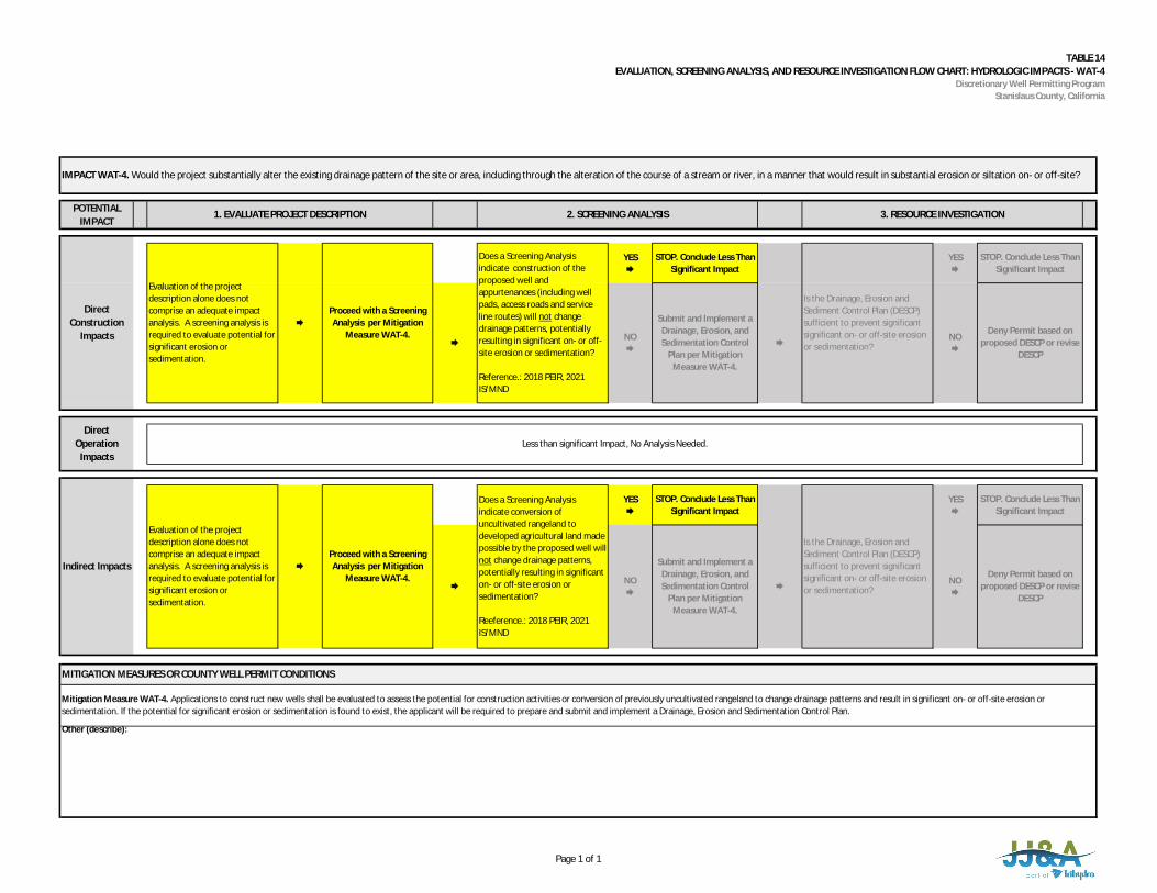
TABLE 14EVALUATION, SCREENING ANALYSIS, AND RESOURCE INVESTIGATION FLOW CHART: HYDROLOGIC IMPACTS - WAT-4
Discretionary Well Permitting ProgramStanislaus County, California
POTENTIALIMPACT
YES
STOP. Conclude Less ThanSignificant Impact
YES
STOP. Conclude Less ThanSignificant Impact
YES
STOP. Conclude Less ThanSignificant Impact
YES
STOP. Conclude Less ThanSignificant Impact
Other (describe):
DirectOperation
ImpactsLess than significant Impact, No Analysis Needed.
Indirect Impacts
Evaluation of the projectdescription alone does notcomprise an adequate impactanalysis. A screening analysis isrequired to evaluate potential forsignificant erosion orsedimentation.
Proceed with a ScreeningAnalysis per Mitigation
Measure WAT-4. NO
Deny Permit based onproposed DESCP or revise
DESCP
Is the Drainage, Erosion andSediment Control Plan (DESCP)sufficient to prevent significantsignificant on- or off-site erosionor sedimentation?
NO
Does a Screening Analysisindicate conversion ofuncultivated rangeland todeveloped agricultural land madepossible by the proposed well willnot change drainage patterns,potentially resulting in significanton- or off-site erosion orsedimentation?
Reeference.: 2018 PEIR, 2021IS/MND
Does a Screening Analysisindicate construction of theproposed well andappurtenances (including wellpads, access roads and serviceline routes) will not changedrainage patterns, potentiallyresulting in significant on- or off-site erosion or sedimentation?
Reference.: 2018 PEIR, 2021IS/MND
Mitigation Measure WAT-4. Applications to construct new wells shall be evaluated to assess the potential for construction activities or conversion of previously uncultivated rangeland to change drainage patterns and result in significant on- or off-site erosion orsedimentation. If the potential for significant erosion or sedimentation is found to exist, the applicant will be required to prepare and submit and implement a Drainage, Erosion and Sedimentation Control Plan.
Deny Permit based onproposed DESCP or revise
DESCP
NO
Submit and Implement aDrainage, Erosion, andSedimentation Control
Plan per MitigationMeasure WAT-4.
MITIGATION MEASURES OR COUNTY WELL PERMIT CONDITIONS
IMPACT WAT-4. Would the project substantially alter the existing drainage pattern of the site or area, including through the alteration of the course of a stream or river, in a manner that would result in substantial erosion or siltation on- or off-site?
1. EVALUATE PROJECT DESCRIPTION 2. SCREENING ANALYSIS 3. RESOURCE INVESTIGATION
DirectConstruction
Impacts
Evaluation of the projectdescription alone does notcomprise an adequate impactanalysis. A screening analysis isrequired to evaluate potential forsignificant erosion orsedimentation.
Proceed with a ScreeningAnalysis per Mitigation
Measure WAT-4.
Is the Drainage, Erosion andSediment Control Plan (DESCP)sufficient to prevent significantsignificant on- or off-site erosionor sedimentation?
NO
Submit and Implement aDrainage, Erosion, andSedimentation Control
Plan per MitigationMeasure WAT-4.
Page 1 of 1
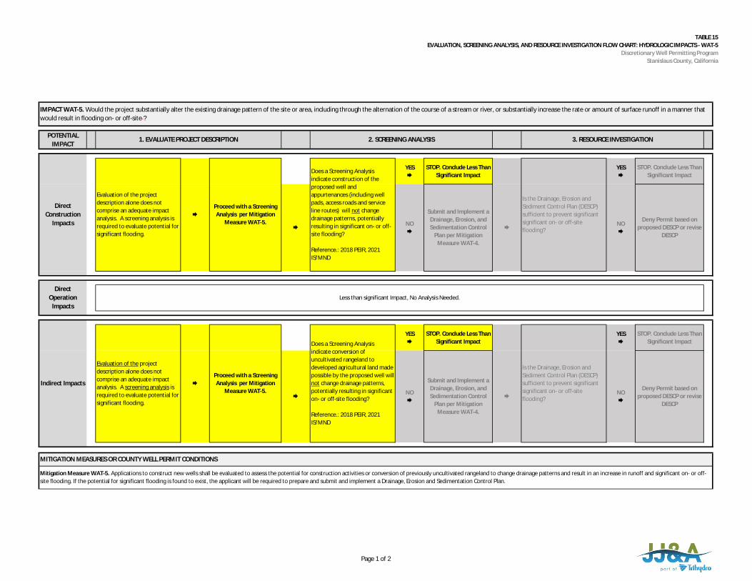
TABLE 15EVALUATION, SCREENING ANALYSIS, AND RESOURCE INVESTIGATION FLOW CHART: HYDROLOGIC IMPACTS - WAT-5
Discretionary Well Permitting ProgramStanislaus County, California
POTENTIALIMPACT
YES
STOP. Conclude Less ThanSignificant Impact
YES
STOP. Conclude Less ThanSignificant Impact
YES
STOP. Conclude Less ThanSignificant Impact
YES
STOP. Conclude Less ThanSignificant Impact
Evaluation of the projectdescription alone does notcomprise an adequate impactanalysis. A screening analysis isrequired to evaluate potential forsignificant flooding.
Does a Screening Analysisindicate construction of theproposed well andappurtenances (including wellpads, access roads and serviceline routes) will not changedrainage patterns, potentiallyresulting in significant on- or off-site flooding?
Reference.: 2018 PEIR, 2021IS/MND
Submit and Implement aDrainage, Erosion, andSedimentation Control
Plan per MitigationMeasure WAT-4.
NO
Deny Permit based onproposed DESCP or revise
DESCP
MITIGATION MEASURES OR COUNTY WELL PERMIT CONDITIONS
Mitigation Measure WAT-5. Applications to construct new wells shall be evaluated to assess the potential for construction activities or conversion of previously uncultivated rangeland to change drainage patterns and result in an increase in runoff and significant on- or off-site flooding. If the potential for significant flooding is found to exist, the applicant will be required to prepare and submit and implement a Drainage, Erosion and Sedimentation Control Plan.
Does a Screening Analysisindicate conversion ofuncultivated rangeland todeveloped agricultural land madepossible by the proposed well willnot change drainage patterns,potentially resulting in significanton- or off-site flooding?
Reference.: 2018 PEIR, 2021IS/MND
Proceed with a ScreeningAnalysis per Mitigation
Measure WAT-5.
NO
Is the Drainage, Erosion andSediment Control Plan (DESCP)sufficient to prevent significantsignificant on- or off-siteflooding?
DirectOperation
ImpactsLess than significant Impact, No Analysis Needed.
Indirect Impacts
IMPACT WAT-5. Would the project substantially alter the existing drainage pattern of the site or area, including through the alternation of the course of a stream or river, or substantially increase the rate or amount of surface runoff in a manner thatwould result in flooding on- or off-site ?
1. EVALUATE PROJECT DESCRIPTION 2. SCREENING ANALYSIS 3. RESOURCE INVESTIGATION
DirectConstruction
Impacts
Evaluation of the projectdescription alone does notcomprise an adequate impactanalysis. A screening analysis isrequired to evaluate potential forsignificant flooding.
Proceed with a ScreeningAnalysis per Mitigation
Measure WAT-5.
Is the Drainage, Erosion andSediment Control Plan (DESCP)sufficient to prevent significantsignificant on- or off-siteflooding?
NO
Submit and Implement aDrainage, Erosion, andSedimentation Control
Plan per MitigationMeasure WAT-4.
NO
Deny Permit based onproposed DESCP or revise
DESCP
Page 1 of 2
TABLE 15EVALUATION, SCREENING ANALYSIS, AND RESOURCE INVESTIGATION FLOW CHART: HYDROLOGIC IMPACTS - WAT-5
Discretionary Well Permitting ProgramStanislaus County, California
Other (describe):
Page 2 of 2

Stanislaus County Initial Study Checklist – Final
Attachment 2 – Biological Resources Survey
MOORE BIOLOGICAL CONSULTANTS August 3, 2021
Mr. Shawn Conde
Conde Farming Inc.
15880 Sonora Road
Oakdale, CA 95361
Subject: BIOLOGICAL ASSESSMENT: 635+/- ACRE “HUNTER RANCH”,
PROJECT, STANISLAUS COUNTY, CALIFORNIA
Dear Shawn:
Thank you for asking Moore Biological Consultants to conduct a biological
assessment of this 635+/- acre site east of Farmington, in Stanislaus County,
California (Figures 1 and 2). The purposes of this assessment are to describe
existing biological resources on the property, identify potentially significant
impacts to biological resources from the proposed project, and provide
recommendations for how to reduce those impacts to a less-than-significant level.
The work was done in support of the California Environmental Quality Act
(CEQA) document being prepared for the project prior to issuing discretionary
well permits under the Stanislaus County Groundwater Ordinance. The work
involved reviewing databases, aerial photographs, and documents, and
conducting field surveys. This report details the methodology and results of our
investigation.
Project Overview
The proposed project is the development of several groundwater wells that will
be used to irrigate orchard crops on a portion of the parcel. The action that is
being evaluated under the Stanislaus County Groundwater Ordinance and under
CEQA consists of the development and operation of several production wells at
the project to serve as an irrigation water supply for a proposed orchard.
10330 Twin Cities Road, Suite 30 • Galt, CA 95632 (209) 745–1159 • Fax (209) 745-7513
e-mail: [email protected]
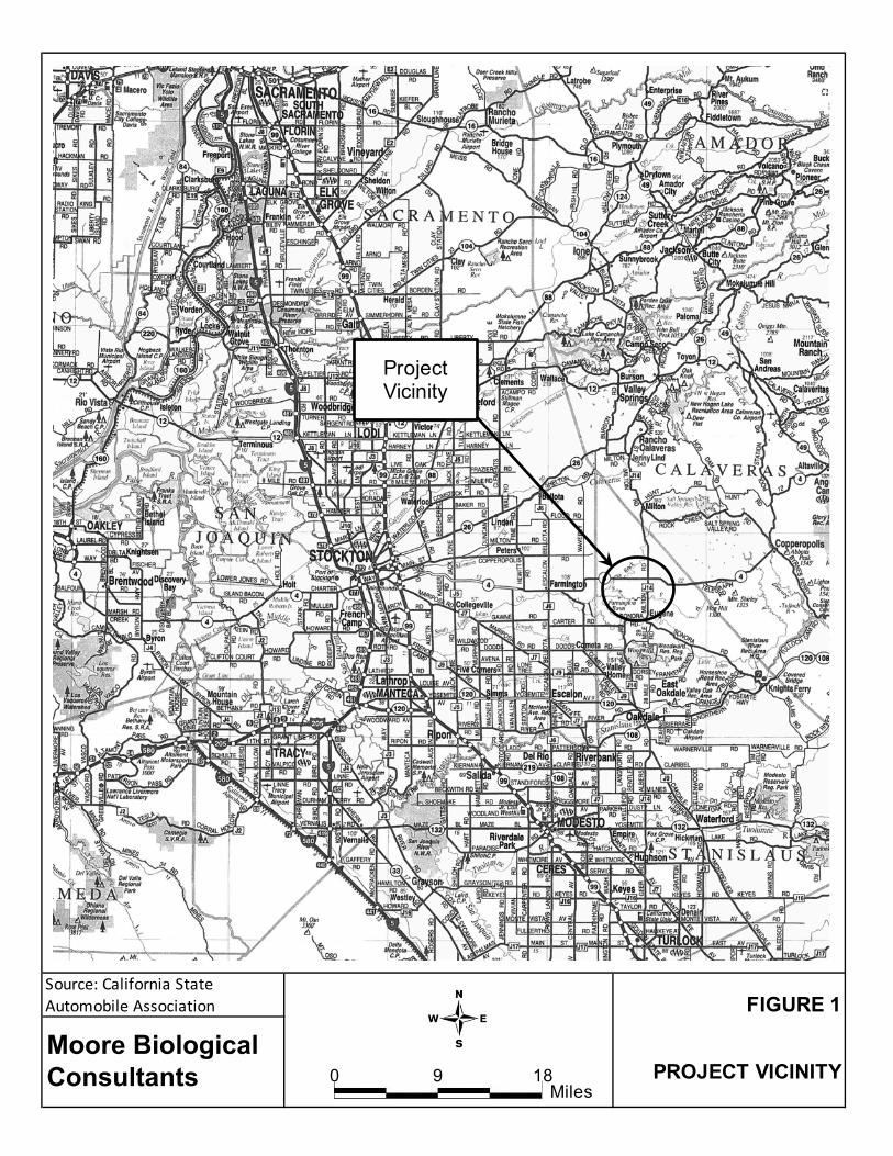
FIGURE 1
PROJECT VICINITY
Source: California State Automobile Association
Moore Biological Consultants 0 189
Miles
Project Vicinity
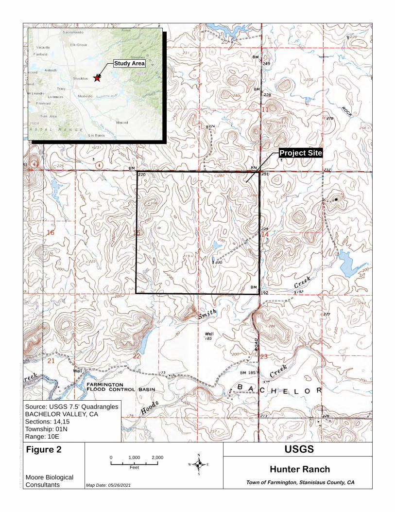
.0 2,0001,000
Feet
Figure 2
Map Date: 05/26/2021
USGS
C:\FE
C_IN
C\Pro
jects\
Moore
Biolo
gical\
Hunte
r_Ran
ch\M
XD\hu
nter_r
anch
_usgs
_figu
re_2.m
xd
Moore BiologicalConsultants Town of Farmington, Stanislaus County, CA
Hunter Ranch
Source: USGS 7.5' QuadranglesBACHELOR VALLEY, CASections: 14,15Township: 01NRange: 10E
Project Site
_̂
Study Area
Hunter Ranch: Biology 4 August 3, 2021
Because the development of a reliable irrigation water supply will make the conversion of disturbed rangeland into an orchard possible, the development and operation of the irrigation system and orchard are being also being evaluated under CEQA as contingent actions. The Project will include the following:
• Phase I of the Project will consist of the conversion of two existing test wells into irrigation wells and the conversion of a third test well into a de minimis supply well for miscellaneous incidental water supply needs, and the long-term operation of these wells to supply the water demand of approximately 175 acres of orchard for a period up to approximately 20 to 30 years. The contingent actions during Phase I include construction of the irrigation system, conversion of up to 175 acres of disturbed rangeland into an almond orchard, and long-term operation of the orchard.
• Monitoring will be conducted during the initial pumping for Phase I to assess whether groundwater drawdown is consistent with or less than the drawdown predictions presented in this memorandum. If so, then the Project will proceed to Phase II.
• Phase II of the Project will consist of construction of up to three additional irrigation wells to supply the water demand of up to an additional 175 acres of orchard for a period up to approximately 20 to 30 years. The contingent actions during Phase II include expansion of the irrigation system, conversion of up to an additional 175 acres of disturbed rangeland into an almond orchard, and long-term operation of the orchard.
The project will involve drilling and developing the new wells and appurtenant equipment, such as a pad and shed at each well, and extending power to the new wells. Contingent activities during orchard development will involve disking ripped areas that are not yet disked, ripping and disking rangeland that is not yet ripped, installing the irrigation system, and planting the orchard. Please see Proposed Site Development Map (Attachment A) and the Technical Memorandum Groundwater Resources Impact Assessment (Formation Environmental, 2020) for a complete project description.
Hunter Ranch: Biology 5 August 3, 2021
Methods
Prior to the field surveys, we conducted a search of California Department of Fish and Wildlife's (CDFW) California Natural Diversity Database (CNDDB, 2021). The CNDDB search included the USGS 7.5-minute Farmington and Bachelor Valley topographic quadrangles, encompassing approximately 120+/- square miles surrounding the site (Attachment B). The United States Fish and Wildlife Service (USFWS) IPaC Trust Resource Report of Federally Threatened and Endangered species that may occur in or be affected by projects in the project vicinity was also reviewed (Attachment B). This information was used to identify special-status wildlife and plant species that have been previously documented in the vicinity or have the potential to occur based on suitable habitat and geographical distribution. Additionally, the CNDDB depicts the locations of sensitive habitats. The USFWS on-line-maps of designated critical habitat in the area were also downloaded. We also reviewed a delineation of potentially jurisdictional Waters of the U.S. (a term that includes wetlands) (ACOE, 1987; 2008) in the project site (Cali Consulting, 2021, Attachment C). Moore Biological Consultants conducted field surveys of the site on March 23 and April 23, 2021. The surveys consisted of driving and walking throughout the site making observations of habitat conditions and noting surrounding land uses, habitat types, and plant and wildlife species. Observations were also made regarding site topography, drainage patterns, and levels of disturbance. The site was searched for special-status species and suitable habitat for special-status species (e.g., vernal pools, blue elderberry shrubs, cliffs, caves, areas with unique soils). The site was also searched for burrowing owls (Athene
cunicularia) or ground squirrel burrows that could be utilized by burrowing owls or California tiger salamanders (Ambystoma californiense). In addition, observations were made regarding the habitat attributes and associated suitability of the on-site reservoir for breeding California tiger salamanders and other amphibians. Near shore areas in the reservoir were also visually inspected for larval salamanders, frogs, and toads.
Hunter Ranch: Biology 6 August 3, 2021
The wetland characteristics (i.e., vegetation, hydrology, and soils) within the aquatic resources delineated by Cali Consulting were noted. Observations were also made regarding the types of the aquatic resources (i.e., seasonal wetland that ponds water, linear swale, creek, pond) and the associated suitability for plants and wildlife.
Results The 635+/- acre site is a few miles east of the community of Farmington, in Stanislaus County, California (Figure 1). The site is within Sections 14 and 15, within Township 1 North, Range 10 East of the USGS 7.5-minute Bachelor Valley topographic quadrangle (Figure 2). The site consists of gently rolling hills and ranges in elevations from approximately 180 to 310 feet above mean sea level. Land uses in this part of Stanislaus County are a mixture of agriculture, rangeland, and open space (Figure 3). Highway 4 borders the north edge of the site and the east edge of the site is bordered by Milton Road. The west edge of the site is bordered by an orchard and the south edge of the site is bordered by rangeland and orchards. There is rangeland to the north and east of the site, beyond Highway 4 and Milton Road, respectively. A portion of the site has been farmed in wheat, portions of the site have been ripped but not yet disked in preparation for orchard trees, and other portions have been ripped and disked, portions of the site perimeter have been disked for fire protection, and the remaining portions of the site are historical rangeland. The project site primarily consists of open grassland that has been disturbed in some capacity, but there is also a constructed stock pond in the site, a few ephemeral and intermittent drainages, several seasonal wetlands and wetland swales, and a small portion of Smith Creek that crosses the extreme southeast corner of the site (Figure 3 and photographs in Attachment D). Some of the grasslands have been highly disturbed by ripping and disking, while other areas
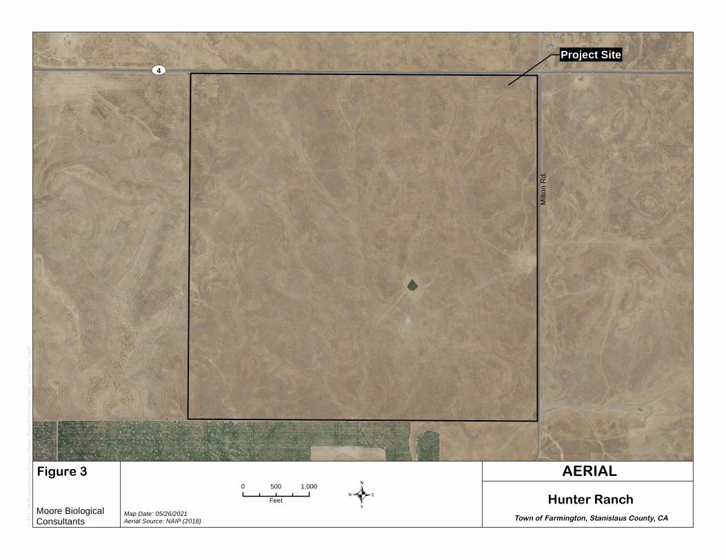
UV4
Milto
n Rd.
.0 1,000500
Feet
Figure 3
Map Date: 05/26/2021Aerial Source: NAIP (2018)
AERIAL
C:\FE
C_IN
C\Pro
jects\
Moore
Biolo
gical\
Hunte
r_Ran
ch\M
XD\hu
nter_r
anch
_aeri
al_fig
ure_3
.mxd
Moore BiologicalConsultants Town of Farmington, Stanislaus County, CA
Hunter Ranch
Project Site
Hunter Ranch: Biology 8 August 3, 2021
are more typical of rangeland used for long-term grazing. Approximately 220+/- acres of the site was farmed in wheat earlier this year and approximately 112+/- acres of the site has been ripped in preparation for the new orchard (Figure 4). There is a 7+/- acre reservoir in the central part of the site. Approximately 229+/- acres of the site is rangeland that has been used primarily for cattle grazing in the past. VEGETATION: California annual grassland series (Sawyer and Keeler-Wolf, 1995) best describes the habitat type in the site (see photographs in Attachment D). The grassland areas within the site are vegetated with native and non-native annual and perennial grassland species. Oats (Avena fatua), foxtail barley (Hordeum murinum), soft chess brome (Bromus hordeaceus), ripgut brome (Bromus diandrus), and perennial ryegrass (Lolium perenne) are dominant grasses in the site. Other grassland species such as fiddleneck (Amsinckia
menziesii), prickly lettuce (Lactuca serriola), bull thistle (Cirsium vulgare), rose clover (Trifolium hirtum), hairy vetch (Vicia villosa), field bindweed (Convolvulus
arvensis), and filaree (Erodium botrys) are intermixed with the grasses. Plant species observed in the site are listed in Table 1. There are several seasonal wetlands and seasonal wetland swales scattered within the site that support common hydrophytic species including foxtail barley (Hordeum murinum), Fremont’s goldfields (Lasthenia fremontii), meadowfoam (Limnanthes alba), horned downingia (Downingia ornatissima), stalked popcorn flower (Plagiobothrys stipitatus var. micranthus), and coyote thistle (Eryngium
vaseyi). The seasonal wetlands are all relatively small and shallow and most appear to pond water only to depths of approximately 2 to 6 inches. Some of the seasonal wetlands and seasonal wetland swales in the site have been subject to varying levels of disturbance, including grazing, disking, and wheat farming. The disking and wheat farming of some of the seasonal wetland features appears to involve disturbance to the top few inches of soil, comparable to disturbance from historical wheat farming in the site. Hoofprints evident from
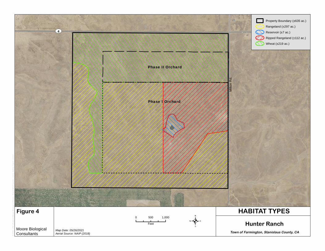
UV4
Milto
n Rd.
Phase I Orchard
Phase II Orchard
.0 1,000500
Feet
Figure 4
Map Date: 05/26/2021Aerial Source: NAIP (2018)
HABITAT TYPES
C:\FE
C_IN
C\Pro
jects\
Moore
Biolo
gical\
Hunte
r_Ran
ch\M
XD\hu
nter_r
anch
_hab
itat_f
igure_
4.mxd
Moore BiologicalConsultants Town of Farmington, Stanislaus County, CA
Hunter Ranch
Property Boundary (±635 ac.)Rangeland (±297 ac.)Reservoir (±7 ac.)Ripped Rangeland (±112 ac.)Wheat (±219 ac.)

Hunter Ranch: Biology 10 August 3, 2021
TABLE 1 PLANT SPECIES OBSERVED IN THE SITE
Achyrachaena mollis blow wives Alopecurus saccatus Pacific foxtail Amsinckia menziesii rancher’s fireweed Avena fatua wild oat Briza maxima big quaking grass Bromus diandrus ripgut brome Bromus hordeaceus soft chess brome Bromus madritensis compact brome Calochortus luteus yellow Mariposa lily Capsella bursa-pastoris shepherd’s purse Cerastium glomeratum mouse-eared chickweed Chamomilla suaveolens pineapple weed Cirsium vulgare bull thistle Convolvulus arvensis field bindweed Crypsis schoenoides swamp pricklegrass Cyperus eragrostis tall flat sedge Delphinium variegatum royal larkspur Dichelostemma capitatum blue dicks Downingia ornatissima horned downingia Eleocharis palustris common spike-rush Eremocarpus setigerus turkey mullein Erodium botrys filaree Erodium cicutarium red-stem filaree Eryngium vaseyi coyote-thistle Geranium dissectum cut-leaf geranium Glyceria occidentalis northwestern mannagrass Hesperevax caulescens hog-wallow starfish Holocarpha virgata tarweed Hordeum marinum Mediterranean barley
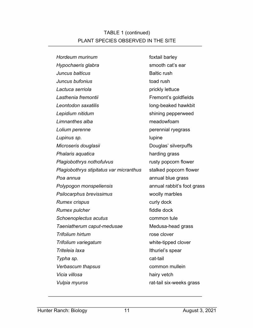
Hunter Ranch: Biology 11 August 3, 2021
TABLE 1 (continued) PLANT SPECIES OBSERVED IN THE SITE
Hordeum murinum foxtail barley Hypochaeris glabra smooth cat’s ear Juncus balticus Baltic rush Juncus bufonius toad rush Lactuca serriola prickly lettuce Lasthenia fremontii Fremont’s goldfields Leontodon saxatilis long-beaked hawkbit Lepidium nitidum shining pepperweed Limnanthes alba meadowfoam Lolium perenne perennial ryegrass Lupinus sp. lupine Microseris douglasii Douglas’ silverpuffs Phalaris aquatica harding grass Plagiobothrys nothofulvus rusty popcorn flower Plagiobothrys stipitatus var micranthus stalked popcorn flower Poa annua annual blue grass Polypogon monspeliensis annual rabbit’s foot grass Psilocarphus brevissimus woolly marbles Rumex crispus curly dock Rumex pulcher fiddle dock Schoenoplectus acutus common tule Taeniatherum caput-medusae Medusa-head grass Trifolium hirtum rose clover Trifolium variegatum white-tipped clover Triteleia laxa Ithuriel’s spear Typha sp. cat-tail Verbascum thapsus common mullein Vicia villosa hairy vetch Vulpia myuros rat-tail six-weeks grass
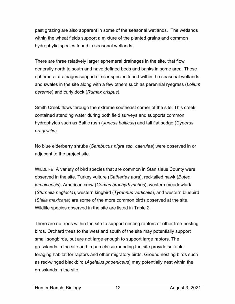
Hunter Ranch: Biology 12 August 3, 2021
past grazing are also apparent in some of the seasonal wetlands. The wetlands within the wheat fields support a mixture of the planted grains and common hydrophytic species found in seasonal wetlands. There are three relatively larger ephemeral drainages in the site, that flow generally north to south and have defined beds and banks in some area. These ephemeral drainages support similar species found within the seasonal wetlands and swales in the site along with a few others such as perennial ryegrass (Lolium
perenne) and curly dock (Rumex crispus). Smith Creek flows through the extreme southeast corner of the site. This creek contained standing water during both field surveys and supports common hydrophytes such as Baltic rush (Juncus balticus) and tall flat sedge (Cyperus
eragrostis). No blue elderberry shrubs (Sambucus nigra ssp. caerulea) were observed in or adjacent to the project site. WILDLIFE: A variety of bird species that are common in Stanislaus County were observed in the site. Turkey vulture (Cathartes aura), red-tailed hawk (Buteo
jamaicensis), American crow (Corvus brachyrhynchos), western meadowlark (Sturnella neglecta), western kingbird (Tyrannus verticalis), and western bluebird (Sialia mexicana) are some of the more common birds observed at the site. Wildlife species observed in the site are listed in Table 2.
There are no trees within the site to support nesting raptors or other tree-nesting birds. Orchard trees to the west and south of the site may potentially support small songbirds, but are not large enough to support large raptors. The grasslands in the site and in parcels surrounding the site provide suitable foraging habitat for raptors and other migratory birds. Ground nesting birds such as red-winged blackbird (Agelaius phoeniceus) may potentially nest within the grasslands in the site.

Hunter Ranch: Biology 13 August 3, 2021
TABLE 2 WILDLIFE SPECIES OBSERVED IN THE SITE
Canada goose Branta canadensis Turkey vulture Cathartes aura
Red-tailed hawk Buteo jamaicensis
Killdeer Charadrius vociferous
Western gull Larus occidentalis Mourning dove Zenaida macroura
Say’s phoebe Sayornis saya Western kingbird Tyrannus verticalis
Horned lark Eremophila alpestris American crow Corvus brachyrhynchos
Western bluebird Sialia mexicana European starling Sturnus vulgaris Golden-crowned sparrow Zonotrichia atricapilla
Red-winged blackbird Agelaius phoeniceus
Tricolored blackbird Agelaius tricolor Western meadowlark Sturnella neglecta
Several mammals are expected to use habitats in or move through the site on occasion. While no mammals were observed in the site, a limited number of California ground squirrel (Otospermophilus beecheyi) burrows were observed, primarily along the west edge of the site. Numerous Botta’s pocket gopher (Thomomys bottae) burrows were also observed in relatively undisturbed grasslands in the site. Coyote (Canis latrans), raccoon (Procyon lotor), desert cottontail (Sylvilagus audubonii), black-tailed hare (Lepus californicus), and striped skunk (Mephitis mephitis) are known from the greater project vicinity and are expected to occur within the project site on occasion. Black-tailed (mule) deer (Odocoileus hemionus), mountain lion (Felis concolor) and bobcat (Felis rufus)
Hunter Ranch: Biology 14 August 3, 2021
may occur on-site on occasion; however, no evidence of these species was observed. Small rodents including mice (Mus musculus, Reithrodontomys
megalotis, and Peromyscus maniculatus) and voles (Microtus californicus) are also likely occur in the site. Based on habitat types present, a variety of amphibians and reptiles may use habitats within the immediate project vicinity; however, no amphibians or reptiles were observed within the site during the field surveys. The site is within the range of a few common species such as American bullfrog (Lithobates catesbeianus), Pacific chorus frog (Pseudacris regilla), western fence lizard (Sceloporus occidentalis), northern alligator lizard (Gerrhonotus coeruleus), common king snake (Lampropeltis getulus), western rattlesnake (Crotalis viridis), and common garter snake (Thamnophis sirtalis); these and other common amphibian and reptile species may also occur on-site. WATERS OF THE U.S. AND WETLANDS: Waters of the U.S., including wetlands, are broadly defined under 33 Code of Federal Regulations (CFR) 328 to include navigable waterways, their tributaries, and adjacent wetlands. State and federal agencies regulate these habitats and Section 404 of the Clean Water Act requires that a permit be secured prior to the discharge of dredged or fill materials into any waters of the U.S., including wetlands. Some jurisdictional waters of the U.S. also fall under the jurisdiction of CDFW and/or the California Regional Water Quality Control Board (RWQCB). “Waters of the U.S.”, as defined in 33 CFR 328.4, encompasses Territorial Seas, Tidal Waters, and Non-Tidal Waters; Non-Tidal Waters includes interstate and intrastate rivers and streams, as well as their tributaries. The limit of federal jurisdiction of Non-Tidal Waters of the U.S. extends to the “ordinary high water mark”, which is identified by physical characteristics such as a natural water line impressed on the bank, presence of shelves, destruction of terrestrial vegetation, or the presence of litter and debris. Jurisdictional wetlands are vegetated areas that meet specific vegetation, soil, and hydrologic criteria defined by the ACOE
Hunter Ranch: Biology 15 August 3, 2021
Wetlands Delineation Manual and Regional Supplement (ACOE, 1987; 2008). Jurisdictional wetlands are usually adjacent to or hydrologically associated with Waters of the U.S. Isolated wetlands are outside federal jurisdiction, but may be regulated by RWQCB under the State Wetlands Program. Jurisdictional wetlands and Waters of the U.S. include, but are not limited to, perennial and intermittent creeks and drainages, lakes, seeps, and springs; emergent marshes; riparian wetlands; and seasonal wetlands. Wetlands and Waters of the U.S. provide critical habitat components, such as nest sites and a reliable source of water, for a wide variety of wildlife species. There are several different aquatic features within the overall parcel boundary. A wetland delineation was conducted in 2020 by Cali Consulting (Attachment C). Potential Waters of the U.S or wetlands include several seasonal wetlands, several seasonal drainages, a reservoir, and a short section of a perennial creek. Other than the features delineated, no other potentially jurisdictional Water of the U.S. or wetlands were observed in the site. The remainder of the site consists of upland grasslands with soils that appear well draining. Seasonal Wetlands: There are 15 seasonal wetlands within the project site, which are labeled SW-1 through SW-15 on the wetland delineation map. These seasonal wetlands are shallow basins, and most appear to only pond water to a depth of only a few inches. Common hydrophytic species observed within the seasonal wetlands in the site include meadowfoam, Fremont’s goldfields, popcorn flower, and toad rush. Seasonal Wetland Swales: A total of 28 seasonal wetlands swales were delineated in the site and are labeled as WS-1 through WS-28 on the wetland delineation map. The seasonal wetland swales in the site have directional flow and support several of the same hydrophytic species as the seasonal wetlands. Four of the drainages that are mapped as swales may be better described as ephemeral or intermittent creeks, as they have defined beds and banks along
Hunter Ranch: Biology 16 August 3, 2021
much of their lengths with discernible high water marks in deeper pockets. Three of these creeks are depicted as dashed “blue-line” drainages on the USGS topographic map (Figure 2) and are identified as “Riverine” or “Freshwater Emergent Wetland” features in the National Wetland Inventory (NWI) (Attachment E). While not shown on the USGS map or included in the NWI, Seasonal Wetland Swale WS-16 is also better described as an ephemeral or intermittent creek Reservoir: The reservoir in the central part of the site was constructed for stock watering many decades ago as a way to provide cattle with a perennial water source and has been enlarged to hold water pumped in to the pond from the on-site wells and store the water to irrigate the new orchard. There is no emergent wetland vegetation such as cattails in the reservoir and near-shore areas are bare dirt and gravel. This constructed pond is depicted as a seasonal pond on the topographic map (Figure 2) and as a “Freshwater Emergent Wetland” in the NWI (Attachment E). Perennial Creek: Smith Creek runs through the extreme southeast corner of the site, flowing on to the site through a culvert under Milton Road. There was standing water in Smith Creek during the field surveys and common species such as Baltic rush, tall flat sedge, annual rabbit’s-foot grass (Polypogon
monspeliensis), common tule (Schoenoplectus acutus), and cattails (Typha sp.) were observed along the creek banks. Smith Creek is depicted as a blue-line stream on the USGS topographic map (Figure 2). While Smith Creek upstream and downstream of the site is mapped as a “Riverine” feature on the NWI map (Attachment E), the portion of the creek that passes through the site is mapped as a “Freshwater Pond”. SPECIAL-STATUS SPECIES: Special-status species are plants and animals that are legally protected under the state and/or federal Endangered Species Act or other regulations. The Federal Endangered Species Act (FESA) of 1973 declares that all federal departments and agencies shall utilize their authority to conserve
Hunter Ranch: Biology 17 August 3, 2021
endangered and threatened plant and animal species. The California Endangered Species Act (CESA) of 1984 parallels the policies of FESA and pertains to native California species. Both FESA and CESA prohibit unauthorized “take” (i.e., killing) of listed species, with take broadly defined in both acts to include activities such as harassment, pursuit and possession. Special-status wildlife species also includes species that are considered rare enough by the scientific community and trustee agencies to warrant special consideration, particularly with regard to protection of isolated populations, nesting or denning locations, communal roosts, and other essential habitat. The federal Migratory Bird Treaty Act and Fish and Game Code of California protect special-status bird species year-round, as well as their eggs and nests during the nesting season. Fish and Game Code of California also provides protection for mammals and fish. Special-status plants are those which are designated rare, threatened, or endangered and candidate species for listing by the USFWS. Special-status plants also include species considered rare or endangered under the conditions of Section 15380 of the California Environmental Quality Act Guidelines, such as those plant species identified on Lists 1A, 1B and 2 in the Inventory of Rare and Endangered Vascular Plants of California (CNPS, 2021). Finally, special-status plants may include other species that are considered sensitive or of special concern due to limited distribution or lack of adequate information to permit listing or rejection for state or federal status, such as those included on CNPS List 3. Table 3 summarizes the listing status and habitat requirements of special-status species that have been documented in the CNDDB (2021) in the greater vicinity of the site, or for which there is potentially suitable habitat in or near the site. This table also includes an assessment of the likelihood of occurrence of each of these species in the site. The evaluation of the potential for occurrence of each species is based on regional occurrences (if any), habitat suitability, and field observations.
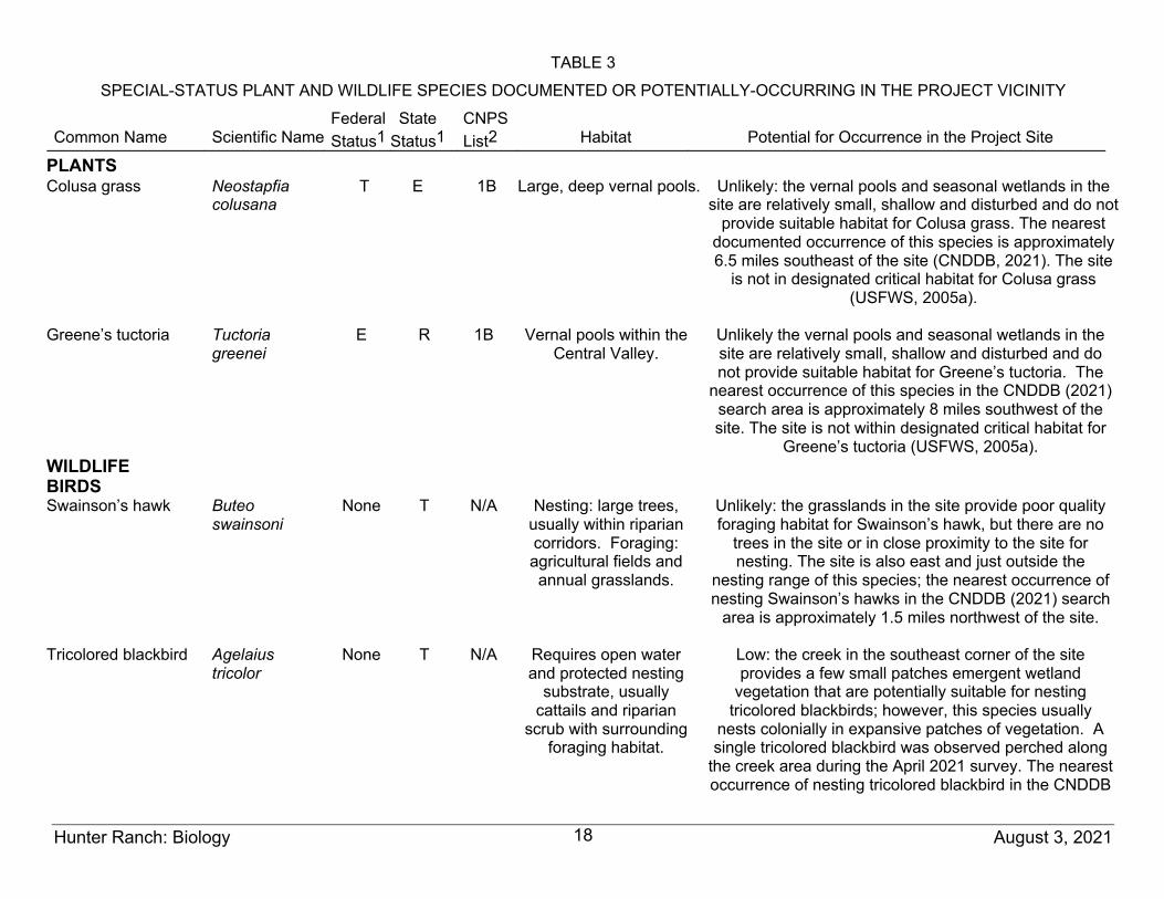
TABLE 3
SPECIAL-STATUS PLANT AND WILDLIFE SPECIES DOCUMENTED OR POTENTIALLY-OCCURRING IN THE PROJECT VICINITY
Common Name
Scientific Name
Federal Status1
State Status1
CNPS List2
Habitat
Potential for Occurrence in the Project Site
Hunter Ranch: Biology August 3, 2021 18
PLANTS Colusa grass Neostapfia
colusana T E 1B Large, deep vernal pools. Unlikely: the vernal pools and seasonal wetlands in the
site are relatively small, shallow and disturbed and do not provide suitable habitat for Colusa grass. The nearest
documented occurrence of this species is approximately 6.5 miles southeast of the site (CNDDB, 2021). The site
is not in designated critical habitat for Colusa grass (USFWS, 2005a).
Greene’s tuctoria Tuctoria
greenei E R 1B Vernal pools within the
Central Valley.
Unlikely the vernal pools and seasonal wetlands in the site are relatively small, shallow and disturbed and do not provide suitable habitat for Greene’s tuctoria. The
nearest occurrence of this species in the CNDDB (2021) search area is approximately 8 miles southwest of the site. The site is not within designated critical habitat for
Greene’s tuctoria (USFWS, 2005a). WILDLIFE BIRDS Swainson’s hawk Buteo
swainsoni None T N/A Nesting: large trees,
usually within riparian corridors. Foraging: agricultural fields and annual grasslands.
Unlikely: the grasslands in the site provide poor quality foraging habitat for Swainson’s hawk, but there are no
trees in the site or in close proximity to the site for nesting. The site is also east and just outside the
nesting range of this species; the nearest occurrence of nesting Swainson’s hawks in the CNDDB (2021) search
area is approximately 1.5 miles northwest of the site.
Tricolored blackbird Agelaius tricolor
None T N/A Requires open water and protected nesting
substrate, usually cattails and riparian
scrub with surrounding foraging habitat.
Low: the creek in the southeast corner of the site provides a few small patches emergent wetland
vegetation that are potentially suitable for nesting tricolored blackbirds; however, this species usually
nests colonially in expansive patches of vegetation. A single tricolored blackbird was observed perched along
the creek area during the April 2021 survey. The nearest occurrence of nesting tricolored blackbird in the CNDDB
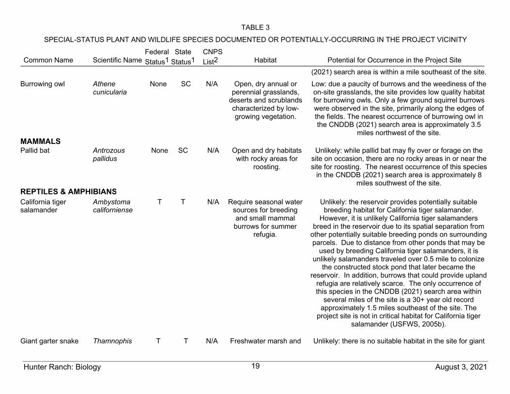
TABLE 3
SPECIAL-STATUS PLANT AND WILDLIFE SPECIES DOCUMENTED OR POTENTIALLY-OCCURRING IN THE PROJECT VICINITY
Common Name
Scientific Name
Federal Status1
State Status1
CNPS List2
Habitat
Potential for Occurrence in the Project Site
Hunter Ranch: Biology August 3, 2021 19
(2021) search area is within a mile southeast of the site. Burrowing owl Athene
cunicularia
None SC N/A Open, dry annual or perennial grasslands,
deserts and scrublands characterized by low-growing vegetation.
Low: due a paucity of burrows and the weediness of the on-site grasslands, the site provides low quality habitat for burrowing owls. Only a few ground squirrel burrows were observed in the site, primarily along the edges of the fields. The nearest occurrence of burrowing owl in the CNDDB (2021) search area is approximately 3.5
miles northwest of the site. MAMMALS Pallid bat Antrozous
pallidus None SC N/A Open and dry habitats
with rocky areas for roosting.
Unlikely: while pallid bat may fly over or forage on the site on occasion, there are no rocky areas in or near the site for roosting. The nearest occurrence of this species
in the CNDDB (2021) search area is approximately 8 miles southwest of the site.
REPTILES & AMPHIBIANS California tiger salamander
Ambystoma californiense
T T N/A Require seasonal water sources for breeding and small mammal burrows for summer
refugia.
Unlikely: the reservoir provides potentially suitable breeding habitat for California tiger salamander.
However, it is unlikely California tiger salamanders breed in the reservoir due to its spatial separation from
other potentially suitable breeding ponds on surrounding parcels. Due to distance from other ponds that may be
used by breeding California tiger salamanders, it is unlikely salamanders traveled over 0.5 mile to colonize
the constructed stock pond that later became the reservoir. In addition, burrows that could provide upland
refugia are relatively scarce. The only occurrence of this species in the CNDDB (2021) search area within
several miles of the site is a 30+ year old record approximately 1.5 miles southeast of the site. The
project site is not in critical habitat for California tiger salamander (USFWS, 2005b).
Giant garter snake Thamnophis T T N/A Freshwater marsh and Unlikely: there is no suitable habitat in the site for giant
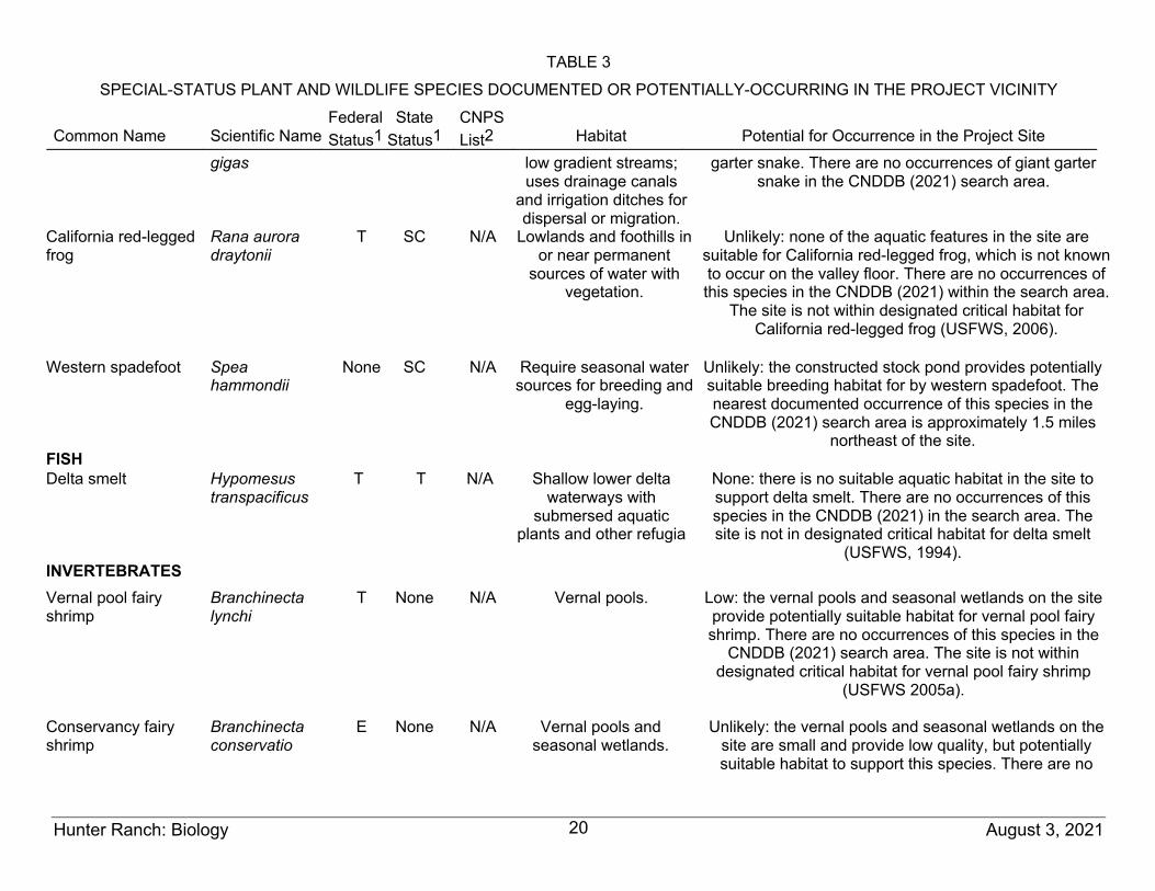
TABLE 3
SPECIAL-STATUS PLANT AND WILDLIFE SPECIES DOCUMENTED OR POTENTIALLY-OCCURRING IN THE PROJECT VICINITY
Common Name
Scientific Name
Federal Status1
State Status1
CNPS List2
Habitat
Potential for Occurrence in the Project Site
Hunter Ranch: Biology August 3, 2021 20
gigas low gradient streams; uses drainage canals
and irrigation ditches for dispersal or migration.
garter snake. There are no occurrences of giant garter snake in the CNDDB (2021) search area.
California red-legged frog
Rana aurora draytonii
T SC N/A Lowlands and foothills in or near permanent
sources of water with vegetation.
Unlikely: none of the aquatic features in the site are suitable for California red-legged frog, which is not known to occur on the valley floor. There are no occurrences of this species in the CNDDB (2021) within the search area.
The site is not within designated critical habitat for California red-legged frog (USFWS, 2006).
Western spadefoot Spea
hammondii None SC N/A Require seasonal water
sources for breeding and egg-laying.
Unlikely: the constructed stock pond provides potentially suitable breeding habitat for by western spadefoot. The nearest documented occurrence of this species in the CNDDB (2021) search area is approximately 1.5 miles
northeast of the site. FISH Delta smelt Hypomesus
transpacificus T T N/A Shallow lower delta
waterways with submersed aquatic
plants and other refugia
None: there is no suitable aquatic habitat in the site to support delta smelt. There are no occurrences of this species in the CNDDB (2021) in the search area. The site is not in designated critical habitat for delta smelt
(USFWS, 1994). INVERTEBRATES Vernal pool fairy shrimp
Branchinecta lynchi
T None N/A Vernal pools.
Low: the vernal pools and seasonal wetlands on the site provide potentially suitable habitat for vernal pool fairy shrimp. There are no occurrences of this species in the
CNDDB (2021) search area. The site is not within designated critical habitat for vernal pool fairy shrimp
(USFWS 2005a).
Conservancy fairy shrimp
Branchinecta conservatio
E None N/A Vernal pools and seasonal wetlands.
Unlikely: the vernal pools and seasonal wetlands on the site are small and provide low quality, but potentially suitable habitat to support this species. There are no
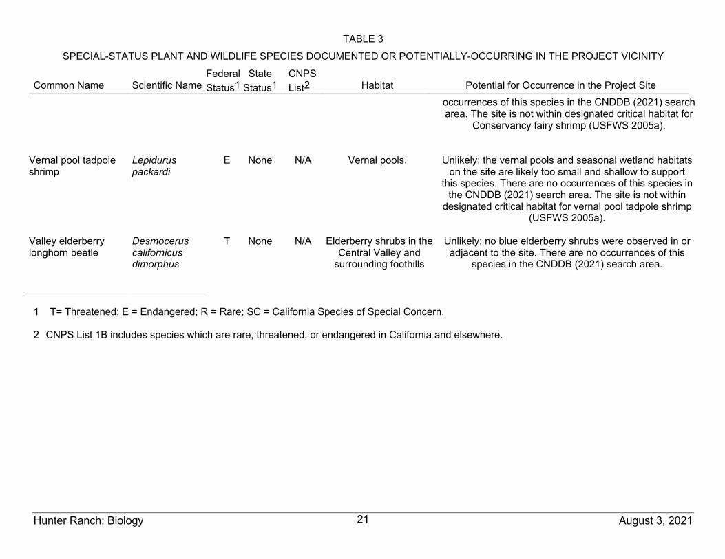
TABLE 3
SPECIAL-STATUS PLANT AND WILDLIFE SPECIES DOCUMENTED OR POTENTIALLY-OCCURRING IN THE PROJECT VICINITY
Common Name
Scientific Name
Federal Status1
State Status1
CNPS List2
Habitat
Potential for Occurrence in the Project Site
Hunter Ranch: Biology August 3, 2021 21
occurrences of this species in the CNDDB (2021) search area. The site is not within designated critical habitat for
Conservancy fairy shrimp (USFWS 2005a).
Vernal pool tadpole shrimp
Lepidurus packardi
E None N/A Vernal pools.
Unlikely: the vernal pools and seasonal wetland habitats on the site are likely too small and shallow to support
this species. There are no occurrences of this species in the CNDDB (2021) search area. The site is not within
designated critical habitat for vernal pool tadpole shrimp (USFWS 2005a).
Valley elderberry longhorn beetle
Desmocerus californicus dimorphus
T None N/A Elderberry shrubs in the Central Valley and
surrounding foothills
Unlikely: no blue elderberry shrubs were observed in or adjacent to the site. There are no occurrences of this
species in the CNDDB (2021) search area.
1 T= Threatened; E = Endangered; R = Rare; SC = California Species of Special Concern.
2 CNPS List 1B includes species which are rare, threatened, or endangered in California and elsewhere.
Hunter Ranch: Biology 22 August 3, 2021
SPECIAL-STATUS PLANTS: Colusa grass (Neostapfia colusana) and Greene’s tuctoria (Tuctoria greenei) are the only special-status plants recorded in the CNDDB (2021) within the search area (i.e., the USGS 7.5-minute Farmington and Bachelor Valley topographic quadrangles) (Table 3 and Attachment C). The USFWS IPaC Trust Report does not include any special-status plants. Special-status plants found along the edge of the valley floor along the edge of Sierra Nevada foothills generally occur in relatively undisturbed areas within unique vegetation communities such as chaparral, seeps and springs, marshes and swamps, and areas with unique soils (i.e., serpentine, gabbroic). The site primarily consists of upland grassland, much of which is highly disturbed, and no unique habitat types, special-status plants, or highly suitable habitat for special-status plants were observed in the site. The seasonal wetlands in the project site do not provide suitable habitat for Colusa grass and Greene’s tuctoria. These two species are usually found in larger, deeper, and less disturbed vernal pools and seasonal wetlands than those in the site. The nearest records of Colusa grass and Greene’s tuctoria in the CNDDB (2021) search area are 6.5 and 8 miles from the project site, respectively. SPECIAL-STATUS WILDLIFE: The potential for intensive use of habitats within the site by special-status wildlife species is generally low. Special-status wildlife species recorded in the CNDDB (2021) in the search area include Swainson’s hawk (Buteo swainsoni), burrowing owl, tricolored blackbird (Agelaius tricolor), pallid bat (Antrozous pallidus), California tiger salamander, and western spadefoot toad (Spea hammondii). California red-legged frog (Rana aurora draytonii), giant garter snake (Thamnophis gigas), delta smelt (Hypomesus transpacificus), vernal pool fairy shrimp (Branchinecta lynchi), Conservancy fairy shrimp (Branchinecta
conservatio), vernal pool tadpole shrimp (Lepidurus packardi), and valley
Hunter Ranch: Biology 23 August 3, 2021
elderberry longhorn beetle (Desmocerus californicus dimorphus) are not recorded in the CNDDB (2021) within the search area, but are on the USFWS IPaC Trust Report (Attachment B). Only a few of the species identified in Table 3 have potential to occur in the site on more than an occasional or transitory basis and are discussed below. BURROWING OWL: The Migratory Bird Treaty Act and Fish and Game Code of California protect burrowing owls year-round, as well as their nests during the nesting season (February 1 through August 31). Burrowing owls are a year-long resident in a variety of grasslands as well as scrub lands that have a low density of trees and shrubs with low growing vegetation; burrowing owls that nest in the Central Valley may winter elsewhere. The primary habitat requirement of the burrowing owl is small mammal burrows for nesting. The owl usually nests in abandoned ground squirrel burrows, although they have been known to dig their own burrows in softer soils. In urban areas, burrowing owls often utilize artificial burrows including pipes, culverts, and piles of concrete pieces. This semi-colonial owl breeds from March through August, and is most active while hunting during dawn and dusk. The nearest record of this species in the CNDDB (2021) search area is approximately 3.5 miles northwest of the site No burrowing owls or burrows with evidence of past or present owl occupancy were observed in the site. The weediness of the grassland in the site, as well as disturbance from ripping and disking reduces the likelihood of burrowing owls using portions of the site for nesting. Further, only a few ground squirrel burrows were observed within the site, with most of the burrows being in the rangeland along the west edge of the site. Burrowing owls are known to occur in low numbers the greater project vicinity and this species could occur within the site in the future if burrow habitat is available.
Hunter Ranch: Biology 24 August 3, 2021
SWAINSON’S HAWK: The Swainson’s hawk is a migratory hawk listed by the State of California as a Threatened species. The Migratory Bird Treaty Act and Fish and Game Code of California protect Swainson’s hawks year-round, as well as their nests during the nesting season (March 1 through September 15). Swainson’s hawk are found in the Central Valley primarily during their breeding season, a population is known to winter in the San Joaquin Valley. Swainson's hawks prefer nesting sites that provide sweeping views of nearby foraging grounds consisting of grasslands, irrigated pasture, hay, and wheat crops. Most Swainson's hawks are migratory, wintering in Mexico and breeding in California and elsewhere in the western United States. This raptor generally arrives in the Central Valley in mid-March, and begins courtship and nest construction immediately upon arrival at the breeding sites. The young fledge in early July, and most Swainson's hawks leave their breeding territories by late August. Swainson’s hawks soar high in the sky while foraging, searching for prey items and then fly down to kill and eat mice, gophers, snakes, and other small animals. They cannot see prey items beneath the canopies of trees and cannot fly in to orchards and soar between rows of trees. Swainson’s hawk foraging habitat is clearly defined in CDFW’s Staff Report regarding Mitigation for Impacts to Swainson’s Hawks (Buteo Swainsoni) in the Central Valley of California (CDFG, 1994) as annual grassland, annual cropland including fallow fields, pasture, and alfalfa. Vineyards, orchards and cotton are specifically identified as unsuitable. Swainson’s hawks primarily forage near their nest trees but can also forage over several hundred or thousands or acres. The site is east and just outside the nesting range of Swainson’s hawks and no Swainson’s hawks were observed in the site. The CNDDB (2021) contains only a few records of nesting Swainson’s hawk in the greater project vicinity and the nearest record is approximately 1.5 miles northwest of the site. The site provides suitable foraging habitat for Swainson’s hawk, but does not contain any suitable
Hunter Ranch: Biology 25 August 3, 2021
nest trees. The orchard trees to the west and south of the site are too small to support nesting raptors, including Swainson’s hawk; the orchards also do not provide suitable foraging habitat for Swainson’s hawks. Due to the location of the site so far east of the valley floor and lack of suitable nest trees, it is unlikely Swainson’s hawks forage in the site on more than a very occasional basis. TRICOLORED BLACKBIRD: The tricolored blackbird is a State of California Species threatened species and is also protected by the federal MBTA and Fish and Game Code of California. Tricolored blackbirds are colonial nesters requiring very dense stands of emergent wetland vegetation and/or dense thickets of wild rose or blackberries for nesting. Preferred nesting substrates are expansive stands of cattails and tules adjacent to open water. Tricolored blackbirds forage in annual grasslands and cropland. The nearest occurrence of nesting tricolored blackbird in the CNDDB (2021) search area is within a mile southeast of the site. A single tricolored blackbird was observed along the creek in the southeast corner of the site. The section of Smith Creek in the southeast corner of the site provides a limited area of open water habitat, but lacks expansive areas of suitable emergent wetland vegetation used for nesting by this species. The annual grassland in and adjacent to the project site provides potentially suitable foraging habitat for this species. The extent of use of the site by foraging tricolored blackbirds is not known. CALIFORNIA TIGER SALAMANDER: In 2004, the California tiger salamander was listed as threatened under FESA (USFWS, 2004), and in 2010, it was also listed as threatened under CESA. In August 2005, USFWS designated critical habitat for the Central Valley population of California tiger salamander (USFWS, 2005a). Review of the USFWS maps of designated critical habitat for California tiger salamander (Attachment F) indicates that the project site is not within a Critical Habitat Unit for California tiger salamander.
Hunter Ranch: Biology 26 August 3, 2021
California tiger salamanders require stock ponds without game fish or deep, large vernal pools, which hold water well into the spring (i.e., April or May) for breeding (Jennings and Hayes, 1994). Grasslands containing ground squirrel burrows and other smaller mammal burrows near breeding ponds are used for over-summering. After heavy winter rains, the adults emerge from their burrows, migrate to breeding ponds, spend a few days in the ponds breeding, and then return to their burrows. California tiger salamander eggs are laid singularly or in groups, attached to emergent and underwater vegetation. Following larval metamorphosis, the young emerge from the ponds, disperse across upland habitats, and spend the summer months in subterranean refugia. While most salamanders aestivate in burrows within several hundred feet of their breeding ponds, they have been documented over-summering up to a mile or more from their breeding ponds. The nearest documented occurrence of this species is approximately 1.5 miles southeast of the site (CNDDB, 2021). This 1988 record describes a few live and dead salamanders somewhere along Dunton Road. There are no other records of California tiger salamander in the CNDDB (2021) within several miles of the site. The reservoir in the site provides low quality yet potentially suitable breeding habitat for California tiger salamander, with the suitability being reduced by an absence of emergent wetland vegetation or submerged vegetation on the floor of the reservoir. The seasonal wetlands in the site are too small and shallow to pond water long enough in the spring to support successful reproduction. No other potentially suitable California tiger salamander breeding habitat was observed within or adjacent to the project site. It is unlikely California tiger salamanders breed in the reservoir due to its spatial separation from other potentially suitable breeding ponds on surrounding parcels from which salamanders may have migrated over 0.5 miles to colonize the constructed pond that later became the reservoir. Further, only a few pocket gopher burrows and ground squirrel burrows were observed in the site that could potentially provide suitable aestivation habitat for tiger salamander.
Hunter Ranch: Biology 27 August 3, 2021
WESTERN SPADEFOOT: The western spadefoot is a State of California Species of Concern, but is not listed at either the state or federal level. Western spadefoot is a subterranean species that occupies rodent burrows and other underground retreats in grasslands, prairie, savanna, and scrub vegetation communities. This toad remains underground most of the year coming to the surface only during the rainy season, when it moves to ephemeral water channels and pools to breed. Western spadefoot toad is more commonly found in large, deep, vernal pools as opposed to isolated stock ponds. There are only two records of western spadefoot within the CNDDB (2021) search area and the nearest documented occurrence of this species is approximately 1.5 miles northeast of the site; this record is historic (1981). Similar to the California tiger salamanders, it is unlikely western spadefoot traveled over 0.5 miles to colonize the constructed stock pond that later became a reservoir, and potential refugia burrows are relatively scarce at the site. VERNAL POOL INVERTEBRATES: In 1994, USFWS listed three species of Central Valley fairy shrimp and one species of tadpole shrimp as threatened or endangered species under FESA. The vernal pool fairy shrimp was listed as threatened, while Conservancy fairy shrimp, longhorn fairy shrimp (B.
longiantenna), and vernal pool tadpole shrimp were listed as endangered. All of these species occur in vernal pools and other seasonal wetland habitats throughout much of the Central Valley. In most years, following cold winter rains which fill vernal pools, shrimp hatch, grow for a period ranging from a couple of weeks to a couple of months, then lay eggs and die. The eggs drift to the mud at the bottom of the pools, and remain in the dirt throughout the summer when the pools dry out; the shrimp hatch the following winter. There are no occurrences of vernal pool fairy shrimp, vernal pool tadpole shrimp, or Conservancy fairy shrimp in the CNDDB (2021) search area. Most of the seasonal wetlands in the site are highly disturbed from past disking and wheat farming and are very shallow. The low suitability of the seasonal wetlands in the
Hunter Ranch: Biology 28 August 3, 2021
site and lack of documented occurrences in close proximity to the site reduces the potential for listed vernal pool shrimp species to occur in the site. OTHER SPECIAL-STATUS SPECIES: Pallid bat may fly over or forage in the site, but there are no rocky areas in the site to support roosting. The site does not provide suitable aquatic habitat for California red-legged frog. Smith Creek does not provide suitable aquatic habitat for special-status fish. CRITICAL HABITAT: The site is not within designated critical habitat for California red-legged frog (USFWS, 2006), any vernal pool shrimp or plant species (USFWS, 2005a), California tiger salamander (USFWS, 2005b), or other federally listed species (Attachment F).
Program Environmental Impact Report In 2018, Stanislaus County adopted a Program Environmental Impact Report (PEIR) that evaluated the potential environmental impacts associated with implementing its discretionary well permitting program (JJ&A 2018). The PEIR concluded that implementation of individual well development and associated agricultural development projects could result in potentially significant impacts to biological resources. The PEIR concluded projects such as the proposed project could result in four impact areas as follows:
Impact BIO-1. Substantial adverse effect, either directly or through habitat modifications, on any species identified as a candidate, sensitive, or special-status species in local or regional plans, policies, or regulations, or by the California Department of Fish and Wildlife (CDFW) or U.S. Fish and Wildlife Service (USFWS).
Impact BIO-2. Substantial adverse effect on any riparian habitat,
groundwater-dependent ecosystem, groundwater-
Hunter Ranch: Biology 29 August 3, 2021
connected stream or reservoir, or other sensitive natural community identified in local or regional plans, policies, regulations, or by the California Department of Fish and Wildlife or U.S. Fish and Wildlife Service.
Impact BIO-3. Substantial adverse effect on federally protected wetlands
as defined by Section 404 of the Clean Water Act (including, but not limited to, marshes, vernal pools, coastal wetlands, etc.) or waters of the State through direct removal, filling, hydrological interruption, or other means.
Impact BIO-4. Conflicts with any local policies or ordinances protecting
biological resources, such as a tree preservation policy or ordinance.
The Hunter Ranch project appears well suited for CEQA programmatic review under the guidelines contained in the PEIR (JJ&A 2018). The PEIR concluded certain well construction and operation projects and associated contingent agricultural rangeland conversion that may result in potentially significant impacts may be reduced to a less-than-significant level by incorporating the following PEIR Mitigation Measures, which will be implemented for the proposed project: Mitigation Measure BIO-1. A qualified biologist shall investigate the potential presence or absence of sensitive habitats and wetlands, and special-status plants or wildlife in areas that will be disturbed by well construction or conversion of rangelands to cultivated use that is made possible by the well, prior to well permit approval or project implementation. This biological assessment fulfills Mitigation Measure BIO-1. Mitigation Measure BIO-1b. The applicant shall endeavor to conduct any drilling, construction work and/or ground-disturbing activities associated with installation of the proposed well or the conversion of rangeland to cultivated
Hunter Ranch: Biology 30 August 3, 2021
agricultural use that will be irrigated using the well during the non-breeding season of any birds and raptors protected under the Migratory Bird Treaty Act (generally September 16 through January 31). If construction activities must be scheduled during the nesting season (generally February 1 to September 15), preconstruction surveys for raptors, migratory birds, and special-status bird
species shall be done by a qualified biologist to identify active nests near the site.
This shall include a buffer extending out from the construction or disturbance area to a distance of approximately ½ mile. If active nests are found, no drilling construction activities shall occur within 500 feet of the nest until the young have fledged and the nest is no longer active (as determined by the qualified biologist). Survey timing and frequency requirements differ among species; species-specific surveys should follow all timing and frequency requirements of CDFW and USFWS. Consultation with the CDFW and/or USFWS shall occur if required and may result in additional requirements. Mitigation Measures BIO-1 & BIO-2. These measures are designed to also satisfy Impact BIO-3 criteria concerning Section 404 of the Clean Water Act and wetland habitat assessment. Mitigation Measure BIO-4. Evaluate well construction permit applications to assess potential conflicts with local policies or ordinances that protect biological resources and consider mitigation measures for significant effects on the environment on a project-specific basis. The PEIR concluded that implementation of the discretionary well permitting program would result in less-than-significant impacts to the movement of native wildlife species, wildlife movement corridors, and would not impede the use of native wildlife nursery sites. The PEIR also concluded that implementation of the discretionary well permitting program would not conflict with an approved local, regional, or state habitat conservation plan.
Hunter Ranch: Biology 31 August 3, 2021
Discussion, Conclusions and Recommendations
• The site primarily consists of upland native and non-native grassland disturbed by historical grazing and with many parts of the site disturbed by wheat farming, disking, and ripping. Similar upland grasslands are widespread in Stanislaus County, supporting a variety of mostly common plant and wildlife species.
• Potential Waters of the U.S or wetlands include several seasonal
wetlands and wetlands swales, a few intermittent creeks, a reservoir, and a short section of Smith Creek.
• The proposed project and contingent actions involve complete
avoidance of aquatic resources, including 30+/- buffers between the new orchard blocks and the delineated aquatic resources. If complete avoidance of potentially jurisdictional Waters of the U.S. or wetlands is infeasible, impacts should be minimized to the maximum extent practicable, and permits from ACOE, CDFW, and/or the Regional Water Quality Control Board (RWQCB) may be needed prior to the placement of any fill material (e.g., culverts, fill dirt, rock) within jurisdictional Waters of the U.S.
• Due to a lack of suitable habitat, it is unlikely special-status plants
occur in the site. • Swainson’s hawks may forage in the site on occasion, but there are no
suitable nest trees in or adjacent to the site to support this species. it is unlikely Swainson’s hawks forage in the site on more than a very occasional basis. The conversion of grassland to orchard and development of the new wells will result in less-than-significant impacts to Swainson’s hawk.
Hunter Ranch: Biology 32 August 3, 2021
• No burrowing owls or burrows with evidence of past or present owl occupancy were observed in the site. Burrowing owls could occur within the site in the future if burrow habitat is available; however, existing burrow habitat is scarce.
• Listed vernal pool shrimp are unlikely to occur in the seasonal
wetlands in the site due to their disturbed state and shallow nature of the wetlands.
• The reservoir in the site provides potentially suitable breeding habitat
for California tiger salamander. However, it is unlikely California tiger salamanders breed in the reservoir due to its spatial separation from other potentially suitable breeding ponds on surrounding parcels from which salamanders may have migrated over 0.5 miles to colonize the constructed pond that later became the reservoir. In addition, burrows that provide suitable upland refugia are relatively scarce.
• The reservoir in the site provides potentially suitable breeding habitat
for western spadefoot. However, it is unlikely western spadefoot breeds in the reservoir due to its constructed nature, spatial separation from other aquatic habitats that may support this species, and the relative scarcity of refugia burrows.
• The likelihood of occurrence of other special-status wildlife species in
the site is very low. No other special-status wildlife species are expected to occur at or near the site on more than a very occasional or transitory basis. The conversion of grassland to orchard and development of the new wells will result in less-than-significant impacts to special-status wildlife species.
• There are no riparian habitats in the site. Smith Creek does not support
riparian vegetation. There are no wildlife movement corridors native
Hunter Ranch: Biology 34 August 3, 2021
References and Literature Consulted ACOE (U.S. Army Corps of Engineers). 1987. Technical Report Y87-1. U.S. Army Corps of Engineers Waterways Experiment Station, Vicksburg, MI. ACOE. 2008. Regional Supplement to the Corps of Engineers Wetland Delineation Manual: Arid West Region. U.S. Army Engineer Research and Development Center, Vicksburg, MS. September. CDFG (California Department of Fish and Game). 1994. Staff Report regarding Mitigation for Impacts to Swainson’s Hawks (Buteo Swainsoni) in the Central Valley of California. November. CDFG. 2012. Staff Report on Burrowing Owl Mitigation. California Department of Fish and Wildlife, Sacramento, California. March 7. CNDDB (California Natural Diversity Database). 2021. California Department of Fish and Wildlife’s Natural Heritage Program, Sacramento, California. California Native Plant Society, Rare Plant Program. 2021. Inventory of Rare and Endangered Plants of California (online edition, v8-03 0.39). Website http://www.rareplants.cnps.org. Jacobson James & Associates, Inc. (JJ&A) 2018. Final Program Environmental Impact Report, SCH #2016102005, Discretionary Well Permitting and Management Program, Stanislaus County, California: Prepared for Stanislaus County Department of Environmental Resources. June 11 Jennings, M.R. and M.P. Hayes. 1994. Amphibian and Reptile Species of Special Concern in California. Prepared for California Department of Fish and Game, Rancho Cordova, California. November. National Oceanic and Atmospheric Administration (NOAA). 2005. Endangered and Threatened Species; Designation of Critical Habitat for Seven Evolutionarily
Hunter Ranch: Biology 35 August 3, 2021
Significant Units of Pacific Salmon and Steelhead in California; Final Rule. Federal Register 70 (170): 52488-52585. September 2, 2005. Sawyer, J.O. and T. Keeler-Wolf. 1995. A Manual of California Vegetation. California Native Plant Society, Sacramento. California. USFWS (United States Fish and Wildlife Service). 1980. Part II, Department of the Interior, Fish and Wildlife Service. 50 CFR Part 17. Listing the Valley Elderberry Longhorn Beetle as a Threatened Species with Critical Habitat. Federal Register 45 No. 155, pp. 52803-52807, August 8. USFWS. 1994. Final Critical Habitat for the Delta Smelt (Hypomesus transpacificus). Federal Register Vol. 59, No. 242, December 19, 1994, pp. 65256 – 65279. USFWS. 2005a. Part II, Department of the Interior, Fish and Wildlife Service. 50 CFR Part 17: Endangered and Threatened Wildlife and Plants; Final Designation of Critical Habitat for Four Vernal Pool Crustaceans and Eleven Vernal Pool Plants in California and Southern Oregon; Evaluation and Economic Exclusions from August 2003 Final Designation, Final Rule. Federal Register Vol. 70, No. 154, August 11. USFWS. 2005b. Endangered and Threatened Wildlife and Plants; Designation of Critical Habitat for the California Tiger Salamander, Central Population; Final Rule. Federal Register Vol. 70, No. 162, August 23, 2005, pp. 49390 – 49458. USFWS. 2006. Part II, Department of the Interior, Fish and Wildlife Service. 50 CFR Part 17: Endangered and Threatened Wildlife and Plants; Designation of Critical Habitat for California Red-Legged Frog, and Special Rule Exemption Associated with Final Listing for Existing Routine Ranching Activities, Final Rule. Federal Register Vol. 71, No. 71, April 13. USFWS. 2017. Framework for Assessing Impacts to the Valley Elderberry Longhorn Beetle (Desmocerus californicus dimorphus). U.S. Fish and Wildlife Service; Sacramento, California. 28pp.

Attachment A
Proposed Site Development Map
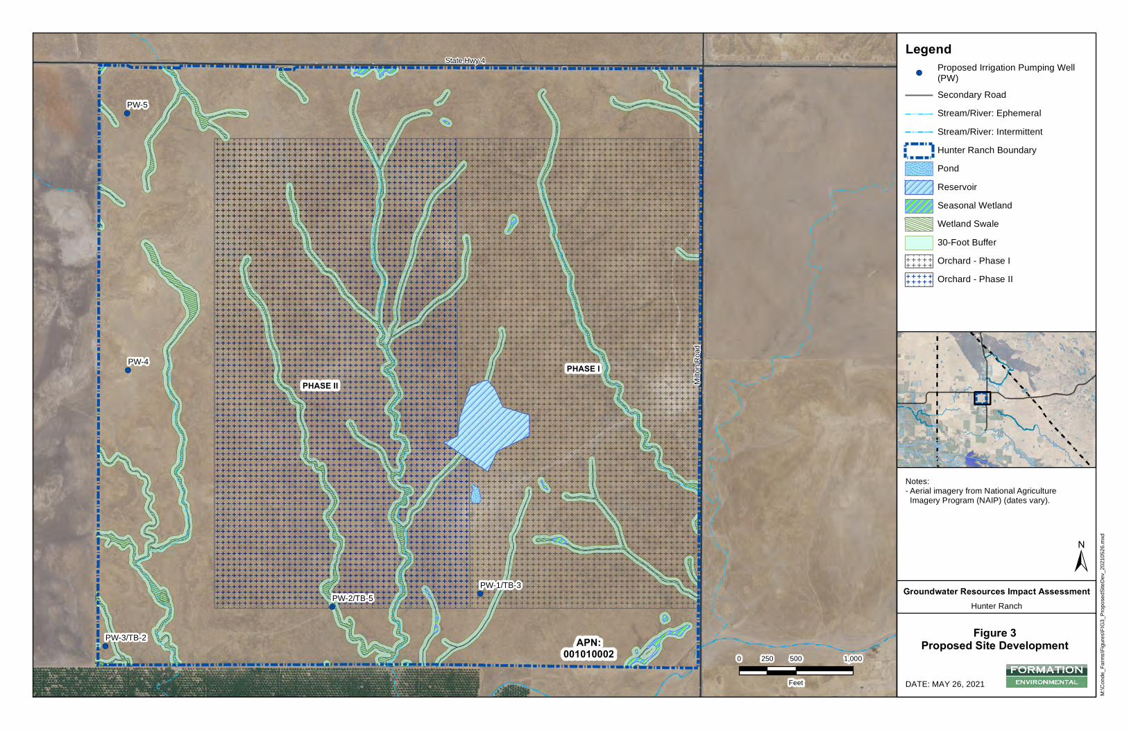
&,
&,
&,
&,
&,
APN:001010002
Milto
n Roa
d
State Hwy 4
PW-1/TB-3PW-2/TB-5
PW-3/TB-2
PW-4
PW-5
PHASE I
PHASE II
M:\C
onde
_Farm
s\Figu
res\FI
G3_P
ropos
edSit
eDev
_202
1052
6.mxd
DATE: MAY 26, 2021
0 500 1,000250
Feet
±Groundwater Resources Impact Assessment
Hunter Ranch
Figure 3Proposed Site Development
Notes:- Aerial imagery from National AgricultureImagery Program (NAIP) (dates vary).
Legend&,
Proposed Irrigation Pumping Well(PW)Secondary RoadStream/River: EphemeralStream/River: IntermittentHunter Ranch BoundaryPondReservoirSeasonal WetlandWetland Swale30-Foot Buffer
E E E E E EE E E E E EE E E E E EE E E E E E Orchard - Phase I
E E E E E EE E E E E EE E E E E EE E E E E E
Orchard - Phase II
Attachment B
CNDDB Summary Report and Exhibits
& USFWS IPaC Trust Resource Report
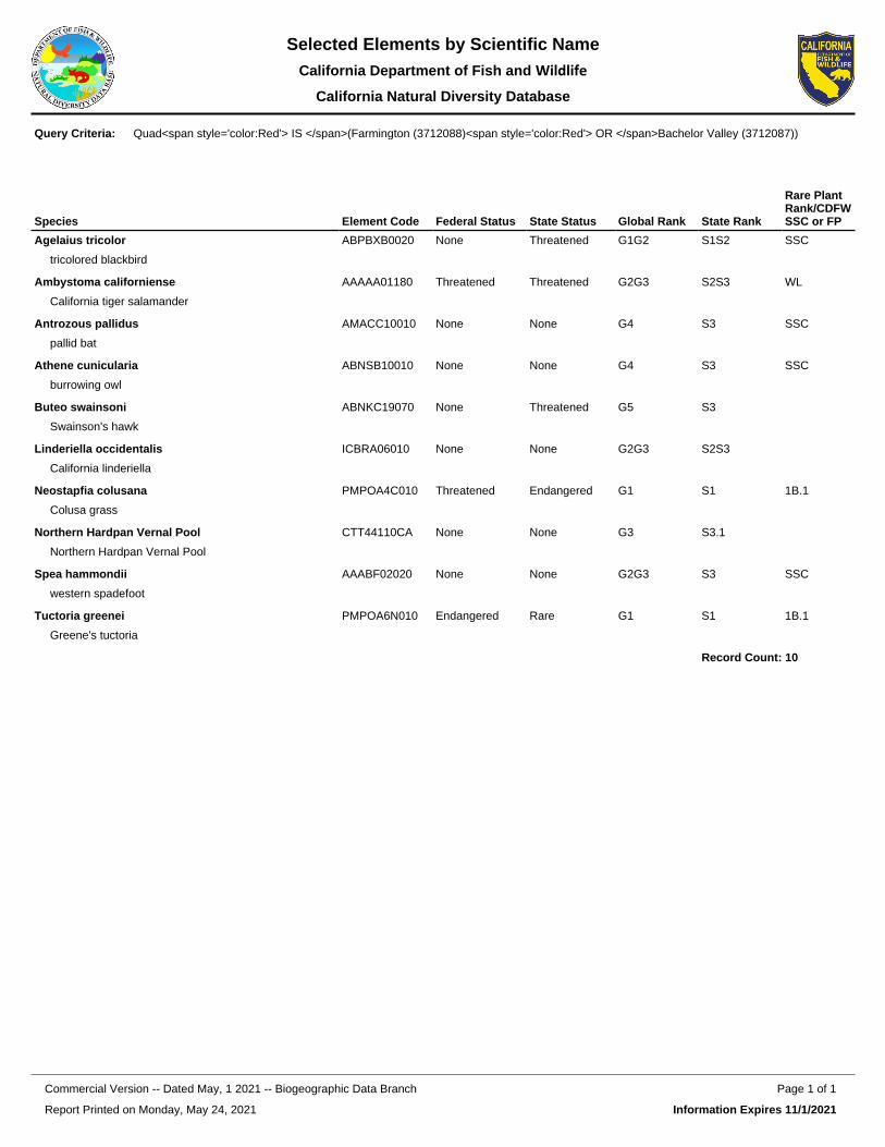
Species Element Code Federal Status State Status Global Rank State Rank
Rare Plant Rank/CDFW SSC or FP
Agelaius tricolor
tricolored blackbird
ABPBXB0020 None Threatened G1G2 S1S2 SSC
Ambystoma californiense
California tiger salamander
AAAAA01180 Threatened Threatened G2G3 S2S3 WL
Antrozous pallidus
pallid bat
AMACC10010 None None G4 S3 SSC
Athene cunicularia
burrowing owl
ABNSB10010 None None G4 S3 SSC
Buteo swainsoni
Swainson's hawk
ABNKC19070 None Threatened G5 S3
Linderiella occidentalis
California linderiella
ICBRA06010 None None G2G3 S2S3
Neostapfia colusana
Colusa grass
PMPOA4C010 Threatened Endangered G1 S1 1B.1
Northern Hardpan Vernal Pool
Northern Hardpan Vernal Pool
CTT44110CA None None G3 S3.1
Spea hammondii
western spadefoot
AAABF02020 None None G2G3 S3 SSC
Tuctoria greenei
Greene's tuctoria
PMPOA6N010 Endangered Rare G1 S1 1B.1
Record Count: 10
Quad<span style='color:Red'> IS </span>(Farmington (3712088)<span style='color:Red'> OR </span>Bachelor Valley (3712087))Query Criteria:
Report Printed on Monday, May 24, 2021
Page 1 of 1Commercial Version -- Dated May, 1 2021 -- Biogeographic Data Branch
Information Expires 11/1/2021
Selected Elements by Scientific NameCalifornia Department of Fish and Wildlife
California Natural Diversity Database
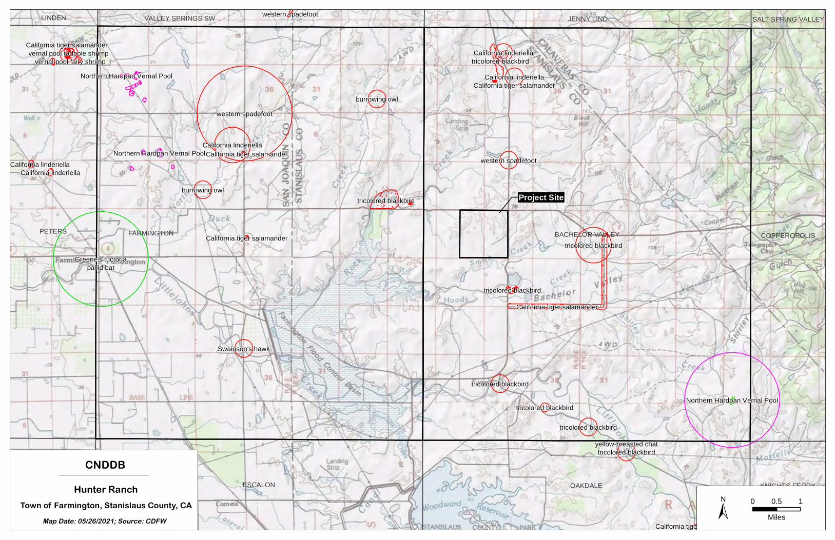
Greene's tuctoria
Northern Hardpan Vernal Pool
Northern Hardpan Vernal Pool
Northern Hardpan Vernal Pool
pallid bat
western spadefoot
tricolored blackbird
California linderiella
California tiger salamander
tricolored blackbirdburrowing owl
burrowing owl
Swainson's hawk
western spadefoot
tricolored blackbird
tricolored blackbird
tricolored blackbird
California linderiella
California linderiellatricolored blackbird
yellow-breasted chat
vernal pool tadpole shrimp
California tiger salamander
vernal pool fairy shrimp
tricolored blackbird
tricolored blackbird
California tiger salamander
California linderiellaCalifornia linderiella
California tiger salamander
western spadefoot
California tiger salamander
California tiger salamanderFARMINGTON BACHELOR VALLEYPETERS
ESCALON OAKDALE
COPPEROPOLIS
AVENA
JENNY LIND
KNIGHTS FERRY
VALLEY SPRINGS SWLINDEN SALT SPRING VALLEY
CNDDBHunter Ranch
Town of Farmington, Stanislaus County, CAMap Date: 05/26/2021; Source: CDFW ± 0 10.5
Miles
Project Site
5/24/2021 IPaC: Explore Location resources
https://ecos.fws.gov/ipac/location/JAHMTWBE2BEUBAQQ3EZVLV3NRI/resources 1/15
IPaC resource listThis report is an automatically generated list of species and other resources such as critical habitat(collectively referred to as trust resources) under the U.S. Fish and Wildlife Service's (USFWS)jurisdiction that are known or expected to be on or near the project area referenced below. The listmay also include trust resources that occur outside of the project area, but that could potentially bedirectly or indirectly a�ected by activities in the project area. However, determining the likelihood andextent of e�ects a project may have on trust resources typically requires gathering additional site-speci�c (e.g., vegetation/species surveys) and project-speci�c (e.g., magnitude and timing of proposedactivities) information.
Below is a summary of the project information you provided and contact information for the USFWSo�ce(s) with jurisdiction in the de�ned project area. Please read the introduction to each section thatfollows (Endangered Species, Migratory Birds, USFWS Facilities, and NWI Wetlands) for additionalinformation applicable to the trust resources addressed in that section.
LocationStanislaus County, California
Local o�ceSacramento Fish And Wildlife O�ce
(916) 414-6600 (916) 414-6713
Federal Building2800 Cottage Way, Room W-2605Sacramento, CA 95825-1846
U.S. Fish & Wildlife ServiceIPaC
5/24/2021 IPaC: Explore Location resources
https://ecos.fws.gov/ipac/location/JAHMTWBE2BEUBAQQ3EZVLV3NRI/resources 2/15
Endangered speciesThis resource list is for informational purposes only and does not constitute an analysis of projectlevel impacts.
The primary information used to generate this list is the known or expected range of each species.Additional areas of in�uence (AOI) for species are also considered. An AOI includes areas outside ofthe species range if the species could be indirectly a�ected by activities in that area (e.g., placing adam upstream of a �sh population even if that �sh does not occur at the dam site, may indirectlyimpact the species by reducing or eliminating water �ow downstream). Because species can move,and site conditions can change, the species on this list are not guaranteed to be found on or near theproject area. To fully determine any potential e�ects to species, additional site-speci�c and project-speci�c information is often required.
Section 7 of the Endangered Species Act requires Federal agencies to "request of the Secretaryinformation whether any species which is listed or proposed to be listed may be present in the area ofsuch proposed action" for any project that is conducted, permitted, funded, or licensed by any Federalagency. A letter from the local o�ce and a species list which ful�lls this requirement can only beobtained by requesting an o�cial species list from either the Regulatory Review section in IPaC (seedirections below) or from the local �eld o�ce directly.
For project evaluations that require USFWS concurrence/review, please return to the IPaC website andrequest an o�cial species list by doing the following:
1. Draw the project location and click CONTINUE.2. Click DEFINE PROJECT.3. Log in (if directed to do so).4. Provide a name and description for your project.5. Click REQUEST SPECIES LIST.
Listed species and their critical habitats are managed by the Ecological Services Program of the U.S.Fish and Wildlife Service (USFWS) and the �sheries division of the National Oceanic and AtmosphericAdministration (NOAA Fisheries ).
Species and critical habitats under the sole responsibility of NOAA Fisheries are not shown on this list.Please contact NOAA Fisheries for species under their jurisdiction.
1. Species listed under the Endangered Species Act are threatened or endangered; IPaC also showsspecies that are candidates, or proposed, for listing. See the listing status page for moreinformation. IPaC only shows species that are regulated by USFWS (see FAQ).
2. NOAA Fisheries, also known as the National Marine Fisheries Service (NMFS), is an o�ce of theNational Oceanic and Atmospheric Administration within the Department of Commerce.
The following species are potentially a�ected by activities in this location:
Reptiles
1
2
NAME STATUS

5/24/2021 IPaC: Explore Location resources
https://ecos.fws.gov/ipac/location/JAHMTWBE2BEUBAQQ3EZVLV3NRI/resources 3/15
Amphibians
Fishes
Insects
Crustaceans
Giant Garter Snake Thamnophis gigasWherever found
No critical habitat has been designated for this species.https://ecos.fws.gov/ecp/species/4482
Threatened
NAME STATUS
California Red-legged Frog Rana draytoniiWherever found
There is �nal critical habitat for this species. The location of the criticalhabitat is not available.https://ecos.fws.gov/ecp/species/2891
Threatened
California Tiger Salamander Ambystoma californienseThere is �nal critical habitat for this species. Your location overlaps thecritical habitat.https://ecos.fws.gov/ecp/species/2076
Threatened
NAME STATUS
Delta Smelt Hypomesus transpaci�cusWherever found
There is �nal critical habitat for this species. The location of the criticalhabitat is not available.https://ecos.fws.gov/ecp/species/321
Threatened
NAME STATUS
Valley Elderberry Longhorn Beetle Desmocerus californicusdimorphusWherever found
There is �nal critical habitat for this species. The location of the criticalhabitat is not available.https://ecos.fws.gov/ecp/species/7850
Threatened
NAME STATUS
Conservancy Fairy Shrimp Branchinecta conservatioWherever found
There is �nal critical habitat for this species. The location of the criticalhabitat is not available.https://ecos.fws.gov/ecp/species/8246
Endangered
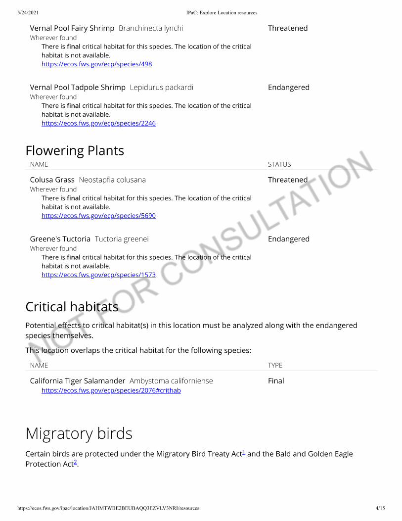
5/24/2021 IPaC: Explore Location resources
https://ecos.fws.gov/ipac/location/JAHMTWBE2BEUBAQQ3EZVLV3NRI/resources 4/15
Flowering Plants
Critical habitatsPotential e�ects to critical habitat(s) in this location must be analyzed along with the endangeredspecies themselves.
This location overlaps the critical habitat for the following species:
Migratory birds
Vernal Pool Fairy Shrimp Branchinecta lynchiWherever found
There is �nal critical habitat for this species. The location of the criticalhabitat is not available.https://ecos.fws.gov/ecp/species/498
Threatened
Vernal Pool Tadpole Shrimp Lepidurus packardiWherever found
There is �nal critical habitat for this species. The location of the criticalhabitat is not available.https://ecos.fws.gov/ecp/species/2246
Endangered
NAME STATUS
Colusa Grass Neostap�a colusanaWherever found
There is �nal critical habitat for this species. The location of the criticalhabitat is not available.https://ecos.fws.gov/ecp/species/5690
Threatened
Greene's Tuctoria Tuctoria greeneiWherever found
There is �nal critical habitat for this species. The location of the criticalhabitat is not available.https://ecos.fws.gov/ecp/species/1573
Endangered
NAME TYPE
California Tiger Salamander Ambystoma californiensehttps://ecos.fws.gov/ecp/species/2076#crithab
Final
Certain birds are protected under the Migratory Bird Treaty Act and the Bald and Golden EagleProtection Act .
1
2
5/24/2021 IPaC: Explore Location resources
https://ecos.fws.gov/ipac/location/JAHMTWBE2BEUBAQQ3EZVLV3NRI/resources 5/15
The birds listed below are birds of particular concern either because they occur on the USFWS Birds ofConservation Concern (BCC) list or warrant special attention in your project location. To learn moreabout the levels of concern for birds on your list and how this list is generated, see the FAQ below.This is not a list of every bird you may �nd in this location, nor a guarantee that every bird on this listwill be found in your project area. To see exact locations of where birders and the general public havesighted birds in and around your project area, visit the E-bird data mapping tool (Tip: enter yourlocation, desired date range and a species on your list). For projects that occur o� the Atlantic Coast,additional maps and models detailing the relative occurrence and abundance of bird species on yourlist are available. Links to additional information about Atlantic Coast birds, and other importantinformation about your migratory bird list, including how to properly interpret and use your migratorybird report, can be found below.
For guidance on when to schedule activities or implement avoidance and minimization measures toreduce impacts to migratory birds on your list, click on the PROBABILITY OF PRESENCE SUMMARY atthe top of your list to see when these birds are most likely to be present and breeding in your projectarea.
Any person or organization who plans or conducts activities that may result in impacts to migratorybirds, eagles, and their habitats should follow appropriate regulations and consider implementingappropriate conservation measures, as described below.
1. The Migratory Birds Treaty Act of 1918.2. The Bald and Golden Eagle Protection Act of 1940.
Additional information can be found using the following links:
Birds of Conservation Concern http://www.fws.gov/birds/management/managed-species/ birds-of-conservation-concern.phpMeasures for avoiding and minimizing impacts to birdshttp://www.fws.gov/birds/management/project-assessment-tools-and-guidance/ conservation-measures.phpNationwide conservation measures for birdshttp://www.fws.gov/migratorybirds/pdf/management/nationwidestandardconservationmeasures.pdf
NAME BREEDING SEASON (IF ABREEDING SEASON IS INDICATEDFOR A BIRD ON YOUR LIST, THEBIRD MAY BREED IN YOURPROJECT AREA SOMETIME WITHINTHE TIMEFRAME SPECIFIED,WHICH IS A VERY LIBERALESTIMATE OF THE DATES INSIDEWHICH THE BIRD BREEDS ACROSSITS ENTIRE RANGE. "BREEDSELSEWHERE" INDICATES THAT THEBIRD DOES NOT LIKELY BREED INYOUR PROJECT AREA.)
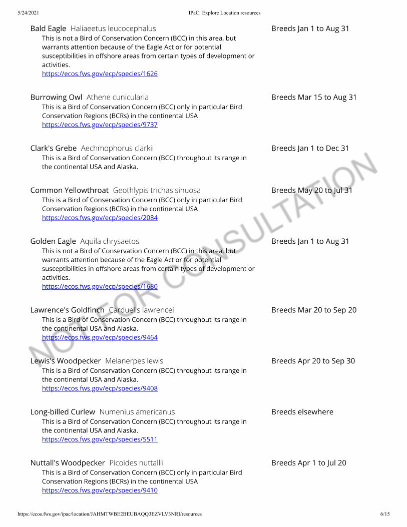
5/24/2021 IPaC: Explore Location resources
https://ecos.fws.gov/ipac/location/JAHMTWBE2BEUBAQQ3EZVLV3NRI/resources 6/15
Bald Eagle Haliaeetus leucocephalusThis is not a Bird of Conservation Concern (BCC) in this area, butwarrants attention because of the Eagle Act or for potentialsusceptibilities in o�shore areas from certain types of development oractivities.https://ecos.fws.gov/ecp/species/1626
Breeds Jan 1 to Aug 31
Burrowing Owl Athene cuniculariaThis is a Bird of Conservation Concern (BCC) only in particular BirdConservation Regions (BCRs) in the continental USAhttps://ecos.fws.gov/ecp/species/9737
Breeds Mar 15 to Aug 31
Clark's Grebe Aechmophorus clarkiiThis is a Bird of Conservation Concern (BCC) throughout its range inthe continental USA and Alaska.
Breeds Jan 1 to Dec 31
Common Yellowthroat Geothlypis trichas sinuosaThis is a Bird of Conservation Concern (BCC) only in particular BirdConservation Regions (BCRs) in the continental USAhttps://ecos.fws.gov/ecp/species/2084
Breeds May 20 to Jul 31
Golden Eagle Aquila chrysaetosThis is not a Bird of Conservation Concern (BCC) in this area, butwarrants attention because of the Eagle Act or for potentialsusceptibilities in o�shore areas from certain types of development oractivities.https://ecos.fws.gov/ecp/species/1680
Breeds Jan 1 to Aug 31
Lawrence's Gold�nch Carduelis lawrenceiThis is a Bird of Conservation Concern (BCC) throughout its range inthe continental USA and Alaska.https://ecos.fws.gov/ecp/species/9464
Breeds Mar 20 to Sep 20
Lewis's Woodpecker Melanerpes lewisThis is a Bird of Conservation Concern (BCC) throughout its range inthe continental USA and Alaska.https://ecos.fws.gov/ecp/species/9408
Breeds Apr 20 to Sep 30
Long-billed Curlew Numenius americanusThis is a Bird of Conservation Concern (BCC) throughout its range inthe continental USA and Alaska.https://ecos.fws.gov/ecp/species/5511
Breeds elsewhere
Nuttall's Woodpecker Picoides nuttalliiThis is a Bird of Conservation Concern (BCC) only in particular BirdConservation Regions (BCRs) in the continental USAhttps://ecos.fws.gov/ecp/species/9410
Breeds Apr 1 to Jul 20
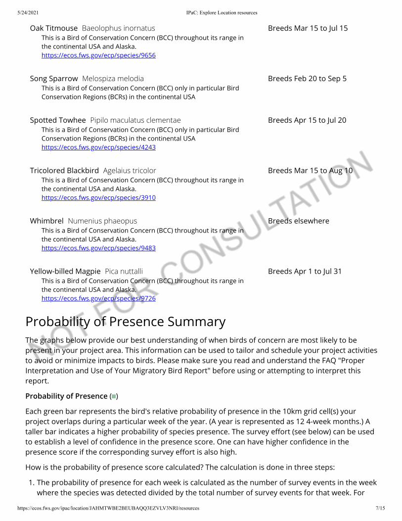
5/24/2021 IPaC: Explore Location resources
https://ecos.fws.gov/ipac/location/JAHMTWBE2BEUBAQQ3EZVLV3NRI/resources 7/15
Probability of Presence SummaryThe graphs below provide our best understanding of when birds of concern are most likely to bepresent in your project area. This information can be used to tailor and schedule your project activitiesto avoid or minimize impacts to birds. Please make sure you read and understand the FAQ "ProperInterpretation and Use of Your Migratory Bird Report" before using or attempting to interpret thisreport.
Probability of Presence ( )
Each green bar represents the bird's relative probability of presence in the 10km grid cell(s) yourproject overlaps during a particular week of the year. (A year is represented as 12 4-week months.) Ataller bar indicates a higher probability of species presence. The survey e�ort (see below) can be usedto establish a level of con�dence in the presence score. One can have higher con�dence in thepresence score if the corresponding survey e�ort is also high.
How is the probability of presence score calculated? The calculation is done in three steps:
1. The probability of presence for each week is calculated as the number of survey events in the weekwhere the species was detected divided by the total number of survey events for that week. For
Oak Titmouse Baeolophus inornatusThis is a Bird of Conservation Concern (BCC) throughout its range inthe continental USA and Alaska.https://ecos.fws.gov/ecp/species/9656
Breeds Mar 15 to Jul 15
Song Sparrow Melospiza melodiaThis is a Bird of Conservation Concern (BCC) only in particular BirdConservation Regions (BCRs) in the continental USA
Breeds Feb 20 to Sep 5
Spotted Towhee Pipilo maculatus clementaeThis is a Bird of Conservation Concern (BCC) only in particular BirdConservation Regions (BCRs) in the continental USAhttps://ecos.fws.gov/ecp/species/4243
Breeds Apr 15 to Jul 20
Tricolored Blackbird Agelaius tricolorThis is a Bird of Conservation Concern (BCC) throughout its range inthe continental USA and Alaska.https://ecos.fws.gov/ecp/species/3910
Breeds Mar 15 to Aug 10
Whimbrel Numenius phaeopusThis is a Bird of Conservation Concern (BCC) throughout its range inthe continental USA and Alaska.https://ecos.fws.gov/ecp/species/9483
Breeds elsewhere
Yellow-billed Magpie Pica nuttalliThis is a Bird of Conservation Concern (BCC) throughout its range inthe continental USA and Alaska.https://ecos.fws.gov/ecp/species/9726
Breeds Apr 1 to Jul 31
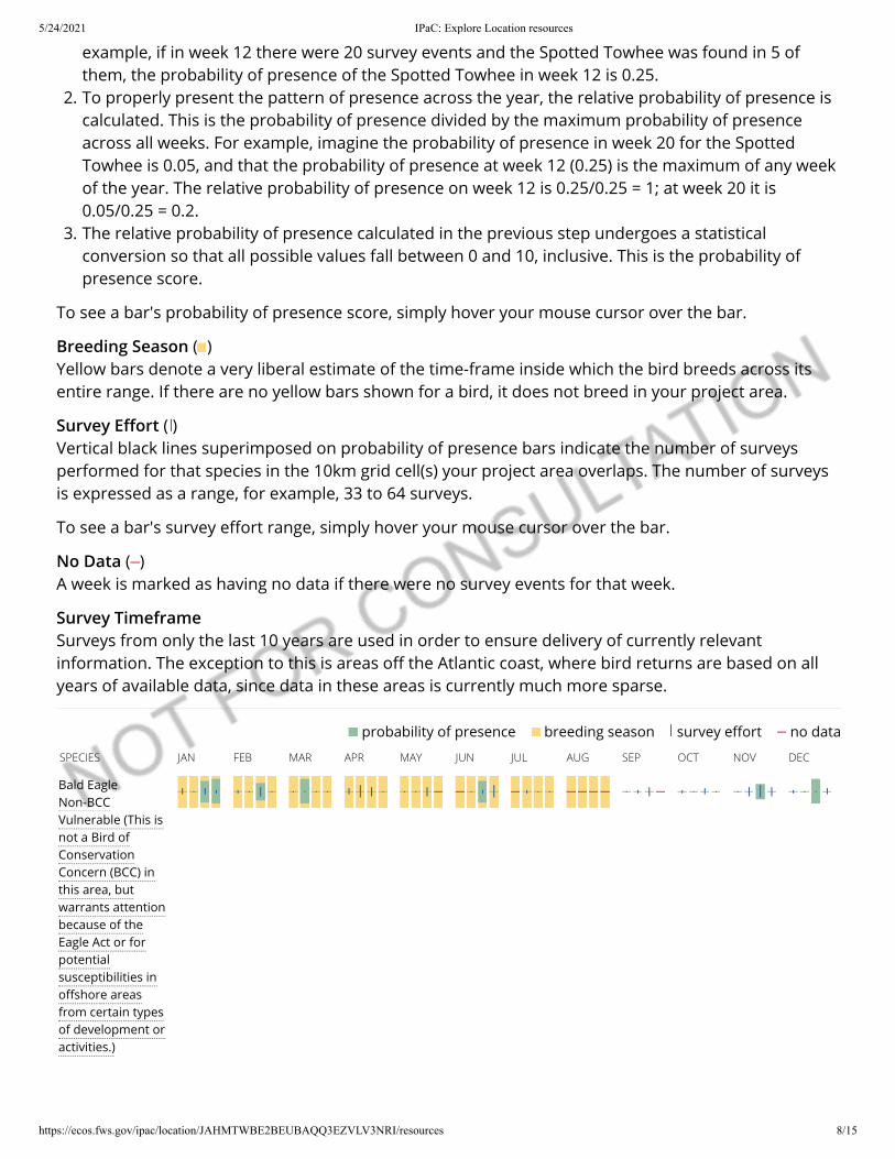
5/24/2021 IPaC: Explore Location resources
https://ecos.fws.gov/ipac/location/JAHMTWBE2BEUBAQQ3EZVLV3NRI/resources 8/15
no data survey e�ort breeding season probability of presence
example, if in week 12 there were 20 survey events and the Spotted Towhee was found in 5 ofthem, the probability of presence of the Spotted Towhee in week 12 is 0.25.
2. To properly present the pattern of presence across the year, the relative probability of presence iscalculated. This is the probability of presence divided by the maximum probability of presenceacross all weeks. For example, imagine the probability of presence in week 20 for the SpottedTowhee is 0.05, and that the probability of presence at week 12 (0.25) is the maximum of any weekof the year. The relative probability of presence on week 12 is 0.25/0.25 = 1; at week 20 it is0.05/0.25 = 0.2.
3. The relative probability of presence calculated in the previous step undergoes a statisticalconversion so that all possible values fall between 0 and 10, inclusive. This is the probability ofpresence score.
To see a bar's probability of presence score, simply hover your mouse cursor over the bar.
Breeding Season ( )Yellow bars denote a very liberal estimate of the time-frame inside which the bird breeds across itsentire range. If there are no yellow bars shown for a bird, it does not breed in your project area.
Survey E�ort ( )Vertical black lines superimposed on probability of presence bars indicate the number of surveysperformed for that species in the 10km grid cell(s) your project area overlaps. The number of surveysis expressed as a range, for example, 33 to 64 surveys.
To see a bar's survey e�ort range, simply hover your mouse cursor over the bar.
No Data ( )A week is marked as having no data if there were no survey events for that week.
Survey TimeframeSurveys from only the last 10 years are used in order to ensure delivery of currently relevantinformation. The exception to this is areas o� the Atlantic coast, where bird returns are based on allyears of available data, since data in these areas is currently much more sparse.
SPECIES JAN FEB MAR APR MAY JUN JUL AUG SEP OCT NOV DEC
Bald EagleNon-BCCVulnerable (This isnot a Bird ofConservationConcern (BCC) inthis area, butwarrants attentionbecause of theEagle Act or forpotentialsusceptibilities ino�shore areasfrom certain typesof development oractivities.)
5/24/2021 IPaC: Explore Location resources
https://ecos.fws.gov/ipac/location/JAHMTWBE2BEUBAQQ3EZVLV3NRI/resources 9/15
Burrowing OwlBCC - BCR (This is aBird ofConservationConcern (BCC) onlyin particular BirdConservationRegions (BCRs) inthe continentalUSA)
Clark's GrebeBCC Rangewide(CON) (This is aBird ofConservationConcern (BCC)throughout itsrange in thecontinental USAand Alaska.)
CommonYellowthroatBCC - BCR (This is aBird ofConservationConcern (BCC) onlyin particular BirdConservationRegions (BCRs) inthe continentalUSA)
Golden EagleNon-BCCVulnerable (This isnot a Bird ofConservationConcern (BCC) inthis area, butwarrants attentionbecause of theEagle Act or forpotentialsusceptibilities ino�shore areasfrom certain typesof development oractivities.)
Lawrence'sGold�nchBCC Rangewide(CON) (This is aBird ofConservationConcern (BCC)throughout itsrange in thecontinental USAand Alaska.)
5/24/2021 IPaC: Explore Location resources
https://ecos.fws.gov/ipac/location/JAHMTWBE2BEUBAQQ3EZVLV3NRI/resources 10/15
Lewis'sWoodpeckerBCC Rangewide(CON) (This is aBird ofConservationConcern (BCC)throughout itsrange in thecontinental USAand Alaska.)
Long-billed CurlewBCC Rangewide(CON) (This is aBird ofConservationConcern (BCC)throughout itsrange in thecontinental USAand Alaska.)
Nuttall'sWoodpeckerBCC - BCR (This is aBird ofConservationConcern (BCC) onlyin particular BirdConservationRegions (BCRs) inthe continentalUSA)
Oak TitmouseBCC Rangewide(CON) (This is aBird ofConservationConcern (BCC)throughout itsrange in thecontinental USAand Alaska.)
Song SparrowBCC - BCR (This is aBird ofConservationConcern (BCC) onlyin particular BirdConservationRegions (BCRs) inthe continentalUSA)
5/24/2021 IPaC: Explore Location resources
https://ecos.fws.gov/ipac/location/JAHMTWBE2BEUBAQQ3EZVLV3NRI/resources 11/15
Spotted TowheeBCC - BCR (This is aBird ofConservationConcern (BCC) onlyin particular BirdConservationRegions (BCRs) inthe continentalUSA)
SPECIES JAN FEB MAR APR MAY JUN JUL AUG SEP OCT NOV DEC
TricoloredBlackbirdBCC Rangewide(CON) (This is aBird ofConservationConcern (BCC)throughout itsrange in thecontinental USAand Alaska.)
WhimbrelBCC Rangewide(CON) (This is aBird ofConservationConcern (BCC)throughout itsrange in thecontinental USAand Alaska.)
Yellow-billedMagpieBCC Rangewide(CON) (This is aBird ofConservationConcern (BCC)throughout itsrange in thecontinental USAand Alaska.)
Tell me more about conservation measures I can implement to avoid or minimize impacts to migratory birds.
Nationwide Conservation Measures describes measures that can help avoid and minimize impacts to all birds at anylocation year round. Implementation of these measures is particularly important when birds are most likely to occurin the project area. When birds may be breeding in the area, identifying the locations of any active nests and avoidingtheir destruction is a very helpful impact minimization measure. To see when birds are most likely to occur and bebreeding in your project area, view the Probability of Presence Summary. Additional measures or permits may beadvisable depending on the type of activity you are conducting and the type of infrastructure or bird species presenton your project site.
What does IPaC use to generate the migratory birds potentially occurring in my speci�ed location?

5/24/2021 IPaC: Explore Location resources
https://ecos.fws.gov/ipac/location/JAHMTWBE2BEUBAQQ3EZVLV3NRI/resources 12/15
The Migratory Bird Resource List is comprised of USFWS Birds of Conservation Concern (BCC) and other species thatmay warrant special attention in your project location.
The migratory bird list generated for your project is derived from data provided by the Avian Knowledge Network(AKN). The AKN data is based on a growing collection of survey, banding, and citizen science datasets and is queriedand �ltered to return a list of those birds reported as occurring in the 10km grid cell(s) which your project intersects,and that have been identi�ed as warranting special attention because they are a BCC species in that area, an eagle(Eagle Act requirements may apply), or a species that has a particular vulnerability to o�shore activities ordevelopment.
Again, the Migratory Bird Resource list includes only a subset of birds that may occur in your project area. It is notrepresentative of all birds that may occur in your project area. To get a list of all birds potentially present in yourproject area, please visit the AKN Phenology Tool.
What does IPaC use to generate the probability of presence graphs for the migratory birds potentially occurringin my speci�ed location?
The probability of presence graphs associated with your migratory bird list are based on data provided by the AvianKnowledge Network (AKN). This data is derived from a growing collection of survey, banding, and citizen sciencedatasets .
Probability of presence data is continuously being updated as new and better information becomes available. Tolearn more about how the probability of presence graphs are produced and how to interpret them, go the Probabilityof Presence Summary and then click on the "Tell me about these graphs" link.
How do I know if a bird is breeding, wintering, migrating or present year-round in my project area?
To see what part of a particular bird's range your project area falls within (i.e. breeding, wintering, migrating or year-round), you may refer to the following resources: The Cornell Lab of Ornithology All About Birds Bird Guide, or (if youare unsuccessful in locating the bird of interest there), the Cornell Lab of Ornithology Neotropical Birds guide. If a birdon your migratory bird species list has a breeding season associated with it, if that bird does occur in your projectarea, there may be nests present at some point within the timeframe speci�ed. If "Breeds elsewhere" is indicated,then the bird likely does not breed in your project area.
What are the levels of concern for migratory birds?
Migratory birds delivered through IPaC fall into the following distinct categories of concern:
1. "BCC Rangewide" birds are Birds of Conservation Concern (BCC) that are of concern throughout their rangeanywhere within the USA (including Hawaii, the Paci�c Islands, Puerto Rico, and the Virgin Islands);
2. "BCC - BCR" birds are BCCs that are of concern only in particular Bird Conservation Regions (BCRs) in thecontinental USA; and
3. "Non-BCC - Vulnerable" birds are not BCC species in your project area, but appear on your list either because ofthe Eagle Act requirements (for eagles) or (for non-eagles) potential susceptibilities in o�shore areas from certaintypes of development or activities (e.g. o�shore energy development or longline �shing).
Although it is important to try to avoid and minimize impacts to all birds, e�orts should be made, in particular, toavoid and minimize impacts to the birds on this list, especially eagles and BCC species of rangewide concern. Formore information on conservation measures you can implement to help avoid and minimize migratory bird impactsand requirements for eagles, please see the FAQs for these topics.
Details about birds that are potentially a�ected by o�shore projects
For additional details about the relative occurrence and abundance of both individual bird species and groups of birdspecies within your project area o� the Atlantic Coast, please visit the Northeast Ocean Data Portal. The Portal alsoo�ers data and information about other taxa besides birds that may be helpful to you in your project review.

5/24/2021 IPaC: Explore Location resources
https://ecos.fws.gov/ipac/location/JAHMTWBE2BEUBAQQ3EZVLV3NRI/resources 13/15
Alternately, you may download the bird model results �les underlying the portal maps through the NOAA NCCOSIntegrative Statistical Modeling and Predictive Mapping of Marine Bird Distributions and Abundance on the AtlanticOuter Continental Shelf project webpage.
Bird tracking data can also provide additional details about occurrence and habitat use throughout the year, includingmigration. Models relying on survey data may not include this information. For additional information on marine birdtracking data, see the Diving Bird Study and the nanotag studies or contact Caleb Spiegel or Pam Loring.
What if I have eagles on my list?
If your project has the potential to disturb or kill eagles, you may need to obtain a permit to avoid violating the EagleAct should such impacts occur.
Proper Interpretation and Use of Your Migratory Bird Report
The migratory bird list generated is not a list of all birds in your project area, only a subset of birds of priority concern.To learn more about how your list is generated, and see options for identifying what other birds may be in yourproject area, please see the FAQ "What does IPaC use to generate the migratory birds potentially occurring in myspeci�ed location". Please be aware this report provides the "probability of presence" of birds within the 10 km gridcell(s) that overlap your project; not your exact project footprint. On the graphs provided, please also look carefully atthe survey e�ort (indicated by the black vertical bar) and for the existence of the "no data" indicator (a red horizontalbar). A high survey e�ort is the key component. If the survey e�ort is high, then the probability of presence score canbe viewed as more dependable. In contrast, a low survey e�ort bar or no data bar means a lack of data and,therefore, a lack of certainty about presence of the species. This list is not perfect; it is simply a starting point foridentifying what birds of concern have the potential to be in your project area, when they might be there, and if theymight be breeding (which means nests might be present). The list helps you know what to look for to con�rmpresence, and helps guide you in knowing when to implement conservation measures to avoid or minimize potentialimpacts from your project activities, should presence be con�rmed. To learn more about conservation measures, visitthe FAQ "Tell me about conservation measures I can implement to avoid or minimize impacts to migratory birds" atthe bottom of your migratory bird trust resources page.
Facilities
National Wildlife Refuge landsAny activity proposed on lands managed by the National Wildlife Refuge system must undergo a'Compatibility Determination' conducted by the Refuge. Please contact the individual Refuges todiscuss any questions or concerns.
THERE ARE NO REFUGE LANDS AT THIS LOCATION.
Fish hatcheries
THERE ARE NO FISH HATCHERIES AT THIS LOCATION.
5/24/2021 IPaC: Explore Location resources
https://ecos.fws.gov/ipac/location/JAHMTWBE2BEUBAQQ3EZVLV3NRI/resources 14/15
Wetlands in the National Wetlands InventoryImpacts to NWI wetlands and other aquatic habitats may be subject to regulation under Section 404 ofthe Clean Water Act, or other State/Federal statutes.
For more information please contact the Regulatory Program of the local U.S. Army Corps of EngineersDistrict.
Please note that the NWI data being shown may be out of date. We are currently working to updateour NWI data set. We recommend you verify these results with a site visit to determine the actualextent of wetlands on site.
This location overlaps the following wetlands:
FRESHWATER EMERGENT WETLANDPEM1CPEM1APEM1FhPEM1AxPEM1CxPEM1ChPEM1Ah
FRESHWATER FORESTED/SHRUB WETLANDPFOA
FRESHWATER PONDPUBFhPABHhPUBHhPUBKxPUSAPUSChPUSCPUSAhPUBH
LAKEL2USKx
RIVERINER4SBCR2ABHR4SBAR4SBCxR5UBFxR4SBAxR5UBF
A full description for each wetland code can be found at the National Wetlands Inventory website
5/24/2021 IPaC: Explore Location resources
https://ecos.fws.gov/ipac/location/JAHMTWBE2BEUBAQQ3EZVLV3NRI/resources 15/15
Data limitations
The Service's objective of mapping wetlands and deepwater habitats is to produce reconnaissance level informationon the location, type and size of these resources. The maps are prepared from the analysis of high altitude imagery.Wetlands are identi�ed based on vegetation, visible hydrology and geography. A margin of error is inherent in the useof imagery; thus, detailed on-the-ground inspection of any particular site may result in revision of the wetlandboundaries or classi�cation established through image analysis.
The accuracy of image interpretation depends on the quality of the imagery, the experience of the image analysts, theamount and quality of the collateral data and the amount of ground truth veri�cation work conducted. Metadatashould be consulted to determine the date of the source imagery used and any mapping problems.
Wetlands or other mapped features may have changed since the date of the imagery or �eld work. There may beoccasional di�erences in polygon boundaries or classi�cations between the information depicted on the map and theactual conditions on site.
Data exclusions
Certain wetland habitats are excluded from the National mapping program because of the limitations of aerialimagery as the primary data source used to detect wetlands. These habitats include seagrasses or submerged aquaticvegetation that are found in the intertidal and subtidal zones of estuaries and nearshore coastal waters. Somedeepwater reef communities (coral or tuber�cid worm reefs) have also been excluded from the inventory. Thesehabitats, because of their depth, go undetected by aerial imagery.
Data precautions
Federal, state, and local regulatory agencies with jurisdiction over wetlands may de�ne and describe wetlands in adi�erent manner than that used in this inventory. There is no attempt, in either the design or products of thisinventory, to de�ne the limits of proprietary jurisdiction of any Federal, state, or local government or to establish thegeographical scope of the regulatory programs of government agencies. Persons intending to engage in activitiesinvolving modi�cations within or adjacent to wetland areas should seek the advice of appropriate federal, state, orlocal agencies concerning speci�ed agency regulatory programs and proprietary jurisdictions that may a�ect suchactivities.

Attachment C
Wetland Delineation Map and Acreage Summary
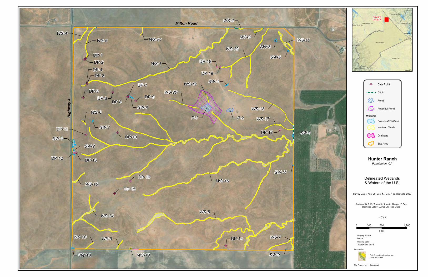
!A!A
!A!A
!A
!A!A!A
!A
!A!A
!A!A
!A
!A
!A
!A
!A!A
DP-9DP-8
DP-7
DP-6DP-5
DP-4DP-3
DP-2DP-1
DP-19
DP-18
DP-17
DP-16
DP-15
DP-14
DP-13DP-12
DP-11
DP-10SW-1
SW-5
SW-3
SW-4
SW-10
SW-7
SW-6
SW-11
SW-9
SW-8
SW-2
WS-16
WS-8
WS-1
WS-14
WS-11WS-12
WS-7
WS-5WS-4
WS-15
WS-17WS-18
WS-3
WS-9
WS-2
WS-10
WS-20
WS-6
WS-19
WS-21
WS-13
P-1 P-2
0 600 1,200300
Feet
´
Stanislaus Co.
Merced Co.
San Joaquin Co. Tuolumne Co.
Calaveras Co.
Santa Clara Co.
Mariposa Co.
Madera Co.
Alameda Co.
Mariposa Co.
Contra Costa Co.
PropertyLocation
Map Prepared by:
Surveyed by:
Cali Consulting Service, Inc.(209) 810-2538
GeoAssist
Imagery Source:MaxarImagery Date:September 2018
Hunter RanchFarmington, CA
Survey Dates: Aug. 26, Sep. 17, Oct. 7, and Nov. 28, 2020
Sections 14 & 15, Township 1 North, Range 10 EastBachelor Valley, CA USGS Topo Quad
!A Data Point
Ditch
Pond
Potential Pond
WetlandSeasonal WetlandWetland Swale
Drainage
Site Area
Delineated Wetlands& Waters of the U.S.
Milton Road
High
way 4
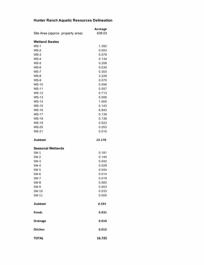
AcreageSite Area (approx. property area) 638.03
WS-1 1.392WS-2 0.053WS-3 0.078WS-4 0.134WS-5 0.208WS-6 0.030WS-7 0.303WS-8 3.228WS-9 0.070WS-10 0.056WS-11 0.557WS-12 0.713WS-13 0.006WS-14 1.005WS-15 0.143WS-16 6.842WS-17 0.139WS-18 0.136WS-19 0.022WS-20 0.053WS-21 0.010
Subtotal 15.176
SW-1 0.181SW-2 0.140SW-3 0.042SW-4 0.028SW-5 0.044SW-6 0.014SW-7 0.019SW-8 0.083SW-9 0.003SW-10 0.033SW-11 0.005
Subtotal 0.591
Ponds 0.931
Drainage 0.010
Ditches 0.015
TOTAL 16.725
Hunter Ranch Aquatic Resources Delineation
Wetland Swales
Seasonal Wetlands

Attachment D
Photographs
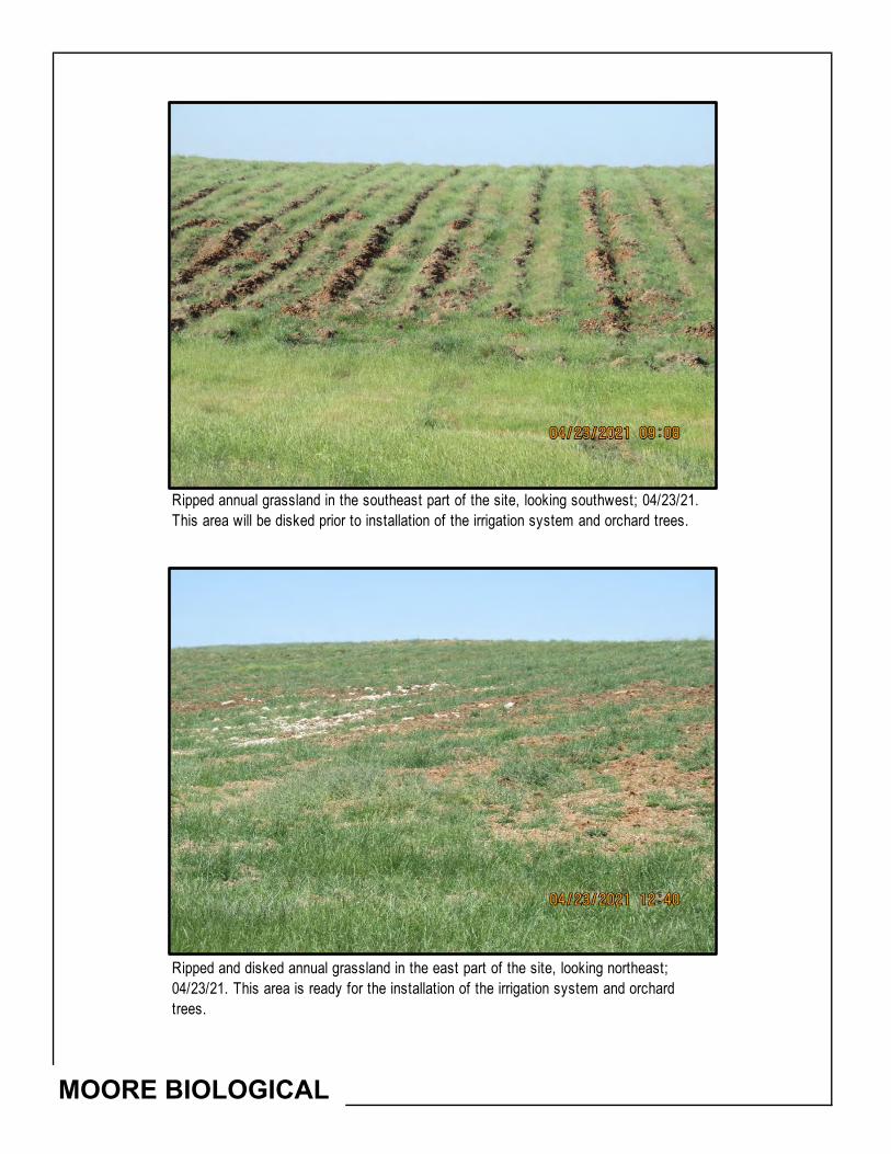
MOORE BIOLOGICAL
Ripped and disked annual grassland in the east part of the site, looking northeast; 04/23/21. This area is ready for the installation of the irrigation system and orchard trees.
Ripped annual grassland in the southeast part of the site, looking southwest; 04/23/21. This area will be disked prior to installation of the irrigation system and orchard trees.
MOORE BIOLOGICAL
Winter wheat along the west edge of the site, looking south from near the northwest corner of the site; 04/23/21.
Annual grassland along the south edge of the site, looking east from near the southwest corner of the site; 04/23/21.
MOORE BIOLOGICAL
Winter wheat along the north edge of the site, looking west along Highway 4; 04/23/21.
Annual grassland and a fire break along the east edge of the site, looking north along Milton Road; 04/23/21.
MOORE BIOLOGICAL
Winter wheat in the west part of the site, looking southeast from a hill along the west edge of the site; 04/23/21.
Winter wheat in the northeast part of the site, looking west; 04/23/21.
MOORE BIOLOGICAL
Annual grassland in the wwest part of the site, looking west; 04/23/21. Proposed well PW-4 will developed in this area.
Winter wheat in the northwest part of the site, looking west; 04/23/21. Proposed well PW-5 will developed in this area.
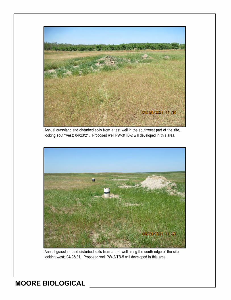
MOORE BIOLOGICAL
Annual grassland and disturbed soils from a test well along the south edge of the site, looking west; 04/23/21. Proposed well PW-2/TB-5 will developed in this area.
Annual grassland and disturbed soils from a test well in the southwest part of the site, looking southwest; 04/23/21. Proposed well PW-3/TB-2 will developed in this area.
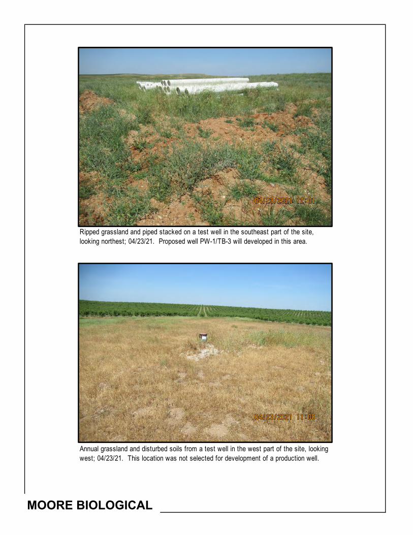
MOORE BIOLOGICAL
Annual grassland and disturbed soils from a test well in the west part of the site, looking west; 04/23/21. This location was not selected for development of a production well.
Ripped grassland and piped stacked on a test well in the southeast part of the site, looking northest; 04/23/21. Proposed well PW-1/TB-3 will developed in this area.

MOORE BIOLOGICAL
Seasonal wetland along the north edge of the site, looking northwest; 04/23/21. This wetland will be fully avoided by orchard development, which will be set back 30+/- feet from the wetland.
Annual grassland in the central part of the site, looking west from just west of the reservoir; 04/23/21. With exeception of the wetland areas and setbacks, this area will be ripped and disked prior to installation of the irrigation system and orchard trees.

MOORE BIOLOGICAL
Seasonal wetland in thewinter whate field in the northeast part of the site, looking north; 04/23/21. This wetland will be fully avoided by orchard development, which will be set back 30+/- feet from the wetland.
Seasonal wetland swale in the southeast part of the site, looking west; 04/23/21. This wetland is south of the proposed orchard and will be fully avoided.

MOORE BIOLOGICAL
Reservoir in the central part of the site, looking southwest; 04/23/21. A constructed stock pond in this area was recently enlarged.
Smith Creek in the southeast corner of the site, looking south along Milton Road; 04/23/21. Just west of Milton Road, the creek corridor broadens and supports marsh vegetation. Smith Creek will be fully avoided by the project.
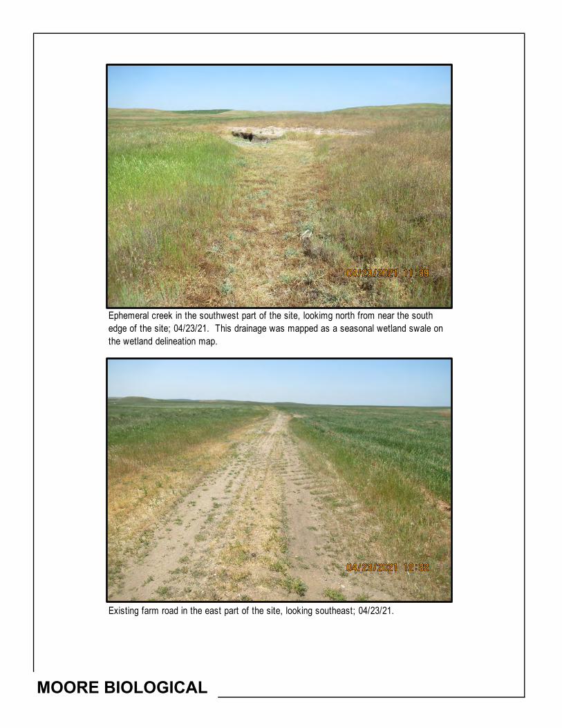
MOORE BIOLOGICAL
Existing farm road in the east part of the site, looking southeast; 04/23/21.
Ephemeral creek in the southwest part of the site, lookimg north from near the south edge of the site; 04/23/21. This drainage was mapped as a seasonal wetland swale on the wetland delineation map.

Attachment E
National Wetland Inventory Map
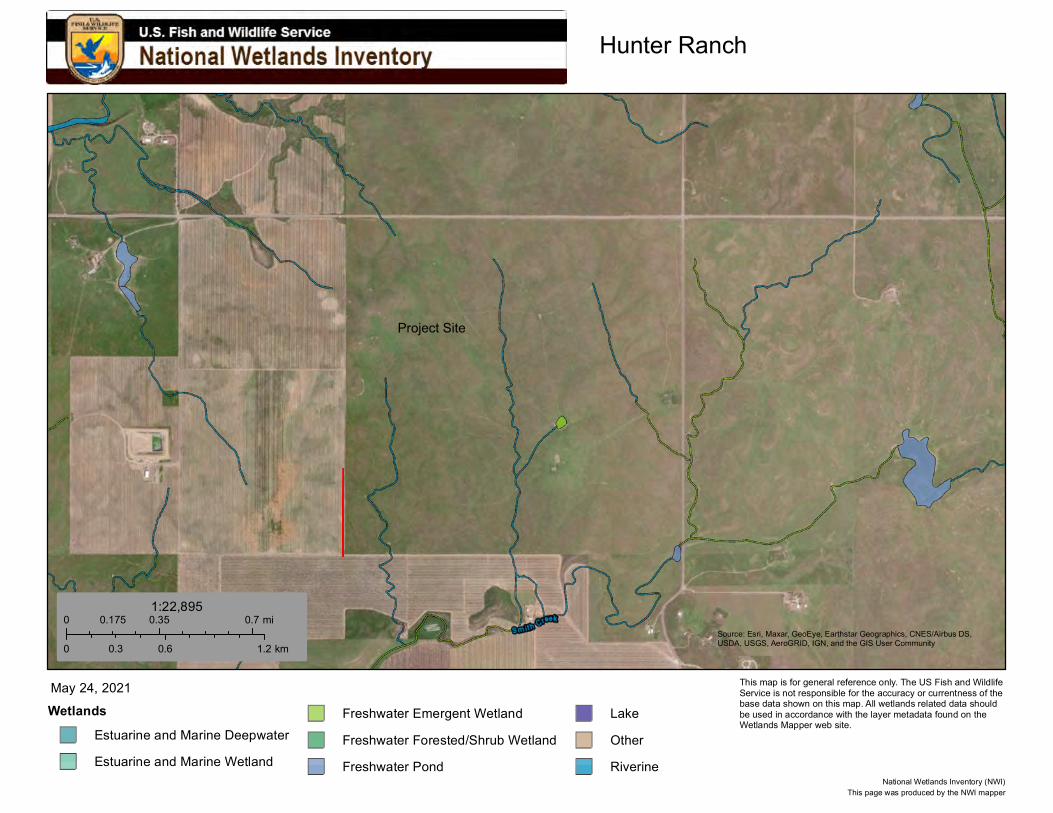
Hunter Ranch
Source: Esri, Maxar, GeoEye, Earthstar Geographics, CNES/Airbus DS,USDA, USGS, AeroGRID, IGN, and the GIS User Community
WetlandsEstuarine and Marine DeepwaterEstuarine and Marine Wetland
Freshwater Emergent WetlandFreshwater Forested/Shrub WetlandFreshwater Pond
LakeOtherRiverine
May 24, 2021
0 0.35 0.70.175 mi
0 0.6 1.20.3 km
1:22,895
This page was produced by the NWI mapperNational Wetlands Inventory (NWI)
This map is for general reference only. The US Fish and Wildlife Service is not responsible for the accuracy or currentness of the base data shown on this map. All wetlands related data should be used in accordance with the layer metadata found on the Wetlands Mapper web site.
Project Site
moorebio
Polygonal Line

Attachment F
Designated Critical Habitat

FARMINGTONPETERS BACHELOR VALLEY
OAKDALEESCALON
COPPEROPOLIS
AVENA
JENNY LINDLINDEN
KNIGHTS FERRY
VALLEY SPRINGS SW SALT SPRING VALLEY
CRITICAL HABITATHunter Ranch
Town of Farmington, Stanislaus County, CAMap Date: 05/26/2021; Source: USFWS, NOAA ± 0 1.50.75
Miles
Project Site
California tiger SalamanderVernal pool fairy shrimp

Stanislaus County Initial Study Checklist – Final
Attachment 3 – Cultural Resource Record Search Report
Tetra Tech, Inc. 17885 Von Karman Avenue, Suite 500, Irvine, CA 92614
Tel 916.852.8300 Fax 916.852.0307 tetratech.com
November 8, 2021 Ms. Jan Jacobson Principal Trihydro/Jacobson James 79083 Foothills Boulevard, Suite 370 Roseville, California 95747 [email protected] RE: Cultural Resource Record Search Letter Report for the Hunter Ranch Project in
Stanislaus County, California Dear Ms. Jacobson, The purpose of this letter is to describe the results of a cultural resources record search and literature review and provide any recommendation in regard to cultural resources for the Hunter Ranch Project (Project) in Stanislaus County, California (Attachment 1, Figure 1). Conde Farms is proposing to develop an orchard on Assessor’s Parcel Number 01-01-002 located in rural unincorporated Stanislaus County. The proposed Project would consist of potentially two phases: Phase I will include a Groundwater Resources Impact Assessment (GRIA) to evaluate the potential groundwater resource-related impacts of converting two test wells into irrigation wells and one test well into a small-capacity yard water supply well to irrigate approximately 175 acres of new orchard. Depending on the results of Phase I, a potential second phase (Phase II) would consist of installing up to three new irrigation supply wells to support expansion of the orchard by up to an additional 175 acres. The decision whether, and to what extent, to expand the groundwater supply during Phase II will depend on monitoring conducted during Phase I as part of an adaptive management strategy. Across both phases, the proposed Project would involve installing/converting up to five water supply wells. The proposed Project is located southwest of the Rock Creek Water District in an area that is outside the service territory of any water or irrigation districts, and groundwater is currently the only option for development of an irrigation water supply. The purpose of the proposed well conversions and installation is to develop a long-term water supply for the proposed orchard.
The proposed Project requires a Stanislaus County permit requiring compliance with the Stanislaus County Groundwater Ordinance (Ordinance; County Code Chapter 9.37), the Discretionary Well Permitting and Management Program1, and the guidelines and regulations of the California Environmental Quality Act (CEQA). For this cultural resource desktop study, the proposed Project area is defined as the 635 acres within the Project boundary (Attachment 1, Figures 1 through 3). The
1 Stanislaus County 2018. Final Program Environmental Impact Report (SCH#2016102005), Discretionary Well Permitting and Management
Program, Stanislaus County, California. Electronic document available at http://www.stancounty.com/er/pdf/groundwater/final-impact-report.pdf accessed October 2021.

Ms. Jacobson November 8, 2021 Page 2
purpose of this study is to provide technical information to serve as the basis for the determination of impacts and any related mitigation measures in the CEQA document for this project.
PROJECT DESCRIPTION The action that is being evaluated under the Ordinance and under CEQA consists of the development and operation of several production wells within the Project area to serve as an irrigation water supply for a proposed orchard. Because the development of a reliable irrigation water supply will make the conversion of disturbed rangeland into an orchard possible, the development and operation of the irrigation system and orchard are also being evaluated under CEQA as contingent actions. Specifically, the Project will include the following:
• Phase I of the proposed Project will consist of the conversion of two existing test wells into irrigation wells, the conversion of a third test well into a supply well for miscellaneous incidental water supply needs, the construction of two additional irrigation wells in the western portion of the Project area, and the long-term operation of these wells to supply the water demand of approximately 175 acres of orchard for a period up to approximately 20 years. The contingent actions during Phase I include construction of the irrigation system, conversion of up to 175 acres of disturbed rangeland into an almond orchard, and long-term operation of the orchard.
• Monitoring will be conducted during the initial pumping for Phase I to assess whether groundwater drawdown is consistent with or less than the drawdown predictions presented in this letter. If so, then the proposed Project will proceed to Phase II.
• Phase II of the proposed Project will consist of construction of up to three additional irrigation wells to supply the water demand of up to an additional 175 acres of orchard for a period up to approximately 20 years. The contingent actions during Phase II include expansion of the irrigation system, conversion of up to an additional 175 acres of disturbed rangeland into an almond orchard, and long-term operation of the orchard.
PROJECT LOCATION The proposed Project is located in unincorporated Stanislaus County, California. The proposed Project area consists of approximately 635 acres and is zoned for agriculture use (Attachment 1, Figures 2 and 3). The Project is bound by State Highway 4 to the north, and Milton Road to the east. The Project is approximately 4 miles north of Woodward Reservoir and 11 miles north of Oakdale, California. The proposed Project area is within the U.S. Geological Survey (USGS) 7.5-minute Bachelor Valley, California, quadrangle, Township 1 North, Range10 East, east half of Section 15, and west half of Section 14 (Attachment 1, Figure 3).
REGULATORY COMPLIANCE The state and local laws, ordinances, and regulations are provided below.
Ms. Jacobson November 8, 2021 Page 3
California Environmental Quality Act CEQA (Section 21084.1) requires that a lead agency determine whether a project could have a significant effect on historical resources and tribal cultural resources (see Public Resource Code [PRC] Section 21074 [a][1][A]-[B] for tribal resources). Under the CEQA (Section 15064.5), a historic resource (e.g., buildings, structures, or archaeological resources) is listed in, or determined to be eligible for listing in, the California Register of Historical Resources (CRHR) or a local register or landmark, if identified as significant in a historical resource survey (meeting the requirements of Section 5024.1(g) of the PRC), or any object, building, structure, site, area, place, record, or manuscript that a lead agency determines to be historically significant (Section 15064.5[a][3]). Under the California Code of Regulations, Title 14, Chapter 11.5, properties listed on or formally determined to be eligible for listing in the National Register of Historic Places (NRHP) are automatically eligible for listing in the CRHR. A resource is generally considered to be historically significant under CEQA if it meets the criteria for listing in the CRHR (see PRC Section 5024.1, Title 14 California Code of Regulations, Section 5024.1).
California Health and Safety Code, Sections 7050.5 Section 7050.5 (a) states that it is a misdemeanor (except as provided in Section 5097.99, see below) to knowingly mutilate or disinter, wantonly disturb, or willfully remove any human remains in or from any location other than a dedicated cemetery without the authority of law. The provisions of this subdivision shall not apply to any person carrying out an agreement developed pursuant to subdivision (l) of Section 5097.94 of the PRC or to any person authorized to implement Section 5097.98 of the PRC. Section 7050.5 (b) requires that construction or excavation be stopped in the vicinity of discovered human remains until the coroner of the County (in which the human remains are discovered) can determine whether the remains are subject to the coroner’s authority. The coroner shall make their determination within 2 working days from the time the person responsible for the excavation, or that person’s authorized representative, notifies the coroner of the discovery of human remains. Per Section 7050.5 (c), if the coroner determines the remains are not subject to their authority and recognizes the remains to be Native American or has reason to believe they are those of a Native American, the coroner shall contact by telephone within 24 hours the California Native American Heritage Commission (NAHC).
California Native American Historical, Cultural, and Sacred Sites Act The California Native American Historical, Cultural, and Sacred Sites Act (Act) applies to both state and private lands. The Act requires that upon discovery of human remains, construction or excavation activity cease and the County coroner is notified. If the remains are Native American, the coroner must notify the NAHC. The NAHC will then identify and notify a most likely descendant (MLD). The Act stipulates the procedures the MLD may follow for treating or disposing of the remains and associated grave goods.
California Public Resource Code, Sections 5097.5 and 5097.99 California PRC Sections 5097.5 and 5097.99 provides protection for cultural resources and human remains.

Ms. Jacobson November 8, 2021 Page 4
Section 5097.5 of the PRC states:
No person shall knowingly and willfully excavate upon, or remove, destroy, injure or deface any historic or prehistoric ruins, burial grounds, archaeological or vertebrate paleontological site, including fossilized footprints, inscriptions made by human agency, or any other archaeological, paleontological or historical feature, situated on public lands, except with the express permission of the public agency having jurisdiction over such lands. Violation of this section is a misdemeanor.
As used in this section, “public lands” means lands owned by, or under the jurisdiction of the state or any city, county, district, authority, public corporation, or any agency thereof.
Section 5097.99 of the PRC states:
(a) No person shall obtain or possess any Native American artifacts or human remains which are taken from a Native American grave or cairn on or after January 1, 1984, except as otherwise provided by law or in accordance with an agreement reached pursuant to subdivision (l) of Section 5097.94 or pursuant to Section 5097.98.
(b) Any person who knowingly or willfully obtains or possesses any Native American artifacts or human remains which are taken from a Native American grave or cairn after January 1, 1988, except as otherwise provided by law or in accordance with an agreement reached pursuant to subdivision (l) of Section 5097.94 or pursuant to Section 5097.98, is guilty of a felony which is punishable by imprisonment pursuant to subdivision (h) of Section 1170 of the Penal Code.
(c) Any person who removes, without authority of law, any Native American artifacts or human remains from a Native American grave or cairn with an intent to sell or dissect or with malice or wantonness is guilty of a felony which is punishable by imprisonment pursuant to subdivision (h) of Section 1170 of the Penal Code.
Assembly Bill 52 Under CEQA, Assembly Bill 52 (Section 5, 21080.3.1) requires a lead agency to consult with any California Native American tribe that is traditionally and culturally affiliated with the geographic area of a proposed project if:
1. A Native American tribe requested to the lead agency, in writing, to be informed by the lead agency through formal notification of proposed projects in the geographic area that is traditionally and culturally affiliated with the tribe; and
2. The California Native American tribe responds, in writing, within 30 days of receipt of the formal notification, and requests the consultation.
Consultations may include a brief description of the proposed project and its location, the lead agency contact information, the type of environmental review necessary, the significance of tribal cultural resources, and the significance of the project’s impacts on the tribal cultural resources, and alternatives and mitigation measures recommended by the tribe. Consultation, if requested, must take place prior to
Ms. Jacobson November 8, 2021 Page 5
the release of a negative declaration, mitigated negative declaration, or environmental impact report required for a project.
California State Senate Bill 18 California State Senate Bill 18, signed into law in September 2004 and implemented March 1, 2005, requires cities and counties to notify and consult with California-recognized Native American Tribes about proposed local land use planning decisions for the purpose of protecting Traditional Tribal Cultural Places. The Governor’s Office of Planning and Research was mandated to amend its General Plan Guidelines to include the stipulations of Senate Bill 18 and to add advice for consulting with California Native American Tribes.
Stanislaus County Stanislaus County General Plan The 2015 Stanislaus County General Plan2 policies that pertain to cultural, historical, and archaeological resources is included in Chapter III, Conservation Open Space, under Goal Eight: preserve areas of national, state, regional, and local historical importance:
• Policy Twenty-Four: The County will support the preservation of Stanislaus County's cultural legacy of archeological, historical, and paleontological resources for future generations. Implementation measures applicable to this Project Include:
o Implementation Measure 5: The County shall utilize the California Environmental Quality Act (CEQA) process to protect archaeological, historic, or paleontological resources. Most discretionary projects require review for compliance with CEQA. As part of this review, potential impacts must be identified and mitigated.
RECORD SEARCH RESULTS AND FINDINGS A record search of the cultural resources site and project file collection at the Central California Information Center (CCIC), California State University, Stanislaus, of the California Historical Resources Information System, was conducted on September 9, 2021 (Record Search File No.: 11893N; Attachment 2: Non-Confidential). As part of this records search, the CCIC database of survey reports and overviews was consulted, as well as documented cultural resources, cultural landscapes, and ethnic resources. Additionally, the search included a review of the following publications and lists: California Office of Historic Preservation Historic Properties Directory, NRHP, California Office of Historic Preservation Archaeological Determinations of Eligibility, California Inventory of Historical Resources/California Register of Historic Resources, California Points of Historical Interest, and California Historical Landmarks. A literature search of ethnographic information, historical literature, historical maps and plats, and local historic resource inventories was also conducted. The records
2 Stanislaus County. 2015. Stanislaus County General Plan 2015: Chapter III Conservation and Open Space Element. Electronic document
http://www.stancounty.com/planning/pl/gp/current/gp-chapter3.pdf accessed September 2021.

Ms. Jacobson November 8, 2021 Page 6
search focused specifically on the proposed Project area and a 1-mile buffer centered on the proposed Project area (Attachment 1, Figure 4).
No previously recorded archaeological sites were identified in the proposed Project area. Sixteen previously recorded cultural resources were identified within 1 mile of the proposed Project area. The previously recorded resource identified within 1 mile consists of 14 prehistoric sites (lithic and tool scatters, habitation sites, village sites, and quarry sites) and two historic sites (refuse deposits, road). None of these resources have been evaluated for the NRHP or CRHR. Previously recorded resources within 1 mile of the proposed Project area are presented in Table 1.
The CCIC records search identified two previously conducted reports within the proposed Project area: ST-01670 conducted in 1981 and ST-3770 conducted in 1999. Both previous reports are linear and overlap with less than one percent of the proposed Project area. Six previously conducted surveys were identified within 1 mile of the Project area. These surveys were conducted between 1978 and 2011. These previous investigations consist of architectural and archaeological field studies. Previously conducted cultural resource studies within the Project area and within 1 mile of the Project area are presented in Table 2.
Table 1. Cultural Resources Previously Recorded within 1 Mile of the Proposed Project Area
Primary or Trinomial #
Time Period Site Type/Name Date/Recorder CRHR/NRHP
Eligibility
P-50-000160 Prehistoric Lithic scatter 1951 (Brooks and Freed, UC Berkeley) Not Evaluated P-50-000162 Prehistoric Lithic scatter 1951 (Brooks, Freed, UC Berkeley) Not Evaluated P-50-000163 Prehistoric Habitation site 1951 (Brooks and Freed, UC Berkeley) Not Evaluated P-50-000164 Prehistoric Village site 1951 (Brooks) Not Evaluated P-50-000165 Prehistoric Village site 1951 (Brooks, UC Berkeley) Not Evaluated P-50-000166 Historic Village site 1951 (Brooks, UC Berkeley) Not Evaluated P-50-000167 Prehistoric Lithic quarry, lithic tools 1951 (Brooks, UC Berkeley) Not Evaluated P-50-000169 Prehistoric Village site 1951 (Brooks, UC Berkeley) Not Evaluated P-50-000170 Prehistoric Lithic quarry 1951 (Brooks, UC Berkeley) Not Evaluated P-50-000171 Prehistoric Lithic quarry, lithic tools 1951 (Brooks, UC Berkeley) Not Evaluated P-50-000188 Prehistoric Lithic quarry 1951 (Brooks, Mangels, UC Berkeley) Not Evaluated P-50-000189 Prehistoric Lithic quarry, lithic tool 1951 (Freed or possibly Fredrickson, UC Berkeley) Not Evaluated P-50-000247 Prehistoric Lithic flake and tool scatter 1977 (J.W. Parker) Not Evaluated P-50-000495 Prehistoric Lithic scatter, lithic tool 1999 (M. Jablonowski, A Van Wyke, G. George and M.
Newland, Sonoma State University) Not Evaluated
P-50-000496 Historic Refuse scatter 1999 (Van Wyke, A., George, R., Newland, M. and M. Jablonowski, Anthropological Studies Center, Sonoma State University)
Not Evaluated
P-50-000500 Historic Road: Old Highway 4 1999 (R. George et.al, Anthropological Studies Center, SSU); 1999 (R. George et.al, Anthropological Studies Center, SSU)
Not Evaluated
* Disclosure of site locations prohibited. Information contained in this document is confidential, in compliance with 36 CFR 800.11(c), and access to this information is restricted by the National Historic Preservation Act of 1966 (as amended) Section 1 (16 USC 470), and the Archaeological Resources Protection Act of 1979 (as amended).
The record search results (CCIC data sheets and figures) are included in Attachment 2.
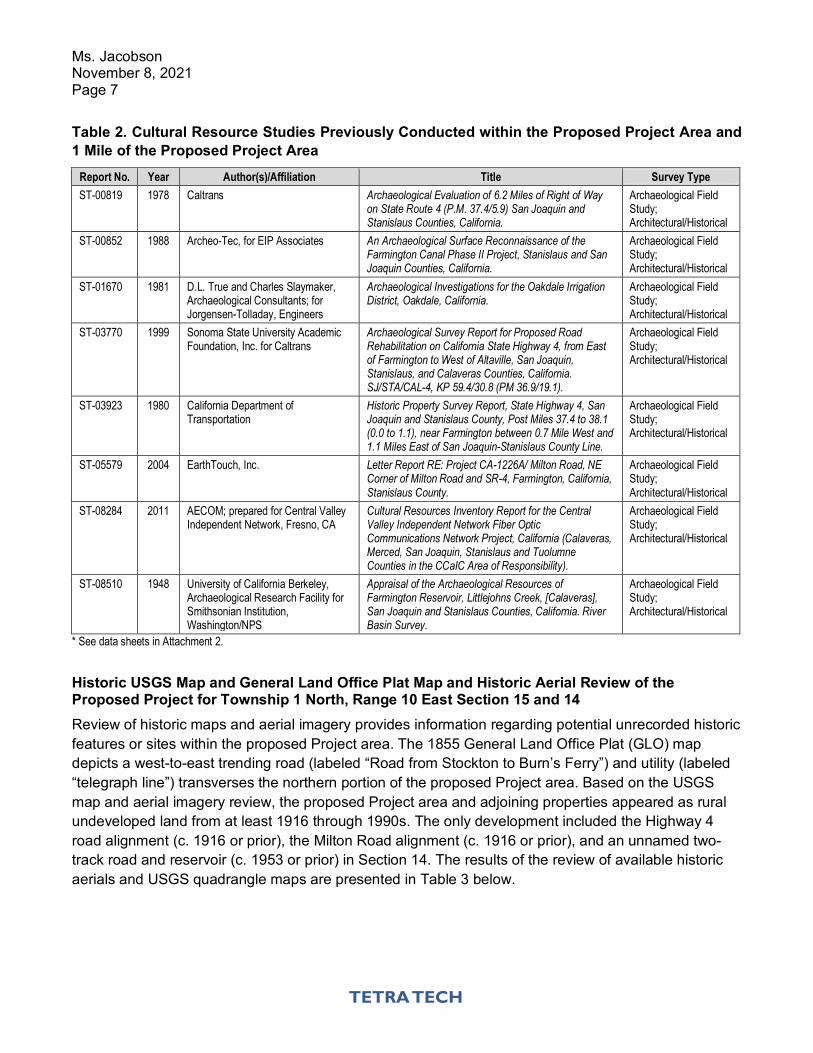
Ms. Jacobson November 8, 2021 Page 7
Table 2. Cultural Resource Studies Previously Conducted within the Proposed Project Area and 1 Mile of the Proposed Project Area
Report No. Year Author(s)/Affiliation Title Survey Type ST-00819 1978 Caltrans Archaeological Evaluation of 6.2 Miles of Right of Way
on State Route 4 (P.M. 37.4/5.9) San Joaquin and Stanislaus Counties, California.
Archaeological Field Study; Architectural/Historical
ST-00852 1988 Archeo-Tec, for EIP Associates An Archaeological Surface Reconnaissance of the Farmington Canal Phase II Project, Stanislaus and San Joaquin Counties, California.
Archaeological Field Study; Architectural/Historical
ST-01670 1981 D.L. True and Charles Slaymaker, Archaeological Consultants; for Jorgensen-Tolladay, Engineers
Archaeological Investigations for the Oakdale Irrigation District, Oakdale, California.
Archaeological Field Study; Architectural/Historical
ST-03770 1999 Sonoma State University Academic Foundation, Inc. for Caltrans
Archaeological Survey Report for Proposed Road Rehabilitation on California State Highway 4, from East of Farmington to West of Altaville, San Joaquin, Stanislaus, and Calaveras Counties, California. SJ/STA/CAL-4, KP 59.4/30.8 (PM 36.9/19.1).
Archaeological Field Study; Architectural/Historical
ST-03923 1980 California Department of Transportation
Historic Property Survey Report, State Highway 4, San Joaquin and Stanislaus County, Post Miles 37.4 to 38.1 (0.0 to 1.1), near Farmington between 0.7 Mile West and 1.1 Miles East of San Joaquin-Stanislaus County Line.
Archaeological Field Study; Architectural/Historical
ST-05579 2004 EarthTouch, Inc. Letter Report RE: Project CA-1226A/ Milton Road, NE Corner of Milton Road and SR-4, Farmington, California, Stanislaus County.
Archaeological Field Study; Architectural/Historical
ST-08284 2011 AECOM; prepared for Central Valley Independent Network, Fresno, CA
Cultural Resources Inventory Report for the Central Valley Independent Network Fiber Optic Communications Network Project, California (Calaveras, Merced, San Joaquin, Stanislaus and Tuolumne Counties in the CCaIC Area of Responsibility).
Archaeological Field Study; Architectural/Historical
ST-08510 1948 University of California Berkeley, Archaeological Research Facility for Smithsonian Institution, Washington/NPS
Appraisal of the Archaeological Resources of Farmington Reservoir, Littlejohns Creek, [Calaveras], San Joaquin and Stanislaus Counties, California. River Basin Survey.
Archaeological Field Study; Architectural/Historical
* See data sheets in Attachment 2.
Historic USGS Map and General Land Office Plat Map and Historic Aerial Review of the Proposed Project for Township 1 North, Range 10 East Section 15 and 14 Review of historic maps and aerial imagery provides information regarding potential unrecorded historic features or sites within the proposed Project area. The 1855 General Land Office Plat (GLO) map depicts a west-to-east trending road (labeled “Road from Stockton to Burn’s Ferry”) and utility (labeled “telegraph line”) transverses the northern portion of the proposed Project area. Based on the USGS map and aerial imagery review, the proposed Project area and adjoining properties appeared as rural undeveloped land from at least 1916 through 1990s. The only development included the Highway 4 road alignment (c. 1916 or prior), the Milton Road alignment (c. 1916 or prior), and an unnamed two-track road and reservoir (c. 1953 or prior) in Section 14. The results of the review of available historic aerials and USGS quadrangle maps are presented in Table 3 below.
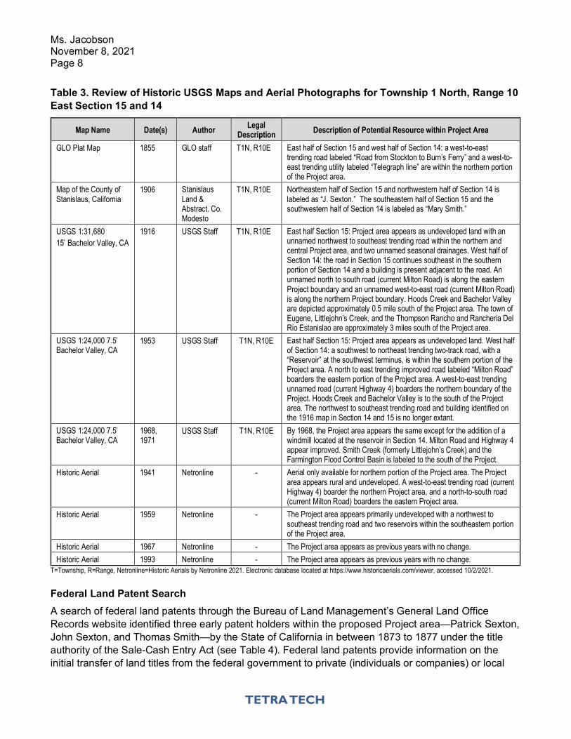
Ms. Jacobson November 8, 2021 Page 8
Table 3. Review of Historic USGS Maps and Aerial Photographs for Township 1 North, Range 10 East Section 15 and 14
Map Name Date(s) Author Legal Description Description of Potential Resource within Project Area
GLO Plat Map 1855 GLO staff T1N, R10E East half of Section 15 and west half of Section 14: a west-to-east trending road labeled “Road from Stockton to Burn’s Ferry” and a west-to-east trending utility labeled “Telegraph line” are within the northern portion of the Project area.
Map of the County of Stanislaus, California
1906 Stanislaus Land & Abstract. Co. Modesto
T1N, R10E Northeastern half of Section 15 and northwestern half of Section 14 is labeled as “J. Sexton.” The southeastern half of Section 15 and the southwestern half of Section 14 is labeled as “Mary Smith.”
USGS 1:31,680 15’ Bachelor Valley, CA
1916 USGS Staff T1N, R10E East half Section 15: Project area appears as undeveloped land with an unnamed northwest to southeast trending road within the northern and central Project area, and two unnamed seasonal drainages. West half of Section 14: the road in Section 15 continues southeast in the southern portion of Section 14 and a building is present adjacent to the road. An unnamed north to south road (current Milton Road) is along the eastern Project boundary and an unnamed west-to-east road (current Milton Road) is along the northern Project boundary. Hoods Creek and Bachelor Valley are depicted approximately 0.5 mile south of the Project area. The town of Eugene, Littlejohn’s Creek, and the Thompson Rancho and Rancheria Del Rio Estanislao are approximately 3 miles south of the Project area.
USGS 1:24,000 7.5’ Bachelor Valley, CA
1953 USGS Staff T1N, R10E East half Section 15: Project area appears as undeveloped land. West half of Section 14: a southwest to northeast trending two-track road, with a “Reservoir” at the southwest terminus, is within the southern portion of the Project area. A north to east trending improved road labeled “Milton Road” boarders the eastern portion of the Project area. A west-to-east trending unnamed road (current Highway 4) boarders the northern boundary of the Project. Hoods Creek and Bachelor Valley is to the south of the Project area. The northwest to southeast trending road and building identified on the 1916 map in Section 14 and 15 is no longer extant.
USGS 1:24,000 7.5’ Bachelor Valley, CA
1968, 1971
USGS Staff T1N, R10E By 1968, the Project area appears the same except for the addition of a windmill located at the reservoir in Section 14. Milton Road and Highway 4 appear improved. Smith Creek (formerly Littlejohn’s Creek) and the Farmington Flood Control Basin is labeled to the south of the Project.
Historic Aerial 1941 Netronline - Aerial only available for northern portion of the Project area. The Project area appears rural and undeveloped. A west-to-east trending road (current Highway 4) boarder the northern Project area, and a north-to-south road (current Milton Road) boarders the eastern Project area.
Historic Aerial 1959 Netronline - The Project area appears primarily undeveloped with a northwest to southeast trending road and two reservoirs within the southeastern portion of the Project area.
Historic Aerial 1967 Netronline - The Project area appears as previous years with no change. Historic Aerial 1993 Netronline - The Project area appears as previous years with no change.
T=Township, R=Range, Netronline=Historic Aerials by Netronline 2021. Electronic database located at https://www.historicaerials.com/viewer, accessed 10/2/2021.
Federal Land Patent Search A search of federal land patents through the Bureau of Land Management’s General Land Office Records website identified three early patent holders within the proposed Project area—Patrick Sexton, John Sexton, and Thomas Smith—by the State of California in between 1873 to 1877 under the title authority of the Sale-Cash Entry Act (see Table 4). Federal land patents provide information on the initial transfer of land titles from the federal government to private (individuals or companies) or local
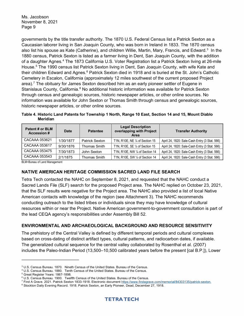
Ms. Jacobson November 8, 2021 Page 9
governments by the title transfer authority. The 1870 U.S. Federal Census list a Patrick Sexton as a Caucasian laborer living in San Joaquin County, who was born in Ireland in 1833. The 1870 census also list his spouse as Kate (Catherine), and children Willie, Martin, Mary, Francis, and Edward.3 In the 1880 census, Patrick Sexton is listed as a farmer living in Dent, San Joaquin County, with the addition of a daughter Agnes.4 The 1873 California U.S. Voter Registration list a Patrick Sexton living at 26-mile House.5 The 1990 census list Patrick Sexton living in Dent, San Joaquin County, with wife Kate and their children Edward and Agnes.6 Patrick Sexton died in 1918 and is buried at the St. John’s Catholic Cemetery in Escalon, California (approximately 12 miles southwest of the current proposed Project area).7 The obituary for James Sexton described him as an early pioneer settler of Eugene in Stanislaus County, California.8 No additional historic information was available for Patrick Sexton through census and genealogic sources, historic newspaper articles, or other online sources. No information was available for John Sexton or Thomas Smith through census and genealogic sources, historic newspaper articles, or other online sources.
Table 4. Historic Land Patents for Township 1 North, Range 10 East, Section 14 and 15, Mount Diablo Meridian
Patent # or BLM Accession # Date Patentee
Legal Description overlapping with Project
Area Transfer Authority
CACAAA 053621 1/30/1877 Patrick Sexton T1N, R10E, NE ¼ of Section 15 April 24, 1820: Sale-Cash Entry (3 Stat. 566) CACAAA 053617 9/30/1876 Thomas Smith T1N, R10E, SE ¼ of Section 15 April 24, 1820: Sale-Cash Entry (3 Stat. 566) CACAAA 053475 7/30/1873 John Sexton T1N, R10E, NW ¼ of Section 14 April 24, 1820: Sale-Cash Entry (3 Stat. 566) CACAAA 053543 2/1/1875 Thomas Smith T1N, R10E, SW ¼ of Section 14 April 24, 1820: Sale-Cash Entry (3 Stat. 566)
BLM=Bureau of Land Management
NATIVE AMERICAN HERITAGE COMMISSION SACRED LAND FILE SEARCH Tetra Tech contacted the NAHC on September 8, 2021, and requested that the NAHC conduct a Sacred Lands File (SLF) search for the proposed Project area. The NAHC replied on October 23, 2021, that the SLF results were negative for the Project area. The NAHC also provided a list of local Native American contacts with knowledge of the region (see Attachment 3). The NAHC recommends conducting outreach to the listed tribes or individuals since they may have knowledge of cultural resources within or near the Project. Native American government-to-government consultation is part of the lead CEQA agency’s responsibilities under Assembly Bill 52.
ENVIRONMENTAL AND ARCHAEOLOGICAL BACKGROUND AND RESOURCE SENSITIVITY The prehistory of the Central Valley is defined by different temporal periods and cultural complexes based on cross-dating of distinct artifact types, cultural patterns, and radiocarbon dates, if available. The generalized cultural sequence for the central valley collaborated by Rosenthal et al. (2007) includes the Paleo-Indian Period (13,500–10,500 calibrated years before the present [cal B.P.]), Lower
3 U.S. Census Bureau. 1870. Nineth Census of the United States. Bureau of the Census. 4 U.S. Census Bureau. 1880. Tenth Census of the United States. Bureau of the Census. 5 Great Register Years: 1867-1898. 6 U.S. Census Bureau. 1900. Twelfth Census of the United States. Bureau of the Census. 7 Find A Grave. 2021. Patrick Sexton 1833-1918. Electronic document https://www.findagrave.com/memorial/84303135/patrick-sexton. 8 Stockton Daily Evening Record. 1918. Patrick Sexton, an Early Pioneer, Dead, December 27, 1918.
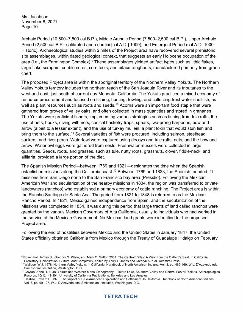
Ms. Jacobson November 8, 2021 Page 10
Archaic Period (10,500–7,500 cal B.P.), Middle Archaic Period (7,500–2,500 cal B.P.), Upper Archaic Period (2,500 cal B.P.–calibrated anno domini [cal A.D.] 1000), and Emergent Period (cal A.D. 1000–Historic). Archaeological studies within 2 miles of the Project area have recovered several prehistoric site assemblages, within dated geological context, that suggests an early Holocene occupation of the area (i.e., the Farmington Complex).9 These assemblages yielded artifact types such as lithic flakes, large flake scrapers, cobble cores, core tools, and biface roughouts, manufactured primarily from green chert.
The proposed Project area is within the aboriginal territory of the Northern Valley Yokuts. The Northern Valley Yokuts territory includes the northern reach of the San Joaquin River and its tributaries to the west and east, just south of current day Mendota, California. The Yokuts practiced a mixed economy of resource procurement and focused on fishing, hunting, fowling, and collecting freshwater shellfish, as well as plant resources such as roots and seeds.10 Acorns were an important food staple that were gathered from groves of valley oaks, and often collected in mass quantities and stored in granaries. The Yokuts were proficient fishers, implementing various strategies such as fishing from tule rafts, the use of nets, hooks, diving with nets, conical basketry traps, spears, two-prong harpoons, bow and arrow (albeit to a lesser extent), and the use of turkey mullein, a plant toxin that would stun fish and bring them to the surface.11 Several varieties of fish were procured, including salmon, steelhead, suckers, and river perch. Waterfowl were captured using decoys and tule rafts, nets, and the bow and arrow. Waterfowl eggs were gathered from nests. Freshwater mussels were collected in large quantities. Seeds, roots, and grasses, such as tule, nutty roots, grassnuts, clover, fiddle-neck, and alfilaria, provided a large portion of the diet.
The Spanish Mission Period—between 1769 and 1821—designates the time when the Spanish established missions along the California coast.12 Between 1769 and 1833, the Spanish founded 21 missions from San Diego north to the San Francisco bay area (Presidio). Following the Mexican American War and secularization of the nearby missions in 1834, the region was transferred to private landowners (ranchos) who established a primary economy of cattle ranching. The Project area is within the Rancho Santiago de Santa Ana. The period from 1821 to 1848 is referred to as the Mexican Rancho Period. In 1821, Mexico gained independence from Spain, and the secularization of the Missions was completed in 1834. It was during this period that large tracts of land called ranchos were granted by the various Mexican Governors of Alta California, usually to individuals who had worked in the service of the Mexican Government. No Mexican land grants were identified for the proposed Project area.
Following the end of hostilities between Mexico and the United States in January 1847, the United States officially obtained California from Mexico through the Treaty of Guadalupe Hidalgo on February
9 Rosenthal, Jeffrey S., Gregory G. White, and Mark Q. Sutton 2007. The Central Valley: A View from the Catbird’s Seat. In California
Prehistory: Colonization, Culture, and Complexity, edited by Terry L. Jones and Kathryn A. Klar. Altamira Press. 10 Wallace, W.J. 1978. Northern Valley Yokuts. In California. Handbook of North American Indians, Vol. 8, pp. 462-469, W.L. D’Azevedo eds,
Smithsonian Institution, Washington, D.C. 11 Gayton, Anna H. 1948. Yokuts and Western Mono Ethnography I: Tulare Lake, Southern Valley and Central Foothill Yokuts. Anthropological
Records, 10(1):143-301. University of California Publications, Berkeley and Los Angeles. 12 Castillo, Edward D. 1978. The Impact of Eruo-American Exploration and Settlement. In California. Handbook of North American Indians,
Vol. 8, pp. 99-127, W.L. D’Azevedo eds, Smithsonian Institution, Washington, D.C.
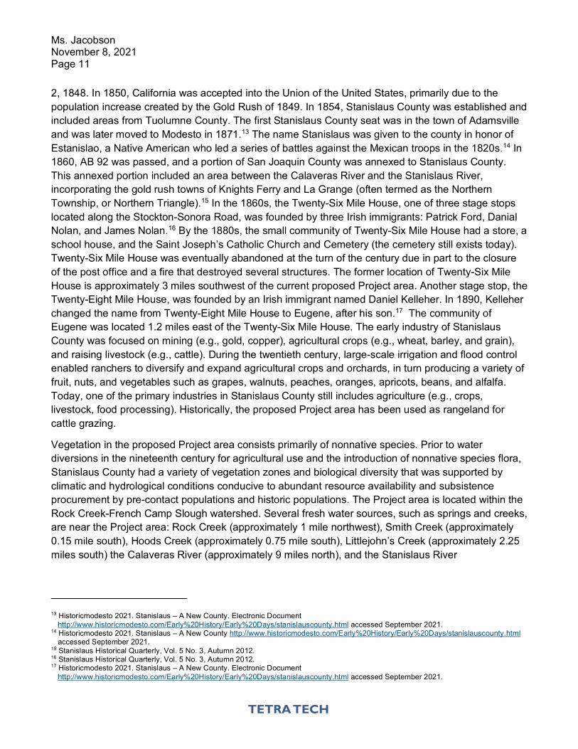
Ms. Jacobson November 8, 2021 Page 11
2, 1848. In 1850, California was accepted into the Union of the United States, primarily due to the population increase created by the Gold Rush of 1849. In 1854, Stanislaus County was established and included areas from Tuolumne County. The first Stanislaus County seat was in the town of Adamsville and was later moved to Modesto in 1871.13 The name Stanislaus was given to the county in honor of Estanislao, a Native American who led a series of battles against the Mexican troops in the 1820s.14 In 1860, AB 92 was passed, and a portion of San Joaquin County was annexed to Stanislaus County. This annexed portion included an area between the Calaveras River and the Stanislaus River, incorporating the gold rush towns of Knights Ferry and La Grange (often termed as the Northern Township, or Northern Triangle).15 In the 1860s, the Twenty-Six Mile House, one of three stage stops located along the Stockton-Sonora Road, was founded by three Irish immigrants: Patrick Ford, Danial Nolan, and James Nolan.16 By the 1880s, the small community of Twenty-Six Mile House had a store, a school house, and the Saint Joseph’s Catholic Church and Cemetery (the cemetery still exists today). Twenty-Six Mile House was eventually abandoned at the turn of the century due in part to the closure of the post office and a fire that destroyed several structures. The former location of Twenty-Six Mile House is approximately 3 miles southwest of the current proposed Project area. Another stage stop, the Twenty-Eight Mile House, was founded by an Irish immigrant named Daniel Kelleher. In 1890, Kelleher changed the name from Twenty-Eight Mile House to Eugene, after his son.17 The community of Eugene was located 1.2 miles east of the Twenty-Six Mile House. The early industry of Stanislaus County was focused on mining (e.g., gold, copper), agricultural crops (e.g., wheat, barley, and grain), and raising livestock (e.g., cattle). During the twentieth century, large-scale irrigation and flood control enabled ranchers to diversify and expand agricultural crops and orchards, in turn producing a variety of fruit, nuts, and vegetables such as grapes, walnuts, peaches, oranges, apricots, beans, and alfalfa. Today, one of the primary industries in Stanislaus County still includes agriculture (e.g., crops, livestock, food processing). Historically, the proposed Project area has been used as rangeland for cattle grazing.
Vegetation in the proposed Project area consists primarily of nonnative species. Prior to water diversions in the nineteenth century for agricultural use and the introduction of nonnative species flora, Stanislaus County had a variety of vegetation zones and biological diversity that was supported by climatic and hydrological conditions conducive to abundant resource availability and subsistence procurement by pre-contact populations and historic populations. The Project area is located within the Rock Creek-French Camp Slough watershed. Several fresh water sources, such as springs and creeks, are near the Project area: Rock Creek (approximately 1 mile northwest), Smith Creek (approximately 0.15 mile south), Hoods Creek (approximately 0.75 mile south), Littlejohn’s Creek (approximately 2.25 miles south) the Calaveras River (approximately 9 miles north), and the Stanislaus River
13 Historicmodesto 2021. Stanislaus – A New County. Electronic Document
http://www.historicmodesto.com/Early%20History/Early%20Days/stanislauscounty.html accessed September 2021. 14 Historicmodesto 2021. Stanislaus – A New County http://www.historicmodesto.com/Early%20History/Early%20Days/stanislauscounty.html
accessed September 2021. 15 Stanislaus Historical Quarterly, Vol. 5 No. 3, Autumn 2012. 16 Stanislaus Historical Quarterly, Vol. 5 No. 3, Autumn 2012. 17 Historicmodesto 2021. Stanislaus – A New County. Electronic Document
http://www.historicmodesto.com/Early%20History/Early%20Days/stanislauscounty.html accessed September 2021.
Ms. Jacobson November 8, 2021 Page 12
(approximately 11 miles south). Prior to historic alterations to the landscape, the region was characterized by vegetation communities such as riverine and upland grasslands and oaks.
Regionally, the proposed Project area lies within the Sierra Nevada foothills of the Sierra Nevada Geomorphic Province. Sediments within the proposed Project area primary consist of the Mehrten Formation of the late Miocene to Early Pliocene in age.18 In portions of the proposed Project area, the Mehrten Formation is overlain by the alluvial fan deposits of the Pliocene age Laguna Formation, and Pleistocene (10,000 to 2 million years old, over 20 feet in depth) to Holocene (recent to 10,000 years old, 10 to 20 feet in depth) aged locally derived gravelly alluvium.19 It is generally accepted that human occupation of Central California did not occur until approximately 13,000 to 10,000 years ago. Therefore, landforms that are Pleistocene (1.8 million years to 11,800 years) in age or older are less likely to contain subsurface archaeological material. Conversely, intact Holocene-age (10,500 cal BP to present) deposits are considered more likely to contain archaeological material.20 The soils in the proposed Project area are described as being in the Pentz-Peters association, 2 to 15 percent slopes, a well-drained silty loam to silty clay loam that ranges zero to 25 inches in depth.21
As noted above, the proposed Project area has been used as rangeland for livestock grazing and other disturbances include ranch roads, two seasonal ponds (one currently in use, the other no longer extant due to disuse and erosion) and several stock wells, and periodic disking of fire breaks around the Project perimeter. In addition, possible discing and dryland hay cultivation may have also occurred within the proposed Project area. More recently, portions of the proposed Project area have been disced and tilled to support cultivation of winter wheat and hay during the 2020/2021 season. Subsurface disturbance within the disced and tilled areas is estimated at approximately 12 inches in depth. There is a possibility that surface or buried archaeological deposits may be encountered during Project-related, ground-disturbing activities.
Existing regulations require that if human remains and/or cultural items defined by Health and Safety Code, Section 7050.5, are inadvertently discovered, all work in the vicinity of the find would cease and the Stanislaus County Coroner at (209) 567-4480 or (209) 552-2468 would be contacted immediately. If the remains are found to be Native American as defined by Health and Safety Code, Section 7050.5, the coroner will contact the NAHC by telephone within 24 hours. The NAHC shall immediately notify the person it believes to be the MLD as stipulated by California PRC, Section 5097.98. The MLD(s), with the permission of the landowner and/or authorized representative, shall inspect the site of the discovered remains and recommend treatment regarding the remains and any associated grave goods. The MLD shall complete their inspection and make their recommendations within 48 hours of notification by the NAHC. Any discovery of human remains would be treated in accordance with Section 5097.98 of the PRC and Section 7050.5 of the Health and Safety Code.
18 Marchard, D.E., Bartow, J.A., Shipley, S. 1981. Preliminary Geological Map Showing Cenozoic Deposits of the Bachelor Valley Wuadrangle,
California. 19 Marchard, D.E., Bartow, J.A., Shipley, S. 1981. Preliminary Geological Map Showing Cenozoic Deposits of the Bachelor Valley Wuadrangle,
California. 20 Meyer, Jack, D. Craig Young, Jeffrey S. Rosenthal 2010. Volume I: A Geoarchaeological Overview and Assessment of Caltrans Districts 6
and 9, Cultural Resources Inventory of Caltrans District 6/9 Rural Conventional Highways. EA 06 0A7408 TEA Grant. February. 21 United States Department of Agriculture natural Resources Conservation Service. Web Soil Survey. Available online at:
https://websoilsurvey.nrcs.usda.gov/app/, accessed September 29, 2021.
Ms. Jacobson November 8, 2021 Page 13
Should you have any questions regarding the information provided above, please contact Tetra Tech’s Cultural Resource Specialist, Jenna Farrell, at [email protected] or (916) 206-8705. Sincerely, Jenna Farrell, MA, RPA Principal Archaeologist, Tetra Tech, Inc. Attachments: Attachment 1. Figures Attachment 2. Record Search Results – NON-CONFIDENTIAL Attachment 3. Native American Heritage Commission Results
Attachment 1 Figures
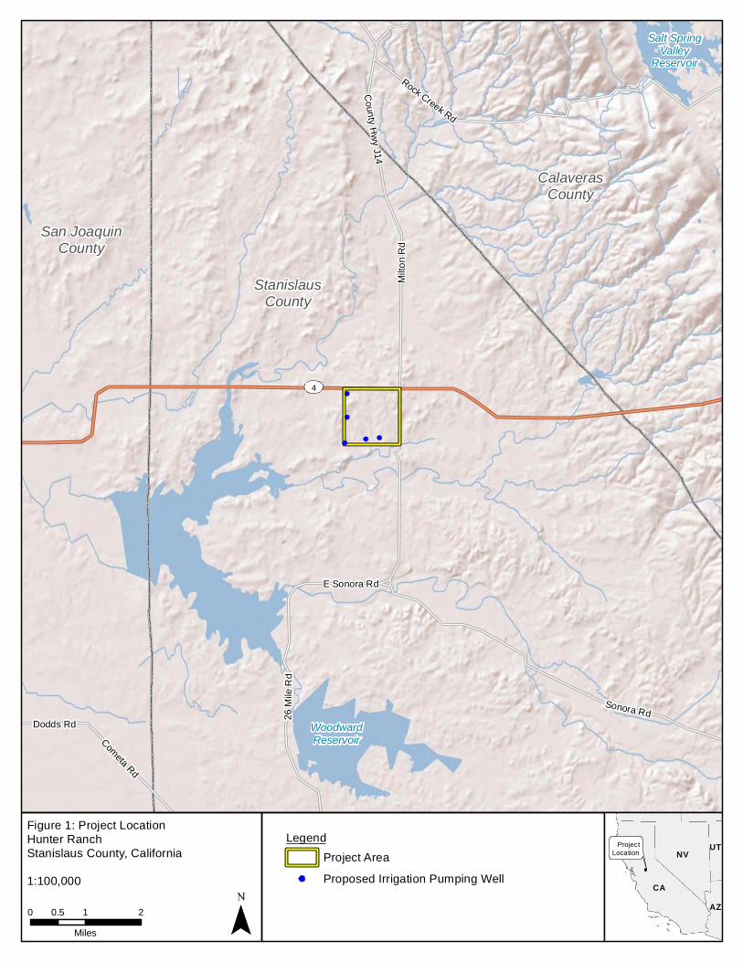
CalaverasCounty
San JoaquinCounty
StanislausCounty
4
Dodds Rd 26 M
ile R
d
Cometa Rd
Milto
n Rd
County Hwy J14
Sonora Rd
E Sonora Rd
Rock Creek Rd
Salt SpringValley
Reservoir
WoodwardReservoir
Figure 1: Project LocationHunter RanchStanislaus County, California
0 1 20.5Miles
CACA
NVNV
AZAZ
UTUT
1:100,000
ProjectLocation
LegendProject AreaProposed Irrigation Pumping Well
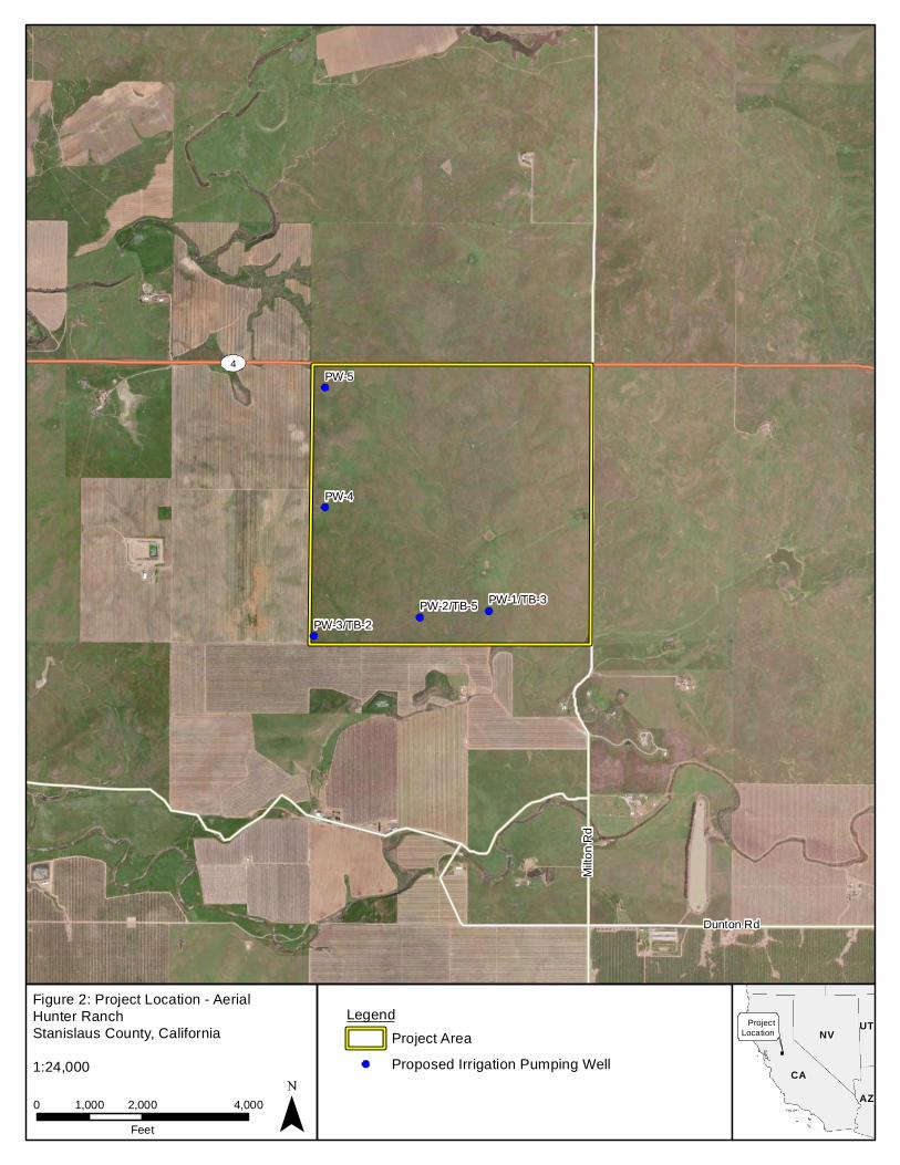
Milto
n Rd
Dunton Rd
4
PW-1/TB-3PW-2/TB-5PW-3/TB-2
PW-4
PW-5
Figure 2: Project Location - AerialHunter RanchStanislaus County, California
0 2,000 4,0001,000Feet
CACA
NVNV
AZAZ
UTUT
1:24,000
ProjectLocation
LegendProject AreaProposed Irrigation Pumping Well

PW-1/TB-3PW-2/TB-5PW-3/TB-2
PW-4
PW-5
Figure 3: Project Location - TopographicHunter RanchStanislaus County, California
0 2,000 4,0001,000Feet
CACA
NVNV
AZAZ
UTUT
1:24,000
ProjectLocation
USGS 7.5' Quad: Bachelor Valley, CA (1971)PLSS: T1N R10E S14, 15
LegendProject AreaProposed Irrigation Pumping Well
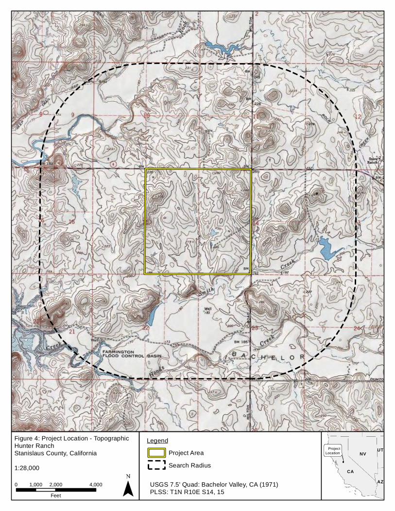
Figure 4: Project Location - TopographicHunter RanchStanislaus County, California
0 2,000 4,0001,000Feet
CACA
NVNV
AZAZ
UTUT
1:28,000
ProjectLocation
LegendProject Area
USGS 7.5' Quad: Bachelor Valley, CA (1971)PLSS: T1N R10E S14, 15
Search Radius
Attachment 2 Record Search Results NON-CONFIDENTIAL
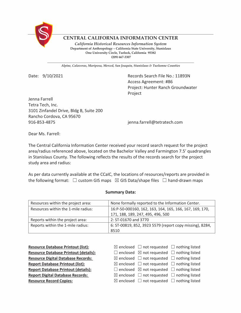
CENTRAL CALIFORNIA INFORMATION CENTER
California Historical Resources Information System Department of Anthropology – California State University, Stanislaus
One University Circle, Turlock, California 95382 (209) 667-3307
_____________________________________________________________________________________________ Alpine, Calaveras, Mariposa, Merced, San Joaquin, Stanislaus & Tuolumne Counties
Date: 9/10/2021 Records Search File No.: 11893N Access Agreement: #86 Project: Hunter Ranch Groundwater Project Jenna Farrell Tetra Tech, Inc. 3101 Zinfandel Drive, Bldg B, Suite 200 Rancho Cordova, CA 95670 916-853-4875 [email protected] Dear Ms. Farrell: The Central California Information Center received your record search request for the project area/radius referenced above, located on the Bachelor Valley and Farmington 7.5’ quadrangles in Stanislaus County. The following reflects the results of the records search for the project study area and radius: As per data currently available at the CCaIC, the locations of resources/reports are provided in the following format: custom GIS maps GIS Data/shape files hand-drawn maps
Summary Data:
Resources within the project area: None formally reported to the Information Center. Resources within the 1-mile radius: 16:P-50-000160, 162, 163, 164, 165, 166, 167, 169, 170,
171, 188, 189, 247, 495, 496, 500 Reports within the project area: 2: ST-01670 and 3770 Reports within the 1-mile radius: 6: ST-00819, 852, 3923 5579 (report copy missing), 8284,
8510 Resource Database Printout (list): enclosed not requested nothing listed Resource Database Printout (details): enclosed not requested nothing listed Resource Digital Database Records: enclosed not requested nothing listed Report Database Printout (list): enclosed not requested nothing listed Report Database Printout (details): enclosed not requested nothing listed Report Digital Database Records: enclosed not requested nothing listed Resource Record Copies: enclosed not requested nothing listed
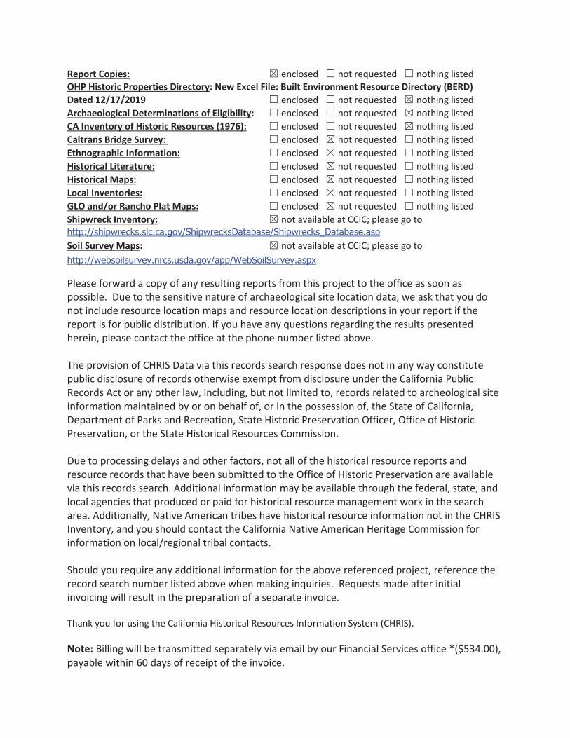
Report Copies: enclosed not requested nothing listed OHP Historic Properties Directory: New Excel File: Built Environment Resource Directory (BERD) Dated 12/17/2019 enclosed not requested nothing listed Archaeological Determinations of Eligibility: enclosed not requested nothing listed CA Inventory of Historic Resources (1976): enclosed not requested nothing listed Caltrans Bridge Survey: enclosed not requested nothing listed Ethnographic Information: enclosed not requested nothing listed Historical Literature: enclosed not requested nothing listed Historical Maps: enclosed not requested nothing listed Local Inventories: enclosed not requested nothing listed GLO and/or Rancho Plat Maps: enclosed not requested nothing listed Shipwreck Inventory: not available at CCIC; please go to http://shipwrecks.slc.ca.gov/ShipwrecksDatabase/Shipwrecks_Database.asp Soil Survey Maps: not available at CCIC; please go to http://websoilsurvey.nrcs.usda.gov/app/WebSoilSurvey.aspx
Please forward a copy of any resulting reports from this project to the office as soon as possible. Due to the sensitive nature of archaeological site location data, we ask that you do not include resource location maps and resource location descriptions in your report if the report is for public distribution. If you have any questions regarding the results presented herein, please contact the office at the phone number listed above. The provision of CHRIS Data via this records search response does not in any way constitute public disclosure of records otherwise exempt from disclosure under the California Public Records Act or any other law, including, but not limited to, records related to archeological site information maintained by or on behalf of, or in the possession of, the State of California, Department of Parks and Recreation, State Historic Preservation Officer, Office of Historic Preservation, or the State Historical Resources Commission. Due to processing delays and other factors, not all of the historical resource reports and resource records that have been submitted to the Office of Historic Preservation are available via this records search. Additional information may be available through the federal, state, and local agencies that produced or paid for historical resource management work in the search area. Additionally, Native American tribes have historical resource information not in the CHRIS Inventory, and you should contact the California Native American Heritage Commission for information on local/regional tribal contacts. Should you require any additional information for the above referenced project, reference the record search number listed above when making inquiries. Requests made after initial invoicing will result in the preparation of a separate invoice. Thank you for using the California Historical Resources Information System (CHRIS). Note: Billing will be transmitted separately via email by our Financial Services office *($534.00), payable within 60 days of receipt of the invoice.
If you wish to include payment by Credit Card, you must wait to receive the official invoice from Financial Services so that you can reference the CMP # (Invoice Number), and then contact the link below: https://commerce.cashnet.com/ANTHROPOLOGY Sincerely,
EE. A. Greathouse E. A. Greathouse, Coordinator Central California Information Center California Historical Resources Information System
* Invoice Request sent to: [email protected], CSU Stanislaus Financial Services
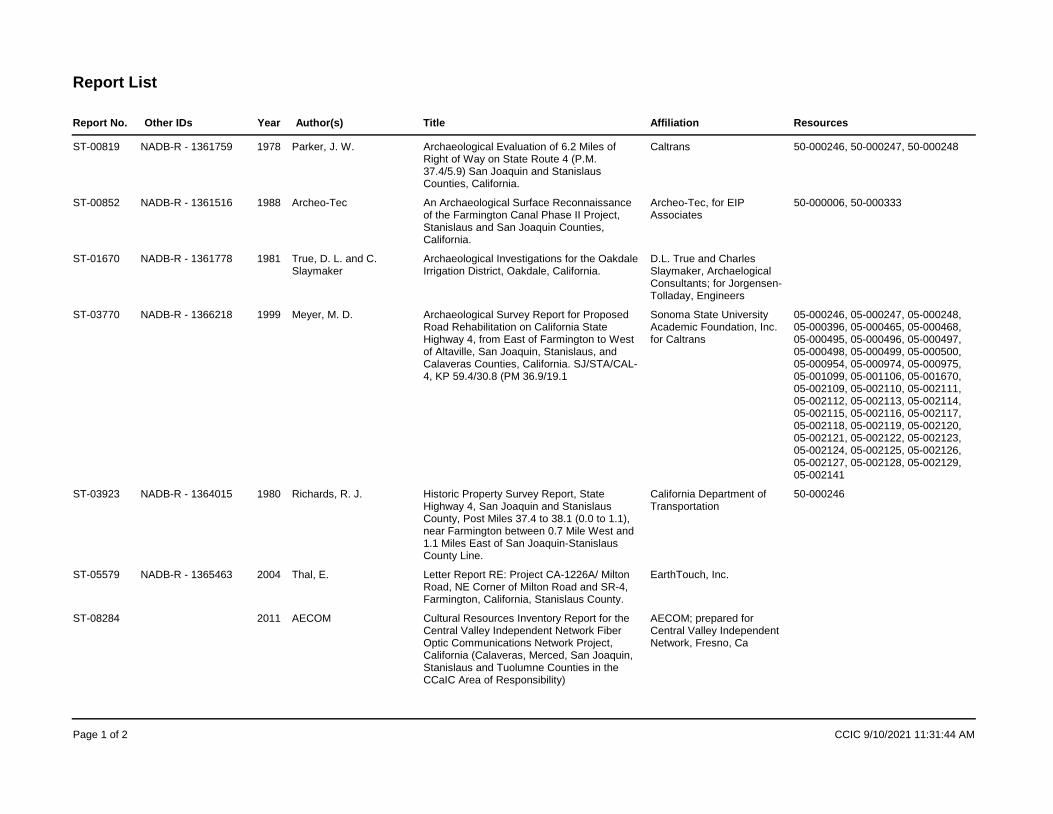
Report List
Report No. Year Title AffiliationAuthor(s) ResourcesOther IDs
ST-00819 1978 Archaeological Evaluation of 6.2 Miles of Right of Way on State Route 4 (P.M. 37.4/5.9) San Joaquin and Stanislaus Counties, California.
CaltransParker, J. W. 50-000246, 50-000247, 50-000248NADB-R - 1361759
ST-00852 1988 An Archaeological Surface Reconnaissance of the Farmington Canal Phase II Project, Stanislaus and San Joaquin Counties, California.
Archeo-Tec, for EIP Associates
Archeo-Tec 50-000006, 50-000333NADB-R - 1361516
ST-01670 1981 Archaeological Investigations for the Oakdale Irrigation District, Oakdale, California.
D.L. True and Charles Slaymaker, Archaelogical Consultants; for Jorgensen-Tolladay, Engineers
True, D. L. and C. Slaymaker
NADB-R - 1361778
ST-03770 1999 Archaeological Survey Report for Proposed Road Rehabilitation on California State Highway 4, from East of Farmington to West of Altaville, San Joaquin, Stanislaus, and Calaveras Counties, California. SJ/STA/CAL-4, KP 59.4/30.8 (PM 36.9/19.1
Sonoma State University Academic Foundation, Inc. for Caltrans
Meyer, M. D. 05-000246, 05-000247, 05-000248, 05-000396, 05-000465, 05-000468, 05-000495, 05-000496, 05-000497, 05-000498, 05-000499, 05-000500, 05-000954, 05-000974, 05-000975, 05-001099, 05-001106, 05-001670, 05-002109, 05-002110, 05-002111, 05-002112, 05-002113, 05-002114, 05-002115, 05-002116, 05-002117, 05-002118, 05-002119, 05-002120, 05-002121, 05-002122, 05-002123, 05-002124, 05-002125, 05-002126, 05-002127, 05-002128, 05-002129, 05-002141
NADB-R - 1366218
ST-03923 1980 Historic Property Survey Report, State Highway 4, San Joaquin and Stanislaus County, Post Miles 37.4 to 38.1 (0.0 to 1.1), near Farmington between 0.7 Mile West and 1.1 Miles East of San Joaquin-Stanislaus County Line.
California Department of Transportation
Richards, R. J. 50-000246NADB-R - 1364015
ST-05579 2004 Letter Report RE: Project CA-1226A/ Milton Road, NE Corner of Milton Road and SR-4, Farmington, California, Stanislaus County.
EarthTouch, Inc.Thal, E.NADB-R - 1365463
ST-08284 2011 Cultural Resources Inventory Report for the Central Valley Independent Network Fiber Optic Communications Network Project, California (Calaveras, Merced, San Joaquin, Stanislaus and Tuolumne Counties in the CCaIC Area of Responsibility)
AECOM; prepared for Central Valley Independent Network, Fresno, Ca
AECOM
Page 1 of 2 CCIC 9/10/2021 11:31:44 AM

Report List
Report No. Year Title AffiliationAuthor(s) ResourcesOther IDs
ST-08510 1948 Appraisal of the Archaeological Resources of Farmington Reservoir, Littlejohns Creek, [Calaveras], San Joaquin and Stanislaus Counties, California. River Basin Survey.
University of California Berkeley, Archaeological Research Facility for Smithsonian Institution, Washington/NPS
Riddell, D. 50-000088, 50-000089, 50-000090, 50-000091, 50-000092, 50-000093, 50-000094, 50-000095, 50-000096, 50-000097, 50-000098, 50-000099, 50-000100, 50-000101, 50-000102, 50-000103, 50-000104, 50-000105, 50-000106, 50-000107, 50-000108, 50-000109, 50-000130, 50-000131, 50-000132, 50-000133, 50-000134, 50-000135, 50-000136, 50-000137, 50-000138, 50-000139, 50-000140, 50-000141, 50-000142, 50-000143, 50-000144, 50-000145, 50-000146, 50-000147, 50-000148, 50-000149, 50-000150, 50-000151, 50-000152, 50-000153, 50-000154, 50-000155, 50-000156, 50-000157, 50-000158, 50-000159, 50-000160, 50-000161, 50-000162, 50-000163, 50-000164, 50-000165, 50-000166, 50-000167, 50-000168, 50-000169, 50-000170, 50-000171, 50-000172, 50-000173, 50-000174, 50-000175, 50-000176, 50-000177, 50-000178, 50-000179, 50-000180, 50-000181, 50-000182, 50-000186, 50-000187, 50-000188, 50-000189, 50-000190, 50-000191, 50-000192, 50-000193, 50-000194, 50-000195, 50-000196, 50-000197, 50-000198, 50-000199, 50-000200, 50-000201, 50-000202, 50-000205
Page 2 of 2 CCIC 9/10/2021 11:31:45 AM
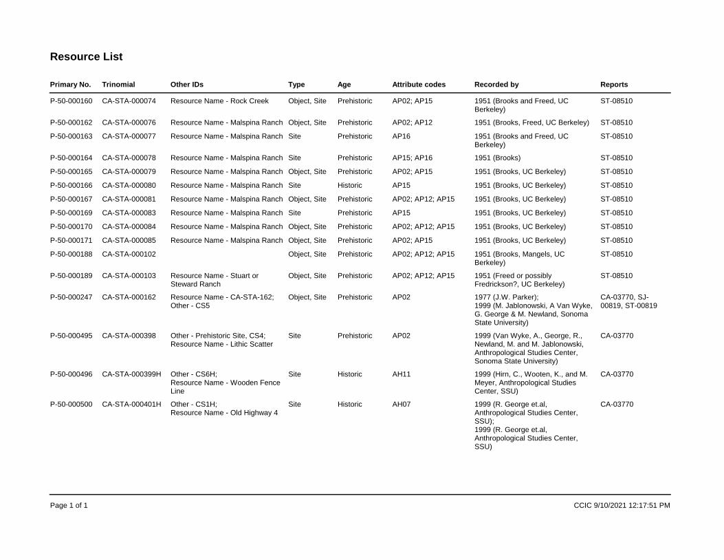
Primary No. Trinomial
Resource List
Other IDs ReportsType Age Attribute codes Recorded by
P-50-000160 CA-STA-000074 Resource Name - Rock Creek ST-08510Object, Site Prehistoric AP02; AP15 1951 (Brooks and Freed, UC Berkeley)
P-50-000162 CA-STA-000076 Resource Name - Malspina Ranch ST-08510Object, Site Prehistoric AP02; AP12 1951 (Brooks, Freed, UC Berkeley)P-50-000163 CA-STA-000077 Resource Name - Malspina Ranch ST-08510Site Prehistoric AP16 1951 (Brooks and Freed, UC
Berkeley)P-50-000164 CA-STA-000078 Resource Name - Malspina Ranch ST-08510Site Prehistoric AP15; AP16 1951 (Brooks)P-50-000165 CA-STA-000079 Resource Name - Malspina Ranch ST-08510Object, Site Prehistoric AP02; AP15 1951 (Brooks, UC Berkeley)P-50-000166 CA-STA-000080 Resource Name - Malspina Ranch ST-08510Site Historic AP15 1951 (Brooks, UC Berkeley)P-50-000167 CA-STA-000081 Resource Name - Malspina Ranch ST-08510Object, Site Prehistoric AP02; AP12; AP15 1951 (Brooks, UC Berkeley)P-50-000169 CA-STA-000083 Resource Name - Malspina Ranch ST-08510Site Prehistoric AP15 1951 (Brooks, UC Berkeley)P-50-000170 CA-STA-000084 Resource Name - Malspina Ranch ST-08510Object, Site Prehistoric AP02; AP12; AP15 1951 (Brooks, UC Berkeley)P-50-000171 CA-STA-000085 Resource Name - Malspina Ranch ST-08510Object, Site Prehistoric AP02; AP15 1951 (Brooks, UC Berkeley)P-50-000188 CA-STA-000102 ST-08510Object, Site Prehistoric AP02; AP12; AP15 1951 (Brooks, Mangels, UC
Berkeley)P-50-000189 CA-STA-000103 Resource Name - Stuart or
Steward RanchST-08510Object, Site Prehistoric AP02; AP12; AP15 1951 (Freed or possibly
Fredrickson?, UC Berkeley)P-50-000247 CA-STA-000162 Resource Name - CA-STA-162;
Other - CS5CA-03770, SJ-00819, ST-00819
Object, Site Prehistoric AP02 1977 (J.W. Parker); 1999 (M. Jablonowski, A Van Wyke, G. George & M. Newland, Sonoma State University)
P-50-000495 CA-STA-000398 Other - Prehistoric Site, CS4; Resource Name - Lithic Scatter
CA-03770Site Prehistoric AP02 1999 (Van Wyke, A., George, R., Newland, M. and M. Jablonowski, Anthropological Studies Center, Sonoma State University)
P-50-000496 CA-STA-000399H Other - CS6H; Resource Name - Wooden Fence Line
CA-03770Site Historic AH11 1999 (Hirn, C., Wooten, K., and M. Meyer, Anthropological Studies Center, SSU)
P-50-000500 CA-STA-000401H Other - CS1H; Resource Name - Old Highway 4
CA-03770Site Historic AH07 1999 (R. George et.al, Anthropological Studies Center, SSU); 1999 (R. George et.al, Anthropological Studies Center, SSU)
Page 1 of 1 CCIC 9/10/2021 12:17:51 PM
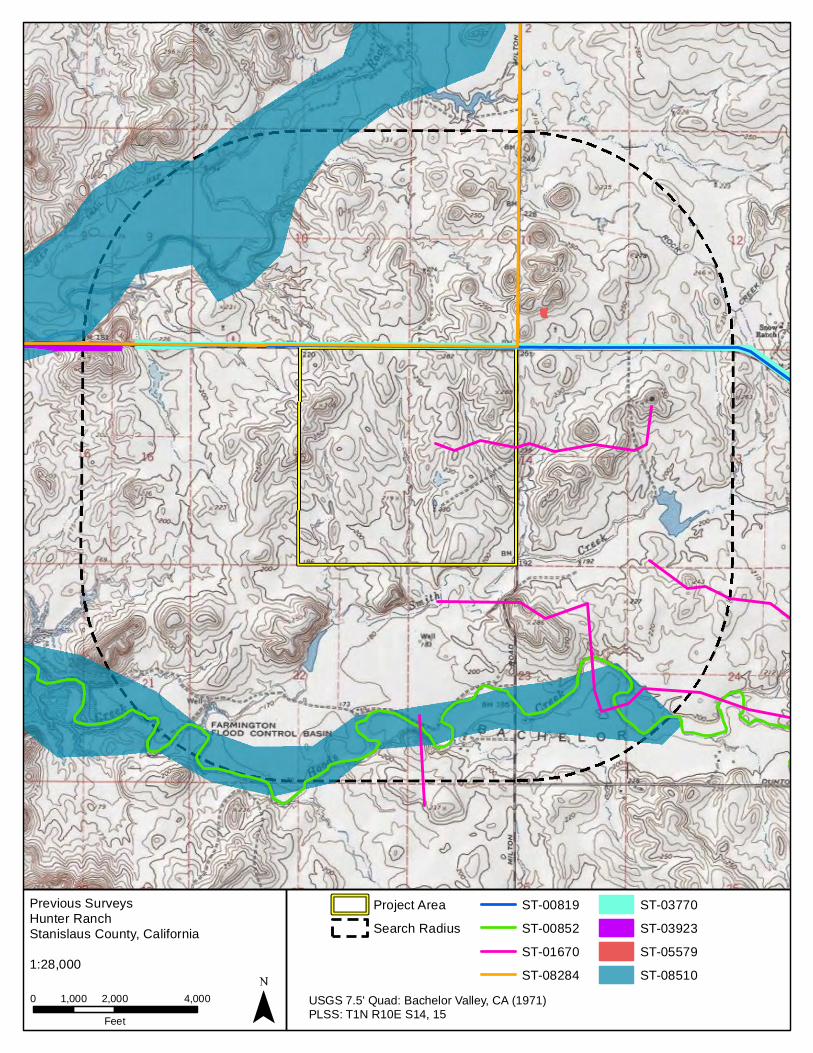
Previous SurveysHunter RanchStanislaus County, California
0 2,000 4,0001,000Feet
1:28,000
USGS 7.5' Quad: Bachelor Valley, CA (1971)PLSS: T1N R10E S14, 15
Project AreaSearch Radius
ST-00819ST-00852ST-01670ST-08284
ST-03770ST-03923ST-05579ST-08510

Attachment 3 Native American Heritage Commission Results
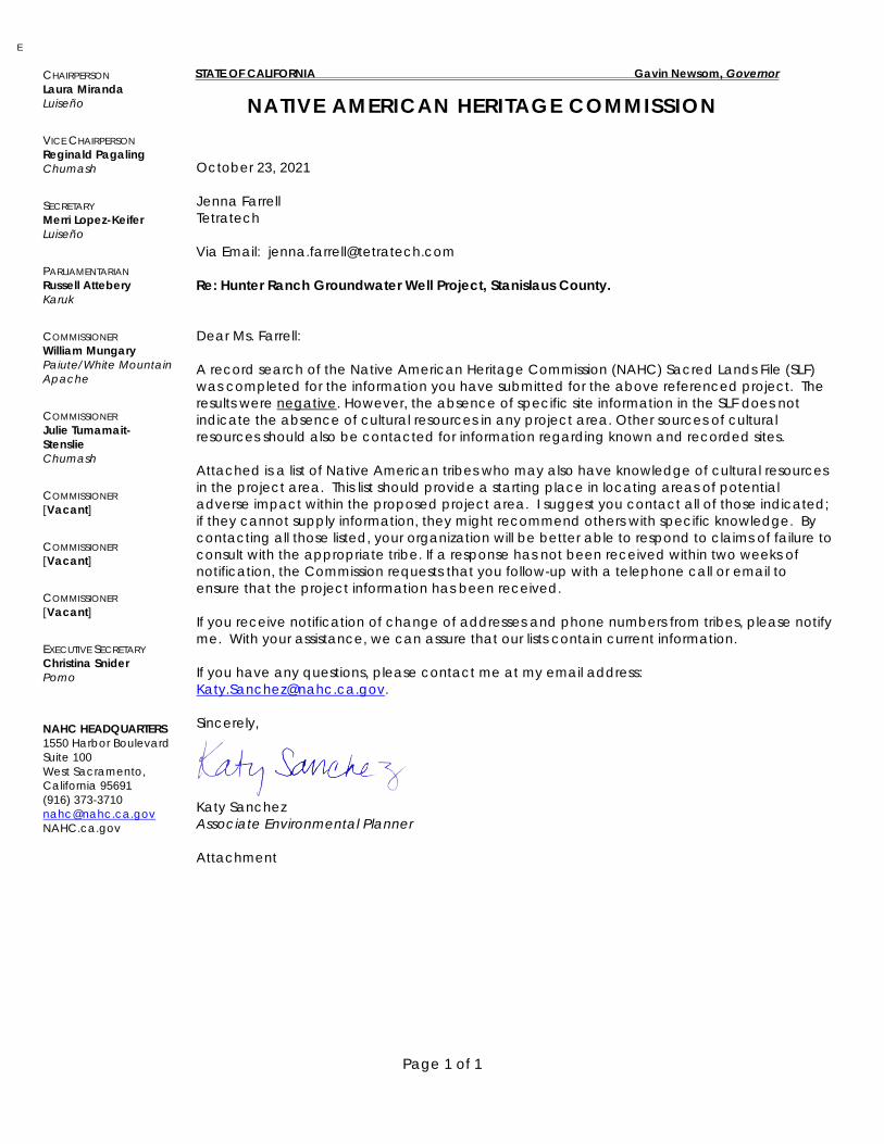
STATE OF CALIFORNIA Gavin Newsom, Governor
NATIVE AMERICAN HERITAGE COMMISSION
Page 1 of 1
October 23, 2021 Jenna Farrell Tetratech Via Email: [email protected] Re: Hunter Ranch Groundwater Well Project, Stanislaus County. Dear Ms. Farrell: A record search of the Native American Heritage Commission (NAHC) Sacred Lands File (SLF) was completed for the information you have submitted for the above referenced project. The results were negative. However, the absence of specific site information in the SLF does not indicate the absence of cultural resources in any project area. Other sources of cultural resources should also be contacted for information regarding known and recorded sites. Attached is a list of Native American tribes who may also have knowledge of cultural resources in the project area. This list should provide a starting place in locating areas of potential adverse impact within the proposed project area. I suggest you contact all of those indicated; if they cannot supply information, they might recommend others with specific knowledge. By contacting all those listed, your organization will be better able to respond to claims of failure to consult with the appropriate tribe. If a response has not been received within two weeks of notification, the Commission requests that you follow-up with a telephone call or email to ensure that the project information has been received. If you receive notification of change of addresses and phone numbers from tribes, please notify me. With your assistance, we can assure that our lists contain current information. If you have any questions, please contact me at my email address: [email protected]. Sincerely, Katy Sanchez Associate Environmental Planner Attachment
E
CHAIRPERSON Laura Miranda Luiseño
VICE CHAIRPERSON Reginald Pagaling Chumash
SECRETARY Merri Lopez-Keifer Luiseño
PARLIAMENTARIAN Russell Attebery Karuk
COMMISSIONER William Mungary Paiute/White Mountain Apache
COMMISSIONER Julie Tumamait-Stenslie Chumash
COMMISSIONER [Vacant]
COMMISSIONER [Vacant]
COMMISSIONER [Vacant]
EXECUTIVE SECRETARY Christina Snider Pomo
NAHC HEADQUARTERS 1550 Harbor Boulevard Suite 100 West Sacramento, California 95691 (916) 373-3710 [email protected] NAHC.ca.gov
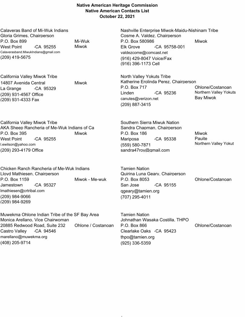
Native American Heritage CommissionNative American Contacts List
October 22, 2021
Gloria Grimes, ChairpersonP.O. Box 899West Point 95255
(209) 419-5675
Mi-WukMiwokCA,
Calaveras Band of Mi-Wuk Indians
This list is current as of the date of this document and is based on the information available to the Commission on the date it was produced.
Distribution of this list does not relieve any person of statutory responsibility as defined in Section 7050.5 of the Healthand Safety Code,Section 5097.94 of the Public Resources Code, or Section 5097.98 of the Public Resources Code.
This list is only applicable for contacting local Native Americans Tribes for the proposed: Hunter Ranch Groundwater Well Project, Stanislaus County
14807 Avenida CentralLa Grange 95329(209) 931-4567 Office
MiwokCA,
(209) 931-4333 Fax
California Valley Miwok Tribe
This list is current as of the date of this document and is based on the information available to the Commission on the date it was produced.
Distribution of this list does not relieve any person of statutory responsibility as defined in Section 7050.5 of the Healthand Safety Code,Section 5097.94 of the Public Resources Code, or Section 5097.98 of the Public Resources Code.
This list is only applicable for contacting local Native Americans Tribes for the proposed: Hunter Ranch Groundwater Well Project, Stanislaus County
AKA Sheep Rancheria of Me-Wuk Indians of CaP.O. Box 395West Point 95255
(209) 293-4179 Office
MiwokCA,
California Valley Miwok Tribe
This list is current as of the date of this document and is based on the information available to the Commission on the date it was produced.
Distribution of this list does not relieve any person of statutory responsibility as defined in Section 7050.5 of the Healthand Safety Code,Section 5097.94 of the Public Resources Code, or Section 5097.98 of the Public Resources Code.
This list is only applicable for contacting local Native Americans Tribes for the proposed: Hunter Ranch Groundwater Well Project, Stanislaus County
Lloyd Mathiesen, ChairpersonP.O. Box 1159Jamestown 95327
(209) 984-9066
Miwok - Me-wukCA,
(209) 984-9269
Chicken Ranch Rancheria of Me-Wuk Indians
This list is current as of the date of this document and is based on the information available to the Commission on the date it was produced.
Distribution of this list does not relieve any person of statutory responsibility as defined in Section 7050.5 of the Healthand Safety Code,Section 5097.94 of the Public Resources Code, or Section 5097.98 of the Public Resources Code.
This list is only applicable for contacting local Native Americans Tribes for the proposed: Hunter Ranch Groundwater Well Project, Stanislaus County
Monica Arellano, Vice Chairwoman20885 Redwood Road, Suite 232Castro Valley 94546
(408) 205-9714
Ohlone / CostanoanCA,
Muwekma Ohlone Indian Tribe of the SF Bay Area
This list is current as of the date of this document and is based on the information available to the Commission on the date it was produced.
Cosme A. Valdez, ChairpersonP.O. Box 580986Elk Grove 95758-001
7(916) 429-8047 Voice/Fax
MiwokCA,
(916) 396-1173 Cell
Nashville Enterprise Miwok-Maidu-Nishinam Tribe
This list is current as of the date of this document and is based on the information available to the Commission on the date it was produced.
Distribution of this list does not relieve any person of statutory responsibility as defined in Section 7050.5 of the Healthand Safety Code,Section 5097.94 of the Public Resources Code, or Section 5097.98 of the Public Resources Code.
This list is only applicable for contacting local Native Americans Tribes for the proposed: Hunter Ranch Groundwater Well Project, Stanislaus County
Katherine Erolinda Perez, ChairpersonP.O. Box 717Linden 95236
(209) 887-3415
Ohlone/CostanoanNorthern Valley YokutsBay Miwok
North Valley Yokuts Tribe
This list is current as of the date of this document and is based on the information available to the Commission on the date it was produced.
Distribution of this list does not relieve any person of statutory responsibility as defined in Section 7050.5 of the Healthand Safety Code,Section 5097.94 of the Public Resources Code, or Section 5097.98 of the Public Resources Code.
This list is only applicable for contacting local Native Americans Tribes for the proposed: Hunter Ranch Groundwater Well Project, Stanislaus County
Sandra Chapman, ChairpersonP.O. Box 186Mariposa 95338(559) 580-7871
MiwokPauiteNorthern Valley Yokut
CA,
Southern Sierra Miwuk Nation
This list is current as of the date of this document and is based on the information available to the Commission on the date it was produced.
Distribution of this list does not relieve any person of statutory responsibility as defined in Section 7050.5 of the Healthand Safety Code,Section 5097.94 of the Public Resources Code, or Section 5097.98 of the Public Resources Code.
This list is only applicable for contacting local Native Americans Tribes for the proposed: Hunter Ranch Groundwater Well Project, Stanislaus County
Quirina Luna Geary, ChairpersonP.O. Box 8053San Jose 95155
(707) 295-4011
Ohlone/CostanoanCA,
Tamien Nation
This list is current as of the date of this document and is based on the information available to the Commission on the date it was produced.
Distribution of this list does not relieve any person of statutory responsibility as defined in Section 7050.5 of the Healthand Safety Code,Section 5097.94 of the Public Resources Code, or Section 5097.98 of the Public Resources Code.
This list is only applicable for contacting local Native Americans Tribes for the proposed: Hunter Ranch Groundwater Well Project, Stanislaus County
Johnathan Wasaka Costilla, THPOP.O. Box 866Clearlake Oaks 95423
(925) 336-5359
Ohlone/CostanoanCA,
Tamien Nation
This list is current as of the date of this document and is based on the information available to the Commission on the date it was produced.
.
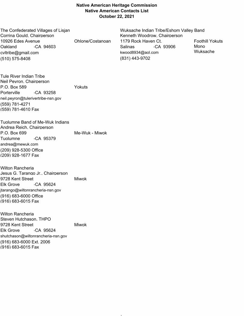
Native American Heritage CommissionNative American Contacts List
October 22, 2021
Corrina Gould, Chairperson10926 Edes AvenueOakland 94603
(510) 575-8408
Ohlone/CostanoanCA,
The Confederated Villages of Lisjan
This list is current as of the date of this document and is based on the information available to the Commission on the date it was produced.
Distribution of this list does not relieve any person of statutory responsibility as defined in Section 7050.5 of the Healthand Safety Code,Section 5097.94 of the Public Resources Code, or Section 5097.98 of the Public Resources Code.
This list is only applicable for contacting local Native Americans Tribes for the proposed: Hunter Ranch Groundwater Well Project, Stanislaus County
Neil Peyron, ChairpersonP.O. Box 589Porterville 93258
(559) 781-4271
YokutsCA,
(559) 781-4610 Fax
Tule River Indian Tribe
This list is current as of the date of this document and is based on the information available to the Commission on the date it was produced.
Distribution of this list does not relieve any person of statutory responsibility as defined in Section 7050.5 of the Healthand Safety Code,Section 5097.94 of the Public Resources Code, or Section 5097.98 of the Public Resources Code.
This list is only applicable for contacting local Native Americans Tribes for the proposed: Hunter Ranch Groundwater Well Project, Stanislaus County
Andrea Reich, ChairpersonP.O. Box 699Tuolumne 95379
(209) 928-5300 Office
Me-Wuk - MiwokCA,
(209) 928-1677 Fax
Tuolumne Band of Me-Wuk Indians
This list is current as of the date of this document and is based on the information available to the Commission on the date it was produced.
Distribution of this list does not relieve any person of statutory responsibility as defined in Section 7050.5 of the Healthand Safety Code,Section 5097.94 of the Public Resources Code, or Section 5097.98 of the Public Resources Code.
This list is only applicable for contacting local Native Americans Tribes for the proposed: Hunter Ranch Groundwater Well Project, Stanislaus County
Jesus G. Tarango Jr., Chairperson9728 Kent StreetElk Grove 95624
(916) 683-6000 Office
MiwokCA,
(916) 683-6015 Fax
Wilton Rancheria
This list is current as of the date of this document and is based on the information available to the Commission on the date it was produced.
Distribution of this list does not relieve any person of statutory responsibility as defined in Section 7050.5 of the Healthand Safety Code,Section 5097.94 of the Public Resources Code, or Section 5097.98 of the Public Resources Code.
This list is only applicable for contacting local Native Americans Tribes for the proposed: Hunter Ranch Groundwater Well Project, Stanislaus County
Steven Hutchason, THPO9728 Kent StreetElk Grove 95624
(916) 683-6000 Ext. 2006
MiwokCA,
(916) 683-6015 Fax
Wilton Rancheria
This list is current as of the date of this document and is based on the information available to the Commission on the date it was produced.
Kenneth Woodrow, Chairperson1179 Rock Haven Ct. Salinas 93906
(831) 443-9702
Foothill YokutsMonoWuksache
Wuksache Indian Tribe/Eshom Valley Band
This list is current as of the date of this document and is based on the information available to the Commission on the date it was produced.
Distribution of this list does not relieve any person of statutory responsibility as defined in Section 7050.5 of the Healthand Safety Code,Section 5097.94 of the Public Resources Code, or Section 5097.98 of the Public Resources Code.
This list is only applicable for contacting local Native Americans Tribes for the proposed: Hunter Ranch Groundwater Well Project, Stanislaus County
.
Stanislaus County Initial Study Checklist – Final
Attachment 4 – Groundwater Resources Impact Assessment
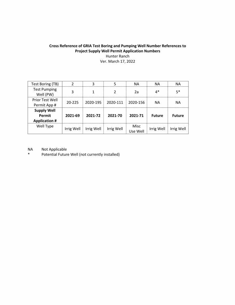
Cross Reference of GRIA Test Boring and Pumping Well Number References to Project Supply Well Permit Application Numbers
Hunter Ranch Ver. March 17, 2022
NA Not Applicable * Potential Future Well (not currently installed)
Test Boring (TB) 2 3 5 NA NA NA Test Pumping
Well (PW) 3 1 2 2a 4* 5*
Prior Test Well Permit App # 20-225 2020-195 2020-111 2020-156 NA NA
Supply Well Permit
Application # 2021-69 2021-72 2021-70 2021-71 Future Future
Well Type Irrig Well Irrig Well Irrig Well Misc Use Well Irrig Well Irrig Well

Page 1
TECHNICAL MEMORANDUM
GROUNDWATER RESOURCES IMPACT ASSESSMENT, HUNTER RANCH, STANISLAUS COUNTY, CALIFORNIA
PREPARED FOR: Shawn Conde, Conde Farms
PREPARED BY: Mike Tietze, PG, CHG, CEG, Formation Environmental, LLC
Amy Daviscourt, Formation Environmental, LLC
David Carlson, CHG, Formation Environmental, LLC
DATE: June 13, 2020
1. INTRODUCTION Conde Farms plans to develop an orchard on Assessor’s Parcel Number 01-01-002, located in rural unincorporated Stanislaus County (the Site, see Figures 1 and 2). The Site consists of approximately 635 acres located southwest of the intersection of State Highway 4 and Milton Road that is zoned for agricultural use. Environmental, LLC (Formation) has prepared this Technical Memorandum to present the methods and results of a Groundwater Resources Impact Assessment (GRIA) to evaluate the potential groundwater resource-related impacts of converting two test wells into irrigation well and one test well into a small capacity yard water supply well to irrigate approximately 175 acres of new orchard (Phase I). A potential second phase will consist of installing up to three new irrigation supply wells to support expansion of the orchard by up to an additional 175 acres (Phase II). The decision whether and to what extent to expand the groundwater supply during Phase II will depend on monitoring conducted during Phase I as part of an adaptive management strategy. The Phase I and Phase II well conversion and installation, together with the monitoring and adaptive management framework, are collectively referred to herein as the “Project.” The location of the Site and the proposed wells is shown on Figure 1. The Site is located southwest of the Rock Creek Water District in an area that is outside the service territory of any water or irrigation districts (Figure 2), and groundwater is currently the only option for development of an irrigation water supply. The purpose of the proposed well conversions and installation is to develop a long-term water supply for the proposed orchard.
Because the proposed wells will be located in unincorporated Stanislaus County in an area that is not served by a water agency operating in compliance with a Groundwater Management Plan, they are subject to the requirements of the Stanislaus County Groundwater Ordinance (County Code Chapter 9.37), which requires that applicants complete a supplemental application and provide “substantial evidence” that groundwater extraction from their proposed wells will be sustainable, as defined under the Ordinance. The definition of sustainability in the Ordinance is based on the definition in the Sustainable Groundwater Management Act (SGMA). This Groundwater Resources Impact Assessment (GRIA) provides
mtietze
Text Box
Exp. 04/30/2023
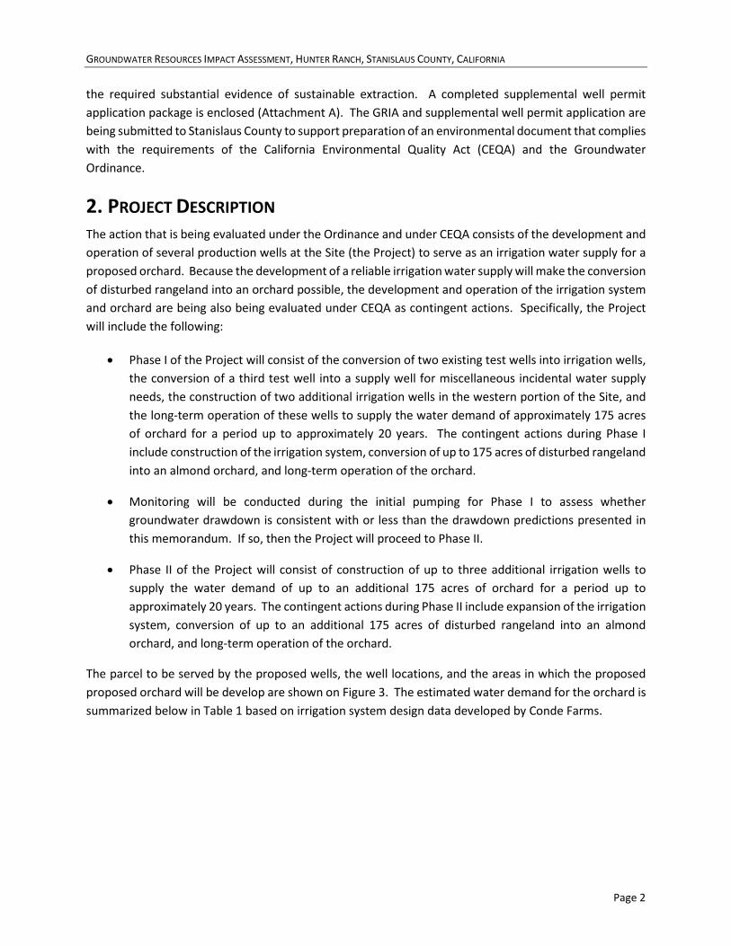
GROUNDWATER RESOURCES IMPACT ASSESSMENT, HUNTER RANCH, STANISLAUS COUNTY, CALIFORNIA
Page 2
the required substantial evidence of sustainable extraction. A completed supplemental well permit application package is enclosed (Attachment A). The GRIA and supplemental well permit application are being submitted to Stanislaus County to support preparation of an environmental document that complies with the requirements of the California Environmental Quality Act (CEQA) and the Groundwater Ordinance.
2. PROJECT DESCRIPTION The action that is being evaluated under the Ordinance and under CEQA consists of the development and operation of several production wells at the Site (the Project) to serve as an irrigation water supply for a proposed orchard. Because the development of a reliable irrigation water supply will make the conversion of disturbed rangeland into an orchard possible, the development and operation of the irrigation system and orchard are being also being evaluated under CEQA as contingent actions. Specifically, the Project will include the following:
• Phase I of the Project will consist of the conversion of two existing test wells into irrigation wells, the conversion of a third test well into a supply well for miscellaneous incidental water supply needs, the construction of two additional irrigation wells in the western portion of the Site, and the long-term operation of these wells to supply the water demand of approximately 175 acres of orchard for a period up to approximately 20 years. The contingent actions during Phase I include construction of the irrigation system, conversion of up to 175 acres of disturbed rangeland into an almond orchard, and long-term operation of the orchard.
• Monitoring will be conducted during the initial pumping for Phase I to assess whether groundwater drawdown is consistent with or less than the drawdown predictions presented in this memorandum. If so, then the Project will proceed to Phase II.
• Phase II of the Project will consist of construction of up to three additional irrigation wells to supply the water demand of up to an additional 175 acres of orchard for a period up to approximately 20 years. The contingent actions during Phase II include expansion of the irrigation system, conversion of up to an additional 175 acres of disturbed rangeland into an almond orchard, and long-term operation of the orchard.
The parcel to be served by the proposed wells, the well locations, and the areas in which the proposed proposed orchard will be develop are shown on Figure 3. The estimated water demand for the orchard is summarized below in Table 1 based on irrigation system design data developed by Conde Farms.

GROUNDWATER RESOURCES IMPACT ASSESSMENT, HUNTER RANCH, STANISLAUS COUNTY, CALIFORNIA
Page 3
Table 1. Hunter Ranch Annual and Short-Term Maximum Irrigation Water Demand
Planned Cropping Average Consumptive Use of Applied Water from ET Data
Consumptive Use of
Applied Water (AFY)
Irrigation Efficiency
Pond Evaporation Loss (AFY)
Total Groundwater
Demand (AFY) Crop (acres) Month (inches) (feet)
Phase 1 Orchard Development Water Demand Almond 175 Mar 2 0.17 29 0.90 1 34 Almond 175 Apr 3 0.25 44 0.90 2 51 Almond 175 May 4 0.33 58 0.90 6 71 Almond 175 Jun 6 0.50 88 0.90 13 110 Almond 175 Jul 7.1 0.59 104 0.90 16 131 Almond 175 Aug 6.6 0.55 96 0.90 14 121 Almond 175 Sep 5.1 0.43 74 0.90 11 94 Almond 175 Oct 4 0.33 58 0.90 6 71
Phase 1 Annual Demand 37.8 3.15 551 0.90 69 683 Phase 2 Orchard Development Water Demand
Almond 175 Mar 2 0.17 29 0.90 1 34 Almond 175 Apr 3 0.25 44 0.90 2 51 Almond 175 May 4 0.33 58 0.90 6 71 Almond 175 Jun 6 0.50 88 0.90 13 110 Almond 175 Jul 7.1 0.59 104 0.90 16 131 Almond 175 Aug 6.6 0.55 96 0.90 14 121 Almond 175 Sep 5.1 0.43 74 0.90 11 94 Almond 175 Oct 4 0.33 58 0.90 6 71
Phase 2 Annual Demand 37.8 3.15 551 0.90 69 683 Project Total Forecast Water Demand (Phase 1 and Phase 2)
Annual Total Demand 37.8 3.15 1,102 0.90 138 1,366 Notes: ET = Evapotranspiration. AFY = acre-feet/year. 1. Monthly crop evapotranspiration water demand was provided by Conde Farms and developed using data from the
California Irrigation Management Information System (CIMIS). 2. An irrigation efficiency of 0.90 is assumed for the use of microjet or drip irrigation system. 3. Evaporation and seepage losses are assumed to range from 5 to 15%. 4. Water demand for immature trees is less than estimated above: First year demand = approximately 25% to 30% of annual
total demand; Second year demand = 50% of annual total demand. Third year forward = 100% of annual total demand.
The groundwater supply development approach for the Site was selected based on information gathered during the test well program described in Section 3. The irrigation water supply for Phase 1 of the orchard development would be sourced by converting two of the three test wells constructed on the south side of the site into irrigation wells (PW-1 and PW-2). Each of these wells is completed to a depth of approximately 500 feet and completed in permeable sands of the Mehrten Formation and the underlying Valley Springs Formation, and has an estimated production capacity of approximately 1,000 gallons per minute (gpm). The additional water supply for Phase 2 would be sourced from three new water supply
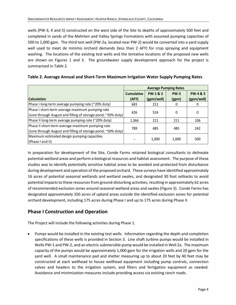
GROUNDWATER RESOURCES IMPACT ASSESSMENT, HUNTER RANCH, STANISLAUS COUNTY, CALIFORNIA
Page 4
wells (PW-3, 4 and 5) constructed on the west side of the Site to depths of approximately 500 feet and completed in sands of the Mehrten and Valley Springs Formations with assumed pumping capacities of 500 to 1,000 gpm. The third test well (PW-2a, located near PW-2) would be converted into a yard supply well used to meet de minimis orchard demands (less than 2 AFY) for crop spraying and equipment washing. The locations of the existing test wells and the tentative locations of the proposed new wells are shown on Figures 1 and 3. The groundwater supply development approach for the project is summarized in Table 2.
Table 2. Average Annual and Short-Term Maximum Irrigation Water Supply Pumping Rates
In preparation for development of the Site, Conde Farms retained biological consultants to delineate potential wetland areas and perform a biological resources and habitat assessment. The purpose of these studies was to identify potentially sensitive habitat areas to be avoided and protected from disturbance during development and operation of the proposed orchard. These surveys have identified approximately 16 acres of potential seasonal wetlands and wetland swales, and designated 30 foot setbacks to avoid potential impacts to these resources from ground-disturbing activities, resulting in approximately 62 acres of recommended exclusion zones around seasonal wetland areas and swales (Figure 3). Conde Farms has designated approximately 350 acres of upland areas outside the identified exclusion zones for potential orchard development, including 175 acres during Phase I and up to 175 acres during Phase II.
Phase I Construction and Operation
The Project will include the following activities during Phase 1.
• Pumps would be installed in the existing test wells. Information regarding the depth and completion specifications of these wells is provided in Section 3. Line shaft turbine pumps would be installed in Wells PW-1 and PW-2, and an electric submersible pump would be installed in Well 2a. The maximum capacity of the pumps would be approximately 1,000 gpm for the irrigation wells and 20 gpm for the yard well. A small maintenance pad and shelter measuring up to about 20 feet by 40 feet may be constructed at each wellhead to house wellhead equipment including pump controls, connection valves and headers to the irrigation system, and filters and fertigation equipment as needed. Avoidance and minimization measures include providing access via existing ranch roads.
Cumulative(AFY)
PW-1 & 2(gpm/well)
PW-3(gpm)
PW-4 & 5(gpm/well)
683 211 0 0
426 524 0 0
1,366 211 211 106
789 485 485 242
-- 1,000 1,000 500
Calculation
Average Pumping Rates
Phase I long-term average pumping rate (~20% duty)Phase I short-term average maximum pumping rate (June through August and filling of storage pond; ~50% duty)Phase II long-term average pumping rate (~20% duty)Phase II short-term average maximum pumping rate (June through August and filling of storage pond; ~50% duty)Maximum estimated design pumping capacities (Phase I and II)
GROUNDWATER RESOURCES IMPACT ASSESSMENT, HUNTER RANCH, STANISLAUS COUNTY, CALIFORNIA
Page 5
• Power would be extended to the existing supply wells and to the pond. Wooden power poles will be extended westward from Milton Road through the southern portion of the proposed orchard blocks Site boundary with feeder lines extended to the wells and to the existing pond. Wooden power poles would be installed spacings ranging between 300 and 500 feet. Avoidance and minimization measures include access to power pole and power drop sites via existing ranch roads and across designated orchard areas. Placement of poles within the setback areas from potentially sensitive swales would be avoided.
• Equipment used during construction will include a small crane, trucks to mobilize equipment and supplies, and crew service trucks.
• The wells would be operated to provide a long-term irrigation water supply for a period of approximately 20 to 30 years to the orchard in accordance with the water demand and supply information provided in Tables 1 and 2.
Contingent activities related to orchard development would include the following during Phase I.
• The areas of the designated orchard blocks that have not been previously tilled would be ripped and tilled. Avoidance and minimization measures include maintaining 30-foot setbacks from designated potentially sensitive drainage swales, and crossing swales only at existing ranch roads roads or over structural spans.
• The irrigation system would be constructed, including construction of a network of buried irrigation pipes that supply a micro-drip irrigation system from a pump station at the pond. Supply pipelines from each irrigation wellhead to the pond would also be installed. The plastic irrigation pipes would range from approximately 12 inches to 1 inch in diameter, and would be buried within the cultivated blocks. Avoidance and minimization measures include crossing of designated potentially sensitive swales within the footprint of existing ranch roads or via clear structural spans. Ground disturbance within designated setback areas would be avoided.
• Trees would be planted in the Phase I area (175 acres) of the approximately 350-acre orchard area identified in Figure 3. Avoidance and minimization measures include limiting planting activities to the designated block areas outside of setback zones from potentially sensitive swale areas.
• After planting, the orchard would be irrigated, maintained and operated over an expected life of 20 to 30 years using standard agronomic practices. The property is enclosed by existing fences along the property lines. Access to the cultivated areas will be via gates along Milton Road. Avoidance and minimization measures include the use of existing ranch roads to cross designated setback areas from potentially sensitive swales or placing structural spans across these areas for any new access roads constructed in cultivated areas.
Phase I Monitoring and Adaptive Management Program
As with any groundwater development project, the response of the aquifer system to pumping for the project is not completely understood until the aquifer is significantly stressed. To address this uncertainty, the Project will include a monitoring and adaptive management program to gather groundwater level data during the initial operation of PW-1 and PW-2, gauge the aquifer response to sustained pumping, and inform the appropriate groundwater development strategy to support Phase II orchard expansion. Specifically, the program will include the following components:
GROUNDWATER RESOURCES IMPACT ASSESSMENT, HUNTER RANCH, STANISLAUS COUNTY, CALIFORNIA
Page 6
• A monitoring plan will be developed and provided to the Stanislaus County DER for review and approval. The plan will describe the procedures to collect and analyze groundwater level monitoring data from two or more monitoring wells during the initial operation of PW-1 and 2. Each of the monitoring wells will be fitted with a recording pressure transducer. Drawdown data and groundwater extraction data will be gathered for a period of at least three months after project startup.
• The observed drawdown data will be compared to drawdown data simulated using the groundwater flow model developed for the Project and described in Section 4. To to this, the actual pumping rates from the initial startup period will be simulated using the model, and the predicted drawdown response at the monitoring well locations will be compared to the observed response. If the observed drawdown is different from the predicted drawdown, the model will be updated as appropriate to match the observed drawdown. The updated model will then be used to assess the allowable groundwater development extraction rate for Phase II of the Project, as follows:
o If the observed drawdown was less than or similar to the originally predicted drawdown, development of Phase II may include up to an additional 175 acres.
o If the observed drawdown was greater than the originally predicted drawdown, the updated model will be used to establish an allowable additional pumping volume for Phase II such that the drawdown predicted for expanded Phase II pumping remains less than or similar to the originally predicted drawdown described in Section 4.
o The outcome of the analysis will be provided to the Stanislaus County DER for review and approval.
Phase II Construction and Operation
The Project would include the following activities during Phase II.
• Up to three new wells would be constructed adjacent to existing dirt and gravel ranch roads near the tentative locations shown on Figures 1 and 3. Temporary well construction work areas would be established around each well site during drilling. The work areas would measure up to approximately 50 by 100 feet, and would be located in existing level areas that are cleared and used for ranch road, parking or storage purposes and were previously used for cultivation of winter wheat. Avoidance and minimization measures include accessing the drilling locations via existing ranch roads.
• Based on a test well program implemented by Massellis Drilling (Attachments B and D), the wells would be constructed to extract water from the aquifer system in the Mehrten and Valley Springs Formations, where water of adequate quality and quantity is expected to be encountered. The estimated well depths are approximately 400 to 500 feet. The upper approximately 20 feet of the well borings would be drilled to a diameter of approximately 24 to 30 inches using a bucket auger and a steel conductor casing would be installed. The wells would be constructed using the mud rotary or
GROUNDWATER RESOURCES IMPACT ASSESSMENT, HUNTER RANCH, STANISLAUS COUNTY, CALIFORNIA
Page 7
fluid reverse method by drilling through the inside of the conductor casings. The additional wells are proposed to be constructed using 12-inch diameter PVC casing and screen place in approximately 18-inch diameter boreholes with annular filter packs. Sanitary seals are expected to extend from the ground surface to depths of approximately 20 feet.
• The wells may be completed at the surface with small concrete pads, and would be fitted with electrical line-shaft turbine pumps. A small maintenance pad and shelter measuring up to about 20 feet by 40 feet may be constructed at each wellhead to house wellhead equipment including pump controls, connection valves and headers to the irrigation system, and filters and fertigation equipment as needed.
• Power would be extended to the new supply wells northward from the power supply lines installed during Phase I. Wooden power poles would be installed spacings ranging between 300 and 500 feet and lateral power drops would be constructed to each wellhead. Avoidance and minimization measures include access to power pole and drop sites via existing ranch roads and across designated orchard areas. Placement of poles within the setback areas from potentially sensitive swales would be avoided.
• Phase II well construction and development work is anticipated to take place up to two years after completion of Phase I. Drilling equipment, typically consisting of a drilling rig, pipe truck water truck, forklift, compressors, pumps, light stands, desander, mud pit and support trucks would be mobilized for approximately two to three weeks at each drilling location. Work during drilling of the wells may be conducted during normal working hours or utilizing shift work, 24 hours per day, seven days per week, depending upon conditions. Well development, pump testing, pump installation and surface completion would be conducted over the course of an additional month during regular working hours. Equipment would include development rigs, jib cranes and work trucks. Construction of irrigation wells is an agricultural activity, and is exempt from the County Noise Ordinance. Avoidance and minimization measures include providing access via existing ranch roads.
Contingent activities related to orchard development would consist of the following during Phase II.
• The areas of the designated orchard blocks that have not been previously tilled would be ripped and tilled. Avoidance and minimization measures include maintaining 30-foot setbacks from designated potentially sensitive drainage swales, and crossing swales only at existing ranch roads or over structural spans.
• Irrigation water would be supplied to the orchard areas by extending the irrigation system installed during Phase I to the additional Phase II block areas and installing pipelines from the new wells to the existing storage pond using the methods described previously, and employing the same minimization and avoidance measures.
• Trees would be planted within up to an additional 175 acres in the area identified in Figure 3. Avoidance and minimization measures include limiting planting activities to the designated block areas outside of setback zones from potentially sensitive swale areas.
GROUNDWATER RESOURCES IMPACT ASSESSMENT, HUNTER RANCH, STANISLAUS COUNTY, CALIFORNIA
Page 8
• After planting, the orchard would be irrigated, maintained and operated over an expected life of 20 to 30 years using standard agronomic practices. Site access and development would be as discussed previously for Phase I.
3. PROJECT SETTING 3.1. PHYSIOGRAPHY AND LAND USE The Site encompasses Assessor’s Parcel Number 01-01-002, located in rural unincorporated Stanislaus County (Figures 1 and 2). The Site consists of approximately 635 acres located southwest of the intersection of State Highway 4 and Milton Road that is zoned for agricultural use. It is occupied by low rolling hills covered with non-native grasses typical of the “Northern Triangle” region of Stanislaus County, and underlain by soils developed on the Mio-Pliocene volcano-fluvial Mehrten Formation locally capped by alluvial deposits of the Pliocene Laguna Formation. The Site topography consists of relatively gentle slopes (generally 1 to 5 percent) with a few locally more resistant layers representing more resistant deposits that support slopes as steep as 10 percent. Historically, the site has been used as rangeland for cattle grazing, likely for over 100 years. Supporting activities have included development of dirt ranch roads, two small seasonal ponds and several stock wells, and periodic disking of fire breaks around the Site perimeter. It is possible that periodic disking and dryland hay cultivation were also conducted on inland portions of the Site. All these activities have resulted in long-term disturbance of the near surface soils that is typical of historical rangeland in this portion of Stanislaus County.
The potential seasonal wetlands, swales, and surrounding 30-foot setback areas identified during the biological surveys are relatively gentle and do not have defined banks, except for the drainage that runs north to south through the center of the site, which displays locally steepened bank morphology and is identified as an ephemeral stream in the United States Geological Survey (USGS) National Hydrography Dataset (Figure 2). The slopes in the upland areas identified for potential orchard development have relatively gentle slopes generally ranging from approximately 1 to 5 percent. Portions of this area have been disked and tilled to support the cultivation of winter wheat/hay during the 2020/2021 season and in anticipation of future agricultural activity. Additionally, the perimeter of the Site has been disked for fire protection purposes, with exception of the identified swale exclusion zones. Five test borings have been drilled and three test wells installed in the southern and western portions of the Site as part of a groundwater supply exploration program. A pond in the central portion of the Site, west of the central swale, that had reportedly fallen into despair and no longer effectively retained water has been recently repaired and re-established for water storage. This pond is approximately 6.4 acres in size and has an estimated storage capacity of 64 acre-feet. A second, small stock pond was historically located south of the above pond, but disappeared as a result of disuse and erosion years ago.
3.2. HYDROLOGY The Site is located within the Rock Creek - French Camp Slough watershed (Figure 2). In the low foothills, this watershed drains a rolling upland between the Calaveras River to the north and the Stanislaus River to the south, both of which are relatively deeply incised. Woodward Reservoir is located in the south-central
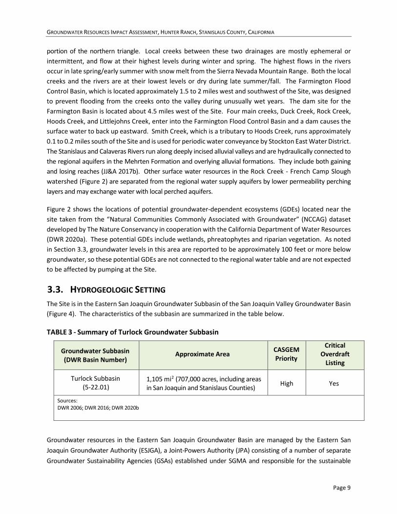
GROUNDWATER RESOURCES IMPACT ASSESSMENT, HUNTER RANCH, STANISLAUS COUNTY, CALIFORNIA
Page 9
portion of the northern triangle. Local creeks between these two drainages are mostly ephemeral or intermittent, and flow at their highest levels during winter and spring. The highest flows in the rivers occur in late spring/early summer with snow melt from the Sierra Nevada Mountain Range. Both the local creeks and the rivers are at their lowest levels or dry during late summer/fall. The Farmington Flood Control Basin, which is located approximately 1.5 to 2 miles west and southwest of the Site, was designed to prevent flooding from the creeks onto the valley during unusually wet years. The dam site for the Farmington Basin is located about 4.5 miles west of the Site. Four main creeks, Duck Creek, Rock Creek, Hoods Creek, and Littlejohns Creek, enter into the Farmington Flood Control Basin and a dam causes the surface water to back up eastward. Smith Creek, which is a tributary to Hoods Creek, runs approximately 0.1 to 0.2 miles south of the Site and is used for periodic water conveyance by Stockton East Water District. The Stanislaus and Calaveras Rivers run along deeply incised alluvial valleys and are hydraulically connected to the regional aquifers in the Mehrten Formation and overlying alluvial formations. They include both gaining and losing reaches (JJ&A 2017b). Other surface water resources in the Rock Creek - French Camp Slough watershed (Figure 2) are separated from the regional water supply aquifers by lower permeability perching layers and may exchange water with local perched aquifers.
Figure 2 shows the locations of potential groundwater-dependent ecosystems (GDEs) located near the site taken from the “Natural Communities Commonly Associated with Groundwater” (NCCAG) dataset developed by The Nature Conservancy in cooperation with the California Department of Water Resources (DWR 2020a). These potential GDEs include wetlands, phreatophytes and riparian vegetation. As noted in Section 3.3, groundwater levels in this area are reported to be approximately 100 feet or more below groundwater, so these potential GDEs are not connected to the regional water table and are not expected to be affected by pumping at the Site.
3.3. HYDROGEOLOGIC SETTING The Site is in the Eastern San Joaquin Groundwater Subbasin of the San Joaquin Valley Groundwater Basin (Figure 4). The characteristics of the subbasin are summarized in the table below.
TABLE 3 - Summary of Turlock Groundwater Subbasin
Groundwater Subbasin (DWR Basin Number)
Approximate Area CASGEM
Priority
Critical Overdraft
Listing
Turlock Subbasin (5-22.01)
1,105 mi2 (707,000 acres, including areas in San Joaquin and Stanislaus Counties)
High
Yes
Sources: DWR 2006; DWR 2016; DWR 2020b
Groundwater resources in the Eastern San Joaquin Groundwater Basin are managed by the Eastern San Joaquin Groundwater Authority (ESJGA), a Joint-Powers Authority (JPA) consisting of a number of separate Groundwater Sustainability Agencies (GSAs) established under SGMA and responsible for the sustainable
GROUNDWATER RESOURCES IMPACT ASSESSMENT, HUNTER RANCH, STANISLAUS COUNTY, CALIFORNIA
Page 10
management of groundwater within their jurisdictions. The ESJGA has developed the Eastern San Joaquin Groundwater Subbasin Groundwater Sustainability Plan (GSP) to guide and regulate sustainable groundwater management in the subbasin (ESJGA 2019). Each of the GSAs in the subbasin is responsible to implement this plan within their respective jurisdiction. The GSA responsible for the sustainable management of groundwater resources in the “northern triangle” region of Stanislaus County is the Eastside San Joaquin GSA, whose governing board includes Stanislaus County, Calaveras County and Rock Creek Water District.
The portion of the Eastern San Joaquin Subbasin that underlies the northern triangle of Stanislaus County is bounded to the south by the Stanislaus River to the south and to the east by low-permeability bedrock formations of the Sierra Nevada. To the north and west it extends outside the county boundaries into San Joaquin County. A small portion of the Subbasin also extends into Calaveras County to the east. Groundwater in this portion of the subbasin occurs primarily under unconfined to semi-confined conditions in the Mehrten Formation. The Mehrten Formation is late Miocene to Early Pliocene in age and is comprised of moderately well to well indurated andesitic sand to sandstone which is interbedded with conglomerate, tuffaceous siltstone, and claystone. Vertical groundwater movement within the Mehrten Formation is impeded by lower permeability deposits, such as volcanic mudflows, claystones and well developed paleosols (ancient soils). In the vicinity of the Site, the Mehrten Formation is about 350 feet thick. It thins to the northeast and thickens to the southwest, where it is overlain by water-bearing alluvial fan deposits of the Laguna, Turlock Lake, Modesto and Riverbank Formations (Marchard, Bartow and Shipley 1981). The Mehrten Formation is reported to be over 600 feet thick in the subsurface near Stockton and Modesto, but the primary municipal water supplies in these areas are derived from the overlying alluvial formations. The Mehrten Formation sands in the Northern Triangle can commonly yield 1,000 gallons per minute from wells, but yields are less where the formation begins to thin near the Site. Beneath the Mehrten Formation, sands of the Valley Springs Formation lie within an interval that is approximately 50 and 200 feet thick and may yield a few hundred gallons per minute to wells (DWR 2006). The Mehrten Formation is locally capped by conglomerate, sandstone and siltstone of the Pliocene Laguna Formation (Marchard, Bartow and Shipley 1981).
The Stanislaus and Calaveras Rivers run along deeply incised alluvial valleys and are hydraulically connected to the regional aquifers in the Mehrten Formation and overlying alluvial formations. They include both gaining and losing reaches (JJ&A 2017b). Other surface water resources in the Rock Creek - French Camp Slough watershed (Figure 2) are separated from the regional water supply aquifers by lower permeability perching layers and may exchange water with local perched aquifers.
The regional groundwater table in this area lies about 100 to 150 feet below the ground surface (bgs) and groundwater flow is generally inferred to be to the southwest, toward the San Joaquin River (DWR 2020b). A review of groundwater well hydrograph trends in the northern triangle area of Stanislaus County indicates groundwater levels in the area west and southwest of the Site show a generally declining trend; however, the trend is not anticipated to result in “undesirable results” as defined in the County Groundwater Ordinance or in SGMA (JJ&A 2017a). Groundwater use and agricultural development is more dense than it is near the Site, which is located northeast of the area of current agricultural development in the area. There are no reported groundwater level monitoring wells near the Site for which data is available from the California Ambient Groundwater Elevation Monitoring (CASGEM) program or the DWR’s SGMA Data Viewer website (DWR 2020b) within 5 miles of the Site; however, Stanislaus County has monitored
GROUNDWATER RESOURCES IMPACT ASSESSMENT, HUNTER RANCH, STANISLAUS COUNTY, CALIFORNIA
Page 11
groundwater levels in an agricultural supply well located approximately 1.4 miles southeast of the Site at 9337 Dunton Road since 2016. Information regarding this well is included in Attachment B and the location of the well, referred to as the McCurley Well, is shown on Figure 5. . The well is reported to be 480 feet deep and is screened across black sands of the Mehrten Formation from approximately 200 to 480 feet bgs. Groundwater levels measured by the County since October 2016 indicate groundwater levels during this time period have remained relatively stable, ranging from 84.4 bgs to 89.85 feet bgs.
3.4. SITE HYDROGEOLOGY A groundwater supply investigation was conducted at the site and included drilling and logging five test borings and installing and testing test wells at three of the test boring locations. Additionally, specific capacity test data from one well on the adjacent parcel to the south of the Site were analyzed.
3.4.1. Test Boring and Geophysical Exploration Program Five test borings were drilled and lithologically logged, and four were geophysically logged. Drilling logs and geophysical logs for the test borings and are included in Attachment B. Driller’s logs for a stock well in the eastern portion of the Site, two additional wells in the northern portion of the Site, and three wells located near the Site are also included in Attachment B. In addition, subsurface geophysical data were collected along three transects using Electrical Resistance Tomography (ERT) to image variations in subsurface electrical resistance that are correlated with fine- and coarse-grained sediments. Reports regarding the ERT surveys conducted at the Site are included in Attachment C. The locations of the test borings, test wells and ERT profiles are shown on Figure 5. An east-west cross section based on the geophysical and lithologic logs for the test borings is presented as Figure 6 and its location is shown on Figure 5.
The following conclusions may be made from interpretation of the subsurface lithologic and geophysical data collected at the Site.
• The Site is underlain by interbedded sandy aquifer units (described as black sand, brown sand, white sand and gravel). Fine-grained units consist of clay and mudstone (clay, blue clay, white clay and shale) and potentially volcanic ash (white “shale”). These units are saturated below a depth of approximately 160 feet bgs.
• Sand units consist of broad, lenticular bodies as imaged by the north-south trending ERT profiles that can be correlated over distances of several thousand feet in the east-west cross section. The lenticular sand bodies thin to the north in the ERT profiles and plunge gently to the west in the cross section. The lithology and stratigraphic data suggest the Site is underlain by a fluvio-volcanic aquifer system that was deposited on a westward (or southwestward) dipping surface and thins to the north and east of the Site.
• Generally, black sands are considered characteristic of lithic sands associated with fluvio-volcanic deposits of the Mehrten Formation, which was deposited on the Sierra Nevada slope during a period of resurgent uplift and volcanism. White clay and sand deposits are characteristic of highly-
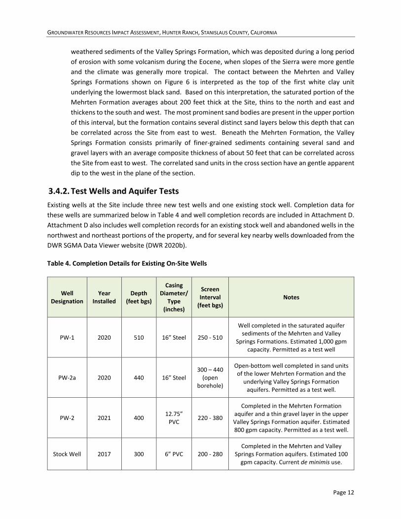
GROUNDWATER RESOURCES IMPACT ASSESSMENT, HUNTER RANCH, STANISLAUS COUNTY, CALIFORNIA
Page 12
weathered sediments of the Valley Springs Formation, which was deposited during a long period of erosion with some volcanism during the Eocene, when slopes of the Sierra were more gentle and the climate was generally more tropical. The contact between the Mehrten and Valley Springs Formations shown on Figure 6 is interpreted as the top of the first white clay unit underlying the lowermost black sand. Based on this interpretation, the saturated portion of the Mehrten Formation averages about 200 feet thick at the Site, thins to the north and east and thickens to the south and west. The most prominent sand bodies are present in the upper portion of this interval, but the formation contains several distinct sand layers below this depth that can be correlated across the Site from east to west. Beneath the Mehrten Formation, the Valley Springs Formation consists primarily of finer-grained sediments containing several sand and gravel layers with an average composite thickness of about 50 feet that can be correlated across the Site from east to west. The correlated sand units in the cross section have an gentle apparent dip to the west in the plane of the section.
3.4.2. Test Wells and Aquifer Tests Existing wells at the Site include three new test wells and one existing stock well. Completion data for these wells are summarized below in Table 4 and well completion records are included in Attachment D. Attachment D also includes well completion records for an existing stock well and abandoned wells in the northwest and northeast portions of the property, and for several key nearby wells downloaded from the DWR SGMA Data Viewer website (DWR 2020b).
Table 4. Completion Details for Existing On-Site Wells
Well Designation
Year Installed
Depth (feet bgs)
Casing Diameter/
Type (inches)
Screen Interval
(feet bgs) Notes
PW-1 2020 510 16” Steel 250 - 510
Well completed in the saturated aquifer sediments of the Mehrten and Valley
Springs Formations. Estimated 1,000 gpm capacity. Permitted as a test well
PW-2a 2020 440 16” Steel 300 – 440
(open borehole)
Open-bottom well completed in sand units of the lower Mehrten Formation and the
underlying Valley Springs Formation aquifers. Permitted as a test well.
PW-2 2021 400 12.75” PVC 220 - 380
Completed in the Mehrten Formation aquifer and a thin gravel layer in the upper Valley Springs Formation aquifer. Estimated 800 gpm capacity. Permitted as a test well.
Stock Well 2017 300 6” PVC 200 - 280 Completed in the Mehrten and Valley
Springs Formation aquifers. Estimated 100 gpm capacity. Current de minimis use.
GROUNDWATER RESOURCES IMPACT ASSESSMENT, HUNTER RANCH, STANISLAUS COUNTY, CALIFORNIA
Page 13
Aquifer parameter data for the Mehrten Formation and Valley Springs Formation aquifers were estimated from aquifer tests conducted on PW-1 and PW-2a, and specific capacity tests conducted on PW-2 and an off-site well located on the property to the south. Information regarding these tests is included in Attachment E. The methods and findings of the tests are summarized below.
3.4.2.1. PW-1 Aquifer Test An aquifer test of PW-1 was conducted from September 17 to 20, 2020. This well was completed with a screen interval from 280 to 505 feet bgs across the lower portion of the saturated Mehrten Formation and several sand units in the Valley Springs Formation. The thickness of the Mehrten Formation and Valley Springs Formation aquifers from which the well derives water was estimated to be approximately 190 and 50 feet, respectively. Drawdown data were collected in PW-1 and the Stock Well (located approximately 2,450 feet to the east) using vented pressure transducers.
On September 17, a step drawdown test was conducted, consisting of three 2-hour steps during which the well was pumped at 800, 1,000 and 1,200 gpm. Based on the results of this test, a pumping rate of 1,000 gpm was selected for a 24-hour constant discharge aquifer test. Prior to initiating the test, the well was allowed to recover for one day and the test pumping was commenced at 8:00 AM on September 18. The extraction rate was maintained for 24 hours within +/- 5 percent of 1,000 gpm, except between approximately 19 and 20 hours when the pump was inadvertently allowed to run out of gas. The drawdown data for the pumping well were analyzed using the Theis and Cooper-Jacob methods, yielding transmissivity estimates of 2,316 and 2,313 square feet per day (ft2/day), respectively. The curve match was relatively good; however, the analyses were considered of fair quality due to the fact they were collected during drawdown in a pumping well. The early- and late-time recovery data were analyzed using the Theis method, yielding transmissivity estimates of 2,989 and 11,715 ft2/day, respectively. The curve match for the late time recovery data was relatively poor, so this analysis was rejected. The curve match for the early-time recovery data was fair to good, so this analysis was selected as being the most representative transmissivity estimate for the test.
The geophysical log for TB-3 (in which PW-1 was completed, indicates a saturated thickness of Mehrten aquifer material of about 190 feet and a thickness of saturated Valley Springs aquifer of approximately 50 feet. The average bulk hydraulic conductivity of these aquifer materials is therefore estimated to be 12.5 feet/day.
During the test, between 0.1 and 0.2 feet of drawdown were recorded in the stock well on the east side of the Site. .The data were of relatively poor quality and therefore were not used to estimate the aquifer transmissivity; however, the data were used to develop a preliminary estimate of aquifer Storativity. Using drawdown data from this well, an aquifer Storativity of 0.007 was estimated using the Cooper-Jacob method.

GROUNDWATER RESOURCES IMPACT ASSESSMENT, HUNTER RANCH, STANISLAUS COUNTY, CALIFORNIA
Page 14
3.4.2.2. PW-2a Aquifer Test A second aquifer test was completed on test well PW-2a on December 3, 2020. This well was completed with casing to 300 feet bgs with an open bottom above a borehole drilled to approximately 500 feet bgs through sand units of the lower Mehrten Formation and the underlying Valley Springs Formation. The well was pumped at a constant rate of 295 gpm for 2 hours, after which the test was discontinued because drawdown was approaching the pump intake. Drawdown and recovery data were collected from the pumping well and PW-1 (located approximately 1,370 feet to the east) using vented pressure transducers.
The drawdown and recovery data were analyzed using the Theis and Hantush-Jacob methods. The best curve matches were achieved for the drawdown and recovery data from the pumping well, resulting in a transmissivity estimate of 393 ft2/day for the drawdown data and 755 ft2/day for the recovery data. Good data curve matches were not achieved for the observation well data, likely because only 0.35 feet of drawdown were recorded in the observation well during the test. Based on construction of the well with an open bottom, it is believed that most of the groundwater extracted during the test was derived from a single sand unit in the lower Mehrten Formation that was approximately 22 feet thick, yielding a hydraulic conductivity estimate for this sand unit of about 17.9 feet/day if the lower transmissivity value calculated for the pumping well is used.
During the test, between 0.35 feet of drawdown were recorded in the PW-1. .The data were considered to be of poor to fair quality due to the limited amount of drawdown, and therefore were not used to estimate the aquifer transmissivity; however, the data were used to develop an estimate of aquifer Storativity. Using drawdown data from this well, an aquifer Storativity of 0.0007 was estimated using the Cooper-Jacob method. This is an order of magnitude less than the Storativity estimated based on the PW-1 pumping test, and reflects of the lower Storativity of the deeper, more confined aquifer units.
3.4.2.3. Specific Capacity Tests Well PW-2 was completed approximately 40 feet east of well PW-2a with a screen interval from 220 to 380 feet bgs in the Mehrten Formation Aquifer. After completion and development of the well, a specific capacity test was conducted for approximately one hour after well development. At the end of the test, approximately 25 feet of drawdown were measured at a pumping rate of 200 gpm, yielding a specific capacity estimate of 8 gpm/foot of drawdown. Using a conversion factor for semi confined aquifers based on Driscoll (1986) yields a transmissivity estimate of 1,820 ft2/day for this well. Given a saturated thickness of the Mehrten Formation aquifer of approximately 190 feet at this location yields a bulk hydraulic conductivity estimate of 9.6 feet/day.
A second specific capacity test was conducted on a well constructed in 2008 on the property to the south (Well 95366). This well is completed in the Mehrten Formation aquifer and screened between approximately 200 and 380 feet bgs. The well was tested at a rate of 830 gpm in 2020, yielding a specific capacity of 9.6 gpm/foot of drawdown. Using the same conversion factor and an aquifer thickness of approximately 210 feet (since the well is located at a lower elevation than PW-2) yields a hydraulic conductivity estimate of 10.4 feet/day.
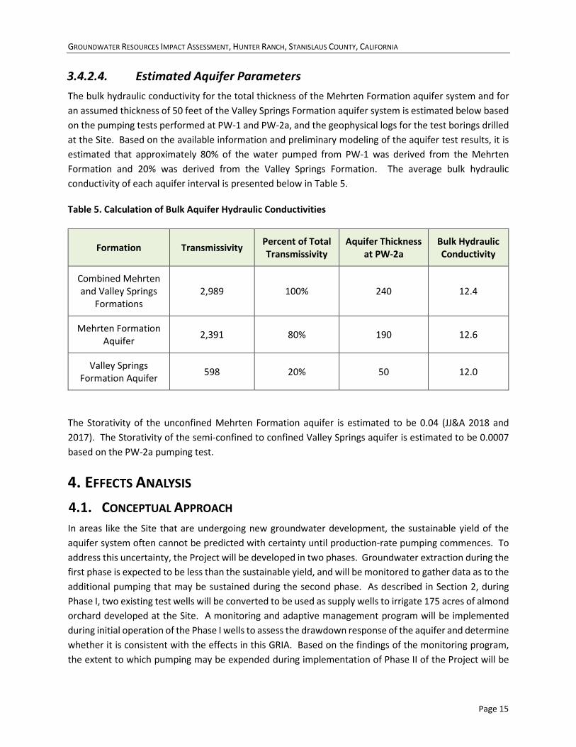
GROUNDWATER RESOURCES IMPACT ASSESSMENT, HUNTER RANCH, STANISLAUS COUNTY, CALIFORNIA
Page 15
3.4.2.4. Estimated Aquifer Parameters The bulk hydraulic conductivity for the total thickness of the Mehrten Formation aquifer system and for an assumed thickness of 50 feet of the Valley Springs Formation aquifer system is estimated below based on the pumping tests performed at PW-1 and PW-2a, and the geophysical logs for the test borings drilled at the Site. Based on the available information and preliminary modeling of the aquifer test results, it is estimated that approximately 80% of the water pumped from PW-1 was derived from the Mehrten Formation and 20% was derived from the Valley Springs Formation. The average bulk hydraulic conductivity of each aquifer interval is presented below in Table 5.
Table 5. Calculation of Bulk Aquifer Hydraulic Conductivities
Formation Transmissivity Percent of Total Transmissivity
Aquifer Thickness at PW-2a
Bulk Hydraulic Conductivity
Combined Mehrten and Valley Springs
Formations 2,989 100% 240 12.4
Mehrten Formation Aquifer 2,391 80% 190 12.6
Valley Springs Formation Aquifer 598 20% 50 12.0
The Storativity of the unconfined Mehrten Formation aquifer is estimated to be 0.04 (JJ&A 2018 and 2017). The Storativity of the semi-confined to confined Valley Springs aquifer is estimated to be 0.0007 based on the PW-2a pumping test.
4. EFFECTS ANALYSIS 4.1. CONCEPTUAL APPROACH In areas like the Site that are undergoing new groundwater development, the sustainable yield of the aquifer system often cannot be predicted with certainty until production-rate pumping commences. To address this uncertainty, the Project will be developed in two phases. Groundwater extraction during the first phase is expected to be less than the sustainable yield, and will be monitored to gather data as to the additional pumping that may be sustained during the second phase. As described in Section 2, during Phase I, two existing test wells will be converted to be used as supply wells to irrigate 175 acres of almond orchard developed at the Site. A monitoring and adaptive management program will be implemented during initial operation of the Phase I wells to assess the drawdown response of the aquifer and determine whether it is consistent with the effects in this GRIA. Based on the findings of the monitoring program, the extent to which pumping may be expended during implementation of Phase II of the Project will be
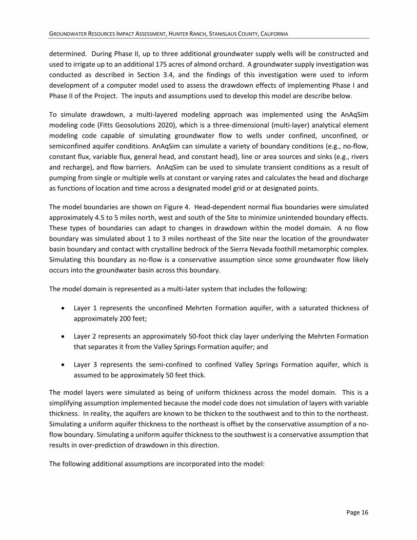
GROUNDWATER RESOURCES IMPACT ASSESSMENT, HUNTER RANCH, STANISLAUS COUNTY, CALIFORNIA
Page 16
determined. During Phase II, up to three additional groundwater supply wells will be constructed and used to irrigate up to an additional 175 acres of almond orchard. A groundwater supply investigation was conducted as described in Section 3.4, and the findings of this investigation were used to inform development of a computer model used to assess the drawdown effects of implementing Phase I and Phase II of the Project. The inputs and assumptions used to develop this model are describe below.
To simulate drawdown, a multi-layered modeling approach was implemented using the AnAqSim modeling code (Fitts Geosolutions 2020), which is a three-dimensional (multi-layer) analytical element modeling code capable of simulating groundwater flow to wells under confined, unconfined, or semiconfined aquifer conditions. AnAqSim can simulate a variety of boundary conditions (e.g., no-flow, constant flux, variable flux, general head, and constant head), line or area sources and sinks (e.g., rivers and recharge), and flow barriers. AnAqSim can be used to simulate transient conditions as a result of pumping from single or multiple wells at constant or varying rates and calculates the head and discharge as functions of location and time across a designated model grid or at designated points.
The model boundaries are shown on Figure 4. Head-dependent normal flux boundaries were simulated approximately 4.5 to 5 miles north, west and south of the Site to minimize unintended boundary effects. These types of boundaries can adapt to changes in drawdown within the model domain. A no flow boundary was simulated about 1 to 3 miles northeast of the Site near the location of the groundwater basin boundary and contact with crystalline bedrock of the Sierra Nevada foothill metamorphic complex. Simulating this boundary as no-flow is a conservative assumption since some groundwater flow likely occurs into the groundwater basin across this boundary.
The model domain is represented as a multi-later system that includes the following:
• Layer 1 represents the unconfined Mehrten Formation aquifer, with a saturated thickness of approximately 200 feet;
• Layer 2 represents an approximately 50-foot thick clay layer underlying the Mehrten Formation that separates it from the Valley Springs Formation aquifer; and
• Layer 3 represents the semi-confined to confined Valley Springs Formation aquifer, which is assumed to be approximately 50 feet thick.
The model layers were simulated as being of uniform thickness across the model domain. This is a simplifying assumption implemented because the model code does not simulation of layers with variable thickness. In reality, the aquifers are known to be thicken to the southwest and to thin to the northeast. Simulating a uniform aquifer thickness to the northeast is offset by the conservative assumption of a no-flow boundary. Simulating a uniform aquifer thickness to the southwest is a conservative assumption that results in over-prediction of drawdown in this direction.
The following additional assumptions are incorporated into the model:
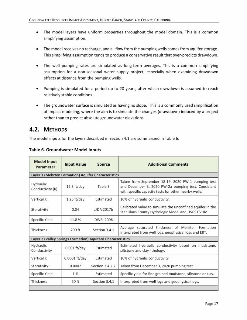
GROUNDWATER RESOURCES IMPACT ASSESSMENT, HUNTER RANCH, STANISLAUS COUNTY, CALIFORNIA
Page 17
• The model layers have uniform properties throughout the model domain. This is a common simplifying assumption.
• The model receives no recharge, and all flow from the pumping wells comes from aquifer storage. This simplifying assumption tends to produce a conservative result that over-predicts drawdown.
• The well pumping rates are simulated as long-term averages. This is a common simplifying assumption for a non-seasonal water supply project, especially when examining drawdown effects at distance from the pumping wells.
• Pumping is simulated for a period up to 20 years, after which drawdown is assumed to reach relatively stable conditions.
• The groundwater surface is simulated as having no slope. This is a commonly used simplification of impact modeling, where the aim is to simulate the changes (drawdown) induced by a project rather than to predict absolute groundwater elevations.
4.2. METHODS The model inputs for the layers described in Section 4.1 are summarized in Table 6.
Table 6. Groundwater Model Inputs
Model Input Parameter Input Value Source Additional Comments
Layer 1 (Mehrten Formation) Aquifer Characteristics
Hydraulic Conductivity (K) 12.6 ft/day Table 5
Taken from September 18-19, 2020 PW-1 pumping test and December 3, 2020 PW-2a pumping test. Consistent with specific capacity tests for other nearby wells.
Vertical K 1.26 ft/day Estimated 10% of hydraulic conductivity.
Storativity 0.04 JJ&A 2017b Calibrated value to simulate the unconfined aquifer in the Stanislaus County Hydrologic Model and USGS CVHM.
Specific Yield 11.8 % DWR, 2006
Thickness 200 ft Section 3.4.1 Average saturated thickness of Mehrten Formation interpreted from well logs, geophysical logs and ERT.
Layer 2 (Valley Springs Formation) Aquitard Characteristics
Hydraulic Conductivity 0.001 ft/day Estimated Estimated hydraulic conductivity based on mudstone,
siltstone and clay lithology.
Vertical K 0.0001 ft/day Estimated 10% of hydraulic conductivity
Storativity: 0.0007 Section 3.4.2.2 Taken from December 3, 2020 pumping test
Specific Yield 1 % Estimated Specific yield for fine grained mudstone, siltstone or clay.
Thickness 50 ft Section 3.4.1 Interpreted from well logs and geophysical logs.
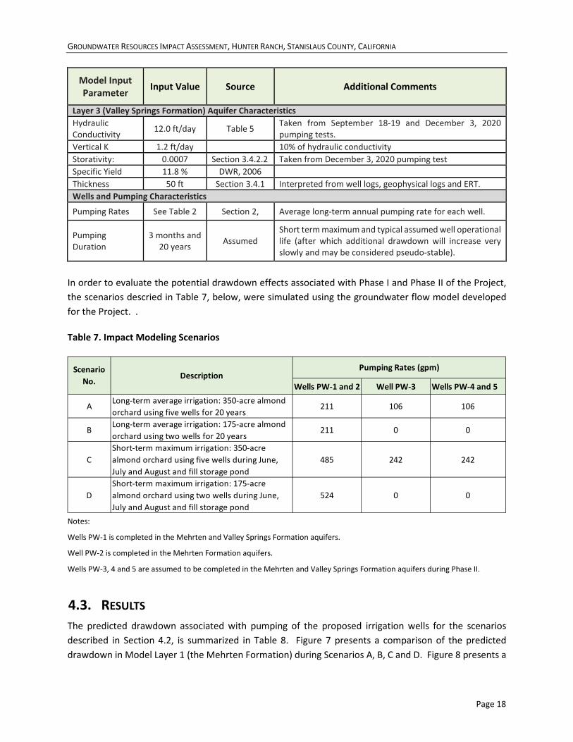
GROUNDWATER RESOURCES IMPACT ASSESSMENT, HUNTER RANCH, STANISLAUS COUNTY, CALIFORNIA
Page 18
Model Input Parameter Input Value Source Additional Comments
Layer 3 (Valley Springs Formation) Aquifer Characteristics Hydraulic Conductivity 12.0 ft/day Table 5 Taken from September 18-19 and December 3, 2020
pumping tests. Vertical K 1.2 ft/day 10% of hydraulic conductivity Storativity: 0.0007 Section 3.4.2.2 Taken from December 3, 2020 pumping test Specific Yield 11.8 % DWR, 2006 Thickness 50 ft Section 3.4.1 Interpreted from well logs, geophysical logs and ERT. Wells and Pumping Characteristics
Pumping Rates See Table 2 Section 2, Average long-term annual pumping rate for each well.
Pumping Duration
3 months and 20 years Assumed
Short term maximum and typical assumed well operational life (after which additional drawdown will increase very slowly and may be considered pseudo-stable).
In order to evaluate the potential drawdown effects associated with Phase I and Phase II of the Project, the scenarios descried in Table 7, below, were simulated using the groundwater flow model developed for the Project. .
Table 7. Impact Modeling Scenarios
Notes:
Wells PW-1 is completed in the Mehrten and Valley Springs Formation aquifers.
Well PW-2 is completed in the Mehrten Formation aquifers.
Wells PW-3, 4 and 5 are assumed to be completed in the Mehrten and Valley Springs Formation aquifers during Phase II.
4.3. RESULTS The predicted drawdown associated with pumping of the proposed irrigation wells for the scenarios described in Section 4.2, is summarized in Table 8. Figure 7 presents a comparison of the predicted drawdown in Model Layer 1 (the Mehrten Formation) during Scenarios A, B, C and D. Figure 8 presents a
Wells PW-1 and 2 Well PW-3 Wells PW-4 and 5
ALong-term average irrigation: 350-acre almond orchard using five wells for 20 years
211 106 106
BLong-term average irrigation: 175-acre almond orchard using two wells for 20 years
211 0 0
CShort-term maximum irrigation: 350-acre almond orchard using five wells during June, July and August and fill storage pond
485 242 242
DShort-term maximum irrigation: 175-acre almond orchard using two wells during June, July and August and fill storage pond
524 0 0
Scenario No.
DescriptionPumping Rates (gpm)

GROUNDWATER RESOURCES IMPACT ASSESSMENT, HUNTER RANCH, STANISLAUS COUNTY, CALIFORNIA
Page 19
comparison of the predicted 5 foot and 20 foot drawdown contours Layers 1 (the Mehrten Formation) and 3 (the Valley Springs Formation) for Scenarios A and B. Figure 9 shows the maximum drawdown predicted during Phase I in Layer 1 compared to nearby well locations and domestic well depths. Figure 10 shows the maximum drawdown in Layer 1 during Phase II compared to nearby well locations and domestic well depths. Figure 11 shows the extent of drawdown exceeding 0.5 feet in Layer 1 relative to the locations of potential GDEs. The results are summarized below.
• Figure 8 illustrates the extent of drawdown predicted in Layer 3 (the Valley Springs Formation aquifer) is somewhat greater than in Layer 1 (the Mehrten Formation aquifer), especially in the northeast direction toward the presumed no-flow boundary at the edge of the basin. This is consistent with Layer 3 being more strongly confined than Layer 1, which results in a broader cone of depression. Review of well completion records for 2 miles in each direction from the Site indicates that most irrigation and domestic wells are completed in the Mehrten Formation. Based on the analysis presented in Section 4.4, wells that are completed in both formations would derive most of their water from the Mehrten Formation. For these reasons, the discussions below focus on predicted drawdowns in Layer 1 (the Mehrten Formation).
• During Phase I, drawdowns in Model Layer 1 (the Mehrten Formation) exceeding 5 feet are predicted to extend approximately 1.1 to 1.3 miles from the wellfield in all directions, and 0.5 to 1.1 mile off-Site. Drawdowns exceeding 10 feet extend off-Site to the south for a distance up to approximately 0.3 mile and drawdown exceeding 15 feet are limited to the southern portion of the Site. The maximum predicted drawdown at the property line is approximately 14 feet along the central portion of the southern property line.
• If the maximum Phase II expansion is implemented, drawdown in Model Layer 1 (the Mehrten Formation) exceeding 5 feet is predicted to extend approximately 1.7 to 2 miles from the wellfield and property boundaries to the north, south and west, and slightly over 2 miles toward the edge of the groundwater basin to the northeast. Drawdowns exceeding 10 feet are predicted to extend off-Site approximately 0.5 to 1 mile, and drawdown exceeding 20 feet is predicted to extend off site to the southwest by up to approximately 0.15 mile. A maximum drawdown of about 25 feet at the property line is predicted to occur near the southwest Site corner.
• Drawdown exceeding 5 feet resulting from the short-term maximum pumping scenarios is predicted to extend off-Site to the south by about 0.15 mile during Phase I and about 0.15 mile to the south and southwest during Phase II.
• Figures 9 and 10 illustrate that the predicted drawdown at nearby irrigation well locations during both Phase I and Phase II is less than 20 feet. A number of nearby domestic wells are predicted to be affected by drawdown exceeding 5 feet under either Phase I and Phase II. The area affected by more than 5 feet of drawdown extends about half as far from the Site under Phase I than under Phase II. Statistics for domestic well completion depths for each square mile section near the Site were downloaded from the SGMA Data Viewer website (DWR 2020b) and indicate that most domestic wells in the area have available drawdowns of 100 to 200 feet. Review of well
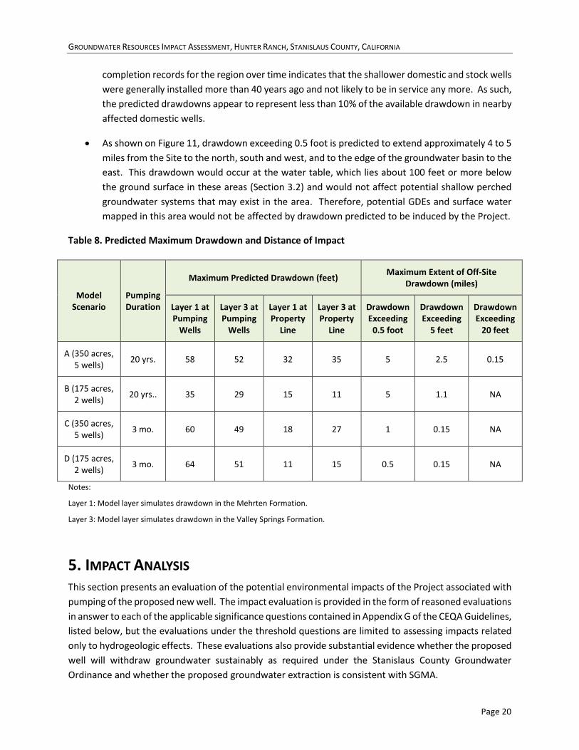
GROUNDWATER RESOURCES IMPACT ASSESSMENT, HUNTER RANCH, STANISLAUS COUNTY, CALIFORNIA
Page 20
completion records for the region over time indicates that the shallower domestic and stock wells were generally installed more than 40 years ago and not likely to be in service any more. As such, the predicted drawdowns appear to represent less than 10% of the available drawdown in nearby affected domestic wells.
• As shown on Figure 11, drawdown exceeding 0.5 foot is predicted to extend approximately 4 to 5 miles from the Site to the north, south and west, and to the edge of the groundwater basin to the east. This drawdown would occur at the water table, which lies about 100 feet or more below the ground surface in these areas (Section 3.2) and would not affect potential shallow perched groundwater systems that may exist in the area. Therefore, potential GDEs and surface water mapped in this area would not be affected by drawdown predicted to be induced by the Project.
Table 8. Predicted Maximum Drawdown and Distance of Impact
Model Scenario
Pumping Duration
Maximum Predicted Drawdown (feet) Maximum Extent of Off-Site Drawdown (miles)
Layer 1 at Pumping
Wells
Layer 3 at Pumping
Wells
Layer 1 at Property
Line
Layer 3 at Property
Line
Drawdown Exceeding
0.5 foot
Drawdown Exceeding
5 feet
Drawdown Exceeding
20 feet
A (350 acres, 5 wells) 20 yrs. 58 52 32 35 5 2.5 0.15
B (175 acres, 2 wells) 20 yrs.. 35 29 15 11 5 1.1 NA
C (350 acres, 5 wells) 3 mo. 60 49 18 27 1 0.15 NA
D (175 acres, 2 wells) 3 mo. 64 51 11 15 0.5 0.15 NA
Notes:
Layer 1: Model layer simulates drawdown in the Mehrten Formation.
Layer 3: Model layer simulates drawdown in the Valley Springs Formation.
5. IMPACT ANALYSIS This section presents an evaluation of the potential environmental impacts of the Project associated with pumping of the proposed new well. The impact evaluation is provided in the form of reasoned evaluations in answer to each of the applicable significance questions contained in Appendix G of the CEQA Guidelines, listed below, but the evaluations under the threshold questions are limited to assessing impacts related only to hydrogeologic effects. These evaluations also provide substantial evidence whether the proposed well will withdraw groundwater sustainably as required under the Stanislaus County Groundwater Ordinance and whether the proposed groundwater extraction is consistent with SGMA.
GROUNDWATER RESOURCES IMPACT ASSESSMENT, HUNTER RANCH, STANISLAUS COUNTY, CALIFORNIA
Page 21
5.1. GROUNDWATER-DEPENDENT ECOSYSTEMS Question IV(a): Would the project have a substantial adverse effect, either directly or through habitat modifications, on any species identified as a candidate, sensitive, or special status species in local or regional plans, policies, or regulations, or by the California Department of Fish and Game or U.S. Fish and Wildlife Service?
Question IV(b): Would the project have a substantial adverse effect on any riparian habitat or other sensitive natural community identified in local or regional plans, policies, regulations, or by the CDFG or USFWS?
Question IV(c): Would the project have a substantial adverse effect on state or federally protected wetlands (including marsh, vernal pool, coastal, etc.) through direct removal, filling, hydrological interruption, or other means?
The proposed wells will withdraw water from from an unconfined and underlying semi-confined aquifer system with a water table that is approximately 100 or more feet bgs in the areas where potential GDEs have been identified (Section 3.2, Figure 4 and Figure 11). Surface waters and potential GDEs in this area may exchange water with local perched aquifers, but are not hydraulically connected to the regional aquifer systems proposed to be utilized for the Project. As such, GDEs and interconnected surface waters are not anticipated to be affected by the proposed well. No impact will occur.
5.2. WATER QUALITY Question IX(a): Would the project violate any water quality standards or waste discharge requirements or otherwise substantially degrade surface or ground water quality?
Question IX(e): Would the project conflict with or obstruct implementation of a water quality control plan or sustainable groundwater management plan?
Groundwater quality in the Mehrten and Valley Springs Formation aquifer systems is relatively good, and there are no known zones of degraded groundwater or contamination incidents identified in the vicinity of the Site that could be mobilized by pumping of the proposed wells. The existing test wells and proposed new wells are completed with sanitary seals in accordance with the Stanislaus County Well Ordinance (Chapter 9.36 of the County Code). The sanitary seals for these wells are sufficient for water quality protection associated at agricultural sites, and the wells are not located near any septic discharge systems or animal confinement areas. The orchard will be operated under the General Agricultural Water Quality Protection Orders issued by the RWQCB for the proposed Irrigated Lands Regulatory Program. Based on this information, potential impacts to water quality will be less than significant.
5.3. SUBSIDENCE Question VII(c): Would the project be located on a geologic unit or soil that is unstable, or that would become unstable as a result of the project, and potentially result in on or off-site landslide, lateral spreading, subsidence, liquefaction, or collapse?
GROUNDWATER RESOURCES IMPACT ASSESSMENT, HUNTER RANCH, STANISLAUS COUNTY, CALIFORNIA
Page 22
Land subsidence can occur when compressible clays are depressurized because of groundwater extraction, triggering water to flow from the clays into the surrounding aquifer, and ultimately causing consolidation of the clay under pressure from the overlying sediments. In general, most subsidence occurs when an aquifer is initially depressurized, but can continue for months, or even years, after clays slowly dewater and adjust to the new pressure regime. If groundwater levels subsequently recover, subsidence generally does not resume (or does not progress as rapidly), until groundwater levels fall below historical low levels. Subsidence can occur especially in confined aquifer conditions, where the drawdown associated with groundwater extraction is greater than in unconfined aquifers. Subsidence in the San Joaquin Valley has occurred mainly when compressible clays are dewatered because of drawdown in the confined aquifer system beneath the Corcoran Clay to below historical low levels.
The Site is underlain by well-consolidated deposits of the Mehrten and Valley Springs Formations and is not located in a Subsidence Management Area designated under Stanislaus County’s discretionary well permitting program. No subsidence monitoring stations are located within 10 miles of the Site; however, subsidence monitoring stations in similar geologic settings about 11 miles to the north-northwest near Jenny Lind (USGS GPS monitoring station P309-IGS14) and 14 miles to the southeast near Knights Ferry (USGS GPS monitoring station P306-IGS14) have not recorded any clear evidence of inelastic subsidence in the last 15 years (UNAVCO 2021) The maximum off-site drawdown predicted to be induced by the Project is about 20 feet in a small area within about 0.15 mile southwest of the Site. No infrastructure that is sensitive to subsidence is located in this area. Based on this information, no subsidence-related impacts are expected.
5.4. CHRONIC DRAWDOWN AND DIMINUTION OF SUPPLY Question IX(b): Would the project substantially decrease groundwater supplies or interfere substantially with groundwater recharge such that the project may impede sustainable groundwater management of the basin?
Question IX(e): Would the project conflict with or obstruct implementation of a water quality control plan or sustainable groundwater management plan?
The potential for operation of the proposed irrigation wells to interfere with implementation of a water quality control plan is discussed in Section 5.2, above.
Groundwater recharge is thought to be limited in the near near the Site due to the near surface presence of competent paleosols and mudflows in the Mehrten Formation. The Project consists of the conversion, construction and operation of several irrigation wells that will be used to support development of an almond orchard on rangeland currently used for cattle grazing and hay production. The Site land use will remain agricultural. Construction and operation of the proposed Project wells and development and operation of an orchard at the site is not expected to change the recharge characteristics of the Site and will not add any impervious surfaces. Based on this information, the project would not have any impact on groundwater recharge.

GROUNDWATER RESOURCES IMPACT ASSESSMENT, HUNTER RANCH, STANISLAUS COUNTY, CALIFORNIA
Page 23
In 2018, the County adopted a Program Environmental Impact Report (PEIR) that evaluated the potential environmental impacts associated with implementing its discretionary well permitting program (JJ&A 2018). The PEIR concluded that implementation of the discretionary well permitting program would result in less-than-significant impacts related to groundwater level decline, interference drawdown and groundwater storage depletion as long as the program requirements to evaluate site specific hydrogeologic impacts are implemented. These impacts are discussed below.
The long-term groundwater extraction associated with the proposed irrigation wells will be approximately 683 AFY for Phase I and 1,366 AFY if the full Phase II expansion is implemented. This is a new groundwater demand north and east of the area of currently developed for irrigation water supplies. An evaluation of groundwater level trends in the northern triangle area of Stanislaus County did not identify any long-term groundwater level data near the Site, but noted that several wells about 5 miles to the southwest show a generally declining groundwater level trend, and several wells about 5 miles to the west showed declining trends until about 1980, when surface water became available in that area, and then stabilized (JJ&A 2017a). The extrapolation of these groundwater level trends for the next 50 years did not identify any evidence that they would result in undesirable results as defined under the County Groundwater Ordinance or the SGMA if current groundwater management practices are continued. For this reason, the County has not identified the area as being within a Groundwater Level Management Zone as defined by the County’s discretionary well permitting program (JJ&A 2018). Groundwater levels in a well monitored by Stanislaus County about 1.4 miles southeast of the Site indicated that groundwater levels have varied by about 5 feet since 2016, and do not show a clear trend (Section 3.3, Attachment B). Based on this information, the Site is located north and east of areas developed for groundwater supply in an area where groundwater levels are currently relatively stable.
As discussed in Section 3.3, the mapped boundary of the Eastern San Joaquin Subbasin is located about 2 to 3 miles northeast of the Site (Figure 4). The Mehrten Formation aquifer thins in this direction, and the Valley Springs Formation aquifer subcrop rises closer to the ground surface. Conversely, to the west and south of the Site, the productive thickness of the Mehrten Formation aquifer is thicker, and Valley Springs aquifer is deeper beneath the ground surface. A modeling evaluation of drawdown and storage depletion was conducted for this Project as described in Section 4 and considered these factors. The investigation found that predicted drawdown induced by the project after 20 years of pumping would exceed 5 feet within up to about 1.1 mile of the Site if Phase I pumping is implemented, and within up to about 2.5 miles from the Site if Phase II is fully implemented. The drawdown is predicted to be extend further off-Site to the northwest than to the southwest. Drawdown exceeding 20 feet is predicted to be limited to within about 0.15 mile south of the Site during Phase I and 0.15 mile south and southwest of the Site during Phase II. This drawdown represents about 2% to 8% of the available aquifer thickness. As discussed in Section 4.3 and shown on Figures 8 and 9, the drawdown predicted as a result of Phase I pumping and expanded Phase II pumping is not expected to impact existing irrigation wells with more than 20 feet of interference drawdown, and the predicted drawdown at nearby domestic wells is anticipated to be less than 10% of their available drawdown. Based on this analysis, the amount of drawdown is not expected to result in significant reductions in groundwater supply availability or well operating costs in the area
GROUNDWATER RESOURCES IMPACT ASSESSMENT, HUNTER RANCH, STANISLAUS COUNTY, CALIFORNIA
Page 24
surrounding the Site, and impacts to the sustainability of local groundwater supplies are expected to be less than significant.
Because the Site is located near the northeastern edge of the Eastern San Joaquin Groundwater Subbasin in an area where groundwater supplies have been relatively sparsely developed and groundwater level data to assess the long-term response of the aquifer system to pumping are limited, a monitoring and adaptive management program will be implemented during the early part of Phase I pumping and provide an evaluation and feedback mechanism that helps assure that groundwater extraction remains within the local sustainable yield, and does not cause or contribute to undesirable results. Groundwater drawdown in connection with implementation of Phase I is expected to be within the safe yield of the aquifer system since it represents irrigation of only 27% of the available farmland at the Site – a much lower irrigation demand density than what exists to the west and south of the Site vicinity, where irrigated land development densities are between about 50% to 100%. If Phase II is implemented, the irrigated land would expand to 350 acres of the 640-acre site, or about 55%, which is still at the lower end of the the development density observed to the south and west. During the initial groundwater extraction to support irrigation of orchard development during Phase I, groundwater level data will be collected and compared to the drawdowns predicted by the groundwater modeling study described in Section 4. The model would be updated if required, and the amount of additional irrigation pumping expansion implemented during Phase II would be limited, if required, to keep the groundwater drawdown effects within the range that was estimated in the impact analysis discussed in this GRIA. With implementation of this program, there is increased certainty that the groundwater level and supply impacts induced by the Project will be less than significant and will not interfere with the sustainable management of groundwater in the area.
As discussed in Section 3.3, sustainable groundwater management in the northern triangle of Stanislaus County occurs under the jurisdiction of the Eastside San Joaquin GSA, which is responsible to implement the provisions of the Eastern San Joaquin Groundwater Subbasin Groundwater Sustainability Plan (GSP; ESJGA 2019). The GSP designates Representative Monitoring Sites (RSM) and establishes Minimum Thresholds (MT), Measurable Objectives (MO) and Interim Milestones (IM) for these monitoring sites that must be met to assure sustainable groundwater management. The MOs and IMs are target groundwater elevations at the RSMs, and groundwater resources are required to be managed in a way that maintains groundwater levels above these targets and avoids undesirable results. MT, MO and IM were informed by hydrograph analysis and groundwater modeling. Per Table 3-2 of the GSP, the MO for chronic lowering of groundwater levels was set at the lower of either 1992 or 2015/2015 groundwater levels. The closest RMS for which thresholds have been established is well 01S10E26J001M, located south of Woodward Reservoir and over 10 miles from the Site. A “Broad Monitoring Network” is established to provide additional data that informs groundwater conditions and management. The additional wells in this network will not be used to assess compliance with MTs, MOs or IMs, and includes a well located about on the south side of the Farmington Flood Control Bason, about 5 miles south of the Site. As shown on Figure 4-3 of the GSP, additional monitoring wells for water quality and level monitoring are proposed to be installed approximately 4 miles south and 3 miles northwest of the Site; however, information regarding these wells is not yet available. The existing wells included in the monitoring network to guide
GROUNDWATER RESOURCES IMPACT ASSESSMENT, HUNTER RANCH, STANISLAUS COUNTY, CALIFORNIA
Page 25
implementation of the GSP are located in areas that that are not expected to be affected by drawdown induced by the project, or are located at a distance where drawdown would not be expected to be distinguishable from seasonal groundwater level fluctuations or other more local effects.
The closest available well to the Site with historical groundwater level data is the McCurley well, with a period of record from Fall 2016 through Spring 2021. While this well is not used to assess compliance with the MTs, MOs or IMs designated in the GSP, it provides a useful basis for assessing consistency of the proposed Project with the GSP. The 1992 groundwater level is not known. The reported depth to groundwater in this well ranged from 84.4 feet bgs in March 2017 to 89.85 feet bgs in October 2020. The depth to groundwater in October 2016, when monitoring began, was 87.52 feet bgs. The groundwater elevations in this well reflect relatively stable conditions in response to local groundwater pumping near the northeastern edge of the area where groundwater supplies are developed. Under these conditions, it is reasonable to assume that some additional groundwater level decline would be acceptable. The predicted groundwater level decline at the McCurley well after 20 years of pumping for Phase I is approximately 2.5 feet, and approximately 6.5 feet if Phase II were fully implemented. This is within the general range of groundwater level fluctuations observed in this well.
Based on the information presented above, well interference impacts to existing wells and impacts related to reduction in groundwater storage will be less than significant. The Project would not cause any undesirable results or violate any MTs, MOs or IMs established in the GSP, and groundwater level drawdowns induced by the project would be similar to or less than the range of historical fluctuations in the closest County groundwater level monitoring well. As such, the Project appears consistent with the GSP and would not obstruct its implementation.
5.5. CUMULATIVE IMPACTS Question XVIII(b): Does the project have impacts that are individually limited, but cumulatively considerable? ("Cumulatively considerable" means that the incremental effects of a project are considerable when viewed in connection with the effects of past projects, the effects of other current projects, and the effects of probable future projects.)
Cumulative pumping to date has resulted in relatively stable groundwater levels at the McCurley well, located about 1.4 miles southeast of the Site and completed in the Mehrten Formation. A PEIR prepared to evaluate potential impacts associated with implementation of Stanislaus County’s discretionary well permitting program found that future development of groundwater resources in the eastern foothill area of the County would not result in significant impacts as long as the requirements of that program are implemented (JJ&A 2018).
Under SGMA, the Eastside San Joaquin GSA is responsible for implementation of the Eastern San Joaquin Groundwater Subbasin Groundwater Sustainability Plan (ESJGA 2019), including the achievement of the sustainability goals of the plan, and assuring compliance with MTs, MOs and IMs. The GSA has the authority to require minimum well spacing, prescribe allowable extraction rates, or implement projects as needed to assure that these sustainable management criteria are met. Stanislaus County submits
GROUNDWATER RESOURCES IMPACT ASSESSMENT, HUNTER RANCH, STANISLAUS COUNTY, CALIFORNIA
Page 26
applications for new well permits to the GSA for review and determination whether construction and operation of the wells is consistent with the GSP or would interfere with its implementation. The County considers the GSA’s review comments in its approval of the permits and in development of permit conditions, as appropriate. These procedures and requirements under state law (SGMA) and the County Groundwater Ordinance are specifically intended to prevent adverse potential environmental impacts that could result from groundwater extraction by individual wells or due to the cumulative effects of pumping by all wells in a broader area.
Groundwater levels in the McCurley well, located approximately 1.4 mile southeast of the Site, reflect the cumulative effects of existing and historical groundwater pumping near the Site. Groundwater levels measured in this well since 2016 have been relatively stable, indicating the existing pumping is not resulting in potentially adverse cumulative impacts or undesirable results as defined under SGMA or the County Groundwater Ordinance. Longer term regional hydrographs for the northern triangle area of Stanislaus County reflect the effects of local groundwater extraction in more densely irrigated areas to the south and west of the Site, as well as drawdown during periods of drought, recovery after droughts and recovery after the implementation of surface water supply projects (Section 3.3). Similar future groundwater level fluctuations may be expected near the Site due to the expansion of irrigation pumping in the area, future climatic fluctuations, and potentially implementation of surface water supply projects. Reasonably foreseeable increases in pumping due to additional agricultural development in the area surrounding the Site would be expected to result in additional drawdown; however, implementation of the the County Groundwater Ordinance and the GSP will assure that these increases do not result in cumulatively significant impacts (or undesirable results as defined in SGMA and the County Groundwater Ordinance.
Based on these considerations, the groundwater resources impacts associated with the Project will be less than cumulatively considerable.
5.6. WATER SUPPLY AND ENTITLEMENTS Question XVII(d): Would the project have sufficient water supplies available to serve the project and reasonably foreseeable future development during normal, dry and multiple dry years?
Chapter 9.37 of the Stanislaus County Code requires that: (1) groundwater quality and quantity are adequate and will not be adversely impacted by the cumulative amount of development and uses allowed in the area; (2) the proposed use will not cause or exacerbate an overdraft condition in a groundwater basin or subbasin; and (3) the proposal not result in groundwater overdraft, land subsidence, or saltwater intrusion. In addition, groundwater use must not result in critical reduction in flow in directly connected surface waters or adverse impacts to groundwater dependent ecosystems. The previous sections of this report provide substantial evidence that these requirements of the Stanislaus County Groundwater Ordinance have been met, and that sufficient groundwater supplies are available for extraction by the proposed new well to supply Phase I and Phase II of the Project under both normal and extreme drought conditions. A monitoring and adaptive management program will be implemented to gather data during implementation of Phase I that will help to address potential uncertainty and assure that groundwater extraction for Phase II remains within the
GROUNDWATER RESOURCES IMPACT ASSESSMENT, HUNTER RANCH, STANISLAUS COUNTY, CALIFORNIA
Page 27
requirements of the County Groundwater Ordinance and the local GSP. The Site is not located in an adjudicated basin, and based on the available data it is unlikely the local GSA will need to regulate groundwater extraction in this area to implement its GSP. Therefore, there is no foreseeable regulation of groundwater that would limit the ability of the proposed Phase I and Phase II wells to supply the orchard development at the Site. The operators would be able to extract groundwater for beneficial use on their property under an overlying groundwater right. No new entitlements would be required, and the Project would therefore have no impact.
6. REFERENCES California Department of Water Resources (DWR), 2006. California’s Groundwater Bulletin 118, San Joaquin
River Hydrologic Region, San Joaquin Valley Groundwater Basin, Eastern San Joaquin Subbasin. Updated January 20, 2006.
___, 2016. SGM Sustainable Groundwater Management, Critically Overdrafted Basins. http://www.water.ca.gov/groundwater/sgm/cod.cfm.
___, 2020a. NC Dataset Viewer. https://gis.water.ca.gov/app/NCDatasetViewer/. Accessed November.
___, 2020b. SGMA Data Viewer https://sgma.water.ca.gov/webgis/?appid=SGMADataViewer #currentconditions. Accessed November.
Driscoll, F.G., 1986. Groundwater and Wells. Johnson Filtration Systems Inc.
Eastern San Joaquin Groundwater Authority (ESJGA), 2019. Eastern San Joaquin Groundwater Subbasin Groundwater Sustainability Plan. November.
Faunt, Claudia, 2012. Groundwater Availability of the Central Valley Aquifer, California: USGS Professional Paper 1766.
Jacobson James & Associates, Inc. (JJ&A). 2017a. Evaluation of Groundwater Level Trends in Northern Triangle Area, Stanislaus County, California. September 27.
___, 2017b. Technical Memorandum - Stanislaus County Hydrologic Model: Development and Forecast Modeling: Prepared for Stanislaus County Department of Environmental Resources. December 20.
___, 2018. Final Program Environmental Impact Report, SCH #2016102005, Discretionary Well Permitting and Management Program, Stanislaus County, California: Prepared for Stanislaus County Department of Environmental Resources. June 11.
Marchard, Bartow and Shipley 1981. Preliminary Geologic Maps Showing Cenozoic Deposits of the Farmington and Bachelor Valley Quadrangles, San Joaquin, Stanislaus and Calaveras Counties, California. USGS Open File Report 81-1050.
UNAVCO, 2020. Network of the Americas: https://www.unavco.org/instrumentation/networks/. Accessed June 2021.

GROUNDWATER RESOURCES IMPACT ASSESSMENT, HUNTER RANCH, STANISLAUS COUNTY, CALIFORNIA
FIGURES

!
!
!
!
!!
!!
!!
!!
!!
!!
!!
!!
!!
!!
!!
!!
!!
!!
!!
!!
!!
!!
!!
!!
!!
!!
!!
!
!
!
!
!
!
!
!
!
!
!
!
!
!
!
!
!
!
!
!
!
!
!
!
!
!
!
!
!
!
!!
!
!
!
!
!
!
!
!
!
!
!
!
!
!
!
!
!
!
!
!
!
!
!
!
!
!
!
!
!
!
!
!
!
!
!
!
!
!
!
!
!
!
!
!
!
!
!
!
!
!
!
!
!
!
!
!
!!
!!
!!
!!
!!
!!
!!
!!
!!
!!
!!
!!
!!
!!
!!
!!
!!
!!
!!
!!
!!
!!
!!
!!
!!
!!
!!
!!
!!
!!
!!
!!
!!
!!
!!
!
!
!!
!!
!!
!
!
!
!
!!
!!
!!
!!
!!
!
!
!
!
!
!
!
!
!
!
!
!
!
!
!
!
!
!
!
!
!
!
!
!
!
!
!
!
!
!
!
!
!
!
!
!
!
!
!
!
!
!
!
!
!!
!!
!!
!!
!
!
!
!
!
!
!
!!
!
!
!
!
!
!
!
!!
!!
!!
!
!
!
!
!!
!!
!!
!!
!!
!!
!
!
!!
!!
!!
!
!
!!
!!
!!
!
!
!!
!!
!!
!
!
!!
!!
!!
!
!
!!
!
!
!!
!
!
!
!
!
!
!!
!
!
!!
! !
!
!
!
!
!
!
!
!
!
!
!
!
!
!
!
!
!
!
!
!
!
!
!
!
!
!
!
!
!
!
!
!
!
!
!
!
!
!
!!
! !
!!!
!
!!
!
!
!
!
!
!
!!
!
!
! !
!
!
!
!
!
!
!!
!!
!
!!
!
!
!
!
!!
!
!
!
!
!
!
!
!
!
!!
!!
!
!
!
!
! !
!
!
!
!
!
!
!
!
! !
!!
!
!
! !
!!
2nd St
I- 580I- 580
Westside Fwy
S t ateR
te132
State Rte 4
I- 205
9th St
I- 205
I- 5
I- 580
Sinclair Fwy
Land
er Av
e
N St
EHwy 4
State Rte
49
Hwy17
W Hwy 4
Patterson Rd
State Rte 4
State Rte 84
State Rte 12
Lon Dale Rd
Nimitz Fwy
S Main St
Marsh Creek Rd
Sullivan Rd
Montez umaRd
Merce
ySpri
ngsRd
State Rte 26
State Rte 120State Rte 120
McHe
nry Av
e
State Rte 132
Monterey Hwy
SantaCruzHwy
StateRte17
State Rte 82
State Rte 33
State
Rte 1
65
S tate
Hwy1
08
Los B
anos
Hwy
State
Rte 5
9
State
Rte 108State Rte 120
S Stat
e Hwy
59
State Rte 49
McSwain Rd
E Hwy 4
Waterloo Rd
State
Rte 5
9
State Rte 84
E State Hwy 140
State
Rte 1
7
Nimitz Fwy
State
Rte88
State Hwy 4
W 11th St
S t ate Rte 49
State Rte 87
State Rte 237State Rte237
State Rte87
Santa
Nell
a Rd
I- 205 Bus
Milto
n Roa
d
I- 680
I- 680
I-880I- 880
State R te 82
Stat e Rte 82
S tate H
wy84
US Hwy 101
Sne ll
ingHw
y
Mission Blvd
Lande r Ave
State
R te3
3
Farmington Rd
Maze Blvd
State Rte 108
State Rte 120
State
H wy160
Sinclair
Fwy
State Rte 99
I- 5
Golden State HwyGolden State Hwy
San Anton io Vall ey Rd
State Hwy 120
Stat e
Rte5
9
Mount Hamilt on R d
Arthur H Breed Fwy Arthur H Breed Fwy
State Hwy 108
W Valley FwyState Rte 85
S Valley Fwy
State Hwy 99
State Hwy99
State Hwy 33
Westside Fwy
State Rte 4
State Rte 99
Yosemite Blvd
State Rte 140
State Rte99
S t ateR
te130
State Hwy 132
M:\C
onde
_Farm
s\Figu
res\FI
G1_L
ocati
on_2
0210
331.m
xd
DATE: MAR 31, 2021
0 40,000 80,00020,000
Feet
±Groundwater Resources Impact Assessment
Hunter Ranch
Figure 1Site Location
Notes:- Aerial imagery from National Agriculture Imagery Program (NAIP) (dates vary).- Background imagery courtesy of ESRI.
!!
!!
! ! ! ! ! !
!!
!!!!!!
Stanislaus County BoundaryPrimary RoadSecondary Road
!(!(
!(
!(
!(
State Hwy 4
Milto
n Roa
d
PW-5
PW-4
PW-3/TB-2PW-2/TB-5 PW-1/TB-3
Legend!(
Proposed Irrigation Pumping Well(PW0Hunter Ranch BoundaryGroundwater Model Boundary
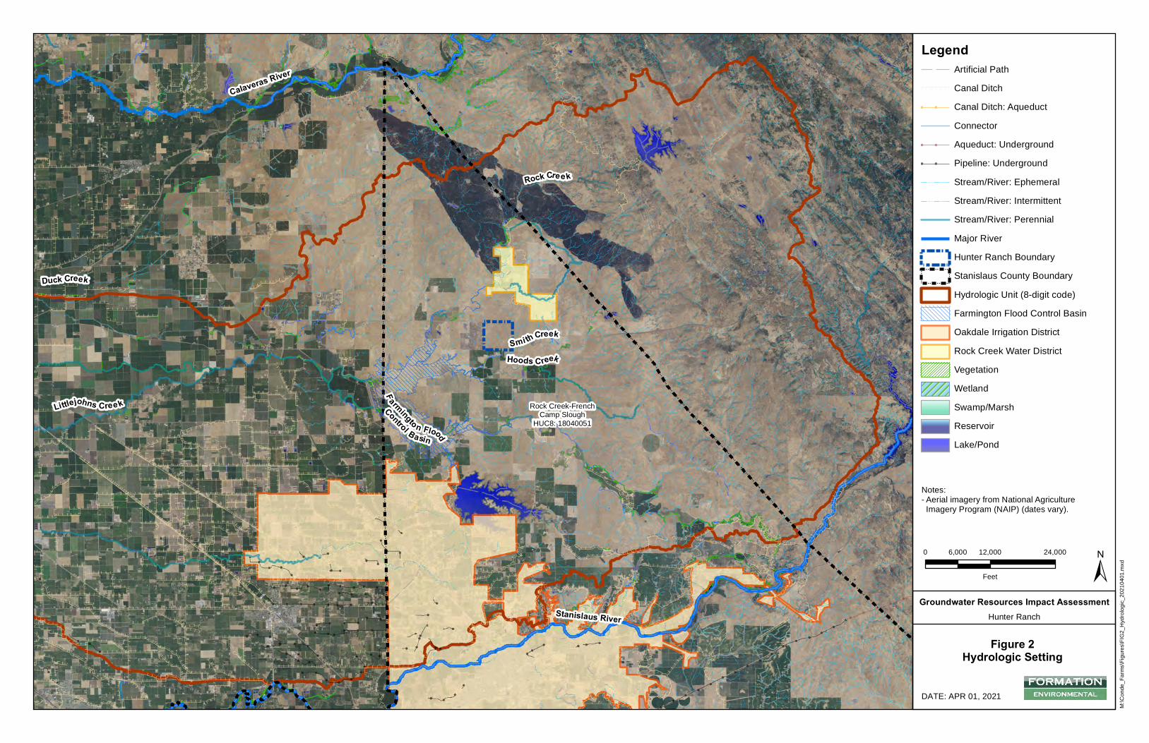
Hoods Creek
Littlejohns Cree k
Smi th Creek
Duck Creek
Rock Cree k
Stanislaus River
Calaveras River
Rock Creek-FrenchCamp Slough
HUC8: 18040051
F armingto n Flood
Control Basin
M:\C
onde
_Farm
s\Figu
res\FI
G2_H
ydrol
ogic_
2021
0401
.mxd
DATE: APR 01, 2021
0 12,000 24,0006,000
Feet ±Groundwater Resources Impact Assessment
Hunter Ranch
Figure 2Hydrologic Setting
Notes:- Aerial imagery from National Agriculture Imagery Program (NAIP) (dates vary).
LegendArtificial PathCanal Ditch
!! !! Canal Ditch: AqueductConnector
!! !! Aqueduct: Underground!! !! Pipeline: Underground
Stream/River: EphemeralStream/River: IntermittentStream/River: PerennialMajor RiverHunter Ranch Boundary
!!
!!
! ! ! ! ! !
!!
!!!!!!
Stanislaus County BoundaryHydrologic Unit (8-digit code)Farmington Flood Control BasinOakdale Irrigation DistrictRock Creek Water DistrictVegetationWetlandSwamp/MarshReservoirLake/Pond

&,
&,
&,
&,
&,
APN:001010002
Milto
n Roa
d
State Hwy 4
PW-1/TB-3PW-2/TB-5
PW-3/TB-2
PW-4
PW-5
PHASE I
PHASE II
M:\C
onde
_Farm
s\Figu
res\FI
G3_P
ropos
edSit
eDev
_202
1052
6.mxd
DATE: MAY 26, 2021
0 500 1,000250
Feet
±Groundwater Resources Impact Assessment
Hunter Ranch
Figure 3Proposed Site Development
Notes:- Aerial imagery from National AgricultureImagery Program (NAIP) (dates vary).
Legend&,
Proposed Irrigation Pumping Well(PW)Secondary RoadStream/River: EphemeralStream/River: IntermittentHunter Ranch BoundaryPondReservoirSeasonal WetlandWetland Swale30-Foot Buffer
E E E E E EE E E E E EE E E E E EE E E E E E Orchard - Phase I
E E E E E EE E E E E EE E E E E EE E E E E E
Orchard - Phase II
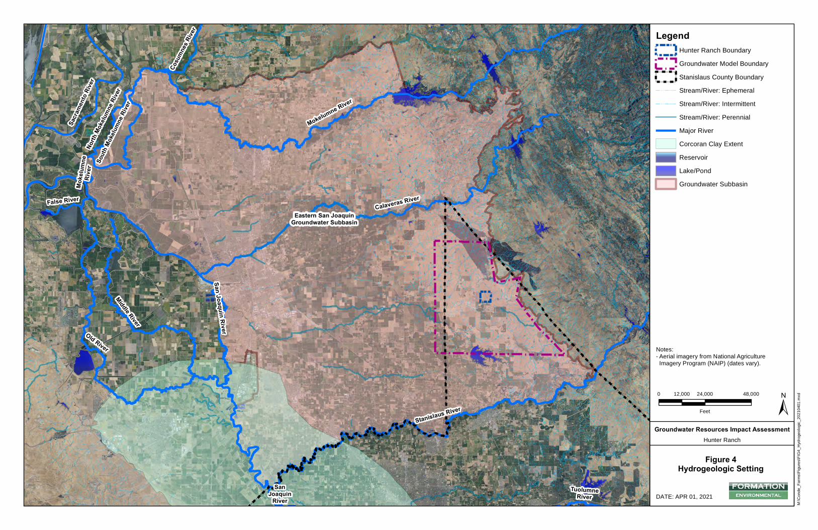
!
!!!
!!
!!
!!
!!
!!
!!
!!
!!
!!
!!
!!
!!
!!
!!
!!
!!
!!
!!
!!
!!
!!
!!
!!
!!
!!
!!
!!
!!
!!
!!
!!
!!
!!
!!
!!
!!
!!
!!
!!
!!
!!
!
!
!!
!!
!
!
!
!
!!
!!
!!
!!
!!
!!
!!
!!
!!
!!
!!
!!
!!
!!
!!
!!
!!
!!
!!
!!
!!
!!
!!
!!
!!
!!
!!
!!
!!
!!
!!
!!
!!
!!
!!
!!
!!
!!
!!
!
!
!
!
!!
!!
!!
!!
!!
!!
!!
!!
!!
!!
!!
!
!
!
!
!!
!!
!!
!!
!!
!!
!!
!!
!!
!!
!!
!!
!!
!!
!!
!!
!!
!!
!!
!!
!!
!!
!!
!!
!!
!!
!!
!!
!!
!!
!!
!!
!!
!!
!!
!!
!!
!!
!!
!!
!!
!!
!!
!!
!!
!!
!!
!!
!!
!!
!!
!!
!!
!!
!!
!!
!!
! !
!
!
!!
! !
!!
!
!
!
!!!
! !
!!
!
!
!!
!!
!!
!!
!
!
!!
!!
!!
!!
!!
!!
!!
!!
!!
!
!
!!
!!
!!
!!
!!
!
!
!!
!!
!!
!!
!!
!
!
!
!
!!
!!
!!
!
!
!
!!!!!
!!
!
!
!!
!
!
!!
!!!!
!
!!!
!
!
!
!
!!
!!
!!
!
!
!!
!
!
!!
!
!
!!
!!
!!
!
!
!!
!!
!!
!!
!!
!!
!!
!
!
!
!
!!
!!
!!
!!
! !
!!
!!
!
!
!!
!!
!!
! !!
!!
!
!!
!!
!
!
!
!
!!
!
!!
!
!!
!!!!
!
!
!!
!!
!
!
!!
!!
!!
!!
!
!
!!
!!
!!
! !
! !
!!
!!
!!
!!
!!
!!
!!
!!
!!
!!
!!
!
!
!!
!!
!!
!!
!!
!!
!!
!!
!!
!!
!!
!!
!!
!!
!!
!!
!!
!
!
!
!
!
!
!
!
!!
!!
!!
!
!
!
!
!
!
!!
!
!!
!
! !
!!
!! !
!
!
!
!
!!
!
!
! !
!
! !
! !
! ! ! !
!
!
!!
!
! !
!
! !
!!
! !
!!
!!
!!
!
!
! !
! !
!
! ! !!
!
!
!
! !!!
!
!
!
!
!!
!!
!!
!!
!! !
! !!
! !
Eastern San JoaquinGroundwater Subbasin
North
Mok
elum
ne R
iver
Mokelumne RiverSo
uth
Mok
elum
ne R
iver
Stanislaus River
Calaveras River
TuolumneRiver
San Joaquin River
SanJoaquin
River
Cosu
mne
s Ri
ver
Mok
elum
neR
iver
Sacr
amen
to R
iver
Middle River
False River
Old River
M:\C
onde
_Farm
s\Figu
res\FI
G4_H
ydrog
eolog
ic_20
2104
01.m
xd
DATE: APR 01, 2021
0 24,000 48,00012,000
Feet ±Groundwater Resources Impact Assessment
Hunter Ranch
Figure 4Hydrogeologic Setting
Notes:- Aerial imagery from National Agriculture Imagery Program (NAIP) (dates vary).
LegendHunter Ranch BoundaryGroundwater Model Boundary
!!
!!
! ! ! ! ! !
!!
!!!!!!
Stanislaus County BoundaryStream/River: EphemeralStream/River: IntermittentStream/River: PerennialMajor RiverCorcoran Clay ExtentReservoirLake/PondGroundwater Subbasin
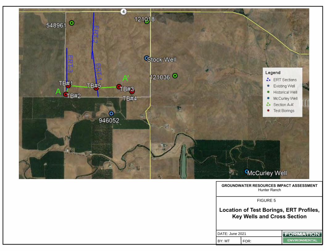
DATE: June 2021BY: MT FOR:
FIGURE 5
Location of Test Borings, ERT Profiles, Key Wells and Cross Section
GROUNDWATER RESOURCES IMPACT ASSESSMENT Hunter Ranch
A’A
ERT-3
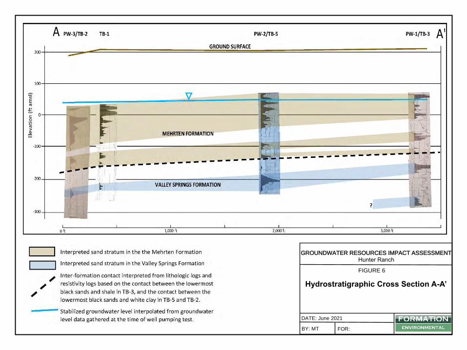
DATE: June 2021BY: MT FOR:
FIGURE 6
Hydrostratigraphic Cross Section A-A’
GROUNDWATER RESOURCES IMPACT ASSESSMENT Hunter Ranch
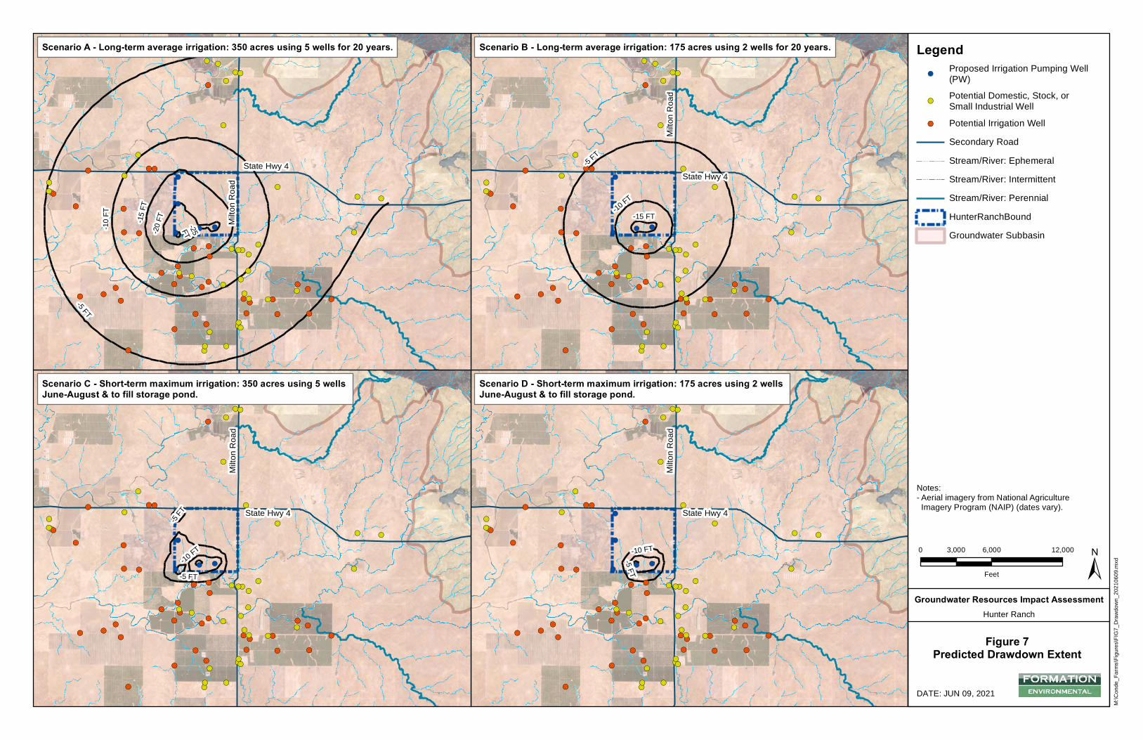
&)
&)&'
&'
&'&' &)
&)
&)
&)&)&)&'
&'&' &)
&'
&'
&'
&)
&)
&)
&)
&)
&)
&'
&'&'
&)
&) &)
&)&'&)
&)
&'
&)
&'
&'
&'&'&)
&' &'
&'
&'
&) &'
&'&)
&)&)&)
&)&)&)
&'&)
&'
&'
&'
&'&'&'
&'
&'
&)
&)
&)
&'
&)
&)
!(!(!(
!(
!(-5 FT
-10 FT
State Hwy 4
Milto
n Roa
d
&)
&)&'
&'
&'&' &)
&)
&)
&)&)&)&'
&'&' &)
&'
&'
&'
&)
&)
&)
&)
&)
&)
&'
&'&'
&)
&) &)
&)&'&)
&)
&'
&)
&'
&'
&'&'&)
&' &'
&'
&'
&) &'
&'&)
&)&)&)
&)&)&)
&'&)
&'
&'
&'
&'&'&'
&'
&'
&)
&)
&)
&'
&)
&)
!(!(!(
!(
!(
-10 FT
-5 FT
-5 FT
State Hwy 4
Milto
n Roa
d
&)
&)&'
&'
&'&' &)
&)
&)
&)&)&)&'
&'&' &)
&'
&'
&'
&)
&)
&)
&)
&)
&)
&'
&'&'
&)
&) &)
&)&'&)
&)
&'
&)
&'
&'
&'&'&)
&' &'
&'
&'
&) &'
&'&)
&)&)&)
&)&)&)
&'&)
&'
&'
&'
&'&'&'
&'
&'
&)
&)
&)
&'
&)
&)
!(!(!(
!(
!(
-5 FT
-10 FT-15 FT
State Hwy 4
Milto
n Roa
d
&)
&)&'
&'
&'&' &)
&)
&)
&)&)&)&'
&'&' &)
&'
&'
&'
&)
&)
&)
&)
&)
&)
&'
&'&'
&)
&) &)
&)&'&)
&)
&'
&)
&'
&'
&'&'&)
&' &'
&'
&'
&) &'
&'&)
&)&)&)
&)&)&)
&'&)
&'
&'
&'
&'&'&'
&'
&'
&)
&)
&)
&'
&)
&)
!(!(!(
!(
!(
Milto
n Roa
d
State Hwy 4
-25FT-20 FT-10
FT -15 FT
-5 FT
M:\C
onde
_Farm
s\Figu
res\FI
G7_D
rawdo
wn_2
0210
609.m
xd
DATE: JUN 09, 2021
0 6,000 12,0003,000
Feet ±Groundwater Resources Impact Assessment
Hunter Ranch
Figure 7Predicted Drawdown Extent
Legend!(
Proposed Irrigation Pumping Well(PW)
&)Potential Domestic, Stock, orSmall Industrial Well
&' Potential Irrigation WellSecondary RoadStream/River: EphemeralStream/River: IntermittentStream/River: PerennialHunterRanchBoundGroundwater Subbasin
Scenario A - Long-term average irrigation: 350 acres using 5 wells for 20 years. Scenario B - Long-term average irrigation: 175 acres using 2 wells for 20 years.
Scenario C - Short-term maximum irrigation: 350 acres using 5 wells June-August & to fill storage pond.
Scenario D - Short-term maximum irrigation: 175 acres using 2 wells June-August & to fill storage pond.
Notes:- Aerial imagery from National Agriculture Imagery Program (NAIP) (dates vary).
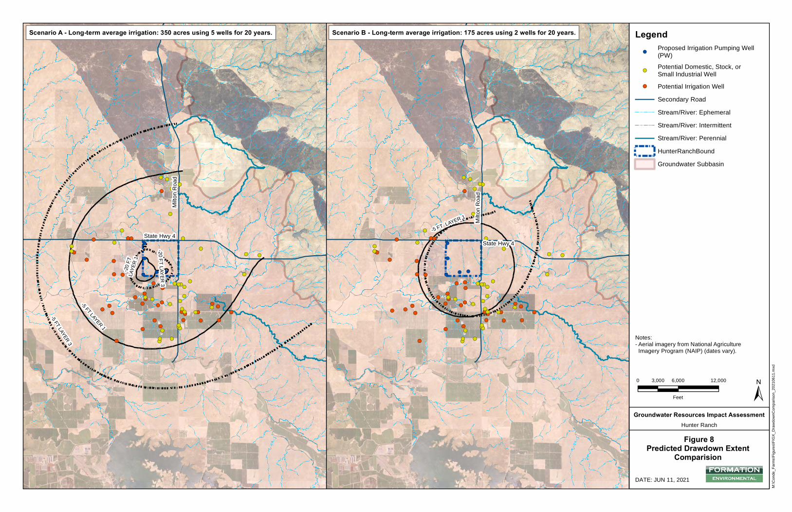
&)
&)&'
&'
&'&' &)
&)
&)
&)&)&)&'
&'&' &)
&'
&'
&'
&)
&)
&)
&)
&)
&)
&'
&'&'
&)
&) &)&)&'&)
&)
&'
&)
&'
&'
&'&'&)
&' &'
&'
&'&) &'
&'&)
&)&)&)
&)&)&)
&' &)
&'
&'
&'&'&'
&'
&'
&'
&)
&)
&)
&'&)
&)
!(!(!(
!(
!(
-5 FT LAYER 1 Milto
n Roa
d
State Hwy 4
&)
&)&'
&'
&'&' &)
&)
&)
&)&)&)&'
&'&' &)
&'
&'
&'
&)
&)
&)
&)
&)
&)
&'
&'&'
&)
&) &)&)&'&)
&)
&'
&)
&'
&'
&'&'&)
&' &'
&'
&'&) &'
&'&)
&)&)&)
&)&)&)
&' &)
&'
&'
&'&'&'
&'
&'
&'
&)
&)
&)
&'&)
&)
!(!(!(
!(
!(
State Hwy 4
Milto
n Roa
d
-20 FT
LAYE
R 1
-5 FT LAYER 1
-20 FT LAYER 3
-5 FT LAYER 3
M:\C
onde
_Farm
s\Figu
res\FI
GX_D
rawdo
wnCo
mpari
son_
2021
0611
.mxd
DATE: JUN 11, 2021
0 6,000 12,0003,000
Feet ±Groundwater Resources Impact Assessment
Hunter Ranch
Figure 8Predicted Drawdown Extent
Comparision
Legend!(
Proposed Irrigation Pumping Well(PW)
&)Potential Domestic, Stock, orSmall Industrial Well
&' Potential Irrigation WellSecondary RoadStream/River: EphemeralStream/River: IntermittentStream/River: PerennialHunterRanchBoundGroundwater Subbasin
Scenario A - Long-term average irrigation: 350 acres using 5 wells for 20 years. Scenario B - Long-term average irrigation: 175 acres using 2 wells for 20 years.
Notes:- Aerial imagery from National AgricultureImagery Program (NAIP) (dates vary).
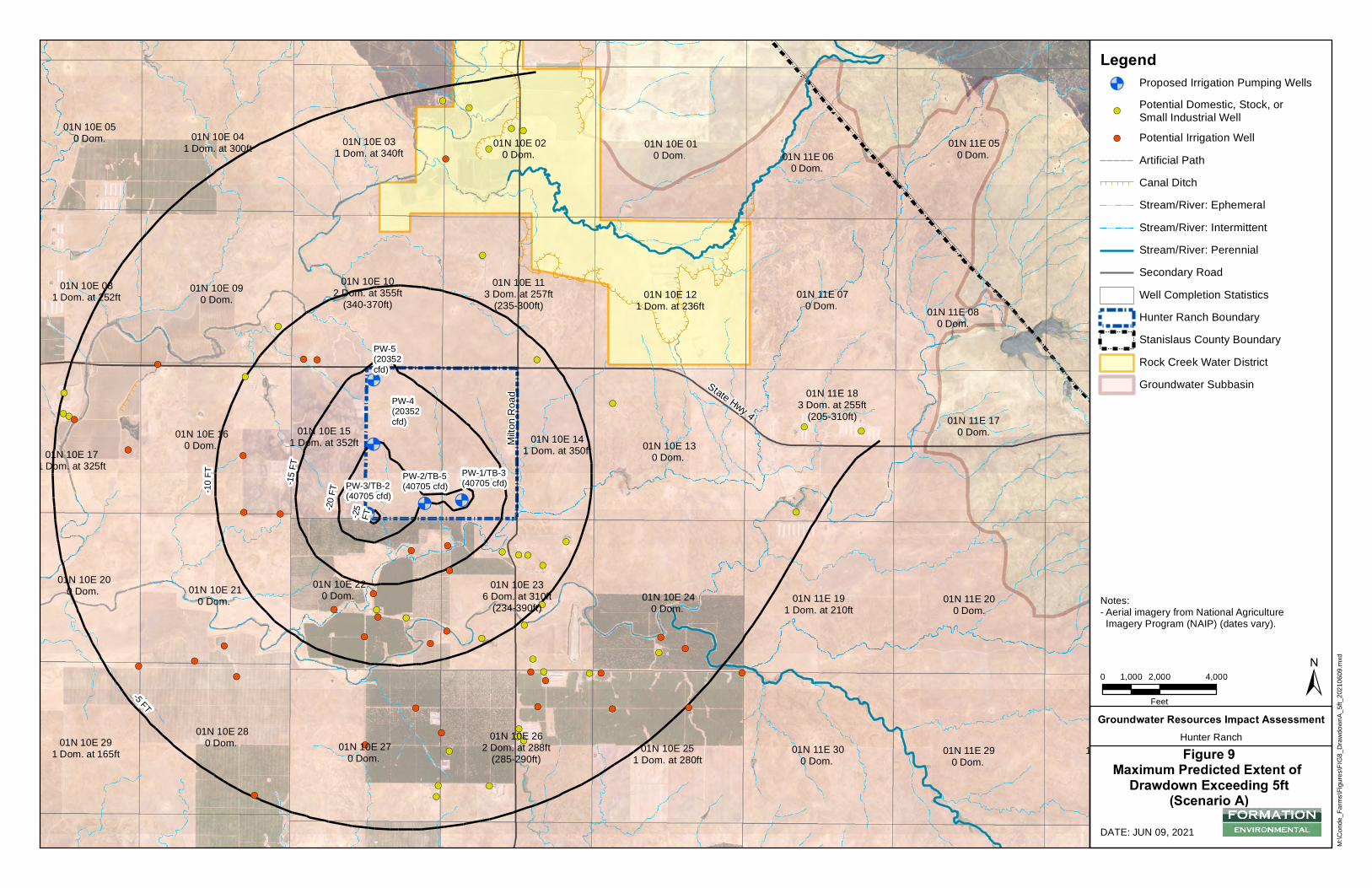
&)
&)&'
&'
&'
&'&)
&)
&)
&)
&)&)&'
&'
&' &)
&'
&'
&'
&)
&)
&)
&)
&)
&)
&'
&' &'
&)
&)&)
&)&'
&)
&)
&'
&)
&'
&'
&'
&'
&)
&' &'
&'
&'
&)&'
&'&)
&)&)
&)
&)
&)
&)
&'&)
&'
&'
&'
&'&'
&'
&'
&'
&)
&)
&)
&'
&)
&)
&<&<&<
&<
&<
PW-1/TB-3(40705 cfd)PW-2/TB-5
(40705 cfd)PW-3/TB-2(40705 cfd)
PW-4(20352cfd)
PW-5(20352cfd)
01N 10E 010 Dom.
01N 10E 020 Dom.
01N 10E 031 Dom. at 340ft
01N 10E 041 Dom. at 300ft
01N 10E 050 Dom.
01N 10E 081 Dom. at 252ft 01N 10E 09
0 Dom.01N 10E 10
2 Dom. at 355ft(340-370ft)
01N 10E 113 Dom. at 257ft
(235-300ft)01N 10E 12
1 Dom. at 236ft
01N 10E 130 Dom.
01N 10E 141 Dom. at 350ft
01N 10E 151 Dom. at 352ft01N 10E 16
0 Dom. 01N 10E 171 Dom. at 325ft
01N 10E 200 Dom. 01N 10E 21
0 Dom. 01N 10E 22
0 Dom. 01N 10E 23
6 Dom. at 310ft(234-390ft)
01N 10E 240 Dom.
01N 10E 251 Dom. at 280ft
01N 10E 262 Dom. at 288ft
(285-290ft)01N 10E 27
0 Dom.
01N 10E 280 Dom. 01N 10E 29
1 Dom. at 165ft
01N 11E 050 Dom. 01N 11E 06
0 Dom.
01N 11E 070 Dom. 01N 11E 08
0 Dom.
01N 11E 170 Dom.
01N 11E 183 Dom. at 255ft
(205-310ft)
01N 11E 191 Dom. at 210ft
01N 11E 200 Dom.
01N 11E 281 Dom. at 240ft
(240-240ft)01N 11E 29
0 Dom. 01N 11E 30
0 Dom.
Milto
n Roa
d State Hwy 4
-25 FT
-20 FT-10
FT -15 FT
-5 FT
M:\C
onde
_Farm
s\Figu
res\FI
G8_D
rawdo
wnA_
5ft_2
0210
609.m
xd
DATE: JUN 09, 2021
0 2,000 4,0001,000
Feet±
Groundwater Resources Impact AssessmentHunter RanchFigure 9
Maximum Predicted Extent of Drawdown Exceeding 5ft
(Scenario A)
Legend&< Proposed Irrigation Pumping Wells
&)Potential Domestic, Stock, orSmall Industrial Well
&' Potential Irrigation WellArtificial PathCanal DitchStream/River: EphemeralStream/River: IntermittentStream/River: PerennialSecondary RoadWell Completion StatisticsHunter Ranch Boundary
!!
!!
! ! ! ! ! !
!!
!!!!!!
Stanislaus County BoundaryRock Creek Water DistrictGroundwater Subbasin
Notes:- Aerial imagery from National AgricultureImagery Program (NAIP) (dates vary).
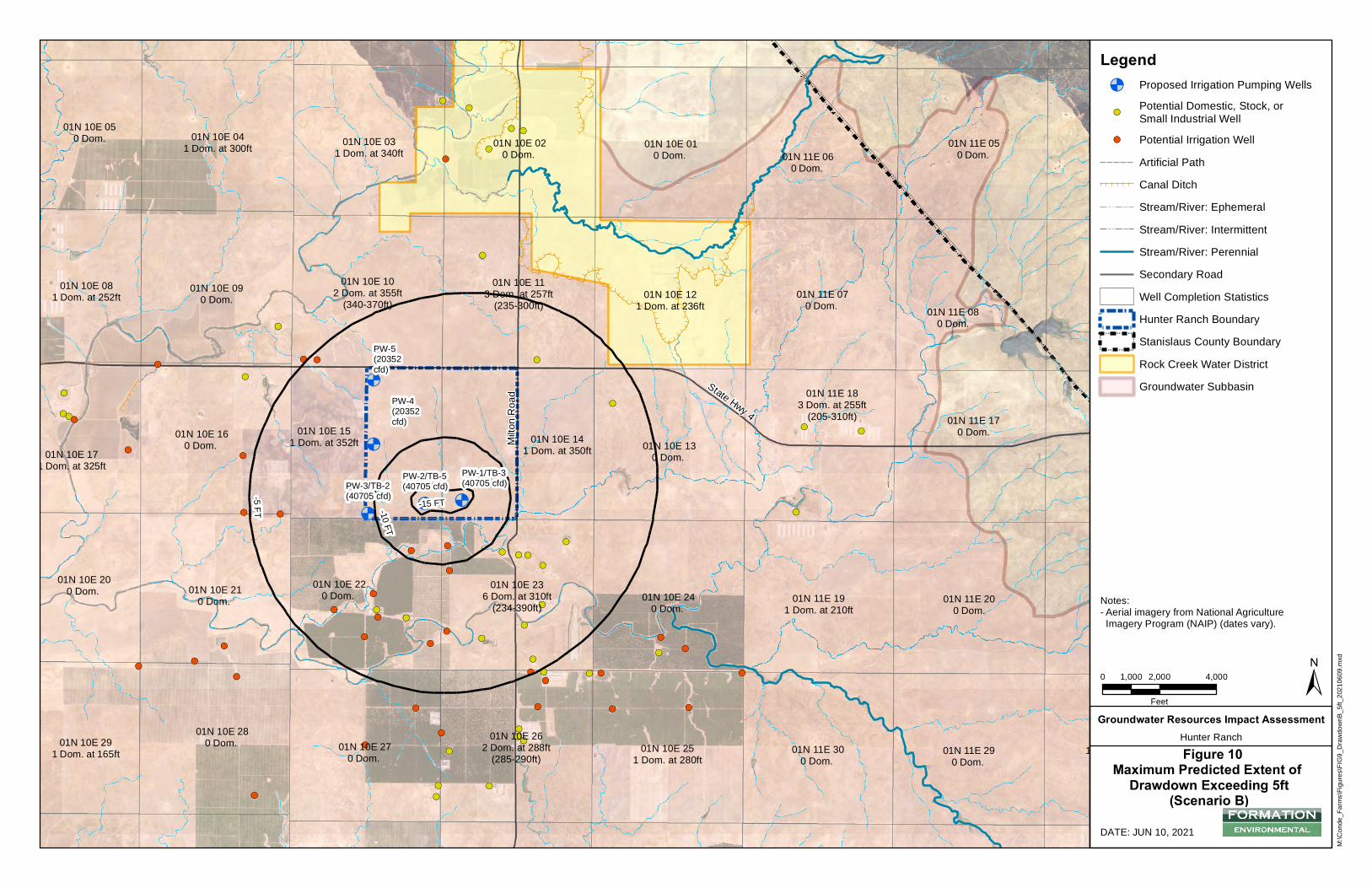
&)
&)&'
&'
&'
&'&)
&)
&)
&)
&)&)&'
&'
&' &)
&'
&'
&'
&)
&)
&)
&)
&)
&)
&'
&' &'
&)
&)&)
&)&'
&)
&)
&'
&)
&'
&'
&'
&'
&)
&' &'
&'
&'
&)&'
&'&)
&)&)
&)
&)
&)
&)
&'&)
&'
&'
&'
&'&'
&'
&'
&'
&)
&)
&)
&'
&)
&)
&<&<&<
&<
&<
PW-1/TB-3(40705 cfd)PW-2/TB-5
(40705 cfd)PW-3/TB-2(40705 cfd)
PW-4(20352cfd)
PW-5(20352cfd)
01N 10E 010 Dom.
01N 10E 020 Dom.
01N 10E 031 Dom. at 340ft
01N 10E 041 Dom. at 300ft
01N 10E 050 Dom.
01N 10E 081 Dom. at 252ft 01N 10E 09
0 Dom.01N 10E 10
2 Dom. at 355ft(340-370ft)
01N 10E 113 Dom. at 257ft
(235-300ft)01N 10E 12
1 Dom. at 236ft
01N 10E 130 Dom.
01N 10E 141 Dom. at 350ft
01N 10E 151 Dom. at 352ft01N 10E 16
0 Dom. 01N 10E 171 Dom. at 325ft
01N 10E 200 Dom. 01N 10E 21
0 Dom. 01N 10E 22
0 Dom. 01N 10E 23
6 Dom. at 310ft(234-390ft)
01N 10E 240 Dom.
01N 10E 251 Dom. at 280ft
01N 10E 262 Dom. at 288ft
(285-290ft)01N 10E 27
0 Dom.
01N 10E 280 Dom. 01N 10E 29
1 Dom. at 165ft
01N 11E 050 Dom. 01N 11E 06
0 Dom.
01N 11E 070 Dom. 01N 11E 08
0 Dom.
01N 11E 170 Dom.
01N 11E 183 Dom. at 255ft
(205-310ft)
01N 11E 191 Dom. at 210ft
01N 11E 200 Dom.
01N 11E 281 Dom. at 240ft
(240-240ft)01N 11E 29
0 Dom. 01N 11E 30
0 Dom.
Milto
n Roa
d State Hwy 4
-10 FT
-15 FT
-5 FT
M:\C
onde
_Farm
s\Figu
res\FI
G9_D
rawdo
wnB_
5ft_2
0210
609.m
xd
DATE: JUN 10, 2021
0 2,000 4,0001,000
Feet±
Groundwater Resources Impact AssessmentHunter RanchFigure 10
Maximum Predicted Extent of Drawdown Exceeding 5ft
(Scenario B)
Legend&< Proposed Irrigation Pumping Wells
&)Potential Domestic, Stock, orSmall Industrial Well
&' Potential Irrigation WellArtificial PathCanal DitchStream/River: EphemeralStream/River: IntermittentStream/River: PerennialSecondary RoadWell Completion StatisticsHunter Ranch Boundary
!!
!!
! ! ! ! ! !
!!
!!!!!!
Stanislaus County BoundaryRock Creek Water DistrictGroundwater Subbasin
Notes:- Aerial imagery from National AgricultureImagery Program (NAIP) (dates vary).
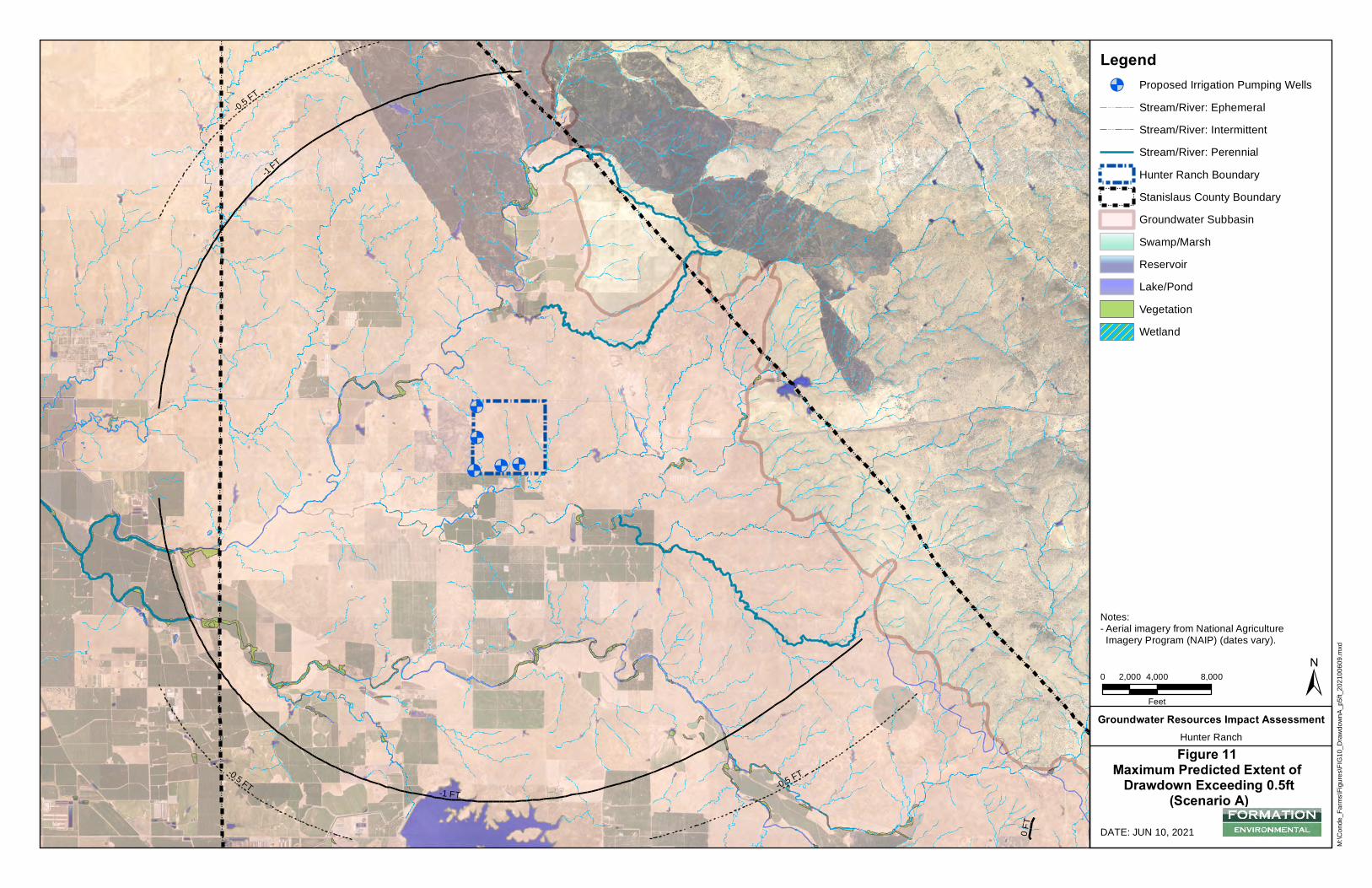
!!
!!
!!
!!
!!
!!
! !
!!
!!
!!
!!!!
!
!!
!!
!!
!!
!!
!!
!!
!!
!!
!!
!!
!!
!!
!!
!!
!!
!!
!!
!!
!!
!!
!!
!!
!!
!!
!!
!!
!!
!!
!!
!!
!!
!!
!!
!!
!!
!!
!!
!!
!!
!!
!!
!!
!!
!!
!!
!!
!!
!!
!!
!!
!!
!!
!!
!!
!!
!!
!!
!!
!!
!!
!!
!!
!!
!!
!!
!!
!!
!!
!!
!!
!!
!!
!!
!!
!!
!!
!!
!!
!!
!!
!!
!!
!!
!!
!!
!!
!!
!!
!!
!!
!!
!!
!!
!!
!!
!!
!!
!!
!!
!!
!!
!!
!!
!!
!!
!!
!!
!!
!!
!!
!!
!!
!!
!!
!!
!!
!!
!!
!!
!!
!!
!!
!!
!!
!!
!!
!!
!!
!!
!!
!!
!!
!!
!!
!!
!!
!!
!!
!!
!!
!!
!
!!
!!
!!
!!
!!
!!
!!
!!
!!
!!
!!
!!
!!
!!
!!
!!
!!
!!
!!
!!
!!
!!
!!
!!
!!
!!
!!
!!
!!
!!
!!
!!
!!
!!
!!
!!
!!
!!
!!
!!
!!
!!
!!
!!
!!
!!
!!
!!
!!
!!
!!
!!
!!
!!
!!
!!
!!
!!
!!
!!
!!
!
!
!!
!!
!!
!!
!!
!!
!!
!!
!!
!!
!!
!!
!!
!!
!!
!!
!!
!!
!!
!!
!!
!!
!!
!!
!!
!!
!!
!!
!!
!!
!!
!!
!!
!!
!!
!!
!!
!!
!!
!!
!!
!!
!!
!!
!!
!!
!!
!!
!!
!!
!!
!!
!!
!!
!!
!!
!!
!!
!!
!!
!!
!!
!!
!!
!!
!!
!!
!!
!!
!!
!!
!!
!!
!!
!!
!!
!!
!!
!
!
!!
!!
!!
!!
!!
!!
!!
!!
!!
!!
!!
!!
!!
!!
!!
!!
!!
!!
!!
!!
!!
!!
!!
!!
!!
!!
!!
!!
!!
!!
!!
!!
!!
!!
!!
!!
!!
!!
!!
!!
!!
!!
!!
!!
!!
!!
!!
!!
!!
!!
!!
!!
!!
!!
!!
!!
!!
!!
!!
!!
!!
!!
!!
!!
!!
!!
!!
!!
!!
!!
!!
!!
!
!
!!
!!
!!
!!
!!
!!
!!
!!
!!
!!
!!
!!
!!
!!
!!
!!
!!
!!
!
!
!!
!!
!!
!!
!!
!!
!!
!!
!!
!!
!!
!!
!!
!!
!!
!!
!!
!!
!!
!!
!!
!!
!!
!!
!!
!!
!!
!!
!!
!!
!!
!!
!!
!
!
!!
!
!
!!
!!
!!
!!
!!
!!
!!
!!
!!
!!
!!
!!
!!
!!
!!
!!
!!
!!
!!
!!
!!
!!
!!
!!
!!
!!
!!
!!
!!
!!
!!
!!
!!
!!
!!
!!
!!
!!
!!
!!
!!
!!
!!
!!
!!
!!
!!
!!
!!
!!
!!
!!
!!
!!
!!
!!
!!
!!
!!
!!
!!
!!
!!
!!
!!
!!
!!
!!
!!
!!
!!
!!
!!
!!
!!
!!
!!
!!
!!
!!
!!
!!
!!
!!
!!
!!
!!
!!
!!
!!
!!
!!
!!
!!
!!
!!
!!
!!
!!
!!
!!
!!
!!
!!
!!
!!
!!
!!
!!
!!
!!
!!
!!
!!
!!
!!
!!
!!
!!
!!
!!
!!
!!
!!
!!
!!
!!
!!
!!
!!
!!
!!
!!
!!
!!
!!
!!
!!
!!
!!
!!
!!
!!
!!
!!
!!
!!
!!
!!
!!
!!
!!
!!
!!
!!
!!
!!
!!
!!
!!
!!
!!
!!
!!
!!
!!
!!
!!
!!
!!
!!
!!
!!
!!
!!
!!
!!
!!
!!
!!
!!
!!
!!
!!
!!
!!
!!
!!
!!
!!
!!
!!
!!
!!
!!
!!
!!
!!
!!
!!
!!
!!
!!
!!
!!
!!
!!
!!
!!
!!
!!
!!
!!
!!
!!
!!
!!
!!
!!
!!
!!
!!
!!
!!
!!
!!
!!
!!
!!
!!
!!
!!
!!
!!
!!
!!
!!
!!
!!
!
!
!!
!!
!!
!!
!
!
!!
!
!!
!
!!
! !
! !
! !
! !
!!
!!
!!
!!
!!
!
!!
!
!!
! !!
!
!!
!!!
!
!!
!!
! !
!!
!!!!
!!
!!
!!
!!
!!
!!
!!
!!
!!
!! !
!
!!
!
! ! ! !!
!!
!!
!!
!
!
!!
!!
!!
!!
!!
!!
!!
!!
!!
!!
!!
!!
!!
!!
!!
!!
!!
!!
!!
!!
!!
!!
!!
!!
!!
!!
!!
!!
!!
!!
!!
!!
!!
!!
!!
!
!
!!
!!
!!
!!
!!
!!
!!
!!
!!
!!
!!
!!
!!
!!
!!
!!
!!
!
!
!!
!!
!!
!!
!
!
!!
!!
!!
!!
!!
!!
!!
!!
!!
!!
!!
!
!
!!
!!
!!
!!
!!
!!
!!
!!
!!
!!
!!
!!
!!
!!
!!
!!
!!
!!
!!
!!
!!
!!
!!
!
!
!!
!!
!!
!!
!!
!!
!!
!!
!!
!!
!!
!!
!!
!!
!!
!!
!!
!!
!!
!!
!!
!!
!!
!!
!!
!!
!!
!!
!!
!!
!
!
!!
!
!
!!
!!
!
!
!!
!!
!!
!
!
!!
!!
!!
!!
!!
!!
!
!!!!!
!!!!
!!!!
!!
!!
!!
!!
!!
!!
!
!
!!
!!
!!
!!
!!
!!
!
!!
!
!!
!
!
!!
!!
!!
!!
!!
!!
!!
!!
!!
!!
!!
!!
!!
!!
!!
!!
!!
!!!!
!!
!!!!
!!
!!
!!
!!
!!
!!
!!
!!
!!
!!
!!
!!
!!
!
!
!!
!
!
!!
!!
!!
!!
!!
!
!
!!
!!
!!
!!
!
!!!
!
!
!!
!
!
!!
!!
!!
!!
!!
!!
!!
!!
!!
!!
!!
!!
!!
!!
!!
!!
!!
!!
!!
!!
!!
!!
!!
!!
!!
!!
!!
!!
!
!
!!
!
!
!!
!!
!!
!!
!!
!!
!!
!!
!!
!!
!!
!!
!!
!!
!
!!
!!
!!
!
!!
!!
!!
!!
!!
!!
!
!
!!
!
!
!!
!!
!!
!
!
!!
!!
!!
!
!
!!
!
!
!!
!!
!!
!!
!!
!!
!!
!!
!!
!!
!!
!!
!!
!!
!
!
!!
!!
!
!! !
!!
!!
!!
!
!!
!
!!
!!
! !
!!
!!
!
! !!
!!
! !
! !
! !
!!
!!
!!
!!
!!
!
!
!!
!!
!!
!!
! !
!!
!!
!!
!!
!!
!!
!!
!!
!!
!!
!!
!!
!!
!!
!!
!!
!!
!!
!
!
!
!!
!
!!
!!
!!
!!
!!
!!
!!
!
!!
!
!!
!!
!!
!!
!
!
!!
!!
!!
!!
!!
!
!!
!
!!!!
!!
!!
!!!!
!!
!!
!!
!!
!!
!!
!!
!!
!!
!!
!!
!!
!!
!!
!!
!!
!!
!!
!!
!!
!!
!!!
!
!!
!!
!!
!!
!
!!
!
!!
!!
!!
!!
!!
!!
! !
!!
!!
!!
!!
!!
!!
!!
!!
!!
!!
!!
!!
!!
!!
!!
!!
!!
!!
!!
!!
!!
!!
! !!!
!!
!
!
! !
!!
!
!
!!
!!
!!
!!
!!
!!
!!
!!
!!
!!
!!
!!
!!
!!
!!
!!
!!
!!
!!
!!
!!
!!
!!
!!
!!
!!
!!
!!
!!
!!
!!
!!
!!
!!
!!
!!
!!
!!
!!
!!
!!
!!
!!
!!
!!
!!
!!
!!
!!
!
!
!!
!!
!!
!!
!!
!!
!!
!!
!!
!!
!!
!!
!!
!!
!!
!!
!!
!!
!!
!!
!!
!!
!!
!!
!!
!!
!!
!!
!!
!!
!!
!!
!!
!!
!!
!!
!!
!!
!!
!!
!!
!!
!!
!!
!!
!!
!!
!!
!!
!!
!!
!!
!!
!!
!!
!!
!!
!!
!!
!!
!!
!!
!!
!!
!!
!
!! !
! !
! !!
!
!!
!!
!
!
!!
! !
! !
!!
!!
!
!
!!
!!
!!
! !
!!
!!
!!
!
!
! !
!!
!
!
!!
! !
!
!! !
!!
!!
!!
!!
!!
!!
!! !
!
!!
!
!!
!
! !
!
!
!!
! !
!!
!!
!!
! !!
! !
!
!! !
!
!!
!
!
!!
! !
!!
!!
!!
!!
!!
!!
!!
!!
! ! ! !
!!
!!
!!
!!
!!
!!
!!
!!
!!
!!
! !
!!
!!
!!
!!
! !
!
!
!
!!
!
! !
!!
!!
! !
!!
!!
!!
!!
!!
!
!
! !! !
!!
!!
! !!
!
!
!
! !
!
!
!
!
!!
!!
!!
!!
!!
! !
! !
!!
! !
!!
!
!!
!
!!
!!
!
!
!
!
!!
!!
!
!!
!
!
!!
!
!!
!! !
!
! !
!!
!!
!!
! !
!
!
!!
!!
! !
!!
!!
!!
!!
! !
! !
!
!
!
!
!
!
!
!
! !
! !
!!
!
!
!!
!!
!!
!!
!!
!!
!!
!!
! !
!
!
! !
!!
!
!
! !
!!
!!
! !
! !
!!
!!
!
!!
!
! !
!!
! !
!!
! ! ! !
!!
!!
!!
!!
!!
!!
!
!!
!
!!
!!
!!
! !
!!
!!
!
!
!!
!!
! !
! !
!!
!!
!
!
!
!
!!
!!
!!
!!
! !
!!
!!
!!
!! !
!
!!
!!
!
!
!
!
!!
!!
!!
!!
!!
!!
! !
!!
!!
!!
!!
!!
!!
! ! ! !
!!
!!
! !! !
!!
!!
&<&<&<
&<
&<
-0.5 FT
-1 FT
-0.5 FT -0.5 FT
-1 FT
0 FT
M:\C
onde
_Farm
s\Figu
res\FI
G10_
Draw
down
A_p5
ft_20
2100
609.m
xd
DATE: JUN 10, 2021
0 4,000 8,0002,000
Feet±
Groundwater Resources Impact AssessmentHunter RanchFigure 11
Maximum Predicted Extent of Drawdown Exceeding 0.5ft
(Scenario A)
Legend&< Proposed Irrigation Pumping Wells
Stream/River: EphemeralStream/River: IntermittentStream/River: PerennialHunter Ranch Boundary
!!
!!
! ! ! ! ! !
!!
!!!!!!
Stanislaus County BoundaryGroundwater SubbasinSwamp/MarshReservoirLake/PondVegetationWetland
Notes:- Aerial imagery from National AgricultureImagery Program (NAIP) (dates vary).
GROUNDWATER RESOURCES IMPACT ASSESSMENT, HUNTER RANCH, STANISLAUS COUNTY, CALIFORNIA
APPENDIX A
Supplemental Well Permit Application

DEPARTMENT OF ENVIRONMENTAL RESOURCES 3800 Cornucopia Way, Suite C, Modesto, CA 95358-9592 Phone: 209.525.6770 Fax: 209.525.6773
Page 1 of 15
SUPPLEMENTAL APPLICATION FOR NON-EXEMPT WELLS
The following supplemental information is required for all wells that are determined not to be exempt from the prohibitions and requirements of the County Groundwater Ordinance effective November 25, 2014.
Applicant Information
Name of Applicant: Firm (if applicable):
Address: City: State: Zip Code:
Daytime Phone Number: Fax Number Email:
Name of Owner (if different from Applicant): Firm (if applicable):
Address: City: State: Zip Code:
Daytime Phone Number: Fax Number Email:
Licensed Professional Information (Professional Engineer or Geologist)
Name of Licensed Professional: Firm:
Address: City: State: Zip Code:
Daytime Phone Number: Fax Number Email:
License Type and Number: Sections of Application Completed:
Name of Licensed Professional: Firm:
Address: City: State: Zip Code:
Daytime Phone Number: Fax Number Email:
License Type and Number: Sections of Application Completed:
For County Use Only
NON-EXEMPT WELL CONSTRUCTION PERMIT SUPPLEMENTAL APPLICATION
Page 2 of 15
I. Location Map
Provide a map or maps showing the following: A. Well location B. Outline of property to be served by the well, and APN number(s) C. Outline of contiguous owned property surrounding the well location, and APN
number(s) D. Streams and lakes within 2 miles
E. Springs, seeps, wetlands and other Groundwater-Dependent Ecosystems (GDEs) within 3 miles or within the predicted area of 0.5 feet of drawdown on the date that a Groundwater Sustainability Plan will be adopted. (Use the drawdown analysis in Section IV, USGS topographic maps, aerial photo imagery available from the internet or other sources, state and federal wetland and hydrology databases, studies, County resources, or knowledge of the area to identify any areas where groundwater may be discharging to surface water or groundwater-dependent vegetation may exist.)
F. Existing sewer lines, cisterns, septic disposal systems and animal confinements within 250 feet
G. Concentrated Animal Feeding Operations (CAFOs) within 1 mile H. Reported hazardous materials and hazardous waste sites or release incidents
within 1 mile (from Section VI.A.)
I. Existing wells on the property, keyed to a table that provides well use, depth, diameter, screen interval, and pumping rate. If available, attach information regarding any specific capacity or other pumping tests completed.
J. Predicted area of drawdown exceeding 0.5 and 5 feet (from Section IV, below).
K. For proposed wells within 2 miles of areas underlain by the Corcoran Clay and
completed below the depth of the Corcoran Clay, the location of any infrastructure within 2 miles that is potentially sensitive to subsidence. This includes, but is not necessarily limited to, canals, ditches, pipelines, utility corridors, and roads.
For County Use Only
Data Adequate? ☐ Yes ☐ No Comments:
mtietze
Text Box
GRIA Figure 3
mtietze
Text Box
GRIA Figures 1 and 3
mtietze
Text Box
GRIA Figure 3
mtietze
Text Box
GRIA Figure 2 and 4
mtietze
Text Box
GRIA Figures 2 and 11
mtietze
Text Box
None
mtietze
Text Box
None
mtietze
Text Box
None
mtietze
Text Box
GRIA Fig 5; Tbl 4
mtietze
Text Box
N/A
mtietze
Text Box
GRIA Fig 7-11

NON-EXEMPT WELL CONSTRUCTION PERMIT SUPPLEMENTAL APPLICATION
Page 3 of 15
II. Pumping and Water Use Data
Provide the following information regarding groundwater extraction from the proposed well.
A. For irrigation wells, use the following table to calculate the water demand to beserved by the proposed well.
Crop Type Irrigated Acres
Irrigation System Type
Irrigation Season Length (days)
Average Annual
Demand (AFY)
Maximum Monthly Demand (MGM)
Peak Daily Demand (GPM)
B. Estimated pumping rate of proposed well: _________ gpmC. Anticipated pumping schedule for proposed well (hours per day, days per week,
approximate annual start date and stop date for seasonal pumping):
D. Estimated annual extraction volume: ________ galE. Estimated cumulative extraction volume prior to January 1, 2022: ________ galF. Estimated cumulative extraction volume in 20 years: ________ galG. Planned water use: ☐ Irrigation ☐ Stock ☐ Domestic ☐ Municipal
☐ Industrial ☐ Other (describe): ____________________________________H. Size of area to be served by the well: __________ acresI. Size of contiguous owned property on which the well is located: ________ acres
For County Use Only
Data Adequate? ☐ Yes ☐ No Comments:
mtietze
Text Box
Pumping schedule will depend on the time of year and will generally be limited to the irrigation season. Long term average pump duty will be approximately 20%. During the peak irrigation season (June, July and August), pump duty may be up to 50%.
mtietze
Text Box
(Ph 2: up to 191 MG additional)
mtietze
Text Box
See Project Description for additional detail. Phase I includes converting two test wells into production wells to irrigate 175 acres. Phase II includes constructing up to three additional wells to irrigate up to an additional 175 acres. The number of wells and pumping rate during Phase II will be determined by monitoring and adaptive management.
mtietze
Text Box
(Ph 2: up to 3825 MG additional)
mtietze
Text Box
(Ph 2: up to 175 acres additional)
mtietze
Text Box
See attached GRIA report for details regaridng proposed wells, water demand, and pumping schedules.

NON-EXEMPT WELL CONSTRUCTION PERMIT SUPPLEMENTAL APPLICATION
Page 6 of 15
V. Wells in a Groundwater Level Management Zone
If the proposed well is in a County-designated Groundwater Level Management Zone, the Applicant shall provide the following:
A. A Groundwater Extraction Offset Plan that demonstrates that the proposed
groundwater extraction will be 100% offset. The scope of the Groundwater Extraction Offset Plan must be discussed with the DER and agreed to prior to implementation. The Plan shall include, at a minimum, the following:
1. The proposed method and location of offset; 2. The proposed timing and duration of offset; 3. Supporting calculations to demonstrate offset volume; and 4. Any assurances and/or agreements with other parties that verify their
agreement to support the proposed offset. OR B. A Groundwater Resources Investigation that demonstrates the proposed
groundwater extraction will not cause or contribute to Undesirable Results in the Groundwater Level Management Zone. The scope of the Groundwater Resources investigation must be discussed with the DER and agreed to prior to implementation and, at a minimum, shall include the following:
1. A summary of previous studies and reports; 2. A summary of available information regarding undesirable results in the area; 3. Analysis of local and regional groundwater level trends based on available well
hydrographs within no less than 5 miles of the proposed well; 4. Methods and data from any additional site specific hydrogeologic investigation; 5. An analysis of the local groundwater balance; 6. A prediction of future groundwater level drawdown and trends in the area with
and without the proposed well; 7. Evaluation whether the proposed well will cause or contribute to undesirable
results, and recommendations prevent them as needed; and; 8. Signature by a Registered Professional Geologist or Registered Professional
Engineer in California. AND C. A Groundwater Level Monitoring Plan that includes, at a minimum, the following: 1. A description of the aquifers to be monitored; 2. A description of any existing or new wells to be used, their locations,
construction specifications and completion depths; and 3. Water level measurement methods and frequency (minimum spring and fall). For County Use Only
Data Adequate? ☐ Yes ☐ No Comments:
mtietze
Text Box
NOT APPLICABLE

NON-EXEMPT WELL CONSTRUCTION PERMIT SUPPLEMENTAL APPLICATION
Page 7 of 15
VI. Regional Groundwater Level Decline and Storage Reduction
For all proposed well not located within a County-designated Groundwater Level Management Zone, the Applicant shall provide the following:
A. Calculate available aquifer storage beneath the contiguous property owned by the Applicant on which the proposed well is located: _______________ acre-feet
Parameter Value Source/Justification (attach additional information as needed)
Size of Property (acres) Aquifer Thickness (feet)
Specific Yield (assume 0.25 or provide justification for alternate value)
B. Divide the cumulative groundwater extraction volume prior to January 1, 2020 or 2022 by the available aquifer storage calculated above: ___________ %
C. Divide the cumulative groundwater extraction volume for the first 20 years of well operation by the available aquifer storage calculated above: ___________ %
D. If the cumulative extraction volume after 20 years exceeds 10% of available
aquifer storage, submit a Groundwater Level Monitoring Plan that includes, at a minimum, the following:
a. A description of the aquifers to be monitored; b. A description of any existing or new wells to be used, their locations,
construction specifications and completion depths; and c. Water level measurement methods and frequency (minimum spring and fall). For County Use Only
Data Adequate? ☐ Yes ☐ No Comments:
mtietze
Text Box
635 Enclosed GRIA Report
mtietze
Text Box
0.25
mtietze
Text Box
250 Enclosed GRIA Report
mtietze
Text Box
A groundwater monitoring and adaptive management plan will be prepared for County review and approval.
NON-EXEMPT WELL CONSTRUCTION PERMIT SUPPLEMENTAL APPLICATION
Page 8 of 15
VII. Water Quality Degradation
A. Provide a database search for reported hazardous materials and waste sites and release incidents near the proposed well with search radii that comply with ASTM Standard 1527. (Commercial database search services provide this service.)
B. Provide water quality data available within 1 mile of the proposed well for small water supply systems regulated by the County or the State, and from the State Geotracker website (http://geotracker.waterboards.ca.gov/) and from the USGS NWIS Database (http://maps.waterdata.usgs.gov/mapper/index.html).
C. If the well is located in a County-designated Groundwater Quality Protection Zone (in an area underlain by the Corcoran Clay), the Applicant shall provide data regarding the well seals and construction methods used to prevent communication between the unconfined aquifer system overlying the Corcoran Clay with the confined aquifer system underlying the Corcoran Clay.
D. If the well is located in a County-defined Groundwater Quality Study Zone (within 1 mile of a well that produces water with solute concentrations that exceed primary or secondary MCLs or other applicable Water Quality Objectives), or within 1 mile of a reported contamination incident identified by the database search, the Applicant shall submit a Groundwater Quality Investigation. The scope of the Groundwater Quality investigation must be discussed with the DER and agreed to prior to implementation. At a minimum, the Groundwater Quality Investigation shall include the following:
1. A summary of relevant data, studies and/or reports regarding the local aquifer system, groundwater quality and contaminant transport;
2. Analysis of local and regional groundwater quality trends based on available data in the area;
3. The methods and results of any additional site-specific hydrogeologic and groundwater quality investigation;
4. Evaluation of the potential effect of the proposed well on future groundwater quality trends and contaminant migration;
5. Evaluation whether the proposed groundwater extraction will cause or
contribute to groundwater quality degradation in excess of applicable standards for beneficial uses, or will interfere with groundwater quality management or remediation efforts overseen by State or Federal agencies; and
6. Signature by a Registered Professional Geologist or Registered Professional Engineer in California.
For County Use Only
Data Adequate? ☐ Yes ☐ No Comments:
mtietze
Text Box
See enclosed GRIA report
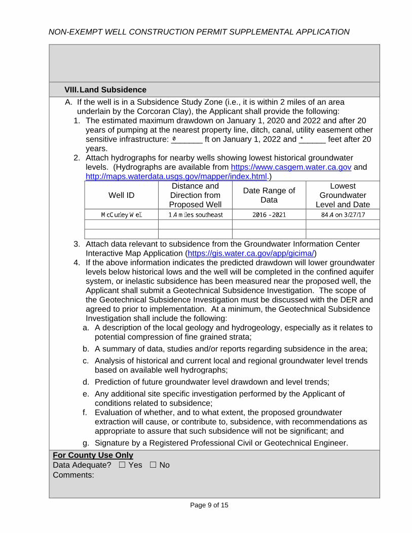
NON-EXEMPT WELL CONSTRUCTION PERMIT SUPPLEMENTAL APPLICATION
Page 9 of 15
VIII. Land Subsidence
A. If the well is in a Subsidence Study Zone (i.e., it is within 2 miles of an areaunderlain by the Corcoran Clay), the Applicant shall provide the following:
1. The estimated maximum drawdown on January 1, 2020 and 2022 and after 20years of pumping at the nearest property line, ditch, canal, utility easement othersensitive infrastructure: _______ ft on January 1, 2022 and ______ feet after 20years.
2. Attach hydrographs for nearby wells showing lowest historical groundwaterlevels. (Hydrographs are available from https://www.casgem.water.ca.gov andhttp://maps.waterdata.usgs.gov/mapper/index.html.)
Well ID Distance and Direction from Proposed Well
Date Range of Data
Lowest Groundwater
Level and Date
3. Attach data relevant to subsidence from the Groundwater Information CenterInteractive Map Application (https://gis.water.ca.gov/app/gicima/)
4. If the above information indicates the predicted drawdown will lower groundwaterlevels below historical lows and the well will be completed in the confined aquifersystem, or inelastic subsidence has been measured near the proposed well, theApplicant shall submit a Geotechnical Subsidence Investigation. The scope ofthe Geotechnical Subsidence Investigation must be discussed with the DER andagreed to prior to implementation. At a minimum, the Geotechnical SubsidenceInvestigation shall include the following:
a. A description of the local geology and hydrogeology, especially as it relates topotential compression of fine grained strata;
b. A summary of data, studies and/or reports regarding subsidence in the area;c. Analysis of historical and current local and regional groundwater level trends
based on available well hydrographs;d. Prediction of future groundwater level drawdown and level trends;e. Any additional site specific investigation performed by the Applicant of
conditions related to subsidence;f. Evaluation of whether, and to what extent, the proposed groundwater
extraction will cause, or contribute to, subsidence, with recommendations asappropriate to assure that such subsidence will not be significant; and
g. Signature by a Registered Professional Civil or Geotechnical Engineer.For County Use Only
Data Adequate? ☐ Yes ☐ No Comments:
mtietze
Text Box
See GRIA
mtietze
Text Box
NOT APPLICABLE
mtietze
Text Box
(Predicted max drawdown at property line 15' for Phase I and 35' for Phase II
mtietze
Text Box
As discussed in Section 3.3 of the GRIA, groundwater levels are relatively stable with approximately 5 feet of fluctuation over the period of record.
mtietze
Text Box
See enclosed GRIA report
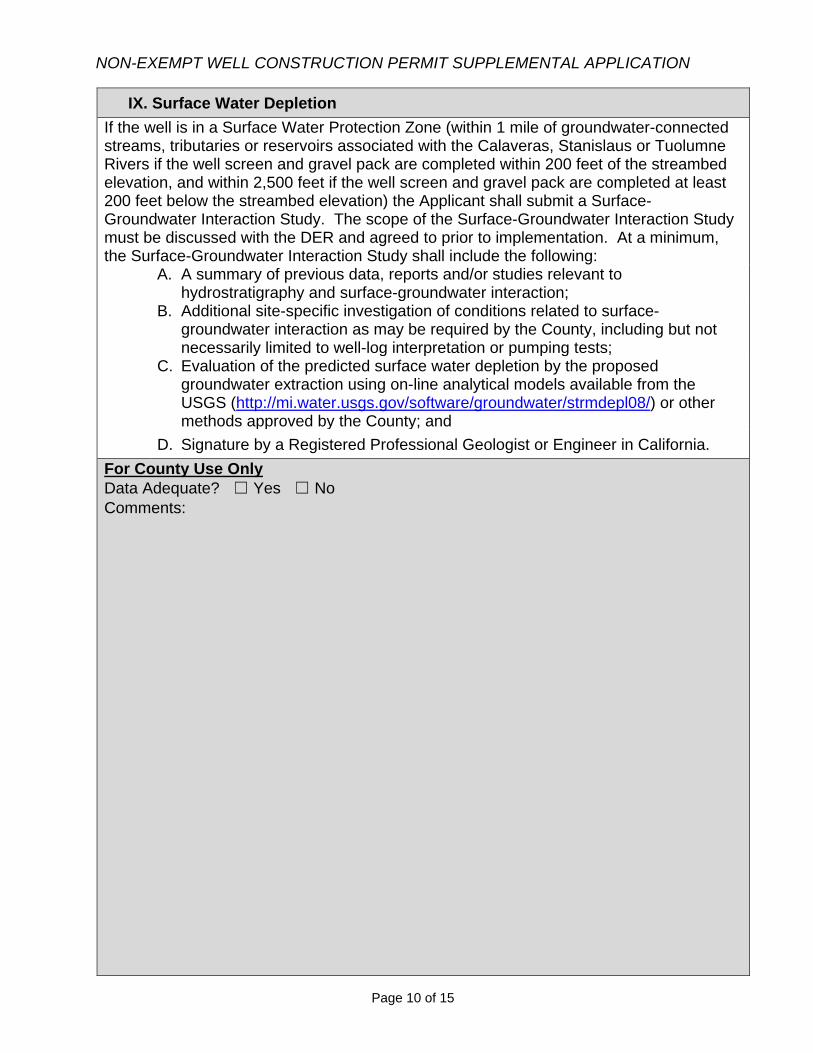
NON-EXEMPT WELL CONSTRUCTION PERMIT SUPPLEMENTAL APPLICATION
Page 10 of 15
IX. Surface Water Depletion
If the well is in a Surface Water Protection Zone (within 1 mile of groundwater-connected streams, tributaries or reservoirs associated with the Calaveras, Stanislaus or Tuolumne Rivers if the well screen and gravel pack are completed within 200 feet of the streambed elevation, and within 2,500 feet if the well screen and gravel pack are completed at least 200 feet below the streambed elevation) the Applicant shall submit a Surface-Groundwater Interaction Study. The scope of the Surface-Groundwater Interaction Study must be discussed with the DER and agreed to prior to implementation. At a minimum, the Surface-Groundwater Interaction Study shall include the following:
A. A summary of previous data, reports and/or studies relevant tohydrostratigraphy and surface-groundwater interaction;
B. Additional site-specific investigation of conditions related to surface-groundwater interaction as may be required by the County, including but notnecessarily limited to well-log interpretation or pumping tests;
C. Evaluation of the predicted surface water depletion by the proposedgroundwater extraction using on-line analytical models available from theUSGS (http://mi.water.usgs.gov/software/groundwater/strmdepl08/) or othermethods approved by the County; and
D. Signature by a Registered Professional Geologist or Engineer in California.For County Use Only
Data Adequate? ☐ Yes ☐ No Comments:
mtietze
Text Box
See attached report
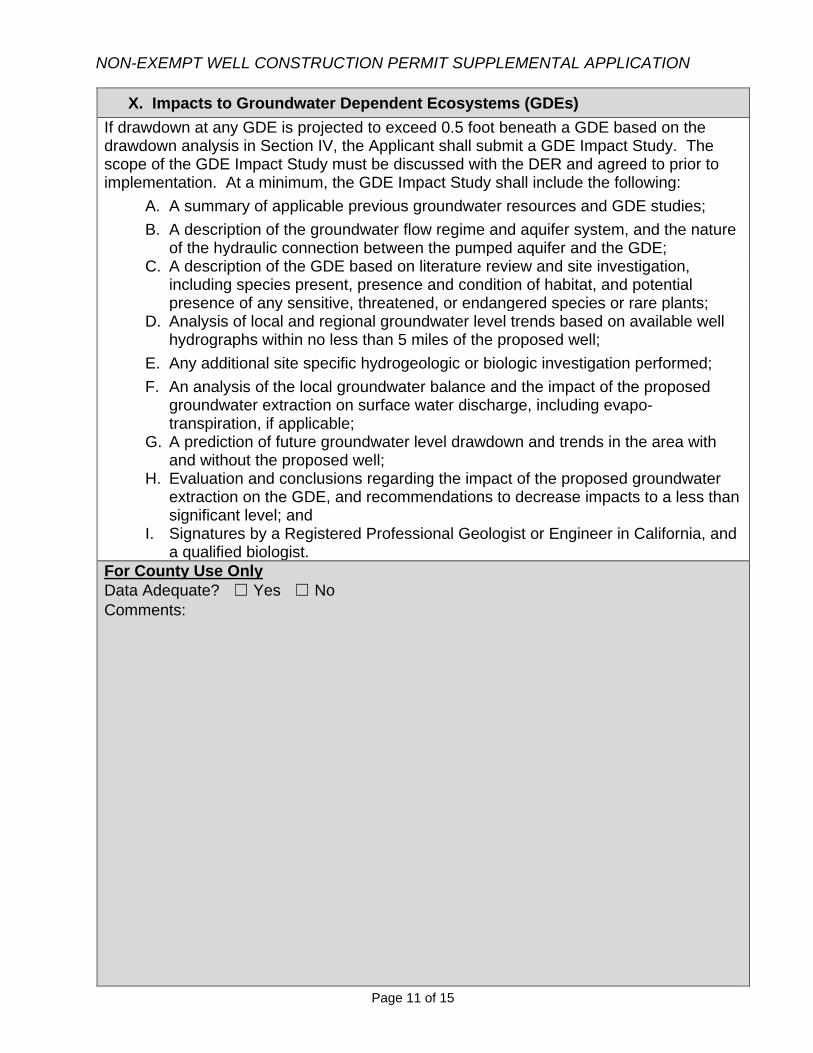
NON-EXEMPT WELL CONSTRUCTION PERMIT SUPPLEMENTAL APPLICATION
Page 11 of 15
X. Impacts to Groundwater Dependent Ecosystems (GDEs)
If drawdown at any GDE is projected to exceed 0.5 foot beneath a GDE based on the drawdown analysis in Section IV, the Applicant shall submit a GDE Impact Study. The scope of the GDE Impact Study must be discussed with the DER and agreed to prior to implementation. At a minimum, the GDE Impact Study shall include the following: A. A summary of applicable previous groundwater resources and GDE studies; B. A description of the groundwater flow regime and aquifer system, and the nature
of the hydraulic connection between the pumped aquifer and the GDE;
C. A description of the GDE based on literature review and site investigation, including species present, presence and condition of habitat, and potential presence of any sensitive, threatened, or endangered species or rare plants;
D. Analysis of local and regional groundwater level trends based on available well hydrographs within no less than 5 miles of the proposed well;
E. Any additional site specific hydrogeologic or biologic investigation performed;
F. An analysis of the local groundwater balance and the impact of the proposed
groundwater extraction on surface water discharge, including evapo-transpiration, if applicable;
G. A prediction of future groundwater level drawdown and trends in the area with and without the proposed well;
H. Evaluation and conclusions regarding the impact of the proposed groundwater
extraction on the GDE, and recommendations to decrease impacts to a less than significant level; and
I. Signatures by a Registered Professional Geologist or Engineer in California, and a qualified biologist.
For County Use Only
Data Adequate? ☐ Yes ☐ No Comments:
mtietze
Text Box
Not Applicable

NON-EXEMPT WELL CONSTRUCTION PERMIT SUPPLEMENTAL APPLICATION
Page 12 of 15
INDEMNIFICATION
In consideration of the County’s processing and consideration of this application for approval of the groundwater project being applied for (the “Project”), and the related CEQA consideration by the County, the Owner and Applicant, jointly and severally, agree to indemnify the County of Stanislaus (“County”) from liability or loss connected with the Project approvals as follows:
1. The Owner and Applicant shall defend, indemnify and hold harmless the County and its agents, officers and employees from any claim, action, or proceeding against the County or its agents, officers or employees to attack, set aside, void, or annul the Project or any prior or subsequent development approvals regarding the Project or Project condition imposed by the County or any of its agencies, departments, commissions, agents, officers or employees concerning the said Project, or to impose personal liability against such agents, officers or employees resulting from their involvement in the Project, including any claim for private attorney general fees claimed by or awarded to any party from County. The obligations of the Owner and Applicant under this Indemnification shall apply regardless of whether any permits or entitlements are issued.
2. The County will promptly notify Owner and Applicant of any such claim, action, or proceeding, that is or may be subject to this Indemnification and, will cooperate fully in the defense.
3. The County may, within its unlimited discretion, participate in the defense of any such claim, action, or proceeding if the County defends the claim, actions, or proceeding in good faith. To the extent that County uses any of its resources responding to such claim, action, or proceeding, Owner and Applicant will reimburse County upon demand. Such resources include, but are not limited to, staff time, court costs, County Counsel’s time at their regular rate for external or non-County agencies, and any other direct or indirect cost associated with responding to the claim, action, or proceedings.
4. The Owner and Applicant shall not be required to pay or perform any settlement by the County of such claim, action or proceeding unless the settlement is approved in writing by Owner and Applicant, which approval shall not be unreasonably withheld.
5. The Owner and Applicant shall pay all court ordered costs and attorney fees. 6. This Indemnification represents the complete understanding between the Owner
and Applicant and the County with respect to matters set forth herein. The Stanislaus County Department of Environmental Resources (DER) will notify the applicant of the date in which the completed information has been received. This date will trigger the 30-day review period to determine whether the application is complete. If
NON-EXEMPT WELL CONSTRUCTION PERMIT SUPPLEMENTAL APPLICATION
Page 14 of 15
NOTICE TO ALL APPLICANTS
Pursuant to California Fish and Game Code §711.4, the County of Stanislaus is required to collect filing fees for the California Department of Fish and Wildlife for all projects subject to the California Environmental Quality Act (CEQA) unless a fee exemption is provided in writing from the California Department of Fish and Wildlife. Pursuant to California Fish & Game Code §711.4(d), all applicable fees are required to be paid within 5 DAYS of approval of any project subject to CEQA. These fees are subject to change without County approval required and are expected to increase yearly. Please contact the Department of Environmental Resources or refer to the current fee schedule for information on current fee amounts. If a required filing fee is not paid for a project, the project will not be operative, vested or final and any local permits issued for the project will be invalid. (Section 711.4(c)(3) of the Fish and Game Code.) Under the revised statute, a lead agency may no longer exempt a project from the filing fee requirement by determining that the project will have a de minimis effect on fish and wildlife. Instead, a filing fee will have to be paid unless the project will have no effect on fish and wildlife. (Section 711.4 (c)(2) of the Fish and Game Code). If the project will have any effect on fish and wildlife resources, even a minimal or de minimis effect, the fee is required. A project proponent who believes the project will have no effect on fish and wildlife should contact the California Department of Fish and Wildlife. If the California Department of Fish and Wildlife concurs the project will have no such effect, the Department will provide the project proponent with a form that will exempt the project from the filing fee requirement. Project proponents may contact the Department by phone at (916) 651-0603 or through the Department’s website at www.dfg.ca.gov. Pursuant to California Fish and Game Code §711.4(e)(3) , the department (CDFW) shall assess a penalty of 10 percent of the amount of fees due for any failure to remit the amount payable when due. The department may pursue collection of delinquent fees through the Controller’s office pursuant to Section 12419.5 of the Government Code. Additionally California Fish and Game Code §711.4(f) states the following: Notwithstanding Section 12000, failure to pay the fee under subdivision (d) is not a misdemeanor. All unpaid fees are a statutory assessment subject to collection under procedures as provided in the Revenue and Taxation Code. Failure to pay the necessary fee will also extend the statute of limitations for challenging the environmental determination made by the County, thus increasing exposure to legal challenge. The type of environmental determination to be made by the County may be discussed with the project reviewer following the environmental review stage of the project and will be outlined in a Board of Supervisor’s staff report.
NON-EXEMPT WELL CONSTRUCTION PERMIT SUPPLEMENTAL APPLICATION
Page 15 of 15
REQUIRED ADDITIONAL FEE: STANISLAUS COUNTY RECORDER
Upon approval of the proposed project, Stanislaus County will record either a “Notice of Exemption” or a “Notice of Determination” pursuant to CEQA Guidelines. The Clerk Recorder charges an additional fee of $57.00 for recording these documents. A separate check made payable to “Stanislaus County” is due and payable within 5 DAYS of approval of the project.
GROUNDWATER RESOURCES IMPACT ASSESSMENT, HUNTER RANCH, STANISLAUS COUNTY, CALIFORNIA
APPENDIX B
Test Boring Lithologic Logs and Geophysical Logs
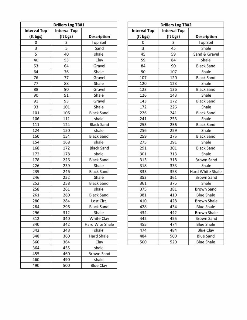
Interval Top (ft bgs)
Interval Top (ft bgs) Description
Interval Top (ft bgs)
Interval Top (ft bgs) Description
0 3 Top Soil 0 3 Top Soil 3 5 Sand 3 45 Shale5 40 shale 45 59 Sand & Gravel
40 53 Clay 59 84 Shale 53 64 Gravel 84 90 Black Sand 64 76 Shale 90 107 Shale76 77 Gravel 107 120 Black Sand 77 88 Shale 120 123 Shale88 90 Gravel 123 126 Black Sand 90 91 Shale 126 143 Shale91 93 Gravel 143 172 Black Sand 93 101 Shale 172 226 Shale
101 106 Black Sand 226 241 Black Sand 106 111 shale 241 253 Shale111 124 Black Sand 253 256 Black Sand 124 150 shale 256 259 Shale150 154 Black Sand 259 275 Black Sand 154 168 shale 275 291 Shale168 172 Black Sand 291 301 Black Sand 172 178 shale 301 313 Shale178 226 Black Sand 313 318 Brown Sand226 239 Shale 318 333 Shale239 246 Black Sand 333 353 Hard White Shale 246 252 Shale 353 361 Brown Sand252 258 Black Sand 361 375 Shale258 261 shale 375 381 Brown Sand 261 280 Black Sand 381 410 Blue Shale 280 284 Lost Circ. 410 428 Brown Shale284 296 Black Sand 428 434 Blue Shale 296 312 Shale 434 442 Brown Shale312 340 White Clay 442 455 Brown Sand340 342 Hard Wite Shale 455 474 Blue Shale 342 348 shale 474 484 Blue Clay 348 360 Hard Shale 484 500 Blue Sand 360 364 Clay 500 520 Blue Shale 364 455 shale 455 460 Brown Sand460 490 shale 490 500 Blue Clay
Drillers Log TB#1 Drillers Log TB#2

Interval Top (ft bgs)
Interval Top (ft bgs) Description
Interval Top (ft bgs)
Interval Top (ft bgs) Description
0 3 Top Soil 372 398 Shale 3 12 Gravel 398 408 Sand
12 15 Clay 408 430 Shale 15 19 Sand 430 444 Sand19 53 Clay 444 464 Shale 53 56 Gravel 464 474 Sand56 64 Clay 474 484 Shale64 80 Black Sand 484 491 Sand80 82 Shale 491 501 Blue Shale82 93 Black Sand 501 510 Sand93 115 Shale 510 515 Blue Shale
115 124 Lost Circ 515 520 Blue Clay 124 143 Black Sand 143 162 Shale 162 178 Black Sand 178 184 Shale 184 194 Black Sand 194 198 Shale 198 200 Black Sand 200 209 Shale 209 211 Black Sand 211 229 Shale 229 242 Black Sand 242 249 Shale 249 258 Black Sand 258 271 White Shale271 275 White Sand275 283 White Clay283 286 Sand286 288 Shale 288 301 Black Sand 301 325 Shale 325 328 Black Sand 328 333 Shale 333 343 Brown Sand 343 345 Hard Shale345 362 Brown Sand 362 368 Shale 368 372 Sand372 398 Shale 398 408 Sand408 430 Shale 430 444 Sand444 464 Shale
Drillers Log TB#3 Drillers Log TB#3 (continued)
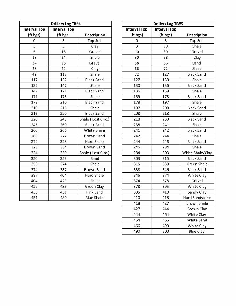
Interval Top (ft bgs)
Interval Top (ft bgs) Description
Interval Top (ft bgs)
Interval Top (ft bgs) Description
0 3 Top Soil 0 3 Top Soil 3 5 Clay 3 10 Shale5 18 Gravel 10 30 Gravel
18 24 Shale 30 58 Clay24 26 Gravel 58 66 Sand 26 42 Clay 66 72 Shale42 117 Shale 72 127 Black Sand
117 132 Black Sand 127 130 Shale132 147 Shale 130 136 Black Sand 147 171 Black Sand 136 159 Shale171 178 Shale 159 178 Black Sand 178 210 Black Sand 178 197 Shale210 216 Shale 197 208 Black Sand 216 220 Black Sand 208 218 Shale220 245 Shale ( Lost Circ.) 218 238 Black Sand 245 260 Black Sand 238 241 Shale260 266 White Shale 241 242 Black Sand 266 272 Brown Sand 242 244 Shale272 328 Hard Shale 244 246 Black Sand 328 334 Brown Sand 246 284 Shale334 350 Shale ( Lost Circ.) 284 303 White Shale/Clay350 353 Sand 303 315 Black Sand 353 374 Shale 315 338 Green Shale374 387 Brown Sand 338 346 Black Sand 387 404 Hard Shale 346 374 White Clay404 429 Shale 374 378 Gravel429 435 Green Clay 378 395 White Clay435 451 Pink Sand 395 410 Sandy Clay451 480 Blue Shale 410 418 Hard Sandstone
418 427 Brown Shale427 444 Brown Clay444 464 White Clay 464 466 White Sand466 490 White Clay490 500 Blue Clay
Drillers Log TB#4 Drillers Log TB#5
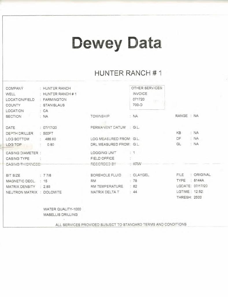

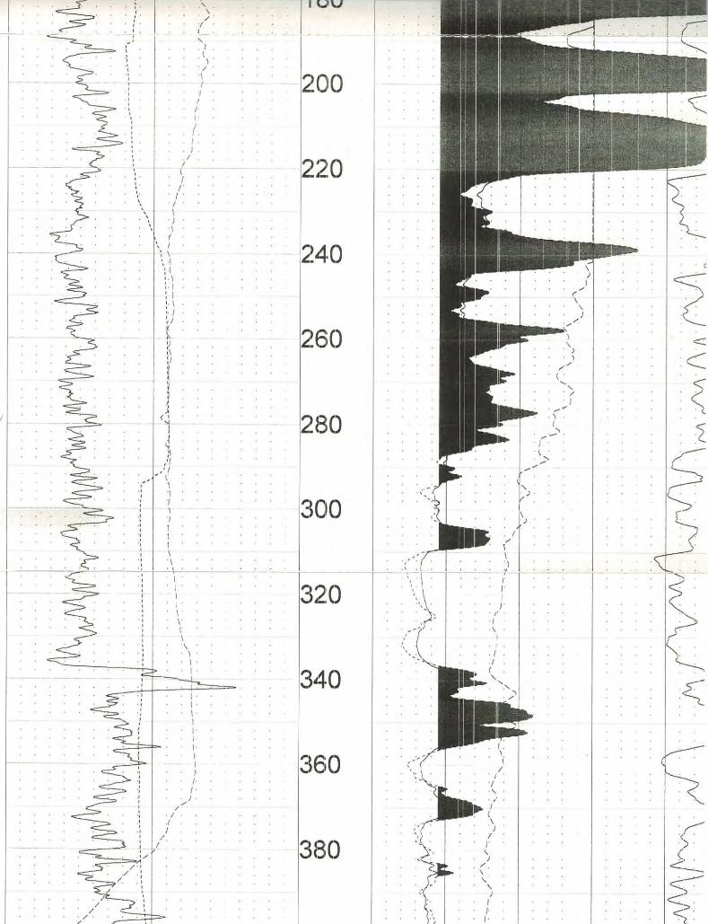
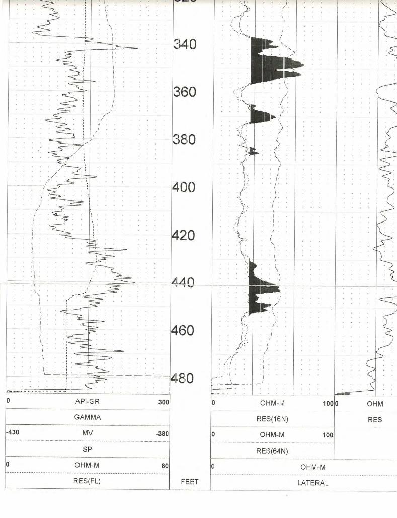
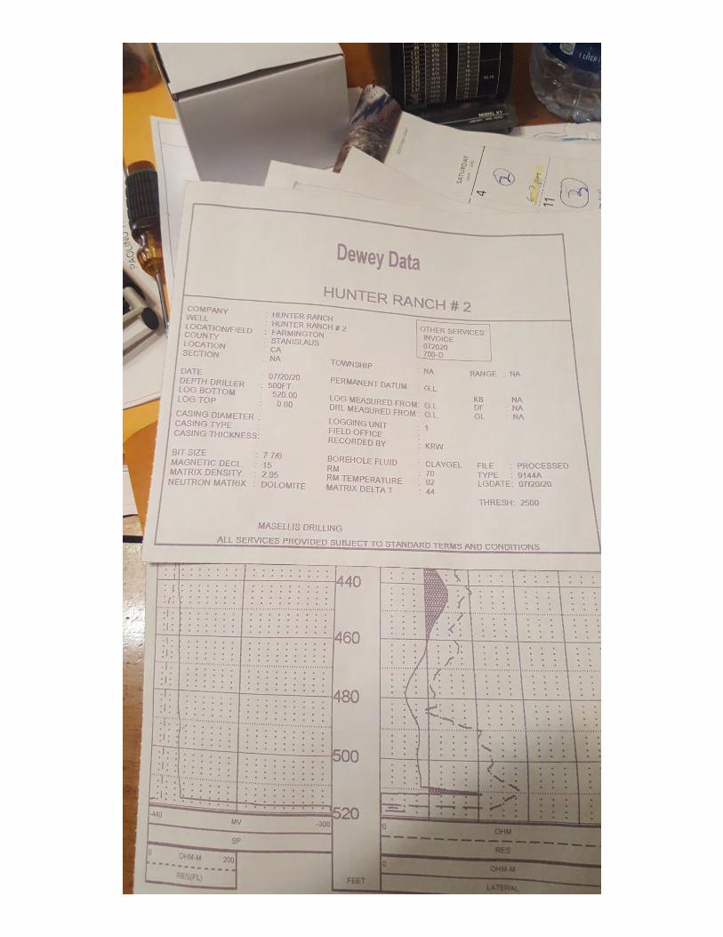
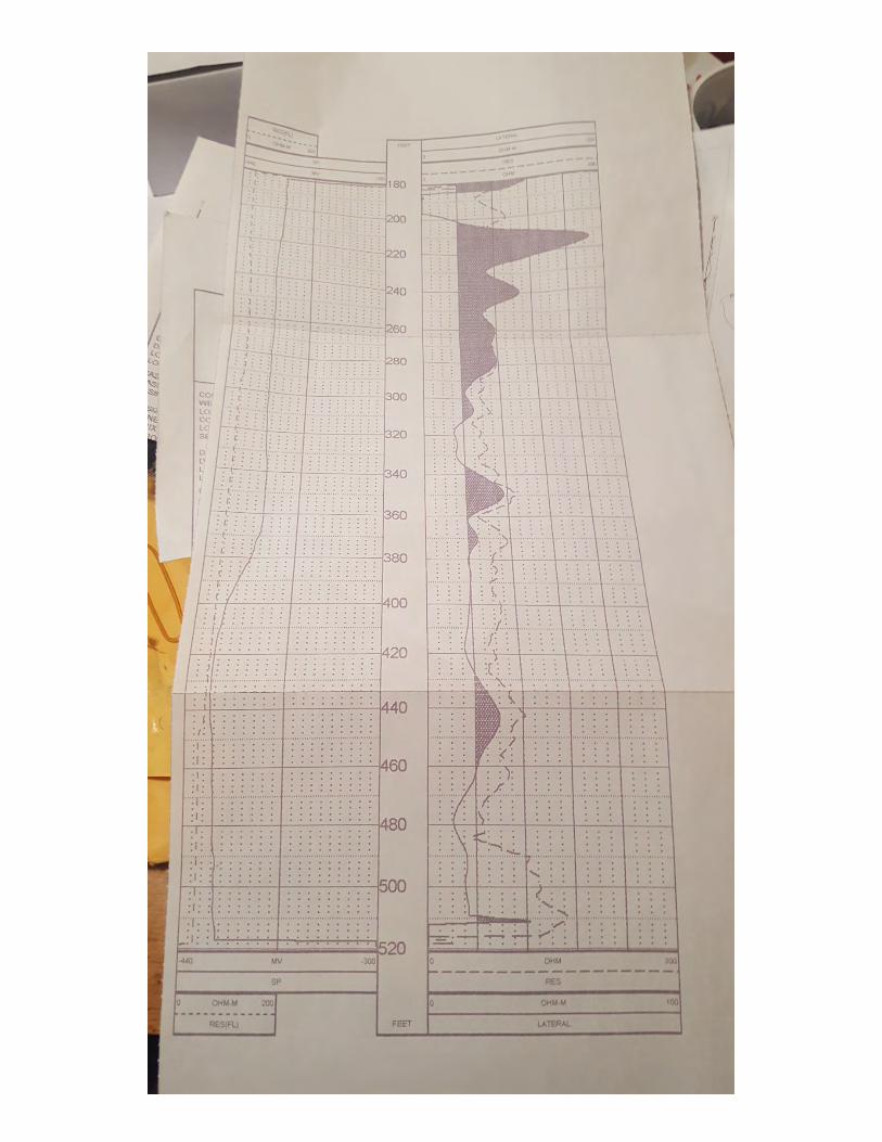
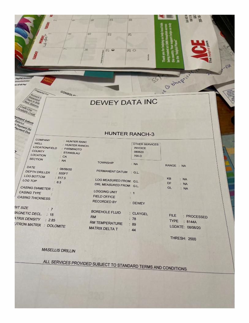
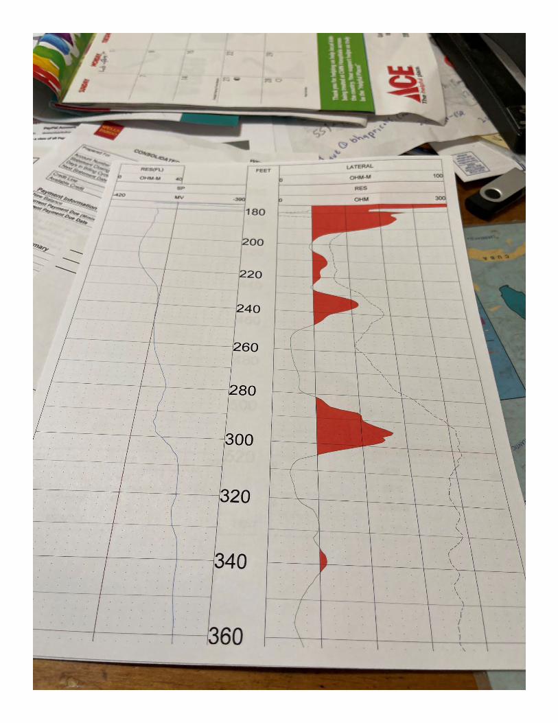
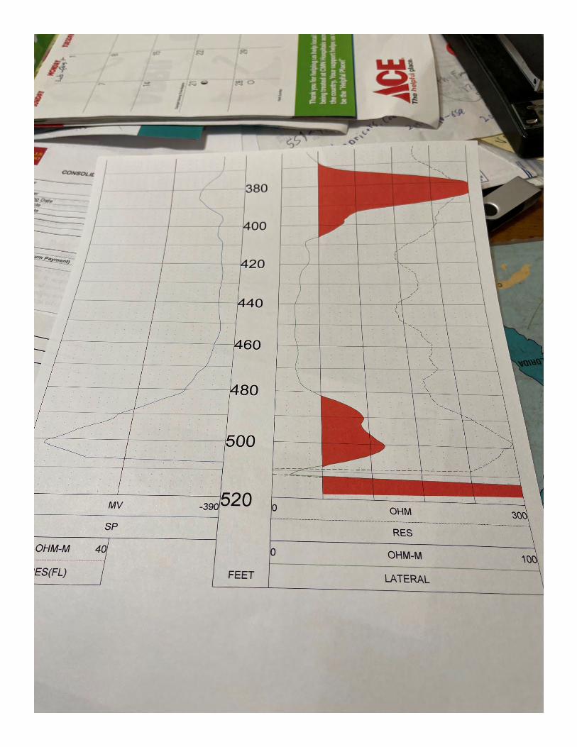
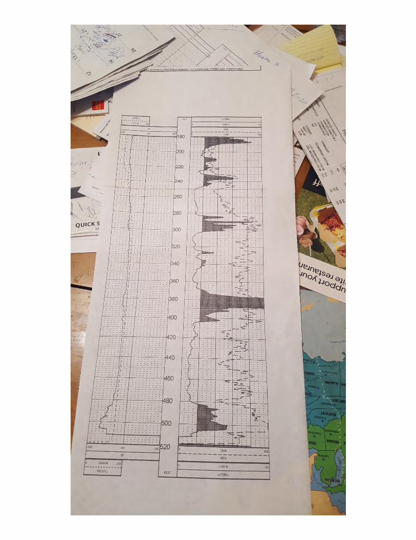
mtietze
Text Box
TB#3 elog
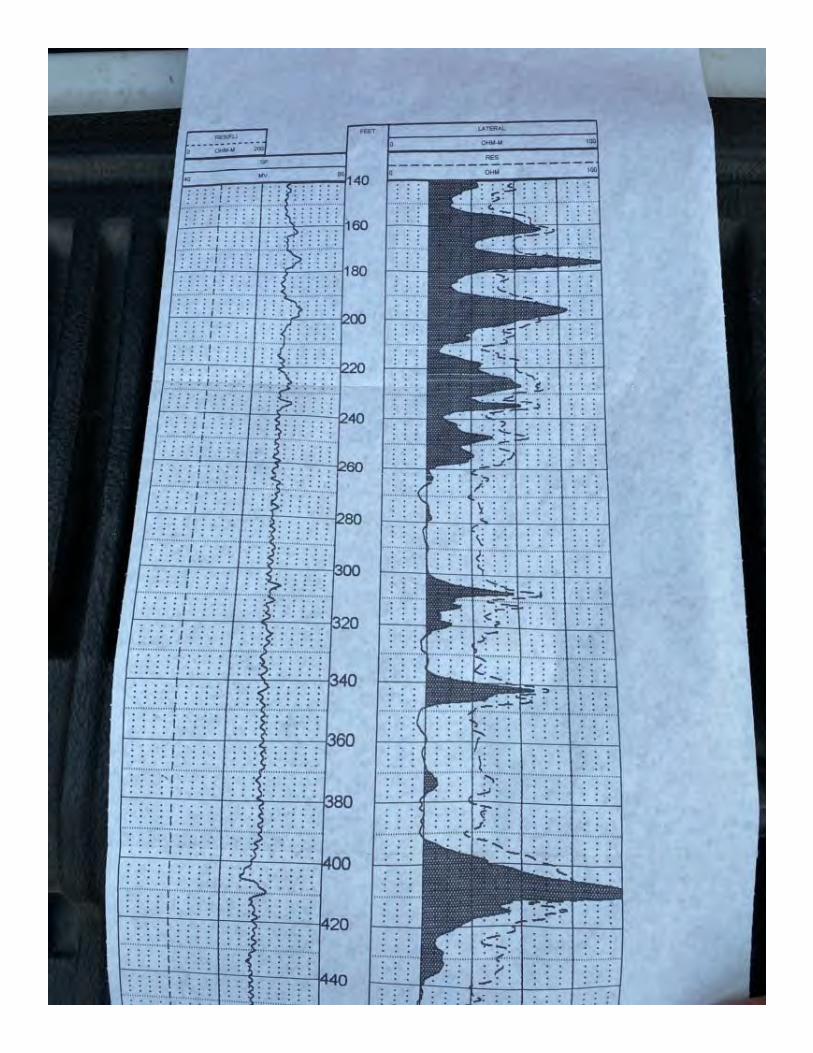
mtietze
Text Box
TB#5 elog
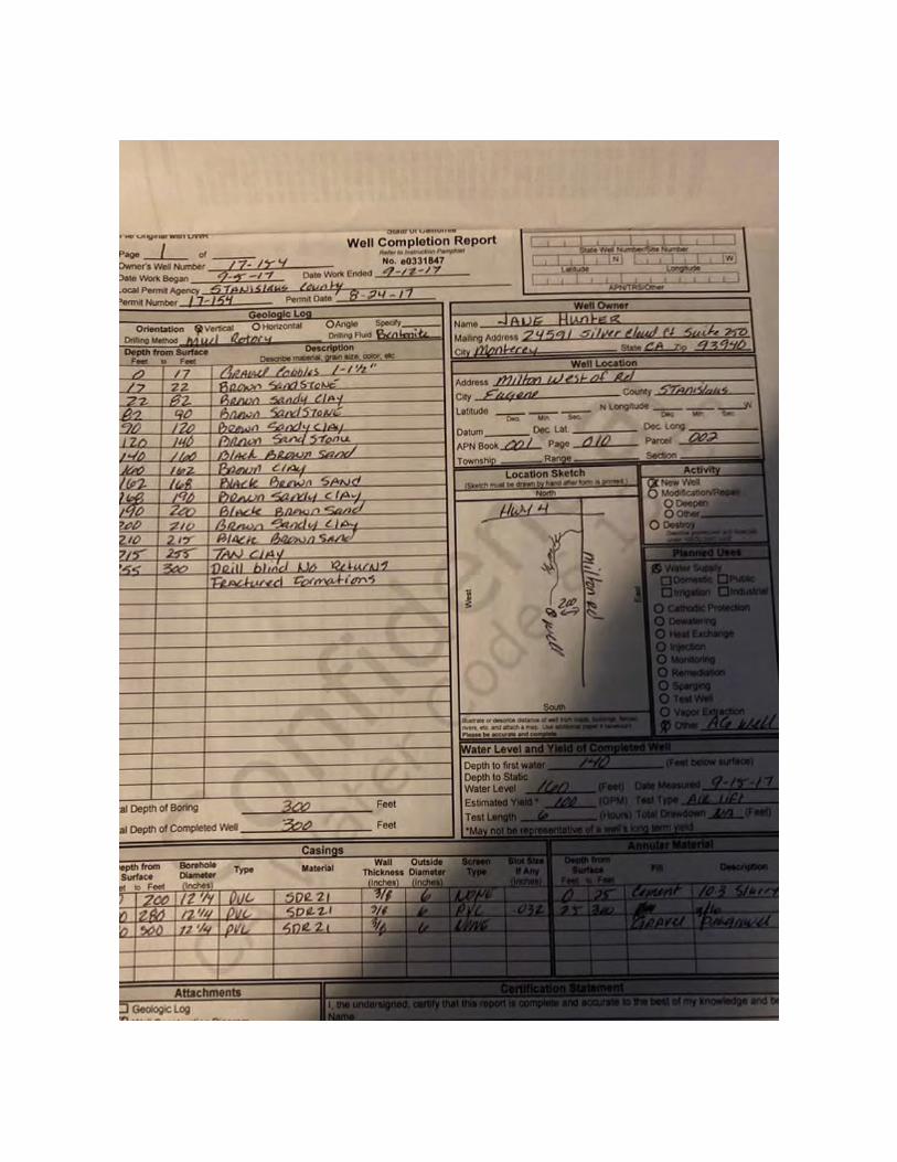
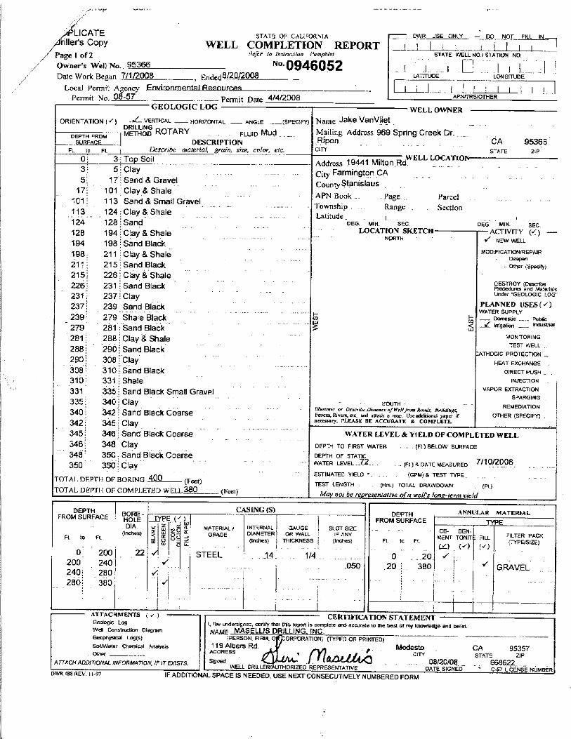
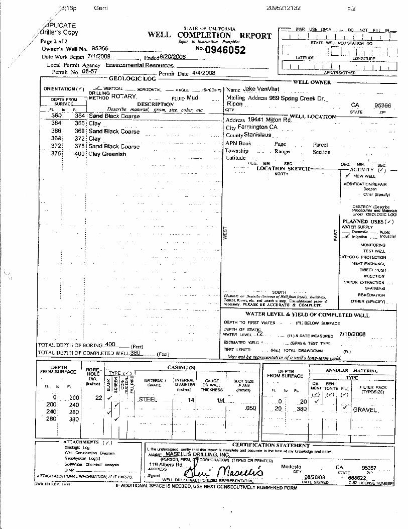

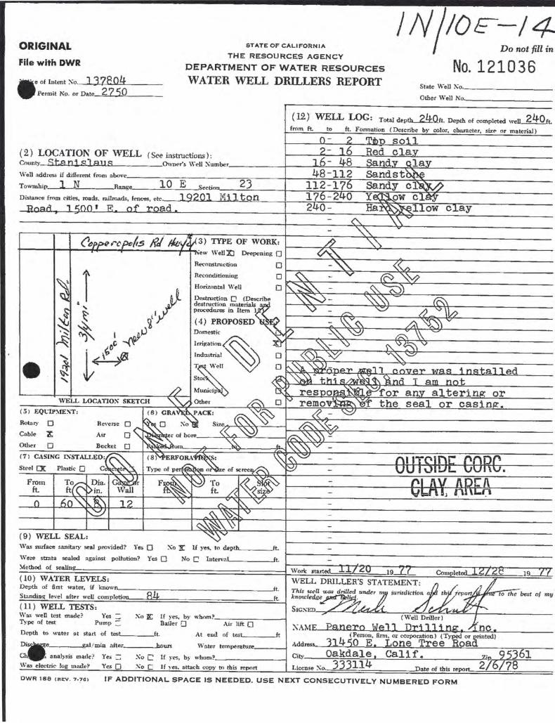
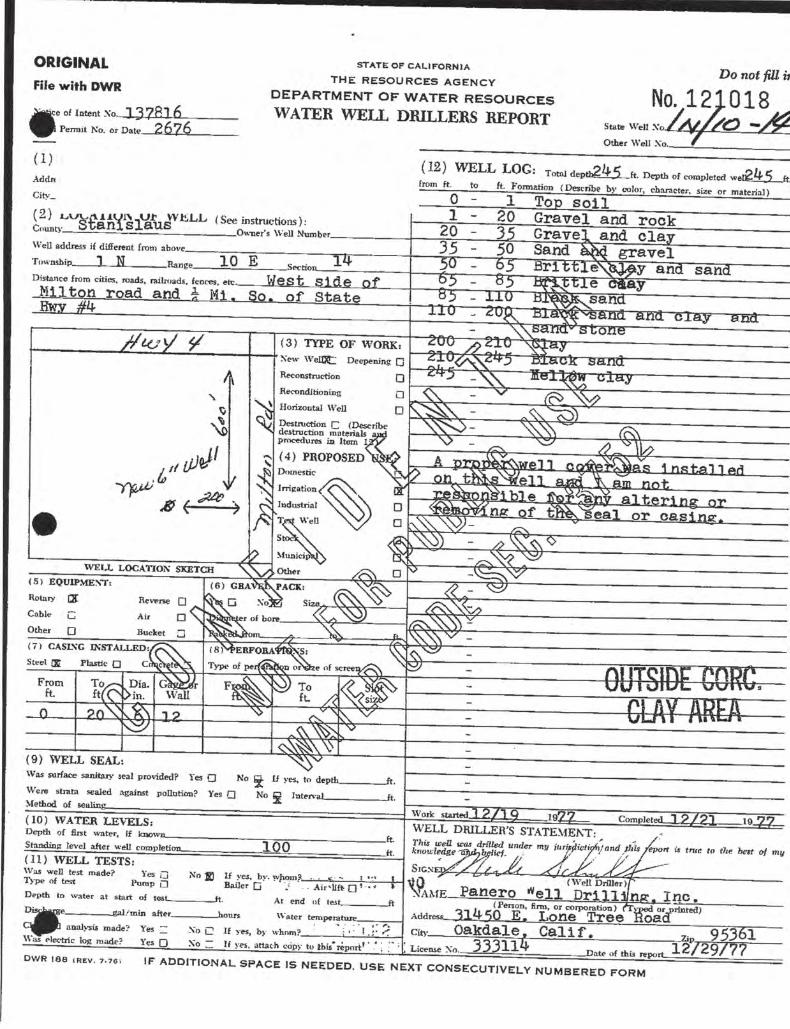

GROUNDWATER RESOURCES IMPACT ASSESSMENT, HUNTER RANCH, STANISLAUS COUNTY, CALIFORNIA
APPENDIX C
Electrical Resistance Tomography (ERT) Sections

ERT TRANSECT OF 09-10-2020 (SOUTH TRANSECT)
SCHLUMBERGER\ PROPO~;~siEST WELL I ARRAY 1
Depth 1cerauon' i1 Abs. error= 8.9 320 . 0 0. SOllTH ' 160.0
4 .zc.t-=~~rii5 ~ ~ r ~;;;;:-"5e~~~ .. ;:~~!H"~===~~ 21.1 j 38.6 56.1 74.2 92.6
111.4 130.5 150 . 1 169.9
19 0• 3 depth = 600 foet Inuerse Model Resisti1Jity Section
---- D DDDDDDD 3.17 5.06 8.08 12.9 20.6 32 . 8 52 . 4
ALTERNATE WELL SITE E # 57 ,
480 . 0 640 . 0 800.0 NORTH r ro.
NORTH ! SOllTH Resi stiuity in ohm.m Unit e l ectrode spacing is 10 . 0 m.
(EXTENDED MODEL) \ SCHULMBERGER E # 15 '
PROPOSED TEST WELLi Depth
98.7 117 .4 136.7
156.6
177 . 1
ARRAY1
160.0
Inverse Hodel Resistiuity Section
320 . 0
----~□DDDDDDD --1 . 65 2 . 78 4.69 7.91 13.3 22.5 38.0 64.0
ALTERNATE WELL SITE E # 57
480.0 800.0 NORTH :m.
Resistivity in ohm. m Unit electrode spacing is 10.0 m.
Profile 1 (top): Electrical resistivity tomography (ERT) profile 1 acquired in Schlumberger array mode with 90 electrodes at 32.8 foot (10 meter) spacing on 09-10-2020 at the "Hunter Ranch" parcel owned by the Conde family located at the intersection of Highway 4 and Milton Rd. Farmington, CA achieved a maximum depth of 190.3 meters, or 625 feet. The profile transect starts at electrode (E) # 1, ten feet north of the south fence, and extends north (right) to E # 90, passing 75 feet east of a potential well site selected by the family at E # 57 (Map 1). Dry Mehrten Formation sandstones are indicated by the high resistivity (R) yellow, orange and red colors with R > 26 < 120 ohm.meters, with dry claystones and siltstones in blue and green colors with R < 26 ohm.m from 0 to 170+ feet deep, at the estimated static water level (SWL) as derived from the proximal # 3 well site (Map 1). The SWL is represented by the upper, short-dashed line starting at 170 feet deep at E # 1 and descending to 195 feet deep at E # 90 as topography rises. Below the dry Mehrten Fm. strata, saturated, producing Mehrten Fm. sandstones are imaged in the yellow, orange and red colors which reach about 320 - 350 feet deep along the majority of the profile, but deepens abruptly at the far south (left) edge of the profile to 400 feet deep where the profile is truncated at E # 19. The proposed, primary test well site is selected at E # 15, which would be anticipated to have producing Mehrten Fm. sandstones extending as deep as 400 feet, although some of deeper sands between 360 - 400 feet may be of Valley Springs Fm. affinity and could have poor production. By comparison, the E # 57 site has good producing Mehrten Fm. sandstones extending to 335 feet deep, then has an abrupt change into a deep stack of non-producing claystones.
Profile 2 (below): ERT profile 2 is also a Schlumberger array profile with the same data set, but is digitally processed as an "extended model" with software-extrapolated geology at the far edges to better estimate the depth and range ofresistivity of the producing sandstones at the E # 15 test well site. This site is a bit more generous to the E # 57 site as the base of the producing Mehrten Fm. sandstones is imaged to be 365 feet deep. This may be in agreement with the Well # 3 log which shows a transition zone of "Brown Sand" beds interbedded with shales from 328 - 362 feet, which is probably of Mehrten Fm. affinity, underlying the last "Black Sand" between 325 - 328 feet deep.
Aquifer and Well Site Potential: The proposed, primary test well site is located at electrode# 15 and is centered at a deeper, Mehrten Fm. sandstone channel or lens body, which appears to reach about 400 feet deep. The estimated depth of the SWL is 17 5 feet at E # 15, so that there is up to 225 feet of producing zone sandstones interbedded with non-producing, siltstones and shaley rocks. By comparison, at E # 57, the average imaged depth of the Mehtren Fm. sandstone-bearing strata is 350 feet deep and has an estimated SWL of 185 feet, for a 165 foot thick producing zone.
The estimated yield at each site can be calculated by using an estimated range of specific capacity, or SC, multiplied by the total producing zone thickness. The range of SC is about 6 - 7 gallons/minute/foot of draw down for this type of Mehrten Fm. strata, where black and brown sandstones make up about 40 - 50% of the formation. Therefore the estimated range of yield for the E # 15 site with up to 225 feet of sandstone-bearing strata is 1,350 -1,575 gallons/minute. For the E # 57 site, with about 165 feet of sandstone-bearing strata, the estimated range of yield is about 990 - 1,155 gallons/minute.
The estimated yields are based on a fully developed well with 16 inch casing within a 22 - 24 inch diameter bore. Minimum depth of the test well should be 520 feet and it is anticipated that additional, thin, sandstone producing zones may be obtained from the 400 - 520 foot depth interval that could potentially add a small amount to the yield, but probably no more than 100 gallons/minute is possible from the additional 120 feet of depth.
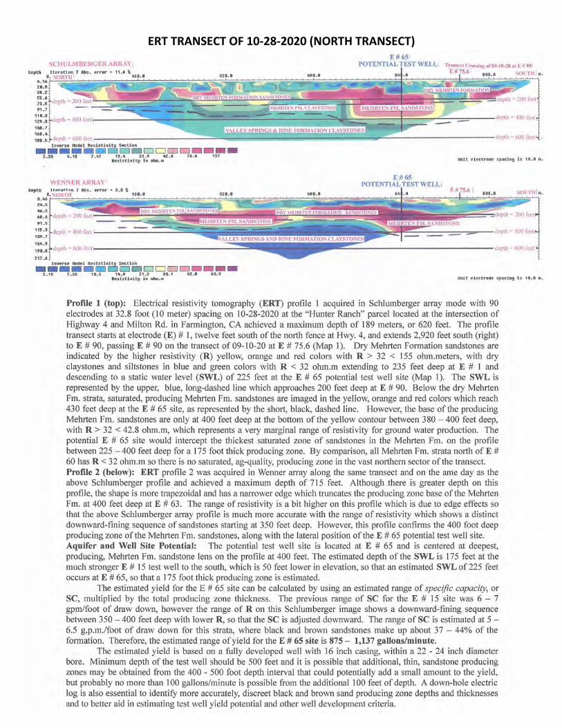
ERT TRANSECT OF 10-28-2020 (NORTH TRANSECT)
SCHULMBERGERARRAY \ E # 65 i
POTENTIAL TEST WELL!
Depth o.J~eoi:i,Hi 7 Abs . error"' 11.6 %100.0
4 . 16 _
20.9 38.2 55 . 6 73.5 91.7
110.3 , ------=~~=----~:::'!a.~ ?:::::.;==::=--===--==-=:~~ ~ ====F = :=;;....c=:::--==----depth = 400 feet 129 .• 3 depth= 400 feet r -----..--------..a.---;;;;;;;:,•-14e.1
::::; depth = 600 tect r------------_:;= - ......,....,======c=====-==:::r-------------depth = 600feet Inc,,erse Hodel Resistivity Section
---- DDD□DDDD --2.33 4.18 7.47 13.4 23 . 9 42.8 76.6 137 Unit electrMe spaciny :is 10.0 m.
Depth
24.5 46.2 68.6 91 . 5
WENNER ARRAY I
Resisti_uity in ohm.m
E # 65 , POTENTIAL TEST WELL i
::: :: depth= 400 feet I
164.9 , --------------=~~--190.8 depth= 600 feet ~
217 .6 Inverse Model Resistivity Section
---- DDD□DDDD~ - -s.19 1 . ae 10.s 14.9 21.2 ao.1 42.8 60. 9 Resistivity in ohm.Ill Unit electr-ode spacing is 1 0 . 0 m.
Profile 1 (top): Electrical resistivity tomography (ERT) profile 1 acquired in Schlumberger array mode with 90 electrodes at 32.8 foot (10 meter) spacing on 10-28-2020 at the "Hunter Ranch" parcel located at the intersection of Highway 4 and Milton Rd. in Farmington, CA achieved a maximum depth of 189 meters, or 620 feet. The profile transect starts at electrode (E) # 1, twelve feet south of the north fence at Hwy. 4, and extends 2,920 feet south (right) to E # 90, passing E # 90 on the transect of09-10-20 at E # 75.6 (Map 1). Dry Mehrten Formation sandstones are indicated by the higher resistivity (R) yellow, orange and red colors with R > 32 < 155 ohm.meters, with dry claystones and siltstones in blue and green colors with R < 32 ohm.m extending to 235 feet deep at E # 1 and descending to a static water level (SWL) of 225 feet at the E # 65 potential test well site (Map 1). The SWL is represented by the upper, blue, long-dashed line which approaches 200 feet deep at E # 90. Below the dry Mehrten Fm. strata, saturated, producing Mehrten Fm. sandstones are imaged in the yellow, orange and red colors which reach 430 feet deep at the E # 65 site, as represented by the short, black, dashed line. However, the base of the producing Mehrten Fm. sandstones are only at 400 feet deep at the bottom of the yellow contour between 380 - 400 feet deep, with R > 32 < 42.8 ohm.m, which represents a very marginal range of resistivity for ground water production. The potential E # 65 site would intercept the thickest saturated zone of sandstones in the Mehrten Fm. on the profile between 225 - 400 feet deep for a 175 foot thick producing zone. By comparison, all Mehrten Fm. strata north of E # 60 has R < 32 ohm.m so there is no saturated, ag-quality, producing zone in the vast northern sector of the transect. Profile 2 (below): ERT profile 2 was acquired in Wenner array along the same transect and on the ame day as the above Schlumberger profile and achieved a maximum depth of 715 feet. Although .there is greater depth on this profile, the shape is more trapezoidal and has a narrower edge which truncates the producing zone base of the Mehrten Fm. at 400 feet deep at E # 63. The range of resistivity is a bit higher on this profile which is due to edge effects so that the above Schlumberger array profile is much more accurate with the range of resistivity which shows a distinct downward-fining sequence of sandstones starting at 350 feet deep. However, this profile confirms the 400 foot deep producing zone of the Mehrten Fm. sandstones, along with the lateral position of the E # 65 potential test well site. Aquifer and Well Site Potential: The potential test well site is located at E # 65 and is centered at deepest, producing, Mehrten Fm. sandstone lens on the profile at 400 feet. The estimated depth of the SWL is 175 feet at the much stronger E # 15 test well to the south, which is 50 feet lower in elevation, so that an estimated SWL of 225 feet occurs at E # 65, so that a 175 foot thick producing zone is estimated.
The estimated yield for the E # 65 site can be calculated by using an estimated range of specific capacity, or SC, multiplied by the total producing zone thickness. The previous range of SC for the E # 15 site was 6 - 7 gpm/foot of draw down, however the range of R on this Schlumberger image shows a downward-fining sequence between 350 - 400 feet deep with lower R, so that the SC is adjusted downward. The range of SC is estimated at 5 -6.5 g.p.m./foot of draw down for this strata, where black and brown sandstones make up about 37 - 44% of the formation. Therefore, the estimated range of yield for the E # 65 site is 875 - 1,137 gallons/minute.
The estimated yield is based on a fully developed well with 16 inch casing, within a 22 - 24 inch diameter bore. Minimum depth of the test well should be 500 feet and it is possible that additional, thin, sandstone producing zones may be obtained from the 400 - 500 foot depth interval that could potentially add a small amount to the yield, but probably no more than 100 gallons/minute is possible from the additional 100 feet of depth. A down-hole electric log is also essential to identify more accurately, discreet black and brown sand producing zone depths and thicknesses and to better aid in estimating test well yield potential and other well development criteria.
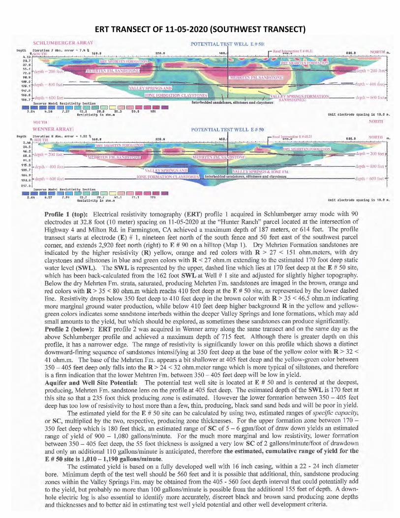
ERT TRANSECT OF 11-05-2020 (SOUTHWEST TRANSECT)
SCHLUMBERGERARIUY ! POTENTIAL TEST WELL E # SO: oeptn Iteration 7 Abs. et·ror " 7." %
"·SOlTH
~ii'.~,-,...~~~~ -~::~c:2i.~~~~~it~~~~i~-~-~~i5~;.;. .. :.~;;c;J~~~:;;;~~rb~~,;r,,;:ir:::i~jr.110t1:~:\~t~\\\f~~~~~;~i\j~g:jFS~:5~!!!lS''l 37 .8 .,, 55.1 72.8 .
90.9
;:.:~ depth ·- 400 l'eel,--------~;;..;.,~= 7.~~~~~~r ==----=~ ~==r:==::---------:=:,,1-=::;:.--;:;;,,-= -==-=-=-==dcpth = 400 feet, 147.3
::: :! depth = 600 feet JONE FORMATION CLA\'STO:',f.S ---\ '.>\l}r\' SPRINGS .-OR\f.\TIO:\
lntcrbedded sands ones, siltstones and cJaystoncs~ SANDS'IONJ,Si depth = 600 ti-ct
Invet'se Model Resistiuity Section
----□i;.;::;i□□li2JDDDD --2.s" 4.ae 1.21 12.s 20.a as-.a 59.8 101 Resi:s:tiuity i11 ohm.in Unit electrode spaci ng is 113.D rn.
SOllTII
WENNER ARRAY; POTENTIAL TEST WELL E # 50 Depth Iteration a Aini. error • 1.52 %
O. SOl'TII 16U.o 3.46 24.5 -46.2
68 .6 91.5
115 .3
139. 7
16- .9
190.8
217 . 6 Inverse Hodel Resistiuity Section
----=□□D□DD□□m••• 2.64 . lt .57 1.P1 13,7 23.7 J11.1 71.1 123 Resistiui ty in ohn. D Unit electt'oOe spacing is 10.0 ro.
Profile 1 (top): Electrical resistivity tomography (ERT) profile l acquired in Schlumberger array mode with 90 electrodes at 32.8 foot (l 0 meter) spacing on l 1-05-2020 at the "Hunter Ranch" parcel located at the intersection of Highway 4 and Milton Rd. in Farmington, CA achieved a maximum depth of 187 meters, or 614 feet. The profile transect starts at electrode (E) # 1, nineteen feet north of the south fence and 50 feet east of the southwest parcel corner, and extends 2,920 feet north (right) to E # 90 on a hilltop (Map 1). Dry Mehrten Formation sandstones are indicated by the higher resistivity (R) yellow, orange and red colors with R > 27 < 151 ohm.meters, with dry claystones and siltstones in blue and green colors with R < 27 ohm.m extending to the estimated 170 foot deep static water level (SWL). The SWL is represented by the upper, dashed line which lies at 170 feet deep at the E # 50 site, which has been back-calculated from the 162 foot SWL at Well# 1 site and adjusted for slightly higher topography. Below the dry Mehrten Fm. strata, saturated, producing Mehrten Fm. sandstones are imaged in the brown, orange and red colors with R > 35 < 80 ohm.m which reachs 410 feet deep at the E # 50 site, as represented by the lower dashed line. Resistivity drops below 350 feet deep to 410 feet deep in the brown color with R > 35 < 46.5 ohm.m indicating more marginal ground water production, while below 410 feet deep higher background R in the yellow and yellowgreen colors indicates some sandstone interbeds within the deeper Valley Springs and lone formations, which may add small amounts to the yield, but which should be explored, as sometimes these sandstones can produce significantly. Profile 2 (below): ERT profile 2 was acquired in Wenner array along the same transect and on the same day as the above Schlumberger profile and achieved a maximum depth of 715 feet. Although there is greater depth on this profile, it has a narrower edge. The range of resistivity is significantly lower on this profile which shows a distinct downward-fining sequence of sandstones intensifying at 350 feet deep at the base of the yellow color with R > 32 < 41 ohm.m. The base of the Mehrten Fm. appears a bit shallower at 405 feet deep and the yellow-green color between 350 - 405 feet deep only falls into the R > 24 < 32 ohm.meter range which is more typical of siltstones, and therefore is a firm indication that the lower Mehtren Fm. between 350 - 405 feet deep will be low in yield. Aquifer and Well Site Potential: The potential test well site is located at E # 50 and is centered at the deepest, producing, Mehrten Fm. sandstone lens on the profile at 405 feet deep. The estimated depth of the SWL is 170 feet at this site so that a 235 foot thick producing zone is estimated. However the lower fonnation between 350 - 405 feet deep has too low of resistivity to host more than a few, thin, producing, black sand sand beds and will be poor in yield.
The estimated yield for the E # 50 site can be calculated by using two, estimated ranges of specific capacity, or SC, multiplied by the two, respective, producing zone thicknesses. For the upper formation zone between 170 -350 feet deep which is 180 feet thick, an estimated range of SC of 5 - 6 gpm/foot of draw down yields an estimated range of yield of 900 - 1,080 gallons/minute. For the much more marginal and low resistivity, lower formation between 350 - 405 feet deep, the 55 foot thickness is assigned a very low SC of 2 gallons/minute/foot of drawdo'"'n and only an additional 110 gallons/minute is anticipated, therefore the estimated, cumulative range of yield for the E # 50 site is 1,010 - 1,190 gallons/minute.
The estimated yield is based on a fully developed well with 16 inch casing, within a 22 - 24 inch diameter bore. Minimum depth of the test well should be 560 feet and it is possible that additional, thin, sandstone producing zones within the Valley Springs Fm. may be obtained from the 405 - 560 foot depth interval that could potentially add to the yield, but probably no more than 100 gallons/minute is possible from the additional 155 feet of depth. A downhole electric log is also essential to identify more accurately, discreet black and brown sand producing zone depths and thicknesses and to better aid in estimating test well yield potential and other well development criteria.
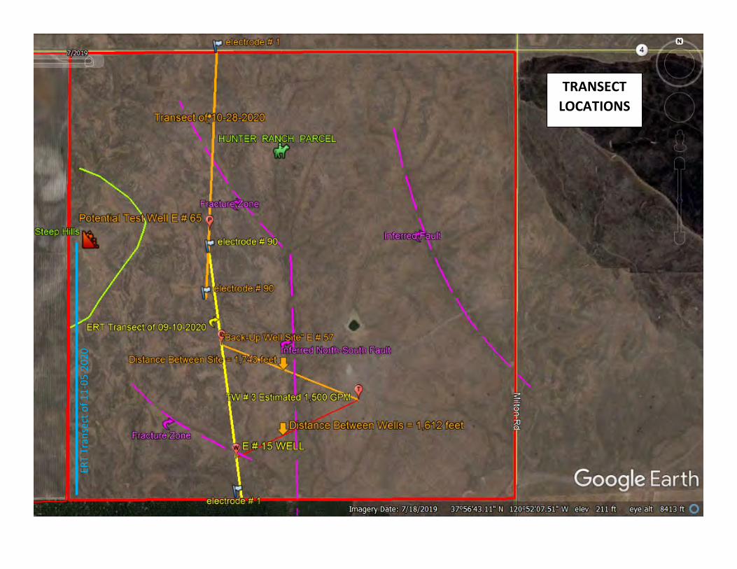
TRANSECT LOCATIONS
ERT
Tran
sect
of 1
1-05
-202
0
,. - - liS~
- o ~ IFl3!!ffi
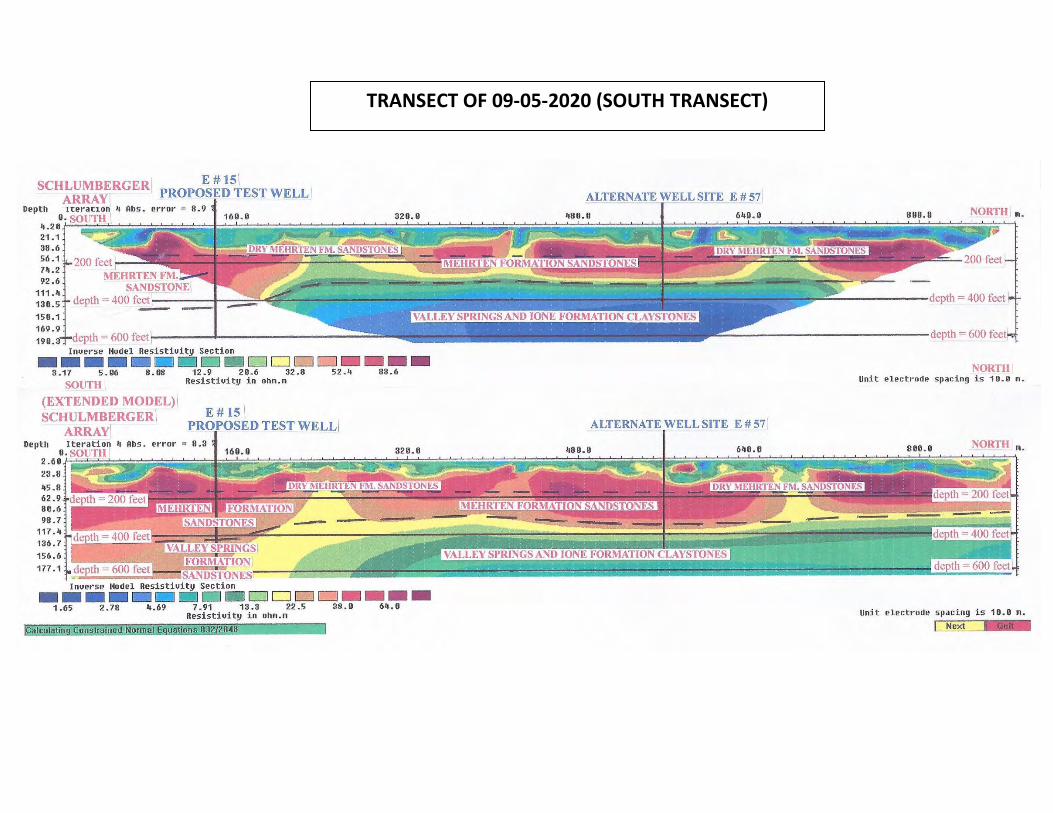
TRANSECT OF 09-05-2020 (SOUTH TRANSECT)
SCHLUMBERGER' E # 15 \ ARRAY PROPOSED TEST WELL'
Depth 1cerac1on 4 Abs. error = 8.9 O. SOUTH 160.0
4.20 21.1 38.6 56.1 74.2 92.6 MEHRTENFM.
SANDSTONE1
ALTERNATE WELL SITE E # 57
320.0 480.0 640.0
111.4 130.5 150.1 169.9
depth = 400 feet!::::-==~:=::=i..oJ!!li:::;::::------~:---:;:;::;:;::;;;;;;;:;;;;;:~:;;;~~;;;::;;;.;;iiii'iiiii
Inuerse Model Resistiuity Section
---- CJ DD□□ 3.17 5.06 8.08 12.9 20.6 32 .8 52.4 SOUTH Resistiuity in oh111.111
(EXTENDED MODEL) ! SCHULMBERGER\
ARRAY
E# 15 I PROPOSED TEST WELL/
Depth Iteration 4 Abs. error ~ 8.3 o. SOl'Tl-1 160.0
--83.6
ALTERNATE WELL SITE E # 57
320.0 480.0 640.0
800.0 NORTH 111 .
NORTH Unit electt·ode spacing i s 10 . 0 111.
800.0 2.60 fr;~,_;;;;;;;;;~~~!iiiil:;;;;:;;~=--~-==::;;;;:;-->-;;;:=:~=-=;;=. ... ::;;::~iii,v::.;:::;;;=:---'::::::;:;.=;;:~~~~:=.;;=;:;===:!a~;!:::;;:!:;;:;:;::::!::;;;;::..:f:~--':;;:r:r.;;;!:;;;;;:;!:;::-'--'::::;;!;;;;;!;:;;;!;;;;!:;;;;;!;:;;;;;!;:;;;!:::=;:;;:;:-'7-'~=-;!;;;;;;~;:-'-----:;--c->-;;;;;;;=-:-): 23.8
45.8 62 . 9 80.6 98.7
117 .4 136. 7
156.6 177 .1
Inuerse Model Resistiuity Section
---- CJ DD□□ - --1.65 2.78 4.69 7.91 13.3 22.5 38.0 64.0 Resistiuity in oh111.111
alculatin Constrained Normal uations 832 284
Unit electrode spacing is 10.0 111.
I Next
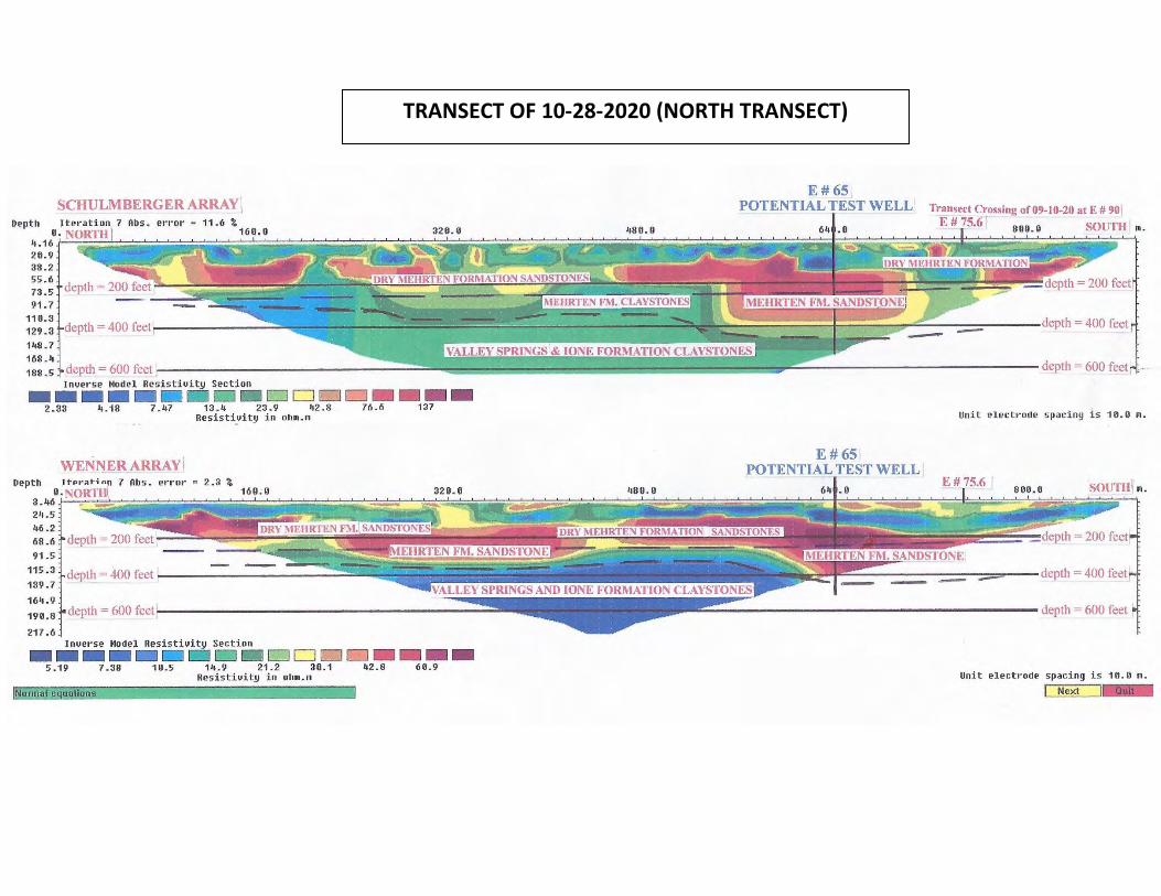
TRANSECT OF 10-28-2020 (NORTH TRANSECT)
SCHULMBERGER ARRAY \ Depth Iteration 7 Abs. error~
O. NORTH ( 4.16 20.9 38.2 55.6 73.5 91.7
E#65 POTENTIAL TEST WELL
64 .0
Transect Crossing of09-10-20 at E # 90\
E#75.6 T eoo.o SOUTH l m_
11 o.3 ______ .::::::::=...,,------....:~=::=2a::.=~:::;!.~=:_-------:::::~~-==-----~t===:::::=::;7 "'::::----:::::::=---- depth = 400 feet 129 _3 depth= 400 feet~ ____ ~---148.7
168.4 1-------------......:==::::=-...==========-- -========':7".c::::::; ______________ depth = 600 feet . -188.5 depth= 600 feet Inverse Model Resistivity Section
---- DD □□DD 2.33 4.18 7.47 13.4 23.9 42.8 76.6 Resisti~ity in ohm.m
WENNER ARRAY \ Depth Jtpr~t;nfl 7 Abs. error ~ 2.3 %
O, NORTHI 3.46 24.5 46.2 68.6 91.5
115.3 139.7
164.9
190.8
217 .6
depth = 400 feet
Inverse Model Resistivity Section
---- □□ DD□□ 5.19 7.38 10.5 14.9 21.2 30.1 42-8 Resistiuity in ohm.m
Normal e uations
--137
--60.9
480.0
E#65 I POTENTIAL TEST WELL I
64 .0
unit electrode spaciny is 10.0 m.
E # 75.6 I 800.0 SOUTH:l m.
Unit electrode spacing is 10.0 m.
Next
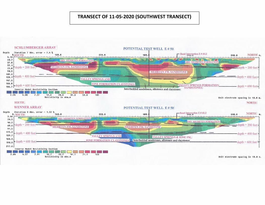
TRANSECT OF 11-05-2020 (SOUTHWEST TRANSECT)
SCHLUMBERGER ARRAY
Depth Iteration 7 Abs. error= 7.4 % 0,SOUTHI
4.13 20.7 37.8 55.1 72.8 90.9
POTENTIAL TEST WELL E # sol
189 ·3 1-....:=....:==--=~;::~£:1!!:!;=.:::!: ~~:;;;;;;;;,,,,;;;;==::==--=-f~~--;;;::J;::_ ______ _:;~-:;::;;:f;=i,:-:::;~ -==::::::;......:==-=-=-=-=-=- depth = 400 feet ' 128. 1 llepth = 400 feet ___ __ _
147 .3
166.8 186.7 depth = 600 feet
Inverse Model Resistivity Section
---- l:d□!:=JDDDD 2.54 4.30 7 .27 12.3 20.8 35.3 59.8
Depth
24.5 46.2 68.6 91.5
115.3 139.7
164. 9
190.8
217 .6
Resistivity in ohm.m
SOUTH I WENNER ARRAY'
error= 1.52 %
depth = 400 feet
Inuerse Model Resistiuity Section
---101
----- O□□DDDD - --2.64 4.57 7.91 13.7 23.7 41.1 71.1 123 Resistiuity in ohm.m
depth = 600 feet
Unit electrode spacing is 10.0 m.
NORTH I
POTENTIAL TEST WELL E # sol
800.0 NORTH : m.
Unit electrode spacing is 10.0 in.
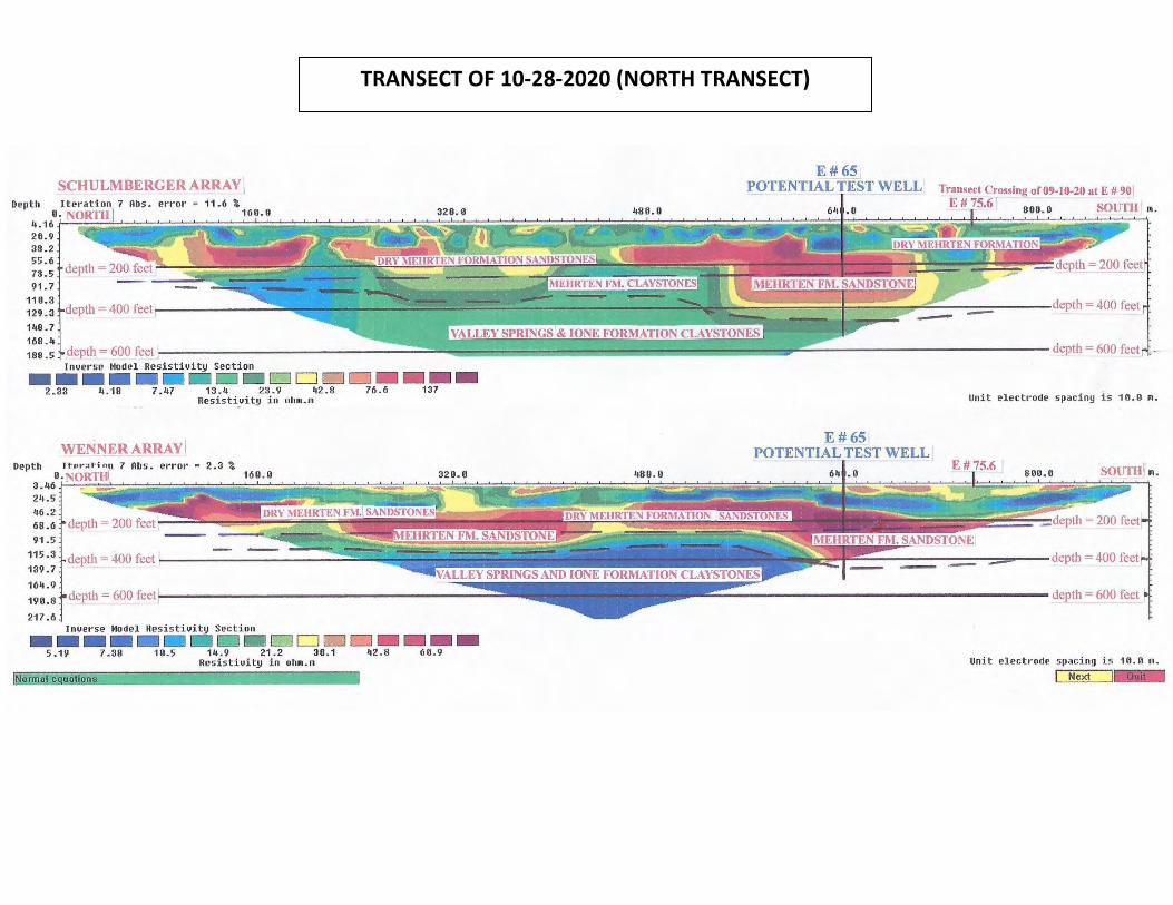
TRANSECT OF 10-28-2020 (NORTH TRANSECT)
SCHULMBERGERARRAY \ E#65
POTENTIAL TEST WELL Transect Crossing of09-I0-20 at E # 90\ Depth Iteration 7 Abs. error = 11.6 %
11,. ~N~O~RgT~H~/-;;::;;;;;,;;;;;;;;;;;;;;;;:;;;:::;;::;~;;,;;;~;;1~6io~.oiiaii;~;~;;:;;;::-;,;:--~~~~3~20~.~o:;;;:::::::::.;;:-:::--~--=;;!;;;;::;;;!;:;;;:::~~~~~sa~:i;~~;;;;;;~~~~.::;;~J§i,~;':1;;;;;2;:1:~;i~?~=jii}l 4.16.f- r-20.9 38.2 55.6 73.5 91.7
E # 75.6 SOUTH I 111.
110.3 129.3 148.7 168 . 4
WENNER ARRAY ! Depth error = 2. 3 %
24.5 46.2 68.6 91.5
115.3 139.7
164.9
190.8
217.6
depth = 400 feet
Inuerse Model Resistiuity Section
---- D DD□□ 5.19 7.38 10.5 14.9 21.2 30.1 42.8 Resistiuity in oh111.111
ormal e uations
--137
--60.9
E#6S 1 POTENTIAL TEST WELL
unit electrode spacing is 10.0 111.
E# 75.6 I
Unit electr ode spacing is 10.0 111.
Next
GROUNDWATER RESOURCES IMPACT ASSESSMENT, HUNTER RANCH, STANISLAUS COUNTY, CALIFORNIA
APPENDIX D
Well Completion Records
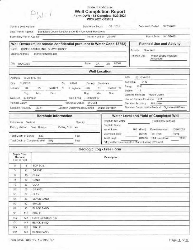
I i. IWell Completion ReportFom DWR 133 Comprere 4/29/2021
werr owner(m!srrcnain confdenrkl prBuanr to waier code 13752) Planncd Use and Actlvlly
waler Level and Yleld of Comoleted well
,e iFed) Ddere-,ed ir6lrn
G.ologic Log - FEe Form
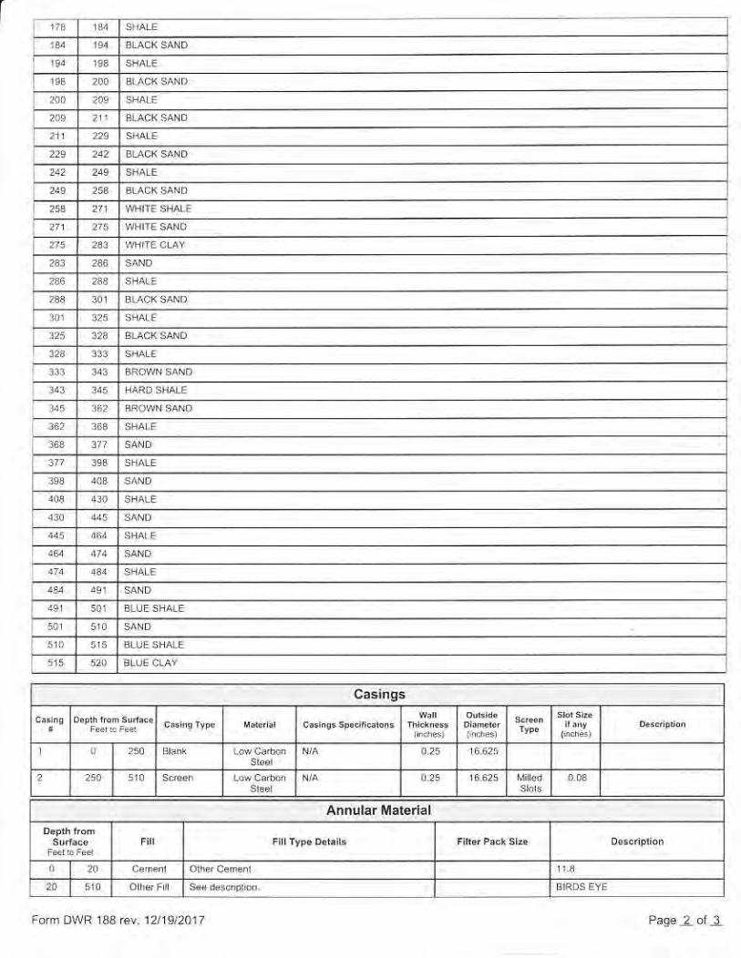
Form DrirR i33 rev r2lrS,20r7
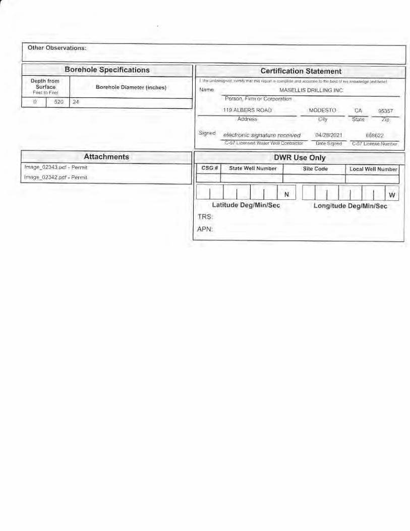
Boehole Sp.cjfication3
-<';;...--z]-
Latiludeoes/Min/soc LonoludeDes/Min/sec

i 'l^.rWell Completion Report
Form DWR 133 Comprere 4291202r--!.:i
w€llowner {musl renaln confidential pucuani to warer Code 137t) Plann€d Use.nd Activity
Water Level and Yield of Comoleled Woll
Geologic Log - Free Fom
Form Or rR 133rev rZi9/2017
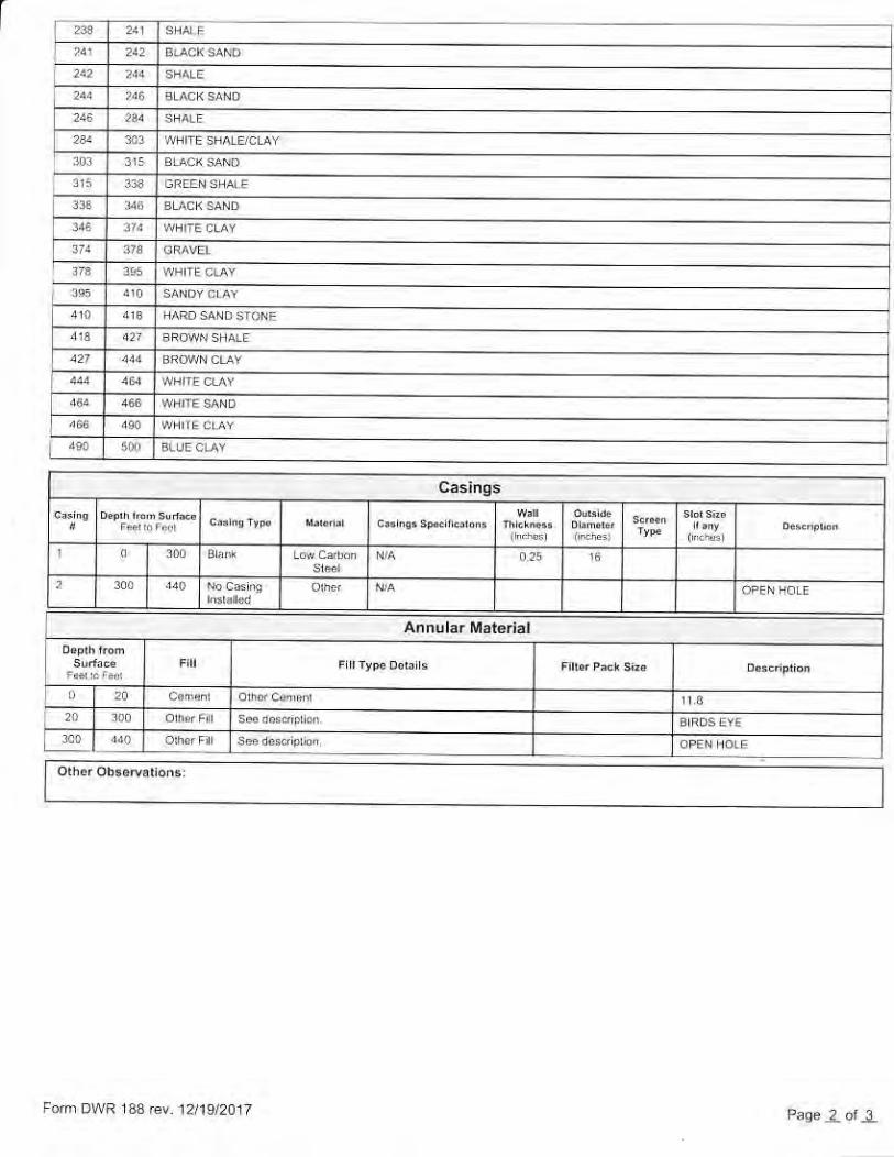
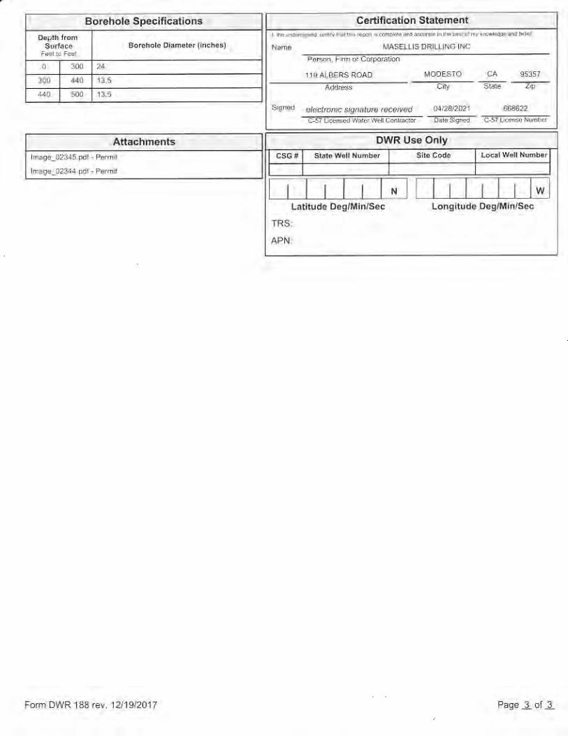
Borchole Specifi€tions
ssryrded@mcsignanrcEi|ed
fr tl TaT;lLatilude D eg/M in/sec
Form DWR 133rev. 12/19/2017
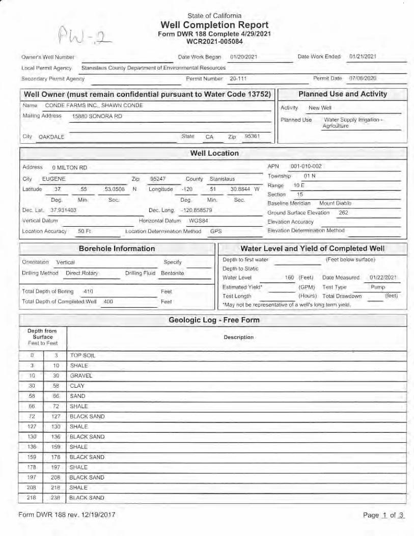
l. rWellCompletion Report
Forn DwR 133 comprete 4/2sl2021
W€ll Own.r(nust Enain conlidonti.l puEuant to Warer Co.!e 13752) Planned Us€.nd Activig
w.ler Level and Yiold of cohpleted well
Geologic Log . Free Form
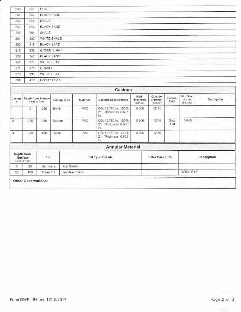
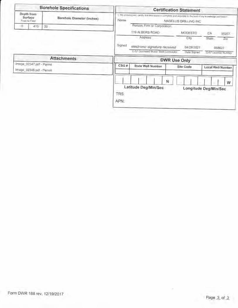
6oEhote Specn€tions
.:lfT.". I
,_ ,-._5.- "d d. . ' "-" . _ *;;;;;i ,:;ii"-;;;;;
.t .;ii _ :D
l_rt_lrdt-7i!ii::n;iiji


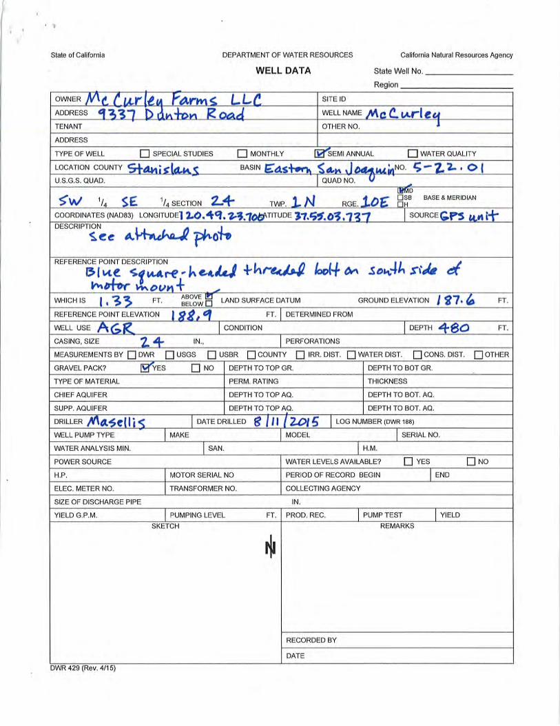
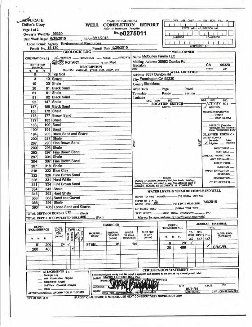
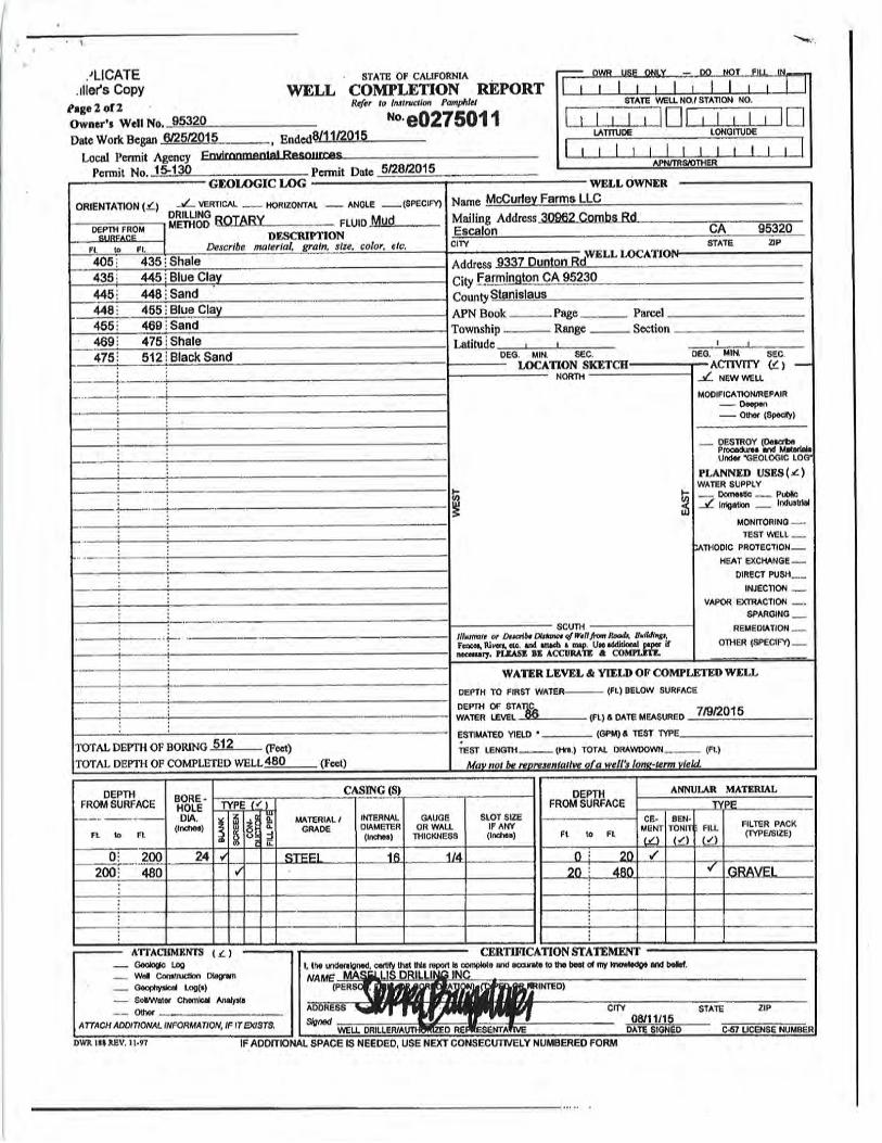


GROUNDWATER RESOURCES IMPACT ASSESSMENT, HUNTER RANCH, STANISLAUS COUNTY, CALIFORNIA
APPENDIX E
Pumping Tests

PW-1 Pumping Test
September 17-20, 2020
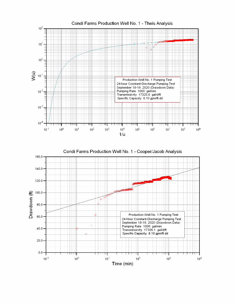
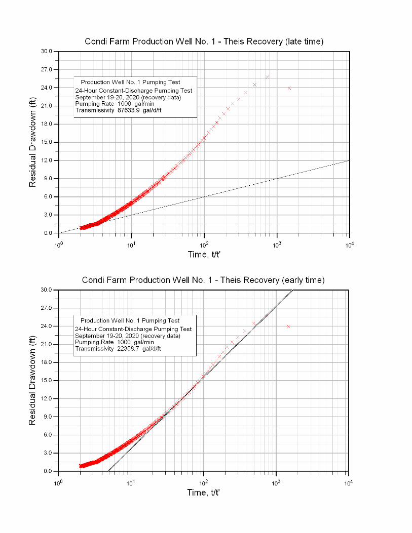


PW-2a Pumping Test
September 17-20, 2020
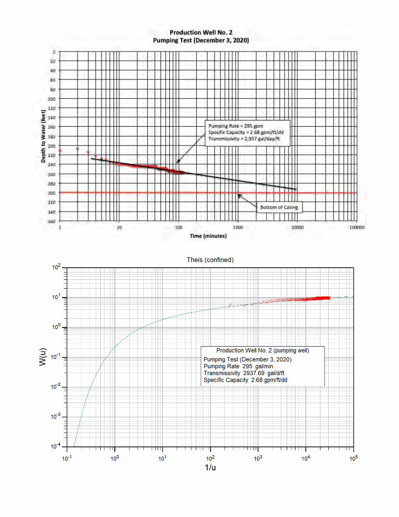


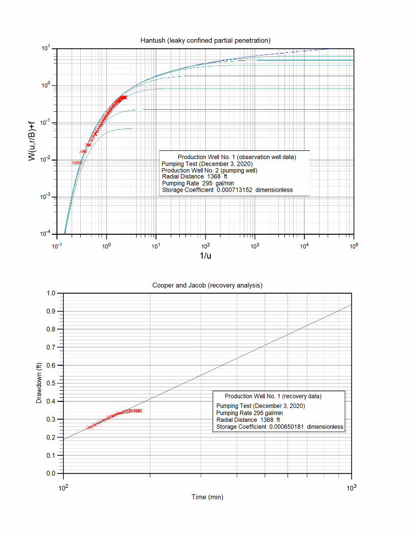
Stanislaus County Final ISMND Package
Mitigation Monitoring and Reporting Program
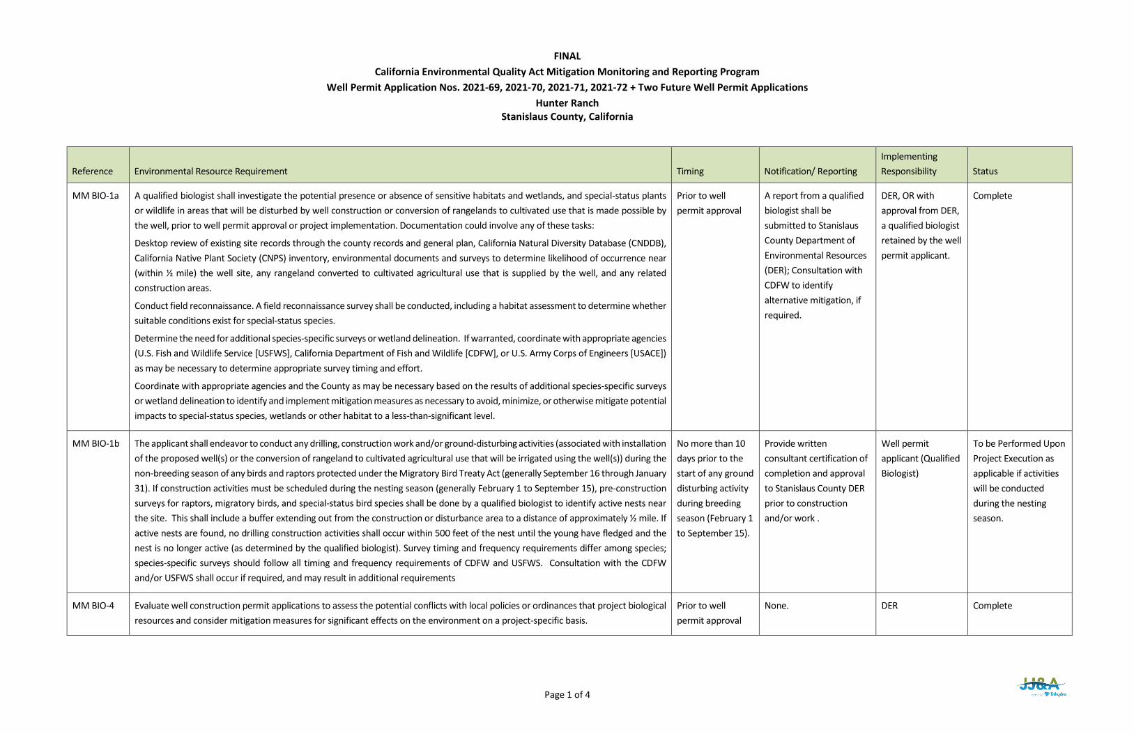
Page 1 of 4
FINAL California Environmental Quality Act Mitigation Monitoring and Reporting Program
Well Permit Application Nos. 2021-69, 2021-70, 2021-71, 2021-72 + Two Future Well Permit Applications Hunter Ranch
Stanislaus County, California
Reference Environmental Resource Requirement Timing Notification/ Reporting Implementing Responsibility Status
MM BIO-1a A qualified biologist shall investigate the potential presence or absence of sensitive habitats and wetlands, and special-status plants or wildlife in areas that will be disturbed by well construction or conversion of rangelands to cultivated use that is made possible by the well, prior to well permit approval or project implementation. Documentation could involve any of these tasks:
Desktop review of existing site records through the county records and general plan, California Natural Diversity Database (CNDDB), California Native Plant Society (CNPS) inventory, environmental documents and surveys to determine likelihood of occurrence near (within ½ mile) the well site, any rangeland converted to cultivated agricultural use that is supplied by the well, and any related construction areas.
Conduct field reconnaissance. A field reconnaissance survey shall be conducted, including a habitat assessment to determine whether suitable conditions exist for special-status species.
Determine the need for additional species-specific surveys or wetland delineation. If warranted, coordinate with appropriate agencies (U.S. Fish and Wildlife Service [USFWS], California Department of Fish and Wildlife [CDFW], or U.S. Army Corps of Engineers [USACE]) as may be necessary to determine appropriate survey timing and effort.
Coordinate with appropriate agencies and the County as may be necessary based on the results of additional species-specific surveys or wetland delineation to identify and implement mitigation measures as necessary to avoid, minimize, or otherwise mitigate potential impacts to special-status species, wetlands or other habitat to a less-than-significant level.
Prior to well permit approval
A report from a qualified biologist shall be submitted to Stanislaus County Department of Environmental Resources (DER); Consultation with CDFW to identify alternative mitigation, if required.
DER, OR with approval from DER, a qualified biologist retained by the well permit applicant.
Complete
MM BIO-1b The applicant shall endeavor to conduct any drilling, construction work and/or ground-disturbing activities (associated with installation of the proposed well(s) or the conversion of rangeland to cultivated agricultural use that will be irrigated using the well(s)) during the non-breeding season of any birds and raptors protected under the Migratory Bird Treaty Act (generally September 16 through January 31). If construction activities must be scheduled during the nesting season (generally February 1 to September 15), pre-construction surveys for raptors, migratory birds, and special-status bird species shall be done by a qualified biologist to identify active nests near the site. This shall include a buffer extending out from the construction or disturbance area to a distance of approximately ½ mile. If active nests are found, no drilling construction activities shall occur within 500 feet of the nest until the young have fledged and the nest is no longer active (as determined by the qualified biologist). Survey timing and frequency requirements differ among species; species-specific surveys should follow all timing and frequency requirements of CDFW and USFWS. Consultation with the CDFW and/or USFWS shall occur if required, and may result in additional requirements
No more than 10 days prior to the start of any ground disturbing activity during breeding season (February 1 to September 15).
Provide written consultant certification of completion and approval to Stanislaus County DER prior to construction and/or work .
Well permit applicant (Qualified Biologist)
To be Performed Upon Project Execution as applicable if activities will be conducted during the nesting season.
MM BIO-4 Evaluate well construction permit applications to assess the potential conflicts with local policies or ordinances that project biological resources and consider mitigation measures for significant effects on the environment on a project-specific basis.
Prior to well permit approval
None. DER Complete
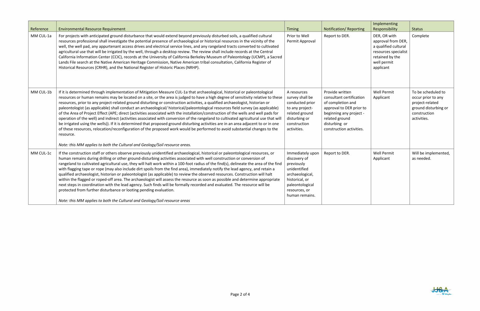
Page 2 of 4
Reference Environmental Resource Requirement Timing Notification/ Reporting Implementing Responsibility Status
MM CUL-1a For projects with anticipated ground disturbance that would extend beyond previously disturbed soils, a qualified cultural resources professional shall investigate the potential presence of archaeological or historical resources in the vicinity of the well, the well pad, any appurtenant access drives and electrical service lines, and any rangeland tracts converted to cultivated agricultural use that will be irrigated by the well, through a desktop review. The review shall include records at the Central California Information Center (CCIC), records at the University of California Berkeley Museum of Paleontology (UCMP), a Sacred Lands File search at the Native American Heritage Commission, Native American tribal consultation, California Register of Historical Resources (CRHR), and the National Register of Historic Places (NRHP).
Prior to Well Permit Approval
Report to DER. DER, OR with approval from DER, a qualified cultural resources specialist retained by the well permit applicant
Complete
MM CUL-1b If it is determined through implementation of Mitigation Measure CUL-1a that archaeological, historical or paleontological resources or human remains may be located on a site, or the area is judged to have a high degree of sensitivity relative to these resources, prior to any project-related ground disturbing or construction activities, a qualified archaeologist, historian or paleontologist (as applicable) shall conduct an archaeological/ historical/paleontological resources field survey (as applicable) of the Area of Project Effect (APE; direct (activities associated with the installation/construction of the wells and well pads for operation of the well) and indirect (activities associated with conversion of the rangeland to cultivated agricultural use that will be irrigated using the wells)). If it is determined that proposed ground disturbing activities are in an area adjacent to or in one of these resources, relocation/reconfiguration of the proposed work would be performed to avoid substantial changes to the resource. Note: this MM applies to both the Cultural and Geology/Soil resource areas.
A resources survey shall be conducted prior to any project-related ground disturbing or construction activities.
Provide written consultant certification of completion and approval to DER prior to beginning any project -related ground disturbing or construction activities.
Well Permit Applicant
To be scheduled to occur prior to any project-related ground disturbing or construction activities.
MM CUL-1c If the construction staff or others observe previously unidentified archaeological, historical or paleontological resources, or human remains during drilling or other ground-disturbing activities associated with well construction or conversion of rangeland to cultivated agricultural use, they will halt work within a 100-foot radius of the find(s), delineate the area of the find with flagging tape or rope (may also include dirt spoils from the find area), immediately notify the lead agency, and retain a qualified archaeologist, historian or paleontologist (as applicable) to review the observed resources. Construction will halt within the flagged or roped-off area. The archaeologist will assess the resource as soon as possible and determine appropriate next steps in coordination with the lead agency. Such finds will be formally recorded and evaluated. The resource will be protected from further disturbance or looting pending evaluation. Note: this MM applies to both the Cultural and Geology/Soil resource areas
Immediately upon discovery of previously unidentified archaeological, historical, or paleontological resources, or human remains.
Report to DER. Well Permit Applicant
Will be implemented, as needed.

Page 3 of 4
Reference Environmental Resource Requirement Timing Notification/ Reporting Implementing Responsibility Status
MM WAT-2 Property owners and water agencies in the area where predicted drawdown exceeds 5 feet will be notified of the existence of the Interference Drawdown Monitoring and Mitigation Program and will be invited to register any domestic wells in the predicted 5-foot drawdown area and any municipal, industrial, or irrigation wells in the predicted 20-foot drawdown area to participate in the program. To register for the program, well owners will be required to complete a Well Information Questionnaire regarding the construction, use, history and performance of their well, and to allow access for periodic measurement of water levels and assessment of well condition and performance by the County or a neutral third party. If well performance is found to be diminished by more than 20 percent or to be inadequate to meet pre-existing water demand due to interference drawdown, registered participants will be eligible to receive reimbursement for reasonable and customary costs for well replacement, deepening or rehabilitation, or pump lowering as needed to restore adequate well function. The cost of reimbursement shall be borne by the operator of the well causing the interference in proportion to the degree of their contribution to the drawdown that caused the diminished yield.
Upon a WAT-2b finding that drawdowns exceed the WAT-2 drawdown triggers (For domestic wells: 5-feet or 10% of available drawdown, whichever is greater; For municipal, industrial or irrigation wells: 20 feet)
Completion of phase one Monitoring and Adaptive Management Program Develop Well Interference Mitigation Program for County Approval. Notify property owners and water agencies of the program and invite them to register their wells to participate. Submit written verification to the County. Implement and Administer the Program.
Applicant Applicant Applicant Applicant, County and Designated Implementing Agency, as applicable .
Not Applicable Due to Permit Conditions of Approval
MM WAT-2b Per Page 5 of the Groundwater Resources Impact Assessment (Initial Study, Attachment 2), the applicant will prepare and implement a Monitoring and Adaptive Management Program during Phase I of the Project. The program will include the following components:
• A monitoring plan will be developed and provided to the Stanislaus County DER for review and approval. The plan will describe the procedures to collect and analyze groundwater level monitoring data from two or more monitoring wells during the initial operation of PW-1 and PW-2.
• Each of the monitoring wells will be fitted with a recording pressure transducer. Drawdown data and groundwater extraction data will be gathered for a period of at least three months after project startup.
Prior to operation of wells PW-1 and PW-2.
Starting prior to Phase I: initial operation of PW-1 and PW-2 and for at least 3 months after well start-up.
Monitoring Plan to DER for review and approval.
Notification to DER of commencement of groundwater level monitoring.
Applicant with review and approval by DER.
Applicant
To be scheduled to occur prior to operating PW-1 and PW-2.
To be scheduled to occur prior to startup of PW-1 and PW-2 pumping and to occur for at least 3 months.

Page 4 of 4
Reference Environmental Resource Requirement Timing Notification/ Reporting Implementing Responsibility Status
• The observed drawdown data will be compared to drawdown data simulated using the groundwater flow model developed for the Project and described in Section 4 of the Groundwater Resources Impact Assessment and a Phase I Drawdown Response Assessment will be prepared and submitted for County review and approval. To perform the assessment, the actual pumping rates from the initial startup period will be simulated using the model, and the predicted drawdown response at the monitoring well locations will be compared to the observed response. If the observed drawdown is different from the predicted drawdown, the model will be updated as appropriate to match the observed drawdown. The updated model will then be used to assess the allowable groundwater development extraction rate for Phase II of the Project, as follows:
o If the observed drawdown was less than or similar to the originally predicted drawdown, development of Phase II may include up to an additional 175 acres.
o If the observed drawdown was greater than the originally predicted drawdown, the updated model will be used to establish an allowable additional pumping volume for Phase II such that the drawdown predicted for expanded Phase II pumping remains less than or similar to the originally predicted drawdown described in Section 4 of the Groundwater Resources Impact Assessment.
o The outcome of the analysis will be provided to the Stanislaus County DER for review and approval.
The outcome analysis will be reported within 90 days of completing Phase 1 groundwater level monitoring; and prior to Phase II construction and operation.
Phase I drawdown response analysis and Phase II proposed activities report from GRIA consultant to DER.
Applicant with review and approval by DER prior to implementing Phase II.
To be scheduled to occur upon completion of groundwater level monitoring and prior to any Phase II activities.
Related Documents