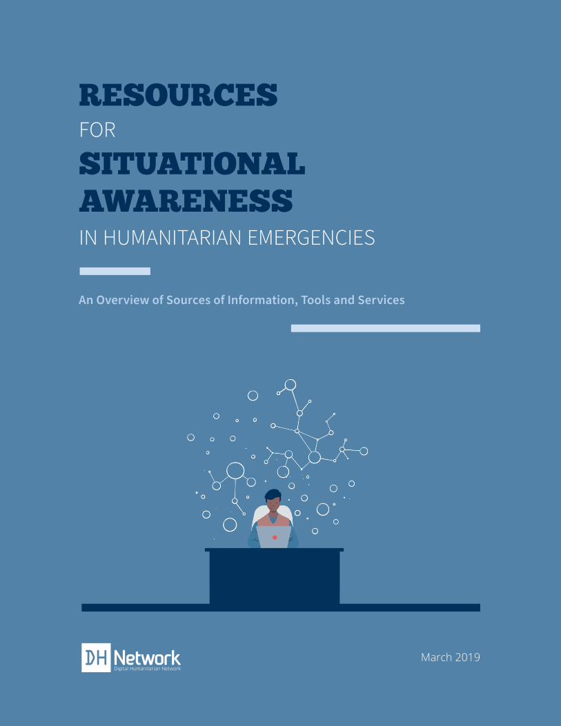
RESOURCES FOR SITUATIONAL AWARENESS IN HUMANITARIAN EMERGENCIES An Overview of Sources of Information, Tools and Services March 2019

Welcome message from author
This document is posted to help you gain knowledge. Please leave a comment to let me know what you think about it! Share it to your friends and learn new things together.
Transcript
1
RESOURCES FOR
SITUATIONAL AWARENESSIN HUMANITARIAN EMERGENCIES
An Overview of Sources of Information, Tools and Services
March 2019
2
Licensing Information
“RESOURCES FOR SITUATIONAL AWARENESS INHUMANITARIAN EMERGENCIES
An Overview of Sources of Information, Tools and Services ” by RJ Reid and Andrej Verity, is licensed under
Creative Commons Attribution-NonCommercial 3.0 Unported.
3
Mar 2019 I
RESOURCES FOR SITUATIONAL AWARENESS IN
HUMANITARIAN EMERGENCIES
An Overview of Sources of Information,Tools and Services
RJ Reid ([email protected])Master of Global Affairs Candidate
Munk School of Global Affairs & Public Policy, University of Toronto
Andrej Verity ([email protected] | @andrejverity)Office for the Coordination of Humanitarian Affairs (OCHA)
United Nations
Design
Ignacio G. Rebollo (igrebollo.com | [email protected]) M.Des. Ontario College of Arts and Design University (OCAD U)
B.Arch. (Hons) ‘12 Instituto de Empresa (IE) University - School of Architecture
This document was made possiblewith the support of UN-OCHA
by
I Mar 2019
METHODOLOGY
Resources in this document were compiled through a combination of
interviews, literature reviews, and detailed reviews of products and services
conducted between May to July 2018. The research was thorough but
should not be considered exhaustive, especially with the rapidly-changing
pace of technology.
1
Mar 2019 I
RESOURCES FOR SITUATIONAL AWARENESS IN HUMANITARIAN EMERGENCIESAn Overview of Sources of Information, Tools and Services
INTRODUCTION 02
WHAT IS SITUATIONAL AWARENESS? 03
SITUATIONAL AWARENESS IN HUMANITARIAN EMERGENCIES 04
STRATEGIES FOR EFFECTIVE SITUATIONAL AWARENESS IN HUMANITARIAN EMERGENCIES 06
Knowing What You Need to Know 06
Knowing What Is Available 07
Integrating Situational Awareness into Organizational Processes 08
Knowing What Others Need to Know 10
RESOURCES FOR SITUATIONAL AWARENESS IN HUM. EMERGENCIES 11
Information and Data Sources in Humanitarian Emergencies 12
Tools and Services for Situational Awareness 20
APPENDIX I: List of Interviewees 33
APPENDIX II: Links to Resources 34
CONTENTS
02 I Mar 2019
INTRODUCTIONFor organizations responding to humanitarian emergencies, situational awareness is critical in order to ensure optimized actions, from understanding needs to the logistical distribution of assistance, to communicating with affected people. However, the definition of (humanitarian) situational awareness will vary between groups and organizations. It is therefore recognized that one report will not provide the sole definition. However, understanding the resources available to respondents—data, information, tools and services—is a realistic possibility. This report aims to do exactly that: provide a landscape analysis of those resources available to anyone responding to humanitarian emergencies.
In order to structure the report, a general definition of (humanitarian) situational awareness is provided, followed by an outline of its relation to humanitarian emergencies and strategies for effective situation-al awareness. The second half of the report provides a landscape of digital resources available, includ-ing resources designed for the humanitarian sector as well as resources designed for other sectors (e.g. private, military, intelligence). The report aims to detail the relation between situational awareness and digital services and to showcase the potential of resources currently available to humanitarian organi-zations.
We all understand that technology and related services are changing rapidly. Therefore, one should consider this report as a “snapshot” taken in mid-2018.
03
Mar 2019 I
WHAT IS SITUATIONAL AWARENESS?
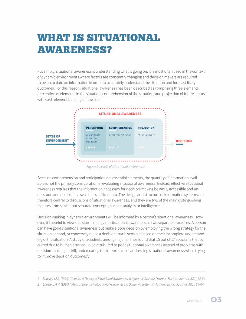
Put simply, situational awareness is understanding what is going on. It is most often used in the context of dynamic environments where factors are constantly changing and decision makers are required to be up to date on information in order to accurately understand the situation and forecast likely outcomes. For this reason, situational awareness has been described as comprising three elements: perception of elements in the situation, comprehension of the situation, and projection of future status, with each element building off the last1.
Because comprehension and anticipation are essential elements, the quantity of information avail-able is not the primary consideration in evaluating situational awareness. Instead, effective situational awareness requires that the information necessary for decision-making be easily accessible and un-derstood and not lost in a sea of less critical data. The design and structure of information systems are therefore central to discussions of situational awareness, and they are two of the main distinguishing features from similar but separate concepts, such as analysis or intelligence.
Decision-making in dynamic environments will be informed by a person’s situational awareness. How-ever, it is useful to view decision-making and situational awareness as two separate processes. A person can have good situational awareness but make a poor decision by employing the wrong strategy for the situation at hand, or conversely make a decision that is sensible based on their incomplete understand-ing of the situation. A study of accidents among major airlines found that 15 out of 17 accidents that oc-curred due to human error could be attributed to poor situational awareness instead of problems with decision-making or skill, underscoring the importance of addressing situational awareness when trying to improve decision outcomes2.
1 Endsley, M.R. (1995). “Toward a Theory of Situational Awareness in Dynamic Systems” Human Factors Journal, 37(1), 32-64.
2 Endsley, M.R. (1995). “Measurement of Situational Awareness in Dynamic Systems” Human Factors Journal, 37(1), 65-84.
Figure 1: Levels of situational awareness1
04 I Mar 2019
SITUATIONAL AWARENESS IN HUMANITARIAN EMERGENCIES
In any humanitarian emergency, critical decisions must be made within a limited time frame based on constantly changing information. In this respect, humanitarian emergencies are similar to other fields where the concept of situational awareness is regularly employed, such as aviation and tactical response. The dynamic environment of these fields makes it difficult to standardize operations and in-stead requires people involved to make decisions based on their best understanding.
For effective humanitarian response, strong situational awareness is required at every level of an or-ganization. At the global level, situational awareness is required to distribute funds and develop an overarching strategy. At the country level, situational awareness is required to distribute resources and anticipate upcoming needs. At the frontline response level, situational awareness is required for the management of day-to-day operations and planning for the immediate future. Situational awareness will look different and have different requirements for each role within the response to a humanitarian emergency. The concept at its core, however, remains the same.
There has been increased recognition in the humanitarian community of the importance of producing and utilizing good information and analysis during a humanitarian crisis. The United Nations (UN) Office for the Coordination of Humanitarian Affairs (OCHA) included improving situational analysis as its sec-ond objective in its 2018-2021 Strategic Plan,3 and the UN Secretary-General, Antonio Guterres, listed addressing gaps in situational awareness as a key method to improving UN peacekeeping response.4 A
3 OCHA Strategic Plan 2018-2021, available at: https://www.unocha.org/sites/unocha/files/OCHA%202018-21%20
Strategic%20Plan.pdf
4 See Guterres’s remarks on UN peacekeeping reform at: https://www.un.org/sg/en/content/sg/speech-
es/2017-09-20/sgs-reform-un-peacekeeping-remarks
05
Mar 2019 I
2017 report commissioned by the UN determined that the organization needed a coherent situational awareness system to overcome current challenges in its operations.5
Outside the UN, the International Federation of the Red Cross and Red Crescent Societies (IFRC) re-cently developed its IFRC GO project, which aims to make disaster information accessible and useful to IFRC responders.6 ACAPS, a non-profit project of the Norwegian Refugee Council and Save the Children, was created in 2009 with the express purpose of supporting the humanitarian community by providing up-to-date information on crisis situations.7 Other significant contributions to situational awareness in humanitarian emergencies have been made in the past decade by non-governmental organizations (NGOs), social enterprises, private companies, university institutes, charitable foundations and digital volunteer networks, all looking to help improve the outcomes of crisis response.
5 Wilmot H, Improving UN Situational Awareness. Stimson Centre, August 2017. https://www.stimson.org/sites/de-
fault/files/file-attachments/UNSituationalAwareness_FINAL_Web.pdf
6 Visit the IFRC GO project at: http://go.ifrc.org/
7 Visit ACAPS at: https://www.acaps.org/
06 I Mar 2019
STRATEGIES FOR EFFECTIVE SITUATIONAL AWARENESS IN HUMANITARIAN EMERGENCIES
The following strategies were developed from conversations with experts working in humanitarian re-sponse and situational awareness, and from relevant literature. Appendix I features a list of those who contributed their insights.
KNOWING WHAT YOU NEED TO KNOW
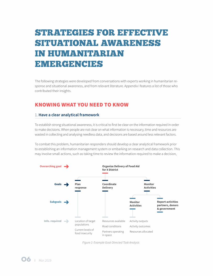
1. Have a clear analytical framework
To establish strong situational awareness, it is critical to first be clear on the information required in order to make decisions. When people are not clear on what information is necessary, time and resources are wasted in collecting and analysing needless data, and decisions are based around less relevant factors.
To combat this problem, humanitarian responders should develop a clear analytical framework prior to establishing an information management system or embarking on research and data collection. This may involve small actions, such as taking time to review the information required to make a decision,
Figure 2: Example Goal-Directed Task Analysis
07
Mar 2019 I
or large actions, such as an organization-wide assessment of information management practices. For the latter, Dr. Mica Endsley recommends completing a Goal-Directed Task Analysis (GDTA) to ensure systems are developed for their appropriate purpose. A GDTA evaluates the various goals and subgoals that a person has in a prescribed role and from this compiles a list of all the information necessary to make decisions. Goals in the GDTA are action-based in order to more directly correspond to the work tasks of the prescribed role. Figure 2 shows an example of a simple GDTA.8
The GDTA helps to ensure that all information necessary to complete a specific task is being received by completing a personalized assessment. While recommended, such assessments will not always be feasible, and it may not be possible to design information products to that level of specificity. As an alternative, the Multi-Sectoral Initial Rapid Assessment Guidance9 provides a standardized framework that captures information commonly needed in crisis situations. Individuals can then draw from such assessments and take the information necessary for their specific task.
2. Incorporate local and global situational awareness
Local situational awareness corresponds to having a good understanding of what is going on within a narrow range of work responsibilities, while global situational awareness corresponds to an under-standing across a broader range of higher-level objectives. Global situational awareness can be dis-tracting to those working to complete specific tasks, but it can also provide helpful context and clarity that can ensure better coordination between teams and alignment with an overall programme mission. Those operating in humanitarian response should prioritize local situational awareness necessary for their tasks, but they should designate time at a set interval (daily, weekly) to understand the larger pic-ture and where their operations fit.
“Different NGOs may be working in the same area and the left hand doesn’t know what the right hand is doing, and then that causes inefficiencies or even problems.”
- Dr. Mica Endsley, President SA Technologies
KNOWING WHAT IS AVAILABLE
3. Canvas secondary research before embarking on primary research
Experts commonly noted a tendency in humanitarian response to try to collect data when similar in-formation had already been collected and analysed. Some believe this duplication of effort happens because a thorough information review requires intense research and reading potentially thousands of
8 For more information on GDTA and the design process, see Endsley, M.R. Designing for Situational Awareness.
(Florida: CRC Press, 2016).
9 Inter-Agency Standing Committee (July 2015) “Multi-Sectoral Initial Rapid Assessment Guidance”
08 I Mar 2019
pages of documents, while others saw difficulties with alignment. Different organizations use different metrics and definitions for similar concepts, and thus available data is sometimes unable to fit within the desired framework. Regardless of the reason, humanitarian responders should make a concerted effort to review all relevant research and pursue primary data collection only after ensuring it is neces-sary. Such an effort can minimize duplication and prevent time and resources being wasted.
“People favour primary data collection, and we waste resources collecting information we already have.”
- Patrice Chataigner, humanitarian-sector consultant
4. Work with what’s available
High-quality analysis is the most helpful for emergency responders, but this type of information will not be available immediately following a sudden-onset disaster. Situational awareness should not be a roadblock to timely relief efforts, and responders should instead base decisions off available infor-mation in time-sensitive situations. Available information can come from a variety of sources including social media, such as Twitter; Skype groups and other online discussion forums; and in-person discus-sions with people in the affected area. If humanitarian responders remain conscious of knowing what they need to know, these unverified sources can still provide the information requisite for early deci-sions.
“If you are not operating on social media and you are a disaster responder, then you are missing part of what’s going on in the world.”
- Cat Graham, Co-Founder of Humanity Road
INTEGRATING SITUATIONAL AWARENESS INTO ORGANIZATIONAL PROCESSES
5. Dedicate adequate resources to information management and analysis
Having a strong comprehension of a situation is a full-time job. Teams working in humanitarian re-sponse should have at least one person assigned exclusively to information management and analysis to help improve the team’s situational awareness. In larger organizations, these responsibilities will require their own teams.
The information age has brought mass amounts of data, but compiling and structuring it all into a useable format has been identified as a major roadblock to situational awareness. Better structuring of information, which allows for easier analysis, is another area identified as underdeveloped in the hu-manitarian space.
09
Mar 2019 I
Together, information management specialists and analysts keep a team aware of the current situation, and they foster comprehension of the present and anticipation about likely events in the future. This fa-cilitates better planning and delivery of aid in humanitarian emergencies, and it increases the team’s ca-pacity by reducing inefficiencies and better managing resources. Analysis commonly gets deprioritized during sudden-onset emergencies due to the high workload experienced by an organization. However, such times are when analysis is most critical, and efforts should be made to retain analysis capacity in order to optimize situational awareness.
“We as a community massively underinvest in analysis, and therefore it is critical that we get better at it. We spend more money on evaluating how operations went wrong than we do on getting it right up front.”
- Lars Peter Nissen, Director of ACAPS
6. View situational awareness as an ongoing process
Initial assessments and baseline surveys are helpful in obtaining situational awareness, but humanitarian emergencies are dynamic events and continual monitoring is required to stay abreast of the situation. In determining which information is required to make a decision, consider how often that information is available and if more regularly available proxy indicators can supplement and fill in gaps. Information systems should be designed in a way that allows for easy updating of information. But in the context of humanitarian emergencies, where factors change quickly and decisions are made under a limited time frame, several smaller assessments will likely be more beneficial than one large comprehensive report.
“I prefer the term ‘sensemaking’ [to situational awareness], as it illustrates that it’s an ongoing and dynamic process … it’s impossible to comprehend everything or have a complete awareness of a situation.”
- Kenny Meesters, researcher & practitioner in crisis & disaster information management
7. Leverage available resources
A wide range of tools, services and platforms exist inside and outside of the humanitarian space that can be utilized to improve situational awareness. These resources include curated analysis and infor-mation sources on humanitarian crises, as well as information management systems that allow for eas-ier collection, compiling and analysis of data. The next section of this report outlines the resources that are currently being used by responders or have the potential to be used in the future. Newer resources offer innovative solutions, but an organization’s capacity to work with these resources is a crucial con-sideration in applying them. If technical abilities are limited, new platforms and software can end up placing an unnecessary burden on people within an organization. Training and well-structured transi-tion periods will help new resources gain traction within a team.
“Anything that has been published by anyone on earth about the humanitarian situa-tion in Yemen is on ReliefWeb; it’s the authoritative archive of everyone’s activities.”
- John Ratcliffe, OCHA Humanitarian Affairs Officer for Yemen
10 I Mar 2019
KNOWING WHAT OTHERS NEED TO KNOW
8. Employ user-centred design
When sharing information within teams, between teams or to the population at large, humanitarian responders should think deliberately about what information recipients need and structure their work accordingly. The GDTA process discussed above can be used when implementing an information-shar-ing system to ensure the correct information is being shared. People have short attention spans, espe-cially when dealing with stress or a high volume of information, and large volumes of poorly structured information are unlikely to be adequately absorbed. Information should be presented clearly in a sensi-ble format, with inputs needed for likely decisions grouped together for easier viewing and analysis by the recipient.
“We focus the data on being most relevant to the application, rather than dumping a whole bunch of data and making it accessible and hoping decision makers will know what to do with it, because they won’t; it’s too much data.”
- Anonymous, Humanitarian Affairs Sector
9. Develop team situational awareness
Team situational awareness is the team’s ability as a collective to know what is going on. Each team member does not need to know every detail of a humanitarian emergency, but the correct information needs to flow to the correct people, with all information available upon request. Weekly reports, effec-tive communication platforms and positive team dynamics can help ensure optimal team situational awareness. Each team member should be aware of their information responsibilities in the team, both in terms of what they should know and how they should share it with others. All team members should know the different information responsibilities of people and departments within their organization so they can access information in an efficient manner when necessary. In addition, training individuals on situational awareness, including what is relevant in a situation and how to communicate it, can assist with individual and team comprehension.
“People can figure out what they think is going on, but they don’t necessarily share it well across the organization or across the broader team.”
- Dr. Mica Endsley, President SA Technologies
11
Mar 2019 I
RESOURCES FOR SITUATIONAL AWARENESS IN HUMANITARIAN EMERGENCIES
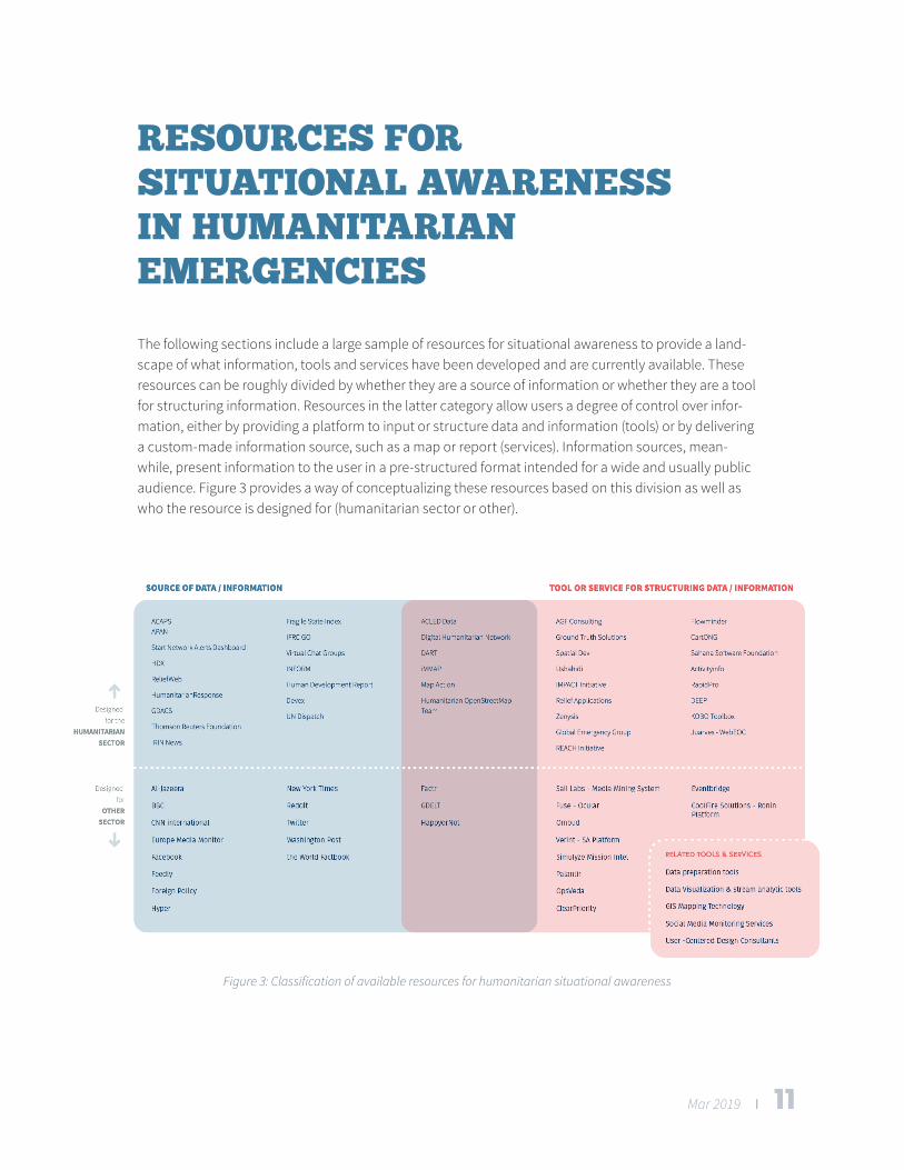
The following sections include a large sample of resources for situational awareness to provide a land-scape of what information, tools and services have been developed and are currently available. These resources can be roughly divided by whether they are a source of information or whether they are a tool for structuring information. Resources in the latter category allow users a degree of control over infor-mation, either by providing a platform to input or structure data and information (tools) or by delivering a custom-made information source, such as a map or report (services). Information sources, mean-while, present information to the user in a pre-structured format intended for a wide and usually public audience. Figure 3 provides a way of conceptualizing these resources based on this division as well as who the resource is designed for (humanitarian sector or other).
Figure 3: Classification of available resources for humanitarian situational awareness
12 I Mar 2019
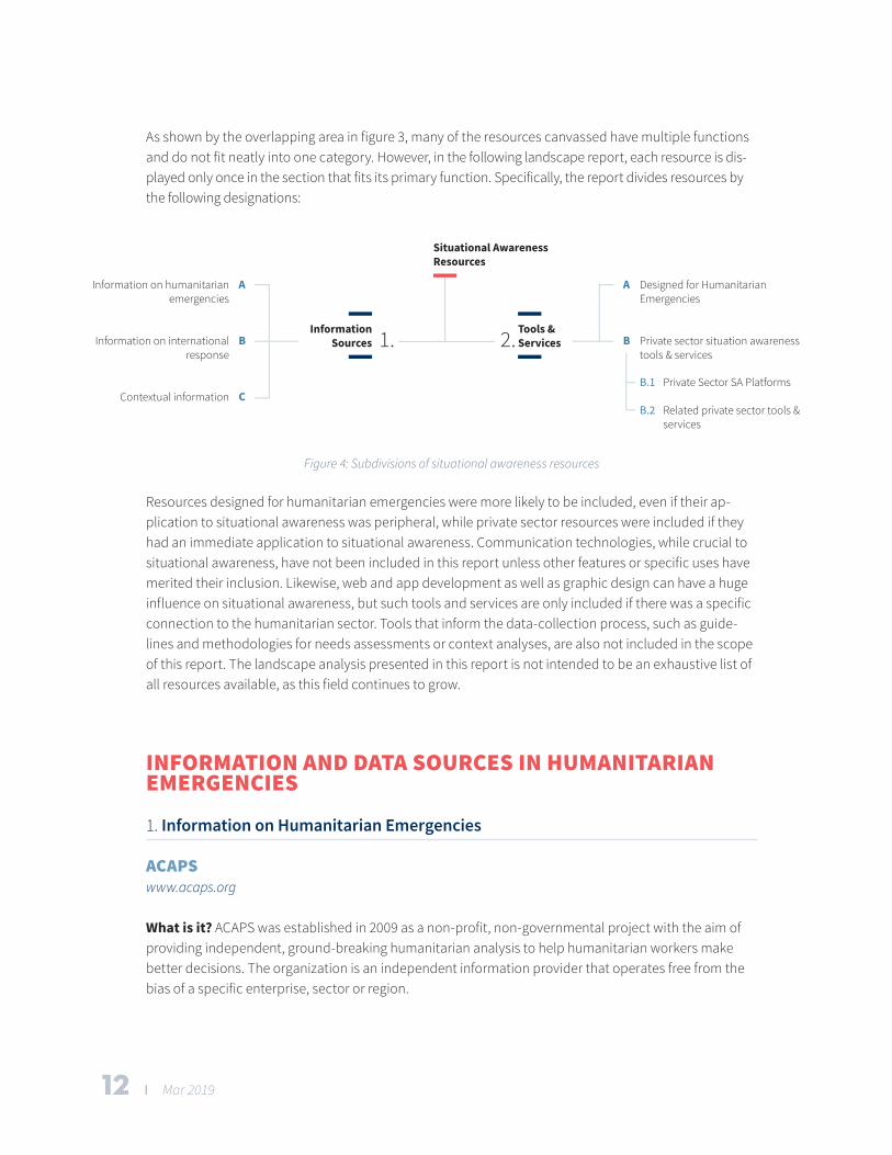
As shown by the overlapping area in figure 3, many of the resources canvassed have multiple functions and do not fit neatly into one category. However, in the following landscape report, each resource is dis-played only once in the section that fits its primary function. Specifically, the report divides resources by the following designations:
Figure 4: Subdivisions of situational awareness resources
Resources designed for humanitarian emergencies were more likely to be included, even if their ap-plication to situational awareness was peripheral, while private sector resources were included if they had an immediate application to situational awareness. Communication technologies, while crucial to situational awareness, have not been included in this report unless other features or specific uses have merited their inclusion. Likewise, web and app development as well as graphic design can have a huge influence on situational awareness, but such tools and services are only included if there was a specific connection to the humanitarian sector. Tools that inform the data-collection process, such as guide-lines and methodologies for needs assessments or context analyses, are also not included in the scope of this report. The landscape analysis presented in this report is not intended to be an exhaustive list of all resources available, as this field continues to grow.
INFORMATION AND DATA SOURCES IN HUMANITARIAN EMERGENCIES
1. Information on Humanitarian Emergencies
ACAPSwww.acaps.org
What is it? ACAPS was established in 2009 as a non-profit, non-governmental project with the aim of providing independent, ground-breaking humanitarian analysis to help humanitarian workers make better decisions. The organization is an independent information provider that operates free from the bias of a specific enterprise, sector or region.
13
Mar 2019 I
What does it offer? ACAPS supports the humanitarian community by providing up-to-date informa-tion on more than 40 key crises around the globe. Information is available by country and includes an overview, crisis analysis, country profile and special report. Analysis is divided by topic (e.g. displace-ment, health), and key figures and priorities are easily accessible. All information is available online and through the ACAPS CrisisAlert app. Registered users can choose to follow certain countries and keep track of new reports, as well as subscribe to a weekly newsletter that provides global updates. In addition, users can request tailored support, such as analytical products and field assessments from ACAPS.
ACLED www.acleddata.com
What is it? The Armed Conflict Location & Event Data Project (ACLED) is a disaggregated conflict collec-tion, analysis and crisis-mapping project. ACLED collects the dates, actors, types of violence, locations and fatalities of all reported political violence and protest events across Africa, South Asia, South-East Asia and the Middle East. The ACLED team conducts analysis to describe, explore and test conflict sce-narios and makes data and analysis open to free use by the public.
What does it offer? ACLED’s dashboard displays data via maps and infographics, and it presents crisis profiles and summaries along with key figures. Interactive features are available to allow users to filter data for their own needs. Analysis is provided on trends identified by the ACLED team. Data used on the site is available for download by the public.
Also check out: CrisisWatch by International Crisis Group
Flowminderwww.flowminder.org
What is it? Flowminder collects, aggregates, integrates and analyses anonymous mobile operator data, and satellite and household survey data. By using such data, it can track population displace-ment, provide estimates on indicators such as poverty and model the spread of disease outbreaks.
What does it offer? Using its data-collection and analysis techniques, Flowminder offers free research for disaster response, socioeconomic analysis and precision epidemiology. It also contributes to capac-ity-building projects and works with mobile operators, Governments, UN agencies, private companies and NGOs to improve data-analysis capabilities.
14 I Mar 2019
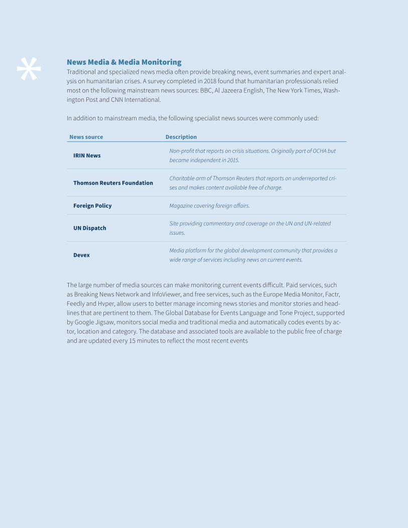
* News Media & Media Monitoring Traditional and specialized news media often provide breaking news, event summaries and expert anal-ysis on humanitarian crises. A survey completed in 2018 found that humanitarian professionals relied most on the following mainstream news sources: BBC, Al Jazeera English, The New York Times, Wash-ington Post and CNN International.
In addition to mainstream media, the following specialist news sources were commonly used:
News source Description
IRIN NewsNon-profit that reports on crisis situations. Originally part of OCHA but
became independent in 2015.
Thomson Reuters FoundationCharitable arm of Thomson Reuters that reports on underreported cri-
ses and makes content available free of charge.
Foreign Policy Magazine covering foreign affairs.
UN DispatchSite providing commentary and coverage on the UN and UN-related
issues.
DevexMedia platform for the global development community that provides a
wide range of services including news on current events.
The large number of media sources can make monitoring current events difficult. Paid services, such as Breaking News Network and InfoViewer, and free services, such as the Europe Media Monitor, Factr, Feedly and Hvper, allow users to better manage incoming news stories and monitor stories and head-lines that are pertinent to them. The Global Database for Events Language and Tone Project, supported by Google Jigsaw, monitors social media and traditional media and automatically codes events by ac-tor, location and category. The database and associated tools are available to the public free of charge and are updated every 15 minutes to reflect the most recent events
15
Mar 2019 I
GDACSwww.gdacs.org
What is it? The Global Disaster Alert and Coordination System (GDACS) is a cooperation framework be-tween the UN, the European Commission and disaster managers worldwide to improve alerts, informa-tion exchange and coordination in the first phase after major sudden-onset disasters. GDACS provides real-time access to web‐based disaster information systems and related coordination tools.
What does it offer? GDACS posts alerts on sudden-onset disasters that include information such as date, timeline, exposed population and disaster-specific information (e.g. magnitude of an earthquake), in addition to maps, satellite imagery and the latest media headlines. GDACS is known as being a reli-able and timely first source of information immediately following a disaster. The Virtual On-Site Opera-tions Coordination Centre (Virtual OSOCC), discussed further below, is housed on the GDACS website.
Also check out: EM-DAT, Pacific Disaster Center
HDXdata.humdata.org
What is it? The Humanitarian Data Exchange (HDX) is an OCHA-managed open platform for sharing data. Or-ganizations share data or metadata to the site, which users can then download and analyse. The HDX team manually reviews all new data sets for relevance, accuracy, timeliness, interpretability and comparability.
What does it offer? HDX offers thousands of data sets, with an aim of posting data related to a crisis in a timely manner. Data sets are most commonly uploaded as a csv, xlsx or zipped shapefile, but they come in a wide variety of formats and may also include data visualizations. Data sets are searchable by format, location, organization or year, and they are either publicly available or have metadata shared. Registered users can request access from the data set’s owner. The Humanitarian Exchange Language is increasingly being used within data sets to help standardize formats and improve integration capabilities.
ReliefWebreliefweb.int
What is it? ReliefWeb is the leading humanitarian information source on global crises and disasters, and is a service of OCHA. ReliefWeb provides reliable and timely information that enables humanitarian workers to make informed decisions and plan an effective response.
What does it offer? ReliefWeb collects and delivers key information on humanitarian crises, includ-ing the latest reports, maps and infographics from trusted sources. Registered users can subscribe to receive a daily email updating them on global headlines or a specific country or disaster. Reports published by UN agencies, such as situation reports, humanitarian needs overviews and humanitarian response plans, will all be found on ReliefWeb as they are published. Information on ReliefWeb can be accessed through its Crises app or through a browser. ReliefWeb Labs offers humanitarian responders services that are currently in testing phase.
16 I Mar 2019
*
Twittertwitter.com
What is it? Twitter is a news and social networking service that allows users to share short pots of no more than 280 characters. Twitter averaged 336 million monthly active users in the first quarter of 2018 and is commonly used in crisis situations. Researchers focusing on the 2015 Nepal earthquake found more than 4.2 million tweets in English alone about the disaster.
What does it offer? Twitter offers close to instantaneous information on current events and public per-ception. Twitter is fast, but it is not screened for accuracy or curated by editors. Furthermore, the huge amount of information on Twitter can be difficult to find, evaluate and analyse, and in essence it is a large, uncleaned data set. Tweets can be geolocated, if the user has enabled this feature, and may also be searched by metadata tags, known as hashtags, that the user can add. Users can engage in public and private conversations with others on the site.
Humanitarian responders have found a wide array of uses for Twitter that include making it a source of breaking news, connecting with affected populations, and performing aggregate analysis to display trends in migration, public perception and access to aid.
Other social media: Twitter is the most commonly used social media platform in relation to humani-tarian emergencies, but responders have also used other platforms for similar purposes, such as Face-book, YouTube and Reddit. Photos from Facebook, for instance, have been used to evaluate infrastruc-ture damage following a disaster, providing an inexpensive and time-efficient alternative to reviewing satellite imagery.
Other relevant information sources
• Government websites and press briefings
• Local media
• NGOs (e.g. Humanitarian Library, Humanity Road)
• Think tanks & private information services (e.g. Jane’s by IHS market)
• University institutes and affiliates (e.g. EM-DAT)
17
Mar 2019 I
*
2. Information on the International Response to Humanitarian Emergencies
APANwww.apan.org
What is it? The All Partners Access Network (APAN) is the unclassified information-sharing and collab-oration platform for the United States Department of Defense (DoD). APAN provides DoD and mission partners with community spaces and collaborative tools to leverage information to effectively plan, train and respond to meet their business requirements and mission objectives. It is commonly used in humanitarian assistance and disaster relief situations.
What does it offer? In cases of humanitarian assistance and disaster relief, communities are estab-lished on the APAN site that allow Governments, militaries, and international and non-governmental organizations to collaborate, share information and request assistance. The site offers communication methods such as audio and video calling, instant messaging and group chat, as well as an automated translation service. The site’s community maps feature allows users to geotag content and create cus-tom, interactive maps.
HumanitarianResponse.Info (HR.info)www.humanitarianresponse.info
What is it? HR.info is the central website for information management tools and services, enabling information exchange among operational responders during a protracted or sudden-onset emergency. Global resources are complemented by country-specific emergency sites that can be accessed through the main site.
What does it offer? HR.info provides access to a one-stop shop for global information coordination resources, including guidance notes and policies, cluster-specific information and data, toolboxes and Internet links. The related country sites are designed to provide a platform for sharing operational in-formation between clusters and Inter-Agency Standing Committee (IASC) members operating within a crisis. Registered users can share and read resources, such as meeting minutes, schedules, Who’s Doing What Where (3W) reports and working maps.
Virtual Chat GroupsIn the immediate aftermath of a sudden-onset emergency, virtual chat groups of humanitarian respond-ers contain the most up-to-date information on the response plan. The Virtual OSOCC, a platform avail-able through the GDACS website, described above, is the principal forum used to coordinate among different actors. Responders post details about their deployment, and registered users share new up-dates on the crisis. Various Skype groups related to humanitarian emergencies also exist, and new users can be added by current group members.
IFRC GOgo.ifrc.org/
What is it? The IFRC GO platform is managed by a team of information and data professionals within IFRC. The team produces a range of products and services aimed at making disaster information univer-sally available and useful for IFRC responders.
What does it offer? IFRC GO provides information on current IFRC operations, 3Ws, field reports, alerts and appeals. Information is presented visually on the website, with data sets available for download.
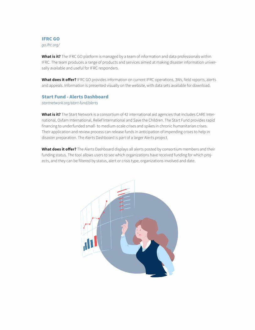
Start Fund - Alerts Dashboardstartnetwork.org/start-fund/alerts
What is it? The Start Network is a consortium of 42 international aid agencies that includes CARE Inter-national, Oxfam International, Relief International and Save the Children. The Start Fund provides rapid financing to underfunded small- to medium-scale crises and spikes in chronic humanitarian crises. Their application and review process can release funds in anticipation of impending crises to help in disaster preparation. The Alerts Dashboard is part of a larger Alerts project.
What does it offer? The Alerts Dashboard displays all alerts posted by consortium members and their funding status. The tool allows users to see which organizations have received funding for which proj-ects, and they can be filtered by status, alert or crisis type, organizations involved and date.
19
Mar 2019 I
3. Contextual Information for Humanitarian Emergencies
In assessing emergencies, general information about a country or region can be helpful in establishing context. A number of indices are produced by organizations that seek to quantify such information, and several other contextual resources are available online. Below are some examples of available resourc-es for helping to establish context prior to or during humanitarian emergencies.
Fragile State IndexAuthor: Fund for PeaceUpdated: AnnuallyDescription: The Fragile State Index is a global annual assessment that ranks and scores States on indicators in four categories: cohesion, economics, politics and social. The intention of the index is to provide a metric for State stability and help forecast likely events.
Human Development ReportAuthor: United Nations Development Programme (UNDP)Updated: AnnuallyDescription: The Human Development Report publishes countries’ progress on a wide range of de-velopment indicators, along with analysis and associated recommendations. The most prominent in-dicator is the Human Development Index, which scores and ranks countries in three key dimensions of human development: health, education and economic standard of living.
Index for Risk Management (INFORM)Author: IASCUpdated: Twice a yearDescription: INFORM is a global, open-source risk assessment for humanitarian crises and disasters. It provides a score and ranking on the likelihood of natural disasters and human conflict in a country, along with the vulnerability of the country’s population and response capacity.Also check out: World Risk Index by Integrated Research on Disaster Risk
The World FactbookAuthor: Central Intelligence Agency of the United States of America (CIA)Updated: WeeklyDescription: The World Factbook is an online resource that provides information on the history, peo-ple, Government, economy, energy, geography, communications, transportation, military and transna-tional issues for 267 world entities. Data and information are taken from a wide variety of sources and vetted by the CIA before being included in the Factbook.
20 I Mar 2019
TOOLS AND SERVICES FOR SITUATIONAL AWARENESS
As discussed above, access to information is only one component of situational awareness. The fol-lowing sections provide an overview of many of the current tools and services available to help sort through available information and data in a meaningful way. Some of the applications help facilitate data collection, but their larger focus is on managing, structuring and presenting data in a manner that enables effective decision-making.
1. Tools and Services from the Humanitarian Sector
ActivityInfowww.activityinfo.org
What is it? ActivityInfo provides software for data collection and reporting intended for use in the mon-itoring and evaluatio of humanitarian operations. The software was developed out of a partnership with UNICEF and is now available for free with limited features, or by monthly subscription.
What does it offer? ActivityInfo is optimized for reporting on activities that are geographically dis-persed and implemented by multiple partner organizations. The platform functions online and offline and includes mobile data collection, a database builder, built-in geodatabase, multilingual interface and data structuring, including pivot tables, charts and maps. The platform includes report-designing capabilities and Application Programming Interface (API) integration to better share results.
Also check out: RapidPro
CartONGwww.cartong.org
What is it? CartONG is an NGO that assists humanitarian organizations in the development and use of maps and geographic information, as well as offering innovative tools and capacity-building for infor-mation management.
What does it offer? CartONG provides mapping and GIS support through service provision or devel-oping tools for an organization. It also works with mobile data-collection technology and more general information management activities, such as data storage, cleaning, analysis and presentation. Its main function is building an organization’s capacity to manage information.
21
Mar 2019 I
DARTwww.dart.jips.org
What is it? The Dynamic Analysis and Reporting Tool (DART) is an online tool that aims to facilitate data-sharing and joint analysis on the topic of population displacement. DART includes a data-manage-ment system that enables users to explore and analyse available data sets and also provide a collabora-tive space to work in groups and create reports from the data. DART is managed by the Joint Internally Displaced People Profiling Service, an inter-agency service that supports humanitarian stakeholders in collaborative profiling exercises.
What does it offer? DART provides a clean and easy-to-use interface that allows non-technical part-ners to conduct analysis and create data visualizations. The analysis tools are only available for the data sets already on the site. The report features allow users to create a workspace with others and structure report writing with different work areas for each chapter. Data visualizations made on the site can be added into the report, and draft reports can then be downloaded from the site.
DEEP* (In development)www.thedeep.io
What is it? The Data Entry and Exploration Platform (DEEP) project is a multi-stakeholder, open-source software platform that provides a suite of tools and processes for secondary data analysis and enables the management of large volumes of unstructured, structured, qualitative and quantitative data. The platform enables users to develop projects by defining the scope and designing analytical framework and required components. Within these projects, the users follow a rigorous method to collect and organize data sources, tag and structure the information to multidimensional categories of the frame-work, and make this information relevant to the geographical areas and specific population groups. Through different tools and visualization, the platform provides opportunities for the exploration of data and making sense of a large information repository into structured analytical conclusions.
Digital Humanitarian Networkdigitalhumanitarians.com
What is it? The Digital Humanitarian Network (DHN) is a consortium of volunteer organizations and philanthropic arms of companies who provide a range of technical skills and services during a human-itarian emergency. DHN acts a platform where requests for services and support can be made and members of the consortium can more easily connect to people who need assistance.
What does it offer? Each DHN member has different mandates and abilities, and DHN offers a wide variety of different services. These include creating thematic maps; writing crisis updates and other reports from publicly available data; developing apps and web platforms to help with crisis response; facilitating communication channels for crisis responders; data entry and analysis, including analysis of satellite imagery; and providing translation and interpretation services.
22 I Mar 2019
Humanitarian OpenStreetMaps Teamwww.hotosm.org
What is it? The Humanitarian OpenStreetMaps Team (HOT) specializes in open mapping to assist disaster management and contributes to other development work. The HOT community comprises volunteers, community leaders and professionals who create and provide free up-to-date maps in crisis situations, mostly through volunteer crowdsourcing.
What does it offer? HOT offers maps for responders in crisis situations produced by online volunteers and people on the ground suited to the needs of the situation. It also designs open-source applications and tools for collaborative mapping and geospatial data collection, and builds capacity by providing training and equipment to relevant actors.
Humanity Roadwww.humanityroad.org
What is it? Humanity Road is a volunteer organization that helps to locate, organize and connect peo-ple and communities with valuable information and resources in disaster situations. It uses public infor-mation, available through social media and other sources, to provide helpful services for people in need and responding organizations using innovative technology and volunteers’ efforts.
What does it offer? During crisis situations, Humanity Road offers situation reports that compile public information into one helpful resource. The reports can be activated through email or phone during a crisis situation, and Humanity Road posts completed situation reports on its website. It also helps orga-nizations to communicate important messages to affected populations, and it works with organizations and Governments on preparedness training and capacity-building for disaster scenarios.
iMMAPhttp://immap.org/
What is it? iMMAP is an international NGO that provides professional information management services to humanitarian and development organizations. It collects and analyses data and produces accom-panying visualizations, which enable informed decisions and ultimately provide high-quality targeted assistance to the world’s most vulnerable populations.
What does it offer? iMMAP offers traditional information management services including data collec-tion and analysis; infographics and mapping; database management; training and monitoring; tools development; and consultation and strategy.
23
Mar 2019 I
Juvare - WebEOCwww.juvare.com/solutions/webeoc
What is it? WebEOC is a platform to improve an organization’s incident-management capabilities. Built to support the mission of crisis management, public safety and emergency response personnel, the solution provides simplified information access promoting intelligent incident response and business resiliency. Juvare specializes in crisis management and emergency preparedness and response tech-nologies.
What does it offer? With WebEOC, users can manage information, report events, monitor resources and tasks, and produce after-action reports, all on one easy-to-use platform. WebEOC can also be used with other Juvare programs that can add mapping, alerts and response planning features to the sys-tem, offering a customizable set of utilities for complete situational awareness.
KoBoToolboxwww.kobotoolbox.org
What is it? KoBoToolbox is a suite of tools for field data collection, designed for use in challenging en-vironments. Its tools are often used by people working in humanitarian crises, and by aid professionals and researchers working in developing countries.
What does it offer? KoBoToolbox allows users to design surveys and collect responses via Android, iOS and other operating systems. Surveys can be completed online and offline, and data management and analysis tools are available through the platform. KoBoToolbox is available for free for all humanitarian agencies.
MapActionmapaction.org
What is it? MapAction is an NGO that gathers crucial data at the disaster scene and conveys it visually in the form of maps. By creating a shared operational picture for aid agencies, Governments and local partners, it helps them make informed decisions and deliver aid and emergency supplies to the right place, quickly.
24 I Mar 2019
What does it offer? MapAction offers a wide range of map products to best fit responders’ needs. It deploys to a crisis situation within 24 to 48 hours of a disaster and provides remote team assistance. MapAction is also involved in emergency preparation and training activities.
REACH Initiativewww.reach-initiative.org
What is it? The REACH Initiative facilitates the development of information tools and products that enhance the humanitarian community’s decision-making and planning capacity. REACH is a joint initia-tive of IMPACT, its sister organization, ACTED, and the United Nations Operational Satellite Applications Programme.
What does it offer? The REACH Initiative conducts inter-agency field-based assessments; uses remote-sensing and satellite-imagery analysis to complement primary data collection; completes secondary data reviews; produces reports, profiles, situation overviews and fact sheets; develops us-er-friendly maps and establishes field-based mapping centres to facilitate access to spatial data; and designs web-based maps and dashboards that allow actors to access and manipulate key information.
Sahana Software Foundationsahanafoundation.org
What is it? Sahana Software Foundation is a non-profit that develops community-driven, open-source in-formation management systems for emergency preparedness, response, recovery and resilience-building. Its EDEN software provides a comprehensive management service designed for disaster management.
What does it offer? Sahana’s EDEN software has functions to support organization directories, hu-man resources, 3Ws, logistics, messaging and documents. In addition, it has crisis-specific features, such as disease and patient tracking for health crises, and alerts and incident tracking for emergen-cies. The tool also has features to monitor affected populations, including the ability to collect and manage assessments and keep record of demographic information. EDEN is an open-source software and is available for free.
Standby Task Forcewww.standbytaskforce.org
What is it? Standby Task Force is a non-profit, entirely volunteer network that turns online data into actionable intelligence to support crisis response worldwide. Standby Task Force services are engaged by a request for activation on its website, and it assists with a wide range of crisis information tasks.
What does it offer? Standby Task Force can produce crisis maps, rapid 3Ws and remote assessments, as well as assist with information management capacity. Crisis information products are informed by publicly available information, predominantly social media, with volunteers filtering the large amount of data into helpful and accessible resources for crisis responders.
25
Mar 2019 I
Ushahidiwww.ushahidi.com
What is it? Ushahidi is a social enterprise that provides open-source software to help improve the bot-tom-up flow of information. Its software is often used for crisis response, human rights reporting and elec-tion monitoring. Ushahidi offers products that enable local observers to submit reports using their mobile phones or the Internet, while simultaneously creating a temporal and geospatial archive of events.
What does it offer? Ushahidi platforms allow users to collect data from social media, SMS and custom surveys, and then manage that information with customizable filters and workflow and collaboration tools. The platforms also offer data-visualization tools and email alerts, and Ushahidi will provide cus-tom development and support to adapt its software to the user’s needs. A free plan is available that includes basic features, with more features available for monthly premiums.
Zenysis Technologieswww.zenysis.com
What is it? Zenysis’s software is a data integration and analysis platform designed to help countries harness the power of software to save lives, improve the quality of life of all their citizens, and ensure no citizen is invisible to decision makers. Zenysis is a for-profit company founded by Palantir’s previous Head of International Partnerships, but unlike Palantir it focuses exclusively on assisting Governments and international organizations on humanitarian issues.
What does it offer? The Zenysis platform allows users to integrate different data sources and employ analytical tools with easy-to-use dashboards and machine learning.
26 I Mar 2019
* Related Humanitarian Service Providers
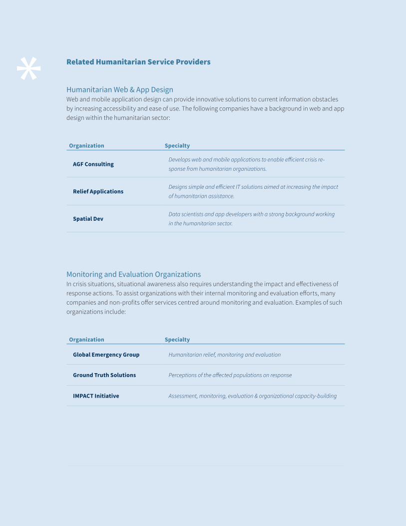
Humanitarian Web & App Design Web and mobile application design can provide innovative solutions to current information obstacles by increasing accessibility and ease of use. The following companies have a background in web and app design within the humanitarian sector:
Organization Specialty
AGF ConsultingDevelops web and mobile applications to enable efficient crisis re-
sponse from humanitarian organizations.
Relief ApplicationsDesigns simple and efficient IT solutions aimed at increasing the impact
of humanitarian assistance.
Spatial DevData scientists and app developers with a strong background working
in the humanitarian sector.
Monitoring and Evaluation OrganizationsIn crisis situations, situational awareness also requires understanding the impact and effectiveness of response actions. To assist organizations with their internal monitoring and evaluation efforts, many companies and non-profits offer services centred around monitoring and evaluation. Examples of such organizations include:
Organization Specialty
Global Emergency Group Humanitarian relief, monitoring and evaluation
Ground Truth Solutions Perceptions of the affected populations on response
IMPACT Initiative Assessment, monitoring, evaluation & organizational capacity-building
27
Mar 2019 I
2. Tools and Services from the Private Sector
Several private sector companies are now offering platforms that provide improved situational aware-ness or operational intelligence. These platforms help structure data and enable decision-making through features such as data integration, stream analytics, customizable dashboards, GPS and map features, and organized communication channels. Platforms that self-identify themselves as situa-tional-awareness tools are usually directed towards use in law enforcement, intelligence and security services, whereas platforms intended for use in sales and finance commonly describe themselves as operational-intelligence platforms. The majority of platforms listed below are not intended for use in humanitarian emergencies, but they provide a landscape of what the private sector is currently doing to increase situational awareness and demonstrate abilities of new technologies for potential application in the humanitarian sector in the future.
2.1 Situational Awareness Platforms from the Private Sector
Coolfire Solutions - Ronin Platformwww.coolfiresolutions.com
What is it? The Ronin Platform is intended to increase an organization’s situational awareness. It is marketed to a range of industries including transportation, utilities, public safety, military and general business. It focuses on getting the right data into the right hands for real-time decision-making.
What does it offer? The Ronin Platform provides tailored dashboards for its users based on their roles, responsibilities and locations, aggregates existing data into one platform, allows for data visual-izations and maps, and provides communication channels within teams. Technologies such as cameras and sensors can be incorporated into monitoring on the platform. The Ronin Platform can be accessed through mobile, tablet and desktop devices, allowing for optimal use dependent on the situation.
Why is it noteworthy? The Ronin Platform markets itself as the technology platform that is expanding the concept of situational awareness to every industry. The platform was initially developed for the US military, but the company then recognized that numerous industries face similar data needs and would benefit from a situational-awareness platform.
Fuse - Ocularwww.fuseintegration.com/products/ocular/
What is it? Ocular is a mobile situational-awareness tool that enables teams to operate in distributed environments, providing a common operational picture with shared location data, live-map markup, text, video and voice connectivity. Ocular is designed and managed by Fuse, a company seeking to bridge the gap between operators and technology.
What does it offer? Ocular offers a simple, common interface that lets users see where their team is and communicate with them. The platform provides a shared map, and users can track their team
28 I Mar 2019
members’ locations as well as draw on maps and send notes. The backend of the system allows users to manage groups of members and authorize different access to data. Ocular includes streaming video across multiple platforms, and video can be selected directly from the map feature. Ocular is built for Android, iOS and browsers.
Why is it noteworthy? Fuse’s leadership has a strong military background, and products are designed for use in challenging environments where situational awareness is critical.
Ombudhttps://www.ombud.com/
What is it? Ombud is a decision-management platform intended for people working in sales. With Om-bud, organizations can easily collaborate, enable knowledge transfer and make better decisions within one platform. The platform combines knowledge collaboration, enterprise content management and deep learning to ensure users are operating with the most complete information available.
What does it offer? Ombud provides a platform for organizations to streamline selection and decision pro-cesses. Information is stored in a standardized global location and easily integrated into standard reporting requirements. Users can assign tasks to others, and the platform includes review and comment features.
Why is it noteworthy? Ombud was originally developed for use in sales, but it received a strategic investment from In-Q-Tel in December 2016 and remains a part of In-Q-Tel’s portfolio. In-Q-Tel invests in new technologies that show promise in helping US Government agencies concerned with safety and security. The strategic part-nership with Ombud was created with the intention of empowering the US intelligence community.
Palantirhttps://www.palantir.com/
What is it? Palantir is a company that creates platforms and technologies that allow users to analyse data in a variety of forms without requiring advanced statistical or computer capabilities. Its platforms integrate, manage and secure data and facilitate fully interactive human-driven, machine-assisted anal-ysis. Palantir is a large player in this field and has worked with companies in a wide range of industries, including automotive, cyber, defence, finance, intelligence, legal and pharma.
What does it offer? Palantir’s products collect data from different sources and integrate them together in a user-centred design interface. Data is tagged, secured and tracked, and the platform facilitates easy analysis. Palantir’s Gotham software has data-visualization and mapping capabilities and advanced search functions to internal and external data, and it can be used on mobile and tablet devices.
Why is it noteworthy? Palantir is a leader in the big data analytics field and has provided innovative solutions in many different contexts. Palantir has been used by the US Department of Defense and US intelligence, and it contributed to recovery efforts following Hurricane Sandy and other crises.
29
Mar 2019 I
Simulyze - Mission Insighthttps://www.simulyze.com/
What is it? Mission Insight provides commanders and operators in deployed situations with a common operating picture to ensure real-time, in-depth data access for mission-critical events. Mission Insight interprets and integrates disparate data sources with a customizable graphical interface.
What does it offer? Mission Insight offers a single interface for compiling information, including social media data, databases, GPS, video, imagery, sensory data, weather, radar intelligence, data from un-manned aerial vehicles and data from electronic intelligence. Its benefits include low-bandwidth capa-bilities, real-time processing and analytics and alert features that keep users informed.
Why is it noteworthy? Mission Insight is an operational intelligence platform intended for the US in the security and intelligence sector. Its focus on maintaining situational awareness in difficult conditions, as well as its advanced mapping and GPS features, make it suitable to use in humanitarian emergencies. In addition, integration of data such as weather and drone surveillance offers a comprehensive source of information useful to humanitarian responders.
30 I Mar 2019
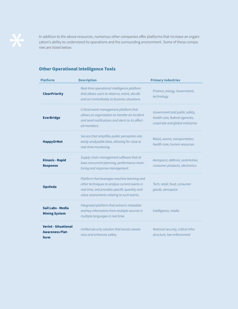
* In addition to the above resources, numerous other companies offer platforms that increase an organi-zation’s ability to understand its operations and the surrounding environment. Some of these compa-nies are listed below:
Other Operational Intelligence Tools
Platform Description Primary Industries
ClearPriority Real-time operational intelligence platform
that allows users to observe, orient, decide
and act immediately to business situations.
Finance, energy, Government,
technology
EverBridge
Critical event management platform that
allows an organization to monitor an incident
and send notifications and alerts to its affect-
ed members.
Government and public safety,
health care, federal agencies,
corporate and global enterprise
HappyOrNotService that simplifies public perception into
easily analysable data, allowing for close to
real-time monitoring.
Retail, events, transportation,
health care, human resources
Kinaxis - Rapid Response
Supply chain management software that al-
lows concurrent planning, performance moni-
toring and response management.
Aerospace, defence, automotive,
consumer products, electronics
OpsVeda
Platform that leverages machine learning and
other techniques to analyse current events in
real time, and provides specific quantity and
value assessments relating to such events.
Tech, retail, food, consumer
goods, aerospace
Sail Labs - Media Mining System
Integrated platform that extracts metadata
and key information from multiple sources in
multiple languages in real time.
Intelligence, media
Verint - Situational Awareness Plat-form
Unified security solution that boosts aware-
ness and enhances safety.
National security, critical infra-
structure, law enforcement
31
Mar 2019 I
2.2 Related Private Sector Tools & Services
The following section provides a brief overview of tools and services that can aid humanitarian organi-zations in improving situational awareness, but which are not focused specifically on situational aware-ness. The private sector uses these products in areas such as business, finance, marketing and journal-ism. The products are also used by military and intelligence services. Humanitarian organizations have used many of these tools, but other tools have remained limited to other sectors.
Data Preparation Tools
Data preparation tools allow users to access, integrate and transform data for their own analysis. The term ‘preparation’ encompasses finding, storing, cleaning and combining data into a workable format for analysis. Services in this field specialize in converting disparate types of data into a workable data set. Applications to humanitarian emergencies include integrating data from the wide array of actors involved in crisis response and overcoming challenges with different formats and structures.
Check out: Alteryx, Datameer, Datawatch, Ephesoft, Paxata, Trifacta
Data Visualization and Stream Analytic Tools
Data-visualization tools help users understand and analyse data and communicate it to others. Effec-tive data visualizations provide users with a clear analysis of the data and improve situational aware-ness by facilitating easier understanding. Similarly, stream analytics tools perform analysis on real-time data, allowing system users to have immediate visualizations and representations of the most recent information. Stream analytics are commonly integrated with other platforms, and they can be used to custom design dashboards and web pages intended to keep users situationally aware.
Check out: Azure Stream Analytics, DataWrapper, HighCharts, IBM Streaming Analytics, Plotly, Qlik, Tableau, Zoomdata,
GIS Mapping Technology
Geographic Information System (GIS) Mapping technology enables the creation of accurate and clear maps that can be designed for express purposes. Maps offer the clearest method of sharing geographi-cal information, and GIS technology is incorporated into many of the resources, tools and services avail-able to create situational awareness.
Check out: CartoDB, ESRI arcGIS, GeoMedia, Global Mapper, MapInfo
Open-Source Alternatives: GRASS GIS, Quantum GIS
32 I Mar 2019
Social Media Monitoring Services
Social media contains a vast amount of information that can make attempts at monitoring and anal-ysis seem impossible. Social media monitoring resources use artificial intelligence to sort through the data and identify breaking news and critical information, or allow users to better filter through relevant data. Platforms enable users to sort through and geolocate data and set custom alerts for certain news events. Applications to humanitarian emergencies include faster access to crisis information and the ability to identify the needs of affected populations through social media posts.
Check out: Crimson Hexagon, Dataminr, DataSift, Hootsuite, Newswhip, ScatterBlogs, Tweetdeck
Designed for Humanitarian Sector: Artificial Intelligence for Digital Response, Scanigo, SensePlace3
User-Centred Design Consultants
Specialized consultants are available to assist companies, organizations and Government entities in designing systems that lead to improved situational awareness. These consultants predominantly em-ploy user-centred design approaches to intentionally create working environments that foster situation-al awareness. These consultants often have backgrounds in and commonly work with the US Air Force and other branches of the US Armed Forces.
Check out: Human Factors Consulting, SA Technologies
33
Mar 2019 I
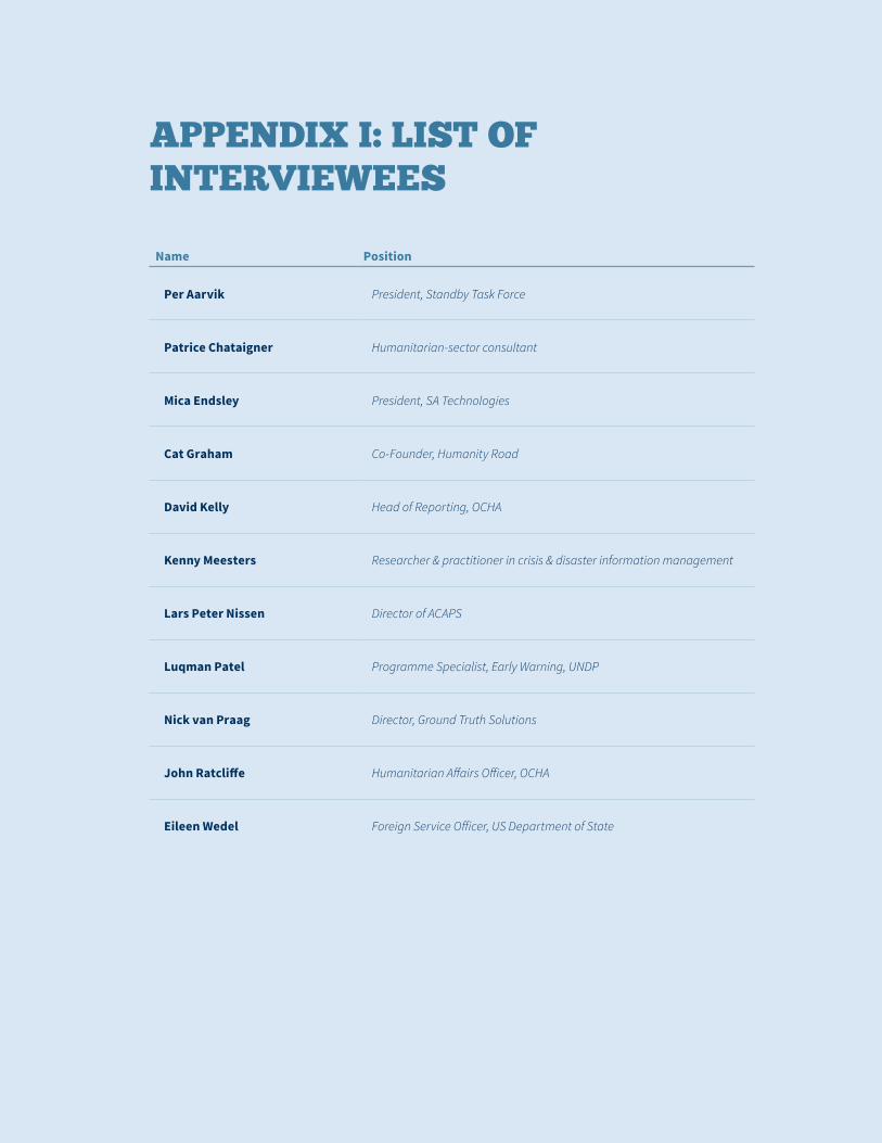
APPENDIX I: LIST OF INTERVIEWEES
Name Position
Per Aarvik President, Standby Task Force
Patrice Chataigner Humanitarian-sector consultant
Mica Endsley President, SA Technologies
Cat Graham Co-Founder, Humanity Road
David Kelly Head of Reporting, OCHA
Kenny Meesters Researcher & practitioner in crisis & disaster information management
Lars Peter Nissen Director of ACAPS
Luqman Patel Programme Specialist, Early Warning, UNDP
Nick van Praag Director, Ground Truth Solutions
John Ratcliffe Humanitarian Affairs Officer, OCHA
Eileen Wedel Foreign Service Officer, US Department of State
34 I Mar 2019
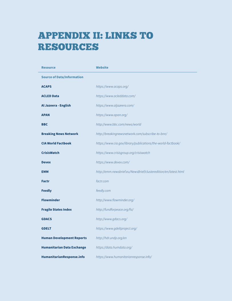
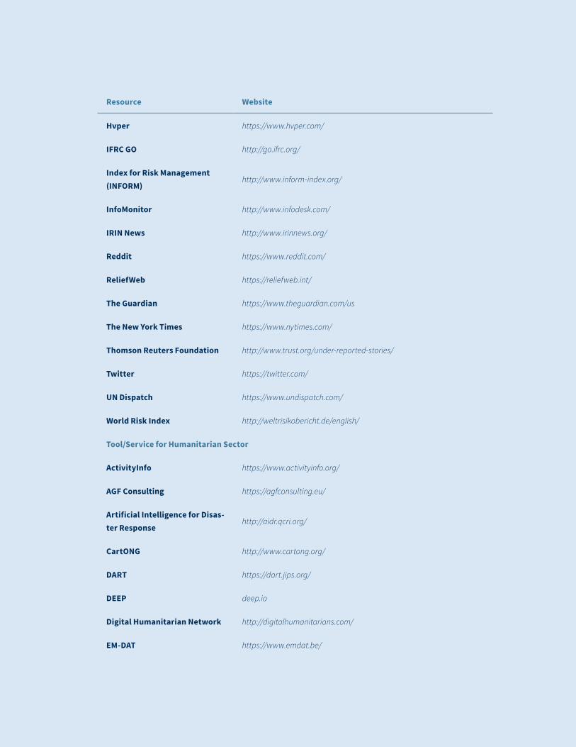
APPENDIX II: LINKS TO RESOURCES
Resource Website
Source of Data/Information
ACAPS https://www.acaps.org/
ACLED Data https://www.acleddata.com/
Al Jazeera - English https://www.aljazeera.com/
APAN https://www.apan.org/
BBC http://www.bbc.com/news/world
Breaking News Network http://breakingnewsnetwork.com/subscribe-to-bnn/
CIA World Factbook https://www.cia.gov/library/publications/the-world-factbook/
CrisisWatch https://www.crisisgroup.org/crisiswatch
Devex https://www.devex.com/
EMM http://emm.newsbrief.eu/NewsBrief/clusteredition/en/latest.html
Factr factr.com
Feedly feedly.com
Flowminder http://www.flowminder.org/
Fragile States Index http://fundforpeace.org/fsi/
GDACS http://www.gdacs.org/
GDELT https://www.gdeltproject.org/
Human Development Reports http://hdr.undp.org/en
Humanitarian Data Exchange https://data.humdata.org/
HumanitarianResponse.info https://www.humanitarianresponse.info/
35
Mar 2019 I
Resource Website
Hvper https://www.hvper.com/
IFRC GO http://go.ifrc.org/
Index for Risk Management (INFORM)
http://www.inform-index.org/
InfoMonitor http://www.infodesk.com/
IRIN News http://www.irinnews.org/
Reddit https://www.reddit.com/
ReliefWeb https://reliefweb.int/
The Guardian https://www.theguardian.com/us
The New York Times https://www.nytimes.com/
Thomson Reuters Foundation http://www.trust.org/under-reported-stories/
Twitter https://twitter.com/
UN Dispatch https://www.undispatch.com/
World Risk Index http://weltrisikobericht.de/english/
Tool/Service for Humanitarian Sector
ActivityInfo https://www.activityinfo.org/
AGF Consulting https://agfconsulting.eu/
Artificial Intelligence for Disas-ter Response
http://aidr.qcri.org/
CartONG http://www.cartong.org/
DART https://dart.jips.org/
DEEP deep.io
Digital Humanitarian Network http://digitalhumanitarians.com/
EM-DAT https://www.emdat.be/
36 I Mar 2019
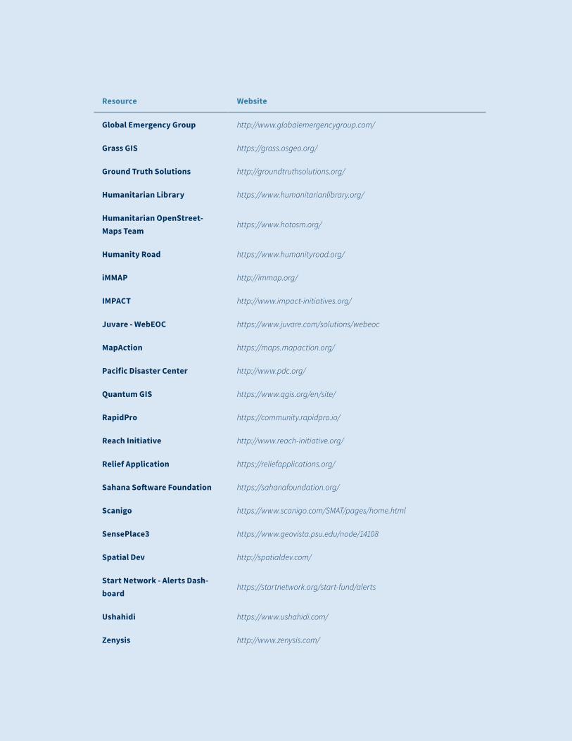
Resource Website
Global Emergency Group http://www.globalemergencygroup.com/
Grass GIS https://grass.osgeo.org/
Ground Truth Solutions http://groundtruthsolutions.org/
Humanitarian Library https://www.humanitarianlibrary.org/
Humanitarian OpenStreet-Maps Team
https://www.hotosm.org/
Humanity Road https://www.humanityroad.org/
iMMAP http://immap.org/
IMPACT http://www.impact-initiatives.org/
Juvare - WebEOC https://www.juvare.com/solutions/webeoc
MapAction https://maps.mapaction.org/
Pacific Disaster Center http://www.pdc.org/
Quantum GIS https://www.qgis.org/en/site/
RapidPro https://community.rapidpro.io/
Reach Initiative http://www.reach-initiative.org/
Relief Application https://reliefapplications.org/
Sahana Software Foundation https://sahanafoundation.org/
Scanigo https://www.scanigo.com/SMAT/pages/home.html
SensePlace3 https://www.geovista.psu.edu/node/14108
Spatial Dev http://spatialdev.com/
Start Network - Alerts Dash-board
https://startnetwork.org/start-fund/alerts
Ushahidi https://www.ushahidi.com/
Zenysis http://www.zenysis.com/
37
Mar 2019 I
Resource Website
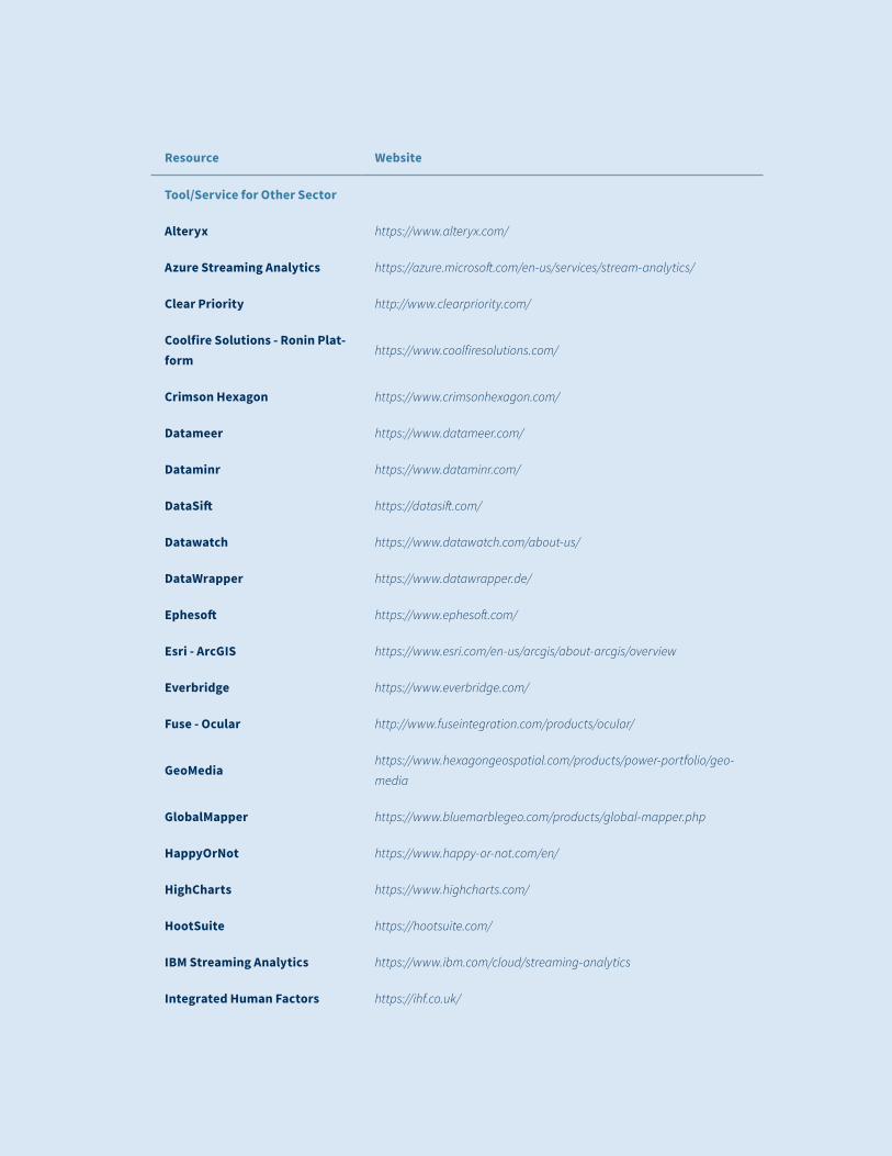
Tool/Service for Other Sector
Alteryx https://www.alteryx.com/
Azure Streaming Analytics https://azure.microsoft.com/en-us/services/stream-analytics/
Clear Priority http://www.clearpriority.com/
Coolfire Solutions - Ronin Plat-form
https://www.coolfiresolutions.com/
Crimson Hexagon https://www.crimsonhexagon.com/
Datameer https://www.datameer.com/
Dataminr https://www.dataminr.com/
DataSift https://datasift.com/
Datawatch https://www.datawatch.com/about-us/
DataWrapper https://www.datawrapper.de/
Ephesoft https://www.ephesoft.com/
Esri - ArcGIS https://www.esri.com/en-us/arcgis/about-arcgis/overview
Everbridge https://www.everbridge.com/
Fuse - Ocular http://www.fuseintegration.com/products/ocular/
GeoMediahttps://www.hexagongeospatial.com/products/power-portfolio/geo-
media
GlobalMapper https://www.bluemarblegeo.com/products/global-mapper.php
HappyOrNot https://www.happy-or-not.com/en/
HighCharts https://www.highcharts.com/
HootSuite https://hootsuite.com/
IBM Streaming Analytics https://www.ibm.com/cloud/streaming-analytics
Integrated Human Factors https://ihf.co.uk/
38 I Mar 2019
Resource Website
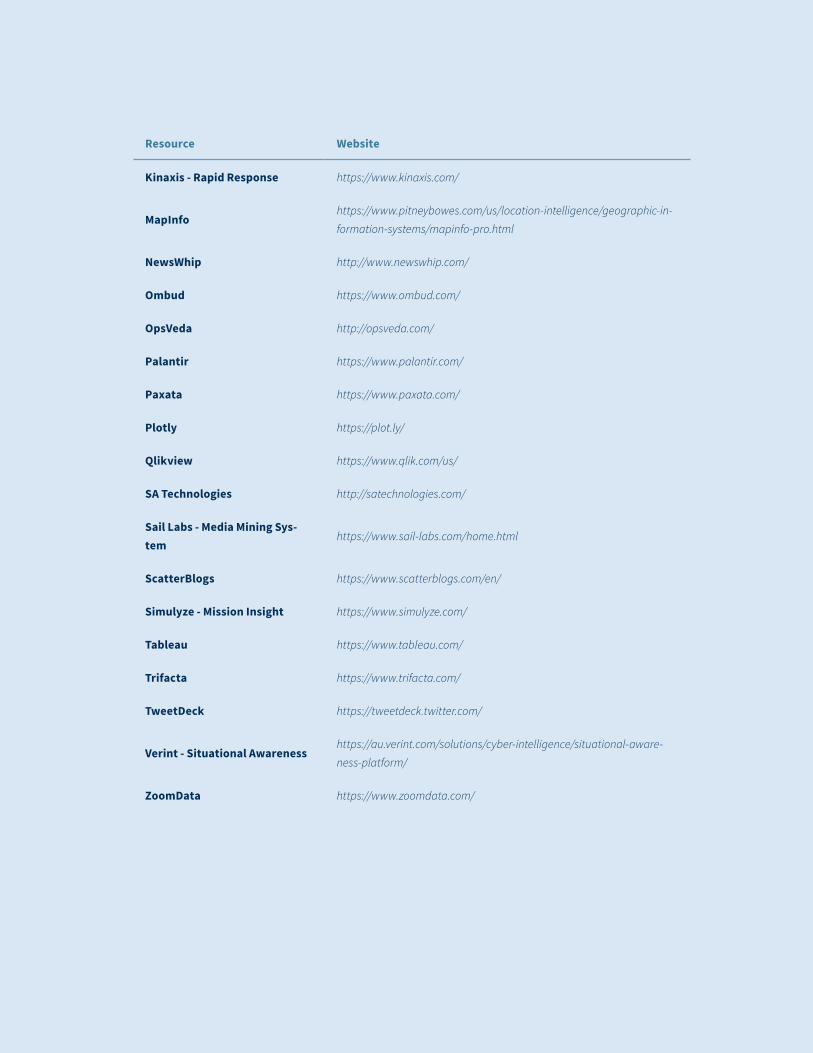
Kinaxis - Rapid Response https://www.kinaxis.com/
MapInfohttps://www.pitneybowes.com/us/location-intelligence/geographic-in-
formation-systems/mapinfo-pro.html
NewsWhip http://www.newswhip.com/
Ombud https://www.ombud.com/
OpsVeda http://opsveda.com/
Palantir https://www.palantir.com/
Paxata https://www.paxata.com/
Plotly https://plot.ly/
Qlikview https://www.qlik.com/us/
SA Technologies http://satechnologies.com/
Sail Labs - Media Mining Sys-tem
https://www.sail-labs.com/home.html
ScatterBlogs https://www.scatterblogs.com/en/
Simulyze - Mission Insight https://www.simulyze.com/
Tableau https://www.tableau.com/
Trifacta https://www.trifacta.com/
TweetDeck https://tweetdeck.twitter.com/
Verint - Situational Awarenesshttps://au.verint.com/solutions/cyber-intelligence/situational-aware-
ness-platform/
ZoomData https://www.zoomdata.com/

39
Mar 2019 I

40 I Mar 2019
Related Documents