RESOURCE SERIES 37 With sections on COAL RESOURCES by Wynn Eakins and PETROLEUM RESOURCES by H. Thomas Hemborg Colorado Geological Survey Department of Natural Resources Denver, Colorado 1999

Welcome message from author
This document is posted to help you gain knowledge. Please leave a comment to let me know what you think about it! Share it to your friends and learn new things together.
Transcript

RESOURCE SERIES 37
With sections on COAL RESOURCES by Wynn Eakins
and
PETROLEUM RESOURCES by H. Thomas Hemborg
Colorado Geological Survey Department of Natural Resources
Denver, Colorado 1999

RESOURCE SERIES 37
Geology and Mineral Resources of Gunnison County, Colorado By Randall K. Streufert
With sections on
COAL RESOURCES by Wynn Eakins
and
PETROLEUM RESOURCES by H. Thomas Hemborg
Bill Owens, Governor, State of Colorado
Greg E. Walcher, Director, Department of Natural Resources
Vicki Cowart, State Geologist, Colorado Geological Survey Denver, Colorado
1999

Resource Series 37 Geology and Mineral Resources of Guimisui
Cover Painting: "Gunnison Country", 1996, by Larry Scott
ii Colorado Geological Survey

Kesourcc Urui J, Geology and Mineral Resources of Gunnison County
ACKNOWLEDGMENTS viii
1 GEOLOGIC SETTING 1 Introduction 1
Tectonic and Geomorphic History 2
2 PRECAMBRIAN ROCKS 5 Introduction 5
Proterozoic X 5
Proterozoic Y 5
Proterozoic YX 6
3 SEDIMENTARY ROCKS 7 Paleozoic Era 7
Cambrian System 7
Sawatch Quartzite 7
Peerless Formation 7
Ordovician System 8
Manitou Dolomite 8
Harding Sandstone 8
Fremont Limestone 8
Devonian System 9
Chaffee Group 9
Parting Formation 9
Dyer Dolomite 9
Gilman Sandstone 10
Mississippian System 10
Leadville Limestone 10
Pennsylvanian and Permian Systems 11
Belden Formation 11
Gothic Formation 12
Minturn Formation 12
Maroon Formation 12
Mesozoic Era 12
Triassic System 12
Jurassic System 12
Entrada Sandstone 13
junction Creek Sandstone 13
Wanakah Formation 13
Morrison Formation 14
Cretaceous System 14
Burro Canyon Formation 14
Dakota Sandstone 15
Colorado Geological Survey •••

Resource Series 37 Geology and Mineral Resources of GiuuiisuiY-̂ OTHtry
Mancos Shale 15
Mesaverde Formation (Group) 15
Rollins Sandstone Member 16
Coal-bearing Member 16
Barren Member 16
Ohio Creek Member 16
Cenozoic Era 16
Tertiary System 16
Paleocene and Eocene 16
Wasatch Formation 16
Eocene 17
Telluride Conglomerate 17
Sedimentary Deposits 17
Miocene 17
Boulder Gravel and Tuffaceous Conglomeratic Sandstone 17
4 IGNEOUS ROCKS 19 Introduction 19
Paleozoic Intrusive Rocks (Cambrian) 19
Powderhorn Carbonatite Complex 19
Laramide Intrusive Suite 20
(Late Cretaceous to Eocene)
Twin Lakes Pluton (Tki) 20
Middle Tertiary Suite 20
(Oligocene and Miocene)
Intermediate Hypabyssal Stocks, Laccoliths, Dikes, 20
and Sills (Tmi)
Vent Facies Andesitic Lavas and Breccias— 20
West Elk Volcanic Field (Tpl)
Ash Flow Tuff (Taf) 22
San Juan Volcanics 22
Grizzly Peak Caldera 22
Inter-Ash-Flow Andesitic Lava and Breccia (Tial) 22
Late Tertiary Intrusive Suite (Miocene) 22
Rhyolitic Rocks of Biomodal Suite (Tbr) 22
Basaltic Rocks of Biomodal Suite (Tbb) 23
Granite of Treasure Mountain (Tui) 23
5 SURFICIAL DEPOSITS 25 Introduction 25
Young Glacial Drift (Qd) 25
Young Gravels (Qg) 25
Landslide Deposits (Ql) 25
Modern Alluvium (Qa) 25
jy Colorado Geological Survey

Resource Oeiies-37— Geology and Mineral Resources of Gunnison County
6 MINERAL RESOURCES 27 Precious and Base Metal Districts 27
Box Canyon District 27
Cebolla District 27
The Gunnison Gold Belt 27
Proterozoic Stratabound Sulfide Deposits 31
Vulcan-Good Hope Mine 31
Ironcap Mine 31
Cochetopa (Iris) District 31
Proterozoic Stratabound Sulfide Deposits 31
Denver City Mine 31
Premetamorphic Copper Veins 33
Graflin Mine 33
Cross Mountain District 33
Replacement Deposits in Paleozoic Carbonates 33
Wahl Mine 33
Vein Deposits in Paleozoic Rocks 33
Gold Bug Mine 33
Crystal River District 34
Treasure Mountain Dome 34
Dorchester District 34
Elk Mountain District 35
Vein Deposits 35
Sylvanite Mine 35
Silver Mineralization in Pyritized Rock 35
Copper Queen Mine 35
Contact Metamorphic Deposits of Iron-oxides and Sulfides 35
Iron King Mine 35
Gold Brick District 35
Vein Deposits in Proterozoic Rocks 36
Raymond Mine 36
Gold Links Mine 36
Quartz Creek District 36
Replacement Deposits in Paleozoic Rocks 36
Fairview Mine 37
Vein Deposits in Proterozoic Rocks 37
Ruby District 37
Spring Creek District 37
Taylor Park District 38
Tincup District 38
Silver-Lead-Gold Replacement Deposits in Paleozoic Rocks 38
Gold Cup Mine 38
Silver-Lead-Gold Vein Deposits 39
Colorado Geological Survey y

Resource Series 37 Geology and Mineral Resources uf-Qunnrson-Goxxttty
Jimmy Mack Mine 40
Tomichi (Whitepine) District 40
Replacement Deposits in Paleozoic Deposits 40
Morning Star Mine 40
Vein Deposits in Proterozoic and Middle Tertiary Rocks 41
Spar Copper Mine 41
Environmental Geology 41
Energy/Alloy Metal and Industrial Mineral Areas 43
Powderhorn District 43
Alkalic Rocks at Iron Hill-Powdernhorn Carbonatite Complex 44
Thorium 49
Titanium 50
Niobium 52
Rare-Earth Elements 52
Uranium/Vanadium 52
Vermiculite 52
Quartz Creek Pegmatite District 52
Brown Derby Mine 53
Uranium in Gunnison County 53
Marshall Pass Uranium District 53
Little Indian No. 36 Mine 54
Big Red Uranium Claims 54
Mount Emmons Molybdenum Deposit 56
Gold Hill Tungsten/Molybdenum Area 57
White Earth Tungsten Area 57
Morning Star Perlite Deposit 57
Yule Marble Deposit 58
7 GEOTHERMAL RESOURCES 59
8 COAL RESOURCES 61 Uinta Coal Region 61
Carbondale Coal Field 62
Crested Butte Coal Field 62
Somerset Coal Field 62
San Juan River Coal Region 64
Tongue Mesa Coal Field 64
Selected References—Coal Resources 64
9 PETROLEUM RESOURCES 67 Geological Setting 67
Gunnison County Exploration and Development 67
REFERENCES 69
yj Colorado Geological Survey

Resource Geiies 37 Geology and Mineral Resources of Gunnison County
1. Map of basic tectonic features in Colorado 1
2. Geologic map of Elk Mountains and vicinity 21
3. Index map of precious and base metal mining districts 28
4. Map showing distribution of Precambrian sulfide deposits 32
5. Geologic map of Tincup mining district 39
6. Index map of energy/alloy metal and industrial minerals areas 44
7. Geologic map of alkalic rocks complex at Iron Hill 48
8. Map showing distribution and trend of thorium deposits 50
9. Contour map showing thorium distribution in Iron Hill carbonatites 51
10. Geologic map of Cochetopa and Marshall Pass uranium region 54
11a. Geologic map of Marshall Pass district 55
11b. Cross section and explanation for Figure 11a 56
12. Generalized cross-section of Mt. Emmons 57
13. Cross section hydrothermal alteration of Mt. Emmons deposit 57
14. Map showing locations of thermal springs 59
15. Map showing locations of coal regions of Western Colorado 61
16. Map showing coal fields and coal mines in Gunnison County 63
1. Precious and base metal mining districts data 29
2. A B A samples 42
3. A B A data 43
4. Energy /alloy metal and industrial minerals data 45
5. Thermal springs of Gunnison County 60
6. Coal analysis data 64
7. Data for coal mines producing more than 100,000 tons 65
8. Oil and Gas cumulative production in Gunnison county 68
1. Geologic Map of Gunnison County Envelope
Colorado Geological Survey yjj

Resource Series 37 Geology and Mineral Resources of Gunnison County
ACKNOWLEDGMENTS
This report was made possible through Colorado Severence Tax funds which are derived from the production of oil, gas, coal, and minerals. It is the first in a series of county-scale mineral reports to be prepared under this new funding source. Many people contributed to this initial report. Vicki Cowart and
James Cappa of the Colorado Geological Survey obtained funding and provided administrative support for the project. The manuscript was reviewed and edited by Bruce Bartleson of Western State University in Gunnison, and James Cappa and Chris Carroll of the Colorado Geological Survey. The following geologists provided many helpful suggestions throughout the course of the study: Bruce
Bartleson and Allen Stork of Western State University, Chris Carroll, Bruce Bryant, Scott Effner, Mark Williamson, Dan Larsen, and Dan Cuttler. Wendy Meyer of Adrian Brown Consultants, Inc. assisted in interpretation of A B A data, and edited the section on Environmental Geology. M a p plates were digitized and prepared by Matt Morgan and Randy Phillips of the Colorado Geological Survey. Larry Scott drafted illustrations and prepared the manuscript for publi
cation. The manuscript was edited by Mary-Margaret Coates, James Cappa and Cheryl Brchan. Analyses and A B A data were provided by Chemex
Labs, Inc. of Sparks, Nevada.
viii Colorado Geological Survey

Resource Series 37 Geology and Mineral Resources of Gunnison County
INTRODUCTION Gunnison County is located in central and southwestern Colorado in an area of diverse geology. Precambrian
through Tertiary rocks occur throughout the county and
have undergone different stages of development. The di
visions of these tectonic and depositional provinces are
shown in Figure 1. Most of the geologic provinces of
Gunnison County contain economically important
deposits of minerals or mineral fuels. Plate 1 of this report
is a 1:250,000 scale geologic map of Gunnison County that
was complied from existing 1 x 2 degree quadrangle
geologic maps by the United States Geological Survey.
Figure 1. Map showing basic tectonic features of Colorado with Gunnison County in bold outline.
Colorado Geological Survey

Resource Series 37 Geology and Mineral Resources of Gunnison County
Proterozoic crystalline and Paleozoic sedimentary
rocks exposed in eastern Gunnison County are part of
the Laramide Sawatch Uplift, a large north-south-
trending anticlinal uplift that contains a number of
Colorado's tallest peaks. The crest of the Sawatch Uplift
is the eastern boundary of Gunnison County which
coincides with a large portion of the Continental Divide.
This area of exposed Proterozoic and Paleozoic terranes
in eastern Gunnison County contains many of the
county's productive mining districts, which were worked
for precious and base metals from vein and replacement
deposits, for uranium from vein deposits, and for rare-
earth elements and thorium from pegmatite deposits.
Another large exposed Proterozoic terrane is the
Gunnison Uplift in southern Gunnison County. Rocks
exposed in the Gunnison Uplift include a suite of
metavokanic rocks containing stratabound massive
sulfide deposits (Dubois Greenstone). It is bounded on the south by the Cimarron Fault, a large Laramide
dip-slip fault that cuts, and mav have localized, a Late
Proterozoic and early Cambrian alkalic-carbonatite intrusive complex at Powderhorn (see Powderhorn
District, this report). The Gunnison Uplift also exposes
the Proterozoic, dominantly metasedimentary Black
Canvon Schist (Xb) in the Black Canyon of the Gunnison River (Hansen, 1971). The Gunnison Uplift
is a large fault-block highland that locally dips 5 to 10 degrees north-northeast and disappears underneath
Mesozoic sedimentary rocks to the northwest
(Hedlund and 01son,'l981). The Gunnison Uplift includes numerous mining districts that have been
worked for gold and silver, base metals, and minor
uranium. The alkalic intrusive complex at Powderhorn
contains the largest single resource of titanium in the
world.
The Middle Tertiary San Juan volcanic field and
the similarly aged West Elk volcanic field cover a great portion of southern and western Gunnison County,
respectively, with extrusive and volcaniclastic rocks.
Most of southern Gunnison County is covered by thick
sheets of Oligocene ash-flow tuff overlying pre-ash-flow
andesitic lavas and breccias of the extensive San Juan
volcanic field to the south. The West Elk volcanic field
northwest of Gunnison forms a deeply dissected, south-sloping volcanic plateau. These volcanic deposits
are related to Early to Middle Oligocene granodioritic
plutons and laccoliths emplaced in the West Elk
Mountains. Associated intermediate-composition vol
canoes that erupted locally in the West Elk volcanic
field are related in time to the larger San Juan volcanic
event to the south (Gaskill and others, 1981; Lipman
and others, 1969). Although many of these plutons
may have vented, volcanic ejecta is preserved only in
the southern part of the West Elk Mountains as the
West Elk Breccia. No known economic mineral
deposits are associated with the lavas and ash-flow
tuffs of the San Juan volcanic field that extend north
ward into Gunnison County. N o known mineralization
is associated with the West Elk volcanic field.
The southern edge of the Piceance Basin extends
into northern Gunnison County; however, only shallow
marine and clastic rocks of Cretaceous and Tertiary age
crop out. Tertiary volcanic activity and the emplace
ment of hypabyssal stocks in the Elk Mountains and
Ruby Range locally metamorphosed and altered these Mesozoic and Tertiary sedimentary rocks. At the
Mount Emmons molybdenum deposit near Crested
Butte, metamorphosed and altered sediments of the
Piceance Basin host stockwork molybdenite mineral
ization. The Piceance Basin is also economically impor
tant because of coal production from underground
mines (see Coal Resources, this report), and to a lesser extent from the production of oil and gas (see Petroleum
Resources, this report).
The Elk Mountain Uplift extends into northern
Gunnison County (Figure 1). The Elk Mountains are an area of complex Middle through Late Tertiary intrusive
activity that overprinted Laramide thrust faulting and
related deformation. The predominant Laramide structure is the Elk Mountain Thrust Fault, which extends
through the very northern portion of Gunnison County.
The Elk Range Thrust is a north vergent structure that transitions into a large drape fold known as the Grand
Hogback Monocline just to the northwest of Gunnison County in Pitkin County. The thrust fault places Late
Mesozoic rocks over Pennsylvanian-Permian redbeds.
The Middle Tertiary Snowmass pluton, and younger Treasure Mountain Dome, are intrusive events that
have possibly been focused along and near the trace of this zone of thrust faulting. Important economic min
eral deposits are associated with this zone including
precious and base metals, molybdenum, tungsten, and dimension stone.
TECTONIC AND GEOMORPHIC HISTORY Proterozoic rocks in Gunnison County have a varied parentage representing many depositional environments and reflecting varying degrees of metamorphism and deformation. Early and Middle Paleozoic time was
characterized by repeated epeirogeny, accompanied in
some places by fault movement, and in southern
Gunnison County by Cambrian intrusion of alkalic
rocks. Many periods of erosion and nondeposition
during the Early and Middle Paleozoic are represented by numerous unconformities in the lower and middle
Paleozoic section. In Late Paleozoic time depositional
patterns changed in response to large uplifts in
Colorado comprising the Ancestral Rocky Mountains.
2 Colorado Geological Survey

Resource Series 37 Geology and Mineral Resources of Gunnison County
In Gunnison County, the Uncompahgre-San Luis
Highland, to the southwest, and to a lesser degree, the
Front Range Highland to the northeast, were initially
recorded as orogenic sediments in near-source, clastic
rocks (The Pennsylvanian Gothic and Minturn
Formations). The Uncompahgre and Front Range
Uplifts were active and continued to shed sediment
into the intervening Central Colorado Trough through
out the remainder of the Paleozoic and into the Triassic.
A regional unconformity below the upper Middle
Jurassic Entrada Sandstone (the pre-Entrada unconfor
mity) truncates rocks of both the former highlands and
the intervening basins. Some of the Mesozoic rocks in
Gunnison County are related to the San Juan Basin
forming contemporaneously to the southwest. Shallow
marine sedimentation during the Cretaceous was
widespread and continued until the onset of the
Laramide orogeny.
During Laramide time (latest Cretaceous through
middle or late Eocene) Colorado was part of a wide
spread compressional tectonic regime affecting the
entire western United States. Reactivation of parts of
the Pennsylvanian mountain ranges (Ancestral Rockies),
as well as the creation of new highlands, was accom
panied by intrusion of porphyritic rocks and formation
of precious and base metal deposits. An extensive ero
sion surface was cut across much of the post-Laramide
landscape in Colorado prior to widespread volcanism
in the early Oligocene (Tweto, 1980a). Prolific volcanism
in southern Colorado during this period, manifested in
Gunnison County as the West Elk and San Juan vol
canic fields, and as numerous hypabyssal intrusive
rocks in the Elk Mountains, continued for about 15
million years into the early Miocene. A pronounced
regional uplift across much of the southwestern and
parts of the central United States, which most likely
occurred 9 to 10 million years ago, initiated a canyon-
cutting cycle into the relatively graded Middle to Late
Tertiary surface producing much of the landscape geo-
morphology seen today in western Colorado. This
landscape is characterized by river drainages superim
posed upon older bedrock structure. Pleistocene glaciation finished the sculpting of much of the moun
tain topography seen today in Western Colorado
including Gunnison County.
Colorado Geological Survey 3

Resource Series 37 Geology and Mineral Resources of Gunnison Count}-
INTRODUCTION Precambrian rocks in Colorado consist of an 1,800 M a gneissic and shistose complex (Xfh, Xb), and of three
ages of granitic rocks including: 1,750 Ma, 1,400 M a (Yg),
and 1,100 Ma. The gnessic and schistose complex was
deformed and metamorphosed during at least two
episodes. The oldest granitic rocks (Xg) were emplaced
late in the second stage at about 1,750 Ma. (Tweto,
1980b). The younger granites (Yg) were emplaced dur
ing major movement on pre-existing north-northwest-
trending faults. These rocks are on the northern edge of
a province of late Early Proterozoic rocks, which includes the southwestern United States and much of
Mexico, accreted onto a distinctly older Archean
province to the north near the Colorado-Wyoming
border. Rock types within this province are diverse,
reflecting varied parent material and a wide range of
both prograde and retrograde metamorphism and of penetrative deformation (Tweto, 1980b).
In Gunnison County, the 1,800 M a rocks consist of
interlayered felsic and hornblendic gneiss (Xfh), biotitic
gneiss and migmatite (Xb), and mafic intrusive rock
(Xm). Granitic rocks of the 1,750 M a suite (Xg) are
present in Gunnison County as plutons of granodiorite,
quartz monzonite, and as a granodiorite gneiss. The
1,400 M a granite suite is present as quartz monzonitic
stocks (Yg), but also as alkalic and mafic rocks (Yam).
N o 1,100 M a granite (Pikes Peak granite) exists in
Gunnison County. However, latest Proterozoic to
Cambrian alkalic and mafic intrusive rocks
(Powderhorn district) are localized along predomi
nantly north-northwest-trending Precambrian faults,
many of which were reactivated in the Laramide.
PROTEROZOIC X The oldest Precambrian rocks (1,800 Ma) in Gunnison
County are Proterozoic interlayered felsic and horn
blendic gneisses (Xfh) with a predominantly volcanic
parentage. These rocks have undergone varying
degrees of metamorphism. Rhyolites, basalts, and
interlayered graywackes are recognizable in areas of
low-grade metamorphism, especially in the southern
portion of Gunnison County where a belt of
Proterozoic volcanic and volcaniclastic rocks (the
Dubois Greenstone; Gunnison gold belt) is exposed.
Because Proterozoic X rocks of the Gunnison
Greenstone belt are less metamorphosed at the eastern
end of their exposure, many volcanic and volcaniclas
tic units can be described. These units are both aerial
and sub-marine, and include exhalative massive sul
fide deposits that contain gold and silver. Biotitic
gneisses and migmatite (Xb) containing interlayered
hornblende gneiss, calc-silicate rocks, and abundant
pegmatite have a sedimentary parentage.
The 1,750 M a granitic suite (Xg), and some slightly
younger rocks, are represented in Gunnison County by
the Denny Creek Granodiorite Gneiss, Kroenke
Granodiorite, Pitts Meadow Granodiorite, Browns Pass
Quartz Monzonite, and other rocks previously mapped
as Pikes Peak and Silver Plume granite. The slightly
younger Whitepine, Quartz Creek, and Cochetopa
granites are 1,670 M a in age. (B. Bartleson, written
commun., 1998). These rocks occur in numerous places
in eastern Gunnison County near the Continental
Divide and Sawatch Uplift. Thev also crop out in southern Gunnison County as the Powderhorn
Granite, host rock for Cambrian alkalic-carbonatite
intrusive rocks (see Powderhorn District, this report).
Mafic intrusive rocks (Xm) consisting of gabbro and
mafic diorite and monzonite occur in small plutons
and dikes in eastern Gunnison County.
PROTEROZOIC Y Granites and quartz monzonites ranging in age from
1,350 to 1,480 M a (Yg) are exposed in Precambrian ter-
ranes in Gunnison County. These rocks occur in small
batholiths and many smaller stocks that lack foliation
and are commonly concordant with enclosing gneisses
(Tweto, 1980b). They are found in southern Gunnison
County near Blue Mesa Reservoir as small outcrops of
Vernal Mesa and Curecanti Quartz Monzonite and
equivalent rocks. Alkalic and mafic intrusive rocks of
1,400 M a (Yam) occur in a northwest-trending line of plutons near Cebolla Creek.
Colorado Geological Survey 5

Resource Series 37 Geology and Mineral Resources of Gunnison County
PROTEROZOIC YX Granitic rocks in the vicinity of Spring Creek and Taylor Park (YXg) are undivided owing to problematic
ages and areas of complexly mixed X and Y age Proterozoic rocks. Some of these rocks have physical
characteristics of the 1,400 M a granites but have age
dates indicating ages of 1,800 Ma.
6 Colorado Geological Survey

Resource Series 37 Geology and Mineral Resources of Gunnison County
PALEOZOIC ERA CAMBRIAN SYSTEM The oldest Paleozoic rocks in Gunnison County are
Late Cambrian in age and represent a gradual west-to-
east transgression of a Cambrian sea upon an eroded,
low-relief Precambrian surface. Throughout Gunnison
County this interval is represented by a package of
quartzose sandstones and conglomerate (Sawatch
Quartzite) that gradually thickens to the west and
northwest. At the close of the Cambrian the supply of
detrital material into this sea diminished, and vast
tidal flats were dominated by carbonate formation.
In the northern part of Gunnison County (Treasure
Mountain area), as well as at Aspen and to the north
west in the Piceance Basin, this interval is represented
by dolomite and quartzite (Peerless Formation). Rocks
of the Sawatch Quartzite are Dresbachian in age; the
Peerless Formation in this area may be in part
Franconian age (Lochman-Balk, 1972). O n the White
River Uplift to the north, dolomite and algal limestone
of the Dotsero Formation (Bass and Northrop, 1953)
occur between, and are conformable with, the Peerless Formation and overlying rocks of the Early Ordovician
Manitou Formation. These very latest Cambrian
(Trempealeauan) rocks are entirely absent in Gunnison
County owing to an interval of erosion.
SAWATCH QUARTZITE (M-Cr) The Sawatch Quartzite crops in the eastern portion of
Gunnison County as the basal unit in a series of isolat
ed blocks of Paleozoic rock that are fault-bounded by
Proterozoic rocks (Plate 1). The unit also outcrops in
the northernmost and northeastern portions of the
county on Treasure Mountain Dome and in the Elk
Mountains, respectively. The Sawatch Quartzite is fairly
consistent lithologically across Gunnison County but
varies somewhat in thickness. In the area of Treasure
Mountain Dome the Sawatch Quartzite is a white to
light brownish-gray, medium to very thick, regularly
bedded, locally ripple marked, crossbedded, glauconitic,
medium-grained quartzite. The basal zone contains
upwards of 3 ft (0.9 m) of arkosic quartz pebble to
small cobble conglomerate. The unit in this area also
contains some thin, sandy shale intervals which have
been contact metamorphosed to hornfels by intrusion
of the Late Tertiary Granite of Treasure Mountain
(Mutschler, 1970; Gaskill and Godwin, 1966a).
In eastern Gunnison County near Fossil Ridge, the
Sawatch Quartzite has been broken into three subunits
(Lower, Middle, and Upper). In this area a basal con
glomerate and medium-grained quartzite package
(Lower unit) is overlain by a fine- to medium-grained,
poorly sorted sandstone and sandy dolomite (Middle
unit), which in turn is overlain by massive, white, cliff-
forming, fine- to coarse-grained quartzites of the
Upper unit (Zech, 1988).
The Sawatch Quartzite is of variable thickness
across Gunnison County, ranging from roughly 100 ft
(30 m ) near Fossil Ridge, to 350-100 ft (106-122 m ) in
northernmost Gunnison County near Aspen. The
Sawatch Quartzite locally is a favorable host for precious and base metal deposits but production from this
interval has been small.
PEERLESS FORMATION (M-Cr) The Peerless Formation outcrops only in the northern
portion of Gunnison County on Treasure Mountain
Dome. The unit most likely wedges out in the subsur
face to the southeast. It has been completely removed
by erosion beneath a pre-Ordovician unconformity
where Early Paleozoic rocks again crop out to the east
and south of Treasure Mountain Dome in eastern
Gunnison County. O n the Treasure Mountain Dome,
Peerless Formation rocks consist of light- to dark- and
greenish-gray, very fine to fine-grained sandstone
interbedded with limestone and dolomitic limestone,
dark-greenish and purplish-gray shale, and purplish-
gray arkosic sandstone, all of which have been contact
metamorphosed to quartzite and hornfels that contain
serpentine and epidote (Gaskill and Godwin, 1966a).
The thickness of this sequence in the Treasure
Mountain Dome area is about 90 ft (27 m). The
Peerless Formation is ocassionally a favorable host for
precious and base metal deposits but has not been a significant producer.
Colorado Geological Survey 7

Resource Series 37 Geology and Mineral Resources of Gunnison County
ORDOVICIAN SYSTEM Ordovician stratigraphy in Gunnison County, and
indeed in Colorado in general, is fragmented by several
episodes of intra-Ordovician and pre-Devonian erosion.
In Gunnison County the Ordovician is represented by
three formation, all of which are possibly separated by
unconformities. The formations from base to top are
the Manitou Dolomite of Canadian age; the Harding
Sandstone, which is most likely Rocklandian age; and
the Fremont Limestone of Cincinnatian age (Ross and
Tweto, 1980). The Manitou Dolomite was subjected to a period of weathering and erosion lasting perhaps as
long as 35 million years prior to deposition of the
Harding Sandstone and Fremont Limestone (Ross and
others, 1978). The Ordovician rocks that are preserved
in the stratigraphic record are predominantly
dolomite, dolomitic limestone, and minor calcareous
clastic rocks which represent periods of marine sedi
mentation. In Gunnison County these rocks crop out in the eastern mining districts near Fairview Peak and
Fossil Ridge, and in the northern portion of the County
near the Elk Mountains and on Treasure Mountain Dome. All of the Ordovician formations wedge out
south and southwestward of the Elk Mountains
beneath unconformities.
MANITOU DOLOMITE (MOr) The Manitou Dolomite is the most extensive and thick
est of the Ordovician formations. Stratigraphic divisions
of the Manitou Dolomite of Bass and Northrop (1953), the lower Dead Horse Conglomerate and the upper Tie
Gulch Dolomite Member, which are used on the White River Plateau to the north, are not used in Gunnison
County. The Lower Ordovician Manitou Dolomite out
crops on the northeast side of the Elk Mountains and
in the Treasure Mountain Dome area. The unit also
occurs in a belt of exposed Paleozoic rocks in the east
ern portion of the county in the vicinity of Fairview Peak and Fossil Ridge. Between Tincup and Pitkin the
Manitou Dolomite is a light- to medium-gray dolomite
with sparse white chert nodules, and with an average
thickness of around 200 ft (61m). The Manitou is 250 ft
(77 m ) thick at Aspen (Bryant, 1971), 220 ft (68 m ) thick
at Cement Creek just south of Crested Butte (McFarlan,
1961), and 240 ft (74 m) thick at Monarch (Robinson,
1961) to the east in Chaffee County. The Manitou Dolomite is an important host rock for precious and
base metal deposits.
HARDING SANDSTONE (MOr) The Harding Sandstone varies in distribution and
lithology across its area of occurrence in central
Colorado. At Tennessee Pass in Lake County the
Harding Sandstone is present only sporadically as
channel fillings in, or small erosional remnants on, the
Peerless Formation. The thickest known section of
Harding Sandstone, 186 ft (57 m) , has been described
2.5 mi north of Cotopaxi in the Arkansas River Valley
by Sweet (1954). In Gunnison County the Harding
Sandstone is a maximum of 5 ft (1.5 m ) thick on the
Treasure Mountain Dome and is composed of dark-
gray to white, fine-grained sandstone, siltstone, and
shale, and their metamorphic equivalents, quartzite,
hornfels, and argillite (Gaskill and Godwin, 1966a). In
exposed lower Paleozoic sections in eastern Gunnison
County and on Fossil Ridge, the Harding Sandstone is
mottled light-gray and grayish-pink, medium-and
coarse-grained, bimodal, well-rounded sandstone to
quartzite; it is upwards of 15 ft (5 m) thick (Zech, 1988).
In eastern Gunnison County mining districts (such
as Pitkin, Tincup, and Whitepine) the Harding Sandstone is identifiable in the field by abundant heteros-
traci fish plates surrounded by purple orbicules of phosphatic iron-oxide stain (Fischer, 1978). Although
the formation does not generally host significant ore in
these districts, it is a good marker bed for Devonian
ore zones above.
FREMONT LIMESTONE (MOr) The Fremont Limestone (Fremont Dolomite) has been described as an erosional remnant of a once extensive
group of rocks that represent the most widespread marine submergence to which North America has ever
been subjected (Ross, 1976 a,b). The thickest sections
described are at Kerber Creek (Burbank, 1932) and at
Priest Canyon (Sweet, 1954), both of which are 300 ft (91 m ) thick. The unit thins considerably to the south
and is a maximum of 85 ft (26 m) thick in Gunnison County. Zech (1988) described 44-49 ft (13-15 m ) of
Fremont Limestone at Fossil Ridge.
At Fossil Ridge and in eastern Gunnison County
mining districts (such as Whitepine, Quartz Creek,
Tincup; Figure 3, p. 28) the unit is a brownish-gray,
resistant, jagged-weathering, partly fossiliferous and
dolomitic limestone with thin-bedded, platy-weathering dolomite beneath (Zech, 1988). On Treasure Mountain
Dome the unit is a medium dark gray to white, fine- to
medium-grained, very thick, massive- to thin-bedded,
limestone and dolomitic limestone, all of which have
been metamorphosed to lime-silicate marble (Gaskill
and Godwin, 1966a). The Fremont Limestone has not
been found at any locality without the Harding
Sandstone beneath it (Ross and Tweto, 1980). The
Fremont Limestone has produced metaliferous ores in
Gunnison County. At the Fairview Mine in the Quartz
Creek mining district (Figure 3, p. 28, Table 1), the
Fremont Limestone produced silver-lead-zinc ores
from the Fairview ore zone.
8 Colorado Geological Survey

Resource Series 37 Geology and Mineral Resources of Gunnison County
DEVONIAN SYSTEM The unconformity at the base of Devonian rocks in
central Colorado represents about 100 million years
(Campbell, 1981). Missing from this interval are sedi
ments representing any portion of the Silurian, and
Early and Middle Devonian time. The likelihood of at
least periodic Silurian deposition in Colorado, followed
by a period of erosion lasting into the Late Devonian,
is indicated bv the presence of Middle and Upper
Silurian brachiopods contained in limestones recovered
from several Devonian kimberlite diatremes in the
northern Front Range near the Colorado-Wyoming
border (Chronic and others, 1969).
The known and paleontologically documented
Devonian system in Colorado northeast of the
Uncompahgre Uplift is represented by the lower and middle parts of the Chaffee Group. The upper portions
of the Chaffee Group may be Mississippian in age but
unconformities and lack of fossils preclude exact age
determinations. Despite these stratigraphic uncertain
ties, the Chaffee Group is generally regarded as
Devonian because of genetic similarities between the
included formations. The Chaffee Group represents
Late Devonian sedimentation in central Colorado.
This includes an initial west to east marine transgres
sion that covered a highly eroded older Paleozoic terrain; and a localized minor period of regression occur
ring in Late Devonian or Early Mississippian time
(Campbell, 1981).
CHAFFEE GROUP (MOr) The Chaffee Group from base to top consists of the
Parting Formation, Dyer Dolomite, and the Gilman
Sandstone. Documented Upper Devonian rocks are
represented by the Parting Formation of Frasnian age
and the Dyer Dolomite, the majority of which is
Famennian age (Baars, 1972). The Dyer Dolomite is
divided into two formal members on the White River
Plateau by Campbell (1970a), a lower Broken Rib
Member and an upper Coffee Pot Member. Eastward
in the Central Colorado Trough the stromatolitic
dolomite of the upper Coffee Pot Member thickens at
the expense of fossiliferous limestone of the lower
Broken Rib Member. This dolomite probably repre
sents the easternmost extent of the Late Devonian
transgression and the westward regression of the sea
in earliest Mississippian time (Baars and Campbell,
1968). If so, this would indicate the upper formations
in the Chaffee Group, the Gilman Sandstone, and the
upper part of the Dyer Dolomite may in part be
Mississippian in age (Baars, 1972). On the basis of
genetic similarities of dolomitic lenses in water-
reworked eolian sandstones near Minturn, and on the
hypersaline character of carbonates in the Dyer
Dolomite, Tweto and Lovering (1977) reassigned the
Gilman Sandstone from the Leadville Limestone
(Mississippian) to the Chaffee Group. Separated above
and below by unconformities and completely lacking
in fossils, the Gilman Sandstone may be Upper
Devonian or Lower Mississippian.
Rocks of the Chaffee Group crop out in the north
ern part of Gunnison County in the Elk Mountains and
on Treasure Mountain Dome but lack the Gilman
Sandstone. A full Chaffee Group section, including the
Gilman Sandstone, occurs in eastern Gunnison Countv
in areas of precious and base metal deposits in Paleo
zoic rocks (Whitepine, Quartz Creek, Tincup, (Figure 3,
p. 28, Table 1) and near Fossil Ridge. The Devonian
rocks in Gunnison County wedge out and thin to the
southwest beneath a pre-Entiada unconformity.
Parting Formation (MOr)
Across Gunnison County, the Parting Formation is
variable in lithology and thickness. In the vicinity of
Fossil Ridge the unit consists of an upper sequence of
sandstone interbedded with dolomite, and thin-bedded
limestone and shale. The sandstone is grayish-orange-
pink, resistant, coarse- to medium-grained, and poorly
sorted. The dolomite is pale orange-weathering, and is
resistant to erosion forming a rough surface. This
sequence overlies a section of thin-bedded, ripple-lam
inated, sandy dolomite and coarse-grained sandstone. The lower portion of the unit is notable for very thinly
bedded sandstone with some interbedded shale and
dolomite with ripple marks, mudcracks, and ocassional salt casts (B. Bartleson, written commun., 1998). The
Parting Formation in this area is reported as being 69 ft
(21 m ) thick (Zech, 1988).
In the Elk Mountains and at Treasure Mountain
Dome the unit is white to medium-grav limestone and dolomite with partings and thin beds of greenish-grav
shale and siltstone. A thick gray quartzite caps the unit
and a dolomite pebble conglomerate is present locally
at the base. In this area of Gunnison County the unit is
50-65 ft (15-20 m) thick. Most of the Parting Formation
in the Elk Mountains and Treasure Mountain Dome
areas has been contact metamorphosed to marble,
hornfels, and argillite by Tertiary intrusive rocks
(Gaskill and Godwin, 1966a; Mutschler, 1970).
Dyer Dolomite (MOr) In Gunnison County the Dyer Dolomite lies con
formably above the Parting Formation. Exposures of
the Dyer Dolomite Member are found in all eastern
Gunnison County mining districts (such as Quartz
Creek, Whitepine, Tincup), at Fossil Ridge, and in the
northern part of the county on Treasure Mountain
Dome. O n Fossil Ridge the unit consists of a basal
sandy limestone overlain by mottled grayish-red,
Colorado Geological Survey 9

Resource Series 37 Geology and Mineral Resources of Gunnison County
medium-bedded, fossiliferous limestone and dolomitic
limestone; the limestone in turn is overlain by medium
dark gray and yellowish-weathering limestone and
dolomite. The upper limestone and dolomite unit
weathers into small, sharp, platy fragments, allowing
it to be identified in the field. The Dyer Dolomite on
Fossil Ridge is reported by Zech (1988) to be 119-134 ft
(36-41 m) thick. In the Quartz Creek mining district
the Dyer Dolomite is an important host horizon for precious and base metal deposits.
On Treasure Mountain Dome the Dyer Dolomite is light-gray to white, buff-weathering, fine-grained,
locally sandy dolomite and limestone that is somewhat
cherty These rocks have been contact metamorphosed
to lime-silicate and serpentine marble. Thickness is
60-100 ft (18-30 m). Replacement type zinc-lead-copper-silver deposits in the Dyer Dolomite occur on
Treasure Mountain Dome and in the Crystal River Canyon (Gaskill and Godwin, 1966a).
Gilman Sandstone (MOr) The Gilman Sandstone occurs in eastern Gunnison County Paleozoic sections but is absent from the
Chaffee Group at Treasure Mountain Dome. On Fossil Ridge the Gilman Sandstone consists of yellowish gray
weathering, slope-forming, massive sandy dolomite,
medium to light gray, medium-grained sandstone, and a medium bluish gray, dolomitic breccia with fragments
of dolomite and chert. Total thickness is 14-18 ft (4-5 m) (Zech, 1988). At the Fairview Mine on Terrible Moun
tain in the Quartz Creek district, the Gilman Sandstone
is, in part, a very fine-grained, smooth-weathering, buff colored, micritic dolomite which is referred to
locally as the "Buckskin" limestone. These rocks prob
ably acted as a partial aquitard for metal-bearing solu
tions which created replacement precious and base metal deposits in the underlying Dyer Dolomite.
MISSISSIPPIAN SYSTEM The Mississippian is represented in the Central
Colorado Basin by carbonates of the Leadville
Limestone. These rock are Earlv Mississippian in age
(Baars, 1966; DeVoto, 1980a). The Late Mississippian
and Early Pennsylvanian in central Colorado was a period of weathering and erosion during which time
an extensive karst surface was developed upon Early
Mississippian rocks. A residual soil (paleosol) locally
preserved on this surface is called the Molas Formation.
This reddish-brown to purple regolith has been dated
in part as Earlv Pennsylvanian (Merrill and Winar, 1958).
In the Central Colorado Basin, Early Mississippian
rocks are divided into two formal members separated
by an unconformity. The basal carbonate in the Leadville
Limestone is the Redcliff Member, a predominantly
thin-bedded, stromatolitic dolomite mudstone and dolomite breccia (DeVoto, 1980a). These rocks rest
unconformably on dolomitic sandstones of the Gilman
Sandstone (reassigned by Tweto and Lovering (1977) to the Upper Devonian Chaffee Group). The Kinder-
hookian-age Redcliff Member is probably in part of
Osagean age; however, the formal boundary is placed
at an obvious intia-formational unconformity rather
than at a change in fossil faunas (DeVoto, 1980b).
Osagean rocks of this sequence in central Colorado are
designated as the Castle Butte Member. These rocks
consist predominantly of pelletal, oolitic, and mixed-
skeletal grainstones and packstones (DeVoto, 1980a).
The relatively thin, predominantly subtidal Lower
Mississippian carbonate sequence in central Colorado,
coupled with unconformities that record subaerial
erosion, suggest that the Mississippian period was
dominated by erosion interrupted by short periods of marine sedimentation (DeVoto, 1980b).
LEADVILLE LIMESTONE (MOr) The Leadville Limestone outcrops in eastern Gunnison County in areas of exposed Paleozoic terrain, and in
the Elk Mountains, where the unit attains its maximum thickness of 275 ft (84 m). Although an upper and
lower member are recognizable in Gunnison County,
the formal divisions of the formation are not in use. The Leadville Limestone caps part of Fossil Ridge.
Here it consists of two units. An upper, dense, light bluish gray to dark gray, massive, very thick bedded
limestone contains abundant well-cemented, collapse-breccia-dominant paleokarst; a lower dark-gray unit is
fossiliferous, massive limestone, dolomite, and stromatolitic limestone. The Leadville Limestone on Fossil Ridge is 195-210 ft (59-64 m) thick. In this area the
Molas Formation was recognized but is included in the overlying Belden Formation (Zech, 1988).
In the Elk Mountains and on Treasure Mountain Dome the Leadville Limestone contains a basal
sequence of sandy limestone and dolomite marble, cal
careous sandstone, and thin beds of hornfels. These
beds are overlain by an upper finely to coarsely crystalline calcite marble with a few beds of cherty and
dolomitic marble, and white to medium-bluish-gray,
thin-bedded to massive marble and dolomitic marble. The rocks of the Leadville Limestone on Treasure Mountain Dome are at most 275 ft (84 m ) thick
(Mutschler, 1970). In the Elk Mountains and on
Treasure Mountain Dome these rocks have been con
tact metamorphosed by Tertiary intrusive rocks.
The Molas Formation in this area is as much as 50 ft
(15 m) thick. It contains a brownish- or blackish-red,
dusky- or grayish-green pebble to boulder residual
breccia and conglomerate, argillite, sandy argillite, and
10 Colorado Geological Survey

Resource Series 37 Geology and Mineral Resources of Gunnison County
argillaceous quartzite. The Molas Formation rests on
an irregular karst surface with as much as 40 ft (12 m )
of relief (Mutschler, 1970). The Molas Formation has
been metamorphosed to hornfels and quartzite on
Treasure Mountain Dome (Gaskill and Godwin, 1966a).
Exceptionally pure white marble (Yule Marble)
quarried from the Leadville Limestone at Yule Creek has
been used in the Tomb of the Unknown Soldier and the
Lincoln Memorial in Washington, D.C., as well as in the
Arlington National Cemetary in Virginia, and structures
in other localities. The Leadville Limestone is also an
important ore-producing horizon for precious and base
metals in numerous Gunnison County mining districts.
PENNSYLVANIAN AND PERMIAN SYSTEMS The Pennsylvanian and Permian sections in the Central
Colorado Trough record what is probably a 70-million
year period of continuous, unbroken sedimentation.
This stratigraphic interval is the most continuous section
in Gunnison County. At the onset of the Pennsylvanian,
and through most of Morrowan time, karst topography
continued to develop on exposed Mississippian car
bonates of the Leadville Limestone (DeVoto, 1980b).
In southwestern Colorado and Gunnison County, dep
osition of the Molas Formation onto this karst surface
probably continued into early Atokan time with some
reworking of the upper portions of the formation by
marine readvances later in the Atokan (Merrill and
Winar, 1958).
During Late Morrowan time, the black shales, car
bonates, and other clastic rocks of the Belden Formation
began to be deposited over this well developed karst
surface. Deposition of these marine shales and limestones predominated into Atokan time but decreased
as the Uncompahgre and Front Range Uplifts began to
contribute orographic sediments into the basin (Minturn/Gothic Formations and Maroon Formation).
The Uncompahgre Uplift to the southwest and the
Ancestral Front Range Uplift to the east ultimately
contributed more than 13,000 ft (4,000 m ) of fluvial
and marine sediments to the intervening Central
Colorado Trough (Campbell, 1981). The structural and
sedimentary history of this basin has been described
by Mallory (1972) and DeVoto (1980b).
Pennsylvanian mountain building adjacent to the
Central Colorado Trough reached a maximum in the
Des Moinesian (Middle Pennsylvanian) (DeVoto, 1980b).
This was also the time of maximum marine advance,
although nonmarine alluvial-plain and alluvial-fan
sediments began to accumulate at the basin margins and around local fault-block uplifts within the basin
(DeVoto, 1980b; Streufert and others, 1997a). In the
eastern part of the trough (eastern Gunnison County)
Colorado Geological Survey
these basin-margin and localized orographic sediments
compose the Middle Pennsylvanian Minturn Formation.
In the south and southwestern parts of the basin,
(Gunnison County and Crested Butte-Aspen area),
time and stiatigraphically equivalent rocks related to
orographic influences from the Uncompahgre Uplift,
and to the emergence of localized fault blocks, have
been designated as the Gothic Formation (Langenheim,
1952; Bartleson, 1972; Bartleson, Bryant, and Mutschler,
1968). Continued mountain building and basin-filling
sedimentation in Des Moinesian time in the Central
Colorado Trough restricted the seaway in the northern
portion of the trough. Here up to 9,000 ft (2,745 m ) of
evaporitic rocks (Eagle Valley Evaporite) formed in a
series of sub-basins collectively known as the Eagle
Basin. The Eagle Basin does not extend into Gunnison
County.
Complex tectonic styles and sedimentation patterns
in the Central Colorado Trough, recorded in interbed
ded and inter-tonguing marine, non-marine, and tran
sitional rock types characteristic of Des Moinesian time, shifted significantly in Missourian and Virgilian
(Late Pennsylvanian) time. Although the basin geome
try remained the same, arid-climate, alluvial-fan and
braided-river sedimentation were the dominant styles
in the Central Colorado Trough for the remainder of
the Pennsylvanian and into the Permian (DeVoto,
1980b). This interval of sedimentation is represented
by the predominantly coarse- to fine-grained, clastic,
subordinate marine, red-bed sequence of the Maroon
Formation. The strata of the Maroon Formation formed
in mountain-front alluvial fans as poorly sorted, coarsegrained detritus; braided-stream systems; basin-center,
low-energy streams, flood-plains, and playa lakes
(DeVoto, 1980b). These depositional patterns continued
into the Early Permian. By the close of the Paleozoic
the Uncompahgre and Ancestral Front Range high
lands had been greatly reduced by erosion and the
intervening basins mostly filled in. Sedimentation into
the Central Colorado Trough continued, after a brief
period of erosion, into the Late Permian and Early
Triassic periods, represented by redbeds of the State
Bridge Formation. These rocks are absent from
Gunnison County owing to nondeposition or erosion
beneath the pre-Entrada unconformity, or both.
BELDEN FORMATION (Pb andtPmb) The Belden Formation outcrops in northern Gunnison
County on Treasure Mountain Dome, on Fossil Ridge,
where only 300 ft (91 m ) of the formation remain as
an erosional remnant, and in the eastern part of the
county in areas of exposed Paleozoic sections
(Whitepine, Quartz Creek, and Tincup mining districts).
On Treasure Mountain Dome the unit consists of
11

Resource Series 37 Geology and Mineral Resources of Gunnison County
light- to dark-gray, sandy and cherty limestone,
dolomitic limestone, and dolomite, and gray to green
ish-gray calcareous sandy siltstone and minor sand
stone interbedded with dark carbonaceous shale
(Gaskill and Godwin, 1966a; Mutschler, 1970). In the
vicinity of Treasure Mountain Dome these rocks have
been metamorphosed to marble and calcium-silicate
hornfels and are occasionally productive host rocks for precious and base metal deposits.
GOTHIC FORMATION (IPm and CPmb) Across the northwestern and north-central portions of
Gunnison County (Elk Mountains) the Middle
Pennsylvanian Gothic Formation consists of predomi
nantly gray, pale-yellow to brown sandstone, conglom
erate, and shale with ocassional limestone beds. On
l:250,000-scale geologic maps of Gunnison County
(Montrose and Leadville 1x2 degree maps) the Gothic Formation of Langenheim (1952) is included as a part of
the Minturn Formation. On the geologic map prepared
for this report (Plate 1) sediments that occur stratigraph-
ically above the Belden Formation and below the
Maroon Formation in the area of the Elk Mountains are designated as Gothic Formation, owing to the fact that
the Minturn Formation cannot be defined on the west
side of the Central Colorado Trough. These basin-marginal and near-source orographic sediments in northwestern
and north-central Gunnison County are more correctly referred to as the Gothic Formation (B. Bartleson, writ
ten commun., 1998). On Plate 1 the Gothic Formation is
in all cases mapped as a combined unit with the underlying Belden Formation (IPb and IPmb).
A coal resources-based l:100,000-scale geologic
map of the Paonia and northern Gunnison County areas
(Ellis and others, 1987) includes Gothic Formation that is mapped to the exclusion of Minturn Formation. On
this map the Gothic Formation consists predominantly
of brownish-gray to reddish-brown arkosic sandstone,
siltstone, conglomerate, gray shale, and limestone
upturned against and intruded by Middle Tertiary gran-odioritic rocks of the White Rock pluton, and occurring
stratigraphically below the Pennsylvanian/Permian
Maroon Formation.
MINTURN FORMATION (u°m and IPmb) The Minturn Formation as originally described on the
east side of the Central Colorado Trough consists
mostly of arkosic, poorly sorted, basin-margin clastic
rocks, but it also contains interbedded limestone beds,
in the type localities at Minturn and Pando, Colorado
(Tweto and Lovering, 1977; Tweto, 1949). These sedi
ments accumulated just to the west of the emergent
Ancestral Front Range highland in both marine, and
nonmarine, largely fluviatile, environments (Tweto
and Lovering, 1977). To the north of Gunnison County
these clastic and subordinate carbonate rocks change
facies westward into, and interfinger with, evaporitic
rocks of the Eagle Basin. The Minturn Formation only
occurs in eastern Gunnison County on the western
flank of the Sawatch Uplift, where it is mapped as a
combined unit with the underlying Belden Formation
(IPmb) (Plate 1).
MAROON FORMATION (PIPm) The redbeds of the Maroon Formation consist of
maroon and red to grayish-red sandstone, conglomer
ate, and mudstone, with minor carbonate beds. The
unit is an arkose and is somewhat micaceous. The
Maroon Formation attains its maximum thickness of
greater than 9,500 ft (2,900 m ) in the Elk Mountains
just southwest of Aspen (Bryant, 1969). These sedi
ments thin abruptly to the south across northern and
central Gunnison County, wedging out between
Cement Creek and the Taylor River bv a combination of depositional thinning and truncation beneath the
pre-Entrada unconformity (Tweto and others, 1976).
Sedimentation during latest Pennsylvanian and earliest
Permian time, as recorded in the Maroon Formation in the Central Colorado Trough was characterized by
stream channel and flood-plain deposits that grade
into coastal plain or tidal flat deposits basinward (Tweto and Lovering, 1977).
MESOZOIC ERA TRIASSIC SYSTEM Late Paleozoic mountain building begun in the
Pennsylvanian gave way by the Middle to Late Permian to an interval of tectonic stability that extended into the
Triassic in most parts of Colorado. Lower Triassic sedi
ments may have thinly blanketed southern Colorado only to be subsequently removed by erosion, or they
may never have been deposited, as no Lower Triassic
rocks have been recognized in Gunnison County.
Southwestward-thickening Upper Triassic rocks were deposited in a wedge onto a part of the stable craton in
northeastern Colorado. These rocks, however, are absent from much of central Colorado owing to
epeirogenic upwarping and ensuing erosion beneath
the pre-Entrada unconformity (Maughan, 1980).
JURASSIC SYSTEM During the Jurassic, although western North America
was invaded four times by seas, Colorado was largely
exposed and marine conditions were never widespread.
In the Early Jurassic the basic framework of a large
north-south trending, asymmetrical basin called the
Western Interior Basin had been established and suc
cessive marine encroachments from both the north and
south began. Each of these seas advanced farther into
12 Colorado Geological Survey

Resource Series 37 Geology and Mineral Resources of Gunnison County
the center of the continent and they joined in the early
Late Cretaceous (Berman and others, 1980). Jurassic
sediments were deposited along the western margin of
the major Jurassic seaway west and northwest of
Colorado. Marine shales, sandstones, and limestones
grade southwestward and eastward into continental
sandstones, redbeds, and varigated, multi-colored shales
composing the Jurassic in western Colorado. Jurassic
marine deposition occurred only in portions of north-
central and northwestern Colorado because Jurassic
shorelines were controlled by persistent uplifts to the
west (Uncompahgre Uplift), and northeast (Trans
continental Arch). The Jurassic section in western
Colorado contains as many as five principal unconfor
mities, as well as a regional unconformity at the contact
between the Upper Jurassic Morrison Formation and
the Lower Cretaceous Dakota Group (Berman and others, 1980).
The Middle and Upper Jurassic sequences of
southern and southwestern Gunnison County are
described, in part, by stratigraphic nomenclature carried
north from the San Juan Basin. In Gunnison County the
Junction Creek Sandstone (Middle Jurassic) is assigned
formation status, although in the San Juan Basin it is a
member of the Wanakah Formation (Middle and Upper
Jurassic), also present in Gunnison County.
The Junction Creek Sandstone extends north of
Almont in south-central Gunnison County, where it
rests depositionally on Proterozoic crystalline rocks
and is overlain by the Morrison Formation. This sand
stone may very well be the Entrada Sandstone and
needs further studv (B. Bartleson, person, commun.,
1998). The Wanakah Formation does not extend north
or east of the mouth of the Lake Fork of the Gunnison
River. The Entrada Sandstone (Middle Jurassic) occurs
in northern Gunnison County, thinning to the south
and east, and does not occur south of Cement Creek.
ENTRADA SANDSTONE (Jme) The Entrada Sandstone (Middle Jurassic) was deposited
in western Colorado and northern Gunnison County
upon a widespread erosion surface (pre-Entrada uncon
formity) cut across all older formations from Triassic
through Proterozoic in age. Triassic sediments may
have existed in Gunnison County and may have been
possibly removed entirely by this pre-Entrada interval
of erosion. Many Paleozoic formations and some
Proterozoic terranes show modification, such as bevel
ling of thicknesses and truncations, beneath the pre-
Entrada unconformity. A n excellent summary of the
stratigraphy and of the workers who have published
on the Entrada Sandstone and its many equivalents in
given by Berman and others (1980).
The Entrada Sandstone is a light-gray to white,
pale-orange, and pink, medium- to massive- bedded,
usually crossbedded, sandstone or quartzite that is
locally conglomeratic at the base. The unit is a maxi
m u m 100 ft (30 m ) thick in northern Gunnison County,
thins to the south, and pinches out at the Taylor River.
The Entrada Sandstone is frequently mapped together
with the Morrison Formation (Jme) in areas of cover or
poor access. It is metamorphosed into quartzite in
northern Gunnison County where exposed in the Elk
Mountains and on Treasure Mountain Dome, and
occasionally hosts precious and base metal sulfide
deposits.
JUNCTION CREEK SANDSTONE (]mw and Jmj)
In southwest Colorado the Junction Creek Sandstone
(Middle Jurassic) interfingers with and overlies the
Wanakah Formation. The Wanakah, represents the
third marine invasion of the Western Interior Basin by
Jurassic seas, and overlies the Todilto Limestone and
Entrada Sandstone (Berman and others, 1980). The
Middle Jurassic in Gunnison County is represented by
the Entrada and Junction Creek Sandstones only, and
they are not correlative. In the area of the Black
Canyon of the Gunnison River the Junction Creek
Sandstone is included as part of the Wanakah
Formation (included in Jmj and Jmw units on Plate 1).
The Junction Creek Sandstone thins to the northeast and pinches out just north of the Taylor River. North of
the town of Gunnison in the vicinity of Almont, the
Junction Creek Sandstone rests depositionally on
Proterozoic granitic and gneissic rocks and is overlain
by the Morrison Formation (Ellis and others, 1987).
These authors mapped the Junction Creek Sandstone
as a separate unit as far north as the Roaring Judy Fish
Hatchery, located on the East River 4 mi north of
Almont. To the north at Round Mountain, these are
mapped together with Cretaceous Dakota Sandstone
and Burro Canyon Formations and the Jurassic
Morrison Formation. To the north of Round Mountain
(5 mi north of Roaring Judy Fish Hatchery), the
Junction Creek Sandstone is believed to be absent and
Entrada Sandstone is recognized below the Morrison
Formation.
The Junction Creek Sandstone is a light-yellowish-
gray to white, massive, friable, eolian sandstone which
is locally quartzitic. Its maximum thickness in
Gunnison County is about 180 ft (55 m ) (Ellis and others, 1987).
WANAKAH FORMATION The Middle and Upper Jurassic Wanakah Formation occurs only in southern and southwestern Gunnison
County, mainly in exposures within the upper Black
Canyon of the Gunnison River and Blue Mesa
Reservoir. In this area the Junction Creek Sandstone
Colorado Geological Survey 13

Resource Series 37 Geology and Mineral Resources of Gunnison County
(Middle Jurassic) is included as a member. The
Wanakah Formation, except for the Junction Creek
Member (Formation), does not extend eastward of the
mouth of the Lake Fork of the Gunnison River. The
formation contains the following members from top to
bottom: 1) interbedded gray mudstone and cherty
algal limestone, 2) Junction Creek Sandstone Member,
3) gypsiferous mudstone and sandstone, and 4) the
Pony Express Limestone Member. The basal Pony
Express Limestone Member is locally absent (Ellis and others, 1987). The maximum thickness of the unit in
Gunnison County is less than 300 ft (90 m ) (Tweto and others, 1976).
MORRISON FORMATION (]me) The Upper Jurassic Morrison Formation in western
Colorado is divided into four members: from top to
bottom, the Brushy Basin, Westwater Canyon, Recapture,
and Salt Wash Members. In Gunnison County only the
upper Brushy Basin Member and underlying Salt Wash
Member are present (Tweto and others, 1976). Both the
Salt Wash and Brushy Basin Members thin eastward (Tweto and others, 1976; Ellis and others, 1987).
The Morrison Formation consists of variegated,
predominantly dull green and reddish-brown, clavstone, mudstone, and siltstone (Brushy Basin Member), and
prominent beds of light-grav sandstone (Salt Wash
Member). Locally the unit can contain thin limestone
beds and lenticular beds of pebble conglomerate. The maximum thickness of the unit in Gunnison County is
probably about 500 ft (152 m) (Tweto and others, 1976).
CRETACEOUS SYSTEM The Cretaceous rocks of Colorado are important eco
nomically because they contain coal, coal-bed methane,
and oil and gas resources and as such they have been well studied. The Cretaceous period in the Western
Interior Basin was a time of nearly continual deposition
of continental sediments in the western portion of the
basin, and of marginal marine grading to offshore
deposits in the east. A widespread Cretaceous deltaic system located in Wyoming and Utah produced large
sediment accumulation and subsidence in western and
central Colorado (Berman and others, 1980). Cretaceous
rocks range in total thickness from 3,200 ft (976 m ) in
southeastern Colorado to 11,350 ft (3,460 m ) in north
west Colorado (Young, 1970). Cretaceous rocks occur
in all structural basins in Colorado and most likely
existed above the older rocks now exposed in many of
Colorado's present day uplifts from which they have
been removed. Coal beds, especially in the Upper
Cretaceous Mesaverde Group, are mined in northwest
ern Colorado and from Gunnison County (see "Coal
Resources" chapter, this report). Coal beds in Cretaceous
sections formed from consolidation of local organic
debris while the much more abundant terrigenous
clastic sediments composing the Cretaceous of Colorado
originated in the Sevier orogenic belt to the west in
present day Utah (Berman and others, 1980) and, to a
lesser degree, as material shed off a cratonic source
area to the east (MacKenzie and Poole, 1962).
The oldest Cretaceous rocks in Colorado and in
Gunnison County are those of the Burro Canyon
Formation (Lower Cretaceous), which occurs locally
between the Upper Jurassic Morrison Formation and
rocks of the Upper Cretaceous Dakota Group. The
Burro Canyon and Dakota Group rocks are usually
mapped together. Both the Burro Canyon Formation
and Dakota Group rocks are dominated by quartz
sandstone, with minor shale and conglomerate. The
Dakota Group rocks represent the most widespread of
all Cretaceous regressive sequences in the Western
Interior Basin and are found in many western states
and in the internal Provinces of Canada (Berman and
others, 1980). The Dakota Group and its depositional environments are hence described by numerous work
ers. A very good summary and list of references is
given in Berman and others (1980). Locally, lack of
diagnostic fossils in the Dakota makes exact time correlation difficult within the unit. Rocks of the Burro
Canyon Formation and Dakota Group occur in all
parts of Gunnison County except the Sawatch Uplift, from which they have been removed by erosion.
The Upper Cretaceous Mancos Shale is composed
of minor sandstone, and siltstone, all of marine origin. Sequences of Mancos Shale that are exposed in Gunnison
County attain a thickness of 5,000 ft (1,524 m ) in the northwestern portion of the county. Mancos Shale is
metamorphosed into hornfels in portions of the Elk
Mountains and on Treasure Mountain Dome, and it
locally hosts precious and base metal sulfide deposits as in Lead King Basin in northern Gunnison County.
The Upper Cretaceous Mesaverde Group occurs extensively in northwestern Gunnison County and
contains commercially important coal beds in its lower
portions. The Group contains from top to bottom,
1) Ohio Creek Member—conglomeratic sandstone;
2) Barren member-sandstone, shale and uneconomic
coal-beds; 3) Coal-bearing member(s)—sandstone, shale, and coal; and 4) Rollins Sandstone Member—quartzose
sandstone. The Mesaverde Formation is a maximum of
2,500 ft (762 m) thick in northwestern Gunnison County.
BURRO CANYON FORMATION (Kdb, KJdb, KJdj, KJdw)
The Burro Canyon Formation consists of lenticular
beds of light-gray chert-pebble conglomerate and
sandstone, and light-gray to green claystone (Tweto
and others, 1976). The unit is commonly mapped with
the overlying Upper Cretaceous Dakota Sandstone
14 Colorado Geological Survey
Resource Series 37 Geology and Mineral Resources of Gunnison County
(Kdb), or it is grouped into larger combined Mesozoic
units (KJdm, KJdj, KJdw), including the Dakota
Sandstone through the Jurassic Morrison Formation,
Junction Creek Sandstone, or Upper Jurassic Wanakah
Formation. The Burro Canyon Formation outcrops
along either side of the valley near the town of Almont,
at the confluence of the East and Taylor Rivers (head
of the Gunnison River), where it is combined with the
Dakota Sandstone (Kdb). The combined unit is also
found in exposed Cretaceous sections upturned against
the Middle Tertiary White Rock pluton northeast of
Crested Butte. In these exposures the Burro Canyon
Formation consists of light-gray sandstone; conglomer
atic, chert-pebble sandstone; and light bluish gray to
light-green claystone, shale, and siltstone with a maxi
m u m thickness of 100 ft (30 m ) (Ellis and others, 1987).
Although the unit is exposed all along U.S. Highway
50 both east and west of Gunnison, it is missing a few
mi south of the highway and is not again recognized
until south of the San Juan Mountains (B. Bartleson,
written commun., 1998).
DAKOTA SANDSTONE (Kd, Kdb, KJde, KJdj, KJdm, KJdw)
The Dakota Sandstone unconformably overlies the
Burro Canyon Formation and consists of light-gray to
light-brown resistant sandstone, that is locally car
bonaceous, shale, coal beds, and chert-pebble con
glomerate (Tweto and others, 1976). Its maximum
thickness is 200 ft (60 m). The Dakota Sandstone occurs
in outcrops in southeastern Gunnison County, in the
Elk Mountains, and along the Gunnison, East and
Taylor Rivers. It is commonly either mapped with the
Burro Canyon Formation (Kdb), or with other Mesozoic
formations (KJdj, KJdw, KJdm, KJde). It is mapped
separately in an area of Cretaceous rock upturned
against the Middle Tertiary granodioritic White Rock
pluton in the Elk Mountains north of Crested Butte
(Ellis and others, 1987). In this area the unit consists of
light-gray to brown resistant sandstone or quartzite,
minor shale, local thin coal beds, and minor chert-peb
ble conglomerate sandstone lenses at or near the base;
its thickness ranges from 40 to 200 ft (12 to 61 m).
Because of its widespread deposition and very
resistant nature, the Dakota Sandstone is widely
exposed. It is useful in regional structural analyses
because strain events are recorded in the brittle resist
ant quartzites of the unit as fractures and slickensides.
In Gunnison County the Dakota Sandstone locally
hosts precious and base metal deposits.
MANCOS SHALE (Km) The Mancos Shale outcrops over large areas in the
northwestern portion of Gunnison County and in
many places in the Elk Mountains, as well as west and
southeast of Gunnison. Many Middle Tertiary laccolith-
shaped intrusives of granodiorite are emplaced into
thick sequences of Mancos Shale in the West Elk
Mountains in northwestern Gunnison County and near
Crested Butte along the west flank of the Elk Mountains.
Mancos Shale most likely underlies the large area in
west-central Gunnison County covered by volcanic
and volcaniclastic rocks of the West Elk volcanic field.
Scattered outcrops of Mancos Shale in the eastern part
of Gunnison County are isolated erosional remnants
on the west flank of the Laramide-age Sawatch Uplift.
In the Elk Mountains the Mancos Shale consists of
gray to dark gray marine shale with sandstone beds
near the top. The unit includes silver-gray siliceous
shale of the Lower Cretaceous Mowry Shale Member
at the base, the Upper Cretaceous Frontier Sandstone
Member, 300 to 400 ft (90 to 122 m) above the base,
overlain by calcareous shale equivalent to the Niobrara
Formation (Tweto and other, 1978).
The maximum thickness of the Mancos Shale in
Gunnison County is greater than 5,000 ft (1,500 m)
(Tweto and others, 1976). Contact metamorphosed
Mancos Shale is a host for precious and base metal
deposits near Treasure Mountain Dome. Hornfels of
the Mancos Shale partially host the molybdenite deposit at Mount Emmons near Crested Butte.
MESAVERDE FORMATION GROUP (Kmv) The Upper Cretaceous Mesaverde Formation outcrops
extensively in northern Gunnison County and is impor
tant economically because it contains coal resources. The
Mesaverde Formation consists of gray to brown sand
stone, siltstone, shale, and coal beds, which conformably
overlie the Mancos Shale; the units represent a number
of marine transgressions that produced rich coal meas
ures. The coal resources of Gunnison County are dis
cussed in the "Coal Resources" chapter. The Formation
contains four members, from bottom to top, Rollins Sandstone Member, Coal-bearing member, Barren
member, and the Ohio Creek Member. Because of com
mercially important coal beds in the formation it has
been studied by many workers. The maximum thickness
of the Mesaverde Formation in northern Gunnison
County is 2,300 to 2,500 ft (700 to 762 m) (Ellis and others,
1987; Tweto and others, 1976). These rocks are shown
on Plate 1 as the undivided unit K m v that is used on the
Montrose 1x2 degree quadrangle (Tweto and others,
1976). In the Leadville 1x2 degree quadrangle (Tweto
and others, 1978) the unit was split into a lower unit,
consisting of sandstone, shale, and lower productive
coal-zones, and an upper unit, consisting of sandstone
and shale with minor coal. On the geologic map of
Gunnison County in this report (Plate 1), a combined
unit (Kmv) has been used to maintain consistency.
Colorado Geological Survey 15

Resource Series 37 Geology and Mineral Resources of Gunnison County
Rollins Sandstone Member (Kmv) The Rollins Sandstone Member was assigned to the
Mesaverde Formation by Johnson (1948). It is the basal
member of the formation occurring immediately above
marine rocks of the Mancos Shale. The sandstone is
fine grained to very fine grained, tan to light gray,
with calcareous to siliceous cement. It is a coarsening
upward, wave-dominated, deltaic section: offshore
sandstone grades upward to marginal marine sands
and then to coastal swamp deposits and coal at the top
(B. Bartleson, written commun., 1998). The unit rises
stiatigraphically about 275 ft (84 m ) near the western
boundary of Gunnison County and is from 100 to 200
ft (30 to 61 m ) thick (Ellis and others, 1987). To the
north on the Grand Hogback the unit is recognizable in exposures in Four Mile Creek by iron-staining
caused by burning coal beds in the overlying coal-
bearing member (Bowie Shale Member of the lower
Williams Fork Formation in Cattle Creek quadrangle),
and by a carbonate crust on outcrop exposures (Kirkham and others, 1996).
Coal-bearing Member (Kmv) The coal-bearing member, not formally named in
Gunnison County, is a zone containing economically
important coal beds that are part of a statewide coal-
resource hosted in upper Cretaceous rocks. In the northern portion of Gunnison County the unit contains
sandstone interbedded with siltstone, mudstone, shale,
and coal and approaches a thickness of 650 ft (198 m) (Ellis and others, 1987).
Barren Member (Kmv) A package of thin sandstones, mudstones, siltstones, shales, and thin, uneconomic coal beds that comprises
the upper Mesaverde Formation above the economic
coal zone is not formally described. The unit coincides
with the upper Mesaverde (Kmvu) of Tweto and others (1978). Sandstone beds in this sequence, which com
prises more than 60 percent of the total sediments of
the Mesaverde Formation, tend to be thinner, and more
discontinuous. The coal beds are less well developed
and are commonly lignitic.
Ohio Creek Member (Kmv) The Ohio Creek Member was redescribed as being
probably Late Creatceous in age and was reassigned as
the upper member of the Mesaverde Formation (Gaskill
and Godwin, 1963; Johnson and May, 1980). The unit
consists of lenticular sandstone, which is locally con
glomeratic with abundant chert pebbles, siltstone, and
mudstone. The lower contact of the unit with thin clas
tic beds of the Barren member is gradational and locally
conformable. The unit is separated locally from the
overlying early Tertiary Wasatch Formation by an
unconformity (Ellis and others, 1987).
CENOZOIC ERA The Cenozoic Era in western Colorado was charac
terized by two events: the accumulation of orographic
sediments (Wasatch Formation) into basins adjacent
to newly formed Late Cretaceous- to early Tertiary
uplifts (Laramide Orogeny), and widespread middle
to late Tertiary volcanism that produced both intru
sive and extrusive suites of rocks. The complex
Tertiary volcanic history of Gunnison County is
described in the following section on Igneous Rocks.
Many of the volcanic deposits of Gunnison County
include thick sequences of volcaniclastic rocks, some
of which are named on Plate 1, such as Oligocene
sedimentary deposits, and Miocene boulder gravel.
These units will be described below as the youngest
sedimentary deposits in Gunnison County but the
reader should bear in mind that they are intimately
related to the numerous and diverse Tertiary volcanic
eruptions.
TERTIARY SYSTEM Mountain building of the Laramide Orogeny was
well underway by the beginning of the Tertiary
Period in western Colorado. Eocene and Paleocene sediments of the Wasatch Formation (Tw) collected in
the Piceance Basin in response to the erosion of these
uplifts. The Eocene Telluride Conglomerate (Ttc) also formed at this time. Middle Tertiary sedimentary
deposits are associated with Oligocene volcanic
sequences and consist of both volcaniclastic and alluvial sediments (Tos, Tog) within the volcanic rocks.
Miocene-age boulder gravel and tuffaceous conglomerate (Tmg) is interbedded with extrusive volcanic
and volcaniclastic rocks in the West Elk and Elk Mountains (Tweto and others, 1976).
PALEOCENE AND EOCENE Wasatch Formation (Two)
The Wasatch Formation consists of variegated clay-
stone and shale with local lenses of sandstone, vol
canic sandstone, and basal conglomerate. As shown on Plate 1, the Wasatch Formation has a maximum
thickness of 1,800 ft (550 m); it is mapped with the
underlying Ohio Creek Formation. The thickness of the Ohio Creek Member shown on Plate 1 is 400 ft (120
m), for a combined thickness for the unit (Two) of
2,200 ft (670 m ) (Tweto and others, 1976). The
Wasatch Formation, which is distinguished from the
underlying Cretaceous Ohio Creek Member on the
northern Gunnison County and Paonia Coal map of
Ellis and others (1987), has a maximum thickness of 2,000 ft (610 m).
16 Colorado Geological Survey

Resource Series 37 Geology and Mineral Resources of Gunnison County
EOCENE Telluride Conglomerate (Tt) A few small isolated outcrops of Telluride Conglomerate
are found in the southwest corner of Gunnison County
near Little Cimarron Creek and Cimarron Creek (Plate 1).
These rocks are light-gray to red conglomerate, grit, and
sandstone, with lesser quantities of mudstone and shale
(Tweto and others, 1976). The maximum thickness of
these rocks is about 500 ft (150 m).
Sedimentary Deposits
Late Eocene gravels, water-laid tuffs, sand, and silt,
occupy various stratigraphic positions within the West
Elk volcanic sequence, and northwest and southeast of
Parlin (Coyote Hill). The deposits probably formed
during a late Eocene erosion event. They may be
equivalent to Oligocene gravel deposits described by
Ellis and others (1987) as coarse gravel and boulders
derived from Precambrian rocks mantling Late Eocene
pediment surfaces.
MIOCENE Boulder Gravel and Tuffaceous Conglomeratic Sandstone Boulder gravel and interbedded tuffaceous conglomer
atic sandstone and tuff are derived from sedimentary
and plutonic rocks in the Sawatch and Elk Mountain
uplifts. The volcanic and volcaniclastic units include
rhyolitic pumice tuff, andesitic tuff, and tuffaceous
sand and gravel. The Miocene gravels and ash-flow
tuffs occur in isolated outcrops on the ridge between
Ohio Creek and East River in central Gunnison County
(Ellis and others, 1987). These rocks are not described
on Plate 1.
Colorado Geological Survey 17

Resource Series 37 Geology and Mineral Resources of Gunnison County
INTRODUCTION The igneous rocks of Gunnison County include a single Cambrian alkalic intrusive suite (carbonatite complex)
located near Powderhorn, and a widespread and
diverse Laramide to Miocene collection of hypabyssal
and extrusive rocks. The Cenozoic igneous rocks of
Gunnison County can be divided into three distinct
suites based on field relationships, isotope dates, and
petrochemical data (Mutschler and others, 1981).
The Twin Lakes pluton on Independence Pass
(TKi) is the oldest Cenozoic intrusive center in Gunnison County and was intruded during the
Laramide Orogeny (Late Cretaceous to Eocene). Only
the southern portion of the stock exposed on the western flank of the Sawatch Uplift near Jenkins Mountain
and Grizzly Peak is shown on Plate 1. These rocks
range in composition from dacitic to rhyolitic.
Middle Tertiary (Oligocene and Miocene)
hypabyssal rocks (Tmi), which include granodioritic,
quartz monzonitic, and granitic stocks, laccoliths,
dikes, sills, and irregular bodies, are abundant in both
the Elk and West Elk Mountains, and to a lesser extent
in eastern Gunnison County in the Sawatch Uplift. The
middle Tertiary was also a time of widespread extru
sive volcanism, represented in Gunnison County by
Oligocene vent-facies andesitic lavas and breccias (Tpl)
from numerous volcanoes in the West Elk volcanic
field, and by slightly younger Oligocene ash-flow tuffs
(Taf), and inter-ash-flow andesitic lavas and breccias
(Tial), from caldera sources in the San Juan Mountains
and Sawatch Range.
Late Tertiary (Miocene) igneous rocks are a bimodal
assemblage derived from basaltic and rhyolitic magmas
which reached a high crustal level and were locally
vented (Mutschler and others, 1981). Igneous rocks
associated with the late Tertiary period include rhyolitic
plugs, sills, laccoliths, and small stocks (Tbr) occurring
on Round Mountain and in north-central Gunnison
County, lava flows and interbedded tuffs, breccias, and
volcanic conglomerates (Tbb) in southern Gunnison
County, and the sodic granite stock of Treasure
Mountain (Tui) and associated satellite dikes and plugs.
The Cambrian alkalic intrusive suite at Powderhorn
and the three distinct periods of Cenozoic intrusion and
volcanic activity will be discussed sequentially in the
following sections.
PALEOZOIC INTRUSIVE ROCKS (CAMBRIAN) POWDERHORN CARBONATITE COMPLEX The complex of alkalic rocks at Powderhorn contains
intrusive bodies of pvroxenite with, in general order of
decreasing age, abundant magnetite-ilmenite-perovskite
segregations, uncompahgrite, ijolite, nepheline syenite,
and a late carbonatite stock (Olson and Hedlund, 1981). The alkalic rocks at Powderhorn were emplaced about
570 M a into Proterozoic X-age granite (Powderhorn Granite) and metamorphic rocks. A fenite alteration
halo of up to 2,000 ft (600 m ) wide surrounds the mar
gin of the complex in the Proterozoic wall rock and
adjacent to alkalic dikes. Carbonatite dikes, similar in
composition to the carbonatite stock, cut all older rock
types of the intrusive complex, and the Proterozoic
wall rock, especially in the fenitized aureole. These
rocks crop out throughout an area of approximately
31 sq km immediately southeast of the town of Powderhorn. Parts of the intrusive complex are cov
ered by ash-flow tuffs, welded tuffs, and colluvium,
mostly of Oligocene age, and by alluvium and colluvium of Quaternary age.
The complex is bisected by the Cimarron Fault, a
large northwest-trending, dip-slip fault that most likely
is Laramide in age. The Cimarron Fault is dowthrown
to the southwest such that intrusive rocks of the alkalic
complex exposed on the upthrown, or northeast, side
of the fault represent a deeper structural level of the
complex (Hedlund and Olson, 1975). Erosion since
faulting has placed rocks of different levels of the
intrusive complex in contact across the fault at the
present ground surface. In the present outcrop pattern
of the intrusive complex, nearly all of the uncom
pahgrite, most of the ijolite, and the carbonatite stock
Colorado Geological Survey 19

Resource Series 37 Geology and Mineral Resources of Gunnison County
lie southeast of the Cimarron Fault, while the pyroxen-
ite with magnetite-ilmenite-perovskite segregations and the nepheline syenite are found northeast of the fault.
The intrusive complex at Powderhorn is a classic
example of a carbonatite-nephelinite magmatic igneous association. It is possible that erosion may
have removed nephelinitic extrusive volcanic rocks usually associated with similar complexes (Armbrustmacher, 1981).
LARAMIDE INTRUSIVE SUITE (LATE CRETACEOUS TO EOCENE) TWIN LAKES PLUTON (TKI) A large stock of dacitic to rhyolitic granite and porphyry is exposed in northeastern Gunnison County in the vicinity of Jenkins Mountain and Grizzly Peak (Plate 1). The portion of the stock which extends into Gunnison
County is a smaller portion of the whole intrusive
body which covers an area greater than 100 square mi southeast of Independence Pass. These rocks have
intruded Proterozoic granites (Xg) and to a lesser extent
Proterozoic metasedimentary rocks (Xb). The Twin Lakes pluton has been dated at 63.8 ± 1.4 M a from a
sample collected north of Lake Pass in Lake County
(B. Bryant, person, commun., 1998). These earlv
Laramide rocks are slightly younger than hornblende quartz diorite, quartz porphyry, aplite, and aplite por
phyry found in sills and fault-controlled plutons to the north in the Aspen area, which have K-Ar ages of from
67-72 M a (Bryant, 1979). Rich silver-lead-zinc manto
deposits of the Aspen mining district are related to
these early Laramide intrusive rocks. It is possible that
similar silver-lead-zinc deposits in the Dorcester mining district of Gunnison County (Figure 3, p. 28, Table 1) are
in turn related to the quartz-rich, late Laramide intru
sive rocks near Jenkins Mountain and Grizzly Peak.
MIDDLE TERTIARY SUITE (OLIGOCENE AND MIOCENE) INTERMEDIATE HYPABYSSAL STOCKS,
LACCOLITHS, DIKES, AND SILLS (Tmi) Middle Tertiary intrusive granodioritic rocks are widespread in the western Sawatch Range, Elk Mountains, Ruby Range, and West Elk Mountains (Figure 2)
(Mutschler and others, 1981). Small stocks and sills of
granodioritic prophyrv intrude Proterozoic crystalline
rocks and Paleozoic clastic-carbonate sections occurring
in most eastern Gunnison County metal mining dis
tricts, and they may have provided the thermal energy
for the formation of those metal deposits. In the Elk
Mountains large stocks of equigranular to porphyritic
granodiorite, including the Whiterock pluton and
Italian Mountain complexes, were intruded into a thick
Phanerozoic section and created extensive zones of
contact metamorphism. Valuable mineral deposits
occurring in contact aureoles include silver and base metal mineralization in the Elk Mountain mining dis
trict (Figure 3, p. 28, Table 1), and deposits of lapis
lazuli and sodalite on North Italian Mountain.
A northeast-trending zone of small stocks, with
associated linear or radial dike swarms, extends along
the crest of the Ruby Range and includes the Ruby
Peak, Mount Owen, Afley, Augusta, and Paradise Pass
stocks. The trend extends northeast into the Elk
Mountains as the Schofield stock. These small granodi
oritic stocks have extensive contact metamorphic aure
oles containing important metallic mineral deposits.
The deposits consist of disseminated pyrite chalcopyrite-
molybdenum, quartz-pyrite-base metal sulfide veins,
calcite-pyrite-base metal sulfide veins and replacements,
and quartz-ruby silver-arsenopyrite-sulfantimonide vein and replacement deposits (Mutschler and others, 1981).
Many large laccoliths intruded into thick sequences of Mesozoic rocks and are now exposed and make up
peaks of the West Elk Mountains: Marcellina Mountain,
Mount Gunnison, Mount Axtell, the Anthracite Range, Ohio Peak, Mount Whetstone, Carbon Peak, and others.
These laccolithic plutons are composed of granodiorite porphyry and do not have extensive contact metamor
phic halos. No known economic mineral deposits are associated with these intrusive bodies.
The voluminous Oligocene intrusive rocks were emplaced during 5 m.y. between 34 and 29 M a
(Mutschler and others, 1981). The Middle Tertiary
intrusive rocks of the Elk and West Elk Mountains are
temporally and chemically similar to the igneous rocks
of the San Juan volcanic field (Lipman and others, 1969).
In contrast to the San Juan volcanic field, the West Elk
Mountains was not the site of large ash-flow tuff eruptions and caldera development.
VENT FACIES, ANDESITIC LAVAS, AND BRECCIAS-WEST ELK
VOLCANIC FIELD (Tpl) Sometime shortly after the emplacement of large granodiorite plutons and laccoliths in the Elk and West Elk
Mountains, a group of composite andesitic stiatovolca-noes developed forming the West Elk volcanic field
(Figure 2). These volcanoes were surrounded by coa
lescing aprons of volcaniclastic debris and interbedded volcanic rocks that are collectively termed the West Elk
Breccia (Gaskill and others, 1981). The surviving volcanic
20 Colorado Geological Survey

Resource Series 37 Geology and Mineral Resources of Gunnison County
107" 00'
39° 00'
Fault—bar and ball on downthrown side; dashed where approximate
Thrust fault
EXPLANATION
(Tmi) Middle Tertiary Igneous Suite
| ' ^ J Plutonic rocks
| Q | Quaterna
Late Tertiary Igneous Suite
Basalt dikes
['Tpl'j Volcanic rocks
£t§6la Basalt flows
•.Tuh-,1 Rhyolite-granite plutons
| Qyf | Felsite-age uncertain
||lTaf;jj| Ash flow tuffs from San Juan Mountains
Laramide Igneous Suite
| Tw | Plutons of Aspen
Sedimentary Metamorphic Rock
I &P I Wasatch and Ohio Ck. Fm.
I MPr | Mesozoic and Paleozoic rocks
r- '"- A Proterozoic rocks
(16) Localities
1. Augusta stock, 2. Boston Peak, 3. Buck Hollow, 4. Elk Range thrust,
5. Flat Top, 6. Italian Mtn. complex,
7. Mt. Emmons-Redwell Basin,
8. Mt. Bellview, 9. Paradise Pass stock,
10. Red Mtn., 11. Round Mtn.,
12. Ruby Peak stock, 13. Smooth Canyon,
14. Snowmass pluton 15. Sopris pluton, 16. Tomichi Dome,
17. Treasure Mtn. Dome,
18. West Elk volcanic center, 19. Whiterock pluton
Figure 2. Geologic sketch map, Elk Mountains and vicinity, Colorado. (Modified from Tweto and others, 1976,1978)
Colorado Geological Survey 21

Resource Series 37 Geology and Mineral Resources of Gunnison County
deposits of the West Elk volcanic field form a deeply
dissected, south-dipping, volcanic plateau with steep
escarpments along its western and northern edges. The
volcanic and volcaniclastic rocks of the West Elk
Breccia were erupted from numerous fissures and
intermediate-composition, composite volcanoes.
Volcanic rocks in the northern part of the West Elk vol
canic field have been removed by erosion, exposing
the large laccolithic intrusive bodies mentioned above
and described in the previous section. Many of these
laccolithic plutons probably vented and most likely
also contributed volcanic ejecta to deposits surviving
as the West Elk Breccia (Gaskill and others, 1981).
Interbedded tuffs and gravel deposits in the West Elk
Breccia indicate the episodic nature of the eruptions.
The West Elk volcanic field is located structurally near the crest of the Paleozoic Uncompahgre highland
(Hansen, 1965), and on the north flank of the Laramide
Gunnison Uplift (Kelley, 1955). Potassium-argon age
dating suggests that the West Elk Breccia and associated
granodiorite laccolithic plutons are about 29 to 34 M a (Lipman and others, 1969; Obradovich and others,
1969). Volcanic deposits in the southern portion of the
West Elk volcanic field north of Blue Mesa Reservoir
are locally covered by ash-flow tuffs erupted from the San Juan volcanic field. N o significant mineral deposit
are known to be associated with the volcanic rocks of
the West Elk volcanic field.
ASH-FLOW TUFF (Taf) SAN JUAN VOLCANICS
Ash-flow tuff from volcanic sources in the extensive
Oligocene San Juan volcanic field located to the south are present in southern Gunnison County. These
deposits, although spotty and discontinuous, extend
north of Blue Mesa Reservoir where they cover volcanic
deposits of the slightly older West Elk volcanic field. Some isolated remnants of San Juan ash-flow tuff out
crop east of Gunnison near Cabin Creek. The ash-flow
tuffs are related to numerous large caldera-type erup
tions throughout the San Juan volcanic field (Lipman
and others, 1969).
The ash-flow tuffs range from crystal-poor rhyolitic
to crvstal-rich latitic ignimbrites with a degree of
welding that varies widely from unit to unit and with
distance from source areas. Although economic miner
al deposits are hosted in ash-flow tuffs within and
near source calderas in the San Juan volcanic field, no
known economic ore deposits have been described in
these rocks from Gunnison County.
GRIZZLY PEAK CALDERA The southern portion of the Oligocene Grizzly Peak
caldera extends into the northern part of Gunnison
County along the Continental Divide in the vicinity of
Independence Pass, at the junction of Gunnison, Pitkin,
and Chaffee Counties (Plate 1). The surviving volcanic
deposits associated with the Grizzly Peak caldera are
exclusively intracaldera ash-flow tuffs. These rocks
have been isotopically age dated at 34.8 ± 1.1 M a
(Obradovich and others, 1969; Luedke, 1993).
Extensive hydrothermal alteration and minor precious
and base metal ores are associated with the central and
northern portions of the Grizzly Peak caldera, predom-
inatlv in Pitkin, Lake, and Chaffee Counties. Minor
economic deposits in these areas do not extend into
Gunnison County.
INTER-ASH-FLOW ANDESITIC LAVA
AND BRECCIA (Tial) Fine-grained to porphyritic, intermediate composition
lavas and breccias from many small sources occur in
the southern portions of Gunnison County. These rocks
represent local eruptions, related to the San Juan vol
canic field, which occurred after widespread ash-flow
tuff eruptions and before major calderas formed. These rocks do not host economic mineral deposits.
LATE TERTIARY INTRUSIVE SUITE (MIOCENE)
During the Miocene a bimodal assemblage of rhyolitic and basaltic magmas reached high crustal levels and
locally vented (Mutschler and others, 1981). These
bimodal rhyolitic-basaltic suites are believed to be
emplaced in extensional tectonic settings (Christiansen and Lipman, 1972; Mutschler and others, 1978). Partial
melting of upper lithospheric mantle produced basaltic
magmas and partial melting of the lower crust produced rhyolitic magmas (Lipman and others, 1978).
RHYOLITIC ROCKS OF BIMODAL
SUITE (Tbr) Miocene rhyolitic rocks of the bimodal suite in
Gunnison County consists of the following: a rhyolite
breccia pipe complex in Redwell Basin (Gaskill and
others, 1967; Sharp, 1978), a buried rhyolite-granite
plug at Mount Emmons and associated molybdenite
ores (Dowsett and others, 1981), the Round Mountain
rhyolite porphyry stock (the only outcrop of unit Tbr
on Plate 1), rhyolite vents and a breccia pipe at Boston
Peak (Ernst, 1980), a rhyolite and microgranite pluton
at Tomichi Dome (Stark and Behre, 1936; Ernst, 1980),
and small dikes and sills in the Elk Mountains and
Ruby Range (Mutschler and others, 1981). Rhyolite
porphyry at Mount Emmons is isotopically age-dated
at 17.7 M a (Dowsett and others, 1981). Rhyolite por-
22 Colorado Geological Survey

Resource Series 37 Geology and Mineral Resources of Gunnison County
phyry of Round Mountain is isotopically dated at 13.9
± 0.3 M a (Cunningham and others, 1977).
Venting occurred at Boston Peak (Ernst, 1980), and
may have occurred at Treasure Mountain Dome
(Mutschler, 1968), Redwell Basin (Sharp, 1978), and
Tomichi Dome (Ernst, 1980). Any one of these sources
could have erupted the rhyolite pumice tuff that under
lies basalt flows on Red Mountain and Flat Top Mesa
(Gaskill and others, 1981). Important stockwork-type
molybdenite mineralization at Mount Emmons
(Dowsett and others, 1981), and Redwell Basin (Sharp,
1978), and similar but uneconomic molybdenite
deposits at Treasure Mountain (Mutschler, 1976), are
associated with the rhyolites and granites of this suite
(Mutschler and others, 1981).
BASALTIC ROCKS OF BIMODEL SUITE
(Tbb) Basaltic rocks include remnants of lava flows on Red Mountain and Flat Top Mesa between Ohio Creek and
the East River (Plate 1). These are dense flows of black
basaltic lava with interbedded tuffs, breccias, and vol
canic conglomerate. The basalt flows of Red Mountain
are isotopically dated at 10.9 Ma. The flows on Flat
Top Mesa are dated at 9.7 ± 0.6 Ma. Basaltic-mode
rocks also are represented by scattered dikes of gabbro
porphyry and lamprophyre in the Elk Mountains and Ruby Range (Mutschler and others, 1981).
GRANITE OF TREASURE MOUNTAIN
(Tui) The granite of Treasure Mountain (Figure 2) forms a dome-shaped intrusive complex isotopically dated at
12.4 ± 0.6 M a (Obradovich and others, 1969). Treasure
Mountain Dome is underlain by rocks from Proter
ozoic through Creatceous ages that have been com
plexly intruded and contact metamorphosed by the
granite of Treasure Mountain.
In the exposed inner portions of the dome along
Yule Creek and Crystal River Canyon, contact meta
morphosed Paleozoic rocks dip steeply off the uplift in
a radial pattern. The section is frequently intruded by
sills of Treasure Mountain granite. Trace element
enrichment and depletion patterns in the highly differ
entiated granites of Treasure Mountain, as well as
those of the rhyolites of the Elk Range, suggest the
possibility of a single silicic batholith at depth
(Mutschler and others, 1981).
Miocene base metal ores related to this granite are
zoned; skarn replacement and vein deposits of a con
tact metamorphic origin are concentrated close to the
granite contact. These deposits consist of early silicates
(hedenbergite, diopside, tremolite, andradite, epidote,
scapolite, and quartz), followed by iron oxides (specular
hematite and magnetite), followed by pyrite and
pyrrhotite, followed by chakopyrite, bornite, sphalerite,
tetiahedrite, galena, and pyrite. Quartz-calcite-base metal sulfide vein and replacement deposits occupy
the outer flanks of the dome in metamorphosed Paleozoic and Mesozoic rocks, particularly on the
northeast side including Sheep Mountain, Lead King
Basin, and Schofield Park. These deposits contain
pyrite, galena, sphalerite, chakopyrite, tetiahedrite,
and marcasite in a quartz-cakite gangue. Fluorite is
present in all deposits at Treasure Mountain
(Mutschler and others, 1981).
Colorado Geological Survey 23

Resource Series 37 Geology and Mineral Resources of Gunnison County
IIMIRODUCTION Large areas in Gunnison County are covered with vari
ous Quaternary surficial deposits. The units on the
geologic map of Gunnison County (Plate 1) include
Holocene age alluvial deposits in modern stream val
leys (Qa); numerous landslide deposits (Ql), particu-
larily in the exposed Cretaceous sections in northern
Gunnison County; large areas in the Elk Mountains
covered by young glacial drift (Qd); and terrace and
outwash gravels in the valleys of East and Taylor
Rivers (Qg). Outwash gravel (Qg) and modern stream
alluvium (Qa) deposits are potentially valuable as sources of sand and gravel.
YOUNG GLACIAL DRIFT (Qd) Extensive deposits of Bull Lake and younger gravels
occur in the valley of East River near Crested Butte
and in the West Elk and Elk Mountains, all in northern Gunnison County. Some deposits occur locally in east
ern Gunnison County as remnants of glaciation associ
ated with the Sawatch Uplift. The deposits are unsorted, bouldery, glacial till and associated sand and gravel
deposits (Tweto and others, 1976). The commercial
value of these deposits depends on clast size, lithology,
and degree of weathering. Clast lithology varies
depending on source area and the depositional history
of the deposits. Bull Lake-age gravel deposits may be too weathered to be of commercial value.
YOUNG GRAVELS (Qg) Bull Lake and younger deposits of stream, terrace, and
outwash gravels occur predominantly in the vallev of
East River south of Crested Butte (Tweto and others,
1976). The deposits are most likely unstratified to very
lightly stratified deposits of boulder and pebble gravel
with sandy silt matrix. Commercial value of these
deposits depends on clast sizes, lithologies, and degree
of weathering. Clast lithology varies depending on
source areas and depositional history for the deposits.
Bull Lake age gravel deposits may be too weathered to be of commercial value.
LANDSLIDES DEPOSITS (Ql) Landslide deposits are ubiquitous in Gunnison
County; they are found almost anywhere steep slopes of bedrock are exposed to weather. Landslides can
occur in any rock type but are especially abundant in
the exposed shales and softly cemented sandstones of
the exposed Cretaceous rocks of northern Gunnison
County. These deposits consist of unsorted and
unstratified heterogeneous clay, silt, sand, gravel, and rock debris. Texture and clast lithologies depend on
source areas and history of deposition. Landslide
deposits are variable in nature and are seldom important commercially.
MODERN ALLUVIUM (Qa) Holocene deposits of gravel, sand, and silt are found
in all modern stream valleys in Gunnison County and in alluvial fans (Tweto and others, 1976). These
deposits are predominantly clast-supported, silty, sandy, occasionally bouldery, pebble and cobble gravel
interbedded with and overlain bv sandv silt and silty
sand overbank deposits. They may be of commercial
use as a source of sand and gravel depending on clast lithologies, degree of weathering, and location.
Colorado Geological Survey 25

Resource Series 37 Geology and Mineral Resources of Gunnison County
PRECIOUS AND BASE METAL DISTRICTS
Box CANYON DISTRICT The Box Canyon mining district (Figure 3, Table 1),
sometimes also known as the Waunita district, is located
generally west of Lincoln Gulch in upper Hot Springs
Creek drainage, 2 to 5 mi north of Waunita Hot
Springs. The country rocks in this area are predomi
nantly Proterozoic X-age (± 1,700 Ma) granite (Xg) and
interlayered felsic and hornblendic gneisses and mica
schist (Xfh). In the northern portion of the district near
Waunita Pass a small dioritic pluton outcrops (Xm).
The southwestern portion of the area contains Upper
Jurassic mudstone and sandstone of the Morrison
Formation (Jm) and Junction Creek Sandstone (Jmj),
which are preserved on the west (downthrown) side of a north-south-trending fault.
Ore deposits in the Box Canyon district are con
fined to the Proterozoic rocks, particularilv at contacts between individual units and in zones where rock
types interfinger (Hill, 1909). At the Camp Bird Mine,
which was visited during this study, waste rock col
lected from the main mine dump consisted of relatively fresh, unmineralized, biotite granite and mica schist
with quartz blebs showing copper-oxide staining.
The Camp Bird Mine produced small amounts of free-
milling gold ore hosted in iron-stained and honey
combed quartz located at the contact between lenses of
diorite and mica schist (Hill, 1909). Hill also reports
that the mine was developed by a two-compartment
shaft, which was 100 ft deep. No information concern
ing the nature of other deposits or production records
are available for this mining district.
CEBOLLA DISTRICT The Cebolla mining district (Figure 3, Table 1) includes
some of the most economically valuable precious and
base metal deposits and mines in the Gunnison gold
belt, an area of exposed Proterozoic-age greenstone
(see following chapter: The Gunnison gold belt). The
area is located near the old mining towns of Vulcan,
Spencer, and Midway, astride State Highway 149 and
in the Cebolla and Willow Creek drainages, approxi
mately 15 mi southwest of Gunnison. The area, first
described by Lakes (1896), was mapped in detail at a
scale of 1:24,000 by Hedlund and Olson (1973) and
Olson and Hedlund (1975). It has received further
examination as detailed in reports by Drobek (1981),
Afifi (1981), Sheridan and others (1981), and Hedlund
and Olson (1981). Sheridan and others (1990) summa
rized the rock types, associated ore deposits, petrogen-
esis, and references for the area. Numerous other
workers have contributed to the general understanding
of the Gunnison gold belt and the formation of its
massive sulfide deposits.
The Cebolla district is not credited with a large
total production, owing in part to a lack of production
figures for the districts formative pre-1900 days.
Reported production from the vears 1931-1941 amounts
to 55 oz gold, 208 oz silver, 100 lb copper, and 100 lb lead. Modern re-examination of Proterozoic massive-
sulfide deposits, including those of the Gunnison gold
belt, is generally attributed to the suggestion of Giles
(1974) that southern Colorado may be a "previously
unrecognized volcanogenic massive sulfide metallo-
genic province."
THE GUNNISON GOLD BELT The Gunnison gold belt is an area of Proterozoic age
metavokanic, the Dubois Greenstone, and subordinate
metasedimentary rocks exposed in the Gunnison
Uplift. This belt occurs in southern Gunnison and
northern Saguache Counties, extending from the Lake
Fork of the Gunnison River east and northeast to
Cochetopa Creek (Figure 4). The Gunnison gold belt
extendes to the northeast into the Cochetopa (Iris)
mining district.
The Dubois Greenstone was named for the old
mining camp of Dubois by Hunter (1925), the first
worker to describe in detail the Proterozoic geology of
the area. The Dubois Greenstone was divided into
1) metavokanic hornblende schist, amphibolite, and
chlorite-hornblende schist with intercalated purplish-
gray, meta-chert beds; 2) felsic metavokanic rocks
Colorado Geological Survey 27

Resource Series 37 Geology and Mineral Resources of Gunnison County
Leadville
Figure 3. Map showing precious and base metal mining districts in Gunnison County.
including quartz prophyry flows and dikes and thinly
interlayered muscovite-chlorite schist locally contain
ing kyanite, staurolite, spinel, garnet, and sericitized
andalusite; and 3) diverse metamorphosed epiclastic
and pyroclastic rocks (Hedlund and Olson, 1981). Most
of the Proterozoic terrane of the Dubois Greenstone
has been metamorphosed to lower amphibolite facies,
although metamorphic grades are as high as upper
amphibolite facies. Upper amphibolite facies rock are
associated with staurolite, kyanite, or andalusite and
are concentrated in the western end of the belt. Green-
schist facies rocks with recognizable pillow-structures in metabasalts and shard and pumice fragments in fel
sic metavokanic rocks occur in the easternmost part of
the greenstone belt (Sheridan and others, 1990). Also
included in the Gunnison gold belt are metasedimentary
28 Colorado Geological Survey

Resource Series 37 Geology and Mineral Resources of Gunnison County
N •£
t: ~ co Q_
F co n CM
co TO 'C o CO
';= > Q. H_
CO o
°€ CO
111 Y cu o 6 co
o TO
3 CD
> o
2 5 O X
— **> CO
si . CO 0
Is" T g I ~- cu = y Q. 5
- M S "D (0 CIJ
,__-ci> o a. c> u , -CD
CO
•n o TO
CO
_
CD
CD
CO
r CO
E
E ° "(/) UJ
s n
2 8 o c O co
E5 CO "O
ra £ a. ra o co 0) '±z
8 ° o ^ e g g <D O =F
a r ro S. o Q-•>- c c
a: — o in co
z "iu 'E ? £ i I- O C3
•a
co CD
o O "o
CM CD 00 CD
*6 GO « CO c
-̂ o
o
CO
.E £ co co § CO
° TO S E cu * 3 "D CO CO CO CD CD -1 H co »- <D O "D
'I s »f g. CD CO (J O co
z o £-> c "
ll| or U. .£
CO o
CM
I CD £
I- Q 5
5 "n m a) T
5 f̂
CO
tr
5 5 CO 00 1
00
ir CO CO
00 I
CD
O
CD
•o ii
CO £ 2 O CO Q.
7 2-* C M O o i- o rr
. TO o < "~ N "D O
£o o ^ &*" C N O O O &> 3 CD O CXI CD
•9 ™ ra co CD °> "2 '"" co co
O 8.
a; °>
CD xi O
°
CO O
CO CD
« N
-n co ra o xi <D CM Q .
.E ="£ O N O
xs en CD 2 9-o TO
I xi o co o Q-Cn O CO i- ^
00
en
o g
CO =
a! X
c ^ CO <
TJ . _ CD CO
T <
o 05 1
o u 3
CD CM
•<fr
c» 7 CM C)
n 0. (0
!) O O
*— U CO TO
T3 CO < CO CD N n >• O
•o CD •c
o Q.
7 xi <*> Z co o en o T- CO
i»K CO -CD XI >.£L *> O <
£ ° N
c - ° g °? CT> O - _
"§<o o o o o O CM
O
"D
6 IX
u CD
tr o
< N O
O C5 CJ
•. o <D l— C" o
n Q.
CD
o TJ (0
tl v-
t CD
>
u CO
o o c u
if N X)
o C ) • *
c» CI II XI
o 1^
CO
o
CO o
CO "O A- CO
CO
6
i2 .?>
*-*• ^ co
CD Q S
CQ
Q.
E
ol v c E^ CD »-1^ >
0) 5 S- <" CD o "O o
CD Q. O I T> C) C)
O
Q. CO
O C~ o
x:
CD
X
o
CD
a
3 CQ
o O
CD "O o ra
•c 5x
raO CD o
"O
>, o CO o
g o TO C
'E-g O CD Q o C CD CO CO o o 3 O
> o
o
o c
^ CD CD
o
o
CD
E o
CD"0
3 .E coS
^ i 2 CD O 3 .- CO
" s o 2 a: H
CO
"D CD
E 2 ro o
^ c
=3 "D O
-n" " ^
BE | | ^ ra E en "D ' CD CO CO
TO
o CU CD
O
^ CD-f
-Sgo CD 3 W O > CO ^ CD
co _ "a > co ro £ "•=
ro ̂ M ra 2 E ^ ra CD CD o CD O
TJ
CD X "2 •"
3 °
$"i CD O
El S E E-E CO "o
ro S i= co co o
0
. TO
o
c ,E CD CD
S"5S CD N —
III! Q ro a. H
ro 2 . o
CD TO
•S -c ra S ra ra CD .2
°'™
si ro ™ c^§ CO o
U3
•E g, co a) OJ ^ "E <" .E o. CD >.
> "V x ,E O CD C >
c3.y Q- CD Q- C O CD
" TO CO Q. .E CD
3 ~a c c o ro ° CO
o -̂ CO co
ro g.
o
E E O CO co 0
O
0 ro
ro ra
•B a ro o N <-> ro 2
* a s« o ^ ro N CD ra
-S °-ro "o CD C ~T CO
o 2 N ra o CD
2 K ro *_ 0. o
o. ro cu CD •a x n, "C
o
ig o g
2 t: >, E ro xi
S » 2 o "2 > Ji raw
£?oS CD?5
E "D co ra
•E J2 CD o
c c CD O
E co u ° ro 2 °- >, CD C •- CO
ra p cu > co Q
co ra w 0
&^ .9- tn •a ro
o. £
I-CO ro
o w c
,<U -r,
> 2 3 O
E |
BE CC ro iJ co" x <" ^ "O
O X) 0
O o O
o
6
a:
o
o o XI 0
O O
c; 3
o 2 to o O
CD
> a: CO
>. O
Colorado Geological Survey 29

Resource Series 37 Geology and Mineral Resources of Gunnison County
CO
•a
O TJ o
O LU £?
CJ
o 7 CO
tZ
o tr LO o
CD
T3 O 6 S o U
0 Q-Q. O O
TJ CO 0
CO
O TO
0 X
o N O
li t4 m
L_ CJ 0 ra tx-'
i-E r- CO •h £
° § X < tr -O co Z ra
. X
4J "a "? = 1 ™ a. E . - CO
^ m ID v;
A <u O 0 ID £. I- CJ 0 Q. Q.
! « x TO '> X C CO — ctC
ro -a. to. ° 0 >,x
oo to tr |
CO -o •* x
7 « CO CO • < - ro
I- 0
0 a. a. o o ^ >_- o 0 TO
> •u> E
. 3
"O x CO CD 0 TJ — X
"-£" x o N E
0 0
0 X
0 o
»- ro O 5
CO CO
CO -* Ml CO
0
CO 0 CC c
.. ro CO 21
2 ra
>. ra • TO Q .
I- 0 0 0-
3 s
y co
> 16
0
O
co E
[T TJ
0 <U
> 2 a: d
ro
o
o LU "D xr ro CT <D
Z ra CO Q.
SI CO r-
~ >. X .CO
CM 5 oo 3 I "
CD D r-
I- > °
O
"O E1
ro E 0 0 — "O ,_- x 0 _>*
> o
CD
TO
TJ
O
% CO
6
xi" CL
CN2
Sg 7£ CM TO
gs *"" TO C < O N
?° => 9 TJ CD O CD
!?-ro < 3
<" N O
£ °-° 2 m ~~ ra TO o o co CO
CLCD n. CO v- CM
CO
en
7 CO
TO
o XI
o CO
X Q. X
o CD ID
o TJ C CO
2 O
TO o TO
TJ
O
CO
6
o <
ro TO 0 < CJ N
TJ o ro o
Er? CO co"
o
o °
2§
- N
3 O
"a o
2 °-Q. CO" -^ CM
8 8 CJ a> o CO O-TO CO T"
-,-CM
< xf N 0.
»^ CD O CN O
O)
£6 X o o o 3 CN "D O TO Q.< ^- N TJ o
tr o
o £ Q. TO 0 " tr
! r̂
O
o ^ CO TJ
r- O
ES
°§ Q. CO « CO" 0- CN
X O X ~ 0.
"D — <
2 O N Q . O O
-o°-o 0 O 00 ^ O T— o^. -CLCN =
0 . o
<z< ^ O N O = O O O _ CO
E r- <° o.|f -a ^.^ c
— - ra
ro ^r c-<U TO^
P5 ra co o
0 2 g -g T- 0_ to co o O >.CN
•c
c 'S
o O
0 •tr
ro
°^ CO CO
or co
o
CO Q. O 0
oE 0 Ll_
CO
0 ="
-a .s <D 3 IT" CO
CJ
a
ra a.
ro
E O
tr
o Q
O
0
LU
CJ
CO
TO
_ CO CO ^
CO c o
; x ©
0
£ ID
w E "E 0 0 CO
E ro 0 •
O TJ _ro c o. co 0 ,_- 3 ^ 0 TO X CO TO
EJ'II TJ o ra X TO X ro 0E "? ra to c co o
0 75
'0
> 0
O
Q. CO
o CO
0
£ O c
ro ro
3 -^ co " co o c
O
•c
60 C
'2
3 c
ra= (fl '(-
i N yi >> o O) *;
B 2 S S" CO CL X TJ
X X
E E CO S CO 2
% |
P I J J! "g Q. o 0 »-
EI 0 X T 0
0 E
II-TJ «
E 2 o *- n " •
n N a> 2 o TJ
•E 0 c
2 ro 0 ra 0. > E -o TJ
E B S ^ "^ CO ra S o O 45 E
0
5 — 'o co co c io co ro -o <" c „,
2 « g, 0 co" x c 0 ra = ^ tr fc "a >,
I £ "§ = 3 K m ra 0
>« x XI TO — 0 x r S oj — cu ra
._ 0
> CO
o
o
E _i
> CJ
0
CO 0 o r-
Ei o 0 o S > X CO
*- X x "tJ
<u .E
ro co
°-E 0 -^ *- CO
5 2 ° CO -o ra 0 cj
N o TJ E X N ° TJ _>. X 0 co 0 TJ
t8 O TO CJ .£
0
6 TO
ro tr
x I-
0 TJ
E E 0 ro
jo J2 a. x 0 0 o TJ
18 CO o w s E o 0 0 CO >.CL
TO -_0 0
81 TO 2 0 TO CO o CD 5 > N
-5 2 M- 0 CO
m 2 " ro -̂ o 0 Q. 2 ro x co ro o £. - J O ?
CO N
a. o
n ID u "x CD f-cl) CJ CO CJ. 0
— CO X 0
CJ CJ
TJ CO 0
CO 0
N
"̂ ̂ 3 ?" CTD.
E 5 03 CL U) >»
ra€ o ^J
-2 CO TJ CJ X CJ ro
o a N -^ o X CO 0 CO ~
•S *- <" ro TO o CL 0 Q.
•-s" i2 O c aj (U ro
E o-g 0 ^~ O 0- 0
ro c S Q . — 0 0 CO X "- X TO ro > F CD ^ 5 — 0 0
0 5 2 > co i= = CO 3
W c co
o o a:
30 Colorado Geological Survey

Resource Series 37 Geology and Mineral Resources of Gunnison County
rocks including phyllite and schist which were most
likely argillites, siltites, and graywackes originally
(Sheridan and others, 1990).
PROTEROZOIC STRATABOUND SULFIDE DEPOSITS
Detailed descriptions of Early Proterozoic, syngenetic,
massive sulfide deposits hosted in rocks of the Dubois
Greenstone are published in Sheridan and others (1990,
1981); most of the following summary is extracted from
them. Ore deposits of the Gunnison gold belt are also
described by Drobek (1981). Massive sulfide deposits
are stratabound and elongate parallel to gradational
and interfingering contacts between mafic and felsic
metavokanic rocks. The predominant sulfide minerals
in Gunnison County deposits are sphalerite, chakopy
rite, pyrite, arsenopyrite, and galena. Ores are base
metal sulfides alone or classic massive sulfide with
base metal sulfides in a pyrite or arsenopyrite-rich
matrix. Ores are disseminated with concentrations of
base metal sulfides in a matrix of silicate minerals.
The zinc spinel, gahnite, occurs in ores from districts
in higher (upper amphibolite facies and greater) meta
morphic grades. At two of the Gunnison County
deposits, Vulcan and Good Hope Mines, a younger
(probably Tertiary) mineralizing event has overprinted
Proterozoic sulfides with telluride ores. Average
grades of ores from the five mines in the Powderhorn
quadrangle (Headlight, Anaconda, Ironcap, Good
Hope, and Vulcan mines) are copper 2.3 percent, zinc
>6 percent, lead 0.13 percent, silver 30 grams per metric
ton, and gold 0.71 grams per metric ton.
Vulcan-Good Hope Mine The Vulcan-Good Hope deposits (Figure 4) are hosted
in metabasaltic and meta-andesitic rocks that were
most likely formed from a protolith of dacitic to rhy
olitic flows, water-laid tuffs, and tuffaceous sediments.
Metasedimentary rocks at the site are interpreted as
having been directly eroded off a volcanic edifice.
(Drobek, 1981; Hartley, 1976). A massive sulfide ore
body, predominantly pyrite but with some crude band
ing of pyrite and sphalerite, occurs as a lens in
bleached sericite schist host rocks (Drobek, 1981;
Sheridan and others, 1981). The deposit is surrounded
by an intense quartz-sericite-pyrite alteration halo
which in turn is partially surrounded by an outer
quartz-chlorite alteration envelope (Drobek, 1981).
Near the top of the deposit against the hangingwall is
a narrow band of quartz and bleached schist containing
opaline chalcedony veinlets which carry silver, gold, and
copper tellurides as well as native tellurium. These quartz
veinlets crosscut massive sulfide mineralization and
are clearly unmetamorphosed, and probably represent
a later overprinting event (Hartley, 1976; Drobek, 1981).
The Vulcan-Good Hope deposit, the most prolific in
the Gunnison gold belt, reportedly produced $500,000
of gold-silver ore (25,000 oz gold equivalents) during
its best years from 1898-1902 (Drobek, 1981).
Ironcap Mine The Ironcap deposit and surrounding area was described
by Drobek (1981). Host rocks are metasediments con
sisting of fine-grained arkoses, graywackes, and siltites.
Some sedimentary structures such as ripple-marks and
graded bedding have survived metamorphism. Meta
vokanic rocks at the mine are mafic to intermediate flows
metamorphosed to mafic schist containing actinolite-
tremolite, chlorite, talc, and trace pvrite, magnetite,
and relict olivine phenocrysts. The site also contains
some metamorphosed basaltic lava flows, and chert
horizons. Ores occur in an exhalite dome that was built
around a fumarole (Drobek, 1981). Lamination, veins,
and stockwork-type veinlets contain sphalerite, pyrite,
chakopyrite, galena, in quartz, calcite, epidote, and,
occasionally actinolite. A partial extraction chemical
analysis from a i m channel sample from the Ironcap
deposit indicated 2.6 percent copper, 2.0 oz per ton (opt)
silver, and 0.15 oz opt (Drobek, 1981).
COCHETOPA (IRIS) DISTRICT The Cochetopa, or Iris, mining district (Figure 3, Table 1)
is located in southeastern Gunnison County; deposits
occur in the lower drainage basins of Gold Basin and
Cochetopa Creeks near the old mining camps of Chance
and Iris. The area discussed herein as the Cochetopa
(Iris) district includes the mining areas of Gold Basin, Green Mountain, and Cochetopa, which were dis
cussed as individual mining districts by Hill (1909).
The Cochetopa (Iris) mining district in part includes
the Gunnison gold belt (see Cebolla Mining District,
this report). Hedlund and Olson (1974) and Olson
(1974) completed geologic quadrangle mapping at a
scale of 1:24,000 in this area. The geology and mineral
deposits near Iris are described by Afifi (1981a, 1981b),
Drobek (1981), and Sheridan and others (1990,1981).
The diverse deposits of the Cochetopa (Iris) mining
district include Proterozoic syngenetic massive sulfide
deposits (Denver City Mine), premetamorphic copper-
bearing veins (Graflin Mine), and vounger postmeta-
morphic epigenetic vein deposits (Lucky Strike Mine—
not described in this report).
PROTEROZOIC STRATABOUND SULFIDE DEPOSITS
Denver City Mine The eastern portion of the Gunnison gold belt coin
cides with an area of Proterozoic rocks exposed in the
eastern end of the Gunnison Uplift. Proterozoic rocks
in this area are similar to those to the southwest in the
Colorado Geological Survey 31

Resource Series 37 Geology and Mineral Resources of Gunnison County
38° 30'
^.J
38° 15'
(135)
«?/ AGunnison
(?
'\fty icfc'
Parlin
.92 -Gn"lU:
-.-TYPYSY''/ PCms
PCtns ,
PCms PCdg
Gateview quadrangle
PCdg
^;gm (149)
redg^'V.
Powderhorn
Spring Hill Creek
quadrangle
Powderhorn quadrangle
_L
Z'̂ 'pea
107° 15' EXPLANATION i07°oo
Phanerozoic rocks undifferentiated
Proterozoic <
•fPCgL- Granitic intrusive rocks
PCms | Metasedimentary rocks
Dubois Greenstone metavolcanic rocks P€dg
Fault—dotted where concealed, bar and ball on downthrown side
106° 45'
Sulfide deposit
Names of mines
1. White Iron 2. Headlight
3. Anaconda 4. Ironcap
5. Good Hope 6. Vulcan 7. Midland 8. Denver City
9. Yukon
Figure 4. Distribution of Precambrian sulfide deposits in the Gunnison region, southwestern Colorado.
(After Tweto and others, 1976,1978)
main portions of the Gunnison gold belt, but they are
generally less metamorphosed. This lesser metamor
phism allows a better understanding of original depo
sitional histories of these volcanic and volcaniclastic
rocks. Stratabound massive sulfide deposits occur
around the town of Iris where Proterozoic metavol
canic rocks of the Dubois Greenstone underlie a large
portion of the area. Sequences of metasedimentary
rocks, also Proterozoic, lie strarigraphicallv above and
below the Dubois Greenstone, which is exposed in the
axis of a large syncline. Metasedimentary rocks also
are interbedded with metavolcanic rocks in m a n y
places. The stratigraphy in the district records periods
of volcanic eruption and intervals of epiclastic sedi
mentation, including submarine reworking of pyro-
clastic deposits (Afifi, 1981a,b). The Dubois Greenstone
in the district consists of a sequence of metafelsic tuffs,
metalapilli tuff, dacitic and rhyolitic flows, and rur-
bidites, all of which can contain recrystallized pumice lapilli (Drobek, 1981).
32 Colorado Geological Survey

Resource Series 37 Geology and Mineral Resources of Gunnison County
At the Denver City Mine (Figure 4), a stratiform
massive sulfide body dips steeply to the southeast fol
lowing bedding in a metamorphosed rhyolite of the
Dubois Greenstone. Massive sulfides are intercalated
with quartz, calcite, and fine-grained tuffaceous mater
ial. Sulfide-rich ore at the mine containes 35-45 percent
quartz-cakite-muscovite gangue, 30-40 percent black sphalerite, 20-25 percent pyrite, 2-5 percent chakopy
rite, and less than 2 percent pyrrhotite (Drobek, 1981).
The Denver City Mine reportedly produced copper,
zinc, lead, silver, gold, and arsenic when operated in
1894-1897 and 1901-1902. No production figures are
available (Sheridan and others, 1990).
PREMETAMORPHIC COPPER VEINS Graflin Mine A system of veinlets containing copper occurs at the
Graflin Mine. These foliated veinlets of biotite-pyrite-
chakopyrite were emplaced before metamorphism as
fracture fillings (Afifi, 1981a,b). These deposits may be
similar to copper-tungsten veins in the Cleora mining
district near Salida, which Sheridan and others (1990)
described as related to shear-zone feeder systems.
These veinlet systems may be the root zones that sup
plied hydrothermal fluids leading to stratabound cop
per-tungsten deposits (which have been subsequently
removed by erosion or have yet to be discovered). No
production records are available for the Graflin Mine although a small amount of copper has reportedly
been produced.
CROSS MOUNTAIN DISTRICT The Cross Mountain mining district is located to the west of the Tincup mining district in northeastern
Gunnison County (Figure 3, Table 1). The district
includes the area on the east side of the ridge that runs
north from Broncho Mountain to Cross Mountain,
encompasses the drainage of Lottis Creek, and exten-
des to the drainage divide between Lottis and Willow
Creeks on the east. The Cross Mountain mining area
was discussed briefly by Hill (1909) in a report on the
eastern Gunnison County gold and silver mining dis
tricts. The two principal mines in the district, the Wahl
and Gold Bug, were described by Goddard (1936) in a
report on the Tincup mining district. More recently, the
geology and mineral deposits in the area of Cross
Mountain were described by Zech (1988).
The north-south-trending ridge between Broncho
Mountain and Cross Mountain is capped by lower
Paleozoic rocks, which occur in a number of discontin
uous erosional remnants separated by Proterozoic
granite. These isolated Paleozoic outcrops, and thin
veneer of underlying Proterozoic rocks, are in the
upper plate of a low-angle thrust fault (Zech, 1988).
Upper thrust plate rocks are highly faulted and folded,
truncating in many places against the trace of this
west-vergent, north-south-trending, low angle thrust
fault. Exposure of the fault near the crest of Cross
Mountain shows rocks of the Cambrian Sawatch
Quartzite (MCr) in contact across the fault, indicating
that this quartzite was the decollement surface for
thrusting in this area. This thrust fault can be traced to
the south into a similar structure called the Broncho
Mountain Fault. Zech (1988) reports a minimum of one
mile of horizontal displacement on the Broncho Moun
tain thrust fault, indicating that exposed Proterozoic
granites across the fault northeast of Broncho
Mountain are parts of terranes originally seperated by
a mile or more. If similar displacement on the low-
angle thrust fault on Cross Mountain is assumed,
Paleozoic remnants and faulted Proterozic rocks in the
upper thrust plate on Cross Mountain could be parts
of a terrane thrust to its present position from the east.
The youngest movement on the Sheep Mountain
thrust fault to the south in the vicinity of Fossil
Mountain post-dates intrusion of 69 M a andesite por
phyry (Zech, 1988), although it is possible from map
data that these early Laramide intrusives may have
been localized along these thrust faults. It is not clear if
vein and replacement ores in the Paleozoic rocks on Cross Mountain were emplaced before or after thrust
faulting. These deposits appear to have formed in
association with intrusive sills and small stocks of early Laramide (69 Ma) andesite porphyry.
REPLACEMENT DEPOSITS IN PALEOZOIC CARBONATE ROCKS
Wahl Mine The Wahl Mine is located northeast of the summit of Cross Mountain at approximately 12,000 ft (3,650 m).
The Wahl lode is a replacement ore body in the
Ordovician Fremont Limestone (MCr), just below the
Devonian Parting Formation (MCr), known locally as
the "Fairview shale" (Goddard, 1936). The deposit con
sists of a group of small, flat, lenticular zones of iron
and copper-iron sulfides in a quartz and calcite
gangue. The well-oxidized ore is composed of limonite and malachite containing free gold and copper. Ore
zones are 10 to 15 ft (3 to 4.5 m ) long and 3 to 6 ft (1 to
2 m) wide. A 10-ft-thick sill of hornblende monzonite
porphyry occurs in the Devonian rocks just above the
ore zone. The Wahl Mine produced some very high-
grade gold ore in the late 1800s (Goddard, 1936).
VEIN DEPOSITS IN PALEOZOIC ROCKS Gold Bug Mine The Gold Bug deposit is in a fissure vein cutting the
Sawatch Quartzite and Ordovician limestones and
quartzites (Manitou, Harding, and Fremont Formations).
Irregular masses and veinlets of chakopyrite occur in a
Colorado Geological Survey 33
Resource Series 37
gangue of sugary, medium- to coarse-grained, quartz.
Gold-copper ore from the Gold Bug Mine was in oxi
dized, granular, vuggy quartz with abundant limonite
and considerable malachite (Goddard, 1936).
CRYSTAL RIVER DISTRICT The Crystal River mining district is located in the
northern portion of Gunnison County in the vicinity
of Treasure Mountain Dome, Lead King Basin, and the
town of Crystal. (Figure 3, Table 1). Precious and base
metal ores have been mined from these deposits in
Upper Paleozoic to Cretaceous rocks exposed in the
Treasure Mountain Dome, from vein deposits in
Cretaceous quartzites on the flank of Treasure Mountain at Mineral Point, and to the north in metamorphosed
Cretaceous rocks in an overturned syncline at the
intrusive boundary of a Middle Tertiarv (34.1 ±1.4 Ma)
granodioritic stock (Snowmass Pluton). The geology
and mineral deposits of this area are described by
Vanderwilt (1937). The Treasure Mountain Dome-Marble
area is mapped at 1:24,000 scale by Gaskill and Godwin
(1966a), and Mutschler (1970), who also mapped the
Lead King Basin area. The geology of Treasure Mountain Dome is described by Mutschler (1968). Since
these early descriptions, much work has been done in
the Treasure Mountain Dome and Elk Mountains areas to further the understanding of this area of diverse
and prolific Tertiary magmatism (see Igneous Rocks section, this report). A good summary of the igneous
rocks of northern Gunnison County and associated ore deposits is given by Mutschler and others (1981). The
geology and mineral deposits of the eastern Elk Mountains are described by Bryant (1971, 1979).
TREASURE MOUNTAIN DOME Treasure Mountain Dome is located in northernmost
Gunnison County 1 mi (1.6 km) southeast of the town
of Marble, in the West Elk Mountains. This dominant
geologic feature is an elongate northwest-southeast,
Miocene, domal uplift involving rocks from Proterozoic
through Upper Cretaceous age. An almost complete Phanerozoic stratigraphic section for this portion of
Colorado can be seen on Treasure Mountain Dome.
The entire stratigraphic section has been elevated, in
places dramaticallv (see Gaskill and Godwin, 1966a;
Mutschler, 1970), bv an underlying and interbedded
laccolith-shaped pluton of Miocene porphyritic granite.
The granite of Treasure Mountain is a pale red-purple
to light-gray, equigranular, seriate porphvritic or
porphyritic coarse- to very fine grained granite which
has been potassium-argon dated at 12.4 ± 0.6 M a
(Mutschler, 1970; Obradovich and others, 1969). The
intrusion of large volumes of granitic magma beneath
the Paleozoic and Mesozoic rocks now exposed in
Treasure Mountain Dome has metamorphosed all sedi-
Geology and Mineral Resources of Gunnison County
mentary formations. Petrology and environmental geo
chemistry of metasedimentary rocks from Treasure
Mountian Dome are discussed in the Environmental
Geology section of this report.
Base metal ores are related to the emplacement of
the granite of Treasure Mountain, and the deposits
show distinct zoning (Mutschler and others, 1981). An
inner zone of skarn and vein deposits of contact-meta-
morphic style, close to intrusive contacts, lies on the
south and southeast sides of the dome. A surrounding
zone of quartz-cakite-base metal sulfide veins and
replacement deposits lies on the outer flanks of the
dome, particularly on the northeast side in the Sheep
Mountain, Lead King Basin, and Schofield Park areas.
Skarn and contact metamorphic ores near intrusive
contact are characterized by early silicates (hedenbergite,
diopside, tremolite, andradite, epidote, scapolite, and
quartz), followed by iron oxides (specular hematite and
minor magnetite), followed by base metal-sulfides:
pyrite, pyrrhotite, chakopyrite, bornite, sphalerite,
tetrahedrite, and galena. Deposits in the outer zone of quartz-cakite-base metal sulfide vein deposits are
characterized by pyrite, galena, sphalerite, chakopy
rite, tetrahedrite, and marcasite in a quartz-cakite
gangue. All deposit types contain ubiquitous fluorite (Mutschler and others, 1981).
The productive deposits of either type are hosted
in metamorphosed Pennsylvanian, Permian, Jurassic, and Cretaceous rocks exposed on the lower flanks of
the dome. Lower Paleozoic carbonate-dominated
rocks, which commonly host ore, are only exposed on
the upper parts of Treasure Mountain, where they tend to be less mineralized.
DORCHESTER DISTRICT The Dorchester mining district (Figure 3, Table 1) is
located in the northwest corner of Taylor Park near the
headwaters of Taylor River. Little information is available but the area is said to have produced some
replacement-type silver-lead-zinc ore (Vanderwilt, 1947). The deposits are hosted in Cambrian through
Mississippian carbonate and marine clastic rocks that
crop out in a north-south-trending band on the eastern
margin of the Middle Tertiary White Rock pluton.
These rocks are continuous in surface expression with
and similar to those in the Paleozoic section at Aspen,
12 mi to the north. The Aspen section hosts abundant
silver-base metal ores. Both replacement and dissemi
nated ores have been described in the Aspen/Eastern Elk Mountains area by Bryant (1971,1979). Lower
Paleozoic rocks adjacent to the White Rock pluton are
frequently metamorphosed and occasionally host pre
cious and base metal deposits in other areas of the Elk
Mountains. Mineral deposits in the Dorchester district
34 Colorado Geological Survey

Resource Series 37 Geology and Mineral Resources of Gunnison County
are also hosted by Proterozoic granites that occur in the upper Taylor River area.
ELK MOUNTAIN DISTRICT The Elk Mountain mining district is located in northern
Gunnison County, near the town of Gothic, 6 to 8 mi
(9.6 to 12.8 km) north of Crested Butte (Figure 3, Table
1). The district encompasses the area in and around the
southern margin of the Middle Tertiary White Rock
pluton. The geology and mineral resources of the
Gothic quadrangle have been recently described by
Gaskill and others (1991) who provide extensive mineral
deposits information and mine maps. Much of the fol
lowing synopsis is taken from this comprehensive work.
Mines in the area near Gothic have produced several
hundred-thousand ounces of silver, minor gold, and
copper, lead, and zinc. The productive mineral deposits
are found in a band of steeply dipping, locally over
turned Paleozoic and Mesozoic rocks, to the northeast
of Gothic, which are folded up onto the southwestern
flank of the White Rock pluton. Sedimentary rocks,
particularily the Upper Paleozoic rocks nearest the con
tact with the White Rock pluton, are locally contact-
metamorphosed to hornfels, granofels, and quartzite.
Although mines and prospects have been opened in the
Mesozoic rocks, most productive mines have been host
ed by Upper Paleozoic carbonate and clastic rocks, and
to a lesser degree in the granodiorite of the White Rock
pluton. At the Sylvanite Mine on the north boundary of
the Gothic quadrangle, metalliferous veins are more persistent in the granodiorite pluton than in metasedimen
tary rocks. Ore grades in quartz-barite-pyrite-sulfosalts-native silver veins tend to be higher in the metasedimen
tary rocks (Zahoney in Gaskill and others, 1991).
The Elk Mountain district contains 1) vein deposits
of silver-lead-copper-zinc-gold, hosted in metasedi
mentary rocks, some which contain skarn-type zones
of lime-silicates and hornfels, 2) silver ores in masses
of pyritized rock in metasedimentary rocks and dikes
of rhyolite porphvrv, and 3) contact metamorphic deposits of massive magnetite and iron-sulfide, iron-
copper-sulfide, and gold. The Elk Mountain district
contains some areas of anomalous molybdenum min
eralization, although no molybdenum has been pro
duced. Stockwork deposits of molybdenum in the
adjoining Oh-Be-Joyful quadrangle have been described
by Gaskill and others (1967). Small amounts of coal
(anthracite and semianthracite) have been produced in
the area from beds of the Upper Cretaceous Mesaverde
Group in the Crested Butte Coal Field (see "Coal
Resources" chapter).
VEIN DEPOSITS The vein deposits are typically steeply dipping fissure
fillings along normal faults cutting metasedimentary
rocks and underlying granodiorite of the White Rock
pluton. The veins contain a diverse assemblage of silver
and base metal sulfides, sulfosalts, and minor gold and
which frequently contains secondary copper hydrox
ides. Some of the silver ore from vein deposits was
reportedly of bonanza grade (hundreds of ounces per
ton). Over 100,000 oz of silver have been produced from
vein deposits in the district (Gaskill and others, 1991).
Sylvanite Mine The Sylvanite Mine is located 3 mi (4.8 km) north
northeast of Gothic at the contact of Paleozoic metased
imentary rocks with the White Rock pluton. The area
and history of the mine are described bv Zahoney on
the geologic quadrangle map of the Gothic quadrangle
(Gaskill and others, 1991). The mine is developed with
more than 2,200 ft (670 m ) of tunnels and more than
1,200 ft (365 m ) of vertical workings. There has been
extensive stoping along two veins of native (wire) silver,
ruby silver (prousite and pyrargyrite), argentiferous tetrahedrite, chakopyrite, arsenopyrite, barite, massive
sulfides, minor gold, and galena. The veins are devel
oped both in metasedimentary rocks, and in granodior
ite porphyry of the stock. Ore from the mine had grades
of 1 to 4 opt silver. Production from the Sylvanite Mine
is estimated between 100,000 and 300,000 oz of silver
(Zahoney, 1986).
SILVER MINERALIZATION IN PYRITIZED ROCK
Copper Queen Mine At the Copper Queen Mine located in Queen Basin a
mass of pyritized rock hosted by metasedimentarv rocks and a rhyolite porphyry dike contains silver,
copper, argentiferous tetrahedrite, sphalerite, galena,
and calcite along sheared and brecciated zones in
metasediments (Gaskill and others, 1991). The silver
ore assayed at 350 to 500 opt.
CONTACT METAMORPHIC DEPOSITS OF IRON-OXIDES AND SULFIDES
Iron King Mine The Iron King Mine, located on the ridge between
Copper Creek and Virginia Basin, is developed by 600 ft
(183 m) of workings. The mine exploits a magnetite-
dominant contact metamorphic deposit containing sil
ver, gold, chakopyrite, sphalerite, and barite (Gaskill and others, 1991).
GOLD BRICK DISTRICT The Gold Brick mining district is located in eastern
Gunnison County, in the drainage of Gold Creek, sev
eral miles north of its confluence with Quartz Creek at
Ohio City (Figure 3, Table 1). The productive mineral
deposits mostly occur on the east side of Gold Creek,
Colorado Geological Survey 35

Resource Series 37 Geology and Mineral Resources of Gunnison County
east to the divide between Islet Mountain and Quartz
Dome. The Gold Brick district as described in this
report refers predominantly to vein deposits that occur
in Proterozoic rocks to the east of Gold Creek. The dis
trict proper includes some sediment-hosted deposits in
Paleozoic rocks which are described in the following
section on the Quartz Creek mining district. Full pro
duction records do not exist for the Gold Brick district
but partial production is reported as 16,395 oz gold,
45,650 oz silver, 219,000 lb lead, and 2,350 lb copper
during the years 1932-1942 (Vanderwilt, 1947).
Some sulfide ore, but probablv a greater quantity
of oxide ore, was produced from steeply dipping fis
sure veins hosted in Proterozoic metavolcanic (Xfh),
and granitic (Xg) rocks. Oxide ore could be very rich in gold in some mines; however, sulfide ore from the very
lowest level of the Gold Links Mine assayed 11.76 opt gold, 15.5 opt silver, and 15.3 percent lead (Crawford
and Worcester, 1916). The district also contains some
contact metamorphic iron and iron sulfide deposits, in
addition to the replacement deposits in Paleozoic carbonates described above. Production from these type
of deposits has been minimal.
The Proterozoic rocks and thin overlying Paleozoic
erosional remnants in and around Gold Creek are most likely part of the upper plate of a west-vergent, low-
angle thrust fault with a minimum of 1.0 mi (1.6 km)
of displacement. This interpretation is suggested by mapping on Fossil Ridge to the west of the Gold Brick
district by Zech (1988). It is possible that ore deposits
in the Gold Brick district may have formed in a terrane located to the east, which has subsequently been
thrusted into its present position as part of upper
thrust plate rocks. This interpretation has implications
for future prospecting.
VEIN DEPOSITS IN PROTEROZOIC ROCKS
Raymond Mine The Raymond Mine is located on the east side of Gold
Creek about 1 mi (1.6 km) north of the mouth of Jones
Gulch. The Raymond Mine was one of the largest pro
ducers in the district and is one of the most widely
developed. Specific production records for the mine are
lacking but Crawford and Worcester (1916) report that
the Ra\Tnond Mine was a leading producer in Gunnison
County in the early 1900. The mine is developed by a
3,000 ft (915 m ) crosscut decline tunnel that intersects
nine veins. The veins are from 1 to 6 ft (0.3 to 1.8 m)
wide generally and contain gold-bearing galena and
pyrite in a gangue of quartz and gouge. The wall rocks
are interlayered felsic and hornblendic gneisses (Xfh),
and granodioritic and quartz monzonitic granite (Xg)
(Tweto and others, 1976). Some veins do not persist
into bodies of mica schist wallrock, which are up to 30
ft (9m) in length. Gold is the predominant commodity
at the Ravmond Mine with high-grade streaks assaying
as high as 8 opt gold. Average tenor of the ore is 1.5 to 2
opt (Crawford and Worcester, 1916).
Gold Links Mine
The Gold Links Mine is located on the east side of
Gold Creek just south of Hill Gulch. The mine was the
largest producer in the district during the years 1908-
1912, with values chieflv in gold. The mine is devel
oped by a crosscut tunnel running S. 65° E. for 3,900 ft
(1.2 km). It intersected a porphyry dike and six ore-
bearing veins. The only vein that has been developed
is 2,150 ft (655 m) from the portal. This structure has
been drifted upon for 500 ft (152 m ) to the south and
1,500 ft (457 m ) to the north. The vein is parallel to
foliation in a highly kaolinized, quartzose gneiss, or
quartz schist, containing small flakes of sericite, talc (?),
and small crystals of pyrite. The vein is inconsistent.
Sometimes it has well-defined walls and a sharp vein
boundary; at others it changes into a zone of mineralized country rock lacking gangue minerals or vein-like
characteristics. The vein, where present, ranges in
width from a few inches to 8 ft (2.4 m). In places, the vein was faulted off and not recovered (Crawford and
Worcester, 1916). Ore in the mine consists of gold-bear
ing pyrite and galena with sphalerite.
QUARTZ CREEK DISTRICT The Quartz Creek mining district (Figure 3, Table 1) is a broad area encompassing much of the upper headwa
ter basin of Quartz Creek and part of the Continental Divide. The majority of productive deposits occur on
the exposed rim of a large bowl-shaped erosional rem
nant of Paleozoic carbonate and marine clastic rocks.
This remnant outcrops in the area between the town of Pitkin, on Quartz Creek, and Halls Gulch to the north
near Fairview Peak. The northern end of the district
includes deposits of gold-silver, tungsten, and molybdenum near Cumberland Pass. This area has been
described by Rosenlund (1984). To the east the Quartz Creek district includes small precious and base metal
deposits in Proterozoic rocks occurring east of Sherrod
on the Continental Divide. Most production has come
from replacement deposits in dolomitic beds. Pro
duction from vein-type deposits is appreciably less.
Reported production figures are sparse but the district
produced 3,780 oz silver, 186 oz gold, 13,560 lb lead, and
150 lb copper in the years 1934-1943 (Vanderwilt, 1947).
REPLACEMENT DEPOSITS IN PALEOZOIC ROCKS
Replacement deposits of argentiferous galena, gray
copper (tetrahedrite-tennantite), and possibly stephan-
36 Colorado Geological Survey
Resource Series 37 Geology and Mineral Resources of Gunnison County
ite, have been the most prolific in the district. The
deposits occur in a belt of exposed Paleozoic rocks
known locally as the Pitkin lime belt. Lower Paleozoic
rocks are exposed around the rim of a large erosional
remnant which has been folded into a structural bowl,
dipping from all directions into the drainage of
Armstrong Gulch north of Pitkin. Most ore is in dolo
mites of the Ordovician Fremont Limestone, just below
carbonaceous shales of the Devonian Parting Formation
("Fairview shale" of local usage), although some ore
occurs in the Devonian Dyer Dolomite or in the
Mississippian Leadville Limestone. The ore bodies,
which are generally irregular, contain galena and dark
sulfides in an often vuggy gangue of calcite and
quartz. Some ore has no gangue other than dolomite.
The ore from these deposits contains secondary copper
and lead carbonates (Hill, 1909).
FAIRVIEW MINE The Fairview Mine is located on the divide between
Armstrong and Hall Gulches, 7.5 mi (12 km) north of
Pitkin. The mine is situated on exposed Paleozoic
rocks on the structural edge of the Pitkin lime bowl
near the summit of Terrible Mountain. Replacement mineralization occurs in the Ordovician Fremont
Limestone (ore zone 1). This ore zone contains the most
valuable ore at the Fairview Mine. This frequently
mineralized stratigraphic interval is recognized as an important ore horizon elsewhere in eastern Gunnison
County in areas of Paleozoic carbonate-hosted replace
ment deposits. Early workers in Quartz Creek and
other mining districts also recognized that the best ore
in this zone occurred directly beneath a shale interval
(Fairview shale) that seems to have trapped ore-forming
solutions. Outcrops of the entire lower Paleozoic strati
graphic sequence are well exposed at the Fairview Mine site.
A visit to the Fairview Mine for this study included a cursory measured section and full-suite sample tra
verse through known ore zones for acid-base accounting
(see Environmental Geology section of this report).
This limited inspection indicates that the most produc
tive ore zone (Fairview ore zone) occurs at the top of
the Ordovician Fremont Limestone and directly
beneath thin-bedded, very fine-grained and micritic
dolomitie and shaly dolomite of the Devonian Parting
Formation (Fairview shale). Ore has also been produced
from dolomitic rocks in the Devonian and Mississippian
part of the section (ore zones 2 and 3). Mineralization
in the Devonian Dyer Dolomite was caused by the
trapping of ore-forming solutions beneath beds of fine
grained, buff-colored, very-smooth-weathering lime
stone and fine sandy dolomite of the Gilman Sandstone
(Buckskin limestone of local usage). Deposits have also
been worked in the Mississippian Leadville Limestone.
VEIN DEPOSITS IN PROTEROZOIC ROCKS
In the eastern part of the district in the vicinity of the Continental Divide, vein deposits hosted in Proterozoic
gneisses have been worked. The deposits are silver-
and gold-bearing lead, zinc and copper sulfides in
steeply dipping fissure veins also containing quartz,
calcite, and fluorite. Production from this area has
been small.
RUBY DISTRICT The Ruby Mining district (Figure 3, Table 1) encom
passes deposits in the Ruby Range in the vicinity of
Lake Irwin. Vein deposits rich in ruby silver minerals
are associated with north-northeast-trending faults,
dikes, and small stocks along the east side of the Ruby
Range. The veins contain zinc, lead, silver, copper,
molybdenum, and gold, all of which are mostly dis
seminated. The Ruby Mine reportedly produced rich
ruby silver ore from a vein occurring in Cretaceous
shale and sandstone of the Mesaverde Formation
(Vanderwilt, 1947). The geology of the Ruby Range
was described by Gaskill and others (1967, 1966).
In the Ruby Range a thick section of Upper
Cretaceous Mesaverde Formation, and Early Tertiary
Wasatch Formation, is exposed. These rocks are cut by
numerous northeast-trending dikes and small stocks of quartz monzonite, quartz monzonite porphyry, gran
odiorite porphyry, and biotite granodiorite (Gaskill
and others, 1967). Production from the district was
minor and most was in the 1880 and 1890. The
Standard and Painter Boy Mines were reportedly
working in 1964, but no details are known (Gaskill and others, 1967).
SPRING CREEK DISTRICT The Spring Creek mining district encompasses a small
area east of Spring Creek Canyon, between Manganese
Peak and South Matchless Mountain (Figure 3, Table 1).
The area in question is located 6 mi (9.6 km) west of
Taylor Park Reservoir. The geology of the area of Spring
Creek Canyon is characterized bv Paleozoic carbonate
and clastic rocks, and Proterozoic Y-age granites, all of
which are highly faulted. Mineralization consists of
completely oxidized, narrow, replacement-tvpe deposits
of silver-bearing lead and zinc carbonates hosted by
the Mississippian Leadville Limestone. The single mine
in the district, the Doctor Mine, was one of the biggest
producers in Gunnison County. It yielded $1,000,000 in
lead, zinc, and silver from sporadic production between
the years 1880 to the middle 1920s (Vandenbusche,
1980). The mine reportedlv operated again during the
years 1937-1938 and produced 203,000 lb zinc and 25,900 lb lead (Vanderwilt, 1947).
Colorado Geological Survey 37

Resource Series 37 Geology and Mineral Resources of Gunnison County
TAYLOR PARK DISTRICT The Taylor Park mining district (Figure 3, Table 1)
includes a large area of diverse geology in the general
vicinity of Upper Taylor River in T. 12-13 S., R. 82-84 W.
The boundaries of the district are not well defined
(Figure 3, Table 1). The district includes mines on the
northeast slope of North Italian Mountain, the Star
Mine in upper Italian Creek, the Forest Hill and
Paymaster Mines in the upper drainage of Trail Creek
southwest of Taylor Park, and the Pieplant Mine on
the southwest slope of Jenkins Mountain, northeast of
Taylor Park. Specific information on the mines and
deposits for this mining district is lacking. Deposits at
the Pieplant Mine to the northeast of Taylor Park are
most likely fissure veins in Late Cretaceous-Early
Tertriarv (Laramide) plutonic rocks that have been worked for gold and silver. Deposits near North Italian
Mountain are reportedly of the lead-zinc-silver
replacement-type hosted by Paleozoic carbonates that
flank the Middle Tertiary intrusive complex of Italian
Mountain.
TINCUP DISTRICT The Tincup Mining district is located in eastern Gunnison County, encompassing the area north of
Cumberland Pass and west of the Continental Divide
(Figure 3, Table 1). The area is north of, and contiguous with, the Quartz Creek mining district and contains
similar deposit types. The district has produced gold,
silver, lead, zinc, and minor copper from both replacement- and vein-type deposits. Production records are
spotty for the district, especially in the early years. Reported production for the years 1901-1935 is 300 oz
gold, 26,500 oz silver, 150,000 lb lead, and 177 lb cop
per (Goddard, 1936).
Ore has been mined from silver-lead-gold replace
ment deposits in Paleozoic carbonates, silver-lead-gold
vein-type deposits in Paleozoic sedimentary and Proterozoic rocks, and a few iron-bearing skarn-type
deposits. Tungsten and molybdenum veins in the
southern part of the district on Gold Hill are discussed
in the "Energy/Allov Metals and Industrial Minerals Areas" section on p. 43. The blanket deposits occur in
a band of Paleozoic rock that is exposed on the east
flank of a broad anticline trending N 25° W. The band
of Paleozoic rocks extends N 30° W past Tincup into
lower Willow Creek (Figure 5). The Paleozoic section
here is the typical carbonate and marine clastic
sequence that hosts ores in other eastern Gunnison
County metal mining districts. The Paleozoic section
was intruded bv at least three types of porphyry prima
rily as large sills and small stocks. Strongly developed
faulting influenced vein development and localization
of replacement ore bodies. The band of Paleozoic rocks
is truncated to the east of Tincup along a thrust fault
which brings Proterozoic rocks to the surface where
they have been thrust over the Tincup Anticline.
SILVER-LEAD-GOLD REPLACEMENT DEPOSITS IN PALEOZOIC ROCKS
Silver-lead-gold replacement deposits are the most
economically important in the Tincup district. The
deposits occur as flat-lying replacements in carbonate-
rich zones at the intersection with steeply dipping
faults or fractures. The deposits are typically 8 to 10 ft
(2 to 3 m) thick but can be as much as 59 ft (18 m )
thick. The ore bodies are usually from 30 ft (9m)to
several hundred feet in length (Goddard, 1936).
The most commonlv mineralized horizons at
Tincup are similar to those in other areas of Paleozoic
mineralization in adjoining mining districts. The Ordovician Fremont Limestone (Fairview ore zone) is
commonly the host for this type of blanket deposit, especially beneath a shaly dolomite interval (Devonian Parting Formation) which acted as an aquitard for ore-
forming solutions. Carbonate horizons in the Devonian
Dyer Dolomite and Mississippian Leadville Limestone
also are hosts for silver-lead-gold replacement-type
deposits. The deposits contains argentiferous galena and pyrite accompanied by sphalerite and chakopyrite.
Gold is most likely associated with iron and iron-copper
sulfides. Some ore contains gray copper (tetrahedrite-tenantite) which frequently contains silver. The gangue
is quartz and calcite. A sizeable portion of total pro
duction was oxidized ore, which contained lead and silver in oxide minerals such as cerussite, anglesite,
cerargyrite, and limonite.
Gold Cup Mine The Gold Cup Mine is located on the east side of
Tincup Gulch, a small tributary stream of the Middle Fork of Willow Creek, about 2.5 mi (4 km) south of the
town of Tincup (Figure 5). The Gold Cup was the first
lode deposit located and staked in the district and has
been one of the leading producers. The deposit is
opened by an inclined shaft, extending N. 56° E. for 900 ft (274 m), which was driven directly down-dip
following bedding in Paleozoic carbonate and clastic
rocks. The most prolific ore bodies were stoped from
deposits hosted by the Mississippian Leadville Lime
stone (Goddard, 1936). The ore shoots in the mine
ranged from 30 ft (9 m) to several hundred feet in
length, and from 10 ft to 60 ft (3 to 18 m ) in width, all
with a general pitch to the northeast. Ore in the Gold
Cup mine contained 30 to 1,800 opt silver, 0.5 to 4 opt
gold, and up to 23 percent lead. The silver-to-gold
ratio is 247:1. The mine produced mostly oxidized ore,
a sugary or jaspery quartz with abundant limonite and
irregular masses and seams of cerussite and anglesite.
38 Colorado Geological Survey

Resource Series 37 Geology and Mineral Resources of Gunnison County
106°30' I To Taylor Park
• • • it , \ „ ."-..'.-
.Y\:\\ . 7\.\-. ^ \ V Y-\
kYV:.;-Y>:r;7,r \i \AV' YYYV- -\-v- *-•>;-- .w'< • .-.•. \f \\..' - \ .- - \~ Xfh - - \ \ .
\ ^N^\^ -°77 7Y ' \ \AJPv̂ " — ^ — 7 ^ 1 • Dc \ YWsAT. - ^^~--^
\ A/I' ^L \ v ' ^
38 4b
Figure 5. Sketch map of the Tincup mining district, showing the general geology and distribution of the
main mines. (Geology after Goddard, 1936)
Pyrite is scarce. The ore also contains malachite,
chrysocolla, and calamine in minor amounts. Some
quartz gangue with abundant admixed limonite
resembles a brown jasperoid (Goddard, 1936).
SILVER-LEAD-GOLD VEIN DEPOSITS Silver-lead-gold vein deposits in the district are similar
mineralogically to the more numerous replacement
deposits and are frequently associated with them. Like
the blanket deposits, the vein deposits have been oxi
dized to depths of several hundred feet below the sur
face and contain abundant secondary lead and copper
minerals. If anything distinguishes vein ores from
replacement ores, it would be a generally lower gold
Colorado Geological Survey 39

Resource Series 37 Geologv and Mineral Resources of Gunnison County
content of the vein ores. The silver-lead-gold vein de
posits are developed in host rocks of the lower Paleozoic
section, as well as in Proterozoic crystalline rocks.
Jimmy Mack Mine The Jimmy Mack Mine is located on the upper west
slopes of Gold Hill in the valley of the West Fork about
3.75 mi (6 km) south of Tincup (Figure 5). The Jimmy
Mack vein was opened by a 420 ft deep (128 m ) inclined
shaft (70°) and six levels ranging from 150 ft (45 m) to
350 ft (106 m ) long (Goddard, 1936). The vein strikes
N. 25°-30° E. and dips 70° E., cutting Proterozoic granite gneiss and lower Paleozoic rocks.
The richest ore occurs where the vein is adjacent to
limestones and dolomites of the Manitou, Fremont, and
Chaffee formations. The Jimmy Mack vein averages 3.5
to 6 ft (1 to 1.8 m) in width and the ore is oxidized to
the level of the base of the shaft at 420 ft (128 m). At
the shaft collar a dike of hornblende diorite porphyry
lies 5 ft east of the hanging wall of the vein. The dike
and vein diverge with depth. The Jimmy Mack vein was intersected at the 750 ft (228 m) level by the Blistered
Horn Tunnel driven from the bottom of the West Fork
Valley eastward into Gold Hill. A raise connects the tunnel with the lower shaft workings. Ore at the
Blistered Horn level from the Jimmy Mack vein, as well
from at least two other northeast-trending veins, con
sisted of both oxidized and sulfide ore. The Jimmy Mack
ores contain argentiferous galena and chakopyrite, minor argentite and possibly native silver, and the sec
ondary minerals limonite, cerussite, anglesite, malachite,
chrysocolla, cerargyrite, and calamine (Goddard, 1936).
TOMICHI (WHITEPINE) DISTRICT The Tomichi (Whitepine) district (Figure 3) is located in southeastern Gunnison County in the area of upper
Tomichi Creek and adjacent to the village of Whitepine.
The district is contiguous with, and similar geologically
to, the Monarch Mining District to the east in Chaffee
County. These two mining districts are separated by
the Continental Divide. The geology of this area has
been discussed bv Dings and Robinson (1957), Crawford
(1913), and Hill (1909). Near Whitepine, lower
Paleozoic sedimentary rocks, including the Pennsylvanian Belden Formation through Cambrian Sawatch
Quartzite, are in contact with Proterozoic Y-age gran
ites to the east. The Proterozoic rocks have been fault
ed against the sedimentary rocks along a number of
steeply dipping structures; cumulative vertical dis
placement is as much as 2,000 ft (609 m). The
Paleozoic strata dip 30° to 60° to the east. This faulting
is most likelv Laramide in age but may be younger. To
the west the lower Paleozoic rocks are truncated by a
southern portion of the Middle Tertiary Mount
Princeton batholith, which in this area is quartz mon-
zonitic in composition. A number of dikes of similar
composition cut the sedimentary formations. This
intrusive event locally metamorphosed the lower
Paleozoic sedimentary rocks creating marbles, horn
fels, and quartzites from the original carbonate and
clastic rocks. Limestones and dolomites, and their
metamorphic equivalents, are the main host for pre
cious and base metal ores in the Tomichi district. The
deposits in the district consists of (in desreasing order
of importance) replacement deposits in carbonate
rocks near faults, fissure veins in Proterozoic granite
and Tertiary quartz monzonite, and contact metamor
phic deposits of sulfides and magnetite (Crawford,
1913). Ores of the Tomichi district have produced sil
ver, lead, zinc, copper, and gold. Most metals from the
district were produced in the late 1800s and early
1900s. Posted production for the years 1933-1945 is
75,700 oz silver, 2,400,000 lb lead, 2,640,000 lb copper,
and 180 oz gold (Vanderwilt, 1947).
REPLACEMENT DEPOSITS IN PALEOZOIC ROCKS
Replacement deposits occurring in Paleozoic lime
stones, dolomites, and quartzites have been the most productive in the district. In a general sense, these
deposits are located east and southeast of Whitepine
and east of Tomichi Creek. The deposits occur mostly in and near fault zones where rock units that were
chemically favorable for replacement were near or in
contact with feeder conduits that circulated hydrother-
mal solutions. These deposits were chiefly valued for their silver and lead content but some contained minor
gold. The replacement deposits range from massive
sulfide to sulfide-dominant mantos in a mixed gangue of limestone, dolomite, quartz, calcite, and locally
barite (Crawford, 1913). Some ore shoots are as long as
200 ft (61 m ) but most tend to be less. Thicknesses of the deposits are variable but are seldom greater than
30 to 40 ft (9 to 12 m). Replacement ores consist of
chakopyrite, galena, tennantite-tetrahedrite, and
sphalerite in the gangue described above. Silver is
predominantly associated with galena and gray cop
per (tennantite-tetrahedrite). Many of these deposits
are oxidized and commonly show higher silver assays
associated with the secondary minerals anglesite, cerussite, and malachite. Primary minerals include
stephanite, native silver, enargite, and native gold.
Morning Star Mine The Morning Star Mine is located 1 mi (1.6 km) south
east of Whitepine townsite in Sec. 2, T. 49 N., R. 5 E.
The mine was worked through an inclined shaft, 240 ft
(73 m ) deep, which was driven down-dip to the east
(47°) in ore-bearing carbonate beds (Crawford, 1913).
Based on site investigations for this study, the produc
ing horizon at this mine was the Devonian Dyer
40 Colorado Geological Survey

Resource Series 37 Geology and Mineral Resources of Gunnison County
Dolomite or Mississippian Leadville Limestone, or
both. The deposit occurs in the carbonate rocks and
also in the Star Fault, which is the bounding fault to
the east which brings Proterozoic rock up into contact
with Paleozoic rocks. Stoping has occurred both in the
main inclined shaft and in a crosscut tunnel of 600 ft
(183 m ) that intersects the shaft about at mid-depth.
Both oxidized and sulfide ores were produced. Sulfide
ore consists of galena, sphalerite, and pyrite which
reportedly has an average grade of 19 opt silver, 0.14
opt gold, 22.7 percent lead, and 45.0 percent zinc (Crawford, 1913).
VEIN DEPOSITS IN PROTEROZOIC AND MIDDLE TERTIARY ROCKS
Fissure veins containing native gold and silver, tetrahedrite, chakopyrite, galena, and sphalerite have been
mined or sought in the Tomichi district. These deposits
occur mostly west of Tomichi Creek in quartz mon-
zonites of the Mount Princeton batholith; however,
some veins are hosted in Proterozoic granite. The fact
that granite-hosted veins occur exclusively within a
few hundred feet of quartz monzonitic plutonic rocks
suggests a genetic association of deposits and intrusive rocks of the Mount Princeton batholith. The veins are
classic fissure fillings of sulfide minerals within a
quartz gangue (Crawford, 1913). The veins vary in
width from a few inches to 5 ft (1.5 m), and they strike from due north to N. 65° E. Dips are vertical or very
high angle to the northwest.
Spar Copper Mine
The Spar Copper Mine is located east of Whitepine
townsite in Sec. 35, T 50 N., R. 5 E. The mine consists
of two tunnels, the Morning Glim and the Parole, both
of which were driven along a prominent fissure vein
for 1,200 ft (366 m). The Copper Spar vein varies from
a few inches to 5 ft (1.5 m ) in width, a general average
is 3.5 ft (1 m ) in width (Crawford, 1913). The pay streak
is usually about 1 ft (0.3 m ) in width and it may occupy
both the hanging wall and foot wall of the vein in places.
The ore consists of galena and chakopyrite, together
with tetrahedrite and pyrite, in a gangue of quartz and
calcite. The ore is chiefly valued for silver and lead
associated with galena and tetrahedrite, but also con
tains gold in economic quantities. Samples from the
vein assayed from 40 to 112 opt silver and reportedly
carried appreciable gold (Crawford, 1913).
ENVIRONMENTAL GEOLOGY For this study, host rocks and some low-grade sulfide
ores from a number of Gunnison County metal mining
districts were collected and analyzed for their relative
acid-generating or acid-neutralizing potential. Acid-
Base Accounting (ABA) is a standard mining industry
test performed at mine sites to predict the theoretical
affects a mining operation is likely to have on stream
water quality. In conjunction with an understanding of
minesite geology and hydrology, such data can aid
greatly in planning mine sites and optimizing environ
mental costs.
Complete, or nearly complete, sample suites (Table 2)
were collected from host rocks in productive ore zones
from selected Gunnison County mining districts. Sample
numbers, locations, and descriptions are listed below
in Table 2. For each sample, data are reported for paste
pH, percent sulfur, acid-neutralization potential (ANP),
acid-generation potential (AGP), net neutralization
potential (NNP), ratio, and fizz test (Table 3). Paste pH,
percent sulfur, and the fizz test are direct measure
ments taken from initial sample pulps and can deter
mine general acidity or lack thereof of the sample. The
more important determinations of A N P and A G P are
determined by titration and reflect the environmental
risk of an ore type and/or the ability of a host rock
sample to neutralize generated acidity. The final deter
mination of N N P and the ratio of A N P / A G P reflect
the direct environmental risk factor of a sample. Host
rocks with an A N P / A G P ratio of 3:1 or greater reflect an ability to buffer acidity and are considered opti
m u m rocks in which to develop a metal sulfide deposit.
In the table of A B A data (Table 3), a reported ratio
greater than 3 would generally meet this criterion,
although much larger ratios are more desirable. This study presents preliminary A B A data for the selected
mining districts; it does not pertain to particular mines.
Greatly increased sample densities and sampling details
are required to gain sufficient site-specific data; howev
er, the collection of such data at a given mine at the
beginning of a mining operation can direct the design of
mining method, stope backfilling, pit closure, or waste-storage.
Samples were collected from Paleozoic sections in
the Tomichi (Whitepine) and Quartz Creek mining dis
tricts, both of which have produced from precious and
base metal sulfide deposits formed predominantly in
carbonate host rocks. A n abundance of carbonate host
rocks in the vicinity of a sulfide deposit can naturally
mitigate acid runoff from a minesite. This is indicated
in the high A N P / A G P ratio numbers for carbonate
host rocks from these districts (Table 3). In contrast,
samples collected from the Proterozoic host rocks in the
Gold Brick and Box Canyon mining districts are a good
example of sulfides hosted in carbonate-poor, crystalline
silicate rocks. These host rocks are much less able to
absorb the acid generated by weathering of sulfides
and generally cannot absorb the effects of mining.
Thus, clean-up operations must be pursued at project inception or after mine closure.
Colorado Geological Survey 41

Resource Series 37 Geology and Mineral Resources of Gunnison County
Table 2. A B A Samples—Gunnison County
Sample No. Formation WHITEPINE DISTRICT
Description
WP-1 WP-2 WP-3 WP-4 WP-5 WP-6 WP-7
GB-1 GB-2 GB-3 GB-4
Sawatch Quartzite (M€r) Manitou Formation (MOr) Fremont Limestone (MOr) Leadville Limestone (MOr) Belden Formation (IPmb) Proterozoic granite (Xg) Tertiary intrusive (Tmi)
white, vitreous quartzite, unmineralized micritic limestone/dolomite, unmineralized white limestone, coarse grained, minor sulfides gray to blue-black limestone, unmineralized hornfels, minor sulfide mineralization partially weathered granite, unmineralized quartz monzonite, slightly altered, minor sulfides
GOLD BRICK DISTRICT Proterozoic metavolcanics(Xfh) Proterozoic metavolcanics (Xfh) Proterozoic metavolcanics (Xfh) Proterozoic granite (Xg)
felsic gneiss, minor sulfides amphibolite, no mineralization muscovite schist, no mineralization foliated biotite granite, no mineralization
BOX CANYON DISTRICT BC-1 BC-2 BC-3 BC-4
QC-4 QC-5 QC-6 QC-7 QC-8 QC-9 QC-10 QC-11
Sulfide ore (Xb) Proterozoic granite (Xg) Proterozoic migmatite (Xm) Proterozoic metavolcanics (Xfh)
quartz/schist with low grade sulfide, secondary Cu biotite granite, no mineralization diorite, unmineralized mica schist, unmineralized
QUARTZ CREEK DISTRICT Manitou Dolomite (MOr) Harding Sandstone (MOr) Fremont Dolomite (MOr) Parting Formation (MOr) "Fairview shale" (MOr) Dyer Dolomite (MOr) "Buckskin limestone" (MOr) Harding Sandstone (MOr)
Ore Samples
QC-1 QC-2 QC-3
Ore Zone 2 Ore Zone 2 Ore Zone 2
Bon Ton Mine
QC-12 QC-13
TM-1 TM-2 TM-3 TM-4 TM-5 TM-6 TM-7 TM-8 TM-9 TM-10
Proterozoic granite and Paleozoic rocks Proterozoic granite (Xg)
gray, crystalline dolomite white quartzite with minor Cu oxides, pit grab gray, fine-grained, crystalline dolomite low-grade sulfide ore, with Cu oxides, dump rock gray to buff, micritic sandy dolomite gray micritic dolomite/limestone buff, very fine-grained, micritic sandy dolomite quartzite, with Cu oxides and galena — sort pile grab
sulfides in gouge grab across 1 ft vein in pit sulfides in gouge-channel across 1 ft vein in pit select grab from 1 in. qtz zone against hanging wall
select grab, dump/massive sulfides with qtz and calcite country rock adjacent to portal, unmineralized
TREASURE MOUNTAIN DOME (TMD) Mancos Shale (Km) Mancos Shale-Lower (Km) Dakota Sandstone (Kd) Morrison Formation (Jm and Jme) Entrada Sandstone (KJde) Gothic Formation (Pm andPmb) Belden Formation (Pb andPmb)
Porphyry of T M D (Tui)
"Yule marble" (Mor) Mancos Shale-Upper (Km)
gray limestone, unmetamorphosed metamorphosed shale with Fe staining orthoquartzite, white to tan hornfels white quartzite metaquartzite hornfels granite porphyry
white marble unmetamorphosed black and gray shale
Acid Neutralization Potential (ANCP), Acid generation Potential (AGP), and Net Neutralization Potential (NNP) data are given in tons CaC03/kilo-tons o f sample.
42 Colorado Geological Survey

Resource Series 37
Table 3. ABA Data.
Acid Sample Number
WP-1 WP-2 WP-3 WP-4 WP-5 WP-6 WP-7
BC-1 BC-2 BC-3 BC-4
GB-1 GB-2 GB-3 GB-4
QC-01 QC-02 QC-03 QC-04 QC-05 QC-06 QC-07 QC-08 QC-09 QC-10 QC-11 QC-12 QC-13
TM-01 TM-02 TM-03 TM-04 TM-05 TM-06 TM-07 TM-08 TM-09 TM-10
Acid Paste pH
9.3 9.7 9.4 8.9 8.4 8.6 7.7
8.3 9.5 8.6 9
9.1 9.6 9.3 8.8
7.9 7.9 7.7 9.1 8.3 9.1 9.2 9.3 8.6 8.8 8.2 8.1 7.7
8.7 7.8 8.1 8.6 8.3 9 10.3 8.7 9.3 8.2
Net Percent Sulpher
0.01 0.16 0.09 0.04 4.94 0.01 0.1
0.03 0.04 0.01 0.01
0.1 0.01 0.01 0.01
0.07 0.13 0.13 0.01 0.03 0.01 0.01 0.01 0.03 0.01 0.15 0.01 5.68
0.02 0.01 0.01 0.01 0.03 0.01 0.01 0.01 0.01 0.06
Neutralization Potential
1018 752 961 984 250 6 1
7 7 5 3
8 13 4 3
7 9 4
1048 4
1052 1052 857 959 913 49 4 33
762 11 0 6 77 15 94 2
943 57
Acid Neutralization Potential (ANP), Acid Generation Potential (AGP), CaC03/kilotons of sample.
ENERGY/ALLOY METAL AND INDUSTRIAL MINERAL AREAS POWDERHORN DISTRICT The Powderhorn district encompasses a large area in
the southern portion of Gunnison County in T. 45—17 N ,
and R 1-3 W . (Figure 6, Table 4). The area includes the
upper basin of Cebolla Creek, and its tributaries, in the
vicinity of Huntsman Mesa and Tolvar Peak. Although
the district extends northwest to Sapinero Mesa, most
Geology and Mineral Resources of Gunnison County
Generation Potential
1 5 3 1
154 1 3
1 1 1 1
3 1 1 1
2 4 4 1 1 1 1 1 1 1 5 1
178
1 1 1 1 1 1 1 1 1 2
Neutralization Potential
1017 747 958 983 96 5 -2
6 6 4 2
5 12 3 2
5 5 0
1047 3
1051 1051 856 958 912 44 3
-145
761 10 -1 5 76 14 93 1
942 55
Ratio
1018 150.4 320.3 984
1.62 6 0.33
7 7 5 3
2.67 13 4 3
3.5 2.25 1
1048 4
1052 1052 857 959 913 9.8 4 0.19
762 11 0 6 77 15 94 2
943 28.5
Fizz Test
4 4 4 4 4 1 1
1 2 1 1
2 2 1 1
1 2 2 3 1 3 4 4 4 4 2 1 3
4 1 1 1 3 2 2 1 4 3
and Net Neutralization Potential (NNP) data are given in tons
of the mineral resources in the district are found near
the town of Powderhorn. The Powderhorn district has
been prospected for thorium, niobium, rare-earth ele
ments, titanium, iron, uranium, vanadium, and ver-
miculite. The district contains measured resources of
titanium, iron, niobium, thorium, uranium, and rare-
earth oxides; however, as of 1998 none have been pro
duced. M a n y of the mineral resources in the Powder-
horn district are associated with alkalic rocks at Iron
Hill, an early Cambrian intrusive complex containing
pyroxenite, uncompahgrite, ijolite, nepheline syenite,
Colorado Geological Survey 43

Resource Series 37 Geology and Mineral Resources of Gunnison County
Leadville
Independence Pass '
EXPLANATION
Location of energy/alloy metal and industrial mineral districts of Gunnison County
10 Mi
~ i i r 5 10 15 Km
Figure 6. M a p showing energy/alloy metal and industrial minerals areas in Gunnison County.
and carbonatite (Olson and Hedlund, 1981). The
Powderhorn district is included in the following 1:24,000
scale geologic maps: Powderhorn (Hedlund and Olson,
1975), Rudolph Hill (Olson, 1974), Gateview (Olson
and Hedlund, 1973), and Carpenter Ridge (Hedlund
and Olson, 1973). The mineral resources of the area
have been described bv m a n y workers including:
Singewald (1912), Wallace and Olson (1956), Rose and
Shannon (1960), Hedlund and Olson (1961), and Armbrustmacher (1981, 1980).
ALKALIC ROCKS AT IRON HILL~ POWDERHORN CARBONATITE COMPLEX The complex of alkalic rocks at Iron Hill consists of
intrusive bodies of pyroxenite with abundant magnetite-
ilmenite-perovskite segregations, uncompahgrite, ijolite,
44 Colorado Geological Survey

Resource Series 37 Geology and Mineral Resources of Gunnison County
o
E •£
it o o
CC ^
o
o
ro O
"O
>. £ c ro
=> £ o o ro o => O o D) c if) ra o
•E'll
.*_ >• o
<D ^
z 11 1 <° CJ
H 0-
O ro
CO
<u <) , CD
(1)
ro o m d> JL_
CO
m n
CD "D O
CO CO ft) ±i t/) ro co ra CD
8.°- £
•* O "g
*- °- £ I ra ro
CD
co LU •sr
tr
z in 1-
-»— fl)
O
b -*-
(0 JX.
6 N
tr _J
o
c t
CO co
Q: J=
o
o
0) c ro <D
en p>
< ro o " jo *o CD «-.
ro ro g CD "O x:
ro ̂ -1- CO
LU to CD ro CC <u
a) Z O o —
E - S
£'~ CD
ro a.
F " o CO CD
ra CD
^ CO CO
CM
O CU CO
r
(1)
o d) c LU
& 3 . CD
CD c
W <u co
LU"_g cr «>
o 3
-D O
£ E ™ E
8 £ -,- -a — •= § CD <U —
CO CD !> CD
. o -p -s <" o ro _c co ° "• £= I-
CO
ro -c co
c ° £ 6 E
CD CO
co co
£C 'Z
cu !5 a. co
° Q
co O
= ro o -Q A :
CD ro CJ <D »- Q-o i_ a ro ra
£ S 15 <u
"° cz
s § sz E ._ CO
9. "£ S- => CO o CD
CC
•C CD O Tt
ro 2^2 "5 ro
CC •= o
c .. o CD ^
2 O O ^
g cS - 0 CD +-'
w o c
I CD en CD
? O
co ' CD tt.
% £ •c E o o C CJ
O
O
O
> III C)
rr" 7 o CO 1 O)
^ CD CD
CJ
CD O
<
CO
I- s
1 5
o c
CD m
o I
CO
T) C"
ro en
T J3
"*-O
sz ~5
O
CC ro
CO CD
HO
o
B B o U
ro CD
i E ~ cz
-D P
CD O
-D ° XI i_-^ . CD O > E CO
JD 5̂
E !
t= CD > >
£• ro CD •V E
S e c
• E si = fc fc
CD
c "5 0
CD
tr O)
m _ CM
CM
"D
CC
o Q.
CD"
(J
> O
CJ
CD O) s= ro ••= CO
CO
CD O
fl
b h LU
ro CO
,-—.
> OJ
C v-O
si •2 Q-
CD a.
a o £ >• P ^
CD m
CD
:*:
is
z 01
> S
o O c
>
ro 0.
O
c C CO
ro CO m >,
Q. O •D 13
tr
0 CD
cc tr
•c D M> C C
o "n CD CC
o
o
ro a. o
CJ
ro CL
CO
CT)
o
E E LU
o
O
CD
g o CL
CD II)
N
tr ro CJ
ID
CO
t-m CI) CL
Colorado Geological Survey 45

Resource Series 37 Geology and Mineral Resources of Gunnison County
£ ro
fl) -£
cu 0)
*
O
"c~
o O CO h~ O)
CD CO
Q.
ro °> co
03
00 CD 05 to ^- CD
!l c CD CD co tn
O
CD
O CD Q T-
CD
X
O CO CO CT> O) T-
._' X CD D)
8^ E ^
13 X *-• E £
3
-a o c
^ o Is- <D CM ^ "D CO CD -Q
o CO
o. en
I I ro CD O '>• CM 2? CM O T3 CD CD .t;
* § CO ro
*_- CO c ro CD g cj „
CD CD ^
i a t i o . 2 > Q
o g>o ^ — o zi 33 a> 3 .5 -co >. "O *_ - cz O "O 3
» g. 2 O X .-' — CO =J
ro ̂ ^ CJ J ^ Z3 — T3 CO
2 £ cu 9! o > CO
< CO
i-: s
S-s.
cu
o
2 >* = 3 (0 O
I CD
CD
ro CO E o
(1)
(J
^ t/>
c E
CD U c m
:> CO
TJ
£ T)
O •5 C7> £_
U c cu
3
m > CO <U 3
m
} t)
y Q. O cu X cu o
o o. o
CM
m ,_. XI
co T3 CD CD fv_ O Z) ^~ T3 r--
2 cn Q. E CD P C CD
2 '>• CD 2 CO o
°-S z N CZ T3
ro x -a o _ ^ oO CD
o
ra o C) cu O
CD
> HI c-
ro ro
" £ E
CD
42 3= O
O " "
c CD CD
-° to 5 CD Z3 c
OO
o co =3
s o
•c
o Q.
o Q. O
CD 2 "̂ ~
o b •g s. ro CM O) o
CD C)
CO
CD CJ Z3
o CO cl)
CO
-> o CD
b ~3
3 XI
i:
o CD X
CD o
u
CD ID () m X
Cl>
"D
O
r C)
"D O
o
o CI)
ro CL
CD CO
> _ 1)
£ ro CO ^~
o o X =
CD 5>
• ̂ CO
x J*:
'5 8 E i
O U3
J= O CD X
•B > '•=
~ CO cz •£
ro 5 cn <-> . •a SI
CO N o
C CD
5 >
O X N Q.
CD •o X
>. o E
X>
co
in
cu
>*
<u
LL
(J m c
O)
CO U5
c_ CU
1-0) If)
(1) E
2 E
c CL cz
£ cn
T3
TJ O CD c
-° O .y o
X V
Q. S CD ZJ •o O -̂. T3 CO C CO ~"
5
in ° CD ^ CL *;
Esl
co b O N
co ro
-a a> i= "• CD co
cj CD "o ro N
™ o CD - N
~ ~* o c o)£ Z3 O
o ._ CM "C
< c
o ro 5 o cn
r
TD CD
T3 CD
CO C) X
T3 Z3 X £
O
s si CD CD CD
Q £ ro a O
i 4 » » CD " X ~
> £• ° >~ cn ro m Q-
.E t o "D
CD "0
CD ro
9J CD I &
cu J5 <u
f I? IS 1
-o co p
o I ro E > a; co c; - cj
o 0
5 E
- _CD
K ro
O CD CD CO
S 5
CD CO
5 o c c — o o ••=
B 2 x a> .t; CD
5 c -o ro
CD .£
S" ™ ro *~ cu "O O)
>, ro ro •? o -̂
.5 x
r — ,oj cz co
« c >
CD j£
to " -J 2 2 y CO X
co 2--* o o t >- ro to u . o J C ro
° c S o 01 o
tn o — c « 'N
o -a Q- CO CU CU
a — "D
g s •S ^ ro o E o. O CD
U- 2 CD CD
CO CO
.-£ -¥ -K
5> CD -5 <P £ to .-2 .£
^ CL O O CD £ F, co o.
O CD
a5 £ Q- ra
ro T tn *- c
CD •£ =) S
a> cz CD
£ o cj co
u o "D X
ro _ c
'•53 E ^ CO ™ .£ E -D
. CO co ro
1' ^3 CO
^ CO
4 c
o .2
CU
F
"cn c. O)
• ^
3
O o cu
-J
iZ r (U c o o H ^
u
LL (J
0)
c m a
CO o
co ro ro
o CO 0
E £ co O
^ o 0
£ ro ro ro
X ) fD
~° E N Q
to J5 in CL
o|'S » ±= g o E
o 9
S5£ CD j -
>-o T3 in 0 >_
^ <" §-£ CD O "- CD
£ &
li
p CO •
2- £•• o >, CL X
>. 2-
| a c CD ro
- CD CD CO
1 2 '"
5 to — CO CO" 2 CD O) ^ CD "O CO
r CD
CO N
t: ro
ro J3
cn
ro CD
b ID
CIJ
b CU cz CD X o- S
CU ro
o E b LU
• < .
? o o
^1.
_l
in >
iZ O)
CD
O
>. X cu "O
6 §
CO co cn ro
c 2
"s 8 CU ^-C 2 CD" CU
O ri
-e ̂ ra CD
o o - "' 111 O CD -
1X3 CL CL H H =
E O
g c - CD
E
C
'5
CJ •D CD
cc o> in
o CL
E ro O
O
X
o O
CD X Q.
E
c o E E LU O
2 o CL
46 Colorado Geological Survey

Resource Series 37 Geology and Mineral Resources of Gunnison County
CO CD CJ
C CD
CD
CD
C!
s
3 *0 o IH
0
03
O
^ j
V
(/I
5 (50
g '2
00 03 T— , r
X CO
'c .*: TZ) o o CJ
thin
o> T— co"
£ 4 -a cz
ro N
ro ro CO
g E O 3
° F
- o CD CJ
% E -o 2.
CD c
CO 2
£ <o O X CO o CO o CM O
CD CO x y co E
*- (0
-̂ o LO (O
•5 £ N "-= o co
» £, *- ra O CD
i: Q-- JB CD O
CO c
CD N
=5 t: o ro •° o-
.•i T3
| ro ra CD" CD ^ CL X
CO 2 o cn CO -- 0)
't- CO CO Q)
cu c "O O)
.11 „ CD
1 o Q x
^ CD 2 CD
o s N ro tr E ro cn =1 CD
a a.
CD •£ o Q . CD
CD
N CO X O
E X m
T3
cz
ro CO
ro CD cz
£
« cu CO -~
°1 Z3 5 CZ CL
'̂ = CD CZ — O i_-
o ro CO Q.
=5 -g ro 7;
"O o 2 CD p o c t -o CL b N 2 -o CD O X
ra <°. ra CD ;>. a>" E CD "̂
2 -° ro m CD cz •e ~a o
x ^ E o
co x M o cn ro CD CD 9" c o 2 cn o £ o co —
E 2 £ o *- "c x: o ro := to CD w ri -O L J -Q
E co E CD 2 = cz o o ro cj o
CD in
ra CD CO CD
co . ̂ ro in CD cn T— co" Q .
CO -X CO
CD S
CD m ro CO TT -• >. o c = -~ 3 -1 Q. £ E 3 cz § JO CD £ CO CD £ to -° CD £~ -=?"
2 1 R . CZ <" CD £ ••§ 8 » " CJ <" > CD 3 CD ro =
T3 ra x ID o £ „ m i- C0 "r^ _
to cu 0 -1 E .£ s 0 W 5 . £ £
<= £ ro X 3 — o J2 QJ
3-1 o CO
° ra £ -o o X "O CO CL _-CD CO
c ^ CD
ra co £ o co" to — oo ^ 211 £ C" CD ra <u £ zs ̂ ro £ .a -c > x co
8 ei CO cu o
ro o ° aj; CL -E 1 "a £" cu 2 ra x CD t: C-> 2 ± 03
w ra P
X •c
ro LU £ X
ro cz o TJ CD
ro 03 CL O CO CO X
>. CO Z3
a CU X
ro 2 a; Z3
>-CD X r-
T3 CU
ro 3 cr CD
ro CD X
ro E £ X 5
CD C
CD
> CZ
ro CD" X
ro E £ X
CD
Z3 CL
"o CO "O CU CO
'cO o CL CD
a CD XI
ro 2 £ Z3
>-
CD X
"*"* CD
X 13
CO
ro CD
>. "c CD CJ
2 c CO CO
ro X
"O
£ 1
E o
j ^ CD CD
CJ _CD
Z3
> CO CD
E o
a cz
'ro "x O CD 3 CO
ro CD
'o CD "D
CO
to CD
03 X
c o
X
ro O-E o O CD
-Q
CO
2 CD
3
>-O "D CO
O
O
O
"5 CL X CO 0 T3
ro 0)
CD
c o to 03 03 X
.§. ro -1 E 0! CD
ro 5
5 o c- ">
co -g Q. O
.9- x
'a ra
x> E5 CD cz CO o ° *S X .<o Q. X
O "O
E ^ ro -£
l i "o ro Q. * O CD
b .£ 3 E ° CD X X ro H
CD X
"o X3
E |2 CD
CO CO CO
c .2
C 0) o 5 E x x o O CJ 3 X CO -j x n, — CD
8-<U CO
CO L_~
ro o
,_ X
E * o x 4= 3
Colorado Geological Survey 47

Resource Series 37 Geology and Mineral Resources of Gunnison County
107°00'
Surficial deposits and volcanic rocks
Diabase and gabbro dikes
•Y?Y-I Carbonatite
Ijolite
Uncompahgrite
Pyroxenite
Fenite
QUATERNARY TERTIARY
ORDOVICIAN OR CAMBRIAN
"1 QUA J AND
Fault, dotted where concealed
Nepheline syenite
Melasyenite
V.fv-.1
=J Li
Complex of )> alkalic rocks
of Iron Hill
CAMBRIAN/ |> UPPER PROTEROZOIC
.. Xg' - Granite and metamorphic rocks ]• PROTEROZOIC
Figure 7. Generalized geologic map of the alkalic rock complex at Iron Hill, Powderhorn district. (After Olson
and Hedlund, 1981)
nepheline syenite, and a late carbonatite stock, in gen
eral order of decreasing age (Olson and Hedlund, 1981).
The alkalic rocks at Iron Hill were emplaced about 570
Ma into Proterozoic X-age granite (Powderhorn
Granite) and metamorphic rocks. A fenite alteration halo encircles the margin of the complex in the
Proterozoic wall rock and adjacent to alkalic dikes.
These rocks crop out across an area of approximately
48 Colorado Geological Survey
Resource Series 37 Geology and Mineral Resources of Gunnison Counry
31 sq k m immediately southeast of the town of
Powderhorn (Figure 7). Parts of the intrusive complex
are covered by ash-flow tuffs, welded tuffs, and collu
vium, mostly of Oligocene age, and by alluvium and col
luvium of Quaternary age.
The complex is bisected by the Cimarron fault, a
large northwest-trending, dip-slip fault which most
likely is Laramide in age. The Cimarron fault is down-
thrown to the southwest such that intrusive rocks of
the alkalic complex exposed on the upthrown, or
northeast, side of the fault represent a deeper structural
level of the complex. Erosion since faulting has placed
rocks from different levels of the intrusive complex in
contact across the fault at the present ground surface
(Hedlund and Olson, 1975). In the present outcrop pat
tern of the intrusive complex, nearly all of the uncom-
pahgrite, most of the ijolite, and the carbonatite stock
are found southwest of the fault, while the pyroxenite
with magnetite-ilmenite-perovskite segregations and the
nepheline syenites are found northeast of the fault.
Carbonatite dikes, similar in composition to the
carbonatite stock, cut both the older rock types of the intrusive complex and the Proterozoic granite (Powder-
horn Granite) that host the complex, especially in the
fenitized aureole. The intrusive complex at Iron Hill is a classic example of a carbonatite-nephelinite magmatic
igneous association. Erosion may have removed
nephelinitic extrusive volcanic rocks usually associated
with similar complexes (Armbrustmacher, 1981).
Pyroxenite, the oldest intrusive rock type in the
Powderhorn alkalic complex, is highly variable in min-
eralogic and chemical composition. It is predominantly
medium to coarse grained and locally pegmatitic. Its
mineralogy is 50 to 70 percent clinopyroxene, 10-15
percent magnetite and ilmenite, 5 to 25 percent melan-
ite garnet, 5 percent fluorapatite, and 10 percent biotite and phlogophite, with accessory sphene, calcite, per-
ovskite, leucoxene, sericite, pyrite, chakopyrite, and
pyrrhotite (Hedlund and Olson, 1975; Olson, 1974).
Vermiculite and magnetite-ilmenite-perovskite segre
gations and dikes are common, especially to the north
east of the Cimmaron fault (Armbrustmacher, 1981).
Uncompahgrite in the Powderhorn alkalic complex
is light-gray, medium to coarse grained, and contains
melilite, varying amounts of clinopyroxene, and minor
magnetite, apatite, phlogopite, melanite garnet, and
perovskite (Olson, 1974).
Ijolite is coarse to fine grained, has a hypidiomor-
phic-granular texture, and typically contains 30-50
percent nepheline, 30 to 40 percent sodic clinopyroxene,
10-30 percent melanite garnet, and accessory orthoclase,
magnetite, apatite, biotite, sphene, and alteration prod
ucts of nepheline (Hedlund and Olson, 1975).
Nepheline syenite at Iron Hill is light gray to pink
ish gray, medium to coarse grained, has a trachytic tex
ture, and contains orthoclase, microperthite, and albite,
with interstitial sodic clinopyroxene and nepheline.
Accessories include melanite garnet, magnetite,
sphene, biotite, apatite, calcite, sericite, and zircon
(Armbrustmacher, 1981).
Carbonatite is the youngest intrusive rock at Iron
Hill. The carbonatite stock is a light-brown to light-
gray, foliated to massive carbonatite body containing
dolomite, barite, goethite, hematite, calcite, quartz, flu
orapatite, pyrochlore, pyrite, magnetite, biotite, rutile,
fluorite, bastnaesite, aegirine, anatase, sphalerite, syn-
chisite, zircon, magnesite, and manganese oxide min
erals (Armbrustmacher, 1981). The carbonatite stock
contains greater than 20 times as much barium, cerium,
and neodymium, and greater than 15 to 20 times as
much lanthanum, niobium, phosphorus, and total
rare-earth elements as do average igneous rocks
(Armbrustmacher, 1980).
THORIUM Thorium is found in six types of deposits in the Powderhorn district. In decreasing order of importance
these deposits are thorite veins, a massive carbonatite
stock (Iron Hill carbonatite stock), carbonatite dikes,
trachyte dikes, magnetite-ilmenite-perovskite dikes or
segregations, and disseminations in small plutons of
granite or quartz syenite that predate the Iron Hill
intrusive body (Olson and Hedlund, 1981). Thorite veins occur in steeply dipping, crosscutting shear or
breccia zones in Proterozoic igneous and metamorphic
rocks. The thorite veins, the most widespread type of
deposit in the Powderhorn mining district (Figure 8)
are not confined to the area near the Iron Hill intrusive
complex as are other deposit types. The thorite veins
contain potassic feldspar, white to smoky quartz, cal
cite, barite, and goethite and hematite, with thorite,
jasper, magnetite, pyrite, galena, chakopyrite, spha
lerite, synchisite, apatite, fluorite, biotite, sodic amphi-
bole, rutile, monazite, bastnaesite, and vanadinite.
The Th0 2 content of the veins ranges from 0.01 percent
to as high as 4.9 percent (Olson and Hedlund, 1981).
The carbonatite stock at Iron Hill contains thorium but
is very inhomogeneous (Figure 9); concentrations range
from 0.0007 to 0.017 percent Th0 2 (Armbrustmacher,
1980). The remaining deposit types generally contain
lesser concentrations of thorium: carbonatite dikes - 30
to 3,200 ppm thorium, trachyte dikes and associated
rocks — 32 to 281 ppm thorium, and magnetite-
ilmenite-perovskite segregations — 0.12 to 0.15 percent
thorium (Olson and Hedlund, 1981). Thorium in all of
these types of deposits is commonly accompanied by
niobium and rare-earth elements, although the thorium-
to-niobium and rare-earth element ratios vary greatlv
Colorado Geological Survey 49

Resource Series 37 Geology and Mineral Resources of Gunnison County
107°
38°
22' 30"
38° , 1 5
30"
5' 00" 7'
1 I
. Carpenter Ridge \
\ „ quadrangle (^^v^-. *vf
K 7 -^ 1 _ \ \ I
\\ %. Jr, ~\
? N s T ^ N \ ^ ^ 7) 71 AT v4\ A \ ̂ f v ', \ •»» \ / - \Y '
P N > \ V7 \
1 \ V f Jj- \ Gateview Y* /'-ft\- \ quadrangle / - s
i/ 7 } '"' 1 \X \ •
j i v yy^f^
' To Lake City
30"
" / \ \
To Gunnisor
$ y
L)S
A4s4 V y i
. fV\V s
/ \ 1 /
** A -EXPLANATION ^*
Deposit containing probably more than 1 ton Th02. dotted where low grade (generally less than 250 ppm); placement shows strike
- Deposit containing probably less than 1 ton Th02 or unevaluated; dotted where low grade (generally less than 250 ppm); placement shows strike H.
J.
^
Powderhorn
- ' \ \. V^ s , \ A
<111 \- ^ \
' } r'll ~ I
o Deposit of uncertain trend containing probably more than 1 ton Th02 ^ and of low grade (generally less than 250 ppm)
• Deposit of uncertain trend containing less than 1 ton Th02 or unevaluated; open circle where low grade (generally less than 250 ppm)
0 1 2 3 4 Mi l l I I I I I I I I I I 0 1 2 3 4 5 6 Km
i 1
Big Mesa
quadrangle
i
1 % v 1 =
^ . ^ ~ \
^Powderhorn ( quadrangle Yj
Y-k
T^^-^
^ s \ .f£jV̂ gJ y Iron ' — ;A HHIX . / < _ -
i • i ~-~y ^ \ t% ̂ s.
\ m **
A-/ Rudolph Hill "4 ^ quadrangle Yl
' 1 \"~?"-\Vi '
OvV
\̂ /
107°
ic-»
" l
Figure 8. Map showing distribution and trend of thorium deposits. (After Olson and Hedlund, 1981)
throughout the district. In the carbonatite body at Iron
Hill the Nb 20 5 content is much greater than that of
ThO-,, while in thorite veins in the northwest end of
the district the Th0 2/Nb 20 5 ratio can be as much as
10.7 (Olson and Hedlund, 1981). Olson and Wallace
(1956) showed that thorium is mostly concentrated in
50 Colorado Geological Survey

Resource Series 37 Geology and Mineral Resources of Gunnison County
X
A
-40--50-
Locality of field gamma-ray spectrometer measurements
Geochemical and mineralogical sample locality and field gamma-ray spectrometer measurements
Contact between carbonatite (including carbonatite-rich talus) and alkalic rocks (including alluvium)
Contours of equal thorium content; contour interval 10 ppm Th
Dupont adit
R 2 W
Figure 9. Contour m a p of thorium distribution in the carbonatite at Iron Hill. (After Olson and Hedlund, 1981)
Colorado Geological Survey 51

Resource Series 37 Geology and Mineral Resources of Gunnison County
veins and shear zones beyond the Iron Hill intrusive
complex, and that rare-earth elements mainly are con
centrated within the carbonatite stock and associated dikes.
TITANIUM A large resource of titanium occurs in the Powderhorn
district predominantly in the mineral perovskite
(CaTiOj). The titanium resource at Powderhorn is
believed to be the largest in the United States, accounting
for over half of the known domestic supplv of useable
titaniferous raw material (Thompson, 1987). The titanium
reserve has been estimated at 390 million tons of ore
averaging 11.5 percent Ti02. Perovskite is a constituent
in both pyroxenite and uncompahgrite intrusive rocks,
but it is particularly concentrated in magnetite-
ilmenite-perovskite segregations and dikes, most of
which occur in the pyroxenite intrusive body northeast
of the Cimarron fault (Armbrustmacher, 1981). Some of
these magmatic segregations are as much as 50 percent
perovskite. Perovskite may also contain minor amounts
of niobium, rare-earth elements, and iron. Titanium is
also present in the minerals ilmenite, leucoxene, sphene, melanite garnet, and titaniferous magnetite, although
in far lesser concentrations than in the mineral perovskite.
Production of titanium from the Powderhorn district has been delayed because of processing difficulties.
Economics and beneficiation of titanium-bearing ores
from the Powderhorn district are discussed by Thompson (1987).
NIOBIUM Niobium concentrations are highest in the carbonatite stock of Iron Hill, which contains disseminations of the
mineral pyrochlore. Temple and Grogan (1965) reported
a niobium resource of 100,000 tons Nb 2O s in ore averag
ing at least 0.25 percent Nb2Os. Staatz and others (1979) estimate a reserve of 412,000 tons Nb 20 5 in just the por
tion of the carbonatite stock that is above ground level.
Concentrations of niobium in thorite veins outside the
intrusive complex decrease away from the carbonatite
stock. Niobium concentrations reported from the mineral
perovskite are 0.17, 0.2, and 0.7 percent. Niobium occurs
as a trace element in other minerals in the Powderhorn
district such as ilmenite, magnetite, sphene, and melan
ite (Olson and Hedlund, 1981).
RARE-EARTH ELEMENTS In the Iron Hill intrusive complex the rare-earth elements
are mostly concentrated in the carbonatite stock and
associated dikes. Staatz and others (1980) report
reserves of 21,000 tons total rare-earth oxide in a study
of 13 carbonatite dikes. The carbonatite stock contains
reserves totaling 2,865,500 tons rare-earth oxides
(Staatz and others, 1979). Rare-earth elements are also
found in the thorite veins throughout the district.
Within the thorite veins, ratios of light (cerium-group)
rare-earth elements to heavy (yttrium-group) rare-earth
elements are inversely proportional to the distance
from the carbonatite stock. Cerium-group elements are
most concentrated in and near the complex (Olson and
Hedlund, 1981). Rare-earth element minerals in the
district include monazite, bastnaesite, thorite, rhabdo-
phane, synchisite, and thorite.
URANIUM/VANADIUM Uranium and vanadium occur in the Powderhorn dis
trict but are less important than other commodities.
The carbonatite stock at Iron Hill contains a reserve of
9,180 tons U3Os, and an additional 57 tons of U 3O g is
contained in associated carbonatite dikes (Staatz and
others, 1979,1980). Vanadium occurs in the uncom
pahgrite rocks of the Iron Hill intrusive complex in
concentrations up to 0.21 percent V2Os; concentrations
in magnetite-ilmenite-perovskite segregations range
up to 0.14 percent V2Os. Fisher (1975) estimates a
resource of 50,000 tons of vanadium in magnetite-
ilmenite-perovskite rock.
VERMICULITE Vermiculite in altered pyroxenites of the Iron Hill
intrusive complex is a possible resource. Vermiculite, a hydrated and expanded mica-group mineral, is used in
lightweight concrete aggregate, refractories, oil well
drilling mud, insulation, and fireproofing. N o data are available on reserves or quality (Armbrustmacher, 1981).
QUARTZ CREEK PEGMATITE DISTRICT The Quartz Creek pegmatite area is located on both the east and west sides of lower Quartz Creek, in
T. 49-50 N., R. 3 E., in the vicinity of Ohio City (Figure 3).
The district covers an area of roughly 29 sq mi. The
area contains 1,803 known pegmatite bodies occurring in Proterozoic hornblende gneiss, granite, and quartz
monzonite. The shapes of pegmatite bodies in the district include lenticular, lenticular-branching, oval, and
irregular. The size of pegmatite bodies ranges from
2-3 in. (5-7 m m ) wide and 2-3 ft (0.6-0.9 m ) long to
very large pegmatite bodies such as the Black Wonder,
which is 12,600 ft (3, 800 m ) long and up to 6,700 ft
(2,000 m ) wide. Most pegmatites are from 100 to 400 ft (30 to 122 m) in length. A lack of correlation between
host rock foliation and pegmatite body shape, random
orientations of pegmatites, and the existence of many
pegmatite bodies occurring along structures (line-rock
pegmatites), all suggest that pegmatites were emplaced along irregular fractures and joints (Staatz and Trites,
1955).
The majority of the pegmatites are homogeneous,
but a few show crude zoning: a narrow border zone, a
large wall zone, and a small discontinuous core. The
52 Colorado Geological Survey

Resource Series 37 Geology and Mineral Resources of Gunnison County-
district contains few well-zoned pegmatites. Some of
the pegmatites are layered both in texture and mineral
ogy. Homogeneous or unzoned pegmatites are by far
the most common; thev typically contain plagioclase,
quartz, and perthite, and subordinate muscovite, garnet,
biotite, and magnetite. The unzoned pegmatites may
also contain small amounts (less than 1 percent) of
beryl and tourmaline. The zoned pegmatites, which
make up roughly 14 percent of the total population in
the district, commonly have cores of massive quartz,
perthite-quartz, cleavelandite-quartz, or cleavelandite-lepidolite-quartz.
The wall zones in the heterogeneous pegmatites
usually are identical in composition to unzoned peg
matites in part of the district. Lepidolite and cleavelandite
are found in both zoned and unzoned pegmatites. A few
pegmatites contain attributes of all types in the district
and may have resulted from multiple overprinting
intrusive events (Staatz and Trites, 1955).
About 30 mineral species have been recognized
from pegmatites of the Quartz Creek district including
plagioclase, perthite, quartz, muscovite, garnet, mag-
netite-martite, biotite, beryl, tourmaline, columbite-
tantalite, monazite, lepidolite, pyrochlore-microlite,
topaz, gahnite, and allanite (Staatz and Trites, 1955).
Other less abundant mineral species include chlorite, samarskite, euxenite, epidote, apatite, fluorite, spo-
dumene, amblygonite, and betafite. Reported produc
tion from the Quartz Creek pegmatite district is 51 tons
beryl, 238 tons lepidolite, 140 tons scrap mica, 5,000 lb
columbite-tantalite, and 15 lb monazite (Goodknight,
1981). The district contains resources of feldspar, beryl
lium, lithium, columbium-tantalum, rare-earth elements,
mica, uranium, and thorium. Calculated reserves are as
follows: 251,300,000 tons of milling-grade feldspar,
13,500 tons scrap mica, 350 tons beryl, 3,560 tons lepi
dolite, 900 tons topaz, 4,000 lb columbite-tantalite, and
400 lb monazite (Staatz and Trites, 1955).
Brown Derby Mine The Brown Derby Mine, one of the most developed of
the pegmatite deposits in the district (Staatz and Trites,
1955), is located about 1 mi (1.6 km) southeast of
Quartz Creek in the NE1/*, Sec. 3, T. 49 N., R. 3 E. The
mine consists of three tunnels and numerous open cuts
that have been developed on a series of three dike
shaped pegmatites. The easternmost pegmatite body,
the Brown Derby No. 1 is the most developed. The
Brown Derby No. 1 pegmatite is lenticular and has two
large branching zones at its southern end. The peg
matite, which is exposed for a total length of 913 ft
(278 m ) (Staatz and Trites, 1955), is both zoned and
partially layered. The main body of the pegmatite contained a high-grade, pod-shaped concentration of lepi
dolite in a lepidolite-quartz-cleavelandite core, which
has been completely mined out. The main body of the
dike is layered from hangingwall to footwall as follows:
perthite-albite-quartz (hangingwall zone), quartz-
lepidolite, lepidolite-microlite, quartz-cleavelandite-
lepidolite-topaz, and albite pegmatite (footwall zone).
The lepidolite-microlite zones occur in discontinuous
pods, some of which have been mined out. Beryl crys
tals up to 4 in. (10 m m ) in length occur in the quartz-
cleavelandite-lepidolite-topaz layer.
URANIUM IN GUNNISON COUNTY Uranium prospecting in Gunnison County has met with
moderate success and has led to the discovery of two
mineable ore bodies. Although a modest number of
uranium prospects are reported from the county, virtu
ally all of the uranium production has come from one
mine in the Marshall Pass district. The Cochetopa dis
trict which extends in Gunnison County (Figure 10)
does not contribute any production as all of the pro
ducing mines were located to the south in Saguache
County. Minor production of uranium and thorium
from a vein on the Big Red Claims near Whitepine
completes the production rank of Gunnison County. The combined production from these areas to date has
been 2.64 M lb of U 3O s (Goodknight, 1981). Uranium is most often closely associated with fault and shear
zones in brittle host formations of Paleozoic and
Mesozoic age. Some uranium is associated with alkalic
rocks of the Cambrian Powderhorn carbonatite com
plex, and with rare-earth-bearing pegmatites of the
Quartz Creek pegmatite district, but these deposits
have not been mined for uranium.
MARSHALL PASS URANIUM DISTRICT The Marshall Pass district is located in the southeast
ern corner of Gunnison County and includes the area
between Marshall Pass (Saguache County) on the
south and Monarch Pass on the north (Figure 10).
The Gunnison County portion of the mining district
(Figure 10) is almost entirely underlain by Proterozoic
igneous and metamorphic rocks, with a portion of a
remnant of Paleozoic rocks. The Marshall Pass district
as a whole is underlain by rocks ranging from
Proteozoic to Tertiary. Proterozoic rocks include mica gneiss and schist, hornblende gneiss and schist, gneis-
sic hornblende diorite, and gneissic quartz monzonite,
and also six mappable units of intrusive rocks (Olson,
1988). Paleozoic formations, which unconformably
overlie the Proterozoic rocks, include Sawatch
Quartzite through Belden Formations. Mesozoic rocks
are absent from the Marshall Pass district. To the south
in Saguache County the district includes Tertiary vol
canic and sedimentary rocks that are not present in the
district in Gunnison County. The mining district and
uranium deposits are affected by two large faults, both
Colorado Geological Survey 53

Resource Series 37 Geology and Mineral Resources of Gunnison County
106 15' 106" 07'30
_ _ J
7 GUNNISON CO ^~ HINSDALE CO
fl t
Tvs | Tertiary volcanic and sedimentary rocks
Mesozoic sedimentary rocks
ii
r -r-
10
10 Mi _J 15 Km
^Ps$j!j Paleozoic sedimentary rocks
Cambrian intrusive rocks of Iron Hill complex
Proterozoic igneous and metamorphic rocks
Fault—dotted where concealed, bar and ball on downthrown side
Anticline—fold axis in Proterozoic rock, showing direction of plunge
Syncline—fold axis in Proterozoic rock, showing direction of plunge
Figure 10. Generalized geology of region including the Cochetopa and Marshall Pass uranium districts.
of which are probably Laramide age. Uranium deposits
in the Gunnison County portion of the district are
localized near the Chester fault. This large north-south
-trending reverse fault thrust Proterozoic igneous and
metamorphic rocks westward over Paleozoic and Proterozoic rocks, folding footwall rocks into a large
syncline (Olson, 1988). The Gunnison County uranium
production is attributable to the Little Indian No. 36
Mine, although the largest producer in the district was
the Pitch Mine in Saguache County (Figure 11a).
Little Indian No. 36 Mine The Little Indian No. 36 Mine is located just inside
Gunnison County in the headwaters of Agate Creek. It
produced 8,152 tons of oxidized ore, yielding 71,762 lb
of U3Os, from mineralized breccia and shear zones in
Proterozoic granites, and from replacements in carbona
ceous Paleozoic sediments, along the footwall of the
Chester fault (Olson, 1988). Ore in a limonitic zone near
the top of the Ordovician Harding Sandstone is charac
terized by carbonaceous material, fish scales, and other
fossil remains. At this mine ore with an average urani
um oxide content of 0.44 percent was mined from
steeply dipping to overturned beds of Harding Quartz
ite adjacent to the Chester fault (Olson, 1988). Uranium
minerals reported from the mine include uranophane, uraninite, autunite, and bolfwoodite (Olson, 1988).
Big Red Uranium Claims
The Big Red 22 and Big Red 39 claims are located near
No Name Creek and upper Tomichi Creek 2.5 mi
south of Whitepine (not on map). The prospects are
about 3,200 ft (1 km) apart in separate small remnants of Cambrian Sawatch Quartzite along the footwall of a
northwest-trending reverse fault (Goodknight, 1981).
Uranium oxide with an average grade of 0.22 percent
was mined from the Big Red 22 claim in the 1950s and
1960s. Quadrangle investigation in the area by Nelson-
Moore and others (1978) reported 0.064 percent U 3O s
and 10 percent iron in a sample of fault gouge. The
main uranium mineral in the area is autunite, but tor-
bernite and parsonite occur at the Big Red No. 22 Mine.
Thorium is fairly abundant at the Big Red 39 claim but
completely absent at the Big Red 22 claims (Goodknight,
1981). The area has reportedly produced 127 tons of
ore yielding 557 lb U 3O g from remnants of Sawatch
Quartzite caught in the footwall of a steeply dipping
reverse fault in Proterozoic granite.
54 Colorado Geological Survey

Resource Series 37 Geology and Mineral Resources of Gunnison County
106° 15'
Figure 11a. Generalized geology and cross section of the Marshall Pass district.
Colorado Geological Survey 55

Resource Series 37 Geology and Mineral Resources of Gunnison County
1 2
EXPLANATION
TERTIARY Oligocene <
T^r Ta-
Tt
PENNSYLVANIAN
MISSISSIPPIAN, DEVONIAN,
ORDOVICIAN, AND CAMBRIAN
Middle and Lower Pennsylvanian {[ [Pb
MO
Rhyolite plug
Rawley Andesite
Water laid tuff, welded ash-flow tuff, other generally siliceous volcanic rocks, gravels, undifferentiated
Belden Formation
Leadville Limestone (Lower Mississippian), Chaffee Group (Lower Mississippian? and Upper Devonian), and Fremont Dolomite (Upper Ordivician)
• Age uncertain j
PROTEROZOIC <
uyyt
-Xg
Early
Proterozoic Xd^
Xs
•Xu
80 T T
P^zZZ Harding Sandstone (Middle Ordovician)
Manitou Dolomite (Lower Ordovician), and Sawatch Quartzite (Upper Cambrian)
OCm
77
-0-X
Ultramafic dike rocks
Pegmatitic granite and gneissic quartz monzonite
Gneissic hornblende diorite
Mica gneiss and schist; migmatite, locally siliimanitic; hornblende gneiss and schist
Crystalline rocks, undivided; on cross section only
Fault—Showing dip; bar and ball on downthrown side where known; dashed where inferred; dotted where concealed
Strike and dip of bedding
Strike and dip of foliation
Inclined
Vertical
Prospect pit
Uranium mine
Figure lib. Explanation and cross-section A - A' for Figure 11.
MOUNT EMMONS MOLYBDENUM DEPOSIT The Mount Emmons molvbdenum deposit (Figure 12)
is described bv Dowsett and others (1981). The following summary is taken from that work. The deposit is
located in the Ruby Range on Mt. Emmons about 3.75
mi (6 km) northwest of the town of Crested Butte. Molybdenite discovered in Redwell Basin in 1970 was
described by Sharp (1978). The property was optioned
by A M A X Exploration in 1974 and the Mount Emmons
molybdenite deposit was discovered soon there after.
A drilling program begun in 1977 delineated the ore
body; reserves are estimated at 155 million tons at a
grade of 0.44 percent MoS2, with 0.2 percent as a lower
limit to ore grade (Ganster and others, 1981). The dis
covery of the deposit is credited to Thomas and Galey
(1978) of A M A X Exploration. The deposit is undevel
oped at this time. (1999)
At Mount Emmons an inverted-cup-shaped zone of
molybdenite ore is draped over the top of a multi-phase
intrusive plug emanating from a stock of rhyolite-granite
porphyry beneath Mount Emmons (Figure 12). The
molvbdenite ore extends well out into altered and
metamorphosed Cretaceous clastic wall rocks. The molybdenite zone is the only known economic resource
in the deposit. At its shallowest point the top of the
molybdenite zone is 885 ft (270 m) below the surface of
Red Lady Basin. The ore zone is between 245 ft (75 m ) and 395 ft (120 m) thick with a cross-sectional dimen
sion averaging 2,100 ft (650 m). Ore consists of stock-
work veinlets of molybdenite; fine-grained quartz and
fluorite are developed in both the Mount Emmons
intrusive plug and metamorphosed sedimentary rocks adjacent to the intrusive.
Hvdrothermal alteration in and adjacent to the
Mount Emmons stock overlaps in several distinct
zones (Figure 12). Altered Cretaceous and Tertiary
sedimentary rocks include the Mancos Shale and the
Mesaverde and Ohio Creek Formations (Cretaceous),
and the Wasatch Formation (Tertiary). Alteration zon
ing in sedimentary rocks inward to the stock itself
includes: 1) disseminated pyrrhotite peripheral to
pyrite, 2) a propylitic zone with chlorite, epidote, and
calcite, 3) a phyllic assemblage with quartz, sericite,
and pyrite, 4) potassic alteration with secondary potas
sium feldspar and biotite, and 5) a zone of pervasive
quartz-magnetite and local biotite and potassium
56 Colorado Geological Survey

Resource Series 37 Geology and Mineral Resources of Gunnison County
Elev Feet
13,000-
12,000-
11,000-
10,000-
9,000 -
8,000 -
7,000 -
N Mount Emmons El. 12.392 ft
Wasatch Fm.-—
Redwell Basin
Red Lady Basin Behind ridge)
rhyolite-granite \ porphyry \ Mancos Shale
\
Figure 12. Generalized cross section of Mount Emmons, (after Dowsett and others, 1981)
12,000 -
EXPLANATION Phyllic alteration Potassic alteration Quartz-magnetite alteration Argillic/serictic alteration
Figure 13. Hydrothermal alteration of Mount Emmons
deposit.
feldspar. Molybdenum ore in the metamorphosed sed
iments (hornfels) lies within potassically altered rock
and ocassionally in the transition zone with phyllically
altered rock. The outer margins of the ore zone grades
into stockwork pyrite or pyrite-quartz-sericite veins at
the transition from potassic to phyllic alteration. The
Mount Emmons stock is less mineralized in the outer
part of a zone of quartz-magnetite altered rocks.
GOLD HILL TUNGSTEN/ MOLYBDENUM AREA Gold Hill and the area around Cumberland Pass are part of the Tincup and Quartz Creek precious and base
metal mining districts located in eastern Gunnison
County (Figure 6, Table 4). Huebnerite-bearing veins, hosted by Proterozoic granite and granitic gneiss and
by Tertiary quartz monzonite, have been worked for
tungsten and molybdenum. At the Ida May and
Molybdenite Mines on the crest of Gold Hill, huebner-
ite veins containing molybdenite and minor amounts
of scheelite and powellite were mined during World War II. At the Bon Ton Mine on the south side of
Cumberland Pass in upper Quartz Creek, tungsten-
molybdenum veins were also worked during World
War II. No exact production figures are available
(Rosenlund, 1984; Sharps,1965a)
WHITE EARTH TUNGSTEN AREA The White Earth tungsten area (Figure 6, Table 4) is
located in Sec. 19 and 30, T. 48 N., R. 2 W., on the divide
between Wolf Creek and Wildcat Gulch, both tributaries
of Cebolla Creek. Scheelite is associated with quartz, talc,
and epidote in a deposit occurring in altered Proterozoic
hornblende gneiss, schist and granite cut by Tertiary
rhyolite and quartz-latite intrusives. Small production
of tungsten was reported from the Lilly Belle Mine, in
cluding scheelite crystals up to 4.5 lb (Sharps, 1965a).
MORNING STAR PERLITE DEPOSIT The Morning Star perlite area is located in Sec. 35, T. 50 K ,
R. 5 E. The area is east of the Tomichi (Whitepine)
mining district in the upper reaches of Tomichi Creek
(Figure 6). Perlite is associated with two intrusive dikes.
Colorado Geological Survey 57

Resource Series 37 Geology and Mineral Resources of Gunnison County
YULE MARBLE DEPOSIT The Yule Marble quarry is located on the west side of
Yule Creek, 3 mi (4.8 km) south of the town of Marble
(Figure 6, Table 4). The deposit consists of calcic marble
that is pure white and white with vellow veining.
Chert bands and lenses of dolomite make quarrying
difficult in places. The marble was formed in the
Mississippian Leadville Limestone, which was contact
metamorphosed by intrusion of the granite of Treasure
Mountain (see Igneous Rocks section, this report).
Intrusion and metamorphism of the Paleozoic and
Mesozoic section in this area was accompanied by
doming in the formation of Treasure Mountain Dome.
The marble beds were subsequently exposed by down-
cutting by Yule Creek.
The marble in the area was recognized as early as
1880, owing to the development of silver-lead-zinc veins
deposits in the Crystal River mining district. Production
of the marble however, did not occur until 1908-1909
(Vanderwilt, 1947). Marble from the Yule quarrv was
used to build the Lincoln Memorial building and the
Tomb of the Unknown Soldier, as well as in numerous
other buildings throughout the United States. Production
and shipping from the site has always been hampered
by its remote location and high elevation, and hence
the mine has experienced many idle periods. The quarry
was most active in the first part of the 1900s and was
operated ocassionally thereafter. In 1988, the quarry
reopened and has remained active since.
The present operator, Colorado Yule Marble
Company uses underground column and diamond-
wire saw techniques to remove blocks. Sized blocks are
shipped by truck to Glenwood Springs where they are
loaded onto rail cars for delivery to markets worldwide.
The quarrv is operated on mining claims that cover 44
acres near the head of Yule Creek. Reserves are uncal-
culated at this time but are substantial. The property
was in the process of being transferred to a new owner
at the time of the site visit for this report (1998).
Marble from the Yule quarry is among the best in the world and is highly prized by architects and sculptors.
58 Colorado Geological Survey

Resource Series 37 Geology and Mineral Resources of Gunnison County
Pearl (1981) reports there are 30 ther
mal areas containing approximately
103 thermal springs and wells west
of the Continental Divide in
Colorado (Figure 14). Four of these
are in Gunnison County: Cebolla
Hot Springs, Cement Creek Warm
Springs, Ranger Hot Springs, and Waunita Hot Springs. Discharge,
water temperature, and Total
Dissolved Solids data for these four
sites are given in Table 5. Discharge
rates for the Gunnison County
springs range from a low maximum
discharge rate of 3 gallons per minute (gpm) at Cebolla Hot Springs,
to a high maximum discharge rate of
132 gpm at Ranger Hot Springs. The
hottest maximum temperature, 80°
C, occurs at Waunita Hot Springs
Resort, which has a maximum dis
charge rate of 50 gpm. The Cement
Creek Warm Springs has a maximum
temperature of 25° C at a discharge
rate of 80 gpm (Pearl, 1981). Geo-thermal resources in Colorado are
mostly used for recreational purpos
es. Energy uses are local and limited.
Geothermal resources are most likely
under-utilized, both in Gunnison
County, and statewide in Colorado.
i~-x M O M T R ;.. s E
—i G U N N j/s O N V I , IGunnison \ '
j ^ Waunita H^ Sj> J\
-•-",_; / Cebolla H. S. rZ^A
Figure 14. Map showing location
of hot springs in Gunnison
County and western slope.
Colorado Geological Survey 59

Resource Series 37 Geology and Mineral Resources of Gunnison County
Table 5. Characteristics of thermal springs in Gunnison County (From Pearl, 1981).
Thermal Spring
Cebolla Hot Spring
Cement Creek Warm Spring
Ranger Hot Spring
Waunita Hot Spring
Maximum Discharge (gpm)
3
80
132
50
Maximum Total Dissolved Solids (mg/1)
1,450
390
465
575
Maximum Temperature (°C)
40
25
27
80
Estimated Reservior
Temperature (°C)
200?
60
60
225
60 Colorado Geological Survey

Resource Series 37 Geology and Mineral Resources of Gunnison County
Parts of two coal regions, the Uinta Coal
Region and the San Juan River Coal
Region, are within Gunnison County
(Figures 15 and 16). The southeastern
Uinta Region extends into the north
western part of the county and contains
the entire Crested Butte Coal Field, a
majority of the Somerset Coal Field, and
a small part of the Carbondale Coal
Field. The Gunnison County portion of
these three coal fields occupies about 500
sq mi. The northeastern part of the San
Juan River Region extends into south
western Gunnison County; there the
Tongue Mesa coal field occupies less than 100 sq mi.
Approximately 10 percent of Colo
rado's cumulative production through 1997 came from Gunnison County. The
two mines operating in the county pro
duced almost 27 percent of the state's coal in 1997.
UINTA COAL REGION Approximately one-half of the Uinta
Coal Region lies in west-central Colo
rado; the remainder is the main coal-bearing region of eastern Utah. Most of
the Colorado portion of the Uinta Region
coincides with the Piceance Creek struc
tural basin of Laramide age and is located in the eastern part of the Colorado
Plateau physiographic province. The
Uinta Region in Colorado is bounded by
the Grand Hogback Monocline to the
east, the Axial Basin Uplift to the north,
the Utah state line to the west, Grand
Valley and the Colorado River to the
southwest and the North Fork Valley
and Gunnison Uplifts to the south and
southeast (Figure 15) (Tremain and oth
ers, 1996). Figure 15. Map showing location of major coal regions on western slope.
Colorado Geological Survey 61
Resource Series 37 Geology and Mineral Resources of Gunnison County
The Piceance Creek Basin (Figure 1) is the largest
structural basin in western Colorado, covering an area
exceeding 7,200 sq mi as defined by the base of the
Upper Cretaceous Mesaverde Group. The basin is
asymmetric; its steep flank is on the east and its long
axis trends northwest. This basin, one of the deepest in
the Rocky Mountain region, contains at least 25,000 ft
(8,000 m ) of sediments at the north end of the basin in Rio Blanco County.
The southeastern part of the region, in Gunnison
County, contains coal-bearing strata of the Mesaverde
Formation and numerous Tertiary intrusive complexes,
including the Elk and West Elk Mountains (Figure 1),
sills, laccoliths, and dikes. The high geothermal heat
flow characteristic of this part of the region has
increased the rank of much of the coal, producing large resources of coking coal.
The Colorado Geological Survey evaluated coking
coals in Colorado and showed that original in-place identified coking coal resources total more than 4.2
billion tons (Goolsby and others, 1979). The Uinta
Region contains an estimated 0.5 billion tons of coking-
coal resources, ranging from premium grade medium-
volatile bituminous to marginal grade medium-volatile bituminous. Much of this coking coal is of premium
grade but high in methane and commonly under more
than 1,000 ft of overburden. The southeastern third of
the Uinta Region has produced the most desirable coke-oven feedstock in Colorado. Depth of overburden and
the abnormally gassy nature of the coals have tended to retard development of the resource in this area.
More than 15 million tons of coal were produced in the Uinta Region in 1997, or more than 55 percent of
the state's total output. Since the late 1880s, this impor
tant region has produced nearlv 230 million tons of
coal from 300 mines. This production constitutes more than 26 percent of the total for all of Colorado.
Resource estimates indicate the Piceance Basin portion
of the region may contain 289 billion tons of coal, or
113 billion tons at less than 6,000 ft of overburden (Tyler and others, 1996).
The three Uinta Region coal fields that are within Gunnison County are briefly discussed below. In all of
these fields coal is or has been produced from the
Mesaverde Formation. The ranges of analyses for each
field are given in Table 6.
CARBONDALE COAL FIELD Located at the eastern edge of the Uinta Region, primarily in Garfield and Pitkin Counties, the Carbondale
field also extends slightly into Gunnison County
(Figure 16). The field has been a source of high-quality
coking coal from the Mesaverde Formation. In the Coal
Basin area, the southern part of the field, some of the
coals have been metamorphosed to high-volatile A and
medium-volatile bituminous and, locally, to semi-
anthracite and anthracite.
Original in-place coal resources, to a depth of 6,000
ft in the 165 sq mi area of the coal field, have been esti
mated at more than 5.2 billion tons (Landis, 1959).
N o mines operated in the Carbondale coal field
during 1997. A single mine, the Genter Mine, produced
less than 7,000 tons of anthracite from the Gunnison
County portion of the Carbondale coal field during an
unknown period of operation.
CRESTED BUTTE COAL FIELD This field forms the southeastern tip of the Uinta
Region, near the town of Crested Butte. Much of the
field lies at elevations above 10,000 ft. Coal-bearing Mesaverde strata in this area have been folded, faulted
and intruded by igneous rocks. The coals range from
high-volatile C bituminous to anthracite. South of the
town of Crested Butte, the coals are increased in rank
through metamorphism to high-volatile C and B bituminous and are of good coking quality. North and
west of town, in areas of igneous activity, the coals
were metamorphosed to semi-anthracite and anthracite.
Coal beds vary from 2 to 14 ft (0.6 to 4.5 m) in thickness.
Original in-place coal resources to a depth of 6,000 ft
in the 240 sq mi area surveyed are estimated at 1.56 billion tons (Landis, 1959). In a 35 sq mi area near the
town of Crested Butte, resources are estimated at 240
million tons, of which about 15 percent are semi-
anthracite or anthracite. In the remaining 155 square mi of the field to a depth of 3,000 ft, resources are esti
mated at 1 billion tons. About 50 additional sq mi of
the field contain resources of an estimated 320 million tons at depths to 6,000 ft.
No coal was produced in the Crested Butte coal field during 1997. Thirty-three producing mines operated
during the period from 1884 to 1992. Fourteen of these
mines each produced more than 100,000 tons (Table 7).
Total production for the field exceeds 19 million tons, primarily from the No. 1 and No. 2 seams. More than 3
million tons of anthracite were produced from the Crested Butte coal field.
SOMERSET COAL FIELD The Somerset coal field, in Delta and Gunnison
Counties, lies in a valley cut by the North Fork of the
Gunnison River and its tributaries (Figure 16). The
coals in this area occur in the lower Williams Fork
Formation, are high-volatile B and C bituminous, and
reach up to 25 ft (8 m ) or more in thickness. The eastern
part of the field, near the town of Somerset, contains
relatively good quality coking coal. This coal, however, typically has fairly high levels of methane.
62 Colorado Geological Survey

Resource Series 37 Geology and Mineral Resources of Gunnison County
GUNNISONCO
SAGUACHE CO
EXPLANATION
rtfc Active coal mine as of 1999
0 Historic coal mine
N 10 Mi
i 1 1 H 0 5 10 15 Km
Figure 16. M a p showing location of Somerset, Carbondale, Crested Butte, and Tongue Mesa coal fields, and the individual mines within Gunnison County and those fields.
Colorado Geological Survey 63

Resource Series 37 Geology and Mineral Resources of Gunnison County
In-place coal resources to a depth of 6,000 ft in a
320 sq mi area of the Somerset coal field (in both Delta
and Gunnison counties) are estimated at more than 8
billion tons (Landis, 1959). A 210 sq mi area of coal up to
3,000 ft deep is estimated to be 5.5 billion tons. A 130
sq mi area is estimated to contain over 3.3 billion tons
of bituminous coal, about one-half of which is high-
volatile B bituminous and of good coking quality.
The Colorado Geological Survey studied two coal
resources in the Somerset coal field during 1997 and 1998. The Demonstrated Reserve Base for Gunnison
County, which represents coal within 0.75 mi of a data
point and less than 2,000 ft in depth, was updated to
an estimated 1.85 billion tons (Eakins and others,
1998a). An estimated 1.32 billion tons is considered
accessible and about 55 percent, or 720 million tons, is
estimated to be recoverable. The coal availability of the
Somerset quadrangle, which is entirely within
Gunnison County, was also studied (Eakins and oth
ers, 1998b). An estimated 2.8 billion tons of coal was originally in place, of which about 75 percent, or 2.1
billion tons, is available for development after land-
use and technological restrictions are considered.
The two active Gunnison County underground
mines in this field, the West Elk and Sanborn Creek
Mines, produced a combined 7,322,766 tons of coal during 1997, all from the B seam. The Gunnison
County production represents over 26 percent of the
state's overall 1997 production. Total production for the Gunnison County portion of the coal field is
approximately 75 million tons. About half of the
Somerset Mine, which produced more that 31 million tons of coal, is in Delta County. (Historic production
records were not segregated by county, and the entire
production was attributed to Gunnison County
because the mine portal is in that county). About 80 percent of the coal mined from Gunnison County was
produced from the B or C seam, although the D, E and
F seams have also been mined.
SAN JUAN RIVER COAL REGION TONGUE MESA COAL FIELD The Tongue Mesa Coal Field is an isolated erosional
remnant of Upper Cretaceous sedimentary rock (equiv
alent to at least part of the Mesaverde Formation)
capped by volcanic rocks of Late Cretaceous and early
Tertiary ages. The field is located on Cimarron Ridge,
about 20 mi southeast of Montrose and 8 mi east of
U.S. Highway 550, straddling the Montrose County-
Ouray County line (Figure 16). The coal field extends
slightly into the southwestern part of Gunnison County;
less than 100 sq mi area within the county.
The coals occur within a 900-ft-thick (290 m )
sequence that correlates with the Kirtland-Fruitland-
Pictured Cliffs formations in the San Juan Basin to the south. At least four coal beds, ranging from 2 to more
than 40 ft (0.6 to 13 m ) in thickness, occur on Tongue
Mesa in the lower 200 ft (65 m ) of the Fruitland
Formation (Tremain and others, 1996). Tongue Mesa coals generally are subbituminous B in rank and often
are considerably oxidized and bony. General informa
tion on Tongue Mesa coal quality is provided in Table 6.
The most persistent and the thickest coal bed, the Cimarron, and several thinner coal beds were mined
underground intermittently from the 1890s until 1950. A single mine, the Cimarron Mine, operated in
Gunnison County. This mine produced only about 2,500 tons of coal from 1938 to 1950.
SELECTED REFERENCES-COAL RESOURCES
Boreck, D.L, and Murray, D.K., 1979, Colorado coal reserves depletion data and coal mine summaries: Colorado Geological Survey Open File Report 79-1, 65 p. and appendix.
Table 6. Analyses of Gunnison County coals. Source: Tremain and others, 1999 (in press). For additional analytical data, see references.
Coal Field
Carbondale
(4 beds)
Crested Butte (6 beds)
Somerset (6 beds)
Tongue Mesa (Cimarron bed)
Moisture <%)
2.0-5.2
2.5-13.3
3.9-16.3
14.2-16.0
Volatile Matter (%)
21.8-39.3
33.6-41.9
30.9-40.0
36.0-47.3
Ash (%)
4.3-9.9
3.2-9.1
3.2-15.0
6.7-8.4
Sulfur (%)
0.4-1.5
0.4-1.9
0.2-2.3
0.5-0.9
Heating Value (Btu/lb)
12,609-15,088
11,400-14,170
10,040-13,900
9,350-10,200
Ash Fusion Temperature (F)
2,180-2,455
2,130-2,480
2,120-2,910+
2,450-2,480
FSI*
1-9
0
0-4.5
0
*FSI- Free Swelling Index
64 Colorado Geological Survey
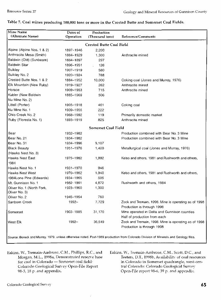
Resource Series 37 Geology and Mineral Resources of Gunnison County
Table 7. Coal mines producing 100,000 tons or more in the Crested Butte and Somerset Coal Fields.
Mine N a m e (Alternate Name)
Alpine (Alpine Nos.
Anthracite Mesa (S
1 &2) mith)
Baldwin (Old) (Sunbeam)
Baldwin Star
Bulkley
Bulkley No. 2
Crested Butte Nos.
Elk Mountain (New
Horace
Kubler (New Baldw
Nu Mine No. 2)
Littell (Porter)
Nu Mine No. 1
Ohio Creek No. 2
Ruby (Floresta No.
Bear
Bear No. 21
Bear No. 31
Black Beauty
(Hawks Nest No. 3)
Hawks Nest East
1984
Hawks Nest No. 1
Hawks Nest West
1 &2
Ruby)
n
1)
1984Lone Pine (Edwards)
Mt. Gunnison No. 1
Oliver No. 1 (North Oliver No. 3)
Oliver No. 2
Sanborn Creek
Somerset
West Elk
Fork,
Source: Boreck and Murray, 1979,
Dates of Operation
1897-1946
1884-1929
1884-1897
1896-1951
1907-1919
1920-1924
1884-1952
1919-1927
1909-1953
1885-1969
1905-1918
1939-1955
1968-1992
1893-1919
1932-1982
1934-1982
1934-1996
1951-1976
1975-1982
1931-1970
1970-1982
1934-1965
1982-1991
1923-1960
1945-1954
1992-
1903-1985
1992-
Production (Thousand tons) Reference/Comments
Crested Butte Coal Field
2,200
1,300
297
126 580 788
10,000
262 715
506
461 222
119 825
Anthracite mined
Coking coal (Jones and Murray, 1976)
Anthracite mined
Anthracite mined
Coking coal
Primarily domestic market
Anthracite mined
Somerset Coal Field
9,107
1,400
1,992
946 1,940
505 4,872
1,300
760
7,729
31,170
36,519
unless otherwise noted. Post-1989 production
Production combined with Bear No. 3 Mine
Production combined with Bear No. 3 Mine
Metallurgical coal (Jones and Murray, 1976)
Kelso and others, 1981 and Rushworth and others,
Kelso and others, 1981 and Rushworth and others,
Rushworth and others, 1984
Zook and Tremain, 1998. Mine is operating as of 1998
Production is through 1998
Mine operated in Delta and Gunnison counties
Half of production from each
Zook and Tremain, 1998. Mine is operating as of 1998
Production is through 1998
from Colorado Division of Minerals and Geology files.
Eakins, W., Tremain-Ambrose, C M . , Phillips, R.C., and
Morgan, M.L., 1998a, Demonstrated reserve base
for coal in Colorado — Somerset coal field:
Colorado Geological Survey Open-File Report
98-5, 18 p. and appendix.
Eakins, W., Tremain-Ambrose, C M . , Scott, D.C., and
Teeters, D.T., 1998b, Availability of coal resources
in Colorado in Somerset quadrangle, west-cen
tral Colorado: Colorado Geological Survey
Open-File report 98-6, 39 p. and appendix.
Colorado Geological Survey 65

Resource Series 37 Geology and Mineral Resources of Gunnison County
Fender, H.B., Jones, D.C, and Murray, D.K., 1978,
Bibliography and index of publications related
to coal in Colorado, 1972-1977: Colorado
Geological Survey Bulletin 41, 54 p.
Goolsby, S.M., Reade, N.B.S., and Murray, D.K., 1979,
Evaluation of coking coals in Colorado:
Colorado Geological Survey, Resources Series 7,
72 p., 3 pis.
Jones, D.C. and Murray, D.K., 1976, Coal mines of
Colorado in statistical data: Colorado Geological
Survey Information Series 2, 27 p.
Kelso, B.S., Ladwig, L.R., and Sitowitz, L., 1981,
Directory of permitted Colorado coal
mines,1981: Colorado Geological Survey Map
Series 15, 130 p.
Landis, E.R., 1959, Coal resources of Colorado: U.S.
Geological Survey Bulletin 1071-C, p. 131-232.
Rushworth, P., Kelso, B.S., and Ladwig, L.R., 1984;
Map, directory, and statistics of permitted coal mines, 1983: Colorado Geological Survey Map
Series 23, 130 p.
Tremain, CM., Hornbaker, A.L., Holt, R.D., Murray,
D.K. and Ladwig, L.R., 1996, 1995 Summary of
coal resources in Colorado: Colorado Geological
Survey Special Publication 41, 19 p.
Tremain Ambrose, CM., Kelso, B.S., Schultz, J.E., and
Eakins, W. (compilers), in press, Colorado coal quality data, Colorado Geological Survey Open-
File Report, CD-ROM.
Tyler, Roger and others, 1996, Geologic and hydrologic
controls critical to coalbed methane producibili-
ty and resource assessment: Williams Fork
Formation, Piceance Basin, Northwest Colorado:
Gas Research Institute Topical Report GRI-95/0532, prepared by the Bureau of Economic
Geology, University of Texas at Austin, 398 p.
Zook, J.M. and Tremain, CM., 1998, Directory and sta
tistics of Colorado coal mines with distribution and electric generation map, 1995-96: Colorado
Geological Survey Resource Series 32, 55 p., 1
pi., scale 1:1,000,000.
66 Colorado Geological Survey

Resource Series 37 Geology and Mineral Resources of Gunnison County
c^-7^r ——
GEOLOGICAL SETTING GUNNISON COUNTY EXPLORATION AND DEVELOPMENT
The Piceance Basin of northwest Colorado is kidney-
shaped and oriented northwest-southeast. It is about
100 mi long and 40-50 mi wide and lies within por
tions of seven counties; Moffat, Rio Blanco, Garfield,
Mesa, Delta, Pitkin, and Gunnison. The basin is asym
metrical and deepest along its east side near the White
River Uplift in central Rio Blanco County, where more
than 20,000 ft of Phanerozoic sedimentary rocks are
present. The southeastern margin of the basin, which
lies in the northwest portion of Gunnison County,
includes a maximum thickness of approximately 11,000 ft of Phanerozoic sedimentary rock.
Numerous gas fields, but only a few oil fields,
have been discovered in the Piceance Basin.
Exploration in the province began in the late 1880s. The first field in the basin, now called White River
(T. 2 N., R. 97 W., Rio Blanco County), was discovered in 1890 and produces from sandstone in the Tertiary
Wasatch Formation and Upper Cretaceous Mesaverde
Formation. The oldest producing reservoir in the basin
is the Permo-Pennsylvanian Weber Formation; the
youngest is the Douglas Creek Member of the Green
River Formation. The dominant productive interval is
the Mesaverde Formation. Sandstone is the primary
gas reservoir, but Mesaverde Formation coal seams
also contribute a small amount of gas. Hydrocarbon
entrapment within the Piceance Basin province is either
entirely stratigraphic or combination of structural
stratigraphic.
The largest field in the basin is Piceance Creek
(T. 2 S., R. 96 W., Rio Blanco County), which has a
cumulative production of 238,253,352 thousand cubic
ft (Mcf) of natural gas and 143,596 barrels of oil (BO)
through 1996. This field, operated by Mobil Oil
Company, was discovered in 1930. Producing reser
voirs in the Piceance Creek Field include the Green
River Formation, Wasatch Formation, and Mesaverde
Formation.
Oil and gas companies drilled 37 wells in Gunnison
County between 1954 and 1994. All were located in the Piceance Basin structural province, which occupies
about 600 sq mi of the northwestern portion of the
county. The first well in the county was a 1,008 ft
Cretaceous Mancos Shale test drilled by K D Drilling
and Mile High Exploration in the SW>4 of the NE1/! of
Sec. 8, T. 13 S., R. 89 W. This well was completed as a
dry hole in July 1954. The most recent well, the 21-7
Federal, was a horizontal test into Cretaceous Mesaverde Cozzette Sandstone. The well, operated by A A Production
Company, was located in the SW:/4 of the NEV4 of Sec.
21, T. 10 S., R. 90 W. Its measured depth was 8,038 ft
and true vertical depth was 6,022 ft. The well was com
pleted in January 1994 as a natural gas producer, open
hole from 6,136 ft to 8,038 ft. The well's initial potential
was reported as 490 Mcf of gas per day with a flow tubing pressure of 1,950 lb. Historic oil and gas production
for Gunnison County is shown in Table 8.
The average depth of the oil and gas well tests
drilled in Gunnison County is about 4,670 ft. The
deepest was a 8,450 ft Jurassic Morrison Formation test
drilled in the NEV4 of the SEV4 of Sec. 11, T. 12 S., R. 90 W.
This Petro-Lewis Corporation test was completed as a
dry hole in January of 1972. The shallowest was the
K D Drilling and Mile High Exploration 1,008 ft
Cretaceous Mancos Shale test cited above as the first
oil and gas test drilled in the county. Twenty-seven
Gunnison County oil and gas company wells were sus
pended in the Cretaceous Mesaverde Formation and the
associated Mancos Shale. Six wells were suspended in
the either the Cretaceous Dakota or the underlying
Jurassic Morrison Formation. One well was reported to
be in the Jurassic Entrada at total depth and four were
taken to Precambrian basement.
Colorado Geological Survey 67
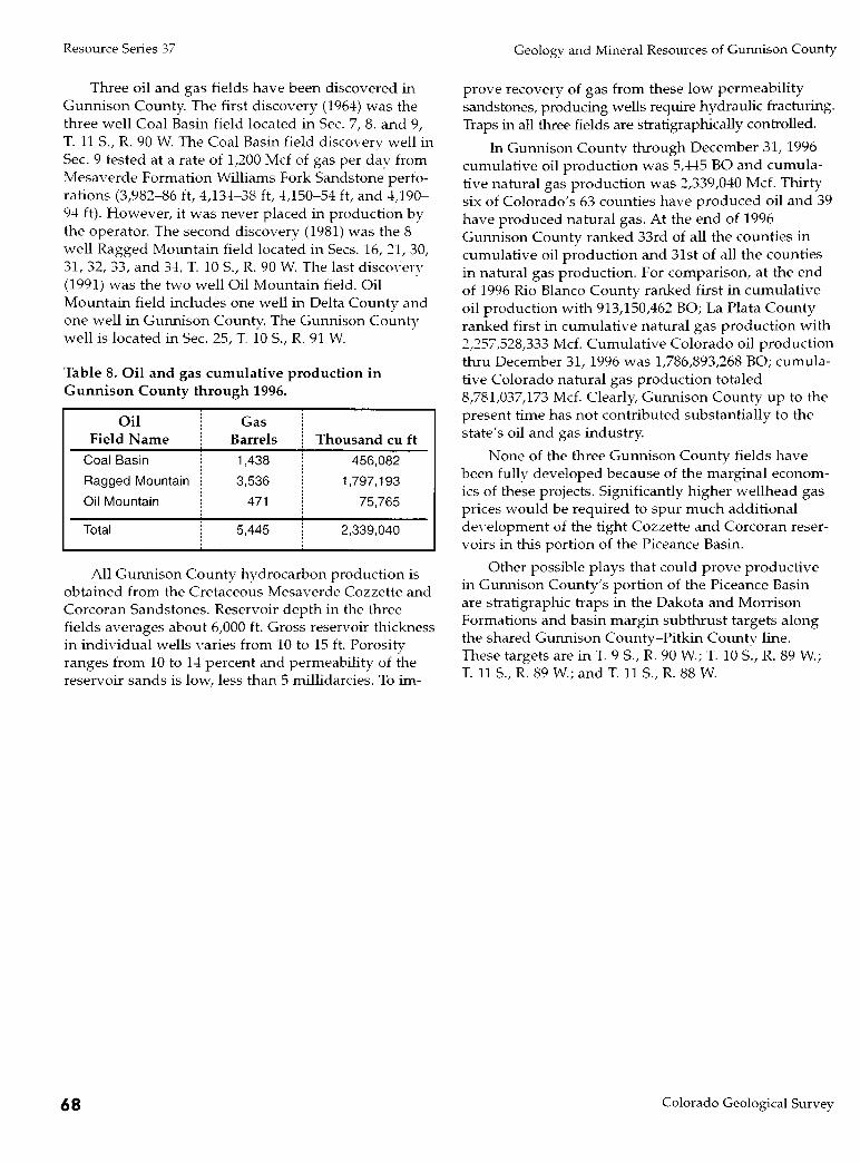
Resource Series 37 Geology and Mineral Resources of Gunnison County
Three oil and gas fields have been discovered in
Gunnison County. The first discovery (1964) was the
three well Coal Basin field located in Sec. 7, 8. and 9,
T. 11 S., R. 90 W. The Coal Basin field discovery well in
Sec. 9 tested at a rate of 1,200 Mcf of gas per dav from
Mesaverde Formation Williams Fork Sandstone perfo
rations (3,982-86 ft, 4,134-38 ft, 4,150-54 ft, and 4,190-
94 ft). However, it was never placed in production by
the operator. The second discovery (1981) was the 8
well Ragged Mountain field located in Sees. 16, 21, 30,
31, 32, 33, and 34, T. 10 S., R. 90 W . The last discovery
(1991) was the two well Oil Mountain field. Oil
Mountain field includes one well in Delta County and
one well in Gunnison County. The Gunnison County
well is located in Sec. 25, T. 10 S., R. 91 W.
Table 8. Oil and gas cumulative production in Gunnison County through 1996.
Oil
Field N a m e
Coal Basin
Ragged Mountain
Oil Mountain
Total
Gas Barrels
1,438
3,536
471
5,445
Thousand cu ft
456,082
1,797,193
75,765
2,339,040
All Gunnison County hydrocarbon production is
obtained from the Cretaceous Mesaverde Cozzette and Corcoran Sandstones. Reservoir depth in the three
fields averages about 6,000 ft. Gross reservoir thickness
in individual wells varies from 10 to 15 ft. Porosity
ranges from 10 to 14 percent and permeability of the
reservoir sands is low, less than 5 millidarcies. To im
prove recovery of gas from these low permeability
sandstones, producing wells require hydraulic fracturing.
Traps in all three fields are stratigraphically controlled.
In Gunnison County through December 31, 1996
cumulative oil production was 5,445 B O and cumula
tive natural gas production was 2,339,040 Mcf. Thirty
six of Colorado's 63 counties have produced oil and 39
have produced natural gas. At the end of 1996
Gunnison County ranked 33rd of all the counties in
cumulative oil production and 31st of all the counties
in natural gas production. For comparison, at the end
of 1996 Rio Blanco County ranked first in cumulative
oil production with 913,150,462 BO; La Plata County
ranked first in cumulative natural gas production with
2,257,528,333 Mcf. Cumulative Colorado oil production
thru December 31, 1996 was 1,786,893,268 BO; cumula
tive Colorado natural gas production totaled 8,781,037,173 Mcf. Clearly, Gunnison County up to the
present time has not contributed substantially to the
state's oil and gas industry.
None of the three Gunnison County fields have
been fully developed because of the marginal econom
ics of these projects. Significantly higher wellhead gas
prices would be required to spur m u c h additional development of the tight Cozzette and Corcoran reser
voirs in this portion of the Piceance Basin.
Other possible plays that could prove productive
in Gunnison County's portion of the Piceance Basin
are stratigraphic traps in the Dakota and Morrison
Formations and basin margin subthrust targets along the shared Gunnison County-Pitkin County line.
These targets are in T. 9 S., R. 90 W.; T. 10 S., R. 89 W.;
T. 11 S., R. 89 W.; and T. 11 S., R. 88 W.
68 Colorado Geological Survey

Resource Series 37 Geology and Mineral Resources of Gunnison County
REFERENCES
Afifi, A.M., 1981a, Precambrian geology of the his
area, Gunnison and Saguache Counties,
Colorado: Masters thesis, Colorado School of Mines, Golden, Colorado.
, 1981b, Stratigraphy, petrology, and structure of
Precambrian metavolcanic rocks in the Iris dis
trict, Gunnison and Saguache Counties, Colo
rado in Epis, R.C, and Callendar, J. E, eds.,
Western Slope Colorado: N e w Mexico Geological
Society 32nd Field Conference Guide Book,
October 8-10, 1981, p. 287-292.
Armbrustmacher, T.A., 1981, The complex of alkaline
rocks at Iron Hill, Powderhorn district,
Gunnison County, Colorado, in Epis, R.C, and
Callendar, J. E, eds., Western Slope Colorado:
N e w Mexico Geological Society 32nd Field
Conference Guide Book, October 8-10,1981, p.
293-296.
Armbrustmacher, T.J., 1980, Abundance and distribu
tion of thorium in the carbonatite stock at Iron
Hill, Powderhorn District, Gunnison County, Colorado: U.S. Geological Survey Professional
Paper 1049-B, p. Bl-Bll.
Baars, D.L., 1962, Permian system of the Colorado
Plateau: American Association of Petroleum
Geologists Bulletin, v. 46, p. 149-218.
,1966, Pre-Pennsylvanian paleotectonics—key to
basin evolution and petroleum occurrences in
Paradox basin, Utah and Colorado: American
Association Petroleum Geologists Bulletin, v. 50,
p. 2082-2111.
, 1972, Devonian systems in Geologic Atlas of
Rocky Mountain region, United States of
America: Rocky Mountain Association of
Geologists, Denver, Colorado, p. 90-99.
Baars, D.L., and Campbell, J.A., 1968, Devonian sys
tems of Colorado, northern N e w Mexico, and
the Colorado Plateau: Mountain Geologist, v. 5,
p. 31-40.
Bartleson, Bruce, 1972, Permo-Pennsylvanian stratigra
phy and history of the Crested Butte-Aspen
region: Quarterly of the Colorado. School of
Mines, v. 67, no. 4, p. 187-248.
, 1992, Cretaceous Dakota and Burro Canyon
formations, Gunnison County, Colorado, [abstr.]:
SEPM 1992 theme meeting, Mesozoic of the
western interior, Fort Collins, Colorado, 1992.
Bartleson, B.L., Bryant, B., and Mutschler, F.E., 1968,
Permian and Pennsylvanian stratigraphy and
nomenclature, Elk Mountains, Colorado: U.S.
Geological Survey Professional Paper 600-C,
p. C53-C60.
Bass,N.W., and Northrop, S.A., 1953, Dotsero and
Manitou Formations, White River Plateau,
Colorado, with special reference to the Clinetop
algal limestone member of the Dotsero Formation: American Association of Petroleum
Geologists Bulletin, v. 37, no. 5, p. 889-912.
, 1963, Geology of Glenwood Springs quadrangle and vicinity, northwestern Colorado: U.S.
Geological Survey Bulletin 1142-J, 74 p.
Belser, Carl, 1956, Tungsten potential in Chaffee,
Fremont, Gunnison, Lake, Larimer, Park, and
Summit Counties, Colorado: U.S. Bureau of Mines Information Circular 7748, 31 p.
Berman, A.E., Poleschook, D., Jr., and Dimelow, T.E.,
1980, Jurassic and Cretaceous systems in
Colorado, in Kent, H.C., and Porter, K.W., eds.,
Colorado Geology: Rockv Mountain Association
of Geologists, Denver, Colorado, p. 11-128.
Blomquist, P.K., 1993, Geology and mineral deposits of
Mt. Tilton, Gunnison County, Colorado: Masters
thesis Colorado School of Mines, Golden, Colorado.
Brill, K.G., 1952, Stratigraphy in the Permo-
Pennsylvanian zeugogeosyncline of Colorado
and northern N e w Mexico: Geological Society of
America Bulletin, v. 63, p. 809-880.
Brock, M.R., and Barker, F, 1972, Geologic map of the
Mount Harvard quadrangle, Chaffee and
Gunnison Counties, Colorado: U.S. Geological
Survey Map GQ-952, scale 1:24,000.
Brown, A.L., 1950, Geology of the Round Mountain
intrusive, Gunnison County, Colorado: Masters thesis, University of Kentucky, 24 p.
Bryant, Bruce, 1969, Geologic map of the Maroon Bells
quadrangle, Pitkin and Gunnison Counties,
Colorado: U.S. Geological Survey Map GQ-788,
scale 1:24,000.
Colorado Geological Survey 69

Resource Series 37 Geology and Mineral Resources of Gunnison County
, 1970, Geologic map of the Hayden Peak quad
rangle, Pitkin and Gunnison Counties, Colorado:
U.S. Geological Survey Map GQ-863, scale
1:24,000.
, 1971, Geologic map of the Aspen quadrangle,
Pitkin County, Colorado: U.S. Geological Survey
Map GQ-933^ scale 1:24,000.
Bush, A.L., 1951, Sources of lightweight aggregates in
Colorado: Colorado Scientific Society
Proceedings, v. 15, no. 8, p. 326-331.
Campbell, J.A., 1967, Dispersal patterns in Upper
Devonian in west-central Colorado in
International Symposium on the Devonian
System, v. 2: Alberta Society of Petroleum
Geologists, p. 1131-1138.
, 1970a, Stratigraphy of the Chaffee Group
(Upper Devonian), west-central Colorado:
American Association of Petroleum Geologists
Bulletin, v. 54, p. 313-325.
, 1970b, Petrology of Devonian shelf carbonates of west-central Colorado: Mountain Geologist, v. 7, p. 89-97.
, 1972, Petrology of the quartzose sandstones of the Parting Formation in west-central Colorado:
Journal of Sedimentary Petrology, v. 42, p. 263-269.
, 1981, Summary of Paleozoic stratigraphy and
history of western Colorado, in Epis, R.C, and Callendar, J.F., eds., Western Slope Colorado:
New Mexico Geological Society 32nd Field
Conference Guide Book, October 8-10, 1981, p.
81-88.
Chronic, John, McCallum, M.E., Ferris, C.S., Jr., and
Eggler, D.H., 1969, Lower Paleozoic rocks in dia-tremes, southern Wyoming and northern
Colorado: Geological Society of America Bulletin, v.
80, no. 1, p. 149-156.
Craig, L.C., 1972, Mississippian system in Geologic Atlas of Rocky Mountain region, United States
of America: Rocky Mountain Association of
Geologists, Denver, Colorado, p. 100-110.
Crawford, R.D., 1913, Geology and ore deposits of the
Monarch and Tomichi districts, Colorado:
Colorado Geological Survey Bulletin 4, 317 p.
Crawford, R.D., and Worcester, P.G., 1916, Geology
and ore deposits of the Gold Brick district,
Colorado: Colorado Geological Survey Bulletin
10,116 p.
Cross, C.W., 1894, The laccolithic mountain groups of
Colorado, Utah, and Arizona: U.S. Geological
Survey 14th Annual Report, p. 165-564.
Cunningham, C.G., Jr., 1976, Petiogenesis and post-magmatic geochemistry of the Italian Mountain
intrusive complex, eastern Elk Mountains,
Colorado: Geological Society of America
Bulletin, v. 86, p. 897-908.
Cunningham, C C , Naeser, C.W., and Marvin, R.F.,
1977, N e w ages for intrusive rocks in the
Colorado mineral belt: U.S. Geological Survey
Open-File Report 77-573, 7 p.
Davis, M.W., and Stieufert, R.K., 1990, Gold occurrences of Colorado: Colorado Geological Survey
Resource Series 28, 101 p.
DeVoto, R.H., 1972, Pennsylvanian and Permian stratigraphy and tectonism in central Colorado:
Colorado School of Mines Quarterly, v. 67, no. 4,
p. 139-186.
, 1980a, Mississippian stratigraphy and history
of Colorado, in Kent, H.C, and Porter, K.W.,
eds., Colorado Geology: Rocky Mountain
Association of Geologists, Denver, Colorado,
p. 57-70.
, 1980b, Pennsylvanian stratigraphy and history
of Colorado, in Kent, H.C, and Porter, K.W.,
eds., Colorado Geology: Rocky Mountain Association of Geologists, Denver, Colorado,
p. 71-101.
DeWitt, Ed, Stoneman, R.J., Clark, J.R., and Kleudner,
S.E., 1985, Mineral resource potential map of the
Fossil Ridge Wilderness Study Area, Gunnison County, Colorado: U.S. Geological Survey
Miscellaneous. Field Studies Map MF-1629-A.
Dickinson, R.G., 1987a, Geologic map of the Washboard Rock quadrangle, Gunnison,
Montrose, and Ouray Counties, Colorado: U.S.
Geological Survey Map GQ-1643, scale 1:24,000.
, 1987b, Geologic map of the Buckhorn Lakes
quadrangle, Gunnison, Montrose, and Ouray
Counties, Colorado: U.S. Geological Survey Map GQ-1642, scale 1:24,000.
, 1988, Geologic map of the Courthouse Mountain quadrangle, Gunnison, Hinsdale, and
Ouray Counties, Colorado: U.S. Geological
Survey Map GQ-1644, scale 1:24,000.
Dings, M.G., and Robinson, C.S., 1957, Geology and
ore deposits of the Garfield quadrangle,
Colorado: U.S. Geological Survey Professional Paper 289, 110 p.
Dowsett, F.R., Jr., Ganster, M.W., Ranta, D.E., Baker,
D.J., and Stein, H.J., 1981, Geology of the Mount
Emmons molybdenum deposit, Crested Butte,
Colorado, in Epis, R.C, and Callendar, J.F., eds.,
Western Slope Colorado: N e w Mexico
70 Colorado Geological Survey

Resource Series 37 Geology and Mineral Resources of Gunnison County
Geological Society 32nd Field Conference Guide
Book, October 8-10, 1981, p. 325-332.
Drobeck, PA., 1979, Geology and trace element geo
chemistry of a part of the Gunnison gold belt,
Colorado: Masters thesis Colorado School of
Mines, Golden, Colorado.
, 1981, Proterozoic syngenetic massive sulfide
deposits in the Gunnison gold belt, Colorado, in
Epis, R.C, and Callendar, J.F. eds., Western
Slope Colorado: N e w Mexico Geological Society
32nd Field Conference Guide Book, October 8-10, 1981, p. 325-332.
Dukes, B.J., 1953, Geology of the Farris Creek area,
Gunnison County, Colorado: Masters thesis,
University of Kentucky, 57 p.
Eckel, E.B., 1961, Mineral of Colorado, a 100-year record:
U.S. Geological Survey Bulletin 1114, 399 p.
Ellis, M.S., Gaskill, D.L., and Dunrud, C.R., 1987,
Geologic map of the Paonia and Gunnison area,
Delta and Gunnison Counties, Colorado: U.S.
Geological Survey Coal Investigation Map C-
109, scale 1:100,000.
Emmons, S.F., Cross, Whitman, and Eldridge, G.H.,
1894, Anthracite-Crested Butte folio, Colorado:
U.S. Geological Survey Atlas, Folio 9, 11 p.
Ernst, D.R., 1980, Petrography and geochemistry of
Boston Peak and Tomichi Dome, and relation to
other plutons in Gunnison County, Colorado: Masters thesis, Eastern Washington University,
Cheney, 52 p.
Fischer, W.A., 1978, The habitat of the early verte
brates: trace and body fossil evidence from the
Harding Formation (Middle Ordovician),
Colorado: The Mountain Geologist, v. 15, no. 1,
p. 1-26.
Fisher, R.P., 1975, Vanadium resources in titaniferous
magnetite deposits: U.S. Geological Survey
Professional Paper 926-B, 10 p.
Foster, N., 1972, Ordovician system in Geologic Atlas
of Rocky Mountain region, United States of
America: Rocky Mountain Association of
Geologists, Denver, Colorado, p. 76-85.
Freeman, R.N., 1950, Geology of the Round Mountain area of Gunnison County, Colorado, and a petro-
logical study of the Coffman Conglomerate:
Masters thesis, University of Kentucky, 41 p.
Ganster, M.W., Dowsett, F.R., and Ranta, D.E., 1981,
Geology of the Mount Emmons Deposit [abs]:
American Institute of Mining, Metallurgical and
Petroleum Engineers, Annual Meeting Program,
p. 21.
Gaskill, D.L., and Godwin, L.H., 1963, Redefinition
and correlation of the Ohio Creek Formation
(Paleocene) in west-central Colorado: U.S. Geo
logical Survey Professional Paper 475-C, p C-35.
, 1966a, Geologic map of the Marble quadran
gle, Gunnison and Pitkin Counties, Colorado:
U.S. Geological Survey Map GQ-512, scale
1:24,000.
, 1966b, Geologic map of the Marcellina
Mountain quadrangle, Gunnison County,
Colorado: U.S. Geological Survey Map GQ-511,
scale 1:24,000.
Gaskill, D.L., Colman, S.M., DeLong, J.E., Jr., and
Robinson, C.H., Geologic map of the Crested
Butte quadrangle, Gunnison County, Colorado:
U.S. Geological Survey Map GQ-1580, scale
1:24,000.
Gaskill, D.L., DeLong, J.E., Jr., and Cochran, D.M.,
1987, Geologic map of the Mt. Axtell quadran
gle, Gunnison County, Colorado: U.S. Geological
Survey Map GQ-1604, scale 1:24,000.
Gaskill, D.L., Godwin, L.H., and Mutschler, F.E., 1967, Geologic map of the Oh-Be-Joyful quadrangle,
Gunnison County, Colorado: U.S. Geological Survey Map GQ-578, scale 1:24,000.
Gaskill, D.L., Mutschler, F.E., and Bartleson, B.L., 1981,
West Elk volcanic field, Gunnison and Delta
Counties, Colorado, in Epis, R.C, and Callendar, J.F., eds., Western Slope Colorado: N e w Mexico
Geological Society 32nd Field Conference Guide
Book, October 8-10, 1981, p. 305-315.
Gaskill, D.L., Mutschler, F.E., Kramer, J.H., Thomas,
J.A., and Zahonv, S.G., 1991, Geologic map of
the Gothic quadrangle, Gunnison County, Colo
rado: U.S. Geological Survey Map GQ-1689,
scale 1:24,000.
Giles, D.L., 1974, Massive sulfide deposits in Precam
brian rocks, northern N e w Mexico [abs.] N e w
Mexico Geological Society Guidebook 25, p. 378.
Goddard, E.N., 1936, The geology and ore deposits of
the Tincup mining district, Gunnison County,
Colorado: Colorado Scientific Society Proceedings v. 13, no. 10, p. 551-595
Godwin, L.H., 1968, Geologic map of the Chair
Mountain quadrangle, Gunnison and Pitkin
Counties, Colorado: U.S. Geological Survey Map GQ-704, scale 1:24,000.
Godwin, L.H., and Gaskill, D.L., 1964, Post-Paleocene
West Elk laccolithic cluster, west-central
Colorado: U.S. Geological Survey Professional Paper 501-C, p. C66-C68.
Colorado Geological Survey 71

Resource Series 37 Geology and Mineral Resources of Gunnison County
Goodknight, C.S., 1981, Uranium in the Gunnison
country, Colorado, in Epis, R.C, and Callendar,
J.F. eds., Western Slope Colorado: N e w Mexico
Geological Society 32nd Field Conference Guide
Book, October 8-10,1981, p. 183-190.
Hansen, W.R., 1971, Geologic map of the Black Canyon
of the Gunnison river and vicinity, western
Colorado: U.S. Geological Survey Misc. Geol.
Invest. Map 1-584, scale 1:31,680.
Harder, E.C, 1910, Manganese deposits of the United
States: U.S. Geological Survey Bulletin 427,
p. 150-151.
Hartley, P.D., 1976, The geology and mineralization of
a Precambrian massive sulfide deposit at
Vulcan, Gunnison County, Colorado: Masters
thesis, Stanford University.
Hedlund, D C , 1974, Geologic map of the Big Mesa quadrangle, Gunnison County, Colorado: U.S.
Geological Survey Map GQ-1153, scale 1:24,000.
Hedlund, D C , and Olson, J C , 1961, Four environ
ments of thorium-, niobium-, and rare-earth-bearing minerals in the Powderhorn district of
southwestern Colorado: U.S. Geological Survey
Professional Paper 424-B, p. B283-B286.
, 1968, Geologic map of the complex of alkalic
rocks at Iron Hill, Gunnison County, Colorado:
U.S. Geological Survey Open-File Map.
, 1973, Geologic map of the Carpenter Ridge quadrangle, Gunnison County, Colorado: U.S.
Geological Survey Map GQ-1070, scale 1:24,000.
, 1974, Geologic map of the Iris N W quadrangle,
Gunnison and Saguache Counties, Colorado:
U.S. Geological Survey Map GQ-1134, scale
1:24,000.
, 1975, Geologic map of the Powderhorn quad
rangle, Gunnison and Saguache Counties, Colorado: U.S. Geological Survey Map GQ-1178,
scale 1:24,000.
, 1981, Precambrian geology along parts of the
Gunnison uplift of southwestern Colorado, in
Epis, R.C, and Callendar, J.F., eds., Western
Slope Colorado: N e w Mexico Geological Society
32nd Field Conference Guide Book, October
8-10, 1981, p. 267-272.
Henderson, C.W., 1926, Mining in Colorado: U.S.
Geological Survey Professional Paper 138, 263 p.
Herald, C.E., 1981, Geology of the Pitkin-Fairview
Peak area, Gunnison County, Colorado: Masters
thesis Colorado School of Mines, Golden,
Colorado.
Hill, J.M., 1909, Notes on the economic geology of southeastern Gunnison County, Colorado: U.S.
Geological Survey Bulletin 380-A, p. A21-A40.
Horlacher, C.F., 1987, Precambrian geology and gold mineralization in the vicinity of Ohio City,
Gunnison County, Colorado: Masters thesis
Colorado School of Mines, Golden, Colorado.
Hunter, J.F., 1925, Precambrian rocks of Gunnison River, Colorado: U.S. Geological Survey Bulletin
777, 94 p.
Isaacson, L.B., and Smithson, S.B., 1976, Gravity anom
alies and granite emplacement in west-central
Colorado: Geological Society of America Bulletin,
v. 87, p. 22-28.
Jackson, W.E., 1957, Geology of the Brush Creek area
and a petrographic study of the Morrison
Formation, Gunnison County, Colorado:
Master's thesis, University of Kentucky, 48 p.
Johnson, J.H., 1944, Paleozoic stratigraphy of the Sawatch Range, Colorado: Geological Society of
America Bulletin, v. 55, no. 3, p. 303-378.
Johnson, R.C, and May, Fred, 1980, A study of the Cretaceous-Tertiary unconformity in the Piceance Creek Basin, Colorado; The underlying
Ohio Creek Formation redefined as a member of
the Hunter Canyon or Mesaverde Formations:
U.S. Geological Survey Bulletin 1482-B, 27 p.
Johnson, V.H., 1948, Geology of the Paonia coal field,
Delta and Gunnison Counties, Colorado: U.S. Geological Survey Coal Field Ser. Map, scale
1:47,520.
Jones, E.L., 1921, Some deposits of manganese ore in Colorado: U.S. Geological Survey Bulletin 715,
p. 61-72.
Kirkham, R.M., Bryant, Bruce, Streufert, R.K., and Shroba, R.R., 1996, Fieldtrip guidebook on the
geology and geologic hazards of the Glenwood
Springs area, Colorado, in Thompson, R.A., Hudson, M.R., and Pillmore, C.L., eds., Geologic
excursions to the Rocky Mountains and beyond;
Fieldtrip guidebook for the 1996 annual meeting
of the Geological Society of America: Colorado
Geological Survey Special Publication 44.
Koksoy, Mumin, 1961, Geology of the northern part of the Tincup mining district, Gunnison County,
Colorado: Masters thesis, Colorado School of
Mines, Golden, Colorado, 99 p.
Lakes, Arthur, 1896, Sketch of a portion of the
Gunnison gold belt, including the Vulcan and
Mammoth Chimney mines: American Institute
of Mining and Metallurgical Engineers,
Transactions, v. 26, p. 440-448.
72 Colorado Geological Survey

Resource Series 37 Geology and Mineral Resources of Gunnison County
Larsen, E.S., Jr., 1942, Alkalic rocks of Iron Hill,
Gunnison County, Colorado: U.S. Geological
Survey Professional Paper 197-A, p. 1-64.
Langenheim, R.L., Jr., 1952, Pennsylvanian and
Permian stratigraphy in Crested Butte quadran
gle, Gunnison County, Colorado: American
Association of Petroleum Geologists Bulletin, v. 36, no. 4,p. 543-574.
Leighton, CD., 1987, Stratigraphy and sedimentology
of the Pennsylvanian Gothic formation in the
Crested Butte area, Colorado: Masters thesis,
Colorado School of Mines, Golden, Colorado.
Levorsen, M.K., 1987, Stratigraphic analysis of the
Gothic formation (Desmoinesian), Pitkin and
Gunnison Counties, Colorado: Masters thesis,
Colorado School of Mines, Golden, Colorado.
Lipman, P.W., Mutschler, F.E., Bryant, Bruce, and
Steven, T.A., 1969, Similarity of Cenozoic
igneous activity in the San Juan and Elk
Mountains, Colorado, and its regional signifi
cance: U.S. Geological Survey Professional Paper
650-D, p. D33-D42.
Lochman-Balk, C , 1972, Cambrian systems, in Geo
logic Atlas of Rocky Mountain region, United
States of America: Rocky Mountain Association
of Geologists, Denver, Colorado, p. 60-75.
Ludington, S., and Ellis, C.E., 1983, Map showing geology and mineral resource potential of the Oh-
Be-Joyful wilderness study area, Gunnison
County, Colorado: U.S. Geological Survey Miscellaneous Field Studies Map MF-1582-A.
Luedke, R.G., 1993, Map showing distribution, compo
sition, and age of Early and Middle Cenozoic
volcanic centers in Colorado and Utah: U.S.
Geological Survey Miscellaneous Investigation
Series M a p
I-2291-B, scale 1:1,000,000.
MacKenzie, D.B., and Poole, D.M., 1962, Provenance of
Dakota Group sandstones of the Wyoming inte
rior, in Symposium of Early Cretaceous rocks of
Wyoming and adjacent areas: 17th Annual Field
Conference Guidebook, Wyoming Geological
Assoc, p. 62-71.
MacLachlan, M.E., 1981, Stratigraphic correlation chart
for western Colorado and northwestern N e w
Mexico, in Epis, R.C, and Callendar, J.F., eds.,
Western Slope Colorado: N e w Mexico
Geological Society 32nd Field Conference Guide
Book, October 8-10, 1981, p. 75-80.
McFarlan, A C , 1961, Outline of the geology of the
Cement Creek area, in Berg, R.E., ed.,
Symposium on lower and middle Paleozoic
rocks of Colorado: Rocky Mountain Association
of Geologists, Denver, Colorado, 1961
Symposium, p. 125-131.
Malan, R.C, and Ranspot, H.W., 1959, Geology of the
uranium deposits in the Cochetopa mining dis
trict, Saguache and Gunnison Counties, Colo
rado: Economic Geology, v. 54, no. 1, p. 1-19.
Mallory, W.W., 1972, Regional synthesis of the Pennsylvanian system, in Geologic Atlas of the
Rocky Mountain Region: Rocky Mountain
Association of Geologists, Denver, Colorado,
p. 111-127.
Maughan, E.K., 1980, Permian and lower Triassic geol
ogy of Colorado, in Kent, H.C, and Porter, K.W.,
eds., Colorado Geology: Rocky Mountain
Association of Geologists, Denver, Colorado, p.
103-110.
Merrill, W.M., and Winar, R.M., 1958, Molas and asso
ciated formations in San Juan basin-Needle Mountains area, southwestern Colorado:
American Association Petroleum Geologists
Bulletin, v. 42, p. 2107-2132.
Muilenburg, G.A.,1919, Manganese deposits of Colorado:
Colorado Geological Survey Bulletin 15, 76 p.
Mutschler, F.E., 1968, Geology of the Treasure Mountain
Dome, Gunnison County, Colorado: Ph. D. dissertation, University of Colorado, Boulder,
Colorado, 240 p.
, 1970, Geologic map of the Snowmass
Mountain quadrangle, Pitkin and Gunnison
Counties, Colorado: U.S. Geological Survey Map
GQ-853, scale 1:24,000.
, 1976, Crystallization of a soda granite,
Treasure Mountain Dome, Colorado, and the genesis of stockwork molybdenite deposits:
N e w Mexico Geological Society Special Paper 6,
p. 199-205.
Mutschler, F.E., Ernst, D.R., Gaskill, D.L., and Billings,
Patty, 1981, Igneous rocks of the Elk Mountains
and vicinity, Colorado-chemistry and related ore
deposits, in Epis, R.C, and Callendar, J.F., eds.,
Western Slope Colorado: N e w Mexico
Geological Society 32nd Field Conference Guide
Book, October 8-10, 1981, p. 317-324.
Mutschler, F.E., Larson, E.E., and Bruce, R.M., 1987,
Laramide and younger magmatism in Colorado-
N e w petrologic and tectonic variations on old
themes, in Drexler, J.W., and Larson, E.E., eds.,
Cenozoic volcanism in the southern Rocky
Mountains revisited: A tribute to Rudv C. Epis-
Part I: Colorado School of Mines Quarterly, v. 82, no. 4, p. 1-47.
Colorado Geological Survey 73

Resource Series 37 Geology and Mineral Resources of Gunnison County
Nadeau, J.E., 1972, Mississippian stratigraphy of cen
tral Colorado: Colorado School of Mines
Quarterly, v. 67, no. 4, p. 77-102.
Nash, W.P., 1972, Mineralogy and petrology of the Iron
Hill carbonatite complex, Colorado: Geological
Society of America Bulletin, v. 83, p. 1361-1382.
Nelson-Moore, J.L., Collins, D.B., and Hornbaker, A.L.,
1978, Radioactive mineral occurrences of
Colorado and bibliography: Colorado Geological
Survey Bulletin 40, 1054 p.
Obradovich, J.D., Mutschler, F.E., and Bryant, Bruce,
1969, K-Ar ages bearing on the igneous and tec
tonic history of the Elk Mountains and vicinity,
Colorado-a preliminary report: Geological
Society of America Bulletin, v. 80, p. 1749-1756.
O'Connor, T.E., 1961, The structure and stratigraphv of an area west of Taylor Park, northeast Gunnison
County, Colorado: Masters thesis, University of
Colorado, Boulder, 97 p.
Olson, J.C, 1974, Geologic map of the Rudolph Hill
quadrangle, Gunnison, Hinsdale, and Saguache
Counties, Colorado: U.S. Geological Survey Map
GQ-1177, scale 1:24,000.
, 1976a, Geologic map of the Iris quadrangle,
Gunnison and Saguache Counties, Colorado:
U.S. Geological Survey Map GQ-1286, scale
1:24,000.
, 1976b, Geologic map of the Houston Gulch quadrangle, Gunnison and Saguache Counties,
Colorado: U.S. Geological Survey Map GQ-1287,
scale 1:24,000.
, 1983, Geologic and structural maps and sec
tions of the Marshall Pass mining district,
Saguache, Gunnison, and Chaffee Counties,
Colorado: U.S. Geological Survey Miscellaneous Investigations Series Map 1-1425, scale 1:24,000.
, 1988, Geology and uranium deposits of the
Cochetopa and Marshall Pass districts, Saguache
and Gunnison Counties, Colorado: U.S.
Geological Survey Professional Paper 1457, 44 p.
Olson, J.C, and Hedlund, D C , 1973, Geologic map of
the Gateview quadrangle, Gunnison County,
Colorado: U.S. Geological Survey Map GQ-1071,
scale 1:24,000.
, 1981, Alkalic rocks and resources of thorium
and associated elements in the Powderhorn dis
trict, Gunnison County, Colorado: U.S. Geolog
ical Survey Professional Paper 1049-C, 34 p.
Olson, J.C, Hedlund, D C , and Hansen, W.R., 1968,
Tertiary volcanic stratigraphy in the Powder-
horn-Black Canyon region, Gunnison and
Montrose Counties, Colorado: U.S. Geological
Survey Bulletin 1251-C, p. C1-C29.
Olson, J.C, Man-in, R.F., Parker, R.L., and Mehnert,
H.H., 1977, Age and tectonic setting of lower
Paleozoic alkalic and mafic rocks, carbonatites,
and thorium veins in south-central Colorado:
Journal of Research, U.S. Geological Survey, v. 5,
p. 673-687.
Olson, J.C, and Wallace, S.R., 1956, Thorium and rare-
earth minerals in the Powderhorn district,
Gunnison County, Colorado: U.S. Geological
Survey Bulletin 1027-O, p. 693-723.
Pearl, R.H., 1981, Hydrothermal resources of western
Colorado, in Epis, R.C, and Callendar, J.F., eds.,
Western Slope Colorado: N e w Mexico Geo
logical Society 32nd Field Conference Guide
Book, October 8-10, 1981, p. 333-335.
Pillmore, K.A., 1984, Geology and mineralization of
the Paradise Pass area, Gunnison County,
Colorado: Masters thesis, Colorado School of
Mines, Golden, Colorado.
Prather, T.L., 1964, Stratigraphy and structural geology
of the Elk Mountains, Colorado: Ph. D. disserta
tion, University of Colorado, Boulder, 106 p.
Raines, G.L., 1971, Geology of the Sargents area, Gunnison and Saguache Counties, Colorado:
Masters thesis, Colorado School of Mines, Golden, Colorado, 57 p.
Robinson, C.S., 1955, Geology and ore deposits of the
Whitepine area, Tomichi mining district, Gunnison County, Colorado: Ph. D. dissertation,
University of Colorado, Boulder, 225 p.
, 1961, Pre-Pennsylvanian stratigraphy of the
Monarch District, Chaffee County, Colorado, in Berg, R.R., and Rold, J.W., eds., Symposium on
lower and middle Paleozoic rocks of Colorado:
12th Field Conference, Rocky Mountain
Association of Geologists, p. 37-39.
Rose, C.K., and Shannon, S.S., Jr., 1960, Cebolla Creek
titaniferous iron deposits, Gunnison County,
Colorado: U.S. Bureau of Mines Report of Investigations 5679, 30 p.
Rosenlund, G.C., 1984, Geology and mineralization of
the Cumberland Pass area, Gunnison County,
Colorado: Masters thesis, Colorado State University, Fort Collins, 105 p.
Ross, R.J., Jr., 1976a, Ordovician sedimentation in the
western United States, in Basset, M.G., ed., The
Ordovician System, Proceedings of Paleon-
tological Association Symposium, Birmingham:
University of Wales Press, Cardiff, U.K., p. 73-205.
74 Colorado Geological Survey

Resource Series 37 Geology and Mineral Resources of Gunnison County
, 1976b, Reprint of 1976a in Symposium on geol
ogy of the Cordilleran hingeline: Rocky
Mountain Association Geologists, p. 109-133.
Ross, R.J., Jr., and others, 1978, Fission-track dating of
lower Paleozoic volcanic ashes in British stiato-
types, in Zartman, R.S., ed., Short papers of the
4th International Conference, Geochronology,
Cosmo-chronology, Isotope Geology, 1978: U.S.
Geological Survey Open-File Report 78-701, p. 363-365.
Ross, R.J., and Tweto, Ogden, 1980, Lower Paleozoic
sediments and tectonics in Colorado in Kent,
H.C, and Porter, K.W., eds., Colorado Geology:
Rocky Mountain Association of Geologists, 1980
Symposium, Denver, Colorado, p. 47-56.
Sharp, J.E., 1978, A molybdenum mineralized breccia
pipe complex, Redwell Basin, Colorado:
Economic Geology, v. 73, p. 369-382.
Sharp, W.N., and Lane, M.E., 1983, Geochemical map
of the Powderhorn Wilderness study and
Cannibal Plateau roadless area, Gunnison and
Hinsdale Counties, Colorado: U.S. Geological Survey Miscellaneous Field Studies Map MF-
1483-C
Sharp, W.N., Martin, R.A., and Lane, M.E., 1983,
Mineral resource potential and geologic map of
the Powderhorn Wilderness study area and
Cannibal Plateau roadless area, Gunnison and
Hinsdale Counties, Colorado: U.S. Geological
Survey Miscellaneous Field Studies Map MF-
1483-A.
Sharps, T.I., 1961, Perlite in Colorado and other west
ern states: Colorado School of Mines Mineral
Industry Bulletin, v. 4, no. 6, p. 1-16.
, 1965a, Tungsten in Colorado: Colorado School of Mines Mineral Industry Bulletin, v. 8, no. 5,
p. 1-16.
, 1965b, Sulfur deposits of Colorado: Colorado
School of Mines Mineral Industry Bulletin, v. 8,
no. 6, p. 1-8.
Sheridan, D.M., and Raymond, W.H., 1984, Precam
brian deposits of zinc-copper-lead sulfides and
zinc spinel (gahnite) in Colorado: U.S. Geolog
ical Survey Bulletin 1550, 31 p.
Sheridan, D.M., Raymond, W.H., Taylor, R.B., and
Hasler, J.W., 1990, Metallogenic map of strata-
bound exhalative and related occurrences in
Colorado: U.S. Geological Survey Miscellaneous Investigation Map 1-1971, 1:1,000,000 scale.
Sheridan, D.M., Raymond, W.H., and Cox, L.J., 1981,
Precambrian sulfide deposits in the Gunnison
region, Colorado, in Epis, R.C, and Callendar,
J.F. eds., Western Slope Colorado: N e w Mexico
Geological Society 32nd Field Conference Guide
Book, October 8-10, 1981, p. 273-277.
Shonk, K.N., 1984, Stratigraphy, structure, tectonic set
ting, and economic geology of an early
Proterozoic metasedimentary and metavolcanic
sequence, South Beaver Creek area, Gunnison
and Saguache Counties, Colorado: Masters the
sis, Colorado School of Mines, Golden,
Colorado.
Singewald, J.T., Jr., 1912, The iron ore deposits of the
Cebolla district, Gunnison County, Colorado:
Economic Geology, v. 7, p. 560-573.
Staatz, M.H., and Trites, A.F., 1955, Geology of the
Quartz Creek pegmatite district, Gunnison
County, Colorado: U.S. Geological Survey
Professional Paper 265, 111 p.
Staatz, M.H., Armbrustmacher, T.J., Olson, J.C,
Brownfield, I.K., Brock, M.R., Lemons, J.F, Jr.,
Coppa, L.V., and Clingan, B.V., 1979, Principal
thorium resources in the United States: U.S. Geological Survey Circular 805, 42 p.
Staatz, M.H., Hall, R.B., Macke, D.L., Armbrustmacher,
T.J., and Brownfield, I.K., 1980, Thorium
resources of selected regions in the United States: U.S. Geological Survey Circular 824, 32 p.
Stark, J.T., and Behre, C.H., Jr., 1936, Tomichi Dome
flow: Geological Society of America Bulletin,
v. 47,p. 101-110.
Steven, T.A., and Lipman, P.W., 1976, Calderas of the
San Juan volcanic field, southwestern Colorado: U.S. Geological Survey Professional Paper 958,
35 p.
Stieufert, R.K., Kirkham, R.M., Schroeder, T.J., Jr., and
Widmann, B., L., 1997a, Geologic map of the
Dotsero quadrangle, Eagle and Garfield
Counties, Colorado: Colorado Geological Survey
Open-File Report 97-2, scale 1:24,000.
Streufert, R.K., Kirkham, R.M., Widmann, B. L., and
Schroeder, T.J., Jr., 1997b, Geologic map of the
Cottonwood Pass quadrangle, Eagle and
Garfield Counties, Colorado: Colorado
Geological Survey Open-File Report 97-4.
Sweet, W.C., 1954, Harding and Fremont Formations,
Colorado: American Association of Petroleum
Geologists Bulletin, v. 38, no. 2, p. 284-305.
Temple, A.K., and Grogan, R.M., 1965, Carbonatite and
related alkalic rocks at Powderhorn, Colorado:
Economic Geology, v. 60, p. 672-692.
Thomas, J.A., and Galev, J.T., Jr., 1978, Mount Emmons,
Colorado, molybdenum deposit (abs): American
Colorado Geological Survey 75

Resource Series 37 Geology and Mineral Resources of Gunnison County
Institute of Mining, Metallurgical and Petroleum
Engineers, Annual Meeting Program, p. 44.
Thomas, M.H., 1981, Stratigraphv of the Dakota and
Burro Canyon formations near Gunnison,
Colorado: Masters thesis, Colorado School of Mines, Golden, Colorado.
Thompson, J.V, 1987, Titanium resource in Colorado
equals all other U.S. deposits: Engineering and
Mining Journal, v. 188, p. 27-30.
Trammell, J.W., 1961, Geology of the Cumberland Pass
area, Gunnison County, Colorado: Masters the
sis, University of Colorado, Boulder, 109 p.
Tweto, Ogden, 1949, Stratigraphy of the Pando area,
Eagle County, Colorado: Colorado Scientific Society Proceedings, v. 15, p. 149-235.
, 1977a, Nomenclature of Precambrian rocks in
Colorado: U.S. Geological Survey Bulletin 1422-D, p. D1-D22.
, 1977b, Tectonic history of west-central
Colorado, in Veal, H.K., ed., Exploration frontiers of the central and southern Rockies: Rocky
Mountain Association of Geologists, Denver, Colorado, p. 11-22
, 1980a, Tectonic history of Colorado, in Kent,
H.C, and Porter, K.W., eds., Colorado Geology:
Rocky Mountain Association of Geologists, Denver, Colorado, p. 5-9.
, 1980b, Precambrian geology of Colorado, in Kent, H.C, and Porter, K.W., eds., Colorado
Geology: Rocky Mountain Association of Geologists, Denver, Colorado, p. 37^16.
, 1980c, Summary of Laramide orogeny in Colorado, in Kent, H.C, and Porter, K.W., eds.,
Colorado Geology: Rockv Mountain Association of Geologists, Denver, Colorado, p. 129-134.
Tweto, Ogden, and Lovering, T.S., 1977, Geology of the
Minturn 15-minute quadrangle, Eagle and
Summit Counties, Colorado: U.S. Geological Survey Professional Paper 956, 96 p.
Tweto, Ogden, Moench, R.H., and Reed, J.C, Jr., 1978,
Geologic map of the Leadville 1° x 2° quadran
gle, northwestern Colorado: U.S. Geological
Survey Miscellaneous Investigation Series Map
1-999, scale 1:250,000.
Tweto, Ogden, Steven, T.A., Hail, W.J., Jr., and Moench,
R.H., 1976, Preliminary geologic map of the
Montrose 1° x 2° quadrangle, southwestern
Colorado: U.S. Geological Survey Miscellaneous
Field Study Map MF-761, scale 1:250,000.
Tweto, Ogden and Sims, P.K., 1963, Precambrian ances
try of the Colorado mineral belt: Geological
Society of America Bulletin, v. 74, p. 991-1014.
Vandebusche, Duane, 1980, The Gunnison country:
Gunnison, Colo., 1980, 472 p.
Vanderwilt, J.W., 1937, Geology and mineral deposits
of the Snowmass Mountain area, Gunnison
County, Colorado: U.S. Geological Survey Bulletin 884, 184 p.
, 1947, Mineral resources of Colorado: Mineral
Resources Board, Denver, Colorado, 547 p.
Wallace, S.R., and Olson, J.C, 1956, Thorium in the
Powderhorn district, Gunnison County,
Colorado: U.S. Geological Survey Professional Paper 300, p. 587-592.
Whitebread, D.H., 1951, Geology of the Pitkin area,
Gunnison County, Colorado: Masters thesis, University of Colorado, Boulder, 37 p.
Wittstrom, M.D., 1979, Sedimentology of the Leadville
limestone (Mississippian), northeastern
Gunnison County, Colorado: Masters thesis,
Colorado School of Mines, Golden, Colorado.
Wood, L.E., 1957, Geology of the Lower Hot Springs
faulted area, Cement Creek, Gunnison County, Colorado: Masters thesis, University of Kentucky, 52 p.
Worcester, P C , 1919, Molybdenum deposits of
Colorado: Colorado Geological Survey Bulletin 14, 131 p.
Young, R.C, 1970, Lower Cretaceous of Wyoming and
the southern Rockies: The Mountain Geologist, v. 7, no. 3, p. 105-121.
Zahoney, S.G., 1986, Geological map of the Sylvanite Mine area, and map showing major veins and
underground workings of the Sylvanite Mine,
Gunnison County, Colorado: unpublished, scale 1:480, available from S.G. Zahoney, Denver, Colo.
Zech, R.S., 1988, Geologic map of the Fossil Ridge area,
Gunnison County, Colorado: U.S. Geological
Survey Miscellaneous Investigation Map 1-1883.
76 Colorado Geological Survey
Related Documents