11 Resilience and Vulnerability in the Maya Hinterlands Gyles Iannone Trent University Keith Prufer University of New Mexico and Diane Z. Chase University of Central Florida ABSTRACT Given their grand architecture, intricately carved monuments, and colorful histories, the largest Maya centers have long drawn the attention of archaeologists and non-specialists alike. Early interest in the infamous Maya collapse was, in fact, initially inspired by the discovery of these “lost cities in the jungle.” This research focus was further stimulated by advances in deciphering the Maya hieroglyphic script, and the recognition that monument erection—or in other words, the written histories of most of the southern Lowland centers—came to a rather abrupt end in the 9th century C.E. IHOPE scholars are attempting to elucidate the conditions that lead to the decline of these impressive centers. In doing so, the trajectories of smaller communities, and or those located in hinterlands between the more prominent centers, have emerged as interesting counterpoints that provide unique, and no less significant, examples of resilience and vulnerability. The emerging data suggest that these communities had specific strengths and weaknesses, which in turn provided them with a particular set of challenges, as well as a specific range of coping mechanisms they could marshal when dealing with their ever-changing environment circumstances (i.e., climate change, resource availability, landscape modifications), and the highly dynamic geopolitical landscape within which they were embedded. This chapter will discuss some of the key insights derived from our examination of hin- terland communities, with particular attention being paid to the broader implications of the contrasting trajectories exhibited by these segments of ancient Maya society. [archaeology, Maya, hinterland, innovation, resilience] A s part of our efforts to explore issues of resilience and vulnerability in the ancient Maya world, IHOPE scholars are not only examining the heartlands of Maya polities, but also their hinterlands. These zones, and their resident communities, are intriguing places to study pre- cisely because of their distinctive characteristics. In this chapter we explore issues relating to resilience and vul- nerability in three Maya centers located today in differ- ent parts of Belize (Figure 11.1), an area of the east- ern Maya Lowlands that can be geographically character- ized as encompassing the Caribbean coastal shelf and the Maya Mountains. Not only did these centers emerge in varied ecological, economic, and political settings, their periods of florescence also occurred at different times during the broader Maya developmental trajectory. These case studies provide a glimpse into the dynamic nature of socio-ecological development and denouement in the Maya hinterlands. ARCHEOLOGICAL PAPERS OF THE AMERICAN ANTHROPOLOGICAL ASSOCIATION, Vol. 24, pp. 155–170, ISSN 1551-823X, online ISSN 1551-8248. C 2014 by the American Anthropological Association. All rights reserved. DOI: 10.1111/apaa.12035.

Welcome message from author
This document is posted to help you gain knowledge. Please leave a comment to let me know what you think about it! Share it to your friends and learn new things together.
Transcript
11
Resilience and Vulnerabilityin the Maya Hinterlands
Gyles IannoneTrent University
Keith PruferUniversity of New Mexico
andDiane Z. Chase
University of Central Florida
ABSTRACTGiven their grand architecture, intricately carved monuments, and colorful histories, the largest Maya centers
have long drawn the attention of archaeologists and non-specialists alike. Early interest in the infamous Mayacollapse was, in fact, initially inspired by the discovery of these “lost cities in the jungle.” This research focus wasfurther stimulated by advances in deciphering the Maya hieroglyphic script, and the recognition that monumenterection—or in other words, the written histories of most of the southern Lowland centers—came to a rather abruptend in the 9th century C.E. IHOPE scholars are attempting to elucidate the conditions that lead to the decline ofthese impressive centers. In doing so, the trajectories of smaller communities, and or those located in hinterlandsbetween the more prominent centers, have emerged as interesting counterpoints that provide unique, and no lesssignificant, examples of resilience and vulnerability. The emerging data suggest that these communities had specificstrengths and weaknesses, which in turn provided them with a particular set of challenges, as well as a specific rangeof coping mechanisms they could marshal when dealing with their ever-changing environment circumstances (i.e.,climate change, resource availability, landscape modifications), and the highly dynamic geopolitical landscape withinwhich they were embedded. This chapter will discuss some of the key insights derived from our examination of hin-terland communities, with particular attention being paid to the broader implications of the contrasting trajectoriesexhibited by these segments of ancient Maya society. [archaeology, Maya, hinterland, innovation, resilience]
A s part of our efforts to explore issues of resilienceand vulnerability in the ancient Maya world, IHOPE
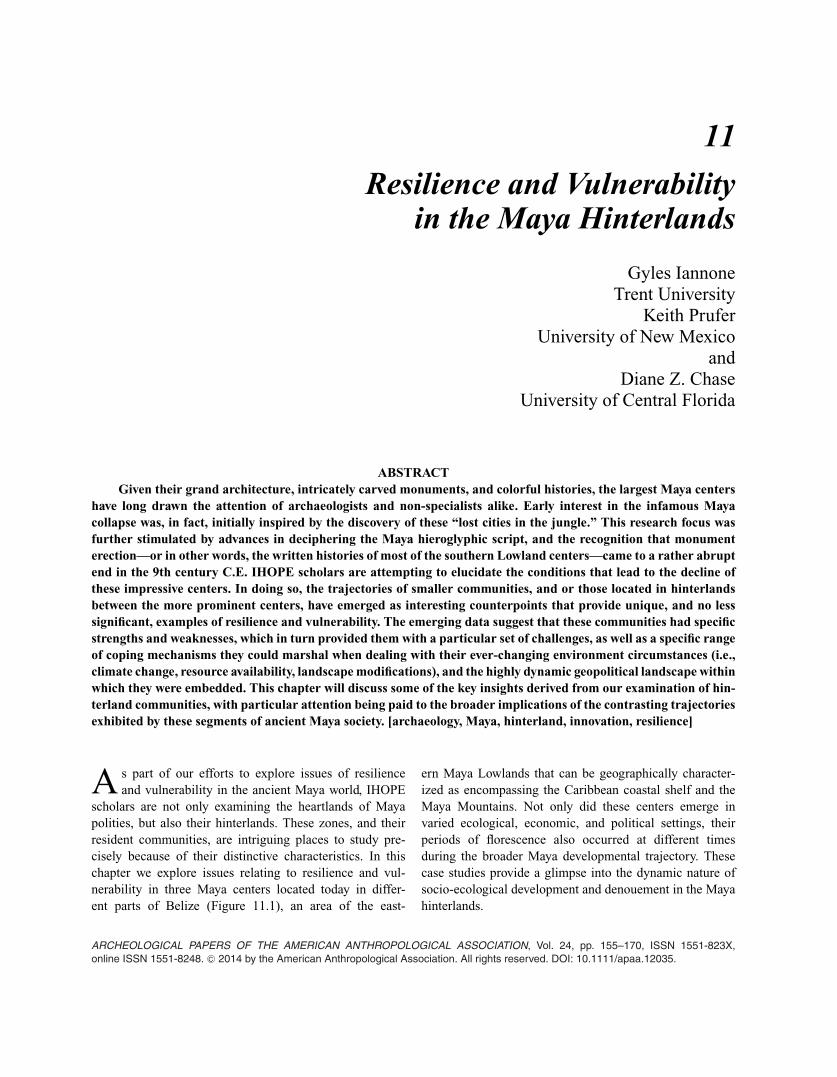
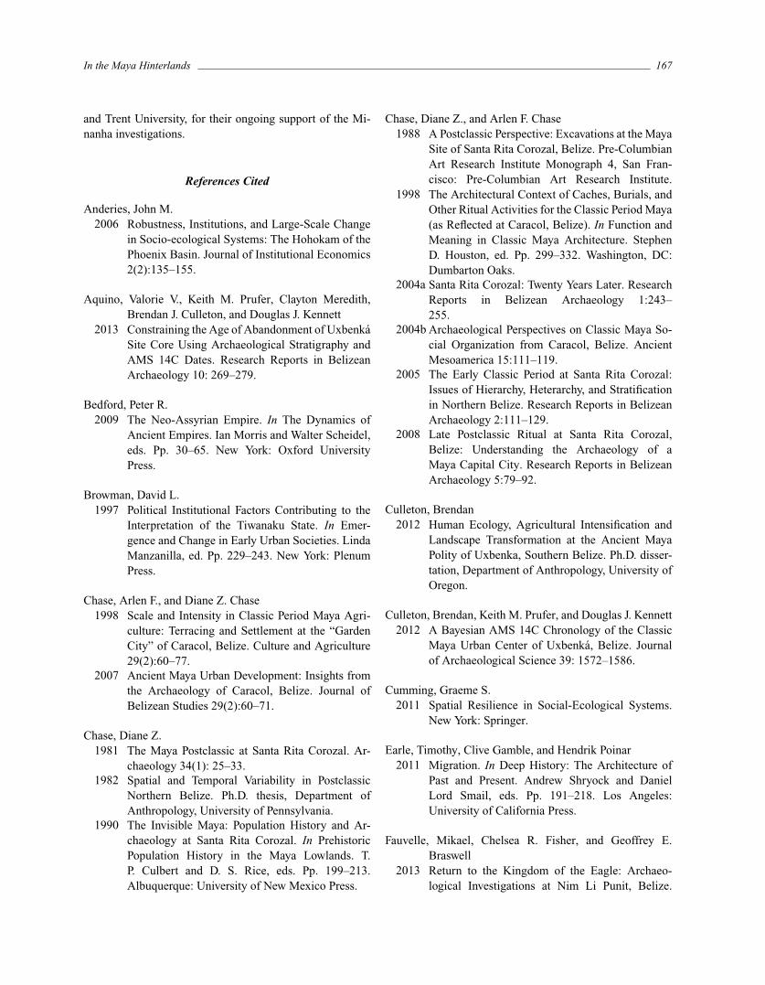
scholars are not only examining the heartlands of Mayapolities, but also their hinterlands. These zones, and theirresident communities, are intriguing places to study pre-cisely because of their distinctive characteristics. In thischapter we explore issues relating to resilience and vul-nerability in three Maya centers located today in differ-ent parts of Belize (Figure 11.1), an area of the east-
ern Maya Lowlands that can be geographically character-ized as encompassing the Caribbean coastal shelf and theMaya Mountains. Not only did these centers emerge invaried ecological, economic, and political settings, theirperiods of florescence also occurred at different timesduring the broader Maya developmental trajectory. Thesecase studies provide a glimpse into the dynamic nature ofsocio-ecological development and denouement in the Mayahinterlands.
ARCHEOLOGICAL PAPERS OF THE AMERICAN ANTHROPOLOGICAL ASSOCIATION, Vol. 24, pp. 155–170, ISSN 1551-823X,online ISSN 1551-8248. C© 2014 by the American Anthropological Association. All rights reserved. DOI: 10.1111/apaa.12035.
156 Gyles Iannone et al.
Figure 11.1. Map of the Maya subarea showing the location of thethree hinterland case studies.
Resilience and Vulnerability in theHinterlands
In considering the qualities of hinterlands and how theserelate to issues of resilience and vulnerability, it is useful tobegin with Igor Kopytoff’s (1987, 1999) distinction betweeninternal frontiers, which are zones between two adjacentpolities, and external frontiers, which are zones formed as aresult of the colonizing expansion of a polity into a sparselypopulated and or less politically complex region. When in-vestigating ancient hinterlands, archaeologists study bothinternal and external frontiers, but often without making aclear distinction between the two. However, the political andeconomic integration of hinterlands into broader systems, aswell as the resilience and vulnerability of hinterland com-munities, may vary for internal and external frontiers.
Hinterland communities develop in zones that consti-tute “edges.” They may occur not only at the juncture ofdifferent political and or cultural units, but also in divergentecological zones. Thus, the location of a hinterland com-munity may support or minimize its resilience. Accordingto Nancy Turner and her colleagues (2003:456–457), “cul-tural edges are like ecological edges in that they allow for
diversification of resources, in this case cultural resources.. . In both cases they provide increasing social-ecologicalresilience as they broaden the diversity of biological speciesand cultural knowledge that can be drawn upon for liveli-hood.”
Others suggest that hinterland communities have an in-herent level of resilience because distance from polity cap-itals affords them a significant level of autonomy (see alsoBrowman 1997:230). The resilience of hinterland communi-ties may also be enhanced because they are located betweencompeting polities and they can, therefore, ally themselveswith the polity that is most beneficial to local power struc-tures or institutions, and or the polity that has taken the upperhand in a territorial dispute (Hassig 1992:98).
Hinterlands may also have significant vulnerabilities.For example, considerable debate exists concerning how in-novative, and hence resilient, hinterland communities are.Sander van der Leeuw (2007:219) posits that hinterlandsare disadvantaged when compared to heartlands becausethe latter are the centers for innovation; the more periph-eral a settlement is, the “more unattainable the innovationsare.” Others suggest that it is during times of stress thatloosely integrated hinterlands become vulnerable, becausesuch “modularity” inhibits the transfer of assistance andinnovations precisely when they are most needed (Cum-ming 2011:138; Walker and Salt 2012:95–96). Similarly,Kopytoff (1999:33) argues that there is often a significantlevel of “cultural conservatism” in hinterland communities,which stifles innovation on the local scale. According toKopytoff (1999:33–34), although the inhabitants of hinter-land communities tend to see themselves as innovators, withsubstantial leeway to create any kind of society they wish,in reality they bring a significant level of conformity to theirsocial constructions. This is because they rely on a given“political culture,” or “cultural baggage” —including tech-nological traditions and conceptions of power, legitimacy,authority, institution building, and political practice—whichmanifests itself in the form of “ideal patterns and idealinstitutional models, rather than being a matter, as in themetropoles, of active practice.”
In contrast to the aforementioned perspectives, oth-ers advocate for more significant levels of innovation,and hence resilience, in the hinterlands. For example,Kopytoff’s (1999) “cyclical model” for hinterland devel-opment underscores the key role played by immigrants frompolity capitals, or metropoles, who move into hinterland set-tings and either set up their own communities or merge withthose communities established by earlier settlers, therebyenhancing the innovative capacity of the hinterland commu-nities they now call home. This view does, however, continueto favor the idea that all innovation occurs in the heartlands,
In the Maya Hinterlands 157
which is a stance that has been effectively challenged bythose who see hinterlands, themselves, as dynamic places ofcultural contact and syncretization, where innovations of allkinds are created, manipulated, and transformed (Lightfootand Martinez 1995:472). From this perspective, hinterlandcommunities are resilient places precisely because they arecenters for innovation, rather than vulnerable peripheriespassively awaiting the next innovation to be transferred fromthe heartland.
Regardless of whether hinterlands are viewed as cre-ators of, or receptors for, innovation—and the previousdiscussion suggests that the answer lay somewhere in themiddle—most scholars agree that the confluence of local andimmigrant cultures, the latter often emanating from multiplemetropoles, often leads to the emergence of unique hinter-land communities, complete with differing social identities(Schortman 1989). The interstitial character of the hinter-land, itself, only serves to enhance this uniqueness. As Kopy-toff (1987, 1999) has documented using African examples,hinterland communities may eventually develop into capi-tals of their own polities, re-initiating the process of hinter-land formation, as immigrants from the newly establishedmetropole move out and coalesce with new and existingcommunities in the new hinterland(s). Often, these commu-nities are seen to “emerge as historically changing, multiple,and branching alignments of social groups and segments”(Wells 2006:268). The mixing of local and immigrant cul-tures within hinterland settings is central to the establish-ment of distinct hinterland societies and contributes to thedifferent levels of resilience and vulnerability that character-ize specific hinterland socioecological systems. While suchhinterland dynamics are often the focus of study relative tolarge ancient empires (see for example Wells 2013 for an-cient Rome and Malpass and Alconini 2010 for the Inka),the proximity of hinterland Maya sites to the Maya heartlandprovides additional depth to this discussion.
We should, in fact, expect considerable variability inthe levels of resilience exhibited by specific hinterland com-munities, over both time and space, especially given thatthey can interface with neighboring political formationsin diverse ways. Where hinterlands are integrated indi-rectly and local power structures are maintained as longas tax or tribute continue to flow to the heartland, we seeloosely integrated geopolitical landscapes defined by contin-ually negotiated alliances and or patron-client relationships(Bedford 2009:42, 48; LeCount and Yaeger 2010:31–39),as well as significant functional redundancy, greater re-sponse diversity, limited connectivity, and higher levels ofresilience (e.g., Holling 2001; Holling and Gunderson 2002;Gunderson and Holling 2002; Walker and Salt 2006). Al-ternatively, when hinterlands are under the direct controlof a political heartland, usually through the installation of
governors emanating from the metropole itself, we see amuch more tightly integrated geopolitical landscape consist-ing of a capital and a series of provinces (Bedford 2009:42,48; LeCount and Yaeger 2010:31–39), as well as consid-erable functional specialization, a more limited degree ofresponse diversity, and a high level of interconnectedness—or in other words, “hypercoherence” —leading to dimin-ished resilience over time (Hegmon et al. 2008; Holling andGunderson 2002; Gunderson and Holling 2002; Walker andSalt 2006:76–77, 164). Of significance here is the fact that acombination of these integrative strategies may be employedat any one time (e.g., see Bedford [2009] for a discussionof the Neo-Assyrian empire, Anderies [2006] for the Ho-hokom, and van der Leeuw [2005] for the Roman Empire inthe Rhone Valley). In summary, as archaeologists we are leftto consider whether hinterland communities were: (1) ideallypositioned, ecologically, culturally, and politically, so as topromote flexibility and resilience when faced with perturba-tions; (2) rigid and, thus, vulnerable in the face of negativechange because they were tightly connected to heartlandsand lacked innovative capacity; and or, (3) highly diverseand inherently dynamic, exhibiting significant variability interms of their ability to deal with unexpected environmen-tal or cultural shocks. We will now turn to our three casestudies to illustrate the complex nature of resilience andvulnerability in the ancient Maya hinterlands.
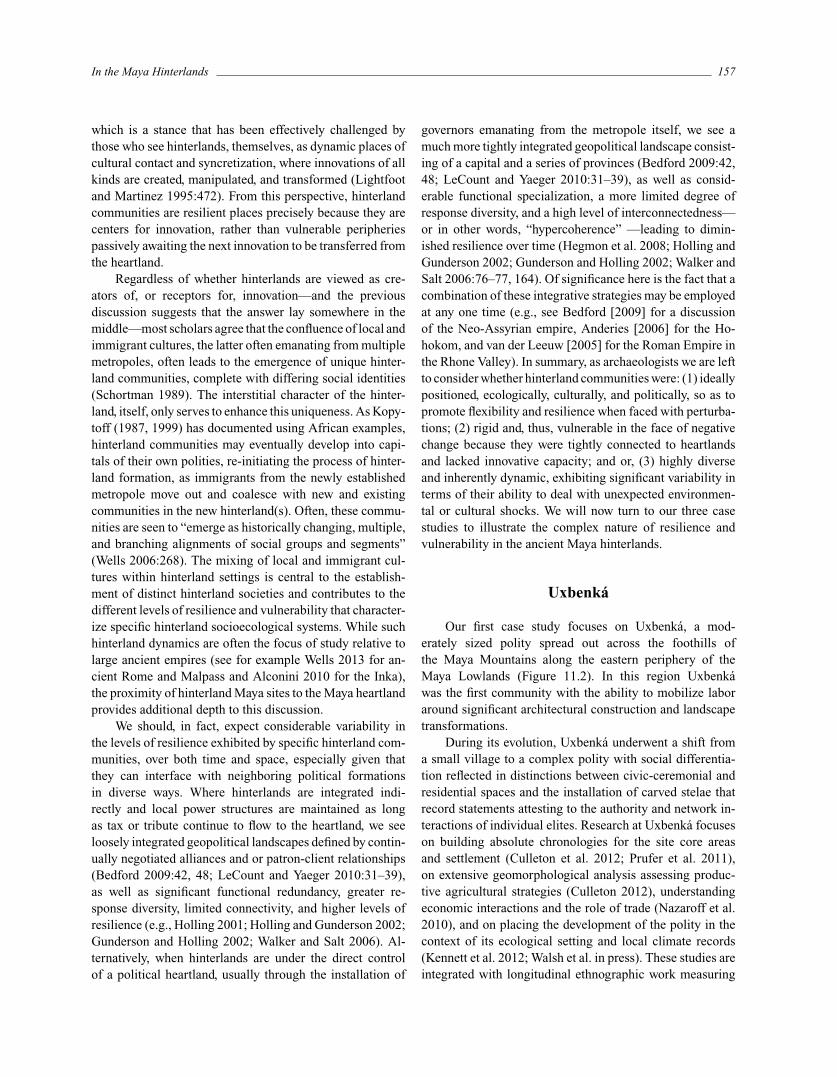
Uxbenka
Our first case study focuses on Uxbenka, a mod-erately sized polity spread out across the foothills ofthe Maya Mountains along the eastern periphery of theMaya Lowlands (Figure 11.2). In this region Uxbenkawas the first community with the ability to mobilize laboraround significant architectural construction and landscapetransformations.
During its evolution, Uxbenka underwent a shift froma small village to a complex polity with social differentia-tion reflected in distinctions between civic-ceremonial andresidential spaces and the installation of carved stelae thatrecord statements attesting to the authority and network in-teractions of individual elites. Research at Uxbenka focuseson building absolute chronologies for the site core areasand settlement (Culleton et al. 2012; Prufer et al. 2011),on extensive geomorphological analysis assessing produc-tive agricultural strategies (Culleton 2012), understandingeconomic interactions and the role of trade (Nazaroff et al.2010), and on placing the development of the polity in thecontext of its ecological setting and local climate records(Kennett et al. 2012; Walsh et al. in press). These studies areintegrated with longitudinal ethnographic work measuring
158 Gyles Iannone et al.
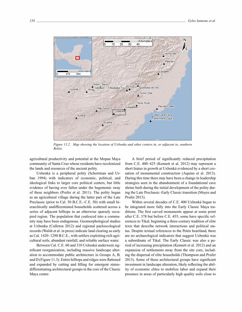
Figure 11.2. Map showing the location of Uxbenka and other centers in, or adjacent to, southernBelize.
agricultural productivity and potential at the Mopan Mayacommunity of Santa Cruz whose residents have recolonizedthe lands and resources of the ancient polity.
Uxbenka is a peripheral polity (Schortman and Ur-ban 1994) with indicators of economic, political, andideological links to larger core political centers, but littleevidence of having ever fallen under the hegemonic swayof these neighbors (Prufer et al. 2011). The polity beganas an agricultural village during the latter part of the LatePreclassic (prior to Cal. 50 B.C.E.–C.E. 50) with small hi-erarchically undifferentiated households scattered across aseries of adjacent hilltops in an otherwise sparsely occu-pied region. The population that coalesced into a commu-nity may have been endogenous. Geomorphological studiesat Uxbenka (Culleton 2012) and regional paeloecologicalrecords (Walsh et al. in press) indicate land clearing as earlyas Cal. 1420–1290 B.C.E., with settlers exploiting rich agri-cultural soils, abundant rainfall, and reliable surface water.
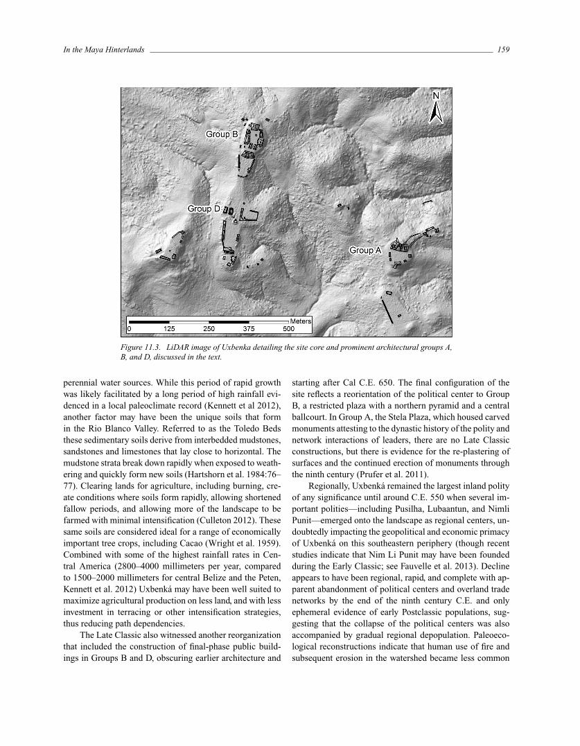
Between Cal. C.E. 60 and 310 Uxbenka underwent sig-nificant reorganization, including massive landscape alter-ation to accommodate public architecture in Groups A, B,and D (Figure 11.3). Entire hilltops and ridges were flattenedand expanded by cutting and filling for emergent status-differentiating architectural groups in the core of the ClassicMaya center.
A brief period of significantly reduced precipitationfrom C.E. 400–425 (Kennett et al. 2012) may represent ashort hiatus in growth at Uxbenka evidenced by a short ces-sation of monumental construction (Aquino et al. 2013).During this time there may have been a change in leadershipstrategies seen in the abandonment of a foundational caveshrine built during the initial development of the polity dur-ing the Late Preclassic–Early Classic transition (Moyes andPrufer 2013).
Within several decades of C.E. 400 Uxbenka began tobe integrated more fully into the Early Classic Maya tra-ditions. The first carved monuments appear at some pointafter C.E. 378 but before C.E. 455; some have specific ref-erences to Tikal, beginning a three-century tradition of elitetexts that describe network interactions and political sta-tus. Despite textual references to the Peten heartland, thereare no archaeological indicators that suggest Uxbenka wasa subordinate of Tikal. The Early Classic was also a pe-riod of increasing precipitation (Kennett et al. 2012) and anexpansion of settlements away from the site core, includ-ing the dispersal of elite households (Thompson and Prufer2013). Some of these architectural groups have significantinvestment in landscape alteration, likely reflecting the abil-ity of economic elites to mobilize labor and expand theirpresence in areas of particularly high quality soils close to
In the Maya Hinterlands 159
Figure 11.3. LiDAR image of Uxbenka detailing the site core and prominent architectural groups A,B, and D, discussed in the text.
perennial water sources. While this period of rapid growthwas likely facilitated by a long period of high rainfall evi-denced in a local paleoclimate record (Kennett et al 2012),another factor may have been the unique soils that formin the Rio Blanco Valley. Referred to as the Toledo Bedsthese sedimentary soils derive from interbedded mudstones,sandstones and limestones that lay close to horizontal. Themudstone strata break down rapidly when exposed to weath-ering and quickly form new soils (Hartshorn et al. 1984:76–77). Clearing lands for agriculture, including burning, cre-ate conditions where soils form rapidly, allowing shortenedfallow periods, and allowing more of the landscape to befarmed with minimal intensification (Culleton 2012). Thesesame soils are considered ideal for a range of economicallyimportant tree crops, including Cacao (Wright et al. 1959).Combined with some of the highest rainfall rates in Cen-tral America (2800–4000 millimeters per year, comparedto 1500–2000 millimeters for central Belize and the Peten,Kennett et al. 2012) Uxbenka may have been well suited tomaximize agricultural production on less land, and with lessinvestment in terracing or other intensification strategies,thus reducing path dependencies.
The Late Classic also witnessed another reorganizationthat included the construction of final-phase public build-ings in Groups B and D, obscuring earlier architecture and
starting after Cal C.E. 650. The final configuration of thesite reflects a reorientation of the political center to GroupB, a restricted plaza with a northern pyramid and a centralballcourt. In Group A, the Stela Plaza, which housed carvedmonuments attesting to the dynastic history of the polity andnetwork interactions of leaders, there are no Late Classicconstructions, but there is evidence for the re-plastering ofsurfaces and the continued erection of monuments throughthe ninth century (Prufer et al. 2011).
Regionally, Uxbenka remained the largest inland polityof any significance until around C.E. 550 when several im-portant polities—including Pusilha, Lubaantun, and NimliPunit—emerged onto the landscape as regional centers, un-doubtedly impacting the geopolitical and economic primacyof Uxbenka on this southeastern periphery (though recentstudies indicate that Nim Li Punit may have been foundedduring the Early Classic; see Fauvelle et al. 2013). Declineappears to have been regional, rapid, and complete with ap-parent abandonment of political centers and overland tradenetworks by the end of the ninth century C.E. and onlyephemeral evidence of early Postclassic populations, sug-gesting that the collapse of the political centers was alsoaccompanied by gradual regional depopulation. Paleoeco-logical reconstructions indicate that human use of fire andsubsequent erosion in the watershed became less common
160 Gyles Iannone et al.
sometime between C.E. 800–1000 (Walsh et al. in press),likely indicating a reduction of land clearing for agricul-ture. This occurred at the same time as a decline in rainfalland several protracted droughts well documented across theMaya Lowlands (see Kennett et al. 2012 and referenceswithin). It remains unclear whether a reduction of rainfallin this area would alone be sufficient to bring about re-gional societal collapse, given the overall high precipitationrates in southern Belize. Declines in rainfall in areas ofhigh annual precipitation are unlikely to be as destabiliz-ing as they would be in areas of lower annual precipitation.Stable isotope rainfall reconstructions suggest that multidecadal drought events between C.E. 820–870 were not assevere as the single short event at C.E. 400–425 (Kennettet al. 2012).
In summary, Uxbenka’s uniquely rich agricultural soilsand location in an area of abundant rainfall likely lent adegree of resilience to both population growth and politicalstability during its 800 year occupation. Its growth may havealso been facilitated by its position along established traderoutes linking the Caribbean Sea to the Peten (Nazaroff et al.2010; Prufer et al. 2011). However, the development of in-creasingly complex geopolitical regional interaction spheresduring the Late Classic, combined with inter-polity compe-tition, population growth, and decisions regarding land-use,may have weakened the polity’s ability to withstand the dis-integration of political and economic relationships occurringin core areas of the Maya Lowlands (Kennett and Beach, inpress).
Minanha
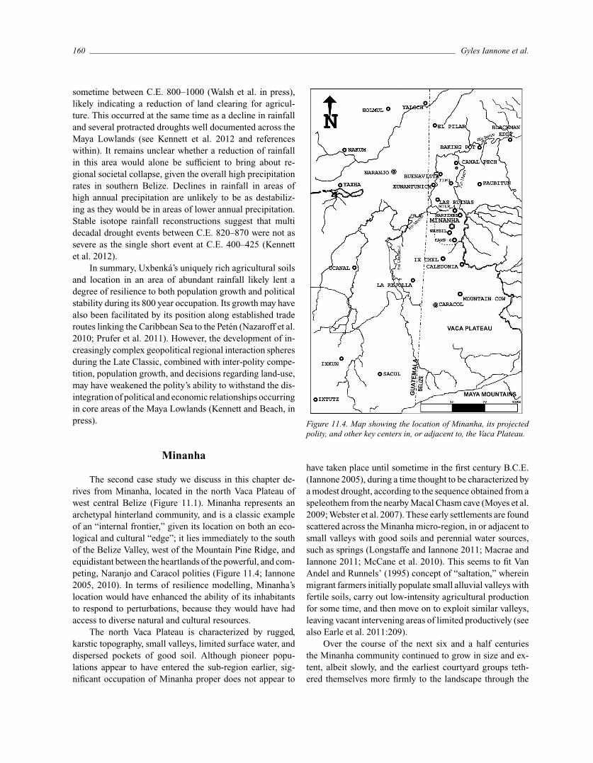
The second case study we discuss in this chapter de-rives from Minanha, located in the north Vaca Plateau ofwest central Belize (Figure 11.1). Minanha represents anarchetypal hinterland community, and is a classic exampleof an “internal frontier,” given its location on both an eco-logical and cultural “edge”; it lies immediately to the southof the Belize Valley, west of the Mountain Pine Ridge, andequidistant between the heartlands of the powerful, and com-peting, Naranjo and Caracol polities (Figure 11.4; Iannone2005, 2010). In terms of resilience modelling, Minanha’slocation would have enhanced the ability of its inhabitantsto respond to perturbations, because they would have hadaccess to diverse natural and cultural resources.
The north Vaca Plateau is characterized by rugged,karstic topography, small valleys, limited surface water, anddispersed pockets of good soil. Although pioneer popu-lations appear to have entered the sub-region earlier, sig-nificant occupation of Minanha proper does not appear to
Figure 11.4. Map showing the location of Minanha, its projectedpolity, and other key centers in, or adjacent to, the Vaca Plateau.
have taken place until sometime in the first century B.C.E.(Iannone 2005), during a time thought to be characterized bya modest drought, according to the sequence obtained from aspeleothem from the nearby Macal Chasm cave (Moyes et al.2009; Webster et al. 2007). These early settlements are foundscattered across the Minanha micro-region, in or adjacent tosmall valleys with good soils and perennial water sources,such as springs (Longstaffe and Iannone 2011; Macrae andIannone 2011; McCane et al. 2010). This seems to fit VanAndel and Runnels’ (1995) concept of “saltation,” whereinmigrant farmers initially populate small alluvial valleys withfertile soils, carry out low-intensity agricultural productionfor some time, and then move on to exploit similar valleys,leaving vacant intervening areas of limited productively (seealso Earle et al. 2011:209).
Over the course of the next six and a half centuriesthe Minanha community continued to grow in size and ex-tent, albeit slowly, and the earliest courtyard groups teth-ered themselves more firmly to the landscape through the
In the Maya Hinterlands 161
construction of eastern ancestor shrines and by building ter-raced agricultural fields, the latter helping to retain soilsand soil moisture in the rugged terrain of the Vaca Plateau(Macrae and Iannone 2011). Alongside this program ofniche construction, they did, however, maintain a level ofbiodiversity and productive flexibility because these im-proved fields only encompassed areas immediately adja-cent to their residential courtyards, while the remainingland continued to be “unimproved” (Macrae and Iannone2011; McCane et al. 2010). Indications are that this small,highly dispersed community was connected to the broaderMaya world economically, as is implied by the sharing ofceramic styles and access to raw materials such as shelland jadeite. However, the absence of certain artifacts com-monly found at other centers to the north and south (e.g.,Pacbitun and Caracol, respectively), such as Charlie Chap-lin figures (Lomitola 2012), and Caracol-style face pots(D. Chase and A. Chase 1998), suggests that Minanhacontinued to be a “deep rural” community that was onlyloosely incorporated into broader political formations andcultural traditions. On one hand, this would have allowedfor some economic and political autonomy, as well as someflexibility to respond to perturbations rapidly, using localknowledge and innovations. For example, the early devel-opment of Minanha’s terrace system would have helped thecommunity maintain productivity during times of declin-ing precipitation, such as the droughts documented for C.E.141, and the period between C.E. 490 and 580 (Websteret al. 2007). At the same time, the loose integration wouldhave also hindered access to heartland innovations, and itapparently limited the ability to acquire certain key com-modities, such as larger obsidian blades (Menzies 2003),leading to some potential vulnerabilities.
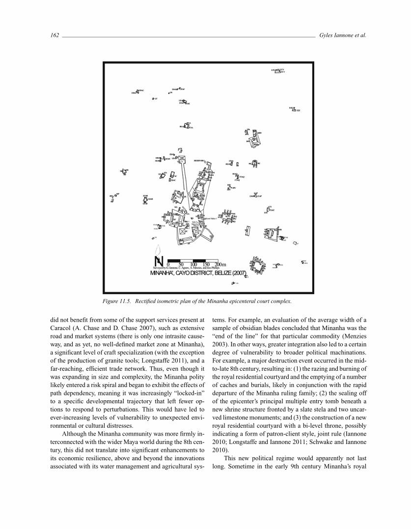
The nature of integration changed dramatically some-time around the beginning of the 8th century C.E., duringan era of significant political change across the Maya Low-lands. At this time some elite migrants, likely from Caracol,established a petty royal court in what would rapidly emergeas the new Minanha epicenter (Iannone 2005; Figure 11.5).
The evidence does not support the notion that Mi-nanha shifted from being a hinterland to a new, independentheartland, as in the African examples discussed by Kopy-toff (1987, 1999). Rather, Minanha’s rapid growth and ad-herence to certain cultural practices suggest the formationof a new client-kingdom under the auspices of the largerCaracol hegemonic polity, albeit one with comparative au-tonomy, given its distance from the Caracol metropole(Iannone 2009). This may fit the scenario described by GilStein (1999) wherein empires or hegemonic polities foster“internal migrations” to encourage state initiatives; althoughmigrants from the heartlands may not necessarily control
land in the hinterlands, they can focus on pacification andmilitary development, support craft specialization and trade,and initiate engineering programs aimed at increasing agri-cultural production (see also Earle et al. 2011:213).
In light of these ideas, it is significant that the newpolitical body that established itself at Minanha seems tohave effectively inserted itself as a new “patron” by incor-porating existing courtyards into new construction projects(Longstaffe and Iannone 2011), encasing extant ritual nodeswithin new shrine structures, and aligning new ritual offer-ings with those previously made by the local community(Schwake and Iannone 2010). The success of this assimi-lation project varied, with some of the largest, and longest-standing residential courtyard groups apparently benefitingfrom, and therefore supporting, the new patrons, whereasother sizable, and equally deep-rooted, courtyard groupsseem to have entered into a period of decline, which im-plies that they contested the authority of the newcomers(Iannone 2010; Longstaffe and Iannone 2011; Macrae andIannone 2011). That the resulting Minanha polity was syn-cretic in character is confirmed by a degree of adherenceto certain Caracol-style caching and burial practices at thesame time that more local traditions were continued, suchas the extensive use of slate as capstones in buildings andgrave chambers, and as burial and cache offerings (Iannone2005, 2010).
Regardless of the apparent unevenness with which theywere accepted by Minanha’s traditional power-brokers, themigrant elites that arrived at the beginning of the 8th CenturyC.E. were able to marshal enough corvee labor to constructan impressive court complex, and to quickly expand theagricultural productivity of the micro-region by linking thepreviously separate terraced fields with longer, but poorerquality terrace sections (Macrae and Iannone 2011; McCaneet al. 2010). They also commissioned the construction of awall around a sizable bajo to create a larger and more reliablesource of water (Primrose 2003). These innovations, likelyborrowed from the more densely settled Caracol heartlandsettlement (e.g., A. Chase and D. Chase 1998), allowed forsignificant population growth, facilitated monumental con-struction, and for a brief moment transformed Minanha froma hinterland to a small heartland, as is one of the expectationsof Kopytoff’s cyclical model for hinterland development.
Nevertheless, it is important to consider that many ofthe initiatives of this time would have been aimed at provid-ing taxes to support the new Minanha rulers, and tribute fortheir Caracol overlords, which would have drawn increas-ingly more resources away from the primary producers overtime. These investments also locked the fledgling Minanhapolity into reliance on an increasingly integrated, artificialenvironment. This new polity exhibited less biodiversity and
162 Gyles Iannone et al.
Figure 11.5. Rectified isometric plan of the Minanha epicenteral court complex.
did not benefit from some of the support services present atCaracol (A. Chase and D. Chase 2007), such as extensiveroad and market systems (there is only one intrasite cause-way, and as yet, no well-defined market zone at Minanha),a significant level of craft specialization (with the exceptionof the production of granite tools; Longstaffe 2011), and afar-reaching, efficient trade network. Thus, even though itwas expanding in size and complexity, the Minanha politylikely entered a risk spiral and began to exhibit the effects ofpath dependency, meaning it was increasingly “locked-in”to a specific developmental trajectory that left fewer op-tions to respond to perturbations. This would have led toever-increasing levels of vulnerability to unexpected envi-ronmental or cultural distresses.
Although the Minanha community was more firmly in-terconnected with the wider Maya world during the 8th cen-tury, this did not translate into significant enhancements toits economic resilience, above and beyond the innovationsassociated with its water management and agricultural sys-
tems. For example, an evaluation of the average width of asample of obsidian blades concluded that Minanha was the“end of the line” for that particular commodity (Menzies2003). In other ways, greater integration also led to a certaindegree of vulnerability to broader political machinations.For example, a major destruction event occurred in the mid-to-late 8th century, resulting in: (1) the razing and burning ofthe royal residential courtyard and the emptying of a numberof caches and burials, likely in conjunction with the rapiddeparture of the Minanha ruling family; (2) the sealing offof the epicenter’s principal multiple entry tomb beneath anew shrine structure fronted by a slate stela and two uncar-ved limestone monuments; and (3) the construction of a newroyal residential courtyard with a bi-level throne, possiblyindicating a form of patron-client style, joint rule (Iannone2010; Longstaffe and Iannone 2011; Schwake and Iannone2010).
This new political regime would apparently not lastlong. Sometime in the early 9th century Minanha’s royal
In the Maya Hinterlands 163
residential courtyard was buried beneath 5 meters of rub-ble, many of its stucco friezes and important stelae were de-stroyed, and some elite building projects were left abandonedprior to completion (Iannone 2005, 2010; Schwake andIannone 2010). The elites of the “new political regime” ap-parently deserted the community, or were forced out, alongwith a large segment of the support population, primarilythe lowest status commoners who may not have had anydirect control over key land and water resources (Macraeand Iannone 2011). From the perspective of resilience the-ory, this scenario fits well with that documented for theAmerican Southwest, where emigration during periods ofsociopolitical downturns has been envisioned as a formof adaptive transformation (Hegmon et al. 2008; Nelsonet al. 2006). It is likely that a combination of unsustainablegrowth, overexploitation of resources, droughts, increasingpolitical and economic competition, ideological disillusion-ment, and the progressively greater interconnectedness ofthe various elites across the Maya Lowlands, contributed tothe downfall. However, this was not the end of the Minanhacommunity. After the demise of the Minanha royal court,the traditional powerbrokers began building anew in theircourtyards, once again taking advantage of their control overimproved land, perennial water sources, and limited incor-poration into the polities that were crumbling around them(Longstaffe and Iannone 2011; Macrae and Iannone 2011).These long-standing, highly resilient residential groups lefta footprint not that dissimilar to their Preclassic and EarlyClassic ancestors (Longstaffe and Iannone 2011).
In summary, the Minanha case study documents theresilient and adaptive quality of some of the larger ru-ral courtyard groups whose roots extend back to the ear-liest occupation of the micro-region. By improving someof their land through terrace construction and settling nearperennial springs, these pioneers—and generations of theirdescendants—were able to live successfully for a millen-nium in an environment that is only sparsely populated to-day. In part, it was the lack of integration into the broaderMaya world—and the short-lived Minanha polity—that mayhave contributed to their success. In contrast, the petty Mi-nanha royal court that emerged in the 8th century was notonly more firmly ensconced within the broader network ofregional politics, but also reliant on an increasingly moretightly integrated, but also hypercoherent, economic and po-litical system encompassing the micro-region over which itruled. This is particularly evident in terms of the expansionand control of the surrounding agriculture and water man-agement features. Ultimately, the elite segment of Minanhasociety proved to be far less resilient, with this experiment inpolitical complexity only lasting for a century (Longstaffeand Iannone 2011). A significant portion of the support pop-
ulation, especially recent immigrants drawn into the micro-region because of the “full-service” nature of the Minanharoyal court, ultimately demonstrated a comparable level ofvulnerability to perturbations, primarily because they didnot control vital resources, such as good agricultural landand reliable water sources (Macrae and Iannone 2011).
Santa Rita Corozal
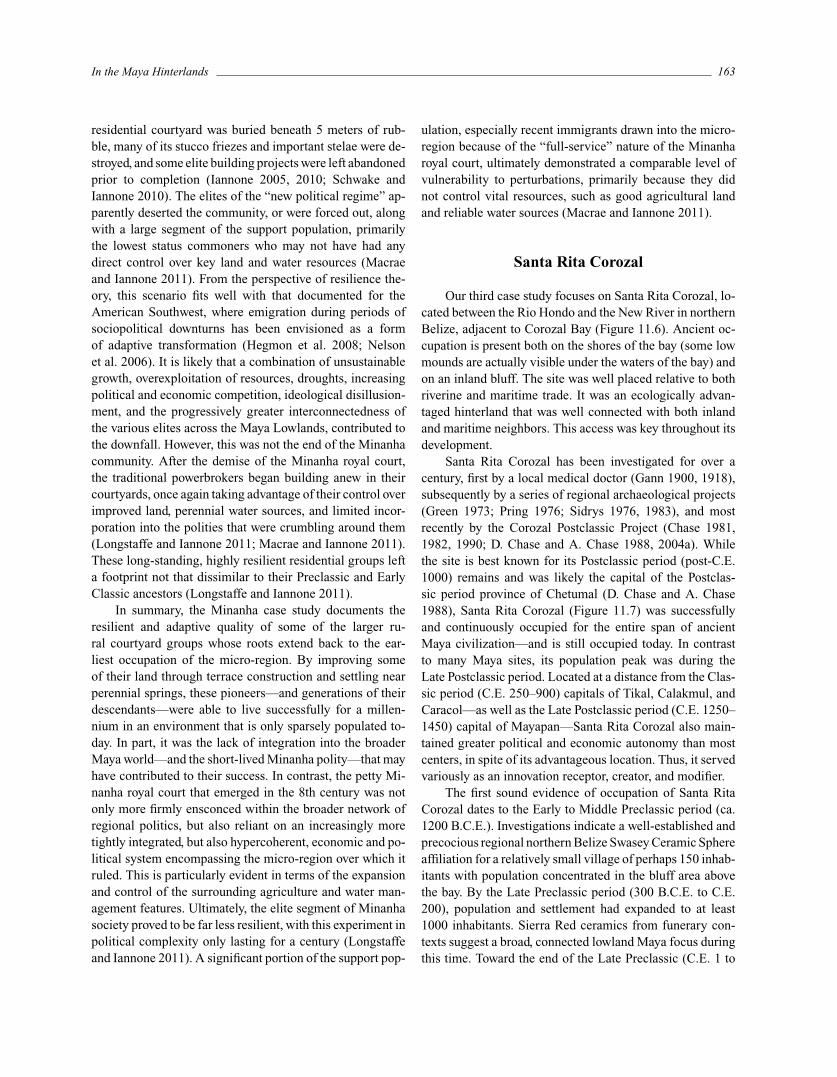
Our third case study focuses on Santa Rita Corozal, lo-cated between the Rio Hondo and the New River in northernBelize, adjacent to Corozal Bay (Figure 11.6). Ancient oc-cupation is present both on the shores of the bay (some lowmounds are actually visible under the waters of the bay) andon an inland bluff. The site was well placed relative to bothriverine and maritime trade. It was an ecologically advan-taged hinterland that was well connected with both inlandand maritime neighbors. This access was key throughout itsdevelopment.
Santa Rita Corozal has been investigated for over acentury, first by a local medical doctor (Gann 1900, 1918),subsequently by a series of regional archaeological projects(Green 1973; Pring 1976; Sidrys 1976, 1983), and mostrecently by the Corozal Postclassic Project (Chase 1981,1982, 1990; D. Chase and A. Chase 1988, 2004a). Whilethe site is best known for its Postclassic period (post-C.E.1000) remains and was likely the capital of the Postclas-sic period province of Chetumal (D. Chase and A. Chase1988), Santa Rita Corozal (Figure 11.7) was successfullyand continuously occupied for the entire span of ancientMaya civilization—and is still occupied today. In contrastto many Maya sites, its population peak was during theLate Postclassic period. Located at a distance from the Clas-sic period (C.E. 250–900) capitals of Tikal, Calakmul, andCaracol—as well as the Late Postclassic period (C.E. 1250–1450) capital of Mayapan—Santa Rita Corozal also main-tained greater political and economic autonomy than mostcenters, in spite of its advantageous location. Thus, it servedvariously as an innovation receptor, creator, and modifier.
The first sound evidence of occupation of Santa RitaCorozal dates to the Early to Middle Preclassic period (ca.1200 B.C.E.). Investigations indicate a well-established andprecocious regional northern Belize Swasey Ceramic Sphereaffiliation for a relatively small village of perhaps 150 inhab-itants with population concentrated in the bluff area abovethe bay. By the Late Preclassic period (300 B.C.E. to C.E.200), population and settlement had expanded to at least1000 inhabitants. Sierra Red ceramics from funerary con-texts suggest a broad, connected lowland Maya focus duringthis time. Toward the end of the Late Preclassic (C.E. 1 to
164 Gyles Iannone et al.
Figure 11.6. Map showing the location of Santa Rita Corozal and other centers in northernBelize (after Hammond 1975:figure 11.1).
250) and Early Classic periods (C.E. 250 to 550) popula-tion also grew in size. Evidence of prosperity and statusdifferentiation in interments and constructions is evident,with ceramic and other artifactual ties extending to both thesouthern and northern Lowlands. The site was a receptorof innovations and trade items, but its connectedness wasexpressed within its own sociopolitical framework.
While the early population of the central portion of thesite was never large, numbering no more than perhaps 1500people, interments from Santa Rita Corozal Structure 7 sug-gest that the rulers of this site maintained a high standardof material well-being (D. Chase and A. Chase 2005). Infact, if taken out of context, grave goods within these in-terments might be taken to suggest that Santa Rita Corozalindividuals were far more important politically within theoverarching Maya realm than was likely the case (D. Chaseand A. Chase 2004a). Late Classic period (C.E. 550–900)population likely increased to approximately 2500. Interest-ingly, material well-being, as indicated by the presence andsimilarity of burial offerings, was more widely distributedthan in previous periods, and the extreme status distinctionsof the Early Classic period were not in evidence, a situa-tion similar to that found in the varied environmental andsocio-political situation of the distant Belize Late Classic pe-riod capital city of Caracol (D. Chase and A. Chase 2004b).Terminal Classic period and Early Postclassic period (C.E.
900–1200, 1200–1300) remains are present at the site, sug-gesting continued access to external trade, but likely withflat population numbers.
However, the largest and most extensive occupation atSanta Rita Corozal dates to the Late Postclassic period (C.E.1300–1550), well after the collapse of inland, mainstream,Classic period centers. The Postclassic period Maya of SantaRita Corozal substantially reframed Classic period tradi-tions. In particular, ritual caching practices appear to haveserved to unify the community through calendric ritual (D.Chase and A. Chase 2008). While Santa Rita Corozal pros-pered during its entire history, it was particularly advantagedfollowing the Classic period collapse, perhaps being able totake even greater advantage of its location on a major tradecorridor (see also Scarborough and Valdez, Ch. 9 this vol-ume for a discussion of trade). Postclassic Santa Rita Corozalevinced particularly strong ties with the northern lowlands;both ritual practices and material remains (in some cases)are nearly identical to those delineated for Mayapan, some300 kilometers to the north (D. Chase and A. Chase 2008).Site population more than tripled; a conservative estimateof the site center population in the Late Postclassic is over7,000 people. The site prospered until the advent of Span-ish conquistadors in C.E. 1532. Later Colonial occupationby the British indicated some limited population continuitywith the modern town of Corozal.
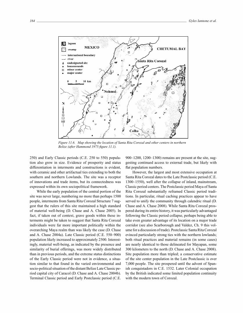
In the Maya Hinterlands 165
Figure 11.7. Rectified plan of Santa Rita Corozal, Belize showing its location in Belize.
Unlike many southern lowland sites, Santa Rita Corozalwas continuously occupied for over three millennia. The sitedoes not appear to have been under direct control of eithersouthern or northern lowland polities, but rather maintaineda connection to both. During much of its history, the siteappears to have been peripheral to political machinationsrecorded in hieroglyphic texts. Preclassic and Classic periodSanta Rita Corozal remained a small, seemingly indepen-dent hinterland polity. Economic ties were extensive, butpolitical integration with neighboring areas was limited—so much so that its Early Classic leaders amassed a vast arrayof symbols to stress their importance at the “edge” of theMaya world. Ultimately, the site came to serve as the capitalof the Postclassic province of Chetumal (D. Chase and A.Chase 1988). The peripheral, yet pivotal, location of SantaRita Corozal at the juxtaposition of the northern and south-ern lowlands—with easy access to multiple trade routes—
enabled this resilience, but other mechanisms supported itslongevity. For example, while settlement was more denselyconcentrated than at many Classic period sites, Santa RitaCorozal’s population remained manageable throughout itshistory—and was easily supported by surrounding agricul-ture land, a diversity of locally available marine resources,and the resources made available by its position as a transitpoint for regional trade. Postclassic period cultural adap-tations, specifically ritual caching practices, evolved to fo-cus on greater integration of the community as populationnumbers increased. Postclassic period Santa Rita Corozal—rather than being a site characterized by depopulation, deca-dence, or decline—was itself a successful dynamic and in-novative adaptation. Thus, Santa Rita Corozal’s exceptionallocation, in conjunction with its smaller size and politicallyperipheral positioning, led to a more nimble and resilientsettlement.
166 Gyles Iannone et al.
Conclusions
While each of these sites was situated in a hinterlandlocation, their physical placements and cultural adaptationsvaried substantially, being alternatively inland (Uxbenka andMinanha) or riverine and coastal (Santa Rita Corozal). Their“hinterland” position also differed. Uxbenka’s placement insouthern Belize partially isolated it from the southern low-land heartland, though it was well integrated in regional andpan-Mesoamerican economies for more than five centuries(Nazaroff et al. 2010). Uxbenka was located in an area of un-usual agricultural fertility, lending to it a degree of resiliencethrough reduced agricultural fallow periods and obviatingthe need for large-scale intensification, such as the terrac-ing found a Minanha. Santa Rita Corozal was positioned atthe juxtaposition of the northern and southern Maya Low-lands. Its access to fresh water and marine resources mayhave afforded it a degree of resilience to food shortages andagricultural uncertainties. Over time, Minanha became in-creasingly dependent on innovative agricultural and watermanagement systems to sustain its population, which in-creased integration but reduced biodiversity and led to pathdependency.
Both Uxbenka and Santa Rita Corozal have little or noevidence of being under the control of other, larger, poli-ties for any extended period, though both were deeply inte-grated into regional geopolitical structures. Minanha startedas an independent – albeit small and deeply rural commu-nity – but as it grew in size and complexity it eventuallyfell under the sway of its larger neighbor, Caracol. Locatedintermediate to the Belize Valley, Naranjo, and Caracaol,Minanha was marginalized to some degree by being setat the eastern edge of the southern Lowlands against thelargely un-farmable and uninhabitable terrain in the Moun-tain Pine Ridge. Both Minanha and Uxbenka were alwayshinterland polities, while Santa Rita Corozal’s hinterlandstatus changed dramatically following the collapse of mostsouthern Lowland polities when it became the capital of theprovince of Chetumal. Minanha was never really well con-nected economically (it was the end of the line for trade,and did not exhibit much craft specialization). Uxbenka andSanta Rita Corozal were both situated to take advantage ofimportant trade routes. Uxbenka took full advantage of itslocation between the Caribbean Sea and the central Peten,and engaged in and mediated trade in obsidian blades andexotic ground stone from distant sources. Similarly, SantaRita Corozal actively engaged in broad economic networks,though it uniquely allowed the fruits of these relationshipsto be spread broadly across its populace.
Besides differing in terms of strategic locations, the ar-chaeological histories of these three sites also are varied.Uxbenka and Santa Rita Corozal were each home to Pre-
classic village occupations and were the largest sites in theirzones for at least portions of their histories; Minanha neverapproached the size of the neighboring site of Caracol, butgrew to be as least as large as the Belize Valley sites foundto its north. Each site sustained a large and well-establishedClassic period population; however, only Santa Rita Corozalgrew to prominence in the Late Postclassic period. Uxbenkaand Minanha utilized stone monuments; Santa Rita did not.
The case studies presented here demonstrate the re-gional and temporal diversity that existed in ancient Mayaadaptations in the southern lowlands—even amongst sitesthat may, in some way, be considered “hinterland.” Despiteeach of these polities being part of the greater southernMaya Lowlands, each displays unique combinations of sub-sistence, economic, and political strategies. In each case,decision-making was geared to maximize adaption to localecological conditions and to maintain resilience to demo-graphic, environmental, and geopolitical stresses. In eachcase the consequences of these actions, intended or oth-erwise, resulted in periods of growth and periods of de-cline. None of these hinterlands was immune to eventsoccurring in the broad social and economic networks inwhich they participated. Nor were they exempt from the im-pacts of changing ecological and climate systems. Uxbenka,Minanha, and Santa Rita Corozal were each nodes in over-lapping and interacting economic and sociopolitical net-works, and they both impacted, and were effected by, othernodes in the network. By the 9th century C.E. all three ofthese hinterland polities were deeply impacted by the polit-ical and economic disintegration sweeping across the MayaLowlands (Kennett and Beach in press). At Uxbenka andMinanha this resulted in the abandonment of political in-stitutions, collapse of agricultural systems, and populationdispersal. Santa Rita Corozal was able to weather the col-lapse, albeit initially in a diminished capacity, rising againduring the Late Postclassic as an important node in the thendominant economic and political landscape of the northernLowlands.
Acknowledgments
The authors would like to thank the Institute of Ar-chaeology in Belize, and in particular Jaime Awe and JohnMorris, for both facilitating and collaborating on our long-term research programs. We also extend our gratitude tothe National Science Foundation (Chase, Prufer) and theAlphawood Foundation (Iannone, Prufer) for funding someof the key components of the Santa Rita Corozal, Uxbenka,and Minanha research. Iannone also wishes to thank the So-cial Sciences and Humanities research Council of Canada,
In the Maya Hinterlands 167
and Trent University, for their ongoing support of the Mi-nanha investigations.
References Cited
Anderies, John M.2006 Robustness, Institutions, and Large-Scale Change
in Socio-ecological Systems: The Hohokam of thePhoenix Basin. Journal of Institutional Economics2(2):135–155.
Aquino, Valorie V., Keith M. Prufer, Clayton Meredith,Brendan J. Culleton, and Douglas J. Kennett
2013 Constraining the Age of Abandonment of UxbenkaSite Core Using Archaeological Stratigraphy andAMS 14C Dates. Research Reports in BelizeanArchaeology 10: 269–279.
Bedford, Peter R.2009 The Neo-Assyrian Empire. In The Dynamics of
Ancient Empires. Ian Morris and Walter Scheidel,eds. Pp. 30–65. New York: Oxford UniversityPress.
Browman, David L.1997 Political Institutional Factors Contributing to the
Interpretation of the Tiwanaku State. In Emer-gence and Change in Early Urban Societies. LindaManzanilla, ed. Pp. 229–243. New York: PlenumPress.
Chase, Arlen F., and Diane Z. Chase1998 Scale and Intensity in Classic Period Maya Agri-
culture: Terracing and Settlement at the “GardenCity” of Caracol, Belize. Culture and Agriculture29(2):60–77.
2007 Ancient Maya Urban Development: Insights fromthe Archaeology of Caracol, Belize. Journal ofBelizean Studies 29(2):60–71.
Chase, Diane Z.1981 The Maya Postclassic at Santa Rita Corozal. Ar-
chaeology 34(1): 25–33.1982 Spatial and Temporal Variability in Postclassic
Northern Belize. Ph.D. thesis, Department ofAnthropology, University of Pennsylvania.
1990 The Invisible Maya: Population History and Ar-chaeology at Santa Rita Corozal. In PrehistoricPopulation History in the Maya Lowlands. T.P. Culbert and D. S. Rice, eds. Pp. 199–213.Albuquerque: University of New Mexico Press.
Chase, Diane Z., and Arlen F. Chase1988 A Postclassic Perspective: Excavations at the Maya
Site of Santa Rita Corozal, Belize. Pre-ColumbianArt Research Institute Monograph 4, San Fran-cisco: Pre-Columbian Art Research Institute.
1998 The Architectural Context of Caches, Burials, andOther Ritual Activities for the Classic Period Maya(as Reflected at Caracol, Belize). In Function andMeaning in Classic Maya Architecture. StephenD. Houston, ed. Pp. 299–332. Washington, DC:Dumbarton Oaks.
2004a Santa Rita Corozal: Twenty Years Later. ResearchReports in Belizean Archaeology 1:243–255.
2004b Archaeological Perspectives on Classic Maya So-cial Organization from Caracol, Belize. AncientMesoamerica 15:111–119.
2005 The Early Classic Period at Santa Rita Corozal:Issues of Hierarchy, Heterarchy, and Stratificationin Northern Belize. Research Reports in BelizeanArchaeology 2:111–129.
2008 Late Postclassic Ritual at Santa Rita Corozal,Belize: Understanding the Archaeology of aMaya Capital City. Research Reports in BelizeanArchaeology 5:79–92.
Culleton, Brendan2012 Human Ecology, Agricultural Intensification and
Landscape Transformation at the Ancient MayaPolity of Uxbenka, Southern Belize. Ph.D. disser-tation, Department of Anthropology, University ofOregon.
Culleton, Brendan, Keith M. Prufer, and Douglas J. Kennett2012 A Bayesian AMS 14C Chronology of the Classic
Maya Urban Center of Uxbenka, Belize. Journalof Archaeological Science 39: 1572–1586.
Cumming, Graeme S.2011 Spatial Resilience in Social-Ecological Systems.
New York: Springer.
Earle, Timothy, Clive Gamble, and Hendrik Poinar2011 Migration. In Deep History: The Architecture of
Past and Present. Andrew Shryock and DanielLord Smail, eds. Pp. 191–218. Los Angeles:University of California Press.
Fauvelle, Mikael, Chelsea R. Fisher, and Geoffrey E.Braswell
2013 Return to the Kingdom of the Eagle: Archaeo-logical Investigations at Nim Li Punit, Belize.
168 Gyles Iannone et al.
Research Reports in Belizean Archaeology10:23–21.
Gann, Thomas1900 Mounds in Northern Honduras. Nineteenth An-
nual Report, 1897–1898. Bureau of AmericanEthnology, Part 2. Pp. 661–692. Washington, DC:Smithsonian Institution.
1918 The Maya Indians of Southern Yucatan and North-ern British Honduras. Bureau of AmericanEthnology Bulletin, 64. Washington, DC: Smith-sonian Institution.
Green, Ernestine1973 Location Analysis of Prehistoric Maya Sites in
Northern British Honduras. American Antiquity38(3):279–293.
Gunderson, Lance H., and C. S. Holling, eds.2002 Panarchy: Understanding Transformations in Hu-
man and Natural Systems. Washington, DC: IslandPress.
Hammond, Norman1975 Introduction. In N. Hammond, Ed., Archaeology
in Northern Belize: British Museum –CambridgeUniversity Corozal Project: 1974–75 InterimReport. N. Hammond, ed. Pp. 6–14. University ofCambridge: Centre of Latin America Studies.
Hassig, Ross1992 War and Society in Ancient Mesoamerica. Los
Angeles: University of California Press.
Hegmon, Michelle, Matthew A. Peeples, Ann P. Kinzig,Stephanie Kulow, Cathryn M. Meegan, andMargaret C. Nelson
2008 Social Transformation and Its Human Costs inthe Prehispanic U.S. Southwest. AmericanAnthropologist 110(3):313–324.
Hartshorn, G. S., L. Nicolait, L.Hartshorn, G. Bevier, R.Brightman, J. Cal, A. Cawich, W. Davidson, R.Dubois, C. Dyer, J. Gibson, W. Hawley, J. Leonard,R. Nicolait, D. Weyer, H. White, and C. Wright
1984 Belize Country Environmental Profile: A FieldStudy. USAID Contract No. 505–0000-C-00-3001–00. San Jose, Costa Rica: Trejos HermanosSucesores, S.A.
Holling, Craford S.2001 Understanding the Complexity of Economic,
Ecological, and Social Systems. Ecosystems 4:390–405.
Holling, Craford S., and Lance H. Gunderson2002 Resilience and Adaptive Cycles. In Panarchy:
Understanding Transformations in Human andNatural Systems. L. H. Gunderson and C. S.Holling, eds. Pp.25–62. Washington, DC: IslandPress.
Iannone, Gyles2005 The Rise and Fall of an Ancient Maya Petty Royal
Court. Latin American Antiquity 16:26–44.2009 The Jungle Kings of Minanha: Constellations
of Authority and the Ancient Maya Socio-Political Landscape. Research Reports in BelizeanArchaeology 6:33–41.
2010 Collective Memory in the Frontiers: A Case Studyfrom the Ancient Maya Center of Minanha, Belize.Ancient Mesoamerica 21(2):353–371.
Kennett, Douglas J., and Tim BeachIn press Archaeological and Environmental Lessons for the
Anthropocene from the Classic Maya Collapse.Anthropocene.
Kennett, Douglas J., Sebastian F. M. Breitenbach, Valorie V.Aquino, Yemane Asmerom, Jaime Awe, James U.L. Baldini, Patrick Bartlein, Brendan J. Culleton,Claire Ebert, Christopher Jazwa, Martha J. Macri,Norbert Marwan, Victor Polyak, Keith M. Prufer,Harriet E. Ridley, Harald Sodemann, Bruce Win-terhalder, and Gerald H. Haug
2012 Development and Disintegration of Maya PoliticalSystems in Response to Climate Change. Science338:788–791.
Kopytoff, Igor1987 The African Frontier: The Reproduction of Tra-
ditional African Societies. Bloomington: IndianaUniversity Press.
1999 The Internal African Frontier: Cultural Conser-vatism and Ethnic Innovation. In Frontiers andBorderlands: Anthropological Perspectives. M.Rosler and T. Wendl, eds. Pp. 31–44. New York:Peter Lang.
LeCount, Lisa J., and Jason Yaeger2010 Provincial Politics and Current Models of the
Lowland Maya State. In Classic Maya ProvincialPolitics: Xunantunich and its Hinterlands. L. J.LeCount and J. Yaeger, eds. Pp. 20–45. Tucson:University of Arizona Press.
In the Maya Hinterlands 169
Lightfoot, Kent G., and Antionette Martinez1995 Frontiers and Boundaries in Archaeological Per-
spective. Annual Reviews in Anthropology24:471–492.
Lomitola, Lisa2012 Ritual Use of the Human Form: A Contextual
Analysis of “Charlie Chaplin” Figures inthe Maya Lowlands. M.A. thesis, Depart-ment of Anthropology, University of CentralFlorida.
Longstaffe, Matthew Stephen2011 Ancient Maya Site Core Settlement at Minanha,
Belize: Development, Integration, and Com-munity Dynamics. M.A. thesis, Department ofAnthropology, Trent University.
Longstaffe, Matthew, and Gyles Iannone2011 Households and Social Trajectories: The Site Core
Community at Minanha, Belize. Research Reportsin Belizean Archaeology 8:45–59.
Macrae, Scott, and Gyles Iannone2011 Investigations of the Agricultural Terracing Sur-
rounding the Ancient Maya Center of Minanha,Belize. Research Reports in Belizean Archaeology8:183–197.
Malpass, Michael A., and Sonia Alconini2010 Distant Provinces in the Inka Empire: Toward a
Deeper Understanding of Inka Imperialism. IowaCity: University of Iowa Press.
McCane, Carmen A., Scott A. Macrae, and Gyles Iannone2010 A Consideration of the Spatial Arrangement of
Settlement Groups and Terraces in Contreras,Minanha, Belize. Research Reports in BelizeanArchaeology 7:141–152.
Menzies, Adam C.2003 A Technological Analysis of the Obsidian As-
semblage from Minanha, Cayo District, Belize.M.A. thesis, Department of Anthropology, TrentUniversity.
Moyes, Holley, Jaime J. Awe, George A. Brook, and JamesW. Webster
2009 The Ancient Maya Drought Cult: Late ClassicCave Use in Belize. Latin American Antiquity20:175–206.
Moyes, Holley, and Keith M. Prufer2013 The Geopolitics of Emerging Maya Rulers: A
Case Study of Kayuko Naj Tunich, a FoundationalShrine at Uxbenka, Southern Belize. Journal ofAnthropological Research 62(2):225–248.
Nazaroff, Adam J., Keith M. Prufer, and Brandon L. Drake2010 Assessing the Applicability of Portable X-ray
Fluorescence Spectrometry for Obsidian Prove-nance Research in the Maya Lowlands. Journal ofArchaeological Science 37:885–895.
Nelson, Margaret C., Michelle Hegmon, Stephanie Kulow,and Karen Gust Schollmeyer
2006 Archaeological and Ecological Perspectives onReorganization: A Case Study from the MimbresRegion of the U.S. Southwest. American Antiquity71:403–432
Primrose, Ryan J.2003 The Ancient Maya Water Management System
at Minanha, West Central, Belize. M.A. thesis,Department of Anthropology, Trent University.
Pring, Duncan1976 Outline of the Northern Belize Ceramic Sequence.
Ceramica de Cultura Maya 9:11–42.
Prufer, Keith M., Holley Moyes, Brendan J. Culleton, An-drew Kindon, and Douglas Kennett
2011 Uxbenka: The Development of a Complex Polityin the Eastern Periphery of the Maya Lowlands,Latin American Antiquity 22(2): 199–223.
Schortman, Edward E.1989 Interregional Interaction in Prehistory: The Need
for a New Perspective. American Antiquity 54(1):52–65.
Schortman, Edward E., and Patricia Urban1994 Living on the Edge: Core/Periphery Relations
in Ancient Southeastern Mesoamerica. CurrentAnthropology 35(4):401–430.
Schwake, Sonja, and Gyles Iannone2010 Ritual Remains and Social Memory: Maya Ex-
amples from West Central Belize. AncientMesoamerica 21(2):331–339.
Sidrys, Raymond1976 Mesoamerica: An Archaeological Analysis if a
170 Gyles Iannone et al.
Low-energy Civilization. Ph.D. dissertation,Department of Anthropology, University ofCalifornia at Los Angeles.
1983 Archeological Investigations in Northern Belize,Central America. Institute of Archaeology Mono-graph 17. Los Angeles: University of California atLos Angeles.
Stein, Gil1999 Rethinking World-Systems: Diasporas, Colonies,
and Interaction in Uruk, Mesopotamia. Tucson:University of Arizona Press.
Thompson, Amy, and Keith M. Prufer2013 Shifting Dynamics in the use of Space at Uxbenka.
Research Reports in Belizean Archaeology 10:255–270
Turner, Nancy J., Iain J. Davidson-Hunt, and MichaelO’Flaherty
2003 Living on the Edge: Ecological and CulturalEdges as Sources of Diversity for Social–Ecological Resilience. Human Ecology 31(3):439–461.
Van Andel, T. H., and N. C. Runnels1995 The Earliest Farmers in Europe. Antiquity 69:481–
500.
van der Leeuw, Sander2005 Climate, Hydrology, Land Use, and Environmental
Degradation in the Lower Rhone Valley duringthe Roman Period. C. R. Geoscience 337(1–2):9–27.
2007 Information Processing and Its Role in the Rise ofthe European World System. In Sustainability orCollapse? An Intergrated History and Future ofPeople on Earth. R. Costanza, L. J. Graumlich, andW. Steffan, eds. Pp. 213–241. Cambridge: MITPress.
Walker, Brian, and David Salt2006 Resilience Thinking: Sustaining Ecosystems and
People in a Changing World. Washington, DC:Island Press.
2012 Resilience Practice: Building Capacity to AbsorbDisturbance and Maintain Function. London:Island Press.
Walsh, Megan, Keith M. Prufer, Brendan J. Culleton, andDouglas J. Kennett
In press A Late Holocene Paleoenvironmental Reconstruc-tion from Agua Caliente, Southern Belize,Linked to Regional Climate Variability andCultural Change at the Maya Polity of Uxbenka.Quaternary Research.
Webster, James William, George A. Brook, L. Bruce Rails-back, Hai Cheng, R. Lawrence Edwards, ClarkAlexander, and Philip P. Reeder
2007 Stalagmite Evidence from Belize Indicating Sig-nificant Droughts at the Time of the PreclassicAbandonment, the Maya Hiatus, and the ClassicMaya Collapse. Paleogeography, Paleoclimatol-ogy, and Paleoecology 250:1–17.
Wells, E. Christian2006 Recent Trends in Theorizing Prehispanic
Mesoamerican Economies. Journal of Archaeo-logical Research 14:265–312.
Wells, Peter2013 Rome Beyond Frontiers: Imports, Attitudes and
Practices, Journal of Roman ArchaeologySupplementary Series, 94.
Wright, A. C. S., D. H. Romney, R. H. Arbuckle, and V. E.Vial
1959 Land Use in British Honduras. Colonial ResearchPublications, 24. London: Her Majesty’s StationaryOffice.
Related Documents


![Colonial Architecture or Relatable Hinterlands? Locke ... · PDF file1 Colonial Architecture or Relatable Hinterlands? Locke, Nandy, Fanon and the Bandung Spirit Introduction [T]hey](https://static.cupdf.com/doc/110x72/5a9df08c7f8b9a29228b6350/colonial-architecture-or-relatable-hinterlands-locke-colonial-architecture.jpg)


![Land[scape] Vulnerability & Resiliencelcluc.umd.edu/sites/default/files/lcluc_documents/...CBR, MBC, & Mundo Maya Vulnerabilities of socioeconomic subsystem at household level Fig.](https://static.cupdf.com/doc/110x72/5f27fb6732446663b3367d34/landscape-vulnerability-cbr-mbc-mundo-maya-vulnerabilities-of.jpg)