This research was commissioned by the IPF Research Programme 2015 – 2018 APRIL 2018 MAJOR REPORT Research Programme Residual Land Values: Measuring Performance and Investigating Viability

Welcome message from author
This document is posted to help you gain knowledge. Please leave a comment to let me know what you think about it! Share it to your friends and learn new things together.
Transcript

Investment Property ForumNew Broad Street House35 New Broad StreetLondon EC2M 1NH
Telephone: 020 7194 7920 Fax: 020 7194 7921Email: [email protected]: www.ipf.org.uk
ResearchProgramme
Printed on recycled paper This research was commissioned by the IPF Research Programme 2015 – 2018This research was commissioned by the IPF Research Programme 2015 – 2018
APRIL 2018 MAJOR REPORT
ResearchProgramme
Residual Land Values: Measuring Performance and Investigating Viability
Residual Land Values: Measuring Performance and Investigating Viability
This research was funded and commissioned through the IPF Research Programme 2015–2018.
This Programme supports the IPF’s wider goals of enhancing the understanding and efficiency of property as an investment. The initiative provides the UK property investment market with the ability to deliver substantial, objective and high-quality analysis on a structured basis. It encourages the whole industry to engage with other financial markets, the wider business community and government on a range of complementary issues.
The Programme is funded by a cross-section of businesses, representing key market participants. The IPF gratefully acknowledges the support of these contributing organisations:
a nuveen company

Residual Land Values: Measuring Performance and Investigating Viability 4
© 2018 - Investment Property Forum
ReportIPF Research Programme 2015–2018
April 2018

Residual Land Values: Measuring Performance and Investigating Viability
DisclaimerThis document is for information purposes only. The information herein is believed to be correct, but cannot be guaranteed, and the opinions expressed in it constitute our judgement as of this date but are subject to change. Reliance should not be placed on the information and opinions set out herein for the purposes of any particular transaction or advice. The IPF cannot accept any liability arising from any use of this document.
Research TeamSteven Devaney, Henley Business School, University of ReadingNeil Crosby, Henley Business School, University of ReadingPeter Wyatt, Henley Business School, University of Reading
Project Steering GroupSimon Marx, LaSalle Investment Management
Richard Yorke, CoStar
Sue Forster, IPF
Pam Craddock, IPF
AcknowledgementsThe Research Team would like to thank the IPF Project Steering Group for their guidance and the four
(anonymous) organisations that provided feedback on model inputs. The Research Team also thanks CoStar,
CBRE and BCIS for assistance with data used in this project.
Residual Land Values: Measuring Performance and Investigating Viability
CONTENTS
Executive summary 1
1. Introduction and project aims 2
2. Sources of information on land prices and land values 4
2.1 UK land prices 4
2.2 UK land price indices 5
2.3 UK land value indices 6
2.4 US land price and land value series 7
2.5 Summary 9
3. Method and data 10
3.1 Valuation model 10
3.2 Data inputs and assumptions 13
3.3 Coverage, scale and frequency 15
4. Results 18
4.1 Residential apartments 18
4.2 Offices 23
4.3 High street retail 26
4.4 Industrial 29
4.5 Retail warehouses 33
4.6 Summary 35
5. Discussion and conclusion 38
Appendices 41
A1. Average land prices per acre for England based on CoStar data 41
A2. Detailed assumptions for residual valuation model by land use type 42
A3. Regional results 43
A4. CLG regional industrial land value estimates 48
References 49

Residual Land Values: Measuring Performance and Investigating Viability

1Residual Land Values: Measuring Performance and Investigating Viability
� Data on land values is important for market analysis and policy making. This research paper reviews
sources of land prices and land value estimates in the UK, as well as recent attempts to create land
price series in the US. It finds that there is little data available on land prices or values, particularly for
commercial land uses.
� A residual valuation model is used to estimate land values for hypothetical schemes in selected cities and
regions. The residual land values are not market prices and do not capture the option value associated
with real sites, but they give an indication of value for immediate development before planning
obligations. Residual land values are analysed to determine whether changes in the viability of different
land uses are driven primarily by costs, rents or pricing.
� Land uses that have been modelled include residential apartments, offices, high street shops, industrial
units and retail warehouses. Rents and yields were sourced from CBRE, apartment prices from the Office
for National Statistics and construction costs from the Building Cost Information Service, with other
inputs detailed in the report. Quarterly estimates of residual land values were produced from 1995 to
2016 for apartments and from 1997 to mid-2017 for the commercial land uses.
� As expected, there is a major North/South divide across the country for some land uses analysed and,
in some parts of the country for some uses, development would not be viable without intervention.
Industrial schemes in the Midlands and North are a good example, but negative values also occur in some
locations for apartments at the beginning and end of the analysis period.
� Movements in residual land values through time are mainly driven by the largest input into the valuation
model, development value. One reason for this is the lack of relative volatility in the construction costs
estimates used for this analysis.
� As a proportion of development value, residual land values have remained fairly stable across the different
property types over the time period studied. The exception is during the 2007/2008 Financial Crisis when
land values dropped to lower proportions across all the sectors. This indicates greater falls in land values
than in the value of the associated developed asset, reinforcing the gearing effect and greater volatility of
land values.
� Land value forms the highest proportion of development value for high street retail and retail warehouses
in relation to other uses. For most land uses, land values are also a higher share of total value in London
relative to other regions and locations.
� Where possible, the residual land values were benchmarked against existing land value data and indices.
The results are variable across the sectors. For example, office residual land values in London increased
at a greater rate than the Savills London Office Development Land Value Index in the aftermath of the
Financial Crisis.
� This research adds to existing knowledge of land values. It also increases the transparency of land
markets and could assist policy-making in relation to land value capture. It establishes a framework for
continued recording of land value trends into the future, setting out the limitations of the approach.
Finally, it invites discussion on the suitability of this framework for the creation of a development land
value series for the UK.
EXECUTIVE SUMMARY

2 Residual Land Values: Measuring Performance and Investigating Viability
There is a paucity of information on commercial and residential land values in the UK. This paucity reflects
the thinly traded nature of land markets, while the heterogeneous nature of each site makes it difficult to
interpret price signals when individual sites are traded. Actual transaction prices reflect a variety of site and
location specific factors, including any elements of hope value (additional value created by any expectations
of development even when specific permission for that development has not yet been granted) and option
value (additional value created by options to, for example, defer the scheme or alter its timing/phasing in
response to market conditions) appropriate to the site in question. Therefore, the creation of indexes to
track the general level of or trend in land values for a particular land use or location is challenging. In this
context, theoretical land values estimated for different places could provide a useful benchmark, subject to a
consistent valuation methodology.
Better information on land values is needed for market analysis and, especially in the case of residential land
policy making. Based on what information is available for England (see Section 2), land values in certain
areas have increased rapidly over recent years. As a result, land has become a significant store of wealth
for individuals and corporate entities. This creates interest in how commercial and residential land values in
different cities and regions change through time and how land values have been affected by macroeconomic
conditions and policy decisions.
The viability of specific sites for residential development is of interest to potential developers and funders,
as well as national and local government organisations. For developers, this interest stems from traditional
market participants and from institutional investors with an interest in emerging sectors such as residential
‘build-to-rent’. While site-specific assessments will always be necessary, aggregate information on land values
can help investors to model the drivers of viability and formulate strategies for different regions and urban
areas.
Viability is also central to planning policy decisions. Information on land values is important to ensure that
there is a fair/policy-compliant distribution of any value uplift between the community and landowners. Land
value indexes are likely to assist with setting area-wide policies, in particular. Clear identification of which
scheme types are least viable could assist public agencies in regard to regeneration policies and the provision
of incentives to stimulate certain types of development activity. Alternative use value is an element of viability
testing and so the comparison between commercial and residential development land values may play an
important role.
Finally, residual land values are of interest to investors. Subject to any unexpired lease length and default
risk, prospective reversionary land values are important for the appraisal of residential and commercial
investments. The potential for redevelopment for existing or alternative uses requires an assessment of
the development site value compared to the existing use. It can also be important for ground rents and
properties let on index-linked leases, where the differentiation between these property investments and other
financial instruments lies mainly in the reversion value.
1. INTRODUCTION AND PROJECT AIMS
3Residual Land Values: Measuring Performance and Investigating Viability
It is in this wider context that a framework has been developed by this research for the periodic estimation of
land values for different locations. The aims of the research project were:
� To set out a framework for measuring theoretical land values in a consistent way;
� To measure land values for different hypothetical scheme types in different regions of Great Britain and in
selected cities;
� To examine the time-series characteristics of these measures and compare trends in values across cities and
regions;
� To analyse the key drivers of changes in development viability for different uses over time and whether
these were led primarily by changes in costs, rents or pricing;
� To provide recommendations on the scope for regular production of such measures, their likely applications
and their limitations.
This research report is structured as follows. Section 2 reviews attempts to estimate land values in the UK, as
well as recent studies of land values and land prices undertaken in the US. Section 3 discusses the method
adopted by this research, along with the inputs and assumptions used. Section 4 presents the time series
estimates of land values for different land uses in different locations. Finally, Section 5 discusses the potential
application and scope for further production of residual land value measures by the UK real estate industry.
Further results are contained within the appendices to the report.
1. INTRODUCTION AND PROJECT AIMS

4 Residual Land Values: Measuring Performance and Investigating Viability
Land prices are the result of trading activity and, as is the case for real estate markets in general, land is
transacted infrequently. Furthermore, while participants in real estate markets for shops, offices, industrial
properties and apartments trade assets that are relatively homogeneous, the same cannot be said for
land. Each site is unique in its location, accessibility, development potential, and so on. This restricts the
comparability of land prices to a greater degree than for property investments, an aspect that is exacerbated
by the lack of transparency regarding land transactions.
Land values are estimates of land prices. The preferred method of valuation is comparison with transactions
involving similar sites, if they are available. However, a lack of comparable land transactions has led to the
introduction of valuation techniques that rely on first principles (using final scheme value minus costs of
development). Land valuations are often undertaken for actual sites, both to inform development decision
making and in the context of planning negotiations. Meanwhile, for creating land value indexes, a valuation
based approach has been common within UK industry practice, whether the indexes have been based on
actual sites or on hypothetical land uses and sites.
The issues related to land prices, land valuation and index construction are relevant to the aim of this study,
which adopts a valuation based framework in order to construct development land value series. This section
reviews previous and existing attempts to construct such indices in the UK and the US.
2.1 UK land pricesThe Land Registry records details of land transactions as part of their statutory duty to register the ownership
of all freehold and leasehold (with a term of three years or more) land and property interests. However, the
Land Registry only releases details of residential property sales into the public domain on a volume basis. For
other land uses, it is necessary to search the Land Registry on a transaction-by-transaction basis and a fee is
payable for each search.
CoStar records the details of commercial land transactions in England, Wales and Scotland. Based on author
calculations, Appendix 1 shows the average price per acre of land transactions from 2011 to 2016 in England,
Scotland and Wales. Figure 2.1 shows the regional disparities (excluding London and the South East) and
illustrates the variability and lack of pattern across regions when average price is used to track land price
movements at an aggregated level. This is mainly owing to the fact that, at the site-specific level, land prices
display high levels of heterogeneity.
2. SOURCES OF INFORMATION ON LAND PRICES AND LAND VALUES IN THE UK

5Residual Land Values: Measuring Performance and Investigating Viability
1 Some success in applying hedonic regression techniques to CoStar land price datasets in the United States is discussed in Section 2.4.
2. SOURCES OF INFORMATION ON LAND PRICES AND LAND VALUES IN THE UK
Figure 2.1: Average Transaction Prices for Development Land from 2011 to 2016 – UK Regions Excluding London and the South East
0
500,000
1,000,000
1,500,000
2,000,000
2,500,000
2011 2012 2013 2014 2015 2016
Pric
e pe
r ac
re (£
)
East of England East Midlands North East North West
South West West Midlands Yorks/Humberside
Source: Compiled by the authors using CoStar data
2.2 UK land price indicesWhile sophisticated techniques exist for constructing price indexes, such as hedonic regression, these
rely on a sufficient volume of sales and sufficient supporting information for the indexes to be measured
accurately and for the impact of heterogeneity to be reduced1. While CoStar has begun to record both the
sale price and additional information for each land sale, including the location, size and existing land use,
full information is difficult to obtain, which means that there are gaps in the available data. For example,
important variables are the planning status and intended land use, but these are not always known or
reported.
In regard to agricultural land prices, Javedicius et al. (2017) highlight the lack of data on farmland prices and
so focus on constructing a long-term farmland price index. A source of farmland price data that is available
for Britain is the biannually updated Directory of Land Prices published by the Royal Institution of Chartered
Surveyors (RICS) together with the Royal Agricultural University (RAU). The directory records the following
details for individual transactions: farm name or location, a brief description of the farm, the area in acres and
soil quality, the type of tenure, the date of the transaction, the agent name and whether they were a joint
or sole agent, method of sale (private treaty or auction), price, and the relationship between the price and
the guide price. The data are used by RICS/RAU in their biannual Rural Land Market Survey, which began in
2013. The survey reports a weighted average price (£ per acre) of farmland, an index of farmland prices, the
number of reported sales and an average transaction size (acres).

6 Residual Land Values: Measuring Performance and Investigating Viability
2 The 2010 and 2011 reports were presented in a different format: three value metrics were reported; £ per hectare of site area, £/habitable room and £ per square metre of completed space GIA for suburban sites of 0.5ha in key areas in each government office region. This prevented time series analysis running back through previous years.
2. SOURCES OF INFORMATION ON LAND PRICES AND LAND VALUES IN THE UK
There is no comparable series as yet in relation to land prices in the UK for commercial land uses. In general,
transactions of development land occur infrequently compared to other real estate markets. It is difficult,
therefore, to build a picture of trends over time and space. One solution is to use land valuations as a proxy
for land prices and several data sources use this approach.
2.3 UK land value indicesUp until January 2011, the Valuation Office Agency (VOA) for England and Wales reported values of
agricultural land, of land for residential development and of land for industrial/warehouse development in
their regular ‘Property Market Report’. These reports were biannual until 2003 and annual thereafter, with
figures reported as at 1 January for each year in the later reports. In the case of both residential land and
industrial land, figures were reported for over 100 selected ‘localities’ (typically major towns and cities), while
regional tables were based on unweighted averages of the values reported for locations in those regions. In
2010, though, the number of locations for which values were reported was scaled back significantly.
For residential building land, land values in £ per hectare were reported in respect of the following three
types of site: bulk land (sites larger than two hectares), small sites (accommodating less than five houses),
and sites with planning permission for flats and maisonettes. The values were published at the locality level,
but the Inner London values excluded the central area (i.e. Westminster, Kensington & Chelsea and ‘bulk
land’ in Camden)2. The VOA regarded the reported values as illustrative rather than definitive, representing
typical levels of vacant possession value for sites with no abnormal site constraints and a residential planning
permission of a type generally found within the area.
Until recently, the Department for Communities and Local Government (DCLG) used the VOA land value data
to compile regional statistics for residential land values for the three categories of site described above. To
establish the average value for each region, an average was determined for each district by applying weights
to the valuations of the three different types of site. A nominal weight of 5% was applied to the valuation
of the “small” plots, and the weights for the bulk plots and flat plots were apportioned on the basis of the
number of houses and flats sold in that district during the previous three years (using Land Registry data). The
average valuations per district were combined to determine the regional figure by using population weights
(which change each year) as a proxy for the relative amount of residential building land within each district.
This residential land value series is no longer updated by the DCLG, but they did publish two reports in 2015,
both entitled ‘Land value estimates for policy appraisal’ (CLG, 2015a; 2015b). These reported residential land
values (£ per hectare) as of 1 January 2014 and 1 March 2015 for English local authorities. It is not clear how
many locations were valued in each local authority area or how they were aggregated to local authority level.
The report also presented two averages for England, one figure that included London and another that did
not. These aggregates were created by weighting the local authority numbers using DCLG statistics on net
additional dwellings for each district to reflect development patterns.
The values contained in CLG (2015a; 2015b) were estimated by the VOA using a different approach to that
used in the Property Market Reports described above. They were ‘typical residential site’ values estimated
using a ‘truncated’ residual valuation model that involved valuing the assumed scheme and deducting
development costs to find site value. The scheme that was assumed varied according to whether a location

7Residual Land Values: Measuring Performance and Investigating Viability
3 The model assumed one of two hypothetical schemes. Outside London, the scheme was a development of 35 two-storey, two-, three- and four-bed dwellings with a total floor area of 3,150 square metres. In London, the scheme was a multi-storey development of 269 units comprising one-, two-, three- and four-bed flats with a gross building area of 23,202 square metres and a net sales area of 19,722 square metres.4 This value excludes ‘paddock’ and ‘hope’ value and so is meant to reflect ‘commercial agricultural use’.
inside or outside London was being considered3. Each site was assumed to be freehold with vacant
possession, one hectare in size, of regular shape and with a road frontage, to have a net developable area
equal to 80% of the gross area, to have services up to the boundary, and to be without contamination, flood
risk or abnormal development costs. It was also assumed that full planning consent was in place, that no
affordable housing provision was required and that no CIL or other planning contributions were due.
An interesting feature of using a residual approach is that it is possible to generate a negative land value
where costs outstrip values. This is reported by DCLG as having happened in a number of cases. However,
rather than report negative land values, the DCLG inserted a national-level ‘reserve value’, which represents
“a figure at less than which it is unlikely (although possible in some cases) that one hectare of land would be
released for residential development.” (CLG, 2015a, 14; 2015b, 15).
The earlier of the two reports published in 2015 also includes an England average agricultural land value
estimate and an England average industrial land value estimate4, but it does not provide estimates by location
or region for these land uses. The later report does include regional estimates for agricultural and industrial
land values too. The industrial value was created using the hypothetical residual approach assuming a
freehold site with vacant possession in a typical urban, brownfield location with no abnormal site constraints
or remediation issues, services available to the edge of the site and full planning consent is in place for
industrial or warehouse use. Consistent with the residential estimates, the residual value does not include the
cost of CIL or other planning obligations.
Since the 2015 reports, there have been no further government publications of land values at the local,
regional or national scale. There are, however, some private sector land value indexes that show land
value change, usually published on a quarterly basis. Savills (2015; 2017a; 2017b) publishes two residential
development land indexes; UK Greenfield and UK Urban. Their indexes are based on estimates of market
prices prepared by consultants active in the land market. While there are no published indices of commercial
land values in the UK, Savills include residential, office and hotel sites in a central London development
land index (Savills, 2015; 2017a; 2017b). Savills (various) also publishes quarterly valuations of six types of
agricultural land.
Meanwhile, Knight Frank (various) publishes three indexes based on valuations of approximately 70 UK
residential development sites around the country. These indexes are of England greenfield development land,
prime central London development land, and urban development land index, respectively. However, in the
case of these indexes and the Savills indexes, the data is proprietary and only a limited amount of information
is released into the public domain.
2.4 US land price and land value seriesFor comparison with UK research, four US studies are now discussed. Two of these examine land values and
have adopted a residual value approach to constructing indexes. They also focus on residential property. The
other two studies examine land prices and adopt a transaction-based, econometric approach. These report
indices for both residential and commercial land uses. All of these studies track either land values or land
prices at an aggregate, national level. This enables the results from the different bases and approaches to
index construction to be compared.
2. SOURCES OF INFORMATION ON LAND PRICES AND LAND VALUES IN THE UK

8 Residual Land Values: Measuring Performance and Investigating Viability
2. SOURCES OF INFORMATION ON LAND PRICES AND LAND VALUES IN THE UK
5 Series available at http://datatoolkits.lincolninst.edu/subcenters/land-values/ as at December 2017.
First, Davis and Heathcote (2007) investigated the level and growth of US land values using government
agency, census and national accounts data. They used this data to establish the value of the national housing
stock and the value of the structure component within that stock, with the rest of value attributed to land.
The data were highly aggregated and did not enable measurement of land values for individual locations.
Their study has limited similarity to this work, but it establishes a precedent for using property price and
construction cost inputs to study trends in land values through time.
Davis and Palumbo (2008) used data on values for samples of houses in each of 46 metro areas, deducting
estimates of the depreciated replacement cost of the structure from these values to establish the land value
and the share of land in total value in each case. This data was then aggregated into indices and land/
structure share estimates for individual metros. This has more similarity to this work, although it uses the
values of actual residential buildings rather than of hypothetical schemes and it makes assumptions about
depreciation in order to create land value estimates.
Updated versions of the indexes described by Davis and Heathcote (2007) and Davis and Palumbo (2008)
are disseminated by the Lincoln Institute of Land Policy and are publicly available5. The Lincoln Institute also
disseminate land value series at State level, which are created using the same approach. One criticism that
could be made of these series is that they do not use transaction prices in their construction. This raises the
question of how well they track land prices over time, which might be answered through comparison with
the studies that have adopted a transaction based approach.
Sirmans and Slade (2012) and Nichols et al. (2013) both use CoStar US data to estimate land price indexes.
These studies do not rely on average prices per unit of area, which was shown above to have limited potential
for tracking land price movements. Instead, they use hedonic regression techniques. This is to control for the
many differences in physical and location attributes between sites that affect prices paid. The techniques seek
to explain the variation in observed land prices through reference to data on variables that represent value-
relevant factors.
Sirmans and Slade (2012) only describe a national land price index for the US while Nichols et al. (2013)
produce indices for 23 Metropolitan Statistical Areas (MSAs). In both studies, the reported indexes do not
identify levels of land value in monetary terms, but adopt an arbitrary base for the purpose of tracking trends
and changes in land prices over time. It is possible that price levels for a site of specified characteristics could
be extracted, but this then requires that a representative site be defined.
Sirmans and Slade (2012) compare directly the index from their modelling with the residual value based
index from Davis and Heathcote (2007). The two types of index share a similar cycle with a similar peak and
a similar pattern of decline up to the end of the comparison period. One difference is that the transaction
based series starts to rise earlier in the 1990s than the residual based series, with the latter catching up in
the early 2000s. Another difference is that the transaction based series is more volatile. Less obvious from
the chart is that the series from Sirmans and Slade peaks earlier, at end 2005. However, the national series
reported by Nichols et al. (2013) peaks in mid-2006, exactly in line with the Lincoln Institute series.
This analysis does not prove that residual value based indexes will track land prices successfully for other land
use types or countries, particularly given differences between nations, as well as differences in the application
of methods and data sources. However, it provides reassurance that the method can produce reasonable data

9Residual Land Values: Measuring Performance and Investigating Viability
2. SOURCES OF INFORMATION ON LAND PRICES AND LAND VALUES IN THE UK
on land price trends and has been used successfully for the US real estate market.
2.5 SummaryIt is clear from this review that a gap exists in the UK in terms of data on land values, particularly for
commercial land uses and especially for office and retail land uses where there have been few attempts to
quantify values either through transaction data or valuation-based estimates. Since the VOA discontinued
publication of their regular land value series, a gap has emerged in terms of residential land values as well.
In the absence of a large database of land transactions, particularly for earlier years, this study adopts a
residual valuation method based on hypothetical scheme types, details of which are set out in the next
section. A hypothetical approach is not without problems but the authors conclude that, at present, it is the
only feasible approach to the construction of a land value series unless the transparency and quality of land
transaction data greatly improves. In this respect the study mirrors the broad approach adopted for published
US residential land price series but it also uses specific methods and inputs that reflect the UK commercial real
estate market context. These are the subject of the next section.
10 Residual Land Values: Measuring Performance and Investigating Viability
To date, using a transaction-based approach to construct a time series of commercial real estate performance
has proved more problematic than using a valuation-based approach and it is likely to be even more
problematic for development land than for standing investments. Given that both the appraisal and
performance measurement industries have recognised these problems, a residual valuation methodology
based on hypothetical developments is the preferred approach for construction of a land value series at
present. This section sets out the detail of the valuation method, the inputs and assumptions used to
calibrate the model, and the decisions made with respect to coverage and frequency of the resulting indexes.
3.1 Valuation modelRICS Guidance on the Valuation of Development Land is currently under review but the old Valuation
Information Paper No 12 (RICS, 2008) identified two approaches; direct comparison with similar transactions
and the residual method of valuation. Where relevant similar transactions are available this may be the
preferred method of valuation but the information paper recognises that the individuality of sites will
normally imply that both methods should be applied.
Under this established market valuation paradigm, the value of land is a ‘residual amount’ (RICS, 2008), in
which a bidder will assess the value at which the developed product can be sold, and then deduct the costs
of production, notably purchase costs, construction costs and required profit, in order to arrive at a land
value. The calculation required is more formally expressed in the following equation:
Equation 3.1
𝐿𝐿𝑉𝑉0=(1+𝑖𝑖)−𝑡𝑡x[𝐷𝐷𝑉𝑉0x(1+𝑝𝑝)−𝐷𝐷𝐶𝐶0−𝐼𝐼]
Where LV
0 = residual land value at time t = 0, i = annual interest rate, t = development period, DV
0 = current
estimate of development value, p = profit as a percentage of DV0, DC
0 = current estimate of development
costs and I = finance costs. Figure 3.1 illustrates the application of the model for one square metre of
residential dwelling space (a similar approach, with very minor variations, is adopted for the commercial land
uses). The model estimates the residual value as a monetary amount, but the land value figure can also be
expressed as a percentage of development value. This allows the relative contributions of land and structure
to total value to be estimated.
3. METHOD AND DATA

11Residual Land Values: Measuring Performance and Investigating Viability
Figure 3.1: Residual Valuation Model for Residential Development
Values
Dwelling price net of sale costs (£/m2 GIA), say 3,000
Building cost (£/m2 GIA) (1,000)
Professional fees (10% build costs) (100)
Site, infrastructure and other costs (20% build costs) (200)
Interest @ 5% p.a. on half total costs and fees for build period of 2 years [1] (67)
Developer’s return (15% development value) (450)
Residual balance [2] 1,183
Less interest on residual balance [3] 0.9070
Residual land value gross of purchase costs 1,073
Residual land value (RLV) today, net of 5.75% land purchase costs (£) 1,015
RLV as a % of Development Value 34%
Note 1: Assumes 100% debt finance for development costs and evenly spread drawdown as is typical for this model.Note 2: This represents the amount available for land as at the end of the development period.Note 3: Discounted to present value at the finance rate over the development period.
Note that some of the model inputs, such as the percentages assumed for professional fees and the site,
infrastructure and other costs, remain constant over time. Others, such as the finance rate and purchase
costs (including Stamp Duty), change through time. The basis of the inputs used in the model is further
discussed below.
An important point to note is that the model does not include costs of planning obligations (S106
agreements and Community Infrastructure Levy). These costs vary significantly from site to site and cannot be
included in a generalized valuation model. The resultant land values are therefore hypothetical and represent
the value before the cost of planning obligations are deducted. As such, they are useful for determining
the amount of planning obligations that a site might be capable of generating. Figure 3.2 illustrates the
relationship between the development value of a site and the costs involved with realizing this value. In a
regulatory environment where planning obligations are payable, some of the land value uplift will be used to
pay for them.
3. METHOD AND DATA

12 Residual Land Values: Measuring Performance and Investigating Viability
6In addition, feedback from the Project Steering Group and from organisations that regularly conduct land valuations revealed that the conventional residual valuation method was used and would be appropriate for this particular purpose.
Figure 3.2: Residual Land Value Split between Landowner and Planning Obligations
Developmentcosts
Developer’s profit
Land Price or Value
PlanningObligations
Developmentvalue
Residue for landand planningobligations
Other costs that are usually incorporated into residual land valuations, such as contingencies, marketing costs
or external works, are included in the ‘site, infrastructure and other costs’ line in the model. The model does
not capture ‘option’ value, i.e. the value that a landowner may attribute to the option – while holding the
land – to delay development, sell or alter the proposed scheme, together with the potential risk and reward
associated with these options. The residual value relates to the amount available to satisfy the bottom two
cost elements on the right-hand side of Figure 3.2.
This approach can and does lead to negative values in some property segments and locations. In their 2015
reports (2015a; 2015b) the DCLG did not report negative values on the basis that there may be an existing
use value and that land would not be released for development at negative values – or even where the values
did not exceed those of existing or more valuable alternative uses. Within this study we have no benchmark
for these base values and so have reported negative development land values where they occur. Negative
values indicate where development, even in the hypothetical prime position for that use within a location, is
not viable. This is an important piece of information for policy makers, developers and investors.
There are a number of residual valuation frameworks that could be adopted, ranging from the traditional
residual model set out in the formula above to a full discounted cash flow. Coleman et al. (2012) provide
a critique of the issues surrounding the traditional approach, however, it is adopted here for two reasons.
First, its simple framework is suited to situations where detailed assumptions are not necessary and only
indicative values are required. Second, its use in the UK real estate market is still widespread for estimating
development viability and the Market Value of land6.
3. METHOD AND DATA

13Residual Land Values: Measuring Performance and Investigating Viability
7Since the yields supplied were net yields, an adjustment is also made for purchase costs to arrive at Net Development Value.8https://www.ons.gov.uk/peoplepopulationandcommunity/housing/datasets/meanhousepricefornationalandsubnationalgeographiesnewlybuiltdwellingsquarterlyrollingyearhpssadataset13
3.2 Data inputs and assumptionsTo estimate the value of commercial developments after completion, access is required to a dataset for prime
rents and yields. The valuation approach for the completed scheme is then a simple capitalization of the
market rent at the prime yield7. For this project, the rent and yield points that underlie the CBRE UK prime
rent and yield monitor are used. These provide quarterly time series estimates of rent and yield for a large
number of UK towns and cities, as well as a number of locations within London. The sectors now covered by
this dataset include offices, industrials, high street shops and retail warehouses. The dataset has a very long
history with continuous recording for some of the office and retail locations from 1972 onwards, though only
data from 1997 onwards is used here. The reason for this is twofold; first, improvements in the coverage of
the data from the mid-1990s onwards and, second, to avoid a starting point for the series in a particularly
atypical point in the property cycle where values might have been more difficult to assess and excessive lease
incentives might have disguised the true level of rent. The early to mid-1990s was characterized by a major
downturn and subsequent recovery in the UK real estate market.
The observations of rent and yield are assessed on the basis of a hypothetical building of a given type and
specification. The details of the specification currently assumed for each property type are set out in CBRE
(2014), while CB Richard Ellis (2007) and CB Hillier Parker (2000) set out the assumptions used in earlier years.
In high street retail, the rent points are the 100% trading position in the particular town or city. Where that
location changes through time, the hypothetical new building is transferred to the new 100% location. For
offices and industrial the properties are assumed to be a standard specification new building in the best
location. Again, where this changes, the hypothetical location and building specification also changes. The
hypothetical properties are assumed to be let at their market rent (headline rent) on standard lease terms and
the yield data represents the net equivalent yield.
The nature of the dataset at any point in time provides consistency between locations in terms of what is
being measured. Meanwhile, the changes in specification over time reflect how the requirements for new
buildings change as the market for a particular property type evolves. However, it should be noted that the
basis of rent and yield observations for the retail warehouse sector differs from the other sectors in that, since
2007, rents and yields are based on specific retail parks rather than on hypothetical buildings. This creates
some inconsistency for this particular exercise, the implications of which are explored later.
The residential apartment prices were obtained from the Office for National Statistics’ House Price Statistics
for Small Areas (HPSSAs). Dataset 138, published as part of those statistics, reports the mean price paid for
newly built dwellings at a range of administrative geographies. Table 1e within Dataset 13 reports the mean
price for newly built flats and maisonettes on a quarterly basis, starting in the fourth quarter of 1995. This
table was the source of apartment prices used in this research. The apartment values therefore differ from
the commercial and industrial data. They represent average prices, while the commercial and industrial
valuations are based on prime location and specification.
3. METHOD AND DATA

14 Residual Land Values: Measuring Performance and Investigating Viability
For the purposes of the valuation model it is necessary to convert the prices to prices per square metre. This
was done by dividing the price by an estimate for the average size of a flat/maisonette. The average size was
obtained from the 2014/2015 English Housing Survey (CLG, 2015), which reported the average size of a flat
to be 61 square metres. This figure was cross-referenced with the Dwelling Size Survey for the Commission
for Architecture and the Built Environment (CABE) (Wilson, 2010). The CABE report included a gross internal
area mean of 60.7 square metres for a two-bedroom flat and median of 58.9. 60 square metres was chosen,
therefore, as the average area for a residential apartment in the valuation model.
Although many developers employ cost consultants to prepare a detailed breakdown of building costs
at the initial feasibility or financial viability stages, a potential source of construction cost estimates is the
Building Cost Information Service (BCIS). This source provides data at the local authority and regional levels.
Specifically, BCIS reports the average tender price per square metre for different types of development scheme
in each location. These average tender prices can then be extrapolated back through time using the national
BCIS All-In Tender Price Index together with data on how tender prices in different local authority areas have
varied relative to the national average. Data on these ‘location factors’ are not normally published, but were
made available to the authors by BCIS to assist with this research project.
For each sector, the mean tender prices (£ per square metre GIA including prelims) for the following building
types in BCIS were selected:
� Residential: BCIS Building Function 816: Flats (apartments) new-build mean;
� Offices: BCIS Building Function 320 Offices new-build mean;
� Shops: BCIS Building Function 345: Shops new-build mean;
� Industrial: BCIS Building Function 282.1: Advance Factories new-build mean; and
� Retail Warehouses: BCIS Building Function 341.1: Retail warehouses new-build mean.
In the traditional residual model, illustrated in Figure 3.1, 100% debt finance for the total cost of construction
is typically assumed along with an evenly-spread drawdown of the loan during the development period.
The finance rate has been based on sterling three-month interbank lending rates (source: Bank of England)
plus a margin for pre-let commercial developments or residential developments as appropriate (source: Lux
(various); Maxted and Porter (various)). The model includes several other assumptions in line with industry
practice. The Project Steering Group, plus four organisations that conduct residual valuations, assisted with
the selection of input values, which included:
� Professional fees at 12.5% of the build costs;
� Site, infrastructure and other costs at 10-15% of the build costs plus professional fees;
� Development period: this varies according to land use. For residential apartments it is two years, for
commercial land uses it is one to one-and-a-half years; and
� Developer’s profit margin was assumed to be 15% of development value. Industry feedback revealed that
this percentage return would vary according to market conditions. Therefore, it is increased to 17.5%
in any quarter where development values for the region had fallen relative to their level six months
beforehand. It then returned to 15% in any quarter when development values had risen relative to six
months beforehand9.
A table setting out in more detail the assumptions for each land use type can be found in Appendix 2.
9A number of different rules in regard to spatial scale and time horizon were tested for this assumption. The adoption of a region (as opposed to town) level rule and a six (as opposed to three) month threshold was chosen to reduce noise without excessive loss of detail.
3. METHOD AND DATA

15Residual Land Values: Measuring Performance and Investigating Viability
3.3 Coverage, scale and frequencyQuarterly dwelling prices dating from the fourth quarter of 1995 were available and this set the analysis period
for the apartment land values. Quarterly observations of prime rents and yields were available for much longer,
but there was a trade-off between length of series and number of towns and cities that could contribute
consistently to the production of land value series. Combined with the need to avoid an atypical start point, rents
and yields for the commercial land uses were obtained for a twenty year period from the end of 1997. Estimates
were then made for as many quarters as possible given the datasets available at the time of writing: to end-2016
in the case of apartments and to Q2 2017 in the case of offices, shops, industrial units and retail warehouses.
Residual land values are reported at two spatial scales. First, they have been reported for a selection of towns
and cities chosen to represent key locations for specific property types (except retail warehouses, as discussed
below). These locations are listed below in Table 3.1. Second, they are estimated for all regions in Great Britain,
except in the case of apartments where data was available only for English regions.
Table 3.1: Selected Towns/Cities for Different Land Use Types (excluding Retail Warehouses)
All land uses Birmingham
Bristol
Glasgow (but not residential – see text)
Leeds
Manchester
Residential apartments London (Camden, Croydon, Newham, Southwark)
Brighton & Hove
Liverpool
Newcastle
High street shops Glasgow
London (Central and Croydon)
Cardiff
Edinburgh
Liverpool
Nottingham
Sheffield
Office buildings London (City, Mid-Town, Southbank, West End)
Cardiff
Edinburgh
Reading
Light industrial units London (Heathrow, Park Royal, Stratford)
Leicester
Milton Keynes
Sheffield
Stoke-on-Trent
3. METHOD AND DATA

16 Residual Land Values: Measuring Performance and Investigating Viability
Two processes were used to select individual locations. In the case of the commercial land uses, reference
was made to VOA data on floorspace by local authority (England & Wales) and CoStar data on floorspace
by major market area (all UK). This allowed the largest markets in terms of built stock to be identified.
Meanwhile, reference was also made to general data on the size of the UK’s major urban areas.
Measuring city size is complicated, but, according to Demographia (2017), 13 of the largest UK urban areas
are in the world’s top 1,000 urban areas by population. These include London, Manchester, Birmingham,
Leeds/Bradford and Glasgow, which are at or near the top for the UK when measured in terms of continuous
urban area. The largest city in the south of England other than London is Bristol, so land values across all
sectors were included for these locations. In measuring continuous urban areas, Demographia amalgamates
Portsmouth and Southampton to create an urban area larger than Bristol, but Bristol was felt to be a more
appropriate location as it is larger as a city than either of those two places. Demographia also amalgamates
Leeds/Bradford, but Leeds alone also ranks very highly in the ONS list of city populations. Edinburgh,
Liverpool and Sheffield rank very highly as well, but their regions were already represented by Glasgow,
Manchester and Leeds. Nonetheless, these locations are partly included in samples for residential (Liverpool),
retail (Edinburgh, Liverpool and Sheffield), office (Edinburgh) and industrial (Sheffield).
For London, data was available within CBRE at a greater level of disaggregation than for any other location.
There was therefore an element of sampling across locations for the different sectors: Residential using both
Inner and Outer London Boroughs, High Street Retail using one Inner and one Outer London location, Offices
using the City, West End and two other central London locations, and Industrial using three locations around
London including Heathrow. A small sample of other important regional locations were used including
Reading Office, Newcastle Residential, and Cardiff Office and Cardiff High Street Shops. Industrial locations
near motorway links include Milton Keynes, Stoke-on-Trent and Leicester.
For the retail warehouses, sampling was more complicated. The CBRE data set has a major structural break
in Q2 2007. Prior to that time, the data were compiled in similar manner to the other property types.
During the 1980s and 1990s, retail warehouses were mainly bulky goods stores and the data was collected
for sample locations adopting the same hypothetical 100% location for such stores, shifting that location
if the need arose within each sample area. The changes in the nature of this property type were then
acknowledged in 2007 by the creation of three retail warehouse categories; Bulky goods parks, Fashion parks
and Open A1 parks. In addition, the hypothetical series for specific locations were discontinued and the new
estimates were based on specific named retail warehouse parks in different parts of the UK. For this reason,
a series for specific towns and cities is not reported. However, a series for bulky goods from 1997 and for the
three different types of retail warehouse from 2007 are reported. There is also a regional series based on all
park types from 2007 onwards as part of the material in Appendix 3.
Retail has three major elements; high street, retail warehouses and shopping centres. However, a shopping
centre development land value series was not constructed owing to the confidentiality aspects of the data
(with only one major shopping centre in many locations). Meanwhile, the industrial sector is in the process of
change with the growth of specialist logistics assets over the period. The industrial land value series presently
conforms to the specification of the CBRE light industrial unit within their rent and yield series and so we do
not track land values for logistics.
Estimating residual land values at the geographical scale of individual cities (and their local authority areas)
and at the regional level requires data for the key model inputs of scheme values and building costs to be
3. METHOD AND DATA

17Residual Land Values: Measuring Performance and Investigating Viability
available at these two spatial scales. This is straightforward for building costs and the residential apartment
prices; both are reported at local authority and regional scales and are based on averages of building tender
prices and apartment sale prices within the relevant areas respectively.
It is less straightforward for the commercial land uses, though. Here, CBRE produce yield levels at a regional
scale, but not rent levels – only indexes of rental growth. So regional residual land value series were built up
by using residual values for all underlying locations in a region that were capable of providing rent and yield
inputs throughout the study period. The number of underlying locations for each regional series is shown
in Table 3.2. The residual values in each period for a given location in a given region are then weighted
according to the share that the development value for that location would have in a total development value
for the region based on holding a site in each of the component locations.
In other words, the regional series for the commercial land uses are value-weighted whereby the most
valuable locations in terms of synthetic capital value have the greatest weight in the analysis. This mirrors the
procedure used for weighting rent and yield points in the CBRE rent and yield monitor when regional series
are created for that publication (see CBRE, 2014).
Table 3.2: Number of Locations Underlying the Regional Series
Office High street shop Industrial Retail warehouse
East Midlands 5 13 5 4
East of England 12 24 11 6
London 34 53 14 6
North East 4 7 2 3
North West 3 21 4 9
Scotland 8 17 8 6
South East 20 33 20 10
South West 7 16 7 5
Wales 3 7 3 6
West Midlands 7 9 6 7
Yorks & Humber 3 13 4 8
TOTAL 106 213 84 70
3. METHOD AND DATA

18 Residual Land Values: Measuring Performance and Investigating Viability
To facilitate detailed analysis by readers, the quarterly land value figures for each location and region are
reported in a set of spreadsheets that accompany this report. The results are based on two specific measures
produced for each location in each quarter. These are the residual land value expressed as a price per square
metre of developed space and the residual land value as a percentage of development value. The discussion
and charts below focus on the location level series, while charts for the regional series can be found in
Appendix 3.
4.1 Residential ApartmentsFigures 4.1 and 4.2 set out results for selected locations for apartment land values based on the value per
square metre measure. Figure 4.3 identifies the same locations in terms of their residual value relative to
development value.
Figure 4.1: Residual Land Values for Apartments in Selected Locations ex. London (1995 to 2016)
-1,000
-500
0
500
1,000
1,500
2,000
2,500
3,000
Q4
1995
Q
2 19
96
Q4
1996
Q
2 19
97
Q4
1997
Q
2 19
98
Q4
1998
Q
2 19
99
Q4
1999
Q
2 20
00
Q4
2000
Q
2 20
01
Q4
2001
Q
2 20
02
Q4
2002
Q
2 20
03
Q4
2003
Q
2 20
04
Q4
2004
Q
2 20
05
Q4
2005
Q
2 20
06
Q4
2006
Q
2 20
07
Q4
2007
Q
2 20
08
Q4
2008
Q
2 20
09
Q4
2009
Q
2 20
10
Q4
2010
Q
2 20
11
Q4
2011
Q
2 20
12
Q4
2012
Q
2 20
13
Q4
2013
Q
2 20
14
Q4
2014
Q
2 20
15
Q4
2015
Q
2 20
16
Q4
2016
RLV
£/m
2
Birmingham Brighton & Hove Bristol Croydon Leeds Liverpool Manchester Newcastle
4. RESULTS

19Residual Land Values: Measuring Performance and Investigating Viability
4. RESULTS
Figure 4.2: Residual Land Values for Apartments in London (19195 to 2016)
-5,000
0
5,000
10,000
15,000
20,000
25,000
30,000
Q4
1995
Q
2 19
96
Q4
1996
Q
2 19
97
Q4
1997
Q
2 19
98
Q4
1998
Q
2 19
99
Q4
1999
Q
2 20
00
Q4
2000
Q
2 20
01
Q4
2001
Q
2 20
02
Q4
2002
Q
2 20
03
Q4
2003
Q
2 20
04
Q4
2004
Q
2 20
05
Q4
2005
Q
2 20
06
Q4
2006
Q
2 20
07
Q4
2007
Q
2 20
08
Q4
2008
Q
2 20
09
Q4
2009
Q
2 20
10
Q4
2010
Q
2 20
11
Q4
2011
Q
2 20
12
Q4
2012
Q
2 20
13
Q4
2013
Q
2 20
14
Q4
2014
Q
2 20
15
Q4
2015
Q
2 20
16
Q4
2016
RLV
£/m
2
Camden Newham Southwark Westminster London Inner London
Figure 4.3: Ratio of Residual Land Value to Development Value for Apartments (1995 to 2016)
-60%
-40%
-20%
0%
20%
40%
60%
80%
Q4
1995
Q
2 19
96
Q4
1996
Q
2 19
97
Q4
1997
Q
2 19
98
Q4
1998
Q
2 19
99
Q4
1999
Q
2 20
00
Q4
2000
Q
2 20
01
Q4
2001
Q
2 20
02
Q4
2002
Q
2 20
03
Q4
2003
Q
2 20
04
Q4
2004
Q
2 20
05
Q4
2005
Q
2 20
06
Q4
2006
Q
2 20
07
Q4
2007
Q
2 20
08
Q4
2008
Q
2 20
09
Q4
2009
Q
2 20
10
Q4
2010
Q
2 20
11
Q4
2011
Q
2 20
12
Q4
2012
Q
2 20
13
Q4
2013
Q
2 20
14
Q4
2014
Q
2 20
15
Q4
2015
Q
2 20
16
Q4
2016
% o
f D
V
Birmingham Brighton & Hove Bristol Camden Croydon Leeds Liverpool Manchester Newcastle Newham Southwark Westminster
20 Residual Land Values: Measuring Performance and Investigating Viability
10 The apartment price data is not controlled for any changes to the nature of the stock sold in a particular period. It is an average price and so is subject to issues of heterogeneity discussed earlier in the report. The volatility in these prices could be solely a function of the samples and the volatility arises whether the median or mean apartment price is used. The commercial series, using a consistent property specification and valuations rather than prices, is much more stable.
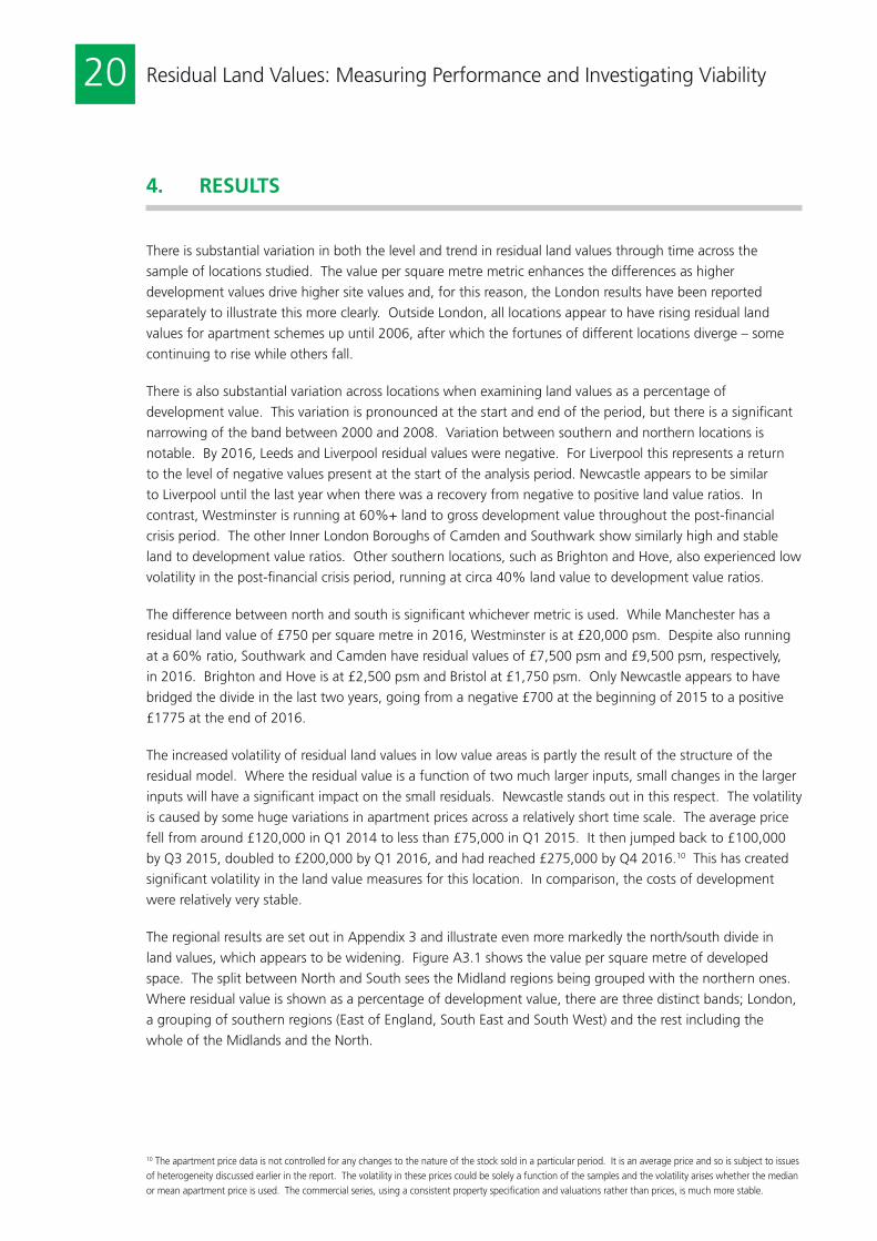
There is substantial variation in both the level and trend in residual land values through time across the
sample of locations studied. The value per square metre metric enhances the differences as higher
development values drive higher site values and, for this reason, the London results have been reported
separately to illustrate this more clearly. Outside London, all locations appear to have rising residual land
values for apartment schemes up until 2006, after which the fortunes of different locations diverge – some
continuing to rise while others fall.
There is also substantial variation across locations when examining land values as a percentage of
development value. This variation is pronounced at the start and end of the period, but there is a significant
narrowing of the band between 2000 and 2008. Variation between southern and northern locations is
notable. By 2016, Leeds and Liverpool residual values were negative. For Liverpool this represents a return
to the level of negative values present at the start of the analysis period. Newcastle appears to be similar
to Liverpool until the last year when there was a recovery from negative to positive land value ratios. In
contrast, Westminster is running at 60%+ land to gross development value throughout the post-financial
crisis period. The other Inner London Boroughs of Camden and Southwark show similarly high and stable
land to development value ratios. Other southern locations, such as Brighton and Hove, also experienced low
volatility in the post-financial crisis period, running at circa 40% land value to development value ratios.
The difference between north and south is significant whichever metric is used. While Manchester has a
residual land value of £750 per square metre in 2016, Westminster is at £20,000 psm. Despite also running
at a 60% ratio, Southwark and Camden have residual values of £7,500 psm and £9,500 psm, respectively,
in 2016. Brighton and Hove is at £2,500 psm and Bristol at £1,750 psm. Only Newcastle appears to have
bridged the divide in the last two years, going from a negative £700 at the beginning of 2015 to a positive
£1775 at the end of 2016.
The increased volatility of residual land values in low value areas is partly the result of the structure of the
residual model. Where the residual value is a function of two much larger inputs, small changes in the larger
inputs will have a significant impact on the small residuals. Newcastle stands out in this respect. The volatility
is caused by some huge variations in apartment prices across a relatively short time scale. The average price
fell from around £120,000 in Q1 2014 to less than £75,000 in Q1 2015. It then jumped back to £100,000
by Q3 2015, doubled to £200,000 by Q1 2016, and had reached £275,000 by Q4 2016.10 This has created
significant volatility in the land value measures for this location. In comparison, the costs of development
were relatively very stable.
The regional results are set out in Appendix 3 and illustrate even more markedly the north/south divide in
land values, which appears to be widening. Figure A3.1 shows the value per square metre of developed
space. The split between North and South sees the Midland regions being grouped with the northern ones.
Where residual value is shown as a percentage of development value, there are three distinct bands; London,
a grouping of southern regions (East of England, South East and South West) and the rest including the
whole of the Midlands and the North.
4. RESULTS

21Residual Land Values: Measuring Performance and Investigating Viability
Figure 4.4 sets out the Central London residential land index of Savills against the residual land values for
Inner London and for Westminster estimated by this study, also expressed as an index. The index is based at
Q1 1997 and the last observations for all three series are as at Q3 2016.
Figure 4.4: London Residential Land Value Indices
Savills London Index Inner London Westminster
Q1
1998
Q1
1997
Q1
1999
Q1
2000
Q1
2001
Q1
2002
Q1
2003
Q1
2004
Q1
2005
Q1
2006
Q1
2007
Q1
2008
Q1
2009
Q1
2010
Q1
2011
Q1
2012
Q1
2013
Q1
2014
Q1
2015
Q1
2016
0
200
400
600
800
1,000
1,200
1,400
1,600
Inde
x Q
1 19
97 =
100
The residual land value index for both Westminster and Inner London outpaces the Savills index over the whole
period by a significant margin. There is a brief coming together around the time of the financial crisis. The
Inner London and Westminster residual land value indices peaked in Q3 2006 and then started to fall. In stark
contrast the Savills index grows by well over 50% in the period Q3 2006 to Q3 2007 and then falls by 50% in
the next 18 months. Yet this is precisely the time that the residual land values start to increase significantly on
the back of strong rises in the average sale prices of London apartments. In Q1 2008, the mean Inner London
price for apartments was £437,500, but this increased to £650,000 within nine months. Despite falling back
to under £500,000 in 2009 and 2010, mean values are over £1 million in 2016. This has driven a major
increase in residual land values that, particularly since the beginning of 2014, has not been matched by the
Savills index, which now stands at around 50% of the residual land value index for Inner London.
The higher rate of increase in residual land values in Inner London compared to the Savills Index is particularly
apparent at the beginning and end of the analysis period. Had the base year been Q1 2000, the Inner
London residual land values index would have been significantly lower than Savills around the end of 2007
but would have caught up by Q3 2016. If the base year had been Q1 2004, the Savills Index would still be
a small margin higher than the Inner London residual land value series at the end of the 2016. Regardless of
the base year, the residual land value series for Westminster is significantly higher than both Savills and the
average for Inner London.
4. RESULTS
22 Residual Land Values: Measuring Performance and Investigating Viability
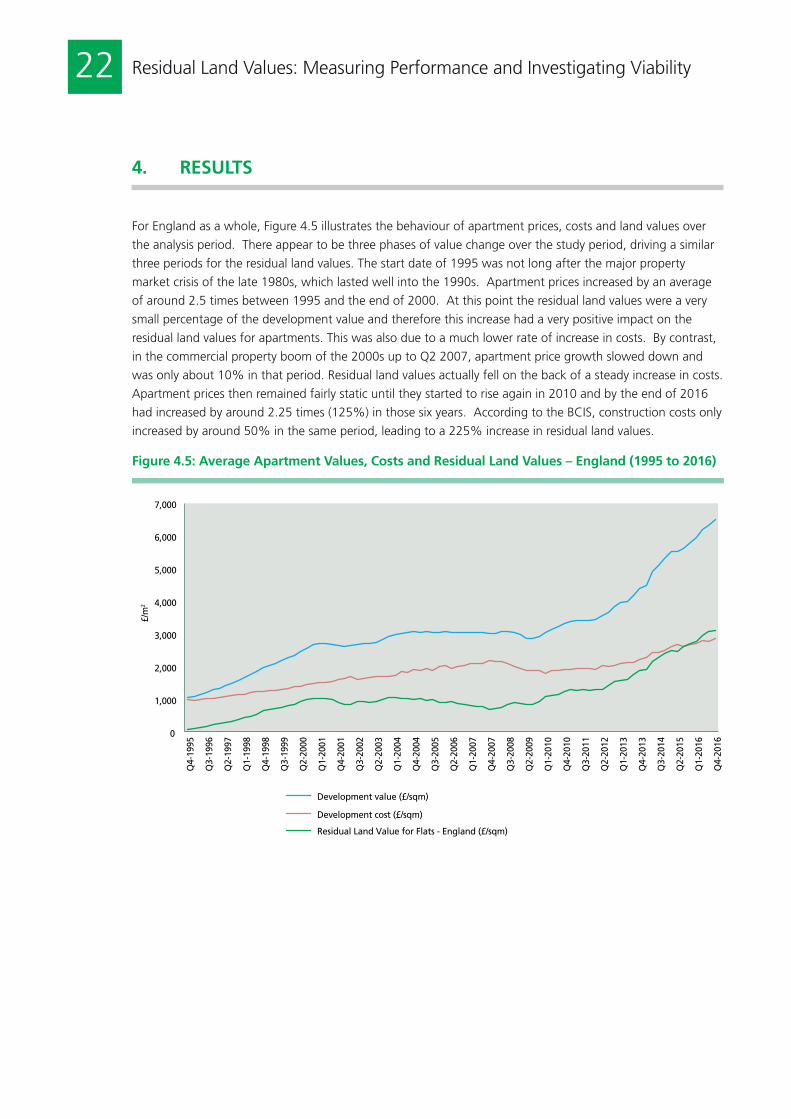
For England as a whole, Figure 4.5 illustrates the behaviour of apartment prices, costs and land values over
the analysis period. There appear to be three phases of value change over the study period, driving a similar
three periods for the residual land values. The start date of 1995 was not long after the major property
market crisis of the late 1980s, which lasted well into the 1990s. Apartment prices increased by an average
of around 2.5 times between 1995 and the end of 2000. At this point the residual land values were a very
small percentage of the development value and therefore this increase had a very positive impact on the
residual land values for apartments. This was also due to a much lower rate of increase in costs. By contrast,
in the commercial property boom of the 2000s up to Q2 2007, apartment price growth slowed down and
was only about 10% in that period. Residual land values actually fell on the back of a steady increase in costs.
Apartment prices then remained fairly static until they started to rise again in 2010 and by the end of 2016
had increased by around 2.25 times (125%) in those six years. According to the BCIS, construction costs only
increased by around 50% in the same period, leading to a 225% increase in residual land values.
Figure 4.5: Average Apartment Values, Costs and Residual Land Values – England (1995 to 2016)
0
1,000
2,000
3,000
4,000
5,000
6,000
7,000
Q4-
1995
Q3-
1996
Q2-
1997
Q1-
1998
Q4-
1998
Q3-
1999
Q2-
2000
Q1-
2001
Q4-
2001
Q3-
2002
Q2-
2003
Q1-
2004
Q4-
2004
Q3-
2005
Q2-
2006
Q1-
2007
Q4-
2007
Q3-
2008
Q2-
2009
Q1-
2010
Q4-
2010
Q3-
2011
Q2-
2012
Q1-
2013
Q4-
2013
Q3-
2014
Q2-
2015
Q1-
2016
Q4-
2016
£/m
2
Development value (£/sqm)
Development cost (£/sqm)
Residual Land Value for Flats - England (£/sqm)
4. RESULTS

23Residual Land Values: Measuring Performance and Investigating Viability
4.2 OfficesFigures 4.6, 4.7 and 4.8 set out the results for the sample locations in the office sector.
Figure 4.6: Residual Land Values for Offices in Selected Locations ex. London (1997 to 2017)
0
500
1,000
1,500
2,000
2,500
3,000
3,500
4,000
Q4
1997
Q2
1998
Q4
1998
Q2
1999
Q4
1999
Q2
2000
Q4
2000
Q2
2001
Q4
2001
Q2
2002
Q4
2002
Q2
2003
Q4
2003
Q2
2004
Q4
2004
Q2
2005
Q4
2005
Q2
2006
Q4
2006
Q2
2007
Q4
2007
Q2
2008
Q4
2008
Q2
2009
Q4
2009
Q2
2010
Q4
2010
Q2
2011
Q4
2011
Q2
2012
Q4
2012
Q2
2013
Q4
2013
Q2
2014
Q4
2014
Q2
2015
Q4
2015
Q2
2016
Q4
2016
Q2
2017
RLV
£/m
2
Birmingham Bristol Cardiff Edinburgh Glasgow Leeds Manchester Reading
Figure 4.7: Residual Land Values for Offices in London (1997 to 2017)
0
2,000
4,000
6,000
8,000
10,000
12,000
14,000
16,000
Q4
1997
Q2
1998
Q4
1998
Q2
1999
Q4
1999
Q2
2000
Q4
2000
Q2
2001
Q4
2001
Q2
2002
Q4
2002
Q2
2003
Q4
2003
Q2
2004
Q4
2004
Q2
2005
Q4
2005
Q2
2006
Q4
2006
Q2
2007
Q4
2007
Q2
2008
Q4
2008
Q2
2009
Q4
2009
Q2
2010
Q4
2010
Q2
2011
Q4
2011
Q2
2012
Q4
2012
Q2
2013
Q4
2013
Q2
2014
Q4
2014
Q2
2015
Q4
2015
Q2
2016
Q4
2016
Q2
2017
RLV
£/m
2
London - City London - Midtown London - Southbank London - West End London
4. RESULTS

24 Residual Land Values: Measuring Performance and Investigating Viability
Figure 4.8: Ratio of Residual Land Value to Development Value for Offices (1997 to 2017)
0%
10%
20%
30%
40%
50%
60%
70%
Q4
1997
Q2
1998
Q4
1998
Q2
1999
Q4
1999
Q2
2000
Q4
2000
Q2
2001
Q4
2001
Q2
2002
Q4
2002
Q2
2003
Q4
2003
Q2
2004
Q4
2004
Q2
2005
Q4
2005
Q2
2006
Q4
2006
Q2
2007
Q4
2007
Q2
2008
Q4
2008
Q2
2009
Q4
2009
Q2
2010
Q4
2010
Q2
2011
Q4
2011
Q2
2012
Q4
2012
Q2
2013
Q4
2013
Q2
2014
Q4
2014
Q2
2015
Q4
2015
Q2
2016
Q4
2016
Q2
2017
% o
f D
V
Birmingham Bristol Cardiff Edinburgh Glasgow Leeds London - City London - Midtown London - Southbank London - West End Manchester Reading
Office residual land values generally follow the behaviour of the built office market through the period – a
recovery in values across the country in the mid to late 1990s, followed by a fall in some land value series in
the post tech boom economy of the early 2000s that hit certain parts of the country more than others. There
is then a boom in values in the period up to 2007, a major crash in 2007 to 2009 and a recovery thereafter,
mirroring the office market more generally. Figure 4.9 illustrates the lack of relative volatility in building
costs for three major office markets in the sample: Manchester, Birmingham and Glasgow. This shows that
movements in residual values in this sector tend to follow the market values of the completed development.
Rather than a North/South divide, for office residual land values the divide is between London and the rest of
GB both in terms of residual land values per square metre and residual value as a percentage of development
value, with only London locations able to command land values at more than 50% of development value.
4. RESULTS

25Residual Land Values: Measuring Performance and Investigating Viability
Figure 4.9: Variability of Residual Model Inputs for Manchester, Birmingham & Glasgow Offices (1997 to 2017)
0
1,000
2,000
3,000
4,000
5,000
6,000
7,000
8,000
Q4
1997
Q2
1998
Q4
1998
Q2
1999
Q4
1999
Q2
2000
Q4
2000
Q2
2001
Q4
2001
Q2
2002
Q4
2002
Q2
2003
Q4
2003
Q2
2004
Q4
2004
Q2
2005
Q4
2005
Q2
2006
Q4
2006
Q2
2007
Q4
2007
Q2
2008
Q4
2008
Q2
2009
Q4
2009
Q2
2010
Q4
2010
Q2
2011
Q4
2011
Q2
2012
Q4
2012
Q2
2013
Q4
2013
Q2
2014
Q4
2014
Q2
2015
Q4
2015
Q2
2016
Q4
2016
Q2
2017
£/m
2
Manchester BLD Glasgow BLD Birmingham BLD Manchester NDV Birmingham NDV
Glasgow NDV Manchester RLV Glasgow RLV Birmingham RLV
Note: BLD = Building Costs, NDV = Net Development Value, RLV = Residual Land Value
The Savills London Land Value Index, which aggregates multiple uses including office sites, can be compared to
the residual land values produced for London. Figure 4.10 sets out this comparison. A similar pattern emerges
to the residential analysis. The value series remain similar for the last part of the 1990s but start to diverge
in the booming market of the middle 2000s. Although the Savills index remains close to the value change
patterns recorded in the City by the residual valuations, the West End office land segment almost triples in
value from 2004 until the middle of 2007. That segment records major losses in value until the trough in
March 2009 before recovering strongly. Although all the value series record significant gains from 2009,
the residual values appear to outpace the values contained within the Savills index, again significantly. This
includes the City Offices series, which, up until 2009, had appeared to map onto the Savills index quite closely.
4. RESULTS

26 Residual Land Values: Measuring Performance and Investigating Viability
4. RESULTS
Figure 4.10: Comparison of Residual Land Values and Savills Land Value Index for Central London Offices
0
50
100
150
200
250
300
350
400
Q1
1998
Q
3 19
98
Q1
1999
Q
3 19
99
Q1
2000
Q
3 20
00
Q1
2001
Q
3 20
01
Q1
2002
Q
3 20
02
Q1
2003
Q
3 20
03
Q1
2004
Q
3 20
04
Q1
2005
Q
3 20
05
Q1
2006
Q
3 20
06
Q1
2007
Q
3 20
07
Q1
2008
Q
3 20
08
Q1
2009
Q
3 20
09
Q1
2010
Q
3 20
10
Q1
2011
Q
3 20
11
Q1
2012
Q
3 20
12
Q1
2013
Q
3 20
13
Q1
2014
Q
3 20
14
Q1
2015
Q
3 20
15
Q1
2016
Q
3 20
16
Q1
2017
Inde
x Q
1 19
98 =
100
London Average Residual Land Value City Residual Land Value
West End Residual Land Value Savills London Index
Note: Quarterly residual land value series all rebased to end Q1 1998 to match Savills six-monthly index.
4.3 High Street RetailFigures 4.11, 4.12 and 4.13 set out the results for the high street shop residual land values.
Figure 4.11: High Street Retail Residual Land Values for Selected Locations ex. London (1997 to 2017)
0
5,000
10,000
15,000
20,000
25,000
30,000
Q4
1997
Q
2 19
98
Q4
1998
Q
2 19
99
Q4
1999
Q
2 20
00
Q4
2000
Q
2 20
01
Q4
2001
Q
2 20
02
Q4
2002
Q
2 20
03
Q4
2003
Q
2 20
04
Q4
2004
Q
2 20
05
Q4
2005
Q
2 20
06
Q4
2006
Q
2 20
07
Q4
2007
Q
2 20
08
Q4
2008
Q
2 20
09
Q4
2009
Q
2 20
10
Q4
2010
Q
2 20
11
Q4
2011
Q
2 20
12
Q4
2012
Q
2 20
13
Q4
2013
Q
2 20
14
Q4
2014
Q
2 20
15
Q4
2015
Q
2 20
16
Q4
2016
Q
2 20
17
RLV
£/m
2
Birmingham Bristol Cardiff Croydon Edinburgh Glasgow Leeds Liverpool Manchester Nottingham Sheffield

27Residual Land Values: Measuring Performance and Investigating Viability
4. RESULTS
Figure 4.12: Residual Land Values for High Street Retail in London (1997 to 2017)
0
20,000
40,000
60,000
80,000
100,000
120,000
140,000
160,000
180,000
200,000
Q4
1997
Q2
1998
Q4
1998
Q2
1999
Q4
1999
Q2
2000
Q4
2000
Q2
2001
Q4
2001
Q2
2002
Q4
2002
Q2
2003
Q4
2003
Q2
2004
Q4
2004
Q2
2005
Q4
2005
Q2
2006
Q4
2006
Q2
2007
Q4
2007
Q2
2008
Q4
2008
Q2
2009
Q4
2009
Q
2 20
10
Q4
2010
Q2
2011
Q4
2011
Q2
2012
Q4
2012
Q2
2013
Q4
2013
Q2
2014
Q4
2014
Q2
2015
Q4
2015
Q2
2016
Q4
2016
Q2
2017
RLV
£/m
2
Central London London Rest of London
Figure 4.13: Ratio of Land Value to Development Value for High Street Retail in Selected Locations (1997 to 2017)
50%
55%
60%
65%
70%
75%
80%
Q4
1997
Q2
1998
Q4
1998
Q2
1999
Q4
1999
Q2
2000
Q4
2000
Q2
2001
Q4
2001
Q2
2002
Q4
2002
Q2
2003
Q4
2003
Q2
2004
Q4
2004
Q2
2005
Q4
2005
Q2
2006
Q4
2006
Q2
2007
Q4
2007
Q2
2008
Q4
2008
Q2
2009
Q4
2009
Q2
2010
Q4
2010
Q2
2011
Q4
2011
Q2
2012
Q4
2012
Q2
2013
Q4
2013
Q2
2014
Q4
2014
Q2
2015
Q4
2015
Q2
2016
Q4
2016
Q2
2017
% o
f D
V
Birmingham Bristol Cardiff Central London Croydon Edinburgh
Glasgow Leeds Liverpool Manchester Nottingham Sheffield

28 Residual Land Values: Measuring Performance and Investigating Viability
4. RESULTS
As expected the value per square metre is very high, over 10 times that of the equivalent office residual
values. Given the single floor nature of high street shops (lower density) and the high value premium of the
100% location assumed in the CBRE data, that is not surprising. The percentage of residual land value to
development value is consistently high and the North/South divide is not so prominent.
The residual land values follow a similar pattern as the offices. A more pronounced recovery in residual land
values from the 1990 property downturn is apparent at the start of the period. At that point the lowest
value cities are Sheffield, Bristol, Liverpool, Nottingham, Leeds and Cardiff. The highest value locations are
Edinburgh, Glasgow, Birmingham and Manchester. They all cluster around the 65% to 70% ratio of residual
land value to development value, again illustrating the high land value content in retail due to very high
development values in the good locations and relatively low costs of development. However, although the
general shape of the value changes mimics the property cycle over the last 20 years, there is some divergence
since the financial crisis; mirroring the pattern for apartments. While some locations maintain their 65% to
70% ratio of land value to developed value, Cardiff, Nottingham, Sheffield, Croydon and Bristol have reduced
ratios with percentages in the low 50s and 60s.
As with offices, the residual land values are driven by completed development values, as these are more
volatile than costs. Using the same three illustrative locations as for offices, the same pattern emerges, but
even more pronounced due to the relative insignificance of the building costs. On this scale, it is hard to
distinguish any difference between the building costs in any of the locations (Figure 4.14).
Figure 4.14: Volatility and Variability of Residual Land Value Inputs for High Street Retail in Manchester, Birmingham & Glasgow (1997 to 2017)
0
5,000
10,000
15,000
20,000
25,000
30,000
35,000
40,000
Q4
1997
Q
2 19
98
Q4
1998
Q
2 19
99
Q4
1999
Q
2 20
00
Q4
2000
Q
2 20
01
Q4
2001
Q
2 20
02
Q4
2002
Q
2 20
03
Q4
2003
Q
2 20
04
Q4
2004
Q
2 20
05
Q4
2005
Q
2 20
06
Q4
2006
Q
2 20
07
Q4
2007
Q
2 20
08
Q4
2008
Q
2 20
09
Q4
2009
Q
2 20
10
Q4
2010
Q
2 20
11
Q4
2011
Q
2 20
12
Q4
2012
Q
2 20
13
Q4
2013
Q
2 20
14
Q4
2014
Q
2 20
15
Q4
2015
Q
2 20
16
Q4
2016
Q
2 20
17
£/m
2
Manchester RLV Glasgow RLV Birmingham RLV Manchester BLD Glasgow BLD
Birmingham BLD Manchester NDV Glasgow NDV Birmingham NDV
Note: BLD = Building Costs, NDV = Net Development Value, RLV = Residual Land Value
The London results in Figure 4.12 exhibit a sharp increase in value in Central London compared to a relatively
low increase in the Rest of London. The Rest of London is represented by local shopping centres in the Inner
and Outer London Boroughs and there appears to have been very mixed fortunes over the last 20 years in
each of these high streets. Some performed well, with Zone A values rising by between 150% and 300%
(Camden, Islington, Clapham, Hammersmith and Stratford). But, in other locations, Zone A rents have frozen
(Lewisham, Ilford, Orpington, Sutton). Croydon comes into the latter category with static rental values over

29Residual Land Values: Measuring Performance and Investigating Viability
the last 20 years. On average, rents have grown by about 75% across these London boroughs but capital
values have done slightly better due to a general cap rate fall across the period. However, these gains are
dwarfed in Figure 4.12 by the change in Central London retail values, which have driven up residual land
values by over 600%. Central London rents have done well relative to the rest of London high streets but
the real change is the reduction in cap rates, which averages about 40% over the last 20 years, leading to a
500% increase in development values even though rents have only gone up by over 200%. Residual land
values in Central London high street retail now stand at 75% of development value.
There are no retail high street land value benchmarks with which to compare these results. That is not
surprising. The nature of the retail data, which assumes a single high street unit in a prime location, could
be considered a very rare development opportunity. Few bare sites are available in the prime location, and
rebuilding is highly unlikely due to the ability to reconfigure retail at a very low relative cost. Shopping centre
development or redevelopment is far more likely and therefore the obstacles to developing a shopping centre
land value series should be addressed.
4.4 IndustrialFigures 4.15, 4.16 and 4.17 set out the results for the industrial sector.
Figure 4.15: Residual Land Values for Industrials in Selected Locations ex. London (1997 to 2017)
-400
-300
-200
-100
0
100
200
300
400
Q4
1997
Q2
1998
Q4
1998
Q2
1999
Q4
1999
Q2
2000
Q4
2000
Q2
2001
Q4
2001
Q2
2002
Q4
2002
Q2
2003
Q4
2003
Q2
2004
Q4
2004
Q2
2005
Q4
2005
Q2
2006
Q4
2006
Q2
2007
Q4
2007
Q2
2008
Q4
2008
Q2
2009
Q4
2009
Q2
2010
Q4
2010
Q2
2011
Q4
2011
Q2
2012
Q4
2012
Q2
2013
Q4
2013
Q2
2014
Q4
2014
Q2
2015
Q4
2015
Q2
2016
Q4
2016
Q2
2017
RLV
£/m
2
Birmingham Bristol Glasgow Leeds Leicester Manchester Milton Keynes Sheffield Stoke-on-Trent
4. RESULTS

30 Residual Land Values: Measuring Performance and Investigating Viability
Figure 4.16: Residual Land Values for Industrials in London (1997 to 2017)
-500
0
500
1,000
1,500
2,000
2,500
Q4
1997
Q2
1998
Q4
1998
Q2
1999
Q4
1999
Q2
2000
Q4
2000
Q2
2001
Q4
2001
Q2
2002
Q4
2002
Q2
2003
Q4
2003
Q2
2004
Q4
2004
Q2
2005
Q4
2005
Q2
2006
Q4
2006
Q2
2007
Q4
2007
Q2
2008
Q4
2008
Q2
2009
Q4
2009
Q2
2010
Q4
2010
Q2
2011
Q4
2011
Q2
2012
Q4
2012
Q2
2013
Q4
2013
Q2
2014
Q4
2014
Q2
2015
Q4
2015
Q2
2016
Q4
2016
Q2
2017
RLV
£/m
2
Heathrow Park Royal Stratford London
Figure 4.17: Ratio of Residual Land Value to Development Value for Industrials in Selected Locations (1997 to 2017)
-60%
-40%
-20%
0%
20%
40%
60%
Q4
1997
Q2
1998
Q4
1998
Q2
1999
Q4
1999
Q2
2000
Q4
2000
Q2
2001
Q4
2001
Q2
2002
Q4
2002
Q2
2003
Q4
2003
Q2
2004
Q4
2004
Q2
2005
Q4
2005
Q2
2006
Q4
2006
Q2
2007
Q4
2007
Q2
2008
Q4
2008
Q2
2009
Q4
2009
Q2
2010
Q4
2010
Q2
2011
Q4
2011
Q2
2012
Q4
2012
Q2
2013
Q4
2013
Q2
2014
Q4
2014
Q2
2015
Q4
2015
Q2
2016
Q4
2016
Q2
2017
% o
f D
V
Birmingham Bristol Glasgow Heathrow Leeds Leicester Manchester Milton Keynes Park Royal Sheffield Stoke-on-Trent Stratford
4. RESULTS

31Residual Land Values: Measuring Performance and Investigating Viability
The first observation is that certain parts of the country have had no viable industrial land market throughout
the whole of the analysis period. Stoke-on-Trent and Sheffield have two positive residual land values between
them in the whole of the 20-year study period covering 158 observations (Figure 4.15). Within the database
as a whole the same can be said for locations throughout the Midlands and the North.
While the South does exhibit positive land values for industrial development throughout most of the period,
not one location outside of London and its immediate sphere of influence (which, for example, includes
Reading, Woking, Guildford, Watford and St. Albans) has a positive land value in every one of the 79 quarters
measured between 1997 and 2017. Even locations like Bristol had two quarters in the second half of 2008
where a negative residual land value was recorded. The regional data set out in Appendix 3 suggests that the
negative land value issue is most acute in the North East, North West, Scotland and Yorkshire/Humberside.
Here, there are only 15 positive residual land values over the whole period, the equivalent of one year in 20
for each of them. To complete the geographically stark divide, the next three least viable regions are Wales
(11 positive residual land values across 79 quarters), West Midlands (13) and the East Midlands (21).
The data exhibit the same increased variability across locations during the post financial crisis period, which
was also apparent for apartments and high street retail. This seems to be a function of geography, with
Bristol and Milton Keynes increasing in value from the middle of 2014 to the present, while residual industrial
land values have declined throughout much of the North and Midlands since the beginning of 2009.
As with other property sectors, industrials around London have higher residual values, with land values
stabilising at around 40% of development value from around the middle of the 2000s (Figure 4.17). During
the financial crisis these residual land values dropped to around 30% but by the end of 2009 had recovered
back to 40%. Of the sample cities, Bristol currently has residual land values at about 20% of development
value and Milton Keynes at 10%, but all the others struggle to register any positive residual value at all.
There are no contemporary indices for the value of industrial development land, but, as noted in Section 2,
the Department for Communities and Local Government did publish estimates as at March 2015 for the
English regions (CLG, 2015b). These estimates, set out in Appendix 4, are all positive and this contrasts with
the residual land value estimates produced for this research, which, at the same time period, are all negative
except for London, the South East and the East Midlands (Figure 4.18). However, with the exception of East
of England, the relative values across the regions appear to be broadly consistent.
The main driver of the industrial land residual is, as with the other land uses, the development value. The
lack of relative volatility in the construction tender price series for the cities of Birmingham, Manchester and
Glasgow is illustrated in Figure 4.19.
4. RESULTS

32 Residual Land Values: Measuring Performance and Investigating Viability
Figure 4.18: Industrial Residual Land Values versus CLG/VOA Estimates for English Regions (March 2015)
-400
-200
0
200
400
600
800
1000
East East Midlands
London North East North West South East South West West Midlands
Yorkshire and the Humber
Pric
e pe
r sq
uare
met
re
VOA Residual Land Value
Figure 4.19: Volatility of Residual Model Inputs for Manchester, Birmingham & Glasgow Industrials (1997 to 2017)
-400
-200
0
200
400
600
800
1,000
1,200
1,400
Q4
1997
Q2
1998
Q4
1998
Q2
1999
Q4
1999
Q2
2000
Q4
2000
Q2
2001
Q4
2001
Q2
2002
Q4
2002
Q2
2003
Q4
2003
Q2
2004
Q4
2004
Q2
2005
Q4
2005
Q2
2006
Q4
2006
Q2
2007
Q4
2007
Q2
2008
Q4
2008
Q2
2009
Q4
2009
Q2
2010
Q4
2010
Q2
2011
Q4
2011
Q2
2012
Q4
2012
Q2
2013
Q4
2013
Q2
2014
Q4
2014
Q2
2015
Q4
2015
Q2
2016
Q4
2016
Q2
2017
£/m
2
Manchester RLV Glasgow RLV Birmingham RLV Manchester BLD Glasgow BLD Birmingham BLD Manchester NDV Glasgow NDV Birmingham NDV
Note: BLD = Building Costs, NDV = Net Development Value, RLV = Residual Land Value
4. RESULTS
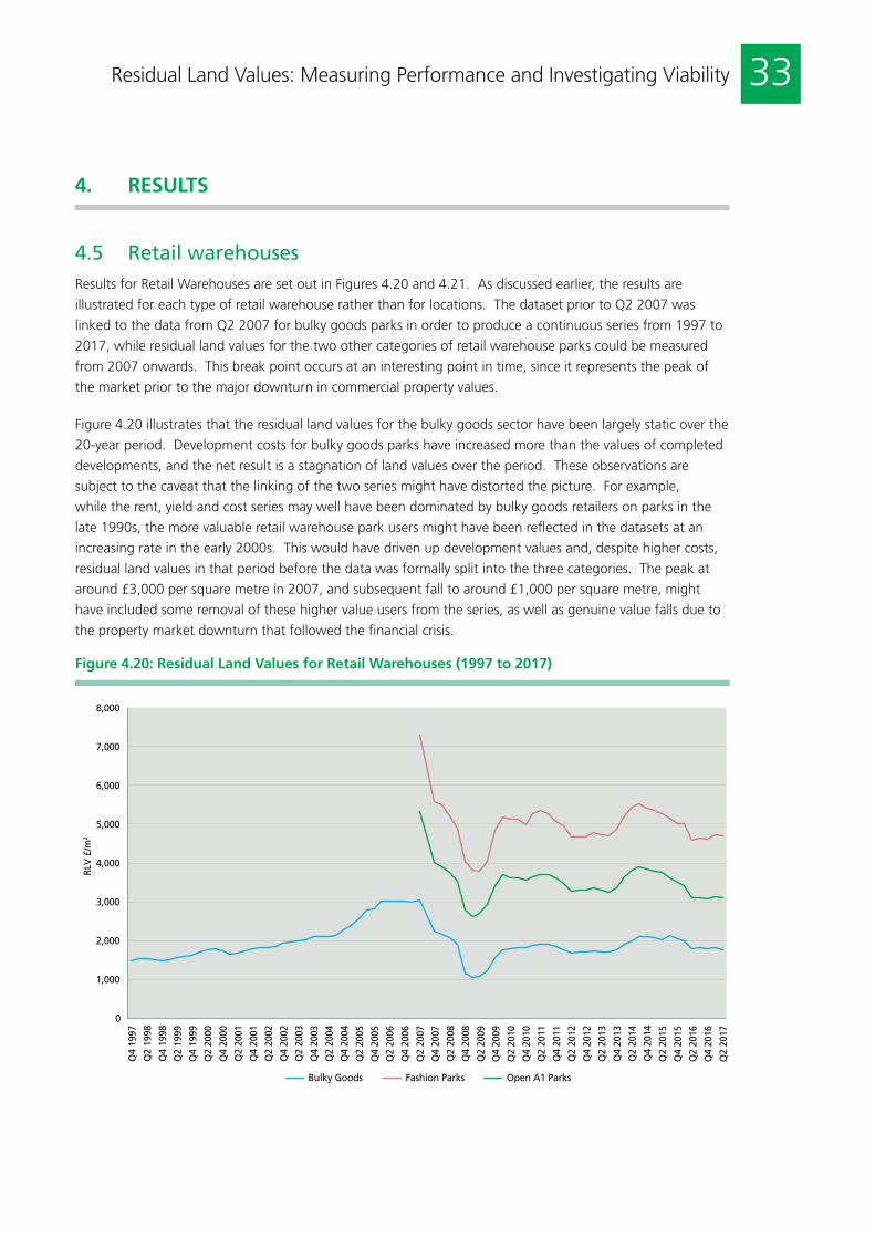
33Residual Land Values: Measuring Performance and Investigating Viability
4.5 Retail warehousesResults for Retail Warehouses are set out in Figures 4.20 and 4.21. As discussed earlier, the results are
illustrated for each type of retail warehouse rather than for locations. The dataset prior to Q2 2007 was
linked to the data from Q2 2007 for bulky goods parks in order to produce a continuous series from 1997 to
2017, while residual land values for the two other categories of retail warehouse parks could be measured
from 2007 onwards. This break point occurs at an interesting point in time, since it represents the peak of
the market prior to the major downturn in commercial property values.
Figure 4.20 illustrates that the residual land values for the bulky goods sector have been largely static over the
20-year period. Development costs for bulky goods parks have increased more than the values of completed
developments, and the net result is a stagnation of land values over the period. These observations are
subject to the caveat that the linking of the two series might have distorted the picture. For example,
while the rent, yield and cost series may well have been dominated by bulky goods retailers on parks in the
late 1990s, the more valuable retail warehouse park users might have been reflected in the datasets at an
increasing rate in the early 2000s. This would have driven up development values and, despite higher costs,
residual land values in that period before the data was formally split into the three categories. The peak at
around £3,000 per square metre in 2007, and subsequent fall to around £1,000 per square metre, might
have included some removal of these higher value users from the series, as well as genuine value falls due to
the property market downturn that followed the financial crisis.
Figure 4.20: Residual Land Values for Retail Warehouses (1997 to 2017)
0
1,000
2,000
3,000
4,000
5,000
6,000
7,000
8,000
Q4
1997
Q2
1998
Q4
1998
Q2
1999
Q4
1999
Q2
2000
Q4
2000
Q2
2001
Q4
2001
Q2
2002
Q4
2002
Q2
2003
Q4
2003
Q2
2004
Q4
2004
Q2
2005
Q4
2005
Q2
2006
Q4
2006
Q2
2007
Q4
2007
Q2
2008
Q4
2008
Q2
2009
Q4
2009
Q2
2010
Q4
2010
Q2
2011
Q4
2011
Q2
2012
Q4
2012
Q2
2013
Q4
2013
Q2
2014
Q4
2014
Q2
2015
Q4
2015
Q2
2016
Q4
2016
Q2
2017
RLV
£/m
2
Bulky Goods Fashion Parks Open A1 Parks
4. RESULTS

34 Residual Land Values: Measuring Performance and Investigating Viability
Figure 4.21: Ratio of Residual Land Value to Development Value for Retail Warehouses (1997 to 2017)
40%
45%
50%
55%
60%
65%
70%
Q4
1997
Q2
1998
Q4
1998
Q2
1999
Q4
1999
Q2
2000
Q4
2000
Q2
2001
Q4
2001
Q2
2002
Q4
2002
Q2
2003
Q4
2003
Q2
2004
Q4
2004
Q2
2005
Q4
2005
Q2
2006
Q4
2006
Q2
2007
Q4
2007
Q2
2008
Q4
2008
Q2
2009
Q4
2009
Q2
2010
Q4
2010
Q2
2011
Q4
2011
Q2
2012
Q4
2012
Q2
2013
Q4
2013
Q2
2014
Q4
2014
Q2
2015
Q4
2015
Q2
2016
Q4
2016
Q2
2017
% o
f D
V
Bulky Goods Fashion Parks Open A1 Parks
Figure 4.21 illustrates that in the first half of the time series between 1997 and 2007, the ratio of land value to
development value was fairly static at just under 60%, with a slight rising trend perhaps as a result of the changes
identified above. The fall in all three series from Q2 2007 is apparent, driven by the fall in development value rather
than a substantial increase in construction and other development costs. Development Values fell by around 45% in
the Fashion Parks and A1 segments but Bulky Goods Parks fared worse at around 55% from Q2 2007 until the end
of Q1 2009. In contrast, development costs based on BCIS tender prices fell by less than 10% in the same period.
Residual land values also fell by around 50% in the two most valuable segments and by 65% in the bulky goods
segment, a function of greater falls in development value and a lower ratio of residual value to development value.
In the recovery, it was the bulky goods section that fared the best with around 50% growth in development
values between 2009 and 2017, compared to less than 20% in the other two segments. Despite a 40% increase
in tender prices, the growth in residual land prices, the gearing effect resulted in a net gain for the bulky goods
residual land values of around 70% growth compared to around 20% in the other two segments. Most of that
recovery was in the first two years and thereafter the residual land values have witnessed no sustained growth
through to 2017.
4. RESULTS

35Residual Land Values: Measuring Performance and Investigating Viability
4.6 Cross-sector comparisonFigures 4.22 and 4.23 summarise all of the results across the cities and regions, respectively, as at the end of
2016. The results indicate the hierarchy of residual land values based on the ratio of land value to developed
value. This hierarchy has two elements; property type and region/city/town.
The high value uses per square metre associated with retail land use flow through into residual land values. City/
town level discrepancies are not so apparent in retail, with the majority of the ratios at city centre level ranging
between 55% and 66%. The exceptions are Edinburgh (68%), Glasgow (70%) and Central London (74%).
Retail warehouses have the lowest ratio at around 50%. Apart from Scotland and Central London, the regional
standard high street retail variations are even less, ranging from Wales at 54% to the North East at 60%. This
indicates that there is no regional north/south divide in retail. This is reinforced within the retail warehouse sector,
with ratios being highest in Wales and Scotland and lowest in the East Midlands, the East and the South East.
Regarding the lack of regional variation, retail is the exception. Office ratios exhibit a much greater range.
At city/town level this ranges from Cardiff at 30% to the West End of London at nearly 60%. Outside of
London, the ratios hover around 40% with Manchester at 42% and Birmingham 38%. Leeds is at 33%. At
the regional level the ratios are significantly lower across the board ranging from Wales at 15% to the North
West at 32%, with London the outlier at 55%. These results indicate the influence of large regional centres
such as Manchester, Birmingham, Glasgow and Edinburgh on the regional results, but also that smaller towns
within the regions have much lower land values as a percentage of total development values.
The north/south divide is most apparent in the industrial results. Here the ratios, even assuming prime
locations, are negative for all towns north of Birmingham apart from Manchester and Glasgow. The regional
results are even more illustrative with only London, the South East, the East and the South West showing
positive ratios and the whole of the Midlands, North, Scotland and wales exhibiting negative ratios.
Apartment values also indicate a north/south divide; London stands out with a regional ratio of over 50%,
while the South East, South West and the East cluster around 33%, and the rest range between 10% and
15%. The city/town level results are less consistent with a number northern cities having high ratios such as
Newcastle and Manchester; these particular inconsistencies have been addressed elsewhere.
4. RESULTS
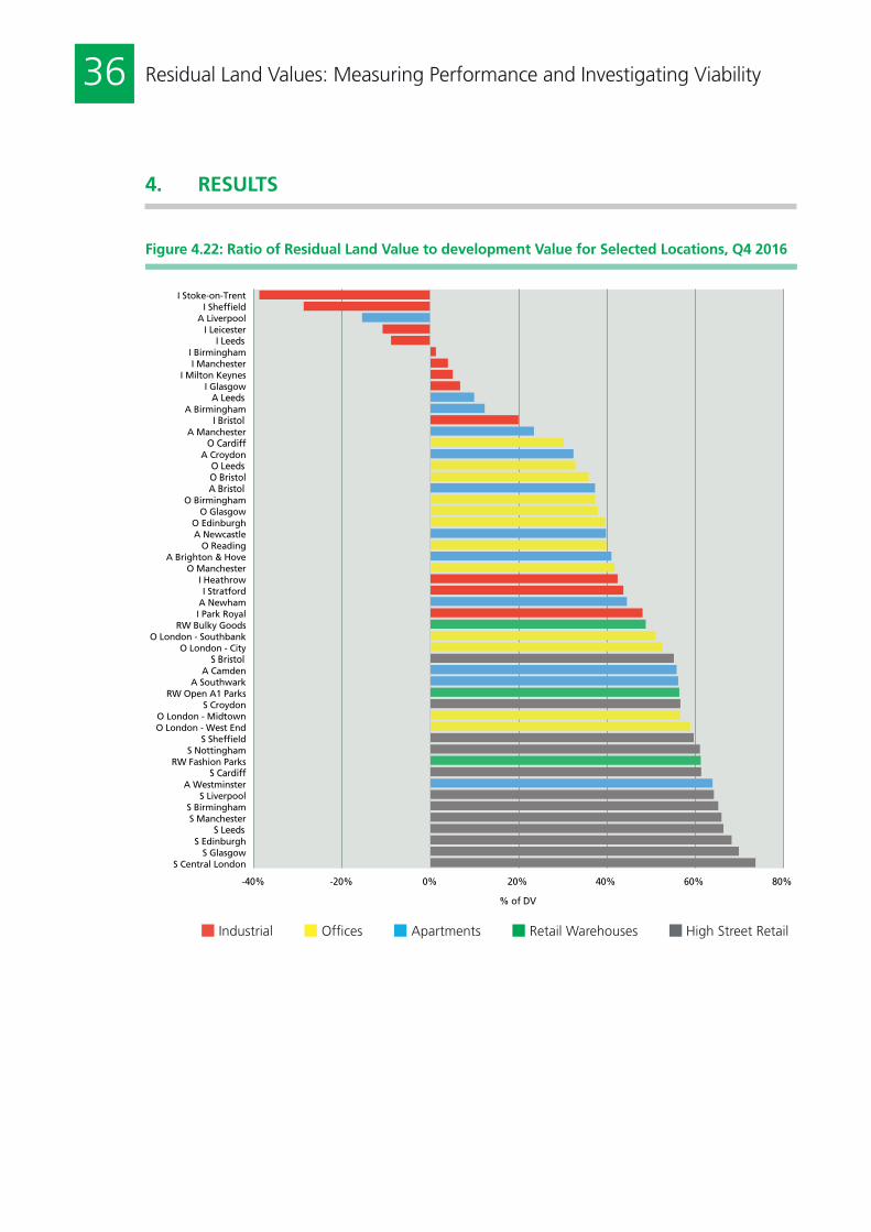
36 Residual Land Values: Measuring Performance and Investigating Viability
Figure 4.22: Ratio of Residual Land Value to development Value for Selected Locations, Q4 2016
-40% -20% 0% 20% 40% 60% 80%
% of DV
S Central London S Glasgow
S Edinburgh S Leeds
S Manchester S Birmingham
S Liverpool A Westminster
S Cardiff RW Fashion Parks
S Nottingham S Sheffield
O London - West End O London - Midtown
S Croydon RW Open A1 Parks
A Southwark A Camden
S Bristol O London - City
O London - Southbank RW Bulky Goods
I Park Royal A Newham I Stratford
I Heathrow O Manchester
A Brighton & Hove O Reading
A Newcastle O Edinburgh
O Glasgow O Birmingham
A Bristol O Bristol O Leeds
A Croydon O Cardiff
A Manchester I Bristol
A Birmingham A Leeds
I Glasgow I Milton Keynes
I Manchester I Birmingham
I Leeds I Leicester
A Liverpool I Sheffield
I Stoke-on-Trent
N Industrial N Offices N Apartments N Retail Warehouses N High Street Retail
4. RESULTS

37Residual Land Values: Measuring Performance and Investigating Viability
Figure 4.23: Ratio of Residual Land Value to Development Value for Regions, Q4 2016
-40% -20% 0% 20% 40% 60% 80% % of DV
S London S Scotland RW Wales
RW Scotland S North East
S Yorks/Humber S North West
RW North East RW West Midlands
S South East S West Midlands
S South West RW South West
RW London RW North West
S East of England RW Yorks/Humber
RW South East O London
RW East of England S East Midlands
S Wales A London
RW East Midlands I London
A East of England A South East
O North West A South West
O Scotland O South East
O East of England O West Midlands O Yorks/Humber
A North West O Wales
A Yorks/Humber I South East
A West Midlands A East Midlands
I East of England O South West A North East I South West O North East
I Scotland I North West
O East Midlands I East Midlands
I West Midlands I Yorks/Humber
I North East I Wales
N Industrial N Offices N Apartments N Retail Warehouses N High Street Retail
4. RESULTS

38 Residual Land Values: Measuring Performance and Investigating Viability
The research into land value measurement has uncovered just how few systematic land price measures
exist in the UK. Where they do exist, they are concentrated upon agricultural and residential land uses. In
commercial land markets, there is virtually nothing.
This is in contrast with the built environment, where the collection and analysis of data sets has a long history
stretching back into the 1960s. In commercial real estate markets, CBRE rent and yield data is a case in point,
with continuous measurement across the UK from 1972. MSCI and others have been measuring benchmark
returns for investment property since the 1980s, with the IPD long term index extending back to 1971 and
the main UK index starting from 1981.
The production of price indexes in residential and commercial real estate markets is a well-researched area,
and the difficulties of producing transaction-based indexes that can give granular disaggregation within
markets is well documented. This is why both CBRE and MSCI commercial real estate indexes are valuation-
based rather than transaction-based indexes. Valuation-based indices are grounded in direct comparison
valuation techniques using rental value and yields to generate market values. Land valuation is more complex
and these direct valuation approaches have proved incapable of valuing all but the most basic of sites, and
only where transaction evidence exists. In the absence of homogeneous sites and a depth of transaction
evidence, development valuation relies on the residual method, as endorsed by professional guidance.
For the purposes of developing a commercial land value series, we have adopted the residual method in its
conventional form. This has been verified within the industry steering group as being in frequent use within
practice and confirms earlier research by the authors on valuation methods in practice (Coleman et al., 2012).
Having selected the valuation method, the next stage involved selecting appropriate data inputs for the
revenue and cost estimates. The agreement with CBRE to use their individual rent and yield points enabled the
research to estimate development values for commercial land uses in different locations using a simple rent/
yield model. Residential apartment prices were sourced from data published by Office for National Statistics
but are limited to England only. Construction costs are based on the Building Cost Information Service.
The cost (and indeed value impact) of planning obligations is not included in the residual model. For
residential in particular, this is a highly politicised area and, at the time of writing, changes to the English
planning regime concerning planning obligations are imminent. The model, therefore, estimates hypothetical
land values excluding the impact of planning obligations. Also, the model does not reflect any option value
that the land may have. Given both the simplicity of the model and its limitations, including the possibility
that some revenue and cost items are not accounted for, the resulting residual land values are not claimed to
mimic prices accurately. We have compared the residual land values against available benchmarks to identify
these issues and to stimulate discussion as to how the model could be improved.
The main objective for this research was to produce a series of regional and location-specific land values,
examine the results and identify the major drivers. The results are set out in Section 4 and Appendix 3. The
results were disaggregated into five primary land uses; apartments, offices, high street retail, industrials and
retail warehouses. Retail warehouse rent and yield data were subject to a structural break in 2007 and so
could not be assessed with the same degree of confidence as the other land uses.
5. DISCUSSION AND CONCLUSIONS

39Residual Land Values: Measuring Performance and Investigating Viability
There are some common features within the results. First, they are mainly driven by development values.
One reason for this is the lack of volatility in construction costs. The BCIS cost series is remarkably stable
over time compared to development values. This raises questions concerning the determination of the
construction cost series, and the academic and professional literature is light in this area. There are few
critiques of the data collection, collation or index construction issues within either BCIS or any other source
of building cost information. It is also one area where the small survey of practice carried out to verify our
approach did not provide much support. Most respondents use cost consultants rather than indices and cost
information services. This is an area for further research.
Second, there is a major North/South divide and, in some parts of the country for some uses, development is
not viable without intervention. Industrial in the Midlands and North is a prime example, but negative values
occur in some locations for apartments at the beginning and end of the analysis period. Even where there
are positive residual values, the other property types exhibit significantly lower values in the Northern regions.
Only in London and its very near environs did every location exhibit positive residual land values in industrial.
This finding contrasts with the Government’s estimates, which are all positive regardless of region (CLG,
2015a; 2015b).
Third, and not surprisingly given the impact of development value on residual land value, the property market
downturn in 2007 and 2008 caused a major correction in residual land values. This downturn was matched
in offices by the Savills benchmark, but this series suggested that the recovery was slower than that recorded
by the residual values. At other points in the property market cycle, the ratio of land value to development
value was relatively stable. Exceptions include high street retail where the variability between locations
appears to widen significantly towards the end of the period. As indicated earlier, this variability was most
obvious in industrials but lasted throughout the analysis period. Apartments were quite similar between
locations in the middle of the period but diverged at both the beginning and the end. The benchmarking
exercise that compared the Savills Central London Residential Land Value Index with the apartment residual
land values for Inner London raise some questions for both series. There were quite significant discrepancies
and, even if some of them could relate to the base year, there is no doubt that the different value series
behave differently at different stages in the value cycle. This was especially apparent during the financial
crisis period but also in the last few years. It has been acknowledged that the residual land value series does
not take account of planning obligations and optionality but there issues with comparative valuation-based
indices discussed above that may impact on the timing and extent of value change within the Savills index,
which might also explain some of these discrepancies.
The final objective of this research was to identify the scope for regular publication of land value data on a
periodic basis. The data has been produced in quarters and so any publication could use that as the period.
The real question is whether these outputs represent figures that are useful, given the limitation of valuation-
based value series in general, and the valuation of development land in particular. Valuation-based indices
are well established but there are acknowledged problems with valuations of development land that are not
replicated in the valuation of real estate standing investments.
5. DISCUSSION AND CONCLUSIONS

40 Residual Land Values: Measuring Performance and Investigating Viability
5. DISCUSSION AND CONCLUSIONS
The research makes it clear that the residual land values are not market prices but they do give an indication
of value before planning obligations and option value. They also give some indication of value change
through time and across space. The residual land values should enable users to identify which land uses
have commanded most value at particular points, which will have shaped decisions about what and when
to build, and what to pay. Such information can increase the transparency of land markets and of policy
making surrounding land value capture. As such, the results should be of interest to real estate developers,
investors that engage in or fund development, development consultants and policy makers in local or national
government who are interested in viability and its determinants.
The next step is for the industry to use this report as the framework for a debate into whether land value
residuals would be a useful addition to existing property market data sources. Would it, despite the
limitations, improve transparency in a market that appears to have very little information at present? If so,
the next stage is to refine the model, if that is deemed necessary, identify any additional or alternative data
sources, and determine the nature and format of any periodic publication.

41Residual Land Values: Measuring Performance and Investigating Viability
APPENDIX 1: AVERAGE LAND PRICES PER ACRE BASED ON COSTAR DATA
The following table is compiled by the authors using data supplied by CoStar. The number of transactions
that support each land price figure is shown in brackets. While this report produces land value estimates
for both regions and cities, there were too few deals in the CoStar dataset to enable comparable city-level
estimates to be attempted. To create each average land price per acre that is shown below, the authors have
removed extreme outliers, but significant variations remain both across regions and from period-to-period
within different regions.
2011 2012 2013 2014 2015 2016
East of England 512,484(16)
338,924(11)
996,576(15)
1,344,316(23)
2,370,140(21)
1,304,741(21)
East Midlands 462,517(26)
267,217(18)
559,774(23)
246,329(24)
430,963(33)
431,059(36)
London 7,335,144(8)
8,402,361(13)
9,830,028(17)
15,851,921(14)
6,884,927(27)
9,935,378(13)
North East 522,488(16)
598,726(8)
382,782(9)
744,117(11)
651,098(17)
756,511(14)
North West 912,223(39)
638,533(24)
297,931(61)
309,888(57)
433,752(58)
1,261,392(44)
South East 470,231(20)
4,087,100(21)
767,500(18)
1,363,595(32)
1,665,329(23)
2,013,769(37)
South West 857,560(20)
339,096(13)
1,351,236(14)
401,011(26)
773,020(21)
928,726(19)
West Midlands 616,446(18)
752,383(33)
305,659(42)
573,254(43)
502,940(45)
2,228,160(50)
Yorkshire & Humber
522,934(15)
561,509(17)
631,789(21)
464,531(26)
301,091(30)
685,296(21)
Scotland 494,357(76)
644,004(69)
432,039(120)
324,368(99)
385,824(141)
448,152(81)
Wales 202,740(4)
271,504(8)
420,846(6)
302,822(11)
202,364(9)
160,163(10)

42 Residual Land Values: Measuring Performance and Investigating Viability
APPENDIX 2: DETAILED ASSUMPTIONS FOR RESIDUAL VALUATION MODEL BY LAND USE TYPE
See Sections 3.1 and 3.2 for illustration of the residual valuation model and further discussion of the data sources
and inputs
Apartment Industrial Office Retail Warehouse
Shop
Rents n/a CBRE CBRE CBRE CBRE
Yields n/a CBRE CBRE CBRE CBRE
Stamp duty rates n/a Rises from 2%-5%
Rises from 2%-5%
Rises from 2%-5%
Rises from 2%-5%
Other purchase costs n/a 1.75% 1.75% 1.75% 1.75%
Purchase costs n/a Rises from 3.75%-6.75%
Rises from 3.75%-6.75%
Rises from 3.75%-6.75%
Rises from 3.75%-6.75%
Sale costs 2.0% 2.0% 2.0% 2.0% 2.0%
Building costs BCIS BCIS BCIS BCIS BCIS
Site etc. costs 15% 10% 10% 10% 10%
Professional fees 12.5% 12.5% 12.5% 12.5% 12.5%
Finance - base 3 month IBLR 3 month IBLR 3 month IBLR 3 month IBLR 3 month IBLR
Finance - margin De Montfort Residential
De Montfort Pre-let
De Montfort Pre-let
De Montfort Pre-let
De Montfort Pre-let
Build period 2.0 years 1.0 years 1.5 years 1.0 years 1.0 years
Efficiency ratio 100% 90% 100% 80%
Developer profit 17.5%-20% DV
15%-17.5% DV
15%-17.5% DV
15%-17.5% DV
15%-17.5% DV
Land purchase costs* From 2.5% to 5.75%
Rises from 3.75%-6.75%
Rises from 3.75%-6.75%
Rises from 3.75%-6.75%
Rises from 3.75%-6.75%
Other Flat size of 60m2
n/a n/a n/a 25ft frontage, 80ft depth
*
Not incorporated where values are negative.

43Residual Land Values: Measuring Performance and Investigating Viability
APPENDIX 3: REGIONAL RESULTS
Figure A3.1: Residual Land Values for Apartments – Regions ex. London
-400
-200
0
200
400
600
800
1,000
1,200
1,400
1,600
Q4
1995
Q
2 19
96
Q4
1996
Q
2 19
97
Q4
1997
Q
2 19
98
Q4
1998
Q
2 19
99
Q4
1999
Q
2 20
00
Q4
2000
Q
2 20
01
Q4
2001
Q
2 20
02
Q4
2002
Q
2 20
03
Q4
2003
Q
2 20
04
Q4
2004
Q
2 20
05
Q4
2005
Q
2 20
06
Q4
2006
Q
2 20
07
Q4
2007
Q
2 20
08
Q4
2008
Q
2 20
09
Q4
2009
Q
2 20
10
Q4
2010
Q
2 20
11
Q4
2011
Q
2 20
12
Q4
2012
Q
2 20
13
Q4
2013
Q
2 20
14
Q4
2014
Q
2 20
15
Q4
2015
Q
2 20
16
Q4
2016
RLV
£/m
2
East Midlands East of England North East North West South East South West West Midlands Yorks/Humber
Figure A3.2: Ratio of Residual Land Value to Development Value for Apartments – Regions
-40%
-30%
-20%
-10%
0%
10%
20%
30%
40%
50%
60%
Q4
1995
Q
2 19
96
Q4
1996
Q
2 19
97
Q4
1997
Q
2 19
98
Q4
1998
Q
2 19
99
Q4
1999
Q
2 20
00
Q4
2000
Q
2 20
01
Q4
2001
Q
2 20
02
Q4
2002
Q
2 20
03
Q4
2003
Q
2 20
04
Q4
2004
Q
2 20
05
Q4
2005
Q
2 20
06
Q4
2006
Q
2 20
07
Q4
2007
Q
2 20
08
Q4
2008
Q
2 20
09
Q4
2009
Q
2 20
10
Q4
2010
Q
2 20
11
Q4
2011
Q
2 20
12
Q4
2012
Q
2 20
13
Q4
2013
Q
2 20
14
Q4
2014
Q
2 20
15
Q4
2015
Q
2 20
16
Q4
2016
% o
f D
V
East Midlands East of England London North East North West South East South West West Midlands Yorks/Humber
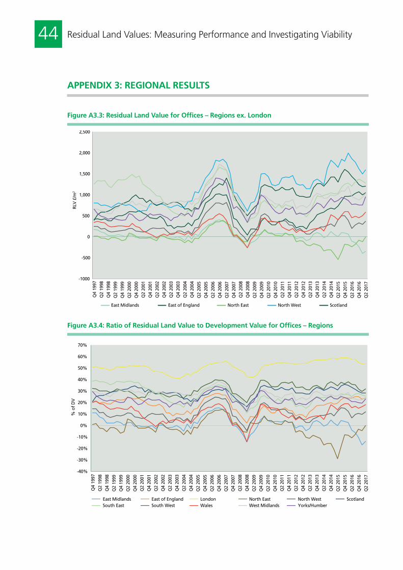
44 Residual Land Values: Measuring Performance and Investigating Viability
APPENDIX 3: REGIONAL RESULTS
Figure A3.3: Residual Land Value for Offices – Regions ex. London
-1000
-500
0
500
1,000
1,500
2,000
2,500
Q4
1997
Q2
1998
Q4
1998
Q2
1999
Q4
1999
Q2
2000
Q4
2000
Q2
2001
Q4
2001
Q2
2002
Q4
2002
Q2
2003
Q4
2003
Q2
2004
Q4
2004
Q2
2005
Q4
2005
Q2
2006
Q4
2006
Q2
2007
Q4
2007
Q2
2008
Q4
2008
Q2
2009
Q4
2009
Q2
2010
Q4
2010
Q2
2011
Q4
2011
Q2
2012
Q4
2012
Q2
2013
Q4
2013
Q2
2014
Q4
2014
Q2
2015
Q4
2015
Q2
2016
Q4
2016
Q2
2017
RLV
£/m
2
East Midlands East of England North East North West Scotland
Figure A3.4: Ratio of Residual Land Value to Development Value for Offices – Regions
-40%
-30%
-20%
-10%
0%
10%
20%
30%
40%
50%
60%
70%
Q4
1997
Q2
1998
Q4
1998
Q2
1999
Q4
1999
Q2
2000
Q4
2000
Q2
2001
Q4
2001
Q2
2002
Q4
2002
Q2
2003
Q4
2003
Q2
2004
Q4
2004
Q2
2005
Q4
2005
Q2
2006
Q4
2006
Q2
2007
Q4
2007
Q2
2008
Q4
2008
Q2
2009
Q4
2009
Q2
2010
Q4
2010
Q2
2011
Q4
2011
Q2
2012
Q4
2012
Q2
2013
Q4
2013
Q2
2014
Q4
2014
Q2
2015
Q4
2015
Q2
2016
Q4
2016
Q2
2017
% o
f D
V
East Midlands East of England London North East North West Scotland South East South West Wales West Midlands Yorks/Humber

45Residual Land Values: Measuring Performance and Investigating Viability
APPENDIX 3: REGIONAL RESULTS
Figure A3.5: Residual Land Value for High Street Retail – Regions ex. London
0
2,000
4,000
6,000
8,000
10,000
12,000
14,000
Q4
1997
Q2
1998
Q4
1998
Q2
1999
Q4
1999
Q2
2000
Q4
2000
Q2
2001
Q4
2001
Q2
2002
Q4
2002
Q2
2003
Q4
2003
Q2
2004
Q4
2004
Q2
2005
Q4
2005
Q2
2006
Q4
2006
Q2
2007
Q4
2007
Q2
2008
Q4
2008
Q2
2009
Q4
2009
Q2
2010
Q4
2010
Q2
2011
Q4
2011
Q2
2012
Q4
2012
Q2
2013
Q4
2013
Q2
2014
Q4
2014
Q2
2015
Q4
2015
Q2
2016
Q4
2016
Q2
2017
RLV
£/m
2
East Midlands East of England North East North West Scotland South East South West Wales West Midlands Yorks/Humber
Figure A3.6: Ratio of Residual Land Value to Development Value for High Street Retail – Regions
50%
55%
60%
65%
70%
75%
80%
Q4
1997
Q2
1998
Q4
1998
Q2
1999
Q4
1999
Q2
2000
Q4
2000
Q2
2001
Q4
2001
Q2
2002
Q4
2002
Q2
2003
Q4
2003
Q2
2004
Q4
2004
Q2
2005
Q4
2005
Q2
2006
Q4
2006
Q2
2007
Q4
2007
Q2
2008
Q4
2008
Q2
2009
Q4
2009
Q2
2010
Q4
2010
Q2
2011
Q4
2011
Q2
2012
Q4
2012
Q2
2013
Q4
2013
Q2
2014
Q4
2014
Q2
2015
Q4
2015
Q2
2016
Q4
2016
Q2
2017
% o
f D
V
East Midlands East of England London North East North West Scotland South East South West Wales West Midlands Yorks/Humber

46 Residual Land Values: Measuring Performance and Investigating Viability
APPENDIX 3: REGIONAL RESULTS
Figure A3.7: Residual Land Value for Industrials – Regions ex. London
-400
-300
-200
-100
0
100
200
300
400
500
600
Q4
1997
Q2
1998
Q4
1998
Q2
1999
Q4
1999
Q2
2000
Q4
2000
Q2
2001
Q4
2001
Q2
2002
Q4
2002
Q2
2003
Q4
2003
Q2
2004
Q4
2004
Q2
2005
Q4
2005
Q2
2006
Q4
2006
Q2
2007
Q4
2007
Q2
2008
Q4
2008
Q2
2009
Q4
2009
Q2
2010
Q4
2010
Q2
2011
Q4
2011
Q2
2012
Q4
2012
Q2
2013
Q4
2013
Q2
2014
Q4
2014
Q2
2015
Q4
2015
Q2
2016
Q4
2016
Q2
2017
RLV
£/m
2
East Midlands East of England North East North West Scotland South East South West Wales West Midlands Yorks/Humber
Figure A3.8: Ratio of Land Value to Development Value for Industrials – Regions
-80%
-60%
-40%
-20%
0%
20%
40%
60%
Q4
1997
Q2
1998
Q4
1998
Q2
1999
Q4
1999
Q2
2000
Q4
2000
Q2
2001
Q4
2001
Q2
2002
Q4
2002
Q2
2003
Q4
2003
Q2
2004
Q4
2004
Q2
2005
Q4
2005
Q2
2006
Q4
2006
Q2
2007
Q4
2007
Q2
2008
Q4
2008
Q2
2009
Q4
2009
Q2
2010
Q4
2010
Q2
2011
Q4
2011
Q2
2012
Q4
2012
Q2
2013
Q4
2013
Q2
2014
Q4
2014
Q2
2015
Q4
2015
Q2
2016
Q4
2016
Q2
2017
% o
f D
V
East Midlands East of England London North East North West Scotland South East South West Wales West Midlands Yorks/Humber

47Residual Land Values: Measuring Performance and Investigating Viability
APPENDIX 3: REGIONAL RESULTS
Figure A3.9: Residual Land Value for Retail Warehouses – Regions ex. London
0
1,000
2,000
3,000
4,000
5,000
6,000
7,000
Q2
2007
Q
3 20
07
Q4
2007
Q
1 20
08
Q2
2008
Q
3 20
08
Q4
2008
Q
1 20
09
Q2
2009
Q
3 20
09
Q4
2009
Q
1 20
10
Q2
2010
Q
3 20
10
Q4
2010
Q
1 20
11
Q2
2011
Q
3 20
11
Q4
2011
Q
1 20
12
Q2
2012
Q
3 20
12
Q4
2012
Q
1 20
13
Q2
2013
Q
3 20
13
Q4
2013
Q
1 20
14
Q2
2014
Q
3 20
14
Q4
2014
Q
1 20
15
Q2
2015
Q
3 20
15
Q4
2015
Q
1 20
16
Q2
2016
Q
3 20
16
Q4
2016
Q
1 20
17
Q2
2017
£/m
2
East Midlands East of England London North East North West Scotland South East South West Wales West Midlands Yorks/Humber
Figure A3.10: Ratio of Residual Land Value to Development Value for Retail Warehouses – Regions
45%
50%
55%
60%
65%
70%
Q2
2007
Q
3 20
07
Q4
2007
Q
1 20
08
Q2
2008
Q
3 20
08
Q4
2008
Q
1 20
09
Q2
2009
Q
3 20
09
Q4
2009
Q
1 20
10
Q2
2010
Q
3 20
10
Q4
2010
Q
1 20
11
Q2
2011
Q
3 20
11
Q4
2011
Q
1 20
12
Q2
2012
Q
3 20
12
Q4
2012
Q
1 20
13
Q2
2013
Q
3 20
13
Q4
2013
Q
1 20
14
Q2
2014
Q
3 20
14
Q4
2014
Q
1 20
15
Q2
2015
Q
3 20
15
Q4
2015
Q
1 20
16
Q2
2016
Q
3 20
16
Q4
2016
Q
1 20
17
Q2
2017
% o
f D
V
East Midlands East of England London North East North West Scotland South East South West Wales West Midlands Yorks/Humber

48 Residual Land Values: Measuring Performance and Investigating Viability
APPENDIX 4: CLG REGIONAL INDUSTRIAL LAND VALUE ESTIMATES
Region VOA Estimates per hectare
Price PSM assuming 45% cover
Author Residual Land Values
East of England 675,000 150 -118
East Midlands 450,000 100 101
London £2,733,000 607 780
North East 180,000 40 -298
North West 400,000 89 -134
South East 1,100,000 244 192
South West 430,000 96 -17
West Midlands 500,000 111 -55
Yorkshire and the Humber 375,000 83 -163
Source of VOA estimates: CLG (2015b)
49Residual Land Values: Measuring Performance and Investigating Viability
REFERENCES
CBRE (various) Rent and Yield Monitor. CBRE: London.
CBRE (2014), Rent Index and Average Yields: A Guide to the CBRE Rent and Yield Monitor. London:
CBRE.
CB Richard Ellis (2007), Rent Index and Average Yields: A Guide to the CB Richard Ellis Rent and Yield Monitor. London: CB Richard Ellis.
CB Hillier Parker (2000), Rent Index and Average Yields: A Guide to the CB Hillier Parker Rent and Yield Monitor. London: CB Hillier Parker.
CLG (2015) English Housing Survey 2014/2015. Communities and Local Government: London. Annex Table
3.4 https://www.gov.uk/government/statistics/english-housing-survey-2014-to-2015-housing-stock-report
CLG (2015a) Land Value Estimates for Policy Appraisal. Communities and Local Government: London,
February 2015
CLG (2015b) Land Value Estimates for Policy Appraisal. Communities and Local Government: London,
December 2015
Coleman, C., Crosby, N., McAllister, P. and Wyatt, P. (2012) Development appraisal in practice: some evidence
from the planning system. Journal of Property Research, 30 (2): 144-165. https://doi.org/10.1080/09599916.
2012.750620
Davis, M. A. and Heathcote, J. (2007). “The price and quantity of residential land in the United States”. Journal of Monetary Economics, 54: 2595-2620.
Davis, M. A. and Palumbo, M. G. (2008). “The price of residential land in large US cities”. Journal of Urban Economics, 63: 352-384.
Demographia (2017) World Urban Areas. 13th edition. Demographia: Belleville, USA.
Javedicius, A., Huston, S., Baum, A. and Butler, A. (2017) Two centuries of farmland prices in England, Journal of Property Research, https://doi.org/10.1080/09599916.2017.1393450
Knight Frank (various) Residential Development Land Index. Knight Frank Residential Research: London.
Lux, N. (various) The UK Commercial Property Lending Report. De Montfort University: Leicester.
Maxted and Porter (various) The UK Commercial Property Lending Report. De Montfort University: Leicester
Nichols, J. B., Oliner, S. D. and Mulhall, M. R. (2013). “Swings in commercial and residential land prices in the
United States”. Journal of Urban Economics, 73: 57-76.
ONS (2011) 2011 UK Census – Built-up Areas. Office for National Statistics: London
RICS (2008) The Valuation of Development Land, Valuation Information Paper 12 RICS: London
RICS/RAU (various) Rural Land Market Survey. RICS/Royal Agricultural University. https://www.rics.org/Global/
RICS_RAU_Rural_Land_Market_Survey_H1_2017_Summary.pdf
Savills (2015) Development Land Statistical Supplement Q3 2015. Savills Research: London
Savills (2017a) Development Land Statistical Supplement Extract Q1 2017. Savills Research: London
Savills (2017b) UK Residential Development Land Market In Minutes – October 2017. Savills Research:
London
Savills (various) Market Survey UK Agricultural Land. Savills: London

Investment Property ForumNew Broad Street House35 New Broad StreetLondon EC2M 1NH
Telephone: 020 7194 7920 Fax: 020 7194 7921Email: [email protected]: www.ipf.org.uk
ResearchProgramme
Printed on recycled paper
Related Documents