RESEARCH DESIGN SLAVE CEMETERY (44FX116) Joseph A. Downer Mount Vernon Ladies’ Association Mount Vernon, VA 22121 October 2014 Archaeology Division Department of Historic Preservation and Collections George Washington’s Mount Vernon

Research design slave cemetery
Jul 25, 2015
Welcome message from author
This document is posted to help you gain knowledge. Please leave a comment to let me know what you think about it! Share it to your friends and learn new things together.
Transcript

RESEARCH DESIGN SLAVE CEMETERY
(44FX116)
Joseph A. Downer
Mount Vernon Ladies’ Association Mount Vernon, VA 22121
October 2014
Archaeology Division Department of Historic Preservation and Collections
George Washington’s Mount Vernon

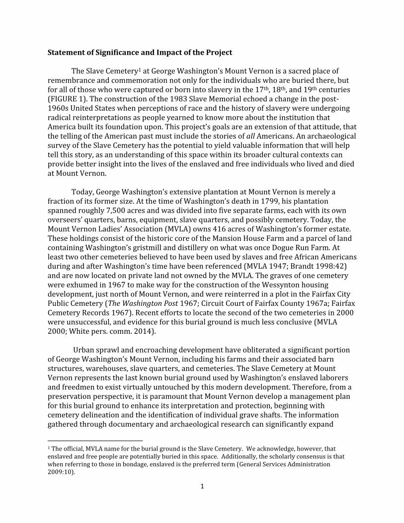
Figure 1. Slave cemetery archaeological area, 44FX116. (Map by Joe Downer, 2014.)
1
Statement of Significance and Impact of the Project The Slave Cemetery1 at George Washington’s Mount Vernon is a sacred place of remembrance and commemoration not only for the individuals who are buried there, but for all of those who were captured or born into slavery in the 17th, 18th, and 19th centuries (FIGURE 1). The construction of the 1983 Slave Memorial echoed a change in the post-1960s United States when perceptions of race and the history of slavery were undergoing radical reinterpretations as people yearned to know more about the institution that America built its foundation upon. This project’s goals are an extension of that attitude, that the telling of the American past must include the stories of all Americans. An archaeological survey of the Slave Cemetery has the potential to yield valuable information that will help tell this story, as an understanding of this space within its broader cultural contexts can provide better insight into the lives of the enslaved and free individuals who lived and died at Mount Vernon. Today, George Washington’s extensive plantation at Mount Vernon is merely a fraction of its former size. At the time of Washington’s death in 1799, his plantation spanned roughly 7,500 acres and was divided into five separate farms, each with its own overseers’ quarters, barns, equipment, slave quarters, and possibly cemetery. Today, the Mount Vernon Ladies’ Association (MVLA) owns 416 acres of Washington’s former estate. These holdings consist of the historic core of the Mansion House Farm and a parcel of land containing Washington’s gristmill and distillery on what was once Dogue Run Farm. At least two other cemeteries believed to have been used by slaves and free African Americans during and after Washington’s time have been referenced (MVLA 1947; Brandt 1998:42) and are now located on private land not owned by the MVLA. The graves of one cemetery were exhumed in 1967 to make way for the construction of the Wessynton housing development, just north of Mount Vernon, and were reinterred in a plot in the Fairfax City Public Cemetery (The Washington Post 1967; Circuit Court of Fairfax County 1967a; Fairfax Cemetery Records 1967). Recent efforts to locate the second of the two cemeteries in 2000 were unsuccessful, and evidence for this burial ground is much less conclusive (MVLA 2000; White pers. comm. 2014). Urban sprawl and encroaching development have obliterated a significant portion of George Washington’s Mount Vernon, including his farms and their associated barn structures, warehouses, slave quarters, and cemeteries. The Slave Cemetery at Mount Vernon represents the last known burial ground used by Washington’s enslaved laborers and freedmen to exist virtually untouched by this modern development. Therefore, from a preservation perspective, it is paramount that Mount Vernon develop a management plan for this burial ground to enhance its interpretation and protection, beginning with cemetery delineation and the identification of individual grave shafts. The information gathered through documentary and archaeological research can significantly expand
1 The official, MVLA name for the burial ground is the Slave Cemetery. We acknowledge, however, that enslaved and free people are potentially buried in this space. Additionally, the scholarly consensus is that when referring to those in bondage, enslaved is the preferred term (General Services Administration 2009:10).

2
Mount Vernon’s educational programming about the life-ways and death rituals of enslaved African Americans on the estate, information potentially destroyed in other parts of Washington’s plantation landscape. These new resources can be used to produce powerful new interpretive materials that have the potential to reach the over one million visitors Mount Vernon receives each year, as well as a global audience online. An accurate map of grave shaft locations will also aid in the protection of the site from any maintenance or landscape development that needs to take place in the future. With this knowledge in hand, the MVLA will have the resources necessary to ensure that those buried on this ridge are honored and protected for generations to come. Introduction Mount Vernon Slave Cemetery The Slave Cemetery archaeological site (44FX116) is located approximately 50 yards southwest of Washington’s new tomb on a ridge overlooking the Potomac River (APPENDIX A). The site was purchased from John Augustine Washington in 1860 by the MVLA along with the historic core of Mount Vernon, and has remained under their ownership ever since. Though four previous archaeological excavations have occurred in the cemetery, all of these were conducted to mitigate modern impacts to the site, making sure that maintenance and grounds work would not interfere with existing burials. As a result of this work, eight possible grave shafts have been discovered, however only two have been fully exposed and recorded. A combination of oral and historical accounts with geophysical survey and the results of previous archaeological investigations suggests that a large portion of graves remain undiscovered within the cemetery.
Documentary evidence pertaining to the cemetery is scarce. The inscription on the 1929 memorial indicates that the Slave Cemetery was likely to have been in use circa 1760 through circa 1860, however no evidence has been found listing the beginning and end dates of the burial ground (MVLA 1929:46). West Ford (c. 1785-1863), a longtime servant of the Washington family who was freed in 1829 and continued to work for the MVLA after they assumed control of the estate in 1860, is believed to have been the last individual to be buried in the cemetery (Mary Thompson 2014, elec. comm.). It is also believed that William “Billy” Lee, Washington’s manservant throughout the Revolutionary War, was interred on the site following his death in c. 1828 (Mary Thompson 2014, elec. comm.; Western Literary Messenger 1846). It is likely that burials at Mount Vernon’s Slave Cemetery ceased following the end of the Civil War. This is because many communities of formerly enslaved African Americans established their own churches, with burial grounds, after emancipation. Burials soon became associated with those cemeteries rather than longtime plantation slave burial grounds (Scott Casper 2014, elec. comm.). Several documents record the existence of the cemetery in the years preceding the Civil War, however by the turn of the 20th century, most surface evidence of individual burials appears to have disappeared. In 1928, the MVLA feared that all traces of the cemetery would soon be gone and a simple marker was placed on the site in 1929 to commemorate the unmarked graves of the individuals interred there (MVLA 1928:75; MVLA 1929:46). The memorial reads: “In Memory of the Many Faithful Colored Servants of
3
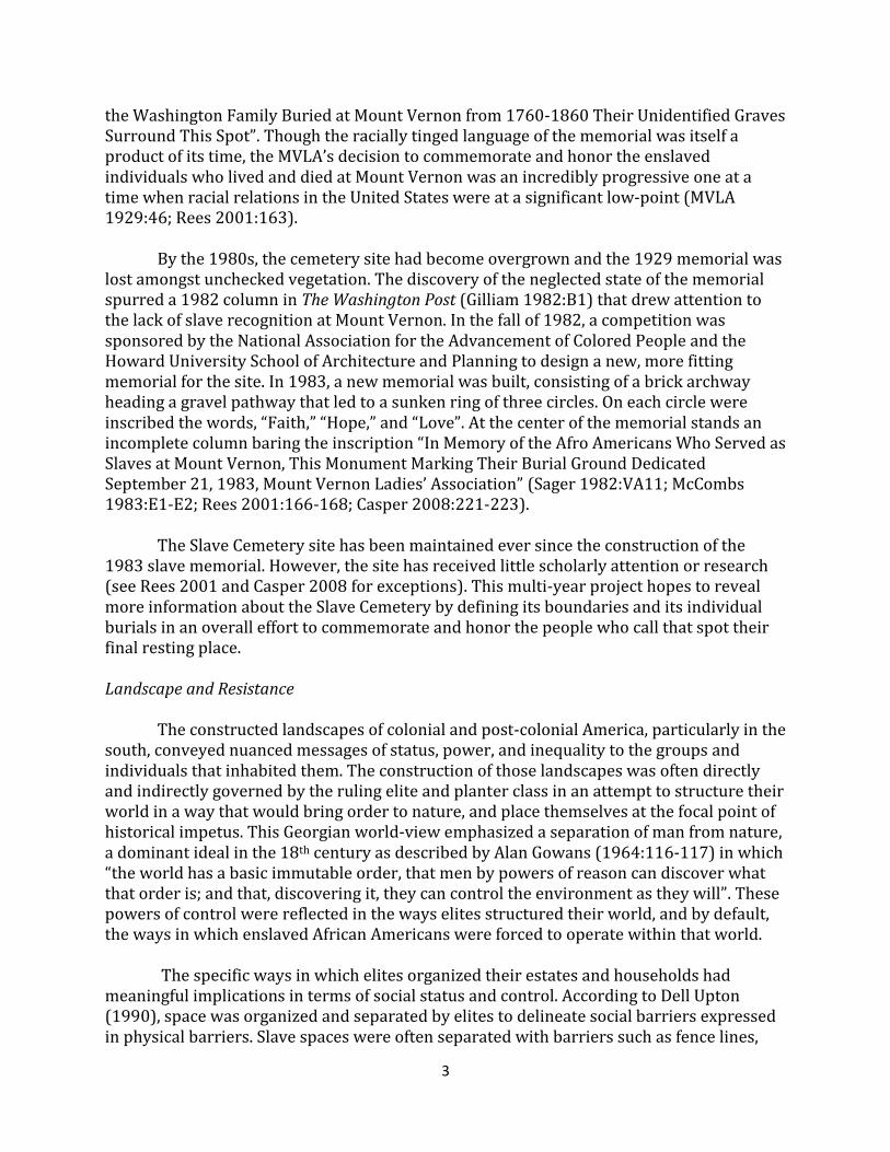
the Washington Family Buried at Mount Vernon from 1760-1860 Their Unidentified Graves Surround This Spot”. Though the racially tinged language of the memorial was itself a product of its time, the MVLA’s decision to commemorate and honor the enslaved individuals who lived and died at Mount Vernon was an incredibly progressive one at a time when racial relations in the United States were at a significant low-point (MVLA 1929:46; Rees 2001:163). By the 1980s, the cemetery site had become overgrown and the 1929 memorial was lost amongst unchecked vegetation. The discovery of the neglected state of the memorial spurred a 1982 column in The Washington Post (Gilliam 1982:B1) that drew attention to the lack of slave recognition at Mount Vernon. In the fall of 1982, a competition was sponsored by the National Association for the Advancement of Colored People and the Howard University School of Architecture and Planning to design a new, more fitting memorial for the site. In 1983, a new memorial was built, consisting of a brick archway heading a gravel pathway that led to a sunken ring of three circles. On each circle were inscribed the words, “Faith,” “Hope,” and “Love”. At the center of the memorial stands an incomplete column baring the inscription “In Memory of the Afro Americans Who Served as Slaves at Mount Vernon, This Monument Marking Their Burial Ground Dedicated September 21, 1983, Mount Vernon Ladies’ Association” (Sager 1982:VA11; McCombs 1983:E1-E2; Rees 2001:166-168; Casper 2008:221-223). The Slave Cemetery site has been maintained ever since the construction of the 1983 slave memorial. However, the site has received little scholarly attention or research (see Rees 2001 and Casper 2008 for exceptions). This multi-year project hopes to reveal more information about the Slave Cemetery by defining its boundaries and its individual burials in an overall effort to commemorate and honor the people who call that spot their final resting place. Landscape and Resistance
The constructed landscapes of colonial and post-colonial America, particularly in the south, conveyed nuanced messages of status, power, and inequality to the groups and individuals that inhabited them. The construction of those landscapes was often directly and indirectly governed by the ruling elite and planter class in an attempt to structure their world in a way that would bring order to nature, and place themselves at the focal point of historical impetus. This Georgian world-view emphasized a separation of man from nature, a dominant ideal in the 18th century as described by Alan Gowans (1964:116-117) in which “the world has a basic immutable order, that men by powers of reason can discover what that order is; and that, discovering it, they can control the environment as they will”. These powers of control were reflected in the ways elites structured their world, and by default, the ways in which enslaved African Americans were forced to operate within that world.
The specific ways in which elites organized their estates and households had
meaningful implications in terms of social status and control. According to Dell Upton (1990), space was organized and separated by elites to delineate social barriers expressed in physical barriers. Slave spaces were often separated with barriers such as fence lines,

4
walls, or gates, and were placed out of site of the entertaining spaces and living spaces of elites. In the mansion house, separate, unadorned entrances and stairwells were put in place to allow slaves to work but not be seen. These nuances had psychological implications pertaining to the social roles that slaves filled. They were not in a world defined by their own control, but rather in one defined in terms of domination by elites.
Despite strict limitations to the sovereignty of enslaved individuals, slaves found
numerous ways in which to create their own landscapes within the confines of the plantation. John Vlach (1993:13) notes that the spaces predominantly occupied by enslaved African Americans were “a domain that generally escaped much notice, mainly because [they were] marked in ways that planters either considered insignificant or could not recognize.” Though often under the careful observation and scrutiny of overseers and plantation owners, slaves were able to carve out secret places hidden in the landscape, often in secret paths and trails. These spaces facilitated a place for clandestine meetings and rituals, offering enslaved African Americans an opportunity to resist their status as slaves and reinforce their own distinct cultural practices (Vlach 1993:13; Isaac 1999:52-53; Ginsburg 2010).
Forms of both active resistance, such as physical violence or running away, and
passive resistance, such as setting a slow work pace or breaking equipment necessary to complete a task, abounded within the enslaved community. Perhaps most effective, however, were forms of cultural resistance to slavery. This form of resistance is exemplified in the persistence of cultural practices unique to the enslaved community in the face of forced assimilation by slave owners. Examples of this can be seen in slave practices such as yard sweeping, the digging of subfloor pits to store materials, or the importance of communal, outdoor spaces for social gatherings (Samford 2007; Fesler 2010). By studying these spaces and by “encountering artifact patterns, landscape features, building foundations, and other forms of archaeological evidence…archaeologists can begin to retrace how enslaved people experienced the landscape and how they negotiated, fashioned, and adapted to their setting” (Fesler 2010:30).
Slave funeral ceremonies often provided enslaved individuals with opportunities to
express forms of cultural resistance. The specific locations of plantation slave burial grounds was often chosen by the plantation owner on lands that were ill-suited for agricultural development (Rainville 2014:49). In spite of this, enslaved African Americans frequently “had control over funerary rituals, commemorative devices such as headstones and footstones, the interment style and the layout of individual burials within the cemetery” (Chapman et al. 2006:6). The degree to which these forms of slave autonomy existed varies from site to site. Slave owners who placed a greater emphasis on religious observance may have exerted more control over the spiritual lives of their slaves, resulting in cemetery arrangements and burial traditions more closely resembling European customs (Chapman et al. 2006; Rivanna Archaeological Services 2013:24). More sporadic and seemingly unorganized spatial distributions of graves may indicate higher levels of slave autonomy and suggests a form of cultural resistance.

5
Previous Research Death and Mortuary Practices Attitudes towards death and spirituality in the slave community were deeply rooted in existing tradition and folk beliefs. Following the arrival of African American slaves to North America, many West African traditions were transmitted and mixed with Anglo-Saxon, Celtic, and American traditions and beliefs through practice and song (Gorn 1984:551; King 2010:125). This amalgam of beliefs allowed enslaved African Americans an opportunity to practice distinct cultural traditions in the New World (Jamieson 1995:39). Though variety existed among the many West African traditions and religions that came to the New World, most shared a common belief in a spirit life after death, and ancestral worship (Rainville 2014; King 2010:126). A belief in the survival of the soul after death was the cornerstone of the burial practices and rituals of the enslaved community. It was believed that spirits could influence the world of the living in very direct ways, and many customs were put in place to appease and guide the spirit to the afterlife. Only after the proper ritual requirements were satisfied would the lingering spirit depart for spirit world (Rainville 2014:54). Rituals surrounding death would begin shortly after the deceased breathed his or her last breath. Though oftentimes delayed by the workday imposed upon them by overseers and plantation owners, enslaved African Americans began the burial process by preparing, or “settin’ up” with the body. This process often took place at nighttime once the workday was completed, and simultaneously served to protect the body from scavenging animals, as well as watch over the deceased and keep his or her spirit company as it departed its earthly vessel (Genovese 1976:198-199; Thomas 2008:113; Rainville 2014:54-55). This time would often be accompanied by prayer, song, and the consumption of food, and it allowed members of the enslaved community an opportunity to reinforce their distinct cultural and communal bonds (Thomas 2008:113; Rainville 2014:55). Throughout this process, the body would be cleaned and wrapped in cloth before being placed on a cooling board to stave decomposition. During the warmer months, rapid decomposition would necessitate a quick burial, which often took place the following evening (Thomas 2008:114; Rainville 2014:54-55). News of the death of a member of the enslaved community would travel quickly through a vast and complex communication network. Enslaved African Americans were often forced to live separate lives from their families on neighboring or distant plantations. News of a recent death would travel from plantation to plantation through slaves on foot or by boat, as well as through the use of drum signals (Thomas 2008:112; Rainville 2014:55). It sometimes took the enslaved community weeks to assemble for the funeral of a deceased member. A second funeral ceremony would often be held at the burial site after the sun set when others were able to attend from visiting plantations. This further provided the enslaved community a chance to strengthen familial and communal ties that extended beyond the property boundaries of a single plantation. Because of this, funerals were often “celebratory reunions among the living as well as remembrances of the dead” (Rainville 2014:55).

6
The funeral ceremony itself would often be held after dark. This practice can be traced to certain African mortuary rituals, where burial ceremonies were held at night, but was also likely a practical necessity, allowing friends and members from neighboring plantations to attend after the work day was completed (Journal of American Folklore 1894:318-319; Genovese 1976:197; Thomas 2008:114; Rainville 2014:57). The body of the deceased would have been carried to the burial ground in a torch-lit procession, with an officiant or minister leading the way (FIGURE 2). The remains would likely have been carried in a coffin constructed specifically for the deceased individual, though if materials were unavailable to build a coffin, a shroud would have been used (Rainville 2014:56). Following a sermon, the minister would lead the enslaved community in a series of spirituals or songs (FIGURE 3). Some have described scenes of African American burials as similar to those of a pageant: “A negro funeral without an uproar, without shouts and groans, without fainting women and shouting men, without pictures of triumphant death beds…was no funeral at all” (Hatcher 1908:38). As the body of the deceased was laid into the ground, those present would sometimes lay hands on the coffin or throw a handful of dirt atop the grave. A dance would be initiated in a circle around the grave site, guided by spirituals and drums (The Journal of American Folklore 1894:318; Thomas 2008:115; Rainville 2014:58, 61). These practices further allowed enslaved African Americans a way in which to remember and preserve distinct cultural traits unique to the enslaved community. After an individual had been buried, grave offerings and decorations were often placed atop the burial mound to adorn the grave site. Grave offerings and decorations took many different forms. The practice is linked to West and West Central African traditions and the items used have been explained as decorative objects that “cryptically honor the spirit in the earth, guide it to the other world, and prevent it from wandering or returning to haunt survivors” (Thompson 1983:132). Oftentimes the last object touched by the deceased individual before expiring was broken and placed on the grave. These objects were believed to hold remnants of the previous owner’s power and were broken to prevent the spirit of the dead from returning in search of the object (Rainville 2014:61; Vlach 1990:141; Thompson 1983:134). Ceramics, glassware, and utensils have all been used in this capacity as grave decorations, oftentimes being perforated or broken to prevent their use. The intentional breaking of objects is believed to symbolize the destruction of the body by death and can be linked to some North Angolan cultural practices (Genovese 1976:200-201). Some West African beliefs hold that spirits still experience hunger and thirst after death. Families and survivors would often provide food and water offerings during and after burials to satisfy the hunger of the deceased and prevent their return (Genovese 1976:198; King 2010:132). The color white also held spiritual significance in some West African traditions, symbolizing purity, the world of spirits, and the dead. White shells were often placed atop graves as they were considered symbols of immortality and water (King 2010:128; Sipe 2011). The use of shells and the representation of water echoes certain beliefs that the spirit world is located underwater, but can also be attributed to a metaphoric crossing over to the spirit world, or even be in reference to the ocean-crossing required to return to Africa (Vlach 1990:143; Rainville 2014:61). The organization of shells on particular grave
7
sites varies: some graves have been recorded as being outlined with shells, others have been completely covered, and others still have depicted designs (King 2010:128). The spatial layout of cemeteries and the cardinal orientation of individual graves may also speak to various beliefs about the afterlife. A variety of grave orientations has been reported from various cemetery sites, though the majority of burials in most cemeteries appear to be aligned east-west (Bon-Harper et al. 2003; Sipe 2011; RAS 2013; Rainville 2009, 2014). The east-west orientation of burials in some African American cemeteries may speak to West African traditions where burial alignments follow the rising and setting of the sun. However, Christian tradition also orients burials east-west in order to witness the coming of Christ on judgment day (King 2010:132). Another explanation for this burial pattern is that individuals were interred facing east towards Africa (Rainville 2014:64). This explanation would seem to be supported by the many instances in which death was perceived as the way in which one could return home to the African continent (Ball 1837:265; Parrinder 1970:107; Genovese 1976:198). Based on these similarities, it is difficult to determine if an east-west pattern of grave orientations in a particular cemetery are following West African tradition, Christian tradition, both traditions, or perhaps neither tradition. Another pattern of burial organization witnessed is group clusters. Burial grounds that exemplify seemingly haphazard organization may in fact be organized in groups based on familial ties, age, sex, or social status (Rainville 2009:69). Others suggest that the organization and layout of burials within these cemeteries may speak to the level of control exerted by owners over the burial practices of the enslaved community (Chapman et al. 2006). Cemeteries organized in straight rows, similar to those of European and Anglo American cemeteries, may indicate that plantation owners had a more pronounced role in the burial practices of the people he or she enslaved, making sure that burials were conducted in accordance with their own customs and beliefs. Conversely, African American plantation cemeteries that do not resemble this paradigm may indicate that the enslaved community on that plantation had more autonomy in the structuring and execution of their burial rituals. Headstones and footstones are another form of grave identification that can convey useful information to researchers about burials and grave sites. Many times in slave cemetery sites, rough, uninscribed fieldstones, or simple iron or stone sculptures were used to mark either the head, foot, or both ends of a burial. This has been seen in sites were archaeological surveys have been conducted such as Monticello’s Park cemetery (Bon-Harper et al. 2003), the University of Virginia’s servants’ cemetery (FIGURE 4) (RAS 2013), and the Montpelier slave cemetery (Chapman et al. 2006), as well as numerous other sites studied through surface survey (Rainville 2009, 2014; Vlach 1990). Very rarely are formal inscribed headstones used to denote the burials of slaves. This is likely a result of high illiteracy among the enslaved population. Even if an enslaved individual was literate and able to carve an epitaph on a fieldstone, it would mean exposing oneself as a slave who had the ability to read and write in a time and place where literacy among the enslaved community was a punishable offence (Rainville 2014:2). Despite the presence of some sort of permanent marker on a handful of grave sites, the majority of African American slave graves were either marked with non-permanent materials, such as wood, or were not marked at all, resulting in little to no surface evidence of the grave’s existence other than

8
possible ground depressions resulting from the deterioration of coffins and the settling of redeposited soils (Chapman et al. 2006). Historical Research: Mount Vernon Slave Cemetery Little exists in terms of historical documentation of Mount Vernon’s Slave Cemetery. Slave life, beyond the labor those individuals provided, was rarely considered worth recording by plantation owners and managers; the writings of Washington, his overseers, and the subsequent executors of the estate prove no different. Though Washington was meticulous in recording the work and progress of his estate, no list of slave deaths or slave burials at Mount Vernon appears to have ever been documented, or has ever been found. Likewise, the subsequent owners of the estate were even less rigorous in recording pertinent details to the estate’s operation, let alone the details of slave life and death. However, though it seems that slave burials at Mount Vernon were never explicitly recorded, it is possible to paint a very fragmentary picture of the cemetery and the deaths of slaves from a number of sources. Mount Vernon’s overseers and managers from the five farms were required to produce reports that would be compiled into a weekly summary by the plantation manager. These reports detailed the overall workings of the plantation, as well as served to log the work and activities performed by enslaved African Americans. In so doing, managers inadvertently recorded a number of deaths by documenting the work of carpenters on the plantation as they built coffins for the recently deceased. Throughout this project, the weekly reports of farm managers will be scrutinized to ensure all pertinent information is gleaned from the historical record. Though these brief accounts go no further in providing details of the subsequent burials of these individuals, they do show that some individuals were interred in coffins rather than shrouds and that coffins were being produced on site. Research done to date suggests that the early documented instance of a coffin being made for a slave (Jenny at Dogue Run Farm) was in December of 1790 (Whitting 1790). One instance each occurs in 1792 and 1794 (Whitting 1792; Pearce 1794). Five coffins were made in 1797 to bury children and adults (Anderson 1797). Some visitor accounts mention the cemetery itself in more detail. In an 1833 journal account, Caroline Moore, a visitor to Mount Vernon, noted seeing the burying place of Washington’s slaves (Lee 2006:139).
Our guide first took us to the tomb where the remains of General Washington are not interred. They were removed from the old tomb about 3 years since… Near his Tomb, you see the burying place of his slaves, containing 150 graves. We then walked to the Old tomb, which is situated on the Bank of the Potomac; it is in a very ruinous condition.
It is unclear if the 150 graves was an estimate based on brief observation or a more reliable, calculated number. However, this account shows that graves in the cemetery could be discerned from the surrounding landscape in 1833.

9
An 1846 visitor account provides a more intimate description of the cemetery. In this account, the unnamed visitor records:
Observing some servants busy in a little grove, in front of the new tomb, we went thither. They were enclosing with a paling a grave very neatly sodded, and some sweet briar was still clinging to its native turf upon it. It was the grave of a favorite servant, an aged colored woman, whose good and amiable character had won her respect and regard. ‘When did she die?’ we enquired. ‘She parted from us last Sunday,’ was the reply. There are many graves in the grove, and one of the servants pointed out that of Washington’s favorite servant, who was with him in his campaigns, fulfilling his simple duties faithfully and affectionately. The [soul] is not forgotten, though the tramp of passing years has leveled the little mount. Nor was the humble cemetery a mournful spot: the birds were singing unerringly in the trees, and the hand of Spring was moulding the wild flower, and training vines over the graves (Western Literary Messenger 1846:201). These brief paragraphs provide a fascinating insight into the cemetery space in
1846. First, a recently enclosed grave is described as being surrounded with paling, or a small fence. Additionally, the cemetery is depicted as a humble grove containing many graves, suggesting either that surface evidence of the purported 150 graves seen in 1833 had diminished in 13 years’ time, or perhaps Caroline Moore’s previous recollection was merely hyperbolic. This is supported by the condition of the grave of “Washington’s favorite servant” whose burial mound had been leveled with “the tramp of passing years”. The slaves who drew attention to this grave may have been referring to William “Billy” Lee, who accompanied Washington throughout the Revolutionary War and is believed to have died c. 1828. If this is the case, then the grave itself is roughly only 18 years old by the time of this account, suggesting significant deterioration of surface evidence since the time it was enclosed. However, the slaves who drew attention to this grave may have been catering to white romanticized versions of the past and the idea of the faithful and noble servant, a trend that can be seen in the role played by other enslaved African Americans and employees around Mount Vernon as it grew to become a national shrine, and the duality of separate black and white histories became ever more apparent (Casper 2008). The only historic map identifying the cemetery was published by Currier and Ives in 1855 (FIGURE 5). The “Negro Burying Ground,” as it is labeled, can be seen just southwest of the new tomb in a section of woodland. The image shows the cemetery to be enclosed, presumably with a fence, and containing 12 burials divided into two neat rows running east-west. The individual burials appear to be oriented north-south. It is likely that the image published by Currier and Ives is merely a representation of the site rather than a true depiction of the area, as Caroline Moore’s 1833 account, and the anonymous 1846 visitor account suggest that a much larger number individuals are interred in the cemetery. Oral History: Mount Vernon Slave Cemetery Oral history accounts can provide another level of insight into the use and condition of the cemetery. In a 1947 interview, Wilford Neitzey, Artie Petit and Jessie Duvall, Mount

10
Vernon staff who installed the 1929 memorial tablet, recalled “seeing mounds of dirt about and rough stones that might be markers for slave graves.” Furthermore, Petit remembered a man named George Ford who was working at Mount Vernon at the time the memorial tablet was installed. Ford explained how he had been born in the room over the spinning house and that both of his parents were buried on the hill where the memorial tablet was being placed. Additionally, Ford said that there was once a rail fence enclosing the burying ground before Harrison Dodge, Superintendent of Mount Vernon from 1885-1937, had it torn down (Slaves and Slave Quarters n.d.). This evidence gives credence to the Currier and Ives depiction of the cemetery as being enclosed with a fence. Further oral histories speak to the potential boundaries of the Slave Cemetery, as well as the other cemeteries likely used across Washington’s five farms before and after his death in 1799. The exact bounds of the Slave Cemetery located on the Mansion House Farm are unknown, but it is generally believed that African American burials are located solely on the ridge southwest of Washington’s tomb. However, Dr. Judith Burton speaks of burials extending northeast towards the old tomb, a considerable tract of land (Mary Thompson 2014, elec. comm.) Her memories raise the possibility that there could be burials surrounding the Old Tomb, in the same way that the graves of several Washington family members as well as the Slave Cemetery are around the New Tomb. Future archaeological and geophysical research is planned to define the boundaries of the Slave Cemetery and to test the Old Tomb area and the grassy area connecting the two for the presence of graves. It is likely that this cemetery located near the New Tomb was only one of a number of burial grounds for the African Americans who worked at Mount Vernon during the eighteenth and nineteenth centuries. During the Washington family tenure (1735-1860), the outlying farms might all have contained burial plots, although there is no historical or physical evidence to support this. Library research notebooks compile references and remembrances about several areas in the Mount Vernon neighborhood where African Americans were buried although none of these locations are explicitly noted (The Tomb n.d.; Slaves and Slave Quarters n.d.).
One reference is to the “Burial ground of servants” (The Tomb n.d.). It is outside the MVLA property on land owned by the Tucker heirs (Mrs. Tucker was a daughter of John Augustine Washington III and inherited land along Route 235 North). The cemetery is .5 miles from Mount Vernon and references a letter, August 25, 1937 from Julian Washington to H.M. Hobson filed in the Superintendent’s office, Tomb folder. The estate of Beverly D. Tucker is shown on “Plat Showing Property of Mount Vernon Ladies’ Association of the Union, August 1931” (FIGURE 6) although there is no indication of a cemetery.
On December 8, 1947, notes from a visit to a slave burial ground were made by two Mount Vernon employees identified by the initials WB and IW. Mary Thompson believes these to be Worth Bailey and Irene Warren, library researchers compiling the informational files. WB and IW visited a cemetery near Mount Vernon and interviewed a Park policeman named Mr. Freeman. During their site visit they observed 25 – 30 graves including one standing tombstone, “Nathan Johnson 1885” and a flat tombstone “Margaretta Johnson 1820” and other flat and broken stones covered with leaves. Mr.

11
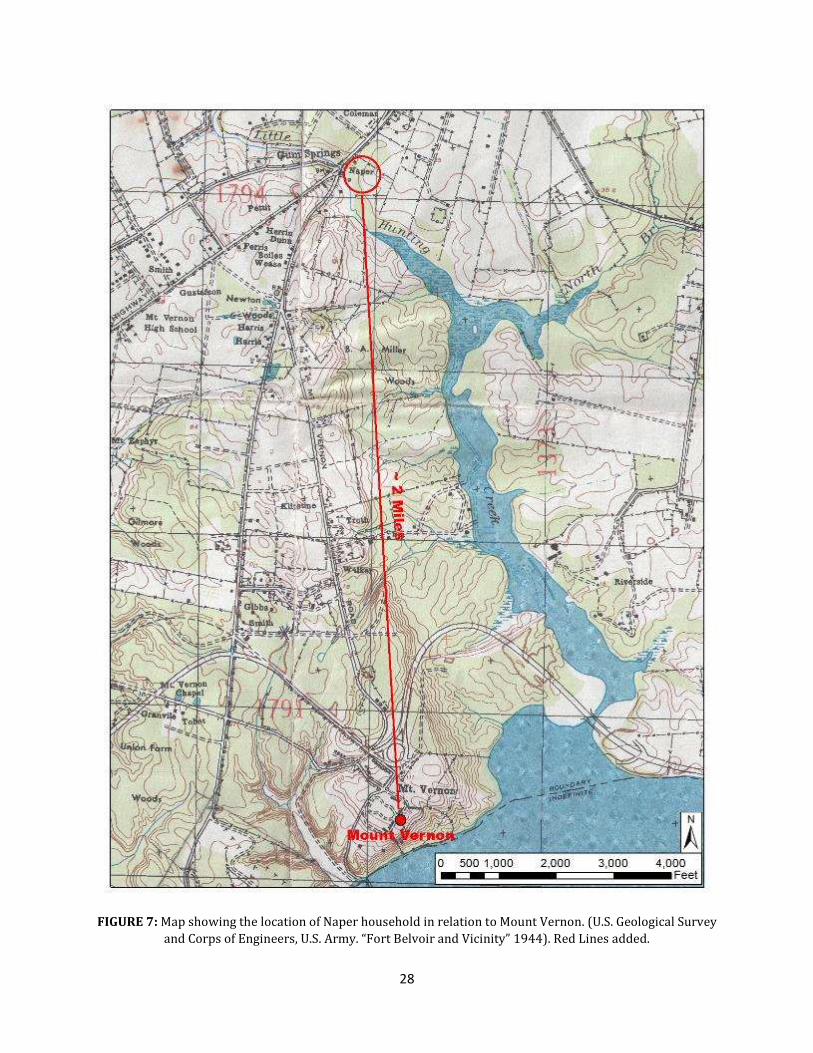
Bailey stepped into a hole “nearly up to his knee” dug by neighborhood boys to see what was there. Mr. Freeman remembered: seeing a funeral attended by African Americans for a man named Johnson; suggested the tombstones might be from the Alexandria firm Chauncey; noted one stone was marked “Blackburn”; commented that the site was fenced “not so long ago.” A note in the same file references a “colored burying ground where colored people named Johnson are buried,” near “where Dick Napier lives,” and mentions that there are stones there dating before 1792 (MVLA 1947). Census records note a Richard Napper living in proximity to route 235, and in 1940, lists his occupation as a gardener at Mount Vernon (U.S. Census 1940). A 1944 tactical map of Fort Belvoir and the surrounding vicinity that recorded the locations of a number of homeowners indicates a “Naper” living in Gum Springs near the intersection of route 235 and route 1, roughly two miles north of Mount Vernon (FIGURE 7). This suggests that another African American cemetery related to Mount Vernon may exist in the vicinity of Gum Springs. Gum Springs is a small black community in Fairfax County who traces its roots back to its founder, West Ford, who purchased the land in 1833 (Sanders-Burton 1986).
During the summer of 1967, The U.S. Plywood Corporation, in partnership with
Miller & Smith Associates as the Wessynton Joint Venture, asked the Fairfax County Circuit Court for permission to remove bodies from a cemetery located just northeast of the present-day intersection of Cunningham Drive and Mansion Farm Place, in advance of logging and the construction of the Wessynton housing development (Circuit Court of Fairfax County 1967b) (FIGURE 8). Articles in The Washington Post (1967:A9), The Fairfax Herald (1967:4) and Fairfax City Times (1967:23) advertised the intent to remove the bodies. On October 13, 1967 permission was granted to the Wessynton Joint Venture by the Circuit Court of Fairfax County to remove any remains found in the cemetery to a plot in the Fairfax City Public Cemetery (Circuit Court of Fairfax County 1967a). On October 17, a permit for the disinterment, transit, and reinterment of three unknown graves was granted to the Everly Funeral Home in Fairfax City to remove any existing remains from the Wessynton tract (Commonwealth of Virginia 1967). The following month, the remains from this cemetery were reinterred in a plot in the Fairfax City Public Cemetery, purchased by the Wessynton Joint Venture (Fairfax Cemetery Records 1967).2 The original location of the Wessynton cemetery prior to its removal corresponds with the likely location for the cemetery referenced by the Tucker heirs and also the one visited by MVLA staff and Mr. Freeman in 1947.
The Mount Vernon Archaeology Department visited 3217 Woodland Lane on September 23, 2000 and again on January 9, 2003 (FIGURE 9). A neighbor of this property, Mr. Thomas Brandt contacted Mount Vernon concerning burials. Many years ago another neighbor, Mrs. Key remembered discovering human remains which were removed “and interred at Mount Vernon.” There is a stand of bamboo to the west of the home where oral tradition suggests the bodies were originally interred. This property is on a branch of Little Hunting Creek (MVLA 2000). There are no known records of any human remains being removed to Mount Vernon. A Washington Post article (Diggins 1965:B6) reports the
2 Disinterred remains from the cemetery located on the Wessynton tract were reburied in Lot #352A, Section 2, Site #1, in the Fairfax City Public Cemetery (Fairfax Cemetery Records 1967).

12
Smithsonian removed several African American graves in advance of construction from property associated with the Mason family along Telegraph Rd. and this could be a source for this story.
A review of these notes suggests that there is strong evidence for a cemetery associated with Mount Vernon’s African American community in the Wessynton development which was removed in November of 1967. The proximity of the cemetery to the MVLA property as well as adjacent to the property of the National Park Service make this a likely location for the 1947 site visit and meeting with Park policeman Mr. Freeman. The presence of a second cemetery along Woodland Lane has much weaker evidence and elements of this story could be comingled with the prior story, especially since the informant, Mr. Brandt was relaying things told to him by another resident, Mrs. Key. Geophysical Research: Mount Vernon Slave Cemetery A geophysical survey of the Mount Vernon Slave Cemetery was conducted in January of 1985 by Bruce Bevan that revealed the possible locations of at least 51 potential graves. The survey covered two portions of the project area: a 70 x 100 ft. area just west of the 1983 slave memorial pathway (north section) (FIGURE 10), and a 120 x 80 ft. area just south of the memorial itself (south section) (FIGURE 11). Areas east of the memorial pathway, and further north towards the archway were not surveyed. The entire survey area was explored using ground-penetrating radar (GPR), while additional tests were made over portions of these areas with a magnetometer and resistivity meter (Bevan 1985). Numerous subsurface anomalies were detected with GPR in both survey sections. While some anomalies may be the result of refilled pits dating to the Native American occupation of the site or other ground disturbances, due to their suggested sizes and shapes, Bevan interpreted many of these readings to be grave excavations. Radar echoes were recorded at depths ranging from as little as 1 ¼ feet deep to as much as 6 ¼ feet deep with varying degrees of reliability. GPR in the north section of the survey area produced 30 reliable readings and 6 less-reliable readings, suggesting the presence of at least 30 potential burials in this area. One of these echoes, with a depth of 2 ½ feet, is located underneath the 1983 memorial pathway. Likewise, GPR in the south section of the survey area produced 21 reliable readings and 9 less-reliable readings. Geological strata in this section of the project area were evident, according to Bevan, which may have affected the reliability of some readings. The spatial orientations of these features were conjectured based on Bevan’s interpretation of the data. However, Bevan states that these supposed orientations cannot be confirmed until they are groundtruthed, as the antenna used in this section of the survey area naturally makes radar echoes appear broader, thereby making the true orientation of detected readings difficult to ascertain (Bevan 1985:14). Nevertheless, Bevan suggests that a number of potential burials in the cemetery are aligned east-west (Bevan 1985:14). The geophysical survey also detected a number of other surface and subsurface features. In both survey areas, an extensive tree survey was conducted which documented
13
the precise locations and sizes of all trees on the site over two inches in diameter. In the north survey section, an anomaly that Bevan interpreted as a buried former pathway was detected running parallel to a portion of the 1983 memorial pathway. Bits of iron from flower memorial stands were also found superficially and at shallow depths by an audio-indicating magnetometer. Those bits that were below the surface were left in place and accounted for. In the south section of the survey area, an unusually complex soil strata was detected near the surface that Bevan interpreted as a possible grave or debris-filled pit (Bevan 1985). Ground-truthing these anomalies and revisiting their interpretations is one goal for this archaeological investigation. Previous Archaeology: Mount Vernon Slave Cemetery (44FX116) There have been four previous archaeological investigations in various portions of the cemetery (FIGURE 12) (FIGURE 13). All excavations were conducted in order to mitigate future maintenance and development of the site. In all, eight potential grave shafts have been discovered as a result of these excavations (TABLE 1). No grave shafts were excavated and no human remains were disinterred. All grave shafts were recorded at their highest possible elevation before being reburied (See Appendix A).
Year Number of Grave Shafts Identified 1994 3 2007 1 2008 2 2012 2
Total 8
TABLE 1: Number of Grave Shafts Identified through Small Projects at 44FX116.
In August of 1994, Mount Vernon planned the installation of a post-and-rail fence to enclose the cemetery and to prevent visitors from accessing the steep hill on the southern end of the site. The intended locations of fence posts were marked with pin flags and archaeologists tested those areas for subsurface features, specifically grave shafts. A total of 43 shovel test pits (STPs) were excavated and three possible grave shafts were identified just south of the 1984 memorial in STPs 19, 21, and 22. STPs 19 and 21 were excavated further to reveal the horizontal extent of the graves which were subsequently mapped and photographed (FIGURE 14). The grave shaft in STP 22 was identified without further excavation and was documented before being reburied. The decision was made to alter the fence design by installing post-and-rail fence segments in STPs 1-14 and 27-41. Two new fence posts were excavated (14A and 27A) in order to accommodate a stacked fence that would span the gap south of the 1983 memorial. STPs 15-26 were backfilled and the discovered features were not impacted by the construction of the fence. Artifacts from this excavation consisted of a small assemblage of prehistoric material (White 1994). In June of 2007, the brick archway located at the entrance of the 1983 slave memorial pathway was failing. Archaeologists were asked to expose the foundations of the

14
archway to explore the problem in detail. A total of two, 3 x 5 ft. test units (100 and 101) were excavated to expose the foundations on the eastern side of each arch footer. The majority of test unit 101 was comprised of soils related to the construction of the archway and contained a few prehistoric lithic materials. Test unit 100 contained a substantial amount of lithic material (including flakes, debitage, and broken projectile points) as well as a feature comprised of similar mottled soils to the grave shafts discovered in 1994 (Breen 2007a).
This unit was opened up further in July of 2007, exposing a potential grave shaft
measuring six feet long and two feet wide (FIGURE 15). The wider end of the grave shaft is oriented to the northwest, suggesting that the head of the burial is in this direction and feet are to the southeast. The burial has been hypothesized as a shroud-style burial of a smaller or skinnier individual. At the conclusion of excavation, the burial was re-covered with soil and four nails were placed in the ground to show the outline of the feature. A significant quantity of lithic materials were found in the expanded test unit, suggesting a camp or workshop of Native American occupation (Breen 2007b).
In January of 2008 Mount Vernon proposed to plant five trees in two clusters, one
located near the New Tomb, the other located roughly 30-40 feet from the slave memorial archway. Archaeologists excavated holes for the proposed trees to determine if any grave shafts were present in those locations. A mottled soil was identified in Tree Hole 4 that resembled the mottled soil found in grave shafts from the 1994 and 2007 excavations. This hole was expanded and a very straight line could be traced between the mottled and natural soils, indicating a potential grave shaft. Further expansion of the unit revealed a suspected corner of the shaft. The potential grave shaft was covered with plastic and reburied, and the extent of the excavated area was marked with pink pin flags. The Grounds crew were directed not to plant at that location. A similar feature was discovered in Tree Hole 5 but this unit was not extensively expanded. A line could be drawn between mottled and natural soils in the unit, but was much less clear than the line drawn in Tree Hole 4. A portion of the feature appeared to be previously impacted, probably from the planting of a tree. This feature was interpreted as a potential grave shaft and was covered with plastic, backfilled, and marked with pink pin flags (Breckenridge 2008).
In March of 2012, poor water drainage in the slave memorial pathway prompted
Mount Vernon to explore the possibility of installing a new drainage system. Archaeologists excavated one 10 x 10 ft. test unit (102) to determine the depth of the gravel in the pathway, if any features were present, and the feasibility of adding a new drain. The upper layers of unit 102 consisted mostly of deposits related to the construction of the 1983 slave memorial. Underneath these upper layers archaeologists discovered a prehistoric occupation layer that, when cleaned off, revealed two potential burials (102G and 102H) protruding from the North and East walls of the test unit (FIGURE 16) (Pecoraro 2012).

15
Research Contexts Comparative Research A handful of slave and freedmen cemeteries have been studied over the years. Many of those sites were analyzed using geophysical methods only (Yerka and Brock 2009; Yerka 2010; Bigman 2014), while others were fully excavated and individuals sometimes disinterred in archaeological recovery and mitigation projects (Thomas et al. 1977; Davidson 1999; Sipe 2011; RAS 2013). The most famous archaeological site of this type is the African Burial Ground in New York City, excavated and analyzed from 1991-2006 (General Services Administration 2009; Blakey 2010). Three African American burial ground archaeological projects that share many regional and contextual similarities to Mount Vernon’s Slave Cemetery survey are Monticello’s Park Cemetery project (Bon Harper et al. 2003), The University of Virginia’s Cemetery ‘H’ Expansion project (RAS 2013), and the City of Alexandria’s Contrabands and Freedmen’s Cemetery project (Sipe 2014). Comparative Research: Monticello Park Cemetery, 2000 Monticello was a 5,000 acre plantation owned by Thomas Jefferson, located in Albemarle County, Virginia. Documentary evidence indicates that Jefferson chose the location for the Park as a burial place for both his slaves and for members of his own family, however he later changed his plan and established a family cemetery elsewhere on the estate (Bon-Harper et al. 2003:4). Researchers believe the cemetery itself to be a Jefferson-era feature, used from the early 1770s to the time of Jefferson’s death in 1826. No evidence of dwellings or structures have been found in close proximity to the cemetery, suggesting its use as a communal burial ground rather than the site of a family cemetery. The location of the Park cemetery away from dwellings mimics the central locations of slave cemeteries at other Virginia plantations such as Mount Vernon and Kingsmill (Fesler 2000), and adds to the belief that these were communally-used cemeteries rather than family plots (Bon-Harper et al. 2003:9). Archaeologists at Monticello used remote sensing and surface mapping techniques in 1990 and 2000 to survey the Park cemetery site. Oblong ground depressions could be discerned on the surface of the site, suggesting the location of individual interments where top soils had sunken following the collapse of coffin lids. Surface mapping recorded these features as well as stones, trees, and tree stumps in the area. GPR detected a number of subsurface anomalies in areas marked by ground depressions as well as areas where surface disturbance was not evident. Likewise, GPR was not successful in detecting subsurface anomalies in some depressed areas (Bon-Harper et al. 2003:11-13). In 2000, excavations were conducted in the Park cemetery to determine the presence or absence of graves. Twenty-four 5 x 5 ft. test units were excavated to reveal the outline of grave shafts. Twenty grave shafts were identified, of these, ten were adults, eight were children, and two were insufficiently exposed to make a determination with regards to age. The determination of age was based solely on the size of exposed grave shafts (Bon-Harper et al. 2003:13). The placement of test units was designed to test various surface

16
conditions and areas suspected of containing burials. Archaeologists found that oblong, east-west oriented depressions consistently corresponded with burials. Furthermore, seven graves were discovered that did not correlate to ground depressions, indicating that some graves do not leave surface indications (Bon-Harper et al. 2003:14). It was discovered that five of the burials were marked by fieldstones: three burials were marked by headstones and footstones, one burial was marked by a headstone only, and one burial was marked by a footstone only. All fieldstones discovered were tabular and unmarked (Bon-Harper et al. 2003:17). Monticello archaeologists utilized two methods to estimate the total number of burials in the Park cemetery. The first method was to determine a minimum and maximum number of burials. A minimum was reached by adding the total number of confirmed burials (20) to the number of unexcavated oblong ground depressions (17), producing a minimum number of 37. A maximum was determined by multiplying an estimate of the total area of the cemetery by the mean density of burials known from excavation (Bon-Harper et al. 2003:17). From this method it was determined that the Park cemetery contained somewhere between 37 and 134 burials. The second method employed by the archaeologists at Monticello was to divide the quadrants within the suspected boundary of the cemetery into two groups: those that contain ground depressions, and those that do not. Two separate estimates were then computed of the mean number of burials per quadrant, one for each of the two categorized quadrant types. These estimates allowed archaeologists to project the expected number of burials associated with unexcavated quadrants both with and without ground depressions. From this method researchers were able to determine that the most likely number of burials in the cemetery was 71, and that there was a 90% chance that the cemetery contained between 42 and 100 burials (Bon-Harper et al. 2003:18). Comparative Research University of Virginia Cemetery Expansion Project, 2012 Another meaningful comparative study of a burial ground for enslaved individuals took place just six miles from Monticello at the University of Virginia in 2012. In 2011, the University asked Rivanna Archaeological Services, a Charlottesville-based CRM firm, to assess the impact of a proposed expansion to the university cemetery. The expansion involved the installation of crypts and the construction of a new stone wall in the project area which was located north of, and abutting the existing cemetery boundary. Archaeologists conducted a Phase I survey of the project area and supervised the mechanical excavation of fill deposits down to historic grade. Once these layers were removed, the exposed project area measured roughly 75 x 175 ft. and contained 67 previously unidentified burial shafts (RAS 2013:iii).
The cemetery itself was established in 1828, and the space was formally enclosed a year later by a stone wall. Over the years, the cemetery was expanded several times to provide more burial plots for students, faculty, and staff. In 1862, the university enclosed a 200 x 228 ft. area west of the original 1828 cemetery for the purpose of burying Confederate soldiers who had died at the school while it served as a hospital. The final

17
expansion was added in 1940 with the enclosing of a 100 x 200 ft. space north of the Confederate cemetery expansion (RAS 2013:7-12). Few records exist pertaining to the deaths, let alone the interments of enslaved African Americans at the University Cemetery. A handful of late nineteenth-century references indicate that deceased slaves were buried north of, and outside the University Cemetery. Other references suggest that slaves were interred in coffins provided by their owners (RAS 2013:22). The practice of secret burials was also often conducted by many African Americans, where false graves would be excavated in known cemeteries, and logs interred in the graves to fool cadaver hunters and grave robbers. The actual burial would take place elsewhere at a secret location, thereby protecting the body of the deceased from desecration (RAS 2013:25-28). Following a Phase I survey of the project area, and the mechanical removal of topsoil and fill deposits, archaeologists could identify 67 burial shafts. A total of 160 artifacts were recovered during mechanical excavation, however due to the nature of this method, the artifacts were stripped of their contextual information (RAS 2003:36). Fifty-six percent of recovered artifacts were ceramics. The use of ceramics as grave decorations can be speculated, but without contextual information it is impossible to make a determination one way or another. One piece of slate and one piece of white quartzite sandstone were discovered that appeared to show signs of modification. These have been interpreted as fragments of grave markers, however no writing or inscription could be identified on either piece (RAS 2003:37). Sixty-four of the 67 identified grave shafts were oriented east-west, while three grave shafts were oriented northeast-southwest. The two distinct patterns of spatial organization that could be discerned were rows and small clusters. Eight rows consisting of anywhere between three to eleven burials, and six clusters consisting of two to three burials each made up the identified interments. Eight grave shafts contained an in situ stone marker; six of these markers were fieldstones, likely procured locally. Two of the markers were made of white quartzite sandstone and were placed at the head or western end of each grave. One grave shaft was overlain by a number of vertically set fieldstones. This phenomena is likely an indication of cultural activity, however archaeologists are uncertain if these stones were placed in the fill of a legitimate grave or if they represent a “fake” burial meant to fool potential grave robbers (RAS 2003:58). Based on their size, 21 burial features have been interpreted as adult burials, while 15 have been interpreted as child/youth graves. The age-range of the remaining 31 burials were inconclusive either because the grave shafts were only partially exposed or their relative size produced an ambiguous indication of age. The University Expansion Project was able to determine that the previously unknown graves were most likely from the enslaved population at the University of Virginia. The arrangement of graves in organized rows facing east-west suggests that burials were conducted in accordance with Christian tradition. By this time, many African Americans practiced Christian beliefs, however it is unclear how much autonomy slaves had in the burial of their dead or the mortuary practices they used. One account of a slave

18
owner burying a recently deceased slave in a nearby cemetery insisted that his servant receive a proper Christian burial (RAS 2003:24). This seems to indicate that the way in which the enslaved person was interred was the decision of the master rather than that of the enslaved African American community. On the other hand, the practice of secret and “fake” burials seems to indicate that some slaves did in fact have a degree of autonomy in the burial of their dead. There was likely a large degree of variability depending on the beliefs of the owner and the enslaved community in question. Comparative Research: City of Alexandria Contrabands and Freedmen Cemetery, 2007 The City of Alexandria in northern Virginia is located nine miles from George Washington’s home at Mount Vernon. During the Civil War, the town was held under Union control and became a safe haven for runaway slaves vying for their freedom. These individuals were dispassionately referred to as “contrabands,” and it was not long before the city became inundated with people seeking freedom from slavery. Cramped quarters and unsanitary conditions led to rampant spread of disease among the contraband and freedmen community, resulting in numerous deaths and the need for a segregated space to bury the dead. Property confiscated from a Confederate sympathizer became the resting place for over 1,500 of these individuals in a cemetery that would soon fall into disrepair, be sold, paved over, and forgotten (Sipe 2011). By 2000, the cemetery site had been developed with a gas station and office building standing on the lot at the corner of South Washington St and Church St. A remote sensing investigation was conducted in 1996 with the goal of assessing the potential for grave shafts beneath the gas station property. Surveyors used GPR and electro-magnetic studies to maximize the amount of data that could be gleaned under the conditions of surface disturbance at the site. Remote sensing detected numerous anomalies related to the infrastructure of the gas station, however, of particular interest were the areas in the back of the station that contained columns of undisturbed soil in a series of eight to ten rows. The regularity of these anomalies suggested the presence of burial shafts (Sipe 2011). In 1998, a geophysical survey was conducted on land owned by the Virginia Department of Transportation, just south of the previously surveyed area (Bevan 1999). This survey detected one anomaly in a grassy area in the western portion of the property. Though the geophysical survey in the eastern portion of the property did not reveal any anomalies, observation of intact soils via surface inspection along with the GPR results from the previous geophysical survey suggested that this area may contain graves (Sipe 2011:192). Excavations were conducted in this area in 1999 to discern the western and southern boundaries of the cemetery. Forty-nine grave shafts were identified in the area south of the gas station. The dimensions of these grave shafts ranged in size approximately one to two feet by three to seven feet, suggesting the interment of both children and adults (Sipe 2011:196). Archaeologists uncovered a handful of artifacts associated with burials. Though no human remains were disturbed, nails and small white buttons were among the artifacts likely associated with graves that were recovered. Some of these artifacts were left in situ, while others were reburied where they were found after they have been removed from the grave. Possible coffin remains were identified in another grave shaft where
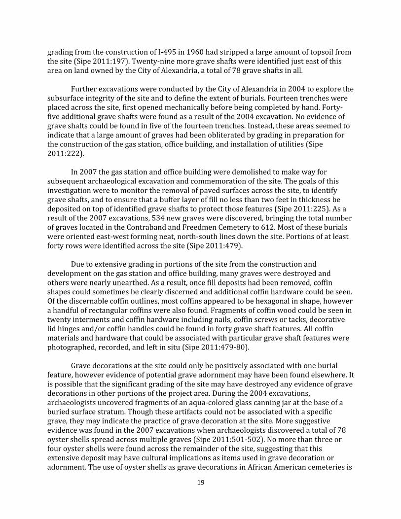
19
grading from the construction of I-495 in 1960 had stripped a large amount of topsoil from the site (Sipe 2011:197). Twenty-nine more grave shafts were identified just east of this area on land owned by the City of Alexandria, a total of 78 grave shafts in all. Further excavations were conducted by the City of Alexandria in 2004 to explore the subsurface integrity of the site and to define the extent of burials. Fourteen trenches were placed across the site, first opened mechanically before being completed by hand. Forty-five additional grave shafts were found as a result of the 2004 excavation. No evidence of grave shafts could be found in five of the fourteen trenches. Instead, these areas seemed to indicate that a large amount of graves had been obliterated by grading in preparation for the construction of the gas station, office building, and installation of utilities (Sipe 2011:222). In 2007 the gas station and office building were demolished to make way for subsequent archaeological excavation and commemoration of the site. The goals of this investigation were to monitor the removal of paved surfaces across the site, to identify grave shafts, and to ensure that a buffer layer of fill no less than two feet in thickness be deposited on top of identified grave shafts to protect those features (Sipe 2011:225). As a result of the 2007 excavations, 534 new graves were discovered, bringing the total number of graves located in the Contraband and Freedmen Cemetery to 612. Most of these burials were oriented east-west forming neat, north-south lines down the site. Portions of at least forty rows were identified across the site (Sipe 2011:479). Due to extensive grading in portions of the site from the construction and development on the gas station and office building, many graves were destroyed and others were nearly unearthed. As a result, once fill deposits had been removed, coffin shapes could sometimes be clearly discerned and additional coffin hardware could be seen. Of the discernable coffin outlines, most coffins appeared to be hexagonal in shape, however a handful of rectangular coffins were also found. Fragments of coffin wood could be seen in twenty interments and coffin hardware including nails, coffin screws or tacks, decorative lid hinges and/or coffin handles could be found in forty grave shaft features. All coffin materials and hardware that could be associated with particular grave shaft features were photographed, recorded, and left in situ (Sipe 2011:479-80). Grave decorations at the site could only be positively associated with one burial feature, however evidence of potential grave adornment may have been found elsewhere. It is possible that the significant grading of the site may have destroyed any evidence of grave decorations in other portions of the project area. During the 2004 excavations, archaeologists uncovered fragments of an aqua-colored glass canning jar at the base of a buried surface stratum. Though these artifacts could not be associated with a specific grave, they may indicate the practice of grave decoration at the site. More suggestive evidence was found in the 2007 excavations when archaeologists discovered a total of 78 oyster shells spread across multiple graves (Sipe 2011:501-502). No more than three or four oyster shells were found across the remainder of the site, suggesting that this extensive deposit may have cultural implications as items used in grave decoration or adornment. The use of oyster shells as grave decorations in African American cemeteries is

20
a practice seen at many other sites across Virginia and the southeastern United States that may reflect the survival of certain West-African burial traditions (Rainville 2009:73 Vlach 1990:143). Archaeological Component: Mount Vernon Slave Cemetery The primary goal of this multiyear project is to document features associated with the Slave Cemetery, with a particular focus on determining the number of extant burials. Further research questions pertain to the spatial layout of the cemetery, with an emphasis on ascertaining the orientations of, and spatial relationships between the graves themselves, as well as identifying the boundaries of the cemetery and any evidence of a fence that enclosed the burial ground space. Based on the lengths of exposed grave shafts, it is also possible to conjecture if an interment holds a child or an adult burial. This information can assist in interpreting the demographics of the cemetery. Excavations may also reveal if fieldstones or any kind of semi-permanent grave markers were used to demarcate burials, though it is possible such markers have since been removed. Furthermore, excavations may produce evidence of grave decorations or offerings. This information could hold cultural implications on attitudes towards death and behavior associated with grave visitation and commemoration by Mount Vernon’s enslaved population. Joseph Downer, a graduate student at the George Washington University in Washington DC, will initially serve as Crew Chief for excavations in the Slave Cemetery. This archaeological survey will be conducted largely by volunteers. The Crew Chief will be assisted by Mount Vernon staff members, Dr. Eleanor Breen, Deputy Director of Archaeology, Luke Pecoraro, Assistant Director of Archaeological Research, Karen Price, Preservation Lab Manager and Photographer, and Leah Stricker, Field and Lab Technician. Archaeological Methodology: Mount Vernon Slave Cemetery Prior to the removal of any topsoil from the site, the geophysical map produced by Bruce Bevan in 1985 was georeferenced into ESRI’s ArcGIS by Joseph Downer, with the assistance of Eric Benson and Luke Pecoraro. The suspected locations and orientations of potential graves indicated on the geophysical map were traced in ArcGIS to create a digital reading of the 1985 survey results. In addition, a new surface survey was conducted on the site, where each tree, tree stump, fencepost, and above-ground utility in the archaeological survey area was charted and measured to be integrated into a new digital site map. The internal and external outlines of both the 1929 and 1983 Slave Memorials were also incorporated in this survey. All of these elements were combined into a survey planning map, where a grid consisting of 5 x 5 ft. random test units was overlain onto the archaeological grid for the estate. These 5 x 5 ft. random squares will serve as the starting point for excavations.
Excavation in the north wilderness consisted of randomly selected 5 x 5 foot test units within a 20 x 20 foot grid and followed the procedures outlined in the Mount Vernon Archaeology Field Manual (Pogue and Jobrack 2013; White 2012). When suspected grave

21
shafts are encountered, judgmental units will be placed to fully expose the feature. The test units were excavated according to natural levels. Excavations will cease once grave shafts have been identified and recorded, and no individual remains or related burial material will be disturbed. All non-burial features will be thoroughly documented as well. All soils were screened through a ¼” hardware mesh and a soil sample taken from layers with the exception of topsoil, identified utility line deposits, and other modern intrusions (Pogue and Jobrack 2013:7, 34). All artifacts, soil samples, field records, and images are stored at Mount Vernon’s archaeological laboratory. Archaeological recovery procedures for this survey will be performed in accordance with the guidelines set by the Virginia Department of Historic Resources (VDHR), which state that a burial permit is not required so long as individual grave shafts are not excavated (See Appendix B). Upon the discovery of a grave shaft, it will be assigned a provenience according to the test unit in which it was first located. For example, if a grave shaft is found overlain by 702B, then the shaft will be assigned the label 702C. Provenience cards will be completed for grave shafts as they would any other archaeological feature, however no excavation of the grave shaft will take place. The depositional history of the site should be fairly simple and uniform due to minimal man-made build-up of soil on the site, however some areas near the location of the 1983 slave memorial may be more complex. As a result of the site’s location away from much of the underground infrastructure located throughout the estate, non-burial related cultural intrusions should be nominal. However, areas immediately adjacent to the 1983 memorial are likely to have been heavily impacted by its construction. In the 2012 Slave Memorial Path Project, roughly one foot of topsoil and fill material related to the memorial’s construction overlaid the occupation layer containing burial shafts 102G and 102H (Pecoraro 2012). To date, all artifacts uncovered in the cemetery have either been modern (20th century) or prehistoric in nature. No artifacts that can be interpreted as grave decorations have been found, and nothing diagnostic has been discovered that could help identify the relative dates of individual interments. Modern artifacts will likely be concentrated in areas near both the 1929 and 1983 memorial. These artifacts will likely be related to the construction of the memorials or items dropped by visitors and covered over time. Judging by the large quantity of prehistoric material found thus far at the site it is likely that more will be found as the survey proceeds. Oral History Component: Mount Vernon Slave Cemetery In addition to archaeological research, histories from descendent families, local community members, and others who participated in the 1983 memorial effort will be recorded through archival research and oral history interviews. Intern Nia White conducted archival research on the commemoration of the cemetery site by utilizing resources at the Fred W. Smith National Library for the Study of George Washington. Ms.

22
White has also conducted an interview with Dr. Judith Burton, a descendent of West Ford and expert on the history of the African American community of Gum Springs, located just north of Mount Vernon (Sanders-Burton 1986). Dr. Burton’s testimony has contributed to a more corporate understanding of African American contextual history of the surrounding region, as well as the commemorative efforts undertaken in 1983 for the construction of the new Slave Memorial. Future Research: Mount Vernon Slave Cemetery One component of this multi-year archaeological survey will be to test different methods of locating graves in areas already known to contain burials, and areas where the presence of interments is uncertain. Geophysical surveys, to include the use of GPR, will be utilized in the areas surrounding the 1983 slave memorial, and results compared to the results produced in Bruce Bevan’s 1985 geophysical survey of the site (Bevan 1985). Geophysical methods will also be used to test areas outside of the current boundaries of 44FX116 for the presence of subsurface disturbances that could indicate graves, particularly in the area between the ridge containing the Slave Cemetery and Washington’s old tomb, overlooking the Potomac River. Furthermore, the use of Human Remain Detection (HRD) dogs, commonly known as cadaver dogs, will be explored to assist in the location of potential graves in areas within and outside the bounds of 44FX116. Some HRD dogs have been said to have the ability to detect human remains over 600 years of age up to two meters in the ground (Michael 2012). HRD dogs have been utilized in a handful of other similar cemetery sites (Smiley 2000; Broecker 2010; Florida Public Archaeology Network 2013), though their efficacy is undetermined, as these sites have yet to be archaeologically ground-truthed. A combination of geophysical survey techniques with the use of HRD dogs could provide archaeologists with two sources of information from which to plan and implement excavation strategies moving forward. Outreach and Final Products Graduate Research and Reports
Outreach and the sharing of data is an important component to any research effort. These outreach efforts take on many different forms including museum exhibitions, the utilization of online communicative, assistance and participation in commemorative events, and graduate-level research initiatives. The archaeological investigation of the Slave Cemetery is the basis for the M.A. thesis of Joseph Downer, Crew Chief of excavations and graduate student at the George Washington University. The data recovered from this project will serve in academic research efforts designed to produce an accurate interpretation of the site as well as fulfill requirements for a graduate-level degree. A final site report will be produced from research associated with this project that will be made available to future researchers, further fulfilling Mount Vernon’s outreach and data-sharing efforts.
23
Furthermore, an updated site form will be completed with the VDHR detailing the site’s cultural affiliations, thematic contexts and functions, location information, condition, and a description of the archaeological survey itself. This will include a summary of work completed at the site, and information on where field notes, reports, images, and collected specimens can be located for further study by interested parties in the future. Exhibition, Interpretation, and Commemoration The archaeological survey of the Slave Cemetery is taking place within the greater context of an initiative by the MVLA to revise and bolster its interpretation of slavery at Mount Vernon. This includes the creation of a database of enslaved individuals who lived at Mount Vernon, the reanalysis of the House for Families slave quarter site as part of the department’s Archaeological Collections Online initiative, and a temporary exhibit in the Donald W. Reynolds Museum and Education Center opening in February of 2016.
The archaeology of the Slave Cemetery will allow Mount Vernon to bolster its interpretation of the site. By identifying individual burials below the surface and mapping their precise locations, it would be possible to communicate this information to the public with individual commemorations or a site map of the cemetery depicting the location of each discovered burial. This would be a powerful form of commemoration that would allow visitors to connect with the site in a way never before realized at Mount Vernon. Researchers will also be able to play a role in contributing to existing annual commemorative events organized by Black Women United for Action (BWUFA). Conclusion The survey of the Slave Cemetery provides an opportunity to learn more about enslaved African American lifeways and rituals in death and interment at Mount Vernon. The information gathered through research and excavation will serve to improve the interpretation of the memorial space and guide potential commemorative efforts and events in the future. Furthermore, a site map will be produced, identifying the location of each individual gravesite discovered through archaeology. This map will aid in preserving and protecting the individuals who call this spot their final resting place. This will be achieved not only through archaeological research efforts but also through the multidisciplinary approach of continued historical and archival research, as well as the documentation of oral histories from community members and descendant families. Improved knowledge, collaboration, and interpretation will allow Mount Vernon to produce a management plan for the Slave Cemetery, ensuring that the individuals buried here are honored and protected for generations to come.

24
FIGURE 2: "Midnight Slave Funeral,” Hamilton Pierson, In the Brush; or, Old-time social, political, and religious life in the Southwest (New York, 1881), facing p. 284. Image Reference NW0177, as shown on
www.slaveryimages.org, compiled by Jerome Handler and Michael Tuite, and sponsored by the Virginia Foundation for the Humanities and the University of Virginia Library."

25
FIGURE 3: "Plantation Burial,” John Antrobus, ca. 1860, (Historical New Orleans Collection). Image Reference NW0179, as shown on www.slaveryimages.org, compiled by Jerome Handler and Michael Tuite, and
sponsored by the Virginia Foundation for the Humanities and the University of Virginia Library."
FIGURE 4: Grave shafts 20 and 21 (foreground) found in University of Virginia Cemetery H Expansion Project with white quartzite sandstone head markers broken off at base. (Rivanna Archaeological Services 2014).

26
FIGURE 5: “Plan of Mount Vernon, The Home of Washington,” Published by Currier and Ives, 1855. First known map documenting the Slave Cemetery”. Red outlines added. (Mount Vernon Ladies’ Association).

27
FIG
UR
E 6
: Pla
t Sh
ow
ing
Pro
per
ty o
f M
ou
nt
Ve
rno
n L
adie
s’ A
sso
ciat
ion
of
the
Un
ion
, Au
gust
19
31
. No
te t
he
Be
verl
y Tu
cke
r Es
tate
no
rth
of t
he
MV
LA
lan
d h
old
ings
(M
ou
nt
Ver
no
n L
adie
s’ A
sso
ciat
ion
).
28
FIGURE 7: Map showing the location of Naper household in relation to Mount Vernon. (U.S. Geological Survey
and Corps of Engineers, U.S. Army. “Fort Belvoir and Vicinity” 1944). Red Lines added.
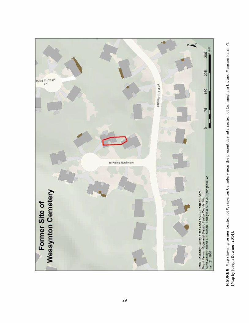
29
FIG
UR
E 8
: Map
sh
ow
ing
form
er lo
cati
on
of
Wes
syn
ton
Cem
eter
y n
ear
the
pre
sen
t d
ay
inte
rsec
tio
n o
f C
un
nin
gh
am D
r. a
nd
Man
sio
n F
arm
Pl.
(Map
by
Jo
sep
h D
ow
ner
, 20
14
).

30
FIGURE 9: Map showing location of 2000 and 2003 Woodland Lane site visit in relation to the Wessynton Cemetery, the Mount Vernon Mansion House, and Archaeological Site 44FX116 Slave Cemetery. (Map by
Joseph Downer, 2014).
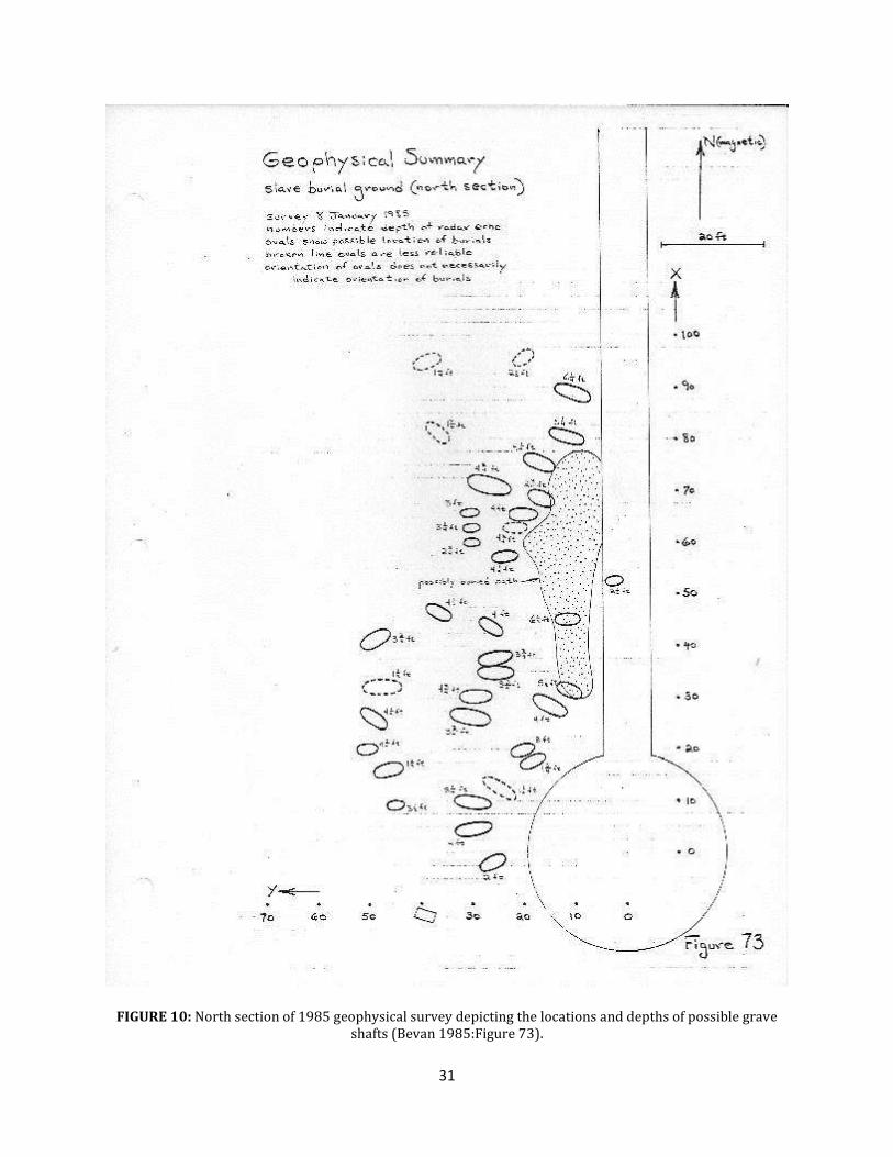
31
FIGURE 10: North section of 1985 geophysical survey depicting the locations and depths of possible grave shafts (Bevan 1985:Figure 73).

32
FIGURE 11: South section of 1985 geophysical survey depicting the locations and depths of possible grave shafts (Bevan 1985:Figure78).

33
FIGURE 12: North Section of Survey area showing grave shafts discovered through small projects in relation
to 1985 GPR readings. (Map by Joseph Downer, 2014).

34
FIGURE 13: South Section of Survey area showing grave shafts discovered through small projects in relation
to 1985 GPR readings. (Map by Joseph Downer, 2014).

35
FIGURE 14: Exposed grave shaft found in STP 21 during 1994 mitigation work. Facing east. (Mount Vernon
Ladies’ Association).

36
FIGURE 15: Exposed grave shaft from 2007 excavations of the 1983 memorial archway, facing northwest (Mount Vernon Ladies’ Association).

37
FIGURE 16: Test Unit 102 from 2012 excavation, facing southwest, revealing two grave shafts protruding from northeast and southeast walls (102G, 102H) (Mount Vernon Ladies’ Association).

38
References Cited Anderson, James 1797 Farm Reports. 18 February, 4 March, 27 May, 3 June, 22 July 1797. Washington Headquarters Library, Morristown, NJ. Transcript provided by The Papers of George Washington. Mount Vernon Ladies' Association, Mount Vernon, VA. Ball, Charles 1837 Slavery in the United States: A Narrative of the Life and Adventures of Charles Ball, a Black Man. John S. Taylor, New York. Reprinted 1969 by Negro Universities Press, New York, NY . Bevan, Bruce W. 1985 A Geophysical Survey at Mount Vernon. Report to the Mount Vernon Ladies’ Association. Manuscript, MVLA, Mount Vernon, VA. 1999 A Geophysical Survey at the Alexandria Freedmen’s Cemetery. Report to Terry H. Klein, URS Greiner, Inc. Manuscript, Alexandria Archaeology, Alexandria, VA. Bigman, Daniel P. 2014 Mapping Social Relationships: Geophysical Survey of a Nineteenth Century American Slave Cemetery. Archaeological and Anthropological Sciences 6:17-30.
Bon-Harper, Sarah; Fraser Neiman, and Derek Wheeler 2003 “Monticello’s Park Cemetery” Monticello Department of Archaeology Technical Report Series Number 5. Thomas Jefferson Foundation, Charlottesville, VA <http://www.monticello.org/sites/default/files/inline-pdfs/parkcemetery.pdf>. Accessed February 5, 2014. Blakey, Michael L 2010 African Burial Ground Project: paradigm for cooperation? Museum International 62(1-2):61-68.
Brandt, Thomas 1998 George Washington’s Herbal Pursuits. The Herb Companion 1998:42-46 Breckenridge, Curt 2008 Mount Vernon Archaeology Small Project Form. 44FX116/1, Tree Holes, September 1, 2008. Manuscript, MVLA, Mount Vernon, VA. Breen, Eleanor 2007a Mount Vernon Archaeology Small Project Form. 44FX116, Slave Memorial Arch, June 6-14, 2007. Manuscript, MVLA, Mount Vernon, VA. 2007b Mount Vernon Archaeology Small Project Form – Update. 44FX116, Slave Memorial Arch, July 16-19, 2007. Manuscript, MVLA, Mount Vernon, VA.

39
Broecker, Carie 2010 Archaeology Dogs. Coastal Canine <http://www.coastalcaninemag.com/issues/summer2010/indianabones.html>. Accessed June 26, 2014.
Casper, Scott 2008 Sarah Johnson’s Mount Vernon: The Forgotten History of an American Shrine. Hill and Wang, New York, NY. Chapman, C. Thomas, Steve Marqusee, and Matthew Reeves 2006 “Hark from de tomb a doleful soun”: Contextualizing the Slave Cemetery at Montpelier. Manuscript, MVLA, Mount Vernon, VA. Circuit Court of Fairfax County 1967a Final Decree. United States Plywood Corporation and Miller & Smith Associates as Wessynton Joint Venture vs. Any And All Persons Having An Interest In Any Body Or Bodies Buried. October 13, 1967. Chancery No. 25479. Fairfax, VA. 1967b Bill of Complaint. United States Plywood Corporation and Miller & Smith Associates as Wessynton Joint Venture vs. Any And All Persons Having An Interest In Any Body Or Bodies Buried. August 7, 1967. Chancery No. 25479. Fairfax, VA. Commonwealth of Virginia 1967 Permit for Disinterment, Transit, and Reinterment. Bureau of Vital Records and Health Statistics, Richmond, VA. Manuscript, City of Fairfax Cemetery Office, 10567 Main St. Fairfax, VA. Davidson, James Michael 1999 Freedmen’s Cemetery (1869-1907): A Chronological Reconstruction of an Excavated African American Burial Ground, Dallas, Texas. Master’s thesis, Department of Anthropology, University of Arkansas, Fayetteville. University Microfilms International, Ann Arbor, MI. Diggins, Peter S. 1965 Slave Skeletons in VA. Tied to Mason Closet. Washington Post 12 June:B6. Washington, DC. Fairfax Cemetery Records 1967 Fairfax Cemetery Records. Manuscript, City of Fairfax Cemetery Office, 10567 Main St. Fairfax, VA. Fairfax City Times 1967 Slaves’ Cemetery. Fairfax City Times 16 August:23, Fairfax City, VA. Fairfax Herald 1967 Of Valuable Unimproved Real Estate. Fairfax Herald 11 August:4, Fairfax, VA.
40
Fesler, Garrett 2000 Preliminary Archaeological Findings from the Pettus Burial Ground. Paper presented at the November 2000 Jamestown Conference, Jamestown, VA. 2010 Excavating the Spaces and Interpreting the Places of Enslaved Africans and Their Descendants. In Cabin, Quarter, Plantation: Architecture and Landscapes of North American Slavery, Clifton Ellis and Rebecca Ginsburg, editors, pp. 27-49. Yale University Press, New Haven, CT. Florida Public Archaeology Network 2013 The Munree Cemetery Project: An Update on Our Progress. Shovel Bytes: FPAN North Central Blog <http://www.flpublicarchaeology.org/blog/ncrc/2013/05/>. Accessed June 26, 2014. General Services Administration 2009 The New York African Burial Ground: Unearthing the African Presence in Colonial New York. Howard University Press, Washington DC. Genovese, Eugene D. 1976 Roll, Jordan, Roll: The World The Slaves Made. Vintage Books, New York, NY. Gilliam, Dorothy 1982 Remembrance. The Washington Post 6 February:B1. Washington, DC. Ginsburg, Rebecca 2010 Escaping Through a Black Landscape. In Cabin, Quarter, Plantation: Architecture and Landscapes of North American Slavery, Clifton Ellis and Rebecca Ginsburg, editors, pp. 51-66. Yale University Press, New Haven. Gorn, Elliot J. 1984 Black Spirits: The Ghostlore of Afro-American Slaves. American Quarterly 36(4):549-565. Gowans, Alan 1964 Images of American Living. J.B. Lippincott, Philadelphia, PA. Hatcher, William E. 1908 John Jasper: The Unmatched Negro Philosopher and Preacher. Fleming H. Revell Company, New York, NY. Isaac, Rhys 1999 The Transformation of Virginia, 1740-1790. The University of North Carolina Press, Chapel Hill. Jamieson, Ross W. 1995 Material Culture and Social Death: African American Burial Practices. Historical Archaeology 29(4):39-58.

41
Journal of American Folklore 1894 Mortuary Customs and Beliefs of South Carolina Negroes. Journal of American Folklore, 7(27):319-319. King, Charlotte 2010 Separated by Death and Color: The African American Cemetery of New Philadelphia, Illinois. Historical Archaeology 44(1):125-137. Lee, Jean B. 2006 Experiencing Mount Vernon: Eyewitness Accounts, 1784-1865. University of Virginia Press, Charlottesville. McCombs, Phil 1983 Repaying a Debt at Mount Vernon. The Washington Post 22 September:E1-E2. Washington, DC. Michael, Peter 2012 Migaloo The Dog Has a Nose for Archaeology. News.com.au. <http://www.news.com.au/national/queensland/this-dog-has-a-nose-for-archeology/story-fndo4ckr-1226463394595>. Accessed June 26, 2014. Mount Vernon Ladies’ Association (MVLA) 1928 Minutes of the Mount Vernon Ladies’ Association. Mount Vernon, VA. 1929 Minutes of the Mount Vernon Ladies’ Association. Mount Vernon, VA. 1947 Slaves burying ground. Typescript, MVLA, Mount Vernon, VA. 2000 Slave Cemetery. Internal Memo, MVLA, Mount Vernon, VA. Parrinder, Geoffrey 1970 African Traditional Religion. Greenwood, Westport, CT. Pearce, William 1794 Farm Reports. 30 August 1794. U.S. Library of Congress, George Washington Papers, Washington, DC. Transcript provided by The Papers of George Washington. Mount Vernon Ladies' Association, Mount Vernon, VA. Pecoraro, Luke 2012 Mount Vernon Archaeology Small Project Form. 44FX116, Slave Memorial Path, March 5-9, 2012. Manuscript, Mount Vernon Ladies’ Association, Mount Vernon, VA. Pogue, Dennis J., and Judith D. Jobrack 1988 Mount Vernon Archaeology Field and Laboratory Manual. Manuscript on File, Mount Vernon Ladies’ Association. Mount Vernon, Virginia.
42
Rainville, Lynn 2009 “Home at Last: Mortuary Commemoration at Virginia Slave Cemeteries” Markers XXVI: Annual Journal of the Association of Gravestone Studies, Greenfield, MA. 2014 Hidden History: African American Cemeteries in Central Virginia. University of Virginia Press. Charlottesville and London. Rees, James C. 2001 Looking Back, Moving Forward: The Changing Interpretation of Slave Life on the Mount Vernon Estate. In Slavery at the Home of George Washington, Philip J. Schwartz, editor, pp. 159-179. Mount Vernon Ladies’ Association, Mount Vernon, VA. Rivanna Archaeological Services, LLC (RAS) 2013 Beyond the Walls: An African American Burial Ground at the University of Virginia Volume 1: The Cemetery ‘H’ Expansion Project. Manuscript on File, Mount Vernon Ladies’ Association. Mount Vernon, Virginia. Sager, Mike 1982 30 Teams Vied For Design of Slave Memorial At Mt. Vernon. The Washington Post 3 November:VA11. Washington, DC. Samford, Patricia 2007 Subfloor Pits and the Archaeology of Slavery in Colonial Virginia. University of Alabama Press. Tuscaloosa, Alabama. Sanders-Burton, Judith 1986 A History of Gum Springs, Virginia: A Report of a Case Study of Leadership in a Black Enclave. Doctoral Dissertation, Department of Education, Vanderbilt University, Nashville, TN. Sipe, Boyd 2011 The Contrabands and Freedmen Cemetery Memorial, Archaeological Data Recovery at Site 44AX0179. Report to Alexandria Archaeology, Alexandria, Virginia, from Thunderbird Archaeology, Gainesville, Virginia. Slave and Slave Quarters N.D. Black notebook informational file. Mount Vernon Library, Mount Vernon, VA. Smiley, Brenda. 2001. This dog digs history. Current science 86, (10) (Jan 19): 8-9, http://search.proquest.com/docview/195948255?accountid=11243 (accessed June 26, 2014). Thomas, David Hurst, Stanley South, and Clark Spencer Larson 1977 Rich Man, Poor Men: Observations on the Three Antebellum Burials from the Georgia Coast. Anthropological Papers of the American Museum of Natural History, 54(3) 393-420.

43
Thomas, Kenneth 2008 The Religious Dancing of American Slaves, 1820-1865: Spiritual Ecstasy at Baptisms, Funerals, and Sunday Meetings. The Edwin Mellen Press, Lewiston. The Tomb N.D. Black notebook informational file. Mount Vernon Library, Mount Vernon, VA. Thompson, Robert Farris 1983 Flash of the Spirit: African Afro-American Art and Philosophy. Random House, New York, NY. Upton, Dell 1990 Imagining the Early Virginia Landscape. In Earth Patterns: Essays in Landscape Archaeology, Bill Kelso and Rachel Most, editors, pp. 71-88. University Press of Virginia, Charlottesville. U.S. Census 1940 Fairfax County, Virginia, population schedule, Mount Vernon, enumeration district (ED) 30-19A, page 42, sheet 22DB, dwelling 76, Richard R. Napper household; digital images, National Archives (http://www.1940census.archives.gov: accessed 12 September 2014). Vlach, John Michael 1990 Afro-American Tradition in Decorative Arts. University of Georgia Press, Athens. 1993 Back of the Big House: The Architecture of Plantation Slavery. University of North Carolina Press, Chapel Hill. Washington Post 1967 Firm Seeks To Empty Old Cemetery. The Washington Post 8 August:A9. Washington, DC. Western Literary Messenger 1846 “Visit to Mount Vernon,” Western Literary Messenger 6(May 2, 1846): 201 White, Esther 1994 Mount Vernon Archaeology Small Project Form. Slave Graveyard, August 1994. Manuscript, Mount Vernon Ladies’ Association, Mount Vernon, VA. 2012 Archaeological Investigations at the site of the Fred W. Smith National Library for the Study of George Washington. Memo to James Rees, President, Mount Vernon Ladies’ Association from Esther White, Director of Archaeology, May 3. Mount Vernon Archaeology, Mount Vernon, VA.

44
Whitting, Anthony 1790 Farm Reports. 4 December 1790. U.S. Library of Congress, George Washington Papers, Washington, DC. Transcript provided by The Papers of George Washington. Mount Vernon Ladies' Association, Mount Vernon, VA. 1792 Farm Reports. 14 January 1792. U.S. Library of Congress, George Washington Papers, Washington, DC. Transcript provided by The Papers of George Washington, Mount Vernon Ladies' Association, Mount Vernon, VA. Yerka, Stephen J. 2010 Geophysical survey of a suspected cemetery on Berkshire Road, Roane County, Tennessee. Report Submitted to TVA. Yerka , Stephen J. and Daniel W. H. Brock 2009 Geophysical prospection of the Nashville city cemetery, Davidson County, Tennessee. Report presented to Nashville Metro Historic Commission.

45
Appendices

46
Appendix A
44FX116 Site Form

47

48
Appendix B
Grave Shafts Found through Small Projects at 44FX116 Slave Cemetery
As of May 2014, there have been eight grave shafts identified in the Slave Cemetery
as a result of small archaeological projects. Only two of these grave shafts were fully
exposed to reveal the exact dimensions of each burial. The remainder were identified
before being fully uncovered, and excavations ceased once that ID had been made. The
table below (TABLE 2) gives the dimensions of each grave shaft found in the cemetery as of
May 2014. One measurement is made to determine the overall length of the grave shaft,
and three measurements are taken at the head, midpoint, and foot of each grave to
determine the width of the grave shaft at those points. The head and foot of a grave is
identified based on the width of the grave shaft at both ends. The wider end is considered
to be the head of the grave. Because many grave shafts were not fully exposed to reveal
their overall dimensions, some information is unavailable, however as much metric
information as possible is given.
The 1994 excavations consisted of digging shovel test pits (STPs), while the 2008
excavations consisted of exploring proposed tree holes (THs). Each grave shaft was given
an identifier according to the STP or TH in which it was discovered. This is reflected in the
identification of each grave shaft in the table below. The grave shaft found in 2007 was
discovered when Test Unit (TU) 100, placed to explore the foundation of the east arch
footer, was expanded. The grave shafts found in 2012 were labeled as archaeological
features in TU 102.
Year Grave Shaft Length (ft.) Width 1 (ft.) Width 2 (ft.) Width 3 (ft.) 1994 1 (STP 21) 4.25 1.40 1.50 1.30 1994 2 (STP 19) x x 2.25 x 1994 3 (STP 22) x x x x 2007 4 (TU 100) 6.10 2.00 1.65 1.40 2008 5 (TH 4) x x x x 2008 6 (TH 5) x x x x 2012 7 (102G) x x 1.95 x 2012 8 (102 H) x x x x
TABLE 2: Table showing the dimensions of each grave shaft discovered in
archaeological area 44FX116 Slave Cemetery through small projects as of May 2014.

49
Appendix C Letter from Virginia Department of Historic Resources re: Burial Permit
Related Documents
![Master-Slave Curriculum Design for Reinforcement Learning · Master-Slave Curriculum Design for Reinforcement Learning Yuechen Wu, Wei Zhang , Ke Song ... 2010]. The target agent](https://static.cupdf.com/doc/110x72/600ac8afd9fc9a68b76ccb04/master-slave-curriculum-design-for-reinforcement-learning-master-slave-curriculum.jpg)