U.S. Department of the Interior U.S. Geological Survey Fact Sheet 2012–3001 August 2012 RESEARCH AT THE USGS WESTERN GEOGRAPHIC SCIENCE CENTER Decision-Support Systems for Natural-Hazards and Land- Management Issues cientists at the USGS Western Geographic Science Center are S developing decision-support sys- tems (DSSs) for natural-hazards and land-management issues. DSSs are interactive computer-based tools that use data and models to help identify and solve problems. These systems can provide crucial support to policy- makers, planners, and communities for making better decisions about long-term natural hazards mitigation and land-use planning. Decision-support systems (DSSs) are in- teractive computer-based tools that use data and models to help decisionmakers identify and solve problems. They are designed to assist decision making, rather than replace individual judgment. In an effort to provide crucial tools to policymakers, planners, and communities dealing with complex, dynam- ic natural-hazards and land-management issues (land-use choices), the U.S. Geologi- cal Survey (USGS) Western Geographic Science Center (WGSC) is developing three DSSs—the Land-Use Portfolio Model, Land-Use Simulation Model, and Ecosys- tem Portfolio Model. DSSs can be used to help synthesize, vi- sualize, and analyze the natural-science and socioeconomic information needed for mak- ing risk-reduction and land-use choices. They can help users (1) better define problems, (2) systematically review decisions they make, (3) analyze factors that influence those deci- sions, (4) identify available information on these factors, (5) determine effects of deci- sions made with and without desired infor- mation, and (6) provide transparency and justification of decisions. DSSs also can help support long-term management goals and priorities, evaluate “what-if” scenarios and tradeoffs, address problems with uncertainty, and lead to more effective decisions. The Land-Use Portfolio Model The Land-Use Portfolio Model (LUPM) is a geospatial, scenario-based risk-analysis tool designed to provide information to poli- cymakers, planners, and communities to sup- port decisions on investing wisely and cost effectively in risk-reduction measures for nat- ural hazards. Natural hazards pose increasing challenges to society because more people are settling in areas at risk. The costs of natu- ral disasters are enormous, while resources to reduce risk are limited. Deciding what ac- tions to take to reduce future damage and loss is difficult because of the many uncertainties involved, such as the location, timing, sever- ity, and impacts of a hazard event. The LUPM provides a quantitative way to estimate the potential benefits and costs of var- ious mitigation measures for different hazard scenarios, while taking into account various uncertainties. The LUPM uses information about hazard-event probabilities, values of as- sets at risk, conditional damage probabilities (damage at a location given that the hazard event occurs), and mitigation costs to estimate returns-on-investment for different mitigation policies. A mitigation policy consists of a port- folio of assets to mitigate, such as buildings and bridges, and a mitigation measure, such as more stringent building codes. Users can select sets of assets to analyze (for example, low-in- come residential parcels, businesses located in high-susceptibility zones, or critical facilities). Researchers have used the LUPM to conduct successful demonstrations for scenarios in California, Tennessee, British Columbia, and Indonesia. Information on the Land-Use Portfolio Model software can be found at http://pubs.usgs.gov/tm/tm11c4. The Land-Use Simulation Model The Land-Use Simulation Model (LUSM) (http://pubs.usgs.gov/of/2011/1275) is a geospatial, Web-based, land-planning tool designed to help scientists, managers, and stakeholders make decisions about allocat- USGS Western Geographic Science Center researchers are developing decision-support systems to help policymakers, planners, and communities. One such system is the Land-Use Portfolio Model, a scenario- based risk-analysis tool developed to provide information to support decisions on investing in natural- hazard-mitigation measures. It estimates expected values and uncertainties of losses, avoided losses, and rates of return on mitigation investment for specified mitigation policies and hazard scenarios. The sample results shown here are for a magnitude 7.1 earthquake scenario on the Coachella Valley fault in southern California. Earthquake shaking intensities for the scenario are shown as peak ground acceleration, as measured in percent g (g is the acceleration due to gravity or 980 cm/sec/sec). The estimated losses that would be avoided by installing earthquake-resistant bracing systems on mobile homes in all of the census tracts in the study area are shown in thousands of dollars. (USGS image by Jeff Peters.) 0 8 16 4 MILES 0 8 16 4 KILOMETERS l N Palm Springs Indio Coachella San Bernardino Hemet Expected avoided losses by census tract in thousands of dollars > 3,000–3,600 > 1,000–3,000 > 400–1,000 > 100–400 ≤ 100 Peak ground acceleration, in percent g 0.33–0.38 0.21–0.32 0.13–0.20 0.09–0.12 0.06–0.08 PACIFIC OCEAN CALIFORNIA Map area N

Welcome message from author
This document is posted to help you gain knowledge. Please leave a comment to let me know what you think about it! Share it to your friends and learn new things together.
Transcript
U.S. Department of the InteriorU.S. Geological Survey
Fact Sheet 2012–3001 August 2012
RESEARCH AT THE USGS WESTERN GEOGRAPHIC SCIENCE CENTER
Decision-Support Systems for Natural-Hazards and Land-Management Issues
cientists at the USGS Western Geographic Science Center are S
developing decision-support sys-tems (DSSs) for natural-hazards and land-management issues. DSSs are interactive computer-based tools that use data and models to help identify and solve problems. These systems can provide crucial support to policy-makers, planners, and communities for making better decisions about long-term natural hazards mitigation and land-use planning.
Decision-support systems (DSSs) are in-teractive computer-based tools that use data and models to help decisionmakers identify and solve problems. They are designed to assist decision making, rather than replace individual judgment. In an effort to provide crucial tools to policymakers, planners, and communities dealing with complex, dynam-ic natural-hazards and land-management issues (land-use choices), the U.S. Geologi-cal Survey (USGS) Western Geographic Science Center (WGSC) is developing three DSSs—the Land-Use Portfolio Model, Land-Use Simulation Model, and Ecosys-tem Portfolio Model.
DSSs can be used to help synthesize, vi-sualize, and analyze the natural-science and socioeconomic information needed for mak-ing risk-reduction and land-use choices. They can help users (1) better define problems, (2) systematically review decisions they make, (3) analyze factors that influence those deci-sions, (4) identify available information on these factors, (5) determine effects of deci-sions made with and without desired infor-mation, and (6) provide transparency and justification of decisions. DSSs also can help support long-term management goals and priorities, evaluate “what-if” scenarios and tradeoffs, address problems with uncertainty, and lead to more effective decisions.
The Land-Use Portfolio ModelThe Land-Use Portfolio Model (LUPM)
is a geospatial, scenario-based risk-analysis tool designed to provide information to poli-
cymakers, planners, and communities to sup-port decisions on investing wisely and cost effectively in risk-reduction measures for nat-ural hazards. Natural hazards pose increasing challenges to society because more people are settling in areas at risk. The costs of natu-ral disasters are enormous, while resources to reduce risk are limited. Deciding what ac-tions to take to reduce future damage and loss is difficult because of the many uncertainties involved, such as the location, timing, sever-ity, and impacts of a hazard event.
The LUPM provides a quantitative way to estimate the potential benefits and costs of var-ious mitigation measures for different hazard scenarios, while taking into account various uncertainties. The LUPM uses information about hazard-event probabilities, values of as-sets at risk, conditional damage probabilities (damage at a location given that the hazard event occurs), and mitigation costs to estimate
returns-on-investment for different mitigation policies. A mitigation policy consists of a port-folio of assets to mitigate, such as buildings and bridges, and a mitigation measure, such as more stringent building codes. Users can select sets of assets to analyze (for example, low-in-come residential parcels, businesses located in high-susceptibility zones, or critical facilities). Researchers have used the LUPM to conduct successful demonstrations for scenarios in California, Tennessee, British Columbia, and Indonesia. Information on the Land-Use Portfolio Model software can be found at http://pubs.usgs.gov/tm/tm11c4.
The Land-Use Simulation ModelThe Land-Use Simulation Model (LUSM)
(http://pubs.usgs.gov/of/2011/1275) is a geospatial, Web-based, land-planning tool designed to help scientists, managers, and stakeholders make decisions about allocat-
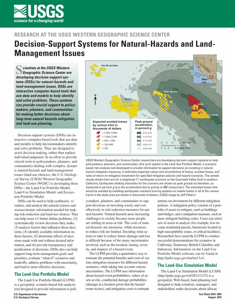
USGS Western Geographic Science Center researchers are developing decision-support systems to help policymakers, planners, and communities. One such system is the Land-Use Portfolio Model, a scenario-based risk-analysis tool developed to provide information to support decisions on investing in natural-hazard-mitigation measures. It estimates expected values and uncertainties of losses, avoided losses, and rates of return on mitigation investment for specified mitigation policies and hazard scenarios. The sample results shown here are for a magnitude 7.1 earthquake scenario on the Coachella Valley fault in southern California. Earthquake shaking intensities for the scenario are shown as peak ground acceleration, as measured in percent g (g is the acceleration due to gravity or 980 cm/sec/sec). The estimated losses that would be avoided by installing earthquake-resistant bracing systems on mobile homes in all of the census tracts in the study area are shown in thousands of dollars. (USGS image by Jeff Peters.)
0 8 164 MILES
0 8 164 KILOMETERS
lN
Palm Springs
Indio
Coachella
San Bernardino
Hemet
Expected avoided losses by census tract in thousands of dollars
> 3,000–3,600
> 1,000–3,000
> 400–1,000
> 100–400
≤ 100
Peak ground acceleration,in percent g
0.33–0.38
0.21–0.32
0.13–0.20
0.09–0.12
0.06–0.08
PACIFICOCEAN
CALIFORNIA
Maparea
N
that can help visualize and compare potential impacts to multiple services across different urban growth/climate change scenarios. Two current applications in the Western United States include the Puget Sound, Washington, EPM and the Santa Cruz Watershed EPM (SCWEPM), along the border of southeast-ern Arizona and northern Sonora, Mexico.
The Puget Sound EPM focuses on eco-system services provided by nearly 2,500 miles of nearshore environment that in-cludes bluffs, beaches, mudflats, kelp and eelgrass beds, salt marshes, gravel spits, and estuaries (http://geography.wr.usgs.gov/pugetSound/index.html). This EPM analyzes scenarios of urban growth out to the year 2060. It examines potential changes to the nearshore, including fecal coliform pollution in commercial shellfish growing areas, beach visitation at State parks, and where seawalls and bulkheads may impact recreational beaches and spawning beaches for “forage fish.”
The SCWEPM addresses water con-cerns in an arid region (http://www.mdpi.com/2071-1050/2/7/2044). It analyzes scenarios of land use and climate change to assess impacts to water-related ecosystem services, such as drinking and irrigation water, erosion, flood control, and biodiver-sity, and equitable access to these services for vulnerable populations.
The work of Western Geographic Science Center (WGSC) scientists on DSSs for natu-ral hazards and land management is part of WGSC’s efforts to better understand causes and consequences of land-cover change. WGSC, supported by the USGS Geographic Analysis and Monitoring Program, works with communities to help provide them the crucial geographic, economic, and natural hazards information they need to make decisions to reduce unnecessary risk from interactions be-tween people and their environment.
N
City of SouthLake Tahoe
Tahoma
InclineVillage
Carnelian Bay and
Kings Beach
Tahoe City
0 5 MILES
0 5 KILOMETERS
Lake Tahoe
Laura Dinitz, William Forney, and
Kristin ByrdEdited by James W. Hendley II
Graphics and layout by Judy Weathers
For more information, contact:Laura Dinitz
U.S. Geological SurveyMenlo Park, CA 94025
Tel. (650) [email protected]
http://geography.wr.usgs.govThis Fact Sheet and any updates to it are
available online athttp://pubs.usgs.gov/fs/2012/3001/
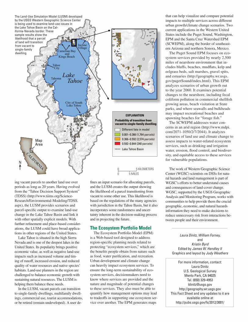
The Land-Use Simulation Model (LUSM) developed by the USGS Western Geographic Science Center is being used to examine land-use issues in the Lake Tahoe Basin on the Cal-ifornia-Nevada border. These sample results show the likelihood that a parcel of land will transition from vacant to single-family dwelling.
N
MapArea
CALIFORNIA
ing vacant parcels to another land use over periods as long as 20 years. Having evolved from the “Tahoe Decision Support System” (TDSS) (http://www.tiims.org/Science-Research/Environmental-Modeling/TDSS.aspx), the LUSM provides scenarios and parcel-specific output to examine land-use change in the Lake Tahoe Basin and link it with other spatially explicit models. With further refinement and place-based consider-ations, the LUSM could have broad applica-tions in other regions of the United States.
Lake Tahoe is situated in the high Sierra Nevada and is one of the deepest lakes in the United States. Its popularity brings positive economic value, as well as negative land-use impacts such as increased volume and tim-ing of runoff, increased erosion, and reduced quality of water resources and native species’ habitats. Land-use planners in the region are challenged to balance economic growth with sustaining natural resources. The LUSM is helping them balance these needs.
In the LUSM, vacant parcels can transition to single-family dwellings, multifamily dwell-ings, commercial use, tourist accommodations, or be retired (remain undeveloped). A user de-
fines an input scenario for allocating parcels, and the LUSM creates the output showing the likelihood of a parcel transitioning from vacant to some other use. This likelihood is based on the regulations of the many agencies with jurisdiction in the Tahoe Basin, but it also incorporates some randomness and uncer-tainty inherent in the decision-making process and in projecting the future.
The Ecosystem Portfolio ModelThe Ecosystem Portfolio Model (EPM)
is a Web-based tool designed to address region-specific planning needs related to protecting “ecosystem services,” which are the benefits people obtain from nature such as food, water purification, and recreation. Urban development and climate change can heavily impact ecosystem services. To ensure the long-term sustainability of eco-system services, decisionmakers need to know where services are provided and the nature and magnitude of potential changes to these services. They also must be able to quantify how management options may lead to tradeoffs in supporting one ecosystem ser-vice over another. The EPM generates maps
Lake Tahoe Basin
Probability of transition from vacant to single-family dwelling
Different fate in model
0.001–0.366 (1,764 parcels)0.366–0.592 (2,574 parcels)0.592–0.844 (240 parcels)
EXPLANATION
Related Documents