Restoration of Degraded Riparian, Wetland, and Deltaic Environments on Mill Creek, Mono County, California Report to Dr. Fritz Reid, Ducks Unlimited Dr. Rod Drewien, Hornocker Wildlife Research Mr. Tom Ratcliff, United States Forest Service and the Los Angeles Department of Water and Power Scott Stine, Ph.D. Berkeley, California 94702 November, 1995 I 1 , , t t I I l I I I I I I , I -I

Welcome message from author
This document is posted to help you gain knowledge. Please leave a comment to let me know what you think about it! Share it to your friends and learn new things together.
Transcript

Restoration of Degraded Riparian, Wetland, and Deltaic
Environments on Mill Creek, Mono County, California
Report to
Dr. Fritz Reid, Ducks Unlimited Dr. Rod Drewien, Hornocker Wildlife Research Mr. Tom Ratcliff, United States Forest Service
and the Los Angeles Department of Water and Power
Scott Stine, Ph.D. Berkeley, California 94702
November, 1995
I
1
, , t
t
I
I
l
I
I
I
I
I
I , I
-I

I I
I I I I
I I
I
I
I
I
I
I
I
I
I
I
I
Restoration of pegraded Riparian. Wetland. and peltaic Enylronments on Mill Creek. . Mono County. California
Table of Contents Introduction ...................................................................... ................................... 1 Environmental Setting . ••..• .............. ........... ....... ..... ........... ......................... ....... 1
The bedrock reach (Lundy Canyon) ................... ..... ..... ..... ......... ................... 2 The Pleistocene Delta Reach ............. .............. ......... ........... ............... ........ 2 The Holocene Delta Reach-Mill Creek's Interior and exterior delta ........ ......... 3
History of Diversions .............................................................. .......... ............ .... 3 Degradation of the Mill Creek Bottomlands ........................ .......................... 5 Restoring the Mill Creek Bottomlands ................. ~......................................... 6
Introduction .................................. ..................... ...... ......... ............... ........... 6 The abandoned channels: Delineation ......................................................... 6 The abandoned channels: DisCussion .... ............. ........... ............... ......... ...... 6
Mill Creek's Entrenched Exterior Delta: The Potential for Creating Hypopycnal Rlas and Wooded Wetlands .................................................... 11
Creation of the trenches .. ...................... ............... .......... .......................... .... 11 Creation of hypopycnal rias and wooded wetlands .......................................... 11 Desirability of groundwater flow to the Mill Creek trenches ............................... 12 ModifICation of the county road ..... ......... ................ ........... ............ ............. .... 1 2
Required Flow Regime ....................................................................................... 13 Introduction ................................................................................................. 13
Rewaterlng Mill Creek: Formulating a Plan .................................................... 14 Introduction .. .......... ................ ....... •••• ........... .............. ........... ....... ............... 14 Potential sources of water-the appurtenant rights .......................................... 14 Historical peculiarities in the distribution of tailrace water .................................. 1 6
Rewaterlng Mill Creek: A Plan for Discussion and Debate ......................... 1 7 Plan elements ..... ..... ..... .... ......... ............... .......... ................ ............. ............. 1 7
Element 1: The Los Angeles Department of Water and Power dedicates _ its Mill Creek water right to Instream use on Mill Creek ......... 1 B
Description ....... ............. ........... ........... ..... .......... ........... ......... •••.•• ............... 1 B Required changes in existing faa1ilies ...................... ..................................... 1 B Components of the '"RequIred Flow Regime-satisfied by Element 1 •• •••. ••• •••••• 1 B
Element 2: All 1.1111 Creek water not used for Irrigation Is returned to, or retained in, Mill Creek, to satisfy Instream uses ............................. 19
DescI1ption .. ............ ............. .......... ........ .................... ............. .............. ...... 1 9 Reqt,ired changes ill existing 'fadle . ...••...• ........... ..•. ... ........ .•........• ............ ..... 1 9 Components of the "Required Flow Regime-satisfied by Element 2 ........ ....... 20
Element 3: The United States FOlflst Service dedicates Its water right to Instream use on 1.1111 Creek ............................................................. 20
Description .. .. .... .... .... .. .. .. .. .. .. .. ........ .. .... .. .... .. .. .... ........ .. .. .. .. .. .. .. .. ......... .... .. .. .. .. .. .. .. .. .. .. .... .. .. .. .. .. .... .. .. .... .. .. .. .... .. .. .. .. .. .. .. .... .. .. .... .. .... .... .. .. 2 0 Required changes In existing faciIitJes .... ...................... ................. ................ 20 Components of the "Required Flow Regime-satisfied by Element 3 .............. 21
Element 4: The Conway Ranch dedicates Its 1.1111 Creek water right to Instream use on Mill Creek ..................................................... ..................... 21
Description ...................................................................... :.... ...... .. .... .. .. .. .. .. ...... .... .. .... .. .. .. .. ........ .. .. .. .. .. ...... .. ........ .. .... .. .. .. .. .. .. ...... .... .. .... .. 21 Required changes In existing faciIitJes .... ••••• ..... ............ ............. ......... .......... 22 Cot7ponents of the "Required Flow Regime-satisfied by Bement 4 ............... 22
Figure 1-Map of abandoned channels of the Mill Creek bottomlands .................................... 7 Table 1-Abandoned channels of the Mill Creek bottomlands ................................................ B Table 2-Summary of Mill Creek Water Rights, by Priority and Current Land Owner) ................. 15 Table 3-Summary of Mill Creek Water Rights, by Current Land Owner and Location of Lands .. 16

Restoration of Degraded Riparian, Wetland, and Deltaic Environments on Mill Creek, Mono County. California
Introduction
With a length of -13 miles and an average annual flow of approximately 22,000 acre
feet, Mill Creek is the third largest stream in the Mono Basin. It heads at the Sierran
crest, and flows eastward over the bedrock of Lundy Canyon, then over glacial and
deltaic sediments to Mono Lake.
Since before the early 1880s water has been diverted from Mill Creek, initially for
irrigation, and later (beginning in 1905) for hydropower generation. These diversions
have had a substantial impact on the lower -11,000 feet of the stream, destroying .
much of the vegetation, and transforming the multi-channeled "Mill Creek bottom lands"
into a single-channeled system.
The lowermost 5000 feet of the stream has been further impacted since the 1940s,
when Mono Lake began to fall in response to the trans-basin diversion of Rush and
Lee Vining creeks by the Department of Water and Power (DWP). This drop in base
level, totaling 45 vertical feet by 1982, foreed Mill Creek to incise its exterior deHa,
creating two elongate trenches up to 10 feet deep.
This report documents the history of diversion-induced impact to Mill Creek; it
examines the measures that could be taken to restore the riparian and wetland
environments of the Mill Creek bottom lands; and it proposes measures to maximize
hypopycnal-ria-type waterfowl habitat on the incised exterior delta of Mill Creek.
Environmental Setting
Hydrologically, geologically. and geomorphologically Mill Creek is divisible into three
reaches: a bedrock canyon of approximately 9.25 miles (-49,000 feet), composed of
crystalline rocks of the Sierra Nevada; a "Pleistocene deltaW reach of approximately
3.45 miles (18,200 feet), the bed of which is underlain alternately by permeable
gravels and relatively impermeable lacustrine silts; and a "Holocene deltaw reach of
approximately 2.15 miles (-11,200 feet). underlain by permeable cobbles and gravels ..
This latter reach is further divisible into an "interior deltaw (length::. 7800 feet), and an
1
I
I
I
I
I
I
I
I
J
I
I
I
I
I
J
I
I
I
I

I
1 I I
"exterior delta" (length =. 5000 feet). -
The bedrock reach (Lundy Canyon). Mill Creek heads in a cirque at the crest of the
Sierra Nevada. It flows eastward over the glacially scoured bedrock of Lundy Canyon
for approximately 49,000 feet, exiting the canyon mouth at elevation -7200 feet
(approximately 3.25 miles downstream from Lundy Dam). Hydrologically. this bedrock
reach is the most productive portion of the catchment, receiving roughly 85% of the
watershed's precipitation. Lundy Canyon thus generates the great bulk of the water
I for the lower two reaches. It is the stream's sole gaining reach, and the only reach
characterized by tributaries (including the perennial Deer Creek, and numerous
unnamed intermittent water courses). A primary feature of this reach is Lundy Lake, a
natural water body dammed by recessional moraines of the Tioga glacial"advance.
Glaciation during Late Pleistocene time eroded most of the soil and sediment mantle
from Lundy Canyon, leaving only a small potential for storing groundwater. This small
storage potential, coupled with the marked seasonality of precipitation and runoff,
contributes to a strong season-to-season variation in the natural flow regime of Mill
Creek. Unimpaired flows measured immediately downstream from Lundy Lake
typically reach an annual maximum between late May and early July (average monthly
flow for June = 89 cfs). and then decline to a base flow (averaging 14 + 4 cfs) between
September and late April 1 (FW Env. Corp, 1995; Perrault, 1995).
The Pleistocene Delta Reach. Mill Creek debouches from its bedrock canyon at an
elevation of -7200 feet. For the next 3.45 miles it flows eastwardly through a narrowly
incised late Pleistocene delta over a bed of alternating coarse-alluvial and fine
lacustrine sediments. Aerial photos and field observations indicate that this
Pleistocene Delta Reach of Mill Creek was characterized over most of its length by a
single channel lined with a narrow band of riparian vegetation (mainly willows.
cottonwoods, aspens, and Jeffrey pines). Only locally did the stream braid into
1 A gain raccretionj of 3 to 10 cfs occurs downstream of this gauge in the lower portions of the bedrock
reach (EBASCO. 1995). Thus, both the base flow and the average monthly maximum flow at the foot of
the bedrock reach are slightly higher than the figures given above.
2

multiple channels. Observations made since 1980 leave no doubt that water seeps to
the ground along this portion of the stream, with an estimated loss of perhaps 2-4 cfs
over the length of the reach.
The Holocene Delta Reach--Mill Creek's interior and exterior delta. At elevation
-6630 feet the narrow, eastward-trending gorge of Mill Creek begins a sweeping bend
to the south, and becomes progressively wider along its bottom. For purposes of this
report, this change in valley orientation and width at elevation -6630 feet marks the
boundary between Mill Creek's Pleistocene Delta Reach and its Holocene Delta
Reach. The Holocene Delta Reach stretches 2.45 miles to Mono Lake.
The downstreamward widening of 1he canyon bottom beginning at -6630 feet is the
result of Holocene deltaic sedimentation on Mill Creek. Simply put, progradation
(lengthening) of Mill Creek resulting from the construction of its "exterior delta"
. (stretching from the county road to Mono Lake, a distance of -50QO feet) has instigated
agradation or backfilling into the Mill Creek canyon, creating the stream's "interior
delta" (stretching from the county road upstream to the aforementioned bend, a
distance of -7800 feet). Under natural conditions, this interior delta, like all active
interior deltas, was characterized by multiple channels, or "distributaries". These
narrow channels distributed the stream flow widely across the valley bottom, creating a
Mbottomlands environment" characterized by wooded wetlands. Riparian woodland
was common along these narrow distributaries, and on the interfluves that separated
them, as evidenced by the dead snags that remain abundant on the ground today_
History of Diversions
By the late 19th century irrigation interests were diverting water .from the upper two
reaches of Mill Creek by way of ditches. The highest of these irrigation diversions-the
Upper Conway Ditch-tapped the left bank of Mill Creek at an elevation of -7520 feet.
It irrigated lands near the present-day site of the Lundy Power Plant, and near the
base of the Bodie Hills. Approximately 1.5 miles farther downstream, near the
boundary between the Bedrock Reach and the Pleistocene Delta Reach (elevation of
7185 feet), the Upper Thompson Ditch bifurcated from the right bank of Mill Creek,
transporting water east- and southward to the Thompson Ranch (now DWP lands)
3
(
I
I
I
I
I
I
I
I
I
-I
-I
I
I
I
I r;

I I
1 I I
I I
I
I I , I I
I I
near Dechambeau Creek. At slightly lower elevation (-70BO feet) the Lower Conway
Ditch diverted water from the left bank of Mill Creek toward the Conway and
Dechambeau ranchlands to the north and east. The right bank was again tapped at
elevation 6920 feet by the Thompson Main Ditch. The lowest of the Mill Creek ditches,
the "McGahn Ditch", departed from the stream's left bank at an elevation of 6650 feet,
approximately 1 mile downstream from the Highway 395 stream crossing. It watered
an -BO-acre parcel of land (now owned by DWP) lying between Mill and (present-day)
Wilson creeks.
In 1905 the predecessors to Southern California Edison constructed a power
generating facility (the "Jordan Power House") at a site north of Mill Creek (and indeed
beyond the boundary of the Mill Creek watershed). Shortly after its construction, this
facility was obliterated by an avalanche. It was replaced in 1911 by the Lundy Power
House (Vorster, pers. com., 1995).
As part of this hydroelectric project, a dam was built on Lundy Lake that raised the
outlet by -37 vertical feet (from elevation n66 feet to 7B03 feet). This dam was
constructed near the mouth Of Deer Creek, and was intended to capture the flow of that
main tributary. 1 The stored water is diverted from near the Lundy Dam into an
aqueduct and penstock that feeds the powerhouse. This facility has the capacity to
accommodate a diversion of up to 70.6 cfs (Perrault, 1995).
Following completion of the Lundy Dam, Southern California Edison and its
predecessors in all but the wettest years diverted the bulk of water from the Mill Creek
watershed into the power plant. Once through the plant and into the tailrace, the flow
was split: a high percentage was directed into the Conway-Dechambeau ditch system
(this rendered unnecessary the direct off-stream diversions at the Upper Conway Ditch
and the Conway-Dechambeau Ditch); the relatively small (and occasional) remainder
entered a newly constructed return ditch that carried the water back to Mill Creek,
I ensuring a supply to downstream diverters.
~ 1 Sometime between 1956 and 1968 Deer Creek shifted eastward on its alluvial fan, so that today it enters
Mill Creek immediately below the dam. This flow is typically taken up by downstream Irrigation interests.
~ 4
~

Throughout Mill Creek's upper two reaches, dewatering due to irrigation and
hydropower diversions was rare. Accretion below Lundy Dam, together with minor
seepage from the dam and small obligatory releases to downstream diversion
interests, kept this portion of the stream perennially watered. As a result, riparian
vegetation has remained largely intact, protecting the streambanks from wholesale
erosion.
Degradation of the Mill Creek Bottomlands
In contrast to Mill Creek's upper two reaches, which were seldom devoid of flow, the
lower reach of the stream was frequently dewatered. Death of the riparian vegetation
appears to have come early (possibly even before the tum of the century), so that by
1929, when the first aerial photos of the Mono Basin were produced, most of the
riparian stand had already been lost. Today, long-dead remnants of trees and shrubs
testify to the once-widespread woodland.
The 1929 photos also show the geomorphological consequences of this vegetation
degradation: Much of the system of multiple channels has been abandoned, and the
single existing channel is in the process of being widened over some segments.
Further channel degradation, including overwidening along lengthy new segments, is
evident on the 1940 photos (presumably this more recent degradation occurred during
the high-runoff year of 1938). Later photos show that by 1955 nearly the entire reach
has been transformed into a straight, wide wash with little to no channel definition.
Beginning in the early 1960s a series of natural and artificial events conspired to force
the frequent watering of Mill Creek's lowest reach. In September of 1961 the Lundy
Powerhouse was damaged, apparently by a landslide. The facility remained
inoperative over the ensuing 7 years, during which time a diminished amount of water
was diverted to the Conway-Dechambeau lands. As a consequence, Mill Creek
carried flow during most of the months of that period. Following the powerhouse
repair, the stream received flow during the peak snowmeH times of numerous normal
to wet years: 1969, '73, '74, '78, '80, '82, '83, '84, '86, '93, and '95. As a consequence
of these releases, riparian vegetation, though largely confined to the active wash, is
more abundant today than it has been at any time during the past 65 years. The
5
I
I
I
I
I
I
I
F
I
[
I
L
I
I
I
I
I
I
I

I I I I I I I I I I I I.'.",',·.' ! ,
II I'.~.'. j ¥",
It f
i I' f ·I;'~ ~~ 0:,;'
~" Jf
stream channel, however, remains wide and ill-defined along most of its length. While
braiding across the wash is evident in numerous places, there is no indication of a
return to a system of narrow distributary channels.
Restoring the Mill Creek Bottomlands
Introduction. Many of the narrow distributary channels that characterized the Mill
Creek bottom lands under natural conditions are still in existence. Their heads are
typically plugged by sediment generated during the periods of erosion-induced
widening of the existing channel.
Rewatering these channels would accomplish the following:
• distribute streamflow widely across the valley bottom
• raise the water table across the valley bottom
• promote ponding in the numerous' natural depressions
• promote growth of riparian vegetation across the valley bottom by dispersing
seeds, raising the water table, and providing natural irrigation
The abandoned channels: Delineation. The abandoned channels of the Mill Creek
bottom lands were mapped during the late summer and early fall of 1995. That map is
included here as Figure 1. Descriptions of the channels are provided in Table\1. A
discussion of the channels follows.
The abandoned channels: Discussion. The multiple channels of the Mill Creek
bottom lands were aband6ned when the loss of vegetation destabilized the channel
banks. This loss of bank stability not only caused the stream to cut a new, straighter
path at weakened meander points, but it also mobilized sediment which then clogged
the entrance of the distributaries. Thus, in most cases, rewatering the abandoned
distributaries would entail re~oval of these plugs of sediment. (Note that these plugs
are typically far smaller than the deposits of quarry waste that today clog the
abandoned channels of the Rush Creek bottomlands.) Along most of their length, the
abandoned channels of Mill Creek retain their former width and sinuosity, though at a
few highly localized sites rewatering would require improving the channel definition.
6

---------------------..-
N
1 ~IL
1000fPe't
'£XI'!I+IV\j c.l-vt1t\V\£ J
A bit. V\ ei 0 Vl. (.t1 .dtl.ll.ltUi L t
\ ;
" )) ~
E
I' V \ (
,,/ I
\ I I
I
\
i •
;
( ! , ,
Figure 1 Abandoned Channels of the Mill Creek Bottomlands (see Table 1 for descriptions)
Sources: USDA Forest Service aerial photo 8·22-93; field observations of 9/93 and 10/93
i
k .. ..
I I
•

I I I I
I I
I
I
I I
I
I
I 1
I I I I I
TABLE 1
ABANDONEP CHANNELS OF THE MILL CREEK BOrrOMLANDS (see Figure 1 for channel locations)
The table that follows outlines the characteristics of the abandoned channels of the Mill Creek bottomlands. Each of the channels has been designated by capital letter (A through E). This designation is by elevational sequence, with Channel A being the upstream-most of the abandoned channels, and Channel E being the downstream-most. The channel lengths given here are based on analysis of aerial photos, and so should be considered approximate.
In addition to the objective information provided in the table, each of the channels is assigned a restoration priority (either 1 or 2). While admittedly subjective, the assigned priorities are based on objective criteria, including length of channel, ease of rewatering, degree to which a rewatered channel would spread flow across the bottomlands, and other factors explained in the "Priority" subsections.
Channel A. This abandoned channel lies west of the main channel, immediately above the very big westward bend (upstream) of the stream. It is reasonably well-defined at its upper and lower ends. .
Approximate Length: 450 feet Elevation at upper end: -6620 feet Grade at upper end: 4-5 feet above existing active channel Grade at lower end: 4-5 feet above existing active channel Sinuosity: Variable, though greater than the modem channel complex. Priority: 2. The stretch of stream along which Channel A runs is already
characterized by 2 well-formed channels, offsetting the need to spread the water laterally. Furthermore, Channel A is stranded 4 to 5 feet above the existing active channel, and so presents a problem in entrance and exit design.
Channel B. This abandoned distributary lies west of the modem channel complex. It has carried water this year, and will continue to do so during times of high flows.
Approximate Length: 450 feet Elevation at upper end: -6600 feet Grade at upper end: In grade with existing active channel Grade at lower end: In grade with existing active channel Sinuosity: moderate- greater than most of the modem channel complex Other characteristics: Channel B is part of the modem channel complex. It might
be encouraged to take more water, since the lower portions of the channel constitute a fine wetland.
Priority: 1. Channel B is presently watered at high flows; it should be examined to determine suitability for augmenting flow, with an eye to retaining wetland habitat during fall and winter seasons.
8

TABLE 1 (cont.)
Channel C. This abandoned channel lies east of, and runs parallel to, the modem channel complex. It is reasonably well-defined, though blocked by a fallen cottonwood trunk, at its upper end. Because of this blockage, and a cobble that extends down channel for a short distance, the channel entrance lies approximately 2-3 feet above the modem channel complex. Rewatering might entail getting semi-permanent flow into a portion of the modem complex that, presently, carries water only during moderate to high flows. The channel is welldefined near its head, locally clogged in some of the middle sections, and exceptionally well defined in its lower reaches. In these lower reaches it runs along the canyon wall a la Rush Creek's channel 10. It enters the existing channel at grade, and through an aspen-lined lowland with a small (1- acre) depression which, when watered, would constitute a pool.
Approximate Length: -1510 feet Elevation at upper end: -6570 feet Grade at upper end: -3 feet above modem channel complex, due to fallen
cottonwood and sediment clog. Grade at lower end: In grade with modem channel complex Sinuosity: Variable, though greater than the modem channel complex. Priority: 1. Channel C is considered a high-priority channel, since it would a)
spread water far to the east, and indeed graze the east canyon wall along its lower reaches; b) encourage the growth of riparian woodland over a long (-1500-foot) stretch which today is largely lacking in arboreal growth; and c) encourage ponding of water at several points, most notably at the downstream end of the channel. Channel definition would be required at several sites through the middle reaches of Channel C.
Channel D. This channel lies west of the main stream complex. It is a small meander that was cut off sometime between 1930 and 1940 (likely in 1938).
Approximate Length: 300 feet Elevation at upper end: -6540 feet Grade at upper end: 2-3 feet above modem channel complex Grade at lower end: near grade Sinuosity: high Priority: 2. Channel 0 represents only a small departure from the modem channel
complex. While it is might provide both direct and indirect benefits to waterfowl, it is relatively short. Assuming that Channel C were rewatered, the rewatering of Channel D would then create three active channels abreast, perhaps leading to a problem of water sharing in years of only moderately high flows.
9
I
I
I
I
I
I
I
I
I
I
I
I
I
I
I
I
I I I

I TABLE 1 (cont.)
Channel E. This abandoned channel lies west of, and runs parallel to, the modem channel complex. It follows a course marked in places by large amounts of dead and downed willow. It heads near a dead (but standing) cottonwood tree. With a length of -2600 feet, this is by far the longest of the abandoned channels. It is characterized by numerous small depressions, and one extensive depression (the "Big Hole", approximately 800 feet upstream of the County Road) that would become ponds when rewatered.
Approximate Length: -2610 feet Approximate Width: Variable, typically 3-4 feet bottom width and 6-9 feet top width Elevation at upper end: -6520 feet Grade at upper end: -3 feet above modem channel complex Grade at lower end: In grade Sinuosity: Variable, though greater than the modem channel complex. Priority: 1. Channel E is considered a highest-priority channel, since it would a)
spread water far to the west of the bottomlands; b) encourage the growth of riparian woodland over a long (-2600-foot) stretch which today is largely lacking in arboreal growth; c) encourage ponding of water at several points, most notably at the "Big Hole" (approximately 800 feet upstream of the County Road); and d) provide a means of getting water down the westernmost of the two trenches that trisect the Mill Creek delta trench. Channel definition would be required along 5% to 10% of its length, most notably through the middle sections of the abandoned channel.
Based on such considerations as channel length, ease of rewatering, degree to which
a rewatered channel would distribute flow widely across the bottomlands, and other
factors, each of the abandoned channels was assigned a priority of 1 (highest) or 2.
Three of the 6 channels (B, C, and E) are deemed Priority 1. Channel B is already
watered at high flows, but might be modified slightly to insure that it carries flow during
the fall and winter seasons. Channels C and E share the following traits: They are
long (with a total length of 4100 feet); they spread water to the edges of the
bottom lands (to the east side in the case of Channel C, and to the west side in the
case of Channel E); and they are characterized by depressions that would become
ponds when rewatered. Channel E has an additional advantage in that it terminates at
10

the county road immediately upstream of the westernmost of the two trenches that
trisect the exterior delta of Mill Creek, and would thus provide a means of rewatering
that trench. A discussion of the two trenches follows:
Mill Creek's Entrenched Exterior Delta:
The Potential for Creating Hypopycnal Rias and Wooded Wetlands
Creation of the trenches. The artificially-induced drop in the level of Mono Lake since
1940 has caused the lake's main feeder streams to incise their deltas. While Rush
and Lee Vining creeks have each cut a single trench, Mill Creek has cut two-an
eastern one, which has carried most of the flow of the stream, and a western one,
which was cut in 1969 when high flows plugged the culvert under the county road and
caused the stream to avulse westward. Similar short-lived freshets, leading to further
deepening of the western trench, occurred in 1980 and 1986.
Creation of hypopycnal rias and wooded wetlands. As Mono Lake rises toward 6391
feet, as ordered by the California State Water Resources Control Board, it will engulf
the lower reaches of these two trenches, creating two elongate embayments, or urias".
Deposition of bay-mouth bars at the foot of the trenches will create highly sheltered,
slack-water conditions within the rias. At times when fresh water is flowing down the
Mill Creek trenches, it will override the heavy salt water of the embayment, creating
"hypopycnal" conditions (density-induced stratification of waters). Such sheltered,
hypopycnal conditions were favored by waterfowl at Mono Lake during the early and
middle decades of this century.
To the extent that water is flowing down Mill Creek's delta trenches, the presence of
rias will induce agradation, avulsion, and bifurcation of the stream. This, in tum, will
create, within each of the trenches, wooded wetlands characterized by a high water
table, dense riparian vegetation, multiple channels, and ponds. Such an environment
can be expected to stretch roughly 1000 feet upstream from the saltwater
embayments. All told, with fresh water flowing down both of the two trenches and
Mono Lake standing at an elevation of 6391 feet, approximately 14 acres of slack
water hypopycnal ria, roughly 16 acres of wooded wetlands, and roughly 25 acres of
stream-side riparian vegetation, will exist on Mill Creek's exterior delta.
11
I
I
I
I
I , , (
I

I
f
I
I I I
Desirability of groundwater flow to the Mill Creek trenches. Streamflow through much
of Mill Creek's Pleistocene Delta Reach, and through most of its Holocene Delta
Reach, results in loss of water to the ground. This "lost" water runs through the
permeable alluvium of the two -reaches, then reappears as springs and seeps near the
lower ends of the delta trenches. This subsurface flow contributes water to the
woodlands, wetlands, and hypopycnal layer in the trenches throughout the year, most
importantly during periods when surface flow in the stream is low. Equally as
importantly, the seeps and springs will keep these habitats wetted into the earty winter,
after the stream itself has frozen up. For these reasons, groundwater replenishment
should be considered an essential component of Mill Creek restoration.
Modification of the county road. Neither rewatering the two delta trenches, nor
creating the hypopycnal rias and wooded wetlands, will require in-channel
manipulations on the exterior delta. (Indeed, the hypopycnal rias and the wooded
wetlands will be highly dynamic and self-perpetuating.) Getting water into the western
trench, however, will require modification of the county road. Presently the road blocks
that trench, directing all flow down the eastern watercourse.
The amount of road modification required to rewater the two trenches would be
minimized if the flow of Mill Creek above the county road were split between the
presently existing channel system (which would continue to feed the eastern trench)
and the now-abandoned Channel E (which would deliver water to the western trench).
Presently the downstream end of Channel E lies close to the upstream end of the
western trench; only the road prevents the two from being a continuous channel.
Insertion of a culvert or bridge on the county road would eliminate this blockage.
Since the eastern trench is both wider and deeper than its western counterpart, it
would seem reasonable that the eastern trench should receive a greater portion of the
stream flow. With this in mind I suggest a 213 - 113 split, with the division occurring
where Channel E (which would receive the 1/3 flow) bifurcates from the existing
channel system (which would receive 213 of the flow).
12

Required Flow Regime
Introduction. Successful restoration of woodlands, wetlands, and hypopycnal rias
along Mill Creek's Holocene Delta Reach (Le. the Mill Creek bottom lands and the
exterior delta) would require release of water throughout the year. Ideally, these
releases would mimic (though would not necessarily need to duplicate) the natural
flow regime of the stream. Presently, use of water for irrigation, and regulation of flows
for hydropower generation, preclude duplication of the natural flow regime.
The flow regime necessary for restoration of the bottom lands and exterior delta of Mill
Creek can be generalized into three components:
1) . Base flows, September through April. Under natural conditions, flows on Mill
Creek are low during the period September through April, fluctuating between
monthly averages of roughly 10 to 20 cfs. This includes the period September
through December, during which the largest numbers of migrating waterfowl
inhabit the Mono Basin. Thus, by feeding marshes, ponds, and rills, and by
maximizing hypopycnal conditions within the delta trenches, the flows during
these months are of direct use to the birds. It is therefore highly desirable,
and perhaps essential, that the small amount of water that is naturally available in
the Mill Creek watershed in fall and winter sill be in the stream during these
months.
2) Chan.nel- and riparian-maintenance flows, late spring and early summer.
Under natural conditions, peak flows on Mill Creek coincide with the period of
peak snowmelt (typically May in dry years, June in normal years, and early July in
wet years). For the period 1941-1990, the average unimpaired flow is 89 cfs for
June and 73 cfs for July. In the wettest June (1983) of this period, flow averaged
roughly 167 cfs, while in the wettest July (1967) it averaged approximately 166
cfs. In each of these cases, peak daily. and weekly flows were higher.
Because of the small capacity of Lundy Reservoir, water in many years spills from
the dam (in such years it is also released from the dam in anticipation of spillage).
As a result, lower Mill Creek occasionally receives flow for a short time in late
13
I
I
I
I
I
I
I
I
I
I
I
I
I
I
I
I I I I

I
I
I
I
I
I
I
I
I
I
spring or earty summer. Such existing flows, if augmented and prolonged with
additional water from water-rights holders, and with unappropriated water from
the powerplant tailrace (see below), would contribute greatly to the restoration of
Mill Creek's bottomland and deltaic environments, which in tum constitute
waterfowl habitat. Such flows are required to maintain channel fonn, build
floodplains, disperse seeds of riparian vegetation, and irrigate that vegetation.
(Note that these channel- and riparian-maintenance flows would need to be
ramped up and down to avoid damaging the 'channels. A discussion of such
ramping is beyond the scope of this paper.)
3) Groundwater replenishment, late spring, summer; and early fall. For reasons
described above (maximization of fresh water at the mouths of the trenches
during the low-flow months, and emission of relatively wann groundwater during
months of freezing temperatures) it is beneficial to replenish the groundwater
reservoir by maintaining water in Mill Creek whenever possible. It is thus
desirable to maintain flows in Mill Creek not only in the summer (when riparian
and channel maintenance dictate that flows be high) and in the winter (when
flows are of direct use to waterfowl), but in the spring and fall as well.
rRewatering Mill Creek: Formulating a Plan
Introduction. Any plan for rewatering Mill Creek must take into consideration the
needs of the stream (see above), as well as the limitations imposed by nature, by
water rights, and by facilities (Le. ditches, dam gates, etc.). These limitations, and
I potential future changes in these limitations, are taken into account in the following
I
I
I
I
I
I
consideration of a plan for rewatering Mill Creek.
Potential sources of water-the appurtenant rights. The rights t<1 Mill Creek water are
summarized by priority on Table 2, and by land ownership on Table 3. These tables
are based on data generated during the Aitken Case proceedings of 1934. They differ
in several respects from the water rights table compiled by Mr. J.R. Perrault of the
LADWP in his revised document of August 18, 1995. The differences generally
involve small amounts of water and low-priority rights, and so bear little on the broad
issues being discussed here. Note that all discussions of quantity and priority of water
14

rights hereafter are based on Tables ~2 and 3, and that they are subject to adjustment
as the differences in the water-rights lists are resolved.
It is clear from Tables 2 and 3 that Conway Ranch and the Department of Water and
Power hold highest priority rights to the largest quantity of water. In both priority and
water quantity, the United States Forest Service ranks third in importance. (The only
other existing right is that of Simis. While of relatively high (No. 4 of 12) priority, it
consists of only 1.6 cfs, and is exercised only during the irrigation season. The Simis
Priority
1.
2.
3,4.
4.
5.
6, 7.
7.
8, 9.
10.
11.
12.
Table 2 Summary of Mill Creek Water Rights
(by Priority and Current Land Owner)
Current Owner rNVP
Conway Ranch
Simis
Conway
US Forest Service
Conway
1914 Claimant NCPCo.
Conway
Miller, Felosina
Sylvester Estate
Cain Irr.
Mattly, Conway
LWOechambeau
D.Currie M. Felosina
H. Mattly
Cain Irr.
Cain Irr.
Lands
Cemetery
Conway
Ditch
Mill Cr pasture
ConwayMattly
Volume (cfs) 1.0
12.0
Miller, Felo- Upper 9.4 sina, Allen Thompson
Sylvester Upper 1.6
Thompson Ranch
ConwayMattly
Oechambeau Ranch
Currie and Felosina
Mattly Ranch
McGahn
Lundy Lk
Thompson
Thompson Main
Conway
14.0
5.0
Wilson 12.6
Maln & Upper 6.0 Thompson
Conway- . 1.0 Mattly
-McGahn-. 2.0
storage 6.0
Source: FW Env. Cons., 1995, with ditch data by Vorster, pers. com., 1995.
15
I
I
I
I
I
I
I
I
I
I I I I
I I I I I
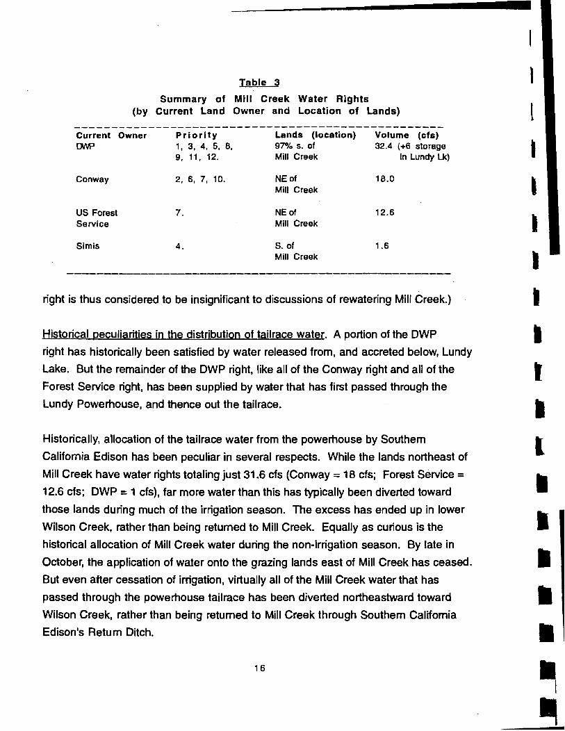
Table 3
Summary of Mill Creek Water Rights (by Current land Owner and location of lands)
Current Owner Priority Lands (location) Volume (cfs) r::JNP 1, 3, 4, 5, 8, 97% s. of 32.4 (+6 storage
9, 11, 12. Mill Creek In Lundy Lk)
Conway 2, 6, 7, 10. NEof 18.0 Mill Creek
US Forest 7. NEof 12.6 Service Mill Creek
Simis 4. S. of 1.6 Mill Creek
right is thus considered to be insignificant to discussions of rewatering Mill Creek.)
Historical peculiarities in the distribution of tailrace water. A portion of the DWP
right has historically been satisfied by water released from, and accreted below, Lundy
Lake. But the remainder of the DWP right, like all of the Conway right and all of the
Forest Service right, has been supplied by water that has first passed through the
Lundy Powerhouse, and thence out the tailrace.
Historically. allocation of the tailrace water from the powerhouse by Southern
California Edison has been peculiar in several respects. While the lands northeast of
Mill Creek have water rights totaling just 31.6 cfs (Conway = 18 cfs; Forest Service =
12.6 cfs; DWP = 1 cfs), far more water than this has typically been diverted toward
those lands during much of the irrigation season. The excess has ende.d up in lower
Wilson Creek, rather than being returned to Mill Creek. Equally as curious is the
historical allocation of Mill Creek water during the non-irrigation season. By late in
October, the application of water onto the grazing lands east of Mill Creek has ceased.
But even after cessation of irrigation, virtually all of the Mill Creek water that has
passed through the powerhouse tailrace has been diverted northeastward toward
Wilson Creek, rather than being returned to Mill Creek through Southern California
Edison's Return Ditch.
16
I
l
I , I
I I
I
l
-I I I I I
•

I
I
I I I I I
I I
I
I I
I I
I
I I (
Rewatering Mill Creek: A Plan for Discussion and Debate
plan elements. The plan for restoring the woodland, wetland, and deltaic habitats on
Mill Creek consists of 4 elements, each of which is discussed below. Included in this
discussion is 1) a list of the changes in the facilities, facilities management, and
exercise of water rights that would be required for the implementation of each element,
and 2) an apprarsal of the extent to which each element would satisfy the "Required
Flow Regime" outlined above.
I stress that the plan presented here is intended to be a point of departure for
discussion and debate rather than an exhaustive dissertation of all possible actions.
Additionally, note the following:
a) The plan assumes that hydroelectric generation will continue to be a factor in
the future operation of the Mill Creek system, with most of the water from the
drainage basi!1 passing through the powerhouse and out the tailrace before
being further distributed. (This is not to say that flow to the, powerhouse could
not be curtailed in the future, with more water being released from Lundy Lake
into Mill Creek.)
b) The 4 elements are not mutually exclusive, but rather are complementary and
cumulative.
c) For the sake of simplicity, the discussions of channel· and riparian-maintenance
flows focus on the effect of the plan in years of normal and high runoff. In years
of low runoff, neither the plan, nor nature, can be expected to provide ideal, or
even adequate, channel- and riparian-maintenance flows.
d) The plan is intended to address broad issues, rather than the intricacies that
come with such complications as change-in-use permits, future Federal Energy
Regulatory Commission requirement on Southern California Edison 1, precise
ramping, dam-release, and power generation schedules 2, etc.
1 FERC Is In the process of relicensing SCE's Lundy operation. At issue is how much water should be released immediately below Lundy Dam. This release, whatever Its amount. will obviously impact Mill Creek flow in a way that affects the plan described below.
21t may be possible for SCE, without loosing revenue, to regulate hydropower releases such that October flows are kept at higher than historical levels. thus making more water available available for potential releases down Min Creek.
17
Element 1: The Los Angeles Department of Water and Power dedicates its Mill Creek water right to instream use on Mill Creek. Description:
As part of its overall program to restore waterfowl habitat to the Mono Basin, the
Los Angeles Department of Water and Power will exercise its non-storage rights to Mill
Creek water by retuming that water to (via the tailrace and Southem Califomia
Edison's Retum Ditch), or not diverting it from, Mill Creek. This will contribute, during
the peak runoff period of most years, a total of 32.4 cfs to the flow of Mill Creek. Owing
to the higher-priority right of Conway Ranch, and to rights held by the Forest Service,
this contribution will necessarily decrease through the summer
zero during the late fall and winter .
Required changes in existing facilities:
, and will likely be' near
Of DWP's total non-storage Mill Creek water right of 32.4 cfs, a portion (9.4 cfs)
is appurtenant to lands fed by the Upper Thompson Ditch. This ditch lies above·
Southem Califomia Edison's Retum Ditch (which heads at the powerplant tailrace),
and so must be fed by water released from the Lundy Dam (at "Farmer's Gate,,), andlor
by water that accretes below the dam. The remainder of DWP's Mill Creek water right
(= 23 cfs minus whatever water in excess of 9.4 cfs is in the Mill Creek channel .
immediately below the Upper Thompson Ditch) will have to be retumed to Mill Creek
by way of Southem Califomia Edison's Retum Ditch. T 0 the extent that only 9.4 cfs is
in the Mill Creek channel at the Upper Thompson Ditch, and that there is sufficient
water in the Mill Creek system to fumish the DWP with their entire water right, the
capacity of the Retum Ditch, presently rated at 16 cfs, will have to be upgraded to 23
cfs. (Less upgrading will be required if, at such times, more 1I1an 9.4 cfs is present in
Mill Creek at the Upper Thompson DitCh.)
Components of the "Required Flow Regime" satisfied by Element 1:
During the late spring and early summer of moderately wet to very wet years,
when water is spilling from Lundy Reservoir (or is being released from the dam by
Southem Califomia Edison in anticipation of a spill), 1I1e retum of DWP's water (at
such times, 32.4 cfs) to Mill Creek will contribute in an important way to riparian- and .
channel-maintenance flows. In years when little or no water passes through or over
18
\
I ,
, I
I
I
I
I

--I I I I I I I I I I I I
I I I I I
the Lundy Dam, streamflows high enough to benefit riparian- and channel-
maintenance will likely not occur . Even in these years, however ,DWP's summertime
contribution will provide important environmental benefits, by replenishing
groundwater supplies, and by providing riparian irrigation during the growing season.
The return of DWP's rightful water to Mill Creek will contribute only a very small
amount of water to the stream during the months of September through April. This is
because, for all intents and purposes, the bulk of DWP's total right is junior to the bulk
of the Conway right. Thus, in an average month of, say , November, with only -10-12
cfs present in the Mill Creek system, Conway will have the right to nearly all the
available flow ,and DWP's potential contribution will drop to near zero. While DWP's
contribution of its water right is an important, indeed essential, first step in the
restoration of Mill Creek, it will do little to insure that the Mill Creek bottomlands are wetted, or that hypopycnal conditions in the delta trenches are available, during the
months of peak waterfowl abundance.
Element 2: All Mill Creek water not used for irrigation is returned to (via
Southern California Edison's Return Ditch), or retained in, Mill Creek, to
satisfy Instream uses.
Description:
All tailrace flow in excess of the water rights associated with the Conway and
Forest Service lands will be returned to Mill Creek by way of Southern California
Edison's Return Ditch. As a result, the maximum flow of tailrace water that will be
diverted toward the Conway and Forest Service lands will be 30.6 cfs (Conway total = 18 cfs; Forest Service total = 12.6 cfs).
Any tailrace water that is not used for irrigation by Conway Ranch and/or the
Forest Service, even if that unused water is within the flow specified in the Conway
and Forest Service water rights, will be returned to Mill Creek by way of the Return
Ditch. Thus, in the late summer ,fall, and winter ,at times when the tailrace flow
exceeds the amount of water spread onto the Conway and Forest Service lands for
irrigation, the excess water will be returned to Mill Creek.
Required changes in existing facilities:
The capacity of Southern California Edison's Return Ditch, presently rated at 16
19

cfs. will have to be upgraded to at least 40 cfs (this figure is derived by subtracting the
Conway and Forest Service rights-total 30.6 cfs-from the powerhouse capacity of
70.6 cfs).
The water in the Return Ditch (up to 40 cfs) will need to pass under the Lundy
Canyon Road. As part of increasing the capacity of Return Ditch. it will likely be
necessary to increase the capacity of the culvert that passes under the road. or to
replace that culvert with a more suitable structure.
Components of the URequired Flow Regimen satisfted by Element 2:
Because it will increase irrigation-season flows in Mill Creek by up to 16 cfs
above that outlined in Element 1. Element 2 will contribute substantially to channel
and riparian-maintenance flows. and to summertime groundwater replenishment.
Element 2 will result in all. or nearly all, tailrace flows being retumed to Mill
Creek in the non-irrigation season. As a result, in the months October through April,
Mill Creek on average will receive an additional 10 to 16 cfs beyond tiJat provided in
Element 1. Flow through the bottom lands and across the exterior delta of Mill Creek
will be close to that which would occur under natural conditions. By watering ponds,
rills. and marshes. and by insuring hypopycnal conditions within the delta trenches,
this additional water will directly benefrt waterfowl during the months when they are in
greatest abundance.
Element 3: The United States Forest Service dedicates its water right to
instream use on Mill Creek.
Description:
The United States Forest Service, in the interest of restoring the Mill Creek
environment, will exercise its right to Mill Creek water by returning that water to (via the
tailrace and Southern California Edison's Return Ditch), or not diverting it from, Mill
Creek. This middle-priority right (7th out of 12), comprising up to 12.6 cfs, can begin to
be exercised only at times when divertable flow exceeds 43 cfs. Such flows are
typically exceeded only during June and July • The Forest Service contribution would
thus occur in the weeks prior to, during, and following, the period of peak runoff.
20
I
I
I
I
I
I
I
I
I [
I
I
I
I
I
I
I I
I

I
I
I
I
I
I
I
I
I
(
I
I
I
I
I
I
I
I
Required changes in existing facilities:
Under this element, the maximum amount of flow that will be diverted
northeastward from the powerhouse tailrace will be 18 cfs (the Conway right). The
remainder of the tailrace flow (up to 52.6 cfs) will be returned to Mill Creek by way of
Southern California Edison's Return Ditch. The capacity of the Return Ditch, presently
rated at 16 cfs, will thus have to be upgraded to at least 52.6 cfs.
The water in the Return Ditch (up to 52.6 cfs) will need to pass under the Lundy
Canyon Road. As part of increasing the capacity of Return Ditch, it will likely be
necessary to increase the capacity of the culvert that passes under the road, or to
replace that culvert with a more suitable structure.
Under this element, Mill Creek below the Return Ditch will receive all of the flow
from the drainage basin except 18 cfs. Thus, all other things being equal, during years
of high runoff Mill Creek below the Return Ditch will experience flows up to 52.6 cfs
higher than have occurred historically • It may therefore be necessary to modify the
Highway 395 crossing of Mill Creek, to insure that it can accommodate flows up to 52.6
cfs higher than have occurred since the highway was constructed.
Because of the increase in flow noted immediately above, it may be necessary
to modify the county road crossing of Mill Creek. Any need to accommodate higher
flows at the county road would be minimized if both of Mill Creek's delta trenches were
rewatered, since this would necessitate 2 county road crossings.
Components of the "Required Flow Regime" satisfied by Element 3:
Because the Forest Service water right can typically be exercised only during
May through August, the dedication of that right to instream use will necessarily occur
when flows on Mill Creek are naturally near their annual maximum. It will thus
constitute an important (to 12.6 cfs) contribution to channel· and riparian-maintenance
flows, as well as to summertime groundwater replenishment, on Mill Creek.
By contributing to groundwater replenishment during the summertime (and thus
to springflow during the fall and winter), the return of the Forest Service's rightful water
to Mill Creek will directly benefit waterfowl during the months when they are in greatest
abundance.
21

Element 4: The Conway Ranch dedicates its Mill Creek water right to
instream use on Mill Creek.
Description:
The present or future owners of the Conway Ranch, in the interest of restoring
the Mill Creek environment, will exercise their right to Mill Creek water by returning that
water to (via the tailrace and Southern California Edison's Return Ditch), or not
diverting it from, Mill Creek. T we-thirds (= 12 cfs) of the Conway right (= 18 cfs), holds
high priority (No.2 of 12). It, or at least a large portion of it, is thus theoretically
available throughout the year .
Required changes in existing facilities:
Under the full extent of this element, no water will be diverted northeastward out
of the Mill Creek drainage. Thus, the entire tailrace flow (up to 70.6 cfs) will be
returned to Mill Creek by way of Southern California Edison's Return Ditch. The
capacity of the Mill Creek Return Ditch, presently rated at 16 cfs, will thus have to be
upgraded to 70.6 cfs.
The water in the Return Ditch (up to 70.6 cfs) will need to pass under the Lundy
Canyon Road. As part of increasing the capacity of Retum Ditch, it will likely be
necessary to increase the capacity of the culvert that passes under the road, or to
replace it with a more suitable structure.
Under this element, Mill Creek below the Return Ditch will receive all of the flow
from the drainage basin. Thus, all other things being equal, during years of high runoff
Mill Creek below the Return Ditch will experience flows up to 70 cfs higher than have
occurred historically . It may therefore be necessary to modify the Highway 395
crossing of Mill Creek, to insure that it can accommodate flows up to 70 cfs higher than
have occurred since the highway was constructed.
Components of the "Required Row Regime" satisfied by Element 4:
Element 4 will return Mill Creek to a condition in which it functions very much as it did
under natural conditions. (The continued operation of Lundy Dam for hydroelectric
generation will prevent precise duplication of the natural regime, by delaying, and
attenuating, peak runoff in most years.) It will thus provide the greatest and most
thorough environmental benefits to Mill Creek.
22
I
I
I
I
I , I
I
I
I
I
I
I
I
I I
I
I [

I
f
I I I I I I I I I I I
Uterature Cited
Foster Wheeler Environmental Corporation, 1995. Draft Instream Flow and Habitat Restoration
Investigation for Mill Creek. Mono County, California. Study for the California Department of Fish and
Game, Stream Evaluation Report 95-1.
Perrault. J.R., 1995. Mill Creek Watershed Report. prepared for the Mono Basin waterfowl habitat
restoration technical advisOry group meeting of July 2B. 1995 (revised August 1B. 1995).
Stine, S., 1995a. Historical and Future Waterfowl Habitat at Mono Lake, California. Report to the qalifomia
State Lands Commission and the California Department of Parks and Recreation, 61 pp.
__ ...... 1995 b. Waterfowl Habitat Restoration in the Mono Basin: A Preliminary Examination of
Constraints and Possibilities. Report to the California State Lands Commission and the California
Department of Parks and Recreation, 7 pp.
___ " 1993. Historic and Modern Distribution of Lake-Fringing Wetlands. Mono Lake, California.
Report to the california State Water Resources Control Board and Jones and Stokes Associates,
Sacrarnento, 59 pp.
___ I 1992. Past and Present Geomorphic, Hydrologic, and Vegetative Conditions on Rush Creek,
Mono County, California.
__ -', 1991. Extent of Riparian Vegetation on Streams Tributary to Mono Lake, 1930-1940: An
assessment of the streamside woodlands and wetlands," and the environmental conditions that
supported them. Report to the California State Water Resources Control Board and Jones and
Stokes Associates, Sacramento, 73 pp.
___ , S. English, and T. Taylor, 1994. Feasibility of Rewatering Abandoned Channels of the Rush
Creek Bottomlands, Mono County, california, 73 pp.
23
Related Documents