SUBJECT: PURPOSE District of Lantzville REPORT TO CHIEF ADMINISTRATIVE OFFICER Meeting Date: September 14, 2020 OCP & Zoning Bylaw Amendment Application for 7555 Fernmar Road, 7645 Harby Road West and 7655 Harby Road West (Winchelsea View Golf Course Redevelopment) To consider an Official Community Plan (OCP) and Zoning Bylaw amendment application for three properties to facilitate a residential development. RECOMMENDATION THAT the Official Community Plan and Zoning Bylaw amendment application for 7555 Fernmar Road, 7645 Harby Road West, and 765~ Harby Road West be refused. The implication of the staff recommendation is that subdivision and development of the subject properties would be limited to the current zoning. Given that 7555 Fernmar Road is already zoned Residential 1, the owner could submit a Preliminary Subdivision Review application to the Approving Officer for consideration of a subdivision with proposed parcels averaging at least 0.2 ha (0.5 ac) for that property. The owner would also have the option of re-applying, presumably with an amended application, following a 6-month period after a decision by Council to refuse the application. The 6-month period could be varied for a specific re-application by an affirmative vote of at least 2/3 of the Council members eligible to vote the matter. COMMITTEE RECOMMENDATION N/A ALTERNATIVES AND IMPLICATIONS 1. THAT Official Community Plan and Zoning Bylaw amendment bylaws, in accordance with the owner's proposal, be brought for to Council for consideration. Staff would draft the necessary bylaws and present those bylaws at a future Council meeting. 2. As directed by Council. BACKGROUND/RELEVANT HISTORY The subject property includes three separate parcels of land totaling 40.7 ha (100.6 ac) in area, as shown on the location map in ATTACHMENTS 1 & 2. P83

Welcome message from author
This document is posted to help you gain knowledge. Please leave a comment to let me know what you think about it! Share it to your friends and learn new things together.
Transcript

SUBJECT:
PURPOSE
District of Lantzville
REPORT TO CHIEF ADMINISTRATIVE OFFICER
Meeting Date: September 14, 2020
OCP & Zoning Bylaw Amendment Application for 7555 Fernmar Road, 7645 Harby Road West and 7655 Harby Road West (Winchelsea View Golf Course Redevelopment)
To consider an Official Community Plan (OCP) and Zoning Bylaw amendment application for three properties to facilitate a residential development.
RECOMMENDATION
THAT the Official Community Plan and Zoning Bylaw amendment application for 7555 Fernmar Road, 7645 Harby Road West, and 765~ Harby Road West be refused.
The implication of the staff recommendation is that subdivision and development of the subject properties would be limited to the current zoning. Given that 7555 Fernmar Road is already zoned Residential 1, the owner could submit a Preliminary Subdivision Review application to the Approving Officer for consideration of a subdivision with proposed parcels averaging at least 0.2 ha (0.5 ac) for that property.
The owner would also have the option of re-applying, presumably with an amended application, following a 6-month period after a decision by Council to refuse the application. The 6-month period could be varied for a specific re-application by an affirmative vote of at least 2/3 of the Council members eligible to vote the matter.
COMMITTEE RECOMMENDATION
N/A
ALTERNATIVES AND IMPLICATIONS
1. THAT Official Community Plan and Zoning Bylaw amendment bylaws, in accordance with the owner's proposal, be brought for to Council for consideration.
Staff would draft the necessary bylaws and present those bylaws at a future Council meeting.
2. As directed by Council.
BACKGROUND/RELEVANT HISTORY
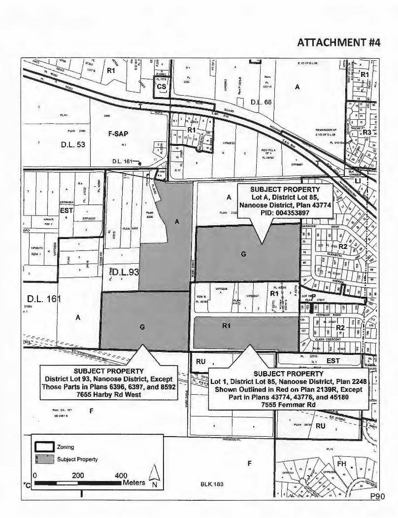
The subject property includes three separate parcels of land totaling 40.7 ha (100.6 ac) in area, as shown on the location map in ATTACHMENTS 1 & 2. P83

District of Lantzville September 14, 2020, Council Agenda Item - OCP & Zoning Bylaw Amendment Application for 7555 Fernmar Road, 7645 & 7655 Harby Road West Page2of4
7555 Fernmar Road - 7.4 ha (18.3 ac) in area, designated Residential in the Official Community Plan {ATTACHMENT 3), and zoned Residential 1 in the Zoning Bylaw (ATTACHMENT 4). A large portion of the property was logged in recent years. There are no ecologically sensitive areas or natural hazard areas identified on the property in the Municipality's mapping.
7645 Harby Road West-12.8 ha (31.63 ac) in area, designated Resource-Open Space in the Official Community Plan (ATTACHMENT 3), and zoned Golf Course in the Zoning Bylaw (ATTACHMENT 4). The property contains the Winchelsea View Golf Course While there are no ecologically sensitive areas or natural hazard area identified on the property in the Municipality's mapping, there are two ponds. The property borders the Agricultural Land Reserve to the north and west {ATTACHMENT 5).
7655 Harby Road West - 20.5 ha (50.7 ac) in area, designated Resource - Open Space and ResourceAgriculture in the Official Community Plan (ATTACHMENT 3), and split-zoned Golf Course and Agriculture in the Zoning Bylaw (ATTACHMENT 4). The property contains the remainder of the Winchelsea View Golf Course, including the clubhouse and parking lot. Knarston Creek and its riparian area, which have significant ecological value, flow through the western portion of the property. The property is partially within the Agricultural Land Reserve (ATTACHMENT 5).
Proposal
The owner is proposing amendments to the OCP and the Zoning Bylaw to redesignate and rezone, respectively, portions of the subject property to facilitate a residential development.
7555 Fernmar Road - rezone from Residential 1 to Residential 3. The purpose of this change is to reduce the minimum parcel area from 0.2 ha (0.5 ac) to 0.1 ha (0.25 ac) to facilitate a 57-parcel subdivision.
7645 Harby Road West - redesignate from Resource- Open Space to Residential and rezone from Golf Course to Residential 1. The purpose of this change is to change the land use designation to residential and to apply a residential zone with a minimum parcel area of 0.1 ha (0.25 ac) to facilitate a 77-parcel subdivision.
7655 Harby Road West - redesignate the southern portion of the property from Resource - Open Space to Residential and rezone from Golf Course to Residential 3 and a Comprehensive Development Zone. The purpose of this change is to apply a residential zone with a minimum parcel area of 0.1 ha {0.25 ac) to facilitate a 46-parcel subdivision and to apply a comprehensive development zone to permit multi-unit housing up to 60 dwelling units.
The overall concept plan is included in ATTACHMENT 6. This concept is a revised submission -the original S':Jbmission is shown in ATTACHMENT 7. Staffs application review letter and referral responses from Island Health, the Ministry of Agriculture and Ministry of Transportation and Infrastructure are included as ATTACHMENTS 8 and 9, respectively. The complete application submission package is included in ATTACHMENT 10.
P84

District of Lantzvllle 5eptember 14, 2020, Council Agenda Item -OCP & Zoning Bylaw Amendment Application for 7555 Fernmar Road, 7645 & 7655 Harby Road West Page3of4
ATTACHMENTS
1. Location Map 2. Air Photo 3. OCP Land Use Designation Map 4. Zoning Map 5. ALR Map 6. Concept Plan (Re-Submission} 7. Concept Plan (Original Submission} 8. Application Review Letter 9. Referral Responses 10. Complete Application Submission Package
ANALYSIS/RATIONALE
Staff are recommending that Council refuse the OCP and Zoning Bylaw amendment application on the basis of inconsistency with the principles and goals established in the OCP.
The owner's application begins by stating that "while the OCP supports cluster development, the proposed development is proposed in a more traditional layout and provides significant open space while creating a financially viable development". The planning principles of the OCP seek to encourage innovative site planning and design, including cluster subdivisions, highly varied parcel areas, and housing diversity, while avoiding cookie-cutter, homogenous subdivisions in new development areas. This is discussed and illustrated in Section 8.5 of the OCP. While it is not expected that each smaller development property throughout the community would, individually, be able to meet all of the policies of the OCP, it is expected that these policies will be met at the landscape level within unique infill development areas. With a property as large as the subject property - 40. 7 ha (100.6 ac} - a unique and innovative site development plan consistent with the policies of the OCP is expected.
In contrast to the OCP policies, the proposed concept is for a relatively conventional and uniform development pattern with very little variation in parcel areas 0.1 ha (0.25 ac) to 0.13 ha (0.3 ac), primarily conventional freehold tenure, with an area in the southwest corner of the site identified as "multi family" between 40-60 dwelling units. While the application indicates that 13.8 ha (34.1 ac) {34% of the site) is proposed to be transferred to the Municipality, the vast majority of these lands are either within the ALR, are ecologically sensitive, are within areas that will primarily serve a stormwater management function, or are acting as buffers to the ALR. The ALR is governed by the Agricultural Land Commission Act and associated Regulations and is very limited with respect to permitted uses. Passive recreation and community gardens would be permitted community uses. While not a direct consideration in whether to support the application, aside from the proposed land transfer, no other community amenity contributions are proposed.
It is worth noting that the application states that if the property is developed as a strata, the 5% statutory park dedication would apply, not the 34% being offered by the developer. However, there is no legitimate reason why parks and open space in excess of the statutory 5% would need to be privately owned. As a community amenity, public lands can be dedicated and provided separate from private strata development sites.
P85

District of Lantzville
September 14, 2020, Council Agenda ltem-OCP & Zoning Bylaw Amendment Application for 7555 Fernmar Road, 7645 & 7655 Harby Road West Page4 of 4
1. Strategic Plan Objectives
N/A
2. Policy
3.
4.
N/A
Resource Implications
N/A
Financial/Budget Implications
If Council chooses to refuse the application, the $1,000 public hearing portion of the application fee would be returned to the applicant.
5. Sustainability Implications
Growth management is a fundamental part of sustainability. In accordance with Section 8.2 of
the OCP, Council may wish to prioritize infill areas for new development, prior to consideration of greenfield sites.
6. Legal Implications
N/A
Prepared By: Approved for Submission to Council:
4, ~
Date: August 17, 2020 Date:
REVIEWED WITH:
D Corporate Administration D Fire Rescue D Public Works/Engineering □ RCMP
D Financial Services D Planning D Solicitor D Committee:
D Other:
COUNCIL AGENDA INFORMATION:
Meeting Type Date Agenda Item # Regular September 14, 2020 'le.) Closed {In-Camera}
Committee of the Whole
File: 3360-20-19-2 l ocation: T:\DISTRICT OF LANTZVILLE\Reports to Council\2020\2020 09 14 Winchelsea Golf Course OCP and Zoning Bylaw Amendment Application,docx
P86

..,. .....
D-L.16
,SUBJECT PROPERTY District lot 93, Nanoose District, Except
Those Parts in Plans 6396, 6397, and 8592 7655 Harby Rd West
BLK. 794
ATTACHMENT #1
SUBJECT Lot A, Di
Nanoose Dis
' - , I
ot 1,, District lot 85, Nanoose Distric Shown Outlined in Red on Plan 213
BLK.183
Part in P'lans 43774, 43776, and 7·555, Fernmar Rd
Im Subject Property
ALR
0 200 400 Meters
.1 N
P87

125
ATTACHMENT #2
250 Meters

NA
NO
OS
E
HA
RB
OU
R
DIS
TR
ICT
O
F
LA
NT
ZV
ILL
E
OF
FIC
IAL
C
OM
MU
NIT
Y P
LA
N
LA
ND
M
AP
NO
. 3
US
E D
ES
IGN
AT
ION
S
Leg
end
D
Dls
trlc
tofl
.:I n
izvi
l• B
ound
a
C) G
row
!hC
ry
on
lai!1
men
l Bou
rw:fa
ry
D
Non
-VIi
a S
!I
" pe
dal P
IM A
rea•
LJP
an:8
1,
DE
SIG
NA
TIO
NS
,ou
r1:e
. Agr
iCIA
!ure
(A
LR
)
Mou
n:e
. Fo
rest
ry
tole
Res
lden
6el
Ufa
lRe,
lden
tlal
R0<
1deo
ll31
ago
oolh
ills
CD
A
OY
lAW
NO
. 1
50
, 20
19
Ma
y 8,
20
19
Ii N
PLAN
F-SAP
D.L. 53 R ,I
RA ; -~ ~ i
EPP8'1983 t.
EST V.Pek1S EPP30~3·7
qa,: A OAO ;t ff')
PUN 6397
~
VIP65•7~ j < 5 c:i REM 1 a:
.: ~ ~ '/!: ~
~
!D.L.9 t
D.L. 16 2>!09
" 1
A G
SUBJECT PROPERTY District Lot 93, Nanoose District, Except
Those Parts in Plans 6396, 6397, and 8592 7655 Harby Rd West
Rem, 0 .l , 161 F 004981 N
Ozoning
CJ Subject Property
0 200 400 Meters
L\ N re
L---------------------
RU
VIP$060:l
Rtm.
Pl 1207-R
RHIPClA CJ'1
Pl. 26792
SUBJECT PR
ATTACHMENT #4
A
A Lot A, District Nanoose District,
R1
SUBJECT PROPERTY Lot 1, District Lot 85, Nanoose District, Plan 2248
Shown Outlined in Red on Plan 2139R, Except Part in Plans 4377 4, 43776, and 45180
7555 Femmar Rd
YARWOOD Pl.
F
BLK.183

RE-SUBMISSION CONCEPT PLAN
nc-====-==--=-=-=:==-· =~ =~·-=•=• .. =··:· :-----------_J
n•. L:)if" ~f!:1tJ
REM. LOT 1 PlAN 2.\.39R
! I
.··, . I ~•. I _.
H.•I,;, ;.. ..... , .:1 .. ~ ..
• i
··- .J Ln L~rsj
ATTACHMENT #5
FOl<! ST 1Jf"1
MAf; . /,'.)'JU DRl!/l
L f
1- ·•- i -I ., i ;··- ! ·-1 7 _J -I .I -, -
I- ,!_,, [ ___ ... ·- ---;
I • -t. ~ -~:=--= ·t·.·= ~
. .J
-i
i-- -·- .... I i T t
I ! ! i I I
' I
1.--,, . , .. 1 ...... ,
P91

,. ,
ATTACHMENT #6 ORIGINAL CONCEPT PLAN
i - -i
· {I I I'\ .. ..•-•---••-··-• 15~;., ~" \
tC
r•••· .. • •·••• • • ••u •• .. ••• ,._,, •
! l I
TO
•/ 11,,,. :, .,.·.oo
i
f
~,. V~ ~~~~ I
._!"~I. .'\, 'Ill, 1..1
. I ' ..... .. ······ ... · .. -· .... , .... .. -····~·~·--- ... -·-·--- J i.1
I.II_. ,' ":" J. ::.'.:
'lA't\fl" ... f ...
'
Ha..RIIY RU"? WEST
Fe;
1- ·~70 l
i i
- -j
~ -J-; ......... ~---TO
P92

ATTACHMENT #7
August 30, 2019
Timberlake-Jones Engineering Weldon Professional Centre #201- 177 Weld Street PO Box 89 Parksville, BC V9P 2G3
Attn: Michell Jones, P.Eng.
District of Lantzvil1e PO Box 100, 7192 Lantzville Road Lantzville, BC V0R 2H0
Tel 250.390.4006 district@lantzvi lle.ca Fax 250.390.5188 lantzvil le.ca
File No. 3360-20-19-2
RE: Winchelsea OCP and Zoning Bylaw Amendment Application Review
The District has completed a preliminary review of your OCP and Zoning Bylaw Amendment Application. Revisions are required in order to ensure consistency with the OCP and to address other issues identified by staff.
Once you have completed the necessary revisions, please re-submit the application as one complete package.
Please contact the undersigned if you have any questions.
Sincerely,
k/r Kyle Young, MSEM, RPP Director of Planning District of Lantzville T: 250.933-8083 E: kyoung@lantzville .ca
c: Ronald Campbell, Chief Administrative Officer Fred Spears, Director of Public Works
T:\DISTRICT OF LANTZVILLE\Planning\Applications\ZB\19-2 Winchelsea Redevelopment\Correspondence\Letters P93

Michelle Jones Winchelsea OCP and Zoning Bylaw Amendment Application Review August 30, 2019
Conceptual Development Plan
2
The proposed concept plan needs to be further developed to provide greater certainty regarding the supported form of development and to ensure consistency with the OCP.
Official Community Plan
Housing Choice : The OCP encourages a range of housing forms and tenures. The proposal must incorporate a greater variety of parcel sizes and housing forms. Please refer to Section 7 of the OCP (Goal 4 Provide Housing Choice).
Cluster Development: The OCP supports cluster development principles, rather than cookiecutter style subdivisions. The proposed concept design must be amended to cluster development, leaving wider greenways and other greenspace. Please refer to Section 8.5 of the OCP (Density Bonus, Averaging and Clustering).
Innovation : It is expected that all new subdivision and development in Lantzville will incorporate innovative site and building design practices. Please provide additional detail on how the proposal is innovative. Please refer to Section 8 of the OCP (Goal 5: Manage Steady and Sustainable Development of Infill Neighbourhoods).
Greenspace and Open Space : The District is prepared to accept the Knarston Creek corridor and ALR lands as public open space. However, given that community uses will generally not be permitted in these areas, additional lands that the District may use for community uses are required, including public parkland and greenways.
Sustainability: It is expected that all new land use, subdivision and development proposals will demonstrate how they are sustainable from an economic, ecological and social perspective. In particular, the proposal must clearly demonstrate how the tax reve.nues generated from the development will fully cover the costs of maintaining, operating and replacing all public infrastructure and greenspace resulting from the development.
Farmland Protection
The property is adjacent to lands within the Agricultural Land Reserve that are currently being used for agriculture. The lands may also be used for intensive agricultural operations in the future. Buffering and separation from the ALR are required in order to minimize the impact of the proposed residential development on the farmland. A minimum 15 m wide landscaped / planted buffer, including a fence and signage, must be established along the ALR boundary, in accordance with the Ministry of Agriculture's Guide to Edge Planning. This buffer is required to be designed and planted at the subdivision stage. Please include a cross section diagram illustrating the required buffer.
T:\DlSTRICT OF LANTZVI LLE\Planning\Applications\ZB\19-2 Winchelsea Redevelopment\Correspondence\letters P94

Michelle Jones Winchelsea OCP and Zoning Bylaw Amendment Application Review August 30, 2019
Roads and Transportation
3
There are no further requirements at this time related to the Traffic Impact Assessment. An initial discussion has taken place with RDN Transit Services. Once the concept plan is finalized, a further review will be completed to identify possible future transit stop requirements.
The District is currently reviewing its road standards. As part of this application, updated road standards will be applied. All right-of-way widths will be 20 m. The local road standard will include vehicle lanes, a parking lane on one side of the road with appropriate signage, street trees on both sides of the road, and 1.5 m wide separated concrete sidewalks on both sides of the road. The collector road standard will include the same elements but the concrete sidewalk on one side of the road will be replaced with a 2.5 m wide separated asphalt multi-use pathway.
Third Party Utilities
All third party utilities, including existing overhead utilities along Fernmar Road are required to be located (or relocated) underground.
Water Servicing
The District is not prepared to accept a new source well and supply line in this location. The development will need to be connected to the District water system and acquire new water service connections under the Lantzville / Nanaimo Water Agreement as connections become available and as approved by Council.
Sewer Servicing
All proposed parcels will need to be connected to the District sanitary sewer system via a gravity connection. Lift stations are not supported.
Stormwater Management
A preliminary stormwater management plan that includes a technical report and a plan view overview of the proposed stormwater management system, including a topographic plan, is required. The report must confirm that achieving a no-net-increase in stormwater runoff. All stormwater for stratas and multi-family sites will need to be managed entirely onsite to ensure post-development flows equal pre-development flows.
T:\DISTRICT OF LANTZVILLE\Planning\Applicatlons\ZB\19-2 Winchelsea Redevelopment\Correspondence\Letters P95

Michelle Jones Winchelsea OCP and Zoning Bylaw Amendment Application Review August 30, 2019
Ecological Protection
4
The existing forested area must be retained in order to protect Knarston Creek and its riparian areas. This area will need to be transferred to the District with the ALR lands prior to development in this portion of the site.
Community Amenity Contributions
In accordance with the OCP, community amenity contributions are required. Please identify the proposed community amenity contributions in the updated submission. Please refer to Section 8.6 of the OCP.
T:\DISTRICT OF LANTZVILLE\Plannlng\Applications\ZB\19-2 Winchelsea Redevelopment\Correspondence\letters P96
Excellent care, for everyone,
everywhere, every t ime.
July 3, 2019
Kyle Young Director of Planning District of Lantzville PO Box 100, 7192 Lantzville Road Lantzville, BC V0R 2H0
ATTACHMENT #8
island health
Your File No: 3360-20-19-2
RE: Review of Proposed 206-unit residential development - Winchelsea Golf Course
Thank you for the opportunity to comment on the Official Community Plan and Zoning Bylaw amendments to re-designate and rezone the subject property to facilitate a 206-unit residential development.
The past few years have seen significant advances in linking urban planning with a variety of health outcomes. These include outcomes such as: the encouragement of physical activity, healthier eating, greater safety, cleaner air and healthier living environments, access to health services, food security, age friendly communities, and improved social interaction amongst other potential health criteria.
Island Health (VIHA) appreciates the opportunity to provide evidence based recommendations and comments for this referral. Regulatory requirements as well as Healthy Built Environment recommendations are itemized below:
Regulatory Considerations
Drinking Water
• Generally- Under the Drinking Water Protection Act and Regulation, any construction,
installation, alteration, or extension of (a) a water supply system, or (b) works, facilities, or
equipment that are intended to be a water supply system or part of a water supply system,
must be issued a construction permit from our Public Health Engineer. Consultation with our
Drinking Water Officer will also be needed (for more information:
https://www.islandhealth.ca/learn-about-health/drinking-water).
M edical Health Officer Located at: 3
rd Floor 6475 Metral Drive I Nanaimo, BC V9T 2L9 Tel: 250.739.6304 I Fax: 250.755.3372 viha.ca P97

District of Lantzville File No. 3360-20-19-2
Page 2 of 5
• Site specific desktop review - Based on a preliminary appraisal of the proposed source water,
Well #2, Island Health has concerns of the suitability of this well for servicing a subdivision of
this size. The well report completed by GW Solutions indicates, on Page 21 & 22 under
Conclusions and Recommendations - Point 4, that the reliability of the well and behavior of the
aquifer would need to be further explored before it could be proven that the well was
adequate for the full development. Furthermore, the report, on Page 4 Geo-Camera
inspection, indicates that the bedrock in the aquifer was observed with major
fractures. Fractured bedrock aquifers are highly vulnerable and are considered to be
Groundwater at Risk of Containing Pathogens, requiring treatment and disinfection on the
water to make it potable for users. While the most recent chemical test illustrates an absence
of microbiological exceedances, previous analysis (in September 2018) detected Total
Coliforms (140 CFU/l00mL) and E.coli (60 CFU/l00mL) respectively. In addition, Boron (at
5.68 or 6.68 mg/L) exceeds the Maximum Acceptable Concentration (MAC). These parameters
would require treatment. What's more, pH (9.27) and sodium (159 mg/L) may also require
treatment for both maintenance and health purposes. More information would be required to
determine whether this source water is a safe and sustainable option for this development.
Sewerage Disposal
• While the development would fall under the Ministry of Environments Municipal Wastewater
Regulation (for systems over >22, 700 L/flow/day). Island Health suggests that the District of
Lantzville's proposed Phase 3 sewer project at Fenmar Road and Harwood Drive precedes
Phases 2 and 3 of the Winchelsea View Golf Course redevelopment to ensure the area is fully
serviced by an approved wastewater management system.
Recommendations under Island Health's Healthy Built Environment Initiative
Healthy Neighborhood Design
• On page 22, in the referral, proponents endeavor to illustrate alignment with the Official
Community Plan (OCP) under Goal 5 - Manage Steady and Sustainable Development of Infill
Neighborhoods; however, this proposal is clear that it does not promote traditional infill.
Under Goal 4- Provide Housing Choices (page 22), the first phases of this development will be
single detached housing units "with future phases allow[ing] for consideration of multi-family
developments ... " We bring up these elements of the proposal for the following reasons:
o By definition, this development fosters sprawl. It is characterized by low-density
devefopment with new growth appearing primarily on previously undeveloped, while
modified and not natural, land. Sprawl not only restricts opportunities for physical
activity and access to healthy food, it also undermines social well-being. Alternatively,
fostering the compact form, can limit outward urban expansion, which can be
P98

District of Lantzville File No. 3360-20-19-2
Page 3 of 5
combined with more efficient use of land resources and more effective protection of
natural resources1•
o By clustering development, creating more compact and complete community style
development, is more likely to support active transportation. Healthy neighborhood
design is reflected in diverse neighborhoods where all people can live, work, play,
connect and access amenities. Thereby, allocating mixed use, or multi-unit compact
design in this development can have a great impact on health and well-being1•
• We want to inquire about meaningful parkland dedication and play spaces for children. These
community contributions are lacking or absent from the proposal. Park playgrounds are found
to be important for supporting healthy weights. One study found that of 13 public park
characteristics examined, children with a park playground located within one kilometer of their
home were almost 5 times more likely to be classified as being of a healthy weight than those
without a nearby playground2•
Healthy Food Systems
• On page 25 of the proposal package, under (2.2.) Parks and Open Space, proposed park
dedication includes land in the Agricultural Land Reserve (ALR). We like to highlight the
importance of agricultural protection. From a health perspective, "farmland preservation helps
to maintain a level of food production that contributes to food self-sufficiency, and food self
sufficiency supports healthy eating"1• Therefore, while parkland dedication and greenspace
allocation has many other health related benefits, the protection of agricultural land should be
a key consideration.
Healthy Natural Environments
• Tree retention: In the Habitat Assessment report, page 6 (point 2), it is suggested trees to be
retained. Island Health would like to support this point in the retention of as much of the
existing natural environment as possible. Health evidence shows a strong link between
exposure and engagement to natural areas and the reduction of stress, chronic disease,
depression and anxiety as well as improvements in cognitive functions.
Storm water management: We encourage moving away from open swale/ditch edging to proper storm water management. It appears the roads are only planning open swale/ditch. We fail to see how swales and ditches will promote ground water recharge when the proposed subdivision is repurposing 60 acres of currently vegetated land. An integrated stormwater management system may be a more appropriate approach to protect property, habitat, and water quality4
'5
•
Healthy Transportation
• In reference to the Traffic Impact Assessment and application package there are notable
concerns for the proposed Transportation Network:
o As proposed, the residential roads will lack sidewalks, and the collector road at
P99

District of Lantzville File No. 3360-20-19-2
Page4of5
Fernmar Road is only being recommended as a "multiuse" pathway connection.
o Overall, the proposal mentions connectivity and trail links but provides no level of
detail. Due to the site's location, it would be appropriate to ensure connectivity to
Copley Park (and Copley Ridge Recreation Trail).
• The health rationale to support the above comments are in line with prioritizing active and
safe transportation options. When this is achieved, mobility for all residents is encouraged
which leads to improved health outcomes. The safety of cycling paths, and sidewalks, the
distance and time it takes to walk to common destinations all play a role in our daily choices
about how to get where we need to go1•
• For instance, sidewalks can provide 50-88% reduction in vehicle-pedestrian crashes compared
to locations without sidewalks. Studies have also shown that cycling injury risk can be reduced
by 30-90%, compared to on-street riding with no cycling infrastructure3•
Healthy Housing
• Affordability: In reviewing the proposal there is only one reference to affordability and that is
on page 22, where it states ... "future phases allow for consideration of multi-family
developments, seniors housing an~ smaller units for those people wishing to downsize. This
may allow for more affordable housing choices for different age and income levels". As
mentioned in the Healthy Neighborhood Design section above, design, quality and
affordability ·of housing options have a critical influence on health and well-being. Diverse
housing options helps people stay in their communities longer and improves their ability to
afford other basic needs such as health care and nutritious food, while decreasing stress1•
• To minimize potential nuisance related impacts on residential development adjacent to the
ALR, Island Health is supportive of the District's OCP (2019) policy (page 56) that states "a
buffer in the form of a landscaped area, green belt ... " be required. This has the potential to
alleviate issues, such as, "noise exposure [that] can result in sleep disturbance, fatigue, and
other mental and physical health problems"1, and odor or air pollution related impacts
associated with agricultural operations.
If you have any questions or comments, please do not hesitate to contact us.
Sincerely,
Dr. Paul Hasselback Medical Health Officer
P100

District of Lantzville File No. 3360-20-19-2
cc: Stacey Sowa, Environmental Health Officer, Island Health Jade Yehia, Regional Built Environment Consultant, Island Health
JY/td
Page 5 of 5
1 BC Centre for Disease Control (2018). Healthy Built Environment Linkages Toolkit: making the links between design, planning and health, Version 2.0. Vancouver, B.C. Provincial Health Services Authority. Retrieved at: http://www.bccdc.ca/pop-public-health/Documents/HBE llnkages toolkit 2018.pdf
2 Potwarka, L. R., Kaczynski, A. T., & Flack, A. L. (2008). Places to play : Association of park space and facilities with healthy weight status among
children. Journal of Community Health, 33(5), 344-350. doi:10.1007 /s10900-008-9104-x
3Government of BC (2015). BC Community Road Safety Toolkit and Vision Zero. Retrieved from: https://www2.gov.bc.ca/gov/content/transportation/driving-and-cycling/road-safety-rules-and-consequences/publications- legislationand-data/bc-communlty-road-safety-toolkit
4 Ministry of Environment (2014) . Develop with Care: Environmental Guidelines for Urban and Rural Land Development in British Columbia.
Retrieved from : https://www2. gov. be.ca/gov/ content/ environment/natural-resource-stewardship/ laws- policies-standardsgu idance/best-m a nagem en t-p ra ct ices/develop-with-ca re
5Ministry of Water, Land, and Air Protection (2002). A Guidebook for British Columbia: Stormwater Planning. Retrieved at: https://www2.gov.bc.ca/assets/gov/environment/waste-management/sewage/stormwater planning guidebook for bc.pdf
P101

June 21, 2019
Kyle Young Director of Planning District of Lantzville 7192 Lantzville Road, PO Box 100 Lantzville, BC VOH 2HO
Sent by email
Dear Kyle Young:
BRITISH COLUMBIA
Re: Referral for proposed 206-unit residential development - Winchelsea Golf Course
Thank you for providing the opportunity for the Ministry of Agriculture to provide comments on the residential development proposed for the properties that make up the Winchelsea Golf Course. There are 3 lots that make up the application. Two, Lot A- DL 85 and Lot 1 -DL 85 are out of the Agricultural Land Reserve (the 'ALR') and one, DL 93 is a split lot with the northern portion in the ALR and the southern portion out of the ALR. From an agricultural perspective, the Ministry of Agriculture offers the following comments:
Between 1988-1991, golf courses were permitted in the ALR. The concept at the time was that golf courses could be converted into agricultural production at a future date. By 1992 the ALR Regulations were amended to no longer permit golf courses in the ALR, however there are still many of these golf courses on the ALR in existence. With demand for golf waning and an increased demand for residential development these applications for redevelopment are becoming more common.
Lot 1 DL 85, the proposed first phase of the project, is located outside of the ALR, does not border the ALR boundary and therefore, there are no concerns related to this portion of the residential development outside of drainage and potentially increased traffic which will be discussed below.
The Ministry of Agriculture has published the "Guide to Edge Planning" (the 'Guide') which is a comprehensive document that promotes compatibility along the agricultural-urban edge (a link to the Guide is provided below). For your reference and in the context of this development, we have included the following excerpt from the Guide:
"Measures to promote compatibility along B. C. agriculture-urban interfaces have been limited. As a result, a variety of complaints can arise from both farmers and their neighbours.
Farmers often experience trespass, property and equipment vandalism, crop damage and theft, livestock harassment, and litter. Flooding of farm land by rainwater runoff from upland urban development is another impact many farmers have experienced. All of these problems result in significant financial losses for farmers.
On the urban side of the 'fence', complaints can be related to odour, pesticide spraying, dust, aesthetics, and noise from different farm activities. Urban neighbours might complain about unfamiliar (to them) but normal and accepted farm practices, even if they are carried out in compliance with established regulations and standards."
In order to protect the agricultural integrity of the ALR parcels in the vicinity of the development and considering the scale of this development, there are a few protections that need to be addressed in this proposal. Specifically, the Guide recommends that the minimum setback for residential buildings is 30 metres on the urban side of the ALR boundary. Within that 30 metre setback, the 15 metres immediately
P102
adjacent to the ALR boundary should be dedicated to a vegetative buffer ideally consisting of fast growing tree and shrub species with foliage from base to crown. The aforementioned setback suggestions should be applied to all proposed residential properties that border the ALR which includes the northern and western portions of Lot A - DL 85 and those properties lying to the east of Knarston Creek along the ALR boundary ofDL 93.
- The ALR parcel diredly north of Lot A- DL 85 is an operating full service equestrian facility. Currently, there appears to be an established vegetated buffer along the ALR boundary between Lot A - DL 85 and the ALR-equestrian property, although it is difficult to determine on which side of the ALR boundary the buffer exists. For the benefit of both the owner of the equestrian facility and the prospedive landowners constructing homes on the properties immediately south of the equestrian facility, serious consideration should be taken to retain this existing vegetative buffer. If this buffer is located on the ALR-equestrian property, a 15 metre vegetative buffer on the non-ALR properties (urban side of the ALR boundary) is highly recommended.
- Within the context of the ever evolving nature of the agricultural sector, the importance of robust buffers between properties in the ALR and adjacent residential properties cannot be overstated. For instance, while the ALR parcel directly north of Lot A - DL 85 is currently an equestrian facility and the ALR portion of DL 93 is currently part of the golf course, depending on a multitude of factors, the land use of these properties may change over time to forms of agriculture that are more commonly associated with nuisance complaints from residents living in farming area such as an Intensive livestock or tree fruit operations. Robust buffers between properties in the ALR and adjacent residential properties are extremely effedive at preventing potential nuisance complaints from residents living in farming area.
... The northern half of DL 93 is the portion of the golf course that is in the ALR. Almost 28% of the required park dedication of this development will be located on land in the ALR. As per the recommendation for urban sites abutting the farming edge as described in the Guide, at least 5% of the park area should be provided adjacent to the boundary of the ALR to create space for a vegetated buffer. While permitted Non-Farm Uses in the ALR include open land parks for biodiversity conservation and passive recreation, it is noteworthy that the portion of DL 93 in the ALR has an agricultural capability class of 4 with limitations of aridity and excess moisture. As such, if the aforementioned limitations are addressed, this land can support a wide range of agricultural activities. The Ministry suggests that a detailed soils analysis be conduded and a concurrent discussion is undertaken with the community on the opportunities for utilizing the ALR portion of this parcel for agricultural use. As there is existing infrastructure on the site, we are also interested to know if any discussions have taken place on the future use of the golf course club house and parking area.
- The proposal for a north-south collector road between the development and agricultural properties is of concern. Colledor roads which move more traffic adjacent to properties in the ALR are not conducive to supporting farming. The Land Title Act states an approving officer may refuse a subdivision if "the extent or location of highways and highway allowances shown on the plan is such that it would unreasonably or unnecessarily increase access to land in an agricultural land reserve". Traffic movement associated with the proposed development should consider avoiding farming areas to prevent future conflid between residents and farmers.
- As per subdivision design recommendations within the Guide, with the exception of two lots located east of Knarston Creek along the ALR boundary of DL 93, the proposed development appears to avoid larger residential lots along the ALR boundary. While it may seem counter Intuitive, this is important to reducing agricultural-urban conflict as Ministry of Agriculture studies on ALR edge development show that affluent residents living on larger suburban lots adjacent to farms have higher expectations of peace and quiet and are more likely to complain about farm practices and operations.
- Urban developments can affed nearby farmland by changing storm water flows and ground water levels. This is a significant concern with this development as the golf course's more natural soft landscape is being replaced by hard impervious surfaces. It is important to also consider that farm drainage systems cannot accommodate the potential increase in surface water flows resulting from the development. Increased moisture in the winter and dryness in the summer creates considerable hardship for farmers and the longterm viability of the farmland in question. Effort should be put into understanding the hydrology of the entire area before development proceeds.
P103

A link to the Guide to Edge Planning is found below.https://www2.gov.bc.ca/assets/gov/farming-naturalresources-and-industry/agriculture-and-seafood/agricultural-land-and-environment/strengtheningfarming/planning-for-agriculture/823100-3 edge guide 2015.pdfn
Please contact Ministiy staff if you have any questions regarding the above comments.
Thank you for the opportunity to provide comments from an agricultural perspective with respect to this proposal.
Sincerely,
~ ·9✓ / I . r •~,,Y / I
i ' • I
Jill Hatfield, P.Ag., Regional Agrologist B.C. Ministiy of Agriculture - Courtenay Office: (250) 897-7518 E-mail: [email protected]
Reed Bailey, Land Use Planner B.C. Ministiy of Agriculture Phone: (778) 698-3455 Email: [email protected]
P104

~ BRITISH I MinistryofTransporration llii.illlill COLUMBIA and Infrastructure
Kyle Young; c/o District of Lantzville
7192 Lantzville Road PO Box 100 Lantzville, British Columbia V0R 2H0 Canada
Attention:
DEVELOPMENT SERVICES GENERAL COMMUNICATION
eDAS File#: 2019-03696 Date: Jun/28/2019
Re: Proposed Zoning Bylaw Approval Application for: Map: 1138314,471460 7555 Femmar Road 7655 Harby Road West
Upon review of the provided documents, and clarification provided at the Ministry Engineers request, the Ministry is supportive of the rezoning at Winchelsea Golf Course to facilitate a 206 unit residential development.
If you have any questions please feel free to call Jamie Hopkins at (250) 751-7090.
Yours truly,
Jamie Hopkins Development Approvals Technician
H1160-eDAS (2009/02)
[~~1~Z1r~~~ii~~~ Vancouver Island District
Third Fir 2100 Labieux Road
Nanalmo, BC V9T 6E9 Canada
Phone: (250) 751-3246 Fax: (250) 751-3289 Page 1 of 1
P105
ATTACHMENT #9
DISTRICT OF LANTZVILLE
P106

August 11, 2020
District of Lantzville 7192 Lantzville Road PO Box 100 Lantzville, BC VOR 2HO
Attention: Kyle Young, Planner
Redevelopment Concept Plan for Winchelseo View Golf Course, Lantzville, BC
Dear Mr. Young,
This Redevelopment Concept Plan has been prepared in response to several meetings and communication with District of Lantzville staff and response to the August 2019 letter from yourself. We have reviewed the newly adopted Official Community Plan (OCP} and Land Use Bylaw, reviewed the water and sewer phased plans, and completion of several background studies (environmental and riparian area, socio economic review of the proposed development, and well testing).
This Redevelopment Concept will provide the support material required for the OCP amendment and the re-zoning application.
The Winchelsea Golf Course has operated for many years but is no longer a financially viable operation. Surrounded by agricultural and residential land, this site is well suited to a phased redevelopment to residential uses. The proposed development will complement the adjacent uses, and provide appropri·ate setbacks from existing agriculture and environmentally significant areas. The proposed development will provide additional paths, trails and roads to improve the pedestrian and vehicular access for existing residents.
We will arrange a meeting to review this document with you in the near future.
Sincerely, DILLON CONSULTING LIMITED
Patricia Malaney, FCIP, RPP Planner
PAM:clm Our file: 18-6878
''"''-?' DILLON CONSULTING
PO Box 37069
Cuuntr~• Club Centre
1'nnaimo,
British Columbiu
Canada
\ ?T 6~4
Telephone
403.819.81%
Fa:.,.:
03.215-.8889
P107

Ta e of Contents 1.0 Introduction 1
2.0 Overview of the Proposed Development 2
3.0 Planning Context 4
3.1. Regional Growth Strategy 4
3.2. District of Lantzville Strategic Priorities 4
3.3. Official Community Plan 5
Goal 1: Protect the Natural Environment 5
Goal 2: Preserve Community Character 6
Goal 3: Strengthen the Village Priority Commercial Core 7
Goal 4: Provide Housing Choices 7
Goal S: Manage Steady and Sustainable Development of Infill Neighbourhoods 7
Goal 6: Develop Community Infrastructure 8
Goal 7: Improve Road, Pedestrian and Bicycle Mobility 8
3.4. Water Master Plan 9
3.5. Land Use Bylaw 10
4.0 Proposed Development Strategy 12
4.1. Residential Concept 12
Phase 1 13
Phase 2 17
Phase 3 18
4.2. Parks and Open Space 19
5.0 Transportation 21
5.1. Site Access 21
5.2. Traffic Impact Assessment 21
6.0 Archaeology 23

7.0 Servicing 24
7.1. Water Servicing 24
7.2. Sanitary Servicing 26
7.3. Rainwater Management 27
8.0 Financial and Social Impacts 28
9.0 Engagement Plan 29
9.1. Meetings with District Staff 29
9.2. July 28, 2018 Open House Summary 29
9.3. September 26, 2018 Fernmar Road Landowners Meeting 30
9.4. Future Engagement 30
10.0 Approvals Process 32

Figures
Figure 1: Winchelsea Redevelopment Planning Area 3
Figure 2: Map 2, Excerpt from District of Lantzville 5
Figure 3: Map 2, Excerpt from District of Lantzville 6
Figure 4: Map 10, Excerpt from District of Lantzville Official Community Plan Bylaw No. 150, 2019 6
Figure 5: Map 3, Excerpt from District of Lantzville Official Community Plan Bylaw No. 150, 2019 7
Figure 6: Map 5, Excerpt from District of Lantzville Official Community Plan Bylaw No. 150, 2019 8
Figure 7: Excerpt from the Land Use Bylaw No. 180, 2020 11
Figure 8: Proposed Development Phasing 14
Figure 9: Excerpt from the Land Use Bylaw No. 180, 2020 15
Figure 10: Proposed Land Use 16
Figure 11: ALC Setback Cross Section 18
Figure 12: Excerpt of Appropriate Uses in the ALR 20
Figure 13: 2022 Post-Development Conditions with Full Buildout 22
Figure 14: Map 6 Excerpt from the Land Use Bylaw No. 180, 2020 24
Figure 15: Location of On-Site Wells 25
Figure 16: Map 7 Excerpt from the Official Community Plan 26
Tables
Table 1: Winchelsea Anticipated Sewer Flows
Table 2: Proposed Approvals Timeline
Appendices
A Concept Plans
B Habitat and Riparian Area Assessment Report
C Traffic Impact Assessment
D Archeological Assessment
E Well Reports
F Drainage Report
G Financial and Social Impact Assessment
H Response from the District of Lantzville
I Open House Summary
J Fernmar Road Landowners Meeting Summary
K Land Titles
27 32

1.0 ntroduction The ownership group of the Winchelsea Golf Course and adjacent lands have engaged Timberlake-Jones
Engineering Ltd. {Timberlake-Jones} and Dillon Consulting Limited (Dillon) to prepare this
Redevelopment Concept Plan.
The subject lands include:
• The existing 18 hole golf course at 7655 Harby Road West in Lantzville; aind
• 7555 Fernmar Road.
The legal descriptions include:
• District Lot 93, Na noose District Except Those Parts in Plans 63966, 6397 and 8592;
• Lot A, District Lot 85, Nanoose District, Plan 43774; and
• Lot 1, District Lot 85, Nanoose District Plan 2248, Except Part in Plans 43774, 43776 and 45180.
This project was initiated in February 2018 with meetings with the District of L.antzville representatives.
Since that time, District staffing changes have occurred along with the adoption of a new Official
Community Plan (OCP; Bylaw No. 150, :2019) and a new Land Use Bylaw (Bylaw No. 180, 2020).
Communication with Mr. Kyle Young, based on the letter dated August 30, 2019, has provided direction
on the background information required for this Concept Plan. We have completed additional
background studies and now incorporate the newly adopted OCP and Land Use Bylaw. The socio
economic assessment has demonstrated that freehold subdivision is financially viable for the District,
that strata development is less desirable for market demand and that the free,hold option provides more
public open space for community benefit.

2.0Overview of the Proposed Develo,pment
The owners have determined that the golf course use is not an economically viable opportunity. In
addition, the land on the north side of Fernmar Road is appropriate for residential development.
The purpose of this Concept Plan is to initiate the strategic redevelopment of Winchelsea View Golf
Course for residential use, while protecting the rural character and Agricultural Land Reserve, and
prepare the application for an OCP amendment, Land Use Bylaw amendment, and subdivision.
The Concept Plan provides an overview of the proposed development phasing strategy, internal road
network and external connections, density, municipal infrastructure (water and sanitary sewer),
storm/drainage plan, protected environmental areas, community open space, paths and pedestrian
connections, relationship to existing and planned adjacent land uses, and opportunity for future
intensification of neighbouring acreages.
The Vision for the Winchelsea area is:
Winchelsea is a residential neighbourhood that embraces the rural lifestyle while providing housing
options, encourages a healthy lifestyle with pedestrian, cycling and equestrian trails and supports
green infrastructure and climate adaptation.
Figure 1 illustrates the planning area for the Winchelsea Redevelopment Plan.
While the OCP supports cluster development, the proposed development is proposed in a more
traditional layout and provides significant open space while creating a financially viable development.

2
lf' Timberlake-Jones t .. :!,>2 :.'C'01 J'u, ~$-:s!3 ....... m-t ........ URL.. ~~
Figure 1: Winchelsea Redevelopment Planning Area
CLIENT:
.._., RB
STUDY AREA
LEGEND
Weteroour~e
SCALI 1.1.0IXl
ELSEA VIEW GOLF COURSE LTD.
- 0

3.0Pla • I Context
There are several applicable long range planning documents that apply to the Winchelsea
Redevelopment Concept. This section provides a broad analysis of this development proposal as it
relates to each of these strategic documents.
3.1. Regional Growth Strategy The District of Nanaimo Regional Growth Strategy, adopted in 2011, outlines several goals for the region
applicable to Lantzville, which have been incorporated into its OCP. It establishes a Regional Growth
Containment Boundary (GCB} and promotes appropriate densification and infill development, to
encourage housing options for both existing and new residents. The strategy acknowledges the need for
more housing within the GCB to broaden both housing supply and choice, and improve affordability. The
efficient use of existing infrastructure is promoted in the strategy by encouraging intensification/ greater
density for residential uses and redeveloping appropriate land uses not currently used for agriculture,
employment, or environmentally sensitive areas.
This proposal reflects the intention of the Nanaimo Region as expressed in the Regional Growth Strategy
in several ways, including:
• Protecting and enhancing existing natural areas along Knarston Creek;
• Providing additional housing choice through greater supply and options geared toward families
and seniors;
• Developing new and utilizing existing community infrastructure connections;
• Improving road, pedestrian and bicycle mobility;
• Intensifying development within the Regional GCB;
• Creating construction employment opportunities; and
• Redeveloping an underutilized parcel of land adjacent to residential uses.
3.2. District of Lantzville Strategic Priorities The District of Lantzville Strategic Plan 2019 - 2023, identifies the following mission statement:
Provide efficient, effective and environmentally and economically sustainable services and good
governance for the public while managing growth of the community and respecting Lantzville's
diverse character and charm.
The District updated their Strategic Priorities in January 2020. This update recognized that the OCP and
the Land Use Bylaw had been updated. There are several priorities that impact the Winchelsea
Redevelopment Concept. In addition to major priorities as providing equitable water to all residents, the

priorities include developing subsidized seniors housing, encouraging housing diversity, achieving a
proper taxation balance, and ensuring that new development cons iders innovation, green technology,
unique architecture, trend setting, and the BC Energy Step Code. The improvement of parks, trails,
pathways and bicycle routes is a strong priority to maintain an active healthy community with less
dependence on personal vehicles.
The Winchelsea Redevelopment Concept has the potential to provide diversity of housing, including
supportive seniors housing; however, the overall density limits set by the District do not allow for much
innovative or green technology or affordability. The concept includes paths and trails and connectivity to
regionally proposed parks and paths, and protects the environmentally sensitive areas, as well as the.
Agricultural Land Reserve parcel.
3.3. Official Community Plan The District of Lantzville adopted a new OCP (Bylaw 150} in 2019. The key takeaway from the vision
statement is:
Lantzville will continue to be primarily a suburban residential community1 to the urban centres of the
region, with limited commercial and industrial development.
Phase 1 of the proposed redevelopment is
identified within the OCP for Residential use.
The remainder of the redevelopment would
require an OCP amendment to change from
Resource - Open Space land use to Residential.
The OCP outlines seven key goals. The following
outlines how the Winchelsea Redevelopment
project complies with and supports the goals of
the OCP.
Goal 1: Protect the Natural
Environment Knarston Creek runs along the western side of
the property, and a detailed environmental
study of the creek and related riparian areas
will be provided.to determine appropriate
development setbacks. The residential
development would demonstrate both
Environmentally Sensitive Areas
.- :7 · I
Figure 2: Map 2, Excerpt from District of Lantzville Official Community Plan Bylaw No. 150, 2019

protection and enhancement of the existing
creek. Existing forested areas along the creek
would be preserved, with development
concentrated where the existing golf course is
located and to the south side of Fernmar Road.
The creek is noted in both Map 2 and Map 9 of
the OCP. The proposed development will provide
a 30 metre setback from the top of bank for all
of the creek that is located on the Winchelsea
property. No vegetation will be removed from
this area. Paths and trails will be considered, but
not at the risk of removing any significant
vegetation or impacting the significant riparian
areas.
In addition, the Winchelsea area is outside of any
areas identified for Hazard Lands in the OCP.
Natural Environment Development Permit Areas . - ' ' ' , ......._, "· \ ~
-=.;,1;2~;'18;~~ ... 1-=-=· ;;=·~· 1=·· """ __ :_J-ucl~I c-_j ::: t~ ' . . -s I 1 J '
; I
l ~~-~- ~ad _.,· DU : ~
. c-· T T[J 'g(~UIIJ . L.1~:: !'~ill~
~ t ,- ··10" --.~•-• ~h•~F,.--,--f-::-;" •
- - -T-=-i -~.;c__- ... ~~ ....
--=-~-- . "' ~· . -~. -; ~ I!~-- -~(
-=-=- . . . ~- __ •- e:~---Wf \ ' .. ..___ _, - - ~
Figure 3: Map 2, Excerpt from District of Lantzville Official Community Plan Bylaw No. 150, 2019
Goal 2: Preserve Community Characte·r The lot sizes, coverage, density and heights
would be in line with adjacent residential
development to the east of the subject site. The
intention of the proposed concept is to align with
the existing community character and road
network as much as possible, and maintain
opportunity for future redevelopment of the
existing acreages along Fernmar Road to match
with the character of the present
neighbourhood, as provided in the Concept Plan.
Map 3 of the OCP identifies Land Use
Designations. Phase 1 of the Winchelsea lands
are identified for Residential. The majority of the
golf course is designated Resource - Open Space
and a large portion of the golf course, which is
within the Agricultural Land Reserve, is
designated Resource -Agriculture. The property
is bordered by residential development on the
east side, residential development along Fernmar
Figure 4: Map 10, Excerpt from District of Lantzville Official Community Plan Bylaw No. 150, 2019
separates Phase 1 from the balance of the land, and agricultural lands are located on the north and west
sides of the property.
Future development of Residential uses Phases 2 and beyond, will not conflict with existing uses.
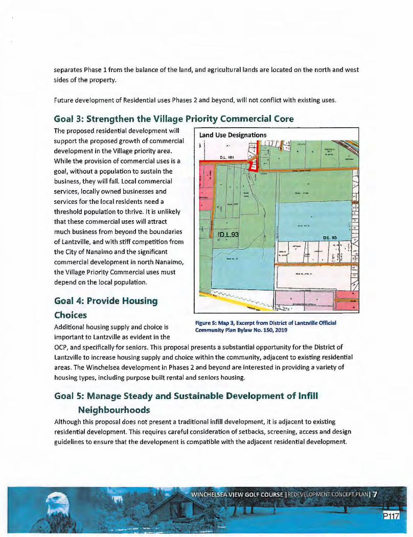
Goal 3: Strengthen the Village Priority Commercial Core The proposed residential development will
support the proposed growth of commercial
development in the Village priority area.
While the provision of commercial uses is a
goal, without a population to sustain the
business, they will fail. Local commercial
services, locally owned businesses and
services for the local residents need a
threshold population to thrive. It is unlikely
that these commercial uses will attract
much business from beyond the boundaries
of Lantzville, and with stiff competition from
the City of Nanaimo and the significant
commercial development in north Nanaimo,
the Village Priority Commercial uses must
depend on the local population.
Goal 4: Provide Housing
Choices Additional housing supply and choice is
important ta Lantzville as evident in the
Land Use Designations
3
-------- ---... ...... _ . ...._,_ --,_~ ~-!'
Figure 5: Map 3, Excerpt from District of Lantzville Official Community Plan Bylaw No. 150, 2019
OCP, and specifically for seniors. This proposal presents a substantial opportunity for the District of
Lantzville to increase housing supply and choice within the community, adjacent to existi'ng residential
areas. The Winchelsea development in Phases 2 and beyond are interested in providing a variety of
housing types, including purpose built rental and seniors housing.
Goal 5: Manage Steady and Sustainable Development of Infill
Neighbourhoods Although this proposal does not present a traditional infill development, it is adjacent to existing
residential development. This requires careful consideration of setbacks, screening, access and design
guidelines to ensure that the development is compatible with the adjacent residential development.

Goal 6: Develop Community Infrastructure The efficient use of existing infrastructure is a key priority of the OCP. Any new infrastructure necessary
for the proposed development will be at the cost of the developer. The subject site is strategically
located close to existing residential development and will provide opportunity for residential
intensification in the future for the acreages nearby. Phase 1 of the Winchelsea development is located
within Phase B of the Sanitary Sewer System and Phase 1 of the Water Service Area. The development
will pay for the installation of the distribution lines, which will allow for the residents along Fern mar
Road to connect to piped municipal services.
Goal 7: Improve Road, Pedestrian and Bicycle Mobility Appropriate road and sidewalk
standards will be used to service the
development. Bicycle and pedestrian
mobility will be an important
consideration in the design of the
subdivision, in .addition to
consideration of equestrian trails.
Fernmar Road will be connected to the
development to improve connectivity
within the area. Map 5 of the OCP
illustrates the proposed municipal
roads, facilities and trails. While these
may not be the final and exact
locations for the parks and trails, the
Winchelsea Redevelopment Concept
proposes trails and paths and a park
location in Phase 3. In addition, the
Agricultural Land Reserve (ALR) lands
may be provided for a variety of open
space and public uses.
Municipal Roads, Facilities and Trails
• !,l_• . .--· ' · ,. ·~ fl,,, ~.,J, ' .. . ~,· ~ ' . - ~~~
j
r ·- : ~ 1 · . . /1----- . ;,. ·. I ,:;•. rr-: ./' ~ . l t::..,J " • ; . • /, • -~.~
.ri • , - .• J. • . ~ . l " (f _J, I ~~ • • • "' ' =3 !D.~9~ jt I--...-------...---.---,----. • I . - ~ .. ~I
-1 Ir- ✓ - ~ . _ ___.._._ - --. -....,_;--:;:;-~ ~ • - •
r __ l_-_· - -;'l-~~ DijiiiEli~ ~,-,.-,~~
~
I •
1; _-
Figure 6: Map 5, Excerpt from District of Lantzville Official Community
Plan Bylaw No. 150, 2019
There is a large section of ALR land on the property that is currently used for golf course, club house and
parking. With the modification to appropriate ALR uses by the Agricultural Land Commission (ALC),
future uses on this parcel are restricted to directly Agricultural and resource-based uses, but allow open
space and recreational uses that would benefit the Lantzville comm.unity at large. In addition, the
District could lease this land for community gardens or small agricultural operations. The golf course
club house could also be repurposed for a community use.

The Agricultural Land Reserve Use Regulation (BC Reg 30/2019) identifies the appropriate uses for ALR
lands. There is a long list of agricultural uses including all forms of farming, livestock and greenhouses. In
addition, there is a list of farm related uses including wineries and cideries, production of compost, farm
sales, and timber harvest. In addition, there is a short list of permitted non-farm uses that include: home
based businesses, temporary sawmill, pet kennels, production/storage/application of compost, small
aggregate extraction, education and research, public infrastructure, and conservation and passive
recreation and open land parks.
3.4. Water aster Plan The Water Master Plan sets direction for managing and enhancing the community's water infrastructure
and use. A water supply and distribution study was completed in 2015 and the Water Master Plan was
recently completed in 2017.
Phase 1 of the development is located within the FW: Fernmar Road Area water supply area. The District
Water Master Plan acknowledges that the proximity to the existing infrastructure will help to limit
potential extension costs. The Winchelsea Redevelopment Plan proposes that Phase 1 of the
development be serviced by the District Water. The developer will be required to construct the water
line along Fernmar Road. This will provide the opportunity for the, existing acreage lots on Fernmar Road
to tie into piped water.
The current zoning for Phase 1 is R-1 Residential which allows for houses, with carriage houses as a
secondary use and a minimum lot size of 2,000 m2 (or half acre). The piped water (along with piped
sanitary sewer service) will allow for the intensification of development. In addition, it is envisioned that
the existing large lots on the north side of Fernmar Road will have the opportunity to subdivide and
increase the density of the area with the ability to tie into piped services. The OCP continues to
recognize this as future residential development area. The Water Master Plan states "short term
consider for water service extension, subject to neighbourhood approval may be warranted." This would
reduce the dependence on individual wells, reduce the individual cost per parcel for the water line and
allows for intensification. The potential for carriage houses also creates the opportunity for a different
housing form.
The existing lot owners on the north side of Fernmar Road would pay a tie-in charge or latecomer
charge, and the physical tie-in would have to consider capacity for any future re-subdivision. The
engagement for the preparation of the Winchelsea Redevelopment Plan indicated that the Fern mar
residents would be in support of this waterline and extension and the opportunity to tie-in. Some of the
residents expressed the interest in future subdivision. This would make economical use of the
infrastructure, demonstrating fiscal responsibility on the part of the District of Lantzville.

Phases 2 and 3 of the Winchelsea Redevelopment area are not located within the area designated for
residential uses in the OCP or the Water Service Area. As such, they were envisioned at the time to
remain for golf course; therefore, would require an amendment to the OCP to designate the lands for
Residential. In addition, the Water Master Plan would require modification to include the Winchelsea
lands in total, along with a re·zoning application.
It is also understood that the District is limited to the number of residential units they may connect to
the piped water system annually due to the agreement with the City of Nanaimo f~r the provision of
treated potable water.
Golf courses are significant water users and, as such, there are several water wells on the property,
along with holding ponds. In 2018, the owners commissioned a Water Well Study, which was prepared
by GW Solutions (attached as Appendix E). This study demonstrated that there is sufficient quantity of
water to accommodate residential development in Phases 2 and 3. In addition, the water quality meets
the provincial drinking water criteria. It is proposed that Phases 2 and 3 of the Winchelsea
Redevelopment Plan could be served by the well water on the site. The GW Solutions report found
during the well testing that while the drawdown was not ideal, using an incomplete recovery, the well
water can conservatively provide a safe yield of 54 USgpm (3,4001/d). This yield will provide a safe and
sustainable water source for 85 residential units. This yield could be increased once more reliable data
on the volume pumped over one summer and the resulting drop in water level is collected. In addition, if
the recommendations of the Water Master Plan are adopted and the water requirement is reduced to
2,800 to 3,0001/d, the well could safely provide for between 98 and 105 residential units. Therefore, this
well will provide sufficient water for Phase 2 of the Winchelsea Redevelopment Plan.
3.5. Land Use Bylaw The District of Lantzville adopted a new Land Use Bylaw (Bylaw 180) in 2020. The Winchelsea lands are
zoned a combination of Residential 1, Golf Course and Agriculture. Prior to the adoption of the new Land
Use Bylaw, Rl allowed one (1) acre lots. The amended Land Use Bylaw now allows 2,000 m2 (1/2 a.ere)
lots.
The agricultural zone on the golf course reflects the fact that the ALC in the past, allowed golf courses in
the ALR. This is no longer a permitted use and, as such, the golf course continues with a "legal non
conforming" status that will remain in effect until such time as the golf course stops operation. The ALR
land in the north portion of the Winchelsea lands is designated Agriculture, even though it too was used
for golf course including the Club House and parking lot.

The redevelopment concept for Phases 2 and 3
would require Land Use Bylaw amendment in
addition to the OCP amendment to change the
lands from golf course to residential uses.
The agricultural parcel is proposed for open
space and dedication for Municipal Reserve and
is not proposed for rezoning; therefore, it does
not require an OCP amendment or a Land Use
Bylaw amendment. The opportunity exists for
the District to lease this land for uses that would
be appropriate in the ALR that could benefit the
community. These uses are listed in Section 4.2.
Figure 7: Excerpt from the Land Use Bylaw No. 180, 2020

4.0 Proposed Developme t Strategy The proposed redevelopment concept is divided into three phases: the existing residential land on the
south side of Fernmar Road, the agricultural lands, and the two golf course parcels. This section provides
more detail on the development strategy. The proposed phasing of the development is illustrated on
Figure 8. The Concept Plans are included in Appendix A.
The development strategy includes a phasing strategy that divides the land into three phases, each a
separately titled lot:
• Phase 1- Lot 1, District Lot 85, Nanoose District, Plan 2248, Except Part in Plans 43774, 43776
and 45180 located on the south side of Fernmar Road, a total of 7.31 ha (18.0 acres);
• Phase 2 - Lot A, District Lot 85, Nanoose District, Plan 43774, located in the northeastern lot
adjacent to the existing development on Clark and Andrea Crescents, a total of 12.71 ha (31
acres); and
• Phase 3 - District Lot 93, Nanoose District, Except Those Parts in Plans 6396, 6397 and 8592, and
includes the western most lot and includes the ALR lands and riparian/wetland environmental
protection areas, a total of 10.86 ha (27 acres) south of the ALR and a total of 9.12 ha (23 acres)
for a total of 19.98 ha of ALR land.
The phasing has been developed to achieve the following:
• Desire to maintain the golf course operation as long as possible, allowing the golf course to fully
operate as Phase 1 develops, and operate nine holes as Phase 2 develops;
• Allowing for realistic lot absorption and not flooding the market, and develop a viable financial
strategy;
• Ensuring appropriate time for infrastructure construction and connection; and
• Permitting suitable time for coordinating the OCP amendment, rezoning application and
subdivision application for Phases 2 and 3.
4. 1. Residential Concept The overall concept is to provide primarily single detached homes. This appears to be the primary
demand for housing type and fits with the vision of Lantzville as outlined in the Official Community Plan.
The proposed lot layout features 180 residential lots with a minimum lot size of¼ acre (1,000 m2). Lot
sizes are proposed to be larger on the east side of the development to match the size of the lots on Clark
and Andrea Crescents (1/3 acre or 1,300 m2) creating continuity between the proposed and existing lots.
This layout has been developed for the following reasons:
• There is market demand for 1,000 m2 lots based on regional demographics, local real estate
trends, and the community desire for smaller service lots in the OCP review process;

• There is less demand for strata development and the consumer payment of strata fees;
• Compatibility with adjacent land uses, specifically the residential development on Clark and
Andrea Crescents by incorporating larger lots or green space;
• Water and sewer servicing is optimized with higher density and smaller lots, demonstrating
fiscal responsibility;
• Increased lot yield makes the project financially viable;
• Ability to offer a lot size catered toward a broad spectrum of potential buyers including families
and seniors (less maintenance, potentially lower cost due to less land};
• Opportunity to offer greater amenities and open space provision throughout the site to the entire
community;
• Future redevelopment potential for the adjacent acreages along the north side of Fernmar Road;
• Phased developme,nt allows the golf course to remain in operation as long as possible;
• Allowing for adequate real estate absorption and development financing; and
• Ensuring appropriate time for infrastructure construction and connection.
The long range concept includes a multi lot parcel for higher density development in the southwest
corner of the property in Phase 3. There was general support for this type of development specifically if
it is geared to seniors' living. The parcel provides views, access to Knarston Creek, significant
environmental setback, and a number of paths and trails.
This development is proposed as a freehold subdivision, with the only strata development being the
multifamily parcel proposed in Phase 3. The socio-economic assessment has indicated that at the
density proposed, the District will not be placed in any financial hardship to maintain the infrastructure,
and the community at large will not "pay" for this development. In addition, as a freehold development,
the community at large will benefit from the extensive open space and pathway system proposed
(which would have been privately owned and not available for public use if developed as a strata}. This
open space totals 31.77 ha or 34.4% of the total property for public open space.
Phase 1 Phase 1 (Rem. Lot 1, Plan 213R} of the development is a 7.31 ha (18.06 acre) parcel fronting onto
Fernmar Road. The proposal is to accommodate a total of 57 single detached lots of 1,000 m2 (1/4 acre).
The five lots that back onto Clark Crescent will have additional separation from these lots by a green
space that provides a walking trail. While the single detached development conforms to the OCP, the
current zoning of Rl requires a minimum lot size of 2,000 m2• The applicant has applied for rezoning to
R3 to accommodate the 1,000 m2 lot size.

w,, l'LMaa'
... , . IJl'UIAI.,.,
Figure 8: Proposed Development Phasing
_____ ,_
t-.~1u,·, ":;.ll. V',~?;1 ..... ,.. _ __ _ ____ .,. ___ _
i
f .E
l i :
&1,1!1-.U-uwff
~ ..... - ----•"'""""'! ...... ~~··
e .... - . ~ .. --,---LOTA
. RM-43774
I ~ t lA !; I
I
~ L_ __ ,. __ f I •
1 1 I •1:---1 It ___________ .....
-,'be,, r. Z·D:!U,10 ANLJWIIUl,T AtA!llltGhMI

The development proposes walkway connections and a linear green space backing onto existing parcels
on Clark Crescent. The gross parcel size is 7.31 ha (18.06 acre). The internal road will utilize .956 ha of
land. A total of .374 ha of land is proposed as open space for trails and parkland. The required
dedication is 5%. This concept proposed 5.11% of open space, conforming to the Local Government Act
requirements.
The Land Use Bylaw allows carriage houses and secondary suites in the R3 zone. New development is
encouraged to apply for and accommodate the additional units to provide a variety of housing
opportunities. Figure 9 illustrates the current Rl zoning regulations and the proposed R3 zoning
regulations.
This phase will be accessed from the existing Fern mar Road. Water and sanitary sewer will be
constructed to service this area and provide the potential for the existing residents on the north side of
Fern mar Road to tie into the piped water and sewer.
I U RESIDENTW. 1 ZCNE
ParmnadUlit5
Tt,,:~1r1D11d i:,1nur~, ;,i.:lu:m"C1Jr1 .w,;;nc-.a.:fttis...,.
Pr.Jr,.,. ,Lbt
HlUIH'
OinDn,Unlts:
,I.a'l'll!f:r HJW:.J'
· ¼Ll~,r&im,en
kturcbr1:1Ao-~
(Rl)
T11,: 111u,lln,>1,.,11ru1 ct--=tl'TUf!l'-",!W ~.ru..! ;, l!ail~III! i. 11111r.ld1:.:u,,.,i,.,.,.., Uld ~.cl 0"1!· Ut:.1.l.aly:.ill:' -"OT Iolt"'l.p l•n..r:,:
51~
n,l!murrma.r,uttlltk.lt- Qnd ll...,_._,,e•;,~lill l,._-;
Parall ~
Tl!• ITIUfllf"IJMP'mf •lZ•ff••~ :l'ft;
5!.lbdMSlan
Figure 9: Excerpt from the Land Use Bylaw No. 180, 2020
I u RESIDENTW.] ZONE
P1rmrtcdl.lsc$
l
DlirwUn5 UIIIU
tbcnYoamurr.numu,cto-:u,-,..,ll" .. 1111•· .iur,trl,, 11.1ao1nirn,11.,,oo&,0r,·•l1J,...,.MU1 rf!frC'f u-r 111:aoll;i!\, ~lc· IP'<rr l.l'"'II" ~o.a:-
Sl'~
J . Thcmnorr ... m,~ll.f111m,14-.,1:t uruc;arc .a.::l'O IJ1"-'-
Hqht
-4 TbUTIM rr.Jdt"Jhl!fJU:.;afl:'.t:,f.;tllwo.
P.:1 1'<1:l ~
The JTYtamurn p~ tG<-c..;v,r •~ !19Ji.
Sib:S~an
611'l
1 I!:,

_. _ ·.:, :.".'l!!:"Jt!l•~-t~." •• -
=J ~ □~□ ltMlmXStT.W..:S
□ ~',Tl!!.)
ct-tim.Tt
□ !t.!lift..CW-
' .
□ Cl -~•l: ~ □~
PJ.R
Figure 10: Proposed Land Use
, I
l J
I
___ ., ___ ,
ttl,!·!!l'l'hUl,L'I~-!,! ........ ----- - .. - ..
A
•::L Lil
RU
-----ua,. "r;;:ltl.UllA Vll.WGD'.l.l &Dllllfil -D:Jll'& .m:NM:IMN~
tl<lr.t'-'IZ.IUJ:Cl\lt.r.lllUIJ'

Phase 2 Phase 2 of the development could accommodate up to 77 lots of 1,000 m2 (1/4 acre) lots, on a 12.75 ha
(31.51 acre) parcel of land. This parcel is currently zoned Golf Course and accommodates two large
ponds for water storage for golf course irrigation. The lot layout proposes single detached lots accessing
off the future Hurd Road extension. The ponds will be incorporated into the open space plan to provide
paths and trails, but will also provide surface drainage ponds for the stormwater management of the
site. This creates an amenity and feature in the development that will connect to the overall path and
trail system.
At the Open House, the residents did not support the construction of Harwood Drive through this
property. They were concerned about the increased through traffic. The development proposed
Harwood Drive be constructed as an emergency and pedestrian access only. The Traffic Impact
Assessment did not indicate that this road was required for traffic circulation (because 77 lots do not
required secondary accesses).
This property is adjacent to the Agricultural Land Reserve to the equestrian operation to the north. The
development is proposing a 15 metre green space separating the rear of the new residential lots and the
agricultural parcel. This green space will include landscaping in compliance with the ALC require~ents
along with a walking trail. Figure 11 illustrates the cross section for this green space. The gross area for
this parcel is 12. 75 ha with 2.437 ha of local internal roads. The development proposes to dedicate a
total of 1.876 ha of open space, or 14.7% of the gross area for parks and open space.
This parcel is currently zoned Golf Course and the OCP designates the site as Resource-Open Space. lhe
development of this land requires an OCP amendment to recognize this land for residential use. This
parcel requires rezoning to R3 to accommodate the minimum lot size of 1,000 m 2• In addition, the lots
that back onto the existing residential development on Andrea Crescent will be enlarged to 1,300 m2 to
reflect the character of the existing lots in the Harwood neighbourhood.
This property will be accessed by the construction of Hurd Road and will bring the servicing through
Harwood Road into the development.

p ALR-t--------------------------+
15.00m PL
3.50m 9.00m 2.50m
300ITVn.APPROVFfiffi,9TI31r:§ii:~~ GRCM~,MG f..'IEDI :-u
300mm co GRAVEL
460mm AP CLEAN UNDISTURBED SOIL ~J-:Gf..'.EDruM DRAIN ROCK
OR APPROVED Fili
NOfES;
1. 200mrr.0 PE RF ORA TED UNOERORAIN SLOPE AT 0.5%
2. FL uER FABRIC 600mm EACH SIDE OF DRAIN
3. 500:run OEP'fH TO OVERFLOW
4. MAX 3:1 SLOPES INTO SWALE
100mm CONCRETE Wr,J.;W{AY
150nvn8ASE COURSE
ALR BUFFER WI TRAIL & RAIN GARDEN SECTION 1':200
Figure 11: ALC Setback Cross Section
Phase 3 Phase 3 of the Winchelsea development includes the 10.86 ha of land that is tucked into the southwest
corner of the property along, with an additional 9.12 ha of ALR land. It is proposed that the 10.86 ha
parcel could accommodate· up to 46 single detached lots of 1,000 m2 (1/4 acre}, and a multi-family
parcel that could accommodate between 40 and 60 residential units in duplex and row housing form.
Our early community consultation indicate that the southwest corner of the parcel would be suited to
multi-family development in the future. This could provide alternative forms of housing, including
market seniors housing.
The development of this land requires an amendment to the OCP to recognize the residential uses. A
zoning amendment to R3 will also be required for the proposed single detached lots. It is proposed that
the multi-family lot development be accommodated through a comprehensive development zone,
developed specifically for the site and for the actual development proposed. This will allow the
developer and the District to clearly define the density, the uses, the housing types and the servicing at
the time.
The open space dedication for this parcel includes paths and trails and a small parkette, Knarston Creek
setback and ALR dedication, for a total of 11.517 ha of open space.
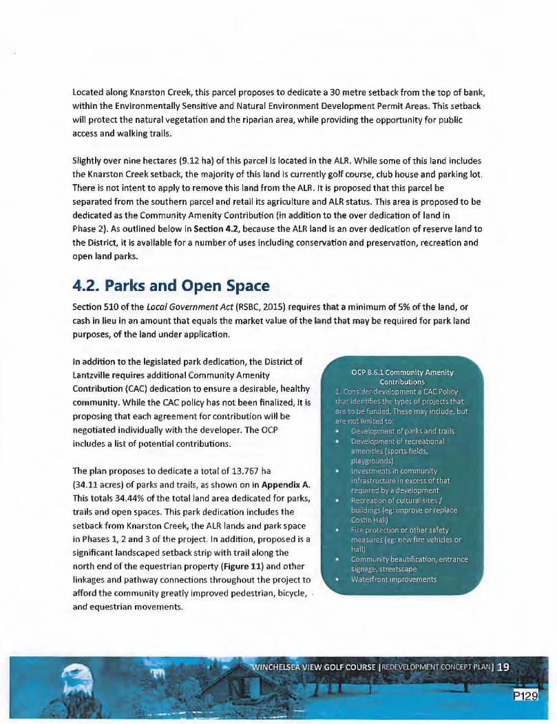
Located along Knarston Creek, this parcel proposes to dedicate a 30 metre setback from the top of bank,
within the Environmentally Sensitive and Natural Environment Development Permit Areas. This setback
will protect the natural vegetation and the riparian area, while providing the opportunity for public
access and walking trails.
Slightly over nine hectares (9.12 ha) of this parcel is located in the ALR. While some of this land includes
the Knarston Creek setback, the majority of this land is currently golf course, club house and parking lot.
There is not intent to apply to remove this land from the ALR. It is proposed that this parcel be
separated from the southern parcel and retail its agriculture and ALR status. This area is proposed to be
dedicated as the Community Amenity Contribution (in addition to the over dedication of land in
Phase 2). As outlined below in Section 4.2, because the ALR land is an over dedication of reserve land to
the District, it is available for a number of uses including conservation and preservation, recreation and
open land parks.
4.2. Parks and Open Space Section 510 of the local Government Act {RSBC, 2015) requires that a minimum of 5% of the land, or
cash in lieu in an amount that equals the market value of the land that may be required for park land
purposes, of the land under application.
In addition to the legislated park dedication, the, District of
Lantzville requires additional Community Amenity
Contribution (CAC) dedication to ensure a desirable, healthy
community. While the CAC policy has not been finalized, it is
proposing that each agreement for contribution will be
negotiated individually with the developer. The OCP
includes a list of potential contributions.
The plan proposes to dedicate a total of 13.767 ha
(34.11 acres) of parks and trails, as shown on in Appendix A.
This totals 34.44% of the total land area dedicated for parks,
trails and open spaces. This park dedication includes the
setback from Knarston Creek, the ALR lands and park space
in Phases 1, 2 and 3 of the project. In addition, proposed is a
significant landscaped setback strip with trail along the
north end of the equestrian property (Figure 11) and other
linkages and pathway connections throughout the project to
afford the community greatly improved pedestrian, bicycle,
and equestrian movements.
OCP 8.6;1 Community Amenity Contributions
1. Consider development a CAC Policy
th{:: identifies the types of projects that
are to be funded. These may include, but c:re r"iut limited to:
oe,;elopment of parks and trails
Gevelopment of recreational
amen tties {sports fields,
playgrounds)
• Investments in community infrastructure in excess of that required by a development
• Recreation of cultural sites/ buildings (eg: improve or replace
Costin Hall)
Fire: protection or other safety measures {eg: new fire vehicles or hallj
Community beautification, entrance
signage, streetscape
• Waterfront improvements

To provide further assessment of the Environmentally Sensitive Area of Knarston Creek, the owner
commissioned Dillon to complete a Habitat and Riparian Area Assessment. The conclusions of the report
(Appendix B) states:
... the development will be established at a distance of greater than 10 metres from the crest of the
ravine. This is outside of the calculated RAA for the site and, as such, a provincial RAR submission will not
be required. RAR submissions will also not be required for the ponds onside, given they ore not known to
connect to fish habitat.
The report also indicates that other environmental regulations may be required. No known eagle or
heron nests are located on the property.
The open space concept includes the retention of the three existing ponds on the golf course. They will
be surrounded by greenspace and connected to paths and trails. These ponds were originally
constructed to provide storage for irrigation water for the operation of the golf course. The ponds will
provide a dual function - amenity in the parks and stormwater retention (as part of the overall
rainwater management plan for the property). Site connectivity will be preserved through the
dedication and construction of trails/access easements.
This provides a total park/ trail dedication of 34.44% of the total site area with 10.2% of the open space
being outside the ALR parcel. Dedication of the ALR parcel poses many opportunities for the District. The
District could lease the land for agricultural operations, or allow the site to be used for one of the
permitted farm and non-farm compatible uses which include the following. This also allows the District
to contribute to food security and local businesses.
Berries and fruit trees Vegetables (field and greenhouse} Ornamentals Greenhouses
Equestrian facilities
Figure 12: Excerpt o f Appropriate Uses in the ALR1
Temporary or Seasonal Agri-Tourism Activities Home based businesses Pet Kennels and Breeding Facilities Conservation and preservation recreation and open land parks Forced Mains, trunks sewers, gas and water pipelines within an existing right of way
1 https://www.alc.gov.bc.ca/alc/content/alr-maps/living-in-the-alr/permitted-uses-in-the-alr

5.0Transportation
5.1. Site Access The existing access to the Winchelsea Golf Course is via an access road within the Hurd Drive right-of
way off Harby Road. Hurd Road is not developed currently to municipal standards. Phased access will
occur as follows:
• Phase 1 of the development will access off the existing Fernmar Road, and a portion of Hurd
Road will be constructed;
• Phase 2 will access off Hurd Road and require construction and upgrade to the access point. It is
proposed that Harwood Road access in the northeast corner of the Phase, and will be developed
as an emergency and pedestrian access only to minimize the through traffic in the Harwood
neighbourhood. The development of 77 single detached lots does not demand a second
permanent access; and
• Phase 3 will require the fill construction of Hurd Road south to connect with Phase 1
construction.
The ultimate construction of Fernmar Road through to Hurd Road will improve the direct emergency
access route for the Harwood and Fern mar residents.
5.2. Traffic Impact Assessment The owner commissioned a Traffic Impact Assessment to be completed by Watt Consulting Group
(March 14, 2019). The report (Appendix C) concluded:
The proposed 206 single family residential development will replace the existing 18 hole golf course
ond undeveloped site area. The development will not have a significant impact on the traffic
operations at the intersection of the surrounding road network. Conservative traffic growth rates were
used for the future conditions analysis.
At the two signalized intersections (Superior Road and Ware Road) on Highway 19, the highway
through movements will operate at acceptable levels of service {LOS or better) with full bui/dout in the
long term, there are no capacity mitigation requirements triggered by the development. At the all
stop-controlled study intersections, no left turn lane is required based on the warrant review of 2032
post development PM volumes.
The recommendations of the report include:
• Construct the proposed on-site roads as per the District standards;

• Upgrading Fernmar Road cross-section fronting the property to a collector road with pedestrian
facilities front the development side; and
• Providing the right-of-way dedication south of Fern mar Road to allow for multi-use pathway
connection to the south.
Figure 13 illustrates the fill build out conditions of the road network.
rn
Sitlr f'hMa2
Sllllr;FIIMc1 C811t:Cra
Figure 13: 2022 Post-Development Conditions with Full Buildout

6.0 Archaeology An archaeological data request was submitted to the Province of British Columbia Archaeology Branch
for the three lots forming the Winchelsea Redevelopment Plan area. The Branch responded on August 9,
2018 stating that "According to Provincial records there are no known archaeological sites recorded on
any of the subject properties". A record of this response is provided in Appendix D.

7.0Servicing The following outlines the proposed servicing strategy for potable water, sanitary sewer system and
rainwater drainage.
7 .1. Water Servicing The District of Lantzville does not
currently have water available for a
development of this size and scope,
and with the limitation on the
water connections under the
Na naimo Water Agreement, it is
anticipated that any development
of this property would be
responsible for providing additional
water to the District in accordance
with the Water Plan and District
standards. However, Phase 1 of the
development is locat ed on the
south side of Fernmar Road and is
located within the Water Service
Area.
There is an existing well located
w ithin the plan area which has
been in use for irrigation purposes
since 1996 for the golf course.
Water Service Area
DJL. 53
Figure 14: Map 6 Excerpt from the Land Use Byfaw No. 180, 2020
Figure 15 illustrates the, well locations. Testing for this well was completed in the fall of 2018 by GW
Solutions (report is included in Appendix E). The preliminary results of the testing indicated:
The yield of the well was evaluated by completing a 72 hour pumping test at a rate of 90 USgpm
which indicated a drawdown of 15. 64 m of the available 36.2 m of safe available drawdown.
Extrapolating this data to 100 days as required by BC regulations would result in a drawdown of 27
m for an "'idean aquifer. The estimated maximum yield for the well is 120. 7 USgpm.
Historical records were provided by the golf course from irrigation periods from 2008 - 2016 which
provided pumping rates and drawdown on a weekly basis. Based upon this information and an assumed

pumping rate of somewhere between 60 and 80 USgpm, the safe yield was estimated to be between 54
and 72 USgpm.
The conclusions and recommendations from the GW Solutions report (March 2019) are that the well
conservatively be rated at 54 USgpm, but that further testing be completed to confirm pumping rates,
volumes and drawdowns through the 2019 irrigation season (May to September). With these results,
the safe yield would be recalculated based upon 201'9 information. The well would also need to be
upgraded to municipal standards by boring a larger diameter and completing to current Groundwater
Protection Standards.
The report recommends the phased development approach to "monitor the operation of the well and
the behaviour of the aquifer over long periods" and concludes that as the District of Lantzville requires
3400 L/day per lot; Well #2 could potentially sustain the demand for 85 residential lots. The report
stated that as an alternative, "locations for additional water supply wells could be explored at the
southeast and southwest corners of the property or the Red W could be drilled deeper". Both reports
are included in Appendix E.
Figure 15: Location of On-Site Wells
o Surfilce water l~nses - Streams a Punphcuse
Feutt.s r- Extension Fault -Fault ,---, No.rmal F&u t = Stn1c.e-Slip fault
Thrust Failt
0 Uritnown • Bedrcd 0 Unconsolidated
- Rod( Fracture 6nes

7.2. Sanitary Servicing As noted earlier, Phase 1 is located
within the Phase C - Winchelsea
Catchment Area. Phases 2 and 3,
and included in Phase B - Lower
Lantzville Catchment Area, as
illustrated on Figure 16.
The Winchelsea Redevelopment
Area would service the proposed
lots with sanitary sewer to be
connected to the Districts' proposed
sanitary sewer system at two
locations (fernmar Road and
Harwood Drive) as shown on the
Prelim inary Servicing Plan
(Appendix A).
If existing Fernmar Road acreages
are further developed and connect
to the sanitary sewer, it is
anticipated that they would be split
between the two connections due to
the topography. These acreages
total 7.2 ha and if fully developed at
the same density would yield
approximately 50 lots. Our
calculations have allowed for these
Proposed Sanitary Sewe·r System Phasing Prcpo,,ecl $.ltvu.')• Sewer~
D Pr\o1!9e A. - O.c:lunsonRoao I~ 8Hdl Cn:lwntnt A.<ea
D Phne B - LCM'tl Llln:rt.lle c.at~ Are,
D Ph.ue C. Wcnc:hel~ Ca:chmffl NU
.I
l •
Figure 16: Map 7 Excerpt from the Official Community Plan
lots to be split evenly between the two connections.
·w· i. ; ,. , ... i . : ~
:--"(
• H
The following table (Table 1) provides the sewer calculations for the contributory area to each of the
connections. In speaking with the Director of Public Works, it is anticipated that these additional
demands would be a marginal increase in the overall sewage flows for the Phase 3 sewer project
currently planned and would not require any increase in pipe sizes.

Table 1: Winchelsea Anticipated Sewer Flows
Average Average Peak Area Inflow/ Design Flow Flow Peaking Flow Infiltration Flow
I
Location Units Population {I/day) (fps) Factor (lps) (ha) (lps) (lpsl
!Fe,nmarRNd Winchelsea SF 93 233 62,910 0.728 4.09 2.98 16.9 2.20 5.18 WinchelseaMF 60 150 40,500 0.469 4.1>9 l..92 1.6.9 2.20 4.11 ExistlllQ Acreaaes 25 63 17,010 0.197 4.29 0.84 7.2 0.94 1.78 Total 178 445 120,150 1391 4.0S 5.63 41 533 10.96 1Haewaod 0m,e
Winchetsea 87 218 58,860 0.681 4.09 2.79 16.9 2.20 4.98 &Jstinq Aaeaqes 25 63 17,010 0.197 4.29 o..84 7.2 0.94 1.78 Total 112 280 75,600 0.875 4.05 354 24.1 3.13 6.68
7 .3. Rainwater Management A Draina.ge Report was prepared for the subject lands by Timberlake-Jones in October 2019
(Appendix F). This report considered the pre-development flows and compared them to the full build
out with the 10 year storm event. The conclusions of the report states:
The pre-development maximum flow for the existing 525mm culvert under Fernmar Road from SUB-A
is 10.8 lps for the 10-year storm. After development, with the storage volumes noted, this flow will be
reduced to 10.4 fps. Post- development flows for all other st.Jb-basins wi/1 also be reduced for the 10-
year storm.
All lats shall install Exfiltratian Drain Pits that will infiltrate roof runoff from future structures for the 5-
year storm event. The Exfiltration Drain Pits should be sized in accordance with details provided in
Appendix D and installed at the time of Building P'ermit.
Low Impact Development Techniques will be utilized within this property to maintain predevelopment
runoff rates to the existing 10 year rainfa ll event, maximize permeable surfaces, reduce erosion and
sediment, and minimize impacts to downstream drainage, system. This will be accomplished in the
following manners:
• Proposed lots will be required to have a stormwater infiltration system which will capture and
infiltrate the 10 year storm form impervious surfaces (roof and paving) at the time of house
construction. This can be achieved with either a rock pit or a combination of cistern and
infiltration chamber;
• All opportunities will be utilized to maintain permeable surfaces, incorporate raingardens and
installing roof top harvest for on-site watering;
• Proposed roads include drainage swales to encourage groundwater recharge; and
• The existing ponds will be retained to capture and store runoff from major storm events.

8. • anc1a Socia mpacts The District of Lantzville staff originally requested that all new development be bareland strata
development to support sustainable development, and to minimize the expense,s to the District and
making the development more fiscally beneficial to the District. As a result, the District requested a
Financial and Social Impact Assessment. This assessment was completed by Dillon in February 2020
(attached as Appendix G). The assessment considered the development of 206 single detached
residential lots, in both strata and non-strata ownership models.
The report found that the proposed Winchelsea development will not be a negative impact on the
District of Lantzville. While it does add students to the school system, support of local schools is needed
to keep the schools functional. The Winchelsea's proposed housing supply aligns with the community
goals and can be interpreted as a positive impact. The additional municipal revenue from taxes adds to
the revenue surplus of the community. It is expected that this development will improve the local
economy and support local business, particularly meeting the goals of growth in the Village core. It is
also important to note that the future road connection and upgrade of Fernmar Road to Harby Road will
provide a more direct route to Highway 19 that will improve emergency services access. This is a
significant benefit to the residents of Harwood.
The issue of strata vs. non-strata ownership model was assessed and while as a non-strata development,
the District would ultimately become responsible for the roads and services that the developer
constructs, they would not have public access to the open spaces and parks included in the strata
development. As property of the strata corporation, public use implies significant liability that the strata
corporation will not incur. The minimum 5% open space would be dedicated, rather than the 34.44%
currently proposed. In addition, current practice demonstrates that if the open space is owned by the
strata, there are often issues of weeds and invasive species.
In addition, the assessment concluded that if the development were to be more financially viable for the
District, density would need to be increased. This would increase the tax base, make more efficient use
of the infrastructure and support the local commercial businesses.

9.0 Engagement a We understand that this proposal represents a residential development of significant interest for the
District of Lantzville and requires meaningful engagement and consultation with District staff, Council,
and residents. This process began with several formal meetings and discussions with City staff and
elected officials. In addition, a public open house was held on Saturday, July 28, 2018 at the Lantzville
Legion. Further to the open house, planning and engineering representatives of the owner met with
Fernmar Road residents on their properties to view points of interest and concern. An electronic mailing
list has been prepared to keep the adjacent residents informed of the progress of this project and to
provide any advance notice of future public meetings.
9. 1. Meetings with District Staff During the preparation of this Redevelopment Plan, the owners' consultants from Timberlake-Jones and
Dillon have met with District staff on four occasions. This has provided feedback on the proposed
development. In addition, the draft of this plan was forwarded to the District and this re·sponds to
comments from Mr. Kyle Young in a letter dated August 30, 2019 (Appendix H).
9.2. July 28, 2018 Open House Summary Adjacent residents of the eight acreage properties along Fern mar Road were personally invited via hand
delivered letters to attend an open house from 10:00am-12:00pm with representatives of the
Winchelsea View Golf Course. Representatives from Timberlake-Jones and Dillon were in attendance.
Four of the eight invited residents attended. They reviewed the proposed development and asked
questions related to the proposal. Particular action items noted were:
• Adjacent residents would like to remain informed and updated throughout the planning and
development process;
• Maintaining northern ocean views for residents by establishing an appropriate maximum height
(with consideration of the significant slope) for new dwellings is a major priority;
• Future road alignment should ensure viable opportunity for potential connection to their
acreage properties for future water and sanitary sewer tie-in and future subdivision; and
• Generally, acreage residents were supportive of the development and the opportunity it will
provide for water and sewer connection and potential acreage redevelopment.
Following this, residents from the adjacent subdivision to the east of the golf course along Harwood
Drive and Andrea Crescent were personally invited via hand delivered letters to attend an open house
from 1:00pm - 3:00pm with representatives of the Wihchelsea View Golf Course, Timberlake-Jones, and
Dillon planners. Approximately 20 residents attended to discuss and ask questions related to the - .
proposal. Elected officials were present at both open houses:· Particular action items noted were:

• Residents would like to remain informed and updated throughout the planning and
development process;
• Residents on the west side of Andrea and Clark Crescents want to ensure that houses won't be
built too close to their rear property lines, or be so tall as to overlook their lots;
• Residents would like to see the golf course continue operations as long as possible, and are
therefore supportive of the proposed phasing approach;
• Residents would prefer to keep Harwood Drive for emergency access/ utility right-of-way and
pedestrian access only, and generally do not s.upport thru-traffic for vehicles on their street; and
• They would like to see pedestrian access/trails provided through the site.
The valuable input received from the open house has been taken into consideration in the development
concept, and it is our intention to keep neighbours informed of the planning process and provide further
opportunity for engagement with the rezoning and OCP amendment applications. The complete open
house summary is provided in Appendix I.
9.3. September 26, 20 8 Fernmar Road Landowners Meeting
On September 26, 2018, a meeting was held on-site with the Fernmar landowners (summary of meeting
included as Appendix J). It was noted that most of the landowners supported the option of tie-in to
piped water and sewer, and some of the landowners were interested in a future option of subdividing
their land.
9.4. Future Engagement We anticipate the following engagement to occur in the near future:
1. Formal Circulation -This submission responds to the comments from the internal review. It is
anticipated that this document will be formally circulated to other agencies, and comments will
be reviewed and discussed with District Staff.
2. Meeting with Mayor and Council -We propose to hold a working meeting for meaningful
discussion with the District of Lantzville Mayor and Council regarding the benefits of this
development to the community and to address any outstanding concerns.
3. Community Open House -A second community open house will be set up to present the final
Concept Plan, rezoning and OCP amendment applications. This will be an opportunity to
demonstrate how the feedback received during the first open house has been incorporated into
the plan.
4. Community Information Meeting-While the community information meeting is hosted by the
District, the Applicant will provide exhibit information and materials, make a presentation, and
be present to answer any questions of Council or the public.

5. Bylaw Introduction - It is anticipated that staff will introduce the OCP and Zoning Amendment
Bylaws concurrently and that they can be processed together. If the servicing is available for
Phase 1 earlier than anticipated, the owner may elect to apply ahead of the balance of the
Redevelopment Plan and the OCP amendment. The owners and their representatives will work
with the District staff to determine the most effective manner to move this application forward.

10.0 Approva s P ocess Below is an approximate timeline of the planning approvals process anticipated for this comprehensive
development. The owner and their representatives are open to exploring alternative timing or phasing
as it suits the District of Lantzville planning staff. Subsequent approvals {building, engineering, etc.) are
not provided in this section.
Table 2: Proposed Approvals Timeline
Step Task Proposed Timeline I Spring 2019
l! Ai;'>~lkation for OCP and Land Use Bylaw Amendments Fiile No. 3360-20-19-2
2 Subdivision Application for Phase 1 November 2020
3 Subdivision Application for Phase 2 JanuariY 2022
4 OCP and Zoning Amendment Application for Phase 3 TBD 5 Suedivision A!l>?licat ion for Phase 3 liBD

Appendix A
Concept Plans
P143

::::
:: B
OU
ND
AR
Y
0 G
RE
EN
SP
AC
E
D
RO
AD
S
0 M
ULT
IFA
MIL
Y
c::J
SIN
GLE
FA
MIL
Y L
OTS
PO
ND
S
I !I
WE
U
(,<
PP
R()
Xj
r••-
"-••
-1
J ii
e ~
LOT
A
PL.1
.N
2123
2
i I
i II
• I
LO
TA
G
RE
l;:N
$P
AC
I;:: 1
.878
ha
RO
AD
S;
2.43
7 h
a LO
TS
; e .• 3
7 h■
~9i"
A
PLA
N
43
77
~ 1
.... -. __
__ ,
I \..
_ L
T_
1 r
·--r··
I
·-. -·
-~ --
..J ..
-[_
.J
. __
' F
OR
ES
T T
UR
N
":"
-r·-
-,··
-..,
. i /
! -
7--..
..t ~-~
--.. L
! ·-
-l--
.r-·
' I
llG
DII
D
UJ
Sff
,1Q
P1
11:0
l"O
S£0
----
EDG
E O
F PA
VEM
EN
T----
--
Cl.
J$
S-
MC
111H
MC--
---•--
ECIG
EOFG
RA
VEl.--
--
--
--
-W
ATE
R M
AIN
--
--
--~
-
$ToA
M.S
EW
£R-·
•---
--
SA
Nll'
Mf't
SE
Yi,'
ER--
•--
•••.
--·
-cv
rr,,
nJN
E -
--
--
• -
• -
""O
f'1a1
m'L
INI;----
--
.~~
;....
F"'E
NCEL
tNE
O
C
NC
Tl.
l.O
CJ,
f'IC
IIII
Olb
:tl'f
ttO
.lo
r.,Q
i'~.r
,JII
S
t<M
N"
""
1t-
O~
Tl\
.'¥
'Pl'
Ou
.,;,
ITl~
c:,«
.CJ
;(tl
N
'"'C
l'IO
.Dll
.,.'
nl!
!QO
M'r
~~
TO
~~
Cll
"'M
Jll
11
:.M
~fflt
sT
'D
N:N
O-r
.1tt
1~
Tl\.
YO
l"N
#f~
S.
ST
AN
OA
RO
A8
8R
EV
IA,T
ION
S
lDT
,.m
ta:,
ctt
ofl
ll.i
l'\N
il;D
I .. ~ C
IUlU
«D
HII
IUfO
"fl'
Ufi
l ,1
:1JM
.~
••1
n.,
. ll"
\#'l
$ 41.1
P1
4.U
1n
#ff
l ..
Ho
... m
t.ri
T"
ll'U
.ti1
on
••
lliM
.DlS
l"U
""N
iJ.M
XIR
tlt!T
-,cT
.
t-e
....
.. .
...c
~fill
ll. ...
c,or
,..t'l
l&-,-
,'1
'-4
!
=a:r•
,v4t"=
~~17
'==
.,..,
.,_,
. ~ ~
. ~.;:
....,;
..'"';
:ll:.
WIN
CH
l!L
Sl!
A V
I-
GO
LF
CO
UII
S'I!
LT
D •
..... W
INC
HE
LSE
A V
IEW
GO
LF
CO
UR
SE
-""
ocp
& Z
ON
ING
AM
EN
DM
EN
T
OP
EN
SP
AC
E C
ON
CE
PT
PL
AN
335-
-01-
P1
C

RE
~.
0.L
16
1
I LO
T 1
/ l
LPT
I 1,
PLA
N
6J96
\
I P
LAN
6
39
7
jl J
I (
' --~
L. ___
J=-=
I LO
T 1
J P
LAN
4
79
68
I
-----
--l I
l01
2
I /
PL.
t.N
'79
58
f
/
d
W8
.L
l.trP
R.()
XI
.......
··--
UG
IDID
o
::tt
fi,O
n:
QPO
SE:D
----
E0G
EOF
PAVE
M.e.
N'T----
--
cu:t
'89
-lo
!Ct1
1~--
----
=0
.-c;R
AV
El.--
--
~~
-~
~ -
WA
.TE
RM
ilJN----
-~
-st
OR
M.~
S.-
··---
----
SI.M
TA
AY
SF
AE
R--•--
--
--·
-c:e
.NTR
B.f'E
-·-----
-PR
OPE
R:T
YU
E-
--
-_
_,,
__
__
"-
fEN
CE
.LIN
E-0
--0
----
L 1
T
t-u
o-.
..-
C.-
c•
Vtl
4~
~~
u •
.c1.
f[L
[
ticll.
&
...
..
M"l
'g,,!
ltll
T
...
. ~
..,..
,.. .....
... __
,.. -
::i·
,,
a~
-
~ l'
• •
&~
11.-
.cw
.11
,-0
,.n
l""""""""
"'"'""'""
'"'-""0-
, tl
MO
'l,l
,H,f
Jl'tl
9O
0J&
m'r
AN
Ot.
llJS
1H
~
f!ll,.
_-J
tlD
IYn
tCC
ON
'flltf
,Cto
tt~
TO
~
!.W
(JffO
ll'"
M)!U
l,.T
lCO
ill•
•IUJt
~T
O
IIIE
-NO
TW
lal'~
TD
.~O
,AJ,1
1C
Od
'U:T
f.,
STA
NO
AR
O A
BB
ReV
IATI
ON
S
....
1
Joa.
ttl:
'IT
U'I
I"'
I I
=-~
~(l
l'V
%•2
llll'J
I,":_
51:.,
::;:
~~:~
ro:u
-~·-C::
~,
-:,. ➔
-=~.
:iC.
:V
MT
JI
c:~
~
"11N
C:H
1!U
1!A
Vln
l G
OU
' C
:0U
ltl1
! LT
11.
~W
INC
HE
LS
EA
VIE
W G
OLF
CO
UR
SE
--O
CP
& Z
ON
ING
AM
EN
DM
EN
T P
RE
LIM
INA
RY
LO
T L
AY
OU
T

U!O
l!N
D
lOS
ft.o
P1
toP'
OSC
D
----
-~~
~~
~ -----
EOCl
eOf'a
RAva
.--
--
--
-W
AT
ER
~----
---
-·
--
rST
~W
:S.~
R-··---
--
-_..
,..,AA
Ys~~--
·--
---
--
a,m
,EU
NE
-·-·
---
-f"
'oe
fJIT
YI.
M-
--
---c
•--
-F'
ENC
e U
NE
O
0
R£1A
, O
.L.
161
! ~--·
····-
-...
·----
· i
I
--.. +.
---·· -
I

Appendix
Habitat and Ripar,ian Area Assessment Report
P147

October 17, 2018
Timberlake Jones Engineering Weldon Professional Centre #201-177 Weld Street P.O. Box 89 Parksville, BC V9P 2G3
Attention : Ms. Michelle Jones, P.Eng.
Proposed Development at Winchelsea View Golf Course Preliminary Riparian Areas Regulation Setbacks
Dear Ms. Jones,
Dillon Consulting Limited (Dillon) is pleased to provide Timberlake Jones Engineering (TJE} with this report outlining our preliminary findings for a Riparian Areas Regulation (RAR) Assessment conducted along Knarston Creek at Winchelsea View Golf Course in Lantzville, BC. The intention of the assessment is to provide TJE with an understanding of the limits of construction associated with the Streamside Protection and Enhancement Area (SPEA or setback) as established under the RAR. It is also intended to provide TJE with an understand ing of whether or not an RAR submission is required
based on the final location of development in relation to the creek.
1.0 Project Background
The proposed development of the golf course is required to be compliant with the RAR, which establishes SPEAs from creeks in much of southern British Columbia, including Vancouver Island. Under the RAR, an assessment is required when development is proposed within 30 metres of the high water mark (HWM) of a creek or top-of-bank of a ravine, assuming the ravine is less than 60 metres (m) in width minus the width of the channel. An assessment is requ ired if development is proposed within 10 m of a ravine greater than 60 metres wide minus the width of the channel.
Dillon opted to apply the Detailed Assessment protocol which tends to produce a more refined SPEA determination based on site-specific channel characteristics.
It is our understanding that a determination of the specific location of development in relation to Knarston Creek, which is located within a ravine, has not yet been determined. In addition, Dillon has not been provided with a survey or LIDAR data indicating the ravine width. Based on the field assessment, Dillon anticipates that the ravine minus the channel width is greater than 60 metres and, as such, an RAR
3820Ccssna Drive
Suite 510
Richmond,
British Colum bia
Canada
\/7B 0A2
Telephone
604.278. 7847
Fax
604.278. 7894
Dillon Consulting Limited
P148

Winchelsea View Golf Course Development Poge2 October 19, 2018
submission will only be required if development is proposed at less than 10 metres from the top of the ravine. This should be confirmed with survey data.
2.0 Project Methodology
Dillon conducted the assessment of the site on June 25, 2018. A two-person crew walked Knarston Creek through that portion of the site adjacent to the proposed development. The creek adjacent to that portion of the property within the Agricultural Land Reserve was not walked given that development is not proposed for that parcel. GPS enabled phones were utilized to orient the crew in proximity to the proposed development.
As referenced, Dillon applied the Detailed Assessment protocol. This consisted of the following:
The channel was divided into "reaches" which are distinct sections of channel based on morphology, dimensions and gradient. A total of 3 reaches were identified adjacent to the subject parcel. Two reaches at the upstream and downstream extents of the assessed area were located within mature forest canopies. A third reach was located between the upstream and downstream sections. This middle reach was distinct based on it being within an open area largely lacking in forest cover.
It should be noted that the subsequent survey provided to Dillon indicated the most upstream reach was immediately outside of the proposed development area. It had been measured due to the inherent inaccuracy associated with GPS in forested areas.
The width of the channel within a 100-metre section was measured at the approximate mid-point of each reach. A total of eleven (11) measurements were taken, one (1) in the middle and five (5) upstream and downstream at 10-metre intervals. Flagging pins were placed at each cross-section for later survey. Measurements of the channel were established from the HWM where a distinct difference in bank texture and rooted vegetation was observed. A tape measure was used to establish channel width. The final channel width was then determined by discarding the highest and lowest measurements and averaging the remaining nine (9) measurements.
The slope was determined measuring upstream and downstream using a Sunnto clinometer. These measurements were taken as far apart as the vegetation allowed for line of sight. The measurements were averaged to establish final channel gradient.
Channel type was determined by comparing average width to average slope as outlined in Figure 3.4 of the Riparian Areas Regulation Assessment Methods guidebook1
•
Site potential vegetation type (SPVT) was determined to be "Tree" given that the large majority of the creek is located within a forested canopy.
1 Available as a downloadable PDF at https://w-..vw2.gov.bc.ca/assets/gov/environment/plants-animals-andecosystems/fish-fish-habitat/riparian-areas-regulations/rar_assessment_methods.pdf
P149

Winchelsea View Golf Course Development Page3 October 19, 2018
The measured parameters were used to establish "Zones of Sensitivity" for: Large Woody Debris, and Bank and Channel Stability; Litter Fall and Insect Drop; and Shade. The largest of these zones establishes the SPEA (see Section 3).
Dillon subsequently met the project surveyor onsite on July 6, 2018 to discuss survey requirements. We indicated that the two reaches should be surveyed along with the south bank of the channel between the reaches and the top-of-bank of the ravine.
3.0 Results
The resu lts of the assessment area indicated in Table 1 below.
TABLE 1: CHANN EL CHARACTERISTIC
Parameter Upstream Reach Downstream Reach
Description Open area largely lacking in Located within well-established
trees forest canopy
Channel Width (m) 2.51 3.35
Channel Slope(%) 1.9 2.5
Channel Type Riffle-Pool Riffle-Pool
Site Potential Vegetation Type Tree Tree
The Zones of Sensitivity are established as. follows:
3.1 Large Woody Debris, Bank and Channel Stability
For a riffle pool with an SPVT of tree, the Zone of Sensitivity is 3 times the channel width with a minimum of 10 metres. This establishes the Zone for each reach as follows:
• Upstream Reach-10 m • Downstream Reach - 10.05 m
3.2 Litter Fall and Insect Drop
A channel with an SPVT of Tree has a Zone of Sensitivity for litter fall and insect drop established at 3 times the channel width with a minimum of 10 metres and a maximum of 15 metres. This establishes the Zone for each reach as follows:
• Upstream Reach-10 m • Downstream Reach -10.05 m
3.3 Shade
A channel with an SPVT of Tree has a Zone of Sensitivity for shade established at 3 times the channel width with a maximum of 30 metres. This establishes the Zone for each reach as follows:
• Upstream Reach- 7.53 m • Downstream Reach - 10.05 m
P150

Winchelsea View Golf Course Development Page4 October 19, 2018
Please note that for Shade the Zone is established due south of the channel. As such the values listed here may be considered maximums and would be reduced for sections of channel that have a more north-south orientation.
3-.4 Streamside Protection and Enhancement Area
Based on the greatest of the three (3) Zones of Sensitivity, the SPEA may be established for each reach as follows:
• Upstream Reach -10 m • Downstream Reach - 10.05 m
The setback is established from the HWM as determined by survey.
4.0 Further Actions
Dillon proposes to provide TJE with a figure indicating the SPEA in relation to the creek and the top-of-bank of the ravine. Ideally, a survey would be provided that indicates the HWM of the creek between the two reaches. The survey should also indicate the top of the ravine. If the survey is provided to Dillon in CAD format, we can then indicate the SPEA.
Dillon can provide a figure with the information we currently have. This would require we make some assumptions about the alignment of the channel between the two reach sections. It would also not indicate the SPEA in relation to the top of ravine.
As indicated previously, a submission to the province would only be required if the development is proposed at less than 10 m from the top of the ravine. Note that this assumes the ravine less the width of the channel is greater than 60 metres. If the ravine minus the width of the channel is less than 60 m, then a submission will be required if development is proposed within 30 m of the ravine.
Please note that any submission to the province would require that the "Measures" as outlined in the Detailed Assessment protocol would be addressed. The Measures consist of the following:
• Hazard Trees - an arborist would be required if the proponent is proposing to remove any trees from the SPEA that may fall into the development. This is the only development related work allowed in the SPEA.
• Windthrow- Removal of trees outside of the SPEA can expose trees in the SPEA that have previously been sheltered from wind. This can cause them to topple given they are typically less wind resistant than exposed trees. An arborist will be required to make a windfirm assessment if tree removal is proposed.
• Slope Stability- a geotechnical engineer will be required to conduct an assessment to determine if development outside of the SPEA can cause instability within the SPEA. In effect, this may increase the width of area that cannot be developed.
• Tree Protection During Construction - a management plan will be required to protect trees from construction related impacts. Typically this consists of fencing around the root protection zones and other barriers as required.
P151

Winchelsea View Golf Course Development Page 5
October 19, 2018
• Encroachment in the SPEA - a management plan will be required to discourage residents from accessing the SPEA after construction is completed. Typically this consists of fencing and sign age.
• Erosion and Sediment Control - a plan will be required to address erosion and sediment during construction. Typically this consists of surface treatment to minimize the potential for erosion and controls to drop any sedimentation that does occur from suspension prior to discharging to local watercourses.
• Stormwater Management - a stormwater engineer will be required to develop a drainage management plan that does not affect the SPEA.
• Floodplain Concerns -A determination should be made regarding the mobility of the channel within the ravine. It shou ld be noted that significant signs of erosion or channel instability associated with a mobile channel were not noted during the site assessment.
5.0 Summary and Conclusion
The SPEA as established by the application of the Detailed Assessment protocol was determined to be a maximum of 10.05 m from the HWM of Knarston Creek. Dillon can indicate this setback on a figure which idea lly would indicate the HWM for the entirety of the length of the creek adjacent to the development pa reel as well as the top of the ravine bank. A figure making some assumptions regarding the location of the HWM can be produced indicating the SPEA based on the survey data currently in our possession. It would not indicate the top of ravine bank however.
Assuming that the ravine minus the channel width is greater than 60 metres, a submission to the province will only be required if development is proposed within 10 m of the top of the ravine. If this is the case, the application of the Measures described in Section 4 will be required.
Please contact Nathan Gregory at 604-278-7847, Ext. 4211 shou ld you have any questions about this report.
Sincerely,
DILLON CONSULTING LIMITED
Nathan Gregory1 R.P.Bio. Project Manager, Associate
NRG:cv
P152

Appendix C
Traffic Impact Assessment
P153

Consulting Group
WINCHELSEA RESIDENTIAL SUBDIVISIO
Prepared for:
Prepared by:
Our File:
Date:
Traffic Impact Assessment
Timberlake-Jones Engineering f.A.,r,·e..:
Watt Consulting Group ~L~~ ~ . ~
2539.801
March 6, 2019
t # 29702 ~ ~ ~ '!. t1 ~ ,,1 ~~,_ G I NE. ?,""
~~...,,.>:,::,777 ,
M4rLI, Cr,1011
P154

TABLE OF CONTENTS
1.0 IN'TRODUCTIOI~ ................................................................................................... 1
1.1 Study Area ................................... .......................................................................... 1
2.0 EXISTING CONDITIONS ...................................................................................... 2 2.1 Land Use ............................................................................................................... 2 2.2 Road Network .................................................................................................. ...... 2
2.3 Traffic Count .......................................................................................................... 2
2.4 Traffic Modelling - Background Information .......................................................... 3
2.5 Existing Traffic - Results .. .. ... ................ ......... .. ....... .............................................. 3
2.6 Future Traffic Growth ............................... ....... ... ...... .... ... ....................................... 4
3.0 POST DEVELOPMENT CONDITIONS ................................................................. 4 3.1 Proposed Land Use ............................................................................................... 4
3.2 Site Access ............................................................................................................ 4
3.3 Trip Generation ..................................................................................................... 5
3.4 Trip Assignm1ent ................................................ ... ................................................. 6 3.5 2022 Background Traffic ....................................................................................... 8 3.6 Traffic Analysis Results - Short Term ................................................................... 9
3.6.1 Analysis Results with Phase 1 ................................................................... 9
3.6.2 · Analysis Results with Full Buildout.. .......................................................... 9
4.0 LONG TERM CONDITIONS ............................................................................... 12 4.1 Traffic Analysis Results ....................................................................................... 12
5.0 SAFETY AND GEOl\~E'TRICS ......................................... , .................................. 14 5.1 Left Turn Lane Review ................. ..... .... .... ....................... ..................................... 14 5.2 Cross Sections ..................................................................................................... 14
6.0 OT.HER MODES .. ....................................................................................................... ,. ............... 11 ....... 11 .... 14 6.1 Pedestrians and Cyclists ............................................... ..... ...... ........................... 14 6.2 Transit ................................................................................................................. 15
7.0 CONCLUSIONS .. ................................................................................................ 15
8.0 RECOMMENDATl,QNS ....................................................................................... 16
Appendix A: Synchro Background
Winchelsea Residential Subdivision Traffic Impact Assessment
APPENDICES
P155

LIST OF FIGURES
Figure 1 : Study Area and Site Location ...................................................... ............ ...................... 1 Figure 2: Existing PM Peak Hour Volumes and Levels of Service ............................................... 3 Figure 3: Site Plan and Access Roads ..... .............. .. .................................................................... 5 Figure 4: Site Trip Assignment - Phase 1 .............................................. ... ..... ....... ........................ 7 Figure 5: Site Trip Assignment - Full Buildout.. ............................................................................. 7
Figure 6: 2022 Background PM Peak Hour Volumes and Levels of Service ................................ 8 Figure 7: 2022 Post Development with Phase 1 ........................................................................... 9 Figure 8: 2022 Post Development Conditions with Full Buildout .. ... .. ......................... ................ 11 Figure 9: 2032 Post Development Conditions with Full Buildout ... ... ... ....................................... 14 Fig.·ure 10: Transit Route 11 - Lantzville Loop ......................................................................... .... 15
LIST OF TABLES
Table 1 - PM Peak Hour Trip Generation .................... ................................................................. 6 Table 2- 2022 PM Peak Conditions: Signalized Intersections .................................................. 10 Table 3- 2022 PM Peak Conditions: Intersections Stop-Controlled .......................................... 11 Table 4- 2032 PM Peak Conditions: Signalized Intersections .................................................. 12
Table 5- 2032 PM Peak Conditions: Superior Rd/ Vandenhoek Rd ........................................ 13
Winchelsea Residential Subdivision Traffic Impact Assessment
ii
:IWb.TT
P156
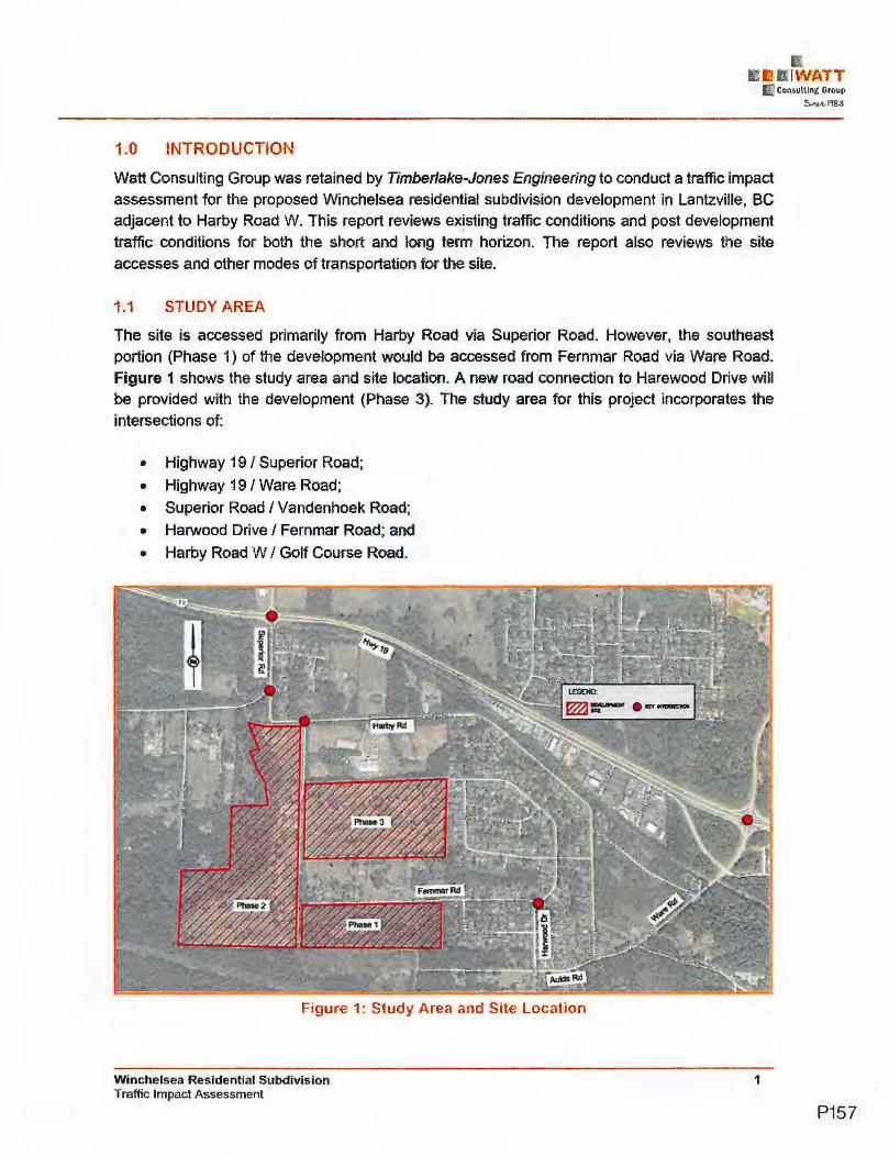
1.0 INTRODUCTION
Watt Consulting Group was retained by Timberlake-Jones Engine.ering to conduct a traffic impact
assessment for the proposed Winchelsea residential subdivision development in Lantzville, BC
adjace.nt to Harby Road W. This report reviews existing traffic conditions and post development
traffic conditions for both the short and long term horizon. The report also reviews the site
accesses and other modes of transportation for the site.
1.1 STUDY AREA
The site is accessed primarily from Harby· Road via Superior Road. However, the southeast
portion (Phase 1 ) of the development would be accessed from Fernmar Road via Ware Road.
Figure 1 shows the study area and site location. A new road connection to Harewood Drive will be· provided with the development (Phase 3). The study area for this project incorporates the
intersections of:
• Highway 19 / Superior Road;
• Highway 19 / Ware Road;
• Superior Road / Vandenhoek Road;
• Harwood Drive/ Fernmar Road; and
• Harby Road W / Golf Course Road.
Figure 1; Study Area and Site location
Winchel.sea Re.sidential Subdivision Traffic Impact Assessment
1
'I\VAlT
P157

2.0 EXISTING CONDITIOf S
2.1 LAND USE
The existing land use of the site (Phase 2 & 3) is an 18-hole golf course (Winchelsea View) which
is zoned to resource (open space). The Phase 1 portion (undeveloped) south of Fernmar Road is currently zoned as residential. The surrounding land use is resource (agriculture) and single
family residential.
2.2 ROAD NETWOR•<
Highway 19 (Island Highway) is under the jurisdiction of the Ministry of Transportation and
Infrastructure (MoTI). Highway 19 provides a connection through Vancouver Island from the Duke
Point Ferry Terminal (south end) to the Port Hardy Ferry Terminal (north end). Highway 19 is classified as a four-lane divided arterial road.
The remaining study intersections are within the District of Lantzville's jurisdiction. According to
the District's OCP, Superior Road is classified as a two-lane rural major ( coHector) road with gravel shoulders.
Vandenhoek Road is a short connector between Superior Road and Harby Road W. Vandenhoek
Road, Harby Road Wand Fernmar Road are classified as two-lane local roads.
The intersection of Highway 19 / Superior Road has four approaches and is signalized wi1h
protected I permitted left turn phasing. There are dedicated left and right tum lanes on Highway
19. All four approaches have channelized islands for right turns. The intersection of Highway 1,9 I Ware Road is located 2km east of the Superior Road intersection and also signalized.
The intersection of Superior Road / Vandenhoek Road is stop controlled. From Vandenhoek
Road, the south approach (northbound) has a channelized island for right turns (yield control).
The posted speed limit is 90 km/h on Highway 19 within the study area and 50 km/h everywhere else in the study area.
2.3 TRAFFIC COUNT
Traffic counts were undertaken at the study intersections in the PM peak hour on October 17, 2018. Traffic counts at the Golf Course Road/Harby Road W collected to determine the existing site trips. Existing site trips were measured at seven vehicles in the PM peak hour. For Highway
19 / Ware Road, a previous count was used with volumes balanced with 2018 counts. See Figure 2 for the existing PM peak hour traffic volumes.
Winchelsea Residential Subdivision Traffic Impact Assessment
2
I\Vf.tTT
P158

2.4 TRAFFIC MODELLING - BACKGROUND INFORMATrOl
Analysis of the traffic conditions at the intersections within the s1udy area were undertaken using
Synchro software (Version 9 / 10).
Synchro I SimTraffic is a two-part traffic modelling software that provides analysis of traffic
conditions based on traffic control, geometry, volumes and traffic operations. Measures of
effectiveness such as level of service (LOS), delay and 95th percentile queue length are
calculated by the software based on the Highway Capacity Manual methodologies.
The LOS are broken down into six letter grades with LOS A being excellent operations and LOS
F being unstable/failure, operations. LOS C is generally considered to be an acceptable LOS by
most municipalities. LOS D is generally considered to be on the threshold between acceptable
and unacceptable operations. A description of level of service and Synchro is provided in
Appendix A.
2,5 EXISTING TRAFFIC - RESULTS
2018 existing traffic conditions were analyzed at the five study intersections. At Highway 19 /
Superior Road, the highway through movements are operating at a LOS B and all other
movements are operating at a LOS Dor better. The intersection of Highway 19 / Ware Road is
operating at a LOS C or better for all movements. At all other study intersections, an movements
are a LOS A. See Figure 2 for existing PM peak hour volumes and levels of service.
rn Harby Rd
SITE
SrTE
Figure 2: Existing PM Peak Hour Volumes and Levels of Service
Winchelsea Residential Subdivision Traffic Impact Assessment
3
P159
2.6 FUTURE TRAFFIC GROWTH
It is assumed that the opening day will occur in 2022 for the short term analysis. The long term analysis is based on 10-year horizon (2032) after full build-out of the site. Background traffic
conditions are expanded from 2018 existing traffic conditions to future horizon years for the PM peak hour traffic conditions.
Growth rates for future background volumes were calculated. Based on MoTl,s traffic data between 2012 and 2015 AADT on Highway 19, 100m north of Lantzville Road (Short Count Site:
Lantzville 14-060NS). A 0.5 percent average annual growth rate was calculated. However, for the long term background traffic projections a linear growth rate of 1.0 percent per year was used for Highway through volumes to reflect a conservative traffic growth. Compared two counts on Superior Road between 2014 and 2108, an average annual growth rate was estimated at 1.2%
in the last four years. A 2.0% annual growth rate is considered appropriate for the lantzville roads.
3.0 POST DEVELOPMENT CONDITIONS
3.1 PROPOSED LAND USE
The proposed land use is the redevetopment of the Winchelsea View Golf Course for residential housing. The development will consist. of 206 single-family dwelling units and may occur in three
phases. Phase 1 off Fernmar Road includes 58 singfe-family lots with the 18-hole golf course in
operation. Phase 2 on the· west side of the golf course mcludes 60 single-family lots with a 9-hole golf course in operation. Phase 3 wil comprete the conversion of the golf course to additional 80 residential lots. A significant portion of the property will be given to the District as park land .and open space for various land uses .
3.2 SITE ACCESS
The existing access to the Gotf Course is via Golf Course Road off Harby Road. For Phase 1, the development site will be accessed from Fernmar Road via Harwood Drive.
During Phase 2 - 3, the Goff Course Road will be extended from Harby Road to Femmar Road and upgraded to meet the municipal road standards. A new road connection will be provided through the Phase 3 area from the Golf Course Road to Harwood Drive.
See Figure 3 for the site plan and access roads.
Winchelsea Residential Subdivision Traffic Impact Assessment
4
P160
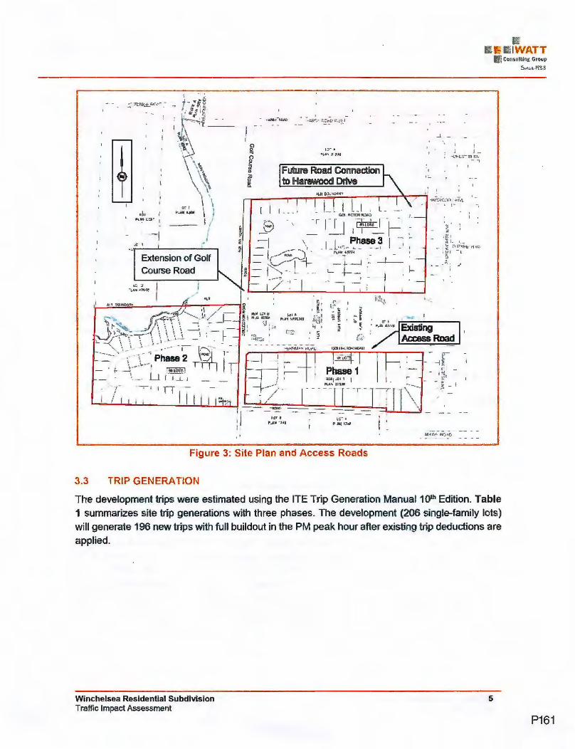
t
/
' . ·h . .:i.?. I:~!~~·;_-_·_
., \ ~\ \"\ ., ... .:,,., '
\, ~,\ ' 'l \ ·'i:.. \ \~
I
I \ t,•1 I I
"-~lj&JOI I I
·--- I /
Extension of Golf Course Road
TT -
I I I
C)
& 0 0 C cil ~
s' ~
Future Road Connection to Harewood Drive
-_-_- - --I ,
Figure 3: Site Plan and Access Roads
3.3 TRIP GENERATION
I-
I • J J -~ ··L.,,.,L:t nJ:1; -,
I I
The development trips were estimated using the ITE Trip Generation Manual 10th EdiUon. Table 1 summarizes site trip generations with three phase.s. The development (206 single-family lots) will generate 196 new trips with full buildout in the PM peak hour after existing trip deductions are applied.
Winchelsea Residential Subdivision Traffic Impact Assessment
5
P161

TABLE 1 - PM PEAK HOUR TRIP GENERATION
Single-family Housing 36 21
(Phase 1) Single-family Housing
68 units 0.99 trips/
67 42 25 210 (Phase 2) unit
Single-family Housing 79 50 29
(Phase 3)
203 128 75
18-Hole Golf Course Observed (-7) (-5.) (-2)
(Existing Trip Deduction)
Net Site Trips 196 123 73
3.4 TRIP ASSIGNMENT
The site trip assignment is based on the existing trip distributions at the two highway study intersections. The following summarizes directional split percentages of the site trips at the access roads within the study area.
Directional Split Percentages of Site Trips
Trips-In
• 64.5% of entering site trips are from East (Highway 19)
• 19.9% of entering site trips are from North (Superior or Ware Road)
• 15.6% of entering site trips are from West {Highway 19)
Trips-Out
• 59.6% of exiting site trips are to East {Highway 19)
• 20.2% of exiting site trips are to North (Superior or Ware Road)
• 20.2% of exiting site trips are to West (Highway 19)
The site trip assignment is executed with two stages: Phase 1 and Full Buildout. It is assumed that all Phase 1 traffic use· the Highway 19/Ware Road intersection to Fernmar Road. At full buildout trips are split between Ware Road (to Fernmar Road) and Superior Road (to Golf Course Road). Although not assigned a portion of the traffic may utilize the new Harewood Drive connection to the site (via Ware Road). Harewood Drive has significant capacity to accommodate any development traffic or any potential local residents (west of the site) to access Ware Road. Figure 4 shows the site trips assigned for Phase 1 and Figure 5 for full buildout.
Winchelsea Residential Subdivision Traffic Impact Assessment
6
IWATT
P162

Hart,yRd
Slle: Phale 1 n..,.,x ""'1: Tri>O.HhPlf
rn
Figure 4: Site Trip Assignment~ Phase 1
rn
Sile: Phls11t 3
Sita:Phale2
Slle: Phase 1
Figure 5: Site Trip Assignment - Full Buildout
Winchelsea Residential Subdivision Traffic Impact Assessment
7
P163

3.5 2022 BACKGROUND TRAFFIC
2022 background traffic conditions provide the basis for the short term analysis. 2022 background
traffic conditions are expanded from 2018 existing traffic conditions to the opening year for the PM peak hour traffic conditions. See Figure 6 for 2022 background PM peak hour volumes and
levels of service.
In 2022 PM peak hour without the development, at the intersection of Highway 19 / Superior
Road, all movements will be operating at a LOS Dor better (Highway 19 through movements:
LOS B). The intersection of Highway 19 / Ware Road will be operating at a LOS C or better for all movements (Hig_hway 19: through movements: LOS B). At all other study intersections, all
movements will be operating a LOS A/8.
rn
SITE
SITE
SITE
Figure 6: 2022 Background PM Peak Hour Volumes and Levels of Service
Winchelsea Residential Subdivision Traffic Impact Assessment
8
P164

3.6 TRAFFIC ANALYSIS RESULTS - SHORT TERM
The weekday PM peak hour post development traffic volumes were entered into Synchro to
determine the post development traffic conditions at the study intersections.
3.6.1 ANALYSIS RESULTS WITH PHASE 1
With the build-out of Phase 1 the intersection of Highway 19 / Ware Road will be operating at a LOS C or better for all movements except the westbound. left movement (LOS D) which is still an acceptable level of service. No queuing issues were found at any o·f the turn lanes of the intersection. The intersection of Harwood Drive/Fernmar Road will continue to be operating at a
LOS A for all movements with Phase 1. Figure 7 for 2022 post development conditions with Phase 1.
Superior Rd
VandenhoekRVL---r----~~~~~~=------.
Slta:~1
rn
Figure 7: 2022 Post Development with Phase 1
3.6.2 ANALYSIS RESULTS WITH FULL BUILDOUT
2022 post development conditions were also analyzed with full buildout conditions and the split of traffic between Superior Road and Ware Road to access the site. The development will have little impact on the two signalized intersections with full buildout in the short term. At the
intersection of Highway 19 / Superior Road all movements, will continue to be operating at the same LOS as 2022 background (existing) except the eastbound through movement which will drop to a LOS C from a LOS B. The intersection of Highway 19 / Ware Road will continue to be· operating at a LOS C or better for all movements except the westbound left movement which will be at a LOS D (additional delay: 6.3 seconds).
Winchelsea Residential Subdivision Traffic Impact Assessment
9
IWATT
P165

At all other study intersections, all movements will be operating a LOS A/B. The estimated 95th
queue lengths at all turn lanes do not exceed the ,existing storage lengths at the two signalized
intersections.
At the three stop-controlled study inters,ections, all movements will continue to be operating at the
same levels of service (LOS A/B) as 2022 background. On Supe,rior Road at Harby Road, the
southbound left turn volumes will be significantly increased with full buildout, but a left turn lane
is not warranted based on the 2022 post development PM peak hour volumes. Therefore, the
development (full buildout) does not trigger any mitigation measures at all study intersections in
the short term.
Table 2 and Table 3 summarize 2022 Opening Day peak hour traffic conditions with / without the
development. See Figure 8 for 2022 post development volumes and LOS with full buildout.
TABLE 2- 2022 PM PEAK CONDITIONS: SIGNALIZED INTERSECTIONS
D 39.8 EBT B 13.3 EBR A 0.0 11.1,
Hwy 19 / WBL D 51 .6 2'7.5
Superior Rd WBT B 10.1 89.S WBR · A 0.0 15.0 NBLT D 37.8 19.1 NBR A 0.1 5.4 SBLT D 40.1 20.4 SBR A 0.0 0.0 EBL C 26.1 9.0 EBT A 9.7 49.1 EBR A 0.0 0
C 32.3 26.1 Hwy 19/ A §.6 59.9
Ware Rd A 0.1 3.8 C 23.4 C 23.0
N A 0.1 s C 24.3 s C 23.1 SBR A 0.0 0.0
*Note: EB & WB = Hwy 19; 95th Queues based on SimTraffic results
Winchelsea Residential Subdivision Traffic Impact Assessment
A D B A 0.0
4_2. A 0.1
42. 0.0
26.2 10.6
A 0.0 D 38.7 A A 0.1 C C A
A 0.0
5.6
'•
0.0
10
P166

TABLE 3 - 2022 PM PEAK CONDITIONS: INTERSECTIONS STOP~CONTROLLED
NBT OJ) A 0.0 NBR 0.0 A 0.0
Superior Rd / Vandenhoek
Rd (NWL=Stop;
NWR=Yield)
SBL 7.4 A 33.1 (3.0*)
Harwood Dr/ FemmarRd (EBLR=S.top)
Harby Rd/ Site Access
(NBLR=Stop)
$BT 0.0 A .0 0.(), NWL 10 B 13.8 8.2 NWR 8.7 A 9.1 6.5 EBL 8.8 A 9.2 12.3 EBR 0.0 A 0.0 0.0 NBL 7.3 A 7.4 3.6 NBT 0.0 A 0.0 SBT 0.0 A 0.0 SB~ 0.0 A 0.0 EBT 0.0 A o~o 0.0 EBR 0.0 A 0.0 0 0 WBL 0.0 A 0.0 Q.O WBT Q.O A 0.0 0.0 NBL 8.7 A 9.6 13.4
. NBR A 0.0 0.0 A 0.0 0.0 *Note: 95th Queues based on SimTraffic results; (3.0*) from Synchro result (HCM 95th %tile queue}
rn
Slla:PNM3
Sita:Pt.N2
Slle: Phae 1 ClartcCrs
Figure 8: 2022 Post Development Conditions with Full Buildout
Winchelsea Residential Subdivision Traffic Impact Assessment
11
1IV'1ATT
P167

4.0 LONG TERM CONDITIONS
The long term (10-year horizon after Opening Day) conditions were analyzed assuming the
existing roadway network. 2032 background traffic volumes were projected with a 2.0% annual
growth rate for Lantzville roads and a 1.0% for Highway 19 which are both considered greater
than actual growth rates in recent years.
4.1 TRAFFIC ANALYSIS RESULTS
2032 PM peak hour conditions with/without the development for the signalized study intersections
are summarized in Table 4. The signal timing a,t ,each intersection was optimized. See Figure 9 for 20.32 post development volumes and LOS with full buildout.
In 2032 with full buildout, Highway, 19 through movements will operate at a LOS C or better. At
Highway 191 / Superior Road, the westbound left movement will operate at a LOS E with / without
the development. No queuing issues were found on any of the, approaches of highway
intersections.
TABLE 4 - 2032 PM PEAK CONDITIONS: SIGNALIZED INTERSECTIONS
22.3 112.4 28. 17.8 A 0.1
Hwy1,9/ 32.2 6 81.3 B . 8.2 A 0.1 17.4
Superior Rd
20.3 D 50. 29.6 4.2 A 0.1 10.8 24.0 D · 50. 29 . .5 0.0 A 0.0 9.7 C 32
EBT 56.2 B 1 59.1 EBR_ 0.0 A WBL 32.4 WBT 78.6
Hwy 19 / WBR 0.0 Ware Rd NBL ~~~=~ 162
NBT -=--=~= 17 .2 0.0 18.1 18.0 C 29.1 20.1
SB 0.0 A 0.0 0.0 •Note: EB & WB = Hwy 19; 95th Queues based on SimTraffic results; (l#f.) = Existing Storage Length
Winchelsea Residential Subdivision Traffic Impact Assessment
12
P168

The remaining three stop-controlled study intersections will continue to operate a LOS A/B. No
queuing issues were found at all stop-controlled study intersections. See Table 5 for the 2032
conditions at the unsignalized intersection. The development trips do not trigger any mitigation
measures at the study intersections in the long term.
TABLE 5 - 2032 PM PEAK CONDITIONS: SUPERIOR RD/ VANDENHOEK RD
Superior Rd / NBT
Vandenhoek NBR Rd SBL
(NWl=Stop; SJH NW~
NWR=Yietd) NWR EBL
Harwood Dr I EBR FemmarRd NBl
{EBLR=Stop) NBT $BT S8R EBT
Harby Rd/ EBR
Site Access WBL
{NBLR=Stop) WBT NBL NBR
Winchelsea Residential Subdivision Traffic Impact Assessment
0.0 0.0 11.0
0.0 0.0 10.4 7.4 8.8 8.1 8.9 11.9 0.0 0.0 7~3 ' .6 3.6 0.0 0.0 0.0
0.0 0.0 . 00 O.Q 0.0
0.0 0.0 0.0 0.01
0.0 0.0 0.0 0.0 0.0 0.0 0.0 0.0 0.0 0.0 0.0 0.0 8.7 6.9 9.7 13.9 0.0 O~O 0.0 0.0
13
-!WATT
P169

rn
Siw:Phae3
&ie: Ptl8N2'
SkPhaae1 C18111Cta
Figure 9: 2032 Post Development Conditions with Full Buildout
5.0 SAFETY AND GEOMETRICS
5.1 LEFT TURN LANE REVIEW
At Superior Road/ Vandenhoek Road, a southbound left tum lane. is not warranted based on
2032 post development PM peak hour volumes. At all stop-controlled study intersections, no
separate left tum lanes are required based on the left tum lane warrant review.
5.2 CROSS SECTIONS
The proposed site roads should conform to the District's Engineering Specifications road cross
sections.
6.0 OTHER MODES
6.1 PEDESTRIANS AND CYCLISTS
There are no existing pedestrian or bicycling 'facilities in the vicinity of the development. However,
the upgraded Golf Course Road and Fernmar Road (development frontage) will require sidewalk
(one side) for the collector road or gravel path ·for the proposed local road. Within the proposed
land dedication south of the Fern mar Road site (Phase 1 }, a multi-use pathway connection could
be provided rather than constructed to a road standard. The sidewalks that will be added will
provide a trail connection through the site to the Crown Lands to the south.
Winchelsea Residential Subdivision Traffic Impact Assessment
14
P170

6.2 TRANSIT
Transit services are provided by BC Transit. The Route 11 Lantzville Loop (8 times service a
weekday) connects the Superior Road (through Harby Road) to Woodgrove Shopping Centre in
Nanaimo via Lantzville Road, Dickinson Road, Uplands Drive and Aulds Road. The close bus
stops are near Superior Road / Vandenhoek Road and Phillips Road. Distances from the development site (each Phase) to the bus stops are 600m to 1 km which is considered beyond a comfortable walking1 distance. See Figure 10 for the Transit route map.
The development may increase the potential demand for transit in the area.
Figure 10: Transit Route 11 - Lantzville Loop
7.0 CONCLUSIONS
The proposed 206 single-family residential development will replace the existing 18-hole golf course and undeveloped site area. The development will not have a significant impact on the traffic operations at the intersections of the surrounding road network. Conservative traffic growth
rates were used for the future conditions analysis.
At the two signalized intersections (Superior Road and Ware Road) on Highway 19, the highway through movements will operate at acceptable levels of service (LOS C or better) with full buildout in the long term. In the short ,and long term, there are no capacity mitigation requirements triggered by the development. At the all stop-controlled study intersections, no left tum lane is required based on the warrant review of 2032 post development PM volumes.
The proposed roads should conform to the District's roadway standards with pedestrian facilities. A multi-use pathway connection could be provide within the road dedication south of the Fernmar
Winchelsea Residential Subdivision Traffic Impact Assessment
15
·I\VATT
P171

Road to access the Crown Lands to the south. The sidewalks provided within the development will act as a connection to the trail and lands to the south.
8.0 RECOMMENDATIONS
The following are the recommendations for the developer to provide regarding the Winchelsea View development:
• Construct the proposed on-site roads as per District's road standards.
• Upgrade Fernmar Road cross-section fronting property to collector road with pedestrian facilities fronting the development side.
• Provide right-of-way dedication south of the Fern mar Road to allow for multi-use pathway connection to the south.
Winchelsea Residential Subdivision Traffic Impact Assessment
16
rs 11\'VATT
P172

APPENDIX A:
Winchelsea Residential Subdivision Traffic Impact Assessment
SYNCHRO BACKGROUND
L L:IWATT
("~ Consulting Group 5c= l•J-g 3
17
P173

SYNCHRO MODELLING SOFTWARE DESCRIPTION
The traffic analysis was completed using Synchra, and SimTraffic traffic modeling software.
Results were measured in delay, level of service (LOS) and 95th percentile queue length.
Synchro is based on the Highway Capacity Manual (HCM) methodology. SimTraffic integrates
established driver behaviours and characteristics to simulate actual conditions by randomly
"seeding" or positioning vehicles travelling throughout the network. The simulation is run five
times (five different random seedings of ve,hicle types, behaviours and arrivals) to obtain
statistical significance of the results.
Le·vels of Service
Traffic operations are typically described in terms of levels of service, which rates the amount of
delay per vehicle for each movement and the entire intersection. Levels of service range from
LOS A (representing best operations) to LOS E/F' (LOSE being poor operations and LOS F
being unpredictable/disruptive operations). LOS EJF are generally unacceptable levels of
service under normal everyday conditions.
The hierarchy of criteria for grading an intersection or movement not only includes delay times,
but also takes into account traffic control type (stop signs or traffic signal). For e.xample, if a vehicle is delayed for 19 seconds at an unsignalized intersection, it is considered to have an
average operation, and would therefore be graded as'an LOS C. However, at a signalized
intersection, a 19 second delay would be considered a good operation and therefore it would be
given a111 LOS B. The table below indicates the range of delay for LOS for signalized and
unsignalized intersections.
Table A 1: LOS Criteri.a, by Intersection Traffic Control
Level of Service
A B
C D E
F
Winchelsea Residential Subdivision Traffic Impact Assessment
Unsignalized Intersection
Average Vehicie Delay
(sec/veh)
Less than 10
10 to 15
15 to25
25 to 35
35 to 50
More than 50
Signalized Intersection Average Vehicle Delay
(sec/veh)
Less than 10
11 to 20
20 to 35
35to 55 55to 80
More than 80
18
P174

Appendix
Archeological Assessment
P175

From: To: Subject: Dat:11!: Attachments:
Hello Michelle,
Cooner J>ana Fl NB'EX .. mk:beUe@tieoo ca .. RE: Data Request: Michel'-l Jones • Timberlake Jones Engineelmg August 9, 2018 9:07:36 AM ~
Thank you for your archaeological data request regarding three properties:
DL 93 NANOOSE DISTRICT EXC PT IN PLS 6396 6397 & 8592, PIO 009421033;
LA DL 85 NANOOSE DISTRICT PL 43774, PIO 004353897 and
L 1 DL 85 NANOOSE DISTRICT PL 2248 SHWN 0/L IN RED ON PL 2139R EXC PT IN PLS 43774 43776 & 45180, PIO 002689669.
According to Provincial records there are no known archaeological sites recorded on any of the subject properties.
There is always a possibility for unknown archaeological sites to exist on any of the properties. Archaeological sites (both recorded and unrecorded)
are protected under the Heritage Conservation Act and must not be altered or damaged without a permit from the Archaeology Branch. If any land
altering development is planned for the properties, owners and operators should be notified that if an archaeological site is encountered during
development, activities must be halted and the Archaeology Branch contacted at 250-953-3334 for direction.
Please review the screenshot of the properties below (outlined in yellow). If this does not represent the properties listed in the data request please
contact me.
Do not hesitate to contact me if you have any further questions.
Kind regards,
Diana
P176

Diana Cooper I Archaeologist/Archaeolog1cal Site Inventory Information and Data Administr-ator
Archaeology Branch I Ministry of Forests, Lands, Natural Resource Operations and Rural Development
Unit 3 - 1250 Quadra Street, Victoria, BC V8W2K7I PO Bo~ 9816 Sin Prov Govt, Victor ia BC V8W9W3
Phone: 250-953-3343 I Fax : 250-953-3340 I Website: http·//www for gpy hr cataccbaeology/
From: [email protected] [ mailto:ArchDataRequest@gov. be.ca] Sent: Tuesday, July 24, 2018 3:14 PM To: Arch Data Request FLNR:EX Subject: Data Request: Michelle Jones - Timberlake Jones Engineeimg
Terms and Conditions Accepted
Name
Affiliation
Address
City
Province
Postal Code
Phone Number
I am a Why Site Information is Required
Third Party Access
Information Requested
Format Required
Who Prompted
File Attachment#1
File Attachment#2
File Attachment#3
File Attachment#4
File Attachment#5
GIS Data
Yes
Michelle Jones
Timberlake Jones Engineeirng
#201 -177 Weld St, PO Box 89
Parksville
BC
V9P2G3
250-248-2001
Contractor for Private Property (e.g., engineer, architect)
I request information and advice about archaeological sites on the parcel(s) described below:
7655 Harby Road West and 7555 Fernmar Road Lantzville PID 004-353-897-Lot A, DL 85, Nanoose District Plan 43774, PID 002-689-669 -lot 1 DL 85, Nanoose District Plan 2248 shown outlined in red on plan 2139R except part in plans 43774, 43776 and 45180 PID 009421033-DL 93 except part in plans 6396, 6397 and 8592
Other (describe in detail below):
I am working for the owner of the property to review the development potential for the property
The following person(s) may have access to this information.
Owner and District of Lantzville
I am a regular business user of this data request service (i.e. , I am a realtor, archaeologist, local government representative, etc.)
335-areamap.pdf
P177

Appendix E
We I Reports
P178

-u --'-""-I co
- - - . · - .. -- ·- ----·- ··---- - --- ------- - --- --------
GW SOLUTION S ASSESSMENT & PRO TECTION OF GROUN OWATER
FROM: GW Solutions Inc.
TO: Winchelsea View Golf Course Ltd., c/o Timberlake -Jones Engineering
DATE: March 7, 2019
SUBJECT: 72-h pumping test - Well #2 at Winchelsea View Golf Course - Revised
-1 6ACKGROUND
~-:-- - LIJl~
1 : - ; ::
Well #2 is the current production well for Winchelsea View Golf Course. The well is used from May to September for irrigation purpose, completed in a bedrock (basalt) aquifer (Aquifer 213), and drilled to a depth of 201 m. According to the well log (Appendix 1 ), the basalt formation Is overlaid by 22.3 m of unconsolidated sediments composed of mostly sand and gravel. The location of Well #2 is shown on Figure 1.
Our recommendation (memo dated October 1st, 2018) was to perfonn a 72-h pumping test on Well #2. in order to obtain the following Information:
► Well #2. long-tenn behavior and yield;
► Long-term influence on other wells (Well #1, Well #3 and RedW);
► Comprehensive water quality analysis (Health Authority package) including dissolved and particulate concentration for metals;
► Potential hydraulic connection with surface water.
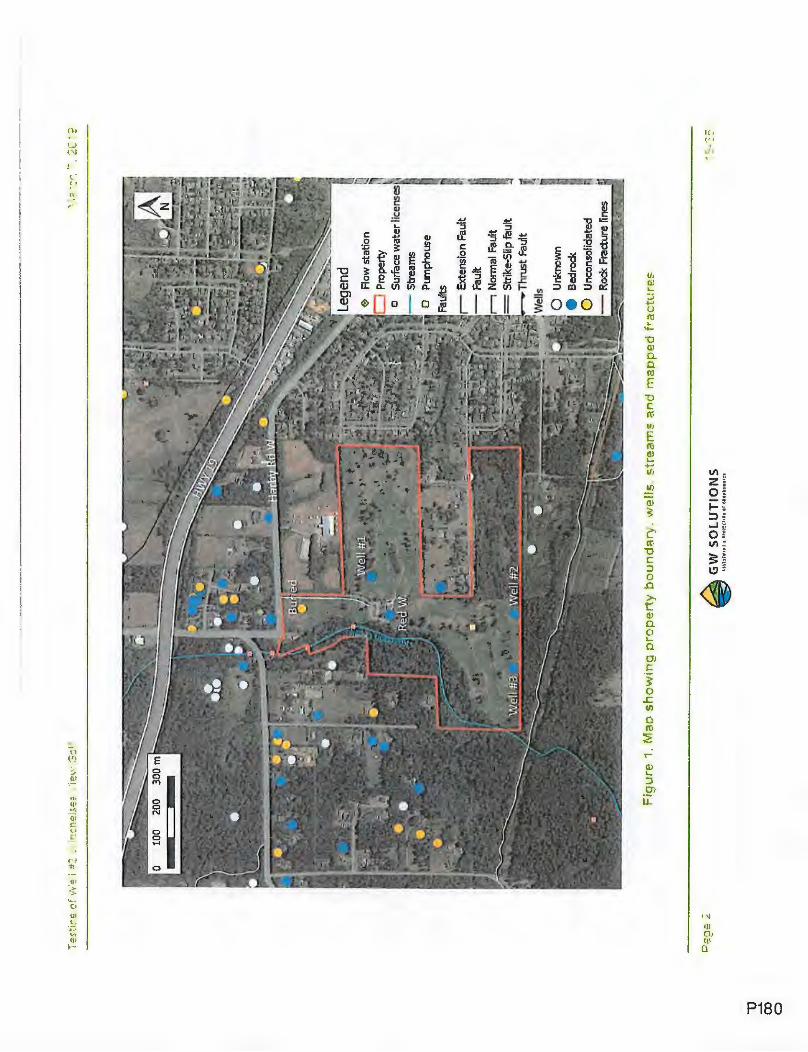
""'O
.....L
00
0
r-, N
orm
al F
ault
~ =
Stri
ke-S
U p
fau
It ...
-Th
rust
Faul
t
0 U
nkno
wn
• B
edro
ck
0 U
ncon
solid
ated
Fig
ure
1.
Ma
o s
ho
wi;
,g p
rop
ert
y b
ou
nd
ary
. v'
.relfs
. st
rea
r.1
s a
r,d
ma
op
ed
fra
ctu
re$
GW
SO
LU
TIO
NS
'-)~
~-r"'j
-
~,""
'i-<'I~
'
--
~
■-'!
,-
,..

"'U ..... 00 .....
2 q EGUL~TOP ' BAC~GROUNC Performing a controlled constant rate pumping test is the minimum regulatory requirement for proving up a community groundwater supply in BC under the Water Sustainability Act and local government bylaws. For a fractured bedrock well, a minimum of 72-h test has to be conducted under the supervision of a professional hydrogeologist. To rate a well (safe yield), various factors have to be considered:
- The drawdown behavior in the well over 100 days of continuous pumping;
- Well interference with other wells and surface water bodies;
- Aquifer mining (long-term water level decrease);
- Water level recovery;
- Water quality (e.g. sea water intrusion).
In the subdivision approval process, the well capacity has to be confirmed. When capacity cannot be proven with a high degree of confidence because of one of the above described factors, the recommended capacity should be the minimum capacity that can be proven up with confidence.
3 : OMPLF ''"E'.:; \VORK GW Solutions has completed the following tasks related to Well #2:
- Supervised a geo-camera inspection;
- Supervised a 72-h pumping test at a constant rate of 90 USgpm (using a temporary pump);
- Continuously monitored physico-chemical parameters and collected a groundwater sample; and
- Interpreted the data and provided recommendations in this report.

'1J
....
.;L
co
I\)
4 ·:
;E()
-CA
M~
RJ:
.. l
t,JS
~E
CT
12
r!
Th
e g
eo
-ca
me
ra in
spe
ctio
n t
oo
k p
lace
aft
er
rem
ova
l of t
he
exi
stin
g p
um
p b
y R
ed
Will
iam
s W
ell
Dri
llin
g L
td.
(Re
d W
illia
ms)
on
No
vem
be
r 14
th•
Th
e g
eo
-ca
me
ra w
as
low
ere
d t
o a
de
pth
of
151
m (
ma
xim
um
le
ng
th o
f th
e c
ab
le).
W
e m
ad
e t
he
fo
llow
ing
ob
serv
atio
ns:
-W
ate
r w
as
lea
kin
g i
n th
e w
ell
fro
m u
nd
er
the
ca
sin
g (
Fig
ure
2a)
;
-T
he
re a
re m
an
y fr
act
ure
s o
r b
ed
rock
ca
vin
g a
lon
g t
he
bo
reh
ole
;
-M
ajo
r fra
ctu
res
we
re e
nco
un
tere
d a
t 6
9.9
m,
90
.7 -1
10
.3 m
(fr
act
ure
zo
ne
), 1
39
.6 m
an
d 1
50
.5 m
; h
ow
eve
r,
the
ge
o-c
am
era
do
es
no
t allo
w d
ete
rmin
atio
n o
f wh
eth
er
the
se f
ract
ure
s a
re w
ate
r b
ea
rin
g o
r n
ot
Wa
ter
be
ari
ng
zo
ne
s w
ere
en
cou
nte
red
by
the
ori
gin
al d
rille
r .a
t 6
7 m
, 9
6 m
, 15
1 m
an
d 2
00
m (
see
att
ach
ed
we
ll lo
g in
A
pp
en
dix
1 ),
wh
ich
is
in a
gre
em
en
t w
ith t
he
ge
o-c
am
era
insp
ect
ion
.
a)
Fig
ure
2..
Sn
ao
sho
t.s
of
the
ge
o-c
am
ere
! in
spe
ctio
r"I
sho
win
g:
;ii
wat
er J
eaka
g'=
ul"
!de
r th
e :
.a s
ing
~1
3~
r th
e c
iriv
esh
c-e
21n
c b
l :.1
fra
ctu
re -
at 9D
.7 m
dee
c.
·
GW
SO
LU
TIO
NS
0
1u
uu
11
& •
•~uc
uow
: u
.uo1u
11rn
1n

'1J ~
(X)
(..,.)
S
GR
OU
N•
\VA
"T=
R Q
UA
NT
1TY
5.1
Gen
eral
Inf
orm
atio
n
Red
Will
iam
s ca
rrie
d ou
t th
e 7
2-h
pu
mp
ing
test
on
Wel
l #2
un
de
r the
sup
ervi
sion
of G
W S
olut
ions
. T
he
y re
mo
ved
the
ex
istin
g pu
mp,
rai
sed
the
wel
lhea
d an
d in
stal
led
a te
mp
ora
ry p
um
p c
ap.a
ble
of p
um
pin
g a
t 90
US
gpm
for
72
hou
rs.
Th
e
test
sta
rted
on
No
vem
be
r 16
, 2
01
8 a
t 1
0:3
0 a
m a
t th
e r
ate
of 9
0 U
Sgp
m a
nd e
nd
ed
aft
er 7
2 h
ou
rs o
f pum
ping
on
No
vem
be
r 19
, 201
8 at
10:
30 a
m.
Dur
ing
the
72-h
pum
ping
test
, w
ate
r le
vels
we
re m
ea
sure
d b
oth
usin
g a
leve
l lo
gg
er
inst
alle
d in
a s
ou
nd
er
tub
e a
nd
ma
nu
ally
by
Red
Will
iam
s' s
taff
. W
ate
r le
vels
we
re m
onito
red
in o
bser
vatio
n w
ells
We
ll #1
, W
ell #
3 an
d R
ed
W u
sing
leve
l lo
gger
s.
So
me
man
ual m
ea
sure
me
nts
we
re a
lso
take
n re
gula
rly
in t
he
thre
e ob
serv
atio
n w
ells
by
Red
Will
iam
s' s
taff.
No
prec
ipita
tion
occu
rred
dur
ing
the
72-
h pu
mpi
ng t
est.
Gen
eral
info
rmat
ion
rega
rdin
g th
e 72
-h p
umpi
ng t
est
is p
rese
nte
d in
Tab
le 1
. F
igur
e 3
a/b
sho
ws,
res
pect
ivel
y, t
he
pum
ping
te
st s
ettin
g ar
ound
th
e w
ell
head
and
th
e w
ate
r d
isch
arg
e to
the
pon
d n
ea
r th
e pu
mph
ouse
.
-abf
!?!
1. D
~ta
fro
m t
he
72
-h p
um
pin
g :
est
co
mp
lete
d i
n W
P.JI
==~
Flo
w te
st
Dep
th o
f pum
p F
low
Rat
e D
urat
ion
(hou
rs)
Dep
th to
wat
er a
t D
epth
to w
ater
at
Dra
wdo
wn
(m)
inta
ke (
m)
(US
gpm
) st
art o
f te
st (
mbg
) en
d o
f te
st (
mb
g)
Con
stan
t rat
e p
um
pin
g t
est
in
96.7
7 90
72
44
.29
59.9
3 15
.64
Wel
l#2
GW
SO
LU
TIO
NS

-u
__...
(X)
..i::,.
. -
----
-----------------------------------------------
----
Fig
ure
3.
a, P
um
oin
g te
s~ s
etti
ng
3ro
uri
c· th
e \l\
'ellh
ee
a a
nd
b)
dis
char
Qe
to t
he
po
rid
(N
ove
mb
e~
18
201
31
GW
SO
LU
TIO
NS

-u
......
0)
0,
5.2
Dra
wdo
wn
and
Hyd
raul
ic B
ehav
iour
of t
he A
quife
r aro
und
Wel
l #2
Fig
ure
4 sh
ow
s th
e d
raw
dow
n re
cord
ed
in W
ell #
2 d
urin
g p
um
pin
g a
s w
ell a
s th
e lo
g-de
riva
tive
dra
wd
ow
n.
Th
e s
tatic
wa
ter l
evel
in W
ell #
2 w
as
44
.29
m b
elo
w g
rou
nd
be
fore
the
test
. T
he
dra
wd
ow
n a
t th
e e
nd o
f th
e 7
2-h
pu
mpi
ng t
est
wa
s 15
.64
m.
The
sh
ap
e o
f the
der
ivat
ive
curv
e is
cle
arl
y in
dica
tive
of b
ilin
ea
r flo
w,
mea
ning
th
at t
he
wel
l is
conn
ecte
d to
a v
ertic
al fa
ult.
D
urin
g a
bili
ne
ar f
low
regi
me,
we
ha
ve fl
ow
con
trib
utio
n fr
om
bot
h th
e fr
actu
re a
nd t
he
ro
ck m
atrix
; th
e fl
ow
go
es
from
th
e
mat
rix
to th
e fr
actu
re a
nd f
rom
th
e fr
act
ure
to th
e w
ell.
Th
e d
raw
do
wn
an
d l
og
-der
ivat
ive
dra
wd
ow
n c
urv
es d
o n
ot s
ug
ges
t a
ny
rec
har
ge
bo
un
dar
y c
los
e to
th
e w
ell.

7J
-'-
OJ
O')
0.1
1 10
Ela
psed
tim
e (m
in)
100
1000
10
000
--·-
--·
----
-------------
------
---
··· -
----·---
-----•-• -
·-
·· ··
·-·-
· 10
00
-o
raw
do
wn
in W
ell~
2
_,_
Log
-der
ivat
ive
dra
wd
ow
n in
We1
1#2
1
vari
atio
ns in
flo
w r
ate
0.1
9t:;
.c:
R
I .c: s 0 "t
i 3 ro c
;:-i
gu
re 4
. D
r2w
dcW
'1 2
nd
lo
g-d
eri
va
tive
dra
1 1.N
dow
n -:
u,."
eS f
or
W-e
fl #
2 d
uri
ng
th'
= .
,.2-t
, o
um
pih
g ~
es!
at
30
US
gr:
nr.
.
GW
SO
LU
TIO
NS

'1J ......
CX
)
-..J
5.3
Wel
l Int
erfe
renc
e an
d A
rea
of I
nflu
ence
Fig
ure
5 sh
ow
s th
e w
ate
r le
vels
in W
ell
#2.,
Wel
l #1,
We
ll #3
, a
nd
Re
dW
du
rin
g t
he
pu
mp
ing
test
. W
e o
bse
rve
d th
at:
-W
ell
#3,
loca
ted
ap
pro
xim
ate
ly 2
00
m f
rom
We
ll #
2,
reac
ted
to t
he
pu
mp
ing
of W
ell
#2
wit
h 8
.32
m o
f dra
wd
ow
n
at th
e e
nd o
f pu
mp
ing
.
-W
ell
#1,
loca
ted
ap
pro
xim
ate
ly 5
00
m f
rom
Wel
l #2
, sh
owed
a 1
5 c
m d
raw
do
wn
-R
edW
, lo
cate
d a
pp
roxi
ma
tely
40
0 m
fro
m W
ell
#2
, sh
owed
a 1
0 c
m d
raw
do
wn
; h
ow
eve
r, t
he
de
clin
e d
oe
s n
ot
last
the
ent
ire
dura
tion
of
pum
ping
and
sho
wed
a s
ign
of r
ech
arg
e o
f un
kno
wn
ori
gin.
Bas
ed o
n th
e d
ista
nce
vs d
raw
do
wn
rel
atio
nshi
p, t
he
are
a o
f in
flu
ence
aft
er 7
2-h
of p
umpi
ng is
slig
htly
ov
er
500
m.
Th
e
area
of i
nflu
en
ce w
ill g
et l
arg
er a
s th
e p
um
pin
g c
ontin
ues,
be
cau
se th
e d
raw
do
wn
cu
rve
did
no
t sh
ow
a s
ign
of
stab
iliza
tion
tha
t wo
uld
re
sult
from
a r
echa
rge
bo
un
da
ry.
We
als
o ob
serv
ed t
ha
t th
e fo
ur w
ells
sh
ow
a s
ligh
t tid
al in
fluen
ce.
Its
ma
xim
um
am
plit
ud
e o
f 3 c
m w
as
reco
rde
d a
t Re
dW
.

"U
~
00
0
0
5-N
ov
9-N
ov
13
-No
v
40
·
-------
----
-------~
--
45
n
-o:c
..c
E
~5
0 -
Dat
e an
d ti
me
1
7-N
ov
Pum
ping
pe
riod
---------------------
■
~ "O
i:::
('C
N
:t;:
=5
5
(IJ s ·= ... 2 ra ~
£5
0
~ .. c..
OJ
0
65
70
Rec
over
y fr
om
su
mm
er
pu
mp
ing
• W
ellri
'2
I
, •
Man
ual W
ell#
2 !
--
Wel
l#3
--
We
ll#!
Re
dW
21
-No
v
Rec
over
y fr
om
72.
H p
um
pin
g a
nd
sum
me
r p
um
pin
g
~ig
ure
5.
Oe
pth
to
w:a
te
in W
ell 1
t2.
We
ll#
;.
Wel
J :'!
3. 3
nd
R~
dW
.
GW
SO
LU
TIO
NS
2.0
2.5
3.0
3.5
S.O
8.5
9.0
· 9
.5
· 10
.0

"1J __..
00
co
5.4
Rec
ove
ry a
nd L
on
g-t
erm
Beh
avio
ur
Fig
ure
5 s
ho
ws
bo
th W
ell
#3
an
d W
eU #
2 w
ere
un
de
r re
cove
ry c
on
diti
on
be
fore
the
72-
h p
um
pin
g t
est
sta
rte
d.
Th
is
reco
very
co
nd
itio
n i
s d
ue
to t
he
su
mm
er
pu
mp
ing
in W
ell
#2
fo
r ir
rig
atio
n p
urp
ose
. C
on
sid
eri
ng
th
is a
dd
itio
na
l re
cove
ry
eff
ect
(0.
7 m
ove
r 3
days
), t
he f
ull
reco
very
of w
ate
r le
vel o
ccu
rre
d a
lmo
st a
we
ek
aft
er
the
pu
mp
ing
te
st s
top
pe
d,
wh
ich
is
mo
de
rate
ly s
low
.
Fig
ure
6 s
ho
ws
the
his
tori
cal w
ate
r le
vels
in W
ell
#2
sin
ce 2
00
8 (
yea
rs 2
01
0,
20
13
an
d 2
01
7 a
re m
issi
ng
).
Th
ese
wa
ter
leve
ls w
ere
me
asu
red
we
ekl
y by
the
pe
rso
n in
ch
arg
e o
f th
e ir
rig
atio
n s
yste
m a
t th
e G
olf
Co
urs
e.
Fro
m t
his
da
ta a
nd
F
igur
e 6
we
can
ma
ke t
he
follo
win
g o
bse
rva
tion
s:
-T
he
irri
ga
tion
pe
rio
d l
ast
s b
etw
ee
n 1
05
an
d 1
89
da
ys d
ep
en
din
g o
n th
e y
ea
r, a
vera
gin
g 1
44 d
ays
;
-T
he
dra
wd
ow
n is
a.b
out 6
0 m
eve
ry y
ea
r (e
very
su
mm
er
irri
ga
tion
cyc
le);
-T
he
wa
ter
tab
le n
eve
r fu
lly r
eco
vers
du
rin
g w
inte
r fo
llow
ing
a p
um
pin
g c
ycle
in t
he
su
mm
er
(i.e.
, th
e w
ate
r le
vel
is s
till
incr
ea
sin
g w
he
n a
ne
w ir
rig
atio
n c
ycle
sta
rts)
;
-T
he
hig
he
st w
ate
r le
vel
me
asu
red
fo
llow
ing
pa
rtia
l re
cove
ry is
ap
pro
xim
ate
ly 1
7 m
be
low
gro
un
d;
-T
he
re is
a s
ligh
t de
cre
asi
ng
tre
nd
in t
he
wa
ter
leve
l in
the
last
10
ye
ars
;
-T
he
72-
h p
um
pin
g t
est
did
no
t sta
rt fr
om
a "
na
tura
l sta
tic"
wa
ter
leve
l;
Th
is h
isto
rica
l da
ta p
rovi
de
s ve
ry im
po
rta
nt
info
rma
tion
ab
ou
t th
e lo
ng
•te
rm b
eh
avi
or
of t
he
aq
uife
r.
Alth
ou
gh
in
sta
nta
ne
ou
s flo
w r
ate
wa
s re
cord
ed w
ee
kly
as
we
ll a
s to
tal f
low
at t
he
en
d o
f th
e ir
rigaU
on p
erio
d, w
e n
otic
ed
th
at
the
flo
wm
ete
r w
as
no
t pro
vid
ing
acc
ura
te d
ata
, u
nfo
rtu
na
tely
. T
he
re
po
rte
d r
ate
s a
re v
ari
ab
le,
with
hig
he
r p
um
pin
g
rate
s re
cord
ed
in
late
sp
rin
g a
nd
ea
rly
sum
me
r (a
t th
e b
eg
inn
ing
of p
um
pin
g).
U
nfo
rtu
na
tely
, th
e f
low
me
ter
ap
pe
ars
to
have
drtf
ted
over
tim
e, p
rovi
ding
non
-rel
iabl
e da
ta.
We
estim
ate
the
pum
ping
rat
es h
ave
pro
ba
bly
rang
ed b
etw
ee
n 6
0 to
80
US
gp
m b
ase
d o
n th
e t
otal
vo
lum
es
re.c
orde
d d
uri
ng
th
e p
um
pin
g p
eri
od
aft
er t
he
me
ter w
as
inst
alle
d,
an
d a
ssu
min
g
tha
t its
ca
libra
tion
wa
s m
ore
acc
ura
te s
ho
rtly
aft
er
be
ing
in
sta
lled
. F
igu
re 6
als
o s
ho
ws
the
re
po
rte
d c
um
ula
tive
pu
mp
ed
vo
lum
es
at t
he
end
of t
he
irlii
gatio
n p
eri
od
.
GW
SO
LU
TIO
NS

7J
.....L
<O
0
E - '- 2 ro
3 .8 .c
.J,,
J 0..
QJ
0
0 --
---
----
·.
----
--·--
--
---
-~-
----
----
Star
t of
l.S
E+
O/
10 .
20
30
40
so
60 ~
70
-
80
-
90
-+
-D
epth
to
wa
ter
W~
2 H
isto
rica
l
irri
gati
on
pe'ld (
2015
)
End
of i
rrig
ati
on
/ pe
riod
(20
15)
20
16
Sta
rt o
f 72
H t
est ~ \
End
of
\
~ D
epth
to
wa
ter W
¢¢2
Fa!!
2018
-
--Cu
mu
lativ
e f
!ow
1.6E
+07
1.4E
+07
1.2
E+
07
~
..Q ~
0 V,
1.0E
+07
2.
QJ E
:::, ~
8.0E
+06
~
-~
~ E
6.0E
+06
:::;
u
'. 4.
0E-~
06
2.0E
+0E
O.O
E+O
O
Fig
ure
E.
De
pth
to
wa
t~r
a!1d
cu
rriu
lati
\/e
pu
mp
ed
vo
luri
ies s
mce
20
0~
in
'N
ell
~2
anc!
201
8 ::
,um
pin
g ·
-=st
-:la
t=-
GW
SO
LU
TIO
NS

"'O
.....
c.o
.....
5.5
Wel
l Yie
ld R
atin
g In
BC
, th
e y
ield
of t
he
wel
l is
estim
ated
by
first
ext
rapo
lati_
ng t
he
ob
serv
ed
dra
wdo
wn
durin
g th
e 7
2-h
ou
r pu
mpi
ng t
est
to
10
0 da
ys.
Fig
ure
7 sh
ow
s th
e ex
trap
olat
ed d
raw
do
wn
usi
ng t
his
met
hod,
con
side
ring
an
"idea
l1"
aqui
fer a
nd a
"no
n-id
eal"
aq
uife
r. I
t sho
uld
be
not
ed t
ha
t be
dro
ck w
ells
ofte
n h
ave
no
n-i
de
al b
ehav
iour
, sh
owin
g la
rge
r rat
es o
f wa
ter l
eve
l de
cre
ase
de
pend
ing
on t
he
str
uctu
ral c
ondi
tions
en
cou
nte
red
dur
ing
pu
mp
ing
. F
igur
e 7
sho
ws
the
line
ar e
xtra
pola
tion
of t
he
dr
awdo
wn
(27
m),
con
side
ring
th
e w
ell
is p
umpi
ng c
ontin
uous
ly fo
r 1
00
da
ys a
t the
rat
e o
f 90
US
gpm
, an
d th
e a
qu
ifer i
s "id
eal".
Th
e a
vaila
ble
dra
wd
ow
n in
a b
ed
rock
wel
l is
def
ined
as
the
diff
ere
nce
bet
wee
n th
e lo
we
st s
tatic
wa
ter l
eve
l (us
ually
end
of
sum
me
r) a
nd th
e u
pper
mos
t ma
jor p
rodu
cing
fra
ctur
e.
Ba
sed
on
the
ge
o-c
am
era
insp
ectio
n an
d th
e a
vaila
ble
cons
truc
tion
log
of t
he
wel
l, th
e u
pp
erm
ost
ma
jor
prod
ucin
g fr
act
ure
was
iden
tifie
d a
t a
de
pth
of 9
6 m
. W
ate
r le
vel p
rio
r to
th
e te
st w
as m
easu
red
at 4
4.29
m b
elo
w g
rou
nd
. T
his
wa
ter
leve
l is
cons
ider
ed t
he
low
est
wa
ter l
evel
, al
thou
gh t
he
wa
ter
leve
l wa
s st
ill r
ecov
erin
g be
fore
pum
ping
. T
he r
esul
ting
safe
ava
ilabl
e dr
awdo
wn
(con
side
ring
30
% s
afe
ty fa
cto
r) is
36
.2
m.
Ta
ble
2 p
rese
nts
the
cal
cula
ted
safe
yie
ld a
ccor
ding
to
the
BC
Gu
ide
line
and
con
side
ring
an
"ide
al"
aq
uife
r beh
avio
ur.
Th
e e
stim
ated
max
imum
yie
ld is
12
0.7
US
gpm
. H
owev
er,
the
ma
xim
um
rec
omm
ende
d pu
mpi
ng y
ield
fo
r We
ll #
2 c
ould
n
ot e
xcee
d 90
US
gpm
, as
a w
ell
can
no
t be
rate
d a
t a h
igh
er r
ate
tha
n it
wa
s pu
mpe
d. N
o s
ea
son
al i
mp
act
ha
s be
en
cons
ider
ed a
s w
ate
r lev
el is
alr
ea
dy
be
low
the
nat
ural
low
wa
ter l
evel
. T
he
re w
as
no
obs
erve
d in
terf
ere
nce
fro
m o
ther
ne
arby
wel
ls.
On
Fig
ure
7,
wa
ter l
evel
info
rmat
ion
from
th
e p
umpi
ng p
erio
d in
20
15
wa
s ad
ded
to th
e g
rap
h f
or
com
pari
son
purp
ose.
T
his
ye
ar w
as
chos
en b
ecau
se it
pre
sent
s th
e b
est c
urve
, w
ith l
ess
pum
ping
inte
rrup
tions
. T
he w
ate
r le
vels
we
re
conv
erte
d to
dra
wdo
wn
sinc
e th
e d
ay
the
pum
ping
cyc
le s
tart
ed o
n A
pril
29,
2015
. W
e c
an
se
e o
n th
e g
raph
th
at
aft
er 1
00
da
ys th
e d
raw
dow
n is
abo
ut 5
8 m
. Th
is s
ug
ge
sts
tha
t we
are
in a
non
-ide
al a
qu
ifer s
ituat
ion.
In
201
5, t
he
wa
ter
leve
l sh
ows
a ra
pid
de
clin
e s
ugge
stin
g a
"non
-ide
al"
be
ha
vio
ur o
f the
aqu
ifer.
T
he
pos
ition
of t
he
20
15
pu
mp
ing
cur
ve is
ab
ove
th
e 7
2h p
umpi
ng c
urve
at i
ts b
egin
ning
(be
twee
n 1
00
00
and
20
00
0 m
inut
es);
the
refo
re,
the
flo
w ra
te in
20
15
wa
s ve
ry
1 "I
deal
' wou
ld t
ypic
ally
be
infin
ite, o
f co
nst
an
t thi
ckne
ss,
hom
ogen
eous
, an
d fo
r whi
ch fl
ow
to a
wel
l wou
ld b
e ra
dial
.

"1J
-.
co
I\.)
I ,-
-I
....
..,.
likel
y le
ss th
an 9
0 U
Sgp
m.
Com
pare
d w
ith t
he d
raw
dow
ns o
bser
ved
durin
g th
e s
tep
test
, W
ell #
2 w
as l
ikel
y pu
mpe
d be
twee
n 60
and
80
US
gpm
in 2
015.
"S
tatic
" w
ate
r le
vel p
rio
r th
e p
umpi
ng c
ycle
in 2
01
5 is
abo
ut 2
1 m
be
low
gro
und.
C
onsi
derin
g a
30%
saf
ety
fact
or
(whi
ch in
clud
es th
e un
know
n se
ason
al im
pact
), t
he r
esul
ting
safe
ava
ilabl
e dr
awdo
wn
is
52.9
m.
Tab
le 2
sum
mar
izes
est
imat
ed s
afe
yiel
ds o
,f th
e w
ell u
sing
the
72h
pum
ping
te
st a
s w
ell
as h
isto
rical
dat
a fo
r re
spec
tivel
y a
flow
rat
e o
f 60
and
80 U
Sgp
m.
Sa
fe y
ield
s o
f res
pect
ivel
y 90
, 54
and
72
US
gpm
are
obt
aine
d.
Bas
ed o
n th
e ob
serv
ed s
low
rec
over
y o
f the
fra
ctur
ed b
ed
rock
and
a s
light
dec
reas
ing
tren
d in
the
wa
ter
leve
l in
the
last
10
yea
rs (
Fig
ure
6),
we
have
to ta
ke a
con
serv
ativ
e ap
proa
ch a
nd m
inim
ize
the
ris
k o
f str
essi
ng t
he a
quife
r (s
ee S
ectio
n 2)
. T
here
fore
, w
e re
com
men
d th
e w
ell t
o b
e r
ated
at a
max
imum
yie
ld o
f 54
US
gpm
.
The
Dis
tric
t of l
an
tzvi
lle re
.qui
res
a m
inim
um o
f 340
0 U
da
y o
f· wa
ter
pe
r lo
t (0.
63 U
Sgp
m).
The
refo
re,
Wel
l #2
cou
ld
sust
ain
the
dem
and
for
85 r
esid
entia
l lo
ts.
GW
SO
LU
TIO
NS

-u
......
c.o
c..u
1 10
10
0
Ela
psed
tim
e t
(min
) 10
00
100
days
10
000
1000
00
-----
------
•· 0
' ~ \
I 2
I 4
I_ 6
I
8 ,_
10
12
14
16
18
20
22
2
4
26
. 28
e
30 ~
32
3:
34 .g
36
:r:
38 ~
40
C
42
I· 4..
a. I-
46
I 4
8
I so
I
52
I 5
4
._,-
56
,. 5
8
,-60
I
62
I 6
4
,. 66
c;g
ur~
7.
EY
trap
ota
ted
100
day
s d
raw
do
wr.
fo
r a
pu
mo
ing
rat
e o
f 9
0 U
Sg
pm
1n
We
ll :fi
2 a
nd
h:~
tori
c;;!
ln
for~
atl
o
fr~
m 2
01
.:
GW
SO
LU
TIO
NS

Tabl
12 2
. R
ated
yie
ld f
o,.
y,112
-111
:
Un
it
Key
W
ell#
2.
Wef
l#Z
Wel
l#2
Par
amet
er
(ide
al a
quif
er)
His
toric
al d
ata
H
istor
ical
dat
a
Pum
ping
rat
e U
Sgp
m
90
60
8
0
Dra
wdo
wn
(100
day
s)
m
27
5
8
58
Pro
ject
ed s
peci
fic
cap
acit
y (
100
days
) U
Sgp
m/m
3.
3 1.
0 1.
4
Spe
cifi
c ca
paci
ty
l/s/
m
a 0.
21
0.07
0.
09
Dep
th t
o f
irst
maj
or
wat
er b
eari
ng f
ract
ure
m
bg
b 96
.0
96.0
96
.0
Sou
nder
Pip
e (S
P)
m
C
0.53
0.
53
0.53
"Sta
tic"
wat
er l
evel
m
bTSP
d
44.8
2 21
21
Sea
sona
l im
pac
t m
e
0 0
0
Inte
rfer
ence
from
oth
er w
ells
m
f
0 0
Q
Saf
ety
fact
or (
70%
) g
0.7
0.7
0.7
Ava
ilab
ledr
awdo
wn
m
h =
b+c
-d-e
-f
51.7
1 75
.53
75.5
3
Saf
e av
aila
ble
dra
wdo
wn
m
g=
hx
g
36
,20
52
.87
52
.87
Est
imat
ed s
ust
ain
able
yie
ld
1./s
i=ax
g
7.6
3.5
4.6
Es ti
mat
ed s
ust
a i n
a bl
e y
ield
U
Sgpm
12
0.7
54.7
72
.9
--
--
I
Max
i mum
iq
~ y
teld
-
--
--
USg
pm
---
90
54
72
E
GR
OU
ND
Vv·
AT
=R '
.JUA
LITY
6.1
Con
tinuo
us I
n-si
tu M
onito
ring
of P
hysi
co-c
hem
ical
Par
amet
ers
Ph
ysic
o-c
he
mic
al p
ara
me
ters
incl
ud
ing
te
mp
era
ture
(T
), p
H,
oxi
de
-re
du
ctio
n p
ote
ntia
l (O
RP
), d
isso
lve
d o
xyg
en
(D
O),
sp
eci
fic c
on
du
ctiv
ity a
nd
tot
al d
isso
lve
d s
olid
s (T
DS
) w
ere
mo
nito
red
in-s
itu d
uri
ng
th
e p
um
pin
g t
est.
In
-situ
mo
nito
rin
g
he
lps
ide
ntif
y w
he
the
r p
um
pin
g h
as r
ea
che
d a
bo
un
da
ry (
river
, cr
eek,
lak
e, n
o fl
ow),
or
salt-
wa
ter
intr
usi
on
is o
ccu
rrin
g,
wh
ich
is a
ris
k fo
r w
ells
in c
oa
sta
l a
rea
s a
s w
ell a
s d
ee
p w
ells
. F
igur
e 8
sho
ws
tha
t p
ara
me
ters
re
ma
ine
d s
tab
le d
uri
ng
th
e
test
. C
ha
ng
e in
wa
ter
qu
alit
y w
as
no
t re
cord
ed
.
GW
SO
LU
'TIO
NS

""'O
.....L
c.o
01
co
16
t:: .E
..
t-
I'll
a..
.,.
~E
!
Spe
cifi
c ~
nd
uct
ivit
y
:,
--
-0
. --
--
--
14
TO
S
12
=
._
M
Te
mp
era
ture
!.
, 0
10
Q
"'C C: "' £
pH
=-8
g «I.I B
t'II
6 ai Q
. ! 4
,
\c.....
...._
OR
P 2
\.. D
isso
lved
Oxy
gen
0 ~
C
!:)
~
~'y
--i,<:;
$ ~~
"(,<
:;s 'br:
s 't)..
., q,r
:s q,.
.., ~-
..;
'f:c:,"
.; ~c
:,",
~
~c
...,ro
'\,Co
':::.~
-:::.v
...... ~
'\,~
..,,.
-..;
..,,.--.;
- u C
Q.
-E
t;
:;J
t)
0. ..
lo
--
--
---
"'CJ C ...,
--
-.. .
-
. . -
Tem
pera
ture
("q
-
-D
isso
lve
d O
xyg
en
(m
g/L
) .
pH (
units
)
Spec
ific:
Con
duc:
tanc
:e {
uS/c
:m)
TOS
(mg/
L)
-.. -
oR
P(m
V)
-!:
) !:.
) !::I
!:
)
~?
,.,,~ ~?
"(
,~
q,r;s
'b "",
. Co
r:s Co
..., ~r:
::,-..;
c:,~
-::..,,r
:::,-..;
~c:,"
r ~
,;
~...,eo
'j.-..;
'j....,~
~~
.....
.....
'\,--,
; '\,"
> ...,,
D
ate
and
tim
e
60
0 e
400 ~
u, .a. ~
"$
200
't;
::,
"'C C: 8 u
0 =
u (1
1 C.
U'I
"' C -2
00
"' >
-5.
0,.
-40
00
-.... ......
QII
E
-600
';;;'
0 I-
-80
0
-100
0
Fig
ure
8.
Co
nti
nu
ou
s m
on
ito
rin
g o
f p
hysic
o-c
tie
mic
al
oa
r-a
~e
ters
du
rin
g t
he
72
-h t
est
in
'N
ell
t:2
GW
SO
LU
TIO
NS

-u
~
co
0)
6.2
Che
mic
al A
naly
sis
A w
ate
r sa
mp
le w
as
colle
cte
d a
t th
e e
nd
of t
he p
um
pin
g t
est
an
d s
en
t to
th
e a
ccre
dite
d l
ab
ora
tory
Ma
xxa
m A
na
lyti
cs f
or
Isla
nd
He
alth
Au
tho
rity
po
tab
ility
an
aly
sis.
T
he
ori
gin
al
lab
ora
tory
re
po
rt is
fo
un
d i
n A
pp
en
dix
2.
Ta
ble
3 s
ho
ws
a .s
umm
ary
of k
ey
pa
ram
ete
rs a
nd
ho
w th
e-ir
co
nce
ntr
ati
on
s co
mp
are
to
th
e C
an
ad
ian
Dri
nki
ng
Wa
ter
Qua
lity
Gui
derin
e (C
DW
QG
). lh
e fo
llow
ing
ob
serv
ati
on
s a
re m
ade:
►
To
tal
Bo
ron
co
nce
ntr
atio
n i
s 5.
68 m
g/L
, w
hic
h e
xcee
ds
the
MA
C b
y 14
%.
Th
e e
xce
ed
an
ce w
as
less
th
an
aft
er
the
ste
p t
est
(e
xce
ed
an
ce b
y 3
3%
). D
isso
lve
d b
oro
n c
on
cen
tra
tion
is
4.7
5 m
g/L,
wh
ich
re
pre
sen
ts 8
4%
of t
he
tota
l b
om
n c
on
cen
tra
tion
; th
eref
ore,
the
ma
jori
ty o
f th
e b
oro
n c
on
cen
tra
tio
n i
s un
der
dis
solv
ed
fonn
, th
is is
the
form
th
at
ne
ed
s to
be
re
mo
ved
usi
ng
ad
eq
ua
te t
rea
tme
nt.
·
►
Co
lifo
rm b
acte
ria
and
E.C
oli
are
no
t p
rese
nt
in W
ell
#2.
Pre
vio
us
an
aly
sis
(Se
pte
mb
er
20
18
) ha
d re
po
rte
d t
ota
l co
lifo
rms
an
d E
.Co
li a
bo
ve t
he
Ma
xim
um
Allo
wa
ble
Co
nce
ntr
atio
n (
MA
C).
T
he
ir a
bse
nce
at t
he
pre
sen
t d
ay
pro
ba
bly
re
sults
fro
m t
he
te
mp
ora
ry r
ais
ed
ca
$in
g a
bo
ve g
rou
nd
, th
e w
ell
wa
ter f
lush
ing
du
rin
g t
he
te
st a
nd
/or
the
u
se o
f .a c
lea
n d
isch
arg
e p
ipe
.
►
The
gro
un
dw
ate
r is
Na
-Cl t
ype
wh
ich
is
typ
ica
l o
f de
ep
an
cie
nt
gro
un
dw
ate
r.
►
Wa
ter
is s
oft
(co
nce
ntr
atio
n o
f 40
mg
/L o
f C
aC
o3
) w
hic
h i
s ty
pic
al
of g
rou
nd
wa
ter f
low
ing
th
rou
gh
ig
ne
ou
s ro
cks.
Ta
hie
3.
Su
mm
ary
of
wa
te ..
qu
ality
ari
afy
sis
at
Wel
1 -:;.
;_
Wel
l ID
Sa
mpl
ing
Dat
e P
aram
eter
R
epor
ted
Con
cent
ratio
n U
nit
Lim
it co
ncen
trat
ion
Exce
edan
ce c
ateg
ory
To
tal
Bor
:on
(Br)
5
.68
m
g/L
5
Exc
eed
s M
~C
No
n-C
olif
orm
bac
teri
a 62
C
FU
/l0
0m
l 20
0 In
dic
ato
r to
ol
Dis
solv
ed B
oro
n (
Br)
4.
75
mg
/L
5 -
Wel
l#2
N
ov
19
, 20
18
Tot
al (
Dis
solv
ed)
So
diu
m
15
5 (
118)
m
g/L
2
00
(A
O)
-D
isso
lved
Chl
orid
e 15
0 m
g/L
2
50
(A
O)
-T
otal
Dis
solv
ed S
olid
s 44
2 m
g/l
5
00
(A
O)
-
GW
SO
LU
flO
NS

-0
--L
c.o
--.J
6.3
GA
RP
Ass
essm
ent
We
ll #
2 is
pre
sen
tly r
ate
d "
At R
isk
of C
onta
inin
g P
atho
gens
" b
ase
d o
n th
e G
uid
an
ce D
ocu
me
nt f
or
Gro
un
dw
ate
r A
t R
isk
of
Co
nta
inin
g P
ath
og
en
s (V
ers
ion
3 -
Se
pte
mb
er
20
17
).
Th
is is
ma
inly
du
e to
th
e f
act
tha
t th
e w
ell
he
ad
is n
ot
bu
ilt in
co
mp
lian
ce w
ith t
he
cu
rre
nt
Gro
un
dw
ate
r P
rote
ctio
n R
eg
ula
tion
. In
pa
rtic
ula
r, t
he
we
ll is
in a
pit
with
po
nd
ing
wa
ter,
th
ere
is
lik
ely
no
su
rfa
ce s
eal,
an
d w
ate
r is
lea
kin
g a
t th
e b
ase
of t
he
ca
sin
g.
Th
is s
ho
uld
be
so
lve
d w
he
n t
he
pro
du
ctio
n w
ell
is
dri
lled
in a
cco
rda
nce
with
th
e G
rou
nd
wa
ter
Pro
tect
ion
Re
gu
latio
n.
Th
e G
AR
P a
sse
ssm
en
t ta
ble
fo
r W
ell
#2
is s
ho
wn
in
Ap
pe
nd
ix 3
.
Th
e le
vel o
f hyd
rau
lic c
on
ne
ctio
n b
etw
ee
n s
urf
ace
wa
ter
an
d g
rou
nd
wa
ter
ha
s to
be
est
ima
ted
in o
rde
r to
ass
ess
:
-T
he
ris
k o
f co
nta
min
atio
n o
f gro
un
dw
ate
r b
y p1 a
tho
ge
ns
sho
uld
it b
e in
clo
se c
on
ne
ctio
n w
ith s
urf
ace
wa
ter
(in
clu
de
d in
th
e G
AR
P a
na
lysi
s p
rese
nte
d a
bo
ve);
-T
he
ris
k o
f ne
ga
tive
ly im
pa
ctin
g w
ate
r le
vels
in s
tre
am
s, l
ake
s, w
etl
an
ds
or
spri
ng
s w
hile
pu
mp
ing
th
e w
ell
{Wa
ter
Su
sta
ina
bili
ty A
ct).
In
ou
r ca
se,
Kn
ars
ton
Cre
ek
wo
uld
be
a s
tre
am
po
ten
tia
lly a
t ri
sk o
f be
ing
im
pa
cte
d.
Th
e h
ydra
ulic
co
nn
ect
ion
be
twe
en
gro
un
dw
ate
r n
ea
r th
e w
ell
an
d s
urf
ace
wa
ter
is e
stim
ate
d a
s u
nlik
ely
ba
sed
on
cu
rre
nt
ava
ilab
le in
form
atio
n, fo
r th
e fo
llow
ing
reas
ons:
-T
he
pu
mp
ing
te
st d
id n
ot
reve
al
the
pre
sen
ce o
f a r
ech
arg
e b
ou
nd
ary
clo
se t
o t
he
wel
l;
-ln
-sffu
ph
ysic
o-c
he
mic
al p
ara
me
ters
did
no
t sh
ow
sig
ns
of a
dif
fere
nt
typ
e o
f wa
ter
(su
rfa
ce w
ate
r) e
nte
rin
g t
he
w
ell
(no
ch
an
ge
in w
ate
r q
ua
lity)
.
-T
he
wa
ter
leve
l in
the
dis
cha
rge
po
nd
ne
ar t
he
pu
mp
ho
use
did
not
de
cre
ase
as
a re
sult
of t
he
72
h p
um
pin
g t
est
(F
igu
re 9
) as
sho
wn
by
the
1.5
m w
ate
r le
vel ris
e.
-T
he
re is
a g
ran
ula
r la
yer
sep
ara
ting
th
e b
ed
rock
from
Kn
ars
ton
Cre
ek.
Th
is g
ran
ula
r la
yer
ge
ts t
hin
ne
r a
s w
e
mo
ve to
wa
rds
the
low
lan
ds,
bu
t a
lso
co
nta
ins
mo
re c
lay,
acc
ord
ing
to
we
ll lo
gs.
In
de
ed
, th
e th
ickn
ess
of t
he
o
verl
yin
g o
verb
urd
en
is
22
m a
t W
ell
#2
, a
bo
ut
1 O m
ne
ar
Re
dW
an
d 3
m n
ea
r W
ell
#1.
GW
SO
LU
TIO
NS

-a
--1
,.
(0
co
1.8
~ 1.
6 t1
0 .Q
<11
1.
4 >
0 ..0
It!
1.
2 -
t'.!
2:! (!J
1 .§
. ~
0.8
0 a.
.!: 0
.6
aj l
o.4
... QJ ~
0.2
~
0 0 0 0 0 >
0 z J;,
.....
Sta
rt o
f
0 0
9.
0 ~
..:.i
0 .....
>
>
0
0 z
z JJ
JJ
.....
....
__ .._ _
_ -
···•
•4•
--,.,
_
0 0
0 0
0 0
0 9.
'?
. 0
0 0
co 0
IO
..:.i
co 0
.-4
0
0 ....
-t
0 >
>
>
>
>
>
0
0 0
0 0
0 z
z z
z z
z J,
r!.
r!.
r!.
r!.
~
.....
.... ....
.....
.....
-0 0 \I
) 0 >
0 z co ....
Rea
ch o
f ov
erflo
w
0 0
0 0
<;!
0 ..:.
i co
0
.... ....
0 >
>
>
0
0 0
z z
z 00
co
en ....
.... r-
t
End
of
pu
mp
ing
Va
lve
-~-
... --~
.. ... ,
.. -.,--
---;
0 0
0 0
0 0
9.
9.
9.
0 0
9.
\0
:: co
g
\I)
"' 0
.-4
0
.... >
>
>
>
>
>
0
0 0
0 0
0 :z
z
z z
z 2
:
~ ~
di
6 6
6 .....
N
N
N
0 0
0 '?
. co
0 .....
0
>
>
0 0
z :;;;
:_
~ rl
N
Fig
urie
9.
Evo
luti
or.
of
~.-~
ter
lev~
I in
th
s d
i~ch
a:g
e o
on
ci d
uri
ng
ti"
e 7
2-h
pu
mp
1n
g t
est
GW
SO
LU
TIO
NS
,U
UU
WU
f I,
PII
JCC
IIII
I 41
0
Clt
!UT
U1
U

"'O
....
I,
co
co
.S C
ON
CL
US
ION
S f
a.N
D P
~EC
C1 M
~,11E
ND
.~T
!ON
S
Bas
ed o
n th
e re
view
ed i
nfor
mat
ion
and
wo
rk c
ompl
eted
, G
W S
olut
ions
dra
ws
the
follo
win
g co
nclu
sion
s:
1.
A 7
2-h
test
has
bee
n co
mpl
eted
to
me
et t
he
reg
ulat
ory
requ
irem
ents
fo
r te
stin
g an
d ra
ting
of a
bed
rock
wel
l. T
his
72-h
test
, al
ong
with
his
tori
cal w
ate
r le
vel d
ata
col
lect
ed o
ver
the
last
10
year
s, i
ndic
ates
th
at t
he a
quife
r be
havi
or is
"n
on-id
eal"
, in
oth
er w
ords
, th
e ra
te a
t whi
ch t
he
wa
ter
leve
l dro
ps
incr
ease
s bo
th w
ith t
ime
and
with
inc
reas
ed
draw
dow
n.
2.
Con
side
ring
the
inco
mpl
ete
reco
very
of t
he
wa
ter
leve
l an
d th
e g
radu
al d
ecr
ea
se o
f wa
ter
leve
l ove
r th
e la
st 1
0 ye
ars,
we
con
serv
ativ
ely
est
ima
te th
e sa
fe y
ield
at 5
4 U
Sgp
m.
Th
is y
ield
cou
ld b
e in
crea
sed
once
mor
e re
.liab
le
data
on
the
volu
me
pum
ped
ove
r o
ne
su
mm
er
and
the.
resu
lting
dro
p in
wa
ter
leve
l is
colle
cted
.
3.
Dra
wdo
wn
is e
xpec
ted
to s
prea
d o
ver
mo
re th
an 5
00 m
aro
und
Wel
l #2.
4.
Wa
ter
qual
ity r
esul
ts in
dica
te t
hat t
otal
bor
on c
once
ntra
tion
slig
htly
exc
eeds
th
e C
anad
ian
Drin
king
Wa
ter
Qua
lity
Gui
delin
e. A
wa
ter
trea
tmen
t sys
tem
will
ha
ve to
be
built
to t
rea
t bor
on.
5.
Wel
l #2
is p
rese
ntly
rat
ed "
At R
isk
of C
onta
inin
g P
atho
gens
" m
ostly
du
e to
the
fa
ct th
at t
he
wel
l he
ad i
s n
ot b
uilt
in
com
plia
nce
with
the
cur
rent
Gro
un
dw
ate
r P
rote
ctio
n R
egul
atio
n.
Thi
s co
uld
be
sol
ved
by
impr
ovin
g th
e w
ellh
ead
in
acco
rdan
ce w
ith t
he G
rou
nd
wa
ter
Pro
tect
ion
Reg
ulat
ion
(e.g
. re
mov
e th
e p
it, r
aise
the
wel
lhea
d an
d se
cure
cap
).
6.
Hyd
raul
ic c
onne
ctio
n w
ith s
urf
ace
wa
ter
(i.e.
Kna
rsto
n C
reek
) ha
s n
ot b
een
obse
rved
bas
ed o
n cu
rren
tly a
vaila
ble
info
rmat
ion.
We
rec
omm
end
to:
1.
Inst
all a
flo
wm
ete
r in
Wel
l #2
so t
ha
t bot
h in
stan
tane
ous
as w
ell
as c
umul
ativ
e flo
ws
can
be
rec
orde
d a
ver t
he
nex
t pu
mpi
ng s
easo
n (2
019)
. M
anua
l me
asu
rem
en
t of t
he f
low
rat
e sh
ould
be
carr
ied
ou
t fo
r ca
libra
tion
purp
oses
.
2.
Mon
itor
both
wa
ter
leve
l and
flo
w d
urin
g th
e n
ext i
rrig
atio
n pe
riod
(20
19).
T
he
mo
re r
elia
ble
data
def
inin
g th
e fl
ow
ra
te a
nd c
umul
ated
dis
char
ge c
ould
the
n be
use
d to
rec
alcu
late
th
e p
ropo
sed
safe
yie
ld (
usin
g th
e ca
lcul
atio
n pr
esen
ted
in T
able
2).
Rel
ying
on
acc
ura
te p
umpe
d vo
lum
es a
nd d
raw
dow
ns,
this
sa
fe y
ield
wou
ld b
e d
efe
nd
ab
le
to r
ate
this
wa
ter
sour
ce.
Thi
s in
form
atio
n co
uld
be
pro
vide
d to
reg
ulat
ors
wh
en
an
appl
icat
ion
for
a g
rou
nd
wa
ter
licen
ce is
sub
mitt
ed.
GW
SO
LU
TIO
NS

"1J
I\)
0 0
3.
Bor
ing
the
wel
l to
incr
ease
its
dia
me
ter
(to
an 8
-inc
h o
r 10
-inc
h pr
oduc
tion
we
ll} a
nd
com
plet
ing
the
we
ll ac
cord
ing
to th
e s
tand
ards
of t
he G
rou
nd
wa
ter
Pro
tect
ion
Reg
ulat
ion.
4.
Co
nsi
de
r a la
nd d
eve
lop
me
nt i
n ph
ases
. T
his
wou
ld a
llow
to m
on
itor t
he
ope
ratio
n o
f th
e w
ell a
nd t
he
be
ha
vio
r of
the
aq
uife
r ove
r lon
g pe
riod
s o
f tim
e a
nd p
reve
nt c
omm
ittin
g to
a w
ate
r su
pp
ly th
at w
ould
jeo
pa
rdiz
e th
e r
elia
bilit
y o
f th
e a
quife
r. T
he
Dis
tric
t of L
antz
ville
req
uire
s a
min
imu
m o
f 34
00
Ud
ay
of w
ate
r p
er l
ot (
0.63
US
gp
m}.
The
refo
re,
We
ll #
2 c
ould
sus
tain
th
e d
eman
d fo
r 85
res
iden
tial l
ots.
Loc
atio
ns fo
r ad
ditio
nal w
ate
r su
pp
ly w
ells
that
cou
ld b
e
expl
ored
are
the
so
uth
ea
st a
nd s
ou
thw
est
com
ers
of t
he
pro
pert
y, o
r th
e o
the
r op
tion
wou
ld b
e to
dri
ll R
ed
W
deep
er.

7J
I\)
0 ....
I.
ST
UD
Y L
IMIT
AT
IDN
S
Thi
s d
ocu
me
nt w
as
prep
ared
fo
r th
e e
xclu
sive
use
of W
inch
els
ea
Vie
w G
olf
Co
urs
e L
td.
an
d it
s a
ge
nts
. T
he
infe
ren
ces
conc
erni
ng t
he
dat
a, s
ite a
nd r
ece
ivin
g e
nvi
ron
me
nt
con
diti
on
s co
nta
ine
d in
th
is d
ocu
me
nt a
re b
ased
on
info
rma
tion
ob
tain
ed d
urin
g in
vest
iga
tion
s co
nd
uct
ed
at
the
site
by
GW
So
lutio
ns
and
oth
ers
an
d a
re b
ase
d s
ole
ly o
n t
he
co
nd
itio
n o
f th
e si
te a
t the
tim
e o
f the
site
stu
die
s.
Soi
l, su
rfa
ce w
ate
r a
nd
gro
un
dw
ate
r co
nd
itio
ns
ma
y va
ry w
ith l
oca
tion
, d
ep
th,
time,
sa
mp
ling
me
tho
do
log
y, a
na
lytic
al t
ech
niq
ue
s an
d o
the
r fa
cto
rs.
In e
valu
atin
g t
he
su
bje
ct s
tud
y a
rea
an
d w
ate
r q
ua
lity
data
, G
W S
olu
tion
s h
as
relie
d in
go
od
faith
on
info
rma
tion
pro
vid
ed
. T
he
fac
tual
dat
a, i
nte
rpre
tatio
ns
an
d r
eco
mm
en
da
tion
s p
ert
ain
to
a sp
ect
tic p
roje
ct a
s d
esc
rib
ed
in t
his
do
cum
en
t, b
ase
d
on t
he
info
rma
tion
obt
aine
d d
uri
ng
th
e a
sse
ssm
en
t by
GW
So
lutio
ns
on t
he
da
tes
cite
d in
th
e d
ocu
me
nt,
an
d a
re n
ot
ap
plic
ab
le t
o a
ny
oth
er
pro
ject
or
site
lo
catio
n.
GW
So
lutio
ns
a.cc
epts
no
re
spo
nsi
bili
ty f
or
an
y d
efic
ien
cy o
r in
acc
ura
cy
con
tain
ed
in t
his
do
cum
en
t as
a re
sult
of r
elia
nce
on
the
afo
rem
en
tion
ed
in
form
atio
n.
Th
e fi
nd
ing
s a
nd
co
ncl
usi
on
s d
ocu
me
nte
d in
th
is d
ocu
me
nt h
ave
bee
n p
rep
are
d f
or
the
sp
eci
fic a
pp
lica
tion
to
th
is p
roje
ct
and
ha
ve b
ee
n d
eve
lop
ed
in a
ma
nn
er
con
sist
en
t with
th
at
leve
l of c
are
no
rma
lly e
xerc
ise
d b
y h
ydro
ge
olo
gis
ts c
urr
en
tly
prac
ticin
g u
nd
er s
imila
r co
nd
itio
ns
in t
he
juri
sdic
tion
.
GW
So
lutio
ns
ma
kes
no
oth
er
wa
rra
nty
, e
xpre
sse
d o
r im
plie
d a
nd
ass
um
es
no
lia
bili
ty w
ith r
esp
ect
to
th
e u
se o
f th
e
info
rmat
ion
cont
aine
d in
this
doc
umen
t at t
he s
ubje
ct s
ite,
or a
ny o
ther
site
, fo
r ot
her t
han
its in
tend
ed p
urpo
se.
Any
use
w
hich
a t
hird
pa
rty
ma
kes
of t
his
do
cum
en
t, o
r a
ny
relia
nce
on
or
de
cisi
on
s to
be
ma
de
ba
sed
on
it, a
re th
e r
esp
on
sib
ility
o
f suc
h th
ird
part
ies.
G
W S
olu
tion
s a
cce
pts
no
re
spo
nsi
bili
ty f
or
da
ma
ge
s, if
an
y, s
uff
ere
d b
y an
y th
ird
pa
rty
as
a re
sult
of
de
cisi
on
s m
ad
e o
r ac
tion
ba
sed
on
this
do
cum
en
t.
All
thir
d p
art
ies
rely
ing
on t
his
do
cum
en
t d
o s
o a
t th
eir
ow
n r
isk.
E
lect
ron
ic m
ed
ia is
su
sce
ptib
le t
o u
na
uth
ori
zed
mo
difi
catio
n,
de
teri
ora
tion
an
d i
nco
mp
atib
ility
and
th
er,e
fore
no
pa
rty
can
rely
up
on
th
e e
lect
ron
ic m
ed
ia v
ers
ion
s o
f GW
So
lutio
ns'
do
cum
en
t o
r o
the
r wo
rk p
rod
uct
. G
W S
olu
tion
s is
no
t re
spon
sibl
e fo
r a
ny
un
au
tho
rize
d u
se o
r m
od
ifica
tion
s o
f th
is d
ocu
me
nt.
GW
So
lutio
ns
ma
kes
no
oth
er
rep
rese
nta
tion
wh
ats
oe
ver,
in
clu
din
g t
ho
se c
on
cern
ing
th
e l
eg
al s
ign
ifica
nce
of i
ts fi
nd
ing
s,
or
as to
oth
er
leg
al m
att
ers
to
uch
ed
on
in t
his
do
cum
en
t, i
ncl
ud
ing
, b
ut
no
t lim
ited
to,
ow
ne
rsh
ip o
f a.n
y p
rop
ert
y, o
r th
e
appl
icat
ion
of a
ny la
w to
th
e fa
cts
set f
orth
he
rein
.
GW
SO
LU
TIO
NS

-u
I'\)
0 I\
)
If n
ew
info
rmat
ion
is d
isco
vere
d du
ring
fut
ure
wor
k, i
nclu
ding
exc
avat
ions
, sa
mpl
ing,
soi
l bo
ring,
pre
dict
ive
ge
och
em
istr
y o
r o
the
r in
vest
igat
ions
, G
W S
olu
tion
s sh
ou
ld b
e re
ques
ted
to r
e-ev
alua
te t
he c
on
clu
sio
ns
of t
his
do
cum
en
t a11
d to
· pro
vide
am
endm
ents
, as
req
uire
d, p
rio
r to
an
y re
lianc
e up
on t
he in
form
atio
n pr
esen
ted
here
in. T
he
val
idity
of t
his
do
cum
en
t is
affe
cted
by
an
y ch
ange
of s
ite c
ondi
tions
, pu
rpos
e, d
eve
lop
me
nt p
lan
s o
r si
gn
ifica
nt d
ela
y fr
om t
he d
ate
of t
his
do
cum
en
t in
ini
tiatin
g or
com
plet
ing
the
proj
ect.
Th
e p
rodu
ced
grap
hs,
imag
es,
and
ma
ps
ha
ve b
een
ge
ne
rate
d to
vis
ualiz
e re
sults
.and
ass
ist i
n pr
esen
ting
info
rmat
ion
in
a sp
atia
l and
tem
pora
l con
text
. T
he c
oncl
usio
ns a
nd r
ecom
men
datio
ns p
rese
nted
in t
his
do
cum
en
t are
bas
ed o
n th
e re
vie
w o
f inf
orm
atio
n av
aila
ble
at
the
time
the
wo
rk w
as
com
plet
ed,
and
with
in t
he
tim
e a
nd b
ud
ge
t lim
itatio
ns o
f th
e s
cop
e
of w
ork.
Win
chel
sea
Vie
w G
olf
Cou
rse
Ltd.
an
d it
s a
ge
nts
ma
y re
ly o
n th
e in
fon
na
tion
con
tain
ed in
thi
s d
ocu
me
nt s
ub
ject
to t
he
a
bo
ve li
mita
tions
.
GW
SO
LU
TIO
NS

"U
I\)
0 c,:,
Con
clus
ions
and
rec
omm
enda
tions
pre
sent
ed h
erei
n a
re b
ased
on
ava
ilab
le in
form
atio
n a
t th
e ti
me
of t
he
stu
dy.
Th
e
wor
k h
as
been
car
ried
ou
t in
acc
ord
an
ce w
ith g
en
era
lly a
ccep
ted
engi
neer
ing
prac
tice.
No
oth
er
wa
rra
nty
is m
ade,
eith
er
expr
esse
d o
r im
plie
d.
Eng
inee
ring
jud
ge
me
nt h
as
been
ap
plie
d in
pro
duci
ng t
his
lett
er-r
epor
t.
Th
is le
tter
rep
ort w
as
prep
ared
by
pers
onne
l with
pro
fess
iona
l exp
erie
nce
in t
he
fiel
ds c
over
ed.
Ref
eren
ce s
houl
d be
m
ad
e to
the
Gen
eral
Con
ditio
ns a
nd L
imita
tions
att
ache
d in
Ap
pe
nd
ix 4
.
GW
Sol
utio
ns w
as
plea
sed
to p
rod
uce
this
doc
umen
t. I
f yo
u h
ave
an
y qu
estio
ns,
ple
ase
co
nta
ct m
e.
You
rs tr
uly,
GW
So
luti
on
s In
c.
Pre
par
ed b
y:
Sa
nd
ra R
ICH
AR
D,
Ph.
D.
Rev
iew
ed b
y:
Gill
es W
EN
DL
ING
, P
h.D
., P
.Eng
.
Ph.
D. i
n H
ydro
ge
olo
gy
Pre
sid
en
t
Pag
e 25

WE
LL
LO
G -
WE
LL
#2
GW
SO
LU
TIO
NS

&,~ Groundwater Wells and Aquifers
Well Summary Well Tag Number! 96752
Well ldentlflcallon Plate Number:
Owner Name; WINCHELSEA VIEW GOLF COURSE
Lice need Status: UN LICENSED
Location Information
Well Status: ALTERATION
Well Cla5s: Water Supply
Well Subclass: Non Domestic
Intended Water Use; lrrlgaUon
Observation Well Number:
Observation Well Status:
Environmental Monitoring system (EMS) ID:
Aquifer Number:
Alternative specs submitted (If required): No
Street Address:
Town/City: / Legal Description:
lot
Plan
District Lot
Block
Section
TownshJp
Range
Land District
93
33NANOOSE
Property ldentlficallon Description (PIO) 9421033
Description of Well Locallon: WEU. 12
DCGS Mapsheet Number:092F030144
Well Activity
Construction Date CYYYY·MM-DD)
1994-07-()4
Well Completion Data
Alteration Date (YYYY-MM-0D)
1995-12-20
~ I Powered by £1d I, Government of British Columble, Dat ...
Geographic Coordinates• North American Datum of \903 (NAO 83)
Latitude: 49.241686
UTM Northtng: 5454907
Zone: 10
Decommission Date (YYYY·MM-0D)
Longltude:-1M.10130S
UTM Eastlng:419839
location Accuracy Code; A
Dllllln1J Company
Kallcum Drllllng
Total Depth DrHled: 670feel
670feel
16lnches
Static Water Level (BTOC): 42foet WellCap: WELDED LID
No
AIILROTARY
vertical
Rnlshed Well Depth:
Final Casing Stick Up:
Depth to Bedrock:
Ground Elevation:
Elevation Determined Oy;
Estimated Well Yield:
Artesian Flow;
Aneslan Pressure:
6S USGPM Well Dlsinfeaed:
Dfillin9 Method:
Orleniatlon of Well:
LDOln
l
P205

Lithology
; fRlffl (feel) : To (feet) i Uthot~y ~·oe~ ·i Oe.sa2ptlon l Material Description. Relatfy~ H~ess'!eoio~,-=-w.~arl~ ; Obser11tlons : • i Estimated Flow ·
.o
:1a )460
'460 ..... !4a5
0
498 648
: 'IOPSOU. ffl. ·· ··· : coarse ;GRAVEL
. i SANDWITH . ... ... : coarse. . .. ·, :GRAVEL
'BASAlTwmt : QUARl'Z LENSES
wab!r: ·· ··· · ;s·and ibearlng
•. ·••ri'"=1wa11
648 .. ··:ss···· ·:MEDIUMFAULT
655 650 .basalt
660 ; 670 ; LARGE FAULT
Casing Details . From (feet)
0
79
. . '.i-oifieo ··•···:19'
; DlameterClnchasJ . ••\•
6
; Casing Malelfal
!Steel
Surface Seal and Backfill Detalls SUrfDa: Sell .Matedot Bnckftll MaterCal Above Surface Seal: Suff.ce Seal Installation Mettlod: SUrface Seatl'bldmess: SUmm Seal Length:
Liner DetaUs No l?ner Information ava11ablt.
Screen Details
lntllke Method:
~ Materlal: Openfng:
Bottom:
Well Development Developed~ Alrl!J"tfng
WeHYleld Est(matfon Melhod:
Well Decommissioning Reason fer Deccmmlnlon: Method cf Decommission: Decommission OetaU1:
Comments
Backfill Deplht
No screen assembly klformatlon aw!Jable.
Duelcpment Total Duration:
Estrmatlan Rate:
Sealant Mater111!: BndfillMatedel;
. ~ . ! . .. # • • • .. •
grey
: H20 AT22f18GPM,315' 57 GPM
.. . . . ... . . . ........... . : SMAil.FAULT, SOMEINOlEASEIN FlOWNOJtCED,
.............. :
I
; ... : LARGE INCREASE IN FLOWNOllCED. MULTCONTINUJNG'IODAWIN& UNABLET0PENETRATEFUR1HER.
: Wall lhk:knass (inches)
:0,188
I .... •. • ·••• • ..
1Drtve5hoe
'Yes
No
Estimation Duration:
MEASUREMENTS FROM 10P OF CASING.SAUNn'Y .11.CONDUCflYllY 362.Pm.ess UNITWELDED, NEW. SHOE WELDED. RECOMMENDED PUMP TYPE SUB. Rl!COMMENOEO PUMPING RATE 65 USGPM. WELL ORIGINALLY DRILLED 19P4-07-D4.
Dlsclaimer The lnformntlon provided shaufd not be used as a basls for making flftandal or anyotherccmmltm11:n11. lheGowmmentofBrltisheolumbla accepts no llabmtyfor the il(Q.lracy, avallabDlty, suttablll1', rellabtilt~ usabtl~ comptetEnes.s ordrne11ne55aftlte data or graphtcaldeplctfons rendered ftom the data.
P206

""CJ
I\J
0 -...J
po
erd
ix 2
. W
AT
ER
QU
AL
ITY
RE
SU
LT
S

Attention: SANDRA RICHARD GW SOLUTIONS UNIT 201- 5180 DUBLIN WAY NANAIMO, BC CANADA V9T OH2
MAXXAM JOB #: B8A1474 Received: 2018fll/19, 15:28
Sample Matrix: Water II Samples Received: 1
Analyses
Alkalinity - Water
Non-coliform (Background) count in Water (1)
Chloride by Automated Colourimetry
True Colour (Single Wavelength) (1)
Conductance - water
Fluoride
Iron Bacteria (1)
Sulphide (as H2S) Ca.lculatlon - total
Hardness Tota.I (calculated as CaC03) (3)
Hardness (calculated as CaC03)
Mercury (Dissolved) by CVAF
Mercury (Total) by CVAF
Heterntropic Plate Count Water Mem. Flit (1)
Na, K, Ca, Mg, S by CRC ICPMS (dlss.)
Elements by CRC ICPMS (dissolved)
Na, K, Ca, Mg, S by CRC ICPMS (total)
Elements by CRC ICPMS (tota I)
Nitrogen (Total)
Ammonla-N (Preserved)
Nitrate+ Nitrite. (N)
Nitrite. (N) by CF A
Nitrogen - Nitrate (as N}
Nltrog.en (Tot. Organic) Calculatlon
Filter and HN03 Preserve for Metals
pH Water {4)
Sat. pH and Langelier Index(@ 4.4C)
Sat. pH and Langeller Index(@ 60()
Sulphate by Automated Colourlmetry
Sulphate Reducing Bacteria (1)
Sulphide -total
Your Project U: 18-35/WINCHELSEA VIEW GOLF Site#: 2 Your C.O.C. II: 570703-01-01
CERTIFICATE OF ANALYSIS
Date Date Quantity Extracted Analyzed Laboratory Method
1 N/A 2018/11/21 BBV6SOP-00026
1 N/A 2018/11/20 VIC SOP-00122
1 N/A 2018/11/23 BBYGSOP-00011
1 N/A 2018/11/22 VIC SOP-00010
1 N/A 2018/11/21 BBY6SOP-00026
1 N/A 2018/11/24 BBYGSOP-00048
1 N/A 2018/11/20 VIC SOP-00114
1 N/A 2018/11/26 BBY Wl-00033
1 N/A 2018/11/23 BBV Wl-00033
1 N/A 2018/11/23 BBY Wl-00033
1 N/A 2018/11/23 BBY7SOP-00015
1 2018/11/22 2018/11/22 BBY7SOP-00015
1 N/A 2018/11/20 BBV4 SOP-00003
1 N/A 2018/11/23 BBY Wl-00033
1 N/A 2018/11/22 BBV7SOP-00002
1 N/A 2018/11/23 BBV Wl-00033
1 N/A 2018/11/22 BBY7SOP-00003,
1 N/A 2018/11/23 BBY6SOP-00016
1 N/A 2018/11/22 BBY6SOP-00009
1 N/A 2018/11/22 BB V6S0 P-00010
1 N/A 2018/11/22 BBY6SOP-00010
1 N/A 2018/11/22 BBV Wl-00033
1 N/A 2018/11/26 BBY Wl-00033
1 N/A 2018/11/20 BBY7 Wl-00004
1 N/A 2018/11/21 8BY6SOP-00026
1 N/A 2018/11/23 BBY Wl-00033
1 N/A 2018/11/23 BBY Wl-00033
1 N/A 2018/11/23 BBVGSOP-'00017
1 N/A 2018/11/20 VIC SOP-00114
1 N/A 2018/11/23 BBYGSOP-00006
Page 1 of 18
Report Date: 2018/12/04 Report#: R2659732
Version: 1 - Final
Analytical Method
SM 22 2320 B m
Based on SM-9222
SM 22 4500-CI- E m
SM23 2120Cm
SM 22 2510 B m
SM 22 4500-F C m
SM23 9240B m
Auto Cale
Auto Cale
Auto Cale
BCMOE BCLM Oct2013 m
BCMOE BCLM Oct2013 m
SM239215 m
Auto Cale
EPA 6020b R2 m
Auto Cale
EPA 6020b R2 m
SM 22 4500-N C m
EPA350.1 m
SM 23 4SOO-N03- I m
SM 22 4500-N03- I m
Auto Cale
Auto Cale
BCMOE Reqs 08/14
SM 22 4500-H+ B m
Auto Cale
Auto Cale
SM 22 4SOO-S042- Em
SM23 9240C m
SM 23 4SOO-S2- D m
M-m AnalyUn lnt .. rnatlonal Carpofatlcm a/a Ma11X1m Anal'(ll,s Burnaby: 460& C..n~da WWi VSG 11CS Telepliona(604) 734-7276 Fax1604) 731-2386
P208

~· i. A Bureau Veritas Group Company . .,,,
Your Project ti: 18-35/WINCHELSEA VIEW GOLF Sltetl: 2
Attentipnj SANDRA RICHARD GW SOLUTIONS UNIT 201-5180 DUBLIN WAY NANAIMO, BC CANADA V9T OH2
MAXXAM JOB tti B8A1474 Received: 2018/11/19, 15:28
Sample Matrix: Water # Samples Received: 1
Analyses
Total Dissolved Solids (Fllt. Residue) (1)
Total Coliform & E.Coli by MF-Chromocult (1)
Carbon (Total Organic) (2, 5)
Total Suspended Solids ('l}
Turbidity
Remarksi
Your C.O.C. ti: 570703-01-01
CERTIFICATE OF ANALYSIS
Date Date Quantity Extracted Analyzed Laboratory Method
1 N/A 2018/11/20 VIC SOP-00008
1 N/A 2018/11/20 VIC SOP 00112
1 N/A 2.018/1.1/23 CAL SOP-00077
1 N/A 2018/11/22 VIC SOP-00009
l N/A 2018/11/21 BBYGSOP-00027
Repon Date: 2018/12/04 Report II: R2659732
Version: 1 • Final
Analytical Method
SM23 2540Cm
SM23 9222J
MMCW 119 1996 m
SM23 2540 D E m
SM 22 2130 B m
Maxxam Analytics' laboratories are accredited to 1S0/IEC 17025:2005 for s,pecific parameters on scopes- of accreditation. Unless otherwise noted, procedures used by Maxxam are based upon recognized Provincial, Federal or US method compendia such as CCME, MDDELCC, EPA, APHA.
All work recorded herein has been done In accordance with procedures and practices ordinarily exercised by professionals In MaxJ<am's profession using accepted testing methodologies, quality assurance and quality control procedures (except where otherwise agreed by the client and Maxxam in writing}. All data is in statistical control and has met quality control and method performance criteria unless otherwise noted. All method blanks are reported; unless indicated otherwise, associated sample data are not blank corrected. Where applicable, unless otherwise note.d, Measurement Uncertainty has not been
acwunted for when stating conformity to the referenced standard.
Maxxam Analytics' liability Is limited to the actual cost of the requested analyses, unless otherwise agreed In writing. There is no other warranty expressed or Implied. Maxxam has been retained to provide analysis of samples provided by· t~e Client using the testing methodology referenced in this report. Interpretation and use of test results are the sole responsibility of the Client and are not w.ithin the scope. of services provided by Maxxam, unless otherwise agreed In writing. Maxxam is not responsible for the accuracy or any data impacts, that result from the Information provided by the customer or their agent.
Solid sample results, except biota, are based on dry weight unless otherwise Indicated. Organic analyses are not recovery corrected except for isotope dilution methods. Results relate to samples tested. When sampling is not conducted by Maxxam, results relate to the supplled samples tested. This Certificate shall not be reproduced except in full, without the written approval of the laboratory.
Reference Method suffiK "m- indicates test methods Incorporate validated modifications from specific reference methods to Improve performance.
• RP Ds calculated using raw data. The rounding of flnal results may result in the apparent difference.
(1) This test was performed by Maxxam Victoria (2) This test was performed by Ma,ocam Calgary Environmental (3) "Total Hardness" was calculated from Total Ca and Mg concentrations and may be biased high (Hardness, or Dissolved Hardness, calculated from Dissolved ca and Mg, should be used for compliance If available). {4) The BC-MOE and APHA Standard Method require pH to be analysed within 15 minutes of sampling and therefore field analysis is required for compliance. All Laboratory pH analyses in this report are reported past the BC-MOE/ APHA Standard Method holding time. (5) TOC present in the sample should be considered as non-purgeable TOC.
Page 2of 18
Mauom Anat~lc1 lnternallon ■ I Corporllllon 0/n Maaam An1lvtlcs Burnaby: 4606 Cenada Wtkt VSG 11(5 Telephone{604 I 734-7276 Fa.{604) 731·2386
P209

l\/la x1a rn A Bureau Vcril.is Group Company . .,
Attention; SANDRA RJCHARD GW SOLUTIONS UNIT 201- 5180 DUBLIN WAY NANAIMO,BC CANADA V9T OH2
Your Project II: 18-35/WINCHEL'iEA VIEW GOLF
Sltett: 2
Your C.O.C. II: 570703-01-01
Report Date: 2Dl8/12/04 Report#: R2659732
Version: 1-Final
CERTIFICATE OF ANALYSIS MAXXAM JOB #i B8At474 Ree11lved: 2018/11/19, 15:28
Encryption Key
Haxxam
04 Dec 2'018 12, :J:2 tOS
Please direct all questions regarding this Certificate of Analysis to your Project Manager. Debbie Nordbruget, Project Manager Email: [email protected] Phoneil (250)385-6112
This report has been generated and distributed using a secure automated pr= Max~am has procedures In place to guard against Improper use of the elettronlc signature and have the required "signatories", as per section 5.10.2 of ISO/lEC 17O2S:200S(E}, signing the reports. For Service Group specific validation please refer to the Va6datlon Signature Page.
Total Cover Pages : 3 Page 3of 18
M-.Mm Anali,tlc, fnte:rnatlonal Corpc,•ltan o/tJ Ma,cc.a,n AnaJrt,la 8ufnaby:4GD&Canada Wf!lf VSG llCS Tnlephonelrbl) 734-127(, hx(G04)731-'23B~
P210

i'ia A Bureau Verllas Group Company 0,,.,
Ma><xam Job #l: B8A1474 Report Date: 2018/12/04
GW SOLUTIONS
Client Project It: 18-35/WINCHELSEA VIEW GOLF
Sampler Initials: SR
RESULTS OF CHEMICAL ANALYSES OF WATER
Maxxam ID UU5428
Sampling Date 2018/11/19
09:30
COC Number 570703-01-01
UNITS MAC AO OG WELL #2 RDL QC Batch
ANIONS
Nitrite (N) mg/l 1 - - <0.0050 0.0050 9238724
Calculated Parameters
Filter and HN03 Preservation N/A - - - FIELD ONSITE
Dlssolved Hardness (CaC03) mg/L - - - 34.9 0.50 9233369
!Total Hardness (CaC03) mg/L - - - 39.9 0.50 9233365
Nitrate (N) mg/L 10 - - 0.094 0.020 9233384
!Total Organic Nitrogen (N) mg/L - - - <0,020 0.020 9234797
Misc. lnorganlcs
Fluoride (F) mg/L 1.5 - - 0.370 0.020 9240974,
Alkallnlty (Total as CaC03) mg/l - - - 111 1.0 9238709
!Total Organic Carbon (C) mg/l - - - <0.50 0.50 9238280
Alkallnity (PP as CaC03) mg/L - - - 32.6 1.0 9238709
Bicarbonate (HC03) mg/l - - - 55.4 1.0 9238709
Carbonate (C03) mg/L - - 39.1 1.0 9238709
Hydroxide (OH) mg/L - - - <1.0 1.0 9238709
Total Suspended Solids mg/L - - - <2 2 9238164
Antons
Dissolved Sulphate (S04) mg/L - 500 - 32.8 1.0 9242265
Dissolved Chloride (Cl) mg/L - 250 - 150 1.0 9242257
MISCELLANEOUS
'True Colour Col. Unit - 1S - <S 5 9238720
Nutrients
!Total Ammonia (N) mg/L - - - 0.15 0.020 9238732
Nitrate plus Nitrite (N) mg/L - - - 0.094 0.020 9238723
Total Nitrogen (N) mg/l - - - 0.260 0.020 9239623
Physical Properties
Conductivity us/cm - - - 786 2.0 9238707
pH pH - - 7.0:10.5 9.32 9238705
Physical Properties
iTotal Dissolved Solids mg/L - 500 - 442 20 9233638
Turbidity NTU see remark see remark see remark 0.19 0.10 9237278
I I No Exceedance ..... Exceeds 1 criteria policy /level
Exceeds both criteria/levels
= Reportable Detection limit
Page 4 of 18
Muam ArYlytic.1 lntern1llon1I Ccrpcullon o/a Maxxam Analytics 9urntby; 4606 can&dm Way VSG 1KS Telephorn:(604) 734-7276 Fax/604)731-23!6
P211

lVI a,/i.a m A Bureau Vcritas Group Company . ,,
Maxxam Job II: B8A1474 Report Date: 2018/12/04
Maxxam ID
sampllng Date
COCNumber
Elements
GW SOLUTIONS Cllent Project II: 18-35/WINCHELSEA VIEW GOLF Sampler Initials: SR
MERCURY BV COLD VAPOR (WATER)
UU5428
2018/11/19 09:30
570703-01-01
UNITS MAC WELL #2 RDL QC Batch
Dissolved Mercury (Hg) ug/L 1 <0.0020 0.0020 9239322
Total Mercury (Hg) ug/L 1
No Exceedance
Exceeds 1 criteria policy/level
Exceeds both criteria/levels
Pages of 18
0.0040 0.0020 9237914
MM.1'alm Anal\l'llN lhterNllot1al Corporttbn 0/1 M110U1mAnalytlcs Bumllby:4i06 Cenad11 Way VSG U:.S T11lt1phcne(604) 7344 7276 fP(604)731~1l86
P212

/ia A Bureau Verilas Group Company .,
Maxxam Job II: B8A1474 Report Date: 2018/12/04
GW SOLUTIONS Client Project #I: 18-35/WlNCHELSEA VIEW GOLF Sampler Initials: SR
ELEMENTS BV ATOMIC SPECTROSCOPY (WATER)
Maxxam ID UUS428
Sampling Date 2018/11/19
09:30
COCNumber 570703-01,-01
UNITS MAC AO OG WELl#2 RDL QC Batch
Dissolved Metals by ICPMS
Dissolved Aluminum {Al) ug/l - - 100 4.5 3.0 9237662
Dissolved Antimony (Sb) ug/L 6 - - <0.50 0.50 9237662
Dissolved Arsenic (As) ug/l 10 - - 1.71 0.10 9237662
Dissolved Barium (Ba) ug/l 1000 - - <1.0 1.0 9237662
Dlssolved Beryllium (Be) ug/l - - - <0.10 0.10 9237662
Dissolved Bismuth (Bl) ug/l - - - <1.0 1.0 9237662
Dissolved Boron (B) ug/l 5000 - - 4750 50 9237662
Dissolved Cadmium (Cd) ug/L 5 - - <0.010 0.010 9237662
Dissolved Chromium (Cr) ug/l 50 - - <1.0 1.0 9237662
Dissolved Cobalt (Co) ug/L - - - <0.20 0.20 9237662
Dissolved Copper (Cu) ug/L - 1000 - <0.20 0.20 9237662
Dissolved Iron (Fe) ug/L - 300 - <5.0 5.0 9237662
Dissolved Lead (Pb) ug/L 1:0 - - <0.20 0.20 9237662
Dissolved lithium (LI) ug/l - - - 36.3 2.0 9237662
Dlssolved Manganese {Mn) ug/L - 50 - 1.4 1.0 9237662
Dlssolved Molybdenum (Mo) ug/L - - - 1.8 1.0 9237662
Dlssolved Nickel (NI) ug/l - - - <1.0 1.0 9237662
Dissolved Selenium (Se) ug/l 50 - - <0.10 0.10 9237662 Dissolved SIiicon (SI) ug/L - - - 22400 100 9237662
Dissolved Sliver (Ag) ug/L - - - <0.020 0.020 9237662
Dissolved Strontium (Sr) ug/l - - - 108 1.0 9237662
Dissolved Thallium (Tl) ug/l - - - <0.010 0.010 9237662
Dissolved Tin (Sn) ug/L - - - <5.0 5.0 9237662
Dissolved Titanium (Ti) ug/l - - - <5.0 5.0 9237662
Dissolved Uranium (U) ug/L 20 - - <0.10 0.10 9237662
Dissolved Vanadium (V) ug/L - - - <5.0 5.0 9237662
Dissolved Zinc (Zn) ug/L - 5000 - <5.0 5.0 9237662
Dissolved Zirconium (Zr) ug/L - - - <0.10 0.10 9.237662
Dissolved Calcium (Ca} mg/l - - - 8.45 0.050 9233710
Dissolved Magnesium (Mg) mg/L - - - 3.35 0.050 9233710
Dissolved Potassium (K) mg/L - - - 0.193 0.050 9233710
Dissolved Sodium (Na) mg/l - 200 - 118 0.050 92.33710
No Fill I No Exceedance
- Exceeds 1 criteria policy/level
Exceeds both criteria/levels
ROL = Reportable Detection limit
Page 6 of 18
Maxxam An~IV,lts lnterna\lo,iel Corp01atlon o/a Ma,cum An1lytlc1 Burnaby; 4606 Canida Wwv VSG 3KS Telephone(604) 734-7276 Fu(6D4) 731·2386
P213
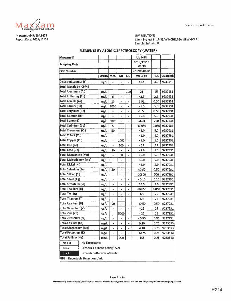
r ~· XL A Bureau Verllas Group Company . ,,,
Maxxam Job U: 88A1474 Report Date: 2018/12/04
GW SOLUTIONS
Client Project U: 18-35/WINCHELSEA VIEW GOLF Sampler Initials: SR
ELEMENTS BV ATOMIC SPECTROSCOPY (WATER)
MuxamlD
Sampling Date
COCNumber
UU5428
2018/11/19 09:30
570703-01-01
UNITS MAC AO OG WELL #2 RDL QC Batch
Dissolved Sulphur (S} mg/l -Total Metals by ICPMS
I I
al A 6 T alA 10
l J -
- tal Bismuth (Bl)
tal Boron (B) 1g 5000 -
ug/l -T ug/L
Total Copper (Cu) /L 1000 -
Total Iron (Fe) L 300
Total Lead (Pb)
Total Manganese (Mn) ug/l 0
Total Molybdenum (Mo) ug/L IT I ug/L
Se) ug/L I I i ug/L
IT tal Silver (Ag) ug/L
tal Strontium (Sr) ug/l -t I I
Total Tin (Sn) ug/L -Total Tlta n lum (Ti) ug/L -
Total Vanadiu
Total Zinc (Zn)
Total m (Zr) ug/L
IT (Ca) mg/L
al Potassium (K) mg/L Total Sodium (Na) mg/l 200
No Fill I No Exceedance
~ Exceeds 1 criteria policy/level
- Exceeds both criterfa/levels
!FD = le Detection Limit
Page 7 of18
10.1 3.0 9233710
n 15 9237
2.5 9237
<5.0 5.0 9237931
<0.50 0.50 9237931
<5.0 5.0 9237931
.050 9237931
<S.0 5.0 9237931
<1.0 1.0 9237931
< . 1.0 9237931
<1.0 1.0 92379
<5.0 5.0 92379
<0.50 0.50 9237
20800 500 92379
<0. 0.10 92379
99. 9237931
I 9237931
<25
<25 2
9237931
9237931
92379
233513
233513
<0.25 0.25 9233513
155 0.25 92335,13
M•~~am Anelyti:s lnlern11lon1l Corporellon o/• M•xx•m Analytics llurnaby: 4606 C.n,d• w.., \/Si. 11:5 T•l•phone{604 l 734°7276 Fn(604) 731-2316
P214

Maxxam Job fl: B8A1474 Report Date: 2018/12/04
GW SOLUTIONS Client Project #I: 18-35/WINCHELSEA VIEW GOLF Sampler lnitlals: SR
ELEMENTS B'V ATOMIC SPECTROSCOPY (WATER)
Maxxam ID
Sampling Date
COCNumber
UNITS MAC AO OG
No Exceedance
Exceeds 1 criteria policy/level
Exceeds both criteria/levels
RDL = Reportable Detection Limit
Page 8 of 18
UU5428
2018/11/19 09:30
570703-01-01
WELL#2 RDL QCBatch
Maxum Analy'llcs lntemaUonal Corporation o/a Ma10u1mAnaly'llts Bum1by: 4606 Canada Wrtt V5G lKS T11lephon11(604 I 734•7276 Fu(604} 731-23!6
P215
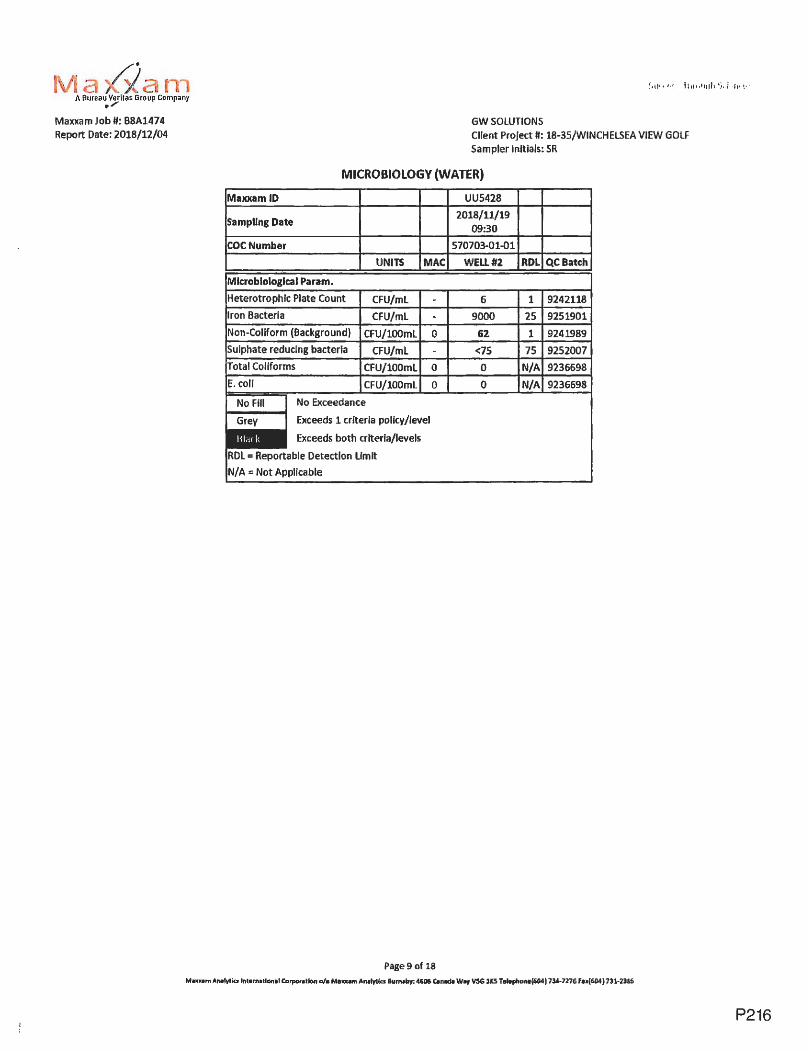
·a /i. A Bureau Veril.is Group Company
111/
Maxxam Job#: B8A1474 Report Date: 2018/12/04
GW SOLUTIONS Client Project II: 18-35/WINCHELSEA VIEW GOLF Sampler Initials: SR
MICROBIOLOGY (WATER)
Maxxam ID UUS428
Sampling Date 2018/11/19
09:30
COCNumber 570703-01-01
UNITS MAC WELL#2 RDL QC Batch
Mlcroblologlcal Param.
Heterotrophlc Plate Count CFU/ml - 6 1 9242118
Iron Bacteria CFU/ml - 9000 25 9251901
Non-Coliform (Background) CFU/lOOml 0 62 1 9241989
Sulphate reducing bacteria CFU/ml - <75 75 9252007
Total Coliforms CFU/100ml 0 0 N/A 9236698 E.coli CFU/l00ml 0 0 N/A 9236698
No Fill I No Exceedance
- E><ceeds 1 criteria policy/level
Exceeds both criteria/levels
R0L = Reportable Detection limit
N/A = Not Applicable
Page9 of 18
Mnxam Anulvtiu lnt■rn1ll0ntl Carpor1tlon o/a Me101•1T1 Antlvtia Burn,by; 4606 C.nadt w.., V5G 31CS Telepl,one{604) 734-7276 fe.{604} 731-2316
P216
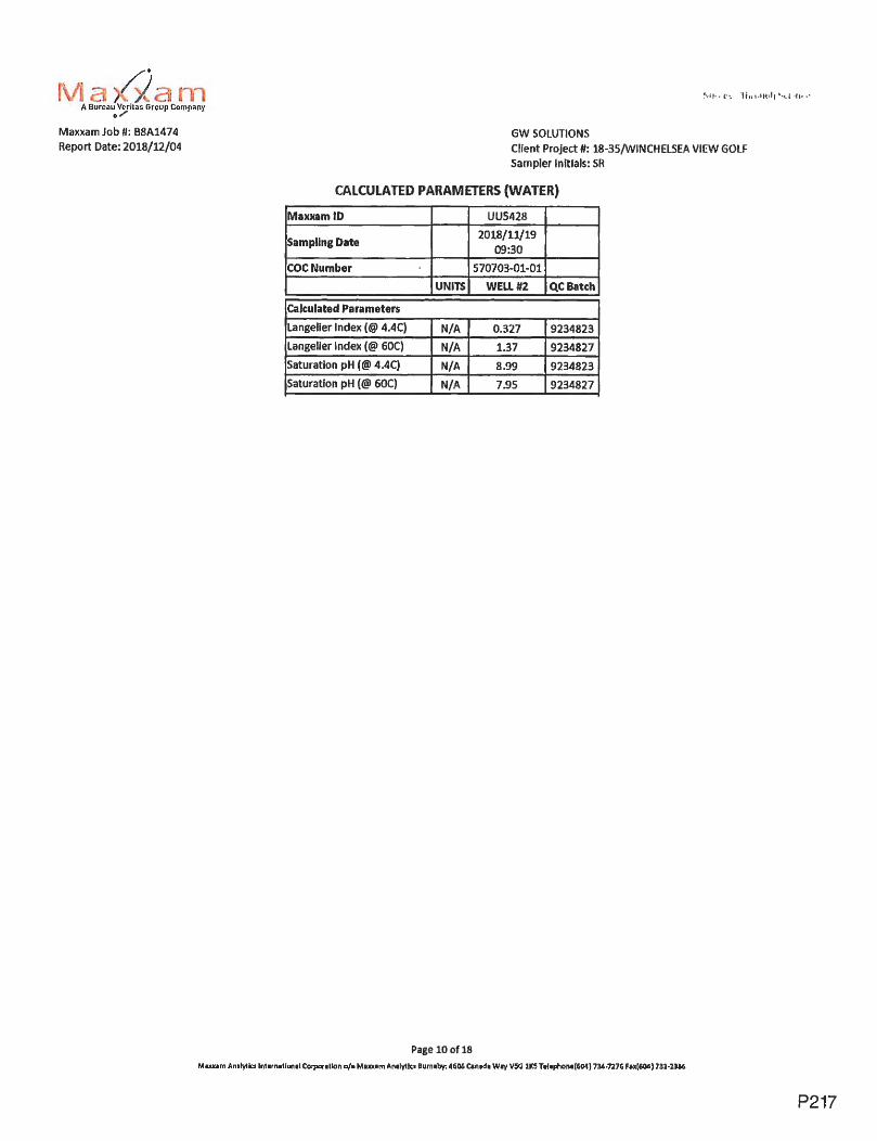
~· X A Bureau Veritas Group Company 0,,,,.
Maxxam Job #1: B8A1474 Report Date: 2018/12/04
GW SOLUTIONS Client Project #I: 18-35/WINCHELSEA VIEW GOLF Sampler Initials: SR
CALCULATED PARAMETERS (WATER)
Maxxam ID UUS428
Sampllng Date 2018/11/19
09:30
COCNumber 570703-01-01
UNITS WELL#2 QC Batch
Calculated Parameters
Langelier Index(@ 4.4C) N/A 0.327 9234823
Langelier Index (@ 60C) N/A 1.37 9234827
Saturation pH(@ 4.4C) N/A 8.99 9234823
Saturation pH (@ 60C) N/A 7.95 9234827
Page 10 of 18
Maxxam Antlytlcs lnt ■rn■llan■I Corpar■ llon a/■ M■xx■m An1lyllu Burn ■by; 4606 C■ nttd■ Wrt \ISG 11CS Telephon,(604) 734-7276 F■~(604) 731-2116
P217

rvta✓-ian1 A Bureau Verllas Group Company . ,,,
Maxxam Job#: B8A14 7 4 Report Date: 2018/U/04
GW SOLUTIONS
Client Project#: 18-3S/WINCHEL5EA VIEW GOLF Sampler lnltlals: SR
MISCELLANEOUS (WATER)
Mal(J(amlD
Sampling Date
UU5428
2018/11/19 09:30
COCNumber 570703-01-01
UNITS AO
Calculated Parameters Total Sulphide (as H2S) mg/L 0.05
MISCELlANEOUS
mg/L 0.05
No Exceedance
Exceeds 1 criteria policy /level
Exceeds both criteria/levels
Page 11 of 18
WELL#Z
0.0090
0.0080
RDL QCBatch
0,0053 9232657
0.0050 9239573
Minim AmlyUa tnttrnatl1~~,.tcorpor1tlon o/• MaJ0U1mAnalytks 81'fl)lby:A1606C.nlda w., V.5G 1t$ T.ale~on,{604) 7JA.•7276 f.,(604)'31·23&6
P218

-a. A Bureau Vcritas Group Company . /
Maxxam Job ff: B8A1474 Report Date: 2018/12/04
GW SOLUTIONS
Client Project II: 18-35/WINCHELSEA VIEW GOLF Sampler Initials: SR
GENERAL COMMENTS
MAC,A0,OG: The guldellnes that have been Included in this report have been taken from the. Canadian Drinking Water Quality Summary Table, February 2017.
Criteria A = Maximum Acceptable Concentration (MAC)/ Criteria B "'Aesthetic Objectives (AO) / Criteria C = Operational Guidance Values (OG} It is recommended to consult these guidelines when interpreting your data since there are non-numerical guidelines that are not Included on this
report.
Turbidity Guidelines: 1. Chemically assisted filtration: less than or equal to 0.3 NTU in 95% of the measurements or 95% of the time each month. Shall not exceed 1.0 NTU at any time.
2. Slow sand/ diatomaceous earth filtration: less than or equal to 1.0 NTU In 95% of the measurements or95% of the time each month. Shall not
exceed 3.0 NTU at any time. 3. Membrane filtration: less than or equal to 0.1 NlU in 99% of the measurements made or at least 99% of the time each calendar month. Shall not
exceed 0.3 NTU at any time. 4. To ensure effectiveness of disinfection and for good operation of the distribution system, it is recommended that water entering the distribution
system have turbidity levels of 1.0 NTU or less. Measurement of Uncertainty has not been accounted for when stating conformity· to the selected criteria~ where applicable.
ELEMENTS BY ATOMIC SPECTROSCOPY (WATER) Comments Sample UU5428 !WELL #2} Elements by CRC ICPMS (total): ROL raised due to sample matrix interference.
Results relate only to the items tested.
Page 12of 18
Mwcem Analytics lnlernallonal Corporation o/e Mel0!1m Anetytk.1 Bum1by: 4606 Clmeda W"i VSG lKS Telephone(604) 734•7276 fH(604) 731•23116
P219

C ,O
.~ A. B
ureau
Veritas G
roup Co
mp
any
. .,
Ma
xxam
Job
#: B
8A1474
Re
po
rt Date: 2
01
8/1
2/0
4
QC
Batch
P
ara
me
ter
9233638 T
ota
l Dissolved S
olids
92
37
27
8
Tu
rbid
ity
92
37
66
2
Dissolved A
lum
inu
m (A
l)
92
37
66
2
Dissolved A
ntim
on
y (Sb)
92
37
66
2
Dissolved A
rsenic (As)
92
37
66
2
Dissolved B
arium (B
a)
92
37
66
2
Dissolved B
erylliu
m (B
e)
92
37
66
2
Dissolved B
ismuth (B
i)
92
37
66
2
Dissolved B
oron {B)
92
37
66
2
Dissolved C
admium
(Cd)
92
37
66
2
Dissolved C
hro
miu
m (C
r)
92
37
66
2
Dissolved C
ob
alt (C
o)
92
37
66
2
Dissolved C
opper (Cu)
92
37
66
2
Dissolved Iro
n (F
e)
92
37
66
2
Dissolved Lead (P
b)
92
37
66
2
Dissolved L
ithiu
m (Li)
92
37
66
2
Dissolved M
anganese (Mn
)
9237662 D
issolved Mo
lybd
en
um
(Mo
)
92
37
66
2
Dissolved N
ickel (Ni)
92
37
66
2
Dissolved S
elenium (S
e)
92
37
66
2
Dissolved S
ilicon (Si)
92
37
66
2
Dissolved S
ilver (Ag)
92
37
66
2
Dissolved S
tron
tium
(Sr)
92
37
66
2
Dissolved T
ha
llium
(Tl)
92
37
66
2
Dissolved T
in (Sn)
92
37
66
2
Dissolved T
itan
ium
(Ti}
92
37
66
2
Dissolved U
ran
ium
(U)
92
37
66
2
Dissolved V
an
ad
ium
(V)
92
37
66
2
Dissolved Z
inc (Zn)
92
37
66
2
Dissolved Z
irconium {Z
r)
9237914 T
otal M
ercu
ry (Hg)
QU
ALITY
ASSU
RA
NC
E REPO
RT
Matrix Spike
Da
te
%R
ecovery
QC
Um
its
20
18
/11
/20
2018/11/21
20
18
/11
/22
91
80
-12
0
2018/11/22 94
80
-12
0
20
18
/11
/22
9
9
80
-12
0
20
18
/11
/22
94,
80
-12
0
2018/11/22 83
80
-12
0
20
18
/11
/22
9
3
80
-12
0
20
18
/11
/22
8
2
80
-12
0
20
18
/11
/22
9
3
80
-12
0
20
1B
/11
/22
8
6
80
-12
0
20
18
/11
/22
8
6
80
-UO
20
1B
/11
/22
83
80
-12
0
20
18
/11
/22
NC
80
-12
0
20
18
/11
/22
92
80
-12
0
20
18
/11
/22
86
80
-U0
2018/11/22 8
7
80
-12
0
20
18
/11
/22
NC
80
-12
0
20
18
/11
/22
85
80
-12
0
20
18
/11
/22
93
80
-12
0
20
18
/ll./22
N
C
80
-12
0
20
18
/11
/22
9
2
80
-12
0
2018/11/22 108
80
-12
0
20
18
/11
/22
9
3
80
-12
0
20
18
/11
/22
94
80
-12
0
20
18
/11
/22
91
80
-12
0
20
18
/11
/22
9
3
80
-12
0
20'12,/11/22 9
0
80
-12
0
20
18
/11
/22
9
1
80
-12
0
20
12
/11
/22
106
80
-12
0
20
18
/11
/22
1
01
8
0-1
20
Page 1
3 o
f 18
GW
SO
LUTIO
NS
C
lien
t Pro
ject#
: 18-35/WIN
CH
ELS
EA
VIE
W G
OLF
Sa
mp
ler Initials: SR
Spiked Blank
Method B
lank R
PO
%R
ec
ov
ery
Q
C L
imits
Valu
e U
NITS
Va
lue
(%)
105 8
0-1
20
<
10 m
g/L
4.7
102 8
0-1
20
<
0.1
0
NTU
2.0
96 8
0-1
20
<
3.0 u
g/L
96
8
0-1
20
<
0.5
0
ug
/l
100 8
0-1
20
<
0.W
ug
/l 1.9
100 8
0-1
20
<
l.O
ug
/L
86 8
0-
12
0
<0.10
ug
/L
99
8
0-U
O
<1.0
ug
/L
86 8
0-U
0
<50
ug
/L
96
8
0-U
0
<0.010
ug
/L
94 8
0-U
O
<1
.0
ug
/L
NC
94
8
0-1
20
<
0.2
0
ug
/L
93
8
0-1
20
<
0.2
0
ug
/L
3.7
103 8
0-1
20
<
5.0 u
g/L
97 8
0-U
O
<0
.20
u
g/L
91
8
0-U
0
<2.0
ug
/L
101 8
0-U
O
<1.0
ug
/L
98 8
0-1
20
<
1.0 u
g/L
95 8
0-U
O
<1
.0
ug
/L
95 8
0-1
20
<
0.1
0
ug
/L
113 8
0-1
20
<
100 u
g/L
97 8
0-1
20
<
0.020 u
g/L
1'12 8
0-1
20
<
1.0 u
g/L
98 8
0-U
0
<0.010
ug
/L
95 8
0-1
20
<
5.0
u
g/L
99 8
0-U
O
<5.0
ug
/L
97
8
0-1
20
<
0.1
0
ug
/L
96
8
0-1
20
<
5.0 u
g/L
97 8
0-U
O
<5.0
ug
/L
105 8
0-1
20
<
0.1
0
ug/L
101 8
0-1
20
<
0.0020 u
g/L
NC
Maxllllm
An
alytb
International Coqian1tion o
/a Mu
xom
An
1lytlcs 8
um
ab~
46
06
Canada W
C>f VSG
111'.5 Telephone{604) 734-727&
FP
(60
4) 731-231&
QC
Limits
20
20
20
20
20
20
0 C\J C\J a..

~Be
A B
ureau Vtritas G
roup Com
pany _.,
Maxxam
Job
#: B
8A1474
Report D
ate: 2018/12/04
QC
Batch
P
ara
me
ter
9237931 T
ota
l Alu
min
um
(Al)
9237931 T
ota
l An
timo
ny (S
b}
9237931 T
ota 1 Arsen le {A
s)
9237931 T
ota
1 Barium
(Ba)
9237931 T
ota
l Be
ryllium
{Be)
9237931 T
ota
l Bism
uth (Bi)
9237931 T
ota
l Boron (B
)
9237931 T
ota
l Cadm
ium (C
d)
9237931 T
ota
l Ch
rom
ium
(Cr)
9237931 T
ota
l Cobalt (C
o)
9237931 T
ota
l Copper (C
u)
9237931 T
ota
l Iron (Fe)
9237931 T
ota
l Lead (Pb)
9237931 T
ota
l Manganese (M
n)
9237931 T
ota
l Mo
lybd
en
um
(Mo
)
9237931 T
ota
l Nickel (N
i)
9237931 T
ota
l Selenium
(Se)
9237931 T
ota
l SIiicon (S
i)
9237931 T
ota
l Silver (A
g)
9237931 T
ota
l Stro
ntiu
m (S
r)
9237931 T
ota
l Th
alliu
m (T
l)
9237931 T
otal'Tin (S
n)
9237931 T
ota
l Tita
niu
m (T
I)
9237931 T
ota
l Ura
niu
m (U
)
9237931 T
ota
l Vanadium
(V)
9237931 T
otal Zinc (Z
n)
9237931 T
ota
l Zirco
niu
m (Z
r}
9238164 T
ota
l Suspended S
olids
9238280 'T
ota
l Organic C
arbon (C)
9238705 pH
9238707 C
on
du
ctivity
QUALITY A
SSUR
AN
CE R
EPOR
T(CO
NT'D
) G
W S
OLU
TION
S
Client P
roje
ct#: 18-35/W
INC
HE
LSE
A V
IEW
GO
LF S
ampler Initials: SR
Ma
trix S
pike Spiked B
lank M
ethod Blank
RP
D
Date
%R
ec
ov
ery
Q
CU
miu
o/o R
ecovery
Q.C Um
its V
alue
UN
ITS V
alue(%)
2018/11/22 108
80
-12
0
113 8
0-1
20
<3.0
ug
/L
NC
2018/11/22 101
80
-12
0
103 8
0-1
20
<0.50
ug
/L
NC
2018/11/22 103
80
-12
0
103 8
0-1
20
<
0.10 u
g/L
2.6
20lB/11/22
NC 8
0-
120 104
80
-12
0
<1.0 u
g/L
0.029
2018/11/22 102
80
-12
0
105 8
0-1
20
<
0.10 u
g/L
2018/11/22 97
80
-12
0
102 8
0-1
20
<
1.0 u
g/L
2018/11/22 100
80
-12
0
103 8
0-1
20
<50
ug/L N
C
20lB/11/22
99 8
0-1
20
103
80
-12
0
<0.010 ug/L
NC
2018/11/22 98
80
-12
0
101 8
0-1
20
<1.0
ug
/L
NC
20l8/11/22 93
80
-120
99 8
0-1
20
<
0.20 u
g/L
0.15
2018/11/22 89
80
-12
0
97 8
0-1
20
<
0.20 ug/L
0.023
2018/11/22 N
C
80
-12
0
107 8
0-1
20
<5.0
ug
/L
1.4
2018/11/22 99
80
-12
0
103 8
0-1
20
<
0.20 u
g/L
N
C
2018/11/22 N
C
80
-12
0
101 8
0-1
20
<1.0
ug
/L
1.4
2018/11/22 105
80
-12
0
104 8
0-1
20
<1.0
ug
/L
2.6
2018/11/22 91
80
-12
0
98 8
0-1
20
<
1.0 u
g/L
0.92
2018/11/22 99
80
-12
0
99 8
0-1
20
<
0.10 ug/L
NC
2018/11/22 98
80
-12
0
108 80-1.20
<100
ug
/L
0.26
2018/11/22 98
80
-12
0
101 8
0-1
20
<0.020
ug
/L
NC
2018/11/22 NC
80
-12
0
106 8
0-1
20
<
1.0 u
g/L
2018/11/22 104
80
-12
0
99 8
0-1
20
<0.010
ug
/L
2018/11/22 99
80
-12
0
106 8
0-1
20
<S.0
ug
/L
20lB/11/22
102 8
0-1
20
100
80
-12
0
<5.0 u
g/L
2018/11/22 103
80
-12
0
105 8
0-1
20
<0.10
ug
/L
0.32
2018/11/22 98
80
-12
0
102 8
0-1
20
<5.0
ug
/L
NC
20lB/11/22
94 8
0-
120 lU
8
0-1
20
<5.0
ug
/L
0.54
2018/11/22 104
80
-12
0
105 8
0-1
20
<0.10
ug
/L
2018/11/22 96
80
-12
0
<1 m
g/L
2.4
2018/11/23 105
80
-12
0
99 8
0-1
20
<0.50
mg
/L
NC
2018/11/21 5.75
pH
2018/11/21 101
80
-12
0
<2.0
uS/cm
Page 14 of1
8
M-m
Analytics lnterr>11t10nal C
orp
ora
tion
o/• Mu
xe
m A
na
lytic; Bu
ma
by:4
60
6 C
anad• Wr, V
5G lJC
5 Td
ep
ho
ne
{60
4} 7
34
-n7
6 F
u(6
04
) 731-2.316
QC
Limits
20
20
20
20
20
20
20
20
20
20
20
20
20
20
20
20
20
20
20
20
20
20
T"""
C\J C\J 0....

GW
SO
LUTIO
NS
M
axxam Job n: B
8A
l47
4
Report D
ate: 20
18
/12
/04
Q
UA
LllY
AS
SU
RA
NC
E R
EP
OR
T(CO
NT
1D)
Client P
roject#: 18-35/WIN
CH
ELS
EA
VIE
W G
OLF
Sam
pler Initials: SR
Matrix Spike
Spiked Blank
Meth
od
Blank
RPO
QC
Batch
Param
eter D
ate
%
Reco
very Q
C Lim
its %
Reco
very Q
C L
imits
Valu
e U
NITS
Valu
e(%)
9238709 A
lkalin
ity (PP as CaC
03) 2
01
8/1
1/2
1
<1.0
mg
/L
NC 9238709
Alka
linity (T
otal as CaC
03) 2
01
8/1
1/2
1
NC 8
0-1
20
101
80
-UO
<
1.0 m
g/L
0.87
9238709 B
icarbonate (HC
03) 2
01
8/1
1/2
1
<1.0 m
g/l
0.87
9238709 C
arbonate (C03)
20
18
/11
/21
<
1.0 m
g/L
NC
9238709 H
ydroxide (OH
) 2
01
8/1
1/2
1
<1.0
mg
/l N
C
92
38
72
0
Tru
e C
olour 2
01
8/1
1/2
2
98 8
0 -1
20
<
5 C
ol. Un
it N
C
92
38
n3
N
itrate
plus Nitrite
(N)
20
18
/11
/22
103
80
-12
0
108 8
0-1
20
<
0.020 m
g/L
0.11
9238724 N
itrite {N
) 2
01
8/1
1/2
2
97
8
0-1
20
103
80
-12
0
<0.0050
mg
/L
NC
9238732 T
ota
l Am
mo
nia
{N)
20
18
/11
/23
NC
80
-12
0
100 8
0-1
20
<
0.020 m
g/L
4.3
9239322 D
issolved Me
rcury (H
g) 2
01
8/1
1/2
3
95 8
0-1
20
95
80
-12
0
·<0.0020 ug/L
NC
9239573 T
ota
l Sulphide
20
18
/11
/23
106
80
-12
0
100 8
0-1
20
<
0.0050 m
g/L
NC
9239623 T
ota
l Nitro
ge
n (N
) 2
01
8/1
1/2
3
NC
8
0-1
20
92
80
-12
0
<0.020
mg
/L
8.4
9240974 F
luoride (F) 2
01
8/1
1/2
4
108 8
0-1
20
96
80 -12
0
<0.020
mg
/L
3.1
9241989 N
on-Coliform
(Background)
20
18
/11
/20
6.7
9242257 D
issolved Chloride {C
l) 2
01
8/1
1/2
3
96
8
0-1
20
99
80
-12
0
<1.0
mg
/L
2.5
9242265 D
issolved Sulphate (S
04) 2
01
8/1
1/2
3
92 8
0-1
20
96
80
-12
0
<1.0
mg
/l N
C
N/A
= N
ot A
pplicable
Duplicate:
Paired analysis o
f a separate po
rtion
of th
e sam
e sample. U
sed to evaluate th
e variance in th
e m
easurement.
Ma
trix Spike:
A sam
ple to w
hich a known a
mo
un
t of th
e analyte o
f inte
rest has been added. U
sed to evaluate sam
ple ma
trix inte
rfere
nce
.
Spiked B
lank: A blank m
atrix sam
ple to w
hich
a known a
mo
un
t of th
e analyte, usually fro
m a second source, has been added. U
sed to evaluate m
eth
od
accuracy.
Me
tho
d B
lank: A blank m
atrix containing all reagents used in th
e analytical procedure. U
sed to id
en
tify lab
ora
tory co
nta
min
atio
n.
QC
Limits
20
20
20
20
20
10
25
20
20
20
20
20
20
N/A 20
20
NC
(Ma
trix Spike): T
he recovery in the
ma
trix spike was n
ot calculated. T
he rela
tive d
iffere
nce
be
twe
en
the
.con
cen
tratio
n in th
e p
are
nt sam
ple and the
spike am
ou
nt w
as too
small to
pe
rmit a reliable
reco
very calculation (m
atrix spike co
nce
ntra
tion
was less than th
e n
ative
sample co
nce
ntra
tion
)
NC
(Duplicate R
PO
): The duplicate R
PD w
as no
t calculated. The co
nce
ntra
tion
in the
sample a
nd
/or d
up
licate
was to
o lo
w to
pe
rmit a reliable R
PD calculation (absolute d
iffere
nce
<=
2x R
DL).
Page 15 o
f 18
M-m
Analytic, lnternatJ.cnal C
o1p0n1tlan o/• Maxx.em
An
llytla B
urnaby: 4606 Canada W
fl<f VSG
113 Tc:lc:phonc:(60<I) 734-7276 F
u{604} 731-Dao
C\J C\J C\J Cl..

~· . . i a /1 Bureau Verilas Group Company ~,,,
Maxxam Job fl: B8A1474
Report Date: 2018/12/04 GW SOLUTIONS
Client Project#: 18-35/WINCHELSEA VIEW GOLF
Sampler Initials: SR
VALIDATION SIGNATURE PAGE
The analytical data and all QC contained In this report were reviewed and validated by the following lndividual(s).
Andy Lu, Ph.D., P .Chem., Scientific Specialist
Rob Reinert, B.Sc., Scientific Specialist
Ma)()(am has procedures In place to guard against Improper use of the electronic signature and have the required "signatories 0, as per section 5.10.2 of ISO/IEC 17025:200S(E), signing the reports. For Service Group specific validaUon please refer to the Validation Signature Page.
Page 16 of .18
Muum Analytlc:1 tnlun•llonal Corpota\lon 0/1 M1xnm Analytic, Burnaby: 4606 Cen1d1 Wey VSG llCS Telephone{604) 734-7276 Fax[604) 731·2386
P223

...
;.,I
IIS
U"IU
~U
S:W
0 ---
.~b
tot•
itaO
u-a
t □ ;(
lt!2
□
"'•,.'fa'
~L
1)L
lt-4
1~
t~
iY
J.~
~~
~
__ ,,, ..
...... ,: _
____ _
~
"'!I
Vll'lit
'Vl'.,
:t8
1,P
Q0
/1'W
fl(J
f1tl
r~s,t
O,~
/f!f
..f.1ttlT
~:$
'~"'"
"
□
.,.t.Y
at)
SQ
ll.,
.~~
~t,
(-t'
.-.l
~J.~
:~~
1-1
1;!
,l.V
.:,~
/~~
.a,c
,,.I
'1Y
~ilt-C
1-
~Y
raU
H''l
.. '!Y
:lll
,.l.
'1ff
lVJ,
a.t~
J.1
'WJC
l0ll
ro l
(J,o
w,e
,;u
.'n
#.-
=w
.tW
~l!
)O.t
.SO
:, J
GU
l'f)
fC~
U.~
~~
~O
J. }Q
f-5
~!1
1U
dU
MT
l~:W
U.
1!1.
IJ ,
.
':ll
.t:l
;14
iY-"
f)a
:tL
'lr.
ll1
0ll
l"""
-l'I
N\'
~JJ'~
,o
,I
J.:2
"ll'l
9 !,
J.,o
nu
;n:)
~ft
:t,,
O'S
SU
.IIC
I Q
JU~
'Jo
Q1
1;1
1rt
"OM
.zM
M.t
ao.t
Clb
tW3
S\t
H9
-H,1
.01
9"W
'I
..,
"""□
--""□
--,o
~
=\~
JC
!, ~ =
~
~~H
,._$
.-.n
"'"
"<IA"
".
I.Ill
.....

Polley S.l AppendJx B: Mlnlm.~m UntreaJed Source Water Q11all1y Parameters lo Be AnalJ•ied, Groun4 WIiier
MINIMUM BOJ IBCE WATER QUALJl'Y PARAMETERS IQ Dt1 ANALYZED
$HAI ,J,QW WELkCJ, Pf-ff P WELJ4 Wld SPRINGS
MJCBQDJQI.QGJCAL1
Toud Coliform ( 5ou ~'-.4~ +tr-n ~ ) Non-colifonn bacteria SulphlD' Bacteria (deep wells) Heterotrophio Plato Counts
mDJCAJ/CfffiM~t\J,
Esd,er/J:hia colf ( 3c l"' )
Iron and
l~111-t ) .
AlkaHnity Anunonia, ~nig Chloride' 0>1our' Conductiviy c.orrosivcncs,1
'fluoride" Herdnew Metals SCllh "+1)~'1ed Nitritrr'
Selenium Sulphate Sulphide (as hydro'gen sulphide,,) 4
Tolal Dissolved SoHd! -+ TSfS Total Ospnic Carbon ' 6
Turbidity,' Nitrate' Organic Nltroge,( pl-v ~·
I. Analysis of additional parameters may be required bued on tile results of initial analysis and on potential impact by nearby sources of ~nation or polluting soun:es. IfindustriaL agricullW'BI or t>=tlicide pollution is suspected, identify what chemicals may have been used and analyse fnt most likely indicatorparametets. If petroleum polh.diQn is suspected (undcr,ground fuel stGJ'8&':I) analyse for alkyl bw'Ame compoumk. If parasitic pollution suspected, Glardia lamb/la and/or cryplosporldirun analysis may be required.
2. Analyses must be sufficiently accurareso lbat ·the minimum delectable concentnition is fess than 10% of Guidelines for Canadian Drinking Watl!ir Quality. the Driliking Waa.r Proteotlon .Mt or the Drinking JYan'er Pralecllon Regulllllon where applicable. Other an.alysis must provide suffici~tinfOJ'J'Wlfion to reasonably assess the water suitability for drlnkIDg purposes and to deimnine what, If any, treatment might be needed. AnaJyses must be eonducted in accordance with methods prescribed in eiStandard Melho<h1 for the Examinatiijn of Watenmd WasleWatcr' (latest edition) er other acceptable lffl.Jcedure.
Bacterial analysis must be conducted at an approved labo,atory (bgp;/Omiabs.phso.ca/Dpcuments/PHO-amm,ved-labgratories.pdO
2 ConductanceJSpecific Conductanco 3 Calcium Carboru¢e saturation/Langeliefs index 4 Por deep wells: On site or preserve sampl~ or use altcmarivc method of eonfianing that water
has satisfactory odolD'. 5 For deep wells: On site or preserve sample, or use altemadve method of confinning that water ha., satisfactory odour. 6 IfTmbidi~ less than 1.0 mg/L Dissolved Organic Carbon m:ay be used as an alternative 10 To~t Organic Carbon.
7 At least: alumin~ bmiLmJ, boron, cadmium, calcium, chromium, coppart iron, lead, magnesium. manganese, molybdenum, nickel, ~horous, potas$lum, silver, sodiutn, zinc (e,cpand if minendl= to inolude mercury).
Where UV is being considered as part of the water treatment process •
• .-.,1 Revised February 2016 B8A1474_COC
Page 18 of 18
P225

"U
I\)
I\)
0)
X
.
GA
RP
AS
SE
SS
ME
NT
TA
BL
E
GW
SO
LU
TIO
NS
•
":.\1
\\1.
Utl
if
I-H
Olf
tll
lUI
If u
,nu
u,u
:.

"1J
I\) rv
-....J
1 STAG
E 1.
-HAZ
ARD
S~RE
ENIN
G A
ND A
.5SES
SMEN
T -
--
--
·--·
Haz
ard
HAZA
RDS
---
--
-' t
SC
REEN
ING
AS
SESS
MEN
T No
W
ater
Suo
otv
Svst
em W
ell
: -
---
A
Wat
er Q
ualit
y R
esul
ts
Al:
Exh
ibits
rec
urrin
g pr
esen
ce o
f tot
al c
olifo
rm b
acte
ria, f
ecal
col
iform
P
rese
nce
of t
otal
A
ris
k 1
bact
eria
, or E
sche
richi
a co
li (E
. col
i).
colif
orm
bac
teria
A
2: H
as r
epor
ted
inte
rmitt
ent t
urbi
dity
or
has
a hi
stor
y o
f con
sist
ent t
urbi
dity
-
2 1g
reat
er th
an 1
NTU
. N
ot p
rese
nt
At
low
risk
-
-..
-B.
Wel
l Loc
atio
n -
Bl:
Situ
ated
insi
de s
etba
ck d
ista
nces
from
pos
sibl
e so
urce
s o
f con
tam
inat
ion
as
-3
I pe
r sec
tion
8 o
f the
HH
R.
Not
pre
sent
A
t lo
w ri
sk
4 82
; Has
an
inta
ke d
epth
<15
m b
elow
gro
und
surfa
ce t
ha
t is
loca
ted
with
in a
N
ot p
rese
nt
At l
ow r
isk
natu
ral b
ound
ary
of s
urfa
ce w
ater
or a
floo
d pr
one
area
. 83
: H
as a
n in
take
dep
th b
etw
een
the
high
-wat
er m
ark
and
surfa
ce w
ater
5
botto
m (
or<
15
.m b
elow
the
norm
al w
ater
leve
l), a
nd lo
cate
d w
ithin
, o
r le
ss
Not
pre
sent
A
t lo
w ri
sk
than
150
m fr
om t
he n
atur
al b
ound
ary
of a
nv s
urfa
ce w
ater
.
84: L
ocat
ed w
ithin
300
m o
f a s
ourc
e o
f pro
babl
e en
teric
vira
l con
tam
inat
ion
I•
6 w
itho
ut a
bar
rier t
o v
iral t
rans
port
. N
ot p
rese
nt
At l
ow
risk
.
C.
Wel
l Con
stru
ctio
n ·1
~
-
7 C
l: D
oes
no
t mee
t GW
PR f
or s
urfa
ce s
ealin
g.
Do
es n
ot m
eet
IAt
risk
G
WPR
8 C
2: D
oes
not m
eet G
WPR
fo
r w
ell c
aps
and
cove
rs.
Mee
t the
GW
PR
A r
isk
9 C
3: D
oes
not m
eet G
WPR
fo
r flo
od p
roof
ing.
D
oes
not m
eet
At
risk
G
WP
R
10
C4:
Doe
s no
t mee
t GW
PR f
or w
ellh
ead
prot
ectio
n.
Me
et t
he G
WPR
IA
t ri
sk
,, D
. A
quife
r Typ
e an
d S
ettin
g -
-··-
-'
11
D1:
Has
an
inta
ke d
epth
<15
m b
elow
gro
und
surfa
ce.
No
t pre
sent
A
t lo
w r
isk
12
D2:
Is s
ituat
ed in
a h
ighl
y vu
lner
able
, un
conf
ined
, unc
onso
lidat
ed o
r fr
actu
red
Pre
sent
.A
t ris
k be
droc
k aa
uife
r. 13
D
3: I
s co
mpl
eted
in a
kar
st b
edro
ck a
quife
r, r
egar
dles
s o
f dep
th.
No
t pre
sent
A
t7,o
w r
isk ~
STAG
E 2 .
.. G
ARP
DETE
RM'IN
ATIO
N ~
-· A
t Rl
SK (G
AR
P}
·--
--
--
WEL
L#2
C
NOTE
S -
.
Sam
ple
aft
er s
tep
test
sho
ws
tota
l col
iform
s an
d e.
coli.
N
ot p
rese
nt a
fte
r 72h
pum
ping
test
.
Pro
babl
y 2
or
3 se
ptic
sys
tem
s fr
om n
earb
y ho
uses
with
in
300
m b
ut w
ater
leve
l and
pro
duci
ng fr
actu
res
are
deep
an
d be
droc
k se
para
ted
by 2
0 m
+ o
verb
urde
n .
No
surfa
ce s
eal m
entio
nned
in w
ell l
og.
Wel
l in
pit.
Wat
er p
ondi
ng in
pit,
cov
er le
ts w
ater
ent
erin
g ea
sily
. Hol
es in
the
cap,
wat
er e
nter
ing
via
the
cap
that
is
sitte
d at
the
bott
om o
f the
oit.
See
abov
e
Wel
lhea
d un
der g
roun
d le
vel
--
Wel
l is
com
plet
ed in
bed
rock
aqu
ifer
bu
t con
side
red
low
vu
lner
abili
ty to
sub
surfa
ce c
onta
min
atio
n.
J

-u
I\)
I\)
co
GW
SO
LU
TIO
NS
IN
C.
GE
NE
RA
L C
ON
DIT
ION
S A
ND
LIM
ITA
TIO
NS
-.,
GW
SO
LU
TIO
NS
,U
'UU
.\111
11
I tl
lH(H
U
.. ,
c1o
i,u
1u
,11
1

-u
I\)
I\)
c.o
----
--···
··---··-
····
-·-----------
--------------------
-
Th
is r
epor
t in
corp
ora
tes
and
is s
ub
ject
to t
he
se "
Ge
ne
ral
Co
nd
itio
ns
and
Lim
itatio
ns".
1.0
US
E O
F R
EP
OR
T
Th
is r
ep
ort
per
tain
s to
a s
pe
cific
are
a, a
sp
eci
fic s
ite,
a sp
eci
fic
de
velo
pm
en
t, a
nd
a s
pe
cific
sco
pe
of w
ork
. It
is n
ot a
pp
lica
ble
to a
ny
oth
er
site
s, n
or
sho
uld
it b
e r
elie
d u
po
n f
or
typ
es
of d
eve
lop
me
nt o
the
r th
an
th
ose
to
wh
ich
it r
efer
s. A
ny
vari
atio
n f
rom
th
e s
ite o
r pr
opos
ed
de
velo
pm
en
t wo
uld
ne
cess
itate
a s
up
ple
me
nta
ry in
vest
iga
tion
an
d
ass
ess
me
nt.
T
his
repo
rt a
nd t
he
ass
ess
me
nts
an
d r
eco
mm
en
da
tion
s co
nta
ine
d in
it a
re in
tend
ed f
or
the
sole
use
of G
W S
OL
UT
ION
S's
clie
nt.
GW
SO
LU
TIO
NS
do
es
no
t acc
ep
t an
y re
spo
nsi
bili
ty f
or
the
acc
ura
cy o
f a
ny
of t
he
dat
a, t
he
an
aly
sis
or
the
reco
mm
en
da
tion
s co
nta
ine
d o
r re
fere
nce
d in
th
e r
ep
ort
wh
en
th
e r
ep
ort
Is u
sed
or
relie
d u
po
n b
y a
ny
pa
rty
oth
er
tha
n G
W S
OL
UT
ION
S's
clie
nt
un
less
oth
erw
ise
au
tho
rize
d in
w
ritin
g b
y G
W S
OL
UT
ION
S.
Any
un
au
tho
rize
d u
se o
f th
e r
ep
ort
is a
t th
e
sole
ris
k o
f th
e u
ser.
T
his
re
po
rt is
su
bje
ct to
co
pyr
igh
t an
d s
ha
ll n
ot b
e re
prod
uced
eith
er w
ho
lly o
r in
pa
rt w
itho
ut t
he
prio
r, w
ritt
en
pe
rmis
sio
n o
f G
W S
OL
UT
ION
S.
Ad
diti
on
al
copi
es o
f the
rep
o.rt,
if r
eq
uir
ed
, m
ay
be
ob
tain
ed
up
on
req
uest
.
2.0
LIM
ITA
TIO
NS
OF
RE
PO
RT
Th
is r
ep
ort
is b
ase
d s
ole
ly o
n th
e c
on
diti
on
s w
hic
h e
xist
ed
with
in t
he
st
ud
y a
rea
or
on
site
at t
he
tim
e o
f GW
SO
LU
TIO
NS
's in
vest
iga
tion
. T
he
cl
ient
, an
d a
ny
oth
er
part
ies
usin
g th
is r
ep
ort
with
th
e e
xpre
ss w
ritt
en
co
nse
nt o
f th
e c
lien
t and
GW
SO
LU
TIO
NS
, a
ckn
ow
led
ge
th
at c
on
diti
on
s af
fect
ing
the
en
viro
nm
en
tal a
sse
ssm
en
t of t
he
site
ca
n v
ary
with
tim
e a
nd
th
at t
he
co
ncl
usi
on
s a
nd
re
com
me
nd
atio
ns
set o
ut i
n th
is r
ep
ort
are
tim
e se
nsiti
ve.
Th
e c
lient
, a
nd
an
y o
the
r p
art
y u
sin
g th
is r
ep
ort
with
the
e
xpre
ss w
ritt
en c
on
sen
t of t
he
clie
nt a
nd G
W S
OL
UT
ION
S,
als
o
ack
no
wle
dg
e th
at t
he
co
ncl
usi
on
s a
nd
re
com
me
nd
atio
ns
set o
ut i
n th
is
rep
ort
are
ba
sed
on
lim
ited
ob
serv
atio
ns
an
d t
est
ing
on
th
e a
rea
or
sub
ject
site
and
th
at c
on
diti
on
s m
ay
vary
acr
oss
th
e s
ite w
hic
h,
in t
urn,
co
uld
aff
ect
the
co
ncl
usi
on
s a
nd
re
com
me
nd
atio
ns
ma
de
. T
he
clie
nt
ack
no
wle
dg
es
tha
t GW
SO
LU
TIO
NS
is n
eith
er
qu
alif
ied
to,
no
r is
it
mak
ing,
an
y re
com
me
nd
atio
ns
with
re
spe
ct t
o th
e p
urc
ha
se,
sale
, in
vest
me
nt o
r d
eve
lop
me
nt o
f th
e p
rope
rty,
th
e d
eci
sio
ns
on
wh
ich
are
th
e so
le r
espo
nsib
ility
of t
he
clie
nt.
2.1
INF
OR
MA
TIO
N P
RO
VID
ED
ro G
W S
OL
UT
ION
S B
Y O
TH
ER
S
Du
rin
g t
he
pe
rfo
rma
nce
of t
he
wo
rk a
nd
th
e p
repa
ratio
n o
f th
is r
epor
t,
GW
SO
LU
TIO
NS
ma
y h
ave
rel
ied
on
in
form
atio
n p
rovi
de
d b
y p
ers
on
s o
the
r th
an
th
e c
lient
. W
hile
GW
SO
LU
TIO
NS
en
de
avo
urs
to
ve
rify
the
acc
ura
cy o
f su
ch in
form
atio
n w
he
n in
stru
cte
d t
o d
o s
o b
y th
e c
lient
, G
W
SO
LU
TIO
NS
acc
ep
ts n
o r
esp
on
sib
ility
for
the
acc
ura
cy o
r th
e re
liabi
lity
of
such
info
rma
tion
wh
ich
ma
y a
ffe
ct th
e r
epor
t.
3.0
LIM
ITA
TIO
N O
F L
IAB
ILIT
Y
Th
e c
lien
t re
cog
niz
es
tha
t p
rop
ert
y co
ntai
ning
co
nta
min
an
ts a
nd
h
aza
rdo
us
wa
ste
s cr
ea
tes
a h
igh
ris
k o
f cla
ims
bro
ug
ht
by
thir
d p
art
ies
ari
sin
g o
ut o
f the
pre
sen
ce o
f th
ose
mat
eria
ls.
In c
on
sid
era
tion
of t
he
se
risk
s, a
nd
in c
on
sid
era
tion
of G
W S
OL
UT
ION
S p
rovi
din
g t
he
se
rvic
es
req
ue
ste
d,
the
clie
nt a
gre
es
tha
t GW
SO
LU
TIO
NS
's li
ab
ility
to t
he
clie
nt,
wit
h r
esp
ect
to
an
y is
sue
s re
latin
g to
co
nta
min
an
ts o
r o
the
r h
aza
rdo
us
wa
ste
s lo
cate
d o
n t
he
su
bje
ct s
ite s
ha
ll b
e li
mite
d as
fo
llow
s:
{1)
With
re
spe
ct to
an
y cl
aim
s b
rou
gh
t ag
ain
st G
W S
OL
UT
ION
S b
y th
e cl
ien
t a
risi
ng
ou
t o
f th
e p
rovi
sio
n o
r fa
ilure
to
pro
vid
e s
erv
ice
s h
ere
un
de
r sh
all
be
lim
ited
to t
he
am
ou
nt o
f fe
es
pa
id b
y th
e cl
ien
t to
GW
S
OL
UT
ION
S u
nd
er t
his
Ag
ree
me
nt,
wh
eth
er
the
act
ion
is·b
ase
d o
n
bre
ach
of c
on
tra
ct o
r to
rt;
(2)
With
re
spe
ct t
o c
laim
s b
rou
gh
t by
thir
d p
art
ies
ari
sin
g o
ut o
f th
e
pre
sen
ce o
f co
nta
min
an
ts o
r h
aza
rdo
us
wa
ste
s o
n t
he
su
bje
ct s
ite,
the
cl
ien
t a
gre
es
to in
de
mn
ify,
de
fen
d a
nd
hol
d h
arm
less
GW
SO
LU
TIO
NS
fr
om
an
d a
ga
inst
an
y an
d al
l cl
aim
or
clai
ms,
act
ion
or
act
ion
s, d
em
an
ds,
da
mag
es1
pena
lties
, fin
es,
loss
es,
cost
s a
nd
exp
en
ses
of e
very
na
ture
a
nd
kin
d w
ha
tso
eve
r, i
ncl
ud
ing
so
licito
r-cl
ien
t cos
ts,
ari
sin
g o
r a
lleg
ed
to
a
rise
eit
he
r In
wh
ole
or
pa
rt o
ut o
f se
rvic
es
prov
ided
by
GW
SO
LU
TIO
NS
, w
he
the
r th
e c
laim
be
bro
ug
ht a
ga
inst
GW
SO
LU
TIO
NS
for
bre
ach
of
con
tra
ct o
r to
rt.
4.0
JO
B S
ITE
SA
FE
TY
GW
SO
LU
TIO
NS
is o
nly
re
spo
nsi
ble
fo
r th
e a
ctiv
itie
s o
f its
em
plo
yee
s o
n
the
job
sit
e a
nd
is n
ot r
esp
on
sib
le fo
r th
e su
pe
rvis
ion
of
an
y o
the
r p
ers
on
s w
ha
tso
eve
r. T
he
pre
sen
ce o
f GW
SO
LU
TIO
NS
p
ers
on
ne
l on
site
sha
ll n
ot
be
co
nst
rue
d in
an
y w
ay
to r
elie
ve t
he
clie
nt o
r a
ny
oth
er
pe
rso
ns
on
sit
e fr
om
th
eir
resp
on
sib
ility
for
job
sit
e s
afe
ty.
GW
SO
LU
TIO
NS
-u
I\)
uJ
0
·--------------------------------
-·
5.0
DIS
CL
OS
UR
E O
F I
NF
OR
MA
TIO
N B
Y C
LIE
NT
The
clie
nt a
gree
s to
fully
coo
pera
te w
ith G
W S
OL
UT
ION
S w
ith r
espe
ct t
o
the
pro
visi
on o
f all
avai
labl
e in
form
atio
n o
n t
he
pas
t, p
rese
nt,
and
prop
osed
con
ditio
ns o
n t
he s
ite,
incl
udin
g hi
stor
ical
info
rmat
ion
resp
ectin
g th
e us
e o
f the
site
. T
he
clie
nt a
ckn
ow
led
ge
s th
at
in o
rde
r fo
r G
W S
OL
UT
ION
S to
pro
pe
rly
prov
ide
the
se
rvic
e,
GW
SO
LU
TIO
NS
is
rely
ing
up
on
the
full
disc
losu
re a
nd a
ccu
racy
of a
ny
such
info
rmat
ion.
6.0
ST
AN
DA
RD
OF
CA
RE
Ser
vice
s pe
rfor
med
by
GW
SO
LU
TIO
NS
for
this
re
po
rt h
ave
been
co
nduc
ted
in a
man
ner
cons
iste
nt w
ith t
he
leve
l of s
kill
ord
ina
rily
ex
erci
sed
by
me
mb
ers
of t
he p
rofe
ssio
n cu
rren
tly p
ract
icin
g u
nd
er s
imila
r co
nditi
ons
in t
he ju
risd
ictio
n in
wh
ich
th
e s
erv
ice
s a
re p
rovi
ded.
E
ngin
eeri
ng ju
dg
em
en
t has
be
en
app
lied
in d
eve
lop
ing
th
e c
oncl
usio
ns
an
d/o
r re
com
men
datio
ns p
rovi
ded
in t
his
rep
ort.
No
wa
rra
nty
or
guar
ante
e, e
xpre
ss o
r im
plie
d, is
ma
de
con
cern
ing
the
tes
t res
ults
, co
mm
ents
, re
com
men
datio
ns,
or
an
y o
the
r po
rtio
n o
f thi
s re
port
.
7.0
EM
ER
GE
NC
Y P
RO
CE
DU
RE
S
Th
e d
ien
t und
erta
kes
to in
form
GW
SO
LU
TIO
NS
of a
ll ha
zard
ous
cond
ition
s, o
r po
ssib
le h
azar
dous
co
nd
itio
ns
wh
ich
are
kn
ow
n t
o it.
Th
e
clie
nt
reco
gniz
es th
at
the
act
iviti
es o
f GW
SO
LU
TIO
NS
ma
y u
nco
ver
pre
vio
usl
y u
nkn
ow
n h
azar
dous
mat
eria
ls o
r co
nditi
ons
and
tha
t suc
h d
isco
very
ma
y re
sult
in t
he n
ece
ssity
to u
nd
ert
ake
em
erg
en
cy
proc
edur
es to
pro
tect
GW
SO
LU
TIO
NS
em
plo
yee
s, o
the
r pe
rson
s an
d th
e e
nvir
onm
ent.
Th
ese
proc
edur
es m
ay in
volv
e ad
ditio
nal c
osts
ou
tsid
e o
f an
y b
ud
ge
ts
prev
ious
ly a
gree
d up
on.
The
clie
nt a
gre
es
to p
ay
GW
SO
LU
TIO
NS
fo
r an
y ex
pens
es in
curr
ed a
s a
resu
lt o
f su
ch d
isco
veri
es
and
to c
om
pe
nsa
te
GW
SO
LU
TIO
NS
thro
ug
h p
aym
ent o
f ad
diti
on
al f
ee
s an
d e
xpe
nse
s fo
r tim
e sp
en
t by
GW
SO
LUT
ION
S t
o d
ea
l with
th
e c
on
seq
ue
nce
s o
f su
ch
disc
over
ies.
8.0
NO
TIF
ICA
TIO
N O
F A
UT
HO
RIT
IES
Th
e c
lient
ack
now
ledg
es th
at I
n ce
rtai
n in
sta
nce
s th
e d
isco
very
of
ha
zard
ou
s su
bsta
nces
or
cond
ition
s an
d m
ater
ials
ma
y re
quir
e th
at
regu
lato
ry a
ge
nci
es
and
oth
er
pe
rso
ns
be i
nfo
rme
d a
nd t
he
clie
nt a
gre
es
tha
t no
tific
atio
n to
su
ch b
odie
s o
r pe
rson
s as
req
uire
d m
ay
be d
on
e b
y G
W S
OL
UT
ION
S in
its
reas
onab
ly e
xerc
ised
dis
cret
ion.
9.0
OW
NE
RS
HIP
OF
INS
TR
UM
EN
TS
OF
SE
RV
ICE
Th
e c
lien
t ack
no
wle
dg
es
tha
t all
repo
rts,
pla
ns,
and
da
ta g
en
era
ted
by
GW
SO
LL
JflO
NS
du
rin
g th
e p
erf
orm
an
ce o
f the
wo
rk a
nd o
the
r d
ocu
me
nts
pre
pare
d b
y G
W S
OL
UT
ION
S a
re c
on
sid
ere
d it
s pr
ofes
sion
al
wo
rk p
rod
uct
an
d s
ha
ll re
mai
n th
e c
op
yrig
ht
pro
pe
rty
of G
W
SO
LU
TIO
NS
.
10.0
AL
TE
RN
AT
E R
EP
OR
T F
OR
MA
T
Wh
ere
GW
SO
LU
TIO
NS
sub
mits
bot
h e
lect
ron
ic fi
le a
nd h
ard
co
py
vers
ion
s o
f rep
orts
, d
raw
ing
s an
d o
the
r pr
ojec
t-re
late
d d
ocu
me
nts
and
d
eliv
era
ble
s (c
olle
ctiv
ely
term
ed G
W S
OL
UT
ION
S's
inst
rum
en
ts o
f pr
ofes
sion
al s
ervi
ce),
th
e C
lien
t ag
ree
s th
at
on
ly th
e s
ign
ed
and
sea
led
ha
rd c
op
y ve
rsio
ns
shal
l be
con
side
red
final
and
le
ga
lly b
indi
ng.
Th
e h
ard
cop
y ve
rsio
ns s
ub
mitt
ed
by
GW
SO
LU
TIO
NS
sh
all
be
the
ori
gina
l d
ocu
me
nts
for
reco
rd a
nd w
ork
ing
pur
pose
s, a
nd,
in t
he e
ven
t of a
d
isp
ute
or
dis
cre
pa
nci
es,
the
hard
cop
y ve
rsio
ns
shal
l go
vern
ove
r th
e e
lect
ron
ic v
ersi
ons.
Fur
ther
mo
re,
the
Clie
nt a
gre
es
and
wa
ive
s al
l fut
ure
rig
ht o
f dis
pu
te th
at
the
orig
inal
har
d co
py
sig
ne
d v
ers
ion
arc
hiv
ed
by
GW
S
OL
UT
ION
S s
ha
ll be
de
em
ed
to
be
the
over
all o
rigi
nal f
or
the
Pro
ject
. T
he
Clie
nt a
gre
es
tha
t bo
th e
lect
ron
ic fi
le a
nd
ha
rd c
opy
vers
ion
s o
f GW
~
OL
UT
ION
S's
inst
rum
ents
of p
rofe
ssio
nal s
erv
ice
sha
ll no
t, u
nd
er
an
y ci
rcum
stan
ces,
no
ma
tte
r wh
o o
wn
s o
r us
es t
hem
, be
alte
red
by
an
y p
art
y e
xce
pt G
W S
OL
UT
ION
S.
Th
e C
lien
t wa
rra
nts
th
at G
W
SO
LU
TIO
NS
's in
stru
me
nts
of p
rofe
ssio
nal
serv
ice
will
be
use
d o
nly
and
e
xact
ly a
s su
bmitt
ed b
y G
W S
OL
UT
ION
S.
Th
e C
lien
t rec
ogni
zes
an
d
ag
ree
s th
at e
lect
ron
ic fi
les
subm
itted
by
GW
SO
LU
TIO
NS
ha
ve b
ee
n
prep
ared
and
su
bm
itte
d u
sin
g s
pe
cific
so
ftw
are
an
d h
ard
wa
re s
yste
ms.
G
W S
OL
UT
ION
S m
ake
s n
o r
epre
sent
atio
n a
bo
ut t
he
co
mp
atib
ility
of
the
se fi
les
with
the
Clie
nt's
cur
rent
or
futu
re s
oft
wa
re a
nd h
ard
wa
re
syst
ems.
GW
SO
LU
TIO
NS

Appendix F
Drainage Report
P231

Report to:
District of Lantzville
DRAINAGE REPORT
OCP & Zoning Amendment Application for
Lot 1, DL 85, Plan 2248 except part in Plan 43774, 43776, and 45180 and
Lot A, Plan 43774 and Rem. DL 93 all in Nanoose District
October 2019
Winchelsea View Golf Course
Winchelsea View Golf Course
Timberlake -Jones engineering
File: 335 Lantzville File: 3360-20-19-2
P232

1. INTRODUCTION
This report presents the current storm drainage situation on the subject properties. It discusses the potential impacts of development and proposes measures to mitigate its impact and maintain drainage patterns. The proposal is to amend the OCP and rezone to allow for a multi-phase development of the existing property into a yet to be determined number of residential units.
2. GENERAL DESCRIPTION OF SITE
2.1. Existing Conditions
The area to be developed is approximately 30.7 hectares and includes a golf course and a vacant residential lot. The site is moderately sloped northwards with slopes averaging 8 to 13%. Along the western boundary is Knarston Creek which flows north. Existing drainage patterns and catchment areas are shown on TJE Dwg. No. 335-STM-01.
As can be seen on this plan, runoff from the site is split into 3 primary directions. Lot 1 (SUB-A) drains to an existing ditch along Fernmar Road that directs all flow through a 525mm concrete culvert (C-1) north into a neighbouring property (OUT-1) where it continues into an existing pond which overflows to a ditch in an SRW on the east side of Lot A. Lot A (SUB-B) and part of the Rem. DL 93 (SUB-C) discharge to the adjacent properties to the north in non-channelized overland flow (OUT-2) and laneway ditches (OUT-3). This flow eventually reaches Harby Road ditch and is directed to Knarston Creek. The western portion of DL 93 {SUB-O) flows overland to Knarston Creek {OUT-4). The northern portion of DL 93 {SUB-E) is in the ALR and is not proposed for development at this time; it drains by overland flow to the Harby Road ditch {OUT-5).
Constructed irrigation ponds are located on the golf course. The pond levels are currently maintained utilizing the existing well. Water from the ponds is used for irrigation of the golf course.
The following photos, as located on TJE Dwg. No. 335-STM-01, depict the existing conditions of the site.
Photo 1: SUB-A (left) along Fernmar Road, facing west from the culvert C-1
-------------"\e--------------Winchelsea View Golf Course O Page 1
P233

Photo 2: OUT-1, facing north from C-1
Photo 3: SUB-8, facing east from clubhouse
Winchelsea View Golf Course Page 2
P234
Related Documents