HMT-SE Operational Needs & Requirements Workshop 1–of–14 Report on the NOAA Hydrometeorology Testbed–Southeast (HMTSE) Operational Needs & Requirements Workshop February 35, 2009 Chapel Hill, North Carolina Executive Summary The first of two NOAA Hydrometeorology TestbedSoutheast (HMTSE) Workshops was held at the Renaissance Computing Institute (RENCI) in Chapel Hill, NC on 35 February 2009. The HMTSE Operational Needs and Requirements Workshop sought to document requirements that will inform the future development of an HMTSE science plan for improved hydrometeorological science and services in the Southeastern Region. A diverse group of operational forecasters, emergency planners and researchers met to identify operational gaps and needs in the SE region. In all, fortynine people participated from NOAA and affiliated organizations other Federal agencies (NASA; the USGS; and the US EPA), State of North Carolina climate and emergency management agencies, and area universities and educational institutes. After several talks providing a foundation for the workshop, four breakout groups were formed at random and asked to identify general gaps and needs. Five themes were identified: (1) Quantitative Precipitation Estimation (QPE); (2) Quantitative Precipitation Forecasting (QPF); (3) Hydrologic/Hydrodynamic Applications & Models; (4) Decision Support Systems (DSS); and (5) Societal Impacts. The first four (QPE, QPF, “Hydro” and DSSs) map onto four of HMT’s “Major Activity Areas;” the remaining HMT major activity areas are Snow Information, Debris Flow and Verification were identified as “crosscutting themes” in this workshop. On subsequent days, four new, selfselected groups were organized around these five themes (decision support systems and societal impacts were grouped together as a matter of convenience) to identify and consider gaps and needs within each of them. Ultimately, over fortythree requirements addressing these gaps were identified and documented herein. These requirements will, after consolidation and refinement, form the backbone of an HMTSE Science Plan that will determine the nature of observation networks and scientific experiments to be conducted during the ensuing, fieldoperations phase of HMT SE. A oneday North Carolina Sensors Workshop held on February 2, at the same site, preceded the HMTSE Operational Needs and Requirements Workshop. The stated objective of that workshop was to inventory and document environmental sensors in North Carolina. Knowledge of and access to these sensor systems should prove to be highly valuable to the HMTSE planning process.

Welcome message from author
This document is posted to help you gain knowledge. Please leave a comment to let me know what you think about it! Share it to your friends and learn new things together.
Transcript
HMT-SE Operational Needs & Requirements Workshop
1–of–14
Report on the NOAA Hydrometeorology Testbed–Southeast (HMT-SE) Operational Needs & Requirements Workshop
February 3-5, 2009
Chapel Hill, North Carolina
Executive Summary The first of two NOAA Hydrometeorology Testbed-‐Southeast (HMT-‐SE) Workshops was held at the Renaissance Computing Institute (RENCI) in Chapel Hill, NC on 3-‐5 February 2009. The HMT-SE Operational Needs and Requirements Workshop sought to document requirements that will inform the future development of an HMT-‐SE science plan for improved hydro-‐meteorological science and services in the Southeastern Region. A diverse group of operational forecasters, emergency planners and researchers met to identify operational gaps and needs in the SE region. In all, forty-‐nine people participated from NOAA and affiliated organizations other Federal agencies (NASA; the USGS; and the US-‐EPA), State of North Carolina climate and emergency management agencies, and area universities and educational institutes. After several talks providing a foundation for the workshop, four breakout groups were formed at random and asked to identify general gaps and needs. Five themes were identified: (1) Quantitative Precipitation Estimation (QPE); (2) Quantitative Precipitation Forecasting (QPF); (3) Hydrologic/Hydrodynamic Applications & Models; (4) Decision Support Systems (DSS); and (5) Societal Impacts. The first four (QPE, QPF, “Hydro” and DSSs) map onto four of HMT’s “Major Activity Areas;” the remaining HMT major activity areas are Snow Information, Debris Flow and Verification were identified as “cross-‐cutting themes” in this workshop. On subsequent days, four new, self-‐selected groups were organized around these five themes (decision support systems and societal impacts were grouped together as a matter of convenience) to identify and consider gaps and needs within each of them. Ultimately, over forty-‐three requirements addressing these gaps were identified and documented herein. These requirements will, after consolidation and refinement, form the backbone of an HMT-‐SE Science Plan that will determine the nature of observation networks and scientific experiments to be conducted during the ensuing, field-‐operations phase of HMT-‐SE. A one-‐day North Carolina Sensors Workshop held on February 2, at the same site, preceded the HMT-‐SE Operational Needs and Requirements Workshop. The stated objective of that workshop was to inventory and document environmental sensors in North Carolina. Knowledge of and access to these sensor systems should prove to be highly valuable to the HMT-‐SE planning process.

HMT-SE Operational Needs & Requirements Workshop
2–of–14
Workshop Overview The HMT-‐SE Operational Needs & Requirements Workshop spanned two and one half days over February 3-‐5, 2009, and was the first of two planned workshops. The primary objectives of this workshop were to:
• Share a knowledge of the proposed purpose and benefits of HMT-SE with the workshop participants
• Learn of existing and planned programs, projects, and capabilities in the region for hydro-meteorological science and services from the participants
• Work with the participants to identify the driving issues and document the needs and/or gaps in hydro-meteorological science and services in the region, and in turn, define a set of validated requirements to inform the development of a science plan
• And finally, to lay the foundation for a 2nd HMT-SE workshop, which will be focused the research needed to address these gaps/needs
Outcomes The intended outcome of this workshop was a documented set of requirements for improved hydro-‐meteorological science and services in the HMT-‐SE Region. These requirements will undergo further refinement before and during HMT-‐SE Workshop #2. The ultimate outcome of the two workshops will be the formulation of an HMT-‐SE Science Plan that will frame the observation systems and networks to be established, experiments to be conducted, and organizations expected to participate in the field-‐operations phase of HMT-‐SE in the ensuing years (http://hmt.noaa.gov/). By definition, testbeds are an evolving process, and the HMT-‐SE Science Plan will be a living document. Participants A diverse group of operational forecasters, emergency planners and researchers participated in this workshop, in all, forty-‐nine people. By design, the largest contingent was from the NOAA/National Weather Service (NWS) and its operational community, including representatives from approximately one half-‐dozen Weather Forecast Offices (WFOs) in and around North Carolina; the Southeast River Forecast Center (SERFC); NWS Headquarters; and Eastern and Southern Region Headquarters. Also represented were other NOAA and affiliated organizations from NOAA Research (OAR); the National Ocean Service (NOS)’s Coastal Services Center (CSC) and North and South Carolina Sea Grant. Other Federal agencies that participated were the National Aeronautics and Space Administration (NASA); the U.S. Geologic Survey (USGS); and the U.S, Environmental Protection Agency (US-‐EPA). Among the State and local educational, environmental, and emergency management institutes were RENCI; Duke University; University of North Carolina, Chapel Hill; the Consortium of Universities for the Advancement of Hydrologic Science, Inc (CUAHSI); NC State University (NC State Climate Office); the NC Flood Mapping Program, North Carolina State Emergency Management office; and the City of Rocky Mount.
HMT-‐SE is scheduled to begin with a limited effort in FY10, and begin ramping-‐up in FY11. A five-‐year run of the testbed is anticipated (i.e. extend until ~FY15). HMT-‐SE will be centered on the Tar and Neuse River Basins of the central (Piedmont) area of North Carolina, but may also extend outward to other regions of the State and perhaps, surrounding states, depending on requirements and resources. The two workshops are being conducted to help refine the scope of HMT-‐SE (see map appendix C).

HMT-SE Operational Needs & Requirements Workshop
3–of–14
Table 1 Participants in the HMT-‐SE Operational Needs & Requirements Workshop
Name Affiliation Name Affiliation *Austin, Glenn NHWC/Env. Consult. Lynch, Keith Wakefield WFO Bacon, Robert Sea Grant Marcy, Doug CSC Bales, Jared USGS Mcnutt, Chad OAR/NIDIS Band, Larry CUAHSI *Miller, Dennis NWS-OHD Bandy, Richard Newport WFO Moneypenny, Michael Raleigh WFO *Barros, Ana Duke University Neuherz, Richard Wilmington WFO Billet, John Wakefield WFO †Olmi, Geno SECART/NOS CSC Birkenheuer, Dan ESRL-GSD Patchen, Rich NOS/Inundation Blaes, Jonathan Raleigh-WFO *†Payne, Jeff CSC/SECART Boyles, Ryan NC Climate Office Petersen, Walt NASA/GPM *Cabrera, Reggina NWS-ER HQ Prat, Olivier Duke University Carter, Gary NOAA-NWS-OHD Proud, Jessica RENCI *Danaher, Ed NCEP-HPC Roberts, Woody ESRL-GSD Dorman, John NC FPMP *Schmidt, John SERFC *Figurskey, Darin Raleigh-WFO **Schneider, Tim ESRL-PSD *Galluppi, Ken RENCI Smith, Barrett Raleigh WFO Goodall, Carin Newport WFO †Spence, Lundie Sea Grant Hamill, Todd Southeast RFC †Thigpen, Jack Sea Grant Hartman, Rob CA-NV RFC *Van Cooten, Suzanne CI-FLOW/NSSL Hawkins, Donald Wilmington WFO *Waldstreicher, Jeff NWS-ER HQ Herlong, David NC Emergency Mgmt. *Weiger, Ben NWS-SR HQ Hollowell, Wayne City of Rocky Mount White, Allen ESRL-PSD Johnson, Lynn CU/ESRL-PSD Worthy, Dorsey US EPA-NERL Keighton, Stephen Blacksburg WFO Zamora, Bob ESRL-PSD Kingsmill, David ESRL-PSD/CIRES
Figure 1 Participants at the conclusion of the workshop (February 5)

HMT-SE Operational Needs & Requirements Workshop
4–of–14
** HMT Program Manager and Workshop Chair. * Members of the HMT-‐SE Ad Hoc Workshop Planning Committee (not present: John Feldt, SERFC; Kevin Kelleher, NSSL; Doug Miller, UNC Asheville) † Workshop Facilitators _________________________________________________________________ Thirteen members of the ad hoc HMT-‐SE Workshop Planning Committee were among those present. The workshop (and committee) was chaired by Tim Schneider of OAR/ESRL (Boulder, Co), the HMT Program Manager, and was facilitated by Jeff Payne, Lead of NOAA’s Southeast and Caribbean Regional Team (SECART) and a team he assembled from the Coastal Services Center and Sea Grant (G. Olmi, J. Thigpen, L. Spence). A full list of participants appears in the Table 1, below. Those present at the conclusion of the workshop on February 5th are shown in Figure 1. Methodology Overview: The workshop was structured to achieve the objectives outlined previously. The first half-‐day was focused on talks to provide background material about HMT in general, how HMT fits within the bigger picture, and some perspective on the region and its unique resources and challenges. The rest of the workshop was organized around a series of breakout sessions and plenary sessions designed to iteratively hone in on a set of requirements, with each breakout session becoming more and more focused. The initial breakout groups were formed at random, whereas the remaining breakout groups were self-‐selecting, based on personal interest (these remained in tact after the first day). In each case, diverse and balanced groups were achieved. The morning session of the first day consisted of presentations to set the background and context for HMT-‐SE. Gary Carter (Director, NWS/Office of Hydrologic Development (OHD)) described the new, inter-‐agency, Integrated Water Resource Science and Services effort; Tim Schneider provided a high-‐level overview of the HMT Program and discussed the purpose of the Workshop, expected use of its results, and how the attendees were expected to participate; Rob Hartman (HIC, California-‐Nevada RFC) shared accomplishments and lessons learned from the HMT-‐West Testbed; Todd Hamill (SERFC) provided a characterization of the physical geography and hydrometeorology of the SE Testbed region; Jeff Waldstreicher (NWS ERHQ) gave a summary of existing resources, programs/projects, and infrastructure within the region; Ken Galluppi and Jessica Proud (RENCI) contributed a summary of the previous day’s NC Sensors Workshop; and John Dorman (State of NC) provided an overview of the NC Flood Plain Mapping Program as well as an assessment of gaps/needs from an emergency planning perspective. The first division into breakout groups occurred on the afternoon of the first day, with four groups of ~ten members apiece being tasked to identify the major hydro-‐meteorological issues and challenges in the HMT-‐SE region. After consideration of questions such as operational benefits, performance impacts, scientific and technical feasibility, and duration of effort (short or long term), each group developed their own prioritized list of those challenges and issues. This exercise was followed by a plenary session during which each of the breakout groups reported-‐out its results and full-‐group discussions were held to identify common themes and interests.
HMT-SE Operational Needs & Requirements Workshop
5–of–14
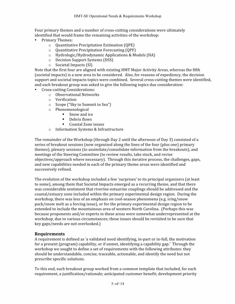
Four primary themes and a number of cross-‐cutting considerations were ultimately identified that would frame the remaining activities of the workshop: • Primary Themes:
o Quantitative Precipitation Estimation (QPE) o Quantitative Precipitation Forecasting (QPF) o Hydrologic/Hydrodynamic Applications & Models (HA) o Decision Support Systems (DSS) o Societal Impacts (SI)
Note that the first four are aligned with existing HMT Major Activity Areas, whereas the fifth (societal impacts) is a new area to be considered. Also, for reasons of expediency, the decision support and societal impacts topics were combined. Several cross-‐cutting themes were identified, and each breakout group was asked to give the following topics due consideration: • Cross-‐cutting Considerations:
o Observational Networks o Verification o Scope (“Sky to Summit to Sea”) o Phenomenological
Snow and ice Debris flows Coastal Zone issues
o Information Systems & Infrastructure The remainder of the Workshop (through Day 2 until the afternoon of Day 3) consisted of a series of breakout sessions (now organized along the lines of the four (plus one) primary themes), plenary sessions (to assimilate/consolidate information from the breakouts), and meetings of the Steering Committee (to review results, take stock, and revise objectives/approach where necessary). Through this iterative process, the challenges, gaps, and new capabilities needed in each of the primary theme areas were identified and successively refined. The evolution of the workshop included a few ‘surprises’ to its principal organizers (at least to some), among them that Societal Impacts emerged as a recurring theme, and that there was considerable sentiment that riverine-‐estuarine couplings should be addressed and the coastal/estuary zone included within the primary experimental design region. During the workshop, there was less of an emphasis on cool-‐season phenomena (e.g. icing/snow pack/snow melt as a forcing issue), or for the primary experimental design region to be extended to include the mountainous area of western North Carolina. (Perhaps this was because proponents and/or experts in these areas were somewhat underrepresented at the workshop, due to various circumstances; these issues should be revisited to be sure that key gaps/needs are not overlooked.) Requirements A requirement is defined as ‘a validated need identifying, in-‐part or in-‐full, the motivation for a present (program) capability, or if unmet, identifying a capability gap.’ Through the workshop we sought to define a set of requirements with the following attributes: they should be understandable, concise, traceable, actionable, and identify the need but not prescribe specific solutions. To this end, each breakout group worked from a common template that included, for each requirement, a justification/rationale; anticipated customer benefit; development priority

HMT-SE Operational Needs & Requirements Workshop
6–of–14
(high; medium; low); estimated effort (also high; medium; low); and proposed ‘owner’ of the requirement (e.g. OAR/ESRL; OAR/NSSL; NWS/OHD; NWS Regional HQ; etc.). Ultimately, each of the four groups reported-‐out a list of 6-‐13 validated requirements per primary theme area, for a total of ~43: six for QPE; twelve for QPF; thirteen for HA; and twelve for DSS & SI (plus another twelve potential DSS/SI requirements were jotted down). A synopsis of the requirements in the four primary theme areas follows. QPE Requirements: In the QPE primary theme area, the breakout group identified six requirements with the focus being on enhanced instrumentation and improved datasets. Subthemes developed around rain gage data, weather radar data/algorithms, satellite techniques, and closing water budgets.
• Two of the requirements concerned rain gauge data – i.e. developing more automated quality control techniques, and determining optimal, spatial distribution for real-‐time, hourly gauge networks
• Two more focused on weather radar – i.e. evaluating the impact of new algorithmic techniques, such as incorporation of Vertical Profile of Reflectivity (VPR) or usefulness of QPE estimates derived from dual polarimetric fields, and assessing the impact of radar gaps in QPE estimates
• Another requirement pertained to assessing satellite-‐derived QPE estimates • Lastly, assessing the adequacy of QPE techniques in evaluating catchment-‐scale water budgets
QPF Requirements: The QPF breakout group discussed the present and desired future state of quantitative precipitation forecasting, and identified gaps to achieving this future state. These gaps and the desired improvements for future QPF led to twelve requirements categorized into five basic sub-‐themes (in no particular order):
• Uncertainty – Key elements include: the quantification of uncertainty in NWP guidance (and associated verification); forecaster understanding of uncertainty from data and models; conveying uncertainty information to users; and expressing forecaster confidence.
• Scale Issues – Key elements include temporal and spatial scale issues, all of which apply to both forecasting and modeling activities: very short term (1-‐3 hours) and storm scale QPF; features unique to the region that modulate the initiation and evolution of convection
• Data Issues – Key elements include: data availability, quality control, and verification • Modeling – In addition to the scale issues listed above, key modeling elements identified include: the impacts of various data on model initializations and forecasts; microphysics; QPF from tropical cyclones; and coupling QPF from atmospheric models with hydrologic models
• Forecast Process – Key elements of the forecast process include: improved applications of ensemble forecast systems, and very high-‐resolution models; forecast technique development, including real-‐time forecast and NWP verification tools; and forecaster training
Hydrology Modeling Requirements: The Hydrologic/Hydrodynamic Applications & Models breakout group identified future directions related to the modeling and forecasting of surface water. This was defined by the

HMT-SE Operational Needs & Requirements Workshop
7–of–14
availability of a comprehensive forecast system that uses coupled models (atmosphere/streamflow/ocean), incorporates an ensemble approach, and provides quantification of uncertainty. The requirements identified to achieve this overarching vision included:
• Data Issues – Availability of continuous spatial coverage of bathymetric and topographic data; design of optimal sensor networks; improvements in density of hydrologic sensors in coastal areas; and the development of an appropriate database infrastructure
• Modeling Issues and Forecast Process – Coupled, sky to summit to sea modeling. Input for hydrologic models are provided by atmospheric models, therefore close coordination on the topics of QPE and QPF is required. Work is needed on applications of ensemble forecast systems in real time; tools for the quantification of uncertainty; use of distributed hydrologic models; and development of skill metrics and verification tools
• Research to Operations – Develop plan for transition into operations, including forecaster training; embed a liaison person/team from research into the operational environment, early in the process (HMT calls these Hydromet Infusion Teams)
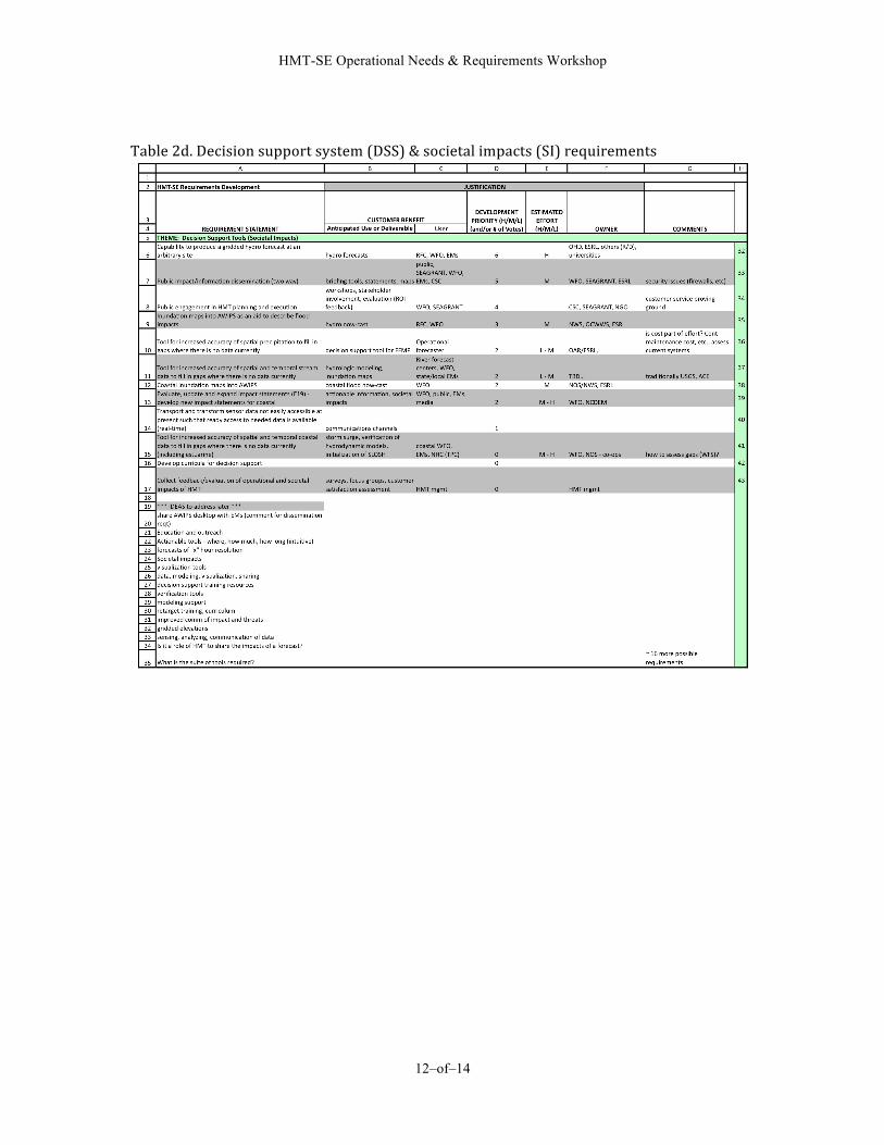
Decision Support Tool/Societal Impact Requirements: Understanding and communicating scientific and social information that results in optimal planning and response to extreme precipitation events is recognized as a critical goal for the HMT-‐SE project. This breakout group identified a list of activities that should be incorporated into the project's science and services plan in order to achieve this goal. Technical tasks recommended include the development of higher spatial and temporal modeling and display systems used to monitor and predict changes in the coastal and riverine environment. Included on this list is the ability to integrate data and share desktop applications (e.g., open access to inundation data layers used by NWS employees on AWIPS as well as a local officials using GIS.) Non-‐technical, but equally important actions include engaging and educating customers clientele or user-‐groups, and learning better methods of communicating risk and probabilities by understanding decision support systems better. Benefits of achieving these goals include a) improved situational awareness on the parts of both the scientists, and constituents (i.e., customers), b) increased accuracy and precision in measurement and prediction of extreme precipitation events and their outcomes, c) better 2-‐way communication and exchange of “actionable” information, resulting in reduced impacts from extreme precipitation events on society, and d) increased customer/clientele satisfaction and feedback. It is important to include local partners (customers/constituents) as early as possible in the planning process. If possible, contacting key leaders in the watershed and organizing a preliminary local advisory committee, perhaps within the next few months, would provide valuable input at an early stage. This would allow more time to develop the long-‐term relationships that will be important to the integration of these people into the project. Customer involvement throughout the project lifetime should help ensure that HMT-‐SE deliverables hit their targeted goals. For a full, detailed listing of these requirements, see Appendix A, Tables 2a-d. Each of the ‘validated’ requirements in the tables is deemed important and worth pursuing; however, it will be beyond the scope of HMT to address each and every one of them. Final

HMT-SE Operational Needs & Requirements Workshop
8–of–14
prioritization from an HMT-‐SE perspective will depend upon a number of factors, including perceived value/benefit; available personnel (skill sets) and resources (fiscal or otherwise); and potential for collaboration/ leveraging with other entities. Even though HMT-‐SE may not be able to address all the identified requirements, it is felt that the process undertaken during the Operational Needs & Requirements Workshop, and its outcome (i.e. the requirements list), will ultimately be of significant value to the hydro-‐meteorological community at large. Conclusion & Next Steps During the final wrap-‐up session of the Planning Committee, there was almost unanimous sentiment among its members that Workshop #1 had been a success, with its primary goals and objectives having been well met amidst an atmosphere of information sharing, consensus and collegiality. The initial set of requirements will need to be clarified and consolidated somewhat prior to Workshop #2, so that they may serve as the basis for further discussion and refinement during that workshop. Finally, there was preliminary discussion of Workshop #2, with determination that its field of invitees would be expanded to perhaps 60-‐70 in order to include members of the research and modeling communities (in addition to any participant in Workshop #1 who may want to return). Among those whom the organizers would like to see in attendance would be folks with expertise in stream flow forcing and distributed modeling, including an expanded contingent from OHD, Note that the location of Workshop #2 may have to be moved from RENCI to an alternate venue in the central NC area, in order to accommodate the additional, anticipated participants (nearby Duke University is likely available). The tentative timeframe of that workshop will be the 3rd week of June, most likely Monday-‐Wednesday June 15-‐17. This report and the report produced from the second workshop will be used to inform the development of the HMT-‐SE Science and Operations Plan to be completed this summer. Appendices: Appendix A: Detailed requirements listed (i.e. Table 2a-‐d) Appendix B: A Brief Note about RENCI & the NC Sensors Workshop Appendix C: HMT-‐SE Conceptual Map Complete files from the meeting: Additional files, including the directive from the HMT Management Council leading to HMT-‐SE, the agenda (in both a full process version, for meeting organizers, and a shortened version, for the general audience) and copies of the presentations given, can be found at the following ftp site:
ftp://ftp.etl.noaa.gov/user/hmt/HMT-‐Southeast/
Note that the files/folders from this workshop are found in subdirectory "Workshop #1"

HMT-SE Operational Needs & Requirements Workshop
9–of–14
Appendix A: Detailed requirements listed (i.e. Table 2a-d) Table 2a. Quantitative precipitation estimation (QPE) requirements

HMT-SE Operational Needs & Requirements Workshop
10–of–14
Table 2b. Quantitative precipitation forecast (QPF) requirements

HMT-SE Operational Needs & Requirements Workshop
11–of–14
Table 2c. Hydrologic/hydrodynamic applications (HA) requirements
HMT-SE Operational Needs & Requirements Workshop
12–of–14
Table 2d. Decision support system (DSS) & societal impacts (SI) requirements

HMT-SE Operational Needs & Requirements Workshop
13–of–14
Appendix B: A Brief Note about RENCI & the NC Sensors Workshop RENCI (http://www.renci.org/) was founded in 2004 and is a virtual organization of science, industrial and educational interests in the State of North Carolina that combines the resources of numerous public and private institutions and universities within the State. Its stated mission is to “… find innovative solutions to problems … including prediction and planning for disaster mitigation”. As part of this mission, there is considerable emphasis on the gathering, dissemination and display of weather, severe storm and climatological information, with particular consideration of ‘human factors’ in design of the display products. RENCI’s North Carolina Sensors Workshop on February 2nd featured numerous environmental data sensors and networks already in place or potentially available within the State, including rain and river gauges, air quality and ocean sensors, and an advanced flood warning system managed by their State Emergency Management organization. This inventory of sensors and infrastructure should provide a substantial supplement to those directly at NOAA’s disposal and should help maximize the probabilities for success of the HMT-‐SE experiment.

HMT-SE Operational Needs & Requirements Workshop
14–of–14
Appendix C. HMT-SE Conceptual Map This map portrays one possible configuration of the testbed. It articulates a concept of scaled effort, in which the innermost grid is the focus of the most intense effort, and so on. Other configurations are possible, such as establishing “satellite” sites in other representative terrains (coastal, mountain). Collectively, the two workshops will help to determine the optimal testbed strategy, which will ultimately depend on available resources, collaborative efforts, etc.
Related Documents