CBD Distr. GENERAL CBD/EBSA/WS/2019/1/5 8 November 2019 ENGLISH ONLY REPORT OF THE REGIONAL WORKSHOP TO FACILITATE THE DESCRIPTION OF ECOLOGICALLY OR BIOLOGICALLY SIGNIFICANT MARINE AREAS IN THE NORTH- EAST ATLANTIC OCEAN 1 Stockholm, 22-27 September 2019 INTRODUCTION 1. At its tenth meeting, the Conference of the Parties to the Convention on Biological Diversity requested the Executive Secretary to work with Parties and other Governments as well as competent organizations and regional initiatives, such as the Food and Agriculture Organization of the United Nations (FAO), regional seas conventions and action plans, and, where appropriate, regional fisheries management organizations (RFMOs) to organize, including the setting of terms of reference, a series of regional workshops, with a primary objective to facilitate the description of ecologically or biologically significant marine areas (EBSAs) through the application of the scientific criteria given in decision IX/20, annex I, as well as other relevant compatible and complementary nationally and intergovernmentally agreed scientific criteria, as well as the scientific guidance on the identification of marine areas beyond national jurisdiction, which meet the scientific criteria in annex I to decision IX/20 (see decision X/29, para. 36). 2. Subsequently, at its eleventh, twelfth, thirteenth and fourteenth meetings, the Conference of the Parties reviewed the outcomes of the regional workshops conducted and requested the Executive Secretary to include the summary reports prepared by the Subsidiary Body on Scientific, Technical and Technological Advice, as contained in the annexes to decisions XI/17, XII/22, XIII/12 and 14/9, in the repository of ecologically or biologically significant marine areas, and to transmit the summary reports to the United Nations General Assembly and its relevant processes, as well as to Parties, other Governments and relevant international organizations, in line with the purpose and procedures set out in decisions X/29, XI/17 and XII/22. 3. The Conference of the Parties to the Convention, at its thirteenth meeting, also requested the Executive Secretary, in line with paragraph 36 of decision X/29, paragraph 12 of decision XI/17 and paragraph 6 of decision XII/22, to continue to facilitate the description of areas meeting the criteria for ecologically or biologically significant marine areas through the organization of additional regional or subregional workshops where Parties wish workshops to be held. Furthermore, the Conference of the Parties to the Convention, at its fourteenth meeting, invited Parties to submit descriptions of areas that meet the criteria for EBSAs in the North-East Atlantic. 4. On 30 November 2018, Ms. Susana Salvador, Executive Secretary of the Convention for the Protection of the Marine Environment of the North-East Atlantic (OSPAR Commission), and Mr. Darius Campbell, Secretary of the North-East Atlantic Fisheries Commission (NEAFC), transmitted a letter to Ms. Cristiana Pașca Palmer, Executive Secretary of the CBD, to request collaboration between the CBD Secretariat, the OSPAR Commission and NEAFC to organize a CBD regional workshop to facilitate the 1 The designations employed and the presentation of material in this note do not imply the expression of any opinion whatsoever on the part of the Secretariat concerning the legal status of any country, territory, city or area or of its authorities, or concerning the delimitation of its frontiers or boundaries.

Welcome message from author
This document is posted to help you gain knowledge. Please leave a comment to let me know what you think about it! Share it to your friends and learn new things together.
Transcript
CBD
Distr.
GENERAL
CBD/EBSA/WS/2019/1/5
8 November 2019
ENGLISH ONLY
REPORT OF THE REGIONAL WORKSHOP TO FACILITATE THE DESCRIPTION OF
ECOLOGICALLY OR BIOLOGICALLY SIGNIFICANT MARINE AREAS IN THE NORTH-
EAST ATLANTIC OCEAN1
Stockholm, 22-27 September 2019
INTRODUCTION
1. At its tenth meeting, the Conference of the Parties to the Convention on Biological Diversity
requested the Executive Secretary to work with Parties and other Governments as well as competent
organizations and regional initiatives, such as the Food and Agriculture Organization of the United
Nations (FAO), regional seas conventions and action plans, and, where appropriate, regional fisheries
management organizations (RFMOs) to organize, including the setting of terms of reference, a series of
regional workshops, with a primary objective to facilitate the description of ecologically or biologically
significant marine areas (EBSAs) through the application of the scientific criteria given in decision IX/20,
annex I, as well as other relevant compatible and complementary nationally and intergovernmentally
agreed scientific criteria, as well as the scientific guidance on the identification of marine areas beyond
national jurisdiction, which meet the scientific criteria in annex I to decision IX/20 (see decision X/29,
para. 36).
2. Subsequently, at its eleventh, twelfth, thirteenth and fourteenth meetings, the Conference of the
Parties reviewed the outcomes of the regional workshops conducted and requested the Executive
Secretary to include the summary reports prepared by the Subsidiary Body on Scientific, Technical and
Technological Advice, as contained in the annexes to decisions XI/17, XII/22, XIII/12 and 14/9, in the
repository of ecologically or biologically significant marine areas, and to transmit the summary reports to
the United Nations General Assembly and its relevant processes, as well as to Parties, other Governments
and relevant international organizations, in line with the purpose and procedures set out in decisions X/29,
XI/17 and XII/22.
3. The Conference of the Parties to the Convention, at its thirteenth meeting, also requested the
Executive Secretary, in line with paragraph 36 of decision X/29, paragraph 12 of decision XI/17 and
paragraph 6 of decision XII/22, to continue to facilitate the description of areas meeting the criteria for
ecologically or biologically significant marine areas through the organization of additional regional or
subregional workshops where Parties wish workshops to be held. Furthermore, the Conference of the
Parties to the Convention, at its fourteenth meeting, invited Parties to submit descriptions of areas that
meet the criteria for EBSAs in the North-East Atlantic.
4. On 30 November 2018, Ms. Susana Salvador, Executive Secretary of the Convention for the
Protection of the Marine Environment of the North-East Atlantic (OSPAR Commission), and Mr. Darius
Campbell, Secretary of the North-East Atlantic Fisheries Commission (NEAFC), transmitted a letter to
Ms. Cristiana Pașca Palmer, Executive Secretary of the CBD, to request collaboration between the CBD
Secretariat, the OSPAR Commission and NEAFC to organize a CBD regional workshop to facilitate the
1 The designations employed and the presentation of material in this note do not imply the expression of any opinion whatsoever
on the part of the Secretariat concerning the legal status of any country, territory, city or area or of its authorities, or concerning
the delimitation of its frontiers or boundaries.
CBD/EBSA/WS/2019/1/5
Page 2
description of EBSAs in the North-East Atlantic. The letter further invited the workshop to consider the
information collated for the regional EBSA process organized by the OSPAR Commission and NEAFC,
in collaboration with the CBD Secretariat, in 2011 and 2013 and peer reviewed by the International
Council for Exploration of the Sea (ICES) in 20132 and any additional new information that has been
collected in the intervening period.
5. Pursuant to the above requests, and with financial support from the Governments of Sweden,
France, Denmark and Germany, the Secretariat of the Convention on Biological Diversity convened the
Regional Workshop to Facilitate the Description of Ecologically or Biologically Significant Marine Areas
in the North-East Atlantic Ocean, in Stockholm, from 23 to 27 September 2019, preceded by a training
session on 22 September 2019. The workshop was hosted by the Government of Sweden and organized in
collaboration with the OSPAR Commission and NEAFC.
6. Scientific and technical support for this workshop was provided by a team from Duke University.
The results of technical preparation for the workshop were made available in the meeting document
entitled “Data to Inform the Regional Workshop to Facilitate the Description of Ecologically or
Biologically Significant Marine Areas (EBSAs) in the North-East Atlantic Ocean”
(CBD/EBSA/WS/2019/1/3).
7. The meeting was attended by experts from Belgium, Denmark (Kingdom of), European Union,
Germany, Iceland, Ireland, Netherlands, Norway, Portugal, Russian Federation, Spain, Sweden, United
Kingdom of Great Britain and Northern Ireland, International Seabed Authority, North-East Atlantic
Fisheries Commission (NEAFC), OSPAR Commission, International Council for Exploration of the Sea
(ICES), Saami Council, BirdLife International, Global Ocean Biodiversity Initiative, Fisheries Expert
Group of the IUCN Commission of Ecosystem Management, IUCN Marine Mammal Protected Areas
Task Force, and the World Wide Fund for Nature (WWF).3 The full list of participants is provided in
annex I.
ITEM 1. OPENING OF THE WORKSHOP
8. On behalf of the Government of Sweden, Ms. Charlotta Sörqvist, Senior Adviser, Division for
Natural Environment, Ministry of the Environment of Sweden, delivered opening remarks. She welcomed
participants to Sweden and to Stockholm. She noted that the 2011 OSPAR/NEAFC/CBD EBSA
workshop for the North-East Atlantic, which was also the first-ever EBSA workshop, was held eight
years ago, due to the eagerness of scientists in the North-East Atlantic region to apply the EBSA concept
to their region. She noted that this process was now closer than ever to reaching a conclusion in this
region, an important step towards a COP decision next year. She affirmed Sweden’s faith in the process,
which the Government saw as very important in building knowledge about the marine environment on
which human beings depended. She noted that, looking ahead to the post-2020 global biodiversity
framework, one thing was certain: marine and coastal biodiversity would continue to face serious
challenges. She stressed that Sweden saw EBSAs as having a potentially important role as conservation
efforts awerere stepped up, not only for the knowledge that the process had generated, but also in the light
of environmental challenges, such as climate change. Ms. Sörqvist thanked participants for their
dedication to the EBSA process and wished them a productive week.
9. Ms. Lena Avellan delivered an opening statement on behalf of Ms. Susana Salvador, Executive
Secretary of the OSPAR Commission. She expressed her gratitude to the Convention on Biological
2 ICES. 2013. OSPAR/NEAFC special request on review of the results of the Joint OSPAR/NEAFC/CBD Workshop on
Ecologically and Biologically Significant Areas (EBSAs). June 2013. Available at:
http://www.ices.dk/sites/pub/Publication%20Reports/Advice/2013/Special%20requests/OSPAR-
NEAFC%20EBSA%20review.pdf 3 An expert nominated by the government of France was scheduled to attend the workshop. However, due to unforeseen
circumstances, the participant was unable to attend, and it was not possible in the limited timeframe to arrange for an alternate
expert from France to attend.
CBD/EBSA/WS/2019/1/5
Page 3
Diversity for arranging this important regional workshop and to the technical team from the Marine
Geospatial Ecology Lab of Duke University for its technical support. She also thanked the Government of
Sweden for generously hosting this workshop and the Governments of France, Denmark and Germany for
their valuable financial contributions, as well as the other Governments that had contributed to making
this workshop possible. She also thanked NEAFC for the productive and continued cooperation in this
area of work. She noted that in the past ten years, their two organizations had developed a strong
collaboration, shared information of common interest, and, above all, significantly enhanced the
collective arrangement as a forum for regional and cross-sectoral dialogue. She emphasized that the
organizations had furthermore explored ways to promote the identification of areas meeting the EBSA
criteria and were proud of working together with the Convention. She noted that, while the North-East
Atlantic was a well-studied area, the OSPAR Commission still had insufficient knowledge of the
ecosystems to fully apply an ecosystem approach to managing human activities. OSPAR applied the
precautionary principle to management of human activities and aimed to increase availability of
information to inform and sustain policy decisions. She noted that the outputs of this workshop would be
helpful to the future work of OSPAR as it contributed to efforts to increase the availability of scientific
information to policymakers. She noted that the Contracting Parties to OSPAR were currently developing
a new strategy based on an ambitious programme for the next decade, to be launched in July 2020. An
important part of this work was to evaluate achievements against current objectives and targets, which
were set in 2010. But when looking towards the future, ambitions needed to take emerging pressures,
such as climate change, into account. Through the new Strategy for 2020-2030, the OSPAR Commission
aimed to set out the main commitments to protect the marine environment of the North East Atlantic in
the wider context of ocean governance and to contribute to the UN 2030 Agenda, mostly the delivery of
many of the Sustainable Development Goals. Reinforced international cooperation was therefore a
fundamental component of our plan of action for the decade ahead. OSPAR believed the post-2020 global
biodiversity framework was of crucial importance in the context of global biodiversity conservation, and
OSPAR sought to support the CBD process by contributing results and findings from regional efforts and
aligning common objectives and targets. OSPAR sought to take further steps in supporting global efforts
on conserving marine biodiversity, and collaboration on EBSA was one important step towards this end.
In conclusion, she reiterated the appreciation of OSPAR to the Convention for its collaboration in
identifying EBSAs in the North East Atlantic, and reaffirmed OSPAR’s willingness to support this
process and work ahead. She wished participants a successful workshop.
10. Mr. Darius Campbell, Secretary of NEAFC, delivered opening remarks. After thanking the
Swedish Government for hosting, the CBD Secretariat for organizing, and the Governments of France,
Denmark and Germany for financially supporting the workshop, Mr. Campbell provided some historical
context. He recalled the previous year, NEAFC and OSPAR requested the Convention on Biological
Diversity to hold this workshop, following a process to describe EBSAs in the North-East Atlantic that
began in 2011, following decision X/29, whereby the Conference of the Parties requested the Executive
Secretary to organize a series of regional workshops to facilitate the description of EBSAs. OSPAR,
NEAFC and the CBD Secretariat kicked off this process in the North-East Atlantic via a workshop held in
2011. Following a scientific review process, some refined draft proposals were developed in 2013.
Further progress was, however, prevented until last year’s joint request to the CBD. He noted that
NEAFC, OSPAR and the CBD should be proud of their history of cooperation on the EBSA process, as
such collaboration was unusual in 2011. Mr. Campbell noted his pleasure at the renewal of efforts on the
EBSA process for the North-East Atlantic, and his hope that these efforts would lead to a successful
conclusion in the very near future. He noted that since 2011, NEAFC had continued to make progress in
moving from science to action in terms of conservation in Areas beyond National Jurisdiction in the
North-East Atlantic. Since 2004 NEAFC had closed several areas to bottom fisheries, where Vulnerable
Marine Ecosystems occurred. Moreover, in all but a very small part of the NEAFC Regulatory Area,
where already established bottom fishing was allowed, no new bottom-fishing activity could progress
without a strict impact assessment process. In closing, he emphasized that NEAFC concentrated on
policy, while scientific advice was provided only by the International Council for Exploration of the Sea
CBD/EBSA/WS/2019/1/5
Page 4
(ICES), and that NEAFC was therefore very pleased to note that ICES would lend its expertise to this
workshop. At the same time, he indicated that ICES would likely consider the information established in
this process as it provides scientific advice to NEAFC. He wished all participants a fruitful workshop.
11. Mr. Joseph Appiott delivered an opening statement on behalf of Ms. Cristiana Paşca Palmer,
Executive Secretary of the Convention on Biological Diversity. He thanked participants for joining the
workshop and lending their valuable scientific expertise to this important process. He also expressed his
gratitude to the Government of Sweden for hosting the workshop and to the Governments of France,
Denmark and Germany for their valuable financial support. He also thanked the OSPAR Commission and
NEAFC for their collaboration and valuable technical input and expressed his gratitude to the technical
support team from the Marine Geospatial Ecology Lab of Duke University, whose important work in
geospatial mapping had been crucial to the success of the EBSA process. He noted that the North-East
Atlantic was a diverse place, with an ecology that included an enormous range of species and habitats.
The intense human activities in the region placed considerable pressure on the marine environment and on
the ability of the ocean to continue to provide the services that had supported the region’s economic
development and social well-being. These challenges had been further exacerbated by global drivers such
as climate change and ocean acidification. In view of these challenges, biodiversity must not be seen as a
hindrance, but rather a solution for sustainable economic growth and human well-being, by supporting the
functioning of the Earth’s life support system. He noted that significant strides had been made in the
region towards sustainable development. The OSPAR Commission, NEAFC and other multilateral
processes had brought together countries in the region to take steps to improve the conservation and
sustainable use of the region’s marine and coastal resources. This region had shown leadership in cross-
sectoral approaches to understanding and managing its marine resources, including through the robust
collaboration between the OSPAR Commission and NEAFC, which was widely viewed as a model of
regional collaboration for the whole world to follow. At such a crucial time in the global ocean policy
landscape, particularly in view of the ongoing deliberations for the post-2020 global biodiversity
framework, he urged participants to demonstrate once again the leadership role that the North-East
Atlantic had long played in regional collaboration to better understand, conserve and sustainably use
marine biodiversity. In conclusion, he wished participants a successful workshop.
ITEM 2. ELECTION OF THE WORKSHOP CO-CHAIRS, ADOPTION OF THE
AGENDA AND ORGANIZATION OF WORK
12. After a brief explanation by the CBD Secretariat on procedures for electing the workshop co-
chairs, Mr. Staffan Danielsson (Sweden), as offered by the host Government, and Mr. Juan-Pablo
Pertierra (EU), proposed by an expert from Sweden and seconded by the floor unanimously, were elected
as the workshop co-chairs.
13. Participants were then invited to consider the provisional agenda (CBD/EBSA/WS/2019/1/1) and
the proposed organization of work, as contained in annex II to the annotations to the provisional agenda
(CBD/EBSA/WS/2019/1/1/Add.1) and adopted them without any amendments.
14. The workshop was organized in plenary and break-out group sessions. The co-chairs nominated
Mr. David Johnson (GOBI) as rapporteur to assist the CBD Secretariat in preparing the draft workshop
report on the workshop discussions with respect to agenda item 6.
ITEM 3. WORKSHOP BACKGROUND, SCOPE AND OUTPUT
15. Under this agenda item, participants were provided with a series of presentations during the
training day, including presentations on the scientific aspects of the EBSA criteria and the application of
the EBSA criteria:
(a) Mr. Joseph Appiott (CBD Secretariat) delivered a presentation on the work of the CBD
on EBSAs and the global context for the workshop;
CBD/EBSA/WS/2019/1/5
Page 5
(b) Ms. Hedvig Hogfors (Sweden) delivered a presentation on Mosaic, a new framework in
Sweden to facilitate the ecosystem approach to spatial management;
(c) Ms. Lena Avellan (OSPAR Commission) delivered a presentation on the role and
mandate of the OSPAR Commission, and its work in assessing the state of the marine environment, and
the forthcoming 2023 OSPAR Quality Status Report, which will evaluate the North-East Atlantic
Environment Strategy 2010-2020;
(d) Mr. Darius Campbell (NEAFC) delivered a presentation on the role and mandate of the
NEAFC, the background of inter-sectoral cooperation with OSPAR and on previous efforts towards
identifying EBSAs in the region, which strengthened regional cooperation;
(e) Mr. Eugene Nixon (ICES) delivered a presentation on work under ICES relevant to the
workshop discussions and explained the role of ICES as an intergovernmental scientific organization that
provides independent evidence-based advice on marine-related issues to OSPAR and NEAFC;
(f) Ms. Jihyun Lee (ISA Secretariat) delivered a presentation on work under the ISA relevant
to the workshop discussions, including scientific data collected through exploration activities, which
supports the effective implementation of ISA’s environmental management system, together with
scientific analysis, modeling and observations being undertaken by other scientific groups;
(g) Mr. Patrick Halpin (technical support team) gave a presentation on the scientific criteria
for EBSAs and approaches and experiences in the description of areas meeting the EBSA criteria;
(h) Mr. Patrick Halpin (technical support team) gave a presentation on the scientific
information compiled for the workshop;
16. Summaries of the above presentations are provided in annex II.
17. Mr. Joseph Appiott (CBD Secretariat) briefed the participants on the workshop objectives,
expected outputs and geographic scope, building on his presentation on the Convention's EBSA process
that was delivered on the training day.
18. The participants discussed the scope of the workshop. It was agreed to align the scope of the
workshop with the maritime areas of the OSPAR Commission and NEAFC (which are identical), except
for the southern boundary, which the workshop agreed to extend. The southern boundary of the workshop
scope was extended south, partially overlapping with the scope of the CBD regional EBSA workshop for
the South-Eastern Atlantic (Swakopmund, Namibia, 8-12 April 2013), in order to encompass waters and
features surrounding the islands of Madeira and the Azores (Portugal) and the Canary Islands (Spain), as
(a) experts from Portugal and Spain had not been present at the South-Eastern Atlantic workshop, (b)
features surrounding the islands of Madeira and the Azores (Portugal) and the Canary Islands (Spain) had
generally not been considered in the South-Eastern Atlantic workshop, and (c) additional information
from those areas was made available at the regional EBSA workshop for the North-East Atlantic. As the
scope of the workshop also partially overlapped with the scope of the CBD regional EBSA workshop for
the Arctic (Helsinki, 3-7 March 2014) and the CBD regional EBSA workshop for the Baltic Sea (Helsinki,
19-24 February 2018), the workshop also took note of the results of these previous workshops.
19. Germany, Greenland (Kingdom of Denmark), Iceland, Ireland, Netherlands, Norway, and the
United Kingdom of Great Britain and Northern Ireland did not include their Exclusive Economic Zones
(EEZs) in the workshop scope due to the fact that those Parties had conducted, or were in the process of
conducting, relevant national processes applying the EBSA criteria or other similar criteria for identifying
marine areas of particular importance. Workshop participants from those Parties were invited to provide
brief summaries of these national processes. Sweden and the Russian Federation had already described
EBSAs in their EEZs in previous CBD regional EBSA workshops that overlapped with the scope of the
present workshop, and did not describe additional features or information in their EEZs. Annex III
provides information on the above.
CBD/EBSA/WS/2019/1/5
Page 6
20. An expert nominated by the Government of France was scheduled to attend the workshop.
However, due to unforeseen circumstances, the participant was unable to attend, and it was not possible in
the limited timeframe to arrange for an alternate expert from France to attend. Thus, features in the EEZ
of France were not considered in the scope of this workshop.
21. The map of the workshop scope is provided in annex IV.
22. The workshop participants noted the following points regarding the guidance of the Conference
of the Parties to the Convention on Biological Diversity on the regional workshop process as well as the
potential contribution of the scientific information produced by the workshops:
(a) The Conference of the Parties, at its tenth meeting, noted that the application of the
scientific criteria in annex I of decision IX/20 for the identification of ecologically or biologically
significant marine areas presents a tool which Parties and competent intergovernmental organizations may
choose to use to progress towards the implementation of ecosystem approaches in relation to areas both
within and beyond national jurisdiction, through the identification of areas and features of the marine
environment that are important for conservation and sustainable use of marine and coastal biodiversity
(paragraph 25, decision X/29);
(b) The application of the EBSA criteria is a scientific and technical exercise, and the
identification of EBSAs and the selection of conservation and management measures is a matter for States
and competent intergovernmental organizations, in accordance with international law, including the
United Nations Convention on the Law of the Sea (decision X/29, para. 26,);
(c) The EBSA description process is open-ended, and additional regional or subregional
workshops may be organized when there is sufficient advancement in the availability of scientific
information (decision XI/17, paras. 9 and 12);
(d) Each workshop is tasked to describe areas meeting the scientific criteria for EBSAs based
on best available scientific information. As such, experts at the workshops are not expected to discuss any
management issues, including threats to the areas;
(e) The EBSA description process facilitates scientific collaboration and information-sharing
at national, subregional and regional levels, as demonstrated by the collective work by workshop
participants with different expertise, contributing to each other’s description of areas meeting the EBSA
criteria;
23. Participating experts were invited through a selection process, based on nominations by CBD
National Focal Points, using the selection criteria provided in the CBD notification dated 25 March 2019
(reference number 2019-036). Prior to the workshop, selected experts were asked to provide relevant
scientific and technical information, in collaboration with relevant scientists within their respective
countries, to support the workshop discussions, including by filling in the EBSA information template
(appended to the notification above).
ITEM 4. REVIEW OF RELEVANT SCIENTIFIC DATA/INFORMATION/MAPS
COMPILED FOR THE WORKSHOP
24. For the consideration of this item, the workshop had before it two information notes by the
Executive Secretary that were prepared in support of the workshop deliberations: Compilation of Relevant
Scientific Information Submitted by Parties, Other Governments and Relevant Organizations in Support
of the Workshop Objectives (document CBD/EBSA/WS/2019/1/2), which was compiled based on
submissions in response to the Secretariat’s notification (2019-050, dated 28 May 2019), and Data to
Inform the CBD Regional Workshop to Facilitate the Description of Ecologically or Biologically
Significant Marine Areas in the North-East Atlantic Ocean (document CBD/EBSA/WS/2019/1/3). The
documents/references submitted prior to the workshop were made available for the information of
workshop participants on the meeting website (https://www.cbd.int/meetings/EBSA-WS-2019-01).
CBD/EBSA/WS/2019/1/5
Page 7
25. Mr. Patrick Halpin (technical support team) provided a presentation that reviewed the relevant
scientific data/information/maps compiled to support the workshop deliberations, based on document
CBD/EBSA/WS/2019/1/3. The information provided in this presentation was considered in the
description of areas meeting the EBSA criteria by the break-out groups. A summary of this presentation is
provided in annex II.
26. Workshop participants who had submitted relevant scientific information using the EBSA
templates prior to the workshop, as contained in the document CBD/EBSA/WS/2019/1/2, were invited to
present their draft descriptions of areas potentially meeting the EBSA criteria.
27. Spatial data compiled for this workshop was available to workshop participants both in hard-copy
maps as well as in a Geographic Information System (GIS) database, for their use, analysis and
interpretation in the application of the EBSA criteria.
28. The workshop participants also noted the previous information collated for the regional EBSA
process organized by the OSPAR Commission and NEAFC, in collaboration with the CBD Secretariat, in
2011 and 2013, and peer-reviewed by ICES in 2013,4 the outputs of which were made available for the
workshop discussions.
29. Workshop participants noted with appreciation the considerable amount of data/information
gathered, including GIS data, for the workshop deliberation and highlighted the importance of making it
available through the development of relevant information platforms (e.g., EBSA regional repository) at
national and regional scales.
ITEM 5. DESCRIPTION OF ECOLOGICALLY OR BIOLOGICALLY
SIGNIFICANT MARINE AREAS THROUGH THE APPLICATION OF
THE SCIENTIFIC CRITERIA (DECISION IX/20, ANNEX I)
30. Building on the theme presentations provided in the previous agenda items, the workshop
participants exchanged their views on possible ways of organizing their work under this agenda item. In
this regard, participants noted the following points with regard to the description of areas meeting the
EBSA criteria:
(a) The description of EBSAs is based on the scientific information and expert knowledge
available at the time of the workshop, and, as the EBSA process is iterative and ongoing, there may be
additional areas described as meeting the EBSA criteria in future regional or sub-regional workshops;
(b) In describing multiple ecological and/or biological components of a given area,
participants should consider how these components may be interconnected as part of a system, and that, if
separate components cannot be described as part of a coherent system approach, these components should
be described separately;
(c) The EBSA criteria can be applied on all scales from global to local. Once a scale has
been selected, however, the criteria are intended to be used to evaluate areas and ecosystem features in a
context relative to other areas and features at the given scale;
(d) There are no thresholds that must be met, judgements are comparative to adjacent areas,
and the current ranking system (e.g., high, medium, low, no information) for assessing the areas meeting
each EBSA criterion is devised to facilitate better understanding of available scientific information in
describing the areas with regard to the extent to which they meet different criteria. The current ranking
system, however, does not intend to compare the importance of each criterion;
(e) Relative assessments are necessarily scale dependent. Relative significance of areas has
generally been viewed from regional or large sub-regional scales;
4 ICES OSPAR-NEAFC EBSA review.pdf
CBD/EBSA/WS/2019/1/5
Page 8
(f) Areas may meet multiple criteria, and that is important, but ranking at least one as high is
also necessary for a proposed area to be described as an EBSA;
(g) Areas described to meet the EBSA criteria have ranged from relatively small sites to very
extensive oceanographic features;
(h) Areas described to meet the EBSA criteria can be overlapped or nested;
(i) Difficulties are often encountered in applying EBSA criterion 4 (vulnerability, fragility,
sensitivity, and/or slow recovery). Criterion 4 applies to an area that contains a relatively high proportion
of sensitive habitats, biotopes or species that are functionally fragile (highly susceptible to degradation or
depletion by human activity or by natural events) or with slow recovery, not directly describing the
anthropogenic threats or pressures affecting the areas.
31. This workshop was mandated to evaluate areas at a regional scale within the North-East Atlantic.
However, the workshop considered that the entire region has significant ecological or biological features
that should be viewed on a global scale. This perspective is presented in annex V of this report.
32. Participants recognized that indigenous peoples and local communities in the North-East Atlantic
have a significant amount of endemic, traditional knowledge relevant to the description of EBSAs, and
that traditional knowledge should be appropriately considered and engaged in the description of areas
meeting the EBSA criteria through the full and effective participation of indigenous peoples and local
communities. Participants noted that indigenous peoples and local communities have long been part of the
North-East Atlantic ecosystem, and its biodiversity has been the basis for ways of life for indigenous
peoples for millennia and is still a vital part of their material and spiritual existence. They further noted
the importance of recognizing the linkage between culture and biodiversity, given that healthy and
productive marine and ecosystems are the foundation of indigenous cultures, traditions and identities.
Although the workshop did not consider many areas where indigenous peoples and local communities
live, indigenous peoples and local communities have always known that remote areas outside their
immediate environment are important areas for refuge and homes to other beings and respected as such. If
those areas had been considered in the context of this workshop, traditional knowledge on features such
fishing grounds, spawning areas, streams, fauna, bird habitats, seabed conditions and also knowledge of
customary use of areas, areas of social and economic importance, cultural heritage sites, subsistence use
areas and sacred sites would have been highly relevant.
33. For effective review of available scientific information and assessment of potential areas meeting
the EBSA criteria, the workshop participants were split into two break-out groups. These sub-groupings
were not based on any geographic, ecological, biological, political or any other criteria or considerations,
nor based on any existing sub-groupings used in any other processes. The participants were split into
these sub-groupings only to facilitate a more efficient mode of working, especially in light of limitations
posed by the relatively small number of technical support staff present at the workshop to support the
description of areas meeting the EBSA criteria. These sub-groupings are as follows:
(a) Northern part of the North-East Atlantic;
(b) Southern part of the North-East Atlantic.
34. Each break-out group was advised to focus on the following in their discussion:
(a) Review the layers of information available, including GIS maps of ocean features, other
types of data sets, primary and other scientific and technical reports and publications, and expert
knowledge, relative to each of the CBD EBSA criteria;
(b) Based on the review of available scientific information, describe areas that may be
considered to be relatively ecologically or biologically significant, based on their relative importance on
one or more of the criteria;
CBD/EBSA/WS/2019/1/5
Page 9
(c) Document the description of each area considered to be ecologically or biologically
significant, using the EBSA template and augmenting the template with narrative text and maps
considered necessary to reflect the rationales of the group. Where appropriate, the narrative text may
report on strengths and weaknesses in the information used in the description of the area, and key
uncertainties;
(d) Review existing compilation of templates and refine them as necessary, considering
comments provided by the Secretariat and the workshop plenary, in terms of scientific data/information,
and polygon boundaries of areas to be mapped;
(e) Where appropriate, consider merging areas described in draft descriptions with other
areas or refining them into smaller areas so that the description can accurately cover the ecosystem
features under consideration;
(f) Identify the needs for future scientific research, scientific collaboration, data/information
sharing, and capacity building to further enable application of the EBSA criteria in the region, particularly
for areas or types of information for which there is a lack of scientific information or expert knowledge at
this workshop, as inputs to agenda item 6;
(g) Work with technical support team to define the polygon boundary of areas of your EBSA
description on the GIS map; and
(h) Invite relevant international/regional experts available at the meeting for their expert
opinions.
35. Participants were assisted by the technical support team, including GIS operators, who made
hard/electronic copies of the maps available for the deliberation of the break-out group discussion, and
provided data in a GIS database, and supported data analysis and interpretation as well as mapping of
potential areas meeting the EBSA criteria.
36. During the break-out group discussions, participants working on the description of areas meeting
EBSA criteria drew approximate polygons of areas meeting the EBSA criteria on a map provided by the
technical support team.
37. The results of the break-out groups were reported at the plenary for consideration. At the plenary
sessions, workshop participants reviewed the description of areas meeting the EBSA criteria proposed by
the break-out group sessions, including the draft descriptions, using templates provided by the CBD
Secretariat, and considered them for inclusion in the final list of areas meeting EBSA criteria.
38. The workshop participants agreed on descriptions of 17 areas meeting the EBSA criteria. The
map of described areas is contained in annex VI. They are listed in annex VII and described in its
appendix.
ITEM 6. IDENTIFICATION OF GAPS AND NEEDS FOR FURTHER ELABORATION
IN DESCRIBING AREAS MEETING EBSA CRITERIA, INCLUDING THE
NEED TO DEVELOP SCIENTIFIC CAPACITY AND FUTURE
SCIENTIFIC COLLABORATION
39. Building on the workshop deliberations, the workshop participants were invited to identify,
through break-out group sessions and plenary discussion, gaps and needs for further elaboration in
describing areas meeting the EBSA criteria, including the need for scientific information, scientific
capacity development and scientific collaboration. The results of the plenary and subgroup discussions are
compiled in annex VIII.
40. Workshop participants discussed Arctic sea ice habitats in the context of the application of the
EBSA criteria in this region, noting specific challenges in describing such features during this workshop,
following previous work in describing these features as meeting the EBSA criteria at the 2011 Joint
OSPAR/NEAFC/CBD Scientific Workshop on the identification of EBSAs in the North-East Atlantic and
CBD/EBSA/WS/2019/1/5
Page 10
the 2014 CBD Arctic Regional Workshop to Facilitate the Description of EBSAs. The results of the
plenary and subgroup discussions on this issue are provided in the appendix to annex VIII.
ITEM 7. OTHER MATTERS
41. No other matters were discussed.
ITEM 8. ADOPTION OF THE REPORT
42. The participants considered and adopted the workshop report on the basis of a draft report
prepared and presented by the co-chairs, with some changes.
43. The participants agreed that any additional scientific references would be provided to the CBD
Secretariat by workshop participants within one week of the closing of the workshop in order to further
refine the description of areas meeting EBSA criteria contained in annex VII and its appendix.
ITEM 9. CLOSURE OF THE WORKSHOP
44. In closing the workshop, the participants expressed their appreciation to the Government of
Sweden for their hospitality and thanked the workshop co-chairs for their leadership in steering the
workshop deliberation. They also thanked the rapporteurs, facilitators, and technical team for their
valuable contributions. They acknowledged with thanks the hard work and efficient servicing by the
Secretariat staff for successfully organizing and concluding the workshop.
45. The workshop was closed at 6pm on Friday, 27 September 2019.
CBD/EBSA/WS/2019/1/5
Page 11
Annex I
LIST OF PARTICIPANTS
PARTIES
Belgium
1. Mr. Steven Degraer
Senior scientist,
Royal Belgian Institute of Natural Sciences
Brussels - BELGIUM
Denmark (Kingdom of)
2. Mr. Karsten Dahl
Section leader/Senior Advisor in Marine
Biology
Department of Bioscience
Aarhus University
Roskilde, Denmark
E-mail: [email protected]
3. Mr. Ib Krag Petersen
Senior Advisor
Wildlife Ecology
Institute of Bioscience
Aarhus University
Rønde, Denmark
E-mail: [email protected]
4. Mr. Tom Christensen
Section Leader, Section of Arctic Environment,
Aarhus University
Arctic Research Centre/ Danish Centre of
Energy and Environment,
Institute of Bioscience, Aarhus University
Roskilde, Denmark
European Union
5. Juan-Pablo Pertierra Vera
Principal Administrator
European Commission
Brussels, Belgium
E-mail: [email protected]
Germany 6. Mr. Henning von Nordheim
Head
Directorate "Marine Nature Conservation"
German Federal Agency for Nature
Conservation
Isle of Vilm - Branch Office
Putbus/Rügen Germany
E-mail: [email protected]
7. Mr. Boris Dorschel
Head
Bathymetry Group,
Alfred Wegener Institute
Helmholtz Centre for Polar and Marine Research
Bremerhaven, Germany
E-mail: [email protected]
Iceland
8. Mr. Gudmundur Gudmundsson
Deputy Director
Icelandic Institute of Natural History
Gardsbær, Iceland
E-mail: [email protected]
Ireland
9. Mr. Oliver Ó Cadhla
Marine Environment Section, Water Division,
Department of Housing, Planning and Local
Government, Ireland
E-mail: [email protected]
10. Mr. David Lyons
National Parks & Wildlife Service
Department of Culture, Heritage and the
Gaeltacht
Galway, Ireland
E-mail: [email protected]
Netherlands
11. Mr. Jeroen Vis
Coordinator
North Sea and Nature Team Leader—Marine
Ministry of Agriculture, Nature and Food
Quality
The Hague, Netherlands
E-mail: [email protected]
Norway
12. Ms. Cecilie Von Quillfeldt
Norwegian Polar Institute
Tromsø, Norway
E-mail: [email protected]
CBD/EBSA/WS/2019/1/5
Page 12
13. Mr. Åge Høines
Scientist
Institute of Marine Research
Bergen, Norway
E-mail: [email protected]
Portugal
14. Ms. Maria Ana Manso Dionísio
Head Scientist
Portugal EBSA process,
Institute for Nature Conservation and Forests
Lisbon, Portugal
E-mail: [email protected]
15. Ms. Maria Ana Almeida Colaço
Marine Environmental Research Center-
MARE/Instituto do Mar-IMAR
Departamento de Oceanografia e Pescas
Universidade dos Açores
Horta, Portugal
E-mail: [email protected]
Russian Federation 16. Ms. Tina N. Molodtsova
Senior Scientist
P.P. Shirshov Institute of Oceanology RAS
Moscow Russia
E-mail: [email protected]
Spain
17. Ms. Ana de la Torriente
Researcher
Spanish Institute of Oceanography
Cantabria, Spain
E-mail: [email protected]
Sweden
18. Ms. Pia Norling
Senior analyst/adviser
Swedish Agency for Marine and Water
Management
Gothenburg, Sweden
E-mail: [email protected]
19. Mr. Staffan Danielsson
Head of Section
Natural Environment division
Ministry of the Environment
Stockholm, Sweden
E-mail: [email protected]
20. Mr. Mattias Sköld
Senior Scientist
Institute of Marine Research
Department of Aquatic Resources
Swedish University of Agriculture
Fiskebäckskil, Sweden
E-mail: [email protected]
United Kingdom of Great Britain and
Northern Ireland
21. Ms. Kerry Howell
Associate Professor (Reader) in Deep-Sea
Ecology
University of Plymouth
Plymouth, United Kingdom of Great Britain and
Northern Ireland
E-mail: [email protected]
22. Mr. J. Murray Roberts
Professor of Marine Biology
University of Edinburgh
Edinburgh, United Kingdom of Great Britain
and Northern Ireland
E-mail: [email protected]
INDIGENOUS PEOPLES AND LOCAL
COMMUNITIES
23. Mr. Beaska Niillas
Saami fisher/Traditional handicrafter
Saami Council
Kirkenes, Norway
E-mail: [email protected]
INTERGOVERNMENTAL
ORGANIZATIONS
International Seabed Authority Secretariat
24. Ms. Jihyun Lee
Director
Office of Environmental Management of
Mineral Resources
International Seabed Authority Secretariat
Kingston, Jamaica
E-mail: [email protected]
North-East Atlantic Fisheries Commission
25. Mr. Darius Campbell
Secretary
North East Atlantic Fisheries Commission
London, United Kingdom of Great Britain and
Northern Ireland
CBD/EBSA/WS/2019/1/5
Page 13
E-mail: [email protected]
OSPAR Commission
26. Ms. Lena Avellan
Deputy Secretary
OSPAR Commission
London, United Kingdom of Great Britain and
Northern Ireland
E-mail: [email protected]
ORGANIZATIONS
BirdLife International
27. Ms. Maria Ana Figueiredo Peixe Dia
Marine Science Coordinator
BirdLife International
Cambridge, United Kingdom of Great Britain
and Northern Ireland
E-mail: [email protected]
Global Ocean Biodiversity Initiative
28. Mr. David Johnson
Director, Seascape Consultants Ltd.
Romsey, United Kingdom of Great Britain and
Northern Ireland
E-mail:
International Council for Exploration of the
Sea (ICES) Secretariat
29. Mr. Eugene Nixon
Vice Chair
Advisory Committee
International Council for Exploration of the Sea
(ICES)
Copenhagen, Denmark
E-mail: [email protected]
IUCN Marine Mammal Protected Areas Task
Force
30. Mr. Michael Tetley
Coordinator
IMMA Global Programme
IUCN Marine Mammal Protected Areas Task
Force
Dervaig, United Kingdom of Great Britain and
Northern Ireland
E-mail:[email protected];
IUCN – Fisheries Expert Group
31. Mr. Eskild Kirkegaard
Independent Consultant
Holte, Denmark
E-mail: [email protected]
World Wide Fund for Nature (WWF)
32. Mr. Tim Packeiser
Senior Policy Advisor Ocean Governance
International WWF-Centre for Marine
Conservation
World Wide Fund for Nature
Hamburg, Germany
E-mail: [email protected]
OBSERVERS
33. Ms. Anna Karlsson
Swedish Agency for Marine and Water
Management
Gothenberg, Sweden
E-mail: [email protected]
34. Ms. Jenny Hedman
Head of section
Swedish Ministry of the Environment
Natural Environment Division
Stockholm, Sweden
E-mail: [email protected]
35. Ms. Hedvig Hogfors
Analyst
Aquatic Biodiversity and Protected Areas
Department for Marine and Water Management
Swedish Agency for Marine and Water
Management
Gothenberg, Sweden
E-mail: [email protected]
TECHNICAL SUPPORT TEAM
36. Mr. Patrick N. Halpin
Associate Professor of Marine Geospatial
Ecology
Marine Geospatial Ecology Lab
Nicholas School of the Environment
Duke University
Beaufort, United States of America
E-mail: [email protected]
CBD/EBSA/WS/2019/1/5
Page 14
37. Mr. Jesse Cleary
Research Analyst
Marine Geospatial Ecology Lab, Nicholas
School of the Environment
Duke University
Beaufort, United States of America
E-mail: [email protected]
38. Ms. Sarah DeLand
Research Associate
Marine Geospatial Ecology Lab
Nicholas School of the Environment
Duke University
Beaufort, United States of America
E-mail: [email protected]
SECRETARIAT OF THE CONVENTION
ON BIOLOGICAL DIVERSITY
39. Mr. Joseph Appiott
Associate Programme Management Officer
Marine, Coastal and Island Biodiversity
Secretariat of the Convention on Biological
Diversity
United Nations Environment Programme
Montreal, Canada
E-mail: [email protected]
40. Jacqueline Grekin
Programme Assistant
Marine, Coastal and Island Biodiversity
Secretariat of the Convention on Biological
Diversity
United Nations Environment Programme
Montreal, Canada
E-mail: [email protected]
41. Mr. Christopher Barrio Froján5
Seascape Consultants Ltd
5 Providing support to CBD Secretariat
Romsey, United Kingdom of Great Britain and
Northern Ireland
E-mail:

Title 15
CBD/EBSA/WS/2019/1/5
Page 16
Annex II
SUMMARY OF THEME PRESENTATIONS
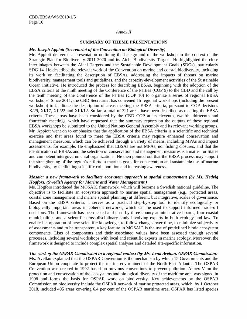
Mr. Joseph Appiott (Secretariat of the Convention on Biological Diversity) Mr. Appiott delivered a presentation outlining the background of the workshop in the context of the
Strategic Plan for Biodiversity 2011-2020 and its Aichi Biodiversity Targets. He highlighted the close
interlinkages between the Aichi Targets and the Sustainable Development Goals (SDGs), particularly
SDG 14. He described the relevant work of the Convention on marine and coastal biodiversity, including
its work on facilitating the description of EBSAs, addressing the impacts of threats on marine
biodiversity, management tools and guidelines, and the capacity-development activities of the Sustainable
Ocean Initiative. He introduced the process for describing EBSAs, beginning with the adoption of the
EBSA criteria at the ninth meeting of the Conference of the Parties (COP 9) to the CBD and the call by
the tenth meeting of the Conference of the Parties (COP 10) to organize a series of regional EBSA
workshops. Since 2011, the CBD Secretariat has convened 15 regional workshops (including the present
workshop) to facilitate the description of areas meeting the EBSA criteria, pursuant to COP decisions
X/29, XI/17, XII/22 and XIII/12. So far, a total of 321 areas have been described as meeting the EBSA
criteria. These areas have been considered by the CBD COP at its eleventh, twelfth, thirteenth and
fourteenth meetings, which have requested that the summary reports on the outputs of these regional
EBSA workshops be submitted to the United Nations General Assembly and its relevant working groups.
Mr. Appiott went on to emphasize that the application of the EBSA criteria is a scientific and technical
exercise and that areas found to meet the EBSA criteria may require enhanced conservation and
management measures, which can be achieved through a variety of means, including MPAs and impact
assessments, for example. He emphasized that EBSAs are not MPAs, nor fishing closures, and that the
identification of EBSAs and the selection of conservation and management measures is a matter for States
and competent intergovernmental organizations. He then pointed out that the EBSA process may support
the strengthening of the region’s efforts to meet its goals for conservation and sustainable use of marine
biodiversity, by facilitating scientific collaboration and increasing awareness.
Mosaic: a new framework to facilitate ecosystem approach to spatial management (by Ms. Hedvig
Hogfors, (Swedish Agency for Marine and Water Management )
Ms. Hogfors introduced the MOSAIC framework, which will become a Swedish national guideline. The
objective is to facilitate an ecosystem approach to marine spatial management (e.g., protected areas,
coastal zone management and marine spatial planning) at different, but integrative, scales of governance.
Based on the EBSA criteria, it serves as a practical step-by-step tool to identify ecologically or
biologically important areas in coherent networks, which can be used to support informed trade-off
decisions. The framework has been tested and used by three county administrative boards, four coastal
municipalities and a scientific cross-disciplinary study involving experts in both ecology and law. To
enable incorporation of new scientific knowledge, to follow changes over time, to minimize subjectivity
of assessments and to be transparent, a key feature in MOSAIC is the use of predefined biotic ecosystem
components. Lists of components and their associated values have been assessed through several
processes, including several workshops with local and scientific experts in marine ecology. Moreover, the
framework is designed to include complex spatial analyses and detailed site-specific information.
The work of the OSPAR Commission in a regional context (by Ms. Lena Avellan, OSPAR Commission)
Ms. Avellan explained that the OSPAR Convention is the mechanism by which 15 Governments and the
European Union cooperate to protect the marine environment of the North-East Atlantic. The OSPAR
Convention was created in 1992 based on previous conventions to prevent pollution. Annex V on the
protection and conservation of the ecosystems and biological diversity of the maritime area was signed in
1998 and forms the basis for OSPAR work on biodiversity. Key achievements by the OSPAR
Commission on biodiversity include the OSPAR network of marine protected areas, which, by 1 October
2018, included 495 areas covering 6.4 per cent of the OSPAR maritime area. OSPAR has listed species
CBD/EBSA/WS/2019/1/5
Page 17
and habitats that are threatened and/or declining, for which regional priority action is needed. For these
listed species, OSPAR has adopted 54 Recommendations describing protective actions that are to be
taken by Contracting Parties nationally as well as collectively by OSPAR. Ms. Avellan explained that
regularly developed status assessments of the North-East Atlantic are a core area of work, with the
Intermediate Assessment published in 2017 being the latest development. OSPAR is currently preparing
to deliver the next Quality Status Assessment to be published in 2023 (QSR 2023). The aim of the QSR
2023 is to evaluate the North-East Atlantic Environment Strategy 2010-2020. This strategy will be
followed by a new strategy for the period 2020-2030, which is currently being developed by OSPAR and
due for publication at the Ministerial Meeting in July 2020. She explained that the present EBSA
workshop would contribute to OSPAR work by bringing forward a global perspective and insight to
marine biodiversity. The EBSA process will contribute to the efforts of making available scientific
information on a regional scale to policy makers when implementing the ecosystem-based approach to
managing human activities.
EBSA Context: North-East Atlantic Fisheries in Areas beyond National Jurisdiction (by Mr. Darius
Campbell, NEAFC)
Mr. Campbell set out the fisheries perspectives from the North-East Atlantic to provide context for the
workshop deliberations. He described the binding fisheries management and conservation provisions
made under the Commission, in particular on area-based management with respect to Vulnerable Marine
Ecosystems. In addition, he explained the background for inter-sectoral cooperation with OSPAR, which
was enhanced through cooperation on the identification of EBSAs. In terms of EBSAs, Mr. Campbell
described the process undertaken jointly by OSPAR and NEAFC since their workshop in 2011 with CBD,
which had developed 10 EBSA proposals. These 10 proposals were subjected to a review process under
the International Council for Exploration of the Seas (ICES), leading to a refined suite of four final
proposals in 2013. Due to other circumstances the process stalled until 2018, when OSPAR and NEAFC
requested the CBD to organize the current workshop, inviting it also to include consideration of the 2013
proposals in its process. Mr. Campbell wished the workshop every success and noted that the outcomes
would no doubt help inform ICES in its future scientific advice to NEAFC.
ICES approach as evidence provider to EBM (by Mr. Eugene Nixon, ICES)
Mr. Nixon presented information on the status of ICES as an intergovernmental scientific organization
and the processes used to provide independent evidence-based advice on marine-related issues. Specific
examples of ICES advice on EBSAs, including advice to OSPAR and NEAFC on four EBSA template
descriptions, and to NEAFC on Vulnerable Marine Ecosystems in the North-East Atlantic, were
outlined. Sources of ICES data, information and advice, that could potentially be useful to the EBSA
Workshop, were identified.
Regional Environmental Management Planning Process of International Seabed Authority (by Ms.
Jihyun Lee, International Seabed Authority Secretariat) Ms. Lee introduced the work undertaken by the ISA in the past 25 years, under the mandate of the UN
Convention on the Law of the Sea for the protection of the marine environment (Article 145 of the
Convention), in terms of its application of the precautionary approach to regulating activities in the Area.
Building on this mandate, the ISA Strategic Plan (2019-2023) elaborates the specific approaches and
measures in the Strategic Direction 3 (Protect the marine environment), focusing on an adaptive, practical
and technically feasible regulatory framework, regional environmental management plan, environmental
impact/risk assessment, environmental monitoring, modeling, data management and information access.
Scientific data/information being provided by contractors through their exploration activities critically
underpins the effective implementation of ISA’s environmental management system, together with
scientific analysis, modeling and observations being undertaken by other scientific groups. The data
submitted by contractors are now compiled and collated through the ISA database (“DeepData), through
which environmental data has been publicly available since July 2019, when it was publicly launched.
Scientific collaboration among contractors and relevant scientific groups will be the key to successful
CBD/EBSA/WS/2019/1/5
Page 18
development of regional environmental management plans (REMPs), including through the forthcoming
workshops to be held in Portugal (November 2019) and the Russian Federation (June 2020) for the Area
of the northern mid-Atlantic ridge. Likewise, ISA will apply coherent and coordinated approaches at
various steps of the REMP development to ensure effective and meaningful engagement of stakeholders
in a transparent manner within the auspices of the ISA.
Approaches and experiences in the description of EBSAs (by Mr. Patrick Halpin, Technical Support
Team)
Mr. Halpin reviewed the seven criteria adopted by the Conference of the Parties at its ninth meeting
(decision IX/20) for the description of EBSAs. Mr. Halpin introduced the definition of each criterion,
provided some context for its application at regional workshops, as well as some guidance on its use, as
contained in annex I to that decision. He also described four types of areas meeting the EBSA criteria,
comprising both fixed and dynamic features. He then summarized some of the lessons that have been
learned about the application of the criteria, based on experience with their use in other CBD workshops,
addressing the questions of scale, aggregation/clustering, and overlapping and nested EBSAs, among
others. He stressed that the criteria were designed to be applied individually with regard to their relative
significance within the region under consideration. Mr. Halpin also noted that only the inherent properties
of EBSAs are considered, rather than existing threats or management considerations. The presentation
also covered the EBSA description process and the completion of the EBSA template, as well as the types
of information, maps and references that can supplement templates.
Review of relevant scientific data/information/maps compiled for the workshop (by Mr. Patrick Halpin,
Technical Support Team) Mr. Halpin reviewed the compilation of scientific data and information prepared for the workshop and
presented in the document entitled Data to Inform the Regional Workshop to Facilitate the Description of
Ecologically or Biologically Significant Marine Areas (EBSAs) in the North-East Atlantic Ocean
(CBD/EBSA/WS/2019/1/3). He explained that the baseline data layers developed for this workshop
closely follow the data types prepared for previous EBSA workshops, to provide consistency between
regional efforts, along with many data specific to the North-East Atlantic region. More than 75 data layers
were prepared for this workshop. The presentation covered three general types of data: (1) biogeographic
data, (2) biological data and (3) physical data. The biogeographic data focused on major biogeographic
classification systems. The biological data portion of the presentation covered a variety of data sources to
include data and statistical indices compiled by the Ocean Biogeographic Information System. The
physical data layers included bathymetric and physical substrate data, oceanographic features and
remotely sensed data. The data report also identified several published scientific papers that listed
additional data resources. Mr. Halpin noted that there were likely a significant number of scientific data
sets and papers for the North-East Atlantic region that were not located in internationally accessible sites
and recommended that the workshop participants rely on local experts to help identify critical regional
data sets and analyses that could be identified to supplement their efforts. Specific information on the data
layers is provided in detail in the data report referred to above.
CBD/EBSA/WS/2019/1/5
Page 19
Annex III
SHARING EXPERIENCES FROM RELEVANT NATIONAL PROCESSES APPLYING THE
EBSA CRITERIA OR OTHER SIMILAR CRITERIA FOR IDENTIFYING MARINE AREAS OF
PARTICULAR IMPORTANCE6
As noted in paragraph 19, above, Germany, Greenland (Kingdom of Denmark), Iceland, Ireland,
Netherlands, Norway, and the United Kingdom of Great Britain and Northern Ireland did not include their
EEZs in the workshop scope due to the fact that those Parties had conducted, or were in the process of
conducting, relevant national processes applying the EBSA criteria or other similar criteria for identifying
marine areas of particular importance. Workshop participants from those Parties were invited to provide
brief summaries of these national processes. Sweden and the Russian Federation had already described
EBSAs in their EEzs in previous CBD regional EBSA workshops that overlapped with the scope of the
present workshop, and did not describe additional features or information in their EEZs.
The workshop also noted, with respect to the national processes of EU Member States, that the EU
environmental policy in the marine domain include the Marine Strategy Framework Directive (MSFD),7
the Common Fisheries Policy (CFP), the 7th Environment Action Programme, the 2020 Biodiversity
Strategy, and legislation such as the Birds Directive,8 Habitats Directive9 and the Water Framework
Directive. The MSFD, as the environmental maritime pillar, is the key component of the EU's policy
response to achieve healthy, clean and productive seas. The objective of the MSFD is for European
marine waters to achieve “good environmental status” (GES) by 2020. It aims to promote the sustainable
use of the seas and conserve marine ecosystems through the implementation of an ecosystem-based
approach to the management of human activities in the marine environment.
The MSFD requires Member States to adopt Programmes of Measures to achieve good environmental
status in their marine waters. These Programmes of Measures include spatial protection measures
contributing to coherent and representative networks of marine protected areas (MPAs). MPAs are a
measure used across Europe’s seas for protecting vulnerable species and habitats that have been
referenced in both the Birds and Habitat Directives.
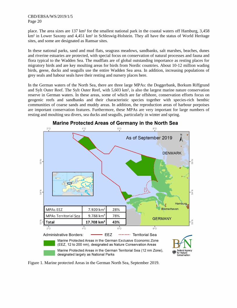
GERMANY
Since the 1980s, a substantial number of MPAs have been established and are protected by national law
as marine nature reserves or national parks in the German waters of the North Sea. Today, this MPA
network covers as much as 43 per cent of the German North Sea (see Figure 1). All MPAs are Natura
2000 sites, i.e., protected according to European law. The criteria that were applied to select these MPAs
are almost identical to the selection criteria for CBD EBSAs. Each German MPA is also listed as an
OSPAR MPA according to OSPAR’s selection criteria.
In the territorial sea, the national parks in the Wadden Sea in Schleswig-Holstein, Lower Saxony and
Hamburg completely protect the coastal areas of the North Sea coast and all have management plans in
6 Other Parties participating in this workshop, but not included in this annex, (i.e., Denmark (mainland), Portugal, Spain) have
their own respective national processes that have contributed to the description of EBSAs during this workshop. Information on
areas in the respective waters of these Parties described by this workshop as meeting the EBSA criteria is provided in annex VII
and its appendix. 7 Marine Strategy Framework Directive: Directive 2008/56/EC aims to achieve Good Environmental Status (GES) of the EU's
marine waters by 2020 and to protect the resource base upon which marine-related economic and social activities depend. 8 Birds Directive: Directive 2009/147/EC of the European Parliament and of the Council of 30 November 2009 on the
conservation of wild birds (codified version of Directive 79/409/EEC as amended). 9 Habitats Directive: Council Directive 92/43/EEC of 21 May 1992 on the conservation of natural habitats and of wild fauna and
flora (Also available the consolidated version of 1 January 2007 with the latest updates of the annexes.
CBD/EBSA/WS/2019/1/5
Page 20
place. The area sizes are 137 km² for the smallest national park in the coastal waters off Hamburg, 3,458
km² in Lower Saxony and 4,451 km² in Schleswig-Holstein. They all have the status of World Heritage
sites, and some are designated as Ramsar sites.
In these national parks, sand and mud flats, seagrass meadows, sandbanks, salt marshes, beaches, dunes
and riverine estuaries are protected, with special focus on conservation of natural processes and fauna and
flora typical to the Wadden Sea. The mudflats are of global outstanding importance as resting places for
migratory birds and are key moulting areas for birds from Nordic countries. About 10-12 million wading
birds, geese, ducks and seagulls use the entire Wadden Sea area. In addition, increasing populations of
grey seals and habour seals have their resting and nursery places here.
In the German waters of the North Sea, there are three large MPAs: the Doggerbank, Borkum Riffgrund
and Sylt Outer Reef. The Sylt Outer Reef, with 5,603 km², is also the largest marine nature conservation
reserve in German waters. In these areas, some of which are far offshore, conservation efforts focus on
geogenic reefs and sandbanks and their characteristic species together with species-rich benthic
communities of coarse sands and muddy areas. In addition, the reproduction areas of harbour porpoises
are important conservation features. Furthermore, these MPAs are very important for large numbers of
resting and moulting sea divers, sea ducks and seagulls, particularly in winter and spring.
Figure 1. Marine protected Areas in the German North Sea, September 2019.
CBD/EBSA/WS/2019/1/5
Page 21
GREENLAND (KINGDOM OF DENMARK)
Over the past decade, the marine environment around Greenland has been evaluated to identify marine
areas and coastlines vulnerable to oil spills. This includes key habitats, migration routes and the
population size and ecology of sensitive species and resources in Greenland. These investigations have
resulted in a number of strategic environmental impact assessments (SEIAs) for hydrocarbon exploration
and exploitation activities (Boertmann, D. & Mosbech 2017; Boertmann et al. 2013; Boertmann, D. &
Mosbech, A. 2011; Frederiksen et al. 2012; Merkel et al. 2012). The SEIAs are conducted for the
Greenland Bureau of Minerals and Petroleum by scientific environmental institutions (Danish Center for
Environment and Energy of Aarhus University and the Greenland Institute of Natural Resources). The
SEIAs build on peer-reviewed scientific literature and supplementary scientific studies.
In recent years, several other initiatives to identify valuable ecosystems and biodiversity hot spots in
Greenland have been carried out. These are mainly based on the data assembled in the above-mentioned
SEIA reports and on the monitoring of living resources carried out by the Greenland Institute for Natural
Resources.
In 2012, a study was conducted to identify ecologically valuable and sensitive marine areas around
Greenland, based on the International Maritime Organization´s criteria for Particularly Sensitive Sea
Areas (PSSA) (Christensen et al. 2012; Mosbech, Christensen & Falk in AMAP/ CAFF/ SDWG, 2013 –
the AMSA II C report). A comparison between the 11 criteria for designating PSSAs with the EBSA
criteria demonstrates that they are broadly similar (Skjoldal and Taropova, 2010 & AMAP/ CAFF/
SDWG, 2013). This process showed that most of the coastal and offshore waters around Greenland host
sensitive marine resources at least part of the year. Twelve marine areas have been identified to meet the
PSSA criteria.
Parallel to these studies, Greenland has initiated a national project analyzing existing biodiversity
hotspots. A report identifies biodiversity hotspots based on occurring species and ecosystem data in West
Greenland and the southeastern part of Greenland (Christensen et al. 2016). Included in this study is a
thorough analysis of the distribution of species (including red-listed species), nature types and areas with
high biological diversity. The study covers where and when these species are concentrated in specific
areas and/ or can be sensitive to human activities. Each of the identified areas is mapped in GIS where all
occurring resources/species are represented by a separate layer. These layers are ranked, based on
internationally accepted criteria (such as the EBSA criteria, KBA criteria, Ramsar Criteria, areas with red
listed species, etc.) and nationally formulated criteria (e.g., importance of ecosystem services). Based on
this, an overlay analysis has been performed to reveal where in Greenland’s biological hotspots are found.
Twenty-three areas were identified as ecologically and biologically valuable areas. In the second phase
(which is in progress), a report is planned to assess important areas in the north-eastern part of Greenland.
References
AMAP/CAFF/SDWG, 2013. Identification of Arctic marine areas of heightened ecological and cultural
significance: Arctic Marine Shipping Assessment (AMSA) IIc. Arctic Monitoring and Assessment
Programme (AMAP), Oslo. 114 pp. ISBN-978-82-7971-081-3
http://www.amap.no/documents/download/1548
Boertmann D, Mosbech A (eds) 2017. Baffin Bay. An updated strategic environmental impact assessment
of petroleum activities in the Greenland part of the Baffin Bay. – Scientific Report from DCE –
Danish Centre for Environment and Energy No. 215, 319 pp.
Boertmann, D., Mosbech, A., Schiedek, D. & Dünweber, M. (eds.) 2013. Disko West. A strategic
environmental impact assessment of hydrocarbon activities. Aarhus University, DCE – Danish Centre
for Environment and Energy, 306 pp. Scientifi c Report from DCE – Danish Centre for Environment
and Energy No. 71. http://dce2.au.dk/pub/SR71.pdf
CBD/EBSA/WS/2019/1/5
Page 22
Boertmann, D. & Mosbech, A. (eds.) 2011. The western Greenland Sea, a strategic environmental impact
assessment of hydrocarbon activities. Aarhus University, DCE – Danish Centre for Environment and
Energy, 268 pp. - Scientific Report from DCE – Danish Centre for Environment and Energy no.
22. http://www2.dmu.dk/Pub/SR22.pdf
Boertmann, DM, Kyhn, LA & Petersen, IK 2019, Seabirds and marine mammals in the eastern
Greenland Sea, August-September 2017. Results from an aerial survey. Scienific Report from DCE,
nr. 335.
Christensen, T, Aastrup, P, Boye, T, Boertmann, D, Hedeholm, R, Johansen, KL, Merkel, FR, Rosing-
Asvid, A, Bay, C, Blicher, M, Clausen, DS, Ugarte, F, Arendt, KE, Burmeister, A, Topp-Jørgensen, E,
Retzel, A, Hammeken, N, Falk, K, Frederiksen, M, Bjerrum, M & Mosbech, A 2016, Biologiske
interesseområder i Vest- og Sydøstgrønland: Kortlægning af vigtige biologiske områder . Teknisk
rapport fra DCE - Nationalt Center for Miljø og Energi, bind 89.
Christensen, T., Falk, K., Boye, T., Ugarte, F., Boertmann, D. & Mosbech, A. (2012). Identifi kation af
sårbare marine områder i den grønlandske/danske del af Arktis. Aarhus Universitet, DCE – Nationalt
Center for Miljø og Energi. 72 pp. http://www2.dmu.dk/pub/sr43.pdf
Frederiksen, M., Boertmann, D., Ugarte, F. & Mosbech, A. (eds) 2012. South Greenland. A Strategic
Environmental Impact Assessment of hydrocarbon activities in the Greenland sector of the Labrador
Sea and the southeast Davis Strait. Aarhus University, DCE – Danish Centre for Environment and
Energy, 220 pp. Scientific Report from DCE – Danish Centre for Environment and Energy No. 23
http://www.dmu.dk/Pub/SR23.pdf
Merkel, F., Boertmann, D., Mosbech, A. & Ugarte, F (eds). 2012. The Davis Strait. A preliminary
strategic environmental impact assessment of hydrocarbon activities in the eastern Davis Strait.
Aarhus University, DCE – Danish Centre for Environment and Energy, 280 pp. Scientific Report from
DCE – Danish Centre for Environment and Energy No. 15. http://www.dmu.dk/Pub/SR15.pdf
ICELAND
Iceland uses an ecosystem-based management programme for sustainable use and protection of natural
marine resources. The objective is to maintain the structure, functioning and productivity of the
ecosystem as a whole, which are under continuous scrutiny. As a part of the strictly regulated catch
management system in Icelandic waters, various areas are protected to a different degree. Closures are
concordant with international agreements ratified by Icelandic authorities, including CBD, OSPAR,
IUCN and ICES. The protected areas are of two main types: a) temporal and flexible closures, mainly to
protect livelihood and productivity of fish stocks, and b) permanent closures for the protection of
important and vulnerable habitats and species, like cold-water coral areas and hydrothermal vents that
have been fully protected against bottom fisheries.
Mapping of vulnerable marine ecosystems has been conducted intermittently since 2004 and further
mapping is planned in the coming years. Furthermore, as of 2017 the Marine and Freshwater Research
Institute initiated a 12-year programme, with the objective to map with high resolution the seabed within
the 200-mile exclusive economic zone. Such bathymetric maps are increasingly important to science. The
topography and the characteristics of the seabed are fundamental parameters for the habitats and
ecosystems of the sea floor. This information will be, and is being, used in further development of the
management plan for sustainable use and protection of the marine ecosystem.
IRELAND
CBD/EBSA/WS/2019/1/5
Page 23
Ireland is engaged in analogous processes for the protection of ecologically and environmentally
important areas. Ireland, as a member of the European Union, is committed to Directives derived to
protect significant ecological features and to uphold and achieve environmental standards.
With the transposition of the Birds Directive (2009/147/EC), Ireland undertook to designate Special
Protection Areas (SPAs) for these species’ conservation. Currently, many SPAs have been created at the
coastal margin, and further sites in the marine area are anticipated in the future.
Article 3 of the Habitats Directive (1992/43/EC) requires the creation of sites for the conservation of
selected habitats and species. Eighty-eight marine sites are currently designated, and we will shortly be
analyzing an extensive benthic data set along the continental shelf margin with the view to assessing
whether more sites may be warranted for reef habitat in particular. Ireland considers it has achieved its
objective to designate enough sites for the other qualifying habitats and species.
The final important piece of European legislation of relevance to marine EBSAs is the Marine Strategy
Framework Directive (2008/56/EC). This Directive, coupled with 1992 OSPAR Convention, seeks to
designate MPAs for various natural features, with a particular emphasis on threatened, declining or
vulnerable habitats and species. Currently there are 19 MPAs nominated, all of which coincide with the
Natura network established under the Habitats and Birds Directives. As part of its ongoing programme of
measures, Ireland will shortly begin a process to identify and develop the strategic and legal instruments,
as well as candidate areas and features that will drive the future designation of additional MPAs. This is
expected to consider, inter alia, the standardized qualifying criteria used in the EBSA process, and
associated guidance, as potential tools for use in this national undertaking.
NETHERLANDS
The Dutch North Sea Policy aims to ensure that the North Sea will continue to be a clean, healthy and
productive sea in the future. The ecosystem is functioning optimally and is resilient, the water is clean and
the use of the North Sea is sustainable. In that way, the North Sea offers perspectives for nature and the
environment but also for economic activities. Using an area-based approach, the Netherlands aims to
safeguard the protection of vulnerable ecological species and areas, such as the Natura 2000 areas and the
additional protection in the Frisian Front and the Central Oyster Grounds. These measures stem from the
obligation arising from the Birds and Habitats Directiveand MSFD to make progress towards achieving a
good environmental status of the marine ecosystem and to contribute to a coherent and representative
network of protected marine areas by protecting certain ecological/habitat areas in the Dutch part of the
North Sea. The fundamental principle is area-based regulation or suppression of certain forms of use that
disrupt the natural and biodiversity values to be protected or restored by the MSFD.
The following criteria were used to identify biological hotspots: Distribution, Density, Biomass,
Resilience, Dependence on the marine environment, Breeding in the Netherlands, Importance of the
Dutch Continental Shelf for the species, Trends, Rarity, Large specimens within populations, (Potentially)
large species, Species Richness, Species Evenness.
The sites involved are:
o The Voordelta: occupies an area of the North Sea of more than 900 km². This site lies off the
islands of South Holland and those of Zeeland. The area extends from the Maasvlakte to the tip of
Walcheren Island
o The North Sea Coastal Zone: consists of ‘sandbanks which are slightly covered by sea water all
the time, subtype North Sea Coastal Zone’.
CBD/EBSA/WS/2019/1/5
Page 24
o The Vlakte van de Raan: is a Habitat Directive site or SAC of approx. 190 km2 that consists of
‘sandbanks which are slightly covered by sea water all the time, subtype North Sea Coastal
Zone’.
o The Dogger Bank: a shallow area that extends across the UK, Dutch, German and Danish sectors
of the North Sea.
o The Cleaver Bank: a Habitat Directive site or SAC in the category of ‘Open-sea reefs’. It is a
marine site of approx. 1,235 km² that lies some 160 km to the north-west of Den Helder.
o The Frisian Front: lies roughly 75 km to the north of Den Helder and occupies a marine site of
approx. 2,880 km2. It is a Birds Directive site or SPA.
Parts of the Central Oyster Grounds and Frisian Front have been designated as special areas for
introducing measures for protection of the sea floor ecosystems in the framework of the MSFD.
Additionally, the Conservation plan for the harbour porpoise (Phocoena phocoena) of the Netherlands is
an additional protection plan due to the highly migratory character of the species. This species protection
plan contributes to meeting the obligations under the Habitat Directive for the harbour porpoise.
NORWAY
The Johannesburg declaration of 2002 calls for Ecosystem Approach (EA) to management of all marine
ecosystems by 2010. As a result, the management plan for the Barents Sea-Lofoten area was first
announced in the white paper Protecting the Riches of the Sea (St.meld. nr. 12 (2001-2002)). The white
paper states that an ecosystem approach to management of marine sea areas should provide a framework
for sustainable use of natural resources and goods derived from the area that at the same time maintains
the structure, functioning and productivity of the ecosystems of the area. Since then, Norway has
established management plans as the basis for integrated ecosystem approach to management of all
Norwegian Sea areas (Barents Sea 2006, Norwegian Sea 2009, North Sea/Skagerrak 2013). Furthermore,
Norway has signed several international conventions and agreements and participates in international
processes that also provide guidance on the design of the Norwegian marine management plans. These
plans represent a strictly knowledge-based management regime. The plans are updated every four years
and revised (more extensive process) every 12 years to take into account new knowledge and changes in
the ecosystem or human activities.
In the management plans several areas are identified as particularly valuable areas. The EBSA criteria and
some additional criteria were used for selecting these areas. Some of the most important ones were:
o Oceanographically/topographically special areas (e.g., fronts, strong currents, fjords);
o Important areas for life history (e.g., spawning/birthing/breeding grounds, drifting
paths/migrating routes, feeding grounds, wintering grounds, moulting areas);
o Other criteria (key areas for endangered or vulnerable species or species for which Norway has a
special responsibility or habitats for internationally or nationally endangered or vulnerable
populations of certain species all year round or at specific times of the year).
Vulnerability was then assessed with respect to specific environmental pressures such as oil pollution,
fluctuation in food supply and physical impact within the plan area. When assessing vulnerability, the
type of impact, duration and possible effects need to be considered. Differentiating between natural and
human-induced pressures on the environment can be difficult. Furthermore, an area is usually not equally
vulnerable all year round, and all species in an area will not be equally vulnerable to a specific
environmental pressure. Negative pressures in these areas will in some cases affect a large proportion of a
population or a large proportion of the ecosystem and might persist for many years.
CBD/EBSA/WS/2019/1/5
Page 25
Furthermore, the marine part of seven national parks and four nature reserves in Svalbard and Jan Mayen
are OSPAR Marine Protected Areas. The aim of designating these areas as OSPAR MPAs reflects that of
the national regulation and aims to protect and conserve several species and habitats on the OSPAR list in
a part of the OSPAR maritime area not presently covered by existing OSPAR MPAs. Five smaller areas
along the Norwegian coast are also OSPAR MPAs.
In addition, a network of smaller MPAs will be established along the coast of Norway, in order to
maintain biodiversity and keep certain areas relatively undisturbed to facilitate research and monitoring.
A plan for MPAs has been drawn up. The selection of all areas has not yet been finalized, but some are
already established MPAs.
RUSSIAN FEDERATION
With the participation of experts from the Russian Federation, features in its EEZ were previously
considered and described as meeting the EBSA criteria in the CBD regional EBSA workshops for the (i)
North Pacific, (ii) Arctic, and (iii) Black Sea and Caspian Sea, including in areas in parts of the Russian
EEZ in the Arctic that overlap with the geographic scope of this workshop. 10 The regional EBSA
workshop for the Arctic described the following EBSAs in the EEZ of Russia that overlap with the scope
of the present workshop11:
o Coast of Western and Northern Novaya Zemlya
o Murman Coast and Varanger Fjord
o North-eastern Barents–Kara Sea
o South-eastern Barents Sea (the Pechora Sea)
o White Sea
SWEDEN
With the participation of experts from Sweden, features in the EEZ of Sweden were considered in the
CBD regional EBSA workshop for the Baltic Sea, including in areas that overlap with the geographic
scope of the present workshop.12 The regional EBSA workshop for the Baltic Sea described the following
EBSA in Sweden’s EEZ, which overlaps with the scope of the present workshop13:
o Fladen, Stora Middelgrund and Lilla Middelgrund
10 UNEP/CBD/EBSA/WS/2014/1/5. Report of the Arctic Regional Workshop to Facilitate the Description of Ecologically or
Biologically Significant Marine Areas (Helsinki, Finland, 3 to 7 March 2014). 11 https://www.cbd.int/ebsa/ 12 CBD/EBSA/WS/2018/1/4. Report of the Regional Workshop to Facilitate the Description of Ecologically or Biologically
Significant Marine Areas in the Baltic Sea (Helsinki, Finland, 19-24 February 2018). 13 https://www.cbd.int/ebsa/
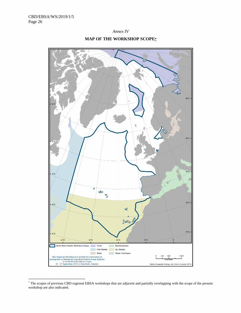
CBD/EBSA/WS/2019/1/5
Page 26
Annex IV
MAP OF THE WORKSHOP SCOPE*
* The scopes of previous CBD regional EBSA workshops that are adjacent and partially overlapping with the scope of the present
workshop are also indicated.
CBD/EBSA/WS/2019/1/5
Page 27
Annex V
ECOLOGICAL OR BIOLOGICAL SIGNIFICANCE OF THE
NORTH-EAST ATLANTIC IN A GLOBAL CONTEXT
This annex describes large features of the North-East Atlantic of special significance on a global scale,
which extend beyond of the scope of the workshop.
1. REGIONAL OVERVIEW OF THE NORTH-EAST ATLANTIC
Marine and coastal areas of the North-East Atlantic demonstrate a wide array of diverse ecosystems and
varying environmental conditions. The coastal and shelf areas of the marine environment have been used
by humans for centuries. In the last decades, human use has begun to move into the deep oceanic areas.
The mountainous coasts along the north-western margins are deeply indented with fjords, estuaries and
rias. The coasts around the North Sea and Celtic Sea include cliffs of varying heights and rock types, bays
and estuaries, sandy and shingle beaches, dunes and island archipelagos. Further south, the coast of the
Bay of Biscay is low lying and lagoons occur. The Iberian coast comprises alternating cliffs and beaches
(OSPAR Commission 2000). Much of the coastal area in the North-East Atlantic is densely populated,
highly industrialised or used intensively for agriculture (OSPAR Commission 2010). There are several
oceanic islands in the North-East Atlantic with coasts dominated by cliffs, such as the Azores, Madeira
and the Canary Islands in the south, and Iceland and the Faroe Islands in the north. The islands rise from
the ocean floor and are surrounded by deep oceanic waters.
In the deep ocean basin, an abyssal plain extends on either side of the mountains of the Mid-Atlantic
Ridge (see below) to the continental margins. The abyssal plan consists of a 4-to-6 km thick basaltic
basement overlain by 0.1-to-2 km thick accumulations of sediment (OSPAR Commission, 2000).
Most of the water masses of the North-East Atlantic are well-mixed to depths of up to 600 m, with a
permanent thermocline in deep oceanic waters, and strong tidal currents in shallow shelf areas (OSPAR
Commission 2010). Where warm water masses meet cold water masses (e.g., at the Arctic front) hotspots
of productivity can form. The density gradients result in areas of sufficiently shallow mixing depth and
consequently enhance a phytoplankton bloom earlier in the season than in open water (Rey, 2004).
Following the seasonal latitudinal progression of the sunlight, the phytoplankton bloom proceeds from
south to north, initiating the pelagic production of secondary producers (grazers) such as zooplankton
(Melle et al., 2005). The growth season can also be prolonged by the physical forcing from turbulence
associated with ocean currents supplying nutrients to the upper layers.
The deep Atlantic supports a diverse array of structurally complex seabed habitats that meet the EBSA
criteria. For example, there are more records of reef framework forming cold-water corals in the North-
East Atlantic than any other ocean region, making the North-East Atlantic globally significant for these
deep-water biodiversity hotspots (Roberts et al. 2006). This reflects both the long history of deep-sea
research in the region, and the great depths of the aragonite saturation horizon in the North-East Atlantic
water masses that has allowed aragonitic scleractinian coral skeletons to persist for millennia. By contrast,
the aragonite saturation horizon in the North-East Pacific is far shallower, and equivalent habitats are
dominated by calcitic gorgonians, hydrocorals or sponges, and not by aragonitic scleractinian corals
(Stone 2014).
However, as atmospheric CO2 levels rise, the oceans absorb more CO2 and become more acidic (Zeebe
and Wolf-Gladrow 2005). As a result, ocean pH has already fallen by 0.1 pH units and will likely fall
another ~0.3 units by the end of the century (Caldeira and Wickett 2003). Such a pH decline shifts the
distribution of dissolved carbon species away from carbonate ions (CO32−
) and hence directly impacts
CaCO3 saturation states (Feely et al. 2004; Orr et al. 2005). By 2100, the aragonite saturation horizon will
CBD/EBSA/WS/2019/1/5
Page 28
become sufficiently shallow to expose approximately 70 per cent of known aragonitic cold-water corals to
corrosive waters, i.e., waters undersaturated with respect to aragonite (Guinotte et al. 2006). In the North
Atlantic, recent modelling studies point to an even more dramatic 44 per cent decline in carbonate ion
supply mediated via the AMOC (see below) today compared to the pre-industrial times (Perez et al.
2018). Eventually, the calcite saturation horizon will also shallow, exposing calcitic corals to corrosive
conditions, however aragonitic corals, which form extensive reefs in the North-East Atlantic, face the
more immediate threat (Gruber et al., 2019). Given the importance of seawater carbonate chemistry for
cold-water coral reef frameworks, and the direct relationship between aragonite saturation and
atmospheric CO2, they appear to be one of the most vulnerable marine ecosystems to present-day
anthropogenic climate change (Roberts et al. 2016).
2. LARGE FEATURES OF SPECIAL SIGNIFICANCE
2.1 Mid-Atlantic Ridge
The Mid-Atlantic Ridge (MAR) is the longest mountain range in the world. This is a major topographic
feature of the entire Atlantic Ocean, extending well beyond the scope of the North-East Atlantic EBSA
workshop. The MAR is a volcanic mountain range that rises from the Atlantic abyssal plain, extending
from the Arctic at the Gakkel Ridge to the Antarctic at the Bouvet Triple Junction, ranging more than
16,000 km (UNESCO, 2017).
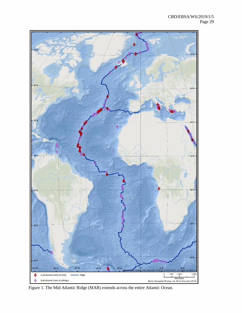
CBD/EBSA/WS/2019/1/5
Page 29
Figure 1. The Mid Atlantic Ridge (MAR) extends across the entire Atlantic Ocean.
CBD/EBSA/WS/2019/1/5
Page 30
The MAR remains poorly studied overall, however several international research projects (e.g., MAR-
ECO, ECOMAR, ATLAS, SPONGES) have shed some light on the geology, oceanography and ecology
of some parts of the MAR. The ridge supports rich communities of vulnerable and fragile cold-water
corals, sponge aggregations and deep-water vulnerable fish. Additionally, hydrothermal vent fields and
transform faults support unique fauna, many of which are endemic to the MAR.
As the Atlantic Ocean slowly expands, new oceanic floor is formed in the central valley of the MAR on
the boundaries of the Nubia, American and Eurasian tectonic plates, at a speed of 28-33mm·year-1
(Dinter, 2001; Heger et al., 2008; Hosia et al., 2008). In the process of tectonic movement, massive
volcanic events give rise to large ridge- and seamount-like structures, and in some cases even to islands
such as those of the Azores (Portugal) or St. Peter and St. Paul's Archipelago (Brazil). The MAR began to
form 200 million years ago but was only discovered in the mid-19th century, when the first submarine
cables linking North America and Europe were deployed.
The MAR is a hotspot of seamounts but also of hydrothermal vents, which are formed when seawater
circulates into the crust through cracks and porous rocks, heated by underlying magma, and rises back
through openings in the seafloor. There are about 85 known and inferred distinct and unique deep-sea
hydrothermal vent fields at the MAR, with only 28 having been confirmed as active vents (InterRidge
Vents Database v3.4).
The MAR has a profound role in the circulation of the water masses in the North Atlantic Ocean (Rossby,
1999; Bower et al., 2002; Heger et al., 2008; Søiland et al., 2008). The complex hydrographic setting
around the MAR in general and the presence of the ridge itself leads to enhanced vertical mixing and
turbulence that results in areas of increased productivity over it (Falkowski et al., 1998; Heger et al.,
2008).
Due to the size and prominence of the MAR spanning the whole Atlantic basin, this feature has a major
impact on the area’s ecology and hydrology. The MAR provides hard substrate for benthic species and
structures the migratory corridors. If an EBSA process were undertaken on a global scale, the workshop
noted that this prominent feature would be relevant, even at that scale.
2.2. Ocean currents
Atlantic circulation occurs at a global scale and is driven by mechanical forcing due to winds and by
buoyancy exchanges. These forcings lead to regional and global gradients (horizontal and vertical) in
temperature and salinity. The North Atlantic plays an important role in the global thermohaline
circulation, which is part of the Atlantic Meridional Overturning Circulation (Sandström 1908). The
North-East Atlantic holds key components of the global ocean circulation system, including the northern
part of the Atlantic Meridional Overturning Circulation (AMOC) (Lozier et al., 2015).
The AMOC can be separated into warm northward-flowing surface currents and cold southward-flowing
surface and deep-water masses (Daniaulta, 2016; Buckley and Marshall, 2016). Areas of deep-water
formation occur both to the south and north of Iceland. The intensity of deep-water formation in the
Norwegian seas north of Iceland varies over time and is detected as a higher surface temperature as a
reflection of the intensified flow of Atlantic water into the area (Malmberg and Valdimarsson, 2003).
Deep-water formation also occurs in the waters south of Iceland, where the marine climate has been
regarded as stable (Malmberg and Valdimarsson, 2003) although recent work challenges this view (Josey
et al. 2018). It has a global significance, as the effects of downwelling ventilating the deep-water masses
and ocean basins influence the chemical conditions (e.g., calcite compensation depth, CCD). Abyssal
seafloor habitats under areas of deep-water formation may experience reductions in water column oxygen
concentrations by as much as 0.03 mL L–1
by 2100 (Sweetman et al., 2017). In the presence of a coherent
forcing, such as warming and freshening at high latitudes driven by anthropogenic CO2 emissions, the
AMOC is expected to get weaker (Thornalley, 2018). The AMOC is projected to weaken in the 21st
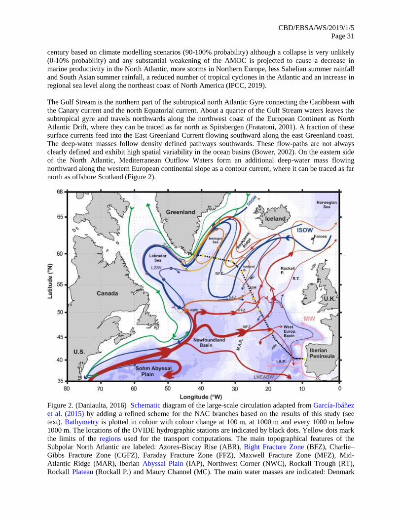
CBD/EBSA/WS/2019/1/5
Page 31
century based on climate modelling scenarios (90-100% probability) although a collapse is very unlikely
(0-10% probability) and any substantial weakening of the AMOC is projected to cause a decrease in
marine productivity in the North Atlantic, more storms in Northern Europe, less Sahelian summer rainfall
and South Asian summer rainfall, a reduced number of tropical cyclones in the Atlantic and an increase in
regional sea level along the northeast coast of North America (IPCC, 2019).
The Gulf Stream is the northern part of the subtropical north Atlantic Gyre connecting the Caribbean with
the Canary current and the north Equatorial current. About a quarter of the Gulf Stream waters leaves the
subtropical gyre and travels northwards along the northwest coast of the European Continent as North
Atlantic Drift, where they can be traced as far north as Spitsbergen (Fratatoni, 2001). A fraction of these
surface currents feed into the East Greenland Current flowing southward along the east Greenland coast.
The deep-water masses follow density defined pathways southwards. These flow-paths are not always
clearly defined and exhibit high spatial variability in the ocean basins (Bower, 2002). On the eastern side
of the North Atlantic, Mediterranean Outflow Waters form an additional deep-water mass flowing
northward along the western European continental slope as a contour current, where it can be traced as far
north as offshore Scotland (Figure 2).
Figure 2. (Daniaulta, 2016) Schematic diagram of the large-scale circulation adapted from García-Ibáñez
et al. (2015) by adding a refined scheme for the NAC branches based on the results of this study (see
text). Bathymetry is plotted in colour with colour change at 100 m, at 1000 m and every 1000 m below
1000 m. The locations of the OVIDE hydrographic stations are indicated by black dots. Yellow dots mark
the limits of the regions used for the transport computations. The main topographical features of the
Subpolar North Atlantic are labeled: Azores-Biscay Rise (ABR), Bight Fracture Zone (BFZ), Charlie–
Gibbs Fracture Zone (CGFZ), Faraday Fracture Zone (FFZ), Maxwell Fracture Zone (MFZ), Mid-
Atlantic Ridge (MAR), Iberian Abyssal Plain (IAP), Northwest Corner (NWC), Rockall Trough (RT),
Rockall Plateau (Rockall P.) and Maury Channel (MC). The main water masses are indicated: Denmark
CBD/EBSA/WS/2019/1/5
Page 32
Strait Overflow Water (DSOW), Iceland–Scotland Overflow Water (ISOW), Labrador Sea Water (LSW),
Mediterranean Water (MW), and Lower North East Atlantic Deep Water (LNEADW). (For interpretation
of the references to colour in this figure legend, the reader is referred to the web version of the publication
Daniaulta et al., 2016.)
2.3 Species migrating on the conveyor belts across the Atlantic
Ocean currents affect biodiversity and ecology in the North-East Atlantic, by playing a key role in the
dispersal of larvae, as well as providing an energy-efficient mode of transport for mature individuals. The
need to balance energy reserves during migration is a critical factor for most long-distance migrants and
an important determinant of migratory strategies. Examples of some species groups are presented below.
The North-East Atlantic EBSA workshop considered the possibility of identifying and presenting a single
regional feature in this regard; the “North Atlantic Gyre” and its known or potential importance for
migrating species (as illustrated in Figure 3). Based on the regional scale of this EBSA assessment
process and the much larger extent of the gyre currents, it was concluded that such a description would
not be appropriate at this stage.
Cetaceans
Large baleen whales migrate annually between foraging and breeding sites, crossing vast ocean areas
where food is seldom abundant. A number of tracking and telemetry studies on marine mammals,
particularly for baleen whale species, have indicated the presence of known migratory pathways transiting
through the region.
For example, satellite tracking studies of humpback whales (Megaptera novaeangliae) tagged in their
foraging areas in Norway, Svalbard and Iceland have shown direct migration to their southern breeding
areas within the Caribbean (UiT 2019). These migrations benefit from the oceanic currents. The
endangered sei whale (Balaenoptera borealis) migrates from the Azores, likely longitudinally from
waters on the Eastern Atlantic, to highly productive foraging areas in the Labrador Sea as well as
Greenlandic and Icelandic waters (Olsen et al. 2009, Prieto et al. 2014).
Seabirds
Seabird migration in the North Atlantic is relatively well studied. Several species of seabirds, mostly
shearwaters (genus Calonectris, Puffinus and Ardenna), skuas (Catharacta and Stercorarius) and some
terns (e.g., Arctic tern Sterna paradisea) perform seasonal movements between the breeding areas and the
wintering sites, many of them trans-equatorial between the North and South Atlantic (González-Solís et
al. 2007, Guilford et al. 2009, Egevang et al. 2010, Dias et al. 2011, 2012, Gilg et al. 2013). Seabirds
sometimes stop to spend some time in specific regions of the North-East Atlantic during the migratory
journey (stopovers), to replenish and/or to rest (Guilford et al. 2009, Egevang et al. 2010, Dias et al.
2012). In their migratory journeys, seabirds often follow major oceanic currents and wind corridors (e.g.
Dias et al. 2012, González-Solís et al. 2009). Several species breeding in colonies in South Atlantic also
perform the inverse journey to spend the non-breeding period in the North Atlantic, in most cases in areas
along or near the MAR (e.g., Kopp et al. 2011, Hedd et al. 2012).
Sea turtles
Sea turtles, as long-lived ancient reptiles, have a complex life cycle which involves a terrestrial natal and
breeding/nesting phase confined to warm tropical regions due of thermal constraints on egg incubation.
Hatchling, juvenile and mature sea turtles undergo major shifts in ecology, behaviour and distribution that
are distinctive according to the species and developmental stage (Huang, 2015; Scott et al., 2014). There
are six species of sea turtle occurring in the Atlantic Ocean, all of which are listed on the IUCN Red List
of Threatened Species14. Leatherback turtle (Dermochelys coriacea) and loggerhead turtles (Caretta
14 http://www.iucnredlist.org

CBD/EBSA/WS/2019/1/5
Page 33
caretta) are the most prominent species in the North-East Atlantic. These species are included on the
OSPAR List of Threatened and/or Declining Species and the European Union’s Habitats Directive15.
Leatherback and loggerhead turtles make use of the vast North Atlantic Gyre circulatory system (Figure
3) in order to be directed to suitable foraging areas and to eventually return to warm waters in order to
breed.
Figure 3. Illustration of the turtle migration across the Atlantic using currents.
For migrating Loggerhead turtles, the warm temperate areas of the North-East Atlantic around the Azores,
Madeira and the Canary Islands (Carr, 1986; Santos et al., 2007) as well as along the Atlantic coast of
southern Spain and Portugal, are shown to be particularly significant in late summer. Leatherback turtles
are known to also inhabit cold temperate waters of the North-East Atlantic, particularly in the warmer
summer and autumn months, when they are recorded opportunistically off Ireland, the UK and in the Bay
of Biscay (Doyle, 2007; Eckert, 2006).
REFERENCES
Bower, A.S., Le Cann, B., Rossby, T., Zenk, W., Gould, J., Speer, K., Richardson, P.L., Prater, M.D.,
Zhang, H.M., 2002. Directly measured mid-depth circulation in the northeastern North Atlantic
Ocean. Nature 419, 603–607. http://dx.doi.org/10.1038/nature01078
Buckley, M. and J. Marshall (2016). "Observations, inferences, and mechanisms of the Atlantic
Meridional Overturning Circulation: A review." Reviews of Geophysics: 1-59.
Caldeira K, Wickett ME (2003) Anthropogenic carbon and ocean pH. Nature 425: 365
Carr A.F. (1986). Rips, FADS, and little loggerheads. Bioscience 36:92–100
Daniaulta, N; Mercier, H, Lherminier, P; Sarafanov, A; Falina, A; Zunino, P; Pérez, F; Ríos; Ferron, B;
Hucke, T; Thierry, V; Gladyshevd, S; (2016) The northern North Atlantic Ocean mean circulation
in the early 21st century. Progress in Oceanography, 146, p142-158.
https://doi.org/10.1016/j.pocean.2016.06.007
15 Council Directive 92/43/EEC of 21 May 1992 on the conservation of natural habitats and of wild fauna and flora.
CBD/EBSA/WS/2019/1/5
Page 34
Dias M.P., Granadeiro J.P., Phillips R.A., Alonso H., Catry P. (2011) Breaking the routine: individual
Cory's shearwaters shift winter destinations between hemispheres and across ocean basins.
Proceedings of the Royal Society of London B: Biological Sciences 278, 1786-1793.
Dias M., Granadeiro J., Catry P. (2012) Do Seabirds Differ from Other Migrants in Their Travel
Arrangements? On Route Strategies of Cory’s Shearwater during Its Trans-Equatorial Journey.
PLOS ONE 7, e49376.
Dinter, W. P. (2001). Biogeography of the OSPAR maritime area. Bonn, Germany: Federal Agency for
Nature Conservation
Doyle T. K. (2007). Leatherback Sea Turtles (Dermochelys coriacea) in Irish waters. Irish Wildlife
Manuals 32. National Parks and Wildlife Service, Department of the Environment, Heritage and
Local Government, Dublin, Ireland.
Drange, H., Dokken, T., Furevik, T., Gerdes, R., Berger, W. (Eds.) Geophysical Monograph Series 158
pp. 137-202.
Eckert S.A. (2006). High-use oceanic areas for Atlantic leatherback sea turtles (Dermochelys coriacea) as
identified using satellite telemetered location and dive information. Marine Biology 149: 1257-
1267.
Egevang C., Stenhouse I.J., Phillips R.A., Petersen A., Fox J.W., Silk J.R. (2010) Tracking of Arctic terns
Sterna paradisaea reveals longest animal migration. Proceedings of the National Academy of
Sciences 107, 2078-2081.
Falkowski, P. G., Barber, R. T., & Smetacek, V. (1998). Biogeochemical controls and feedbacks on ocean
primary production. Science, 281(5374), 200-206.
Feely RA, Sabine CL, Lee K, Berelson W, Kleypas J, Fabry VJ, Millero FJ (2004) Impact of
anthropogenic CO2 on the CaCO3 system in the oceans. Science 305: 362–366
Fratantoni, D. M. (2001), North Atlantic surface circulation during the 1990's observed with satellite‐tracked drifters, J. Geophys. Res., 106( C10), 22067– 22093, doi:10.1029/2000JC000730.
Hedd A., Montevecchi W.A., Otley H., Phillips R.A., Fifield D.A. (2012) Trans-equatorial migration and
habitat use by sooty shearwaters Puffinus griseus from the South Atlantic during the nonbreeding
season. Marine Ecology Progress Series 449, 277-290.
Gilg O., Moe B., Hanssen S.A. et al. (2013) Trans-equatorial migration routes, staging sites and wintering
areas of a high-arctic avian predator: the long-tailed skua (Stercorarius longicaudus). PloS one 8,
e64614.
González-Solís, J., Croxall, J.P., Oro, D., Ruiz, X.P., (2007). Trans-equatorial migration and mixing in
the wintering areas of a pelagic seabird. https://doi.org/10.1890/1540-
9295(2007)5[297:TMAMIT]2.0.CO;2
González-Solís, J., Felicísimo, A., Fox, J.W., Afanasyev, V., Kolbeinsson, Y., Muñoz, J., 2009. Influence
of sea surface winds on shearwater migration detours. Marine Ecology Progress Series 391, 221–
230. https://doi.org/10.3354/meps08128
Gruber, N., D. Clement, B. R. Carter, R. A. Feely, S. van Heuven, M. Hoppema, M. Ishii, R. M. Key, A.
Kozyr, S. K. Lauvset, C. Lo Monaco, J. T. Mathis, A. Murata, A. Olsen, F. F. Perez, C. L.
Sabine, T. Tanhua and R. Wanninkhof (2019). "The oceanic sink for anthropogenic CO2; from
1994 to 2007." Science 363(6432): 1193. Guilford T., Meade J., Willis J. et al. (2009) Migration and stopover in a small pelagic seabird, the Manx
shearwater Puffinus puffinus: insights from machine learning. Proceedings of the Royal Society
of London B: Biological Sciences, rspb. 2008.1577.IPCC, 2019: Summary for Policymakers. In:
IPCC Special Report on the Ocean and Cryosphere in a Changing Climate [H.- O. Pörtner, D.C.
Roberts, V. Masson-Delmotte, P. Zhai, M. Tignor, E. Poloczanska, K. Mintenbeck, M. Nicolai,
A. Okem, J. Petzold, B. Rama, N. Weyer (eds.)]. In press.
Guinotte, J. M., Orr, J., Cairns, S., Freiwald, A., Morgan, L. and George, R. (2006). Will human-induced
changes in seawater chemistry alter the distribution of deep-sea scleractinian corals? Frontiers in
Ecology and the Environment 4: 141-146.
CBD/EBSA/WS/2019/1/5
Page 35
Heger, A., Ieno, E. N., King, N. J., Morris, K. J., Bagley, P. M., & Priede, I. G. (2008). Deep-sea pelagic
bioluminescence over the Mid-Atlantic Ridge. Deep Sea Research Part II: Topical Studies in
Oceanography, 55(1-2), 126-136.
Hosia, A., Stemmann, L., & Youngbluth, M. (2008). Distribution of net-collected planktonic cnidarians
along the northern Mid-Atlantic Ridge and their associations with the main water masses. Deep
Sea Research Part II: Topical Studies in Oceanography, 55(1-2), 106-118.
Huang, H-W. (2015). Conservation hotspots for the turtles on the high seas of the Atlantic Ocean. PLoS
ONE 10(8): e0133614. doi:10.1371/journal.pone.0133614.Josey, S.A., Hirschi, J. J.-M., Sinha,
B., Duchez, A., Grist, J.P. and Marsh, R. (2018) The Recent Atlantic Cold Anomaly: Causes,
Consequences, and Related Phenomena Annual Review of Marine Science, 10 (1), 475-501.
(doi:10.1146/annurev-marine-121916-063102).
Kopp M., Peter H.-U., Mustafa O. et al. (2011) South polar skuas from a single breeding population
overwinter in different oceans though show similar migration patterns. Marine Ecology Progress
Series 435, 263-267.
Lozier, M.S., Overturning assumptions: Past, present, and future concerns about the ocean’s circulation.
Oceanography. 28, 240–251 (2015).
Malmberg, S-A., and Valdimarsson, H. 2003. Hydrographic conditions in Icelandic waters, 1990-1999.
ICES Marine Science Symposia 219: 50-60.
Melle, W., Ellertsen, B., Skjoldal, H.R., 2005. Zooplankton: The link to higher trophic levels. In: The
Nordic Seas: An integrated perspective oceanography, climatology, biogeochemistry, and
modelling.
Orr JC, Fabry VJ, Aumont O, Bopp L, Doney SC, Feely RA, Gnanadesikan A, Gruber N, Ishida A, Joos
F, Key RM, Lindsay K, Maier-Reimer E, Matear R, Monfray P, Mouchet A, Najjar RG, Plattner
GK, Rodgers KB, Sabine CL, Sarmiento JL, Schlitzer R, Slater RD, Totterdell IJ, Weirig MF,
Yamanaka Y, Yool A (2005) Anthropogenic ocean acidification over the twenty-first century and
its impact on calcifying organisms. Nature 437:681–686
OSPAR Commission, 2000. Quality Status Report 2000. OSPAR Commission, London. 108 + vii pp
OSPAR, 2010. Quality Status Report 2010. OSPAR Commission. London. 176 pp.
Perez, F.F., Marcos Fontela, Maribel I. García-Ibáñez, Herlé Mercier, Anton Velo, Pascale Lherminier,
Patricia Zunino, Mercedes de la Paz, Fernando Alonso-Pérez, Elisa F. Guallart & Xose A. Padin
(2018) Meridional overturning circulation conveys fast acidification to the deep Atlantic Ocean.
Nature 554: 515–518
Rey, F., 2004. Phytoplankton: the grass of the sea. In: The Norwegian Sea Ecosystem. Skjoldal, H.R.
(Ed.)Tapir Academic Press, Trondheim, Norway pp. 97-136.
Roberts JM, Wheeler AJ, Freiwald A (2006) Reefs of the deep: the biology and geology of cold-water
coral ecosystems. Science 312: 543-547
Roberts JM, Murray F, Anagnostou E, Hennige S, Gori A, Henry L-A, Fox A, Kamenos N, Foster GL
(2016) Cold-water corals in an era of rapid global change: are these the deep ocean’s most
vulnerable ecosystems? The Cnidaria, Past, Present and Future. Springer. Goffredo S, Dubinsky
Z (Eds.) pp. 593-606
Rossby, T. (1999). On gyre interactions. Deep Sea Research Part II: Topical Studies in Oceanography,
46(1-2), 139-164.
Sandström, J.W., Dynamische Versuche mit Meerwasser. Annalen der Hydrographie und Maritimen
Meteorologie, 1908. 36: p. 6-23.
Santos M.A., Bolten A.B., Martins H.R., Riewald B. & Bjorndal K.A. (2007). Air-breathing visitors to
seamounts: sea turtles. In Pitcher T.J., Morato T., Hart P.J.B., Clark M.R., Haggan A. and Santos
R. (Eds): Seamounts: Ecology Fisheries and Conservation (Fish & Aquatic Resources).
University of Azores: Blackwell publishing: 239-243.
Scott, R., Marsh, R. & Hays, G.C. (2014). Ontogeny of long-distance migration. Ecology 95(10): 2840–
2850.
Stone RP (2014) The ecology of deep-sea coral and sponge habitats of the central Aleutian Islands of
Alaska. NOAA Prof Pap NMFS 16: 1–52
CBD/EBSA/WS/2019/1/5
Page 36
Søiland, H., Budgell, W.P. & Knutsen, Ø. (2008) The physical oceanographic conditions long the
MidAtlantic Ridge north of the Azores in June-July 2004. Deep-Sea Research II 55: 29 – 44.
Sweetman AK, Thurber AR, Smith CR, Levin LA, Mora C, Wei C-L, Gooday AJ, Jones DOB, Rex M,
Yasuhara M, Ingels J, Ruhl HA, Frieder CA, Danovaro R, Würzberg L, Baco A, Grupe B,
Pasulkax A, Meyer KS, Dunlop KM, Henry L-A, Roberts JM (2017) Global climate change
effects on deep seafloor ecosystems. Elementa Science of the Anthropocene 5(4) DOI:
https://doi.org/10.1525/elementa.203
Thornalley, D.J.R, Oppo, D.W, Robson J.I, Brierley C.M., Davis, R., Hall, I.R., Moffa-Sanchez, P., Rose,
N.L., Spooner, P.T., Yashayaev, I., Keigwin, L.D., (2018) Anomalously weak Labrador Sea
convection and Atlantic overturning during the past 150 years. Nature, 556: p. 227-230.
UiT (2019) UiT- The Arctic University of Norway – Whaletrack
https://en.uit.no/prosjekter/prosjekt?p_document_id=505966
UNESCO (2017). Mid-Atlantic Ridge, Ref 6231. Submitted on the 06/06/2017. Available at:
https://whc.unesco.org/en/tentativelists/6231/.
Wunsch, C., Moon, tides and climate. Nature, 2000. 405: p. 743-744.
Zeebe RE, Wolf-Gladrow D (2005) CO2 in seawater: equilibrium, kinetics, isotopes. Elsevier, Amsterdam
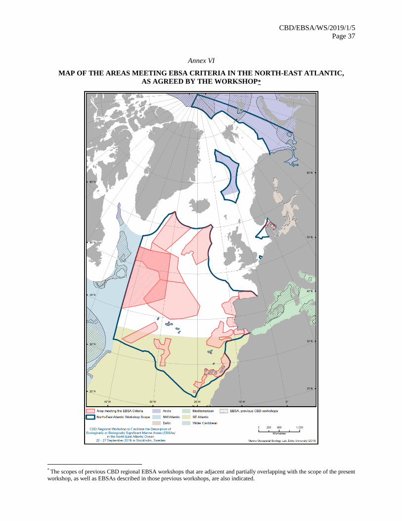
CBD/EBSA/WS/2019/1/5
Page 37
Annex VI
MAP OF THE AREAS MEETING EBSA CRITERIA IN THE NORTH-EAST ATLANTIC,
AS AGREED BY THE WORKSHOP*
* The scopes of previous CBD regional EBSA workshops that are adjacent and partially overlapping with the scope of the present
workshop, as well as EBSAs described in those previous workshops, are also indicated.
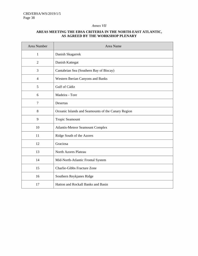
CBD/EBSA/WS/2019/1/5
Page 38
Annex VII
AREAS MEETING THE EBSA CRITERIA IN THE NORTH-EAST ATLANTIC,
AS AGREED BY THE WORKSHOP PLENARY
Area Number Area Name
1 Danish Skagarrek
2 Danish Kattegat
3 Cantabrian Sea (Southern Bay of Biscay)
4 Western Iberian Canyons and Banks
5 Gulf of Cádiz
6 Madeira - Tore
7 Desertas
8 Oceanic Islands and Seamounts of the Canary Region
9 Tropic Seamount
10 Atlantis-Meteor Seamount Complex
11 Ridge South of the Azores
12 Graciosa
13 North Azores Plateau
14 Mid-North-Atlantic Frontal System
15 Charlie-Gibbs Fracture Zone
16 Southern Reykjanes Ridge
17 Hatton and Rockall Banks and Basin
CBD/EBSA/WS/2019/1/5
Page 39
Appendix to Annex VII
DESCRIPTION OF AREAS MEETING THE EBSA CRITERIA IN THE NORTH-EAST
ATLANTIC, AS AGREED BY THE WORKSHOP PLENARY
Area no. 1: Danish Skagerrak
Abstract
This area focuses on a highly productive upwelling zone along the southern edge of the Norwegian
Trench. This area has high fish biomass and diversity, and the upwelling zone also provides valuable
feeding grounds for several cetacean and bird species.
Introduction The Danish part of the Skagerrak north of Jutland is a very productive frontal area. The water depth is
between 0 and 465m. The seabed sediment within the area changes from muddy in the deep water to
sandy with decreasing depth. Reef areas exist within two Natura 2000 sites. The Natura 2000 site “Store
Rev” hosts a relatively deep reef site, and the Natura 2000 site “Knudegrund” hosts a shallower reef area.
The shallow part of Knudegrund hosts a seaweed forest. Hard bottom communities below 11.5 and 13.5m
water depth in the Skagerrak are dominated by the soft coral “Dead man’s finger” (Alcyonium digitatum)
and the bryozoan Flustra foliacea (Edelvang et al., 2017a). This description focuses mainly on the
presence of pelagic-feeding birds and cetaceans, related to the highly productive upwelling zone along the
southern parts of the Norwegian Trench. The area hosts several species of seabirds. It is also important for
harbour porpoise (Phocoena phocoena) and, to a less extent, white-beaked dolphin (Lagenorhynchus
albirostris) and minke whale (Balaenoptera acutorostrata). The high biomass of several fish species is
reflected in the intensive fishery in the area.
Location This area is situated in the Danish part of the Skagerrak. The area reaches westwards to 6°45’E, to
Skagen, the northern tip of Jutland, and stretches northeast from Skagen. It comprises an area of
7,876 km2 and reaches depths from the coastline to 465m. The northern and western parts cover the
southern reach of the Norwegian Trench (Figure 2).
Feature description of the area
Front zones
In the Skagerrak, the tidal mixing front is narrower and forms part of the Skagerrak frontal system, which
is also driven by eddies related to the Skagerrak gyre and the shelf break along the Norwegian Trench
(Figure 3A). This frontal zone continues further west of the tip of Jutland as the “Kattegat-Skagerrak
front”, where the less saline surface water from Kattegat, influenced by the surplus of Baltic Sea water,
mixes with the Skagerrak water mass (Figure 3B).
Plankton production
The frontal zone is characterized by enhanced concentrations of phyto- and zooplankton (Nielsen et al.
1993; Josefson and Conley, 1997).
Fish
Schooling fish and predator species occurring in tight aggregations and predators feeding on schooling
fish are observed along the front (Krause et al. 1986, Munk 1993, Stone et al. 1995). In the Skagerrak
region, the front has a profound influence on the distribution of nursery areas for several gadoid fishes
(Munk et al. 1999). Both catches in scientific fish surveys and the commercial fishery demonstrate a very
high abundance and biomass of both demersal and pelagic fish species (Edelvang et al. 2017a).
Harbour porpoise
The frontal zone is also extremely important for harbour porpoise (Teilmann et al. 2008; Sveegaard
2018). Part of the North Sea population uses the area intensively over the year (Figure 4). Harbour
CBD/EBSA/WS/2019/1/5
Page 40
porpoise is listed in OSPAR Recommendation 2013/11 on furthering the protection and restoration of the
harbour porpoise in Regions II and III of the OSPAR maritime area (OSPAR 2013)
Other cetaceans
Minke whales and white-beaked dolphins are found mainly in the northern North Sea (ICES 2015), but
distribution models based on aerial surveys have suggested that the north-western part of the Danish
North Sea may be a preferred habitat for both species and that the waters along the Norwegian Trench, as
well as the central Danish North Sea, may be preferred habitats for minke whales (Figure 5), (Edelvang et
al. 2017a).
Birds
The Skagerrak area is particularly important for the occurrence of pelagic-feeding bird species, many of
which are associated with the upwelling zone along the southern edge of the Norwegian Trench (Tasker et
al. 1987; Stone et al. 1995; Petersen unpublished data). The most abundant bird species recorded in the
area was fulmar (Fulmarus glacialis), common guillemot (Uria aalge) and razorbill (Alca torda). While
fulmars and common guillemots primarily occur in the deep parts of the area, razorbills are found in more
coastal areas as well. Great skuas (Catharacta skua) are found in numbers of international importance and
are primarily associated with the deep-sea areas.
Fulmar
Observations indicate that fulmars are very numerous in the summer and early autumn. The highest
concentration of birds is observed on the southern shelf of the Norwegian Trench, where the birds feed on
zooplankton in the upwelling zone. The fulmars are distributed across the above-mentioned zone and only
occasionally associated with fishing vessels. It is unclear whether these birds are actively breeding or non-
breeders (Petersen unpublished data). . In August 2006, more than 86,000 individuals were observed
(Figure 6). Of those, 85 per cent were found within the area meeting EBSA criteria.
In October 2007, approximately 18,500 fulmars were recorded in the northern part of the Danish North
Sea and Kattegat (Figure 7). Ninety-four per cent of those birds were found within the area described as
meeting the EBSA criteria.
Razorbill/Common Guillemot
Razorbills and common guillemots are found in high numbers in the area. Common guillemots rear
flightless young in the area (Skov et al. 1992).
In August 2006, more than 28,000 razorbills/common guillemots were estimated in the northern part of
the Danish North Sea and Skagerrak (Figure 8). Of these, 74 per cent were found within the area
described as meeting the EBSA criteria.
In September 2007 approximately 9,600 razorbills/common guillemots were recorded in the northern part
of the Danish North Sea and Skagerrak (Figure 9). Of these, 61 per cent were found within the area
meeting the EBSA criteria.
In October 2007, an estimated 21,000 razorbills/common guillemots were recorded in the northern part of
the Danish North Sea and Skagerrak (Figure 10). Of these, 61 per cent were found within the area
meeting the EBSA criteria.
Great Skua
Great skuas were found in high numbers in the northern part of Danish North Sea and Skagerrak in late
summer and early autumn (Figure 11, Petersen unpublished data). Up to 1,250 individuals were
estimated, which amounts to more than 2 to 4 per cent of the world population of the species. The
majority of these birds were recorded within the area meeting EBSA criteria.

CBD/EBSA/WS/2019/1/5
Page 41
Feature condition and future outlook of the area
Skagerrak is the marine connection between the northeastern Atlantic and the Baltic seas. The shipping
traffic density is very high (Edelvang 2017a). This is also a highly productive area in an upwelling zone
along the southern edge of the Norwegian Trench, which in turn creates the functional background for a
rich and diverse fish community (Edelvang 2017a). The fishery in this part of Skagerrak is intensive.
This productive area serves as a foraging site to high numbers of birds, and the area is particularly
important for concentrations of pelagic piscivorous and surface-feeding birds, such as fulmar, common
guillemot and razorbill. Likewise, cetaceans utilize this rich area. Harbour porpoise density in this area
ishigh.
Within the area described, three areas have been designated under the EU Habitats Directive. There are no
EU Birds Directive designations for this area, but an Important Bird Area (IBA) has been designated by
BirdLife International (BirdLife International 2019).
National legislation is being prepared to prohibit bottom-trawling gear within boulder reefs in
NATURA2000 sites with reefs on the designation list.
Assessment of area no. 1, Danish Skagerrak, against CBD EBSA Criteria
CBD EBSA
Criteria
(Annex I to
decision
IX/20)
Description
(Annex I to decision IX/20) Ranking of criterion relevance
(please mark one column with an X)
No
informat
ion
Low Medi
um
High
Uniqueness
or rarity
Area contains either (i) unique (“the only one
of its kind”), rare (occurs only in few
locations) or endemic species, populations or
communities, and/or (ii) unique, rare or
distinct, habitats or ecosystems; and/or (iii)
unique or unusual geomorphological or
oceanographic features.
X
Explanation for ranking
Very productive frontal area (Nielsen et al.1993, Josefson and Conley, 1997).
Very high concentrations of northern fulmar (Fulmarus glacialis) and great skua (Catheracta skua), both
of which are present in numbers of international significance (Petersen unpublished).
The high productivity of the upwelling zone at the southern edge of the Norwegian Trench promotes high
fish concentrations and in turn also provides favorable conditions for both birds and cetaceans, including
harbour porpoise.
Special
importance
for life-
history stages
of species
Areas that are required for a population to
survive and thrive.
X
Explanation for ranking
In late summer and early autumn, this area serves as a rearing area for common guillemot that perform a
swimming migration from their breeding grounds in Scotland to the Danish North Sea and Kattegat via
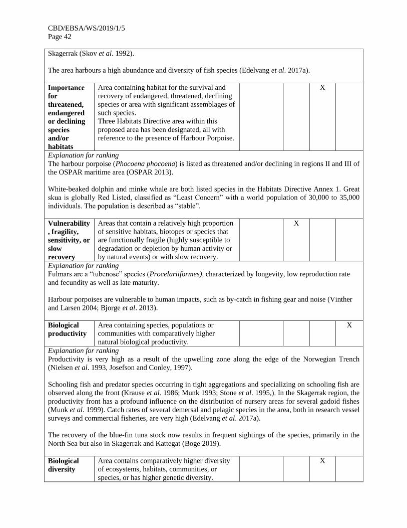
CBD/EBSA/WS/2019/1/5
Page 42
Skagerrak (Skov et al. 1992).
The area harbours a high abundance and diversity of fish species (Edelvang et al. 2017a).
Importance
for
threatened,
endangered
or declining
species
and/or
habitats
Area containing habitat for the survival and
recovery of endangered, threatened, declining
species or area with significant assemblages of
such species.
Three Habitats Directive area within this
proposed area has been designated, all with
reference to the presence of Harbour Porpoise.
X
Explanation for ranking
The harbour porpoise (Phocoena phocoena) is listed as threatened and/or declining in regions II and III of
the OSPAR maritime area (OSPAR 2013).
White-beaked dolphin and minke whale are both listed species in the Habitats Directive Annex 1. Great
skua is globally Red Listed, classified as “Least Concern” with a world population of 30,000 to 35,000
individuals. The population is described as “stable”.
Vulnerability
, fragility,
sensitivity, or
slow
recovery
Areas that contain a relatively high proportion
of sensitive habitats, biotopes or species that
are functionally fragile (highly susceptible to
degradation or depletion by human activity or
by natural events) or with slow recovery.
X
Explanation for ranking
Fulmars are a “tubenose” species (Procelariiformes), characterized by longevity, low reproduction rate
and fecundity as well as late maturity.
Harbour porpoises are vulnerable to human impacts, such as by-catch in fishing gear and noise (Vinther
and Larsen 2004; Bjorge et al. 2013).
Biological
productivity
Area containing species, populations or
communities with comparatively higher
natural biological productivity.
X
Explanation for ranking
Productivity is very high as a result of the upwelling zone along the edge of the Norwegian Trench
(Nielsen et al. 1993, Josefson and Conley, 1997).
Schooling fish and predator species occurring in tight aggregations and specializing on schooling fish are
observed along the front (Krause et al. 1986; Munk 1993; Stone et al. 1995,). In the Skagerrak region, the
productivity front has a profound influence on the distribution of nursery areas for several gadoid fishes
(Munk et al. 1999). Catch rates of several demersal and pelagic species in the area, both in research vessel
surveys and commercial fisheries, are very high (Edelvang et al. 2017a).
The recovery of the blue-fin tuna stock now results in frequent sightings of the species, primarily in the
North Sea but also in Skagerrak and Kattegat (Boge 2019).
Biological
diversity
Area contains comparatively higher diversity
of ecosystems, habitats, communities, or
species, or has higher genetic diversity.
X
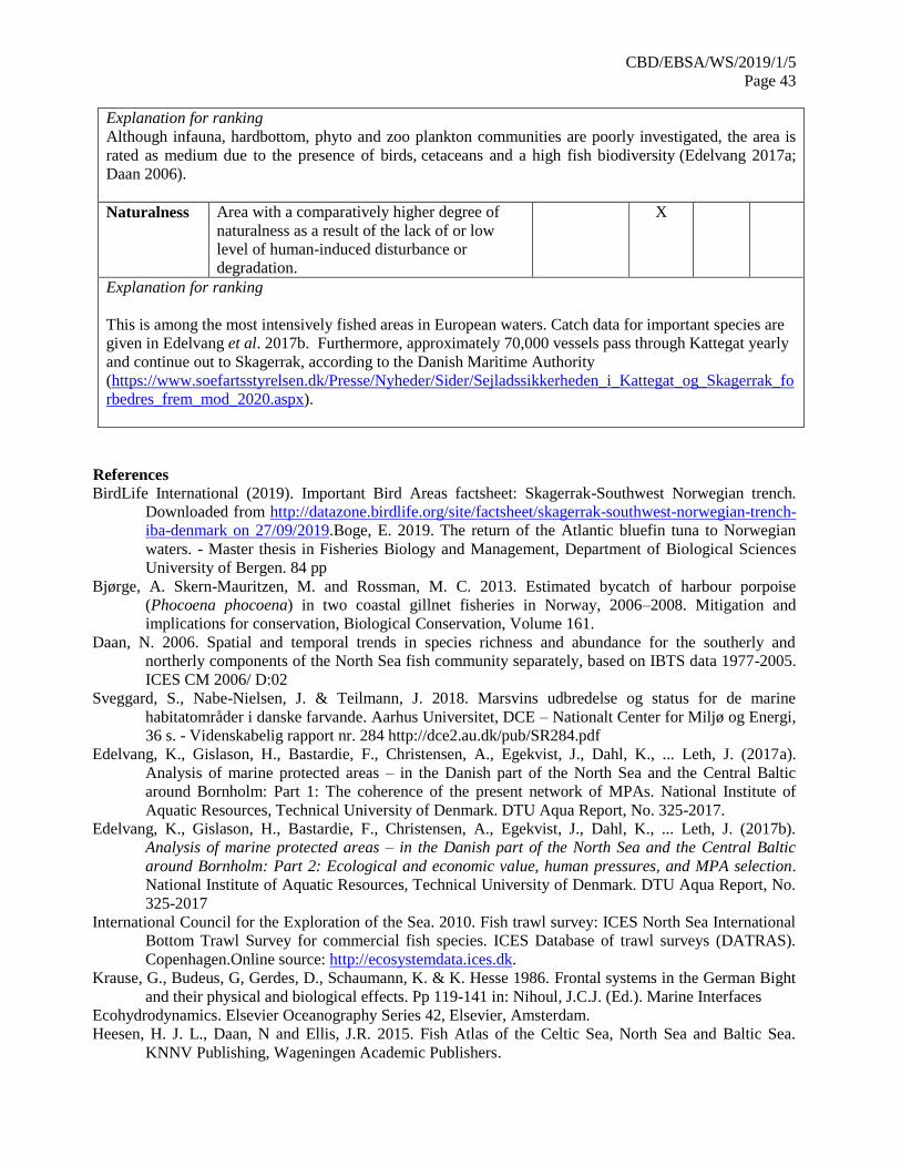
CBD/EBSA/WS/2019/1/5
Page 43
Explanation for ranking
Although infauna, hardbottom, phyto and zoo plankton communities are poorly investigated, the area is
rated as medium due to the presence of birds, cetaceans and a high fish biodiversity (Edelvang 2017a;
Daan 2006).
Naturalness Area with a comparatively higher degree of
naturalness as a result of the lack of or low
level of human-induced disturbance or
degradation.
X
Explanation for ranking
This is among the most intensively fished areas in European waters. Catch data for important species are
given in Edelvang et al. 2017b. Furthermore, approximately 70,000 vessels pass through Kattegat yearly
and continue out to Skagerrak, according to the Danish Maritime Authority
(https://www.soefartsstyrelsen.dk/Presse/Nyheder/Sider/Sejladssikkerheden_i_Kattegat_og_Skagerrak_fo
rbedres_frem_mod_2020.aspx).
References
BirdLife International (2019). Important Bird Areas factsheet: Skagerrak-Southwest Norwegian trench.
Downloaded from http://datazone.birdlife.org/site/factsheet/skagerrak-southwest-norwegian-trench-
iba-denmark on 27/09/2019.Boge, E. 2019. The return of the Atlantic bluefin tuna to Norwegian
waters. - Master thesis in Fisheries Biology and Management, Department of Biological Sciences
University of Bergen. 84 pp
Bjørge, A. Skern-Mauritzen, M. and Rossman, M. C. 2013. Estimated bycatch of harbour porpoise
(Phocoena phocoena) in two coastal gillnet fisheries in Norway, 2006–2008. Mitigation and
implications for conservation, Biological Conservation, Volume 161.
Daan, N. 2006. Spatial and temporal trends in species richness and abundance for the southerly and
northerly components of the North Sea fish community separately, based on IBTS data 1977-2005.
ICES CM 2006/ D:02
Sveggard, S., Nabe-Nielsen, J. & Teilmann, J. 2018. Marsvins udbredelse og status for de marine
habitatområder i danske farvande. Aarhus Universitet, DCE – Nationalt Center for Miljø og Energi,
36 s. - Videnskabelig rapport nr. 284 http://dce2.au.dk/pub/SR284.pdf
Edelvang, K., Gislason, H., Bastardie, F., Christensen, A., Egekvist, J., Dahl, K., ... Leth, J. (2017a).
Analysis of marine protected areas – in the Danish part of the North Sea and the Central Baltic
around Bornholm: Part 1: The coherence of the present network of MPAs. National Institute of
Aquatic Resources, Technical University of Denmark. DTU Aqua Report, No. 325-2017.
Edelvang, K., Gislason, H., Bastardie, F., Christensen, A., Egekvist, J., Dahl, K., ... Leth, J. (2017b).
Analysis of marine protected areas – in the Danish part of the North Sea and the Central Baltic
around Bornholm: Part 2: Ecological and economic value, human pressures, and MPA selection.
National Institute of Aquatic Resources, Technical University of Denmark. DTU Aqua Report, No.
325-2017
International Council for the Exploration of the Sea. 2010. Fish trawl survey: ICES North Sea International
Bottom Trawl Survey for commercial fish species. ICES Database of trawl surveys (DATRAS).
Copenhagen.Online source: http://ecosystemdata.ices.dk.
Krause, G., Budeus, G, Gerdes, D., Schaumann, K. & K. Hesse 1986. Frontal systems in the German Bight
and their physical and biological effects. Pp 119-141 in: Nihoul, J.C.J. (Ed.). Marine Interfaces
Ecohydrodynamics. Elsevier Oceanography Series 42, Elsevier, Amsterdam.
Heesen, H. J. L., Daan, N and Ellis, J.R. 2015. Fish Atlas of the Celtic Sea, North Sea and Baltic Sea.
KNNV Publishing, Wageningen Academic Publishers.

CBD/EBSA/WS/2019/1/5
Page 44
Munk P. 1993. Differential growth of larval sprat (Sprattus sprattus) across a tidal front in the eastern North
Sea. Marine Ecology Progress Series 99: 17-29.
Munk, P., Larsson, P.O., Danielsen, D.S. & Moksness, E. 1999. Variability in frontal zone formation and
distribution of gadoid fish larvae at the shelf break in the northeastern North Sea. Mar. Ecol. Prog.
Ser. 177: 221-233.
OSPAR (2008) OSPAR List of Threatened and/or Declining Species and Habitats. Agreement 2008-06.
OSPAR Commission 2008.
OSPAR (2013) OSPAR Recommendation 2013/11 on furthering the protection and restoration of the
harbour porpoise (Phocoena phocoena) in Regions II and III of the OSPAR maritime area.
Petersen, I.K. unpublished. Antal og fordeling af vandfugle i den nordlige danske del af Nordsøen.
Unpublished report requested by the By- og Landskabsstyrelsen.
Skov, H., Durinck, J. & Danielsen, F. (1992): Udbredelse og antal af Lomvie Uria aalge i Skagerrak i
sensommerperioden. – Dansk Orn. Foren. Tidsskr. 86: 169-176.
Skov, H., Heinänen, S., Žydelis, R., Bellebaum, J., Bzoma, S., Dagys, M., Durinck, J., Garthe, G.,
Grishanov, G., Hario, M., Kieckbusch, J.J., Kube, J., Kuresoo, A., Larsson, K., Luigujoe, L.,
Meissner, W., Nehls, H.W., Nilsson, L., Petersen, I.K., Roos, M.M., Pihl, S., Sonntag, N., Stock,
A., Stipniece A. and Wahl, J. 2011. Waterbird Populations and Pressures in the Baltic Sea. – Nordic
Council of Ministers, TemaNord 2011:550. 201 pp.
Stone, C.J., Webb, A., Bsrton, C., Ratcliffe, N., Reed, T.C., Tasker, M.L., Camphuysen, C.J. & Pienkowski,
M.W. (1995): An Atlas of Seabird Distribution in north-west European waters. – Joint Nature
Conservation Committee and Nederlands Instituut voor Onderzoek der Zee. 326 pp.
Sveggard, S., Nabe-Nielsen, J. & Teilmann, J. 2018. Marsvins udbredelse og status for de marine
habitatområder i danske farvande. Aarhus Universitet, DCE – Nationalt Center for Miljø og
Energi, 36 s. - Videnskabelig rapport nr. 284. http://dce2.au.dk/pub/SR284.pdf
Tasker, M.L., Webb, A., Hall, A.J., Pienkowski, M.W. & Langslow, D.R. 1987: Seabirds in the North Sea.
– Nature Conservancy Council, UK. Report, 336 pp.
Vinther M. and Larsen F. (2004) Updated estimates of harbor porpoise bycatch in the Danish bottom set
gillnet fishery. J Cetacean Res Manag 6: 19−24.
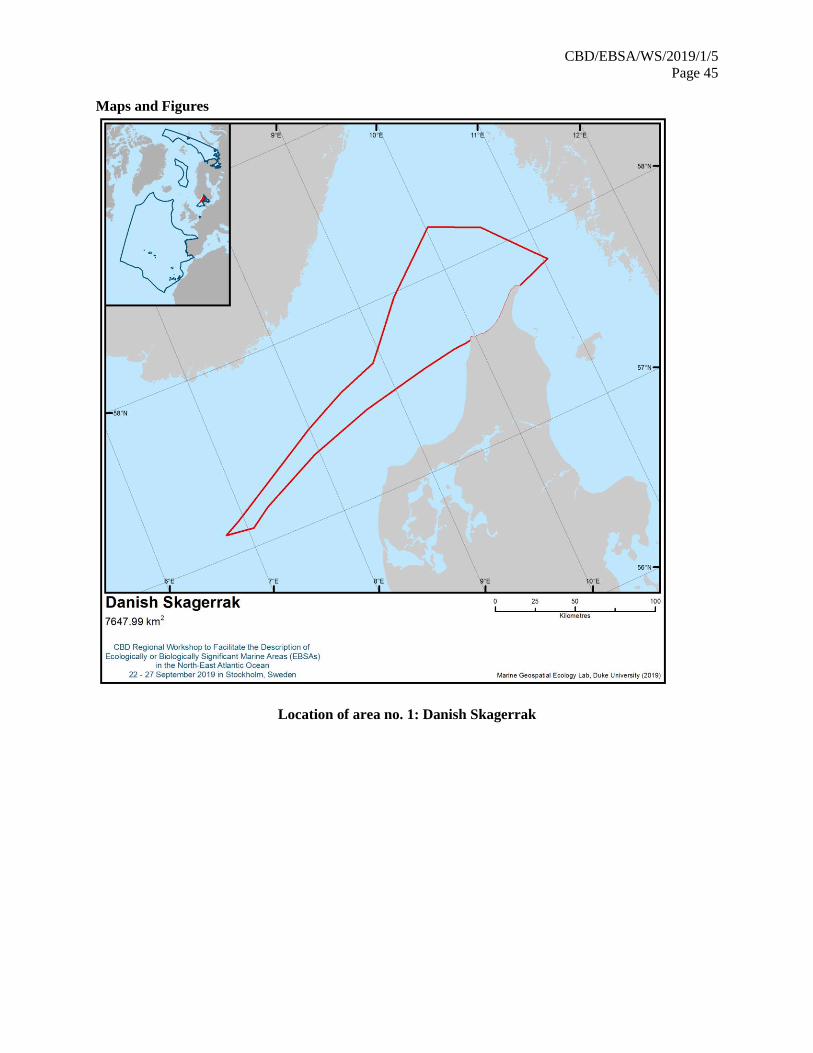
CBD/EBSA/WS/2019/1/5
Page 45
Maps and Figures
Location of area no. 1: Danish Skagerrak
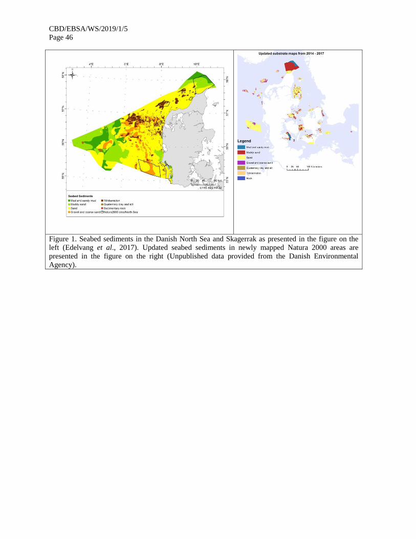
CBD/EBSA/WS/2019/1/5
Page 46
Figure 1. Seabed sediments in the Danish North Sea and Skagerrak as presented in the figure on the
left (Edelvang et al., 2017). Updated seabed sediments in newly mapped Natura 2000 areas are
presented in the figure on the right (Unpublished data provided from the Danish Environmental
Agency).

CBD/EBSA/WS/2019/1/5
Page 47
Figure 2. The geographical extent of the Skagerrak area. The Important Bird Area (IBA) is also shown.
The bathymetry of the area, in metres, is indicated.
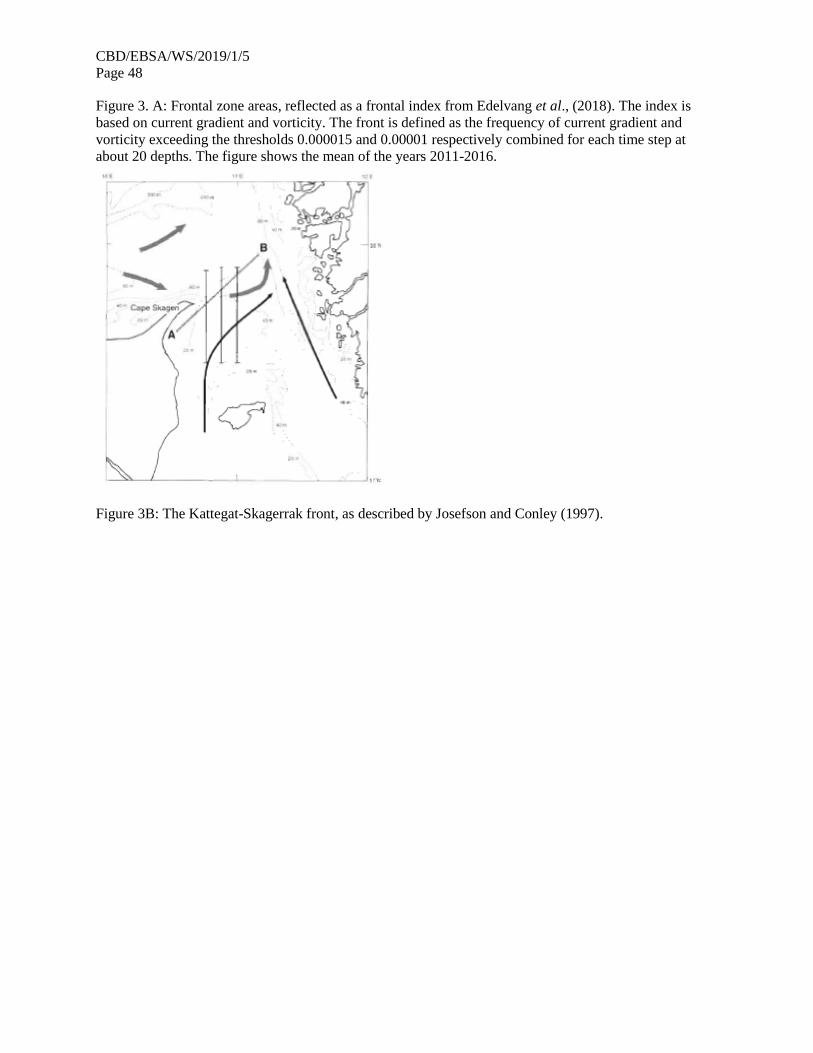
CBD/EBSA/WS/2019/1/5
Page 48
Figure 3. A: Frontal zone areas, reflected as a frontal index from Edelvang et al., (2018). The index is
based on current gradient and vorticity. The front is defined as the frequency of current gradient and
vorticity exceeding the thresholds 0.000015 and 0.00001 respectively combined for each time step at
about 20 depths. The figure shows the mean of the years 2011-2016.
Figure 3B: The Kattegat-Skagerrak front, as described by Josefson and Conley (1997).
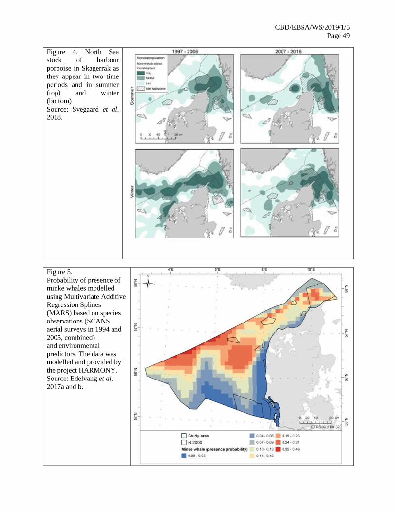
CBD/EBSA/WS/2019/1/5
Page 49
Figure 4. North Sea
stock of harbour
porpoise in Skagerrak as
they appear in two time
periods and in summer
(top) and winter
(bottom)
Source: Svegaard et al.
2018.
Figure 5.
Probability of presence of
minke whales modelled
using Multivariate Additive
Regression Splines
(MARS) based on species
observations (SCANS
aerial surveys in 1994 and
2005, combined)
and environmental
predictors. The data was
modelled and provided by
the project HARMONY.
Source: Edelvang et al.
2017a and b.
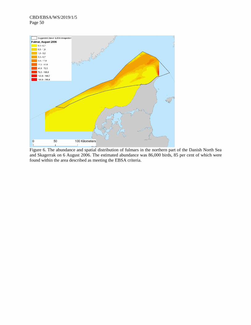
CBD/EBSA/WS/2019/1/5
Page 50
Figure 6. The abundance and spatial distribution of fulmars in the northern part of the Danish North Sea
and Skagerrak on 6 August 2006. The estimated abundance was 86,000 birds, 85 per cent of which were
found within the area described as meeting the EBSA criteria.
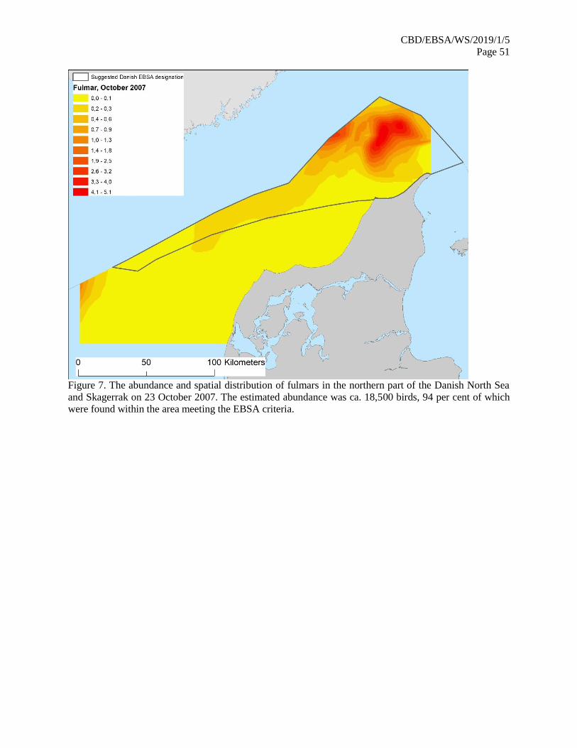
CBD/EBSA/WS/2019/1/5
Page 51
Figure 7. The abundance and spatial distribution of fulmars in the northern part of the Danish North Sea
and Skagerrak on 23 October 2007. The estimated abundance was ca. 18,500 birds, 94 per cent of which
were found within the area meeting the EBSA criteria.
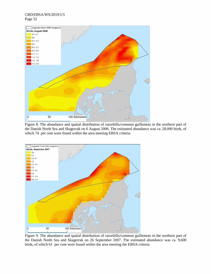
CBD/EBSA/WS/2019/1/5
Page 52
Figure 8. The abundance and spatial distribution of razorbills/common guillemots in the northern part of
the Danish North Sea and Skagerrak on 6 August 2006. The estimated abundance was ca. 28,000 birds, of
which 74 per cent were found within the area meeting EBSA criteria.
Figure 9. The abundance and spatial distribution of razorbills/common guillemots in the northern part of
the Danish North Sea and Skagerrak on 26 September 2007. The estimated abundance was ca. 9,600
birds, of which 61 per cent were found within the area meeting the EBSA criteria.
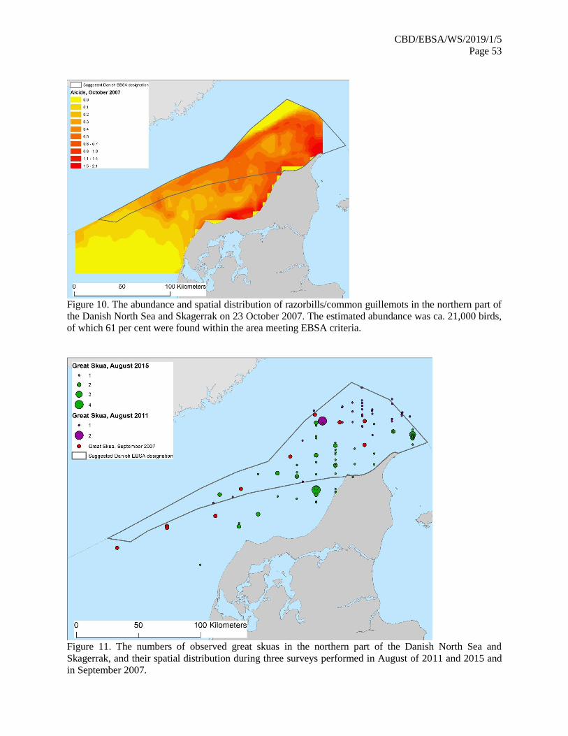
CBD/EBSA/WS/2019/1/5
Page 53
Figure 10. The abundance and spatial distribution of razorbills/common guillemots in the northern part of
the Danish North Sea and Skagerrak on 23 October 2007. The estimated abundance was ca. 21,000 birds,
of which 61 per cent were found within the area meeting EBSA criteria.
Figure 11. The numbers of observed great skuas in the northern part of the Danish North Sea and
Skagerrak, and their spatial distribution during three surveys performed in August of 2011 and 2015 and
in September 2007.

CBD/EBSA/WS/2019/1/5
Page 54
Area no. 2: Danish Kattegat
Abstract
The Danish Kattegat hosts a landscape comprising shallow sandy flats, deeper muddy channels and areas
with boulder reefs and bubbling reefs. The area has a diverse avifauna, with elements from pelagic
environments in the North Sea, as well as wintering birds from breeding grounds in the Russian
Federation and Scandinavia. Parts of the area are difficult to access for human activities serve as valuable
moulting sites for seaducks, such as common scoter and velvet scoter. The area is a meeting site for two
subpopulations of harbour porpoise. Eelgrass meadows exist here, although they are smaller than they
were in the year 1900. Seaweed forests and rich fauna are found on boulder reefs and bubbling reefs in
this area, and infauna communities have high biomasses. Horse-mussel beds are found primarily in the
southern part of Kattegat, where they form biogenic reef structures. Haploops tubicola, a small
crustacean, is present in the area, but no longer forms a specific habitat with high densities.
Introduction Kattegat is a transitional water zone between the highly saline Skagerrak and the brackish Baltic Sea. Its
eastern part hosts a deep ancient river valley (>100 m depth), surrounded by shallow sandbanks and
boulder reef areas bordering Swedish waters. To the west, sandy flats dominate, with water depth less
than 20m. The rare feature made by “bubbling reefs” is present in the northern area. The water masses are
stratified, with the less saline Baltic water flowing northward over masses with higher salinity, which
flow southward. The area is very productive, with high biomass of fauna in both sandy and muddy
sediments. Biogenic reefs of horse-mussel beds (Modiolus modiolus) are found in patches primarily in the
southern part. Submerged vegetation covers boulders on reef locations as well as on the top of bubbling
reefs, even with high coverage on 20m water depth. Eelgrass meadows occur along the coast. Populations
of harbour seals rest and breed on the islands. Kattegat also hosts a high density of harbour porpoise. The
area is internationally important for seabirds.
Location
The area comprises the northern part of inner Danish waters. It is bordered to the south by the north coast
of Sealand, to the west by the northeast Jutland coast, to the east by the Danish-Swedish border and to the
north by a line from the northernmost point of Denmark to the northeast. It covers a total area of 14,995
km2. The existing EBSA (Area No. 9: Fladen and Stora and Lilla Middelgrund), described in the Baltic
EBSA workshop, borders this area (see workshop report here:
https://www.cbd.int/doc/c/aa9a/bde9/eaf24f73bd471d64e8094722/ebsa-ws-2018-01-04-en.pdf).
Feature description of the area
General description
Kattegat is a transitional water zone between the highly saline Skagerrak and the brackish Baltic Sea. Its
eastern part hosts a deep ancient river valley (>100 m depth), surrounded by shallow sandbanks and
boulder reef areas bordering Swedish waters. To the west, sandy flats dominate, with water depth less
than 20m. The water masses are stratified, with the less saline Baltic water flowing northward, while
beneath it, water with higher salinity flows southward.
Bubbling Reefs
A very rare/unique feature made by leaking gas (Habitats Directive type 1180), known as “bubbling
reefs” (Figure 2) are present in the area, and are particularly numerous in the northern part of the area.
This feature is so far recorded only in Kattegat, a minor part of the Danish part of Skagerrak, and in the
Codling Fault Zone in Irish waters. Figure 3 shows the distribution of identified bubbling reefs in the area
described as meeting the EBSA criteria. Bubbling reefs are formed by prolonged leaking of methane
gasses from deep deposits (Jensen et al, 1992). The reef structures are formed in the near-surface
sediment layer in a chemical process binding chalk to the sediment in an oxygenated sediment
environment along the gas-seeping channels. Large bubbling reefs have caves and overhangs hosting

CBD/EBSA/WS/2019/1/5
Page 55
communities dominated by hard bottom fauna on shady parts that are not found at the same water depth
on nearby boulder reefs. Bubbling reefs in Kattegat are often located on sandy bottoms and thus
significantly increase the complexity of these habitats.
The appearance of the reef structures above the seabed is due to erosional processes likely over very long
time-scales. The structures are fragile and very sensitive to physical disturbance.
Boulder reefs
There are offshore reef areas, as well as coastal reef areas, in the entire area. There are several offshore
areas next to the offshore reef areas of the existing EBSA (Area No. 9: Fladen and Stora and Lilla
Middelgrund), described in the Baltic EBSA workshop, in Kattegat (Figure 4). The reefs host productive
seaweed forests as well as a high diversity of algae (Nielsen et al, 1992). The vegetation is multilayered to
a depth of 15 m (Carstensen and Dahl, 2018). The species diversity of invertebrates is high on offshore
reef areas. In Fladen, part of the nearby EBSA noted above, 439 species were found, but the diversity is
also high at Lilla Middelgrund (374 species), and Stora Middelgrund (more than 300 species)
(Naturvårdsverket 2006).
Several reefs host a special kelp community consisting of Sacharina latisima, Laminaria digitate and
Laminaria hyperboria. Kelp are highly productive and can be found down to approximately 20m water
depth in Kattegat but suffer in adjacent fjord systems (Dahl et al, 2013). Concern has been raised about
kelp species being potentially sensitive to climate change in this region.
Infauna communities in general
The area is very productive, with a high biomass of infauna on both sandy and muddy substrates. Gogina
et al. (2016) modelled community distribution and biomass distribution in Kattegat as well as the rest of
the Baltic Sea based on collected data from the whole HELCOM area. Findings indicate that Kattegat is
an area with high biomass and several different communities (Figure 5).
The deeper muddy seabed hosts a high number of Norway lobster (Nephrops norvegicus) Figure 6)
Haplops habitat
The tube-building crustacean Haploops tubicola used to cover extensive areas in the southern Kattegat,
where dense numbers formed a specific habitat. Haploops communities have decreased significantly since
the 1960s, when the habitat is believed to have occurred abundantly at depths greater than 15 metdrs in
the south-eastern Kattegat (Göransson et al. 2010). Today, Haploops is still present in the Kattegat area,
but only in low densities, and with no habitat-forming function (Figure 7). The species is considered
endangered, according to the HELCOM Red List (HELCOM (2013b).
Modiolus modiolus beds
The horse mussel (Modiolus modiolus) is unevenly distributed, primarily in the southern part of Kattegat
(figure 8). Following the definition of Dahl and Petersen (2018), they can form biogenic reefs or
combined geogenic and biogenic reefs in several places. Such reefs are shaped by a mixture of live
mussels and dead shells. Modiolus is also recorded from some sites in Øresund, Lillebelt and Great Belt,
all part of the HELCOM region. A known horse-mussel bed in the northern Kattegat became extinct in
the 1990s. The mussels in Danish waters are typically found on mixed sediments containing rough sand,
gravel and larger boulders, where the larger living mussels are two-thirds buried in the sediment.
Modiolus reefs host a high diversity of associated fauna and a few algal species. The beds are located
below 15 to 19m, but a deeper depth range is likely as well. The distribution is most likely constrained to
areas having an average salinity above 26 PSU). The geographical distribution has not been described.
Only point observations exist in different areas.
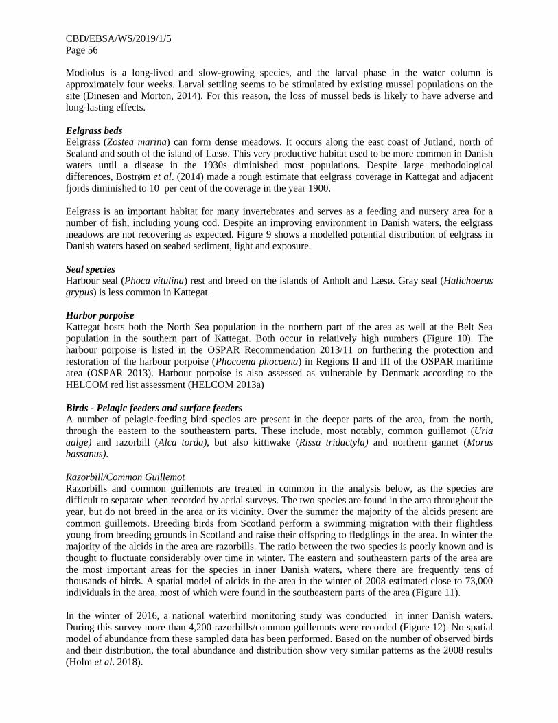
CBD/EBSA/WS/2019/1/5
Page 56
Modiolus is a long-lived and slow-growing species, and the larval phase in the water column is
approximately four weeks. Larval settling seems to be stimulated by existing mussel populations on the
site (Dinesen and Morton, 2014). For this reason, the loss of mussel beds is likely to have adverse and
long-lasting effects.
Eelgrass beds
Eelgrass (Zostea marina) can form dense meadows. It occurs along the east coast of Jutland, north of
Sealand and south of the island of Læsø. This very productive habitat used to be more common in Danish
waters until a disease in the 1930s diminished most populations. Despite large methodological
differences, Bostrøm et al. (2014) made a rough estimate that eelgrass coverage in Kattegat and adjacent
fjords diminished to 10 per cent of the coverage in the year 1900.
Eelgrass is an important habitat for many invertebrates and serves as a feeding and nursery area for a
number of fish, including young cod. Despite an improving environment in Danish waters, the eelgrass
meadows are not recovering as expected. Figure 9 shows a modelled potential distribution of eelgrass in
Danish waters based on seabed sediment, light and exposure.
Seal species
Harbour seal (Phoca vitulina) rest and breed on the islands of Anholt and Læsø. Gray seal (Halichoerus
grypus) is less common in Kattegat.
Harbor porpoise
Kattegat hosts both the North Sea population in the northern part of the area as well at the Belt Sea
population in the southern part of Kattegat. Both occur in relatively high numbers (Figure 10). The
harbour porpoise is listed in the OSPAR Recommendation 2013/11 on furthering the protection and
restoration of the harbour porpoise (Phocoena phocoena) in Regions II and III of the OSPAR maritime
area (OSPAR 2013). Harbour porpoise is also assessed as vulnerable by Denmark according to the
HELCOM red list assessment (HELCOM 2013a)
Birds - Pelagic feeders and surface feeders
A number of pelagic-feeding bird species are present in the deeper parts of the area, from the north,
through the eastern to the southeastern parts. These include, most notably, common guillemot (Uria
aalge) and razorbill (Alca torda), but also kittiwake (Rissa tridactyla) and northern gannet (Morus
bassanus).
Razorbill/Common Guillemot
Razorbills and common guillemots are treated in common in the analysis below, as the species are
difficult to separate when recorded by aerial surveys. The two species are found in the area throughout the
year, but do not breed in the area or its vicinity. Over the summer the majority of the alcids present are
common guillemots. Breeding birds from Scotland perform a swimming migration with their flightless
young from breeding grounds in Scotland and raise their offspring to fledglings in the area. In winter the
majority of the alcids in the area are razorbills. The ratio between the two species is poorly known and is
thought to fluctuate considerably over time in winter. The eastern and southeastern parts of the area are
the most important areas for the species in inner Danish waters, where there are frequently tens of
thousands of birds. A spatial model of alcids in the area in the winter of 2008 estimated close to 73,000
individuals in the area, most of which were found in the southeastern parts of the area (Figure 11).
In the winter of 2016, a national waterbird monitoring study was conducted in inner Danish waters.
During this survey more than 4,200 razorbills/common guillemots were recorded (Figure 12). No spatial
model of abundance from these sampled data has been performed. Based on the number of observed birds
and their distribution, the total abundance and distribution show very similar patterns as the 2008 results
(Holm et al. 2018).
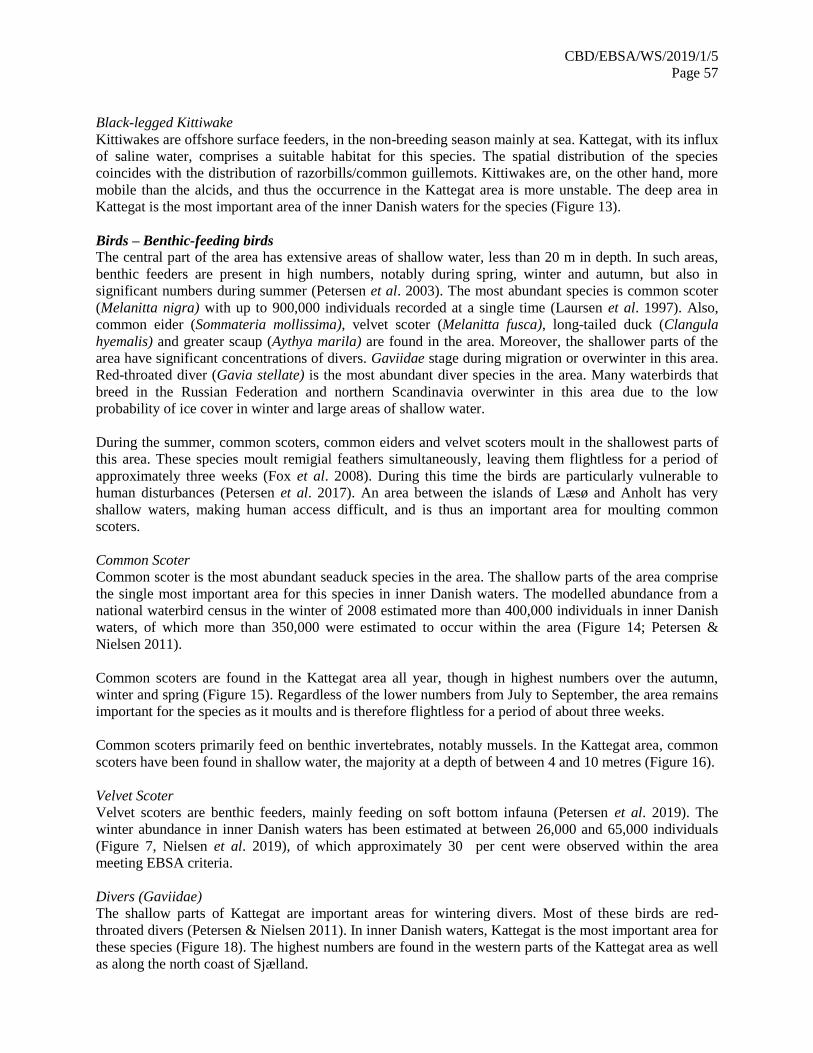
CBD/EBSA/WS/2019/1/5
Page 57
Black-legged Kittiwake
Kittiwakes are offshore surface feeders, in the non-breeding season mainly at sea. Kattegat, with its influx
of saline water, comprises a suitable habitat for this species. The spatial distribution of the species
coincides with the distribution of razorbills/common guillemots. Kittiwakes are, on the other hand, more
mobile than the alcids, and thus the occurrence in the Kattegat area is more unstable. The deep area in
Kattegat is the most important area of the inner Danish waters for the species (Figure 13).
Birds – Benthic-feeding birds
The central part of the area has extensive areas of shallow water, less than 20 m in depth. In such areas,
benthic feeders are present in high numbers, notably during spring, winter and autumn, but also in
significant numbers during summer (Petersen et al. 2003). The most abundant species is common scoter
(Melanitta nigra) with up to 900,000 individuals recorded at a single time (Laursen et al. 1997). Also,
common eider (Sommateria mollissima), velvet scoter (Melanitta fusca), long-tailed duck (Clangula
hyemalis) and greater scaup (Aythya marila) are found in the area. Moreover, the shallower parts of the
area have significant concentrations of divers. Gaviidae stage during migration or overwinter in this area.
Red-throated diver (Gavia stellate) is the most abundant diver species in the area. Many waterbirds that
breed in the Russian Federation and northern Scandinavia overwinter in this area due to the low
probability of ice cover in winter and large areas of shallow water.
During the summer, common scoters, common eiders and velvet scoters moult in the shallowest parts of
this area. These species moult remigial feathers simultaneously, leaving them flightless for a period of
approximately three weeks (Fox et al. 2008). During this time the birds are particularly vulnerable to
human disturbances (Petersen et al. 2017). An area between the islands of Læsø and Anholt has very
shallow waters, making human access difficult, and is thus an important area for moulting common
scoters.
Common Scoter
Common scoter is the most abundant seaduck species in the area. The shallow parts of the area comprise
the single most important area for this species in inner Danish waters. The modelled abundance from a
national waterbird census in the winter of 2008 estimated more than 400,000 individuals in inner Danish
waters, of which more than 350,000 were estimated to occur within the area (Figure 14; Petersen &
Nielsen 2011).
Common scoters are found in the Kattegat area all year, though in highest numbers over the autumn,
winter and spring (Figure 15). Regardless of the lower numbers from July to September, the area remains
important for the species as it moults and is therefore flightless for a period of about three weeks.
Common scoters primarily feed on benthic invertebrates, notably mussels. In the Kattegat area, common
scoters have been found in shallow water, the majority at a depth of between 4 and 10 metres (Figure 16).
Velvet Scoter
Velvet scoters are benthic feeders, mainly feeding on soft bottom infauna (Petersen et al. 2019). The
winter abundance in inner Danish waters has been estimated at between 26,000 and 65,000 individuals
(Figure 7, Nielsen et al. 2019), of which approximately 30 per cent were observed within the area
meeting EBSA criteria.
Divers (Gaviidae)
The shallow parts of Kattegat are important areas for wintering divers. Most of these birds are red-
throated divers (Petersen & Nielsen 2011). In inner Danish waters, Kattegat is the most important area for
these species (Figure 18). The highest numbers are found in the western parts of the Kattegat area as well
as along the north coast of Sjælland.
CBD/EBSA/WS/2019/1/5
Page 58
Divers are found in the Kattegat area in winter and spring primarily. Few divers were recorded during the
summer and autumn (Figure 19).
Divers are mainly piscivorous, and largely feed on demersal fish. The birds are found on deeper waters
than the benthic feeding seaducks, with more than 50 per cent of the divers recorded on water depth
between 8 and 16 meters (Figure 10).
Feature condition and future outlook of the area
Kattegat hosts a rich birdlife of international importance and the larger of two sub-populations of harbour
porpoise. It also holds productive boulder and bubbling reef areas and areas with relatively high benthic
biomass. Measures were enforced in the late 1980s to reduce eutrophication levels in Kattegat and
adjacent waters. Since then the environment in Kattegat has been undergoing an oligotrophication
process, improving the water quality (Riemann et al. 2015). Major shipping routes, connecting the Baltic
Sea and the northeast Atlantic, pass through Kattegat, and an intensive fishery takes place in the deeper
eastern part, mainly for Norway lobster.
National legislation prohibits the use of dredging fishing gears on reefs and all bottom-contacting gears
on “Structures made by leaking gasses” (bubbling reefs) in NATURA 2000 sites where those features are
part of the designation lists.
Assessment of area no. 2, Danish Kattegat, against CBD EBSA Criteria
CBD EBSA
Criteria
(Annex I to
decision
IX/20)
Description
(Annex I to decision IX/20) Ranking of criterion relevance
(please mark one column with an X)
No
informat
ion
Low Medi
um
High
Uniqueness
or rarity
Area contains either (i) unique (“the only one
of its kind”), rare (occurs only in few
locations) or endemic species, populations or
communities, and/or (ii) unique, rare or
distinct, habitats or ecosystems; and/or (iii)
unique or unusual geomorphological or
oceanographic features.
X
Explanation for ranking
Presence of “bubbling reefs” habitat (Habitats Directive type 1180) exists with one or more structures in
several places. Most structures are found north of Læsø and north east of Frederikshavn. The habitat is on
the HELCOM biotope red list (HELCOM 2013a).
Presence of biogenic reef structures and combined biogenic-geogenic reef structures of Modiolus
modiolus in the southern part of Kattegat (reference: Danish NOVANA database)
The area is unique, combining high numbers of both benthic-feeding and pelagic-feeding seabirds. The
range of ecological niches creates optimal habitats for the unusual variety of seabirds. In the shallow
western part, benthic-feeding common scoter (Melanitta nigra) and common eider (Somatteria
mollissima) are found in numbers of international significance (Petersen et al., 2003, 2010).
Special
importance
for life-
history stages
Areas that are required for a population to
survive and thrive.
X
CBD/EBSA/WS/2019/1/5
Page 59
of species
Explanation for ranking
Existing Modiolus modiolus beds seem to attract larval settling of new generations (Dinesen and Morton
2014). Loss of existing mussel beds may result in lacking or very slow restocking of the beds.
Kattegat acts as a donor area for several benthic invertebrates to the adjacent fjords. The organisms are
transported in planktonic stages (Josefson and Hansen 2004). This function is important as many fjords,
bays and inlets with poor water exchange regularly suffer from oxygen deficiencies. In general, problems
with oxygen deficiency have not diminished in the last 25 years, despite severe reduction in nutrient load
to Kattegat (Riemann et al. 2017)
During the summer, common scoters, common eiders and velvet scoters use the shallow areas of the
Kattegat as a moulting site. These species moult remedial feathers simultaneously, leaving them flightless
for a period of approximately three weeks (Fox et al. 2008). The area is among the most important
moulting places for this species in Europe (Petersen and Fox 2009 and Petersen og Nielsen 2011). During
this time the birds are particularly vulnerable to human disturbances (Petersen et al. 2017). An area
between the islands of Læsø and Anholt has very shallow waters, making it difficult to access for human
activities and is thus a more natural habitat and an important area for moulting common scoters.
Importance
for
threatened,
endangered
or declining
species
and/or
habitats
Area containing habitat for the survival and
recovery of endangered, threatened, declining
species or area with significant assemblages of
such species.
X
Explanation for ranking
The tube-building crustacean Haploops tubicola used to cover extensive areas in the southern Kattegat,
where dense numbers formed a specific habitat. Today Haploops are still present in the Kattegat area but
only in low densities with no habitat-forming function. Haploops is considered endangered on the
HELCOM Red List (HELCOM 2013b).
Modiolus modiolus beds are on the OSPAR List of Threatened and/or Declining Species and Habitats
(OSPAR 2008) Modiolus beds are recognized as biogenic habitats hosting a specific community (Dinesen
and Morton 2014)
Velvet scoter (Melanitta fusca) and long-tailed duck (Clangula hyemalis) found within on shallow waters
the area are described as declining (Skov et al. 2011) and globally Red Listed (IUCN Red List of
Threatened Species).
Diver species (Gaviidae), mainly red-throated diver (Gavia stellate), are found in numbers of national
importance (Petersen et al. 2003; 2006; 2010; Holm et al 2018). Red-throated divers are described as
declining in the Baltic (Skov et al. 2011).
The harbour porpoise is listed in OSPAR Recommendation 2013/11 on furthering the protection and
restoration of the harbour porpoise (Phocoena phocoena) in regions II and III of the OSPAR maritime
area (OSPAR 2013). Harbour porpoise is also assessed as vulnerable by Denmark according to the
HELCOM Red List (HELCOM 2013a)
.
Vulnerability
, fragility,
Areas that contain a relatively high proportion
of sensitive habitats, biotopes or species that
X
CBD/EBSA/WS/2019/1/5
Page 60
sensitivity, or
slow
recovery
are functionally fragile (highly susceptible to
degradation or depletion by human activity or
by natural events) or with slow recovery.
Explanation for ranking
The Danish part of Kattegat hosts a large number of identified bubbling reef structures. The reef
structures are fragile and sensitive to physical disturbance, e.g., by mobile fishing gears like bottom trawls
or bottom set gears like pots and gillnets, anchors and lines. Damage to bubbling reef structures is
irreversible.
Eelgrass meadows occur all along the coast of Kattegat. In the 1930s, eelgrass was more widely
distributed than it is today. Despite significant improvement in the marine environment over the last 25
years, eelgrass distribution is still reduced, with hardly any improvement (Rieman et al. 2015).
During summer moult the diving ducks are particularly vulnerable to human disturbances (Petersen et al.
2017).
An area between the islands of Læsø and Anholt has very shallow waters, making human access difficult,
and is thus an important area for moulting common scoters
Biological
productivity
Area containing species, populations or
communities with comparatively higher
natural biological productivity.
X
Explanation for ranking
The large offshore reef sites have a considerably higher coverage of erect macroalgae compared to coastal
sites or sites in adjacent fjord areas (Carstensen and Dahl 2018; Würgler 2018).
Eelgrass meadows occur all along the coast of Kattegat. In the 1930s, eelgrass was more widely
distributed than it is today. Despite significant improvement in the marine environment over the last 25
years, eelgrass distribution is still reduced, with hardly any improvement (Rieman et al. 2015).
The general assessment of benthic infaunal biomass indicates that it is high in the Danish part of Kattegat
(Gogina et al. 2016).
Biological
diversity
Area contains comparatively higher diversity
of ecosystems, habitats, communities, or
species, or has higher genetic diversity.
X
Explanation for ranking
High number of harbour porpoise, harbour seals and several bird species.
Off-shore reefs and bubbling reefs both host many macroalgal species and hard-substrate species.
Naturalness Area with a comparatively higher degree of
naturalness as a result of the lack of or low
level of human-induced disturbance or
degradation.
X
Explanation for ranking
Coastal areas in Denmark, including Kattegat, are in an oligotrophic state as a result of the Danish action
plans from 1988 to reduce nutrient load to marine waters. Several parameters, like marine algal
vegetation, level of chlorophyll, reduced benthic biomass and a reduction of filter feeders, are
counteracted by increasing deposit feeders.
No improvements have been seen in oxygen content and eelgrass distribution (Riemann et al. 2017).
CBD/EBSA/WS/2019/1/5
Page 61
Some features can be considered to have a high naturalness rating, such as bubbling reef sites, offshore
reef areas and seal haul outs on the eastern spit of the island Anholt and the southern part of Læsø.
The shallow water in the western Kattegat, especially the area south of the island Læsø, is important for
benthic-feeding bird species, particularly in the moulting season, and can be considered to have a high
degree of naturalness, as human access is limited due to the shallow waters, and thus birds experience
reduced human disturbance.
References
Anon 2018. Report of the working group on Nephrops Surveys (WGNEPS) ICES WGNEPS Report
2018. ICES CM 2018/EOSG:18
Boge, E. 2019. The return of the Atlantic bluefin tuna to Norwegian waters. - Master thesis in Fisheries
Biology and Management, Department of Biological Sciences University of Bergen. 84 pp
Boström, C. , Baden, S. , Bockelmann, A. , Dromph, K. , Fredriksen, S. , Gustafsson, C. , Krause‐Jensen,
D. , Möller, T. , Nielsen, S. L., Olesen, B. , Olsen, J. , Pihl, L. and Rinde, E. (2014), Distribution,
structure and function of Nordic eelgrass (Zostera marina) ecosystems: implications for coastal
management and conservation. Aquatic Conserv: Mar. Freshw. Ecosyst., 24: 410-434.
doi:10.1002/aqc.2424
Dahl, K., Josefson, A.B., Göke, C., Aagaard Christensen, J.P., Hansen, J.L.S., Markager, S., Rasmussen,
M.B., Dromph, K., Tian, T., Wan, Z., Krämer, I., Viitasalo, M., Kostamo, K., Borenäs, K.,
Bendtsen, J., Springe, G., Bonsdorff, E.. Climate Change Impacts on Marine Biodiversity and
Habitats in the Baltic Sea - and Possible Human Adaptations. In: O. Krarup Leth, K. Dahl, H.
Peltonen, I. Krämer & L. Kūle (eds.). Sectoral Impact Assessments for the Baltic Sea Region -
Climate Change Impacts on Biodiversity, Fisheries, Coastal Infrastructure and Tourism.
Coastline Reports (21), pp. 1-34. EUCC - Die Küsten Union Deutschland e.V., Rostock, 2013.
Dahl, K. and Petersen, J.K. (2018). Definition af biogene rev. Miljøprojekt nr. 1992. Miljøstyrelsen
https://www2.mst.dk/Udgiv/publikationer/2018/03/978-87-93614-88-8.pdf
Carstensen J & Dahl K. (2019). Macroalgal indicators for Danish Natura 2000 habitats. Aarhus
University, DCE – Danish Centre for Environment and Energy, 45 pp. Technical Report No. 142.
http://dce2.au.dk/pub/TR142.pdf
Dierschke, V. (2002): Durchzug von Sterntauchern Gavia stellata und Prachttauchern G. arctica in der
Deutschen Bucht bei Helgoland. - Vogelwelt 123: 203 – 211.
Fox, A.D., Hartmann, P. & Petersen, I.K. 2008. Changes in body mass and organ size during remigial
moult in common scoter Melanitta nigra. - J. Avian Biol. 39: 35_40
Dinesen G.E. and Morton B. (2014) Review of the functional morphology, biology and perturbation
impacts on the boreal, habitat-forming horse mussel Modiolus modiolus (Bivalvia: Mytilidae:
Modiolinae), Marine Biology Research, 10:9, 845-870, DOI: 10.1080/17451000.2013.866250
Göransson P., Bertilsson Vuksan S., Karlfelt J. & Börjesson L. 2010. Haploops- och Modiolus-samhället
utanför Helsingborg 2000-2009. Miljönämnden i Helsingborg.
Gogina, M., H. Nygård, M. Blomqvist, D. Daunys, A. B. Josefson, J. Kotta, A. Maximov, J. Warzocha,
V. Yermakov, U. Gr+ñwe, and M. L. Zettler 2016. The Baltic Sea scale inventory of benthic
faunal communities. Ices Journal of Marine Science 73: 1196-1213.
Hansen, J.L.S. & Blomqvist, M. 2018. Effekt af bundtrawling på bundfauna-samfund i Kattegat -
undersøgt med forskellige bundfaunaindeks baseret på NOVANAovervågningsdata.
Aarhus Universitet, DCE – Nationalt Center for Miljø og Energi, 46 s. - Videnskabelig rapport fra DCE -
Nationalt Center for Miljø og Energi nr. 256. http://dce2.au.dk/pub/SR256.pdf
HELCOM (2013a). Red List of Baltic Sea underwater biotopes, habitats and biotope complexes. Baltic
Sea Environmental Proceedings No. 138
HELCOM (2013b). HELCOM Red List of Baltic Sea species in danger of becoming extinct. Baltic Sea
Environmental Proceedings No. 140.
CBD/EBSA/WS/2019/1/5
Page 62
Jensen P., Aagard, I., Burke Jr., Dando P.R., Jørgensen N.O., Kuijpers A., Laier T., O’hare S.C.M. and
Schmaljohann R (1992) “bubbling reefs” in the Kattegat: submerged landscapes of carbonate-
cemented rocks support a diverse ecosystem at methane seeps. Mar. Ecol. Prog. Ser. Vol. 83:103-
112 https://core.ac.uk/download/pdf/154816882.pdf
Josefson, A. and Hansen, J.L.S. (2004) Species Richness of benthic macrofauna in Danish estuaries and
coastal areas. Global Ecology and Biogeography 13: 273- 288.
Laursen, K., Pihl, S., Durinck, J., Hansen, M., Skov, H., Frikke, J. & Danielsen, F. (1997). Numbers and
distribution of waterbirds in Denmark 1987-1989. - Danish Review of Game Biology 14 (1): 1-
184.
Naturvårdsverket (2010). Undersökning av Utsjöbankar - Inventering, modellering och
naturvärdesbedömning. Rapport 6385. ISBN 978-91-620-6385-6, ISSN 0282-7298
Nielsen, R.D., Holm, T.E., Clausen, P., Bregnballe. T., Clausen, K.K., Petersen, I.K., Sterup, J., Balsby,
T.J.S., Pedersen, C.L., Mikkelsen, P. & Bladt, J. (2019). Fugle 2012-2017. NOVANA. Aarhus
Universitet, DCE – Nationalt Center for Miljø og Energi. - Videnskabelig rapport nr. 314.
http://dce2.au.dk/pub/SR314.pdf and http://novana.au.dk/fugle/
Nielsen, R., and K. Dahl. (1992). Macroalgae at briseis Flak, Schultzs Grund and Store Middelgrund,
stone reefs in southern and eastern part of Kattegat, Denmark. Bjørnestad, E, Hagerman, L, and
Jensen, K. Proceedings of the 12th Baltic Marine Biologists Symposium .
OSPAR 2008. OSPAR List of Threatened and/or Declining Species and Habitats. Agreement 2008/6
OSPAR 2013. OSPAR Recommendation 2013/11 on furthering the protection and restoration of the
harbour porpoise (Phocoena phocoena) in Regions II and III of the OSPAR maritime area.
Petersen, C.G.J., 1913. Havets Bonitering. II. Om Havbundens Dyresamfund og om disses betydning for
den marine Zoogeograti. Beretn. Minist. Landbr. Fisk. Dan. Biol. Stn., Vol. 21, pp. l-42.
Petersen, I.K., Fox, A.D.& Clausager, I. (2003): Distribution and numbers of birds in Kattegat in relation
to the proposed offshore wind farm south of Læsø – Ornithological Impact Assessment. – Report
Request. Commissioned by ELSAM Engineering A/S. 116 pp.
Petersen, I.K. & Fox, A.D. (2009): Faktorer der påvirker fordelingen af sortænder I fældningsperioden i
Ålborg Bugt. Report request. Commissioned by Vattenfall Vindkraft. 20 pp.
Petersen, I.K., Pihl, S., Hounisen, J.P., Holm, T.E., Therkildsen, O. & Christensen, T.K. (2006):
Landsdækkende optællinger af vandfugle, januar og februar 2004. Danmarks Miljøundersøgelser.
76 pp. – Faglig rapport fra DMU nr. 606. http://www.dmu.dk/Pub/FR606.pdf
Petersen, I.K., Nielsen, R.D., Pihl, S., Clausen, P., Therkildsen, O., Christensen, T.K., Kahlert, J. &
Hounisen, J.P. 2010. Landsdækkende optælling af vandfugle i Danmark, vinteren
2007/2008. Danmarks Miljøundersøgelser, Aarhus Universitet. 78 s. – Arbejdsrapport fra DMU
nr. 261. http://www.dmu.dk/Pub/AR261.pdf
Petersen, I.K., Nielsen, R.D., Therkildsen, O.R. & Balsby, T.J.S. 2017. Fældende havdykænders antal og
fordeling i Sejerøbugten i relation til menneskelige forstyrrelser. Aarhus Universitet, DCE –
Nationalt Center for Miljø og Energi, 38 s. - Videnskabelig rapport fra DCE - Nationalt Center
for Miljø og Energi nr. 239
http://dce2.au.dk/pub/SR239.pdf
Petersen, I.K. & Nielsen, R.D. 2011. Abundance and distribution of selected waterbird species in Danish
marine areas. Report commissioned by Vattenfall A/S. National Environmental Research
Institute, Aarhus University, Denmark. 62 pp.
Skov, H., Durinck, J. & Danielsen, F. (1992): Udbredelse og antal af Lomvie Uria aalge I Skagerak I
sensommerperioden. – Dansk Orn. Foren. Tidsskr. 86: 169-176.
Petersen, I.K., Sørensen, I.H., Nielsen, R.D., Fox, T. & Christensen, T.K. 2019. Status for overvintrende
fløjlsænder og havlitter i danske farvande. En analyse af bestandsudviklingen og årsager til
forandringer. Aarhus Universitet, DCE – Nationalt Center for Miljø og Energi, 52 s. -
Videnskabelig rapport nr. 336
http://dce2.au.dk/pub/SR336.pdf
Riemann, B., J. Carstensen, K. Dahl, H. Fossing, J. W. Hansen, H. H. Jakobsen, A. B. Josefson, D.
Krause-Jensen, S. Markager, P. A. Stæhr, K. Timmermann, J. Windolf, and J. H. Andersen 2015.
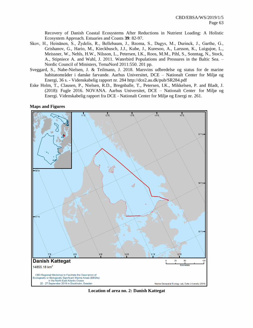
CBD/EBSA/WS/2019/1/5
Page 63
Recovery of Danish Coastal Ecosystems After Reductions in Nutrient Loading: A Holistic
Ecosystem Approach. Estuaries and Coasts 39: 82-97.
Skov, H., Heinänen, S., Žydelis, R., Bellebaum, J., Bzoma, S., Dagys, M., Durinck, J., Garthe, G.,
Grishanov, G., Hario, M., Kieckbusch, J.J., Kube, J., Kuresoo, A., Larsson, K., Luigujoe, L.,
Meissner, W., Nehls, H.W., Nilsson, L., Petersen, I.K., Roos, M.M., Pihl, S., Sonntag, N., Stock,
A., Stipniece A. and Wahl, J. 2011. Waterbird Populations and Pressures in the Baltic Sea. –
Nordic Council of Ministers, TemaNord 2011:550. 201 pp.
Sveggard, S., Nabe-Nielsen, J. & Teilmann, J. 2018. Marsvins udbredelse og status for de marine
habitatområder i danske farvande. Aarhus Universitet, DCE – Nationalt Center for Miljø og
Energi, 36 s. - Videnskabelig rapport nr. 284 http://dce2.au.dk/pub/SR284.pdf
Eske Holm, T., Clausen, P., Nielsen, R.D., Bregnballe, T., Petersen, I.K., Mikkelsen, P. and Bladt, J.
(2018): Fugle 2016. NOVANA. Aarhus Universitet, DCE – Nationalt Center for Miljø og
Energi. Videnskabelig rapport fra DCE - Nationalt Center for Miljø og Energi nr. 261.
Maps and Figures
Location of area no. 2: Danish Kattegat
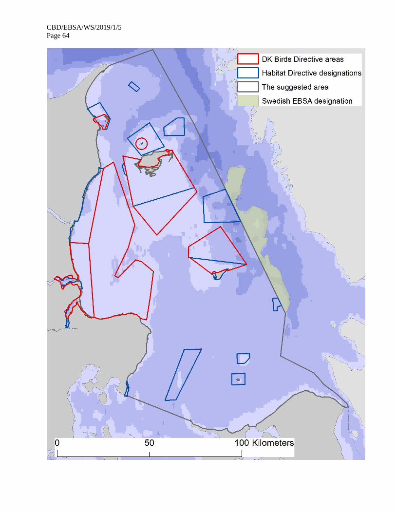
CBD/EBSA/WS/2019/1/5
Page 64
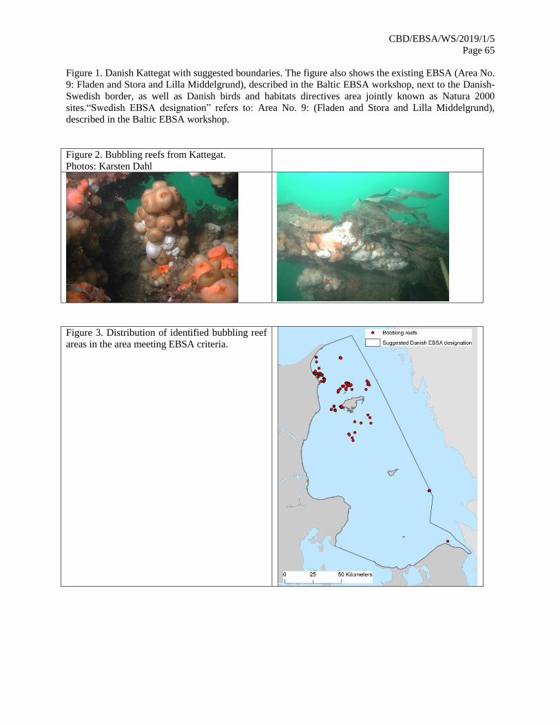
CBD/EBSA/WS/2019/1/5
Page 65
Figure 1. Danish Kattegat with suggested boundaries. The figure also shows the existing EBSA (Area No.
9: Fladen and Stora and Lilla Middelgrund), described in the Baltic EBSA workshop, next to the Danish-
Swedish border, as well as Danish birds and habitats directives area jointly known as Natura 2000
sites.“Swedish EBSA designation” refers to: Area No. 9: (Fladen and Stora and Lilla Middelgrund),
described in the Baltic EBSA workshop.
Figure 2. Bubbling reefs from Kattegat.
Photos: Karsten Dahl
Figure 3. Distribution of identified bubbling reef
areas in the area meeting EBSA criteria.
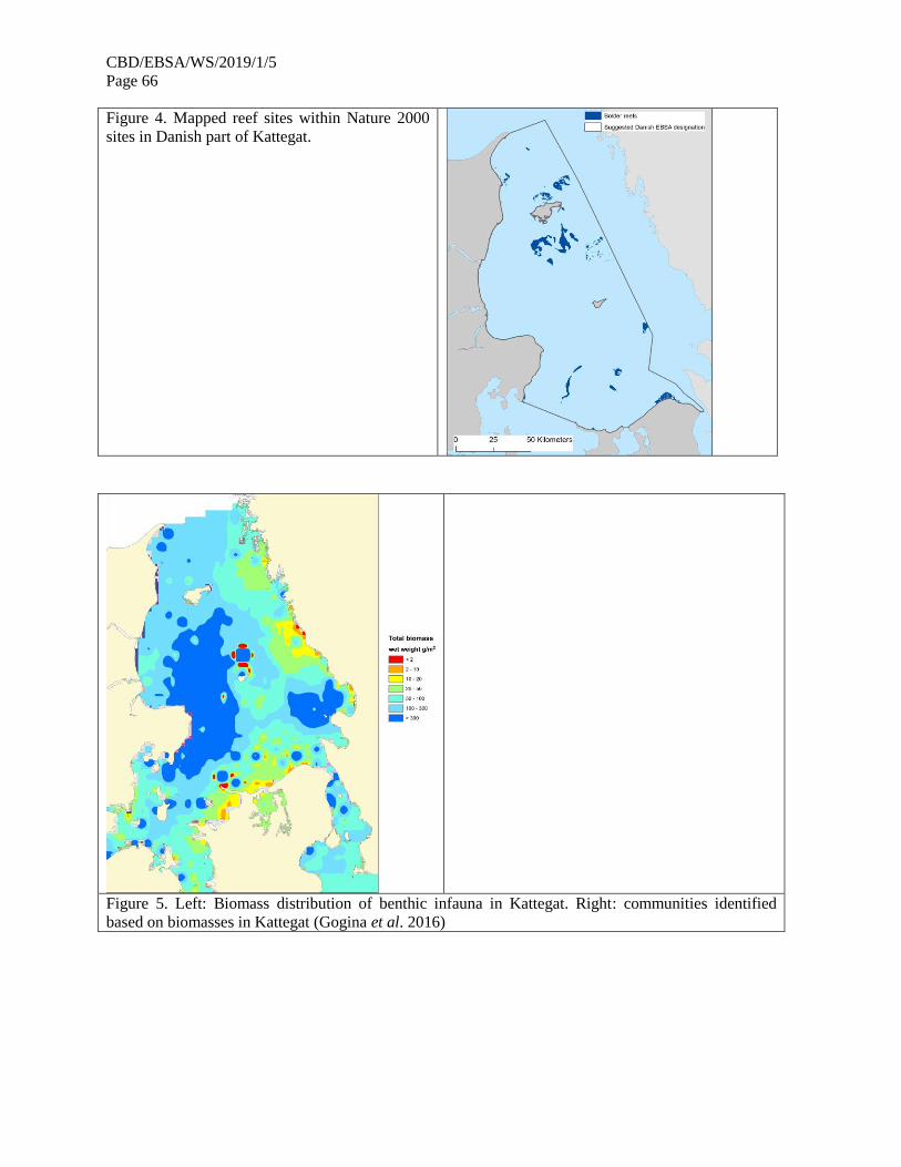
CBD/EBSA/WS/2019/1/5
Page 66
Figure 4. Mapped reef sites within Nature 2000
sites in Danish part of Kattegat.
Figure 5. Left: Biomass distribution of benthic infauna in Kattegat. Right: communities identified
based on biomasses in Kattegat (Gogina et al. 2016)
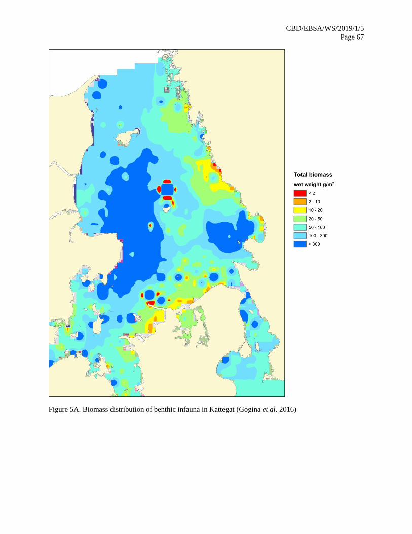
CBD/EBSA/WS/2019/1/5
Page 67
Figure 5A. Biomass distribution of benthic infauna in Kattegat (Gogina et al. 2016)
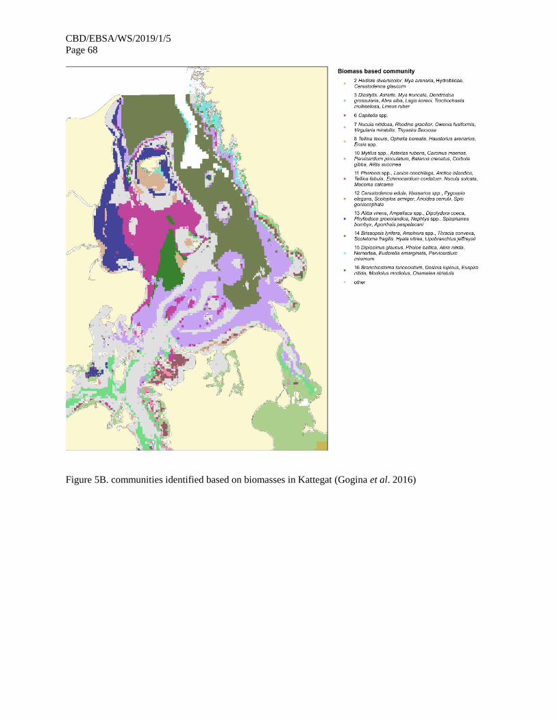
CBD/EBSA/WS/2019/1/5
Page 68
Figure 5B. communities identified based on biomasses in Kattegat (Gogina et al. 2016)
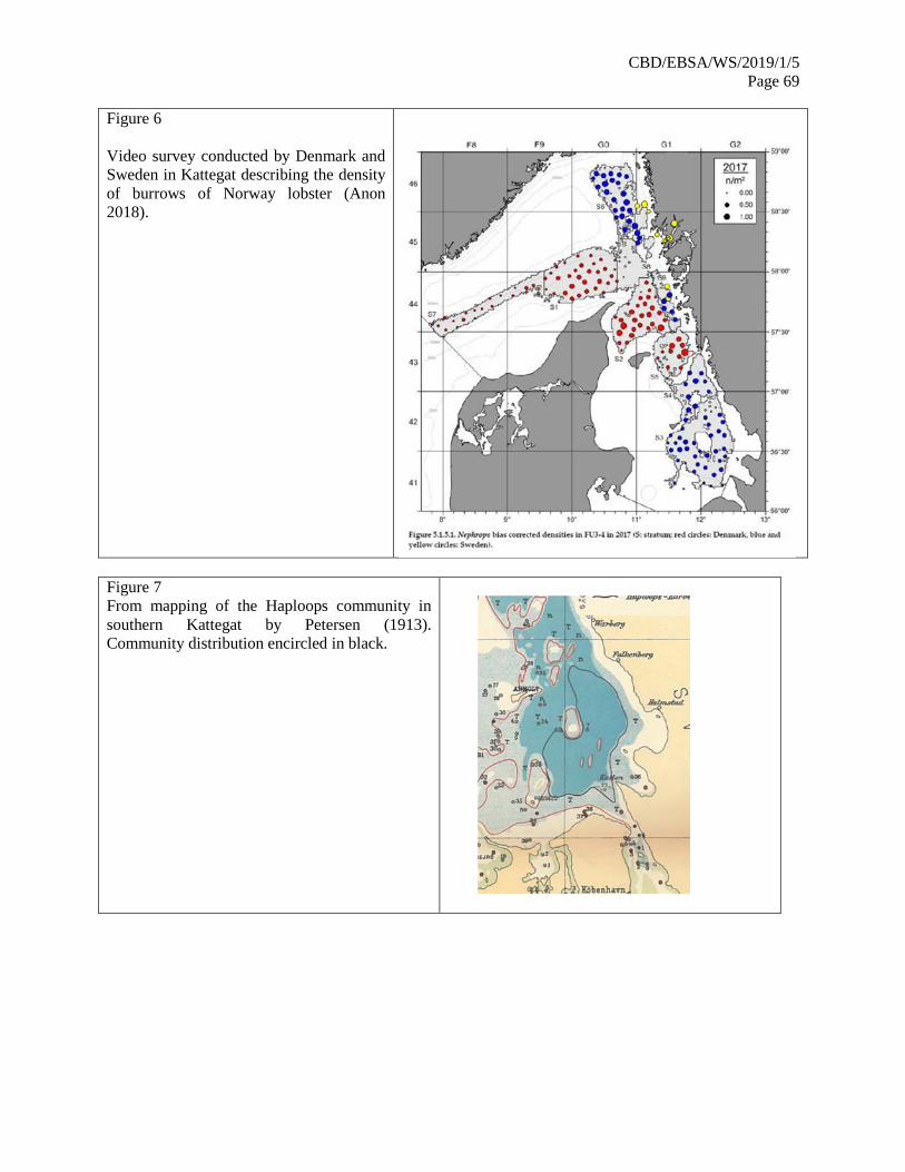
CBD/EBSA/WS/2019/1/5
Page 69
Figure 6
Video survey conducted by Denmark and
Sweden in Kattegat describing the density
of burrows of Norway lobster (Anon
2018).
Figure 7
From mapping of the Haploops community in
southern Kattegat by Petersen (1913).
Community distribution encircled in black.
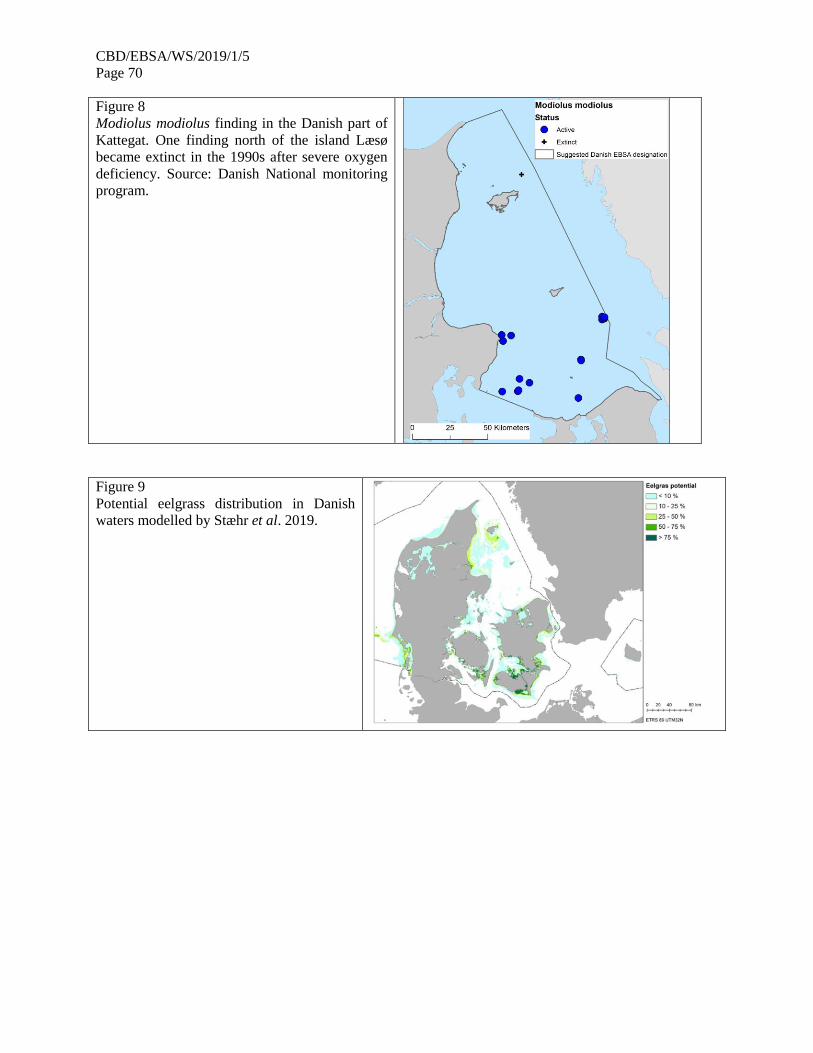
CBD/EBSA/WS/2019/1/5
Page 70
Figure 8
Modiolus modiolus finding in the Danish part of
Kattegat. One finding north of the island Læsø
became extinct in the 1990s after severe oxygen
deficiency. Source: Danish National monitoring
program.
Figure 9
Potential eelgrass distribution in Danish
waters modelled by Stæhr et al. 2019.
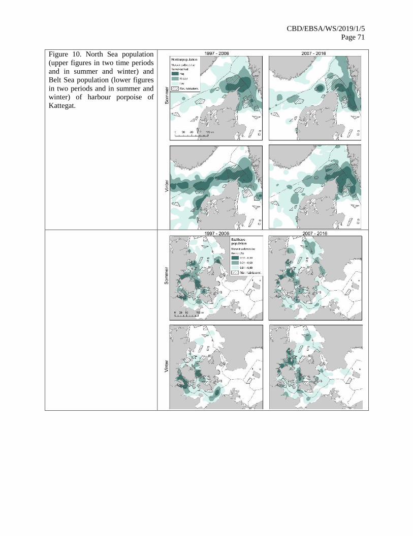
CBD/EBSA/WS/2019/1/5
Page 71
Figure 10. North Sea population
(upper figures in two time periods
and in summer and winter) and
Belt Sea population (lower figures
in two periods and in summer and
winter) of harbour porpoise of
Kattegat.

CBD/EBSA/WS/2019/1/5
Page 72
Figure 41. The spatial distribution of 76.553 razorbills/guillemots in inner Danish waters in the winter of
2008. Density is N/0.25 km2. Of these, almost 73,000 individuals were estimated to be within the Danish
part of Kattegat between Sjælland and Anholt (Petersen and Nielsen, 2011).
Figure 12. The spatial distribution of 4,228 observed razorbills/common guillemots in inner Danish
waters in the winter of 2016 (Holm et al. 2018).
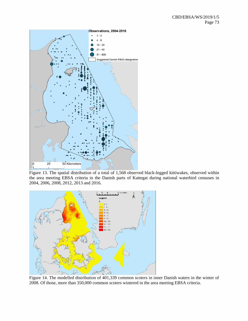
CBD/EBSA/WS/2019/1/5
Page 73
Figure 13. The spatial distribution of a total of 1,568 observed black-legged kittiwakes, observed within
the area meeting EBSA criteria in the Danish parts of Kattegat during national waterbird censuses in
2004, 2006, 2008, 2012, 2013 and 2016.
Figure 14. The modelled distribution of 401,339 common scoters in inner Danish waters in the winter of
2008. Of those, more than 350,000 common scoters wintered in the area meeting EBSA criteria.
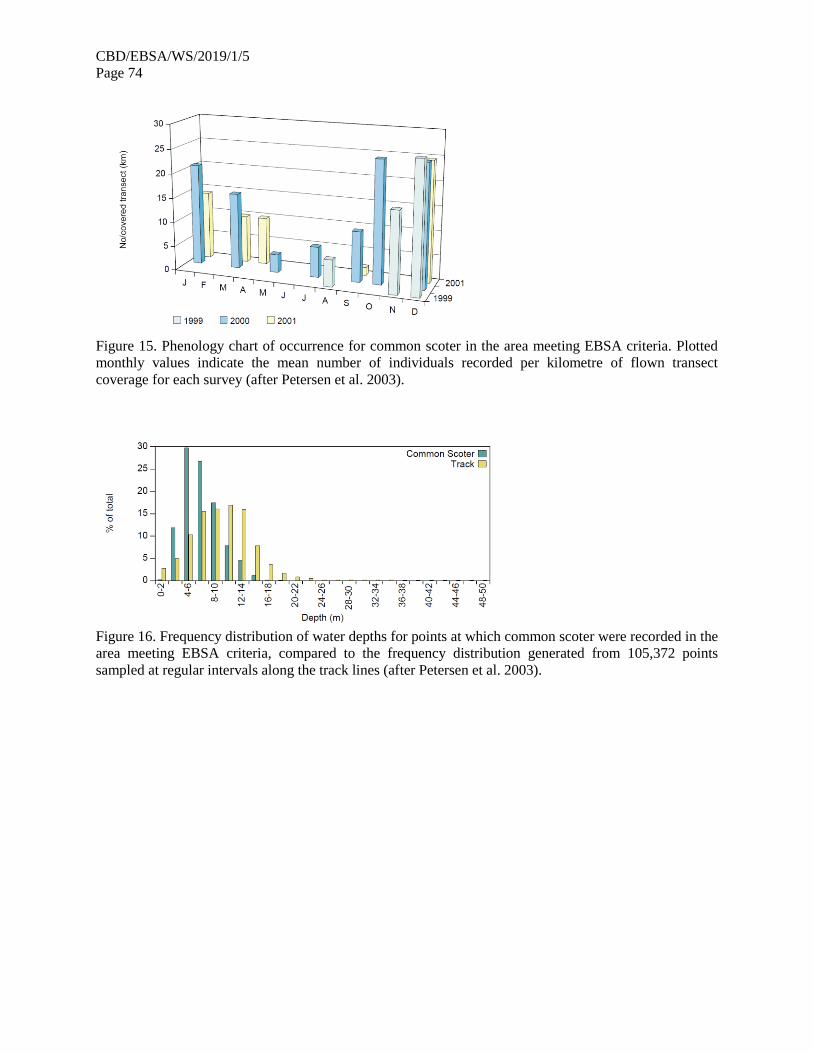
CBD/EBSA/WS/2019/1/5
Page 74
Figure 15. Phenology chart of occurrence for common scoter in the area meeting EBSA criteria. Plotted
monthly values indicate the mean number of individuals recorded per kilometre of flown transect
coverage for each survey (after Petersen et al. 2003).
Figure 16. Frequency distribution of water depths for points at which common scoter were recorded in the
area meeting EBSA criteria, compared to the frequency distribution generated from 105,372 points
sampled at regular intervals along the track lines (after Petersen et al. 2003).

CBD/EBSA/WS/2019/1/5
Page 75
Figure 17. The spatial distribution of 2,310 observed velvet scoters in inner Danish waters in the winter of
2016 (Holm et al. 2018).
Figure 18. The spatial distribution of 740 observed diver species in inner Danish waters in the winter of
2016. Source: Holm et al. 2018.
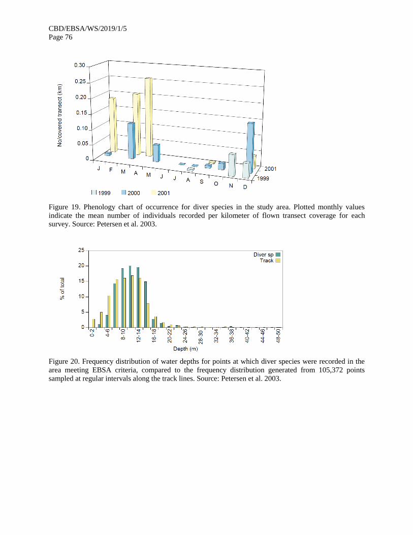
CBD/EBSA/WS/2019/1/5
Page 76
Figure 19. Phenology chart of occurrence for diver species in the study area. Plotted monthly values
indicate the mean number of individuals recorded per kilometer of flown transect coverage for each
survey. Source: Petersen et al. 2003.
Figure 20. Frequency distribution of water depths for points at which diver species were recorded in the
area meeting EBSA criteria, compared to the frequency distribution generated from 105,372 points
sampled at regular intervals along the track lines. Source: Petersen et al. 2003.
CBD/EBSA/WS/2019/1/5
Page 77
Area no. 3: Cantabrian Sea (Southern Bay of Biscay)
Abstract
The Cantabrian Sea ecosystem includes the continental shelf and slope and the deep abyssal basin (5000
m water depth) located along the northern border of the Iberian Peninsula (Southern Bay of Biscay), from
the Capbreton Canyon head to Estaca de Bares Cape, on the Galician coast. It is a highly complex area,
where the narrow continental shelf is deeply affected by the action of tectonic compression. The area
contains important geomorphological elements, such as large submarine canyons and seamounts. The
hydrology is also complex due to the interaction between waters formed in the Atlantic and waters of
Mediterranean origin. This area includes a variety of benthic habitats, including habitats that are
considered hotspots of biodiversity. These habitats serve as spawning grounds for several commercial
species. The area also contains habitats for endangered, threatened and declining species and for
migratory pelagic species, including cetaceans.
Introduction The Bay of Biscay, where the Cantabrian Sea is located, is an arm of the Atlantic Ocean, indenting the
coast of Western Europe from north-western France (offshore Brittany) to north-western Spain (Galicia).
The southern Bay of Biscay is a well-differentiated geomorphological unit in the northeast Atlantic. The
abyssal basin has a mean depth of 4,800 m. The shelf of the Bay of Biscay is quite narrow in the
Cantabrian Sea, whereas it is much wider and increasing with latitude on the French coast. In the
Cantabrian Sea, there are various deep-sea canyons that have generally narrow, steep-sided, linear and
sinuous channels. The deep-sea valleys allow continental sediments to be transported to oceanic basins
(Lavín et al., 2005).
Most of the water masses occupying the bay have a North Atlantic origin or are the result of interaction
between waters formed in the Atlantic with water of Mediterranean origin. The hydrodynamics of the bay
are dominated by: a) a weak anticyclonic circulation in the oceanic part, b) a poleward-flowing slope
current, c) coastal upwelling, d) the northward flow of Mediterranean water at depth, around the Iberian
Peninsula, e) the shelf circulation and f) the cross-shelf transport along the axes of submarine canyons
(OSPAR, 2000). Most of these features show a marked seasonality (Koutsikopoulos and Le Cann, 1996).
The Bay of Biscay is a region of large tidal amplitudes and strong thermohaline forcing (Piraud et al.,
2003). It is well known for its energetic internal tides, caused by the combination of summer
stratification, steep shelf-edge topography and strong (cross-slope) tidal currents, especially at spring tides
(Lam et al., 003).
Coastal upwelling events occur mainly on the Spanish continental margin of the Bay of Biscay
(Cantabrian Sea). These are produced by north-eastern winds prevailing from late May to September.
Upwelling events are highly variable in intensity and frequency from year to year, but in general they are
more common and intense to the west of Cape Peñas and act as a mechanism generating an environmental
contrast between the western and eastern parts of the Cantabrian Sea and between the coastal mixed
waters and the neighbouring oceanic stratified areas (Lavín et al., 2005). Moreover, the Cantabrian Sea is
only weakly influenced by the land, due to the absence of large rivers in the area, which can affect the
physical and chemical characteristics of the water column and sediments. As a result, it shows
environmental characteristics significantly different from the large continental shelf of the French Bay of
Biscay area.
There are many descriptive studies on different aspects of the Bay of Biscay. The main reviews/studies
are the Quality Status Report from OSPAR (2000) and the work of Valdés and Lavín (2002), which
considers the Bay of Biscay a “large marine ecosystem”. Díez et al. (2000) reviewed the information on
the southern part of the Bay of Biscay (the Cantabrian Sea).
Location
CBD/EBSA/WS/2019/1/5
Page 78
The area is located in the south of the Bay of Biscay and is bounded by the parallels 43º 25'N and 45º
00'N and meridians 2º 10'W and 7º 00'W. The feature for which this area is described also extends
eastwards and northwards, beyond the boundaries currently described.
Feature description of the area
The area includes a variety of benthic habitats that are considered hotspots of biodiversity.
The Bay of Biscay area forms the subtropical/boreal transition zone of the eastern Atlantic, where typical
temperate-water species from the south occur, together with those of northern origin and, consequently,
high biodiversity indices exist in comparison with adjacent areas (Quéro et al., 1989; Sánchez et al.,
2002). Additionally, the highly complex area includes a great diversity of geomorphological features
(e.g., submarine canyons, seamounts, banks and mounds, pockmarks, slope affected by smaller rock
outcrops) and hence, a diversity of benthic niches is available. Although, in some areas, benthic
information is scarce (particularly in the deepest zones), available scientific data highlight the existence of
important hotspots of biodiversity. The submarine canyons of the Avilés system (Sánchez et al., 2014),
the Le Danois Bank (Sánchez et al., 2008) as well as numerous areas of the continental slope (Aguilar et
al., 2009) are example of hotspots of benthic biodiversity, where numerous vulnerable taxa and habitats
have been recorded.
Habitats on both soft and rocky bottoms host a high diversity of species, resulting in shelf and slope
ecosystems that are rich in species and in ecological interactions, including circalittoral rocky bottoms
with sponges (Phakellia ventilabrum) and corals (Dendrophyllia cornigera), coral reefs with Madrepora
oculata and Lophelia pertusa, bathyal rocky bottoms with gorgonians (Callogorgia verticillata,
Acanthogorgia spp.), big sponge grounds (Asconema setubalense, Geodiidae, Pachastrellidae) and black
corals (Leiopathes sp., Antipathes sp., Bathypathes sp.). Other species that are frequently found over hard
substrates are crinoids (Leptometra celtica) and sea stars (Brisinga endecacnemos and Novodina pandina).
However, over soft bottoms, different communities have been found, such as pennatulids (Pennatula
rubra, Pennatula phosphorea, Funiculina quadrangularis), tube-dwelling anemones (Cerianthus sp.) and
detritic sand bottoms with sea anemones (Phelliactis hertwigi). Some carnivorous sponges (Lypocodina,
Chondrocladia and Cladrihiza) have also been recorded (see Sánchez et al., 2008; 2014; Aguilar et al.,
2009).
Together with deep zones, some coastal areas are ecologically or biologically significant due to the
presence of gorgonian forests and sponge grounds (e.g., Somos Llungo- Peñas Cape) where levels of
biodiversity indices are high (Aguilar et al., 2009) or due to their geomorphology and the presence of
species typical of the Mediterranean in the Cantabrian Sea (e.g., Jaizkibel).
The area is important for cetaceans.
The Bay of Biscay, including the areas of the canyons, seamounts, shelf, and adjacent pelagic areas,
support a persistent presence of cetacean species, including the bottlenose dolphin (Tursiops truncatus
Montagu, 1821), common dolphin (Delphinus delphis. Linnaeus, 1758), the long-finned pilot whale
(Globicephala melas, Traill, 1809), striped dolphin (Stenella coeruleoalba, Meyen, 1833) Cuvier's beaked
whale (Ziphius cavirostris, Cuvier, 1823), fin whale (Balaenoptera physalus, Linnaeus, 1758), and sperm
whale Physeter macrocephalus (Linnaeus, 1758; Laborde, 2008; CODA 2009) (Marcos-Ipiña et al., 2014;
Laran et al., 2016).
The area includes habitats for endangered, threatened and declining species.
Many species recorded in the area are considered endangered, threatened and/or declining, according to,
for example, the IUCN, OSPAR, ICES or the EU Habitat Directive.

CBD/EBSA/WS/2019/1/5
Page 79
Listed below are some examples of species and habitats in the area that need special attention:
The IUCN Red List of threatened species (CR: Critically endangered, EN: Endangered and VU:
Vulnerable):
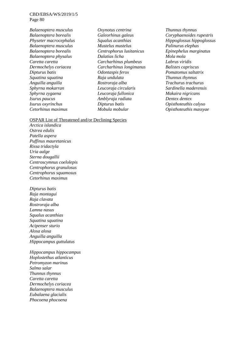
CBD/EBSA/WS/2019/1/5
Page 80
Balaenoptera musculus
Balaenoptera borealis
Physeter macrocephalus
Balaenoptera musculus
Balaenoptera borealis
Balaenoptera physalus
Caretta caretta
Dermochelys coriacea
Dipturus batis
Squatina squatina
Anguilla anguilla
Sphyrna mokarran
Sphyrna zygaena
Isurus paucus
Isurus oxyrinchus
Cetorhinus maximus
Oxynotus centrina
Galeorhinus galeus
Squalus acanthias
Mustelus mustelus
Centrophorus lusitanicus
Dalatias licha
Carcharhinus plumbeus
Carcharhinus longimanus
Odontaspis ferox
Raja undulata
Rostroraja alba
Leucoraja circularis
Leucoraja fullonica
Amblyraja radiata
Dipturus batis
Mobula mobular
Thunnus thynnus
Coryphaenoides rupestris
Hippoglossus hippoglossus
Palinurus elephas
Epinephelus marginatus
Mola mola
Labrus viridis
Balistes capriscus
Pomatomus saltatrix
Thunnus thynnus
Trachurus trachurus
Sardinella maderensis
Makaira nigricans
Dentex dentex
Opisthoteuthis calyso
Opisthoteuthis massyae
OSPAR List of Threatened and/or Declining Species
Arctica islandica
Ostrea edulis
Patella aspera
Puffinus mauretanicus
Rissa tridactyla
Uria aalge
Sterna dougallii
Centroscymnus coelolepis
Centrophorus granulosus
Centrophorus squamosus
Cetorhinus maximus
Dipturus batis
Raja montagui
Raja clavata
Rostroraja alba
Lamna nasus
Squalus acanthias
Squatina squatina
Acipenser sturio
Alosa alosa
Anguilla anguilla
Hippocampus guttulatus
Hippocampus hippocampus
Hoplostethus atlanticus
Petromyzon marinus
Salmo salar
Thunnus thynnus
Caretta caretta
Dermochelys coriacea
Balaenoptera musculus
Eubalaena glacialis
Phocoena phocoena
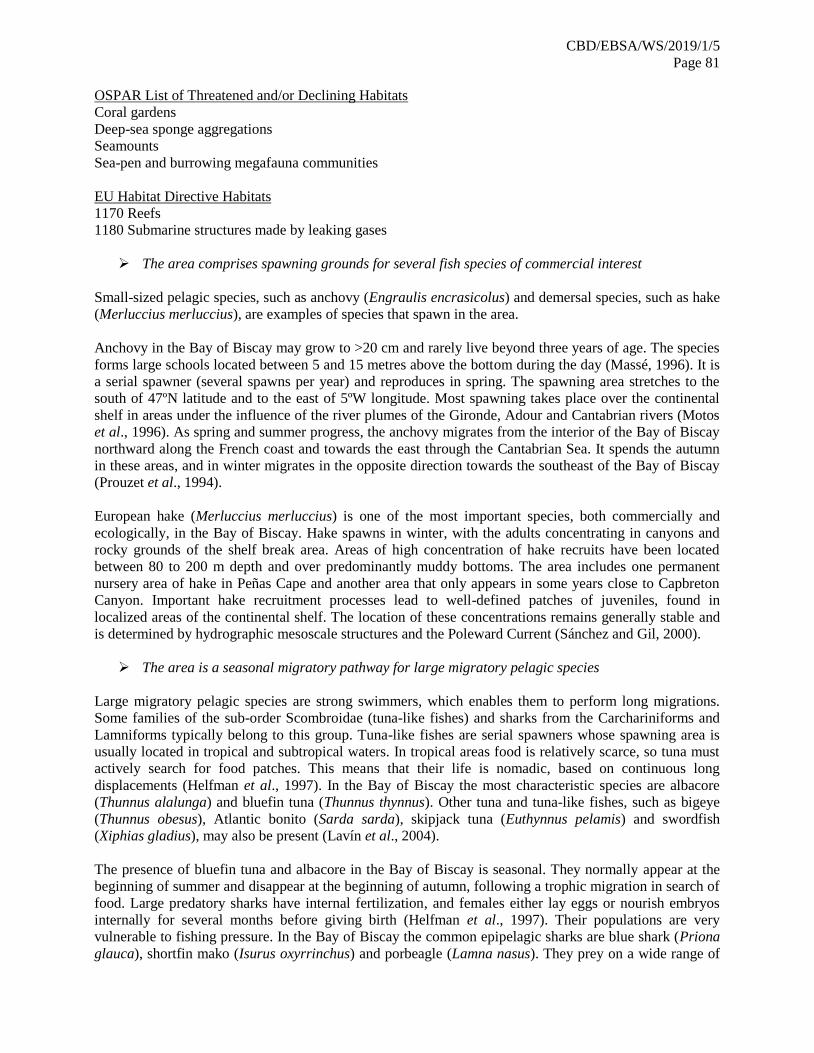
CBD/EBSA/WS/2019/1/5
Page 81
OSPAR List of Threatened and/or Declining Habitats
Coral gardens
Deep-sea sponge aggregations
Seamounts
Sea-pen and burrowing megafauna communities
EU Habitat Directive Habitats
1170 Reefs
1180 Submarine structures made by leaking gases
The area comprises spawning grounds for several fish species of commercial interest
Small-sized pelagic species, such as anchovy (Engraulis encrasicolus) and demersal species, such as hake
(Merluccius merluccius), are examples of species that spawn in the area.
Anchovy in the Bay of Biscay may grow to >20 cm and rarely live beyond three years of age. The species
forms large schools located between 5 and 15 metres above the bottom during the day (Massé, 1996). It is
a serial spawner (several spawns per year) and reproduces in spring. The spawning area stretches to the
south of 47ºN latitude and to the east of 5ºW longitude. Most spawning takes place over the continental
shelf in areas under the influence of the river plumes of the Gironde, Adour and Cantabrian rivers (Motos
et al., 1996). As spring and summer progress, the anchovy migrates from the interior of the Bay of Biscay
northward along the French coast and towards the east through the Cantabrian Sea. It spends the autumn
in these areas, and in winter migrates in the opposite direction towards the southeast of the Bay of Biscay
(Prouzet et al., 1994).
European hake (Merluccius merluccius) is one of the most important species, both commercially and
ecologically, in the Bay of Biscay. Hake spawns in winter, with the adults concentrating in canyons and
rocky grounds of the shelf break area. Areas of high concentration of hake recruits have been located
between 80 to 200 m depth and over predominantly muddy bottoms. The area includes one permanent
nursery area of hake in Peñas Cape and another area that only appears in some years close to Capbreton
Canyon. Important hake recruitment processes lead to well-defined patches of juveniles, found in
localized areas of the continental shelf. The location of these concentrations remains generally stable and
is determined by hydrographic mesoscale structures and the Poleward Current (Sánchez and Gil, 2000).
The area is a seasonal migratory pathway for large migratory pelagic species
Large migratory pelagic species are strong swimmers, which enables them to perform long migrations.
Some families of the sub-order Scombroidae (tuna-like fishes) and sharks from the Carchariniforms and
Lamniforms typically belong to this group. Tuna-like fishes are serial spawners whose spawning area is
usually located in tropical and subtropical waters. In tropical areas food is relatively scarce, so tuna must
actively search for food patches. This means that their life is nomadic, based on continuous long
displacements (Helfman et al., 1997). In the Bay of Biscay the most characteristic species are albacore
(Thunnus alalunga) and bluefin tuna (Thunnus thynnus). Other tuna and tuna-like fishes, such as bigeye
(Thunnus obesus), Atlantic bonito (Sarda sarda), skipjack tuna (Euthynnus pelamis) and swordfish
(Xiphias gladius), may also be present (Lavín et al., 2004).
The presence of bluefin tuna and albacore in the Bay of Biscay is seasonal. They normally appear at the
beginning of summer and disappear at the beginning of autumn, following a trophic migration in search of
food. Large predatory sharks have internal fertilization, and females either lay eggs or nourish embryos
internally for several months before giving birth (Helfman et al., 1997). Their populations are very
vulnerable to fishing pressure. In the Bay of Biscay the common epipelagic sharks are blue shark (Priona
glauca), shortfin mako (Isurus oxyrrinchus) and porbeagle (Lamna nasus). They prey on a wide range of
CBD/EBSA/WS/2019/1/5
Page 82
pelagic and demersal fishes. The largest shark in the Bay of Biscay is the basking shark (Cetorhinus
maximuis), which can measure more than 9 m in length (Lavín et al., 2004).
The area includes soft bottoms essential for the biology of commercial benthic species.
This is the case, for example, of the Norway lobster (Nephrops norvegicus). This species is distributed
from Iceland to Portugal and the Mediterranean and is limited to areas of muddy habitat at depths of 15 to
800 m. The spatial extent of suitable sediment defines the species distribution and the stock boundaries.
Nephrops are sedentary and rather common on muddy grounds, in which they dig the burrows where they
spend most of their time. In the Bay of Biscay, three populations are distinguished: one on the French
shelf and two in the Cantabrian Sea. Females spawn from April to August and carry eggs under their tails
(“berried” females) until they hatch about seven months later. The larvae develop in the plankton for one
month before settling to the seabed. When berried, females rarely come out of the burrow and are
therefore naturally protected from trawlers. Nephrops are mainly nocturnal and feed on detritus,
crustaceans and worms (Lavín et al., 2004).
Feature condition and future outlook of the area
There are various activities impacting the ecological/biological features of the Bay of Biscay:
- Fishing activities: the main fishing gears used in the area are bottom trawling, fishing lines and gill nets.
Trawlers operate on the muddy bottoms of the shelf and produce serious negative impacts over certain
habitat types. Long-liners also operate mainly at the bottom but at the shelf-break, whereas gill nets are
used on rocky grounds near the coast and shelf-break. In addition to resource overexploitation, fishing
activities have an impact on other species, such as sea turtles, cetaceans and seabirds (longline bycatch).
Bay of Biscay fisheries have had a strong impact on the bottom communities and have induced changes in
their structure (Sánchez and Olaso, 2004; Serrano et al., 2006). This impact has been mainly direct
(fishing mortality on target species and bycatch) and indirect by means of modifications to the habitat
through erosion of the sediment and damage to the benthos by different elements of the gears.
- Water pollution: the main sources of pollution are ships and cities located on the coast (mostly in summer when the intensity of tourism increases in some coastal areas).
- Global warming: this phenomenon seems to have led to an increase in the presence of temperate-water
fish species in the Bay of Biscay (e.g., among pelagic fishes Megalops atlanticus, Seriola rivoliana) over
the last 20 years (Quéro et al., 1998; Stebbing et al., 2002). These changes related to global warming tend
to operate slowly but have severe long-term consequences for the ecology of the ecosystem. They can
affect: i) the behaviour of species (e.g., changes in migratory routes), ii) their recruitment (due to changes
in the environmental conditions in the spawning and/or recruitment areas) and iii) the spatial distribution
of species (since more meridional species can expand their area of distribution). In fact, this increase in
temperature is likely to be responsible for the appearance of tropical fish species in the southeast shelf of
the Bay of Biscay.
- Shipping and oil transport: The Bay of Biscay is located on the main route of supertankers transporting
oil from the Middle East and Africa to EU harbours. More than 70 per cent of the total oil consumed in
the EU is moved by shipping through the Finisterre pass directly towards the English Channel and then to
the final destination in different European harbours. In recent years, several oil spills have occurred in the
Bay of Biscay; for example five supertankers carrying more than 50 000 t have been wrecked since 1976,
the last three of which occurred in an interval of just a decade (1992, Aegean Sea; 1999, Erika; 2002,
Prestige), which has made this region the most severely affected in the world by this kind of accident
(Lavín et al., 2004).

CBD/EBSA/WS/2019/1/5
Page 83
Conversely, some actions to protect the area and to ensure the conservation of its biodiversity are being
carried out, and two specific areas within the area described have been protected in accordance with
international and Spanish regulations and conventions:
(1) The El Cachucho-Le Danois Bank: this off-shore marine protected area (MPA) covers an extensive
offshore bank and seamount with surrounding slopes and a complex system of channels and canyons that
covers 234 000 ha. Depths within the area vary from 500 to 4000 m, which makes for an amazingly
diverse biological hotspot. The high biodiversity found in the area (Sánchez et al., 2008; Cristobo et
al., 2009; Altuna, 2013), but moreover, the presence in the area of “1170 Reef” habitats that are included in Annex I of the Habitats Directive of the European Union (Council Directive 92/43/EEC), were
the main reason for the declaration of the area as a MPA and inclusion in the OSPAR Network of Marine
Protected Areas (Sánchez et al., 2017; Rodríguez-Basalo et al., 2019).
El Cachucho MPA has been the subject of numerous studies and surveys in recent years to evaluate the
condition of the habitats (García-Alegre et al., 2014; Sánchez et al., 2017). Many species have been
recently discovered there to be new to science, and more are being described (Guerra-García et al.,
2008; Frutos and Sorbe, 2010; Frutos et al., 2011).
Bottom trawling and fishing with static gear, including bottom set gillnets and bottom set longlines, are prohibited.
(2) The Avilés submarine system of canyons: this Site of Community Importance (Natura 2000 network)
comprises three great submarine canyons (Avilés, El Corbiro and La Gaviera), a marginal platform (Canto
Nuevo) and a tall, structural, rocky mass (Agudo de Fuera). The Avilés Canyon begins at a depth of 128 m
and is approximately 75 km in length, with a V-shaped profile and a primarily sedimentary bottom. The
Corbiro Canyon is 23 km in length and also has a V-shaped profile and a sedimentary bottom, while the
La Gaviera Canyon has U-shaped profile with one sedimentary and one rocky flank, with features of a
hanging canyon. Along its axis there are several rocky escarpments (Gomez-Ballesteros et al., 2014).
The submarine canyons of the Avilés system act as a collector of terrigenous material deposited by the
rivers and play an important role as a transport mechanism for the sediment and organic matter from the
continental shelf to the deep areas of the Bay of Biscay abyssal basin. Therefore, this area is considered a
highly productive biological system. Biodiversity in the area is very high, and more than 1300 species
have been catalogued to date on the seabed (excluding the pelagic organisms that occupy the water
column). Some of these species, such as corals, sponges and sharks, are particularly vulnerable and are
included in various protection regulations. The management plan of the area is being developed in the framework of the INTEMARES project.
A third area currently under consideration under the coverage of the INTEMARES project is the
Capbretón Canyon. This submarine valley located on the continental shelf and slope of the Bay of Biscay
is divided in two zones: the northern Aquitanian continental shelf and the southern Cantabrian shelf. A
proposal for protection will be developed.
Apart from conservation projects, every autumn the Instituto Español de Oceanografía (IEO) carries out a
bottom-trawling survey named DEMERSALES. This survey aims to provide data for the assessment of
commercial fish species and benthic ecosystems on the Galician and Cantabrian shelf (ICES, 2010). This
survey is part of an international effort to monitor marine ecosystems and is coordinated by the
International Bottom Trawling Surveys (IBTS) working group of the International Council for the
Exploration of the Sea (ICES).
Assessment of area no. 3, Cantabrian Sea (Southern Bay of Biscay), against CBD EBSA Criteria
CBD EBSA Description Ranking of criterion relevance
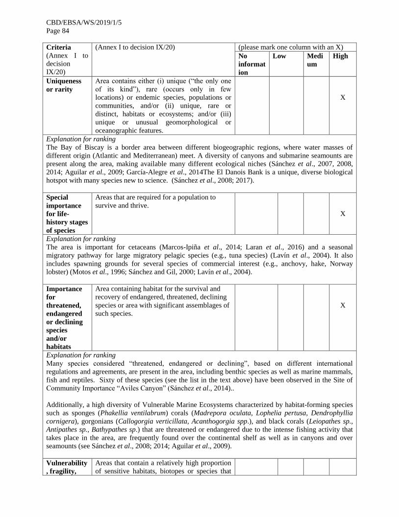
CBD/EBSA/WS/2019/1/5
Page 84
Criteria
(Annex I to
decision
IX/20)
(Annex I to decision IX/20) (please mark one column with an X)
No
informat
ion
Low Medi
um
High
Uniqueness
or rarity
Area contains either (i) unique (“the only one
of its kind”), rare (occurs only in few
locations) or endemic species, populations or
communities, and/or (ii) unique, rare or
distinct, habitats or ecosystems; and/or (iii)
unique or unusual geomorphological or
oceanographic features.
X
Explanation for ranking
The Bay of Biscay is a border area between different biogeographic regions, where water masses of
different origin (Atlantic and Mediterranean) meet. A diversity of canyons and submarine seamounts are
present along the area, making available many different ecological niches (Sánchez et al., 2007, 2008,
2014; Aguilar et al., 2009; García-Alegre et al., 2014The El Danois Bank is a unique, diverse biological
hotspot with many species new to science. (Sánchez et al., 2008; 2017).
Special
importance
for life-
history stages
of species
Areas that are required for a population to
survive and thrive.
X
Explanation for ranking
The area is important for cetaceans (Marcos-Ipiña et al., 2014; Laran et al., 2016) and a seasonal
migratory pathway for large migratory pelagic species (e.g., tuna species) (Lavín et al., 2004). It also
includes spawning grounds for several species of commercial interest (e.g., anchovy, hake, Norway
lobster) (Motos et al., 1996; Sánchez and Gil, 2000; Lavín et al., 2004).
Importance
for
threatened,
endangered
or declining
species
and/or
habitats
Area containing habitat for the survival and
recovery of endangered, threatened, declining
species or area with significant assemblages of
such species.
X
Explanation for ranking
Many species considered “threatened, endangered or declining”, based on different international
regulations and agreements, are present in the area, including benthic species as well as marine mammals,
fish and reptiles. Sixty of these species (see the list in the text above) have been observed in the Site of
Community Importance “Aviles Canyon” (Sánchez et al., 2014)..
Additionally, a high diversity of Vulnerable Marine Ecosystems characterized by habitat-forming species
such as sponges (Phakellia ventilabrum) corals (Madrepora oculata, Lophelia pertusa, Dendrophyllia
cornigera), gorgonians (Callogorgia verticillata, Acanthogorgia spp.), and black corals (Leiopathes sp.,
Antipathes sp., Bathypathes sp.) that are threatened or endangered due to the intense fishing activity that
takes place in the area, are frequently found over the continental shelf as well as in canyons and over
seamounts (see Sánchez et al., 2008; 2014; Aguilar et al., 2009).
Vulnerability
, fragility,
Areas that contain a relatively high proportion
of sensitive habitats, biotopes or species that
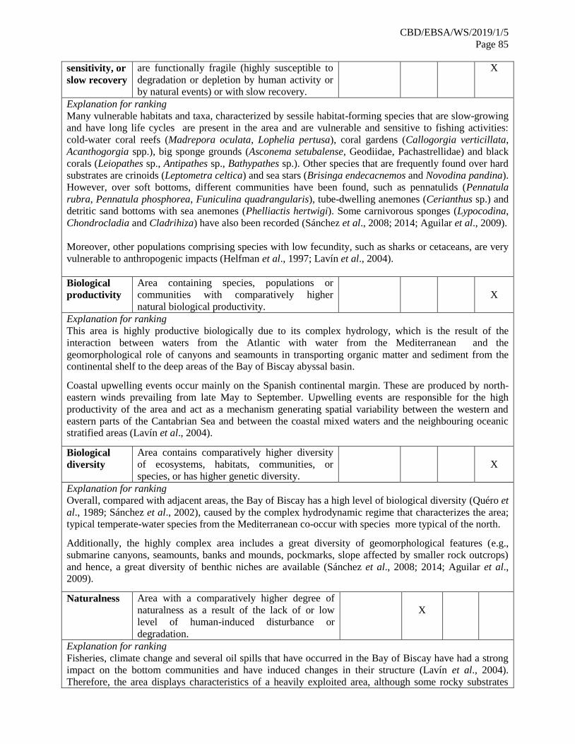
CBD/EBSA/WS/2019/1/5
Page 85
sensitivity, or
slow recovery
are functionally fragile (highly susceptible to
degradation or depletion by human activity or
by natural events) or with slow recovery.
X
Explanation for ranking
Many vulnerable habitats and taxa, characterized by sessile habitat-forming species that are slow-growing
and have long life cycles are present in the area and are vulnerable and sensitive to fishing activities:
cold-water coral reefs (Madrepora oculata, Lophelia pertusa), coral gardens (Callogorgia verticillata,
Acanthogorgia spp.), big sponge grounds (Asconema setubalense, Geodiidae, Pachastrellidae) and black
corals (Leiopathes sp., Antipathes sp., Bathypathes sp.). Other species that are frequently found over hard
substrates are crinoids (Leptometra celtica) and sea stars (Brisinga endecacnemos and Novodina pandina).
However, over soft bottoms, different communities have been found, such as pennatulids (Pennatula
rubra, Pennatula phosphorea, Funiculina quadrangularis), tube-dwelling anemones (Cerianthus sp.) and
detritic sand bottoms with sea anemones (Phelliactis hertwigi). Some carnivorous sponges (Lypocodina,
Chondrocladia and Cladrihiza) have also been recorded (Sánchez et al., 2008; 2014; Aguilar et al., 2009).
Moreover, other populations comprising species with low fecundity, such as sharks or cetaceans, are very
vulnerable to anthropogenic impacts (Helfman et al., 1997; Lavín et al., 2004).
Biological
productivity
Area containing species, populations or
communities with comparatively higher
natural biological productivity.
X
Explanation for ranking
This area is highly productive biologically due to its complex hydrology, which is the result of the
interaction between waters from the Atlantic with water from the Mediterranean and the
geomorphological role of canyons and seamounts in transporting organic matter and sediment from the continental shelf to the deep areas of the Bay of Biscay abyssal basin.
Coastal upwelling events occur mainly on the Spanish continental margin. These are produced by north-
eastern winds prevailing from late May to September. Upwelling events are responsible for the high
productivity of the area and act as a mechanism generating spatial variability between the western and
eastern parts of the Cantabrian Sea and between the coastal mixed waters and the neighbouring oceanic stratified areas (Lavín et al., 2004).
Biological
diversity
Area contains comparatively higher diversity
of ecosystems, habitats, communities, or
species, or has higher genetic diversity.
X
Explanation for ranking
Overall, compared with adjacent areas, the Bay of Biscay has a high level of biological diversity (Quéro et
al., 1989; Sánchez et al., 2002), caused by the complex hydrodynamic regime that characterizes the area; typical temperate-water species from the Mediterranean co-occur with species more typical of the north.
Additionally, the highly complex area includes a great diversity of geomorphological features (e.g.,
submarine canyons, seamounts, banks and mounds, pockmarks, slope affected by smaller rock outcrops)
and hence, a great diversity of benthic niches are available (Sánchez et al., 2008; 2014; Aguilar et al., 2009).
Naturalness Area with a comparatively higher degree of
naturalness as a result of the lack of or low
level of human-induced disturbance or
degradation.
X
Explanation for ranking
Fisheries, climate change and several oil spills that have occurred in the Bay of Biscay have had a strong
impact on the bottom communities and have induced changes in their structure (Lavín et al., 2004).
Therefore, the area displays characteristics of a heavily exploited area, although some rocky substrates
CBD/EBSA/WS/2019/1/5
Page 86
show less stressed ecosystems.
References
Aguilar, R., De la Torriente, A., García, A., 2009. Propuesta de Áreas Marinas de Importancia Ecológica;
Zona galaico- cantábrica. OCEANA
Aguilar R., García S., De la Torriente A., Peñalver, J., 2009. Cetáceos del área galaico-cantábrica. Zonas
de importancia para su conservación. Oceana - Obra Social Caja Madrid, 82 pág.
Altuna, A., 2013. Scleractinia (Cnidaria: Anthozoa) from ECOMARG 2003, 2008 and 2009 expeditions to
bathyal waters off north and northwest Spain (northeast Atlantic). Zootaxa 3641 (2), 101–128.
Anadón N., Doménech J. L., Pérez C., Villegas, M.L., 2004. Estudio para la conservación de la
biodiversidad del entorno marino del Cabo Peñas. Autoridad Portuaria de Gijón. 435 pp.
Barberá C., Bordehore C., Borg J.A., Glémarec M., Grall J., Hall-Spencer J.M., De la Huz C.H.,
Lanfranco E., Lastra M., Moore P.G., Mora J., Pita M.E., Ramos-Esplá A.A., Rizzo M., Sánchez-
Mata A., Seva A., Schembri P.J. & C. Valle (2003). Conservation and management of northeast
Atlantic and Mediterranean maërl beds. Aquatic Conservation: Marine and Freshwater
Ecosystems 13: 65-76.
Botas J.A., Fernández E., Bode A., Anadón, R., 1990. A persistent upwelling off the central Cantabrian
coast (Bay of Biscay). Est. Coast. Shelf Sci., 30: 185–199.
Borja A., Collins, M., 2004. Oceanography and marine environment of the Basque country. Elsevier
Oceanograp. Ser. 70, 616 pp.
Brocheray, S, Cremer, M., Zaragosi, S., Schmidt, Sp., Eynaud, F., Rossignol, L., Gillet, H., 2014. 2000
years of frequent turbidite activity in the Capbreton Canyon (Bay of Biscay). Marine Geology,
347: 136-152.
Cardador, F., Sanchéz, F., Pereiro, F.J., Borges, M.F., Caramelo, A.M., Azevedo, M., Silva, A., Pérez, N.,
Martins, M.M., Olaso, I., Pestana, G., Trujillo, V., Fernandez, A., 1997. Groundfish surveys in the
Atlantic Iberian waters (Ices Divisions VIIIc and IXa): history and perspectives. ICES, Council
Meeting 1997/Y:08, 30 pp.;
CODA 2009. Cetacean Offshore Distribution and Abundance in the European Atlantic. Final Report. 43
pp. <http://biology.st-andrews.ac.uk/coda/>.
Corcabri, L., Sorbe, J.C., 2001. Structure of the suprabenthic assemblages in the Capbreton area (SE of the
bay of Biscay). Le milieur marin: benthologie.
Cristobo, J., P. Ríos, F. Sánchez and N. Anadón, 2009. Redescription of the rare species Podospongia
loveni (Porifera) from the Cantabrian Sea. Continental Shelf Research 29 (2009), 1157-1164.
Díez, I., A. Secilla, A. Santolaria and J.M. Gorostiaga, 2000. The north coast of Spain. In Seas at the
Millennium. An environmental evaluation. C. Sheppard (Ed.). Pergamon, Amsterdam, Volume I,
135–150.
Frutos, I. and Sorbe, J.C., 2010. Politolana sanchezi sp. nov. (Crustacea: Isopoda: Cirolanidae), a new
benthic bioturbating scavenger from bathyal soft-bottoms of the southern Bay of Biscay
(northeastern Atlantic Ocean). Zootaxa 2640: 20-34.
Frutos, I., Sorbe J.C. & Junoy J. 2011. The first blind Paranthura species (Crustacea, Isopoda,
Paranthuridae) from the "El Cachucho" Marine Protected Area (Le Danois Bank, southern Bay of
Biscay). Zootaxa, 2971: 17-32.
García-Alegre, A. Sánchez, F., Gómez-Ballesteros, M., Hinz, H., Serrano, A., Parra, S., 2014. Modelling
and mapping the local distribution of representative species on the Le Danois Bank, El Cachucho
Marine Protected Area (Cantabrian Sea). Deep-Sea Research II, 106: 151-164.
Gaudin, M., Mulder, T., Cirac, P., Berné, S., Imbert, P., 2006. Past and present sedimentary activity in the
Capbreton Canyon, southern Bay of Biscay. Geo-Mar Lett (2006) 26:331–345. DOI
10.1007/s00367-006-0043-1.
Gómez-Ballesteros, M., M. Druet, A. Muñóz, B. Arrese, J. Rivera, F. Sánchez, F. J. Cristobo, S. Parra; A.
García-Alegre, C. González-Pola, J. Gallastegui, J. Acosta, 2014.

CBD/EBSA/WS/2019/1/5
Page 87
Geomorphology and sedimentary features of the Avilés Canyon System. Cantabrian Sea (Bay of Biscay).
Deep-Sea Research II, 106, pp. 99-117.
González-Irusta, J.M., De la Torriente, A., Punzón, A., Blanco, M., Serrano, A., 2018. Determining and
mapping species sensitivity to trawling impacts: the BEnthos Sensitivity Index to Trawling
Operations (BESITO). ICES Journal of Marine Science, 75(5), 1710–1721.
doi:10.1093/icesjms/fsy030.
Guerra-García J.M., J.C. Sorbe & I. Frutos, 2008. A new species of /Liropus/ (Crustacea, Amphipoda,
Caprellidae) from the Le Danois bank (southern Bay of Biscay). Organisms Diversity &
Evolution, Volume 7, Issue 4, 253-264.
ICES, 2016. Bay of Biscay and the Iberian Coast Ecoregion – Ecosystem overview. ICES Ecosystem
Overviews. Published 04 March 2016 Version 2; 13 May 2016
ICES, 2019. Nephrops in Division 8c. WGBIE
IUCN, 2019. IUCN Red List of Threatened Species
Koutsikopoulos C. 6 B. Le Cann (1996). Physical processes and hydrological structures related to the Bay
of Biscay anchovy. Sci. Mar., 60: 9–19.
Lam, F.P.A., T. Gerkema and L.R.M. Maas, 2003. Preliminary results from observations of internal tides
and solitary waves in the Bay of Biscay. http://www.whoi.edu/
science/AOPE/people/tduda/isww/text/lam/
Laran, S., Authier, M., Aurélie B., Ghislain D., Falchetto, H., & Monestiez, P., Pettex, E., Eric, S.,
Canneyt, O., & Ridoux, V. (2016). Seasonal distribution and abundance of cetaceans within
French waters- Part II: The Bay of Biscay and the English Channel. Deep Sea Research Part II:
Topical Studies in Oceanography. 10.1016/j.dsr2.2016.12.012.
Lavín, L. Valdés, F. Sánchez, P. Abaunza, A. Forest, J. Boucher, P. Lazure, A. M. Jegou, 2005. The Bay
of Biscay: The encountering of the ocean and the shelf. Capítulo en libro ”The Sea, Ideas and
Observation on Progress in the Study of the Seas”, Vol: 14, Part B, pp. 935 - 1002. Ed: A.
Robinson and K. Brink, Harvard University Press, Cambridge, MA, 2006. ISBN-13:978-0-674-
02117-4.
Laborde, M (2008) Spatial distribution of cetaceans in the Bay of Biscay and implications of the Marine
Strategy Directive for their conservation. 10.13140/RG.2.2.22520.96000.
Marcos-Ipiña, E., Salazar, J.M., De Stephanis, R. 2014. Cetacean population research and detection of
Special Areas of Conservation for cetaceans in the marine environment of Jaizkibel and adjacent
waters. Munibe Monographs. Nature Series, 2: 91-99. Donostia-San Sebastián • ISSN 2340-0463
Mazières, A., Gillet, H., Castelle, B., Mulder, T., Guyot, C., Garlan, T., Mallet, C., 2014. High-resolution
morphobathymetric analysis and evolution of Capbreton submarine canyon head (Southeast Bay
of Biscay—French Atlantic Coast) over the last decade using descriptive and numerical modeling.
Marine Geology 351: 1–12
Motos, L., A. Uriarte and V. Valencia, 1996. The spawning environment of the Bay of Biscay anchovy
(Engraulis encrasicolus L.). Sci. Mar., 60 (2), 140–177.
Núñez, J., Aguirrezabalaga, F., Ceberio, A., 2000. Species of nereididae from the Capbreton Canyon (Bay
of Biscay, Northeast Atlantic). Bulletin of Marine Science, 67(1): 25–37.
OSPAR Commission, 2000. Quality Status Report 2000: Region IV - Bay of Biscay and Iberian Coast.
OSPAR Commission. London. 134 + xiii pp.
OSPAR (2008). OSPAR List of Threatened and/or Declining Species and Habitats. OSPAR Convention
for the Protection of the Marine environment of the North-East Atlantic. (Reference Number:
2008-6).
Piraud, I., Marseleix, P. and F. Auclair, 2003. Tidal and thermohaline circulation in the Bay of Biscay.
Geophys. Res. Abstracts, 5, 07058.
Prado, E., Sánchez, F., Rodríguez-Basalo, A., Altuna, A., Cobo , A., 2019. Semi- automatic method of fan
surface assessment to achieve gorgonian populations structure in Le Danois Bank, Cantabrian Sea.
The International Archives of the Photogrammetry, Remote Sensing and Spatial Information
Sciences, Volume XLII-2/W10, 2019 Underwater 3D Recording and Modelling “A Tool for
Modern Applications and CH Recording”, 2–3 May 2019, Limassol, Cyprus
CBD/EBSA/WS/2019/1/5
Page 88
Prouzet, P., K. Metuzals and C. Caboche, 1994. L’anchois du golfe de Gascogne. Caractéristiques
biologiques et campagne de pêche française en 1992. Rapport CNPM-IMA-IFREMER.
Quéro J.C., J. Dardignac and J.J. Vayne, 1989. Les poissons du golfe de Gascogne. IFREMER. Brest: 229
pp.
Quéro, J.C., M.H. Du Buit and J.J. Vayne, 1998. Les observations de poissons tropicaux et le
réchauffement des eaux dans l’Atlantique européen. Oceanol. Acta, 21 (2), 345–351.
Rodríguez, A., Sánchez, F., García-Alegre, A., 2015. Epibenthic communities on bathyal hard bottoms of
Le Danois Bank (El Cachucho MPA, Cantabrian sea) Resúmenes sobre el VIII Simposio MIA15,
Málaga del 21 al 23 de septiembre de 2015.
Rodríguez-Basalo, A., F. Sánchez, A. Punzón, M. Gómez-Ballesteros, 2019. Updating the Master
Management Plan for El Cachucho MPA (Cantabrian Sea) using a Spatial planning approach.
Continental Shelf Research (in press).
Sánchez, F., de la Gándara, F., Gancedo, R., 1995. Atlas de los peces demersales de Galicia y el
Cantábrico, Otoño 1991–1993. Publ. Esp. Inst. Esp. Oceanogr. 20, 99.
Sánchez, F., Serrano, A., Parra, S., Ballesteros, M:, Cartes, J.E., 2008. Habitat characteristics as
determinant of the structure and spatial distribution of epibenthic and demersal communities of Le
Danois Bank (Cantabrian Sea, N. Spain). Journal of Marine Systems, 72: 64–86
Sánchez, F., Gil, J., 2000. Hydrographic mesoscale structures and Poleward Current as a determinant of
hake (Merluccius merluccius) recruitment in southern Bay of Biscay ICES Journal of Marine
Science, 57: 152–170. 2000 doi:10.1006/jmsc.1999.0566, available online at
http://www.idealibrary.com
Sánchez F., Blanc M., Gancedo, R., 2002. Atlas de los peces demersales y de los invertebrados de interés
comercial de Galicia y el Cantábrico. Otoño 1997–1999. Ed. CYAN (Inst. Esp.Oceanogr.) 158 p.
Sánchez, F., A. Serrano, 2003. Variability of groundfish communities of the Cantabrian Sea during the
1990s. Hydrobiological Variability in the ICES Area, 1990 – 1999. ICES Marine Science
Symposia.219, pp. 249 – 260.
Sánchez F., Olaso, I., 2004. Effects of fisheries on the Cantabrian Sea shelf ecosystem. Ecol. Model. 172,
151–-174.
Sánchez, F., A. Serrano, S. Parra, M. Ballesteros & J. Cartes, 2007. Habitat characteristics as determinant
of the structure and spatial distribution of epibenthic and demersal communities of Le Danois
bank (Cantabrian Sea, N Spain). Journal of Marine Science (in press).
Sánchez, F., A. Serrano, S. Parra, M. Gómez-Ballesteros, J. E. Cartes, 2008. Habitat characteristics as
determinant of the structure and spatial distribution of epibenthic and demersal communities of Le
Danois Bank (Cantabrian Sea, N. Spain). Journal of Marine Systems. 72, pp. 64 - 86.
Sanchez, F., Morandeau, G., Bru, N., Lissardy, M., 2013. A restricted fishing area as a tool for fisheries
management: Example of the Capbreton canyon, southern Bay of Biscay. Marine Policy 42: 180–
189.
Sánchez, F., C. González-Pola, M. Druet, A. García-Alegre, J. Acosta, F.J. Cristobo, S. Parra; P. Ríos, A.
Altuna, M. Gómez-Ballesteros, A. Muñoz-Recio, J. Rivera, G. Díaz del Río, 2014. Habitat
characterization of deep-water coral reefs in La Gaviera canyon (Avilés Canyon System,
Cantabrian Sea). Deep Sea Research II, 106, pp. 118-140.
Sánchez, Francisco; Gómez-Ballesteros, María; González-Pola, Cesar; Punzón, Antonio. 2014. Sistema de
cañones submarinos de Avilés. Proyecto LIFE +INDEMARES. Ed. Fundación Biodiversidad del
Ministerio de Agricultura, Alimentación y Medio Ambiente.
Sánchez, F., Rodríguez Basalo, A., García-Alegre, A., Gómez-Ballesteros, M., 2017. Hard-bottom bathyal
habitats and keystone epibenthic species on Le Danois Bank (Cantabrian Sea). Journal of Sea
Research 130; 134-153.
Serrano A., Sanchez F., Garcia-Castrillo, G., 2006. Epibenthic communities of trawlable grounds of the
Cantabrian Sea. Sci. Mar., 70, 149–159.
Serrano, A., F. Sánchez, A. Punzón, F. Velasco, I. Olaso, 2011. Deep sea megafaunal assemblages off the
northern Iberian slope related to environmental factors. Scientia Marina. 75 - 3.
CBD/EBSA/WS/2019/1/5
Page 89
SIMNORAT, 2019. Marine Potected Areas in the Bay of Biscay and Iberian Coasts Database Completion
and Analysis. European Commission; Directorate-General for Maritime Affairs and Fisheries
Sorbe, J.C., Frutos, I., Aguirrezabalaga, F., 2010. The benthic fauna of slope pockmarks from
the Kostarrenkala area (Capbreton canyon, SE Bay of Biscay). Munibe (Ciencias Naturales-Natur
Zientziak) • Nº 58: 85-98 • ISSN 0214-7688
Stebbing, A. R. D., S. M. T. Turk, A. Wheeler and K. R. Clarke, 2002. Immigration of southern fish
species to south-west England linked to warming of the North Atlantic (1960–2000). J. Mar. Biol.
Ass. U.K., 82, 177–180.
Valdés, L. and A. Lavín, 2002. Dynamics and human impact in the Bay of Biscay: An ecological
perspective. In Large Marine Ecosystems of the North Atlantic: Changing States and
Sustainability. K. Shermann and H.R. Skjoldal (ed.). Elsevier Science B.V., Amsterdam, 293–320.
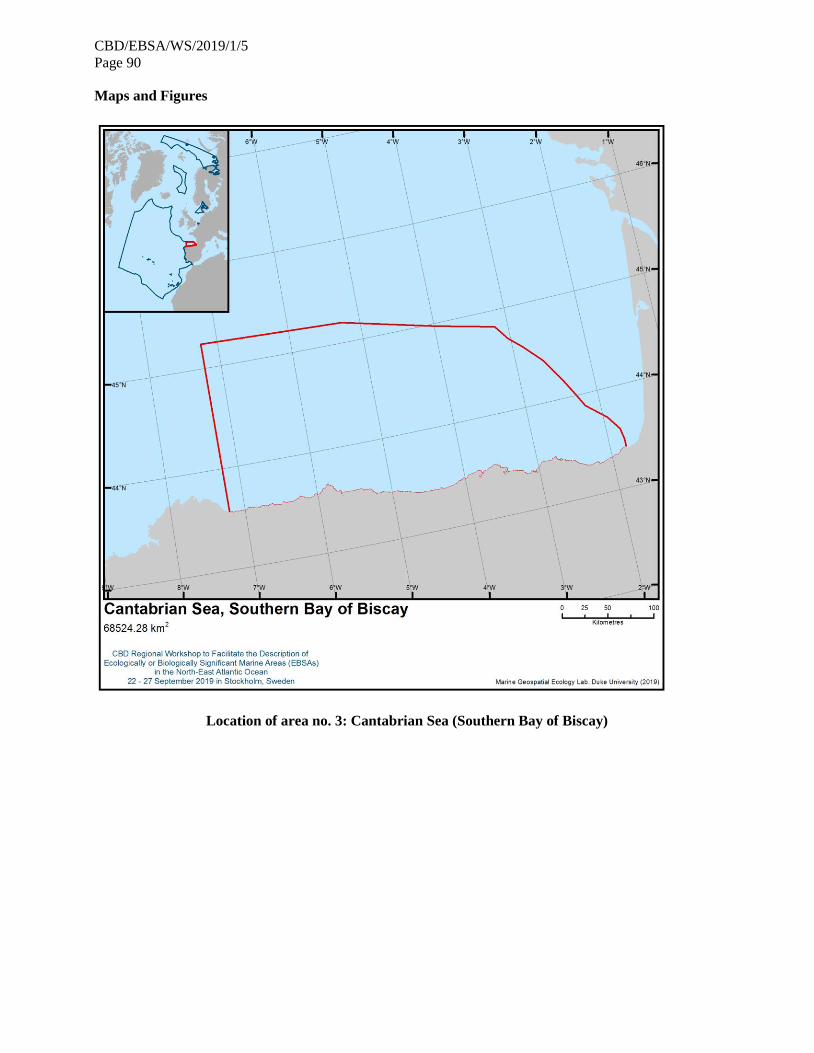
CBD/EBSA/WS/2019/1/5
Page 90
Maps and Figures
Location of area no. 3: Cantabrian Sea (Southern Bay of Biscay)
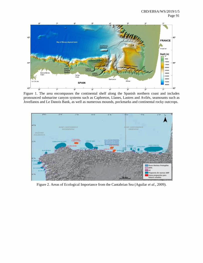
CBD/EBSA/WS/2019/1/5
Page 91
Figure 1. The area encompasses the continental shelf along the Spanish northern coast and includes
pronounced submarine canyon systems such as Capbreton, Llanes, Lastres and Avilés, seamounts such as
Jovellanos and Le Danois Bank, as well as numerous mounds, pockmarks and continental rocky outcrops.
Figure 2. Areas of Ecological Importance from the Cantabrian Sea (Aguilar et al., 2009).
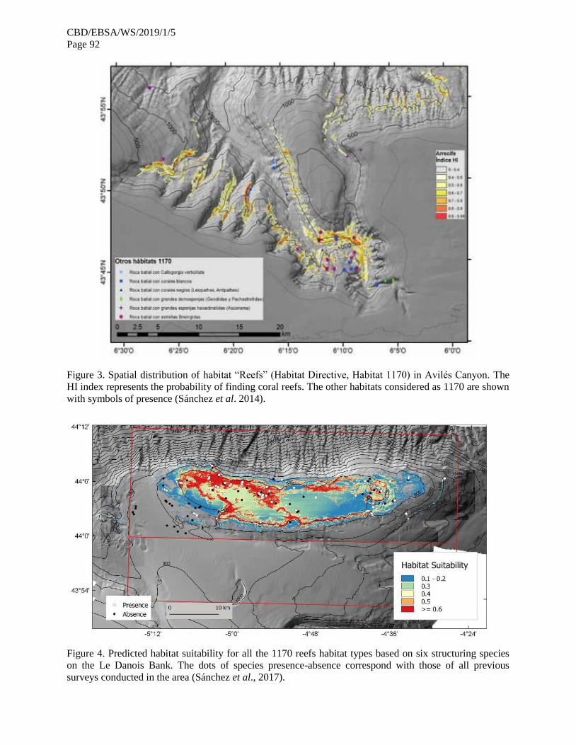
CBD/EBSA/WS/2019/1/5
Page 92
Figure 3. Spatial distribution of habitat “Reefs” (Habitat Directive, Habitat 1170) in Avilés Canyon. The
HI index represents the probability of finding coral reefs. The other habitats considered as 1170 are shown
with symbols of presence (Sánchez et al. 2014).
Figure 4. Predicted habitat suitability for all the 1170 reefs habitat types based on six structuring species
on the Le Danois Bank. The dots of species presence-absence correspond with those of all previous
surveys conducted in the area (Sánchez et al., 2017).
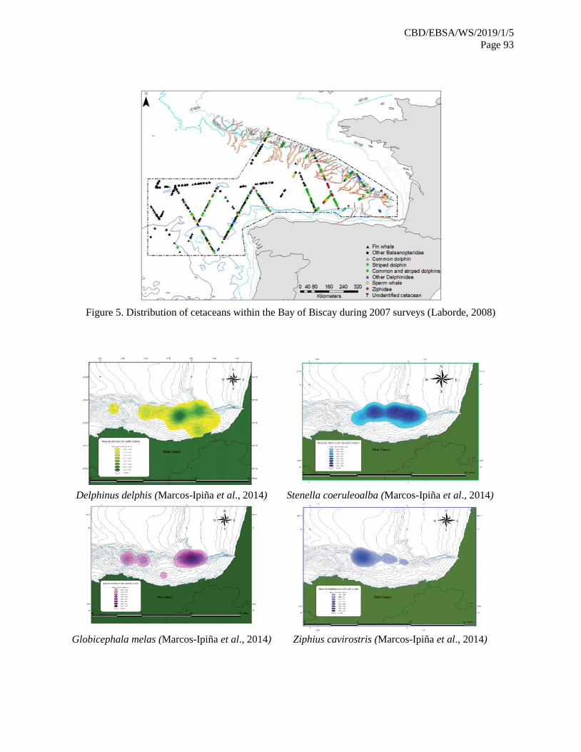
CBD/EBSA/WS/2019/1/5
Page 93
Figure 5. Distribution of cetaceans within the Bay of Biscay during 2007 surveys (Laborde, 2008)
Delphinus delphis (Marcos-Ipiña et al., 2014) Stenella coeruleoalba (Marcos-Ipiña et al., 2014)
Globicephala melas (Marcos-Ipiña et al., 2014) Ziphius cavirostris (Marcos-Ipiña et al., 2014)

CBD/EBSA/WS/2019/1/5
Page 94
Tursiops truncatus 2003-2011 (CEMMA, 2012)
Tursiops truncates (Marcos-Ipiña et al., 2014)
Figure 6. Marine mammal distribution in the area.
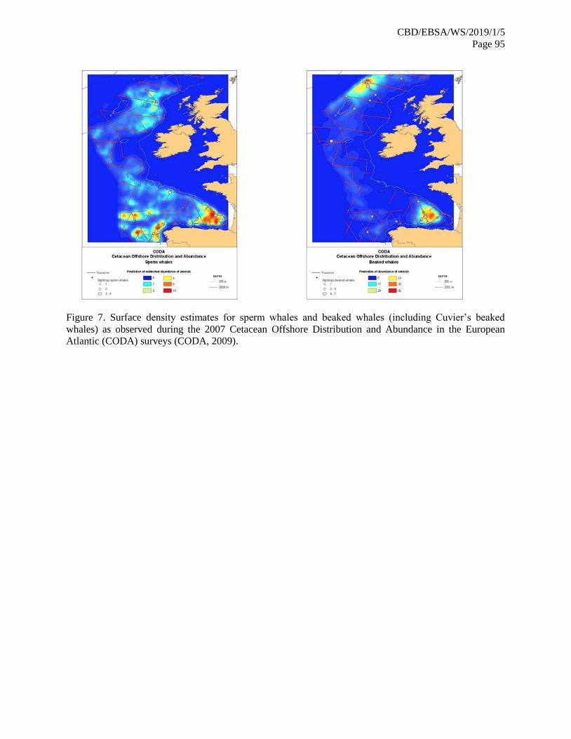
CBD/EBSA/WS/2019/1/5
Page 95
Figure 7. Surface density estimates for sperm whales and beaked whales (including Cuvier’s beaked
whales) as observed during the 2007 Cetacean Offshore Distribution and Abundance in the European
Atlantic (CODA) surveys (CODA, 2009).

CBD/EBSA/WS/2019/1/5
Page 96
Figure 8. Distribution of sightings and effort for winter and summer surveys, for harbour porpoise (with
red dot for calf/young occurrence), common dolphin, small-sized delphinids, bottlenose dolphin,
balaenopteridae, sperm-and beaked whales, long-finned pilot whale and risso's dolphin (Laran et al. 2016)
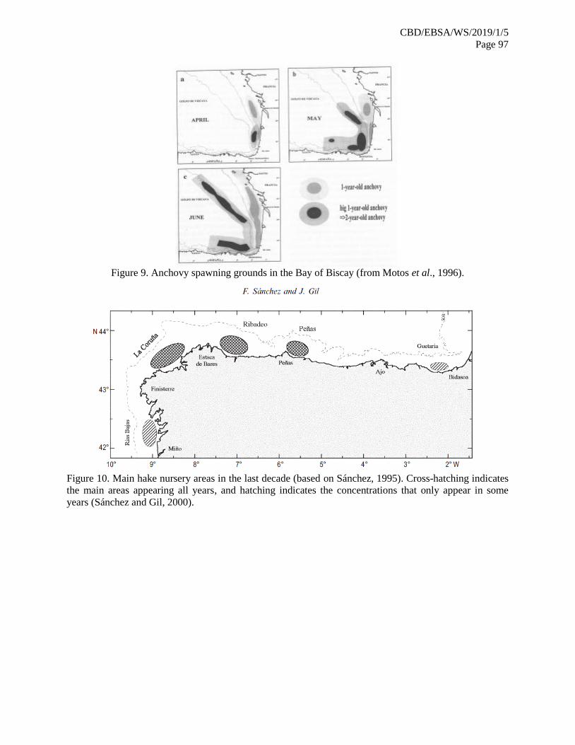
CBD/EBSA/WS/2019/1/5
Page 97
Figure 9. Anchovy spawning grounds in the Bay of Biscay (from Motos et al., 1996).
Figure 10. Main hake nursery areas in the last decade (based on Sánchez, 1995). Cross-hatching indicates
the main areas appearing all years, and hatching indicates the concentrations that only appear in some
years (Sánchez and Gil, 2000).
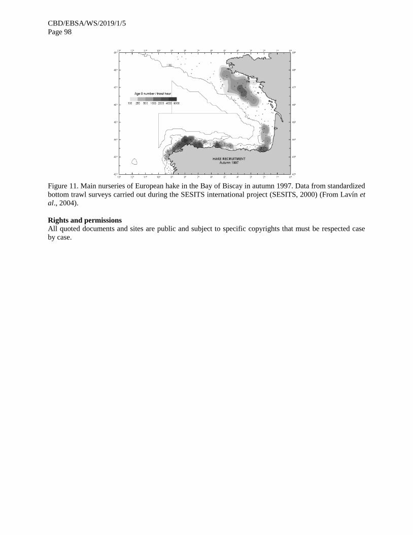
CBD/EBSA/WS/2019/1/5
Page 98
Figure 11. Main nurseries of European hake in the Bay of Biscay in autumn 1997. Data from standardized
bottom trawl surveys carried out during the SESITS international project (SESITS, 2000) (From Lavín et
al., 2004).
Rights and permissions
All quoted documents and sites are public and subject to specific copyrights that must be respected case
by case.
CBD/EBSA/WS/2019/1/5
Page 99
Area no. 4: West Iberian Canyons and Banks
Abstract This area includes marine protected areas (including six that are part of the OSPAR Network of Marine
Protected Areas), one protected area, one UNESCO Biosphere Reserve, 12 Natura 2000 Sites of
Community Interest and 10 Natura 2000 Special Protection Areas for seabirds. The area is divided into
three sections: North Western, Centre Western and South Western. The features in the area are hotspots of
marine life, and they represent areas of enhanced productivity, especially when compared with
surrounding areas. The area has a high diversity of benthic communities and spawning grounds for several
species, and it is an important area for cetaceans. A total of 3411 species are listed in the area, 11 per cent
of which are protected under international or regional law.
Introduction
This area comprises coastal protected areas, which were designated under different multilateral
agreements, national legislation or European Union Directives, with some of them overlapping partially or
totally. As an example, Archipelago of Berlengas is a protected area (Reserva Natural das Berlengas) –
Decree-Law No. 264/81, and it overlaps with the Site of Community Interest Arquipélago das Berlengas -
PTCON0006, designated under EU Habitats Directive; the Special Protection Area Ilhas Berlengas -
PTZPE0009, designated under EU Birds Directive; the UNESCO Berlengas Biosphere Reserve; OSPAR
Berlengas Marine Protected Area; and the Council of Europe Berlenga Biogenetic Reserve.
The area comprises submarine canyons, which are major geomorphic features of continental margins
(Harris et al., 2014). Canyons are characterized by steep and complex topography (Shepard and Dill,
1966; Lastras et al., 2007; Harris and Whiteway, 2011) that influences current patterns (Shepard et al.,
1979; Xu, 2011) and provides a heterogeneous set of habitats, from rocky walls and outcrops to soft
sediment (De Leo et al., 2014). These geomorphologic features act as preferential particle-transport routes
from the productive coastal zone down continental slopes to the more stable deep seafloor (Allen &
Durrieu de Madron, 2009; Puig et al., 2014). On many continental margins, cross-shelf exchanges of
water and particulate matter are inhibited by the presence of density fronts and associated slope currents
flowing parallel to the isobaths (e.g., Font et al., 1988; Allen & Durrieu de Madron, 2009). Near the
seafloor, alignment of the current with the direction of the canyon axis is commonly observed (Shepard et
al., 1979; Puig et al., 2000). The adjustments of the current to the canyon topography produce vortex
stretching and vertical motions (Klinck, 1996; Hickey, 1997). These modifications of the currents may
result in local upwelling, which stimulates primary production (Ryan et al., 2005). Additionally, closed-
circulation cells and downwelling may develop over canyons, enhancing the capacity of the canyon to trap
particles transported by long-shore currents (Palanques et al., 2005; Allen & Durrieu de Madron, 2009).
Canyons are important routes for the transport of organic matter from surface waters and continental shelf
areas to deep-sea basins (Durrieu de Madron et al., 2000; Palanques et al., 2005; Canals et al., 2006;
Pasqual et al., 2010). There is increasing evidence that submarine canyons play important ecological roles
in the functioning of deep-sea ecosystems (Amaro et al., 2016; Thurber et al., 2014) and contribute
significantly to regional biodiversity and primary/secondary production along the continental margin (Gili
et al., 1999, 2000; Sardà et al., 2009; Ingels et al., 2009; Vetter et al., 2010; De Leo et al., 2010).
The area also comprises seamounts, which are defined as isolated topographic features of the seabed that
have a limited lateral extent and rise (Menard, 1964). Seamounts are hotspots of marine life (e.g., Rogers,
1994; Gubbay, 2003; Morato & Pauly, 2004; Pitcher et al., 2007, 2010; Mendonça et al., 2012), and in
general represent areas of enhanced productivity in comparison with nearby abyssal areas. In most cases,
around the seamounts there is an extensive anticyclonic eddy associated with the lifting of nutrients from
the rich deep water, giving rise to high concentrations of nitrates and chlorophyll in shallow waters
(Coelho & Santos, 2003). Seamounts are biologically distinctive habitats of the open ocean, exhibiting a
number of unique features (Rogers, 1994; Probert, 1999; Morato & Clark, 2007). These structures can
host very distinctive biological communities that are different to the communities on nearby abyssal plains
dominated by soft sediment, and these particular places may attract pelagic fish, including larger,
commercially valuable vertebrate (Beryx splendens) and invertebrate (Charonia lampas) species and other
marine species, like top predators, such as the blue shark (Prionace glauca) and marine reptile species,
CBD/EBSA/WS/2019/1/5
Page 100
such as loggerhead sea turtles (Caretta caretta) and protected marine mammals (Balaenoptera borealis)
(e.g., Holland & Grubbs, 2007; Kaschner, 2007, Santos et al., 2007). Productivity in oceanic settings
depends on light and nutrient availability, while overall production is the result of productivity and
accumulation of the phytoplankton. At a seamount, either a seamount-generated, vertical nutrient flux has
to be shallow enough to reach the euphotic zone and the ensuing productivity retained over the seamount
long enough to allow transfer to higher trophic levels, or the seamount must rely on allochthonous inputs
of organic material to provide a trophic subsidy to resident populations (Clark et al., 2010 a), b)).
The area is located next to the mainland area. The area is divided into three sections:1) North Western
Iberian Peninsula and Mainland canyons 2) Center Western Iberian Peninsula and Mainland canyons and
3) South Western Iberian Peninsula and Mainland canyons.
To the northwest of the Iberia Abyssal Plain area, the continental rise is relatively wide, ~100 km, and
includes three seamounts: the easternmost Porto seamount and the more distant Vigo and Vasco da Gama
seamounts. The Dom Carlos Valley, between the seamounts, forms a prominent fault bounded depression
into which the sediment transported by the Porto and Aveiro submarine canyons is mainly funnelled
(Mougenot et al., 1984; Mougenot, 1988; Milkert et al., 1996; Alves et al., 2003).
Galicia Bank is characterized by two isolated seamounts on its southern edge (Vasco da Gama and Vigo)
and is separated from northwestern Iberia by a broad submarine valley. The Galicia Bank has an area of
200x150 km within which the seafloor shoals to about 600 m water depth (Whitmarsh et al., 1998; Wilson
et al., 2001).
The Porto submarine canyon is located about 25 km west of Póvoa de Varzim and is deeper than 110m.
This canyon is more than 100 km in length, stretching towards the Iberian Abyssal Plain, and its
morphology is related to the occurrence of mass movements, with no apparent relation to the present-day
watercourses (Vanney & Mougenot, 1981; Rodrigues, 2001; Guerreiro et al., 2007). The Porto submarine
canyon is cut deeply into this steep surface (Rodrigues et al., 1991). The bottom sedimentary cover is
characterized by the presence of two important muddy deposits with general N-S orientation, located in
the mid-shelf off the Minho and Douro rivers (Oliveira et al., 2002; Guerreiro et al., 2009). The normal
wave regime promotes bottom sediment remobilization, primarily in the inner and middle shelf region
(Vitorino et al., 2002).
The Aveiro Canyon cuts the shelf-break, presenting an "amphitheater" outline, with the head carved in
biogenic and detritic limestone formations from the Neogene and Eocene periods (Kenyon et al., 2000;
Rodrigues, 2004). The canyon begins about 30 km west of the coast, more than 110 m in depth, has a wide
transversal profile with a half-circle upper sector of about 10 km diameter. It shows no apparent relation to
present-day watercourses and meets the Porto canyon at the Valle-Inclan Depression, before reaching the
Iberian Abyssal Plain (Terrinha et al., 2003; Guerreiro et al., 2007). In Aveiro canyon, due to the
interaction of the poleward slope flow with the canyon's topography and with the southwards upwelling,
this sector is known to promote recurrent filament activity (Haynes et al., 1993) and generates an
anticyclonic eddy in the canyon's mouth (Peliz et al., 2002).
The Nazaré Canyon is the largest submarine canyon of Europe and one of the largest in the world; it is
also the longest submarine canyon on the western Iberian margin, extending over 270 km from a water
depth of about 50 m near the Portuguese coast to 5000 m at the edge of the Iberian Abyssal Plain (Vanney
& Mougenot, 1990). The Nazaré fault, with an ENE-WSW alignment, is a late Variscan structure, which
maintained its activity during the Meso-Cenozoic period (Moreira, 1985; Ribeiro et al., 1990). In terms of
sediment transport, the canyon is highly active, particularly during winter, because upwelling events may
prevent sediment export during summer (Pusceddu et al., 2010). Although the canyon does not connect to
a river, the proximity of the head to the shore contributes to its effectiveness at capturing sediment
transported along the shelf (Duarte et al., 2000; de Stigter et al., 2007; Oliveira et al., 2007). Under the
influence of tidal currents, fine-grained particles suspended from bottom sediments are captured in the
upper canyon and actively transported downwards to the abyssal plain (Stigter et al., 2007). Other
physical forces promoting active sediment transport are episodic (intermittent) gravity flows (Van
Weering et al., 2002; Stigter et al., 2007).

CBD/EBSA/WS/2019/1/5
Page 101
The Berlengas archipelago is located approximately 10 km west of the town of Peniche. The largest island
of the archipelago is called Berlenga Island, which reaches an altitude of 88 m, with a maximum length of
1.5 km. Two groups of smaller islets, called Estelas and Farilhões, are also part of the archipelago.
Its geographical location imparts the archipelago with unique characteristics. The archipelago has been
studied in detail, because it is located in an area with a temperate maritime climate and is influenced by
seasonal coastal upwelling controlled by the atmospheric circulation associated with the Azores
anticyclone. Persistent northerlies (upwelling favourable) are observed in summer (June to September)
(Peliz et al., 2002; Álvarez-Salgado et al., 2003). However, it is during the non-upwelling season (late
winter-spring) that many meroplankton species are observed over the shelf (Santos et al., 2004).
Concerning coastal circulation, other important aspects are the Portugal Current flowing off the
continental slope westward of 10ºW (Saunders, 1982), the Iberian Poleward Current, which flows over the
slope (Haynes & Barton, 1991) and the Western Iberia Buoyant Plume (WIBP) (Peliz et al., 2002).
Moreover, it is located at the top of the escarpment of the Nazaré Canyon, one of the most important
submarine canyons in the world, located in the transition zone between the Mediterranean and European
subregions. This location contributes to the remarkable productivity and diversity of marine species and
habitats and to a landscape unique in the region. Previous studies have investigated the distribution and
composition of zooplankton along the Berlenga shelf area (Pardal & Azeiteiro, 2001).
The Berlenga Marine Protected Area is about 102 km2 in area and surrounds seabird-nesting habitats and
an important place of passage for migratory birds (Queiroga et al., 2008); it comprises a Special
Protection Area for Wild Birds and is integrated in the Natura 2000 network of marine protected areas.
The Cascais Canyon is situated north to Setúbal Canyon and is not connected to any river flow. The
organic matter input is thought to be mainly from the Tagus River, though some quantities of sediment
and associated materials may be transported from the continental shelf. The canyon acted as the major
conduit of sediment from the continental shelf to the abyssal plain at the time of the Lisbon earthquake in
1755 (Amaro et al., 2009; Lastras et al., 2009).
The Lisboa and Setúbal canyons are located in an area of complex topography and coastal configuration.
These canyons are conduits with southwards (Lisboa) and westerly (Setúbal) course directions, and their
heads are located on the shelf at around 80 and 120 m near the mouth of the Tagus and Sado rivers,
respectively (Mougenot, 1988; Alves et al., 2003; Lastras et al., 2009; Jesus et al., 2012).
The Lisboa Canyon’s V-shaped channel follows a sinuous course down slope in a southerly direction.
From the canyon head, at 100m depth, down to the junction with the Setúbal Canyon, at 1900 m, the
channel is 30 km long. Below the junction point, the canyon continues in WSW direction for another 80
km to the foot of the continental slope at a depth of 4500 m (de Stigter et al., 2004). This submarine
canyon differs from the other canyons by the width of its valley, which follows a graben. To the south the
continental shelf is very narrow and disappears below the sediment progradation of Neogene beds
(Kenyon et al., 2001).
The Lagos canyon extends over 60 km, drains towards the SW, and its morphology changes from the
upper to the lower parts. In its upper part the canyon displays a wider thalweg with a smaller inner channel
carved close to the SE wall. The heights of the flanks vary from 200 m (incising the contourites) to 800 m
(closer to the continental slope).
The Portimão Canyon has an important effect on the formation of the filaments, eddies and internal waves
that transport the Mediterranean waters long distances into the Atlantic Ocean (Serra & Ambar, 2002;
Serra et al., 2005; Garcia-Lafuente et al., 2006; Ambar et al., 2008; Cherubin et al., 2000; Bruno et al.,
2006; Garcia et al., 2015).
Its location seems to be related to the Albufeira Fault. Erosion is not active today, as evidenced by its
relatively smooth flanks, and the canyon seems to be progressively infilled by sediment load (Mulder et
al., 2006; Marchès et al., 2007; Garcia et al., 2015).
CBD/EBSA/WS/2019/1/5
Page 102
In terms of biodiversity, the continental margins are considered major reservoirs of marine biodiversity
and productivity (Sanders & Hessler, 1969; Rex, 1983; Snelgrove et al., 1992; Levin et al., 2001; Brandt
et al., 2007). The patterns of benthic community structure and productivity have been studied in relatively
few submarine canyons (e.g., Vetter 1994; Vetter & Dayton 1999; Hargrave et al., 2004; Schlacher et al.,
2007). Habitat diversity and specific abiotic characteristics enhance the occurrence of high levels of
biodiversity (Vetter & Dayton, 1998; McClain and Barry, 2010; Company et al., 2012; De Leo et al.,
2014). Some findings suggest that increased habitat heterogeneity in canyons is responsible for enhancing
benthic biodiversity and creating biomass hotspots (Rowe et al., 1982; Vetter 1994; Vetter et al., 2010).
Enhanced local fishery production in canyons, when contrasted to regular slope environments, has also
been reported and attributed to the channeling and concentrating of detrital organic matter and pelagic
animal populations (Yoklavich et al., 2000; Brodeur, 2001; Company et al., 2008).
The area also encompasses seamounts. Seamounts are host to epipelagic fishes with important functions
for migratory species, such as tuna (e.g., Thunnus thynnus and Thunnus albacares), and habitats that are
associated with the species spawning function and recruitment of fish (belonging to the Serranidae, and
Carangidae families), benthopelagic and respective communities (including habitats for fish species
captured for commercial purposes, such as orange roughy, Hoplostethus atlanticus) (Morato & Clark,
2007; OSPAR, 2010). In this set of habitats some endangered and/or declining species can also be found,
such as the blue whale (Balaenoptera musculus), leatherback and loggerhead turtles (Dermochelys
coriacea and Caretta caretta) (protected under the European Union Habitats Directive, the Bern
Convention, Bonn Convention, the Convention on International Trade in Endangered Species of Wild
Fauna and Flora and the OSPAR Convention), and elasmobranch (Hoplostethus atlanticus,
Centroscymnus coelolepis, Centrophorus granulosus and Centrophorus squamosus) (protected under the
OSPAR Convention) (Morato et al., 2008; Santos et al., 2012).
Seamounts are also important to birds and Cory’s shearwater (Calonectris borealis), which breed in the
Azores and have been shown to forage over the Mid-Atlantic Ridge (Magalhães et al., 2008).
Both seamounts and canyons can host high biodiversity, and both structures have been relatively well
studied (see Table 1). A total of 3411 species are listed for the area, and 776 were specifically recorded for
the different structures it comprises (see feature description of the described area).
Location
The area is located in waters surrounding Portugal and Spain. Its total area is 189239 km2 and is divided
into three sections: North Western Iberian Peninsula, Center Western Iberian Peninsula and South Western
Iberian Peninsula. The area includes 12 submarine canyons, five seamount structures, banks, islands and an archipelago.
Feature description of the area
There are 3174 species reported for the whole area and 776 specifically recorded for the structures. This
coastal area exhibits mesoscale spatial and temporal patterns of upwelling. Coastal winds off the north-
west exert a conspicuous seasonal cycle, favouring upwelling from March-April to September-October
and downwelling for the rest of the year (Wooster et al., 1976; Bakun and Nelson, 1991). Upwelling areas
are particularly important for the exploitation of resources and for the air-sea exchange of anthropogenic
CO2. Knowledge of the magnitude of "New Production" of this area is of great importance (Alvarez-
Salgado et al., 2002). "New Production" is defined as the fraction of the gross primary production that is
maintained by external nutrients.
Nutrient enrichment associated with upwelled water results in high pelagic productivity on the shelf and in
the Rias Bajas (Campos and Gonzalez, 1975; Tenore et al., 1995). Along the coast there is an important
pelagic fishery, especially off Cape Finisterre. A coastal purse-seine fishery for sardine, Sardina
pilchardus, typically yields ca. 80,000 metric tons annually along the Galician coast (Porteiro et al., 1986).
There is also an important demersal fishery along the Galician shelf, including hake (Merluccius
merluccius), blue-whiting (Micromesistius poutassou) and Norway lobster (Nephrops norvegicus) (Farina
et al., 1983).
CBD/EBSA/WS/2019/1/5
Page 103
Around 11 per cent of the 3174 species identified in the area are legally protected or recognized as
threatened by CITES, IUCN Red List, European Union Habitats and Birds Directives, Bern Convention or
OSPAR Convention. In this area OSPAR identified as endangered or declining the following species:
Deep-water sharks (Centrophorus granulosus, Centroscymus coeleopsis, Centrophorus squam)
commercial fish, such as orange roughy (Hoplostethus atlanticus)
three species of corals (Funiculina quadrangularis, Lophelia pertusa, Madrepora oculate)
sea urchin (Centrostephanus longispinus)
turtles (Caretta caretta and Dermochelys coriacea).
Other examples of species under CITES Appendix I are:
cetaceans (Balaenoptera borealis, Balaenoptera musculus, Balaenoptera physalus, Megaptera
novaeangliae, Physeter macrocephalus, Tursiops truncates)
turtles (Caretta caretta, Dermochelys coriacea, Eretmochelys imbricata and Lepidochelys kempii)
saw-fish (Pristis pristis)
Examples of species under CITES Appendix I are (CITES Appendix II)
sharks (Lamna nasus, Carcharodon carcharias, Cetorhinus maximus, Sphyrna zygaena)
ray (Mobula mobular)
45 corals (e.g., Antipathella subpinnata, Aulocyathus atlanticus, Caryophyllia ambrosia,
Desmophyllum dianthus, Flabellum alabastrum, Flabellum angulare, Fungiacyathus fragilis,
Lophelia pertusa, Madrepora oculata, Schizopathes affinis, Solenosmilia variabilis, Stauropathes
arctica, Stephanocyathus moseleyanus)
fishes (Hippocampus guttulatus and Hippocampus hippocampus)
whales (Balaenoptera physalus, Balaenoptera musculus, Balaenoptera borealis, Megaptera
novaeangliae, Physeter microcephalus)
dolphins (Delphinus delphis, Tursiops truncates)
turtles (Caretta caretta, Dermochelys coriacea)
sea urchin (Centrostephanus longispinus, protected under the EU Habitats Directive)
anthozoa (Astroides calycularis)
crustacean (Homarus gammarus, Maja squinado, Pagurus bernhardus, Palinurus elephas,
Scyllarides latus and Scyllarus arctus)
fish (Epinephelus marginatus, Pomatoschistus microps, Pomatoschistus minutos, Syngnathus
abaster and Umbrina cirro, protected by Annex II of the Bern Convention).
Also present in the area are 109 species listed on the IUCN Red List as near
threatened/vulnerable/endangered/critically endangered, e.g., 30 cetaceans (e.g., Balaenoptera musculus
and Balaenoptera borealis), six turtles (e.g., Caretta caretta and Dermochelys coriacea), one coral
(Eunicella verrucose), one crustacean (Palinurus elephas), 37 sharks (e.g., Lamna nasus and
Carcharhinus brachyurus), 13 rays (e.g., Dipturus batis and Gymnura altavela), 15 fishes (e.g.,
Epinephelus marginatus and Mola mola), five tunas (e.g., Thunnus alalunga and Thunnus thynnus), one
bird (Rissa tridactyla). There are also 12 species of birds (e.g., Hydrobates castro and Calonectris
borealis) belonging to Annex I of the European Union Birds Directive.
Dedicated surveys for cetacean species from the 2007 Cetacean Offshore Distribution and Abundance
(CODA) and the 2017 large-scale surveys for cetaceans in European Atlantic waters (SCANS-III)
observed many cetacean species through this area (CODA, 2008; Hammond et al., 2017). In particular,
modelled density estimates of fin whale (Balaenoptera physalus) and sperm whales (Physeter
macrocephalus) indicate that the areas of the northwest Iberian Peninsula likely contain some of the
highest densities of these species in European waters (see below). Both fin and sperm whales are
migratory species, and seasonally move into and through the area to other known key lifecycle areas
(foraging, resting, breeding), such as the inner Bay of Biscay and Biscay Seamounts (Cooke, 2018).
CBD/EBSA/WS/2019/1/5
Page 104
There are differences in the proportion of protected species, among the different groups of species. All the
bird species observed in this area are protected by the EU Birds Directive, and 86.67 per cent belong to
annexes I and II. Of the Elasmobranchi, 23.39 per cent are listed on the IUCN Red List, with 36.17 per
cent NT (near threatened), 40.43 per cent VUL (vulnerable), 17.02 per cent EN (endangered), and 6.38
per cent CR (critically endangered); 2.87 per cent of fish are classified by the IUCN Red List, with 26.67
per cent NT (near threatened), 53.33 per cent VUL (vulnerable), 13.3 per cent EN (endangered), and 6.67
per cent CR (critically endangered).
Of all the species described for this area, there is a predominance of species belonging to the phylum
Annelida, phylum Mollusca, Superclass Gnathostomata (Fish), class Bryozoa, subphylum Crustacea, class
Anthozoa, subclass Elasmobranchii.
The phylum Annelida is composed almost entirely (94.8 per cent) of species belonging to the class
polychaeta. The second-most abundant is the phylum Mollusca with species belonging to five different
classes: Gastropoda (e.g., Gibbula umbilicalis), Bivalvia (e.g., Crassostrea gigas), Cephalopoda (e.g.,,
Loligo vulgaris), Scaphopoda (e.g., Cadulus subfusiformis), Polyplacophora (e.g., Callochiton calcatus), a
suborder Nudibranchia (e.g., Flabellina affinis) and order Opisthobranchia (e.g., Aplysia fasciata). The
Crustacea subphylum includes many different species from different orders: Decapoda (e.g.,, Scyllarides
latus), Amphipoda (e.g., Ericthonius punctatus), Isopoda (e.g., Zonophryxus grimaldii), Cumacea (e.g.,
Paralamprops semiornatus), Tanaidacea (e.g., Apseudes latreillei), Stomatopoda (e.g., Pseudosquillisma
oculata); Subclass: Copepoda (e.g., Temora longicornis); Infraclass: Cirripedia (e.g., Pollicipes
pollicipes); Family: Mysidae (e.g., Diamysis bahirensis), Caprellidae (e.g., Caprella andreae); Class:
Ostracoda (e.g., Munidopsis curvirostra), Malacostraca (e.g., Bathyporeia elkaimi). The subclass
Elasmobranchii has a dominance of sharks, with a percentage of 68.8.
Almost 4 per cent of the total species belong to the Anthozoa class, including species of scleractinians
(e.g., Leptopsammia Formosa) and gorgonians (e.g., Paramuricea clavata). In this area (seamounts and
canyons) the gorgonian species were reported to form dense gorgonian coral habitat-forming aggregations,
which may represent important feeding and sheltering grounds for seamount fishes and potential shark
nurseries (WWF, 2001; Etnoyer & Warrenchuk, 2007; OSPAR, 2011). Cold-water, deep-sea, habitat-
forming corals can shelter higher megafauna in association with the corals than other habitats without
coral communities (Roberts et al., 2006; Mortensen et al., 2008, Rogers et al., 2008). The structures
characteristic of this area also harbour large aggregations of demersal or benthopelagic fish (Koslow,
1997; Morato & Pauly, 2004; Pitcher et al., 2007; Morato et al., 2009, 2010).
The Berlengas archipelago is characterized by high biodiversity, with 76 fish species currently reported in
the reserve area (Rodrigues et al. 2008). This, allied with the favourable combination of bathymetric
features and ocean and wind circulation (namely the Azorean anti-cyclone and the Portuguese continental
shelf upwelling), characterizes the area as rich feeding and breeding grounds for several species,
especially seabird species (Paiva et al., 2010; Werner, 2010).
Berlenga features the only breeding populations of pelagic seabirds in mainland Portugal: the Cory’s
shearwater (Calonectris borealis), and the band-rumped storm-petrel (Hydrobates castro). Presently, the
archipelago hosts approximately 850 breeding pairs of Cory’s shearwaters, distributed among Farilhões
Islets (500-550 pairs) and Berlenga Island (300 pairs) (Lecoq et al., 2011). The European shag
(Phalacrorax aristotelis), lesser black-backed gull (Larus fuscus), and, until recently, the critically
endangered common murre (Uria aalge) also bred on the island. The most abundant bird is the yellow-
legged gull (Larus michahellis), which possibly exerts a negative effect on the other seabird populations,
as stated by Lecoq et al., (2011), when they recorded predation of Cory’s shearwater eggs at Farilhões
Islets.
Feature condition and future outlook of the area
The deep sea, the largest biome on Earth, is composed of a variety of different habitats with specific biotic
and abiotic characteristics (Ramirez-Llodra et al., 2010). Submarine canyons and seamounts are two of
these habitats. Recent novel technological developments, including underwater acoustic mapping,
imaging, and sampling technologies, and long-term/permanent moored or benthic observatories, have
CBD/EBSA/WS/2019/1/5
Page 105
greatly contributed to our understanding of the diverse and complex hydrodynamics (Xu, 2011) and
geomorphology of canyons over the last two decades (Robert et al., 2014; Quattrini et al., 2015), allowing
the spatio-temporal tracking of oceanographic processes and the associated biological responses, with an
integration level that grows every day (Aguzzi et al., 2012; Matabos et al., 2014; Fernandez-Arcaya et al.,
2017).
In 1981, the Berlengas Islands, a refuge for marine wildlife, became a natural reserve of major importance
(Radhouani et al., 2010; Pereira et al., 2017). The Berlengas MPA is a type VI from IUCN’s protected
area categories: “Protected area with sustainable use of natural resources: Areas that conserve ecosystems
and habitats, together with associated cultural values and traditional natural resource management
systems” (Day et al., 2012). The Berlengas MPA is not established strictly for the purposes of
conservation of species and habitats. It also allows for economic activities, such as fishing and diving
under specific regulations with respect to biodiversity conservation (Law Decree 30/98). It includes two
Partially Protected Areas as well as a Complementary Protected Area. Partially Protected Areas are buffer
zones where recreational and commercial fishing as well as tourism activities are allowed under specific
regulation. This regulation establishes a limited number of visitors by site and allows a limited number of
fishing boats. The Complementary Protected Area is open to fishing but not necessarily as an open-access
fishery, as legislation does not allow for commercial fishing by vessels not registered in Peniche Port
Authority, trawl fishing, gill nets, trap fishing and shellfish collecting (Queiroga et al., 2009; Thurber et
al., 2014; Boavida et al., 2016).
Galician waters have long suffered from overfishing, illegal fisheries and the consequences of shipping
and oil transport:
Fishing activities: Galicia (NW Spain) is one of the EU regions with the highest level of
dependence on fishing activities (EC, 2004). The main fishing gears used in the area are bottom
trawling, fishing lines and gill nets.
Climate change: this phenomenon seems to have led to an increase in the presence of temperate
water fish species in the Cantabrian sea (e.g., among pelagic fishes are Megalops atlanticus
andSeriola rivoliana) over the last twenty years (Quéro et al., 1998; Stebbing et al., 2002).
Shipping and oil transport: The Galician waters are located on the main route of supertankers
transporting oil from the Middle East and Africa to EU harbours. More than 70 per cent of the
total oil consumed in the EU is moved by shipping through the Finisterre pass directly towards the
English Channel and then to the final destination in different European harbours. In recent years
several oil spills have occurred (1992, Aegean Sea; 1999, Erika; 2002, Prestige); the sinking of
the Prestige oil tanker in 2002 off the coast of Galicia (Spain) caused one of the worst oil spills off
the European coastline and made this region the most severely affected by this kind of accident in
the world (Lavín et al., 2004).
Conversely, some actions to protect the area and to ensure the conservation of its biodiversity are being
carried out, and one specific offshore area within the area being described has been protected in
accordance with international and Spanish regulations and conventions: The Galicia Bank is a deep
underwater mountain located to the northwest of the Iberian Peninsula, 180 km from the Galician coast.
Its summit is located at a depth of between 650 and 1,500 m. Its steep slopes descend from the summit to
the abyssal plains located 4,000 metres below sea level.
This submarine mountain belongs to the submerged western extension of the Pyrenees and the Cantabrian
mountains. Materials originating from the mainland are not significant, being composed of abundant
sediments from shells of tiny marine organisms, which are deposited in the open sea. Located in the
middle of the Atlantic, the bank is influenced by various regions and water masses, which create a great
disparity of environments. Moreover, local currents that typically originate on undersea mountains – rising
water masses, twists and eddies – favour the retention of nutrients and larvae on the Galicia Bank,
explaining the existence of a highly biodiverse “submerged island” in the middle of the Atlantic.
The presence of vulnerable and threatened habitats and species, covered by various protection agreements
and international standards, has shown the ecological and biological significance of the Galicia Bank. In
CBD/EBSA/WS/2019/1/5
Page 106
addition to the presence of the loggerhead sea turtle (Caretta caretta), bottlenose dolphin (Tursiops
truncatus) and numerous species of birds, including the band-rumped storm-petrel (Hydrobates castro),
the area is home to extremely rare species and harbours the designated habitat “Reefs” (Habitats Directive:
1170), making it a priority for conservation.
A management plan for the area is being developed in the framework of the INTEMARES project. Apart
from conservation projects, every autumn the Instituto Español de Oceanografía (IEO) carries out a
bottom-trawling survey on the Northern Spanish Shelf named DEMERSALES. This survey aims to
provide data for the assessment of commercial fish species and benthic ecosystems on the Galician and
Cantabrian shelf (ICES, 2010). This survey is part of an international effort to monitor marine ecosystems
and is coordinated by the International Bottom Trawling Surveys working group of the International
Council for the Exploration of the Sea (ICES).
Assessment of area no. 4, West Iberian Canyons and Banks, against CBD EBSA Criteria
CBD EBSA
Criteria
(Annex I to
decision
IX/20)
Description
(Annex I to decision IX/20) Ranking of criterion relevance
(please mark one column with an X)
No
informat
ion
Low Medi
um
High
Uniqueness
or rarity
Area contains either (i) unique (“the only one
of its kind”), rare (occurs only in few
locations) or endemic species, populations or
communities, and/or (ii) unique, rare or
distinct, habitats or ecosystems; and/or (iii)
unique or unusual geomorphological or
oceanographic features.
X
Explanation for ranking
The submarine canyons known as Mugia, Aveiro, Porto, Cascais, Lisboa, Nazaré, Setúbal, Faro,
Lagos, Portimão, Sagres and São Vicente are prominent topographic features connecting shallow
coastal waters to the deep continental margin and contribute as preferential pathways to the channeling
(efficient drainage) of water masses, sediments and organic matter from the shore to deep basins
(Nittrouer et al., 1994; Xu et al., 2002; Canals et al., 2006; Shepard, 1981; Wynn et al., 2002;
Normark & Carlson, 2003; Weaver et al., 2004; Canals et al., 2006).
The Nazaré Canyon is one of the largest and deepest submarine valleys in the world (Duarte et al.,
2000; Duarte, 2002; Duarte & Taborda, 2003; de Stigter et al., 2007).
The fauna and flora of the Berlenga archipelago present unique characteristics even though located
near the mainland. The first colonizers arrived about 15,000 years ago, when the valleys (nowadays
submarine valleys) were solid ground. They evolved very differently to their “continental siblings” due
to other types of pressures, giving rise to different life forms. The Berlengas host the only population
of band-rumped storm petrel (Hydrobates castro) and one of the very few of Cory’s shearwater
(Calonectris borealis) of continental Europe, the residual population of common guillemot (Uria
aalge), the largest national population of shags (Phalacrocorax aristotelis), the only couples of lesser
black-backed gulls (Larus fuscus) that reproduce in Portugal, and the largest colony in the country of
yellow-legged gull (Larus michahellis), with more than 25,000 birds (Azevedo & Nunes, 2010;
BirdLife et al. 2019).
The Galicia Bank is located 180 km from the Galician coast and is influenced by various regions and
water masses, which create a great disparity of environments. More than 20 new species have been
identified on this seamount (De la Torriente et al., 2014; Gofas et al., 2014).
Special
importance
for life-
history stages
Areas that are required for a population to
survive and thrive. X
CBD/EBSA/WS/2019/1/5
Page 107
of species
Explanation for ranking
Both fin and sperm whales (Balaenoptera physalus and Physeter macrocephalus, respectively) are
migratory species and seasonally move into and through the area to other known key lifecycle areas
(foraging, resting, breeding), such as the inner Bay of Biscay and Biscay Seamounts (Cooke, 2018).
Spawning ground of demersal species such as the hake (Merluccius merluccius) (Sánchez and Gil,
2000).
Female Nephrops norvegicus spawn from April to August and brood eggs for seven months. The
larvae develop in the plankton for one month before settling to the seabed (Lavín et al., 2004).
The Berlengas archipelago is the most important breeding area for seabird species in mainland
Portugal, supporting the only known colonies of Procellariiformes, and the largest colony of yellow-
legged gull (Larus michahellis) in the country. Berlenga also features the only breeding populations of
pelagic seabirds in continental Portugal: the Cory’s shearwater (Calonectris borealis), the band-
rumped storm-petrel (Hydrobates castro), the European shag (Phalacrorax aristotelis), lesser black-
backed gull (Larus fuscus), and until recently, the critically endangered common murre (Uria aalge).
The most abundant bird is the yellow-legged gull (Larus michahellis), which possibly exerts a negative
effect on the other seabird populations, as stated by Lecoq et al., (2011) when they recorded predation
of Cory’s shearwater eggs at Farilhões Islets. The area is also important for the critically endangered
and OSPAR-listed Balearic shearwater (Puffinus mauretanicus), with estimates of up to 4,500
individuals using the site during their migration and winter period (BirdLife et al. 2019). The high
variety of habitats make these islands a favourable place for reproduction of skates; for example,
juvenile undulate ray (Raja undulata) and egg capsules of smalleyed ray (Raja microocellata) are
found in the area (Serra-Pereira et al., 2014).
Importance
for
threatened,
endangered
or declining
species
and/or
habitats
Area containing habitat for the survival and
recovery of endangered, threatened, declining
species or area with significant assemblages of
such species.
X
Explanation for ranking
The submarine canyons and seamounts are hotspots of benthic production (Vetter, 1994) and key
habitats of exploited and non-exploited species (Ferrier-Pages et al., 2007). They host cold-water coral
and sponge reef habitats that also qualify as Vulnerable Marine Ecosystems in relation to high seas
fisheries, according to criteria developed by FAO (FAO, 2007; Rogers et al., 2008).
In the underwater environment, the Berlengas have the most skate species in mainland Portugal,
including coastal and offshore species, such as the IUCN near threatened (NT) longnosed skate
(Dipturus oxyrinchus).
Almost 11 per cent of the 3174 species identified in the area are legally protected or recognized as
threatened by CITES, IUCN Red List, European Union Habitats and Birds Directives, Bern
Convention or OSPAR Convention. In this area OSPAR identified as endangered or declining the
deep-water sharks (see “feature description of the area”).
There are differences in the proportion of protected species among the different groups of species. All
the bird species recorded in this area are protected by the EU Birds Directive, and 86.67 per cent
belong to annex I and II. Of the Elasmobranchi, 23.39 per cent are listed on the IUCN Red List, with
36.17 per cent near threatened, 40.43 per cent vulnerable, 17.02 per cent endangered, and 6.38 per
cent critically endangered; 2.87 per cent of fish are classified by the IUCN Red List, with 26.67 per
cent near threatened, 53.33 per cent vulnerable, 13.3 per cent endangered, and 6.67 per cent critically
endangered.
The Berlengas archipelago area has several species and some habitats of high conservation value in a

CBD/EBSA/WS/2019/1/5
Page 108
national and European context, namely the reefs and submerged or semi-submerged marine caves
classified by the Habitats Directive (Queiroga et al., 2008). It includes the habitat “Reefs (1170)” of
the Habitats Directive, consisting of rocky substrates and /or other substrates of biological origin (e.g.,
Sabelaria reefs).
The Berlengas encompass a habitat, protected under the EU Habitats Directive, of significant
conservation value: “Submerged or semi-submerged sea caves”, a type referred to as “8330”.
Vulnerability
, fragility,
sensitivity, or
slow recovery
Areas that contain a relatively high proportion
of sensitive habitats, biotopes or species that
are functionally fragile (highly susceptible to
degradation or depletion by human activity or
by natural events) or with slow recovery.
X
Explanation for ranking
This area encompasses different types of habitats classified by the OSPAR Convention as threatened
and/or declining, including coral gardens, deep-sea sponge aggregations, maërl beds and semaounts
(Aguilar et al., 2009; De la Torriente et al., 2014; Serrano et al., 2012; 2017). The area also has a
relatively high proportion of sensitive habitats, biotopes or species that are functionally fragile and
with slow recovery, such as coral reefs, gorgonian forest and sponge grounds. Moreover, these habitats
provide valuable direct and indirect goods and services, such as food provision and climate regulation
(Van den Hove & Moreau, 2007).
The archipelago of Berlengas, comprising a small island and some islets, is a protected area with
controlled access, intended to minimize anthropogenic impacts. The archipelago is part of the Nature
Reserve of Berlenga, protected by Portuguese law since 1981. In 1999, under the EU Birds Diretive,
the Berlengas Islands were designated as a Special Protection Area (SPA), which was integrated in the
Natura 2000 network. This SPA was then enlarged in 2012. A wider area was identified by BirdLife
International as an Important Bird Area (IBA) for seabirds (Ramirez et al., 2008). The archipelago was
also declared a Biosphere Reserve by UNESCO (unesco.org, 2011) and a Site of Community
Importance (under the EU Habitats Directive).
This area contains 136 species of cold-water corals, with 41 belonging to CITES annex I and II (e.g.,
Antipathella subpinnata, Flabellum alabastrum and Stichopathes gracilis) and 25 belonging to a ist of
Vulnerable Marine Ecosystems (VMEs) (e.g., Caryophyllia ambrosia, Lophelia pertusa and
Madrepora oculata). These corals are particularly fragile, and their recovery is quite slow (Rogers et
al., 2007).
There are 47 species (from a total of 77) of Elasmobranchii listed on the IUCN Red List of Threatened
Species (e.g., Chimaera monstrosa (chimera), Dipturus batis (shark) and Raja undulate (ray)). All the
cetacean species in the West Iberian Canyons and Banks area belong to CITES annex I and II (e.g.,
Balaenoptera musculus, Physeter macrocephalus and Tursiops truncatus). The same is true of the five
turtle species recorded in the area, which are all protected by CITES (e.g., Caretta caretta, Chelonia
mydas and Eretmochelys imbricate). The Balearic shearwater (Puffinus mauretanicus) is classified as
critically endangered and was listed by OSPAR as a threatened and/or declining species (OSPAR
2008).
There are prominent megafaunal taxa, including sponges (e.g., Geodia cydonium), deep-sea bamboo
coral (e.g., Acanella arbuscula), sea pen (e.g., Anthoptilum grandiflorum), solitary corals (e.g.,
Caryophyllia ambrosia), gorgonian species (e.g., Eunicella verrucosa), cockscomb cup coral (e.g.,
Desmophyllum dianthus), soft corals (e.g., Heteropolypus insolitus), sea fan (e.g., Paragorgia
arborea), antipatharian and madreporarian corals (e.g., Leiopathes glabberima and Madrepora
oculata), sea cucumber (e.g., Abyssocucumis abyssorum), dwarf brittle star (e.g., Amphipholis
squamata), sand sea star (e.g., Astropecten irregularis), sea urchins (Centrostephanus longispinus),
pea urchin (e.g., Echinocyamus macrostomus), sea star (e.g., Hymenaster anomalus), seven-armed sea
star (e.g., Luidia ciliaris), ophiuroidea brittle stars (e.g., Ophiura ljungmani) that are vulnerable to
anthropogenic activities.
The recovery from human impacts of vulnerable species and the assemblages that they form is
predicted to be very slow in the deep sea (e.g., Roark, et al., 2006; Probert et al., 2007), and the
CBD/EBSA/WS/2019/1/5
Page 109
recruitment can be intermittent as a consequence of the also intermittent dispersal between seamount
populations (Rogers et al., 2007; Shank, 2010). Many commercial species are recognized in the area,
particularly fishes, e.g., splendid alfonsino (Beryx splendens) and crevalle jack (Caranx rhonchus).
Biological
productivity
Area containing species, populations or
communities with comparatively higher
natural biological productivity.
X
Explanation for ranking
The Nazaré canyon is highly active, particularly during winter. In summer, upwelling events may
prevent sediment export (Pusceddu et al., 2010). Several studies point to chlorophyll-a and organic
carbon concentrations that are significantly higher in the canyon than in the adjacent open slope
sediments (Garcıa et al., 2008; Ingels et al., 2009; Pusceddu et al., 2010).
The Berlengas Natural Reserve, off Peniche, is located in the Eastern North Atlantic Upwelling
Region, which is characterized by strong and frequent coastal upwelling events during spring and
summer months, with high chlorophyll-a and organic carbon concentrations, creating biomass hotspots
(Wooster et al., 1976, Fraga et al., 1988, Queiroga et al., 2007, Alvarez et al., 2008).
Coastal winds off NW Spain describe a conspicuous seasonal cycle, favouring upwelling from March-
April to September-October and downwelling for the rest of the year (Wooster et al., 1976; Bakun and
Nelson, 1991). Upwelling areas are particularly important for the exploitation of resources and for the
air-sea exchange of anthropogenic CO2. Knowledge of the magnitude of "New Production"(defined as
the fraction of the gross primary production that is maintained by external nutrients) of this area is of
great importance (Alvarez-Salgado et al., 2002). . The coastal areas exhibit mesoscale spatial and
temporal patterns of upwelling.
Studies conducted in the structures of the area prove that it has high biological productivity (e.g.,
Mougenot et al., 1984; Whitmarsh & Sawyer, 1996; Vetter et al., 1998; Cascalho & Fradique, 2007;
Guerreiro et al., 2009; Cruz et al., 2010; Keijzer et al., 2010; Van Rooij et al., 2010; De Leo, 2012;
Tuya et al., 2012; Muacho et al., 2013; Muñoz et al., 2013; Leduc et al., 2014; Souto et al., 2014;
Hernández-Molina et al., 2015).
Biological
diversity
Area contains comparatively higher diversity
of ecosystems, habitats, communities, or
species, or has higher genetic diversity.
X
Explanation for ranking
The Berlengas archipelago has high biodiversity, with 76 fish species currently reported in the reserve
area (Rodrigues et al. 2008). This, combined with the favourable combination of bathymetric features
and ocean and wind circulation (namely the Azorean anti-cyclone and the Portuguese continental shelf
upwelling), characterizes the area as rich feeding and breeding grounds for several species, especially
seabirds (Paiva et al., 2010; Werner, 2010).
The canyon circulation phenomena are responsible for enhancing both pelagic and benthic
productivity inside canyon habitats as well as the biodiversity of many benthic faunal groups
(Schlacher et al., 2007; Vetter et al., 2010). In addition to currents and topography, substrate
heterogeneity is a key factor contributing to the highly diverse faunal assemblage present in submarine
canyons (De Leo et al., 2014). Submarine canyons host a wide variety of substrate types, including
mud, sand, hardground, gravel, cobbles, pebbles, boulders, and rocky walls, occurring either separately
or in various combinations (Baker et al., 2011). Most species are restricted to either hard substratum
(most scleractinians, antipatharians, gorgonians and sponges) or soft substratum (most pennatulids and
some scleractinians, gorgonians and sponges) (Vetter & Dayton, 1998).
Being already partially enclosed by the Berlengas Natural Reserve, it is believed that this area could be
one of the main contributors to the known biodiversity and abundance of skates in the surroundings of
Peniche (Serra-Pereira et al., 2014).
The benthic macrofauna of the canyons and banks of this area show important variations in taxonomic
and functional composition, abundance, biodiversity and community structure. Abundance in the
upper canyons has been shown to be significantly higher than in the adjacent slopes, and in all canyons
bathymetric trends were identical to peak abundances at intermediate depths (Cunha et al., 2011).
CBD/EBSA/WS/2019/1/5
Page 110
The area integrates different types of species belonging to phylum Anellida (e.g., Erpobdellidae -
Erpobdella octoculata; Hirudinea - Glossiphonia complanata; Oligochaeta - Enchytraeus capitatus;
Polychaeta - Eulalia viridis); phylum Acanthocephala (e.g., Acanthocephalus clavula); phylum
Echinordermata, including ophiuroidea (e.g., Ophiothrix fragilis), starfish (e.g., Echinaster sepositus),
sea urchins (e.g., Paracentrotus lividus), crinoide (e.g., Anachalypsicrinus nefertiti) and sea cucumbers
(e.g., Holothuria forskali); phylum Mollusca, including classes Gastropoda (e.g., Bittium reticulatum),
Bivalvia (e.g., Bathyarca pectunculoides), Cephalopoda (e.g., squid - Cranchia scabra; octopuses -
Callistoctopus macropus), Scaphopoda (e.g., Fissidentalium candidum) and Polyplacophora (e.g.,
Leptochiton cancellatus), suborder Nudibranchia (e.g., Tambja ceutae), and order Opisthobranchia
(e.g., Aplysia fasciata); phylum Nemertea: (e.g., Tetrastemma vermiculus); phylum Porifera (e.g.,
Clathrina cerebrum); subphylum Crustacea with representation of orders Decapoda (e.g., crab -
Acanthonyx brevifrons, hermit crabs - Dardanus calidus, shrimp - Gnathophyllum elegans)
Amphipoda (e.g., Normanion quadrimanus), Isopoda (e.g., Anilocra physodes), Tanaidacea (e.g.,
Tanais dulongii), Cumacea (e.g., Makrokylindrus inermis), and Stomatopoda (e.g., Pseudosquillisma
oculata), subclass Copepoda (e.g., Paracalanus parvus), infraclass Cirripedia (e.g., Lepas anatifera),
class Ostracoda (e.g., Henryhowella sarsii), family Balanidae (e.g., Balanus spongicola), family
Caprellidae (e.g., Caprella andreae) and family Mysidae (e.g., Boreomysis arctica); superclass
Osteichthyes including all the reported fish (e.g., commercial - Aphanopus carbo; non-commercial -
Serrivomer beanie; protected - Hippoglossus hippoglossus); class Anthozoa (e.g., Flabellum
alabastrum); class Ascideacea (e.g., Botryllus schlosseri); class Aves (e.g., seabirds - Calonectris
(diomedea) borealis); class Brachiopoda (e.g., Megathiris detruncate); class Bryozoa (e.g.,
Membranipora membranacea); class Elasmobranchii (e.g., shark - Dipturus batis; ray - Raja
microocellata); class Hydrozoa (e.g., Dynamena disticha); class Pycnogonida (e.g., Ammothella
longipes); class Reptilia (e.g., sea turtle - Caretta caretta); class Scyphozoa (e.g., Catostylus tagi);
infraorder Cetacea (e.g., Balaenoptera musculus); family Chimaeridae (e.g., Chimaera monstrosa).
Naturalness Area with a comparatively higher degree of
naturalness as a result of the lack of or low
level of human-induced disturbance or
degradation.
X
Explanation for ranking
Seafloor resources of the mainland canyons, the steep slopes and rocky topography have seen limited
exploitation by human activities (Würtz, 2012). Consequently, many canyon areas experience lower
levels of anthropogenic pressure than adjacent areas on the shelf and slope.
Nevertheless, submarine canyons are increasingly subjected to different stressors, not only in relation
to fishing (Company et al., 2008; Martín et al., 2008; Orejas et al., 2009; Puig et al., 2012). The
hydrodynamic processes of canyons enhance the transport of litter (Mordecai et al., 2011; Ramirez-
Llodra et al., 2013; Tubau et al., 2015) and chemical pollutants from the shelf to deep-sea
environments (Palanques et al., 2008; Koenig et al., 2013; Pham et al., 2014).
The Lisbon, Setúbal and Cascais canyons are located adjacent to the Lisbon and Setúbal regions of
Portugal, where Lisbon, the capital city, and Setúbal and their suburbs are located. The Lisbon and
Setúbal regions are relatively heavily populated and industrialized and a potential source of more litter
than less populated regions. As the abundance of litter in canyons off Lisbon was associated with both
distance from the coast and depth, we infer that most litter is from terrestrial sources. Studies
performed in the Tagus estuary and prodelta indicated the occurrence of anthropogenic metal
enrichment (e.g., Paiva et al., 1997; Jouanneau et al., 1998, Mil-Homens et al., 2009). Richter et al.
(2009) also demonstrated a contribution of anthropogenic metals in surface sediments from the Lisboa-
Setúbal Canyon System.
The Portimão Canyon has a strong influence on the regional sediment cover distribution (Moita, 1986;
Hernández-Molina et al., 2006). It becomes a distinct feature at only 100 m depth, sinking for about 8
km (first from NNE–SSW then turning in a NNW–SSE direction) until it joins the Lagos Canyon at
ca. 4000 m depth (Mouguenot, 1989). The head of this canyon is, therefore, in the route of the
crustacean trawlers operating here with intense activity (Borges et al., 2001); being aware of this
CBD/EBSA/WS/2019/1/5
Page 111
feature, fishers often choose to “fly” their nets over the canyon rather than stopping the haul (Morais et
al., 2007).
In Nazaré Canyon, at 460 km from the coast, the abundance of litter remains at a relatively low
constant level. This canyon is less influenced by nearby population centres than the canyons further
south. Over all, the distribution of litter in canyons suggests that litter from terrestrial sources
(population sources) is not transported in large quantities more than a few tens of kilometres from the
source, although the observed litter distribution may primarily be a function of local oceanographic
conditions (De Stigter et al., 2011).
The composition and abundance of litter varies among canyons. The litter in Lisbon, Setúbal and
Cascais canyons is dominated by plastics has been found to comprise up to 70 per cent plastic, similar
to the European coast (Galgani et al., 2000). In contrast, most of the litter in Nazaré canyon is fishing
gear (37 per cent), followed by plastic (25 per cent) and metal (17 per cent). Although it is difficult to
ascertain the exact source of litter, the results suggest that the Nazaré canyon is mostly affected by
marine-sourced litter (June, 1990; Keller et al., 2010; Watters et al., 2010).
Galician waters have been suffering for many years from overfishing, illegal fisheries and the
consequences of the Prestige oil spill in 2002.
Fishing activities: The region of Galicia (NW Spain) has one of the highest levels of dependence on
fishing activities in the EU (EC, 2004). The main fishing gears used in the area are bottom trawling,
fishing lines and gill nets. Trawlers operate on the muddy bottoms of the shelf and produce serious
negative impacts over certain habitat types. Long-liners also operate mainly at the bottom but on the
shelf-break, whereas gill nets are used on rocky grounds near the coast and shelf-break. Additionally,
fishing activities have an impact on a great diversity of species, such as sea turtles, cetaceans and
seabirds (longline bycatch).
Galician fisheries have had a very negative impact on the bottom communities and have induced
changes in their structure. This impact has been mainly direct (fishing mortality on target species and
bycatch) and indirect by means of modifications to the habitat through erosion of the sediment and
damage to the benthos by different elements of the gears.
there is no information on historic or current fishing effort in seamount areas, although there are
reports of illegal/unreported fishing by vessels using unmarked monofilament gill nets and small drift
nets, which are abandoned when they are detected (Morato et al., 2013). Seamount fisheries have
typically proven difficult to research and manage sustainably. Many deep-sea commercial species have
characteristics that generally make them more vulnerable to fishing pressure than shallower shelf
species. They can form large and stable aggregations over seamounts for spawning or feeding, which
enables very large catches and rapid depletion of stock size (Clark et al., 2010a), b)).
References
Abelló, P., Arcos, J. & Sola, L. (2003). Geographical patterns of seabird attendance to a research trawler
along the Iberian Mediterranean coast. Scientia Marina 67: 69–75.
Abrantes, I., & Rocha, F. (2007). Sedimentary dynamics of the Aveiro shelf (Portugal). Journal of Coastal
Research 50: 1005-1009.
Abrantes, I., Dias, J. & Rocha, F. (2004). Spatial and Temporal Variability of Suspended Sediments
Concentration in Ria de Aveiro Lagoon and Fluxes between the Lagoon and the Ocean. Journal of
Coastal Research, SI 39 (Proc. 8th Intern. Coastal Symp.), 718 - 723. Itajai, SC, Brazil, ISSN 0749-
0208.
Aguilar, J.S. (1999). Species Action Plan for the Balearic Shearwater Puffinus mauretanicus in Europe.
BirdLife International on behalf of the European Commission.
Aguilar, R., De la Torriente, A., García, A., 2009. Propuesta de Áreas Marinas de Importancia Ecológica;
Zona galaico- cantábrica. OCEANA
Aguilar, R., García S., De la Torriente A., Peñalver, J., 2009. Cetáceos del área galaico-cantábrica. Zonas
de importancia para su conservación. Oceana - Obra Social Caja Madrid, 82 pág.
Allen, S. & Durrieu de Madron, X. (2009). A review of the role of submarine canyons in deep-ocean
exchange with the shelf. Ocean Science 5: 607-20.
CBD/EBSA/WS/2019/1/5
Page 112
Alvarez, I., Gomez-Gesteira, M., deCastro, M. & Dias, J. (2008). Spatiotemporal evolution of upwelling
regime along the western coast of the Iberian Peninsula. Journal of Geophysical Research: Oceans
113:C07020.
Álvarez-Salgado XA, Beloso S, Joint I, Nogueira E and others (2002) New production of the NW Iberian
shelf during the upwelling season over the period 1982-1999. Deep-Sea Res I 49:1725 – 739.
Álvarez-Salgado, X., Figueiras, F., Pérez, F., Groom, S., Nogueira, E., Borges, A., Chou, L., Castro, C.,
Moncoiffé, G., Ríos, A., Miller, A., Frankignoulle, M., Savidge, G. & Wollast, R. (2003) The
Portugal coastal counter current off NW Spain: new insights on its biogeochemical variability.
Progress in Oceanography 56: 281-321.
Álvarez-Salgado, X.A., beloso, S., Joint, I., Nogueira, E., Chou, L., Pérez, F.F., Groom, S., Cabanas, J.M.,
Rees, A.P., Elskens, M., 2002. New production of the NW Iberian shelf during the upwelling
season over the period 1982- 1999.
Alves, T., Gawthorpe, R., Hunt, D. & Monteiro, J. (2003). Cenozoic Tectono-Sedimentary Evolution of
the Western Iberian Margin. Marine Geology 195(1–4): 75–108.
Alves, T., Moita, C., Sandnes, F., Cunha, T., Monteiro, J. & Pinheiro, L. (2006). Mesozoic-Cenozoic
evolution of North Atlantic continental-slope basins: The Peniche basin, western Iberian margin.
AAPG Bulletin 90(1): 31–60.
Amaro, T., Huvenne, V., Allcock, A., Aslam, T., Davies, J., Danovaro, R., De Stigter, H., Duineveld, G.,
Gambi, C., Gooday, A., Gunton, L., Hall, R., Howell, K., Ingels, J., Kiriakoulakis, K., Kershaw, C.,
Lavaleye, M., Robert, K., Stewart, H., Van Rooij, D., White, M. & Wilson, A. (2016). The Whittard
Canyon– A case study of submarine canyon processes. Progress in Oceanography 146: 38–57.
Amaro, T., Witte, H., Herndl, G. J., Cunha, M. R., & Billett, D. S. M. (2009). Deep-sea bacterial
communities in sediments and guts of deposit-feeding holothurians in Portuguese canyons (NE
Atlantic). Deep-Sea Research Part I: Oceanographic Research Papers 56(10): 1834–1843.
Ambar, I., Armi, L., Bower, A., & Ferreira, T. (1999). Some aspects of time variability of the
Mediterranean Water off south Portugal. Deep Sea Research Part I: Oceanographic Research
Papers 46(7): 1109-1136.
Ambar, I., Serra, N., Neves, F. & Ferreira, T. (2008). Observations of the Mediterranean Undercurrent and
eddies in the Gulf of Cadiz during 2001. Journal of Marine Systems 71(1–2): 195–220.
Arcos, J.M. and Oro, D. (2004) Pardela Balear Puffinus mauretanicus. Pp. 46–50 in: Madroño, A.,
González, C., and Atienza, J.C. (eds.) Libro Rojo de las Aves de España. Madrid, Spain:
Dirección General para la Biodiversidad – SEO/BirdLife.
Arzola, R., Wynn, R., Lastras, G., Masson, D. & Weaver, P. (2008). Sedimentary features and processes
in the Nazaré and Setúbal submarine canyons, west Iberian margin. Marine Geology 250: 64–88.
Azevêdo, T. & Nunes, E. (2010). The Evolution of the Coastline at Peniche and the Berlengas Islands
(Portugal) - State of the Art. The Egyptian Journal of Environmental Change 2(1): 13–23.
Baker, E. (1976). Distribution, composition, and transport of suspended particulate matter in the vicinity
of Willapa submarine canyon, Washington. Geological Society of America Bulletin 87(4): 625-632.
Baker, K., Wareham, V., Snelgrove, P., Haedrich, R., Fifield, D., Edinger, E. & Gilkinson, K. (2011).
Distributional patterns of deep-sea coral assemblages in three submarine canyons off
Newfoundland, Canada. Marine Ecology Progress Series 445: 235–249.
Bakun, A., Nelson, C.S., 1991. The seasonal cycle of wind-stress curl in subtropical eastern boundary
current regions. Journal of Physical Oceanography, 21, 1815- 1834.
Balseiro, C.F., Carracedo, P., Gómez, B., Leita˜oP.C., Montero, P., Naranjo, L., Penabad, E., Pérez-
Mun˜uzuri, V., 2003. Tracking the Prestige oil spill: An operational experience in simulation at
MeteoGalicia. Weather Vol. 58.
Bañón R., J.C. Arronte, A. Serrano & F. Sánchez, 2011. First records of Purplemouthed conger
Pseudophichthys splendens (Anguilliformes: Congridae) from the Galicia Bank (NW Spain). A
northward range extension of their distribution in the eastern Atlantic. Cybium, 35(3): 262-264.
Barberá C., Bordehore C., Borg J.A., Glémarec M,, Grall J,, Hall-Spencer J.M., De la Huz C.H.,
Lanfranco E., Lastra M., Moore P.G., Mora J., Pita M.E., Ramos-Esplá A.A., Rizzo M., Sánchez-
Mata A., Seva A., Schembri P.J. & C. Valle (2003). Conservation and management of northeast
CBD/EBSA/WS/2019/1/5
Page 113
Atlantic and Mediterranean maërl beds. Aquatic Conservation: Marine and Freshwater Ecosystems
13: 65-76.
Berner, R. (1982). Burial of organic carbon and pyrite Sulphur in the modern ocean; its geological and
environmental significance. American Journal of Science 282: 451–473.
Bianchelli, S., Gambi, C., Zeppilli, D., Danovaro, R., 2010. Metazoan meiofauna in deep-sea canyons and
adjacent open slopes: A large-scale comparison with focus on the rare taxa. Deep-Sea Research
Part I: Oceanographic Research Papers 57: 420-433.
BirdLife International (2019) Important Bird Areas factsheet: Berlengas. Downloaded from
http://www.birdlife.org on 25/09/2019
Boavida, J., Assis, J., Silva, I. & Serrão, E. (2016). Overlooked habitat of a vulnerable gorgonian revealed
in the Mediterranean and Eastern Atlantic by ecological niche modelling. Scientific reports 6:
36460.
Boehlert, G. & Mundy, B. (1993). Ichthyoplankton assemblages at seamounts and oceanic islands.
Bulletin of Marine Science 53(2): 336-361.
Boehlert, G. & Sasaki, T. (1988) Pelagic biogeography of the armourhead, Pseudopentaceros wheeleri,
and recruitment to isolated seamounts in the North Pacific Ocean. Fishery Bulletin US 86: 453-465.
Borges T., Costa M., Erzini K., Gonçalves I., Malaquias M., Olim S., Pais C., Ramos J, Santos J. &
Sendão J. (2001) Análise e avaliação do efeito do arrasto nas espécies demersais da costa do
Algarve: quantificação e estudos bioecológicos (REG 21). Relatório final: INTERREGII. Project
No. 21/REG II/6/96. Fundação para a Ciência e Tecnologia, Portugal 325 pp.
Bosley, K., Lavelle, J., Brodeur, R., Wakefield, W., Emmett, R., Baker, E. & Rehmke, K. (2004).
Biological and physical processes in and around Astoria submarine Canyon, Oregort, USA. Journal
of Marine Systems 50: 21-37.
Bourillet, J., Zaragosi, S. & Mulder, T. (2006). The French Atlantic margin and deep-sea submarine
systems. Geo-Marine Letters 26(6): 311-315.
Bower, A., Le Cann, B., Rossby, T., Zenk, W., Gould, J., Speer, K., Richardson, P., Prater, M. & Zhang,
H. (2002). Directly measured mid-depth circulation in the northeastern North Atlantic Ocean.
Nature 419: 603 – 607.
Brandt, A., Gooday, A., Brandão, S., Brix, S., Brökeland, W., Cedhagen, T., Choudhury, M., Cornelius,
N., Danis, B., Mesel, I., Diaz, R., Gillan, D., Ebbe, B., Howe, J., Janussen, D., Kaiser, S., Linse, K.,
Malyutina, M., Pawlowski, J., Raupach M. & Vanreusel A. (2007) First insights into the
biodiversity and biogeography of the Southern Ocean deep sea. Nature 447: 307–311.
Brodeur, R. (2001). Habitat-specific distribution of Pacific ocean perch (Sebastes alutus) in Pribilof
Canyon, Bering Sea. Continental Shelf Research 21: 207–224.
Bruno, M., Vazquez, A., Gomez-Enri, J., Vargas, J., Garcia Lafuente, J., Ruiz-Canavate, A., Mariscal, L.
& Vidal, J. (2006). Observations of internal waves and associated mixing phenomena in the
Portimão Canyon area. Deep Sea Research Part II: Topical Studies in Oceanography 53(11-13):
1219–1240.
Buhl-Mortensen, L., Vanreusel, A., Gooday, A., Levin, L., Priede, I., Buhl-Mortensen, P., Gheerardyn, H.,
King, N. & Raes, M. (2010). Biological structures as a source of habitat heterogeneity and
biodiversity on the deep ocean margins. Marine Ecology 31(1): 21-50.
Campos, M. J., and N. Gonzales, Phytoplankton in relation with nutrient concentrations in the ria de
Arosa, in Proceedings of the 10th European Symposium on Marine Biology, Ostende, Belgium,
Sept. 17-23, vol. 2, pp. 111-125, 1975.
Cañadas, A., Sagarminaga, R. & Garcıa-Tiscar, S. (2002) Cetacean distribution related with depth and
slope in the Mediterranean waters off southern Spain. Deep Sea Research Part I: Oceanographic
Research Papers 49(11): 2053-2073.
Canals, M., Danovaro, R., Heussner, S., Lykousis, V., Puig, P., Trincardi, F., Calafat, A., Durrieu de
Madron, X., Palanques, A. & Sanchez-Vidal, A. (2009). Cascades in Mediterranean Submarine
Grand Canyons. Oceanography, 22. 26-43.
Canals, M., Lastras, G., Urgeles, R., Casamor, J., Mienert, J., Cattaneo, A., Batist, M., Haflidason, H.,
Imbo, Y., Laberg, J., Locat, J., Long, D., Longva, O., Masson, D., Sultan, N., Trincardi, F. & Bryn,
CBD/EBSA/WS/2019/1/5
Page 114
P. (2004). Slope failure dynamics and impacts from sea floor and shallow sub-seafloor geophysical
data: case studies from the COSTA project. Marine Geology 213(1–4): 9–72.
Canals, M., Puig, P., de Madron, X., Heussner, S., Palanques, A. & Fabres, J. (2006). Flushing submarine
canyons. Nature 444: 354–357.
Cardador, F., Sanchéz, F., Pereiro, F.J., Borges, M.F., Caramelo, A.M., Azevedo, M., Silva, A., Pérez, N.,
Martins, M.M., Olaso, I., Pestana, G., Trujillo, V., Fernandez, A., 1997. Groundfish surveys in the
Atlantic Iberian waters (Ices Divisions VIIIc and IXa): history and perspectives. ICES, Council
Meeting 1997/Y:08, 30 pp.;
Cartes, J., Huguet, C., Parra, S. & Sanchez, F. (2007 a)) Trophic relationships in deep-water decapods of
Le Danois bank (Cantabrian Sea, NE Atlantic): Trends related with depth and seasonal changes in
food quality and availability. Deep Sea Research Part I: Oceanographic Research Papers 54:
1091–1110.
Cartes, J., Serrano, A., Velasco, F., Parra, S., & Sanchez, F. (2007 b)) Community structure and dynamics
of deep-water decapod assemblages from Le Danois Bank (Cantabrian Sea, NE Atlantic): Influence
of environmental variables and food availability. Progress in Oceanography 75: 797–816.
Cascalho, J., & Fradique, C. (2007). The Sources and Hydraulic Sorting of Heavy Minerals on the
Northern Portuguese Continental Margin. Developments in Sedimentology, 58(7): 75–110.
CBD - Convention on Biological Diversity (2008). Report of the Conference of the Parties to the
Convention on Biological Diversity on the Work of its Ninth Meeting in Bonn (Germany), 19–30
May 2008. UNEP/CBD/COP/9/29, 20 June 2008. Available online at:
http://www.cbd.int/doc/meetings/cop/cop-09/official/cop-09-29-en.doc (14.09.2008)
Cherubin, L., Carton, X., Paillet, J., Morel, Y. & Serpette, A. (2000). Instability of the Mediterranean
Water undercurrents southwest of Portugal: effects of baroclinicity and of topography.
Oceanologica Acta 23: 551–573.
Clark, M. (2001) Are deepwater fisheries sustainable? The example of orange roughy. Fisheries Research
51: 123–35.
Clark, M., Rowden, A., Schlacher, T., Williams, A., Consalvey, M., Stocks, K., Rogers, A., O’Hara, T.,
White, M., Shank, T. & Hall-Spencer, J. (2010 a)). The ecology of seamounts: structure, function,
and human impacts. Annual Review of Marine Science 2: 253-278.
Clark, M., Williams, A., Schlacher, T., Rowden, A., Althaus, F., Bowden, D. & Kloser, R. (2010 b))
Seamount megabenthic assemblages fail to recover from trawling impacts. Marine Ecology 31(1):
183-199.
Clarke, K., Somerfield, P. & Chapman, M. (2006). On resemblance measures for ecological studies,
including taxonomic dissimilarities and a zero-adjusted Bray-Curtis coefficient for denuded
assemblages. Journal of Experimental Marine Biology and Ecology 330: 55–80.
CODA, 2009. Cetacean Offshore Distribution and Abundance in the European Atlantic (CODA), 43pp.
Coelho, H. & Santos, R. (2003) Enhanced primary production over seamounts: a numerical study.
Thalassas 19: 144-145.
Company, J. B., Puig, P., Sarda, F., Palanques, A., Latasa, M. & Scharek, R. (2008). Climate influence on
deep sea populations. PLoSONE 3(1), e1431.
Company, J. B., Ramirez-Llodra, E., Sardà, F., Puig, P., Canals, M., Calafat, A. (2012). “Submarine
canyons in the Catalan Sea (NW Mediterranean): megafaunal biodiversity patterns and
anthropogenic threats Mediterranean Submarine Canyons: Ecology and Governance,” ed W. M.
(Ed.). Gland (Switzerland) and Malaga (Spain): IUCN), 133–144.
Connell, J. (1978). Diversity in tropical rain forests and coral reefs. Science 199: 1302–1310.
Cooke, J.G. (2018) Balaenoptera physalus. The IUCN Red List of Threatened Species 2018:
e.T2478A50349982. http://dx.doi.org/10.2305/IUCN.UK.2018-2.RLTS.T2478A50349982.en.
Coppier, G. & Mougenot, D. (1982). Stratigraphie sismique et evolution geologique des formations
neogenes et quaternaires de la plate-forme continentale portugaise au Sud de Lisbonne. Bulletin de
la Société géologique de France 24: 421-431.
CBD/EBSA/WS/2019/1/5
Page 115
Correia, A., Tepsich, M., Rosso P., Caldeira M., & Sousa-Pinto, I. (2015) Cetacean occurrence and spatial
distribution: Habitat modelling for offshore waters in the Portuguese EEZ (NE Atlantic). Journal of
Marine Systems 143: 73– 85.
Cruz, T., Castro, J. & Hawkins, S. (2010). Recruitment, growth and population size structure of Pollicipes
pollicipes in SW Portugal. Journal of Experimental Marine Biology and Ecology 392(1–2): 200–
209.
Cunha, M., Paterson, G., Amaro, T., Blackbird, S., de Stigter, H., Ferreira, C., Glover, A., Hilário, A.,
Kiriakoulakis, K., Neal, L., Ravara, A., Rodrigues, C., Tiago, A. & Billett, D. (2011). Biodiversity
of macrofaunal assemblages from three Portuguese submarine canyons (NE Atlantic). Deep-Sea
Research Part II: Topical Studies in Oceanography 58(23–24): 2433–2447.
Curdia, J., Carvalho, S., Ravara, A., Gage, J., Rodrigues, A. & Quintino, V. (2004). Deep macro benthic
communities from Nazare submarine canyon (NW Portugal). Scientia Marina 68, 171-180.
Davies, J., Howell, K., Stewart, H., Guinan, J. & Golding, N. (2014). Defining biological assemblages
(biotopes) of conservation interest in the submarine canyons of the South West Approaches
(offshore United Kingdom) for use in marine habitat mapping. Deep-Sea Research Part II: Topical
Studies in Oceanography 104: 208–229.
Day, K. (2002). “Deepwater Canyon slope stability,” in Offshore Site Investigation and Geotechnics'
Diversity and Sustainability'; Proceedings of an International Conference (London: Society of
Underwater Technology).
Dde Forges de, B., Koslow, J. & Poore, G. (2000) Diversity and endemism of the benthic seamount fauna
in the south-west Pacific. Nature 405: 944–47.
Dde Stigter, H., Boera, W., Mendesb, P., Jesusc, C., Thomsenb, L., van den Bergha, G. & van Weeringa,
T. (2007). Recent sediment transport and deposition in the Nazaré Canyon, Portuguese continental
margin. Marine Geology 246(2-4): 144-164.
Dde Stigter, H., Jesus, C., Boer, W., Richter, T., Costa, A., & van Weering, T. (2011). Recent sediment
transport and deposition in the Lisbon-Setúbal and Cascais submarine canyons, Portuguese
continental margin. Deep-Sea Research Part II: Topical Studies in Oceanography, 58(23–24):
2321–2344.
Dde Stigter, H., shipboard party (2004). Report of cruise 64 PE 218 with R. V. “Pelagia”, Valencia-
Lisbon, 11–31 October, 2003. Sediment Dispersal in Submarine Canyons of the Portuguese Atlantic
Margin, 43pp.
De la Torriente, A., Serrano, Alberto; Druet, María; Gómez- Ballesteros, María; Acosta, Juan; Parra,
Santiago; et al, Banco de Galicia. Áreas de estudio del proyecto LIFE+ INDEMARES. Proyecto
LIFE+ INDEMARES. Ed. Fundación Biodiversidad del Ministerio de Agricultura, Alimentación y
Medio Ambiente. 2014.
De Leo, F., Drazen, J., Vetter, E., Rowden, A. & Smith, C. (2012). The effects of submarine canyons and
the oxygen minimum zone on deep-sea fish assemblages off Hawai'i. Deep-Sea Research Part I:
Oceanographic Research Papers 64: 54–70.
De Leo, F., Smith, C., Rowden, A., Bowden, D. & Clark, M. (2010). Submarine canyons: hotspots of
benthic biomass and productivity in the deep sea. Proceedings of the Royal Society B: Biological
Sciences 277(1695): 2783–2792.
De Leo, F., Vetter, E., Smith, C., Rowden, A. & McGranaghan, M. (2014). Spatial scale-dependent habitat
heterogeneity influences submarine canyon macrofaunal abundance and diversity off the Main and
Northwest Hawaiian Islands. Deep-Sea Research Part II: Topical Studies in Oceanography. 104:
267–290.
Díez, I., A. Secilla, A. Santolaria and J.M. Gorostiaga, 2000. The north coast of Spain. In Seas at the
Millennium. An environmental evaluation. C. Sheppard (Ed.). Pergamon, Amsterdam, Volume I,
135–150.
Drago, T., Araujo, F., Valerio, P., Weber, O. & Jouanneau, J. (1999). Geomorphological control of fine
sedimentation on the northern Portuguese shelf. Boletin del Instituto Espanol de Oceanografia.
15(14): 111-122.
CBD/EBSA/WS/2019/1/5
Page 116
Duarte, F. (2002) Distribuição espacial dos sedimentos da Nazaré e plataforma adjacente. Proceedings of
the 3.ª Asamblea Hispano-Portuguesa de Geodesia y Geofísica, Espanha, 477 pp.
Duarte, J. & Taborda, R. (2003) Multibeam analysis of Nazaré Canyon Head. 4th Symposium on the
Iberian Atlantic Margin, Vigo, pp. 45 – 46.
Duarte, J., Dias, J. & Taborda, R. (2000) Cabeceira do canhão da Nazaré: erosão versus sedimentação.
In: Dias, J., Ferreira, O. (eds) 3º Simpósio sobra a Margem Ibérica Atlântica, Faro, pp. 227 – 228.
Duineveld, G., Lavaleye, M., Berghuis, E. & Wilde, P. (2001). Activity and composition of the benthic
fauna in the Whittard Canyon and the adjacent continental slope (NE Atlantic). Oceanologia Acta
24: 69–83.
Durrieu de Madron, X., Abassi, A., Heussner, S., Aloisi, J., Radakovitch, O., Giresse, P., Buscáil, R. &
Kerherve, P. (2000). Particulate matter and organic carbon budgets for the Gulf of Lions (NW
Mediterranean). Oceanologia Acta 23: 717–730.
Epping, E., van der Zee, C., Soetaert, K. & Helder, W. (2002). On the oxidation and burial of organic
carbon in sediments of the Iberian margin and Nazaré Canyon (NE Atlantic). Progress in
Oceanography 52: 399–431.
Etnoyer, P. & Warrenchuk, J. (2007) A catshark nursery in a deep gorgonian field in the Mississipi
Canyon, Gulf of Mexico. Bulletin of Marine Science 81: 553−559.
FAO (2007) State of the World’s Forests 2007. Rome. www.fao.org/docrep/009/a0773e/a0773e00.htm.
Faria, J. (2014). Using a seabird top predator to assess the adequacy of the Berlengas Marine Protected
Area (Master's thesis).
Fariña A.C., Freire J. & E. González-Gurriarán (1997). Demersal Fish Assemblages in the Galician
Continental Shelf and Upper Slope (NW Spain): Spatial Structure and Long-term Changes. Est.,
Coast. Shelf Sci. 44, 435–454.
Farina, A. c., F. 1. Pereiro and A. Fernandez. 1983. Peces de los fondos de arrastre de la plataforma
continental de Galicia. Actas II Jornadas Ictiologia Iberica, Barcelona, Mayo 1983.
Faris, J. & Hart, K. (1994). Seas of Debris: A Summary of the Third International Conference on Marine
Debris. Alaska Fisheries Science Center, Seattle.
Farrugio, H. (2012). “A refugium for the spawners of exploited Mediterranean marine species: the
canyons of the continental slope of the Gulf of Lion,” in Mediterranean Submarine Canyons:
Ecology and Governance, ed M. Würtz (Gland; Málaga: IUCN), 45.
Fernandez-Arcaya, U., Ramirez-Llodra, E., Aguzzi, J., Allcock, A., Davies, J., Dissanayake, A. & Martín,
J. (2017). Ecological role of submarine canyons and need for canyon conservation: a review.
Frontiers in Marine Science, 4, 5.
Fernandez-Arcaya, U., Rotllant, G., Ramirez-Llodra, E., Recasens, L., Aguzzi, J., Flexas, M., Vidal, A.,
López-Fernández, P., García, J. & Company, J. (2013). Reproductive biology and recruitment of the
deep-sea fish community from the NW Mediterranean continental margin. Progress in
Oceanography 118: 222–234.
Fohrmann, H., Backhaus, J., Blaume, F. & Rumohr, J. (1998). Sediments in bottom-arrested gravity
plumes: Numerical case studies. Journal of Physical Oceanography 28: 2250-2274.
Font, J., Salat, J. & Tintoré, J. (1988). “Permanent features of the circulation in the Catalan Sea,” in
Océanographie Pélagique Méditerranéenne, eds H. J. Minas and P. Nival (Montrouge: Gauthier-
Villars), 51–57.
Fraga, S., Anderson, D., Bravo, I., Reguera, B., Steidinger, K. & Yentsch, C. (1988). Influence of
upwelling relaxation on dinoflagellates and shellfish toxicity in Ria de Vigo, Spain. Estuarine,
Coastal and Shelf Science 27: 349-361.
Frouin R., Fiúza A.F.G., Ambar I. & T.J. Boyd (1990). Observations of a Poleward Surface Current off
the coasts of Portugal and Spain during winter. J. Geophys. Res., 5: 679–691.
Fusco, G., V. Artale, Y. Cotroneo, and G. Sannino, 2008: Thermohaline variability of Mediterranean
Water in the Gulf of Cadiz, 1948–1999. Deep-Sea Res. I, 55, 1624–1638, doi:10.1016/
j.dsr.2008.07.009
Gage, J. & Tyler, P. (1991) Deep-sea biology: a natural history of organisms at the deep-sea floor.
Cambridge University Press.
CBD/EBSA/WS/2019/1/5
Page 117
Galgani, F., Leaute, J., Moguedet, P., Souplet, A., Verin, Y., Carpentier, A., Goraguer, H., Latrouite, D.,
Andral, B., Cadiou, Y., Mahe, J., Poulard, J., Nerisson, P. (2000). Litter on the sea floor along
European coasts. Marine Pollution Bulletin 40: 516–527.
Galgani, F., Souplet, A. & Cadiou, Y. (1996). Accumulation of debris on the deep sea floor off the French
Mediterranean coast. Marine Ecology Progress Series 142: 225–234.
Garcia, A. C. M. (2008). Fine Sediments resuspension processes and transport in Nazaré Submarine
Canyon (Doctoral dissertation, Dissertation presented to the Instituto Superior Técnico of the
Universidade Técnica de Lisboa, for the PhD degree in Environmental Engineering. 150 pp.
Garcia, K., Koho, H., de Stigter, H., Epping, E., Koning, L. & Thomsen, L. (2007). Distribution of
meiobenthos in the Nazare canyon and adjacent slope (western Iberian Margin) in relation to
sedimentary composition. Marine Ecology Progress Series 340: 207–220.
Garcia, M., Ercilla, G., Alonso, B., Estrada, F., Jane, G., Mena, A. & Juan, C. (2015). Deep-water
turbidite systems: a review of their elements, sedimentary processes and depositional models. Their
characteristics on the Iberian margins-Sistemas turbidíticos de aguas profundas: revisión de sus
elementos, procesos sedimentarios y modelos deposicionales. Sus características en los márgenes
Ibéricos. Boletín Geológico y Minero 126(2-3): 189-218.
Garcia, R. & Thomsen, L. (2008). Bioavailable organic matter in surface sediments of the Nazare canyon
and adjacent slope (Western Iberian Margin). Journal of Marine Systems 74, 44–59.
García-Lafuente, J., Delgado, J., Criado-Aldeanueva, F., Bruno, M., del Río, J. & Vargas, J. (2006). Water
mass circulation on the continental shelf of the Gulf of Cadiz. Deep Sea Research Part II: Topical
Studies in Oceanography 53(11-13): 1182-1197.
Gardner, W. (1989). Periodic resuspension in Baltimore Canyon by focusing of internal waves. Journal of
Geophysical Research 94: 18185–18194.
Garrett, C. (2003). Internal tides and ocean mixing. Science 301: 1858-1859.
Genin, A. & Dower, J. (2007) Seamount plankton dynamics. In: Pitcher, T.J., T. Morato, P.J.B. Hart, M.R.
Clark, N. Haggan and R.S. Santos (Eds) Seamounts: Ecology, Fisheries & Conservation. Fish and
Aquatic Resources Series 12, Blackwell Publishing, Oxford, United Kingdom, pp 85-100.
Genin, A. (2004). Bio-physical coupling in the formation of zooplankton and fish aggregations over
abrupt topographies. Journal of Marine Systems 50: 3–20.
Gili, J. M., Pagès, F., Bouillon, J., Palanques, A., Puig, P., Heussner, S. & Monaco, A. (2000). A
multidisciplinary approach to the understanding of hydromedusan populations inhabiting
Mediterranean submarine canyons. Deep Sea Research Part I: Oceanographic Research Papers
47(8): 1513-1533.
Gili, J., Bouillon, J., Pages, E., Palanques, A. & Puig, P. (1999). Submarine canyons as habitats of prolific
plankton populations: three new deep-sea Hydroido-medusae in the western Mediterranean. Journal
of the Linnean Society 225: 313–329.
Goetz, S., Read, F.L., Ferreira, M., Martínez-Portela, J., Santos, M.B., Vingada, J., Siebert, U., Marcalo,
A., Santos, J., Araújo, H., Monteiro, S., Caldas, M., Riera, M., Pierce, G.J., Aquatic Conservation:
Marine and Freshwater Ecosystems, 25: 138-154.
Goezt et al., S, Read, F.L., Ferreira, M., Martínez Portela, J., Santos, M.B., Vingada, J., Siebert, U.,
Marcalo, A., Santos, J., Araújo, H., Monteiro, S., Caldas, M., Riera, M., Pierce, G.J., 2015.
Cetacean occurrence, habitat preferences and potential for cetacean–fishery interactions in Iberian
Atlantic waters: results from cooperative research involving local stakeholders. Aquatic
Conservation: Marine and Freshwater Ecosystems, 25(1): 138-154
Gofas S., Kantor Y. & Luque Á. A. (2014). A new Aforia (Gastropoda: Conoidea: Cochlespiridae) from
Galicia Bank (NW Iberian Peninsula). Iberus. 32(1): 45-51
Gómez-Ballesteros, M., Druet, M., Muñoz, A., Arrese, B., Rivera, J., Sánchez, F., Cristobo, J., Parra, S.,
García- Alegre, A., González-Pola, C., Gallastegui, J. & Acosta, J. (2014). Geomorphology of the
Avilés Canyon System, Cantabrian Sea (Bay of Biscay). Deep-Sea Research II 106: 99-117.
Gong, C., Wang Y., Zhu, W., Li, W. & Xu, Q. (2013). Upper Miocene to Quaternary unidirectionally
migrating deepwater channels in the Pearl River Mouth Basin, northern South China Sea. AAPG
Bulletin 97: 285-308.

CBD/EBSA/WS/2019/1/5
Page 118
González-Irusta, J.M., De la Torriente, A., Punzón, A., Blanco, M., Serrano, A., 2018. Determining and
mapping species sensitivity to trawling impacts: the BEnthos Sensitivity Index to Trawling
Operations (BESITO). ICES Journal of Marine Science, 75(5), 1710–1721.
doi:10.1093/icesjms/fsy030
González-Pola, C., del Río, G., Ruiz-Villarreal, M., Sánchez, R. & Mohn, C. (2012) Circulation patterns
at Le Danois Bank, an elongated shelf-adjacent seamount in the Bay of Biscay. Deep Sea Research
Part I: Oceanographic Research Papers 60: 7-21.
Greene, C., Wiebe, P., Burczynski, J. & Youngbluth, M. (1988). Acoustical detection of high-density krill
demersal layers in the submarine canyons off Georges Bank. Science 241: 359–361.
Grime, J. (1973). Competitive exclusion in herbaceous vegetation. Nature 242: 344–347.
Gruetzner, J., Uenzelmann-Neben, G. & Franke, D. (2016). Evolution of the northern Argentine margin
during the Cenozoic controlled by bottom current dynamics and gravitational processes.
Geochemistry, Geophysics, Geosystems 17(8): 3131-3149.
Gubbay, S. (2003) Seamounts of the North-East Atlantic. WWF Germany, Frankfurtam Main, Germany.
Guerreiro, C., Oliveira, A. & Rodrigues, A. (2009) Shelfbreak canyons versus “Gouf” canyons: A
comparative study based on the silt-clay mineralogy of bottom sediments from Oporto, Aveiro and
Nazaré Submarine Canyons. Journal of Coastal Research 56: 722–726.
Guerreiro, C., Rodrigues, A., Duarte, J., Oliveira, A. & Taborda, R. (2007). Bottom sediment signature
associated with the Oporto, Aveiro and Nazaré Submarine Canyons (NW off Portugal): Thalassas
23: 9–18.
Guerreiro, C., Sá, C., de Stigter, H., Oliveira, A., Cachão, M., Cros, L. & Rodrigues, A. (2014). Influence
of the Nazaré Canyon, central Portuguese margin, on late winter coccolithophore assemblages.
Deep Sea Research Part II: Topical Studies in Oceanography 104: 335-358.
Hall, R. & Carter, G. (2011). Internal tides in Monterey submarine canyon. Journal of Physical
Oceanography 41: 186–204.
Hammond, P.S., C. Lacey, A. Gilles, S. Viquerat, P. Börjesson, H. Herr, K. Macleod, V. Ridoux, M.B.
Hargrave, B., Kostylev, V. & Hawkins, C. (2004). Benthic epifauna assemblages, biomass and respiration
in The Gully region on the Scotian Shelf, NW Atlantic Ocean. Marine Ecology Progress Series
270: 55–70.
Harris, P. & Whiteway, T. (2011). Global distribution of large submarine canyons: Geomorphic
differences between active and passive continental margins. Marine Geology 285: 69–86.
Harris, P., Macmillan-Lawler, M., Rupp, J. & Baker, E. (2014). Geomorphology of the oceans. Marine
Geology 352: 4–24.
Harrold, C., Light, K. & Lisin, S. (1998). Organic enrichment of continental shelf and deep-sea benthic
communities by macroalgal drift imported from nearshore kelp forests. Limnology and
Oceanography 43: 669–678.
Harvey, J., 1982. Theta-S relationships and water masses in the eastern North Atlantic. Deep Sea Res., 29
(8A), 1021–1033.
Haynes, R. & Barton, E. (1991) Lagrangian observations in the Iberian Coastal Transition Zone. Journal
of Geophysical Research-Oceans 96: 14731-14741.
Haynes, R., Barton, E. & Pilling, I. (1993). Development, persistence and variability of upwelling
filaments off the Atlantic coast of the Iberian peninsula. Journal of Geophysical Research 98:
22681- 22692.
Hernández-Molina, F., Llave, E., Stow, D., García, M., Somoza, L., Vázquez, J. & Medialdea, T. (2006).
The contourite depositional system of the Gulf of Cadiz: a sedimentary model related to the bottom
current activity of the Mediterranean outflow water and its interaction with the continental margin.
Deep Sea Research Part II: Topical Studies in Oceanography 53(11-13): 1420-1463.
Hernández-Molina, F., Wåhlin, A., Bruno, M., Ercilla, G., Llave, E., Serra, N. & Sánchez-González, J.
(2015). Oceanographic processes and morphosedimentary products along the Iberian margins: A
new multidisciplinary approach. Marine Geology 378: 127-156
CBD/EBSA/WS/2019/1/5
Page 119
Heussner, S., Calafat, A. & Palanques, A. (1996). Quantitative and qualitative features of particle fluxes
in the North-Balearic Basin. In: Canals, M., Casamor, J.L., Cacho, I., Calafat, A.M., Monaco, A.
(Eds.), EUROMARGE-NB Final Report. MAST II Programme, EC, vol. 2, 41–66 p.
Hickey, B. (1997). The response of a steep-sided, narrow canyon to time variable wind forcing. Journal of
Physical Oceanography 27: 697–726.
Hickey, B.M. 1995. Coastal Submarine Canyons. In: Proceedings Aha Huliko'a Hawaiian Winter
Workshop 1995, Topographic Effects in the Ocean, pp. 95-110.
Hill, A., Souza, A., Jones, K., Simpson, J., Shapiro, G., McCandliss, R., Wilson, H. and Leftley, J. (1998).
The Malin cascade in winter 1996. Journal of Marine Research 56: 87-106.
Hoff, G. (2010). Identification of skate nursery habitat in the eastern Bering Sea. Marine Ecology
Progress Series 403, 243–254.
Holland, K. & Grubbs, R. (2007) Fish Visitors to Seamounts: Tunas and Billfish at Seamounts. Chapter 10
Section A. in Pitcher, T.J., Morato, T., Hart, P.J.B., Clark, M.R., Haggan, N. and Santos, R.S. (eds)
Seamounts: Ecology, Conservation and Management. Fish and Aquatic Resources Series,
Blackwell, Oxford, UK. pp. 189-201.
Huang, Z., Nichol, S., Harris, P. & Caley, M. (2014). Classification of submarine canyons of the
Australian continental margin. Marine Geology. 357,
Hughes, D., Shimmield, T., Black, K. & Howe, J. (2015). Ecological impacts of large-scale disposal of
mining waste in the deep sea. Scientific Reports 5:9985.
Huston, M., 1994. Biological Diversity— - The Coexistence of Species on Changing Landscapes.
Cambridge University Press, Cambridge
Huthnance, J. (1995). Circulation, exchange and water masses at the ocean margin: the role of physical
processes at the shelf edge. Progress in Oceanography. 35, 353–431.
Huvenne, V., Tyler, P., Masson, D., Fisher, E., Hauton, C., Hühnerbach, V. (2011). A picture on the wall:
innovative mapping reveals cold-water coral refuge in submarine canyon. PLoS ONE 6:e28755.
ICES, 2016. Bay of Biscay and the Iberian Coast Ecoregion – Ecosystem overview. ICES Ecosystem
Overviews. Published 04 March 2016 Version 2; 13 May 2016
ICES, 2019. Nephrops in Division 8c. WGBIE
Ingels, J., Kiriakoulakis, K., Wolff, G. & Vanreusel, A. (2009). Nematode diversity and its relation to the
quantity and quality of sedimentary organic matter in the deep Nazaré Canyon, Western Iberian
Margin. Deep-Sea Research I 56: 1521–1539.
IUCN, 2019. IUCN Red List of Threatened Species
Ivanov, M., Akhmetzhanov, A. & Akhmanov, G. (2000). Multidisciplinary Study of Geological Processes
on the North East Atlantic and Western Mediterranean Margins. Intergovernmental Oceanographic
Commission technical series - UNESCO 56: 136.
Ivanov, V., Shapiro, G., Huthnance, J., Aleynik, D. & Golovin, P. (2004). Cascades of dense water around
the world ocean. Progress in Oceanography 60: 47–98.
Jesus, C., Stigter, H., Oliveira, A. & Rocha, F. (2012). Fine-Fraction mineralogy of Setubal canyon and
adjacent continental margim and slope (SW Portugal). 5th Symposium on the Iberian Atlantic
Margin, 103–105.
Jouanneau, J. M., Garcia, C., Oliveira, A., Rodrigues, A., Dias, J. A., & Weber, O. (1998). Dispersal and
deposition of suspended sediment on the shelf off the Tagus and Sado estuaries, SW Portugal.
Progress in Oceanography 42(1-4): 233-257.
June, J. (1990). Type, source, and abundance of trawl-caught marine litter off Oregon, in the Eastern
Bering Sea, and in Norton Sound in 1988.In: Shomura, R., Godfrey, M. (Eds.), Proceedings of the
Second International Conference on Marine Debris, April 2–7, 1989. US Dept. Commerce, NOAA
Technical Memo, NMFS-SWF-SC-154, Honolulu, Hawaii, pp. 279–301.
Kaschner, K. (2007) Air-breathing visitors to seamounts: Marine Mammals. A. in Pitcher, T.J., Morato,
T., Hart, P.J.B., Clark, M.R., Haggan, N. and Santos, R.S. (eds) Seamounts: Ecology, Conservation
and Management. Fish and Aquatic Resources Series, Blackwell, Oxford, UK. pp. 230-238.
CBD/EBSA/WS/2019/1/5
Page 120
Katsanevakis, S. & Katsarou, A. (2004). Influences on the distribution of marine debris on the seafloor of
shallow coastal areas in Greece (Eastern Mediterranean). Water, Air, and Soil Pollution 159(1):
325-337.
Keijzer, G. & Boer, P. (2010). Influence of climate and oceanography on Cretaceous sedimentation in the
North Atlantic. Geowetenschappen, MSc. Retrieved from http://igitur-archive.library.uu.nl/student-
theses/2010-0223-200211/UUindex.html
Keller, A., Fruh, E., Johnson, M., Simon, V. & Mc Gourty, C. (2010). Distribution and abundance of
anthropogenic marine debris along the shelf and slope of the US West Coast. Marine Pollution
Bulletin 60: 692–700.
Kennett, J.P. 1982. Marine Geology. Prentice-Hall, Englewood.
Kenyon, N., Klaucke, I., Millington, J., Ivanov, M. (2002). Sandy submarine canyon mouth lobes on the
western margin of Corsica and Sardinia, Mediterranean Sea. Marine Geology 184: 69–84.
Kenyon, N., Lvanov, M., Akhmetzhanov, A. & Akhmanov, G. (2001). Interdisciplinary Approaches to
Geoscience on the North East Atlantic Margin and Mid-Atlantic Ridge. Unesco.
Keppel, G., Lowe, A. & Possingham, H. (2009). Changing perspectives on the biogeography of the
tropical South Pacific: influences of dispersal, vicariance and extinction. Journal of Biogeography
36(6): 1035-1054.
King, M. (1987). Distribution and ecology of deep-water caridean shrimps (Crustacea: Natantia) near
tropical Pacific Islands. Bulletin of Marine Science 41: 192–203.
Klinck, J. (1996). Circulation near submarine canyons: a modeling study. J. Geophys. Res.: Oceans 101,
1211–1223.
Koenig, S., Fernández, P., Company, J., Huertas, D. & Solé, M. (2013). Are deep-sea organisms dwelling
within a submarine canyon more at risk from anthropogenic contamination than those from the
adjacent open slope? A case study of Blanes canyon (NW Mediterranean). Progress in
Oceanography 118: 249–259.
Koslow, J. (1997). Seamounts and the ecology of deep-sea fisheries. Americam Scientist 85: 168-176.
Koslow, J. A., Auster, P., Bergstad, O. A., Roberts, J. M., Rogers, A., Vecchione, M. & Bernal, P. (2016).
Biological communities on seamounts and other submarine features potentially threatened by
disturbance. Chapter, 51: 1-26.
Koslow, J., Gowlett-Holmes, K., Lowry, J., O’Hara, T., Poore, G. & Williams, A. (2001). Seamount
benthic macrofauna off southern Tasmania: community structure and impacts of trawling. Marine
Ecology Progress Series 213: 111-125.
Kunze, E. & Llewellyn Smith, S. (2004). The role of small-scale topography in turbulent mixing of the
global ocean. Oceanography 17(1): 55–64.
Kunze, K., Rosenfeld, L., Carter, G. & Gregg, M. (2002). Internal waves in Monterey submarine canyon.
Journal of Physical Oceanography 32: 1890-1913.
Lack, M., Short, K. & Willock, A (2003) Managing risk and uncertainty in deep-sea fisheries: lessons
from orange roughy. Traffic Oceania and WWF Endangered Seas Programme.
Lam, F.P.A., T. Gerkema and L.R.M. Maas, 2003. Preliminary results from observations of internal tides
and solitary waves in the Bay of Biscay. http://www.whoi.edu/
science/AOPE/people/tduda/isww/text/lam/
Lastras, G., Arzola, R., Masson, D., Wynn, R., Huvenne, V., Hühnerbach, V. & Canals, M. (2009)
Geomorphology and sedimentary features in the central Portuguese submarine canyons. Western
Iberian margin: Geomorphology 103: 310–329.
Lastras, G., Canals, M., Urgeles, R., Amblas, D., Ivanov, M., Droz, L., Dennielou, B., Fabrés, J.,
Schoolmeester, T., Akhmetzhanov, A., Orange, D. & García-García, A. (2007). A walk down the
Cap de Creus canyon, northwestern Mediterranean Sea: recent processes inferred from morphology
and sediment bedforms. Marine Geology 246: 176–192.
Lavín, A., Valdés, L., Sánchez, F., Abaunza, P., 2004. The Bay of Biscay: the encountering of the ocean
and the shelf. Chapter 24, In book: The Sea, Volume 14, edited by Allan R. Robinson and Kenneth
H. Brink ISBN 0–674– ©2004 by the President and Fellows of Harvard College 933
CBD/EBSA/WS/2019/1/5
Page 121
Lavoie, D., Simard, Y. & Saucier, F. (2000). Aggregation and dispersion of krill at channel heads and
shelf edges: the dynamics in the Saguenay-St.Lawrence Marine Park. Canadian Journal of
Fisheries and Aquatic Sciences. 57: 1853–1869.
Leal, J. & Bouchet, P. (1991) Distribution patterns and dispersal of prosobranch gastropods along a
seamount chain in the Atlantic Ocean. Journal of the Marine Biological Association of the UK 71:
11-25.
Lebreiro, S., McCave, N. & Weaver, P. (1997). Late Quaternary turbidite emplacement on the Horseshoe
abyssal plain (Iberian margin). Journal of Sedimentary Research 67: 856-870.
Lecoq, M., Andrade, J., Geraldes, P. & Ramírez, I. (2011) First complete census of Cory’s Shearwaters
Calonectris diomedea borealis breeding at Berlengas Islands (Portugal), including the small islets of
the archipelago. Airo 21: 31-34.
Leduc, D., Rowden, A., Nodder, S., Berkenbusch, K., Probert, P. & Hadfield, M. (2014). Unusually high
food availability in Kaikoura Canyon linked to distinct deep-sea nematode community. Deep-Sea
Research Part II: Topical Studies in Oceanography 104: 310–318.
Lee, D., Cho, H. & Jeong, S. (2006). Distribution characteristics of marine litter on the sea bed of the East
China and the South Sea of Korea. Estuarine, Coastal and Shelf Science 70: 187–194.
Levin, L. A., and Le Bris, N. (2015). The deep ocean under climate change. Science 350: 766–768.
Levin, L., Etter, R., Rex, M., Gooday, A., Smith, C., Pineda, J., Stuart, C., Hessler, R. & Pawson, D.
(2001) Environmental influences on regional deep-sea species diversity. Annual Review of Ecology,
Evolution, and Systematics 32: 51–93.
Leynaud, D., Mulder, T., Hanquiez, V., Gonthier, E. & Régert, A. (2017). Sediment failure types,
preconditions and triggering factors in the Gulf of Cadiz. Landslides 14(1): 233-248.
Lopes, J., Ferreira, J., Cardoso, A. & Rocha, A. (2014). Variability of Temperature and Chlorophyll of the
Iberian Peninsula near Costal Ecosystem during an Upwelling Event for the Present Climate and a
Future Climate Scenario. Journal of Marine Systems 129: 271–88.
Louzao, M., Hyrenbach, K.D., Arcos, J.M., Abelló, P., Gil de Sola, L. and Oro, D. (2006). Oceanographic
habitat of a critically endangered Mediterranean Procellariiform: implications for Marine
Protected Areas. Ecological Applications 16: 1683–1695.
Mackas, D., Kieser, R., Saunders, M., Yelland, D., Brown, R. & Moore, D. (1997). Aggregation of
euphausiids and Pacific hake (Merluccius productus) along the outer continental shelf off
Vancouver Island. Canadian Journal of Fisheries and Aquatic Sciences 54(9): 2080-2096..
Maestro, A., Bohoyo, F., López-Martínez, J., Acosta, J., Gómez-Ballesteros, M., Llave, E. & Fernández-
Sáez, F. (2015). Influência de los procesos tectónicos y volcánicos en la morfología de los márgenes
continentales ibéricos. Boletín Geológico y Minero 126(2-3): 427-482.
Magalhães, M., Santos, R. & Hamer, K. (2008) Dual-foraging of Cory’s shearwaters in the Azores:
feeding locations, behaviour at sea and implications for food provisioning of chicks. Marine
Ecology Progress Series 359: 283-293.
Marchès, E., Mulder, T., Cremer, M., Bonnel, C., Hanquiez, V., Gonthier, E. & Lecroart, P. (2007).
Contourite drift construction influenced by capture of Mediterranean Outflow Water deep-sea
current by the Portimão submarine canyon (Gulf of Cadiz, South Portugal). Marine Geology
242(4): 247–260.
Marchès, E., Mulder, T., Gonthier, E., Cremer, M., Hanquiez, V., Garlan, T. & Lecroart, P. (2010).
Perched lobe formation in the Gulf of Cadiz: Interactions between gravity processes and contour
currents (Algarve Margin, Southern Portugal). Sedimentary Geology 229(3): 81-94.
Martín, J., Puig, P., Masqué, P., Palanques, A. & Sánchez-Gómez, A. (2014). Impact of bottom trawling
on deep-sea sediment properties along the flanks of a submarine canyon. PLoS ONE 9:e104536.
Martín, J., Puig, P., Palanques, A., Masqué, P. & García-Orellana, J. (2008). Effect of comercial trawling
on the Deep sedimentation in a Mediterranean submarine canyon. Marine Geology 252(3–4): 150–
155.
Martins, I., Vitorino, J., & Almeida, S. (2010, May). The Nazare Canyon observatory (W Portugal) real-
time monitoring of a large submarine canyon. In OCEANS'10 IEEE SYDNEY (pp. 1-7). IEEE.
CBD/EBSA/WS/2019/1/5
Page 122
Masson, D., Huvenne, V., de Stigter, H., Arzola, R. & LeBas, T. (2011). Sedimentary processes in the
middle Nazaré Canyon. Deep-Sea Research Part II: Topical Studies in Oceanography 58(23–24):
2369–2387.
Masson, D., Huvenne, V., De Stigter, H., Wolff, G., Kiriakoulakis, K., Arzola, R. & Blackbird, S. (2010).
Efficient burial of carbon in a submarine canyon. Geology 38(9): 831-834.
Matabos, M., Best, M., Blandin, J., Hoeberechts, M., Juniper, S. K., Pirenne, B., Robert, K., Ruhl, H.,
Sarrazin, J. & Vardaro, M. (2016). Seafloor observatories. Biological Sampling in the deep sea 306-
337.
Matabos, M., Bui, A., Mihály, S., Aguzzi, J., Juniper, S. & Ajayamohan, R. (2014). High-frequency study
of epibenthic megafaunal community dynamics in Barkley Canyon: a multi-disciplinary approach
using the NEPTUNE Canada network. Journal of Marine Systems 130, 56–68.
Mayol-Serra, J., Aguilar, J.S. and Yésou, P. (2000). The Balearic Shearwater Puffinus mauretanicus:
status and threats. Pp. 24–37 in Yésou, P. and Sultana, J. (eds.) Monitoring and conservation of
birds, mammals and sea turtles of the Mediterranean and Black Seas. Proceedings of the 5th
Medmaravis Symposium. Malta: Environment Protection Department.
McClain, C. & Barry, J. (2010). Habitat heterogeneity, disturbance, and productivity work in concert to
regulate biodiversity in deep submarine canyons. Ecology 91: 964–976.
Menard, H. (1964) Marine Geology of the Pacific, 271 pp., McGraw-Hill, New York.
Mendonça, A., Arístegui, J., Vilas, J., Montero, M., Ojeda, A., Espino, M. & Martins, A. (2012). Is there a
seamount effect on microbial community structure and biomass? The case study of Seine and Sedlo
Seamounts (Northeast Atlantic). PLoS ONE 7(1).
Mil-Homens, M., Branco, V., Vale, C., Boer, W., Alt-Epping, U., Abrantes, F. & Vicente, M. (2009).
Sedimentary record of anthropogenic metal inputs in the Tagus Prodelta (Portugal). Continental
Shelf Research 29: 381-392.
Milkert, D., Weaver, P. P. E., & Liu, L. (1996). Pleistocene and Pliocene Turbidites from the Iberia
Abyssal Plain. Proceedings of the Ocean Drilling Program, Scientific Results, 149(May), 281–294.
Miranda, R. (2010). Petrogenesis and geochronology of late Cretaceous Alkaline magnetism in the West
Iberian margin. Tectonics 19(6), 1095-1106.
Moita, I. (1986) Notıcia explicativa da carta de sedimentos superficiais da plataforma continental. Folha
SED 7 e 8: Cabo de S. Vicente ao Rio Guadiana, Instituto Hidrográfico: 18 pp.
Moore, S. & Allen, M. (2000). Distribution of anthropogenic and natural debris on the mainland shelf of
the Southern California Bight. Marine Pollution Bulletin 40: 83–88.
Moors-Murphy, H. (2014). Submarine canyons as important habitat for cetaceans, with special reference
to the Gully: a review. Deep-Sea Research Part II: Topical Studies in Oceanography 104: 6–19.
Morais, P., Borges, T., Carnall, V., Terrinha, P. & Cooper, R. (2007). Trawl-induced bottom disturbances
off the south coast of portugal: direct observations by the “delta” manned-submersible on the
submarine canyon of portimão. Marine Ecology 28, 112–122.
Morato, T, Kvile, K., Taranto, G., Tempera, F., Narayanaswamy, B., Hebbeln, D., Menezes, G.,
Wienberg, C., Santos, R. & Pitcher, T. (2013) Seamount physiography and biology in The North-
East Atlantic and Mediterranean Sea. Biogeosciences 10(5): 3039–3054.
Morato, T. & Clark, M. (2007). Seamount fishes: ecology and life histories. Chapter 9 In:Pitcher, T.J.,
Morato, T., Hart, P.J.B., Clark, M.R., Haggan, N. & Santos, R.S. (eds) Seamounts: ecology,
fisheries & conservation. Fish and Aquatic Resources Series, Blackwell, Oxford, UK. pp. 170 -188.
Morato, T. & Pauly, D. (2004). Seamounts: Biodiversity and fisheries. Fisheries Centre, University of
British Columbia.
Morato, T., Allain, V., Hoyle, S. & Nicol, S. (2009) Tuna Longline Fishing around West and Central
Pacific Seamounts. Information Paper. Scientific Committee, Fifth Regular Session, 10-21 August
2009, Port Vila, Vanuatu. WCPFC-SC5-2009/EB-IP-04. Western and Central Pacific Fisheries
Commission, Palikir, Pohnpei.
Morato, T., Hoyle, S., Allain, V. & Nicol, S. (2010) Seamounts are hotspots of pelagic biodiversity in the
open ocean. Proceedings of the National Academy of Sciences of the United States of America
107(21): 9707–9711.
CBD/EBSA/WS/2019/1/5
Page 123
Morato, T., Varkey, D., Damaso, C., Machete, M., Santos, M., Prieto, R., Santos, R. & Pitcher, T. (2008)
Evidence of a seamount effect on aggregating visitors. Marine Ecology Progress Series 357: 23-32.
Mordecai, G., Tyler, P., Masson, D. & Huvenne, V. (2011). Litter in submarine canyons off the west coast
of Portugal. Deep Sea Research Part II: Topical Studies in Oceanography 58: 2489–2496.
Moreira, V.S., 1985. Seismotectonics of Portugal and its adjacent area in the Atlantic. Tectonophysics
117: 85–96.
Morris, K., Tyler, P., Masson, D., Huvenne, V. & Rogers, A. (2013). Distribution of cold-water corals in
the Whittard Canyon, NE Atlantic Ocean. Deep Sea Research Part II: Topical Studies in
Oceanography 92: 136–144.
Mortensen, P., Buhl-Mortensen, L., Gebruk, A. & Krylova, E. (2008) Occurrence of deep-water corals on
the Mid-Atlantic Ridge based on MAR-ECO data. Deep-Sea Research Part II: Topical Studies in
Oceanography 55(1-2): 142–152.
Mougenot, D. (1988). Geologie de la marge Portugaise. These de Doctorat D’Etat des Sciences
Naturelles, Universite Pierre et Marie Curie, Paris, 155 pp.
Mougenot, D., Kidd, R., Mauffret, A., Regnauld, H., Rothwell, R. & Vanney, J. (1984). Geological
interpretation of combined SEABEAM, GLORIA and seismic data from Porto and Vigo
Seamounts, Iberian continental margin. Marine Geophysical Researches, 6(4): 329–363.
Mouguenot, D. (1989) Geologia da margem Portuguesa. Documentos Técnicos do Instituto Hidrográfico,
Vol. 32, Lisboa: 259 pp.
Moura, D., Gomes, A., & Horta, J. (2017). The Iberian Atlantic Margin. Submerged Landscapes of the
European Continental Shelf: Quaternary Paleoenvironments, 281-300.
Mouriño, B., Fernández, E., Serret, P., Harbour, D., Sinha, B. & Pingree, R. (2001) Variability and
seasonality of physical and biological fields at the Great Meteor Tablemount (subtropical NE
Atlantic). Oceanologica Acta 24(2): 167–185.
Muacho, S., Da Silva, J., Brotas, V. & Oliveira, P. (2013). Effect of internal waves on near-surface
chlorophyll concentration and primary production in the Nazaré Canyon (west of the Iberian
Peninsula). Deep-Sea Research Part I: Oceanographic Research Papers, 81: 89–96.
Mulder T, Gonthier E, Lecroart P, Hanquiez V, Marchès E. & Voisset M (2009) Sediment failures and
flows in the Gulf of Cadiz (eastern Atlantic). Marine and Petroleum Geology 26: 660–672.
Mulder, T., Lecroart, P., Hanquiez, V., Marches, E., Gonthier, E., Guedes, J. & Perez, C. (2006). The
western part of the Gulf of Cadiz: contour currents and turbidity currents interactions. Geo-Marine
Letters, 26(1): 31-41.
Muñoz, A., Acosta, J., Cristobo, J., Druet, M., Uchupi, E., Iglesias, S. & López, V. (2013).
Geomorphology and shallow structure of a segment of the Atlantic Patagonian margin. Earth-
Science Reviews 121:73–95.
Neres, M., Bouchez, J., Terrinha, P., Font, E., Moreira, M., Miranda, R. & Carvallo, C. (2014). Magnetic
fabric in a Cretaceous sill (Foz da Fonte, Portugal): Flow model and implications for regional
magmatism. Geophysical Journal International 199(1): 78–101.
Nittrouer, C. & Wright, L. (1994). Transport of particles across continental shelves. Reviews of
Geophysics 32: 85–113.
Normark, W. & Carlson, P., 2003. Giant submarine canyons: Is size any clue to their importance in the
rock record? Geological Society of America Special Paper 370: 175– 190.
O’Neill-Baringer MO, Price JF. 1999. A review of the physical oceanography of the Mediterranean
outflow. Marine Geology 155: 63–82. Sardina pilchardus, typically yields ca. 80,000 metric tons
annually along the Galician coast.
Okey, T. (1997). Sediment flushing observations, earthquake slumping, and benthic community changes
in Monterey Canyon head. Continental Shelf Research 17: 877–897.
Oliveira, A., Rocha, F., Rodrigues, A., Jouanneau, Dias, J., Weber, O. & Gomes, C. (2002). Clay minerals
from the sedimentary cover from the Northwest Iberian shelf. Progress in Oceanography 52: 233-
247.
CBD/EBSA/WS/2019/1/5
Page 124
Oliveira, A., Santos, A., Rodrigues, A. & Vitorino, J. (2007). Sedimentary particle distribution and
dynamics on the Nazaré canyon system and adjacent shelf (Portugal). Marine Geology 246(2–4):
105–122.
Orejas, C., Gori, A., Lo Iacono, C., Puig, P., Gili, J. & Dale, M. (2009). Cold-water corals in the Cap de
Creus canyon, northwestern Mediterranean: spatial distribution, density and anthropogenic impact.
Marine Ecology Progress Series 397: 37–51.
Oro, D., Aguilar, J.S., Igual, J.M. and Louzao, M. (2004). Modelling demography and extinction risk in
the endangered Balearic shearwater. Biological Conservation 116: 93–102.
Orsi, W., Biddle, J. & Edgcomb, V. (2013). Deep sequencing of subseafloor eukaryotic rRNA reveals
active fungi across marine subsurface provinces. PLoS One 8(2):e56335.
OSPAR (2008). OSPAR List of Threatened and/or Declining Species and Habitats. OSPAR Convention
for the Protection of the Marine environment of the North-East Atlantic. (Reference Number: 2008-
6).
OSPAR (2010) Quality Status Report 2010. OSPAR Commission. London. 176 pp.
OSPAR Commission, 2000. Quality Status Report 2000: Region IV - Bay of Biscay and Iberian Coast.
Ospar Commission. London. 134 + xiii pp.
Paiva V., Geraldes P., Ramírez I., Meirinho A., Garthe S. & Ramos J. (2010). Oceanographic
characteristics of areas used by Cory’s shearwaters during short and long foraging trips in the North
Atlantic. Marine Biology 157: 1385-1399.
Paiva, P., Jouanneau, J., Araújo, F., Weber, O., Rodrigues, A. & Dias, J. (1997). Elemental distribution in
a sedimentary deposit on the shelf off the Tagus Estuary (Portugal). Water, Air and Soil Pollution,
99: 507-514.
Pakhorukov, N. (2008) Visual observations of fish from seamounts of the Southern Azores Region (the
Atlantic Ocean). Journal of Ichthyology 48: 114–123.
Palanques, A., García-Ladona, E., Gomis, D., Martín, J., Marcos, M., Pascual, A. & Guillén, J. (2005).
General patterns of circulation, sediment fluxes and ecology of the Palamós (La Fonera) submarine
canyon, northwestern Mediterranean. Progress in Oceanography 66(2-4): 89-119.
Palanques, A., Martín, J., Puig, P., Guillén, J., Company, J. & Sardà, F. (2006). Evidence of sediment
gravity flows induced by trawling in the Palamós (Fonera) submarine canyon (northwestern
Mediterranean). Deep-Sea Research Part I: Oceanographic Research Papers 53: 201–214.
Palanques, A., Masqué, P., Puig, P., Sanchez-Cabeza, J. A., Frignani, M. & Alvisi, F. (2008).
Anthropogenic trace metals in the sedimentary record of the Llobregat continental shelf and
adjacent Foix Submarine Canyon (northwestern Mediterranean). Marine Geology. 248: 213–227.
Palanques, A., Puig, P., Latasa, M. & Scharek, R. (2009). Deep sediment transport induced by storms and
dense shelf-water cascading in the northwestern Mediterranean basin. Deep-Sea Research Part I:
Oceanographic Research Papers 56(3): 425-434.
Pardal, M. & Azeiteiro, U. (2001) Zooplankton biomass, abundance and diversity in a shelf area of
Portugal (the Berlenga Marine Natural Reserve). Arquipélago Life and Marine Sciences 18A, 25-
33.
Pasqual, C., Sànchez Vidal, A., Zúñiga, D., Calafat Frau, A., Canals Artigas, M., Durrieu de Madron, X.
& Delsaut, N. (2010). Flux and composition of settling particles across the continental margin of the
Gulf of Lion: the role of dense shelf water cascading. Biogeosciences 7(1): 217-231.
Paterson, G., Glover, A., Cunha, M., Neal, L., de Stiger, H., Kiriakoulakis, K., Billet, D., Wolff, G.,
Tiago, A., Ravara, A., Lamont, P. & Tyler, P., (2011). Disturbance, productivity and diversity in
deep-sea canyons: A worm's eye view. Deep Sea Research Part II: Topical Studies in
Oceanography 58(23-24): 2448-2460.
Peffley, M. & O'Brien, J. (1975). A Three-Dimensional simulation of coastal upwelling off Oregon.
Journal of Physical Oceanography 6: 164 – 180.
Peliz, A., Dubert, J., Santos, A., Oliveira, P. & Le Cann, B. (2005). Winter upper ocean circulation in the
Western Iberian Basin—Fronts, Eddies and Poleward Flows: an overview. Deep sea research Part
I: Oceanographic research papers 52(4): 621-646.
CBD/EBSA/WS/2019/1/5
Page 125
Peliz, A., Rosa, T., Santos, A. & Pissarra, J. (2002) Fronts, jets, eddies and counterflows in the western
Iberia upwelling system. Journal of Marine Systems 35: 61-77.
Peña V. & I. Bárbara (2008). Biological importance of an Atlantic European maërl bed off Benencia
Island (northwest Iberian Peninsula). Bot. Mar.
Pereira, T., Manique, J., Quintella, B., Castro, N., de Almeida, P. & Costa, J. (2017). Changes in fish
assemblage structure after implementation of Marine Protected Areas in the south western coast of
Portugal. Ocean & Coastal Management 135: 103-112.
Pham, C., Ramirez-Llodra, E., Alt, C., Amaro, T., Bergmann, M., Canals, M., Company, J., Davies, J.,
Duineveld, G. Galgani, F., Howell, K., Huvenne, V., Isidro, E., Jones, D., Lastras, G., Morato, T.,
Gomes-Pereira, J., Purser, A., Stewart, H., Tojeira, I., Tubau, X., Rooij, D. & Tyler, P. (2014).
Marine litter distribution and density in european seas, from the shelves to deep basins. PLoS ONE
9:e95839.
Picket, S. & White, P. (Eds.), (1985). The Ecology of Natural Disturbance and Patch Dynamics.
Academic Press, New York.
Pitcher, T. & Bulman, C. (2007) Raiding the larder: a quantitative evaluation framework and trophic
signature for seamount food webs. In: Pitcher TJ, Morato T, Hart PJB, Clark MR, Haggen N,
Santos R (eds) Seamounts: ecology, fisheries and conservation. Wiley-Blackwell, Oxford, p 282–
295.
Pitcher, T., Clark, M., Morato, T. & Watson, R. (2010) Seamount fisheries: Do they have a future?
Oceanography 23: 134–144.
Pitcher, T., Morato, T., Hart, P., Clark, M., Haggan, N. & Santos, R. (2007) Seamounts: Ecology,
Fisheries, and Conservation. Blackwell Fisheries and Aquatic Resources Series, Vol. 12, Blackwell
Publishing, Oxford, 527 pp.
Porteiro, F. & Sutton, T. (2007) Midwater fish assemblages and seamounts. In: Pitcher, T.J., T. Morato,
P.J.B. Hart, M.R. Clark, N. Haggan and R.S. Santos (Eds) Seamounts: Ecology, Fisheries &
Conservation. Fish and Aquatic Resources Series 12, Blackwell Publishing, Oxford, United
Kingdom. pp. 101–16.
Prego, R., Guzmán-Zuñiga, D., Varela, M. & Gómez-Gesteira, M. (2007). Consequences of winter
upwelling events on biogeochemical and phytoplankton patterns in a western Galician ria (NW
Iberian peninsula). Estuarine, Coastal and Shelf Science 73(3-4): 409-422.
Probert P. (1999) Seamounts, sanctuaries and sustainability: moving towards deep-sea conservation.
Aquatic Conservation 9: 601-605.
Probert, P., Christiansen, S., Gjerde, K., Gubbay, S. & Santos R. (2007) Management and conservation of
seamounts. In: Pitcher TJ, Morato T, Hart PJB, Clark MR, Haggan N, Santos RS, eds. Seamounts:
ecology, fisheries, and conservation. Blackwell Fisheries and Aquatic Resources Series 12. Oxford,
UK: Blackwell Publishing. pp 442–475.
Puig, P., Canals, M., Company, J.B., Martín, J., Amblas, D., Lastras, G., Palanques, A., Calafat, A.M.
(2012). The ploughing of the deep seafloor. Nature 489: 286–290.
Puig, P., Durrieu de Madron, X., Salat, J., Schroeder, K., Martín, J., Karageorgis, A.P., Palanques, A.,
Roullier, F., Lopez-Jurado, J.L., Emelianov, M., Moutin, T. and Houpert, L. 2013. Thick bottom
nepheloid layers in the western Mediterranean generated by deep dense shelf water cascading.
Progress in Oceanography 111: 1-23.
Puig, P., Martín, J., Masqué, P. & Palanques, A. (2015 a)). Increasing sediment accumulation rates in La
Fonera (Palamós) submarine canyon axis and their relationship with bottom trawling activities.
Geophysical Research Letters 42(19): 8106-8113.
Puig, P., Masqué, P., Martín, J., Paradis, S., Juan-Díaz, X., Toro, M. & Palanques, A. (2015b)). Changes
on sediment accumulation rates within NW Mediterranean submarine canyons caused by bottom
trawling activities. In: Briand, F. (Ed.), CIESM Workshop Monographs N° 47 “Submarine canyon
dynamics in the Mediterranean and tributary seas - An integrated geological, oceanographic and
biological perspective”. CIESM Publisher, Monaco, 71–78.
CBD/EBSA/WS/2019/1/5
Page 126
Puig, P., Ogston, A., Mullenbach, B., Nittrouer, C. & Sternberg, R. (2003). Shelf to canyon sediment-
transport processes on the Eel continental margin (northern California). Marine Geology 193: 129-
149.
Puig, P., Palanques, A. & Martín, J. (2014). Contemporary sediment-transport processes in submarine
canyons. Annual review of marine science 6: 53-77.
Puig, P., Palanques, A., Guillén, J. & Garcıa-Ladona, E. (2000). Deep slope currents and suspended
particle fluxes in and around the Foix submarine canyon (NW Mediterranean). Deep-Sea Research
Part I: Oceanographic Research Papers 47: 343–366.
Pusceddu, A., Bianchelli, S., Canals, M., Sanchez-Vidal, A., De-Madron, X., Heussner, S., Lykousis, V.,
de-Stigter, H., Trincardi, F. & Danovaro, R. (2010). Organic matter in sediments of canyons and
open slopes of the Portuguese, Catalan, Southern Adriatic and Cretan Sea margins. Deep-Sea
Research I 57: 441–457.
Pusceddu, A., Bianchelli, S., Martín, J., Puig, P., Palanques, A., Masqué, P. & Danovaro, R. (2014).
Chronic and intensive bottom trawling impairs deep-sea biodiversity and ecosystem functioning.
Proceedings of the National Academy of Sciences 111(24): 8861-8866.
Quattrini, A., Nizinski, M., Chaytor, J., Demopoulos, A., Roark, E., France, S. & Ruppel, C. (2015).
Exploration of the canyon-incised continental margin of the northeastern United States reveals
dynamic habitats and diverse communities. PLoS One, 10(10): e0139904.
Queiroga, H., Cruz, T., Santos, A., Dubert, J.,González-Gordillo, J., Paula, J., Peliz, Á. & Santos, A.
(2007). Oceanographic and behavioural processes affecting invertebrate larval dispersal and supply
in the western Iberia upwelling ecosystem. Progress in Oceanography 74: 174-191.
Queiroga, H., Leão, F. & Coutinho, M. (2009). Nomination of the Berlengas Islands as a UNESCO
Biosphere Reserve. Câmara Municipal de Peniche, Portugal.
Queiroga, H., Leão, F., & Coutinho, M., (2008). Candidatura das Berlengas a Reserva da Biosfera da
UNESCO, Versão para Consulta Pública, Instituto do Ambiente e Desenvolvimento, 38-83.
Quéro, J., M.H. Du Buit and J.J. Vayne, 1998. Les observations de poissons tropicaux et le réchauffement
des eaux dans l’Atlantique européen. Oceanol. Acta, 21 (2), 345–351.
Radhouani, H., Poeta, P., Pinto, L., Miranda, J., Coelho, C., Carvalho, C. & Domingues, P. (2010).
Proteomic characterization of van A-containing Enterococcu s recovered from Seagulls at the
Berlengas Natural Reserve, W Portugal. Proteome science 8(1): 48.
Ramirez, I., Geraldes, P., Meirinho, A., Amorim, P. & Paiva, V. (2008) Áreas Marinhas Importantes para
as Aves em Portugal. Projecto LIFE 04NAT/PT/000213 – Sociedade Portuguesa para o Estudo das
Aves. Lisboa, Portugal.
Ramirez-Llodra, E., Ballesteros, M., Company, J., Dantart, L. & Sardà, F. (2008). Spatio-temporal
variations of biomass and abundance in bathyal non-crustacean megafauna in the Catalan Sea
(North-western Mediterranean). Marine Biology 153: 297-309.
Ramirez-Llodra, E., Brandt, A., Danovaro, R., De Mol, B., Escobar, E., German, C., Levin, L., Martinez
Arbizu, P., Menot, L., Buhl-Mortensen, P., Narayanaswamy, B., Smith, C., Tittensor, D., Tyler, P.,
Vanreusel, A. & Vecchione, M. (2010) Deep, Diverse and Definitely Different: Unique Attributes
of the World’s Largest Ecosystem. Biogeosciences 7: 2851–2899.
Ramirez-Llodra, E., De Mol, B., Company, J., Coll, M. & Sardà, F. (2013). Effects of natural and
anthropogenic processes in the distribution of marine litter in the deep Mediterranean Sea. Progress
in Oceanography 118: 273–287.
Ramirez-Llodra, E., Trannum, H., Evenset, A., Levin, L., Andersson, M., Finne, T. & Vanreusel, A.
(2015). Submarine and deep-sea mine tailing placements: a review of current practices,
environmental issues, natural analogs and knowledge gaps in Norway and internationally. Marine
Pollution Bulletin 97(1-2): 13-35.
Reis, R. & Gonçalves, M. (1988). O clima de Portugal, WLI. Instituto Nacional de Meteorologia e
Geofísica, Lisboa, p. 160.
Relvas, P., Barton, E., Dubert, J., Oliveira, P., Peliz, Á., da Silva, J. & Santos, A. (2007). Physical
oceanography of the western Iberia ecosystem: Latest views and challenges. Progress in
Oceanography 74(2–3): 149–173.
CBD/EBSA/WS/2019/1/5
Page 127
Ressurreição, A. & Giacomello, E. (2013) Quantifying the direct use value of Condor seamount. Deep-Sea
Research Part II: Topical Studies in Oceanography 98: 209–217.
Rex, M. (1983). Geographic patterns of species diversity in deep-sea benthos. Seas 8: 453–472.
Ribeiro, A., Kullberg, M., Kullberg, J., Manupella, A., Phipps, S. (1990). A review of Alpine Tectonics in
Portugal: foreland detachment in basement and cover rocks. Tectonophysics 184: 357–366.
Richardson, P., Bower, A. & Zenk, W. (2000). A census of Meddies tracked by floats. Progress in
Oceanography 45: 209–250.
Richter, T., de Stigter, H., Boer, W., Jesús, C. & van Weering, T. (2009). Dispersal of natural and
anthropogenic lead through submarine canyons at the Portuguese Margin. Deep-Sea Research I 56:
267-282.
Roark, E., Guilderson, T., Dunbar, R. & Ingram, B. (2006) Radiocarbon-based ages and growth rates of
Hawaiian deep-sea corals. Marine Ecology Progress Series 327: 1–14.
Robert, K., Jones, D., Tyler, P., Van Rooij, D. & Huvenne, V. (2014). Finding the hotspots within a
biodiversity hotspot: fine-scale biological predictions within a submarine canyon using high-
resolution acoustic mapping techniques. Marine Ecology 36: 1256–1276.
Roberts, J., Wheeler, A. & Freiwald, A. (2006) Reefs of the deep: The biology and geology of cold-water
coral ecosystems. Science 213: 543–547.
Robison, B. (2004). Deep pelagic biology. Journal of Experimental Marine Biology and Ecology 300(1):
253-272.
Robison, B. (2009) Conservation of deep pelagic biodiversity. Conservation Biology 23: 847–858.
Roditi-Elasar, M., Kerem, D., Angel, D., Steindler, L., Herut, B. & Shoham-Frider, E. (2013). “Akhziv
Submarine Canyon: an oasis in the warming oligotrophic Levantine Basin?” in C40th CIESM,
Congress Communications Webpages (Marsiglia).
Rodrigues, A. (2001) – Tectono-Estratigrafia da Plataforma Continental Setentrional Portuguesa. Tese
de Doutoramento, Faculdade de Ciências da Univ. Lisboa, 244 pp.
Rodrigues, A. 2004. Tectono-Estratigrafia da Plataforma Continental Setentrional Portuguesa. Doc. Tec.
111(35): 227pp.
Rodrigues, A., Magalhaes, F. & Dias, J. (1991). Evolution of the north Portuguese coast in the last 18000
years. Quaternary International (9): pp. 67-74.
Rodrigues, N., Maranhão, P., Oliveira, P. & Alberto, J. (2008). Guia de espécies submarinas, Portugal–
Berlengas. Instituto Politécnico de Leiria. Leiria, Portugal. 231 pp.
Rogers, A. (1994). The biology of seamounts. Advances in marine biology 30: 305-305.
Rogers, A., Baco, A., Griffiths, H., Hart, T. & Hall-Spencer, J. (2007) Corals on seamounts. In: Pitcher,
T., Morato, T., Hart, P., Clark, M., Haggan, N. & Santos, R. eds. Seamounts: ecology, fisheries, and
conservation. Blackwell Fisheries and Aquatic Resources Series 12. Oxford, UK: Blackwell
Publishing. pp 141–169.
Rogers, A., Clark, M., Hall-Spencer, J. & Gjerde, K. (2008) The Science behind the Guidelines: A
Scientific Guide to the FAO Draft International Guidelines (December 2007) for the Management
of Deep-sea Fisheries in the High Seas and Examples of How the Guidelines May Be Practically
Implemented. IUCN, Switzerland.
Rowe, G. (1971). Observations on bottom currents and epibenthic populations in Hatteras Submarine
canyon. Deep-Sea Research 18: 569–581.
Rowe, G. (1972). The Exploration of Submarine Canyons and their Benthic Faunal Assemblages.
Proceedings of the Royal Society of Edinburgh, Section B: Biological Sciences 73: 159-169.
Rowe, G., Morse, J., Nunnally, C. & Boland, G. (2008). Sediment community oxygen consumption in the
deep Gulf of Mexico. Deep Sea Research Part II: Topical Studies in Oceanography 55(24-26):
2686-2691.
Rowe, G., Polloni, P. & Haedrich, R. (1982). The deep-sea macrobenthos on the continental margin of the
northwest Atlantic Ocean. Deep Sea Research Part A. Oceanographic Research Papers 29(2): 257-
278.
Ryan, J., Chave, F. & Bellingham, J. (2005). Physical-biological coupling in Monterey Bay, California:
topographic influences on phytoplankton ecology. Marine Ecology Progress Series 287: 23-32.
CBD/EBSA/WS/2019/1/5
Page 128
Saavedra, C., 2017. Multispecies population modelling of the common dolphin (Delphinus delphis), the
bottlenose dolphin (Tursiops truncatus) and the southern stock of European hake (Merluccius
merluccius), in Atlantic waters of the Iberian Peninsula. Dosctotal Dissertation, Universidad de
Vigo.
Samadi, S., Bottan, L., Macpherson, E., Richer de Forges, B. & Boisselier, M. (2006) Seamount
endemism questioned by the geographical distribution and population genetic structure of marine
invertebrates. Marine Biology 149: 1463–75.
Samadi, S., Schlacher, T. & de Forges, B. (2007) Seamount benthos. In: Pitcher, T.J., T. Morato, P.J.B.
Hart, M.R. Clark, N. Haggan and R.S. Santos (Eds) Seamounts: Ecology, Fisheries & Conservation.
Fish and Aquatic Resources Series 12, Blackwell Publishing, Oxford, United Kingdom, pp 119-
140.
Sánchez F., Blanc M., Gancedo, R., 2002. Atlas de los peces demersales y de los invertebrados de interés
comercial de Galicia y el Cantábrico. Otoño 1997–1999. Ed. CYAN (Inst. Esp.Oceanogr.) 158 p.;
Sanchez F., Olaso, I., 2004. Effects of fisheries on the Cantabrian Sea shelf ecosystem. Ecol. Model. 172,
151–-174;
Sánchez, F., de la Gándara, F., Gancedo, R., 1995. Atlas de los peces demersales de Galicia y el
Cantábrico, Otoño 1991–1993. Publ. Esp. Inst. Esp. Oceanogr. 20, 99.
Sánchez, F., Gil, J., 2000. Hydrographic mesoscale structures and Poleward Current as a
Sánchez, F., Serrano, A., Parra, S., Ballesteros, M. & Cartes, J. (2008) Habitat characteristics as
determinant of the structure and spatial distribution of epibenthic and demersal communities of Le
Danois Bank (Cantabrian Sea, N. Spain). Journal of Marine Systems 72: 64–86.
Sanchez-Vidal, A., Pasqual, C., Kerhervé, P., Calafat, A., Heussner, S., Palanques, A., Durrieu de
Madron, X., Canals, M. & Puig, P. (2008). Impact of dense shelf water cascading on the transfer of
organic matter to the deep western Mediterranean basin. Geophysical Research Letters 35: L05605.
Sanders, H. & Hessler, R. (1969). Ecology of the deep-sea benthos. Science 163: 1419–1424.
Santos, A., Azeiteiro, U., Sousa, F. & Alves, F. (2012). The role of knowledge and the way of life of local
inhabitants in sustainable development: an exploratory study on the impact of the Natural Reserve
of the Berlengas Islands (Portugal) on the life of its local fishing community. Journal of Integrated
Coastal Zone Management 12(4): 429-436.
Santos, A., Peliz, A., Ré, P., Dubert, J., Oliveira, P. & Angélico, M. (2004) Impact of a winter upwelling
event on the distribution and transport of sardine eggs and larvae off western Iberia: A retention
mechanism. Continental Shelf Reseach 24: 149-165.
Santos, M. Scheidat, J. Teilmann, J. Vingada & N. Øien (2017) Estimates of cetacean abundance in
European Atlantic waters in summer 2016 from the SCANS-III aerial and shipboard surveys.
Santos, M., Bolten, A., Martins, H., Riewald, B. & Bjorndal, K. (2007). Air-breathing Visitors to
Seamounts: Sea Turtles. Chapter 12 Section B. in Pitcher, T.J., Morato, T., Hart, P.J.B., Clark,
M.R., Haggan, N. and Santos, R.S. (eds) Seamounts: Ecology, Conservation and Management. Fish
and Aquatic Resources Series, Blackwell, Oxford, UK. pp. 239-244.
Sardà, F. & Cartes, J. (1994). Spatio-temporal variations in megabenthos abundance in three different
habitats of the Catalan deep-sea (Western Mediterranean). Marine Biology 120: 211–219.
Sardà, F., Company, J.B., Bahamon, N., Rotllant, G., Flexas, M.M., Sánchez, J.D., Zúñiga, D., Coenjaerts,
J., Orellana, D., Jorda, G., Puigde fabregas, J., Sánchez-Vidal, A., Calafat, A., Martín, D. & Espino,
M. (2009). Relationship between environmental and occurrence of the deep-water rose shrimp
Aristeus antennatus (Risso, 1826) in Blanes submarine canyon (Northwestern Mediterranean).
Progress in Oceanography 82(4): 227–238.
Saunders, P. (1982) Circulation in the eastern North Atlantic. Journal of Marine Research 40: 641-657.
Sauvaget, P., David, E. & Soares, C. (2000). Modelling tidal currents on the coast of Portugal. Coastal
Engineering 40(4): 393-409.
Schlacher, T., Schlacher-Hoenlinger, M., Williams, A., Althaus, F., Hooper, J. & Kloser, R. (2007).
Richness and distribution of sponge megabenthos in continental margin canyons off southeastern
Australia. Marine Ecology Progress Series 340: 73–88.
CBD/EBSA/WS/2019/1/5
Page 129
Schlacher, T., Williams, A., Althaus, F. & Schlacher-Hoenlinger, M. (2010). High-resolution seabed
imagery as a tool for biodiversity conservation planning on continental margins. Marine Ecology
31: 200-221.
Schmidt, S., Stigter, H. & Weering, T. (2001). Enhanced short-term sediment deposition within the
Nazare Canyon, North-East Atlantic. Marine Geology 173: 55–67.
Serra, N. & Ambar, I. (2002). Eddy generation in the Mediterranean undercurrent. Deep Sea Research
Part II: Topical Studies in Oceanography 49(19): 4225-4243.
Serra, N., Ambar, I. & Kase, R. (2005). Observations and numerical modelling of the Mediterranean
outflow splitting and eddy generation. Deep Sea Research Part II: Topical Studies in
Oceanography 52 (3-4): 383–408.
Serrano A., Preciado I., Abad E., Sánchez F., Parra S. & I. Frutos (2008). Spatial distribution patterns of
demersal and epibenthic communities on the Galician continental shelf (NW Spain). J. Mar. Syst.,
Vol. 72(1-4): 87-100;
Serrano A., Sanchez F., Garcia-Castrillo, G., 2006. Epibenthic communities of trawlable grounds of the
Cantabrian Sea. Sci. Mar., 70, 149–159.
Serrano, A., A. Punzón, P. Ríos, J. Cartes, X. Valeiras, A. Lourido, J..C. Arronte, J. Cristobo, R. Bañón,
V. Papiol, S. Parra, F, Sánchez, I. Frutos, A. García-Alegre, I. Preciado, M. Blanco, A, Luque, S.
Gofas, C. Orejas, M. Druet, M. Gómez-Ballesteros and M. Ruiz-Villarreal, 2012. Deep sea benthic
assemblages of the Galicia Bank: effects of seamount environmental variables. XIII International
Symposium on Oceanography of the Bay of Biscay, ISOBAY13 (Santander, Abril 2012).
Serrano, A., Sánchez, F., Preciado, I., Parra, S., Frutos, I., 2006. Spatial and temporal changes in benthic
communities of the Galician continental shelf after the Prestige oil spill. Marine Pollution Bulletin,
53: 315–331
Serrano, S., González-Irusta. J.M., Punzón, A., García-Alegre, A., Lourido, A., Ríos, P., Blanco, M.,
Gómez-Ballesteros, M, Druet, M., Cristobo, J., Cartes, J.E., 2017. Deep-sea benthic habitats
modeling and mapping in a NE Atlantic seamount (Galicia Bank). Deep Sea Research Part I:
Oceanographic Research Papers, 136: 115-127.
Serra-Pereira, B., Erzini, K., Maia, C. & Figueiredo, I. (2014). Identification of potential essential fish
habitats for skates based on fisher’s knowledge. Environmental management 53(5): 985-998..
Shank, T. (2010) Deep-ocean laboratories of faunal connectivity, evolution, and endemism.
Oceanography 23: 108–122.
Shanmugam, G. (2012). New perspectives on deep-water sandstones: origin, recognition, initiation, and
reservoir quality. Handbook of Petroleum Exploration and Production, 9, Elsevier, Amsterdam, 524
pp.
Shepard, F. & Drill, R. (1966). Submarine canyons and other sea valleys. Rand McNally, Chicago, 381pp.
Shepard, F. (1976). Tidal components of currents in submarine canyons. Journal of Geology, 84, 343-350.
Shepard, F., Marshall, N., McLoughlin, P. & Sullivan, G. (1979). Currents in submarine canyons and
other sea valleys. AAPG, Tulsa, Studies in Geology, 8.
Shepard, R. (1981). Submarine Canyons: Multiple Causes and Long-Time Persistence. American
Association of Petroleum Geologists Bulletin 65: 1062–1077.
SIMNORAT, 2019. Marine Protected Areas in the Bay of Biscay and Iberian Coasts Database Completion
and Analysis. European Commission; Directorate-General for Maritime Affairs and Fisheries
Snelgrove, P., Grassle J. & Petrecca R. (1992). The role of food patches in maintaining high deep-sea
diversity: field experiments with hydrodynamically unbiased colonization trays. Limnology and
Oceanography 37: 1543–1550.
Sobarzo, M., Figueroa, M. & Djurfeldt, L. (2001). Upwelling of subsurface water into the rim of the
Biobio submarine canyon as a response to surface winds. Continental Shelf Research 21: 279-299.
Solomon, S. (2007). Climate change 2007-the physical science basis, In Working Group I Contribution to
the Fourth Assessment Report of the IPCC (Cambridge University Press).
Sousa, W. (1984). The role of disturbance in natural communities. Annual Review of Ecology of Ecology
and Systematics 15: 353–391.
CBD/EBSA/WS/2019/1/5
Page 130
Souto, J., Reverter-Gil, O., De Blauwe, H. & Fernández-Pulpeiro, E. (2014). New records of bryozoans
from Portugal. Cahiers de Biologie Marine 55(1): 129–150.
Spyrakos, E., Santos-Diniz, T.C., Martínez-Iglesias, G., Torres-Palenzuela, J.M., Pierce, G.J., 2011.
Spatiotemporal patterns of marine mammal distribution in coastal waters of Galicia, NW Spain.
Hydrobiologia, 670: 87-109.
Staudigel, H. & Clague, D. (2010). The geological history of deep-sea volcanoes: Biosphere, hydrosphere,
and lithosphere interactions. Oceanography 23(1): 58–71.
Stebbing, A. R. D., S. M. T. Turk, A. Wheeler and K. R. Clarke, 2002. Immigration of southern fish
species to south-west England linked to warming of the North Atlantic (1960–2000). J. Mar. Biol.
Ass. U.K., 82, 177–180.
Stow, D. & Mayall, M. (2000). Deep-water sedimentary systems: new models for the 21st century. Marine
and Petroleum Geology 17(2): 125-135.
Stow, D., Hernández-Molina, F., Llave, E., Bruno, M., García, M., Díaz del Río, V., Somoza, L. &
Brackenridge, R. (2013). The Cádiz Contourite Channel: Sandy contourites, bedforms and dynamic
current interaction. Marine Geology 343: 99-114.
Tabachnick, K. & Menchenina, L. (2007). Revision of the genus Asconema (Porifera: Hexactinellida:
Rossellidae). Journal of the Marine Biological Association of the UK 87: 1403–1429.
Tenore, K. R., M. T. Alvarez-Ossorio, L. P. Atkinson, J. M. Cabanas, R. M. Cal, M. J. Campos, F.
Castillejo, E. J. Chesney, N. Gonzalez, R. B. Hanson, C. R. McLain, A. Miranda, M. Noval, M. R.
Roman, J. Sanchez, G. Santiago, L. Valdes, M. Varela and J. Yoder. 1995. Fisheries and
oceanography off Galicia, NW Spain: Mesoscale spatial and temporal changes in physical processes
and resultant patterns of biological productivity. Journal of Geophysical Research, Vol 100: 10,943-
10,966
Terrinha, P., Matias, L., Vicente, J., Duarte, J., Luís, J., Pinheiro, L., Víctor, L. (2009). Morphotectonics
and strain partitioning at the Iberia-Africa plate boundary from multibeam and seismic reflection
data. Marine Geology 267(3–4): 156–174.
Terrinha, P., Pinheiro, L, Henriet, J., Matias, L., Ivanov, M., Monteiro, J., Akhmetzhanov, A.,
Volkonskaya, A., Cunha, T., Shaskin, P. & Rovere, M. (2003). Tsunamigenic-seismogenic
structures, neotectonics, sedimentary processes and slope instability on the southwest Portuguese
margin. Marine Geology 195: 55–73.
Thurber, A., Sweetman, A., Narayanaswamy, B., Jones, D., Ingels, J. & Hansman, R. (2014). Ecosystem
function and services provided by the deep sea. Biogeosciences 11(14): 3941-3963.
Thurnherr, A. (2006). Diapycnal mixing associated with an overflow in a deep submarine canyon. Deep-
Sea Research II 53: 194-206.
Toucanne, S., Zaragosi, S., Bourillet, J., Cremer, M., Eynaud, F., Van Vliet-Lanoë, B., Penaud, A.,
Fontanier, C., Turon, J., Cortijo, E. & Gibbard, P. (2009). Timing of massive 'Fleuve Manche'
discharges over the last 350 kyr: insights into the European ice-sheet oscillations and the European
drainage network from MIS 10 to 2. Quaternary Science Reviews, 28(13-14): 1238-1256.
Tubau, X., Canals, M., Lastras, G., Rayo, X., Rivera, J. & Amblas, D. (2015). Marine litter on the floor of
deep submarine canyons of the Northwestern Mediterranean Sea: the role of hydrodynamic
processes. Progress in Oceanography 134: 379–403.
Tuya, F., Cacabelos, E., Duarte, P., Jacinto, D., Castro, J., Silva, T. & Wernberg, T. (2012). Patterns of
landscape and assemblage structure along a latitudinal gradient in ocean climate. Marine Ecology
Progress Series, 466: 9–19.
Tyler ,P., Amaro, T., Arzola, R., Cunha, M., deStigter, H., Gooday, A., Huvenne, V., Ingels, J.,
Kiriakoulakis, K., Lastras, G., Masson, D., Oliveira, A., Pattenden, A., Vanreusel, A., VanWeering,
T., Vitorino, J., Witte, U. & Wolff, G. (2009). Europe’s Grand Canyon: Nazaré submarine canyon.
Oceanography 22: 46–57.
Uiblein, F., Lorance, P. & Latroite, D. (2003). Behaviour and habitat utilization of seven demersal fish
species on the Bay of Biscay continental slope, NE Atlantic. Marine Ecology Progress Series 257:
223–232.
CBD/EBSA/WS/2019/1/5
Page 131
Valadares, V. (2012) – The morphotectonics offshore Southwest Iberia and the origin of the South
Portuguese submarine canyons. PhD thesis, Universidade de Lisboa, Lisboa, 346 pp.
Valadares, V., Roque C. & Terrinha P. (2009). Tectonic control and mass-wasting processes along S.
Vicente Canyon (SW Iberia): evidences from multibeam bathymetry and seismic reflection data.
Geophysical Research Abstracts, 11: 12685-12685.
Valdés, L. and A. Lavín, 2002. Dynamics and human impact in the Bay of Biscay: An ecological
perspective. In Large Marine Ecosystems of the North Atlantic: Changing States and Sustainability.
K. Shermann and H.R. Skjoldal (ed.). Elsevier Science B.V., Amsterdam, 293–320.
Van den Hove, S. & Moreau, V. (2007) Ecosystems and Biodiversity in Deep Waters and High Seas: A
scoping report on their socio-economy, management and governance. Switzerland: UNEP-WCMC.
84 pp.
Van Rooij, D., De Mol, L., Le Guilloux, E., Wisshak, M., Huvenne, V., Moeremans, R. & Henriet, J.
(2010). Environmental setting of deep-water oysters in the Bay of Biscay. Deep-Sea Research Part
I: Oceanographic Research Papers 57(12): 1561–1572.
Van Weering, T., de Stigter, H., Balzer, W., Epping, E., Graf, G., Hall, I., Helder, W., Khripounoff, A.,
Lohse, L., McCave, I., Thomsen, L. & Vangriesheim, A. (2001). Benthic dynamics and carbon
fluxes on the NW European continental margin. Deep Sea Research Part II: Topical Studies in
Oceanography 48(14-15): 3191-3221.
Van Weering, T., de Stigter, H., Boer W. & de Haas H. (2002). Recent sediment transport and
accumulation on the NW Iberian margin. Progress in Oceanography 52(2-4): 349-371.
Vanney, J. & Mougenot, D. (1981). La plate-forme continentale du Portugal et les provinces adjacentes:
Analyse Geomorphologique. Serviços Geologicos Portugal 28: 145 pp.
Vanney, J. & Mougenot, D. (1990). Un canyon sous-marin du type “gouf”: le Canhão da Nazaré
(Portugal). Oceanologica Acta 13: 13 – 14.
Varela M. (1992). Upwelling and phytoplankton ecology in Galician (NW Spain) rías and shelf waters.
Bol. Inst. Esp. Oceanogr, 8, 57–74.
Vetter, E. & Dayton, P. (1998). Macrofaunal communities within and adjacent to a detritus-rich submarine
canyon system. Deep-Sea Research 45: 25–54.
Vetter, E. & Dayton, P. (1998). Macrofaunal communities within and adjacent to a detritus-rich submarine
canyon system. Deep Sea Res. II 45: 25–54.
Vetter, E. & Dayton, P. (1999). Organic enrichment by macrophyte detritus, and abundance patterns of
megafaunal populations in submarine canyons. Marine Ecology Progress Series 186: 137-148.
Vetter, E. (1994). Hot spots of benthic production. Nature 372, 47.
Vetter, E. (1995). Detritus-based patches of high secondary production in the nearshore benthos. Marine
Ecology Progress Series 120: 251–262.
Vetter, E., Smith, C. & De Leo, F. (2010). Hawaiian hotspots: enhanced mega-faunal abundance and
diversity in submarine canyons on the oceanic islands of Hawaii. Marine Ecology 31: 183–199.
Viana, A., Faugères, J. & Stow, D. (1998). Bottom current controlled sand deposits: A review from
modern shallow to deep water environments. Sedimentary Geology, 115: 53-80.
Vitorino, J., Oliveira, A., Jouanneau, J. & Drago, T. (2002). Winter dynamics on the northern Portuguese
shelf. Part 2: bottom boundary layers and sediment dispersal. Progress in Oceanography 52: 155 –
170.
Watters, D., Yoklavich, M., Love, M. & Schrodeder, D. (2010). Assessing marine debris in deep seafloor
habitats off California. Marine Pollution Bulletin 60. 131–139.
Weaver, P., Billett, D., Boetius, A., Danovaro, R., Freiwald, A, Sibuet, M., (2004). Hotspot ecosystems
research on Europes deep-ocean margins. Oceanography 17: 132–143.
Weaver, P., Wynn, R., Kenyon, N., Evans, J. (2000). Continental margin sedimentation, with special
reference to the north-east Atlantic margin. Sedimentology 47: 239–256.
Webb, T., Vanden Berghe, E. & O’Dor, R. (2010) Biodiversity’s big wet secret: the global distribution of
marine biological records reveals chronic underexploration of the deep pelagic ocean. PLoS ONE
5(8): e10223.
CBD/EBSA/WS/2019/1/5
Page 132
Werner A. (2010). Pre-breeding period in Cory’s shearwater: bird quality and foraging behavior
(unpublished Master’s thesis, Universidade de Coimbra, Portugal). 82 p.
White, M., Bashmachnikov, I., Aristegui, J. & Martins, A. (2007) Physical processes and seamount
productivity. In: Pitcher, T., Morato T., Hart, P., Clark, M., Haggan, N. & Santos, R. (Eds)
Seamounts: Ecology, Fisheries & Conservation. Fish and Aquatic Resources Series 12, Blackwell
Publishing, Oxford, United Kingdom, pp 65-84.
Whitmarsh, R. & Sawyer, D. (1996). The ocean/continent transition beneath the Iberia Abyssal Plain and
continental-rifting to seafloor-spreading processes. Proceedings of the Ocean Drilling Program,
149(September), 713–736. https://doi.org/10.2973/odp.proc.sr.149.249.1996
Whitmarsh, R., Beslier, M., & Wallace, P. (1998). Leg 173 introduction. Proceedings of the Ocean
Drilling Program, Initial Reports, Vol. 173, 173, 7–23.
Wilson, A., Kiriakoulakis, K., Raine, R., Gerritsen, H., Blackbird, S., Allcock, A. & White, M. (2015).
Anthropogenic influence on sediment transport in the Whittard Canyon, NE Atlantic. Marine
pollution bulletin 101(1): 320–329.
Wilson, R., Manatschal, G. & Wise, S. (2001). Rifting along non-volcanic passive margins: stratigraphic
and seismic evidence from the Mesozoic successions of the Alps and western Iberia. Geological
Society, London, Special Publications, 187(1), 429-452.
Wooster, W., Bakun, A. & McClain, D. (1976). The seasonal upwelling cycle along the eastern boundary
of the north Atlantic. Journal of Marine Research 34: 131–141.
Worm, B., Hilborn, R., Baum, J., Branch, T., Collie, J., Costello, C., Fogarty, M., Fulton, E., Hutchings,
J., Jennings, S., Jensen, O., Lotze, H., Mace, P., McClanahan, T., Minto, C., Palumbi, S., Parma, A.,
Ricard, D., Rosenberg, A., Watson, R. & Zeller, D. (2009) Rebuilding Global Fisheries. Science
325(5940): 578–585.
Würtz, M. (2012). Mediterranean Submarine Canyons: Ecology and Governance. Gland; Málaga: IUCN.
WWF (2001) Implementation of the EU Habitats Directive Offshore: Natura 2000 sites for reefs and
submerged seabanks. Vol. II. Northeast Atlantic and North Sea, 87pp. World Wildlife Fund.
Wynn, R., Kenyon, N., Masson, D., Stow, D., Weaver, P. (2002). Characterization and recognition of
deep-water channel-lobe transition zones. American Association of Petroleum Geologists Bulletin
86: 1441–1462.
Wynn, R., Masson, D., Stow, D. & Weaver, P. (2000). The Northwest African slope apron: a modern
analogue for deep-water systems with complex seafloor topography. Marine and Petroleum
Geology 17(2): 253-265.
Xu, J. (2011). Measuring currents in submarine canyons: technological and scientific progress in the past
30 years. Geosphere 7: 868–876.
Xu, J., Noble, M., Eittreim, S., Rosenfeld, L., Schwing, F. & Pilskaln, C. (2002). Distribution and
transport of suspended particulate matter in Monterey Canyon, California. Marine Geology 193:
129–149.
Yasui, M. (1986). Albacore, Thunnus alalunga, pole-and-line fishery around the Emperor Seamounts.
From Environment and Resources of Seamounts in the North Pacific. R. Uchida, S. Hayashi, and G.
Boehlert [eds]. NOAA Technical Report NMFS 43. September. pp 37 – 40.
Yoklavich, M., Greene, H., Cailliet, G., Sullivan, D., Lea, R. & Love, M. (2000). Habitat associations of
deep-water rockfishes in a submarine canyon: an example of a natural refuge. Fishery Bulletin
98(3), 625–641.
Zaragosi, S., Auffret, G., Faugeres, J., Garlan, T., Pujol, C., Cortijo, E. (2000). Physiography and recent
sediment distribution of the Celtic Deep-sea Fan, Bay of Biscay. Marine Geology 169: 207–237.
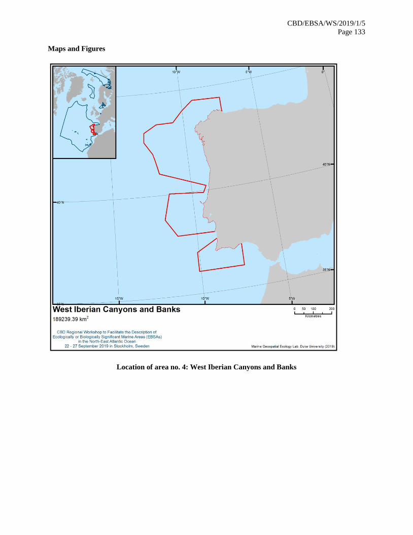
CBD/EBSA/WS/2019/1/5
Page 133
Maps and Figures
Location of area no. 4: West Iberian Canyons and Banks
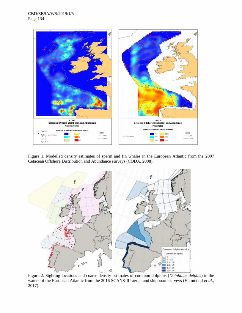
CBD/EBSA/WS/2019/1/5
Page 134
Figure 1. Modelled density estimates of sperm and fin whales in the European Atlantic from the 2007
Cetacean Offshore Distribution and Abundance surveys (CODA, 2008).
Figure 2. Sighting locations and coarse density estimates of common dolphins (Delphinus delphis) in the
waters of the European Atlantic from the 2016 SCANS-III aerial and shipboard surveys (Hammond et al.,
2017).
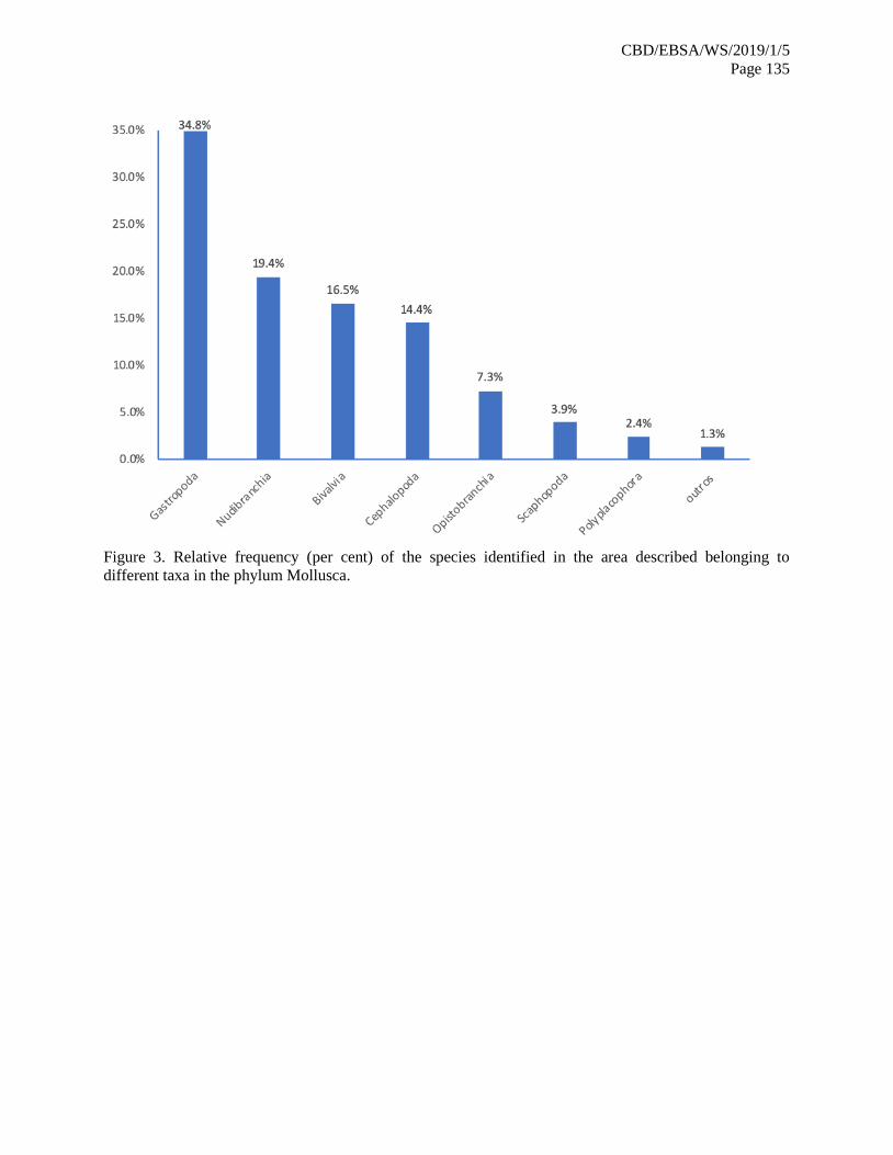
CBD/EBSA/WS/2019/1/5
Page 135
Figure 3. Relative frequency (per cent) of the species identified in the area described belonging to
different taxa in the phylum Mollusca.
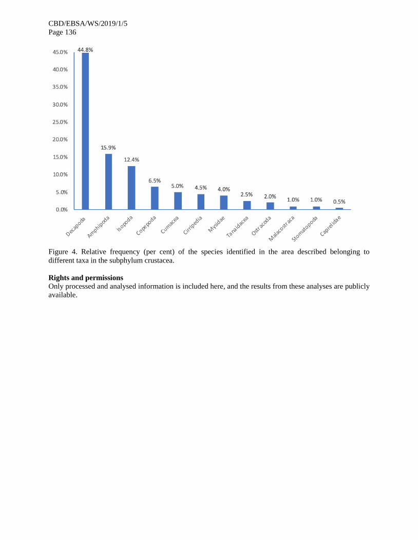
CBD/EBSA/WS/2019/1/5
Page 136
Figure 4. Relative frequency (per cent) of the species identified in the area described belonging to
different taxa in the subphylum crustacea.
Rights and permissions
Only processed and analysed information is included here, and the results from these analyses are publicly
available.
CBD/EBSA/WS/2019/1/5
Page 137
Area no. 5: Gulf of Cádiz
Abstract The Gulf of Cádiz is a very structurally complex area, containing important geomorphological elements,
such as large submarine canyons and seamounts. The hydrology is also complex due to the interaction
between waters formed in the Atlantic and waters of Mediterranean origin. This area includes a variety of
benthic habitats, both on soft and rocky bottoms, that are considered hotspots of biodiversity and which
serve as various habitats for endangered, threatened and declining species. It is also a seasonal migratory
pathway for large migratory pelagic species and is an important area for cetacean species, in particular.
Introduction The Gulf of Cadiz is located in the North-East Atlantic Ocean, to the southwest of the Iberian Peninsula.
Its eastern boundary is the Strait of Gibraltar, at the western border of the Mediterranean Sea. Its complex
physiographic is characterized by irregular reliefs and a diversity of geomorphological features, including
the continental shelf of the Spanish coast, channels, numerous mud volcanoes and the deep basin.
In the Gulf of Cádiz, oceanographic circulation follows an anti-cyclonic gyre (Pelegrí et al. 2005) and is
controlled by the exchange of water masses through the Strait of Gibraltar: a surface flow of Atlantic
origin enters the Mediterranean Sea, while another deep flow of Mediterranean origin circulates under the
former towards the Atlantic Ocean.
The upper thermocline water mass is the North Atlantic Central Water (NACW), located at 300–600m
water depth (Machín et al. 2006). Two intermediate water masses are found between 600 and 1,500 m: the
low-salinity Antarctic Intermediate Water (AAIW) and the Mediterranean water mass out into the Atlantic
(Mediterranean Outflow Water, MOW). Below 1,500 m occurs the North Atlantic Deep Water (NADW).
MOW circulation is poorly constrained and flows in three main branches: an intermediate branch towards
the northwest, a principal branch towards the west, and a southern branch that plunges as far as the Canary
Islands. The latter has been reported at 800 m along the Moroccan margin (Pelegrí et al. 2005), possibly
transported through eddies (Ambar et al. 1999).
The MOW exerts a greater influence on the bottom of the area as it circulates in contact with the friction
surface of the seabed. This interaction with the seabed causes very particular small-scale hydrodynamics,
producing subdivisions of the main flow as current energy is dissipated at greater depths.
Location
The area is located to the southwest of the Iberian Peninsula. Its eastern boundary is the Strait of Gibraltar,
on the western border of the Mediterranean Sea. It is bounded by the parallels (37º 00'N and 35º 56'N) and
meridians (6º 00'W and 7º 24'W).
Feature description of the area
• The area includes a variety of benthic habitats that are considered hotspots of biodiversity,
including mud volcanoes.
Unique and significant geomorphological features are present in the continental margins, and they are
known as mud volcanoes (León et al., 2012; Díaz del Río et al., 2014; Mascle et al., 2014). Mud
volcanoes (MVs) are defined as conic edifices constructed by surface extrusion of cold fluids containing
mud, saline water and/or gases expelled from a pressurized deep source upwards through structurally
controlled conduits (e.g., Brown, 1990; Milkov, 2000; Dimitrov, 2002; Kopf 2002). This process causes
substantial changes to the surface of deposits, significantly changing the existing reliefs and generating
new carbonated structures. In this way, these bottoms become consolidated surfaces or surfaces of a mixed
nature, composed of fragments of new carbonate rock created by the bacterial consumption of methane.
The active process of the expulsion of fluid saturated gas through them causes high levels of biological
diversity in the benthic ecosystems, which in turn determines the development of important deep-water
habitats. The community associated with these bottoms is composed of symbiont species, such as
polychaetes, bivalves and decapods, that excavate galleries, but also of other species not strictly linked to
the emissions, and which are characteristic of the bathyal sludge, such as molluscs, sea pens, polychaetes
CBD/EBSA/WS/2019/1/5
Page 138
and echinoderms. The communities of sea pens and excavator megafauna are widely distributed across
different areas adjacent to the mud volcanoes, presenting high densities (as in the case of Tarshish and
Pipoca volcanoes) and low densities (Anastasya) of sea pens (Funiculina quadrangularis, Kophobelemnon
stelliferum, Pennatula cf. aculeata). Other species that are part of this community are the sponge Thenea
muricata, molluscs, decapods, echinoderms and fish (Díaz del Río, 2014, ATLAS, 2019).
Many other benthic habitats occur in this area, both on soft and rocky bottoms. Among them, there are
mud with mixed communities such as bamboo corals (Isidella elongate), gorgonian (Radicipes fragilis),
hexactinellid sponges (Pheronema carpenter), crinoids of the genus Leptometra, cnidarians (Flabellum
chunii); and rocky bottoms with aggregations of gorgonians (Acanthogorgia, Swiftia, Gymnosarca
bathybius, Placogorgia spp., Callogorgia verticillata, Viminella flagellum, Paramuricea clavata), black
corals (Leiopathes, Stichopathes, Anthipathella) and scleratinians (Madrepora oculata dominates,
Lophelia pertusa and Dendrophyllia cornigera) (e.g., Aguilar et al., 2010; Cúrdia et al., 2012; Fonseca et
a., 2013; Díaz del Río, 2014; Boavida et al., 2016) as well as assemblages of the red coral (Corallium
rubrum) deep reefs (Boavida et al., 2016).
• The area includes habitats for endangered, threatened and declining species.
Many species recorded in the area are considered endangered, threatened and/or declining species,
according to, for example, the IUCN, OSPAR, ICES and the EU HABITAT DIRECTIVE.
Table 1, below, shows a list of species that are considered endangered, threatened and/or declining by
different laws and conventions. Additionally, some species that are not currently protected have been
proposed for inclusion (Aguilar et al., 2010):
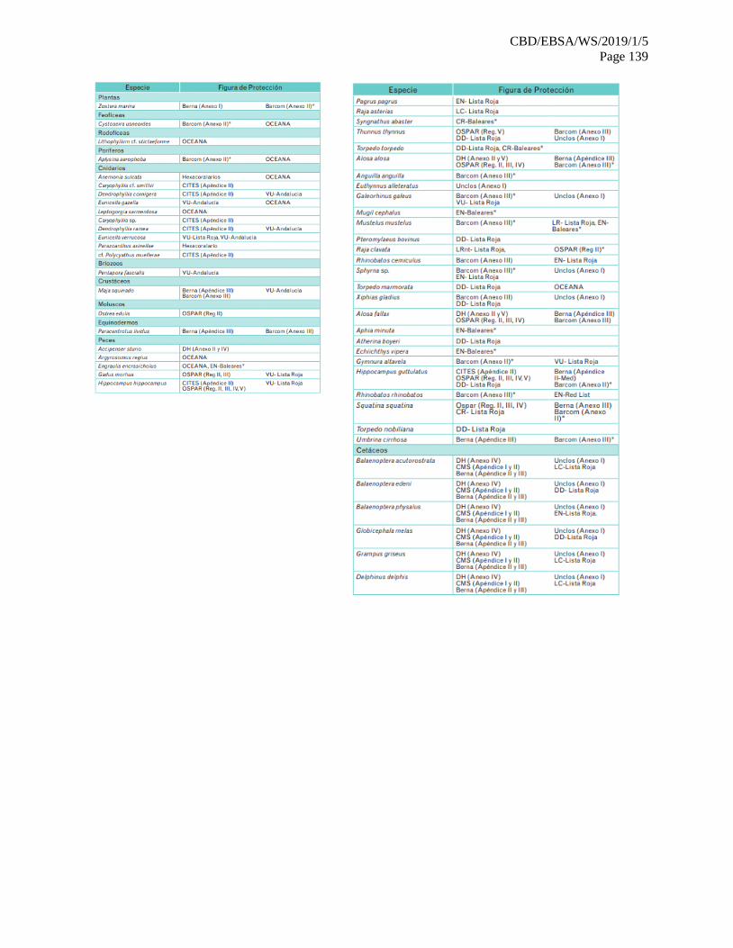
CBD/EBSA/WS/2019/1/5
Page 139
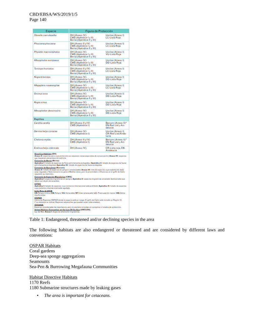
CBD/EBSA/WS/2019/1/5
Page 140
Table 1: Endangered, threatened and/or declining species in the area
The following habitats are also endangered or threatened and are considered by different laws and
conventions:
OSPAR Habitats
Coral gardens
Deep-sea sponge aggregations
Seamounts
Sea-Pen & Burrowing Megafauna Communities
Habitat Directive Habitats
1170 Reefs
1180 Submarine structures made by leaking gases
• The area is important for cetaceans.
CBD/EBSA/WS/2019/1/5
Page 141
This Atlantic–Mediterranean water interface is considered a biogeographic boundary (Sanjuán et al.
1994). Nevertheless, there is substantial transport of organisms across this ecotone, and different
cetaceans species are present in the waters of the Gulf of Cádiz and Strait of Gibraltar: short-beaked
common dolphins (Delphinus delphis), striped dolphins (Stenella coeruleoalba), bottlenose dolphins
(Tursiops truncatus), long-finned pilot whales (Globicephala melas), sperm whales (Physeter
macrocephalus) and killer whales (Orcinus orca) (De Stephanis et al., 2008).
During spring and summer this area provides essential feeding and nursing habitat for killer whales
(Orcinus orca). The small seasonal resident population of 39 killer whales, which are genetically and
ecologically distinct from killer whales in the Atlantic Ocean, use the area, and the same individuals have
been re-sighted annually from 1999 to 2016. They belong to five social pods, which were stable over the
study period (Esteban et al., 2014; 2016). Esteban et al. (2014) showed, using model predictions, that
killer whale occurrence in the Strait is related to the migration of their main prey, Atlantic bluefin tuna
(Thunnus thynnus). In spring, whale distribution was restricted to shallow waters off the western coast of
the Strait, where all pods were observed actively hunting tuna. In summer, the whales were observed
towards the shallow central waters of the Strait. A relatively new feeding strategy has been observed
among two of the five pods. These two pods interact with an artisanal drop-line fishery. Pods predating the
fishery had access to larger tuna in comparison with pods that were actively hunting. The Strait of
Gibraltar killer whales are socially and ecologically different from individuals in the Canary Islands,
where genetic research has indicated that there is little or no female-mediated gene migration between
these areas (Esteban et al., 2016).
The Strait of Gibraltar subpopulation of killer whales is considered vulnerable in the Spanish National
Catalogue of Endangered Species but may be considered endangered based upon other monitoring studies.
In 2016 the area of the Strait of Gibraltar and Gulf of Cádiz was classified as an Important Marine
Mammal Area (IMMA) resulting from the assessment of experts within the IUCN joint SSC/WCPA
Marine Mammals Taskforce (IUCN MMPATF, 2017; IUCN MMPATF, 2019).
• The area is also a seasonal migratory pathway for a large migratory pelagic species: Atlantic
bluefin tuna (Thunnus thynnus).
The Atlantic bluefin tuna (Thunnus thynnus) (Linnaeus, 1758) is the largest of all tunas (ICCAT 2006–
2014) and one of the most highly prized fish species in the world (Ottolenghi et al., 2004). In spring,
Atlantic bluefin tuna perform long seasonal reproductive migrations between feeding areas in the Atlantic
Ocean and spawning grounds, either in the Gulf of Mexico (western stock) or the Mediterranean Sea
(eastern stock). Like all bluefin tuna stocks, both stocks of the Atlantic bluefin tuna are threatened by
overfishing.
The bluefin tuna reproductive season in the Mediterranean Sea extends from May to July. In correlation
with a progressive east-to-west increase of the sea surface temperature, the spawning process begins in the
Levantine Sea, shifts to the southern Tyrrhenian-Malta region and eventually to the Balearic Sea (Heinisch
et al., 2008). Like the eastern spawning area, the reproductive season is known to last approximately three
months (April-June) in the Gulf of Mexico (Baglin et al., 1982).
In addition, the Strait of Gibraltar has been identified as a transiting area for satellite-tagged fin whales
(Balaenoptera physalus) moving between the Gulf of Cádiz and the Ligurian Sea area of the northern
Mediterranean (Gauffier et al. 2009,2018; Cotte et al., 2011; Notarbartolo di Sciara et al., 2016).
Feature condition and future outlook of the area
The waters of the Gulf of Cádiz are impacted by fishing, shipping and pollution.
Fishing activities: probably the fishing activity that has the greatest impact is bottom trawling, which is
responsible for the destruction of some ecosystems. This type of non-selective fishing causes changes in
the composition of ecosystems, affecting the long-term productivity of the fishery. The physical
CBD/EBSA/WS/2019/1/5
Page 142
consequences of bottom trawling are the alteration and/or direct destruction of habitat and the re-
suspension of sediment, increasing turbidity and changing the geochemical composition of the deposits.
Shipping: due to its proximity to the Strait of Gibraltar and the Cape of San Vicente there are important
navigation routes that pass over this area, with a high intensity of large-tonnage vessels that mainly
transport oil and containers. Maritime traffic is an important source of pollution both because of the
potential risk of accidental spillage and because of the intense noise that it generates.
- Water pollution: the main sources of pollution are ships and cities located on the coast (mostly in
summer when the intensity of tourism in some coastal areas increases).
Conversely, some actions to protect the area and to ensure the conservation of its biodiversity are being
carried out, and one specific area has been protected in accordance with international and Spanish
regulations and conventions: "The Gulf of Cádiz mud volcanoes" is located in the bathymetric range
between 300 and 1,200 m, placing it on the upper middle part of the continental slope and the southern
Iberian continental margin.
Three basic types of habitats have been identified, catalogued and described within the generic Habitats
Directive habitat type 1180: (1) the "Mud volcanoes" subtype, which is widespread in the area; (2) the
subtype "Collapsed depressions", located next to the volcanoes Anastasya, Pipoca, Hesperides, Almazan,
Aveiro and San Petersburg, and (3) the "Pockmarks" subtype, which is widespread throughout the area,
especially in the south, being a very diffuse phenomenon in the more distal areas of the slope (112
locations have been mapped). Other habitats at different levels, within the generic 1180 habitat type,
include the "Structures produced by leaking gases with carbonate substrates of chemosynthetic origin",
which is extensive in the area of gas emission, as well as the designation "Structures produced by leaking
gases with chemosynthetic species", which has been identified in the volcanoes Albolote, Gazul,
Anastasya, Pipoca, Tarsis, Hesperides, Almazan, Aveiro and St. Petersburg.
In addition, and of equal importance, nine subtypes of habitats linked to the habitat type 1170 "Reefs"
have been identified. These are: (1) Bathyal rock with Acanthogorgia hirsuta, on Pipoca; (2) reef of deep
coral Lophelia pertusa and/or Madrepora oculata, on bottoms of carbonate rocks and accumulations of
compressed dead coral on the slopes of the Gazul mud volcano, which presents significantly more active
hydrodynamics than in other areas of the SCI, as well as a low level of dragnet fishing activity; (3) deep
rocky bottoms with antipataria, of the genus Leiopathes, Antipathes and Stichopathes, have been found in
the environment of the volcanoes Gazul, Hesperides and Almazan; (4) bathyal rock with large
hexactinellid sponges (Asconema setubalense), in the surroundings of Chica and Enmedio; (5) bathyal
sedimentary rock with Bebryce mollis, found only on Gazul; (6) bathyal rock with Callogorgia verticillata
in specific areas of the Chica complex; (7) bathyal rock with Callogorgia and Demospongiae, in the area
around Enmedio; (8) deep rocky bottoms with aggregations of Demospongiae, identified in Gazul,
Magallanes, Enano, Enmedio and Chica, and (9) deposits of dead coral with remains of escleractinias
(e.g., Lophelia pertusa, Madrepora oculata, Dendrophyllia alternata), colonized by small octocorals (e.g.,
Swiftia, Bebryce, Placogorgia) scattered around the volcanoes Albolote, Gazul, Hesperides, Almazan and
Aveiro. Between them, these reef habitats occupy a surface area of approximately 2,063 hectares.
The management plan for the area is being developed in the framework of the INTEMARES project.
Apart from conservation projects, every year the Instituto Español de Oceanografía (IEO) carries out a
bottom trawling survey on the Gulf of Cádiz named ARSA. This survey aims to provide data for the
assessment of demersal commercial fish species and benthic ecosystems on the area. This survey is part of
an international effort to monitor marine ecosystems and is coordinated by the International Bottom
Trawling Surveys (IBTS) working group of the International Council for the Exploration of the Sea
(ICES).
Assessment of area no. 5, Gulf of Cádiz, against CBD EBSA Criteria
CBD EBSA Description Ranking of criterion relevance
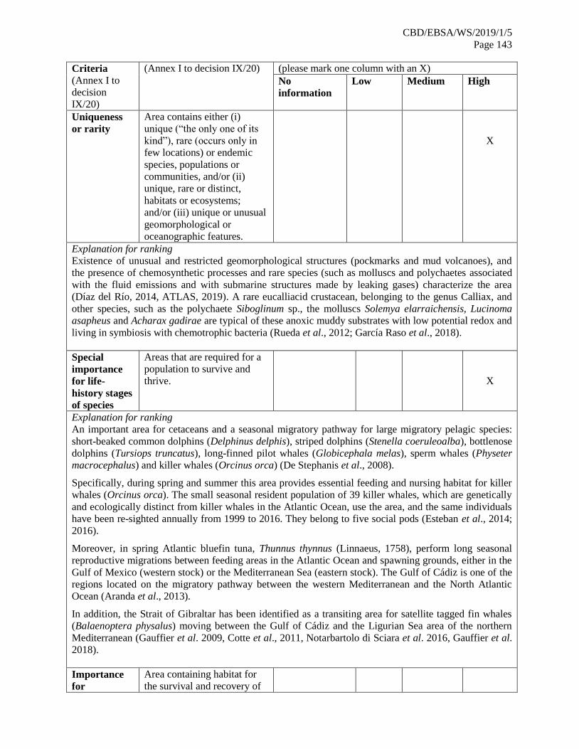
CBD/EBSA/WS/2019/1/5
Page 143
Criteria
(Annex I to
decision
IX/20)
(Annex I to decision IX/20) (please mark one column with an X)
No
information
Low Medium High
Uniqueness
or rarity
Area contains either (i)
unique (“the only one of its
kind”), rare (occurs only in
few locations) or endemic
species, populations or
communities, and/or (ii)
unique, rare or distinct,
habitats or ecosystems;
and/or (iii) unique or unusual
geomorphological or
oceanographic features.
X
Explanation for ranking
Existence of unusual and restricted geomorphological structures (pockmarks and mud volcanoes), and
the presence of chemosynthetic processes and rare species (such as molluscs and polychaetes associated
with the fluid emissions and with submarine structures made by leaking gases) characterize the area
(Díaz del Río, 2014, ATLAS, 2019). A rare eucalliacid crustacean, belonging to the genus Calliax, and
other species, such as the polychaete Siboglinum sp., the molluscs Solemya elarraichensis, Lucinoma
asapheus and Acharax gadirae are typical of these anoxic muddy substrates with low potential redox and
living in symbiosis with chemotrophic bacteria (Rueda et al., 2012; García Raso et al., 2018).
Special
importance
for life-
history stages
of species
Areas that are required for a
population to survive and
thrive.
X
Explanation for ranking
An important area for cetaceans and a seasonal migratory pathway for large migratory pelagic species:
short-beaked common dolphins (Delphinus delphis), striped dolphins (Stenella coeruleoalba), bottlenose
dolphins (Tursiops truncatus), long-finned pilot whales (Globicephala melas), sperm whales (Physeter
macrocephalus) and killer whales (Orcinus orca) (De Stephanis et al., 2008).
Specifically, during spring and summer this area provides essential feeding and nursing habitat for killer
whales (Orcinus orca). The small seasonal resident population of 39 killer whales, which are genetically
and ecologically distinct from killer whales in the Atlantic Ocean, use the area, and the same individuals
have been re-sighted annually from 1999 to 2016. They belong to five social pods (Esteban et al., 2014;
2016).
Moreover, in spring Atlantic bluefin tuna, Thunnus thynnus (Linnaeus, 1758), perform long seasonal
reproductive migrations between feeding areas in the Atlantic Ocean and spawning grounds, either in the
Gulf of Mexico (western stock) or the Mediterranean Sea (eastern stock). The Gulf of Cádiz is one of the
regions located on the migratory pathway between the western Mediterranean and the North Atlantic
Ocean (Aranda et al., 2013).
In addition, the Strait of Gibraltar has been identified as a transiting area for satellite tagged fin whales
(Balaenoptera physalus) moving between the Gulf of Cádiz and the Ligurian Sea area of the northern
Mediterranean (Gauffier et al. 2009, Cotte et al., 2011, Notarbartolo di Sciara et al. 2016, Gauffier et al.
2018).
Importance
for
Area containing habitat for
the survival and recovery of
CBD/EBSA/WS/2019/1/5
Page 144
threatened,
endangered
or declining
species
and/or
habitats
endangered, threatened,
declining species or area with
significant assemblages of
such species.
X
Explanation for ranking
More than 60 species (see Table 1) considered “threatened, endangered or declining”, based on different
international regulations and agreements, are present in the area described, including benthic species as
well as marine mammals, fish and reptiles (Aguilar et al., 2010; Díaz del Río, 2014).
Vulnerability,
fragility,
sensitivity, or
slow recovery
Areas that contain a
relatively high proportion of
sensitive habitats, biotopes or
species that are functionally
fragile (highly susceptible to
degradation or depletion by
human activity or by natural
events) or with slow
recovery.
X
Explanation for ranking
Many Vulnerable Marine Ecosystems, characterized by sessile habitat-forming species with long-life
cycles (e.g., coral reefs, gorgonian forest, sponge grounds) are present in the area and are vulnerable and
sensitive to fishing activities: communities of sea pens (Funiculina quadrangularis, Kophobelemnon
stelliferum, Pennatula cf. aculeata) and bamboo corals (Isidella elongata), which are widely distributed
across different areas adjacent to the mud volcanoes, as well as other habitats, such as cold-water corals
reefs (Madrepora oculata, Lophelia pertusa, Dendrophyllia cornigera), gorgonian gardens (e.g.,
Callogorgia verticillata, Acanthogorgia hirsuta, Swiftia pallida, Bebryce mollis, Eunicella verrucosa)
and aggregations of antipatharia (Leiopathes, Stichopathes, Anthipathella) (Aguilar et al., 2010; Díaz del
Río, 2014; ICES, 2019).
Biological
productivity
Area containing species,
populations or communities
with comparatively higher
natural biological
productivity.
X
Explanation for ranking
The productivity of the area is reflected in the abundance of marine resources. Productivity is related to
the bathymetric characteristics of its continental shelf and slope, the existence of a warm-temperate
climate, the presence of oceanographic processes, and, importantly, the nutrient enrichment delivered by
the outflows of important rivers such as Guadalquivir and Guadiana (Vila et al., 2004; Ramos et al.,
2012).
Biological
diversity
Area contains comparatively
higher diversity of
ecosystems, habitats,
communities, or species, or
has higher genetic diversity.
X
Explanation for ranking
The highly complex area includes a great variety of geomorphological features (e.g., submarine canyons,
seamounts, banks and mounds, mud volcanoes, slope affected by smaller rock outcrops) and hence, a
great diversity of benthic niches available. Numerous vulnerable marine ecosystems have been recorded
CBD/EBSA/WS/2019/1/5
Page 145
in the area using a remotely operated vehicle (Aguilar et al., 2010; Díaz del Río, 2014).
There are mainly three distinct communities that should be highlighted in the area: those associated with
mud volcanoes and their emissions, those associated with soft substrates and those associated with rocky
bottoms.
1. Communities of polychaetes (Siboglinum sp.), molluscs (Solemya elarraichensis, Lucinoma asapheus
and Acharax gadirae) and crustacean (Calliax sp.) are associated with mud volcanoes and their
emissions (Díaz del Río, 2014, ATLAS, 2019).
2. Communities of sea pens (Funiculina quadrangularis, Kophobelemnon stelliferum, Pennatula cf.
aculeata), bamboo coral gardens (Isidella elongate) and other gorgonians (Radicipes fragilis),
scleractinians (Flabellum chunii) and sponges (Thenea muricata, Pheronema carpenteri) are
widely distributed across soft bottoms in areas adjacent to these structures such as (Díaz del Río,
2014, ATLAS, 2019).
3. Communities made up of gorgonians (Acanthogorgia, Swiftia, Gymnosarca bathybius,
Placogorgia spp., Callogorgia verticillata, Viminella flagellum, Paramuricea clavata), black
corals (Leiopathes, Stichopathes, Anthipathella) and scleratinians (Madrepora oculata
dominates, Lophelia pertusa and Dendrophyllia cornigera) are associated with rocky bottoms
across the entire area (e.g., Aguilar et al., 2010; Cúrdia et al., 2012; Fonseca et al., 2013; Díaz
del Río, 2014).
Naturalness Area with a comparatively higher
degree of naturalness as a result of the
lack of or low level of human-induced
disturbance or degradation.
X
Explanation for ranking
This area is an important fishing ground with a high diversity and high productivity of exploited species
(Sobrino et al., 1994). The exploitation of fisheries composed mainly of trawlers, purse seiners and
artisanal boats is intensive in the Gulf of Cádiz, with all fleets exerting high impacts on most living
groups of the ecosystem. Therefore, the Gulf of Cádiz is a notably stressed ecosystem, displaying
characteristics of a heavily exploited area (Torres et al., 2010).
References
Abascal, F.J., medina, A., De la Serna, J.M., Godoy, D., Aranda, G., 2016. Fisheries Oceanography, 25:1,
54-66.
Aguilar, R., Pardo, E., Cornax, M.J., García, S., Ubero, J., 2010. Doñana y el Golfo de Cádiz. Propuesta
para la ampliación del área marina protegida. OCEANA.
Ambar, I., Armi, L., Bower, A., Ferreira, T., 1999. Some aspects of time variability of the Mediterranean
Water off south Portugal. Deep- Sea Res I 46:1109–1136.
Aranda, G., Abascal, F.J., Varela, J.L., Medina, A., 2013. Spawning Behaviour and Post-Spawning
Migration Patterns of Atlantic Bluefin Tuna (Thunnus thynnus) Ascertained from Satellite
Archival Tags. PLoS ONE 8(10): e76445. doi:10.1371/journal.pone.0076445
ATLAS (2019) Deliverable 3.3 Biodiversity, biogeography and GOODS classification system under
current climate conditions and future IPCC scenarios.
Baglin, R.E. Jr. 1982. Reproductive biology of western Atlantic bluefin tuna. Fish Bull 80: 121-134 .
Boavida, J., Paulo, D., Aurelle, D., Arnaud-Haond, S., Marschal, C., Reed, J., Gonçalves, J.M.S., Serrao,
E.A., 2016. A Well-Kept Treasure at Depth: Precious Red Coral Rediscovered in Atlantic Deep
Coral Gardens (SW Portugal) after 300 Years. PLoS ONE 11(1): e0147228.
doi:10.1371/journal.pone.0147228
CBD/EBSA/WS/2019/1/5
Page 146
Boavida, J., Assis, J., Silva, I., Serrao, E.A., 2016. Overlooked habitat of a vulnerable gorgonian revealed
in the Mediterranean and Eastern Atlantic by ecological niche modelling. Scientific Reports,
6:36460. DOI: 10.1038/srep36460
Brown, K.M., 1990. The nature and hydrogeologic significance of mud diapirs and diatremes for
accretionary systems. J Mar Geophys Res 95(6):8969–8982.
Cotte, C., Ovidio, F., Chaigneau, A., Levy, M., Taupier-Letage, I., Mate, B. & Guinet, C (2011) Scale-
dependent interactions of Mediterranean whales with marine dynamics. Limnology and
Oceanography. 56. 10.4319/lo.2011.56.1.0219.
Cúrdia, J., Monteiro, P., Alfonso, C.M.L., Santos, M.N., Cunha, M.R., Gonçalves, J.M.S., 2012. Spatial
and depth-associated distribution patterns of shallow gorgonians in the Algarve coast (Portugal,
NE Atlantic). Helgol Mar Res DOI 10.1007/s10152-012-0340-1
De la Torriente, A., Aguilar, R., 2011. OSPAR Workshop on the improvement of the definitions of
habitats on the OSPAR list. Background document for discussion: "Coral gardens", "Deep sea
sponge aggregations" and "Seapen and burrowing megafauna communities". Bergen, Norway, 20-
21 October.
De Stephanis, R., Cornulier, T., Verborgh, P., Salazar Sierra, J., Pérez Gimeno, N., Guinet, C., 2008.
Summer spatial distribution of cetaceans in the Strait of Gibraltar in relation to the oceanographic
context. Marine Ecology Progress Series, 353: 275-288.
Diaz del Rio, Victor, et al. Volcanes de fango del golfo de Cádiz, Proyecto LIFE + INDEMARES. Ed.
Fundacion Biodiversidad del Ministerio de Agricultura, Alimentacion y Medio Ambiente. 2014.
Dimitrov LI (2002) Mud volcanoes-the most important pathway for degassing deeply buried sediments.
Earth Sci Rev 59:49–76.
Esteban, R., Verborgh, P., Gauffier, P. 2016. Dynamics of killer whale, bluefin tuna and human fisheries
in the Strait of Gibraltar. Biological Conservation 194:31-38.
Esteban, R., Verborgh, P., Gauffier, P. 2016. Using a multi-disciplinary approach to identify a critically
endangered killer whale management unit. Ecological Indicators 66, 291-300.
Esteban, R., Verborgh, P., Gauffier, P. 2016. Conservation Status of Killer Whales, Orcinus Orca, in the
Strait of Gibraltar. In: G. Notarbartolo di Sciara, M. Podestà, B.E. Curry (Editors), Mediterranean
marine mammal ecology and conservation. Advances in Marine Biology 75:141-172.
http://dx.doi.org/10.1016/bs.amb.2016.07.001
Esteban, R., Verborgh, P., Gauffier, P. 2014. Identifying key habitat and seasonal patterns of a critically
endangered population of killer whales. Journal of the Marine Biological Association of the
United Kingdom. doi:10.1017/S002531541300091X
Fonseca, P., Abrantes, F., Aguilar, R., Campos, A., Cunha, M., Ferreira, D., Fonseca, T.P., García, S.,
Henriques, V., Machado, M., Mechó, A., Relvas, P., Rodriguez, A.F., Salgueiro, E., Vieira, R.,
Weetman, A., Castro, M., 2013. A deep-water crinoid Leptometra celtica bed off the Portuguese
south coast. Mar Biodiv DOI 10.1007/s12526-013-0191-2
García Raso, J.E., García Muñoz, J.E., Mateo-Ramírez, A., López-González, N., Fernández-Salas, L.M.,
Rueda, J.L., 2018. Decapod crustaceans Eucalliacidae in chemoautotrophic bathyal bottoms of the
Gulf of Cadiz (Atlantic Ocean), environmental characteristics and associated communities.
Gauffier, P., Verborgh, P., Andréu, E., Esteban, R., Medina, B., Gallego, P., de Stephanis, R., 2009. An
update on fin whales (Balaenoptera physalus) migration through intense maritime traffic in the
Strait of Gibraltar. Paper SC/61/BC6 presented to the Scientific Committee of the International
Whaling Commission, May 2009, Funchal.
Gauffier, P., Verborgh, P., Giménez, J., Esteban, R., Sierra, J., & Stephanis, R, 2018. Contemporary
migration of fin whales through the Strait of Gibraltar. Marine Ecology Progress Series. 588. 215-
228. 10.3354/meps12449.
Heinisch, G., Corriero, A., Medina, A., Abascalm F.J., de la Serna, J.M. et al., 2008. Spatial-temporal
pattern of bluefin tuna (Thunnus thynnus L. 1758) gonad maturation across the Mediterranean Sea.
Mar Biol 154: 623-630. doi:10.1007/s00227-008-0955-6.
ICES, 2019. New information regarding the impact of fisheries on other components of the ecosystem.
ICES Special Request Advice Ecoregions in the Northeast Atlantic and adjacent sea.
CBD/EBSA/WS/2019/1/5
Page 147
IUCN Marine Mammal Protected Areas Task Force, 2019. The IUCN Global Dataset
of Important Marine Mammal Areas (IUCN IMMA). Made available under agreement on terms
and conditions of use by the IUCN Joint SSC/WCPA Marine Mammal Protected Areas Task
Force and accessible via the IMMA e-Atlas http://www.marinemammalhabitat.org/imma-eatlas/
IUCN Marine Mammal Protected Areas Task Force, 2017. Final Report of
the Workshop: First IMMA Regional Workshop for the Mediterranean, Chania,
Greece, 24-28 October 2016, 29pp.
Kopf, A. (2002) Significance of mud volcanism. Rev Geophys 40:1–52.
León, R., Somoza, L., Medialdea, T., Vázquez, J.T., González, F.J., López-González, N., Casas, D., Mata,
M.P., Fernández-Puga, M.C., Giménez-Moreno, C.J., Díaz del Río, V., 2012. New discoveries of
mud volcanoes on the Moroccan Atlantic continental margin (Gulf of Cádiz): morpho-structural
characterization. Geo-Mar Letters DOI 10.1007/s00367-012-0275-1.
Machín F., Pelegrí, J.L., Marrero-Díaz, A., Laiz, I., Ratsimandresy, A.W., 2006. Nearsurface circulation in
the southern Gulf of Cádiz. Deep-Sea Res II 53(11/13):1161–1181.
Mascle, J., Mary, F., Praeg, D., Brosolo, L., Camera, L., Ceramicola, S., Durpé, S., 2014. Distribution
and geological control of mud volcanoes and other fluid/free gas seepage features in the
Mediterranean Sea and nearby Gulf of Cadiz. Geo-Marine Letters, 34, Issue 2-3: 89-110.
Milkov, A.V., 2000. Worldwide distribution of submarine mud volcanoes and associated gas hydrates.
Mar Geol 167:29–42.
Notarbartolo di Sciara, et al. 2016. Fin Whales, Balaenoptera physalus: At Home in a
Changing Mediterranean Sea? Advances in Marine Biology, 75: 75-101.
Ottolenghi, F., Silvestri, C., Giordano, P., Lovatelli, A. and New, M.B., 2004. Capture-Based Aquaculture.
The Fattening of Eels, Groupers, Tunas and Yellowtails. Rome: Food and Agriculture
Organization of the United Nations, 308 pp.
Pelegrí, J.L., Marrero-Díaz, A., Ratsimandresy, A., Antoranz, A., Cisneros- Aguirre, J., Gordo, C.,
Grísolia, D., Hernández-Guerra, A., Láiz, I., Martínez, A., Parrilla, G., Pérez-Rodriguez, P.,
Rodríguez-Santana, A., Sangrà, P., 2005. Hydrographic cruises off northwest Africa: the Canary
Current and the Cape Ghir region. J Mar Syst 54: 39–63.
Ramos, F., Gil, J., Torres, M.A., Silva, L., Vila, Y., Sánchez, R., Jiménez, M.P., Baldó, F., Fernández-
Salas, F., Rueda, L.M., Díaz del Rio, V., Vázquez, J.T., LópezGonzález, N., Lens, S., Bellas, J.,
Besada, V., Vinas, ˜ L., González-Quijano, A., Franco, A., Fumega, J., 2012. Estrategias Marinas.
Demarcación Marina Sudatlántica. Parte I. Marco General: Características de la demarcación
marina. Ministerio de Agricultura, Alimentación y Medio Ambiente (MAGRAMA), Instituto
Espanol ˜ de Oceanografía (IEO), Centro de Estudios de Puertos y Costas-Centro de Estudios y
Experimentación de Obras Públicas (CEPYC-CEDEX), Madrid, pp. 127 pp.
Rueda, J.L., González-García, E., Urra, J., Oporto,T., Gofas, S., García-Raso, E., López-González, N.,
Fernández-Salas, L.M., Díaz del Río, V., 2012. Chemosymbiotic species associated with mud
breccia sediments from mud volcanoes within Spanish waters (Gulf of Cadiz). XVII Iberian
Symposium on Marine Biology Studies.
Sanjuán, A., Zapata, C., Álvarez, G., 1994. Mytilus galloprovincialis and M. edulis on the coasts of the
Iberian Peninsula. Mar Ecol Prog Ser 113:131–146.
Sobrino, I., Jiménez, M.P., Ramos, F., Baro, J., 1994. Descripción de las pesquerías demersales de
laRegiónSuratlántica Espanola, ˜ vol. 151.BoletínInstituto Espanol ˜ de Oceanografía, 76 pp.
Torres, M.A., Coll, M., Heymans, J.J., Christensen, V., Sobrino, I., 2010. Food-web structure of and
fishing impacts on the Gulf of Cadiz ecosystem (South-western Spain). Ecological Modelling,
265: 26–44.
Vila, Y., Silva, L., Millán, M., Ramos, F., Gil, J., Jiménez, M.P., 2004. Los recursos pesqueros del Golfo
de Cádiz: estado actual de explotación. Informes Técnicos. Instituto Espanol ˜ de Oceanografía,
pp. 200 pp.
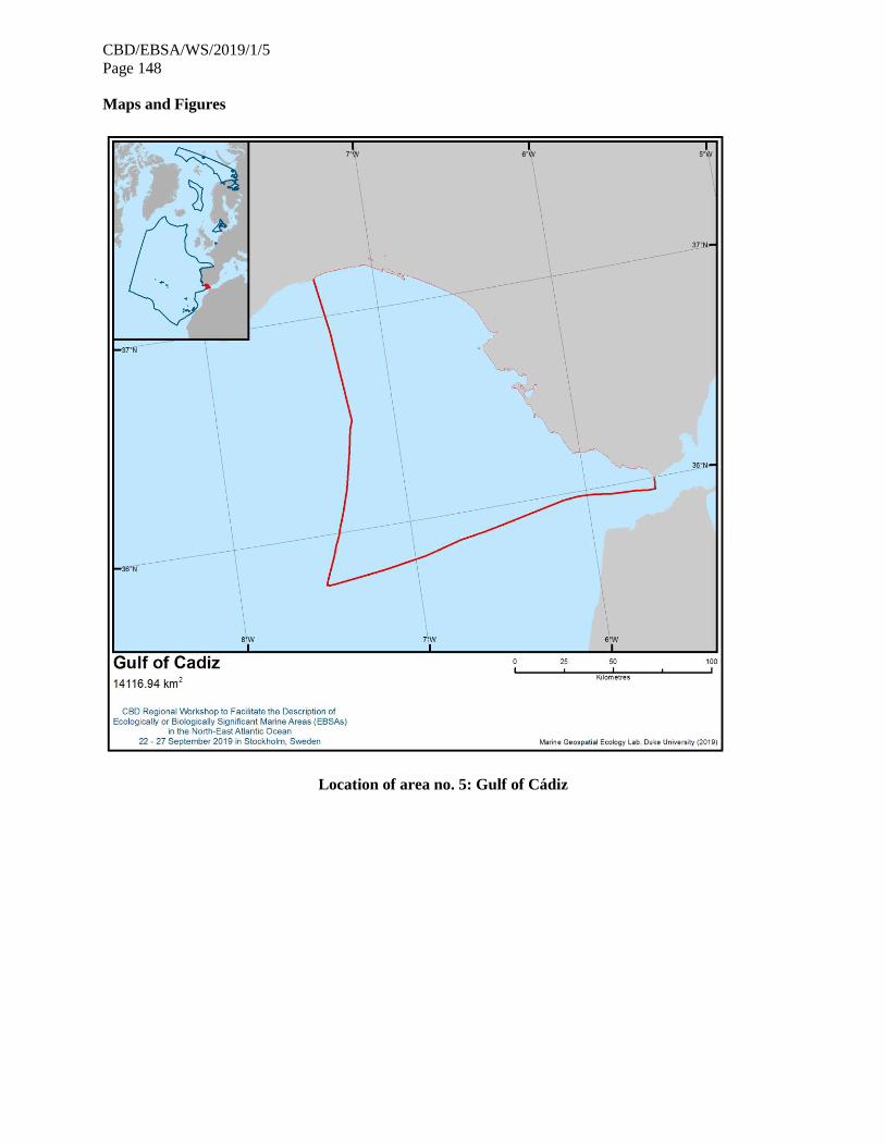
CBD/EBSA/WS/2019/1/5
Page 148
Maps and Figures
Location of area no. 5: Gulf of Cádiz

CBD/EBSA/WS/2019/1/5
Page 149
Location of mud volcanoes along the Spanish margin (Díaz del Río et al., 2014).

CBD/EBSA/WS/2019/1/5
Page 150
Benthic habitats and communities of Gazul Mud Volcano (from ca. 470 to ca. 400 m depth). a) Sponge
field colonising areas in hard authigenic carbonates (slabs), b) specimen of the sponge Asconema
setubalense, c) patches of small colonies of the scleractinian coral Madrepora oculata with sponges, d)
specimens of the ascidian Polycarpa sp. in hard authigenic carbonates (slabs), e) sandy bottom with ripples
and the actinia Actinauge richardi (indicated by the red arrows) f) sandy substrate with presence of the
solitary corals Flabellum chunii (indicated by the red arrows) (ATLAS, 2019).
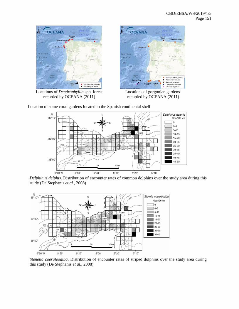
CBD/EBSA/WS/2019/1/5
Page 151
Locations of Dendrophyllia spp. forest
recorded by OCEANA (2011)
Locations of gorgonian gardens
recorded by OCEANA (2011)
Location of some coral gardens located in the Spanish continental shelf
Delphinus delphis. Distribution of encounter rates of common dolphins over the study area during this
study (De Stephanis et al., 2008)
Stenella coeruleoalba. Distribution of encounter rates of striped dolphins over the study area during
this study (De Stephanis et al., 2008)
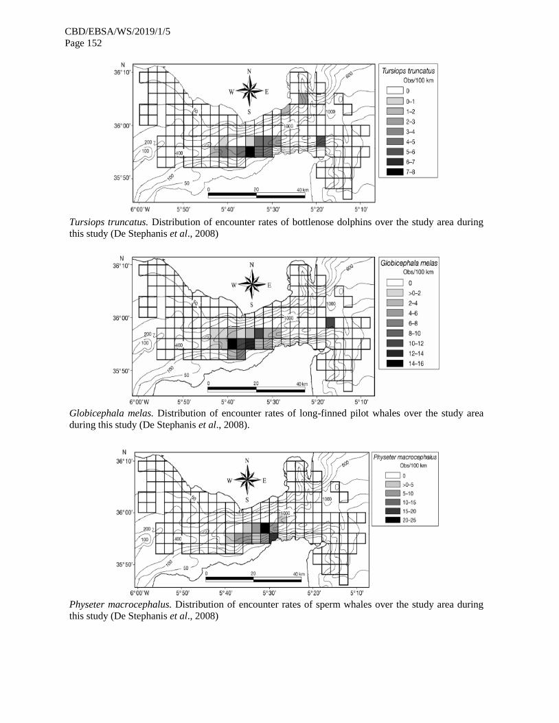
CBD/EBSA/WS/2019/1/5
Page 152
Tursiops truncatus. Distribution of encounter rates of bottlenose dolphins over the study area during
this study (De Stephanis et al., 2008)
Globicephala melas. Distribution of encounter rates of long-finned pilot whales over the study area
during this study (De Stephanis et al., 2008).
Physeter macrocephalus. Distribution of encounter rates of sperm whales over the study area during
this study (De Stephanis et al., 2008)
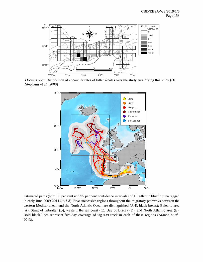
CBD/EBSA/WS/2019/1/5
Page 153
Orcinus orca. Distribution of encounter rates of killer whales over the study area during this study (De
Stephanis et al., 2008)
Estimated paths (with 50 per cent and 95 per cent confidence intervals) of 13 Atlantic bluefin tuna tagged
in early June 2009-2011 (≥45 d). Five successive regions throughout the migratory pathways between the
western Mediterranean and the North Atlantic Ocean are distinguished (A-E, black boxes): Balearic area
(A), Strait of Gibraltar (B), western Iberian coast (C), Bay of Biscay (D), and North Atlantic area (E).
Bold black lines represent five-day coverage of tag #39 track in each of these regions (Aranda et al.,
2013).
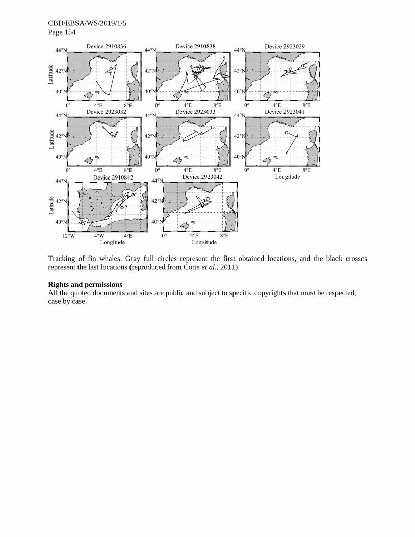
CBD/EBSA/WS/2019/1/5
Page 154
Tracking of fin whales. Gray full circles represent the first obtained locations, and the black crosses
represent the last locations (reproduced from Cotte et al., 2011).
Rights and permissions
All the quoted documents and sites are public and subject to specific copyrights that must be respected,
case by case.
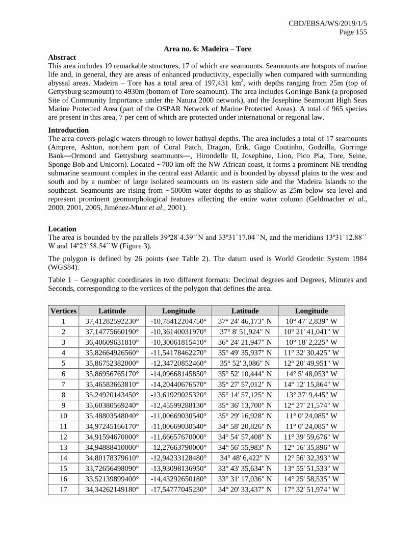
CBD/EBSA/WS/2019/1/5
Page 155
Area no. 6: Madeira – Tore
Abstract This area includes 19 remarkable structures, 17 of which are seamounts. Seamounts are hotspots of marine
life and, in general, they are areas of enhanced productivity, especially when compared with surrounding
abyssal areas. Madeira – Tore has a total area of 197,431 km2, with depths ranging from 25m (top of
Gettysburg seamount) to 4930m (bottom of Tore seamount). The area includes Gorringe Bank (a proposed
Site of Community Importance under the Natura 2000 network), and the Josephine Seamount High Seas
Marine Protected Area (part of the OSPAR Network of Marine Protected Areas). A total of 965 species
are present in this area, 7 per cent of which are protected under international or regional law.
Introduction
The area covers pelagic waters through to lower bathyal depths. The area includes a total of 17 seamounts
(Ampere, Ashton, northern part of Coral Patch, Dragon, Erik, Gago Coutinho, Godzilla, Gorringe
Bank―Ormond and Gettysburg seamounts―, Hirondelle II, Josephine, Lion, Pico Pia, Tore, Seine,
Sponge Bob and Unicorn). Located ∼700 km off the NW African coast, it forms a prominent NE trending
submarine seamount complex in the central east Atlantic and is bounded by abyssal plains to the west and
south and by a number of large isolated seamounts on its eastern side and the Madeira Islands to the
southeast. Seamounts are rising from ∼5000m water depths to as shallow as 25m below sea level and
represent prominent geomorphological features affecting the entire water column (Geldmacher et al.,
2000, 2001, 2005, Jiménez-Munt et al., 2001).
Location The area is bounded by the parallels 39º28`4.39``N and 33º31`17.04``N, and the meridians 13º31`12.88``
W and 14º25`58.54``W (Figure 3).
The polygon is defined by 26 points (see Table 2). The datum used is World Geodetic System 1984
(WGS84).
Table 1 – Geographic coordinates in two different formats: Decimal degrees and Degrees, Minutes and
Seconds, corresponding to the vertices of the polygon that defines the area.
Vertices Latitude Longitude Latitude Longitude
1 37,41282592230° -10,78412204750° 37° 24' 46,173" N 10° 47' 2,839" W
2 37,14775660190° -10,36140031970° 37° 8' 51,924" N 10° 21' 41,041" W
3 36,40609631810° -10,30061815410° 36° 24' 21,947" N 10° 18' 2,225" W
4 35,82664926560° -11,54178462270° 35° 49' 35,937" N 11° 32' 30,425" W
5 35,86752382000° -12,34720852460° 35° 52' 3,086" N 12° 20' 49,951" W
6 35,86956765170° -14,09668145850° 35° 52' 10,444" N 14° 5' 48,053" W
7 35,46583663810° -14,20440676570° 35° 27' 57,012" N 14° 12' 15,864" W
8 35,24920143450° -13,61929025320° 35° 14' 57,125" N 13° 37' 9,445" W
9 35,60380569240° -12,45599288130° 35° 36' 13,700" N 12° 27' 21,574" W
10 35,48803548040° -11,00669030540° 35° 29' 16,928" N 11° 0' 24,085" W
11 34,97245166170° -11,00669030540° 34° 58' 20,826" N 11° 0' 24,085" W
12 34,91594670000° -11,66657670000° 34° 54' 57,408" N 11° 39' 59,676" W
13 34,94888410000° -12,27663790000° 34° 56' 55,983" N 12° 16' 35,896" W
14 34,80178379610° -12,94233128480° 34° 48' 6,422" N 12° 56' 32,393" W
15 33,72656498090° -13,93098136950° 33° 43' 35,634" N 13° 55' 51,533" W
16 33,52139899400° -14,43292650180° 33° 31' 17,036" N 14° 25' 58,535" W
17 34,34262149180° -17,54777045230° 34° 20' 33,437" N 17° 32' 51,974" W
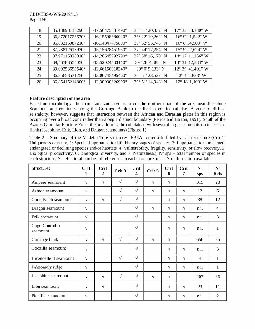
CBD/EBSA/WS/2019/1/5
Page 156
18 35,18898118290° -17,56475831490° 35° 11' 20,332" N 17° 33' 53,130" W
19 36,37201723670° -16,15598386020° 36° 22' 19,262" N 16° 9' 21,542" W
20 36,88215087210° -16,14847475890° 36° 52' 55,743" N 16° 8' 54,509" W
21 37,73812613930° -15,15628451950° 37° 44' 17,254" N 15° 9' 22,624" W
22 37,97115828810° -14,28645992790° 37° 58' 16,170" N 14° 17' 11,256" W
23 39,46788555050° -13,52024533110° 39° 28' 4,388" N 13° 31' 12,883" W
24 39,00253692540° -12,66150018240° 39° 0' 9,133" N 12° 39' 41,401" W
25 36,85653531250° -13,06745495460° 36° 51' 23,527" N 13° 4' 2,838" W
26 36,85415214800° -12,30030626900° 36° 51' 14,948" N 12° 18' 1,103" W
Feature description of the area
Based on morphology, the main fault zone seems to cut the northern part of the area near Josephine
Seamount and continues along the Gorringe Bank to the Iberian continental rise. A zone of diffuse
seismicity, however, suggests that interaction between the African and Eurasian plates in this region is
occurring over a broad zone rather than along a distinct boundary (Peirce and Barton, 1991). South of the
Azores-Gibraltar Fracture Zone, the area forms a broad plateau with several large seamounts on its eastern
flank (Josephine, Erik, Lion, and Dragon seamounts) (Figure 1).
Table 2 – Summary of the Madeira-Tore structures, EBSA criteria fulfilled by each structure (Crit 1:
Uniqueness or rarity, 2: Special importance for life-history stages of species, 3: Importance for threatened,
endangered or declining species and/or habitats, 4: Vulnerability, fragility, sensitivity, or slow recovery, 5:
Biological productivity, 6: Biological diversity, and 7: Naturalness), Nº sps – total number of species in
each structure. Nº refs - total number of references in each structure. n.i. – No information available.
Structures Crit
1
Crit
2 Crit 3
Crit
4 Crit 5
Crit
6
Crit
7
Nº
sps
Nº
Refs
Ampere seamount √ √ √ √ √ √
319 28
Ashton seamount √
√ √ √ √ √ 12 6
Coral Patch seamount √ √ √ √
√ √ 38 12
Dragon seamount √
√ √ √ √ n.i. 4
Erik seamount √
√
√ √ n.i. 3
Gago Coutinho
seamount √
√
√ √ n.i. 1
Gorringe bank √ √ √ √ √ √
656 55
Godzilla seamount √
√
√ √ n.i. 3
Hirondelle II seamount √
√ √
√ √ 4 1
J-Anomaly ridge √
√
√ √ n.i. 1
Josephine seamount √ √ √ √ √ √
207 36
Lion seamount √ √
√
√ √ 23 11
Pico Pia seamount √
√
√ √ n.i. 2
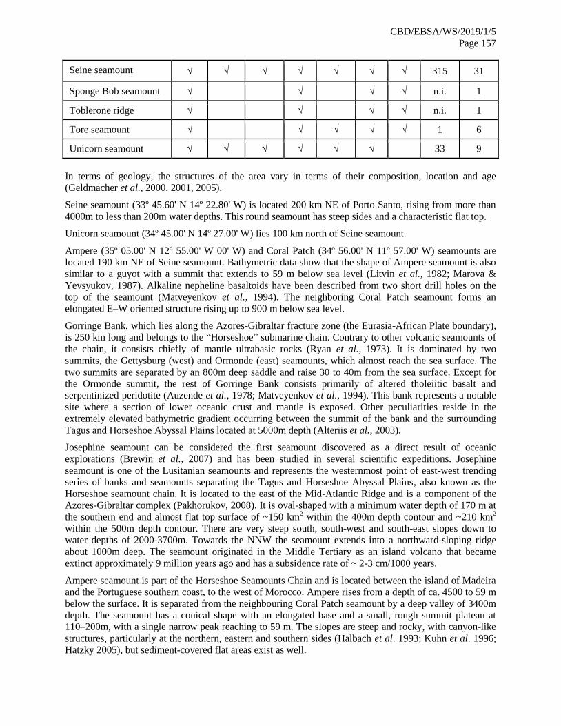
CBD/EBSA/WS/2019/1/5
Page 157
Seine seamount √ √ √ √ √ √ √ 315 31
Sponge Bob seamount √
√
√ √ n.i. 1
Toblerone ridge √
√
√ √ n.i. 1
Tore seamount √
√ √ √ √ 1 6
Unicorn seamount √ √ √ √ √ √
33 9
In terms of geology, the structures of the area vary in terms of their composition, location and age
(Geldmacher et al., 2000, 2001, 2005).
Seine seamount (33º 45.60' N 14º 22.80' W) is located 200 km NE of Porto Santo, rising from more than
4000m to less than 200m water depths. This round seamount has steep sides and a characteristic flat top.
Unicorn seamount (34º 45.00' N 14º 27.00' W) lies 100 km north of Seine seamount.
Ampere (35º 05.00' N 12º 55.00' W 00' W) and Coral Patch (34º 56.00' N 11º 57.00' W) seamounts are
located 190 km NE of Seine seamount. Bathymetric data show that the shape of Ampere seamount is also
similar to a guyot with a summit that extends to 59 m below sea level (Litvin et al., 1982; Marova &
Yevsyukov, 1987). Alkaline nepheline basaltoids have been described from two short drill holes on the
top of the seamount (Matveyenkov et al., 1994). The neighboring Coral Patch seamount forms an
elongated E–W oriented structure rising up to 900 m below sea level.
Gorringe Bank, which lies along the Azores-Gibraltar fracture zone (the Eurasia-African Plate boundary),
is 250 km long and belongs to the “Horseshoe” submarine chain. Contrary to other volcanic seamounts of
the chain, it consists chiefly of mantle ultrabasic rocks (Ryan et al., 1973). It is dominated by two
summits, the Gettysburg (west) and Ormonde (east) seamounts, which almost reach the sea surface. The
two summits are separated by an 800m deep saddle and raise 30 to 40m from the sea surface. Except for
the Ormonde summit, the rest of Gorringe Bank consists primarily of altered tholeiitic basalt and
serpentinized peridotite (Auzende et al., 1978; Matveyenkov et al., 1994). This bank represents a notable
site where a section of lower oceanic crust and mantle is exposed. Other peculiarities reside in the
extremely elevated bathymetric gradient occurring between the summit of the bank and the surrounding
Tagus and Horseshoe Abyssal Plains located at 5000m depth (Alteriis et al., 2003).
Josephine seamount can be considered the first seamount discovered as a direct result of oceanic
explorations (Brewin et al., 2007) and has been studied in several scientific expeditions. Josephine
seamount is one of the Lusitanian seamounts and represents the westernmost point of east-west trending
series of banks and seamounts separating the Tagus and Horseshoe Abyssal Plains, also known as the
Horseshoe seamount chain. It is located to the east of the Mid-Atlantic Ridge and is a component of the
Azores-Gibraltar complex (Pakhorukov, 2008). It is oval-shaped with a minimum water depth of 170 m at
the southern end and almost flat top surface of ~150 km2 within the 400m depth contour and ~210 km
2
within the 500m depth contour. There are very steep south, south-west and south-east slopes down to
water depths of 2000-3700m. Towards the NNW the seamount extends into a northward-sloping ridge
about 1000m deep. The seamount originated in the Middle Tertiary as an island volcano that became
extinct approximately 9 million years ago and has a subsidence rate of ~ 2-3 cm/1000 years.
Ampere seamount is part of the Horseshoe Seamounts Chain and is located between the island of Madeira
and the Portuguese southern coast, to the west of Morocco. Ampere rises from a depth of ca. 4500 to 59 m
below the surface. It is separated from the neighbouring Coral Patch seamount by a deep valley of 3400m
depth. The seamount has a conical shape with an elongated base and a small, rough summit plateau at
110–200m, with a single narrow peak reaching to 59 m. The slopes are steep and rocky, with canyon-like
structures, particularly at the northern, eastern and southern sides (Halbach et al. 1993; Kuhn et al. 1996;
Hatzky 2005), but sediment-covered flat areas exist as well.
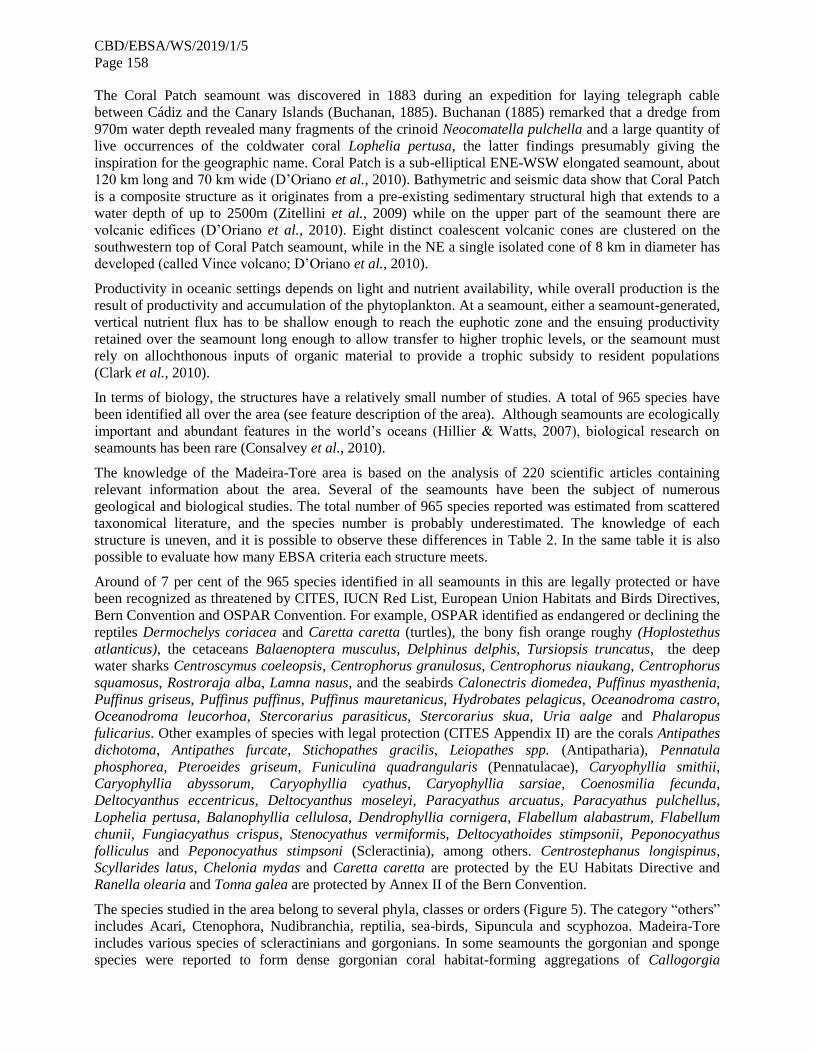
CBD/EBSA/WS/2019/1/5
Page 158
The Coral Patch seamount was discovered in 1883 during an expedition for laying telegraph cable
between Cádiz and the Canary Islands (Buchanan, 1885). Buchanan (1885) remarked that a dredge from
970m water depth revealed many fragments of the crinoid Neocomatella pulchella and a large quantity of
live occurrences of the coldwater coral Lophelia pertusa, the latter findings presumably giving the
inspiration for the geographic name. Coral Patch is a sub-elliptical ENE-WSW elongated seamount, about
120 km long and 70 km wide (D’Oriano et al., 2010). Bathymetric and seismic data show that Coral Patch
is a composite structure as it originates from a pre-existing sedimentary structural high that extends to a
water depth of up to 2500m (Zitellini et al., 2009) while on the upper part of the seamount there are
volcanic edifices (D’Oriano et al., 2010). Eight distinct coalescent volcanic cones are clustered on the
southwestern top of Coral Patch seamount, while in the NE a single isolated cone of 8 km in diameter has
developed (called Vince volcano; D’Oriano et al., 2010).
Productivity in oceanic settings depends on light and nutrient availability, while overall production is the
result of productivity and accumulation of the phytoplankton. At a seamount, either a seamount-generated,
vertical nutrient flux has to be shallow enough to reach the euphotic zone and the ensuing productivity
retained over the seamount long enough to allow transfer to higher trophic levels, or the seamount must
rely on allochthonous inputs of organic material to provide a trophic subsidy to resident populations
(Clark et al., 2010).
In terms of biology, the structures have a relatively small number of studies. A total of 965 species have
been identified all over the area (see feature description of the area). Although seamounts are ecologically
important and abundant features in the world’s oceans (Hillier & Watts, 2007), biological research on
seamounts has been rare (Consalvey et al., 2010).
The knowledge of the Madeira-Tore area is based on the analysis of 220 scientific articles containing
relevant information about the area. Several of the seamounts have been the subject of numerous
geological and biological studies. The total number of 965 species reported was estimated from scattered
taxonomical literature, and the species number is probably underestimated. The knowledge of each
structure is uneven, and it is possible to observe these differences in Table 2. In the same table it is also
possible to evaluate how many EBSA criteria each structure meets.
Around of 7 per cent of the 965 species identified in all seamounts in this are legally protected or have
been recognized as threatened by CITES, IUCN Red List, European Union Habitats and Birds Directives,
Bern Convention and OSPAR Convention. For example, OSPAR identified as endangered or declining the
reptiles Dermochelys coriacea and Caretta caretta (turtles), the bony fish orange roughy (Hoplostethus
atlanticus), the cetaceans Balaenoptera musculus, Delphinus delphis, Tursiopsis truncatus, the deep
water sharks Centroscymus coeleopsis, Centrophorus granulosus, Centrophorus niaukang, Centrophorus
squamosus, Rostroraja alba, Lamna nasus, and the seabirds Calonectris diomedea, Puffinus myasthenia,
Puffinus griseus, Puffinus puffinus, Puffinus mauretanicus, Hydrobates pelagicus, Oceanodroma castro,
Oceanodroma leucorhoa, Stercorarius parasiticus, Stercorarius skua, Uria aalge and Phalaropus
fulicarius. Other examples of species with legal protection (CITES Appendix II) are the corals Antipathes
dichotoma, Antipathes furcate, Stichopathes gracilis, Leiopathes spp. (Antipatharia), Pennatula
phosphorea, Pteroeides griseum, Funiculina quadrangularis (Pennatulacae), Caryophyllia smithii,
Caryophyllia abyssorum, Caryophyllia cyathus, Caryophyllia sarsiae, Coenosmilia fecunda,
Deltocyanthus eccentricus, Deltocyanthus moseleyi, Paracyathus arcuatus, Paracyathus pulchellus,
Lophelia pertusa, Balanophyllia cellulosa, Dendrophyllia cornigera, Flabellum alabastrum, Flabellum
chunii, Fungiacyathus crispus, Stenocyathus vermiformis, Deltocyathoides stimpsonii, Peponocyathus
folliculus and Peponocyathus stimpsoni (Scleractinia), among others. Centrostephanus longispinus,
Scyllarides latus, Chelonia mydas and Caretta caretta are protected by the EU Habitats Directive and
Ranella olearia and Tonna galea are protected by Annex II of the Bern Convention.
The species studied in the area belong to several phyla, classes or orders (Figure 5). The category “others”
includes Acari, Ctenophora, Nudibranchia, reptilia, sea-birds, Sipuncula and scyphozoa. Madeira-Tore
includes various species of scleractinians and gorgonians. In some seamounts the gorgonian and sponge
species were reported to form dense gorgonian coral habitat-forming aggregations of Callogorgia
CBD/EBSA/WS/2019/1/5
Page 159
verticillata and Elisella flagellum, which may be important feeding and sheltering grounds for seamount
fishes and also potential shark nurseries (WWF, 2001; Etnoyer & Warrenchuk, 2007; OSPAR, 2011).
Cold-water, deep, habitat-forming corals can shelter more megafauna than other habitats without coral
communities (Roberts et al., 2006; Mortensen et al., 2008, Rogers et al., 2008). Seamounts also harbour
large aggregations of demersal or benthopelagic fish (Koslow, 1997; Morato and Pauly, 2004; Pitcher et
al., 2007; Morato et al., 2009, 2010).
Feature condition and future outlook of the area
The unique ecosystems of seamounts are highly vulnerable and sensitive to external actions. Most of the
fauna found on seamounts are long-lived, slow-growing organisms with low fecundity and natural
mortality, so called “K-selected species” (Brewin et al., 2007). Recruitment events of long-lived seamount
fauna seem to be episodic and rare (Brewin et al., 2007). The type of gear (usually rock-hopper trawls)
used to fish over the rough and rocky substrata that can be found on seamounts is particularly destructive
of benthic habitat, destroying the very long-lived and slow-growing sessile suspension-feeding organisms
that dominate these habitats (Brewin et al., 2007). Benthic seamount communities are highly vulnerable to
the impacts of fishing because of their limited habitat, the extreme longevity of many species, apparently
limited recruitment between seamounts and the highly localized distribution of many species (Richer de
Forges et al., 2000; Samadi et al., 2006; Samadi et al., 2007).
In just a few decades, the attention of fishers has been drawn to the high abundances of commercially
valuable fish species around many seamounts (Koslow, 1997). The reasons for the fish aggregations can
be explained by the hypotheses that seamount areas can be ‘‘meeting points’’ of usually dispersed fish
stocks, for example to aggregate for spawning, or that an enhanced food supply caused by special current
conditions is the basis for locally maintaining large fish stocks. The importance of seamounts for fisheries
is very well documented (Boehlert & Sasaki, 1988; Koslow, 1997; Morato et al., 2006). The fishery for
horse mackerel (Trachurus trachurus, Carangidae), mackerel (Scomber sp., Scombridae), scabbardfish
(family Trichiuridae) and orange roughy (H. atlanticus) has been operating in the seamounts of this area.
Some fishing techniques can trawl corals, with an estimated age of 300 to 500 years, out of the ocean
(Tracey et al., 2003; Samadi et al., 2007). Structural deep-sea sponge habitat is also vulnerable to bottom
fishing and has been shown to suffer immediate declines in populations through the physical removal of
sponges, which then reduces the reproductive potential of the population, thereby reducing recovery
capacity or even causing further declines (Freese, 2001). Experimental trawling over sponge communities
in Alaska showed that one year after the experiment, individuals within the community showed no sign of
repair or growth, and there was no indication of the recovery of the community (Freese et al., 1999).
In 2010, the Ministerial Meeting of the OSPAR Commission adopted OSPAR Decision 2010/5 to
establish the Josephine Seamount High Seas Marine Protected Area in the water column above Josephine
seamount. Later, in 2015, Portugal designated Gorringe Bank as a national site and is planning to propose
it as a European Union Site of Community Importance.
Assessment of area no. 6, Madeira – Tore, against CBD EBSA Criteria
CBD EBSA
Criteria
(Annex I to
decision
IX/20)
Description
(Annex I to decision IX/20) Ranking of criterion relevance
(please mark one column with an X)
No
informat
ion
Low Medi
um
High
Uniqueness
or rarity
Area contains either (i) unique (“the only one
of its kind”), rare (occurs only in few
locations) or endemic species, populations or
communities, and/or (ii) unique, rare or
distinct, habitats or ecosystems; and/or (iii)
unique or unusual geomorphological or
oceanographic features.
X
CBD/EBSA/WS/2019/1/5
Page 160
Explanation for ranking
The Madeira-Tore area is characterized by complex topography: seamounts and banks of the area rise
from the abyssal depth of Tagus, Horseshoe and Madeira basins to the photic zone (Ryan et al., 1973;
Auzende et al., 1978; Matveyenkov et al., 1994, Alteriis et al., 2003); each seamount supports a
unique faunistic complex, including fauna of hard substrata inhabited sessile suspension feeders as
corals, sponges and associated fauna (Xavier & van Soest, 2007; Christiansen et al. 2009) and
sandbanks (Annex 1 of the Habitats Directive, Natura 2000 Code 1110) with high diversity of soft-
substrate communities and meiofauna. These two types of habitats are well represented at Ampere,
Gorringe, Josephine and Seine seamounts, but less so in others. At greater depths the slope is usually
covered by silt and clay from the continent, and bioclastic sand formed by the shells of pelagic
organisms on the seamount plateau (Surugiu et al., 2008).
Coral Patch has a unique composite structure as it originates from a pre-existing sedimentary structural
high that extends to a water depth of up to 2500m, while there are volcanic edifices on the upper part
of the seamount (Wienberg et al., 2013).
Some taxa show a high level of endemism; 28 per cent of Demospongia reported from the Gorringe
are endemic to this Bank or have a restricted geographical distribution (Xavier & van Soest, 2007); a
high level of endemism (45.6 per cent) has been demonstrated in the micromolluscs Rissoidae (Gofas,
2007).
Special
importance
for life-
history stages
of species
Areas that are required for a population to
survive and thrive.
X
Explanation for ranking
The Coral Patch, Gorringe Bank, Josephine and Unicorn are vital stopping points for certain migratory
species of whales and cetaceans, including sperm whales (e.g., Physeter microcephalus), fin whales
(e.g., Balaenoptera acutorostrata), striped (e.g., Stenella coeruleoalba) and bottlenose dolphins (e.g.,
Tursiops truncates) (e.g., Correia et al., 2015; Gil, 2018). The Ashton, Gorringe Bank, Seine and other
seamounts receive many species of seabirds that use these places to feed (e.g., Calonectris diomedea,
Oceanodroma castro, Puffinus myasthenia) (Paiva et al., 2010; Faria, 2014)
This seamount complex hosts aggregations of commercially important fish and shellfish species that
use this ecosystem for spawning and as nursery grounds (e.g., toothed rock crab – Cancer bellianus),
devil crab (Necora puber) and slipper lobster (Scyllarides latus) in the Gorringe Bank; spider crab
(Maja brachydactyla) in Ampere and Gorringe Bank.
All of the 17 seamounts are home to coral gardens (e.g., Antipathella wollastoni, A. sibpinnata.
Antipathes furcata, Stichopathes gracilis, Leiopathes spp.), molluscs (e.g., Calliostoma leptophyma,
Charonia lampas) and fish species (Aphanopus carbo, Beryx decadactylus) (Christiansen, 2010).
Importance
for
threatened,
endangered
or declining
species
and/or
habitats
Area containing habitat for the survival and
recovery of endangered, threatened, declining
species or area with significant assemblages of
such species.
X
Explanation for ranking
Around of 7 per cent of the 965 species identified in all seamounts in this area are legally protected or
recognized as threatened by CITES, IUCN Red List, European Union Habitats and Birds Directives,
Bern Convention and OSPAR Convention. For example, OSPAR identified as endangered or declining
the reptiles Dermochelys coriacea and Caretta caretta (turtles), the cetaceans Balaenoptera musculus,
CBD/EBSA/WS/2019/1/5
Page 161
Delphinus delphis, Tursiopsis truncatus, the deep water sharks, Centroscymus coeleopsis,
Centrophorus granulosus, Centrophorus niaukang, Centrophorus squamosus, Rostroraja alba, Lamna
nasus and the seabirds Calonectris diomedea, Puffinus myasthenia, Puffinus griseus, Puffinus puffinus,
Puffinus mauretanicus, Hydrobates pelagicus, Oceanodroma castro, Oceanodroma leucorhoa,
Stercorarius parasiticus, Stercorarius skua, Uria aalge and Phalaropus fulicarius. Other examples of
species with legal protection (CITES Appendix II) are cold-water habitat-forming corals Antipathes
dichotoma, Antipathes furcata, Stichopathes gracilis, Leiopathes spp. (Antipatharia), Pennatula
phosphorea, Pteroeides griseum, Funiculina quadrangularis (Pennatulacae), Lophelia pertusa,
Caryophyllia smithii, Caryophyllia abyssorum, Caryophyllia cyathus, Caryophyllia sarsiae,
Coenosmilia fecunda, Deltocyanthus eccentricus, Deltocyanthus moseleyi, Paracyathus arcuatus,
Paracyathus pulchellus, Lophelia pertusa, Balanophyllia cellulosa, Dendrophyllia cornigera,
Flabellum alabastrum, Flabellum chunii, Fungiacyathus crispus, Stenocyathus vermiformis,
Deltocyathoides stimpsonii, Peponocyathus folliculus and Peponocyathus stimpsoni (Scleractinia),
among others. Centrostephanus longispinus, Scyllarides latus, Chelonia mydas and Caretta caretta are
protected by the EU Habitats Directive, and Ranella olearia and Tonna galea are protected by Annex
II of the Bern Convention.
Vulnerability
, fragility,
sensitivity, or
slow recovery
Areas that contain a relatively high proportion
of sensitive habitats, biotopes or species that
are functionally fragile (highly susceptible to
degradation or depletion by human activity or
by natural events) or with slow recovery.
x
Explanation for ranking
Twenty-eight species of Elasmobranchiida (e.g., Prionace glauca, Manta birostris) and 68 species of
cold-water corals (e.g., Antipathella wollastoni; Leiopathes spp., Stichopathes gracilis, Caryophyllia
smithii; Flabellum macandrewi) reported from the Madeira Tore seamounts. Some of those species are
extremely slow recovering (Rogers et al., 2007), such as the black corals Leiopathes spp, some
specimens of which have been estimated to be more than 2000 years old (Carreiro-Silva et al., 2012).
In total 12.1 per cent of the total species in this area belong to the potentially vulnerable, fragile,
sensitive and slow-to-recover class Anthozoa (7.6 per cent), subclass Elasmobranchii (2,9 per cent)
and order Cetacea (1.6 per cent) (see Figure 5).
Biological
productivity
Area containing species, populations or
communities with comparatively higher
natural biological productivity.
X
Explanation for ranking
Studies with plankton prove that Ampere (Gibson et al., 1993; Martin & Christiansen, 2009; Denda &
Christiansen, 2014) Ashton (Paiva et al., 2010; Pingree, 2010), Dragon (Martin & Christiansen, 2009),
Gorringe Bank (Bett, 1999; Coelho & Santos, 2000; White et al., 2007), Josephine (Hesthagen, 1970;
Synnes, 2007; Paiva et al., 2010), Seine (Christiansen et al., 2009; Martin & Christiansen, 2009; Hirch &
Christiansen, 2010; Mendonca et al., 2010) Tore (Lebreiro et al., 1997) and Unicorn (Correia et al., 2015)
have shown high biological productivity.
Biological
diversity
Area contains comparatively higher diversity
of ecosystems, habitats, communities, or
species, or has higher genetic diversity.
X
Explanation for ranking
The Madeira-Tore area includes various species of scleractinians and gorgonians. In some seamounts
the gorgonian and sponge species were reported to form dense aggregations of Callogorgia verticillata
and Elisella flagellum, which may represent important feeding and sheltering grounds for seamount
fishes, potential shark nurseries, and thickets of habitat-forming scleractinian Lophelia pertusa (WWF,
2001; Etnoyer & Warrenchuk, 2007; OSPAR, 2011). Cold-water, habitat-forming corals can shelter
CBD/EBSA/WS/2019/1/5
Page 162
higher megafauna in association with the corals than other habitats without coral communities
(Roberts et al, 2006; Mortensen et al, 2008, Rogers et al, 2008).
Records tell us that most of the structures included in the area harbour a rich benthic fauna typically
dominated by suspension-feeding organisms, of which cold-water corals and sponges are the dominant
elements. The structures also host large aggregations of demersal or benthopelagic fish.
In the Ampere, Gorringe Bank, Josephine and Seine there is evidence of a great diversity, with records
of midwater fish as major predators of zooplankton. For example, the hatchetfish Argyropelecus
aculeatus is equally abundant over the slopes of Ampere, Gorringe Bank, Josephine and Seine
seamounts (Pusch et al., 2004), and probably forms an important trophic link to higher predators (e.g.,
almaco jack – Seriola rivoliana), including squids (e.g., Taningia danae – Dana octopus squid),
piscivorous fishes (e.g., Thunnus thynnus – Atlantic bluefin tuna), seabirds (e.g., Calonectris diomedea
– Cory's shearwater), and marine mammals (Physeter microcephalus – sperm whale) present in most
of the structures in the Madeira-Tore area (see Introduction and Feature Description of the area).
Naturalness Area with a comparatively higher degree of
naturalness as a result of the lack of or low
level of human-induced disturbance or
degradation.
X
Out of a total of 12 out of 17 undersea structures there are no records of anthropogenic disturbances
(Campos et al., 2019).
References
Alteriis, G., Passaro, S. & Tonielli, R. (2003) New, high resolution swath bathymetry of Gettysburg and
Ormonde Seamounts (Gorringe Bank, eastern Atlantic) and first geological results. Marine
Geophysical Researches 24(3-4): 223–244.
Auzende, J., Olivet, J., Lann, A., Pichon, J., Monteiro, A., Nicolas, S. & Ribeiro, A. (1978) Sampling and
observation of oceanic mantle and crust on Gorringe Bank, Nature, 273: 45–49.
Bett, B. (1999) Cruise Report No. 25. RRS Charles Darwin Cruise 112C, 19th May - 24th June, 1998
Atlantic Margin Environmental Survey: Seabed survey of the deep-water areas (17th Round
Tranches) to the north and west of Scotland. NERC/University of Southampton. Published by
Challenger Division for Seafloor Processes. Southampton Oceanography Centre, European Way,
Southampton, SO14 3ZH.
Brewin, P., Stocks, K. & Menezes, G. (2007) A History of Seamount Research. Chapter 3. pp 41- 61. In
Pitcher, T.J., Morato, T., Hart, P.J.B., Clark, M.R., Haggan, N. and Santos, R.S. (eds)
Seamounts: Ecology, Conservation and Management. Fish and Aquatic Resources Series,
Blackwell, Oxford, UK.
Buchanan, J. (1885) On Oceanic Shoals discovered in the S. Dacia in October 1883, Proceedings of
Campos, A., Lopes, P., Fonseca, P., Figueiredo, I., Henriques, V., Gouveia, N. & Drago, T. (2019).
Portuguese fisheries in seamounts of Madeira-Tore (NE Atlantic). Marine Policy, 99, 50-57.
Carreiro-Silva, M., & McClanahan, T. R. (2012). Macrobioerosion of dead branching Porites, 4 and 6
years after coral mass mortality. Marine Ecology Progress Series, 458, 103-122.
Christiansen B, Martin B, Hirch S (2009) The benthopelagic fish fauna of Seine Seamount, NE Atlantic:
composition, population structure and diets. Deep-Sea Res II 56(25):2705–2712. Christiansen, B. (2010). Short cruise report. Meteor M 83/2. Mindelo-Cadiz. 16 November-22 December
2010. Institut für Hydrobiologie und Fischereiwissenschaft.
Christiansen, B., Martin, B. & Hirch, S. (2009) The benthopelagic fish fauna on the summit of Seine
Seamount, NE Atlantic: Composition, population structure and diets. Deep-Sea Research Part
II: Topical Studies in Oceanography 56(25): 2705–2712.
Clark, M. & Tittensor, D. (2010) An index to assess the risk to stony corals from bottom trawling on
seamounts. Marine Ecology 31: 200-211.
CBD/EBSA/WS/2019/1/5
Page 163
Coelho, H. & Santos, R. (2000) Enhanced primary production over seamounts: A numerical study. 4o
Simpósio Sobre a Margem Ibérica Atlântica, 3–4.
Consalvey, M., Clark, M., Rowden, A. & Stocks K. (2010) Life on seamounts. In: McIntyre AD (ed.), Life
in the world’s oceans. Oxford: Blackwell Publishing. pp 123–138.
Convention on Biological Diversity (2008) Decision IX/20. Ninth meeting of the Conference of Parties to
the Convention on Biological Diversity. Montreal: Convention on Biological Diversity.
Correia, A. M., Tepsich, P., Rosso, M., Caldeira, R., & Sousa-Pinto, I. (2015). Cetacean occurrence and
spatial distribution: Habitat modelling for offshore waters in the Portuguese EEZ (NE Atlantic).
Journal of Marine Systems, 143, 73-85.
Correia, A., Tepsich, M., Rosso P., Caldeira M., & Sousa-Pinto, I. (2015) Cetacean occurrence and spatial
distribution: Habitat modelling for offshore waters in the Portuguese EEZ (NE Atlantic). Journal
of Marine Systems 143: 73– 85.
D’Oriano, F., Angeletti, L., Capotondi, L., Laurenzi, M., Lopez Correa, M., Taviani, M., Torelli, L., Trua,
T., Vigliotti, L. & Zitellini, N. (2010) Coral Patch and Ormonde seamounts as a product of the
Madeira hotspot, Eastern Atlantic Ocean. Terra Nova, 22: 494–500.
Denda, A. & Christiansen, B. (2014) Zooplankton distribution patterns at two seamounts in the subtropical
and tropical NE Atlantic. Marine Ecology 35(2): 159–179.
Etnoyer, P. & Warrenchuk, J. (2007) A catshark nursery in a deep gorgonian field in the Mississipi
Canyon, Gulf of Mexico. Bulletin of Marine Science 81: 553−559.
Faria, J. (2014). Using a seabird top predator to assess the adequacy of the Berlengas Marine Protected
Area (Master's thesis).
Freese, J. (2001) Trawl-induced damage to sponges observed from a research submersible. Marine
Fisheries Review 63: 38–42.
Freese, L., Auster, P., Heifetz, J. & Wing, B. (1999) Effects of trawling on seafloor habitat and associated
invertebrate taxa in the Gulf of Alaska. Marine Ecology Progress Series 182: 119 –126.
Geldmacher, J., Hoernle, K., Klügel, A., Wombacher, F. & Berning, B. (2006) Origin and geochemical
evolution of the Madeira‐Tore Rise (eastern North Atlantic). Journal of Geophysical Research:
Solid Earth (1978–2012), 111(B9).
Geldmacher, J., Hoernle, K., van den Bogaard, P., Duggen, S. & Werner R. (2005) New 40Ar/39Ar age
and geochemical data from seamounts in the Canary and Madeira volcanic provinces. Earth and
Planetary Science Letters 237: 85–101.
Geldmacher, J., Hoernle, K., van den Bogaard, P., Zankl, G., & Garbe-Schönberg, D. (2001) Earlier
history of the≥ 70-Ma-old Canary hotspot based on the temporal and geochemical evolution of
the Selvagen Archipelago and neighboring seamounts in the eastern North Atlantic. Journal of
Volcanology and Geothermal Research 111(1): 55-87.
Geldmacher, J., van den Bogaard, P., Hoernle, K., & Schmincke, H. (2000) The 40Ar/39Ar age dating of
the Madeira Archipelago and hotspot track (eastern North Atlantic). Geochemistry, Geophysics,
Geosystems 1(2).
Gibson, C., Nabatov, V. & Ozmidov, R. (1993) Measurements of turbulence and fossil turbulence near
ampere seamount. Dynamics of Atmospheres and Oceans 19(1-4): 175–204.
Gil, A. (2018). Cetáceos na Zona Económica Exclusiva Continental Portuguesa: distribuição espaço-
temporal e registo de novas ocorrências.
Gofas, S. (2007). Rissoidae (Mollusca: Gastropoda) from northeast Atlantic seamounts. Journal of Natural
History 41(13-16): 779-885.
Halbach, P., Pracejus, B. & Marten, A. (1993) Geology and mineralogy of massive sulfide ores from the
central Okinawa Trough Japan. Economic Geology 88: 2210- 2225.
Hatzky, J. (2005) Ampere Seamount. In: Wille PC (ed) Sound imagesof the ocean in research and
monitoring. Springer, Berlin, pp 131–132.
Hesthagen, I. (1970) On the near-bottom plankton and benthic invertebrate fauna of the Josephine
Seamount and Great Meteor Seamount. Meteor Forschungs-Ergebnisse 8: 61-70.
Hirch, S. & Christiansen, B (2010) The trophic blockage hypothesis is not supported by the diets of fishes
on Seine Seamount. Marine Ecology 31(1): 107–120.
CBD/EBSA/WS/2019/1/5
Page 164
Jiménez-Munt, I., Fernandez, M., Torne, M. & Bird, P. (2001) The transition from linear to diffuse plate
boundary in the Azores-Gibraltar region: Results from a thin-sheet model. Earth and Planetary
Science Letters 192: 175–189.
Koslow, J. (1997) Seamounts and the ecology of deep-sea fisheries. Americam Scientist 85: 168-176.
Koslow, J., Gowlett-Holmes, K., Lowry, J., O’Hara, T., Poore, G. & Williams, A. (2001) Seamount
benthic macrofauna off southern Tasmania: community structure and impacts of trawling.
Marine Ecology Progress Series 213: 111-125.
Kuhn, T., Halbach, P. & Maggiulli, M. (1996) Formation of ferromanga-nese microcrusts in relation to
glacial/interglacial stages inPleistocene sediments from Ampere Seamount (Subtropical
NEAtlantic). Chemical Geology 130: 217–232.
Lebreiro, S., Moreno, S., Abrantes, F. & Pflaumann, U. (1997) Productivity and paleoceanographic
implications on the Tore Seamount (Iberian Margin) during the last 225 kyr: Foraminiferal
evidence. Paleoceanography 12: 718 – 727.
Litvin, V. M., V. V. Matveyenkov, E. L. Onishchenko, M. V. Rudenko, and A. M. Sagalevich (1982),
New data on the structure of Ampere Seamount, Oceanology 22(1), 62–64.
Marova, N., & Yevsyukov, Y. (1987) The geomorphology of the Ampére submarine seamount (in the
Atlantic Ocean), Oceanology 27(4), 452–455.
Martin, B. & Christiansen, B. (2009) Distribution of zooplankton biomass at three seamounts in the NE
Atlantic. Deep Sea Research Part II: Topical Studies in Oceanography 56(25): 2671–2682.
Matveyenkov, V., Poyarkov, S., Dmitriyenko, O., Al’Mukhamedov, A., Gamsakhurdia, I. & Kuznetsov O.
(1994) Geological particularities of the seamount structure in the Azoro-Gibraltar Zone,
Oceanology 33(5), 664–673.
Mendonca, A., Martins, A., Figueiredo, M., Bashmachnikov, I., Couto, A., Lafon, V. & Aristegui, J.
(2010) Evaluation of ocean color and sea surface temperature sensors algorithms using in situ
data: a case study of temporal and spatial variability on two northeast Atlantic seamounts.
Journal of Applied Remote Sensing 4(1): 043506.
Morato, T. & Clark, M. (2007). Seamount fishes: ecology and life histories. Chapter 9 In:Pitcher, T.J.,
Morato, T., Hart, P.J.B., Clark, M.R., Haggan, N. & Santos, R.S. (eds) Seamounts: ecology,
fisheries & conservation. Fish and Aquatic Resources Series, Blackwell, Oxford, UK. Pp.
170 -188.
Morato, T. & Pauly, D. (2004). Seamounts: Biodiversity and fisheries. Fisheries Centre, University of
British Columbia.
Morato, T., Allain, V., Hoyle, S. & Nicol, S. (2009) Tuna Longline Fishing around West and Central
Pacific Seamounts. Information Paper. Scientific Committee, Fifth Regular Session, 10-21
August 2009, Port Vila, Vanuatu. WCPFC-SC5-2009/EB-IP-04. Western and Central Pacific
Fisheries Commission, Palikir, Pohnpei.
Morato, T., Cheung, W. & Pitcher, T. (2006) Vulnerability of seamount fish to fishing: fuzzy analysis of
life history attributes. Journal of Fish Biology 68: 209–221
Morato, T., Hoyle, S., Allain, V. & Nicol, S. (2010) Seamounts are hotspots of pelagic biodiversity in the
open ocean. PNAS Early Edition - www.pnas.org/cgi/doi/10.1073/pnas.0910290107.
Morato, T., Hoyle, S., Allain, V., & Nicol, S. (2010) Seamounts are hotspots of pelagic biodiversity in the
open ocean. Proceedings of the National Academy of Sciences of the United States of
America 107(21): 9707–9711.
Morato, T., Varkey, D., Damaso, C., Machete, M., Santos, M. & Pitcher, T. (2008) Evidence of a
seamount effect on aggregating visitors. Marine Ecology Progress Series 357: 23-32.
Mortensen, P., Buhl-Mortensen, L., Gebruk, A. & Krylovab, E. (2008) Occurrence of deep-water corals
on the MidAtlantic Ridge based on MAR-ECO data. Deep-Sea Research II 55:142–152
OSPAR (2011) Background Document on the Josephine Seamount Marine Protected Area. Report
prepared by the OSPAR Intersessional Correspondence Group on Marine Protected Areas.
Biological Diversity and Ecosystems, 551, 27.
CBD/EBSA/WS/2019/1/5
Page 165
Paiva, V. H., Geraldes, P., Ramírez, I., Meirinho, A., Garthe, S., & Ramos, J. A.
(2010). Foraging plasticity in a pelagic seabird species along a marine productivity gradient.
Marine Ecology Progress Series, 398, 259-274.
Paiva, V., Geraldes, P., Ramírez, I., Meirinho, A., Garthe, S. & Ramos, J. (2010) Oceanographic
characteristics of areas used by Cory’s shearwaters during short and long foraging trips in the
North Atlantic. Marine Biology 157(6): 1385–1399.
Pakhorukov, N. (2008) Visual observations of fish from seamounts of the Southern Azores Region (the
Atlantic Ocean). Journal of Ichthyology 48: 114–123.
Peirce, C. & Barton, P. (1991), Crustal structure of the Madeira-Tore Rise, eastern North Atlantic-results
of a DOBS wide-angle and normal incidence seismic experiment in the Josephine Seamount
region. Geophysical Journal International 106: 357–378.
Pingree, R. (2010) Ocean structure and climate (Eastern North Atlantic): in situ measurement and remote
sensing. Journal of the Marine Biological Association of the UK 82: 681–707.
Pitcher, T. & Bulman, C. (2007) Raiding the larder: a quantitative evaluation framework and trophic
signature for seamount food webs. In: Pitcher TJ, Morato T, Hart PJB, Clark MR, Haggen N,
Santos R (eds) Seamounts: ecology, fisheries and conservation. Wiley-Blackwell, Oxford, p
282–295.
Richer de Forges, B., Koslow, J. & Poore, G. (2000) Diversity and endemism of the benthic seamount
fauna in the south-west Pacific. Nature 405: 944–47
Roberts, J., Wheeler, A. & Freiwald, A. (2006) Reefs of the deep: The biology and geology of cold-water
coral ecosystems. Science 213: 543–547.
Rogers, A., Baco, A., Griffiths, H., Hart, T. & Hall-Spencer, J. (2007) Corals on seamounts. In: Pitcher,
T., Morato, T., Hart, P., Clark, M., Haggan, N. & Santos, R. eds. Seamounts: ecology,
fisheries, and conservation. Blackwell Fisheries and Aquatic Resources Series 12. Oxford,
UK: Blackwell Publishing. pp 141–169.
Rogers, A., Clark, M., Hall-Spencer, J. & Gjerde, K. (2008) The Science behind the Guidelines: A
Scientific Guide to the FAO Draft International Guidelines (December 2007) for the
Management of Deep-sea Fisheries in the High Seas and Examples of How the Guidelines
May Be Practically Implemented. IUCN, Switzerland.
Ryan, W., Hsu, K., Cita, M., Dumitrica, P., Lort, J., Maync, W., Nesteroff, W., Pautot, G., Stradner, W. &
Wezel, F. (1973) Gorringe bank Site 120, Initial Reports Deep Sea Drilling Project,
WashingtonNat. National Science Foundation. US government 13:11941
Samadi, S., Bottan, L., Macpherson, E., Richer de Forges, B. & Boisselier, M. (2006) Seamount
endemism questioned by the geographical distribution and population genetic structure of
marine invertebrates. Marine Biology 149: 1463–75.
Samadi, S., Schlacher, T. & De Forges, B. (2007) Seamount benthos. In: Pitcher, T.J., T. Morato, P.J.B.
Hart, M.R. Clark, N. Haggan and R.S. Santos (Eds) Seamounts: Ecology, Fisheries &
Conservation. Fish and Aquatic Resources Series 12, Blackwell Publishing, Oxford, United
Kingdom, pp 119-140.
Surugiu, V., Dauvin, J. C., Gillet, P. & Ruellet, T. (2008) Can seamounts provide a good habitat for
polychaete annelids? Example of the northeastern Atlantic seamounts. Deep Sea Research
Part I: Oceanographic Research Papers 55(11): 1515-1531.
Synnes, M. (2007) Bioprospecting of organisms from the deep-sea: scientific and environmental aspects.
Clean Technologies and Environmental Policy 9(1): 53 – 59.
Tracey, D., Neil, H., Gordon, D. & O’Shea, S. (2003) Chronicles of the deep: ageing deep-sea corals in
New Zealand waters. Water and Atmosphere 11: 22 –24.
White, M., Bashmachnikov, I., Aristegui, J. & Martins, A. (2007) Physical processes and seamount
productivity. In: Pitcher, T., Morato T., Hart, P., Clark, M., Haggan, N. & Santos, R. (Eds)
Seamounts: Ecology, Fisheries & Conservation. Fish and Aquatic Resources Series 12,
Blackwell Publishing, Oxford, United Kingdom, pp 65-84.
CBD/EBSA/WS/2019/1/5
Page 166
Wienberg, C., Wintersteller, P., Beuck, L. & Hebbeln, D. (2013) Coral Patch seamount (NE Atlantic) – a
sedimentological and megafaunal reconnaissance based on video and hydroacoustic surveys.
Biogeosciences 10(5): 3421-3443.
WWF (2001) Implementation of the EU Habitats Directive Offshore: Natura 2000 sites for reefs and
submerged seabanks. Vol. II. Northeast Atlantic and North Sea, 87pp. World Wildlife Fund.
Xavier, Joana, & van Soest, Rob. (2007). Demosponge fauna of Ormonde and Gettysburg Seamounts
(Gorringe Bank, north-east Atlantic): diversity and zoogeographical affinities. Journal of the
Marine Biological Association of the UK, 87(06).
Zitellini, N., Gracia, E., Matias, L., Terrinha, P., Abreu, M., De Alteriis, G., Henriet, J., Danobeitia, J.,
Masson, D., Mulder, T., Ramella, R., Somoza, L. & Diez, S. (2009) The quest for the Africa-
Eurasia plate boundary west of the Strait of Gibraltar, Earth and Planetary Science Letters 280:
13–50.
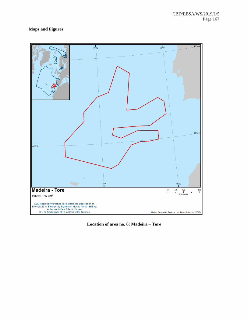
CBD/EBSA/WS/2019/1/5
Page 167
Maps and Figures
Location of area no. 6: Madeira – Tore
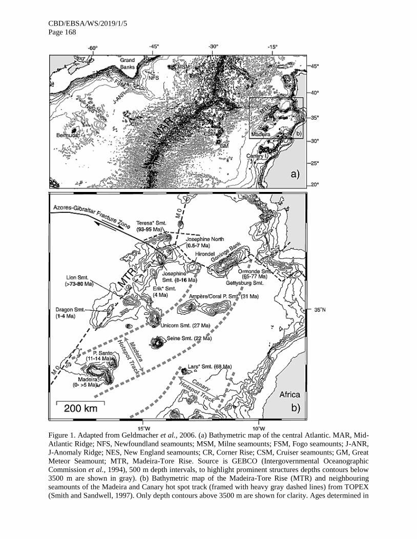
CBD/EBSA/WS/2019/1/5
Page 168
Figure 1. Adapted from Geldmacher et al., 2006. (a) Bathymetric map of the central Atlantic. MAR, Mid-
Atlantic Ridge; NFS, Newfoundland seamounts; MSM, Milne seamounts; FSM, Fogo seamounts; J-ANR,
J-Anomaly Ridge; NES, New England seamounts; CR, Corner Rise; CSM, Cruiser seamounts; GM, Great
Meteor Seamount; MTR, Madeira-Tore Rise. Source is GEBCO (Intergovernmental Oceanographic
Commission et al., 1994), 500 m depth intervals, to highlight prominent structures depths contours below
3500 m are shown in gray). (b) Bathymetric map of the Madeira-Tore Rise (MTR) and neighbouring
seamounts of the Madeira and Canary hot spot track (framed with heavy gray dashed lines) from TOPEX
(Smith and Sandwell, 1997). Only depth contours above 3500 m are shown for clarity. Ages determined in
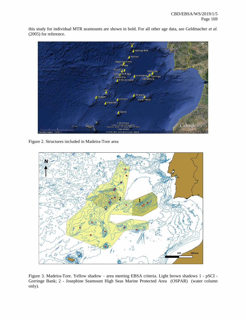
CBD/EBSA/WS/2019/1/5
Page 169
this study for individual MTR seamounts are shown in bold. For all other age data, see Geldmacher et al.
(2005) for reference.
Figure 2. Structures included in Madeira-Tore area
Figure 3. Madeira-Tore. Yellow shadow – area meeting EBSA criteria. Light brown shadows 1 - pSCI -
Gorringe Bank; 2 - Josephine Seamount High Seas Marine Protected Area (OSPAR) (water column
only).
1 2
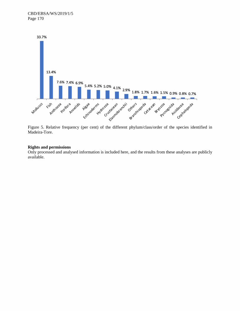
CBD/EBSA/WS/2019/1/5
Page 170
Figure 5. Relative frequency (per cent) of the different phylum/class/order of the species identified in
Madeira-Tore.
Rights and permissions
Only processed and analysed information is included here, and the results from these analyses are publicly
available.
CBD/EBSA/WS/2019/1/5
Page 171
Area no.7: Desertas
Abstract
The Desertas Islands hold some of the most important seabird colonies in the Atlantic, with large
populations of Procellariiforms, including the only population of vulnerable Desertas petrel (Pterodroma
deserta). They also contain important reproductive and resting habitats for the endangered monk seal
(Monachus monachus) in the form of pupping caves and resting beaches.
Introduction The Desertas Islands hold some of the most important seabird colonies in the Atlantic. It is a globally
important site for the vulnerable and endemic Desertas petrel (Pterodroma deserta) (BirdLife
International 2019a), with an estimated 160-180 breeding pairs (Menezes et al. 2010). It also has the
largest colony of Bulwer's petrel (Bulweria bulwerii) in the Atlantic (8,300 pairs: Catry et al. 2015); an
important population of Audubon’s shearwater (Puffinus lherminieri baroli) – listed by OSPAR as a
threatened and/or declining species; and the band-rumped storm-petrel (Hydrobates castro) (1,000
breeding pairs). The area also contains an important population of 25-40 endangered Mediterranean monk
seal (Monachus monachus) (Pires et al. 2007, Pires 2011). The Madeira M. monachus population is
isolated from the other main areas of the species distribution in the Eastern Mediterranean as well as the
only other and nearest Atlantic colony, roughly 1000 km south of Madeira, at Cap Blanc, Mauritania
(Pires et al. 2008). The site has been classified as an Important Bird and Biodiversity Area by BirdLife
International (BirdLife International 2019b) http://datazone.birdlife.org/site/factsheet/desertas-iba-
portugal, as well as an Important Marine Mammal Area (IMMA) by the IUCN Joint SSC/WCPA Marine
Mammal Protected Areas Task Force (IUCN MMPATF 2019).
Location: This area includes the marine areas adjacent to the Desertas Islands. It has an area of 455 km2
and is located southeast of Madeira Island, Portugal (32.47N/-16.52W)
(Figure 1).
Feature description of the area
The Desertas (and specifically Bugio) contains the only breeding colony of Desertas petrel (Pterodroma
deserta) in the world, with 160-180 pairs. Birds return to their breeding grounds in early June. Incubation
occurs between mid-July and the end of August, and juveniles fledge throughout November-December. It
is also globally important for a breeding population of band-rumped storm-petrel (Hydrobates castro)
(1,000 breeding pairs), and Audubon’s shearwater (Puffinus lherminieri baroli), listed by OSPAR as a
threatened and/or declining species. The Madeira population of M. monachus uses cave and beach habitats
around the Desertas Islands, where mating behaviour has been observed and pupping occurs. Neves
(1998) and Pires et al. (2007) further recorded and identified feeding sites near the coastline around the
Desertas Islands. Moreover, studies have shown that feeding occurs regularly inside of the 200 m depth
around the Desertas Islands as well as Madeira (IUCN MMPATF 2018).
The Desertas petrel (Pterodroma deserta) is listed as vulnerable because, although it appears to be stable,
it has a very small population (Meirinho et al. 2014). It occupies a very small range on only one island
when breeding and is susceptible to human impacts, introduced species and stochastic events, which could
drive the species towards extinction in a very short time (BirdLife International 2019a). The Audubon’s
shearwater (Puffinus lherminieri baroli) – listed by OSPAR as a threatened and/or declining species – has
a small population size and is considered rare. Much of the suitable breeding habitat for this species has
been rendered unsuitable due to the introduction of rats and cats, putting it at risk of further declines
(OSPAR 2009). The area also contains an important population of 25-40 endangered Mediterranean monk
seal (Monachus monachus), which utilise cave and beach habitats respectively for pupping as well as
resting (Pires et al. 2007, Hale et al. 2011, Pires et al. 2011; Figure 2). The endangered Mediterranean
monk seal is regarded as one of the most endangered pinniped species in the world, with approximately
600-700 animals in the global population, of which an estimated 350-450 of these are mature individuals
(Karamanlidis & Dendrinos, 2015). The population has also been fragmented into three to four
subpopulations, of which the Desertas supports an isolated population (25-40 individuals) separated by
roughly 1000 km from the only other Atlantic breeding colony (250 individuals) to the south, in Cap
Blanc, Mauritania (Pires et al. 2008).
CBD/EBSA/WS/2019/1/5
Page 172
Feature condition and future outlook of the area
Xeveral projects regarding habitat restoration and scientific research (e.g., Life Recover Natura –
https://liferecovernatura.madeira.gov.pt/). The population of the Desertas petrel is now considered stable
and has benefited from management measures under the project LIFE SOS Freira-do-Bugio -
https://ifcn.madeira.gov.pt/biodiversidade/projetos/freira-do-bugio.html). There are ongoing studies
focusing on the seabird community, in particular the Desertas petrel (e.g., Ramírez et al. 2013, Silva et al.
2019). For the Mediterranean monk seal, the Madeira subpopulation was once restricted to the remote
Desertas Islands (Neves and Pires 1999); monk seals have recently recolonized the main island of Madeira
(Pires, 2011), where suitable habitat for the species still exists (Karamanlidis et al. 2004). Recent
observations and reports indicate that there are strong indications of pupping on the marine island
(Karamanlidis & Dendrinos, 2015). Both the populations of Monk seals and Desertas petrels are regularly
monitored by IFCN (Madeiran Government).
Assessment of area no. 7, Desertas, against CBD EBSA Criteria
CBD EBSA
Criteria
(Annex I to
decision
IX/20)
Description
(Annex I to decision IX/20) Ranking of criterion relevance
(please mark one column with an X)
No
informat
ion
Low Medi
um
High
Uniqueness
or rarity
Area contains either (i) unique (“the only one
of its kind”), rare (occurs only in few
locations) or endemic species, populations or
communities, and/or (ii) unique, rare or
distinct, habitats or ecosystems; and/or (iii)
unique or unusual geomorphological or
oceanographic features.
X
Explanation for ranking
The Desertas (and specifically Bugio) contain the only breeding colony in the region (and in the world) of
the endemic Desertas petrel (Pterodroma deserta) (Menezes 2010, 2011; BirdLife International 2019a).
The endangered Mediterranean monk seal is regarded as one of the most endangered pinniped species in
the world, with approximately 600-700 animals in the global population, of which an estimated 350-450
are mature individuals (Karamanlidis & Dendrinos 2015). The population has also been fragmented into
three to four subpopulations, of which the Desertas supports an isolated population separated by roughly
1000 km from the only other Atlantic breeding colony to the south in Cap Blanc, Mauritania (Pires et al.
2008).
Special
importance
for life-
history stages
of species
Areas that are required for a population to
survive and thrive.
X
Explanation for ranking
The Desertas (and specifically Bugio) contain the only breeding colony of the Desertas petrel
(Pterodroma deserta), with 160-180 pairs (Menezes et al. 2010). Birds return to their breeding grounds in
early June. Incubation occurs between mid-July and the end of August, and juveniles fledge throughout
November-December. It is also globally important for the breeding population of band-rumped storm-
petrel (Hydrobates castro) (1,000 breeding pairs) and Audubon’s shearwater (Puffinus lherminieri baroli)
– listed by OSPAR as a threatened and/or declining species. The Madeira population of M. monachus uses
cave and beach habitats around the Desertas, where mating behaviour has been observed and pupping
occurs. Neves (1998) and Pires et al. (2007) further recorded and identified feeding sites near the coastline
around the Desertas Islands. Moreover, studies have shown that feeding occurs regularly inside of the 200
CBD/EBSA/WS/2019/1/5
Page 173
m depth around the islands of Desertas and Madeira (IUCN MMPATF 2018).
Importance
for
threatened,
endangered
or declining
species
and/or
habitats
Area containing habitat for the survival and
recovery of endangered, threatened, declining
species or area with significant assemblages of
such species.
X
Explanation for ranking
The Desertas hold some of the most important colonies of seabirds in the Atlantic, including the
vulnerable and endemic Desertas petrel (Pterodroma deserta) and Audubon’s shearwater (Puffinus
lherminieri baroli) – listed by OSPAR as a threatened and/or declining species (OSPAR 2009). The
Mediterranean monk seal is a threatened species, assessed and Red Listed as endangered (Karamanlidis &
Dendrinos 2015) and is regarded as one of the most endangered pinniped species in the world.
Vulnerability
, fragility,
sensitivity, or
slow recovery
Areas that contain a relatively high proportion
of sensitive habitats, biotopes or species that
are functionally fragile (highly susceptible to
degradation or depletion by human activity or
by natural events) or with slow recovery.
X
Explanation for ranking
The Desertas petrel (Pterodroma deserta) is listed as vulnerable because, although it appears to be stable,
it has a very small population. It occupies a very small range on only one island when breeding and is
susceptible to human impacts, introduced species and stochastic events, which could drive the species
towards extinction in a very short time (BirdLife International 2019a; Dias et al. 2019; Rodríguez et al.
2019).
The Audubon’s shearwater (Puffinus lherminieri baroli) – listed by OSPAR as a threatened and/or
declining species – has a small population size and is considered rare. Much of the suitable breeding
habitat for this species has been rendered unsuitable due to the introduction of rats and cats, putting it at
risk of further declines (OSPAR 2009).
The endangered Mediterranean monk seal is regarded as one of the most endangered pinniped species in
the world, with approximately 600-700 animals in the global population, of which an estimated 350-450
are mature individuals (Karamanlidis & Dendrinos 2015). The population has also been fragmented into
three to four subpopulations, of which the Desertas supports an isolated population separated by roughly
1000 kmfrom the only other Atlantic breeding colony to the south in Cap Blanc, Mauritania (Pires et al.
2008).
Biological
productivity
Area containing species, populations or
communities with comparatively higher
natural biological productivity.
X
Explanation for ranking
Biological
diversity
Area contains comparatively higher diversity
of ecosystems, habitats, communities, or
species, or has higher genetic diversity.
X
Explanation for ranking
Naturalness Area with a comparatively higher degree of
naturalness as a result of the lack of or low
X
CBD/EBSA/WS/2019/1/5
Page 174
level of human-induced disturbance or
degradation.
Explanation for ranking
Sharing experiences and information applying other criteria (Optional)
Other
Criteria
Description
Ranking of criterion relevance
(please mark one column with an X)
Don’t
Know
Low Medium High
IBA and
IMMA criteria
X
The site has been classified as an Important Bird and Biodiversity Area by BirdLife International
(BirdLife International 2019b), http://datazone.birdlife.org/site/factsheet/desertas-iba-portugal, as well as
an Important Marine Mammal Area (IMMA) by the IUCN Joint SSC/WCPA Marine Mammal Protected
Areas Task Force (IUCN MMPATF 2019).
References
BirdLife International (2019a) Species factsheet: Pterodroma deserta. Downloaded
from http://www.birdlife.org on 28/08/2019.
BirdLife International (2019b) Important Bird Areas factsheet: Desertas. Downloaded
from http://www.birdlife.org on 28/08/2019.
Catry, P., Dias, M.P., Catry, T., Pedro, P., Tenreiro, P., Menezes, D., (2015). Bulwer’s petrels breeding
numbers on the Desertas Islands (Madeira): improved estimates indicate the NE Atlantic
population to be much larger than previously thought. ISSN 0871-6595 Depósito legal 47713/91
Tiragem: 100 exemplares Impressão: Estria, Produções Gráficas, SA Disponível em www. spea.
pt 10.
Dias, M.P., Martin, R., Pearmain, E.J., Burfield, I.J., Small, C., Phillips, R.A., Yates, O., Lascelles, B.,
Borboroglu, P.G., Croxall, J.P., (2019). Threats to seabirds: A global assessment. Biological
Conservation in press. https://doi.org/10.1016/j.biocon.2019.06.033
IUCN MMPATF (2018) Final Report of the IMMA Extraordinary Workshop for the Mediterranean Monk
Seal, La Spezia, Italy, 5 April 2018.
IUCN MMPATF (2019) The IUCN Global Dataset of Important Marine Mammal Areas (IUCN-IMMA).
Made available under agreement on terms and conditions of use by the IUCN Joint SSC/WCPA
Marine Mammal Protected Areas Task Force and accessible via the IMMA e-Atlas
http://www.marinemammalhabitat.org/imma-eatlas/
Karamanlidis, A. & Dendrinos, P. (2015) Monachus monachus (errata version published in 2017). The
IUCN Red List of Threatened Species 2015: e.T13653A117647375.
Karamanlidis, A.A., Pires, R., Silva, N.C., Neves, H.C. (2004). The availability of resting and pupping
habitat for the Critically Endangered Mediterranean monk seal Monachus monachus in the
archipelago of Madeira. Oryx 38, 180–185.
Meirinho, A., Barros, N., Oliveira, N., Catry, P., Lecoq, M., Paiva, V., Geraldes, P., Granadeiro, J.P.,
Ramírez, I., Andrade, J., (2014). Atlas das Aves Marinhas de Portugal. Sociedade Portuguesa para
o Estudo das Aves. Lisboa
Menezes D, Oliveira P & Ramírez I (2010). Pterodromas do arquipélago da Madeira. Duas espécies em
recuperação. Serviço do Parque Natural da Madeira, Funchal
CBD/EBSA/WS/2019/1/5
Page 175
Menezes D, Oliveira P & Ramírez I (2011). Medidas Urgentes para a Recuperação da Freira do Bugio
Pterodroma feae e do seu Habitat. Relatório Final. Serviço Parque Natural da Madeira/ Sociedade
Portuguesa para o Estudo das Aves
Neves, H. C. (1998). ‘Preliminary findings on the feeding behaviour and general ecology strategy of the
Mediterranean monk seal Monachus monachus – (Pinnipedia: Monachinae) on the Desertas
Islands’. Boletim Museu Municipal do Funchal, 5: 263-271.
OSPAR (2009). Background document for Little Shearwater Puffinus assimilis baroli. Biodiversity Series.
Pires, R. (2011). Monk Seals of the archipelago of Madeira. Funchal. Serviço do Parque Natural da
Madeira, 63p
Pires, R., Costa Neves, H. & A. Karamanlidis, (2007). ‘Activity Patterns of the Mediterranean Monk Seal
(Monachus monachus) in the Archipelago of Madeira’. Aquatic Mammals, 33(3): 327-336.
Pires, R., Costa Neves, H. & A. Karamanlidis, (2008). ‘The Critically Endangered Mediterranean monk
seal Monachus monachus in the archipelago of Madeira: priorities for conservation’, Oryx, 42(2):
278– 285.
Ramírez, I., Paiva, V., Menezes, D., Silva, I., Phillips, R., Ramos, J., Garthe, S., (2013). Year-round
distribution and habitat preferences of the Bugio petrel. Marine Ecology Progress Series 476,
269–284. https://doi.org/10.3354/meps10083
Rodríguez, A., Arcos, J.M., Bretagnolle, V., Dias, M.P., Holmes, N.D., Louzao, M., Provencher, J., Raine,
A.F., Ramírez, F., Rodríguez, B., Ronconi, R.A., Taylor, R.S., Bonnaud, E., Borrelle, S.B.,
Cortés, V., Descamps, S., Friesen, V.L., Genovart, M., Hedd, A., Hodum, P., Humphries, G.R.W.,
Le Corre, M., Lebarbenchon, C., Martin, R., Melvin, E.F., Montevecchi, W.A., Pinet, P., Pollet,
I.L., Ramos, R., Russell, J.C., Ryan, P.G., Sanz-Aguilar, A., Spatz, D.R., Travers, M., Votier,
S.C., Wanless, R.M., Woehler, E., Chiaradia, A., (2019). Future Directions in Conservation
Research on Petrels and Shearwaters. Front. Mar. Sci. 6.
https://doi.org/10.3389/fmars.2019.00094
Silva, M., Catry, P., Menezes, D., Zino, F., Viveiros, C., Camara, J., Gouveia, P., Gomes, J., Catry, T.,
Granadeiro, J.P. (2019). Mechanisms of breeding asynchrony in sympatric Portuguese seabirds,
the endangered Zino’s Petrel (Pterodroma madeira) and Deserta´s Petrel (Pterodroma deserta). in
SPEA (2019) (Eds). Livro de Resumos do X Congresso de Ornitologia da SPEA – 1.ª edição.
Sociedade Portuguesa para o Estudo das Aves, Lisboa
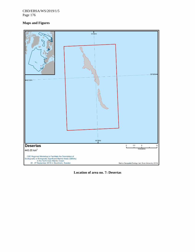
CBD/EBSA/WS/2019/1/5
Page 176
Maps and Figures
Location of area no. 7: Desertas
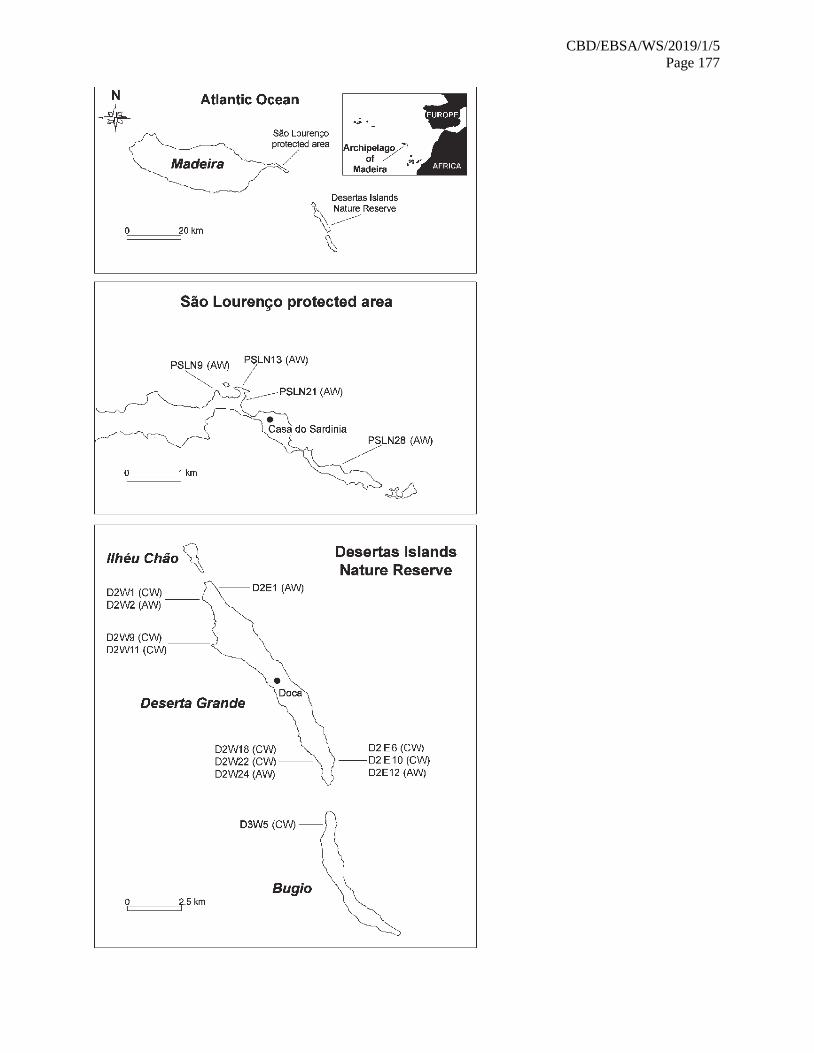
CBD/EBSA/WS/2019/1/5
Page 177
CBD/EBSA/WS/2019/1/5
Page 178
Figure 2. The location of the Desertas Islands Nature Reserve and the protected area at São Lourenço, in
the archipelago of Madeira, with locations of the 16 individually coded caves that offer good pupping
conditions for the monk seal Monachus monachus under all weather conditions (AW), or good pupping
conditions only during calm weather (CW) (Karamanlidis et al. 2004).
CBD/EBSA/WS/2019/1/5
Page 179
Area no. 8: Oceanic Islands and Seamounts of the Canary Region
Abstract The area around the Canary Islands includes a set of islands and seamounts influenced by magma-driven
processes over tens of millions of years over the Canary hotspot. The archipelago is made up of seven
major islands, a group of islets in the northeast and three seamount fields: one in the northeast of the
archipelago, one in the southwest and another between the islands. Some of these seamounts (Concepción
Bank, El Banquete and Amanay) as well as coastal areas of the Canary region have been intensively
studied. Thirty-nine marine Special Areas of Conservation and two Sites of Community Importance (both
under the Natura 2000 network), as well as three marine reserves are located in the area. This region, with
its subtropical oceanographic conditions, represents the southern distribution limit for many pelagic and
benthic species. It includes a variety of benthic habitats, including some that are considered hotspots of
biodiversity. These habitats serve as spawning grounds for several commercial species. The area also
includes habitats for endangered, threatened and declining species and for migratory pelagic species,
including cetaceans.
Introduction The area around the Canary Islands includes a set of islands and seamounts influenced by magma-driven
processes over tens of millions of years over the Canary hotspot. This subtropical region is located 100 km
off the northwestern coast of Africa. Due to its proximity to Africa and the Sahara Desert, the archipelago
is influenced by coastal upwelling that produces complex mesoscale variation in temperature and organic
matter (Arístegui et al., 2009). The archipelago comprises seven major islands, a group of islets in the
northeast andthree seamounts fields: one in the northeast of the archipelago, one in the southwest and
another between the emerged islands. Some of these seamounts (Concepción Bank, El Banquete and
Amanay) have been intensively studied over the years and even as a Site of Community Interest (SCI).
In total, the Canary Islands archipelago includes 39 marine Special Areas of Conservation, two Sites of
Community Importance and three marine reserves; one of them, in the northeast of Lanzarote, is the
largest marine reserve in Europe and covers 706.34 km2. Wave exposure also varies within the islands
according to shoreline orientation. The northern and northeastern coasts of the islands are the most
exposed to wave action due to dominant winds from the northeast and fetch (a measure of coastal
exposure to wind and waves that corresponds to the length of water over which a given wind blows).
Western–southwestern shores are more sheltered in comparison. The volcanic origin of the Canary Islands
and associated geological processes mean the islands stand on narrow platforms, in between which the
waters reaches depths of up to 3000 m. The shallow seabed immediately surrounding the islands is
characterized by a seascape of rocky platforms, large stones, pebbles and sandy patches. Erosion has
generated a higher proportion of sandy or mixed substrates on the northern and eastern shores, especially
around the two oldest islands of the archipelago, Lanzarote and Fuerteventura. By contrast, La Palma and
El Hierro, the western islands, have narrower platforms and are dominated by rocky bottoms.
The geographic location of the Canary Islands archipelago and its lack of a continental shelf likely
contribute to its dissimilarity compared to other Spanish marine areas. Moreover, this area is rich and
diverse due to the effect of the Canary Current Large Marine Ecosystem (Arístegui et al., 2009;
Hernández-Guerra et al., 2017), its location, the great environmental heterogeneity of the archipelago, and
the high diversity of habitats (Brito et al., 2001; Falcón, 2015).
The Canary Islands archipelago belongs to the Northeastern Atlantic Warm Temperate Region, the
biogeographic region with the highest seaweed richness on eastern side of the Atlantic (Hoek, 1984;
Lüning, 1990). Flora and fauna around the Canary Islands consists of an ensemble of species from both
warm temperate and tropical regions (Sansón et al., 2001; Brito and Ocaña, 2004; Sangil et al., 2011). In
recent years there have been many changes in the composition and richness of the habitats and marine
communities of the region. The oceanographic conditions of the area (subtropical region with presence of
upwelling) create unique conditions for the development of species with both tropical and temperate
affinity. Studies currently being carried out in deep areas will expand the information on the different roles
that the seamount and oceanic island play in the colonization and development of benthic species and
communities.
CBD/EBSA/WS/2019/1/5
Page 180
The seamounts, located in flat abyssal areas, pose topographic obstacles that modify the circulation and
lead to complex vortices and Taylor columns (Roden, 1986), whereby a rotating body of water is retained
over the summit of a seamount. These effects promote blooms of primary production, with increases in
zooplankton and suprabenthos, which lead to increases in the availability of food for wildlife (White et al.,
2007). Taylor columns can also trap advected organisms and zooplankton with vertical migration. All
these conditions translate into an external contribution of food for the seamount communities. In addition,
the currents and steep slopes expose the rock and favour, together with the increase in production, the
presence of sessile-gorgonian suspension feeders, corals, sponges, etc., and therefore the development of
vulnerable habitats. The increase of food and the increase of the environmental complexity that these
sessile benthic communities contribute favour the aggregations of demersal and benthopelagic fish and,
consequently, the increase in the presence of migrant species such as pelagic sharks, tunas, cetaceans,
turtles and seabirds. Finally, the particular conditions of isolation and high diversity of environments
favour the appearance of a large number of endemic species (Almón et al., 2014b).
The existence of anchialine caves (volcanic tubes flooded by the sea) on islands such as Lanzarote, where
there are conditions of isolation and specific environmental variables, propitiates the existence of endemic
species such as Munidopsis polymorpha (Koelbel, 1892), and others under study, such as several species
of polychaetes.
The area includes 13 Important Bird and Biodiversity Areas (IBAs, BirdLife International 2019). Key
species breeding in the Canary archipelago and using the area to forage, rest or commute are the Cory's
shearwater (Calonectris diomedea), band-rumped storm-petrel (Hydrobates castro), white-faced storm-
petrel (Pelagodroma marina), Audubon’s shearwater (Puffinus lherminieri), Bulwer's petrel (Bulweria
bulwerii), roseate tern (Sterna dougallii) and common tern (Sterna hirundo) (BirdLIfe International 2019).
All these species occur in regionally or globally significant numbers that meet the criteria to classify the
IBAs in the region (BirdLife International 2019; Donald et al. 2018).
Location
The area is located in and around the Canary Islands, between the parallels 24º60’N and 32º27’N and
meridians 20º96’W and 30º33’W. It includes volcanic edifices (e.g., emerged islands, seamounts and
banks) and has a maximum depth of 3000 m.
Feature description of the area
Variety of benthic habitats that are considered hotspots of biodiversity
The Canary Islands is one of five archipelagos of Macaronesia, a biogeographic region of the North
Atlantic, that share similar characteristics, such as vulcanological origin or the high number of endemic
species. The area includes a great variety of benthic habitats, from typically infralittoral to bathyal depths
(Aguilar et al., 2009; Brito, 2004), as well as seamounts or banks located on the northern and central areas
of the islands (Almón et al., 2014a, 2014b). Research on seamounts located to the south of the islands has
also been done in the framework of the Drago0511 oceanographic campaign, which yielded biological
information that is yet to be analysed and published.
The study area has a wide variety of communities due to the occurrence of a great bathymetric variation,
coupled with different types of substrates. Several communities are included under the Habitats Directive
habitat type 1170 "Reefs". Regarding the infralittoral and circalittoral areas, there are different species of
erect algae (mainly fucoids and red macroalgae), black corals (Antipathella wollastoni), Stichopathes spp.
on the rocky slopes and gorgonians (Leptogorgia spp) in mixed substrates (Martín-García et al, 2016).
In the bathyal zone, we highlight the presence of rocky bottoms with corals (antipataria) and large
hexactinellid sponges (Asconema), frequently observed on different substrates (rocky, soft and mixed
sediments) of bathyal zones. Other important habitats and communities are gorgonian forests comprising
Callogorgia verticillata and Narella bellissima species and accompanied by high densities of Bebryce
mollis and Eunicella verrucose, as well as Pheronema carpenteri and Paramuricea biscaya on rocky
bottoms between 500 and 1500 m, or those formed by lithistid sponges (Leiodermatium-
Neophryssospongia). At the same depth range, siliceous sponges occur on rocky substrates covered by
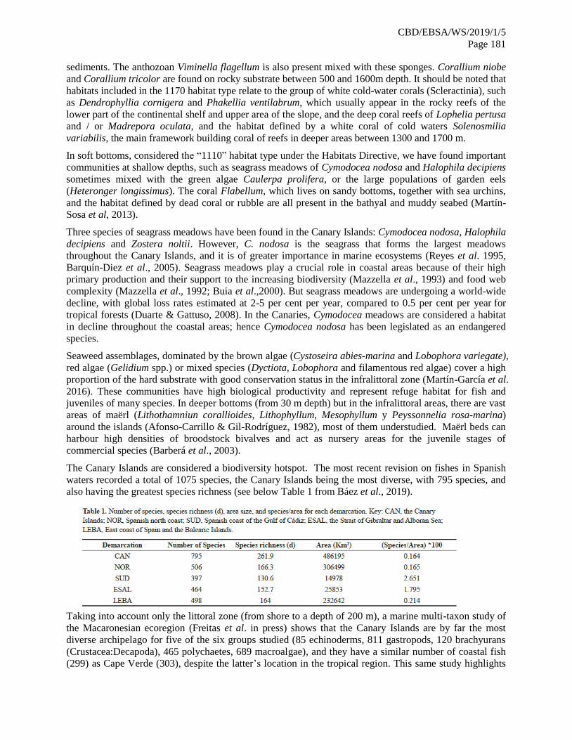
CBD/EBSA/WS/2019/1/5
Page 181
sediments. The anthozoan Viminella flagellum is also present mixed with these sponges. Corallium niobe
and Corallium tricolor are found on rocky substrate between 500 and 1600m depth. It should be noted that
habitats included in the 1170 habitat type relate to the group of white cold-water corals (Scleractinia), such
as Dendrophyllia cornigera and Phakellia ventilabrum, which usually appear in the rocky reefs of the
lower part of the continental shelf and upper area of the slope, and the deep coral reefs of Lophelia pertusa
and / or Madrepora oculata, and the habitat defined by a white coral of cold waters Solenosmilia
variabilis, the main framework building coral of reefs in deeper areas between 1300 and 1700 m.
In soft bottoms, considered the “1110” habitat type under the Habitats Directive, we have found important
communities at shallow depths, such as seagrass meadows of Cymodocea nodosa and Halophila decipiens
sometimes mixed with the green algae Caulerpa prolifera, or the large populations of garden eels
(Heteronger longissimus). The coral Flabellum, which lives on sandy bottoms, together with sea urchins,
and the habitat defined by dead coral or rubble are all present in the bathyal and muddy seabed (Martín-
Sosa et al, 2013).
Three species of seagrass meadows have been found in the Canary Islands: Cymodocea nodosa, Halophila
decipiens and Zostera noltii. However, C. nodosa is the seagrass that forms the largest meadows
throughout the Canary Islands, and it is of greater importance in marine ecosystems (Reyes et al. 1995,
Barquín-Diez et al., 2005). Seagrass meadows play a crucial role in coastal areas because of their high
primary production and their support to the increasing biodiversity (Mazzella et al., 1993) and food web
complexity (Mazzella et al., 1992; Buia et al.,2000). But seagrass meadows are undergoing a world-wide
decline, with global loss rates estimated at 2-5 per cent per year, compared to 0.5 per cent per year for
tropical forests (Duarte & Gattuso, 2008). In the Canaries, Cymodocea meadows are considered a habitat
in decline throughout the coastal areas; hence Cymodocea nodosa has been legislated as an endangered
species.
Seaweed assemblages, dominated by the brown algae (Cystoseira abies-marina and Lobophora variegate),
red algae (Gelidium spp.) or mixed species (Dyctiota, Lobophora and filamentous red algae) cover a high
proportion of the hard substrate with good conservation status in the infralittoral zone (Martín-García et al.
2016). These communities have high biological productivity and represent refuge habitat for fish and
juveniles of many species. In deeper bottoms (from 30 m depth) but in the infralittoral areas, there are vast
areas of maërl (Lithothamniun corallioides, Lithophyllum, Mesophyllum y Peyssonnelia rosa-marina)
around the islands (Afonso-Carrillo & Gil-Rodríguez, 1982), most of them understudied. Maërl beds can
harbour high densities of broodstock bivalves and act as nursery areas for the juvenile stages of
commercial species (Barberá et al., 2003).
The Canary Islands are considered a biodiversity hotspot. The most recent revision on fishes in Spanish
waters recorded a total of 1075 species, the Canary Islands being the most diverse, with 795 species, and
also having the greatest species richness (see below Table 1 from Báez et al., 2019).
Taking into account only the littoral zone (from shore to a depth of 200 m), a marine multi-taxon study of
the Macaronesian ecoregion (Freitas et al. in press) shows that the Canary Islands are by far the most
diverse archipelago for five of the six groups studied (85 echinoderms, 811 gastropods, 120 brachyurans
(Crustacea:Decapoda), 465 polychaetes, 689 macroalgae), and they have a similar number of coastal fish
(299) as Cape Verde (303), despite the latter’s location in the tropical region. This same study highlights
CBD/EBSA/WS/2019/1/5
Page 182
the importance of the Canary Islands in relation to the high number of species restricted to two or more of
the Macaronesian archipelagos (130 of a total of 144 shared endemic species).
Important area for cetaceans
The Canary Islands archipelago is one of the most important areas for cetaceans, with a high diversity of
species, since the distributions of tropical and warm water species in this oceanic region overlap with
those of large oceanic migrants (López, 2017).
Around 30 species of cetaceans have been documented in the Canary Islands, making it one of the world’s
marine mammal hotspots. The Canary Islands archipelago shows the highest diversity of cetaceans in
Macaronesia and harbours five resident species. Due to the islands’ location, they also harbour as many
tropical marine mammal species as those in colder latitudes. Moreover, due to the steep slopes and
canyons surrounding the islands, deep-diving species are well represented, including two resident species
of beaked whales: Blainville´s beaked whale (Mesoplodon densirostris) and Cuvier´s beaked whale
(Ziphius cavirostris) with an estimate of 103 (87-130) and 87 (78-106) off El Hierro island, respectively
(Aparicio, 2008; Arranz, 2011; Reyes, 2017). In the Canary Islands, we can also find one the few resident
populations of short-finned pilot whales (Globicephala macrorhynchus) of the world, with a population
estimate of 391 (325-470) off Tenerife (Marrero et al. 2016).
In summary, the following species are common in the archipelago:
Physeter macrocephalus Grampus griseus Globicephala macrorhynchus
Delphinus delphis Steno bradanensis Stenella coeruleoalba
Stenella frontalis Tursiops truncatus Balaenoptera acutorostrata
Balaenoptera physalus Balaenoptera edeni Ziphius cavirostris
Mesoplodon europaeus
Other species are occasional visitors or have been observed anecdotally:
Balaenoptera musculus Eubalaena glacialis Megaptera novaeangliae
Kogia sima Kogia breviceps Lagenorhynchus acutus
Lagenodelphis hosei Lagenorhynchus albirostris Stenella attenuata
Stenella longirostris Pseudorca crassidens Feresa attenuata
Balaenoptera borealis Mesoplodon densirostris Hyperoodon ampullatus
Mesoplodon bidens Mesoplodon mirus
Habitats for endangered, threatened and declining species
Listed below are some examples of species registered in the area that need special attention:
IUCN Red List of threatened species
Physeter macrocephalus Balaenoptera physalus Caretta caretta
Dermochelys coriacea Squatina squatina Sardinella maderensis
Megalops atlanticus Trachurus trachurus Kajikia albida
Makaira nigricans Bodianus scrofa Pomatomus saltatrix
Thunnus obesus Thunnus thynnus Epinephelus itajara
Epinephelus marginatus Mycteroperca fusca Dentex dentex
Balistes capriscus Mola mola Carcharhinus falciformis
Carcharhinus obscurus Sphyrna lewini Sphyrna zygaena
Galeorhinus galeus Mustelus mustelus Alopias superciliosus
Alopias vulpinus Carcharodon carcharias Isurus oxyrinchus
Gymnura altavela Manta birostris Mobula mobular
Mobula tarapacana Rhincodon typus Pristis pristis
Dipturus batis Leucoraja circularis Raja maderensis
Rostroraja alba Rhinobatos rhinobatos Centrophorus granulosus
CBD/EBSA/WS/2019/1/5
Page 183
Centrophorus squamosus Dalatias licha Centroscymnus owstoni
Squatina squatina Eunicella verrucosa
OSPAR Species
Patella aspera Centroscymnus coelolepis Dipturus batis
Raja montagui Hippocampus hippocampus Raja clavata
Rostroraja alba Squatina squatina Thunnus thynnus
Balaenoptera musculus * Eubalaena glacialis* Caretta caretta
Dermochelys coriacea
(* species with occasional presence)
OSPAR Habitats
Coral gardens
Deep-Sea Sponge Aggregations
Lophelia pertusa Reefs
Mäerl Beds
Seamounts
Sea-Pen & Burrowing Megafauna Communities
Zostera Beds
Habitat Directive Habitat Types
1110 Sandbanks which are slightly covered by sea water all the time
1170 Reefs
8330 Submerged or partially submerged caves
Habitat Directive Species (Annex IV)
Caretta caretta
Centrostephanus longispinus
Cetacea (all the species present)
Particular consideration should be given to the angel shark (Squatina squatina), which has been assessed
as critically endangered by the International Union for Conservation of Nature (IUCN) (Ferretti et
al.,2015) and belongs to the second-most endangered shark family in the world (Dulvy et al., 2014).The
Canary Islands angel shark population is frequent throughout the year, and angel shark nursery areas can
be found around the islands (Escánez et al., 2016).
Spawning grounds for several fish species of commercial interest
Several species (benthic, pelagic and demersal species) with commercial interest spawn in waters around
the Canary Islands, such as small pelagic species like mackerel (Trachurus picturatus and Scomber
colias), whose breeding season is between November and March (Lorenzo & Pajuelo, 1996).
Seasonal migratory pathway for large migratory pelagic species
Migrant species like sharks and tunas criss-cross the archipelago. The tuna species Thunnus obesus, T.
alalunga and T. thynnus represent an important economic resource with high presence in the catches of
local artisanal fisheries (Delgado de Molina, 2011).
Feature condition and future outlook of the area
Most of key threats to the marine environment and biodiversity around the Canary Islands are no different
from those affecting coastal marine flora and fauna across the globe, but these have different local
importance and a different degree of ecological concern along the depth range. The main threats are
described and summarised by Riera et al. (2014):
- Climate change. Climate change arguably poses the greatest threat to the marine ecosystem around the
Canary Islands, particularly the western islands (e.g., El Hierro, La Gomera and La Palma), which are
less affected by the Saharan upwelling off the African coast (Barton et al., 1998). A progressive
tropicalization of coastal ecosystems of the Canary archipelago has been observed in recent decades,
CBD/EBSA/WS/2019/1/5
Page 185
and 78 per cent of the fish species newly recorded in recent years are considered to have tropical
origins (Brito et al., 2005). Ocean warming has promoted the arrival of tropical species. There are
several cases occurring at present in coastal waters of the Canaries related to invasive algal species,
including the green alga Caulerpa racemosa aff. Cylindracea, the cyanobacteria Lyngbya majuscula
(Martín-García et al. 2014), or the proliferation of the green alga Penicillus capitatus (Sangil et al.,
2010).
- Fishing activities. Coastal fisheries have been massively overexploited in the Canary Islands due to
pressure from artisanal fisheries and recreational fishers (Falcon et al., 1996). The target species are
demersal species of the central Atlantic. The shallowest seamounts have a higher level of richness of
target species and are the most suscentible to fishing activity. In addition, the shallowest seamounts
commonly host the most sensitive habitats formed by hard corals and gorgonians (IEO 2012).
- Coastal development pressure on coastal ecosystems in the Canaries is driven by high human
population density and continues to increase rapidly. About 9 per cent of the Canarian coast has been
heavily transformed by the construction of rockwalls and other artificial structures on the shoreline.
Highest concentrations of coastal structures (e.g., groins, dykes, breakwaters) and beach infrastructure
(e.g., boardwalks) are located in tourist areas on the south coast of Tenerife and Gran Canaria, to
protect and encourage use of artificial beaches. Likewise, a consistent increase in the number of
harbours and marina facilities has occurred along the coast, without significant effort to understand the
impacts of these coastal structures on marine biodiversity. Besides, impacts of land-based facilities and
transport infrastructure associated with harbours would add additional impacts and pollution sources at
different levels upon mesolittoral and sublittoral habitats.
- Water pollution. The waters surrounding the Canary Islands are oligotrophic, lacking the seasonal
phytoplankton blooms that typify warm temperate seas elsewhere (Barton et al., 1998; Basterretxea
and Arístegui, 2000). The archipelago also lacks permanent rivers, so nutrients and inorganic
pollutants tend to enter the sea via smaller, isolated point sources like pipelines, sea-cage aquaculture
(mainly for seabass Dicentrarchus labrax and seabream Sparus aurata) or desalination plants. Organic
and inorganic pollutants from intensive farming (mainly banana and tomato) along the coast also have
an impact on marine waters but their effects are not well understood. Fortunately, the presence of
continuous coastal currents around the Canary Islands facilitates the dispersion of pollutants. Thus,
while impacts may be acute near highly concentrated point sources, broader impacts of pollution along
coastlines have not been identified.
- Shipping and maritime traffic. Chronic pollution derived from ship traffic is another potentially large
but understudied threat to the marine environment of the islands. On average, 30,000 commercial
vessels per year entered and exited local harbours (mostly in Gran Canaria and Tenerife) between
1998 and 2012 (ISTAC 2013). Aside from pollutant emissions from moving and docked ships, the
impact for cetaceans posed by collisions and other disturbances (noise and vibration, human presence)
is far from negligible. African hind (Cephalopholis taeniops) and the butterflyfish (Chaetodon
sanctaehelenae) are two examples of fish species believed to have arrived at the Canaries in ballast
water (Brito et al., 2005, 2010).
- Proliferation of the sea urchin Diadema africanum. This species has been responsible for an acute
impoverishment of coastal rocky substrates in all the islands of the archipelago, with the exception of
El Hierro, where fishing pressure has been lower and more strictly regulated in recent decades (Tuya
et al., 2004). Effects of ocean warming on recruitment and growth, topographic complexity, and
release from predation due to overfishing of predators (sensu Ling et al., 2009) are all likely to have
played a role in the explosion of D. africanum populations in the Canaries (Hereu et al., 2004;
Clemente et al., 2007), with the latter mechanism appearing most important (Tuya et al., 2004).
CBD/EBSA/WS/2019/1/5
Page 186
Extraction of construction materials from the seabed, and fuel prospecting and extraction, are two further
disturbance sources for the marine biota of the Canary Islands, with unknown impacts.
In general, most of the impact occurs in the coastal and infralittoral zones. At present, there are many
studies that different research entities are carrying out to better understand the impact of both climate
change and invasive species on the shallowest waters of the archipelago. On the other hand, the human
impacts and threats in deep waters, including seamounts, are insufficiently studied. The Spanish Institute
of Oceanography (IEO) is currently working on the effects of fishing activities in some seamounts
included in Special Areas of Conservation of the Canary Islands. There are more specific studies of
biodiversity and oceanography of all seamounts of the region, but these are isolated and scarce.
Assessment of area no. 8, Oceanic Islands and Seamounts of the Canary Region, against CBD
EBSA Criteria
CBD EBSA
Criteria
(Annex I to
decision IX/20)
Description
(Annex I to decision IX/20) Ranking of criterion relevance
(please mark one column with an X)
No
informat
ion
Low Medi
um
High
Uniqueness or
rarity
Area contains either (i) unique (“the only one
of its kind”), rare (occurs only in few
locations) or endemic species, populations or
communities, and/or (ii) unique, rare or
distinct, habitats or ecosystems; and/or (iii)
unique or unusual geomorphological or
oceanographic features.
X
Explanation for ranking
Flora and fauna around the Canary Islands consists of an ensemble of species with either tropical or warm
temperate affinity (Sansón et al., 2001; Brito and Ocaña, 2004; Sangil et al., 2011). The geographic
location of the Canary Islands archipelago, its lack of a continental shelf and the oceanographic
conditions of the area (subtropical region with presence of upwelling) likely contributes to its
dissimilarity compared to other marine Atlantic regions. This region, with subtropical oceanographic
conditions, represents the southern distribution limit for many pelagic and benthic species.
The Canary Islands archipelago belongs to the Northeastern Atlantic Warm Temperate Region, the
biogeographic region with the highest seaweed richness on the eastern side of the Atlantic (Hoek, 1984;
Lüning, 1990).
Moreover, the particular conditions of isolation that the area suffers and the high diversity of
environments occurring favour the appearance of many endemic species (Almón et al., 2014b). In
addition, the existence of anchialine caves (volcanic tubes flooded by the sea) on islands such as
Lanzarote, where there are conditions of isolation and specific environmental variables, propitiates the
existence of endemic species such as Munidopsis polymorpha (Koelbel, 1892), and others under study,
such as several species of polychaetes.
On the other hand, compared to the surrounding deep-sea environment, seamounts may also form
biological hotspots with a distinct, abundant and diverse fauna, and sometimes contain many species new
to science.
One of the few resident populations of short-finned pilot whales (Globicephala macrorhynchus) of the
world can be found in the waters around the islands, with a population estimate of 391 (325-470) off
Tenerife (Marrero et al. 2016).
Special
importance
for life-history
Areas that are required for a population to
survive and thrive.
X
CBD/EBSA/WS/2019/1/5
Page 187
stages of
species
Explanation for ranking
Around 30 species of cetaceans have been documented in the Canary Islands, making it one of the
world’s marine mammal hotspots. The Canary Islands archipelago shows the highest diversity of
cetaceans in Macaronesia and harbours both migratory and five resident species. Due to the geographical
location of the islands, they also harbour many tropical marine mammal species as well as marine
mammals from colder latitudes. Moreover, due to the steep slopes and canyons surrounding the islands,
deep-diving species are well represented, including two resident species of beaked whales: Blainville´s
beaked whale (Mesoplodon densirostris) and Cuvier´s beaked whale (Ziphius cavirostris) with an
estimate of 103 (87-130) and 87 (78-106) off El Hierro island, respectively (Aparicio, 2008; Arranz,
2011; Reyes, 2017).
With regard to other migrant species, tuna species (Thunnus obesus, T. alalunga and T. thynnus) represent
an important economic resource with a frequent presence in the catches of local artisanal fisheries
(Delgado de Molina, 2011).In addition, habitat-forming species that characterize benthic habitats and
offer substrate and refuge to other species spend their entire life cycle within the area.
Regarding commercial species, some spawn in waters around the Canary Islands, such as small pelagic
species like mackerel (Trachurus picturatus and Scomber colias), whose breeding season is between
November and March (Lorenzo & Pajuelo, 1996).
The area is a regionally and globally important for the breeding populations of several species of seabirds,
including the Cory's shearwater (Calonectris diomedea), band-rumped storm-petrel (Hydrobates castro),
white-faced storm-petrel (Pelagodroma marina), Audubon’s shearwater (Puffinus lherminieri), Bulwer's
petrel (Bulweria bulwerii), roseate tern (Sterna dougallii) and common tern (Sterna hirundo) (BirdLife
International 2019).
Importance
for
threatened,
endangered or
declining
species and/or
habitats
Area containing habitat for the survival and
recovery of endangered, threatened, declining
species or area with significant assemblages
of such species.
X
Explanation for ranking
More than 50 species considered threatened, endangered or declining, based on different international
regulations and agreements, are present in the area, mainly marine mammals and sharks, but also
including benthic species as well as other fish and reptiles (Aguilar et al., 2009; Almón et al., 2014a,
2014b; IUCN, 2019; Habitat Directive, 1992, OSPAR 2008).
Particular consideration should be given to the angel shark (Squatina squatina), which has been assessed
as critically endangered by the International Union for Conservation of Nature (IUCN) (Ferretti et al.,
2015) and belongs to the second-most endangered shark family in the world (Dulvy et al., 2014).The
Canary Islands angel shark population is frequent throughout the year, and different angel shark nursery
areas can be found around the islands (Escánez et al., 2016).
The area contains globally important breeding populations of little shearwater (Puffinus lherminieri
baroli) and roseate tern (Sterna dougallii), both of which are listed by OSPAR as threatened and/or
declining species (OSPAR 2009a, b).
Vulnerability,
fragility,
sensitivity, or
slow recovery
Areas that contain a relatively high
proportion of sensitive habitats, biotopes or
species that are functionally fragile (highly
susceptible to degradation or depletion by
X

CBD/EBSA/WS/2019/1/5
Page 188
human activity or by natural events) or with
slow recovery.
Explanation for ranking
A high diversity and abundance of marine benthic habitat-forming species that are slow-growing and have
a very high longevity (e.g., coral gardens, blacks coral forests) are located all around the islands as well as
on seamounts (e.g., coral reefs, coral gardens, black coral forest, sponge grounds) (Aguilar et al., 2009;
Brito, 2004; Martín-Sosa et al, 2013; Almón et al., 2014a, 2014b; Martín-García et al, 2016) and are
vulnerable and sensitive to fishing activities.
The Macaronesian population of little shearwater (Puffinus lherminieri baroli) is listed by OSPAR as a
threatened and/or declining species. – It has a small population size and is considered rare, primarily
because the suitable breeding habitat for this species has been rendered unsuitable due to the introduction
of rats and cats, putting it at risk of further declines (OSPAR 2009a). The roseate tern (Sterna dougallii)
is also listed by OSPAR as a threatened and/or declining species and has comparatively low adult survival
rates (Green 1995), and therefore needs to maintain exceptionally high productivity to achieve population
stability (Newton 2004). It is threatened by predation and disturbance at the breeding colonies, in
particular (OSPAR 2009b, Dias et al. 2019).
Biological
productivity
Area containing species, populations or
communities with comparatively higher
natural biological productivity.
X
Explanation for ranking
Due to its relative proximity to Africa and the Sahara Desert, the archipelago is influenced by coastal
upwelling that produces complex mesoscale variation in temperature and organic matter (Arístegui et al.,
2009). Additionally, the seamounts, located in flat abyssal areas, pose topographic obstacles that modify
the circulation and lead to complex vortices and Taylor columns (Roden, 1986), whereby a rotating body
of water is retained over the summit of a seamount. These effects promote blooms of primary production,
with increases in zooplankton and suprabenthos, which lead to increases in the availability of food for
wildlife (White et al., 2007). Taylor columns can also trap advected organisms and zooplankton with
vertical migration. All these conditions translate into an external contribution of food for the seamount
communities.
Seagrass meadows play a crucial role in coastal areas because of their high primary production and their
support to the increasing biodiversity (Mazzella et al., 1993) and food web complexity (Mazzella et al.,
1992; Buia et al., 2000). But seagrass meadows are undergoing a worldwide decline, with global loss
rates estimated at 2-5 per cent per year, compared to 0.5 per cent per year for tropical forests (Duarte &
Gattuso, 2008).
Biological
diversity
Area contains comparatively higher diversity
of ecosystems, habitats, communities, or
species, or has higher genetic diversity.
X
Explanation for ranking
The high biodiversity of the area is due to the effect of the Canary Current Large Marine Ecosystem on
this area (Arístegui et al., 2009; Hernández-Guerra et al., 2017), its location, the great environmental
heterogeneity of the archipelago, and the high diversity of benthic habitats (Brito et al., 2001; Falcón,
2015).
Among the high diversity of benthic habitats both on hard and soft bottoms around the area, we find:
black-coral forests (Antipathella wollastoni, Stichopathes spp.), gorgonian gardens (Leptogorgia spp
Callogorgia verticillata, Narella bellissima, Bebryce mollis, Eunicella verrucose, Paramuricea biscaya,
Viminella flagellum), mixed corals (Dendrophyllia cornigera) and sponge (Phakellia ventilabrum) and
sponge assemblages (large hexactinellid sponge, Asconema setubalense, and lithistid sponges,
Leiodermatium-Neophryssospongia), deep coral reefs (Lophelia pertusa, Madrepora oculate,
Solenosmilia variabilis), seagrass meadows (Cymodocea nodosa) and Halophila decipiens sometimes
CBD/EBSA/WS/2019/1/5
Page 189
mixed with green algae (Caulerpa prolifera) (Aguilar et al., 2009; Brito, 2004; Martín-Sosa et al, 2013;
Almón et al., 2014a, 2014b; Martín-García et al, 2016).
Considering the diversity of multi-taxon species and compared to other areas of the Macaronesian, the
Canary Islands are by far the most diverse archipelago for five of the six groups studied (85 echinoderms,
811 gastropods, 120 brachyurans (Crustacea:Decapoda), 465 polychaetes, 689 macroalgae) (Freitas et al.
in press).
Regarding the diversity of fish species, the Canary Islands are considered a biodiversity hotspot, with 795
species, (Báez et al., 2019).
Naturalness Area with a comparatively higher degree of
naturalness as a result of the lack of or low
level of human-induced disturbance or
degradation.
X
Explanation for ranking
Climate change (Barton et al., 1998), artisanal fisheries and recreational fishers (Falcon et al., 1996),
water pollution, the introduction of invasive alien species (Occhipinti-Ambrogi and Savini, 2003; Molnar
et al., 2008) and the proliferation of the sea urchin (Diadema africanum) (Tuya et al., 2004, Hereu et al.,
2004; Clemente et al., 2007) have impacted the Canaries communities. Therefore, the area displays
characteristics of a medium-level of naturalness, since one of the most serious threats for marine diversity
in other areas, trawling, is prohibited.
References
Afonso-Carrillo J., Gil-Rodríguez MC. 1982. Sobre la presencia de un fondo de “Maerl” en las Islas
Canarias. Collectanea Botanica 13: 703–708.
Aguilar, R., De la Torriente, A., Peñalver, J., López, J., Greenberg, R., Calzadilla, C., 2009. Propuesta de
Áreas de Importancia Ecológica. Islas Canarias. OCEANA.
Almón, B., Arcos, J.M., Martín, V., Pantoja, J., Consuegra, E. Martín Sosa, P., González-Porto, M., 2014
(a). Banco de la Concepción, Proyecto LIFE + INDEMARES. Ed. Fundación Biodiversidad del
Ministerio de Agricultura, Alimentación y Medio Ambiente. 2014.
Almón, B., Garrido, M., Meseguer, C., Arcos, J.M., Martín, V., Pantoja, J., Consuegra, E., 2014 (b).
Espacio Marino del Oriente y Sur de Lanzarote-Fuerteventura. Proyecto LIFE + INDEMARES.
Ed. Fundación Biodiversidad del Ministerio de Agricultura, Alimentación y Medio Ambiente.
2014.
Aparicio, C. 2008. Estudio de las poblaciones de los zifios de Blainville y de Cuvier (Mesoplodon
densirostris y Ziphius cavirostris) en El Hierro. PhD thesis, Universidad La Laguna, Spain.
Arístegui, J., Barton, E.D., Alvarez-Salgado, X.A., Santos, A.M.P., Figueiras, F.G. et al., 2009. Sub-
regional ecosystem variability in the Canary Current upwelling (Review). Progress in
Oceanography 83, 33-48.
Arranz, P. 2011. Descripción de la selección y uso del hábitat de los Zifios de Blainville (Mesoplodon
densirostris) y de Cuvier (Ziphius cavirostris) en la isla de El Hierro. Propuestas de conservación.
PhD thesis, Universidad de la Laguna, España.
Báez, J., Rodríguez-Cabello, C., Bañón, R., Brito, A., Falcón, J., Maño, T., Baro, J., Macías, D.,
Meléndez, M., Camiñas, J., Arias-García, A., Gil, J., Farias, C., Artexe, I., & Sánchez, F. (2019).
Updating the national checklist of marine fishes in Spanish waters: An approach to priority
hotspots and lessons for conservation. Mediterranean Marine Science, 20(2), 260-270.
doi:http://dx.doi.org/10.12681/mms.18626
Barberá C, Bordehore C, Borg JA, Glémarec M, Grall J, Hall-Spencer JM, De la Huz CH, Lanfranco E,
Lastra M, Moore PG, Mora J, Pita ME, Ramos-Esplá AA, Rizzo M, Sánchez-Mata A, Seva A,
Schembri PJ, Valle C. 2003. Conservation and management of northeast Atlantic and
Mediterranean maërl beds. Aquatic Conservation: Marine and Freshwater Ecosystems 13: 65-76.
CBD/EBSA/WS/2019/1/5
Page 190
Barton, E., 1998. Eastern boundary of the North Atlantic: Northwest Africa and Iberia. Coastal segment
(18, E). In: Robinson, A., Brink, K.H. (Eds.), The Sea, vol. 11. John Wiley & Sons Inc., pp. 633–
657.
Basterretxea, G., Aristegui, J., 2000. Mesoscale variability in phytoplankton biomass distribution and
photosynthetic parameters in the Canary-NW African coastal transition zone. Marine Ecology-
progress Series - MAR ECOL-PROGR SER. 197. 27-40.
BirdLife International, 2019. Marine IBA e-atlas. Downloaded from
https://maps.birdlife.org/marineIBAs/default.html on 26/09/2019.
Brito, A., Falcón, J., Herrera, R., 2005. Sobre la tropicalización reciente de la ictiofauna litoral de las islas
Canarias y su relación con cambios ambientales y actividades antrópicas. Vieraea. 33. 515-525.
Brito, A., Falcón, J.M., Aguilar, N., Pascual, P., 2001. Fauna vertebrada marina. En: Fenández-Palacios,
J. M. y Martín Esquivel, J. L. (Coord.). Naturaleza de las Islas Canarias. Ecología y
Conservación. pp. 219-229. J. Editorial Turquesa. Santa Cruz de Tenerife.
Brito, A., Ocaña, O., 2004. Corales de las Islas Canarias. In: Lemus, Francisco (Ed.), La Laguna, p.477.
Clark MR, Tittensor D, Rogers AD, Brewin P, Schlacher T, Rowden A, Stocks K, Consalvey M (2006).
Seamounts, deep-sea corals and fisheries: vulnerability of deep-sea corals to fishing on seamounts
beyond areas of national jurisdiction. UNEPWCMC, Cambridge, UK.
Clemente, Sabrina & Hernández, José. (2007). Evolución de las poblaciones del erizo Diadema aff.
antillarum en Canarias y valoración de la depredación como factor de control.
10.13140/RG.2.2.35756.36489.
Delgado de Molina, A. 2011. Historia y situación actual de la pesquería de túnidos de las Islas Canarias.
Biología y estudio poblacional del patudo (Thunnus obesus (Lowe, 1869)) capturado en aguas
próximas al Archipiélago Canario. Tesis doctoral.
Dias, M.P., Martin, R., Pearmain, E.J., Burfield, I.J., Small, C., Phillips, R.A., Yates, O., Lascelles, B.,
Borboroglu, P.G., Croxall, J.P., (2019). Threats to seabirds: A global assessment. Biological
Conservation in press. https://doi.org/10.1016/j.biocon.2019.06.033
Dulvy, N.K., Fowler, S.L., Musick, J.A., Cavanagh, R.D., Kyne, P.M., Harrison, L.R., ... Francis, M.P.
(2014). Extinction risk and conservation of the world’s sharks and rays. Elife,3,
e00590.https://doi.org/10.7554/eLife.00590.001
Escánez, A., Crespo, A., Rodríguez, S., Oñate, M. & Marrero, J. (2016). Estudio del primer área de cría
del Angelote (Squatina squatina) descubierta en Canarias. Chronica naturae, 6, 50-62
Falcón, J., Bortone, S., Brito, A., Bundrick, C., 1996. Structure of and relationships within and between
the littoral, rock- substrate fish communities off four islands in the Canarian Archipelago. Marine
Biology. 125. 215-231.
Falcón, J.M., 2015. Ictiofauna de las Islas Canarias. Análisis biogeográfico. Doctoral thesis. Universidad
de La Laguna. 310 pp.
Ferretti, F., Morey, G., Serena, F., Mancusi, C., Fowler, S.L., Dipper, F. & Ellis, J. (2015). Squatina
squatina. The IUCN Red List of Threatened Species 2015.
http://dx.doi.org/10.2305/IUCN.UK.2015-1.RLTS.T39332A48933059.
Freitas et al. in press. Restructuring of the ‘Macaronesia’ biogeographic unit: A marine multi-taxon
biogeographical approach. Biological reviews.
Green, R.E., 1995. Demography of Roseate Terns in Britain and Ireland. Pp 8-11 in: Ratcliffe, N. (ed)
Proceedings of the 6th Roseate Tern Workshop. RSBP: Sandy, UK.
Habitat Directive, 1992. Council Directive 92/43/EEC of 21 May 1992 on the conservation of natural
habitats and of wild fauna and flora. OJ L 206, 22 July 1992
Hereu, Bernat & Zabala, M. & Linares, Cristina & Sala, Enric. (2004). Temporal and spatial variability in
settlement of the sea urchin Paracentrotus lividus in the NW Mediterranean. Marine Biology. 144.
1011-1018.
Hernández-Guerra, A., Espino-Falcón E., Vélez-Belchí, P., Pérez-Hernández, M.D., Martínez-Marrero,
A. et al., 2017. Recirculation of the Canary Current in fall 2014. Journal of Marine Systems, 174,
25-39.
CBD/EBSA/WS/2019/1/5
Page 191
Hernández-Molina, F. & Larter, R.D. & Rebesco, Michele & Maldonado, A.. (2006). Miocene reversal of
bottom water flow along the Pacific Margin of the Antarctic Peninsula: Stratigraphic evidence
from a contourite sedimentary tail. Marine Geology. 228. 93-116.
Hernández-Molina, F. & Larter, R.D. & Rebesco, Michele & Maldonado, A., 2006. Miocene reversal of
bottom water flow along the Pacific Margin of the Antarctic Peninsula: Stratigraphic evidence
from a contourite sedimentary tail. Marine Geology. 228. 93-116.
Hoek, C., 1984. World-wide latitudinal and longitudinal seaweed distribution patterns and their possible
causes, as illustrated by the distribution of Rhodophytan genera. Helgoländer Meeresun. 38 (2)
227–257.
IEO. 2012. Informe sobre la actividad pesquera del buque palangrero “Maransa” en aguas internacionales
del área de CECAF (División FAO 34). Centro Oceanográfico de Canarias, Santa Cruz de
Tenerife, 57 pp.
IUCN 2019. The IUCN Red List of Threatened Species. Version 2019-2. http://www.iucnredlist.org.
Downloaded on 18 July 2019.
Lorenzo, J. & Pajuelo, J., 2010. Growth and reproductive biology of chub mackerel Scomber japonicus
off the Canary Islands. South African Journal of Marine Science. June 1996. 275-280.
Lüning, K., 1990. Seaweeds. Their Environment, Biogeography and Ecophysiology. Wiley,
NewYork,527pp.
Marrero Pérez, J., Crespo Torres, A., Escánez Pérez, A. y Albaladejo Robles, G. 2016. MITCALD.
Determinación de factores de riesgo para la conservación de la población de Calderón tropical
(Globicephala macrorhynchus) en el ZEC ES-7020017. TENERIFE. Contaminación acústica,
interacciones tróficas y colisiones (Memoria técnica). Informe de Asociación Tonina para la
Fundación Biodiversidad-MAGRAMA.
Martín-García L., Barquín-Diez J., Brito-Izquierdo T. 2016. Bionomía bentónica de las Reservas Marinas
de Canarias (España). Comunidades y hábitats bentónicos del infralitoral. Ministerio de
Agricultura y Pesca, Alimentación y Medio Ambiente. 181 pp.
Martín-García L., Barquín-Diez J., Brito-Izquierdo T. 2016. Bionomía bentónica de las Reservas Marinas
de Canarias (España). Comunidades y hábitats bentónicos del infralitoral. Ministerio de
Agricultura y Pesca, Alimentación y Medio Ambiente. 181 pp.
Martín-García L., Herrera R., Moro-Abad L., Sangil C., Barquín-Diez J., 2014. Predicting the potential
habitat of the harmful cyanobacteria Lyngbya majuscula in the Canary Islands (Spain). Harmful
Algae 34: 76-86.
Molnar, Jennifer & Gamboa, Rebecca & Revenga, Carmen & Spalding, Mark. (2008). Assessing the
global threat of invasive species to marine biodiversity. Frontiers in Ecology and The
Environment - FRONT ECOL ENVIRON. 6. 485-492.
Navarro, P. G., Ramírez, R., Tuya, F., Fernández-Gil, C., Sánchez-Jerez, P. & Haroun, R. J. 2005.
Hierarchical analysis of spatial distribution patterns of patellid limpets in the Canary Islands.
Journal of Molluscan Studies, 71: 67-73.
Newton, S.F.m (2004). Roseate Tern Sterna dougallii pp 302-314 in: Mitchell, P.L., Newton, S.F.,
Ratcliffe, N. and Dunn, T.C. (eds.) Seabird Populations of Britain and Ireland T & AD Poyser,
London.
Occhipinti, A., Savini, D., 2003. Biological invasions as a component of global change in stressed marine
ecosystems. Marine pollution bulletin. 46. 542-51.
OSPAR, 2008. LIST OF THREATENED AND/OR DECLINING SPECIES & HABITATS
OSPAR, 2009a. Background document for Little Shearwater Puffinus assimilis baroli. Biodiversity
Series, 13p.
OSPAR, 2009b. Background document for Roseate Tern Sterna dougallii. Biodiversity Series. 29p
Ramírez R, F Tuya & RJ Haroun. 2009. Spatial patterns in the population structure of the whelk
Stramonita haemastoma (Linnaeus, 1766) (Gastropoda: Muricidae) in the Canarian Archipelago
(eastern Atlantic). Scientia Marina 73: 431-437.
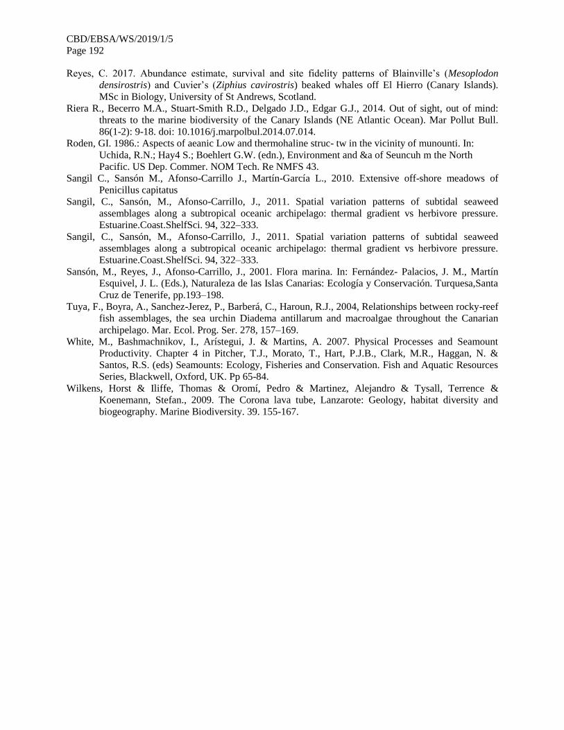
CBD/EBSA/WS/2019/1/5
Page 192
Reyes, C. 2017. Abundance estimate, survival and site fidelity patterns of Blainville’s (Mesoplodon
densirostris) and Cuvier’s (Ziphius cavirostris) beaked whales off El Hierro (Canary Islands).
MSc in Biology, University of St Andrews, Scotland.
Riera R., Becerro M.A., Stuart-Smith R.D., Delgado J.D., Edgar G.J., 2014. Out of sight, out of mind:
threats to the marine biodiversity of the Canary Islands (NE Atlantic Ocean). Mar Pollut Bull.
86(1-2): 9-18. doi: 10.1016/j.marpolbul.2014.07.014.
Roden, GI. 1986.: Aspects of aeanic Low and thermohaline struc- tw in the vicinity of munounti. In:
Uchida, R.N.; Hay4 S.; Boehlert G.W. (edn.), Environment and &a of Seuncuh m the North
Pacific. US Dep. Commer. NOM Tech. Re NMFS 43.
Sangil C., Sansón M., Afonso-Carrillo J., Martín-García L., 2010. Extensive off-shore meadows of
Penicillus capitatus
Sangil, C., Sansón, M., Afonso-Carrillo, J., 2011. Spatial variation patterns of subtidal seaweed
assemblages along a subtropical oceanic archipelago: thermal gradient vs herbivore pressure.
Estuarine.Coast.ShelfSci. 94, 322–333.
Sangil, C., Sansón, M., Afonso-Carrillo, J., 2011. Spatial variation patterns of subtidal seaweed
assemblages along a subtropical oceanic archipelago: thermal gradient vs herbivore pressure.
Estuarine.Coast.ShelfSci. 94, 322–333.
Sansón, M., Reyes, J., Afonso-Carrillo, J., 2001. Flora marina. In: Fernández- Palacios, J. M., Martín
Esquivel, J. L. (Eds.), Naturaleza de las Islas Canarias: Ecología y Conservación. Turquesa,Santa
Cruz de Tenerife, pp.193–198.
Tuya, F., Boyra, A., Sanchez-Jerez, P., Barberá, C., Haroun, R.J., 2004, Relationships between rocky-reef
fish assemblages, the sea urchin Diadema antillarum and macroalgae throughout the Canarian
archipelago. Mar. Ecol. Prog. Ser. 278, 157–169.
White, M., Bashmachnikov, I., Arístegui, J. & Martins, A. 2007. Physical Processes and Seamount
Productivity. Chapter 4 in Pitcher, T.J., Morato, T., Hart, P.J.B., Clark, M.R., Haggan, N. &
Santos, R.S. (eds) Seamounts: Ecology, Fisheries and Conservation. Fish and Aquatic Resources
Series, Blackwell, Oxford, UK. Pp 65-84.
Wilkens, Horst & Iliffe, Thomas & Oromí, Pedro & Martinez, Alejandro & Tysall, Terrence &
Koenemann, Stefan., 2009. The Corona lava tube, Lanzarote: Geology, habitat diversity and
biogeography. Marine Biodiversity. 39. 155-167.
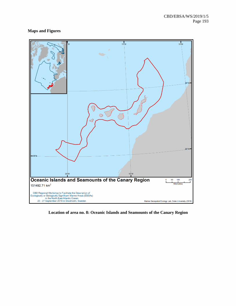
CBD/EBSA/WS/2019/1/5
Page 193
Maps and Figures
Location of area no. 8: Oceanic Islands and Seamounts of the Canary Region
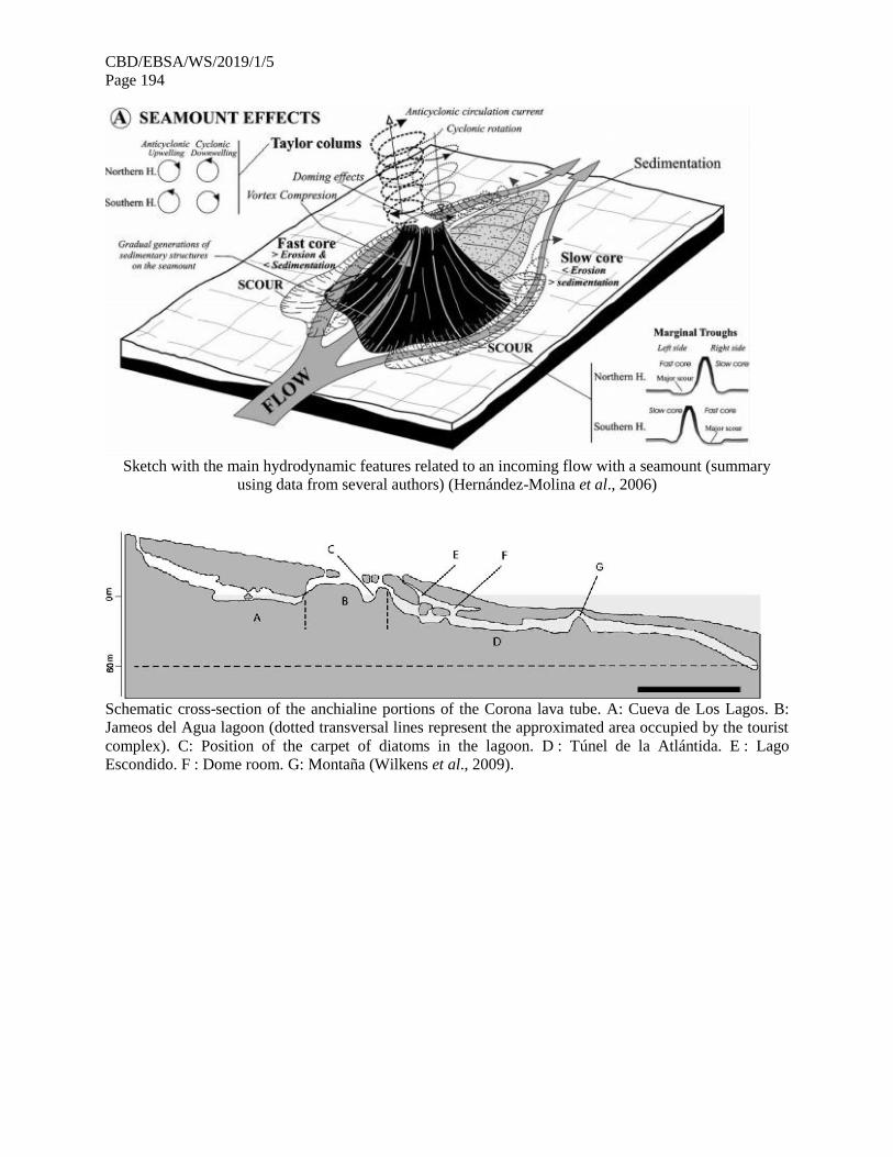
CBD/EBSA/WS/2019/1/5
Page 194
Sketch with the main hydrodynamic features related to an incoming flow with a seamount (summary
using data from several authors) (Hernández-Molina et al., 2006)
Schematic cross-section of the anchialine portions of the Corona lava tube. A: Cueva de Los Lagos. B:
Jameos del Agua lagoon (dotted transversal lines represent the approximated area occupied by the tourist
complex). C: Position of the carpet of diatoms in the lagoon. D : Túnel de la Atlántida. E : Lago
Escondido. F : Dome room. G: Montaña (Wilkens et al., 2009).
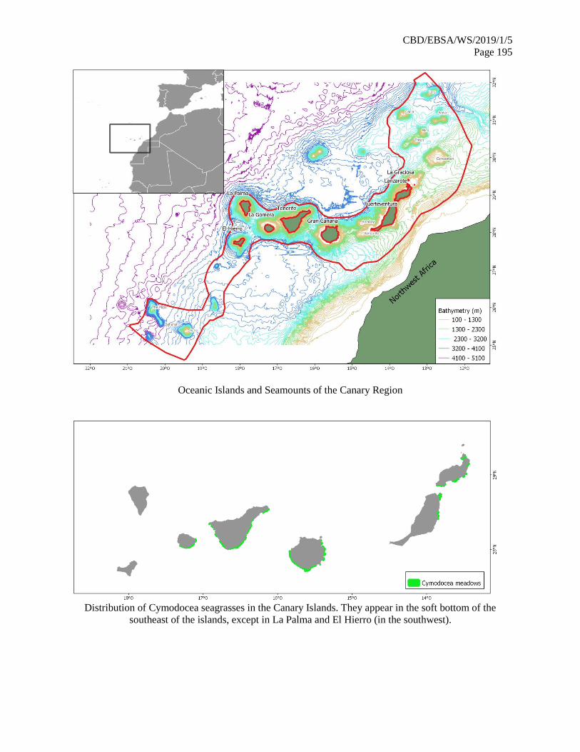
CBD/EBSA/WS/2019/1/5
Page 195
Oceanic Islands and Seamounts of the Canary Region
Distribution of Cymodocea seagrasses in the Canary Islands. They appear in the soft bottom of the
southeast of the islands, except in La Palma and El Hierro (in the southwest).

CBD/EBSA/WS/2019/1/5
Page 196
Distribution of algae assemblages in the infralittoral zone of La Palma. All the islands of the archipelago
present vast extensions of seaweeds on hard substrate in the infralittoral zone.
Benthic habitats identified in the Concepcion Bank
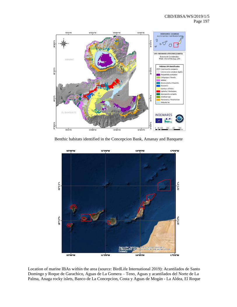
CBD/EBSA/WS/2019/1/5
Page 197
Benthic habitats identified in the Concepcion Bank, Amanay and Banquete
Location of marine IBAs within the area (source: BirdLife International 2019): Acantilados de Santo
Domingo y Roque de Garachico, Aguas de La Gomera – Teno, Aguas y acantilados del Norte de La
Palma, Anaga rocky islets, Banco de La Concepcion, Costa y Aguas de Mogán - La Aldea, El Roque

CBD/EBSA/WS/2019/1/5
Page 198
coastal cliffs, Estrecho de la Bocaina, Island of Lobos, La Playa islet, Lanzarote islets, Salmor rocky islets
and Western coast of El Hierro
Rights and permissions
All the quoted documents and sites are public and subject to specific copyrights that have to be respected
case by case.
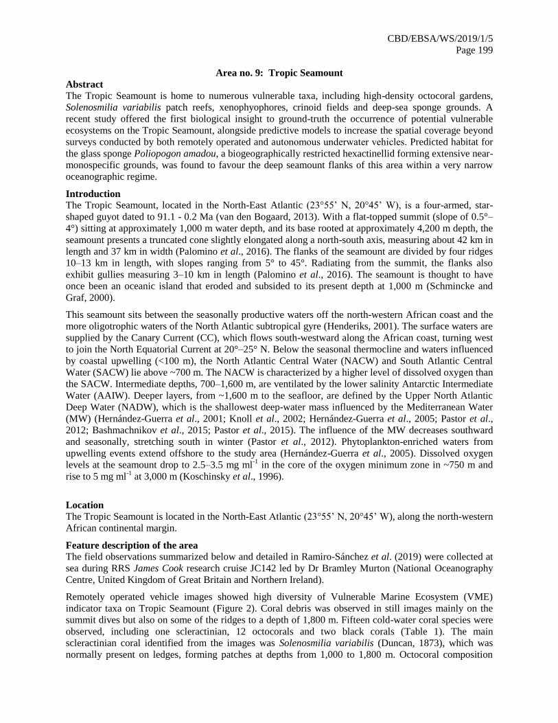
CBD/EBSA/WS/2019/1/5
Page 199
Area no. 9: Tropic Seamount
Abstract The Tropic Seamount is home to numerous vulnerable taxa, including high-density octocoral gardens,
Solenosmilia variabilis patch reefs, xenophyophores, crinoid fields and deep-sea sponge grounds. A
recent study offered the first biological insight to ground-truth the occurrence of potential vulnerable
ecosystems on the Tropic Seamount, alongside predictive models to increase the spatial coverage beyond
surveys conducted by both remotely operated and autonomous underwater vehicles. Predicted habitat for
the glass sponge Poliopogon amadou, a biogeographically restricted hexactinellid forming extensive near-
monospecific grounds, was found to favour the deep seamount flanks of this area within a very narrow
oceanographic regime.
Introduction The Tropic Seamount, located in the North-East Atlantic (23°55’ N, 20°45’ W), is a four-armed, star-
shaped guyot dated to 91.1 - 0.2 Ma (van den Bogaard, 2013). With a flat-topped summit (slope of 0.5°–
4°) sitting at approximately 1,000 m water depth, and its base rooted at approximately 4,200 m depth, the
seamount presents a truncated cone slightly elongated along a north-south axis, measuring about 42 km in
length and 37 km in width (Palomino et al., 2016). The flanks of the seamount are divided by four ridges
10–13 km in length, with slopes ranging from 5° to 45°. Radiating from the summit, the flanks also
exhibit gullies measuring 3–10 km in length (Palomino et al., 2016). The seamount is thought to have
once been an oceanic island that eroded and subsided to its present depth at 1,000 m (Schmincke and
Graf, 2000).
This seamount sits between the seasonally productive waters off the north-western African coast and the
more oligotrophic waters of the North Atlantic subtropical gyre (Henderiks, 2001). The surface waters are
supplied by the Canary Current (CC), which flows south-westward along the African coast, turning west
to join the North Equatorial Current at 20°–25° N. Below the seasonal thermocline and waters influenced
by coastal upwelling (<100 m), the North Atlantic Central Water (NACW) and South Atlantic Central
Water (SACW) lie above ~700 m. The NACW is characterized by a higher level of dissolved oxygen than
the SACW. Intermediate depths, 700–1,600 m, are ventilated by the lower salinity Antarctic Intermediate
Water (AAIW). Deeper layers, from ~1,600 m to the seafloor, are defined by the Upper North Atlantic
Deep Water (NADW), which is the shallowest deep-water mass influenced by the Mediterranean Water
(MW) (Hernández-Guerra et al., 2001; Knoll et al., 2002; Hernández-Guerra et al., 2005; Pastor et al.,
2012; Bashmachnikov et al., 2015; Pastor et al., 2015). The influence of the MW decreases southward
and seasonally, stretching south in winter (Pastor et al., 2012). Phytoplankton-enriched waters from
upwelling events extend offshore to the study area (Hernández-Guerra et al., 2005). Dissolved oxygen
levels at the seamount drop to 2.5–3.5 mg ml-1
in the core of the oxygen minimum zone in ~750 m and
rise to 5 mg ml-1
at 3,000 m (Koschinsky et al., 1996).
Location The Tropic Seamount is located in the North-East Atlantic (23°55’ N, 20°45’ W), along the north-western
African continental margin.
Feature description of the area
The field observations summarized below and detailed in Ramiro-Sánchez et al. (2019) were collected at
sea during RRS James Cook research cruise JC142 led by Dr Bramley Murton (National Oceanography
Centre, United Kingdom of Great Britain and Northern Ireland).
Remotely operated vehicle images showed high diversity of Vulnerable Marine Ecosystem (VME)
indicator taxa on Tropic Seamount (Figure 2). Coral debris was observed in still images mainly on the
summit dives but also on some of the ridges to a depth of 1,800 m. Fifteen cold-water coral species were
observed, including one scleractinian, 12 octocorals and two black corals (Table 1). The main
scleractinian coral identified from the images was Solenosmilia variabilis (Duncan, 1873), which was
normally present on ledges, forming patches at depths from 1,000 to 1,800 m. Octocoral composition
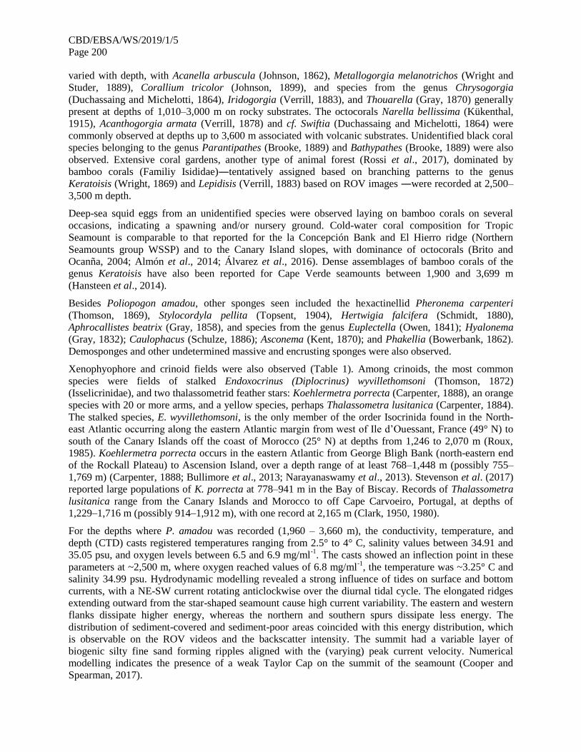
CBD/EBSA/WS/2019/1/5
Page 200
varied with depth, with Acanella arbuscula (Johnson, 1862), Metallogorgia melanotrichos (Wright and
Studer, 1889), Corallium tricolor (Johnson, 1899), and species from the genus Chrysogorgia
(Duchassaing and Michelotti, 1864), Iridogorgia (Verrill, 1883), and Thouarella (Gray, 1870) generally
present at depths of 1,010–3,000 m on rocky substrates. The octocorals Narella bellissima (Kükenthal,
1915), Acanthogorgia armata (Verrill, 1878) and cf. Swiftia (Duchassaing and Michelotti, 1864) were
commonly observed at depths up to 3,600 m associated with volcanic substrates. Unidentified black coral
species belonging to the genus Parantipathes (Brooke, 1889) and Bathypathes (Brooke, 1889) were also
observed. Extensive coral gardens, another type of animal forest (Rossi et al., 2017), dominated by
bamboo corals (Familiy Isididae)―tentatively assigned based on branching patterns to the genus
Keratoisis (Wright, 1869) and Lepidisis (Verrill, 1883) based on ROV images ―were recorded at 2,500–
3,500 m depth.
Deep-sea squid eggs from an unidentified species were observed laying on bamboo corals on several
occasions, indicating a spawning and/or nursery ground. Cold-water coral composition for Tropic
Seamount is comparable to that reported for the la Concepción Bank and El Hierro ridge (Northern
Seamounts group WSSP) and to the Canary Island slopes, with dominance of octocorals (Brito and
Ocanña, 2004; Almón et al., 2014; Álvarez et al., 2016). Dense assemblages of bamboo corals of the
genus Keratoisis have also been reported for Cape Verde seamounts between 1,900 and 3,699 m
(Hansteen et al., 2014).
Besides Poliopogon amadou, other sponges seen included the hexactinellid Pheronema carpenteri
(Thomson, 1869), Stylocordyla pellita (Topsent, 1904), Hertwigia falcifera (Schmidt, 1880),
Aphrocallistes beatrix (Gray, 1858), and species from the genus Euplectella (Owen, 1841); Hyalonema
(Gray, 1832); Caulophacus (Schulze, 1886); Asconema (Kent, 1870); and Phakellia (Bowerbank, 1862).
Demosponges and other undetermined massive and encrusting sponges were also observed.
Xenophyophore and crinoid fields were also observed (Table 1). Among crinoids, the most common
species were fields of stalked Endoxocrinus (Diplocrinus) wyvillethomsoni (Thomson, 1872)
(Isselicrinidae), and two thalassometrid feather stars: Koehlermetra porrecta (Carpenter, 1888), an orange
species with 20 or more arms, and a yellow species, perhaps Thalassometra lusitanica (Carpenter, 1884).
The stalked species, E. wyvillethomsoni, is the only member of the order Isocrinida found in the North-
east Atlantic occurring along the eastern Atlantic margin from west of Ile d’Ouessant, France (49° N) to
south of the Canary Islands off the coast of Morocco (25° N) at depths from 1,246 to 2,070 m (Roux,
1985). Koehlermetra porrecta occurs in the eastern Atlantic from George Bligh Bank (north-eastern end
of the Rockall Plateau) to Ascension Island, over a depth range of at least 768–1,448 m (possibly 755–
1,769 m) (Carpenter, 1888; Bullimore et al., 2013; Narayanaswamy et al., 2013). Stevenson et al. (2017)
reported large populations of K. porrecta at 778–941 m in the Bay of Biscay. Records of Thalassometra
lusitanica range from the Canary Islands and Morocco to off Cape Carvoeiro, Portugal, at depths of
1,229–1,716 m (possibly 914–1,912 m), with one record at 2,165 m (Clark, 1950, 1980).
For the depths where P. amadou was recorded (1,960 – 3,660 m), the conductivity, temperature, and
depth (CTD) casts registered temperatures ranging from 2.5° to 4° C, salinity values between 34.91 and
35.05 psu, and oxygen levels between 6.5 and 6.9 mg/ml-1
. The casts showed an inflection point in these
parameters at ~2,500 m, where oxygen reached values of 6.8 mg/ml-1
, the temperature was ~3.25° C and
salinity 34.99 psu. Hydrodynamic modelling revealed a strong influence of tides on surface and bottom
currents, with a NE-SW current rotating anticlockwise over the diurnal tidal cycle. The elongated ridges
extending outward from the star-shaped seamount cause high current variability. The eastern and western
flanks dissipate higher energy, whereas the northern and southern spurs dissipate less energy. The
distribution of sediment-covered and sediment-poor areas coincided with this energy distribution, which
is observable on the ROV videos and the backscatter intensity. The summit had a variable layer of
biogenic silty fine sand forming ripples aligned with the (varying) peak current velocity. Numerical
modelling indicates the presence of a weak Taylor Cap on the summit of the seamount (Cooper and
Spearman, 2017).
CBD/EBSA/WS/2019/1/5
Page 201
Feature condition and future outlook of the area
The sponge grounds of P. amadou were one of the most frequent and extensive vulnerable ecosystems
observed on the Tropic Seamount, with different body sizes (from approximately 5 cm up to 55 cm)
indicating a stable population with on-going recruitment. The depths of most VME indicator taxa on
Tropic Seamount make these seamount habitats de facto refuges from the impacts of bottom fisheries, as
supported by a lack of evidence for any contact with bottom-fishing gear from the ROV images and from
fishing records across the wider CECAF area (FAO Fiaf/R1184, 2016).
Predicted habitat for P. amadou was found to be favourable on the deep flanks of the seamount within a
very narrow oceanographic regime. Other vulnerable taxa observed on Tropic Seamount, such as coral
gardens and patches of S. variabilis, are also likely to provide important ecosystem functions on the
seamount—indeed one type of coral garden hosted a nursery ground for deep-sea squid, and here too,
predictive species and habitat models could greatly aid in building the evidence base for the occurrence of
vulnerable taxa.
Assessment of area no. 9, Tropic Seamount, against CBD EBSA Criteria
CBD EBSA
Criteria
(Annex I to
decision
IX/20)
Description
(Annex I to decision IX/20) Ranking of criterion relevance
(please mark one column with an X)
No
informat
ion
Low Medi
um
High
Uniqueness
or rarity
Area contains either (i) unique (“the only one
of its kind”), rare (occurs only in few
locations) or endemic species, populations or
communities, and/or (ii) unique, rare or
distinct, habitats or ecosystems; and/or (iii)
unique or unusual geomorphological or
oceanographic features.
X
Explanation for ranking
The Tropic Seamount harbours diverse and near pristine benthic communities that include several
vulnerable taxa, such as the reef-building coral Solenosmilia variabilis, several species of octocorals and
black corals, sponge grounds and crinoid fields. Of particular note on this seamount are the very rare and
unusual occurrences of the sponge Poliopogon amadou forming a diverse animal forest with associated
crinoid fields and other vulnerable taxa. This biogeographically unique occurrence appears to be strongly
related to the specific oceanographic characteristics and hydrography of the Tropic Seamount (Ramiro-
Sánchez et al. 2019).
Special
importance
for life-
history stages
of species
Areas that are required for a population to
survive and thrive.
X
Explanation for ranking
Deep-sea squid eggs from an unidentified species were observed laying on bamboo corals on several
occasions, indicating a spawning and/or nursery ground (Ramiro-Sánchez et al. 2019). However, the
limited extent of surveys to date preclude our providing a ranking on this criterion.
Importance
for
threatened,
endangered
or declining
species
and/or
Area containing habitat for the survival and
recovery of endangered, threatened, declining
species or area with significant assemblages of
such species.
X

CBD/EBSA/WS/2019/1/5
Page 202
habitats
Explanation for ranking
The Tropic Seamount hosts numerous VME indicator taxa (Ramiro-Sánchez et al. 2019) that have
international conservation and management significance through this designation, and therefore the
Seamount is a significant area for the survival of these protected species. These underwater mountains
provide hard substrata for VME indicator taxa, such as corals, sponges and other species—like the ones
found on Tropic Seamount—to settle and grow (Rogers et al., 2007; Samadi et al., 2007; Clark et al.,
2012). Seamounts are often characterised by particular hydrographical conditions that enhance the flow of
currents, and ultimately, the availability of food to suspension feeders (Watling and Auster, 2017). High
densities of corals and sponges can be found on those features (Genin et al., 1986; Rogers et al., 2007;
Roberts et al., 2009; Henry et al., 2013; Victorero et al., 2018), although benthic assemblages and
biomass may vary among seamounts in less productive regions, where substratum is not suitable, or
where seamounts are not adjacent to continental slopes (Rowden et al., 2010).
Vulnerability
, fragility,
sensitivity, or
slow
recovery
Areas that contain a relatively high proportion
of sensitive habitats, biotopes or species that
are functionally fragile (highly susceptible to
degradation or depletion by human activity or
by natural events) or with slow recovery.
X
Explanation for ranking
The Tropic Seamount hosts numerous VME indicator taxa, including reef-building coral species such as
Solenosmilia variabilis; several species of octocorals, black corals and sponges; extensive grounds of the
glass sponge P. amadou; crinoids and xenophyophores (Ramiro-Sánchez et al. 2019). These taxa are
slow-growing, long-lived and late-maturing species, traits that limit their potential for resilience and
recovery from human disturbances (reviewed by Roberts et al. 2009).
Biological
productivity
Area containing species, populations or
communities with comparatively higher
natural biological productivity.
X
Explanation for ranking
The Tropic Seamount hosts many vulnerable species, including extensive and dense monospecific sponge
grounds of Poliopogon amadou of different body sizes (from approximately 5 cm up to 55 cm), large
octocoral gardens and reef-building corals (Ramiro-Sánchez et al. 2019). The biomass this seamount
supports is probably explained by the phytoplankton-enriched waters from the Sahara-upwelling events
that can extend offshore, reaching the Tropic Seamount (Hernández-Guerra et al., 2005). These waters are
fed by the iron-rich dust coming from the Sahara Desert, making the NW waters off Morocco a very
productive oceanographic area (Henderiks, 2001). The existence of a weak Taylor Cap on the seamount
summit (Cooper and Spearman, 2017) may be affecting the distribution of particulate organic carbon,
keeping organic matter suspended and circulated within certain depth ranges (Clark et al., 2010) and
supporting the extraordinary secondary production, thus justifying a medium ranking of this criterion.
Biological
diversity
Area contains comparatively higher diversity
of ecosystems, habitats, communities, or
species, or has higher genetic diversity.
X
Explanation for ranking
Video analysis revealed the existence of a diverse set of VME indicator taxa throughout the different
depth levels of the seamount (Ramiro-Sánchez et al. 2019). Coral debris was observed in still images
mainly on the summit dives but also on some of the ridges to a depth of 1,800 m. Fifteen cold-water coral
species were observed, including one scleractinian, 12 octocorals and two black corals (Table 1). Glass,
massive and encrusting sponges, xenophyophores and crinoid fields were also observed. One of the most
distinctive observations was the occurrence of dense aggregations of the hexactinellid sponge Poliopogon
amadou (Thomson 1877), which formed extensive areas of sponge grounds in the deeper flanks of the
seamount. Ensemble modelling suggested high probability of presence across the entire seamount at a
CBD/EBSA/WS/2019/1/5
Page 203
marked bathymetric between 2,000-3,500 m water depth, but with particularly higher probability of
occurrence in the eastern and western spurs of the seamount (Figure 3).
Naturalness Area with a comparatively higher degree of
naturalness as a result of the lack of or low
level of human-induced disturbance or
degradation.
X
Explanation for ranking
The depths of most VME indicator taxa on Tropic Seamount make these seamount habitats de facto
refuges from the impacts of bottom fisheries, as supported by a lack of evidence for any contact with
bottom-fishing gear from the ROV images and from fishing records across the wider CECAF area (FAO
Fiaf/R1184, 2016).
References
Almón, B., Arcos, J. M., Martín, V., Pantoja, J., Consuegra, E., Martín Sosa, P., et al. (2014). Banco de la
Concepción. Áreas de estudio del proyecto LIFE+ INDEMARES. Available at:
www.indemares.es
lvarez, H., Perry, A. L., Blanco, J., and Aguilar, R. (2016). “Expedición 2014 ‘Atlantic Seamounts’. El
Hierro y montañas submarinas”. Available at:
https://eu.oceana.org/sites/default/files/oceana_el_hierro_y_montanas_submarinas_expedicion_2
014.pdf
Bashmachnikov, I., Nascimento, Â., Neves, F., Menezes, T., and Koldunov, N. V (2015). Distribution of
intermediate water masses in the subtropical northeast Atlantic. Ocean Sci 11, 803–827.
doi:10.5194/os-11-803-2015.
Brito, A., and Ocaña, O. (2004). Corales de las Islas Canarias. Francisco Lemus Editor. La Laguna.
Available at: https://www.casadellibro.com/libro-corales-de-las-islas-
canarias/9788487931673/1011260.
Bullimore, R. D., Foster, N. L., and Howell, K. L. (2013). Coral-characterized benthic assemblages of the
deep Northeast Atlantic: defining “Coral Gardens” to support future habitat mapping efforts.
ICES J. Mar. Sci. 70, 511–522. doi:10.1093/icesjms/fss195.
Clark, A. H. (1950). A Monograph of the Existing Crinoids. 1(4c). 1–383, 32 plates. Available at:
https://repository.si.edu/handle/10088/21346
Clark, A. M. (1980). Crinoidea collected by the Meteor and Discovery in the NE Atlantic. Available at:
http://biostor.org/reference/110
Clark, M. R., Rowden, A. A., Schlacher, T., Williams, A., Consalvey, M., Stocks, K. I., et al. (2010). The
Ecology of Seamounts: Structure, Function, and Human Impacts. Ann. Rev. Mar. Sci. 2, 253–278.
doi:10.1146/annurev-marine-120308-081109.
Clark, M. R., Schlacher, T. A., Rowden, A. A., Stocks, K. I., and Consalvey, M. (2012). Science
Priorities for Seamounts: Research Links to Conservation and Management. PLoS One 7, e29232.
doi:10.1371/journal.pone.0029232.
Cooper, A. J., and Spearman, J. (2017). Validation of a TELEMAC - 3D model of a seamount. in
Proceedings of the TELEMAC-MASCARET user Conference, 17-20 854 October 2017 (Graz
University of Technology, Austria, 29-34). Available at:
https://henry.baw.de/bitstream/handle/20.500.11970/104505/03_Cooper_2017.pdf?sequence=1&i
sAllowed=y.
FAO FIAF/R1184 (2016). FAO / CECAF Technical Workshop on Deep-Sea Fisheries and Vulnerable
Marine Ecosystems in the Eastern Central Atlantic.
Genin, A., Dayton, P. K., Lonsdale, P. F., and Spiess, F. N. (1986). Corals on seamount peaks provide
evidence of current acceleration over deep-sea topography. Nature 322, 59–61.
doi:10.1038/322059a0.
https://eu.oceana.org/sites/default/files/oceana_el_hierro_y_montanas_submarinas_expedicion_2014.pdf
CBD/EBSA/WS/2019/1/5
Page 204
Hansteen, T., Kwasnitschka, T., and Klügel, A. (2014). Cape Verde Seamounts - Cruise No. M80/3 -
December 29, 2009 - February 1, 2010 - Dakar (Senegal) - Las Palmas de Gran Canaria
(Spain). Bremen: DFG-Senatskommission für Ozeanographie. doi:10.2312/cr_m80_3.
Henderiks, J. (2001). Coccolith studies in the Canary Basin: Glacial-Interglacial paleoceanography of the
Eastern Boundary Current System. Available at:
http://www.academia.edu/28505222/Coccolith_studies_in_the_Canary_Basin.
Henry, L. A., Moreno Navas, J., and Roberts, J. M. (2013). Multi-scale interactions between local
hydrography, seabed topography, and community assembly on cold-water coral reefs.
Biogeosciences 10, 2737–2746. doi:10.5194/bg-10-2737-2013.
Hernández-Guerra, A., López-Laatzen, F., Machín, F., De Armas, D., and Pelegrí, J. L. (2001). Water
masses, circulation and transport in the eastern boundary current of the North Atlantic subtropical
gyre. Sci. Mar. 65, 177–186. Available at: http://digital.csic.es/bitstream/10261/5330/1/gyre.pdf.
Hernández-Guerra, A., Fraile-Nuez, E., López-Laatzen, F., Martínez, A., Parrilla, G., and Vélez-Belchí,
P. (2005). Canary Current and North Equatorial Current from an inverse box model. J. Geophys.
Res. Ocean. 110, 1–16. doi:10.1029/2005JC003032.
Knoll, M., Hernández-Guerra, A., Lenz, B., López Laatzen, F., Machı n, F., M ller, T. ., et al. (2002). The
Eastern Boundary Current system between the Canary Islands and the African Coast. Deep Sea
Res. Part II Top. Stud. Oceanogr. 49, 3427–3440. doi:10.1016/S0967-0645(02)00105-4.
Koschinsky, A., Halbach, P., Hein, J. R., and Mangini, A. (1996). Ferromanganese crusts as indicators for
paleoceanographic events in the NE Atlantic. Geol. Rundschau 85, 567–576.
doi:10.1007/BF02369011.
Narayanaswamy, B. E., Hughes, D. J., Howell, K. L., Davies, J., and Jacobs, C. (2013). First observations
of megafaunal communities inhabiting George Bligh Bank, Northeast Atlantic. Deep Sea Res.
Part II Top. Stud. Oceanogr. 92, 79–86. doi:10.1016/J.DSR2.2013.03.004
Palomino, D., Vázquez, J.-T., Somoza, L., León, R., López-González, N., Medialdea, T., et al. (2016).
Geomorphological features in the southern Canary Island Volcanic Province: The importance of
volcanic processes and massive slope instabilities associated with seamounts. Geomorphology
255, 125–139. doi:10.1016/J.GEOMORPH.2015.12.016.
Pastor, M., Peña-Izquierdo, J., Pelegrí, J., and Marrero-Díaz, Á. (2012). Meridional changes in water
mass distributions off NW Africa during November 2007/2008. Ciencias Mar. 38, 223–244.
Available at: http://www.cienciasmarinas.com.mx/index.php/cmarinas/article/view/1831/1667.
Pastor, M., Vélez-Belchí, P., and Hernández-Guerra, A. (2015). Water Masses in the Canary Current
Large Marine Ecosystem. IOC Tech. Ser. 115, 733–79. Available at:
http://hdl.handle.net/1834/9178.
Ramiro-Sánchez, B., González-Irusta, J.M., Henry, L.-A., Cleland, J., Yeo, I., Xavier, J.R., Carreiro-
Silva, M., Sampaio. I., Spearman. J., Victorero. L., Messing, C.G., Kazanidis, G., Roberts, J.M.,
Murton, B. (2019) Characterization and mapping of a deep-sea sponge ground on the Tropic
Seamount (Northeast tropical Atlantic): implications for spatial management in the High Seas.
Frontiers in Marine Science 6: 278
Roberts, J. M., Wheeler, A. J., Freiwald, A., and Cairns, S. D. (2009). Cold-water Corals: The Biology
and Geology of Deep-Sea Coral Habitats. Cambridge University Press. Available at:
www.cambridge.org.
Rogers, A. D., Baco, A., Griffiths, H., Hart, T., and Hall-Spencer, J. M. (2007). Corals on Seamounts.
Seamounts Ecol. Fish. Conserv., 141–169. doi:10.1002/9780470691953.ch8.
Rowden, A. A., Schlacher, T. A., Williams, A., Clark, M. R., Stewart, R., Althaus, F., et al. (2010). A test
of the seamount oasis hypothesis: seamounts support higher epibenthic megafaunal biomass than
adjacent slopes. Mar. Ecol. 31, 95–106. doi:10.1111/j.1439-0485.2010.00369.x.
Samadi, S., Schlacher, T., and de Forges, B. R. (2007). “Seamount Benthos,” in Seamounts: Ecology,
Fisheries & Conservation (Oxford, UK: Blackwell Publishing Ltd), 117–140.
doi:10.1002/9780470691953.ch7.
CBD/EBSA/WS/2019/1/5
Page 205
Schmincke, H.-U., and Graf, G. (2000). DECOS / OMEX II, Cruise No. 43, 25 November 1998 - 14
January 1999. Hamburg: Leitstelle METEOR, Institut für Meereskunde der Universität Hamburg
doi:10.2312/cr_m43
Stevenson, A., Gahn, F. J., Baumiller, T. K., and Sevastopulo, G. D. (2017). Predation on feather stars by
regular echinoids as evidenced by laboratory and field observations and its paleobiological
implications. Paleobiology 43, 274–285. doi:10.1017/pab.2016.39.
van den Bogaard, P. (2013). The origin of the Canary Island Seamount Province - New ages of old
seamounts. Sci. Rep. 3, 2107. doi:10.1038/srep02107.
Victorero, L., Robert, K., Robinson, L. F., Taylor, M. L., and Huvenne, V. A. I. (2018). Species
replacement dominates megabenthos beta diversity in a remote seamount setting. Sci. Rep. 8,
4152. doi:10.1038/s41598-018-22296-8.
Watling, L., and Auster, P. J. (2017). Seamounts on the High Seas Should Be Managed as Vulnerable
Marine Ecosystems. Front. Mar. Sci. 4. doi:10.3389/fmars.2017.00014.
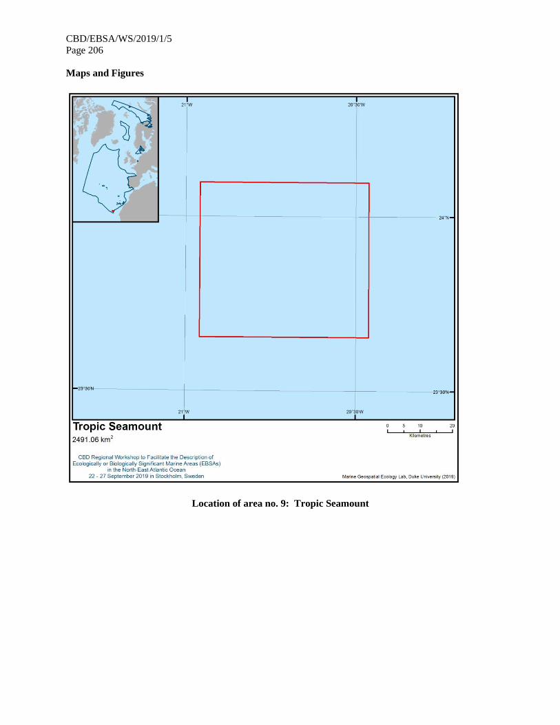
CBD/EBSA/WS/2019/1/5
Page 206
Maps and Figures
Location of area no. 9: Tropic Seamount
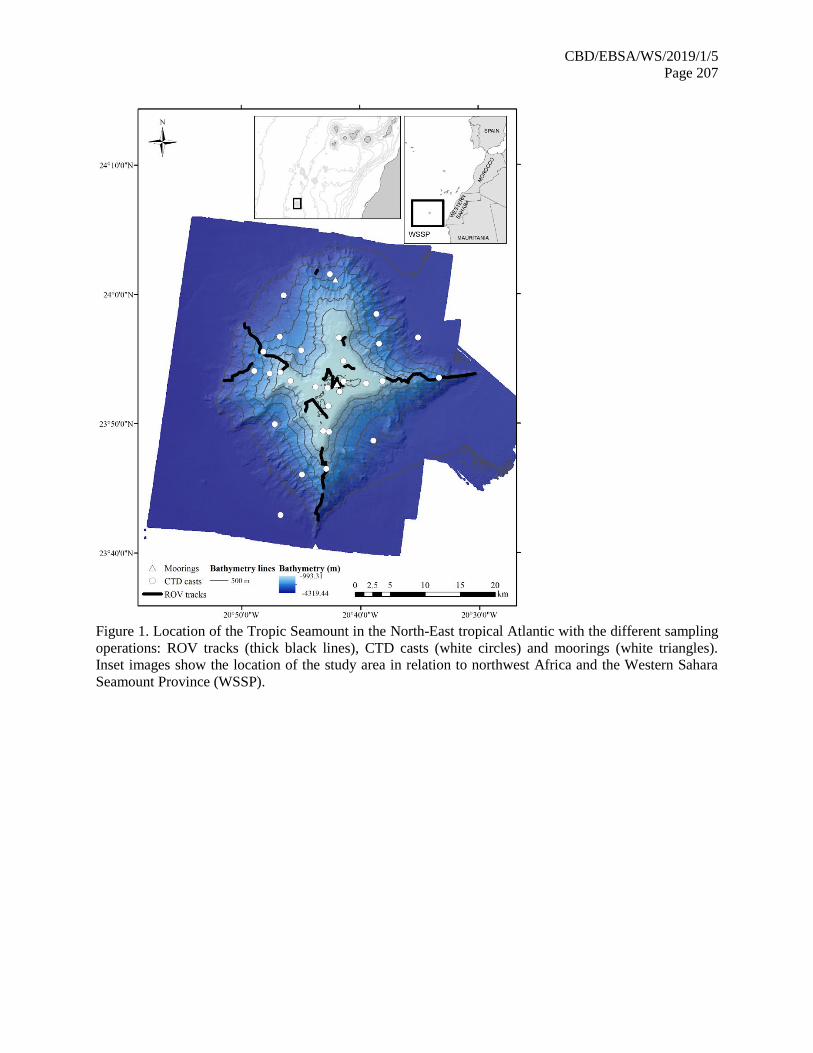
CBD/EBSA/WS/2019/1/5
Page 207
Figure 1. Location of the Tropic Seamount in the North-East tropical Atlantic with the different sampling
operations: ROV tracks (thick black lines), CTD casts (white circles) and moorings (white triangles).
Inset images show the location of the study area in relation to northwest Africa and the Western Sahara
Seamount Province (WSSP).

CBD/EBSA/WS/2019/1/5
Page 208
Figure 2. Seabed photographs showing some of the VME indicator taxa observed on the Tropic
Seamount. A: Specimens of Poliopogon amadou. B: Sponge ground of Poliopogon amadou. C: Coral
garden on a ledge with diverse octocorals and patches of Solenosmilia variabilis. D: Octocoral garden and
coral rubble. E: Antipatharian species, Metallogorgia melanotrichos and Chrysogorgia sp. F:
Unidentified black coral. G: A crinoid field of possibly Thalassometra lusitanica. H: Field of
xenophyophores. I: ROV Isis sampling ferromanganese crust.
Figure 3. Prediction of Poliopogon amadou presence for the ensemble distribution model (A) and (B)
uncertainty (CV) for the ensemble distribution model.
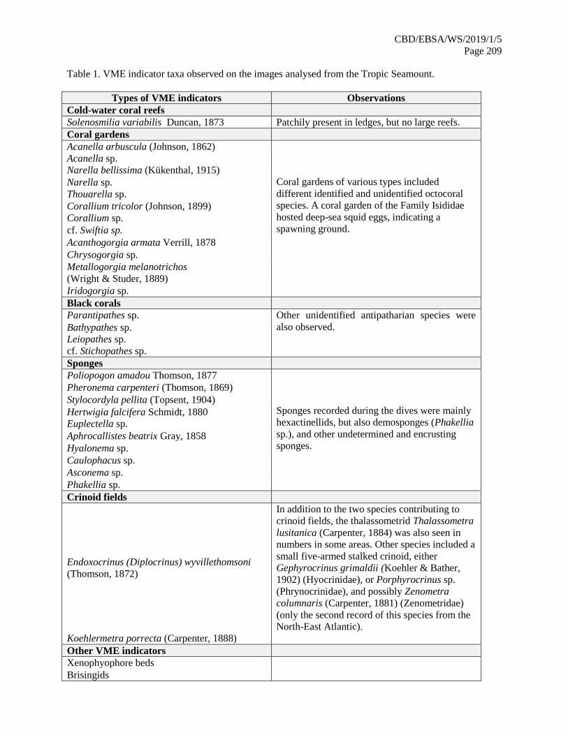
CBD/EBSA/WS/2019/1/5
Page 209
Table 1. VME indicator taxa observed on the images analysed from the Tropic Seamount.
Types of VME indicators Observations
Cold-water coral reefs
Solenosmilia variabilis Duncan, 1873 Patchily present in ledges, but no large reefs.
Coral gardens
Acanella arbuscula (Johnson, 1862)
Acanella sp.
Narella bellissima (Kükenthal, 1915)
Coral gardens of various types included
different identified and unidentified octocoral
species. A coral garden of the Family Isididae
hosted deep-sea squid eggs, indicating a
spawning ground.
Narella sp.
Thouarella sp.
Corallium tricolor (Johnson, 1899)
Corallium sp.
cf. Swiftia sp.
Acanthogorgia armata Verrill, 1878
Chrysogorgia sp.
Metallogorgia melanotrichos
(Wright & Studer, 1889)
Iridogorgia sp.
Black corals
Parantipathes sp. Other unidentified antipatharian species were
also observed. Bathypathes sp.
Leiopathes sp.
cf. Stichopathes sp.
Sponges
Poliopogon amadou Thomson, 1877
Sponges recorded during the dives were mainly
hexactinellids, but also demosponges (Phakellia
sp.), and other undetermined and encrusting
sponges.
Pheronema carpenteri (Thomson, 1869)
Stylocordyla pellita (Topsent, 1904)
Hertwigia falcifera Schmidt, 1880
Euplectella sp.
Aphrocallistes beatrix Gray, 1858
Hyalonema sp.
Caulophacus sp.
Asconema sp.
Phakellia sp.
Crinoid fields
Endoxocrinus (Diplocrinus) wyvillethomsoni
(Thomson, 1872)
In addition to the two species contributing to
crinoid fields, the thalassometrid Thalassometra
lusitanica (Carpenter, 1884) was also seen in
numbers in some areas. Other species included a
small five-armed stalked crinoid, either
Gephyrocrinus grimaldii (Koehler & Bather,
1902) (Hyocrinidae), or Porphyrocrinus sp.
(Phrynocrinidae), and possibly Zenometra
columnaris (Carpenter, 1881) (Zenometridae)
(only the second record of this species from the
North-East Atlantic).
Koehlermetra porrecta (Carpenter, 1888)
Other VME indicators
Xenophyophore beds
Brisingids
CBD/EBSA/WS/2019/1/5
Page 210
Rights and permissions
The field observations summarized here and detailed in Ramiro-Sánchez et al. (2019) were collected at
sea during RRS James Cook research cruise JC142 led by Dr Bramley Murton (National Oceanography
Centre, UK).
This submission was prepared through the ATLAS project with funding provided from the European
Union’s Horizon 2020 Research and Innovation Program under grant agreement no. 678760.
Please contact Dr. Lea-Anne Henry (ATLAS Project, University of Edinburgh) [email protected] for
permission to share or publish information from this template.
CBD/EBSA/WS/2019/1/5
Page 211
Area no. 10: Atlantis-Meteor Seamount Complex
Abstract The Atlantis-Meteor Seamount Complex comprises 10 seamounts. These seamounts are hotspots of
marine life and areas of enhanced productivity, especially when compared with surrounding abyssal
areas. This seamount complex has a total area of 134,079 km2, with depths ranging from 265m (top of
Atlantis seamount) to 4,800m (base of Great Meteor seamount). A total of 437 species are present in this
area (with 16 per cent of mega- and macrofauna and up to 91 per cent of meiofauna endemic to the
seamount group), 3.9 per cent of which are protected under international or regional law.
Introduction The Atlantis-Meteor Seamount Complex comprises 10 seamounts: Atlantis, Cruiser, Hyeres, Irving, Pico
Sul, Plato, Tyro, Meteor Bank, the latter including Great Meteor, Closs and Small Meteor.
Benthic biological communities on seamounts are highly vulnerable to human activities. Many benthic
species are long-lived, slow-growing and vulnerable to human impacts. Seamounts are defined as
isolated topographic features of the seabed that have a limited lateral extent and rise more than 1000m
from abyssal depths (Menard, 1964). Large seamounts usually originate as volcanoes and are primarily
associated with intraplate hotspots and mid-ocean ridges (Staudigel et al., 2010). Generally, seamount
topography is responsible for these structures qualifying as high complexity sites. Due to their isolated
location, these structures can be an obstacle to the free circulation of the oceans. This gives rise to
different kinds of phenomena and disturbances, including an increase in the speed of sea currents,
upwellings, turbulence, Taylor cones, eddies and even jets in the zones where the seamounts interact with
ocean currents (Richardson et al., 2000; Kunze & Smith, 2004; White et al., 2007; Pakhorukov, 2008).
Seamounts are hotspots of marine life (e.g., Rogers, 1994; Gubbay, 2003; Morato & Pauly, 2004; Pitcher
et al., 2007, 2010; Mendonça et al., 2012) and in general are areas of enhanced productivity in
comparison with nearby abyssal areas. In most cases, around the seamounts there is an extensive
anticyclonic eddy associated with the lifting of nutrients from the rich deep water, giving rise to high
concentrations of nitrates and chlorophyll in shallow waters (Coelho & Santos, 2003), which encourages
the development of a wealth of flora and fauna on the structures, leading to exposed hard substrates and
improved food conditions for epibenthic suspension feeders (e.g., Cartes et al., 2007 a), b); Genin &
Dower 2007), such as cold-water corals or deep-water sponges (e.g., Samadi et al., 2007; Sánchez et al.,
2008), tunas (e.g., Yasui 1986; Morato et al., 2010, Ressurreição & Giacomello, 2013), marine mammals
(e.g., Cañadas et al., 2002; Correia et al., 2015), and other organisms that apparently feed on prey
aggregations (e.g., Boehler & Sasaki, 1988; Porteiro & Sutton, 2007; Tabachnick & Menchenina, 2007).
Seamounts are biologically distinctive habitats of the open ocean exhibiting unique features (Rogers,
1994; Probert, 1999; Morato & Clark, 2007). These structures can host very distinctive biological
communities that are different from the communities on nearby abyssal plains dominated by soft
sediment, and these particular places may attract pelagic fish, including larger, commercially valuable
species and other marine top predators such as loggerhead sea turtles (Caretta caretta) and marine
mammals (e.g., Holland & Grubbs, 2007, Kaschner, 2007, Santos et al., 2007).
The Atlantis-Meteor Seamount Complex is part of the Macaronesian region. The area is situated about
1500 km northwest of the African continent and contains 10 banks, which usually have flat summit
plateaus, together with a few lesser seamounts. The whole feature is a large volcanic complex in the
central North Atlantic Ocean, situated some 700 km south of the Azores (Verhoef, 1984). It is the
southernmost of a chain of large seamounts extending south from the Azores Plateau (Figure 1).
The Meteor bank is one of the best explored seamounts in the world, and since an expedition in 1998,
detailed information on the meiofauna inhabiting its plateau has been made available. The Great Meteor
resembles an isolated “island” in respect to the colonization by meiofauna. More data is included in the
descriptions of some seamounts, such as Atlantis, Hyeres, Irving and Plato, than others (see Table 1), due
to a greater sampling effort. Most of the older research was focused on geology.
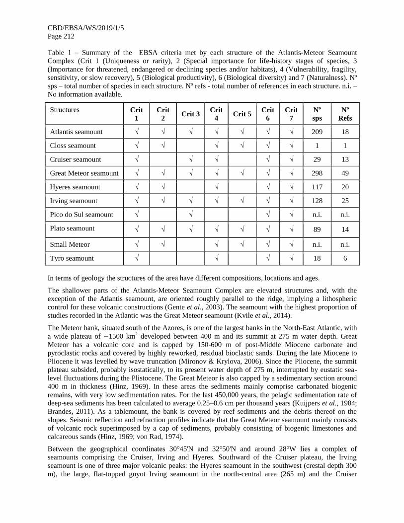
CBD/EBSA/WS/2019/1/5
Page 212
Table 1 – Summary of the EBSA criteria met by each structure of the Atlantis-Meteor Seamount
Complex (Crit 1 (Uniqueness or rarity), 2 (Special importance for life-history stages of species, 3
(Importance for threatened, endangered or declining species and/or habitats), 4 (Vulnerability, fragility,
sensitivity, or slow recovery), 5 (Biological productivity), 6 (Biological diversity) and 7 (Naturalness). Nº
sps – total number of species in each structure. Nº refs - total number of references in each structure. n.i. –
No information available.
Structures Crit
1
Crit
2 Crit 3
Crit
4 Crit 5
Crit
6
Crit
7
Nº
sps
Nº
Refs
Atlantis seamount √ √ √ √ √ √ √ 209 18
Closs seamount √ √
√ √ √ √ 1 1
Cruiser seamount √
√ √
√ √ 29 13
Great Meteor seamount √ √ √ √ √ √ √ 298 49
Hyeres seamount √ √
√
√ √ 117 20
Irving seamount √ √ √ √ √ √ √ 128 25
Pico do Sul seamount √
√
√ √ n.i. n.i.
Plato seamount √ √ √ √ √ √ √ 89 14
Small Meteor √ √ √ √ √ √ n.i. n.i.
Tyro seamount √
√
√ √ 18 6
In terms of geology the structures of the area have different compositions, locations and ages.
The shallower parts of the Atlantis-Meteor Seamount Complex are elevated structures and, with the
exception of the Atlantis seamount, are oriented roughly parallel to the ridge, implying a lithospheric
control for these volcanic constructions (Gente et al., 2003). The seamount with the highest proportion of
studies recorded in the Atlantic was the Great Meteor seamount (Kvile et al., 2014).
The Meteor bank, situated south of the Azores, is one of the largest banks in the North-East Atlantic, with
a wide plateau of ∼1500 km2 developed between 400 m and its summit at 275 m water depth. Great
Meteor has a volcanic core and is capped by 150-600 m of post-Middle Miocene carbonate and
pyroclastic rocks and covered by highly reworked, residual bioclastic sands. During the late Miocene to
Pliocene it was levelled by wave truncation (Mironov & Krylova, 2006). Since the Pliocene, the summit
plateau subsided, probably isostatically, to its present water depth of 275 m, interrupted by eustatic sea-
level fluctuations during the Plistocene. The Great Meteor is also capped by a sedimentary section around
400 m in thickness (Hinz, 1969). In these areas the sediments mainly comprise carbonated biogenic
remains, with very low sedimentation rates. For the last 450,000 years, the pelagic sedimentation rate of
deep-sea sediments has been calculated to average 0.25–0.6 cm per thousand years (Kuijpers et al., 1984;
Brandes, 2011). As a tablemount, the bank is covered by reef sediments and the debris thereof on the
slopes. Seismic reflection and refraction profiles indicate that the Great Meteor seamount mainly consists
of volcanic rock superimposed by a cap of sediments, probably consisting of biogenic limestones and
calcareous sands (Hinz, 1969; von Rad, 1974).
Between the geographical coordinates 30°45'N and 32°50'N and around 28°W lies a complex of
seamounts comprising the Cruiser, Irving and Hyeres. Southward of the Cruiser plateau, the Irving
seamount is one of three major volcanic peaks: the Hyeres seamount in the southwest (crestal depth 300
m), the large, flat-topped guyot Irving seamount in the north-central area (265 m) and the Cruiser
CBD/EBSA/WS/2019/1/5
Page 213
seamount in the northeast (735 m). These seamount crests are mostly unsedimented (Tucholke and
Smoot, 1990).
The Cruiser seamount is located to the furthest North-East, with a maximum height of 590 m below sea
level. The seamount rises to 735 m, and its length is about 70 km. Cruiser seamount contains no flat
surface (Verhoef, 1984).
Irving seamount is situated at about 32°N/28°W. It rises to 250 m below sea level and is a tablemount.
The general direction of Irving seamount is NW-SE, but due to its oval shape it is difficult to assign a
distinct orientation to this seamount. The length of the structure is about 100 km.
Between Irving and Hyeres seamounts, there are several structures that are not as shallow as the other
seamounts. The alignment of these structures is the same as for the other seamounts inside the complex.
Hyeres seamount is the most southwestern structure (Verhoef, 1984).
The Hyeres seamount has a recorded minimum depth of 330 m at 31°20'N/28°50'W. The seismic profiles
over Hyeres seamount show no flat surface. Coming from the northwest, Hyeres rises abruptly from the
ocean floor. It then seems to divide in two branches in the south-east. Hyeres seamount has a length of
about 100 km (Verhoef, 1984).
Inside the complex formed by Cruiser, Irving and Hyeres seamounts, several sedimentary basins are to be
found (e.g., between Cruiser and Irving seamounts). On several profiles, a sedimentary cover on the
seamounts has been recorded (e.g., the profiles over the northwestern part of Irving seamount) (Verhoef,
1984).
Plato seamount is aligned in a general E-W direction. It consists of an echelon structure with a WNW-
ESE direction. The overall length of Plato seamount is about 110 km, and the recorded minimum depth is
580 m. Plato seamount forms the connection with another complex structure, the Atlantis seamount group
(Verhoef, 1984).
The Atlantis seamount complex consists of several elevations, separated by deep saddles and with a
common base at about 2400m. Some summits and slopes have composite relief with hills and peaks
measuring 100 to 200 m. Therefore, the horizontal dimensions of these two seamounts on the contour
charts are only schematic Studies conducted by Heezen et al. (1969) concluded that Atlantis seamount
was an island within the past 12,000 years.
Tyro seamount is situated at 34°40'N/27°30'W with a minimum depth of 1370 m and roughly defined SE
direction (Verhoef, 1984).
Seamounts are locations for a broad range of current-topography interactions and biophysical coupling,
with implications for both phyto and zooplankton. Seamounts appear to support relatively large
planktonic and higher consumer biomass when compared to surrounding ocean waters, particularly in
oligotrophic oceans. It has been a widely held view that in situ enhancement of primary production fuels
this phenomenon, but this has recently been challenged (Genin & Dower 2007).
Productivity in oceanic settings depends on light and nutrient availability, while overall production is the
result of productivity and accumulation of the phytoplankton. At a seamount, either a seamount-
generated, vertical nutrient flux must be shallow enough to reach the euphotic zone and the ensuing
productivity retained over the seamount long enough to allow transfer to higher trophic levels, or the
seamount must rely on allochthonous inputs of organic material to provide a trophic subsidy to resident
populations (Clark et al., 2010).
In terms of biology, these structures have not been extensively studied. A total of 437 species have been
identified throughout the area (see feature description). Although seamounts are ecologically important
and abundant features in the world’s oceans (Hillier & Watts, 2007), biological research on some
seamounts has been limited (see Table 1) (Consalvey et al., 2010).

CBD/EBSA/WS/2019/1/5
Page 214
The most detailed investigations on biodiversity, composition and distribution of the seamount benthic
macrofauna and meiofauna have been carried out in the North Atlantic, particularly at the Great Meteor
seamount (Emschermann, 1971; Grasshoff, 1977; Bartsch, 1973, 2003, 2004, 2008; Hartmann-Schröder,
1979; George & Schminke, 2002; George 2004; Gad 2004, 2009; Gad & Schminke, 2004; Piepenburg &
Müller, 2004; Mironov & Krylova, 2006).
Location The area is situated roughly 700 km south of the Azores and about 1500 km northwest of Africa. It has a
total area of 134,079 km2, with depths ranging from 265m (top of Atlantis seamount) to 4800m (bottom
of Great Meteor seamount). The area is bounded by the parallels 35º30’0,000’’N and 29º12’0,000’’N, and
meridians -27º0’0,000’’W and -31º30’0,000’’W.
The polygon is defined by 19 points (see Table 2). The datum used is World Geodetic System 1984
(WGS84).
Table 2 – Geographic coordinates in two different formats: Decimal degrees and Degrees, Minutes and
Seconds, corresponding to the vertices of the polygon that defines the Atlantis-Meteor Seamount
Complex
Vertices Latitude Longitude Latitude Longitude
1 31,00000000° -29,00000000° 31° 0' 0,000" N -29° 0' 0,000" W
2 31,60000000° -29,30000000° 31° 36' 0,000" N -29° 18' 0,000" W
3 32,00000000° -28,60000000° 32° 0' 0,000" N -28° 36' 0,000" W
4 32,90000000° -28,60000000° 32° 54' 0,000" N -28° 36' 0,000" W
5 33,00000000° -30,50000000° 33° 0' 0,000" N -30° 30' 0,000" W
6 34,00000000° -31,40000000° 34° 0' 0,000" N -31° 24' 0,000" W
7 35,00000000° -31,50000000° 35° 0' 0,000" N -31° 30' 0,000" W
8 35,00000000° -30,30000000° 35° 0' 0,000" N -30° 18' 0,000" W
9 34,00000000° -29,50000000° 34° 0' 0,000" N -29° 30' 0,000" W
10 34,00000000° -28,70000000° 34° 0' 0,000" N -28° 42' 0,000" W
11 35,50000000° -28,50000000° 35° 30' 0,000" N -28° 30' 0,000" W
12 35,40000000° -27,00000000° 35° 24' 0,000" N -27° 0' 0,000" W
13 33,30000000° -27,60000000° 33° 18' 0,000" N -27° 36' 0,000" W
14 32,20000000° -27,00000000° 32° 12' 0,000" N -27° 0' 0,000" W
15 30,70000000° -28,20000000° 30° 42' 0,000" N -28° 12' 0,000" W
16 29,30000000° -28,00000000° 29° 18' 0,000" N -28° 0' 0,000" W
17 29,20000000° -29,30000000° 29° 12' 0,000" N -29° 18' 0,000" W
The Atlantis-Meteor Seamount Complex includes 10 seamount structures.
Feature description of the area
Knowledge of the Atlantis-Meteor Seamount Complex is based on the analysis of 146 scientific articles
containing relevant information about the described area. Several of the seamounts are well known, with a
great number of geological and biological studies. The total number of 437 species reported was
estimated from scattered taxonomical literature, and the species number is probably underestimated.
Knowledge of each structure is uneven.
Around of 4 per cent of the 437 species identified in all seamounts on Atlantis-Meteor Seamount
Complex are legally protected or assessed as threatened by CITES, IUCN Red List, European Union
Habitats and Birds Directives, Food and Agriculture Organization (VMEs), Bern Convention and OSPAR
Convention. For example, OSPAR identified as endangered or declining the deep-water sharks
CBD/EBSA/WS/2019/1/5
Page 215
Centroscymus coeleopsis and Centrophorus squamosus. Other examples of species with legal protection
(CITES Appendix II) are the corals, Antipathella subpinnata, Leiopathes spp., Parantipathes hirondelle,
Aulocyathus atlanticus, Caryophyllia abyssorum, Deltocyathus eccentricus, Deltocyathus moseleyi,
Dendrophyllia cornigera, Desmophyllum dianthus, Flabellum alabastrum, Flabellum chuni and Lophelia
pertusa among others. For example, the species of sea urchin Centrostephanus longispinus is protected by
the EU Habitats Directive, and Ranella olearia is protected by Annex II of the Bern Convention.
The species studied in the described area belong to several phyla, classes or orders (Figure 3). The Meteor
Seamount includes various species of scleractinians and gorgonians. In some seamounts the gorgonian
and sponge species were reported to form dense gorgonian coral habitat-forming aggregations of
Callogorgia verticillata and Elisella flagellum, which may represent important feeding and sheltering
grounds for seamount fishes and potential shark nurseries (WWF, 2001; Etnoyer & Warrenchuk, 2007;
OSPAR, 2011). Cold-water, deep, habitat-forming corals can shelter higher megafauna in association
with the corals than other habitats without coral communities (Roberts et al, 2006; Mortensen et al, 2008,
Rogers et al, 2008). Seamounts also harbour large aggregations of demersal or benthopelagic fish
(Koslow, 1997; Morato & Pauly, 2004; Pitcher et al., 2007; Morato et al., 2009, 2010).
Feature condition and future outlook of the area
Most of the study cruises that have visited the described area focus on Great Meteor bank, with sampling
of the demersal vertebrate fauna (fish). Most studies are qualitative and often focus on specific taxonomic
groups, such as copepods or gastropods (George & Schminke, 2002; Gofas, 2007; Pitcher et al., 2010).
The unique ecosystems of seamounts are highly vulnerable and sensitive to external actions. Most of the
fauna found on seamounts are long-lived, slow-growing organisms with low fecundity and natural
mortality (Brewin et al., 2007). Fisheries for horse mackerel (Trachurus trachurus, Carangidae),
mackerel (Scomber sp., Scombridae), scabbardfish (family Trichiuridae) and orange roughy
(Hoplostethus atlanticus) have been operating on the seamounts of the area (Uiblein et al., 1999).
Assessment of area no. 10, Atlantis-Meteor Seamount Complex, against CBD EBSA Criteria
CBD EBSA
Criteria
(Annex I to
decision IX/20)
Description
(Annex I to decision IX/20) Ranking of criterion relevance
(please mark one column with an X)
No
informat
ion
Low Medi
um
High
Uniqueness or
rarity
Area contains either (i) unique (“the only one
of its kind”), rare (occurs only in few
locations) or endemic species, populations or
communities, and/or (ii) unique, rare or
distinct, habitats or ecosystems; and/or (iii)
unique or unusual geomorphological or
oceanographic features.
X
Explanation for ranking
The fish Protogrammus sousai (Callionymidae) is endemic to Great Meteor Seamount (Uiblein et al.,
1999), as is the antipatharian (Leiopathes montana) (Molodstova, 2011). The Atlantis Seamount has
strong effects on the composition of the mesopelagic fish community (Pusch et al., 2004).
The fish fauna are ecologically distinct, with some evidence of morphologic adaption of certain fish
populations (e.g., Phycis phycis) to the special food-poor conditions at the seamount (Uiblein et al.,
1999).
Meiofaunal groups of copepods and nematodes exhibit pronounced endemism, e.g., 54 of 56 observed
species of the copepod Harpacticoida are new to science (George and Schminke, 2002).
Special Areas that are required for a population to X

CBD/EBSA/WS/2019/1/5
Page 216
importance
for life-history
stages of
species
survive and thrive.
Explanation for ranking
Atlantis and Great Meteor Banks are vital stopping points for certain migratory species of whales and
cetaceans, including sperm whales (e.g., Physeter microcephalus), fin whales (e.g., Balaenoptera
acutorostrata), striped (e.g., Stenella coeruleoalba) and bottlenose dolphins (e.g., Tursiops truncatus).
The seamounts support many species of seabirds that use these places to feed; tracking data reveal the
occurrence of at least 11 species using the area during breeding and/or the non- breeding seasons e.g.,
Calonectris borealis,Puffinus lherminieri baroli – an OSPAR listed species – and the threatened Rissa
tridactyla, Pterodroma deserta and Pterodroma madeira(BirdLife International 2019).
There is a blue shark nursery in the Central North Atlantic, roughly delimited by the Azoresarchipelago in
the North and the Atlantis-Meteor Seamount Complex in the South (Vandeperre et al., 2014)
The aggregation of commercially important fish species in this area use this ecosystem for spawning and
as nursery grounds (e.g., Aphanopus carbo, Beryx splendens, Zenopsis conchifer) (Uiblein et al., 1999).
There is evidence for mid-latitude foraging in central North Atlantic waters for fin and blue whales
migrating to the northern feeding sites. More importantly, these species can suspend their seasonal
migration and remain foraging in middle latitude areas for extended periods of time and much later into
the summer than generally assumed (Silva et al., 2013).
Importance
for
threatened,
endangered or
declining
species and/or
habitats
Area containing habitat for the survival and
recovery of endangered, threatened, declining
species or area with significant assemblages
of such species.
X
Explanation for ranking
Around 4 per cent of the species identified in Atlantis-Meteor Seamount Complex are legally protected
or assessed as threatened by CITES (e.g., Antipathes furcata, Leiopathes spp., Parantipathes hirondelle,
Desmophyllum dianthus, etc), European Union Habitats (e.g., Centrostephanus longispinus), Bern
Convention (e.g., Ranella olearium) orOSPAR Convention (e.g., Centroscymnus coelolepis) (see “feature
description of the area”).
Tracks of the loggerhead turtle (Caretta caretta), which is protected by CITES, indicate their use of
seamount as habitat (Pitcher et al., 2010).
Atlantis seamount and Meteor Bank are vital stopping points for certain migratory species of whales and
cetaceans, including sperm whales (e.g., Physeter microcephalus), fin whales (e.g., Balaenoptera
acutorostrata), striped (e.g., Stenella coeruleoalba) and bottlenose dolphins (e.g., Tursiops truncates,
Romagosa et al., 2009).
Some globally threatened seabird species are also known to occur in the area, such as Rissa tridactyla
(VU), Pterodroma deserta (VU) and Pterodroma madeira (EN), along with the OSPAR listed Puffinus
lherminieri baroli (BirdLife International 2019).
Blue shark (Prionace glauca) is on the IUCN Red List as a threatened species. As the seamount complex
is confirmed as a nursery, it is of paramount importance to the species (Stevens, 2009).
Vulnerability,
fragility,
sensitivity, or
Areas that contain a relatively high
proportion of sensitive habitats, biotopes or
species that are functionally fragile (highly
X
CBD/EBSA/WS/2019/1/5
Page 217
slow recovery susceptible to degradation or depletion by
human activity or by natural events) or with
slow recovery.
Explanation for ranking
These seamounts host unique marine ecosystems, supporting fragile habitats and vulnerable species like
habitat-forming sponges and cold-water corals (e.g., Madrepora oculata). Some of these species exhibit
extremely slow recovery, such as the black corals (Leiopathes spp.); the age of some specimens in this
part of the Atlantic was approximated to be >2000 yrs (Carreiro-Silva et al., 2012).
In the Atlantis-Meteor Seamount Complex, at least 35 species of cold-water corals have been reported
(e.g., Antipathella subpinnata; Parantipathes hirondelle, Leiopathes montana, Caryophyllia smithii;
Dendrophyllia cornigera, Flabellum macandrewi). All these corals are particularly fragile and recover
very slowly (Molodtsova, 2006; Rogers et al., 2007; Molodtsova, 2011).
Presence of species with some legal protection with characteristic features particularly attending to
biological factors, such as longevity, low fecundity, and slow growth rates (e.g., sharks and rays) (e.g.,
Clark, 2001; Morato et al. 2008). Twenty-two species of sharks and rays (e.g., Dalatias licha (shark),
Raja clavata (ray)) are reported in this area (see Figure 5).
Long-lived and slow-growing orange roughy (Hoplostethus atlanticus), one of the longest-lived fish
species known, with an estimated life span of more than 130 years, is reported in deep waters, over steep
continental slopes, ocean ridges and seamounts south of Azores, including Atlantis-Meteor Seamount
Complex (Allain & Lorance, 2000).
Biological
productivity
Area containing species, populations or
communities with comparatively higher
natural biological productivity.
X
Explanation for ranking
Productivity of the area in general is characterized as low; however, physical oceanography of seamounts
leads to enhanced productivity in seamount areas. A circulation system, in the form of an anticyclonic
vortex reported atop the Atlantis-Meteor Seamount Complex, has the potential to accumulate mesopelagic
zooplankton, micronekton, and even fish species with weak swimming capabilities (Boehlert & Mundy,
1993; Dong et al., 2007).
Studies with plankton prove that the Atlantis-Meteor Seamount Complex (Mouriño et al., 2001;
Beckmann & Mohn, 2002; Fock et al., 2002; Martin & Nellen, 2004; Morato et al., 2013) has a relatively
high biological productivity.
Biological
diversity
Area contains comparatively higher diversity
of ecosystems, habitats, communities, or
species, or has higher genetic diversity.
X
Explanation for ranking
These structures, like other seamounts, have been conceptualized as habitat “islands” in the deep-sea. The
Atlantis-Meteor Seamount Complex structures have high species diversity, with 437 different species
registered, some of which are new to science (e.g., George, K. & Schminke, 2002; George, 2004)
The structures also host large aggregations of demersal or benthopelagic fish (see, e.g., Uiblein et
al.,1999; Mironov & Krylova, 2006)
In the Atlantis, Hyeres and Irving seamounts, as well as the Meteor banks there is evidence of a great
diversity, with records of midwater fish as major predators of zooplankton, such as the highly abundant
and very common species, snipefish (Macroramphosus scolopax), seabass (Anthias anthias), boarfishes
(Capros aper and Antigonia capros), flatfish (Arnoglossus rueppelli) and aulopid (Aulopus filamentosus).
Also, there is presence of corals (e.g., Antipathella subpinnata, Parantipathes hirondelle, Leiopathes
spp.), hydroids (e.g., Acryptolaria conferta), echinoderms (e.g., Centrostephanus longispinus), molluscs
(e.g., Dermomurex gofasi) and sponges (e.g., Craniella longipilis). These kinds of species often form
CBD/EBSA/WS/2019/1/5
Page 218
extensive reef-like structures, which themselves provide a diverse habitat for other animals, for example
Cephalopoda (e.g., Ornitoteuthis antillarum, Tremoctopus violaceus) and Elasmobranchii (Heptranchias
perlo).
Atlantis seamount and those of the Meteor bank are vital stopping points for certain migratory species of
whales and cetaceans, including sperm whales (e.g., Physeter microcephalus), fin whales (e.g.,
Balaenoptera acutorostrata), striped (e.g., Stenella coeruleoalba) and bottlenose dolphins (e.g., Tursiops
truncatus). The seamounts of Meteor Bank receive many species of seabirds that use these places to feed
(e.g., Calonectris diomedea, Oceanodroma castro, Puffinus myasthenia). Loggerhead turtle (Caretta
caretta) tracks indicate use of seamount as habitat (Pitcher et al., 2010).
Naturalness Area with a comparatively higher degree of
naturalness as a result of the lack of or low
level of human-induced disturbance or
degradation.
X
Explanation for ranking
This is an FAO Fishing Area (No. 27 / No. 34). The fisheries for horse mackerel (Trachurus trachurus,
Carangidae), mackerel (Scomber sp., Scombridae), scabbardfish (family Trichiuridae) and orange roughy
(Hoplostethus atlanticus) have been operating in the seamounts (Uiblein et al., 1999).
CBD/EBSA/WS/2019/1/5
Page 219
References
Allain, V. and P. Lorance, 2000. Age estimation and growth of some deep-sea fish from the northeast
Atlantic Ocean. Cybium 24(3) Suppl.:7-16.
Bartsch, I. (1973). Halacaridae (Acari) von der Josephinebank und der Großen Meteorbank aus dem
östlichen Nordatlantik. I. Die Halacaridae aus den Schleppnetzproben. Meteor Forsch-Erg D
15: 51-78.
Bartsch, I. (2003). Lohmannellinae (Halacaridae: Acari) from the Great Meteor Seamount (Northeastern
Atlantic). Description of new species and reflections on the origin of the seamount fauna.
Mitteilungen aus dem hamburgischen zoologischen Museum und Institut 100: 101-117.
Bartsch, I. (2004). Halacaridae (Acari) from the Great Meteor Seamount (Northeastern Atlantic).
Description of Simognathus species. Mitteilungen aus dem Hamburgischen Zoologischen
Museum und Institut 101: 185-196.
Bartsch, I. (2008). Notes on ophiuroids from the Great Meteor Seamount (Northeastern Atlantic).
Spixiana 31: 233-239.
Beckmann, A., & Mohn, C. (2002). The upper ocean circulation at Great Meteor Seamount. Ocean
Dynamics 52(4): 194–204.
BirdLife International (2019). The Seabird Tracking Database. www.seabirdtracking.org
Boehlert, G. & Sasaki, T. (1988) Pelagic biogeography of the armourhead, Pseudopentaceros wheeleri,
and recruitment to isolated seamounts in the North Pacific Ocean. Fishery Bulletin US 86:
453-465.
Boehlert, G. W., & Mundy, B. C. (1993). Ichthyoplankton assemblages at seamounts and oceanic islands.
Bulletin of Marine Science 53(2): 336-361.
Brandes, H. (2011). Geotechnical characteristics of deep-sea sediments from the North Atlantic and North
Pacific oceans. Ocean Engineering 38(7): 835-848.
Brewin, P., Stocks, K. & Menezes, G. (2007) A History of Seamount Research. Chapter 3. pp 41- 61. In
Pitcher, T.J., Morato, T., Hart, P.J.B., Clark, M.R., Haggan, N. and Santos, R.S. (eds)
Seamounts: Ecology, Conservation and Management. Fish and Aquatic Resources Series,
Blackwell, Oxford, UK.
Carreiro-Silva, M., Andrews, A. H., Braga-Henriques, A., De Matos, V., Porteiro, F. M., & Santos, R. S.
(2013). Variability in growth rates of long-lived black coral Leiopathes sp. from the Azores.
Marine Ecology Progress Series, 473, 189-199.
Cañadas, A., Sagarminaga, R., & Garcıa-Tiscar, S. (2002) Cetacean distribution related with depth and
slope in the Mediterranean waters off southern Spain. Deep Sea Research Part I:
Oceanographic Research Papers 49(11): 2053-2073.
Cartes, J., Huguet, C., Parra, S. & Sanchez, F. (2007 a)) Trophic relationships in deep-water decapods of
Le Danois bank (Cantabrian Sea, NE Atlantic): Trends related with depth and seasonal
changes in food quality and availability. Deep Sea Research Part I: Oceanographic
Research Papers 54: 1091–1110.
Cartes, J., Serrano, A., Velasco, F., Parra, S., & Sanchez, F. (2007 b)) Community structure and dynamics
of deep-water decapod assemblagesfrom Le Danois Bank (Cantabrian Sea, NE Atlantic):
Influence of environmental variables and food availability, Progress in Oceanography 75:
797–816.
Clark, M. (2001) Are deepwater fisheries sustainable? The example of orange roughy. Fisheries Research
51: 123–35.
Clark, M., Rowden, A., Schlacher, T., Williams, A., Consalvey, M., Stocks, K., Rogers, A., O’Hara, T.,
White, M., Shank, T. & Hall-Spencer, J. (2010) The ecology of seamounts: structure,
function, and human impacts. Annual Review of Marine Science 2: 253-278.
Coelho, H. & Santos, R. (2003) Enhanced primary production over seamounts: a numerical study.
Thalassas 19: 144-145.
Consalvey, M., Clark, M., Rowden, A. & Stocks K. (2010) Life on seamounts. In: McIntyre AD (ed.),
Life in the world’s oceans. Oxford: Blackwell Publishing. pp 123–138.
CBD/EBSA/WS/2019/1/5
Page 220
Convention on Biological Diversity (2008) Decision IX/20. Ninth meeting of the Conference of Parties to
the Convention on Biological Diversity. Montreal: Convention on Biological Diversity.
Correia, A., Tepsich, M., Rosso P., Caldeira M., & Sousa-Pinto, I. (2015) Cetacean occurrence and spatial
distribution: Habitat modelling for offshore waters in the Portuguese EEZ (NE Atlantic).
Journal of Marine Systems 143: 73– 85.
Dong, C., McWilliams, J. C., & Shchepetkin, A. F. (2007). Island wakes in deep water. Journal of
Physical Oceanography 37(4): 962-981.
Emschermann, P. (1971). Loxomespilon perezi—ein entoproctenfund im mittelatlantik. Überlegungen zur
benthosbesiedlung der Großen Meteorbank. Marine Biology 9(1): 51-62.
Etnoyer, P. & Warrenchuk, J. (2007) A catshark nursery in a deep gorgonian field in the Mississipi
Canyon, Gulf of Mexico. Bulletin of Marine Science 81: 553−559.
Fock, H., Matthiessen, B., Zidowitz, H. & Westernhagen, H. (2002). Diel and habitat-dependent resource
utilisation by deep-sea fishes at the Great Meteor seamount: Niche overlap and support for
the sound scattering layer interception hypothesis. Marine Ecology Progress Series 244,
219–233.
Gad, G. (2004). The Loricifera fauna of the plateau of the Great Meteor Seamount. Archive of Fishery
and Marine Research 51(1-3): 9-29.
Gad, G. (2009). Colonisation and speciation on seamounts, evidence from Draconematidae (Nematoda) of
the Great Meteor Seamount. Marine Biodiversity 39(1): 57-69.
Gad, G., & Schminke, H. K. (2004). How important are seamounts for the dispersal of meiofauna.
Archive of Fishery and Marine Research 51(1): 3.
Genin, A. & Dower, J. (2007) Seamount plankton dynamics. In: Pitcher, T.J., T. Morato, P.J.B. Hart,
M.R. Clark, N. Haggan and R.S. Santos (Eds) Seamounts: Ecology, Fisheries &
Conservation. Fish and Aquatic Resources Series 12, Blackwell Publishing, Oxford, United
Kingdom, pp 85-100.
Gente, P., Dyment, J., Maia, M. & Goslin, J. (2003). Interaction between the Mid‐Atlantic Ridge and the
Azores hot spot during the last 85 Myr: Emplacement and rifting of the hot spot‐derived
plateaus. Geochemistry, Geophysics, Geosystems 4(10).
George, K. & Schminke, H. (2002). Harpacticoida (Crustacea, Copepoda) of the Great Meteor Seamount,
with first conclusions as to the origin of the plateau fauna. Marine Biology 141(5): 887-895.
George, K. H. (2004). Meteorina magnifica gen. et sp. nov., a new Idyanthidae (Copepoda,
Harpacticoida) from the plateau of the Great Meteor Seamount (Eastern North Atlantic).
Meiofauna Marina 13: 95-112.
Gofas, S. (2007). Rissoidae (Mollusca: Gastropoda) from northeast Atlantic seamounts. Journal of
Natural History 41(13-16): 779-885.
Grasshoff, M. (1977). Die Gorgonarien des östlichen Nordatlantik und des Mittelmeeres. III Die Familie
Paramuriceidae (Cnidaria, Anthozoa). Meteor Forsch. Ergebnisse 27: 5-76.
Gubbay, S. (2003) Seamounts of the North-East Atlantic. WWF Germany, Frankfurtam Main, Germany.
Hartmann-Schröder, G. (1979). Die Polychaeten der “Atlantischen Kuppenfahrt” von FS “Meteor” (Fahrt
9 c, 1967). 1. Proben aus Schleppgeräten. Meteor Forschungs-Ergebnisse, Reihe D 31: 63-
90.
Heezen, B., Johnson, G. & Hollister, C. (1969). The Northwest Atlantic mid-ocean canyon. Canadian
Journal of Earth Sciences 6(6): 1441-1453.
Hillier J. & Watts A. (2007) Global distribution of seamounts from ship-track bathymetry data.
Geophysical Research Letters 34: L13304.
Hinz, K. (1969). The Great Meteor Seamount. Results of seismic reflection measurements with a
pneumatic sound source, and their geological interpretation. Meteor Forsch Ergebn C(2): 63-
77.
Holland, K. & Grubbs, R. (2007) Fish Visitors to Seamounts: Tunas and Billfish at Seamounts. Chapter
10 Section A. in Pitcher, T.J., Morato, T., Hart, P.J.B., Clark, M.R., Haggan, N. and Santos,
R.S. (eds) Seamounts: Ecology, Conservation and Management. Fish and Aquatic Resources
Series, Blackwell, Oxford, UK. pp. 189-201.
CBD/EBSA/WS/2019/1/5
Page 221
Kaschner, K. (2007) Air-breathing visitors to seamounts: Marine Mammals. Chapter 12 Section A. in
Pitcher, T.J., Morato, T., Hart, P.J.B., Clark, M.R., Haggan, N. and Santos, R.S. (eds)
Seamounts: Ecology, Conservation and Management. Fish and Aquatic Resources Series,
Blackwell, Oxford, UK. pp. 230-238.
Koslow, J. (1997) Seamounts and the ecology of deep-sea fisheries. Americam Scientist 85: 168-176.
Kuijpers, A.; Schüttenhelm, R.T.E.; Verbeek, J.W. (Ed.) (1984). Geological Studies in the Eastern North
Atlantic. Mededelingen Rijks Geologische Dienst. Nieuwe Serie 38(2)
Kunze, E. & Llewellyn Smith, S. (2004) The role of small-scale topography in turbulent mixing of the
global ocean. Oceanography 17(1): 55–64.
Kvile, K., Taranto, G., Pitcher, T. & Morato, T. (2014) A global assessment of seamount ecosystems
knowledge using an ecosystem evaluation framework. Biological Conservation 173: 108-
120.
Martin, B. & Nellen, W. (2004). Composition and distribution of zooplankton at the Great Meteor
Seamount, subtropical north-east Atlantic. Archive of Fishery and Marine Research 51(1-3):
89-100.
Menard, H. (1964) Marine Geology of the Pacific, 271 pp., McGraw-Hill, New York.
Mendonça, A., Arístegui, J., Vilas, J., Montero, M., Ojeda, A., Espino, M. & Martins, A. (2012) Is there a
seamount effect on microbial community structure and biomass? The case study of Seine and
Sedlo Seamounts (Northeast Atlantic). PLoS ONE 7(1).
Mironov, A. & Krylova, E. (2006). Origin of the fauna of the Meteor Seamounts, north-eastern Atlantic.
Biogeography of the North Atlantic Seamounts 22-57.
Molodtsova T.N. 2006. Black corals (Antipatharia: Anthozoa: Cnidaria) of North-East Atlantic. pp. 141-
151 In: Mironov A.N., A.V. Gebruk and A.J. Southward (eds.) Biogeography of the North
Atlantic seamounts. Moscow. KMK Press 201 p. (Parantipathes hirondelle n.sp.- GMsm)
Molodtsova T.N. 2011. A new species of Leiopathes (Anthozoa: Antipatharia) from the Great Meteor
seamount (North Atlantic) Zootaxa 3138: 52–64 (Leiopathes montana n.sp. - GMsm)
Morato, T. & Clark, M. (2007). Seamount fishes: ecology and life histories. Chapter 9 In:Pitcher, T.J.,
Morato, T., Hart, P.J.B., Clark, M.R., Haggan, N. & Santos, R.S. (eds) Seamounts: ecology,
fisheries & conservation. Fish and Aquatic Resources Series, Blackwell, Oxford, UK. pp.
170 -188.
Morato, T. & Pauly, D. (2004). Seamounts: Biodiversity and fisheries. Fisheries Centre, University of
British Columbia.
Morato, T., Allain, V., Hoyle, S. & Nicol, S. (2009) Tuna Longline Fishing around West and Central
Pacific Seamounts. Information Paper. Scientific Committee, Fifth Regular Session, 10-21
August 2009, Port Vila, Vanuatu. WCPFC-SC5-2009/EB-IP-04. Western and Central Pacific
Fisheries Commission, Palikir, Pohnpei.
Morato, T., Hoyle, S., Allain, V. & Nicol, S. (2010) Seamounts are hotspots of pelagic biodiversity in the
open ocean. PNAS Early Edition - www.pnas.org/cgi/doi/10.1073/pnas.0910290107.
Morato, T., Hoyle, S., Allain, V., & Nicol, S. (2010) Seamounts are hotspots of pelagic biodiversity in the
open ocean. Proceedings of the National Academy of Sciences of the United States of
America 107(21): 9707–9711.
Morato, T., Kvile, K., Taranto, G., Tempera, F., Narayanaswamy, B., Hebbeln, D., Menezes, G.,
Wienberg, C., Santos, R. & Pitcher, T. (2013) Seamount physiography and biology in The
North-East Atlantic and Mediterranean Sea. Biogeosciences 10(5): 3039–3054.
Morato, T., Varkey, D., Damaso, C., Machete, M., Santos, M. & Pitcher, T. (2008) Evidence of a
seamount effect on aggregating visitors. Marine Ecology Progress Series 357: 23-32.
Mortensen, P., Buhl-Mortensen, L., Gebruk, A. & Krylovab, E. (2008) Occurrence of deep-water corals
on the MidAtlantic Ridge based on MAR-ECO data. Deep-Sea Research II 55:142–152
Mouriño, B., Fernández, E., Serret, P., Harbour, D., Sinha, B., & Pingree, R. (2001). Variability and
seasonality of physical and biological fields at the Great Meteor Tablemount (subtropical NE
Atlantic). Oceanologica Acta 24(2): 167–185.
CBD/EBSA/WS/2019/1/5
Page 222
OSPAR (2011) Background Document on the Josephine Seamount Marine Protected Area. Report
prepared by the OSPAR Intersessional Correspondence Group on Marine Protected Areas.
Biological Diversity and Ecosystems, 551: 27.
Pakhorukov, N. (2008) Visual observations of fish from seamounts of the Southern Azores Region (the
Atlantic Ocean). Journal of Ichthyology 48: 114–123.
Piepenburg, D. & Müller, B. (2004). Distribution of epibenthic communities on the Great Meteor
Seamount (North-east Atlantic) mirrors pelagic processes. Archive of Fishery and Marine
Research 51(1-3): 55-70.
Pitcher, T., Clark, M., Morato, T. & Watson, R. (2010) Seamount fisheries: Do they have a future?.
Oceanography 23: 134–144.
Pitcher, T., Morato, T., Hart, P., Clark, M., Haggan, N. & Santos, R. (2007) Seamounts: Ecology,
Fisheries, and Conservation, Blackwell Fisheries and Aquatic Resources Series, Vol. 12,
Blackwell Publishing, Oxford, 527 pp.
Porteiro, F. & Sutton, T. (2007) Midwater fish assemblages and seamounts. In: Pitcher, T.J., T. Morato,
P.J.B. Hart, M.R. Clark, N. Haggan and R.S. Santos (Eds) Seamounts: Ecology, Fisheries &
Conservation. Fish and Aquatic Resources Series 12, Blackwell Publishing, Oxford, United
Kingdom. pp. 101–16.
Probert P. (1999) Seamounts, sanctuaries and sustainability: moving towards deep-sea conservation.
Aquatic Conservation 9: 601-605.
Pusch, C., Beckmann, C., Porteiro, F. M., & von Westernhagen, H. (2004). The influence of seamounts
on mesopelagic fish communities. Archive of fishery and marine research 51(1): 165-186.
Romagosa, M., Lucas, C., Pérez‐Jorge, S., Tobeña, M., Lehodey, P., Reis, J., ... & Silva, M. A.
Differences in regional oceanography and prey biomass influence the presence of foraging
odontocetes at two Atlantic seamounts. Marine Mammal Science.
Ressurreição, A. & Giacomello, E. (2013) Quantifying the direct use value of Condor seamount. Deep-
Sea Research Part II: Topical Studies in Oceanography 98: 209–217.
Richardson, P., Bower, A. & Zenk, W. (2000) A census of Meddies tracked by floats. Progress in
Oceanography 45: 209–250.
Roberts, J., Wheeler, A. & Freiwald, A. (2006) Reefs of the deep: The biology and geology of cold-water
coral ecosystems. Science 213: 543–547.
Rogers, A. (1994) The biology of seamounts. Advances in marine biology 30: 305-305.
Rogers, A., Baco, A., Griffiths, H., Hart, T. & Hall-Spencer, J. (2007) Corals on seamounts. In: Pitcher,
T., Morato, T., Hart, P., Clark, M., Haggan, N. & Santos, R. eds. Seamounts: ecology,
fisheries, and conservation. Blackwell Fisheries and Aquatic Resources Series 12. Oxford,
UK: Blackwell Publishing. pp 141–169.
Rogers, A., Clark, M., Hall-Spencer, J. & Gjerde, K. (2008) The Science behind the Guidelines: A
Scientific Guide to the FAO Draft International Guidelines (December 2007) for the
Management of Deep-sea Fisheries in the High Seas and Examples of How the Guidelines
May Be Practically Implemented. IUCN, Switzerland.
Samadi, S., Schlacher, T. & de Forges, B. (2007) Seamount benthos. In: Pitcher, T.J., T. Morato, P.J.B.
Hart, M.R. Clark, N. Haggan and R.S. Santos (Eds) Seamounts: Ecology, Fisheries &
Conservation. Fish and Aquatic Resources Series 12, Blackwell Publishing, Oxford, United
Kingdom, pp 119-140.
Sánchez, F., Serrano, A., Parra, S., Ballesteros, M. & Cartes, J. (2008) Habitat characteristics as
determinant of the structure and spatial distribution of epibenthic and demersal communities
of Le Danois Bank (Cantabrian Sea, N. Spain). Journal of Marine Systems 72: 64–86.
Santos, M., Bolten, A., Martins, H., Riewald, B. & Bjorndal, K. (2007) Air-breathing Visitors to
Seamounts: Sea Turtles. Chapter 12 Section B. in Pitcher, T.J., Morato, T., Hart, P.J.B.,
Clark, M.R., Haggan, N. and Santos, R.S. (eds) Seamounts: Ecology, Conservation and
Management. Fish and Aquatic Resources Series, Blackwell, Oxford, UK. pp. 239-244.
Silva, M.A., Prieto, R., Jonsen, I., Baumgartner, M.F., Santos, R.S. 2013. North Atlantic Blue and Fin
Whales Suspend Their Spring Migration to Forage in Middle Latitudes: Building up Energy
CBD/EBSA/WS/2019/1/5
Page 223
Reserves for the Journey? PLoS ONE 8(10): e76507.
https://doi.org/10.1371/journal.pone.0076507
Staudigel, H. & Clague, D. (2010) The geological history of deep-sea volcanoes: Biosphere, hydrosphere,
and lithosphere interactions. Oceanography 23(1): 58–71.
Stevens, J. 2009. Prionace glauca. The IUCN Red List of Threatened Species 2009: e.T39381A10222811.
http://dx.doi.org/10.2305/IUCN.UK.2009-2.RLTS.T39381A10222811.en.
Tabachnick, K. & Menchenina, L. (2007). Revision of the genus Asconema (Porifera:
Hexactinellida:Rossellidae). Journal of the Marine Biological Association of the UK 87:
1403–1429.
Tucholke, B. & Smoot, N. (1990). Evidence for age and evolution of Corner seamounts and Great Meteor
seamount chain from multibeam bathymetry. Journal of Geophysical Research 95(B11):
17555–17569.
Uiblein, F., Geldmacher, A., Kˆster, F., Nellen, W., & Kraus, G. (1999). Species composition and depth
distribution of fish species collected in the area of the Great Meteor Seamount, Central
Eastern Atlantic, during cruise M42/3, with seventeen new records. Informes Tecnicos del
Instituto Canario de Ciencias Marinas 5: 1-32.
Vandeperre F, Aires-da-Silva A, Fontes J, Santos M, Serrao Santos R, et al. (2014) Movements of Blue
Sharks ( Prionace glauca ) across Their Life History. PLoS ONE 9(8): e103538.
doi:10.1371/journal.pone.0103538
Verhoef, J. (1984). A geophysical study of the Atlantis-Meteor seamount complex. Geologica
ultraiectina 38, 1-153.
Von Rad, U. (1974). Great Meteor and Josephine seamounts (eastern North Atlantic): composition and
origin of bioclastic sands, carbonate and pyroclastic rocks. Meteor Forschungsergebnisse C
19: 1-61.
White, M., Bashmachnikov, I., Aristegui, J. & Martins, A. (2007) Physical processes and seamount
productivity. In: Pitcher, T., Morato T., Hart, P., Clark, M., Haggan, N. & Santos, R. (Eds)
Seamounts: Ecology, Fisheries & Conservation. Fish and Aquatic Resources Series 12,
Blackwell Publishing, Oxford, United Kingdom, pp 65-84.
WWF (2001) Implementation of the EU Habitats Directive Offshore: Natura 2000 sites for reefs and
submerged seabanks. Vol. II. Northeast Atlantic and North Sea, 87pp. World Wildlife Fund.
Yasui, M. (1986). Albacore, Thunnus alalunga, pole-and-line fishery around the Emperor Seamounts.
From Environment and Resources of Seamounts in the North Pacific. R. Uchida, S. Hayashi,
and G. Boehlert [eds]. NOAA Technical Report NMFS 43. September 1986. pp 37 – 40.
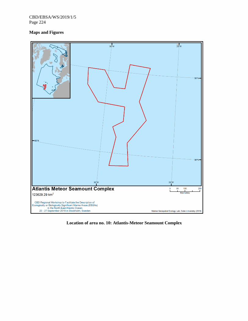
CBD/EBSA/WS/2019/1/5
Page 224
Maps and Figures
Location of area no. 10: Atlantis-Meteor Seamount Complex
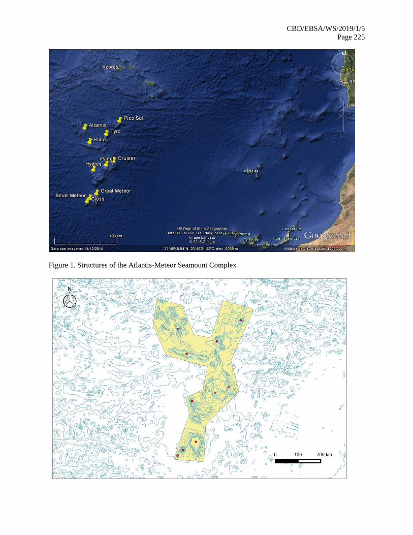
CBD/EBSA/WS/2019/1/5
Page 225
Figure 1. Structures of the Atlantis-Meteor Seamount Complex
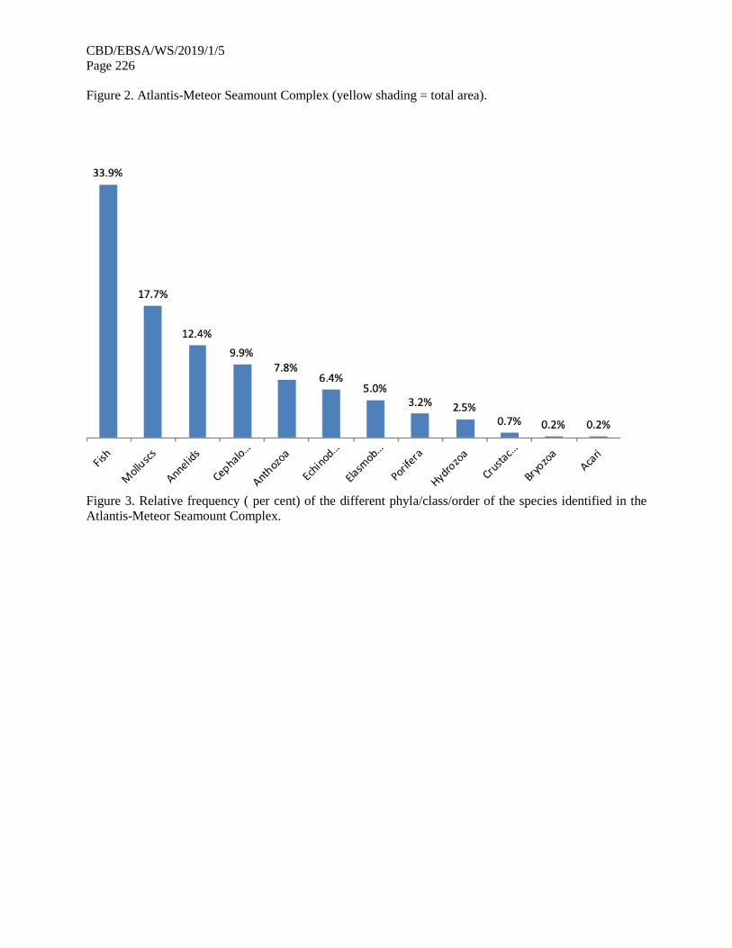
CBD/EBSA/WS/2019/1/5
Page 226
Figure 2. Atlantis-Meteor Seamount Complex (yellow shading = total area).
Figure 3. Relative frequency ( per cent) of the different phyla/class/order of the species identified in the
Atlantis-Meteor Seamount Complex.
CBD/EBSA/WS/2019/1/5
Page 227
Area no. 11: Ridge South of the Azores
Abstract The Ridge South of the Azores encompasses the axial valley and ridge crests of the Mid-Atlantic Ridge,
from the Menez Gwen hydrothermal vent field area to the Haynes fracture zone. At the east ridge crest,
the area includes part of the Alberto Monaco Ridge and seamount-like features associated with the
western portions of the ridge. The area includes three high-seas marine protected areas (part of the
OSPAR Network of Marine Protected Areas) – Lucky Strike, Menez Gwen and Rainbow vent fields. The
features in this area are both hotspots of marine life and areas of enhanced productivity when compared
with surrounding bathyal and abyssal areas. The hydrothermal temperatures range between 10ᵒ C (Menez
Hom and Saldanha) and 362ᵒ C (Rainbow). The area also includes other seafloor features at the ridge
crest that host sponge aggregations, cold-water corals and other charismatic fauna.
Introduction
This area encompasses a part of the Ridge South of the Azores, with different features such as the axial
valley, ridge crests and several hydrothermal vent fields, either active or inferred. The area is bordered at
the north by the Menez Gwen hydrothermal vent field area and at the south by the Haynes fracture zone.
At the east ridge crest, this area incorporates part of the Alberto Monaco Ridge and the seamount-like
features associated with the ridge at its west. The area also includes three high-seas marine protected
areas (part of the OSPAR Network of Marine Protected Areas) –Lucky Strike, Menez Gwen and Rainbow
vent fields. This area has structures at depths ranging from the deepest 3460 m (inferred depth – south
Oceanographer FZ), to the mid-range at 2320 m (measured depth – Rainbow), to the shallowest at Albert
Monaco Ridge. The hydrothermal temperatures range between 10ᵒ C (Menez Hom and Saldanha) and
362ᵒ C (Rainbow). The uniqueness of each vent, due to the diversity of hydrothermal settings, the depth
range and water mass distribution over oceanic ridge crests, significantly influences biomass production
rates in the vicinity of these areas (LeBris et al., 2019).
The presence of a mid-ocean ridge with a truncated water column disrupts the general oceanographic
circulation, potentially creating regions of high biomass that may arise from topographic influences on
water circulation (St Laurent and Thurnherr 2007), upwelling nutrient-rich deep water as well as
concentrating biomass over summits, creating mid-ocean regions of high productivity (Priede et al, 2013).
Knowledge of the Ridge South of the Azores area is based on the analysis of more than 500 scientific
articles. Several of the structures are well known and have been the subject of a great number of
geological and biological studies. The total number of hydrothermal vent species reported was estimated
from scattered taxonomical literature and online species database. The species total derived, 342, is
probably an underestimate.
A large number of species living in the area were discovered or described relatively recently (around 40
per cent of the species in the last 30 years), and a great many of them have their distribution restricted to
the hydrothermal vents. The species studied in this area are in the larger majority dependent on the carbon
produced at the hydrothermal vents, with the symbiotrophic species living closer to the fluid exits, and
then a zonation with decreasing dependence, but always on the sphere of the increased production and
chemical balance of the vents (Levin et al, 2016). There is no legislation or protection figure for the
species, except for the sharks surrounding this area. Of the 342 species, shark species (Centrophorus
squamosus, Centroscymnus coelolepis and Centrophorus granulosus) are the only three protected under
the OSPAR Convention. Among the benthos, several species are indicators of Vulnerable Marine
Ecosystems, namely the cold-water corals Lophelia pertusa and Madrepora oculata at the Menez Gwen,
and several dispersed anthipatharian corals observed on the inactive structures at the outskirts of the vent
fields and on the pillow lavas (Colaço pers. obs Tempera et al, 2013). At the Ridge crests and associated
seamounts, which remain very poorly explored, the global habitat suitability models and distribution
maps for the North Atlantic modelled the distribution of seven suborders of Octocorallia (Yesson et al.
2012) and five species of framework-forming scleractinian corals (Davies & Guinotte 2011). Both studies
revealed the areas as containing important suitable habitats for these taxa.
CBD/EBSA/WS/2019/1/5
Page 228
Location
The Ridge South of the Azores is located in the Atlantic Ocean, south of the Azores. This area has
structures at depths ranging from 3460 m (inferred depth – south Oceanographer FZ), to the mid-range at
2320 m (measured depth – Rainbow), to the shallowest at Albert Monaco Ridge. The datum used is
World Geodetic System 1984 (WGS84).
Feature description of the area
Cold-water coral reefs, gardens, sponge grounds and massive sponges support and enhance highly diverse
benthic communities, comprising faunal biomass that is orders of magnitude above that of the
surrounding seafloor (Henry and Roberts, 2007; Roberts et al., 2008; Lindsay et al., 2013). The
composition of megafauna also significantly differs between sponge grounds and non-sponge grounds
and between different sponge morphologies (Lindsay et al., 2013).
Since the discovery of the first hydrothermal vent field in 1977, an increasing number of fields have been
found, all with different characteristics. However, there is still very little known about most of the 50,000
km of ocean ridges (Charlou et al., 2002; Kelley et al., 2002; Hein et al., 2013; https://vents-
data.interridge.org/).
As tectonic plates separate in the ridge areas, magma migrates in the subsurface and erupts at the seafloor.
Due to rock deformation, seawater penetrates to great depth before it is ejected to the seabed, enriched
with dissolved material, especially hydrogen sulfide (H2S), various sulfide minerals, metals, carbon
dioxide (CO2) and methane. Depending on ejection pressure and ambient temperature, crystallization of
the sulfide minerals forms chimneys known as “black” or “white smokers” on the basis of the mineral
colours precipitated (Ohmoto et al., 2006; Gold, 2013).
The species and communities present in this area belong not only to the deep-sea, but also to mid-water
upper bathyal systems. The vents are characterized by extreme conditions with unique physical properties
(temperature, pressure), chemical toxicity and absence of photosynthesis (Edmond et al., 1979; Mottl &
Wheat, 1994; Kadko et al., 1995; Elderfield & Schultz, 1996; Minic et al., 2006). The venting dynamic of
hydrothermal fluids back into the ocean is of major importance as it is associated with enhanced cooling
of the ocean floor, formation of deep-sea mineral deposits, and unique ecosystems that exist around vent
sites in extreme environmental conditions (Lister, 1980; Tufar et al., 1986; Haymon et al., 1989; Fouquet
et al., 1995; Cathles et al., 1997; Boetius, 2005; Kelley et al., 2005; Marques et al., 2007).
The active vents are hosted by a range of different rock types, including basalt, peridotite and felsic rocks.
The associated hydrothermal fluids exhibit substantial chemical variability, which is largely attributable
to compositional differences among the underlying host rocks (Amend et al., 2011). Vent circulation
accounts for approximately one third of the global geothermal heat flux to the oceans and strongly affects
seawater chemical composition (Elderfield & Schultz, 1996). In this area there are many types of
hydrothermal sites: high-temperature (250ᵒ–365ᵒ C) and low pH (<4) sites; metal-rich chimneys (i.e.,
Bubbylon, Lucky Strike, Menez Gwen and Rainbow); and diffuse and pervasive seepages, with
apparently low temperatures (<30ᵒ C), and unknown pH (e.g., Menez Hom and Saldanha) (Barriga et al.,
1998; Charlou et al., 2010). The Lucky Strike, Menez Gwen and Bubbylon are magamatic-hosted, while
Menez Hom and Saldanha are ultramafic-hosted, and Rainbow presents both types (Charlou et al., 2000;
Desbruyères et al., 2000; Fouquet et al, 2010).
In terms of biology, the vent fields also play a primordial role sustaining abundant populations of faunal
species in the deep sea through autochthonous chemosynthetic primary production (e.g., Lutz & Kennish,
1993; Bemis et al., 2012). This process uses reduced compounds (typically hydrogen sulfide, methane or
hydrogen) in vent fluids to fix inorganic carbon (Karl et al., 1980) that can be oxidized by microbes to
release energy for the formation of organic carbon from carbon dioxide, carbon monoxide and/or methane
(Van Dover et al., 2002). The chemosynthetic organisms may be present in the water column, at the
seafloor as microbial mats, within sediments, fractures of crustal rocks or the sub-seabed, or/and in
symbiosis with larger multi-cellular organisms (Dubilier et al., 2008).

CBD/EBSA/WS/2019/1/5
Page 229
Initial microbial colonization facilitates the development and maintenance of densely populated
ecosystems in which both biomass and faunal abundances are larger than is typical at the deep seafloor
(e.g., Lutz & Kennish, 1993; Smith et al., 2008).
Hydrothermal communities have been studied worldwide, leading to the description of more than 400
new species (Desbruyères et al., 2006), greatly enhancing our knowledge of marine biodiversity (Van
Dover et al., 2002). However, knowledge about these animal communities and the biology and ecology of
individual species in these waters remains limited.
This area covers a section of the Mid-Atlantic Ridge (MAR) south of the Azorean archipelago. Five
major vent fields are described here:
1. Rainbow
The Rainbow vent field was discovered in 1997 (German et al., 1996b). It forms a high temperature
(365°C) field of black smokers located on the western flank of the Rainbow massif along the Mid-
Atlantic Ridge (MAR) (German et al.,1996a, 1999; Charlou et al., 1997; Fouquet et al., 1997, 1998). The
hydrothermal vents are localized between 2270 - 2320 m depth in international waters where they
comprise >30 groups of active small sulphide chimneys over an area of 15 km2. There are many inactive
structures among a large number of rather short-lived active venting sites (German et al., 1996b; Charlou
et al., 1997; Fouquet et al., 1997).
Around the site and through the nontransform discontinuity, a relative chronology of normal dip-slip
extensional faulting, the conjugate transtensional faulting and Riedel shears are evident. The western
border of the vent field is a 25 m high fault scarp where extensive stock work mineralization and
replacement of ultramafic rocks by sulfides are observed (Marques et al., 2006; 2007).
Local hydrography and flow regimes dictate that the non-buoyant plume, which reaches neutral buoyancy
at 2100 m depth, disperses following local topography to flow north-eastward, clockwise, along and
around Rainbow ridge and into the adjacent rift valley (German and Parson, 1998; Thurnherr & Richards,
2001; Thurnherr et al., 2002).
At many places within the Rainbow vent field, unusual sediment lithification around the active field and
near the top of the ridge, together with several places with dead mussels, may be related to diffuse low
temperature of methane-rich fluid through the sediment. Similar processes were also proposed at low
temperature Saldanha and Menez Hom sites, where large amounts of methane discharge through the
sediment cover at the top of the ultramafic ridge (Schroeder et al., 2002; Ribeiro da Costa et al., 2008).
Together with the Lucky Strike segment and Menez Gwen vent fields, the Rainbow field forms a group of
northern bathyal vents fields. The underlying basement and vent fluid compositions differ from those in
basalt-hosted systems due in part to serpentinization of the host rocks at Rainbow. Key characteristics of
the Rainbow fluids include high chlorinity (750 mM), low pH (2.8), high methane, and extremely high Fe
concentrations (24 mM), resulting in a Fe/H2S molar ratio of 24 (Charlou et al., 1997; Douville et al.,
2002). The high temperature vents occur along the shoulder of a W-facing hanging wall of the tilted
ultramafic block and are associated with one of the largest hydrothermal plumes in terms of methane
output (Charlou et al., 1996a), manganese (Aballea et al., 1998), sulfide (Radford-Knoery et al., 1998),
helium and heat (Jean-Baptiste et al., 1998), and particles (German et al., 1998).
Since its discovery, Rainbow has been a frequent focus of scientific expeditions and is the only vent field
on the Mid-Atlantic Ridge that has been visited by tourist operators. Scientific investigations have
included long-term monitoring, manipulative experiments and geological sampling (McCaig et al., 2007;
Baker et al., 2010; Crawford et al., 2010).
2. Lucky Strike
The Lucky Strike vent field was discovered in 1993. Since then, this field has been extensively studied,
particularly during expeditions DIVA1 and FLORES, 1994; LUSTRE, 1996; MoMARETO and
Graviluck, 2006; MoMAR, 2008; Bathyluck, 2009 and MoMARSAT 2010 and 2011. It is also the object
CBD/EBSA/WS/2019/1/5
Page 230
of long-term monitoring (e.g., Ballu et al., 2009; Colaço et al., 2011), including a seafloor observatory
(ESONET-EMSO European project) (Ruhl et al., 2011).
Lucky Strike is one of the largest hydrothermal areas known to date, with 21 active chimney sites
distributed over an area of approximately 150,000 m2 at depth range of 1620-1730 m. Despite its
proximity to the Azores hot spot, the Lucky Strike segment exhibits a morphological and tectonic
architecture with many of the characteristics of a slow-spreading ridge. The Lucky Strike segment is
characterized by a well-developed 13–20 km wide axial rift valley, whose depth increases from 1550 m at
the segment center to 3700 m at the nodal basins near the segment ends.
Beyond the rift walls, the seafloor morphology is dominated by fault-controlled abyssal hills (Detrick et
al., 1995). The centre of the segment is dominated by the 8 km wide, 15 km long, and 500 m high Lucky
Strike volcano, one of the largest central volcanoes along the MAR axis. The crust is 7.5 km thick
beneath the volcano and has thinned to less than 5.5 km at 20 km from the segment centre (Crawford et
al., 2010; Seher et al., 2010).
The hydrothermal activity is located on the periphery of the lava lake. Submersible dive programmes
documented the presence of high temperature black smoker chimneys, extensive areas of diffuse flow and
sulfide deposits distributed around the lava lake margins (Fouquet et al., 1994; Langmuir et al., 1997;
Ondreas et al., 2009). The presence of a lava lake at the summit also suggests recent magmatic activity
and the potential for an active magma chamber directly beneath the edifice (Singh et al., 2006).
The physical/chemical qualities of the vent gases and waters are distinct from other MAR sites due to low
sulphur/high methane contents. Vent fluid temperatures range from 330º C in black smokers, to 200-
212ºC and even 20ᵒC in diffuse emissions (Von Damm et al., 1998; Charlou et al., 2000; Cooper et al.,
2000). The larger active edifices exhibit small zones of high temperature discharge. Elsewhere in the
chimneys, discharge is mostly diffuse, as leakage of transparent fluid, through the mussel-covered outer
walls of the chimneys.
The chimneys show clear evidence of oxidation caused by seawater. In the more active chimneys
oxidation is restricted to an outer layer of oxides a few millimeters thick, mainly of iron. Once fluid flow
ceases, oxidation progresses inwards. Primary sulphides are replaced by secondary sulphides and
subsequently by oxides. Chimneys become rapidly friable, fall and break into progressively less
recognizable fragments. Nearly half of the area of the Lucky Strike field is covered with deeply oxidized
chimney debris, with most of the remaining area composed of exposed “slabs” (Barriga & Santos, 2003).
3. Menez Gwen Menez Gwen was discovered in 1991, during submersible dives on the ridge segment north of the Lucky
Strike segment (Fouquet et al., 1994). This segment is characterized by the absence of a central rift and
volcano. Circular in shape, it has a diameter of 17 km and height of 700 m, while at its summit there is an
axial graben, 6 km long, 2 km wide and 300 m deep. At the graben’s northern end there is a new volcano
of 600 m diameter and 120 m height, composed entirely of fresh pillow lavas with no sediment cover.
Menez Gwen is located near the top of this new volcano at the bottom of the graben at 840-870 m depth.
Its hydrothermal fluids are characterized by temperatures ranging between 265ᵒC and 281ᵒC, and these
temperatures mark its characteristic physiochemical diversity and presence of anhydrite and barite. The
vent is in a basaltic environment, and methane is produced by outgassing of carbon from the mantle and is
related to the carbon-enriched character of basalt (Charlou et al., 1997). In addition, the low pH and low
Fe and Si concentrations are consistent with the short duration of fluid-rock interaction linked to a
shallow circulation system (Douville et al., 1999).
This shallow system can be affected by explosive volcanic activity (Fouquet et al., 1999) on an area of
several square kilometres, as disclosed by the distribution of volcanic ejecta on the bottom (ash, sand and
lapilli). According to Fouquet et al. (1994), Menez Gwen is, geologically speaking, very young (probably
a few decades old); its chimneys are very small, growing directly on fresh pillow lava. Its relatively
young age provides an excellent opportunity to monitor the early stages of hydrothermal vent activity and
CBD/EBSA/WS/2019/1/5
Page 231
thus yield new knowledge on the development of vents and their associated animal communities
(Marcon et al., 2013; Sarrazin et al., 2014; Konn et al., 2015). The vent fluids are the least toxic of the
sites along the MAR and make it possible for non-endemic deep-sea species to live here (Desbruyères et
al., 1997; Tunnicliffe et al., 1998; Colaço et al., 1998; 2002).
4. Saldanha
The Saldanha hydrothermal field was discovered in 1998 during the Saldanha Cruise (Barriga et al.,
1998). It is located between the FAMOUS and AMAR second-order segments and consists of a faulted
peridotite massif detached from its segment flanks, almost parallel to the ridge segment. It is composed
mainly of ultramafic and gabbroic rocks and a strong methane anomaly within the overlying water
column (Charlou et al. 1997; Dias & Barriga, 2006).
Although no vent chimneys are present, hydrothermal activity is expressed as discharge of clear fluid
from several small orifices through sediment over an area of at least 50 m2, and micro chimneys with
silica and sulfides have been observed (Dias, 2001; Dias et al., 2002).
The discovery of this diffuse venting confirmed the presence of hydrothermal activity related to
serpentinization processes, which had been inferred from the detection of geochemical (intense CH4)
anomalies in the water column (Charlou et al., 1997; Bougault et al., 1998). During the serpentinization
of the ultramafic rock, overlying rocks were pushed upward, generating the observed mélange of talc-rich
rocks (steatite) and spilite (Costa, 2001; Costa et al., 2002). Diving operations (Fouquet et al., 1997,
2000; Barriga et al., 1998) revealed intensely altered and locally silicified ultramafic and basaltic rocks
consistent with low magma budgets, relatively thin crust and irregular faulting patterns (Gràcia et al.
2000) at the top of the massif. Discrete low-temperature diffuse discharge (<6°C) from the sediment was
observed near the top of the structure (Biscoito et al., 2006).
Studies to date have discovered that the site is hosted in a mélange of folded lithified sediment, relatively
fresh to deeply altered basalt, variably deformed ultramafic rocks and some gabbroic rock, in large part
covered by sedimentary ooze. The ensemble is interpreted as resulting from active serpentinite protrusion.
Sulphide precipitation is taking place within the top of the rock pile, under a blanket of sediment (Dias,
2001; Barriga 2003).
5. Menez Hom
Like the Saldanha, the Menez Hom ultramafic dome is situated at an inside corner position relative to the
non-transform offset at the south of the Lucky Strike segment. Diving operations have revealed the
general outcrop of ultramafic rocks at the top of the dome. No active vents were seen. However, one
small carbonate chimney was sampled and anomalous rapid lithification of the sediment covers was
observed at the northern side of the dome, near the limit between the ultramafic rocks and the basalt
coverage. This may indicate a preferential discharge of diffuse low-temperature CH4-rich fluids at the
contact between the ultramafic and the basalt cover (Fouquet et al., 2010).
There are two attributes in common to the deep-sea hydrothermal systems in the area described: their
insularity and their gradient regimes of fluid flow and chemistry suggested a priori that measures of
community structure and similarity at vents would be especially sensitive to the degree of proximity
between sites being compared, to the age of the sites and to within-site heterogeneity (Mullineaux &
France, 1995, Marsh et al. 2001, Van Dover et al. 2001). These different vent characteristics “create”
distinct habitats dominated by different chemosynthetic bacterial mats, and endemic and non-endemic
species of tubeworms, mussels, gastropods, clams, shrimp and crabs. In turn these habitats support further
associated invertebrate and vertebrate species.
The majority of organisms found in this area developed different strategies to adapt to its extreme
environments, e.g., biological stabilization of metal (e.g., iron, copper) from hydrothermal vents under
dissolved or colloidal organic (Wu et al., 2011; Hawkes et al., 2013). In the absence of photosynthesis,
the food chain is based on primary production of energy and organic molecules by chemolithoautotrophic
bacteria. Hydrothermal vent plumes sustain rich microbial communities with potential connections to
CBD/EBSA/WS/2019/1/5
Page 232
zooplankton communities and important deep ocean biogeochemical fluxes (Dick et al., 2013). These
microbial communities extract chemical energy starting from the oxidation of reduced mineral
compounds (Minic et al., 2006; Boetius & Wenzhöfer, 2013). Studies in community hydrothermal
evolution, initial colonization, growth, development and demise, show that colonization at vents is rapid
(Lutz et al. 1994, Tunnicliffe et al. 1997, Shank et al. 1998).
The area has an uneven number of studies for its different structures. Nevertheless, there are many studies
focused on the communities and species of these structures. To date a total of 342 species have been
identified within this area (see “introduction”).
Feature condition and future outlook of the area
Since the discovery of this area, most studies have been qualitative and often focus on specific taxonomic
groups, such as amphipods (e.g Myers and Cunha, 2004; Bellan-Santini et al., 2007), cirripeds (e.g.,
Young, 1998; 2001), Copepoda (e.g., Ivaneko and Defaye., 2004; Komai & Segonzac, 2005; Komai &
Chan, 2010), Cumeacea (e.g., LeBris et al., 2000; Corbera et al., 2008), echinoderms (e.g., Stöhr &
Segonzac, 2005), elasmobranchii (e.g., Biscoito et al., 2002; Biscoito, 2006; Linz, 2006), mussels (e.g.,
Colaço et al., 2006a; Duperron et al., 2006; 2013), polychaeta (e.g., Desbruyères & Hourdez, 2000;
Hourdez & Desbruyères, 2003), shrimps (e.g., Shank & Martin, 2003; Nye et al., 2012) and tanaidacean
(Larsen et al., 2006). Most research cruises that have visited the area were focused in the deep-sea
hydrothermal vent fields south of the Azores (i.e., Menez Gwen, Lucky strike, Rainbow and Saldanha),
that were part of the MoMAR concept (“Monitoring the Mid-Atlantic Ridge”). The OSPAR MPAs
(Lucky Strike, Menez Gwen and Rainbow) have a higher number of scientific articles and reports, and
consequently are thus far the best studied. The vent fields inside the NAFO/NEAFAC areas were also
subject to ICES report of the WGDEC (Working Group on Deep-Water Ecology) (Auster et al., 2013).
Studies have also focused on the distribution of species (e.g., Cuvelier et al, 2011a; Sarrazin et al, 2015 ),
temporal evolution (Cuvelier et al, 2011b), foodwebs (Colaço et al., 2002; 2007, De Busserolles et al.,
2009, Portail et al., 2018), physiology (e.g., Bettencourt et al., 2010; Martins et al., 2008; Husson et al.,
2016), reproduction (e.g., Colaço et al., 2006a; Dixon et al., 2006), ecotoxicological aspects (e.g., Colaço
et al., 2006b; Martins et al., 2009, 2011; Company et al., 2008), behaviour (Matabos et al., 2015) and
microbiology (Crepeau et al., 2011 and references therein).
The dissolved constituents of the venting fluids of the hydrothermal vents play an important role in the
geochemical mass balance of the oceans (Levin et al, 2016 and references therein). The unusual nature of
the marine communities that occur around hydrothermal vents makes them particularly important areas in
terms of the biodiversity of the deep sea as well as being a focus for deep-sea research. This type of
ecosystem is sensitive because of its high percentage of endemic species and the unique nature of many of
the species found there (e.g., Vrijenhoek, 2010; Ramirez-Llodra et al., 2011; VanDover et al., 2018).
There is a biological balance in the vents. Well documented examples of biological interactions are
predation and competition, based, for instance, on trophic (e.g., access to hydrogen sulfide or other
resources) and topographic (optimal positioning on the structure or limitation on available space) grounds
(Hessler et al., 1985; Fustec et al., 1987; Comtet and Desbruyères, 1998; Colaço et al., 2002; 2007, Riou
et al., 2008, 2010a,b, deBusserolles et al., 2009, Portail et al., 2018, Sarrazin et al., 2015, Cuvelier et al.,
2011).
All five (Menez Gwen, Lucky Strike, Menez Hom, Saldanha and Rainbow) hydrothermal vent fields are
included in the Azores Marine Park, created in 2007 and expanded in 2016. Lucky Strike, Menez Gwen
and Rainbow are included in the OSPAR Network of Marine Protected Areas. Lucky Strike and Menez
Gwen have been a part of the Natura 2000 network since 2009. All fields are classified under the reef
habitat type of the EU Habitats Directive. Lucky Strike and Menez Gwen (MPAs) are also recognized by
WWF as a Gift to the Earth (GttE).
The areas comprising the Azores Marine Park, and all the regional protected areas beyond the territorial
sea, are classified under IUCN criteria. Lucky Strike (288 km2) and Menez Gwen (95 km
2) have zoning
plans ranging from “full protection” (Category 1) to “sustainable exploitation” (Category IV and VI),
CBD/EBSA/WS/2019/1/5
Page 233
while Rainbow, a smaller vent field, is classified under IUCN Category IV. Lucky Strike has also been
selected as a target field for the installation of the long-term seafloor former MoMAR observatory, and
now EMSO-Azores (Santos et al., 2002; Person et al., 2008; Colaço et al., 2012).
The Contracting Parties to OSPAR Convention committed themselves to establish an ecologically
coherent network of MPAs in the OSPAR Maritime Area by 2010 (the OSPAR Network of Marine
Protected Areas). The regional delivery mechanism is based on Annex V to the OSPAR Convention. The
first national MPA designated under the high seas is the Rainbow vent field, located in the High Seas
sector of the OSPAR Maritime Area (Santos and Colaço, 2010; Ribeiro, 2010).
Assessment of area no. 11, Ridge South of the Azores, against CBD EBSA Criteria
CBD EBSA
Criteria
(Annex I to
decision
IX/20)
Description
(Annex I to decision IX/20) Ranking of criterion relevance
(please mark one column with an X)
No
informat
ion
Low Medi
um
High
Uniqueness
or rarity
Area contains either (i) unique (“the only one
of its kind”), rare (occurs only in few
locations) or endemic species, populations or
communities, and/or (ii) unique, rare or
distinct, habitats or ecosystems; and/or (iii)
unique or unusual geomorphological or
oceanographic features.
X
Explanation of ranking
The Ridge South of the Azores has:
1-Deep-sea vents, which represent one of the most physically and chemically unusual biomes on Earth
(Takai & Nakamura, 2011).
2-The hydrothermal vents of the North MAR may represent a unique biogeographic region of invertebrate
species (Van Dover, 2010). They have relatively high proportions of endemic species (Tunnicliffe &
Fowler, 1996; VanDover et al, 2018) that cannot live anywhere else, dominated by the blind shrimp
Rimicaris exoculata and the mussel Bathymodiolus azoricus (Desbruyères et al., 2001).
3-The uniqueness of each vent, due to the diversity of hydrothermal settings, the depth range and water
mass distribution over oceanic ridge crests, significantly influences biodiversity and species composition
(VanDover et al., 2018). The hydrothermal biota are characterized also by a high level of endemism, with
common specific lineages at the family, genus and even species level, as well as the prevalence of
symbioses between invertebrates and bacteria (Dubilier et al., 2008; Kiel, 2010).
4-In addition to the endemic vent fauna, there are also several topographical elevations associated with
the flanks of the MAR, with reported endemic cold-water corals in the region of the Azores (Braga-
Henriques et al., 2013; de Matos et al 2014; Sampaio et al., 2019), including a species of black coral
(Heteropathes opreski)that is known exclusively from the North MAR south of Azores at depths of
1,955–2,738 m at the Oceanographer fracture zone, (de Matos et al, 2014, Molodtsova, 2016).
5- The vent communities are unique, and the species living in these areas have specialized adaptations.
Such features allow the organisms to exploit vent habitats, endowed with major reorganization of internal
tissues and physiologies to house microbial symbionts, biochemical adaptations to cope with sulphide
poisoning, behavioral and molecular responses to high temperature, presence of metal-binding proteins
and development of specialized sensory organs to locate hot chimneys (Tunnicliffe et al., 1998).
Special
importance
for life-
history stages
Areas that are required for a population to
survive and thrive. X
CBD/EBSA/WS/2019/1/5
Page 234
of species
Explanation of ranking
1-Most of the organisms colonizing these habitats are invertebrates and have larval stages that are subject
to dispersal in an open system, although mechanisms of larval retention are developed to account for the
large settlement events observed (Mullineaux & France 1995, Marsh et al. 2001, Van Dover et al. 2001).
2-The dominant symbiotrophic species span late winter so their planktotrophic larvae can eventually
profit from the increased productivity in the marine environment each spring (Colaço et al, 2006a; Dixon
et al. 2006).
3-Connectivity among vent fields is poorly known, with just two or three studies showing that there are
genetic exchanges, however without knowledge of the time it takes for the exchanges to take place
(Teixeira et al., 2012, Breusing et al., 2016)
4-Blue shark nursery at the Central North Atlantic, roughly delimited by the Azores archipelago in the
North, the Atlantis–Great Meteor seamount complex in the South and the Mid-Atlantic Ridge in the
South-West (Vandeperre et al., 2014)
5- Several species of seabirds use these areas as foraging grounds during their breeding (e.g., Calonectris
borealis, Puffinus lherminieri baroli, Pterodroma deserta, Pterodroma madeira, Bulweria bulwerii) or
non-breeding season (Calonectris diomedea, Puffinus puffinus, Rissa tridactyla, Catharacta maccormicki,
Catharacta skua and Stercorarius longicaudus) (BirdLife International 2019).
6-Corals and sponges of topographic highs (e.g., Albert de Monaco Ridge) also serve as important
spawning, nursery, breeding and feeding areas for a multitude of fishes and invertebrates (Pham et al.
2015, Pereira et al. 2017, Porteiro et al., 2013 Ashford et al., 2019).
Importance
for
threatened,
endangered
or declining
species
and/or
habitats
Area containing habitat for the survival and
recovery of endangered, threatened, declining
species or area with significant assemblages of
such species.
X
Explanation of ranking
1- The area contains one threatened and/or declining habitat, contained in the OSPAR List (OSPAR
publication 2008/358): Oceanic ridges with hydrothermal vents/fields (OSPAR, 2014).
2-Cold-water coral species of the order Antipatharia (e.g., black corals Leiopathes sp, Bathypathes sp),
Scleractinia (e.g., reef-building corals Lophelia pertusa, Madrepora oculata) and family Stylasteridae
(e.g., Errina spp, Stylaster spp), are listed under CITES Appendix II
(https://www.cites.org/eng/app/appendices.php). Many of these habitats, including the cold-water coral
gardens and sponge aggregations, sea-pen and burrowing megafauna communities, as well as oceanic
ridges with hydrothermal vents and seamounts are all listed on the OSPAR List of Threatened and/or
Declining Species and Habitats (OSPAR 2009; 2010a.,b,c,d).
3- The occurrence of three species under OSPAR legal protection was recorded in the area: Centrophorus
granulosus, Centrophorus squamosus and Centroscymnus coelolepis. These three shark species are
included in the OSPAR list of Threatened and/or Declining Species and Habitats (BDC/MASH, 2007).
4-Four globally threatened seabird species occur in the area - Rissa tridactyla (VU), Pterodroma deserta
(VU), Pterodroma madeira (EN) and the OSPAR listed Puffinus lherminieri baroli (BirdLife
International 2019).
Vulnerability Areas that contain a relatively high proportion X

CBD/EBSA/WS/2019/1/5
Page 235
, fragility,
sensitivity, or
slow
recovery
of sensitive habitats, biotopes or species that
are functionally fragile (highly susceptible to
degradation or depletion by human activity or
by natural events) or with slow recovery.
Explanation of ranking
1-The Mid-Atlantic Ridge is a slow-spreading ridge, and hydrothermal vents are estimated to be up to
thousands of years of age, although possibly not active continually. However, some of the individual
vents are only short-lived naturally. In this case, non-consolidated structures that cannot support
eukaryote life are formed easily. Therefore, the vent fields in the area described are relatively stationary in
position, but dynamic regarding the individual smokers and long-term activity (Hannington et al., 1995).
2- Time series studies over 14 years show that these communities are stable over time, and that big
changes might disrupt the stability (Copley et al., 2007; Cuvelier et al., 2011). The occurrence of three
species under OSPAR legal protection was registered in the area: Centrophorus granulosus,
Centrophorus squamosus and Centroscymnus coelolepis. These species have particular features attending
to biological factors such as longevity, low fecundity, and slow growth rates characteristic to these shark
species (e.g., Clark, 2001; Morato et al., 2008).
3-Cold-water corals have life history traits such as slow growth, high longevity, low reproductive
potential (Clark et al 2016; 2019). Octocorals and black corals, which dominate benthic assemblages in
the MAR region, have growth rates of less than 1 cm a year and age spans of hundreds of years (e.g.,
bamboo coral Keratoisis sp. : Watling et al., 2011) to thousands of years (black coral Leiopathes sp.
Roark et al., 2009, Carreiro-Silva et al., 2013).
5-Although age estimates for sponge species are scarce, they suggest multi-centennial age spans, e.g., 220
and 440 years (Leys and Lauzon, 1998; Fallon et al., 2010), whereas some sponge reefs are estimated to
be up to 9,000 years old (e.g., Krautter et al., 2001).
Biological
productivity
Area containing species, populations or
communities with comparatively higher
natural biological productivity.
X
Explanation of ranking
1- The presence of a mid-ocean ridge with a truncated water column disrupts the general oceanographic
circulation, potentially creating regions of high biomass that may arise from topographic influences on
water circulation (St Laurent and Thurnherr 2007) upwelling nutrient-rich deep water as well as
concentrating biomass over summits creating mid ocean regions of high productivity (Priede et al., 2013).
2-In the vent biotopes, there is local primary production of energy and organic molecules by
chemolithoautotrophic bacteria (Synnes, 2007; Le Bris et al., 2016).
3-. Hydrothermal vents are involved in the biogeochemical cycling and elemental transformation of
carbon, sulfur, and nitrogen (Petersen et al., 2011; Lilley et al., 1995; Sievert and Vetrini, 2012) and
contribute to the huge diversity of deep-sea organisms and habitats.
4- This ecosystem enhances trophic and structural complexity relative to the surrounding deep sea and
provides the setting for complex trophic interactions (e.g., Colaço et al., 2007; Portail et al., 2017). The
chemosynthetic productivity from vents is exchanged with the nearby deep-sea environments, providing
labile organic resources to benthic and pelagic ecosystems that otherwise have limited availability of food
(Levin et al., 2016).
5-Organic matter produced at vent complexes, with metals such as iron or copper released from vents
with organic ligands (Bennett et al., 2008; Hoffman et al., 2018), is spread with the buoyant plume,
contributing to the global ocean micronutrient budgets (Tagliabue et al., 2010; Resing et al., 2015).
6- The hydrothermal fluids are rich in iron (Charlou et al,2010 Le Bris et al, 2019). Recent assessments of
these iron sources indicate their significance for deep-water budgets at oceanic scales and underscore the
CBD/EBSA/WS/2019/1/5
Page 236
possibility for fertilizing surface waters through vertical mixing in particular regional settings (Tagliabue
et al., 2010) and supporting long-range organic carbon transport to abyssal oceanic areas (German et al.,
2015).
7- Both cold-water coral communities and sponge grounds are important for global biogeochemical
cycles and the ocean’s benthic pelagic coupling loop, being responsible for nearly 30 per cent of the
coupling between organic matter produced at the ocean surface and the seafloor (Cathalot et al., 2015).
They represent hotspots of ecosystem functioning, processing substantial amounts of organic matter
(White et al., 2012; Cathalot et al., 2015), and release nutrients back into the surrounding water (Van
Oevelen et al., 2009; Cathalot et al., 2015) that become available to associated fauna, thereby potentially
increasing overall biodiversity and biological productivity of these habitats.
Biological
diversity
Area contains comparatively higher diversity
of ecosystems, habitats, communities, or
species, or has higher genetic diversity.
X
Explanation of ranking
1-Fauna associated with vents are characterized by a high degree of specialization and relatively high
productivity and species abundances compared with the surrounding deep sea. However, slow-spreading
ridges, such as the MAR, that are present in the area, present the highest species diversity found at vent
communities (Dubilier et al., 2008; Bernardino et al., 2012).
2-The adjacent bathyal and abyssal areas are characterized by low biomass and high diversity. During
recent years, new exploration led to new discoveries. Around 60 different habitats are identified by the
European Nature Information System (EUNIS) (Tempera et al., 2013).
3-Cold-water coral reefs, gardens and sponge grounds support and enhance a highly diverse community,
comprising faunal biomass that is orders of magnitude above that of the surrounding seafloor (Henry and
Roberts, 2007; Roberts et al., 2008; Lindsay et al, 2013). The composition of megafauna significantly
differed between sponge grounds and non-sponge grounds and between different sponge morphologies
(Lindsay et al., 2013).
Naturalness Area with a comparatively higher degree of
naturalness as a result of the lack of or low
level of human-induced disturbance or
degradation.
X
Overall the naturalness of the described area is classified as high, as it is located in a relatively remote
area.
References Aballea, M., Radford-Knoery, J., Appriou, P., Bougault, H., Charlou, J., Donval, J., Etoubleau, J.,
German, C. & Miranda, M. (1998). Manganese distribution and behavior in the water column
near the Azores Triple Junction along the Mid-Atlantic Ridge and in the Azores domain. Deep-
Sea Research, 45(8): 1319–1338.
Amend, J., McCollom, T., Hentscher, M. & Bach, W. (2011). Catabolic and anabolic energy for
chemolithoautotrophs in deep-sea hydrothermal systems hosted in different rock types.
Geochimica et Cosmochimica Acta, 75(19): 5736–5748.
Ashford, O. S., Kenny, A. J., Barrio Froján, C. R., Downie, A., Horton, T., & Rogers, A. D. (2019). On
the influence of Vulnerable Marine Ecosystem habitats on peracarid crustacean assemblages in the
Northwest Atlantic Fisheries Organisation Regulatory Area. Frontiers in Marine Science, 6, 401.
DOI - 10.3389/fmars.2019.00401
Auster, P.J.; Bergstad, O.A.; Brock, R.; Colaco, A.; Duran Munoz, P.; Ellwood, H.; Golding, N.; Grehan,
A.; Hall-Spencer, J.; Howell, K.; Ingels, J.; Kenchington, E.; McIntyre, F.; Monot, L.; Mortensen,
P.B.; Neat, F.; Nieto-Conde, F.; Pinto, C.; Ross, S.; Vinnichenko, V.; Watling, L. (2013) Report
CBD/EBSA/WS/2019/1/5
Page 237
of the ICES\ NAFO Joint Working Group on Deep-water Ecology (WGDEC), 11–15 March
2013, Floedevigen, Norway.
Baker, E. & German, R. (2004). On the global distribution of hydrothermal vent fields, in Mid-Ocean
Ridges: Hydrothermal Interactions between the Lithosphere and Oceans. Geophysical
Monograph, 148: 245–266.
Baker, M., Ramirez-Llodra, E., Tyler, P., German, C., Boetius, A., Cordes, E., Dubilier, N., Fisher, C.,
Levin, L., Metaxas, A., Rowden, A., Santos, R., Shank, T., Van Dover, C., Young, C. & Warén,
A. (2010). Biogeography, Ecology, and Vulnerability of Chemosynthetic Ecosystems in the Deep
Sea, in: McIntyre, A. (Ed.), Life in the World’s Oceans. Wiley-Blackwell, Oxford, UK, pp. 161–
182.
Ballu, V., Ammann, J., Pot, O., De Viron, O., Sasagawa, G., Reverdin, G., Bouin, M., Cannat, M.,
Deplus, C., Deroussi, S., Maia, M. & Diament, M. (2009). A seafloor experiment to monitor
vertical deformation at the Lucky Strike volcano, Mid-Atlantic Ridge. Journal of Geodesy, 83(2):
147-159.
Barriga, F. & Santos, R. (2003). The MOMAR area: A prime candidate for development of a seafloor
observatory. SSC 2003 - 3rd International Workshop on Scientific Use of Submarine Cables and
Related Technologies, 259–262.
Barriga, F. (2003). Hydrothermal activity at the Mid-Atlantic Ridge in the Azores Region: Lessons
concerning old massive sulphide deposits. Vulcanica, I:1–16.
Barriga, F., Fouquet, Y., Almeida, A., Biscoito, M., Charlou, J., Costa, R., Dias, A., Marques, A., Olu, K.,
Queiroz, M. & Porteiro, F. (1998). Discovery of the Saldanha hydrothermal field on the
FAMOUS segment of the MAR (36ᵒ 30′ N). Eos, Transactions, American Geophysical Union,
79: 67.
Bellan-Santini, D. (2007). New amphipods of hydrothermal vent environments on the Mid- Atlantic
Ridge, Azores Triple junction zone. Journal of Natural History, 41(9-12): 567-596.
Bemis, K., Lowell, R. & Farough, A. (2012). Diffuse Flow On and Around Hydrothermal Vents at Mid-
Ocean Ridges. Oceanography, 25(1): 182–191.
Bennett, S., Achterberg, E., Connely, D., Statham, P., Fones, G. & German, C. (2008). The distribution
and stabilization of dissolved Fe in deep-sea hydrothermal plumes. Earth and Planetary Science
Letters, 270: 157–167.
Bernardino, A., Levin, L., Thurber, A. & Smith, C. (2012). Comparative composition, diversity and
trophic ecology of sediment macrofauna at vents, seeps and organic falls. PLoS ONE, 7(4):
e33515.
Bettencourt, R.; Costa, V.; Laranjo, M.; Rosa, D.; Pires, L.; Colaço, A.; Lopes, H,; Serrão Santos, R.
(2010) Out of the Deep-sea into a land-based aquarium environment: Investigating physiological
adaptations in the hydrothermal vent mussel Bathymodiolus azoricus. ICES Journal of Marine
Science 68 (2):357-364.
BirdLife International (2019). The Seabird Tracking Database. www.seabirdtracking.org
Biscoito, M. (2006). Chordata, Chondrichthyes & Osteichthyes. Handbook of deep-sea hydrothermal
vent fauna. Denisia, pp 489-490.
Biscoito, M., Almeida, A. & Segonzac, M. (2006). Preliminary biological characterization of the
Saldanha hydrothermal field at the Mid-Atlantic Ridge (36 degrees 34'N, 32 degrees 26'W, 2200
m). Cahiers de biologie marine, 47(4): 421-427.
Biscoito, M., Segonzac, M., Almeida, A., Desbruyeres, D., Geistdoerfer, P., Turnipseed, M. & Van
Dover, C. (2002). Fishes from the hydrothermal vents and cold seeps - An update. Cahiers de
Biologie Marine, 43(3-4): 359-362.
Boetius, A. & Wenzhöfer, F. (2013). Seafloor oxygen consumption fuelled by methane from cold seeps.
Nature Geoscience, 6: 725–734.
Boetius, A. (2005), Lost city life. Science, 307(5714): 1420–1422.
Bougault, H., Aballéa, M., Radford-Kronery, Charlou, J., Jean Baptiste, J., APPRIOU, P., Needham, H.,
German, C. & Miranda, M. (1998) - FAMOUS and AMAR segments on the Mid-Atlantic Ridge:
CBD/EBSA/WS/2019/1/5
Page 238
ubiquitous hydrothermal Mn, CH4, δ3He signal along the valley walls and rift offsets. Earth and
Planetary Science Letters, 161: 1-17.
Braga-Henriques, A., Porteiro, F. M., Ribeiro, P. A., Matos, V. D., Sampaio, Í., Ocaña, O., & Santos, R.
S. (2013). Diversity, distribution and spatial structure of the cold-water coral fauna of the Azores
(NE Atlantic). Biogeosciences, 10(6), 4009-4036.
Breusing C., Biastoch, A., Drews, A., Metaxas, A., Jollivet, D., Vrijenhoek, R.C., Bayer, T., Melzner, F.,
Sayavedra, L., Petersen, J.M., Dubilier, N., Schilhabel, M.B., Rosenstiel, P, Reusch, T.B.H, 2016.
Biophysical and population genetic models predict presence of "phantom" stepping stones
connecting Mid-Atlantic Ridge vent ecosystems. Current Biology 26, 2257-2267.
http://dx.doi.org/10.1016/j.cub.2016.06.062
Canales, J. P., R. A. Dunn, R. Arai, and R. A. Sohn (2017), Seismic imaging of magma sills beneath an
ultramafic-hosted hydrothermal system, Geology, 45, 447-450, doi:10.1130/G38795.1.
Cathalot, C. C., Van Oevelen, D., Cox, T. J. S., Kutti, T., Lavaleye, M. S. S., Duineveld, G. C. A., et al.
(2015). Cold-water coral reefs and adjacent sponge grounds: hotspots of benthic respiration and
organic carbon cycling in the deep sea. Frontiers in Marine Science 2, 1–12.
doi:10.3389/fmars.2015.00037.
Cathles, L., Erendi, A. & Barrie, T. (1997). How long can a hydrothermal system be sustained by a single
intrusive event?. Economic Geology and the Bulletin of the Society of Economic Geologists,
92(7–8): 766–771.
Charlou, J., Bougault, H., Fouquet, Y., Donval, J., Douville, E., Radford-Knoery, J., Aballea, M.,
Needham, H., Jean-Baptiste, P., Rona, P., Langmuir, C. & German, C. (1996a) Methane
degassing, hydrothermal activity and serpentinization between the Fifteen Twenty fracture zone
area and the Azores Triple Junction area (Mid-Atlantic Ridge). Joint Meeting Abstracts, 1(2):
771–772.
Charlou, J., Donval J., Douville, E., Knoery, J., Fouquet, Y., Bougault, H., Jean-Baptiste, P., Stievenard,
M. & Michel, S. (1997). High methane flux between 15° N and the Azores Triple Junction, Mid-
Atlantic Ridge. Eos, Transactions, American Geophysical Union, 78(46): F831.
Charlou, J., Donval, J., Douville, E., Jean-Baptiste, P., Radford-Knoery, J., Fouquet, Y., Dapoigny, A. &
Stievenard, M. (2000). Compared geochemical signatures and the evolution of Menez Gwen (37ᵒ
50′ N) and Lucky Strike (37ᵒ 17′ N) hydrothermal fluids, south of the Azores Triple Junction on
the Mid-Atlantic Ridge. Chemical geology, 171(1): 49-75.
Charlou, J., Donval, J., Fouquet, Y., Jean-Baptiste, P. & Holm, N. (2002). Geochemistry of high H2 and
CH4 vent fluids issuing from ultramafic rocks at the Rainbow hydrothermal field (36ᵒ14’N,MAR).
Chemical Geology, 191(4): 345–359.
Charlou, J., Donval, J., Jean-Baptiste P. & Dapoigny A. (1996). Gases and helium isotopes in high
temperature solutions sampled before and after ODP Leg 158 drilling at TAG hydrothermal field
(26ᵒ N, MAR). Geophysical Research Letters, 23(23): 3491–3494.
Charlou, J., Donval, J., Konn, C., Ondreas, H., Fouquet, Y., Jean-Baptiste, P. & Fourre, E. (2010), High
production and fluxes of H2 and CH4 and evidence of abiotic hydrocarbon synthesis by
serpentinization in ultramafic-hosted hydrothermal systems on the Mid-Atlantic Ridge, in
Diversity of Hydrothermal Systems on Slow Spreading Ocean Ridges. Geophysical Monograph,
188: 321–367.
Clark MR, Bowden DA Rowden AA and Stewart R (2019) Little Evidence of Benthic Community
Resilience to Bottom Trawling on Seamounts After 15 Years. Front. Mar. Sci. 6:63. doi:
10.3389/fmars.2019.00063
Clark, M. & Bowden, D. (2015). Seamount biodiversity: high variability both within and between
seamounts in the Ross Sea region of Antarctica. Hydrobiologia, 761(1): 161-180.
Clark, M. R., Althaus, F., Schlacher, T. A., Williams, A., Bowden, D. A., and Rowden, A. A. (2016). The
impacts of deep-sea fisheries on benthic communities: a review. ICES J. Mar. Sci. 73, i51–i69.
doi: 10.1371/journal.pone.0022588
CBD/EBSA/WS/2019/1/5
Page 239
Colaço A.; Bustamante, P.; Fouquet Y.; Sarradin, P.-M.; Serrão Santos, R. (2006) Bioaccumulation of
Cu, Zn, and Hg in the Azores Triple Junction hydrothermal vent fields food chains. Chemosphere,
65: 2260-2267
Colaço, A., Blandin, J., Cannat, M., Carval, T., Chavagnac, V., Connelly, D., Fabian, M., Ghiron, S.,
Goslin, J., Miranda, J. M., Reverdin, G., Sarrazin, J., Waldmann, C. & Sarradin, M. (2011).
MoMAR-D: a technological challenge to monitor the dynamics of the Lucky Strike vent
ecosystem. ICES Journal of Marine Science, 68: 416–424.
Colaço, A., Desbruyères, D. & Dehairs, F. (2002). Nutritional relations of deep-sea hydrothermal fields at
the Mid-Atlantic Ridge: a stable isotope approach. Deep-Sea Research, 49: 395–412.
Colaço, A., Desbruyeres, D., Comtet, T. & Alayse, A. (1998). Ecology of the Menez Gwen hydrothermal
vent field (Mid-Atlantic Ridge/Azores Triple Junction). Cahiers de Biologie Marines, 39: 237-
240.
Colaço, A., Martins, I., Laranjo, M., Pires, L., Leal, C., Prieto, C., Costa, V., Lopes, H., Rosa, D., Dando,
P. & Serrão-Santos, R. (2006). Annual spawning of the hydrothermal vent mussel, Bathymodiolus
azoricus, under controlled aquarium, conditions at atmospheric pressure. Journal of Experimental
Marine Biology and Ecology, 333(2): 166-171.
Colaço, A.; Dehairs, F.; Desbruyères, D.; Le Bris, N.; Sarradin, P.-M. (2002) The relative availability of
sulphide and methane to mussel symbionts rules the d13C signature of hydrothermal mussels.
Cahiers de Biologie Marine, 43(3-4): 259-262
Colaço, A.; Desbruyères, D.; Guezennec, J. (2007). The use of polar lipid fatty acids to determinetrophic
links in chemosynthetic communities. Marine Ecology, 28(1): 15-24.
Company R.; Serafim, A.; Cosson, R.; Fiala-Médioni, A.; Camus, L.; Colaço, A.; Serrão Santos, R.;
Bebianno, M.J. (2008) Metal antioxidant biochemical responses to long-term copper exposure in
Bathymodiolus azoricus from Menez-Gwen hydrothermal vent. Science of Total Environment,
389(2-3): 407-417.
Comtet, T. & Desbruyères, D. (1998). Population structure and recruitment in mytilid bivalves from the
Lucky Strike and Menez Gwen hydrothermal vent fields (37ᵒ17´N and 37ᵒ50´N on the Mid-
Atlantic Ridge). Marine Ecology Progress Series, 163: 165–177.
Cooper, M., Elderfield, H. & Schultz, A. (2000). Diffuse hydrothermal fluids from Lucky Strike
hydrothermal vent field: Evidence for a shallow conductively heated system. Journal of
Geophysical Research: Solid Earth, 105(B8): 19369-19375.
Copley, J., Jorgensen, P. & Sohn, R. (2007). Assessment of decadal-scale ecological change at a deep
Mid-Atlantic hydrothermal vent and reproductive time-series in the shrimp Rimicaris exoculata.
Journal of the Marine Biological Association of the United Kingdom, 87: 859-867.
Corbera, J., Segonzac, M. & Cunha, M. (2008). A new deep-sea genus of Nannastacidae (Crustacea,
Cumacea) from the Lucky Strike hydrothermal vent field (Azores Triple Junction, Mid-Atlantic
Ridge). Marine Biology Research, 4(3): 180–192.
Costa, R. (2001). Estudo mineralógico e geoquímico da alteração hidrotermal das rochas vulcânicas e
ultramáficas serpentinizadas do monte Saldanha (RMA, Segmento Famous/Amar). Dissertação de
Mestrado thesis, 143 pp., Universidade de Lisboa.
Costa, R., Barriga, F. & Fouquet, Y. (2002). Evidence for a late steatization process at the Saldanha
massif (MAR 36°33′50″N–36°26′W). Thermal Regime of Ocean Ridges and Dynamics of
Hydrothermal Circulation Exploratory Workshop, Italy.
Crawford, W., Singh, S., Seher, T., Combier, V., Dusunur, D. & Cannat M. (2010). Crustal structure,
magma chamber and faulting beneath the Lucky Strike hydrothermal vent field, in Diversity of
Hydrothermal Systems on Slow Spreading Ocean Ridges. Geophysical Monograph, 188: 113–
132.
Crepeau, V., Bonavita, M.A.C., Lesongeur, F., Randrianalivelo, H., Sarradin, P.M., Sarrazin, J., Godfroy,
A., 2011. Diversity and function in microbial mats from the Lucky Strike hydrothermal vent field.
FEMS Microbiology Ecology 76 (3), 524-540.
CBD/EBSA/WS/2019/1/5
Page 240
Cuvelier, D.; Sarradin, P.M.; Sarrazin, J., Colaço, A.; Copley, J.; Desbruyères, D.; Glover, A.; Serrão
Santos, R.; Tyler, P. (2011) Hydrothermal faunal assemblages and habitat characterisation at the
Atlantic Eiffel Tower edifice (Lucky Strike vent field). Marine Ecology, 32: 243-255.
Cuvelier, D.; Sarrazin, J.; Colaço, A.; Copley, J.; Glover, A.; Tyler, P.; Serrão Santos, R.; Desbruyères,
D. (2011) Community dynamics over 14 years at the Eiffel Tower hydrothermal edifice on the
Mid-Atlantic Ridge. Limnology and Oceanography, 56: 1624-1640.
Davies, A. J., & Guinotte, J. M. (2011). Global habitat suitability for framework-forming cold-water
corals. PloS one, 6(4), e18483.
De Busserolles, F., Sarrazin, J., Gauthier, O., Gélinas, Y., Fabri, M.C., Sarradin, P.M., Desbruyères, D.,
2009. Are spatial variations in the diets of hydrothermal fauna linked to local environmental
conditions? Deep Sea Research Part II: Topical Studies in Oceanography 56 (19-20), 1649-1664
de Matos V, Braga-Henriques A, Santos RS, Ribeiro PA (2014) New species of Heteropathes (Anthozoa:
Antipatharia) expands genus distribution to the NE Atlantic. Zootaxa 3827:293–300
Desbruyères, D. & Houdez, S. (2000). A new species of scale-worm (Polychaeta: Polynoidae),
Lepidonotopodium jouinae sp. nov., from the Azores triple junctionon the Mid-Atlantic Ridge.
Cahiers de Biologie Marine, 41(4): 399–405.
Desbruyères, D. & Segonzac, M. (Eds.). (1997). Handbook of deep-sea hydrothermal vent fauna. Editions
Quae.
Desbruyères, D., Biscoito, M., Caprais, J. C., Colaco, A., Comtet, T., Crassous, P., Fouquet, Y.,
Khripounoff, A., Le Bris, N., Olu, K., Riso, R., Sarradin, P. M., Segonzac, M. & Vangriesheim,
A. (2001). Variations in deep-sea hydrothermal vent communities on the Mid-Atlantic Ridge near
the Azores plateau. Deep-Sea Research, I48: 1325–1346.
Desbruyères, D., Hashimoto, J. & Fabri, M. C. (2006). Composition and biogeography of hydrothermal
vent communities in Western Pacific back‐arc basins. Back-arc spreading systems: geological,
biological, chemical, and physical interactions, 215-234.
Detrick, R., Needham, H. & Renard, V. (1995). Gravity anomalies and crustal thickness variation along
Mid-Atlantic Ridge between 33ᵒN and 40ᵒN. Journal of Geophysical Research, 100: 3767-3787.
Dias, A. & Barriga, F. (2006). Mineralogy and geochemistry of hydrothermal sediments from the
serpentinite-hosted Saldanha hydrothermal field (36ᵒ34’N; 33ᵒ26’W) at MAR. Marine Geology,
255: 157-175.
Dias, A. (2001). Sedimentos hidrotermais do Monte Saldanha (crista Médio-Atlântica, Famous/Amar),
Dissertação de Mestrado thesis, 115 pp., Universidade de Lisboa.
Dias, A., Barriga, F. & Fouquet, Y. (2002). Hydrothermal sediments from Saldanha Mount (MAR-
Famous-Amar). Thermal Regime of Ocean Ridges and Dynamics of Hydrothermal Circulation
Exploratory Workshop, Italy.
Dick, G., Anantharaman, K., Baker, B., Li, M., Reed, D. & Sheik, C. (2013). The microbiology of deep-
sea hydrothermal vent plumes: ecological and biogeographic linkages to seafloor and water
column habitats. Frontiers in microbiology, 4: 124.
Dixon, D.; Lowe, D.; Miller, P.; Villemin, G.; Colaço, A.; Serrão-Santos, R.; Dixon, L. (2006) Evidence
for seasonal reproduction in the Atlantic vent mussel Bathymodiolus azoricus, and an apparent
link to the timing of photosynthetic primary production. Journal of Marine Biological Association
of United Kingdom, 86(6): 1363-1371
Douville, E., Bienvenu, P., Chartou, J., Donvan, J., Fouquet, Y., Appriou, P. & Gamo, T. (1999). Yttrium
and rare earth elements in fluids from various deep-sea hydrothermal systems. Geochimica et
Cosmochimica Acta, 63(5): 627-643.
Douville, E., Charlou, J., Oelkers, E., Bienvenu, P., Jove Colon, C., Donval, J., Fouquet, Y., Prieur, D. &
Appriou, P. (2002). The rainbow vent fluids (36ᵒ40’N, MAR): the influence of ultramafic rocks
and phase separation on trace metal content in Mid-Atlantic Ridge hydrothermal fluids. Chemical
Geology, 184: 37–48.
Dubilier, N., Bergin, C. & Lott, C. (2008). Symbiotic diversity in marine animals: the art of harnessing
chemosynthesis. Nature Reviews Microbiology, 6: 725–740.
CBD/EBSA/WS/2019/1/5
Page 241
Duperron, S., Bergin, C., Zielinski, F., Blazejak, A., Pernthaler, A., McKiness, Z. P., DeChaine, E.,
Cavanaugh, C. & Dubilier, N. (2006). A dual symbiosis shared by two mussel species,
Bathymodiolus azoricus and Bathymodiolus puteoserpentis (Bivalvia: Mytilidae), from
hydrothermal vents along the northern Mid-Atlantic Ridge. Environmental Microbiology, 8(8):
1441–1447.
Duperron, S., Gaudron, S., Rodrigues, C., Cunha, M., Decker, C. & Olu, K. (2013). An overview of
chemosynthetic symbioses in bivalves from the North Atlantic and Mediterranean Sea.
Biogeosciences, 10(5): 3241–3267.
Edmond, J., Measures, C., McDuff, R., Chan, L., Collier, R., Grant, B., Gordon, L. & Corliss, J. (1979).
Ridge crest hydrothermal activity and the balances of the major and minor elements in the ocean:
the Galapagos data. Earth and Planetary Science Letters, 46(1): 1-18.
Elderfield, H. & Schultz, A., 1996. Mid-Ocean ridges hydrothermal fluxes and the chemical composition
of the ocean. Annual Review of Earth and Planetary Sciences, 24: 191-224.
Fallon, S.J., James, K., Norman, R., Kelly, M. & Ellwood, M.J. 2010. A simple radiocarbon dating
method for determining the age and growth rate of deep-sea sponges. Nuclear Instruments and
Methods in Physics Research, Section B: Beam Interactions with Materials and Atoms. 268(7–8):
1241–1243.
Fouquet, Y., Barriga, F., Charlou, J.., Elderfield, H., German, C., Ondreas, H., Parson, L., Radford-
Knoery, J., Relvas, J., Ribeiro, A., Schultz, A., Apprioual, R., Cambon, P., Costa, I., Donval, J.,
Douville, E., Landure, J., Normand, A., Pelle, H., Ponsevera, E., Riches, S., Santana, H. &
Stephen M. (1998) FLORES diving cruise with the Nautile near the Azores—First dives on the
Rainbow field: hydrothermal seawater/mantle interaction. InterRidge News, 7: 24–28.
Fouquet, Y., Cambon, P., Etoubleau, J., Charlou, J., Ondréas, H., Barriga, F., Cherkashov, G., Semkova,
T., Poroshina, I., Bohn, M., Donval, J., Henry, K., Murphy, P. & Rouxel, O. (2010). Geodiversity
of Hydrothermal Processes Along the Mid‐Atlantic Ridge and Ultramafic‐Hosted Mineralization:
a New Type Of Oceanic Cu‐Zn‐Co‐Au Volcanogenic Massive Sulfide Deposit. Diversity of
hydrothermal systems on slow spreading ocean ridges, 188: 321-367.
Fouquet, Y., Charlou, J., Costa, I., Donval, J., Radford Knoery, J., Pelle, H., Ondreas, H., Lourenço, N.,
Segonzac, M. & Tivey, M. (1994). A detailed study of the Lucky Strike Hydrothermal site and
discovery of a new hydrothermal site: Menez Gwen; preliminary results of the Diva 1 Cruise (5-
29 May, 1994). InterRidge News, 3(2): 14-17.
Fouquet, Y., Charlou, J., Ondreas, H., Knoery, J., Donval, J., Douville, E., Apprioual, R., Cambon, P.,
Pelle, H., Landure, J., Normand, A., Ponsevera, E., German, C., Parson, L., Barriga, F., Costa, I.,
Relvas, J. & Ribeiro, A. (1997) Discovery and first submersible investigations on the Rainbow
hydrothermal field on the MAR (36ᵒ14’N). Eos, Transactions, American Geophysical Union, 78:
832.
Fouquet, Y., Charlou, J., Onréas, H., Radford-Knoery, J., Cambon, P., Barriga, F., Costa, I., Relvas, J.,
Ribeiro, A., German, C. & Parson, L. (2000). Hydrothermal processes in oceanic ultramafic
environments: the Rainbow hydrothermal sulfide deposit. 31st International Geological Congress,
Rio de Janeiro.
Fouquet, Y., Eissen, J., Ondréas, H., Barriga, F., Batiza, R. & Danyushevsky, L. (1999). Extensive
volcanoclastic deposits at the Mid-Atlantic Ridge axis: results of deep-water basaltic explosive
volcanic activity? Terra Nova, 10: 280–286
Fouquet, Y., Ondreas, H., Charlou, J., Donval, J., Radford-Knoery, J., Lourenco, N. & Tivey, M. (1995).
Atlantic Lava Lakes and Hot Vents. Nature. 377: 201.
Fustec, A., Desbruyères, D. & Juniper, S. (1987). Deep-sea hydrothermal vent communities at 13ᵒ N on
the East Pacific Rise: microdistribution and temporal variations. Biological Oceanography, 4:
121–164.
German, C. & Parson, L. (1998). Distributions of hydrothermal activity along the Mid-Atlantic Ridge
interplay of magmatic and tectonic controls. Earth and Planetary Science Letters, 160: 327-341.
German, C., Klinkhamme, G. & Rudnicki, M. (1996a). The Rainbow hydrothermal plume, 36° 15’N.
MAR Geophysical Research Letters, 23: 2979-2982.
CBD/EBSA/WS/2019/1/5
Page 242
German, C., Legendre, L., Sander, S., Niquil, N., Luther, G., Bharati, L., Han, X. & Le Bris, N. (2015).
Hydrothermal Fe cycling and deep ocean organic carbon scavenging: Model-based evidence for
significant POC supply to seafloor sediments. Earth and Planetary Science Letters, 419: 143–
153.
German, C., Parson, L., Bougault, H., Coller, D., Critchley, M., Dapoigny, A., Day, C., Eardley, D.,
Fearn, A., Flewellen, C., Kirk, R., Klinkhammer, G., Landure, J., Ludford, E., Miranda, M.,
Needham, H., Patching, J., Pearce, R., Pelle, H., Radford-Knoery, J., Rouse, I., Scott, J.,
Stoffregen, P., Taylor, P., Teare, D. & Wynar, J. (1996b) Hydrothermal exploration near the
Azores Triple-Junction: Tectonic control of venting at slow-spreading ridges? Earth and
Planetary Science Letters 138(1-4): 93-104.
German, C., Richards, K., Rudnicki, M., Lam, M., Charlou, J. & Party, F. (1998). Topographic control of
a dispersing hydrothermal plume. Earth and Planetary Science Letters, 156(3-4): 267-273.
German, C., Rudnicki, M. & Klinkhammer, G. (1999). A segment-scale survey of the Broken Spur
hydrothermal plume. Deep Sea Research Part I: Oceanographic Research Papers, 46(4): 701-
714.
Gold, T. (2013). The deep hot biosphere: the myth of fossil fuels. Springer Science & Business Media.
Gràcia, E., Charlou, J., Radford-Knoery, J. & Parson, L. (2000). Non-transform offset along the Mid-
Atlantic ridge south of the Azores (38ᵒ N–34ᵒ N): Ultramafic exposures and hosting of
hydrothermal vents. Earth and Planetary Science Letters, 177: 89–103.
Hannington, M., Jonasson, I., Herzig, P. & Petersen, S. (1995) Physical and chemical processes of
seafloor mineralization at mid-ocean ridges. In: Humphris SE, Zierenberg RA, Mullineaux LS,
Thomson RE, eds. Seafloor hydrothermal systems: physical, chemical, biological, and geological
Interactions. Geophysical Monograph 91: 115–157.
Hawkes, J., Connelly, D., Gledhill, M. & Achterberg, E. (2013). The stabilization and transportation of
dissolved iron from high temperature hydrothermal vent systems. Earth and Planetary Science
Letters, 375: 280–290.
Haymon, R., Koski R. & Abrams M. (1989). Hydrothermal discharge zones beneath massive sulfide
deposits mapped in the Oman ophiolite. Geology, 17(6): 531–535.
Hein, J., Mizell, K., Koschinsky, A. & Conrad, T. (2013). Deep-ocean mineral deposits as a source of
critical metals for high- and green-technology applications: Comparison with land-based
resources. Ore Geology Reviews, 51: 1-14.
Henry, L. A., & Roberts, J. M. (2007). Biodiversity and ecological composition of macrobenthos on cold-
water coral mounds and adjacent off-mound habitat in the bathyal Porcupine Seabight, NE Atlantic.
Deep Sea Research Part I: Oceanographic Research Papers, 54(4), 654-672.
Henry, L. A., & Roberts, J. M. (2007). Biodiversity and ecological composition of macrobenthos on cold-
water coral mounds and adjacent off-mound habitat in the bathyal Porcupine Seabight, NE Atlantic.
Deep Sea Research Part I: Oceanographic Research Papers, 54(4), 654-672.
Hessler, R., Smithey, W. & Keller, C. (1985) Spatial and temporal variation of giant clams, tubeworms
and mussels at deep-sea hydrothermal vents. In: Jones ML (ed) The hydrothermal vents of the
eastern Pacific: an overview. Bulletin of the Biological Society of Washington, 6: 411–428.
Hoffman, C. L., Nicholas, S. L., Ohnemus, D. C., Fitzsimmons, J. N., Sherrell, R. M., German, C. R., ...
& Toner, B. M. (2018). Near-field iron and carbon chemistry of non-buoyant hydrothermal plume
particles, Southern East Pacific Rise 15° S. Marine Chemistry, 201, 183-197. doi:
10.1016/j.marchem.2018.01.011
Hourdez, S. & Desbruyeres, D. (2003). A new species of scale-worm (Polychaeta: Polynoidae),
Levensteiniella iris sp nov., from the Rainbow and Lucky Strike vent fields (Mid-Atlantic Ridge).
Cahiers de Biologie Marine, 44(1): 13-21.
Husson, B., Sarradin, P.-M., Zeppilli, D., Sarrazin, J., 2016. Picturing thermal niches and biomass of
hydrothermal vent species. Deep Sea Research Part II: Topical Studies in Oceanography.
Ivanenko, V. & Defaye, D. (2004). A new and primitive genus and species of deep-sea Tegastidae
(Crustacea, Copepoda, Harpacticoida) from the Mid-Atlantic Ridge, 37ᵒ N (Azores Triple
Junction, Lucky Strike). Cahiers de Biologie Marine, 45(3): 255–268.
CBD/EBSA/WS/2019/1/5
Page 243
Jean-Baptiste, P., Bougault, H., Vangriesheim, A., Charlou, J., Radford-Knoery, J., Fouquet, Y.,
Needham, D. & German, C. (1998). Mantle 3He in hydrothermal vents and plume of the Lucky
Strike site (MAR 37°17’N) and associated geothermal heat flux. Earth and Planetary Science
Letters, 157: 69– 77.
Kadko, D., Baross, J. & Alt, J.C. (1995). The Magnitude and Global Implications of Hydrothermal Flux.
American Geophysical Union, 91: 446-466.
Karl, D., Wirsen, C. & Jannasch, H. (1980), Deep-sea primary production at the Galapagos hydrothermal
vents. Science 207: 1345–1347.
Kelley, D., Baross, J. & Delaney, J. (2002). Volcanoes, Fluids, and Life at Mid-Ocean Ridge Spreading
Centers. Annual Review of Earth and Planetary Sciences, 30(1): 385–491.
Kelley, D., Karson, J., Früh-Green, G., Yoerger, D., Shank, T., Butterfield, D., Hayes, J., Schrenk, M.,
Olson, E., Proskurowski, G., Jakuba, M., Bradley, A., Larson, B., Ludwig, K., Glickson, D.,
Buckman, K., Bradley, A., Brazelton, W., Roe, K., Elend, M., Delacour, A., Bernasconi, S.,
Lilley, M., Baross, J., Summons, R. & Sylva, S. (2005). A serpentinite-hosted ecosystem: the
Lost City hydrothermal field. Science, 307(5714): 1428-1434.
Komai, T. & Chan, T. (2010). A new genus and two new species of alvinocaridid shrimps (Crustacea:
Decapoda: Caridea) from a hydrothermal vent field off northeastern Taiwan. Zootaxa, 2372: 15–
32.
Komai, T. & Segonzac, M. (2005). A revision of the genus Alvinocaris Williams and Chace (Crustacea:
Decapoda: Caridea: Alvinocarididae), with descriptions of a new genus and a new species of
Alvinocaris. Journal of Natural History, 39(778384750): 1111–1175.
Konn, C., Charlou, J., Holm, N. & Mousis, O. (2015). The production of methane, hydrogen, and organic
compounds in ultramafic-hosted hydrothermal vents of the Mid-Atlantic Ridge. Astrobiology,
15(5): 381-399.
Krautter, M., Conway, K. W., Barrie, J. V., & Neuweiler, M. (2001). Discovery of a “living dinosaur”:
globally unique modern hexactinellid sponge reefs off British Columbia, Canada. Facies, 44(1), 265-
282.
Langmuir, C., Humphris, S., Fornari, D., Van Dover, C., Von Damm, K., Tivey, M., Colodner, D.,
Charlou, J., Desonie, D., Wilson, C., Fouquet, Y., Klinkhammer, G. & Bougault, H. (1997).
Hydrothermal vents near a mantle hot spot: the Lucky Strike vent field at 37ᵒ N on the Mid-
Atlantic Ridge. Earth and Planetary Science Letters, 148(1-2): 69-91.
Larsen, K., Błaźewicz-Paszkowycz, M. & Cunha, M. (2006). Tanaidacean (Crustacea: Peracarida) fauna
from chemically reduced habitats - The Lucky Strike hydrothermal vent system, Mid-Atlantic
Ridge. Zootaxa, 36(1187): 1–36.
Le Bris, N., Arnaud-Haond, S., Beaulieu, S., Cordes, E., Hilario, A., Rogers, A. & Watanabe, H. (2016).
Hydrothermal Vents and Cold Seeps. UN Eds. First Global Integrated Marine Assessment, 18.
Le Bris, N., Sarradin, P., Birot, D. & Alayse-Danet, A. (2000). A new chemical analyzer for in situ
measurement of nitrate and total sulfide over hydrothermal vent biological communities. Marine
Chemistry, 72(1): 1–15.
Le Bris, N., Yücel, M., Das, A., Sievert, S. M., LokaBharathi, P., & Girguis, P. R. (2019). Hydrothermal
Energy Transfer and Organic Carbon Production at the Deep Seafloor. Frontiers in Marine Science,
5. doi: 10.3389/fmars.2018.00531
Levin LA, Baco AR, Bowden DA, Colaco A, Cordes EE, Cunha MR, Demopoulos AWJ, Gobin J, Grupe
BM, Le J, Metaxas A, Netburn AN, Rouse GW, Thurber AR, Tunnicliffe V, Van Dover CL,
Vanreusel A and Watling L (2016) Hydrothermal Vents and Methane Seeps: Rethinking the
Sphere of Influence. Front. Mar. Sci. 3:72.
Leys, S. P., & Lauzon, N. R. (1998). Hexactinellid sponge ecology: growth rates and seasonality in deep
water sponges. Journal of Experimental Marine Biology and Ecology, 230(1), 111-129.
Lilley, M., Feely, R. & Trefry, J. (1995). Chemical and biochemical transformations in hydrothermal
systems. In: Humpris, S.E., et al., (Eds.), Seafloor Hydrothermal Systems: Physical, Chemical,
Biological and Geological Interactions. American Geophysical Union.
CBD/EBSA/WS/2019/1/5
Page 244
Lindsay I. Beazley, Ellen L. Kenchington, Francisco Javier Murillo, María del Mar Sacau, Deep-sea
sponge grounds enhance diversity and abundance of epibenthic megafauna in the Northwest Atlantic,
ICES Journal of Marine Science, Volume 70, Issue 7, November 2013, Pages 1471–1490,
https://doi.org/10.1093/icesjms/fst124
Linz, B. (2006). Chordata, Chondrichthyes & Osteichthyes. Atlantic, 18: 489–490.
Lister, C. (1980), Heat-flow and hydrothermal circulation. Annual Review of Earth and Planetary
Sciences, 8, 95–117.
Lutz, R. A., & Kennish, M. J. (1993). Ecology of deep‐sea hydrothermal vent communities: A review.
Reviews of Geophysics, 31(3): 211-242.
Lutz, R. A., Shank, T. M., Fornari, D. J., Haymon, R. M., Lilley, M. D., Vondamm, K. L., &
Desbruyeres, D. (1994). Rapid growth at deep-sea vents. Nature, 371(6499): 663-664.
Marcon, Y., Sahling, H., Borowski, C., dos Santos Ferreira, C., Thal, J. & Bohrmann, G. (2013).
Megafaunal distribution and assessment of total methane and sulfide consumption by mussel beds
at Menez Gwen hydrothermal vent, based on geo-referenced photomosaics. Deep Sea Research
Part I: Oceanographic Research Papers, 75: 93-109.
Marques, A., Barriga, F. & Scott S. (2007). Sulfide mineralization in an ultramafic-rock hosted seafloor
hydrothermal system: From serpentinization to the formation of Cu-Zn-(Co)-rich massive
sulfides. Marine Geology, 245: 20–39.
Marques, A., Barriga, F., Chavagnac, V. & Fouquet, Y. (2006). Mineralogy, geochemistry, and Nd
isotope composition of the Rainbow hydrothermal field, Mid-Atlantic Ridge. Mineralium
Deposita, 41(1): 52–67.
Marsh A., Mullineaux L., Young C. & Manahan D. (2001) Larval dispersal potential of the tubeworm
Riftia pachyptila at deep-sea hydrothermal vents. Nature, 411: 77–80.
Martins, I.; Colaço, A.; Dando, P.R.; Martins, I.; Desbruyères, D.; Sarradin, P.M.; Marques, J.C.; Serrão
Santos, R. (2008) Size-dependent variations on the nutritional pathway of Bathymodiolus
azoricus evidenced by a C-flux model. Ecological Modelling, 217(1-2): 59-71.
Martins, I.; Colaço, A.; Serrão Santos, R.; Lesongeur, F.; Godfroy, A.; Sarradin, P.-M.; Cosson, R.P.
(2009) Relationship between the occurrence of filamentous bacteria on Bathymodiolus azoricus
shell and the physiological and toxicological status of the vent mussel. Journal of Experimental
Marine Biology and Ecology, 376: 1-6.
Martins, I.; Cosson, R.P.; Riou, V.; Sarradin, P-M.; Sarrazin, J.; Santos, R.S.; Colaço, A. (2011)
Relationship between the chemical characteristics of Bathymodiolus azoricus microhabitat and its
metal load at Eiffel Tower (MAR, Lucky Strike). Deep-Sea Research I, 58(3): 306-315.
Matabos, M., Cuvelier, D., Brouard, J., Shillito, B., Ravaux, J., Zbinden, M., Barthelemy, D., Sarradin,
P.M., Sarrazin, J., 2015. Behavioural study of two hydrothermal crustacean decapods: Mirocaris
fortunata and Segonzacia mesatlantica, from the Lucky Strike vent field (Mid-Atlantic Ridge).
Deep Sea Research Part II: Topical Studies in Oceanography 121, 146- 158.
McCaig, A., Cliff, R., Escartin, J., Fallick, A. & MacLeod, C. (2007). Oceanic detachment faults focus
very large volumes of black smoker fluids. Geology, 35(10): 935-938.
McClain, C. & Hardy, S. (2010). The dynamics of biogeographic ranges in the deep sea. Proceedings of
the Royal Society of London B: Biological Sciences, 277(1700): 3533-3546.
Minic, Z., Serre, V. & Hervé, G. (2006). Adaptation des organismes aux conditions extremes des sources
hydrothermales marines profondes. Comptes Rendus - Biologies, 329(7): 527–540.
Molodtsova, T. N. (2016). New records of Heteropathes Opresko, 2011 (Anthozoa: Antipatharia) from
the Mid-Atlantic Ridge. Marine Biodiversity, 47: 179–186
Morato, T., Machete, M., Kitchingman, A., Tempera, F., Lai, S., Menezes, G. & Santos, R. (2008).
Abundance and distribution of seamounts in the Azores. Marine Ecology Progress Series, 357:
17-21.
Mottl, M. & Wheat, C. (1994). Hydrothermal circulation through mid-ocean ridge flanks. Geochimica et
Cosmochimica Acta, 58: 2225-2237.
CBD/EBSA/WS/2019/1/5
Page 245
Mullineaux, L. & France, S. (1995). Dispersal Mechanisms of Deep‐Sea Hydrothermal Vent Fauna.
Seafloor Hydrothermal Systems: Physical, Chemical, Biological, and Geological Interactions,
408-424.
Myers, A. & Cunha, M. (2004). New and little known corophiidean amphipods from the “Lucky Strike”
hydrothermal vent, Mid-Atlantic Ridge. Journal of the Marine Biological Association of the UK,
84(5): 1019–1025.
Nye, V., Copley, J. & Plouviez, S. (2012). A new species of Rimicaris (Crustacea: Decapoda: Caridea:
Alvinocarididae) from hydrothermal vent fields on the Mid-Cayman Spreading Centre,
Caribbean. Journal of the Marine Biological Association of the United Kingdom, 1(1): 1–16.
Ohmoto, H., Watanabe, Y., Yamaguchi, K. E., Naraoka, H., Haruna, M., Kakegawa, T., Hayashi K. &
Kato, Y. (2006). Chemical and biological evolution of early Earth: constraints from banded iron
formations. Geological Society of America Memoirs, 198: 291-331.
Ondreas, H., Cannat, M., Fouquet, Y. & Normand, A. (2012). Geological context and vents morphology
of the ultramafic-hosted Ashadze hydrothermal areas (Mid-Atlantic Ridge 13ᵒN). Geochemistry
Geophysics Geosystems, 13: Q0AG14.
OSPAR (2009) Background document on Lophelia pertusa reefs Biodiversity Series, Publication No
423/2009 Available at https://www.ospar.org/work-areas/bdc/species-habitats/list-of-threatened-
declining-species-habitats.
OSPAR (2010d) Background Document for Deep-sea sponge aggregations. Biodiversity Series Available
at: https://www.ospar.org/work-areas/bdc/species-habitats/list-of-threatened-declining-species-
habitats
OSPAR (2014). OSPAR 14/21/1 Annex 16. OSPAR Recommendation 2014/11 on furthering the
protection and conservation of hydrothermal vents/fields occurring on oceanic ridges in Region V
of the OSPAR maritime area. 6pp. OSPAR Commission.
OSPAR 2010a), Background Document for Seamounts. Biodiversity Series, Publication No. 492/2010.
OSPAR 2010b), Background Document for Oceanic ridges with hydrothermal vents/fields. Biodiversity
Series, Publication No. 490/2010 Available at https://www.ospar.org/work-areas/bdc/species-
habitats/list-of-threatened-declining-species-habitats.
OSPAR 2010c). Background document for coral gardens. Biodiversity Series, Publication Number:
486/2010 Available at: https://www.ospar.org/work-areas/bdc/species-habitats/list-of-threatened-
declining-species-habitats.
Pereira J.N., Carmo V., Catarino D., Jakobsen J., Alvarez H., Aguilar R., Hart J., Giacomello E., Menezes
G., Stefanni S., Colaço A., Morato T., Santos R.S., Tempera F., Porteiro F., 2017. Cold-water corals
and large hydrozoans provide essential fish habitat for Lappanella fasciata and Benthocometes
robustus Deep-Sea Research Part II, 145: 33-48.
Person, R., Beranzoli, L., Berndt, C., Danobitia, J. J., Diepenbroecke, M., Favali, P., Gillooly, M.,
Lykousis, V., Miranda, J., Mienert, J., Priede, I., Serrão Santos, R., Thomsen, L., Van Weering,
T. & Waldman, C. (2008). ESONET: An European sea observatory initiative. In OCEANS 2008-
MTS/IEEE Kobe Techno-Ocean (pp. 1-6). IEEE.
Petersen, J. M., Zielinski, F. U., Pape, T., Seifert, R., Moraru, C., Amann, R., ... & Pelletier, E. (2011).
Hydrogen is an energy source for hydrothermal vent symbioses. Nature, 476(7359), 176. doi:
10.1038/nature10325
Pham, C. K., Vandeperre, F., Menezes, G., Porteiro, F., Isidro, E., & Morato, T. (2015). The importance
of deep-sea vulnerable marine ecosystems for demersal fish in the Azores. Deep Sea Research Part
I: Oceanographic Research Papers, 96, 80-88.
Portail M.; Brandily C.; Cathalot C.; Colaço A.; Gélinas Y, Husson B.; Sarradin P-M; Sarrazin J., 2018.
Food-web complexity across hydrothermal vents on the Azores triple junction. Deep-sea research
I; 131: 101-120 Porteiro, F. M., Gomes-Pereira, J. N., Pham, C. K., Tempera, F., & Santos, R. S. (2013). Distribution and
habitat association of benthic fish on the Condor seamount (NE Atlantic, Azores) from in situ
observations. Deep Sea Research Part II: Topical Studies in Oceanography, 98, 114-128.

CBD/EBSA/WS/2019/1/5
Page 246
Priede I.G., O.A. Bergstad, P.I. Miller, M. Vecchione, A. Gebruk, et al. 2013. Does presence of a mid-
ocean ridge enhance biomass and biodiversity? PLoS ONE 8(5): e61550.
doi:10.1371/journal.pone.0061550
Priede, I. G., Bergstad, O. A., Miller, P. I., Vecchione, M., Gebruk, A., Falkenhaug, T., ... & Lorance, P.
(2013). Does presence of a mid-ocean ridge enhance biomass and biodiversity?. PloS one, 8(5),
e61550. doi: 10.1371/journal.pone.0061550.
Radford-Knoery, J., Charlou, J., Donval, J., Aballea, M., Fouquet, Y. & Ondreas, H. (1998). Distribution
of sulfide, methane and manganese near the seafloor at the Lucky Strike (37°17'N) and Menez
Gwen (37°50'N) hydrothermal vent sites on the mid- Atlantic Ridge. Deep-Sea Research, 45(3):
367– 386.
Ramirez-Llodra, E., Tyler, P., Baker, M., Bergstad, O., Clark, M., Escobar, E., Levin, L., Menot, L.,
Rowden, A., Smith, C. & Van Dover, C. (2011). Man and the last great wilderness: human impact
on the deep sea. PLoS One, 6(8): e22588.
Resing, J. A., Sedwick, P. N., German, C. R., Jenkins, W. J., Moffett, J. W., Sohst, B. M., & Tagliabue,
A. (2015). Basin-scale transport of hydrothermal dissolved metals across the South Pacific Ocean.
Nature, 523(7559), 200. doi: 10.1038/nature14577
Ribeiro da Costa, I., Barriga, F. & Taylor R. (2008). Late seafloor carbonate precipitation in serpentinites
from the Rainbow and Saldanha sites (Mid-Atlantic Ridge). European Journal of Mineralogy,
20(2): 173–181.
Ribeiro, M. (2010). The “Rainbow”: The First National Marine Protected Area Proposed Under the High
Seas. International Journal of Marine and Coastal Law, 25: 183–207.
Riou, V.; Bouillon, S.; Serrão Santos, R.; Dehairs, F.; Colaço, A. (2010b) Tracing carbon assimilation in
endosymbiotic deep-sea hydrothermal vent Mytilid fatty acids by 13Cfingerprinting.
Biogeosciences, 7: 3453–3475.
Riou, V.; Colaço, A.; Bouillon, S.; Khripounoff, A.; Dando, P.; Mangion P.; Chevalier, E.; Korntheuer,
M.; Serrão Santos, R.; Dehairs, F. (2010a) The mixotrophic side of the deep sea hydrothermal,
dual endosymbiotic, mytilid Bathymodiolus azoricus: assimilation of dissolved and particulate
organic matter. Marine Ecology Progress Series, 405: 187-201.
Riou, V.; Halary, S.; Duperron, S.; Bouillon, S.; Elskens, M.; Bettencourt, R.; Santos, R.; Dehairs, F.;
Colaço, A. (2008) Influence of CH4 and H2S availability on symbiont distribution, carbon
assimilation and transfer in the dual symbiotic vent mussel Bathymodiolus azoricus. Journal of
Geophysical Research – Biogeosciences, 5: 1681-1691.
Roark, E. B., Guilderson, T. P., Dunbar, R. B., Fallon, S. J., & Mucciarone, D. A. (2009). Extreme
longevity in proteinaceous deep-sea corals. Proceedings of the National Academy of Sciences,
106(13), 5204-5208.
Roberts, J. M., Henry, L. A., Long, D., & Hartley, J. P. (2008). Cold-water coral reef frameworks,
megafaunal communities and evidence for coral carbonate mounds on the Hatton Bank, north east
Atlantic. Facies, 54(3), 297-316.
Roberts, J. M., Henry, L. A., Long, D., & Hartley, J. P. (2008). Cold-water coral reef frameworks,
megafaunal communities and evidence for coral carbonate mounds on the Hatton Bank, north east
Atlantic. Facies, 54(3), 297-316.
Ruhl, H. A., André, M., Beranzoli, L., Çağatay, M. N., Colaço, A., Cannat, M., Dañobeitia, J., Favali, P.,
Géli, L., Gillooly, M., Greinert, J., hall, P., Huber, R., Karstensen, J., Lampitt, R., Larkin, K.,
Lykousis, V., Mienert, J., Miranda, J., Person, R., Priede, I., Thomsen, L. & Waldmann, C.
(2011). Societal need for improved understanding of climate change, anthropogenic impacts, and
geo-hazard warning drive development of ocean observatories in European Seas. Progress in
Oceanography, 91(1): 1-33.
Sampaio, Í., Freiwald, A., Porteiro, F. M., Menezes, G., & Carreiro-Silva, M. (2019). Census of
Octocorallia (Cnidaria: Anthozoa) of the Azores (NE Atlantic): a nomenclature update. Zootaxa,
4550 (4), 451–498. http://dx.doi.org/10.11646/zootaxa.4550.4.1.
Santos, R. & Colaço, A. (2010). Background Document for Oceanic ridges with hydrothermal
vents/fields, Biodiversity Series, OSPAR Commission, 17pp.
CBD/EBSA/WS/2019/1/5
Page 247
Santos, R., Escartin, J., Colaço, A. & Adamczewska, A. (2002). Towards planning of seafloor
observatory programs for the MAR region (Proceedings of the II MoMAR Workshop).
Arquipélago–Life and Marine Sciences, University of the Azores, Ponta Delgada, (ISBN: 972-
8612-11-7) Supplement 3: xii + 64pp.
Sarrazin, J., Cuvelier, D., Peton, L., Legendre, P. & Sarradin, P. (2014). High-resolution dynamics of a
deep-sea hydrothermal mussel assemblage monitored by the EMSO-Açores MoMAR
observatory. Deep Sea Research Part I: Oceanographic Research Papers, 90: 62-75.
Sarrazin, J., Legendre, P., De Busserolles, F., Fabri, M.-C., Guilini, K., Ivanenko, V.N., Morineaux, M.,
Vanreusel, A., Sarradin, P.-M., 2015. Biodiversity patterns, environmental drivers and indicator
species on a High-temperature Hydrothermal edifice, mid-Atlantic ridge. Deep Sea Research Part
II: Topical Studies in Oceanography 121, 177-192.
Schroeder, T., John, B. & Frost, B. (2002). Geologic implications of seawater circulation through
peridotite exposed at slow-spreading mid-ocean ridges. Geology, 30: 367–370.
Seher, T., Crawford, W., Singh, S., Cannat, M., Combier V. & Dusunur, D. (2010). Crustal velocity
structure of the Lucky Strike segment of the Mid-Atlantic Ridge at 37°N from seismic refraction
measurements. Journal of Geophysical Research, 115: B03103.
Shank T., Fornari D., Von Damm K., Lilley M., Haymon R. & Lutz R. (1998). Temporal and spatial
patterns of biological community development at nascent deep-sea hydrothermal vents (9° N,
East Pacific Rise). Deep-Sea Research Part II, 45: 465–516
Shank, T. & Martin, J. (2003). A new caridean shrimp of the family Alvinocarididae from thermal vents
at Menez Gwen on the Mid-Atlantic Ridge. Proceedings Biological Society of Washington,
116(1): 158-167.
Sievert, S. M., & Vetriani, C. (2012). Chemoautotrophy at deep-sea vents: past, present, and future.
Oceanography, 25(1), 218-233. Retrieved from http://www.jstor.org/stable/24861161
Silva, M.A., Prieto, R., Jonsen, I., Baumgartner, M.F., Santos, R.S. 2013. North Atlantic Blue and Fin
Whales Suspend Their Spring Migration to Forage in Middle Latitudes: Building up Energy
Reserves for the Journey? PLoS ONE 8(10): e76507.
https://doi.org/10.1371/journal.pone.0076507
Singh, S., Crawford, W., Carton, H., Seher, T., Combier, V., Cannat, M., Canales, J., Dusunur, D.,
Escartín, J. & Miranda, J. (2006). Discovery of a magma chamber and faults beneath a Mid-
Atlantic Ridge hydrothermal field. Nature, 442: 1029–1032.
Smith, J., Campbell, B., Hanson, T., Zhang, C. & Cary, S. (2008). Nautilia profundicola sp. nov., a
thermophilic, sulfur-reducing epsilonproteobacterium from deep-sea hydrothermal vents.
International journal of systematic and evolutionary microbiology, 58(7): 1598-1602.
St Laurent, L. C., & Thurnherr, A. M. (2007). Intense mixing of lower thermocline water on the crest of
the Mid-Atlantic Ridge. Nature, 448(7154), 680–683.
Stöhr, S. & Segonzac, M. (2005). Deep-sea ophiuroids (Echinodermata) from reducing and non-reducing
environments in the North Atlantic Ocean. Journal of the Marine Biological Association of the
UK, 85(2): 383–402.
Synnes, M. (2007). Bioprospecting of organisms from the deep sea: scientific and environmental aspects.
Clean Technologies and Environmental Policy, 9(1): 53-59.
Tagliabue, A., Bopp, L., Dutay, J., Bowie, A., Chever, F., Jean-Baptiste, P., Bucciarelli, E., Lannuzel, D.,
Remenyi, T., Sarthou, G., Aumont, O., Gehlen, M. & Jeandel, C. (2010). Hydrothermal
contribution to the oceanic dissolved iron inventory. Nature Geoscience, 3: 252–256.
Takai, K. & Nakamura, K. (2010). Compositional, Physiological and Metabolic Variability in Microbial
Communities Associated with Geochemically Diverse, Deep-Sea Hydrothermal Vent Fluids, in:
Barton, L., Mandl, M., Loy, A. (Eds.), Geomicrobiology: Molecular and Environmental
Perspective. Springer Netherlands, Dordrecht, pp. 251–283.
Teixeira S, Serrão EA, Arnaud-Haond S (2012) Panmixia in a Fragmented and Unstable Environment:
The Hydrothermal Shrimp Rimicaris exoculata Disperses Extensively along the Mid-Atlantic Ridge.
PLoS ONE 7(6): e38521. https://doi.org/10.1371/journal.pone.0038521
CBD/EBSA/WS/2019/1/5
Page 248
Tempera, F., Atchoi, E., Amorim, J. Gomes-Pereira & J. Gonçalves (2013). Atlantic Area Marine
Habitats. Adding new Macaronesian habitat types from the Azores to the EUNIS Habitat
Classification. Technical Report No. 4/2013 - MeshAtlantic, IMAR/DOP-UAç, Horta, 126pp.
Thurnherr A. & Richards K. (2001) Hydrography and high temperature heat flux of the Rainbow
hydrothermal site (36 degrees 14' N, Mid-Atlantic Ridge). Journal of Geophysical Research, 106:
9411–9426.
Thurnherr, A., Richards, K., German, C., Lane-Serff, G. & Speer, K. (2002). Flow and mixing in the rift
valley of the Mid-Atlantic Ridge. Journal of Physical Oceanography, 132: 1763– 1778.
Tufar, W., Tufar, E. & Lange J. (1986). Ore paragenesis of recent hydrothermal deposits at the Cocos-
Nazca plate boundary (Galapagos Rift) at 85‡51′ and 85‡55′W: Complex massive sulfide
mineralizations, non-sulfidic mineralizations and mineralized basalts. Geologische Rundschau,
75(3): 829–861.
Tunnicliffe, V. & Fowler, C. (1996). Influence of sea-floor spreading on the global hydrothermal vent
fauna. Nature, 379(6565): 531.
Tunnicliffe, V., Embley, R., Holden, J., Butterfield, D., Massoth, G. & Juniper, S. (1997). Biological
colonization of new hydrothermal vents following an eruption on Juan de Fuca Ridge. Deep Sea
Research Part I: Oceanographic Research Papers, 44(9): 1627-1644.
Tunnicliffe, V., McArthur, A. & McHugh, D. (1998). A Biogeographical Perspective of the Deep- Sea
hydrothermal vent fauna. Advances in Marine Biology, 34: 353-442.
Van Dover, C., German, C., Speer, K., Parson, L. & Vrijenhoek, R. (2002). Evolution and biogeography
of deep-sea vent and seep invertebrates. Science, 295(5558): 1253–1257.
Van Dover, C., Jenkins, C. & Turnipseed, M. (2001) Corralling of larvae in the deep sea. Journal of the
Marine Biological Association of the United Kingdom, 81: 823–826.
Van Dover, C.L. Arnaud-Haond, S. Gianni, M. Helmreich S., Huber J.A., Jaeckel A.L., Metaxas A.,
Pendleton L.H., Petersen S., Ramirez-Llodra E., Steinberg P.E., Tunnicliffe V., Yamamoto
H.,2018. Scientific rationale and international obligations for protection of active hydrothermal
vent ecosystems from deep-sea mining,Marine Policy, 90: 20-28
Van Oevelen, D. V., Duineveld, G., Lavaleye, M., Mienis, F., Soetaert, K., & Heip, C. H. (2009). The
cold‐water coral community as hotspot of carbon cycling on continental margins: A food‐web
analysis from Rockall Bank (northeast Atlantic). Limnology and Oceanography, 54(6), 1829-1844.
Vandeperre F, Aires-da-Silva A, Fontes J, Santos M, Serrao Santos R, et al. (2014) Movements of Blue
Sharks ( Prionace glauca ) across Their Life History. PLoS ONE 9(8): e103538.
doi:10.1371/journal.pone.0103538
Von Damm, K., Bray, A., Buttermore, L. & Oosting, S. (1998). The geochemical controls on vent fluids
from the Lucky Strike vent field, Mid-Atlantic Ridge. Earth and Planetary Science Letters, 160:
521–536.
Vrijenhoek, R. (2010). Genetic diversity and connectivity of deep‐sea hydrothermal vent
metapopulations. Molecular ecology, 19(20): 4391-4411.
Watling, L., Haedrich, R.L., Devine, J., Drazen, J., Dunn, M.R., Gianni, M., Baker, K., Cailliet, G.,
Figueiredo, I., Kyne, P.M., Menezes, G., Neat, F., Orlov, A., Duran, P., Perez, J.A., Ardron, J.A.,
Bezaury, J., Revenga, C. & Nouvian, C. (2011). Can ecosystem-based deep-sea fishing be sustained?
Report of a workshop held 31 August-3 September 2010. Walpole, ME: University of Maine, Darling
Marine Center. Darling Marine Center Special Publication 11-1. 84p.
White, M., Wolff, G. A., Lundälv, T., Guihen, D., Kiriakoulakis, K., Lavaleye, M. S. S., et al. (2012).
Cold-water coral ecosystem (Tisler Reef, Norwegian shelf) may be a hotspot for carbon cycling.
Marine Ecology Progress Series, 465, 11–23.
Wu, J., Wells, M. & Rember, R. (2011). Dissolved iron anomaly in the deep tropical–subtropical Pacific:
Evidence for long-range transport of hydrothermal iron. Geochimica et Cosmochimica Acta 75:
460–468.
Yesson, C., Taylor, M. L., Tittensor, D. P., Davies, A. J., Guinotte, J., Baco, A., ... & Rogers, A. D.
(2012). Global habitat suitability of cold‐water octocorals. Journal of Biogeography, 39(7), 1278-
1292.
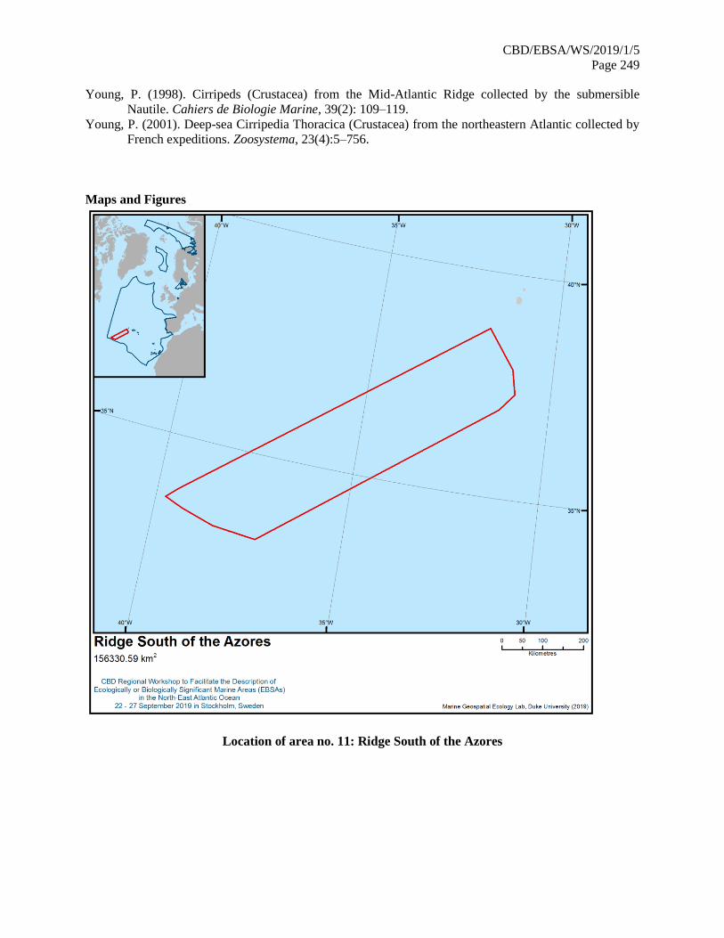
CBD/EBSA/WS/2019/1/5
Page 249
Young, P. (1998). Cirripeds (Crustacea) from the Mid-Atlantic Ridge collected by the submersible
Nautile. Cahiers de Biologie Marine, 39(2): 109–119.
Young, P. (2001). Deep-sea Cirripedia Thoracica (Crustacea) from the northeastern Atlantic collected by
French expeditions. Zoosystema, 23(4):5–756.
Maps and Figures
Location of area no. 11: Ridge South of the Azores

CBD/EBSA/WS/2019/1/5
Page 250
Area no. 12: Graciosa
Abstract Graciosa is a key area for the only breeding population of the vulnerable and endemic Monteiro’s storm-
petrel (Hydrobates monteiroi) and is also important for the breeding population of the Audubon’s
shearwater (Puffinus lherminieri baroli), which is listed by OSPAR as a threatened and/or declining
species. Many other seabirds occur in these waters, such as band-rumped storm-petrel (Hydrobates
castro), Cory’s shearwater (Calonectris borealis), common tern (Sterna hirundo) and roseate tern (Sterna
dougallii). All these species have low recovery rates and are highly sensitive to environmental
degradation or depletion by human activity.
Introduction
The area includes the water column and surface, which are used by seabirds for foraging and resting. The
depth of these waters ranges between 0 and 1207 metres (https://www.gebco.net/). The most relevant
feature supporting the description of the area is the assemblage of seabird species that breeds in the
nearby islands that use the area to forage, rest or commute (Monteiro & Furness 1998, Monteiro et al.
1999, Bolton et al. 2008, Magalhães et al. 2008). Of particular importance is the endemic population of
Monteiro’s storm-petrel (Hydrobates monteiroi, classified as vulnerable in the Red List; BirdLife
International 2018), as well as the breeding population of the Audubon’s shearwater (Puffinus lherminieri
baroli) – listed by OSPAR as a threatened and/or declining species (OSPAR 2009a).
Location This area encompasses the surrounding waters of Graciosa Island and two smaller islands: Baixo and
Praia islets. It has an area of 277 km2 and is the northernmost island of the Azores, Portugal (39.05N/-
27.99W).
Feature description of the area
Graciosa is a globally important site for the vulnerable and endemic Monteiro’s storm-petrel (Hydrobates
monteiroi) (Monteiro & Furness 1998, Bolton et al. 2008), with 330 to 380 breeding pairs (Oliveira 2016;
BirdLife International 2019a). It also contains globally important multi-species assemblages (Monteiro et
al. 1999), including a breeding population of the Audubon’s shearwater (Puffinus lherminieri baroli),
listed by OSPAR as a threatened and/or declining species (OSPAR 2009a); a population of >25,000
individuals of Cory's shearwater (Calonectris borealis) (BirdLife et al. 2019b); and the largest colony on
the Azores of roseate terns (Sterna dougallii), also listed by OSPAR as a threatened and/or declining
species (OSPAR 2009b). The site has been classified as an Important Bird and Biodiversity Area by
BirdLife International (BirdLife International 2019b).
This area completely surrounds Graciosa Island, as there are populations of common tern and roseate tern
that feed in waters around the island almost exclusively (BirdLife International 2019b). Around the main
island there are smaller islands, two of which are classified as Special Protection Areas: Baixo and Praia
islets, the only known breeding site in the world of the “hot-season” Monteiro's storm-petrel (Hydrobates
monteiroi) (Monteiro & Furness 1998). Seven species of seabird breed on Baixo islet, , in what is one of
the most important multi-specific colonies in the archipelago, while on Praia islet the largest breeding
colonies of common tern and band-rumped storm-petrel are to be found, as well as an important roseate
tern colony (BirdLife et al. 2019b).
The Cory's shearwater (Calonectris borealis) is the most abundant species using the area, with a
population estimated at over 25,000 individuals (BirdLife et al. 2019b). Individual tagging work indicates
that Cory's shearwaters use the area to forage and to rest before returning to the colony (Magalhães et al.
2008). The little shearwater (Puffinus lherminieri baroli) population breeding on Baixo and Praia islands
also occurs in the area (Monteiro & Furness 1998). The waters are also used by the band-rumped storm-
petrel (Hydrobates castro) breeding in Praia and Baixo islets, corresponding to around two-thirds of the
breeding population of the species in the Azores (Monteiro & Furness 1998; Bolton et al. 2004). A
population of 320 pairs of yellow-legged gull (Larus cachinnans) nesting in Baixo islet also uses these
waters (Neves et al. 2006), along with roseate tern (Sterna dougallii); the largest colony of this species
CBD/EBSA/WS/2019/1/5
Page 251
breeds in nearby Praia islet, with a recorded maximum of 467 breeding pairs in 2006 (BirdLife et al.
2019b), as do common tern (Sterna hirundo) (a yearly monitoring survey carried out in 2007 estimated a
total population in the area of the proposed IBA of 304 couples; Neves 2007). Great shearwater (Ardenna
gravis) and Bulwer's petrel (Bulweria bulwerii) are also regularly seen in this area (BirdLife et al. 2019b).
The area is also known to be used by 12 species of cetaceans: sperm whale (Physeter microcephalus),
Cuvier’s beaked whale (Ziphius cavirostris), northern bottlenose whale (Hyperodon ampulatus), beaked
whale species (Mesoplodon spp.), bottlenose dolphins (Tursiops truncates), Atlantic spotted dolphin
(Stenella frontalis), striped dolphin (Stenella coeruleoalba), Risso’s dolphin (Grampus griseus), common
dolphin (Delphinus delphis), false killer whale (Psuedorca crassidens), pilot whale (Globicephala spp.)
and sei whale (Balaenoptera borealis) (Silva et al. 2014)
Feature condition and future outlook of the area
The seabird community using the area has been the subject of several scientific studies (e.g., Monteiro et
al. 1999; Bolton et al. 2008; Magalhães et al. 2008; Silva et al. 2016), some of them ongoing and mainly
led by University of the Azores. The conditions are supposedly stable, although the recreational diving in
this area is apparently increasing (Meirinho et al. 2003; BirdLife International 2019b); fishing in the area
is not very extensive and mostly uses traditional approaches (Meirinho et al. 2003).
Assessment of area no. 12, Graciosa, against CBD EBSA Criteria
CBD EBSA
Criteria
(Annex I to
decision IX/20)
Description
(Annex I to decision IX/20) Ranking of criterion relevance
(please mark one column with an X)
No
informat
ion
Low Medi
um
High
Uniqueness or
rarity
Area contains either (i) unique (“the only one
of its kind”), rare (occurs only in few
locations) or endemic species, populations or
communities, and/or (ii) unique, rare or
distinct, habitats or ecosystems; and/or (iii)
unique or unusual geomorphological or
oceanographic features.
X
Explanation for ranking
The area holds the only breeding population in the region (and in the world) of the Monteiro’s storm-
petrel (Hydrobates monteiroi) (Bolton et al. 2008). Around 350 breeding pairs of this species breed in the
nearby islands and use the area for foraging and resting (Oliveira 2016).
Special
importance
for life-history
stages of
species
Areas that are required for a population to
survive and thrive.
X
Explanation for ranking
Graciosa is a regionally and globally important area for the breeding population of the endemic
Monteiro’s storm-petrel (Hydrobates monteiroi) (Monteiro & Furness 1998). It is also used by globally
important multi-species assemblages, including the breeding populations of Audubon’s shearwater
(Puffinus lherminieri baroli), roseate tern (Sterna dougallii) (both listed by OSPAR as a threatened and/or
declining Species; OSPAR 2009a,b), Cory's shearwater (Calonectris borealis), band-rumped storm-petrel
(Hydrobates castro), yellow-legged gull (Larus cachinnans), roseate tern (Sterna dougallii), common tern
(Sterna hirundo) and Bulwer's petrel (Bulweria bulwerii) (BirdLife International 2019). The area is also
used by the non-breeding population of great shearwater (Ardenna gravis) (a migratory species traveling
from the South Atlantic to spend the winter in the North Atlantic; Meirinho et al. 2014).
Importance Area containing habitat for the survival and X
CBD/EBSA/WS/2019/1/5
Page 252
for
threatened,
endangered or
declining
species and/or
habitats
recovery of endangered, threatened, declining
species or area with significant assemblages
of such species.
Explanation for ranking
Graciosa is a globally important site for the vulnerable and endemic Monteiro’s storm-petrel (Hydrobates
monteiroi) (Monteiro & Furness 1998; Bolton et al. 2008), with some 350 breeding pairs (Oliveira 2016).
It also contains globally important multi-species assemblages (BirdLife International 2019), including:
breeding population of the little shearwater (Puffinus lherminieri baroli) and roseate tern (Sterna
dougallii), both of which are listed by OSPAR as threatened and/or declining species (OSPAR 2009a, b).
Vulnerability,
fragility,
sensitivity, or
slow recovery
Areas that contain a relatively high
proportion of sensitive habitats, biotopes or
species that are functionally fragile (highly
susceptible to degradation or depletion by
human activity or by natural events) or with
slow recovery.
X
Explanation for ranking
The Monteiro’s storm-petrel (Hydrobates monteiroi) is listed as vulnerable because it has a very small
population, which is restricted to breeding on a few small islets. It is therefore highly susceptible to
stochastic events and remains at risk of mammalian introductions, avian and reptile predators and light
pollution (Dias et al. 2019, Rodríguez et al. 2019, BirdLife International 2019a).
The little shearwater (Puffinus lherminieri baroli), listed by OSPAR as a threatened and/or declining
species, has a small population size and is considered rare. Much of the suitable breeding habitat for this
species has been rendered unsuitable due to the introduction of rats and cats, putting it at risk of further
declines (OSPAR 2009a).
Roseate terns (Sterna dougallii), listed by OSPAR as a threatened and/or declining species, have
comparatively low adult survival rates (Green, 1995) and therefore need to maintain exceptionally high
productivity to achieve population stability (Newton, 2004). They are threatened by predation and
disturbance at the breeding colonies, in particular (OSPAR 2009b, Dias et al. 2019).
Biological
productivity
Area containing species, populations or
communities with comparatively higher
natural biological productivity.
X
Explanation for ranking
Biological
diversity
Area contains comparatively higher diversity
of ecosystems, habitats, communities, or
species, or has higher genetic diversity.
X
Explanation for ranking
Naturalness Area with a comparatively higher degree of
naturalness as a result of the lack of or low
level of human-induced disturbance or
degradation.
X
Explanation for ranking
Sharing experiences and information applying other criteria
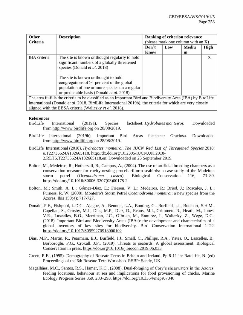
CBD/EBSA/WS/2019/1/5
Page 253
Other
Criteria
Description
Ranking of criterion relevance
(please mark one column with an X)
Don’t
Know
Low Mediu
m
High
IBA criteria
The site is known or thought regularly to hold
significant numbers of a globally threatened
species (Donald et al. 2018)
The site is known or thought to hold
congregations of ≥1 per cent of the global
population of one or more species on a regular
or predictable basis (Donald et al. 2018)
X
The area fulfills the criteria to be classified as an Important Bird and Biodiversity Area (IBA) by BirdLife
International (Donald et al. 2018, BirdLife International 2019b), the criteria for which are very closely
aligned with the EBSA criteria (Waliczky et al. 2018).
References
BirdLife International (2019a). Species factsheet: Hydrobates monteiroi. Downloaded
from http://www.birdlife.org on 28/08/2019.
BirdLife International (2019b). Important Bird Areas factsheet: Graciosa. Downloaded
from http://www.birdlife.org on 28/08/2019.
BirdLife International (2018). Hydrobates monteiroi. The IUCN Red List of Threatened Species 2018:
e.T22735624A132665118. http://dx.doi.org/10.2305/IUCN.UK.2018-
2.RLTS.T22735624A132665118.en. Downloaded on 25 September 2019.
Bolton, M., Medeiros, R., Hothersall, B., Campos, A., (2004). The use of artificial breeding chambers as a
conservation measure for cavity-nesting procellariiform seabirds: a case study of the Madeiran
storm petrel (Oceanodroma castro). Biological Conservation 116, 73–80.
https://doi.org/10.1016/S0006-3207(03)00178-2
Bolton, M.; Smith, A. L.; Gómez-Díaz, E.; Friesen, V. L.; Medeiros, R.; Bried, J.; Roscales, J. L.;
Furness, R. W. (2008). Monteiro's Storm Petrel Oceanodroma monteiroi: a new species from the
Azores. Ibis 150(4): 717-727.
Donald, P.F., Fishpool, L.D.C., Ajagbe, A., Bennun, L.A., Bunting, G., Burfield, I.J., Butchart, S.H.M.,
Capellan, S., Crosby, M.J., Dias, M.P., Diaz, D., Evans, M.I., Grimmett, R., Heath, M., Jones,
V.R., Lascelles, B.G., Merriman, J.C., O’brien, M., Ramírez, I., Waliczky, Z., Wege, D.C.,
(2018). Important Bird and Biodiversity Areas (IBAs): the development and characteristics of a
global inventory of key sites for biodiversity. Bird Conservation International 1–22.
https://doi.org/10.1017/S0959270918000102
Dias, M.P., Martin, R., Pearmain, E.J., Burfield, I.J., Small, C., Phillips, R.A., Yates, O., Lascelles, B.,
Borboroglu, P.G., Croxall, J.P., (2019). Threats to seabirds: A global assessment. Biological
Conservation in press. https://doi.org/10.1016/j.biocon.2019.06.033
Green, R.E., (1995). Demography of Roseate Terns in Britain and Ireland. Pp 8-11 in: Ratcliffe, N. (ed)
Proceedings of the 6th Roseate Tern Workshop. RSBP: Sandy, UK.
Magalhães, M.C., Santos, R.S., Hamer, K.C., (2008). Dual-foraging of Cory’s shearwaters in the Azores:
feeding locations, behaviour at sea and implications for food provisioning of chicks. Marine
Ecology Progress Series 359, 283–293. https://doi.org/10.3354/meps07340
CBD/EBSA/WS/2019/1/5
Page 254
Meirinho, A., Pitta Groz, M., Silva, A.G. (2003). Proposta de Plano de Gestão da Zona de Protecção
Especial Ilhéu da Praia. Departamento de Oceanografia e Pescas da Universidade dos Açores,
Horta
Meirinho, A., Barros, N., Oliveira, N., Catry, P., Lecoq, M., Paiva, V., Geraldes, P., Granadeiro, J.P.,
Ramírez, I., Andrade, J., (2014). Atlas das Aves Marinhas de Portugal. Sociedade Portuguesa
para o Estudo das Aves. Lisboa
Monteiro, L.R., Furness, R.W., (1998). Speciation through temporal segregation of Madeiran storm petrel
(Oceanodroma castro) populations in the Azores? Philosophical Transactions of the Royal
Society of London B 353: 945-953
Monteiro, L.R., Ramos, J.A., Pereira, J.C., Monteiro, P.R., Feio, R.S., Thompson, D.R., Bearhop, S.,
Furness, R.W., Laranjo, M., Hilton, G., Neves, V.C., Groz, M.P., Thompson, K.R., (1999). Status
and Distribution of Fea’s Petrel, Bulwer’s Petrel, Manx Shearwater, Little Shearwater and Band-
Rumped Storm-Petrel in the Azores Archipelago. Waterbirds: The International Journal of
Waterbird Biology 22, 358–366. https://doi.org/10.2307/1522111
Neves, V.C., (2007). Azores 2007 Tern Census. Arquivos do DOP, Séries Estudos 4/2007, 21pp
Neves, V.C., Murdoch, N., Furness, R.W., (2006). Population status and diet of the Yellow-legged Gull in
the Azores. Life and Marine Sciences. 23A: 59-73.
Newton, S.F.m (2004). Roseate Tern Sterna dougallii pp 302-314 in: Mitchell, P.L., Newton, S.F.,
Ratcliffe, N. and Dunn, T.C. (eds.) Seabird Populations of Britain and Ireland T & AD Poyser,
London.
Oliveira, N., (compiler). (2016). Status Report for Monteiro’s Storm-petrel Hydrobates monteiroi. Report
of the Action A10, Project LIFE EuroSAP. Sociedade Portuguesa para o Estudo das Aves,
Lisboa.
OSPAR (2009a). Background document for Little Shearwater Puffinus assimilis baroli. Biodiversity
Series, 13p.
OSPAR (2009b). Background document for Roseate Tern Sterna dougallii. Biodiversity Series. 29p
Rodríguez, A., Arcos, J.M., Bretagnolle, V., Dias, M.P., Holmes, N.D., Louzao, M., Provencher, J.,
Raine, A.F., Ramírez, F., Rodríguez, B., Ronconi, R.A., Taylor, R.S., Bonnaud, E., Borrelle,
S.B., Cortés, V., Descamps, S., Friesen, V.L., Genovart, M., Hedd, A., Hodum, P., Humphries,
G.R.W., Le Corre, M., Lebarbenchon, C., Martin, R., Melvin, E.F., Montevecchi, W.A., Pinet, P.,
Pollet, I.L., Ramos, R., Russell, J.C., Ryan, P.G., Sanz-Aguilar, A., Spatz, D.R., Travers, M.,
Votier, S.C., Wanless, R.M., Woehler, E., Chiaradia, A., (2019). Future Directions in
Conservation Research on Petrels and Shearwaters. Front. Mar. Sci. 6.
https://doi.org/10.3389/fmars.2019.00094
Silva, M., Prieto, R., Cascão, I., Seabra, M., Machete, M., Baumgartner, M., Santos, R., (2014). Spatial
and temporal distribution of cetaceans in the mid-Atlantic waters around the Azores. Marine
Biology Research. 10. 123-137. 10.1080/17451000.2013.793814.
Silva, M.F., Smith, A.L., Friesen, V.L., Bried, J., Hasegawa, O., Coelho, M.M., Silva, M.C., (2016).
Mechanisms of global diversification in the marine species Madeiran Storm-petrel Oceanodroma
castro and Monteiro’s Storm-petrel O. monteiroi: Insights from a multi-locus approach.
Molecular Phylogenetics and Evolution 98, 314–323.
https://doi.org/10.1016/j.ympev.2016.02.014
Waliczky, Z., Fishpool, L.D.C., Butchart, S.H.M., Thomas, D., Heath, M.F., Hazin, C., Donald, P.F.,
Kowalska, A., Dias, M.P., Allinson, T.S.M., (2018). Important Bird and Biodiversity Areas
(IBAs): their impact on conservation policy, advocacy and action. Bird Conservation
International 1–17. https://doi.org/10.1017/S0959270918000175

CBD/EBSA/WS/2019/1/5
Page 255
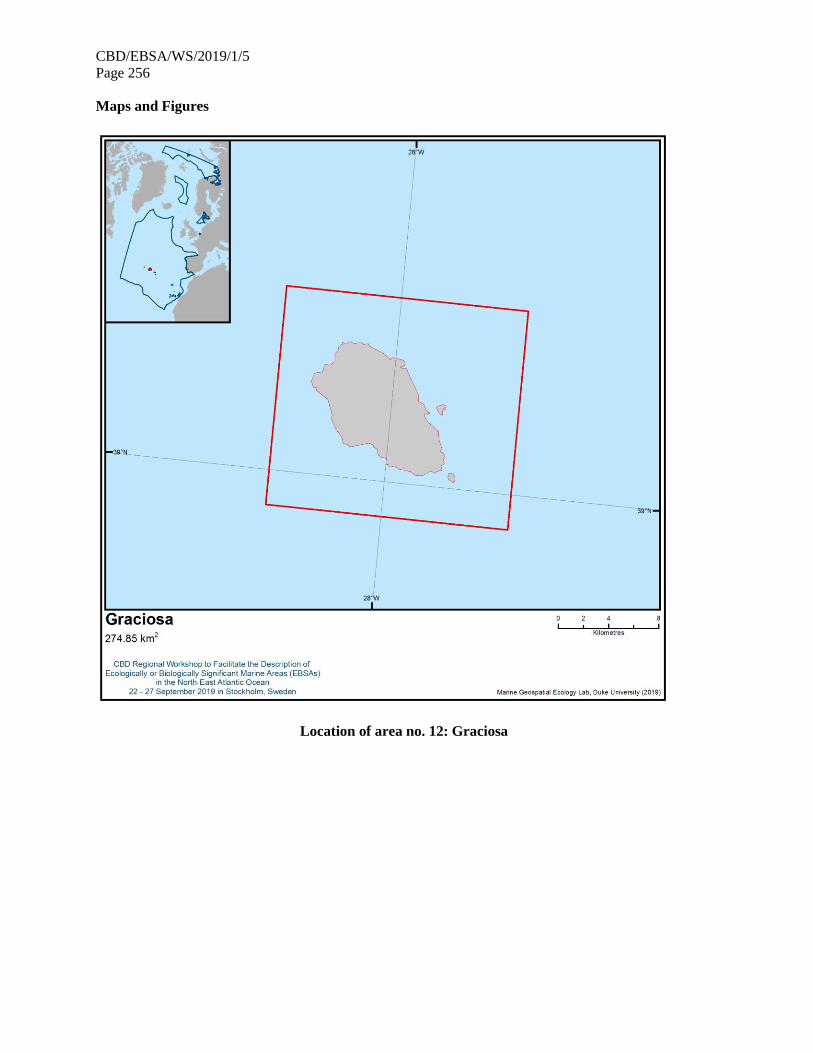
CBD/EBSA/WS/2019/1/5
Page 256
Maps and Figures
Location of area no. 12: Graciosa
CBD/EBSA/WS/2019/1/5
Page 257
Area no. 13: North Azores Plateau
Abstract This area is composed of several seamounts, one hydrothermal vent field, an undersea trough and a large
portion of the Mid-Atlantic Ridge north of the Azores Plateau. The structures in this area are hotspots of
marine life and, in general, areas of enhanced productivity, especially when compared with surrounding
abyssal areas. The Moytirra is the first known deep-sea hydrothermal vent field on the slow-spreading
Mid-Atlantic Ridge north of the Azores, making this area highly unique. A total of 536 species have been
observed in this area, 6 per cent of which are protected under international or regional law.
Introduction
The area includes several seamounts (Altair, Antialtair, Chaucer, Cherkis, Crumb, Lukin- Lebedev and
Sedlo), one hydrothermal vent field (Moytirra), Kings Trough and a large portion of the Mid-Atlantic
Ridge (MAR) north of the Azores Plateau.
Rising from bathyal and abyssal depths, the MAR dominates the seafloor topography in the high seas of
the OSPAR region. The topography is highly differentiated with depths ranging from 4500 m in the
deepest channel to only 700-800m on top of adjacent seamounts (Dinter, 2001). The MAR plays an
important role in the circulation of the water masses in the North Atlantic (Rossby, 1999; Bower et al.,
2002; Heger et al., 2008; Søiland et al., 2008). The complex hydrographic setting around the MAR in
general, and the presence of the ridge itself, leads to enhanced vertical mixing and turbulence that results
in areas of increased productivity over the MAR (Falkowski et al., 1998; Heger et al., 2008). Despite
generally limited surface production, there is evidence of enhanced near-ridge demersal fish biomass
above the MAR (Fock et al., 2002; Bergstad et al., 2008). There is also evidence that the mid-ocean
ridges are ecologically important for higher trophic levels relative to the surrounding abyssal plains and
the open ocean (e.g., blue ling and roundnose grenadier spawning aggregations on the northern MAR)
(Magnusson & Magnusson 1995, Vinnichenko & Khlivnoy 2004).
Most of the structures are classified as seamounts, ridges, or ridge-associated seamounts. These structures
can be an obstacle to the free circulation of the oceans, thereby leading to different kinds of phenomena
and disturbances, including an increase in the speed of ocean currents, upwellings, turbulence, Taylor
cones, eddies, and even jets in the zones where the seamounts interact with ocean currents (Richardson et
al., 2000; Kunze & Smith, 2004; White et al., 2007; Pakhorukov, 2008).
The area shelters the only deep-sea hydrothermal vent field known to date on the MAR north of the
Azores. Since most of the seamounts and other structures in the area remain unexplored, the presence of
more vent communities and more seamounts cannot be excluded with full confidence.
The hydrothermal vent fields play a pivotal role in sustaining abundant populations of deep-sea species
through the chemosynthetic primary production (Van Dover et al., 2002).
The Sedlo seamount shows a high diversity of sessile megabenthos, which may form dense aggregations
(mainly coral Hexacorallia – Madrepora oculata – and sponges) on the predominantly rocky surface of its
summit (OASIS, 2006). Investigations of the demersal fish community were also performed and recorded
large reproductive aggregations of both alfonsino (Beryx splendens) and black cardinal fish (Epigonus
telescopus) (Menezes et al., 2009) two species recognized as typical seamount aggregating deep-sea fish
(Koslow, 1996; Morato et al., 2006). These observations make Sedlo seamount the only known
reproductive area for alfonsino and black cardinal fish in the Azores (Santos et al., 2009). Several
threatened deep-sea shark species were also recorded in these structures, such as the leafscale gulper
shark (Centrophorus squamosus) and the Portuguese dogfish (Centroscymnus coelolepis) (Melo &
Menezes, 2002; Menezes et al., 2009), both considered vulnerable and near threatened, respectively, in
the IUCN (2011) Red List. The endangered fin whale (Balaenoptera physalus) and sei whale
(Balaenoptera borealis) (IUCN, 2011) have been observed in the vicinity of the seamount (Santos et al.,
2009).
Another important feature in the area is a section of the Mid-Atlantic Ridge North of the Azores High
Seas MPA (MARNA), part of the OSPAR Network of Marine Protected Areas. The ridge is a peculiar
CBD/EBSA/WS/2019/1/5
Page 258
topographic feature of the Atlantic Ocean stretching from north of Iceland to the Southern Ocean,
representing the spreading zone between the Eurasian and American continental plates. Although mid-
ocean ridges have an extensive distribution and cover 22 per cent of the Earth’s surface (Garrison, 2005)
these remote areas are largely unexplored (Bergstad et al., 2010). Knowledge of the animal communities
and biology and ecology of individual species in these waters remains limited. The rugged terrain and
great depths make the ridges particularly challenging study areas (Bergstad et al., 2008).
There is a considerable volume of information on Altair and Antialtair seamounts, as both structures are
also components of the OSPAR Network of Marine Protected Areas.
Information about Moytirra is relatively scarce because this hydrothermal vent was only recently
discovered (in 2011). This is the first known deep-sea hydrothermal vent field on the slow-spreading Mid-
Atlantic Ridge north of the Azores and as a result has only been subject to a few studies, most of which
describe its genesis and geological data but provide little biological information (Wheeler et al. 2013).
The area comprises multiple types of structures (hydrothermal vent field, MARNA MPA, and seamounts)
that are very distinct in terms of biology and geology, showing different compositions, locations and ages.
Wheller described the Moytirra vent field (named after the Irish mythological “plain of the pillars”) in
2013. This vent is the only fully described high temperature hydrothermal vent known between the
Azores and Iceland, making it a unique geophysical structure in the high seas of the North Atlantic and
within the MAR. The structure is located at a depth of 2095 m and is situated at 45°N on the 300 m high
fault scarp of the eastern axial wall of the MAR, 3.5 km from the axial volcanic ridge crest (Wheeler et al.
2013). The portion of the MAR contained within the area, which includes the MARNA MPA, is
characterized by rough bottom topography comprising underwater peaks (minimum 660 and maximum
depth 3700 m), a central rift valley, recent volcanic terrain and fracture zones and has the highest
concentration of seamount features on the MAR (Epp & Smoot, 1989; Gebruk et al, 2010). It occupies an
area of 93,415 km2. The MPA contains a section of the axis of the volcanic ridge, generally NNE-SSE,
which runs through the Azores Platform. The central part of this ridge is occupied by an overall steering
valley NNE-SSW with a width typically within 7 km and 9 km, which extends over the whole area and
the base of which lies typically between 3000 and 3500 m deep (Dias et al., 2007; Silveira et al., 2010).
The flank of the central valley can rise to depths below 1000 m, although the crests are typically between
1000 m and 1500 m deep. The surface of the crest flank diverging from the central valley is rough but
essentially inclines towards deeper areas between 3400 m in the east and 3700 m in the west. This area
contains many seamounts that have not been studied or named (Bergstad et al., 2012). In the area seven
known seamounts are present (there is evidence that there are more), three of them belonging to MPAs –
Altair, Antialtair and Sedlo.
An area of 4,384 km2
of the Altair Seamount High Seas MPA (OSPAR Network) is included in the area
described (OSPAR, 2013). The seabed of most of this area is located at a depth between 3500 m and
3700 m. The rupture of the slope in the transition to the relief circumscribed by the isobaths of 3200 m is
more pronounced in the north and southwest quadrants than in the eastern sectors. The Altair seamount
extends from northwest to southeast, and its dimensions at the 3300 m isobath are 73x46 km. Altair
seamount is an isolated volcanic uplift on the eastern slope of the Newfoundland Basin and the North
American-Canary abyssal plain. The middle and upper crusts of the seamount, at depths of 1600-2500 m,
are marked by the widespread development of ferromanganese crusts. Stations at the summit and slope
are often rocky, with cobbles and boulders in places, but also patches of coarse, biogenic sediment
(Matthews et al., 1969; Varentsov et al., 1988; O'Leary et al., 2012).
The structures of the Altair seamount rise within the western and eastern sectors of the Central Adantic
region belonging, according to Zolotarev (1984), to the volcanic-uplift association, developed on the
slopes of the MAR. The Altair seamount consists of two clearly merging conical piles: the summit of the
western pile lies at a water depth of 1545 m, and the two summits of the double-peaked eastern cones at
1350 and 935 m.
CBD/EBSA/WS/2019/1/5
Page 259
The Antialtair Seamount High Seas MPA, which occupies an area of 2807 km2, is part of a volcanic ridge
with a NW-SE general direction, and the top is about 1000 m deep. The flanks of this structure are
asymmetrical and reach the flattened seabed at 4500 m deep (North) and about 3000 m deep in the South
(Druel, 2011; O'Leary et al., 2012). Few studies have been conducted on this seamount. However, its
geology reveals a rugged relief bottom with steep slopes of rocky nature (Muñoz et al., 2000).
The most studied structure in this area is the Sedlo seamount. The seamount is located at the North of the
Azores. Sedlo’s odd bathymetry can be described as a three-summit seamount, with the summit peaks
becoming shallower towards the southeast (Machín et al., 2009). It would therefore be classified as an
intermediate depth seamount, i.e. one whose summit depth is significantly below the euphotic zone but
reaches the permanent thermocline (Mohn et al., 2009; Santos et al., 2009). The shallowest part of
summit has a depth of ~660 m. The seamount is elongated, multi-peaked, orientated NW–SE, close to the
end of a spur. The basin descends to 5000-6000 m and is bounded by the MAR to the west and the
European and African continents to the east (Arístegui et al., 2009; Mohn et al., 2009; Santos et al., 2009;
Morato et al., 2012).
The Sedlo structure is located within the North Atlantic sub-tropical gyre. The seamount is influenced by
eastern and western Atlantic central waters, and west of the Iberian Peninsula, in the path of the
Mediterranean outflow. At mid-latitudes, most of the upper ocean consists of subducted water that
recirculates along the upper thermocline (Harvey and Arhan, 1988; Rios et al., 1992; Pollard et al., 1996,
Machín, 2009). In the western North Atlantic the upper-thermocline layers are influenced by relatively
fresh waters of southern origin reaching the western boundary through the equatorial region. These waters
are transported north by the Gulf Stream, and later northeast via the North Atlantic Current and east via
the Azores Current, as they rise towards the sea surface with the out-cropping isopycnals (McCartney,
1992; Weaver et al., 1999; Brix & Gerdes, 2003). They constitute the Western North Atlantic Central
Water (WNAW) and, west of the MAR, occupy the whole permanent thermocline. In the eastern North
Atlantic the winter mixed layer gets quite deep, up to some 500 m, so that high-salinity surface waters
reach the upper thermocline and give rise to the Eastern North Atlantic Central Water (ENAW) (de Boyer
Montégut et al., 2007). ENAW has been further divided between those of subpolar and subtropical origin
by Rios et al. (1992), according to their latitude of formation and their posterior propagation (Machín et
al., 2009).
In terms of biology, some of the structures have been relatively well studied (see Table 1). A total of 536
species have been observed in the area (see feature description of the area).
The area includes threatened and/or declining ecosystems, for example aggregations of deep-sea sponges,
coral gardens and Lophelia pertusa reefs (OSPAR, 2010). In the Altair seamount the benthic epifaunal
community is dominated in most places by sessile megabenthos, chiefly anemones and true corals
(Hexacorallia) and sponges. The diversity of corals and sponges is particularly high in the saddle and
gully (Henry et al., 2014). Between the two eastern peaks of Sedlo, dense aggregations of soft corals are
present, sea whips (gorgonians) are especially abundant on the southwest side of the seamount, and brittle
stars (Ophiuroids) are also present. The base of the seamount is almost exclusively covered with fine
sediments like the surrounding abyssal plains. These sediment habitats are very low in epifaunal
abundance when compared to other sites on the seamount (e.g., Christiansen & Wolff, 2009; Menezes et
al., 2012; Henry et al., 2014).
Hareide & Garnes (2001) studied the summit fishes of seamounts along the MAR and they found that the
dominant deep-water fish species changed with latitude. Sub-tropical species such as golden-eye perch
(Beryx splendens) and cardinal fish (Epigonus telescopus) dominated the seamount summits.
The seamounts in this area support epipelagic fishes, which in turn support migratory species such as tuna
(Thunnus thynnus and Thunnus albacares). It provides habitats that are associated with epipelagic fish
species spawning and recruitment (species belonging to the Serranidae, and Carangidae families), as well
as benthopelagic species and respective communities, including fish species captured for commercial
purposes, such as orange roughy (Morato & Clark, 2007; OSPAR, 2010). Among these habitats are some
CBD/EBSA/WS/2019/1/5
Page 260
endangered and/or declining species, such as whales (Balaenoptera musculus), turtles (Dermochelys
coriacea and Caretta caretta) (protected under the Habitats Directive, the Bern Convention, Bonn
Convention, CITES and OSPAR Convention), and elasmobranchs (Centroscymnus coelolepis,
Centrophorus granulosus and Centrophorus squamosus) (protected under the OSPAR Convention)
(Morato et al., 2008; Santos et al., 2008).
Studies that demonstrated the ecological and biological importance of the seamounts have been conducted
by Santos et al. (2008). Turtle biotelemetry studies suggest that the turtles exhibit different movement
behaviours near seamounts, remaining in these places for prolonged periods. This provides further
evidence that these topographic features can be hotspots for adult and juvenile loggerheads.
The seamounts are also an important area for birds; Cory’s shearwater (Calonectris borealis) breeds in
the Azores and has been shown to forage over the region of the MAR (Magalhães et al., 2008). This
species performs a dual-foraging strategy that combines short and long foraging trips. Most short trips
have been found to be confined to the MAR just north of the Azores (within about 300 km) (Magalhães et
al., 2008; Xavier et al., 2011).
Location
The area is spread over a wide part of the Atlantic Ocean, north of the Azores. The area is home to
multiple types of structures (i.e., hydrothermal vent field, Mid-Atlantic Ridge North of the Azores ,
seamounts), which are very distinct in terms of biology and geology, and which have different
compositions, locations and ages.
Feature description of the area
Knowledge of this area is based on the analysis of 110 scientific articles containing relevant information.
Several of the structures are well known with a great number of geological and biological studies. The
total number of 536 species reported was estimated from scattered taxonomic literature, and the species
number is probably underestimated. Knowledge of each structure is uneven.
Around 6 per cent of the 536 species identified in all seamounts in this area are legally protected or
recognized as threatened by CITES, IUCN Red List, European Union Habitats and Birds Directives,
VMEs, Bern Convention or OSPAR Convention. In this area OSPAR identified as endangered or
declining the deepwater sharks Centroscymus coeleopsis, Centrophorus squamosus and Dipturus batis,
the commercial fish Hoplostethus atlanticus and the two species of corals Lophelia pertusa and
Madrepora oculata. Other examples of species with legal protection (CITES Appendix I) are the
cetaceans Balaenoptera borealis, Balaenoptera musculus, Balaenoptera physalus, Megaptera
novaeangliae, Physeter macrocephalus, Tursiops truncatus, the turtles Caretta caretta, Dermochelys
coriacea, (CITES Appendix II) and the corals Antipathella subpinnata, Aulocyathus atlanticus,
Caryophyllia ambrosia, Desmophyllum dianthus, Flabellum alabastrum, Flabellum angulare,
Fungiacyathus fragilis, Lophelia pertusa, Madrepora oculata, Schizopathes affinis, Solenosmilia
variabilis, Stauropathes arctica and Stephanocyathus moseleyanus. The species of whales Balaenoptera
physalus, Balaenoptera musculus, Balaenoptera borealis, Megaptera novaeangliae, the sperm whale
(Physeter macrocephalus), the dolphins Delphinus delphis and Tursiops truncatus and the sea urchin
Centrostephanus longispinus are protected by the EU Habitats Directive. The whales Balaenoptera
physalus, Balaenoptera musculus, Balaenoptera borealis, Megaptera novaeangliae, the sperm whale
Physeter macrocephalus and the turtles Caretta caretta and Dermochelys coriacea are protected by
Annex II of the Bern Convention. Also present are 11 species listed on the IUCN Red List as near
threatened/ vulnerable/endangered/critically endangered (Balaenoptera physalus, Balaenoptera musculus,
Balaenoptera borealis, Caretta caretta, Dermochelys coriacea, Dipturus batis, Hippoglossus
hippoglossus, Physeter macrocephalus, Prionace glauca, Thunnus albacares, Thunnus thynnus). There
are also two species of birds (Calonectris borealis and Sterna dougallii) belonging to the Birds Directive
Annex I.
The species studied in the area belong to several phyla, classes or orders. The area includes various
species of scleractinians and gorgonians. In some seamounts the gorgonian and sponge species were
CBD/EBSA/WS/2019/1/5
Page 261
reported to form dense gorgonian coral habitat-forming aggregations which may represent important
feeding and sheltering grounds for seamount fishes as well as potential shark nurseries (WWF, 2001;
Etnoyer & Warrenchuk, 2007; OSPAR, 2011). Cold-water, deep, habitat-forming corals can shelter
higher megafauna in association with the corals (Roberts et al., 2006; Mortensen et al., 2008, Rogers et
al., 2008). Seamounts also harbour large aggregations of demersal or benthopelagic fish (Koslow, 1997;
Morato & Pauly, 2004; Pitcher et al., 2007; Morato et al., 2009, 2010). Seamounts are recognized in
many different fora as being vulnerable to the effects of fishing pressure (e.g., UN, OSPAR, FAO,
NEAFC, NAFO, UNEP).
Deep-sea hydrothermal vents are among the most extreme and dynamic environments on Earth. However,
islands of highly dense and biologically diverse communities exist in the immediate vicinity of
hydrothermal vent flows, in stark contrast to the surrounding bare seafloor (Thornburgn et al., 2010).
Unique communities are formed around vents, attracting unusual creatures such as red-plumed giant tube
worms and massive clams, which cluster around the dark chimneys where vent fluids emerge.
Feature condition and future outlook of the area
Most available studies are qualitative and often focus on specific taxonomic groups, such as Fish,
Echinoderms, Anthozoa and Elasmobranchii (e.g., Mortensen et al., 2008; Gebruk et al., 2010; Menezes
et al., 2012). Most study cruises that have visited the area were focused in Sedlo bank with sampling of
the demersal vertebrate fauna (fish). The OSPAR High Seas MPAs (Altair, Antialtair and MARNA) have
a small number of scientific articles and reports focused on them.
At the Moytirra hydrothermal vent the dissolved constituents of the venting fluids play, as do the other
vents, an important role in the geochemical mass balance of the oceans (Edmond et al., 1979). The high
concentrations of valuable minerals make these kind of structures targets for deep-ocean mining
(Hoagland et al., 2010; Van Dover, 2011), which carries a high risk of damage to these fragile
ecosystems. This type of ecosystem is sensitive because of its high percentage of endemic species and the
unique nature of many of the species found there (e.g., Vrijenhoek, 2010; Ramirez-Llodra et al., 2011).
One of the “recent” potential threats to these ecosystems is bioprospecting activities for possible sources
of biotechnology (e.g., bacteria on hydrothermal vents) (Gubbay, 2003; Synnes, 2007).
Seamount ecosystems are also highly vulnerable and sensitive to external actions. Most of the fauna
found on seamounts are long-lived and slow-growing organisms with low fecundity and natural mortality,
so called K-selected species (Brewin et al., 2007). Recruitment events of long-lived seamount fauna seem
to be episodic and rare (Brewin et al., 2007). The type of gear (usually rock-hopper trawls) used to fish
over the rough and rocky substrata on seamounts is particularly destructive of benthic habitat, destroying
the very long-lived and slow-growing sessile suspension-feeding organisms that dominate these habitats
(Brewin et al., 2007). Benthic seamount communities are highly vulnerable to the impacts of fishing
because of their limited habitat, the extreme longevity of many species, apparently limited recruitment
between seamounts and the highly localized distribution of many species (de Forges et al., 2000; Samadi
et al., 2006, 2007).
In a few decades, industrial fishing attention has been drawn to the abundance of commercially valuable
fish species at many seamounts (Koslow, 1997). The reasons for the fish aggregations can be explained
by the hypotheses that seamount areas can be “meeting points” of usually dispersed fish stocks, for
example to aggregate for spawning, or that an enhanced food supply caused by special current conditions
is the basis for locally maintaining large fish stocks. The importance of seamounts for fisheries is very
well documented (Boehlert & Sasaki, 1988, Koslow, 1997, Morato et al., 2006). The fishing effort in the
area described focuses primarily on commercially valuable species such as horse mackerel (Trachurus
trachurus, Carangidae), mackerel (Scomber sp., Scombridae), scabbardfish (family Trichiuridae) and
orange roughy (Hoplostethus atlanticus). Starting in the early 1970s with Soviet/Russian trawlers, stocks
of roundnose grenadier (Coryphaenoides rupestris), orange roughy (Hoplostethus atlanticus) and
alfonsino (Beryx splendens) associated with the area were exploited (Clark et al. 2007, ICES 2007). It can
be assumed that most hills along the ridge were at least explored (usually by midwater trawls operating
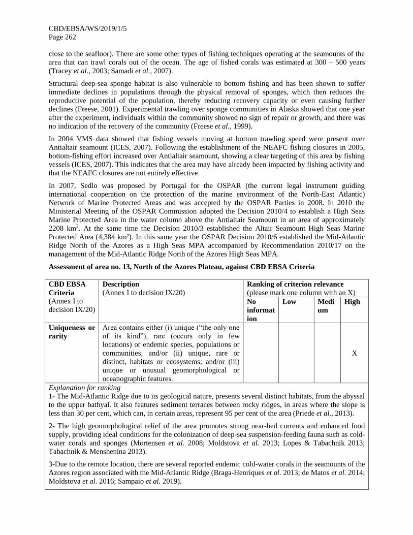
CBD/EBSA/WS/2019/1/5
Page 262
close to the seafloor). There are some other types of fishing techniques operating at the seamounts of the
area that can trawl corals out of the ocean. The age of fished corals was estimated at 300 – 500 years
(Tracey et al., 2003; Samadi et al., 2007).
Structural deep-sea sponge habitat is also vulnerable to bottom fishing and has been shown to suffer
immediate declines in populations through the physical removal of sponges, which then reduces the
reproductive potential of the population, thereby reducing recovery capacity or even causing further
declines (Freese, 2001). Experimental trawling over sponge communities in Alaska showed that one year
after the experiment, individuals within the community showed no sign of repair or growth, and there was
no indication of the recovery of the community (Freese et al., 1999).
In 2004 VMS data showed that fishing vessels moving at bottom trawling speed were present over
Antialtair seamount (ICES, 2007). Following the establishment of the NEAFC fishing closures in 2005,
bottom-fishing effort increased over Antialtair seamount, showing a clear targeting of this area by fishing
vessels (ICES, 2007). This indicates that the area may have already been impacted by fishing activity and
that the NEAFC closures are not entirely effective.
In 2007, Sedlo was proposed by Portugal for the OSPAR (the current legal instrument guiding
international cooperation on the protection of the marine environment of the North-East Atlantic)
Network of Marine Protected Areas and was accepted by the OSPAR Parties in 2008. In 2010 the
Ministerial Meeting of the OSPAR Commission adopted the Decision 2010/4 to establish a High Seas
Marine Protected Area in the water column above the Antialtair Seamount in an area of approximately
2208 km2. At the same time the Decision 2010/3 established the Altair Seamount High Seas Marine
Protected Area (4,384 km²). In this same year the OSPAR Decision 2010/6 established the Mid-Atlantic
Ridge North of the Azores as a High Seas MPA accompanied by Recommendation 2010/17 on the
management of the Mid-Atlantic Ridge North of the Azores High Seas MPA.
Assessment of area no. 13, North of the Azores Plateau, against CBD EBSA Criteria
CBD EBSA
Criteria
(Annex I to
decision IX/20)
Description
(Annex I to decision IX/20) Ranking of criterion relevance
(please mark one column with an X)
No
informat
ion
Low Medi
um
High
Uniqueness or
rarity
Area contains either (i) unique (“the only one
of its kind”), rare (occurs only in few
locations) or endemic species, populations or
communities, and/or (ii) unique, rare or
distinct, habitats or ecosystems; and/or (iii)
unique or unusual geomorphological or
oceanographic features.
X
Explanation for ranking
1- The Mid-Atlantic Ridge due to its geological nature, presents several distinct habitats, from the abyssal
to the upper bathyal. It also features sediment terraces between rocky ridges, in areas where the slope is
less than 30 per cent, which can, in certain areas, represent 95 per cent of the area (Priede et al., 2013).
2- The high geomorphological relief of the area promotes strong near-bed currents and enhanced food
supply, providing ideal conditions for the colonization of deep-sea suspension-feeding fauna such as cold-
water corals and sponges (Mortensen et al. 2008; Moldstova et al. 2013; Lopes & Tabachnik 2013;
Tabachnik & Menshenina 2013).
3-Due to the remote location, there are several reported endemic cold-water corals in the seamounts of the
Azores region associated with the Mid-Atlantic Ridge (Braga-Henriques et al. 2013; de Matos et al. 2014;
Moldstova et al. 2016; Sampaio et al. 2019).
CBD/EBSA/WS/2019/1/5
Page 263
4- The Moytirra vent field is the only known high-temperature hydrothermal vent between the Azores and
Iceland, making it a unique geophysical structure in the high seas of the North Atlantic and within the
MAR (Van Dover et al., 1996). The hydrothermal vents of the North MAR may represent a unique
biogeographic region of invertebrate species (Van Dover, 2010).
5-The different seamounts include in the area also have unique features. For example, the isolated Altair
Seamount, lying to the west of the Mid-Atlantic Ridge is considered a potentially near-pristine example of
an oceanic seamount ecosystem (OSPAR, 2011).
6-The MAR is also home to species, or species associations, that are not present elsewhere. This is the
case of the occurrence of a unique “living-fossil community” formed by a long-lived, deep-sea oyster and
a cyrtocrinid (Wisshak et al., 2009) and coral reefs formed by the azooxanthellate scleractinian
Eguchipsammia c.f. cornucopia Cairns, 1994 (Dendrophylliidae) (Tempera et al., 2015).
7- Waters around the North MAR, particularly the Azores, also host a number of rare deep-water shark
species. An extreme example is the Azores dogfish (Scymnodalatias garricki), a species so rare that it is
known only from two specimens caught in the Azores area in 1977 and 2001 at 300 m and 580 m depth,
respectively (Kukuev & Konovalenko, 1988; Kukuev, 2006). The North MAR is also a preferred habitat
for the sailfin roughshark (Oxynotus paradoxus), a very rare species of deep-water sharks, endemic to the
Eastern Atlantic (Ebert & Stehmann, 2013), and the frilled shark (Chlamydoselachus anguineus) that
could use the MAR as an aggregation or mating area (Kukuev & Pavlov, 2008).
Special
importance
for life-history
stages of
species
Areas that are required for a population to
survive and thrive.
X
Explanation for ranking
Several tracking and telemetry studies on marine mammals, particularly for baleen whale species, have
indicated the presence of known migratory pathways transiting through the region. Such cetaceans
tracked to move through the region include the endangered Sei whale (Balaenoptera borealis) that
migrate through the area from the Azores, likely longitudinally from waters on the Eastern Atlantic, to
highly productive foraging areas in the Labrador Sea as well as Greenlandic and Icelandic waters (Olsen
et al. 2009, Prieto et al. 2014). Other tracking studies of endangered fin whales (Balaenoptera physalus)
and blue whales (Balaenoptera musculus) have described long migratory movements of whales between
the area of the Azores northward towards key foraging areas in the region of eastern Greenland and
western Iceland (Silva et al. 2013). Furthermore, fin and blue whales remained at middle latitudes along
their migration in the area for prolonged periods, exhibiting area-restricted search (ARS) behaviour,
indicative of foraging activity. Behavioural differences have been noted along the observed migratory
pathway of fin whales tracked to higher latitudes: ARS occurred only in the Azores and north of 56°N,
whereas in between these areas whales travelled at higher overall speeds while maintaining a nearly direct
trajectory. This suggests fin whales in the area may alternate periods of active migration with periods of
extended use of specific habitats along the migratory route (Silva et al. 2013).
1-The Sedlo seamount is the only known reproductive area for alfonsino and black cardinal fish in the
area near the Azores (Santos et al., 2009).
2-Tracked turtles move towards seamounts and increased their residence times once in their vicinity
(Santos et al., 2007). In all the seamounts sampled Altair had the highest residence time, indicating that it
may be a hotspot for these juvenile turtles (Santos et al., 2006; Santos et al., 2007; Morato et al., 2008).
3-Endemic chemosynthetic fauna associated with the hydrothermal vent have metabolic adaptations that
depend on the physical-chemical conditions of such vents and therefore cannot survive elsewhere (Van
Dover, 2000).
CBD/EBSA/WS/2019/1/5
Page 264
4-The diverse benthic communities at North MAR, comprising cold-water coral reefs, gardens, sponge
grounds and massif sponges, provide complex three-dimensional structural habitat that provide refuge,
feeding opportunities, and spawning and nursery areas for a wide range of associated sessile and vagile
species, including commercially important fish and crustacean species (Buhl-Mortensen et al., 2010;
Beazley et al., 2013; Pham et al., 2015; Gomes-Pereira et al., 2017). For example, deep-water sharks
were found to lay eggs among cold-water corals (Henry et al., 2013).
5-There is also evidence that the North MAR may be a potential aggregation/mating site for the rare and
vulnerable shark Chlamydoselachus anguineus (Kukuev & Pavlov, 2008) and a spawning area for
roundnose grenadier (Coryphaenoides rupestris; Danke et al., 1987) and the Bigelow’s ray (Rajella
bigelowi) (Orlov et al., 2006).
6-The hydrographic conditions and high morphological relief of the MAR also provide the necessary
conditions for the recruitment and settlement of coral and sponge larvae with low dispersal potential and
recruitment success (Hilário et al., 2015; Girard et al., 2016).
7- the North MAR may also become an important connectivity pathway even for the larvae of the reef-
building coral Lophelia pertusa with high dispersal potential in a scenario of climate change.
Connectivity modelling studies conducted within the framework of ATLAS suggest that the North MAR
may be an important connectivity pathway from the Azores to the North Atlantic for L. pertusa larvae
under a scenario of reduced suitable habitat caused by projected changes in climate (Fox et al., H2020
ATLAS 2018).
8- shallower areas of the MAR may act as refugia for cold-water corals and other benthic calcifying
species from ocean acidification as they lie in shallower waters with a higher aragonite saturation horizon,
as suggested for seamount summits (Tittensor et al., 2010; Rowden et al., 2010).
9- At the ridge crests and associated seamounts, which remain very poorly explored, the global habitat
suitability models and distribution maps for the North Atlantic modelled the distribution of seven
suborders of Octocorallia (Yesson et al. 2012) and five species of framework-forming scleractinian corals
(Davies & Guinotte 2011). Both studies revealed that the areas contain important suitable habitats for
these taxa.
10-Among birds, Cory’s shearwater (Calonectris borealis) breeding in the Azores has been shown to
forage over this region of the Mid-Atlantic Ridge (Magalhães et al, 2008). This species performs a dual-
foraging strategy that combines short and long foraging trips. Most short trips were confined to the Mid-
Atlantic Ridge just north of the Azores (within about 300 km) (Magalhães et al, 2008). Tracking data
collected for other species also reveal the presence of several species that occur during their breeding or
non-breeding period: Sterna paradisea, Fratercula arctica, Calonectris diomedea, Puffinus lherminieri
baroli, Puffinus puffinus, Pterodroma deserta, Pterodroma madeira, Bulweria bulwerii, Rissa tridactyla,
Catharacta maccormicki, Catharacta skua, Stercorarius longicaudus (BirdLife International 2019)
11-There is also evidence that the mid-ocean ridges are ecologically important for higher trophic levels
relative to the surrounding abyssal plains and the open ocean (e.g., blue ling and roundnose grenadier
spawning aggregations on the northern MAR (Magnusson & Magnusson 1995, Vinnichenko & Khlivnoy
2004).
Importance
for
threatened,
endangered or
declining
species and/or
habitats
Area containing habitat for the survival and
recovery of endangered, threatened, declining
species or area with significant assemblages
of such species.
X
Explanation for ranking
1-Oceanic ridges with hydrothermal vents and seamounts are all listed on the OSPAR List of Threatened
CBD/EBSA/WS/2019/1/5
Page 265
and/or Declining Species and Habitats (OSPAR 2009; 2010a.,b,c,d).
2-The seamount and potentially cold-water coral and sponge reef habitats also qualify as Vulnerable
Marine Ecosystems in relation to high seas fisheriesR according to criteria developed by FAO (FAO,
2007; Rogers et al., 2008).
3-Records of many other vulnerable species, for example the lantern shark (Etmopterus princeps) (Durán
Muñoz et al., 2000), which has been classified by ICES as vulnerable to fishing pressure due to its
relatively long recovery time (ICES, 2005; 2008).
4-Overall around 6 per cent of the species identified in this area are listed as threatened by the OSPAR
List of Threatened and/or Declining Species and Habitats (OSPAR 2009; 2010a.,b,c,d) (e.g.,
Centroscymus coeleopsis, Hoplostethus atlanticus), CITES Appendix I (e.g., Balaenoptera borealis,
Dermochelys coriacea), CITES Appendix II (Order Antipatharia (e.g., black corals Leiopathes sp,
Bathypathes sp), Scleractinia (e.g., reef-building corals Lophelia pertusa, Madrepora oculata) and family
Stylasteridae (e.g., Errina spp, Stylaster spp)), EU Habitats Directive (e.g., Megaptera novaeangliae,
Physeter macrocephalus), Annex II of the Bern Convention (e.g., Balaenoptera physalus, Caretta
caretta), IUCN Red List (e.g., Hippoglossus hippoglossus, Thunnus albacares), Birds Directive Annex I
(e.g., Calonectris borealis, Sterna dougallii) (see “feature description of the area”). Some globally
threatened seabird species are also known to occur in the area: Pterodroma madeira (EN), Rissa
tridactyla (VU), Pterodroma deserta (VU), along with the OSPAR listed Puffinus lherminieri baroli
(BirdLife International 2019).
5-Deep-water sharks have limited productivity and limited ability to sustain high levels of fishing
pressure and are unlikely to recover from serious overfishing (Kyne & Simpfendorfer, 2007). Out of the
25 species of deep-water sharks occurring in the North MAR around the Azores, nearly half are listed
under the IUCN Red List of Threatened Species, as critically endangered (n=1), endangered (n=4), or
near threatened (n=2), or as data-deficient (n=7); two have not even been assessed (IUCN Europe 2018).
6-Centrophorus squamosus and Centroscymnus coelolepis (Fossen et al. 2008), along with Centrophorus
granulosus are included on the OSPAR List of Threatened and/or Declining Species and Habitats
(BDC/MASH, 2007), along with Dipturus batis, Raja clavata and Hoplostethus atlanticus. The North
MAR is also home to the charismatic and endangered Greenland shark (Somniosus microcephalus).
Vulnerability,
fragility,
sensitivity, or
slow recovery
Areas that contain a relatively high
proportion of sensitive habitats, biotopes or
species that are functionally fragile (highly
susceptible to degradation or depletion by
human activity or by natural events) or with
slow recovery.
X
Explanation for ranking
1-This area harbours different types of habitats classified by OSPAR as threatened and/or declining, and a
relatively high proportion of sensitive habitats, biotopes or species that are functionally fragile (highly
susceptible to degradation or depletion by human activity or by natural events) and slow to recover (Van
den Hove & Moreau, 2007).
2- Vent ecosystems, however, have relatively high proportions of endemic species (Tunnicliffe et al.,
1996). The associated vent fauna is primarily composed of a small set of large organisms relying on
symbioses with chemoautotrophic bacteria, able to withstand extreme conditions.
-3- The unique characteristics of hydrothermal vent fields and stochastic ecological succession of vent
communities means that if destroyed, there is very little potential for recovery. Active hydrothermal vent
ecosystems are vulnerable and at risk of serious harm (Van Dover et al., 2018).
4-Most benthic communities occurring in the MAR, such as hydrothermal vent fields, cold-water reefs
and gardens and sponge aggregations are considered vulnerable marine ecosystems (VMEs), by the Food
and Agriculture Organization of the United Nations (FAO, 2009). These organisms have life history

CBD/EBSA/WS/2019/1/5
Page 266
traits, such as slow growth, high longevity and low reproductive potential, that make their recovery from
human impacts very slow (Clark et al 2016; 2019).
5- Cold-water corals form reefs that can live for 8,000 years, with L. pertusa colonies growing linearly at
6–35mm year (Roberts et al., 2009).
6-Octocorals and black corals, which dominate benthic assemblages in the North MAR region, have
growth rates of less than 1 cm a year and age spans of hundreds (e.g., bamboo coral; Keratoisis sp.:
Watling et al., 2011) to thousands of years (black coral Leiopathes sp.; Roark et al., 2009; Carreiro-Silva
et al., 2013). This means that if removed from the seabed, these species and the communities they form
can take centuries to millennia to recover. Although age estimates for sponge species are scarce, studies
suggest multi-centennial age spans, e.g., 220 and 440 years (Leys & Lauzon, 1998; Fallon et al., 2010),
whereas some sponge reefs are estimated to be up to 9,000 years old (e.g., Krautter et al., 2001).
7-As described above, the North MAR region is also home to the Greenland shark, which has an
estimated growth of only about 1 centimetre a year and may live more than 400 years, making it the
longest lived vertebrate (Nielsen et al., 2016). Its maturity would only be reached by around 150 years
(Nielsen et al., 2016).
Biological
productivity
Area containing species, populations or
communities with comparatively higher
natural biological productivity.
X
Explanation for ranking
1-The complex hydrographic setting around the North MAR and the presence of the ridge itself leads to
enhanced vertical mixing and turbulence that results in areas of increased productivity (Falkowski et al.,
1998; Heger et al., 2008).
2-The high geomorphological relief also promotes strong near-bed currents and enhanced food supply,
providing ideal conditions for the colonization of deep-sea suspension-feeding fauna such as cold-water
corals and sponges (Mortensen et al 2008; Moldstova et al 2013; Lopes & Tabachnik 2013; Tabachnik &
Menshenina 2013).
3-The Mid-Atlantic Ridge plays a pivotal role in circulation of water masses within the OSPAR Maritime
Area and the whole North Atlantic (Rossby, 1999; Bower et al., 2002; Heger et al., 2008; Søiland et al.,
2008). The complex hydrographic setting around the Mid-Atlantic Ridge in general and the presence of
the ridge itself lead to enhanced vertical mixing and turbulence that result in areas of increased
productivity over the Ridge (Falkowski et al., 1998; Heger et al., 2008).
4- The chemosynthetic productivity from vents is therefore exchanged with the nearby deep-sea
environments, providing labile organic resources to benthic and pelagic ecosystems that are otherwise
food limited (Levin et al., 2016). Vent-derived organic carbon flux supplements the metazoan food web
beyond the areas where hydrothermal venting occurs (Bell et al., 2017).
5- Both cold-water coral communities and sponge grounds are important for global biogeochemical
cycles and the ocean’s benthic pelagic coupling loop, being responsible for nearly 30 per cent of the
coupling between organic matter produced at the ocean surface and the seafloor (Cathalot et al., 2015).
They represent hotspots of ecosystem functioning, processing substantial amounts of organic matter
(White et al., 2012; Cathalot et al., 2015,) and release nutrients back into the surrounding water (Van
Oevelen et al., 2009; Cathalot et al., 2015) that become available to associated fauna, potentially
increasing overall biodiversity and biological productivity of these habitats.
Biological
diversity
Area contains comparatively higher diversity
of ecosystems, habitats, communities, or
species, or has higher genetic diversity.
X
Explanation for ranking
1-The North MAR region is considered a cold-water coral hotspot, with about 200 species (Braga-
CBD/EBSA/WS/2019/1/5
Page 267
Henriques et al., 2013; Sampaio et al., 2019) and more than 20 different types of coral gardens (Tempera
et al., 2013) identified to date. A large proportion of cold-water corals belong to the subclass Octocorallia,
with 98 species identified (Sampaio et al., 2019), representing the highest octocoral diversity given for
European waters (75 per cent of Octocorallia recorded in European Register of Marine Species; Costello
et al., 2001). Among these there are several examples of fauna endemic to the North MAR with the
occurrence of species associations and habitats that do not exist elsewhere else in the Atlantic.
2- The faunal assemblage at the Moytirra vent field shows some high-level taxonomic similarities to
assemblages at other known Mid-Atlantic Ridge vent fields, but also some differences in assemblage
structure.
Naturalness Area with a comparatively higher degree of
naturalness as a result of the lack of or low
level of human-induced disturbance or
degradation.
X
Naturalness was ranked at medium level as it does not remain totally natural due to fishing activities,
despite a fishing closure banning bottom-trawling to protect vulnerable marine ecosystems in the Altair
and Antialtair seamounts along the Northern Ridge of the Azores (ICES, 2007).
et al.
References
Arístegui, J., Mendonça, A., Vilas, J., Espino, M., Polo, I., Montero, M. & Martins, A. (2009) Plankton
metabolic balance at two North Atlantic seamounts. Deep-Sea Research Part II: Topical Studies
in Oceanography 56(25): 2646–2655.
ATLAS (2018) Deliverable 1.6 Biologically realistic Lagrangian dispersal and connectivity. 62pp.
Beazley, L. I., Kenchington, E. L., Murillo, F. J., & Sacau, M. D. M. (2013). Deep-sea sponge grounds
enhance diversity and abundance of epibenthic megafauna in the Northwest Atlantic. ICES
Journal of Marine Science, 70(7), 1471-1490. https://doi.org/10.1093/icesjms/fst124
Bell, J. B., Woulds, C., & van Oevelen, D. (2017). Hydrothermal activity, functional diversity and
chemoautotrophy are major drivers of seafloor carbon cycling. Scientific reports, 7(1), 12025.
doi: 10.1038/s41598-017-12291-w
Bergstad, O. A., Falkenhaug, T., Astthorsson, O. S., Byrkjedal, I., Gebruk, A. V., Piatkowski, U., Priede
I., Santos R., Vecchione M., Lorance P. & Gordon J. (2008). Towards improved understanding of
the diversity and abundance patterns of the mid-ocean ridge macro-and megafauna. Deep Sea
Research Part II: Topical Studies in Oceanography 55(1): 1-5.
Bergstad, O., Gjelsvik, G., Schander, C., & Høines, Å. (2010). Feeding ecology of Coryphaenoides
rupestris from the Mid-Atlantic Ridge. PloS one 5(5): e10453.
Bergstad, O., Menezes, G., Høines, Å., Gordon, J. & Galbraith, J. (2012). Patterns of distribution of
deepwater demersal fishes of the North Atlantic mid-ocean ridge, continental slopes, islands and
seamounts. Deep Sea Research Part I: Oceanographic Research Papers 61: 74-83. BirdLife International (2019). The Seabird Tracking Database. www.seabirdtracking.org
Boehlert, G. & Sasaki, T. (1988) Pelagic biogeography of the armourhead, Pseudopentaceros wheeleri,
and recruitment to isolated seamounts in the North Pacific Ocean. Fishery Bulletin US 86: 453-
465.
Bower, A., Le Cann, B., Rossby, T., Zenk, W., Gould, J., Speer, K., Richardson, P., Prater, M. & Zhang,
H. (2002) Directly measured mid-depth circulation in the northeastern North Atlantic Ocean.
Nature 419: 603 – 607.
Braga-Henriques, A., Porteiro, F. M., Ribeiro, P. A., Matos, V. D., Sampaio, Í., Ocaña, O., & Santos, R.
S. (2013). Diversity, distribution and spatial structure of the cold-water coral fauna of the Azores
(NE Atlantic). Biogeosciences, 10(6), 4009-4036.
Brewin, P., Stocks, K. & Menezes, G. (2007) A History of Seamount Research. Chapter 3. pp 41- 61. In
Pitcher, T.J., Morato, T., Hart, P.J.B., Clark, M.R., Haggan, N. and Santos, R.S. (eds) Seamounts:
CBD/EBSA/WS/2019/1/5
Page 268
Ecology, Conservation and Management. Fish and Aquatic Resources Series, Blackwell, Oxford,
UK.
Brix, H. & Gerdes, R. (2003) North Atlantic Deep Water and Antarctic Bottom Water: Their interaction
and influence on the variability of the global ocean circulation. Journal of Geophysical Research:
Oceans 108(C2).
Buhl‐Mortensen, L., Vanreusel, A., Gooday, A. J., Levin, L. A., Priede, I. G., Buhl‐Mortensen, P., ... &
Raes, M. (2010). Biological structures as a source of habitat heterogeneity and biodiversity on the
deep ocean margins. Marine Ecology, 31(1), 21-50.
Carreiro-Silva, M., Braga-Henriques, A., Sampaio, I., Matos, V., Porteiro, F., & Ocaña, O. (2011).
Isozoanthus primnoidus, a new zoanthid species (Anthozoa: Hexacorallia) associated with the
gorgonian Callogorgia verticillata (Anthozoa: Octocorallia) in the Azores. ICES J. Mar. Sci, 68,
408-415.
Carreiro-Silva, M., Ocaña, O. V., Stanković, D., Sampaio, I., Porteiro,, F., Fabri M-C., & Stefanni, S.
(2017). Zoanthids associated with cold-water corals in the Azores Region: hidden diversity in the
deep-sea in the deep-sea. Frontiers in Marine Science, 4, 88.
Cathalot, C. C., Van Oevelen, D., Cox, T. J. S., Kutti, T., Lavaleye, M. S. S., Duineveld, G. C. A., et al.
(2015). Cold-water coral reefs and adjacent sponge grounds: hotspots of benthic respiration and
organic carbon cycling in the deep sea. Frontiers in Marine Science 2, 1–12.
doi:10.3389/fmars.2015.00037.
Christiansen, B. & Wolff, G. (2009) The oceanography, biogeochemistry and ecology of two NE Atlantic
seamounts: The OASIS project. Deep Sea Research Part II: Topical Studies in Oceanography
56(25): 2579-2581.
Clark, M. R., Althaus, F., Schlacher, T. A., Williams, A., Bowden, D. A., & Rowden, A. A. (2015). The
impacts of deep-sea fisheries on benthic communities: a review. ICES Journal of Marine
Science, 73(suppl_1), i51-i69.
Clark, M. R., Bowden, D. A., Rowden, A. A., & Stewart, R. (2019). Little evidence of benthic
community resilience to bottom trawling on seamounts after 15 years. Frontiers in Marine
Science, 6, 63.
Clark, M., Vinnichenko, V., Gordon, J., Beck-Bulat, G., Kukharev, N. & Kakora, A. (2007) Large-scale
distant-water trawl fisheries on seamounts. In: Pitcher, T.J., Morato, T., Hart, P.J.B., Clark, M.R.,
Haggan, N., Santos, R.S. (Eds.), Seamounts: Ecology, Fisheries & Conservation. Blackwell,
Oxford, pp. 361-399.
Costello, M. (2001). European register of marine species: a check-list of the marine species in Europe
and a bibliography of guides to their identification. Paris: Muséum national d'histoire naturelle.
Danke, L. (1987). Some particularities of roundnose grenadier (Coryphaenoides rupestris Gunn.) in the
North Mid-Atlantic Ridge region. NAFO Scient. Counc. Res. Doc, 87(78), 10.
Davies, A. J., & Guinotte, J. M. (2011). Global habitat suitability for framework-forming cold-water
corals. PloS one, 6(4), e18483.
de Forges de, B., Koslow, J. & Poore, G. (2000) Diversity and endemism of the benthic seamount fauna
in the south-west Pacific. Nature 405: 944–47.
de Matos V., Braga-Henriques A, Santos RS, Ribeiro PA (2014) New species
of Heteropathes (Anthozoa: Antipatharia) expands genus distribution to the NE Atlantic. Zootaxa
3827:293–300
Dias, N., Matias, L., Lourenço, N., Madeira, J., Carrilho, F. & Gaspar, J. (2007) Crustal seismic velocity
structure near Faial and Pico Islands (AZORES), from local earthquake tomography.
Tectonophysics 445(3): 301-317.
Dinter W. (2001) Biogeography of the OSPAR Maritime Area. A synopsis and synthesis of
biogeographical distribution patterns described for the North-East Atlantic. Federal Agency for
Nature Conservation, Bundesamt für Naturschutz, Bonn. Germany. 167 pp.
Ebert, D. A., & Stehmann, M. F. (2013). Sharks, batoids and chimaeras of the North Atlantic. FAO,
Roma (Italia).
CBD/EBSA/WS/2019/1/5
Page 269
Edmond, J., Measures, C., McDuff, R., Chan, L., Collier, R. & Grant, B. (1979). Ridge crest
hydrothermal activity and the balances of the major and minor elements in the ocean; the
Galapagos data. Earth and Planetary Science Letters 46(1): 1-18.
Epp, D. & Smoot, N. (1989) Distribution of seamounts in the North Atlantic. Nature 337: 254-257.
Etnoyer, P. & Warrenchuk, J. (2007) A catshark nursery in a deep gorgonian field in the Mississipi
Canyon, Gulf of Mexico. Bulletin of Marine Science 81: 553−559.
Falkowski, P., Barber, R. & Smetacek, V. (1998) Biogeochemical controls and feedbacks on ocean
primary production. Science 281: 200 – 206.
Fallon, S.J., James, K., Norman, R., Kelly, M. & Ellwood, M.J. 2010. A simple radiocarbon dating
method for determining the age and growth rate of deep-sea sponges. Nuclear Instruments and
Methods in Physics Research, Section B: Beam Interactions with Materials and Atoms. 268(7–8):
1241–1243.
FAO (2007) State of the World’s Forests 2007. Rome. www.fao.org/docrep/009/a0773e/a0773e00.htm.
FAO, 2009. Report of the Technical Consultation on International Guidelines for the Management of
Deep-sea Fisheries in the High Seas, Rome. 4–8 February and 25–29 August 2008, FAO
Fisheries and Aquaculture Report, 881. 86 pp.
Fossen, I., Cotton, C. F., Bergstad, O. A., & Dyb, J. E. (2008). Species composition and distribution
patterns of fishes captured by longlines on the Mid-Atlantic Ridge. Deep Sea Research Part II:
Topical Studies in Oceanography, 55(1-2), 203-217.
Freese, J. (2001) Trawl-induced damage to sponges observed from a research submersible. Marine
Fisheries Review 63: 38–42.
Freese, L., Auster, P., Heifetz, J. & Wing, B. (1999) Effects of trawling on seafloor habitat and associated
invertebrate taxa in the Gulf of Alaska. Marine Ecology Progress Series 182: 119 –126.
Garrison, T. 2005. Oceanography: An Invitation to Marine Science. 5thed. Belmont, California:
Brooks/Cole-Thomson Learning. 522 pp.
Gebruk, A., Budaeva, N. & King, N. (2010) Bathyal benthic fauna of the Mid-Atlantic Ridge between the
Azores and the Reykjanes Ridge. Journal of the Marine Biological Association of the United
Kingdom 90(01): 1-14.
Girard, F., Lacharité, M., & Metaxas, A. (2016). Colonization of benthic invertebrates in a submarine
canyon in the NW Atlantic. Marine Ecology Progress Series, 544, 53-64.
Gomes-Pereira, J. N., Carmo, V., Catarino, D., Jakobsen, J., Alvarez, H., Aguilar, R., ... & Colaço, A.
(2017). Cold-water corals and large hydrozoans provide essential fish habitat for Lappanella
fasciata and Benthocometes robustus. Deep Sea Research Part II: Topical Studies in
Oceanography, 145, 33-48.
Gubbay, S. (2003) Seamounts of the North-East Atlantic. WWF Germany, Frankfurtam Main, Germany.
Hareide, N. & Garnes, G. (2001) The distribution and catch rates of deep water fish along the Mid-
Atlantic Ridge from 43 to 61 N. Fisheries research 51(2): 297-310.
Harvey, J., & Arhan, M. (1988) The water masses of the central North Atlantic in 1983-84. Journal of
Physical Oceanography 18(12): 1855-1875.
Heger, A., Ieno, E., King, N., Morris, K., Bagley, P. & Priede, I. (2008). Deep-sea pelagic
bioluminescence over the Mid-Atlantic Ridge. Deep Sea Research Part II: Topical Studies in
Oceanography 55(1): 126-136.
Henry, L. A., Navas, J. M., Hennige, S. J., Wicks, L. C., Vad, J., & Roberts, J. M. (2013). Cold-water
coral reef habitats benefit recreationally valuable sharks. Biological Conservation, 161, 67-70.
Henry, L., Vad, J., Findlay, H., Murillo, J., Milligan, R. & Roberts, J. (2014). Environmental variability
and biodiversity of megabenthos on the Hebrides Terrace Seamount (Northeast Atlantic).
Scientific reports 4: 5589.
Hilário, A., Metaxas, A., Gaudron, S.M., Howell, K.L, Mercier, A., Mestre, N.C., Ross, R.E., Thurnherr,
A.M. & Young, C.Y. (2015). Estimating Dispersal Distance in the Deep Sea: Challenges and
Applications to Marine Reserves. Frontiers in Marine Science 2.
https://doi.org/10.3389/fmars.2015.00006.

CBD/EBSA/WS/2019/1/5
Page 270
Hoagland, P., Beaulieu, S., Tivey, M., Eggert, R., German, C., Glowka, L. & Lin, J. (2010) Deep-sea
mining of seafloor massive sulfides. Marine Policy 34(3): 728-732.
ICES (2005) Report of the Working Group on Deep-water Ecology (WGDEC), 8-11 March 2005, ICES
Headquarters, Copenhagen. ICES CM 2005/ACE:02. 76 pp.
ICES (2007) Report of the Working Group on Deep-water Ecology (WGDEC), 26-28 February 2007, .
ICES CM 2007/ACE:01 Ref. LRC. 61 pp.
ICES (2008) Report of the Workshop on Methods to Evaluate and Estimate the Accuracy of Fisheries
Data used for Assessment (WKACCU), 27–30 October 2008, Bergen, Norway. ICES CM
2008\ACOM:32. 41 pp.
IUCN (2011) IUCN Red List of Threatened Species. Version 2011.2. Available:
http://www.iucnredlist.org.
Koslow, J. (1996) Energetic and life-history patterns of deep-sea benthic, benthopelagic and seamount
associated fish. Journal of Fish Biology 49(Suppl A): 54–74.
Koslow, J. (1997) Seamounts and the ecology of deep-sea fisheries. Americam Scientist 85: 168-176.
Krautter, M., Conway, K. W., Barrie, J. V., & Neuweiler, M. (2001). Discovery of a “living dinosaur”:
globally unique modern hexactinellid sponge reefs off British Columbia, Canada. Facies, 44(1),
265-282.
Kukuev, E. I. (2006). The second capture of a rare shark Scymnodalatias garricki (Dalatiidae) on a rise of
the South Azores Complex and additional data on the distribution of S. albicauda. Journal of
Ichthyology, 46(9), 811-814.
Kukuev, E. I., & Pavlov, V. P. (2008). The first case of mass catch of a rare frill shark Chlamydoselachus
anguineus over a seamount of the Mid-Atlantic Ridge. Journal of Ichthyology, 48(8), 676-678.
Kukuyev, E. I. (1988). Two new species of sharks of the genus Scymnodalatias (Dalatiidae) from the
North Atlantic and southeastern Pacific oceans. Voprosy ikhtiologii, 2, 315-319.
Kunze, E. & Llewellyn Smith, S. (2004) The role of small-scale topography in turbulent mixing of the
global ocean. Oceanography 17(1): 55–64.
Kyne, P. M., & Simpfendorfer, C. A. (2007). A collation and summarization of available data on
deepwater Chondrichthyans: biodiversity, life history and fisheries. IUCN Shark Specialist
Group. Available at ht tp://www. flmnh. ufl. edu/fish/organizations/ssg/deepchondreport. pdf.
Levin, L. A., Baco, A. R., Bowden, D. A., Colaco, A., Cordes, E. E., Cunha, M. R., ... & Metaxas, A.
(2016). Hydrothermal vents and methane seeps: rethinking the sphere of influence. Frontiers in
Marine Science, 3, 72. doi: 10.3389/fmars.2016.00072
Leys, S. P., & Lauzon, N. R. (1998). Hexactinellid sponge ecology: growth rates and seasonality in deep
water sponges. Journal of Experimental Marine Biology and Ecology, 230(1), 111-129.
Lopes, D. A., & Tabachnick, K. R. (2013). New data on glass sponges (Porifera, Hexactinellida) of the
northern Mid-Atlantic Ridge. Part 1. Farreidae. Marine Biology Research, 9(5-6), 462-468.
Machín, F., Pelegrí, J., Emelianov, M., Isern-Fontanet, J., White, M., Bashmachnikov, I. & Mohn, C.
(2009) Mass and nutrient fluxes around Sedlo Seamount. Deep Sea Research Part II: Topical
Studies in Oceanography 56(25): 2606-2617.
Magalhães, M., Santos, R. & Hamer, K. (2008) Dual-foraging of Cory’s shearwaters in the Azores:
feeding locations, behaviour at sea and implications for food provisioning of chicks. Marine
Ecology Progress Series 359: 283-293.
Matthews, D., Laughton, A., Pugh, D., Sunderland, J., Taliin, M., & Bacon, M. (1969). Crustal Structure
and Origin of Peake and Freen Deeps, NE Atlantic. Geophysical Journal of the Royal
Astronomical Society 18: 517–542.
McCartney, M. (1992) Recirculating components to the deep boundary current of the northern North
Atlantic. Progress in Oceanography 29(4): 283-383.
Melo, O. & Menezes, G. (2002) Exploratory fishing of the orange roughy (Hoplostethus atlanticus) in
some seamounts of the Azores archipelago. ICES CM 2002/M:26.
Menezes G., Rosa, A., Melo, O. & Pinho M. (2009) Demersal fish assemblages off the Seine and Sedlo
seamounts (northeast Atlantic). Deep sea research II 56: 2683–2704.
CBD/EBSA/WS/2019/1/5
Page 271
Menezes, G., Rosa, A., Melo, O. & Porteiro, F. (2012) Annotated list of demersal fishes occurring at
Sedlo Seamount, Azores north‐east central Atlantic Ocean. Journal of Fish Biology 81(3): 1003-
1018.
Mohn, C., White, M., Bashmachnikov, I., Jose, F. & Pelegrí, J. (2009) Dynamics at an elongated,
intermediate depth seamount in the North Atlantic (Sedlo Seamount, 40°20′N, 26°40′W). Deep-
Sea Research Part II: Topical Studies in Oceanography 56(25): 2582–2592.
Molodtsova, T. N. (2013). Deep-sea mushroom soft corals (Octocorallia: Alcyonacea: Alcyoniidae) of the
northern mid-Atlantic ridge. Marine Biology Research, 9(5-6), 488-515.
Molodtsova, T. N. (2016). New records of Heteropathes Opresko, 2011 (Anthozoa: Antipatharia) from
the Mid-Atlantic Ridge. Marine Biodiversity, 47: 179–186
Morato, T. & Clark, M. (2007). Seamount fishes: ecology and life histories. Chapter 9 In:Pitcher, T.J.,
Morato, T., Hart, P.J.B., Clark, M.R., Haggan, N. & Santos, R.S. (eds) Seamounts: ecology,
fisheries & conservation. Fish and Aquatic Resources Series, Blackwell, Oxford, UK. pp. 170 -
188.
Morato, T. & Pauly, D. (2004). Seamounts: Biodiversity and fisheries. Fisheries Centre, University of
British Columbia.
Morato, T., Allain, V., Hoyle, S. & Nicol, S. (2009) Tuna Longline Fishing around West and Central
Pacific Seamounts. Information Paper. Scientific Committee, Fifth Regular Session, 10-21
August 2009, Port Vila, Vanuatu. WCPFC-SC5-2009/EB-IP-04. Western and Central Pacific
Fisheries Commission, Palikir, Pohnpei.
Morato, T., Cheung, W. & Pitcher, T. (2006) Vulnerability of seamount fish to fishing: fuzzy analysis of
life history attributes. Journal of Fish Biology 68: 209–221.
Morato, T., Hoyle, S., Allain, V., & Nicol, S. (2010) Seamounts are hotspots of pelagic biodiversity in the
open ocean. Proceedings of the National Academy of Sciences of the United States of America
107(21): 9707–9711.
Morato, T., Kvile, K., Taranto, G., Tempera, F., Narayanaswamy, B., Hebbeln, D., Menezes, G.,
Wienberg, C., Santos, R. & Pitcher, T. J. (2012). Seamount physiography and biology in North-
East Atlantic and Mediterranean Sea. Biogeosciences Discussions 9(12): 18951-18992.
Morato, T., Varkey, D., Damaso, C., Machete, M., Santos, M., Prieto, R., Santos, R. & Pitcher, T. (2008)
Evidence of a seamount effect on aggregating visitors. Marine Ecology Progress Series 357: 23-
32.
Mortensen, P., Buhl-Mortensen, L., Gebruk, A. & Krylova, E. (2008) Occurrence of deep-water corals on
the Mid-Atlantic Ridge based on MAR-ECO data. Deep-Sea Research Part II: Topical Studies in
Oceanography 55(1-2): 142–152.
Muñoz, P. D., Román, E., González, F., & Apartado, C. O. D. V. (2000). Results of a deep-water
experimental fishing in the North Atlantic: an example of cooperative research with the fishing
industry. ICES CM. 2000/W:04 p. 1-15
Nielsen, J., Hedeholm, R. B., Heinemeier, J., Bushnell, P. G., Christiansen, J. S., Olsen, J., ... &
Steffensen, J. F. (2016). Eye lens radiocarbon reveals centuries of longevity in the Greenland
shark (Somniosus microcephalus). Science, 353(6300), 702-704.
OASIS (2006) Final Scientific and Technical Report for the period 01.12.2002-30.11.2005. Oceanic
Seamounts: an Integrated Study, contract number EVK3-CT-2002-00073-OASIS. 52 pp.
O'Leary, B., Brown, R., Johnson, D., Von Nordheim, H., Ardron, J., Packeiser, T., & Roberts, M. (2012).
The first network of marine protected areas (MPAs) in the high seas: the process, the challenges
and where next. Marine Policy 36(3): 598-605.
Opdal, A. F., Godø, O. R., Bergstad, O. A., & Fiksen, Ø. (2008). Distribution, identity, and possible
processes sustaining meso-and bathypelagic scattering layers on the northern Mid-Atlantic
Ridge. Deep Sea Research Part II: Topical Studies in Oceanography, 55(1-2), 45-58.
Orlov, A., Cottom, C. & Byrkjedal, I. (2006) Deepwater skates (Rajidae) collected during the 2004
cruises of R.V. “G.O. Sars” and M.S. “Loran” in the Mid-Atlantic Ridge area. Cybium 30(4): 35
– 48.
CBD/EBSA/WS/2019/1/5
Page 272
OSPAR (2009) Background document on Lophelia pertusa reefs Biodiversity Series, Publication No
423/2009 Available at https://www.ospar.org/work-areas/bdc/species-habitats/list-of-threatened-
declining-species-habitats.
OSPAR (2010) Quality Status Report 2010. OSPAR Commission. London. 176 pp.
OSPAR (2010d) Background Document for Deep-sea sponge aggregations. Biodiversity Series Available
at: https://www.ospar.org/work-areas/bdc/species-habitats/list-of-threatened-declining-species-
habitats
OSPAR (2011) OSPAR Convention for the Protection of the Marine Environment of the North-East
Atlantic Meeting of the OSPAR Commission (OSPAR) London: 20-24 June 2011.
OSPAR (2013) OSPAR Decision 2010/3 on the Establishment of the Altair Seamount High Seas Marine
Protected Area, OSPAR 10/23/1-E, Annex 38 .
OSPAR 2010a), Background Document for Seamounts. Biodiversity Series, Publication No. 492/2010.
OSPAR 2010b), Background Document for Oceanic ridges with hydrothermal vents/fields. Biodiversity
Series, Publication No. 490/2010 Available at https://www.ospar.org/work-areas/bdc/species-
habitats/list-of-threatened-declining-species-habitats.
OSPAR 2010c). Background document for coral gardens. Biodiversity Series, Publication Number:
486/2010 Available at: https://www.ospar.org/work-areas/bdc/species-habitats/list-of-threatened-
declining-species-habitats.
Pakhorukov, N. (2008) Visual observations of fish from seamounts of the Southern Azores Region (the
Atlantic Ocean). Journal of Ichthyology 48: 114–123.
Pham, C. K., Vandeperre, F., Menezes, G., Porteiro, F., Isidro, E., & Morato, T. (2015). The importance
of deep-sea vulnerable marine ecosystems for demersal fish in the Azores. Deep Sea Research
Part I: Oceanographic Research Papers, 96, 80-88.
Pitcher, T., Morato, T., Hart, P., Clark, M., Haggan, N. & Santos, R. (2007) Seamounts: Ecology,
Fisheries, and Conservation, Blackwell Fisheries and Aquatic Resources Series, Vol. 12,
Blackwell Publishing, Oxford, 527 pp.
Pollard, R., Griffiths, M., Cunningham, S., Read, J., Pérez, F. & Ríos, A. (1996). Vivaldi 1991—A study
of the formation, circulation and ventilation of eastern North Atlantic Central Water. Progress in
Oceanography 37: 167–192.
Priede, I. G., Bergstad, O. A., Miller, P. I., Vecchione, M., Gebruk, A., Falkenhaug, T., ... & Lorance, P.
(2013). Does presence of a mid-ocean ridge enhance biomass and biodiversity?. PloS one, 8(5),
e61550. doi: 10.1371/journal.pone.0061550.
Ramirez-Llodra, E., Tyler, P., Baker, M., Bergstad, O., Clark, M., Escobar, E., Levin, L., Menot, L.,
Rowden, A., Craig, S. & Van Dover, C. L. (2011). Man and the last great wilderness: human
impact on the deep sea PLoS One 6(8): e22588.
Richardson, P., Bower, A. & Zenk, W. (2000) A census of Meddies tracked by floats. Progress in
Oceanography 45: 209–250.
Roark, E., Guilderson, T., Dunbar, R. & Ingram, B. (2006) Radiocarbon-based ages and growth rates of
Hawaiian deep-sea corals. Marine Ecology Progress Series 327: 1–14.
Roberts, J. M., Wheeler, A., Freiwald, A., & Cairns, S. (2009). Cold-water corals: the biology and
geology of deep-sea coral habitats. Cambridge University Press.
Roberts, J., Wheeler, A. & Freiwald, A. (2006) Reefs of the deep: The biology and geology of cold-water
coral ecosystems. Science 213: 543–547.
Rogers, A., Clark, M., Hall-Spencer, J. & Gjerde, K. (2008) The Science behind the Guidelines: A
Scientific Guide to the FAO Draft International Guidelines (December 2007) for the Management
of Deep-sea Fisheries in the High Seas and Examples of How the Guidelines May Be Practically
Implemented. IUCN, Switzerland.
Rossby, T. (1999). On gyre interactions. Deep Sea Research Part II: Topical Studies in Oceanography
46(1): 139-164.
Rowden, A. A., Dower, J. F., Schlacher, T. A., Consalvey, M., & Clark, M. R. (2010). Paradigms in
seamount ecology: fact, fiction and future. Marine Ecology, 31, 226-241.
CBD/EBSA/WS/2019/1/5
Page 273
Samadi, S., Bottan, L., Macpherson, E., Richer de Forges, B. & Boisselier, M. (2006) Seamount
endemism questioned by the geographical distribution and population genetic structure of marine
invertebrates. Marine Biology 149: 1463–75.
Samadi, S., Schlacher, T. & de Forges, B. (2007) Seamount benthos. In: Pitcher, T.J., T. Morato, P.J.B.
Hart, M.R. Clark, N. Haggan and R.S. Santos (Eds) Seamounts: Ecology, Fisheries &
Conservation. Fish and Aquatic Resources Series 12, Blackwell Publishing, Oxford, United
Kingdom, pp 119-140.
Sampaio, Í., Freiwald, A., Porteiro, F. M., Menezes, G., & Carreiro-Silva, M. (2019). Census of
Octocorallia (Cnidaria: Anthozoa) of the Azores (NE Atlantic): a nomenclature update. Zootaxa,
4550 (4), 451–498. http://dx.doi.org/10.11646/zootaxa.4550.4.1.
Santos, M. A., Bolten, A. B., Martins, H. R., Riewald, B., & Bjorndal, K. A. (2008). Air‐Breathing
Visitors to Seamounts: Sea Turtles. Seamounts: Ecology, Fisheries & Conservation, 239-244.
Santos, M., Bolten, A., Martins, H., Riewald, B. & Bjorndal, K. (2007) Air-breathing Visitors to
Seamounts: Sea Turtles. Chapter 12 Section B. in Pitcher, T.J., Morato, T., Hart, P.J.B., Clark,
M.R., Haggan, N. and Santos, R.S. (eds) Seamounts: Ecology, Conservation and Management.
Fish and Aquatic Resources Series, Blackwell, Oxford, UK. pp. 239-244.
Santos, R. S., Christiansen, S., Christiansen, B., & Gubbay, S. (2009). Toward the conservation and
management of Sedlo Seamount: A case study. Deep Sea Research Part II: Topical Studies in
Oceanography, 56(25), 2720-2730.
Silveira, G., Vinnik, L., Stutzmann, E., Farra, V., Kiselev, S. & Morais, I. (2010) Stratification of the
Earth beneath the Azores from P and S receiver functions. Earth and Planetary Science Letters
299(1): 91-103.
Smith, J., Campbell, B., Hanson, T., Zhang, C. & Cary, S. (2008) Nautilia profundicola sp. nov., a
thermophilic, sulfur-reducing epsilonproteobacterium from deep-sea hydrothermal vents.
International journal of systematic and evolutionary microbiology 58(7): 1598-1602
Søiland, H., Budgell, W. & Knutsen, Ø. (2008) The physical oceanographic conditions along the Mid-
Atlantic Ridge north of the Azores in June-July 2004. Deep-Sea Research II 55: 29 – 44.
Staudigel, H. & Clague, D. (2010) The geological history of deep-sea volcanoes: Biosphere, hydrosphere,
and lithosphere interactions. Oceanography 23(1): 58–71.
Synnes, M. (2007) Bioprospecting of organisms from the deep-sea: scientific and environmental aspects.
Clean Technologies and Environmental Policy 9(1): 53 – 59.
Tabachnick, K. & Menchenina, L. (2007). Revision of the genus Asconema (Porifera:
Hexactinellida:Rossellidae). Journal of the Marine Biological Association of the UK 87: 1403–
1429.
Tabachnick, K. & Menchenina, L. (2007). Revision of the genus Asconema (Porifera:
Hexactinellida:Rossellidae). Journal of the Marine Biological Association of the UK 87: 1403–
1429.
Tabachnick, K. R., & Menshenina, L. L. (2013). New data on glass sponges (Porifera, Hexactinellida) of
the northern Mid-Atlantic Ridge. Part 2. Aphrocallistidae, Euretidae, Euplectellidae and
Rossellidae (with descriptions of two new species of Sympagella). Marine Biology Research, 9(5-
6), 469-487.
Tempera, F., Carreiro-Silva, M., Jakobsen, K., Porteiro, F. M., Braga-Henriques, A., & Jakobsen, J.
(2015). An Eguchipsammia (Dendrophylliidae) topping on the cone. Marine Biodiversity, 45(1),
3-4.
Thornburg, C., Zabriskie, T., & McPhail, K. (2010) Deep-Sea Hydrothermal Vents: Potential Hot Spots
for Natural Products Discovery? Journal of natural products 73(3): 489-499.
Tittensor, D. P., Baco, A. R., Hall‐Spencer, J. M., Orr, J. C., & Rogers, A. D. (2010). Seamounts as
refugia from ocean acidification for cold‐water stony corals. Marine Ecology, 31, 212-225.
Tracey, D., Neil, H., Gordon, D. & O’Shea, S. (2003) Chronicles of the deep: ageing deep-sea corals in
New Zealand waters. Water and Atmosphere 11: 22 –24.
Tunnicliffe, V., Fowler, C. & Mcarthur, A. (1996). Plate tectonic history and hot vent biogeography.
Geological Society, London, Special Publications 118(1): 225-238.
CBD/EBSA/WS/2019/1/5
Page 274
Van den Hove, S. & Moreau, V. (2007) Ecosystems and Biodiversity in Deep Waters and High Seas: A
scoping report on their socio-economy, management and governance. Switzerland: UNEP-
WCMC. 84 pp.
Van Dover, C. (2011) Tighten regulations on deep-sea mining. Nature 470(7332): 31-33.
Van Dover, C. (2000). The ecology of deep-sea hydrothermal vents. Princeton University Press.
Van Dover, C. (2000). The ecology of deep-sea hydrothermal vents. Princeton University Press.
Van Dover, C. L., Arnaud-Haond, S., Gianni, M., Helmreich, S., Huber, J. A., Jaeckel, A. L., ... &
Steinberg, P. E. (2018). Scientific rationale and international obligations for protection of active
hydrothermal vent ecosystems from deep-sea mining. Marine Policy, 90, 20-28.
Van Dover, C., Desbruyères, D., Segonzac, M., Comtet, T., Saldanha, L., Fiala-Medioni, A., & Langmuir,
C. (1996) Biology of the Lucky Strike hydrothermal field. Deep Sea Research Part I:
Oceanographic Research Papers 43(9), 1509-1529.
Van Dover, C., German, C., Speer, K., Parson, L. & Vrijenhoek, R. (2002) Evolution and biogeography
of deep-sea vent and seep invertebrates. Science 295(5558): 1253-1257.
Van Oevelen, D. V., Duineveld, G., Lavaleye, M., Mienis, F., Soetaert, K., & Heip, C. H. (2009). The
cold‐water coral community as hotspot of carbon cycling on continental margins: A food‐web
analysis from Rockall Bank (northeast Atlantic). Limnology and Oceanography, 54(6), 1829-
1844.
Varentsov, I., Gevork’yan, V. & Serebrennikova, N. (1988). the Geochemistry of Ferromanganese of
Altair Seamount, Atlantic Ocean. International Geology Review 30(11): 1246–1256.
Vrijenhoek, R. (2010). Genetic diversity and connectivity of deep‐sea hydrothermal vent metapopulations
Molecular Ecology 19(20): 4391-4411.
Watling, L., Haedrich, R.L., Devine, J., Drazen, J., Dunn, M.R., Gianni, M., Baker, K., Cailliet, G.,
Figueiredo, I., Kyne, P.M., Menezes, G., Neat, F., Orlov, A., Duran, P., Perez, J.A., Ardron, J.A.,
Bezaury, J., Revenga, C. & Nouvian, C. (2011). Can ecosystem-based deep-sea fishing be
sustained? Report of a workshop held 31 August-3 September 2010. Walpole, ME: University of
Maine, Darling Marine Center. Darling Marine Center Special Publication 11-1. 84p.
Weaver, A., Bitz, C., Fanning, A. & Holland, M. (1999) Thermohaline circulation: High-latitude
phenomena and the difference between the Pacific and Atlantic. Annual Review of Earth and
Planetary Sciences 27(1): 231-285.
Webb, T., Vanden Berghe, E. & O’Dor, R. (2010) Biodiversity’s big wet secret: the global distribution of
marine biological records reveals chronic underexploration of the deep pelagic ocean. PLoS ONE
5(8): e10223.
Wheeler, A. J., Murton, B., Copley, J., Lim, A., Carlsson, J., Collins, P., Dorsche,l B., Green, D., Judge,
M., Nye, V., Benzie, J., Antoniacomi, A., Coughlan, M. & Morris, K. (2013). Moytirra:
Discovery of the first known deep‐sea hydrothermal vent field on the slow‐spreading Mid‐Atlantic Ridge north of the Azores. Geochemistry, Geophysics, Geosystems 14(10): 4170-4184.
White, M., Bashmachnikov, I., Aristegui, J. & Martins, A. (2007) Physical processes and seamount
productivity. In: Pitcher, T., Morato T., Hart, P., Clark, M., Haggan, N. & Santos, R. (Eds)
Seamounts: Ecology, Fisheries & Conservation. Fish and Aquatic Resources Series 12, Blackwell
Publishing, Oxford, United Kingdom, pp 65-84.
White, M., Wolff, G. A., Lundälv, T., Guihen, D., Kiriakoulakis, K., Lavaleye, M. S. S., et al. (2012).
Cold-water coral ecosystem (Tisler Reef, Norwegian shelf) may be a hotspot for carbon cycling.
Marine Ecology Progress Series, 465, 11–23.
Wisshak, M., Neumann, C., Jakobsen, J. and Freiwald, A. (2009) The ‘living-fossil community’of the
cyrtocrinid Cyathidium foresti and the deep-sea oyster Neopycnodonte zibrowii (Azores
Archipelago). Palaeogeography, Palaeoclimatology, Palaeoecology, 271(1-2), pp.77-83.
WWF (2001) Implementation of the EU Habitats Directive Offshore: Natura 2000 sites for reefs and
submerged seabanks. Vol. II. Northeast Atlantic and North Sea, 87pp. World Wildlife Fund.
Xavier, J., Magalhães, M., Mendonça, A., Antunes, M., Carvalho, N., Machete, M., Santos, R., Paiva, V.
& Hamer, K. (2011) Changes in diet of Cory’s Shearwaters Calonectris diomedea breeding in the
Azores. Marine Ornithology 39: 129-134.
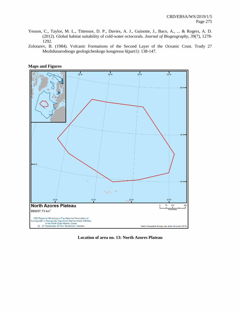
CBD/EBSA/WS/2019/1/5
Page 275
Yesson, C., Taylor, M. L., Tittensor, D. P., Davies, A. J., Guinotte, J., Baco, A., ... & Rogers, A. D.
(2012). Global habitat suitability of cold‐water octocorals. Journal of Biogeography, 39(7), 1278-
1292.
Zolotarev, B. (1984). Volcanic Formations of the Second Layer of the Oceanic Crust. Trudy 27
Mezhdunarodnogo geologicheskogo kongressa 6(part1): 138-147.
Maps and Figures
Location of area no. 13: North Azores Plateau
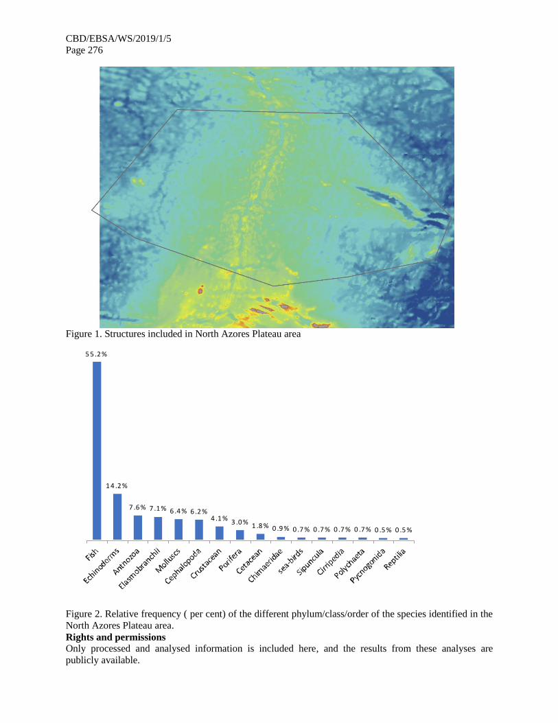
CBD/EBSA/WS/2019/1/5
Page 276
Figure 1. Structures included in North Azores Plateau area
5 5 .2 %
1 4 .2 %
7 .6 % 7 .1 % 6 .4 % 6 .2 %4 .1 % 3 .0 % 1 .8 % 0 .9 % 0 .7 % 0 .7 % 0 .7 % 0 .7 % 0 .5 % 0 .5 %
Figure 2. Relative frequency ( per cent) of the different phylum/class/order of the species identified in the
North Azores Plateau area.
Rights and permissions
Only processed and analysed information is included here, and the results from these analyses are
publicly available.
CBD/EBSA/WS/2019/1/5
Page 277
Area no. 14:
Mid-North-Atlantic Frontal System
Abstract The Mid-North-Atlantic Frontal System is a remote area of intense mesoscale activity with near-
stationary eddies and numerous thermal fronts aligned in zonal bands. These fronts and eddies enhance
primary productivity and retain and concentrate secondary productivity both vertically and horizontally.
The combination of localised high-intensity mixing in the eddies results in patchy, high surface,
productivity at fine scales. Tracking data collected for seabirds, whales, sea-turtles, tunas and sharks
(several of which are globally threatened) confirm that this is an area of high productivity, with a high
intensity of foraging activity, suggesting that productivity cascades to higher trophic levels.
Introduction The North-Atlantic Current (NAC) is the main northward branch of the Gulf Stream (Krauss 1986,
Rossby 1996), transporting warm water towards higher latitudes. After splitting from the Gulf Stream
near the Tail of the Grand Banks of Newfoundland and extending north into the Labrador Sea, the NAC
turns east at the so-called Northwest Corner and flows eastward. The front associated with the NAC is
called the Subpolar (or Subarctic) Front (Belkin & Levitus 1996). The Subpolar Front is a relatively wide
region that separates the subtropical gyre from the subpolar gyre and where the main thermocline shoals
to the surface (Rossby 1996). The NAC is different from surrounding areas and can be visualised through
satellite altimetry and NEMO (Nucleus for European Modelling of the Ocean) ocean models (e.g., Miller
et al. 2013; Marzocchi et al. 2015) and oceanographic sections (Belkin & Levitus 1996) (see also Figures
1-2). The NAC pathways are not randomly located but remain between a number of preferred latitudes,
with surface thermal fronts appearing in a banded structure, aligned west to east in the area south of the
Charlie-Gibbs Fracture Zone (CGFZ), and aligned roughly SW to NE in the north; this alignment follows
the direction of the NAC (Miller et al. 2013). The NAC is a transition zone and has a wide banded
structure with distinct water types that get progressively cooler and fresher from south to north separated
by the three branches and their density fronts. The fronts are associated with vigorous vertical velocities
(bringing nutrients to the surface) and some horizontal exchange, especially southward from the subpolar
region (Dutkiewicz et al. 2001; Figures 1-2). Density contrasts across the fronts lead to instability and the
development of eddies (Volkov 2005). These eddies enhance and concentrate primary production and
represent an important habitat for oceanic higher predators, including seabirds, as evident from studies on
seabirds, turtles, whales, sharks and tunas (e.g., Hays et al. 2004, Walli et al. 2009, Egevang et al. 2010,
Dias et al. 2011, 2012, Gilg et al. 2013; Queiroz et al. 2016), which frequently target areas of higher prey
availability. A large quantity of seabird tracking data confirms this is an area of high productivity, with a
high intensity of foraging activity in the area (BirdLife International 2019a, Figure 3a). Seabird tracking
data shows 21 species of seabird foraging in the area including endangered Zino's petrel (Pterodroma
madeira), endangered Bermuda petrel (Pterodroma cahow), vulnerable Atlantic puffin (Fratercula
arctica), and vulnerable black-legged kittiwake (Rissa tridactyla).
This site is identified from in situ and remote sensing (or satellite) data and validated with biological data
(tracking data collected for seabirds and other marine megafauna).
Location This area has a well-defined western boundary (front), defined by the maritime boundary of the OSPAR
Commission. It extends north along the east flank of the Grand Banks, where it forms a loop called the
Northwest Corner and continues to the east. The northern boundary is defined by the northern extent of
the Subpolar Front at 54°N. The North Subarctic Front is topographically fixed at the Charlie-Gibbs
Fracture Zone (Belkin & Levitus 1996), at 30°W. It is known that the North Atlantic Current and frontal
branches vary strongly, with latitudinal shifts up to 250-300 km (Belkin & Levitus 1996). Thus, maps of
annual means have been used to ensure the full temporal variability has been captured (Marzocchi et al.
2015; Figure 2).
CBD/EBSA/WS/2019/1/5
Page 278
Feature description of the area
The area includes the water column and surface used by seabirds and other marine top predators as
foraging areas throughout the year, as revealed by recent telemetry studies (see Figures 3-5; e.g., Dias et
al. 2011, 2012; Egevang et al. 2010; Frederiksen et al. 2016; Frederiksen et al. 2012; Gilg et al. 2013;
Hedd et al. 2012; Kopp et al. 2011; Queiroz et al. 2016;). Some seabird species travel to this area during
the breeding season, mostly from colonies located in the Azores (e.g., Magalhães et al. 2008) and
Madeira (Silva et al. 2019, Figure 3). The area is also very important as a stopover site during the
migration of Arctic species such as the Arctic tern (Sterna paradisea) and the long-tailed jaeger
(Stercorarius longicaudus) (Egevang et al. 2010, Gilg et al. 2013), and as a wintering ground for species
both from the North and the South Atlantic (e.g., Atlantic Puffin–Fratercula arctica, black-legged
kittiwake–Rissa tridactyla, Cory’s shearwater–Calonectris diomedea, great shearwater–Ardenna gravis,
sooty shearwater– Ardenna grisea and South Polar skua–Catharacta maccormicki; Dias et al. 2011, 2012,
Kopp et al. 2011, Hedd et al. 2012; Figure 3). Twenty-one species of seabirds are known to use the area
on a regular basis, including the OSPAR-listed Audubon’s shearwater (Puffinus lherminieri baroli) and
thick-billed murre (Uria lomvia) and several globally threatened species as Atlantic puffin (Fratercula
arctica), black-legged kittiwake (Rissa tridactyla), Desertas petrel (Pterodroma deserta), Zino’s petrel
(Pterodroma madeira) and Bermuda petrel (Pterodroma cahow). A scientific expedition to the area
carried out in 2018 confirmed the enhanced abundance and diversity of seabird species in the area in
comparison with adjacent waters (Wakefield 2018), and provided further evidence of the use of the area
by other seabird species for which tracking data are not available, such as Leach’s storm petrel
(Hydrobates leucorhous), Wilson’s storm petrel (Oceanites oceanicus), great black-backed gull (Larus
marinus), Arctic jaegar (Stercorarius parasiticus), pomarine jaegar (Stercorarius pomarinus) and
northern gannet (Morus bassanus) (Wakefield 2018).
Other marine megafauna occur in the area, such as marine mammals, sea turtles and sharks (Hays et al.
2004, Olsen et al. 2009, Walli et al. 2009, Silva et al. 2013, Prieto et al. 2014, Queiroz et al. 2016). A
number of tracking and telemetry studies on marine mammals, particularly for baleen whale species, have
indicated the presence of known migratory pathways transiting through the region. Such cetaceans
include the endangered sei whale (Balaenoptera borealis), which migrate through the area from the
Azores, likely longitudinally from waters on the Eastern Atlantic, to highly productive foraging areas in
the Labrador Sea (Figure 4) as well as Greenlandic and Icelandic waters (Olsen et al. 2009, Prieto et al.
2014). Other tracking studies of endangered fin whales (Balaenoptera physalus) and blue whales
(Balaenoptera musculus) have described long migratory movements between the area of the Azores
northward towards key foraging areas in the region of eastern Greenland and western Iceland (Figure 4;
Silva et al. 2013). Furthermore, fin and blue whales remained at middle latitudes along their migration in
the area for prolonged periods, exhibiting area-restricted search (ARS) behaviour, indicative of foraging
activity. Satellite tracking studies of humpback whales (Megaptera novaeangliae) tagged in Norwegian
waters as part of the Arctic University of Norway’s Whaletrack project has further recorded the use of the
area by migrating animals (Whaletrack 2019; Figure 4). Observations carried out during scientific
expeditions (e.g., 2004 Mid-Atlantic Ridge (MAR)-ECO expedition on the R.V. G.O. Sars; Skov et al.
2008) also provided evidence of the use of the area by sei whale, blue whale, fin whale and sperm whale,
as well as long and Short-finned pilot whales (Globicephala melas, G. macrorhynchus), humpback whale
(Megaptera novaeangliae), killer whale (Orcinus orca), beaked whales (Mesoplodon sp.) and Atlantic
white-sided dolphin (Lagenorhynchus acutus) (Waring et al. 2009; Figure 4). Analysis of the data
collected from the same expedition revealed that modelled aggregations of sperm whales and sei whales
along the MAR are primarily associated with fine-scale frontal processes interacting with the topography
in the upper 100 m of the water column just north of the Sub-Polar Front (SPF) and the CGFZ, as well as
moderate and high habitat suitability estimated only for areas downstream from the SPF (Skov et al.
2008; Figure 4).
Tracking studies on the leatherback turtle (Dermochelys coriacea) have indicated that the area is also
used by this species during the summer and autumn for months at a time (Hays et al. 2004). The Atlantic
bluefin tuna, listed by OSPAR as a Threatened and Declining Species, is known to use the area during all
CBD/EBSA/WS/2019/1/5
Page 279
seasons (Walli et al. 2009). Tracking studies have indicated that the area is also used by basking sharks
(Cetorhinus maximus) (Gore et al. 2008) (Figure 5).
The high abundance and diversity of megafaunais likely linked to the presence of multiple frontal zones
and persistent eddies, which are known to aggregate primary productivity and zooplankton, providing a
temporally and spatially reliable foraging zone for higher trophic level predators (Scales et al. 2014). Prey
availability can be further enhanced when these features occur over seamounts, as zooplankton can
become entrained over the abrupt topography (the topographic blockage), and are then further restricted
in their vertical migrations, thereby rendering them more accessible for mesopelagic fish and other top
predators (Dias et al. 2016; Morato et al. 2016; Sweetman et al. 2013). Broad-scale and remotely sensed
studies of the region have demonstrated that the frontal zone is subject to large-scale phytoplankton
blooms during spring and summer (Taylor and Ferrari 2011) with much higher chlorophyll concentrations
than the adjacent waters (Gaard et al. 2008; Pelegrí et al. 2006; Vecchione et al. 2015).
In relation to zooplankton communities, the available evidence suggests a high abundance of copepods,
gelatinous zooplankton and euphausiids (Gaard et al. 2008; Letessier et al. 2011; Vecchione et al. 2015).
Copepods are important prey for gelatinous zooplankton, mesopelagic fish, and some seabird species and
are often associated with high seabird numbers in the North Atlantic as indicators of abundant food
(Frederiksen et al. 2013; Karnovsky et al. 2008). Euphausiids are also abundant across the region and are
important prey for mesopelagic fish, cetaceans and seabirds, including thick-billed murre, little auk and
black-legged kittiwake (Mehlum and Gabrielsen 1993).
Mesopelagic fish are a major source of biomass in the oceans and important prey for higher trophic
predators, including seabirds (Gjøsaeter and Kawaguchi 1980; Harris et al. 2015; Paredes et al. 2014;
Waap et al. 2017). Mesopelagic fish prey on gelatinous zooplankton, and they in turn are preyed on by
larger fish, cetaceans and seabirds (Granadeiro et al. 1998; Granadeiro et al. 2002; Waap et al. 2017).
These small fish are particularly associated with fronts and eddies, such as those occurring within the area
(Paredes et al. 2014). Within the areas investigated by MARECO/ECOMAR (Vecchione et al. 2015,
mesopelagic species such as the goiter blacksmelt (Bathylagus euryops) and lanternfish (Myctophids)
were found in the highest abundance at the Subpolar Front and the CGFZ and with a tendency to be
distributed in the upper surface layers (Sweetman et al. 2013).
Cephalopods are also potentially concentrated within the boundary and broader region of the area, with
studies from the MARECO/ECOMAR programme indicating the highest diversity and abundance
occurring south of the CGFZ (Vecchione et al. 2015). The importance of cephalopods in the diet of some
Atlantic seabirds is well documented, for example in Audubon’s shearwater (Puffinus lherminieri),
Cory’s shearwater (Calonectris borealis), Manx shearwater (Puffinus puffinus) and Bulwer’s petrel
(Bulweria bulwerii) (Den Hartog & Clarke 1996; Neves et al. 2012; Petry et al. 2008; Waap et al. 2017);
other species such as Desertas petrel (Pterodroma deserta) and Atlantic puffin (Fratercula arctica) are
also known to prey on squid (Harris et al. 2015; Ramos et al. 2016).
Feature condition and future outlook of the area
Due to the remoteness of the area and lack of long-term studies, there is no information to determine the
trends of the conditions. Satellite information and other databases suggest that the area is less
commercially important for fishing than adjacent areas, and that no other major activities occur in the
area, apart from shipping (major shipping lines between Canada, USA and Europe pass through the area;
GFW 2019, PASTA MARE 2019). There is an ongoing project, led by University of Glasgow, to study
the community of seabirds, cetaceans and turtles in the area (Wakefield et al. 2018). There is also a
proposal to designate part of the area as a marine protected area under the OSPAR Convention.
Assessment of area no. 14, Mid-North-Atlantic Frontal System, against CBD EBSA Criteria
CBD EBSA
Criteria
(Annex I to
Description
(Annex I to decision IX/20) Ranking of criterion relevance
(please mark one column with an X)
No Low Medi High
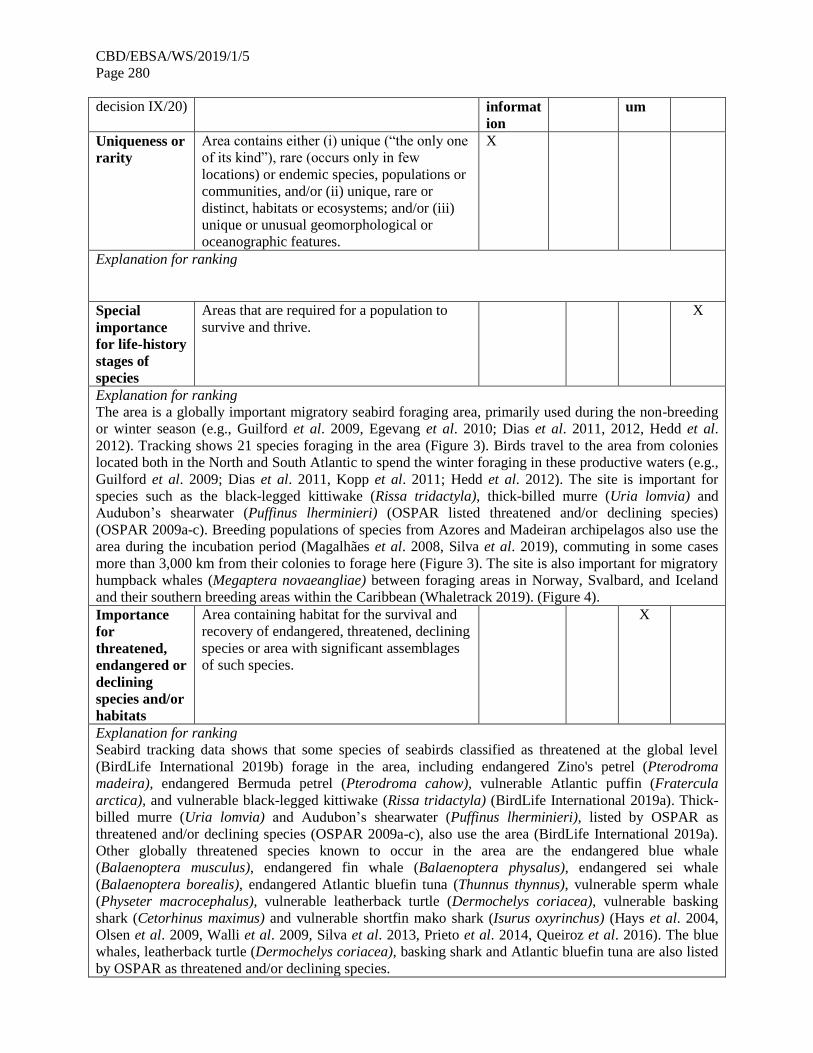
CBD/EBSA/WS/2019/1/5
Page 280
decision IX/20) informat
ion
um
Uniqueness or
rarity
Area contains either (i) unique (“the only one
of its kind”), rare (occurs only in few
locations) or endemic species, populations or
communities, and/or (ii) unique, rare or
distinct, habitats or ecosystems; and/or (iii)
unique or unusual geomorphological or
oceanographic features.
X
Explanation for ranking
Special
importance
for life-history
stages of
species
Areas that are required for a population to
survive and thrive.
X
Explanation for ranking
The area is a globally important migratory seabird foraging area, primarily used during the non-breeding
or winter season (e.g., Guilford et al. 2009, Egevang et al. 2010; Dias et al. 2011, 2012, Hedd et al.
2012). Tracking shows 21 species foraging in the area (Figure 3). Birds travel to the area from colonies
located both in the North and South Atlantic to spend the winter foraging in these productive waters (e.g.,
Guilford et al. 2009; Dias et al. 2011, Kopp et al. 2011; Hedd et al. 2012). The site is important for
species such as the black-legged kittiwake (Rissa tridactyla), thick-billed murre (Uria lomvia) and
Audubon’s shearwater (Puffinus lherminieri) (OSPAR listed threatened and/or declining species)
(OSPAR 2009a-c). Breeding populations of species from Azores and Madeiran archipelagos also use the
area during the incubation period (Magalhães et al. 2008, Silva et al. 2019), commuting in some cases
more than 3,000 km from their colonies to forage here (Figure 3). The site is also important for migratory
humpback whales (Megaptera novaeangliae) between foraging areas in Norway, Svalbard, and Iceland
and their southern breeding areas within the Caribbean (Whaletrack 2019). (Figure 4).
Importance
for
threatened,
endangered or
declining
species and/or
habitats
Area containing habitat for the survival and
recovery of endangered, threatened, declining
species or area with significant assemblages
of such species.
X
Explanation for ranking
Seabird tracking data shows that some species of seabirds classified as threatened at the global level
(BirdLife International 2019b) forage in the area, including endangered Zino's petrel (Pterodroma
madeira), endangered Bermuda petrel (Pterodroma cahow), vulnerable Atlantic puffin (Fratercula
arctica), and vulnerable black-legged kittiwake (Rissa tridactyla) (BirdLife International 2019a). Thick-
billed murre (Uria lomvia) and Audubon’s shearwater (Puffinus lherminieri), listed by OSPAR as
threatened and/or declining species (OSPAR 2009a-c), also use the area (BirdLife International 2019a).
Other globally threatened species known to occur in the area are the endangered blue whale
(Balaenoptera musculus), endangered fin whale (Balaenoptera physalus), endangered sei whale
(Balaenoptera borealis), endangered Atlantic bluefin tuna (Thunnus thynnus), vulnerable sperm whale
(Physeter macrocephalus), vulnerable leatherback turtle (Dermochelys coriacea), vulnerable basking
shark (Cetorhinus maximus) and vulnerable shortfin mako shark (Isurus oxyrinchus) (Hays et al. 2004,
Olsen et al. 2009, Walli et al. 2009, Silva et al. 2013, Prieto et al. 2014, Queiroz et al. 2016). The blue
whales, leatherback turtle (Dermochelys coriacea), basking shark and Atlantic bluefin tuna are also listed
by OSPAR as threatened and/or declining species.
CBD/EBSA/WS/2019/1/5
Page 281
Vulnerability,
fragility,
sensitivity, or
slow recovery
Areas that contain a relatively high
proportion of sensitive habitats, biotopes or
species that are functionally fragile (highly
susceptible to degradation or depletion by
human activity or by natural events) or with
slow recovery.
X
Explanation for ranking
The area is of high importance to numerous globally threatened species that have suffered significant
population declines – including Eedangered Zino's petrel (Pterodroma madeira), endangered Bermuda
petrel (Pterodroma cahow), vulnerable Atlantic puffin (Fratercula arctica), and vulnerable black-legged
kittiwake (Rissa tridactyla). In addition, the area is used by thick-billed murre (Uria lomvia) and
Audubon’s shearwater (Puffinus lherminieri), which are listed by OSPAR as threatened and/or declining
species. Black-legged kittiwake is listed as vulnerable because of population declines due to the depletion
of food resources (e.g., through over-fishing) (Frederiksen et al. 2004, Nikolaeva et al. 2006), marine oil
spills (Nikolaeva et al. 2006) and chronic oil pollution (Nikolaeva et al. 2006). All these species are long-
lived seabirds with a low reproduction rate and thus with slow recovery. The whales occurring in the area
are also species of low reproduction rate and vulnerable to multiple anthropogenic pressures (Melcón et
al. 2012).
Biological
productivity
Area containing species, populations or
communities with comparatively higher
natural biological productivity.
X
Explanation for ranking
Both satellite altimetry and numerous thermal fronts show this is an area of high mesoscale activity with
near-stationary eddies and thermal fronts aligned in zonal bands (Read et al. 2010; Figure 2). The fronts
retain and concentrate productivity both vertically and horizontally, and the combination of localised high
intensity mixing in the eddies results in patchy but high surface productivity at fine scales (Vecchione et
al. 2015). Seabird tracking data confirms this is an area of high productivity, with a high intensity of
foraging activity in the area (BirdLife International 2019a).
Biological
diversity
Area contains comparatively higher diversity
of ecosystems, habitats, communities, or
species, or has higher genetic diversity.
X
Explanation for ranking
This area comprises a transition from the subtropical ocean to the subpolar (subarctic) ocean. As such,
this area features several well-defined water masses separated by well-defined fronts (Figure 2). Each
water mass contains a distinct ecosystem, while fronts act as ecotones, ensuring the high diversity of
ecosystems and habitats in this area (Read et al. 2010; Miller et al. 2013).
Analyses of tracking data from over 2,000 individual seabirds indicate that the area is intensively used by
21 species (compiled by BirdLife International, 2019a; see also Figure 3):
- Arctic Tern Sterna paradisaea (LC)
- Atlantic Puffin Fratercula arctica (VU)
- Audubon’s Shearwater Puffinus lherminieri (LC)
- Bermuda Petrel Pterodroma cahow (EN)
- Black-legged Kittiwake Rissa tridactyla (VU)
- Bulwer’s Petrel Bulweria bulwerii (LC)
- Common Murre Uria aalge (LC)
- Cory’s Shearwater Calonectris borealis (LC)
- Desertas Petrel Pterodroma deserta (VU)
- Great Shearwater Ardenna gravis (LC)
- Great Skua Catharacta skua (LC)
- Little Auk Alle alle (LC)
- Long-tailed Jaeger Stercorarius longicaudus (LC)
- Manx Shearwater Puffinus puffinus (LC)
CBD/EBSA/WS/2019/1/5
Page 282
- Northern Fulmar Fulmarus glacialis (LC)
- Razorbill Alca torda (NT)
- Sabine’s Gull Xema sabini (LC)
- Sooty Shearwater Ardenna grisea (NT)
- South Polar Skua Catharacta maccormicki (LC)
- Thick-billed Murre Uria lomvia (LC)
- Zino’s Petrel Pterodroma madeira (EN)
At-sea surveys confirmed the use of the area by five additional species (Wakefield et al. 2018):
- Great Black-backed Gull, Larus marinus (LC)
- Leach’s Storm Petrel, Hydrobates leucorhous (VU)
- Northern Gannet, Morus bassanus (LC)
- Pomarine Jaegar, Stercorarius pomarinus (LC)
- Wilson’s storm petrel, Oceanites oceanicus (LC)
There is also evidence of the use of the area by other species of marine megafauna (Waring et al. 2009;
Olsen et al. 2009, Silva et al. 2013; Prieto et al. 2014; Wakefield et al. 2018):
- Blue Whale, Balaenoptera musculus (EN)
- Fin Whale, Balaenoptera physalus (EN)
- Sei Whale, Balaenoptera borealis (EN)
- Humpback Whale, Megaptera novaeangliae (LC)
- Sperm Whale, Physeter macrocephalus (VU)
- Pilot Whales, Globicephala spp (DD)
- Killer Whale, Orcinus orca (DD)
- Short-beaked Common Dolphin, Delphinus delphis (LC)
- Risso’s Dolphin, Grampus griseus (LC)
- White-sided Dolphin, Lagenorhynchus acutus (LC)
- Beaked Whales Mesoplodon spp
- Striped Dolphin, Stenella coeruleoalba (LC)
- Leatherback Turtle, Dermochelys coriacea (VU)
- Basking Shark, Cetorhinus maximus (VU)
- Atlantic Bluefin Tuna, Thunnus thynnus (EN)
- Blue Shark, Prionace glauca (NT)
- Shortfin Mako Shark, Isurus oxyrinchus (VU)
Naturalness Area with a comparatively higher degree of
naturalness as a result of the lack of or low
level of human-induced disturbance or
degradation.
X
Explanation for ranking
Due to its remote location in very deep, open ocean, the area is not easily accessible. The waters within
the area are therefore only exposed to a very limited range of human uses at present (e.g., PASTA MARE
2019, GFW 2019).
Sharing experiences and information applying other criteria
Other
Criteria
Description
Ranking of criterion relevance
(please mark one column with an X)
Don’t
Know
Low Mediu
m
High
IBA criteria
The site is known or thought to hold regularly
significant numbers of a globally threatened
species (Donald et al. 2018)
X
CBD/EBSA/WS/2019/1/5
Page 283
The site is known or thought to hold
congregations of ≥1 per cent of the global
population of one or more species on a regular
or predictable basis (Donald et al. 2018)
The area meets the criteria to be classified as an Important Bird and Biodiversity Area (IBA) by BirdLife
International (Donald et al. 2018, BirdLife International 2019c), which are very closely aligned with the
EBSA criteria (Waliczky et al. 2018).
References
Belkin, I. M. & Levitus, S. (1996) Temporal variability of the subarctic front near the Charlie‐Gibbs
fracture zone. Journal of Geophysical Research: Oceans 101(C12): 28317-28324.
BirdLife International (2019a). The Seabird Tracking Database. www.seabirdtracking.org
BirdLife International (2019b) IUCN Red List for birds. Downloaded from http://www.birdlife.org on
30/08/2019.
BirdLife International (2019c) Marine IBA e-Atlas. Available at
https://maps.birdlife.org/marineIBAs/default.html
Cayula J.-F., P. Cornillon (1992), Edge Detection Algorithm for SST Images, Journal of Atmospheric and
Oceanic Technology 9, 67–80.
Chassignet, E. et al. (2009). US GODAE: Global Ocean Prediction with the HYbrid Coordinate Ocean
Model (HYCOM). - Oceanog. 22: 64–75.
Den Hartog J., Clarke M. (1996) A study of stomach contents of Cory's Shearwater, Calonectris
diomedea borealis (Cory, 1881)(Aves: Procellariidae), from the Macaronesian Islands. Zoologische
Mededeelingen 70, 117-133.
Dias M.P., Granadeiro J.P., Phillips R.A., Alonso H., Catry P. (2011) Breaking the routine: individual
Cory's shearwaters shift winter destinations between hemispheres and across ocean basins.
Proceedings of the Royal Society of London B: Biological Sciences 278, 1786-1793.
Dias M., Granadeiro J., Catry P. (2012a) Do Seabirds Differ from Other Migrants in Their Travel
Arrangements? On Route Strategies of Cory’s Shearwater during Its Trans-Equatorial Journey.
PLOS ONE 7, e49376.
Dias M.P., Romero J., Granadeiro J.P., Catry T., Pollet I.L., Catry P. (2016) Distribution and at-sea
activity of a nocturnal seabird, the Bulwer's petrel Bulweria bulwerii, during the incubation period.
Deep Sea Research Part I: Oceanographic Research Papers 113, 49-56.
Donald, P.F., Fishpool, L.D.C., Ajagbe, A., Bennun, L.A., Bunting, G., Burfield, I.J., Butchart, S.H.M.,
Capellan, S., Crosby, M.J., Dias, M.P., Diaz, D., Evans, M.I., Grimmett, R., Heath, M., Jones,
V.R., Lascelles, B.G., Merriman, J.C., O’brien, M., Ramírez, I., Waliczky, Z., Wege, D.C., (2018).
Important Bird and Biodiversity Areas (IBAs): the development and characteristics of a global
inventory of key sites for biodiversity. Bird Conservation International 1–22.
https://doi.org/10.1017/S0959270918000102
Dutkiewicz, S., Rothstein, L. & Rossby, T. (2001) Pathways of cross‐frontal exchange in the North
Atlantic Current. Journal of Geophysical Research: Oceans 106(C11): 26917-26928.
Egevang C., Stenhouse I.J., Phillips R.A., Petersen A., Fox J.W., Silk J.R. (2010) Tracking of Arctic terns
Sterna paradisaea reveals longest animal migration. Proceedings of the National Academy of
Sciences 107, 2078-2081.
Frederiksen M., Anker‐Nilssen T., Beaugrand G., Wanless S. (2013) Climate, copepods and seabirds in
the boreal Northeast Atlantic–current state and future outlook. Global Change Biology 19, 364-372.
Frederiksen M., Moe B., Daunt F. et al. (2012) Multicolony tracking reveals the winter distribution of a
pelagic seabird on an ocean basin scale. Diversity and Distributions 18, 530-542.
Frederiksen, M., Wanless, S., Harris, M. P., Rothery, P., Wilson, L. J. (2004). The role of industrial
fisheries and oceanographic change in the decline of North Sea black-legged kittiwakes. Journal of
Applied Ecology 41: 1129-1139.
CBD/EBSA/WS/2019/1/5
Page 284
Gaard E., Gislason A., Falkenhaug T. et al. (2008) Horizontal and vertical copepod distribution and
abundance on the Mid-Atlantic Ridge in June 2004. Deep Sea Research Part II: Topical Studies in
Oceanography 55, 59-71.
GFW (2019). Global Fishing Watch dataase. Accessed on 26/09/2019.
Gilg O., Moe B., Hanssen S.A. et al. (2013) Trans-equatorial migration routes, staging sites and wintering
areas of a high-arctic avian predator: the long-tailed skua (Stercorarius longicaudus). PloS one 8,
e64614.
Gjøsaeter J., Kawaguchi K. (1980) A review of the world resources of mesopelagic fish. pp. 193-199.
FAO Fisheries Technical Paper 193 Food & Agriculture Organisation, Rome, Italy.
Gore M.A., Rowat D., Hall J., Gell F.R., Ormond R.F. (2008) Transatlantic migration and deep mid-
ocean diving by basking shark. Biology letters 4, 395-398.
Granadeiro J.P., Monteiro L.R., Furness R.W. (1998) Diet and feeding ecology of Cory's shearwater
Calonectris diomedea in the Azores, north-east Atlantic. Marine Ecology Progress Series, 267-276.
Granadeiro J.P., Monteiro L.R., Silva M.C., Furness R.W. (2002) Diet of common terns in the Azores,
Northeast Atlantic. Waterbirds 25, 149-155.
Guilford T., Meade J., Willis J. et al. (2009) Migration and stopover in a small pelagic seabird, the Manx
shearwater Puffinus puffinus: insights from machine learning. Proceedings of the Royal Society of
London B: Biological Sciences, rspb. 2008.1577.
Harris M.P., Leopold M.F., Jensen J.K., Meesters E.H., Wanless S. (2015) The winter diet of the Atlantic
Puffin Fratercula arctica around the Faroe Islands. Ibis 157, 468-479.
Hays, G.C., Houghton, J.D.R., Myers, A.E., (2004). Pan-Atlantic leatherback turtle movements. Nature
429, 522–522. https://doi.org/10.1038/429522a
Hedd A., Montevecchi W.A., Otley H., Phillips R.A., Fifield D.A. (2012) Trans-equatorial migration and
habitat use by sooty shearwaters Puffinus griseus from the South Atlantic during the nonbreeding
season. Marine Ecology Progress Series 449, 277-290.
Karnovsky N.J., Hobson K.A., Iverson S., Hunt Jr G.L. (2008) Seasonal changes in diets of seabirds in
the North Water Polynya: a multiple-indicator approach. Marine Ecology Progress Series 357, 291-
299.
Kopp M., Peter H.-U., Mustafa O. et al. (2011) South polar skuas from a single breeding population
overwinter in different oceans though show similar migration patterns. Marine Ecology Progress
Series 435, 263-267.
Krauss, W. (1986) The north Atlantic current. Journal of Geophysical Research: Oceans 91(C4): 5061-
5074.
Letessier T., Pond D.W., McGill R.A., Reid W.D., Brierley A.S. (2012) Trophic interaction of
invertebrate zooplankton on either side of the a Fracture Zone/Subpolar Front of the Mid-Atlantic
Ridge. Journal of marine systems 94, 174-184.
Magalhães, M.C., Santos, R.S., Hamer, K.C., (2008). Dual-foraging of Cory’s shearwaters in the Azores:
feeding locations, behaviour at sea and implications for food provisioning of chicks. Marine
Ecology Progress Series 359, 283–293. https://doi.org/10.3354/meps07340
Marzocchi, A., Hirschi, J. J. M., Holliday, N. P., Cunningham, S. A., Blaker, A. T. & Coward, A. C.
(2015) The North Atlantic subpolar circulation in an eddy-resolving global ocean model. Journal of
Marine Systems 142: 126-143.
Mehlum F., Gabrielsen G. (1993) The diet of high-arctic seabirds in coastal and ice-covered, pelagic areas
near the Svalbard archipelago. Polar research 12, 1-20.
Melcón, M.L., Cummins, A.J., Kerosky, S.M., Roche, L.K., Wiggins, S.M., Hildebrand, J.A., (2012).
Blue Whales Respond to Anthropogenic Noise. PLOS ONE 7, e32681.
https://doi.org/10.1371/journal.pone.0032681
Miller, P. I., Read, J. F. & Dale, A. C. (2013) Thermal front variability along the North Atlantic Current
observed using microwave and infrared satellite data. Deep Sea Research Part II: Topical Studies in
Oceanography 98: 244-256.
CBD/EBSA/WS/2019/1/5
Page 285
Morato T., Miller P.I., Dunn D.C., Nicol S.J., Bowcott J., Halpin P.N. (2016) A perspective on the
importance of oceanic fronts in promoting aggregation of visitors to seamounts. Fish and Fisheries
17, 1227-1233.
Neves V.C., Bried J., González-Solís J., Roscales J.L., Clarke M.R. (2012) Feeding ecology and
movements of the Barolo shearwater Puffinus baroli baroli in the Azores, NE Atlantic. Marine
Ecology Progress Series 452, 269-285.
Nikolaeva, N.G.; Spiridonov, V.A.; Krasnov, Y.V. (2006). Existing and proposed marine protected areas
and their relevance for seabird conservation: a case study in the Barents Sea region. In: G. Boere,
C. Galbraith and D. Stroud (eds), Waterbirds around the world, pp. 743-749. The Stationery Office,
Edinburgh, UK.
Olsen, E., Budgell P., Head E., Kleivane L., Nottestad L., Prieto R., Silva M., Skov H., Vikingsson G.,
Waring G., Oien N. 2009. First satellite-tracked long-distance movement of a Sei Whale
(Balaenoptera borealis) in the North Atlantic. Aquatic Mammals, 35(3): 313-318
OSPAR (2009a). Background document for Black-legged Kittiwake Rissa tridactyla. Biodiversity Series.
OSPAR (2009b). Background document for Audubon’s Shearwater Puffinus lherminieri. Biodiversity
Series.
OSPAR (2009c). Background document for Thick-billed Murre Uria lomvia. Biodiversity Series
Paredes R., Orben R.A., Suryan R.M. et al. (2014) Foraging responses of black-legged kittiwakes to
prolonged food-shortages around colonies on the Bering Sea shelf. PloS one 9, e92520.
PASTA MARE (2019). Maritime traffic density. Available at https://octopus.zoo.ox.ac.uk/beta/data
Pelegrí J., Marrero-Díaz A., Ratsimandresy A. (2006) Nutrient irrigation of the North Atlantic. Progress
in Oceanography 70, 366-406.
Petry M.V., da Silva Fonseca V.S., Krüger-Garcia L., da Cruz Piuco R., Brummelhaus J. (2008)
Shearwater diet during migration along the coast of Rio Grande do Sul, Brazil. Marine Biology
154, 613-621.
Prieto, R., Silva, M.A., Waring, G. & Gonçalves, J. (2014). Sei whale movements and behavior in the
North Atlantic inferred from satellite telemetry. Endangered Species Research. 26. 103-113. DOI:
https://doi.org/10.3354/esr00630
Queiroz, N., Humphries, N.E., Mucientes, G., Hammerschlag, N., Lima, F.P., Scales, K.L., Miller, P.I.,
Sousa, L.L., Seabra, R., Sims, D.W., (2016). Ocean-wide tracking of pelagic sharks reveals extent
of overlap with longline fishing hotspots. PNAS 113, 1582–1587.
https://doi.org/10.1073/pnas.1510090113
Ramos R., Ramírez I., Paiva V.H. et al. (2016) Global spatial ecology of three closely-related gadfly
petrels. Scientific reports 6.
Read, J., Pollard, R., Miller, P. & Dale, A. (2010) Circulation and variability of the North Atlantic
Current in the vicinity of the Mid-Atlantic Ridge. Deep Sea Research Part I: Oceanographic
Research Papers 57(3): 307-318.
Roberts, J.J., B.D. Best, D.C. Dunn, E.A. Treml, and P.N. Halpin (2010). Marine Geospatial Ecology
Tools: An integrated framework for ecological geoprocessing with ArcGIS, Python,R, MATLAB,
and C++. Environmental Modelling & Software 25: 1197-1207.
Rossby, T. (1996) The North Atlantic Current and surrounding waters: At the crossroads. Reviews of
Geophysics 34(4): 463-481.
Scales K.L., Miller P.I., Hawkes L.A., Ingram S.N., Sims D.W., Votier S.C. (2014) On the Front Line:
frontal zones as priority at‐sea conservation areas for mobile marine vertebrates. Journal of Applied
Ecology 51, 1575-1583.
Silva, M., Catry, P., Menezes, D., Zino, F., Viveiros, C., Camara, J., Gouveia, P., Gomes, J., Catry, T.,
Granadeiro, J.P. (2019). Mechanisms of breeding asynchrony in sympatric Portuguese seabirds, the
endangered Zino’s Petrel (Pterodroma madeira) and Deserta´s Petrel (Pterodroma deserta). in
SPEA (2019) (Eds). Livro de Resumos do X Congresso de Ornitologia da SPEA – 1.ª edição.
Sociedade Portuguesa para o Estudo das Aves, Lisboa
CBD/EBSA/WS/2019/1/5
Page 286
Silva, M.A., Prieto, R., Jonsen, I., Baumgartner, M.F., Santos, R.S. (2013). North Atlantic Blue and Fin
Whales Suspend Their Spring Migration to Forage in Middle Latitudes: Building up Energy
Reserves for the Journey? PLoS ONE 8(10): e76507. https://doi.org/10.1371/journal.pone.0076507
Skov, H., Gunnlaugsson, T., Budgell, W. P., Horne, J., Nøttestad, L., Olsen, E.V., Søilandc, H.
Vı kingsson, G. and Waring, G. (2008) Small-scale spatial variability of sperm and sei whales in
relation to oceanographic and topographic features along the Mid-Atlantic Ridge. Deep Sea
Research Part II Topical Studies in Oceanography. 55. 254-268. 10.1016/j.dsr2.2007.09.020.
Sweetman C.J., Sutton T., Vecchione M., Latour R.J. (2013) Distribution of the biomass-dominant
pelagic fish, Bathylagus euryops (Argentiniformes: Microstomatidae), along the northern Mid-
Atlantic Ridge. Deep Sea Research Part I: Oceanographic Research Papers 78, 16-23.
Taylor J.R., Ferrari R. (2011) Ocean fronts trigger high latitude phytoplankton blooms. Geophysical
Research Letters 38.
Vecchione M., Falkenhaug T., Sutton T. et al. (2015) The effect of the North Atlantic Subpolar Front as a
boundary in pelagic biogeography decreases with increasing depth and organism size. Progress in
Oceanography 138, 105-115.
Volkov, D. L. (2005) Interannual variability of the altimetry-derived eddy field and surface circulation in
the extratropical North Atlantic Ocean in 1993–2001. Journal of Physical Oceanography 35(4):
405-426.
Waap S., Symondson W.O., Granadeiro J.P. et al. (2017) The diet of a nocturnal pelagic predator, the
Bulwer’s petrel, across the lunar cycle. Scientific Reports 7.
Wakefield, E.D. (2018) Transatlantic surveys of seabirds, cetaceans and turtles, July 2013 and July 2018,
University of Glasgow, UK, 34p.
Waliczky, Z., Fishpool, L.D.C., Butchart, S.H.M., Thomas, D., Heath, M.F., Hazin, C., Donald, P.F.,
Kowalska, A., Dias, M.P., Allinson, T.S.M., (2018). Important Bird and Biodiversity Areas (IBAs):
their impact on conservation policy, advocacy and action. Bird Conservation International 1–17.
https://doi.org/10.1017/S0959270918000175
Walli A., Teo S.L., Boustany A. et al. (2009) Seasonal movements, aggregations and diving behavior of
Atlantic bluefin tuna (Thunnus thynnus) revealed with archival tags. PLoS One 4, e6151.
Waring, G., Nøttestad, L., Olsen, E., Skov, H. & Víkingsson, G (2009) Distribution and density estimates
of cetaceans along the mid- Atlantic Ridge during summer 2004. Journal of Cetacean Research and
Management. 10. 137-146.
Whaletrack (2019) UiT- The Arctic University of Norway -
https://en.uit.no/prosjekter/prosjekt?p_document_id=505966
Maps and Figures
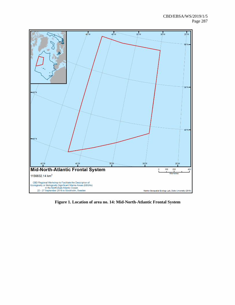
CBD/EBSA/WS/2019/1/5
Page 287
Figure 1. Location of area no. 14: Mid-North-Atlantic Frontal System
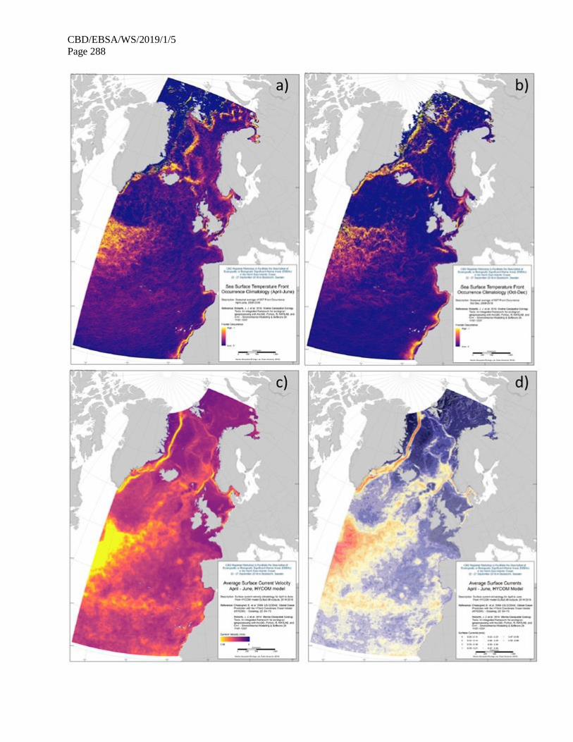
CBD/EBSA/WS/2019/1/5
Page 288
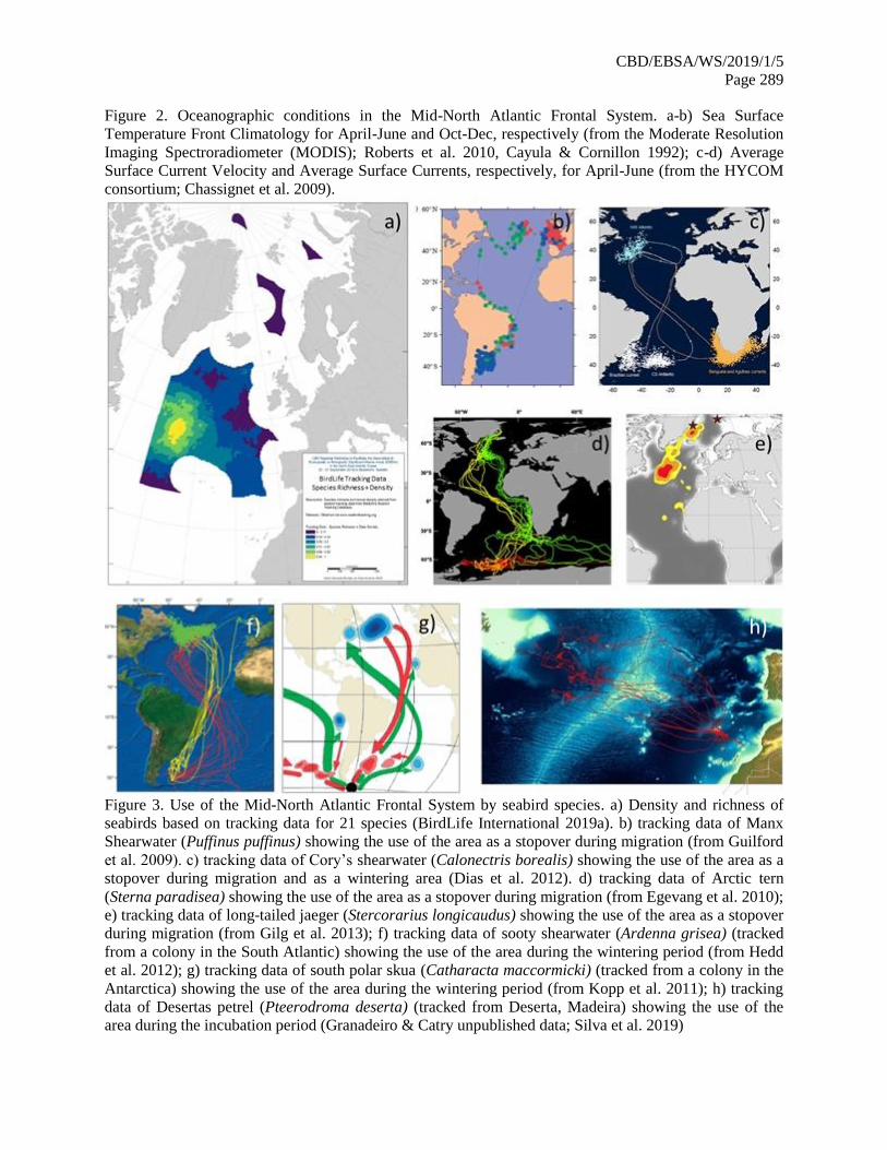
CBD/EBSA/WS/2019/1/5
Page 289
Figure 2. Oceanographic conditions in the Mid-North Atlantic Frontal System. a-b) Sea Surface
Temperature Front Climatology for April-June and Oct-Dec, respectively (from the Moderate Resolution
Imaging Spectroradiometer (MODIS); Roberts et al. 2010, Cayula & Cornillon 1992); c-d) Average
Surface Current Velocity and Average Surface Currents, respectively, for April-June (from the HYCOM
consortium; Chassignet et al. 2009).
Figure 3. Use of the Mid-North Atlantic Frontal System by seabird species. a) Density and richness of
seabirds based on tracking data for 21 species (BirdLife International 2019a). b) tracking data of Manx
Shearwater (Puffinus puffinus) showing the use of the area as a stopover during migration (from Guilford
et al. 2009). c) tracking data of Cory’s shearwater (Calonectris borealis) showing the use of the area as a
stopover during migration and as a wintering area (Dias et al. 2012). d) tracking data of Arctic tern
(Sterna paradisea) showing the use of the area as a stopover during migration (from Egevang et al. 2010);
e) tracking data of long-tailed jaeger (Stercorarius longicaudus) showing the use of the area as a stopover
during migration (from Gilg et al. 2013); f) tracking data of sooty shearwater (Ardenna grisea) (tracked
from a colony in the South Atlantic) showing the use of the area during the wintering period (from Hedd
et al. 2012); g) tracking data of south polar skua (Catharacta maccormicki) (tracked from a colony in the
Antarctica) showing the use of the area during the wintering period (from Kopp et al. 2011); h) tracking
data of Desertas petrel (Pteerodroma deserta) (tracked from Deserta, Madeira) showing the use of the
area during the incubation period (Granadeiro & Catry unpublished data; Silva et al. 2019)
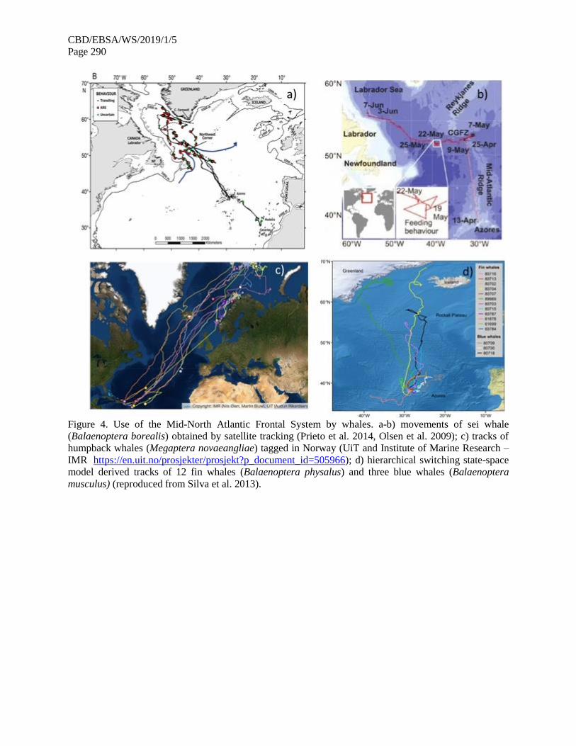
CBD/EBSA/WS/2019/1/5
Page 290
Figure 4. Use of the Mid-North Atlantic Frontal System by whales. a-b) movements of sei whale
(Balaenoptera borealis) obtained by satellite tracking (Prieto et al. 2014, Olsen et al. 2009); c) tracks of
humpback whales (Megaptera novaeangliae) tagged in Norway (UiT and Institute of Marine Research –
IMR https://en.uit.no/prosjekter/prosjekt?p_document_id=505966); d) hierarchical switching state-space
model derived tracks of 12 fin whales (Balaenoptera physalus) and three blue whales (Balaenoptera
musculus) (reproduced from Silva et al. 2013).
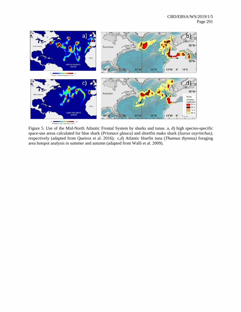
CBD/EBSA/WS/2019/1/5
Page 291
Figure 5. Use of the Mid-North Atlantic Frontal System by sharks and tunas. a, d) high species-specific
space-use areas calculated for blue shark (Prionace glauca) and shortfin mako shark (Isurus oxyrinchus),
respectively (adapted from Queiroz et al. 2016); c,d) Atlantic bluefin tuna (Thunnus thynnus) foraging
area hotspot analysis in summer and autumn (adapted from Walli et al. 2009).
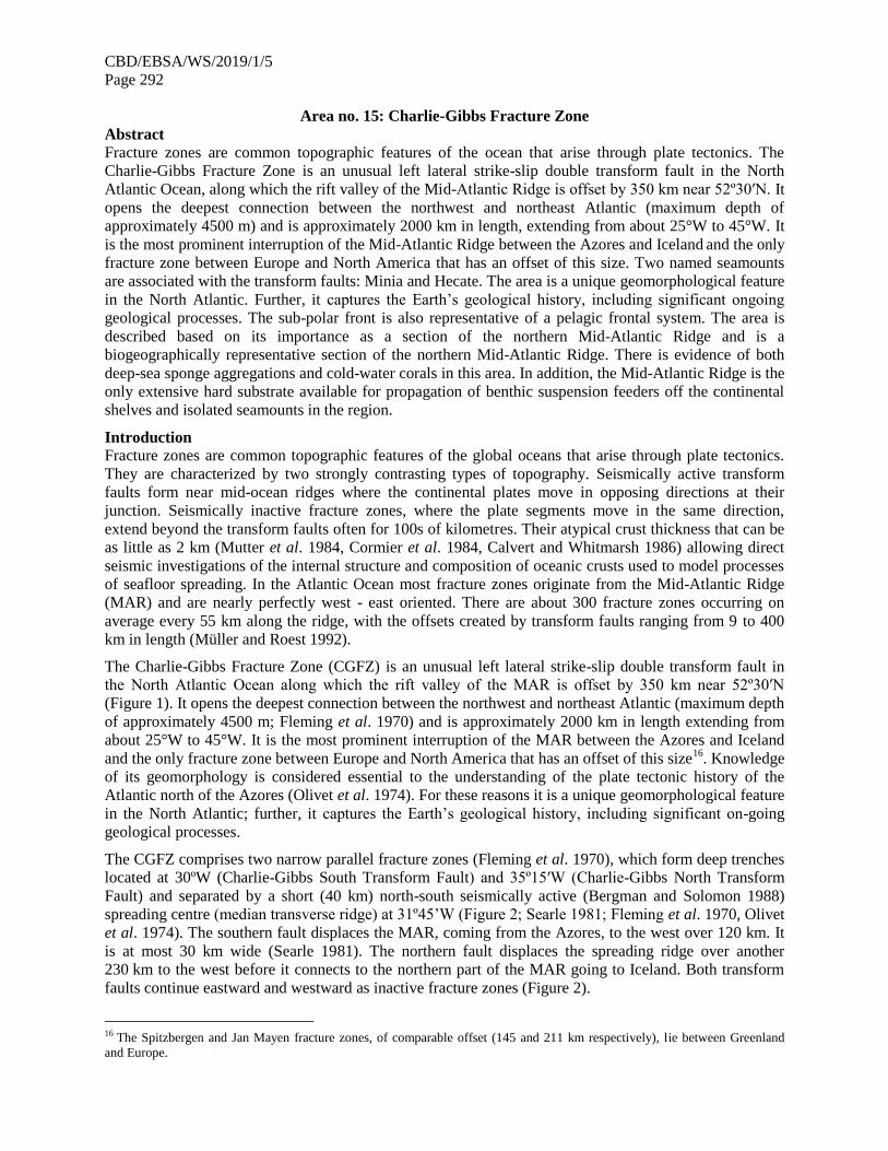
CBD/EBSA/WS/2019/1/5
Page 292
Area no. 15: Charlie-Gibbs Fracture Zone
Abstract Fracture zones are common topographic features of the ocean that arise through plate tectonics. The
Charlie-Gibbs Fracture Zone is an unusual left lateral strike-slip double transform fault in the North
Atlantic Ocean, along which the rift valley of the Mid-Atlantic Ridge is offset by 350 km near 52º30′N. It
opens the deepest connection between the northwest and northeast Atlantic (maximum depth of
approximately 4500 m) and is approximately 2000 km in length, extending from about 25°W to 45°W. It
is the most prominent interruption of the Mid-Atlantic Ridge between the Azores and Iceland and the only
fracture zone between Europe and North America that has an offset of this size. Two named seamounts
are associated with the transform faults: Minia and Hecate. The area is a unique geomorphological feature
in the North Atlantic. Further, it captures the Earth’s geological history, including significant ongoing
geological processes. The sub-polar front is also representative of a pelagic frontal system. The area is
described based on its importance as a section of the northern Mid-Atlantic Ridge and is a
biogeographically representative section of the northern Mid-Atlantic Ridge. There is evidence of both
deep-sea sponge aggregations and cold-water corals in this area. In addition, the Mid-Atlantic Ridge is the
only extensive hard substrate available for propagation of benthic suspension feeders off the continental
shelves and isolated seamounts in the region.
Introduction Fracture zones are common topographic features of the global oceans that arise through plate tectonics.
They are characterized by two strongly contrasting types of topography. Seismically active transform
faults form near mid-ocean ridges where the continental plates move in opposing directions at their
junction. Seismically inactive fracture zones, where the plate segments move in the same direction,
extend beyond the transform faults often for 100s of kilometres. Their atypical crust thickness that can be
as little as 2 km (Mutter et al. 1984, Cormier et al. 1984, Calvert and Whitmarsh 1986) allowing direct
seismic investigations of the internal structure and composition of oceanic crusts used to model processes
of seafloor spreading. In the Atlantic Ocean most fracture zones originate from the Mid-Atlantic Ridge
(MAR) and are nearly perfectly west - east oriented. There are about 300 fracture zones occurring on
average every 55 km along the ridge, with the offsets created by transform faults ranging from 9 to 400
km in length (Müller and Roest 1992).
The Charlie-Gibbs Fracture Zone (CGFZ) is an unusual left lateral strike-slip double transform fault in
the North Atlantic Ocean along which the rift valley of the MAR is offset by 350 km near 52º30′N
(Figure 1). It opens the deepest connection between the northwest and northeast Atlantic (maximum depth
of approximately 4500 m; Fleming et al. 1970) and is approximately 2000 km in length extending from
about 25°W to 45°W. It is the most prominent interruption of the MAR between the Azores and Iceland
and the only fracture zone between Europe and North America that has an offset of this size16
. Knowledge
of its geomorphology is considered essential to the understanding of the plate tectonic history of the
Atlantic north of the Azores (Olivet et al. 1974). For these reasons it is a unique geomorphological feature
in the North Atlantic; further, it captures the Earth’s geological history, including significant on-going
geological processes.
The CGFZ comprises two narrow parallel fracture zones (Fleming et al. 1970), which form deep trenches
located at 30ºW (Charlie-Gibbs South Transform Fault) and 35º15′W (Charlie-Gibbs North Transform
Fault) and separated by a short (40 km) north-south seismically active (Bergman and Solomon 1988)
spreading centre (median transverse ridge) at 31º45’W (Figure 2; Searle 1981; Fleming et al. 1970, Olivet
et al. 1974). The southern fault displaces the MAR, coming from the Azores, to the west over 120 km. It
is at most 30 km wide (Searle 1981). The northern fault displaces the spreading ridge over another
230 km to the west before it connects to the northern part of the MAR going to Iceland. Both transform
faults continue eastward and westward as inactive fracture zones (Figure 2).
16 The Spitzbergen and Jan Mayen fracture zones, of comparable offset (145 and 211 km respectively), lie between Greenland
and Europe.
CBD/EBSA/WS/2019/1/5
Page 293
The CGFZ is characterized by rough morphology, and the walls of the fracture valleys and the ridge in
between them are broken and irregular, with slopes of up to 29° (Fleming et al. 1970). The height of the
ridge between the faults is at least 1000 m below the surface and as shallow as 636 m in parts (Fleming et
al. 1970). Rock samples show the walls of the fracture zone to be both basaltic and ultramafic while the
median transverse ridge contains gabbro (Hekinian and Aumento 1973). Earthquake epicentres are
associated with the transform faults (Kanamori and Stewart 1976, Bergman and Solomon 1988), and an
almost continuous belt of epicentres follows the southern end of the Reykjanes Ridge, along the northern
transform valley, the central median valley and the southern transform valley to the north end of the MAR
(Lilwall and Kirk 1985). Two named seamounts are associated with the transform faults: Minia Seamount
(53°01′N 34°58′W), located near the junction of the Reykjanes Ridge and the northern transform fault,
and Hecate Seamount (52°17′N 31°00′W), located on the northern wall of the southern transform fault
east of the short median transverse ridge.
Ridges and troughs along the CGFZ are mostly covered with muddy sediments (Fleming et al. 1970),
although outcrops of sedimentary rock and boulder fields are exposed by recent faulting and current scour
(Shor et al. 1980, Searle 1981), and the southern transform near 30°30′W has no sediment cover (Searle
1981). Thick layers of sediment are deposited in the northern transform valley from the Iceland-Scotland
Overflow Water (ISOW), which carries a significant load of suspended sediment (25 μg I-1
) as it passes
through (Shor et al. 1980). Transverse ridges prevent the sediment from reaching the southern valley
(Searle 1981), which has less sediment cover, although it is still considered a depositional environment
(Shor et al. 1980).
The topography of the CGFZ has a major influence on deep-water oceanographic circulation (Harvey and
Theodorou 1986). A large component of the North Atlantic Deep Water originates in the Norwegian Sea
and flows south over the sills between Scotland and Iceland (ISOW). It meets the CGFZ near the
intersection of the transform faults and the spreading centre (Shor et al. 1980). There is then a westward
movement of deep water passing through the fracture zone from east to west through to the Irminger Sea
occurring from the core depth of the ISOW at about 2500 m to the sea floor (Garner 1972, Shor et al.
1980, Saunders 1994). Most of this water is carried through the northern transform fault where the
overflow water first encounters the fracture zone.
The topography of the CGFZ also is thought to have some influence on the circulation of surface waters,
although they are not locked to the bottom features to the same extent as the ISOW (Rossby 1999, Bower
et al. 2002). The northern branch of the North Atlantic Current defines the location of the sub-polar front
between colder Sub Arctic Intermediate Water to the north and warmer North Atlantic Intermediate Water
to the south (Søiland et al. 2008). The sub-polar front meanders between 48-53°N, and surface flow is
predominantly eastward. The CGFZ is therefore not only a topographic discontinuity in the MAR but the
area also constitutes an oceanographic transition zone between waters of different temperatures and flow
regimes (Priede et al. 2013).
This proposal concentrates on an area that is an especially complex section of the MAR (Søiland et al.,
2008), including sections of the MAR to the north and south of the Charlie-Gibbs Fracture Zone, and as
such is expected to be home to diverse and interesting deep-sea fauna (Tabachnick & Collins, 2008).
From the north, the Reykjanes Ridge stretches southwestwards from Iceland to approximately 52ºN,
where the Charlie-Gibbs Fracture Zone (Felley et al., 2008; Heger et al., 2008) offsets the ridge by 5º to
the east and opens the deepest (maximum depth 4500 m) connection between the northwest and northeast
Atlantic (Felley et al., 2008; Heger et al., 2008; Mortensen et al., 2008; Søiland et al., 2008). South of the
Charlie-Gibbs Fracture zone, two pronounced deep rift valleys at 32.25ºW and 31.75ºW (Opdal et al.,
2008) and two further fracture zones (Faraday and Maxwell Fracture Zones, at 50ºN and 48ºN
respectively) create topographic complexity that likely also creates associated diversity in ecological
communities, although the latter remain poorly characterised.The MAR within the OSPAR maritime area
is considered to have three different biogeographic regions. The MAR-ECO project studied these areas in
their fieldwork, by targeting three clear areas in the northern, southern and Charlie-Gibbs Fracture Areas
CBD/EBSA/WS/2019/1/5
Page 294
regions. The on-going ATLAS project is completing a revision of North Atlantic biogeography, including
work to understand the implications of changing ocean conditions (ATLAS 2019).
The general circulation in the epipelagic zone (0-200 m) is well understood as the warm North Atlantic
current flowing north-eastwards from the subtropical gyre in the southwest Atlantic towards the European
shelf with two to four branches crossing the MAR between 45° and 52° N, approximately coinciding with
the three fracture zones (Sy et al. 1992, Søiland et al., 2008). The sub-polar front is created where the
warm, saline North Atlantic water meets the cold, less saline water of the sub-polar gyre from the
Labrador and Irminger Seas and is a permanent feature. The meandering of the sub-polar front between
48-53°N coincides with temporal variation in the character and spatial distribution of the water masses
and frontal features (Søiland et al. 2008). This front is one of the major oceanic features in the OSPAR
region, being an area of elevated abundance and diversity of many taxa, including an elevated standing
stock of phytoplankton (Clark et al., 2001; Gallienne et al., 2001; Gaard et al., 2008; Opdal et al., 2008;
Sutton et al., 2008).
Location This area extends from 48°N and 55°188′N along the Mid-Atlantic Ridge, and the Charlie-Gibbs Fracture
Zone occurs at 52º30′N. The area extends from about 25°W to 45°W, with the transform faults occurring
between 30°W and 35°W (Olivet et al. 1974). The eastern boundary of the Charlie- Gibbs Fracture Zone
is detectable beyond 42°W. The southern ridge continues uninterrupted to 45°W (Olivet et al. 1974). This
area encompasses the Charlie-Gibbs Fracture Zone, the meandering Sub-polar Frontal Zone and the
benthic communities of the Mid-Atlantic Ridge in this area, including individual seamounts.
Feature description of the area
The MAR is a benthic feature and has important benthic habitats associated with it. However, as
mentioned in the introductory section, the MAR plays a fundamental role in circulation patterns of the
area and so can also be considered a water column feature. The Charlie-Gibbs Fracture Zone (CGFZ) is a
unique geomorphological feature to the North Atlantic Ocean and to the high-seas areas of NEAFC and
OSPAR. Owing to its remoteness, the fauna associated with the CGFZ are poorly studied, and it is
premature to speculate on whether any species are endemic based on first descriptions. For example,
Gebruk (2008) described two species of holothurians and believed them to be endemic to the MAR but
they subsequently were found on the European continental margin in the Whittard Canyon (Masson
2009).
As part of the MAR-ECO project (Priede et al. 2013) manned submersibles were deployed on the axis
(52°47′N) and the northern slopes (52°58′N) of the Charlie–Gibbs North transform fault and surveyed
macroplankton (Vinogradov 2005), demersal nekton (Felley et al. 2008) and invertebrate megafauna
(Gebruk and Krylova 2013). Pelagic shrimps, chaetognaths and gelatinous animals were numerically
dominant in the plankton, with peak densities corresponding to the main pycnocline. Mucous houses of
appendicularians were abundant at 150 m above the seabed, although this is common throughout the
central Atlantic and not associated with specific bottom topography (Vinogradov 2005). Nekton included
large and small macrourids (Coryphaenoides spp.), shrimp (infraorder Penaeidea), Halosauropsis
macrochir, Aldrovandia sp., Antimora rostrata, and alepocephalids (Felley et al. 2008).
Glass sponges were common between 1700 and 2500 m while the deeper parts of the fracture wall and the
sea floor were dominated by isidid corals, other anthozoans, squat lobsters and echinoderms, especially
holothurians. The elpidiid holothurian, Kolga nana, occurred at high density in the abyssal depression
(Gebruk and Krylova 2013). Rogacheva et al. (2013) recorded 32 holothurian species from the CGFZ
area through the ECOMAR project (http://www.oceanlab.abdn.ac.uk/ecomar/), including three elasipodid
holothurian species new to science.
In general, none of the fauna documented from the CGFZ showed distributions atypical of similar habitats
in the broader North Atlantic, although Gebruk and Krylova (2013) discuss the known distribution of the
holothurian Peniagone longipaillata and remark on the differences in relative abundance observed
between the occurrence of this species, where it is common in the lower bathyal of the CGFZ, and the
CBD/EBSA/WS/2019/1/5
Page 295
continental slopes in the Porcupine Seabight and Abyssal Plain areas and Whittard Canyon, where it is
less common. There is weak evidence that the CGFZ may be important for juvenile zoarcids based on a
high percentage of those observed with baited cameras being <100 mm in length (Kemp et al. 2013).
General knowledge of seafloor benthos suggests that where the geo-morphological processes of the
fracture zone have created steep walls along the fractures, the greater three-dimensional topographic
complexity, combined with the strong water flows through the fractures, creates habitat that is likely to be
more productive and support greater concentrations of fragile taxa such as deep-water corals and sponges
than adjacent habitats (Miller et al. 2012). The sampling done along the fracture zone supports these
inferences but the differences from other habitats in similar depths and latitudes have not been quantified
yet. The CGFZ was mapped for the first time in 2015 on the RV Celtic Explorer as one of the key projects
launched by the Atlantic Ocean Research Alliance, following the signing of the Galway Statement on
Atlantic Ocean Cooperation between Canada, the EU and the US in May 2013, discovering sponge
gardens and a skate nursery at 2000m.
For the benthic fauna, the Mid-Atlantic Ridge can serve as a barrier for east-west dispersal (see e.g.,
Mironov & Gebruk 2002, 2006) although the degree to which east and west communities differ varies
along the ridge (Alt et al., 2019). Gebruk et al. (2006) noted that particularly in the area south of the
CGFZ, 48 per cent of the 150 identified species occurred only to the west of the ridge, whereas 19 per
cent of the species were restricted to the eastern Atlantic. Likewise, the CGFZ acts as a barrier in north-
south direction: the areas south and north of the CGFZ share only 27 per cent of the species (of the groups
used as indicators), and recent studies suggest that the CGFZ may serve as a major biogeographic barrier
for deep-sea demosponges (Cárdenas and Rapp, 2015). Due to the transition of water masses at 800-1000
m depth there is also a vertical zonation of the bathyal fauna.
Video inspections in the areas south and north of the CGFZ found cold water corals at all sites, at depths
of 772-2355m, most commonly between 800 and 1400 m. Twenty-seven of the 40 coral taxa were
octocorals, among which the Gorgonacea were the most diverse (Mortensen et al., 2008). Molodtsova et
al. (2008) found very little overlap in species composition of the coral fauna in the sampling areas north,
near and south of the CGFZ. The number of megafaunal species was higher in areas where corals
dominated, compared to areas without coral. Typical taxa that co-occurred with Lophelia were crinoids,
certain sponges, the bivalve Acesta excavata, and squat lobster (Mortensen et al. 2008). In addition,
further surveys have also observed sponge aggregations. Bell et al., (2016) observed areas dominated by
both demosponges and glass sponges on steep slopes between 2095 and 2601 m depth. Alt et al. (2019)
also reported sponge aggregations on flat areas and sedimented slopes at around 2500m depth.
The biogeography of the seamount-related fish fauna of the North Atlantic, caught mainly as bycatch in
roundnose grenadier (Coryphaenoides rupestris) and alfonsino (Beryx splendens) trawls down to 1500 m
depth in over 20 years of commercial exploitation by Russian fisheries, is described by Kukuev (2004).
He accounts for 68 species of mainly mesobenthopelagic bathyal fishes associated with the seamounts of
the northern MAR (45-55°N, i.e. within the described area), including 44 species of deepwater sharks,
such as Chlamydoselachidae, Pseudotriakidae, Scyliorinidae and Squalidae, including leafscale gulper
shark (Centrophorus squamosus), gulper shark (C. granulosus) and Portuguese dogfish (Centroscymnus
coelepis).
The ecosystem associated with the MAR seems to be of particular importance to sei (Balaenoptera
borealis) and sperm whales (Physeter macrocephalus). The highest aggregations of baleen whales and
especially sei whales were observed north of and in relation to the CGFZ, which overlaps with earlier
observations of Sigurjónsson et al. (1991) (in Skov et al. 2008). Balaenoptera borealis in particular was
most abundant over the slopes of steep seamounts and water depths between 1500 and 3000 m, whereas
P. macrocephalus were most common in waters shallower than 2000 m and often seen above high rising
seamounts where they presumably found the best feeding conditions, i.e. the highest squid density
(Nøttestad et al. 2005). Tracking studies of sei, fin and blue whale have described the migration of these
species through the area from the Azores to foraging areas in the Labrador Sea as well as Greenlandic and
CBD/EBSA/WS/2019/1/5
Page 296
Icelandic waters (Olsen et al. 2009, Silva et al., 2013; Prieto et al., 2014), Furthermore, fin and blue
whales remained at middle latitudes along their migration in the area for prolonged periods in the areas of
the CGFZ and Reykjanes Ridge, exhibiting area-restricted search (ARS) behaviour, indicative of foraging
activity. The 2004 MAR-ECO expedition, which provided the opportunity to model the oceanic
distributions of cetaceans across the CGFZ and Reykjanes Ridge for sperm whales, suggests that these
species are associated with fine-scale frontal processes interacting with the topography in the upper 100m
of the water column just north of the Sub-Polar Front (SPF), CGFZ and Faraday Seamount (Skov et al.,
2008).
The MAR-ECO cruise provided a snapshot of seabird distribution along the MAR in summer 2004: 22
species of seabirds were identified, however only the northern fulmar (Fulmarus glacialis), great
shearwater (Puffinus gravis) and Cory´s shearwater (Calonectris diomedea) were observed by the
hundreds. The distribution of these species reflects the broad characters of water masses in the area (from
Mar-Eco cruise report, Nøttestad et al., 2004) and in particular the boundary effect of the frontal zone and
the limited nesting sites available only on the Azores and Iceland (Skov et al. 1994). F. glacialis were
distributed along most of the study transect north of 47° N, and they were by far the most common
species of seabird along the central and northern parts of the MAR. Densities were generally below 1 bird
per km2, and no large-scale concentrations were noted. However, discrete elevations in densities were
recorded both in the Reykjanes and the CGFZ regions. P. gravis were observed only in the vicinity of the
Subpolar front just north of the CGFZ. Most of the birds recorded were found in the area of the Subpolar
front, where concentrations of both sitting and flying birds were observed. The largest flock seen was of
160 birds, but flock sizes were generally between three and 10 birds. Outside the frontal area P. gravis
were mainly seen in singles. C. diomedea on the other hand is found only south of the P. gravis
distribution area – usually not in flocks except for an area where warm Gulf Stream water surfaced. C.
diomedea were commonly observed with cetaceans, most notably dolphins, but also with other species,
e.g., sperm whales. More recent at-sea surveys confirm the importance of the area for species richness,
abundance and over-wintering aggregations (Bennison and Jessopp, 2015; Boertmann, 2011) as well as
for breeding birds from the Azores (i.e., birds travelling there during the incubation period) (Magalhaes et
al., 2008).
There is only anecdotal evidence on the observation of sea turtles over the MAR, in particular, enhanced
abundances over the CGFZ and SPF regions. The leatherback turtle (Dermochelys coriacea) can be found
foraging at oceanic fronts during their long trans-Atlantic migrations (Eckert, 2006). It occurs within the
described region and feeds primarily on gelatinous zooplankton (Hays et al., 2006; Doyle, 2007, Doyle et
al, 2008), high concentrations of which have been recorded several times around the CGFZ and SPF
(Fock et al., 2004; Youngbluth et al., 2008). One study has tracked individuals to the SPF area of the
North-East Atlantic, presumably to feed in this plankton rich environment (Ferraroli et al., 2004; Hays et
al., 2004). It is probable therefore, that this species of turtle visits the described area to feed. Loggerhead
turtle (Caretta caretta) is the most common sea turtle in the North-East Atlantic (Revelles et al., 2007).
No direct observations of this species have been made near the CGFZ . However, it is known to make
trans-Atlantic migrations between nesting and foraging sites (Encalada et al., 1998). It is possible that
animals may stop to feed in the CGFZ during these migrations as noted for individual D. coriacea.
Feature condition and future outlook of the area
Given the geophysical nature, location and size of the CGFZ, it is unlikely that it will be affected by
human activities, although there is potential for mining of the rare minerals associated with the transform
faults. In 2010 the Environmental Ministers of the OSPAR countries officially designated a marine
protected area of 145,420 km2 in the southern part of the CGFZ (Figure 3) and adopted “significant and
innovative measures to establish and manage the southern part of the originally proposed Charlie-Gibbs
Fracture Zone MPA – ‘Charlie-Gibbs South MPA’-, for which the seabed and super adjacent waters are
situated in areas beyond national jurisdiction” (OSPAR Commission 2010). That same year (2010) the
OSPAR Commission and the International Seabed Authority signed a memorandum of understanding in
order to conciliate the development of mineral resources with comprehensive protection of the marine
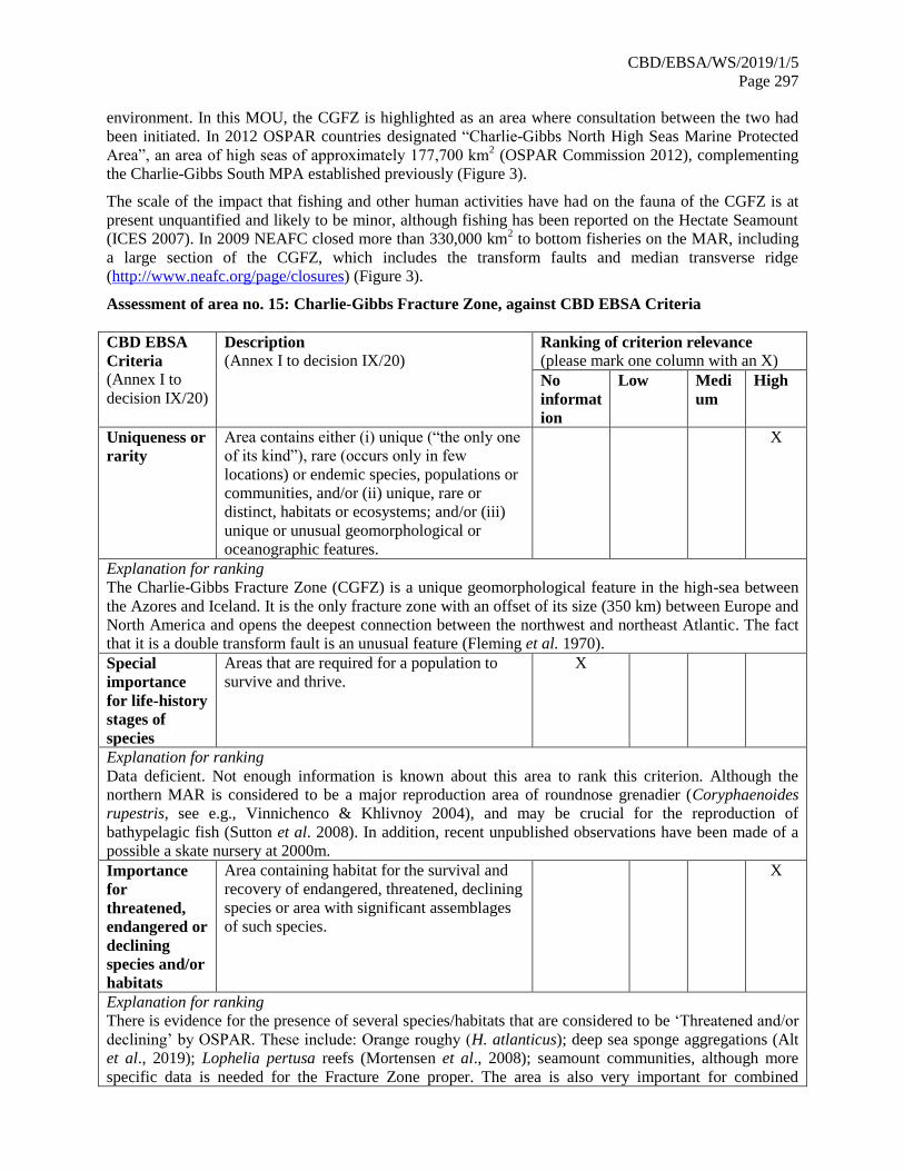
CBD/EBSA/WS/2019/1/5
Page 297
environment. In this MOU, the CGFZ is highlighted as an area where consultation between the two had
been initiated. In 2012 OSPAR countries designated “Charlie-Gibbs North High Seas Marine Protected
Area”, an area of high seas of approximately 177,700 km2 (OSPAR Commission 2012), complementing
the Charlie-Gibbs South MPA established previously (Figure 3).
The scale of the impact that fishing and other human activities have had on the fauna of the CGFZ is at
present unquantified and likely to be minor, although fishing has been reported on the Hectate Seamount
(ICES 2007). In 2009 NEAFC closed more than 330,000 km2 to bottom fisheries on the MAR, including
a large section of the CGFZ, which includes the transform faults and median transverse ridge
(http://www.neafc.org/page/closures) (Figure 3).
Assessment of area no. 15: Charlie-Gibbs Fracture Zone, against CBD EBSA Criteria
CBD EBSA
Criteria
(Annex I to
decision IX/20)
Description
(Annex I to decision IX/20) Ranking of criterion relevance
(please mark one column with an X)
No
informat
ion
Low Medi
um
High
Uniqueness or
rarity
Area contains either (i) unique (“the only one
of its kind”), rare (occurs only in few
locations) or endemic species, populations or
communities, and/or (ii) unique, rare or
distinct, habitats or ecosystems; and/or (iii)
unique or unusual geomorphological or
oceanographic features.
X
Explanation for ranking
The Charlie-Gibbs Fracture Zone (CGFZ) is a unique geomorphological feature in the high-sea between
the Azores and Iceland. It is the only fracture zone with an offset of its size (350 km) between Europe and
North America and opens the deepest connection between the northwest and northeast Atlantic. The fact
that it is a double transform fault is an unusual feature (Fleming et al. 1970).
Special
importance
for life-history
stages of
species
Areas that are required for a population to
survive and thrive.
X
Explanation for ranking
Data deficient. Not enough information is known about this area to rank this criterion. Although the
northern MAR is considered to be a major reproduction area of roundnose grenadier (Coryphaenoides
rupestris, see e.g., Vinnichenco & Khlivnoy 2004), and may be crucial for the reproduction of
bathypelagic fish (Sutton et al. 2008). In addition, recent unpublished observations have been made of a
possible a skate nursery at 2000m.
Importance
for
threatened,
endangered or
declining
species and/or
habitats
Area containing habitat for the survival and
recovery of endangered, threatened, declining
species or area with significant assemblages
of such species.
X
Explanation for ranking
There is evidence for the presence of several species/habitats that are considered to be ‘Threatened and/or
declining’ by OSPAR. These include: Orange roughy (H. atlanticus); deep sea sponge aggregations (Alt
et al., 2019); Lophelia pertusa reefs (Mortensen et al., 2008); seamount communities, although more
specific data is needed for the Fracture Zone proper. The area is also very important for combined
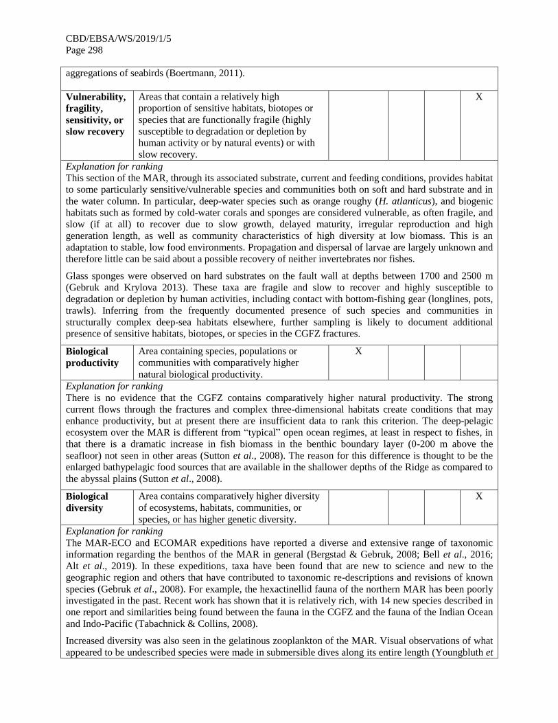
CBD/EBSA/WS/2019/1/5
Page 298
aggregations of seabirds (Boertmann, 2011).
Vulnerability,
fragility,
sensitivity, or
slow recovery
Areas that contain a relatively high
proportion of sensitive habitats, biotopes or
species that are functionally fragile (highly
susceptible to degradation or depletion by
human activity or by natural events) or with
slow recovery.
X
Explanation for ranking
This section of the MAR, through its associated substrate, current and feeding conditions, provides habitat
to some particularly sensitive/vulnerable species and communities both on soft and hard substrate and in
the water column. In particular, deep-water species such as orange roughy (H. atlanticus), and biogenic
habitats such as formed by cold-water corals and sponges are considered vulnerable, as often fragile, and
slow (if at all) to recover due to slow growth, delayed maturity, irregular reproduction and high
generation length, as well as community characteristics of high diversity at low biomass. This is an
adaptation to stable, low food environments. Propagation and dispersal of larvae are largely unknown and
therefore little can be said about a possible recovery of neither invertebrates nor fishes.
Glass sponges were observed on hard substrates on the fault wall at depths between 1700 and 2500 m
(Gebruk and Krylova 2013). These taxa are fragile and slow to recover and highly susceptible to
degradation or depletion by human activities, including contact with bottom-fishing gear (longlines, pots,
trawls). Inferring from the frequently documented presence of such species and communities in
structurally complex deep-sea habitats elsewhere, further sampling is likely to document additional
presence of sensitive habitats, biotopes, or species in the CGFZ fractures.
Biological
productivity
Area containing species, populations or
communities with comparatively higher
natural biological productivity.
X
Explanation for ranking
There is no evidence that the CGFZ contains comparatively higher natural productivity. The strong
current flows through the fractures and complex three-dimensional habitats create conditions that may
enhance productivity, but at present there are insufficient data to rank this criterion. The deep-pelagic
ecosystem over the MAR is different from “typical” open ocean regimes, at least in respect to fishes, in
that there is a dramatic increase in fish biomass in the benthic boundary layer (0-200 m above the
seafloor) not seen in other areas (Sutton et al., 2008). The reason for this difference is thought to be the
enlarged bathypelagic food sources that are available in the shallower depths of the Ridge as compared to
the abyssal plains (Sutton et al., 2008).
Biological
diversity
Area contains comparatively higher diversity
of ecosystems, habitats, communities, or
species, or has higher genetic diversity.
X
Explanation for ranking
The MAR-ECO and ECOMAR expeditions have reported a diverse and extensive range of taxonomic
information regarding the benthos of the MAR in general (Bergstad & Gebruk, 2008; Bell et al., 2016;
Alt et al., 2019). In these expeditions, taxa have been found that are new to science and new to the
geographic region and others that have contributed to taxonomic re-descriptions and revisions of known
species (Gebruk et al., 2008). For example, the hexactinellid fauna of the northern MAR has been poorly
investigated in the past. Recent work has shown that it is relatively rich, with 14 new species described in
one report and similarities being found between the fauna in the CGFZ and the fauna of the Indian Ocean
and Indo-Pacific (Tabachnick & Collins, 2008).
Increased diversity was also seen in the gelatinous zooplankton of the MAR. Visual observations of what
appeared to be undescribed species were made in submersible dives along its entire length (Youngbluth et
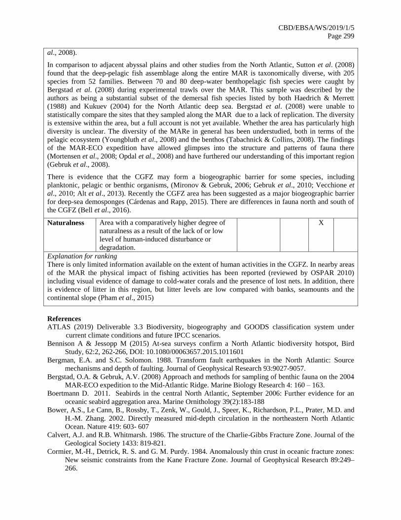
CBD/EBSA/WS/2019/1/5
Page 299
al., 2008).
In comparison to adjacent abyssal plains and other studies from the North Atlantic, Sutton et al. (2008)
found that the deep-pelagic fish assemblage along the entire MAR is taxonomically diverse, with 205
species from 52 families. Between 70 and 80 deep-water benthopelagic fish species were caught by
Bergstad et al. (2008) during experimental trawls over the MAR. This sample was described by the
authors as being a substantial subset of the demersal fish species listed by both Haedrich & Merrett
(1988) and Kukuev (2004) for the North Atlantic deep sea. Bergstad et al. (2008) were unable to
statistically compare the sites that they sampled along the MAR due to a lack of replication. The diversity
is extensive within the area, but a full account is not yet available. Whether the area has particularly high
diversity is unclear. The diversity of the MARe in general has been understudied, both in terms of the
pelagic ecosystem (Youngbluth et al., 2008) and the benthos (Tabachnick & Collins, 2008). The findings
of the MAR-ECO expedition have allowed glimpses into the structure and patterns of fauna there
(Mortensen et al., 2008; Opdal et al., 2008) and have furthered our understanding of this important region
(Gebruk et al., 2008).
There is evidence that the CGFZ may form a biogeographic barrier for some species, including
planktonic, pelagic or benthic organisms, (Mironov & Gebruk, 2006; Gebruk et al., 2010; Vecchione et
al., 2010; Alt et al., 2013). Recently the CGFZ area has been suggested as a major biogeographic barrier
for deep-sea demosponges (Cárdenas and Rapp, 2015). There are differences in fauna north and south of
the CGFZ (Bell et al., 2016).
Naturalness Area with a comparatively higher degree of
naturalness as a result of the lack of or low
level of human-induced disturbance or
degradation.
X
Explanation for ranking
There is only limited information available on the extent of human activities in the CGFZ. In nearby areas
of the MAR the physical impact of fishing activities has been reported (reviewed by OSPAR 2010)
including visual evidence of damage to cold-water corals and the presence of lost nets. In addition, there
is evidence of litter in this region, but litter levels are low compared with banks, seamounts and the
continental slope (Pham et al., 2015)
References
ATLAS (2019) Deliverable 3.3 Biodiversity, biogeography and GOODS classification system under
current climate conditions and future IPCC scenarios.
Bennison A & Jessopp M (2015) At-sea surveys confirm a North Atlantic biodiversity hotspot, Bird
Study, 62:2, 262-266, DOI: 10.1080/00063657.2015.1011601
Bergman, E.A. and S.C. Solomon. 1988. Transform fault earthquakes in the North Atlantic: Source
mechanisms and depth of faulting. Journal of Geophysical Research 93:9027-9057.
Bergstad, O.A. & Gebruk, A.V. (2008) Approach and methods for sampling of benthic fauna on the 2004
MAR-ECO expedition to the Mid-Atlantic Ridge. Marine Biology Research 4: 160 – 163.
Boertmann D. 2011. Seabirds in the central North Atlantic, September 2006: Further evidence for an
oceanic seabird aggregation area. Marine Ornithology 39(2):183-188
Bower, A.S., Le Cann, B., Rossby, T., Zenk, W., Gould, J., Speer, K., Richardson, P.L., Prater, M.D. and
H.-M. Zhang. 2002. Directly measured mid-depth circulation in the northeastern North Atlantic
Ocean. Nature 419: 603- 607
Calvert, A.J. and R.B. Whitmarsh. 1986. The structure of the Charlie-Gibbs Fracture Zone. Journal of the
Geological Society 1433: 819-821.
Cormier, M.-H., Detrick, R. S. and G. M. Purdy. 1984. Anomalously thin crust in oceanic fracture zones:
New seismic constraints from the Kane Fracture Zone. Journal of Geophysical Research 89:249–
266.
CBD/EBSA/WS/2019/1/5
Page 300
Doyle, T.K. (2007) Leatherback sea turtles (Dermochelys coriacea) in Irish waters. Irish Wildlife
Manuals, No. 32. National Parks and Wildlife Service, Department of the Environment, Heritage
and Local Government, Dublin, Ireland.
Doyle, T.K., Houghton, J.D.R., O’Súilleabháin, P.F., Hobson, V.J., Marnell, F., Davenport, J. & Hays,
G.C. (2008) Leatherback turtles satellite-tagged in European waters. Endangered Species Research
4: 23 – 31
Encalada, S.E., Bjorndal, K.A., Bolten, A.B., Zurita, J.C., Schroeder, B., Possardt, E., Sears, C.J. &
Bowen, B.W. (1998) Population structure of loggerhead turtle (Caretta caretta) nesting colonies in
the Atlantic and Mediterranean as inferred from mitochondrial DNA control region sequences.
Marine Biology 130: 567 – 575.
Felley, J.D., Vecchione, M. And R.R. Wilson Jr. 2008. Small-scale distribution of deep-sea demersal
nekton and other megafauna in the Charlie-Gibbs Fracture Zone of the Mid-Atlantic Ridge. Deep
Sea Research II 55: 153-160.
Ferraroli, S., Georges, J-Y., Gasparll, P. & Le Maho, Y. (2004) Where leatherback turtles meet fisheries:
conservation efforts should focus on hotspots frequented by these ancient reptiles. Nature 429: 521.
Fleming, H.S., Cherkis, N.Z. and J.R. Heirtzler. 1970. The Gibbs Fracture Zone: A double fracture zone
at 52°30′N in the Atlantic Ocean. Marine Geophysical Researches 1:37-45.
Fock, H., Pusch, C. & Ehrich, S. (2004) Structure of deep-pelagic fish assemblages in relation to the Mid
Atlantic Ridge (45o – 50oN). Deep-Sea Research I 51: 953
Garner, D.M. 1972. Flow through the Charlie-Gibbs Fracture Zone, Mid-Atlantic Ridge. Canadian
Journal of Earth Sciences 9: 116-121.
Gebruk A.V. 2008. Holothurians (Holothuroidea, Echinodermata) of the northern Mid-Atlantic Ridge
collected by the G.O. Sars MAR-ECO expedition with descriptions of four new species. Marine
Biology Research 4, 48–60.
Gebruk, A.V. and E.M. Krylova. 2013. Megafauna of the Charlie–Gibbs Fracture Zone (northern Mid-
Atlantic Ridge) based on video observations. Journal of the Marine Biological Association of the
United Kingdom 93: 1143-1150. doi:10.1017/S0025315412001890.
Haedrich, R.L. & Merrett, N.R. (1988) Summary atlas of deep-living fishes in the North Atlantic. Journal
of Natural History 22: 1325 – 1362.
Harvey, J.G. and A. Theodorou. 1986. The circulation of Norwegian Sea overflow water in the eastern
North Atlantic. Oceanologica Acta 9: 393-402.
Hays, G.C., Hobson, V.J., Metcalfe, J.D., Righton, D. & Sims, D.W. (2006) Flexible foraging movements
of leatherback turtles across the north Atlantic Ocean. Ecology 87(10): 2647 – 2656.
Hays, G.C., Houghton, J.D.R. & Myers, A.E. (2004) Pan-Atlantic leatherback turtle movements. Nature
429: 522.
Heger, A., Ieno, E.N., King, N.J., Morris, K.J., Bagley, P.M. & Priede, I.G. (2008) Deep-sea pelagic
bioluminescence over the Mid-Atlantic Ridge. Deep-Sea Research II 55: 126 – 136.
Hekinian, R. and F. Aumento. 1973. Rocks from the Gibbs Fracture Zone and the Minia Seamount near
53°N in the Atlantic Ocean. Marine Geology 14: 47-72.
ICES. 2007. Report of the Working Group on Deep-water Ecology (WGDEC), 26 – 28th February. ICES
CM 2007/ACE:01 Ref. LRC. 61pp.
Kanamori, H. and G.S. Stewart. 1976. Mode of the strain release along the Gibbs Fracture Zone, Mid-
Atlantic Ridge. Physcis of the Earth and Planetary Interiors 11: 312-332.
Kukuev, E.I. (2004) 20 years of ichthyofauna research on seamounts of the North Atlantic Ridge and
adjacent areas. A review. Archive of Fishery Marine Research 51(1-3): 215 -232.
Lilwall, R.C. and R.E. Kirk. 1985. Ocean-bottom seismograph observations on the Charlie-Gibbs fracture
zone. Geophysical Journal of the Royal Astronomical Society 80: 195-208.
Magalhães, M., Santos, R. & Hamer, K. 2008. Dual-foraging of Cory’s shearwaters in the Azores:
feeding locations, behaviour at sea and implications for food provisioning of chicks. Mar. Ecol.
Prog. Ser. 359: 283–293.
CBD/EBSA/WS/2019/1/5
Page 301
Masson, D.G. 2009. The Geobiology of Whittard Submarine Canyon. RRS James Cook Cruise 36, 19
June–28 July 2009. National Oceanography Centre, Southampton, 53 pp.
http://www.eprints.soton.ac.uk/69504/1/nocscr041.pdf.
Miller, R.J., Hocevar, J., Stone, R.P. and D.V. Fedorov. 2012. Structure-forming corals and sponges and
their use as fish habitat in Bering Sea submarine canyons. PLoS ONE 7(3): e33885.
doi:10.1371/journal.pone.0033885
Molodtsova, T.N., Sanamyan, N.P.& Keller, N.B.(2008) Anthozoa from the northern Mid-Atlantic Ridge
and the Charlie-Gibbs Fracture Zone. Marine Biology Research 4: 112 -130.
Mortensen, P.B., Buhl-Mortensen, L., Gebruk., A.V. and Krylova, E.M. (2008) Occurrence of deep-water
corals on the Mid-Atlantic Ridge based on MAR-ECO data. Deep-Sea Research II 55:142-152.
Müller, R.D. and W.R. Roest. 1992. Fracture zones in the North Atlantic from combined Geosat and
Seasta data. Journal of Geophysical Research 97: 3337-3350.
Mutter, J.C., Detrick, R.S. and North Atlantic Transect Study Group. 1984. Multichannel seismic
evidence for anomalously thin crust at Blake Spur fracture zone. Geology 12: 534-537.
Nøttestad, L., Olsen, E., 2004. Whales and seals: top predators in the ecosystem. In: The Norwegian Sea
Ecosystem. Skjoldal, H.R. (Ed.)Tapir Academic Press, Trondheim, Norway pp. 395-434.
Olivet, J.-L., Le Pichon, Xl, Monti, S. and B. Sichler. 1974. Charlie-Gibbs Fracture Zone. Journal of
Geophysical Research 79: 2059-2072.
Olsen, E., Budgell P., Head E., Kleivane L., Nottestad L., Prieto R., Silva M., Skov H., Vikingsson G.,
Waring G., Oien N. 2009. First satellite-tracked long-distance movement of a Sei Whale
(Balaenoptera borealis) in the North Atlantic. Aquatic Mammals, 35(3): 313-318
Opdal, A.F., Godø, O.R., Bergstad, O.A. & Fiksen, Ø. (2008) Distribution, identity, and possible
processes sustaining meso-bathypelagic scattering layers on the northern Mid-Atlantic Ridge.
Deep-Sea Research II 55: 45 – 58.
OSPAR Commission. 2010. OSPAR Convention for the Protection of the Marine Environment of the
North-East Atlantic. Meeting of the OSPAR Commission Bergen: 20-24 September 2010. Annex
49 (Ref. M6.2).
http://www.ospar.org/content/content.asp?menu=01441000000000_000000_000000
OSPAR Commission. 2012. OSPAR Convention for the Protection of the Marine Environment of the
North-East Atlantic. Meeting of the OSPAR Commission Bonn: 25-29 June 2012. Annex 6 (Ref.
§5.19a). OSPAR Decision 2012/01.
Priede, I.G., Billett, D.S.M., Brierley, A.S., Hoelzel, A.R., Inall, M., Miller, P.I., Cousins, N.J., Shields,
M.A. and T. Fujii. 2013. The ecosystem of the Mid-Atlantic Ridge at the sub-polar front and
Charlie-Gibbs Fracture Zone; ECO-MAR project strategy and description of the sampling
programme 2007-2010. Deep-Sea Research II http://dx.doi.org/10.1016/j.dsr2.2013.06.012i.
Prieto, R., Silva, M.A., Waring, G. & Gonçalves, J. 2014. Sei whale movements and behavior in the
North Atlantic inferred from satellite telemetry. Endangered Species Research. 26. 103-113. DOI:
https://doi.org/10.3354/esr00630
Revelles, M., Cardona, L., Aguilar, A. & Fernández, G. (2007) The diet of pelagic loggerhead sea turtles
(Caretta caretta) off the Balearic archipelago (western Mediterranean): relevance of long-line baits.
Journal of the Marine Biological Associationn of the United Kingdom 87: 805 – 813.
Rogacheva A, Gebruk A. and C.Alt. 2013. Deep-sea holothurians of the Charlie Gibbs Fracture Zone
area, northern Mid-Atlantic Ridge. Marine Biology Research 9:587_623.
Rossby, T. 1999. On gyre interactions. Deep-Sea Research II 46: 139-164.
Saunders, P.M. 1994.The flux of overflow water through the Charlie–Gibbs Fracture Zone. Journal of
Geophysical Research 99:12343–12355.
Searle, R. 1981. The active part of the Charlie-Gibbs Fracture Zone: A study using sonar and other
geophysical techniques. Journal of Geophysical Research 86: 243-262.
Shor, A., Lonsdale, P., Hollister, C.D. and D. Spencer. 1980. Charlie-Gibbs fracture zone: bottom-water
transport and its geological effects. Deep-Sea Research 27A: 325-245.
CBD/EBSA/WS/2019/1/5
Page 302
Silva, M.A., Prieto, R., Jonsen, I., Baumgartner, M.F., Santos, R.S. 2013. North Atlantic Blue and Fin
Whales Suspend Their Spring Migration to Forage in Middle Latitudes: Building up Energy
Reserves for the Journey? PLoS ONE 8(10): e76507. https://doi.org/10.1371/journal.pone.0076507
Skov, H., Gunnlaugsson, T., Budgell, W.P., Horne, J., Nøttestad, L., Olsen, E., Søiland, H., Víkingsson,
G. & Waring, G. (2008) Small-scale spatial variability of sperm and sei whales in relation to
oceanographic and topographic features along the Mid-Atlantic Ridge. Deep-Sea Research II 55:
254 – 268.
Søiland, H., Budgell, W.P. and Ø Knutsen. 2008. The physical oceanographic conditions along the Mid-
Atlantic Ridge north of the Azores in June-July 2004. Deep-Sea Research II 55: 29- 44.
Sutton, T., Porteiro, F.M., Heino, M., Byrkjedal, I., Langhelle, G., Anderson, C.I.H., Horne, J.P., Søiland,
H., Falkenhaug, T., Godø, O.R. & Bergstad, O.A. (2008) Vertical structure, biomass and
topographic association of deep-pelagic fishes in relation to a mid-ocean ridge system. Deep-Sea
Research II 55: 161 – 184.
Tabachnick, K.R. & Collins, A.G. (2008) Glass sponges (Porifera, Hexactinellidae) of the northern Mid-
Atlantic Ridge. Marine Biology Research 4: 25 – 47.
Vinnichenko, V. I. & Khlivnoy V. N. (2004) Distribution and biological characteristics of young
roundnose grenadier (Coryphaenoides rupestris) in the northeast Atlantic (by data of Russian
investigations in 2003). ICES Working Group on the Biology and Assessment of Deep-Sea
Fisheries Resources Working Document, 2004
Vinogradov, G.M. 2005. Vertical distribution of macroplankton at the Charlie-Gibbs Fracture Zone
(North Atlantic), as observed from the manned submersible “Mir-1”. Marine Biology 146: 325-331.
Youngbluth, M., Sørnes, T., Hosia, A. & Stemmann, L. (2008) Vertical distribution and relative
abundance of gelatinous zooplankton, in situ observations near the Mid-Atlantic Ridge. Deep-Sea
Research II 55: 119 – 125.
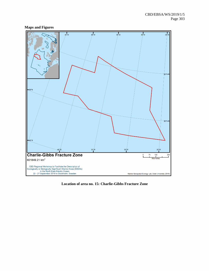
CBD/EBSA/WS/2019/1/5
Page 303
Maps and Figures
Location of area no. 15: Charlie-Gibbs Fracture Zone
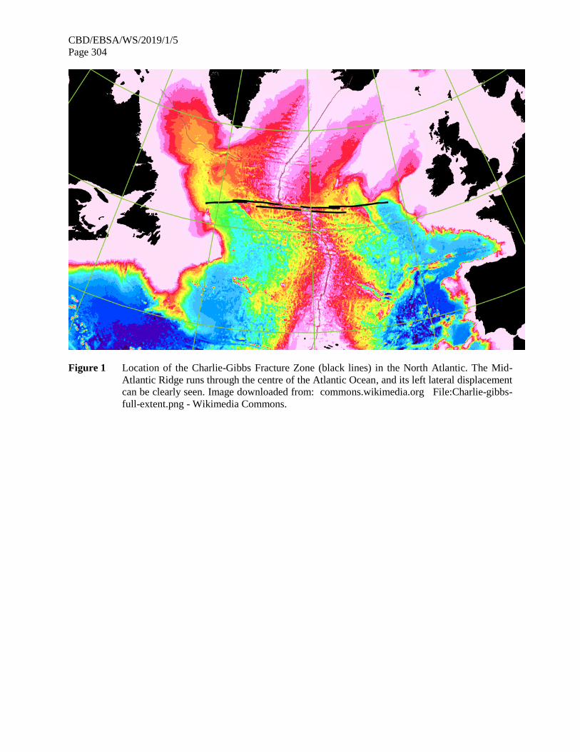
CBD/EBSA/WS/2019/1/5
Page 304
Figure 1 Location of the Charlie-Gibbs Fracture Zone (black lines) in the North Atlantic. The Mid-
Atlantic Ridge runs through the centre of the Atlantic Ocean, and its left lateral displacement
can be clearly seen. Image downloaded from: commons.wikimedia.org File:Charlie-gibbs-
full-extent.png - Wikimedia Commons.
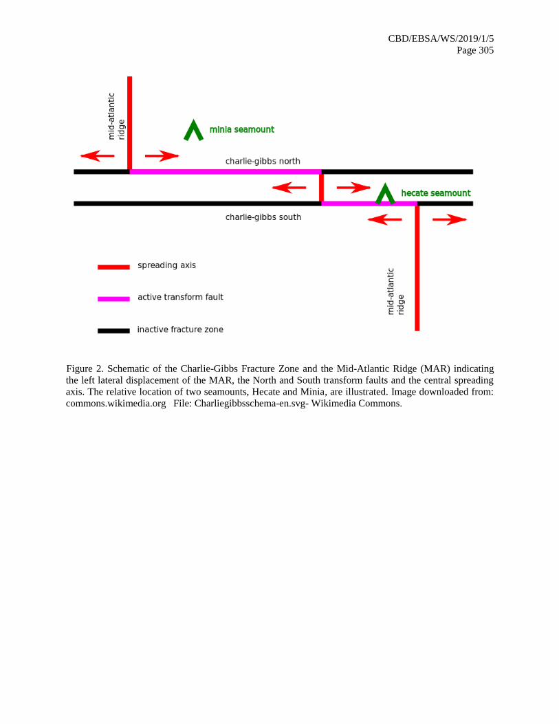
CBD/EBSA/WS/2019/1/5
Page 305
Figure 2. Schematic of the Charlie-Gibbs Fracture Zone and the Mid-Atlantic Ridge (MAR) indicating
the left lateral displacement of the MAR, the North and South transform faults and the central spreading
axis. The relative location of two seamounts, Hecate and Minia, are illustrated. Image downloaded from:
commons.wikimedia.org File: Charliegibbsschema-en.svg- Wikimedia Commons.
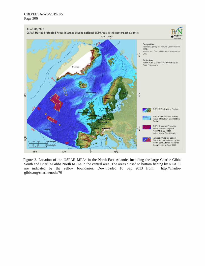
CBD/EBSA/WS/2019/1/5
Page 306
Figure 3. Location of the OSPAR MPAs in the North-East Atlantic, including the large Charlie-Gibbs
South and Charlie-Gibbs North MPAs in the central area. The areas closed to bottom fishing by NEAFC
are indicated by the yellow boundaries. Downloaded 10 Sep 2013 from: http://charlie-
gibbs.org/charlie/node/70
CBD/EBSA/WS/2019/1/5
Page 307
Area no. 16: Southern Reykjanes Ridge17
Abstract Reykjanes Ridge is part of the major topographic feature of the Atlantic Ocean, the Mid-Atlantic Ridge.
The Mid-Atlantic Ridge separates the Newfoundland and Labrador Basins from the West-European Basin
and the Irminger Sea from the Iceland Basin, influencing hydrography and circulation. The ridge crest is
generally cut by a deep rift valley along its length, bordered by high rift mountains, which are bordered by
high fractured plateaus. This region is largely composed of volcanic rock, which is the foundation of the
area and provides a hard-bottom substrate for the colonization of benthic communities, including
vulnerable and habitat-forming species. The area supports several endangered and threatened shark and
ray species. The Ridge itself and its complex hydrographic setting contribute to enhanced vertical mixing
and turbulence, resulting in areas of increased productivity above the Ridge. The 2,500 m depth contour
is used to inform the boundary of the area, capturing most of the ridge crest and known distribution of
deep-water corals.
Introduction Mid-ocean ridge systems occupy a third of the ocean floor and are the sites where new portions of the
Earth’s crust form (Heezen 1969). The Mid-Atlantic Ridge (MAR), a tectonic continental plate boundary,
is the major topographic feature of the Atlantic Ocean, extending over 12,000 km from Iceland to the
Bouvet Triple Junction in the South Atlantic (Figure 1). It divides the ocean longitudinally into two
halves, each cut by secondary transverse ridges and interrupted by strike-slip transform faults that offset
the ridge in opposing directions on either side of the axis of seafloor spreading. It has a profound role in
the circulation of the water masses in the North Atlantic (Rossby, 1999; Bower et al., 2002; Heger et al.,
2008; Søiland et al., 2008). The complex hydrographic setting and the presence of the Ridge lead to
enhanced vertical mixing and turbulence, resulting in areas of increased productivity over the Ridge
(Falkowski et al., 1998; Heger et al., 2008).
Reykjanes Ridge is tectonically active, with a relatively low spreading rate of a few centimetres a year
(Mironov & Gebruk, 2006). Volcanic activity is thought to be high, shown by the growth of lava domes,
the development of extended volcanic chains and regular infilling of cracks with basaltic material
(Sbortshikov &Rudenko, 1990; Mironov & Gebruk, 2006). Studies of volcanic rocks from the submerged
MAR suggest that it consists largely of tholeiitic basalt with low values of K, Ti, and P. In contrast, the
volcanic islands that form the elevated caps on the Ridge are built of alkali basalt with high values of Ti,
Fe3+
, P, Na, and K (Engel and Engel 1964). Variations in mineral content result from chemical and
isotopic heterogeneity in the mantle (White and Schilling 1978). There is one site north of the area that
has been shown to have hydrothermal activity: Steinaholl vent field at 63°06’N (Olaffson et al., 1991;
German et al., 1994; Mironov & Gebruk, 2006). No other hydrothermal activity has so far been detected
along the Reykjanes Ridge, despite intensive sampling (German et al, 1994; German & Parsons, 1998).
The crests of the MAR consist mostly of hard volcanic rock, whereas the flanks are covered with
expanding thicknesses of soft sediments with increasing distance from the crests (Dinter, 2001). The
Reykjanes Ridge is characterized by high sedimentation rates, which are related to the high biological
productivity in the mixing zone of different water masses (Mironov & Gebruk, 2006).
The general physiography of the MAR was documented some time ago (Heezen el al. 1959). The ridge
crest is generally notched by a deep rift valley along its length, bordered by high rift mountains, which in
turn are bordered by high fractured plateaus (Heezen et al. 1959). These crest zones are generally well
defined and present along the full length of the MAR (Malinverno 1990). At approximately 50 -75 km
from the axis of the ridge, the crest merges with sediment covered flanks, which extend down to the
abyssal plain (van Andel and Bowin 1968). The flanks are composed of a succession of smooth shelves,
each from 2 to 100 km from the central axis and subdivided into upper, middle, and lower steps (Heezen
el al. 1959) extending in some areas to depths of 4,572 m (Tolstoy and Ewing 1949). The flanks are
generally covered with soft sediments.
17 Area south of Iceland’s Exclusive Economic Zone.
CBD/EBSA/WS/2019/1/5
Page 308
Within the OSPAR area, the Northern MAR separates the Newfoundland and Labrador Basins from the
West-European Basin and the Irminger from the Iceland Basin. It plays an important role in the
circulation of the water masses in the North Atlantic (Rossby 1999, Bower et al. 2002, Søiland et al.
2008) with currents crossing the MAR over deep gaps in the ridge and influencing upper-ocean
circulation patterns (Bower et al. 2002). Canyons cut into the flanks may influence upward fluxes of
water and abyssal mixing (Speer and Thurnherr 2005).
Over the MAR within the OSPAR area there are three main water masses in the upper ocean; the one
found within the area is often termed Modified North Atlantic Water (Søiland et al, 2008). The surface
current system of the North Atlantic is dominated by the warm North Atlantic Drift, which is a
continuation of the Gulf Stream (Mironov & Gebruk, 2006). The northern boundary of this forms the
characteristic Sub-Polar Front, which acts to separate the warm and cold-water masses and is usually
found between 52 and 53°N (Mironov & Gerbuk, 2006; Søiland et al., 2008). After the North Atlantic
Drift crosses the Mid-Atlantic Ridge at approximately 50 to 52°N, it flows north (Mironov & Gebruk,
2006). Some of this current enters the Norwegian Sea east of Iceland, and some turns and flows westward
(called the Irminger Current) over the Reykjanes Ridge at between 53°N and 60°N, into the Irminger
Basin (Mironov & Gebruk, 2006). This is the major current within the area.
Reykjanes Ridge is characterized by sharp gradients in environmental conditions, which have allowed the
area to be colonized by benthic fauna from very remote regions (Mironov & Gebruk, 2006). For example,
species have been found whose distributions extend to the Antarctic, North Pacific and the Indo-West
Pacific (Mironov & Gebruk, 2006). Within the area of the Icelandic Shelf and the Reykjanes Ridge the
Arctic fauna is replaced by a boreal one, the European fauna by American and the autochthonous deep-
sea fauna is replaced by an allochthonous one (Mironov & Gebruk, 2006). The composition of deep-sea
benthic fauna on the Reykjanes Ridge south of Iceland’s EEZ is not very well known in comparison to
adjacent areas (Mironov & Gebruk, 2006). As Mironov & Gebruk (2006) state, this is well illustrated by
the fact that the fourth cruise of the “Akademik Mstislav Keldysh” (1982) sampled many species that
were recorded on the Ridge for the first time. This cruise yielded an extensive collection of deep-sea
fauna, and since then other research cruises have focused on the Reykjanes Ridge (Mironov & Gebruk,
2006).
The northern part of the MAR has been subject to recent scientific investigations as part of the Census of
Marine Life (MAR-ECO project) (Bergstad et al, 2008) and ECOMAR project (Preide et al. 2013a).
Numerous new species have been discovered, and data has been derived that has led to taxonomic
revisions and the discovery of species that were not previously known to exist in this region (Gebruk et
al, 2008). The published findings of the MAR-ECO and ECOMAR projects represent most of the modern
information and data about the Reykjanes Ridge in this description. Information has also been gathered
from historical fishing accounts found in ICES reports and older published scientific research.
Location The northern boundary of the area is Iceland’s Exclusive Economic Zone. The southern boundary of this
area is 55°188′N, well north the Sub-Polar Front, which separates the warm- and cold-water masses and is
usually found between 52°N and 53°N (Mironov & Gerbuk, 2006; Søiland et al, 2008). The 2,500 m
depth contour was used to define the boundaries of the area, as this captures most of the ridge crest and
known distribution of deep-water corals (maximum 2,400 m).
Feature description of the area
The entire Reykjanes Ridge forms a hard-bottomed substrate, rising from the abyssal plain, which acts to
provide a wide range of benthic habitats and is colonized by a variety of erect megafauna (e.g.,
gorgonians, sponges and cold-water corals) (Copley et al. 1996). In addition, Reykjanes Ridge acts to
separate the warmer waters of the Iceland Basin from the cooler waters of the Irminger Basin, forming a
hydrographic boundary in the mesopelagic realm (Fock and John 2006; Gislason et al. 2007). There is a
strong relationship between larval fish communities and hydrography and topography, which is largely
determined by the Reykjanes Ridge (Fock and John 2006). Larvae are retained above the Ridge by a
CBD/EBSA/WS/2019/1/5
Page 309
branching current from the North Atlantic Current due to the Coriolis effect (Fock and John 2006).
Therefore, this area should be considered important for both its benthic and surrounding water column
features. The fauna of the Reykjanes Ridge have not been fully described, and it is premature to speculate
on whether any species are endemic. Some new species have been described, which may prove to be
endemic to the area with further sampling. However, there are strong indications that the benthic fauna at
the Reykjanes ridge has certain distinct components that are distinct from the benthic fauna south of the
Charlie Gibbs fracture zone (Alt et al., 2019).
The benthic fauna associated with Reykjanes Ridge and the Northern MAR are known from detailed
observations at a few locations. Priede et al. (2013) used a variety of sampling gears to survey habitat,
biomass and biodiversity in a segment of the Northern MAR as part of a multinational and
multidisciplinary project (ECOMAR). They found that primary production and export flux over the MAR
were not enhanced compared with a nearby reference station over the Porcupine Abyssal Plain and
biomass of benthic macrofauna and megafauna were similar to global averages at the same depths. Also,
as part of MAR-ECO, Mortensen et al. (2008) used an ROV to conduct video surveys along the MAR at
eight sites between the Reykjanes Ridge and the Azores, including two sites north of CGFZ. At
Reykjanes Ridge, 20 taxa of deep-water corals were observed, including patches of Solenosmillia
variabilis. Crinoids, sponges, the bivalve Acesta excavata, and squat lobsters were associated with cold-
water corals. None of those corals were recognized as new species to science and all likely have broader
distributions extending along the continental slopes and seamounts at similar latitudes in the North
Atlantic. In the northern part of the Ridge (north of 52°N) relatively common sub-Arctic demersal fish
species, such as Sebastes spp., tusk (Brosme brosme) and Greenland halibut (Reinhardtius
hippoglossoides) were dominant.
The Reykjanes Ridge acts to retain two populations of the planktonic copepod Calanus finmarchicus,
which is thought to form the basis of many food webs within the North-East Atlantic (Gislason et al.,
2007; Gislason et al., 2008). C. finmarchicus is considered to be one of the most important components of
the zooplankton in the waters around Iceland, where it is usually by far the most abundant in terms of
biomass (Speirs et al., 2005; Gislason et a.l, 2007). It has a widespread distribution over the North
Atlanticm and its highest population densities occur in the Norwegian Sea gyre and the Labrador/Irminger
Sea gyre (Speirs et al, 2005). As such, this copepod forms a critical part of the diet of the larval stages of
many important commercial fish stocks in these areas (Speirs et al., 2005).
The seamounts of the northern MAR were surveyed between 43º and 57ºN, which is just outside the
workshop boundaries. The species that were sampled by Kukuev (2004) consisted of approximately 20
elasmobranch species. Hareide & Garnes (2001) reported catching the pale ray (Bathyraja pallida) and
Richardson’s ray (Bathyraja richardsoni), C. coelolepis, included on the OSPAR List of Threatened
and/or Declining Species and Habitats (BDC/MASH 2007) and S. microcephalus, an extremely long-
lived and slow-growing deep water species of shark that was historically targeted for its liver oil by
Norway, Iceland and Greenland, listed as near threatened on the IUCN Red List (Paul & Fowler, 2003;
Kyne et al., 2006; Stevens & Correla, 2003). In the 1910s, catches for this species reached 32,000 sharks
per year by Greenland alone, and these fisheries are thought to have had a significant impact on this
species (Kyne et al., 2006).
The three rare ray species that have been reported for the northern MAR (Hareide & Garnes, 2001) come
from two families. B. richardsoni and B. pallida belong to the family Arhynchobatidae (Softnose Skates)
and R. kukujevi and belongs to the family Rajidae (Hardnose Skates) (Kyne & Simpfendorfer, 2007).
There is a high species diversity within the Arhynchobatidae Family.
However, relatively little is known about their biology mainly due to their scattered distributions, deep
occurrences (this family includes some of the deepest occurring chondrichthyans), taxonomic uncertainty
and limited material, meaning some species, such as those found in and near to the area, are virtually
unknown (Kyne & Simpfendorfer, 2007). Estimates from the limited information about softnose skates
suggests they can live up to 29 years and reach maturity at about 10 years (Kyne & Simpfendorfer, 2007),
CBD/EBSA/WS/2019/1/5
Page 310
making them highly vulnerable to any human-induced exploitation. There is considerably more
information available about the Rajidae family than the Arhynchobatidae family, which is the most
speciose of chondrichthyans, and contains the deepest occurring chondrichthyan species. However, the
overall knowledge about this family is poor (Kyne & Simpfendorfer, 2007). The family on the whole
conforms to the general life history traits of chondrichthyan species and therefore will also be highly
vulnerable to exploitation. Both B. pallida and B. richardsoni are listed on the IUCN Red List of
Threatened Species as being of least concern, due to their very deep depth ranges, which remain out of the
range of most deepwater fishing activity (Kulka et al, 2007; Orlov, 2007). However, both were caught
during experimental fishing along the MAR and therefore they can be considered vulnerable to deep-
water fishing in the area. Indeed, the whole of their depth range is now reachable with longline gear. R.
kukujevi is not listed on the IUCN Red List
For the northern section of the MAR region, covering the Reykjanes Ridge, the dedicated North Atlantic
Sightings Surveys (NASS) and Trans-NASS Surveys (T-NASS) were internationally coordinated
cetacean surveys that have been conducted in 1987, 1989, 1995, 2001, 2007 and 2015. The main purpose
of the surveys was and is to get quantitative information on the distribution and abundance of all cetacean
species in the survey area, which encompasses much of the northern North Atlantic between Norway and
North America. Since 1995, the NASS have been planned and coordinated by the NAMMCO Scientific
Committee and have observed a diversity of cetacean species along the Reykjanes Ridge.
Feature condition and future outlook of the area
Given the geophysical nature, location and size of the Reykjanes Ridge, it is unlikely that it will be
adversely affected by human activities.
Assessment of area no. 16, Southern Reykjanes Ridge, against CBD EBSA Criteria
CBD EBSA
Criteria
(Annex I to
decision IX/20)
Description
(Annex I to decision IX/20) Ranking of criterion relevance
(please mark one column with an X)
No
informat
ion
Low Medi
um
High
Uniqueness or
rarity
Area contains either (i) unique (“the only one
of its kind”), rare (occurs only in few
locations) or endemic species, populations or
communities, and/or (ii) unique, rare or
distinct, habitats or ecosystems; and/or (iii)
unique or unusual geomorphological or
oceanographic features.
X
Explanation for ranking
Reykjanes Ridge and its biological communities are biogeographically distinct from other parts of the
MAR (Mironov & Gebruk 2006, Gebruk et al. 2010, Dilman 2013, Alt et al. 2019) bounded by a
permanent coldwater current (Iceland-Scotland Overflow Water (Shor et al., 1980,). In this sense,
Reykjanes Ridge qualifies as a unique geomorphological feature in the North Atlantic, and it is most
likely that in future, hydrothermal vent fields will be discovered in this area. There is some evidence
(explained above) to suggest the presence of several unique and rare species, like elasmobranchs
Bathyraja pallida and B. richardsoni and Greenland shark Solmiosus microcephalus (Hareide & Garnes
2001), although detailed investigations have only been conducted relatively recently, so it is possible that
many other rare species exist in this area.
Special
importance
for life-history
stages of
species
Areas that are required for a population to
survive and thrive.
X
CBD/EBSA/WS/2019/1/5
Page 311
Explanation for ranking
Cold-water corals, habitat-forming scleractinians and areas of natural coral rubble, and sponge
aggregations provide shelter, nursery and feeding grounds for a variety of species (e.g., Mortensen et al.
2008; Roberts et al. 2009; Maldonado et al., 2016). Furthermore, Reykjanes Ridge is important in the life
history of the calanoid copepod Calanus finmarchicus, which has an important role as a prey species in
the wider food web.
Importance
for
threatened,
endangered or
declining
species and/or
habitats
Area containing habitat for the survival and
recovery of endangered, threatened, declining
species or area with significant assemblages
of such species.
X
Explanation for ranking
Several endangered and threatened shark and ray species have been found in the area. Orange roughy
(Hoplostethus atlanticus) form aggregations at Reykjanes Ridge at depths exceeding 600 m (Magnússon
& Magnússon 1995a, Hareide &Garnes 2001). There is also evidence for deep-water coral and sponge
communities (Mortensen et al. 2008; Cárdenas & Rapp 2015), both of which have been described as
threatened. The area supports species of cold-water corals, including black corals, bamboo corals, hard
and soft corals. These form localized reef and coral garden habitats that are listed under OSPAR as
threatened and declining habitats (Roberts et al. 2006, 2009). In addition, deep-sea sponge aggregations
are also known to be present and these are also listed under OSPAR (Klitgaard and Tendal, 2004; Howell
et al., 2016).
Vulnerability,
fragility,
sensitivity, or
slow recovery
Areas that contain a relatively high
proportion of sensitive habitats, biotopes or
species that are functionally fragile (highly
susceptible to degradation or depletion by
human activity or by natural events) or with
slow recovery.
X
Explanation for ranking
This Ridge rises from the abyssal plain and provides a wide range of benthic habitats and is colonized by
a variety of erect megafauna (e.g., gorgonians, sponges and cold-water corals) (Copley et al. 1996). At
least 20 species of cold-water corals were reported at Reykjanes Ridge during the MAR-ECO project
cruise (Mortensen et al. 2008). Further study of benthic communities in the shallow portions of the
Reykjanes Ridge (ATLAS, 2019; Anonymous, 2004) has also revealed new occurences of scleractinian
(Lophelia pertusa, Madrepora oculata) and octocoral (Paragorgia arborea, Primnoa resedaeformis and
species in the families Anthothelidae and Nephtheidae) cold-water corals and diverse sponge
communities. It can therefore be inferred that cold-water corals occur along the Reykjanes Ridge,
providing further support to past studies (e.g., Copley et al. 1996). There is also evidence from
experimental trawling of the Reykjanes Ridge that sponge communities inhabit the flanks and summits of
the Ridge (Magnússon & Magnússon, 1995). Many of the fauna present in this area are deep-sea fauna
that have life history characteristics that make them particularly vulnerable to the effects of fishing. Many
of the cold-water coral species have slow growth rates, and long generation times (Roark et al., 2006)
leading to very slow and episodic recoveries following human impact. Seamount fish species have been
shown in the past to be slow to recover from the impacts of fishing.
There is clear evidence of aggregations of both demosponges and glass sponges on the Reykjanes Ridge,
which are identified as Vulnerable Marine Ecosystems (UNGA, 2006) under the FAO's guidelines for the
management of deep-sea fisheries (FAO, 2009).
Biological Area containing species, populations or X
CBD/EBSA/WS/2019/1/5
Page 312
productivity communities with comparatively higher
natural biological productivity.
Explanation for ranking
Reykjanes Ridge plays an important role within the open ocean ecosystem. The lack of terrigenous
nutrient input to the open ocean means that productivity is generally low, and the deep-sea fauna found
there are reliant on the limited local surface water primary production (Fossen et al, 2008). The complex
hydrographic setting and the presence of Reykjanes Ridge itself leads to enhanced vertical mixing and
turbulence, resulting in areas of increased productivity over the Ridge (Falkowski et al., 1998; Fossen et
al., 2008; Heger et al., 2008). This increased biological productivity means that Reykjanes Ridge is likely
to have a greater abundance and diversity of fauna than the surrounding open ocean and abyssal plains
(Sutton et al, 2008).
However, the research conducted through the MAR-ECO project found that primary production and
export flux over the MAR were not enhanced compared with a nearby reference station over the
Porcupine Abyssal Plain, and biomass of benthic macrofauna and megafauna were similar to global
averages at the same depths. There is some evidence for pelagic fish concentrating in the benthic
boundary layer (to 200 m above the seafloor) over the MAR in association with topographic features.
Biological
diversity
Area contains comparatively higher diversity
of ecosystems, habitats, communities, or
species, or has higher genetic diversity.
X
Explanation for ranking
There is clear evidence of aggregations of both demosponges and glass sponges on the Reykjanes
Ridge. Sponge aggregations create complex habitats supporting high biodiversity (Bett and Rice, 1992);
they provide a refuge for fish, are a source of novel chemical compounds (Bell, 2008; Maldonado et al.,
2016), and may also play an important role as a sink in the marine silicon cyclem which is thought to
influence primary productivity and the carbon cycle (Hendry et al., 2019).
Naturalness Area with a comparatively higher degree of
naturalness as a result of the lack of or low
level of human-induced disturbance or
degradation.
X
Explanation for ranking
The actual extent and severity of the impact that fishing and other human activities have had on MAR
ecosystems is largely unquantified. Although Magnússon & Magnússon (1995a) reported that the
Reykjanes Ridge is in general a very difficult area for bottom trawling because of its extremely irregular
bottom topography, more detailed and accurate mapping of the seafloor may change this.
References
Alt, C. H., Kremenetskaia, A., Gebruk, A. V., Gooday, A. J., & Jones, D. O. (2019). Bathyal benthic
megafauna
from the Mid‐Atlantic Ridge in the region of the Charlie-Gibbs fracture zone based on remotely operated
vehicle observations. Deep Sea Research Part I: Oceanographic Research Papers, 145, 1-12.
Anonymous (2004). Protection of vulnerable marine areas in Icelandic waters. Conclusions and
proposition of a Committee appointed by the Minister of Fisheries
https://www.stjornarradid.is/media/atvinnuvegaraduneytimedia/media/skyrslur/fridunskyrsla_200
5.pdf
ATLAS (2019) Deliverable 3.3 Biodiversity, biogeography and GOODS classification system under
current climate conditions and future IPCC scenarios.
Bell, J.J., 2008. The functional roles of marine sponges. Estuarine, coastal and shelf science, 79(3),
pp.341-353
CBD/EBSA/WS/2019/1/5
Page 313
Bergstad, O.A., Menezes,G. and Å.S. Høines. 2008. Demersal fish on a mid-ocean ridge: Distribution
patterns and structuring factors. Deep Sea Research Part II: Topical Studies in Oceanography
55(1–2): 185-202.
Bett, B.J. and Rice, A.L., 1992. The influence of hexactinellid sponge (Pheronema carpenteri) spicules on
the patchy distribution of macrobenthos in the porcupine seabight (bathyal NE Atlantic). Ophelia,
36(3), pp.217-226
Bower, A.S., Le Cann, B., Rossby, T., Zenk, W., Gould, J., Speer, K., Richardson, P.L., Prater, M.D. and
H.-M. Zhang. 2002. Directly measured mid-depth circulation in the northeastern North Atlantic
Ocean. Nature 419: 603- 607.
Cárdenas, P., & Rapp, H. T. (2015). Demosponges from the Northern Mid-Atlantic Ridge shed more light
on the diversity and biogeography of North Atlantic deep-sea sponges. Journal of the Marine
Biological Association of the United Kingdom, 95(7), 1475-1516.
Copley JTP, Tyler PA, Sheader M, Murton BJ & German CR (1996). Megafauna from sublittoral to
abyssal depths along the Mid-Atlantic Ridge south of Iceland. Oceanologica Acta, 19: 549-559.
Dilman, A. B. (2013). Changes in deep-sea asteroid fauna along the northern Mid-Atlantic Ridge. Cahiers
de biologie marine, 54(4), 505-509.
Dinter, W.P. (2001) Biogeography of the OSPAR Maritime Area – A Synopsis and Synthesis of
Biogeographical Distribution Patterns described for the North-East Atlantic. Bundesamt für
Naturschutz, Bonn, Germany pp 167.
Engel, A.E.J. and C.G. Engel. 1964. Composition of basalts from the Mid-Atlantic Ridge. Science 144
(3624): 1330-1333.
Falkowski, P.G., Barber, R.T. & Smetacek, V. (1998) Biogeochemical controls and feedbacks on ocean
primary production. Science 281: 200 – 206.
Fock, H. and John, H-C. (2006) Fish larval patterns across the Reykjanes Ridge. Marine Biology
Research 2:191-199.
Fossen, I., Cotton, C.F., Bergstad, O.A. and J.E. Dyb. 2008. Species composition and distribution patterns
of fishes captured by longlines on the Mid-Atlantic Ridge. Deep Sea Research Part II: Topical
Studies in Oceanography 55(1–2): 203-217.
Gebruk , A.V., Priede, I.G., Fenchel T. and F. Uiblein. 2013. Benthos of the sub-polar front area on the
Mid-Atlantic Ridge: Results of the ECOMAR project. Marine Biology Research 9(5-6): 443-446.
Gebruk, A. V., Budaeva, N. E., & King, N. J. (2010). Bathyal benthic fauna of the Mid-Atlantic Ridge
between the Azores and the Reykjanes Ridge. Journal of the Marine Biological Association of the
United Kingdom, 90(1), 1-14
Gebruk, A.V. (2008) Holothurians (Holothuroidea, Echinodermata) of the northern Mid-Atlantic Ridge
collected by the G.O. Sars MAR-ECO expedition with descriptions of four new species. Marine
Biology Research 4: 48 – 60.
German, C.R. & Parsons, L.M. (1998) Distributions of hydrothermal activity along the Mid-Atlantic
Ridge: interplay of magmatic and tectonic controls. Earth and Planetary Science Letters 160: 327
– 341
German, C.R., Briem, J., Chin, C., Danielsen, M., Holland, S., James, R., Jónsdottir, A., Ludford, E.,
Moser, C., Ólafsson, J., Palmer, M.R. & Rudnicki, M.D. (1994) Hydrothermal activity on the
Reykjanes Ridge: the Steinahóll vent-field at 63o06’N. Earth and Planetary Science Letters 121:
647 – 654.
Gislason, A., Eiane, K. and Reynisson, P. (2007) Vertical distribution and mortality of Calanus
finmarchicus during overwintering in oceanic waters southwest of Iceland. Marine Biology
150:1253-1263.
Gislasson, A., Gaard, E., Debes, H. & Faulkenhaug, T. (2008) Abundance, feeding and reproduction of
Calanus finmarchicus in the Irminger Sea and on the northern Mid-Atlantic Ridge in June. Deep-
Sea Research II 55: 72 – 82.
Hareide, N.-R. and G. Garnes. 2001. The distribution and catch rates of deep-water fish along the Mid-
Atlantic Ridge from 43 to 61°N. Fisheries Research 51(2–3): 297-310.

CBD/EBSA/WS/2019/1/5
Page 314
Heezen, B.C.,Tharp, M. and M. Ewing. 1959. The Floors of the Oceans: I. The North Atlantic. The
Geological Society of America Special Paper 65, 122 pp.
Heezen, BC. 1969. The world rift system: An introduction to the symposium. Tectonophysics 8:269-279.
Heger, A., Ieno, E.N., King, N.J., Morris, K.J., Bagley, P.M. & Priede, I.G. (2008) Deep-sea pelagic
bioluminescence over the Mid-Atlantic Ridge. Deep-Sea Research II 55: 126-136.
Hendry, K.R., Cassarino, L., Bates, S.L., Culwick, T., Frost, M., Goodwin, C. and Howell, K.L., 2019.
Silicon isotopic systematics of deep-sea sponge grounds in the North Atlantic. Quaternary
Science Reviews, 210, pp.1-14
Herndon, A.P. & Burgess, G.H. 2006. Etmopterus princeps. The IUCN Red List of Threatened
Species 2006:
e.T60242A12332917. http://dx.doi.org/10.2305/IUCN.UK.2006.RLTS.T60242A12332917.en. D
ownloaded on 26 September 2019.
Howell, K.L., Piechaud, N., Downie, A.L. and Kenny, A., 2016. The distribution of deep-sea sponge
aggregations in the North Atlantic and implications for their effective spatial management. Deep
Sea Research Part I: Oceanographic Research Papers, 115, pp.309-320
E.I. 2004. Twenty years of ichthyofauna research on seamounts of the North Atlantic Ridge and adjacent
areas. A review. Archives of Fisheries and Marine Research 51(1-3): 215-232
Kyne, P.M. and C.A. Simpfendorfer, 2007. A collation and summarization of available data on deepwater
chondrichthyans: biodiversity, life history and fisheries. Report prepared by the IUCN SSC Shark
Specialist Group for the Marine Conservation Biology Institute, 137 pp.
Klitgaard, A.B. and Tendal, O.S., 2004. Distribution and species composition of mass occurrences of
large-sized sponges in the northeast Atlantic. Progress in oceanography, 61(1), pp.57-98
Kulka, D.W., Orlov, A. & Barker, A. 2007. Bathyraja richardsoni. In: IUCN 2007. 2007 IUCN Red List
of Threatened Species. <www.iucnredlist.org>. Downloaded on 11 March 2008.
Maldonado, M., Aguilar,R., Bannister,R.J., Bell,D., Conway,K.W., Dayton,P.K., Díaz, C., Gutt,J.,
Kenchington,E.L.R., Leys,D. and Pomponi,S.A., 2016. Sponge grounds as key marine habitats: a
synthetic review of types, structure, functional roles, and conservation concerns. In: Marine
Animal Forests. Springer, Berlin._24–1
Magnússon, J. V., & Magnússon, J. (1995a). The distribution, relative abundance, and biology of the
deep-sea fishes of the Icelandic slope and Reykjanes Ridge. In Deep-Water Fisheries of the North
Atlantic Oceanic Slope (pp. 161-199). Springer, Dordrecht.
Magnússon, J. and Magnússon, J.V. (1995) Oceanic redfish (Sebastes mentella) in the Irminger Sea and
adjacent waters. Scientia Marina 59(3-4):241-254.
Malinverno, A. 1990. A quantitative study of axial topography of the Mid-Atlantic Ridge. Journal of
Geophysical Research 95: 2645-2660.
Mironov, A.N. & Gebruk, A.V. (2006) Biogeography of the Reykjanes Ridge, the northern Atlantic. In:
Mironov, A.N., Gebruk, A.V., Southward, A.J. (eds.) Biogeography of the North Atlantic
Seamounts. KMK Scientific Press, Moscow, 2006. pp 6 - 21
Mortensen, P.B., Buhl-Mortensen, L., Gebruk, A.V. and E. M. Krylova. 2008. Occurrence of deep-water
corals on the Mid-Atlantic Ridge based on MAR-ECO data. Deep-Sea Research II 55:142-152.
Olafsson et al., A sudden cruise off Iceland, RIDGE Events Newsletter, 2(2), 35-38, 1991.
(plume only) German, C.R. et al., Hydrothermal activity on the Reykjanes Ridge: the Steinaholl
vent field at 63°06′N. Earth Planet. Sci. Lett. 121 (1994), pp. 647–654.
Orlov, A. 2007. Bathyraja pallida. In: IUCN 2007. 2007 IUCN Red List of Threatened Species.
<www.iucnredlist.org>. Downloaded on 11 March 2008.
Priede, I.G., Bergstad, O.A., Miller, P.I., Vecchione, M., Gebruk, A., et al. 2013. Does Presence of a Mid-
Ocean Ridge Enhance Biomass and Biodiversity? PLoSONE 8(5): e61550.
doi:10.1371/journal.pone.0061550
Priede, I. G., Billett, D. S., Brierley, A. S., Hoelzel, A. R., Inall, M., & Miller, P. I. (2013a). The ECO-
MAR (Ecosystem of the Mid-Atlantic Ridge at the Sub-Polar Front and Charlie Gibbs Fracture
Zone) project: description of the benthic sampling programme 2007–2010. Marine Biology
Research, 9(5-6), 624-628.

CBD/EBSA/WS/2019/1/5
Page 315
Roark, E. B., Guilderson, T. P., Dunbar, R. B. and Ingram, B. L. (2006). Radiocarbon based ages and
growth rates: Hawaiian deep sea corals. Marine Ecology Progress Series, 327, 1-14
Roberts JM, Wheeler AJ, Freiwald A (2006) Reefs of the deep: the biology and geology of cold-water
coral ecosystems. Science 312: 543-547
Roberts JM, Wheeler AJ, Freiwald A, Cairns SD (2009) Cold-water Corals: The Biology and Geology of
Deep-sea Coral Habitats. Cambridge University Press, 334 pp
Rossby, T. 1999. On gyre interactions. Deep-Sea Research II 46: 139-164.
Sbortshikov, I.M. & Rudenko, M.V. (1990) Relief and tectonic structures of the Reykjanes Ridge axis
zone. In: Almukhamedov, A.I., Bogdanov, Yu.A., Kuzmin, M.I. et al Reykjanes Ridge rift zone:
tectonics, magmaism and conditions of sedimentology, pp 42 – 61. Moscow, Nauka.
Shor, A., P.Lonsdale, C.D.Hollister, D.Spencer (1980). Charlie-Gibbs fracture zone: bottom-
water transport and its geological effects. Deep Sea Research Part A. Oceanographic Research
Papers
Volume 27, Issue 5, May 1980, Pages 325-338, IN1-IN2, 339-345 https://doi.org/10.1016/0198-
0149(80)90030-8
Søiland, H., Budgell, W.P. and Ø Knutsen. 2008. The physical oceanographic conditions along the Mid-
Atlantic Ridge north of the Azores in June-July 2004. Deep-Sea Research II 55: 29- 44.
Speer, K. G. and A. M. Thurnherr. 2005. Abyssal Canyons and Mixing by Low-Frequency Flow. In: P.
Muller and D. Henderson (Editors), Near-Boundary Processes and Their Parameterization, topics
in physical oceanography, 'Aha Huliko' a Winter Workshop, pp. 17-19.
Speirs. D.C., Gurney, W.S.C., Heathm M.R., and Wood, S. (2005) Modelling the basin-scale demography
of Calanus finmarchicus in the north-east Atlantic. Fisheries Oceanography 14(5):333-358.
Sutton, T.T., Porteiro, F.M., Heino, M., et al. 2008. Vertical structure, biomass and topographic
association of deep-pelagic fishes in relation to a mid-ocean ridge system. Deep-Sea Research II
55 (1–2):161–184.
Tolstoy, I. and M. Ewing. 1949. North Atlantic hydrography and the Mid-Atlantic Ridge. Bulletin of the
Geological Society of America 60(10): 1527-1540.
van Andel, Tj. H. and C. O. Bowin. 1968. Mid-Atlantic Ridge between 22º and 23º north latitude and the
tectonics of mid-ocean rises. Journal of Geophysical Research 73: 1279-1298.
Vecchione, M., Young, R.E. and U. Piatkowski. 2010. Cephalopods of the northern Mid-Atlantic Ridge.
Marine Biology Research 6: 25–52.
White, W.M. and J.-G. Schilling. 1978. The nature and origin of geochemical variation in Mid-Atlantic
Ridge basalts from the Central North Atlantic. Geochimica et Cosmochimica Acta 42 (10): 1501-
1516.
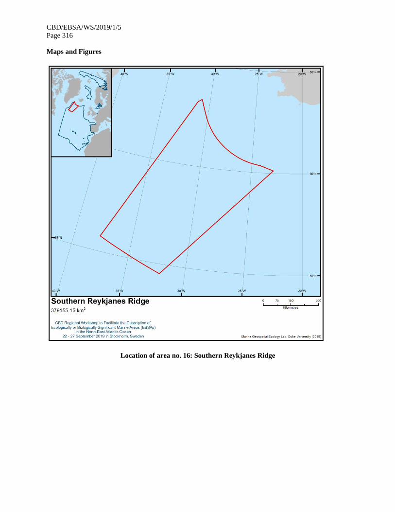
CBD/EBSA/WS/2019/1/5
Page 316
Maps and Figures
Location of area no. 16: Southern Reykjanes Ridge
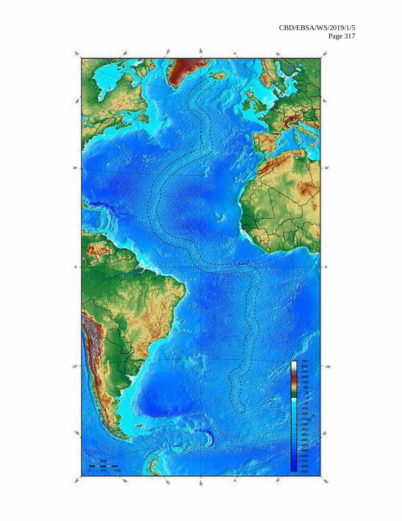
CBD/EBSA/WS/2019/1/5
Page 317

CBD/EBSA/WS/2019/1/5
Page 318
Figure 1 Location of the Mid-Atlantic Ridge (dashed lines). Image downloaded from:
commons.wikimedia.org File:Mid-atlantic ridge.jpg - Wikimedia Commons.
CBD/EBSA/WS/2019/1/5
Page 319
Area no. 17: Hatton and Rockall Banks and Basin
Abstract The Hatton and Rockall Banks, as well as their associated slopes and connecting basin, represent offshore
pelagic and bathyal habitats from the surface to 3000m deep that collectively constitute a unique and
prominent feature of the North-East Atlantic. The area has high habitat heterogeneity and supports a wide
range of benthic and pelagic species and associated ecosystems. Its comparatively remote oceanic
location several hundred kilometres from the continental shelf afford it a level of protection and isolation
from many human activities that are known to degrade the natural marine environment.
Introduction The Hatton and Rockall Banks are large isolated geomorphological features in the NE Atlantic. Formed
from continental crust, they span depths from c. 200m to 3000m. The banks are linked by the Hatton-
Rockall Basin at a depth of approximately 1300 m which has particular geomorphological features and
habitats. The gently sloping banks and the basin provide a contrasting geological and sedimentary setting
to the tectonically active Mid-Atlantic Ridge to the west and the generally steeper slopes of the European
continental margin to East. The banks encompass a large depth range with strong environmental gradients
(e.g., temperature, pressure, and food availability) that give rise to a high diversity of species and habitats
(Billett, 1991; Bett, 2001; Howell et al., 2002; Davies et al. 2006; Roberts et al. 2008; Howell et al.,
2009; Howell et al. 2010). Environmental heterogeneity is positively correlated with biological diversity
at a variety of scales (Menot et al. 2010) as indicated by significantly elevated levels of species change
across space in areas such as Hatton Bank (Roberts et al. 2008).
Changes in pressure and temperature have significant effects on the biochemistry of species, influencing
cell membrane structure and enzyme characteristics (Gage and Tyler, 1991). In general, each species is
adapted to a particular range of environmental conditions. Each may occur over a depth range of about
500 m, but the depths where any particular species is abundant, and therefore able to form viable
populations, is generally limited to a much more restricted depth range of 100 to 200 m (Billett, 1991;
Howell et al., 2002). There is evidence that such depth-related effects promote speciation (Howell et al.,
2004). In addition, the progressive decrease in organic matter availability with increasing depth (with
some patchiness depending on geomorphology) leads to a reduction of predatory species and an increase
in detritus feeders (Billett, 1991). Taken together such environmental changes lead to a continuous
sequential change in species composition with depth, and biological community characteristics that are
radically different to those known in shallow shelf seas.
The area is influenced by a number of different water masses and circulation systems, including the North
Atlantic Current (i.e. Gulf Stream system) which draws warm water from the Gulf of Mexico far into the
NE Atlantic., There is considerable interaction between the topography and physical oceanographic
processes, in some areas focusing internal wave and tidal energy (Ellett et al. 1986) which results in
strong currents and greater mixing. This may give rise to highly localized and specialised biological
communities such as sponge aggregations and coral gardens. The mixing of Arctic and Atlantic water in
the north of the Hatton-Rockall area means that species from both ecosystems are represented causing
enhanced species diversity across a wide range of animal groups.
The Rockall Bank supports shallow demersal fisheries targeting haddock, megrim, gurnard and monkfish
(Neat & Campbell 2010; Nolan et al., 2011). The slopes and the Hatton Bank are target areas for deep-
water bottom fisheries for Ling (Molva molva), Blue Ling (Molva dypterygia), Tusk (Brosme brosme),
Roundnose Grenadier (Coryphaenoides rupestris) and Black Scabbardfish (Aphanopus carbo). In the past
deepwater sharks were also caught in the area, but this is now prohibited. A wide variety of other non-
target fish species are also taken as incidental by-catch (Gordon et al., 2003; Large et al., 2003; ICES
2010).
Some of the deep-water target species have characteristic low productivity and extended generation times.
In this regard deep-water fisheries have significant effects not only on target fish species, but also on the
benthic fauna (Le Guilloux et al., 2009; Clark et al. 2010). Some invertebrate species, such as cold-water
CBD/EBSA/WS/2019/1/5
Page 320
corals and sponges, provide important structural habitat heterogeneity. These habitats are highly
susceptible to physical damage and may take hundreds, if not thousands, of years to reform (Hall-Spencer
et al. 2002; Roberts et al. 2009; Söffker et al., 2011).
Major wide-ranging Northeast Atlantic epipelagic fish stocks, e.g., mackerel, horse mackerel and blue
whiting, use and inhabit the Hatton-Rockall area for parts of their life cycle and are targeted by
international fisheries. The slopes of the banks and channels between the banks have a diverse
bathypelagic and mesopelagic fish community sustained by the zooplankton production in the epipelagic
zone. Such pelagic fish communities are similar to, and probably extensions of, those in adjacent oceanic
waters along the European continental margin.
Current fisheries control measures on the Hatton and Rockall Banks have focused mainly on the
protection of corals (Hall-Spencer et al., 2009) and sponges (ICES 2013).
Location The area is situated in the North-East Atlantic approximately 400-500km west-northwest of the United
Kingdom of Great Britain and Ireland and 400-500km south-southeast of Iceland. It comprises the seabed
and pelagic zones shallower than 3000m overlying the Rockall and Hatton Banks, together with the
Rockall-Hatton Basin between them. The 3000m contour has been selected as delineating the boundary of
this feature because: 1) it marks the accepted boundary between the bathyal and abyssal environments, 2)
review of oceanographic data suggests the 3000m contour corresponds well with oceanographic influence
of the feature and thus its likely influence on pelagic communities and 3) new bird and mammal data
suggest species use the pelagic areas just off the bank, which are captured by the boundary of this area.
Feature description of the area
The area covers benthic and pelagic faunal communities extending down to depths of 3000 m in and
around the Hatton and Rockall Banks and Hatton-Rockall Basin. Seabed communities captured within the
area include cold-water coral formations, sponge aggregations and potential seep communities (Oliver
and Drewery, 2014; Neat et al., 2018). Geomorphologically complex seabed types include rocky reefs,
carbonate mounds, polygonal fault systems and sedimentary slopes, slides and fans. Diverse pelagic
communities inhabiting the area include those occupying bathy-, meso- and epipelagic zones, such as
zooplankton, free-swimming cnidaria, elasmobranchs, teleost fish, squid, seabirds, cetaceans, and
occasionally sea turtles.
1. Benthic and benthopelagic communities
1a. Cold-water corals
Observations in the early 1970s found cold-water coral communities on the Rockall Bank down to a depth
of 1,000 m (Wilson, 1979a). Thickets of Lophelia pertusa occurred principally at depths between 150-
400m18
. Large coral growth features have recently (2011) been discovered to be still present on the
northern Rockall Bank (Howell et al., 2009; Huvenne et al., 2011, Roberts et al. 2013). Bottom-contact
fishing can result in significant adverse impacts to these habitats.
Frederiksen et al. (1992) reported a high diversity of corals on the northern Hatton Bank, including
Paragorgia, Paramuricea, Isididae and Antipatharia as well as the scleractinians L. pertusa and M.
oculata. Since these observations further records of coral gardens (Bullimore et al., 2013) and coral
frameworks have been noted throughout the Rockall and Hatton area, including the Logachev Mounds
and the Western Rockall Bank Mounds (Kenyon et al., 2003; Roberts et al., 2003; Narayanaswamy et al.,
2006; Howell et al., 2007; Durán Muñoz et al. 2009; Piechaud et al., 2015).
Recent surveys identified many areas that contained the cold-water coral L. pertusa throughout the
Rockall and Hatton Banks (Narayanaswamy et al., 2006; Howell et al., 2007; Roberts et al. 2008; Durán
Muñoz et al. 2009). Several areas on the Hatton Bank contained pinnacles and mounds with extensive
18 http://www.lophelia.org/lophelia/case_4.htm
CBD/EBSA/WS/2019/1/5
Page 321
biogenic structures including areas of coral rubble around the flanks of the coral mounds. Coral
frameworks are known from the Hatton Bank (Durán Muñoz et al. 2009), and are predicted to occur over
a wider region of both Hatton and Rockall Banks (Howell et al., 2011; Ross and Howell, 2013; Ross et al.
2015). Geophysical evidence suggests that these have formed by successive coral growth and
sedimentation episodes, as in other regions (Roberts et al., 2006), forming coral carbonate mounds
(Roberts et al. 2008). Single and clustered coral carbonate mounds have also been discovered on the
southeast of Rockall Bank. These structures are comprised mostly of L. pertusa and can reach heights of
380 m in water depths of between 600-1000 m (Kenyon et al., 2003; Mienis et al., 2006; Mienis et al.,
2007).
Scleractinian cold-water coral frameworks have been reported to support over 1,300 species in the
Northeast Atlantic, some of which have yet to be described (Roberts et al., 2006). New species and
associations have been reported recently (e.g., Myers & Hall-Spencer 2007; Le Guilloux et al., 2010;
Söffker et al. 2011). The corals may provide an important habitat for certain fish species (Fosså et al.,
2002; Söffker et al., 2011; Henry et al., 2013), including commercial species Sebastes sp., Molva molva,
Brosme brosme, Anarhichas lupus and Pollachius virens (Mortensen et al., 1995; Freiwald, 2002; Hall-
Spencer et al., 2002). Pregnant Sebastes viviparus may use the reef as a refuge or as a nursery ground to
raise their offspring (Fosså et al., 2002) as recently observed on the northern Rockall Bank (Huvenne et
al., 2011, Roberts et al. 2013). As well as living reefs, dead coral framework and coral rubble provide a
structural habitat. Jensen and Frederiksen (1992) collected Lophelia and found 256 species; a further 42
species were identified among coral rubble. Recent work has highlighted the significance and local
abundance of long-lived non-scleractian coral on and around coral carbonate mounds (De Clippele et al.
2019). Cold water corals can be highly vulnerable as a result of their slow growth rates and longevity
(Brendan Roark et al., 2006; Carreiro-Silva et al., 2013).
As well as being highly diverse systems, cold water coral reefs are also highly productive regions. Recent
research has shown that the Logachev mound province at Rockall Bank is a hotspot for remineralization
of organic matter and specifically for deep water carbon and nitrogen cycling (ATALS deliverable 2.3).
Benthic respiration rates in the vicinity of the cold-water corals were ~five times higher than those of
sediments at comparable depths, aligning with published studies from cold-water coral habitats from
continental shelf settings off Scotland and Norway (Catholot et al. 2015, Rovelli et al. 2015). The corals
are highly effective at trapping laterally and vertically advected particulate organic matter and its
subsequent respiration. In addition the mound structures formed by cold-water coral reef growths interact
with local oceanography resulting in a topographically-enhanced carbon pump. This pump draws carbon
from the surface waters, and focuses organic matter transport onto the reef structure supporting the high
mineralization rates and affecting the surrounding ecosystem (Soetaert et al., 2016).
There has been only limited research into connectivity between coral and other deep-water ecosystems.
Compared to the south-eastern US and Gulf of Mexico, molecular research has shown that northeastern
Atlantic populations of L. pertusa are moderately differentiated (Morrison et al. 2011) and form distinct
subpopulations, but also that Rockall Bank corals show some genetic similarity to those occurring on the
New England Seamounts indicating some degree of connectivity (Morrison et al. 2011). Lophelia pertusa
exhibits high levels of inbreeding through asexual reproduction at several sites in the NE Atlantic,
suggesting a high incidence of self-recruitment in local populations (Le Goff-Vitry and Rogers, 2005).
Further molecular studies are required in local areas to gauge the importance of the Rockall and Hatton
Banks in the life history of regional coral populations, however larval dispersal models for the region
have suggested that both Hatton and Rockall Banks provides an important larval supply to Rosemary
Bank and Anton Dohrn seamounts as well as parts of the European continental slope (Ross et al., 2017).
Such patterns are controlled and modulated by the dominant pattern of interannual atmospheric
circulation variability over the northeast Atlantic, the North Atlantic Oscillation. Thus MPA network
functioning in this region will vulnerable to atmospheric-driven changes in ocean circulation (Fox et al.
2016)
In summary, the cold-water corals fit the following EBSA criteria:
CBD/EBSA/WS/2019/1/5
Page 322
Special importance for life-history stages
Cold-water corals and areas of natural coral rubble provide shelter, nursery and feeding grounds for a
variety of species.
Importance for threatened, endangered or declining species/habitats
The area is known to support various species of cold-water corals including black corals, bamboo
corals, hard and soft corals. These form coral reef, carbonate mound and coral garden habitats that
are listed under OSPAR as threatened and declining habitats.
The distribution of cold-water coral has been severely reduced in the area over the last 30 years
The reef which lies on the summit of Rockall Bank at 197 m depth may provide one of very few
climate refugia for Lophelia pertusa reefs as a result of ASH shoaling (Jackson et al., 2015).
Vulnerability, fragility, sensitivity, or slow recovery
There is a high diversity of corals, including bamboo coral (Isididae), black coral (Antipatharia) as
well as the reef forming stony corals (Scleractinia), though some of these may now be reduced in
distribution occurring in patches. Many of the species have slow growth rates, and long generation
times leading to very slow and episodic recoveries following human impact.
Cold-water coral habitats are easily impacted and recover very slowly, if at all.
The cold water coral habitats of this feature are vulnerable to climate change through shoaling of the
aragonite saturation horizon (Jackson et al., 2015).
Biological productivity
The Logachev mound province on Rockall Bank is a highly productive system playing an important
role in carbon and nitrogen cycling and supporting respiration rates 5 times higher than the
surrounding sediment ecosystem.
Biological diversity
Cold-water corals provide diverse habitats for other invertebrates and fish.
1b. Sediment communities
The Hatton and Rockall Banks support many different habitats each with their own depth-related species
assemblages (Narayanaswamy et al., 2006; Howell et al., 2007; Roberts et al. 2008; Howell et al., 2009).
Local seabed morphology in this region is ultimately controlled by hydrography and oceanography (Due
et al. 2006; Sayago-Gil et al. 2010), which creates heterogeneity in sediment types including mud,
exposed bedrock, fine sediments, living coral framework and coral debris that – this habitat heterogeneity
has a major influence on species diversity and turnover (Roberts et al. 2008). A great variety of large
invertebrate fauna (megafauna) occur in this region including giant protozoans (xenophyophores), vase
shaped white sponges, actiniarians, antipatharian corals, hydroids, bryozoans, asteroids, ophiuroids,
echinoids, holothurians and crustaceans (Narayanaswamy et al., 2006; Howell et al., 2007; Roberts et al.
2008). Large mega-infauna such as echiuran worms are evident from observations of their feeding traces.
Little is known, however, of the smaller fauna living within the sediment. The Hatton-Rockall Basin is
known to host a particular geomorphology known as a polygonal fault system (Jacobs, 2006; Berndt et al
2012). The faults in the Hatton-Rockall Basin have surface expression, i.e. a network of interlinked
channels across the level seafloor. These fault structures were first visualised in 2005 (Jacobs, 2006), with
image and video survey conducted in 2006 (Jacobs and Howell, 2007). The flanks of the gullies appear to
support extensive, dense aggregations of mixed species sponge communities, including Pheronema
carpenteri aggregations (Howell et al., 2016). Sponge aggregations create complex habitats supporting
high biodiversity (Bett and Rice, 1992), providing a refuge for fish, are a source of novel chemical
compounds (Bell, 2008; Maldonado et al., 2016), and may also play an important role as a sink in the
marine silicon cycle which is thought to influence primary productivity and the carbon cycle (Maldonado
et al., 2005; Hendry et al., 2019). They are identified as Vulnerable Marine Ecosystems (UNGA, 2006)
CBD/EBSA/WS/2019/1/5
Page 323
under the FAO's guidelines for the management of deep-sea fisheries (FAO, 2009). These sponge
aggregations are predicted to occur across large sections of the basin (Howell et al., 2016). Recent
modelling suggests these populations may be reproductively isolated from known neighbouring
populations (Ross et al., 2019)
Another key concern in such a geological setting is the occurrence of cold-seep communities. Large
carbonate blocks were encountered that were likely formed as a result of seafloor fluid escape. In 2012
the first evidence of an active cold-seep ecosystem in the area was suggested by the collection of
chemosynthetic bivalves and polychaete worms (ICES 2013; Oliver and Drewery, 2014) and observations
of reduced sediments and bacterial communities (Neat et al., 2018) on the eastern margin of Hatton-
Rockall Basin at a depth of 1200 m. The species are new to science and suggest there is a lot still to learn
of the seafloor and ecology of the Hatton and Rockall Banks.
The megafauna on the Hatton and Rockall Banks are largely species known from the wider NE Atlantic
continental margin (Gage et al. 1983; Gage et al., 1985; Mauchline et al., 1986; Harvey et al., 1988; Rice
et al., 1991). These studies focused on sedimented areas around the UK and Ireland and provide a lot of
information on the life history characteristics of the species including information on growth and
reproduction. Apart from some species that produce small eggs (indicative of planktotrophic
development) in a seasonal cycle, most species conform to the life history characteristics typical of the
deep sea of larger egg size, lower fecundity and greater generation times (Gage and Tyler, 1991). This is
an adaptation to the low food input to the deep sea, which leads to the rapid decrease in biomass with
increasing depth (Lampitt et al., 1986; Wei et al., 2010). Fauna adapt to lower food availability in the
deep sea by a number of trade-offs, one of which is a reduction in reproductive effort and longer
generation times. The majority of species, therefore, are highly susceptible to repeated physical
disturbance.
In summary, the sediment communities fit the following EBSA criteria:
Uniqueness or rarity
The area has considerable environmental heterogeneity, and is unique as a large offshore feature
extending from above sea-level to 3000m. As species turnover with depth, it is rare as an offshore
area that can be inhabited by shallow water species
The area of polygonal faults may be a unique seabed feature and the presence of newly described
chemosynthetic bivalves and polychaete worms suggests the area may have unique communities.
Special importance for life-history stages
Sponge aggregations provide shelter, nursery and feeding grounds for a variety of species.
Importance for threatened, endangered or declining species/habitats
Deep-sea sponge aggregations are present in the Hatton-Rockall Basin and these are defined as
OSPAR threatened and declining species and habitats.
Vulnerability, fragility, sensitivity, or slow recovery
Many of the species have reproductive cycles with long generation times leading to very slow and
episodic recoveries following human impact. Most deep-sea species are particularly susceptible to
degradation and depletion by human activity.
Recent modelling suggests the deep-sea sponge aggregations in the Hatton-Rockall Basin may be
isolated from neighbouring populations and thus highly vulnerable.
Biological diversity
Benthic sedimentary communities occupy all depths in and around the Hatton and Rockall Banks and
Basin. Seabed communities include sponge aggregations. Seabed geomorphology is diverse with
examples polygonal fault systems and potential cold seep habitat, and steep and gentle sedimentary
slopes. This high habitat heterogeneity supports a high number of species and diverse communities.

CBD/EBSA/WS/2019/1/5
Page 324
1c. Demersal fish
The deep-water fish of the NE Atlantic continental margin are generally well-known following
comprehensive and extensive surveys of the region (e.g., Gordon & Duncan, 1985; Merrett et al., 1991;
Mauchline et al. 1986 and Rice et al. 1991). Species of commercial importance are reviewed by Gordon
et al. (2003) and Large et al. (2003) and for fish associated with cold-water corals by Söffker et al.
(2011). Fish species diversity increases to depths of approx. 1500 m on the continental slopes and
declines thereafter (Campbell et al 2011). The shallow water fish assemblage on Rockall can be described
as an impoverished sub-set of that found in adjacent continental shelf areas, but one that has a
significantly different community composition (Neat & Campbell 2010). Recent surveys have found that
the western slope of the Rockall Bank has a slightly different fish assemblage than the adjacent European
slope with several species of a more southern affinity present (F. Neat unpublished data). Blue ling is
known to spawn in a few locations on Rockall bank and at Hatton bank (Large et al 2008).
The extensive sampling in the Porcupine Seabight in the 1970s and 1980s took place before the start of
deep-water commercial fishing. More recent sampling of the same area in the 1990s and 2000s can be
used to compare fish communities before and after bottom trawling (Bailey et al. 2009). These data show
that over 70 fish species have been impacted by the fishing activity, of which only 4-5 are target
commercial species. The area impacted is up to 2.5 times larger than the area fished because the home
range of many the fish extends into considerably deeper waters. In addition some deep sea demersal fish
have very slow recovery times as a result of their slow reproductive rate compared to pelagic fish
(Koslow et al., 2000). In the past decade, however, there is evidence that this initial steep decline in
abundance has been halted, at least in one of the major groups of fishes, the grenadiers (Neat & Burns
2010). At the northern limits of the area where Arctic water masses mix with Atlantic water cold-water
species such as Greenland Halibut and Roughhead Grenadier are present adding to the diversity of species
in the area.
In summary the demersal fish fit the following EBSA criteria:
Vulnerability, fragility, sensitivity, or slow recovery
Many of the deep demersal fish have very slow recovery times as a result of their slow reproductive
rate compared to pelagic fish.
2. Pelagic communities and populations (plankton, nekton, birds, and mammals)
2a. Pelagic fish
Mackerel, horse mackerel, blue whiting and other wide-ranging pelagic fish such as epipelagic sharks
(e.g., blue shark), tuna, and other large predatory fish species inhabit the area during various parts of their
life-cycle (e.g., Nolan et al., 2011; Vandeperre et al., 2016), for example during larval or growth stages,
for predatory feeding or as migration corridors. For blue whiting the slope area is used and well
documented as an important spawning area. Mackerel and horse mackerel eggs and larvae originating
from spawning areas further south drift extensively through the area.
2b. Seabirds
Analyses of satellite tracking data hosted at www.seabirdtracking.org (Table 1) found the Hatton-Rockall
area to be used by multiple seabird species through the year. For example the area is used by Manx
Shearwaters (Puffinus puffinus) from Iceland and UK colonies during the breeding season (Apr-Sept).
From September until November tracked individual Cory’s Shearwater (Calonectris diomedea) from
three colonies, Sooty Shearwater (Puffinus griseus), Fea’s Petrel (Pterodroma feae) and Zino’s Petrel
(Pterodroma madeira) used the area. Studies of tracked Atlantic Puffin (Fratercula arctica) from Skomer
and Isle of May colonies also found the site to be important during the overwintering phase (Aug-Apr)
(Harris et al. 2010, Guilford et al. 2011).
In addition to tracking data, ship-based survey data confirm many more seabird species occurring and
foraging within the area including Great Shearwater, Black-legged Kittiwake, Northern Fulmar, Northern

CBD/EBSA/WS/2019/1/5
Page 325
Gannet as well as various Storm Petrel and Skua species (e.g., Cronin and Mackey, 2002; Mackey et al.,
2004; Nolan et al., 2011). As indicated by telemetry tracking data, previous ship-based research also
highlights the Hatton Bank and Hatton-Rockall Basin to be of potential importance to far-ranging
migratory species (e.g., Sooty Shearwater, Tern species), and together with the Rockall Bank to be of
importance to those species that winter offshore such as the Atlantic Puffin and to non-breeding and
juvenile birds during the breeding season such as Manx Shearwater (Mackey et al., 2004). Species such
as the Brünnich’s Guillemot, Little Auk and Sabine’s Gull were also found in the area in small numbers
in May and June, considerably further south than their known breeding grounds (Mackey et al., 2004).
2c. Cetaceans
The Hatton-Rockall area including its shallower banks and their perimeter slopes represent a region of
considerable importance for an array of baleen whales (Mysticeti), toothed whales and dolphins
(Odontoceti). Its position in the high seas area of the Northeast Atlantic, and centrally within the region of
Gulf Stream influence as the North Atlantic Current flows north towards sub-polar regions, confer it with
a distinctive set of oceanographic, ecological and interactive conditions (e.g., Visser et al., 2011). This
may help to explain the wide diversity of cetacean species that have been encountered in this specific
region, encompassing endangered whale species, deep diving toothed whales, warm-water as well as sub-
polar/polar species, apex predator species, several smaller dolphin species and also the harbour porpoise
(Phocoena phocoena) that is more commonly known as a shallow continental shelf species.
Among the six baleen whale species known to occur in the area (e.g., Charif & Clark, 2009; Kavanagh et
al., 2017; Ó Cadhla et al., 2004; Reid et al., 2003; Wall et al., 2013) the migratory Sei Whale
(Balaenoptera borealis) and Blue Whale (Balaenoptera musculus) are listed as Endangered by the IUCN
while other large migratory whales such as Humpback Whale (Megaptera novaeangliae), Fin Whale
(Balaenoptera physalus) also occur in the region. The critically endangered Northern Right Whale
(Eubalaena glacialis), whose numbers in the Atlantic have been reduced by historical whaling and other
human impacts to only a few hundred individuals, has also been observed in this region, representing a
rare but significant occurrence.
In addition to the presence of numerous baleen whale species, more than 12 toothed cetacean species have
been recorded within the area, comprising deep-diving and ecologically vulnerable beaked whales
(Hammond et al., 2009; Kavanagh et al., 2017; Ó Cadhla et al., 2004; Rogan et al., 2017; Reid et al.,
2003), Sperm Whales (Physeter microcephalus) and Long-finned Pilot Whales (Globicephala melas)
(Kavanagh et al., 2017; Ó Cadhla et al., 2004; Rogan et al., 2017; Reid et al., 2003; Wall et al., 2013)
plus higher predatory Killer Whale (Orcinus orca) and False Killer Whale (Pseudorca crassidens) (Ó
Cadhla et al., 2004; Reid et al., 2003). The latter species is generally considered to be a subtropical or
warm temperate species, as is the Striped Dolphin (Stenella coeruleoalba), which has also been recorded
in this area (Kavanagh et al., 2017; Ó Cadhla et al., 2004). With regard to the deep diving species it is the
margins of the area, where the slope and waters exceeding 1000m depth occur, that appear to be most
significant. Of further interest is that the Hatton-Rockall area is also home to cetaceans more commonly
thought of as primarily coastal and/or continental shelf dwelling such as Minke Whale (Balaenoptera
acutorostrata), Atlantic White-sided Dolphin (Lagenorhynchus acutus) and Common Bottlenose Dolphin
(Tursiops truncatus).
In summary, with respect to pelagic communities/populations, this site fits the following EBSA criteria:
Uniqueness or rarity
The area is considered rare in that it is an extensive, comparatively shallow offshore bank and basin
system situated directly in the pathway of the broader Gulf Stream and North Atlantic Current, and
within the known migratory routes of numerous vertebrate species.
Importance for threatened, endangered or declining species/habitats
A number of endangered and significantly depleted whale species occur in this area.
CBD/EBSA/WS/2019/1/5
Page 326
Vulnerability, fragility, sensitivity, or slow recovery
The baleen whale species recorded within the area have reproductive cycles with long generation
times leading to very slow recoveries following significant human impact over many decades (e.g.,
historical whaling, natural resource exploitation).
Biological productivity
The occurrence of numerous long-distance migratory seabird species in this region is indicative of its
potential primary and/or secondary productivity and its comparative importance outside of areas
subject to more intensive maritime resource use and management.
Biological diversity
Many pelagic communities/populations occupy the waters in and around the Hatton and Rockall
Banks and Hatton-Rockall Basin, representing a highly biodiverse pelagic assemblage.
Vertebrate species found in the site represent a diverse collection of functional ecological niches
from surface-feeding and shallow-diving seabirds and baleen whales, to fast-swimming predatory
fish and toothed cetaceans, to slower-moving and highly specialised deep-diving whales.
Feature condition and future outlook of the area
The Hatton-Rockall plateau straddles national and international waters and as such it is subject to many
different regulations arising from multiple regulatory bodies and both national and international policy
(Johnson et al., 2019).
Demersal fish have been targets of extensive fisheries for decades, expanding primarily in the latter half
of the 1980s. Although satisfactory stock assessments were seldom achieved, the probable declines in
abundance and increase in vulnerability of many of the target species have been reflected in advice from
ICES for many years (ICES 1996 onwards, Large et al., 2003). A range of management actions by
NEAFC and relevant coastal states have been implemented to reduce fishing effort and facilitate recovery
of target species and some associated by-catch species. A similar range of measures applies to species
such as haddock inhabiting the shallowest areas.
Epipelagic species such as mackerel and blue whiting, and large pelagic sharks and tuna-like species
occurring in the area are managed by relevant coastal states, NEAFC and ICCAT. Cetaceans are managed
by the IWC. The management is based on recurrent stock assessments by ICES and other advisory bodies.
Records of the physical impact of deep-water trawling west of Scotland extend back to the late 1980s
(Roberts et al., 2000; Gage et al., 2005) and studies using VMS data show that fishing activity potentially
affects much of the Hatton-Rockall area (Hall-Spencer et al. 2009; Benn et al. 2010). Damage may occur
to structural species such as corals and sponges, which may take hundreds to thousands of years to
recover (Hall-Spencer et al., 2002; Davies et al. 2007; Roberts et al., 2009; Hogg et al. 2010).
A recent survey (2011) has documented extensive destruction of coral framework on the northern Rockall
Bank (Huvenne et al. 2011) in waters adjacent to the area currently being described. This expedition also
encountered evidence of trawling impact on the megafauna of open sedimented areas, with photographic
surveys in the area of the 'Haddock Box' (Rockall Bank) showing frequent occurrence of physically
damaged holothurians - thought to be net escapees or discarded by-catch. Pheronema carpenteri sponge
aggregations and cold seep communities are vulnerable to trawling impacts; seep communities are
typically highly localised and are of a relatively small scale such that they could be eliminated by a single
trawl. Cold seeps are OSPAR priority habitats for which there are considerable concerns regarding the
effects of bottom trawling (van Dover et al. 2011a, b).
Some of the benthic communities of the Hatton and Rockall Banks have already been significantly
affected by deep-water fishing (ICES WGDEC, 2007). Lost / discarded fishing gear makes up a
significant percentage of observed seafloor litter on Hatton Bank, and a smaller percentage on Rockall
Bank (Pham et al., 2015). The effects on deep-water fish may extend to waters deeper than those utilised
CBD/EBSA/WS/2019/1/5
Page 327
by trawl fisheries (Bailey et al., 2009). Broad-scale multibeam surveys have revealed a diverse range of
geomophological features and sediment types on Hatton Bank (Jacobs and Howell, 2007; Stewart and
Davies, 2007; MacLachlan et al., 2008; Sayago-Gil et al., 2010). These physical environment maps,
coupled with targeted biological surveys have resulted in the production of biological habitat maps for the
region (Howell et al., 2011) which highlight the range and diversity of non-coral seabed features present
in the area.
It is considered important for the future that the underlying mechanisms and oceanic processes which
support such an array of benthic and pelagic organisms within the Hatton-Rockall region, as part of the
Northeast Atlantic, are studied further. Such future work could usefully explore and deliver an improved
understanding of oceanographic and hydrological patterns in space and time, and their effect on benthic
and pelagic community composition, structure, productivity, and ecosystem/trophic functioning within
the region.
Assessment of area no. 17, Hatton and Rockall Banks and Basin against CBD EBSA Criteria
CBD EBSA
Criteria
(Annex I to
decision IX/20)
Description
(Annex I to decision IX/20) Ranking of criterion relevance
(please mark one column with an X)
No
informat
ion
Low Medi
um
High
Uniqueness or
rarity
Area contains either (i) unique (“the only one
of its kind”), rare (occurs only in few
locations) or endemic species, populations or
communities, and/or (ii) unique, rare or
distinct, habitats or ecosystems; and/or (iii)
unique or unusual geomorphological or
oceanographic features.
X
Explanation for ranking
The area has considerable environmental heterogeneity, and is unique as a large offshore feature
extending from above sea-level to 3000m. As species turnover with depth, it is rare as an offshore area
that can be inhabited by shallow water species (Billett, 1991; Bett, 2001; Howell et al., 2002; Howell
et al., 2004; Davies et al. 2006; Roberts et al. 2008; Howell et al., 2009; Howell et al. 2010)
An area of polygonal faults may be a unique seabed feature and the recent discovery of cold-seep
species that are new to science suggests the area is very likely to be unique (Jacobs, 2006; Jacobs and
Howell, 2007; Berndt et al 2012; ICES 2013; Oliver and Drewery, 2014; Neat et al., 2018)
The pelagic environment is considered rare in that it is an extensive, comparatively shallow offshore
bank and basin system situated directly in the pathway of the broader Gulf Stream and North Atlantic
Current, and within the known migratory routes of numerous vertebrate species (Ellett et al. 1986;
Reid et al., 2003; Ó Cadhla et al., 2004; Charif & Clark, 2009; Hammond et al., 2009; Nolan et al.,
2011; Visser et al., 2011; Wall et al., 2013; Vandeperre et al., 2016; Kavanagh et al., 2017)
Special
importance
for life-history
stages of
species
Areas that are required for a population to
survive and thrive.
X
Explanation for ranking
Cold-water corals, areas of natural coral rubble, and sponge aggregations provide shelter, nursery and
feeding grounds for a variety of species (Mortensen et al., 1995; Fosså et al., 2002; Freiwald, 2002;
Hall-Spencer et al., 2002; Bell, 2008; Huvenne et al., 2011; Söffker et al. 2011; Henry et al 2013;
Roberts et al. 2013; Maldonado et al., 2016)
Parts of the Hatton-Rockall area are important as spawning areas for blue whiting, and the area is used
CBD/EBSA/WS/2019/1/5
Page 328
as a corridor for a range of migrating species including turtles (Reid et al., 2003; Ó Cadhla et al.,
2004; Charif & Clark, 2009; Hammond et al., 2009; Nolan et al., 2011; Visser et al., 2011; Wall et al.,
2013; Vandeperre et al., 2016; Kavanagh et al., 2017)
Importance
for
threatened,
endangered or
declining
species and/or
habitats
Area containing habitat for the survival and
recovery of endangered, threatened, declining
species or area with significant assemblages
of such species.
X
Explanation for ranking
The area is known to support various species of cold-water corals including black corals, bamboo
corals, hard and soft corals. These form coral reef, carbonate mound and coral garden habitats that are
listed under OSPAR as threatened and declining habitats. The distribution of cold-water coral has been
severely reduced in the area over the last 30 years (Wilson, 1979a; Frederiksen et al. 1992; Kenyon et
al., 2003; Roberts et al., 2003; Mienis et al., 2006; Narayanaswamy et al., 2006; Howell et al., 2007;
Mienis et al., 2007; Roberts et al. 2008; Durán Muñoz et al. 2009; Howell et al., 2009; Howell et al.,
2011; Huvenne et al., 2011, Bullimore et al., 2013; Roberts et al. 2013; Ross and Howell, 2013;
Piechaud et al., 2015; Ross et al. 2015).
In addition, deep-sea sponges aggregations are also known to be present and these are also listed under
OSPAR (Howell et al., 2016; Ross et al., 2019)
A number of endangered and significantly depleted whale species have been shown to occur in this
area (Reid et al., 2003; Ó Cadhla et al., 2004; Charif & Clark, 2009; Hammond et al., 2009; Nolan et
al., 2011; Visser et al., 2011; Wall et al., 2013; Vandeperre et al., 2016; Kavanagh et al., 2017)
The reef which lies on the summit of Rockall Bank at 197 m depth may provide one of very few
climate refugia for Lophelia pertusa reefs as a result of ASH shoaling (Jackson et al., 2015).
Vulnerability,
fragility,
sensitivity, or
slow recovery
Areas that contain a relatively high
proportion of sensitive habitats, biotopes or
species that are functionally fragile (highly
susceptible to degradation or depletion by
human activity or by natural events) or with
slow recovery.
X
Explanation for ranking
There is a high diversity of corals, including bamboo coral (Isididae), black coral (Antipatharia) as
well as the reef forming stony corals (Scleractinia), though some of these may now be reduced in
distribution occurring in patches (Wilson, 1979a; Frederiksen et al. 1992; Kenyon et al., 2003; Roberts
et al., 2003; Mienis et al., 2006; Narayanaswamy et al., 2006; Howell et al., 2007; Mienis et al., 2007;
Roberts et al., 2008; Durán Muñoz et al., 2009; Howell et al., 2009; Howell et al., 2011; Huvenne et
al., 2011, Bullimore et al., 2013; Roberts et al. 2013; Ross and Howell, 2013; Piechaud et al., 2015;
Ross et al. 2015). Many of the species have slow growth rates, and long generation times (Brendan
Roark et al., 2006; Carreiro-Silva et al., 2013) leading to very slow and episodic recoveries following
human impact.
Recent modelling suggests the deep-sea sponge aggregations in the Hatton-Rockall Basin may be
isolated from neighbouring populations and thus highly vulnerable. (Ross et al., 2019)
Some of the demersal fish have very slow recovery times as a result of their slow reproductive rate
compared to pelagic fish. Stocks have already been diminished in some areas (Koslow et al., 2000;
Bailey et al. 2009).
The baleen whale species recorded within the area have reproductive cycles with long generation
times leading to very slow recoveries following significant human impact over many decades (e.g.,
CBD/EBSA/WS/2019/1/5
Page 329
historical whaling, natural resource exploitation). The cold-water coral habitats of this feature are
vulnerable to climate change through shoaling of the aragonite saturation horizon (Jackson et al.,
2015).
Biological
productivity
Area containing species, populations or
communities with comparatively higher
natural biological productivity.
X
Explanation for ranking
The Logachev mound province on Rockall Bank is a highly productive system playing an important
role in carbon and nitrogen cycling and supporting respiration rates 5 times higher than the
surrounding sediment ecosystem (Soetaert et al., 2016; Atlas data unpublished).
The occurrence of numerous long-distance migratory seabird species in this high seas region is
indicative of its potential primary and/or secondary productivity and its comparative importance in
lying in a remote area beyond those subject to more intensive maritime resource use and management.
(Cronin and Mackey, 2002; Mackey et al., 2004; Harris et al. 2010, Guilford et al. 2011; Nolan et al.,
2011; and www.seabirdtracking.org)
Biological
diversity
Area contains comparatively higher diversity
of ecosystems, habitats, communities, or
species, or has higher genetic diversity.
X
Explanation for ranking
Benthic and pelagic communities occupy all depths in and around the Hatton and Rockall Banks and
Basin. Seabed communities include cold-water corals, rocky reefs, carbonate mounds, polygonal fault
systems, sponge aggregations, steep and gentle sedimented slopes (Wilson, 1979a; Frederiksen et al.
1992; Kenyon et al., 2003; Roberts et al., 2003; Mienis et al., 2006; Narayanaswamy et al., 2006;
Howell et al., 2007; Mienis et al., 2007; Roberts et al. 2008; Durán Muñoz et al. 2009; Howell et al.,
2009; Howell et al., 2011; Huvenne et al., 2011, Bullimore et al., 2013; Roberts et al. 2013; Ross and
Howell, 2013; Piechaud et al., 2015; Ross et al. 2015; Howell et al., 2016).
Cold-water corals provide diverse habitats for other invertebrates and fish (Mortensen et al., 1995;
Fosså et al., 2002; Freiwald, 2002; Hall-Spencer et al., 2002; Bell, 2008; Huvenne et al., 2011;
Söffker et al. 2011; Henry et al 2013; Roberts et al. 2013; Maldonado et al., 2016).
Many pelagic communities/populations occupy the waters in and around the Hatton and Rockall
Banks and Hatton-Rockall Basin, representing a highly biodiverse pelagic assemblage.
(Gordon & Duncan, 1985; Mauchline et al. 1986; Merrett et al., 1991; Rice et al. 1991; Cronin and
Mackey, 2002; Reid et al., 2003; Mackey et al., 2004; Ó Cadhla et al., 2004; Charif & Clark, 2009;
Hammond et al., 2009; Harris et al. 2010; Guilford et al. 2011; Nolan et al., 2011; Visser et al., 2011;
Wall et al., 2013; Vandeperre et al., 2016; Kavanagh et al., 2017; and www.seabirdtracking.org)
Vertebrate species found in the site represent a diverse collection of functional ecological niches from
surface-feeding and shallow-diving seabirds and baleen whales, to fast-swimming predatory fish and
toothed cetaceans, to slower-moving and highly specialised deep-diving whales (Cronin and Mackey,
2002; Reid et al., 2003; Mackey et al., 2004; Ó Cadhla et al., 2004; Charif & Clark, 2009; Hammond
et al., 2009; Harris et al. 2010; Guilford et al. 2011; Nolan et al., 2011; Visser et al., 2011; Wall et al.,
2013; Vandeperre et al., 2016; Kavanagh et al., 2017; and www.seabirdtracking.org).
Naturalness Area with a comparatively higher degree of
naturalness as a result of the lack of or low
level of human-induced disturbance or
degradation.
X
Explanation for ranking
Parts of Hatton and Rockall Banks and Basin are subject to fishing pressure including demersal
trawling, pelagic trawling and long-lining (ICES WGDEEP). This fishing only occurs in NEAFC
CBD/EBSA/WS/2019/1/5
Page 330
recognized fishing areas and NEAFC has taken action to “freeze the footprint” of fishing in the area.
There is evidence of seafloor litter predominantly derived from the fishing industry (Pham et al.,
2015).
References
Bailey, D.M., Collins, M.A., Gordon, J.D.M., Zuur, A.F. & Priede, I.G. (2009) Long-term changes in
deep-water fish populations in the northeast Atlantic: a deeper reaching effect of fisheries? Proc.
Roy. Soc. Lond. B. 276, 1965-1969
Bell, J.J., (2008) The functional roles of marine sponges. Estuar. Coast. Mar. Sci., 79(3), pp.341-353.
Benn, A.R., Weaver, P.P.E, Billett, D.S.M., van den Hove, S., Murdock, A.P., Doneghan, G.B. & Le Bas,
T. (2010). Human Activities on the Deep Seafloor in the North East Atlantic: An Assessment of
Spatial Extent. PLoS One 5(9): e12730. doi:10.1371/journal.pone.0012730.
Berndt, C, Jacobs, C. L., Evans, A. J., Gay, A., Elliot, G., Long, D. and Hitchen, K. (2012) Kilometre-
scale polygonal seabed depressions in the Hatton Basin, NE Atlantic Ocean: Constraints on the
origin of polygonal faulting Marine Geology, 332/334 . pp. 126-133. DOI
10.1016/j.margeo.2012.09.013.
Bett, B.J. (2001) UK Atlantic Margin Environmental Survey: introduction and overview of bathyal
benthic ecology. Cont. Shelf Res. 21, 917-956.
Bett, B. J., and Rice, A. L. (1992). The influence of hexactinellid sponge (Pheronema carpenteri) spicules
on the patchy distribution of macrobenthos in the porcupine seabight (bathyal NE Atlantic).
Ophelia 36, 217–226.
Billett, D.S.M. (1991) Deep-sea holothurians. Oceanogr. mar. Biol. Ann. Rev. 29, 259-317.
Campbell, N. et al. 2010. Taxonomic indicators of deep water demersal fish community diversity on the
Northeast Atlantic continental slope. ICES J. Mar. Sci. 68, 365-378.
Carreiro-Silva, M., Andrews, A.H., Braga-Henriques, A., De Matos, V., Porteiro, F.M. and Santos, R.S.,
(2013). Variability in growth rates of long-lived black coral Leiopathes sp. from the Azores. Mar
Ecol Prog Ser, 473, pp.189-199.
Cathalot C, van Oevelen D, Cox TJ, Kutti T, Lavaleye M, Duineveld G, Meysman FJR (2015) Cold-
water coral reefs and adjacent sponge grounds: hotspots of benthic respiration and organic carbon
cycling in the deep sea. Front. Mar. Sci. 2, https://doi.org/10.3389/fmars.2015.00037
Clark M.R., Rowden A.A., Schlacher T., Williams A., Consalvey M., Stocks K.I., Rogers A.D., O'Hara
T.D., White M., Shank T.M. & Hall-Spencer J.M. (2010) The ecology of seamounts: structure,
function and human impacts. Annu. Rev. Mar. Sci. 2, 253-278.
Costello, M.J., McCrea, M., Freiwald, A., Lundälv, T., Jonsson, L., Bett, B.J., Van Weering, T.C.E., De
Haas, H., Roberts, J.M. & Allen, D. (2005) Role of cold-water Lophelia pertusa reefs as fish
habitat in the NE Atlantic. In: Freiwald, A., Roberts, J.M. (Eds.), Cold-water Corals and
Ecosystems. Springer-Verlag, Berlin Heidelberg, pp. 771-805.
Charif, R.A. & Clark, C.W. (2009). Acoustic monitoring of large whales in deep waters north and west of
the British Isles: 1996-2005. Technical Report 08-07 for the UK DECC. Cornell University
Bioacoustics Research Program, Laboratory of Ornithology, Cornell University, New York. 40pp
Cronin, M., Mackey, M. (2002) Cetaceans and Seabirds of the Hatton-Rockall Region, Cruise Report of
the Geological Survey of Ireland May 2002.
Davies, A.J., Narayanaswamy, B.E., Hughes, D.J. & Roberts, J.M. (2006) An introduction of the benthic
ecology of the Rockall-Hatton Area (SEA 7). Scottish Association for Marine Science, Oban, p.
94. http://www.offshoresea.org.uk/
Davies, A.J., Wisshak, M., Orr, J.C. & Roberts, J.M. (2008) Predicting suitable habitat for the cold-water
coral Lophelia pertusa (Scleractinia). Deep-Sea Res. I 55, 1048-1062.
Davies. A., Roberts. J.M. & Hall-Spencer, J.M. (2007) Preserving deep-sea natural heritage: emerging
issues in offshore conservation and management. Biol. Cons. 138, 299-312.
CBD/EBSA/WS/2019/1/5
Page 331
De Clippele LH, Huvenne VAI, Molodtsova TN and Roberts JM (2019) The diversity and ecological role
of non-scleractinian corals (Antipatharia and Alcyonacea) on scleractinian cold-water coral
mounds. Front. Mar. Sci. 6:184. doi: 10.3389/fmars.2019.00184
Due, L., van Aken. H.M., Boldreel. L.O. & Kuijpers, A. (2006) Seismic and oceanographic evidence of
present-day bottom-water dynamics in the Lousy Bank–Hatton Bank area, NE Atlantic. Deep-Sea
Research I53:1729-1741
Durán Muñoz, P., Sayago-Gil, M., Cristobo, J., Parra, S., Serrano, A., Díaz del Rio, V., Patrocinio, T.,
Sacau, M., Murillo, F.J., Palomino, D. & Fernández-Salas, L.M. (2009) Seabed mapping for
selecting cold-water coral protection areas on Hatton Bank, Northeast Atlantic. ICES J. Mar. Sci.
66, 2013-2025
Ellett, D.J., Edwards, A. & Bowers, R. (1986) The hydrography of the Rockall Channel – an overview.
Conference Proceedings Symposium on the Oceanography of the Rockall Channel, Edinburgh
(UK), 27-29 Mar 1985.
Fosså, J.H., Mortensen, P.B. & Furevik, D.M. (2002) The deep-water coral Lophelia pertusa in
Norwegian waters: distribution and fishery impacts. Hydrobiologia 471, 1-12.
Frederiksen, R., Jensen, A. & Westerberg, H. (1992) The distribution of the scleractinian coral Lophelia
pertusa around the Faeroe Islands and the relation to internal tidal mixing. Sarsia 77, 157-171.
Freiwald, A. (2002) Reef-forming cold-water corals. In: Wefer, G., Billett, D., Hebbeln, D., Jorgensen,
B.B., Schluter, M., Van Weering, T. (Eds.), Ocean Margin Systems. Springer-Verlag Berlin
Heidelberg, Berlin, pp. 365-385.
Gage, J.D. & Tyler, P.A. (1991) Deep-Sea Biology. A Natural History of Organisms at the Deep-Sea
Floor. Cambridge University Press. 504pp.
Gage, J.D., Billett, D.S.M., Jensen, M. & Tyler, P.A. (1985) Echinoderms of the Rockall Trough and
adjacent areas. 2. Echinoidea and Holothurioidea. Bull. Br. Mus. Nat. Hist. (Zool.), 48, 173-213.
Gage, J.D., Pearson, M., Clark, A.M., Paterson, G.L.J. & Tyler, P.A. (1983) Echinoderms of the Rockall
Trough and adjacent areas. 1. Crinoidea, Asteroidea and Ophiuroidea. Bull. Br. Mus. nat. Hist.
(Zool.) 45, 263-308.
Gage, J.D., Roberts, J.M., Hartley, J.P. & Humphery, J.D. (2005) Potential impacts of deepsea trawling
on the benthic ecosystem along the Northern European Continental Margin: A review. In: Barnes,
P.W., Thomas, J.P. (Eds.), Benthic Habitats and the Effects of Fishing. American Fisheries
Society, Bethesda, Maryland, pp. 503-517.
Gordon, J. D. M., O. A. Bergstad, I. Figueiredo, and G. Menezes. 2003. Deep-water Fisheries of the
Northeast Atlantic: I. Description and Current Trends. J. Northw. Atl. Fish. Sci. 31: 137-150.
Gordon, J.D.M. & Duncan, J.A.R. (1985) The ecology of the deep-sea benthic and benthopelagic fish on
the slopes of the Rockall Trough, northeastern Atlantic. Prog. Oceanogr. 15, 37-69.
Guilford, T., Freeman, R., Boyle, D., Dean, B., Kirk, H., Phillips, R.A., Perrins, C. (2011) A dispersive
migration in the Atlantic Puffin and its Implications for Migratory Navigation, Plos One, 6(7),
e21336.
Hall-Spencer J.M., Allain V. & Fossa J.H. (2002) Trawling damage to Northeast Atlantic ancient coral
reefs. Proc. Roy. Soc. Lond. B. 269, 507-511.
Hall-Spencer, J.M., Tasker, M., Söffker, M., Christiansen, S., Rogers, S., Campbell, M. & Hoydal, K.
(2009) The design of Marine Protected Areas on High Seas and territorial waters of Rockall. Mar.
Ecol. Prog. Ser. 397, 305-308.
Hammond, P.S., Macleod, K., Burt, L. Cañadas, A., Lens, S. Mikkelsen, B., Rogan, E., Santos, B.,
Uriarte, A., Van Canneyt, O. & Vázquez, J.A. (2009). Cetacean Offshore Distribution and
Abundance in the European Atlantic (CODA). Final Report. University of St Andrews, Scotland.
Harris, M.P., Daunt, F., Newell, M., Phillips, R.A., Wanless, S. (2010) Wintering areas of Atlantic
Puffins Fratercula arctica from a North Sea colony as revealed by geolocation technology, Mar
Biol, 157, 827-836
Harvey, R., Gage, J.D., Billett, D.S.M., Clark, A.M. and Paterson, G.L.J. (1988) Echinoderms of the
Rockall Trough and adjacent areas. 3. Additional records. Bull. Br. Mus. (Nat. Hist.) (Zool.), 54
(4), 153-198.
CBD/EBSA/WS/2019/1/5
Page 332
Hendry, K.R., Cassarino, L., Bates, S.L., Culwick, T., Frost, M., Goodwin, C. and Howell, K.L., (2019).
Silicon isotopic systematics of deep-sea sponge grounds in the North Atlantic. Quat Sci Rev, 210,
pp.1-14.
Henry, L-A. & Roberts, J.M. (2007) Biodiversity and ecological composition of macrobenthos on cold-
water coral mounds and adjacent off-mound habitat in the bathyal Porcupine Seabight, NE
Atlantic. Deep-Sea Res I 54, 654-672
Hogg, M.M., Tendal, O.S., Conway, K.W., Pomponi, S.A., van Soest, R.W.M., Gutt, J., Krautter, M. &
Roberts, J.M. (2010) Deep-sea Sponge Grounds: Reservoirs of Biodiversity. UNEP-WCMC
Biodiversity Series No. 32. UNEP-WCMC, Cambridge, UK
Howell, K., Billett, D.S.M. & Tyler, P.A. (2002). Depth-related distribution and abundance of seastars
(Echinodermata:Asteroidea) in the Porcupine Seabight and Porcupine Abyssal Plain, N.E.
Atlantic. Deep-Sea Res. I 49, 1901-1920.
Howell, K.L. (2010) A benthic classification system to aid in the implementation of marine protected area
networks in the deep / high seas of the NE Atlantic. Biol. Cons. 143, 1041–1056.
Howell, K.L., Davies J.S., Jacobs, C., and Narayanaswamy B.E. (2007). Broadscale Survey of the
Habitats of Rockall Bank, and mapping of Annex I ‘Reef’ Habitat. Joint Nature Conservation
Committee Report. No. 422, 165p.
Howell, K.L., Davies J.S. & Narayanaswamy, B.E.(2010). Identifying deep-sea megafaunal epibenthic
assemblages for use in habitat mapping and marine protected area network design. J. Mar. Biol.
Ass. UK 90, 33-68 .
Howell, K.L., Davies, J.S., Hughes, D.J. & Narayanaswamy, B.E. (2007) Strategic Environmental
Assessment / Special Area for Conservation Photographic Analysis Report. Department of Trade
and Industry, Strategic Environmental Assessment Report, UK, p. 163. Unpublished report.
Howell, K.L., Holt, R., Pulido Endrino, I. & Stewart, H. (2011) When the species is also a habitat:
comparing the predictively modelled distributions of Lophelia pertusa and the reef habitat it
forms. Biol. Cons.
Howell, K.L., Mowles S. & Foggo, A. (2010) Mounting evidence: near-slope seamounts are faunally
indistinct from an adjacent bank. Mar. Ecol. 31, 52-62.
Howell, K.L., Rogers, A., Tyler, P.A. & Billett, D.S.M. (2004). Reproductive isolation among
morphotypes of the cosmopolitan species Zoroaster fulgens (Asteroidea:Echinodermata). Mar.
Biol. 144, 977-984.
Howell K.L., Piechaud N., Downie A.L. & Kenny A. (2016) The distribution of deep-sea sponge
aggregations in the North Atlantic and implications for their effective spatial management' Deep-
Sea Res Pt I, 115, 309-320.
Husebø, A., Nottestad, L., Fosså, J.H., Furevik, D.M. & Jorgensen, S.B. (2002) Distribution and
abundance of fish in deep-sea coral habitats. Hydrobiologia 471, 91-99.
Huvenne, V.A.I. et al. (2011) RRS James Cook Cruise 60, 09 May-12 Jun 2011. Benthic habitats and the
impact of human activities in Rockall Trough, on Rockall Bank and in Hatton Basin. (National
Oceanography Centre Cruise Report, No. 04) Southampton, UK: National Oceanography Centre,
Southampton, 133pp.
ICES (2007) Report of the Working Group on Deep-Water Ecology (WGDEC), 26–28 February 2007,
ICES Cm 2007/aCE:01 Ref lRC. International Council for the Exploration of the Sea,
Copenhagen, Denmark, 57pp.
ICES 2010. Report of the Working group on the Biology and Assessemnt of Deepwater Fisheries
Resources. www.ices.dk
Jackson, E.L., Davies, A.J., Howell, K.L., Kershaw, P.J. and Hall-Spencer, J.M., (2014). Future-proofing
marine protected area networks for cold water coral reefs. ICES J Mar Sci, 71(9), pp.2621-2629.
Jacobs, C.L. (2006) An Appraisal of the Surface Geology and Sedimentary Processes within SEA7, the
UK
Continental Shelf. National Oceanography Centre Southampton Research and Consultancy
Report, No. 18, 62pp.
CBD/EBSA/WS/2019/1/5
Page 333
Jacobs, C.L., Howell, K.L. (2007) Habitat investigations within the SEA4 and SEA7 area of the UK
continental shelf. MV Franklin Cruise 0206, 03-23 Aug 2006. Research and Consultancy Report
No. 24. National Oceanography Centre, Southampton. UK. 95pp.
Jensen, A. & Frederiksen, R. (1992) The fauna associated with the bank-forming deep-water coral
Lophelia pertusa (Scleractinaria) on the Faroe Shelf. Sarsia 77, 53-69.
Johnson, D.E., Barrio Froján, C., Neat, F., Van Oevelen, D., Stirling, D., Gubbins, M.J. and Roberts, M.,
(2019). Rockall and Hatton: resolving a super wicked marine governance problem in the high
seas of the northeast Atlantic Ocean. Front Mar Sci, 6, p.69.
Kavanagh, A.S., Hunt, W., Richardson, N. & Jessopp, M. (2017). Cetaceans in Irish offshore waters:
Final report of the SFI-KOSMOS Project 2015-2017. MaREI Centre for Marine and Renewable
Energy, University College Cork. 66pp.
Kenyon, N.H., Akhmetzhanov, A.M., Wheeler, A.J., van Weering, T.C.E., de Haas, H. & Ivanov, M.K.
(2003) Giant carbonate mud mounds in the southern Rockall Trough. Marine Geology 195, 5-30.
Lampitt, R.S., Billett, D.S.M. & Rice, A.L. (1986) The biomass of the invertebrate megabenthos from
500 to 4100m in the North East Atlantic. Mar. Biol. 93, 69-81.
Large, P. A., C. Hammer, O. A. Bergstad, J. D. M. Gordon, and P. Lorance. 2003. Deep-water Fisheries
of the Northeast Atlantic: II. Assessment and Management Approaches. J. Northw. Atl. Fish. Sci.
31: 151-163.
Le Goff-Vitry & M.C. & Rogers, A.D. (2005) Molecular ecology of Lophelia pertusa in the NE Atlantic.
In: Freiwald, A., Roberts, J.M. (Eds.). Cold-water Corals and Ecosystems. Springer-Verlag,
Berlin Heidelberg, pp. 653-662.
Le Guilloux, E., Hall-Spencer, J.M., Söffker, M.K. & Olu-Le Roy, K. (2010) Association between the
squat lobster Gastroptychus formosus (Filhol, 1884) and cold-water corals in the North Atlantic.
J. Mar Biol. Ass. UK 90, 1363-1369.
MacLachlan SE, Elliot GM, Parson LM (2008) Investigations of the bottom current sculpted margin of
Hatton bank, NE Atlantic. Mar. Geol. 253:170–184
Mackey, M., Ó Cadhla, O., Kelly, T.C., Aguilar de Soto, N. & Connolly, N. (2004). Cetaceans and
Seabirds of Ireland’s Atlantic Margin. Volume I – Seabird distribution, density & abundance.
Report on research conducted under the 1997 Irish Petroleum Infrastructure Programme (PIP):
Rockall Studies Group (RSG) projects 98/6, 99/38 and 00/13.
Maldonado, M., Carmona, M. C., Velásquez, Z., Puig, A., Cruzado, A., López, A., et al. (2005). Siliceous
sponges as a silicon sink: an overlooked aspect of benthopelagic coupling in the marine silicon
cycle. Limnol. Oceanogr. 50, 799–809.
Maldonado, M., Aguilar,R., Bannister,R.J., Bell,D., Conway,K.W., Dayton,P.K., Díaz, C., Gutt,J.,
Kenchington,E.L.R., Leys,D. and Pomponi,S.A., (2016). Sponge grounds as key marine habitats:
a synthetic review of types, structure, functional roles, and conservation concerns. In: Marine
Animal Forests. Springer, Berlin._24–1.
Mauchline, J., Ellett, D.J., Gage, J.D., Gordon, J.D.M. & Jones, E.J.W. (1986) A bibliography of the
Rockall Trough. Conference Proceedings Symposium on the Oceanography of the Rockall
Channel, Edinburgh (UK), 27-29 Mar 1985.
Menot, L., Sibuet, M., Carney, R.S., Levin, L.A., Rowe, G.T., Billett, D.S.M., Poore, G., Kitazato, H.,
Vanreusel, A., Galéron, J., Lavrado, H.P., Sellanes, J., Ingole, B. & Krylova, E. (2010) New
Perceptions of Continental Margin Biodiversity. In: McIntyre, A., (Ed). Chapter 5. Life in the
World’s Oceans: Diversity, Distribution and Abundance. Wiley-Blackwell. 79-101.
Merrett, N.R., Gordon, J.D.M., Stehmann, M. & Haedrich, R.L. (1991) Deep demersal fish assemblage
structure in the Porcupine Seabight (eastern North Atlantic): slope sampling by three different
trawls compared. J. Mar. Biol, Ass. UK 71, 329-358.
Mienis, F., de Stigter, H.C., de Haas, H. & van Weering, T.C.E. (2009) Near-bed particle deposition and
resuspension in a cold-water coral mound area at the Southwest Rockall Trough margin, NE
Atlantic. Deep-Sea Res. I 56, 1026-1038.
CBD/EBSA/WS/2019/1/5
Page 334
Morrison, C., Ross, S., Nizinski, M., Brooke, S., Järnegren, J., Waller, R., Johnson, R. & King, T. (2011)
Genetic discontinuity among regional populations of Lophelia pertusa in the North Atlantic
Ocean. Cons. Genetics 12, 713-729
Mortensen, P.B., Hovland, M., Brattegard, T. & Farestveit, R. (1995) Deep-water bioherms of the
scleractinian coral Lophelia pertusa (L) at 64 degrees N on the Norwegian Shelf – Structure and
associated megafauna. Sarsia 80, 145-158.
Myers, A.A. & Hall-Spencer, J.M. (2004) A new species of amphipod crustacean, Pleusymtes comitari
sp. nov., associated with Acanthogorgia sp. gorgonians on deep-water coral reefs off Ireland. J.
Mar. Biol. Ass. UK 84, 1029-1032.
Narayanaswamy, B.E., Howell, K.L., Hughes, D.J., Davies, J.S., Roberts, J.M. & Black, K.D. (2006)
Strategic Environmental Assessment Area 7 Photographic Analysis Report. 13. Department of
Trade and Industry, Strategic Environmental Assessment Report, UK, p. 179. Unpublished report.
Neat, F.C. & Burns, F. 2010. Stable abundance, but changing size structure in grenadier fishes
(Macrouridae) over a decade (1998-2008) in which deepwater fisheries became regulated. Deep
Sea Res. I. 57, 434-440.
Neat, F. & Campbell, N. 2010. Demersal fish diversity of the isolated Rockall plateau compared with the
adjacent west coast shelf of Scotland. Biol. J. Linn. Soc. Lond. 104, 138-147.
Neat, F., Jamieson, A., Stewart, H., Narayanaswamy, B., Collie, N., Stewart, M., et al. (2018). Visual
evidence of reduced seafloor conditions and indications of a cold-seep ecosystem from the
Hatton–Rockall basin (NE Atlantic). J. Marine Biol. Assoc. 1–7.
Nolan, C., Connolly, P., Kelly, E., Dransfeld, L., Slattery, N., Paramor, O.A.L., & Frid, C.L.J. (2011):
MEFEPO North Western Waters Atlas 2nd Edition. Marine Institute. ISBN 978-1-902895-49-9.
Ó Cadhla, O., Mackey, M., Aguilar de Soto, N., Rogan, E. & Connolly, N. (2004). Cetaceans and
Seabirds of Ireland’s Atlantic Margin. Volume II – Cetacean distribution & abundance. Report on
research conducted under the 1997 Irish Petroleum Infrastructure Programme (PIP): Rockall
Studies Group (RSG) projects 98/6, 99/38 and 00/13.
Oliver, P. G., and Drewery, J. (2014). New species of chemosymbiotic clams (Bivalvia: Vesicomyidae
and Thyasiridae) from a putative ‘seep’ in the Hatton–Rockall Basin, north-east Atlantic. J.
Marine Biol. Assoc. UK. 94, 389–403.
Penny, A.J., Parker, S.J. & Brown, J.H. (2009) Protection measures implemented by New Zealand for
vulnerable marine ecosystems in the South Pacific Ocean. Mar Ecol. Prog. Ser. 397, 341-354.
Pham, C.K., Ramirez-Llodra, E., Alt, C.H., Amaro, T., Bergmann, M., Canals, M., Davies, J., Duineveld,
G., Galgani, F., Howell, K.L. and Huvenne, V.A. (2014) Marine litter distribution and density in
European seas, from the shelves to deep basins. PloS one, 9(4), p.e95839.
Pollock, C & Barton, C. 2006. Offshore seabirds in the SEA 7 area. A report to the UK Department of
Trade and Industry.
Reid, J.B., Evans, P.G.H. & Northridge, S.P. (2003). Atlas of Cetacean Distribution in North-west
European Waters. Joint Nature Conservation Committee, Peterborough. 76pp.
Rice, A.L., Billett, D.S.M., Thurston, M.H. and Lampitt, R.S. (1991). The Institute of Oceanographic
Sciences Biology Programme in the Porcupine Seabight: background and general introduction. J.
Mar. Biol. Ass. U.K., 71, 281-310.
Piechaud, N., Downie, A., Stewart, H.A. & Howell, K.L. (2015) The impact of modelling method
selection on predicted extent and distribution of deep-sea benthic assemblages. Earth Env Sci T R
So 105, (4) 251-261
Roark, E.B., Guilderson, T.P., Dunbar, R.B. and Ingram, B.L., (2006). Radiocarbon-based ages and
growth rates of Hawaiian deep-sea corals. Mar Ecol Prog Ser, 327, pp.1-14.
Roberts, J.M., Harvey, S.M., Lamont, P.A., Gage, J.D. & Humphery, J.D. (2000) Seabed photography,
environmental assessment and evidence for deep-water trawling on the continental margin west of
the Hebrides. Hydrobiologia 441: 173-183
Roberts, J.M. and shipboard party (2013) Changing Oceans Expedition 2012. RRS James Cook cruise
073 Cruise Report. Heriot-Watt University. 224 pp.
CBD/EBSA/WS/2019/1/5
Page 335
Roberts, J.M., Henry, L-A., Long, D. & Hartley, J.P. (2008) Cold-water coral reef frameworks,
megafaunal communities and evidence for coral carbonate mounds on the Hatton Bank, north east
Atlantic. Facies 54: 297-316
Roberts, J.M., Long, D., Wilson, J.B., Mortensen, P.B. & Gage, J.D. (2003) The cold-water coral
Lophelia pertusa (Scleractinia) and enigmatic seabed mounds along the north-east Atlantic
margin: are they related? Mar. Poll. Bull. 46, 7-20.
Roberts, J.M., Wheeler, A., Freiwald, A. & Cairns, S.D. (2009) Cold-water corals: The biology and
geology of deep-sea coral habitats. Cambridge University Press. 334pp.
Roberts, J.M., Wheeler, A.J. & Freiwald, A. (2006) Reefs of the deep: The biology and geology of cold-
water coral ecosystems. Science 213, 543-547.
Rogan, E., Cañadas, A., Macleod, K., Santos, B., Mikkelsen, B., Uriarte, A., Van Canneyt, O., Vazquez,
A.J. & Hammond, P.S. (2017). Distribution, abundance and habitat use of deep diving cetaceans
in the North East Atlantic. Deep Sea Research II 141: 8-19. doi.org/10.1016/j.dsr2.2017.03.015
Rogers, A.D. & Gianni, M. (2010) The implementation of the UNGA Resolutions 61/105 and 64/72 in
the management of deep-sea fisheries on the High Seas. Report of the Deep-Sea Conservation
Coalition. International Programme on the State of the Ocean, London, UK. 97pp.
Ross, R.E. & Howell, K.L. (2013) Use of predictive habitat modelling to assess the distribution and
extent of the current protection of ‘listed’ deep-sea habitats. Diversity Distrib. 19, (4) 433-445
Ross, L.K., Ross, R.E., Stewart, H.A. & Howell, K.L. (2015) The Influence of Data Resolution on
Predicted Distribution and Estimates of Extent of Current Protection of Three Listed Deep-Sea
Habitats. PLOS ONE 10, (10)
Ross, R.E., Nimmo-Smith, W.A.M. and Howell, K.L., (2017) Towards ‘ecological coherence’: Assessing
larval dispersal within a network of existing marine protected areas. Deep-Sea Res Pt I, 126,
pp.128-138.
Ross, R.E., Wort, E.J. and Howell, K.L. (2019) Combining distribution and dispersal models to identify a
particularly Vulnerable Marine Ecosystem. Front Mar Sci, 6, p.574.
Rovelli L, Attard K, Bryant LD, Flögel S, Stahl HJ, Roberts JM, Linke P, Glud RN (2015) Benthic O2
uptake of two cold-water coral communities estimated with the non-invasive eddy-correlation
technique. Mar Ecol Prog Ser 525: 97-104
Sayago-Gil M, Long D, Hitchen K, Díaz-del-Río V, Fernández-Salas LM, Durán-Muñoz P (2010)
Evidence for current-controlled morphology along the western slope of Hatton Bank (Rockall
Plateau, NE Atlantic Ocean). Geo-Mar. Lett. 30, 99-111
Söffker, M., Sloman, K.A. & Hall-Spencer, J.M. (2011) In situ observations of fish associated with coral
reefs off Ireland. Deep-Sea Res. I 58, 818-825
Stewart, H A, and Davies, J S. 2007. Habitat investigations within the SEA7 and SEA4 areas of the UK
continental shelf (Hatton Bank, Rosemary Bank, Wyville Thomson Ridge and Faroe–Shetland
Channel). British Geological Survey Commercial Report, CR/07/051.
Tittensor, D.P., Baco-Taylor, A.R., Brewin, P., Clark, M.R., Consalvey, M., Hall-Spencer, J.M., Rowden,
A.A., Schlacher, T., Stocks, K. & Rogers, A.D. (2009) Predicting global habitat suitability for
stony corals on seamounts. J. Biogeog. 36, 1111-1128
Vandeperre, F., Aires-da-Silva, A., Lennert-Cody, C., Serrão Santos, R. & Afonso, P. (2016). Essential
pelagic habitat of juvenile blue shark (Prionace glauca) inferred from telemetry data. Limnol.
Oceanogr. 61(5): 1605-1625
Van Dover, C., Smith CR, Ardron J, Dunn D, Gjerde K, Levin L, Smith S and the Dinard Workshop
Contributors (2011a). Uncharted waters: Placing deep-sea chemosynthetic ecosystems in reserve.
Marine Policy 36, 378-381.
Van Dover, C., Smith CR, Ardron J, Dunn D, Gjerde K, Levin L, Smith S and the Dinard Workshop
Contributors (2011b). Environmental management of deep-sea chemosynthetic ecosystems:
justification of and considerations for a spatially-based approach. International Seabed Authority
Technical Study 9. 29pp.
Vanreusel, A., Fonseca, G., Danovaro, R., et al. (2010) The contribution of deep-sea macrohabitat
heterogeneity to global nematode diversity. Mar. Ecol. 31, 66-77.
CBD/EBSA/WS/2019/1/5
Page 336
Visser, F., Hartman, K.L., Pierce, G.J., Valavanis, V.D. & Huisman, J. (2011). Timing of migratory
baleen whales at the Azores in relation to the north Atlantic spring bloom. Marine Ecology
Progress Series 440: 267–279.
Wall, D., Murray, C., O’Brien, J., Kavanagh, L., Wilson, C., Ryan, C., Glanville, B., Williams, D.,
Enlander, I., O’Connor, I., McGrath, D., Whooley, P. & Berrow, S. (2013). Atlas of the
distribution and relative abundance of marine mammals in Irish offshore waters 2005 - 2011. Irish
Whale and Dolphin Group, Kilrush, Co. Clare. 63pp
Wei, C-L. et al. (2010). Global Patterns and Predictions of Seafloor Biomass Using Random Forests.
PLoS One 5 (12) http://dx.plos.org/10.1371/journal.pone.0015323.
Wilson, J.B., (1979a) The distribution of the coral Lophelia pertusa (L.) [L. prolifera (Pallas)] in the
North-East Atlantic. J. Mar. Biol. Ass. UK 59, 149-164.
Wilson, J.B., (1979b) ‘Patch’ development of the deep-water coral Lophelia pertusa (L.) on Rockall
Bank. J. Mar. Biol. Ass. UK 59, 165-177.
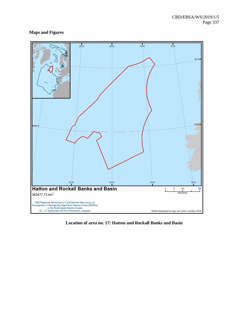
CBD/EBSA/WS/2019/1/5
Page 337
Maps and Figures
Location of area no. 17: Hatton and Rockall Banks and Basin
CBD/EBSA/WS/2019/1/5
Page 338
Annex VIII
SUMMARY OF THE WORKSHOP DISCUSSION ON IDENTIFICATION OF GAPS AND
NEEDS FOR FURTHER ELABORATION IN DESCRIBING ECOLOGICALLY OR
BIOLOGICALLY SIGNIFICANT MARINE AREAS, INCLUDING THE NEED FOR
SCIENTIFIC INFORMATION, DEVELOPMENT OF SCIENTIFIC CAPACITY AS WELL AS
SCIENTIFIC COLLABORATION
General gaps
1. The North-East Atlantic is a relatively well-studied area compared to many of the world’s oceans.
However, the relative data richness of this area should be qualified by temporal and spatial data
limitations creating data biases. For example, most at-sea surveys favour summer conditions.
2. In preparation for this workshop, an extensive data-collection process was undertaken, and a data
report was developed. Biological, physical oceanographic and physiographic data were collected as well
as data from global archives on biogeographic information. The ICES data centre collaborated with the
workshop’s technical support team prior to the workshop to share and incorporate data holdings and links
for the workshop. Access was also available to specialised OSPAR, EMODnet, and OBIS datasets. Many
European collections do not extend as far west as the workshop study area and required supplementing
from global data sets. Throughout this data collection process, several general data gaps were identified.
3. Fisheries data was provided by ICES as needed during the workshop, including access to stock
assessments, but individual catch statistics were not explored.
4. The most prominent data gaps involve the lack of consistent, region-wide surveys of data on
marine species throughout all depth ranges. This especially applies to deep-sea and particularly the
abyssal plain (see below), which is under-represented, with available biological data being more restricted
to surface or shallow water regions in and around coastal areas.
5. Typically, as elsewhere, there is higher confidence in the coverage of physical oceanography
data, while many deep-sea offshore habitats are under-studied and poorly inventoried. Some discrete
geographical gaps were noted within the North-East Atlantic region, such as an absence of data for many
individual seamounts, which limited the workshop’s ability to fully describe all seamount complexes and
other physiographic systems, such as canyons extending far offshore. Future collaboration and integration
of data within projects such as the EU iAtlantic Project have the potential to strengthen future efforts.
6. There is a need to better understand the relationship between natural and human-induced change
and its impact on marine biodiversity. Many threatened and/or declining species and habitats in the region
exhibit traits with little adaptive potential to threats associated with climate change (Johnson et al. 2018).
7. There is a need to better consider and engage traditional knowledge in the description of areas
meeting the EBSA criteria through the full and effective participation of indigenous peoples and local
communities.
Specific gaps
8. Traditional knowledge: In consistence with article 8(j) of the Convention on Biological Diversity
and Aichi Biodiversity Target 18, together with various COP decisions, there is a need to ensure the full,
effective and meaningful participation of indigenous and local communities and the integration of
traditional knowledge in the EBSA process. This was further emphasized by the CBD COP in the
Voluntary Practical Options for Further Enhancing Scientific Methodologies and Approaches, including
Collaborative Arrangements, on the Description of Areas Meeting the EBSA criteria (annex II of decision
XIII/12), which noted:
“Given the unique challenges associated with the use of traditional knowledge, more work
should be done to identify effective ways of including that information in the description of
EBSAs. Training activities could be organized prior to workshops at the relevant scale,
targeting both representatives and experts from indigenous peoples and local communities as
CBD/EBSA/WS/2019/1/5
Page 339
well as from scientific institutions. This would build on the training manual on incorporating
traditional knowledge into the description of EBSAs, as contained in document
UNEP/CBD/SBSTTA/20/INF/21, as well as the relevant work by the Intergovernmental
Science-Policy Platform on Biodiversity and Ecosystem Services”
Indigenous peoples and local communities in the North-East Atlantic have a significant amount of
endemic, traditional knowledge relevant to the description of EBSAs in this region. However, this
knowledge could not be used in this workshop because the some geographical areas in which this
knowledge is focused was not included in the workshop scope, on the decision of Parties in the region.
So, for example, traditional knowledge from the Saami and Inuit areas could not be applied to the
description of EBSAs in this region in a meaningful way. Examples of knowledge that could have been
valuable for this workshop include knowledge of fishing grounds, spawning areas, streams, fauna, bird
habitats and seabed conditions and also knowledge of customary use of areas, areas of social and
economic importance, cultural heritage sites, subsistence use areas and sacred sites. Social, cultural and
spiritual information are also of considerable importance to the conservation and sustainable use of
biodiversity, as well as to the survival of indigenous peoples in the area. Social and cultural
considerations would not only add immediate value to the CBD EBSA process, but is vital to the success
and long-term sustainability of the process, and the conservation and sustainable use of marine
biodiversity in general.
Furthermore, in consistence with article 8(j) of the Convention on Biological Diversity and Aichi
Biodiversity Target 18, together with various COP decisions, national processes applying the EBSA
criteria or other similar criteria for identifying marine areas of particular importance should identify
indigenous knowledge holders and/or indigenous peoples and local communities, include them in the
national processes and also make the knowledge holders and/or indigenous peoples and local
communities able to participate fully and effectively and with their prior and informed consent or free,
prior and informed consent or approval and involvement, as appropriate, and consistent with national
legislation and circumstances, and in accordance with international obligations in processes wherever
they are affected.
9. The ‘Banana Hole’: Due to lack of new specific biological or ecological information, no EBSA
was proposed by the workshop for the ‘Banana Hole’ area. However, this area is known to support
significant biomass production on all trophic levels, best visualized by large schools of feeding pelagic
fish (Spring-spawning herring, mackerel, whiting). Complex hydrography (especially frontal processes)
and different light levels influence phytoplankton production as noted below by the 2011 Joint
OSPAR/NEAFC/CBD Scientific Workshop on the identification of EBSAs in the North-East Atlantic,
Annex 16, which stated that
“The large-scale atmospheric pressure fields in the North Atlantic are closely linked to
the general oceanic circulation patterns, and their variation is reflected in changing
patterns of zooplankton biomass production (Skjoldal and Sætre, 2004). During periods
of a high NAO index (NAOI) the zooplankton biomass, in particular that of Calanus
finmarchicus, is high, during periods of a low NAOI the biomass is low (Skjoldal and
Sætre, 2004). The transition from one to the other NAO state is suspected to trigger
particularly successful recruitment for the most important pelagic fishes: herring respond
positively to the switch from low to high NAOI, blue whiting to a switch from high to
low NAOI (Skjoldal and Sætre, 2004).
Recent studies reveal that sea surface warming in the Northeast Atlantic is accompanied
by significant latitudinal shifts in the size distribution of phytoplankton (Richardson and
Shoeman, 2004), and in the species distribution of zooplankton (Beaugrand et al., 2002)
and fish (Brander et al., 2003). In addition, due to different control mechanisms (light,
temperature, food) for the various ecosystem components, a variable trophic match (or
CBD/EBSA/WS/2019/1/5
Page 340
mismatch) may contribute to these distribution shifts, in the end affecting also the
commercially important species, primarily fish, and dependent predators such as marine
mammals and sea birds (Edwards and Richardson, 2004).”
10. Migratory species: Dunn et al. (2019, p.2) highlight challenges faced by migratory species,
stating that “migratory connectivity, the geographical linking of individuals and populations throughout
their migratory cycles, influences how spatial and temporal dynamics of stressors affect migratory
animals and scale up to influence population abundance, distribution and species persistence. Population
declines of many migratory marine species have led to calls for connectivity knowledge, especially
insights from animal tracking studies, to be more systematically and synthetically incorporated into
decision-making. Inclusion of migratory connectivity in the design of conservation and management
measures is critical to ensure they are appropriate for the level of risk associated with various degrees of
connectivity”. For the North-East Atlantic, in common with many other marine regions benthic and
pelagic interconnectivity, as well as interconnections between the High Seas and surrounding shelf
ecology, is incompletely understood. Gaps were recognized by the workshop for the following taxa:
i. Turtles
For Leatherback turtles, scientific research within the North-East Atlantic region has been comparatively
limited so far. Based on the regional scale of this EBSA assessment process and the much larger North
Atlantic extent of the gyre, plus gaps in the current knowledge base around sea turtle migration, foraging
ecology and habitat use, it was concluded that a proposal reflecting the significance of turtle migration
would not be brought forward at this stage.
ii. Marine mammals
For marine mammals in the North East Atlantic, although there exist a number of initial tracking studies,
particularly of large cetaceans such as fin whales (Balaenoptera physalus) and sei whales (Balaenoptera
physalus) from the Azores (Silva et al. 2013, Pireto et al., 2014), and other tracking studies of humpback
whales (Megaptera novaeangliae) between the Arctic and Caribbean (Kennedy et al., 2013, UiT, 2018),
there are still many gaps regarding the spatial and temporal use of habitats by these and other cetacean
species across the region. The presence and known transient movement of some animals, such as
humpback whales from photo-identification studies, is well documented but whether they are restricted to
particular areas or range more widely is not fully understood (Stevick et al., 2006, Ryan et al., 2015,
Lavan , 2017, O’Neil et al., 2019). More specifically, it is known that many cetaceans migrate from
wintering grounds in the southern areas of the region to highly productive foraging areas in the Labrador
Sea, Greenlandic/Icelandic waters, Norway and Svalbard. Interpretation of preliminary analyses available
for sei whales and fin whales is based on the best available but limited sample of telemetry data drawn
from the, strongly indicated the potential presence of a route between the Charlie Gibbs Fracture Zone
and the Labrador Sea for this species (Olsen et al., 2009), as well as migratory stepping stones and
foraging stops along their pathway between the Azores and Greenlandic/Icelandic waters (Silva et al.
2013). Though limited, the best available data suggests the area is a critical corridor in part of a complex
migration process of large baleen whales that can involve longitudinal movements between the two sides
of the ocean basin in addition to expected latitudinal movements (Pireto et al. 2014). Tagging
programmes that provide relatively long records of movements of large whales are often expensive and
logistically demanding, so sample sizes are often limited, and results may have biases that may or may
not be quantifiable. Recent efforts by specialists are developing standards for how such data can be used
to infer use of areas in their area of specialization, in particular the recent combination of satellite tracking
and stable isotope analysis, which has further indicated the link between wintering and feeding grounds of
North Atlantic baleen whales (Silva et al., 2017).
There are further gaps identified in the coverage of systematic line-transect surveys of marine mammals
in large parts of the region, particularly for those areas away from national jurisdictions. Large sightings
CBD/EBSA/WS/2019/1/5
Page 341
survey campaigns for marine mammals (cetaceans and pinnipeds) are underway in the northern parts of
the regions (i.e. T-NASS, SCANS, CODA) but the temporal scale of these efforts still reflect a gap in
knowledge on the trends in marine mammal abundance and density over time (CODA, 2009, Hammond
et al., 2017, NAMMCO, 2018). Additional research from both dedicated survey efforts and opportunistic
fisheries observation have further indicated the importance for the diversity and seasonal habotat use of
the Azores for North Atlantic marine mammals (Silva et al., 2014, Tobeña et al., 2016). Further research
is being developed in the form of habitat and surface density modelling of marine mammal line-transect
as well as opportunistic data from non-marine mammal focused research cruises, to provide predicted
estimates of an oceanic scale. Such research includes those undertaken by the MERP project in European
Waters (ICES, 2018). The IUCN MMPATF is undertaking a number of studies to improve the
identification of Important Marine Mammal Areas (IMMAs) throughout the world’s seas and oceans, in
particular through the development and application of such habitat and density surface models (IUCN
MMPATF, 2018). This includes the use of Historic Whaling Data available via the International Whaling
Commission (IWC) and the Census of Marine Life (CoML) to indicate areas of interest (AoI) for the
future identification of IMMAs (Smith et al., 2012). More recently the IUCN MMPATF has been
developing approaches for predictive modelling of marine mammals beyond areas of high effort
concentration, using hybrid presence–absence and presence-only modelling techniques (Fiedler et al.,
2018).
iii Seabirds
Seabird migration patterns and non-breeding distribution have been some of the most important
knowledge gaps, needed to be filled for effective management of seabird populations. Now, with a
combined effort of researchers all around the North-East Atlantic participating in SEATRACK
(http://www.seapop.no/en/seatrack/) and in the Seabird Tracking database held by BirdLife International,
light-logging technology has enabled mapping (since 2014) of important seabird moulting and wintering
areas as well as migration routes on a much larger scale and in greater detail than ever before. To
document the variation in habitat use across ocean regions, priority has been given to species with a
breeding range spanning the whole study area. These are ongoing programmes and will be important
information for future work with EBSAs in the region. During the workshop, a lack of sea bird data for
the Swedish part of Kattegat and Skagerrak was noted. However, national efforts are currently undertaken
to survey seabirds in the Kattegat.
11 Benthic communities: We are unable to assess large areas of the abyssal environment of the
North East Atlantic due to a complete lack of data. Although traditionally regarded as a flat featureless
environment the abyss has a highly complex landscape with millions of hills and mountains. Recent
studies suggest abyssal hills of just 10s of meters in height may enhance megafaunal biomass and there
may be considerable unquantified heterogeneity in these systems (Durden et al., 2015; Morris et al.,
2016). About one third of the benthic species present in deep water appear to be endemic and the degree
of endemism increases with depth (Vinogradova, 1997). Rarity is common in the abyssal environment,so
estimating the diversity of this region is challenging. The abyssal environment may be significantly
affected by climate change as a result of changes to surface primary production which is then expressed
as changes in the composition, abundance and timing of food supply to the deep sea (Wigham et al.,
2003; Ruhl et al., 2008). This could make abyssal systems highly vulnerable.
In addition, it is difficult to assess many bathyal areas in ANBJ due to a complete lack of data. Studies from bathyal regions within North East Atlantic nations EEZs suggest that these regions may support significant three-dimensional structural habitats including sea pen fields, sponge aggregations, Acanella (Bamboo coral) fields, cup coral fields, and other coral aggregations (Radicipes fields) (Howell, 2010). These habitats may play important roles in other animal life histories, for example Baillon et al., (2012) found that larvae of red fish (Sebastes) closely associate with five species of sea pen. A greater understanding of the distribution of these habitats is needed. Given the vast area of un-explored deep sea, habitat suitability modelling and species distribution modelling could provide an important means to fill
CBD/EBSA/WS/2019/1/5
Page 342
the data gaps (Howell et al., 2016). However, it is important that model limitations are understood, and on-going research is investigating this. Good models rely on good input data, and efforts to map the seafloor over the next decade (Seabed 2030) will certainly provide improved input data. In addition, good models must also be based on a firm understanding of the relationship between species distribution and environmental drivers. Research aimed at understanding these relationships is needed and highlighted in decision XIII/1, the CBD COP ‘voluntary specific workplan on biodiversity in cold-water areas within the jurisdictional scope of the Convention’.
12. Vulnerability of deep-sea organisms: It is challenging to assess inherent vulnerability of deep-sea
organisms as a result of serious gaps in our fundamental ecological knowledge for most species. This
includes physical and chemical drivers of distribution, abundance, biomass, growth rates, fecundity,
longevity, reproductive cycles, larval behaviour and connectivity to name some key aspects. These data
form the input to all biological ecosystem models. Our ability to forecast how marine biodiversity will
respond to environmental change and other anthropogenic pressures, depends on good fundamental
ecological, biological and physiological knowledge. At present, we have a limited understanding of the
linkages between habitats and species, including ontogenetic or seasonal movement between habitats,
larval dispersal pathways and genetic connectivity, and patterns of succession (DOSI 2018)
13. Resolving uncertainties for coldwater areas: In decision XIII/1, the CBD COP adopted the
‘voluntary specific workplan on biodiversity in cold-water areas within the jurisdictional scope of the
Convention’. This workplan advanced five objectives:
o To avoid, minimize and mitigate the impacts of global and local stressors, and especially the
combined and cumulative effects of multiple stressors;
o To maintain and enhance the resilience of ecosystems in cold-water areas in order to contribute to
the achievement of Aichi Biodiversity Targets 10, 11 and 15, and thereby enable the continued
provisioning of goods and services;
o To identify and protect refugia sites, and areas capable of acting as refugia sites, and adopt, as
appropriate, other area-based conservation measures, in order to enhance the adaptive capacity of
cold-water ecosystems;
o To enhance understanding of ecosystems in cold-water areas, including by improving the ability
to predict the occurrence of species and habitats and to understand their vulnerability to different
types of stressors as well as the combined and cumulative effects of various stressors;
o To enhance international and regional cooperation in support of national implementation,
building on existing international and regional initiatives and creating synergies with various
relevant areas of work within the Convention.
Within this workplan, the pressures and threats to biodiversity in cold-water areas were considered
alongside a series of focal areas that would assist resolving on-going uncertainties and gaps in knowledge:
o Greater understanding of the interactions among species within trophic webs is needed. Whether
an impact of climate change on one organism will impact the survival of other organisms is
poorly understood at present. Mesocosm experiments, where communities are subjected to
projected future conditions, can help to address this.
o Impacts of ocean acidification on different life stages of cold-water organisms need to be studied.
Early life stages of a number of organisms may be at particular risk from ocean acidification, with
impacts including decreased larval size, reduced morphological complexity and decreased
calcification. Further work needs to be done on different life stages of many cold-water
organisms.
o Existing variability in organism response to ocean acidification needs to be investigated further to
assess the potential for evolutionary adaptation. Multi-generational studies with calcifying and
CBD/EBSA/WS/2019/1/5
Page 343
non-calcifying algal cultures show that adaptation to high CO2 is possible for some species. Such
studies are more difficult to conduct for long-lived organisms or for organisms from the deep sea.
Even with adaptation, community composition and ecosystem function are still likely to change.
o Research on ocean acidification increasingly needs to involve other stressors, such as changes in
temperature as well as deoxygenation, as will occur under field conditions in the future.
Acidification may interact with many other changes in the marine environment on both local and
global scales. These “multiple stressors” include changes in temperature, nutrients and oxygen. In
situ experiments on whole communities (using natural CO2 vents or CO2 enrichment mesocosms)
provide a good opportunity to investigate the impacts of multiple stressors on communities in
order to increase understanding of future impacts.
The workshop recognized the value of this workplan to address gaps and uncertainties for the North-East
Atlantic region.
14. Capacity building and integration: the workshop acknowledged the need to combine information
from different processes in order to raise capacity and inform planning within the context of the UN
Decade of Ocean Science for Sustainable Development.
REFERENCES
Baillon, S., Hamel, J.F., Wareham, V.E. and Mercier, A., 2012. Deep cold‐ water corals as nurseries for
fish larvae. Frontiers in Ecology and the Environment, 10(7), pp.351-356.
Deep Ocean Stewardship Initiative’s Decade of Ocean Science working group (2018) Deep-Sea Research
in the Decade of Ocean Science. Mapping the role of the deep ocean in human
society. https://www.dosi-project.org/topics/decade-of-deep-ocean-science/. Accessed 26/09/19
Dunn, D.C., Harrison, A-L., et al. (2019) The importance of migratory connectivity for global ocean
policy. Proc. R. Soc. B. 286: 20191472.
Durden, J.M., Bett, B.J., Jones, D.O., Huvenne, V.A. and Ruhl, H.A., 2015. Abyssal hills–hidden source
of increased habitat heterogeneity, benthic megafaunal biomass and diversity in the deep
sea. Progress in Oceanography, 137, pp.209-218.
Howell, K.L., 2010. A benthic classification system to aid in the implementation of marine protected area
networks in the deep/high seas of the NE Atlantic. Biological Conservation, 143(5), pp.1041-
1056.
Howell, K.L., Piechaud, N., Downie, A.L. and Kenny, A., 2016. The distribution of deep-sea sponge
aggregations in the North Atlantic and implications for their effective spatial management. Deep
Sea Research Part I: Oceanographic Research Papers, 115, pp.309-320.
IUCN MMPATF (2018) Guidance on the use of selection criteria for the identification of Important
Marine Mammal Areas (IMMAs). IUCN Joint SSC/WCPA Marine Mammal Protected Areas
Task Force. Version: March 2018. 82pp.
Johnson, D., Ferreira, M.A. and Kenchington, E. (2018) Climate change is likely to severely limit the
effectiveness of deep-sea ABMTs in the North Atlantic. Marine Policy 87 (2018) 111-122.
Kennedy, A., Zerbini, A., Vasquez, O., Gandilhon, N., Clapham, P. & Oliver, A. (2013). Local and
migratory movements of humpback whales (Megaptera novaeangliae) satellitetracked in the
North Atlantic Ocean. Canadian Journal of Zoology. published online.
https://doi.org/10.1139/cjz-2013-0161
Morris, K.J., Bett, B.J., Durden, J.M., Benoist, N.M., Huvenne, V.A., Jones, D.O., Robert, K., Ichino,
M.C., Wolff, G.A. and Ruhl, H.A., 2016. Landscape-scale spatial heterogeneity in phytodetrital
CBD/EBSA/WS/2019/1/5
Page 344
cover and megafauna biomass in the abyss links to modest topographic variation. Scientific
reports, 6, p.34080.
Ruhl, H.A., Ellena, J.A. and Smith, K.L., 2008. Connections between climate, food limitation, and carbon
cycling in abyssal sediment communities. Proceedings of the National Academy of
Sciences, 105(44), pp.17006-17011.
Silva, M.A., Prieto, R. Cascão, I., Seabra, M.I., Machete, M., Baumgartner, M.F. & Santos, R.S. (2014)
Spatial and temporal distribution of cetaceans in the mid-Atlantic waters around the Azores,
Marine Biology Research, 10:2, 123-137, https://doi.org/10.1080/17451000.2013.793814
Tobeña, M., Prieto, R., Machete, M. & Silva, M.A. (2016) Modeling the Potential Distribution and
Richness of Cetaceans in the Azores from Fisheries Observer Program Data. Front. Mar. Sci.
3:202. https://doi.org/10.3389/fmars.2016.00202
Wigham, B.D., Hudson, I.R., Billett, D.S. and Wolff, G.A., 2003. Is long-term change in the abyssal
Northeast Atlantic driven by qualitative changes in export flux? Evidence from selective feeding
in deep-sea holothurians. Progress in oceanography, 59(4), pp.409-441.
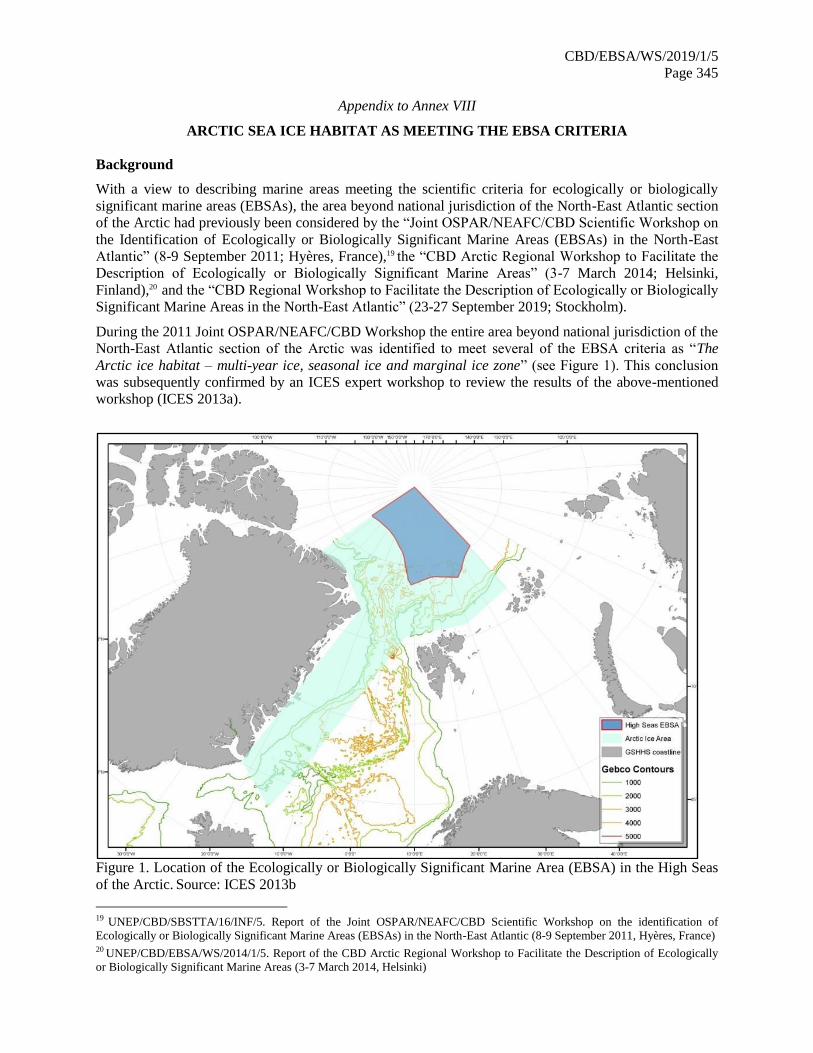
CBD/EBSA/WS/2019/1/5
Page 345
Appendix to Annex VIII
ARCTIC SEA ICE HABITAT AS MEETING THE EBSA CRITERIA
Background
With a view to describing marine areas meeting the scientific criteria for ecologically or biologically
significant marine areas (EBSAs), the area beyond national jurisdiction of the North-East Atlantic section
of the Arctic had previously been considered by the “Joint OSPAR/NEAFC/CBD Scientific Workshop on
the Identification of Ecologically or Biologically Significant Marine Areas (EBSAs) in the North-East
Atlantic” (8-9 September 2011; Hyères, France),19 the “CBD Arctic Regional Workshop to Facilitate the
Description of Ecologically or Biologically Significant Marine Areas” (3-7 March 2014; Helsinki,
Finland),20 and the “CBD Regional Workshop to Facilitate the Description of Ecologically or Biologically
Significant Marine Areas in the North-East Atlantic” (23-27 September 2019; Stockholm).
During the 2011 Joint OSPAR/NEAFC/CBD Workshop the entire area beyond national jurisdiction of the
North-East Atlantic section of the Arctic was identified to meet several of the EBSA criteria as “The
Arctic ice habitat – multi-year ice, seasonal ice and marginal ice zone” (see Figure 1). This conclusion
was subsequently confirmed by an ICES expert workshop to review the results of the above-mentioned
workshop (ICES 2013a).
Figure 1. Location of the Ecologically or Biologically Significant Marine Area (EBSA) in the High Seas
of the Arctic. Source: ICES 2013b
19 UNEP/CBD/SBSTTA/16/INF/5. Report of the Joint OSPAR/NEAFC/CBD Scientific Workshop on the identification of
Ecologically or Biologically Significant Marine Areas (EBSAs) in the North-East Atlantic (8-9 September 2011, Hyères, France) 20 UNEP/CBD/EBSA/WS/2014/1/5. Report of the CBD Arctic Regional Workshop to Facilitate the Description of Ecologically
or Biologically Significant Marine Areas (3-7 March 2014, Helsinki)
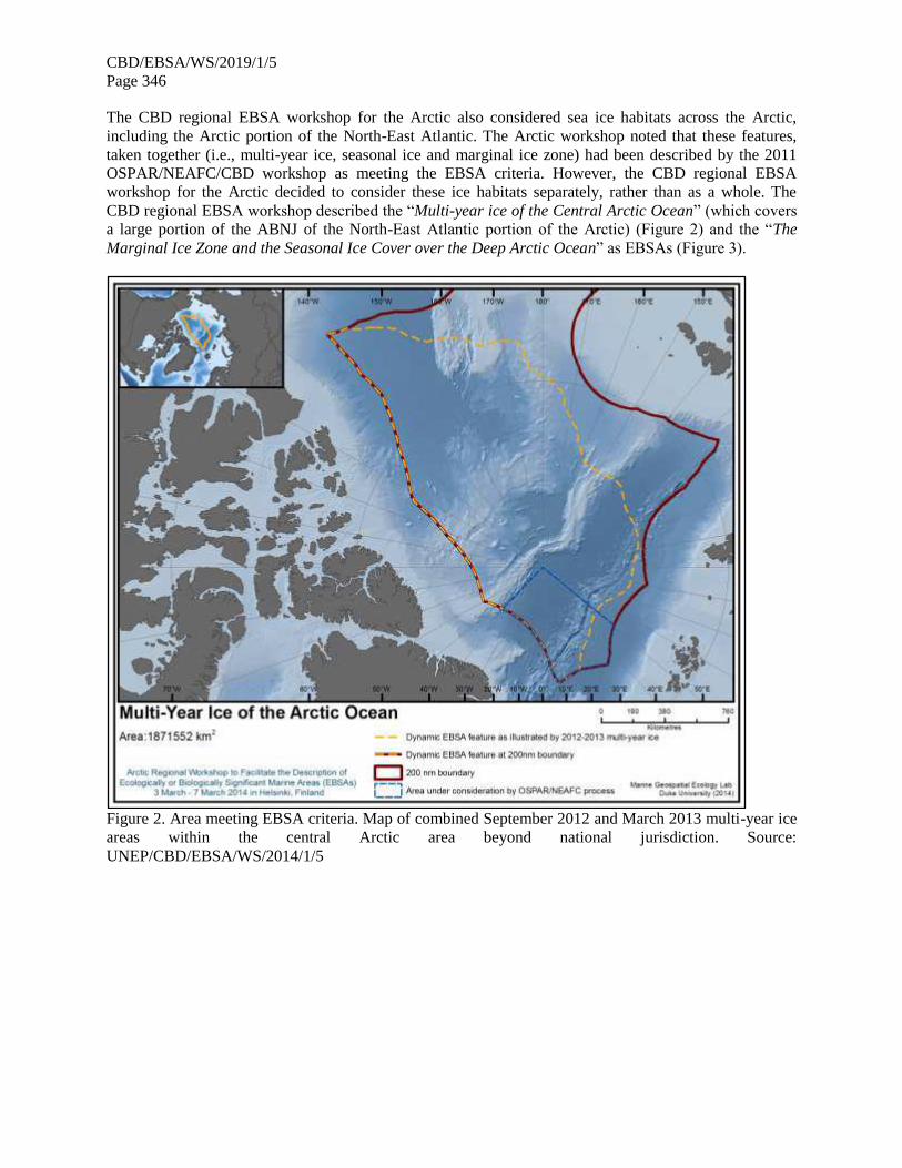
CBD/EBSA/WS/2019/1/5
Page 346
The CBD regional EBSA workshop for the Arctic also considered sea ice habitats across the Arctic,
including the Arctic portion of the North-East Atlantic. The Arctic workshop noted that these features,
taken together (i.e., multi-year ice, seasonal ice and marginal ice zone) had been described by the 2011
OSPAR/NEAFC/CBD workshop as meeting the EBSA criteria. However, the CBD regional EBSA
workshop for the Arctic decided to consider these ice habitats separately, rather than as a whole. The
CBD regional EBSA workshop described the “Multi-year ice of the Central Arctic Ocean” (which covers
a large portion of the ABNJ of the North-East Atlantic portion of the Arctic) (Figure 2) and the “The
Marginal Ice Zone and the Seasonal Ice Cover over the Deep Arctic Ocean” as EBSAs (Figure 3).
Figure 2. Area meeting EBSA criteria. Map of combined September 2012 and March 2013 multi-year ice
areas within the central Arctic area beyond national jurisdiction. Source:
UNEP/CBD/EBSA/WS/2014/1/5
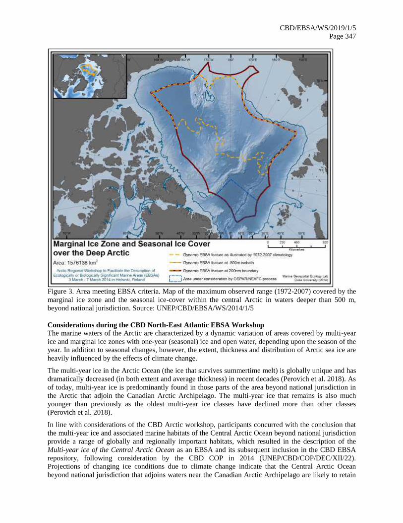
CBD/EBSA/WS/2019/1/5
Page 347
Figure 3. Area meeting EBSA criteria. Map of the maximum observed range (1972-2007) covered by the
marginal ice zone and the seasonal ice-cover within the central Arctic in waters deeper than 500 m,
beyond national jurisdiction. Source: UNEP/CBD/EBSA/WS/2014/1/5
Considerations during the CBD North-East Atlantic EBSA Workshop
The marine waters of the Arctic are characterized by a dynamic variation of areas covered by multi-year
ice and marginal ice zones with one-year (seasonal) ice and open water, depending upon the season of the
year. In addition to seasonal changes, however, the extent, thickness and distribution of Arctic sea ice are
heavily influenced by the effects of climate change.
The multi-year ice in the Arctic Ocean (the ice that survives summertime melt) is globally unique and has
dramatically decreased (in both extent and average thickness) in recent decades (Perovich et al. 2018). As
of today, multi-year ice is predominantly found in those parts of the area beyond national jurisdiction in
the Arctic that adjoin the Canadian Arctic Archipelago. The multi-year ice that remains is also much
younger than previously as the oldest multi-year ice classes have declined more than other classes
(Perovich et al. 2018).
In line with considerations of the CBD Arctic workshop, participants concurred with the conclusion that
the multi-year ice and associated marine habitats of the Central Arctic Ocean beyond national jurisdiction
provide a range of globally and regionally important habitats, which resulted in the description of the
Multi-year ice of the Central Arctic Ocean as an EBSA and its subsequent inclusion in the CBD EBSA
repository, following consideration by the CBD COP in 2014 (UNEP/CBD/COP/DEC/XII/22).
Projections of changing ice conditions due to climate change indicate that the Central Arctic Ocean
beyond national jurisdiction that adjoins waters near the Canadian Arctic Archipelago are likely to retain
CBD/EBSA/WS/2019/1/5
Page 348
multi-year ice longer than all other regions of the Arctic, thus providing refugia for globally unique ice-
dependent species, including vulnerable species. See UNEP/CBD/EBSA/WS/2014/1/5 for a
comprehensive description of the area.
Large areas of the basins in the Central Arctic Ocean are now characterized by annual ice and are thus ice
edge and seasonal ice zones with a period of open water in summer. This region of ice edge/seasonal ice
and seasonal open water over the deep Arctic is highly dynamic both spatially and temporally. The
marginal ice zone, which results from seasonal ice cover over the deep Arctic Ocean (deeper than 500 m),
is a significant and unique feature in areas beyond national jurisdiction and it has also been included in
the CBD EBSA repository in 2014 (UNEP/CBD/COP/DEC/XII/22). The area is important for several
endemic Arctic species. Some of the ice-related species are listed as vulnerable by IUCN, and/or listed as
under threat and/or decline by OSPAR. The marginal ice zone and leads are important feeding areas for
ice-associated species. Sea ice is important breeding, moulting and resting (haul-out) habitat for certain
marine mammals. See UNEP/CBD/EBSA/WS/2014/1/5 for a comprehensive description of the area.
Both EBSAs were described as geographically and temporally dynamic features that are expected to
change in area, shape and geographic location from year to year. Furthermore, in view of the increasing
rate of change in Arctic sea ice habitats due to climate change, it is becoming increasingly difficult to
spatially delineate and distinguish the extent of various types of ice habits (i.e., multi-year ice, seasonal
ice and marginal ice zone).
The CBD Arctic EBSA workshop in 2014 also noted that, given the dynamic nature of the geographic
area covered by the description of the two EBSAs, these may, depending on changes in coverage of
multi-year ice/marginal ice cover, partially overlap with an area meeting the CBD EBSA criteria that was
described by the Joint OSPAR/NEAFC/CBD workshop for the North-East Atlantic in 2011.
Challenges
As already recognized in 2014, the spatial extent of both areas described to meet the EBSA criteria is not
only affected by seasonal changes but also subject to the effects of climate change. Perovich et al. (2018)
states that:
- The past four years (2015-18) have the four lowest maximums in the satellite record. The sea ice
cover reached a minimum annual extent of 4.59 million km2 September 2018.
- In 1985, the oldest ice comprised 16% of the ice pack, whereas in March of 2018 old ice only
constituted 0.9% of the ice pack. Therefore, the oldest ice extent declined from 2.54 million km2
in March 1985 to 0.13 million km2 in March 2018, representing a 95% reduction.
- First-year ice now dominates the ice cover, comprising ~77% of the March 2018 ice pack
compared to about 55% in the 1980s. Given that older ice tends to be thicker, the sea ice cover
has transformed from a strong, thick pack in the 1980s to a more fragile, younger. thinner, and
more mobile pack in recent years.
Thus, delimitation of areas based on types of sea ice will experience equivalent changes, both with respect
to size and location of an area. Furthermore Frey et al. (2018) and literature therein states that:
- Recent declines in Arctic sea ice extent have contributed substantially to shifts in primary
productivity throughout the Arctic Ocean. However, the response of primary production to sea ice
loss has been both seasonally and spatially variable.
Thus, changes in sea ice alter the amount, timing and location of primary production, both within the ice
and in the water column, with potential cascading effects throughout the ecosystem.
Conclusion Mapping dynamic areas such as sea ice that are not only subject to seasonal but also ongoing long-term
changes is challenging, as this case illustrates. The amount of multi-year ice relative to annual ice is
CBD/EBSA/WS/2019/1/5
Page 349
rapidly decreasing. Areas previously covered by multi-year ice are increasingly being characterized by a
marginal ice zone with seasonal ice.
As illustrated by the differing approaches taken by the 2011 OSPAR/NEAFC/CBD workshop (which
considered the ice habitats as a whole) and the 2014 CBD regional EBSA workshop for the Arctic (which
considered the ice habitats distinctly), there can be different ways to consider and describe features
meeting the EBSA criteria. These differing approaches to considering features may affect not only the
narrative description, but also the geographic delineation of such features, as the area described at the
2011 OSPAR/NEAFC/CBD covers the entire ABNJ portion of the North-East Atlantic, while the area
described during the 2014 CBD regional EBSA workshop for the Arctic does not cover the entire ABNJ
area of the North-East Atlantic portion of the Arctic. Furthermore, the geographic coordinates of the
Arctic sea ice EBSAs described by the 2014 CBD regional EBSA workshop for the Arctic were noted to
be dynamic and based on approximate boundaries.
Finally, and as noted in the previous section, the rate of change of Arctic ice is increasing due to climate
change, making it increasingly difficult to justify spatially delineating and distinguishing the extent of
various types of ice habits (i.e., multi-year ice, seasonal ice and marginal ice zone) (see Figure 4). The
application of the EBSA criteria to dynamic features such as this is necessarily limited by not only the
information available at the time, but also by the need to assess the state of dynamic conditions at the time
of the assessment.

CBD/EBSA/WS/2019/1/5
Page 350
Figure 4. Comparison of multi-year ice in March 2013/September 2013 with March 2018/September
2018. The map indicates 1st year (seasonal) ice in light blue and multi-year ice in dark blue. The area
beyond national jurisdiction is shown in orange outline. Ice data citation: Tschudi, M., W. N. Meier, J. S.
Stewart, C. Fowler, and J. Maslanik. 2019. EASE-Grid Sea Ice Age, Version 4. [Northern Hemisphere
subset]. Boulder, Colorado USA. NASA National Snow and Ice Data Center Distributed Active Archive
Center. doi: https://doi.org/10.5067/UTAV7490FEPB. [Accessed 26 September 2019]. Maps prepared by
Marine Geospatial Ecology Lab – Duke University, 2019.
Respecting the outcome of the 2014 Arctic EBSA workshop, this workshop did not describe EBSAs in
the Arctic or update any previously-described EBSAs in the Arctic. However, the view of the workshop
is that this case highlights the need for revisions and updates of previously-described EBSAs, especially
for dynamic features such as the boundaries of the Marginal Ice Zone and the Seasonal Ice-Cover Over
the Deep Arctic Ocean EBSA and the Multi-year Ice of the Central Arctic Ocean EBSA described in
2014.
CBD/EBSA/WS/2019/1/5
Page 351
REFERENCES
Frey K.E., Comiso J.C., Cooper L.W., Grebmeier J.M., Stock L.V. (2018) Arctic Ocean Primary
Productivity: The Response of Marine Algae to Climate Warming and Sea Ice Decline. Arctic
Report Card 2018, NOAA. https://www.arctic.noaa.gov/Report-Card/Report-Card2018
ICES, 2013a. Report of the Workshop to Review and Advise on EBSA Proposed Areas (WKEBSA), 27 -
21 May 2013, ICES HQ, Copenhagen, Denmark. ICES CM 2013/ACOM:70. 127 pp.
ICES, 2013b. Report of the ICES Advisory Committee In: ICES Advice, Book 1,
OSPAR/NEAFC special request on review and reformulation of four EBSA Proformas.
Perovich D., Meier W., Tschudi M., Farrell S., Hendricks S., Gerland S., Haas C., Krumpen T,
Polashenski C., Ricker R., Webster M. (2018) Arctic Report Card: Update for 2018. NOAA
https://www.arctic.noaa.gov/Report-Card/Report-Card-2018
__________
Related Documents