Report of the Officials of the Governments of India and the Peoples’ Republic of China on the Boundary Question (Part 4) Ministry of External, Government of India

Welcome message from author
This document is posted to help you gain knowledge. Please leave a comment to let me know what you think about it! Share it to your friends and learn new things together.
Transcript
Report of the Officials
of the
Governments of India
and the
Peoples’ Republic of China
on the
Boundary Question
(Part 4)
Ministry of External, Government of India
(D) EASTERN SECTOR Evidence of Indian Administration upto
traditional alignment in the Eastern Sector
Under Item 2 the Indian side submitted a great deal of evidence from
Indian, Chinese and other sources to show the traditional and customary
basis of the watershed boundary of India from east of Bhutan to the tri-
junction of the boundaries of India, Burma and China, and showed that this
traditional boundary was confirmed by a formal exchange of letters with
Tibet in 1914. They now submitted evidence of Indian administration in this
area right upto this boundary alignment.
This entire area now constitutes a part of the North East Frontier Agency
under the direct administration of the Union Government of India. It
comprises the Kameng, the Subansiri, the Siang and the Lohit Frontier
Divisions. It is inhabited almost entirely by tribal people who were, for a
long time, permitted as far as possible to look after their own internal
matters.
Chinese officials have illegally dispossessed the designated authorities of
the Government of Bhutan in the following eight villages situated in western
Tibet over which Bhutan has been exercising administrative jurisdiction for
more than 300 years: Khangri, Tarchen Tsekhor, Diraphu, Dzung Tuphu,
Jangehe, Chakip and Kacha.
Bhutan has for centuries appointed the officers who governed these
villages, collected taxes from them and administered justice. Tibetan
authorities consistently recognised that these villages belonged to the
Bhutan Government. The villages were not subject to Tibetan officers and
laws; nor did they pay any Tibetan taxes. There has thus been a violation
of Bhutan's legitimate authority over these villages.
At the request of the State of Bhutan the Government of India in their
notes of 19 August 1959 and 20 August 1959 have represented to the
Chinese Government to restore the rightful authority of the Bhutan
Government over their enclaves.
The chief tribes inhabiting the region are:
(i) The Monbas in the Tawang, Tammaphu, Domkho and Dupla Ko
river valleys;
(ii) The Akas in the Tenga and Bichom river valleys;
(iii) The Daflas in the areas east of the Aka and Monha territory and
between the Kameng and Subansiri rivers;
(iv) The Miris in the area north and east of the dafla area upto the
Subansiri river;
(v) The Abors in the area between the Suhansiri and the Dibang
river valleys; and
(vi) The Mishmis in the area between the Dibang valley and, the
Indo-Burma boundary.
In the statement regarding the traditional and customary basis of the
Indian alignment the Indian side cited a large number of authorities to
show that the Ahom Rajas had extensive relations with the northern tribes
and :Bad exercised sovereignty over them. During the British period these
various tribal areas were placed from the start under the jurisdiction either
of Political Agents or of the Deputy Commissioners of the adjoining districts.
These Political Agents and Deputy Commissioners regulated inter-tribal
relations as also relations between the tribal people and inhabitants of the
plains. From time to time laws were passed and notifications issued defining
the administrative boundaries between the hill districts and those on the
plains and the limits of the administrative units set up in the hill areas
themselves.
Thus in 1873, when it was found that the Government were being deprived
of their revenue from the hill are as by traders from the plains who were
exploiting rubber and other plants and killing animals, the Government of

India issued a public notification-the Bengal Eastern Frontied Regulation 1
of 1873. This notification empowered the Provincial Government to
prescribe what was known as the Inner Line beyond which people were to
be prohibited from going without special passes. They were not to obtain
from the hill areas any rubber, wax, ivory or other jungle products nor hunt
wild elephants beyond the Inner Line without special permission of the
Government. (Photostat 1). It may be mentioned that the very use of the
term Inner Line was to distinguish it from the "Outer Line". that is, the
international boundary. Exclusive control of grant of permits to enter
certain territories is the strongest possible proof of control of those
territories.
Under this Regulation of 1873 a detailed description of the Inner Line was
issued. Notifications describing the Inner Line in the Lakhimpur District and
the Inner Line in the Darrang District were issued in September 1875 and
March 1876 respectively. (Photostats 2 and 3). In October 1884, a revised
notification regarding the Inner Line in Lakhimpur was issued. (Photostat
4). All these documents show clearly that the Inner Line marked merely an
administrative limit and the area north of it was also controlled by the
Government of India Revisions of the Inner Line have been, regularly
notified thereafter right down to our own times; for example, in 1928,
1929, 1934 !l:md 1958 such notifications were issued. On the last occasion
it was formally brought to the notice of the Chinese Government on 23
January 1959; but the Chinese Government said nothing to show that this
area, administered by India and' indeed to which admission was controlled
by the' Government of India, was claimed by China. (Document 5).
Similarly, Government orders were issued from time to time notifying or
altering the revenue and judicial administration of the. tribal areas, and
appointing officers specially for the purpose. In 1880, the Government of
India issued a notification conveying the Governor-General's sanction to the

Frontier Tract Regulation. This Regulation extended "to any tract inhabited
or frequented by barbarous, or semi-civilised tribes adjoining or within the
borders of any of the districts included within the territories under the
administration of the Chief Commissioner of Assam." The administration of
civil and criminal justice, as also revenue administration, were to be vested
in such officers as the Chief Commissioner might appoint. (Photostat 6).
Under this Regulation, Political Officers were appointed to look after these
tribal areas by the District Officers of Lakhimpur, Darrang and Dibrugarh,
all of which adjoined the tribal areas. Regulation 1 of 1945 consolidated
end amended the administration of justice and exercise of police authority
in these frontier areas.
In September 1914 a fresh division of the areas was made and three main
units were established. The Central and Eastern Sections, North-East
Frontier Tract, which was one of the units thus established, comprised the
hills inhabited by the Abors, Miris, Mishmis and others. The Western
Section, North-East Frontier Tract comprised the hills inhabited by the
Monbas, Akas, Daflas and parts of the Miri and Abor hills. The Lakhimpur
Frontier Tract. comprised the hills inhabited by the Singphos, Nagas and
Khamtis.
The line separating these hilly areas from the plains was described in great
detail in this notification. (Photostat 7).
In March 1919, by another public notification, the Central and Eastern
Section, North-East Frontier Tract was renamed the Sadiya Frontier Tract
and the Western Section, North-East Frontier Tract was termed the Balipara
Frontier Tract. (Photostat 8). Notification 50 of 3 January 1921 notified an
the frontier districts of Assam to be "backward tracts" in which, under the
new Government of India Act of 1919, only such laws would operate as the
Governor in Council or the Governor-General in Council might direct. The
Government of India Act of 1935, divided these hill areas upto the
international boundary into "excluded" or "partially excluded" areas. Section
92 of the 1935 Act stated that till such time as these excluded areas were
ready to be merged with the rest of the province the Governor would
administer them in his discretion under the general control of the Governor-
General. On 3 March, 1936, The Government of India (Excluded and
Partially Excluded Areas) Order declared the Sadiya, Lakhimpur and
Balipara Tracts to be excluded areas, and they were so administered till
1947. The Constitution of India, which came into effect on 26 January,
1950, made detailed provisions under the Sixth Schedule for the
administration of this whole area, now known as the North East Frontier
Agency.
The exercise by the Government of India of civil and criminal jurisdiction
over the tribal areas and regulation of inter-tribal relations as well as the
relations between the tribes and the people living on the plains can also be
conclusively established.
The Chief of Tawang, called the Deb Raja, and his dependents, all of whom
had been dependents of the Thom Rajas, undertook as early as 1844 to
submit to British civil jurisdiction. An annuity of Rs. 5,000 was paid to
them, conditional on their good behaviour and observance of all the terms
of their undertaking. The text of this undertaking' was published as far back
as 1862 in Aitchison's Collection of Treaties, Engagements and Sanads
(Volume 1, pages 145-146); and the Chinese and Tibetan Governments
were doubtless aware of this submission of the Tawang and other Bhutiya
Chiefs to British jurisdiction.
Apart from these Chief's a number of other Bhutiya Chiefs also undertook in
the same year "never to join any person or persons that may be at enmity
with the British Government; and furthermore to oppose every effort made
against the Government the instant it shall be brought to our knowledge…"
They also agreed "to act up to any orders we may get from the British

authorities". On these conditions as well as of an assurance of good
behaviour, they were given a monthly pension. There could be no greater
proof of this acceptance of the sovereign authority of the Government of
India.
In 1853 when a Tibetan refugee took asylum under the British, some of
these Bhutiya Chiefs made a representation on behalf of the Tibetan
Government but later withdrew for fear of losing the annuity of Rs. 5,000
granted to them earlier. They agreed that the annuity might be forfeited
"should the peace be ever broken by us". All these administrative
agreements have been published in the various editions of Aitchison.
There is conclusive proof of the exercise of administrative jurisdiction in the
other areas as well. The Abor region was visited as early as 1826 and 1827
by Captain Bedford, Captain Neufville and Captain Wilcox to settle a
number of feuds existing between the Miris and the Abors. In 1847 Major
Vetch held a meeting with several clans of Abors 'On the Dihang for the
purpose of establishing trading posts. The next year he settled the Posa
(stipend) to be given to the different tribes of Abors. In 1862, following
certain raids made by the Abors on the plains, a force consisting of 400
soldiers was sent up the Dihang valley and the tribes subdued. The latter
then gave undertakings confirming that they would not cross the
administrative frontier and accepting the jurisdiction of the British
Commissioner. Similar undertakings were given in 1866 by twelve more
sections of the Abors who in addition agreed to preserve the tranquility of
the frontier.
In 1911, when the Minyong Abors committed a breach of the peace, the
Government took effective action to punish them and to bring them to
order. The tribals living in Kebang, Yemsing, Rengging and Babuk were told
to obey the orders of the Government and not to interfere with people
going down to the plains for trade. AU these documents also have been
published by Aitchison.
The Akas undertook in 1844 "never to join any parties that are or may
hereafter be enemies to the British Government, but pledge ourselves to
oppose them in every way in our power. We will also report any intelligence
we may get 'Of any conspiracy against the British Government, and act up
to any order we may receive from their authorities". Further, they also
promised good behaviour on pain of forfeiting the pension they were
receiving from the Government of India.
In 1883-84 when the Akas committed certain crimes, they were duly
punished and thereafter they submitted and gave an undertaking of good
behaviour in 1888.
The Indian side have a vast amount of evidence to show that the Political
Officers in charge of the tribal areas exercised effective jurisdiction right
upto the traditional frontier. It is true, as stated in the Prime Minister's
letter of 26 September 1959, that the British Government's policy was
generally to leave the tribes more or less to look after themselves, and not
seek to establish any detailed administration in these areas such as was to
be found in the rest of British Indian territory. Nevertheless, where
questions of law and order, inter-tribal relations and relations between the
tribal people and the plains people were concerned, the authorities never
failed to exercise their sovereign jurisdiction. The Indian side would give a
few examples selected from various periods to show the continuity and
scope of this jurisdiction.
1- The Annual Report for 1885-1886 of the Deputy Commissioner, Darrang,
stated that the Tawang representative attended the Darbar held by the
Deputy Commissioner, wherein a dispute that had arise between the
Tawang traders and the Kuriapara people regarding the exchange of salt for
rice, was settled. The Tawang representative received his annual pension of
Rs. 5,000 at this Durbar. The Tawang representative also reported about
the economic conditions prevailing in Tawang at that time. (Photostat 9).
The presence of the Tawang representative at the Durbar of the British
official in 1885 and his conduct there constituted formal evidence of
Tawang's acceptance of British sovereignty.
2. The Annual Report on the Frontier Tribes for the year 1896-97 showed
administrative control over the whole area. It stated that peaceful
conditions prevailed in the Monba, Miri and Doba Abor areas. The Monbas
assured the Deputy Commissioner that the y would not force their hill-salt
upon the people of the neighbouring plains in exchange for rice at any rate
other than the fair and recognised one. An expedition was sent to the Apa
Tanang (Dafla) area to punish them for a murder they had committed.
(Photostat 10).
3. The Annual Report on the Frontier Tribes for the year 1901-1902 stated
that certain people including the Gam (Chief) of the Miris were given
permission to hunt elephants in the area beyond the Inner Line. A
complaint was lodged by the Doba Abors that certain Miris had cut trees in
their country, and the Deputy Commissioner thereupon imposed fines on
the Miris. (Photostat 11).
4. The Annual Report for the year 1902-1903 stated that the Tawang
Monbas, Charduar Monbas, and the Thebengia Monbas came as usual to
Tezpur to receive their respective posas and to give their presents in
return. Passes were issued for cutting trees in the Aka area, beyond the
Inner Line. (Photostat 12).
5. The tour diary for February 1913 of Dundas, the Political Officer in
charge of the Abor area, gave details of his official tours as far as Damro
and Komkar deep in the Padam Abor area. (Photostat 13).
6. Capt Nevill Political Officer in the Western Section of the North East
Frontier Tract, visited Tawang and the other Monba territories further south

during the course of his official tour in 1914. His detailed report described
the conditions prevailing in these areas and made proposals for their better
administration. Re suggested that the Tawang monastery should be asked
not to forward the pension received by .it from the Government of India to
Lhasa, to whom it owed religious obedience. Re added that an officer
should be stationed at Tawang and that police posts should be established
at Dirang and Rupa. He stated that neither the inhabitants of Rupa and
Shergaon nor those of But and Konia knew Tibetan. Rupa and Shergaon
paid no taxes to Dirang and sent a, contribution to the Monastery at
Tawang. N either in Tawang nor in these villages did Nevill find any trace of
Tibetan administration. (Photostat 14).
7. The Annual Report for 1914-15 stated that certain Padam Abor villages
and certain Mishmi villages were assessed for poll tax. The Mishmis were
behaving satisfactorily. The report gave information also about certain
inter-tribal quarrels among the Abors living as far north as Komsing and
Komkar. (Photostat 15).
8. The Annual Report for 1915-16 reported certain disturbances in. the
Minyong Abor areas and proposed the despatch of an expedition, restore
order. A poll tax was levied on the Padam Abor villages. The Chulikata and
Bebijiya Mishmi areas were peaceful. (Photostat 6).
9. The Annual Administration Report of the Balipara Frontier Tract for the
year 1918-19 showed clearly that Tawang was administered by Indian
officials. That the British Political Officer, representing the Government of
India, was in charge of the administration of the entire area was clear from
the fact that he paid the stipends, regulated the inter-tribal relations of the
Moonbas, conducted the administration and reported regularly about the
economic conditions f the entire area. The Monhas of Rupa and Shergaon
complained to the Political Officer about the oppression of the Akas and

Miris and requested him to send a guard and establish a dispensary.
(Photostat 17).
10. In September 1920 the Government of India conveyed their sanction to
the Government of Assam regarding the extensive tours to be conducted in
the frontier areas by the political Officers of the in North East Frontier
Tracts. (Photostat 18).
11. The Dairy of R. W. Godfrey, Political Officer, Sadiya Frontier Tract,
regarding his tour in March 1939 deep into. the Abor territory beyond Karko
described at great length the various administrative duties performed by
him in a large number of villages all of which received him most cordially.
Since the report is a lengthy one the Indian side supplied photostats of only
extracts from it. The duties performed by the officer included hearing cases
and discussing village matters with the Gams of Pangin, ordering Karko,
Riga and Pang kang to remove trade blocks and to settle claims amicably in
Kebang (Council), appointing men to hold a Kebang in connection with the
Pertin-Tayong land dispute, hearing and settling cases concerning Damroh
and giving medical treatment to the tribal people. (Photostat 19).
12. In April 1939, the Secretary to the Governor of Assam reported to the
Government of India about the conditions prevailing in the central Monba
region as noticed by the Political Officer while returning from his official tour
to Tawang. The Miji and Miri Akas were in the habit of raiding and
plundering the Monba villages and exacting illegal tributes from them,and
the Governor proposed the sending.. of an expedition to punish the Akas.
(Photostat 20).
This representative evidence that the Indian side brought forward regarding
the nature of the jurisdiction exercised by Indian officers in the various
tribal areas at different periods proves that these areas upto the traditional
frontier have always been under Indian jurisdiction. All forms of
administrative control, including the primary one of maintaining law and
order were in the hands of the Government of India. These tribes were the
pensioners of the Indian Government and the latter controlled their
relations both among themselves and with their southern neighbours,
promoted their prosperity, looked after their health and social welfare and
punished them for wrong-doing. The scope and. variety of Indian
administration in these unsettled tribal areas has been for a great many
years both comprehensive and conclusive.
Detailed surveys conducted from time to time throughout these areas
constitute another group of evidence conclusively proving Indian sovereign
jurisdiction. The Political Officers incharge of the various frontier tracts were
in the habit of collecting detailed information regarding the geography of
the. areas. This was illustrated by the Annual Reports and Tour Diaries,
several of which the Indian side had already produced. Detailed and
scientific surveys - of the areas were held between 1911-14. A survey party
attached to the Miri Mission (November 1911-March 1912) surveyed the
valleys of the Subansiri, Kamla and Khru rivers. The General Report
'submitted by Kerwood, who was in charge of this Mission, summarised (in
Chapter IX) the results of the survey sand said that nearly 1400 square
miles of territory had been accurately mapped on the scale of 11 : 4 miles.
(Photostat 21). The Results of this Miri .survey were linked with those of
the Abor Field Force which surveyed the Abor area further east. The Abor
survey was conducted by a party attached to the Abor Expeditionary Force
under Major General Bower, and Bentinck, Assistant Political Officer. A few
relevant extracts from the lengthy Reports and Tour Diaries submitted by
Bentinck are attached. It can be seen that the party visited almost all
important parts of the Abor area and in particular the Dihang valley
(Photostat 22).
The Mishmi area between the Dibang and the Lahit valleys was surveyed by
two parties between 1911 and 1913. A few extracts from the reports
submitted by the first party under Major Bliss, Commander, Mishmi Mission
Force, and similar extracts from re-ports submitted by parties attached to
this Mission and in-charge of construction of bridges and roads, are
attached. (Photostat 23). This provides not only proof of survey work but
incidentally also of public works undertaken in these areas.
The entire Monba and Aka region from the eastern boundary of Bhutan up
to the Dafla territory in the Kameng River Valley, was surveyed by a party
under Lt. Huddleston of the Survey of India, attached to the Tour Party
under Capt NeviIl, Political Officer, in 1913-14. This party surveyed an area
of 4000 square miles up to the Tse La Range. A photostat copy of the
relevant extract is attached. (Photostat 24). The region further north
including Tawang was surveyed by Captain Bailey and Captain Morshead.
These surveys prove not only the extension of Indian administration to
these areas but also that the area had been as well surveyed as was then
possible and the so-called McMahon Line only formalized the traditional
alignment which had been carefully confirmed and the terrain accurately
surveyed.
The Assam Provincial Census Reports for the various years provide further
proof of the fact that the tribal areas were, right from the beginning, an
integral part of India. Although regular enumeration beyond the Inner Line
was not always possible, attempts were made to collect as much
information as possible regarding the habits and customs of the tribal
people.
The Assam Census Report for 1881 made it clear right at the beginning that
the tribal are a extending up to the Himalayas ID the north was part of
Assam.
In paragraph 1 of page 1 it was stated:
"Assam occupies the north-east corner of the Indian Empire and is
bounded on the north by the eastern section of the Himalayan range
which portion 18 inhabited by the Bhutias, Daflas, Akas and other hill
tribes".
In paragraph 144 it stated:
"Miri, Dafla and Abor are names which have been given by the
Assamese to three sections of one and the same race, inhabiting the
mountains between the Assam valley and Tibet..."
Paragraph 145 gave an account of the Miris, Abors, Daflas and other tribes.
It was worth noting that it stated that the Miris had been subject to the
Ahom kings. Photostats of pages 86 and 89 from the report were attached.
(Photostat 25).
The Assam Census Report of 1901 similarly gave an account of the tribal
people. In paragraph 201 of Chapter XI it stated:
"Living in. the Hills on the north of the Brahmaputra, we find, the
Mishmis, the Abors, the - Miris, the Daflas and the Akas". (Photostat
26).
The Assam Census Report for 1921 contained a full appendix on the tribes
written by Capt. Nevill, Political Officer, Balipara Frontier Tract. He dealt
with all the tribes and gave detailed information regarding their territory,
their customs and practices, traditions and religion. (Photostat 27).
These Census Reports make clear that the territory up to the watershed
was regarded as part of India and whenever a census was held in other
parts of India this area was also taken into account and attempts at
enumeration made.
Apart from the tours conducted by the Political Officers and jurisdiction
exercised by them in various ways there is a great deal of other
administrative evidence, including construction of public works, to show
that the north-eastern tribal areas always formed part of India. Instances of
such works were the construction of a bridged track from Sadiya to the
frontier in the Lohit valley, the establishment of a military police post near

Menilkrai, the construction of a telegraph line from Sadiya to the advanced
post and the construction of a bridge track along the left bank of the
Dibang river.
A note by Dundas, Political Officer, Central and Eastern Section, dated
January 1916, referred ,to the road 92 miles long from Sadiya to
Therouliang in the Mishmi area which had been built earlier at a cost of 26
lakhs of rupees. He then referred to the examination of the road and
bridges which had been built earlier, by the Mishmi Works Party in 1912-
13, as far as Makhung beyond the Dou river. (Photostat 28).
A letter from the Government of Assam to the Government of India, dated
19 August 1938, stated that out of the current year's provision of Rs.
18,000 a sum or Rs. 15,260.19 had already been beginning that the tribal
area extending up to the Himalayas III the be surrendered under that head.
(Photostat 29).
A letter from the Government of India to the Government of Assam dated
30 August 1940 conveyed the sanction for the establishment of cold-
weather out-posts at Karko and Riga in the Upper Siang Valley. Karko and
Siang are situated in the heart of Abor territory and the sanction of special
posts for these places is proof that Indian administration was actively
functioning in these areas and that no taxes could have been collected by
the Tibetans as alleged by the Chinese side in their earlier statements.
(Photostat 30).
A letter from the Government of Assam to the Government of India dated 6
September 1940 recommended the construction of a road four feet wide in
the Lohit Valley and the construction of several suspension bridges across
the rivers along this road. It suggested also the establishment of an octroi
and road maintenance post at Therouliang in the Tiding Valley. (Photostat
31).

Extracts of notes from a file of the Government of India dated September
1946 prove the grant of financial sanction for a number of administrative
measures in the North East Frontier Agency. These measures include the
purchase of bridging material in the Lohit Valley, conversion of a post of
Assistant Political Officer to that of a Political Officer in the Abor Hills of the
Siang Sub-agency, the establishment of a forward post in the Siang Valley,
the establishment of a post in the Panir (Ranga Nadi) Valley and the
construction of a temporary plains base for the Subansjri area. (Photostat
32).
The increasing responsibilities undertaken by the Government of India for
extending the benefits of regular administration can also be seen from the
Balipara Frontier Tract Jhum Land Regulation III of 1947 which provided for
the better utilization of the Jhum land and arranged facilities for their better
cultivation. (Jhum land was that which members of a village community
had a customary right to cultivate or to utilise for other purposes).
These documents pertaining to different periods and extending over the
entire area in question provide full proof of active jurisdiction exercised by
the Government of India not only in recent years but for many decades in
the past and long before 1914. They show an aspect of administration. The
Government of India not only maintained law and order but undertook
constructive activities in this area.
In face of this vast amount of evidence showing conclusively the exercise of
Indian administration and jurisdiction in these areas up to the traditional
watershed alignment, it seems hardly necessary to bring forward further
evidence in the form of official maps to substantiate the Indian alignment.
However, as the Chinese side have, in their statement of 4 September
1960, referred to certain maps of the Survey of India, the Indian side would
deal with these.

The maps referred to by the Chinese side were the map of India of 1865,
the map of India of 1889, the District Map of India of 1903, and the maps
of Tibet and Adjacent Countries of 1917 and 1938. The maps showed the
administrative Inner Line dividing the tribal areas from the plains districts
of Assam. The description of the Inner Line, as notified from time to time,
corresponded to the limits of normal regular administration in Assam, and it
was this line which was shown in maps issued by the Survey of India.
British cartographers, as a rule, showed on their maps the administrative
boundaries irrespective of the alignment of the international boundary. But
this Inner Line, as the Indian side had already shown very clearly and as
his very name denoted, was only an internal boundary. Perhaps nowhere
was this more clearly shown than in the official Government of India Act of
1935. This was a legal document of the utmost significance which was
drafted with great precision. In Section 311 of the Act, it was stated clearly
"India means British India together with the tribal areas." In other words,
tribal areas were not parts of provinces or even of British India, but they
were a part of India and lay within the international boundaries of India. It
is this administrative distinction between various parts of India that was
shown on the maps of the Survey of India. All these maps showed the
extent of these tribal areas of India either by a colour wash north of the
administrative line or Inner Line or by printing the names of the tribes
across the area. Since the relations of the Government of India with the
tribal regions were of long standing, were well-known from the beginning
and had been made, clear during the last two centuries by statutory
enactments and administrative agreements, and as the administrative
measures taken regarding these areas were publicly notified from time to
time, there was no possibility of mistaking the administrative line shown on
the maps for the external boundary of India.
The Indian side could produce a large number of maps published by the
Survey of India to substantiate this position. The Map of India of 1883
showed the whole tribal area by a colour wash. (Photostat 33). The
Government of India had already drawn attention, in their note of 12
February 1960, to the map published by the Survey of India in 1895 and
corrected upto 1903. This map also showed the whole tribal area by a
colour wash (Photostat 34). The map attached to the Memorandum on
Native States, Volume II, Published by the Government of India in 1909
(Photostat 35), and the map of Eastern Bengal and Assam attached to the
1908 edition of Aitchison's Collection of Treaties, Engagements and Sanads,
Volume II also showed the entire tribal area by a distinct colour wash.
It might be pointed out, in this connection, that the same procedure was
followed on the north-west frontier. Although the boundary in this area had
been clearly defined by an international agreement of 1893, maps
published by the Survey of India continued to show the area beyond the
administrative line by a colour wash. This did not mean either that the
boundary was not known or that the area beyond normal, regular
administration was not a part of India.
That the four maps of the Survey of India cited by the Chinese side showed
only the administrative line was further made clear by the fact that on the
District Map of India of 1903 the external boundary was not shown for
almost its whole length; and on the maps of Tibet and Adjacent Countries,
the inset map showed clearly and correctly the whole external boundary of
India.
As regards the Chine se contention that the "undemarcated" symbol was
altered in Indian maps after 1952, this has already been explained in the
note of the Government of India of 12 February 1960.
In fact, it had been conclusively shown that the natural, traditional and
customary boundary between India and Tibet in this Sector lay along the

watershed. Not only had evidence been led from ancient times right down
to our own day to prove that this was the traditional and customary
alignment, but it had also been shown that it was well-recognised and
accepted by both sides. Authoritative Chinese works themselves, as the
Indian side had shown under Item 2, written at various times, recognised
this as the boundary between the two countries. Indian jurisdiction and
administration had extended right up to it for a long time and it was given
further treaty sanction in 1914. Official Chinese maps, such as the Postal
Atlas of China of 1917, also showed the correct alignment in this sector.
COMMENTS ON THE EASTERN SECTOR UNDER ITEM 3
As the Chinese side commenced by asserting once more that their
alignment was the traditional one, the Indian side were obliged to draw
attention again to the fact that under Item 2, the Chinese side had brought
forward no historical evidence in support of an alignment claimed to be
traditional. The Indian side, however, had provided a vast amount of
conclusive evidence in support of the traditional Indian alignment. It had
also been shown that this traditional Indian alignment had secured the!
sanction of treaty; but as the Chinese side spoke again of the McMahon
Line as "illegal" the Indian sidle brought forward further evidence to place
the issue beyond the shadow of doubt. They supplied a photostat copy of a
note formerly handed over by the representative of the Government of
China to the Government of India on 5 November 1947. In this note the
Government of China had enquired "whether after the transfer of power,
the Government of India have replaced the former Government of British
India in assuming the treaty rights and obligations hitherto existing
between British India and Tibet… "
In their reply of 9' February 1943, the Government of India had formally
informed the Chinese Government that "as from the date of the
establishment of the Dominion of India, the Government of India have
replaced the former Government of British India in regard of the treaty
rights and obligations: previously existing between British India and Tibet".
These documents formed incontrovertible evidence of the Chinese
Government's acceptance of the treaty-making powers of Tibet, and the
strongest possible proof not only of the, validity of the Indo-Tibetan
Boundary Agreement of 1914, but also of its recognition by the Chinese
Government.
The Chinese side argued that the reference here was to the treaties signed
between the Chinese and British Governments; but it was shown that there
was no basis at all for such an interpretation for the Chinese communication
of 5 November 1947 referred explicitly to the obligations that existed
between India and Tibet and not to those between India and China. The
free Government of India had never been interested in any extra-territorial
rights that might have been bequeathed to her, and when the time came
she renounced them, and was proud to renounce them. But tl1e legitimate
rights and obligations that had been acquired by her or on her behalf had
always been recognised by her; and similarly Tibet also had recognised her
rights and obligations. One of the main sources of the rights and obligations
of India and Tibet was the valid exchange of letters in 1914. The
Government of China had recognised this in 1947.
Evidence of Indian Administration upto the Traditional Alignment The
Chinese side made no effort to controvert much of the large quantum of
evidence cited by the Indian side, and the few comments they did make on
the remainder were shown to be lacking in substance. They asserted that
while the Indian side had brought forward evidence regarding the existence
of the Inner Line no evidence had been brought forward to establish
administration of the areas beyond the Inner Line or the exact-location of
the 'Outer Line'. The Indian side answered that this was to ignore all the
evidence, such as permits to foreigners to cross the Inner Line and exercise
of civil and judicial administration, covering every part of this area right
upto the watershed boundary: This evidence not only substantiated the
Indian alignment but disproved the Chinese claim, for the alignment
claimed by the Chinese, as they themselves had admitted, was for almost
its entire length the Inner Line maintained by the Government of India. The
Chinese Government were claiming what was never more than an
administrative line, with no international significance whatsoever. It was, in
fact, not even a municipal line. The very term Inner Line showed that it was
only an administrative line within, and south of, the international
alignment.
The assertion of the Chinese side that Indian administrative control had
reached only upto the Inner Line and never beyond it, was obviously based
on a misunderstanding of the nature of the Inner Line. The areas north of
this line had always been under the jurisdiction of the Indian Government.
But they were inhahited by tribes with a distinct culture and a way of life of
their own and the Indian Government had always been anxious to preserve
the unique quality of tribal life. For that reason regular administration, such
as was to be found in other parts of: India, was not extended to those
areas. As explained earlier, the tribal areas had been described in the
Government of India Act .of 1935 as "excluded" or '''partially excluded"
areas-Le., excluded from the normal administrative processes to be found
in other parts of India. The Inner Line showed the limits of the tribal areas.
It marked the limit not 'Of Indian administrative c0ntrol but 'Only; of
normal Indian administration. What was to be found north of the Inner Line
and upto the international boundary was a special type of administration
adapted to the peculiar needs or the tribal areas.
The Chinese side then wished to know how, if the tribal areas were not
administered, the tribes could have been controlled. It was explained by the
Indian side that they had never stated that these areas were not
administered, but only that they were not under the same type of
administration which was to be found in other parts of India. A vast amount
of evidence showing the precise nature of administrative authority
exercised in these areas, in bath the pre-British and the British periods, had
been brought forward.
.
The Chinese side stated that they could not understand why the Border
Regulations of 1880, cited by the Indian side, applied also to tribal
territories adjoining the districts administered by the Chief Commissioner of
Assam. The Indian side explained that this was because special
arrangements were being made for the administration of these areas. This
could not, by any stretch, he interpreted to mean that the area was not
apart of India. Special arrangements for the administration of the tribal
areas was in fact the clearest possible proof that this part of Indian territory
was under Indian administration.
The Indian side pointed out that this variation in the types of administration
was not peculiar to India. Not all parts of China were administered in the
same manner. Indeed, for several centuries Chinese laws had not been
operative in Tibet, nor had any taxes been collected by China in Tibet. The
Chinese side did not, on that account, admit lack of administrative control.
Even now there existed what were known as 'Autonomous Areas' in China.
As for the suggestion that there was no indication in the Indian evidence as
to where exactly the international boundary lay, it was stated that the exact
alignment had already been established under earlier Items, and under this
Item the Indian side were only concerned with establishing the existence of
Indian jurisdiction and administration upto it. The record of continuous
administration supplied by the Indian side showed that authority had been
exercised in every area upto the boundary. The Indian side might well ask
the Chinese side whether in any of their documents under this Item the
exact location of the alignment claimed by them had been described.
The Indian side repudiated the Chinese suggestion that the people of this
area had always adopted an attitude of resistance to the British
Government. For entirely the converse was true. The tribes had explicitly
accepted the sovereign jurisdiction of the British Indian Government, and
rarely was there any trouble in these areas. The Chinese side had referred

to Needham's expedition. In 1885 Needham went right upto the border in
the Mishmi area and within a mile of Rima. It was true, as stated by the
Chinese side, that Williamson had been murdered in the Abor area in 1911.
But the Indian side could not believe that the Chinese side were seeking to
argue that a stray murder in the course of over a hundred years of
continuous exercise of administrative authority by the British Indian
Government proved either lack of administrative control or that these areas
belonged to Tibet. Occasional murders of officials took place in every part of
the world, but on that ground no one could argue that administrative
control did not exist. In fact, those guilty of Williamson's murder had been
severely punished by the Indian authorities.
The, Chinese side mentioned that the majority of the local people had hated
outsiders. The Indian side replied that even if this were true, it could not
follow that the territory lay outside India. In Tibet itself to this day
foreigners were not particularly welcome; but it had not been inferred from
this that Tibet was not now' a part of China.
The Chinese side then referred to the Indian evidence regarding the
undertakings by the tribes confirming Indian sovereignty. As already shown
by the Indian side, they were merely administrative arrangements in order
to enforce the sovereign authority of the Indian Government in this area.
This authority had never been questioned by the tribes, and ways and
means suitable to these areas had to be developed. The Indian side had
cited a number of articles in these agreements which made their nature
clear and which showed that the tribes were under the sovereign
jurisdiction of the Indian Government. When a reference was made in these
agreements to "British territory", what was meant was territory under
regular administration. As the laws applicable to these areas were different
to those enforced in the plains districts, the laws operative in the plains
were referred to as "British laws", applicable' to the whole of British Indian

territory as distinct from these tribal areas. In fact, the Indian side had
already quoted an article from the Government of India Act which made it
clear that even as recently as 1935 these territories were regarded as a
part of India but not of British India. Far from these agreements showing
that these areas were not British territory, they emphasised the fact that
they were a part of Indian territory but that special arrangements had to be
made for them.
It was also pointed out by the Indian side in this connection that if, in fact,
these tribal areas had belonged to Tibet, the Government of India would
have signed agreements direct with Tibet and not with the Monbas or the
other tribes; for during those years the Tibetan Government were
negotiating on their own, as was shown by their treaty with Nepal in 1856.
So even if it had been true, as; the Chinese side had contended that these
agreements were between two equal parties, it would only show not that
these tribal areas belonged to Tibet but that they were independent. In
fact, as already mentioned, they were administrative agreements between
the Central Government and the outlying areas. The reference in an
agreement of 1853 to the Lhasa Government merely indicated that on this
particular occasion, which concerned an incident involving a Tibetan, the
local Rajas were acting for the Tibetan Government. That it meant no more
was placed beyond doubt by the fact that nine years earlier, in 1844, these
Rajas had explicitly reaffirmed the administrative authority of the
Government of India over these areas. The key sentence of that agreement
of 1844, which the Indian, side had already quoted, was:
"We also pledge ourselves to act upto any orders we may get from
the British authorities."
The Chinese side stated that the payment of posa or stipends could not be
regarded as proof of administrative control, and cited Haimendorf in
support. The Indian side replied that the payment of posa was clear proof

of Indian administration of the tribal areas, because they were paid to those
tribes which had explicitly accepted the traditional sovereign jurisdiction of
the Indian Government over their areas. As there was little normal source
of income in these hilly areas, the Government were obliged to make these
payments to the tribes. Moreover, through such payments, as was clear
from some of the undertakings given by the tribes, the British arranged to
maintain the security and defence of the international frontier lying north of
the tribal areas. The explanation given by Haimendorf was patently wrong,
and it was surprising "that the Chinese side should have based their
argument on such an unauthoritative work. No Government in the world
paid stipends to those who were not its citizens.
Regarding the varied evidence brought forward by the Indian side to show
continuous Indian administration, the Chinese side only commented on a
few items, and even these comments were shown to be of no pertinence.
The visit of the representative of Tawang to the Durbar of the Deputy
Commissioner in 1885 showed clearly that Tawang was under the
administrative control of the Indian Government; and his presence was
additional evidence of the formal acceptance of Indian sovereignty. He did
not attend the Durbar, as the Chinese side alleged, merely to settle trade
matters. As had already been shown, he received his annual pension at that
Durbar and reported on the conditions prevailing in Tawang.
The Indian side could not accept the Chinese assertion that the despatch of
Indian troops into this area was illegal and that they went only into the
southern areas. It had been established with a wealth of documentary proof
that this area was always a part of India and that Indian officials and
military personnel had been touring the whole region right upto the
boundary alignment, as they had a legitimate right to do, for many years.
The tours of these officials were by no means secret, as the Chinese side
alleged, and were fully covered in the Annual Reports. The taxes collected

were not limited to the cultivation of fields in the plains and even those
tribesmen who were not owners of land in the plains had to pay these
taxes.
The Indian side had produced a considerable amount of evidence to show
that the Tawang area had always been administered by Indian officials. For
example, in 1938 the boundary between Bhutan and this area had been
surveyed for its whole length right upto the northern alignment by a joint
commission set up by the Governments of India and Bhutan. The Indian
side could not comprehend on what basis the Chinese side ignored all such
evidence, without giving any reasons at all.
The surveys carried out in these areas upto the traditional alignment by
Indian officials were also part of the legitimate exercise of administrative
authority. When these officials like Bailey and Gunter crossed the border to
survey Tibetan territory, it was always with the permission of the Tibetan
Government. The Indian side could not accept the Chinese statement that
the surveys during the years 1911 to 1914 were with the intention of
annexing a part of Tibet. The boundary with Tibet was well-known and
recognised, and the exchange of letters between India and Tibet in 1914
merely formalized it.
The Indian side noted that the Chinese si de had not attempted to
controvert the evidence of administrative control provided by the Census
Reports. The nature of the terrain explained the fact that the census.
methods were not of the same pattern as that adopted for the other parts
of India. The same method was followed Tor the other tribal areas in the
heart of India, such as those in what was now Madhya Pradesh.
As for the public works undertaken in this area, the Indian side had shown
that they were constructed even in the early years of this century, and they
could not see on what, grounds the Chinese side stated that they had all

been planned and built after 1940. These public works were evidence of
general administration in this area.
The Chinese side cited passages from various books in an effort to prove
that the areas north of the Inner Line were not a part of India; but it was
shown by the Indian side that all these works in fact supported the Indian
position. The Chinese side quoted a passage from Dr. Elwin's recent book A
Philosophy for NEFA. It was incomprehensible what was sought to be
proved by that statement. Dr. Elwin had clearly stated that these tribal
areas had been a part of India, both under the Ahom Kings and in the days
of British rule. The Indian side quoted the' relevant sentence from Dr.
Elwin's book:
"When the British took over the control of Assam from Purander
Singh in 1838, they found that the warlike tribes of the frontier had
become even more aggressive as a result of the breakdown of the
authority of Government and for the remainder of the century they
largely followed the policy of the Ahom kings."
It was clear from this that Dr. Elwin was only describing the state of
relative unrest within a part of India. He had then described the means
adopted by the British Indian Government to reassert their authority in the
tribal areas. Nowhere had he stated, or even suggested, that this area was
outside India or was a part of Tibet.
The Chinese side referred to a passage in an article written by Kingdon
Ward. The Indian side were surprised that the Chinese side should have
quoted Kingdon Ward, for there were a number of books and articles
written by him, to which the Indian side had already drawn attention, and
which stated expressly that the international boundary of India in this
Sector was what was known as the McMahon Line. If the Chinese wished to
base their claim on Kingdon Ward's opinions, the Indian si de would be

most willing to cite his many statements describing the traditional Indian
alignment.
Reference was also made by the Chinese side to a passage in the book
Himalayan Barbary by Haimendorf. This book had already been dealt with
by the Indian Government in their earlier correspondence with the Chinese
Government. Haimendorf was new to this area and in 1944 he had visited it
for the first Ume. Clearly all that he meant when he talked about the Inner
Line being the only effective border of India was that regular administration
of the type common to the rest of India was not to be found to the north of
the Inner Line. His work also was only made possible by the assistance
rendered by the Government of India. The position had been fully explained
in the passage in the Encyclopaedia Britannica of 1947, which had been
quoted by the Chinese side: "beyond it (the Inner Line), it is illegal for
British officials and men to move into unless with special permission." The
fact mentioned in this statement, that no one could enter the tribal areas
without the special permission of the Indian Government, demonstrated
more clearly than anything else that these areas were a part of India. The
Indian side were grateful to the Chinese side for drawing attention to the
Encyclopaedia Britannica.
The Chinese side quoted a passage from a book by Alfred Lyall, published
nearly 80 years ago, stating "we must start from the creation of a political
boundary." Whatever the interpretation the Chinese side might put on
Lyall's statement, it had already been shown beyond doubt by the Indian
side under Item 2 that the traditional and customary boundary of India lay
where it was now being shown. What Lyall had in mind was that it was a
matter for decision whether the British Government in India intended to
extend their authority right upto the settled boundaries of India or whether
they intended to leave some independent Indian kingdoms within the
international boundaries of India. This had obviously no bearing on the fact

that the border of India in the Eastern Sector had always laid along the
watershed range, and that the Inner Line marked the limits of regular
administration south of it. The Chinese suggestion that the name Inner Line
was given to keep the boundary in a fluid state was totally unwarranted by
facts.
The Chinese side again dwelt at length on the maps published by the
Survey of India. The use of the term 'undemarcated' on earlier official maps
had already been explained both in the earlier correspondence between the
two Governments and at these meetings. Further, the maps merely showed
the administrative boundaries of what was called British India in the sense
that the y showed only the then limits of regular, normal administration.
Material brought forward by the Chinese side
While under Item 2, the evidence, such as it was-which had been brought
forward by the Chinese side had pertained to no more than about a tenth of
the territory involved, under Item 3 their evidence, on their own admission,
pertained to an even smaller area, and dealt with three small pockets, the
Monba area in the extreme west, the so-called Layul area in the extreme
north and a small part of the Lohit valley to the north of Walong in the
extreme east. But even here, the evidence did not cover the whole of these
small wedges of territory. For ex ample, in the Layul area, the so-called
'Avowals' and the lists said to represent a tax register covered only a few
villages along the banks of the Siang river. Even according to the Chinese
side these villages were at a great distance from the alignment claimed by
them. and by no stretch of logic-or of territory could this strip along the
Siang river be held to cover a vast area, and that are a given the name of
Layul. Similarly, in the so-called Lower Zayul area, the Chinese evidence
concerned only a few hamlets on the banks of the Tellu river. Outside these
small pockets there were extensive areas of thickly populated territory

which the Chinese side claimed but which the Chinese evidence did not
even seek to cover. There was no reference for ex ample to the Dafla
tribes, to the Tagins, to the great number of Mishmis and to the bulk of the
Abor land.
The Indian side could not believe that the Chinese side meant to assert that
their continuous administration of these areas was established beyond
doubt by one solitary document brought forward by them regarding the
collection in these areas of a few tiger skins and a pair of elephant tusks.
This was in strong contrast to the evidence brought forward by the Indian
side. This evidence has been selected from a vast mass of documentation in
order to cover different aspects of administration in every part of this area,
and particularly the northern areas near the traditional alignment.
The Monba area
The Chinese side once again cited the order of the Fifth Dalai Lama and
stated that the Tibetan Government had deputed certain persons to
exercise jurisdiction in the Monba area. It was pointed out that this
document had already been dealt with under Item 2 and shown to be in no
way conclusive of the establishment of public administration. Moreover, in
the course of the discussion, the Chinese side had made so many
contradictory statements that it was hard to believe that any of these
statements -was correct. All that this particular document dealt with was
the management of monasteries and endowments and the raising of
voluntary contributions. As the whole origin of the claim to Tibetan
administration of the Monba area was based on this document and as the
Chinese side had repeatedly referred to it, the Indian side read out the
relevant passage: " it would not only be possible to manage monasteries
that are under the control of Mera Lama from Ningsang onwards and
Khelin, Tsang Chiang Mu and Ali upwards and manage the farms of the
spiritual ones belonging to the monasteries but it would also be possible to
build a few monasteries and collect levies for the clergy in all the places of
the east, west, above, and below Mon region. For summer and autumn the
levies for each person in every temporal household and the donations of
those having faith and that offer, should be ten units. For the living
collections can be made. For the de ad ones good deeds giving generous
presentations to the lay and clergy in the place and also the Ula for
transportation purposes when the great believers are deputed to places
below Tsona."
This made repeatedly clear that the management was of the monasteries,
that the collections were only for religious purposes, and that even Ula or
the right to beggar was reserved for the monks, for the "great believers
deputed to places below Tsona." Nowhere in the document was it stated, as
the Chinese side had claimed, that Lang Kha Chu and the Mera Lama were
to exercise jurisdiction over this area. Here was evidence provided by the
Chinese side themselves that what the Fifth Dalai Lama had established in
the Monba are a was no more than ecclesiastical jurisdiction. And as had
frequently been pointed out by the Indian side, the mere existence of a
theocratic system in Tibet did not mean that wherever there was
ecclesiastical jurisdiction, political authority automatically went with it.
The Chinese side gave a long list of places in the area and asserted that
they had been organised into tsos. Some of the places listed did not, in
fact, exist, others lay north of the traditional Indian alignment, and still
others were known to be outside the Monba area. A few of the names were
those of places within the area. But the type of administrative organisation
which actually existed in the area was far from that of the nature described
by the Chinese side. Detailed descriptions of the exact type of tribal
organisation found in those areas were available in the annual reports sent
by the India.

The Monba area consisted of four main divisions: Tawang, including the
villages of Shakti, Gyangkar, Jang and Senge; Upper Tammaphu and Upper
Phutang valleys consisting of the villages of Lili Dirang and Phutang
inhabited by the Sherchokpa Monbas; the lower Tembang valley consisting
of the villages of Tembang, Konia and.
But inhabited by the Thebengia Monbas; and the Domkho and Dupla Ko
valleys consisting of the villages of Talung Kalaktang Shergaon and Rupa,
inhabited by the Sherdukpa Monbas. In the Tawang and Sherchokpa areas,
the villages enjoyed autonomy in regard to their internal affairs, and the
monks of the Tawang monastery collected religious dues from these
villages. The Tawang area was divided into eleven groups of villages with
each group under a Chhyargen or Gaonbura; eight of these groups were in
western Tawang and three in eastern Tawang. In each village there was a
Kachung and two or three Gamis, according to the size of the village. From
the beginning the Monbas of the Tawang and Sherchokpa areas had
accepted Indian sovereign authority and had received pensions from the
British Indian Government. In course of time the Tawang monastery, taking
advantage of the Government's policy of allowing the tribal people to. look
after themselves and of the backward and superstitious nature of the tribal
people, began gradually to exact services and dues to which it was by no
means entitled. But at no time was Tibetan administration or the tso
organisation to be found in this Monba area. The Indian side had provided a
large amount of evidence to this effect and they drew particular attention to
Photostats 9, 10, 12 and 14, which showed that the Deputy Commissioner
of Darrang and the Political Officer under him were exercising effective
jurisdiction over the entire Monba area including Tawang. Photostat 14 also
described the actual type of tribal administration that existed in the Monba
areas. It stated: "Rupa and Shergaon are jointly ruled by a council, of 20
headmen, of whom seven are hereditary. These seven are descendants of
the original headmen who in the old days were called by the Assamese 'Sat
Rajas'. Every villager may attend the council and in village affairs each man
has a vote. The people are divided into two classes, the upper class who
are hereditary landholders (called Babus) and the poorer classes (called
Giba). There is no. slavery." Every year the representatives of the
Sherchokpa and. Tawang Monbas came to Darrang or to Tezpur to receive
their annuity and renewed their submissions and promises of good
behaviour.
Some time later, the Tawang monastery started to send a part of its
annuity as contribution to the Drepung monastery of which it was, a
branch. But it could not follow from this that Tibetan administration
prevailed in Tawang. Religious dues and the organisation of Lamaist
Buddhism were no proof of administrative control just as the existence of
the Roman Catholic Church in various parts of the world was not proof of
the authority of any Roman Government.
Indeed in March 1914 Lonchen Shatra, the Tibetan Prime Minister had
himself acknowledged to the British Indian representative that Tawang was
not a part of Tibetan territory and that Tibetan interest in Tawang was
confined to the income which the Potala Trung-yik Chenpo and the Loseling
college of the Drepung monastery were receiving in return for the services
of the agents (the Tsona Dzongpons) sent by them to manage the land of
the Tawang monastery.
Lonchen Shatra made a specific request that such income obtained from
Tawang might be considered as the income of private individuals. The
Indian side supplied a photostat copy of the relevant extracts from the
discussions, and believed that this would conclusively settle all controversy
about the nature of the income or the so-called "taxes" derived from
Tawang, and about the ownership of Tawang itself.

The only comment made by the Chinese side on this detailed ;account
provided by the Indian side of the actual form of tribal organisation and the
nature of Tibetan influence in the Monba area, was to brush aside
summarily the statement of Lonchen Shatra. The Indian side pointed out
that no one had been in a more authoritative and responsible position to
speak for Tibet than Lonchen Shatra, who was the then Prime Minister of
Tibet. They added that the Chinese attitude could be a precedent for the
Indian side to set aside all statements by Tibetan authorities, and the whole
Chinese case was based on such Tibetan statements. But it was a
precedent that 'they did not intend to follow.
As for the description of the Trukdri organisation which the Chinese side
had given, the Indian side stated that it was well-known that the Trukdri
was only a monastic council in charge of the administration of the
monastery and its endowments. The Government of India had been fully
aware of the existence of this purely monastic council and had not
interfered with its activities, so long as it confined itself to the management
of the monastic property. The two Representatives of the Tawang
monastery at Talung received the annuity of Rs. 5,000 from the
Government of India on behalf of the 'Tawang monastery. These
representatives at Talung, though they sometimes called themselves
dzongpons, were only agents of the monastery which 1tse1f was
unquestionably within the jurisdiction of the Government of India, as was
shown even by the receipt of annuities. The Government of India had been
aware that the Tawang monastery had been forwarding a part of this
annuity to the Drepung monastery, and at one stage, in 1914, had even
considered stopping this practice. It was extraordinary that the Chine se
side should have cited the existence of the Trukdri and of these agents as
evidence of Tibetan administration. Their functioning was no more than
proof of a religious organisation. It was significant that the Chinese side
themselves admitted that the dzongpons were not members of the Tawang
administrative committee, but only of the non-permanent committee.
The Chinese side asserted that certain Indian officials such as Bailey had
recognised the existence of Tibetan administration in this area. In reply it
was pointed out that at least for the last 130 years and long before the
traditional boundary was formalised in 1914, Indian officials had been
touring every part of the area north of the Inner Line, had maintained law
and order and had authorised detailed surveys. Administrative units had
been formed in the area, and an elaborate machinery of government not
only created but even re-organised before 1914. The very fact that the
Chinese and Tibetan Governments had taken no objection to such open
activities as those of the Joint Indo-Bhutan Commission of 1938 showed not
merely that the area was under Indian and not under Tibetan
administration, but also that this continuous exercise of administrative
authorities by India was recognised by the Tibetan and Chinese
Governments as legitimate. As for the reference in Bailey's book, this had
already been dealt with in detail by the Indian Government in the earlier
correspondence between the two Governments, and did not require
repetition.
The Indian side then dealt in detail with all the documents of which
photostats had been brought forward by the Chinese side. Photostat 1
referred only to a private dispute concerning the hereditary estates of the
Sixth Dalai Lama in the Tawang area. The Indian side had never questioned
the existence of such Tibetan private estates in this area. In fact they had
been expressly safeguarded by the Indo-Tibetan exchange of letters of
1914. Photostat 2 concerned the collection of monastic dues by the agents
of Tawang monastery, and was no evidence of tax-collection. Photostat 3
referred to the mismanagement of the monastic estate by the monks of

Tawang, monastery and the suggestion that the lay officials-the dzongpons
should manage it.
Similarly there was nothing in photostat 4 to show any civil administration
of the area by Tibetan authorities. On the other hand, it showed clearly that
such religious dues as were collected were being spent on religious
ceremonies and were not being forwarded either to Tawang or to Tibet.
When in 1944 the Adviser to the Governor of Assam visited Dirang Dzong,
the monks helped to make his visit a success; and it was then announced
that the making of offerings to Tawang monastery would be a purely
voluntary affair. The document also described the administrative system
established by the British officers under the headmen in each village.
The Chinese side provided photostats of some documents in support of
their contention that the Dzongpons had collected taxes, listed the number
of families and even exercised judicial powers in the Monba area. But none
of these documents referred to taxes as such being collected. Photostat 7
listed road stages and the dues to be collected by the local authorities for
road-making. It was not even clear that these road stages, which had been
mentioned lay south of the traditional Indian alignment. The Indian side
stated that it was impossible from this document to reach the Chinese
conclusion that it had listed the families paying taxes to Tsona Dzong.
The Indian side examined with great care photostat 8, which the Chinese
side claimed to be a book of tax regulations for Tsona Dzong. It did not
give, as one would expect in any book of tax regulations, a complete list of
villages in the Monba area and the taxes paid by them under various heads.
In fact, the only places south of the traditional Indian alignment mentioned
were identified as the private' Tibetan estates. This was clear proof,
furnished by the Chinese side themselves, that no part of the area south of
the Indian alignment belonged to Tibet or had been administered' by
Tibetan officials. Moreover, it was well-known that the Tibetan Government
had, until recently, been maintaining a customs post along the traditional
Tawang-Tibet border, thereby established that the Monba area was not
within the customs jurisdiction of Tibet.
Photostat 9 again mentioned no tax. Photostat 10 was no evidence of a
census conducted in the various tsos in 1940 as claimed by the Chinese
side. This document spoke specifically of the offerings to be made by the
people on the occasion of the enthronement of the Dalai Lama. It was
evidence neither of census nor of tax payments but of collection of funds
for a special religious ceremony.
Thus no evidence had been brought forward by the Chinese side to show
either that Tibetan officials had been entitled to collect taxes in the Monba
area or indeed that any civil taxes had been collected at all. The Chinese
side referred to Ya Ch'ai and T'un Ch'ai, but no such taxes existed and no
proof of their collection had been provided. Nor had any proof of collection
in cash been brought forward. No regular revenue registers or records
showing continuous collections of any sort of revenue, such as had been
provided by the Indian side, had been produced by the Chinese side. The
only conclusions which had been clearly established were that irregular
incomes were derived from private Tibetan estates that contributions were
collected for the Tawang monastery and that dues were levied on goods
sold at Tsona. Indeed, had taxes been collected in any area south of the
tradition al alignment Lonchen Shatra in 1914 would have demanded that
this be taken into consideration in framing the terms of the boundary
agreement. The fact that the only stipulation made was for the protection of
private Tibetan estates showed that the Tibetan Government had no other
interests in this area.
Ta support their claim to have exercised judicial powers in this area, the
Chinese side brought forward some documents of a very vague nature.
Photostat 18 referred to a joint investigation by India and Tibet into a case
of rioting among some Monba villagers and the consequent death of a
relation of the Dalai Lama. This did not prove the exercise of judicial
authority by Tibet. Indeed, it proved Indian jurisdiction; for while the
interest of Tibet was obvious in that a relative of the Dalai Lama had been
killed, there was no explanation for India's interest except in that it
pertained to an area under Indian administration. The Chinese side
suggested that the reference in the document was to China and Tibet and
not to India and Tibet. The Indian side pointed out that the Tibetan ward
'Gya' not 'Han' as stated in the final Chine se statement-in this document
referred to India and not to China. Photostat 19, with its clear reference to
"Lamas in the monasteries on the Tibetan border" quarrelling with the local
people and the despatch of an officer to investigate, was again no more
than proof, at most, of ecclesiastical jurisdiction over the monks of the
monastery. There was nothing in photostat 20 to show the exercise of
judicial authority. Photostat 2i described the situation arising from the
damage caused to the lands of Tawang monastery during 'Lapa' raids on
Monba territory. Lhasa was naturally interested in safeguarding the
interests of the monastery and instructed the Abbot and other
representatives of Tawang to settle the matter. Obviously it was not an
exercise of judicial authority and there was no evidence of Tibetan judicial
officers taking part. The actual judicial authority in such cases was
exercised by the Indian Political Officers, and the Indian side had provided
evidence of this. The fact that this document had been addressed to
Tawang monastery and all the people of these areas did not indicate that
the authority of the Tibetan Government prevailed over them. The Chinese
side had themselves stated that it was the Tibetan practice to address
letters to all and sundry. Photostat 23 had been cited to show that even
British officers had acknowledged the exercise of judicial powers by Tibetan
officers. However, examination of the full text of this document showed that
there was nothing to warrant the claim made by the Chinese side. The
identification by them of Tak Dzong with Talung Dzong was also not
substantiated. So none of these documents could be regarded as providing
evidence of the exercise of Tibetan judicial authority in this area.
In later years, there were some occasions when the Tsona Dzongpons came
down to Jang, near Tawang, during the winter months to help the Tawang
monastery to manage its monastic property, and usurped certain powers to
which they were not entitled. But such malpractices were always promptly
put down by the Government of India. A Political Officer who had visited
Tawang in 1938 found that these Dzongpons had been pretending to
possess judicial authority and inflicting brutal punishment on Indian Monbas
living in what was unquestionably Indian territory. The Political Officer
called for immediate measures to stop these unlawful activities. In 1945 the
Tsona Dzongpons alleged that they had concluded a 'treaty' with the
villages of Lih, Chug and Sangti according to which the villagers had to pay
paddy for the maintenance of certain gompas in Tibet in return for a
nominal present of salt. The Indian Political Officer in charge of the Balipara
Frontier Tract inquired into this and found that the so-called "treaty" was a
forgery. The Indian side supplied photostats of the original documents. This
showed clearly the type of civil administration that the Tsona Dzongpons
had ever conducted on behalf of Tibet in this area.
The Layul Area
The Chinese side reiterated their claim that a part of the so-called Layul
area had been originally under Pome and later under Pemakoi-Chen and,
therefore, belonged to Tibet. The Indian side showed that this claim was
entirely baseless. In the statement regarding the limits of Tibet submitted
by the Chinese Representative, Ivan Chen, at the third meeting of the
Simla Conference on 12 January 1914, it had been clearly stated:
"Poyul has never belonged to Tibet. It is a country inhabited by lawless
herdsmen …Poyul is practically independent and Tibet has never been able
to exercise any influence over the place".
If in 1914 Poyul (Pome and Pemakoi-Chen), which lay north even of the
traditional Indian alignment, was recognised as never having belonged to
Tibet, the Chinese side could not claim that this area, or the area south of
it, had traditionally been a part of Tibet.
However, it was noted that the Chinese side themselves admitted that
evidence of Tibetan administration in this area was even less than that in
the Monba area; and that evidence had already been shown to be
inconclusive. The Chinese side argued that what Ivan Chen had meant was
that these areas had belonged to China. The Indian side replied that
Tibetan administration could not have prevailed south of an area under
Chinese territory; and the Chinese stand was that the areas south of the
traditional alignment had belonged to Tibet.
The Chinese side referred to some obscure administrative office being set
up in this area after 1927. However, they had admitted that out of the five
administrative units set up here only one, namely, Ta Kang, happened to be
south of the Indian traditional alignment. But there was no place called Ta-
Kang anywhere in this area.
Of the documents cited by the Chinese side to support their claim that
taxes had been collected in the Layul area most of them pertained to the
area north of the Indian boundary and a few to the small area between the
boundary and the Sirapateng river. Photostat 11 was claimed to be a
register of revenue and taxes submitted by Pa-ch'ia-si-jeng area. The
document itself appeared to be the register of a private land-owner
recording the amount of butter and money received and the services
rendered by tenants-a record of private estate management rather than of
state transactions. There was no mention of any taxes having been

collected by the Tibetan Government. The same was the case with
photostat 12 which mentioned, not the revenue pa id by Mechuka village to
Keka Dzong, as the Chinese side claimed, but the debts payable by various
Mimek traders to the Estate Manager of Gaza. It was only evidence that
some Tibetan landlords had practised usury in this area.
Photostat 13 recorded the giving of certain religious offerings by the people
of Loka and Lonak areas. There was nothing to show that it referred to
people living south of the traditional alignment. Indeed, it obviously
referred to the Tibetan territory north of the Indian alignment, for the name
Loka, as was well-known, was applied to the region on either side of the
Tsangpo roughly from 91 degrees to 96 degrees East Longitude, and
bounded by the southern districts of Kham On the north and east, and by
Bhutan and the Indian tribal territory on the south. As the Chinese side
insisted, without any fresh evidence, that Loka and Lonak referred to the
Layul area in India, which according to them was the greater portion of the
area now claimed by them, the Indian side stated that it was strange that
from this vast area only five ounces of silver, ten tiger -skins and one pair
of ivory tusks were collected, according to this document, as revenue.
Obviously the correct interpretation of the document was that it referred to
religious offerings from Loka and Lonak areas lying outside Indian territory.
Photostat 14 was an assurance by certain village that they would maintain
the local monastery properly, and was no evidence of Tibetan civil
administration. Photostat 15, which was claimed to be a directive issued by
the Tibetan Government to the Sera monastery for the collection of
revenues in the Layul area, was in fact an effort to collect payment for
Tibetan mercenaries from some Abor villages very far from the alignment
now claimed by China. Considerable evidence had been supplied by the
Indian side to show that the Abor areas right upto the alignment had been
under Indian administration. This was proof enough that the Tibetans could
not have collected taxes in this area as late as 1945; but there was also
positive evidence to show that both the Tibetan officials and people
accepted Kepang La as the border and refrained from coming south.
In this connection the Indian side submitted a photostat copy of a report
submitted by the Indian Political Officer regarding the meeting that took
place between him and the Deba from the 18th to the: 20th April, 1949.
The Chinese side cited only one document to support the claim to have
exercised judicial powers in the Layul area. But this also had no relevance
to the territory in question, and referred to a dispute between two persons
of Besi and the Shika of Gaza. There was no place called Besi in the area
south of the traditional alignment, while Gaza was in Tibet.
The Lohit Valley Area
Although the Chinese side had cited no evidence to show that any Tibetan
administrative units had existed in the Lohit valley or that it had formed
part of any Tibetan administrative unit, they continued to assert that it was
part of Tibetan territory. The Indian side pointed out that in this case also
Ivan Chen, in his statement submitted at the third meeting of the Simla
Conference on 12 January 1914, had stated:
"Zayul is divided into two parts, the upper and the lower" both of
which are outside the pale of the Tibetan control and are inhabited by
independent and barbarous tribes called Miris, Abors and Mishmis".
As so much of the Chinese case depended on the actions of Ivan Chen, the
Indian side could not believe that they would disown his statements on
these points. But if Zayul was not, according to the: Chinese Government
themselves, a part of Tibet in 1914, the Chinese side could not now with
any consistency claim that this part was' traditionally a part of Tibet. The
weakness of the Chinese case was apparent from the nature of the
evidence brought forward by them. Only two stray documents had been

cited in support of their claim to have collected taxes in this area. Of these
the first document did not mention the name of a single place in Indian
territory and was of no value from the viewpoint of the boundary. It only
proved that taxes had been collected in Rongto, a valley in Tibet far from
the Indian boundary. The second document mentioned th81 despatch of
such odd articles as leather, pieces of wood and beer to Tibet from a few
places near the border by Tibetan settlers. There was no mention of any
taxes being collected.
As against such stray references, the Indian side had produced solid proof
of continuous Indian jurisdiction. There had never been any doubt about
the alignment of the boundary in this region; and to show that even the
local people had been well aware of the international boundary, the Indian
side supplied another photostat of an extract from the tour diary of the
Political Officer in 1946.
In the final statement of 7 November 1960, the Chinese side claimed that
in the last years of the Ching dynasty, Chine se troops had been stationed
near Walong. This assertion had never been made during the discussions,
much less substantiated. It was, in fact incorrect.
Other Material cited by the Chinese side
The Chinese side brought forward four photostats in support af
their contention that the Tibetan Government had often taken measures to
control the entry and exit of foreigners into the territory in, question.
However, none of the documents were relevant, and compared in no way
with the documents regarding permission for crossing the Inner Line
brought forward by the Indian side. Photostat 25 was a pledge by the
people of Zayul to prevent plots being hatched by foreigners. From the list
of signatories it was clear that they all belonged to the Rima area lying
north of the Indian territory. Photostat 26 was a promise by the authorities

of Dirang and Talung that they would not allow foreigners to cross the
India- Tibet border and proceed to Lhasa. This offer to assist the Tibetan
Government in keeping out foreigners was no proof of Tibetan
administration in this area, but rather showed that it lay outside Tibet ln the
letter of Bailey, the Indian Political Officer in Sikkim seeking the Tibetan
Government's permission for the visit of Kingdon Ward to certain Tibetan
areas such as Sanga-cho Dzong and Chamdo, Layul and Zayul had been
mentioned only to show that that was the route that would be taken by
Kingdon Ward to enter Tibetan territory. Tibetan permission had not been
sought for Kingdon Ward's transit through these indisputably Indian are as.
ln his letter of 3 January 1924 to the Government of India, Bailey stated
that he was seeking permission for Kingdon Ward to visit the areas south
and southwest of Chamdo. That the Tibetan Government themselves did
not consider that the Layul and Zayul areas lay in Tibet, was clear from the
reply they gave on 27 September 1923. They noted that Kingdon Ward
would travel through Lopa Nahongpa (Lohit-Mishmi) territory to Rima "in
Tibet". Their letter dated 16 February 1924, and the enclosure giving the
list of authorities to whom they had written in this connection. also showed
that they did not consider either Layul or the Walong area of the Lohit
'Valley as lying in Tibet.
They mentioned only places lying between Gyantse and Sanga-cho Dzong,
all of which lay north of Indian territory. The Indian side submitted
photostat copies of these various documents. The Chinese side did not deal
with this Evidence.
The fourth document cited by the Chinese side was supposed to be a list of
representations made by Norbu Dhondup, the British Trade' Agent at
Yatung. This had no relevance to the question at issue and the Indian side
could only presume that the reference in Item 2 of this document to the
permission sought for the visit of Ludlow to Bhutan and Tawang was being
construed by the Chinese side as a request for permission to visit Tawang.
It was clear from the document itself that the permission was sought not
because Ludlow wanted to visit Tawang but because he sought to adopt a
route other than the usual one, and to travel via Gyantse in Tibet.
As evidence of administration the Chinese side also cited two occasions
when the Tibetans were supposed to have quelled revolts in this area-in the
Pome area in 1927 and in the Monba area in 1853.
The quelling of a revolt in the Pome area in 1927 had obviously no
relevance to the question of the traditional Indian boundary lying south of
it. The Indian territory inhabited by the Abors in this part of the region had
never been a part of Pome. On the other hand, the Indian contention that
Tibetan administration had not extended even over the Pome area for a
long time stood confirmed.
Regarding the report of Kalun Wang Ch'u-chieh-pu of 1853, the facts of the
case were that when a Tibetan refugee sought asylum in India, some of the
Monba chiefs, who were subjects of the Indian Government, were incited by
the Tibetans to make a representation.
However, the Indian Government dealt with them effectively and the chiefs
withdrew their petition for fear of forfeiting their annuity. Instead, they
renewed their undertaking that they would not cause disturbances again.
This only showed that the area continued to be under Indian jurisdiction.
Part Two of the Chinese Statement
In the second part of their statement the Chinese side asserted that it was
only in the forties of the present century that the British had taken
advantage of Chinese preoccupation elsewhere to invade and occupy this
territory and that India after independence not only inherited the places
occupied by Britain but further pressed forward to occupy the entire area
upto the so-called McMahon Line. These serious allegations were entirely

without foundation. The Indian 'side had already established that this
traditional part of Indian territory had been throughout administered by
Indian authorities and that there had never been any Tibetan
administration in any of these areas. The Annual Reports of the Political
Officers, who had regularly toured all these areas for decades, convincingly
disproved the Chinese allegation that the Monba areas had only been
occupied after 1944. The Indian side had supplied photostat copies of a
representative collection of these Reports. The documents cited by the
Chinese side could not prove Indian "encroachment" on what had been
Indian territory for centuries. Photostat 29 stating that Indian officials had
ordered that grain should not be sent to the private estates of the
dzongpons was clearly a secret letter written by those whose interests were
affected because the Government of India were terminating their
malpractices. The statement in Photostat 30, that Mills, the Adviser to the
Government of Assam, had been requested by the people of Dirang to
withdraw, was completely false. The Indian side had a number of records in
their possession showing that the tours of Mills in 1945 had been very
successful; and it could be stated categorically that there were no protests
and demands of the nature spoken of in this document.
The Chinese side referred to certain discussions and correspondence
between the British representatives and the Government of Tibet during
1944 and 1945 and concluded that the Tibetan Government had protested
against the extension of British administration into the Monba area. They
added that certain offers made by the British Government indicated that
they too had recognised that these areas had originally belonged to Tibet.
It was pointed out that this was an incorrect description of what in fact had
happened. The British India Government had decided to put an end to the
oppression practised by the Tawang monastery and its agents at Dirang
and Talung under the pretext of collecting monastic dues; and they made
arrangements to establish regular administrative offices in places.
which had until then been allowed to look after themselves. On 21 March
1943 the Indian Government protested against the illegal activities of
certain Tibetan officers in the Monba area. The Tibetan Government replied
on 12 April 1944 that the most friendly relations existed between the British
and the Tibetan Governments, and the calling up of villagers and attempts
to obtain taxes from the Monba area could not be justified. The Tibetan
Government accordingly issued orders to the officers in charge of the Tsona
area to desist from such activities. This made it perfectly clear that neither
the British nor the Tibetan Government ever considered these areas as
belonging to Tibet. However, as the monastic income of both Tawang and
Drepung monasteries was likely to be affected by the stiffening of British
administration and this might affect friendly relations with Tibet, and as it
had been agreed in 1914 that minor differences would be settled in a
friendly spirit, the British Indian Government offered, to pay compensation.
That the Tibetan Government themselves had no doubt about these areas
belonging to India was further proved by the fact that on 31 October 1944,
on instructions from the Kashag, the Tibetan Foreign Office told Gould, the
British representative, that they "did not wish in any way to dispute the
validity of McMahon Line as determining the limits of the territory (subject
to such minor adjustments as were contemplated in 1914) in which India
and Tibet respectively are entitled to exercise authority". But in view of the
"territorial and political settlement" with China which was then pending,
they requested the British Government to postpone extension of their
regular administration upto the McMahon Line. They added that Chiang' Kai
Shek was pressing them to admit the existence of differences with the
British Government, but they had refused to do so. A, photostat of this
document was supplied by the Indian side.
The Chinese side cited some documents and contended that they showed
that Tawang had been occupied by the Indian Government only in 1951.
This again was a distorted presentation of the facts which could not be
sustained. Although the Indian side had already shown in great detail that
Tawang had always been a part of India, yet they dealt with the specific
evidence cited by the Chinese side.
It was claimed that in answer to complaints from the Tsona Dzongpons that
an Indian officer and troops had arrived at Tawang (Photostat 36), the
Tibetan Government had replied that they were negotiating with the
Government of India to prevent any "forcible annexation" of the territory
(Photostat 37), and that in reply to the information conveyed by the Indian
Trade Agent (Photostat 38) the Tibetan Government had protested that the
area did not belong to India and that the latter should withdraw their
officers and troops. (Photostat 39). What in fact had occurred was that on
22 March 1951 the Indian Trade Agent at Yatung had explained to the
Tibetan Foreign Bureau the significance of certain administrative measures
that were being taken by the Government of India. He told them that in
view of the close relations that existed between India and ''Tibet, the
former had not till then considered it necessary to post any political officers
on the border at Tawang; but it had now been decided by the Government
of India to extend regular administration right upto the well-known frontier.
The Indian side added that this correct statement of facts would be
corroborated by the documents cited by the Chinese side if the whole text
of the documents, and not merely parts of it, had been produced by the
Chinese side. On 17 April 1951 the Indian Trade Agent at Yatung had
reiterated this position and affirmed that what was involved was purely
Indian territory and that no Tibetan territory had been occupied.
The Chinese side repeated their allegation that Indian troops had invaded
the Dihang valley upto Karko around 1944, and further north in 1946-47.
The evidence of the Indian side showed that this area had been under
Indian administration for many years prior to 1944, and no protest had
ever been received from the Tibetan Government.
That Tibet recognized this area as Indian would indeed seem to be the
explanation why the Tibetan Government took no notice of the complaint
said to have been made by their local official (Photostat 40).
In fact, the Tibetan Government had formalized the traditional international
boundary in 1914, and they knew that Karko and the other places lay south
of it. For example, a letter from the Indian Trade Agent at Lhasa referred to
a representation of the Tibetan Government that Kingdon Ward had crossed
the 'Red Line' (the McMahon Line) without Tibetan permission. The Indian
side supplied a photo stat copy of this document. Photostat 41 supplied by
the Chinese side further confirmed this, for it showed that the boundary lay
at Kepang La.
As baseless were the Chinese allegations of the recent 'invasion' by India of
the Lohit valley. The Chinese side produced photostats of two letters, from
the Dzongpon of Sanga-cho Dzong and from the Tibetan Government,
stating that a number of British Officers had come to the area between
1944 and 1947. The fact that the Tibetan authorities did not know till 1947
that Indian officials had been functioning in the area, though in fact they
had been there for many years before, showed an ignorance which
confirmed that they had had no contacts Or relations with this area. The
four notes sent by the Government of China in 1946-47 had been answered
at the time, and dealt with again in the note of the Government of India of
12 February 1960.
Conclusion
This detailed analysis of the evidence brought forward by the Chinese side
claiming exercise of administrative jurisdiction in what had always been
known as the North East Frontier Tract or Agency of India established
certain conclusions beyond doubt. The Chinese side had not even put
forward evidence concerning over nine-tenths of the area claimed by them.
For the remaining fragments of territory the evidence was either of
collection of religious dues or of extortions which had been shown to be
illegal. The greater part of the Chinese evidence concerned the Monba area,
where the Prime Minister of Tibet himself had recognised in 1914 that the
on1y Tibetan interests were private estates and monastic contributions;
and all the Chinese evidence was shown to pertain to these. For the other
two small areas, even such evidence had not been produced. There had
been no valid evidence for any of these areas of the exercise of judicial
authority, control of entry of foreigners, quelling of rebellions or indeed of
any form of common administrative authority.
Even a knowledge of the topography of this vast area or of the tribes who
inhabit it had not been shown. This was in striking contrast to the detailed
Indian evidence which included undertakings by village headmen, official
tours, intensive surveys, construction of public works, and all other aspects
of general administration.
Finally, the Indian side submitted further evidence to show that even after
the establishment of the authority of the People's Government in Tibet, the
Tibetan authorities had accepted the international alignment as shown by
India. Photostats of three letters exchanged between the Assistant Political
Officer in Tawang and the Tsana Dzongpon in August and September 1953
regarding certain pastures situated on the border were produced; and
attention was drawn to the fact that the Dzongpon of Pemakoe, in his
discussions with the Indian Political Officer in January 1956, had accepted
the Indian alignment in the so-called Layul area.
The Chinese side quoted a sentence from the Dzongpon's letter of 1953,
and interpreted it to mean that both Lebu and Pangchen were in Tibet. The
Indian side pointed out that if this were so then there would have been no
need for the Dzongpon to address the Indian Political Officer. The
correspondence made obvious that the boundary lay between Lebu and
Pangchen, that is, it was the traditional alignment.
To show that these cordial relations on the frontier continued even after
1953 a friendly communication of 20 May 1955 from the Tsona Dzongpon
to the Assistant Political Officer at Tawang was cited.
After stating that the Indian check-post at Pangchen had stopped Bome
Tibetan traders, the Tsona Dzongpon claimed that "because of the
existence of cordial relations between our two countries we on our part are
not putting any obstacles or restrictions on the movement of trade goods of
all varieties during the periodical fairs". He added "It may be pointed out
here that there exists a treaty between India and Tibet which guarantees
free movement of trade goods, including grains, between the two
countries". This document was a highly, significant one because five years
after the People's Government of China had established their authority in
Tibet, one of their frontier officials had referred explicitly to the location of
an Indian check-post at Pangchen, showing thereby that even the People's
Government had recognized the tradition al alignment. Further, the official
described the cordial relations on the frontier between the officials of the
two Governments and recognised the existence of a treaty between India
and right guaranteeing free movement of trade. Obviously the official had
in mind the Trade Regulations of 1914 which had been concluded at the
Simla Conference. This evidence proved that as late as 1955 the Chinese
authorities in Tibet recognized the traditional alignment, there were cordial
relations between the frontier officials of the two countries and the Chinese
officials recognized the power of Tibet to sign treaties, and the validity of
the 1914 agreements. It wag clearly only in very recent times that the
People's Government of China had decided to repudiate this alignment. The

Chinese side were unable to refute this evidence or to show that the
conclusions drawn by, the Indian side were wrong.

IV. CONCLUSION
A. Introduction
In the preceding chapters the evidence brought forward by the Indian side
has been stated in outline, and it has been shown that the areas along the
common boundary which are now disputed by China have always been
parts of India. The evidence and arguments brought forward by the Chinese
side cou1d in no way affect this conclusion. The Indian side furnished a vast
and varied amount of material and fully established that the long traditional
boundary of over 2,400 miles shown on current Indian maps was clear and
precise, conformed to unchanging natural features, had support in tradition
and custom as well as in the exercise of administrative jurisdiction right
upto it, had been recognised for centuries and had been confirmed in
agreements. It, therefore, required no further delimitation.
The Chinese case, as explained in the correspondence of the Governments
and on various occasions during these discussions, was:
(i) that the boundary which China claims, as delineated on the map
furnished to the Indian side at the beginning of Item One, and not the
boundary shown on the map furnished by the Indian side, was, in fact
the true traditional boundary between the two countries;
(ii) that the common boundary between China and India had not been
formally delimited and, therefore, required to be negotiated between
the two Governments, and if necessary, settled through joint surveys.
The Chinese side provided no valid or coherent evidence in support of either
of these contentions, and the Indian side defeated the first proposition in
detail and established that the second contention had no weight and was
irrelevant to the task of the officials.
In this concluding chapter, the Indian side will state briefly the geographical
principles underlying the Indian alignment and the nature of the Indian

evidence. It will also be shown that the material cited by the Chinese side
was wholly inconclusive and that the Chinese stand had no basis either in
fact or in law or in logic. .
B. Geographical Facts and Principles relating to the Sino-Indian
Boundary.
(i) Exchange of authenticated maps and information regarding the claimed
alignments.
In the discussions which followed the exchange of authenticated maps and
descriptions of the two alignments, the Indian side showed that it had the
most accurate information about its alignment for its entire length. The
Indian side even volunteered to exchange maps on a much larger scale, of
a scale even of 1: 1 million, which is the standard scale adopted by
International Organisations; but the Chinese side were unwilling to provide
a map on a scale larger than 1: 5 million. The Indian side, therefore,
provided a map showing the boundary of India on the roughly
corresponding scale of 1 inch to 70 miles (1: 4: 4 million) and a
topographical map of the northern frontier on the scale of 1: 7 million.
However, the description given by the Indian side was based on a map of a
much larger scale. It clearly and precisely detailed the features along which
the alignment lay and furnished spherical co-ordinates of all the nodal
points. In addition, in reply to the questions of the Chinese side, other
exact information regarding the natural features along the boundary and
the co-ordinates of all peaks and other important points was provided.
Nearly sixtY1 questions were put to the Indian si e regarding the Indian
alignment and every one of them was promptly and precisely answered.
The Chinese side brought forward no information to suggest that there
were any factual errors in these replies.
(ii) Lack of precise information about the alignment claimed by the Chinese
side.
On the other hand, the Chinese side, although claiming initially that the
alignment shown on the map furnished by them was precise and clear,
were un able to provide accurate information regarding the points through
which their alignment ran or even regarding the lie of particular stretches.
The description provided was vague and in general terms and! contained
few specific co-ordinates; and of the nearly 120 questions which were put
to the Chinese side to ascertain the exact location of important points along
this claimed alignment, only about 60 were answered and few of these
answers were precise and complete.
In the discussions subsequent to the exchange of the two reports, the
Chinese side objected to the inclusion, in ,the Indian part of the report, of
the Chinese description of their alignment and their replies to the questions
put by the Indian side. It was alleged that since it was a Chinese
statement, it should not have been included in the Indian part of the report.
The Indian side affirmed that it was, not only justifiable but essential to
reproduce the Chinese description along with the Indian description. The
Indian side had always placed emphasis on ascertaining complete
information about the Chinese alignment and the questions asked by the
Indian side could have no meaning unless the original description given by
the Chinese side and their replies to the questions of the Indian side were
also reproduced in full. The Indian side had taken care not to distort in 'any
way the texts of the description or of the replies and could not understand
what possible objection there could be to their quoting the statement and
replies exactly as drafted by the Chinese side.
The Chinese side later asserted that some of the replies given to the Indian
questions were composite ones covering more than one question. It was,
however, in pointed out that the questions had all been tabled separately

and the Chinese replies had been given with particular references to these
questions. They had never been claimed to be composite answers and they
obviously formed general answers to certain questions and did not provide
the specific information sought in the many other questions. The vagueness
of the description and the replies provided by the Chinese side need no
comment or annotation for they tell their own tale about the legitimacy and
precision of the "ancient boundary" claimed by China.
The questions to which no replies were provided were also Bought to be
dismissed as "minute and trifling", but the Chinese side had themselves
asked even more detailed questions on certain small segments such as
Longju and Khinzemane in which they were particularly interested
presumably for reasons extraneous to these discussions. Indeed, the
Chinese side admitted that surveys had not been conducted along the
whole length of their claimed frontier and that in parts the traditional line
claimed by, them wag a "broad" - or "approximate" one. In other words,
the discussions revealed clearly that while the Indian Government had a
thorough knowledge of their boundary, the Chinese Government were 110t
even familiar with the topography of the territory which they claim to have
possessed and administered for centuries. This ignorance regarding a
frontier claimed with tenacity could not but at the very start cast serious
doubt on the intrinsic validity of the claim.
The Chinese side, however, stated that their knowledge of their frontier was
less vague at points which lay astride important communication routes;
and, therefore, the Indian side were particularly disappointed that even
information pertaining to areas which are obviously frequented, was not
provided.. This was the case, for ex ample, with the Spanggur area through
which lies a traditional and well-used route, and where, indeed, a number
of Chinese posts are known to be established. 'This failure to provide
information was all the more surprising because the Chinese Government
had vouchsafed, in a communication addressed to the Indian Government
even while the discussions were taking place, the most precise spherical co-
ordinates-accurate to seconds-for a point in the same area: but information
regarding the claimed boundary alignment at a point which could not be
more than a few hundred yards away was not furnished.
The Chinese side also stated that they could not provide exact information
about their alignment because this might necessitate approaches to the
traditional border and precipitate border clashes. 'This argument too could
not be sustained because modern cartography and ground surveys enable
accurate surveys to be made from -a vantage point for an area within a
radius of 15 to 20 miles. Indeed, the co--ordinates of some peaks provided
to the Indian side could have been based only on distant triangulation fixes
and not obtained after surveying the entire ground surface.
(iii) The watershed principle and its bearing on the Sino-Indian boundary.
ln the discussions on the location and natural features of the -alignment,
the Indian side demonstrated that the boundary shown 'by India was the
natural dividing line between the two countries. 'This was not a theoretical
deduction based on the rights and wrongs of abstract principles. The fact
that this line .had received the sanction of centuries of tradition and custom
was no matter of accident or surprise because it conformed to the general
development. of human geography and illustrates that social and political
Institutions are circumscribed by physical environment. It was natural that
peoples tended to settle upto and on the sides of mountain ranges' and the
limits of societies--and nations-were formed by mountain barriers. The
Chinese side recognised this fact that high and insurmountable mountain
barriers provided natural obstacles and suggested that it was appropriate
that the boundary should run along such ranges. But if mountains form
natural barriers, it was even more logical that the dividing line should be
identified with the crest of that range which forms the watershed in that
area. Normally where mountains exist, the highest range is also the
watershed; but in the few cases where they diverge, the boundary tends to
be the watershed range.
Various international authorities of different countries, commenting on
traditional boundaries, have testified to the logic of the watershed principle;
and it is now a well-recognised principle of customary international law that
when two countries are separated by a mountain range and there are no
boundary treaties or specific agreements, the traditional boundary tends to
take shape along the crest which divides the major volume of the waters
flowing into the two countries. The innate logic of this principle is self-
Evident. The inhabitants of the two areas not only tend to settle upto the
intervening barrier but wish and seek to retain control of the drainage
basins.
The coincidence of traditional and customary boundaries, when, they lie
along mountains, with the water-parting line can also be illustrated from
examples taken from other parts of the world. The boundaries between
France and Spain along the Pyrenees, between Chile and Argentina along
the Andes, and between Sudan and Congo along the central African
mountains, are but three examples. This; is, of course, not applicable to,
artificial international boundaries, such as those between Canada and
U.S.A. and between various countries in Europe, which are not in origin
traditional boundaries and where there is no obvious natural dividing line
between the countries concerned.
The Indian side after providing the details of the traditional Indian
alignment, drew attention to its overwhelming consistency with the
watershed principle. They also showed that when the Indian and the
Chinese alignments coincided-as they did for most of the length of the
Middle Sector-it was along the watershed line formed by one of the
Himalayan ranges. Where the alignments coincided, It was possible to
provide, as indeed had been provided, the most exact information about
the geographical features along which it lay. When, however, the two
alignments diverged lt was because the Chinese alignment arbitrarily swung
westwards' or southwards, away from the watershed line, and always
towards India and never towards Tibet. The fact of triple coincidence, of the
two alignments with the watershed, was no accident but, in fact, further
proof of the validity, of the watershed concept, and undermined the
Chinese claim in all sectors where their alignment left this natural dividing
line. Evidence under other heads would have to be very strong indeed to
support such an uncommon departure from the basic geographical
principle. For the traditional boundary alignment in a mountainous area is
obviously that which lies along the watershed which is also in most caes the
highest range-and not that which leave arbitrarily in order to encompass
territory.
The fact that a mountain barrier provides a natural dividing line and the
watershed range a precise and easily discernible boundary alignment does
not, of course, imply that such ranges form absolute barriers. Indeed, the
phrase about mountains providing an "insurmountable barrier" was one
used by, the Chinese side. The Indian side recognised the obvious fact that
rivers often cut through watershed ranges. What they emphasised was that
this did not make' these ranges any less of watersheds, dividing the greater
part of the waters on either side. For example, the Brahmaputra has its
source north of the Himalayas and cuts through a gorge into the Indian
sub-continent on its way to the sea. But clearly this does not detract from
the impressive formation of the watershed along the Himalayan range and
the c1ear division between the geographical unity of the Indo-Gangetic
plains on the south and the Tibetan table and on the north. Similarly, it is
manifest that there are passes all along the high mountains and that there
are always contacts across the ranges. But this does not invalidate the
general conclusion that the watershed range tends to determine the limits
of the settlements of the inhabitants on either side and to form the
boundary between the two peoples. Neither the flow of rivers through the
ranges nor the contacts of peoples across them can undermine the basic
fact that a high watershed range tends to develop into the natural,
Economic and political limits of the areas on the two sides.
In the case of the Sino-Indian boundary" in the Western Sector, the
alignment claimed by the Chinese side lay along the lower Karakoram
ranges but every river marked on the map provided to the Indian side cut
across them and, indeed, it was acknowledged later by the Chinese side
themselves that the main watershed in the area lay much to the East of the
line claimed by them. In the Middle Sector, wherever the Chinese alignment
departed from the watershed to take in such pockets as Spiti, Shipki,
Barahoti, Lapthal and Sangchamalla, there was neither any correlation to
natural features nor any indication of the precise alignment. In the Eastern
Sector, the divergence was not in just a few areas, but involved a vast
stretch of territory of about 32,000 square miles, the alignment being right
down at the foothills. But these points of departure from the watershed, be
they in smal1 segments as in the Middle Sector or in a large swoop as in
the Eastern Sector, were all the more strange and inexplicable because the
southern boundary of China not just in India's Middle Sector and with
Sikkim and Bhutan but as was recently recognised, with Nepal and Burma
also, conformed exactly to the same continuing Himalayan watershed. The
foothills of the Himalayas, while they could form a natural boundary
between India and certain cis-Himalayan, sub-montane kingdoms on the
Indian periphery and lying entirely to the south of the main range could
hardly be a well-marked geographical boundary between the two
subcontinents lying on either side of the Great Himalayas.

When the Indian side drew attention to this absence of correlation between
the natural features and the Chinese alignment and the basic inconsistency
of the alignment with the geographical principle which had been mentioned
W both the Indian and the Chinese descriptions of the common boundary,
the Chinese side, in modification of their earlier emphasis on geographical
principles, stated that their alignment was based on historical facts and
could not be negated by geographical principles. The Indian side pointed
out that in fact it was the Indian alignment which illustrated the Chinese
statement that geographical features were relevant and determined the
formation through history of traditional and customary boundaries and that
historical Evidence tended to confirm rather than to negate the
geographical principle evident in the alignment of traditional boundaries in
mountainous areas.
C. Documentary evidence in support of the stands of the two Governments
Geographical principles, however, provide only the original basis of a
traditional boundary. The actual proof to support the alignments claimed by
The two sides was to be considered in the discussions on treaties and
agreements, tradition and custom, and administration, The earlier chapters
contain the positive statements in support of the Indian alignment under
these heads as well as summaries of the comments made in analyzing the
arguments and the material brought forward by the Chinese side.
Both the Governments of India and China acknowledged that the common
boundary between India and China was in origin a traditional one. But the
exchange of the descriptions confirmed that there was a radical difference
regarding the actual alignment of the traditional boundary. It was,
therefore, necessary to ascertain whether it was the significant points and
the natural features along the alignment shown by the Indian Government
or along that claimed by the Chinese Government which had been accepted
for centuries as marking the traditional boundary. Such proof of the

tradition al and customary basis of the boundary would have to be
supported by, official evidence. It would be necessary to establish that
sovereign authority, in a form appropriate to the geographical terrain, had
been exercised upto the claimed boundary and particularly over the areas
intervening between the two alignments. For this it should be shown that
these areas were parts of administrative sub-divisions and subject to the
pattern of revenue and tax' collection prevalent in the contiguous territory,
that the State wielded the power of enforcing law and order, subjected the
inhabitants to the criminal and civil jurisdiction of the land and promoted
the economic betterment and development of the area. Finally, it should be
established that legislative enactments had mentioned the area and were
enforced therein. In short, a picture of a legally constituted and effective
sovereign authority should emerge, exercising the normal and regular
functions of an established Government not intermittently but continuously
over what was claimed as national territory.
The Evidence which was produced by the Indian side established this
pattern and supported the claims both of recognition in tradition and
custom and of exercise .of regular administrative authority. As will be
abundantly clear from the attached list and the number of Indian
documents cited under each item, it was an untenable allegation of the
Chinese sidle that the Indian side had not utilized official evidence.
According to the agreed Agenda pattern, the emphasis was bound to be
under Item Two on unofficial evidence, and under Item Three on official
evidence, each supplementing the other. Further, it was demonstrated that
the traditional alignment as shown by India had been confirmed through
valid treaties and agreements. In sharp contrast, a scrutiny of the Evidence
provided by the Chinese side revealed that it was lacking in the quality
necessary to prove that the alignment claimed by China had ever been
recognised in tradition and custom as the boundary between the two
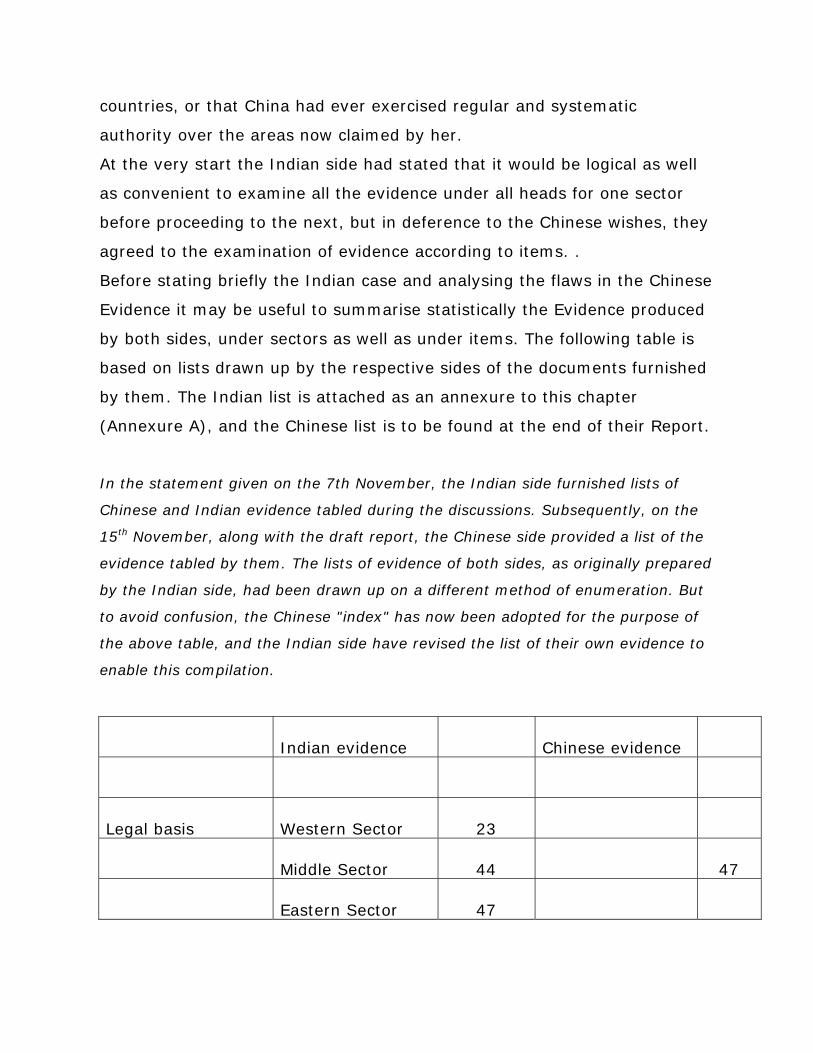
countries, or that China had ever exercised regular and systematic
authority over the areas now claimed by her.
At the very start the Indian side had stated that it would be logical as well
as convenient to examine all the evidence under all heads for one sector
before proceeding to the next, but in deference to the Chinese wishes, they
agreed to the examination of evidence according to items. .
Before stating briefly the Indian case and analysing the flaws in the Chinese
Evidence it may be useful to summarise statistically the Evidence produced
by both sides, under sectors as well as under items. The following table is
based on lists drawn up by the respective sides of the documents furnished
by them. The Indian list is attached as an annexure to this chapter
(Annexure A), and the Chinese list is to be found at the end of their Report.
In the statement given on the 7th November, the Indian side furnished lists of
Chinese and Indian evidence tabled during the discussions. Subsequently, on the
15th November, along with the draft report, the Chinese side provided a list of the
evidence tabled by them. The lists of evidence of both sides, as originally prepared
by the Indian side, had been drawn up on a different method of enumeration. But
to avoid confusion, the Chinese "index" has now been adopted for the purpose of
the above table, and the Indian side have revised the list of their own evidence to
enable this compilation.
Indian evidence Chinese evidence
Legal basis Western Sector 23
Middle Sector 44 47
Eastern Sector 47
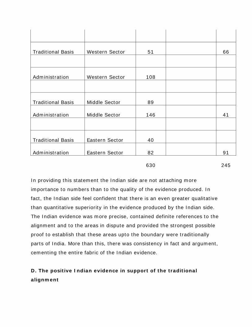
Traditional Basis Western Sector 51 66
Administration Western Sector 108
Traditional Basis Middle Sector 89
Administration Middle Sector 146 41
Traditional Basis Eastern Sector 40
Administration Eastern Sector 82 91
630 245
In providing this statement the Indian side are not attaching more
importance to numbers than to the quality of the evidence produced. In
fact, the Indian side feel confident that there is an even greater qualitative
than quantitative superiority in the evidence produced by the Indian side.
The Indian evidence was more precise, contained definite references to the
alignment and to the areas in dispute and provided the strongest possible
proof to establish that these areas upto the boundary were traditionally
parts of India. More than this, there was consistency in fact and argument,
cementing the entire fabric of the Indian evidence.
D. The positive Indian evidence in support of the traditional
alignment
(i) The Western Sector.
The evidence relating to the Western Sector produced by the Indian side
showed -how for many centuries important points along the present Indian
alignment were recognised as the traditional limits of Ladakh on the one
hand and Tibet on the other. The well-known Chronicle of the Kings of
Ladakh, Ladvags rgyal rabs written in the 17th century, recorded that the
Ladakh boundary was traditional and well-known and specified that after
King Ngeema-gon partitioned his territories in the 10th century, Demchok
and Imis Pass lay on the boundary of Ladakh, while Hanle was within
Ladal;:h. Evidence was provided regarding other major points on this
boundary by travellers of different centuries, who visited these areas. These
travellers included Desideri (1715), Balllie Fraser (1820), Cunningham
(1854), Nain Singh (1873), Carey (1885-87), Bower (1891), Wellby (1898)
and Deasy (1900).
Similarly, the Indian side demonstrated, with the support of a large variety
of documents and unofficial maps originating in different countries,
including China, that at least from the 6th century onwards, the southern
limits of Sinkiang did not extend south of the Kuen Lun ranges, and only
reached upto them towards the end of the 19th century. This made it clear
that the Aksai Chin platean and the Lingzi Tang plains were never a part of
China. Among the authoritative evidence furnished were extracts and maps
from wellknown Chinese works, such as the Nei fu yu tu (1760), Hsi yu tu
chih (1762), to ching hui tien (1818), Hsin chiang chih l1wh (1821), Hsi yu
skui tao chi (1824) and Hsin chiang tu chih (1911). The Chinese side
sought to argue that the Tsungling mountains referred to in some of these
works as forming the southern boundary of Sinkiang applied to the
Karakoram ranges. But this contention was disproved by the internal
evidence contained in the various Chinese maps brought forward by the
Indian side. For ex ample, on some maps the term Tsungling was written all
along the Kuen Lun ranges and both the Yurungkash and the Qara Qash
rivers were shown as cutting through these mountains, thus making clear
that they could not be the Karakoram mountains. The Indian side also
brought forward evidence that the Sinkiang and the Chinese authorities had
themselves recognised that their boundary lay along the Kuen Lun ranges.
Documentary evidence, establishing that the people of Ladakh had used the
Aksai Chin and other areas, now claimed by China, as of right for trading,
hunting, grazing and salt collecting were also furnished. Further, even
though most of these areas were largely uninhabited official documents
establishing the continuous and comprehensive exercise of Indian
administration over these areas for over a hundred years were brought
forward. It was shown that police check-posts had been maintained by the
Kashmir Government in the northern Aksai Chin area as far back as 1865.
There were a series of revenue and assessment reports covering the whole
area now claimed by China. Aksai Chin and the whole of the Chang Chenmo
valley were part of the Ilaga of Tanktse and Ladakh Tehsil; and a revenue
map of this Tehsil of 1908 was supplied to the Chinese side. A few
representative documents out of the large number of records showing the
control exercised over the various frontier areas and the revenue collected
from the frontier villages were provided. Such evidence was also produced
for Minsar, a Ladakhi enclave in Tibet. It was shown that the Governments
of Ladakh and Kashmir had exercised full administrative authority there
right down to our own times.
As regards the inhabited areas further south, such as Demchok, nineteen
significant documents of regular administration, such as revenue
settlements and census operations, were brought forward by the Indian
side in an unbroken series for the years from 1865 down to the present
times.

Other evidence provided by the Indian side established that at least from
the 19th century onwards trade routes running through this area were
maintained by the Kashmir Government. In 1870 the British Indian
Government signed an agreement with the Government of Kashmir
securing permission to survey the trade routes in this area "including the
route via the Chang Chemoo Valley". There were also legislative
enactments of the Government of Kashmir regulating hunting expeditions in
the Demchok and Khurnak areas and the whole Chang Chenmo Valley.
Officials had been touring these areas regularly right down to the present
time, and during the years 1911-1949 Indian officials, survey parties and
patrols constantly visited these areas upto the traditional alignment.
In 1862 the detailed survey of the frontier areas was begun by Johnson and
Godwin Austen; and thereafter a number of exploration and survey parties
visited the area regularly. Geological surveys were carried out extensively
in 1870, 1873 and during the years 1875 to 1882.
Survey of India maps from the sixties of the 19th century, when the area
was first systematically surveyed, showed the alignment correctly and the
Indian side brought forward a large number stretching over the years. They
also showed that official Chinese maps, such as that of Hung Ta-chen of
1893, and the Postal Atlases of China of 1917, 1919 and 1933, showed the
correct boundary along the traditional alignment.
Further, the Indian side showed that the traditional boundary received the
sanction of treaties concluded in 1684 between Ladakh and Tibet and in
1842 between Ladakh, on the one hand, and Tibet and China on the other,
and that it found further confirmation in subsequent diplomatic
correspondence between the British Indian Government and the Chinese
Central Government and in a local agreement reached by the border
authorities of the two States in 1852.
The Chinese side appeared to question the existence of the 1684 treaty and
asserted that the other agreements and exchanges cited by the Indian side
did not specify the description which would support the present Indian
alignment. However, the fact that a treaty was concluded in 1684 was
clearly established not only by the historical records quoted by the Indian
side but also from the evidence brought forward by the Chinese side
themselves. For example, the Chinese side cited a Tibetan work, the
Biography of Polhanas, to prove that a war had been fought between Tibet
and Ladakh in 1683 and in the ensuing peace settlement certain towns had
been ceded to Ladakh. This was sufficient proof in itself that a peace treaty
had been concluded. The Lapchak Mission, also referred to by the Chinese
side, the corresponding Chaba mission and the retention of the village of
Minsar by Ladakh, which as the Chinese side recognised had till recently
been paying revenue to the Kashmir Government, all had their origin in this
treaty. The Chinese side made no effort even to suggest any other possible
origin for these contractual obligations trade missions and territorial
settlements.
It is true that these treaties and agreements mentioned by the Indian side
gave no detailed description of the boundary; and the Chinese side, at first,
sought to deny that they acknowledged the existence of a clear, well-
recognised traditional boundary, The Chinese side stated that the 1842
treaty was merely "a non-aggression pact" between Ladakh and Tibet; and
they cited a passage that "the territories (of Ladakh and Tibet) as they used
to be will be administered by them respectively without infringing upon the
other". The Indian side provided copies of both the Persian and the Tibetan
texts of the treaty which showed that the "old established" frontiers had
been confirmed. It was obvious from the texts that there was no
uncertainty even at that time about their common frontier. But, even if one
accepted the Chinese reading of this treaty, the Indian stand was

substantiated; for there could be no agreement not to cross the common
boundary if there were no certain knowledge as to where this boundary lay.
In fact, considering that these treaties were signed centuries ago, they
reflect remarkable confidence in the knowledge of the tradition al boundary
in difficult terrain.
Further, the Chinese Imperial Commissioner, in his letter of 1847, stated
that the ancient frontier between Ladakh and Tibet was so clear and well-
fixed that there was no necessity to proceed with the joint demarcation
which had been proposed by the British Indian Government. From this
statement of a senior Chinese official it was indisputably clear that the
precise location of the common frontier was clear and beyond any doubt at
that time. It on1y required to be established that the "ancient and well-
known boundaries" mentioned in these treaties and correspondence
referred to the alignment claimed by India. For this purpose the Indian side
had brought forward evidence much older than- the 19th century referring
to important points all along the border. Apart from ancient evidence this
traditional alignment was also supported by 18th century evidence
produced by the Chinese side, specifically stating that the boundary ran
through Lhari, west of Demchok Karpo, which was none other than the
Lhari stream near Demchok. It was thus convincingly established that
treaties of the 17th and 19th centuries and the diplomatic exchanges of
1847 confirmed the boundary which was well-known and which was the
traditional boundary now shown by India.
(ii) The Middle Sector
Apart from the natural and geographical basis of the high Himalayan
watershed which supported the Indian alignment in the Middle Sector the
Indian side showed that literary and religious tradition and ancient
chronicles corroborated the Indian alignment in a surprisingly precise
manner. The a:rea now claimed by China—Kauirik and Gyu in the Spiti
area, Shipki Pass, the Nilang-Jadhang area and Barahoti, Sangchamalla and
Lapthal-were from the beginning of history parts of Indian kingdoms. The
boundaries of the early Indian border states of Bashahr and Garhwal lay
along the watershed, and numerous early inscriptions and historians like
Ferishta have borne testimony to this. Hieun Tsang visited the region in the
7th century and confirmed that it lay in India. After the 8th century the
areas were ruled successively by the Katyuri, Chand, Pala, Malla and other
Garhwali dynasties right upto the latter half of the 18th century. Then some
of these areas were conquered by Nepal but recovered by the British Indian
Government in 1815. The Indian side also showed that innumerable
contemporary records and accounts of explorers and travellers of the last
150 years had testified that the boundary lay along the Himalayan wate:r-
parting. Some of these were Gerard (1821), Hutton (1838), and Hay
(1850) for the Spiti area; Gerard (1821), Gutzlaff (1849), Ryder (1904) and
Wakefield (1929) for the Shipki Pass; Balllie Fraser (1815), Moorcroft
(1819), Batten (1837), Manson (1842), R. Strachey (1848), Beckett (1874)
and Pauw (1896) for the Barahoti area. Moreover, the alignment was
confirmed not only by unofficial British maps, but by maps prepared in
Germany, Russia, France and, above all-and most significantly-in Chinese
maps.
A wealth of evidence was. quoted for every one of the areas in dispute to
establish that the Indian authorities had always exercised effective
administrative and civil jurisdiction over these areas. For every pocket,
numerous detailed revenue settlements, tax collection :records, official
village maps, accounts of tours of officials and of road construction, and
reports of topographical and geological surveys were furnished as manifest
proofs of Indian official authority. The revenue records cited for Nilang-
Jadhang in particular were of a very detailed character, covered the years

1868-1951 and included information regarding the exact limits of every
village and hamlet, the type of land, the extent of forests and the most
detailed figures of revenue. The Indian side took pains to present such a
selection of records as world make clear that they were not just of an
occasional nature but mirrored the unbroken and continuous exercise of
normal governmental authority right down till today.
The traditional boundary along the watershed was always accepted by the
authorities on both sides. Traill, the first British Commissioner, recorded in
J.815 that it had been recognised by the Tibetan Government. In 1890 and
1914 the alignment in the Barahoti sector was formally communicated to
the Tibetan authorities. In recent years the whole alignment has had
further and explicit confirmation. The implications of the categorical
assurance accepting the well-recognised boundaries of India in the
correspondence of 1950 and the pledge of the two Governments to respect
each other's territorial in integrity contained in the 1954 Agreement will be
dealt with later.
Here the Indian side would like to point out that the specific mention of six
border passes in this Sector in the latter Agreement undoubtedly provided a
clear legal confirmation of the alignment. These passes could never have
found mention in an international agreement if any of them lay entirely in
Chinese territory; and the fact that they were border passes becomes
clearer still if one reads together Articles IV and V of the Agreement. It is,
in fact, indisputable that the Indian alignment with Tibet in general and the
Middle Sector in particular has the endorsement and sanction of a binding
international agreement.
(iii) The Eastern Sector
The Indian side showed how in ancient chronicles the sub-montane region
had been repeatedly and explicitly mentioned as a part of India. Thereafter,

there were specific and unambiguous references in the works and records
of different countries to this area being ruled by the Varmans, the
Salasthambas, the Palas and the Ahoms. Later works, such as the Political
Geography of the Assam Valley, an Assamese work of the 17th century,
and the chronicle of the Mogul historian, Shihabuddin Talish, show that
Ahom rule prevailed over this tribal area till the British Indian Government
replaced it. Disinterested travellers like Desidieri (1716-1729) Della Penna
(1730) and Gutzlaff (1849) have also testified that contemporary tradition
considered that the limits of Tibet lay along the high Himalayan range. ln
addition to these non-British accounts, British travellers such as Michell
(1883) and Cooper (1873) had referred specifically to the same alignment.
There was also evidence of this in Chinese works such as Wei tsang tu chih
(1792), Hsitsang tu kao (1886) and the Ching chih kao (1926). Further, the
Indian side furnished nine Chinese maps of the 18th and 19th centuries
based on official Chinese investigations conducted in the early 18th
century, and several others of French, German and British origin, which all
confirmed that the southern limits of Tibet in this area had never extended
south of the Himalayan crest.
The Indian side brought forward positive evidence to show that Indian
political authority had always been exercised over the stretch of territory
between the foothills and the main Himalayan range. The British Indian
Government, which inherited this political authority from the Ahom rulers,
exercised administrative control over these tribes in the same manner as
over other Indian tribes-those in the North West Frontier areas of undivided
India as weIl as those in the tribal areas in the heart of India. The Indian
side showed how subventions were paid, and homage and tributes realized,
through the Political Officers responsible for these tracts, in
acknowledgement of the controlling authority of the Indian Government.
Numerous undertakings were given by the Bhutias, Akas, Abors, Daflas,

Miris, Mishmis and other tribes from 1844 onwards explicitly confirming
their acceptance of the sovereign authority of the Government of India and
promising good behaviour. To protect the distinctive features of tribal life
the Government of India restricted entry into these areas and no one could
cross the Inner Line without permission from the Government. A special
form of administration was also developed for these areas. The Annual
Reports of Political Officers from the middle of the 19th century provided a
clear picture of detailed and continuous administration; and the Indian side
furnished many extracts from these Reports. The Indian side also gave
details of numerous surveys and census operations which were conducted
in normal exercise of administrative authority over the area. There could be
no better proof that the area had always belonged to India than its specific
mention in Indian legislative enactments, administrative regulations and
statutes of 1873, 1880, 1884, 1914, 1919, 192& and 1929, and in the
Government of India Act of 1935 and the Indian Constitution of 1950. In
striking contrast, there was not a single Chinese law or administrative
enactment which made a specific mention of any of the areas in dispute.
The Chinese side alleged that the process of extending detailed Indian
administration into the tribal belt was a recent one; but recent or
otherwise-and the Indian side had shown that Indian authority had always
been exercised over this area-clearly it was the right of the Indian
Government to do so, as it would be for the Central Government of China to
strengthen their authority in any semiautonomous region of China. So any
such extension of Indian administration could not support the Chinese
alignment.
E. Validity of the "McMahon Line" agreement
The Indian side also established beyond doubt that the traditional boundary
in the Eastern Sector had been formalized in 1914 by an exchange of

letters between India and Tibet. At that time, Tibet had enjoyed the power
to sign treaties and to deal directly with neighbouring States on matters
regarding the boundary. The Chinese Government had recognised these
rights enjoyed by Tibet and had been aware of this formalization of the
Indo-Tibetan boundary at the Simla Conference.
The Indian side had made it clear that, they were reluctant to discuss the
history of the relations between China and Tibet and had only considered it
in their initial statements to the extent that it was relevant to the exchange
of letters formalizing the boundary in 1914.
Unable to establish that the agreement was valid, the Chinese side
endeavoured to set it aside by assertions which were not historically correct
and by the most serious and unwarranted allegations against the
Government of. India. It was, for instance, repeatedly alleged that India
was seeking to defend British Imperialist policy and to benefit from British
aggression in Tibet; and it was sought to convey the impression that the
Indian side regarded Tibet as an independent country. The Indian side
could not but emphatically repudiate these most objectionable distortions of
the well-known and clearly established policies of the Government of India.
It had been clearly recognised by the Government of India and had been
repeated innumerable times m these discussions, that Tibet was an
autonomous region or China; and independent India had always dealt with
the Central Government of China on matters pertaining to Tibet. The very
fact that these talks pertaining to the boundary of India with, for the most
part, Tibet, were being held with the representatives of the Chinese Central
Government, was a clear indication of India's acceptance that the Chinese
Government were responsible for all external, affairs relating to Tibet. It
was even categorically and explicitly stated by the Indian side that India did
not regard Tibet as independent.

But the present status and powers of Tibet could obviously not be projected
backwards or allowed to influence one's understanding of: the nature of the
relations subsisting between China and Tibet in 1914. That during the 300
years prior to 1950, Tibet, whatever her status, had enjoyed the right to
sign treaties and have direct dealings with her neighbours on boundary
questions, was clearly established by history. The Indian side had already
drawn attention to the treaties of 1684 and 1842 signed by Tibet with
Ladakh. In 1800, she signed a treaty with Nepal, and the People's
Government of China themselves recognised the validity of this treaty,
because they felt it necessary to abrogate it in their treaty, signed exactly a
hundred years later, in 1956 with the Nepal Government. It was asserted
by the Chinese side that the Chinese Amban in Tibet had assisted in the
conclusion of the 1856 treaty. This, too, was an incorrect statement of
facts; but even if true, it would only corroborate the Indian position that
China recognised the treaty-making powers of Tibet. For it would mean that
China assisted Tibet in directly negotiating a treaty which, among other
things, granted extra-territorial rights to Nepal. 'The Tibetan Government
protested against the conclusion of the 1890 Convention by Britain and
China and successfully defied its implementation because they had not
been a party to it. It, therefore, 'became necessary for Britain to sign an
agreement with Tibet in 1904. Far from objecting to such direct
negotiations by Tibet, the Chinese Amban in Lhasa assisted in its conclusion
and two years later the Chinese Central Government confirmed it in their
Convention with Britain. It may be noted that the 1906 Convention
concluded in Peking did not suggest that the 1904 Convention was invalid,
or merely repeat its provisions but specifically recognised it.
Furthermore, it was a fact of history-and the officials at these meetings
were only concerned with an objective scrutiny of the facts ,of history-that
after the 1911 revolution Tibet had issued a declaration of independence.
The Indian side themselves had drawn attention to the fact that even the
British Government at that time had not acknowledged this declaration. But
the fact remained that whatever the theoretical conception of Chinese
relations with Tibet, all working relations between the two seem to have
been practically terminated. Not a single item of evidence was brought
forward by the Chinese side from either the Chinese or the Tibetan archives
that could suggest that this statement was incorrect. The then Central
Government of China, eager to re-establish their connections with Tibet,
agreed to attend the tripartite Simla Conference and designated a
plenipotentiary to attend "jointly" with the Tibetan plenipotentiary ,and to
negotiate with him and the British Indian representative on terms of
equality. The Chinese Government conferred full powers on 'their
representative and, what was even more significant, accepted without any
reservation the credentials of the Tibetan representative which vested him
with full powers in the name of the Dalai Lama and authorised him to
function as an equal plenipotentiary with those of China and India and
settle all matters pertaining to Tibet. Thus it was the Chinese Government
of the time which accepted a procedure which under diplomatic usage, is
normally adopted only at international conferences of the representatives of
sovereign countries.
The fact that the Chinese Plenipotentiary did not sign the tripartite
agreement which he had initialled did not in any way invalidate the
agreement signed by the British and the Tibetan representatives.
All Chinese reservations to the Simla Convention, as stated at the time of
the Conference and subsequently in 1919, were merely regarding the
boundaries of Inner Tibet and Outer Tibet. There was never any objection,
or indeed any comment of any kind, regarding that part of the boundary
shown on the Convention Map between India and Tibet and formalized in
the exchange of letters between the Indian and the Tibetan
representatives.
The Chinese side sought to suggest that the Chinese Plenipotentiary had
been unaware of the direct dealings and the Agreement concluded between
the Tibetan and the British Indian Plenipotentiaries. There was no reason
why the formal exchange of letters between the Indian and the Tibetan
representatives should have been shown to the Chinese representative. In
fact, all the Tibetan documents which have now been quoted by the
Chinese 'side as supporting their alignment were not known, at the time
they were written, to the Chinese Government. They knew nothing at the
time, for ex ample, of the negotiations regarding Dokpo Karpo in the
Western Sector in 1924, and those regarding Nilang-Jadbang in the Middle
Sector in 1926. However, far from regarding these '''secret'' documents of
the Tibetan Government as invalid, they have now based their claim on
them.
But in fact there is no doubt that the Chinese representative and -the
Chinese Government were aware of the formalization of the Indo-Tibetan
boundary in 1914. The substance of the agreement 'was mentioned at the
tripartite conference; there was a general reference to it in the Simla
Convention itself; and it was shown on the map presented to the
conference in April 1914 and attached to the Convention in July 1914. The
areas south of the red line in the Eastern Sector on this Convention Map
could not be explained in any other way except by recognising that they
constituted Indian territory. The Convention was published in the first
edition of Aitchison's Treaties, Engagements and Sanads to be, issued after
the Simla Conference.
Apart from these facts, the whole array of argument and evidence furnished
by the. Chinese side during these very discussion fully proved, If anything,
that Tibet at that time had enjoyed treaty making powers and the right of

direct dealings with neighbour States. These entire evidence produced by
the Chinese side showed Tibet functioning all along her border without
Chinese presence or support. In quoting such Tibetan actions with approval,
and bringing forward such evidence of Tibetan activity the Chinese side
confirmed the legality of Tibet's powers to negotiate and conclude treaties.
In all inter-governmental talks between India and Tibet as at Dokpo Karpo,
Barahoti and Nilang-Jadhang, no representative of the Chinese Central
Government had been present. The representatives of the Government of
Lhasa had dealt with representatives of the Central Government of India,
who had been supported by officials of local Governments. There was no
question, therefore, of these discussions having been conducted on a purely
local level~ and the fact that on the Tibetan side there had been no Chinese
representation or any Chinese authority and, at any Ume, even a
semblance of interest on the part of the Chinese Central Government,
proved the Tibetan right to deal directly with the Government of India. The
Chinese side were, therefore, unable to escape from the dilemma that to
dispute the powers of Tibet to have direct dealings with India to confirm the
traditional boundary in the Eastern Sector was to jettison all their evidence
for the Eastern and Middle Sectors and almost all their evidence for the
Western Sector. For the overwhelming majority of the records and
documents quoted by the Chinese side were from Tibetan, and hardly any
from Chinese sources. Indeed, the documents cited by the Chinese side
referred throughout to a Tibetan Government. It was obviously, even
according to the Chinese evidence, much more than a merely local
authority or a provincial administration.
The Chinese side sought to argue that as the negotiations were "resultless"
they could not prove Tibet's negotiating powers. It hardly requires to be
stated that success or failure has no bearing on this point; but if the failure
of these negotiations negated their legality then the Chinese side

themselves were precluded from quoting them as evidence in other
contexts.
The Indian side also mentioned, in this connection, that the Chinese side
had referred to a non-aggression treaty having been concluded in 1853 by
the then Government of India and the Regent of Tibet. There was, in fact,
no such treaty and what the Chinese side had in mind was discovered to be
an administrative arrangement between the Monba chiefs and the British
Indian Government. But the Chinese contention was obviously based on the
premise that the Tibetan authorities had the right to make peace and war
and to conclude treaties of non-aggression. It was clearly illogical in the
face of this to contend that a Tibetan Government with such ample treaty-
making powers could not formalize an existing traditional boundary.
To place the matter beyond all possible doubt, the Indian side cited a note
formally presented by the Government of China in November 1947,
enquiring whether after the transfer of power the Government of India had
assumed the treaty rights and obligations existing till then between India
and Tibet. In their reply of February 1948, the Government of India
formally informed the Chinese Government that they had assumed these
treaty rights and obligations. The reference in this exchange to the treaty
rights and obligations between India and Tibet, as distinct from those
between India and China, was the strongest possible proof both of the
validity of the "McMahon Line" agreement and of its recognition by the
Chinese Government. The Indian side also brought forward documents to
show that for many years after the establishment of the authority of the
People's Government in Tibet, the Tibetan authorities had accepted the
traditional international alignment in this sector.
Nowhere, in fact, as in its disputation of the validity of the so-called
McMahon Line was the Chinese position so replete with contradictions. To
mention but a few, the Chinese side throughout quoted with approval

Tibetan negotiations on certain segments of the traditional alignment in the
Western and Middle Sectors, but when confronted with the implications of
this position they denied Tibet the right to confirm the traditional boundary
in the Eastern Sector. They asserted that Tibet had no treaty-making
powers but claimed that she had signed a treaty of non-aggression.
Similarly Tibet, with no treaty-making powers, had signed an agreement
conferring extra-territorial rights on Nepal which the People's Government
had found necessary to abrogate. The Chinese side asserted that the
Convention of 1904 between Britain and Tibet was invalid, though it had
been negotiated with the assistance of the Chinese officials, and had been
referred to with approval in the Convention signed between Britain and
China in 1906. They argued that China had never recognised the treaty-
making powers of Tibet but could not explain why the suzerain Chinese
Government of 1914 had accepted the equal and plenipotentiary status of
the Tibetan representative and had participated with Tibet in a tripartite
conference in India. They argued that the red line in this sector on the
Simla Convention Map was the boundary between Tibet and China but
brought forward evidence which was said to show that the area south of
this line had belonged traditionally to Tibet. The "McMahon Line" Agreement
was described as a result of a secret imperialist intrigue and Tibet was said
to have been coerced into signing it; but the fact remains that as late as
1943, Tibet successfully defied the combined pressure of the Chinese
Central and British Governments to se cure the use of Tibetan territory as a
supply route for the defence of China
This maze of contradictions makes it impossible even to comprehend the
Chinese stand, much less to find evidence to sustain the Chinese claim. It
needs to be stated clearly that the treaty-making powers of Tibet and in
particular her formalization of the "McMahon Line" were acknowledged by
the Chinese Central Government of the time; and it was profitless to distort
the present position of the Government of India and the statements of the
Indian side in a vain attempt to repudiate the confirmation of the traditional
boundary. For it was conclusively established from every angle of law and
history that the "McMahon Line" agreement which confirmed the traditional
boundary in the Eastern Sector was a valid Agreement which had been
signed by Tibet and was now binding on China.
Indeed, the Indian position regarding the' "McMahon Line" agreement found
corroboration also from the documents and agreements cited by the
Chinese side. Even the recently concluded Sino-Burmese Agreement which
acknowledges that the Burma Sector of the "McMahon Line" was the
traditional boundary between China and Burma was telling circumstantial
proof that in the Indian Sector also it had obviously confirmed the
traditional boundary.
The Indian side were most surprised at the statement of the Chinese side
that they distinguished between the actions of past Chinese Governments,
accepted what suited them and rejected what was not in consonance with
the present Chinese attitude and claims. This was obviously an
extraordinary position to adopt and unsettled all relations between
Governments. It was an accepted principle of international law that all past
commitments of previous governments were binding on successor
governments, at least until they had been re-negotiated. The whole
purpose and value of the assignment given to the officials would be
undermined if either side refused to accept all the facts of history,
regardless of past motives and present claims, but accepted only such
evidence as confirmed their contentions and repudiated those facts which
destroyed them.
F. Maps and Surveys
Special mention may be made of two particular categories of evidence-
maps and surveys-for the Chinese side have suggested that they have been
shirked by the Indian side. In fact, they provide strong evidence of the
Indian alignment.
(i) Maps.
The Indian side brought forward a large number of maps published in
various countries including China, by disinterested cartographers of repute,
which showed that the traditional boundary had been well-known and
recognised. For the Western Sector, a large number of unofficial Chinese
maps, from very ancient times right down to our own, were cited to
establish the acceptance of the tradition al boundary throughout history.
Included among them were not merely old Chinese maps, reflecting the
general understanding of the location of the traditional boundary, but
modern maps, brought out by such agencies as the Commercial Press of
Shanghai, for many years the foremost publishing house of China, the Shun
Pao, the leading newspaper of the country, the Far Eastern Geographic
Establishment, the leading cartographic organisation, and Peking
University. Failing in their effort to under-rate these maps cited by the
Indian side, the Chinese side supplied two old Chinese maps which were
said---to support their case, but even these when examined were found to
support the alignment as now shown on Indian maps. For the Middle
Sector, over 20 unofficial maps published in India, China and various
countries of Europe and showing the watershed boundary were cited by the
Indian side. Similarly, a large collection of maps, published at different
times in different countries, were cited in confirmation of the Indian
alignment in the Eastern Sector. They included maps published by almost
every well-known cartographic firm of Europe. The most important group,
as mentioned' earlier, was constituted by nine Chinese maps belonging to

different periods and mostly based on official Chines8 investigations. All
these maps showed that throughout the centuries, the tradition al boundary
between India and China had been shown and recognised to lie in
accordance with the present Indian alignment. The Chinese side failed to
bring forward any items of evidence of this nature in support of their case.
Much of the Chinese case was based on maps issued by the Sur vey of
India and they were repeatedly referred to under both Items 2 and 3, even
though being evidence of official viewpoints, they were not relevant
evidence of tradition and custom. It was alleged that most Indian official
maps supported the Chinese position and that the Indian side brought
forward few official maps on their own to substantiate the Indian alignment
but dealt with them primarily when replying to the Chinese evidence. Tt has
even been suggested for the first time in the Chinese report that the Indian
side "deliberately evaded such material" and that no official maps were
cited by them for the Middle Sector. In fact, however, this category of
evidence provided support for the Indian, and not the Chinese, case and
was used considerably for every sector of the alignment.
As has been shown in detail in the earlier chapters dealing with the
discussions on Tradition and Custom and on Administration and jurisdiction,
the Indian maps quoted by the Chinese side had been incorrectly
interpreted and understood. Most of the Indian maps which the Chinese
side brought forward showed no boundaries. But this did not mean, as the
Chinese side argued, that no boundaries existed. These maps were
intended for internal administrative purposes and, therefore, did not seek
to show the international boundaries. This becomes clear when one
considers, for example, the 1937 map of India. The main map showed no
international boundaries, and has been cited by the Chinese side; but the
reference becomes valueless when it is noticed that the small inset map on
the same sheet correctly delineated the international frontier. Again, some

physical relief maps published by the Survey of India showed no boundaries
as their concern was different. They were, therefore, wholly irrelevant to
the present question, let alone being evidence in favour of the Chinese side.
Many Chinese maps also do not show all the regions of China within China's
external frontiers. It should also be remembered that official maps of the
Survey of India only showed areas which had been properly surveyed at the
time of issue of the map and not necessarily the traditional alignment,
which was well-known. Survey of India maps naturally laid emphasis on
official surveys, which were the main function of the organisation.
The Chinese side referred, in particular, for the Western Sector to the 1825
map prepared for the East India Company, the 1840 map prepared by
James Wyld, and Walker's map of 1846. The Indian side pointed out that in
evaluating these maps as evidence of the boundary alignment, it was
necessary to bear in mind that British Control had extended over the Indian
State of Kashmir only in 1846, and prior to that British Indian maps either
did not show Kashmir at all or, understandably, showed the boundaries of
independent Kashmir incorrectly. It was only about twenty years after
Kashmir came under British control that the first surveys of the Aksai Chin
area were undertaken by Johnson; and from the sixties onwards Survey of
India maps correctly depicted the limits of Indian territory in the Western
Sector. So while the early maps of Wyld and Walker, drawn before any
surveys had been conducted, were based on conjecture, the Survey of
India maps subsequent to the surveys showed the Indian alignment
correctly. Walker himself revised his earlier erroneous maps on the basis of
these accurate surveys and showed the boundaries correctly in his maps of
1860 and 1868. If Walker's maps were to be regarded as evidence,
obviously the later revised, maps based on scientific surveys, and not the
earlier conjectural maps were the authoritative ones.

Regarding the maps in the Eastern Sector, the Indian side explained that
many of these maps showed merely the administrative frontier along the
Inner Line as distinct from the international frontier leaving out the tribal
areas which were at that time under the overall control of the British Indian
authorities but not under regular British administration. They, however,
showed these areas by a colour wash in order to make clear that they were
a part of India.
This general British practice of delineating the administrative frontier along
with a colour wash upto the international boundary could be discerned also
in maps which showed the North West Frontier areas, now a part of
Pakistan, as lying beyond regular Indian administration.
From the foregoing analysis, it becomes clear that Indian official maps for
over a hundred years have largely shown the correct limits of Indian
territories. Naturally, as the years passed, the maps became more accurate
and precise, because of the growing knowledge which came from detailed
surveys, development of communications and a general improvement in the
science of cartography. But in any case these Indian maps never showed an
international alignment which could be claimed to confirm the present
Chinese alignment.
The Chinese side also laid great emphasis on the captions 'frontier
undefined' and 'frontier undemarcated' on some Survey of India maps,
although this had been explained in detail in the note of the Government of
India of 12 February 1960. The term 'undefined' in the Western Sector
indicated that the boundary had not been defined in detail from point to
point or demarcated on the ground, while the term 'undemarcated' in the
Eastern Sector indicated that the boundary had been delineated on a treaty
map but had not been demarcated on the ground. But there was never any
uncertainty about the location of the traditional boundary in these sectors.
The Indian side brought forward official Chinese maps which confirmed the
Indian alignment in all the Sectors. The map of the Chinese Minister Hung
Ta-chen given officially to the British representative in 1893 showed an
alignment which corresponded to the Indian alignment. Similarly, the map
issued by the Postal Department of China in 1917 and used officially right
upto our times correctly showed the Indian alignment throughout its length.
There were repeated editions of this Postal Atlas. Until the maps issued
since the People's Republic of China was inaugurated, which were only
recently claimed to be correct, there were no official maps published in
China which substantiated the alignment now claimed by China.
The conclusion is not qualified by the two maps of 1918 and 1948 which the
Chinese side quoted as corroborating their alignment. For the Indian side
found on scrutiny that these two maps, said to have been prepared by the
'Northern Warlords Government' and the Minis.try of Defence respectively,
had never been published; and subsequently the Chinese side agreed that
this was so. It was surprising that secret maps had been brought forward
as valid evidence of open .and effective administration. They obviously
were no proof of the alignment, much less of recognition by the
Government of India of the boundary delineated on them. The furnishing of
such so-called 'official' maps was al the more extraordinary because the
Chinese side had themselves stated that no official maps had been printed
in China during the period of the Kuomintang rule. In fact, such official
maps had been published, and they supported the Indian alignment.
The Chinese side asked how Chinese maps cited by the Indian side could
become evidence of Indian administrative control. The Indian side
explained that they had never claimed Chinese maps as proof of Indian
administrative control but had only cited them to -establish that the
traditional Indian alignment had been endorsed by the Chinese Central
Governments. The Indian side, in fact, emphasised that as proof of

sovereign administrative authority, it was necessary to rely primarily on
such records as those of the regular collection of revenue and taxes and the
maintenance of law and order. As far as the Indian side were concerned,
official maps had been adduced only as secondary, corroborating proofs of
administrative jurisdiction. Even here, the emphasis had been placed on
administration maps, on sub-divisional, village, local and revenue maps
which showed the administrative organisation as extending right upto the
traditional alignment. It was significant that aH large-scale maps of
particular areas published by the Survey of India, of w:hatever date, clearly
and €explicitly supported the Indian alignment.
However, it became abundantly c1ear that the Chine se claim to
administrative control was based primarily on maps derived from Indian
sources, and these, too, small-scale maps published for general purposes.
It is pertinent, therefore, to pose the parallel question as to whether the
Chinese side had brought forward any official maps, published in China, to
support their alignment, and to enquire how Indian maps could form almost
the sole evidence of Chinese administration. It was clearly of the utmost
significance that the Chinese side could not produce a single published
official Chinese map showing the boundary as claimed. by them, even
though they assert that China has administered these areas for centuries.
Finally, it is necessary to correct the erroneous impression that was sought
to be created, that the Indian side had not furnished many official maps in
support of their alignment. Attached to this chapter (Annexure 'B') is a list
of the official maps furnished by the Indian side; and from this it will be
observed that as against 13 Indian official maps quoted by the Chinese
side, 36 were brought forward by the Indian side; and as against the total
lack of official Chine se maps brought forward by the Chinese side, 8 official
Chinese maps were produced by the Indian side. The Indian maps which
were quoted by the Indian side confirmed the evidence of Indian

administration, and the Chinese maps cited by them served to establish
that the alignment claimed by India had been recognised by the Central
and the local Governments of China.
(ii) Surveys
As evidence of continuous administration of these traditionally Indian
territories upto the alignment, the Indian side brought forward detailed
evidence of official surveys conducted in the Western Sector from 1862, in
the Middle Sector from 1850 and in the Eastern Sector from 1826 and
particularly during the years 1911 to 1914. The results of these open
surveys had been published in a large number of official reports and
scientific journals even at the time they were conducted, and the Indian
side cited the relevant documents. For example, in the Western Sector, the
results of surveys in the Aksai Chin, Lingzi Tang and Chang Chenmo areas
were published in a series of volumes from 1863 onwards. It was,
therefore, completely untenable to contend that these surveys had been
the result of Indian officials "sneaking" into Chinese or Tibetan territory. In
fact, in the' Western Sector the only surveyor who had crossed the
alignment was Johnson in 1866; but he did so at the invitation of the
Khotan Government and it was the Indian Government which rebuked and
punished him for crossing the Indian .boundary. In the Eastern Sector,
surveys of Tibetan territory -across the frontier were only carried out with
the explicit permission of the Tibetan Government and they had always
been clearly described as "trans-frontier surveys". Nor had the Indian side
cited these explorations of Chinese and Tibetan territories. Such evidence
as the Indian side had brought forward of official surveying had been of
well-publicized operations in Indian territory.
However, while the Chinese side sought to minimise the significance of
Indian surveying and described as "absurd" the suggestion that surveys

were proof of legitimate administration, they themselves claimed in the
Western Sector that surveys of the Aksai Chin area had been carried out by
them in 1892 and 1941. In fact, as the Indian side showed, these Chinese
surveys had not been of this Indian territory; but it was significant that the
Chinese side recognised that survey operations were conclusive proof of
ownership and administration of territory. In- the circumstances, the very
fact that they did not deny the validity of the evidence brought forward by
the Indian. side of open, regular and systematic surveys, to which the
Chinese' and the Tibetan Governments of the time had taken no objection,
was obviously conclusive proof, even according to the premises of the
Chinese side, that these territories which had been surveyed were a part of
India. Further, as the Chinese side themselves have stated: "Obviously, it is
inconceivable that such official, long-term and large sc ale surveys could
have been conducted and accomplished smoothly had they been carried
out" in someone else's territory.
In short, according to the Chinese side themselves, official and detailed
survey~ are conclusive proof of sovereignty and administration; they
themselves could bring forward no evidence of any such surveys of the
areas now 'claimed by them; and the Indian side brought forward evidence
of an unbroken series, stretching over a hundred years, of official, long-
term and large-scale surveys of all the areas In every sector.
G. The meagre contents of the Chinese case
As compared to the wealth of positive documentary proof brought forward
by the Indian side, the Chinese evidence was scanty in number, recent in
origin, Imprecise in its indication and, what was even more, internally
inconsistent both in facts and arguments. This evidence, therefore, was
totally inconclusive in supporting the Chinese case).

On the Western Sector, the Chinese case consisted mostly of un supported
assertions. Little traditional and customary evidence was produced from
Chinese works and maps and whatever was produced turned out to be in
India's favour. Vague references from Western travelers were adduced but
could not stand scrutiny because fuller references even from the same
authors as well as detailed accounts of other travellers clearly established
that the authority of Sinkiang had never extended south of the Kuen Lun
mountains. On the basis of some place names of Uighur origin, the Chinese
side sought to prove that the Aksai Chin area formed part of Sinkiang, but
the Indian side showed that if philological evidence were to be considered
the vast bulk of place names in this area was obviously derived from the
Ladakhi language).
For the Middle and Eastern Sectors also, there was no evidence of tradition
and custom as such. The major part of the evidence quoted by the Chinese
side merely pertained to the collection of religious dues or the exercise of
religious superintendence over the Lamaist monasteries and the Buddhist
believers in small areas. But as the Indian side explained, such spiritual
allegiance to Lhasa could not be regarded as proof of political or secular
control over the areas concerned. The Indian side quoted from statements
made by responsible Chinese officials such as Ivan Chen, who was the
Chinese Plenipotentiary at the Simla Conference (1913-14) and the Foreign
Minister of China(in 1914) to confirm that these places where Lamaist
institutions existed or religious dues were collected were beyond the limits
of Tibet's secular authority.
In the Eastern Sector, the evidence pertained exclusively to three small
pockets of Buddhist influence close to the traditional border. Indeed, the
Chinese evidence was mostly about Tawang where there is an important
monastery exercising spiritual authority over the Monbas who are
Buddhists. The Chinese evidence failed completely to substantiate the
assertion that these three small units of Monyul. Layul and Lower Zayul
covered the entire area of 32,000 square miles now claimed by China. The
bulk of the population of this vast area are not Buddhists but tribal people,
but there was no evidence at all concerning them. There was not even a
general reference to them such as was to be found in medieval Indian
evidence, which the Chinese side acknowledged.
The inadequacy of the Chinese evidence was nowhere greater than in the
endeavour to prove that these territories now claimed by China in the
various sectors were throughout subject to the administrative authority of
China or, for that matter, even of Sinkiang or Tibet. Unlike the Indian side
who had produced continuous revenue and tax records and other archives
of administration for year after year and decade after decade for all
disputed areas, the Chinese side produced one or two documents of an
occasional and a vague nature pertaining to a few odd places and claimed
them as proof of administrative authority exercised continuously for
centuries over all the areas now claimed. Only one document was produced
as proof that Sinkiang had exercised administrative authority over the Aksai
Chin area. But this document itself was a recent one and it only mentioned
a proposal for the establishment of a new administrative subdivision of
Shahidulla, which, in any case, lies north of the Indian alignment. It
specified the Karakoram Pass as the southern limits of the administrative
project, and since, according to the traditional alignment, the Karakoram
Pass lies along the northern boundary of Kashmir, it was clear that the new
division could not have been responsible for the administrative control of
the vast Aksai Chin area. Nor was any evidence produced, either that this
new administrative unit had been established, or that for the period from
1928 right upto 1950 jurisdiction over the Aksai Chin plateau was in fact
exercised by this sub-division of Sinkiang. The scrutiny of the Chine se
evidence confirmed the Indian position that Sinkiang and China never
exercised control upto the limits now claimed till, of course, the illegal use
and control of this territory since 1950.
The evidence to prove continuous Tibetan administration of the other areas
now claimed by China was also sparse and flimsy. For the whole of Ladakh,
there was only one document showing the collection of produce from a
private estate in Demchok. In the case of Spiti also, only one monastic
record, manifestly of religious superintendence, was quoted as proof of
both tradition and the exercise of administrative authority. For Shipki, the
only evidence of administration, on which the Chinese case was based, was
an 'avowal' of 1930 by certain individuals; but 'avowals' are private
affirmations and not proofs of official authority. For Nilang-Jadhang only
two documents, separated by 170 years, were cited, and even these
showed not that taxes had been collected, but that transit dues were paid
by those proceeding to Tibet. Such dues were collected from pers6ns in
Nilang-Jadhang and Barahoti who went for trading into Tibet, and never
from persons who did not cross into Tibetan territory. In the traditional
pattern of trade' between India and Tibet, India supplied food-stuffs and
necessities of life of Tibet, while Tibet exported wool which was only an
industrial raw material. It was, therefore, the Tibetan local authorities who
were anxious to take the initiative to open and encourage border trade
operations. These local officials of Tibet came just across the Himalayan
passes, as it was impossible to stay on the saddles of the passes, to
encourage the opening of trade; but they remained in these camping and
pasture grounds and did not go down to the villages where the persons
from whom these dues were collected resided for most of the year. These
camping grounds, where these dues were collected, were near the Indian
border and very far from the alignment claimed by China. In any case, no
records were brought forward by the Chinese side to correlate the alleged
tax dues with land holdings and pastures, and it was clearly established
that these visiting Tibetan officials had no authority in India. A comparison
of the meagre and casual evidence of the Chinese side with the systematic
and detailed documentary evidence of revenue settlements, land taxes,
official tours and other aspects of general administration furnished by the
Indian side, placed beyond doubt that these areas were Integral parts of
Indian villages and the collections which were claimed as proofs of Chinese
authority were merely transit dues paid for the facility of crossing into
Tibet. The Chinese side were in no position to challenge the veracity of
Indian tax collection and settlement records; and such detailed evidence of
Indian administration over these pockets put the Chinese evidence in
perspective, and underlined that they were transit dues without any
significance.
In the Eastern Sector, not a single record from any of the contiguous
administrative sub-divisions, containing a chart or a map or any other
specific proof showing an alignment which tallies with what is now claimed
as the traditional boundary, was brought forward. The nearest approach to
such evidence, which must be considered essential, was a solitary
document pertaining to the Walong area which mentioned a stream which
was nowhere near the alignment now claimed by China. The material
provided established only Buddhist influence and ecclesiastical organisation
in small pockets of territory.
There was no evidence of any revenue collection, of survey operations, of
acquaintance with the cultivated lower valley or of construction of public
works in the inhabited areas. The Chinese evidence was striking In that it
made no claim to the exercise of any form of authority-spiritual, secular or
political-over the vast majority of the inhabitants of these areas south of
the high Himalayan range.
Claim supported by illegal occupation

There is one argument advanced by the Chinese side which deserves
special mention. The Chinese side asserted that the Chinese army crossed
unhindered the Aksai Chin area in 1950, conducted surveys there in 1954-
55 and eventually constructed a highway across it, and they claimed that
all this supported their contention that the territory always formed part of
China and that the traditional line ran to the west of it. The Indian side
could not possibly accept that this trespass and present control confer a
legitimate title to this area. The Chinese Government themselves accepted
the position, as it shown by their statement in the Chinese note of 3 April
1960, that-"Violation of the traditional customary line and expansion of the
extent of occupation by unilateral occupation cannot constitute the legal
basis for acquiring territory".
In this effort of trying to determine what was the traditional boundary
between Sinkiang and Tibet on the one hand and India on the other, it was
necessary to ascertain the historical status quo or what the Chinese
Government called the "long existing state of the boundary" between the
two countries, and furnish proof of an original title, setting aside any
evidence from gains derived from recent illegal activity in the area.
International law recognises that sovereignty over national territory does
not demand continuous occupation of every place. The type and continuity
of control necessarily differ with the nature of the terrain and the special
circumstances of the territories concerned. The Indian positive evidence of
tradition, custom and the exercise of state authority for this sector all
established that the Indian title was an ancient, legitimate and recognised
one; and it was shown that the Governments of Kashmir and India had
exercise normal and open authority over the area in a manner appropriate
to its physical and climatic conditions. The Indian side had also
demonstrated that this title was intrinsically superior to the Chinese claim
for it was based on evidence which pre-dates by centuries the activities of
the last decade. It had been established, for example, that until this recent
activity Sinkiang never exercised any control over the Lingzitang and Aksai
Chin areas and that Chinese maps and documents invariably recognised
that Sinkiang did not extend south of the Kuen Lun ranges. As mentioned
earlier, the nearest direct evidence of administrative control produced by
the Chinese side were documents of 1927-28 which merely mentioned the
intention of establishing an administrative organisation, and that too in
Shahidulla (which is in Sinkiang), and covering an area which even in the
project was stated to have its southern limit at the Karakoram Pass.
In this connection, it may be,' expedient to refer to two famous cases of
territorial disputes where the International Court, in ascertaining the
legitimate title, set aside all evidence subsequent to what was described as
the "crucial date". In the dispute between the' United States and Holland
over the island of Palmas, evidence subsequent to 1906 was not considered
as valid. In the dispute between Norway and Denmark over Eastern
Greenland, Norway's claim was set aside and considered "illegal and
invalid" on the ground that she had not been able to establish any proof of
administration prior to, 1921, when she first occupied the disputed
territory. As was pointed out in the Palmas case, in such circumstances, it
was necessary to establish that the display of sovereignty existed openly
and publicly prior to the period when the dispute was precipitated.
Further the Indian side, by giving evidence of the administration of this
area prior to 1950 and details of patrols. which were sent even subsequent
to 1950 and right upto 1958 and even 1959, have demonstrated that India
had the continuing intent even during the last ten years of exercising her
rightful sovereignty and fully discharging her responsibility of local
administration in a way befitting the terrain. Indeed, the Government of
India had, in the customary manner, sent a patrol into the Chang Shenmo
valley in June 1959 and no trace of Chinese personnel was then found in

the area. This valley was only occupied subsequently by Chinese forces;
and this occupation resulted in the clash and loss of life near the Kongka
Pass. The evidence of long user and jurisdiction, the continuing intent to
exercise sovereignty until the present Governmental exchanges
commenced and the application of international case law precedents all
clearly establish the Indian title to the area. The fact that India, in trust and
true to centuries of tradition, did not establish a net-work of fixed;
administrative and defence posts at the extreme limits of the difficult
terrain can in no way prejudice her ancient title.
It may be mentioned here that the Prime Minister of India had' enquired
from Premier Chou En-lai in Delhi in April whether a second road parallel to
the original highway was being constructed in the Aksai Chin area. Premier
Chou En-lai disclaimed knowledge of such a road. However, the Chinese
side in their final statement and their Report have mentioned, as supporting
proof of their claim that over ten routes in this area were surveyed for
construction; and it is known that some routes other than and west of the
present highway have already been constructed. Such consolidation of
illegal control by new constructions are even more objectionable and be
certainly not strengthen, in any way, the Chinese claim to this territory.
Traditional boundaries are as much binding in international law as
boundaries embodied in agreements and treaties, and no government has
any justification in violating such boundaries and seeking to use occupation
to confer legitimacy on trespass.
H. Deficiencies and contradictions in the Chinese evidence
These general observations pertain to the weak factual foundation of the
Chinese case. During the discussions, the Indian side made a careful
analysis of the documents produced by the Chinese side and the comments,
summarised in the earlier chapters, show why the documents cannot help

to sustain the Chinese claim. Here the Indian side would like to mention
certain fundamental irrelevancies and contradictions in the facts and logic
of the Chinese evidence.
(i) Irrelevance and contradiction of many items of Chinese evidence
(a) The scrutiny of the documents furnished by the Chinese side showed
that many of them had no direct relevance to the alignment or the areas
claimed by China. For example, the decree of the Kashag that foreigners
should not be allowed to enter Tibet was no. proof of any alignment; and
the fact that Deasy was turned back in Tibet from a point east of 80° E, i.e.
east of the traditional alignment in the Western Sector and about a hundred
miles east of the alignment now claimed by China, was obviously of no
significance or even relevance. The extract cited from the Yuan Shih to
prove that Ladakh was part of Tibet in fact only affirmed that a part of Tibet
belonged to China. Another document was cited to show that Chushul was
close to Rudok-a well-known geographical fact which had no bearing on the
alignment. Now in their report the Chinese side have sought to strengthen
this item of evidence, but still to no purpose. A statement in a Chinese work
that the Karakoram mountains touched Sinkiang and Tibet could not
damage the Indian position, for Sinkiang reaches upto the Karakoram Pass
and the Karakoram ranges run from Ladakh into Tibet. Most of the evidence
advanced to support the claim over Aksai Chin pertained to the Pamirs or
the Western Karakoram area and concerned either the Sino-Russian and
Sino-Indian boundaries or that part of the Sino-Indian boundary west of the
Karakoram Pass which the Chinese side did not wish to discuss at these
meetings.
(b) Certain items of evidence brought forward by the Chinese side
contradicted the Chinese stand. For example, the Mandate of the Fifth Dalai
Lama, which was claimed to show the secular authority of the Tibetan

Government over the Monba area, was found to refer solely to ecclesiastical
jurisdiction in the Monba area. The 1911 Report of Cheng Feng-hsiang,
quoted by the Chinese side with a view to support their alignment, stated
that the boundary lay at the Yapak stream south of Rima; and this is well to
the north of what China now claimed as her traditional boundary. There are
many such instances of evidence furnished on all sectors, which either had
no. relevance to the Chinese claim or factually contradicted it.
(ii) The Chinese evidence consists of a large number of unsupported
assertions)
The Indian side were surprised to find that the Chinese case contained
numerous assertions which were unsupported by documentary evidence.
Obviously, such assertion in face of the massive amount of Indian evidence
could not be regarded as establishing the Chinese alignment. A few
examples may be given to illustrate this feature of the Chinese evidence.
(a) In the Western Sector, it was claimed that the Kirighiz and Uighur
people of Sinkiang had been going to the Aksai Chin and Lingzi Tang areas
since the 18th century for salt-mining, pasturing and trading and this was
said to establish that the area had through out been a part of Sinkiang. But
not a single document either from the archives of the Sinkiang
administration or from contemporary records and accounts was produced to
establish the prevalence of this practice. On the other hand, the Indian side
produced both historical evidence such as accounts of travellers and official
records and local gazeteers to show that it was the people of Ladakh who
had been going for salt-mining, hunting and pasturing, as of right, into
these very areas.
(b) It was stated that the Tibetan Government had always posted guards at
Demchok and Khurnak and headmen at Gyu and Kauirik in exercise of their
administrative authority. But no document to substantiate these claims was
brought forward. On the other hand the Indian side produced records
showing continuous administration of these places.
(c) There were other cases where the translation and examination of the
photostats supplied by the Chinese side showed that the passages cited by
the Chinese side in their statement and said to be taken from specified
documents actually were not to be found in the full texts contained in the
photostats. For instance, an avowal of 1853 was said to refer to the
prevention of the sovereignty of the borders in the Monba are a falling into
the hands of others; but the actual Tibetan text supplied by these Chinese
side did not contain such a passage. The Chinese side themselves
acknowledged this during the discussions; but they now, in their Report,
charge the Indian side of having made this allegation. A report of 1913 was
said to state that Garpons had been appointed to Layul; but again on such
a reference could be found in the Tibetan text of the photostat supplied.
Kishen Singh, an Indian explorer, was said to have testified to Khurnak
being in Tibetan territory, but the reference did not confirm this. In their
Report, the Chine se side have sought to explain this by saying that Kishen
Singh camped in what was allegedly Tibetan territory and had stated that
Khurnak was nearby. But even this fact was not proved, much less the
Inference drawn from it. Other cases wherein the significance attributed to
a document did not exist, included those dealing with Kingdon Ward's visit
to Tibet and Ludlow's visit to Tawang.
(d) It was stated that even though the administrative centres for the areas
claimed in the Eastern Sector were in the extreme north and west of the
territories now in dispute, yet the local authorities bad developed special
administrative techniques to control the areas right down to the foothills. It
was promised that details of these techniques would be provided along with
other evidence of administration and jurisdiction, but when the
administrative pattern of the Eastern Sector came to be discussed, this
promise remained unfulfilled. It has, in fact, never been clarified as to how
this large belt of 32,000 square miles could have been traditionally
administered by Tibet.
(iii) The evidence produced does not cover the area claimed or
contain any historical proof of border points.
There was no precise and relevant documentary evidence brought forward
by the Chinese side to prove that the areas now claimed were ever known
to Sinkiang or Tibet, much less that they belonged to them or to show that
points along the alignment now claimed were known to be border points.
In the Western Sector, the Indian evidence had shown how important
border points and passes were traditionally accepted and mentioned in
contemporary records as marking the limits between India and Tibet. For
example, the Indian side provided specific items of evidence of the 18th
and the 19th centuries which clearly mentioned Lanak La as having been
considered at the time as a border pass between Ladakh and Tibet; but the
Chinese side did not provide a single historical reference to show that the
Kongka Pass (which is claimed to be the limits of Chinese territory and is
located in the same valley and quoted as a nodal point on their alignment)
was ever accepted 'as a border pass. The only document quoted by the
Chinese side which contained a reference to a border point was Lhari of
Demchok Karpo and that reference supported the Indian alignment.
Again, in the Middle Sector, no proof was brought forward to, establish any
claim to points along the alignment shown by China.
In the Eastern Sector, as already stated, no maps or administrative records
of any kind were brought forward to show that Monyul, Layul and Lower
Tsayul covered the whole tribal belt. A Survey of India map of 1906 was
referred to as stating that Monyul, Layul and Lower Tsayul comprised the
whole of the area in question but the scrutiny showed that there was no

such indication on the map. The Chinese side claimed that certain foreign
travellers had stated that these three units covered the whole area, but
when invited to give the references, failed to do so.
The Chinese side had also referred to Lhoka as comprising most of what is
now called the North East Frontier Agency of India. But it is well-known that
Lhaka refers only to the 18 Dzongs under the control of the Commissioner
of Neptong in Tibet and certainly did not extend south of the Himalayan
range. When the Indian side pointed this out, the Chinese side did not deny
it.
No historical records or accounts were brought forward by the Chinese side
which mentioned the foothills as the traditional boundary, much less
specifying the traditional points of entry of the tribal people into the
Brahmaputra plains. This was, obviously, because neither the Chinese nor
the Tibetans had any know ledge of these places or of the topography of
these foothills.
(iv) Change even in the definition of the extent of the area claimed
It was difficult enough to assess the relevance of the Chinese evidence
when no historical records were brought forward concerning areas near the
alignment now claimed by China. But the Chinese claims became even
more mystifying when recent and authoritative definitions of the areas
claimed revealed surprising contradictions and inconsistencies. Attention
has already been drawn in an earlier chapter to the bewildering variety of
delineations of the Sino-Indian frontier in recent Chinese maps. Two other
significant examples of contradiction are given here.
(a) In the correspondence between the two Governments, the Government
of India had pointed out that even in Chinese official maps published since
the inauguration of the People's Republic of China the delineation of the
boundary with India had not been consistent. It was notice d, for example,
that, speaking broadly, the 1951 and 1959 maps had shown one alignment,
while the 1954 and 1956 maps had shown a totally different alignment. In
reply to our Prime Minister's letter of 26 September 1959, Premier Chou
En-lai, in his letter of 17 December 1959, stated that "the Chinese maps
published in 1956 correctly show the boundary between the two countries."
The Indian side were, therefore, naturally taken aback when it was found
that in the face of this categorical and most authoritative statement of the
Prime Minister of China, the authenticated map provided at the beginning of
these discussions did not tally with the Chinese map of 1956. In fact, the
map now provided claims a few thousand square miles more than even the
extravagant claim to Indian territory in the 1956 map. As the Chinese side
continued to assert that there was no difference in the alignments shown
on the two maps, the Indian side indicated precisely the divergence
between the alignments on the map given to the Indian official side and
that shown on the map endorsed by Premier Chou En-lai. The Indian side
remain at a loss to know which map is to be considered more authentic; for
despite repeated requests no explanation was provided to resolve this vital
contradiction in the Chinese definition of the alignment claimed by them.
(b) The second example seems to suggest the development of a change in
the Chinese conception of their boundary, even during the course of these
discussions. In the description of the Chine se alignment provided to the
Indian side, it was alleged that in the Middle Sector, eight places oi Chine
se territory were under Indian occupation and that the boundary skirted
these places on the south side. Lapthal and Sangchamalla were individually
listed and mentioned as distinct from Barahoti (Wu-je). Earlier, too, in the
correspondence between the two Governments and during these
discussions, Barahoti, Lapthal and Sangchamalla had been mentioned
separately. However, the answers given by the Chinese side to some of the
questions of the Indian side seeking clarification of the Chinese alignment

raised the suspicion that the claimed alignment did not just (as had been
stated) skirt these places, but ran much further to the south and east of
them and that these places were much nearer the traditional Indian
boundary than to the line now claimed by China. But it was only five weeks
after these talks began that the Indian side were informed, for the first
time, that these three areas:-Barahoti (Wu-je), Sangchamalla and Lapthal-
were, in fact, not separate units of territory but parts of one large,
composite area of approximately 300 square miles. No explanation was
provided as to why these places had earlier been mentioned separately.
One could not help feeling that in this particular case the Chinese claim was
inflated after the commencement of these discussions. As far as the Indian
side were concerned, they contested the claim to these three pasture and
camping grounds even when the area involved did not amount to more
than ten to fifteen square miles. But the Indian side were naturally most
concerned that the area, as finally claimed, was a sizeable one and,
incidentally, included the Niti and Kungribingri Passes, which are border
passes explicitly mentioned in the 1954 Agreement and where for decades
India has exercised her traditional jurisdiction.
(v) Utilization of material taken out of the proper context
The Chinese side frequently took certain passages out of their proper
context and quoted them in such a manner as to suggest that they
supported the Chinese case. The most striking instance of this was the
utilization of certain statements of the Prime Minister of India. For example,
the listing in his letter of 22 March 1959 to Premier Chou En-lai of some of
the agreements confirming the traditional Indian alignment was said to
show that the 1954 Agreement was not regarded as one of such treaties.
His statement in Parliament that the boundary in the Western Sector had
not been delimited on the ground was cited as proof that the Indian

Government had accepted that the boundary had not been delimited, and
his statement that during the days of British rule no administrative outpost
had been maintained in the northern Aksai Chin area was interpreted to
mean that there had never been any administrative control of the whole
area. Obviously these and similar statements should be read in their proper
context and not distorted to suit the Chinese case.
(vi) Inconsistencies in the logic of the Chinese case
More damaging than even these irrelevancies, unsubstantiated Assertions
and ambiguities were the sharp contradictions and in consistencies in the
logic of the Chinese case. These contradictions, to which the Indian side
drew attention at the time, remain unresolved.
(a) The Chinese side were unable to explain their stand about the
alignment near Demchok in the Western Sector. While furnishing their
evidence supporting the traditional basis of the alignment, the Indian side
were the first to quote a 17th century document to show that the traditional
boundary between Tibet and Ladakh near Demchok lay at the Lhari stream.
When later the Chinese side also brought forward evidence of the 18th
centuary showing that the limits of Tibetan territory were at Lhari, and that
headmen as far back as a hundred years ago had confirmed that the
boundary lay at Lhari, the Indian side welcomed it as a point of agreement,
but, at the same time, pointed out that this destroyed the Chinese claim
that the boundary was further west of Demchock.
At the request of the Chinese side, the Indian side furnished the
coordinates of Lhari stream, and invited the Chinese side to give the co-
ordinates of Lhari according to them, if they disagreed with this contention.
But the information sought was not provided even though Lhari had been
quoted as a significant point on the alignment. It was merely asserted that
Lhari was near the point where the Chinese alignment crossed the Indus,

but if this were so, Lhari would be almost due north and not west of
Demchok, as the Chinese evidence itself established. The Chinese side
could not disown the evidence they themselves had submitted and which
disproved their alignment and supported the Indian one.
(b) It was repeatedly affirmed that until Ladakh was annexed by Gulab
Singh in the fourth decade of the 19th century, it was a part of Tibet' and
not independent of it. But this clearly destroyed the Chinese contention that
the alignment of the tradition al boundary as now claimed by them was
"ancient", and had "always" been the boundary between the two countries.
Actually, as he has been mentioned, the Chinese side had themselves
brought forward evidence which mentioned wars between Ladakh and
Tibet, the cession of forts by Tibet to Ladakh and the exchange of regular
Lapchak and Chaba trade missions between Tibet and Ladakh since the
17th and 18th centuries, all clearly showing that Ladakh was not under the
political control of Tibet and the two dealt with each other as equal parties.
Indeed, the Chinese side themselves quoted evidence of this very period
referring to the ancient and clearly known boundaries of Ladakh. They even
brought forward evidence of the 18th century to show that the international
boundary between Ladakh and Tibet lay at Demchok, yet they persisted in
claiming that the status of Ladakh was changed only in the mid-nineteenth
century by the alleged annexation of Ladakh by Gulab Singh and thus, by
implication, the international boundaries of Tibet moved east a hundred to
a hundred and fifty miles from the western limits of Ladakh at about 75° to
somewhere along the present Indo-Tibetan boundary at about 78°, When
faced with this discrepancy between their evidence and their assertions, the
Chinese side stated that the alignment claimed by them conformed to the
ancient feudal line between Ladakh and Tibet; but it need hardly be pointed
out that a feudal line cannot form an ancient boundary, and that a
boundary only a hundred years old can scarcely be regarded as a traditional

international frontier. Nothing was more embarrassing to the Chinese
contention about the status of Ladakh than the evidence furnished by the
Chinese side themselves.
(c) The Chinese side have repeatedly referred to some minor and old
disputes with a view to proving that the boundary has not been formally
delimited. The Indian position on the merits of these disputes had been
explained in the appropriate context; but what is obvious is that the
existence of these old and limited disputes to which the Chine se side
referred cannot support the present claim of China but, in fact, destroys it.
The disputes, such as those regarding the Dokpo Kaxpo pastures in the
Western Sector, Barahoti in the Middle Sector and Walong in the Eastern
Sector were clearly over small areas close to the Indian alignment and very
distant from what China now considers to be her traditional boundary.
Indeed, if the Chinese alignment were correct, these small disputed areas
would be little enclaves entirely surrounded by Chine se territory and
nowhere near what China considers as the international boundary and they
could then never have been boundary disputes and would have no
relevance to the delimited nature of the boundary. In fact, the mention of
these boundary disputes by the Chinese side 'nullifies the present claims of
China, and indicates that the alignment now claimed by her is certainly not
the traditional boundary between the two countries.
(d) It would be appropriate, in this context, to refer again to a major
contradiction in the Chinese case. The Chinese side asserted that Tibet was
always a part of and under the sovereign control of China and had no right
to have any dealings with other countries, ,and sign an agreement
formalising the boundary; but, at the same time, they quoted these
disputes-(and India has not denied that such disputes took place)-which
show Tibetan representatives holding negotiations in attempts to resolve
their boundary disputes, and in one case even constituting an international

commission, without any trace of Chinese presence or concurrence.
Obviously, the Chinese side cannot refer to Indo-Tibetan boundary
discussions, produce Tibetan documents, and quote Tibetan claims in
frontier areas, even while they assert that Tibet had no right to deal with
her neighbours or to conclude Boundary Agreements
The contradictions in the Chinese case are so numerous, and their
implications so serious and far-reaching that they serve to disintegrate the
Chinese evidence and position; but most of these illogicalities and
contradictions are resolved if it is recognised that the Indian alignment
corresponds to the traditional boundary between the two countries. Then,
for example, the minor boundary disputes would really be on the boundary,
the negotiations by Tibet would be in conformity with her treaty-making
powers, and the traditional Ladakh-Tibet boundary would be the traditional
international alignment.
1. Features of the Chinese Comments on Indian Evidence
The Chinese side made no specific comments on a large number of the
documents furnished by the Indian side and presumably recognised not
merely their authenticity but also the validity of the conclusions drawn from
them. Even the few comments they did make were found, as shown in
earlier chapters, to be of no significance. Special mention is here made, and
notable 'examples are given, of certain surprising features of the arguments
used by the Chinese side in their attempts to deal with the evidence
produced by the Indian side.
(i) Refusal to face the implications of the Indian evidence
Throughout the discussions, the Chinese side reiterated their assertions
without taking into account any of the Indian evidence and arguments. For
example, they ignored all the remarkably precise references in Indian

chronicles, literary tradition and inscriptions, which made clear that the
Indian alignment had even in ancient times Iain along the Himalayan
watershed. This was particularly surprising because the Chinese side
themselves frequently referred to Tibetan religious works which are
generally regarded as much less authoritative than Indian chronicles.
Modern Indian evidence also was not so much just set aside as wholly
ignored. Thus the Indian side proved that Deasy had been stopped in Tibet
by local authorities, east of the traditional Indian alignment, and brought
forward the map prepared by Deasy which made this clear; yet the Chinese
side continued to assert that Deasy had been arrested by Tibetan
authorities in the Aksai Chin area of India. Similarly, in the Middle Sector,
the Indian side provided photostat copies of the field-notes written at the
time by Hutton and Gerard; but the Chinese side continued to term them
hearsay evidence. The Indian side cited a statement from the report of
Wakefield's journey in the Shipki Pass area in 1929, wherein he stated
clearly that the boundary lay across the Spipki Pass; but the Chinese side
insisted, in face of the evidence, that Wakefield had not made any
statement to this effect.
But nowhere was this Chinese attitude of refusing to face facts clearer than
in the case of Pulamsumda. Both in the 1954 negotiations and in the
correspondence of recent years between the two' Governments, the Indian
Government had repeatedly brought forward precise and specific proof to
show that Puling Sumdo, which is mentioned in the 1954 Agreement as one
of the trade markets in the Ali district of Tibet, is not the locality in the
Nilang-Jadhang area called Pulamsumda. Even the co-ordinates of Puling
Sumdo had been communicated in writing to the Chinese Government in
1954. Pulamsumda is a camping-ground south of the Ganges-Sutlej
watershed, and Puling Sumdo is a trade mart north of the watershed and
over 20 miles distance from Pulamsumda. Yet the Chinese side, without

bringing forward any evidence, persisted in confusing the two places, and
contended that they were the same.
(ii) Conflicting interpretations of the same item of evidence
The Chinese side gave conflicting interpretations of the same item of
evidence, as it suited them, merely to deal with the specific point in hand.
For example, it will be recalled that China had sought to deny that the 1842
Treaty between Ladakh and Tibet covered Kashmir's boundary with
Sinkiang, on the ground that the latter had not participated in the
negotiations. The Indian side had pointed out that the Chinese contention,
even if correct, was of no relevance, for Sinkiang had never extended south
of the Kuen Lun mountains. But later, when discussing the Treaty basis of
the Eastern Sector, the Chinese side stated that the 1842 Treaty council not
show that Tibet had enjoyed treaty-making powers because Tibet had not
acted independently of China. This confirmed what the Indian Government
had always maintained, that China was a party to the 1842 Treaty. By their
subsequent acceptance that the Chinese Government approved of the
Treaty of 1842, the Chinese side not only upheld the Indian contention but
presumably abandoned their position that the treaty did not affect and was
not binding on Sinkiang.
For it must be assumed that the Central Government of China were
safeguarding and representing the legitimate territorial interests of a
constituent province when they accepted the 1842 Treaty.
(iii) Setting aside certain groups of documents when brought
forward by the Indian side but furnishing the same kind of
evidence.

The Chinese side sought to set aside groups of documents of the Indian
evidence as being irrelevant but used the same' types of evidence in an
effort to substantiate the Chinese case.
For example, in commenting on the Indian evidence on the Western Sector
under Item Two, it was stated by the Chinese side that salt-mining and
pasturing were not solid proofs of tradition and custom; but later the
Chinese side themselves stated without any documentary support that the
people of Sinkiang had been visiting the area for salt-mining and pasturing
and claimed this as proof of the traditional and customary basis of the
Chinese alignment.
Similarly the Chinese side sought to belittle indirect evidence provided by
accounts of travellers and unofficial maps, when quoted by the Indian side,
but brought forward vague items of no intrinsic merit from every one of
these categories of evidence to support their own case. They doubted the
value of old style Chinese maps produced by the Indian side but later
proceeded to quote not only old style Chinese maps but even a panoramic
Tibetan map which did not even show rivers or bear any indication of the
date of its compilation. They sought to set aside continuous and regular
Indian surveys as proof of Indian administration but contended that if any
Chinese surveys were conducted, they would be proofs of Chinese
ownership.
(iv) Setting aside of Indian evidence by branding it as "Imperialist"
The Chinese side, while repeatedly pledging that they would consider and
comment on Indian evidence in an objective manner, brought forward
extraneous and irrelevant considerations and tried to dismiss established
facts and documented evidence by making sweeping and unsubstantiated
challenges of malafide intentions. They have even gone so far as to allege
in their final statement that the Indian alignment "in no way represents a
traditional customary line, but marks the attempted goal of British
aggression against China's territory in Sinkiang and Tibet." The Indian side
take the strongest objection to this astounding allegation, made after the
Chinese side had scrutinised and been unable to refute an the vast amount
of evidence establishing the traditional and customary basis of the Indian
alignment.
During the discussions, the Chinese side sought to minimise the value of a
considerable amount of Indian evidence on the ground that it came from
British sources and represented merely a manifestation of British imperialist
policy. It was inevitable that Indian evidence of the last three centuries,
particularly of administration should be largely British. But for every sector
where British evidence had been mentioned, the Indian side had also
mentioned evidence recorded by persons of German, French or Italian
origin who could not have been impelled by the desire to support British
Imperialist policy, since at that time these other European powers were
jealous of British hegemony and rivals of Britain throughout the world.
What was even more significant, the Indian side invariably brought forward
evidence from Chinese sources to confirm the alignment Shown by India.
It required no re-affirmation that independent India is no defender of
British Imperialist policies in India or any other part of the world. But it was
not for the officials to pass judgments on the past. The task assigned to
them was to study and draw conclusions from the facts of history as they
related to the boundary question. Objective historical evidence which had a
bearing on the boundary could not be set aside merely on the ground that
it was recorded by an Englishman or came from a British source. Further,
the Indian side could not agree that whatever British policy in Sinkiang
might have been, it hart any bearing on the boundaries of Kashmir. The
charge of British "imperialist motivation" could not explain away that the
Indian boundary lay along natural geographical features or that it found
confirmation in Chinese official and unofficial documents. Besides, all the
British records of the 19th century were now open. to the general public
and research scholars, but the Chinese side had not cited a single British
official record of that period to prove deliberate malafides and an interested
effort to change the then existing alignment.
However, notwithstanding these general arguments to dismiss evidence
from British sources, the Chinese side themselves relied heavily on British
sources. Indeed, in the Western Sector under both Items 2 and 3, the
majority of the evidence produced by the Chinese side was from British
sources. For example, a map published by Johnston was quoted; but when
the Indian side brought forward a more accurate map published by the
same firm, it was disregarded. A reference to Gerard's first-hand account of
the alignment in the Shipki area was discounted when cited by the Indian
side but a second-hand version, written over a hundred years later, of what
Gerard was believed to have noted, was cited with approval as it seemed to
support the Chinese case. The curious fact was that the Chinese side
referred to Moorcroft, Cunningham, Burrard, Bell, Walker and even a
publication of the British Foreign Office as evidence in their favour, but
when the Indian side produced the fuller and more conclusive texts from
the same author or source to prove that these documents did not help the
Chinese case, the Chinese side sought to dismiss them as inspired by
Imperialist motives and not worthy of serious notice.
It may be added that an objective analysis of the history of British policy
towards Tibet during the years after 1880 showed that the British
Government were eager to buttress rather than to belittle the position and
strength of China, and therefore sought to minimize the aspirations and
claims of Tibet. This was because they were anxious to prevent Russia from
obtaining a foothold or influence in Tibet. In the few discussions which took
place over the northern boundary of Kashmir and over minor disputes such
as in Nilang-Jadhang and Dokpo Karpo, British policy was to offer a
compromise to Tibetan advantage even though both sides recognised the
traditional alignment, and so to persuade Tibet to settle her political and
territorial disputes with China in the north. During these years, therefore, it
was the then Central Government of China which reaped the benefit of
European imperialist rivalries in Central Asia. At all events, if Britain with
her imperialist ambitions was seeking to change the frontiers, she would
scarcely have limited herself to the traditional boundaries but would have
advanced far beyond the Kuen Lun, the Aghil and the Himalayan Hanges
and acquired territories which were more valuable economically and
strategically. The Indian side could not therefore but affirm that any
attempt to dismiss objective and contemporary records of history on
general grounds that they were from British sources was contrary to the
spirit of this assignment and to the methods of historical research, and,
incidentally, inconsistent with the practice adopted by the Chinese side
themselves.
.
J. Aspects of the Chine se Report
The chapters written by the Chinese side present, in an obvious effort to
withstand more effectively than during the discussions the impact of Indian
evidence and analyses, a different picture to what had, in fact, transpired.
In contravention of the agreement arrived at and communicated to the two
Prime Ministers that the substantive work would be completed at the Delhi
session and the final session limited only to the drafting of the report, the
Chinese side have dealt afresh with questions of substance, and, as they
have themselves acknowledged, brought forward new material, arguments,
explanations and elaborations. The Indian side do not feel it necessary to
answer these new points as they do not seem to be of any weight, and their
own report gives a correct and complete account of the discussions and, ifl
particular, a comparative appraisal of the evidence produced by both sides.
However, a few striking examples of the new material in the Chinese report
are given in an appendix. (Annexure C).
It is particularly regrettable that in the Chinese report there are certain
baseless and unbecoming allegations against the bona fides and integrity of
the Indian side. The Indian side will not give these allegations of deliberate
distortions and willful misinterpretations the importance of rebutting them
in detail. It is sufficient to say that throughout these discussions the Indian
side have never made a statement which they did not substantiate, they
have never presented evidence which they have not interpreted objectively
and they have never rejected Chinese evidence without showing precisely
why it was invalid.
K. The boundary west of the Karakoram Pass and the Boundaries of
Bhutan and Sikkim
The Indian side were surprised at the reluctance of the Chinese side to
discuss questions pertaining to the boundary of Kashmir State of' India
west of the Karakoram Pass and to the northern boundaries of Sikkim and
Bhutan on the ground that these boundaries did not fall within the scope of
these discussions.
The Chinese refusal to discuss the segment of the boundary west of the
Karakoram Pass was tantamount to questioning the legality of the
accession of the State of Jammu and Kashmir to India when in fact the
accession had not only been recognised by other countries but even by the
United Nations Organisation. Kashmir was a part of India and
notwithstanding any temporary occupation of the territories west of the
Karakoram Pass, it was the legitimate responsibility of the Government of
India to represent to the Chinese Government with regard to this sector
along with other sectors of the Sino-Indian boundary, particularly as there
was a considerable discrepancy in this sector also between the alignments
shown in Indian and Chinese official maps. So even though the Chine se
side refused to discuss the matter, the Indian side considered it necessary
to place on record, in the broadest outline, the evidence supporting the
alignment shown by India in this section.
Similarly, there was complete justification for the Indian contention that the
boundaries of Sikkim and Bhutan with the Tibet region of China were the
legitimate responsibility of the Government of India and within the purview
of these talks. The Joint Communique which served as terms of reference
for these talks authorised the officials to consider matters "which pertain to
certain differences which have arisen between the two Governments
relating to the border areas." Even prior to the meeting of the two Prime
Ministers, both Governments had exchanged views on matters relating to
the boundaries of these States. In the case of Sikkim, the Chinese
Government had categorically recognised the continuing validity of the
189'0 Convention which expressly acknowledged India's responsibility for
the external relations of Sikkim. In the case of Bhutan, apart from the lndo-
Bhutanese Treaty of 1949, the Bhutan Government had repeatedly urged
the Government of India -to represent to the Chinese Government in
matters pertaining to Bhutan's boundary and her interests in Tibet.
Moreover, as mentioned during these discussions, the Bhutan National
Assembly had passed a special resolution specifically drawing attention to
the errors in the depiction in Chinese maps of Bhutan's boundary. There
could, therefore, be no ambiguity regarding either the nature of the
relations of India with Bhutan and Sikkim or their inclusion within the terms
of reference of the present discussions.
The Chinese side's attitude was the more surprising because the
Government of India had frequently explained the content of the special
relations of India with these two States, and Premier Chou En-lai had stated
in his press interview at- Delhi on 25 April 1960 that "China respects India's
relationship with Bhutan and Sikkim". The Peking Review which the Chinese
side referred to as containing the text of the interview, qualifies the
assurance by adding the adjective 'proper' before 'relations'. Since not only
several first hand and independent textual records but also tape recordings
of what Premier Chou En-lai stated are available, there could be no doubt
that he gave a categorical and unqualified assurance capable of no other
interpretation than as an acceptance of India's position as explained
previously. Indeed the statement made at the Press Conference was
identical with what Premier Chou En-lai had said the same day in his
conversation with the Indian Prime Minister.
There could, therefore, be no doubt about the validity of the Indian stand
on this question and its acceptance by the Chinese Government. In practice
also the position had been acknowledged by the Chinese Government. The
Indian side, therefore, naturally received with concern the statements
during these discussions made by the Chinese side in refusing to deal with
the discrepancies in Bhutan's borders. If the Chinese side disagreed with
the Indian position, it would have been appropriate if they had given an
explanation of the Chinese understanding with regard to both the status of
Bhutan and Sikkim and the nature of India's relationship with these two
States, which according to Premier Chou En-lai was respected by China.
L. China had never Affirmed the Boundary Claimed and in fact
accepted and Acquiesced in the Indian Alignment
The Chinese side now state that "China has never recognised the alignment
now claimed by India, it has always held that only the 'boundary as
maintained by China is the true traditional customary line". This statement
is clearly a wholly incorrect description of the facts. The Government of
India only received a clear indication of -the existence and extent of the

Chinese claim to Indian territory in September 19159. Prior to this, the
Government of India had only; seen various Chinese maps erroneously
depicting the boundary, but the Government of China had not precisely
defined what they considered to be the territories of China or ever disputed
India's declared alignment of her boundary with China. The Indian side
have shown that several legislative enactments from the 19th century
onwards and official documents including many Survey of India maps of the
British Indian period had clearly referred to the areas now claimed by China
as being parts of India. Innumerable administrative activities had also been
undertaken during these years right upto the boundary. Even in desolate
areas large exploratory and survey parties had conducted their activities
openly and their results had 'been published. In the north-eastern regions,
administrative arrangements were made with the tribal people and
published in .successive editions of Indian State papers. The "McMahon
Line" agreement and the Simla Convention were published in Aitchison's
Collection of Treaties, 1929 edition. A joint Indo-Bhutan Commission
examined their common border in this area right upto the tradition al
alignment in 1938.
The Central Government of China, who were doubtless aware of all these
publications and activities throughout these many years pertaining to areas
now claimed by them, never made any protests. It is unprecedented in the
history of international relations that after one State has publicly exercised
full administrative jurisdiction for several centuries over certain regions,
another State should raise a dispute regarding their ownership.
But even since India attained independence in 1947 and the promulgation
two years later of the Chinese People's Republic, the well-known limits of
Indian territory had again on many occasions been publicly and
authoritatively affirmed by the Government of India. For example, the
Constitution of India, formulated in 1950 after open discussions which
lasted over several years, referred in one of its Schedules to the North East
Frontier Agency, parts of which are now claimed by China. Subsequently
the Prime Minister of India openly stated-and that too with reference to
Chinese maps-that the extent of India was shown in official Indian maps
and India was not aware of any major dispute regarding this delineation or
of any claim to any, part of Indian territory. Even according to the Chinese
side there has been no ambiguity about the alignment shown on Indian
official maps since 1954. Bat no protest was registered regarding any of
these authoritative documents and statements by the People's Republic of
China.
Apart from these positive affirmations of India's frontiers, on every occasion
that the erroneous depiction of the alignment on Chinese maps came to the
notice of the Government of India, prompt action was taken to bring it to
the attention of the Chinese authorities. The note of the Chinese
Government of 26 December 1959 itself acknowledged that it was the
Prime Minister of India who raised the question of Chinese maps in his
discussion with Premier Chou En-lai in 1954. On that occasion, the Prime
Minister made clear that India's boundaries were well-known and were not
a matter of argument. Premier Chou En-lai sought to treat these Chinese
maps as of little significance and described them as merely reproductions of
old maps which the Chinese Government had had no time to revise. The
substance of what Premier Chou-En-lai said was made clear in the letter of
the Prime Minister of India, sent on 14 December, 1958. However, after the
substantive discussions were completed, the Chinese side described the
account of what took place as a distortion. This was to cast an aspersion to
which the Indian side took the strongest objection. That, in fact, it was an
accurate version of what occurred is confirmed by several subsequent
verbal statements, and even written communications or the Chinese
Government which adopted the same attitude as Premier Chou En-lai in
1954 and affirmed that these maps did not represent the correct position.
This in effect was confirmed even during these discussions and in their
report by the Chinese side. When the Prime Ministers met next, in the
winter of 1956-57, the Prime Minister of India once again brought to the
attention of the Chinese Premier the possible threat to Sino-Indian relations
posed by the continued distribution of maps incorrectly depicting the Sino-
Indian boundary.
It may, also be mentioned that in the cases of intrusion into Khurnak,
Nilang-Jadhang, Shipki and Spiti, it was the Government of India which
promptly protested. No reply to the respective Indian notes of 2 July 1958,
2 May 1956 and 8 September and 24 September 1956 and the verbal pro
tests of 7 December 1956 were received, then or later. It was only in the
case of Barahoti that the Chinese Government confirmed that they
considered Wuje as part of Chinese territory; and the Government of India
immediately, in the note of 27 August 1954, made clear their position that
Barahoti was a part of India. Thereafter a number of notes were exchanged
culminating in a Conference on Barahoti in 1958. But as already stated,
even the claim then put forward by China to Wuje had no relation to the
extent of the claims in this area affirmed du ring these discussions. For
example, it has now been claimed that Niti Pass itself was in Chinese
territory though for many, years prior to 1954 Indian posts were
established on the Niti Pass and both the 1954 Agreement and the Indian
note of 5 November 1955 referred to Niti Pass as the border pass between
the two countries. At the time of the 1958 discussions on Barahoti Indian
posts existed near Niti Pass, to the west of Barahoti, and in Lapthal and
Sangchamalla to the east, but no mention was then made of the extensive
Chinese claim to or alleged Indian "occupation" of these areas.
It was again the Government of India which, in a formal note of 21 August
1958, specifically drew attention to erroneous Chinese maps; and even

though the map concerned was on a small sc ale, the Indian Government
specified the broad extent of the error in the delineation of the boundary in
the Eastern, Middle and Western Sectors and in the depiction of a part of
Bhutan as within Tibet. In the same note, the Government of India made
clear that the correct boundaries of India were as shown in the Political Map
of India (3rd Edition 1956). The Chinese reply of 3 November 1958 far from
disputing the Indian boundary alignment or affirming support for the
Chinese claim, once again suggested that the alignment in the Chinese
maps was based on old maps, which would be corrected in due course after
fresh consultations and surveys. Even Premier Chou En-lai's reply of 23
January 1959, to the letter from the Prime Minister of India of 14 December
1958, failed to clarify the Chinese concept of the boundary.
The Chine se Government did not even bring to the attention of the
Government of India their understanding of the boundary alignment when
Indian personnel were apprehended in Aksai Chin in September 1958. It
was the Indian Government which took up the matter in October 1958,
drawing attention to the fact of the missing personnel and protesting
against the construction of a highway across Indian territory. The Chinese
reply of 3 November 1958, delivered on the same day as the note belittling
old Chinese maps, dwelt on the question of the apprehended personnel and
alleged that they had intruded into Chinese territory; but even then the
exact delineation of the boundary as conceived by China was not indicated.
In the summer of 1959 the Indian Government took the precaution of
informing the Chinese Government of their intention to drop a doctor by
parachute for attending on the officer-in-charge of the checkpost personnel
in Longju, as he had fallen seriously ill.
This was in case the aircraft flew inadvertently over the traditional
boundary. In that connection the exact co-ordinates, inc1uding grid
references, of the checkpost were provided in the Indian Note of 24 July

1959. The Chinese Foreign Office mentioned verbally that it was
unnecessary to bring activities over Indian territory to their notice.
However, only five weeks later, after the clash and loss of life at Longju,
India was accused of violation of Chinese territory and of an unwarranted
attack on Chinese troops at the very place regarding the location of which
information had been volunteered by the Indian Government and
considered unnecessary by the Chinese Government.
The Chinese Government did not even demur to an exact definition with
precise co-ordinates of the traditional Indian alignment in the Lanak La-
Spanggur sector in the Indian Note or 13 August 1959. But later, in
October/November 1959, after the Kongka Pass incident, the Chinese
version of the alignment was affirmed with vigour and tenacity, and the
Indian personnel were even accused of willful intrusion into Chinese
territory.
The fact was that, despite the initiative taken by the Government of India
on numerous occasions, the Chinese Government never gave their version
of the boundary or disputed the definition provided by the Indian side. It
was particularly surprising that even in reply to the note of 21 August 1958
and our Prime Minister's letter of 14 December 1958, where specific
objection to the entire delineation on Chinese maps had been raised, they
were not defended. On the contrary, in reply to all these communications it
was sought to be suggested that the maps were reprints from old maps and
not necessarily correct and, therefore, provided the Government of India
With no cause for objection or anxiety. It was only in September 1959, five
years after the Indian Government had first raised the question of Chinese
maps, that the Chinese Government, in glaring contradiction to their
previous position, justified and upheld these maps and claimed that they
showed the traditional boundaries of China. If this alignment were really
regarded as ancient and correct, the replies given (such as that of
November 1958) and the lack of replies to Indian notes (such as those
pertaining to Shipki, Spiti, Nilang-Jadhang and Khurnak) can only be
described as grossly and deliberately misleading. In the absence of any
affirmation of the alignment shown on Chinese maps, the Government of
India were justified in assuming that no such claims to Indian territory were
held by the Chinese Government.
When, therefore, in September 1959 claims to about 50,000 square miles
of Indian territory were advanced and defended -and maps which had been
earlier said to be reprints of erroneous ones were 'upheld as representing
valid claims, it could not but be a matter ,of astonishment and serious
concern to the Government of India. Having failed, in the face of open
dec1arations and direct communications by the Government of India, to
specify her claim or to protest, there is no doubt that under the accepted
canons of international usage China must be held to have accepted and
acquiesced in the Indian alignment and to be now estopped from raising
claims to Indian territory. But it is not only a matter of international law.
Friendly relations between countries presume a frank and forthright
exchange of views in such vital matters concerning national territories; and
it would unsettle the very basis of trust and amity between nations if such
vast territorial claims are kept undisclosed and brought forward by a
neighbouring country at its own unilateral convenience when it regards
them as "ripe for solution".
The Chinese side in the report have asked "Can it be said that a sovereign
state has no right to reserve its position concerning questions of its own
sovereignty and to raise it on suitable occasions?" While, of course, a
sovereign State may reserve its position on any question, it must do so
positively, especially when the territories of other States are involved. Tt is
unknown in the history of international relations for a sovereign State to
reserve its right tacitly on such issues as boundary matters, which even the
Chinese side in their report acknowledge "are matters of major importance
which involve the sovereignty and territory of a country", and to raise them
on what it regards as suitable occasions.
Chinese State practice itself illustrates this obvious truth that it is the
bounden duty of sovereign States in the protection of their national
interests to challenge in an appropriate manner any action or even
authoritative statement that adversely affects their interests.
'The Chinese People's Republic has protested on every occasion when there
was the remotest suggestion of creating "Two Chinas". It has similarly
reminded vigilant and issued warnings-now numbering .over a hundred-at
alleged intrusions into its territorial waters and air space. There is an
inexplicable contrast between the promptitude of Chinese protests at such
sporadic violations and her deliberate silence when she as it is now affirmed
had always held claims.and that too on the basis of ancient title to 50,000
square miles of Indian territory. It is a contrast which can only be explained
by recognising that the Chinese claims are of very recent origin.
The correspondence between the two Governments in 1950 also made
c1ear that the well-recognised boundary between the two countries should
be respected and remain inviolate. However, after the substantive
discussions were over, the Chinese side sought to draw a distinction
between a "border" and a "boundary" and contended that in 1950 the
Chinese Government had only recognised the Indian border. Whatever
distinction the Chinese side have in mind between a "border" and a
"boundary"-and it is impossible to understand how any "border" could be
recognised with unspoken claims to about 50,000 square miles of territory-
it can have no relevance here, for in the diplomatic exchanges the
Government of India made clear that it was the well-established and
precise boundary that should be respected and it was such a boundary that
was recognised by the Government of China.
Finally the fact that China clearly acquiesced in and positively confirmed the
frontiers of India is also established by the Preamble to the 1954
Agreement which pledged both countries no merely to mutual non-
aggression but to respect of each other's territorial integrity. As far as India
was concerned, she had notified the extent of her territories to the entire
world in her Constitution and official dec1arations prior to the Agreement
and there could be no mistake about it. The Chinese side sought to argue
that this pledge of mutual non-aggression and respect for territorial
integrity did not require China to clarify whatever claims she might have
had to Indian territory. The Chinese side sought support for this
extraordinary contention that a State can tacitly reserve its claims on such
matters of vital importance by recalling that even though the boundaries
with Nepal and Burma were not formally delimited, China had subscribed to
the Panch Sheel agreements with both those countries. The Chinese side
also mentioned that the Prime Minister of India had offered to conclude a
Panch Sheel agreement with Pakistan even though Pakistan held
reservations regarding the State of Kashmir. But these examples were in no
way en appropriate parallel and provided no justification for any claims
reserved by China to Indian territory in 1954. The traditional boundaries of
China with Nepal and with Burma were basically clear and there were only
small and well-known areas of dispute along them. This is c1ear from the
recent agreements of formal delimitation which merely confirmed the
general v'3lidity of the existing boundaries. Similarly in the case of the
dispute between India and Pakistan over Kashmir, the stands of the two
sides had long been openly stated and were fully known to bath countries.
But judging from the present attitude and claim of China, when she
committed herself to respect India's territorial integrity in 1954 she held
undisclosed reservations with regard to a vast area of territory. If the
alignment now claimed by China was even then regarded as the correct
one, to have kept undisclosed a claim of this magnitude was seriously
misleading and contrary to the spirit of mutual confidence and respect for
territorial integrity explicitly affirmed in the Panch Sheel. Peaceful relations
between sovereign nations are based on the assumption of the most
honourable motives and intentions.
India had reason to believe that China had accepted and acquiesced in the
traditional Indian alignment and was only now creating a major boundary
question and not that China had sought to deceive India until September
1959 and then for the first time openly disclosed her claims to Indian
territory.
What is most extraordinary, however, in the contention advances by the
Chinese side that it was India who had acquiesced in the Chinese concept of
the boundary. This assertion, in the face of such facts as the initiative taken
by the Prime Minister and the Government of India and particularly the
affirmation in the official note of 21 August 1958 that the boundaries of
India were- as in the 1956 Political Map, is so transparently untenable that
it need hardly be taken seriously or answered in detail.
Equally baseless was the other allegation that India had carried out "large
scale intrusion and occupation of Chinese territory". The entire record of
Sino-Indian relations since 1947 is a standing testimony of India's
determination to promote friendship with China and to live in trust along
the common border. In this matter of the Sino Indian boundary, it was
India who, on numerous occasions, took the initiative in clarifying the
concept of the frontier and challenged the slightest semblance of deviation,
whereas China neither asserted the alignment she now claims nor
challenged the boundaries which had been openly and officially affirmed in
the most authoritative manner by the Government of India. Now to make
such groundless counter-charges of acquiescence and occupation can
neither justify the present claim nor explain her actions.

M. That the Indian alignment is the true traditional boundary is
proved by the evidence brought forward by the Chinese side.
According to the Chinese side themselves, the evidence they led was
intended to prove two contentions: that the customary and traditional
boundary between the two countries is the one now claimed by China and
that the Sino-Indian boundary required to be delimited formally. Regarding
the first contention, in the preceding chapters and in the earlier sections of
this chapter, it has been made abundantly clear that the evidence brought
forward by the Indian side to support the Indian alignment remains
unshaken. But the strength of the Indian case does not depend on the
intrinsic merits of its own evidence also.
Throughout the ,discussions, the Indian side emphasised that the
assignment given by the Prime Ministers required the officials to make a
comparative appraisal of the evidence brought forward by both sides for
every sector and under every item. Therefore, the Indian side repeatedly
suggested that even though, in ,.order to complete the assignment quickly,
each side might summarise Hs own evidence, the statement of the two
sides should be interleaved to facilitate comparative scrutiny by the two
Governments of the evidence produced by the two sides. The Chinese side,
however, insisted on a format which was tantamount to two separate
reports within a common framework. This reluctance of the Chinese side tq
face a comparative appraisal of the evidence and to subject their evidence
to the implications of the comments of the Indian side was understandable.
For the deficiencies of the Chinese evidence are so great .and the
inconsistencies in the Chinese arguments so many that the Chinese stand
can hardly bear scrutiny. The evidence produced by the Indian side
exceeded that of the Chinese side for every segment and on every point, so
that in all H was almost thrice that produced by the Chinese side. Often the
Chinese side were reduced to citing the same document as testimony of
bath tradition and administration. As already mentioned, the copiousness of
Indian documentation was in itself of telling significance; but the full force
of the Indian evidence lies even more in its qualitative superiority than in
its numerical strength.
It was, of course, a matter of no surprise that the Indian evidence was both
greater in number and superior in quality; for the Indian boundary
alignment has the support of centuries of history. Indeed, to place this
statement beyond all doubt, the Indian side would like to draw attention to
the fact that the traditional Indian alignment stands proven on the sole
basis of the evidence volunteered by the Chinese side. In other words, it is
possible to corroborate the Indian alignment by setting aside all the
hundreds of documents brought forward by the Indian side as well as all
the comments made by them on the Chinese evidence, and by merely
piecing together the information contained in the evidence tabled by the
Chinese side and in the works of the authors quoted by them.
Five Chinese works quoted by the Chinese side, (1) the Nei fu yu t'u, (2)
the Hsi yu t'u chih, (3) the Ta Ch'ing yi t'ung chih, (4) the Ta Ch'ing hui tien
t'u, and (5) the Hsin Chiang t'u chih, confirmed that the southern limits of
Sinkiang lay along the Kuen Lun ranges or even further north. This
established that the northern boundary of Kashmir lay along the Kuen Lun
ranges and included the Aksai Chin area in India. As for the Ladakh-Tibet
boundary, the Tibetan works, (6) the Biography of Adisha and (7) the Blue
Annals, showed that Ladakh was independent prior to its incorporation in
the Mogul Empire in the 17th century. This disproved the Chinese
contention that Ladakh had been subservient to Tibet till the 19th century.
The Chinese side also quoted (8) Moorcroft, as cited in a recent work, to
the effect that Ladakh was a Buddhist province subject to Tibet, but while
this particular passage referred to spiritual jurisdiction, there was a long
account in Moorcroft's own book describing in detail how Ladakh became a
part of the Mogul Empire in the 17th century.
Another Tibetan work cited by the Chinese side, (9) the Biography of
Polhanas, confirmed that a peace settlement had been concluded in 1684
between the King of Ladakh and the King of Tibet. It also showed, by its
reference to 'border towns", that there was even then a well-recognised
boundary between Ladakh and Tibet. It was significant that at the report
stage the translation was changed from "border towns" to "forts". Two
documents cited by the Chinese side, (10) an Arbitration Award of 1763
and (11) an Avowal of 1859, specifically located the boundary at Lhari,
west of Demchok Karpo. These documents also showed that there was a
King of Ladakh who had been independent of the King of Tibet. (12)
Cunningham, to whose work the Chinese side referred with approval, made
clear that the boundary between Ladakh and Tibet had been well-defined
by piles of stones in 1687 and that it lay near Demchok. A recent traveller
(13) Schomberg, in his account quoted by the Chinese side, confirmed that
the Karakoram range ran 'through' Ladakh and so could not form its
international boundary.
In the Middle Sector, the Chine se side quoted an account in a book
published in 1954 and claimed that (14) Gerard in 1821 had supported
their alignment in the Spiti area. In fact, Gerard's own field notes, written
at the time and published in 1846, stated clearly that the boundary was
near Kauirik village. The Chinese side also cited a passage from (15) Sven
Hedin's Trans-Himalaya which stated in very great detail that the
international boundary lay at Pashagong, a saddle on the Shipki Pass, and
not some miles west of the Pass as is now claimed by the Chinese side.
(16) and (17) Two official Survey of India maps of 1880 and 1889, cited by
the Chinese side, showed the boundary clearly and correctly along the
Shipki Pass. (18) A land deed of Polha specified that the boundary lay north
of Barahoti and included Barahoti in India.
In the Eastern Sector, (19) the Biography of the 9th Dalai Lama referred to
the exercise of Indian jurisdiction in Tawang as far back as in the early
years of the 19th century. (20) Dr. Verrier Elwin stated clearly that the
tribal areas south of the traditional Indian alignment had been administered
by the Ahom rulers and that the British Indian Government had succeeded
to this in the 19th century. (21) Haimendorf made it clear that the Inner
Line was an administrative boundary and the territory to the north of it was
under the jurisdiction of the Government of India. (22) It was stated, in the
1947 edition of the Encyclopaedia Britannica, in the very passage quoted by
the Chinese side, that no one could enter these areas north of the Inner
Line without special permission from the Indian Government (23) and (24)
Holdich and Kingdon Ward stated explicitly that the correct international
boundary was the so-called McMahon Line and that the whole area upto it
had been explored by Indian surveyors.
It can, therefore, be clearly established, by using only the items and
sources of evidence cited by the, Chinese side that the Sino-Indian
boundary lay along the Kuen Lun range, near Demchok, near Kauirik,
across the Shipki Pass, above Barahoti, and along the so-called McMahon
Line. They also establish that Indian administration had prevailed right up
to this alignment. Furthermore, until the Indian side explained the
disastrous implications of their position, the Chinese side repeatedly
insisted that the Tibetan Government had held discussions with the Indian
Government regarding the Bara Hoti area since the latter part of the last
century and regarding Dokpo Karpo in 1924-25, and had claimed Walong in
the Eastern Sector. The purpose of the Chinese side was to prove on the
basis of these discussions that the boundary had not been formally
delimited. India had never stated that there was a formal Boundary
Agreement but in fact, these border disputes established that the traditional
boundary must have laid approximately near these a:reas, thereby
destroying the Chinese claim to their present alignment which is far
removed from these areas. These negotiations, along with those concerning
Nilang-Jodhang in 1925-27, further corroborated the exercise in those
years by Tibet of treaty-making powers; and by so doing confirmed the
validity of the so-called McMahon Line. The fact that, in addition to the
large amount of evidence provided by the Indian side (not one item of
which had even been sought by the Chinese side during the substantive
discussions to be utilised for supporting their alignment) much of the
relatively sparse evidence brought forward by the Chinese side confirmed
the Indian alignment" provided its strongest vindication.
N. Indian boundary is already delimited
(i) The Chinese side accept that a traditional boundary could be valid and
precise
The Indian alignment has thus been shown to be the true traditional
boundary between the two countries, finding independent confirmation
even in evidence supplied by the Chinese side. The other Chinese
contention regarding formal delimitation is also neither tenable in theory
nor relevant to the Sino-Indian problem.
The Chinese side have contended that the most fundamental aspect of their
stand is the necessity of recognising that the boundary has, not been
formally delimited. They have affirmed that in the absence of formal
delimitation no precision is possible nor can sanctity be attached to the
common traditional boundary. The Indian side have repeatedly stated that
they agreed with the Chinese side that the common boundary between the
two countries is a traditional and customary one. They have never
suggested that this alignment has its original sanction in a detailed
Boundary Agreement. The Indian case was that this traditional boundary
was by itself valid and' required no further or formal definition.
The Chinese side have throughout asserted that not only was the Sino-
Indian boundary not formally delimited, but that even if the traditional
boundary were undisputed, it required to be settled by a Boundary
Agreement through joint surveys. But, as was acknowledged by the
Chinese side, while boundaries are as old as integrated groupings of human
society, boundary agreements are a feature of recent history, particularly
since the formation of nation-states. Even today a large number of
international boundaries have not been defined in boundary agreements.
Many boundaries between South American states are traditional boundaries
without boundary agreements. The boundaries of China with many of her
neighbours were for long only traditional boundaries but caused no dispute.
The' boundary between China and the Mongolian People's Republic is still a
traditional one, and no disputes are known to exist.
The Chinese statements made even du ring the course of these discussions
in relation to the Sino-Indian boundary established the superfluity of formal
delimitation and exposed the basic contradiction in what is said to be the
most fundamental aspect of their stand. On the one hand, the Chinese side
repeatedly contended that since the boundary was merely a tradition al
one, it could not be precise; in fact, it was stated that the Chinese
alignment was "broad" and "approximate", because it was not formally
delimited. On the other hand the Chinese side commenced their description
by stating that "there is a traditional line", and during the discussions they
repeatedly affirmed that the traditional alignment described by them was
'''precise and (clear", that it was "firm and unshakable", that the "ancient
line is well-defined", and that the "traditional boundary has always been as
indicated in the Chinese maps". No distinction such as was subsequently
suggested between a "boundary" and a "border" was made during the

discussions. Indeed, on the basis of what is called the well-known and
precise traditional line, the Chinese Government have not hesitated to
arrest Indian nationals a few hundred yards from their claimed alignment;
nor has the 'approximateness' of the alignment prevented the Chinese
Government from taking action which led to the wanton loss of Indian lives
last year in the Kongka Pass area fairly close to the claimed Chinese
alignment.
This ambivalence of the Chinese position was evident throughout the
discussions. When the Chinese side did not answer questions or were
unable to provide clarifications on factual obscurities, they stated that their
alignment was unsurveyed, 'broad' and 'approximate', because the
boundary was undelimited. But when they wished to affirm their claim in
the face of Indian evidence, they stated that their boundary was precise
and the Chinese Government were confident of their knowledge. In fact the
Chine se side plainly affirmed that a tradition al boundary required no
further delimitation. When referring to the Dokpo Karpo discussions of
1924-25, the Chinese side stated that China had not agreed at the time to
certain proposals because "the Chinese side felt that the tradition al line
was clear and needed no delimitation". Here, when not the actual alignment
but the Chine se concept of traditional boundaries was being considered, it
is clear that the argument advanced and the statement made in disputably
acknowledge that the Chinese side accept that a treaty or boundary
agreement is not essential to delimit a boundary. It is the same line of
argument and almost the same words used by the Indian side to describe
the Indian position.
The Chinese side had also stated earlier that, with the assistance of modern
cartography, precision was possible even in the case of traditional
boundaries and they even conceded that it was not the Chinese contention
that the Indian alignment was not precise. While the Indian side also feel

that more accurate information could have 'been provided by the Chinese
side and they do not accept that the 'Chinese alignment was the true
traditional boundary, they do not .doubt that there is a delineation implicit
in the Chinese description of the boundary. The Indian side have also
pointed out that where the Indian and the Chinese alignments coincide, as
they do in the Middle 'Sector, and when they follow natural features such as
the watershed, absolute precision was possible and such precision had been
demonstration in the definition of the common boundary even though the
boundary had not been formally delimited. The Chinese side could not claim
firm validity for a traditional boundary in one context and deny it in
another. Along a high mountain barrier, demarcation by pillars fixed at
regular intervals IS not easy. But the very fact that precision is claimed by
both sides for their respective alignments proves that, given maps prepared
on the basis of scientific surveys which can be conducted far from a high
range, a traditional boundary can be clear and definite without joint surveys
and without a boundary agreement or formal delimitation.
(ii) The Chinese concept of formal delimitation
In the face of claims of precision and validity for a boundary which the
Chinese side repeatedly stated had not been formally delimited, it became
impossible to understand why the Chinese side emphasised the absolute
necessity of formally delimiting traditional boundaries and what they
understood by it. As India had never claimed that a Boundary Agreement
covering the whole alignment existed, the Chinese side's insistence on
proving that the boundary had not been formally delimited seemed
unnecessary. It is a traditional line confirmed and acknowledged in
agreements; but this does not make it any the less valid. It would,
however, appear that by 'the process of formal delimitation the Chinese
side meant not merely a formal instruments containing a definition of an
agreed boundary but a procedure of discussions involving "friendly
consultations", joint surveys and "joint negotiations" on the basis of
"mutual understanding and mutual accommodation". In underlining the
importance of this procedure, the Chinese side have constantly referred to
the examples of Burma and Nepal who recently concluded Boundary
Treaties or Agreements with China. But the differences between the Indian
and the Chinese Governments regarding their common boundary had no
parallel in the boundaries of China with Burma and with Nepal. In those
cases, except in some well-defined pockets, the concept of the common
traditional boundary held by the two Governments concerned was more or
less identical. In referring to the examples of Burma and Nepal, the Chinese
side would seem not to have squarely faced the magnitude of their claim to
over 50,000 square miles of Indian territory. With such a vast discrepancy
between the two alignments no demarcation, joint surveys or agreed
definition as part of formal delimitation was possible unless the "Chinese
side understood by this process negotiations for large-scale adjustments of
national territories.
The Chinese side stated that "If the Indian sidle had been willing to face the
fact that the Sino-Indian boundary had not been formally delimited and
drew logical conclusions from it, then it should have adopted a positive
attitude and agreed to hold negotiations to formally delimit the boundary".
The Indian side, from the very commencement of these discussions,
pointed out that references to the methods of settlement contained in the
Chinese insistence on formal delimitation went beyond the scope of the
assignment given to the officials. Further, while acknowledging in theory
that the task of officials was merely to explore facts, the Chinese side
reaffirmed the so-called Six Points of Proximity as a basis for solution of the
problem. These' points had been rejected by the Prime Minister of India;
and they contained suggestions for recognition of lines of actual control
which would have destroyed the very basis of the task undertaken by the
officials which was to ascertain the true tradition al alignment. Neither the
insistence that the boundary was not formally delimited nor the proposal for
affirming "that there existed a dispute," could be permitted to confer
legality on the present Chinese claim, which, as had been shown, was not
justified on the basis of historical evidence and which in any case China was
precluded from advancing because she had acquiesced in and accepted the
Indian alignment. In a factual study of the Sino-Indian boundary question,
he emphasis on formal delimitation could only belittle the significance of the
vast area of territory involved. Moreover, the Chinese understanding of the
process seems to enlarge its scope to comprehend matters totally unrelated
to it, and unsettle the entire boundary which according to both sides has
been recognised by centuries of tradition f.md custom and would inevitably
involve territorial adjustments.
The actual Indian alignment was clear and its precision was recognised by
the Chinese side. Formal delimitation of traditional boundaries was an
option al procedure--for a traditional boundary was; valid without it-and a
matter of convenience of the Governments concerned. It was but an extra
process of confirmation and, in the case of the Sino-Indian boundary, it
could only be with reference to the traditional Indian alignment.
(iii) International precedents and Chinese State practice
That some attempts were made in the past to settle minor disputes-never
pertaining to more than a few miles along the alignment-far from
invalidating confirms the existence of a long recognised traditional
boundary over thousands of miles between Indian on the one hand and
Tibet and Sinkiang on the other.
A well-known case of a boundary dispute which occurred on the dissolution
of the Austro-Hungarian Empire, when Poland and Czechoslovakia were

established as independent states, was an instructive precedent on this
question. The frontiers as re-established between Poland and
Czechoslovakia in 1919 conformed to the old historical frontier of Galicia
und Hungary which had never been defined in an agreement. The
Permanent Court of International Justice in its famous advisory opinion
upheld the validity of traditional, historical and customary frontiers. The
Court stated "although there is no express provision recognising this
frontier (meaning there is no treaty in regard to this matter) the Court had
no doubt about the matter. The very fact that disputes between the two
states with regard to certain points on this frontier occurred seems hardly
explicable except on the assumption that everywhere else the frontier
between Galicia and Hungary has been adopted as the frontier between
Poland and Czechoslovakia." This opinion vindicated that the validity of
historical frontiers is reinforced rather than undermined by the facts of
small disputes.
It is also clear that the traditional boundary, as elucidated by the Indian
side, had long existed along the southern borders of China. The watershed
principle itself had found explicit mention in agreements concluded by China
with Russia in 1864, with France in 1895 and with Great Britain in 1890.
But more than this, an analysis of the agreements recently concluded with
Burma and Nepal by China confirms the Indian and not the Chinese
position. In both the cases, the boundary was acknowledged to run along
the watershed formed by the same continuing mountain system which, as
the Indian side have shown, provides the natural division between the
Indian subcontinent and the Tibet region of China. An analysis of the Sino
Burmese Agreement of January 1960, confirmed by the treaty of October
1960, is particularly instructive in its implications. From this Agreement it
becomes clear:

(i) That there was a 'traditional' boundary between China and Burma
in the northern sector-running along the Himalayan watershed from
the tri-junction to the high conical peak;
(ii) That there was an exact coincidence between this boundary now
confirmed by the recent Agreements and that delineated in the
'McMahon Line' Agreement of 1914.
This agreement also incidentally proves that Chinese official maps had been
grossly erroneous, in the past, till at least 1953, Chinese maps had shown
the boundary of China with northern Burma as running roughly along
latitude 25°, whereas now it is acknowledged by China that the true
traditional boundary between Burma and China lay approximately along the
28th Parallel. This document of formal delimitation amounts to ap.
unqualified admission that an area of about 25,000 square miles of
Burmese territory had been earlier in correctly shown in the official maps of
the People's Republic as parts of China. Obviously, as the traditional
boundaries could not have been formed or even changed in seven years,
the Agreement proves that pre-1953 Chinese maps had not correctly
delineated the traditional boundary.
The analysis of this agreement has a bearing in principle on the Sino-Indian
boundary and in particular for the contiguous Eastern Sector of India. This
agreement proves that the traditional boundary lay along the Himalayan
watershed and that it was precise long before the recent treaties of formal
delimitation. If there was for northern Burma such' a precise traditional
boundary along the watershed as has now been confirmed, it could not
possibly be suggested that the tradition al boundary for the Eastern Sector
of India did not run along the same watershed but much to the south along
the foothills; and if it is now accepted, as it must be, that the 'McMahon
Line' adhered to the traditional boundary of northern Burma, it could not be
something else in the Indo-Tibetan sector. It should also be obvious that

Chinese official maps which were grossly erroneous in departing from the
watershed in Burma to include vast areas of Burma in China, are equally
erroneous when showing the boundary in the Eastern Sector along the
foothills of the Himalayas and that the McMahon Line represents the true
traditional boundary along the Himalayan watershed, as much for India as
for Burma.
So the very Agreements with Burma and Nepal which China presents as
examples as well as indications of her point of view, only serve to vindicate
the Indian case and must in fact, on analysis, be of embarrassment to
China.
(iv) Delimitation of traditional boundaries through historical
process
In contrast to the inconsistencies in Chinese concept and practice regarding
formal delimitation, the Indian position on the formation and validity of
traditional boundaries is logical, and supported by international boundary
law precedents in every part of the world including China.
Before explaining the validity of the Indian concept, it may be expedient to
define the different processes and methods of indicating and determining
boundaries between sovereign international States. Delimitation is a
general term for the formation of the precise alignment which is recognised
to separate two countries. The process and method of delimitation vary
according to historic al circumstances. It may be by delineation on a map or
by demarcation on the ground, or by precise definition in the form of co-
ordinates of nodal points or prominent features along the alignment in a
descriptive statement or by a formal delimitation in a negotiated bilateral
instrument embodying the agreed definition of the boundary. But apart
from all these, the boundary may also be delimited by historical process;
and it is such a process of historic al delimitation which is relevant to a
tradition boundary, such as that between India and China. A traditional
boundary takes shape on the basis of the natural features of an area, and is
later recognised through a process of acknowledgement spread over
centuries of custom and tradition. Much later, it may be confirmed by
delineation, demarcation, definition or even formal delimitation, but as is
clear even from the cases of Nepal and Burma, such confirmation is not
necessary to its validity. Formal agreements, though essential for artificial
boundaries, are option al in the case of a boundary based on natural
features, which had been traditionally recognised. Unlike artificial
boundaries, traditional boundaries are delimited through impersonal factors
without deliberate human intervention and derive their sanctity from the
recognition over the centuries by the peoples and governments of the
countries concerned. A distinction, therefore, obviously exists between
delimitation of a boundary in the sense of its being clear, valid, and well-
known and formal delimitation through a negotiated instrument. It may be
pointed out that even the Chinese side have, in practice, repeatedly
endorsed this historical process of boundary formation.
During the discussions they made various statements to this effect. The
Indian side have already quoted Chinese statements which acknowledged
the importance of geographical features in the process of boundary
formation. The Chinese side stated, for example:
"The boundary is formed through hundreds of thousands of years of
history. Naturally in the formation of a boundary line through these
years, geographical features are related to it."
Similarly, on the process of delimitation of traditional boundaries, the
Chinese side stated” …this line has been formed through history by
administrative jurisdiction and tradition and custom. We have sufficient
material and evidence to prove that this traditional customary line is the
boundary-that all the territory on this side which we considered as the

traditional customary line is our territory." The Chinese side in their final
statement accepted that through a historical process a traditional
customary line can be formed. The Chinese side had even stated, as
pointed out earlier, that a traditional line was so clear that it needed no
delimitation. These statements underlined and recognised the historical
process of formation of traditional boundaries and, in fact, explained how
boundaries were delimited in this way.
Thus whatever they might conceive to be the requirement for the
delimitation of a boundary, in practice the Chinese side accepted that
natural features and historical practice were sufficient to give it precision
and validity.
The boundary of India with China is a striking instance of such a process of
historical delimitation. This long frontier lies along an impressive and clearly
marked natural alignment-along the Mustagh range and the Aghil range,
across the Karakoram Pass, along the main Kuen Lun range, across Lanak
La, Kone La and Kepsang La, along the Chumesang river, between the two
halves of the Pangong Lake, along the Kailash range and the Zanskar
range, across the Shipki Pass, the Mana Pass, the Niti Pass, the Kungri
Bingri Pass, the Darma Pass, and the Lipu Lekh Pass, and along the Great
Himalayan Range north of Sikkim, Bhutan and what is known as the North
East Frontier Agency of India. In other words, it runs along features which
form the mast striking geographical definition of the boundary between
India and China.
This alignment has also been recognised and accepted in history. To
mention but a few significant items from the vast mass of evidence brought
forward during these discussions, official Indian and Chinese records
showed that the southern limits of Sinkiang lay along the Karakoram Pass
and the Kuen Lun ranges; there was unofficial evidence to establish that
throughout the ages Lanak La, Niagzu and Demchok in the Western Sector
and the mountain passes in the Middle Sector had been recognised as key
points along the boundary; and in the Eastern Sector, there was continuous
testimony from Indian, Chinese and other sources to show that the tribal
territory south of the Himalayan ranges has always been a part of India and
never a part of Tibet. Official evidence for all sectors was also conclusive in
showing that the administration had extended right upto this boundary.
It will be seen that an alignment drawn through these nodal points
mentioned in history and shown to be the limits of Indian administration
would coincide with the alignment now shown by India. This cumulative
evidence 'indisputably establishes the Indian position that the natural
northern boundary of India has long been well known and recognised and
requires no further definition.
(v) Do traditional boundaries change?
The Chinese side had a180 asserted that traditional boundaries tend to
change continuously, and that this change might be due to the strength or
weakness of the State or concerned or "when strong control was exercised
by one or other State in the border areas." The Indian side are not aware
whether the Chinese side considered that such arguments are in any way
applicable to the present dispute-where India considered that an old
boundary was sought to be changed by a new claim-but it is abundantly
clear that these arguments have no bearing on a traditional boundary. Such
boundaries do not naturally change and if they change, they become
artificial boundaries. Certainly the strength and weakness of the States
concerned or the exercise of effective authority or military control in the
border areas do not in themselves affect legitimate title or result in any
change in the location of a traditional line. On the contrary, with the
development of scientific cartography, knowledge of the exact delineation
of the traditional line gets increasingly precise. In fact, the Indian side fully
endorse the statement of the Chinese side that "the development of
surveys and cartography has helped people to be more precise in the
understanding of the boundary", but the Indian side do not agree that the
advance of this science means changes in the traditional boundary.
The Chinese side asked whether the Indian side considered that boundaries
were pre-determined. In a sense, the answer is in the affirmative. But this
is not to say that boundaries from ancient times were artificially prescribed.
Since the facts of geography preceded human habitation, the boundaries
are pre-determined only where the geographical features are clear and
provide a natural dividing line between the two countries.
O. Conclusion
In the preceding pages it has been shown that traditional boundaries are
delimited by a historical process and that both Indian and Chinese evidence
established beyond doubt that the true traditional boundary between the
two countries is that shown by India. The Chinese side, by the logic of their
own arguments, should recognise that traditional boundaries are valid and
that the emphasis on formal delimitation is irrelevant and extraneous to the
Sino-Indian boundary dispute. Any kind of format delimitation is option al
and not essential in establishing the location and validity of traditional
boundaries. If boundaries on1y become valid when they are formalized in a
Boundary Agreement, it would amount to suggesting that there were no
valid boundaries between China and Nepal or Burma prior to 1960, and that
there are still no boundaries between China and Mongolia and, in the
Sarikol sector, between China and the U.S.S.R.-indeed that there were no
boundaries in the world before such formal agreements, which are a feature
only of modern history.
The fact is that formal delimitation of the Sino-Indian boundary cannot
resolve the issue because, unlike the northern boundaries of Nepal or
Burma, the Indian and Chinese alignments are separated for long distances
by large belts of territory - 100 to 150 miles in depth. The crux of the Sino-
Indian boundary question i8 not the nature of the boundary, because both
sides contend that their alignment is, in fact, what for centuries has been
accepted, but which of the two alignments is the true traditional boundary.
During the last six months the two sides brought forward material which
they considered to be in support of the stands of their respective
Governments. The Indian case stood proven, as it conformed to the obvious
principles of the formation of tradition al boundaries, and was, therefore,
naturally and irresistibly supported by unbroken historical evidence and
administrative record. The Chinese case, on the other hand, was found to
be inconsistent in logic, and documentary support for it was meagre and
lacking in content. The result, as is plain from these Reports, was a telling
contrast between the wealth of consistent and conclusive evidence
produced by the Indian side, and the sketchy .and contradictory material
brought forward by the Chinese side.
The positive Indian evidence as well as the analysis of the Chinese evidence
establish indisputably that the true traditional boundary between India and
China is that defined in the description provided by the Indian side at the
commencement of these discussions. The title of India is an ancient and
immemorial one, and no major dispute regarding it existed till just over
twelve months ago. The majestic arc of the Kuen Lun and the Great
Himalayan Ranges forms the most impressive natural boundary in the
world, has been recognized in tradition and custom for centuries, has
determined the limits of administration on both sides and has received
confirmation, for different sectors at different times during the last 300
years, in valid international agreements. The facts, therefore, demand
respect for this boundary defined by nature, confirmed by history and
sanctified by the laws of nations.
Related Documents