18 th ASCOBANS Advisory Committee Meeting AC18/Doc.5-08 (S) UN Campus, Bonn, Germany, 4-6 May 2011 Dist. 26 April 2011 NOTE: IN THE INTERESTS OF ECONOMY, DELEGATES ARE KINDLY REMINDED TO BRING THEIR OWN COPIES OF DOCUMENTS TO THE MEETING Agenda Item 5.3 Implementation of the Triennium Work Plan (2010-2012) – Other Issues Review of New Information on the Extent of Negative Effects of Vessels and Other Forms of Disturbance Document 5-08 Report of the Joint IWC-ACCOBAMS Workshop on Reducing Risk of Collisions Between Vessels and Cetaceans Action Requested Take note of the report Submitted by Secretariat

Welcome message from author
This document is posted to help you gain knowledge. Please leave a comment to let me know what you think about it! Share it to your friends and learn new things together.
Transcript
18th
ASCOBANS Advisory Committee Meeting AC18/Doc.5-08 (S)
UN Campus, Bonn, Germany, 4-6 May 2011 Dist. 26 April 2011
NOTE: IN THE INTERESTS OF ECONOMY, DELEGATES ARE KINDLY REMINDED TO BRING THEIR
OWN COPIES OF DOCUMENTS TO THE MEETING
Agenda Item 5.3 Implementation of the Triennium Work Plan (2010-2012) – Other Issues
Review of New Information on the Extent of Negative Effects of Vessels and Other Forms of Disturbance
Document 5-08 Report of the Joint IWC-ACCOBAMS Workshop on Reducing Risk of Collisions Between Vessels and Cetaceans
Action Requested Take note of the report
Submitted by Secretariat

REPORT OF THE JOINT IWC-ACCOBAMS WORKSHOP ON SHIP STRIKES
1 06/01/11
Report of the Joint IWC-ACCOBAMS Workshop on Reducing Risk of Collisions between Vessels and Cetaceans
Contents1. INTRODUCTORY ITEMS ......................................................................................................................................... 2 2. OBJECTIVES OF THE WORKSHOP ...................................................................................................................... 3 3. ADOPTION OF THE AGENDA ................................................................................................................................. 4 4. PRESENTATIONS ....................................................................................................................................................... 4 5. DATA REQUIREMENTS, EXISTING DATA, KNOWLEDGE GAPS WITH AN EMPHASIS ON SPATIAL
AND TEMPORAL CONSIDERATIONS ........................................................................................................ 4 5.1 Data on cetacean abundance, density and movements ............................................................................................................ 4
5.1.1 Methods (collection and analysis) .................................................................................................................................... 4 5.1.2 Existing information (esp. Mediterranean and Canary Islands) and knowledge gaps ...................................................... 5
5.2 Data on collisions ................................................................................................................................................................... 6 5.2.1 Methods (collection and analysis) .................................................................................................................................... 6 5.2.2 Existing information (esp. Mediterranean and Canary Islands) ....................................................................................... 8 5.2.3 Summary and conclusions on reporting ........................................................................................................................... 9
5.3 Data on shipping density ......................................................................................................................................................... 9 5.3.1 Methods (collection and analysis) .................................................................................................................................... 9 5.3.2 Existing information (esp. Mediterranean and Canary Islands) ..................................................................................... 11
5.4 Recommendations ................................................................................................................................................................. 12 6. RISK ASSESSMENT ................................................................................................................................................. 12
6.1 Examples of shipping and whale data and overlay ............................................................................................................... 12 6.2 Factors affecting risk and recommendations ......................................................................................................................... 12
7. MITIGATION MEASURES FOR REDUCING COLLISION RISK ................................................................... 13 7.1 Routing options including traffic separation schemes, areas/times to be avoided, dynamic measures ......................... 14
7.1.1 Case studies ................................................................................................................................................................... 14 7.1.2 Evaluation of implementation/compliance ................................................................................................................... 14 7.1.3 Evaluation of effectiveness (& knowledge gaps) ......................................................................................................... 14
7.2 Speed restrictions .................................................................................................................................................................. 15 7.2.1 Case studies .................................................................................................................................................................. 15 7.2.2 Evaluation of implementation/compliance ................................................................................................................... 15 7.2.3 Evaluation of effectiveness .......................................................................................................................................... 15
7.3 Mandatory ship reporting systems and relay of whale information ...................................................................................... 16 7.3.1 Case studies .................................................................................................................................................................. 16 7.3.2 Evaluation of implementation & effectiveness ............................................................................................................ 16
7.4 Dedicated observers including training of crew in observation and response ....................................................................... 16 7.4.1 Case studies .................................................................................................................................................................. 17
7.5 Technological approaches ..................................................................................................................................................... 17 7.5.1 Case studies .................................................................................................................................................................. 17 7.5.2 Evaluation of implementation and effectiveness .......................................................................................................... 18
8. RECOMMENDATIONS ........................................................................................................................................... 18 8.1 Priority species/populations/areas ......................................................................................................................................... 18
8.1.1 Recommendations at scientific level .............................................................................................................................. 19 8.1.2 Conservation measures ................................................................................................................................................... 19 8.1.3 Reporting ........................................................................................................................................................................ 20
8.2 Other ..................................................................................................................................................................................... 20 9. PROPOSAL FOR A JOINT TWO-YEAR WORK PLAN TO ADDRESS SHIP STRIKE ISSUES .................. 20
9.1 Development of a protocol for investigating and documenting ship strike injuries and mortalities in cetaceans ................. 20 9.2 Mediterranean basin wide survey in the summer of 2012 ..................................................................................................... 21 9.3 Improved reporting to the IWC global ship strike database .................................................................................................. 21 9.4 Development of appropriate modelling techniques to identify high priority areas ............................................................... 21 9.5 Review of progress................................................................................................................................................................ 21
10. PUBLICATION OF REPORT AND PAPERS ...................................................................................................... 21 11. ANY OTHER BUSINESS ........................................................................................................................................ 21 12. ADOPTION OF REPORT ....................................................................................................................................... 21
REPORT OF THE JOINT IWC-ACCOBAMS WORKSHOP ON SHIP STRIKES
2 06/01/11
The Workshop was held at Quality Hôtel Carlton, Beaulieu-sur-Mer, France from 21-24 September 2010. The list of participants is provided in Annex A.
1. INTRODUCTORY ITEMS
1.1 Convenors’ opening remarks The Chair of the IWC Ship Strikes Working Group (SSWG), de Lichtervelde, welcomed participants to the Workshop and explained that it was being jointly hosted by the IWC and ACCOBAMS, as both organisations had a shared interest in reducing cetacean mortality caused by ship strikes. The SSWG had been established in 2005 (see Item 1.2) and most of its activities have been voluntarily funded throughout this time. The present Workshop was funded through contributions from Belgium, Italy and ACCOBAMS. Finally, he thanked the members of the Workshop Steering Committee and expressed the wish that the Workshop will be the first of a series of workshops covering high-risk areas for ship strikes.
The Executive Secretary of ACCOBAMS, Grillo, also welcomed participants to Beaulieu-sur-Mer and highlighted the importance of developing a protocol for assessing ship strike mortality for the ACCOBAMS area. The work of ACCOBAMS on ship strikes is summarised under Item 1.3.
1. 2 Summary of progress on ship strikes by the IWC The IWC Ship Strikes Working Group (SSWG) was established in 2005 by the Conservation Committee to examine the issue of ship strikes with cetaceans (IWC, 2006). The SSWG comprises Argentina, Australia, Belgium, Brazil, Denmark/Greenland, France, Germany, Italy, Republic of Korea, Luxemburg, New Zealand, Portugal, South Africa, Spain, UK, the USA and UNEP/CMS. Belgium is the current Chair of the Working Group. The SSWG submitted its first progress report to the Conservation Committee in 2006 and a work plan was subsequently developed (IWC, 2007).
At the 2007 Annual Meeting, the Conservation Committee reviewed progress with the work as provided in the second progress report and the recommendations for further work proposed by the SSWG (IWC, 2008). These included co-operation with IMO; development of a global ship strikes database; development of national and regional legislation, rules and action plans to reduce the impact of ship strikes with priority for high-risk areas; preparations for a multidisciplinary expert Workshop on ship strike mitigation and recommendations relevant to the Scientific Committee.
At the 2008 Annual Meeting, the Conservation Committee reviewed progress with the work as provided in the third progress report and made four recommendations for further work (IWC, 2009):
(1) endorsing the recommendations of the Scientific Committee for future work, including that the Secretariat develop and maintain the ship strikes database and integrate it in the IWC website;
(2) requesting contracting governments to use the agreed ship strike template and submit ship strikes data to the IWC Secretariat on a regular basis;
(3) requesting contracting governments to communicate ship strike data and information to relevant maritime sector bodies, including port authorities, shipping federations, coast guards and other relevant bodies;
(4) establishing a Steering Committee for a multidisciplinary Workshop on ship strike mitigation, noting that Workshop participants should represent experts from within the Commission, the Scientific Committee and appropriate other organisations.
At the 2009 Annual Meeting, the Conservation Committee reviewed work progress as provided in the fourth progress report and endorsed the proposal for the joint IWC/ACCOBAMS Workshop on ship strikes mitigation (IWC, 2010).
At the 2010 Annual Meeting, a fifth progress report was submitted and most progress achieved related to raising awareness and national initiatives to reduce the risk of collisions; co-operation with IMO was also addressed (IWC, in press1).
1.3 Summary of progress on ship strikes by ACCOBAMS ACCOBAMS has adopted a number of specific ship strikes resolutions and recommendations. The most recent resolution was Resolution 3.14 on ship strikes on large whales in the Mediterranean Sea that was adopted during the last ACCOBAMS MoP in Dubrovnik2. This resolution asked the Scientific Committee to ‘define,
1 http://www.iwcoffice.org/_documents/commission/IWC62docs/62-Rep4.pdf 2 http://www.accobams.net/
REPORT OF THE JOINT IWC-ACCOBAMS WORKSHOP ON SHIP STRIKES
3 06/01/11
taking into account existing relevant work and collaborating with relevant experts, an agreed protocol to assess ship strikes that could be adopted by the Parties […]’.
Following the approval of Resolution 3.14, a Steering Group on ship strikes was created which aimed to increase the knowledge on ship strikes and cetaceans in the ACCOBAMS area and to identify particular risk areas in order to suggest appropriate mitigation measures. The steering group has worked closely with the ACCOBAMS Secretariat and Parties, the Pelagos Sanctuary Secretariat, the IWC, IMO and other relevant experts in the region and has selected a list of actions that will benefit from support from the ACCOBAMS Parties.
The most recent recommendation of the ACCOBAMS Scientific Committee2 was Recommendation 6.4 in which the Committee recommends that the Parties:
(1) adopt and support recommendations presented by international bodies such as IMO or REMPEC; prepare and present joint documents to IMO - MEPC; and consider adapting systems such as the Mandatory Ship Reporting Scheme (MSRS) under the IMO framework;
(2) facilitate collaborations between countries for specific issues (e.g. exchange of information on traffic and to address ship strike issues) in targeted areas (for example between Spain and Morocco);
(3) enhance involvement of the Administrations in facilitating exchange of information between scientists and shipping companies (i.e. organize meetings);
(4) support the basin wide survey initiative, since such effort will provide detailed information on whales’ abundance and distribution throughout the Mediterranean, identifying high risk areas for cetaceans and ship strikes;
(5) facilitate the consideration of ship strikes with cetaceans as a topic for training watchmen and crew on deck (i.e. STCW Committee in IMO);
(6) facilitate detailed necropsies following dedicated protocols to assess the cause of death for large stranded cetaceans.
(7) allow access to ship traffic data (e.g. AIS data, LRIT, radars) to relate traffic information to cetacean presence, thus allowing identification of high risk area for ship strikes;
(8) under-reporting of ship strikes is a major issue in the Mediterranean, Parties should encourage or render it mandatory to report ship strikes and fill the appropriate database that has been developed.
(9) support the REPCET program tested in the Pelagos area, with the French and Italian shipping companies.
The Scientific Committee has also encouraged the ACCOBAMS parties to follow any recommendations and protocols from the present joint IWC/ACCOBAMS Workshop.
1.4 Appointment of Chair Alexandre de Lichtervelde (opening day presentations) and Vincent Ridoux (discussions on the remaining days) were appointed Chairs of the Workshop.
1.5 Appointment of Rapporteurs Simon Brockington, Greg Donovan, Russell Leaper, Simone Panigada and Fabian Ritter were appointed as rapporteurs.
2. OBJECTIVES OF THE WORKSHOP
The objectives of the Workshop were to:
(1) exchange, evaluate and analyse data on temporal and geographical distribution of cetaceans, shipping and reported collision incidents, with a view to: identifying priorities for mitigation in terms of species, populations and areas; and identifying ways to improve data collection and assignment of cause of death;
(2) examine and evaluate existing mitigation approaches/regulations, identify and assess the likely efficacy of potential new ones and make recommendations for further work, including identifying mitigation measures for priority populations/areas as appropriate and methods to examine efficacy;
(3) develop scientific and conservation recommendations and a two-year work plan for consideration by the IWC, ACCOBAMS, IMO and others
2.1 Geographical focus of the Workshop Although considering many issues that are of generic importance to the issue of ship strikes, it had been agreed that from a geographical perspective, the present Workshop would focus on the Mediterranean Sea and the Canary Islands. However, participants noted the great actual and/or potential importance of the issue to certain highly endangered whale populations (e.g. North Atlantic and North Pacific right whales, the Western gray whale and the Arabian Sea humpback whale) as well as other geographical areas where the potential problems have been highlighted e.g. southern right whales off Argentina/Peninsula Valdez, blue whales of southern
REPORT OF THE JOINT IWC-ACCOBAMS WORKSHOP ON SHIP STRIKES
4 06/01/11
Chile, Bryde’s whales off New Zealand, humpback and right whales off Australia and a number of populations in Asian waters. In the future, such populations and areas may benefit from similar consideration to that being undertaken by the current Workshop.
2.2 Definition of the term ‘vessel strike’ Cetaceans are struck by many types of water craft, and smaller boats including sailing yachts, pleasure craft, passenger ferries, fishing boats as well as conventional ships have all been recorded as striking cetaceans. Accordingly, the Workshop adopted the term ‘vessel strike’ to encompass strikes caused by all categories of watercraft, bearing in mind that the terminology generally used is ‘ship strikes’.
3. ADOPTION OF THE AGENDA
The adopted agenda is given as Annex B.
4. PRESENTATIONS
On the first day, the Workshop received a series of presentations covering different aspects of the three key aims of the Workshop to provide background information to the range of stakeholders present and to facilitate discussion on the remaining days. A compilation of the abstracts of these presentations is given as Annex C.
5. DATA REQUIREMENTS, EXISTING DATA, KNOWLEDGE GAPS WITH AN EMPHASIS ON SPATIAL AND TEMPORAL CONSIDERATIONS
Several presentations introduced different aspects of the data requirements necessary for studying ship strikes. The presentations included case studies from both the Mediterranean Sea and the Canary Islands which reviewed, compiled or combined data relating to whale distribution, abundance and vessel traffic densities. The general overall steps and data requirements for addressing anthropogenic threats to cetaceans, including ship strikes, are provided in Donovan et al. (2008).
5.1 Data on cetacean abundance, density and movements The Workshop recognised that it is important to determine objectives for the ‘status3’ and management goals for cetaceans so that priorities for action can be established and the success of mitigation measures can be objectively determined and measured e.g. see discussion in Donovan (2005)4. Such objectives will need to be set by policy makers and will have implications for the design of surveys and other data requirements e.g. see the IWC’s RMP and AWMP objectives (Punt and Donovan, 2007). The IWC’s RMP (and AWMP) relate to total anthropogenic removals, not simply whaling and the Implementation Simulation Trial approach used, that explicitly takes scientific uncertainty into account, could thus be applied to examining anthropogenic removals for populations upon which whaling does not occur.
Information on stock structure is extremely important for the interpretation of abundance estimates and trends (and assessment of threats). Consideration of status, the examination of threats and measures to mitigate these are ultimately related to biological populations (or other units-to-conserve), even if ‘objectives’ may be set for geographic areas. Information on stock structure comes from a suite of techniques (including genetics, morphometrics, biological parameters, distribution and movements etc.) and the IWC Scientific Committee has considerable expertise in this regard and how to deal with the inevitable uncertainty in a precautionary manner.
The Workshop stresses that any threats posed to cetacean populations by ship strikes should not be seen in isolation from other anthropogenic threats.
5.1.1 Methods (collection and analysis) The most appropriate methods/survey designs to obtain information on distribution and abundance with an emphasis on ship strikes will depend on a number of interactive factors including:
(a) reasons for needing the information e.g.
• baseline absolute abundance to assess conservation implications of threats (assuming information on the level of threats is available) and identification of priorities and need for mitigation (including input to population dynamics models and simulation studies);
• trends5, especially if ‘status’ objectives require this. Relative abundance may be sufficient, with periodic estimates of absolute abundance (again this may provide input to population dynamics models and simulation studies);
• identification of ‘high risk areas’ for more detailed studies (qualitative general identification or more detailed spatial modelling);
3Normally when considering ‘status’, one is interested in (a) where a population is now compared to where it was originally and (b) where it is going
in the future. In other words one does not only need information on present abundance but also on trends in abundance. The importance of long-term monitoring cannot be over-emphasised.
4http://www.iwcoffice.org/_documents/conservation/CetaceanMonitoring_GPD.pdf 5 It is essential that power analyses are conducted to examine at what level trends can be detected given the nature of the surveys.
REPORT OF THE JOINT IWC-ACCOBAMS WORKSHOP ON SHIP STRIKES
5 06/01/11
• identification of mitigation measures such as re-routing, ‘protected’ areas (long time periods of data are important here, to determine the natural variability and predictability);
• testing of proposed mitigation measures;
• monitoring to see if mitigation measures are working.
(b) the required spatio-temporal resolution – this relates to (a) above;
(c) species (some methods are more appropriate for certain species);
(d) region and distance offshore (some methods are more appropriate for certain areas);
(e) prevailing weather conditions (some methods are better able to deal with areas where conditions are often poor);
(f) resources;
(g) priorities6.
A number of papers have provided more detailed descriptions of strengths/weaknesses of various methods of obtaining information on abundance and distribution (e.g. Donovan, 2005; Valsain Workshop on the basin wide survey7 ); a short list is given below. The most common methods include:
(a) visual surveys: distance sampling using vessels or aeroplanes (distribution, abundance, trends);
(b) passive acoustic surveys using towed arrays (distribution, abundance and trends for some species);
(c) mark-recapture: individual identification using genetic or photographic methods (distribution, movements, abundance and trends for some species);
(d) telemetry: movements and spatio-temporal information that can assist survey regions/dates/design (sample size can be problematic);
(e) fixed passive acoustic recorders (e.g. ‘Pods’): monitoring presence/absence and perhaps relative abundance through time for some species – may also assist survey regions/dates/design;
(f) platforms of opportunity e.g. whalewatching vessels, ferries, research vessels with other priorities etc. (distribution including spatio-temporal information that can assist survey regions/dates/design, possibly information on trends).
All of these will have some uncertainty associated with them and it is therefore important that a suitably precautionary approach is taken when using the results, as is the case for the IWC’s RMP and AWMP.
Spatial modelling (e.g. (Cañadas et al., 2005)) is a powerful tool not only for providing estimates of abundance (e.g. in SCANS II) but also in identifying important explanatory variables that have value in explaining why animals are where they are and thus allowing some predictive modelling. The need for collecting data on potential explanatory variables (either during surveys or remotely through satellites or other research studies) is emphasised (and has been discussed in the context of the proposed Mediterranean basin wide survey).
5.1.2 Existing information (esp. Mediterranean and Canary Islands) and knowledge gaps The available information for the Mediterranean and Black Seas as of 2004 was summarised in the Valsain Workshop on the basin wide survey. Subsequently, the Italian Government in particular, has generously funded a number of successful aerial surveys in Italian waters, the Pelagos Sanctuary and the Adriatic Sea. In summary, while there are a few well-covered areas, most of the region is either poorly covered or not covered at all. The present Workshop agreed that the need for the basin wide survey recommended by both the ACCOBAMS and IWC Scientific Committees is, if anything, greater now. The information it will provide is vital for assessing anthropogenic threats to cetaceans in the region, for prioritising the need for action and for providing the necessary baseline for future monitoring.
While some information is available for some species in the Canary Islands region, the Workshop noted the high level of ship struck animals but agreed that the available data on abundance and stock structure are insufficient to allow a proper quantitative assessment of the threat posed to cetacean populations by ship strikes.
It is also true that in many areas of the world, even for well-studied large whales, information on distribution and abundance is often limited geographically and temporally (e.g. to feeding grounds in summer). While this may be adequate for obtaining population abundance estimates and trends, may not be sufficient to develop mitigation measures for certain anthropogenic factors such as ship strikes that may occur year round.
6 A system for identifying priorities for action on ship strikes is needed, that e.g. takes into account all threats, the status of the population and the
likelihood of successful mitigation measures being developed. 7 http://www.accobams.org/index.php?option=com_docman&task=cat_view&gid=41&Itemid=50
REPORT OF THE JOINT IWC-ACCOBAMS WORKSHOP ON SHIP STRIKES
6 06/01/11
5.2 Data on collisions Data on collision incidents are required for assessing the conservation implications for whale populations, understanding how different factors affect collision risk and assessing the impact on human activities, including safety at sea and costs related to vessel damage. Data on the potential impacts on whales, vessels and humans are required to prioritise high risk areas where mitigation measures are most needed. Mitigation strategies also need to be informed by observations from collision events. These requirements for data prompted the development of the IWC global database of ship strikes (http://data.iwcoffice.org/whalestrike). In addition, the IWC Scientific Committee has been examining methods for estimating large whale mortality due to ship strikes since 2001.
5.2.1 Methods (collection and analysis)
5.2.1.1 STRANDINGS (NECROPSIES, ETC) The majority of known fatal collisions in the IWC database have come from examination of carcasses.
Stranded carcasses of animals that have been struck by ships may show visible signs of injury but this is not always the case; in the case of blunt trauma impacts, there may be no visible external signs so a simple examination of external signs may result in underestimation of vessel strikes. This contrasts with entanglement mortalities that usually show some external injuries which become apparent upon careful examination. In the case of entanglements, estimates indicate that actual large whale mortality attributed to entanglements is an order of magnitude greater than the number detected solely through evaluation of strandings (Robbins et al., 2008).
An important factor to consider when examining strandings is that carcasses of whales that died from other causes may also be hit by vessels and thus exhibit signs of impact – this brings with it the possibility of overestimating ship strike mortality. Given the potential biases in estimating ship strike mortalities from stranding reports, the Workshop stressed that efforts should be made to examine carcasses consistently to determine whether a ship strike occurred and if so its relationship to the death of the animal.
There are a number of approaches that can be taken to establish whether a whale was hit by a vessel and whether this occurred ante- or post-mortem. In cases of blunt trauma, a full necropsy (including flensing to the bone) has often been required to reveal the extent of ship-strike related injuries and to determine whether the strike occurred post- or ante-mortem.
The Workshop was pleased to hear (IWC/S10/SSW5.2, Annex C) of a histochemical technique based on detecting fat emboli in the lung blood vessels that has been developed for identifying whales that have been struck by vessels (Fernández et al., 2005)). The technique is based on the established observation that fat emboli can be found in humans and other mammals after a significant trauma that caused bone fractures or severe soft tissue damage. These fat emboli can be identified using histochemical methods in mid-size vessels and/or capillaries primarily within the lungs but also in other tissues. Although in other animals, fat emboli can occur with other diseases or circumstances, they have been most commonly associated with blunt force traumas. Fat emboli have been found in tissues from carcasses that were in a state of advanced decomposition and also in tissues following long-term storage. All of the known ship struck whales in the Fernández et al. study showed evidence of fat emboli in the lungs.
The Workshop welcomed the potential for using this technique to examine evidence of ante-mortem or post-mortem trauma in archived samples where lung tissues had been collected and appropriately preserved, and also from carcasses (floating at sea or on the bow of a ship) where lung or other tissues might be extracted to determine whether there was ante-mortem or post-mortem trauma especially in cases when the animal cannot be more thoroughly examined. It recommended the undertaking of further well-designed validation studies (including for easier-to-obtain tissues than lung tissue). These will involve inter alia examination of preserved tissues (and tissues from animals in various states of decomposition) from whales where cause of death and timing of strike had been reliably established by other means, for comparison with tissues where other causes of death/injury have been established (including disease). Tissue archives in the USA, UK and other countries contain a number of potential samples with known case histories and the Workshop recommended that collaborative validation studies to look for fat emboli in such samples should be undertaken.
Researchers who regularly examine carcasses have developed protocols to assess the cause of death for ship strikes and other anthropogenic factors; for example in the USA, a comprehensive manual has been developed to establish consistent protocols and data collection across the country. The Workshop recognised the need for standardisation and the need to build upon the experience gained already. It therefore recommended that stranding networks (especially in those areas that have recorded evidence of ship strikes) standardise examination, documentation and reporting protocols, recognising the different levels of funding and expertise available to stranding networks in different regions. The importance of training in forensic methods to determine ship strikes was emphasised. The Workshop noted that training sessions and achieving application of consistent protocols is best achieved through direct contacts and recommended that the IWC and
REPORT OF THE JOINT IWC-ACCOBAMS WORKSHOP ON SHIP STRIKES
7 06/01/11
ACCOBAMS Scientific Committees work together to develop more consistent and definitive approaches to investigations of human interactions including ship strikes (see Item 9).
With respect to the Mediterranean region in particular, the Workshop re-iterated the previous recommendation from ACCOBAMS to establish basin wide stranding networks in the Mediterranean8 and it also recommended that ACCOBAMS encourage its parties to facilitate an increase in the effort of existing networks (a full updated list is available from ACCOBAMS8) in known high risk areas and to organise co-ordination meetings of their stranding networks on a periodic basis.
Carcasses found floating at sea present a number of challenges for thorough examination. In particular, there may be few suitable sites where it is possible to bring a carcass ashore with adequate facilities for a full examination and safe disposal. The Workshop recommended that such sites and appropriate associated resources for necropsy and disposal of the carcasses should, to the extent possible, be identified in advance in collaboration with the relevant coastal authorities and national governments.
Collisions reported directly to the appropriate national authorities will allow the best chance for a carcass or injured whale to be located for further examination. Once a carcass is sighted, drift models, time since death, and the timeline between injury and death are critical to better determine where the collision occurred. In the USA, drift models are calculated for floating carcasses in order to estimate the location where death might have occurred (hindcasting), to reduce duplicate reporting (hindcasting and forecasting) and to predict where the carcass is likely to land if no action is taken (forecasting). If the forecasts indicate that the carcass will drift to a suitable location for examination or towing in a timely manner, then this may save in the expense of attempting to undertake a long towing operation. The forecasting drift models may also be used to warn mariners of hazards or to determine whether the carcass should be towed for navigational safety reasons. Drift models are based on real time, historic and forecasted weather, wind and current information. Other important parameters in predicting the likely location of death from drift models are the estimated times since death and/or strike or injury but these are difficult to obtain and the Workshop recommended further studies to develop or improve methods to estimate them.
Studies of drift and the eventual fate of carcasses may also be of value in evaluating whether the proportion of reported stranded whales that died as a result of a ship strike is representative of the actual proportion of mortality due to ship strikes across the population.
On a related topic, the Workshop noted that a large whale carcass may represent a hazard to shipping. Under Chapter 5 of the IMO’s SOLAS (Safety Of Life At Sea) Convention, vessels have a responsibility to report hazards at sea to other vessels and relevant authorities. The Workshop recommended highlighting the hazards of a floating whale carcass within the context of SOLAS as one method of improving reporting. It was also suggested that under some circumstances it may be appropriate to report aggregations of live whales that appeared to be at a high risk of collision under SOLAS requirements.
5.2.1.2 DIRECT OBSERVATIONS Direct observations of collisions at sea are relatively rare but can provide valuable additional information to that obtained from carcasses, including the type of vessel involved and its speed at the time of collision. Such observations may come from a range of sources (e.g. crew and/or passengers of the vessel hitting the whale, crew and/or passengers of a vessel nearby, dedicated observers etc.) and criteria are required to verify reports (the IWC database has a verification group for all reports, whatever their origin). Indeed, direct observations of collision incidents are essential to an improved understanding of the many of the factors that relate to collision risk (and to developing effective mitigation measures) and the Workshop recommended that every effort be made to try to improve reporting of such incidents. As per the IMO Circular MEPC.1/Circ.674, ‘any information gathered through national mechanisms should be provided to the International Whaling Commission (IWC), which has developed a global ship strikes database. Data entry should be done using the IWC web-based interface: http://data.iwcoffice.org/whalestrike/ or by e-mailing the IWC Secretariat at: [email protected]’. In making this recommendation, the Workshop recognised:
(1) the importance of establishing a ‘no blame culture’ such that mariners unfortunate enough to accidentally hit a whale whilst acting within the scope of any existing regulations have no concerns about negative implications of reporting the incident - rather such reporting should be seen as an act of environmental responsibility;
(2) the need to encourage companies to establish reporting procedures, stressing that any publicity surrounding events should be associated with environmental responsibility and co-operation with appropriate bodies such as IWC and ACCOBAMS (e.g. 30 companies and ports have signed up to a reporting network for collisions in the Pelagos Sanctuary);
8 http://www.accobams.net/

REPORT OF THE JOINT IWC-ACCOBAMS WORKSHOP ON SHIP STRIKES
8 06/01/11
(3) the need for IWC and ACCOBAMS, amongst others, to enhance the willingness to report by demonstrating the ways in which the data can be used to develop mitigation measures and contribute to cetacean conservation;
(4) the need to provide appropriate, clear information to mariners on what to look for (e.g. whale species, signs of injury), other key information (e.g. vessel speed, propeller characteristics) and how to report it (e.g. to national authorities and ultimately the IWC database – see Item 5.2.3 below);
(5) the need to examine potential reporting biases given inter alia that the willingness to report collisions or near misses will vary between operators and sectors of the industry.
The Workshop recognised that various industry segments may approach reporting differently. For example, some vessels (e.g. passenger vessels) may be likely to be more active in reporting than others (e.g. merchant vessels). In addition, large vessels may well not be aware that a collision has occurred, as indicated by several examples of vessels arriving in port with whales pinned to their bows.
The Workshop considered the question of the use of dedicated observers to obtain direct observations of collisions (and see Item 7.2). It noted that dedicated observers have been employed on some ferry routes considered to be particularly high risk; in some cases these observers were just recording sightings and in other cases the vessel was prepared to take avoiding action. Dedicated observer schemes can provide data on e.g. simple occurrence of whales, temporal and spatial variability in distribution patterns, frequency of near miss events and collisions. However, it was noted that except in very high risk areas, there is little probability of them actually observing a collision, and even there the possibility may not be high. Given this, the Workshop recognised the possibility that visual observers may be of value in known very high risk areas under certain circumstances (including suitable viewing platform) and recommended that countries examine the potential use of dedicated observers for identification and reporting of strikes and near miss incidents in such areas, and where appropriate, employ them. The Workshop noted that there could be many interpretations of a near miss and that a clear definition is required (e.g. in Hawaii, the ‘Super Ferry’ was obliged to report near misses, which were defined as close encounters with whales surfacing within 100m of the vessel). The IMO guidelines on Reporting Near Misses (MSC-MEPC.7-Circ.79) may provide a suitable basis for defining a near miss in the context of whale strikes.
5.2.`.3 INTERVIEWS Recognising the difficulties associated with questionnaires/interviews e.g. Lien et al. (1994), at least qualitative information to assist in identifying potential higher risk areas could be obtained from interviews with mariners about experiences of ship strikes throughout their seagoing career. For example, Matilla reported that interviews with professional mariners in Hawaii had suggested that about one in four collisions that they knew of had been reported while in the Mediterranean, Capoulade reported that interviews within one company had revealed 16 collisions although there was no response from several other companies which were approached. It was suggested that retired seafarers may be more likely to be willing to be interviewed than those still employed in the industry and that they might be approached through local maritime authorities. Industry associations such as the International Chamber of Shipping and the World Shipping Council could also be approached or direct approaches could be made to companies through their designated staff responsible for environmental issues.
5.2.1.4 OTHER Other methods noted included examination of photographs of injured live animals. Photo-identification catalogues can be used to estimate the proportion of a population exhibiting scars related to sharp impacts and particularly from propellers (Hamilton et al., 1998; Knowlton et al., 2003; Rosenbaum et al., 2001). This technique, however, will probably significantly under-report survivors of blunt force strikes.
5.2.2 Existing information (esp. Mediterranean and Canary Islands) The Workshop had received a number of presentations summarising records of ship strikes in the Mediterranean and around the Canary Islands: IWC/S10/SSW5.2 described monitoring of strandings around Tenerife in the Canary Islands since 1991; IWC/S10/SSW5.1 reported work carried out in the central Mediterranean on whale distribution, vessel strikes and public awareness; IWC/S10/SSW5.1 reviewed data from the Canary Islands and the Strait of Gibraltar; IWC/S10/SSW5.1 summarised the Alborán Sea and TSS reconfiguration; IWC/S10/SSW6.1 summarised the Italian experience related to the reporting of cetacean mortality due to ship strikes. These presentations are summarised in Annex C and the details are not repeated here.
9 http://www.vta.ee/atp/public/MSC-MEPC.7-Circ.7.pdf
REPORT OF THE JOINT IWC-ACCOBAMS WORKSHOP ON SHIP STRIKES
9 06/01/11
5.2.3 Summary and conclusions on reporting The main sources of data on ship strikes are from examination of whale carcasses or injured animals and from direct observations of collisions at sea. Although some ship struck whales subsequently strand, or are observed floating offshore and may be towed ashore, a large proportion are likely to remain undetected or unexamined. Similarly, many collision incidents are either not noticed by vessel crews or not reported. Thus the number of reported and confirmed ship strike incidents is likely to be only a small fraction of the total. The Workshop considered ways to improve: (1) detection; (2) the quality of reporting; (3) reporting rates; and (4) how the confirmed reported incidents might be used to make estimates of the total numbers of ship strikes and ship strike related mortalities.
IWC/S10/SSW2 reviewed progress on the IWC global ship strike database (Leaper et al., 2010; Leaper and Donovan, 2009) and the Workshop strongly recommended continued work to facilitate further development of the centralised database and to encourage reporting of all collision events.
Where national or regional reporting systems exist (e.g. the USA and Italy amongst many) in the jurisdiction where an incident occurred, the Workshop agreed that these should be the first point of contact and reports made as quickly as possible. Near real-time reporting best allows rapid further investigation of an incident including: (1) location and identification of an injured/dead whale; (2) assessment of the validity of the report; (3) recovery and full examination of the carcass and documentation of manner of strike, injuries and cause of death. The most useful input to the IWC global database is of incidents that have already been investigated at a national or regional level. There is a need to ensure compatibility across databases as has been done for the initiatives by IWC, ACCOBAMS, ASCOBANS, the Australian Marine Mammal Centre and NOAA in the USA. The IWC Scientific Committee has also encouraged periodic review papers providing data in a suitable form for entry into the database. The Workshop recommended collaborative efforts to ensure that data in national and regional databases are shared with the global database, ensuring that all reports including those involving governmental vessels can be made available from a single source.
The Workshop noted that there are no global requirements for maritime interests to report a known collision with a whale although in some cases it is strongly encouraged (e.g. US government vessels). The lack of overall whale collision reporting effort is problematic, recognising that even full reporting will provide underestimates of true numbers and that such information is essential to estimating the conservation implications of the issue and hence to establishing priorities. The Workshop stressed the importance of maximising reporting of whale collision records. Every effort should be made to ensure that mariners are informed that reporting such information carries no blame and that rather it is making a positive contribution to understanding whether or not there is a conservation problem and if so to the development of effective mitigation measures.
In this regard, the Workshop recommended that efforts be made to encourage IMO member states to make it mandatory to report ship strikes of cetaceans by vessels in their waters or under their flags. In addition, the Workshop recommended that governments should facilitate and develop mechanisms to ensure reporting of ship strikes by non-merchant vessels to the IWC database. It was noted that the IMO has sections on its website related to databases on environmental issues. A link to the IWC database on the IMO site would facilitate reporting. The Workshop recommended that the IWC Secretary approach the IMO to discuss links between the web sites for both reporting and information dissemination. 5.3 Data on shipping density The data required on distribution, movements (including transit speeds and routes) and abundance of shipping (and trends) by vessel type are not dissimilar to the data required on cetaceans. These may be used for examining spatial and temporal patterns of risk or to look at compliance with routing measures or speed restrictions. The intended use will determine the required geographical and temporal scales (as is the case for cetaceans – see Item 5.1.1). It is easier to obtain data for certain larger vessel types (e.g. large merchant vessels) than smaller vessel types (e.g. fishing and recreational craft). Data on shipping density and movements are of value in identifying potential ‘hotspots’ (by comparison with cetacean density and movement information), in examining potential mitigation measures (e.g. shipping lanes, exclusion zones, speed limits) and in monitoring compliance with any measures that may be adopted.
5.3.1 Methods (collection and analysis) Recent developments in electronic navigation and reporting systems have greatly increased the available data on shipping movements and density; the situation will continue to improve. Of particular value are AIS (Automatic Identification System - a VHF broadcast system) and LRIT (Long-Range Identification and Tracking - a satellite-based system) and the strengths and weaknesses of the use of such data in the context of cetaceans and ship strikes are discussed further below.
In addition to electronic systems, for certain types of regular traffic (e.g. ferries), timetables are publicly available in a number of formats (e.g. internet, leaflets, etc.). Lloyd’s Intelligence Maritime Unit data bases could also be a valuable source of current and archived information on merchant ship traffic.
REPORT OF THE JOINT IWC-ACCOBAMS WORKSHOP ON SHIP STRIKES
10 06/01/11
Some analyses will require examination of patterns of shipping over time prior to AIS and LRIT becoming available. Probably the best data set to provide insights on this is the Voluntary Observing Ships (VOS) Scheme (see Item 5.3.1.3).
5.3.1.1 AIS AIS is a VHF broadcast system that sends information to other vessels and shore receivers at regular intervals. It was primarily developed as an additional safety mechanism to prevent collisions. The transmitted information includes: vessel identity, type, position, course, speed and navigational status. AIS transmissions can be received by any suitable receiving equipment but reception range is generally limited to line of sight, typically up to around 40n.miles depending on the height of the transmitting and receiving aerials. However, considerable work has been recently undertaken to pick up the signals by satellites (S-AIS), which presents considerable new potential for data collection and could rival LRIT as a data source (see below).
Since January 2005, the IMO’s International Convention for the Safety of Life at Sea (SOLAS) has required that AIS is fitted aboard international voyaging ships with gross tonnage (GT) of 300 or more tons, and all passenger ships regardless of size. The majority of recreational vessels and small fishing vessels are not fitted with AIS. National and regional authorities may set additional requirements for vessels to be equipped with AIS10.
The value of archives of AIS data for investigating recent patterns of vessel movements has been widely recognised. Many governments and commercial organisations maintain archives of AIS data collected from networks of receiving aerials. However, the majority of the systems are related to port and coastal management and are still under development. The Workshop noted that AIS databases provided valuable data sources on certain categories of shipping but that access to data can be expensive and, given the huge amount of data stored, will require filtering before being used in the context of ship strike work. The general question of data access is considered under Item 5.3.1.4.
Satellite collection aside, the obvious weaknesses of AIS at the global level relate to: (1) the limited number of vessels required to use AIS; (2) the short time the data have been collected (if trends are to be investigated); and (3) the short transmission range. The degree to which these are problematic will depend on the questions to be answered and the analytical methods used. A number of studies (IWC/S10/SSW4; IWC/S10/SSW7; (Hatch et al., 2008; Silber and Bettridge, 2010; Vanderlaan and Taggart, 2007) have made use of AIS data and discussed the strengths and weaknesses of their approaches. The general question of data analysis is considered further under Item 5.3.1.4.
5.3.1.2 LRIT IMO adopted its Long-Range Identification and Tracking (LRIT) regulation in 200611 and ships had to operate appropriate equipment by 2009. It applies to the following ship types engaged on international voyages: all passenger ships including high speed craft; cargo ships, including high speed craft of 300 gross tonnage and above, and mobile offshore drilling units.
LRIT is a satellite based system that can relay messages to shore stations from anywhere in the world. Vessels are required to report four times a day to either national or regional LRIT Data Centres. The data sharing system allows IMO member governments to track any ship globally if required.. However, unlike AIS which is an open broadcast system that can be received by any suitable equipment, LRIT information is only available through the Data Centres and IMO regulations contain a number of provisions on the use of the data. In 2007, it was agreed to set up a European LRIT Data Centre.
The Workshop recognized that LRIT data (and S-AIS data) can overcome many of the problems encountered due to the limited range of AIS signals but that it suffers from similar limitations in terms of vessel types/sizes and a lack of historical data. The general question of data access is considered under Item 5.3.1.4.
The Mandatory Ship Reporting system introduced by the US in areas of critical right whale habitat is described under Item 7.3.1. One of the main motivations at the time was to collect data on shipping.
For some analyses, such as evaluating compliance with routing measures or speed restrictions, AIS has been used successfully (Silber and Bettridge 2010).
5.3.1.3 LONG-TERM DATASETS: VOS Certain analyses may benefit from examination of trends in shipping densities. The Voluntary Observing Ships (VOS) Scheme, now co-ordinated by the WMO (World Meteorological Organisation), was developed as a voluntary observing programme for marine meteorology, collecting information on a number of factors including air and sea surface temperatures, humidity, pressure, wind speed and direction, cloud cover, waves, ice and weather data. However, its potential for examining past shipping densities and movements are also
10 For example, within the European Union, Directive 2009/17/EC sets the timeline for AIS requirements for different sizes of fishing vessels, with
larger vessels being required to use AIS in 2012 and all vessels over 15m by 2014. 11 http://www.lrit.com/regulation.html

REPORT OF THE JOINT IWC-ACCOBAMS WORKSHOP ON SHIP STRIKES
11 06/01/11
clear. Datasets stretch back several decades although the suitability of the data of the earlier years needs to be examined in the context of ship strike issues. The IMO has encouraged participation in the VOS Scheme, emphasising its importance to maritime safety. Inevitably, in a voluntary scheme, there are limitations in terms of vessel types and there are geographic areas that are sparsely covered. As might be expected, data are heavily concentrated along the major shipping routes, primarily in the North Atlantic and North Pacific Oceans. The peak in participating vessels was reached in 1984/85 when some 7,700 ships worldwide participated. Since then there has been an irregular but marked decline and there are currently estimated to be only about 4,000 ships worldwide12. However, its advantages in terms of freely available long-term data sets are apparent, provided its limitations are recognised (e.g. see IWC/S10/SSW4).
5.3.1.4 DATA ANALYSES AND AVAILABILITY When integrated with information on cetaceans, shipping data are essential for investigating many important aspects of the ship strikes issue, ranging from identifying potential ‘hot spots’ for further investigation, evaluating and prioritising the threat of ship strikes to cetaceans at the population level, assisting with the development of mitigation measures and evaluating their success. The nature of the analyses to address these issues (and indeed the data required and its spatial resolution) will, of course depend on the issue.
The IWC Scientific Committee has considerable expertise in analysing cetacean data (see Item 5.1) but, in general, cetacean biologists have relatively little experience with the use of shipping data. The Workshop agreed that it is important to investigate existing analyses of shipping data and consult appropriate experts within the shipping field when developing approaches to develop comparable density plots for cetaceans and vessels to identify ‘hot spots’ at appropriate geographical and temporal scales. It therefore recommended that collaborative efforts between cetaceans and shipping experts be undertaken. The IMO’s World Maritime University in Sweden may be a valuable resource in this regard; for example the recent focus on air emissions through work at the IMO has also required analyses of patterns of shipping density.
The Workshop agreed that approaches to data holders of shipping data for access for research use may be facilitated by the support of organisations such as IWC, ACCOBAMS, IMO or UNEP. However, before the support of IWC or ACCOBAMS is given to any specific requests, the Workshop recommends that researchers requesting support, clearly specify the objectives of the work, the data required and the analytical methods proposed and that these are reviewed carefully (e.g. by the Scientific Committees of IWC and/or ACCOBAMS).
5.3.2 Existing information (esp. Mediterranean and Canary Islands) With respect to AIS, at an EU level, Directive 2002/59 requires member states to build up all necessary equipment and shore-based installations including database development for archiving and processing data. Within the Mediterranean region discussions on AIS databases have been co-ordinated by the European Maritime Safety Agency (EMSA13). EMSA held a Workshop on Traffic Monitoring and its Mediterranean Dimension in Rome on 10 December 2009. At this meeting, ongoing database development including GIS systems for measuring ship traffic and a database of shore based receivers were presented by Italy. The overall patterns of shipping in the Mediterranean are generally well known and more detailed studies have been undertaken in a number of areas including some measurements of absolute shipping densities. However, there is still a need for a basin wide data set of shipping density measurements that could also be stratified by vessel speed and type.
The Workshop recommended that analysts requiring shipping density data in the Mediterranean region should consult with REMPEC (The Regional Marine Pollution Emergency Response Centre for the Mediterranean Sea14) and EMSA to investigate the possibilities for access to AIS and LRIT databases, following the guidance given under Item 5.3.1.4 above.
Patterns of shipping around the Canary Islands are less well documented although the ferry routes are well known. It should be possible and relatively uncomplicated to cover the main areas of interest around the Canary Islands with suitably located shore based AIS receivers.
The Workshop also briefly considered issues arising out of climate change. The IWC Scientific Committee has been working on possible effects of climate change on cetaceans for some time (IWC, 1997), most recently in 2009 (IWC, 2010). Given the potential for this to change both cetacean and shipping distribution, the Workshop agreed that an evaluation of predicted changes in cetacean distribution, and changes in key prey species, as a result of factors including the local effects of climate change, along with predicted future changes in shipping density (especially in the Arctic) would be a valuable exercise.
12 E.g. see http://www.vos.noaa.gov/vos_scheme.shtml 13 http://www.emsa.europa.eu/ 14 http://www.rempec.org/
REPORT OF THE JOINT IWC-ACCOBAMS WORKSHOP ON SHIP STRIKES
12 06/01/11
5.4 Recommendations After discussion the Workshop made the following priority recommendations in relation to data requirements, whilst noting that all of its recommendations under Item 5 are important:
(1) conservation objectives be defined by the appropriate authorities;
(2) surveys be carefully designed taking into account the factors listed above under item 5.1.1 – the IWC Scientific Committee has considerable expertise in this regard and is available for consultation if required;
(3) consolidated and concerted effort be made, especially by Parties to ACCOBAMS, to obtain the necessary resources to ensure that the endorsed basin wide survey in ACCOBAMS waters is undertaken by the summer of 2012;
(4) monitoring efforts, such as those being undertaken commendably by Italy (in part as a contribution to the ACCOBAMS basin wide survey), be expanded to other waters where there is a lack of data including in the eastern and southern Mediterranean;
(5) a carefully designed research programme be developed and implemented to obtain the necessary distribution, density, stock structure and abundance information to quantitatively assess the threat of ship strikes to cetaceans in the waters around the Canary Islands.
6. RISK ASSESSMENT
The Workshop defined risk in terms of the probability of a collision involving contact between a vessel and a cetacean (essentially an encounter rate), combined with the probability that such a collision will lead to a serious outcome such as major injury, mortality or damage to the vessel.
Shipping and whale data overlays can be a first step in identifying areas of higher probabilities of encounters between whales and vessels that may lead to collisions. This is most useful if it can involve large data sets from surveys conducted over different seasons and years to account for temporal variations in whale distribution. Separate analyses are likely to be required by species or species groupings, taking into account differences in ecology which may for example affect the consistency of distribution patterns. For shipping data, variables such as vessel type and speed, and any patterns of temporal variability would be useful to assess variation in risk. Modelling using associated environmental parameters may be used to predict relative or absolute cetacean densities in areas or for seasons with low survey effort.
The initial overlay can be used to allow more detailed investigations in those areas identified as highest probability of encounter. For these areas, risk of collisions and the proportion likely to be fatal may be assessed in more detail, taking into account factors such as vessel type and speed, seasonal differences, behaviour and age groups of whales.
6.1 Examples of shipping and whale data and overlay As noted under Item 5, analytical methods for developing comparable information (and doing the comparison) for cetaceans and shipping are under development – the required rigour of the analyses will depend on the use to which the information is put (e.g. identifying potential hotspots for further investigation, developing possible mitigation measures etc.). Several examples of whale and shipping data overlay were presented (e.g. see IWC/S10/SSW4, 5.1, 5.3). These included some limited areas within the Mediterranean, but sufficient data on cetaceans and shipping were not currently available for much of the ACCOBAMS region or the Canary Islands. Concern was also expressed that simple maps of encounter probability may be misinterpreted by policy makers who may not be aware of the strengths and weaknesses of the data and analyses. Consideration needs to be given to presenting the limitations of the analysis in an easily understood graphical form on any plots as well as carefully pointing them out in text. For example, in the UK a system of simple colour coding has been used in government reports to indicate three levels of confidence in presented results (sometimes referred to as a ‘traffic light’ system of confidence) but this clearly requires agreed criteria. In some cases, the level of uncertainty may be such that it is better not to provide plots but rather to emphasise the need to collect reliable information.
6.2 Factors affecting risk and recommendations There are a number of factors that can be relevant in risk analyses relating to cetaceans (e.g. species, sex- and age-class, behaviour, time of year) vessels (e.g. type, speed, noise signature, behaviour), geographic region and the environment. The primary difficulty in examining these relates to available data and sample sizes, particularly but not exclusively related to ship strikes themselves.
It is likely that for an equivalent encounter rate, the risk of a lethal collision will vary among species and with behaviour (e.g. feeding, reproductive, migrating). Vanderlaan and Taggart (2007) used the available data at the time, pooled across large whale species and large vessels, to estimate the relationship between vessel speed and the probability that if a collision occurred it would be lethal. Although lack of data precludes a rigorous quantification of the relative vulnerability by species (numbers of fatal collisions as a fraction of likely
REPORT OF THE JOINT IWC-ACCOBAMS WORKSHOP ON SHIP STRIKES
13 06/01/11
encounter rate), there have been analyses that suggest for some species at least, that juveniles are more vulnerable than adults e.g. fin whales - (Panigada et al., 2006) and North Atlantic right whales - (Knowlton and Kraus, 2001).
To assist with examining the possible analytical methods and factors that can be incorporated in risk assessment, the Workshop recommended (i) a review of information on the distribution and precise contexts of reported ship strikes, including type of vessel, vessel speed, time of day, species, gender, age-class, and photographs of injuries on live animals; and (ii) the compilation of necropsy information indicating ship strike fatalities.
Sample size permitting, similar analyses to those of Vanderlaan and Taggart (2007) should be undertaken incorporating other parameters such as species and age class. In recent years, more data have been gathered and initiatives such as the global IWC database will facilitate further meta-analysis and the review/compilation suggested above will allow evaluation of whether more detailed analyses are feasible. Particularly with respect to the Mediterranean region, separation by species (fin and sperm whales), age-class and vessel type (e.g. high speed ferries and others) would be valuable and the Workshop recommends that this be investigated further.
Comparing outputs from risk models (where speed affecting probability of lethal strike is taken into account) with reported collisions may allow inferences with potential to inform both risk models and methods to extrapolate reported data to total mortality. Modelling drift of stranded carcasses to estimate the location where a collision occurred would enable better comparison with risk models. The Workshop recommended that whale-shipping overlays should be compared with locations of ship strike fatalities (as best as these are known) to establish concordance. These comparisons may also help to identify whether there are other potential high-risk areas not previously identified. The Workshop recommended that whale – shipping overlays should be created for areas where they have not been fully developed (e.g. Canary Islands) to better identify potential high-risk localities. It also recommended that methods be developed to make uncertainties in models clearer to policy advisors and decision makers.
With respect to examining behavioural factors, the Workshop noted that new tag technologies (e.g. DTAG –Johnson and Tyack 2003) allow previously unobtainable data on the use of the water column by whales, their perceived level of sounds (including ship noise), and their responses to approaching vessels. Such data may be very informative in the understanding of both the risk and nature of ship strikes to a variety of whale species and hence in developing mitigation measures. 7. MITIGATION MEASURES FOR REDUCING COLLISION RISK
The Workshop noted the need to rank the nature of the potential mitigation measures with the level of risk identified at the population level. For example, if the risk to the population is estimated to be above a chosen threshold (see the discussion of objectives under Item 5.1), then the measures that would need to be implemented would need to be those that are most effective and rigorous but also those that may be most difficult to implement i.e. those involving rerouting or excluding shipping from an area. Lower levels of risk may justify less onerous mitigation measures. However, the Workshop agreed that in most cases, the data required to adequately quantify risk are not yet usually available. Risk assessment and appropriate mitigation measures will always be location and often species specific; it is highly unlikely that a pragmatic universal panacea will be developed.
It is clear that the most immediate actions required relate to an initial qualitative risk assessment, based on available data on both cetacean distribution, density and abundance and shipping to identify high priority areas for more careful data collection and evaluation (see also Item 5), and, where data permit, instigation of appropriate mitigation measures. A number of potential and actual mitigation tools are available (e.g. see Annex D) that can be considered for particular regions/species. Each measure has strengths and weaknesses both in efficacy and ease of implementation (e.g. some can be implemented domestically while others require international agreement through the IMO). The Workshop recommended that prior to identifying and implementing measures, the expected risk reduction for any mitigation measure should be quantified to the extent possible, and, as discussed in Donovan (2005) and IWC/S10/SSW1, the gathering of data to allow monitoring of the effectiveness of such measures (and revision of those measures if necessary) should form an integral part of any mitigation programme.
IMO has recently developed a guidance document on minimising the risk of ship strikes with cetaceans (IMO Circular MEPC.1/Circ.67415). The guidance sets out general principles that should be taken into account and possible actions that may be taken to reduce collision risk. The Workshop warmly welcomed this document. The Workshop recommended that the steps in the guidance document be followed to initially identify and move towards implementing the most appropriate mitigation strategy for particular cases. The Workshop also
15 www.imo.org/includes/blastData.asp/doc_id=11687/674.pdf
REPORT OF THE JOINT IWC-ACCOBAMS WORKSHOP ON SHIP STRIKES
14 06/01/11
referred to the discussions and recommendations from the previous ACCOBAMS Workshop on ship strikes in 2005 (ACCOBAMS, 2005) as summarised in Annex E.
The Workshop agreed that reducing collision risk most effectively will be achieved by separating vessels from whales in areas where both occur. It was recommended that based on risk assessment analysis, and wherever practical, vessels should be separated from whales using measures such as re-routing or Areas To Be Avoided (ATBAs). It was agreed that re-routing should be considered the first option but the Workshop further recommended that where separating vessels from whales is not practical, speed should be reduced.
7.1 Routing options including traffic separation schemes, areas/times to be avoided, dynamic measures 7.1.1 Case studies The Workshop received presentations that described the importance of re-routing in general (e.g. IWC/S10/SSW13) and in specific locations, as well as the scientific analyses that had led to their establishment. These included moving the Cabo de Gata TSS16 in Southern Spain ((Tejedor et al., 2008); the movement of the Bay of Fundy TSS and an ATBA17 in the Roseway Basin, Eastern Canada (Vanderlaan and Taggart, 2009); and on the East coast of the USA, moving and narrowing the TSS on Stellwagen Bank and a seasonal ATBA in the Great South Channel (IWC/62/CC5).
Determining static routing measures and time/areas to be avoided requires a time series of robust data in order to have reliable information on the consistency of cetacean and shipping distribution patterns over time. The Workshop recognised that in many cases, cetacean distribution may be too dynamic due to unpredictable movements of animals driven by factors that may not be well understood (e.g. response to changes in prey availability) for ship strike issues to be addressed by either permanent or seasonal static measures. In these cases, dynamic routing measures should be considered.
Dynamic measures can be implemented across a range of temporal and spatial scales but are inevitably more complex than static measures in terms of informing mariners, allowing adequate voyage planning, and evaluating compliance. The use of such dynamic tools or restriction zones can potentially be a very robust tool for reducing collisions, in that they are responsive to whale abundance. This type of measure, however, requires development of a means to assess whale locations, and to quickly establish the zones where mariners are asked to route around the area or transit at 10 knots18 or less (see Item 7.2 below). Such zones should be based upon predictable and recurring whale distributions and known in advance by mariners.
The US has implemented dynamic management areas involving voluntary speed restrictions around concentrations of North Atlantic right whales. These have typically been imposed for periods of 14 days following observations of high numbers of whales. Mariners are requested to route around the areas or transit through them at 10 knots or less. However, monitoring has shown that compliance has been generally poor (Silber and Bettridge, 2010) compared to observance of changes in TSSs and the Roseway Basin ABTA.
If dynamic routing measures are created on the basis of sightings along vessel tracks there may be a number of observation or reporting biases and a lack of adequate data on whale distribution along possible alternative routes. There is a need for ongoing surveys (including spatial modelling that relates whale distribution to measurable environmental variables) that provides the ability to better interpret data from a limited number of transects in terms of predicting overall distribution within an area. There is also a possibility that mariners complying with dynamic routing measures may reduce vigilance, or increase speed as soon as they are out of the area in order to make up lost time giving a potential for increased risk in adjacent areas which needs to be considered.
7.1.2 Evaluation of implementation/compliance Most measures pursued and agreed through the IMO, such as TSSs, are by definition voluntary. However, given the universal recognition that the IMO is the international maritime authority and its endorsement carries considerable weight, compliance with IMO adopted measures is high, as indicated by studies in Canadian waters (Vanderlaan and Taggart, 2009) and Spanish waters (Tejedor et al., 2008)
However, it should be noted that such measures may not apply to all vessel types (e.g. especially pleasure and private yachts and fishing vessels that do not follow fixed routes); for example, the Roseway Basin ABTA in Canada only applies to vessels ≥300 GT). Although certain rules related to TSSs apply to all vessels, it is generally larger vessels that actually follow the designated lanes.
7.1.3 Evaluation of effectiveness (& knowledge gaps) A full evaluation of the success of the above measures requires careful collection of a reasonably long time series of data and thus it has not yet been possible to do more than examine compliance with the measures in most cases (Vanderlaan and Taggart, 2009).
16 Traffic Separation Scheme 17 Area To Be Avoided 18 10 knots or 10 nautical miles per hour is about 18.5 km per hour

REPORT OF THE JOINT IWC-ACCOBAMS WORKSHOP ON SHIP STRIKES
15 06/01/11
7.2 Speed restrictions For large whales, it has been shown that the probability of a collision being lethal is reduced at slower speeds - above 15 knots the probability of a collision being fatal approaches 100%, but decreases rapidly over the 9-1519 knot speed range (Laist et al., 2001; Vanderlaan and Taggart, 2007). Thus the risk of a lethal collision is substantially reduced at speeds below 10 knots and this has been commonly used as an ‘advisory’ speed limit. Slower speeds also improve the ability of some types of vessel to take avoiding action (IWC/S10/SSW7) and may also improve the ability of cetaceans to avoid collisions. Speed restrictions have the potential to be an effective mitigation measure (or supplementary measure) when keeping vessels and cetaceans apart is not considered possible.
The Workshop discussed the trade-off between the reduction in the probability that a collision would be fatal (achieved through reduced speed) and the burden that speed restrictions place on mariners and the shipping industry (which will be linked to compliance). The chosen value for an appropriate speed needs to be informed by balanced conservation and user objectives including navigational safety. From a shipping perspective, increased costs have resulted in some shipping companies implementing speed reductions to save fuel or reduce emissions but the most efficient speed will be vessel dependent. There are also circumstances where speed reductions to 10 knots may have safety implications for larger vessels. It was also noted that many recreational craft may be reluctant to adhere to the speed limit of 10 knots which has been applied in US waters.
The Workshop noted that although risk was related to speed through the water, speed over ground is the measure used on the bridge (given it is determined with current technologies, e.g., GPS navigational systems) and most universally accepted by mariners. 7.2.1 Case studies Vessel speed restrictions or advisories have been established in a number of locations, including in the Strait of Gibraltar, national parks, sanctuaries and in some US waters (sometimes to reduce the likelihood of vessel collisions with taxa other than large whales). Few of these have been the subject of directed studies to determine their effectiveness, but work is underway in Alaska to do this (G. Silber, pers comm.).
In the USA, regulations are in place implementing speed restrictions of 10 knots over the ground or less for certain vessels (≥65ft20) in certain times and areas (e.g. key port entrances) along the U.S. Atlantic seaboard that correspond to right whale occurrence. These restrictions have been established under domestic regulations. Temporary voluntary speed restrictions have also been introduced in dynamic management areas along the east coast in response to concentrations of right whales. In Alaska, seasonal speed restrictions have been imposed in the Glacier Bay National Park and Preserve (IWC/62/CC5). Instructions to travel at slow, safe speed have also been implemented in Hawaiian waters frequented by humpback whales.
In the Strait of Gibraltar, a recommended speed of 13 knots21 between April and August has been implemented by Spain since 2007 in an area of important sperm whale habitat (Tejedor et al., 2008).
7.2.2 Evaluation of implementation/compliance Advances in vessel tracking technology (see Item 5.2) mean that at least for certain vessel types, estimating compliance with speed restrictions should be relatively simple. With respect to domestic measures on the US east coast, indications are that compliance was low in the first year, probably due to poor initial enforcement efforts (Silber and Bettridge 2010); similarly, IWC/S10/SSW5.3 found that compliance with the speed restriction was generally poor within the Strait of Gibraltar, although the possible effect of the fast current within the Straits needs further examination.
7.2.3 Evaluation of effectiveness As noted under Item 7.1.3, a full evaluation of the success of the above measures requires careful collection of a reasonably long time series of data. The Workshop also noted that although the relationships between speed and risk of death in a collision (see Item 7.2.1) have been derived by combining data from all large whales, there may well be species-specific effects. Differences in probability of a collision being lethal may be investigated by repeating previous analyses, stratified by species, now that more data are available. However, other aspects such as whale response remain poorly understood. Investigation of near miss events may provide some insights into whale response provided the term ‘near miss’ can be defined and appropriate analysis parameters extracted.
The Workshop recommends that vessels should travel at a slow, safe speed in identified or potential high risk areas and that compliance and efficacy is monitored carefully.
19 9-15 knots is around 16.7 – 19.8 km per hour 20 65ft is about 19.8m 21 13 knots is about 27.8 km per hour
REPORT OF THE JOINT IWC-ACCOBAMS WORKSHOP ON SHIP STRIKES
16 06/01/11
7.3 Mandatory ship reporting systems and relay of whale information 7.3.1 Case studies In the USA, all commercial vessels ≥300 GT are required to report to a shore-based station when they enter two areas off the east coast of the USA; one in waters off the state of Massachusetts and one off the states of Georgia and Florida. The reporting system off Massachusetts operates year round while the one off Georgia/Florida is in effect each year from 15 November to 15 April, which corresponds with periods of North Atlantic right whale abundance. The primary purpose in establishing these systems was to raise mariner awareness about the vulnerability of right whales to vessel collisions and provide specific right whale sighting locations.
Vessels are required to report their name, call sign, course, speed, location, destination and route (e.g. using waypoints). In return, the vessel receives an automatic return message providing updated information about right whale sightings, as well as guidance on procedures that may help prevent a collision. For example, mariners are advised to refer to navigational publications such as the USA Coast Pilot, Sailing Directions and nautical charts for information on relevant regulations, and the boundaries of right whale critical habitats. They also receive information about the latest sightings locations of right whales through various broadcast media, including the USCG (US Coast Guard) Broadcast to Mariners; satellite linked marine safety broadcasts, and NOAA Weather Radio. In addition, information placards, CDs and other educational materials are available through shipping agents, port authorities, relevant state agencies, the USCG and the NMFS (US National Marine Fisheries Service). This information is also relevant to Item 7.4 below.
7.3.2 Evaluation of implementation & effectiveness The Workshop agreed that mandatory ship reporting systems (MSRS) are an important outreach and education tool, but do not, in themselves, constitute mitigation measures. It is possible that advances in communications systems, as well as data from AIS, LRIT (both of which involve mandatory reporting of much of the same information as MSRS) and other systems may replace the role of the type of MSRS for studies of shipping patterns, at least for the larger vessels covered by these schemes. The Workshop noted the importance of such communications systems in European waters to provide important data to assist in addressing the whale/vessel collision problem However, it also recognised that recreational craft and many fishing vessels are difficult to involve in reporting schemes of this nature; such sectors can only effectively be addressed through education and public awareness campaigns.
Silber reported that the IMO-endorsed and US-implemented mandatory ship reporting system has been successful for its intended purpose: providing real time information relevant to whale/vessel collisions to mariners. Reporting compliance has been high, and an important consequence of its enactment was improved information on vessel traffic patterns that has subsequently been used in developing improved vessel collision measures.
7.4 Dedicated observers including training of crew in observation and response Recognising the limitations (see below), the Workshop identified three reasons for placing dedicated, trained observers on board vessels to search for cetaceans: (1) to collect data on whale abundance/distribution; (2) to collect data on collision risk including actual collision incidents; and (3) to facilitate avoidance manoeuvres in response to sightings. The primary two relate to data collection whilst the third relates to direct mitigation.
With respect to the last, it noted that dedicated observers may not appreciably mitigate risk aboard vessels where response times are slow, manoeuvrability is limited (e.g. large merchant vessels) and/or where the logistics of the vessel mean that the sighting position of the observer is poor. In addition, even well-trained dedicated observers will miss sightings of animals due to perception bias (e.g. related to weather conditions, the ability/state of the observer) and availability bias (the animal does not surface within the range of vision) e.g. see discussion in WGWAP, 200822 . Clearly, observers cannot see whales in fog or at night. Within and outside the IWC Scientific Committee there is a considerable body of literature on the factors that affect sighting efficiency relating to the estimation of abundance. However, despite these limitations, in high risk (or potential high risk) areas, the Workshop recommended the use of trained dedicated observers as a potential mitigation measure as well as a source of data, at least on smaller vessels including some high speed ferries where there is a higher manoeuvrability.
In addition, the Workshop agreed that mariner awareness is vital (both in terms of data collection and mitigation) and it was noted that a number of sources of educational material exist worldwide (see Item 7.4.1 below). In addition to training mariners, it is important that educational programmes on ship strikes are also directed at administrations of companies and all personnel dealing with environmental issues. Raising awareness is a long-term process and educational actions will have to be repeated at regular intervals.
Reporting of sightings of floating items such as whale carcasses is a part of the regular responsibilities of a mariner to report hazards to navigation. At the same time, while it is difficult to make quantitative use of whale
22 http://www.iucn.org/wgwap/wgwap/task_forces/4_d_seismic_task_force/#second
REPORT OF THE JOINT IWC-ACCOBAMS WORKSHOP ON SHIP STRIKES
17 06/01/11
sightings made from untrained observers, the effect of making mariners alert to such sightings is useful in itself. The existence of a global network of maritime academies was identified as a potential route for establishing educational outreach programmes. Incorporation of information relevant to ship strikes into courses at maritime academies will increase awareness and assist in data collection and mitigation. Development of a standard focussed set of issues/information for provision to academies for inclusion would be a valuable way to increase awareness and enhance information dissemination. Within IMO, the International Convention on Standards of Training, Certification and Watchkeeping for Seafarers regularly updates the STCW code and this may provide a good opportunity to add ship strikes to the training modules for crews. Sailing vessels and pleasure crafts should also be informed, for example, through the International Sailing Federation (ISAF) and the World Yachting Association network.
In addition to observers on vessels, the Workshop noted that there may be opportunities to observe from land in a limited number of high risk areas (e.g. Strait of Gibraltar). Land based observations may be very cost effective and can be quickly implemented from any suitable location. As with all observation methods the problem remains of relaying information to mariners in a way that allows a practicable and effective response.
7.4.1 Case studies The Workshop was informed of an interactive CD for vessel crew education, prepared by the US NOAA in co-operation with Holland America Line that is available and can be replicated and distributed at low cost by NOAA. In France, the NGO Souffleurs d'Ecume is conducting presentations at maritime academies on an annual basis. These courses cover a number of issues including species identification, possible avoidance measures and reporting collisions. In Spain, a European LIFE+ project on ‘Inventory and designation of marine Natura 2000 areas in the Spanish Sea’ is being undertaken. The project contains a specific action to identify, assess and mitigate the impacts of maritime traffic activities on marine biodiversity with a special look into cetacean populations and marine protected areas. The project also includes actions to promote awareness of the maritime sector towards the values of marine biodiversity and the development of communication materials.
The Workshop recommended that effective training modules, such as the one developed by NOAA23, should be adapted and made available to vessel operators, with the long term goal of including such training in core education programmes for mariners. Consideration should be given to the further development and placing of such training modules on the IWC and ACCOBAMS websites.
A study by Ritter (this meeting) showed that reports of collisions between sailing vessels and whales are increasing worldwide (although this may be due, in part, to increased public awareness and increased efforts to request strikes to be reported) and there appears to be a higher risk of collisions during regattas and ocean races. The primary problem with such vessels appears to be damage to vessels rather than to whales. Awareness raising and increased reporting are essential, hence the Workshop recommended the development of a strategy for public education. Regatta organisers usually have high profile and good press coverage. Approaching regatta or race organisers to increase interest in the issue involvement might trigger may well result in development of mitigation measure to reduce this threat. Collisions with whales can have catastrophic and even fatal outcomes for both sailors and whales and since large amounts of money are invested in sailing, an interest by event organisers, sponsors, insurers and sailing vessel owners can be expected.
For educational outreach, best practice guidelines such as those provided by IATTO (International Association of Antarctic Tour Operators) might provide useful templates for sailing events. Consideration could also be given to informing event organisers and yachting associations that IWC and ACCOBAMS are willing to work with them on development of measures that could reduce the risk of striking whales. It was also stressed that the International Sailing Federation has consultative status to IMO.
7.5 Technological approaches 7.5.1 Case studies The Workshop discussed the REPCET system24 which has been installed on four ships (two ferries, one cruise ship and one cable ship) operating in the PELAGOS Sanctuary (in the northern Mediterranean Sea). The REPCET tool is a software system whose primary aim is to limit the risks of collision between large cetaceans and large vessels. The concept is based on the following: every sighting of large cetaceans by observers on board a vessel equipped with REPCET is transmitted by satellite in semi-real-time to a server located on land. The server then centralises the data and sends out an alert to equipped vessels that are likely to be affected. The alerts are displayed cartographically on a dedicated screen on board. The collaborative nature of the system means it relies on the density of commercial maritime traffic, although other vessels are also welcome to voluntarily contribute to the system by reporting cetacean sightings, especially military vessels, scientists at sea, whale watching operators, and pleasure boaters. In terms of distance travelled by commercial vessels (passengers and merchant) in the Pelagos Sanctuary, 48% was by ferries (of which 13% were by fast and high
23 http://www.ncro.noaa.gov/shipstrike/doc/mtr.html 24 http://www.repcet.com
REPORT OF THE JOINT IWC-ACCOBAMS WORKSHOP ON SHIP STRIKES
18 06/01/11
speed ferries). Around 30 different ferry vessels operate in the sanctuary area on a regular basis. The developers of the system noted widespread interest in the REPCET, including the Route de Rhum regatta, and the use of the system by a sailing vessel. According to the system’s developers, at the end of 2011 about 20-30 ships would be equipped with REPCET in the PELAGOS Sanctuary.
The Workshop agreed that the system, while promising, has a number of limitations including: general issues surrounding the efficacy of observers (see Item 7.4.1); the fact that vessel operators must purchase and install the system at cost; information is thus far only distributed to subscribing vessels; its usage by a relatively small percentage of vessels that regularly travel in the PELAGOS region; as in other dynamic approaches (see Item 7.1.1), it can only report on where whales have been sighted but does not provide representative information on distribution across an area; it encourages vessel crew to increase attention (e.g. by observers), but no ‘precautionary’ actions like course or speed changes are suggested. The Workshop also noted that at present the system’s effectiveness has not been properly tested, noting that it would be hard to convince vessels to pay to subscribe to the service before such testing was completed. (see Item 7.5.2).
In discussion, it was noted that it might be possible to deliver information on whale abundance to non-participating vessels through the French CROSSMED weather forecast station, but not in real time. The Workshop agreed that this should be investigated further and stressed the need to provide information to vessels which only transit or visit the Pelagos area occasionally.
In the margins of the meeting, Current Corp25 provided information on their detection system which includes technology to detect whale blows. The Workshop discussed experiments in the use of night vision and thermal imaging technique in waters around the Hawaiian Islands which had had limited success. The Workshop agreed that such technologies need to be thoroughly field tested before being deployed in order to demonstrate their effectiveness of cetacean detection.
7.5.2 Evaluation of implementation and effectiveness Recognising the difficulties in doing so, the Workshop agreed that a quantitative evaluation of REPCET should be conducted that incorporates how mariners make practical use of the information received. As one possible approach, whales sighted by REPCET subscribers could be compared to a separate data set provided by either independent observers on the ferries equipped with REPCET or dedicated vessels working in the same area at the same time. The Workshop recommended a properly designed evaluation of REPCET’s effectiveness and its benefits under field conditions. If shown to be helpful, the deployment of similar systems in priority areas such as the Strait of Gibraltar and around the Canary Islands should be investigated, recognising the need for it to be focussed on appropriate local vessel types and cetacean species.
Finally, the Workshop recommended that efforts should be made to identify and study further potential technologies, including that of Current Corp, stressing that their effectiveness in the field should be evaluated before they are deployed as mitigation measures.
8. RECOMMENDATIONS
All of the recommendations in the report are important. However, here a number are highlighted.
8.1 Priority species/populations/areas Several species of whales are at risk of ship strikes within the geographical area examined by the Workshop including fin, sperm and other deep diving species. The Workshop recognised that gaps in data exist for both whale distribution and abundance, and also for shipping data. This lack of data prevented a full assessment of the conservation implications of ship strikes for both species. Nonetheless the Workshop recommended six areas as priorities for collecting data to allow improved risk assessments of ship strikes:
(1) The Strait of Gibraltar. The Straits carry some of the highest traffic densities in the world and are a region of known importance for concentrations of whales with a number of demonstrated cases of ship strikes.
(2) The Pelagos Sanctuary. Fin and sperm whale strikes have regularly been reported from the areas within and around the Sanctuary and the commitment of the range states provides a platform for the introduction of mitigation measures.
(3) The area south west of the island of Crete. Localised studies of sperm whales in the Mediterranean suggest that distribution is highly concentrated within limited areas with low densities elsewhere. Long-term studies to the SW of Crete have suggested that this is a consistent area of high concentrations of sperm whales where ship strike mortalities are known to have occurred. The density of shipping also suggests this may be a high risk area. This area is suggested as a focus for further investigation to ensure sufficient data are gathered to determine whether minor routing changes to shipping could achieve a significant risk reduction. Although the conservation implications from ship strikes at a population level cannot be determined without further
25 http://www.currentcorp.com
REPORT OF THE JOINT IWC-ACCOBAMS WORKSHOP ON SHIP STRIKES
19 06/01/11
abundance data, studies to determine effective mitigation strategies could allow these to be implemented rapidly if new data on abundance indicated a serious conservation problem.
(4) the area around the Balearic Islands and the main shipping routes radiating from Ibiza, Mallorca and Menorca towards the Gulf of Lyons, Valencia and Alicante constitute one of the top high risk areas for interactions between shipping, and especially fast ferry lines and whales. Studies conducted by Alnitak (e.g. (Cañadas et al., 2000; Cañadas et al., 2005; Canadas et al., 1999) highlight the relevance of the waters around these islands for cetaceans and particularly sperm whales and fin whales. Reports of collisions in all three islands and the intensity of ferry traffic clearly highlight the need for an intensified monitoring effort. In the context of the LIFE project INDEMARES, Spain has been conducting pilot monitoring studies using AIS data.
(5) the area between Almeria and Nador at the eastern side of the Alborán Sea constitutes one the main cetacean hotspots in Europe and the Mediterranean, both in terms of diversity of species as for the abundance of priority species currently more vulnerable (Cañadas et al., 2005). Maritime traffic in this region is also extraordinarily complex and new ferry and fast ferry lines have raised concern over the increased risk of collision with whales. For experimenting new technological measures to mitigate risk this site is of special interest given the positive momentum of cooperation between researchers, relevant authorities and the shipping sector as a result of the reconfiguration of the Traffic Separation Scheme of Cabo de Gata and the Notices to Mariners in the Strait of Gibraltar (Tejedor et al., 2008). This task is currently being initiated in the context of the EC LIFE+ Nature project INDEMARES, coordinated by Spanish Ministry of the Environment, Rural and maritime Affairs (Fundación Biodiversidad).
(6) The Canary Islands, the Workshop reviewed data (see IWC/S10/SSW5.3) which indicated that deep diving species including sperm whales, pygmy sperm whales, pilot whales and beaked whales are the principal species affected by ship strikes (Carrillo and Ritter, 2008; Ritter, 2007). The Workshop further recommended that these populations should be considered as candidates for the development of a conservation management plan or plans to address the risk of ship strike, following the guidance provided in Donovan et al. (2008) and IWC/62/Rep. 4. The Workshop reviewed the limited current survey data and recommended that obtaining accurate estimates of abundance and distribution for these populations was a priority. Specific priority areas with respect to ship strikes were recognised as being the channel between Tenerife and La Gomera, the channel between Tenerife and Gran Canaria, the strait between Lanzarote and Fuerteventura (see Ritter, 2007, for details).
8.1.1 Recommendations at scientific level The Workshop recognised the need to obtain data on distribution, abundance and population structure of cetaceans in the Mediterranean Sea and Canary Islands in order to be able to evaluate the conservation implications of ship strikes on mortality26. Accordingly the Workshop re-iterated its earlier recommendation (Item 5.4) that a consolidated and concerted effort be made, especially by Parties to ACCOBAMS, to obtain the necessary resources to ensure that the previously endorsed basin wide survey in ACCOBAMS waters is undertaken by the summer of 2012.
The Workshop recommended that additional data collection and risk assessments be conducted for the six priority areas named above (Item 8.1). It recognised that it may be more difficult to obtain the necessary abundance estimates around the Canary Islands as the population structure and geographical extent of these populations are poorly known. However, localised ship strikes may be of conservation significance to local populations, and surveys are needed to fill in current data gaps in the priority areas identified above (Item 5.4).
8.1.2 Conservation measures As noted above, the lack of the necessary data on cetaceans and vessels along with the lack of agreed conservation objectives, means that it is not possible in most cases to carry out a full risk assessment, especially within the ACCOBAMS region. That being said, the available data do suggest certain priority areas where it may be prudent to instigate mitigation measures and a monitoring programme. For the Strait of Gibraltar, the Workshop reviewed the range of mitigation measures available and concluded that the most efficient option would be to reduce speed given the limited options for re-routing shipping traffic. However the Workshop also noted the practical difficulties that some vessels will encounter in transiting the straits at reduced speeds.
For the Pelagos Sanctuary, the Workshop noted that preparations are being made to submit the designation of the Sanctuary as a Particularly Sensitive Sea Area (PSSA) under the IMO. The Workshop endorsed this process and recognised that this would need to be accompanied by specific measures to reduce ship strikes. The Workshop noted that several measures, including re-routing and speed reductions measures may be beneficial once a thorough analysis of the newly available data had been completed (e.g. the Italian aerial survey programme), stressing the need for a carefully specified monitoring programme.
26 Several documents have been submitted to the IWC, including IWC/61/CC16, Carrillo and Ritter (2008) and Ritter (2007).
REPORT OF THE JOINT IWC-ACCOBAMS WORKSHOP ON SHIP STRIKES
20 06/01/11
For the area southwest of Crete it was noted that this is a turning point for long distance traffic transiting the Mediterranean. The Workshop recommended that a full analysis of the available shipping and cetacean data is undertaken (and additional monitoring carried out including the basin wide survey) to confirm whether a small change in routing to avoid an apparent hotspot for sperm whales would be beneficial; this would add only a minor additional distance to the overall transit journey.
For the Canary Islands, the Workshop recommended the establishment of dedicated observers on fast and high speed ferries as well as according training and education efforts for observers and vessel crews (see Item 7.4). The need for speed reduction was discussed, and speed restrictions (e.g. to ≤10 knots) within existing SACs (Special Areas of Conservation) or identified small scale high risk areas (see map in Ritter, 2007) were recommended (see Item 7.2).
Furthermore, although re-routing might not be feasible in certain areas, it was recommended that approaches like route switching from different ports or other forms of experimental re-routing away from areas with high cetacean concentration should be conducted. Examples would be the current ferry transects from Tenerife to La Palma, La Gomera and Gran Canaria, respectively.
In light of the fact that new inter-island ferry connections are planned, the Workshop suggested that the adoption of the mitigation measures mentioned above, should be preconditions for operation.
The Workshop recognised that increased training measures for mariners, including expansion of the maritime training academy ship strike reduction training module27 whilst not being a mitigation measure in its own right, nonetheless provided valuable opportunities to assist in the implementation of mitigation measures in the future.
8.1.3 Reporting The Workshop discussed methods to improve reporting of ship strikes. These were: (1) strengthening of existing strandings networks and (2) encouraging reporting of strikes to the IWC database. The Workshop reiterated that to obtain the most extensive datasets, measures should be taken to make reporting of ship strikes mandatory and that contracting parties to IWC and ACCOBAMS establish mechanisms to improve and give priority to the reporting of ship strikes, ultimately to the IWC database.
In particular, the Workshop recommended that mandatory reporting (especially for ferries) in the Canary Islands should be established as soon as possible; the Spanish and Canary Islands Governments are competent authorities for maritime traffic and conservation measures respectively.
Additionally, the Workshop recommended that training schemes for mariners be expanded to include awareness of the need to report ship strikes, and that this be facilitated by making a link from the IMO environmental reporting section of its website direct to the IWC database.
In relation to strengthening of existing stranding networks, the Workshop proposed a series of actions in the two year work plan (Item 9) to increase their capacity and to introduce new necropsy techniques.
8.2 Other The Workshop discussed methods to enhance action on the part of states to both improve reporting of strikes and adopt appropriate mitigation measures. There was a brief discussion on the relevance of various national and international laws to assist in this regard, and the Workshop recommended that the ACCOBAMS and IWC Secretariats request contracting parties to provide information on national legal statutes that may require Governments to take measures to reduce the risk of ships striking cetaceans.
9. PROPOSAL FOR A JOINT TWO-YEAR WORK PLAN TO ADDRESS SHIP STRIKE ISSUES
As decided by the IWC and ACCOBAMS, a two-year work plan needs to be developed to reduce collision risks in the ACCOBAMS area. Both organisations have been working for several years on the issue of ship strikes. The following four actions are proposed, subject to endorsement by ACCOBAMS and IWC Parties at their forthcoming meetings of contracting Parties.
9.1 Development of a protocol for investigating and documenting ship strike injuries and mortalities in cetaceans Recognizing the benefits of collaboration across national boundaries and the need for consistent documentation of human interactions with cetaceans, the Workshop recommended that the IWC and ACCOBAMS Scientific Committees establish a Joint Stranding investigation Working Group to carry out the actions listed below.
27 http://www.nero.noaa.gov/shipstrike/doc/mtr.html

REPORT OF THE JOINT IWC-ACCOBAMS WORKSHOP ON SHIP STRIKES
21 06/01/11
(1) Review existing protocols (such as those used in the USA or UK) and tools for determining the presence or role of human interactions in the stranding of cetaceans, with particular emphasis on ship strikes, developing consistent terminology, diagnoses, reporting, and evidence collection.
(2) Identify, develop, review, and validate tools, techniques and/or methods to address key issues relative to stranding investigations such as: (i) time from death; (ii) role of injury in the death; and (iii) time of injury related to death and to promote the use of such validated tools to give a systematic diagnostic approach to the problem of mortalities due to human interaction, with particular emphasis on ship strikes.
(3) Develop a tiered approach that addresses the various experience levels of network participants and the multidisciplinary approach required for a definitive diagnosis. The developed methodology will be addressed to participants at different levels in the stranding networks (volunteers, biologists, veterinarians, pathologists).
(4) Develop and implement training using these agreed approaches and/or protocols (initial emphasis should be given to specific priority ACCOBAMS areas).
(5) Build capacity in range states with no strandings programmes to include human interaction detection, documentation and reporting.
(6) Plan and hold a range-wide stranding coordination meeting for ACCOBAMS members. This type of regional cooperation should become a model for other agreements between IWC and regional conservation bodies that require evaluation of human impacts on cetaceans.
9.2 Mediterranean basin wide survey in the summer of 2012 Given the essential need for baseline data to assess potential effects of ship strikes and other anthropogenic threats to cetaceans, a consolidated and concerted effort must be made, especially by Parties to ACCOBAMS, to obtain the necessary resources to ensure that the previously endorsed basin wide survey in ACCOBAMS waters is undertaken by the summer of 2012. The IWC Scientific Committee will continue to supply scientific support.
9.3 Improved reporting to the IWC global ship strike database Given the identified need for ship strike data worldwide to be able to assess potential conservation problems, a strong commitment should be given by IWC and ACCOBAMS Parties to actively encourage reporting of ship strikes to the IWC global database. In this regard, the Workshop also recommended that efforts be made to encourage IMO member states to make it mandatory to report ship strikes of cetaceans by vessels in their waters or under their flags. In addition, the Workshop recommended that governments should facilitate and develop mechanisms to ensure reporting of ship strikes by non-merchant vessels to the IWC database. It was noted that the IMO has sections on its website related to databases on environmental issues. A link to the IWC database on the IMO site would facilitate reporting. The Workshop recommended that IWC Secretary approach the IMO to discuss links between the web sites for both reporting and information dissemination. 9.4 Development of appropriate modelling techniques to identify high priority areas The IWC and ACCOBAMS should obtain funding and organise a workshop of experts in cetacean and shipping distribution to agree on appropriate analytical and modelling techniques to facilitate the identification of potential ‘hotspots’ for more detailed future consideration.
9.5 Review of progress The Workshop commends its recommendations to the IWC and ACCOBAMS for endorsement. Those organisations should develop a reporting mechanism to review progress on the implementation of the endorsed recommendations in a timely fashion.
10. PUBLICATION OF REPORT AND PAPERS
The Workshop recognised that its report was deemed ‘confidential’ until it had been circulated to IWC contracting governments and ACCOBAMS Parties.
11. ANY OTHER BUSINESS
There was no further business. 12. ADOPTION OF REPORT
The report was adopted ‘by email’ on 1 November 2010.
REPORT OF THE JOINT IWC-ACCOBAMS WORKSHOP ON SHIP STRIKES
22 06/01/11
REFERENCES ACCOBAMS. 2005. Report of the Joint ACCOBAMS/Pelagos Workshop on Large Whale Ship Strikes in the Mediterranean Sea, Monaco, 14-15
November 2005. 35. Cañadas, A., Fernández-Casado, M., de Stephanis, R. and Sagarminaga, R. 2000. Sperm whales ({IPhyseter macrocephalus}) at the gates of the
Mediterrenean sea. Eur. Res. Cet. 14: 320-21. Cañadas, A., Sagarminaga, R., De Stephanis, R., Urquiola, E. and Hammond, P.S. 2005. Habitat selection modelling as a conservation tool: proposals
for marine protected areas for cetaceans in southern Spanish waters. Aquat. Conserv. 15: 495-521. Canadas, A., Sagarminaga, R., Hernandez-Falcon, L., Fernandez, E. and Fernandez, M. 1999. Fin whales ({IBaleanoptera physalus}) in the northern
part of the Alboran Sea and Straits of Gibraltar. Eur. Res. Cet. 13: 300-04. Carrillo, M. and Ritter, F. 2008. Increasing numbers of ship strikes in the Canary Islands: proposals for immediate action to reduce risk of vessel-
whale collisions. 9pp. Paper SC/60/BC6 presented to the IWC Scientific Committee, June 2008, Santiago, Chile. 9pp. Donovan, G. 2005. Cetaceans: can we manage to conserve them? The role of long-term monitoring. pp.161-74. In: Solbé, J. (eds). Long-term
Monitoring - why, what, where, when and how? Sherkin Island Marine Station, Sherkin Island, Co. Cork, Ireland. Donovan, G., Cañadas, A. and Hammond, P. 2008. Towards the development of effective conservation plans for cetaceans. 15pp. Paper SC/60/O17
presented to the IWC Scientific Committee, June 2008, Santiago, Chile. 15pp. Fernández, A., Edwards, J.F., Rodriguez, F., Espinosa de los Monteros, A., Herraez, P., Castro, P., Jaber, J.R., Martin, V. and Arbelo, M. 2005. 'Gas
and fat embolic syndrome' involving a mass stranding of beaked whales (family Ziphiidae) exposed to anthropogenic sonar signals. Vet. Pathol. 42: 446-57.
Hamilton, P.K., Marx, M.K. and Kraus, S.D. 1998. Scarification analysis of North Atlantic right whales ({IEubalaena glacialis}) as a method of assessing human impacts. Paper SC/M98/RW28 presented to the IWC Special Meeting of the Scientific Committee towards a Comprehensive Assessment of Right Whales Worldwide, 16-25 March 1998, Cape Town, South Africa. [Available from the Office of this Journal].
Hatch, L., Clark, C., Merrick, R., van Parijs, S., Ponirakis, D., Schwehr, K., Thompson, M. and Wiley, D. 2008. Characterizing the relative contributions of large vessels to total ocean noise fields: a case study using the Gerry E. Studds Stellwagen Bank National Marine Sanctuary. Environ. Manage. 42: 735-52.
International Whaling Commission. 1997. Report of the IWC Workshop on Climate Change and Cetaceans. Rep. int. Whal. Commn 47:293-319. International Whaling Commission. 2006. Chair's Report of the Fifty-seventh Annual Meeting. Annex H. Report of the Conservation Committee.
Ann. Rep. Int. Whaling Comm. 2005:100-09. International Whaling Commission. 2007. Chair's Report of the Fifty-eighth Annual Meeting. Annex G. Report of the Conservation Committee. Ann.
Rep. Int. Whaling Comm. 2006:110-15. International Whaling Commission. 2008. Chair's Report of the Fifty-ninth Annual Meeting. Annex F. Report of the Conservation Committee. Ann.
Rep. Int. Whaling Comm. 2007:94-104. International Whaling Commission. 2009. Chair's Report of the Sixtieth Annual Meeting. Annex I. Report of the Conservation Committee. Ann. Rep.
Int. Whaling Comm. 2008:103-14. Knowlton, A.R. and Kraus, S.D. 2001. Mortality and serious injury of northern right whales (Eubalaena glacialis) in the western North Atlantic
Ocean. J. Cetacean Res. Manage. (special issue) 2: 193-208. Knowlton, A.R., Man, M.K., Pettis, H.M., Hamilton, P.K. and Kraus, S.D. 2003. Analysis of scarring on North Atlantic right whales (Eubalaena
glacialis): monitoring rates of entanglement interaction. Final report to the US National Marine Fisheries Service. Available from the New England Aquarium, Central Wharf, Boston, MA 02110. 18pp.
Laist, D.W., Knowlton, A.R., Mead, J.G., Collet, A.S. and Podesta, M. 2001. Collisions between ships and whales. Mar. Mammal Sci. 17(1): 35-75. International Whaling Commission. 2010. Report of the Scientific Committee. Annex J. Report of the Working Group on Estimation of Bycatch and
Other Human-Induced Mortality. Appendix 4. Proposal for further development and maintenance of the IWC Ship Strike Database. J. Cetacean Res. Manage (Suppl.) 11(2):266.
Leaper, R. and Donovan, G.P. 2009. Update on the IWC ship strike database. Paper SC/61/BC9 presented to the IWC Scientific Committee, June 2009, Madeira, Portugal (unpublished). 3pp. [Paper available from the Office of this Journal].
Lien, J., Stenson, G.B., Carver, S. and Chardine, J. 1994. How many did you catch? The effect of methodology on bycatch reports obtained from fishermen. Rep. int. Whal. Commn (special issue) 15: 535-40.
Panigada, S., Pesante, G., Zanardelli, M., Capoulade, F., Gannier, A. and Weinrich, M. 2006. Medditerranean fin whales at risk from fatal ship strikes. Mar. Poll. Bull. 52: 1287-98.
Punt, A.E. and Donovan, G.P. 2007. Developing management procedures that are robust to uncertainty: lessons from the International Whaling Commission. ICES J. Mar. Sci. 64: 603–12.
Ritter, F. 2007. A quantification of ferry traffic in the Canary Islands (Spain) and its significance for collisions with cetaceans. 12pp. Paper SC/59/BC7 presented to the IWC Scientific Committee, May 2007, Anchorage, USA. 12pp.
Robbins, J., Landry, S. and Mattila, D. 2008. Entanglement impacts on Gulf of Maine humpback whales. 5pp. Paper SC/60/BC1 presented to the IWC Scientific Committee, June 2008, Santiago, Chile. 5pp.
Rosenbaum, H.C., Razafindrakoto, Y., Vahoavy, J. and Pomilla, C. 2001. A note on recent sightings of southern right whales ({IEubalaena australis}) along the east coast of Madagascar. J. Cetacean Res. Manage. (special issue) 2: 177-80.
Silber, G. and Bettridge, S. 2010. Vessel operations in right whale protection areas in 2009. . U.S. Department of Commerce, NOAA Technical Memorandum NMFS-OPR-44. National Marine Fisheries Service, Office of Protected Resources, Silver Spring, Maryland. 44 pp.
Tejedor, A., Sagaminaga, R., De Stephanis, R., Cañadas, A. and Lago, R. 2008. Management of MPAs. Options and challenges for the maritime transport sector. Spanish case studies. Proceedings of the ECS/ASCOBANS/ACCOBAMS WORKSHOP on Selection Criteria for Marine Protected Areas for Cetaceans. ECS Special Publications Series no. 48.
Vanderlaan, A. and Taggart, C.T. 2007. Vessel collisions with whales: the probability of lethal injury based on vessel speed. Mar. Mammal Sci. 23(1): 144-56.
Vanderlaan, A.S.M. and Taggart, C.T. 2009. Efficacy of a voluntary area to be avoided to reduce risk of lethal vessel strikes to endangered whales. Conservation Biology, 23((6)): 1467-74.
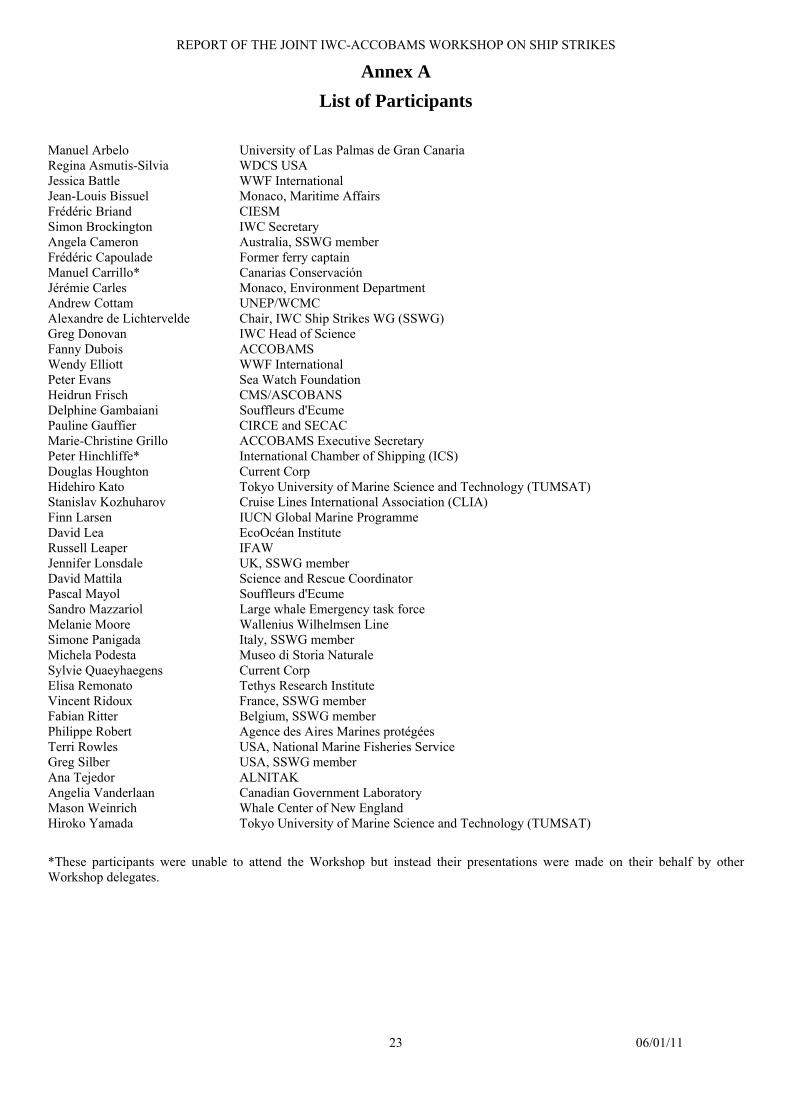
REPORT OF THE JOINT IWC-ACCOBAMS WORKSHOP ON SHIP STRIKES
23 06/01/11
Annex A List of Participants
Manuel Arbelo University of Las Palmas de Gran Canaria Regina Asmutis-Silvia WDCS USA Jessica Battle WWF International Jean-Louis Bissuel Monaco, Maritime Affairs Frédéric Briand CIESM Simon Brockington IWC Secretary Angela Cameron Australia, SSWG member Frédéric Capoulade Former ferry captain Manuel Carrillo* Canarias Conservación Jérémie Carles Monaco, Environment Department Andrew Cottam UNEP/WCMC Alexandre de Lichtervelde Chair, IWC Ship Strikes WG (SSWG) Greg Donovan IWC Head of Science Fanny Dubois ACCOBAMS Wendy Elliott WWF International Peter Evans Sea Watch Foundation Heidrun Frisch CMS/ASCOBANS Delphine Gambaiani Souffleurs d'Ecume Pauline Gauffier CIRCE and SECAC Marie-Christine Grillo ACCOBAMS Executive Secretary Peter Hinchliffe* International Chamber of Shipping (ICS) Douglas Houghton Current Corp Hidehiro Kato Tokyo University of Marine Science and Technology (TUMSAT) Stanislav Kozhuharov Cruise Lines International Association (CLIA) Finn Larsen IUCN Global Marine Programme David Lea EcoOcéan Institute Russell Leaper IFAW Jennifer Lonsdale UK, SSWG member David Mattila Science and Rescue Coordinator Pascal Mayol Souffleurs d'Ecume Sandro Mazzariol Large whale Emergency task force Melanie Moore Wallenius Wilhelmsen Line Simone Panigada Italy, SSWG member Michela Podesta Museo di Storia Naturale Sylvie Quaeyhaegens Current Corp Elisa Remonato Tethys Research Institute Vincent Ridoux France, SSWG member Fabian Ritter Belgium, SSWG member Philippe Robert Agence des Aires Marines protégées Terri Rowles USA, National Marine Fisheries Service Greg Silber USA, SSWG member Ana Tejedor ALNITAK Angelia Vanderlaan Canadian Government Laboratory Mason Weinrich Whale Center of New England Hiroko Yamada Tokyo University of Marine Science and Technology (TUMSAT)
*These participants were unable to attend the Workshop but instead their presentations were made on their behalf by other Workshop delegates.
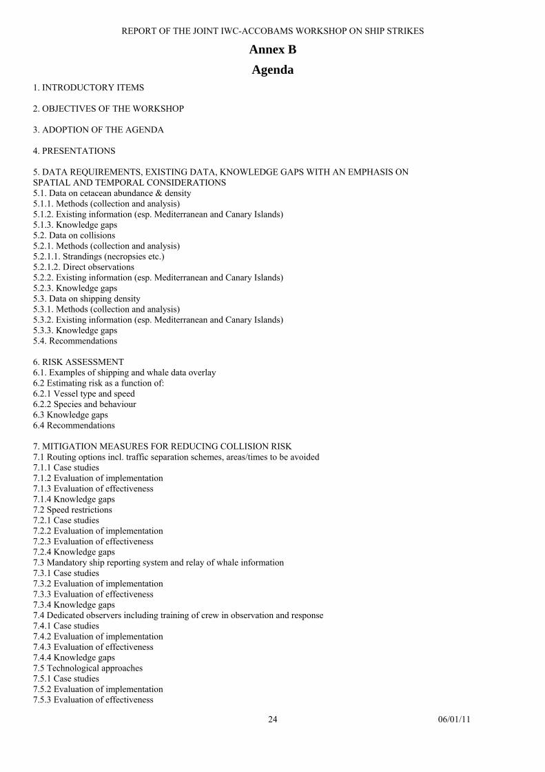
REPORT OF THE JOINT IWC-ACCOBAMS WORKSHOP ON SHIP STRIKES
24 06/01/11
Annex B Agenda
1. INTRODUCTORY ITEMS 2. OBJECTIVES OF THE WORKSHOP 3. ADOPTION OF THE AGENDA 4. PRESENTATIONS 5. DATA REQUIREMENTS, EXISTING DATA, KNOWLEDGE GAPS WITH AN EMPHASIS ON SPATIAL AND TEMPORAL CONSIDERATIONS 5.1. Data on cetacean abundance & density 5.1.1. Methods (collection and analysis) 5.1.2. Existing information (esp. Mediterranean and Canary Islands) 5.1.3. Knowledge gaps 5.2. Data on collisions 5.2.1. Methods (collection and analysis) 5.2.1.1. Strandings (necropsies etc.) 5.2.1.2. Direct observations 5.2.2. Existing information (esp. Mediterranean and Canary Islands) 5.2.3. Knowledge gaps 5.3. Data on shipping density 5.3.1. Methods (collection and analysis) 5.3.2. Existing information (esp. Mediterranean and Canary Islands) 5.3.3. Knowledge gaps 5.4. Recommendations 6. RISK ASSESSMENT 6.1. Examples of shipping and whale data overlay 6.2 Estimating risk as a function of: 6.2.1 Vessel type and speed 6.2.2 Species and behaviour 6.3 Knowledge gaps 6.4 Recommendations 7. MITIGATION MEASURES FOR REDUCING COLLISION RISK 7.1 Routing options incl. traffic separation schemes, areas/times to be avoided 7.1.1 Case studies 7.1.2 Evaluation of implementation 7.1.3 Evaluation of effectiveness 7.1.4 Knowledge gaps 7.2 Speed restrictions 7.2.1 Case studies 7.2.2 Evaluation of implementation 7.2.3 Evaluation of effectiveness 7.2.4 Knowledge gaps 7.3 Mandatory ship reporting system and relay of whale information 7.3.1 Case studies 7.3.2 Evaluation of implementation 7.3.3 Evaluation of effectiveness 7.3.4 Knowledge gaps 7.4 Dedicated observers including training of crew in observation and response 7.4.1 Case studies 7.4.2 Evaluation of implementation 7.4.3 Evaluation of effectiveness 7.4.4 Knowledge gaps 7.5 Technological approaches 7.5.1 Case studies 7.5.2 Evaluation of implementation 7.5.3 Evaluation of effectiveness
REPORT OF THE JOINT IWC-ACCOBAMS WORKSHOP ON SHIP STRIKES
25 06/01/11
7.5.4 Knowledge gaps 7.6 Recommendations 8. RECOMMENDATIONS 8.1. Priority species/populations/areas 8.1.1 At scientific level 8.1.2 Conservation measures 8.1.3 Reporting 8.2 Other 9. DEVELOPMENT OF FRAMEWORK TO ADDRESS SHIP STRIKE ISSUES INCLUDING TWO-YEAR WORK PLAN FOR IWC/ACCOBAMS COLLABORATION 10. PUBLICATION OF REPORT AND PAPERS 11. AOB
12. ADOPTION OF THE REPORT
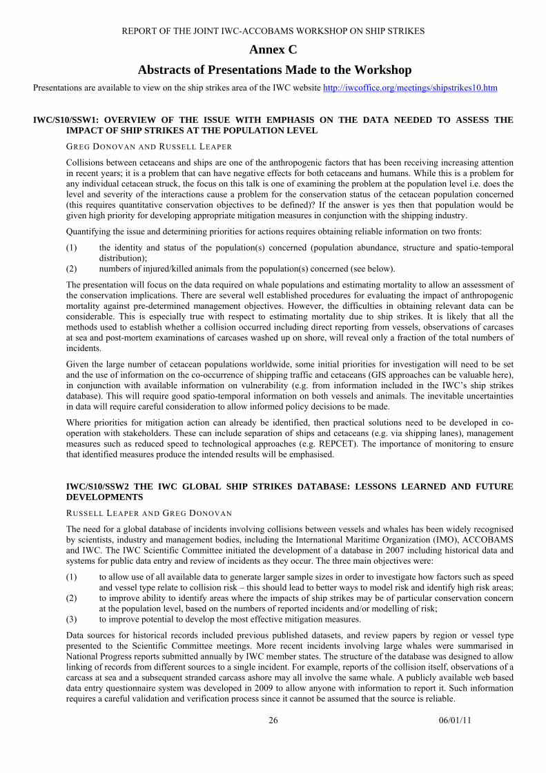
REPORT OF THE JOINT IWC-ACCOBAMS WORKSHOP ON SHIP STRIKES
26 06/01/11
Annex C Abstracts of Presentations Made to the Workshop
Presentations are available to view on the ship strikes area of the IWC website http://iwcoffice.org/meetings/shipstrikes10.htm
IWC/S10/SSW1: OVERVIEW OF THE ISSUE WITH EMPHASIS ON THE DATA NEEDED TO ASSESS THE IMPACT OF SHIP STRIKES AT THE POPULATION LEVEL
GREG DONOVAN AND RUSSELL LEAPER
Collisions between cetaceans and ships are one of the anthropogenic factors that has been receiving increasing attention in recent years; it is a problem that can have negative effects for both cetaceans and humans. While this is a problem for any individual cetacean struck, the focus on this talk is one of examining the problem at the population level i.e. does the level and severity of the interactions cause a problem for the conservation status of the cetacean population concerned (this requires quantitative conservation objectives to be defined)? If the answer is yes then that population would be given high priority for developing appropriate mitigation measures in conjunction with the shipping industry.
Quantifying the issue and determining priorities for actions requires obtaining reliable information on two fronts:
(1) the identity and status of the population(s) concerned (population abundance, structure and spatio-temporal distribution);
(2) numbers of injured/killed animals from the population(s) concerned (see below).
The presentation will focus on the data required on whale populations and estimating mortality to allow an assessment of the conservation implications. There are several well established procedures for evaluating the impact of anthropogenic mortality against pre-determined management objectives. However, the difficulties in obtaining relevant data can be considerable. This is especially true with respect to estimating mortality due to ship strikes. It is likely that all the methods used to establish whether a collision occurred including direct reporting from vessels, observations of carcases at sea and post-mortem examinations of carcases washed up on shore, will reveal only a fraction of the total numbers of incidents.
Given the large number of cetacean populations worldwide, some initial priorities for investigation will need to be set and the use of information on the co-occurrence of shipping traffic and cetaceans (GIS approaches can be valuable here), in conjunction with available information on vulnerability (e.g. from information included in the IWC’s ship strikes database). This will require good spatio-temporal information on both vessels and animals. The inevitable uncertainties in data will require careful consideration to allow informed policy decisions to be made.
Where priorities for mitigation action can already be identified, then practical solutions need to be developed in co-operation with stakeholders. These can include separation of ships and cetaceans (e.g. via shipping lanes), management measures such as reduced speed to technological approaches (e.g. REPCET). The importance of monitoring to ensure that identified measures produce the intended results will be emphasised.
IWC/S10/SSW2 THE IWC GLOBAL SHIP STRIKES DATABASE: LESSONS LEARNED AND FUTURE DEVELOPMENTS
RUSSELL LEAPER AND GREG DONOVAN
The need for a global database of incidents involving collisions between vessels and whales has been widely recognised by scientists, industry and management bodies, including the International Maritime Organization (IMO), ACCOBAMS and IWC. The IWC Scientific Committee initiated the development of a database in 2007 including historical data and systems for public data entry and review of incidents as they occur. The three main objectives were:
(1) to allow use of all available data to generate larger sample sizes in order to investigate how factors such as speed and vessel type relate to collision risk – this should lead to better ways to model risk and identify high risk areas;
(2) to improve ability to identify areas where the impacts of ship strikes may be of particular conservation concern at the population level, based on the numbers of reported incidents and/or modelling of risk;
(3) to improve potential to develop the most effective mitigation measures.
Data sources for historical records included previous published datasets, and review papers by region or vessel type presented to the Scientific Committee meetings. More recent incidents involving large whales were summarised in National Progress reports submitted annually by IWC member states. The structure of the database was designed to allow linking of records from different sources to a single incident. For example, reports of the collision itself, observations of a carcass at sea and a subsequent stranded carcass ashore may all involve the same whale. A publicly available web based data entry questionnaire system was developed in 2009 to allow anyone with information to report it. Such information requires a careful validation and verification process since it cannot be assumed that the source is reliable.
REPORT OF THE JOINT IWC-ACCOBAMS WORKSHOP ON SHIP STRIKES
27 06/01/11
The focus to date has been on data entry and developing a reliable data gathering system. Hence the database has not been available for general queries. However, there have been many more requests for data than those wishing to contribute data. Making data available raises a number of issues including the level of validation and confidentiality of certain information. It is critical that data cannot be used in a way that would discourage others from reporting incidents. The downloadable summary database prepared for the workshop is the first attempt to balance making data readily available while minimising the risks that these will be misinterpreted.
The database has been developed through work by individual members of the IWC Scientific Committee, the IWC Secretariat and small contracts for data entry and to a database consultant. These informal arrangements have allowed progress but will need to be kept under review, and appointment of a dedicated database co-ordinator may be required in the future.
IWC/S10/SSW3 INFORMATION ON SHIPPING DENSITY AND DEMONSTRATION OF DATA INTEGRATION ON THE WEB
ANDREW COTTAM
The talk will describe the potential sources of shipping position information that are currently available that are relevant to whale strikes and outline some of the revenant issues with the data. There are a number of potential sources of data, each with their own advantages/disadvantages.
(1) What types of shipping they cover (2) Coverage, both spatially and temporally (3) Value added services, e.g. alert systems (4) Access and licensing (5) Opportunities to work with partner organisations (6) Producing meaningful maps of shipping and shipping density
In addition, a brief demonstration will be given to highlight how conservation-related datasets can be integrated using web-based GIS tools using a couple of the tools that UNEP-WCMC have developed.
IWC/S10/SSW4 ASSESSING THE POTENTIAL CONFLICT BETWEEN SHIPPING AND CETACEANS IN THE ASCOBANS REGION
PETER G.H. EVANS, MICK E. BAINES AND PIA ANDERWALD
Northwest Europe contains some of the busiest waterways in the world. In order to reach a better understanding of the risk posed by shipping to cetaceans within the ASCOBANS Agreement Area, two alternative approaches to plotting vessel densities were examined, and then compared with information on the relative densities of various cetacean taxa (baleen whales, large toothed whales, dolphins & porpoises).
Shipping was plotted using AIS (Automatic Identification Systems) and VOS (Voluntary Observing Ships Scheme). Each has its advantages and limitations. Because the VOS program is voluntary, some commercial shipping traffic is not captured by these data, and this may particularly underestimate high traffic locations. Furthermore, because ships report their location with varying distance between signals, ship tracks are estimates of the actual shipping route taken. Under the International Maritime Organization's International Convention for the Safety of Life at Sea (SOLAS), AIS is required on all vessels with a gross tonnage of 300 or more tons, and all passenger vessels regardless of size, giving it particular potential for mapping shipping densities. However, AIS receivers have finite range whilst this may vary with atmospheric conditions. The most important factor for better reception is the elevation of the base station antenna. The higher it is, the better. In optimal conditions this can detect vessels 200 nm away, but for many land-based stations, it is much less. This was tested further in waters around the British Isles.
Despite the limitations of the two methods, they both reveal similar patterns of variation in shipping density, with high traffic locations generally matching our knowledge from other information sources.
The relative densities of cetaceans were derived from dedicated offshore surveys, with numbers per unit effort (corrected for sea conditions) plotted on a grid cell basis for different cetacean groupings. These were then used to make some assessment of the relative risk of ship strike (taking account of average vessel speed which influences lethality) on a regional basis.

REPORT OF THE JOINT IWC-ACCOBAMS WORKSHOP ON SHIP STRIKES
28 06/01/11
IWC/S10/SSW5.1 REGIONAL CASE STUDIES: MEDITERRANEAN SEA AND CANARY ISLANDS
SIMONE PANIGADA
Collisions between ships and cetaceans occur throughout the world, with the fin whale, Balaenoptera physalus, being the species most often involved. In the Mediterranean Sea, ship strikes with the two large Mediterranean cetaceans, the fin whale and the sperm whale, Physeter macrocephalus, are relatively common, due to the high volume of maritime traffic concentrating in areas and seasons in which these species occur in high densities.
In cooperation with ACCOBAMS and the IWC, a series of initiatives to investigate and suggest mitigation measures for the risk of collision in the Mediterranean, particularly in the Pelagos Sanctuary has been developed. One of the first aims of this initiative is to improve and increase the dataset for the Mediterranean basin and raise public and institutional awareness. A dedicated web site (www.tethys.org/collisioni/) presents latest updated information about ship strikes, helps disseminate awareness materials to inform ship crews and the general public and includes reporting forms.
This regional database is compatible with the global IWC database and the Mediterranean data will form an integral part of it. An important component is also the collaboration among shipping companies, port authorities and scientists, along with the provision of public information on reporting. The available information for the Mediterranean Sea is sparse. Reliable estimates of fatality rates and associated information are essential to assess impacts at the population level and design effective mitigation measures.
Preliminary qualitative maps to assess areas where ship strike risk may be high in the Mediterranean Sea have been produced, overlapping naval traffic - obtained from AIS data and from ferry routes - and large whale known preferred habitats.
IWC/S10/SSW5.2 REGIONAL CASE STUDIES: COLLISIONS BETWEEN SHIPS AND WHALES IN THE CANARY ISLANDS. THE CASE OF TENERIFE
MANUEL CARRILLO AND ANNA TAVERNA
The monitoring and study of the stranded cetacean in the Tenerife island has been carried out in a systematic manner since 1991, when the stranding of two specimens of sperm whale Physeter macrocephalus was reported for the first time. The animals were two adult females with the bodies divided in halves. (Martín y Carrillo 1992). As a consequence of the social alarm that the collisions between the small fast ferries (jet-foil) and cetaceans caused, in 1993, the University of Las Palmas de Gran Canaria (ULPGC) was introduced to the research, with the financial support of the Transmediterranea Company, in order to determine the migratory patterns of the big whales in the Canary Islands. The results confirmed that the waters near the port of Santa Cruz de Tenerife are a high density area of cetaceans, emphasizing the presence of a resident population of sperm whale (André, M. 1998). However, the research provided little information about the distribution and seasonality of the sightings.
From 1999, coinciding with an increase of shipping traffic and the development of newer faster vessels, the situation changed remarkably. A notable increase of stranded cetaceans with clear signs of ship strikes has been reported (Aguilar et al. 2000, 2001, Herrera et al 2000). To this regard and with the aim to identify the potential risk of the collisions, a model of risk for the high shipping traffic areas in Tenerife was developed (Tregenza et al. 2000, 2002) as well as general tables for collisions for all the Canary Islands (Government of Canary Islands, ULPGC, Tenerife Conservation and SECAC 2009). The analysis of the different stranded animals clearly confirms that the most affected species by ship strikes is the sperm whale (Carrillo & Tejedor, 2006; De Stefanis & Urquiola 2006; Carrillo, M. 2007; Carrillo & Ritter 2008).
Complementary to the analysis of the collisions between vessels and cetaceans, we also go through all the mortality factors and the seasonality of 284 records of stranded cetacean in Tenerife, the island in the Canary’s were not only most cases of stranded animals but also ship strikes are reported (Arbelo, M. 2007). The analysis of the stranded cetaceans during the period from 1991 to July 2010 shows that in 103 of the cases (36.3%) no signs of anthropogenic interactions were found, reporting these deaths as a natural factor. In 70 of the cases (24.6%) wounds, fractures, net marks, fishing devices or anomalous stomach contents (plastics) were observed, which could be associated to the death of the animal, thus, the mortality factor is related to anthropogenic interaction. In 111 of the cases (39.1%) the mortality factor has been classified as undetermined due to the difficulty to examine the specimens or as a consequence of the high level of decomposition.
From the 70 cases of the specimens classified with a mortality factor of anthropogenic interaction, 43 of them showed serious injuries, massive traumas, fractures of hard bones or bodies divided in halves. These animals show clear signs of collision and have been reported as due to shipping traffic mortality factor. This represents 61.4% of the cases of anthropogenic interactions and 15.1% of all cases of stranded cetaceans in the island of Tenerife. The annual distribution of the different cases shows that until 1998, when jet-foils began to appear, 0.6 cases of collision were registered every year and from thereon (to present), the average has increased to 3.1 cases every year. Although cases are registered all year round, seasonality shows that the majority of collisions occur between June and July, with 8 cases registered in both months. In terms of affected species by ship strikes, at least 7 species have been reported: sperm whale (P.

REPORT OF THE JOINT IWC-ACCOBAMS WORKSHOP ON SHIP STRIKES
29 06/01/11
macrocephalus), short fin pilot whale (Globicephala macrorhynchus), pygmy sperm whale (Kogia breviceps), dwarf sperm whale (K. simus), Cuvier’s beaked whale (Ziphius cavirostris), Gervais’s beaked whale (Mesoplodon europaeus) and fin whale (Balaenoptera physalus). The sperm whale, with 21 registered cases, is the most affected species and represents a 48.8% of the total cases of collision in the island of Tenerife. Furthermore, the sperm whale is listed as vulnerable in the Catalogo Nacional de Especies Amenazadas and in the IUCN Red List of Threatened Species (CNEA 1990, IUCN 2010). However, differently to other places where collisions are well documented (NMFS 2007; Tejedor et al., 2007), in Canary Islands nothing has been done to date in order to minimize the risk of ship strikes.
In order to better protect this species, it is essential to address and mitigate those human activities that result in mortality. In 2007, Tenerife Conservation carried out a revision of the available data of sightings, stranded cetacean and threat factors of the protected species of cetacean in the Canary’s and developed a report for the government of the Canary Islands with the aim to establish a conservation plan for the sperm whale. Therefore, we propose the following measures:
(1) To determine the distribution and estimate the size of the population of sperm whale and other cetacean in the areas of high vessel traffic (Tenerife-Gran Canaria and Tenerife-La Gomera, Red Natura 2000), in order to establish the relative probability of vessel and cetacean encounter.
(2) The placement of dedicated on board observers (look-outs) on all fast and high speed vessels. (3) Experimental on-board application of technical mitigation measures to test their feasibility and effectiveness.
Workshop on reducing risk of collisions between vessels and cetaceans. (4) The introduction of a mandatory reporting scheme for collisions, thereby making use of the database being
developed by the IWC Vessel Strike Data Standardisation Group (Van Waerebeek and Leaper, 2007). (5) To propose to the vessel operators and crew an immediate recommendation to avoid causing injury or dead to
cetacean. (6) It would be also important to improve the monitoring of floating dead cetacean that occasionally would not be
recovered and might be cases of ship strikes. REFERENCES
Aguilar, N., Carrillo, M., Delgado, I., Díaz, F. & Brito, A. 2000. Fast ferries impact on cetaceans in the Canary Islands: collisions and displacement. Proc. 14th Ann. Conf. European Cetacean Society, Cork, Ireland, 164. Aguilar N., Díaz F., Carrillo M., Brito A., Barquín J., Alayón P., Falcón J. and González G. 2000. Evidence of disturbance of protected cetacean populations in the Canary Islands. IWC. SC/53/WW1. London. André M. 1998 El cachalote, Physeter macrocephalus en las Islas Canarias. PhD thesis, University of Las Palmas de Gran Canaria, Spain. Arbelo M.A. 2007. Patología y causas de la muerte de los cetáceos varados en las Islas Canarias. PhD thesis, University of Las Palmas de Gran Canaria, Spain. Carrillo, M & Tejedor, M. 2006. Marine traffic and the conservation of sperm whale Physeter macrocephalus populations in Canary Islands. Cetacean Stranded Canarian Net 1980–2004. 20th annual conference of the European Cetacean Society. Gdynia, Poland. Carrillo, M. 2007. diversidad de cetáceos en la makaronesia y factores de amenaza. 2007 WATCH- Year of dolphin. UNESCO- Convención Especies Migratorias (CMS) -Gobierno de Canarias. Tenerife. Carrillo, M & Ritter, F. 2008. Increasing numbers of ship strikes in the canary islands: proposals for immediate action to reduce risk of vessel-whale collisions. IWC Scientific Committee. SC/60/BC6. Catálogo Nacional de Especies Amenazadas (CNEA) 1990. Ministerio del Medio Ambiente, Rural y Marino. Real Decreto 439/1990, de 30 de marzo (B.O.E. nº 82, 5 abril 1990). De Stephanis, R. and Urquiola, E. 2006. Collisions between ships and cetaceans in Spain. Int. Whal. Commn. Scientific Committee SC/58/BC5. Gobierno de Canarias 2009. Activities on cetaceans carried out by the Canary Islands Government in 2008 and review of historic data records of cetaceans and ship strike in the Canary Islands. IWC/61/cc16-(sp). Herrera, R, Carrillo, M and V.Martín. 2000. El tráfico marítimo y su implicación en la conservación de los Cetáceos en las Islas Canarias. Revista Medio Ambiente Canarias, revista de la Consejería de Política Territorial y Medio Ambiente del Gobierno de Canarias. IUCN 2010. IUCN Red List of Threatened Species. Version 2010.3. NMFS/NOAA 2007. Notice to lessees and operators (NTL) of federal oil, gas, and sulphur leases in the outer continental shelf, Gulf of Mexico OCS region. Vessel strike avoidance and injured/dead protected species reporting. NTL Nº2007-G04 Martín, V & Carrillo, M 1992. Programa de estudios de cetáceos varados en Canarias. Informe técnico. Gobierno de Canarias. 68 pp. Tejedor, A., Sagarminaga, R., Canadas, A., De Stepanis, R. & Pantoja, J. 2007 Modifications of Maritime Traffic off southern Spain. Int. Whal.Comm. Document SC/59/BC13. Tregenza, N, Aguilar, N., Carrillo, M., Delgado, I., Díaz, F, Brito, A. and Martin, V. 2000. Potential Impact of fast ferries on whale populations a simple model with examples from the Canary Islands. European Research on Cetaceans, 2000. 14:195-197. Tregenza, N., Aguilar, N., Carrillo, M., Delgado, I., and Diaz, F. 2002 .Collisions between fast ferries and whales in the Canary Islands: observational data and theoretical limits. IWC Scientific Committee. SC/54/BC4 7pp. Van Waerebeek, K. and Leaper, R. (compilers) 2007. Report from the IWC Vessel Strike Data Standardization Group. Document SC/59/BC12.
IWC/S10/SSW5.3 REGIONAL CASE STUDIES: KEY AREAS FOR CETACEANS IN THE CANARY ARCHIPELAGO AND THE STRAIT OF GIBRALTAR - COLLISION RISK AND MITIGATION STRATEGIES
PAULINE GAUFFIER, MARTÍN, V., VERBORGH, P., PÉREZ-GIL, M., DE STEPHANIS, R., SERVIDIO, A., ESTEBAN, R., TEJEDOR, M., PÉREZ-GIL, E., NEVES, S., RUÍZ, L.
Canary Islands With 29 species recorded, the Canary Islands (Spain), in the Lower North Atlantic, are a well-known hot spot for cetacean diversity. These waters constitute an important habitat for several species of deep-diving cetaceans such as beaked (fam Ziphiidae) and sperm whales (Physeter macrocephalus). Cetacean’s mortality related to collisions is an increasing global conservation problem. This archipelago supports a high-density maritime traffic, with a high-speed
REPORT OF THE JOINT IWC-ACCOBAMS WORKSHOP ON SHIP STRIKES
30 06/01/11
vessels fleet that annually travels around 845,000 km between the islands. Some future lines of high-speed traffic are currently in consideration (e.g. west coast of La Palma, South-East of Fuerteventura islands, South of Lanzarote island). This archipelago has several Special Area for Conservation (SAC´s) for bottlenose dolphin (Tursiops truncatus) in the Canary Islands, which are mainly located in the SW portions of the main islands. They are sectors of waters protected from main currents and winds trades by the high relief of the islands, originating calm waters due to the “Island Mass Effect” that increase productivity locally. In these areas, a significant touristic growth in the last years has promoted synergic threats such as whale-watching, coast alterations, artisanal fishery, traffic of a variety of recreational boats and ferries and fast-ferries lines. Regarding the stranding data (Canary Islands Government, SECAC and IUSA’s databases and published literature), two critical areas for collision with cetaceans exist in the archipelago: the SW of Tenerife and the North portion of the inter-islands channels between Tenerife and Gran Canaria islands. Since 1999, the Society for Study of Cetaceans in the Canary Archipelago (SECAC) has been involved in a number of projects to monitor the population of cetaceans in the islands. To date, 825 day-surveys, with 3.717 hour on effort, 21.319 nautical miles with 1.833 cetaceans sightings. In the last years a considerable effort has been realized in most oceanic waters of the oriental islands of the archipelago (Lanzarote and Fuerteventura) with a combination of visual and acoustic census with towed hydrophones, focusing on sperm whales. In these areas the collisions could be a potential threat for the conservation of the species. This presentation reveals the preliminary results about the frequency and distribution of these species in the Canary Islands, as well as the critical areas for collision.
Strait of Gibraltar The Strait of Gibraltar is the second area with the most intense maritime traffic in the World, with around 103,000 ships passing every year. Collisions between ships and cetaceans in the area involve mainly three species, fin whales (Balaenoptera physalus), sperm whales and pilot whale (Globicephala melas).
Since 2007, the Spanish Government identified a critical area for sperm whale that recommends, between April and August, navigating with increased caution and at a speed lower than 13 knots in order to avoid collision. Land-based studies showed that the 13 knot-speed limit is not respected by a great majority of vessels, mean speed being 13.9 knots for cargo ships, 15.3 knots for regular ferries and 24.4 knots for fast-ferries, while a high number of fin and sperm whale sightings in winter suggests the need for an extension of the recommendation over the winter months.
The expansion of Tarifa harbour, with the opening of a new fast-ferry line from Tarifa to Tanger-Med harbour by the end of 2010, will increase once again the traffic and deliberately allow 30 knot-vessels to cross the entire critical area.
Dedicated surveys are carried out to investigate the movements of sperm whales as well as understanding the “boundaries” of the fin whale Mediterranean population.
A series of initiatives should be encouraged regarding the ship strike issue including training of the crew members, the presence of on-board observers, and passenger awareness, as well as increasing the collaboration with Morocco.
IWC/S10/SSW5.3 REGIONAL CASE STUDIES: THE ALBORÁN SEA: TSS RECONFIGURATION VS SPEED RECOMMENDATION
ANA TEJEDOR AND RICARDO SAGARMINAGA.
The Alborán Sea is one of the busiest bottlenecks of maritime traffic, with over 25% of the World’s shipping, including over 30% of the transport of dangerous cargo and over 100.000 passengers. The Alborán Sea must also be highlighted as a strategic site in terms of world security. Overlapping with these human social and economic interests the Alborán Sea today plays a role of special relevance in the international strategies and policy for the conservation of biodiversity. Alborán is the gate of the Mediterranean to the Atlantic, playing an important role as oceanographic transition chamber and hydrological motor for the Western Mediterranean basin. This unique oceanography and productivity, combines with the situation of Alborán at the junction of three biogeographic areas, to give us an overwhelming biological diversity.
Given the need to address the potential risks resulting from this overlap of interests, two international initiatives of maritime traffic management , the reconfiguration of the TSS “Off Cabo de Gata” and the Navigational Recommendations for the Strait of Gibraltar, were initiated in 2005 in the framework of programmes dealing with the implementation of the European Union’s Habitat Directive. This presentation analyses the procedures undertaken in two case studies, and their results in order to provide learning’s for future action.
IWC/S10/SSW6.1 REPORTING CETACEAN MORTALITY RELATED TO SHIPS STRIKES: THE ITALIAN EXPERIENCE
MAZZARIOL S., PODESTÀ M., COZZI B.
In the recent years, the problems related to collisions with vessels in the Mediterranean basin have grown to a level of general concern because of the repetitive registered instances of animal harm. Evidences for death linked to collisions are largely due to well documented instances of large cetaceans (mostly fin whales) stricken by cruising vessels and photographed in the port. However a larger – and more worrisome – quantity of animals has been reported victim of
REPORT OF THE JOINT IWC-ACCOBAMS WORKSHOP ON SHIP STRIKES
31 06/01/11
accidental entanglement in fishing machineries in several areas of the Mediterranean. Our particular point of observation relays in the possibility of evaluating by-catch instances directly in the necropsy room when performing post-mortem investigations on stranded animas. The pathology service of the Faculty of Veterinary medicine of the University of Padova is closely linked to the Mediterranean marine mammal tissue Bank of the same Institution, and received animals recovered by the several local stranding networks that operate along the Italian shorelines. Additional to these regional opportunities, we have also been asked to express our opinion on animals recovered in other riparian countries facing the Adriatic. The definition of “stranded” here includes also those specimens that reached the shores long after long drifts in the open waters and show signs of mutilation due to engine parts and especially the rotor blades. To this list of animals, we may also add all the cetaceans that we have not examined directly either on the beach or in the necropsy room, but had the chance to see when specific puzzling pictures of the damaged animals were referred to our attention by third parties for a professional opinion.
In our presentation we will analyse all the issues and categories stated above as seen from our point of view, and will give an estimation of the phenomenon from this stand, suggesting the necessity to involve the national public veterinary service and the Coast Guard by a specific training, in order to have a capillary action and to understand the role of diseases and other spontaneous conditions in predisposing animals to vessels strikes. We hope our observations will contribute to reach a more general and widely shared evaluation of by-catch-related events in the Mediterranean area with special reference to the waters adjacent to the Italian peninsula.
IWC/S10/SSW5.2 PATHOLOGY OF STRUCK WHALES
ANTONIO FERNÁNDEZ, MARIÑA MÉNDEZ, ANTONIO ESPINOSA, PEDRO HERRÁEZ AND MANUEL ARBELO.
Collisions between large vessels and cetaceans have only recently been fully recognised as a source of anthropogenic mortality and injury, and they need to be assessed and quantified. A pathological diagnosis of the primary cause of death is not always easy, as most of the carcasses are found in a very advanced process of decomposition. Floating carcasses can have been stricken by vessels, making difficult to determine whether the collision had occurred pre- or post-mortem. Since some years ago, we have made efforts for the development of histochemical techniques that could help to differentiate those situations, allowing us to get a final diagnosis. A histochemical technique based on detecting fat emboli in the lung blood vessels has been set up, and it has been applied to whales suspected to have been killed by ship collision.
It is well known in human beings that after a significant trauma causing bone fractures or severe soft tissue damage, fat emboli can be found as a result of that. These fat emboli are found within lung mid size vessels and/or capillaries by using histochemical methods.
Forensic histopathologists have been using Osmium tetroxide postfixation and/or Oil Red O histochemical techniques to detect microscopically fat emboli in lung samples. These were previously, either frozen or formalin fixed. The second group is post-fixed in Osmium before being embedded in paraffin. During the last years, Unit of Histology and Pathology has been working on dead cetaceans suspected of having been traumatized by ships as well as with stranded dolphins and whales with and without external lesions in order to find out fat emboli in the lungs as a main sign to rule out “in vivo” trauma from postmortem changes. Our work will present the results of those studies, showing that this histochemical technique could be a valid forensic tool to demonstrate severe trauma occurred "in vivo" (especially in ship-collision cases), allowing us to rule out "postmortem" changes found during the necropsy.
IWC/S10/SSW7 CONTRIBUTION OF MODELLING TO RISK ASSESSMENT AND EVALUATION OF MITIGATION MEASURES
RUSSELL LEAPER
Understanding the importance of different factors related to collision risk and hence designing the most effective mitigation strategies has been constrained by the lack of data. Models can play a useful role in integrating data on collision incidents collected globally, and also in relating shipping and whale density distributions to estimate risk. Simulation models may also be useful in evaluating mitigation strategies and the sensitivity of their effectiveness in risk reduction to the assumptions that have been made.
We briefly review examples of previous modelling studies including relating collision risk to vessel speed through analysis of reported collision data, relating risk to vessel type through hydrodynamic modelling, and simulation studies of the likely ability of vessels of different types to make avoidance manoeuvres in response to sightings.
The main focus of the presentation is on overlaying shipping and whale distribution patterns to assess risk and examine potential routing options to reduce risk. Factors to consider include the temporal variability in whale distribution and whether either short (dynamic) or long term (e.g. moving Traffic Separation Schemes) changes in routing would be effective risk reduction measures for case study areas. Data on shipping density can be derived from AIS transmissions but need careful analysis to generate unbiased estimates. Whale data are derived from surveys that represent a snapshot
REPORT OF THE JOINT IWC-ACCOBAMS WORKSHOP ON SHIP STRIKES
32 06/01/11
of distribution patterns. Sequences of survey data can be related to habitat variables to obtain information on the likely persistence over time of areas of high whale density.
IWC/S10/SSW8 1998 – 2010. FROM COLLISIONS TO CETACEANS REPORTING: THE REPCET SYSTEM
FREDERIC CAPOULADE AND PASCAL MAYOL
In 1998, in the north west Mediterranean sea, two collisions with fin whales occurred on two different ships, the "Monte Cinto" and the "NGV Asco", with some damage on the HSS. These events were followed by the establishment of partnerships that lead to scientific studies 2001, a study on the detectability of large cetaceans from high speed vessels demonstrated the importance of having an observer specialised in the detection of large cetaceans. The study also developed a training course for crew members at the French National Merchant Marine School of Marseilles. In 2004 a system for reporting the position of large cetaceans, was tested, foreshadowing the REPCET system which will be in function in 2010. REPCET, REaltime Plotting CEtacean is simple and is based on the following: every sighting of large cetaceans by crew on watch aboard a vessel equipped of REPCET is transmitted by satellite in real-time to a server located on land. The server then centralises the data and sends out an alert to all equipped vessels likely to be concerned. The alerts are displayed cartographically on a dedicated screen on board. The collaborative nature of the system means it relies on the density of maritime traffic. Other vessels are also welcome to contribute voluntarily to the system by reporting cetacean sightings, especially any scientists at sea, whale watching operators, or even pleasure boaters.
Designed to evolve with technology, REPCET will be also capable of providing seagoing personnel with results from prediction models of whale presence, and of integrating systems of automatic detection. All data collected through REPCET will be placed at the scientific community’s disposal as part of the work of Pelagos Sanctuary and ACCOBAMS.
IWC/S10/SSW9 ASSESSING TECHNOLOGICAL APPROACHES TO REDUCE SHIP STRIKES OF CETACEANS
GREGORY K. SILBER AND SHANNON BETTRIDGE
Introduction Vessel collisions are a worldwide threat to marine mammals. Vessel collisions (‘ship strikes’) occur with large whale species (Best et al., 2001; Knowlton and Kraus, 2001; Laist et al., 2001; Jensen and Silber, 2003; Vanderlaan and Taggart, 2007), small cetaceans (Van Waerebeek et al., 2006), and sirenians (i.e. manatees and dugongs) (Greenland and Limpus, 2006; Calleson and Frolich, 2007). Records indicate that nearly all large whale species are vulnerable to ship strikes (Laist et al., 2001; Jensen and Silber, 2003; Van Waerebeek and Leaper, 2008) including, but not limited to, blue (Balaenoptera musculus), fin (Balaenoptera physalus), humpback (Megaptera novaeangliae), right (Eubalaena spp.), sei (B. borealis), and sperm (Physeter macrocephalus) whales. Van Waerebeek and Leaper (2008) reported that a number of small and mid-sized cetaceans occurring in the Southern Hemisphere are involved in vessel collisions. Strikes involving sirenians and small water craft are an ongoing problem in locations where these species occur (U.S. Fish and Wildlife Service, 2001; Greenland and Limpus, 2006).
Seeking a technological solution to the problem of ship strikes (e.g. sonar, radar, enhanced remote visual detection), in addition to or in lieu of changes to vessel operations, has been proposed by maritime industries, resource managers, businesses, and government agencies alike. Some authors, corporations, or inventors indicate that a particular technology has direct application to addressing the problem, but not all claims are supported by studies or empirical test results. Further, relatively few studies have attempted to compile information on applicable technologies or assess the effectiveness of their use (Anonymous, 1999; NMFS, 2002).
In July 2008, NOAA’s National Marine Fisheries Service (NMFS) convened a workshop to identify and assess technological approaches to reducing vessel collisions with large whales (Silber et al., 2009). Information contained in this paper is derived almost entirely from that workshop. A summary of key workshop conclusions is provided.
The July 2008 workshop identified and considered the advantages and disadvantages of the following technologies:
(1) marine mammal visual detection (2) telemetry and tagging (3) passive acoustics (4) active acoustics (5) infrared (6) radar (7) predictive modelling
REPORT OF THE JOINT IWC-ACCOBAMS WORKSHOP ON SHIP STRIKES
33 06/01/11
Overview of Workshop Conclusions Participants concluded that the problem of ship strikes is complex, with no obvious or simple technological ‘fixes’ immediately available for wide scale use. Thus, no single technology now exists, or is likely to be developed in the foreseeable future that will eliminate, or reduce to zero the chances of, ships striking large whales. Reducing the spatial overlap of both whales and vessels is likely to remain the best means of reducing ship strikes – a solution not feasible or practicable in many settings.
Use of remote sensing technologies may provide a more effective means to reduce ship strikes if used effectively and also allow certain maritime commerce and other activities to proceed with limited biological and economic impact. However, studies should be required to confirm that any technology developed and used for this purpose is clearly capable of reducing strikes and would not introduce added environmental impacts. Also, development, installation, and/or operation may be cost prohibitive (Anonymous, 1999).
If tested and used, several technologies (e.g. predictive modelling, passive acoustics, and active acoustics) employed in concert could provide information for far- and near-field detection capabilities to aid voyage planning, as well as immediate avoidance reactions. Some workshop participants proposed using multiple systems and technologies to best mitigate ship strikes. For example, they envisioned use of predictive modeling of regional whale occurrence, refined use of passive acoustics to determine local (10s to 100s of km out) occurrence, with yet further detail on whales in the vessel’s immediate vicinity provided by active acoustics. This hypothetically provides better bases for voyage planning and relatively near-field evasive actions, leaving mariners with the freedom to determine the best means of avoiding whales. However, such a network of systems might be costly to maintain and would still rely on potentially hurried last minute evasive action by a large vessel. With regard to some technologies, new, complex, or expensive ship-board systems may need to be developed and maintained, e.g. screen monitoring watch standers.
Mariner response and vessel reaction times Technologies applicable for reducing ship strikes are focused almost entirely on enhancing whale detection. Enhanced detection capabilities can and should be pursued; however, reaction times of both whales and mariners remain important and challenging components of the problem. Several technologies used together would increase the chances of detection at ranges both near and far from a vessel, improving the likelihood of providing warnings to mariners.
However, knowledge of whale locations, regardless of how thorough or timely the information provided, only partly addresses the equation: mariners must still have sufficient time, the desire and wherewithal, and the capability to take Aevasive action@. Workshop participants emphasized that the mariner must have the capabilities (e.g. adequate communication systems and adequate response times) to take evasive action to avoid a detected whale. Responses to such information may vary amongst mariners and vessel types. Even the most diligent and conscientious mariner will require substantial distances to avoid, alter course, slow down, or react at all to an object directly in his/her path, particularly at higher speeds. Because most large, traditional hull vessels have very long reaction times and distances, workshop participants concluded that thousands of meters are needed to significantly alter the course of a large vessel in most conditions. While executing such a manoeuvre, the vessel has limited options for evasive actions, is vulnerable to reduced manoeuvrability throughout the action, or may inadvertently veer toward undetected whales in avoiding those observed. In addition, responding to whales may put undue burden on responsible mariners who alter course or speed when others do not (thereby increasing the risk of collision with another ship, for example), thus affecting navigational safety.
In quite a number of records of large whale ship strikes, the whale suddenly surfaced under or immediately in front of the vessel and was never seen by the ship’s crew (Laist et al., 2001; Jensen and Silber, 2003). This suggests that a strike may not have been precluded under any circumstances - even those in which the mariner might have been armed with good information that whales were in the vicinity.
High-speed vessels (e.g. some passenger ferries) represent exceptions to general manoeuvrability rules. Many possess unique hull configurations, propulsion systems, better manoeuvring capabilities, and shorter stopping distances. However, even with greater manoeuvrability than conventional hulls, such vessels may not be able to react to an observed whale in less time due to their faster speeds.
Alarm devices Of the technologies considered, alarm devices that frighten or deter animals from a particular location were dismissed with minimal discussion in the workshop because repeated or chronic exposure to alarm or alerting stimuli may result in whales and other marine species abandoning a desired feeding, socializing, or migrating area that could result in significant adverse effects on the population. Further, no evidence exists that large whale species would, in fact, respond to such a sound signal by moving away. In the only study of alarm sound playback experiments involving right whales, Nowacek et al. (2004) found that right whales exposed to the alarm sounds immediately rose to the surface and remained motionless, where they are more vulnerable to being struck.
Even if the whales initially responded in a way that might indicate a type of avoidance, workshop participants noted that whales may become habituated to such alarm signals. Acoustic deterrent or harassment devices have been used in certain situations to warn small cetaceans and pinnipeds away from commercial fishing gear and aquaculture operations by
REPORT OF THE JOINT IWC-ACCOBAMS WORKSHOP ON SHIP STRIKES
34 06/01/11
emitting loud sound pulses. Their use has received mixed success because some marine mammals grow accustomed to the stimuli (see Reeves et al., 1996).
Voyage planning Workshop participants concluded that carefully considered voyage planning that anticipates the potential for whale interaction is more desirable than attempting to react to the presence of whales in the near field. That is, knowledge about where whales occur, either historically or with some predictability (e.g. through predictive modelling, see description below) may allow mariners to plan in advance to avoid or carefully transit through a particular area.
Feasibility In all cases, efficient and reliable means to provide information to mariners that can be used to effectively respond is the best course to avoid whale strikes. Therefore, some technologies hold promise and may have application to this problem in the relatively near term, perhaps when used in combination. Others will require continued research and development before wide scale application is feasible. Whereas mariners expect to avoid whales when forewarned and all wish to avoid hitting them, most technologies have limitations in providing detection ranges adequate to allow mariners sufficient time to respond. Given the severity of the problem for a number of endangered species and the relative paucity of foolproof solutions, technological approaches are worthy of, and should be the subject of, ongoing pursuit.
Assessment of Technologies Summary of conclusions regarding various types of technologies (refer to Silber et al., 2009 for complete discussions).
Marine mammal visual detection Although used extensively in some areas, visual surveys can be expensive, logistically complex, and are limited by poor weather, low-light conditions that vary by time of the year. Even in the best of conditions, only a fraction of the whales actually present may be detected. Most of these points also can generally be applied to the posting of dedicated lookouts.
Marine mammal tagging and telemetry Telemetry is highly useful for studies of whale natural history and movement, and the field is advancing rapidly, particularly in regard to increasing power supplies and decreasing costs to transmit data. However, this approach faces challenges in the attaching of devices to whales and in the logistics of deploying devices to a sufficient number of individuals to make it a viable means to reduce ship strikes.
Passive acoustics Passive acoustic technologies are becoming commonplace in many locations for studying whale occurrence and distribution. Due to the amount of data returned for cost investment relative to other technologies, this approach may be one of the most promising for addressing ship strikes. However, these devices will only detect vocalizing whales and determining specific location is not always possible unless multi-unit arrays are used.
Active acoustics Active sonar devices can be effective in detecting whales within hundreds of meters (perhaps up to one thousand in certain cases and circumstances) of a vessel, although this range may be extended as technology improves. Wavelengths of sound that work best for detecting whales are also audible to other marine mammals and fish, and may produce undesirable effects on other organisms and parts of the ecosystem while reducing risks for large whales. Depending on the eventual system designs used, costs can be relatively high and false positives could be problematic.
Infrared Thermal imaging devices have proved promising in detecting whale blows in Antarctic waters and elsewhere at ranges greater than one kilometre but are less effective in warmer climates where blows and ambient temperature differences are less.
Radar Radar devices can be used from ship or shore and have the advantage of operating in poor weather. False positives are a potential problem, though, and more performance data will be needed before commercialization can be contemplated. Ranges are also limited to line-of-sight, which for a small vessel might be 5-8 km (about the same or slightly better than ideal visual detection ranges). The higher the antenna above the water’s surface, the farther a radar can detect objects, with shore-based systems providing detections at ranges exceeding 10 km.
Predictive modelling Predictive models using oceanographic data from satellites or other sources are a relatively low-cost means to predict where whales may occur. Like all models, including weather forecasts, there is an inherent amount of uncertainty in the predicted outcome, but fairly reliable models can be applied now to provide information on large scales. Coverage potentially can be regional in scale, but resolution (and therefore utility) is greatest at scales on the order of 100s of meters.
REPORT OF THE JOINT IWC-ACCOBAMS WORKSHOP ON SHIP STRIKES
35 06/01/11
Some Additional, Miscellaneous Considerations The workshop also made note of a number of additional observations not specifically discussed at length in the workshop deliberations. These included:
(1) Any technology employed should introduce no, or minimal, co-occurring negative effects to marine organisms or habitat.
(2) Use of technologies should involve minimal impact to normal bridge operations, i.e. least amount time involvement from the mariner while underway.
(3) Some of the technologies considered require considerable training for the operators and could involve significant costs (including maintenance).
(4) Technologies that can be incorporated with existing systems are more likely to be accepted by maritime industry than those that require autonomous equipment and dedicated staff to use them effectively.
(5) Finding technological solutions is a multi-part process; there is no one measure to fit all situations. (6) Large vessels pay about $700/ton of fuel. Any hull changes or other devices added will increase fuel
consumption. Environmental footprint will increase with physical solutions. It is highly undesirable to transfer one biological problem for another environmental problem.
(7) Ideally, applicable technologies can be dovetailed with multiple detection systems and can be situation or context specific, e.g. can be fine-tuned to area or vessel type.
(8) Ideally, a viable technology operates in real-time, but with sufficient time to react. (9) With regard to active acoustics technologies:
a. the issue of underwater noise is an international concern (ship noise, sonar noise, etc.). Active acoustic technologies would involve increasing noise levels in the ocean; and ensonifying large areas of ocean would require significant power. Power requirements of some moored systems present technological challenges. Power requirement are not a limiting factor for ship-mounted forward-looking SONAR devices.
(10) Small craft are also involved in whale collisions, but have operating characteristics that differ from large, oceanic vessels; and thus have a different range of technologies that may be appropriate to them.
(11) If technology use or research were proposed for waters of the United States, it would: a. Likely require permits under the Marine Mammal Protection Act and possibly the Endangered Species Act. Any tagging of large whales would require MMPA and possibly ESA permits. b. Likely need to develop operational standards for any of the technologies and phase in any requirements for their use; and c. Likely need to develop key metrics for determining the standards of any technologies and the way they would be used, including feedback loops of the information gathered and communication systems to assure that information collected was widely disseminated.
In the course of discussions and during a ‘brainstorming’ session, the workshop participants also identified several other potentially applicable technologies to address ship strikes, but were not assessed. These were:
(1) tactile alarm in front of ships, e.g. water cannon;
(2) satellite- or unmanned aircraft-based hyperspectral imaging (i.e. detection of electromagnetic spectra, such as ultraviolet);
(3) tomographic profiling of the water column;
(4) physical technologies such as prop guards and hull designs; and
(5) wake detection and other indicators of whale presence as detected from the air.
REFERENCES
Anonymous. 1999. Assessment of the possible use of active acoustics (sonar) to reduce right whale mortalities and injuries from ship strikes: proceedings of an interagency workshop, 28 July 1999. 12 pp. Available from the U.S. Marine Mammal Commission. Best, P.B., J.L. Bannister, R.L. Brownell, Jr., and G.P. Donovan (eds.). 2001. Right whales: worldwide status. Journal of Cetacean Research and Management. (Special Issue) 2. 309 pgs. Calleson, C.S., and R.K. Frolich. 2007. Slower boat speeds reduce risks to manatees. Endangered Species Research 3(3):295-304. Greenland, J.A., and C.J. Limpus. 2006. Marine wildlife stranding and mortality database. II. Cetacean and pinniped. The State of Queensland. Environmental Protection Agency, Freshwater and Marine Sciences Unit, Environmental Sciences Division Conservation technical and data report. Vol. 2005. No. 2. Jensen, A.S., and G.K. Silber. 2003. Large whale ship strike database. U.S. Department of Commerce, NOAA Technical Memorandum NMFS-F/OPR 25, 37 pp. Knowlton, A.R., and S.D. Kraus. 2001. Mortality and serious injury of northern right whales (Eubalaena glacialis) in the western North Atlantic Ocean. Journal of Cetacean Research and Management (Special Issue) 2: 193-208. Laist, D.W., A.R. Knowlton, J.G. Mead, A.S. Collet, and M. Podesta. 2001. Collisions between ships and whales. Marine Mammal Science 17(1): 35-75. National Marine Fisheries Service. 2002. Technological alternatives to the problem of North Atlantic right whale ship strikes. Unpublished white paper. www.nmfs.noaa.gov/pr/pdfs/shipstrike/ss_techalt.pdf. 29 pp. Nowacek, D.P., M.P. Johnson, and P.L. Tyack. 2003. North Atlantic right whales (Eubalaena glacialis) ignore ships but respond to alerting stimuli. Proceedings of the Royal Society of London [Biol]. Vol 271 (1536): 227-231. Reeves, R.R., R. J. Hofman, G.K. Silber, and D. Wilkinson. 1996. Acoustic deterrence of harmful marine mammal-fishery interactions. Proceedings of a workshop held inSeattle, Washington, 20-22 March 1996. U..S Dept. Commerce, NOAA Technical Memorandum NMFS-OPR-10. 70 pp.
REPORT OF THE JOINT IWC-ACCOBAMS WORKSHOP ON SHIP STRIKES
36 06/01/11
Silber, G.K., S. Bettridge, and D. Cottingham. 2009. Report of a workshop to identify and assess technologies to reduce ship strikes of large whales, 8-10 July, 2008, Providence, Rhode Island. U.S. Dep. Commer., NOAA Tech. Memo. NMFS-OPR-42. 55 p. U.S. Fish and Wildlife Service. 2001. Florida manatee recovery plan (Trichechus manatus latirostris), Third revision. U.S. Fish and Wildlife Service, Atlanta, GA. Vanderlaan, A.S.M., and C.T. Taggart. 2007. Vessel collisions with whales: the probability of lethal injury based on vessel speed. Marine Mammal Science. 23(1):144-156. Van Waerebeek, K., A.N. Baker, F. Félix, M. Iñiguez, G.P. Sanino, E. Secchi, G. Slocum, D. Sutaria, A. Van Helden, and Y. Wang, Y. 2006. Vessel collisions with small cetaceans worldwide and with large whales in the Southern Hemisphere. Scientific Committee of the International Whaling Commission, St. Kitts, St Kitts and Nevis. Paper SC/58/BC6.
IWC/S10/SSW10 REDUCING SHIP STRIKES: AN INDUSTRY PERSPECTIVE
PETER B. HINCHLIFFE
The International Chamber of Shipping presentation reviews the work of the International Maritime Organisation with regard to ship strikes on whales and other related work. Potential conflicts between these work streams are highlighted and comments made on the need to find compromises that provide the best possible protection for whale populations. There is a mutual interest in the prevention of ship strikes. The IMO’s mandate is to inform the industry sector and regulate ships; routeing measures, technology, e-navigation, Electronic Chart Display & Information System (ECDIS) and the Marine Information Overlay (MIO) can help reduce ship strikes. Various means of communication can also contribute: Long Range Identification and Tracking (LRIT), Automatic Identification system (AIS) and Virtual Aids to Navigation (AtoN).
With regard to national measures, dynamic management areas can be created and AIS can be used to inform ships of whale areas. Ships can be tracked via AIS and LRIT. At the IMO, guidance for ships on whale avoidance can be provided. The impact of radiated noise on the environment is also being investigated by an intersessional correspondence group of the Marine Environment Protection Committee (MEPC). There is a link between more efficient ships and quieter operations. The question is asked: ‘do quieter ships pose a greater threat to whales?’
IWC/S10/SSW11.1 WATCH OUT AND SAIL CAREFULLY! A CLOSE LOOK AT COLLISIONS BETWEEN SAILING VESSELS AND CETACEANS WORLDWIDE
FABIAN RITTER
Collisions between sailing vessels and cetaceans are increasing worldwide and it appears that ocean races and regattas can significantly contribute to this problem. This presentation will summarize the updated findings of an online-survey created to receive reports about collisions and near-miss events involving sailing vessels worldwide. The number of collisions and near-misses, their location and distribution, as well as the types of vessels involved, will be described. The frequency of incidents will be related to the different species affected. Aspects including time of day, vessel speed, the context (e.g. regattas) and the occurrence of injuries to humans and cetaceans as well as damage to vessels will be discussed. Several measures are proposed which could contribute to mitigating the problem, including placing watchposts, speed reduction, avoiding important cetacean habitats, careful planning of regattas and ocean races, thorough reporting as well as educational initiatives to raise awareness.
IWC/S10/SSW11.2 A REVIEW OF STRIKES OF WHALES BY SAILING YACHTS: A SERIOUS PROBLEM FOR WHALES, SAILORS AND YACHTS
JENNIFER LONSDALE
This review provides examples of incidents experienced by sailors of strikes and situations that presented increased risks of strikes. It proposes the need to work with stakeholders involved in the sailing industry to increase awareness of this threat, increase reporting of incidents and develop a range of mitigation measures to significantly reduce the risk and cost of collisions between whales and sailing yachts.
IWC/S10/SSW12 WHALEWATCHING VESSEL STRIKES: HIGH RISK OR MORE ACCURATE REPORTING?
REGINA ASMUTIS-SILVIA AND MASON WEINRICH
Commercial Whalewatching vessels are often considered to have an unusually high risk of collision with whales due to the amount of time they spend in their proximity and the number of reported strikes when compared to other vessel types. However, this likely reflects a reporting bias as strikes from commercial whale watch vessels are more likely to be reported than those involving other vessel types. It is important to note, however, that in many cases the experience and vigilance of commercial whalewatching crews in spotting whales, especially from a distance, may actually reduce their
REPORT OF THE JOINT IWC-ACCOBAMS WORKSHOP ON SHIP STRIKES
37 06/01/11
risk of a strike when compared with other vessel classes. As result, we suggest redefining how strikes are categorised from those involving commercial whale watch boats to considering risk for ‘vessels in the vicinity of whales’. We propose there are two categories to consider: collisions that take place when a vessel is engaged in whale watching; and collisions that occur when a vessel is in transit. In the latter case, whale watch vessels represent no greater risk, and may represent less risk, than any other similarly sized boat operating in the vicinity of whales. Knowing the rate of strikes in this latter category may be very helpful in modelling the true risk of strike for this class of vessels, due their higher reporting rate and more easily quantifiable effort. We will also present a series of whalewatching ‘guidelines’ from the northeastern region of the United States that were designed with the primary goal of reducing the risk of strike, and discuss their applicability to other areas and non-whale watch vessels.
IWC/S10/SSW13.1 ROLE OF THE INTERNATIONAL MARITIME ORGANIZATION IN LARGE-WHALE SHIP-STRIKE REDUCTION: PROCESSES, MEASURES AND EFFECTIVENESS
GREGORY K. SILBER, ANGELIA S.M. VANDERLAAN, ANA TEJEDOR ARCEREDILLO, SHANNON BETTRIDGE, CHRISTOPHER T. TAGGART, MOIRA W. BROWN AND LINDY JOHNSON
Vessels strikes present a worldwide threat to large whale species. Various modifications to vessel operations have been proposed and implemented in an attempt to reduce this threat. The International Maritime Organization (IMO) is the recognised international authority governing international shipping interests and safety of navigation at sea. As such, the IMO represents a valuable and effective forum for establishing measures by which whale strikes may be reduced, particularly with regard to whale species that migrate among various national and international jurisdictions. A specialized agency of the United Nations with 168 Member States, the IMO was established in 1948 by the International Convention for the Safety of Life at Sea (SOLAS) to address maritime safety. The IMO develops a suite of comprehensive shipping criteria, guidelines, and regulations that address maritime safety, environmental concerns, legal matters, technical co-operation, and the efficiency of shipping. Specialized committees focus on technical work used to update existing legislation or develop and adopt new regulations. To secure IMO-endorsed vessel operation actions or measures, a proposal must be developed and submitted by a member state to the IMO for consideration. The document must identify the problem and the reason for needed action, and address any potential adverse effects to maritime interests and activities. Proposals relevant to environmental matters tend to be reviewed, approved, and adopted by at least two committees that may include the Sub-Committee on Safety of Navigation, the Marine Safety Committee, and the Marine Environment Protection Committee. In some cases, solicitation of an IMO endorsement must be founded on corresponding domestic regulation, legislation, or other action implemented by the submitting member state. In this paper we identify various vessel-routing measures sanctioned by the IMO; and focus on specific examples of IMO measures implemented or modified to reduce whale strikes while also maintaining navigational safety: Areas To Be Avoided, Traffic Separation Schemes, and Mandatory Ship Reporting Systems. We review the timing and processes used to seek and obtain IMO adoption of such measures, and summarize case studies of IMO-endorsed measures established in waters off Canada, the U.S.A., and in the Mediterranean that have been implemented in an effort to reduce vessel strikes of whales. We then assess the effectiveness of the measures in reducing the risk of vessel strikes.
IWC/S10/SSW13.2 CETACEAN STRIKES AVOIDANCE – CRUISE INDUSTRY PERSPECTIVE (TRAINING AND AWARENESS)
STANISLAV KOZHUHAROV
Presentation of cruise industries policies on the subject: CLIA, IAATO (International Association of Antarctic Tour Operators), AECO (Association of Arctic Expedition Cruise Operators), V.Ships Leisure (cruise ship management company)
Overview of the Training Awareness Guidelines: (1) USA NFMS/NOAA and Holland America Cruise Line CBT “Avoiding Whales Strikes” (2) NOAA/USCG CD “A Prudent Mariner’s Guide to Right Whale Protection” (3) AECO’s Guidelines for Expedition Cruise Operations in the Arctic (4) IAATO’s Marine Wildlife Watching Guidelines for Vessels and Zodiacs Compliance with regulations: (1) Background:
a. mandatory requirements b. voluntary self-imposed standards of best management practices
(2) challenges with local regulations Conclusions: (1) cruise industry awareness of the issue and available guidance and training (2) operational aspects challenges (3) Clarifications and information needed on data for strikes by cruise ships and legal aspects of reporting (“no blame
policy”/mandatory)
REPORT OF THE JOINT IWC-ACCOBAMS WORKSHOP ON SHIP STRIKES
38 06/01/11
Other items for discussion including potential recommendations:
(1) maritime best management practices on avoiding cetaceans strikes promulgated by IMO (2) establishing sightings reporting systems (3) implementing technical means for detection of cetaceans (4) wide dissemination of local regulations (5) unification of regulations on international level (6) production of a training interactive/CBT package by IWC applicable to all ship types / worldwide (7) enhancing reporting of strikes through the IMO GISIS system/website
Emphasis: any proposed control and mitigation measures to reduce ships and cetaceans collisions should be technologically available and feasible and also economically practical and achievable in light of best marine practice.
REPORT OF THE JOINT IWC-ACCOBAMS WORKSHOP ON SHIP STRIKES
39 06/01/11
Annex D List of Acronyms
ACCOBAMS Agreement on the Conservation of Cetaceans of the Black Sea, the Mediterranean Sea and Atlantic Contiguous Area
ASCOBANS Agreement on the Conservation of Small Cetaceans of the Baltic and North Seas AWMP Aboriginal Whaling Management Procedure AIS Automatic Identification System ATBA Areas To Be Avoided EMSA European Maritime Safety Agency IAATO International Association of Antarctic Tour Operators ICS International Chamber of Shipping IMO International Maritime Organisation IMO-MEPC International Maritime Organisation’s Marine Environment Protection Committee IMO-STCW International Maritime Organisation’s Standards of Training, Certification and Watch keeping ISAF International Sailing Federation IWC International Whaling Commission LRIT Long Range Identification and Tracking MSRS Mandatory Ship Reporting System NMFS National Marine Fisheries Service NOAA National Oceanic and Atmospheric Administration REMPEC Regional Marine Pollution Emergency Response Centre for the Mediterranean Sea REPCET REal-time Plotting of CETaceans RMP Revised Management Procedure SSWG Ship Strikes Working Group TSS Traffic Separation Scheme USCG United States Coast Guard

REPORT OF THE JOINT IWC-ACCOBAMS WORKSHOP ON SHIP STRIKES
40 06/01/11
Annex E Summary of possible ship strikes mitigation measures (and see IWC/S10/SSW9)
Mitigation Measures International
regulation
Domestic regulation28
Comments
Re-routing
Traffic Separation Schemes X X Cabo de Gata Mandatory or Recommended
Routes X X Cape Cod Bay
Seasonal Areas to Be Avoided X X Roseway Basin, Great South Channel Occasional Whale Exclusion
Zones - - (e.g. Volvo Ocean Race)
Speed limits Mandatory speed limits X (e.g. US East coast, Strait of Gibraltar, Valdes Peninsula) Voluntary speed limits X (e.g. US Channel Islands)
Mandatory Ship Reporting Systems X US East coast (right whale aggregations) Dedicated onboard observers X Real-time (or semi real-time) alerts to vessels on
whale positions x X (e.g. REPCET, Whale Auto Detection Buoy System -WADBS, Sightings Advisory System)
Real-time detection of cetaceans x X (e.g. Infrared, Passive acoustics) Modelling of cetaceans presence X Vessel Permitting Systems X (e.g. Glacier Bay)
Vessel design X (e.g. protection of propellers, hull design, visibility from bridge)
Encourage daytime transit for fast and high-speed ferries X
Particularly Sensitive Sea Areas (IMO) X Associated Protective measures can be related to ship strikes (e.g. re-routing)
28 Some domestic measures are subsequently submitted to the IMO for endorsement.
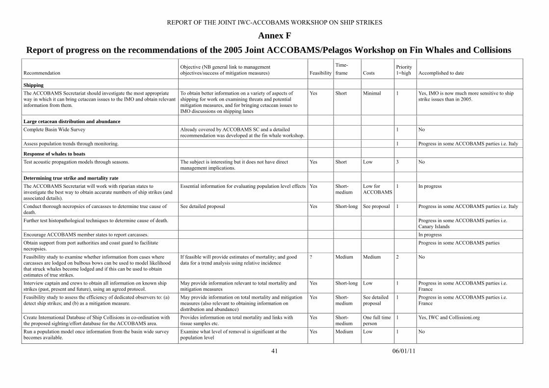
REPORT OF THE JOINT IWC-ACCOBAMS WORKSHOP ON SHIP STRIKES
41 06/01/11
Annex F Report of progress on the recommendations of the 2005 Joint ACCOBAMS/Pelagos Workshop on Fin Whales and Collisions
Recommendation Objective (NB general link to management objectives/success of mitigation measures) Feasibility
Time- frame Costs
Priority 1=high Accomplished to date
Shipping The ACCOBAMS Secretariat should investigate the most appropriate way in which it can bring cetacean issues to the IMO and obtain relevant information from them.
To obtain better information on a variety of aspects of shipping for work on examining threats and potential mitigation measures, and for bringing cetacean issues to IMO discussions on shipping lanes
Yes Short Minimal 1 Yes, IMO is now much more sensitive to ship strike issues than in 2005.
Large cetacean distribution and abundance Complete Basin Wide Survey Already covered by ACCOBAMS SC and a detailed
recommendation was developed at the fin whale workshop. 1 No
Assess population trends through monitoring. 1 Progress in some ACCOBAMS parties i.e. Italy
Response of whales to boats Test acoustic propagation models through seasons. The subject is interesting but it does not have direct
management implications. Yes Short Low 3 No
Determining true strike and mortality rate The ACCOBAMS Secretariat will work with riparian states to investigate the best way to obtain accurate numbers of ship strikes (and associated details).
Essential information for evaluating population level effects Yes Short-medium
Low for ACCOBAMS
1 In progress
Conduct thorough necropsies of carcasses to determine true cause of death.
See detailed proposal Yes Short-long See proposal 1 Progress in some ACCOBAMS parties i.e. Italy
Further test histopathological techniques to determine cause of death. Progress in some ACCOBAMS parties i.e. Canary Islands
Encourage ACCOBAMS member states to report carcasses. In progress Obtain support from port authorities and coast guard to facilitate necropsies.
Progress in some ACCOBAMS parties
Feasibility study to examine whether information from cases where carcasses are lodged on bulbous bows can be used to model likelihood that struck whales become lodged and if this can be used to obtain estimates of true strikes.
If feasible will provide estimates of mortality; and good data for a trend analysis using relative incidence
? Medium Medium 2 No
Interview captain and crews to obtain all information on known ship strikes (past, present and future), using an agreed protocol.
May provide information relevant to total mortality and mitigation measures
Yes Short-long Low 1 Progress in some ACCOBAMS parties i.e. France
Feasibility study to assess the efficiency of dedicated observers to: (a) detect ship strikes; and (b) as a mitigation measure.
May provide information on total mortality and mitigation measures (also relevant to obtaining information on distribution and abundance)
Yes Short-medium
See detailed proposal
1 Progress in some ACCOBAMS parties i.e. France
Create International Database of Ship Collisions in co-ordination with the proposed sighting/effort database for the ACCOBAMS area.
Provides information on total mortality and links with tissue samples etc.
Yes Short-medium
One full time person
1 Yes, IWC and Collissioni.org
Run a population model once information from the basin wide survey becomes available.
Examine what level of removal is significant at the population level
Yes Medium Low 1 No
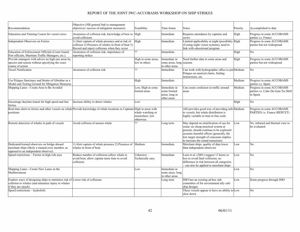
REPORT OF THE JOINT IWC-ACCOBAMS WORKSHOP ON SHIP STRIKES
Recommendation Objective (NB general link to management objectives/ success of mitigation measures) Feasibility Time-frame Notes Priority Accomplished to date
Education and Training Course for vessel crews Awareness of collision risk, knowledge of how to avoid collisions
High Immediate Requires attendance by captains and crews
High Progress in some ACCOBAMS parties i.e. France
Independent Observers on Ferries 1) Alert captain of whale presence and at risk of collision 2) Presence of whales in front of boat 3) Record and report collisions when they occur
High Immediate Limited applicability at night (possibility of using night vision systems), need to link with educational program
High Progress in some ACCOBAMS parties but not widespread
Education of Enforcement Officials (Coast Guard, Port officials, Maritime Traffic Managers, etc.).
Awareness of collision risk, importance of reporting strikes
?? Immediate High No
Provide managers with advice on high-use areas by species and season without specifying the exact course of action
High in some areas, low in others
Immediate in some areas, long in other areas
Need further data in some areas and seasons
High Progress in some ACCOBAMS parties but not widespread
Vessel Notification Awareness of collision risk ?? Immediate Can work with hydrographic office to put Pelagos on nautical charts, Sailing instructions, etc.
Medium No
Use Pelagos Sanctuary and Straits of Gibraltar as a Model and Testing Ground for Mitigation Measures
High Immediate Medium Progress in some ACCOBAMS parties i.e. Spain
Shipping Lanes - Create Area to Be Avoided Low, High in some limited areas
Immediate in some limited areas, long in other areas
Can create confusion in traffic around areas
Medium Progress in some ACCOBAMS parties i.e. Cabo De Gata Tss Shift in Spain
Encourage daytime transit for high speed and fast ferries
Increase ability to detect whales Low High No
Real time alerts to ferries and other vessels on whale positions
Provide knowledge of whale locations to Captains High in areas with whale watching or researchers, low otherwise
AIS provides good way of providing info to vessels, but whale distribution is highly variable in time in fine scale
Medium Progress in some ACCOBAMS PARTIES i.e. France (REPCET)
Remote detection of whales in path of vessels Avoid collision of unseen whale ?? Long term May depend on stratification of sea for sonar; no cheap practical system at present; should continue to be explored+ acoustic harmful effects (generally, the low target strength of cetaceans implies to increase the sound emissions).
Low No, infrared and thermal view to be evaluated
Dedicated/trained observers on bridge aboard merchant ships (likely a trained crew member, as opposed to an independent observer).
1) Alert captain of whale presence 2) Presence of whales in front of boat
Medium Immediate Merchant ships, quality of data lower than independent observers
Low No
Speed restrictions – Ferries in high risk area Reduce number of collisions (allow whale to avoid boat, allow captain more time to avoid collision)
Unknown – Technically easy
Immediate Laist et al. (2001) suggest 13 knots or less to avoid fatal collisions; no difference in risk between all categories – can also be applied to merchant ships
Low No
Shipping Lanes - Create New Lanes in the Mediterranean
Low Immediate in some areas, long in other areas
Low No
Explore ways of designing ships to minimize risk of collision to whales (and minimize injury to whales if they are struck)
Lower risk of collisions Long term IMO has an existing ad hoc sub-committee of for environment ally safe ship designs
Low Some progress through IMO
Speed restrictions – hydrofoils These vessels appear to have no ability to slow down
Low No
42 06/01/11
Related Documents