UNITED NATIONS E/CONF.102/CRP.6 ECONOMIC AND SOCIAL COUNCIL Nineteenth United Nations Regional Cartographic Conference for Asia and the Pacific Bangkok, 29 October – 1 November 2012 Item 6(a) of the provisional agenda Conference papers: country reports Report of Thailand on Cartographic and Geographical Information System Activities* _________________ * Prepared by Thailand

Welcome message from author
This document is posted to help you gain knowledge. Please leave a comment to let me know what you think about it! Share it to your friends and learn new things together.
Transcript

UNITED NATIONS E/CONF.102/CRP.6
ECONOMIC AND SOCIAL COUNCIL
Nineteenth United Nations Regional Cartographic Conference for Asia and the Pacific Bangkok, 29 October – 1 November 2012 Item 6(a) of the provisional agenda Conference papers: country reports
Report of Thailand on Cartographic and
Geographical Information System Activities*
_________________ * Prepared by Thailand

Report of Thailand on Cartographic and Geographical Information System Activities
Submitted by Thailand

1
Report of Thailand on Cartographic and Geographical Information System Activities during the period of 2010 - 2012
The Country report of Thailand presented in brief on the cartographic and GIS activities during the reporting period from 20107 - 2012 was prepared by the Royal Thai Survey Department and Geo-Informatics and Space Technology Development Agency.
1. The Royal Thai Survey Department (RTSD) RTSD is the national mapping agency under the Royal Thai Armed Forces Headquarters, Ministry of Defense who is responsible for surveying and producing topographic maps of Thailand for the purposes of national security and country management and development. The activities performed during 2010 - 2012 are as follows:-
1.1 Topographic maps in Thailand Topographic maps in Thailand were initiated in the reign of King Rama the 5th. In 1868, topographic maps covering border area on the west of Thailand were carried out for the purpose of boundary demarcation between Thailand and Burma. Collaboration with western countries, maps covering Bangkok and Thonburi were produced. During 1875, with farsighted thought in country development, King Rama the 5th established Topographic Department serving road construction in Bangkok and set up telecommunication network from Bangkok to Pratabong city. Besides, during this period of time, maps covering Thai gulf were produced serving marine navigation use.
In 1881, Mr.Mcarthy from the United Kingdom was appointed as director of Rotal Thai Survey Department (RTSD), previously known as Topographic Department, and started conducting Triangulation survey in Thailand. In addition, the Triangulation network was extended to our neighboring countries like Laos and Cambodia, and as result topographic maps, scale 1:2,000,000 covering network were produced. Also, maps with scale 1:100,000 over central area of Thailand were completed
During 1901 to 1971, applying new mapping technology, various map series have been produced which the important among them are : cadastral maps, hydrographic maps, L7017 maps and thematic maps. To comply with new mapping applications, new datum, WGS84, has been used in a new L7018 map series, scale 1:50,000 covering entire country

2
Subsequently, In 2008, map series 1501, scale 1:250,000 covering the whole country was completely produced.
At Present, RTSD continues updating both L7018 and 1501 map series in according with fiscal plan as the Second Edition of L7018 (830 sheets) and 1501 (54 sheets) be completed in 2012. These two map series are considered base maps of the country which RTSD, as a custodian, has to keep current geographic details within every five years. The topographic map features separate into 11 layers consist of the following.
Layer 01 : Industry consists of Mine, Industrial factory, Power plant, Oil well
Layer 02 : Culture consists of Stadiam, Building, (Dense) community, Tomb, Church, Hospital, Lighthouse, Monument, School, Railway station, Tank, Zoo, Ruins, Health station, Mosque, High-Tension power line, Wind-sock, Sanitation, Monastery, Temple, Chinese shrine, Stupa, Pagoda, Admin Office
Layer 03 : Transportation consists of Road, Bridge, Track, Trail, Railroad, Route marker, Tunnel
Layer 04 : Hydrography Drainage consists of Water pipe, dam, Open water, Coral line, Canal, Ditch, Lake, Port, Islet, Reservoir Salt farm, Sea shore, Spring, Water fall, Water course, Stream, Well, Land subject to inundation, Swamp, Aquaculture area
Layer 05 : Elevation consists of Contour interval, Deep interval, Number and Spot of elevation and Spot height.
Layer 06 : Physiography consists of Cave sign, Bluff, Cliff escarpment, Avenue (between hills), Sand and Gravel
Layer 07 : Vegetation consists of Grassland, Grass, Tree, Thick and Perferated forest, Agricultural area, Bracken, Bamboo, Cultivated land, Orchard land, Scrub, Mangrove and Nipa.
Layer 08 : Boundary consists of International border, First and Second order administrative boundaries.
Layer 09 : Aeronautical consists of Airport sign, Airport border, Heliport, Runway and Airbase.
3
Layer 12 : General consists of Vertical and Horizontal datum pin
Layer 14 : Margin consists of the detail in the bottom of map to describe all of things in the map.
The approach used for map update is through digital aerial photography and satellite images from SPOT5 and THEOS.
Future plan in photogrammetric and cartographic approach, RTSD is in progress of Light Distance and Ranging (LiDAR) cameras mounted on helicopters or fixed wing aircraft which has been changed the standard of topographic survey when it comes to collec topographic and geographical design information. This technology allows for proposed routes to be flown based on the assumed points of intersection with defined areas of coverage to
either side of the proposed centerline. From this flight, detailed Digital Terrain Models are developed in concert with survey grade accurate Aerial Orthophoto for the project design team to utilize throughout the engineering and constructability phases of a given project. And creating feature level database containing all geospatial information in diverse levels. This database is expected to use for conducting different map applications for instance GIS, map update, maps on demand and map services.
1.2 Thematic Map prepared by RTSD During the period of October to December 2011, Thailand had faced a severe flood disaster. Geographical information concerning the flood was demanded by both Thai government agencies and people. While Thai government agencies used the information for the analysis of the situation and planning for the mitigation, people in the flood-risk area needed to be prepared by follow the situation. In order to fulfill the demand, RTSD provided the information needed as much as it has to serve both. The information were disseminated on-line and off-line, to military and civilian agency, and published on RTSD website for Internet users. The access to RTSD website was at the highest record ever during the disaster. (see example in Figure 1) The Map Information Center at RTSD was set up as an operation center for the disaster.

4
Figure 1 : The result map on RTSD website.
Spatial and non-spatial data were assimilated from every available sources. Base geographical data sets included 1:50,000 and 1:250,000 topographic maps and digital terrain models of the Chao Phraya basin. (see example in Figure 2) Additional satellite images was supported from the Geo-Information and Space Technology and Development Agency (GISTDA). Other agency such as the Royal Irrigation Department has also provided information it had concerning the flood. The data were analyzed and cartographic products showing various aspects of the situation were made and distributed to users. (see example in Figure 3 and 4 )
Figure 2 : The result map of the Chao Phraya basin

5
Figure 3 : The result map by district
Figure 4 : The result map of stream flow on Bangkok Metropolitan Region
The flood disaster provided RTSD a real situation exercise in managing our resources to tackle the requirement for geographical data during crisis so that RTSD can properly handle any situation that may occur in the future.
1.3 2011 Fundamental Geographic Data Set (FGDS) Nowadays, 1:50,000 L7018 Topographic Line Maps are widely applied to various GIS applications. However, there are not suitable with user requirements because this data set just only graphic that does not have attribute to link with and not suitable format for transfer. RTSD concerned to this problem and set up L7018 reformat project for efficiently support GIS application by collecting spatial database called “Feature Level
6
Database: FLDB”. FLDB is a US. geo-spatial intelligence Agency (NGA) spatial database structure with the following objectives such as seamless storage of vector and matrix data, management of hierarchical data, transaction control and access control, and versioning of the data.. It uses Feature Attribute Coding Catalog (FACC+), Digital Geographic Information Exchange Standard (DIGEST) developed by the Digital Geographic Information Working Group (DGIWG), to coding the geographic feature in GIS database. The process of this data development including: convert L7018 Digital Line Map to temporary database, manipulate data for GIS analysis, edit data structure, input attribute from field survey, data validation, and import to spatial database.
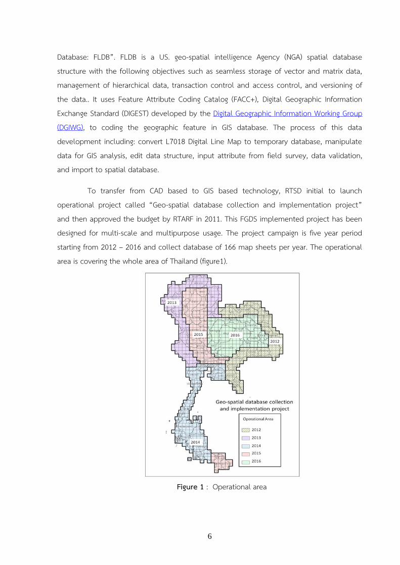
To transfer from CAD based to GIS based technology, RTSD initial to launch operational project called “Geo-spatial database collection and implementation project” and then approved the budget by RTARF in 2011. This FGDS implemented project has been designed for multi-scale and multipurpose usage. The project campaign is five year period starting from 2012 – 2016 and collect database of 166 map sheets per year. The operational area is covering the whole area of Thailand (figure1).
Figure 1 : Operational area
7
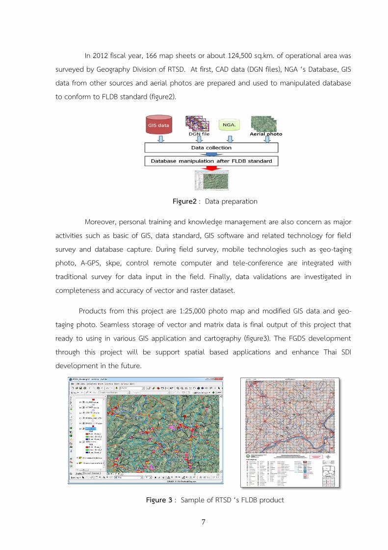
In 2012 fiscal year, 166 map sheets or about 124,500 sq.km. of operational area was surveyed by Geography Division of RTSD. At first, CAD data (DGN files), NGA ‘s Database, GIS data from other sources and aerial photos are prepared and used to manipulated database to conform to FLDB standard (figure2).
Figure2 : Data preparation
Moreover, personal training and knowledge management are also concern as major activities such as basic of GIS, data standard, GIS software and related technology for field survey and database capture. During field survey, mobile technologies such as geo-taging photo, A-GPS, skpe, control remote computer and tele-conference are integrated with traditional survey for data input in the field. Finally, data validations are investigated in completeness and accuracy of vector and raster dataset.
Products from this project are 1:25,000 photo map and modified GIS data and geo-taging photo. Seamless storage of vector and matrix data is final output of this project that ready to using in various GIS application and cartography (figure3). The FGDS development through this project will be support spatial based applications and enhance Thai SDI development in the future.
Figure 3 : Sample of RTSD ‘s FLDB product

8
1.4 Geodesy and Geophysics Work RTSD also engaged in the field of Geodesy and Geophysics of which various activities were conducted during the period under review, 2010-2012. They are as follows :
1.4.1. Geodesy 1.4.1.1 Horizontal Control Network The Royal Thai Survey Department ( RTSD) through Geodesy and Geophysics Division is responsible for the establishment of Geodetic Network in Thailand using the Global Positioning System(GPS). The GPS observation has been performed since 1991 and its networks are continuously developed up until 2002. Now, the GPS network has been re-adjusted connectively with International Terrestrial Reference Frame 2000(ITRF2000). So RTSD has about 700 GPS stations as shown in Figure 1 Figure 1 : GPS Control Network in 2002
9
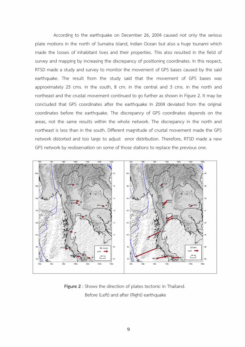
According to the earthquake on December 26, 2004 caused not only the serious plate motions in the north of Sumatra Island, Indian Ocean but also a huge tsunami which made the losses of inhabitant lives and their properties. This also resulted in the field of survey and mapping by increasing the discrepancy of positioning coordinates. In this respect, RTSD made a study and survey to monitor the movement of GPS bases caused by the said earthquake. The result from the study said that the movement of GPS bases was approximately 25 cms. in the south, 8 cm. in the central and 3 cms. in the north and northeast and the crustal movement continued to go further as shown in Figure 2. It may be concluded that GPS coordinates after the earthquake In 2004 deviated from the original coordinates before the earthquake. The discrepancy of GPS coordinates depends on the areas, not the same results within the whole network. The discrepancy in the north and northeast is less than in the south. Different magnitude of crustal movement made the GPS network distorted and too large to adjust error distribution. Therefore, RTSD made a new GPS network by reobservation on some of those stations to replace the previous one.
Figure 2 : Shows the direction of plates tectonic in Thailand.
Before (Left) and after (Right) earthquake

10
The new GPS network had been conducted since 2005 and completed in 2007, After that, extensive modifications to the network were simultaneously carried out in order to make the network acquiring high accuracy and reliability in accordance with the international standards based on the principle of control system and FGCC (Federal Geodetic Control Committee), Standard of the United States. Forms and operational procedures as follows :
1) Reference Network, Reference Network which is classified as a Class A by FGCC has 8 stations, GPS 3427 (Chonburi), GPS 3657 (Phuket) GPS 3217 (Lampang) GPS 3001 (Uthai) GPS 3052 (Sisaket) GPS 3315 (Chumphon) and GPS 3671 (Pattani), and GPS Base Station or GPS 3166 (Bangkok). Observed data from the said stations were sent to DEOS (Delft University of the Netherlands) for data processing by using GIPSY software . The reference coordinates coming out from the said processing are in ITRF2000 datum (epoch 2005.7) as shown on Figure 3. GPS stations on Reference Network are observed repeatedly for seven days period every year to monitor crystal movement.
Figure 3 : Reference Network

11
2) Primary Network, Primary Network which was coming out from the extension of Reference Network consists of 11 stations to cover the whole country of Thailand. They are GPS 3656 GPS 3658 GPS 3239 GPS 3109 GPS 3093 GPS 3084 GPS 3159 GPS3659 GPS 3660 GPS 3300 and GPS 3335. Most of the aforesaid stations were established before the earthquake in 2004. Some of them were newly set up because the previous stations were destroyed and out of proper positions. Each station in the Primary Network was set up at the spacing of about 200-250 kms. Observation period lasts 12 hours. Data from the observation were then processed with Trimble Geomatics Office Software. Coordinates from the said observation are classified as class B of FGCC standard with the loop closure not exceeding of 1 ppm. For the adjusted observation, reference network was tied to primary network (11 stations) amounting to 19 stations as shown in Figure 4
Figure 4 : Primary Network

12
3) Secondary Network, Secondary Network is designed network after earthquake in 2004. This network consists of 94 stations (including Reference Network and Primary Network) which was 700 stations less than the old network. Most stations in this network selected from the original stations which were on good condition and proper positions and the rest stations were the stations from other government agencies. Each station has it spacing of 50-100 kms. with observation period of 6 hours. Data from the observation were then processed with Trimble Geomatics Office Software. Coordinates from the said observation are classified as class B of FGCC standard with loop closure not exceeding 1.0 ppm. Reference Network and Primary Network were tied for the adjusted observation as shown in Figure 5
The result of survey which simultaneously tracked the plates tectonic after the earthquake in 2004 said that the accumulation of plate movement in Phukhet Province, as of November 2008, was 66.4 cms., 20.7 cms. In the central, 8.1 cms. in the north as shown in Table 1 and Figure 6. Having considered only a portion of plate tectonic, it was found that the volume of plate tectonic after the earthquake was 2.6 times of the one during the earthquake.
Figure 5 : Secondary Network

13
Table 1 shows the ratio of the as cumulative magnitude of the movement and motion during earthquakes.
Area
Magnitude movement during the earthquake
(cm.)
Accumulative Magnitude of the
Movement up Until November 2008.
(cm.)
Ratio of accumulative magnitude of
movement to the movement about the earthquake. (times)
North 3 8.1 2.7 Central. 8 20.7 2.6 South 28 66.4 2.4
MEAN 2.6 Accumulative magnitude of movement caused by the earthquakes in Sumatra-Andaman and Nias earthquake before and after the earthquake can be calculated from the following formula :
Disp = Pos(t) – Pos(t ref) – (t-tref)*Vel Then Disp = Formation of the movement Pos(t) = The coordinates at time of consideration Pos(t ref) = Coordinates the time reference Vel = Speed of movement. A large portion of the continental crust

14
Figure 6 : Pictures the movement of the stations flat accumulated evidence in the underlying network Since the earthquake of Sumatra - Andaman and Nias up to November 2008
Current geodetic network in Thailand has been operated after the earthquake in accordance with ITRF2000 epoch 2005.7. The impact of plate tectonic at post seismic which has been still active causes geodetic network of Thailand distorted. Magnitude of distortion which occurred at post seismic is bigger than the one occurred during seismic as shown in Table 2
Table 2 shows the magnitude of plate movement caused by the earthquake.
Area Magnitude of Plate
Movement during an earthquake.
Magnitude of plate Movement after the
earthquake
Accumulative Magnitude of Plate
Movement North 3 5.1 8.1 Central 8 12.7 20.7 South 28 38.8 66.4 * As of November 2008 : Unit in cm.

15
According to the comparison between the coordinates from the Reference Network and Primary Network at the time of 2005.7 and the coordinates at the time of 2008.11 based on ITRF2000, it was found that stations were distorted due to the impact from the earthquake together with the plate tectonic as shown in Figure 7
Although the national network was readjusted in order to meet high accuracy, the network is still distorted due to the impact of post seismic. Magnitude of post seismic movement at the present is bigger than the one at coseismic. The impact of post seismic still remains so RTSD continue to monitor closely to the said movement.
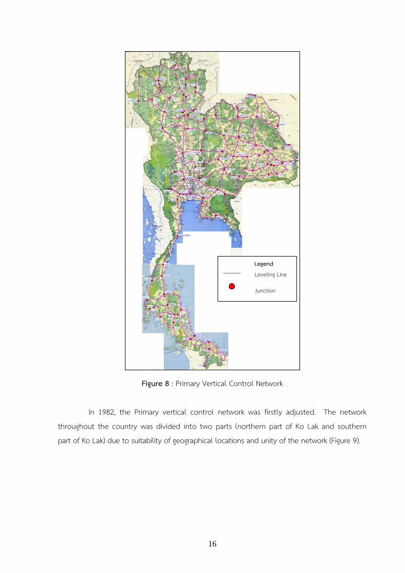
1.4.1.2 Vertical Control Network RTSD has set up vertical control network since 1912 using mean sea level at Ko Lak , Prachaup Kirikhan province as a vertical reference point and using vertical point of BM. A with the height 1.4477 meters as a reference point in order to tie with the first order leveling as shown in Figure 8
Figure 7 : shows horizontal movement on Primary Network from the Period at 2005.7 to 2008.11
16
Figure 8 : Primary Vertical Control Network In 1982, the Primary vertical control network was firstly adjusted. The network throughout the country was divided into two parts (northern part of Ko Lak and southern part of Ko Lak) due to suitability of geographical locations and unity of the network (Figure 9).
Legend Leveling Line
Junction Points

17
Figure 9 : Primary Vertical Control Network
(a) Northern part of Kolak (b) Southern part of Kolak
From 2010 to 2012, RTSD has increase density Primary Vertical Control Network in Central and Northeast of Thailand that has loop over 300 km. as shown on Figure 10
( a ) ( b )

18
Figure 10 : Operations in the past year 2010 - 2012

19
1.4.1.3 Leveling for Investigation of Land Subsidence in Bangkok The Royal Thai Survey Department has carried out the first order leveling in the Bangkok area and nearby vicinity covered the area about 7,000 square kilometers in order to assist the office of the National Environment Board in the investigation of land subsidence caused by the withdrawal of ground water. The Project has been initiated since 1978. Until 2010, 33 observations have been repeated over the same area. After using proper measures to control the withdrawal of ground water, it was found that the magnitude of land subsidence were significantly decreased. Figure 11 shows the accumulative magnitude of land subsidence between 1978 – 2009 (30 years), which the maximum magnitude up to 1.10 meter in Bangkapi district, Bangkok. Figure 12 shows the magnitude of land subsidence between 2010 – 2011 which the average magnitude about 2 centimeters.
Figure 11 : First order leveling for Investigation of land subsidence in Bangkok;
showing magnitude of land subsidence between 1978-2011
1978-2011

20
Figure 12 : First order leveling for Investigation of land subsidence in Bangkok; showing magnitude of land subsidence in 2011
21
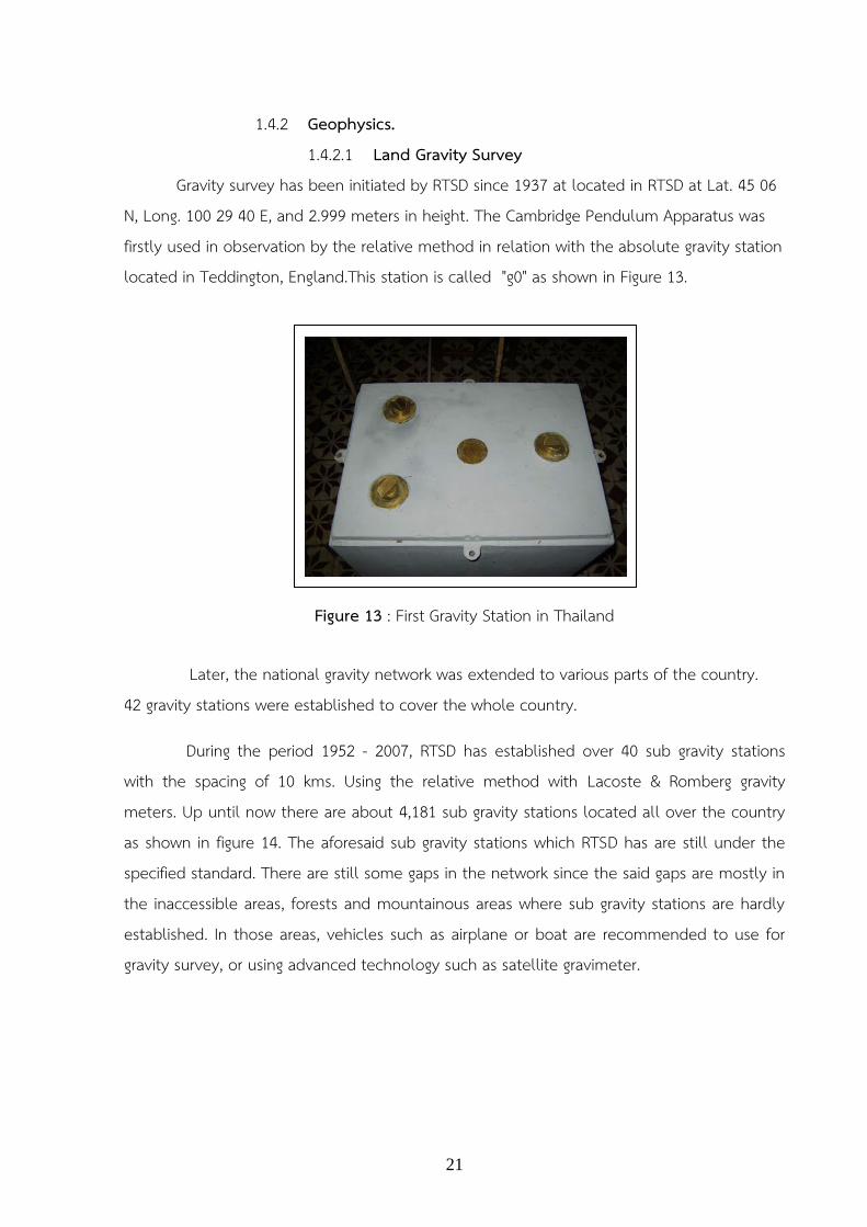
1.4.2 Geophysics. 1.4.2.1 Land Gravity Survey Gravity survey has been initiated by RTSD since 1937 at located in RTSD at Lat. 45 06 N, Long. 100 29 40 E, and 2.999 meters in height. The Cambridge Pendulum Apparatus was firstly used in observation by the relative method in relation with the absolute gravity station located in Teddington, England.This station is called "g0" as shown in Figure 13. Later, the national gravity network was extended to various parts of the country. 42 gravity stations were established to cover the whole country.
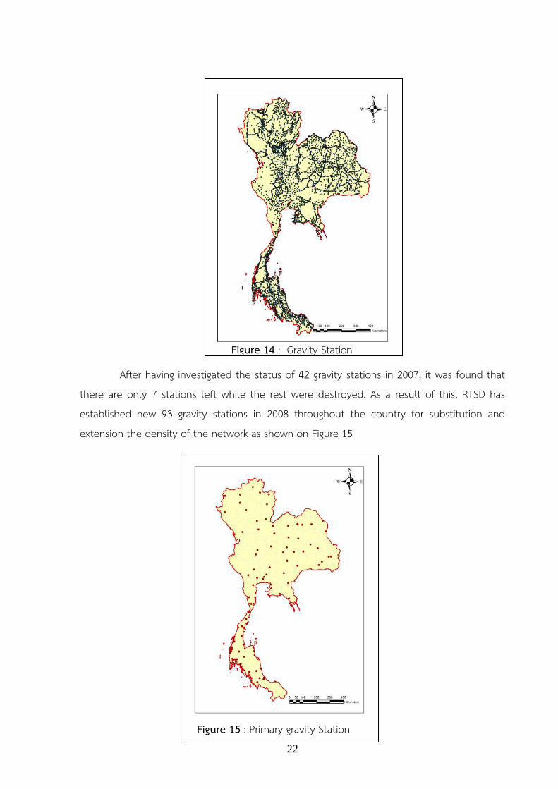
During the period 1952 - 2007, RTSD has established over 40 sub gravity stations with the spacing of 10 kms. Using the relative method with Lacoste & Romberg gravity meters. Up until now there are about 4,181 sub gravity stations located all over the country as shown in figure 14. The aforesaid sub gravity stations which RTSD has are still under the specified standard. There are still some gaps in the network since the said gaps are mostly in the inaccessible areas, forests and mountainous areas where sub gravity stations are hardly established. In those areas, vehicles such as airplane or boat are recommended to use for gravity survey, or using advanced technology such as satellite gravimeter.
Figure 13 : First Gravity Station in Thailand
22
After having investigated the status of 42 gravity stations in 2007, it was found that
there are only 7 stations left while the rest were destroyed. As a result of this, RTSD has established new 93 gravity stations in 2008 throughout the country for substitution and extension the density of the network as shown on Figure 15
Figure 14 : Gravity Station
Figure 15 : Primary gravity Station
23
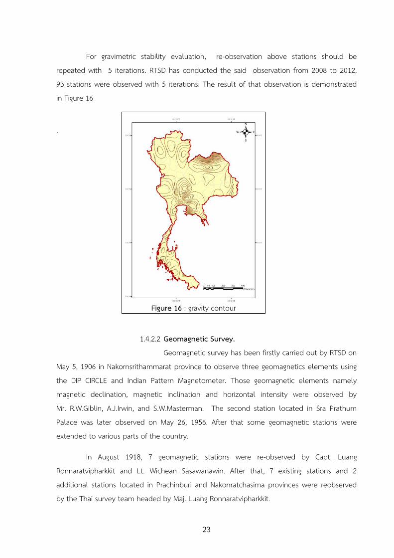
For gravimetric stability evaluation, re-observation above stations should be repeated with 5 iterations. RTSD has conducted the said observation from 2008 to 2012. 93 stations were observed with 5 iterations. The result of that observation is demonstrated in Figure 16
. 1.4.2.2 Geomagnetic Survey.
Geomagnetic survey has been firstly carried out by RTSD on May 5, 1906 in Nakornsrithammarat province to observe three geomagnetics elements using the DIP CIRCLE and Indian Pattern Magnetometer. Those geomagnetic elements namely magnetic declination, magnetic inclination and horizontal intensity were observed by Mr. R.W.Giblin, A.J.Irwin, and S.W.Masterman. The second station located in Sra Prathum Palace was later observed on May 26, 1956. After that some geomagnetic stations were extended to various parts of the country.
In August 1918, 7 geomagnetic stations were re-observed by Capt. Luang Ronnaratvipharkkit and Lt. Wichean Sasawanawin. After that, 7 existing stations and 2 additional stations located in Prachinburi and Nakonratchasima provinces were reobserved by the Thai survey team headed by Maj. Luang Ronnaratvipharkkit.
Figure 16 : gravity contour
24
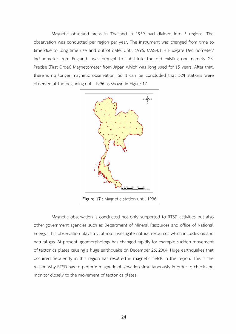
Magnetic observed areas in Thailand in 1959 had divided into 5 regions. The observation was conducted per region per year. The instrument was changed from time to time due to long time use and out of date. Until 1996, MAG-01 H Fluxgate Declinometer/ Inclinometer from England was brought to substitute the old existing one namely GSI Precise (First Order) Magnetometer from Japan which was long used for 15 years. After that, there is no longer magnetic observation. So it can be concluded that 324 stations were observed at the beginning until 1996 as shown in Figure 17. Magnetic observation is conducted not only supported to RTSD activities but also other government agencies such as Department of Mineral Resources and office of National Energy. This observation plays a vital role investigate natural resources which includes oil and natural gas. At present, geomorphology has changed rapidly for example sudden movement of tectonics plates causing a huge earthquake on December 26, 2004. Huge earthquakes that occurred frequently in this region has resulted in magnetic fields in this region. This is the reason why RTSD has to perform magnetic observation simultaneously in order to check and monitor closely to the movement of tectonics plates.
Figure 17 : Magnetic station until 1996
25
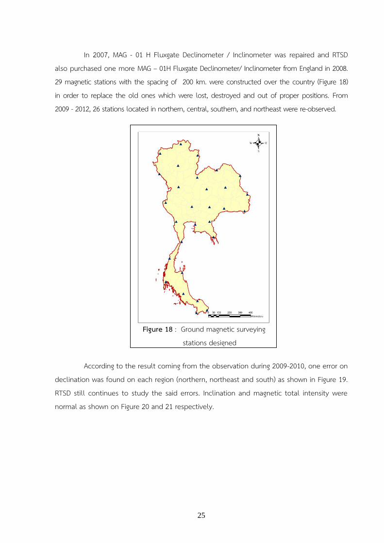
In 2007, MAG - 01 H Fluxgate Declinometer / Inclinometer was repaired and RTSD also purchased one more MAG – 01H Fluxgate Declinometer/ Inclinometer from England in 2008. 29 magnetic stations with the spacing of 200 km. were constructed over the country (Figure 18) in order to replace the old ones which were lost, destroyed and out of proper positions. From 2009 - 2012, 26 stations located in northern, central, southern, and northeast were re-observed. According to the result coming from the observation during 2009-2010, one error on declination was found on each region (northern, northeast and south) as shown in Figure 19. RTSD still continues to study the said errors. Inclination and magnetic total intensity were normal as shown on Figure 20 and 21 respectively.
Figure 18 : Ground magnetic surveying stations designed

26
Figure 19 : Shows Isogonal Line of surveyed results. Survey from 2010 to 2012 (Mumbeaiebn the Regiment)
Figure 20 : Shows Isoclinal Line of surveyed results. Survey from 2010 to 2012 (Mumbeaiebn way down).
Figure 21 : Chart of Total Intensity of surveyed results from 2010 to 2012. (Density, magnetic field)
27
1.4.3 Joint research projects. Geodetic Earth Observation Technologies for Thailand: Environ- mental Change Detection and Investigation (GEO2TECDI) is a joint research project between Thailand and Europe under the Thailand-EC Cooperation. This Project aims to enhance skills and joint research capabilities of Thai researchers in applying and exploiting three space geodetic techniques namely Global Navigation Satellite System (GNSS) Interferometric Synthetic Aperture Radar (InSAR) and Satellite Altimetry (SALT) for the detection, monitoring and modeling of land surface motion and deformation due to tectonic processes, land subsidence and sea level change. Thai researchers consist of staffs from Chulalongkorn University, Royal Thai Survey Department, Royal Thai Naval Academy, Hydrographic Department and Geo-Informatics and Space Technology Development Agency while the EU side consists of staffs from University of Delft, the Netherlands, Institute of Ecole Normale Superieure, France, and the University of Darmstadt, Germany.
1.4.4 Conclusion Geodesy and Geophysics activities of RTSD in the latest 3 years (2010-2012) have focused and participated in the high accuracy survey work whether it is horizontal or vertical surveying, in order to monitor the situation of the earth which is being changed over the years. The disasters caused be earthquaked and the movement of tectonic plates will results directly to the reference coordinates on the map. The results of the GPS measurements have been conducted to improve the control network to be more accurate and reliable.
In the future, RTSD will continue to focus on participating in scientific research and educational institutions to track the threat posed by the global environment. Moreover, RTSD will support the establishment of permanent stations or GPS base station project covering the entire country to monitor the movement of tectonic plates in this region more accurate and reliable, also prepared to cope with other natural disasters that may occur in the future. Prepared by The Royal Thai Survey Department

28
2. The Hydrographic Department, Royal Thai Navy
2.1 Hydrographic Office / Service Established in 1921, Hydrographic Department, Royal Thai Navy or “HDRTN” is a Thailand national hydrographic office whose mission is to carry out the function of organization covering hydrographic and oceanographic surveys, tidal prediction, aids to navigation maintenance, marine environment, nautical charts and publications,
standard time keeping, marine meteorological forecasting and other activities for safety of navigation to support both public and military need in the Gulf of Thailand and the Andaman Sea. The present Director General is Vice Admiral Kittituch Virojvong, who has held this position since 1st October 2012 up until now.
The Organizational Structure of HDRTN
2.2 Surveys 2.2.1 Hydrographic Survey Activities HDRTN conducted 16 hydrographic surveys during the past 3 years (2010-2012). It also simultaneously performed significant role in survey of boundary river for future demarcation among neighboring countries. The results of such hydrographic surveys were utilized for production of nautical charts and other charts required by Royal Thai Navy and maritime community.
29
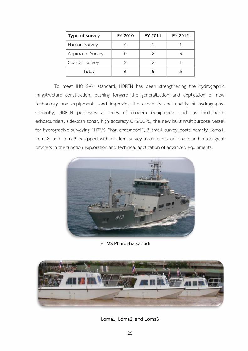
Type of survey FY 2010 FY 2011 FY 2012 Harbor Survey 4 1 1 Approach Survey 0 2 3 Coastal Survey 2 2 1 Total 6 5 5
To meet IHO S-44 standard, HDRTN has been strengthening the hydrographic infrastructure construction, pushing forward the generalization and application of new technology and equipments, and improving the capability and quality of hydrography. Currently, HDRTN possesses a series of modern equipments such as multi-beam echosounders, side-scan sonar, high accuracy GPS/DGPS, the new built multipurpose vessel for hydrographic surveying “HTMS Pharuehatsabodi”, 3 small survey boats namely Loma1, Loma2, and Loma3 equipped with modern survey instruments on board and make great progress in the function exploration and technical application of advanced equipments.
HTMS Pharuehatsabodi
Loma1, Loma2, and Loma3

30
2.3 New Charts and Updates The production of nautical charts and Electronic Navigation Charts (ENCs) are progressing well with the improvement of modern software and hardware capabilities. The results of those mentioned surveys during 2010-2012 were then implemented to produce Thai nautical charts and other related charts in Thai waters. Nautical charts produced in 2010-2012 are shown as below:
Type of Production FY 2010 FY 2011 FY 2012
New Chart - 1 2 New Publication 2 1 3 New Edition 2 3 5 Re-Print 5 2 - Total 9 7 10
2.3.1 Paper Charts - HDRTN has produced totally 78 paper charts (large, medium, small scales) covering Thai waters. The followings are the charts produced during 2010-2012.
2.3.1.1 Produced 3 New Chart - No.265, Ko Tao, scale 1:12,000, WGS84 - No. 273 Ang Thong Islands, scale 1:12,000, WGS84 - No. 374 Entrance to Ranong Port, scale 1:12,000, WGS84
2.3.1.2 Produced 6 New Publication Chart - No.112A , Pak Maenam Chao Phraya, scale 1:22,000, WGS84 - No.333, Ao Phang- Nga, scale 1:45,000, WGS84 - No.260, Prochuap Harbour, scale 1:12,000, WGS84 - No. 147A, Ao Phattaya, scale 1:12,000, WGS84 - No. 226, Lang Suan and Approaches,scale 1:30,000 Indian datum 1975 - No. 340, Entrance to Krabi, scale 1: 45,000,WGS 84
31
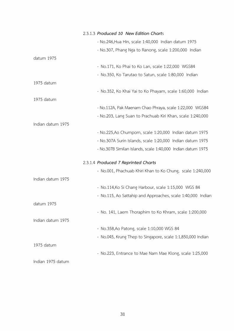
2.3.1.3 Produced 10 New Edition Charts - No.246,Hua Hin, scale 1:40,000 Indian datum 1975 - No.307, Phang Nga to Ranong, scale 1:200,000 Indian datum 1975 - No.171, Ko Phai to Ko Lan, scale 1:22,000 WGS84 - No.350, Ko Tarutao to Satun, scale 1:80,000 Indian 1975 datum - No.352, Ko Khai Yai to Ko Phayam, scale 1:60,000 Indian 1975 datum - No.112A, Pak Maenam Chao Phraya, scale 1:22,000 WGS84 - No.203, Lang Suan to Prachuab Kiri Khan, scale 1:240,000 Indian datum 1975 - No.225,Ao Chumporn, scale 1:20,000 Indian datum 1975 - No.307A Surin Islands, scale 1:20,000 Indian datum 1975 - No.307B Similan Islands, scale 1:40,000 Indian datum 1975
2.3.1.4 Produced 7 Reprinted Charts - No.001, Phachuab Khiri Khan to Ko Chung, scale 1:240,000 Indian datum 1975 - No.114,Ko Si Chang Harbour, scale 1:15,000 WGS 84 - No.115, Ao Sattahip and Approaches, scale 1:40,000 Indian datum 1975 - No. 141, Laem Thoraphim to Ko Khram, scale 1:200,000 Indian datum 1975 - No.358,Ao Patong, scale 1:10,000 WGS 84 - No.045, Krung Thep to Singapore, scale 1:1,850,000 Indian 1975 datum - No.223, Entrance to Mae Nam Mae Klong, scale 1:25,000 Indian 1975 datum

32
2.3.2 Electronic Navigation Chart (ENC) HDRTN has produced 78 paper charts (large, medium, small scales) covering Thai waters. For ENCs, it has plan to produced only 44 cells covering 11 Thailand main shipping routes starting from 2006 to 2012 as the first priority in order to support IMO ECDIS carriage mandatory by 2012. Such main shipping routes have currently covered by 37 cells in different bands (approx.84%) and the remaining 7 cells, mostly large scales, needed to re-survey due to out of date data and non WGS 84 framework. However, as mentioned earlier, all Thailand main shipping routes to major ports are expected to be fully covered by ENCs in the year 2012.

33
2.4 New Navigational Publications and Updating HDRTN has been producing and updating a number of publications, including
- INT 1 symbols, abbreviations, terms used on charts (translated into THAI) - List of Lights and Buoys in Thai Water 2012 - Tide table in Thai Water 2012
- Table of Moon Rise/Set book year 2012, Sun Rise/Set book year 2012, Sunrise-Sunset and Moonrise-Moonset Thailand 2012 - Notice to Mariners Reports in Thai and English 2012, Annual Summary of Notices to Mariners 2012, etc.

34
2.5 Mariners Safety Information HDRTN issued 451 notices to mariners (169 NMs in 2010,181 NMs in 2011 and 101 NMs until september 2012) both in Thai and English Languages. They were distributed through the Navy Radio stations run by Royal Thai Navy and Bangkok Radio coast stations run by CAT Telecom (Public) Co,Ltd. Notices to Mariners and marine weather forecast were issued by such two organizations but the latter one provides 4 coastal stations to additionally service tele-communication between ship to shore and among ships via VHF, MF and HF bands. Such information is mostly concerned with nautical charts update, safety of navigation, maritime distress monitoring, natural disaster warning and other information necessary to mariners.
2.6 C-55 2.6.1 Status of Hydrographic survey of all navigable waters, including internal waters, out of the limits of the EEZ.
Survey coverage, where: A = percentage which is adequately surveyed. B = percentage which requires re-survey at larger scale or to modern standards. C = percentage which has never been systematically surveyed.
A B C Depth < 200 m 100 38 0 Depth > 200 m 15 89 85
35
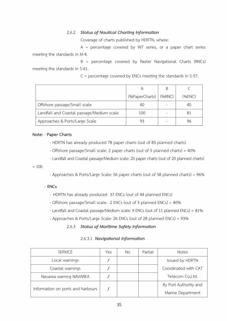
2.6.2 Status of Nautical Charting Information
Coverage of charts published by HDRTN, where: A = percentage covered by INT series, or a paper chart series meeting the standards in M-4. B = percentage covered by Raster Navigational Charts (RNCs) meeting the standards in S-61. C = percentage covered by ENCs meeting the standards in S-57.
A (%PaperCharts)
B (%RNC)
C (%ENC)
Offshore passage/Small scale 40 - 40 Landfall and Coastal passage/Medium scale 100 - 81 Approaches & Ports/Large Scale 93 - 96
Note: - Paper Charts - HDRTN has already produced 78 paper charts (out of 83 planned charts) - Offshore passage/Small scale: 2 paper charts (out of 5 planned charts) = 40% - Landfall and Coastal passage/Medium scale: 20 paper charts (out of 20 planned charts) = 100 - Approaches & Ports/Large Scale: 56 paper charts (out of 58 planned charts) = 96%
- ENCs - HDRTN has already produced 37 ENCs (out of 44 planned ENCs) - Offshore passage/Small scale: 2 ENCs (out of 5 planned ENCs) = 40% - Landfall and Coastal passage/Medium scale: 9 ENCs (out of 11 planned ENCs) = 81% - Approaches & Ports/Large Scale: 26 ENCs (out of 28 planned ENCs) = 93% 2.6.3 Status of Maritime Safety Information
2.6.3.1 Navigational Information
SERVICE Yes No Partial Notes Local warnings / Issued by HDRTN
Coordinated with CAT Telecom Co,Ltd.
Coastal warnings / Navarea warning NAVAREA /
Information on ports and harbours / By Port Authority and Marine Department

36
2.6.3.2 GMDSS Implementation
SERVICE Yes No Partial Notes (run by) Master Plan /
Under proceeding by Marine Department
A1 Area1 / A2 Area2 / A3 Area3 / NAVTEX / CAT Telecom Co.Ltd.
Safety NET /
2.7 Capacity Building Program
In 2013
- Prepared to send 1 officer to attend H2 Hydrographic Survey course in Indonesia. - Prepared to send 1 officer to study in MSc. in Hydrographic science in USA/ Europe - Prepared to send personels to study in 25 specific courses organized by others agency and Mapping company in Thailand. - HDRTN will attend HSSC, IOC, ICA Meeting. - Planned to held 1 EAHC workshop in June/July 2013. - Visit UKHO
2.8 Oceanographic Activities
2.8.1 Tide Prediction The HDRTN provides tide table on 28 sites within Chao-Phraya River, Gulf of Thailand, Andaman Sea and part of Malacca strait. The tide prediction use raw data from HDRTN, Port Authority of Thailand, and Marine Department tide gauge networks.
2.8.2 Sea Level determination Providing sea level data to Permanent Service for Mean Sea Level and University of Hawaii Sea Level Center (UHSLC)
37
2.8.3 Tide gauge programme Two tide gauges have been upgraded along the Chao-Phraya River. The upgrade involves real-time capability and change sensor to acoustic/radar tide gauges. The similar modification for three tide gauges in Gulf of Thailand and other two in Andaman Sea will be carried on in this fiscal year.
2.9 Other Activities
2.9.1 Aids to Navigation Activities 2.9.1.1 Maintenance of Aids to Navigation along The Gulf of Thailand and Andaman sea including 9 lighthouses, 79 beacons, 6 leading lights, 75 buoys. 2.9.1.2 Installation of Automatic Identification System (AIS) into Aids to Navigation along the Gulf of Thailand and Andaman sea including 8 Base Stations, and 39 A to N station.
2.9.2 Marine Meteorological Activities In cooperation with meteorological authorities, HDRTN has established a couple of automatic weather stations along Thailand coast for the observation of air temperature, relative humidity, air pressure, wind, precipitation rainfall, and visibility. The action maximally realized the integration of resources and sharing of information, and serve directly to the mariners.
2.9.3 Standard Time Keeping Activity One of the task of HDRTN is standard time keeping for the nation with cesium clocks including national standard time, international time telling service and time transfer. All time transfers can be traced back to international time standard provided by Bureau International des Poids et Mesures (BIPM).
2.9.4 International Activities 2010 – 2012 HDRTN participated in the international activities from Oct. 2009- Sep. 2012 as follows:

38
2009 October 2009 - attended 10th East Asia Hydrographic Commission (EAHC) Conference,
Singapore - attended 1nd Hydrographic Service and Standard Committee (HSSC), Singapore - attended ECDIS Conference, Singapore
November 2009 - attended 24th Intergovernmental Oceanographic Committee (IOC) Session of the Assembly, Chile
2010 January 2010 - attended 3rd East Asia Hydrographic Commission (EAHC) ENC Task
Group Meeting and 4th EAHC Coordinating Meeting, Thailand February 2010 - attended 10th North Indian Ocean Hydrographic Commission (NIOHC)
Meeting, Bangladesh March 2010 - attended 17th International Association of Marine Aids to Navigation and Lighthouse Authorities (IALA) Meeting, South Africa
- attended 4th EAHC ENC Task Group Meeting and 1st EAHC CB Meeting, Hongkong
June 2010 - attended 8th Capacity Building Sub Committee (CBSC) Meeting and 2rd Inter-Regional Coordination Committee (IRCC) Meeting, United State July 2010 - 12 officers attended the Workshop on Database Design and Management, Thailand September 2010 - attended 1st Indonesia-Thailand ENC Harmonization Meeting, Indonesia October 2010 - attended 2nd Hydrographic Service and Standard Committee HSSC, Germany November 2010 - attended the EAHC Workshop on Technical Aspects of Maritime
Boundary, Baseline and the Extended Continental Shelf, Thailand - attended the EAHC Workshop on ENC Production and Quality Assurance Course, Vietnam - attended the Technical Visit Vietnam Maritime Safety Company, Vietnam

39
2011 January 2011 - attended 6th EAHC ENC Task Group Meeting and 5th EAHC Coordinating
Meeting, Indonesia February 2011 - attended 11th NIOHC Meeting, India April 2011 - attended 1st Ad Hoc Discussion Group (ADG) Meeting, Republic of Korea May 2011 - attended 9th CBSC Meeting and 3rd IRCC Meeting, Brazil June 2011 - attended 26th Intergovernmental Oceanographic Committee (IOC) Session of the Assembly, France
- attended ENC Harmonization Meeting, Malaysia and Indonesia - attended the EAHC Workshop on Database Design and Management, Thailand
July 2011 - attended 15th General Assembly of the International Cartographic Association and 25th International Cartographic Conference, France
- attended 7th EAHC ENC Task Group Meeting and 1st EAHC CB Meeting, Chaina - attended the EAHC Workshop on ENC Production and Quality Assurance, Indonesia
October 2011 - attended the EAHC Workshop on Multi-beam Survey and Side Scan Sonar , Singapore
November 2011 - attended 3nd Hydrographic Service and Standard Committee (HSSC), Germany
- attended the NIOHC Workshop on Port and Shallow Water Surveys, South Africa 2012 January 2012 - attended 8th EAHC ENC Task Group Meeting and 6th EAHC Coordinating Meeting, Okinawa Japan March 2012 - attended 12th NIOHC Meeting, Srilanka April 2012 - attended 18th International Hydrographic Conference, Monaco June 2012 - attended 10th CBSC Meeting and 4rd IRCC Meeting, Singapore
- attended the EAHC Workshop on Tides and Water Level for Hydrographic Survey, Thailand - attended the EAHC Workshop on Seabed Classification, Malaysia

40
July 2012 - attended 9th EAHC ENC Task Group Meeting, Republic of Korea September 2012 - attended 11th EAHC Conference, Thailand
- will attend 4nd HSSC Meeting, United Kingdom
2.10 Conclusion Since established in 1921, HDRTN has been engaged in carrying out hydrographic/oceanographic surveys and observations. The outcome of these surveys and observations have been made beneficially available to mariners, military, private sectors and governments to make both safer navigation and sustainable country development.
In recent years, HDRTN has contributed such a great effort to increase the safety of navigation, to prevent marine disasters and to protect marine environment through its activities and making full use of the forefront technology. It has an intention to promote cooperation with other hydrographic officers not only on a regional basis but also on a global level. Even though it sometimes, like the MSs, get difficult in budget constraints, HDRTN still will do its best to maintain its mission and responsibility and to meet the future challenge of the changing world.
Prepared by Captain Sirichai Noeythong Director of Technical Division Hydrographic Department, Royal Thai Navy
41
3. The Geo-Informatics and Space technology Development Agency (GISTDA) GISTDA is a public organization under the Ministry of Science and Technology, presented its activities during the period review. They are as follows:-
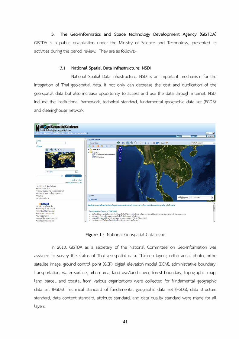
3.1 National Spatial Data Infrastructure: NSDI National Spatial Data Infrastructure: NSDI is an important mechanism for the
integration of Thai geo-spatial data. It not only can decrease the cost and duplication of the geo-spatial data but also increase opportunity to access and use the data through internet. NSDI include the institutional framework, technical standard, fundamental geographic data set (FGDS), and clearinghouse network.
Figure 1 : National Geospatial Catalogue
In 2010, GISTDA as a secretary of the National Committee on Geo-Information was assigned to survey the status of Thai geo-spatial data. Thirteen layers; ortho aerial photo, ortho satellite image, ground control point (GCP), digital elevation model (DEM), administrative boundary, transportation, water surface, urban area, land use/land cover, forest boundary, topographic map, land parcel, and coastal from various organizations were collected for fundamental geographic data set (FGDS). Technical standard of fundamental geographic data set (FGDS); data structure standard, data content standard, attribute standard, and data quality standard were made for all layers.

42
Ortho satellite image is an important data as based data of all layers in fundamental geographic data set (FGDS) was made by GISTDA. Ortho images from SPOT-5 satellite, 2.5 m of panchromatic image, 10 m of multispectral image, and 2.5 pansharpening image were produced at 1:25,000 scale cover Thailand (Figure 2).
Figure 2 : Ortho satellite image from of Thailand
3.2 Web Applications GISTDA apply the geo-informatics technology and develop to various web
map service for disaster monitoring, agricultural management, and etc.
3.2.1 Natural disaster monitoring. GISTDA provides natural disaster information such as disaster maps
and spatial damage assessment through web applications; Thailand flood monitoring system and Thailand fire monitoring system which were developed for natural disaster monitoring. Furthermore, GISTDA developed the storm route forecast and monitoring system that called “storm tracker”.

43
Figure 3 : Thailand flood monitoring system
Figure 4 : Thailand fire monitoring system

44
3.2.2 Online service for management. According to the Memorandum of Understanding between the Ministry of Interior and Ministry of Science and Technology, the well-being and quality of life of local Thai people have been proposed to be enhanced by science and technology. GISTDA as the main agency in geo-informatics and space technology has cooperated with provincial and local administration to develop online service geo-informatics platform: "GIS CHANGWAT".
It provided the geo-spatial database as base map on multi scale that was used by center government or local government. The GIS CHANGWAT online service will facilitate and enhance efficiency management in comprehensive, cost- effective and beneficial improvement for Thai people.
Figure 5 : GIS CHANGWAT
3.2.3 Agricultural management Agriculture is the important sector of Thai economy. However, agriculture of Thailand is still facing the issue of low income and low productivity. Advance cultivated technology, agronomic research and environmental impact are necessary to support the sustainable agricultural development in Thailand. Geo-informatics technology allows for obtaining those data. Therefore, GISTDA applied the geo-informatics technology to agricultural practice and to develop an agriculture web map service “GIS AGRO”

45
The “GIS AGRO” system will provide the agricultural information on five subsystems; crop monitoring system, pest and plant diseases monitoring system, agricultural technology transfer system, weather forecast system, and productivity estimation system.
Figure 6 : GIS AGRO
3.3 Other Thematic Maps During 2010-present, GISTDA has supported various thematic maps to the
government organizations and other organizations for natural disaster management, environmental and resources management, land use and land cover management, urban planning, agricultural management, and etc.

46
Figure 7 : Flooding map
Figure 8 : Longan map of Lampang province

47
Figure 9 : Land use map of Doi Tao District, Lampang provinc
Prepared by the Geo-Informatics and Space Technology Development Agency (Public Organization)
Related Documents