Agenda Item No: 9 Committee: Council Date: 8 September 2020 Report Title: COATES CONSERVATION AREA APPRAISAL 1 Purpose / Summary To inform Members that public consultation on the Coates Conservation Area Appraisal has been completed and seek approval from Council that these documents are adopted. 2 Key issues The Coates Conservation Area Appraisal have been prepared for the following purposes: 2.1 to satisfy Policy LP18 of the adopted Fenland Local Plan which states that "the Council will protect, conserve and seek opportunities to enhance the historic environment throughout Fenland and will look to achieve this by keeping up-to-date and implementing conservation area appraisals and management plans". 2.2 to satisfy S71(1) Planning (Listed Buildings and Conservation Areas) Act 1990 which places a duty on Local Planning Authorities to formulate and publish proposals for the preservation and enhancement of conservation areas. 2.3 to support the Whittlesey Neighbourhood Planning Team by providing an evidence base from which they can develop their neighbourhood plan. 2.4 in the case of the Coates Conservation Area Appraisal, to provide guidance that will be a material consideration in the determination of planning applications. 2.5 in the case of the Coates Conservation Area Appraisal, a management plan has been included to provide a framework of objectives for the Council to follow as proactive actions for preserving and enhancing the character and appearance of the Coates Conservation Area. 3 Recommendations To approve the Coates Conservation Area Appraisal and Management Plan. Wards Affected Benwick, Coates and Eastrea Ward Portfolio Holder(s) Cllr Chris Seaton - Social Mobility and Heritage Cllr Denise Laws - Neighbourhood Planning

Welcome message from author
This document is posted to help you gain knowledge. Please leave a comment to let me know what you think about it! Share it to your friends and learn new things together.
Transcript
Agenda Item No: 9
Committee: Council
Date: 8 September 2020
Report Title: COATES CONSERVATION AREA APPRAISAL
1 Purpose / Summary To inform Members that public consultation on the Coates Conservation Area Appraisal has been completed and seek approval from Council that these documents are adopted.
2 Key issues The Coates Conservation Area Appraisal have been prepared for the following purposes:
2.1 to satisfy Policy LP18 of the adopted Fenland Local Plan which states that "the Council will protect, conserve and seek opportunities to enhance the historic environment throughout Fenland and will look to achieve this by keeping up-to-date and implementing conservation area appraisals and management plans".
2.2 to satisfy S71(1) Planning (Listed Buildings and Conservation Areas) Act 1990 which places a duty on Local Planning Authorities to formulate and publish proposals for the preservation and enhancement of conservation areas.
2.3 to support the Whittlesey Neighbourhood Planning Team by providing an evidence base from which they can develop their neighbourhood plan.
2.4 in the case of the Coates Conservation Area Appraisal, to provide guidance that will be a material consideration in the determination of planning applications.
2.5 in the case of the Coates Conservation Area Appraisal, a management plan has been included to provide a framework of objectives for the Council to follow as proactive actions for preserving and enhancing the character and appearance of the Coates Conservation Area.
3 Recommendations To approve the Coates Conservation Area Appraisal and Management Plan.
Wards Affected Benwick, Coates and Eastrea Ward
Portfolio Holder(s) Cllr Chris Seaton - Social Mobility and Heritage Cllr Denise Laws - Neighbourhood Planning

Report Originator(s) Claire Fidler, Conservation Officer
Contact Officer(s) Claire Fidler, Conservation Officer- 01354 622321 Nick Harding, Head of Planning - 01354 622315 Carol Pilson, Corporate Director - 01354 622360
Background Paper(s) Planning (Listed Buildings and Conservation Areas) Act 1990 Adopted Fenland Local Plan (May 2014) SPD Delivering and Protecting High Quality Environments in Fenland (July 2014) Historic England, Understanding Place: Conservation Area Designation, Appraisal and Management". (2011)

1 Background / Introduction 1.1 These documents provide an up to date Appraisal including management plan for the
Coates Conservation Area. The current Coates Conservation Area Appraisal was published in August 1993 and is now well out of date, containing a number of inaccuracies and a management plan that does not address the conservation area's current issues. It is essential to have accurate and up to date documents for the Coates Conservation Area to support initiatives for the area.
2 Considerations
Planning (Listed Buildings and Conservation Areas) Act 1990 2.1 S71(1) Planning (Listed Buildings and Conservation Areas) Act 1990 states that "It shall
be the duty of a local planning authority from time to time to formulate and publish proposals for the preservation and enhancement of any parts of their area which are conservation areas". The production of the Coates Conservation Area Appraisal accords with this duty.
2.2 S72 (1) Planning (Listed Buildings and Conservation Areas) Act 1990 states that in respect of determining applications affecting conservation areas the Local Planning Authority shall have "special attention shall be paid to the desirability of preserving or enhancing the character or appearance of that area". The Coates Conservation Area Appraisal is intended to identify the architectural and historic interests of the conservation area and would be a material consideration in the determination of applications affecting the Conservation Area in line with S72 (1). The objectives set out in the management plan will support decision making that aligns with S72 (1).
Local Policy: Fenland Local Plan (May 2014) 2.3 Under Local Plan Policy LP18 the Council commits to "keeping up-to-date and
implementing conservation area appraisals and management plans, and using such up to date information in determining planning applications". The production of the Coates Conservation Area Appraisal seeks to meet this Local Plan policy commitment.
Historic England Guidance - Conservation Area Designation, Appraisal and Management: Historic England Advice Note 1 (February 2016) 2.4 Historic England (formally English Heritage), the statutory advisors to the government on
heritage matters, provide advice on the production of the appraisals and management plans in their guidance document - Conservation Area Designation, Appraisal and Management: Historic England Advice Note 1. Within this guidance it states that it is good practice to review and update these documents every 5 years. The existing documents are now 27 years old and require updating in accordance with good practice to ensure they are current and remain relevant.
Structure and Layout of Document 2.5 The Coates Conservation Area Appraisal is laid out following the methodology and best
practice guidance set out in Historic England's guidance document Conservation Area Designation, Appraisal and Management (February 2016)
2.6 The document appraisal is effectively structured into three parts. As is standard in the production of these types of documents the first part covers the introduction and the legislative and policy framework under which the document is produced along with the assessment of the character and appearance of the conservation area with the aim of clarifying what its special architectural and historic interest is. Part 2 covers the boundary review. Part 3 details the management plan.

2.7 The Conservation Area boundary has remained unchanged since its initial designation in 1976. Two areas have been proposed for removal as it is considered they do not have a special architectural and historic interest which contributes to the character and appearance of the conservation area.
2.8 Some clarifications over the boundary have been raised in consultation comments received. These have been noted and answers given in the consultation feedback. The boundary is drawn to reflect the character of the Green and the settlement morphology of the village, rather than the architectural interest of the largely 20th century buildings surrounding it. Therefore some inclusions and exclusions are due to the need for a logical boundary to ensure easy 'readability' and the maximise the greens and verges included, rather than because of the architectural quality of the housing.
2.9 Other feedback included the need for spelling corrections, address clarifications and comments regarding the objectives and have been duly noted. Further discussions regarding the objectives were conducted via a Zoom meeting with Cllrs Laws, Wicks and Miscandlon, FDC and CCC officers (Highways, Conservation) and Whittlesey Town Council and feedback noted.
Consultation and Adoption 2.10 The consultation period began on 6th July 2020 and concluded on 6th August 2020. Due
to the Covid 19, the consultation was held online only with letters sent to affected residents making them aware of the online process, with copies of the draft documents sent to relevant Councillors and amenity societies.
2.11 Comments were received from 9 persons/organisations following the public consultation. These comments are detailed in the table in Appendix B. In accordance with S72 (3) Planning (Listed Buildings and Conservation Areas) Act 1990 the Council shall have regard to the public views expressed during the consultation period. The consultation comments received have been appraised and where appropriate the document has been amended and the action taken has been recorded in the table in Appendix B.
2.12 A few changes have made to the document. A sentence has been added to 'Part 2 Boundary Review' on p19 to state that the boundary is drawn to reflect the character of the Green, rather than the built environment. Wording has been altered to 'Part 3 Management Plan' Objectives on p21 to ensure they are clear as to the actions and parties' involved. List entry numbers and address clarifications have also been added to Annex 1: Buildings on the National Heritage List for England, p24.
Effect on Corporate Objectives 2.13 The Coates Conservation Area Appraisal will assist in the delivery of the Council’s
corporate objectives specifically Environment and Economy.
3 Community Impact 3.1 Once adopted, the Coates Conservation Area Appraisal Management Plan will have a
positive impact on the community within the Coates Conservation Area and will be seeking to achieve improvements in the quality of this environment.
1
Contents
Part 1 Page 2
1. Introduction Page 2
2. Legislation and Policy Page 4
3. Planning Controls Page 5
4. Summary of Special Interest Page 5
5. Assessing Special Interest Page 6
6. Character Analysis: Overview Page 12
7. Character Analysis: Detailed Page 13
Part 2: Boundary Review Page 19
Part 3: Management Plan Page 21
Annex 1: Listed Buildings
Annex 2: Planning Controls and Enforcement
Page 24
Page 25
Annex 3: Public Consultation
Annex 4: References
Page 30
Page 31
APPENDIX A

2
Part 1
1. Introduction
The historic centre of Coates comprising of North Green and South Green is designated a conservation area. This conservation area status is a legal recognition that the area has special architectural and historic interests and there is a presumption that the character and appearance of the area should be preserved and enhanced. The purpose of this conservation area character appraisal is to clearly identify what the special interests of the Coates Conservation Area are and what elements of the built and natural environment contribute to its special interest. The boundary of the Coates Conservation Area is shown on Map 1.
A conservation area was first designated in Coates on 7th October 1976 and is focused on the central core of the village taking in North Green and South Green and the property immediately around these open spaces. The boundary to the Coates Conservation Area has never been amended or altered since designation.
The Appraisal and Management Plan Process
This appraisal and management plan have been prepared following the methodology set out in Historic England’s guidance document ‘Conservation Area Designation, Appraisal and Management’ (Feb 2019). It will set out the legislative and policy background associated with the need for the appraisal and management, before first appraising the special historic and architectural interest of the Coates Conservation Area and secondly considering management requirements to maintain the conservation area’s special qualities.
This Conservation Area Appraisal and Management Plan was approved by Fenland District Council’s Full Council on XX XXXXX XXXX. Prior to its adoption it was subject to local consultation as required by S71 (2) Planning (Listed Buildings and Conservation Areas) Act 1990. Full details of the public consultation process are set out under Annex 3.

3
Coates Conservation Area Boundary (as original designation)
4
2. Legislation and Policy: The requirement to produce a conservation area appraisal and management plan
The legislation governing the designation of conservation areas and the legal duties towards their care now falls under the provision of the Planning (Listed Buildings and Conservation Areas) Act 1990. It is under Section 69 of the act that gives local planning authorities the power to recognize areas which are considered to be of “special architectural and historic interest the character and appearance of which it is desirable to preserve and enhance”, defining them within a boundary and designating them as a conservation area. This conservation area character appraisal and management plan is prepared in accordance with Section 71(1) of the Planning (Listed Buildings and Conservation Areas) Act 1990, which places a duty on the Local Planning Authority to “from time to time to formulate and publish proposals for the preservation and enhancement of any parts of their area which are conservation areas”.
Local Planning Policy
The Fenland Local Plan was adopted on 8th May 2014. This local plan forms the policy basis for growth and regeneration in Fenland over the next 20 years. In the context of planning, applications for planning permission must be determined in accordance with the local development plan unless material considerations indicate otherwise. Within the Fenland Local Plan (2014) Policy LP18 specifically relates to the historic environment and states that “The Council will protect, conserve and seek opportunities to enhance the historic environment throughout Fenland” and one of the ways it will achieve this is by “keeping up-to-date and implementing conservation area appraisals and management plans, and using such up to date information in determining planning applications”. This conservation area appraisal has been produced with due regard to satisfying policy LP18.
Local Plan Policy LP12 (Rural Areas Development Policy) applies to villages in Fenland including Coates. Part (d) of the policy states that where development is concerned “the proposal is of a scale and in a location that is in keeping with the core shape and form of the settlement, and will not adversely harm its character and appearance”. This conservation area appraisal will support policy LP12 by clearly identifying what aspects of the built and natural environment make up the character and appearance of the Coates Conservation Area.
National Planning Policy Framework
The National Planning Policy Framework (Feb 2019) sets out Government planning policies for England and how these are expected to be applied. It identifies how planning policy is to contribute to the achievement of sustainable development through economic, social and environmental factors. A core principle of the NPPF is to “conserve heritage assets in a manner appropriate to their significance, so that they can be enjoyed for their contribution to the quality of life of this and future generations”. The NPPF seeks to promote positive planning which can shape and direct development. This character appraisal has been produced to accord with the NPPF as a positive planning tool which serves to identify the significance of the Coates Conservation Area so that significance can be given appropriate regard in the consideration of planning proposals.
5
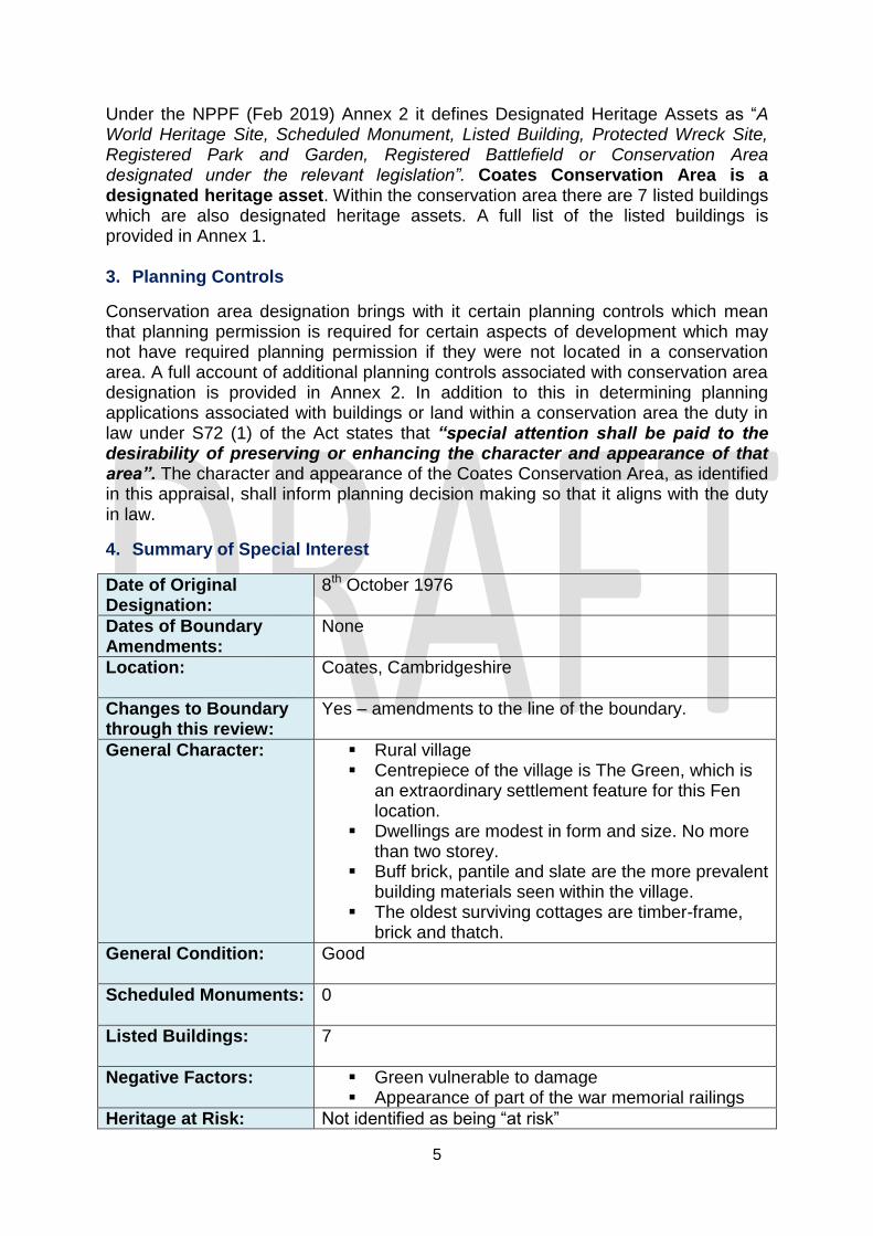
Under the NPPF (Feb 2019) Annex 2 it defines Designated Heritage Assets as “A World Heritage Site, Scheduled Monument, Listed Building, Protected Wreck Site, Registered Park and Garden, Registered Battlefield or Conservation Area designated under the relevant legislation”. Coates Conservation Area is a designated heritage asset. Within the conservation area there are 7 listed buildings which are also designated heritage assets. A full list of the listed buildings is provided in Annex 1. 3. Planning Controls
Conservation area designation brings with it certain planning controls which mean that planning permission is required for certain aspects of development which may not have required planning permission if they were not located in a conservation area. A full account of additional planning controls associated with conservation area designation is provided in Annex 2. In addition to this in determining planning applications associated with buildings or land within a conservation area the duty in law under S72 (1) of the Act states that “special attention shall be paid to the desirability of preserving or enhancing the character and appearance of that area”. The character and appearance of the Coates Conservation Area, as identified in this appraisal, shall inform planning decision making so that it aligns with the duty in law.
4. Summary of Special Interest
Date of Original Designation:
8th October 1976
Dates of Boundary Amendments:
None
Location:
Coates, Cambridgeshire
Changes to Boundary through this review:
Yes – amendments to the line of the boundary.
General Character: Rural village Centrepiece of the village is The Green, which is
an extraordinary settlement feature for this Fen location.
Dwellings are modest in form and size. No more than two storey.
Buff brick, pantile and slate are the more prevalent building materials seen within the village.
The oldest surviving cottages are timber-frame, brick and thatch.
General Condition:
Good
Scheduled Monuments:
0
Listed Buildings:
7
Negative Factors: Green vulnerable to damage Appearance of part of the war memorial railings
Heritage at Risk: Not identified as being “at risk”
6
Section 1 – Character Appraisal
5. Assessing Special Interest
Location & Topography
Coates is a Fen village located in East Anglia, in the north of the county of Cambridgeshire, in the district of Fenland. It is located within the parish of Whittlesey and is 2 1/2 miles east of Whittlesey and 8 miles west of the town of March. The village is located on part of a gravel capped “island” within the low-lying Fenland and is one of a number of these geological “islands” (areas of higher land) within this Fenland area the others including Whittlesey, Eastrea, Eye, Crowland and Thorney. Coates was once a small settlement on part of an island surrounded by marshland but it is now a village surrounded by prime agricultural land. The prime agricultural land has been created though the draining of the Fens (land reclamation) which was undertaken from the mid-17th century. To the north of the town lies the river Nene and Nene washes, which is an area of wildlife rich wash-land on the bank of the river.
Geology
Coates is situated upon bedrock from the Jurassic period specifically a formation of Oxford Clay-mudstone which formed 156-165 million years ago in shallow seas. The overlying superficial deposits, those being the younger geological deposits over the bedrock, are of sand and gravel. These superficial deposits were formed up to 2 million years ago in the Quaternary period and where formed in a shoreline environment. The soil is chiefly a black loam.
Coates in Context
Archaeology
There has been human activity within the parish of Whittlesey since at least the Late Neolithic Period/Early Bronze age (2500 – 2000BC). In Coates, archaeological investigation has identified evidence of a possible Bronze Age or Early Iron Age settlement as post holes and pottery and flint have been found in the locality (CHER MCB17257). The existence of early Bronze Age activity in Whittlesey parish has also been evidenced in recent years by the substantial finds associated with a Bronze Age settlement at the Must Farm site in the west of the parish. Sites recognised as Scheduled Monuments within the Whittlesey parish include Suet Hill Round Barrow Cemetery, a Bronze age burial site (2000-700BC), and the Bowl Barrow south of Buntings Farm, comprising of funerary monuments of earthwork mounds (2400 – 1500BC).
It is known that the Romans (43AD to 410AD) were active in the area. The Fen Causeway (Fen Road), a Roman Road, ran through the area north of the current settlement and provided a Roman route through the marshland of the Fens from Norfolk through Whittlesey to Water Newton (just outside Peterborough). A Roman field system and trackway with later field ditches has also been identified at Whittlesey Washes, again to the north of the town, and this is protected as a Scheduled Monument. Roman artefacts and pottery fragments have been found scattered in fields around Coates.
7
Less evidence of Anglo-Saxon (410-1066AD) living has been found within the Parish of Whittlesey and none in Coates. There has however, been some archaeological evidence of late medieval activity in Coates through evidence of quarrying, field boundaries and water features and some evidence of post medieval activity in the form of building material finds (MCB17083).
History of Coates
Archaeological evidence identifies human activity in the area from the Bronze age era although it is not known when a settlement at Coates was first established or what form it originally took. Up until the 17th century Coates would have stood above the surrounding Fen marshes comprising of peat fen with water logged ground, with reeds growing over it and served by a communication network of canals and rivers. The inhabitants of these lands would have used the surrounding land for fowling, fishing and catching eels which would have been a food source and traded.
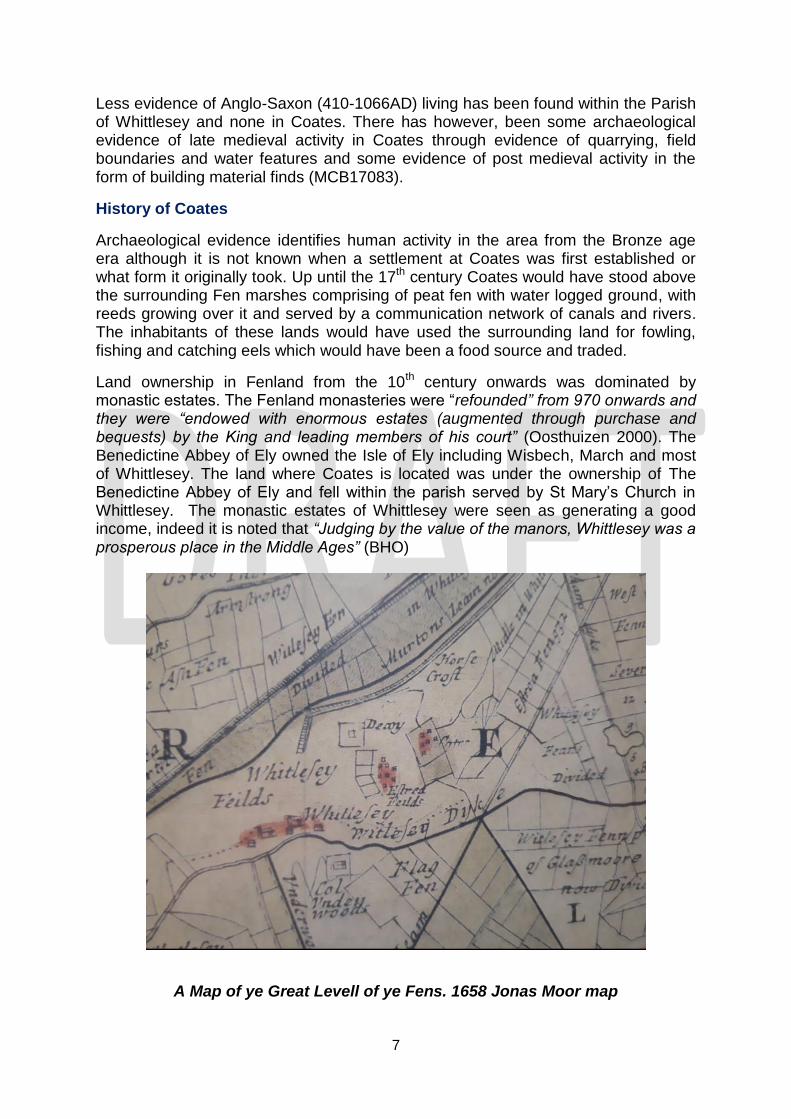
Land ownership in Fenland from the 10th century onwards was dominated by monastic estates. The Fenland monasteries were “refounded” from 970 onwards and they were “endowed with enormous estates (augmented through purchase and bequests) by the King and leading members of his court” (Oosthuizen 2000). The Benedictine Abbey of Ely owned the Isle of Ely including Wisbech, March and most of Whittlesey. The land where Coates is located was under the ownership of The Benedictine Abbey of Ely and fell within the parish served by St Mary’s Church in Whittlesey. The monastic estates of Whittlesey were seen as generating a good income, indeed it is noted that “Judging by the value of the manors, Whittlesey was a prosperous place in the Middle Ages” (BHO)
A Map of ye Great Levell of ye Fens. 1658 Jonas Moor map

8
The ownership of land where Coates is located changed in the 16th century with the dissolution of the monasteries. The monastic estates were broken up and lands passed to private owners. A large amount of land within the Whittlesey area formed the Whittlesey Manors which was owned by the Lord of the Manor and this appears to have included land at Coates. In the early 17th century the Duke of Bedford and associated investors set about draining the Fens, They were seeking to capitalise on its fertile lands for grazing and arable farming. In the mid-17th century the Dutchman Cornelius Vermuyden was appointed to oversee the draining of the Fens. Within the area around Whittlesey and Coates Vermuyden’s plans involved widening the Nene and creating the washes to hold excess river water in winter. By the end of the 18th century it is estimated that there was 1550 acres of open field and 2400 acres of pasture created.
Coates is referenced on the Jonas Moor map of 1658 as Cotes and depicted as a handful of dwellings enclosed by a rectangular boundary suggesting an established settlement of properties over and above a lone farmhouse. There is documentary reference to Quakers and other non-conformists living in Coates in the late 17th century. There is also a documentary reference in 1699 to a sports event being held on Coates Green indicating the Green had existed at this time. The earliest surviving buildings in Coates date to the late 17th and early 18th century and are 98 South Green (grade ii), 22 North Green (grade ii) and 45 Fieldside (grade ii). These properties are constructed in timber frame and brick with thatch roofs.
Beasdales 1723 Map of the Great Level
9
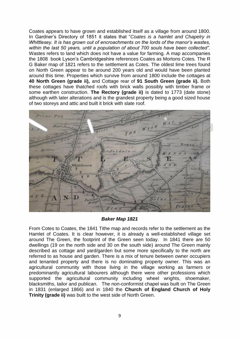
Coates appears to have grown and established itself as a village from around 1800. In Gardner’s Directory of 1851 it states that “Coates is a hamlet and Chapelry in Whittlesey. It is has grown out of encroachments on the lords of the manor’s wastes, within the last 50 years, until a population of about 700 souls have been collected”. Wastes refers to land which does not have a value for farming. A map accompanies the 1808 book Lyson’s Cambridgeshire references Coates as Mortons Cotes. The R G Baker map of 1821 refers to the settlement as Cotes. The oldest lime trees found on North Green appear to be around 200 years old and would have been planted around this time. Properties which survive from around 1800 include the cottages at 40 North Green (grade ii), and Cottage rear of 91 South Green (grade ii). Both these cottages have thatched roofs with brick walls possibly with timber frame or some earthen construction. The Rectory (grade ii) is dated to 1773 (date stone) although with later alterations and is the grandest property being a good sized house of two storeys and attic and built it brick with slate roof.
Baker Map 1821
From Cotes to Coates, the 1841 Tithe map and records refer to the settlement as the Hamlet of Coates. It is clear however, it is already a well-established village set around The Green, the footprint of the Green seen today. In 1841 there are 50 dwellings (19 on the north side and 30 on the south side) around The Green mainly described as cottage and yard/garden but some more specifically to the north are referred to as house and garden. There is a mix of tenure between owner occupiers and tenanted property and there is no dominating property owner. This was an agricultural community with those living in the village working as farmers or predominantly agricultural labourers although there were other professions which supported the agricultural community including wheel wrights, shoemaker, blacksmiths, tailor and publican. The non-conformist chapel was built on The Green in 1831 (enlarged 1866) and in 1840 the Church of England Church of Holy Trinity (grade ii) was built to the west side of North Green.

10
Post Office Directory 1875 Entry.
Coates does not grow as a settlement in the Victorian era, indeed the population of the village itself declines towards the end of the 19th century. From having a population of 600 - 700 in 1841 the population of the village is recorded in the 1861 census as being 709 residents occupying 181 dwellings, in the 1881 census as 694 residents occupying 164 dwelling and by 1901 there are 587 residents occupying 150 dwellings. The Post Office Directory of 1858 still describes Coates as “the pleasant hamlet of Coates” under the entry for Whittlesey but in later decades it is recognised under its own entry for Coates and Eastrea; “formed into an ecclesiastical parish, July 9 1950, from the civil parish of Whittlesey” (Kelly’s Directory 1892). The OS maps of 1887 and 1901 show the footprint of village changes little in the 19th century from that presented on the Tithe map of 1841. It is clear that the settlement pattern around The Green was well established by the 19th century. The buildings which stood around it included many thatched cottages. Buildings including the Fire Engine House, and Sunday School date to this era.
South Green

11
The footprint and character of Coates appears to change little in the first half of the 20th century and it remains a village serving an agricultural community. Kelly’s Directory 1929 cites numerous commercial businesses in the village including a blacksmiths, wheelwright, thatcher, beer retailer as well as two pubs, a post office, a Barclay’s Bank, public hall, school, parish church and Methodist Chapel. The 1926 OS map indicates trees around North Green but South Green was more open. From the mid-20th century onwards the character of the village would change as the cottages that had existed around the Greens were demolished and replaced with new houses. At this time the footprint of the village also expands as housing development starts to occur on the east side of South Green between South Green and March Road and then to the north of The Fold. In the 1990s there has been tree planting schemes which have seen new trees planted across the Greens particularly across South Green which has changed the context of the space. Notable buildings/structures erected in the 20th century are Church View built in 1914 and the War Memorial erected in 1920.
North Green
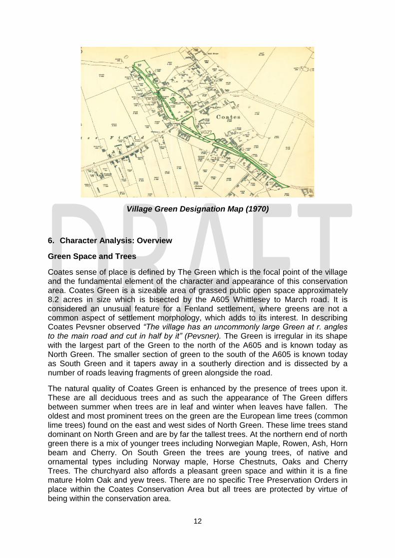
Up until the turn of the 21st century Coates Green was owned by the Lord and Lady of the Manor of Whittlesey. In 1999 on the death of the last Lady of the Manor, Nancy Bowker, the Whittlesey Manors including Coates Green was gifted to the Whittlesey Charities. While owned by the Lord of the Manor and now Whittlesey Charities, Coates Green has historically served as public open space for use by the village community. Historically residents of the village grazed their livestock on Coates Green and it was known for geese grazing on it. Coates Green appears on Cambridgeshire County Council’s Register of Common Lands and Village Greens as a Registered Village Green (VG27) which affords it protection and prevents it from being built on. Its registration as a village green was finalised on 1st October 1970 and under this registration it states the inhabitants of Coates have the right to use the village green for lawful sports and pastimes. Coates Green is maintained by Fenland District Council.
12
Village Green Designation Map (1970)
6. Character Analysis: Overview
Green Space and Trees
Coates sense of place is defined by The Green which is the focal point of the village and the fundamental element of the character and appearance of this conservation area. Coates Green is a sizeable area of grassed public open space approximately 8.2 acres in size which is bisected by the A605 Whittlesey to March road. It is considered an unusual feature for a Fenland settlement, where greens are not a common aspect of settlement morphology, which adds to its interest. In describing Coates Pevsner observed “The village has an uncommonly large Green at r. angles to the main road and cut in half by it” (Pevsner). The Green is irregular in its shape with the largest part of the Green to the north of the A605 and is known today as North Green. The smaller section of green to the south of the A605 is known today as South Green and it tapers away in a southerly direction and is dissected by a number of roads leaving fragments of green alongside the road.
The natural quality of Coates Green is enhanced by the presence of trees upon it. These are all deciduous trees and as such the appearance of The Green differs between summer when trees are in leaf and winter when leaves have fallen. The oldest and most prominent trees on the green are the European lime trees (common lime trees) found on the east and west sides of North Green. These lime trees stand dominant on North Green and are by far the tallest trees. At the northern end of north green there is a mix of younger trees including Norwegian Maple, Rowen, Ash, Horn beam and Cherry. On South Green the trees are young trees, of native and ornamental types including Norway maple, Horse Chestnuts, Oaks and Cherry Trees. The churchyard also affords a pleasant green space and within it is a fine mature Holm Oak and yew trees. There are no specific Tree Preservation Orders in place within the Coates Conservation Area but all trees are protected by virtue of being within the conservation area.
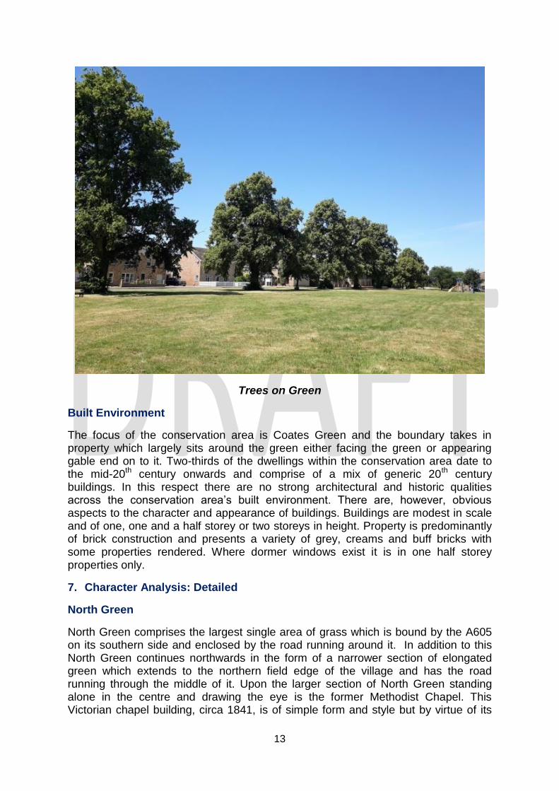
13
Trees on Green
Built Environment
The focus of the conservation area is Coates Green and the boundary takes in property which largely sits around the green either facing the green or appearing gable end on to it. Two-thirds of the dwellings within the conservation area date to the mid-20th century onwards and comprise of a mix of generic 20th century buildings. In this respect there are no strong architectural and historic qualities across the conservation area’s built environment. There are, however, obvious aspects to the character and appearance of buildings. Buildings are modest in scale and of one, one and a half storey or two storeys in height. Property is predominantly of brick construction and presents a variety of grey, creams and buff bricks with some properties rendered. Where dormer windows exist it is in one half storey properties only.
7. Character Analysis: Detailed
North Green
North Green comprises the largest single area of grass which is bound by the A605 on its southern side and enclosed by the road running around it. In addition to this North Green continues northwards in the form of a narrower section of elongated green which extends to the northern field edge of the village and has the road running through the middle of it. Upon the larger section of North Green standing alone in the centre and drawing the eye is the former Methodist Chapel. This Victorian chapel building, circa 1841, is of simple form and style but by virtue of its

14
positioning it stands out as a feature building within the village and makes an intrinsic contribution to the special architectural and historic interests of the conservation area and the village’s sense of place.
The only other built structure found on North Green is the Coates War Memorial which sits adjacent to the A605 towards the south east corner of North Green. The war memorial takes the form of a stone obelisk generously enclosed by fencing much of which is comprised of concrete posts with tubular metal bars. The enclosure around the memorial reinforces the presence of the memorial on the vast green and with its well-maintained hedging and some flowers it creates an attractive semi private space on the otherwise open green. The concrete posts and tubular metal bars do not form a particularly attractive boundary to the war memorial and it is felt this offers an opportunity for enhancement.
Historic Image War Memorial
A key feature of North Green is the trees upon it which add to the strong natural qualities of this part of the conservation area. The oldest and largest trees on North Green are lime trees which make a fundamental contribution to the character and appearance of the conservation area. A total of nine mature lime trees survive each of which are around 150 years old or more. Given the size of the green these large trees sit comfortably within the space complimenting the vast expanse of the green. A number of other mature trees are worth noting around North Green including the Horse Chestnut at the Rectory. Younger trees are also found around North Green and these collectively contribute to the natural qualities of the green.
There are no physical boundaries surrounding North Green to separate it from the roads around it and through it. The edge of the green is entirely open and at any point you can step off the road or path and on to any part of North Green. The mature and semi mature trees that sit towards the edge of the green are seen as
15
natural features on the green and not as a boundary treatment. The open nature of the green forms part of the character and appearance of the space and reinforces its intent as a welcoming space to be used by the local community. North of the former chapel there is a playground area which also emphasises the fact this is a village green for community recreation. The nature of the green edge is such that it is susceptible to suffering from damage and erosion particularly if cars repeatedly park around the edge.
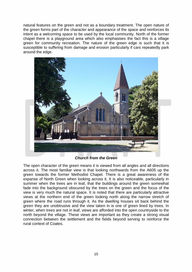
Church from the Green
The open character of the green means it is viewed from all angles and all directions across it. The most familiar view is that looking northwards from the A605 up the green towards the former Methodist Chapel. There is a great awareness of the expanse of North Green when looking across it. It is also noticeable, particularly in summer when the trees are in leaf, that the buildings around the green somewhat fade into the background obscured by the trees on the green and the focus of the view is very much the natural space. It is noted that there are particularly attractive views at the northern end of the green looking north along the narrow stretch of green where the road runs through it. As the dwelling houses sit back behind the green they are unobtrusive and the view taken in is one of green lined by trees. In winter, when trees are not in leaf, views are afforded into the open countryside to the north beyond the village. These views are important as they create a strong visual connection between the settlement and the fields beyond serving to reinforce the rural context of Coates.
16
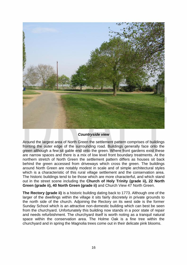
Countryside view
Around the largest area of North Green the settlement pattern comprises of buildings fronting the outer edge of the surrounding road. Buildings generally face onto the green although a few sit gable end onto the green. Where front gardens exist these are narrow spaces and there is a mix of low level front boundary treatments. At the northern stretch of North Green the settlement pattern differs as houses sit back behind the green accessed from driveways which cross the green. The buildings around North Green are notably modest in scale and of simple architectural styles which is a characteristic of this rural village settlement and the conservation area. The historic buildings tend to be those which are more characterful, and which stand out in the street scene including the Church of Holy Trinity (grade ii), 22 North Green (grade ii), 40 North Green (grade ii) and Church View 47 North Green.
The Rectory (grade ii) is a historic building dating back to 1773. Although one of the larger of the dwellings within the village it sits fairly discretely in private grounds to the north side of the church. Adjoining the Rectory on its west side is the former Sunday School which is an attractive non-domestic building which can best be seen from the churchyard. Unfortunately this building now stands in a poor state of repair and needs refurbishment. The churchyard itself is worth noting as a tranquil natural space within the conservation area. The Holme Oak is a fine tree within the churchyard and in spring the Magnolia trees come out in their delicate pink blooms.

17
South Green
The green to the south of the A605 is called South Green. It is smaller than North Green and more fragmented as a result of the roads which run through it. South Green is triangular in shape tapering away as it heads south. The largest section of South Green abuts the A605 and is open without any boundary enclosure. The trees on the space are young trees with the exception of two Norway Maples on the east side. There are no buildings on this area of South Green and the focal point is children’s play equipment. The rest of South Green presents itself as wide stripes of verge to the sides of the road with young deciduous trees throughout. These green spaces offer less opportunity for recreation given their size but contribute to the strong natural qualities of the conservation area.
South Green
Buildings around South Green are predominantly from the mid 20th century onwards and sit to the footpath edge or behind front gardens. The buildings around South Green are notably modest in scale and of simple architectural styles which is a characteristic of this rural village settlement and the conservation area. The historic buildings which survive on South Green tend to be the more characterful buildings in this part of the conservation area and include the pair of adjoining thatched dwellings known as 98 South Green (grade ii) and 45 Fieldside (grade ii). 98 South Green fronts the green although 45 Fieldside is discretely sited behind. The cottage to rear of No. 91 South Green (grade ii) is also discretely sited and not entirely visible from South Green itself although its thatched roof can be seen from the green. These
18
three early buildings are located close together at the southern end of the conservation area.
Fieldside
Fieldside is a lane which forms the western boundary to the conservation area south of the A605. The lane is no more than a farm track, untarmacked. On the east side of Fieldside is the rear boundaries, rear access and garaging of South Green properties. Boundary treatments are a mix of modern walling, fencing and hedging. The interest of this conservation area boundary is in the nature of the unmade track. To the west of Fieldside are currently fields which give rise to its name.
Buildings of Local Importance
Buildings of Local Importance identified in the text above are:
Former Sunday School, North Green (identified as a BLI since 1993)
Former Methodist Chapel, North Green (identified as a BLI since 1993)
Church View, North Green (identified as a BLI since 1993)
Coates War Memorial, North Green (identified as a BLI since 1993)
Fire Engine House (identified as a BLI since 1993)
19
Part 2
Boundary Review
Coates Conservation Area was designated in October 1976 and the boundary has not changed since its original designation. As part of this appraisal process the boundary line of the conservation area has been reviewed to ensure it still covers an area which can be determined to be of special architectural and historic interest. The boundary is drawn to highlight the character of the Green and the settlement morphology of the village. It therefore focuses on those buildings which directly surround the North and South Green.
In this instance it is felt the Coates Conservation Area boundary requires amendment to reflect the fact that a part of the conservation area does not have a special architectural and historic interest. The boundary is to be amended on its east side to remove an area of mid-late 20th century housing development which is not of special interest and does not have a tangible relationship with Coates Green. The areas to be removed are as follows:
Sunnyville Road and the entrance to Barnfield Gardens are included within the conservation area. These streets were created in the mid-20th century and are not considered to be part of the historic footprint of the village. The housing on these streets does not front South Green. Property on Sunnyville Road was built circa 1970 and comprises of generic modern housing. Given it does not relate to the green and is not of architectural or historic interest it is proposed that the boundary is realigned to exclude Sunnyville Road property.
37 – 42 South Green were erected after the conservation area boundary was designated. 40, 41, and 42 are bungalows which are well set back from the green. 37, 38 and 39 sit behind them and are not clearly visible from South Green.
A map showing the proposed boundary is provided in Map 2.

20
Map 2 - Proposed Coates Conservation Area Boundary

21
Part 3
Management Plan
The Management Plan is intended to provide a strategy for managing change, addressing issues and identifying enhancements within the Coates Conservation Area to ensure the conservation area retains its qualities as an area of special architectural and historic interest. The objectives developed are intended to effect positive changes within the Coates Conservation Area to enhance its character and appearance and better reveal its significance.
The fundamental factors which contribute to the special character and appearance of the Coates Conservation Area are identified in the character appraisal. Given the interest of the conservation area there are only a few issues which threaten this particular conservation area’s character and appearance.
Objectives
Preserving the Green
Coates Village Green is the defining element and fundamental feature of the Coates Conservation Area. Therefore preserving the character and appearance of this open green space is fundamental to preserving and enhancing the special interests of the conservation area. As a designated village green it is protected from development and will never be developed upon but there remain some threats which may harm its interests and the quality of the green. The grassed edges of the green are considered to be vulnerable to being eroded and damaged by vehicles repeatedly and regularly being parked on it to the detriment of its character and appearance.
Objective 1 - The Council will work in partnership with the landowner, residents and all relevant and interested parties to endeavour to alleviate parking issues on the
Green.
Coates War Memorial
Coates War Memorial occupies a prominent position on North Green adjacent to the A605. The memorial has historic importance within the village commemorating those villagers who lost their lives in World War I and World War 2. It is also a notable historic feature within the conservation area. In many towns and villages war memorials are listed and recognised for their architectural and historic interests. It is disappointing that the Coates War Memorial is not afforded the same recognition.
Photographic evidence shows that the enclosure around the war memorial has changed in the last century and has been enlarged. The enclosed space is well maintained although the nature of the enclosure on the north, west and east side which is formed from concrete bollards and steel poles is considered to detract from the setting of the war memorial and wider appearance of The Green. It is felt there is an opportunity to enhance the setting of the war memorial and appearance of the green by providing better quality railings.
22
Objective 2 - To seek to promote the historic importance of the war memorial and enhance its setting by (i) putting the memorial forward for listing and (ii) seeking to
facilitate an enhancement scheme to replace the modern sections of railings around the memorial as and when they are due for renewal or if funding opportunities arise.
Trees within the Conservation Area
The natural qualities of the Coates Conservation Area are enhanced by the presence of trees, particularly on the green and within the churchyard area. These are predominantly deciduous trees and as such the appearance of the conservation area does differ between summer when trees are in leaf and winter when leaves have fallen which add to its seasonal interest. The oldest and most prominent trees within the conservation area are on the green are the European lime trees (common lime trees) found on the east and west sides of North Green. These lime trees stand dominant on North Green and are by far the tallest trees. Care is required to effectively manage the lime trees along with other trees on the green.
Objective 3 - Tree management on North & South Green will be implemented in accordance with the Council’s emerging Tree Management Strategy. Trees will only be removed for reasons of health and safety following a full inspection and ensuring a suitable replacement tree will be planted to ensure continuity of tree cover on both
greens.
Development site opportunities
Coates Conservation Area draws its boundary tight around the village green and it peripheral houses and it is already densely developed. In this context development opportunities within the conservation area are limited. There are, however, a few sites and poor quality buildings which currently detract from the character and appearance of the conservation area and offer an opportunity to enhance the conservation area through appropriate and timely redevelopment. Development of these sites will need to be initiated and undertaken by the land/property owners. Where required the Council can support these owners by providing appropriate planning and conservation advice to help ensure such developments enhance the character and appearance of the conservation area:
6 March Road
14 March Road
Delivery
The three objectives cited within this Management Plan are to be delivered in partnership with stakeholders. The delivery of these objectives will require the input of the Conservation Officer(s), the Arboricultural Officer and may involve collaboration with other teams such as Street Scene, Enforcement, Leisure and
23
Open Spaces, and Highways. Fenland District Council will use its available resources to help deliver the objectives contained in this Management Plan.
The Parish of Whittlesey benefits from a strong civic voice and a committed Town Council. There are a number of established community groups and organizations within the parish that take an interest and seek to promote Whittlesey and Coates cultural heritage and its built environment. These groups include The Whittlesey Society and Whittlesey Museum. The Management Plan provides an opportunity for local groups to get involved in the delivery of some of the objectives specifically objective 2. Monitoring During the 5 year period this Management Plan is set to cover it is important to be able to monitor progress of objectives and measure success at the end of the period. Monitoring procedures should be easy to implement and transparent. In this regard the following monitoring should be followed: i. Annual Review – Fenland District Council’s conservation team and
stakeholders referenced within the document shall convene on an annual basis. The purpose of the meeting will be to specifically review the objectives set out in this management plan and report on the progress being made under each objective.
ii. Measuring Success (Objectives) – Success can be measured against
completed objectives. It is considered that objective 2 has a clear outcome and success will occur when the objective is met. It is felt that objectives 1 and 3 are open ended objectives covering a long term strategy of care.
iii. Recording Success (The Photographic Record) – In collaboration with the
annual review it would be beneficial to keep a photographic record of objective related buildings, streets and spaces so successes can be visually convey through “before and after” photographs.
24
Annex 1: Buildings on the National Heritage List for England – Listed Buildings The buildings listed below are identified by the address in the official entry on the National List for Historic England.
22 North Green, Coates. Grade II, List Entry Number: 1279446
Cottage, subdivided, and now one dwelling. Late C17, and early C19 with C20 small addition at rear.
Timber framed, and later brick, plaster rendered.
The Rectory, North Green, Coates. Grade II, List Entry Number: 1228228
Rectory. 1773 (dated stone) and mid C19. Yellow gault brick with steeply pitched slate roof and
sawtooth eaves cornice.
Church of Holy Trinity, North Green. Grade II, List Entry Number: 1287280
Parish Church. 1840, 1874 and 1890 by J. Wild.
40 North Green, Coates. Grade II, List Entry Number: 1228707
Pair of Cottages. Late C18 or early C19. Brick, rendered with long straw thatch and saw tooth eaves
cornice.
98 South Green, Coates. Grade II, List Entry Number: 1228713
Cottage. Late C17 or early C18, and 1784. Originally timber framed but the frame has been
substantially replaced or cased by brick.
45 Fieldside, Coates. Grade II, List Entry Number: 1227934 (to the rear of No. 98 South
Green).
Cottage. Probably late C17 or early C18 in origin, altered and repaired in C19 and C20.
Cottage, Rear of 91 South Green, Coates. Grade II, List Entry Number: 1279403 (now also
known as 55 Fieldside, Thatchers Cottage)
Cottage. C18 and C19. Orignally of claylump which has been replaced entirely by late C18-C19 callow
brick, part now painted, and one gable end rendered.

25
Annex 2: Planning Controls and Enforcement Development Control This Management Plan seeks to establish a proactive framework for managing change, addressing issues and identifying enhancements within the Coates Conservation Area to ensure it retains its qualities as an area of special architectural and historic interest and to better reveal these interests. The Local Planning Authority does however manage change within conservation areas on a day to day basis through the process of development control. Where planning permission or listed building consent is required for works to buildings within a conservation area there are statutory considerations the Local Planning Authority has to follow in determining such applications. Buildings located within a conservation area are also subject to some additional planning controls. The following section identifies the Acts and statutory guidance which contribute to the framework of development control and the process of considering applications. Town and Country Planning Act 1990 The Town and Country Planning Act 1990 is at the heart of the planning system although it is modified by The Planning & Compulsory Purchase Act 2004 and more recently by the Enterprise and Regulatory Reform Act 2013. S57 of the Town and Country Planning Act 1990 sets out the requirement that “Planning Permission is required for the carrying out of any development of land” although it allows for certain development to be exempt from planning permission if it is covered by a development order such as The Town & County Planning (General Permitted Development) (England) Order 2015 as detailed below. S55 of The Town and Country Planning Act 1990 defines development. S38 (6) of The Planning & Compulsory Purchase Act 2004 instructs that “if regard is to be had to the development plan for the purpose of any determination [of planning permission] to be made under the planning Acts the determination must be made in accordance with the plan unless material consideration indicate otherwise”. The Enterprise and Regulatory Reform Act 2013 made changes to the Town and Country Planning Act 1990 and Planning (Listed Buildings and Conservation Areas) Act 1990 simultaneously in respect to the demolition of unlisted buildings within conservation areas. The changes made in respect of demolition resulted in Conservation Area Consent becoming obsolete and instead Planning Permission is solely required for works of relevant demolition in a conservation area under provisions now covered by the Town and Country Planning Act 1990. Planning Permission is required for demolition of a building exceeding 115 cubic metres or to take down any wall, gate or fence over 1 metre high abutting a highway or over 2m elsewhere. Undertaking works of relevant demolition in a conservation area without planning permission constitutes a criminal offence under S196D of the Town and Country Planning Act 1990.
26
The Town & Country Planning (General Permitted Development) (England) Order 2015 The designation of a conservation area has implications under The Town & Country Planning (General Permitted Development) (England) Order 2015. For the purposes of this act, as stated under Schedule 1 Part 1, land within a conservation area is referenced as Article 2 (3) land. Under this act certain works to unlisted dwelling houses which would have otherwise been possible to proceed without planning permission will require planning permission because the dwelling house is an a conservation area. Matters pertaining to the requirement of planning permission for dwelling houses are detailed in Schedule 2, Part 1 of the act and the act should be fully consulted before undertaking works to dwelling houses within a conservation area. Examples where planning permission will be specifically required if a dwelling house is located within a conservation area includes where works consisting of the cladding of any part of the exterior of a house with stone, artificial stone, pebble dash, render, timber, plastic or tiles or extending to the side of the house or extension consisting of a two storey rear extension. The installation of microwave antenna (satellite dishes) is also more greatly controlled if they are on dwellings within a conservation area. Certain changes of use will require planning permission if a building is located in a conservation area. Such matters are detailed under Schedule 2, Part 3 of the act and this should be fully consulted when considering change of use of buildings within a conservation area. For example planning permission is required where buildings operating as shops, financial or professional services, betting offices or pay day loans offices seek to change use to a building to function for assembly or leisure. Planning permission is also required where buildings are to change use to a dwelling house from a building operating as a shop, financial or professional services, betting office or mixed use. Certain non-domestic extensions will require planning permission because a building is located in a conservation area. Such matters are detailed under Schedule 2, Part 7 of the act and this should be fully consulted when considering the extension of non -domestic property in a conservation area. For example planning permission is required for the extension of a shop or financial or professional services establishment or office building. Planning permission would also be required for the erection of a collection facility or modification of the loading bay of a shop. The installation, alteration or replacement of micro-regeneration solar PV or solar thermal equipment is more closely controlled where buildings are located in conservation areas. Such matters are detailed under Schedule 2, Part 14 of the act and this should be fully consulted when considering installing such equipment. For example, planning permission is required if it is the intention to install the equipment on roofs fronting a highway. Planning (Listed Buildings and Conservation Areas) Act 1990

27
The legal duties in respect to the consideration of listed building consent applications and planning applications affecting listed buildings and buildings in conservation areas falls under the provisions of the Planning (Listed Buildings and Conservation Areas) Act 1990. With regard specifically to conservation areas the act requires that in determining planning applications within conservation areas “special attention shall be paid to the desirability of preserving and enhancing the character or appearance of that area”. With regard to listed buildings, S16 of the act concerns the determination of Listed Building Consent and requires that “in considering whether to grant listed building consent for any works the local planning authority or the Secretary of State shall have special regard to the desirability of preserving the building or its setting or any features of special architectural or historic interest which it possesses”. S66 of the act concerns the determination of planning permission in respect of works to listed buildings and requires that “in considering whether to grant planning permission for development which affects a listed building or its setting, the local planning authority or, as the case maybe, the Secretary of State shall have special regard to the desirability of preserving the building or its setting or any features of special architectural or historic interest which it possesses”. Fenland Local Plan (May 2014) Planning law requires that applications for planning permission must be determined in accordance with the development plan unless material considerations indicate otherwise. Relevant material considerations may include other legislative direction (such as the Planning (Listed Buildings and Conservation Areas) 1990), statutory guidance (NPPF) or other general guidance but such considerations should be weighted accordingly. The Fenland Local Plan was adopted in May 2014. Policy LP18 of the Fenland Local Plan (May 2014) specifically concerns the historic environment. Within the Vision Statement set out in the local plan a commitment is made seeking that “The natural and historic environment will be protected and enhanced with new development taking into account the surroundings of the area in which it would be situated”. Objectives 3.1 and 3.2 reinforce the vision and intrinsically inform how the Council will approach development affecting the district’s conservation areas and other heritage assets. Objective 3.1 seeks to “Preserve and where appropriate, enhance buildings, monuments, sites and areas and landscapes that are designated or locally valued for their heritage interest; and protect/enhance their settings”. Objective 3.2 seeks to “create places, spaces and buildings that are well designed, contribute to a high and local distinctiveness of townscape character”. National Planning Policy Framework (Feb 2019) The National Planning Policy Framework sets out Government planning policies for England and how these are expected to be applied. It identifies how planning policy is to contribute to the achievement of sustainable development through economic, social and environmental factors. A core principle of the NPPF is to “conserve

28
heritage assets in a manner appropriate to their significance, so that they can be enjoyed for their contribution to the quality of life of this and future generations”. Section 16 covers conserving and enhancing the historic environment and paragraphs 184 – 202 provide guidance on the determination of applications. Enforcement The character and appearance of a conservation area can be diminished or harmed by unauthorised works being undertaken to listed buildings within it, where breaches of planning occur, where unauthorised advertisements have been used or where tree protection offences have occured. Where buildings or sites within conservation areas are neglected and allowed to fall into disrepair this can also impact negatively on the interests of a conservation area. In these circumstances, the Local Planning Authority has a range of enforcement powers available at their discretion to address these issues. Unauthorised Works to Listed Buildings Any works to listed buildings that involve their alteration, extension or demolition are controlled by the mechanism of Listed Building Consent and proposals that would fail to preserve a listed building’s interests would not be granted consent. The interest of a listed building maybe harmed by inappropriate and unauthorised works and failure to obtain listed building consent itself or breaching a condition attached to a listed building consent constitutes a criminal offence under S9 Planning (Listed Buildings and Conservation Areas) Act 1990 and owners can be prosecuted for undertaking such works. The Local Planning Authority has the power to address unauthorised works to listed buildings under S38 Planning (Listed Buildings and Conservation Areas) Act 1990 and can issue a listed building enforcement notice. A Listed Building Enforcement Notice would set out steps required to restore the building to its former condition or set out steps required to alleviate the effect of the unauthorised works or steps required to bring the building back to a state it would have been if conditions attached to a listed building consent had been complied with. Breaches of Planning Control A breach of planning control is defined under S171A Town and Country Planning Act 1990 and occurs where development has been carried out without the required planning permission or where there has been a failure to comply with a condition under which planning permission has been granted. It is at the discretion of the Local Planning Authority to take action against breaches but where such breaches cause harm to the interests of a conservation area enforcement action should be pursued. The Local Planning Authority can serve an Enforcement Notice which would state what action is required to remedy the breach. It is an offence to fail to comply with an Enforcement Notice once the period for compliance has elapsed.

29
Unauthorised Advertisements Unauthorised advertisements may relate to illegal hoardings, fly-posting, graffiti or adverts along highways. There are a range of provisions under the Town and Country Planning Act 1990 for dealing with these issues. Tree Offences Tree Preservation Orders are made to protect specific trees in the interest of amenity. Anyone who contravenes an order by damaging or carrying out works to a tree has committed an offence and can be fined. They can also be required to replace the tree under a tree replacement notice. Securing repairs to listed buildings Under S48 and S54 Planning (Listed Buildings and Conservation Areas) Act 1990 the Local Planning Authority has powers to address listed buildings which have fallen in to disrepair. Under S54 an Urgent Works Notice can be served on unoccupied listed buildings. An Urgent Works Notice would cover works (the minimum required) considered urgently necessary for the preservation of a listed building to keep the building wind and watertight, supported against collapse and secure from unauthorised entry. Such a notice would require an owner to undertake specified work in a particular timeframe otherwise the local authority would step in and execute the works. A S48 notice, also known as a Full Repairs Notice, could specify works for the full repair of the building although should an owner fail to execute such works the Local Planning Authority would have to be in a position to review the viability of compulsory purchase. Securing repairs to unlisted buildings in conservation areas Under S76 Planning (Listed Buildings and Conservation Areas) Act 1990, the local planning authority could apply the provisions of a S54 urgent works notice (as detailed above) to an unlisted building. S215 Notice S215 Town & Country Planning Act 1990 provides Local Planning Authorities with the power to take steps required for land and buildings to be cleaned up when their condition adversely affects the amenity of an area. Under S219 of the act Local Planning Authorities have the power to undertake the clean-up works at cost to the Local Planning Authority, and recover the costs from the landowner.
30
Annex 3: Public Consultation In accordance with S71 Planning (Listed Buildings and Conservation Areas) Act 1990, the Conservation Area Appraisal and Management Plan (2019) are put to public consultation from Monday 6th July 2020 to Monday 3rd August 2020. Please note the consultation process has been impacted upon by the 2020 Coronavirus outbreak and associated “lockdown” measures. In this regard it has not been possible to undertake consultation activities in the community such as a public display or public event. The consultation was being undertaken in the following way.
Web Site Publicity and Consultation – A consultation page is provided on the Fenland District Council website which gives the necessary information about the new appraisal, the proposed boundary amendment and the management plan content. The community has an opportunity to provide consultation feedback online. Full copies of the Conservation Area Appraisal (July 2020) are available to download from the website: www.fenland.gov.uk/consultations
Advertising – The consultation period will be advertised by means of a press release. Within the press release, the dates of the consultation period are cited alongside the details of where the documents can be viewed.
Direct Consultation – For those building owners who have property that is proposed to be removed from the conservation area they will be directly contacted by letter. They will be made aware that their property is to be removed from the conservation area and asked to comment.

31
Annex 4: References Books Gray P (1990), The Washlanders, Terence Dalton Oosthuizen S (2000), An Atlas of Cambridgeshire and Huntingdonshire, The Lavenham Press N Pevsner (1977) The Buildings of England: Cambridgeshire, Penguin Books Ltd Bevis T (1992) Water water everywhere: The Draining of the Fens Bevis (2000) Whittlesey Through The Ages Hiller R (1981), Clay that Burns: A history of the Fletton Brickmaking Industry. Whittlesey Society, Millennium Memories of Whittlesey, Parrot Print Ltd Whittlesey Society, Millennium Memories of Whittlesey No 2, Parrot Print Ltd Whittlesey Society, Millennium Memories of Whittlesey No 3, Parrot Print Ltd Whittlesey Society (2001), Millennium Memories of Whittlesey No 4, Parrot Print Ltd Whittlesey Society (2004), Millennium Memories of Whittlesey No 5, Parrot Print Ltd Directories Robson’s Commercial Directory (Cambridgeshire) 1839 Slater’s 1950 Post Office Directory of Cambridge, Norfolk & Suffolk 1858 Cassey’s Cambridgeshire Directory 1864 Kelly’s Directory of Cambridge, Norfolk and Suffolk 1875 Kelly’s Directory of Cambridgeshire, Norfolk and Suffolk 1892 Articles Maps Cambridgeshire Records Society, Jonas Moore’s Map of the Great Levell of the Fenns 1658 1841 Tithe Map 1887 OS County Series 1:2500 Cambridgeshire and Isle of Ely 1901 OS County Series 1:2500 Cambridgeshire and Isle of Ely 1926 OS County Series 1:2500 Cambridgeshire and Isle of Ely 1970 OS Plan 1:2500 Websites British History Online (BHO) http://www.british-history.ac.uk/vch/cambs/vol4/pp123-135 (viewed 23/03/2017) Dissertation 1982 – Institute of Geological Natural Environment Research Council The sand and gravel resources of the county around Whittlesey Cambridgeshire S Booth
Coates Conservation Area Appraisal and Whittlesey Conservation Area Management Plan
Consultation Responses
The Coates Conservation Area Appraisal and Management Plan were put out to public consultation between Monday 6th July 2020 and
Thursday 6th August 2020. Due to Covid-19 and subsequent lockdown restrictions there were no public display or events, but the documents
were available to view online via the Fenland District Council website. The documents were also distributed to heritage interest groups within
the town specifically The Whittlesey Charities and Whittlesey Mud Wall Group.
Following public consultation 10 responses were received from the following respondents:
Whittlesey Town Council - Cllr Whitwell
Benwick, Coates and Eastrea – Cllr Wicks
Cllr Laws
Members of the public – Mr and Mrs Todd
- Grace Hards
- Mrs Isabel Boon
- Laurence Seaton
APPENDIX B
Comment Received From
Comment Made Page Effected
Action
Cllr Laws Following Whittlesey Town Council Planning Committee held on Monday evening several points were raised concerning Coates Conservation Appraisal.
Coates Conservation Appraisal was listed on the agenda for information only and to alert members of a public consultation
between Wednesday 8th July and Wednesday 5th August, 2020.
I understand several had noted typo errors – the Town Clerk suggested members complete the consultation individually and highlight spelling mistakes within the text and a road name.
One point raised – since the publication of FDC on-line Coates Conservation public consultation – allegedly a Coates War Memorial Voluntary Committee exists and they are raising concerns.
The group maintained the shrubs, flowers, flag stones within the memorial grounds. I understand they were not happy to see the entry
concerning replacement of boundary fencing.
The group consider, although the robust poles/fencing isn’t what would be deemed to be the correct railings or age compatible with the War Memorial – it is strong, stable and does a job to protect the War Memorial.
Allegedly, the War Memorial is in ownership of Coates Village and not FDC.
Maybe, the wording needs to be reconsidered for the objective –
Comments noted and wording will be amended
to ensure that the objective indicates railings should
aim to be replaced with a more appropriate style,
only when the need arises or funds are available.
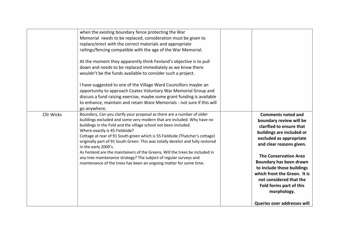
when the existing boundary fence protecting the War Memorial needs to be replaced, consideration must be given to replace/erect with the correct materials and appropriate railings/fencing compatible with the age of the War Memorial.
At the moment they apparently think Fenland’s objective is to pull down and needs to be replaced immediately as we know there wouldn’t be the funds available to consider such a project.
I have suggested to one of the Village Ward Councillors maybe an
opportunity to approach Coates Voluntary War Memorial Group and discuss a fund raising exercise, maybe some grant funding is available to enhance, maintain and retain Ware Memorials - not sure if this will go anywhere.
Cllr Wicks Boundary, Can you clarify your proposal as there are a number of older buildings excluded and some very modern that are included. Why have no buildings in the Fold and the village school not been included. Where exactly is 45 Fieldside? Cottage at rear of 91 South green which is 55 Fieldside (Thatcher’s cottage) originally part of 91 South Green. This was totally derelict and fully restored in the early 2000’s. As Fenland are the maintainers of the Greens, Will the trees be included in any tree maintenance strategy? The subject of regular surveys and maintenance of the trees has been an ongoing matter for some time.
Comments noted and boundary review will be clarified to ensure that
buildings are included or excluded as appropriate and clear reasons given.
The Conservation Area
Boundary has been drawn to include those buildings
which front the Green. It is not considered that the Fold forms part of this
morphology.
Queries over addresses will
also be clarified before the final document is
published.
Maintenance of the trees is addressed under Objective
3.
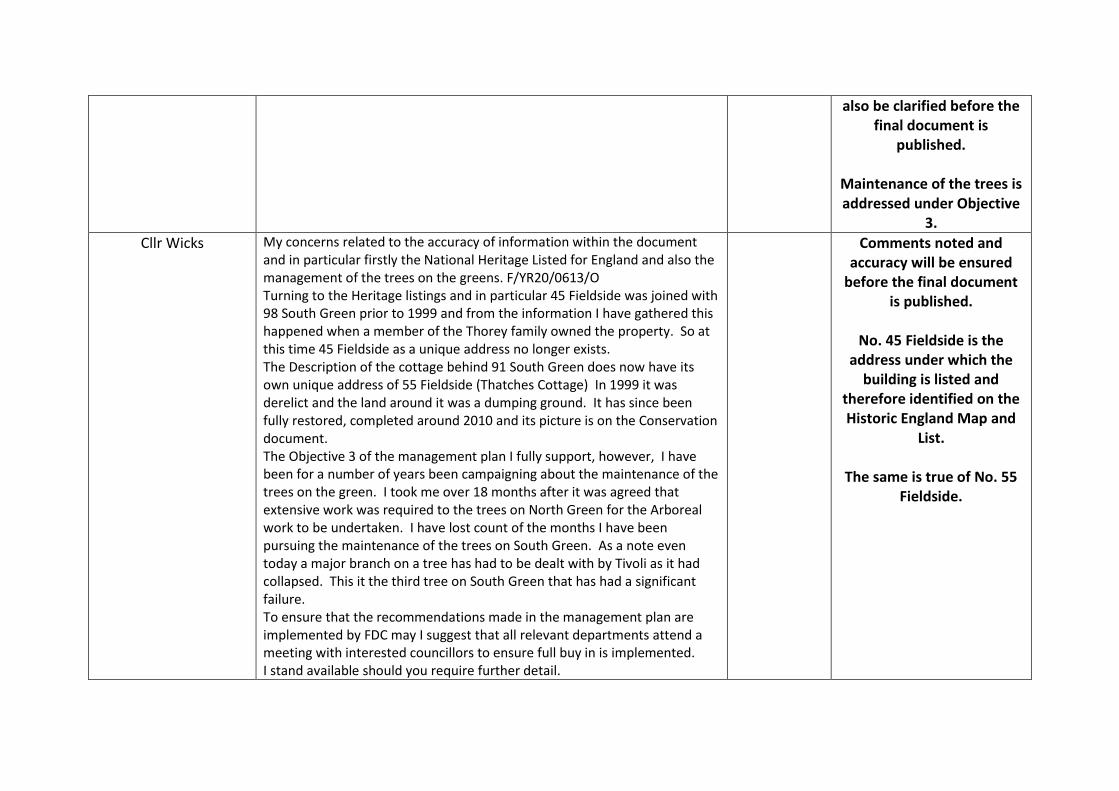
Cllr Wicks My concerns related to the accuracy of information within the document and in particular firstly the National Heritage Listed for England and also the management of the trees on the greens. F/YR20/0613/O Turning to the Heritage listings and in particular 45 Fieldside was joined with 98 South Green prior to 1999 and from the information I have gathered this happened when a member of the Thorey family owned the property. So at this time 45 Fieldside as a unique address no longer exists. The Description of the cottage behind 91 South Green does now have its own unique address of 55 Fieldside (Thatches Cottage) In 1999 it was derelict and the land around it was a dumping ground. It has since been fully restored, completed around 2010 and its picture is on the Conservation document. The Objective 3 of the management plan I fully support, however, I have been for a number of years been campaigning about the maintenance of the trees on the green. I took me over 18 months after it was agreed that extensive work was required to the trees on North Green for the Arboreal work to be undertaken. I have lost count of the months I have been pursuing the maintenance of the trees on South Green. As a note even today a major branch on a tree has had to be dealt with by Tivoli as it had collapsed. This it the third tree on South Green that has had a significant failure. To ensure that the recommendations made in the management plan are implemented by FDC may I suggest that all relevant departments attend a meeting with interested councillors to ensure full buy in is implemented. I stand available should you require further detail.
Comments noted and accuracy will be ensured
before the final document is published.
No. 45 Fieldside is the
address under which the building is listed and
therefore identified on the Historic England Map and
List.
The same is true of No. 55 Fieldside.
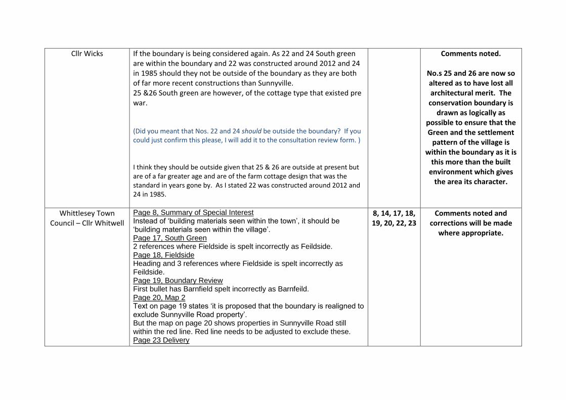
Cllr Wicks If the boundary is being considered again. As 22 and 24 South green are within the boundary and 22 was constructed around 2012 and 24 in 1985 should they not be outside of the boundary as they are both of far more recent constructions than Sunnyville. 25 &26 South green are however, of the cottage type that existed pre war. (Did you meant that Nos. 22 and 24 should be outside the boundary? If you could just confirm this please, I will add it to the consultation review form. ) I think they should be outside given that 25 & 26 are outside at present but are of a far greater age and are of the farm cottage design that was the standard in years gone by. As I stated 22 was constructed around 2012 and 24 in 1985.
Comments noted.
No.s 25 and 26 are now so altered as to have lost all architectural merit. The
conservation boundary is drawn as logically as
possible to ensure that the Green and the settlement
pattern of the village is within the boundary as it is
this more than the built environment which gives
the area its character.
Whittlesey Town Council – Cllr Whitwell
Page 8, Summary of Special Interest Instead of ‘building materials seen within the town’, it should be ‘building materials seen within the village’. Page 17, South Green 2 references where Fieldside is spelt incorrectly as Feildside. Page 18, Fieldside Heading and 3 references where Fieldside is spelt incorrectly as Feildside. Page 19, Boundary Review First bullet has Barnfield spelt incorrectly as Barnfeild. Page 20, Map 2 Text on page 19 states ‘it is proposed that the boundary is realigned to exclude Sunnyville Road property’. But the map on page 20 shows properties in Sunnyville Road still within the red line. Red line needs to be adjusted to exclude these. Page 23 Delivery
8, 14, 17, 18, 19, 20, 22, 23
Comments noted and corrections will be made
where appropriate.

Last sentence has ‘Objectives 2’ in plural, should just be ‘Objective 2’. Page 14, Page 22, War Memorial There are comments that the ‘railings do not form a particularly attractive boundary to the war memorial’, and the objective is ‘seeking to facilitate an enhancement scheme to replace the modern section of railings around the memorial’ Whilst I accept that the railings are not compatible with the age of the war memorial, the existing railings are sound and it would be a waste of money to replace them. Indeed, this is the opinion of the majority of people and the small number of people who keep the war memorial maintained and tidy. Any replacement to more compatible railings should only be done if the existing railings were to fall down or become damaged,
Comments noted and wording will be amended
to ensure that the objective indicates railings should
aim to be replaced with a more appropriate style,
only when the need arises or funds are available
Members of the Public 20 South Green – being removed from the CA. This is a mistake as it was built in 1850. Cars parked on the green is detrimental to the area.
Comments noted and boundary review will be clarified to ensure that
buildings are included or excluded as appropriate and clear reasons given.
Parking on the green is
addressed under objective 1.
Members of the Public Please note that in your plan under Buildings of Local Importance- the number of Church View on North Green is 47 and not 44 as stated. The greens are what gives Coates it's identity, including the countryside view at the bottom of North Green - as outlined in the plan. There are speculations that this could be built upon and it would, without a doubt detract from the village to lose yet another view to a mass of new builds. As an additional note to my previous email; considering the trees on North
Comments noted and corrections will be made
where appropriate.
Maintenance of the trees is addressed under Objective

Green are classed as part of the conservation area it would be nice to see the growth around the bottom of the Lime trees cut back and cared for again as they used to be maintained years ago and then it stopped. This would really enhance the look of the green.
3.
Members of the Public Thank you for this document. I fully support all the comments and objectives made in the document. The importance of engaging with the War Memorial management team is of great importance. (objective 2)
Comment noted.
Member of the Public I have read your document, and agree with the revised boundary shown on the map, and replacement of the trees in the future as they come to the end of their life and will be replaced. This will benefit the residents of Coates by being a lovely place to live and enjoy for future years. I would like to comment on the parking on North Green, and damage to the verges from Church View down to the bottom near the thatch cottage. The busiest times are during school time, parents park here and walk through the flats to Coates School. This is due to insufficient parking space in The Fold at the beginning and end of the school day. There have been bollards placed at the top of North Green near the flats, if these could be extended along the verge to the bottom this would give protection to the verges that are being damaged.
Parking on the green is addressed under objective
1.
Member of the public I have read this report with interest and welcome it's intent which I believe is long overdue. Coates is certainly a very attractive village and I support the conservation of both its natural and manmade features. One very important omission from the appraisal, however, is the ancient area to the west of the church towards Eastrea, known as 'Coates Field' and 'Cow Way'. Coates Field is the oldest continually worked piece of land in the village and at one time would have employed most of the inhabitants
Comments noted and boundary review will be clarified to ensure that areas are included or
excluded as appropriate and clear reasons given.
The boundary of the
Conservation Area focuses
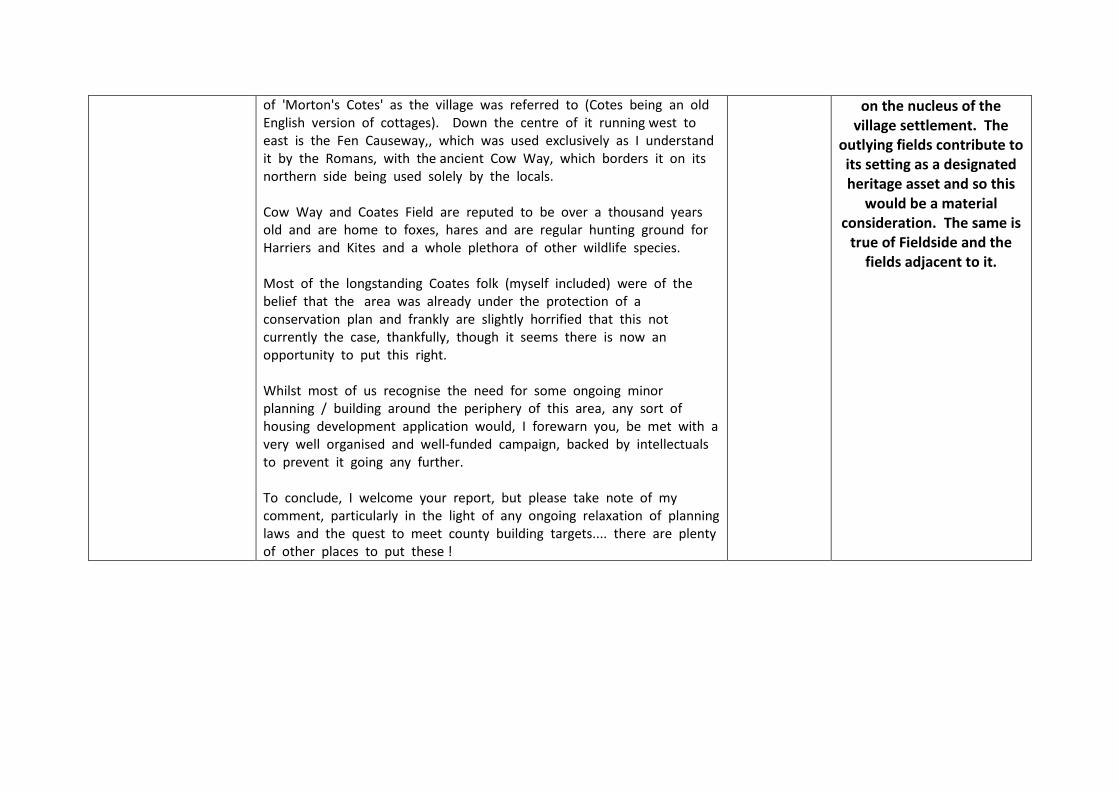
of 'Morton's Cotes' as the village was referred to (Cotes being an old English version of cottages). Down the centre of it running west to east is the Fen Causeway,, which was used exclusively as I understand it by the Romans, with the ancient Cow Way, which borders it on its northern side being used solely by the locals. Cow Way and Coates Field are reputed to be over a thousand years old and are home to foxes, hares and are regular hunting ground for Harriers and Kites and a whole plethora of other wildlife species. Most of the longstanding Coates folk (myself included) were of the belief that the area was already under the protection of a conservation plan and frankly are slightly horrified that this not currently the case, thankfully, though it seems there is now an opportunity to put this right. Whilst most of us recognise the need for some ongoing minor planning / building around the periphery of this area, any sort of housing development application would, I forewarn you, be met with a very well organised and well-funded campaign, backed by intellectuals to prevent it going any further. To conclude, I welcome your report, but please take note of my comment, particularly in the light of any ongoing relaxation of planning laws and the quest to meet county building targets.... there are plenty of other places to put these !
on the nucleus of the village settlement. The
outlying fields contribute to its setting as a designated heritage asset and so this
would be a material consideration. The same is
true of Fieldside and the fields adjacent to it.
Related Documents